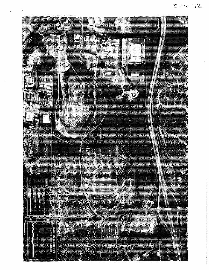
I 540 WESTGATE EBENEZER CHURCH ENGLEHARDT WESTGATE PARK DOMINION MIRANDA CAPE CHARLES WAYNICK STONE MOUNTAIN BLAKEHURST VOSBURGH SULKIRK ORCHID HILL BELLS VALLEY BERRY CREST LEESBURG WYNGATE RIDGE FLORETTA WINDY GAP PICNIC ROCK SPRINGHOUSE GLADE TAYLOR MILL SLIDE ROCK DULUTH MAGENTA KINGSCOTE LASKIN MILL SCHALLER JARRATT ZERMATT ROSECLIFF RHINEBECK COLVILLE FAIR VALLEY I 540 TD R-4 IND-1 CUD R-6 CUD TD CUD R-10 CUD NB CUD O&I-1 CUD O&I-2 R-6 - 700 Feet I 540 WESTGATE LANGWOOD I 540 EXIT 7 WAYNICK TREYMORE CAPE CHARLES FLEET SERVICE I 540 Existing Zoning Map Case Number: Z-10-12 City of Raleigh Public Hearing April 17, 2012 (July 16, 2012) Vicinity Map 97.13 ac from NB CUD, O&I-1 CUD, TD CUD, TD CUD w/AOD, TD CUD w/SHOD-2 & R-4 to I-1 CUD & I-1 CUDw/ SHOD-2 Request: SHOD-2 AOD AOD SHOD-1 SHOD-2 TD AOD

Welcome message from author
This document is posted to help you gain knowledge. Please leave a comment to let me know what you think about it! Share it to your friends and learn new things together.
Transcript

I 540
WESTGATE
EBEN
EZER
CHU
RCH
ENGLEHARDT
WESTGATE PARK
DOMINION
MIRANDA
CAPE CHARLES
WAYNICK
STON
E MO
UNTA
IN
BLAK
EHUR
ST
VOSBURGHSULK
IRK
ORCHID HILL
BELL
S VAL
LEY BERRY CREST
LEES
BURG
WYNGATE RIDGE
FLORETTA
WINDY GAP
PICNIC ROCK
SPRI
NGHO
USE
GLAD
E
TAYL
OR M
ILL
SLIDE ROCK
DULUTH
MAGENTA
KINGSCOTE
LASKIN
MILL
SCHALLERJARRATT
ZERM
ATT
ROSECLIFF
RHINEBECK
COLVILLE
FAIR VALLEY
I 540
TD
R-4
IND-1
CUD R-6
CUD TD
CUD R-10
CUD NB
CUD O&I-1
CUD O&I-2
R-6
700Feet
I 540
WESTGATE
LANGWOODI 540 EXIT 7
WAYNICKTREYMORE
CAPE CHARLES
FLEE
T SER
VICE
I 540Existing Zoning MapCase Number: Z-10-12
City of Raleigh Public HearingApril 17, 2012(July 16, 2012)
Vicinity Map
97.13 ac from NB CUD, O&I-1 CUD, TD CUD, TD CUD w/AOD, TD CUD w/SHOD-2 & R-4 to I-1 CUD & I-1 CUDw/ SHOD-2
Request:
SHOD-2
AOD
AOD
SHOD-1
SHOD-2
TD
AOD

Certified Recommendation Raleigh Planning Commission
CR# 11468
Case Information Z-10-12 Westgate Rd. Location Northside, northwest of its intersection with Ebenezer Church Rd.
Size 97.13 acres Request Rezone property from NB CUD, O&I-1 CUD, TD CUD, TD, R-4 with AOD
& SHOD-2 to IND-1 CUD with SHOD-2
Overall Comprehensive Plan Consistency
Consistent Inconsistent Consistent Future Land Use
Designation
Medium Density residential uses (eastern portion), Public Parks and Open Space (small portion) and Business and Commercial services uses (western portion)
Applicable Policy Statements
The following Comprehensive Plan policies apply: Policy LU 2.6 Infrastructure Impacts Policy LU 5.2 Managing Commercial Development Impacts Policy LU 5.4 Density Transitions Policy LU 5.6 Buffering Requirements Policy LU 4.1 Coordinate Transportation Investments with Land Use Policy LU 7.5 High-Impact Commercial Uses Policy LU 10.2 Retail in Industrial Zones Policy LU 11.2 Location of Industrial Areas Policy LU 11.3 Commercial Uses in Industrial Areas Policy LU 11.5 Mitigating Industrial Land Use Impacts Policy T 1.5 Context Sensitive Road Design Policy T 2.9 Curb Cuts Policy T 2.15 Sensitive Road Design Policy T 2.16 Assessing Changes in Road Design Policy EP 1.13 Evaluating Development Impacts On Air Quality Policy EP 2.7 Road Design and Landscape Preservation Policy EP 3.10 Groundwater Protection Policy EP 3.12 Mitigating Stormwater Impacts Policy EP 8.4 Noise and Light Impacts Policy EP 8.5 Airport Overlay Zone
Summary of Conditions Submitted
Conditions The conditions offered seek to: Define terms used in zoning conditions Realign Westgate Road to the north no more than 600 feet from
centerline of current location, before mining and quarrying activity occurs with applicant bearing all associated costs with provision for a berm
Limit extraction to south of relocated Westgate Rd. with buffer of
Certified Recommendation Z-10-12/Westgate Rd

50 ft. from relocated ROW and min. 25 ft. high berm between ROW and extraction area spaced min 25 ft. away from ROW
Specify minimum ht. and setback for berms along eastern edge with accommodations for driveway and future ROW expansion
Limit permitted uses for the northern portion and specify berm location with respect to ROW
Specify max. height, setback and location of berm with respect to adjacent residential properties
Time and day limitations on deposit of burden Prohibit transportation of overburden at grade across Westgate
Road and specify alternate means of conveyance Provide a 50 foot buffer around Westgate and property edge with
limited driveway access Specify planting of grass and pine seedlings Control of dust Prohibit blasting within 200 ft. of relocated Westgate right-of-way
and within 800 ft. of Wyngate parcels Specify seismograph reading log for southern portion and
limitations on blasting operation Limit hours and days permitted for blasting operation Provide for 50 ft. buffer for Wake County school property along
eastern edge Address additional stormwater controls Offer transit easements and Limit uses and other specifications for the property if road
realignment does not occur
Issues and Impacts
Outstanding Issues
1. Inconsistency with the future land use map
2. Compatibility with adjacent residential uses – noise and vibration impacts
Suggested Conditions
Avigation easement agreement has been provided as requested by the Raleigh Airport Authority
.
Impacts Identified
- The property contains a portion of Sycamore Creek tributary - Condition (i) addresses part of the tree conservation requirement; however, it is less restrictive with all of the listed disturbances that would be allowed. There is no mention of a 50 foot protective buffer along 540
Proposed Mitigation
1. Applicant will be required to designate greenway at the time of site plan or subdivision review.
Public Meetings Neighborhood
Meeting Public
Hearing Committee Planning Commission
12/1/2011 4/17/2012 Date: Action 5/22/12 deferred; 6/12/12 approved
Certified Recommendation Z-10-12/Westgate Rd

Valid Statutory Protest Petition
Attachments 1. Staff report 2. Existing Zoning/Location Map 3. Future Land Use
Planning Commission Recommendation Recommendation The Planning Commission finds that this request is inconsistent
with the Comprehensive Plan. However, based on the findings and reasons stated herein, recommends that this request be approved in accordance with conditions dated 6/5/12.
Findings & Reasons 1. That the request is inconsistent with the future land use map designation. However, there is no guarantee that the property would redevelop as medium density residential use, in accordance with the future land use map designation. Given the unique context of the site with its immediate proximity to an active quarry that has an extended 20 year life expectancy, the proposed zoning with associated conditions offers a more compatible and transitional use. That as long as the quarry to the south remains active, medium density residential use on the subject site would inject additional residential density in closer proximity to an active quarry site than what exists under the current scenario.
2. That several distinct conditions are being offered to protect and mitigate all potential adverse impacts to the surrounding residential uses while allowing for a minimal expansion of an existing quarry business, which services larger community needs.
3. That proposed conditions offer additional buffering, screening, height, access, stormwater, and operation controls that are more restrictive than minimum State standards to mitigate all potential adverse impacts to the surrounding residential uses from the proposed rezoning.
4. That the request would allow for the expansion of an existing quarry business and permit the extraction of natural resource that would offer larger economic and public benefit to the community and residents of Raleigh by supporting production of affordable construction aggregates, off-setting high transportation costs that would otherwise apply for aggregates quarried at distant locations.
5. That as proposed, no additional costs applies to the city for the re-alignment of Westgate Road. That applicant will bear all costs associated with the proposed road realignment.
6. That the subject request and proposed conditions, for reasons stated above, appears to be reasonable and to serve the larger public interest of city of Raleigh residents.
Certified Recommendation Z-10-12/Westgate Rd

Certified Recommendation Z-10-12/Westgate Rd
Motion and Vote Motion: Fleming
Second: Mattox In Favor: Butler, Fleming, Fluhrer, Harris Edmisten, Mattox, Schuster, Sterling Lewis, Terando Opposed: Haq
This document is a true and accurate statement of the findings and recommendations of the Planning Commission. Approval of this document incorporates all of the findings of the attached Staff Report. ________________________________ ________________________________6/12/12 Planning Director Date Planning Commission Chairperson Date Staff Coordinator: Dhanya Sandeep [email protected]

Zoning Staff Report – Case Z-10-12
Conditional Use District
Request Location Northside, northwest of its intersection with Ebenezer Church Rd. Request Rezone property from NB CUD, O&I-1 CUD, TD CUD, TD, R-4 with
AOD & SHOD-2 to IND-1 CUD with SHOD-2 Area of Request 97.13 acres Property Owner Martin Marietta Materials Inc.
PC Recommendation Deadline
July 16, 2012
Subject Property Current Proposed
Zoning NB CUD, O&I-1 CUD, TD CUD, TD, R-4
IND-1 CUD
Additional Overlay AOD, SHOD-2 SHOD-2 (to remain) Land Use Vacant Quarry expansion and storage of
overburden Residential Density 2959 pot. total DU at max.
density permitted under existing zoning TD – 940 TD CUD – 276 NB – 195 O&I-1 CUD – 97 TD CUD – 1450 R-4 – 1
Not permitted (per conditions)
Surrounding Area North South East West
Zoning Residential-4 IND-1, TD w/AOD
O&I-1 CUD, R-6 CUD, R-10 CUD w/SHOD-1, TD CUD
TD w/AOD, SHOD-2
Future Land Use
Low density residential
Special study area, moderate density residential
Low density residential, public facilities
Business and commercial services
Current Land Use
I-540 ROW and low density residential use
Quarry, moderate density residential use
Low density residential use (Wyngate neighborhood)
Commercial and industrial use

Comprehensive Plan Guidance
Future Land Use Medium Density residential uses (eastern portion), Public Parks and Open Space (small portion) and Business and Commercial services uses (western portion)
Area Plan None apply Applicable Policies Policy LU 2.6 Infrastructure Impacts
Policy LU 5.2 Managing Commercial Development Impacts Policy LU 5.4 Density Transitions Policy LU 5.6 Buffering Requirements Policy LU 4.1 Coordinate Transportation Investments with Land Use Policy LU 7.5 High-Impact Commercial Uses Policy LU 10.2 Retail in Industrial Zones Policy LU 11.2 Location of Industrial Areas Policy LU 11.3 Commercial Uses in Industrial Areas Policy LU 11.5 Mitigating Industrial Land Use Impacts Policy T 1.5 Context Sensitive Road Design Policy T 2.9 Curb Cuts Policy T 2.15 Sensitive Road Design Policy T 2.16 Assessing Changes in Road Design Policy EP 1.13 Evaluating Development Impacts On Air Quality Policy EP 2.7 Road Design and Landscape Preservation Policy EP 3.10 Groundwater Protection Policy EP 3.12 Mitigating Stormwater Impacts Policy EP 8.4 Noise and Light Impacts Policy EP 8.5 Airport Overlay Zone
Contact Information Staff Dhanya Sandeep, [email protected]
Applicant Lacy H. Reaves, 821-6704, [email protected]
Citizens Advisory Council
Contact Northwest Jay Gudeman, 789-9884
Case Overview The site is located to the north of Westgate Road, northwest of its intersection with Ebenezer Church Road. The northern edge of the site abuts the expansive right-of-way of I-540 that transitions over to low density residential uses to its further north. The east is bounded by Ebenezer Church Road and the Wyngate residential neighborhood zoned R-6. The area to the west zoned largely TD is developed for a mix of commercial and industrial uses. An active quarry is located to the south on land zoned IND-1. The proposed request seeks to rezone subject property to Industrial-1 CUD with SHOD-2, with the intent to expand the existing quarry operation to a defined area while relocating Westgate Road about 600 feet to the north from its current location. The remaining area outside of the defined extraction area is limited to storage of overburden and berms. Several conditions are offered in an attempt to mitigate adverse impacts to adjacent residential uses.
The proposed industrial use is inconsistent with its Future Land Use map designation. The future land use designates a portion of the property for Medium Density Residential use and the
Staff Report Z-10-12/Westgate Rd 2

remaining for Business and Commercial uses. A small portion to the north along the stream, running parallel to Westgate Road, is designated for Public Parks and Open Space. The proposed rezoning and conditions limit the use of part of the site for quarry operations and the remaining for storage of overburden, which essentially reduces the overall intensity of development that would otherwise be permitted under the existing zoning. Thus, the impacts of the proposed request on infrastructure are minimal. The proposed conditions provide for additional buffering, berms and transitional zones to the surrounding residential uses in an effort to reduce any adverse impacts. However, other potential adverse impacts to be further evaluated include compatibility issues to adjacent residential uses such as noise and vibration. Other regional wide impacts will be regulated by State standards and enforced through the State Mining Permit.
Exhibit C & D Analysis Staff examines consistency with the Comprehensive Plan, compatibility with the surrounding area, public benefits and detriments of the proposal, and summarizes any associated impacts of the proposal.
1. Consistency of the proposed rezoning with the Comprehensive Plan and any applicable City-adopted plan(s)
1.1 Future Land Use
The Future Land Use map designates the eastern portion of the property appropriate for Medium Density residential uses, while the western edge is designated for Commercial and Business Services. A very small portion of Public Parks and Open Space follows Sycamore Creek through the property. The portion of the property designated Medium Density Residential is inconsistent with the requested Industrial zoning.
1.2 Policy Guidance The following policy guidance is applicable with this request:
Policy LU 1.3 - Conditional Use District Consistency All conditions proposed as part of a conditional use district (CUD) should be consistent with the Comprehensive Plan
The proposed conditions appear to be consistent with the policies of the Comprehensive Plan.
Policy LU 2.6 - Zoning and Infrastructure Impacts Carefully evaluate all amendments to the zoning map that significantly increase permitted density or floor area to ensure that impacts to infrastructure capacity resulting from the projected intensification of development are adequately mitigated or addressed. The proposed request seeks to rezone the property to an industrial zone while removing the Airport Overlay District. The proposed zoning conditions provide for relocation of Westgate Road and limit uses on the property to quarrying on a limited area and to storage of overburden on the remaining portion. Thus, the overall development impact of the proposed rezoning on infrastructure is lower than that permitted under the existing zoning. Hence, the proposed rezoning will not impact the infrastructure capacities and is consistent with this policy. Policy LU 5.2 Managing Commercial Development Impacts
Staff Report Z-10-12/Westgate Rd 3

Manage new commercial development using zoning regulations and through the conditional use zoning and development review processes so that it does not result in unreasonable and unexpected traffic, parking, litter, shadow, view obstruction, odor, noise, and vibration impacts on surrounding residential areas. The proposed rezoning while requesting a higher intensity industrial use zone, offers conditions that limit the use of the property to quarry operations in a small portion and to storage of overburden in the remaining larger area. Thus, the overall impacts of commercial uses on the subject property are reduced as compared to what would be permitted under the existing zoning. Zoning conditions offered attempt to provide for added protection from the impacts of potential traffic, parking, litter, shadow, view, odor, noise and vibration. However, the rezoning assumes a relocation of Westgate Road, which would provide additional land area for mineral extraction on the property to the south of Westgate Road. The impacts of noise and vibration to surrounding residential areas are regulated by State and conditions offered propose to monitor and maintain standards more restrictive than State standards to avoid any adverse impacts. Policy LU 5.4 Density Transitions Low- to medium-density residential development and/or low-impact office uses should serve as transitional densities between lower-density neighborhoods and more intensive commercial and residential uses. Where two areas designated for significantly different development intensity abut on the Future Land Use Map, the implementing zoning should ensure that the appropriate transition occurs on the site with the higher intensity. Policy LU 5.6 Buffering Requirements New development adjacent to areas of lower intensity should provide effective physical buffers to avoid adverse effects. Buffers may include larger setbacks, landscaped or forested strips, transition zones, fencing, screening, height and/or density step downs, and other architectural and site planning measures that avoid potential conflicts. The proposed zoning conditions provide for additional buffering along the residential edges. Furthermore, the quarrying operations are limited to the internal site area and a majority of the site area between the quarrying operations and abutting site is limited to the use of storage of overburden, thus providing for appropriate transition area and buffering between commercial and residential uses. The proposed relocation of Westgate Road serves as a transitional edge between the quarry operations and the rest of the site. The request is consistent with these policies. Policy LU 4.1 Coordinate Transportation Investments with Land Use Ensure that transportation decisions, strategies, and investments are coordinated with and support the City’s land use objectives. The rezoning would precipitate a relocation of Westgate Road to the north, within 600 feet of the current location. The relocation of Westgate Road would create a more circuitous alignment. The 2030 Comprehensive Plan does not include a realignment of Westgate Road as proposed by the applicant. Any future realignment of Westgate Road would have to meet all City and NCDOT standards for new road construction. At this time, neither the exact alignment nor preliminary engineering design drawings have been completed for the proposed relocation of Westgate Road. The design and scale of transportation facilities will be evaluated through a formal review process when construction details are submitted. This relocation will render no specific to the City. The conditions commit to the applicant bearing the related costs for relocating this road. The proposed realignment of the road will not impact the land use character anticipated for this area and therefore, meets the intent of this policy.
Staff Report Z-10-12/Westgate Rd 4

Policy LU 7.5 High-Impact Commercial Uses Ensure that the City’s zoning regulations limit the location and proliferation of fast food restaurants, sexually-oriented businesses, late night alcoholic beverage establishments, 24-hour mini-marts and convenience stores, and similar high impact commercial establishments that generate excessive late night activity, noise, or otherwise affect the quality of life in nearby residential neighborhoods. The zoning conditions would permit intense uses associated with the quarry on the property. While actual extraction would not occur on the property, the storage of overburden (excavated dirt) would be permitted. This would require the transportation of material to the property from the extraction site. Zoning conditions provide for special alternative arrangement for conveyance of overburden. Zoning conditions provide for additional buffering and transition to the adjacent residential uses and regulate the day and time of overburden deposit and blasting operations. The impacts of noise and vibration to surrounding residential areas are regulated by State and conditions offered propose to monitor and maintain standards more restrictive than State standards to avoid any adverse impacts. Policy LU 10.2 Retail in Industrial Zones Discourage retail uses in industrial zones to maintain viable industrial areas and avoid an oversupply of retail uses. The proposed request prohibits retail uses on the property. The request is consistent with this policy. Policy LU 11.2 Location of Industrial Areas Accommodate industrial uses— including municipal public works facilities—in areas that are well buffered from residential uses (and other sensitive uses such as schools), easily accessed from major roads and railroads, and characterized by existing concentrations of industrial uses. Such areas are generally designated as “General Industrial” on the Future Land Use Map.
The proposed rezoning site while not designated for industrial use in the future land use map, is adjacent to industrially zoned land and surrounded by commercial/ industrial uses to the west. The conditions provide for additional buffering and transitional area between the proposed quarry use and surrounding residential uses to the east. The relocation of Westgate Road provides access along a major thoroughfare and serves as a physical barrier to define the quarry operations area. The request is consistent with this policy. Policy LU 11.3 Commercial Uses in Industrial Areas Limit specified non-industrial uses in industrially zoned areas, including office and retail development, in order to preserve these areas for industrial development. The proposed request prohibits retail/commercial uses on the property. The request is consistent with this policy. Policy LU 11.5 Mitigating Industrial Land Use Impacts Mitigate the adverse impacts created by industrial uses through a variety of measures, including buffering, site planning and design, strict environmental controls, performance standards, and the use of a range of industrial zones that reflect the varying impacts of different kinds of industrial uses. The proposed conditions along with State environmental standards help mitigate adverse industrial impacts indicated by this policy.
Staff Report Z-10-12/Westgate Rd 5

Policy T 1.5 Context Sensitive Road Design “Context Sensitive” approaches shall be used for new roadways or widening of existing roads to minimize impacts to historic business districts and neighborhoods and sensitive natural areas (particularly in watershed protection, conservation management and metro park protection areas). The proposed Westgate Road relocation does not impact historic districts or natural areas. Stormwater Management division staff has evaluated and determined that the subject proposal will not have significant impacts to natural resources. The request is consistent with this policy. Policy T 2.9 Curb Cuts The development of curb cuts along public streets—particularly on thoroughfares and arterials—should be minimized to reduce vehicular conflicts, increase pedestrian safety, and improve roadway capacity.
The proposed rezoning and conditions limit the uses permitted on the site and therefore, the number of curb cuts utilized will be fewer than would be needed if the property were to be developed under the existing zoning. The request is consistent with this policy. Policy T 2.15 Sensitive Road Design Ensure that all new roadway projects and major reconstruction projects preserve existing trees and topography to the maximum extent feasible and provide an adequate street tree canopy while providing for the safest facility possible. Involve relevant experts (such as a certified arborist) in project planning when implementing this policy. Policy T 2.16 Assessing Changes in Road Design Subject all proposed changes to the treatment of existing vehicular rights-of-way, such as changes to the number and type of travel lanes, to a study prior to implementation to determine the impacts on the larger network and the level of service of all relevant modes. Policy EP 2.7 Road Design and Landscape Preservation Encourage the preservation of natural features and systems when designing new roadways by separating in-bound and out-bound lanes as they pass through natural features such as large clusters of trees, rocky outcrops or water courses. The proposed request provides for relocation of Westgate Road to further north of its current location. The relocation of Westgate Road would create a more circuitous alignment. The 2030 Comprehensive Plan does not include a realignment of Westgate Road as proposed by the applicant. Any future realignment of Westgate Road would have to meet all City and NCDOT standards for new road construction. At this time, neither the exact alignment nor preliminary engineering design drawings have been completed for the proposed relocation of Westgate Road. The design and scale of transportation facilities will be evaluated through a formal review process when construction details are submitted by Office of Transportation, Public Works department, and Urban Forestry staff.
Policy EP 1.13 Evaluating Development Impacts on Air Quality Evaluate potential air emissions from new and expanded development, including transportation improvements and municipal facilities, to ensure that measures are taken to mitigate any possible adverse impacts. These measures should include construction
Staff Report Z-10-12/Westgate Rd 6

controls to reduce airborne dust and requirements for landscaping and tree planting to absorb carbon monoxide and other pollutants. Dust generated from quarry sites is a major source of air pollution, although the impacts are dependent on other factors like the local micro-climate conditions, concentration of dust particles in the ambient air, size of dust particles and their chemistry. Air pollution can be a nuisance as well as have adverse physical and health impacts. The Mining permit issued by the NC Department of Environment and Natural Resources (NC DENR) establishes air quality thresholds for permitted quarrying operations. The proposed conditions address additional controls for dust and impacting operations of the quarry.
Policy EP 3.10 Groundwater Protection Protect groundwater from the adverse effects of development. Land development and use should be managed to reduce the likelihood of groundwater contamination. Potential adverse impacts of a quarry operation to be evaluated include those on potable groundwater supplies, air and noise pollution, damage to biodiversity, impacts from quarry waste, and environmental impacts. Much of these impacts are regulated and monitored by the NC DENR through established standards in the issuance of State mining permits. Policy EP 3.12 Mitigating Stormwater Impacts Potential stormwater impacts from new development on adjoining properties should mimic pre-development conditions and control the rate of runoff so as to avoid erosion of stream banks, inundation of natural waterways and to allow the recharging of groundwater. The intent is to avoid environmental and economic damage to the adjacent properties and City infrastructure. The zoning conditions address additional controls that prohibit any stormwater impacts to the adjacent residential subdivision. The request is consistent with this policy. Policy EP 8.4 Noise and Light Impacts Mitigate potential noise and light pollution impacts from new development on adjoining residential properties. Quarrying operations generate significant amounts of noise and vibrations from related blasting and transportation activities. The proposed rezoning to expand the quarry operations will therefore have to be evaluated for noise and light impacts to the adjoining residential uses. While standard noise thresholds apply through city ordinance, the impacts from mining and quarrying operations have significant community wide impacts and are regulated by the State. The conditions submitted propose to keep log of blasting activities, consistent with the State regulations. The conditions offer to monitor and comply with stricter standards than that established by NC DENR to ensure that no adverse impacts sustain from the expanded operations. Zoning conditions regulate days and hours of operations in an attempt to minimize impacts to surrounding uses. Policy EP 8.5 Airport Overlay Zone Keep the boundaries of the Airport Overlay District zone current with the future expansion plans of Raleigh-Durham International Airport to protect residents from impacts of increased flight patterns and activity. The proposed request seeks to remove Airport Overlay District that applies to the site. While residential uses are not permitted on the site per conditions, the Raleigh Airport Authority requests avigation easement as a condition of this rezoning. An avigation easement agreement has been provided as part of this rezoning.
Staff Report Z-10-12/Westgate Rd 7

1.3 Plan Guidance
None apply.
2. Compatibility of the proposed rezoning with the property and surrounding area The proposed rezoning area is predominantly surrounded by commercial and industrial zoning to the west, with low density zoning located to the east across Ebenezer Church Road and to further north across from I-540. Along the immediate east, a strip of land is left out to remain zoned O&I-1 that will serve as a buffer zone between the proposed industrial and adjacent residential zones. Given the predominantly industrial/commercial character to the west of the surrounding area, an expansion of the industrial use and rezoning to industrial zone would be considered fairly compatible to those properties. However, the proposed zoning would be incompatible to the existing residential zoning to the east. Quarrying operations, which is considered an industrial use, will have significant impacts in terms of noise, vibration, and other environmental factors that could adversely impact residential uses to the east. The proposed zoning conditions limit the use of the property to quarry operation and to storage of overburden. This proposed development of the property is of lower intensity than what would be permitted under the existing Thoroughfare District zoning. Thus, the impacts of the proposed request on infrastructure are minimal. The zoning conditions provide for additional buffering and transitional zones between the industrial and residential uses in an attempt to mitigate potential adverse impacts. However, given the potential direct and indirect impacts to surrounding residential properties from an intense industrial use such as mining and quarrying, further evaluation is needed to ensure that all compatibility issues and adverse impacts to surrounding properties are adequately addressed and/or mitigated.
3. Public benefits of the proposed rezoning Per the applicant, the proposed rezoning for expansion of the quarry will offer the following public benefits to the community: Provide a valuable natural resource to the community for continued availability of
resource to meet demand in proximity to site and will keep development costs down for both public and private projects within a 10 mile radius
Allow quarry operations to expand to north of existing operations and allow conservation of the land adjacent to residential uses for storage of overburden, thus removing impacts of potential commercial uses allowed by existing zoning
Provide for protection and continuation of existing industrial use in the area Provide for more effective transition than would occur under existing zoning Development of property under existing zoning would result in significantly more
traffic, density, building height, and impervious surface than what would be allowed under proposed rezoning
Being adjacent to existing quarry, the property contains deposits of mineable granite that will serve the community’s needs. Optimal use of local aggregates reduces truck traffic and number of axle loadings on the highway system, along with keeping the costs of aggregates reasonable
Staff assessment indicates that the proposed zoning conditions provide for a better transition area than would occur under existing zoning. Development of property under existing zoning would result in significantly more traffic, density, building height, and impervious surface than what would be allowed under proposed rezoning.
Staff Report Z-10-12/Westgate Rd 8

4. Detriments of the proposed rezoning The proposed quarry expansion area is surrounded by industrial and commercial uses to the west and low density residential uses and a future school site to the east. Potential adverse impacts to be evaluated include those on potable groundwater supplies, air and noise pollution, damage to biodiversity, impacts from quarry waste, and environmental impacts. Much of these impacts are regulated and monitored by the NC DENR through established standards in the issuance of mining permits. The proposed expansions should comply with State regulations. Given the inconsistency with the future land use map, and its potential direct and indirect adverse impacts, a thorough evaluation should be applied to ensure that no adverse impacts to the surrounding residential uses will sustain as a result of the proposed rezoning.
5. The impact on public services, facilities, infrastructure, fire and safety, parks and recreation, etc. 5.1 Transportation
Primary Streets Classification 2009 NCDOT Traffic Volume
(ADT)
2035 Traffic Volume Forecast (ADT)
Westgate Road Major Thoroughfare
12,000 18,200
Ebenezer Church Road
Collector Street N/A N/A
Street Conditions Westgate Road Lanes Street Width Curb and
Gutter Right-of-
Way Sidewalks Bicycle
Accommodations
Existing 2 24' None 60' None None City Standard
4
65' Back-to-
back curb and
gutter section
90' minimum 5' sidewalks
on both sides Striped bicycle
lanes on both sides
Meets City Standard?
NO
NO
NO
NO
NO
NO
Ebenezer Church Road
Lanes Street Width Curb and Gutter
Right-of-Way
Sidewalks Bicycle Accommodations
Existing
2
28'
curb and gutter on east side of street
80'
5' sidewalk on east side of the street
None
City Standard
2
41'
Back-to-back curb
and gutter
section
60'
Minimum 5' sidewalk
on one side of the street
N/A
Meets City Standard?
YES
NO
NO
YES
YES
N/A
Expected Traffic Generation [vph]
Current Zoning
Proposed Zoning
Differential
AM PEAK N/A N/A N/A PM PEAK N/A N/A N/A Suggested Conditions/ Traffic Study Determination: A traffic impact analysis study is not
Staff Report Z-10-12/Westgate Rd 9

Impact Mitigation: recommended for Z-10-12. Staff will work in collaboration with the applicant in planning of any future realignment of Westgate Road.
Additional Information:
Neither the City of Raleigh nor NCDOT have scheduled major capital roadway improvement projects in the vicinity of this case.
Impact Identified: None
5.2 Transit
Transit easement has been offered through zoning conditions. Impact Identified: None
5.3 Hydrology
Floodplain FEMA Floodplain is present
Drainage Basin Sycamore Stormwater
ManagementSubject to Part 10, Chapter 9
Overlay District none Neuse River Buffers and FEMA Floodplain are present on the site. Site is subject to Part 10, Chapter 9, Stormwater Regulations. Impact Identified: None
5.4 Public Utilities
Maximum Demand (current)
Maximum Demand (proposed)
Water 656,720 gpd 1.214 MGD Waste Water 656,720 gpd 1.214 MGD
The proposed rezoning will add approximately 557,405 gpd to the wastewater collection and water distribution systems of the City. The Sycamore Creek interceptor traverses along the creek bank along the northern property line of the western parcel and within an easement in the upper third of the eastern property. There is a twenty-four (24”) inch water main located within the Westgate Road right-of-way. The properties would use these mains for connection to the City’s utilities. The subsequent development would be responsible for the installation of all internal sanitary sewer and water mains required.
5.5 Parks and Recreation Property is located along/on the Trib. A of Sycamore Creek. The minimum required greenway along this corridor is 50 on each side of the water course measured from the top of bank.
Staff Report Z-10-12/Westgate Rd 10
This site is not located within a park search area. Impact Identified: Applicant will be required to designate greenway at the time of site plan or subdivision review.
5.6 Urban Forestry The properties are over 2 acres in size and section 10-2082.14 will apply to the properties. Impact Identified: The current zoning of CUD TD would require a 50 foot wide TD yard along 540 and Westgate Rd. The rezoning of these properties to I-1 CUD will remove the primary tree conservation area priority from Westgate Rd. and 540. Condition (i) addresses part of this requirement; however, it is less restrictive with all of the listed disturbances that would be allowed. There is no mention of a 50 foot protective buffer along 540.
5.7 Designated Historic Resources
There are no historic resources on this site. Impact Identified: None.
5.8 Community Development
The site is not located within a redevelopment area. Impact Identified: None
5.9 Impacts Summary Applicant will be required to designate greenway at the time of site plan or
subdivision review Condition (i) addresses part of the tree conservation requirement; however, it is
less restrictive with all of the listed disturbances that would be allowed. There is no mention of a 50 foot protective buffer along 540
No major impacts on public services, facilities, and infrastructure have been identified as a result of the proposed rezoning
5.10 Mitigation of Impacts NA
6. Appearance Commission This request is not subject to Appearance Commission review.
7. Conclusions The proposed request seeks to rezone property from NB CUD, O&I-1 CUD, TD CUD, TD CUD w/AOD, SHOD-2 & R-4 to Industrial-1 CUD with SHOD-2 with the intent to expand an existing quarry operation to its further north. The proposed conditions attempt to address and mitigate adverse impacts to the surrounding uses by providing additional buffering, transitional zones, limited uses and other provisions. However, given the
Staff Report Z-10-12/Westgate Rd 11

Staff Report Z-10-12/Westgate Rd 12
potential direct and indirect impacts to surrounding residential properties from an intense industrial use such as mining and quarrying, further evaluation is needed to ensure that all compatibility issues and adverse impacts to surrounding properties are adequately addressed and/or mitigated. The following outstanding issues and impacts have been identified:
Inconsistency with the future land use map Compatibility with adjacent residential uses – noise and vibration impacts

Certified Recommendation Z-10-12/Westgate Rd 13
Existing Zoning Map

Staff Report Z-10-12/Westgate Rd 14
Future Land Use Map

V|àç by etÄx|z{
NORTH CAROLINA
06/06/2012 To: Raleigh Planning Commission Members From: Raleigh Stormwater Utility Division Re: Z-10-12 – Westgate Road – Martin Marietta Materials, Inc. Several State regulatory agencies have jurisdiction over quarrying/mining activities within the State of North Carolina and the City of Raleigh. While Martin Marietta has indicated their desired future use and activities upon the proposed re-zoned parcel, they still would have to obtain the necessary permits from those State agencies in order to perform those desired activities. NC DENR, Division of Water Quality (DWQ), NC DENR, Division of Land Resources (DLR) would be the two primary permitting agencies and they would be the responsible party for evaluating future plans with respect to mining permits, erosion control, water quality, and stream impacts. With respect to the Umstead Coalition’s concerns outlined in the letter dated 05/22/2012 about specific possible stream impacts resulting from the proposed realignment of Westgate Road, there are stream and/or “stream-like” features located on the parcel. One is a larger tributary of Sycamore Creek which has both FEMA floodplain as well as Neuse River Buffers associated with it. No significant impacts to this stream, floodplain, or buffers are indicated to be proposed with the road realignment. Any proposed impacts would be addressed during Subdivision/Site Plan, Infrastructure Construction Plan, or Permitting review and the appropriate variances, permits; etc would be required from both FEMA and NC DWQ at that time.
One Exchange Plaza
1 Exchange Plaza, Suite 1020 Raleigh, North Carolina 27601
City of Raleigh Post Office Box 590 • Raleigh North Carolina 27602-0590
(Mailing Address) Printed on Recycled Paper
Municipal Building 222 West Hargett Street
Raleigh, North Carolina 27601
The other significant feature is a small tributary that flows in a NW direction into the larger tributary. This unnamed tributary could be impacted by the proposed road realignment. It is shown as a stream feature on the Wake County Soil Survey, and therefore is assumed to also have Neuse River Buffer. It also is bordered by City of Raleigh flood prone soils. Further evaluation of this feature by NC DWQ would determine whether this feature is subject or not subject to Neuse River Buffer rules. The presence of flood prone soils mean that the area would be subject to the city’s floodplain regulations. Again, any proposed impacts would be addressed during

One Exchange Plaza
1 Exchange Plaza, Suite 1020 Raleigh, North Carolina 27601
City of Raleigh Post Office Box 590 • Raleigh North Carolina 27602-0590
(Mailing Address) Printed on Recycled Paper
Municipal Building 222 West Hargett Street
Raleigh, North Carolina 27601
Subdivision/Site Plan, Infrastructure Construction Plan, or Permitting review and the appropriate variances, permits; etc from NC DWQ would be required at that time. Additionally, NPDES water quality regulations would also be addressed by the required NPDES permitting through NC DWQ. With respect to Umstead Coalition’s concerns about soil stabilization and erosion and sediment control. Per, Per City of Raleigh code section 10-5004(3), Activities for which a permit is required under the Mining Act of 1972, G.S. Chapter 74, Article 7, are not subject to the City’s Soil Erosion and Sedimentation Control Regulations. All erosion control plans and permitting would be through NC DLR. Stormwater Utility’s conditions of approval of the re-zoning indicate that the site and any future roadway improvements would be subject to Part 10, Chapter 4 (Flood Hazard Areas), and Part 10, Chapter 9 (Stormwater Control) of the Raleigh City Code.

City of Raleigh, North Carolina Department of City Planning Raleigh Urban Design Center One Exchange Plaza 133 Fayetteville Street P. O. Box 590 P. O. Box 590 Raleigh, NC 27602-0590 Raleigh, NC 27602-0590 P 919.516.2626 P 919.807.8482 F 919.516.2684 F 919.807.8481 www.raleighnc.gov/planning
To: City of Raleigh Planning Commission Members From: Dhanya Sandeep, Planner II
Fleming El-Amin, AICP, Planner II CC: Ken Bowers AICP, Deputy Planning Director
Greg Hallam, Planning Manager Eric Lamb, Manager, Office of Transportation Planning Travis Crane, Senior Planner
Date: June 7, 2012 Re: Zoning Case Z-10-12 quarry expansion
At the May 22nd Planning Commission meeting, staff was directed to evaluate additional 21 policies presented by a speaker representing the Wyngate neighborhood association largely in opposition of this rezoning request. The staff evaluation report is included in this memo. Most of the policies listed are evaluated to be least applicable to the specific context of the proposed request. A couple of policies – LU 5.5 and T 1.6 with some relevancy are evaluated to be consistent with the proposal.
Policy LU 2.5 Healthy Communities New development, redevelopment, and infrastructure investment should strive to promote healthy communities and active lifestyles by providing or encouraging enhanced bicycle and pedestrian circulation, access, and safety along roads near areas of employment, schools, libraries, and parks.
Comment: The subject site is in close proximity to an operating quarry and not located in a walkable environment with proximity to schools, libraries, or parks. Hence this policy is more relevant to sites in mixed use centers and does not apply to this request. However, this proposal will likely improve conditions for cycling. City standards call for Westgate Road to be constructed as a 4-lane divided street with curb and gutter, sidewalks, and striped bicycle lanes on both sides. The City has a current project programmed that would provide paved shoulders with striped bicycle lanes along this segment of Westgate Road.
Policy LU 4.2 Transportation in Support of Walkable Neighborhoods Make the design and scale of transportation facilities compatible with planned land uses and with consideration for the character anticipated by this Comprehensive Plan for the surrounding neighborhood.
Comment: The 2030 Comprehensive Plan does not include a realignment of Westgate Road as proposed by the applicant. Any future realignment of Westgate Road would have to meet all City and NCDOT standards for new road construction. At this time, neither the exact alignment nor preliminary engineering

design drawings have been completed for the proposed relocation of Westgate Road. The design and scale of transportation facilities will be evaluated through a formal review process when construction details are submitted. The proposed realignment of the road will not impact the land use character anticipated for this area. The policy is not applicable at this stage of review. Policy LU 4.3 Directing Transportation Investments Target transportation facilities, services, and investments to promote and accommodate the growth this Comprehensive Plan anticipates in mixed-use centers, commercial corridors, and residential neighborhoods while reducing reliance on single occupancy vehicles. Comment: The proposed request does not alter or impact the planned transportation networks in this area. The policy is not applicable. Policy LU 5.5 Transitional and Buffer Zone Districts Maintain and enhance zoning districts which serve as transitional or buffer areas between residential and commercial districts and which also may contain institutional, non-profit, and office-type uses. Zoning regulations and conditions for these areas should ensure that development achieves appropriate height and density transitions, and protects neighborhood character. Comment: The site with its current zoning provides for an appropriate transition between the commercial and residential use. However, the proposed zoning with attached conditions provide for a better transitional use zone with protection and height transitions to the surrounding neighborhoods. The request is consistent with this policy. Policy LU 8.1 Housing Variety Accommodate growth in newly developing areas of the City through mixed-use neighborhoods with a variety of housing types. Comment: This policy is not applicable as residential uses are not considered as part of this proposal. Policy LU 8.3 Conserving, Enhancing, and Revitalizing Neighborhoods Recognize the importance of balancing the need to increase the housing supply and expand neighborhood commerce with the parallel need to protect neighborhood character, preserve historic resources, and restore the environment. Comment: This policy is not applicable as the proposed request does not involve conserving, enhancing, or revitalizing an existing neighborhood. The subject site is undeveloped. Policy LU 8.13 Traditional Neighborhood Development Encourage Traditional Neighborhood Development (TND) and planning for large undeveloped sites within the City’s municipal boundaries to improve neighborhood and street connectivity. Traditional Neighborhood Development is an urban form characterized by compact, pedestrian-oriented design, which provides a variety of uses and diverse housing types within easy walking distance, and is anchored by a central public space and civic activity (school, library, church, or similar institution). Comment: This policy is not applicable as new residential development is not considered as part of this rezoning and hence the types of neighborhood (TND) has no relevance to this context.. Policy LU 11.4 Rezoning/Development of Industrial Areas Allow the rezoning and/or redevelopment of industrial land for non-industrial purposes when the land can no longer viably support industrial activities or is located such that industry is not consistent with the Future Land Use Map. Examples include land in the immediate vicinity of planned transit stations. Comment: This policy is not applicable as the rezoning site does not include land currently zoned industrial.
2

Policy T 1.1 Coordination with Land Use Map Transportation planning, development, expansion, and investment in transportation facilities should be coordinated with the Future Land Use Map. Comment: The proposed planned transportation improvement associated with the rezoning request does not alter or impact the long range transportation plan. While the proposal is recommending land use change, the transportation investment, borne by the developer and not the City, would not change the land use character. Proposed conditions provide for a scenario if roadway investment is not materialized. The policy is not directly applicable to the specific context. Policy T 1.6 Transportation Impacts Identify and address transportation impacts before a development is implemented. Comment: The proposed realignment would result in a slightly longer distance (approximately 400 feet) between Ebenezer Church Road and Westgate Park Drive. It cannot be asserted that this realignment in and of itself will make the street unsafe and prone to causing more accidents. Adjacent land use patterns will have more of an impact on future traffic on Westgate Road than a proposed realignment of the road. The Z-10-12 rezoning petition is considered a down zoning with respect to trip generating land uses. The requested I-1 zoning reduces new trips that would be anticipated under the current zoning. Policy T 2.3 Eliminating Gaps Eliminate “gaps” in the roadway system and provide a higher roadway grid density that will increase mobility options and promote the accessibility of nearby land uses. Comment: The realignment of Westgate Road will not impact or influence the need for other planned road extensions or improvements in the area. The realignment will have no effect on the planned extension of Ebenezer Church Road or the planned street extension between Leesville Church Road and Westgate Park Drive. The “gap” as described in the Comprehensive Plan refers to missing road links. No gap is created or perpetuated by this proposal. The “dead zone” as described by a citizen at the last Planning Commission meeting would be utilized for quarry operations and while this may create a visual gap in the roadway, it would have no influence on the overall transportation network and mobility of motorists along Westgate Road. The policy is not applicable. Policy T 2.6 Preserving the Grid Existing street grid networks should be preserved and extended where feasible and appropriate to increase overall connectivity. Comment: The existing planned street grid in this area would not be impacted by the proposed relocation of Westgate Road. The policy is not applicable. Policy T 2.7 Conditions for Roadway Closure No street, alley, or other public right-of-way shall be abandoned without the highest level of scrutiny and concurrence among affected City departments and utility companies. Right-of-way abandonment shall be subject to the following findings: The closure will not compromise the integrity of the City's street network, nor lead to a significant loss of vehicular or pedestrian connectivity; The closure will not impair the ability to provide utility service; The closure will not adversely impact the health, safety and welfare of the community, including access by emergency vehicles; The proposed closure is not in conflict with adopted Raleigh Historic Districts Commission policy regarding alley closures in local historic and National Register districts; and Reasonable alternatives have been investigated and found to be impractical or more detrimental to the public welfare than the proposed closure. Comment: The merits of closing Westgate Road have not been fully vetted. The street closure should be a separate issue from the rezoning petition. Staff will provide a thorough investigation of the street closure petition if and when such a request is made. This evaluation will quantify the impacts of the street closure
3

and relocation of Westgate Road and document any potential adverse effects. Please note that so long as the proposed realignment of the street meets or exceeds the quality and design standards of the existing street, closing the remainder of the right-of-way would likely pass muster under this policy. The policy is not applicable at this time. Policy EP 4.2 Floodplain Conservation Development should be directed away from the 100-year floodplain. Floodplains National studies clearly illustrate that the greatest loss of life and highest property damage in flood-prone areas occurs in the flood fringe, where land development continues to be permitted. There is economic justification for prohibiting development in the flood fringe. Additionally, an undisturbed floodplain helps preserve existing vegetation and wildlife habitats, decreases erosion, provides natural stormwater management, improves water quality, and provides land for aquifer recharge. Comment: There is no development proposed in the 100-year floodplain. Any such encrochments into the flood plain will be evaluated during the permitting stage. State regulations enforce adequate standards for protection of floodplains. The policy is not applicable. Policy EP 4.7 No Adverse Impact The City shall adopt the principles of No Adverse Impact (NAI) as outlined by the Association of State Floodplain Managers; NAI floodplain management takes place when the actions of one property owner are not allowed to adversely affect the rights of other property owners. Adverse effects or impacts can be measured in terms of increased flood peaks, increased flood stages, higher flood velocities, increased erosion and sedimentation, or other impacts the community considers important. Comment: This policy provides direction to the City to adopt the principles of No Adverse Impact. This is a policy guidance that is not invoked during rezoning requests. The policy is not applicable. Policy H 1.8 Zoning for Housing Ensure that zoning policy continues to provide ample opportunity for developers to build a variety of housing types, ranging from single-family to dense multi-family. Keeping the market well supplied with housing will moderate the costs of owning and renting, lessening affordability problems, and lowering the level of subsidy necessary to produce affordable housing. Comment: This policy is not applicable as the request is not for a residential zone. Policy PU 1.1 Linking Growth and Infrastructure Focus growth in areas adequately served by existing or planned utility infrastructure. Comment: The proposed request does not propose additional density as it is located in close proximity to a quarry operation. The policy is not applicable. Policy UD 5.3 Improving Neighborhood Connectivity Explore opportunities to conveniently connect existing neighborhoods to adjacent commercial centers and community facilities and services. Comment: The subject site is in close proximity to an operating quarry and not located in a walkable environment. Hence this policy is more relevant to sites in mixed use centers and does not apply to this request.
4

5
Policy UD 5.4 Neighborhood Character and Identity Strengthen the defining visual qualities of Raleigh’s neighborhoods. This should be achieved in part by relating the scale of infill development, alterations, renovations, and additions to existing neighborhood context. Comment: This policy is not applicable as it is not an infill request. The large site is undeveloped. Policy IM 1.1 Consistency of the Comprehensive Plan and Development Code Maintain consistency between the City’s development regulations and the Comprehensive Plan, such that regulations facilitate, and do not inhibit, the implementation of Plan policies. Comment: This policy is not applicable to the rezoning evaluation as this policy is directed to the city to ensure consistency between the Comprehensive Plan and the zoning code. Policy IM 2.2 Preeminence of the Comprehensive Plan The Comprehensive Plan shall be the city’s lead and overall policy guide for the growth and development of Raleigh. All other city plans related to the City’s growth and development and related infrastructure plans must be revised to be in conformance with the Comprehensive Plan. Comment: This policy is not applicable to the rezoning evaluation as this policy is directed to the city to ensure that all plans adopted remain compatible with the Comprehensive Plan.


Related Documents


