Assessment of the restoration potential along the Danube and main tributaries Final Draft, Vienna, May 2010 Working paper for the Danube River Basin

Welcome message from author
This document is posted to help you gain knowledge. Please leave a comment to let me know what you think about it! Share it to your friends and learn new things together.
Transcript
Assessment of the restoration potential along the Danube and main tributaries
Final Draft, Vienna, May 2010
Working paper for the Danube River Basin

________________________________________________________________________________ Assessment of the restoration potential along the Danube and main tributaries
1
For further information please contact:
Dr. Orieta Hulea
WWF International Danube-Carpathian Programme Bucharest Office Str. Ioan Caragea Vodă, nr. 26, Corp A, sector 1, cod 010537, Bucureşti, Romania Tel: 021 317 49 96 Email: [email protected] Website: www.panda.org/dcpo
Dr. Ulrich Schwarz
FLUVIUS Hetzgasse 22/7 A-1030 Vienna Tel.: +43 1 943 2099 Email: [email protected] Website: fluvius.eu
WWF’s mission is to stop the degradation of the planet's natural environment and to build a future in which humans live in harmony with nature, by:
- conserving the world's biological diversity
- ensuring that the use of renewable natural resources is sustainable
- promoting the reduction of pollution and wasteful consumption.
This document has been produced by:
Ulrich Schwarz, FLUVIUS
We acknowledge the financial support from WWF DCPO.
Cover photo: Danube River near Calarasi/Silistra with large agricultural polders (photo credit: GoogleEarth 2010)
________________________________________________________________________________ Assessment of the restoration potential along the Danube and main tributaries
2
Preface: Over the last century, floodplains of the Danube and its tributaries were subject to major human interventions which caused significant changes in the hydromorphology of the river-floodplain ecosystem and losses of natural values and processes. The reduction and degradation of floodplains causes the loss of large water retention areas that originally mitigated flood risks, the loss of functional wetlands and their resources and services they typically provide, e.g. groundwater replenishment, nutrient reduction, water purification and the loss of other riparian ecosystems critical for the conservation of key species and habitats (in particular pioneer habitats and soft- and hardwood forests). However, the political changes in Central and Eastern Europe and respective EU policies (Water Framework Directive, Flood Directive as well as FFH and Bird Directives) are fostering efforts to re-establish the lateral connectivity of floodplains along the Danube and its major tributaries through restoration projects. Also the Ramsar Convention on Wetlands supports the conservation and restoration of floodplains. Since about 20 years restoration projects have been under planning and implementation in various sizes and with different purposes and levels of success. The assessment of the restoration potential of floodplains is necessary to support and stimulate restoration projects. Beyond an inventory of already existing projects, such an approach should enable the proposal of new restoration sites. Finally a prioritisation of projects is necessary. This working paper proposes a framework for such a floodplain inventory, assessment and prioritization for the Danube basin and presents first results.
________________________________________________________________________________ Assessment of the restoration potential along the Danube and main tributaries
3
Table of Contents
Executive Summary 5
1. Introduction 10
2. Floodplain delineation 11
2.1 Methodology 11
2.2 Results 14
3. Floodplain assessment for restoration potential 18
3.1 Methodology 18
3.2 Results 22
3.2.1 Already achieved restoration projects 22
3.2.2 Potential areas for restoration 23
3.2.3 Maps 25
4. Prioritisation approach 36
4.1 Biodiversity, nature conservation 41
4.2 Flood protection 42
4.3 Feasibility, legal framework, local administration and initiative 42
Table 8: Legal framework and ownership (initial ove rview) 43
5. Feasibility of restoration 44
5.1 International and national legal frameworks 44
5.2 Restoration costs 45
5.3 Floodplain values and usage concepts 45
6. Recommendations towards a restoration strategy 4 6
7. References 48
8. Annex 49
________________________________________________________________________________ Assessment of the restoration potential along the Danube and main tributaries
4
List of Acronyms
AT Austria BA Bosnia and Herzegovina BG Bulgaria
DCPO WWF Danube-Carpathian-Programme Office DEM Digital Elevation Model DRB Danube River Basin DE Germany EU European Union FD Floods Directive FFH-D Flora Fauna Habitat Directive (Natura2000 network)
GIS Geographical Information Systems HU Hungary ICPDR International Commission for the Protection
of the Danube River JDS 2 Joint Danube Survey 2, 2007 MD Moldova NGO Non Governmental Organisation RO Romania
RKM River Kilometer RS Serbia SK Slovak Republic UA Ukraine WFD EU Water Framework Directive
Glossary of selected terms
Aggradation The building up of sediments occuring when there is a
supply of sediment and changes in slope and flow velocity. Active floodplain Floodplain area between current flood defenses (dikes) often
designed for the 100 year flood return interval; it includes usually all water bodies, but for very large rivers such as the Danube the main channel surface will be calculated separately.
Channel incision Riverbed deepening and drop of water tables due to lack of sediment supply (dams upstream) often in combination with river straightening and increased shear stress on the river bottom.
Former floodplain Floodplain outside the flood defences that could be potentially flooded (morphological floodplain minus active floodplain).
Hydromorphology The science of the physical characterisation of riverine habitats based on hydrologic, hydraulic and morphologic parameters including the channel, the banks and the floodplain.
Morphological floodplain
Potentially flooded area without flood defences, e.g. along postglacial terrace systems.
________________________________________________________________________________ Assessment of the restoration potential along the Danube and main tributaries
5
Executive Summary
This working paper “Assessment of the restoration potential along the Danube and main tributaries”, commissioned by the WWF International Danube-Carpathian Programme, comprises a floodplain inventory, an assessment of proposed potential restoration sites and a recommendation on how to prioritise the sites.
This study focus on new restoration sites outside the existing flood protection dikes, and emphasises the need for protection of remaining near-natural floodplains as well as improvements of existing altered floodplain areas, especially along main and side channels. Floodplain delineation (balance) and typology
Many studies (e.g. DPRP 1999, Schwarz et al. 2006, BfN 2009) indicate the substantial loss of active floodplains (some 70-80% in Germany and in the DRB). There is a significant differentiation into a) strongly altered rivers or river stretches with 90-100% loss of floodplains in intensively-used landscapes, and b) still intact reaches. This also highlights the loss of biodiversity and intactness of the remaining 20-30% of floodplains. The overall hydromorphological situation of many rivers in Europe has decreased dramatically, but in the case of the Danube more than one-third of the river has been classified in the second (good) class according to the JDS 2 (ICPDR 2008). In particular this includes parts of the free-flowing middle and lower courses of the Danube and the Delta, which are in a better condition.
For the first time, the delineation of floodplain areas in the Danube River Basin in this study includes not only the Danube and several major tributaries with its lower courses, but also many upper courses of major rivers and lower courses of smaller tributaries.
First, floodplains along the Danube and main tributaries were delineated into the morphological floodplain (defined by post-glacial terraces) and the active floodplain (within the current flood protection dikes). Most of the proposed restoration areas are located in the resulting former floodplain, i.e. the portion of the morphological floodplain outside the dikes.
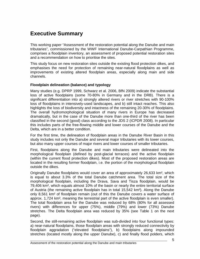
Originally Danube floodplains would cover an area of approximately 26,633 km², which is equal to about 3.3% of the total Danube catchment area. The total size of the morphological floodplain, including the Drava, Sava and Tisza floodplain, would be 79,406 km², which equals almost 10% of the basin or nearly the entire territorial surface of Austria (the remaining active floodplain has in total 15,542 km²). Along the Danube only 8,561 km² of floodplain remain (out of this the Danube covers a water surface of approx. 1,724 km², meaning the terrestrial part of the active floodplain is even smaller). The total floodplain area for the Danube was reduced by 68% (80% for all assessed rivers) with differences for upper (75%), middle (79%) and lower (73%) Danube stretches. The Delta floodplain area was reduced by 35% (see Table 1 on the next page).
Second, the still-remaining active floodplain was sub-divided into four functional types: a) near-natural floodplains, those floodplain areas with strongly reduced connectivity by floodplain aggradation (“elevated floodplains”), b) floodplains along impounded stretches (located mostly along the upper Danube), c) and finally flood polders, which
________________________________________________________________________________ Assessment of the restoration potential along the Danube and main tributaries
6
are flooded only during major flood events. The entire former floodplain was defined as an additional functional type (d). The sub-division allows for a better assessment of the actual remaining near-natural floodplains − the loss is nearly 92% (upper), 90% (middle), 75% (lower) and 48% (Delta) − and furthermore it allows for a better estimation of the restoration potential for the other types of active floodplains, such as the improvement of residual water (ecological flooding) in hydrologically altered areas, e.g. backwater reaches along impounded stretches typical in Germany and Austria.
Table 1: Floodplain area comparison for the Danube
Size of floodplain Floodplain loss
Morphological
floodplain [km²]1
Active floodplain, incl. main channel2
[km²] [%]
Upper Danube 950 km (DE, AT)
2,831
707
75
Middle Danube 900 km (SK, HU, HR, RS, RO)
10,369
2,143
79
Lower Danube 850 km (RO, BG, MD, UA)
8,033
2,208
73
Danube Delta 100 km (RO, UA)
5,400
3,503
35
Danube total 2,845 km
26,633
8,561
68
Finally, a bio-geographical floodplain typology similar to the WFD typology for rivers would complete the basic characterisation of floodplains in the DRB, therefore first suggestions are given in the study. Assessment and proposal of potential restoration si tes
After floodplain delineation and general characterisation into type, the ideal next step would be to assess services that floodplain ecosystems provide, such as flood protection, groundwater replenishment, sediment and nutrient retention, water purification, resilience and recovery of river ecosystems after accidents, biodiversity/habitat, river-floodplain products (wood, fish, game, reed), cultural values, recreation and tourism, and climate change buffering capacity. Due to the exorbitant time requirements to asses these ecosystem services − based on experience and results of earlier studies for the Danube (DPRP 1999 and BfN 2009) − the author skipped this step in favor of assessing the proposed restoration sites only by basic data. However some overall indicators were calculated continuously, such as the overlap of floodplains and protected areas (73% of active and 39% of morphological Danube
1 Including the active floodplain (morphological floodplain minus active floodplain is the “former” floodplain) 2 Due to the fact that all channels are integral part of the river-floodplain ecosystem the channels are included in the calculation. However in heavily altered river reaches the real size of active (semi- and terrestrial habitats) floodplains can have only half the size or even less than the main channel, in particularly along the large lower Danube when the channel reaches some 1-2 km in width)
________________________________________________________________________________ Assessment of the restoration potential along the Danube and main tributaries
7
floodplains are already protected, mostly by Natura2000, as compared to active German floodplains which are protected by about 50%).
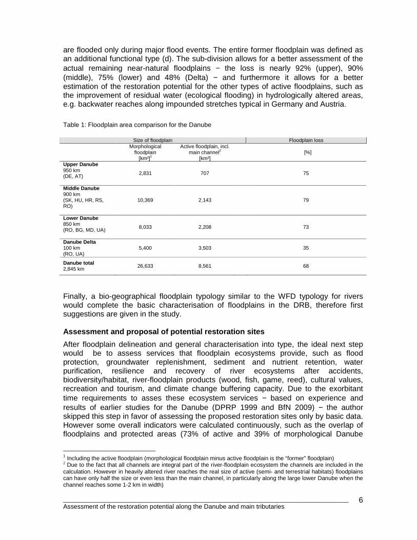
The pragmatic selection of potential restoration sites is based on already existing governmental and non-governmental projects and proposals. In addition, new areas are proposed iteratively from the upper Danube to the Delta based on continuously available data including: land use and habitats (settlements are “no go” areas), spatial configuration (size/length/width/position), hydromorphological intactness, overlapping protected areas, and floodplain function/purpose (e.g. tributary confluences can act as stepping stones in biological corridors or have high floodwater retention capacity). In addition socio-economic indicators, such as land ownership, usage concepts for specific areas and feasibility of projects (costs, legal framework, and administration), were collected and recorded, if available, in a database along with the previous mentioned data. The database also includes information such as adjacent WFD waterbodies (e.g. with their hydromorphology assessments) or existing management plans to directly link proposed areas to the ongoing planning of the respective target fields (WFD, FFH-D and FD). The applied approach identifies large scale restoration projects (>500 ha) but this does not necessarily mean that additional smaller areas or sections of the proposed areas are not also suitable for restoration.
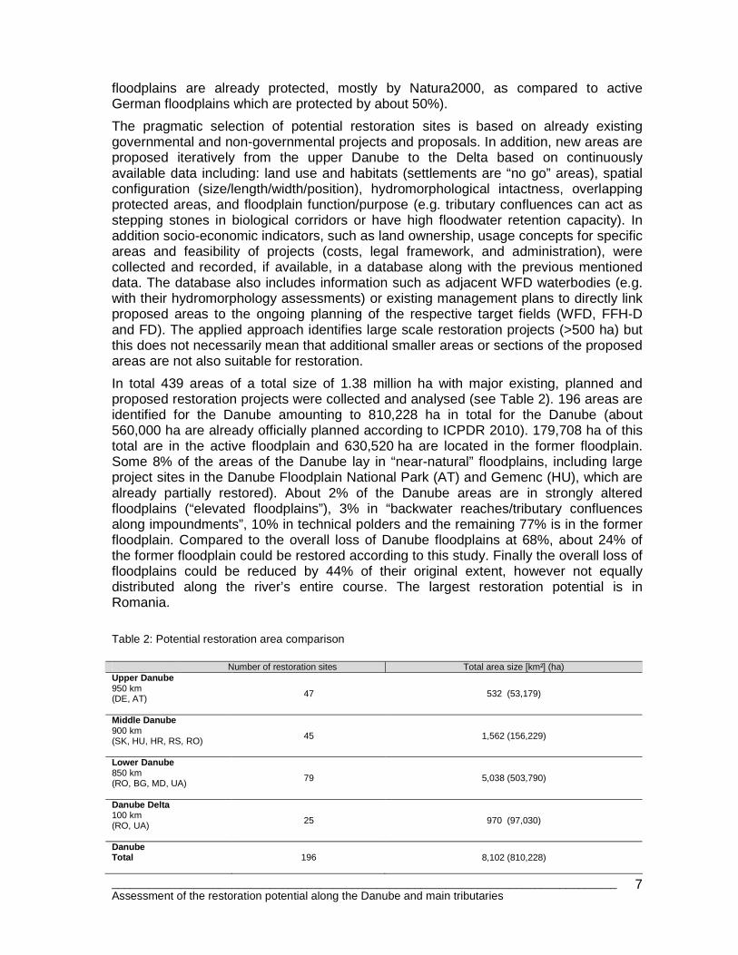
In total 439 areas of a total size of 1.38 million ha with major existing, planned and proposed restoration projects were collected and analysed (see Table 2). 196 areas are identified for the Danube amounting to 810,228 ha in total for the Danube (about 560,000 ha are already officially planned according to ICPDR 2010). 179,708 ha of this total are in the active floodplain and 630,520 ha are located in the former floodplain. Some 8% of the areas of the Danube lay in “near-natural” floodplains, including large project sites in the Danube Floodplain National Park (AT) and Gemenc (HU), which are already partially restored). About 2% of the Danube areas are in strongly altered floodplains (“elevated floodplains”), 3% in “backwater reaches/tributary confluences along impoundments”, 10% in technical polders and the remaining 77% is in the former floodplain. Compared to the overall loss of Danube floodplains at 68%, about 24% of the former floodplain could be restored according to this study. Finally the overall loss of floodplains could be reduced by 44% of their original extent, however not equally distributed along the river’s entire course. The largest restoration potential is in Romania.
Table 2: Potential restoration area comparison
Number of restoration sites Total area size [km²] (ha) Upper Danube 950 km (DE, AT)
47
532 (53,179)
Middle Danube 900 km (SK, HU, HR, RS, RO)
45
1,562 (156,229)
Lower Danube 850 km (RO, BG, MD, UA)
79
5,038 (503,790)
Danube Delta 100 km (RO, UA)
25
970 (97,030)
Danube Total
196
8,102 (810,228)
________________________________________________________________________________ Assessment of the restoration potential along the Danube and main tributaries
8
Total: Danube and tributaries
439 13,855
(1,385,481)
Prioritisation As previously mentioned, the initial prioritisation of the proposed restoration sites is even more complicated due to lack of detailed data. Therefore the approach must fit to the available continuous data requirements, which in turn implicate the limitation of results. The pragmatic pre-selection of potential sites cannot substitute for national approaches. The potential restoration sites vary in size, configuration and feasibility of implementation. Respecting the different purposes of floodplain restoration, such as flood protection, biodiversity, nutrient reduction, groundwater exchange, forestry, recreation etc, the assessment initially focused on “floodplain functioning” or in other words the “intactness” of the floodplain ecosystem in relation to hydromorphological criteria (mostly flood regime and dynamics) to support most of the ecosystem services listed above. Only parameters with sufficient data coverage, e.g. overall hydromorphological intactness of adjacent river stretch, functional floodplain type, land use (percentage of agriculture as an indicator for the intensity of land use), protection status and coverage, and area size (in relation to retention capacity and hydromorphological dynamics) were analysed. An initial assessment matrix indicates priority level for each proposed site. Of the planned and proposed areas for the Danube, 33 (19%) receive a “very high” restoration potential rating, 98 (56%) a “high” rating and the remaining 45 (25%) only a “moderate” restoration potential rating. This first comparison of areas is based on commonly available parameters and can be used to further discuss and develop restoration prioritisation. Conclusions Some “action plans” and “implementation strategies” provide a framework for floodplain restoration. However, using the example of the “Programmes of Measures (PoM” of the WFD, such plans often include only a few proposals (with exception of RO in the PoM) and implementation schedules in later management cycles towards 2026. A short term goal therefore must be the definition and clear planning of one large scale pilot restoration project per country by the next cycle of WFD management planning in 2013.
If all sites proposed in this study were implemented over the long-term, e.g. in the third WFD planning cycle by 2026 and beyond 2032, this would mean that 1% of the proposed sites should be restored per year, with other words it would be necessary to restore 28,000 ha each year, or 2,150 ha per country (not considering the distribution of projects nationally). Based on past experiences of pilot projects, achieving this number would require strong and clear political direction and funding for implementation. Estimating that it costs about 500,000 €/km² for restoration across the basin, the overall investment needed to restore all sites proposed in this study would amount to more than 6 billion € (see Chapter 5.2 for more information).
________________________________________________________________________________ Assessment of the restoration potential along the Danube and main tributaries
9
Further general conclusions are:
• It is necessary to increase trans-boundary knowledge of DRB floodplains overall, and to extend continuous floodplain assessment based on floodplain segments by country, e,g, like what was done in Germany (BfN 2009).
• The tools and approaches applied in this study (in particular prioritization) should be further developed in line with FFH-D, WFD and FD plans within the WFD planning cycle timelines. A database to share experiences and development would support the further work.
• Type-specific and adaptive restoration strategies are needed. Protection and improvement (restoration) of existing floodplains is important (only about 10% remain under near-natural conditions along upper and middle Danube!).
• The availability of land (ownership is often most critical), but also of other data, in particular hydraulic models for ecological planning, is very important to ensure successful restoration.
• Protected areas and their management must go hand-in-hand with restoration efforts. Floodplains are very dynamic systems that host a variety of habitats and species within close vicinity. For example, the reconnection and re-dynamisation of protected oxbows are also important for the river-floodplain system, and restoration of both floodplain and oxbow should coexist in the limited given space for river development.
• Favorable legal frameworks, e.g. clear protection of still-existing retention areas (no-go areas for further land development in floodplains), strong spatial planning instruments and tight administrative and political structures that allow for transparent public participation are requirements for successful restoration projects.
• Clear impact assessments of the project on local, regional and international levels regarding floods, ecology and other ecosystem services is necessary for successful restoration.
• Prioritisation approaches must be further developed, but should not be overloaded with pre-justifications regarding ecological or technical outcomes; ultimately the local feasibility conditions will shape (and reduce) the list of potential sites.
• Requirements for local planning and approval by authorities (e.g. influence on local flood levels, water quality and so on) must be considered from the beginning.
• Broad stakeholder involvement and interdisciplinary planning work is a pre-condition for successful restoration.
________________________________________________________________________________ Assessment of the restoration potential along the Danube and main tributaries
10
1. Introduction Over ten years has passed since the first assessment of restoration potential in the Danube basin and assessments of restoration projects (DPRP 1999, ZÖCKLER 2000, ECRR 2001). Also, within the last decade, only a limited number and size of floodplain areas were restored. On the other hand the knowledge and experience of restoration increased considerably and many new projects are under planning (at least for smaller areas regarding longitudinal continuity, such as the removal of migration obstacles and river stretches focusing on channel improvements, and even a few larger floodplain areas). Considering EU Directives such as the WFD and FD, the pressure on countries to increase their restoration activity is evident and first results of implementation should be achieved until 2013 and 2015, respectively. The aim of this assessment is, therefore, to support further floodplain restoration in the DRB and to discuss and propose basic methodologies on how to define and prioritize future projects. The main part of this working paper focuses on the physical determination and the assessment of potential floodplain restoration sites, and supports the further selection of proposed sites (chapters 2-4). It should provide the framework for the assessment, and finally prioritisation, of restoration projects focussing on the lateral connectivity of river-floodplain ecosystems. From the beginning it was clear that “feasibility” of restoration projects, such as the legal framework, local usage concepts for floodplains, land ownership, data availability or cost calculations, often determinates which projects are feasible or not (even much more than any pre-selection methodology). Therefore this important topic is introduced at the end (chapter 5).
________________________________________________________________________________ Assessment of the restoration potential along the Danube and main tributaries
11
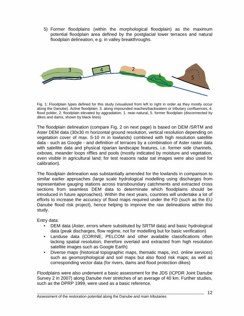
2. Floodplain delineation 2.1 Methodology Earlier studies evaluate the total size of floodplains of the Danube and its major lowland floodplains (DPRP 1999). In this study, the delineation of active and morphological floodplains along the Danube and major tributaries was completely revised and extended to further tributaries with important floodplains; this gives a rather good approximation of the extent of potentially flooded areas. Comparable approaches can be found for the German Floodplain Balance (BfN 2009). In a few years, the current EU “Danube Floodrisk” project should be able to refine these figures based on high resolution DEM and hydrodynamic modelling. Today’s floodplains are not thinkable without lateral flood protection dikes and/or influencing dams. Therefore from the beginning of this study, information on those major hydraulic structures was collected separately. Starting along the upper Danube in Germany and Austria, a widespread type of dike can be defined along river impoundments with an artificial water regime (they are usually only flooded in case of high floods or by smaller tributaries). The largest examples of these floodplains are the Tullnerfeld in Austria and the Szigetköz in Hungary, as well as parts of the Sava floodplain downstream of Zagreb. In addition, pure technical flood polders exist in the upper catchments, but also, e.g. on the Körös tributary in HU. New huge polders are planned along the Hungarian Tisza and partially along the lower Danube in RO. Those floodplains must be assessed separately from permanently connected floodplains. Even in still active floodplains along free-flowing river sections, the changes over the past century have been substantial. The most important factor causing these changes is a decrease in flood dynamic (duration and magnitude of flooding and sediment dynamics). This has caused changes in the ecological conditions of floodplains on most of the rivers due to water stored in upstream reservoirs, i.e. altered discharge regime (e.g. by flood protection measures). Another important issue affecting ecological conditions is the aggradation (fine sediment deposition) in floodplains caused by river regulation (narrowing of the river-floodplain cross section by dikes, deepening of channels) and short flood peaks with often very high suspended load concentrations (due to the changed hydrological regime and land-use practices). Floodplain types assessed in this study applicable for the Danube are (see Figure 1):
1) Active floodplains with still more or less typical habitat conditions (near-natural), side-channels with pioneer stands, floodplain forests and pastures, wetlands and oxbows.
2) Active elevated floodplains, strongly altered due to substantial aggradation (sedimentation) and mostly used for agriculture; but still potentially flooded during major flood events.
3) Active floodplains along impounded reaches/backwaters (often disconnected laterally from the main channel) still flooded regularly by tributary confluences and during major flood events (from 5-10 year flood events and upwards).
4) Polder (technical structures) completely surrounded by dikes, but opened in case of catastrophic floods (steered or un-steered, mostly operated without ecological flooding).
________________________________________________________________________________ Assessment of the restoration potential along the Danube and main tributaries
12
5) Former floodplains (within the morphological floodplain) as the maximum potential floodplain area defined by the postglacial lower terraces and natural floodplain delineation, e.g. in valley breakthroughs.
Fig. 1: Floodplain types defined for this study (visualized from left to right in order as they mostly occur along the Danube). Active floodplain: 3. along impounded reaches/backwaters or tributary confluences, 4. flood polder, 2. floodplain elevated by aggradation, 1. near-natural, 5. former floodplain (disconnected by dikes and dams, shown by black lines) The floodplain delineation (compare Fig. 2 on next page) is based on DEM /SRTM and Aster DEM data (30x30 m horizontal ground resolution, vertical resolution depending on vegetation cover of max. 5-10 m in lowlands) combined with high resolution satellite data - such as Google - and definition of terraces by a combination of Aster raster data with satellite data and physical riparian landscape features, i.e. former side channels, oxbows, meander loops riffles and pools (mostly indicated by moisture and vegetation, even visible in agricultural land; for test reasons radar sat images were also used for calibration). The floodplain delineation was substantially amended for the lowlands in comparison to similar earlier approaches (large scale hydrological modelling using discharges from representative gauging stations across transboundary catchments and extracted cross sections from seamless DEM data to determinate which floodplains should be introduced in future approaches). Within the next years, countries will undertake a lot of efforts to increase the accuracy of flood maps required under the FD (such as the EU Danube flood risk project), hence helping to improve the raw delineations within this study. Entry data:
• DEM data (Aster, errors where substituted by SRTM data) and basic hydrological data (peak discharges, flow regime, not for modelling but for basic verification)
• Landuse data (CORINE, PELCOM and other available classifications often lacking spatial resolution, therefore overlaid and extracted from high resolution satellite images such as Google Earth)
• Diverse maps (historical topographic maps, thematic maps, incl. online services) such as geomorphological and soil maps but also flood risk maps; as well as corresponding vector data (for rivers, dams and flood protection dikes)
Floodplains were also underwent a basic assessment for the JDS (ICPDR Joint Danube Survey 2 in 2007) along Danube river stretches of an average of 40 km. Further studies, such as the DPRP 1999, were used as a basic reference.
________________________________________________________________________________ Assessment of the restoration potential along the Danube and main tributaries
13
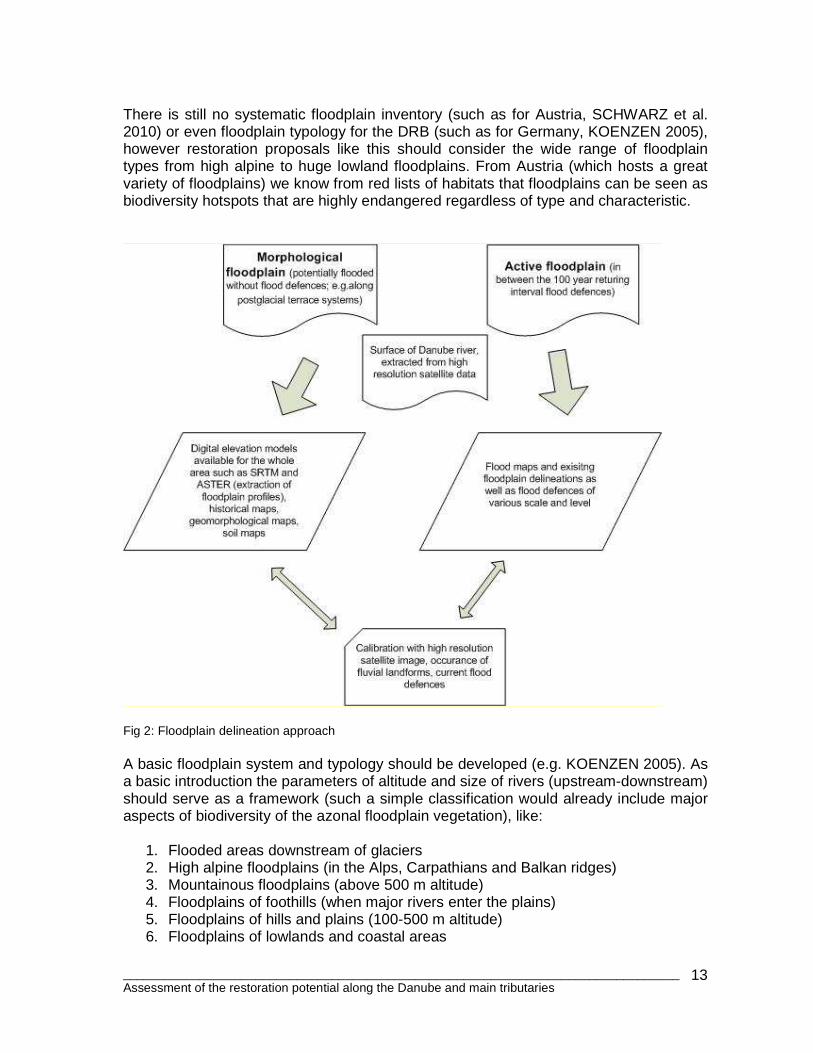
There is still no systematic floodplain inventory (such as for Austria, SCHWARZ et al. 2010) or even floodplain typology for the DRB (such as for Germany, KOENZEN 2005), however restoration proposals like this should consider the wide range of floodplain types from high alpine to huge lowland floodplains. From Austria (which hosts a great variety of floodplains) we know from red lists of habitats that floodplains can be seen as biodiversity hotspots that are highly endangered regardless of type and characteristic.
Fig 2: Floodplain delineation approach A basic floodplain system and typology should be developed (e.g. KOENZEN 2005). As a basic introduction the parameters of altitude and size of rivers (upstream-downstream) should serve as a framework (such a simple classification would already include major aspects of biodiversity of the azonal floodplain vegetation), like:
1. Flooded areas downstream of glaciers 2. High alpine floodplains (in the Alps, Carpathians and Balkan ridges) 3. Mountainous floodplains (above 500 m altitude) 4. Floodplains of foothills (when major rivers enter the plains) 5. Floodplains of hills and plains (100-500 m altitude) 6. Floodplains of lowlands and coastal areas
________________________________________________________________________________ Assessment of the restoration potential along the Danube and main tributaries
14
Another option would be to extend the (national) WFD typology for rivers (such a basin-wide typology is under preparation for the DRB). Proposed restoration projects should at least be allocated to those types (and should be all covered in a conservation-restoration strategy); further delineation and inventories as well as method development of the individual projects would then still be necessary. 2.2 Results
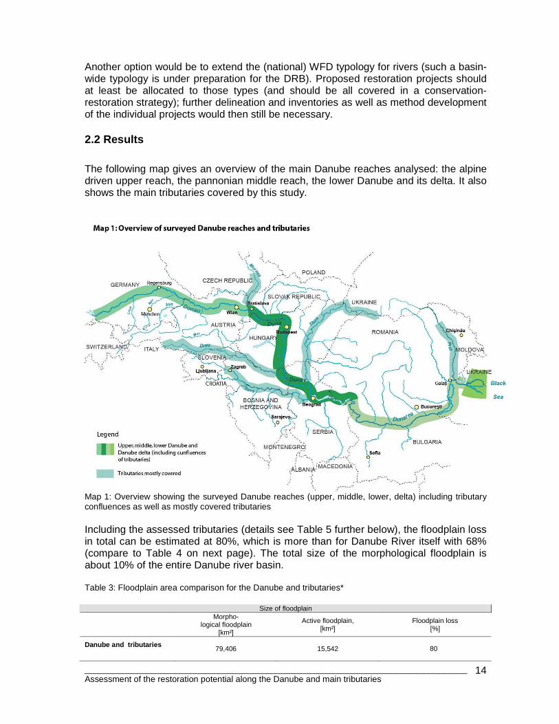
The following map gives an overview of the main Danube reaches analysed: the alpine driven upper reach, the pannonian middle reach, the lower Danube and its delta. It also shows the main tributaries covered by this study.
Map 1: Overview showing the surveyed Danube reaches (upper, middle, lower, delta) including tributary confluences as well as mostly covered tributaries Including the assessed tributaries (details see Table 5 further below), the floodplain loss in total can be estimated at 80%, which is more than for Danube River itself with 68% (compare to Table 4 on next page). The total size of the morphological floodplain is about 10% of the entire Danube river basin. Table 3: Floodplain area comparison for the Danube and tributaries*
Size of floodplain
Morpho-
logical floodplain [km²]
Active floodplain, [km²]
Floodplain loss [%]
Danube and tributaries
79,406
15,542
80
________________________________________________________________________________ Assessment of the restoration potential along the Danube and main tributaries
15
*Drava and Mura total length, Tisza 95%, Prut, Sava and Mures about 80-90% - only headwaters are missing, Bodrog 60%, Latorica 30%, Traun (50%), Morava-Dyje (each 50%), Vah (30%), Raba (50%), Sio (50%), Sajo 30%, Körös and three main tributaries 50%, Timis 30%, Somes 90%, Bosna, Vrbas, Drina, Kolumbara each 20%, Veliki Morava 50%, Timok 50%, Russenski Lom 50%, Jiu, Olt, Vedea, Arges, Ialomita, Siret 20% confluences only: Hron, Ipel, Una, Lom, Ogosta, Iskar, Yantra.
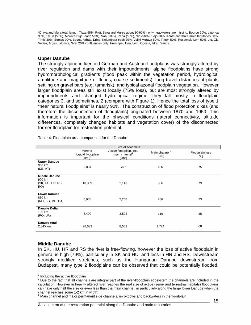
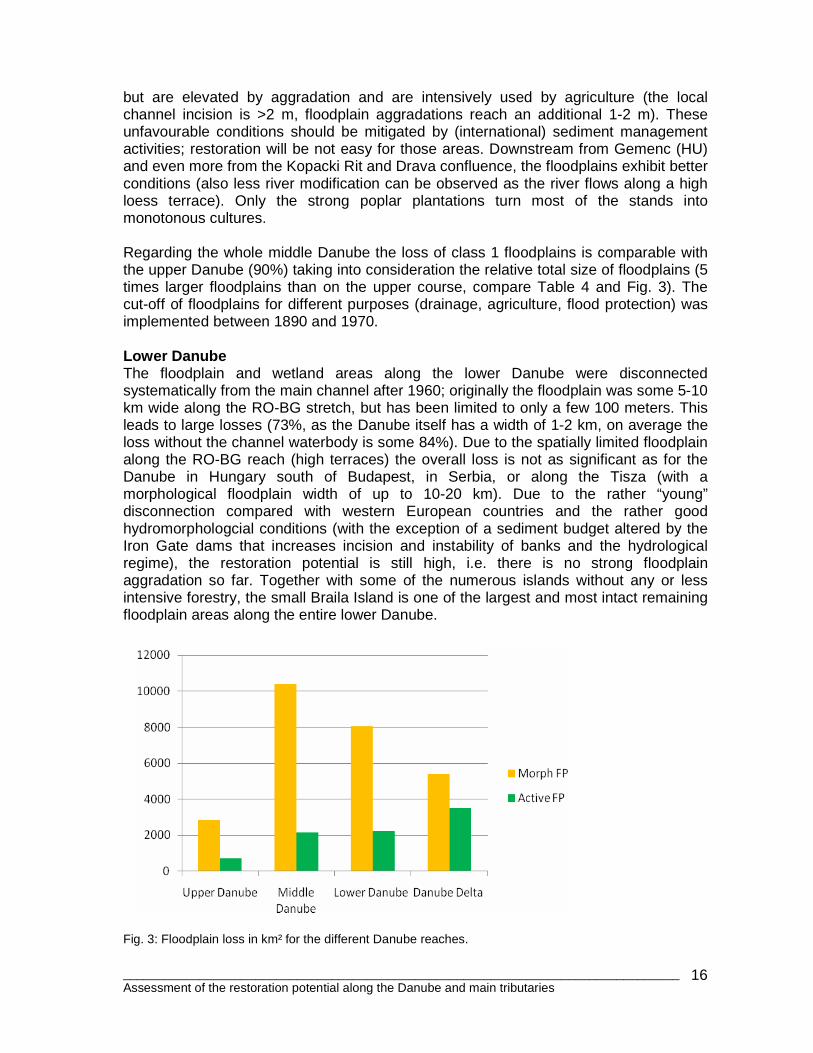
Upper Danube The strongly alpine influenced German and Austrian floodplains was strongly altered by river regulation and dams with their impoundments; alpine floodplains have strong hydromorphological gradients (flood peak within the vegetation period, hydrological amplitude and magnitude of floods, coarse sediments), long travel distances of plants settling on gravel bars (e.g. tamarisk), and typical azonal floodplain vegetation. However larger floodplain areas still exist locally (75% loss), but are most strongly altered by impoundments and changed hydrological regime; they fall mostly in floodplain categories 3, and sometimes, 2 (compare with Figure 1). Hence the total loss of type 1 “near natural floodplains” is nearly 92%. The construction of flood protection dikes (and therefore the disconnection of floodplains) originated between 1870 and 1950. This information is important for the physical conditions (lateral connectivity, altitude differences, completely changed habitats and vegetation cover) of the disconnected former floodplain for restoration potential. Table 4: Floodplain area comparison for the Danube
Size of floodplain
Morpho-
logical floodplain [km²]3
Active floodplain, incl. main channel4
[km²]
Main channel 5 Km²]
Floodplain loss [%]
Upper Danube 950 km (DE, AT)
2,831
707
166 75
Middle Danube 900 km (SK, HU, HR, RS, RO)
10,369
2,143
656 79
Lower Danube 850 km (RO, BG, MD, UA)
8,033
2,208
786 73
Danube Delta 100 km (RO, UA)
5,400
3,503
116 35
Danube total 2,845 km
26,633
8,561
1,724 68
Middle Danube In SK, HU, HR and RS the river is free-flowing, however the loss of active floodplain in general is high (79%), particularly in SK and HU, and less in HR and RS. Downstream strongly modified stretches, such as the Hungarian Danube downstream from Budapest, many type 2 floodplains can be observed that could be potentially flooded, 3 Including the active floodplain 4 Due to the fact that all channels are integral part of the river-floodplain ecosystem the channels are included in the calculation. However in heavily altered river reaches the real size of active (semi- and terrestrial habitats) floodplains can have only half the size or even less than the main channel, in particularly along the large lower Danube when the channel reaches some 1-2 km in width) 5 Main channel and major permanent side channels, no oxbows and backwaters in the floodplain
________________________________________________________________________________ Assessment of the restoration potential along the Danube and main tributaries
16
but are elevated by aggradation and are intensively used by agriculture (the local channel incision is >2 m, floodplain aggradations reach an additional 1-2 m). These unfavourable conditions should be mitigated by (international) sediment management activities; restoration will be not easy for those areas. Downstream from Gemenc (HU) and even more from the Kopacki Rit and Drava confluence, the floodplains exhibit better conditions (also less river modification can be observed as the river flows along a high loess terrace). Only the strong poplar plantations turn most of the stands into monotonous cultures. Regarding the whole middle Danube the loss of class 1 floodplains is comparable with the upper Danube (90%) taking into consideration the relative total size of floodplains (5 times larger floodplains than on the upper course, compare Table 4 and Fig. 3). The cut-off of floodplains for different purposes (drainage, agriculture, flood protection) was implemented between 1890 and 1970. Lower Danube The floodplain and wetland areas along the lower Danube were disconnected systematically from the main channel after 1960; originally the floodplain was some 5-10 km wide along the RO-BG stretch, but has been limited to only a few 100 meters. This leads to large losses (73%, as the Danube itself has a width of 1-2 km, on average the loss without the channel waterbody is some 84%). Due to the spatially limited floodplain along the RO-BG reach (high terraces) the overall loss is not as significant as for the Danube in Hungary south of Budapest, in Serbia, or along the Tisza (with a morphological floodplain width of up to 10-20 km). Due to the rather “young” disconnection compared with western European countries and the rather good hydromorphologcial conditions (with the exception of a sediment budget altered by the Iron Gate dams that increases incision and instability of banks and the hydrological regime), the restoration potential is still high, i.e. there is no strong floodplain aggradation so far. Together with some of the numerous islands without any or less intensive forestry, the small Braila Island is one of the largest and most intact remaining floodplain areas along the entire lower Danube.
Fig. 3: Floodplain loss in km² for the different Danube reaches.
________________________________________________________________________________ Assessment of the restoration potential along the Danube and main tributaries
17
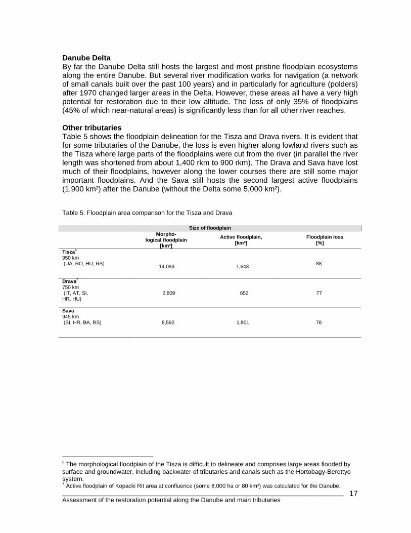
Danube Delta By far the Danube Delta still hosts the largest and most pristine floodplain ecosystems along the entire Danube. But several river modification works for navigation (a network of small canals built over the past 100 years) and in particularly for agriculture (polders) after 1970 changed larger areas in the Delta. However, these areas all have a very high potential for restoration due to their low altitude. The loss of only 35% of floodplains (45% of which near-natural areas) is significantly less than for all other river reaches. Other tributaries Table 5 shows the floodplain delineation for the Tisza and Drava rivers. It is evident that for some tributaries of the Danube, the loss is even higher along lowland rivers such as the Tisza where large parts of the floodplains were cut from the river (in parallel the river length was shortened from about 1,400 rkm to 900 rkm). The Drava and Sava have lost much of their floodplains, however along the lower courses there are still some major important floodplains. And the Sava still hosts the second largest active floodplains (1,900 km²) after the Danube (without the Delta some 5,000 km²). Table 5: Floodplain area comparison for the Tisza and Drava
Size of floodplain
Morpho-
logical floodplain [km²]
Active floodplain, [km²]
Floodplain loss [%]
Tisza 6 950 km (UA, RO, HU, RS)
14,083
1,643
88
Drava7 750 km (IT, AT, SI, 2,809 652 77 HR, HU) Sava 945 km (SI, HR, BA, RS)
8,592
1,901
78
6 The morphological floodplain of the Tisza is difficult to delineate and comprises large areas flooded by surface and groundwater, including backwater of tributaries and canals such as the Hortobagy-Berettyo system. 7 Active floodplain of Kopacki Rit area at confluence (some 8,000 ha or 80 km²) was calculated for the Danube.
________________________________________________________________________________ Assessment of the restoration potential along the Danube and main tributaries
18
3. Floodplain assessment for restoration potential 3.1 Methodology The studies introduced in the second chapter (DPRP 1999, HULSE 2004 and the recently published German floodplain balance and assessment, BfN 2009) try to assess the ecological value and potential based on schematic floodplain segments (see Map 2 on next page). These assessments are mostly based on landuse, width/size, hydromorphological structures (intactness), and the protection status of remaining floodplains. Recent research projects such as the “German National Floodplain project” evaluate floodplain functions for flood retention, sediment retention (depending on roughness), purification functions, CO2 retention (e.g. carbon stocks of some 400 t/ha in hardwood vegetation according to CIERJACKS et al. 2010), and biodiversity and habitat functions. These approaches will be applied to floodplain segments and can therefore be quantified for entire river stretches. However, this can be problematic if the averaged parameters do not reflect reality and different parameters strongly influence others resulting in under- or overestimations. Habitat functions (aggregated functions) can be estimated (by scoring and comparison) based on the available coverage of Natura2000 and other protected areas with its typical habitats for floodplains, as well as the intensity of landuse, which can be obtained by remote sensing or land use classifications. For the present study this very time consuming step was skipped in favour of only assessing the proposed sites by basic, but commonly available, parameters.
________________________________________________________________________________ Assessment of the restoration potential along the Danube and main tributaries
19
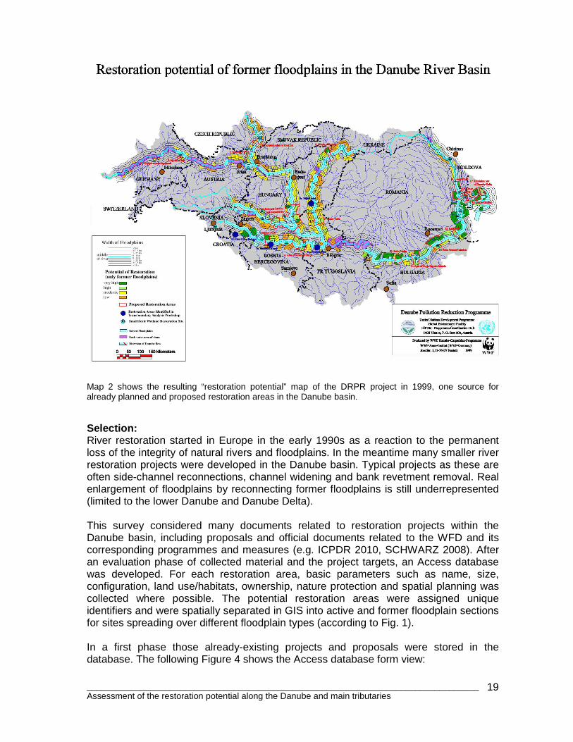
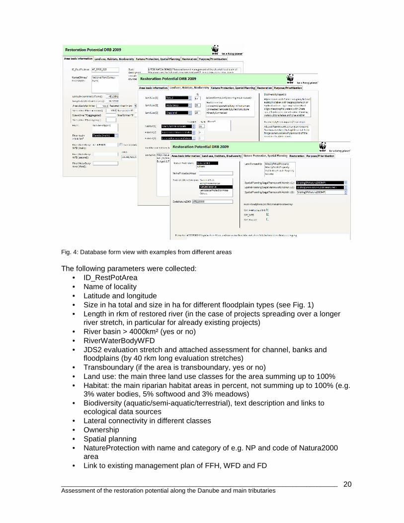
Map 2 shows the resulting “restoration potential” map of the DRPR project in 1999, one source for already planned and proposed restoration areas in the Danube basin. Selection: River restoration started in Europe in the early 1990s as a reaction to the permanent loss of the integrity of natural rivers and floodplains. In the meantime many smaller river restoration projects were developed in the Danube basin. Typical projects as these are often side-channel reconnections, channel widening and bank revetment removal. Real enlargement of floodplains by reconnecting former floodplains is still underrepresented (limited to the lower Danube and Danube Delta). This survey considered many documents related to restoration projects within the Danube basin, including proposals and official documents related to the WFD and its corresponding programmes and measures (e.g. ICPDR 2010, SCHWARZ 2008). After an evaluation phase of collected material and the project targets, an Access database was developed. For each restoration area, basic parameters such as name, size, configuration, land use/habitats, ownership, nature protection and spatial planning was collected where possible. The potential restoration areas were assigned unique identifiers and were spatially separated in GIS into active and former floodplain sections for sites spreading over different floodplain types (according to Fig. 1). In a first phase those already-existing projects and proposals were stored in the database. The following Figure 4 shows the Access database form view:
________________________________________________________________________________ Assessment of the restoration potential along the Danube and main tributaries
20
Fig. 4: Database form view with examples from different areas The following parameters were collected:
• ID_RestPotArea • Name of locality • Latitude and longitude • Size in ha total and size in ha for different floodplain types (see Fig. 1) • Length in rkm of restored river (in the case of projects spreading over a longer
river stretch, in particular for already existing projects) • River basin > 4000km² (yes or no) • RiverWaterBodyWFD • JDS2 evaluation stretch and attached assessment for channel, banks and
floodplains (by 40 rkm long evaluation stretches) • Transboundary (if the area is transboundary, yes or no) • Land use: the main three land use classes for the area summing up to 100% • Habitat: the main riparian habitat areas in percent, not summing up to 100% (e.g.
3% water bodies, 5% softwood and 3% meadows) • Biodiversity (aquatic/semi-aquatic/terrestrial), text description and links to
ecological data sources • Lateral connectivity in different classes • Ownership • Spatial planning • NatureProtection with name and category of e.g. NP and code of Natura2000
area • Link to existing management plan of FFH, WFD and FD
________________________________________________________________________________ Assessment of the restoration potential along the Danube and main tributaries
21
• RetentionCapacity (estimated by area size and by an average flood level of 1.5 m)
• Project status (proposed, planned, implemented) • Restoration types (e.g dike removal) • Restoration purposes (if specifically mentioned for existing projects) • Data (hydrodynamic modeling, biodiversity, forestry) • Prioritisation
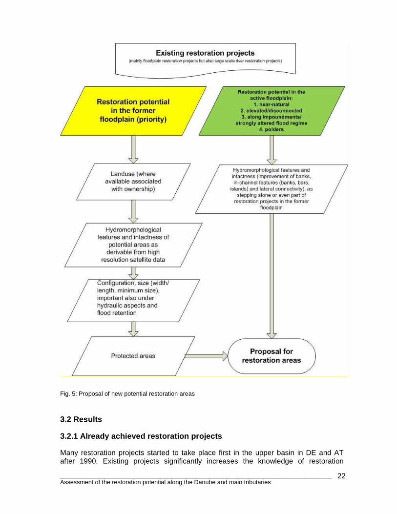
The database is still not fully complete. Most of the fields so far remain empty (see Chapter 5 for more details). The focus of this study was collect and set up the basic information, including landuse and nature protection. No area size limit was set for the initial restoration project database (500 ha was used as significance criteria for the new proposals). E.g. along the Inn River in Austria several very small projects are under implementation totalling not more than 7-8 ha. Some rivers such as the Isar were not covered in full detail; however the Isar 2020 Plan is an ambitious restoration program covering almost 1/3 of the entire river. New areas were added in a second database phase, Potential restoration areas were selected iteratively from the upper Danube to the Delta (respecting the different floodplain types and the position along the river) based on the following criteria that focuses on the former floodplain (see Fig. 5):
1. Landuse in the potential restoration areas and associated ownership (settled areas are “no go” areas).
2. Hydromorphological features and intactness of potential areas (former channels, typical floodplain relief with still existing potential connections to the active floodplain).
3. Configuration, (size/width/length), important also under hydraulic aspects and flood retention, as well as spatial position function/purpose (e.g. on tributary confluences, as stepping stones in the biotope network or with high retention capacity).
4. Overlay with protected areas.
________________________________________________________________________________ Assessment of the restoration potential along the Danube and main tributaries
22
Fig. 5: Proposal of new potential restoration areas 3.2 Results 3.2.1 Already achieved restoration projects Many restoration projects started to take place first in the upper basin in DE and AT after 1990. Existing projects significantly increases the knowledge of restoration
________________________________________________________________________________ Assessment of the restoration potential along the Danube and main tributaries
23
implementation, e.g. on the reaction of the natural system and the success of certain types of measures. One example is the projects carried out in the Danube Floodplain National Park east of Vienna (funded mostly by EU LIFE) over the past ten to fifteen years. There is a clear shift in quality and extension of those projects beginning with very small technical measures (e.g. slightly improved technical inlet structures to improve the discharge in side-channel branches by lowering cross dikes to connect areas during mean water, and the removal of bank revetment over several kilometers). Unfortunately dike relocations or removal of dikes is limited to very small projects in the DRB (large scale projects are under implementation along the German Elbe River and in the Netherlands). In total about 55,000 ha floodplain area projects where carried out, including the Danube National Park in Austria, the National Park Gemenc Beda in Hungary, plus parts of Kopacki Rit Nature Park (HR) and the Biosphere Reserve of the Danube Delta (UA and RO). Out of this 55,000 ha only a very minor area was actually reconnected by some 5,000 ha (along the lower Danube and in the Delta). In DE and AT for example only about 500 ha were actually reconnected; all other projects were in the already active floodplain. Other projects, such as the (technical) stabilization of the lower Salzach or the proposed compensation measures for the river engineering of the upper Danube in Bavaria (Straubing-Vilshofen) for flood protection reasons, are projects with basic positive influences on the floodplains, but must be critically analysed (in particular flood protection projects that often do not improve the direct lateral connection between the main channel and the floodplain). 3.2.2 Potential areas for restoration In total 439 areas have been recorded in this study with a total size of about 1,385,481 ha; 355,950 ha in the active floodplain (with all sub-types) and 1,029,531 ha in the former floodplain (including agricultural polders on lower Danube). Out of the 439 sites, 58 are already implemented (122,710 ha; out of this nearly 50,000 ha fall into the Lonjsko Polje area along the Sava), 105 are under official planning (662,910 ha) and the remaining 276 are only proposed (590,195 ha). The list is still incomplete, e.g. in Germany on the Isar and smaller tributaries several additional projects have been carried out. Also the current project status is subject to change (e.g. from officially planned to implemented), but basically the most important and largest projects have been covered accordingly. The paradigm in water management/flood protection has changed over the years, meaning new flood protection projects are planned to be “ecologically sound” and include ecological measures, and an increase of passive flood protection, i.e. retention where possible or by flood polders, and possible relocation of flood protection dikes. The mean size of individual potential restoration areas for the Danube is about 3,700 ha (see Fig. 13) which varies from about 1,100 ha on the upper Danube to 6,400 ha for the lower Danube. This reflects the very large areas along the lower Danube (the largest site is 70,925 ha at Insula Mare a Brailei, which could be of course sub-divided in smaller portions).
________________________________________________________________________________ Assessment of the restoration potential along the Danube and main tributaries
24
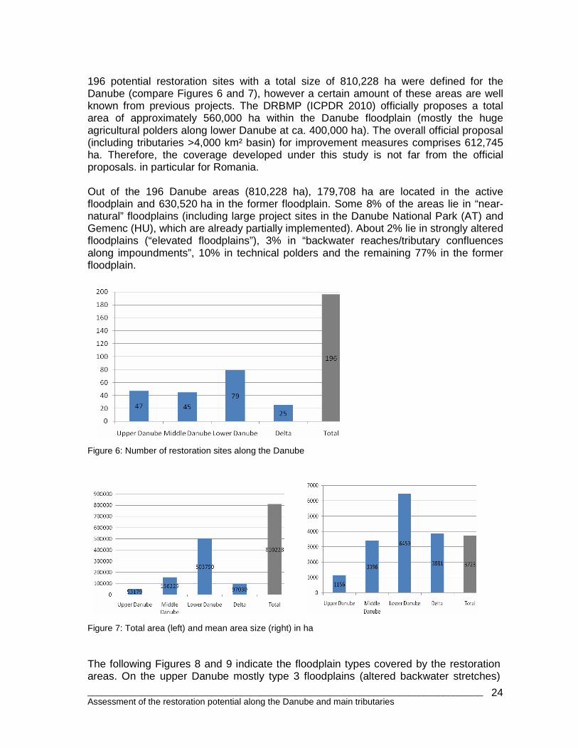
196 potential restoration sites with a total size of 810,228 ha were defined for the Danube (compare Figures 6 and 7), however a certain amount of these areas are well known from previous projects. The DRBMP (ICPDR 2010) officially proposes a total area of approximately 560,000 ha within the Danube floodplain (mostly the huge agricultural polders along lower Danube at ca. 400,000 ha). The overall official proposal (including tributaries >4,000 km² basin) for improvement measures comprises 612,745 ha. Therefore, the coverage developed under this study is not far from the official proposals. in particular for Romania. Out of the 196 Danube areas (810,228 ha), 179,708 ha are located in the active floodplain and 630,520 ha in the former floodplain. Some 8% of the areas lie in “near-natural” floodplains (including large project sites in the Danube National Park (AT) and Gemenc (HU), which are already partially implemented). About 2% lie in strongly altered floodplains (“elevated floodplains”), 3% in “backwater reaches/tributary confluences along impoundments”, 10% in technical polders and the remaining 77% in the former floodplain.
Figure 6: Number of restoration sites along the Danube
Figure 7: Total area (left) and mean area size (right) in ha The following Figures 8 and 9 indicate the floodplain types covered by the restoration areas. On the upper Danube mostly type 3 floodplains (altered backwater stretches)
________________________________________________________________________________ Assessment of the restoration potential along the Danube and main tributaries
25
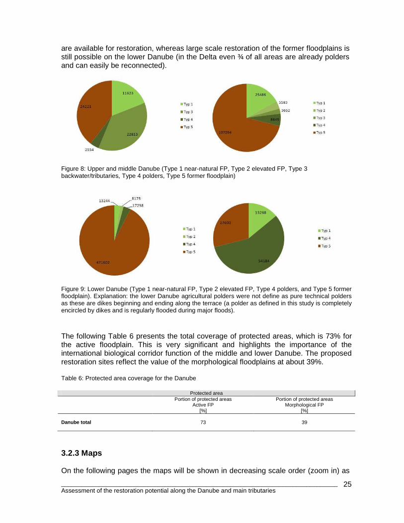
are available for restoration, whereas large scale restoration of the former floodplains is still possible on the lower Danube (in the Delta even ¾ of all areas are already polders and can easily be reconnected).
Figure 8: Upper and middle Danube (Type 1 near-natural FP, Type 2 elevated FP, Type 3 backwater/tributaries, Type 4 polders, Type 5 former floodplain)
Figure 9: Lower Danube (Type 1 near-natural FP, Type 2 elevated FP, Type 4 polders, and Type 5 former floodplain). Explanation: the lower Danube agricultural polders were not define as pure technical polders as these are dikes beginning and ending along the terrace (a polder as defined in this study is completely encircled by dikes and is regularly flooded during major floods). The following Table 6 presents the total coverage of protected areas, which is 73% for the active floodplain. This is very significant and highlights the importance of the international biological corridor function of the middle and lower Danube. The proposed restoration sites reflect the value of the morphological floodplains at about 39%. Table 6: Protected area coverage for the Danube
Protected area
Portion of protected areas
Active FP [%]
Portion of protected areas Morphological FP
[%]
Danube total
73
39
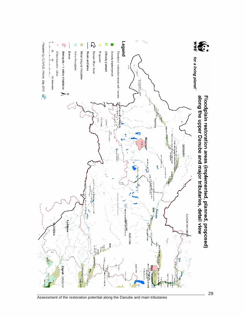
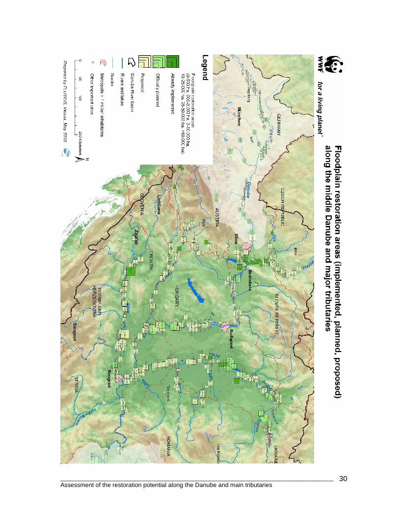
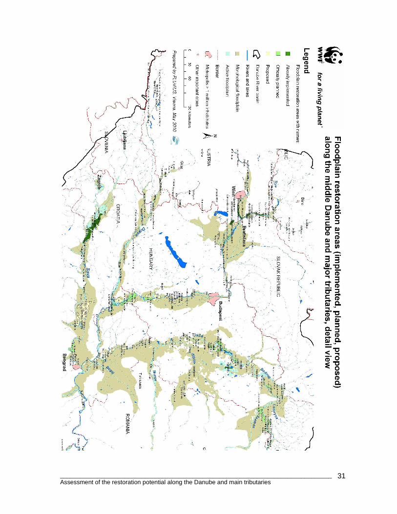
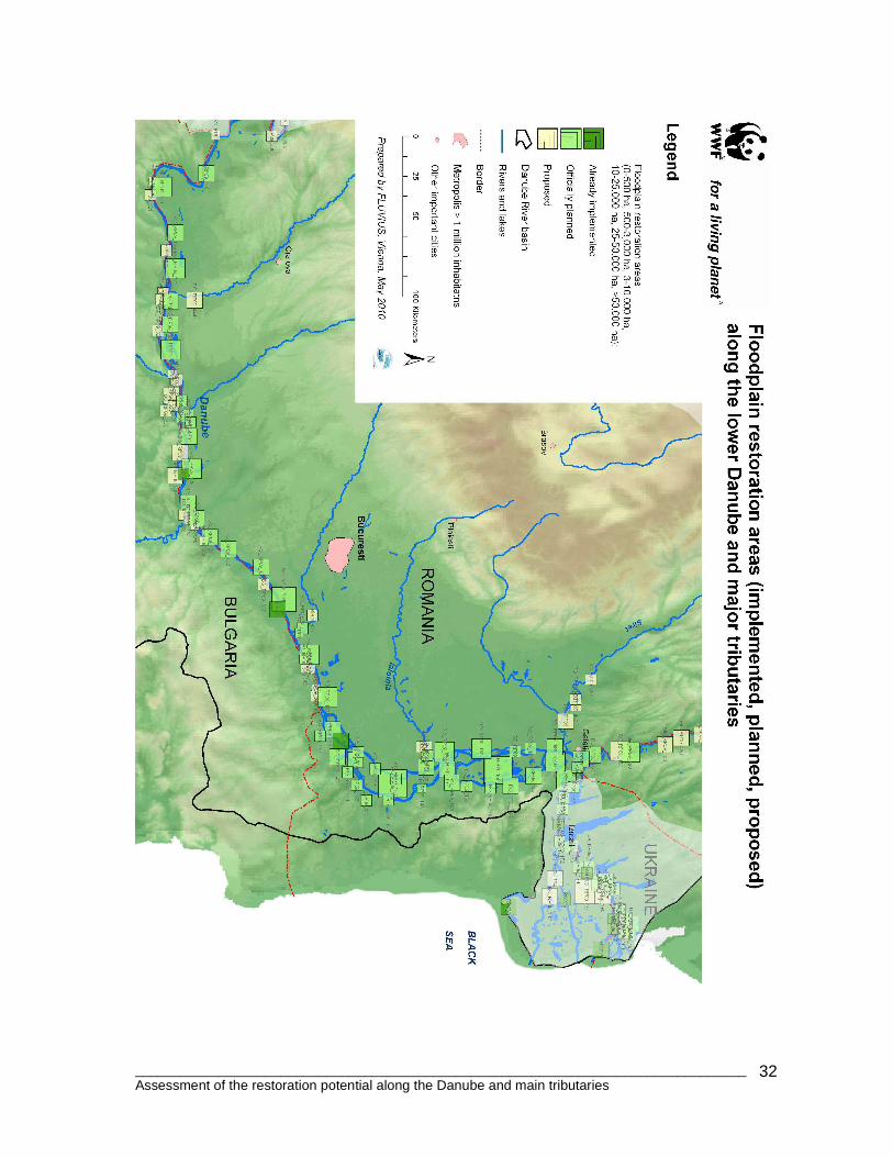
3.2.3 Maps On the following pages the maps will be shown in decreasing scale order (zoom in) as
________________________________________________________________________________ Assessment of the restoration potential along the Danube and main tributaries
26
follows:
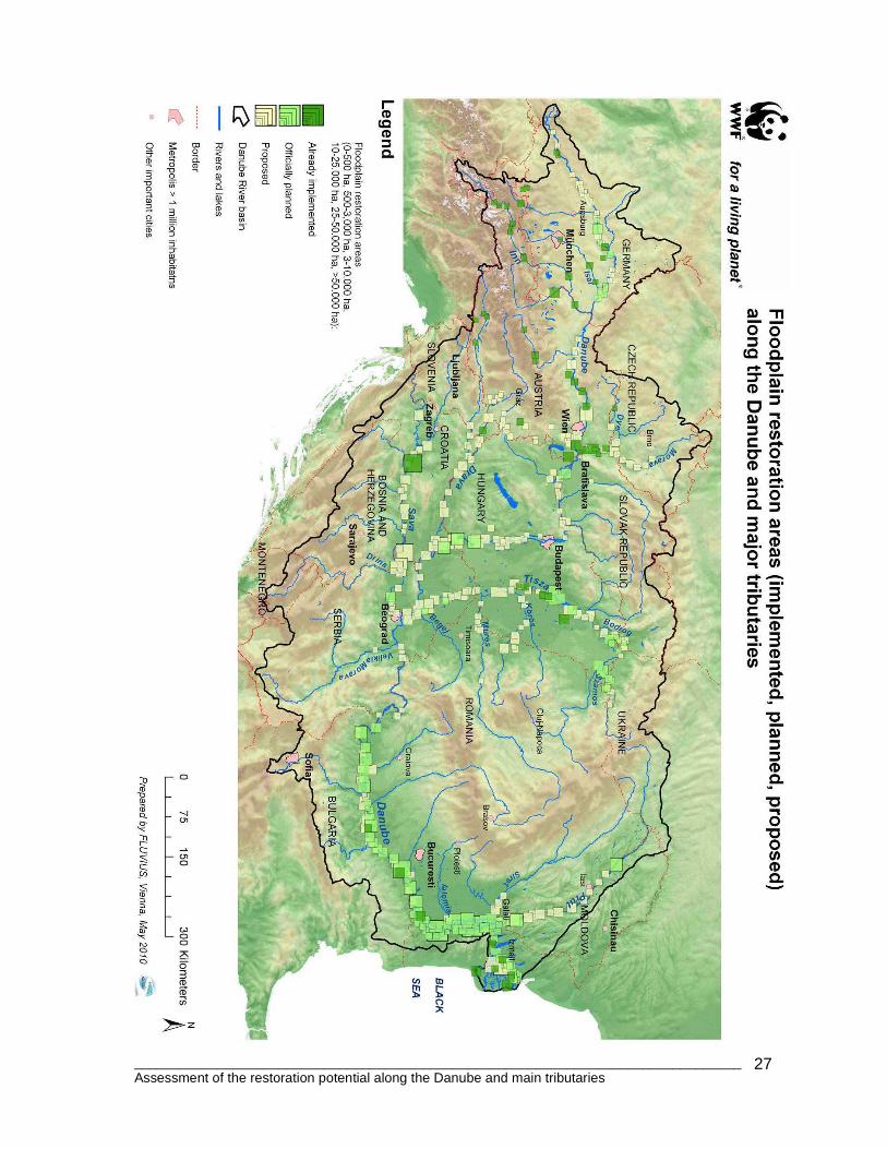
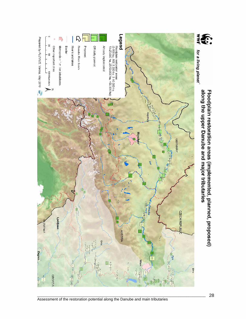
1. DRB overview map showing all restoration sites. 2. Overviews for upper, middle, lower Danube and Delta with automatic labels. 3. Zoom maps showing the floodplain delineation and areas with automatic name
labeling - an attached high resolution PDF file shows this map as one with full labels (identifier and full name, for a printable version the font would be too small).
________________________________________________________________________________ Assessment of the restoration potential along the Danube and main tributaries
27
________________________________________________________________________________ Assessment of the restoration potential along the Danube and main tributaries
28
________________________________________________________________________________ Assessment of the restoration potential along the Danube and main tributaries
29
________________________________________________________________________________ Assessment of the restoration potential along the Danube and main tributaries
30
________________________________________________________________________________ Assessment of the restoration potential along the Danube and main tributaries
31
________________________________________________________________________________ Assessment of the restoration potential along the Danube and main tributaries
32
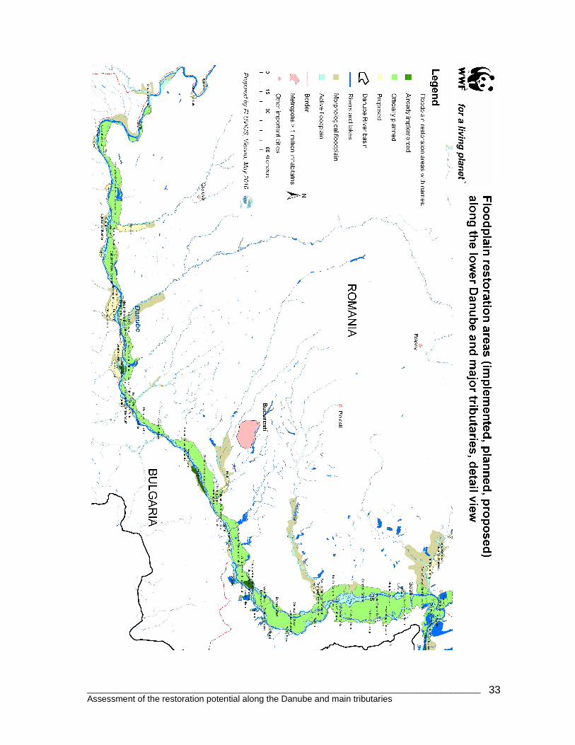
________________________________________________________________________________ Assessment of the restoration potential along the Danube and main tributaries
33
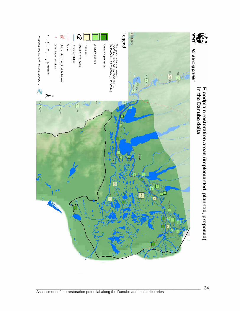
________________________________________________________________________________ Assessment of the restoration potential along the Danube and main tributaries
34
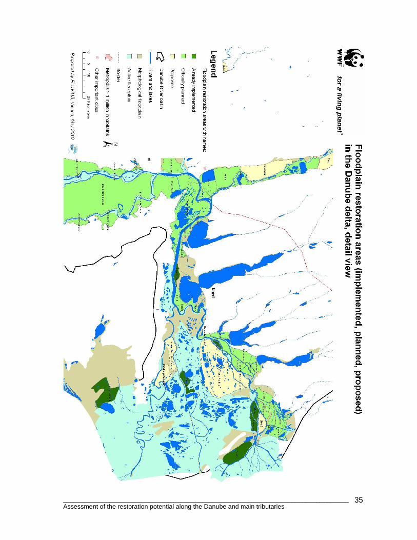
________________________________________________________________________________ Assessment of the restoration potential along the Danube and main tributaries
35
________________________________________________________________________________ Assessment of the restoration potential along the Danube and main tributaries
36
4. Prioritisation approach The potential sites vary in size, configuration, and feasibility for restoration. Respecting the different purposes of floodplain restoration such as flood protection, biodiversity, nutrient reduction, groundwater exchange, forestry, recreation and so on, the assessment initially focused on the “floodplain functioning” or better the “intactness” of the floodplain ecosystem regarding hydromorphological criteria (mostly flood regime and dynamics) supporting most of the ecosystem services listed above. Only parameters with sufficient data coverage, such as functional floodplain type (regarding the hydromorphological intactness, i.e. potential restoration sites along free-flowing stretches have basically more priority than sites along impounded reaches), land use (percentage of agriculture), protection status, overall hydromorphological conditions as well as area size (flood retention capacity) were analysed. The initial assessment is based on:
1. JDS overall Hydromorphology category (for class 1-2 the restoration potential is estimated with “very high (1)”, for class 3 “high (2)” and for 4-5 with “low (3)”).
2. Absolute land use coverage: <30% agriculture “very high (1)”, 30-60% agriculture “high (2)” and > 60% agriculture “low (3)”.
3. Protection status: Overlap >60% “very high (1)”, 30-60% “high (2)” and <30% “low (3)”.
4. Size class: >5,000 ha “very high (1)”, 1,000- 5,000 ha “high (2)”, <1,000 ha “low (3)”.
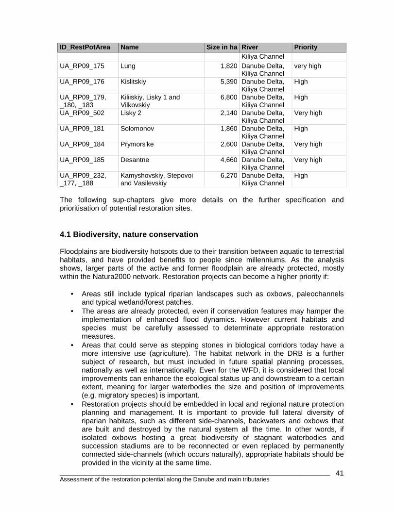
The results can be calculated by a simple mean value of the four parameters with arithmetic classes: 1-1.6 will result in a “very high”, 1.7-2.3 in “high” and 2.4-3.0 in “low” restoration potential. This is a very pragmatic approach that must be specified, e.g. by factors of retention volume, ownership, data availability or facilitation. Results for the Danube: 33 (19%) of the 1768 planned and proposed areas for the Danube would be rated with a “very high” restoration potential (15 areas are already implemented or under implementation), 98 (56%) at “high” and the remaining 45 (25%) only at “moderate” restoration potential. Additional information per country will be given in Chapter 5 regarding ownership and feasibility. Table 7: Planned and proposed restoration sites with priorities ID_RestPotArea Name Size in ha River Priority DE_RP09_105 Ingolstadt 3,030 Danube High DE_RP09_287 Ludwigstal 20 Danube Low DE_RP09_288 Laiz 20 Danube Low DE_RP09_289 Donaustetten 180 Danube Low DE_RP09_290 Weißingen 630 Danube High DE_RP09_291 Günzburg 290 Danube Low
8 The table contains only 176 areas (out of the originally 181 planned (77) and proposed (104) due to combination of adjaceant areas.
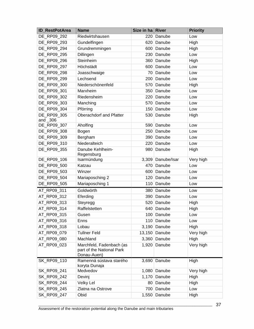
________________________________________________________________________________ Assessment of the restoration potential along the Danube and main tributaries
37
ID_RestPotArea Name Size in ha River Priority DE_RP09_292 Riedwirtshausen 220 Danube Low DE_RP09_293 Gundelfingen 620 Danube High DE_RP09_294 Grundremmingen 600 Danube High DE_RP09_295 Dillingen 230 Danube Low DE_RP09_296 Steinheim 360 Danube High DE_RP09_297 Höchstädt 600 Danube Low DE_RP09_298 Joasschwaige 70 Danube Low DE_RP09_299 Lechsend 200 Danube Low DE_RP09_300 Niederschönenfeld 570 Danube High DE_RP09_301 Marxheim 350 Danube Low DE_RP09_302 Riedensheim 220 Danube Low DE_RP09_303 Manching 570 Danube Low DE_RP09_304 Pförring 150 Danube Low DE_RP09_305 and _306
Oberachdorf and Pfatter 530 Danube High
DE_RP09_307 Aholfing 590 Danube Low DE_RP09_308 Bogen 250 Danube Low DE_RP09_309 Bergham 390 Danube Low DE_RP09_310 Niederalteich 220 Danube Low DE_RP09_355 Danube Kehlheim-
Regensburg 980 Danube High
DE_RP09_106 Isarmündung 3,309 Danube/Isar Very high DE_RP09_500 Katzau 470 Danube Low DE_RP09_503 Winzer 600 Danube Low DE_RP09_504 Mariaposching 2 120 Danube Low DE_RP09_505 Mariaposching 1 110 Danube Low
AT_RP09_311 Goldwörth 380 Danube Low AT_RP09_312 Eferding 390 Danube Low AT_RP09_313 Steyregg 520 Danube High AT_RP09_314 Raffelstetten 640 Danube High AT_RP09_315 Gusen 100 Danube Low AT_RP09_316 Enns 110 Danube Low AT_RP09_318 Lobau 3,190 Danube High AT_RP09_079 Tullner Feld 13,150 Danube Very high AT_RP09_080 Machland 3,360 Danube High AT_RP09_023 Marchfeld, Fadenbach (as
part of the National Park Donau-Auen)
1,920 Danube Very high
SK_RP09_110 Ramenná sústava starého koryta Dunaja
3,690 Danube High
SK_RP09_241 Medvedov 1,080 Danube Very high SK_RP09_242 Devinj 1,170 Danube High SK_RP09_244 Velky Lel 80 Danube High SK_RP09_245 Zlatna na Ostrove 700 Danube Low SK_RP09_247 Obid 1,550 Danube High
________________________________________________________________________________ Assessment of the restoration potential along the Danube and main tributaries
38
ID_RestPotArea Name Size in ha River Priority SK_RP09_249 Ipel confluence 200 Danube High
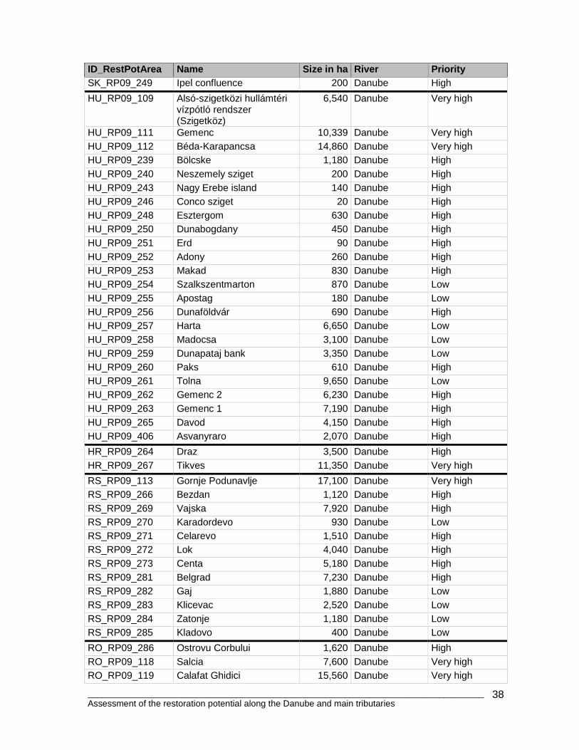
HU_RP09_109 Alsó-szigetközi hullámtéri vízpótló rendszer (Szigetköz)
6,540 Danube Very high
HU_RP09_111 Gemenc 10,339 Danube Very high HU_RP09_112 Béda-Karapancsa 14,860 Danube Very high HU_RP09_239 Bölcske 1,180 Danube High HU_RP09_240 Neszemely sziget 200 Danube High HU_RP09_243 Nagy Erebe island 140 Danube High HU_RP09_246 Conco sziget 20 Danube High HU_RP09_248 Esztergom 630 Danube High HU_RP09_250 Dunabogdany 450 Danube High HU_RP09_251 Erd 90 Danube High HU_RP09_252 Adony 260 Danube High HU_RP09_253 Makad 830 Danube High HU_RP09_254 Szalkszentmarton 870 Danube Low HU_RP09_255 Apostag 180 Danube Low HU_RP09_256 Dunaföldvár 690 Danube High HU_RP09_257 Harta 6,650 Danube Low HU_RP09_258 Madocsa 3,100 Danube Low HU_RP09_259 Dunapataj bank 3,350 Danube Low HU_RP09_260 Paks 610 Danube High HU_RP09_261 Tolna 9,650 Danube Low HU_RP09_262 Gemenc 2 6,230 Danube High HU_RP09_263 Gemenc 1 7,190 Danube High HU_RP09_265 Davod 4,150 Danube High HU_RP09_406 Asvanyraro 2,070 Danube High
HR_RP09_264 Draz 3,500 Danube High HR_RP09_267 Tikves 11,350 Danube Very high
RS_RP09_113 Gornje Podunavlje 17,100 Danube Very high RS_RP09_266 Bezdan 1,120 Danube High RS_RP09_269 Vajska 7,920 Danube High RS_RP09_270 Karadordevo 930 Danube Low RS_RP09_271 Celarevo 1,510 Danube High RS_RP09_272 Lok 4,040 Danube High RS_RP09_273 Centa 5,180 Danube High RS_RP09_281 Belgrad 7,230 Danube High RS_RP09_282 Gaj 1,880 Danube Low RS_RP09_283 Klicevac 2,520 Danube Low RS_RP09_284 Zatonje 1,180 Danube Low RS_RP09_285 Kladovo 400 Danube Low
RO_RP09_286 Ostrovu Corbului 1,620 Danube High RO_RP09_118 Salcia 7,600 Danube Very high RO_RP09_119 Calafat Ghidici 15,560 Danube Very high
________________________________________________________________________________ Assessment of the restoration potential along the Danube and main tributaries
39
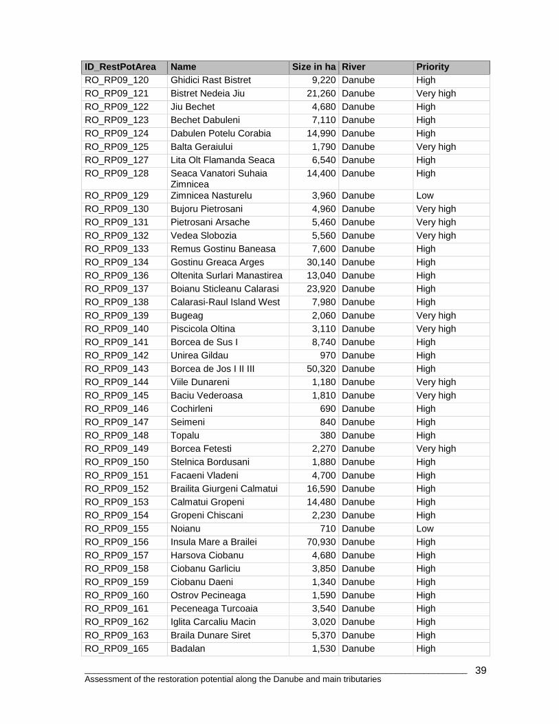
ID_RestPotArea Name Size in ha River Priority RO_RP09_120 Ghidici Rast Bistret 9,220 Danube High RO_RP09_121 Bistret Nedeia Jiu 21,260 Danube Very high RO_RP09_122 Jiu Bechet 4,680 Danube High RO_RP09_123 Bechet Dabuleni 7,110 Danube High RO_RP09_124 Dabulen Potelu Corabia 14,990 Danube High RO_RP09_125 Balta Geraiului 1,790 Danube Very high RO_RP09_127 Lita Olt Flamanda Seaca 6,540 Danube High RO_RP09_128 Seaca Vanatori Suhaia
Zimnicea 14,400 Danube High
RO_RP09_129 Zimnicea Nasturelu 3,960 Danube Low RO_RP09_130 Bujoru Pietrosani 4,960 Danube Very high RO_RP09_131 Pietrosani Arsache 5,460 Danube Very high RO_RP09_132 Vedea Slobozia 5,560 Danube Very high RO_RP09_133 Remus Gostinu Baneasa 7,600 Danube High RO_RP09_134 Gostinu Greaca Arges 30,140 Danube High RO_RP09_136 Oltenita Surlari Manastirea 13,040 Danube High RO_RP09_137 Boianu Sticleanu Calarasi 23,920 Danube High RO_RP09_138 Calarasi-Raul Island West 7,980 Danube High RO_RP09_139 Bugeag 2,060 Danube Very high RO_RP09_140 Piscicola Oltina 3,110 Danube Very high RO_RP09_141 Borcea de Sus I 8,740 Danube High RO_RP09_142 Unirea Gildau 970 Danube High RO_RP09_143 Borcea de Jos I II III 50,320 Danube High RO_RP09_144 Viile Dunareni 1,180 Danube Very high RO_RP09_145 Baciu Vederoasa 1,810 Danube Very high RO_RP09_146 Cochirleni 690 Danube High RO_RP09_147 Seimeni 840 Danube High RO_RP09_148 Topalu 380 Danube High RO_RP09_149 Borcea Fetesti 2,270 Danube Very high RO_RP09_150 Stelnica Bordusani 1,880 Danube High RO_RP09_151 Facaeni Vladeni 4,700 Danube High RO_RP09_152 Brailita Giurgeni Calmatui 16,590 Danube High RO_RP09_153 Calmatui Gropeni 14,480 Danube High RO_RP09_154 Gropeni Chiscani 2,230 Danube High RO_RP09_155 Noianu 710 Danube Low RO_RP09_156 Insula Mare a Brailei 70,930 Danube High RO_RP09_157 Harsova Ciobanu 4,680 Danube High RO_RP09_158 Ciobanu Garliciu 3,850 Danube High RO_RP09_159 Ciobanu Daeni 1,340 Danube High RO_RP09_160 Ostrov Pecineaga 1,590 Danube High RO_RP09_161 Peceneaga Turcoaia 3,540 Danube High RO_RP09_162 Iglita Carcaliu Macin 3,020 Danube High RO_RP09_163 Braila Dunare Siret 5,370 Danube High RO_RP09_165 Badalan 1,530 Danube High
________________________________________________________________________________ Assessment of the restoration potential along the Danube and main tributaries
40
ID_RestPotArea Name Size in ha River Priority RO_RP09_166 Macin Zaclau 13,760 Danube High RO_RP09_167 Zaclau Isaccea 20,790 Danube High RO_RP09_280 Holbina-Dunavat 7,720 Danube Delta Very high RO_RP09_190 Danube Delta, Chilia
Veche 3,230 Danube Delta,
Kiliya Channel High
RO_RP09_191 Danube Delta, Pardina 28,640 Danube Delta,Kiliya Channel
Very high
RO_RP09_194 Danube Delta, Partizani 3,940 Danube Delta, Sulina Channel
High
RO_RP09_195 Danube Delta, Balteni 4,250 Danube Delta, Gheorghe Channel
High
BG_RP09_319 Mouth of Timok 390 Danube Low BG_RP09_320 Archar 140 Danube High BG_RP09_321 Orsoya 2,050 Danube Very high BG_RP09_322 Tzibar 1,410 Danube Very high BG_RP09_323 Kozlodui 1,180 Danube High BG_RP09_324 Ogosta confluence 760 Danube High BG_RP09_325 Ostrov 1,680 Danube High BG_RP09_326 Iskar mouth 350 Danube Low BG_RP09_327 Gigen 1,880 Danube High BG_RP09_328 Brest 9,160 Danube High BG_RP09_329 Dabovan 2,400 Danube High BG_RP09_330 Vit confluence 1,270 Danube High BG_RP09_331 Belene West 5,150 Danube Very high BG_RP09_332 Belene Ost 6,320 Danube High BG_RP09_333 Vardim 1,840 Danube High BG_RP09_334 Yantra mouth 440 Danube Low BG_RP09_335 Batin 370 Danube High BG_RP09_336 Mechka 460 Danube High BG_RP09_337 Ryahovo west 1,000 Danube High BG_RP09_339 Srebarna 140 Danube Very high BG_RP09_340 Aydemir 1,310 Danube High BG_RP09_341 Lake Malak 50 Danube Very high BG_RP09_342 Garvan oxbow 30 Danube Very high BG_RP09_343 Popina 220 Danube High
UA_RP09_168 Reniyskiy, 680 Danube Low UA_RP09_169 Kagulskiy 1,390 Danube Low UA_RP09_170 Orlovskiy 790 Danube Low UA_RP09_172 Repida 2,780 Danube
Lower/Delta High
UA_RP09_173 Matroskiy 1,700 Danube Lower/Delta, Kiliya Channel
High
UA_RP09_174 Staronekrasovskiy 590 Danube Delta, High
________________________________________________________________________________ Assessment of the restoration potential along the Danube and main tributaries
41
ID_RestPotArea Name Size in ha River Priority Kiliya Channel
UA_RP09_175 Lung 1,820 Danube Delta, Kiliya Channel
very high
UA_RP09_176 Kislitskiy 5,390 Danube Delta, Kiliya Channel
High
UA_RP09_179, _180, _183
Kiliiskiy, Lisky 1 and Vilkovskiy
6,800 Danube Delta, Kiliya Channel
High
UA_RP09_502 Lisky 2 2,140 Danube Delta, Kiliya Channel
Very high
UA_RP09_181 Solomonov 1,860 Danube Delta, Kiliya Channel
High
UA_RP09_184 Prymors'ke 2,600 Danube Delta, Kiliya Channel
Very high
UA_RP09_185 Desantne 4,660 Danube Delta, Kiliya Channel
Very high
UA_RP09_232, _177, _188
Kamyshovskiy, Stepovoi and Vasilevskiy
6,270 Danube Delta, Kiliya Channel
High
The following sup-chapters give more details on the further specification and prioritisation of potential restoration sites. 4.1 Biodiversity, nature conservation Floodplains are biodiversity hotspots due to their transition between aquatic to terrestrial habitats, and have provided benefits to people since millenniums. As the analysis shows, larger parts of the active and former floodplain are already protected, mostly within the Natura2000 network. Restoration projects can become a higher priority if:
• Areas still include typical riparian landscapes such as oxbows, paleochannels and typical wetland/forest patches.
• The areas are already protected, even if conservation features may hamper the implementation of enhanced flood dynamics. However current habitats and species must be carefully assessed to determinate appropriate restoration measures.
• Areas that could serve as stepping stones in biological corridors today have a more intensive use (agriculture). The habitat network in the DRB is a further subject of research, but must included in future spatial planning processes, nationally as well as internationally. Even for the WFD, it is considered that local improvements can enhance the ecological status up and downstream to a certain extent, meaning for larger waterbodies the size and position of improvements (e.g. migratory species) is important.
• Restoration projects should be embedded in local and regional nature protection planning and management. It is important to provide full lateral diversity of riparian habitats, such as different side-channels, backwaters and oxbows that are built and destroyed by the natural system all the time. In other words, if isolated oxbows hosting a great biodiversity of stagnant waterbodies and succession stadiums are to be reconnected or even replaced by permanently connected side-channels (which occurs naturally), appropriate habitats should be provided in the vicinity at the same time.
________________________________________________________________________________ Assessment of the restoration potential along the Danube and main tributaries
42
In COOPS et al 2006 and ECRR 2008 several floodplain restoration projects are analysed and recommendations are given for the scaling and procedure of floodplain restoration. 4.2 Flood protection Flood protection, and in particular passive measures like the preservation or restoration of retention areas, become more and more important in official flood risk management. Prioritisation parameters could include:
• The position of the potential restoration/retention area in relation to the catchment, river network and flood conveyance cross section.
• In particular in flood bottlenecks, e.g. town pairs often along transboundary rivers such as the lower Danube, where larger retention areas upstream or inside of the bottleneck support flood mitigation. This would also include the restoration of larger side channels (hydromorphological improvements).
• Size of retention volume (the capacity of restoration sites to retain flood water): The total proposed area would also have a certain effect on flood mitigation. Commonly mentioned areas are already used in case of catastrophic floods, such as polders in Tullnerfeld or along theTisza and particularly the Köres. Therefore from the 1.3 million ha only about 900,000 ha can be seen as actual new water retention areas. Calculating conservatively at about 1.5 m average water depth for these areas, a total capacity volume of about 13.5 billion m³ can be estimated. This is more than three times the entire remaining natural retention areas along the middle and lower Sava (incl. Lonjsko Polje, Mocro polje) or the Hungarian “Century Vazarhely Plan” to build technical polders along the Tisza with a capacity of some 5 billion m³. As a comparison, the Austrian Danube floodplains had a retention volume during the 100-year flood event in 2002 of approximately 0.6 billion m³ and substantially mitigated the flood peaks in Vienna (downstream of Tullnerfeld), Bratislava (downstream of the Austrian Floodplain National Park) and even Budapest (Szigetköz).
• The importance of large scale, freely-floodable floodplains increases along the middle and lower courses of major rivers. For most of the proposed sites technical polders should be not favored.
4.3 Feasibility, legal framework, local administrat ion and initiative Without the deep assessment of feasibility (see Chapter 5), most restoration projects fail from the beginning. The limited data availability and other “soft” factors are serious problems, also for assessment and prioritisation. The following list reflects some of the most important aspects for prioritisation:
• Land ownership, the most critical issues for all projects (see Table 8) • Proposed measures and proposed costs of the restoration project • Legal framework, not only EU legislation, but especially national regulations to
keep/increase retention areas, how is compensation managed (agriculture), are there agricultural programmes in the area, the legal certainty to foster and
________________________________________________________________________________ Assessment of the restoration potential along the Danube and main tributaries
43
materialize planning and implementation steps, and political willingness (which is immeasurable).
• Involvement of local administration, local population (perception, interest in restoration projects), NGOs and other stakeholders.
• Multi-use concepts for and benefits of restoration projects (recreation, nutrient reduction, sustainable forestry/fishery), i.e. local people will participate and profit from those projects.
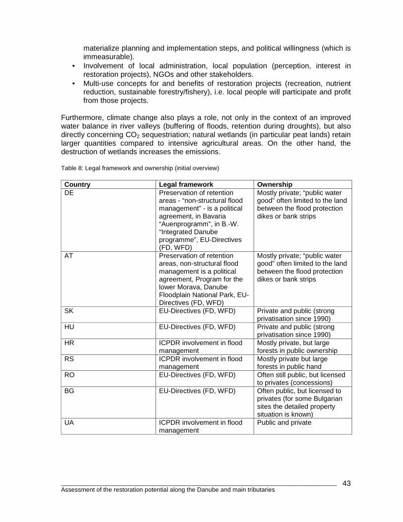
Furthermore, climate change also plays a role, not only in the context of an improved water balance in river valleys (buffering of floods, retention during droughts), but also directly concerning CO2 sequestriation; natural wetlands (in particular peat lands) retain larger quantities compared to intensive agricultural areas. On the other hand, the destruction of wetlands increases the emissions. Table 8: Legal framework and ownership (initial overview) Country Legal framework Ownership DE Preservation of retention
areas - “non-structural flood management” - is a political agreement, in Bavaria “Auenprogramm”, in B.-W. “Integrated Danube programme”, EU-Directives (FD, WFD)
Mostly private; “public water good” often limited to the land between the flood protection dikes or bank strips
AT Preservation of retention areas, non-structural flood management is a political agreement, Program for the lower Morava, Danube Floodplain National Park, EU- Directives (FD, WFD)
Mostly private; “public water good” often limited to the land between the flood protection dikes or bank strips
SK EU-Directives (FD, WFD) Private and public (strong privatisation since 1990)
HU EU-Directives (FD, WFD) Private and public (strong privatisation since 1990)
HR ICPDR involvement in flood management
Mostly private, but large forests in public ownership
RS ICPDR involvement in flood management
Mostly private but large forests in public hand
RO EU-Directives (FD, WFD) Often still public, but licensed to privates (concessions)
BG EU-Directives (FD, WFD) Often public, but licensed to privates (for some Bulgarian sites the detailed property situation is known)
UA ICPDR involvement in flood management
Public and private
________________________________________________________________________________ Assessment of the restoration potential along the Danube and main tributaries
44
5. Feasibility of restoration Feasibility of restoration projects, as discussed several times in earlier chapters, is often the most critical factor to start successful restoration projects. Therefore this chapter should give a short introduction to feasibility. 5.1 International and national legal frameworks
• WFD (EU Water Framework Directive): -Restoration of lateral connectivity to improve status (achieving good status) in adjacent water bodies (there is a strong connection here as lowland floodplains of large rivers contain many waterbodies, such as side-channels, backwaters and oxbows of different size) -Improving groundwater connection and to preserve recharge to keep groundwater-dependant land ecosystems
• FFH (EU Flora Fauna Habitat) and Birds Directives - Protection of many endangered habitats and species dependant on or related to rivers and floodplains - Link to further international conventions such as Ramsar, Bonn, Bern
• FD (EU Flood Directive) - Definition of flood and retention areas, enlargement of retention capacities, no further net-loss of floodplains (preservation of retention areas by spatial planning)
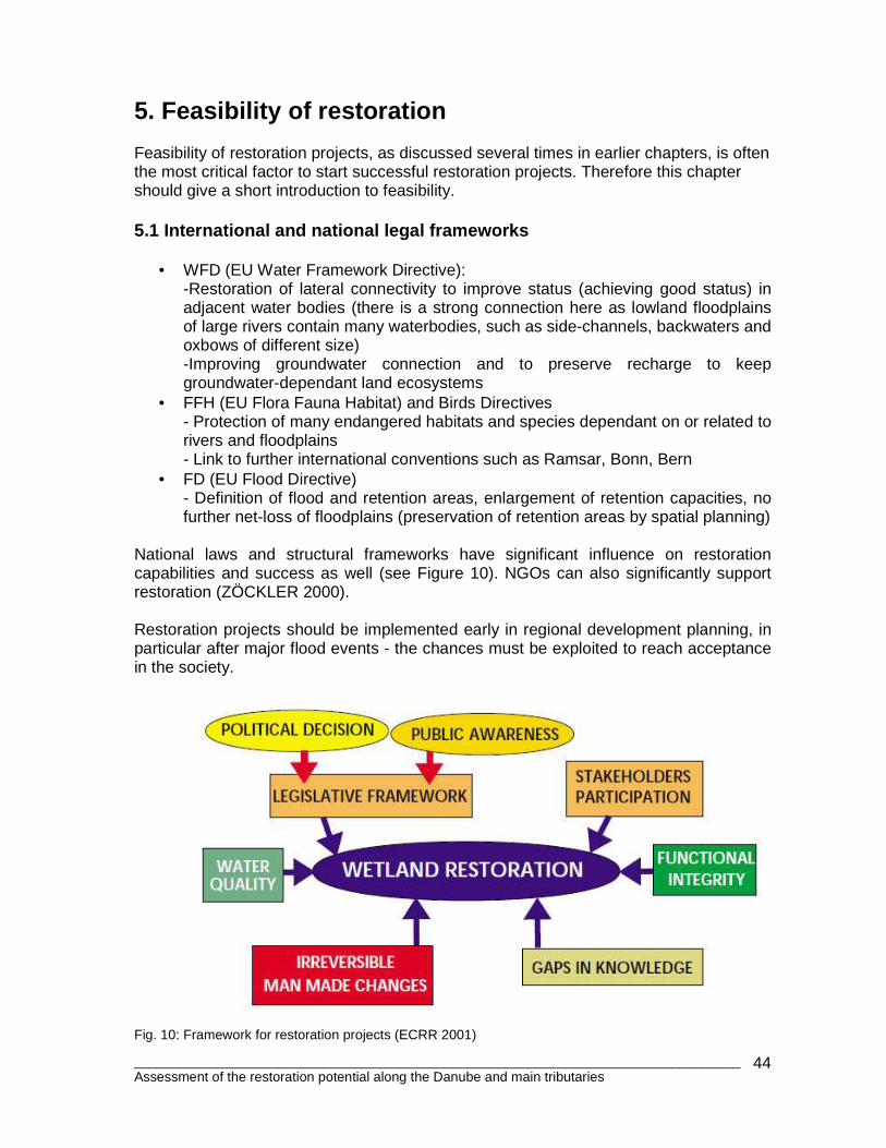
National laws and structural frameworks have significant influence on restoration capabilities and success as well (see Figure 10). NGOs can also significantly support restoration (ZÖCKLER 2000). Restoration projects should be implemented early in regional development planning, in particular after major flood events - the chances must be exploited to reach acceptance in the society.
Fig. 10: Framework for restoration projects (ECRR 2001)
________________________________________________________________________________ Assessment of the restoration potential along the Danube and main tributaries
45
5.2 Restoration costs Restoration costs can be subdivided into land purchase, planning and implementation costs, future compensation in the case of flood (if current land use and landowners remain), and maintenance and monitoring costs. Restoration costs vary widely depending on measures in implemented. The cost differences between western EU member states and newer Member States are still evident but are closing the gap (also for non-EU states such as HR, BA and RS).
A study carried out on the lower Danube after the 2006 floods (Schwarz et al. 2006) calculate costs at about 20,000 €/ km²; this estimation does not include large technical structures, such as polder in- and outlets and compensation for land users. In comparison costs in Germany and Austria can be estimated at some 1-2 million €/km². Based on a DRB-wide average of 500,000 €/km², this all together would imply investment costs of around 6,000,000,000 € shared by 13 countries. Large scale restoration projects can take at least 5-10 years; land procurement and planning approval can take years and therefore require well-developed administrative structures and sufficient funding. Restoration is often not limited to changes in dike lines, but requires changes in the management of the adjacent river and floodplain areas. In most cases improvements of lateral connectivity and changes in landuse (e.g. less intensive forestry, hunting or meadow management) are necessary to accelerate the reconnection and to improve the ecological conditions along the respective river stretch. Monitoring is a necessary tool to assess the restoration progress over years or decades. Restoration areas must be protected and integrated in the existing protection network. If dikes will be completely relocated, or even enlarged, up to 10% of the reconnected area is necessary to reconstruct the dike. In the best case, natural terraces will substitute the dike, like on the lower Danube. 5.3 Floodplain values and usage concepts The (monetary) valorisation of floodplain and ecosystem services and floodplain goods has a certain tradition (e.g. within the Ramsar Convention). They should support cost-benefit analysis to decide upon usage concepts in floodplains. In the case of the lower Danube the value of restored floodplains was estimated at approximately 500 €/ha/year. Again, this value strongly differs depending on usage (and on competing uses, such as agriculture). Floodplains under a broad use concept are still not very developed. Local usage concepts can significantly accelerate and support the restoration of floodplain areas, and can also include touristic concepts.
________________________________________________________________________________ Assessment of the restoration potential along the Danube and main tributaries
46
6. Recommendations towards a restoration strategy Based on data related to floodplain delineation and restoration potential, it is possible to compare and assess different areas to come up with more detailed restoration proposals and to formulate targets for a future strategy. The following are recommendations to achieve such a restoration strategy:
• Convince/support countries to develop realistic restoration targets. It is important that a common understanding on restoration requirements and benefits exist. Existing case studies shoule be assessed, and one large pilot restoration site in each country underway by 2015 can be used as blueprint for future efforts.
• Favorable legal frameworks, e.g. clear protection of still-existing retention areas (no-go areas for further land development in floodplains), strong spatial planning instruments and tight administrative and political structures that allow for transparent public participation are requirements for successful restoration projects.
• Develop national, or even international, floodplain inventories (e.g. SCHWARZ et al. 2010 for Austria, Bfn 2009 for Germany). It is necessary to increase trans-boundary knowledge of DRB floodplains overall, and to extend continuous floodplain assessment based on floodplain segments by country, e,g, like what was done in Germany (BfN 2009).
• The tools and approaches applied in this study (in particular prioritization) should be further developed in line with FFH-D, WFD and FD plans within the WFD planning cycle timelines. Those approaches should not be overloaded with pre-justifications regarding ecological or technical outcomes. A database to share experiences and development would support the further work.
• Type-specific and adaptive restoration strategies are needed. Protection and improvement (restoration) of existing floodplains is important (only about 10% remain under near-natural conditions along upper and middle Danube!)
• Embed river and floodplain restoration into national and international biological corridor network planning as well as spatial planning (“EU Danube Strategy”).
• Protected areas and their management must go hand-in-hand with restoration efforts. Floodplains are very dynamic systems that host a variety of habitats and species within close vicinity. For example, the reconnection and re-dynamisation of protected oxbows are also important for the river-floodplain system, and restoration of both floodplain and oxbow should coexist in the limited given space for river development.
• Infrastructure projects (navigation) and hydropower development will further aggravate the ecological situation of many floodplains. Water management authorities (together with the stakeholders of hydropower, navigation and less flood protection) must offer solutions how to stop incision /bed degradation and further floodplain aggradation by fine sediments. Governments together with the “polluters” must provide the respective financial resources.
________________________________________________________________________________ Assessment of the restoration potential along the Danube and main tributaries
47
Further recommendations for successful restoration projects:
• It must be emphasised that floodplains without river restoration (hydromorphological-lateral integrity of the river-floodplain ecosystem) makes no sense.
• The availability of land (ownership is often most critical), but also of other data, in particular hydraulic models for ecological planning, is very important to ensure successful restoration.
• Clear impact assessments of the project on local, regional and international levels regarding floods, ecology and other ecosystem services is necessary for successful restoration.
• Requirements for local planning and approval by authorities (e.g. influence on local flood levels, water quality and so on) must be considered from the beginning.
• Broad stakeholder involvement and interdisciplinary planning work is a pre-condition for successful restoration.
________________________________________________________________________________ Assessment of the restoration potential along the Danube and main tributaries
48
7. References BUNDESAMT FÜR NATURSCHUTZ (BfN) (2009): Auenzustandsbericht, Flussauen in Deutschland (Floodplain assessment for Germany). Bonn BRATRICH C., B. TRUFFER & B. WEHRLI (2002): River restoration projects – understanding success and failure; report to the NCEAS National River Restoration Synthesis (NRRS) working group meeting in Sept. 2002, p. 1-13. CIERJACKS , A., KLEINSCHMIT, B., BABINSKY, M., KLEINSCHROTH, F., MARKERT, A., MENZEL, M., ZIECHMANN, U., SCHILLER, T., GRAF, M., LANG, F. (2010): Carbon stocks of soil and vegetation on Danubian floodplains. Jurnal of plant nutrition and soil science, 2010, 000, 1–10. COOPS H., K. TOCKNER, C. AMOROS, T. HEIN T & G. QUINN (2006): Restoring lateral connections between rivers and floodplains: lessons from rehabilitation projects. Ecological Studies 190: 15-32. DANUBE POLLUTION REDUCTION PROGRAMM (DPRP) UNDP/GEF (1999): Evaluation of Wetlands and floodplain areas in the Danube River Basin. WWF Danube-Carpathian Programme and WWF-Floodplain Institute (WWF-Germany). ECRR (2001): River restoration in Europe. Proceedings. Riza report 2001.023, Wageningen. ECRR (2008): River restoration in Europe. Proceedings. ECRR (European Center for river restoration) and Centro Italiano per la Riqualificazione Fluviale, Venice. HABERSACK, H.; HAUER, C.; SCHOBER, B.; DISTER, E.; QUICK, I.; HARMS, O.; WINTZ, M.; PIQUETTE, E.; SCHWARZ, U.; (2008): Flood risk reduction by preserving and restoring river floodplains – Pro Floodplain. In: Conference Proceedings “FloodRisk 2008 - The European Conference on Flood Risk Management Research into Practice”, Oxford. Balkema, The Netherlands / Taylor and Francis, Engineering, Water and Earth Sciences, London. HULSE, D., GREGORY, S. (2004): Integrating resilience into floodplain restoration. In: Urban Ecosystems, Volume 7, Number 3 / September 2004 ICPDR (2010): Danube River basin management Plan (DRBMP) 2009. Vienna ICPDR (2008): Joint Danube Survey 2. Final scientifical report. Vienna KOENZEN, U. (2005): FLUSS- UND STROMAUEN IN DEUTSCHLAND. TYPOLOGIE UND LEITBILDER. ERGEBNISSE DES F+E-VORHABENS "TYPOLOGIE UND LEITBILDENTWICKLUNG FÜR FLUSSAUEN IN DER BUNDESREPUBLIK DEUTSCHLAND" DES BUNDESAMTES FÜR NATURSCHUTZ FKZ 803 82 100. HEFT 65, PP. 327. BONN SCHWARZ, U., C. BRATRICH, O. HULEA, S., MOROZ, N. PUMPUTYTE, G. RAST, M.R. BERN AND V. SIPOSS (2006): Floods in the Danube River Basin: Floodplain mitigation for people living in the Danube and the potential for floodplain protection and restoration, Working Paper, Vienna, July 2006, WWF Danube Carpathian Programme, Austria SCHWARZ, U., LAZOWSKI, W., SIGMUND-SCHWACH, S. (2010): Vom flächendeckenden Auen-Inventar zur österreichischen Auen-Strategie- Die Bedeutung der Auen für Hochwasser und Natruschutz. (Austrian floodplain inventory and strategy). In: Beiträge zum Symposium „Auen und Hochwasser“, 10./11. Februar 2010 in Ingolstadt, pp.161-174. Forum für Hydrologie und Wasserbewirtschaftung, Heft 27.10. Hennef. SCHWARZ, U. (2008): Drava-Vision 2020. Proposal for restoration sites along the lower Mura and Drava rivers. WWF Austria, EURONATURE. ZÖCKLER, C. 2000. Wise Use of Floodplains – review of restoration projects in a number of European countries. WWF European Freshwater Programme, 100pp.
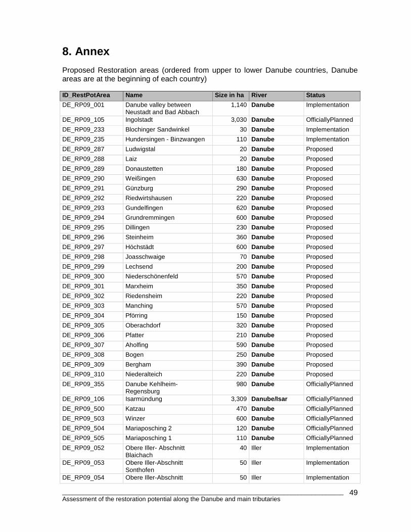
________________________________________________________________________________ Assessment of the restoration potential along the Danube and main tributaries
49
8. Annex Proposed Restoration areas (ordered from upper to lower Danube countries, Danube areas are at the beginning of each country) ID_RestPotArea Name Size in ha River Status
DE_RP09_001 Danube valley between Neustadt and Bad Abbach
1,140 Danube Implementation
DE_RP09_105 Ingolstadt 3,030 Danube OfficiallyPlanned
DE_RP09_233 Blochinger Sandwinkel 30 Danube Implementation
DE_RP09_235 Hundersingen - Binzwangen 110 Danube Implementation
DE_RP09_287 Ludwigstal 20 Danube Proposed
DE_RP09_288 Laiz 20 Danube Proposed
DE_RP09_289 Donaustetten 180 Danube Proposed
DE_RP09_290 Weißingen 630 Danube Proposed
DE_RP09_291 Günzburg 290 Danube Proposed
DE_RP09_292 Riedwirtshausen 220 Danube Proposed
DE_RP09_293 Gundelfingen 620 Danube Proposed
DE_RP09_294 Grundremmingen 600 Danube Proposed
DE_RP09_295 Dillingen 230 Danube Proposed
DE_RP09_296 Steinheim 360 Danube Proposed
DE_RP09_297 Höchstädt 600 Danube Proposed
DE_RP09_298 Joasschwaige 70 Danube Proposed
DE_RP09_299 Lechsend 200 Danube Proposed
DE_RP09_300 Niederschönenfeld 570 Danube Proposed
DE_RP09_301 Marxheim 350 Danube Proposed
DE_RP09_302 Riedensheim 220 Danube Proposed
DE_RP09_303 Manching 570 Danube Proposed
DE_RP09_304 Pförring 150 Danube Proposed
DE_RP09_305 Oberachdorf 320 Danube Proposed
DE_RP09_306 Pfatter 210 Danube Proposed
DE_RP09_307 Aholfing 590 Danube Proposed
DE_RP09_308 Bogen 250 Danube Proposed
DE_RP09_309 Bergham 390 Danube Proposed
DE_RP09_310 Niederalteich 220 Danube Proposed
DE_RP09_355 Danube Kehlheim-Regensburg
980 Danube OfficiallyPlanned
DE_RP09_106 Isarmündung 3,309 Danube/Isar OfficiallyPlanned
DE_RP09_500 Katzau 470 Danube OfficiallyPlanned
DE_RP09_503 Winzer 600 Danube OfficiallyPlanned
DE_RP09_504 Mariaposching 2 120 Danube OfficiallyPlanned
DE_RP09_505 Mariaposching 1 110 Danube OfficiallyPlanned
DE_RP09_052 Obere Iller- Abschnitt Blaichach
40 Iller Implementation
DE_RP09_053 Obere Iller-Abschnitt Sonthofen
50 Iller Implementation
DE_RP09_054 Obere Iller-Abschnitt 50 Iller Implementation
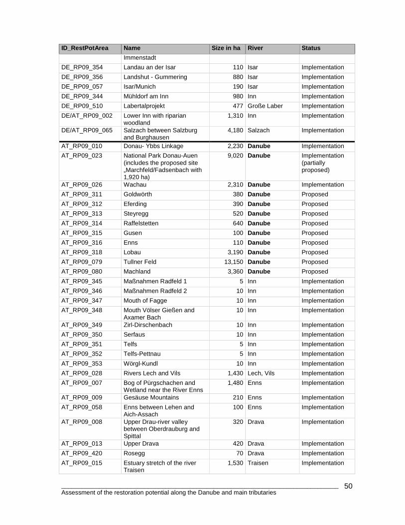
________________________________________________________________________________ Assessment of the restoration potential along the Danube and main tributaries
50
ID_RestPotArea Name Size in ha River Status
Immenstadt
DE_RP09_354 Landau an der Isar 110 Isar Implementation
DE_RP09_356 Landshut - Gummering 880 Isar Implementation
DE_RP09_057 Isar/Munich 190 Isar Implementation
DE_RP09_344 Mühldorf am Inn 980 Inn Implementation
DE_RP09_510 Labertalprojekt 477 Große Laber Implementation
DE/AT_RP09_002 Lower Inn with riparian woodland
1,310 Inn Implementation
DE/AT_RP09_065 Salzach between Salzburg and Burghausen
4,180 Salzach Implementation
AT_RP09_010 Donau- Ybbs Linkage 2,230 Danube Implementation
AT_RP09_023 National Park Donau-Auen (includes the proposed site „Marchfeld/Fadsenbach with 1,920 ha)
9,020 Danube Implementation (partially proposed)
AT_RP09_026 Wachau 2,310 Danube Implementation
AT_RP09_311 Goldwörth 380 Danube Proposed
AT_RP09_312 Eferding 390 Danube Proposed
AT_RP09_313 Steyregg 520 Danube Proposed
AT_RP09_314 Raffelstetten 640 Danube Proposed
AT_RP09_315 Gusen 100 Danube Proposed
AT_RP09_316 Enns 110 Danube Proposed
AT_RP09_318 Lobau 3,190 Danube Proposed
AT_RP09_079 Tullner Feld 13,150 Danube Proposed
AT_RP09_080 Machland 3,360 Danube Proposed
AT_RP09_345 Maßnahmen Radfeld 1 5 Inn Implementation
AT_RP09_346 Maßnahmen Radfeld 2 10 Inn Implementation
AT_RP09_347 Mouth of Fagge 10 Inn Implementation
AT_RP09_348 Mouth Völser Gießen and Axamer Bach
10 Inn Implementation
AT_RP09_349 Zirl-Dirschenbach 10 Inn Implementation
AT_RP09_350 Serfaus 10 Inn Implementation
AT_RP09_351 Telfs 5 Inn Implementation
AT_RP09_352 Telfs-Pettnau 5 Inn Implementation
AT_RP09_353 Wörgl-Kundl 10 Inn Implementation
AT_RP09_028 Rivers Lech and Vils 1,430 Lech, Vils Implementation
AT_RP09_007 Bog of Pürgschachen and Wetland near the River Enns
1,480 Enns Implementation
AT_RP09_009 Gesäuse Mountains 210 Enns Implementation
AT_RP09_058 Enns between Lehen and Aich-Assach
100 Enns Implementation
AT_RP09_008 Upper Drau-river valley between Oberdrauburg and Spittal
320 Drava Implementation
AT_RP09_013 Upper Drava 420 Drava Implementation
AT_RP09_420 Rosegg 70 Drava Implementation
AT_RP09_015 Estuary stretch of the river Traisen
1,530 Traisen Implementation
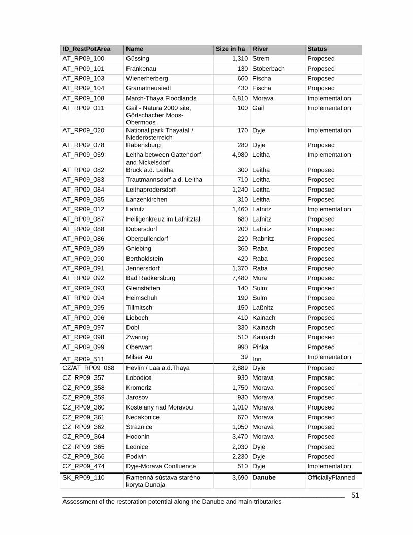
________________________________________________________________________________ Assessment of the restoration potential along the Danube and main tributaries
51
ID_RestPotArea Name Size in ha River Status
AT_RP09_100 Güssing 1,310 Strem Proposed
AT_RP09_101 Frankenau 130 Stoberbach Proposed
AT_RP09_103 Wienerherberg 660 Fischa Proposed
AT_RP09_104 Gramatneusiedl 430 Fischa Proposed
AT_RP09_108 March-Thaya Floodlands 6,810 Morava Implementation
AT_RP09_011 Gail - Natura 2000 site, Görtschacher Moos-Obermoos
100 Gail Implementation
AT_RP09_020 National park Thayatal / Niederösterreich
170 Dyje Implementation
AT_RP09_078 Rabensburg 280 Dyje Proposed
AT_RP09_059 Leitha between Gattendorf and Nickelsdorf
4,980 Leitha Implementation
AT_RP09_082 Bruck a.d. Leitha 300 Leitha Proposed
AT_RP09_083 Trautmannsdorf a.d. Leitha 710 Leitha Proposed
AT_RP09_084 Leithaprodersdorf 1,240 Leitha Proposed
AT_RP09_085 Lanzenkirchen 310 Leitha Proposed
AT_RP09_012 Lafnitz 1,460 Lafnitz Implementation
AT_RP09_087 Heiligenkreuz im Lafnitztal 680 Lafnitz Proposed
AT_RP09_088 Dobersdorf 200 Lafnitz Proposed
AT_RP09_086 Oberpullendorf 220 Rabnitz Proposed
AT_RP09_089 Gniebing 360 Raba Proposed
AT_RP09_090 Bertholdstein 420 Raba Proposed
AT_RP09_091 Jennersdorf 1,370 Raba Proposed
AT_RP09_092 Bad Radkersburg 7,480 Mura Proposed
AT_RP09_093 Gleinstätten 140 Sulm Proposed
AT_RP09_094 Heimschuh 190 Sulm Proposed
AT_RP09_095 Tillmitsch 150 Laßnitz Proposed
AT_RP09_096 Lieboch 410 Kainach Proposed
AT_RP09_097 Dobl 330 Kainach Proposed
AT_RP09_098 Zwaring 510 Kainach Proposed
AT_RP09_099 Oberwart 990 Pinka Proposed
AT_RP09_511 Milser Au 39 Inn Implementation
CZ/AT_RP09_068 Hevlín / Laa a.d.Thaya 2,889 Dyje Proposed
CZ_RP09_357 Lobodice 930 Morava Proposed
CZ_RP09_358 Kromeriz 1,750 Morava Proposed
CZ_RP09_359 Jarosov 930 Morava Proposed
CZ_RP09_360 Kostelany nad Moravou 1,010 Morava Proposed
CZ_RP09_361 Nedakonice 670 Morava Proposed
CZ_RP09_362 Straznice 1,050 Morava Proposed
CZ_RP09_364 Hodonin 3,470 Morava Proposed
CZ_RP09_365 Lednice 2,030 Dyje Proposed
CZ_RP09_366 Podivin 2,230 Dyje Proposed
CZ_RP09_474 Dyje-Morava Confluence 510 Dyje Implementation
SK_RP09_110 Ramenná sústava starého koryta Dunaja
3,690 Danube OfficiallyPlanned
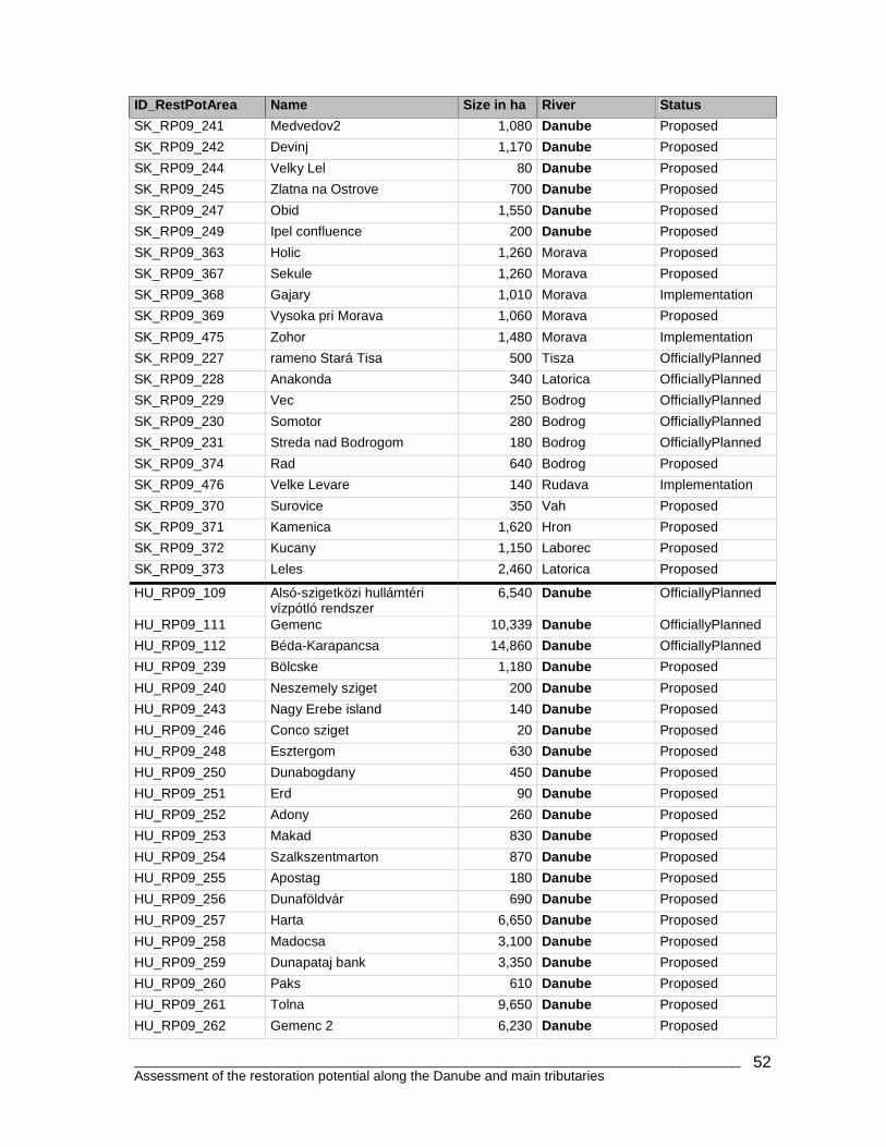
________________________________________________________________________________ Assessment of the restoration potential along the Danube and main tributaries
52
ID_RestPotArea Name Size in ha River Status
SK_RP09_241 Medvedov2 1,080 Danube Proposed
SK_RP09_242 Devinj 1,170 Danube Proposed
SK_RP09_244 Velky Lel 80 Danube Proposed
SK_RP09_245 Zlatna na Ostrove 700 Danube Proposed
SK_RP09_247 Obid 1,550 Danube Proposed
SK_RP09_249 Ipel confluence 200 Danube Proposed
SK_RP09_363 Holic 1,260 Morava Proposed
SK_RP09_367 Sekule 1,260 Morava Proposed
SK_RP09_368 Gajary 1,010 Morava Implementation
SK_RP09_369 Vysoka pri Morava 1,060 Morava Proposed
SK_RP09_475 Zohor 1,480 Morava Implementation
SK_RP09_227 rameno Stará Tisa 500 Tisza OfficiallyPlanned
SK_RP09_228 Anakonda 340 Latorica OfficiallyPlanned
SK_RP09_229 Vec 250 Bodrog OfficiallyPlanned
SK_RP09_230 Somotor 280 Bodrog OfficiallyPlanned
SK_RP09_231 Streda nad Bodrogom 180 Bodrog OfficiallyPlanned
SK_RP09_374 Rad 640 Bodrog Proposed
SK_RP09_476 Velke Levare 140 Rudava Implementation
SK_RP09_370 Surovice 350 Vah Proposed
SK_RP09_371 Kamenica 1,620 Hron Proposed
SK_RP09_372 Kucany 1,150 Laborec Proposed
SK_RP09_373 Leles 2,460 Latorica Proposed
HU_RP09_109 Alsó-szigetközi hullámtéri vízpótló rendszer
6,540 Danube OfficiallyPlanned
HU_RP09_111 Gemenc 10,339 Danube OfficiallyPlanned
HU_RP09_112 Béda-Karapancsa 14,860 Danube OfficiallyPlanned
HU_RP09_239 Bölcske 1,180 Danube Proposed
HU_RP09_240 Neszemely sziget 200 Danube Proposed
HU_RP09_243 Nagy Erebe island 140 Danube Proposed
HU_RP09_246 Conco sziget 20 Danube Proposed
HU_RP09_248 Esztergom 630 Danube Proposed
HU_RP09_250 Dunabogdany 450 Danube Proposed
HU_RP09_251 Erd 90 Danube Proposed
HU_RP09_252 Adony 260 Danube Proposed
HU_RP09_253 Makad 830 Danube Proposed
HU_RP09_254 Szalkszentmarton 870 Danube Proposed
HU_RP09_255 Apostag 180 Danube Proposed
HU_RP09_256 Dunaföldvár 690 Danube Proposed
HU_RP09_257 Harta 6,650 Danube Proposed
HU_RP09_258 Madocsa 3,100 Danube Proposed
HU_RP09_259 Dunapataj bank 3,350 Danube Proposed
HU_RP09_260 Paks 610 Danube Proposed
HU_RP09_261 Tolna 9,650 Danube Proposed
HU_RP09_262 Gemenc 2 6,230 Danube Proposed
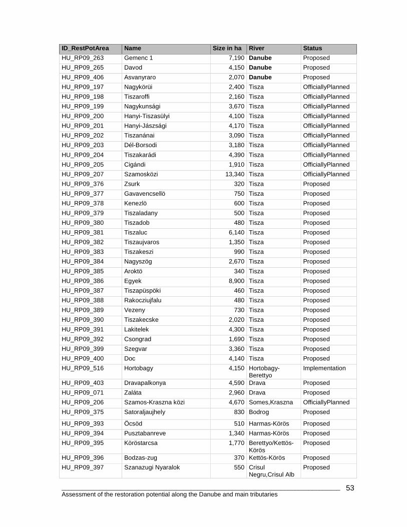
________________________________________________________________________________ Assessment of the restoration potential along the Danube and main tributaries
53
ID_RestPotArea Name Size in ha River Status
HU_RP09_263 Gemenc 1 7,190 Danube Proposed
HU_RP09_265 Davod 4,150 Danube Proposed
HU_RP09_406 Asvanyraro 2,070 Danube Proposed
HU_RP09_197 Nagykörüi 2,400 Tisza OfficiallyPlanned
HU_RP09_198 Tiszaroffi 2,160 Tisza OfficiallyPlanned
HU_RP09_199 Nagykunsági 3,670 Tisza OfficiallyPlanned
HU_RP09_200 Hanyi-Tiszasülyi 4,100 Tisza OfficiallyPlanned
HU_RP09_201 Hanyi-Jászsági 4,170 Tisza OfficiallyPlanned
HU_RP09_202 Tiszanánai 3,090 Tisza OfficiallyPlanned
HU_RP09_203 Dél-Borsodi 3,180 Tisza OfficiallyPlanned
HU_RP09_204 Tiszakarádi 4,390 Tisza OfficiallyPlanned
HU_RP09_205 Cigándi 1,910 Tisza OfficiallyPlanned
HU_RP09_207 Szamosközi 13,340 Tisza OfficiallyPlanned
HU_RP09_376 Zsurk 320 Tisza Proposed
HU_RP09_377 Gavavencsellö 750 Tisza Proposed
HU_RP09_378 Kenezlö 600 Tisza Proposed
HU_RP09_379 Tiszaladany 500 Tisza Proposed
HU_RP09_380 Tiszadob 480 Tisza Proposed
HU_RP09_381 Tiszaluc 6,140 Tisza Proposed
HU_RP09_382 Tiszaujvaros 1,350 Tisza Proposed
HU_RP09_383 Tiszakeszi 990 Tisza Proposed
HU_RP09_384 Nagyszög 2,670 Tisza Proposed
HU_RP09_385 Aroktö 340 Tisza Proposed
HU_RP09_386 Egyek 8,900 Tisza Proposed
HU_RP09_387 Tiszapüspöki 460 Tisza Proposed
HU_RP09_388 Rakocziujfalu 480 Tisza Proposed
HU_RP09_389 Vezeny 730 Tisza Proposed
HU_RP09_390 Tiszakecske 2,020 Tisza Proposed
HU_RP09_391 Lakitelek 4,300 Tisza Proposed
HU_RP09_392 Csongrad 1,690 Tisza Proposed
HU_RP09_399 Szegvar 3,360 Tisza Proposed
HU_RP09_400 Doc 4,140 Tisza Proposed
HU_RP09_516 Hortobagy 4,150 Hortobagy-Berettyo
Implementation
HU_RP09_403 Dravapalkonya 4,590 Drava Proposed
HU_RP09_071 Zaláta 2,960 Drava Proposed
HU_RP09_206 Szamos-Kraszna közi 4,670 Somes,Kraszna OfficiallyPlanned
HU_RP09_375 Satoraljaujhely 830 Bodrog Proposed
HU_RP09_393 Öcsöd 510 Harmas-Körös Proposed
HU_RP09_394 Pusztabanreve 1,340 Harmas-Körös Proposed
HU_RP09_395 Köröstarcsa 1,770 Berettyo/Kettös-Körös
Proposed
HU_RP09_396 Bodzas-zug 370 Kettös-Körös Proposed
HU_RP09_397 Szanazugi Nyaralok 550 Crisul Negru,Crisul Alb
Proposed
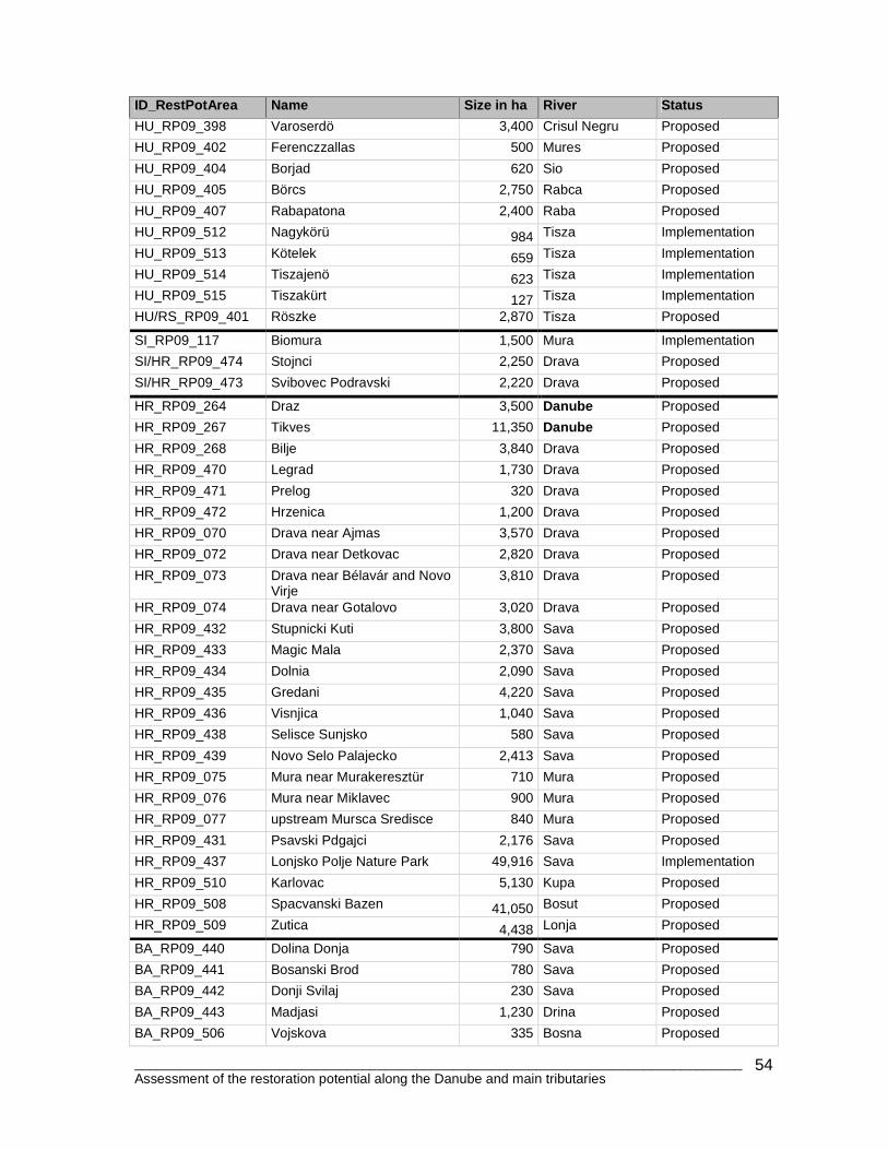
________________________________________________________________________________ Assessment of the restoration potential along the Danube and main tributaries
54
ID_RestPotArea Name Size in ha River Status
HU_RP09_398 Varoserdö 3,400 Crisul Negru Proposed
HU_RP09_402 Ferenczzallas 500 Mures Proposed
HU_RP09_404 Borjad 620 Sio Proposed
HU_RP09_405 Börcs 2,750 Rabca Proposed
HU_RP09_407 Rabapatona 2,400 Raba Proposed
HU_RP09_512 Nagykörü 984 Tisza Implementation
HU_RP09_513 Kötelek 659 Tisza Implementation
HU_RP09_514 Tiszajenö 623 Tisza Implementation
HU_RP09_515 Tiszakürt 127 Tisza Implementation
HU/RS_RP09_401 Röszke 2,870 Tisza Proposed
SI_RP09_117 Biomura 1,500 Mura Implementation
SI/HR_RP09_474 Stojnci 2,250 Drava Proposed
SI/HR_RP09_473 Svibovec Podravski 2,220 Drava Proposed
HR_RP09_264 Draz 3,500 Danube Proposed
HR_RP09_267 Tikves 11,350 Danube Proposed
HR_RP09_268 Bilje 3,840 Drava Proposed
HR_RP09_470 Legrad 1,730 Drava Proposed
HR_RP09_471 Prelog 320 Drava Proposed
HR_RP09_472 Hrzenica 1,200 Drava Proposed
HR_RP09_070 Drava near Ajmas 3,570 Drava Proposed
HR_RP09_072 Drava near Detkovac 2,820 Drava Proposed
HR_RP09_073 Drava near Bélavár and Novo Virje
3,810 Drava Proposed
HR_RP09_074 Drava near Gotalovo 3,020 Drava Proposed
HR_RP09_432 Stupnicki Kuti 3,800 Sava Proposed
HR_RP09_433 Magic Mala 2,370 Sava Proposed
HR_RP09_434 Dolnia 2,090 Sava Proposed
HR_RP09_435 Gredani 4,220 Sava Proposed
HR_RP09_436 Visnjica 1,040 Sava Proposed
HR_RP09_438 Selisce Sunjsko 580 Sava Proposed
HR_RP09_439 Novo Selo Palajecko 2,413 Sava Proposed
HR_RP09_075 Mura near Murakeresztür 710 Mura Proposed
HR_RP09_076 Mura near Miklavec 900 Mura Proposed
HR_RP09_077 upstream Mursca Sredisce 840 Mura Proposed
HR_RP09_431 Psavski Pdgajci 2,176 Sava Proposed
HR_RP09_437 Lonjsko Polje Nature Park 49,916 Sava Implementation
HR_RP09_510 Karlovac 5,130 Kupa Proposed
HR_RP09_508 Spacvanski Bazen 41,050 Bosut Proposed
HR_RP09_509 Zutica 4,438 Lonja Proposed
BA_RP09_440 Dolina Donja 790 Sava Proposed
BA_RP09_441 Bosanski Brod 780 Sava Proposed
BA_RP09_442 Donji Svilaj 230 Sava Proposed
BA_RP09_443 Madjasi 1,230 Drina Proposed
BA_RP09_506 Vojskova 335 Bosna Proposed
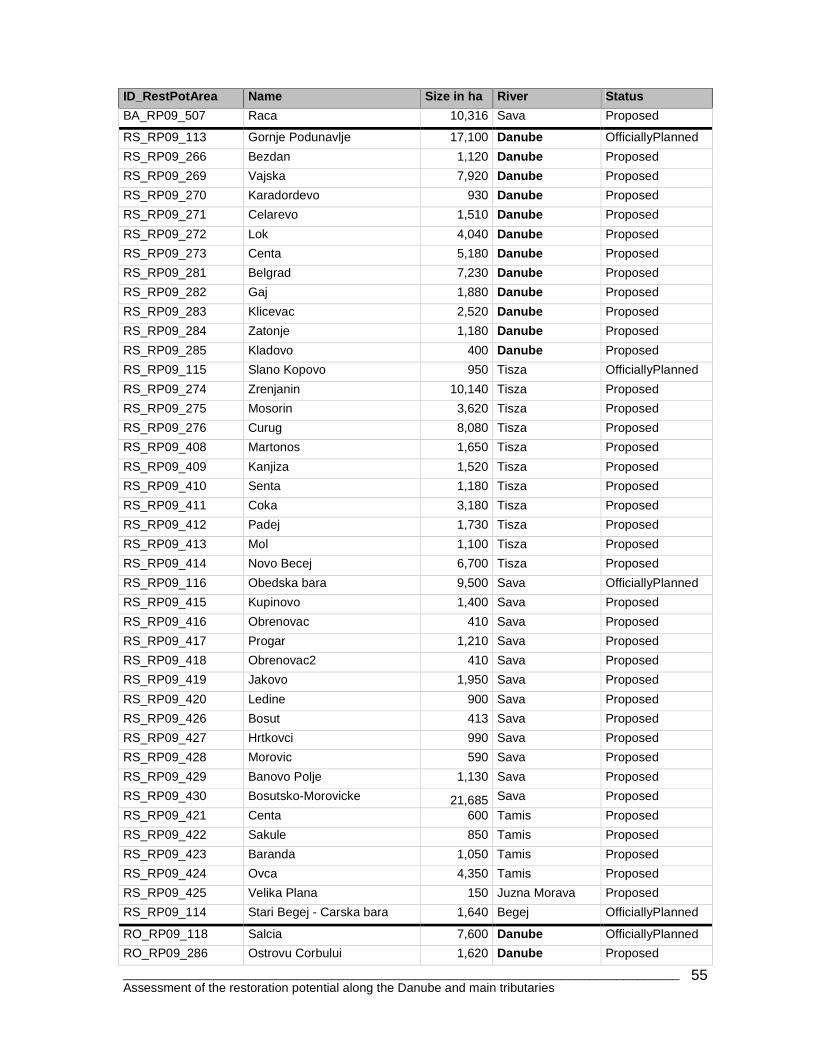
________________________________________________________________________________ Assessment of the restoration potential along the Danube and main tributaries
55
ID_RestPotArea Name Size in ha River Status
BA_RP09_507 Raca 10,316 Sava Proposed
RS_RP09_113 Gornje Podunavlje 17,100 Danube OfficiallyPlanned
RS_RP09_266 Bezdan 1,120 Danube Proposed
RS_RP09_269 Vajska 7,920 Danube Proposed
RS_RP09_270 Karadordevo 930 Danube Proposed
RS_RP09_271 Celarevo 1,510 Danube Proposed
RS_RP09_272 Lok 4,040 Danube Proposed
RS_RP09_273 Centa 5,180 Danube Proposed
RS_RP09_281 Belgrad 7,230 Danube Proposed
RS_RP09_282 Gaj 1,880 Danube Proposed
RS_RP09_283 Klicevac 2,520 Danube Proposed
RS_RP09_284 Zatonje 1,180 Danube Proposed
RS_RP09_285 Kladovo 400 Danube Proposed
RS_RP09_115 Slano Kopovo 950 Tisza OfficiallyPlanned
RS_RP09_274 Zrenjanin 10,140 Tisza Proposed
RS_RP09_275 Mosorin 3,620 Tisza Proposed
RS_RP09_276 Curug 8,080 Tisza Proposed
RS_RP09_408 Martonos 1,650 Tisza Proposed
RS_RP09_409 Kanjiza 1,520 Tisza Proposed
RS_RP09_410 Senta 1,180 Tisza Proposed
RS_RP09_411 Coka 3,180 Tisza Proposed
RS_RP09_412 Padej 1,730 Tisza Proposed
RS_RP09_413 Mol 1,100 Tisza Proposed
RS_RP09_414 Novo Becej 6,700 Tisza Proposed
RS_RP09_116 Obedska bara 9,500 Sava OfficiallyPlanned
RS_RP09_415 Kupinovo 1,400 Sava Proposed
RS_RP09_416 Obrenovac 410 Sava Proposed
RS_RP09_417 Progar 1,210 Sava Proposed
RS_RP09_418 Obrenovac2 410 Sava Proposed
RS_RP09_419 Jakovo 1,950 Sava Proposed
RS_RP09_420 Ledine 900 Sava Proposed
RS_RP09_426 Bosut 413 Sava Proposed
RS_RP09_427 Hrtkovci 990 Sava Proposed
RS_RP09_428 Morovic 590 Sava Proposed
RS_RP09_429 Banovo Polje 1,130 Sava Proposed
RS_RP09_430 Bosutsko-Morovicke 21,685 Sava Proposed
RS_RP09_421 Centa 600 Tamis Proposed
RS_RP09_422 Sakule 850 Tamis Proposed
RS_RP09_423 Baranda 1,050 Tamis Proposed
RS_RP09_424 Ovca 4,350 Tamis Proposed
RS_RP09_425 Velika Plana 150 Juzna Morava Proposed
RS_RP09_114 Stari Begej - Carska bara 1,640 Begej OfficiallyPlanned
RO_RP09_118 Salcia 7,600 Danube OfficiallyPlanned
RO_RP09_286 Ostrovu Corbului 1,620 Danube Proposed
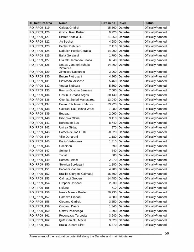
________________________________________________________________________________ Assessment of the restoration potential along the Danube and main tributaries
56
ID_RestPotArea Name Size in ha River Status
RO_RP09_119 Calafat Ghidici 15,560 Danube OfficiallyPlanned
RO_RP09_120 Ghidici Rast Bistret 9,220 Danube OfficiallyPlanned
RO_RP09_121 Bistret Nedeia Jiu 21,260 Danube OfficiallyPlanned
RO_RP09_122 Jiu Bechet 4,680 Danube OfficiallyPlanned
RO_RP09_123 Bechet Dabuleni 7,110 Danube OfficiallyPlanned
RO_RP09_124 Dabulen Potelu Corabia 14,990 Danube OfficiallyPlanned
RO_RP09_125 Balta Geraiului 1,790 Danube OfficiallyPlanned
RO_RP09_127 Lita Olt Flamanda Seaca 6,540 Danube OfficiallyPlanned
RO_RP09_128 Seaca Vanatori Suhaia Zimnicea
14,400 Danube OfficiallyPlanned
RO_RP09_129 Zimnicea Nasturelu 3,960 Danube OfficiallyPlanned
RO_RP09_130 Bujoru Pietrosani 4,960 Danube OfficiallyPlanned
RO_RP09_131 Pietrosani Arsache 5,460 Danube OfficiallyPlanned
RO_RP09_132 Vedea Slobozia 5,560 Danube OfficiallyPlanned
RO_RP09_133 Remus Gostinu Baneasa 7,600 Danube OfficiallyPlanned
RO_RP09_134 Gostinu Greaca Arges 30,140 Danube OfficiallyPlanned
RO_RP09_136 Oltenita Surlari Manastirea 13,040 Danube OfficiallyPlanned
RO_RP09_137 Boianu Sticleanu Calarasi 23,920 Danube OfficiallyPlanned
RO_RP09_138 Calarasi-Raul Island West 7,980 Danube OfficiallyPlanned
RO_RP09_139 Bugeag 2,060 Danube OfficiallyPlanned
RO_RP09_140 Piscicola Oltina 3,110 Danube OfficiallyPlanned
RO_RP09_141 Borcea de Sus I 8,740 Danube OfficiallyPlanned
RO_RP09_142 Unirea Gildau 970 Danube OfficiallyPlanned
RO_RP09_143 Borcea de Jos I II III 50,320 Danube OfficiallyPlanned
RO_RP09_144 Viile Dunareni 1,180 Danube OfficiallyPlanned
RO_RP09_145 Baciu Vederoasa 1,810 Danube OfficiallyPlanned
RO_RP09_146 Cochirleni 690 Danube OfficiallyPlanned
RO_RP09_147 Seimeni 840 Danube OfficiallyPlanned
RO_RP09_148 Topalu 380 Danube OfficiallyPlanned
RO_RP09_149 Borcea Fetesti 2,270 Danube OfficiallyPlanned
RO_RP09_150 Stelnica Bordusani 1,880 Danube OfficiallyPlanned
RO_RP09_151 Facaeni Vladeni 4,700 Danube OfficiallyPlanned
RO_RP09_152 Brailita Giurgeni Calmatui 16,590 Danube OfficiallyPlanned
RO_RP09_153 Calmatui Gropeni 14,480 Danube OfficiallyPlanned
RO_RP09_154 Gropeni Chiscani 2,230 Danube OfficiallyPlanned
RO_RP09_155 Noianu 710 Danube OfficiallyPlanned
RO_RP09_156 Insula Mare a Brailei 70,930 Danube OfficiallyPlanned
RO_RP09_157 Harsova Ciobanu 4,680 Danube OfficiallyPlanned
RO_RP09_158 Ciobanu Garliciu 3,850 Danube OfficiallyPlanned
RO_RP09_159 Ciobanu Daeni 1,340 Danube OfficiallyPlanned
RO_RP09_160 Ostrov Pecineaga 1,590 Danube OfficiallyPlanned
RO_RP09_161 Peceneaga Turcoaia 3,540 Danube OfficiallyPlanned
RO_RP09_162 Iglita Carcaliu Macin 3,020 Danube OfficiallyPlanned
RO_RP09_163 Braila Dunare Siret 5,370 Danube OfficiallyPlanned
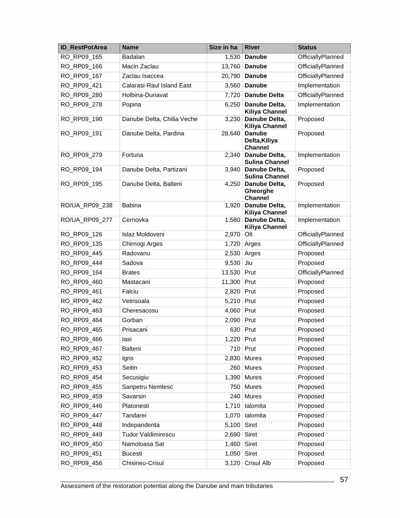
________________________________________________________________________________ Assessment of the restoration potential along the Danube and main tributaries
57
ID_RestPotArea Name Size in ha River Status
RO_RP09_165 Badalan 1,530 Danube OfficiallyPlanned
RO_RP09_166 Macin Zaclau 13,760 Danube OfficiallyPlanned
RO_RP09_167 Zaclau Isaccea 20,790 Danube OfficiallyPlanned
RO_RP09_421 Calarasi-Raul Island East 3,560 Danube Implementation
RO_RP09_280 Holbina-Dunavat 7,720 Danube Delta OfficiallyPlanned
RO_RP09_278 Popina 6,250 Danube Delta, Kiliya Channel
Implementation
RO_RP09_190 Danube Delta, Chilia Veche 3,230 Danube Delta, Kiliya Channel
Proposed
RO_RP09_191 Danube Delta, Pardina 28,640 Danube Delta,Kiliya Channel
Proposed
RO_RP09_279 Fortuna 2,340 Danube Delta, Sulina Channel
Implementation
RO_RP09_194 Danube Delta, Partizani 3,940 Danube Delta, Sulina Channel
Proposed
RO_RP09_195 Danube Delta, Balteni 4,250 Danube Delta, Gheorghe Channel
Proposed
RO/UA_RP09_238 Babina 1,920 Danube Delta, Kiliya Channel
Implementation
RO/UA_RP09_277 Cernovka 1,580 Danube Delta, Kiliya Channel
Implementation
RO_RP09_126 Islaz Moldoveni 2,970 Olt OfficiallyPlanned
RO_RP09_135 Chirnogi Arges 1,720 Arges OfficiallyPlanned
RO_RP09_445 Radovanu 2,530 Arges Proposed
RO_RP09_444 Sadova 9,530 Jiu Proposed
RO_RP09_164 Brates 13,530 Prut OfficiallyPlanned
RO_RP09_460 Mastacani 11,300 Prut Proposed
RO_RP09_461 Falciu 2,820 Prut Proposed
RO_RP09_462 Vetrisoala 5,210 Prut Proposed
RO_RP09_463 Cheresacosu 4,060 Prut Proposed
RO_RP09_464 Gorban 2,090 Prut Proposed
RO_RP09_465 Prisacani 630 Prut Proposed
RO_RP09_466 Iasi 1,220 Prut Proposed
RO_RP09_467 Balteni 710 Prut Proposed
RO_RP09_452 Igris 2,830 Mures Proposed
RO_RP09_453 Seitin 260 Mures Proposed
RO_RP09_454 Secusigiu 1,390 Mures Proposed
RO_RP09_455 Sanpetru Nemtesc 750 Mures Proposed
RO_RP09_459 Savarsin 240 Mures Proposed
RO_RP09_446 Platonesti 1,710 Ialomita Proposed
RO_RP09_447 Tandarei 1,070 Ialomita Proposed
RO_RP09_448 Indepandenta 5,100 Siret Proposed
RO_RP09_449 Tudor Valdimirescu 2,690 Siret Proposed
RO_RP09_450 Namoloasa Sat 1,460 Siret Proposed
RO_RP09_451 Bucesti 1,050 Siret Proposed
RO_RP09_456 Chisineu-Crisul 3,120 Crisul Alb Proposed
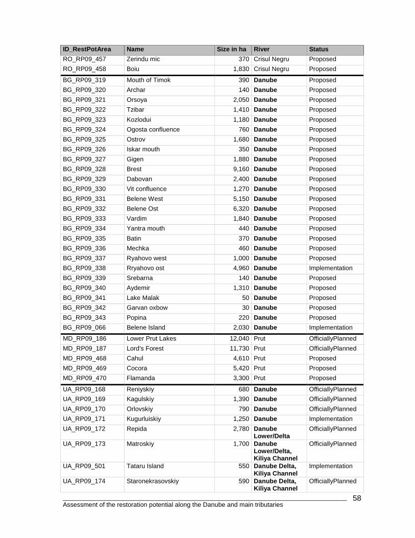
________________________________________________________________________________ Assessment of the restoration potential along the Danube and main tributaries
58
ID_RestPotArea Name Size in ha River Status
RO_RP09_457 Zerindu mic 370 Crisul Negru Proposed
RO_RP09_458 Boiu 1,830 Crisul Negru Proposed
BG_RP09_319 Mouth of Timok 390 Danube Proposed
BG_RP09_320 Archar 140 Danube Proposed
BG_RP09_321 Orsoya 2,050 Danube Proposed
BG_RP09_322 Tzibar 1,410 Danube Proposed
BG_RP09_323 Kozlodui 1,180 Danube Proposed
BG_RP09_324 Ogosta confluence 760 Danube Proposed
BG_RP09_325 Ostrov 1,680 Danube Proposed
BG_RP09_326 Iskar mouth 350 Danube Proposed
BG_RP09_327 Gigen 1,880 Danube Proposed
BG_RP09_328 Brest 9,160 Danube Proposed
BG_RP09_329 Dabovan 2,400 Danube Proposed
BG_RP09_330 Vit confluence 1,270 Danube Proposed
BG_RP09_331 Belene West 5,150 Danube Proposed
BG_RP09_332 Belene Ost 6,320 Danube Proposed
BG_RP09_333 Vardim 1,840 Danube Proposed
BG_RP09_334 Yantra mouth 440 Danube Proposed
BG_RP09_335 Batin 370 Danube Proposed
BG_RP09_336 Mechka 460 Danube Proposed
BG_RP09_337 Ryahovo west 1,000 Danube Proposed
BG_RP09_338 Rryahovo ost 4,960 Danube Implementation
BG_RP09_339 Srebarna 140 Danube Proposed
BG_RP09_340 Aydemir 1,310 Danube Proposed
BG_RP09_341 Lake Malak 50 Danube Proposed
BG_RP09_342 Garvan oxbow 30 Danube Proposed
BG_RP09_343 Popina 220 Danube Proposed
BG_RP09_066 Belene Island 2,030 Danube Implementation
MD_RP09_186 Lower Prut Lakes 12,040 Prut OfficiallyPlanned
MD_RP09_187 Lord's Forest 11,730 Prut OfficiallyPlanned
MD_RP09_468 Cahul 4,610 Prut Proposed
MD_RP09_469 Cocora 5,420 Prut Proposed
MD_RP09_470 Flamanda 3,300 Prut Proposed
UA_RP09_168 Reniyskiy 680 Danube OfficiallyPlanned
UA_RP09_169 Kagulskiy 1,390 Danube OfficiallyPlanned
UA_RP09_170 Orlovskiy 790 Danube OfficiallyPlanned
UA_RP09_171 Kugurluiskiy 1,250 Danube Implementation
UA_RP09_172 Repida 2,780 Danube Lower/Delta
OfficiallyPlanned
UA_RP09_173 Matroskiy 1,700 Danube Lower/Delta, Kiliya Channel
OfficiallyPlanned
UA_RP09_501 Tataru Island 550 Danube Delta, Kiliya Channel
Implementation
UA_RP09_174 Staronekrasovskiy 590 Danube Delta, Kiliya Channel
OfficiallyPlanned
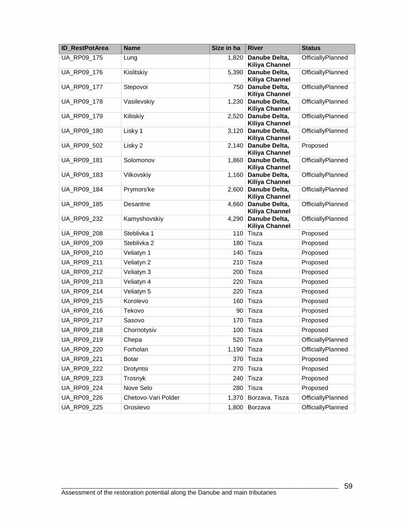
________________________________________________________________________________ Assessment of the restoration potential along the Danube and main tributaries
59
ID_RestPotArea Name Size in ha River Status
UA_RP09_175 Lung 1,820 Danube Delta, Kiliya Channel
OfficiallyPlanned
UA_RP09_176 Kislitskiy 5,390 Danube Delta, Kiliya Channel
OfficiallyPlanned
UA_RP09_177 Stepovoi 750 Danube Delta, Kiliya Channel
OfficiallyPlanned
UA_RP09_178 Vasilevskiy 1,230 Danube Delta, Kiliya Channel
OfficiallyPlanned
UA_RP09_179 Kiliiskiy 2,520 Danube Delta, Kiliya Channel
OfficiallyPlanned
UA_RP09_180 Lisky 1 3,120 Danube Delta, Kiliya Channel
OfficiallyPlanned
UA_RP09_502 Lisky 2 2,140 Danube Delta, Kiliya Channel
Proposed
UA_RP09_181 Solomonov 1,860 Danube Delta, Kiliya Channel
OfficiallyPlanned
UA_RP09_183 Vilkovskiy 1,160 Danube Delta, Kiliya Channel
OfficiallyPlanned
UA_RP09_184 Prymors'ke 2,600 Danube Delta, Kiliya Channel
OfficiallyPlanned
UA_RP09_185 Desantne 4,660 Danube Delta, Kiliya Channel
OfficiallyPlanned
UA_RP09_232 Kamyshovskiy 4,290 Danube Delta, Kiliya Channel
OfficiallyPlanned
UA_RP09_208 Steblivka 1 110 Tisza Proposed
UA_RP09_209 Steblivka 2 180 Tisza Proposed
UA_RP09_210 Veliatyn 1 140 Tisza Proposed
UA_RP09_211 Veliatyn 2 210 Tisza Proposed
UA_RP09_212 Veliatyn 3 200 Tisza Proposed
UA_RP09_213 Veliatyn 4 220 Tisza Proposed
UA_RP09_214 Veliatyn 5 220 Tisza Proposed
UA_RP09_215 Korolevo 160 Tisza Proposed
UA_RP09_216 Tekovo 90 Tisza Proposed
UA_RP09_217 Sasovo 170 Tisza Proposed
UA_RP09_218 Chornotysiv 100 Tisza Proposed
UA_RP09_219 Chepa 520 Tisza OfficiallyPlanned
UA_RP09_220 Forholan 1,190 Tisza OfficiallyPlanned
UA_RP09_221 Botar 370 Tisza Proposed
UA_RP09_222 Drotyntsi 270 Tisza Proposed
UA_RP09_223 Trosnyk 240 Tisza Proposed
UA_RP09_224 Nove Selo 280 Tisza Proposed
UA_RP09_226 Chetovo-Vari Polder 1,370 Borzava, Tisza OfficiallyPlanned
UA_RP09_225 Orosiievo 1,800 Borzava OfficiallyPlanned
Related Documents


