Metropolitan Planning Authority Whole of Water Cycle Assessment: PSP 1067 Donnybrook and PSP 1096 Woodstock Summary Report Final Issue | 27 June 2014 This report takes into account the particular instructions and requirements of our client. It is not intended for and should not be relied upon by any third party and no responsibility is undertaken to any third party. Job number 234383-00 Arup Arup Pty Ltd ABN 18 000 966 165 Arup Level 17 1 Nicholson Street Melbourne VIC 3000 Australia www.arup.com

Welcome message from author
This document is posted to help you gain knowledge. Please leave a comment to let me know what you think about it! Share it to your friends and learn new things together.
Transcript
Metropolitan Planning Authority
Whole of Water Cycle Assessment: PSP 1067 Donnybrook and PSP 1096 Woodstock
Summary Report
Final
Issue | 27 June 2014
This report takes into account the particular
instructions and requirements of our client.
It is not intended for and should not be relied
upon by any third party and no responsibility
is undertaken to any third party.
Job number 234383-00
Arup
Arup Pty Ltd ABN 18 000 966 165
Arup
Level 17
1 Nicholson Street
Melbourne VIC 3000
Australia
www.arup.com
Metropolitan Planning Authority Whole of Water Cycle Assessment: PSP 1067 Donnybrook and PSP 1096
Woodstock Summary Report
Final | Issue | 27 June 2014 | Arup
Contents
Page
Executive Summary 1
1 Introduction 9
1.1 Report contents 12
1.2 WoWCA process and Precinct Structure Planning 13
1.3 Acknowledgments 15
2 Site details 17
3 Option description and assumptions 20
3.1 Alternative option development 20
3.2 Options description 22
3.2.1 Base case 22
3.2.2 Alternative 1 – Base Case + 24
3.2.3 Alternative 2 – Future stretch 26
3.3 Key assumptions 28
3.3.1 Land use types requiring water 28
3.3.2 Land use extents 28
3.3.3 Residential Development Assumptions 29
3.3.4 Water supply 29
3.3.5 Surface water management 30
3.3.6 Potable and non-potable water demands 33
3.3.7 Sewer discharge 34
3.3.8 ASR Potential 35
3.3.9 Climate Change Scenarios 35
4 Precinct demands and sewer discharge 37
4.1 Base Case 37
4.1.1 Alternative 1 – Base Case + 39
4.2 Alternative 2 – Future stretch 41
5 Schematic design 44
5.1 Water Sensitive Urban Design 48
5.1.1 Vegetated swales/Buffer strips 51
5.1.2 Wetlands 51
5.1.3 Rainwater tanks 53
5.2 Anticipated layout 53
5.3 Land take requirements 57
5.3.1 Base case 57
5.3.2 Alternative 1 and 2 58
Metropolitan Planning Authority Whole of Water Cycle Assessment: PSP 1067 Donnybrook and PSP 1096
Woodstock Summary Report
Final | Issue | 27 June 2014 | Arup
6 Options assessment 60
6.1 Donnybrook 61
6.2 Woodstock 62
6.3 Qualitative assessment 63
7 Recommendation and key findings 67
8 References 69
Appendices
Appendix A
Description of site details
Appendix B
Workshop notes
Appendix C
Stakeholder Commentary

Metropolitan Planning Authority Whole of Water Cycle Assessment: PSP 1067 Donnybrook and PSP 1096
Woodstock Summary Report
Final | Issue | 27 June 2014 | Arup
Page 1
Executive Summary
Arup Pty Ltd (Arup) was engaged by the MPA to prepare a Whole of Water Cycle Assessment (WoWCA) to inform the development of the two PSPs which will guide future urban development in the area. Arup’s benefit focussed Design with Water partnership approach to WoWCA has been utilised in the development of this project.
The purpose of this study was to identify a high-level strategy and schematic design for integrated water management to assist in the establishment of the future urban structure for the new communities of Donnybrook and Woodstock. The study identified issues and considerations for the future urban development of the study area and provided options and recommendations for a schematic urban structure to facilitate whole-of-water-cycle management. The assessment will enable MPA to plan the future urban structure for the Donnybrook and Woodstock PSPs with greater consideration of the whole-of-water-cycle opportunities available.
This Summary Report brings together work undertaken to date, stakeholder feedback through the stakeholder workshop conducted in February, comments received after the workshop and consultation with key stakeholders along with other background information available regarding the Woodstock and Donnybrook PSPs.
The development of a WoWCA for the two PSP’s involved a number of key steps which include:
1. Development of a base case report to document key site characteristics and the business as usual scenario (completed in February 2014)
2. Consultation with stakeholders to explore if there are other more innovative and efficient options which meet the required criteria (completed during February and March 2014)
3. Assessment of alternative options and comparison with the base case (the subject of this report)
Organisations consulted in the development of the WoWC Report include:
MPA
Yarra Valley Water
Whittlesea City
Melbourne Water
Office of Living Victoria
Mitchell Shire
Department of Health

Metropolitan Planning Authority Whole of Water Cycle Assessment: PSP 1067 Donnybrook and PSP 1096
Woodstock Summary Report
Final | Issue | 27 June 2014 | Arup
Page 2
WoWCA process and Precinct Structure Planning
According to MPA in the context of Precinct Structure Planning, whole-of-water-cycle management seeks to make effective use of all sources of water by tailoring them to different locations and circumstances and thereby delivering multiple benefits.
Whole-of-water-cycle management at the PSP scale helps deliver on the objectives of the Victorian Government’s Living Victoria strategy ‘Melbourne’s Water Future’ (Office of Living Victoria, July 2013) to plan and manage an integrated and resilient water system.
MPA WoWCA Objectives:
Objectives of the whole-of-water-cycle assessment include:
Diversification of supply thereby reducing the cost of future large scale centralised water/wastewater systems
Waterway health improvement, consisting of less volume and higher quality
Management of potential flooding and decreasing flood risk Improved liveability and urban landscapes Engagement of the community via key stakeholders. Identification of opportunities within the planning and building process
that will also help to deliver on the above objectives. To deliver on these objectives, whole-of-water management opportunities
could include: o Minimising potable water usage by use of alternative water
supplies o Roof rainwater harvesting o Stormwater harvesting o Stormwater quality measures o Flood management including the minimisation of flood extents o Sewer mining o Groundwater including aquifer storage and recovery o Sewage treatment and discharge o Improving environmental, landscape and liveability outcomes
through water management. Site Details
The Donnybrook PSP is located in the Cities of Whittlesea and Mitchell and to the east of the recently approved Lockerbie PSP. The precinct is bounded by the Outer Metropolitan Ring Road (OMR) E6 reservation to the north, the Sydney-Melbourne train line to the west, Donnybrook Road to the south, and the Woodstock PSP to the east.
The Donnybrook PSP is 1,067 hectares (gross) with a proposed primary land use of residential. The PSP is expected to accommodate over 10,000 residential lots. The Woodstock PSP is 759 hectares (gross) with a proposed primary land use of residential and is expected to accommodate over 7,500 residential lots.
Metropolitan Planning Authority Whole of Water Cycle Assessment: PSP 1067 Donnybrook and PSP 1096
Woodstock Summary Report
Final | Issue | 27 June 2014 | Arup
Page 3
Option Description and assumptions
The first stage of the WoWCA process was to define and develop a base case for consideration by the wider stakeholder group. In defining the base case, Arup, in collaboration with and drawing on previous work by Melbourne Water, Yarra Valley Water and the Office of Living Victoria developed in the document “An Integrated Water Future for Melbourne’s North,” considered a number of options presented in this document in order to provide water services to theses growth areas. The base case was further refined in consultation with key stakeholders and was presented to the stakeholders for comment and discussion at a subsequent stakeholder workshop and was updated accordingly.
A key component of this phase of work was to also collaborate with the project stakeholders to develop two alternative whole of water cycle options for the PSP areas and document the assumptions on which analysis of these are based. This was done via face-to-face meetings, a stakeholder workshop and a formal feedback process on the alternatives developed.
There were two alternatives that were then developed: Alternative 1 option is considered a ‘Base Case Plus’ and has been developed to build on the elements identified in the Base Case in order to achieve improved WoWCA outcomes and Alternative 2, the ‘Future Stretch Alternative’, was developed to introduce large scale interventions to supply part of the residential water demand, explore the benefits of a distributed approach to runoff water quality treatment and encourage innovation.

Metropolitan Planning Authority Whole of Water Cycle Assessment: PSP 1067 Donnybrook and PSP 1096
Woodstock Summary Report
Final | Issue | 27 June 2014 | Arup
Page 4
A summary of the options are below:
Base Case Alternative 1 Base Case + Alternative 2 – Future Stretch
Wastewater is collected and treated to recycled water standard at a regional treatment facility and is then returned to residential houses via a ‘third pipe’ system for non-drinking purposes. Approximately 30% of the water demand is met by the recycled water system, reducing the water demand for piped drinking water supply and downsizing drinking water pipes.
Retail and employment, education and public and open space land uses are supplied with potable water only.
Active open space is irrigated to the minimum extent required to maintain coverage but lush conditions are not always achieved.
Rainwater and stormwater are collected in pipes and treated through a series of settling ponds and wetlands prior to discharge into the receiving waterway.
Base Case + sets an efficiency target to reduce water usage in households by 10% off baseline figures.
Wastewater is collected and treated to recycled water standard at a regional treatment facility and is then returned to residential houses and to non-potable uses in retail and employment, educational and community facilities via a ‘third pipe’ system for non-drinking purposes. Approximately 30% of the water demand is met by the recycled water system, reducing the water demand for piped drinking water supply and downsizing drinking water pipes.
Rainwater and stormwater are collected in pipes and treated through a series of settling ponds and wetlands and are then used as supply for irrigation of active open space to achieve lush conditions.
Future Stretch sets an efficiency target to reduce water usage in households by 20% off baseline figures.
Wastewater is collected and treated to recycled water standard at a regional treatment facility and is then returned to residential houses and to non-potable uses in retail and employment, educational and community facilities via a ‘third pipe’ system for non-drinking purposes. Approximately 30% of the water demand is met by the recycled water system, reducing the water demand for piped drinking water supply and downsizing drinking water pipes.
Rainwater is collected by household rainwater tanks to supply hot water to residential buildings and as an additional opportunity to achieve beyond best practice.
A distributed approach to surface water runoff management incorporating streetscape elements along major road reserves and drainage lines to reduce size and extent of end of line detention and treatment is adopted.
Stormwater is harvested as supply for irrigation of open space to achieve lush conditions.
All options incorporate water efficiency measures including Water Efficiency Labelling Scheme (WELS) star rated appliances, fittings and fixtures.
Metropolitan Planning Authority Whole of Water Cycle Assessment: PSP 1067 Donnybrook and PSP 1096
Woodstock Summary Report
Final | Issue | 27 June 2014 | Arup
Page 5
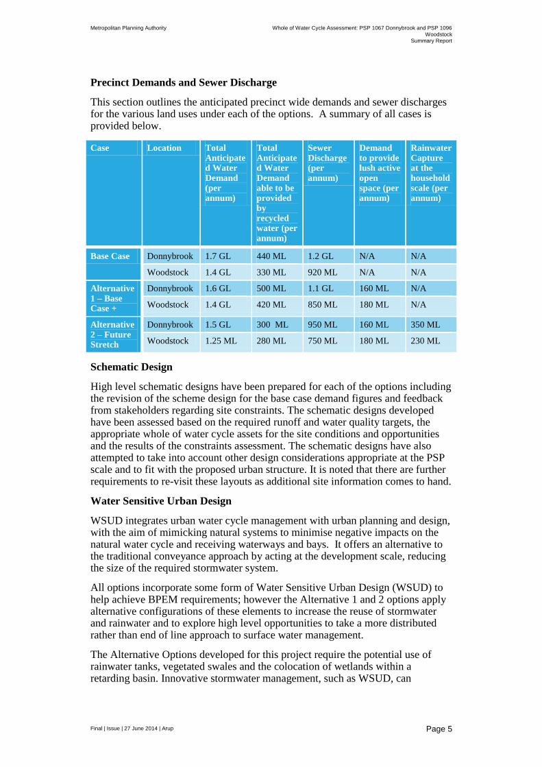
Precinct Demands and Sewer Discharge
This section outlines the anticipated precinct wide demands and sewer discharges for the various land uses under each of the options. A summary of all cases is provided below.
Case Location Total Anticipated Water Demand (per annum)
Total Anticipated Water Demand able to be provided by recycled water (per annum)
Sewer Discharge (per annum)
Demand to provide lush active open space (per annum)
Rainwater Capture at the household scale (per annum)
Base Case Donnybrook 1.7 GL 440 ML 1.2 GL N/A N/A
Woodstock 1.4 GL 330 ML 920 ML N/A N/A
Alternative 1 – Base Case +
Donnybrook 1.6 GL 500 ML 1.1 GL 160 ML N/A
Woodstock 1.4 GL 420 ML 850 ML 180 ML N/A
Alternative 2 – Future Stretch
Donnybrook 1.5 GL 300 ML 950 ML 160 ML 350 ML
Woodstock 1.25 ML 280 ML 750 ML 180 ML 230 ML
Schematic Design
High level schematic designs have been prepared for each of the options including the revision of the scheme design for the base case demand figures and feedback from stakeholders regarding site constraints. The schematic designs developed have been assessed based on the required runoff and water quality targets, the appropriate whole of water cycle assets for the site conditions and opportunities and the results of the constraints assessment. The schematic designs have also attempted to take into account other design considerations appropriate at the PSP scale and to fit with the proposed urban structure. It is noted that there are further requirements to re-visit these layouts as additional site information comes to hand.
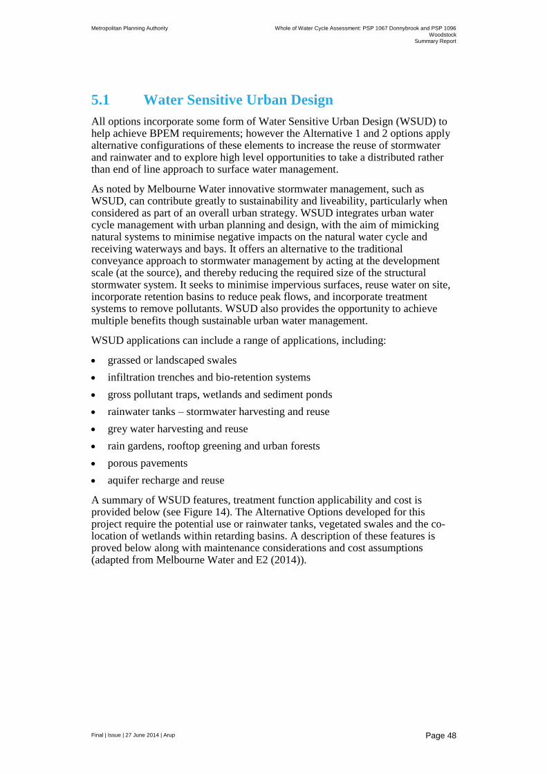
Water Sensitive Urban Design
WSUD integrates urban water cycle management with urban planning and design, with the aim of mimicking natural systems to minimise negative impacts on the natural water cycle and receiving waterways and bays. It offers an alternative to the traditional conveyance approach by acting at the development scale, reducing the size of the required stormwater system.
All options incorporate some form of Water Sensitive Urban Design (WSUD) to help achieve BPEM requirements; however the Alternative 1 and 2 options apply alternative configurations of these elements to increase the reuse of stormwater and rainwater and to explore high level opportunities to take a more distributed rather than end of line approach to surface water management.
The Alternative Options developed for this project require the potential use of rainwater tanks, vegetated swales and the colocation of wetlands within a retarding basin. Innovative stormwater management, such as WSUD, can
Metropolitan Planning Authority Whole of Water Cycle Assessment: PSP 1067 Donnybrook and PSP 1096
Woodstock Summary Report
Final | Issue | 27 June 2014 | Arup
Page 6
contribute greatly to sustainability and liveability, but ongoing costs and management responsibilities are a key consideration.
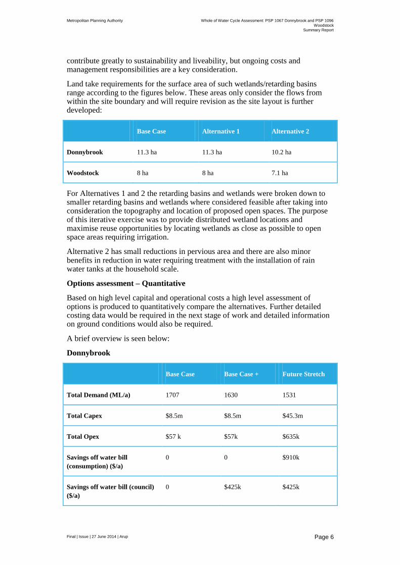
Land take requirements for the surface area of such wetlands/retarding basins range according to the figures below. These areas only consider the flows from within the site boundary and will require revision as the site layout is further developed:
Base Case Alternative 1 Alternative 2
Donnybrook 11.3 ha 11.3 ha 10.2 ha
Woodstock 8 ha 8 ha 7.1 ha
For Alternatives 1 and 2 the retarding basins and wetlands were broken down to smaller retarding basins and wetlands where considered feasible after taking into consideration the topography and location of proposed open spaces. The purpose of this iterative exercise was to provide distributed wetland locations and maximise reuse opportunities by locating wetlands as close as possible to open space areas requiring irrigation.
Alternative 2 has small reductions in pervious area and there are also minor benefits in reduction in water requiring treatment with the installation of rain water tanks at the household scale.
Options assessment – Quantitative
Based on high level capital and operational costs a high level assessment of options is produced to quantitatively compare the alternatives. Further detailed costing data would be required in the next stage of work and detailed information on ground conditions would also be required.
A brief overview is seen below:
Donnybrook
Base Case Base Case + Future Stretch
Total Demand (ML/a) 1707 1630 1531
Total Capex $8.5m $8.5m $45.3m
Total Opex $57 k $57k $635k
Savings off water bill
(consumption) ($/a)
0 0 $910k
Savings off water bill (council)
($/a)
0 $425k $425k
Metropolitan Planning Authority Whole of Water Cycle Assessment: PSP 1067 Donnybrook and PSP 1096
Woodstock Summary Report
Final | Issue | 27 June 2014 | Arup
Page 7
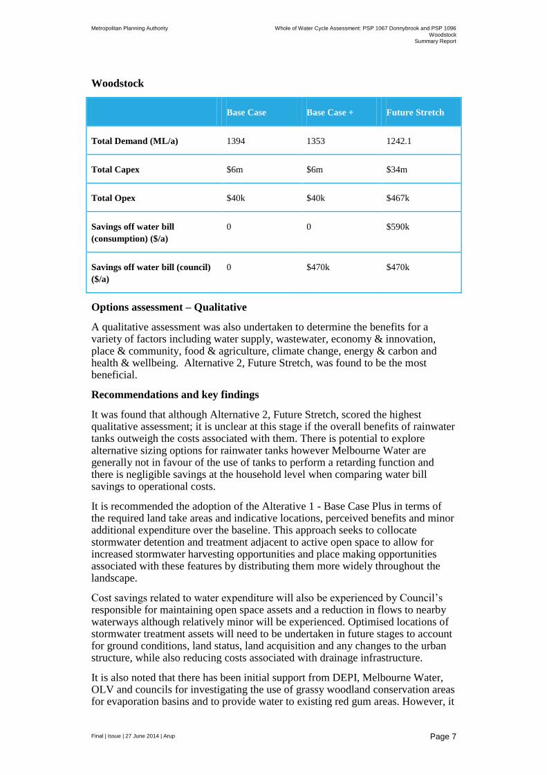
Woodstock
Base Case Base Case + Future Stretch
Total Demand (ML/a) 1394 1353 1242.1
Total Capex $6m $6m $34m
Total Opex $40k $40k $467k
Savings off water bill
(consumption) ($/a)
0 0 $590k
Savings off water bill (council)
($/a)
0 $470k $470k
Options assessment – Qualitative
A qualitative assessment was also undertaken to determine the benefits for a variety of factors including water supply, wastewater, economy & innovation, place & community, food & agriculture, climate change, energy & carbon and health & wellbeing. Alternative 2, Future Stretch, was found to be the most beneficial.
Recommendations and key findings
It was found that although Alternative 2, Future Stretch, scored the highest qualitative assessment; it is unclear at this stage if the overall benefits of rainwater tanks outweigh the costs associated with them. There is potential to explore alternative sizing options for rainwater tanks however Melbourne Water are generally not in favour of the use of tanks to perform a retarding function and there is negligible savings at the household level when comparing water bill savings to operational costs.
It is recommended the adoption of the Alterative 1 - Base Case Plus in terms of the required land take areas and indicative locations, perceived benefits and minor additional expenditure over the baseline. This approach seeks to collocate stormwater detention and treatment adjacent to active open space to allow for increased stormwater harvesting opportunities and place making opportunities associated with these features by distributing them more widely throughout the landscape.
Cost savings related to water expenditure will also be experienced by Council’s responsible for maintaining open space assets and a reduction in flows to nearby waterways although relatively minor will be experienced. Optimised locations of stormwater treatment assets will need to be undertaken in future stages to account for ground conditions, land status, land acquisition and any changes to the urban structure, while also reducing costs associated with drainage infrastructure.
It is also noted that there has been initial support from DEPI, Melbourne Water, OLV and councils for investigating the use of grassy woodland conservation areas for evaporation basins and to provide water to existing red gum areas. However, it

Metropolitan Planning Authority Whole of Water Cycle Assessment: PSP 1067 Donnybrook and PSP 1096
Woodstock Summary Report
Final | Issue | 27 June 2014 | Arup
Page 8
is noted that a large amount of work still required to detail how this could be implemented particularly in terms of water delivery regimes, funding and ongoing maintenance. Implementation of a successful scheme could have a number of beneficial impacts including revegetation of conservation areas, significant reductions in stormwater flows to creeks, recharge of ground water, while also reducing retarding requirements.
Metropolitan Planning Authority Whole of Water Cycle Assessment: PSP 1067 Donnybrook and PSP 1096
Woodstock Summary Report
Final | Issue | 27 June 2014 | Arup
Page 9
1 Introduction
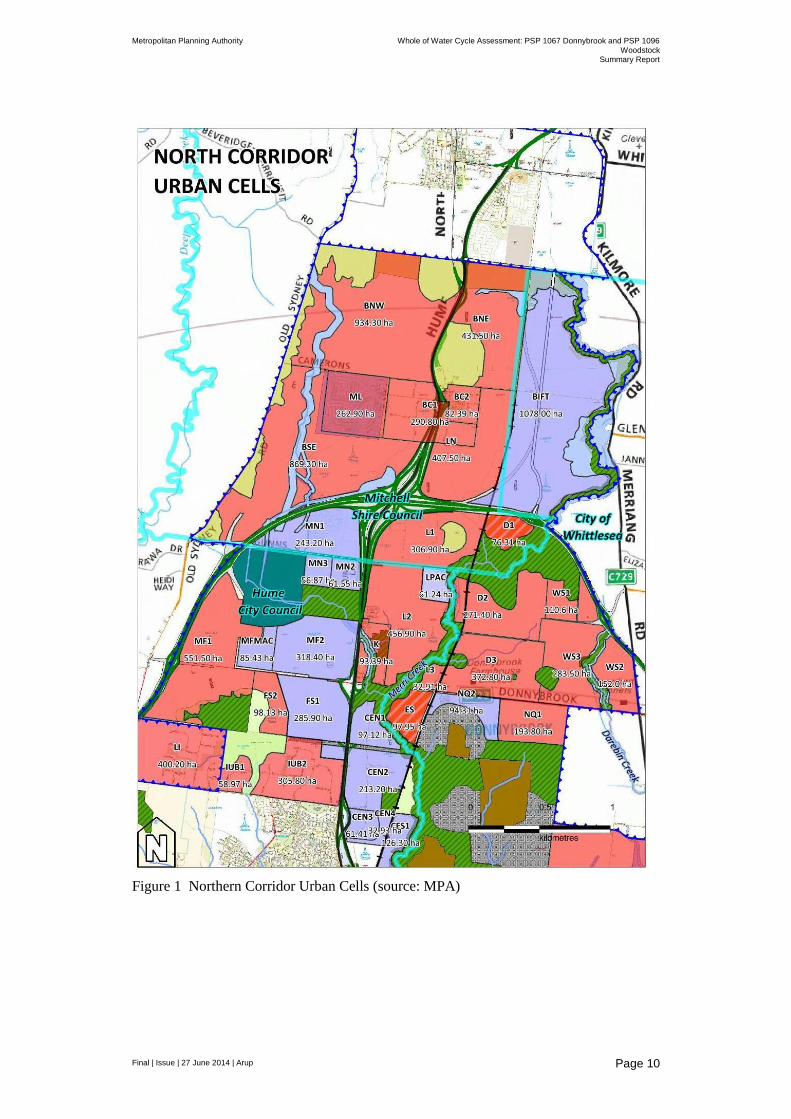
The Metropolitan Planning Authority (MPA), formerly the Growth Areas Authority (GAA), in partnership with the City of Whittlesea and Mitchell Shire Council has commenced preparation of the Donnybrook and Woodstock Precinct Structure Plans (PSPs) which will establish the future urban structure for a new community. Donnybrook and Woodstock PSPs are located in Melbourne’s Northern Growth Corridor (see Figure 1 for the location of Donnybrook PSP 1067 (cells D1, D2 and D3) and Woodstock PSP 1096 (cells WS1, WS2 and WS3)).
As part of the PSP development Arup Pty Ltd (Arup) has been engaged by the MPA to prepare a Whole of Water Cycle Assessment (WoWCA) to inform the development of the two PSPs which will guide future urban development in the area. The incorporation of water management requirements at this stage in the planning process allows for the future urban developments to take into account the best available opportunities for the provision of water services along with opportunities to improve the local environment and increase amenity and liveability outcomes for residents.
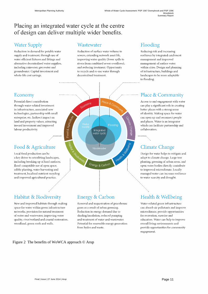
A WoWCA planning approach recognises that water can enhance social infrastructure and open space making it more attractive and sustainable. It also recognises that open space and other areas can be used to treat and store water for later reuse, prevent flooding, and reduce environmental impacts from development on waterways. Understanding the interface between water infrastructure and space requirements is the key to creating a truly multi-functional landscape that delivers multiple social, economic and environmental benefits while minimising unnecessary and costly land take. This in turn creates attractive communities, while ensuring that developer contributions for shared infrastructure are as low as possible to ensure affordability for home buyers. Arup’s benefit focussed Design with Water partnership approach to WoWCA has been utilised in the development of this project and is depicted in Figure 2.
Metropolitan Planning Authority Whole of Water Cycle Assessment: PSP 1067 Donnybrook and PSP 1096
Woodstock Summary Report
Final | Issue | 27 June 2014 | Arup
Page 10
Figure 1 Northern Corridor Urban Cells (source: MPA)
Metropolitan Planning Authority Whole of Water Cycle Assessment: PSP 1067 Donnybrook and PSP 1096
Woodstock Summary Report
Final | Issue | 27 June 2014 | Arup
Page 11
Figure 2 The benefits of WoWCA approach © Arup
Metropolitan Planning Authority Whole of Water Cycle Assessment: PSP 1067 Donnybrook and PSP 1096
Woodstock Summary Report
Final | Issue | 27 June 2014 | Arup
Page 12
The development of a WoWCA for the two PSP’s involves a number of key steps
which include:
1. Development of a base case report to document key site characteristics and the business as usual scenario (completed in February 2014)
2. Consultation with stakeholders to explore if there are other more innovative and efficient options which meet the required criteria (completed during February and March 2014)
3. Assessment of alternative options and comparison with the base case (the subject of this report)
The purpose of this study is to identify a high-level strategy and schematic design for integrated water management within the study area and to identify any issues or considerations for the future urban development of the study area.
Required outputs include the provision of supporting documentation which considers options for an urban structure to facilitate whole-of-water-cycle management and which recommends a preferred option for inclusion into the PSP.
The assessment will enable MPA to plan the future urban structure for the Donnybrook and Woodstock PSPs with greater certainty by identifying issues relating to land capability early in the planning process.
1.1 Report contents
This Summary Report brings together work undertaken to date, stakeholder feedback through the stakeholder workshop conducted in February, comments received after the workshop and consultation with key stakeholders along with other background information available regarding the Woodstock and Donnybrook PSPs such as heritage and biodiversity constraints, roads and utilities placement, commercial and community facilities, and open space.
This Summary Report is a high level strategy and schematic design responding to MPA instructions and issues arising from stakeholder workshops and makes recommendations on the draft future urban structure for the two PSPs including:
Details of drainage, stormwater, constructed waterways, open space, waterways corridors, conservation areas that are required to support delivery of the options
A comparison of how the draft urban structure may be amended to accommodate each of the whole-of-water-cycle options investigated
A strategy and schematic design identifying the alignment of drainage lines/waterways and location and size of retarding basins and water quality treatment wetlands (or other water retardation or treatment facilities)
High level opinion of cost to implement and maintain the short-listed options.
High level comparative analysis that provides relative statements of advantages and disadvantages of each whole-of-water-cycle management option against relevant criteria (environmental impact, infrastructure requirements, etc) to assist in establishing a preferred outcome.
Schematic plans and figures to visually demonstrate the mapping of the land take and infrastructure (required water, sewerage, alternative water, and

Metropolitan Planning Authority Whole of Water Cycle Assessment: PSP 1067 Donnybrook and PSP 1096
Woodstock Summary Report
Final | Issue | 27 June 2014 | Arup
Page 13
drainage services) for each whole-of-water-cycle management option to be assessed in its relationship to the other precinct networks, including open space, community facilities and transport.
This Summary Report will also make a recommendation as to whether further detailed analysis of whole-of-water-cycle management options is appropriate in the development of the PSPs.
1.2 WoWCA process and Precinct Structure Planning
According to MPA in the context of Precinct Structure Planning, whole-of-water-cycle management seeks to make effective use of all sources of water by tailoring them to different locations and circumstances and thereby delivering multiple benefits.
Sources of water could include recycled water, rainwater, stormwater, wastewater, groundwater, potable water and waterways. Whole-of-water-cycle management at the PSP scale helps deliver on the objectives of the Victorian Government’s Living Victoria strategy ‘Melbourne’s Water Future’ (Office of Living Victoria, July 2013) to plan and manage an integrated and resilient water system which:
supports liveable and sustainable communities;
protects the environmental health of urban waterways and bays;
provides secure water supplies efficiently;
protects public health; and
delivers affordable, essential water services.
The Government’s Living Victoria policy identifies a number of reform priorities including the need to improve the integration of urban and water planning. It has a guiding vision of:
“A smart, resilient water system for a liveable, sustainable and productive Melbourne.”
The MPA Integrated Water Management PSP Note requires that each PSP include WoWCA. The PSP Note outlines the following key WoWCA concepts:
“The aim of the integrated water management plan is to identify and bring together relevant water strategies and plans to consider land use impacts and opportunities as part of an overall approach. The objective is to consider how to manage water as a strategic resource within a sustainable development framework.”
“Opportunities need to be considered for combining land uses such as drainage infrastructure, recreational facilities, open space and walking and cycling trails. This approach can lead to significant cost savings while promoting efficient use of land, which ultimately assists housing affordability.”
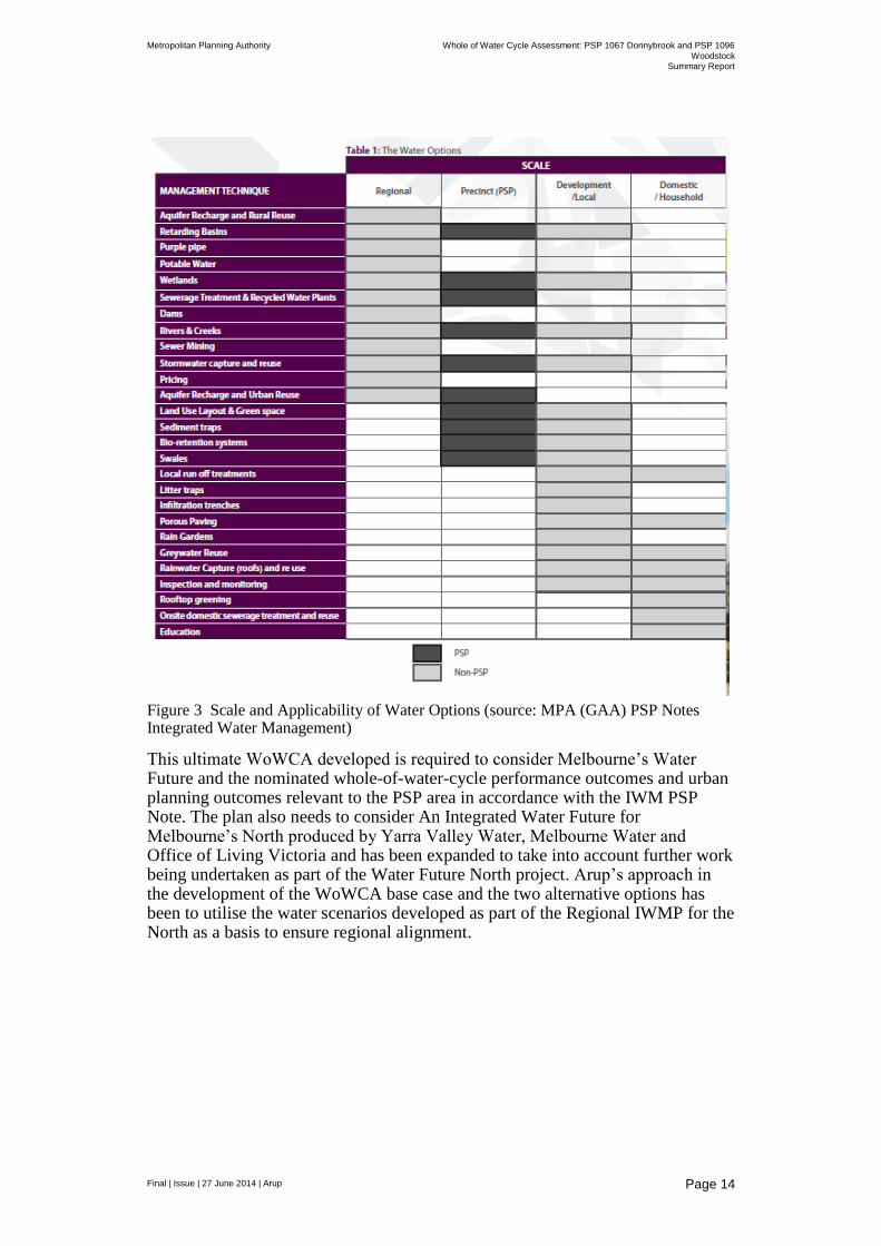
Figure 3 shows the scale and applicability of water options and at which planning scales they should be considered.
Metropolitan Planning Authority Whole of Water Cycle Assessment: PSP 1067 Donnybrook and PSP 1096
Woodstock Summary Report
Final | Issue | 27 June 2014 | Arup
Page 14
Figure 3 Scale and Applicability of Water Options (source: MPA (GAA) PSP Notes Integrated Water Management)
This ultimate WoWCA developed is required to consider Melbourne’s Water Future and the nominated whole-of-water-cycle performance outcomes and urban planning outcomes relevant to the PSP area in accordance with the IWM PSP Note. The plan also needs to consider An Integrated Water Future for Melbourne’s North produced by Yarra Valley Water, Melbourne Water and Office of Living Victoria and has been expanded to take into account further work being undertaken as part of the Water Future North project. Arup’s approach in the development of the WoWCA base case and the two alternative options has been to utilise the water scenarios developed as part of the Regional IWMP for the North as a basis to ensure regional alignment.
Metropolitan Planning Authority Whole of Water Cycle Assessment: PSP 1067 Donnybrook and PSP 1096
Woodstock Summary Report
Final | Issue | 27 June 2014 | Arup
Page 15
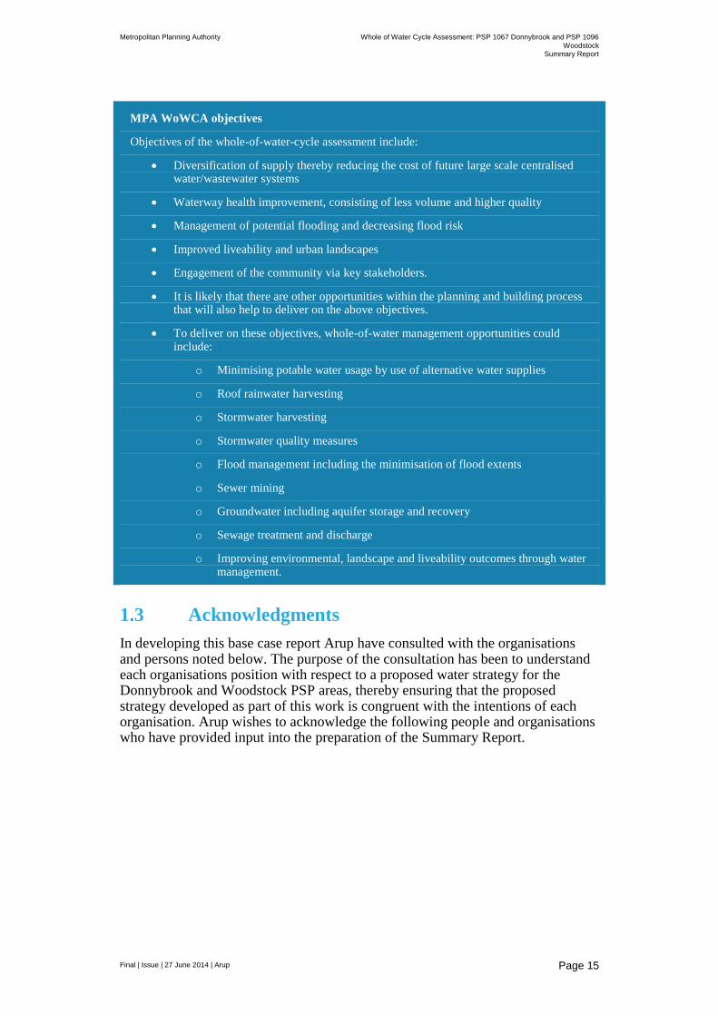
MPA WoWCA objectives
Objectives of the whole-of-water-cycle assessment include:
Diversification of supply thereby reducing the cost of future large scale centralised water/wastewater systems
Waterway health improvement, consisting of less volume and higher quality
Management of potential flooding and decreasing flood risk
Improved liveability and urban landscapes
Engagement of the community via key stakeholders.
It is likely that there are other opportunities within the planning and building process that will also help to deliver on the above objectives.
To deliver on these objectives, whole-of-water management opportunities could include:
o Minimising potable water usage by use of alternative water supplies
o Roof rainwater harvesting
o Stormwater harvesting
o Stormwater quality measures
o Flood management including the minimisation of flood extents
o Sewer mining
o Groundwater including aquifer storage and recovery
o Sewage treatment and discharge
o Improving environmental, landscape and liveability outcomes through water management.
1.3 Acknowledgments
In developing this base case report Arup have consulted with the organisations and persons noted below. The purpose of the consultation has been to understand each organisations position with respect to a proposed water strategy for the Donnybrook and Woodstock PSP areas, thereby ensuring that the proposed strategy developed as part of this work is congruent with the intentions of each organisation. Arup wishes to acknowledge the following people and organisations who have provided input into the preparation of the Summary Report.

Metropolitan Planning Authority Whole of Water Cycle Assessment: PSP 1067 Donnybrook and PSP 1096
Woodstock Summary Report
Final | Issue | 27 June 2014 | Arup
Page 16
Table 1: Organisations and persons consulted in development of base case
Organisation Name
MPA Bruce Hunter Chris Braddock Fiona McDougall
Yarra Valley Water Paul Curtis Simon Newberry Alicia Carr Kein Gan
Whittlesea City Niall McGovern Ben Harris Ross Guastalegname Molly Wilson Edmond Lascaris Paul Bellis
Melbourne Water Stephen Miller Carolina Balagtas Nino Polon Andrew Mellor James Hodgens Digby Richardson
Office of Living Victoria Bridgett Weatherall Lisa Ehrenfried Kanchana Karunaratna
Mitchell Shire Amy Reynolds Gregory Harris
Department of Health Vanora Mulvenna

Metropolitan Planning Authority Whole of Water Cycle Assessment: PSP 1067 Donnybrook and PSP 1096
Woodstock Summary Report
Final | Issue | 27 June 2014 | Arup
Page 17
2 Site details
PSP boundaries and the location of the site in relation to Melbourne are illustrated in Figure 4.
The Donnybrook PSP is located in the Cities of Whittlesea and Mitchell and to the east of the recently approved Lockerbie PSP. The precinct is bounded by the Outer Metropolitan Ring Road (OMR) E6 reservation to the north, the Sydney-Melbourne train line to the west, Donnybrook Road to the south, and the Woodstock PSP to the east.
The Donnybrook PSP is 1,067 hectares (gross) with a proposed primary land use of residential. The PSP is expected to accommodate over 10,000 residential lots. Land to the north of Merri Creek, in the Mitchell Shire Council, is identified as “potential urban” in the North Growth Corridor Plan (see Figure 1). The PSP for Donnybrook will need to confirm a specific land use designation for this land.
The Woodstock PSP is bounded by the OMR E6 reservation to the north-east, Merriang Road in the east, Donnybrook Road to the south, with the boundary of the Donnybrook PSP defining the western boundary of the PSP. The Woodstock PSP is 759 hectares (gross) with a proposed primary land use of residential and is expected to accommodate over 7,500 residential lots.
These precincts form part of larger-scale development in the North Growth Corridor and will contribute to a projected population increase in the North to between 260,000 to 330,000 residents by 2031. The two precincts will be serviced by the Donnybrook Principal Town Centre (in the Lockerbie PSP, immediately abutting the west of the precinct), and are expected to accommodate local town centres, community facility hubs, local active recreation and passive reserves and conservation areas (see Figure 5 for the current draft land use budget).
A description of existing site conditions in contained in Appendix A.

Metropolitan Planning Authority Whole of Water Cycle Assessment: PSP 1067 Donnybrook and PSP 1096
Woodstock Summary Report
Final | Issue | 27 June 2014 | Arup
Page 18
Figure 4 Locality map

Metropolitan Planning Authority Whole of Water Cycle Assessment: PSP 1067 Donnybrook and PSP 1096
Woodstock Summary Report
Final | Issue | 27 June 2014 | Arup
Page 19
Figure 5 Draft Future Urban Structure (source: MPA)
Metropolitan Planning Authority Whole of Water Cycle Assessment: PSP 1067 Donnybrook and PSP 1096
Woodstock Summary Report
Final | Issue | 27 June 2014 | Arup
Page 20
3 Option description and assumptions
A key component of this phase of work was to collaborate with the project stakeholders (organisations listed in Table 1) to develop two alternative whole of water cycle options for the PSP areas and the assumptions on which analysis of these are based. This was done via face-to-face meetings, a stakeholder workshop and a formal feedback process on the alternatives developed.
3.1 Alternative option development
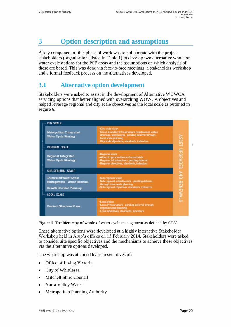
Stakeholders were asked to assist in the development of Alternative WOWCA servicing options that better aligned with overarching WOWCA objectives and helped leverage regional and city scale objectives as the local scale as outlined in Figure 6.
Figure 6 The hierarchy of whole of water cycle management as defined by OLV
These alternative options were developed at a highly interactive Stakeholder Workshop held in Arup’s offices on 13 February 2014. Stakeholders were asked to consider site specific objectives and the mechanisms to achieve these objectives via the alternative options developed.
The workshop was attended by representatives of:
Office of Living Victoria
City of Whittlesea
Mitchell Shire Council
Yarra Valley Water
Metropolitan Planning Authority
Metropolitan Planning Authority Whole of Water Cycle Assessment: PSP 1067 Donnybrook and PSP 1096
Woodstock Summary Report
Final | Issue | 27 June 2014 | Arup
Page 21
Melbourne Water
Detailed workshop notes are contained in Appendix B.
Key objectives identified for the site included:
Align with wider regional water planning initiatives
Maximise the use of recycled water
Utilise rainwater/stormwater where possible
Enhance waterway health
Maintain amenity of open space and urban areas through the provision of irrigation water for green space and tree watering and the use of water conveyance areas as a means of connecting the community (e.g. through installation of bike tracks and walking paths)
Potential means to achieve the above objectives were identified through:
Improved water use efficiency in households
Connectivity along drainage lines
Export of excess water
Use of household rainwater tanks which could include ‘leaky’ tanks for the management of flow events and provision of household hot water
Distributed WSUD systems for surface water management
Extension of recycled water beyond mandated residential areas to as many uses/users as possible
Placement of park areas in low points of catchments to allow for irrigation via gravity fed stormwater harvesting – stormwater for open space
Post workshop the information was collated to develop two alternative WOWCA options. These were then circulated to stakeholders for comment
Comments were received by the following organisations:
Office of Living Victoria – regarding updated demand figures for Water Future North and alignment with government water policy
Melbourne Water – regarding risks associated with the use of rainwater tanks at the lot scale for detention of high flow events and difficulties associated with the use of retarding/basins wetlands for frog habitat. This advice noted that both of these options should be considered secondary benefits rather than primary functions of this WoWCA infrastructure
City of Whittlesea – regarding aquifer storage and recovery potential
These comments were considered and the Alternative options were re-drafted to account for this stakeholder feedback.

Metropolitan Planning Authority Whole of Water Cycle Assessment: PSP 1067 Donnybrook and PSP 1096
Woodstock Summary Report
Final | Issue | 27 June 2014 | Arup
Page 22
3.2 Options description
3.2.1 Base case
The first stage of the WoWCA was to define and develop a base case for consideration by the wider stakeholder group. Arup’s approach in defining the base case was to align with the existing planning work undertaken collaboratively between Melbourne Water, Yarra Valley Water and the Office of Living Victoria in developing the document “An Integrated Water Future for Melbourne’s North.” This document considers a number of options to provide water services to the growth areas of Melbourne north.
Accordingly the baseline option recognises that the PSP areas are within a mandated third pipe zone and residential lots will be supplied with recycled water via a regional treatment facility.
The base case was further defined and was presented to the stakeholders for comment and discussion at a subsequent stakeholder workshop. The base case was updated following comments from stakeholders regarding the supply and use of water, new demand figures and more locally specific MUSIC inputs developed as part of the Water Future North Project.
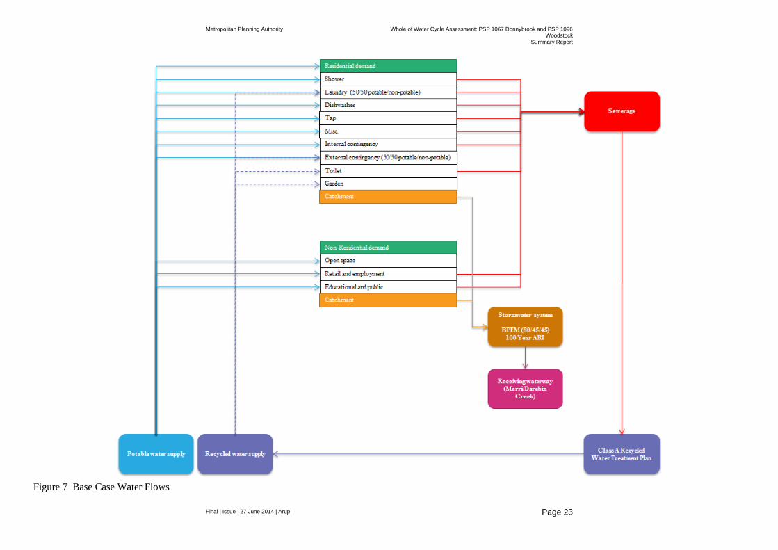
Base Case Option (source: Integrated Water Future for Melbourne’s North)
Wastewater is collected and treated to recycled water standard at a regional treatment facility. The recycled water is then returned to residential houses via a ‘third pipe’ system for non-drinking purposes such as flushing toilets, washing clothes and watering the garden.
Piped drinking water supply and sanitation services are provided; however, drinking water pipes can be downsized as approximately 30 per cent of the water demand will be met by the recycled water system.
Retail and employment, education and public and open space land uses are supplied with potable water only. Active open space is irrigated to the minimum extent required to maintain coverage, but lush growth is not always achieved.
Rainwater and stormwater are collected in pipes and treated through a series of settling ponds and wetlands prior to discharge into the receiving waterway.
This option incorporates water efficiency measures including Water Efficiency Labelling Scheme (WELS) star rated appliances, fittings and fixtures.
Figure 7 provides a graphical representation of the flow of water under the agreed Base Case. The Base Case has been updated and modelled based on the following assumptions which have largely been drawn from the current work being undertaken by stakeholders in the preparation of Water Future North – WWCM options and data collection and information provided by MPA regarding expected densities.
Metropolitan Planning Authority Whole of Water Cycle Assessment: PSP 1067 Donnybrook and PSP 1096
Woodstock Summary Report
Final | Issue | 27 June 2014 | Arup
Page 23
Figure 7 Base Case Water Flows
Metropolitan Planning Authority Whole of Water Cycle Assessment: PSP 1067 Donnybrook and PSP 1096
Woodstock Summary Report
Final | Issue | 27 June 2014 | Arup
Page 24
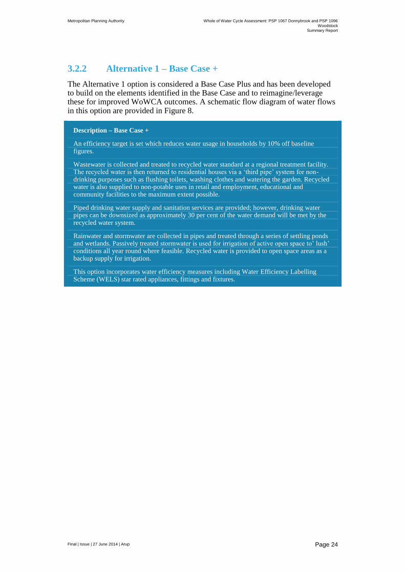
3.2.2 Alternative 1 – Base Case +
The Alternative 1 option is considered a Base Case Plus and has been developed to build on the elements identified in the Base Case and to reimagine/leverage these for improved WoWCA outcomes. A schematic flow diagram of water flows in this option are provided in Figure 8.
Description – Base Case +
An efficiency target is set which reduces water usage in households by 10% off baseline figures.
Wastewater is collected and treated to recycled water standard at a regional treatment facility. The recycled water is then returned to residential houses via a ‘third pipe’ system for non-drinking purposes such as flushing toilets, washing clothes and watering the garden. Recycled water is also supplied to non-potable uses in retail and employment, educational and community facilities to the maximum extent possible.
Piped drinking water supply and sanitation services are provided; however, drinking water pipes can be downsized as approximately 30 per cent of the water demand will be met by the recycled water system.
Rainwater and stormwater are collected in pipes and treated through a series of settling ponds and wetlands. Passively treated stormwater is used for irrigation of active open space to’ lush’ conditions all year round where feasible. Recycled water is provided to open space areas as a backup supply for irrigation.
This option incorporates water efficiency measures including Water Efficiency Labelling Scheme (WELS) star rated appliances, fittings and fixtures.

Metropolitan Planning Authority Whole of Water Cycle Assessment: PSP 1067 Donnybrook and PSP 1096
Woodstock Summary Report
Final | Issue | 27 June 2014 | Arup
Page 25
Figure 8 Alternative 1 – Base case plus water flows

Metropolitan Planning Authority Whole of Water Cycle Assessment: PSP 1067 Donnybrook and PSP 1096
Woodstock Summary Report
Final | Issue | 27 June 2014 | Arup
Page 26
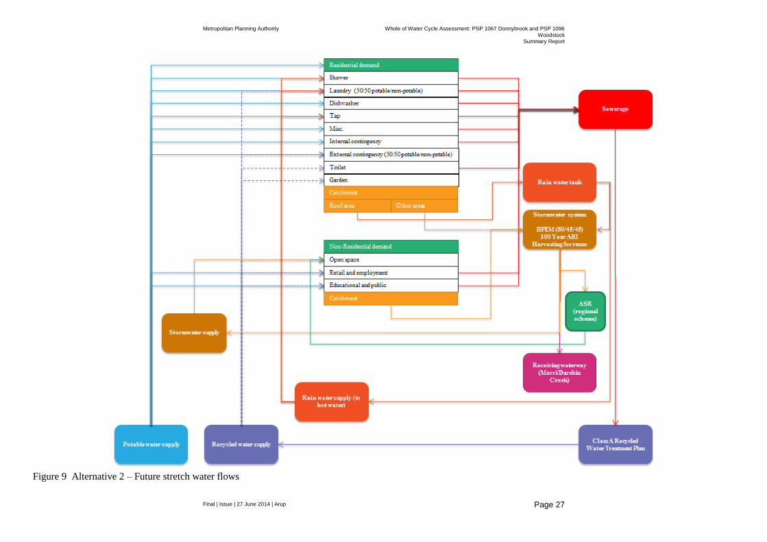
3.2.3 Alternative 2 – Future stretch
The future stretch scenario was developed to introduce lot scale interventions to supply part of the residential water demand and also attempts to explore the benefits of a distributed approach to runoff water quality treatment and encourage innovation. A schematic flow diagram of water flows is provided in Figure 9.
Description – Future Stretch
An efficiency target is set which reduces water usage in households by 20% off the baseline.
Wastewater is collected and treated to recycled water standard at a regional treatment facility. The recycled water is then returned to residential houses via a ‘third pipe’ system for non-drinking purposes such as flushing toilets, washing clothes and watering the garden. Recycled water is also supplied to non-potable uses in retail and employment, educational and community facilities to the maximum extent possible.
Piped drinking water supply and sanitation services are provided; however, drinking water pipes can be downsized as approximately 30 per cent of the water demand will be met by the recycled water system.
Household rainwater tanks supply hot water usage in residential buildings and provide some additional detention and slow release of rainfall events from household roof areas incorporated as an additional opportunity to achieve beyond best practice.
A distributed approach to surface water runoff management incorporating streetscape elements along major road reserves and drainage lines to reduce size and extent of end of line detention and treatment is adopted. Stormwater is harvested for irrigation of open space to’ lush’ conditions all year round where feasible. The potential for Aquifer Storage and Recovery of treated stormwater is considered where feasible.
This option incorporates water efficiency measures including Water Efficiency Labelling Scheme (WELS) star rated appliances, fittings and fixtures.
It is also noted that there has been initial support from DEPI, Melbourne Water, OLV and councils for investigating the use of grassy woodland conservation areas for evaporation basins and to provide water to existing red gum areas. However, it is noted that a large amount of work still required to detail how this could be implemented particularly in terms of water delivery regimes, funding and ongoing maintenance.
Metropolitan Planning Authority Whole of Water Cycle Assessment: PSP 1067 Donnybrook and PSP 1096
Woodstock Summary Report
Final | Issue | 27 June 2014 | Arup
Page 27
Figure 9 Alternative 2 – Future stretch water flows
Metropolitan Planning Authority Whole of Water Cycle Assessment: PSP 1067 Donnybrook and PSP 1096
Woodstock Summary Report
Final | Issue | 27 June 2014 | Arup
Page 28
3.3 Key assumptions
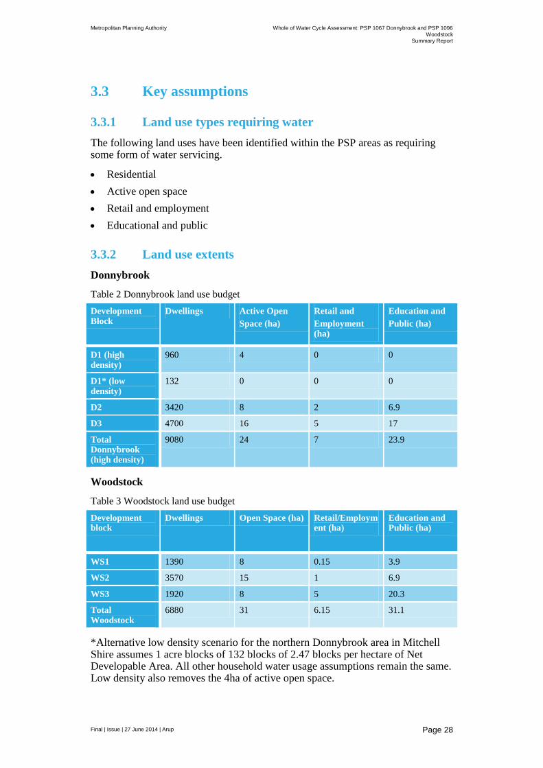
3.3.1 Land use types requiring water
The following land uses have been identified within the PSP areas as requiring some form of water servicing.
Residential
Active open space
Retail and employment
Educational and public
3.3.2 Land use extents
Donnybrook
Table 2 Donnybrook land use budget
Development Block
Dwellings Active Open
Space (ha)
Retail and
Employment (ha)
Education and
Public (ha)
D1 (high density)
960 4 0 0
D1* (low density)
132 0 0 0
D2 3420 8 2 6.9
D3 4700 16 5 17
Total Donnybrook (high density)
9080 24 7 23.9
Woodstock
Table 3 Woodstock land use budget
Development block
Dwellings Open Space (ha) Retail/Employment (ha)
Education and Public (ha)
WS1 1390 8 0.15 3.9
WS2 3570 15 1 6.9
WS3 1920 8 5 20.3
Total Woodstock
6880 31 6.15 31.1
*Alternative low density scenario for the northern Donnybrook area in Mitchell Shire assumes 1 acre blocks of 132 blocks of 2.47 blocks per hectare of Net Developable Area. All other household water usage assumptions remain the same. Low density also removes the 4ha of active open space.

Metropolitan Planning Authority Whole of Water Cycle Assessment: PSP 1067 Donnybrook and PSP 1096
Woodstock Summary Report
Final | Issue | 27 June 2014 | Arup
Page 29
An assumed average number of household inhabitants of 3 has been used based on advice received from Yarra Valley Water and OLV.
3.3.3 Residential Development Assumptions
Based on Yarra Valley Water’s Water Use Calculator
Lot area (m2) Persons per house
Garden size Number of Cars Roof area (m2)*
450 3 Small 1 270
* modelled as 100% impervious
3.3.4 Water supply
3.3.4.1 Potable
Potable water supply is provided by Yarra Valley Water from Yan Yean reservoir (see Figure 12 for YVW’s Preliminary Servicing Strategy).
3.3.4.2 Recycled
Under the Base Case recycled water is provided by Yarra Valley Water for mandated residential use only.
Under Alternatives 1 and 2, recycled water is provided to all other land uses to the maximum extent possible (see Figure 12 for YVW’s Preliminary Servicing Strategy).
3.3.4.3 Treated stormwater
Under Alternative 1 and 2 passively treated stormwater from wetlands is provided for open space irrigation where feasible to lush conditions and any shortfall is met by recycled water.
3.3.4.4 Rainwater
Under Alternative 2, rainwater from household roofs is provided to the hot water system and additional minimal storage is provided within rainwater tanks for part detention of rainfall events to achieve beyond best practice surface water management outcomes.
Tankulator.com.au has sized a tank of 1,500 L as capable of providing 100% of demands of 90.4 L/day of household hot water demand based on an average roof area of 270m
2. This totals 32,850 L of tank water used per household (or water
from the mains supply saved).
Under this scenario the tank overflows on 92 days for a total of 164,341 L/hh/a.
In the absence of more detailed data it is assumed that daily potable water usage and recycled water usage in reduced by 45.2 L for each category of demand (i.e. 50% showers and 50% laundry.).
Metropolitan Planning Authority Whole of Water Cycle Assessment: PSP 1067 Donnybrook and PSP 1096
Woodstock Summary Report
Final | Issue | 27 June 2014 | Arup
Page 30
3.3.5 Surface water management
For the base case “end of line” treatment and detention systems for stormwater management incorporating retarding basins and wetlands prior to discharge to local waterways.
For Alternative 1 and 2, contributing catchments have been broken down in order to collocate retarding basins/wetlands in areas proximate to active open space to allow for these areas to be provided with treated stormwater for irrigation and to increase amenity outcomes.
Quantity to retard: 1 in 100 ARI year flow events.
Quality of discharge to meet current Best Practice Environmental Management Guidelines:
80 % reduction in Total Suspended Solids (TSS) 45% reduction in Total Phosphorous (TP) 45% reduction in Total Nitrogen (TN).
3.3.5.1 Water quantity/runoff
Arup developed a RORB model for both Donnybrook and Woodstock PSP areas to determine the retardation volume required to reduce the flows from proposed development back to the existing i.e. pre-development condition in line with the Business as Usual (BaU) scenario where “rainwater and stormwater are collected in pipes and treated through a series of settling ponds and wetlands prior to discharge into the receiving wetlands”.
RORB is a general runoff and streamflow routing program used to calculate flood hydrographs from rainfall and other channel inputs. It subtracts losses from rainfall to produce rainfall-excess and routes this through catchment storage to produce runoff hydrographs at any location. It can also be used to design retarding basins and to route floods through channel networks.
The results of the RORB model in terms of the indicative location of retarding basins are shown in the Baseline PSP layout in Figure 16.
3.3.5.2 MUSIC modelling inputs
MUSIC (Model for Urban Stormwater Conceptualisation) modelling was undertaken to assess the changes to water quality in the receiving environments following the development of the upstream catchment. MUSIC is decision support tool, developed by eWater and is used to assess different stormwater management measures.
A MUSIC model was constructed for the Donnybrook and Woodstock catchments to simulate the discharge loads and concentrations of TN, TP, TSS and Gross Pollutants (GP) generated by the catchment. The pollutant load reductions predicted by the model were compared with the Best Practice Environmental Management Guidelines (BPEMG) specified targets and the effectiveness of the proposed treatment measures was determined.
The model was developed in accordance with Melbourne Water’s MUSIC Guidelines (Melbourne Water, 2010) and recent regional updates recommended by E2 (2014) in the development of an IWCM for Melbourne’s North. This
Metropolitan Planning Authority Whole of Water Cycle Assessment: PSP 1067 Donnybrook and PSP 1096
Woodstock Summary Report
Final | Issue | 27 June 2014 | Arup
Page 31
guideline provides guidance on the recommended input parameters and modelling approaches for developing MUISC models for the Northern Melbourne region. The following assumptions apply to development of the conceptual model:
The recommended rainfall station for the project is Melbourne Airport Station which has a mean annual rainfall of 550-650mm. The reference year is 1996. A rainfall template with the rainfall data for the reference year (1996) recorded at 6 minute interval was utilised in the model. Monthly evapotranspiration values for the same period were adopted in the model.
The proposed developments PSP 67 and PSP 96 were treated as independent catchments receiving no stormwater runoff from external areas.
For the model development, the rainfall run-off characteristics recommended for the Merri Creek Catchment have been adopted. The soil properties were based on current work being undertaken by E2 (2014) in the Northern Growth Areas and are discussed further in Section 3.3.5.4.
Similarly, the default values for TSS, TN and TP were used as per the Melbourne Water guidelines.
The catchments of PSP67 and PSP96 were each sub-divided with wetlands treating the run-off generated in the smaller sub-catchments.
The findings and recommendations from this assessment would need to be revisited following any significant change to the design of the development.
For Alternatives 1 and 2, opportunities to break catchments up into smaller areas to allow for colocation of wetlands adjacent to proposed open space areas were undertaken.
For Alternative 2 rainwater tanks at the household level sized at 1,500 L supplying hot water demands were included in the analysis with the subsequent decrease in overall retarding basin/wetlands determined. Analysis was also undertaken to include swales within the streetscape of major roads.
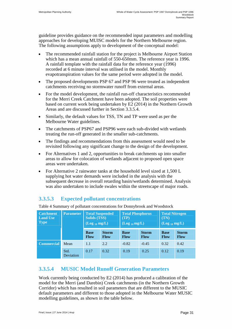
3.3.5.3 Expected pollutant concentrations
Table 4 Summary of pollutant concentrations for Donnybrook and Woodstock
Catchment Land Use Type
Parameter Total Suspended Solids (TSS)
(Log 10 mg/L)
Total Phosphorus (TP)
(Log 10 mg/L)
Total Nitrogen (TN)
(Log 10 mg/L)
Base Flow
Storm Flow
Base Flow
Storm Flow
Base Flow
Storm Flow
Commercial Mean 1.1 2.2 -0.82 -0.45 0.32 0.42
Std. Deviation
0.17 0.32 0.19 0.25 0.12 0.19
3.3.5.4 MUSIC Model Runoff Generation Parameters
Work currently being conducted by E2 (2014) has produced a calibration of the model for the Merri (and Darebin) Creek catchments (in the Northern Growth Corridor) which has resulted in soil parameters that are different to the MUSIC default parameters and different to those adopted in the Melbourne Water MUSIC modelling guidelines, as shown in the table below.

Metropolitan Planning Authority Whole of Water Cycle Assessment: PSP 1067 Donnybrook and PSP 1096
Woodstock Summary Report
Final | Issue | 27 June 2014 | Arup
Page 32
The calibrated soil parameters were determined by E2 based on an analysis of gauged flow data from Merri Creek. The adopted soil parameters result in flow data from MUSIC which corresponds to the gauged flow data for Merri Creek. The calibrated soil parameters have been used for modelling of stormwater runoff in the PSP areas.
Table 5 Calibrated soil parameters for Merri Creek (from ‘Case study of development standards for beneficial waterway outcomes – Northern Growth Corridor’, E2Designlab 2014’)
Parameter Melbourne Water
MUSIC default Merri Creek Calibrated
97% (deep soil) 3 % (riparian zone)
Rainfall threshold (mm/day)
1 1 1
Soil storage capacity (mm)
30 120 115 30
Initial storage (% of capacity)
25 25 25
Field capacity (mm)
20 80 100 20
Infiltration capacity coefficient – a
200 200 200
Infiltration capacity coefficient – b
1 1 1
Initial groundwater depth (%)
10 10 10
Daily recharge rate (%)
25 25 4
Daily base flow rate (%)
5 5 3
Daily deep seepage rate (%)
0 0 0
Music Link Routing (day)
Muskingum-Cunge, Theta 0.25
- - 0.5 0.5
Imperious proportion (%)
1 0
3.3.5.5 Treatment elements
The recommended MUSIC modelling parameters for the treatment elements are from ‘Case study of development standards for beneficial waterway outcomes – Northern Growth Corridor’, E2Designlab 2014’:

Metropolitan Planning Authority Whole of Water Cycle Assessment: PSP 1067 Donnybrook and PSP 1096
Woodstock Summary Report
Final | Issue | 27 June 2014 | Arup
Page 33
Wetlands with extended detention of 0.35m and permanent pool depth of 0.35m. When included as part of the treatment train for a regional harvesting scheme, the treatment performance of the wetland itself must attain a minimum reduction of 80% TSS, 45% TN and 45% TP. This will ensure the longevity of the harvesting and storage infrastructure. The additional pollutant and flow reductions required to meet the new development standards can be attained through the benefits delivered by the harvesting scheme and/or evapotranspiration field.
Vegetated swales - Assumed average depth of 0.5m, batter slope of 1 on 3 and base width of 1m.
Rainwater tanks – sized at 1,500 L per household
3.3.6 Potable and non-potable water demands
3.3.6.1 Household
The following alternative water demand rates were used in the testing of options as derived from Yarra Valley Water (2013).
Table 6 Alternative water demand rates for 450m2 allotments (based on Yarra Valley
Water’s Water Use Calculator for New Homes – Version Jan 13)
Use Source Demand (L/hh/day)
Toilet flushing NP 50
Shower P 113
Laundry (assumed 50/50 split)
NP/P 56
Dishwasher P 9
Taps P 79
Misc P 9
Garden** NP 43*
Car Washing NP -
Internal contingency P 64
External contingency (assumed 50/50 split)
P/NP 22
Total Demand P/NP 455
** Garden irrigation demand is based on 73L/hh/day rate between October to
April and no irrigation between May and September. Note: Hot water is assumed
to equate to 36% of the total internal demand which is calculated as 113 L/hh/day.
For household garden irrigation an average rate has been determined for calculations of annual demand. This rate is based on an average summer irrigation demand of 73 L/hh/day (between October and April) and no irrigation between May and September. This is based on Yarra Valley Water’s Water Use Calculator which assumes an average of 2.1 garden watering sessions per week between October and April using a 16 L/min hose and an average of 15 minutes of watering.

Metropolitan Planning Authority Whole of Water Cycle Assessment: PSP 1067 Donnybrook and PSP 1096
Woodstock Summary Report
Final | Issue | 27 June 2014 | Arup
Page 34
3.3.6.2 Active open space
The following assumptions are for irrigation of active public open spaces (mm/m
2):
Table 7 Irrigation rates for active open space areas
Jan Feb Mar Apr May Jun Jul Aug Sep Oct Nov Dec Avg
Yr
Lush growth* 121.2 103.9 82.2 0 0 0 0 0 0 74 91.4 110.9 583.6
Maintenance** 95 74 44 0 0 0 0 0 0 17 46 70 346
* University of SA tank sizing tool adapted from Connellan (2002)
** Smartgardenwatering.org.au
3.3.6.3 Retail/Employment
An average water demand of 6,450L/ha/day is identified for employment lands by Yarra Valley Water.
Under Alternatives 1 and 2 it has been assumed that 61% of water usage is potable and 39% is non-potable (source: Sydney Water: Water use benchmarks for shopping centres).
3.3.6.4 Education and public
Education and public building water usage of 1 kL/m2/annum of Gross Floor
Area (GFA) (source: Monash Sustainability Institute 2012 Australian Tertiary Education Sector Sustainability Report 2011).
It has been assumed that the GFA is 50% of the total land area.
Under Alternatives 1 and 2 it has been assumed that 77% of water use in educational facilities is non-potable and 23% is potable (source: www.epa.gov/watersense).
3.3.7 Sewer discharge
3.3.7.1 Residential
Yarra Valley Water’s Water Use Calculator identifies 338 L/house/day of residential flows to sewer each day. This assumes 50% of tap and miscellaneous use is for human consumption and does not flow to sewer.
3.3.7.2 Open space
No sewer discharge from open space
3.3.7.3 Retail and employment
Yarra Valley Water identifies an average daily flow of 5,625 L/ha/day to sewer for employment land.

Metropolitan Planning Authority Whole of Water Cycle Assessment: PSP 1067 Donnybrook and PSP 1096
Woodstock Summary Report
Final | Issue | 27 June 2014 | Arup
Page 35
3.3.7.4 Education and Public
The discharge rate for retail and employment land has been adopted of 5,625 L/ha/day
3.3.8 ASR Potential
Advice issued from MPA regarding ASR investigations noted that unless there is an established project that will be implemented by an authority/agency, investigations at the PSP should only consider if the outcome will allow an ASR scheme to be implemented in future within the PSP area or alternatively will feed into an adjoining ASR scheme.
Work by Jacbos and Melbourne Water (2014) assessing ground water resources in the Merri and Darebin Creek areas has recently commenced particularly in relation to the presence and extent of ground water dependent ecosystems. Information provided in relation to the above work does not make mention of the specific potential for an ASR scheme within the boundaries of the Donnybrook or Woodstock PSPs however it is noted that “although the Donnybrook Mineral Spring’s recharge zone is not in the zone of influence of the PSP zone (is further north), it is still a very fragile ecosystem in the area and has significant social value.” Accordingly any future ASR scheme and related investigations would need to balance the risk of affecting this mineral spring resource.
High level mapping conducted by CSIRO in 2006 notes that ASR potential in the area of Donnybrook and Woodstock is very low to low. Accordingly in the context of PSP planning further investigation of the potential for ASR is not warranted at this stage and should be led by a more appropriate agency such as s Water Authority and target a regional scale due to the significant expense involved in conducting on ground investigations to determine the potential and associated risk factors of ASR.
If a smaller scale ASR scheme was developed the most logical place would be in the location of wetlands/retarding basins assuming geological conditions allow and there is sufficient demand for recovered water.
3.3.9 Climate Change Scenarios
Consistent with most recent climate data, the following three climate scenarios have been utilised in modelling of potential impacts of future climate change. This data is sourced from DSE (2008). Climate change in the Port Phillip and Westernport region. Department of Sustainability and Environment. http://www.climatechange.vic.gov.au/__data/assets/pdf_file/0008/73196/PPWP_WEB.pdf
These scenarios have been used to sensitivity test the WOWCA options in MUSIC by altering climatic conditions such as rainfall, evaporation and temperature accordingly.
Table 8 Climate change criteria utilised in the modelling of scenarios
Criteria 2030 2070
Low emissions High emissions

Metropolitan Planning Authority Whole of Water Cycle Assessment: PSP 1067 Donnybrook and PSP 1096
Woodstock Summary Report
Final | Issue | 27 June 2014 | Arup
Page 36
Change in average temperature (C)
0.6 to 1.1 0.9 to 1.9 1.8 to 3.7
Change in annual rainfall (%)
-8 to 0 -13 to 0 -24 to 0
Change in potential evaporation (%)
+1 to +5 +1 to +9 +2 to +17

Metropolitan Planning Authority Whole of Water Cycle Assessment: PSP 1067 Donnybrook and PSP 1096
Woodstock Summary Report
Final | Issue | 27 June 2014 | Arup
Page 37
4 Precinct demands and sewer discharge
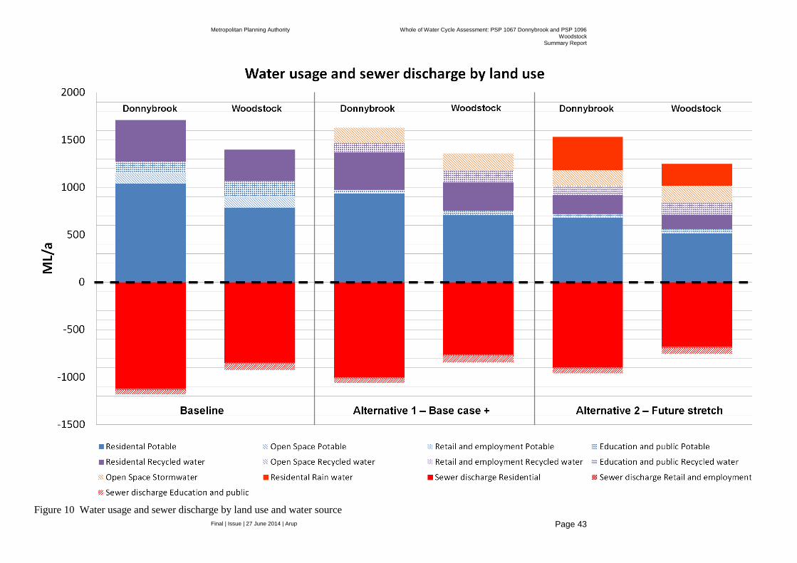
The follow section depicts the anticipated precinct wide demands and sewer discharges for the various land uses under each of the options. A summary graph is provided in Figure 10.
4.1 Base Case
Demands
Table 9 Base case demands for Donnybrook and Woodstock
Land use Supply Donnybrook Woodstock
Residential Potable 1037 ML 786 ML
Non-potable 437 ML 331 ML
Open space Potable 97 ML 107 ML
Retail and employment
Potable 16.5 ML 14.5 ML
Education and public
Potable 120 ML 156 ML
Total
Potable 1270 ML 1063 ML
Non-potable 437 ML 331 ML
Sewer discharge
Table 10 Calculated sewer discharge volumes for Donnybrook and Woodstock
Donnybrook Woodstock
Residential 1120 ML 848 ML
Retail and employment 14 ML 12 ML
Education and public 49 ML 64 ML
Total (discharge) 1183 ML 924 ML

Metropolitan Planning Authority Whole of Water Cycle Assessment: PSP 1067 Donnybrook and PSP 1096
Woodstock Summary Report
Final | Issue | 27 June 2014 | Arup
Page 38
Base Case Summary
Donnybrook
Under the Base Case total anticipated water demands for Donnybrook are 1.7 GL per annum with 440 ML of this demand anticipated to be able to be provided by recycled water for household usage in the laundry, toilet and garden.
Sewer discharges total 1.2 GL per annum.
NB - The demands and discharges presented above currently assume a high density development scenario for the D1 block. If a low density approach is taken the anticipated 132 dwellings in this block (as opposed to 960 dwellings) would result in slightly lower overall consumption for the precinct of 1.34 GL/a and a sewer discharge volume of 1 GL/a
Woodstock
Under the Base Case total anticipated water demands for Woodstock are 1.4 GL per annum with 330 ML of this demand anticipated to be able to be provided by recycled water for household usage in the laundry, toilet and garden.
Sewer discharges total 920 ML per annum.
Metropolitan Planning Authority Whole of Water Cycle Assessment: PSP 1067 Donnybrook and PSP 1096
Woodstock Summary Report
Final | Issue | 27 June 2014 | Arup
Page 39
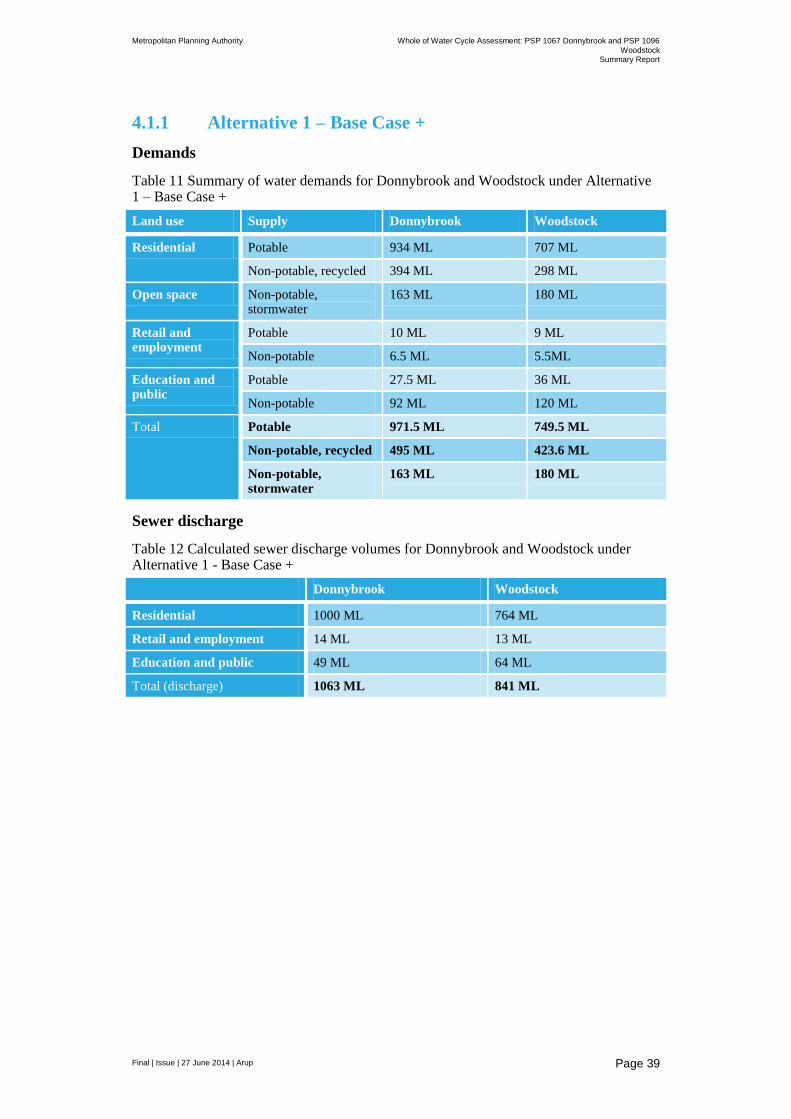
4.1.1 Alternative 1 – Base Case +
Demands
Table 11 Summary of water demands for Donnybrook and Woodstock under Alternative 1 – Base Case +
Land use Supply Donnybrook Woodstock
Residential Potable 934 ML 707 ML
Non-potable, recycled 394 ML 298 ML
Open space Non-potable, stormwater
163 ML 180 ML
Retail and employment
Potable 10 ML 9 ML
Non-potable 6.5 ML 5.5ML
Education and public
Potable 27.5 ML 36 ML
Non-potable 92 ML 120 ML
Total Potable 971.5 ML 749.5 ML
Non-potable, recycled 495 ML 423.6 ML
Non-potable, stormwater
163 ML 180 ML
Sewer discharge
Table 12 Calculated sewer discharge volumes for Donnybrook and Woodstock under Alternative 1 - Base Case +
Donnybrook Woodstock
Residential 1000 ML 764 ML
Retail and employment 14 ML 13 ML
Education and public 49 ML 64 ML
Total (discharge) 1063 ML 841 ML

Metropolitan Planning Authority Whole of Water Cycle Assessment: PSP 1067 Donnybrook and PSP 1096
Woodstock Summary Report
Final | Issue | 27 June 2014 | Arup
Page 40
Alternative 1 – Base Case +
Donnybrook
Under the Base Case + total anticipated water demands for Donnybrook are 1.6 GL per annum with 500 ML of this demand anticipated to be able to be provided by recycled water for household usage in the laundry, toilet and garden and anticipated non-potable demands associated with retail and employment and education and public land uses.
Demands to provide lush active open space are anticipated to be 160 ML which can be provided by stormwater harvesting if feasible or via recycled water.
Sewer discharges total 1.1 GL per annum.
Woodstock
Under the Base Case + total anticipated water demands for Woodstock are 1.4 GL per annum with 420 ML of this demand anticipated to be able to be provided by recycled water for household usage in the laundry, toilet and garden and anticipated non-potable demands associated with retail and employment and education and public land uses.
Demands to provide lush active open space are anticipated to be 180 ML which can be provided by stormwater harvesting if feasible or via recycled water.
Sewer discharges total 850 ML per annum.
Metropolitan Planning Authority Whole of Water Cycle Assessment: PSP 1067 Donnybrook and PSP 1096
Woodstock Summary Report
Final | Issue | 27 June 2014 | Arup
Page 41
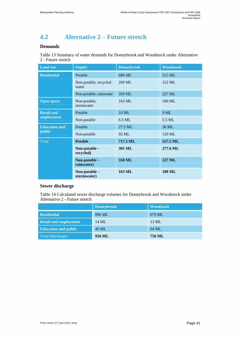
4.2 Alternative 2 – Future stretch
Demands
Table 13 Summary of water demands for Donnybrook and Woodstock under Alternative 2 - Future stretch
Land use Supply Donnybrook Woodstock
Residential Potable 680 ML 515 ML
Non-potable, recycled water
200 ML 152 ML
Non-potable, rainwater 350 ML 227 ML
Open space Non-potable, stormwater
163 ML 180 ML
Retail and employment
Potable 10 ML 9 ML
Non-potable 6.5 ML 5.5 ML
Education and public
Potable 27.5 ML 36 ML
Non-potable 92 ML 120 ML
Total Potable 717.5 ML 557.5 ML
Non-potable – recycled)
301 ML 277.6 ML
Non-potable – rainwater)
350 ML 227 ML
Non-potable – stormwater)
163 ML 180 ML
Sewer discharge
Table 14 Calculated sewer discharge volumes for Donnybrook and Woodstock under Alternative 2 - Future stretch
Donnybrook Woodstock
Residential 896 ML 679 ML
Retail and employment 14 ML 13 ML
Education and public 49 ML 64 ML
Total (discharge) 956 ML 756 ML

Metropolitan Planning Authority Whole of Water Cycle Assessment: PSP 1067 Donnybrook and PSP 1096
Woodstock Summary Report
Final | Issue | 27 June 2014 | Arup
Page 42
Alternative 2 – Future stretch
Donnybrook
Under the Future Stretch total anticipated water demands for Donnybrook are 1.5 GL per annum with 300 ML of this demand anticipated to be able to be provided by recycled water for household usage in the laundry, toilet and garden and anticipated non-potable demands associated with retail and employment and education and public land uses.
Demands to provide lush active open space are anticipated to be 160 ML which can be provided by stormwater harvesting if feasible or via recycled water.
Rainwater capture at the household scale for use to supply domestic hot water supplies are estimated at 350 ML/a
Sewer discharges total 950 ML per annum.
Woodstock
Under the Base Case + total anticipated water demands for Woodstock are 1.25 GL per annum with 280 ML of this demand anticipated to be able to be provided by recycled water for household usage in the laundry, toilet and garden and anticipated non-potable demands associated with retail and employment and education and public land uses.
Demands to provide lush active open space are anticipated to be 180 ML which can be provided by stormwater harvesting if feasible or via recycled water.
Sewer discharges total 750 ML per annum.
Metropolitan Planning Authority Whole of Water Cycle Assessment: PSP 1067 Donnybrook and PSP 1096
Woodstock Summary Report
Final | Issue | 27 June 2014 | Arup
Page 43
Figure 10 Water usage and sewer discharge by land use and water source

Metropolitan Planning Authority Whole of Water Cycle Assessment: PSP 1067 Donnybrook and PSP 1096
Woodstock Summary Report
Final | Issue | 27 June 2014 | Arup
Page 44
5 Schematic design
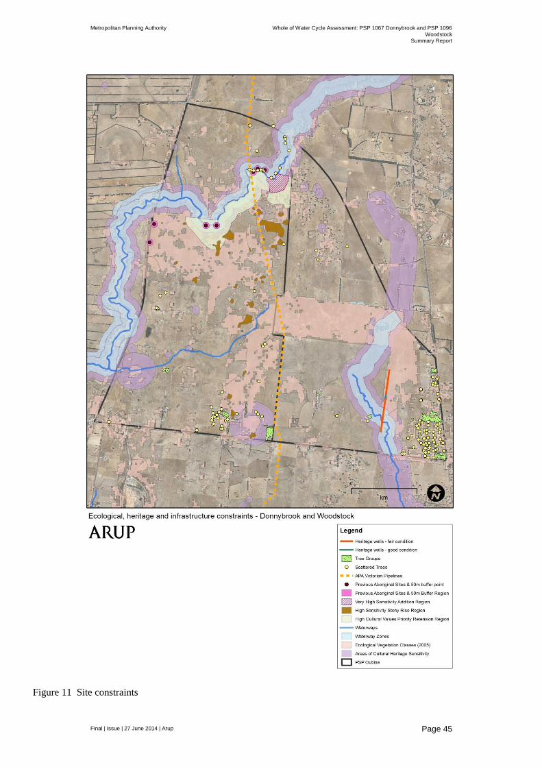
High level schematic designs have been prepared for each of the options including the revision of the scheme design for the base case demand figures and feedback from stakeholders regarding site constraints which are mapped in the Figure 11 below. These constraints have been mapped based on GIS layers provided by MPA and relate to:
High value conservation areas
Scattered trees
High pressure gas pipeline easement
Aboriginal cultural heritage sites
Post-settlement cultural heritage sites
Waterways
Existing houses and facilities
The schematic designs developed have been assessed based on the required runoff and water quality targets, the appropriate whole of water cycle assets for the site conditions and opportunities and the results of the constraints assessment. The schematic designs have also attempted to take into account other design considerations appropriate at the PSP scale, such as:
Multiple WoWCA benefits – design of surface water management systems to achieve multiple stormwater benefits, such as stormwater treatment, stormwater retention as well as water conservation and demand management.
Consideration if other benefits can also be achieved through the stormwater design, such as high quality open space for communities along drainage lines and around wetlands and detention basins.
Flooding – development of designs to minimise local inundation.
Environment – consideration of surface water management measures can protect and enhance the environment.
Climate change – consideration of the impacts that climate change may have on a system, and if these need to be accounted for in the design.
Community – consideration of opportunities for community engagement and education, such as signage and ensuring opportunities for designing WSUD systems to be a community feature
Opportunities to enhance proposed servicing strategies for the area from Melbourne Water and Yarra Valley Water (see Figure 12)
Working with the current site topography to avoid major cut and fill requirements for stormwater infrastructure (see Figure 13)
Preliminary construction and maintenance considerations
Metropolitan Planning Authority Whole of Water Cycle Assessment: PSP 1067 Donnybrook and PSP 1096
Woodstock Summary Report
Final | Issue | 27 June 2014 | Arup
Page 45
Figure 11 Site constraints

Metropolitan Planning Authority Whole of Water Cycle Assessment: PSP 1067 Donnybrook and PSP 1096
Woodstock Summary Report
Final | Issue | 27 June 2014 | Arup
Page 46
Figure 12 Yarra Valley Water Preliminary Servicing Strategy

Metropolitan Planning Authority Whole of Water Cycle Assessment: PSP 1067 Donnybrook and PSP 1096
Woodstock Summary Report
Final | Issue | 27 June 2014 | Arup
Page 47
Figure 13 Site contours
Metropolitan Planning Authority Whole of Water Cycle Assessment: PSP 1067 Donnybrook and PSP 1096
Woodstock Summary Report
Final | Issue | 27 June 2014 | Arup
Page 48
5.1 Water Sensitive Urban Design
All options incorporate some form of Water Sensitive Urban Design (WSUD) to help achieve BPEM requirements; however the Alternative 1 and 2 options apply alternative configurations of these elements to increase the reuse of stormwater and rainwater and to explore high level opportunities to take a distributed rather than end of line approach to surface water management.
As noted by Melbourne Water innovative stormwater management, such as WSUD, can contribute greatly to sustainability and liveability, particularly when considered as part of an overall urban strategy. WSUD integrates urban water cycle management with urban planning and design, with the aim of mimicking natural systems to minimise negative impacts on the natural water cycle and receiving waterways and bays. It offers an alternative to the traditional conveyance approach to stormwater management by acting at the development scale (at the source), and thereby reducing the required size of the structural stormwater system. It seeks to minimise impervious surfaces, reuse water on site, incorporate retention basins to reduce peak flows, and incorporate treatment systems to remove pollutants. WSUD also provides the opportunity to achieve multiple benefits though sustainable urban water management.
WSUD applications can include a range of applications, including:
grassed or landscaped swales
infiltration trenches and bio-retention systems
gross pollutant traps, wetlands and sediment ponds
rainwater tanks – stormwater harvesting and reuse
grey water harvesting and reuse
rain gardens, rooftop greening and urban forests
porous pavements
aquifer recharge and reuse
A summary of WSUD features, treatment function applicability and cost is provided below (see Figure 14). The Alternative Options developed for this project require the potential use or rainwater tanks, vegetated swales and the co-location of wetlands within retarding basins. A description of these features is proved below along with maintenance considerations and cost assumptions (adapted from Melbourne Water and E2 (2014)).

Metropolitan Planning Authority Whole of Water Cycle Assessment: PSP 1067 Donnybrook and PSP 1096
Woodstock Summary Report
Final | Issue | 27 June 2014 | Arup
Page 49
Table 15 Cost functions for WSUD features
Capex Opex
Wetland $75/m2 $0.50/m
2/a
Vegetated swale $150//m2 $5/m
2/a
Rainwater tanks (includes tank, pumping and plumbing for 1,500L)
$4,000 per unit $60 per unit/a
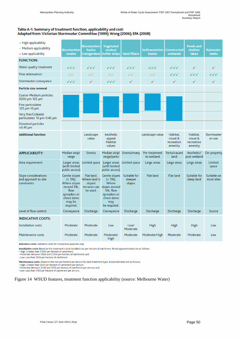
Metropolitan Planning Authority Whole of Water Cycle Assessment: PSP 1067 Donnybrook and PSP 1096
Woodstock Summary Report
Final | Issue | 27 June 2014 | Arup
Page 50
Figure 14 WSUD features, treatment function applicability (source: Melbourne Water)
Metropolitan Planning Authority Whole of Water Cycle Assessment: PSP 1067 Donnybrook and PSP 1096
Woodstock Summary Report
Final | Issue | 27 June 2014 | Arup
Page 51
5.1.1 Vegetated swales/Buffer strips
Vegetated swales convey stormwater and provide removal of coarse and medium sediment. They are commonly used in conjunction with areas of vegetation through which runoff passes, known as buffer strips. Vegetated swales are similar to bioretention swales, but are less effective in removing nitrogen from the stormwater, as they do not feature the filtering component and convey water on the surface only.
Vegetated swales can provide an aesthetically pleasing landscape feature and are relatively inexpensive to construct and maintain. They can be used median strips, verges, car park runoff areas, parks and recreation areas.
Design and maintenance considerations
The longitudinal slope of a swale is the most important consideration. Swales are most efficient with slopes of 1% to 4%. Lower than this, swales can become waterlogged and/or have stagnant pooling, while steeper slopes may have high flow velocities (with potential erosion and vegetation damage risks).
Check banks (small porous rock walls) may be constructed to distribute flows evenly across the swale if they are identified as the most suitable treatment option in such areas.
Where swales are publicly accessible, flow depths and velocities must be acceptable from a public risk perspective.
Traffic and deliveries should be kept off swales as they may damage vegetation and create preferential flow paths that do not offer filtration. Appropriate mitigation measures should be implemented.
Swale side slopes depend on Council regulations, traffic access and the provision of crossings. Typically 1 in 9 side slopes are suitable. For maintenance requirements, grassed swales requiring mowing must not have side slopes exceeding 1 in 4.
5.1.2 Wetlands
Wetland systems are shallow, extensively vegetated water bodies that remove pollutants through enhanced sedimentation, fine filtration and pollutant uptake processes. Stormwater runoff is passed slowly through the vegetated areas, which filter sediments and pollutants, and biofilms establish on the plants, which absorb nutrients and other contaminants.
Wetlands are well suited to treat large volumes of stormwater runoff and have the advantage of improving local amenity and providing habitat diversity.
Key design issues to consider include:
verifying the size and configuration for treatment;
determining design flows;
designing the inlet zone;
layout of the macrophyte zone;
hydraulic structures;
Metropolitan Planning Authority Whole of Water Cycle Assessment: PSP 1067 Donnybrook and PSP 1096
Woodstock Summary Report
Final | Issue | 27 June 2014 | Arup
Page 52
selecting plant species; and
planting densities and providing maintenance.
Design and maintenance considerations
The constructed wetland should treat at least 90% of Mean Annual Runoff (MAR) through the use of a stored event volume above the normal standing water level of the wetland.
A high flow bypass should be capable of taking flows in excess of design flows (typically a 1 in 1 year event).
The wetland design must meet safety requirements and implement reasonable safety measures. This includes fencing, safety batters, signage and benching.
Health and Safety considerations for maintenance staff should also be addressed. It is recommended that an independent safety audit be conducted for each design.
Approach batter slopes should be no steeper than 1:5 Vertical to Horizontal (V:H). All edges should have safety benches of at least 1.5m to 3.0m wide from the edge of the normal top water level.
Safety benches should have a maximum grade of 1:8 (V:H) for the first 1.5m – 3.0m before changing to a 1:5 (V:H) grade for at least the next 0.5m. Beyond this, may be up to a maximum of 1:3 (V:H). The safety bench should be densely planted with emergent macrophytes such that casual entry will be difficult.
Hard stand areas should be provided adjacent to the inlet zone to allow for the maintenance and cleanout of this zone.
Measures to reduce the prevalence of mosquitoes should be taken
Where possible, wetlands should be constructed in the base of retarding basins to reduce land requirement.
The wetland should be divided into four macrophyte zones, an open water zone and a littoral zone and the percentage allocation of each zone in line with Melbourne Water guidance.
Suitable vegetation should be adopted as per Melbourne Water guidelines
Wetlands require large areas of land for construction and are unsuited to steeply sloping land.
A geotechnical investigation is required prior to design to determine soil profiles and infiltration rates.
Hydrogeological investigations may also be required in areas where there is a likelihood of groundwater discharge or high seasonal water tables.

Metropolitan Planning Authority Whole of Water Cycle Assessment: PSP 1067 Donnybrook and PSP 1096
Woodstock Summary Report
Final | Issue | 27 June 2014 | Arup
Page 53
5.1.3 Rainwater tanks
Rainwater tanks collect roof runoff for subsequent reuse, conserving potable mains supplies and reducing stormwater runoff volumes and pollutants from reaching downstream waterways.
Rainwater tanks are applicable to areas of high roof area to occupancy ratio, while they are less applicable in regions of low roof area to occupancy ratio, such as medium and high density residential dwellings.
Design and maintenance considerations
Rainwater tanks should be installed in accordance with the Plumbing and Drainage Standards (AS/NZS 3500:2003).
Rainwater tanks may not provide the optimal strategy for stormwater runoff from a sustainability perspective compared to a centralised stormwater harvesting scheme. This issue should be investigated thoroughly during the concept design stage of a project.
Continual water balance assessments using MUSIC should be performed to determine how much runoff rainwater tanks are removing from the catchment in terms of runoff volumes and associated pollutant loads.
Rainwater tanks should be sized using the appropriate reference curves for the region
Advice was sought from the Department of Health (DoH) related to the use of rainwater for hot water systems. A summary of this advice is provided below
Use of roofwater is not regulated by the Victorian DoH.
DoH has provided guidance on the use of roofwater and rainwater tanks in urban communities, Rainwater use in urban communities - Guidelines for non-drinking applications in multi-residential, commercial and community facilities, April 2013.
Research was undertaken in 2012 on the microbial risk for the use of roofwater in hot water systems. A Quantitative Microbial Risk Assessment was performed and the research looked at different hot water systems (electric, solar, gas). One of the main outcomes was, “Hot water services should not be relied on to inactivate enteric pathogens (pathogens found in the gut) as they may not heat water to a high enough temperature for long enough to act as appropriate treatment (Deere et al 2012).”
The research indicated that the use of roofwater in hot water systems poses a higher risk to users than the normal health standards that the DoH has for potable water.
The DoH cannot reject the use of roofwater in hot water systems, but this poses a risk to end users which they need to made aware of.
5.2 Anticipated layout
Figure 15, Figure 16 and Figure 17 show the anticipated schematic layouts for each of the options including major drainage paths and the location of wetlands, retarding basins and vegetated swales.

Metropolitan Planning Authority Whole of Water Cycle Assessment: PSP 1067 Donnybrook and PSP 1096
Woodstock Summary Report
Final | Issue | 27 June 2014 | Arup
Page 54
Figure 15 Base case schematic design
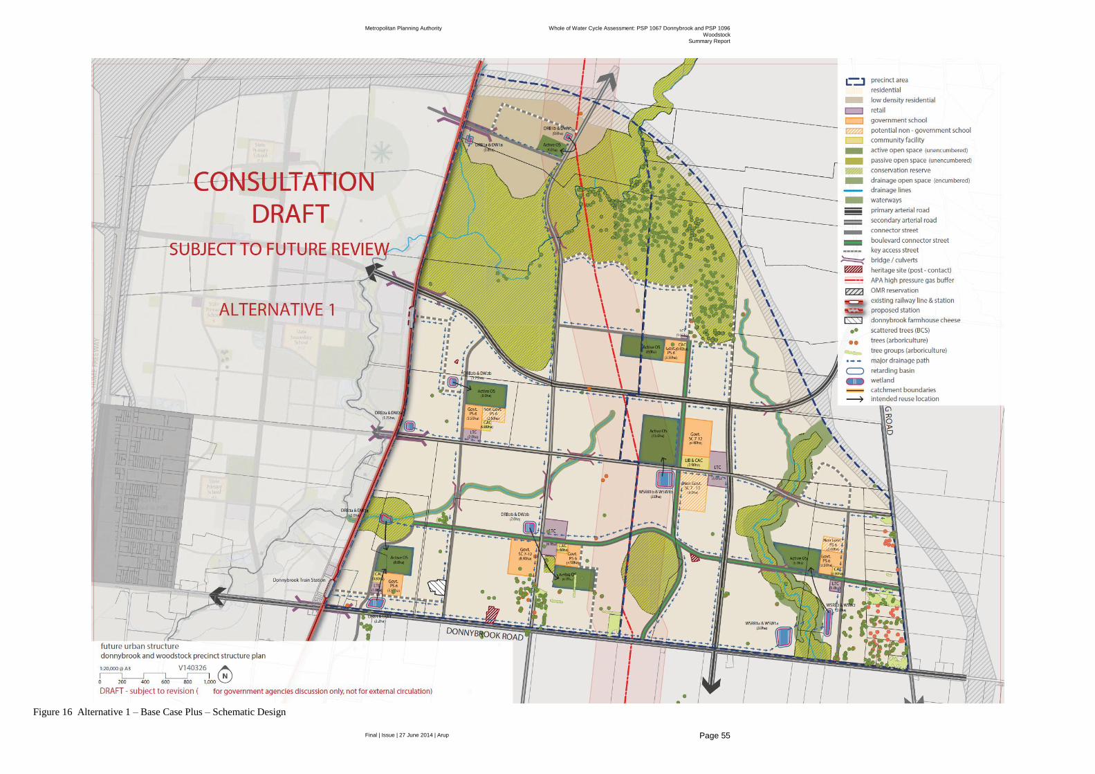
Metropolitan Planning Authority Whole of Water Cycle Assessment: PSP 1067 Donnybrook and PSP 1096
Woodstock Summary Report
Final | Issue | 27 June 2014 | Arup
Page 55
Figure 16 Alternative 1 – Base Case Plus – Schematic Design

Metropolitan Planning Authority Whole of Water Cycle Assessment: PSP 1067 Donnybrook and PSP 1096
Woodstock Summary Report
Final | Issue | 27 June 2014 | Arup
Page 56
Figure 17 Alternative 2 – Future Stretch – Schematic Design
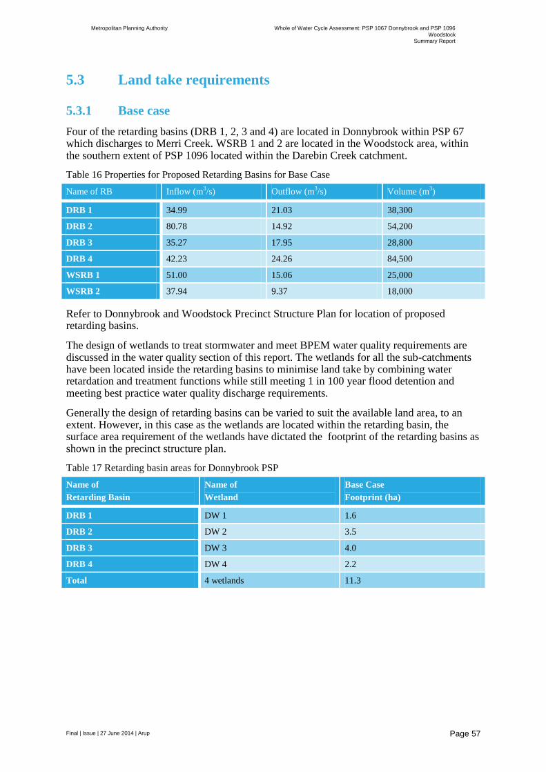
Metropolitan Planning Authority Whole of Water Cycle Assessment: PSP 1067 Donnybrook and PSP 1096
Woodstock Summary Report
Final | Issue | 27 June 2014 | Arup
Page 57
5.3 Land take requirements
5.3.1 Base case
Four of the retarding basins (DRB 1, 2, 3 and 4) are located in Donnybrook within PSP 67 which discharges to Merri Creek. WSRB 1 and 2 are located in the Woodstock area, within the southern extent of PSP 1096 located within the Darebin Creek catchment.
Table 16 Properties for Proposed Retarding Basins for Base Case
Name of RB Inflow (m3/s) Outflow (m
3/s) Volume (m
3)
DRB 1 34.99 21.03 38,300
DRB 2 80.78 14.92 54,200
DRB 3 35.27 17.95 28,800
DRB 4 42.23 24.26 84,500
WSRB 1 51.00 15.06 25,000
WSRB 2 37.94 9.37 18,000
Refer to Donnybrook and Woodstock Precinct Structure Plan for location of proposed retarding basins.
The design of wetlands to treat stormwater and meet BPEM water quality requirements are discussed in the water quality section of this report. The wetlands for all the sub-catchments have been located inside the retarding basins to minimise land take by combining water retardation and treatment functions while still meeting 1 in 100 year flood detention and meeting best practice water quality discharge requirements.
Generally the design of retarding basins can be varied to suit the available land area, to an extent. However, in this case as the wetlands are located within the retarding basin, the surface area requirement of the wetlands have dictated the footprint of the retarding basins as shown in the precinct structure plan.
Table 17 Retarding basin areas for Donnybrook PSP
Name of
Retarding Basin
Name of
Wetland
Base Case
Footprint (ha)
DRB 1 DW 1 1.6
DRB 2 DW 2 3.5
DRB 3 DW 3 4.0
DRB 4 DW 4 2.2
Total 4 wetlands 11.3
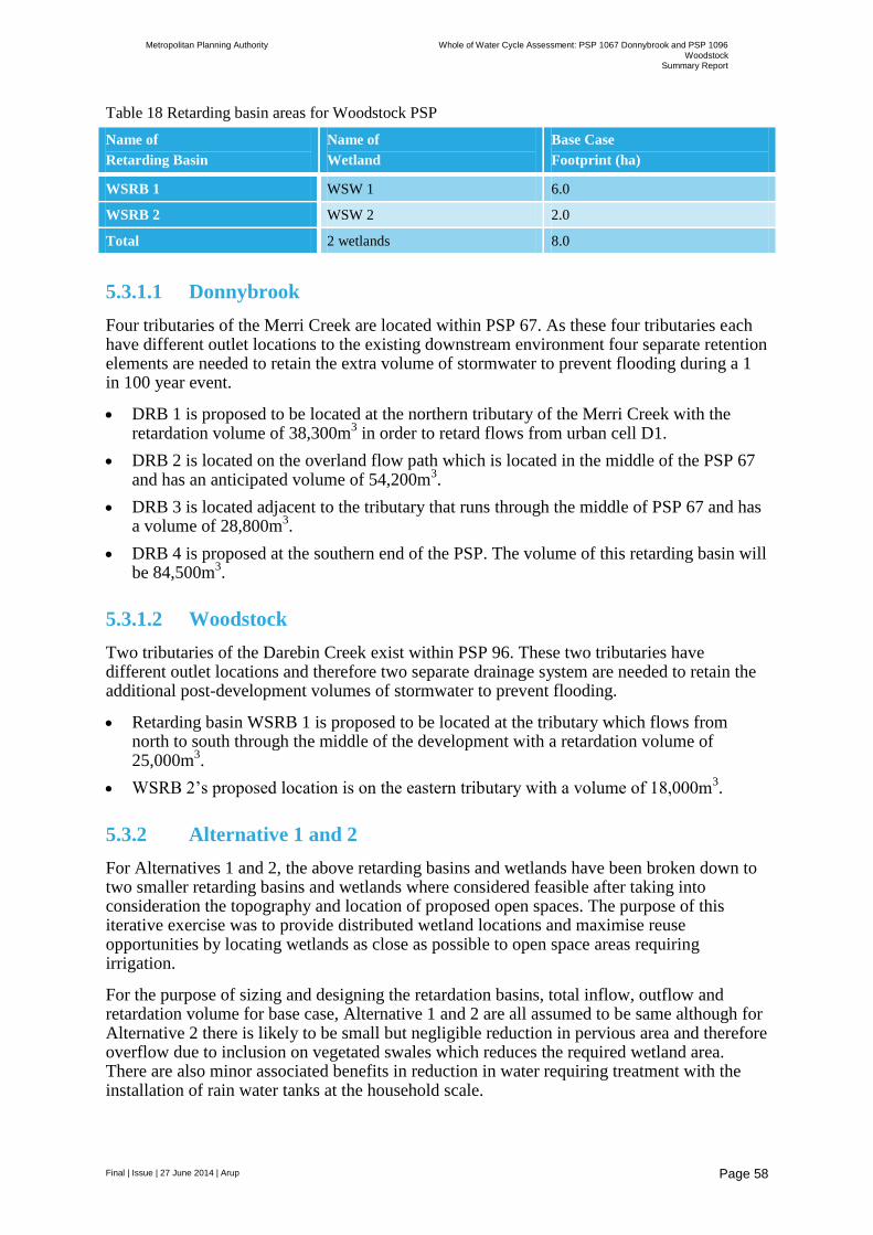
Metropolitan Planning Authority Whole of Water Cycle Assessment: PSP 1067 Donnybrook and PSP 1096
Woodstock Summary Report
Final | Issue | 27 June 2014 | Arup
Page 58
Table 18 Retarding basin areas for Woodstock PSP
Name of
Retarding Basin
Name of
Wetland
Base Case
Footprint (ha)
WSRB 1 WSW 1 6.0
WSRB 2 WSW 2 2.0
Total 2 wetlands 8.0
5.3.1.1 Donnybrook
Four tributaries of the Merri Creek are located within PSP 67. As these four tributaries each have different outlet locations to the existing downstream environment four separate retention elements are needed to retain the extra volume of stormwater to prevent flooding during a 1 in 100 year event.
DRB 1 is proposed to be located at the northern tributary of the Merri Creek with the retardation volume of 38,300m
3 in order to retard flows from urban cell D1.
DRB 2 is located on the overland flow path which is located in the middle of the PSP 67 and has an anticipated volume of 54,200m
3.
DRB 3 is located adjacent to the tributary that runs through the middle of PSP 67 and has a volume of 28,800m
3.
DRB 4 is proposed at the southern end of the PSP. The volume of this retarding basin will be 84,500m
3.
5.3.1.2 Woodstock
Two tributaries of the Darebin Creek exist within PSP 96. These two tributaries have different outlet locations and therefore two separate drainage system are needed to retain the additional post-development volumes of stormwater to prevent flooding.
Retarding basin WSRB 1 is proposed to be located at the tributary which flows from north to south through the middle of the development with a retardation volume of 25,000m
3.
WSRB 2’s proposed location is on the eastern tributary with a volume of 18,000m3.
5.3.2 Alternative 1 and 2
For Alternatives 1 and 2, the above retarding basins and wetlands have been broken down to two smaller retarding basins and wetlands where considered feasible after taking into consideration the topography and location of proposed open spaces. The purpose of this iterative exercise was to provide distributed wetland locations and maximise reuse opportunities by locating wetlands as close as possible to open space areas requiring irrigation.
For the purpose of sizing and designing the retardation basins, total inflow, outflow and retardation volume for base case, Alternative 1 and 2 are all assumed to be same although for Alternative 2 there is likely to be small but negligible reduction in pervious area and therefore overflow due to inclusion on vegetated swales which reduces the required wetland area. There are also minor associated benefits in reduction in water requiring treatment with the installation of rain water tanks at the household scale.
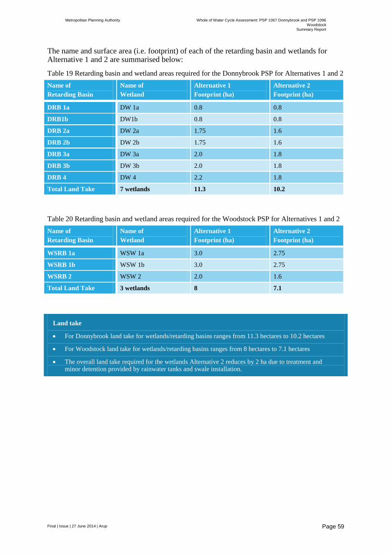
Metropolitan Planning Authority Whole of Water Cycle Assessment: PSP 1067 Donnybrook and PSP 1096
Woodstock Summary Report
Final | Issue | 27 June 2014 | Arup
Page 59
The name and surface area (i.e. footprint) of each of the retarding basin and wetlands for Alternative 1 and 2 are summarised below:
Table 19 Retarding basin and wetland areas required for the Donnybrook PSP for Alternatives 1 and 2
Name of
Retarding Basin
Name of
Wetland
Alternative 1
Footprint (ha)
Alternative 2
Footprint (ha)
DRB 1a DW 1a 0.8 0.8
DRB1b DW1b 0.8 0.8
DRB 2a DW 2a 1.75 1.6
DRB 2b DW 2b 1.75 1.6
DRB 3a DW 3a 2.0 1.8
DRB 3b DW 3b 2.0 1.8
DRB 4 DW 4 2.2 1.8
Total Land Take 7 wetlands 11.3 10.2
Table 20 Retarding basin and wetland areas required for the Woodstock PSP for Alternatives 1 and 2
Name of
Retarding Basin
Name of
Wetland
Alternative 1
Footprint (ha)
Alternative 2
Footprint (ha)
WSRB 1a WSW 1a 3.0 2.75
WSRB 1b WSW 1b 3.0 2.75
WSRB 2 WSW 2 2.0 1.6
Total Land Take 3 wetlands 8 7.1
Land take
For Donnybrook land take for wetlands/retarding basins ranges from 11.3 hectares to 10.2 hectares
For Woodstock land take for wetlands/retarding basins ranges from 8 hectares to 7.1 hectares
The overall land take required for the wetlands Alternative 2 reduces by 2 ha due to treatment and minor detention provided by rainwater tanks and swale installation.

Metropolitan Planning Authority Whole of Water Cycle Assessment: PSP 1067 Donnybrook and PSP 1096
Woodstock Summary Report
Final | Issue | 27 June 2014 | Arup
Page 60
6 Options assessment
A high level assessment of options has been presented below based on capital and operational costs above those incurred under the base case and qualitative assessment of potential benefits based on Arup’s Design with Water framework which includes a high level climate resilience assessment.
For the climate change scenarios, MUSIC models have been re-run amending the predicted evaporation increases this result in minor changes in the run-off volumes generated annually under each case with the table below depicting the % change in mean annual flows.
Table 21 Climate change criteria and mean flow reduction for each scenario
Criteria 2030 2070
Low emissions High emissions
Change in average temperature (C)
0.6 to 1.1 0.9 to 1.9 1.8 to 3.7
Change in annual rainfall (%) -8 to 0 -13 to 0 -24 to 0
Change in potential evaporation (%)
+1 to +5 +1 to +9 +2 to +17
Changes in mean annual flow (%)
No change 0.23% reduction 0.94% reduction

Metropolitan Planning Authority Whole of Water Cycle Assessment: PSP 1067 Donnybrook and PSP 1096
Woodstock Summary Report
Final | Issue | 27 June 2014 | Arup
Page 61
6.1 Donnybrook
Table 22 Summary of WoWCA for Donnybrook PSP
Base Case Base Case + Future Stretch
Demands (ML/a) Potable 1270 971 717
Recycled water 437 495 301
Stormwater 0 163 163
Rainwater 0 0 350
Total 1707 1630 1531
Potable : Non-potable split
86% : 14% 60% : 40% 47% : 53%
Stormwater runoff (ML/a) 2460 2460 2460
Sewer discharge (ML/a) 1183 1063 956
Excess (recycled water vs sewer discharge) (ML/a)
746 568 655
Number of retarding basins/wetlands 4 7 7
Extent of retarding basins/wetlands (ha) 11.3 11.3 10.2
Capex ($) $8.5 m $8.5 m $7.7 m
Opex ($/a) $57 k $57 k $51 k
Extent of swales (m2) 0 0 6,750
Capex ($) 0 0 $1.1 m
Opex ($/a) 0 0 $34 k
Number of rainwater tanks 0 0 9,080
Capex ($) 0 0 $36.5 m
Opex ($/a) 0 0 $550 k
% pollutant reduction
TSS 83 82 84
TP 74 73 74
TN 53 52 49
Gross pollutants 100 100 100
Total Capex $8.5 m $8.5 m $45.3 m
Total Opex $57 k $57 k $635 k
Savings off water bill for tank water (consumption only) ($/a)
0 0 $910k
Savings off water bill (council irrigation) ($/a)
0 $425k $425k
Additional saleable lots compared with Base Case
0 0 24
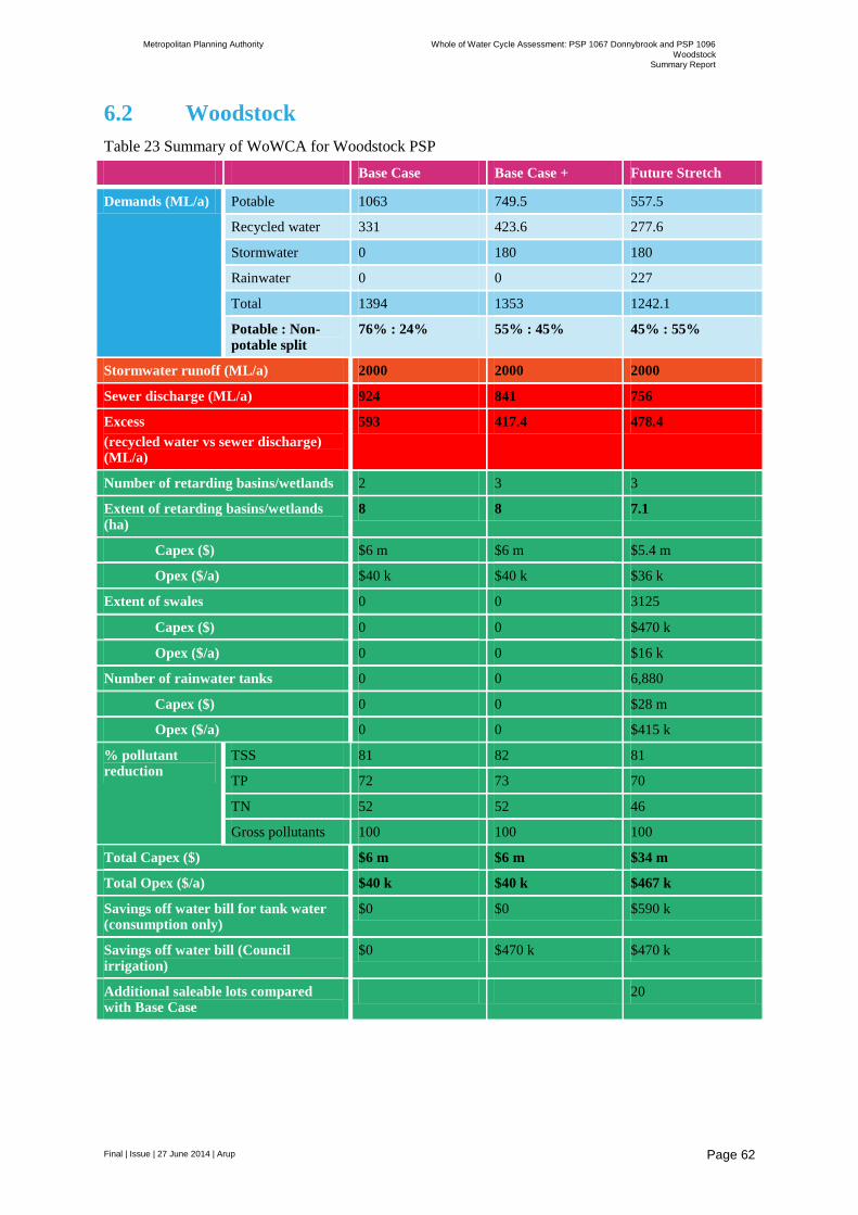
Metropolitan Planning Authority Whole of Water Cycle Assessment: PSP 1067 Donnybrook and PSP 1096
Woodstock Summary Report
Final | Issue | 27 June 2014 | Arup
Page 62
6.2 Woodstock
Table 23 Summary of WoWCA for Woodstock PSP
Base Case Base Case + Future Stretch
Demands (ML/a) Potable 1063 749.5 557.5
Recycled water 331 423.6 277.6
Stormwater 0 180 180
Rainwater 0 0 227
Total 1394 1353 1242.1
Potable : Non-potable split
76% : 24% 55% : 45% 45% : 55%
Stormwater runoff (ML/a) 2000 2000 2000
Sewer discharge (ML/a) 924 841 756
Excess
(recycled water vs sewer discharge) (ML/a)
593 417.4 478.4
Number of retarding basins/wetlands 2 3 3
Extent of retarding basins/wetlands (ha)
8 8 7.1
Capex ($) $6 m $6 m $5.4 m
Opex ($/a) $40 k $40 k $36 k
Extent of swales 0 0 3125
Capex ($) 0 0 $470 k
Opex ($/a) 0 0 $16 k
Number of rainwater tanks 0 0 6,880
Capex ($) 0 0 $28 m
Opex ($/a) 0 0 $415 k
% pollutant reduction
TSS 81 82 81
TP 72 73 70
TN 52 52 46
Gross pollutants 100 100 100
Total Capex ($) $6 m $6 m $34 m
Total Opex ($/a) $40 k $40 k $467 k
Savings off water bill for tank water (consumption only)
$0 $0 $590 k
Savings off water bill (Council irrigation)
$0 $470 k $470 k
Additional saleable lots compared with Base Case
20

Metropolitan Planning Authority Whole of Water Cycle Assessment: PSP 1067 Donnybrook and PSP 1096
Woodstock Summary Report
Final | Issue | 27 June 2014 | Arup
Page 63
6.3 Qualitative assessment
Under the qualitative framework a 1 to 5 scale has been used based on the following in terms of the potential benefits achieved.
1 = very low
2 = low
3 = medium
4 = high
5 = very high

Metropolitan Planning Authority Whole of Water Cycle Assessment: PSP 1067 Donnybrook and PSP 1096
Woodstock Summary Report
Final | Issue | 27 June 2014 | Arup
Page 64
Option Key ‘design with water’
features
Assessment criteria
Water supply
Reduction in demand
for potable water
supply and treatment,
through use of water
efficient fixtures and
fittings and
alternative
decentralised water
supplies, including
rainwater, greywater
and groundwater.
Capital investment
and whole-life cost
savings.
Wastewater
Reduction of water
volume to sewers,
extending network
asset life, improving
water quality and
reducing treatment.
Opportunity to
recycle and re-use
water through
decentralised
treatment.
Flooding
Reducing risk and
increasing resilience
by integrated
catchment
management and
improved
management of
surface water within
cities. Design and
planning of
infrastructure,
buildings and
landscapes to be more
adaptable to flooding.
Economy &
Innovation
Potential direct
contribution through
water-related
investment in
infrastructure
associated new
technologies,
partnership with
small enterprise, etc.
Indirect impact on
land and property
values, attracting
inward investment
and improved labour
productivity.
Place & Community
Access to and
engagement with
water can play a
significant role in
creating better places
with a strong sense of
identity. Making
space for water can
open up and
reconnect people and
places. Water is an
integrator which can
facilitate partnership
and collaboration.
Food & Agriculture
Local food production
can be a key driver to
retrofitting
landscapes, including
breaking up of hard
surfaces, flood-
compatible use of
open space, edible
planting, water
harvesting and
treatment, localised
nutrient recycling and
improved agricultural
practice.
Climate Change
Design for water helps
to mitigate and adapt
to climate change.
Large tree planting,
greening of urban
areas, and open water
bodies directly
contribute to
improved
microclimate. Locally
managed water can
increase resilience to
water scarcity and
drought.
Habitat &
Biodiversity
New and improved
habitats through
making space for
water within green
infrastructure
networks, provision
for natural treatment
of water and
wastewater,
improving water
quality, river/wetland
and coastal
restoration, woodland,
green roofs and walls.
Energy & Carbon
Removal and
sequestration of
greenhouse gases as a
result of urban
greening. Reduction
in energy demand due
to shading/insulation,
reduced pumping and
treatment of water
and wastewater.
Potential for
renewable energy
generation from
hydro and waste.
Health & Wellbeing
Water-related green
infrastructure can
absorb air pollutants
and improve
microclimate, provide
opportunities for
recreation, exercise
and education. Water
can help to improve
overall living
environments and
provide opportunities
for community
engagement.
Total
Base Case
Local STP providing
recycled water for mandated residential uses
Surface water management to
meet BPEM and 1 in 100
year ARI through end of line
system before discharge to local water bodies
Green space maintained to a
‘survival’ level
3
WELS standard fittings
and fixtures
Recycled water supply
3
Local STP provides
recycled water
3
Meets 1 in 100 ARI
requirements
3
Local STP provides
regional employment
Availability of recycled
water may allow for
industries requiring
secure supplied of
water during restrictions to locate to
the area
2
Parks are supplied with
potable water and subject to future water
restrictions.
Wetlands combined
with retarding basin
reduces land take and provides amenity
2
Availability of recycled
water means opportunities for local
food production and
community gardens can
be explored at alter
stages
3
Localised provision of
recycled water provides increased resilience for
water supply in times
of low rainfall
3
Placement of wetlands
and surface water features avoids existing
high quality vegetation
areas.
Potential indirect
creation of new habitats in wetlands
3
Localised treatment of
sewage reduces pumping costs
3
Bike paths walking
trails can be collocated along major drainage
lines
Visual access to water
bodies improves mental
and physical health
Further opportunities
can be explored at alter
stages
28
Base Case +
10% reduction in water usage
in residential houses
Local STP providing
recycled water for mandated
residential uses along with recycled water demands in all
other land use types
Surface water management to
meet BPEM and 1 in 100
year ARI through distributed system which seeks to
collocate wetlands and
retarding basins close to open space areas to maximise
reuse opportunities for
irrigation reuse
Green space maintained to a
‘lush’ level
4
Higher rated WELS
standard fittings and
fixtures leading to a 10% reduction in
householder water
reuse
Recycled water supply
extended to other land uses
Stormwater supplied for open space
irrigation
4
Local STP provides
recycled water
10 %r reduction in
household water usage
reduce flows to sewer
5
Meets 1 in 100 ARI
requirements.
Increased number of
retarding basins
improves resilience
4
Local STP provides
regional employment
Availability of recycled
water may allow for
industries requiring secure supplied of
water during
restrictions to locate to the area
Reuse of stormwater reduces water bills for
councils maintaining
open space assets
4
Parks are supplied with
stormwater where
feasible due to colocation of wetlands
adjacent to these areas.
Recycled water is provided as a backup
meaning open space is resilient to water
restrictions and low
rainfall
Wetlands combined
with retarding basin
reduces land take and provides amenity.
Increased number of
wetlands adjacent to planned open space
improves
2
Availability of recycled
water means
opportunities for local food production and
community gardens can
be explored at alter stages.
4
Localised provision of
recycled water provides
increased resilience for water supply in times
of low rainfall.
Climate independent
source of water allows
for maintenance of green space and tree
canopy.
Distribution of water
bodies improves
microclimate
4
Placement of wetlands
and surface water
features avoids existing high quality vegetation
areas.
Distributed wetlands
provide potential
indirect creation of new habitats in wetlands
Reuse of stormwater reduces flows to
adjacent waterways
Opportunities to increase/maintain
habitat connectivity
along drainage lines can be explored
4
Localised treatment of
sewage reduces
pumping costs
Local use of
stormwater gathered and treated using
gravity systems to the
maximum extent possible reduced water
travel distances and
associated pumping.
4
Bike paths walking
trails can be collocated
along major drainage lines
Visual access to water bodies improves mental
and physical health
Further opportunities
can be explored at alter
stages
35
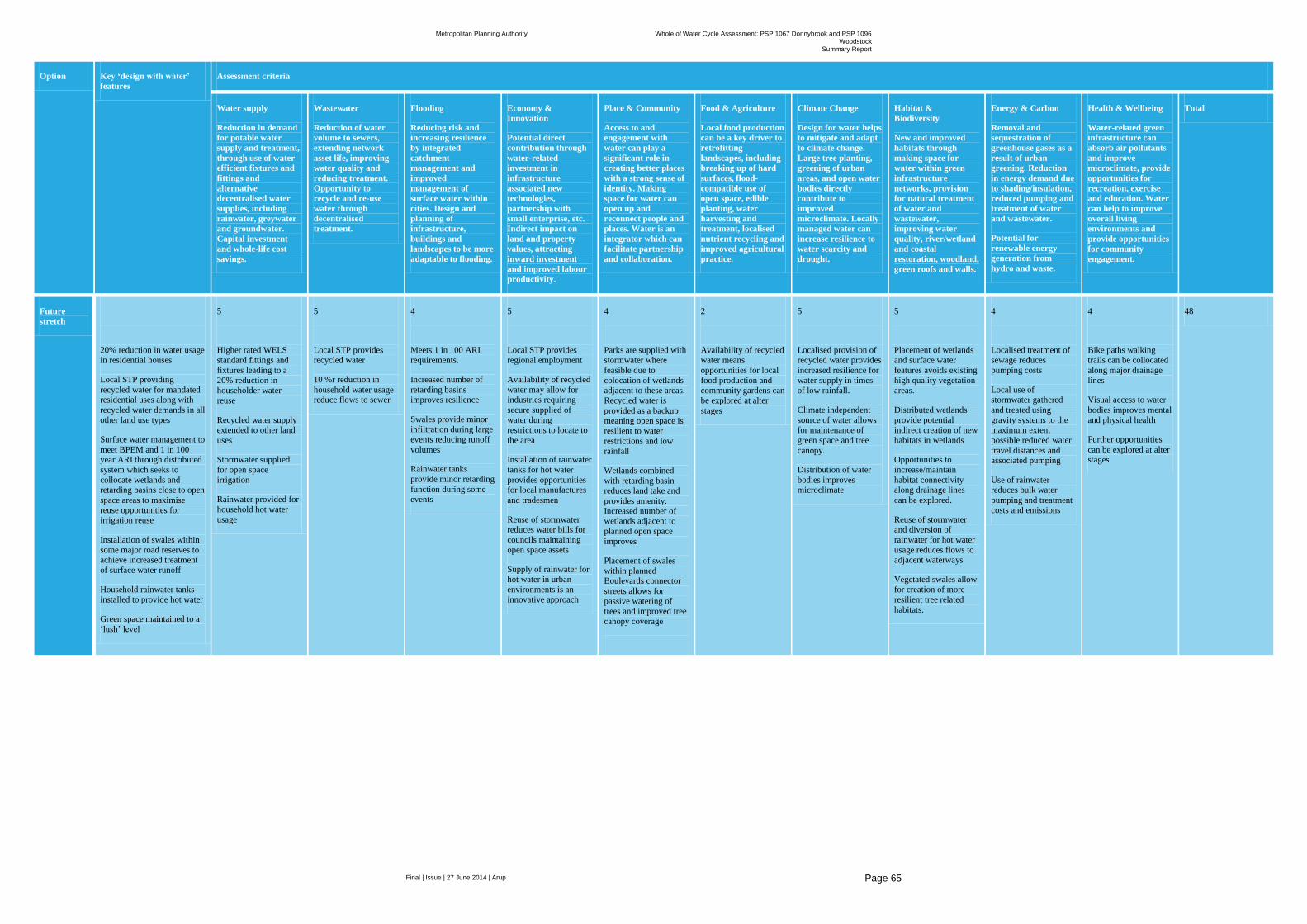
Metropolitan Planning Authority Whole of Water Cycle Assessment: PSP 1067 Donnybrook and PSP 1096
Woodstock Summary Report
Final | Issue | 27 June 2014 | Arup
Page 65
Option Key ‘design with water’
features
Assessment criteria
Water supply
Reduction in demand
for potable water
supply and treatment,
through use of water
efficient fixtures and
fittings and
alternative
decentralised water
supplies, including
rainwater, greywater
and groundwater.
Capital investment
and whole-life cost
savings.
Wastewater
Reduction of water
volume to sewers,
extending network
asset life, improving
water quality and
reducing treatment.
Opportunity to
recycle and re-use
water through
decentralised
treatment.
Flooding
Reducing risk and
increasing resilience
by integrated
catchment
management and
improved
management of
surface water within
cities. Design and
planning of
infrastructure,
buildings and
landscapes to be more
adaptable to flooding.
Economy &
Innovation
Potential direct
contribution through
water-related
investment in
infrastructure
associated new
technologies,
partnership with
small enterprise, etc.
Indirect impact on
land and property
values, attracting
inward investment
and improved labour
productivity.
Place & Community
Access to and
engagement with
water can play a
significant role in
creating better places
with a strong sense of
identity. Making
space for water can
open up and
reconnect people and
places. Water is an
integrator which can
facilitate partnership
and collaboration.
Food & Agriculture
Local food production
can be a key driver to
retrofitting
landscapes, including
breaking up of hard
surfaces, flood-
compatible use of
open space, edible
planting, water
harvesting and
treatment, localised
nutrient recycling and
improved agricultural
practice.
Climate Change
Design for water helps
to mitigate and adapt
to climate change.
Large tree planting,
greening of urban
areas, and open water
bodies directly
contribute to
improved
microclimate. Locally
managed water can
increase resilience to
water scarcity and
drought.
Habitat &
Biodiversity
New and improved
habitats through
making space for
water within green
infrastructure
networks, provision
for natural treatment
of water and
wastewater,
improving water
quality, river/wetland
and coastal
restoration, woodland,
green roofs and walls.
Energy & Carbon
Removal and
sequestration of
greenhouse gases as a
result of urban
greening. Reduction
in energy demand due
to shading/insulation,
reduced pumping and
treatment of water
and wastewater.
Potential for
renewable energy
generation from
hydro and waste.
Health & Wellbeing
Water-related green
infrastructure can
absorb air pollutants
and improve
microclimate, provide
opportunities for
recreation, exercise
and education. Water
can help to improve
overall living
environments and
provide opportunities
for community
engagement.
Total
Future
stretch
20% reduction in water usage in residential houses
Local STP providing
recycled water for mandated residential uses along with
recycled water demands in all
other land use types
Surface water management to
meet BPEM and 1 in 100 year ARI through distributed
system which seeks to
collocate wetlands and retarding basins close to open
space areas to maximise
reuse opportunities for irrigation reuse
Installation of swales within
some major road reserves to achieve increased treatment
of surface water runoff
Household rainwater tanks
installed to provide hot water
Green space maintained to a
‘lush’ level
5
Higher rated WELS standard fittings and
fixtures leading to a
20% reduction in householder water
reuse
Recycled water supply extended to other land
uses
Stormwater supplied
for open space
irrigation
Rainwater provided for
household hot water
usage
5
Local STP provides recycled water
10 %r reduction in
household water usage reduce flows to sewer
4
Meets 1 in 100 ARI requirements.
Increased number of
retarding basins improves resilience
Swales provide minor infiltration during large
events reducing runoff
volumes
Rainwater tanks
provide minor retarding
function during some events
5
Local STP provides regional employment
Availability of recycled
water may allow for industries requiring
secure supplied of
water during restrictions to locate to
the area
Installation of rainwater
tanks for hot water
provides opportunities for local manufactures
and tradesmen
Reuse of stormwater reduces water bills for
councils maintaining
open space assets
Supply of rainwater for
hot water in urban
environments is an
innovative approach
4
Parks are supplied with stormwater where
feasible due to
colocation of wetlands adjacent to these areas.
Recycled water is
provided as a backup
meaning open space is
resilient to water
restrictions and low rainfall
Wetlands combined
with retarding basin reduces land take and
provides amenity.
Increased number of wetlands adjacent to
planned open space
improves
Placement of swales
within planned Boulevards connector
streets allows for
passive watering of trees and improved tree
canopy coverage
2
Availability of recycled water means
opportunities for local
food production and community gardens can
be explored at alter
stages
5
Localised provision of recycled water provides
increased resilience for
water supply in times of low rainfall.
Climate independent
source of water allows for maintenance of
green space and tree
canopy.
Distribution of water
bodies improves microclimate
5
Placement of wetlands and surface water
features avoids existing
high quality vegetation areas.
Distributed wetlands
provide potential indirect creation of new
habitats in wetlands
Opportunities to
increase/maintain
habitat connectivity along drainage lines
can be explored.
Reuse of stormwater and diversion of
rainwater for hot water
usage reduces flows to adjacent waterways
Vegetated swales allow
for creation of more
resilient tree related
habitats.
4
Localised treatment of sewage reduces
pumping costs
Local use of stormwater gathered
and treated using
gravity systems to the maximum extent
possible reduced water
travel distances and associated pumping
Use of rainwater reduces bulk water
pumping and treatment
costs and emissions
4
Bike paths walking trails can be collocated
along major drainage
lines
Visual access to water
bodies improves mental
and physical health
Further opportunities
can be explored at alter stages
48
Metropolitan Planning Authority Whole of Water Cycle Assessment: PSP 1067 Donnybrook and PSP 1096
Woodstock Summary Report
Final | Issue | 27 June 2014 | Arup
Page 67
7 Recommendation and key findings
Key recommendations and findings from this study are provided below:
Alternative 2 Future stretch scores highest in terms of qualitative assessment, and has the highest potable water replacement ratio of approximately 45% potable water usage and 55% non-potable water usage.
In terms of Capex and Opex the expected costs for Alternative 2 are almost 6 times those of the base case and base case + options due to the costs associated with the installation and operation of rainwater tanks at the household scale.
Under all options there is an excess of wastewater generated against recycled water demands. This is most profound under the base case where almost 1,400 ML of treated waste water will require discharge to either local waterways or into the Melbourne sewer system.
Opportunities to extend the supply of recycled water to other land uses and at the household level should be undertaken to reduce discharges of treated water to the environment.
The water balance for the Future Stretch option indicates that from a quantity perspective the installation of rainwater tanks at the lot scale where recycled water is also available will further exacerbate the excess of treated water requiring disposal or direction to alternative uses outside of the PSP areas.
Cost savings or otherwise related to the installation of rainwater tanks at the household level need to be subjected to a more rigorous cost: benefit analysis to determine the benefit flow and who should fund the installation and operation of these measures. However benefits to households appear to be marginal given the expected Opex vs the savings in water bills.
It is also noted that the diversion of rainwater into the sewer system under the future stretch option may not be able to be recognised as billable for treatment under Yarra Valley Water’s current billing arrangements which do not measure water flows leaving the house, but rather account for flows by applying a factor to metered potable water usage.
Under the Alternative 1 option, Base Case plus, there is the potential for council’s to be able to offset around $900k across both PSPs off their irrigation water bills by harvesting stormwater. This involves minimal expense in reconfiguring the placement of wetlands and applying reuse to these facilities. These costs and benefits should be explored in further detail.
The distribution of wetlands throughout the development and adjacent to open space requiring irrigation water also allows for a more staged approach to infrastructure delivery.
Consultation with developers to understand their appetite for the installation of WSUD features beyond the baseline should be undertaken.
Consultation with Council’s and Melbourne Water regarding arrangements for the ongoing management of wetlands and other WSUD features should be undertaken. This relates to large wetlands, vegetated swales and any infrastructure associated with treatment, storage or distribution for reuse.
Further refinement of costs, benefits, responsibilities and risk management procedures is required to better inform a preferred option at the PSP scale.
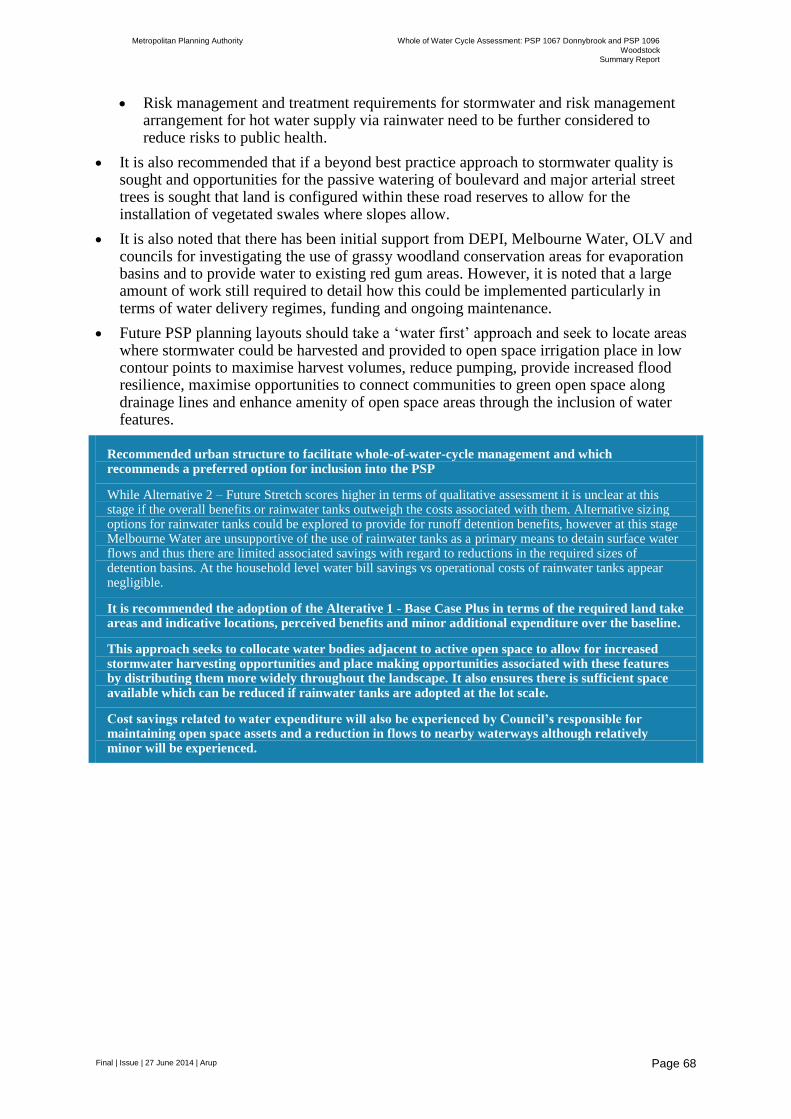
Metropolitan Planning Authority Whole of Water Cycle Assessment: PSP 1067 Donnybrook and PSP 1096
Woodstock Summary Report
Final | Issue | 27 June 2014 | Arup
Page 68
Risk management and treatment requirements for stormwater and risk management arrangement for hot water supply via rainwater need to be further considered to reduce risks to public health.
It is also recommended that if a beyond best practice approach to stormwater quality is sought and opportunities for the passive watering of boulevard and major arterial street trees is sought that land is configured within these road reserves to allow for the installation of vegetated swales where slopes allow.
It is also noted that there has been initial support from DEPI, Melbourne Water, OLV and councils for investigating the use of grassy woodland conservation areas for evaporation basins and to provide water to existing red gum areas. However, it is noted that a large amount of work still required to detail how this could be implemented particularly in terms of water delivery regimes, funding and ongoing maintenance.
Future PSP planning layouts should take a ‘water first’ approach and seek to locate areas where stormwater could be harvested and provided to open space irrigation place in low contour points to maximise harvest volumes, reduce pumping, provide increased flood resilience, maximise opportunities to connect communities to green open space along drainage lines and enhance amenity of open space areas through the inclusion of water features.
Recommended urban structure to facilitate whole-of-water-cycle management and which recommends a preferred option for inclusion into the PSP
While Alternative 2 – Future Stretch scores higher in terms of qualitative assessment it is unclear at this stage if the overall benefits or rainwater tanks outweigh the costs associated with them. Alternative sizing options for rainwater tanks could be explored to provide for runoff detention benefits, however at this stage Melbourne Water are unsupportive of the use of rainwater tanks as a primary means to detain surface water flows and thus there are limited associated savings with regard to reductions in the required sizes of detention basins. At the household level water bill savings vs operational costs of rainwater tanks appear negligible.
It is recommended the adoption of the Alterative 1 - Base Case Plus in terms of the required land take areas and indicative locations, perceived benefits and minor additional expenditure over the baseline.
This approach seeks to collocate water bodies adjacent to active open space to allow for increased stormwater harvesting opportunities and place making opportunities associated with these features by distributing them more widely throughout the landscape. It also ensures there is sufficient space available which can be reduced if rainwater tanks are adopted at the lot scale.
Cost savings related to water expenditure will also be experienced by Council’s responsible for maintaining open space assets and a reduction in flows to nearby waterways although relatively minor will be experienced.
Metropolitan Planning Authority Whole of Water Cycle Assessment: PSP 1067 Donnybrook and PSP 1096
Woodstock Summary Report
Final | Issue | 27 June 2014 | Arup
Page 69
8 References
Bureau of Metrology 2013 Yan Yean Station Number 86131 Weather Data www.bom.gov.au/jsp/ncc/cdio/weatherData/av?p_nccObsCode=139&p_display_type=dataFile&p_startYear=&p_c=&p_stn_num=086131
Cardno 2013, Donnybrook Precinct Structure Plan Utilities Servicing and Infrastructure Assessment Prepared for Growth Areas Authority 18 April 2013
Connellan 2002 A Reference Manual for Turf and Landscape
Ellender, I. 1997 The Aboriginal Cultural Heritage of the Merri Creek: Including the Archaeological Survey for Aboriginal Sites from Craigieburn Road to Hernes Swamp. Report prepared for Merri Creek Management Committee
E2 Design 2014 Water Future North – Whole of Water Cycle Management Study Analysis Part 2
EPA (US) nd Saving Water in Educational Facilities www.epa.gov/watersense
Green Building Council of Australia 2008 Greenstar – Retail Centre v1
Meinhardt 2013, Donnybrook Precinct Structure Plan – 1067 Environmental, Hydrological & Geotechnical Assessment prepared for Growth Area Authority June 2013
Meinhardt 2013, Woodstock Precinct Structure Plan – 1096 Environmental, Hydrological & Geotechnical Assessment prepared for Growth Area Authority June 2013
Monash Sustainability Institute 2012 Australian Tertiary Education Sector Sustainability Report 2011
Orr, A, 2013 Precinct Structure Plan 1067 Donnybrook Aboriginal Heritage Impact Assessment prepared for the Growth Areas Authority
Smart Water Fund June, 2013 Melbourne Residential Water Use Studies
Sydney Water: Water use benchmarks for shopping centres
Tucker, C 2013 Woodstock Precinct Structure Plan Aboriginal Heritage Impact Assessment prepared for the Growth Areas Authority
VandenBerg, A.H.M. 1973 Geology of the Melbourne District. In McAndrew J.& Marsden M.A.H. (eds) Regional Guide to Victorian geology, pp 14-30. School of Geology, University of Melbourne.
Yarra Valley Water 2013, Preliminary Servicing Advice for PSP 1067 Donnybrook and 1096 Woodstock prepared for the Growth Areas Authority 2 August 2013
Yarra Valley Water, Melbourne Water and the Office of Living Victoria 2012 An Integrated Water Future for Melbourne’s North
Walsh, C.J., Bond, N., and Fletcher, T.D. 2013 Possible ecological futures for Merri and Darebin creeks. Melbourne Waterway Science-Practice Partnership, The University of Melbourne. September 2013

Appendix A
Description of site details
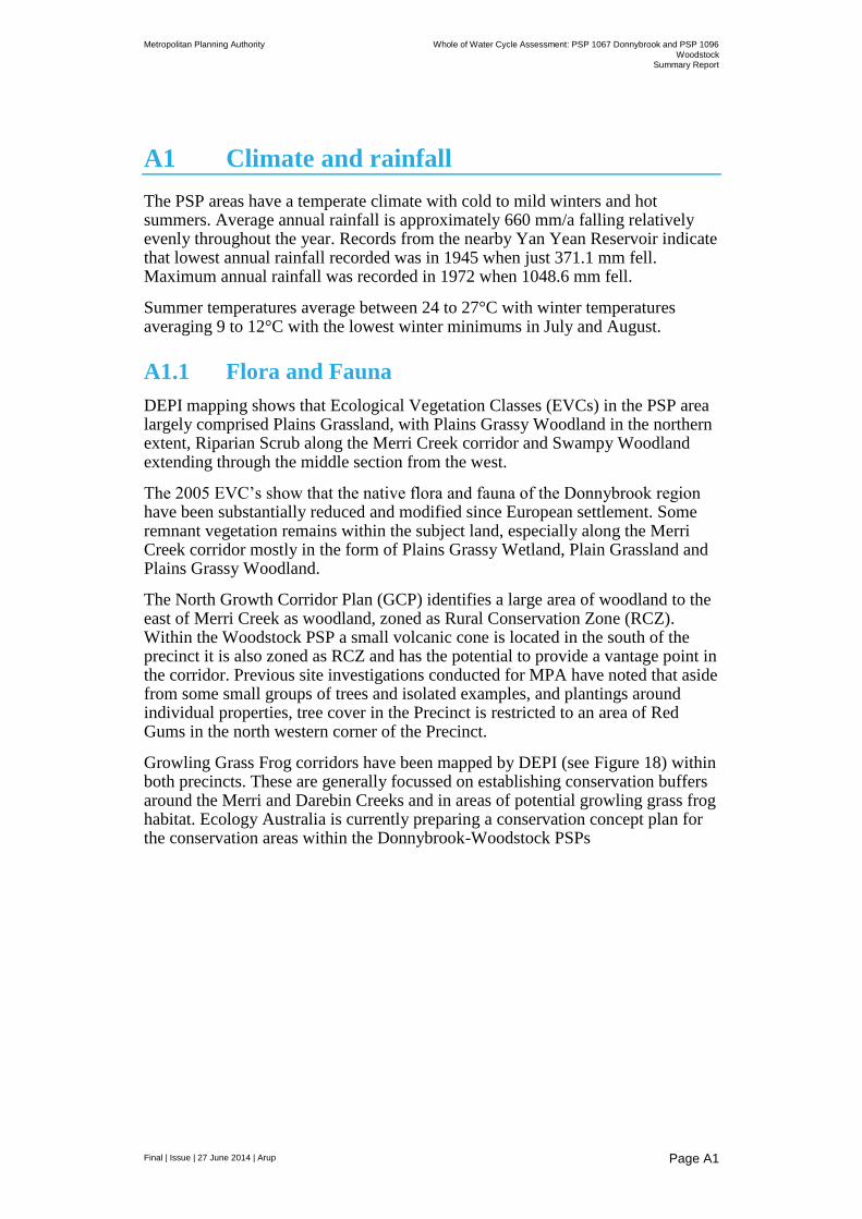
Metropolitan Planning Authority Whole of Water Cycle Assessment: PSP 1067 Donnybrook and PSP 1096
Woodstock Summary Report
Final | Issue | 27 June 2014 | Arup
Page A1
A1 Climate and rainfall
The PSP areas have a temperate climate with cold to mild winters and hot summers. Average annual rainfall is approximately 660 mm/a falling relatively evenly throughout the year. Records from the nearby Yan Yean Reservoir indicate that lowest annual rainfall recorded was in 1945 when just 371.1 mm fell. Maximum annual rainfall was recorded in 1972 when 1048.6 mm fell.
Summer temperatures average between 24 to 27°C with winter temperatures averaging 9 to 12°C with the lowest winter minimums in July and August.
A1.1 Flora and Fauna
DEPI mapping shows that Ecological Vegetation Classes (EVCs) in the PSP area largely comprised Plains Grassland, with Plains Grassy Woodland in the northern extent, Riparian Scrub along the Merri Creek corridor and Swampy Woodland extending through the middle section from the west.
The 2005 EVC’s show that the native flora and fauna of the Donnybrook region have been substantially reduced and modified since European settlement. Some remnant vegetation remains within the subject land, especially along the Merri Creek corridor mostly in the form of Plains Grassy Wetland, Plain Grassland and Plains Grassy Woodland.
The North Growth Corridor Plan (GCP) identifies a large area of woodland to the east of Merri Creek as woodland, zoned as Rural Conservation Zone (RCZ). Within the Woodstock PSP a small volcanic cone is located in the south of the precinct it is also zoned as RCZ and has the potential to provide a vantage point in the corridor. Previous site investigations conducted for MPA have noted that aside from some small groups of trees and isolated examples, and plantings around individual properties, tree cover in the Precinct is restricted to an area of Red Gums in the north western corner of the Precinct.
Growling Grass Frog corridors have been mapped by DEPI (see Figure 18) within both precincts. These are generally focussed on establishing conservation buffers around the Merri and Darebin Creeks and in areas of potential growling grass frog habitat. Ecology Australia is currently preparing a conservation concept plan for the conservation areas within the Donnybrook-Woodstock PSPs

Metropolitan Planning Authority Whole of Water Cycle Assessment: PSP 1067 Donnybrook and PSP 1096
Woodstock Summary Report
Final | Issue | 27 June 2014 | Arup
Page A2
Figure 18 Growling Grass Frog Corridor through Donnybrook and Woodstock, as per the Growth Corridor Plan (2012)
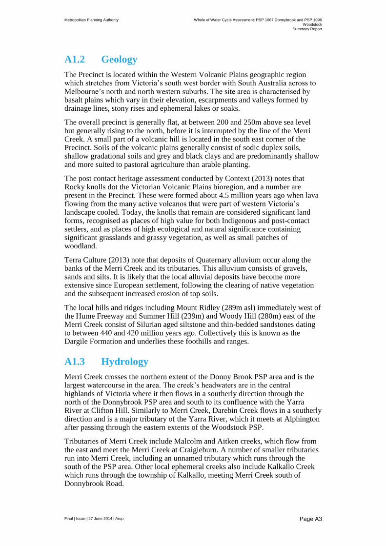
Metropolitan Planning Authority Whole of Water Cycle Assessment: PSP 1067 Donnybrook and PSP 1096
Woodstock Summary Report
Final | Issue | 27 June 2014 | Arup
Page A3
A1.2 Geology
The Precinct is located within the Western Volcanic Plains geographic region which stretches from Victoria’s south west border with South Australia across to Melbourne’s north and north western suburbs. The site area is characterised by basalt plains which vary in their elevation, escarpments and valleys formed by drainage lines, stony rises and ephemeral lakes or soaks.
The overall precinct is generally flat, at between 200 and 250m above sea level but generally rising to the north, before it is interrupted by the line of the Merri Creek. A small part of a volcanic hill is located in the south east corner of the Precinct. Soils of the volcanic plains generally consist of sodic duplex soils, shallow gradational soils and grey and black clays and are predominantly shallow and more suited to pastoral agriculture than arable planting.
The post contact heritage assessment conducted by Context (2013) notes that Rocky knolls dot the Victorian Volcanic Plains bioregion, and a number are present in the Precinct. These were formed about 4.5 million years ago when lava flowing from the many active volcanos that were part of western Victoria’s landscape cooled. Today, the knolls that remain are considered significant land forms, recognised as places of high value for both Indigenous and post-contact settlers, and as places of high ecological and natural significance containing significant grasslands and grassy vegetation, as well as small patches of woodland.
Terra Culture (2013) note that deposits of Quaternary alluvium occur along the banks of the Merri Creek and its tributaries. This alluvium consists of gravels, sands and silts. It is likely that the local alluvial deposits have become more extensive since European settlement, following the clearing of native vegetation and the subsequent increased erosion of top soils.
The local hills and ridges including Mount Ridley (289m asl) immediately west of the Hume Freeway and Summer Hill (239m) and Woody Hill (280m) east of the Merri Creek consist of Silurian aged siltstone and thin-bedded sandstones dating to between 440 and 420 million years ago. Collectively this is known as the Dargile Formation and underlies these foothills and ranges.
A1.3 Hydrology
Merri Creek crosses the northern extent of the Donny Brook PSP area and is the largest watercourse in the area. The creek’s headwaters are in the central highlands of Victoria where it then flows in a southerly direction through the north of the Donnybrook PSP area and south to its confluence with the Yarra River at Clifton Hill. Similarly to Merri Creek, Darebin Creek flows in a southerly direction and is a major tributary of the Yarra River, which it meets at Alphington after passing through the eastern extents of the Woodstock PSP.
Tributaries of Merri Creek include Malcolm and Aitken creeks, which flow from the east and meet the Merri Creek at Craigieburn. A number of smaller tributaries run into Merri Creek, including an unnamed tributary which runs through the south of the PSP area. Other local ephemeral creeks also include Kalkallo Creek which runs through the township of Kalkallo, meeting Merri Creek south of Donnybrook Road.
Metropolitan Planning Authority Whole of Water Cycle Assessment: PSP 1067 Donnybrook and PSP 1096
Woodstock Summary Report
Final | Issue | 27 June 2014 | Arup
Page A4
Terra Culture (2013) note that at the time of European settlement, Merri Creek had good quality water and its environs were abundant with plant and animal life. John Batman was reported to have said that the Merri Creek was “a creek of good water in a most beautiful valley...altogether a most enduring spot” (cited in Wigney no date 14). The fertile land around the creek was suitable for crop, market gardening and dairying and as reported by Wigney (no date 14) the intensification of these landuse practices contributed to erosion, alteration in the water course and changes arising from the effects of flooding.
Downstream of Donnybrooks more substantial changes to the quality of the water occurred through industrial activities that were established near the Merri Creek. Tanneries, wool washers and abattoirs all discharged into the creek. Further impacts are also evident due to extensive residential subdivision and intensification of occupation in the Melbourne region.
In the Donnybrook region the Merri Creek remains fairly rural in its setting and use which is in contrast to the alignment closer to Melbourne.
The IWCM (2012) for the north notes the following with regard to landscape features and management priorities in the area: “other significant landscape features include floodplains associated with Merri Creek, natural wetlands, and Melbourne Water’s Greenvale Reservoir and Kalkallo Retarding Basin. Melbourne Water’s Healthy Waterways Strategy indicates that protection and enhancement of frog habitat in the headwaters of the Merri Creek catchment is a priority, as is the protection and enhancement of riparian vegetation. The Strategy also highlights the importance of catchment-wide stormwater management for waterway protection as the new urban areas are planned and developed across the upper and middle portions of the catchment. In the middle and lower (existing urban) portions of the catchment, social values such as amenity are considered a priority for management.”
The Merri and Darebin Creeks form part of the lower Yarra catchment. Melbourne Water’s Our Yarra website notes that “large amounts of stormwater enter these waterways, reducing water quality and changing water flow rates. Together with waterway diversions upstream, this can cause low flows and low dissolved oxygen, which harms plants and animals in the waterway.
Recent research by Walsh (2013) and colleagues at the Waterway Ecosystem Research Group, University of Melbourne noted the following with regard to the in-stream ecological future of Merri and Darebin Creeks as the middle and upper catchment urbanises:
Use of current ‘best practice’ urban stormwater management practices will result in loss of existing ecological values in upper Merri Creek.
The risk of loss of values under Melbourne Water's preliminary Integrated Water Cycle Management Plan is very high
Much better and stronger strategies for management of urban stormwater are needed to reduce the risk of loss of values.
Harvesting and use of stormwater is the most straightforward way to do better than we do currently.
If stormwater is not harvested, very large areas of open space will be needed, ideally along drainage lines, to allow adequate losses of stormwater though infiltration and evapotranspiration.
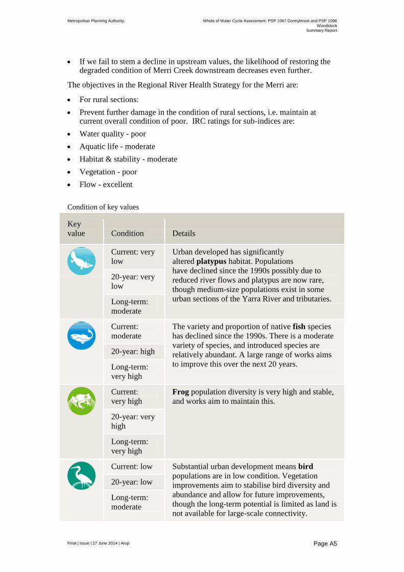
Metropolitan Planning Authority Whole of Water Cycle Assessment: PSP 1067 Donnybrook and PSP 1096
Woodstock Summary Report
Final | Issue | 27 June 2014 | Arup
Page A5
If we fail to stem a decline in upstream values, the likelihood of restoring the degraded condition of Merri Creek downstream decreases even further.
The objectives in the Regional River Health Strategy for the Merri are:
For rural sections:
Prevent further damage in the condition of rural sections, i.e. maintain at current overall condition of poor. IRC ratings for sub-indices are:
Water quality - poor
Aquatic life - moderate
Habitat & stability - moderate
Vegetation - poor
Flow - excellent
Condition of key values
Key
value Condition Details
Current: very
low
Urban developed has significantly
altered platypus habitat. Populations
have declined since the 1990s possibly due to
reduced river flows and platypus are now rare,
though medium-size populations exist in some
urban sections of the Yarra River and tributaries.
20-year: very
low
Long-term:
moderate
Current:
moderate
The variety and proportion of native fish species
has declined since the 1990s. There is a moderate
variety of species, and introduced species are
relatively abundant. A large range of works aims
to improve this over the next 20 years.
20-year: high
Long-term:
very high
Current:
very high
Frog population diversity is very high and stable,
and works aim to maintain this.
20-year: very
high
Long-term:
very high
Current: low Substantial urban development means bird
populations are in low condition. Vegetation
improvements aim to stabilise bird diversity and
abundance and allow for future improvements,
though the long-term potential is limited as land is
not available for large-scale connectivity.
20-year: low
Long-term:
moderate

Metropolitan Planning Authority Whole of Water Cycle Assessment: PSP 1067 Donnybrook and PSP 1096
Woodstock Summary Report
Final | Issue | 27 June 2014 | Arup
Page A6
Current: very
low*
Extensive vegetation clearing for urban
development has occurred over the past 200
years, so the condition is very low. Continued
investment in vegetation will improve this. 20-year:
moderate
Long-term:
high
Current: low Macroinvertebrate communities have been
affected by urban development and poor water
quality. Improvements to stormwater treatment
and vegetation aim to improve this condition.
20-year:
moderate
Long-term:
high
Current:
moderate
Amenity enjoyed from waterways is moderate,
with specific areas important for relaxation and
rejuvenation. Vegetation and litter management
works aim to improve amenity to high over the
next 20 years.
20-year: high
Long-term:
very high
* Limited data used to determine this rating
A1.3.1 Donnybrook
PSP 1067 is located within the Port Phillip and Western Port Catchment. Surface water runoff from within PSP 1067 will generally move in a westerly and south-westerly direction towards Merri Creek. Meinhardt (2013) note that Merri Creek transects the northern sector of the PSP area, flowing through properties 45, 44, 43 and 31 and then flows along the western boundary of PSP 1067.
A number of ephemeral watercourses also flow across the site and discharge into Merri Creek at the western boundary of the site. These water courses flow in a westerly and south-westerly direction. The water courses are most likely to flow during significant rainfall events.
A number of large dams are located in the PSP area. The dams are located on properties 35, 32 and 31. The dam located on property 35 is approximately 2 ha in area. The dam and area surrounding it is currently not allocated for development. Additionally a number of smaller dams are located across the site on majority of the larger properties within the PSP.
Inundation map from VWRM depicts land subject to inundation areas which were recorded along the flow path of Merri Creek at properties 45, 44, 43 and 31. A search of the Victorian Water Resources Data Warehouse (VWRDW) was undertaken by Meinhardt (2013) for floodways and 1 in 100yr flood information. No floodways or 1 in 100yr floods were identified within PSP 1067 boundaries. However inundation areas were identified along the flow path of Merri Creek, indicating potential flood zones.
Metropolitan Planning Authority Whole of Water Cycle Assessment: PSP 1067 Donnybrook and PSP 1096
Woodstock Summary Report
Final | Issue | 27 June 2014 | Arup
Page A7
A1.3.2 Woodstock
PSP 1096 is located within the Port Phillip and Western Port Catchment area. Surface water runoff from within PSP 1096 will generally move in a westerly and south-easterly direction towards Darebin Creek. Darebin Creek transects the south-eastern sector of the PSP area, flowing through Properties 20, 21, 22 and 23 and then flows in a southerly direction, where it eventually discharges into the Yarra River. Previous work by Meinhardt (2013) has noted that in the Woodstock area Darebin Creek appears to be an ephemeral feature.
A number of smaller dams are located across the site on generally located on the larger agricultural properties within the PSP.
Meinhardt (2013) noted that a search of the Victorian Water Resources Data Warehouse (VWRDW) was undertaken for floodways and 1 in 100yr flood information. No floodways or 1 in 100yr floods were identified within PSP 1096 boundaries.
A1.4 Groundwater
A1.4.1 Donnybrook
With reference to the DNRE Groundwater Beneficial Uses Map for South Western Victoria (1994) and the Melbourne Groundwater Directory, the groundwater beneath the site is present in two main aquifers, the upper Newer Volcanics aquifer, a fractured rock basalt aquifer, and a deeper regional bedrock aquifer within the Silurian aged formation.
Groundwater within the upper aquifer is expected to have salinity in the range of 1,000 - 13,000 mg/L TDS, which classifies the groundwater as Segments B and C under the Groundwater SEPP (1994). The Victorian Water Resources Map identified 19 registered boreholes within the site boundary of PSP 1067. Eight of the bores are registered for private use, where they are most likely used for domestic and/or stock watering capacity. The remaining 11 bores are used for monitoring and observation purposes (see Figure 19). No bores were registered for industrial groundwater extraction.
A1.4.2 Woodstock
A preliminary assessment of groundwater resources within the area by Meinhardt (2013) notes that with reference to the DNRE Groundwater Beneficial Uses Map for South Western Victoria (1994) and the Melbourne Groundwater Directory the groundwater beneath the site is present in two main aquifers, the upper Newer Volcanics aquifer, a fractured rock basalt aquifer, and a deeper regional bedrock aquifer within the Silurian aged formation. In the north-eastern portion of PSP 1096 the Newer Volcanics aquifer is not present and the bedrock aquifer is main aquifer beneath the site.
Groundwater within the upper aquifer is expected to have salinity in the range of 1,000 - 13,000 mg/L TDS, which classifies the groundwater as Segments B and C under the Groundwater SEPP (1994).
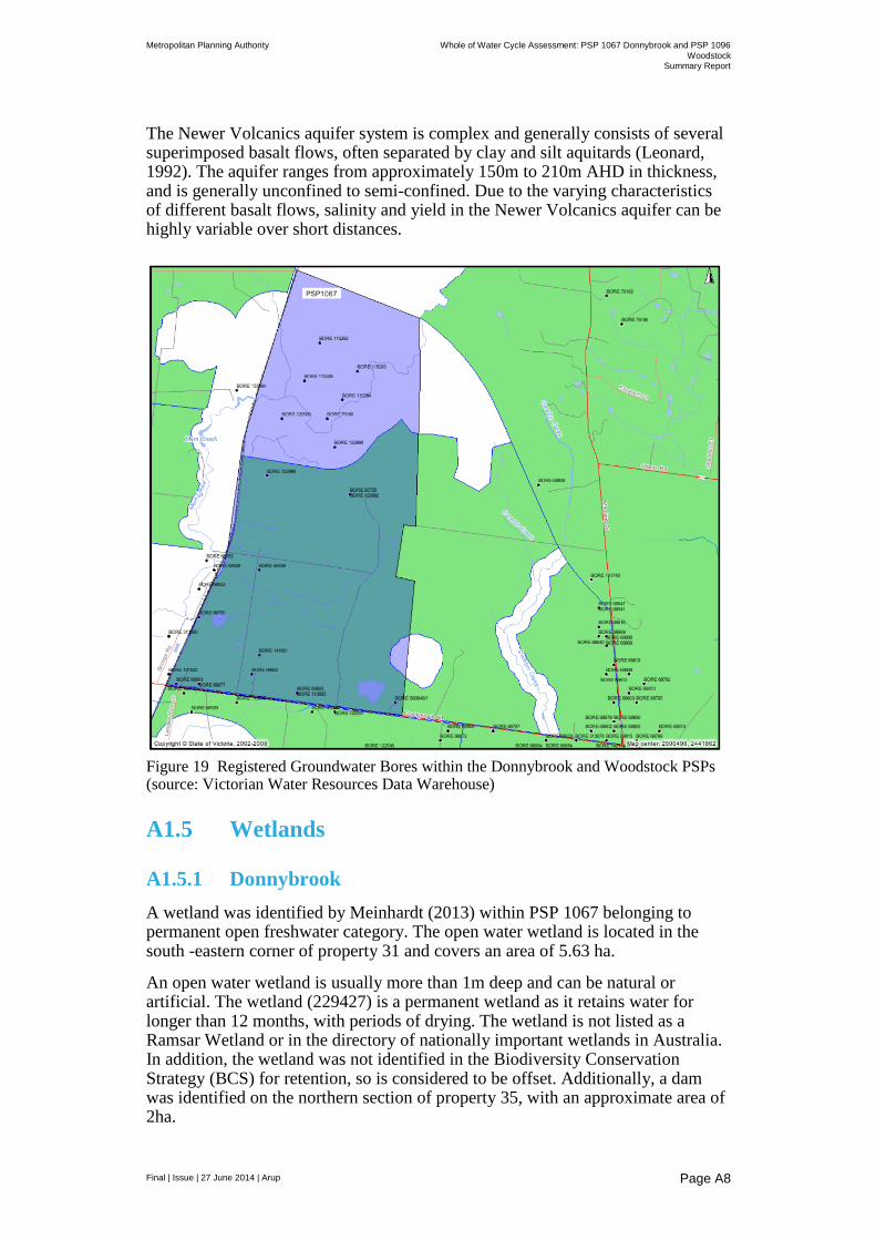
Metropolitan Planning Authority Whole of Water Cycle Assessment: PSP 1067 Donnybrook and PSP 1096
Woodstock Summary Report
Final | Issue | 27 June 2014 | Arup
Page A8
The Newer Volcanics aquifer system is complex and generally consists of several superimposed basalt flows, often separated by clay and silt aquitards (Leonard, 1992). The aquifer ranges from approximately 150m to 210m AHD in thickness, and is generally unconfined to semi-confined. Due to the varying characteristics of different basalt flows, salinity and yield in the Newer Volcanics aquifer can be highly variable over short distances.
Figure 19 Registered Groundwater Bores within the Donnybrook and Woodstock PSPs (source: Victorian Water Resources Data Warehouse)
A1.5 Wetlands
A1.5.1 Donnybrook
A wetland was identified by Meinhardt (2013) within PSP 1067 belonging to permanent open freshwater category. The open water wetland is located in the south -eastern corner of property 31 and covers an area of 5.63 ha.
An open water wetland is usually more than 1m deep and can be natural or artificial. The wetland (229427) is a permanent wetland as it retains water for longer than 12 months, with periods of drying. The wetland is not listed as a Ramsar Wetland or in the directory of nationally important wetlands in Australia. In addition, the wetland was not identified in the Biodiversity Conservation Strategy (BCS) for retention, so is considered to be offset. Additionally, a dam was identified on the northern section of property 35, with an approximate area of 2ha.
Metropolitan Planning Authority Whole of Water Cycle Assessment: PSP 1067 Donnybrook and PSP 1096
Woodstock Summary Report
Final | Issue | 27 June 2014 | Arup
Page A9
The need to protect native vegetation and animals along creek lines falls under the jurisdiction of DEPI and Melbourne Water, and it is generally understood that the Biodiversity Conservation Strategy (BCS) already considers the wetland as an ‘off set’ area.
A1.6 Woodstock
According to Meinhardt (2013) no wetlands were identified within PSP 1096.
A1.6.1 Water features adjacent to the site
A Heritage Citation Report by the City of Whittlesea (2009) notes the occurrence of mineral springs to the east of the Melbourne-Sydney train line. The citation notes that Donnybrook springs were reportedly used by early settlers in the area. However, it was not until 1912 that the Director of the Geological Survey (E.J. Dunn) formally reported the existence of two springs in the Donnybrook area. An Argus report from 21 February 1912 describes the water coming from the springs as being “a strong flow of excellent water of palatable quality.” By that time various developments had taken place and both springs had pipes driven in to them. The report, prepared by Dunn, recommended further development and that they be made “available to the public.”
Context (2013) notes that over the past century various attempts have been made to develop the springs as a going concern. On 1 November 1912, Donnybrook Mineral Springs Pty Ltd was established, but the business (for reasons that are unclear) failed and was deregistered on 9 May 1917. In 1920 an attempt was made to commercially bottle the spring water by O.T. Pty Ltd. In 1935, the land was bought from the Crown by W. H. Stone and an accommodation resort was developed. In 1953 the property was bought by Mr A. Sattler and the mineral water was being sold under the name of “Donny Spa.” The piping of the spring was reconditioned in 1958, but the accommodation side of the business was discontinued in 1960.
In 1983 the business was sold to Luigi Campeotto, the noted tenor. Campeotto planned to expand the business and build a $1.5 million natural spa complex; however, he struggled to obtain finance and, in the face of the 1990s recession, was ultimately declared bankrupt. In recent times, the complex has been bought by the Macedonian Orthodox Church, which is currently constructing a monastery on the site.

Appendix B
Workshop notes
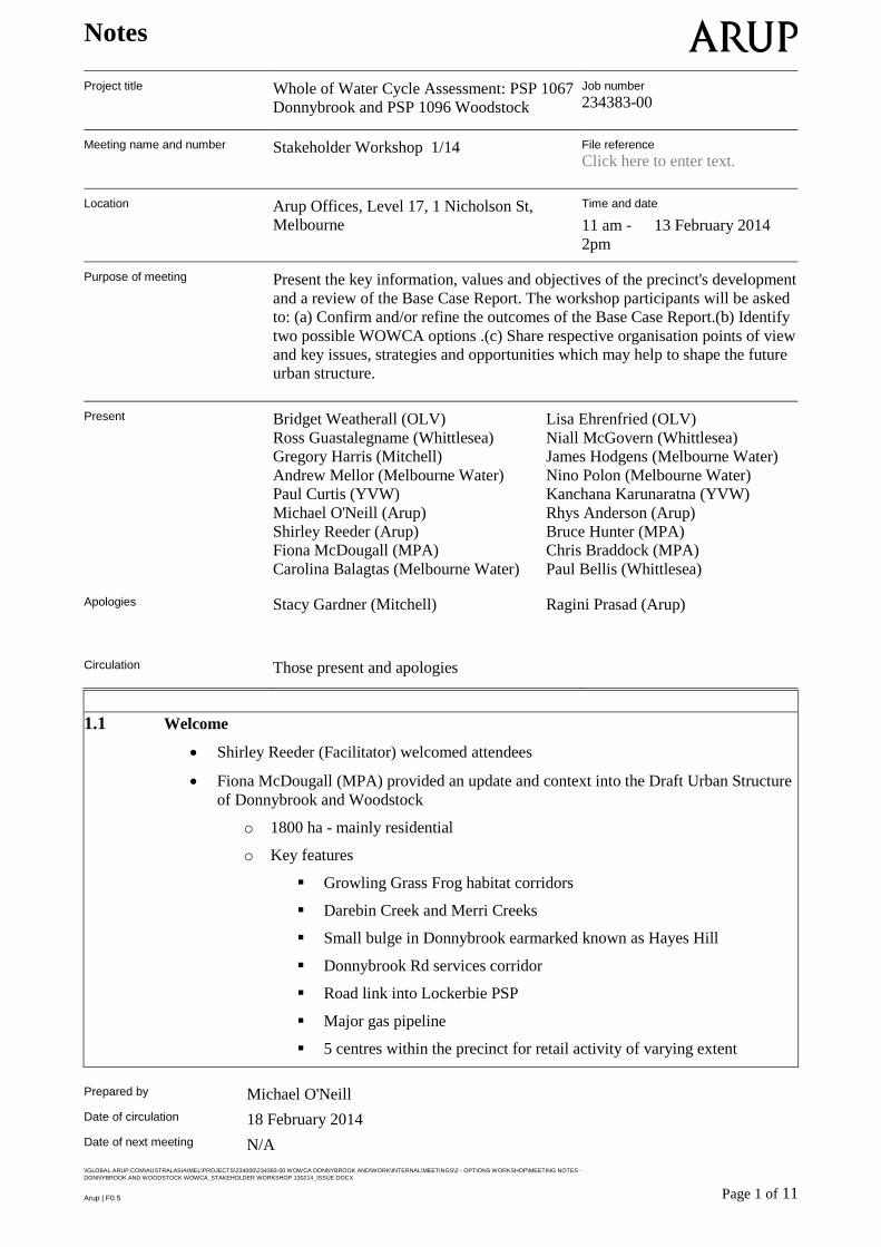
Notes
Prepared by Michael O'Neill
Date of circulation 18 February 2014
Date of next meeting N/A
\\GLOBAL.ARUP.COM\AUSTRALASIA\MEL\PROJECTS\234000\234383-00 WOWCA DONNYBROOK AND\WORK\INTERNAL\MEETINGS\2 - OPTIONS WORKSHOP\MEETING NOTES -
DONNYBROOK AND WOODSTOCK WOWCA_STAKEHOLDER WORKSHOP 130214_ISSUE.DOCX
Page 1 of 11 Arup | F0.5
Project title Whole of Water Cycle Assessment: PSP 1067
Donnybrook and PSP 1096 Woodstock
Job number
234383-00
Meeting name and number Stakeholder Workshop 1/14 File reference
Click here to enter text.
Location Arup Offices, Level 17, 1 Nicholson St,
Melbourne
Time and date
11 am -
2pm
13 February 2014
Purpose of meeting Present the key information, values and objectives of the precinct's development
and a review of the Base Case Report. The workshop participants will be asked
to: (a) Confirm and/or refine the outcomes of the Base Case Report.(b) Identify
two possible WOWCA options .(c) Share respective organisation points of view
and key issues, strategies and opportunities which may help to shape the future
urban structure.
Present Bridget Weatherall (OLV) Lisa Ehrenfried (OLV)
Ross Guastalegname (Whittlesea) Niall McGovern (Whittlesea)
Gregory Harris (Mitchell) James Hodgens (Melbourne Water)
Andrew Mellor (Melbourne Water) Nino Polon (Melbourne Water)
Paul Curtis (YVW) Kanchana Karunaratna (YVW)
Michael O'Neill (Arup) Rhys Anderson (Arup)
Shirley Reeder (Arup) Bruce Hunter (MPA)
Fiona McDougall (MPA) Chris Braddock (MPA)
Carolina Balagtas (Melbourne Water) Paul Bellis (Whittlesea) Apologies Stacy Gardner (Mitchell) Ragini Prasad (Arup)
Circulation Those present and apologies
1.1 Welcome
Shirley Reeder (Facilitator) welcomed attendees
Fiona McDougall (MPA) provided an update and context into the Draft Urban Structure
of Donnybrook and Woodstock
o 1800 ha - mainly residential
o Key features
Growling Grass Frog habitat corridors
Darebin Creek and Merri Creeks
Small bulge in Donnybrook earmarked known as Hayes Hill
Donnybrook Rd services corridor
Road link into Lockerbie PSP
Major gas pipeline
5 centres within the precinct for retail activity of varying extent
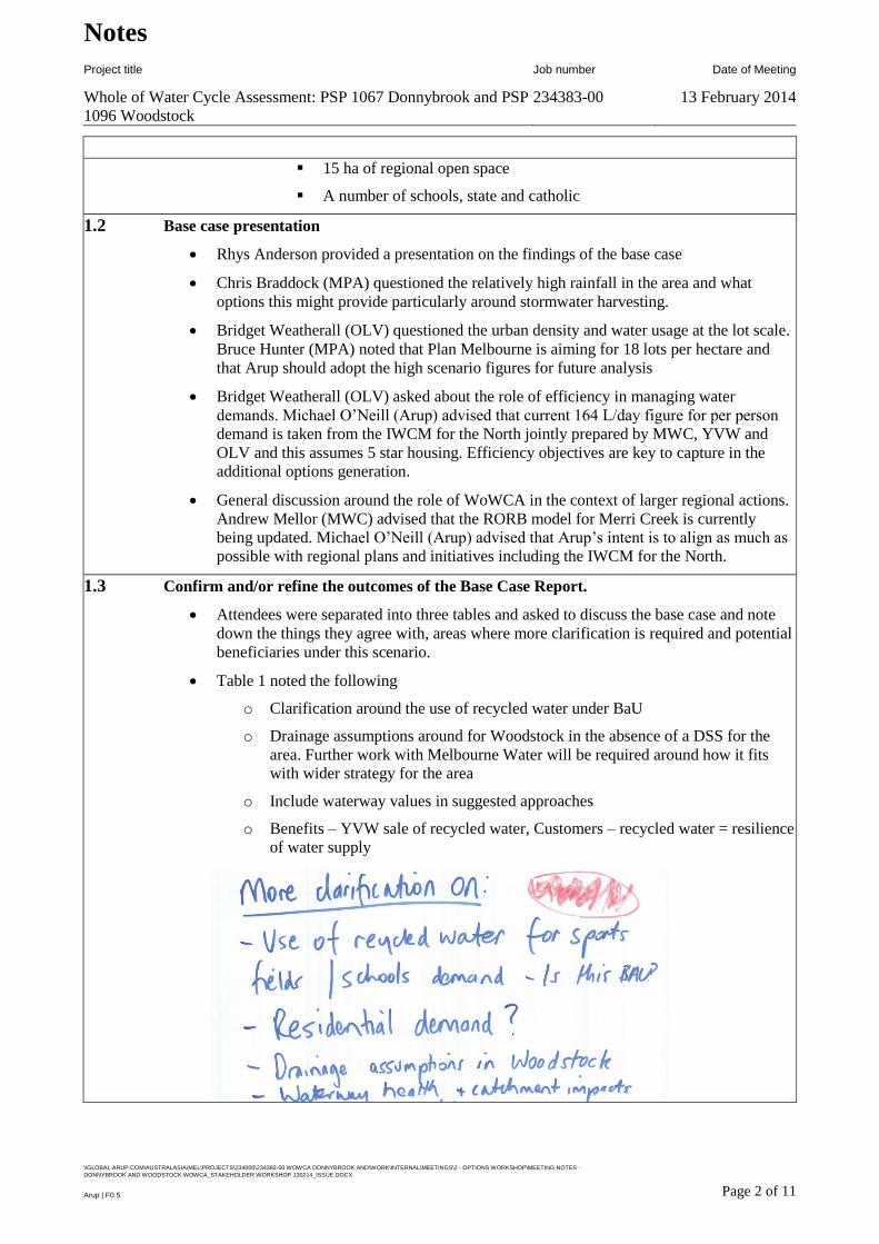
Notes
Project title Job number Date of Meeting
Whole of Water Cycle Assessment: PSP 1067 Donnybrook and PSP
1096 Woodstock
234383-00 13 February 2014
\\GLOBAL.ARUP.COM\AUSTRALASIA\MEL\PROJECTS\234000\234383-00 WOWCA DONNYBROOK AND\WORK\INTERNAL\MEETINGS\2 - OPTIONS WORKSHOP\MEETING NOTES -
DONNYBROOK AND WOODSTOCK WOWCA_STAKEHOLDER WORKSHOP 130214_ISSUE.DOCX
Page 2 of 11 Arup | F0.5
15 ha of regional open space
A number of schools, state and catholic
1.2 Base case presentation
Rhys Anderson provided a presentation on the findings of the base case
Chris Braddock (MPA) questioned the relatively high rainfall in the area and what
options this might provide particularly around stormwater harvesting.
Bridget Weatherall (OLV) questioned the urban density and water usage at the lot scale.
Bruce Hunter (MPA) noted that Plan Melbourne is aiming for 18 lots per hectare and
that Arup should adopt the high scenario figures for future analysis
Bridget Weatherall (OLV) asked about the role of efficiency in managing water
demands. Michael O’Neill (Arup) advised that current 164 L/day figure for per person
demand is taken from the IWCM for the North jointly prepared by MWC, YVW and
OLV and this assumes 5 star housing. Efficiency objectives are key to capture in the
additional options generation.
General discussion around the role of WoWCA in the context of larger regional actions.
Andrew Mellor (MWC) advised that the RORB model for Merri Creek is currently
being updated. Michael O’Neill (Arup) advised that Arup’s intent is to align as much as
possible with regional plans and initiatives including the IWCM for the North.
1.3 Confirm and/or refine the outcomes of the Base Case Report.
Attendees were separated into three tables and asked to discuss the base case and note
down the things they agree with, areas where more clarification is required and potential
beneficiaries under this scenario.
Table 1 noted the following
o Clarification around the use of recycled water under BaU
o Drainage assumptions around for Woodstock in the absence of a DSS for the
area. Further work with Melbourne Water will be required around how it fits
with wider strategy for the area
o Include waterway values in suggested approaches
o Benefits – YVW sale of recycled water, Customers – recycled water = resilience
of water supply
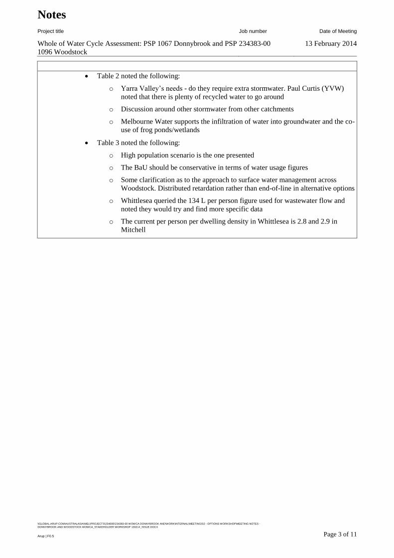
Notes
Project title Job number Date of Meeting
Whole of Water Cycle Assessment: PSP 1067 Donnybrook and PSP
1096 Woodstock
234383-00 13 February 2014
\\GLOBAL.ARUP.COM\AUSTRALASIA\MEL\PROJECTS\234000\234383-00 WOWCA DONNYBROOK AND\WORK\INTERNAL\MEETINGS\2 - OPTIONS WORKSHOP\MEETING NOTES -
DONNYBROOK AND WOODSTOCK WOWCA_STAKEHOLDER WORKSHOP 130214_ISSUE.DOCX
Page 3 of 11 Arup | F0.5
Table 2 noted the following:
o Yarra Valley’s needs - do they require extra stormwater. Paul Curtis (YVW)
noted that there is plenty of recycled water to go around
o Discussion around other stormwater from other catchments
o Melbourne Water supports the infiltration of water into groundwater and the co-
use of frog ponds/wetlands
Table 3 noted the following:
o High population scenario is the one presented
o The BaU should be conservative in terms of water usage figures
o Some clarification as to the approach to surface water management across
Woodstock. Distributed retardation rather than end-of-line in alternative options
o Whittlesea queried the 134 L per person figure used for wastewater flow and
noted they would try and find more specific data
o The current per person per dwelling density in Whittlesea is 2.8 and 2.9 in
Mitchell
Notes
Project title Job number Date of Meeting
Whole of Water Cycle Assessment: PSP 1067 Donnybrook and PSP
1096 Woodstock
234383-00 13 February 2014
\\GLOBAL.ARUP.COM\AUSTRALASIA\MEL\PROJECTS\234000\234383-00 WOWCA DONNYBROOK AND\WORK\INTERNAL\MEETINGS\2 - OPTIONS WORKSHOP\MEETING NOTES -
DONNYBROOK AND WOODSTOCK WOWCA_STAKEHOLDER WORKSHOP 130214_ISSUE.DOCX
Page 4 of 11 Arup | F0.5
1.4 Options development exercise - WoWCA
Table 1 – Option development
o Objectives
Maximise use of recycled water
Waterway health
o How do we achieve it?
Connectivity along drainage lines
Harvesting of stormwater to irrigate open space
Export of excess water
Rainwater tanks – leaky tanks (management of flow events), provide for
hot water
Distributed systems for surface water management
o Problems/opportunities
Developers - one not necessarily keen – other might be
Affordability is key
Demographics – upgrade buyers vs first home owners
Opportunities/interface
Working with BPEM review

Notes
Project title Job number Date of Meeting
Whole of Water Cycle Assessment: PSP 1067 Donnybrook and PSP
1096 Woodstock
234383-00 13 February 2014
\\GLOBAL.ARUP.COM\AUSTRALASIA\MEL\PROJECTS\234000\234383-00 WOWCA DONNYBROOK AND\WORK\INTERNAL\MEETINGS\2 - OPTIONS WORKSHOP\MEETING NOTES -
DONNYBROOK AND WOODSTOCK WOWCA_STAKEHOLDER WORKSHOP 130214_ISSUE.DOCX
Page 5 of 11 Arup | F0.5
2 developers not 11
Self-sustaining open space (multi-use)
Over capitalising infrastructure
Division of public / private responsibilities
Health – risks and benefits (open and connected), shade and amenity
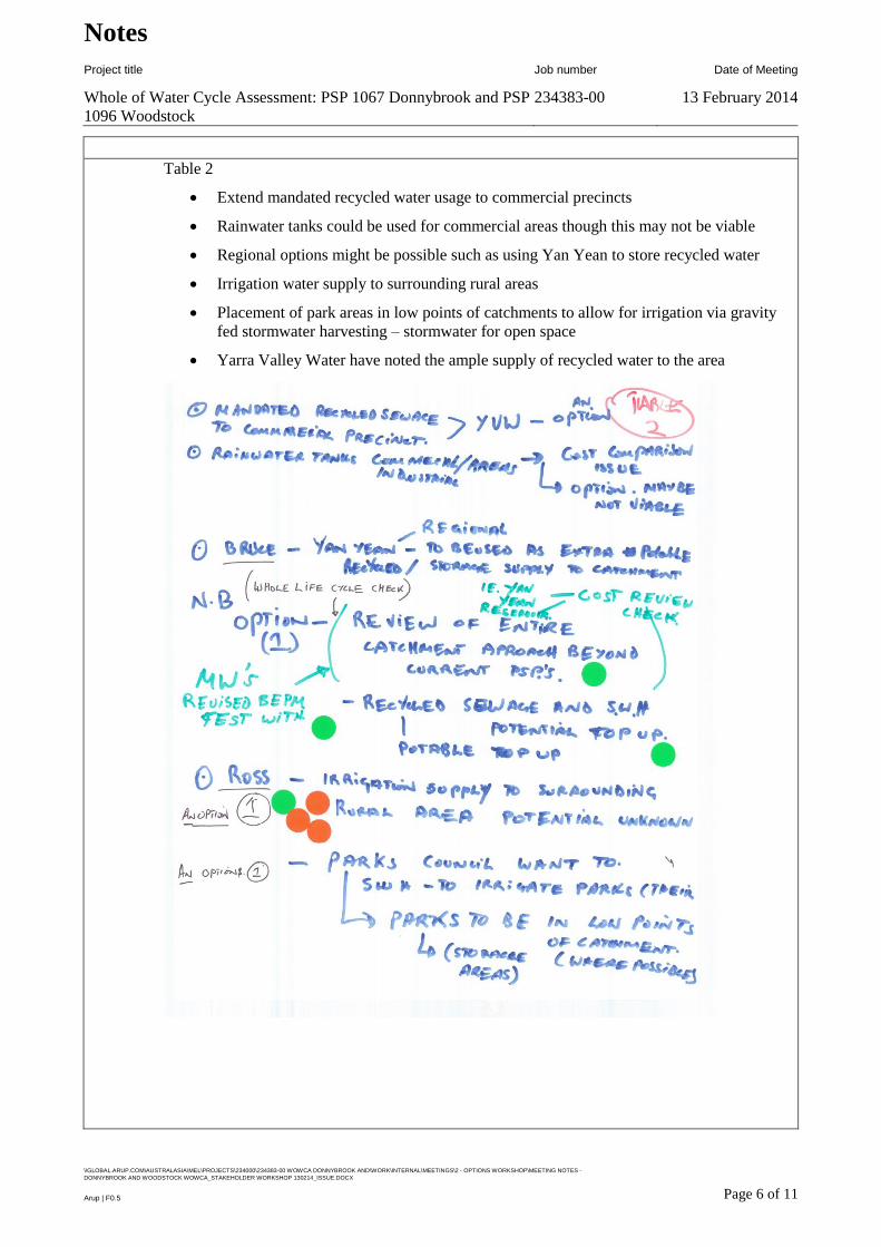
Notes
Project title Job number Date of Meeting
Whole of Water Cycle Assessment: PSP 1067 Donnybrook and PSP
1096 Woodstock
234383-00 13 February 2014
\\GLOBAL.ARUP.COM\AUSTRALASIA\MEL\PROJECTS\234000\234383-00 WOWCA DONNYBROOK AND\WORK\INTERNAL\MEETINGS\2 - OPTIONS WORKSHOP\MEETING NOTES -
DONNYBROOK AND WOODSTOCK WOWCA_STAKEHOLDER WORKSHOP 130214_ISSUE.DOCX
Page 6 of 11 Arup | F0.5
Table 2
Extend mandated recycled water usage to commercial precincts
Rainwater tanks could be used for commercial areas though this may not be viable
Regional options might be possible such as using Yan Yean to store recycled water
Irrigation water supply to surrounding rural areas
Placement of park areas in low points of catchments to allow for irrigation via gravity
fed stormwater harvesting – stormwater for open space
Yarra Valley Water have noted the ample supply of recycled water to the area
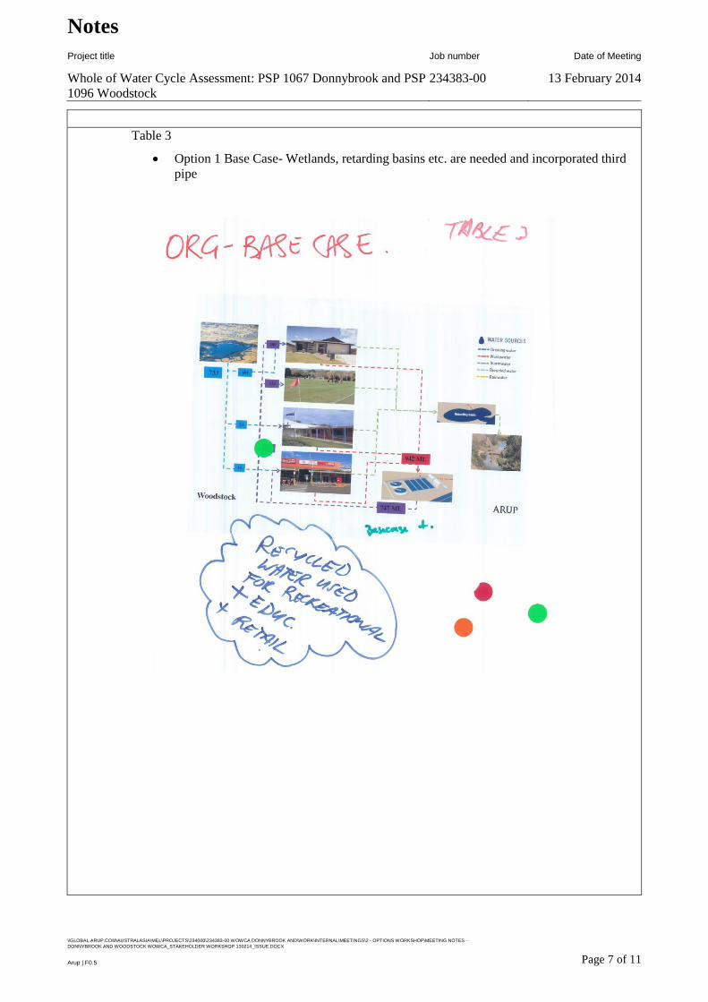
Notes
Project title Job number Date of Meeting
Whole of Water Cycle Assessment: PSP 1067 Donnybrook and PSP
1096 Woodstock
234383-00 13 February 2014
\\GLOBAL.ARUP.COM\AUSTRALASIA\MEL\PROJECTS\234000\234383-00 WOWCA DONNYBROOK AND\WORK\INTERNAL\MEETINGS\2 - OPTIONS WORKSHOP\MEETING NOTES -
DONNYBROOK AND WOODSTOCK WOWCA_STAKEHOLDER WORKSHOP 130214_ISSUE.DOCX
Page 7 of 11 Arup | F0.5
Table 3
Option 1 Base Case- Wetlands, retarding basins etc. are needed and incorporated third
pipe
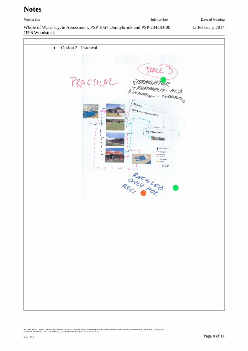
Notes
Project title Job number Date of Meeting
Whole of Water Cycle Assessment: PSP 1067 Donnybrook and PSP
1096 Woodstock
234383-00 13 February 2014
\\GLOBAL.ARUP.COM\AUSTRALASIA\MEL\PROJECTS\234000\234383-00 WOWCA DONNYBROOK AND\WORK\INTERNAL\MEETINGS\2 - OPTIONS WORKSHOP\MEETING NOTES -
DONNYBROOK AND WOODSTOCK WOWCA_STAKEHOLDER WORKSHOP 130214_ISSUE.DOCX
Page 8 of 11 Arup | F0.5
Option 2 - Practical
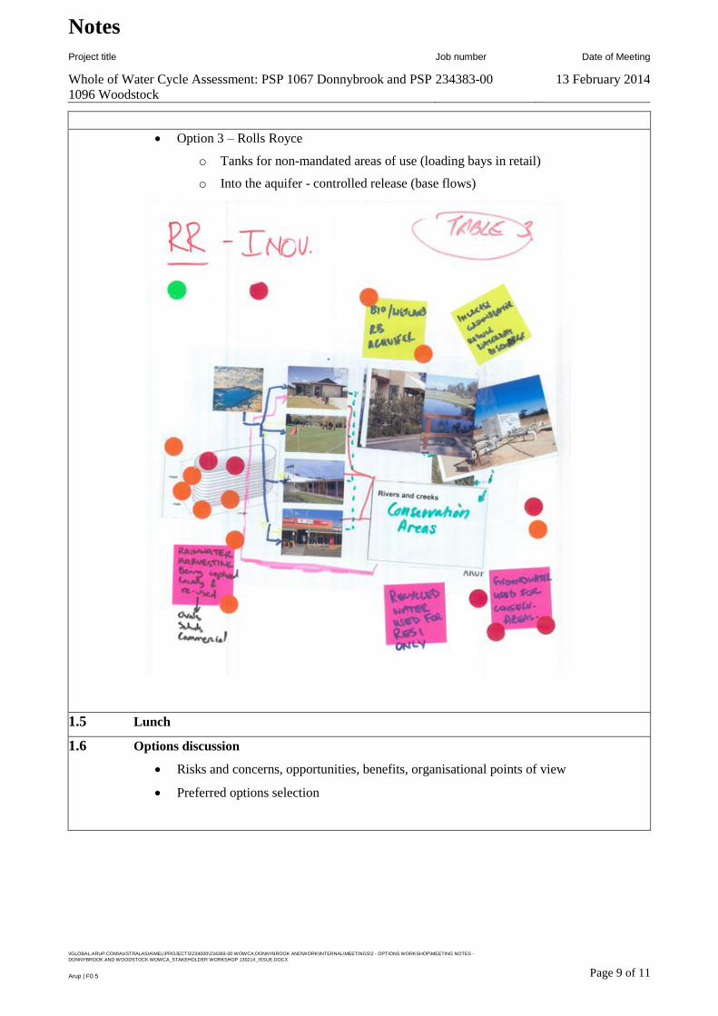
Notes
Project title Job number Date of Meeting
Whole of Water Cycle Assessment: PSP 1067 Donnybrook and PSP
1096 Woodstock
234383-00 13 February 2014
\\GLOBAL.ARUP.COM\AUSTRALASIA\MEL\PROJECTS\234000\234383-00 WOWCA DONNYBROOK AND\WORK\INTERNAL\MEETINGS\2 - OPTIONS WORKSHOP\MEETING NOTES -
DONNYBROOK AND WOODSTOCK WOWCA_STAKEHOLDER WORKSHOP 130214_ISSUE.DOCX
Page 9 of 11 Arup | F0.5
Option 3 – Rolls Royce
o Tanks for non-mandated areas of use (loading bays in retail)
o Into the aquifer - controlled release (base flows)
1.5 Lunch
1.6 Options discussion
Risks and concerns, opportunities, benefits, organisational points of view
Preferred options selection
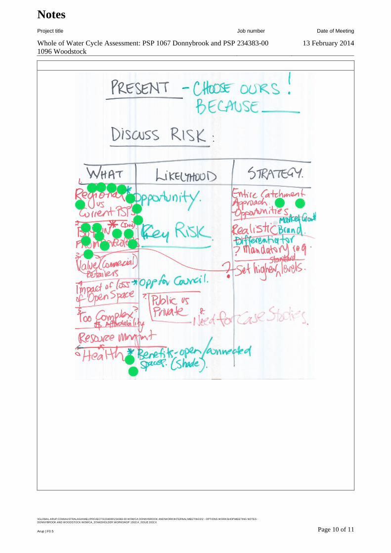
Notes
Project title Job number Date of Meeting
Whole of Water Cycle Assessment: PSP 1067 Donnybrook and PSP
1096 Woodstock
234383-00 13 February 2014
\\GLOBAL.ARUP.COM\AUSTRALASIA\MEL\PROJECTS\234000\234383-00 WOWCA DONNYBROOK AND\WORK\INTERNAL\MEETINGS\2 - OPTIONS WORKSHOP\MEETING NOTES -
DONNYBROOK AND WOODSTOCK WOWCA_STAKEHOLDER WORKSHOP 130214_ISSUE.DOCX
Page 10 of 11 Arup | F0.5
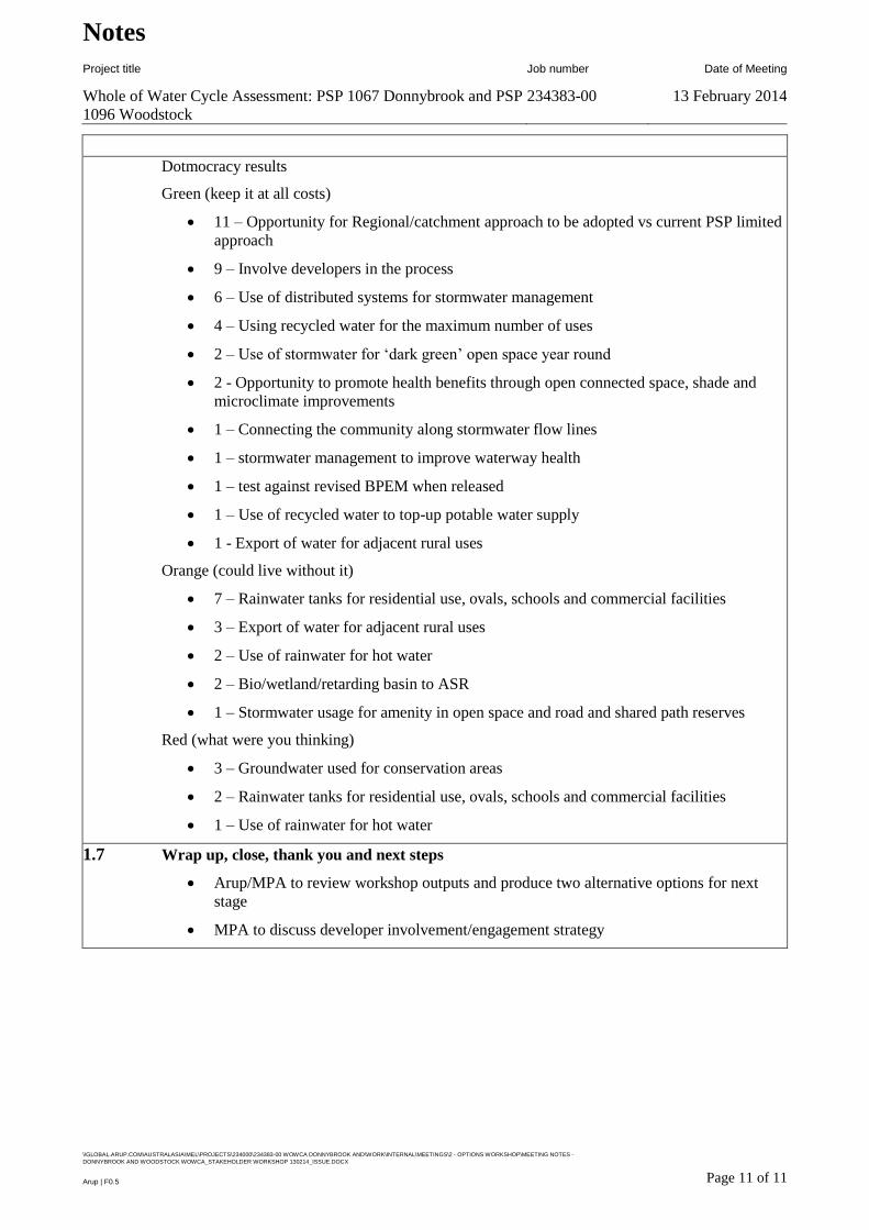
Notes
Project title Job number Date of Meeting
Whole of Water Cycle Assessment: PSP 1067 Donnybrook and PSP
1096 Woodstock
234383-00 13 February 2014
\\GLOBAL.ARUP.COM\AUSTRALASIA\MEL\PROJECTS\234000\234383-00 WOWCA DONNYBROOK AND\WORK\INTERNAL\MEETINGS\2 - OPTIONS WORKSHOP\MEETING NOTES -
DONNYBROOK AND WOODSTOCK WOWCA_STAKEHOLDER WORKSHOP 130214_ISSUE.DOCX
Page 11 of 11 Arup | F0.5
Dotmocracy results
Green (keep it at all costs)
11 – Opportunity for Regional/catchment approach to be adopted vs current PSP limited
approach
9 – Involve developers in the process
6 – Use of distributed systems for stormwater management
4 – Using recycled water for the maximum number of uses
2 – Use of stormwater for ‘dark green’ open space year round
2 - Opportunity to promote health benefits through open connected space, shade and
microclimate improvements
1 – Connecting the community along stormwater flow lines
1 – stormwater management to improve waterway health
1 – test against revised BPEM when released
1 – Use of recycled water to top-up potable water supply
1 - Export of water for adjacent rural uses
Orange (could live without it)
7 – Rainwater tanks for residential use, ovals, schools and commercial facilities
3 – Export of water for adjacent rural uses
2 – Use of rainwater for hot water
2 – Bio/wetland/retarding basin to ASR
1 – Stormwater usage for amenity in open space and road and shared path reserves
Red (what were you thinking)
3 – Groundwater used for conservation areas
2 – Rainwater tanks for residential use, ovals, schools and commercial facilities
1 – Use of rainwater for hot water
1.7 Wrap up, close, thank you and next steps
Arup/MPA to review workshop outputs and produce two alternative options for next
stage
MPA to discuss developer involvement/engagement strategy

Metropolitan Planning Authority Whole of Water Cycle Assessment: PSP 1067 Donnybrook and PSP 1096
Woodstock Summary Report
Final | Issue | 27 June 2014 | Arup
Page B1
B1

Appendix C
Stakeholder Commentary

Metropolitan Planning Authority Whole of Water Cycle Assessment: PSP 1067 Donnybrook and PSP 1096 Woodstock
Summary Report
Final | Issue | 27 June 2014 | Arup
Page C1
C1 Stakeholder commentary and associated actions
Date Received Organisation Report Reference Comment Text Action
29/05/2014 City of Whittlesea 3.2.2 Alternative 2 -
Base Case +
3.3.4.3 Treated
Stormwater
It is considered that the Alternative 1 - Base Case + scenario is achievable;
Alternative 1 – Base Case + can be remodelled to include stormwater harvesting;
Council’s is committed to the irrigation of active open space, in particular to ensure
that these areas are available during periods of draught;
The stormwater harvesting proposal should also include high flow capture; and
if feasible and supported, can stormwater harvesting be included as a DCP item
(either in full or in part)?
Note support – optimise
location and harvesting volumes
in future stages
29/05/2014 City of Whittlesea 3.2.3 Alternative 2 -
Future Stretch
Some elements of the Alternative 2 – Future Stretch scenario appear less likely to
be realised. In particular the combination of:
• Rainwater tank installation at lot level, given MWC risk related comments
regarding the detention of flows in high flow events;
• Stormwater harvesting (amended as suggested above);
• Distributed WSUD assets throughout the precincts; and
• Aquifer storage and recovery
Note
29/05/2014 City of Whittlesea 3.2.3 Alternative 2 -
Future Stretch
Some refinement of the above mentioned elements for Alternative 2 – Future
Stretch, will likely result in this option being more achievable. Suggested tinkering
below:
• Rainwater tank installation for commercial/retail, education and open space
pavilions instead of residential;
• Stormwater harvesting as above;
• All WSUD assets to treat a minimum size of 5ha and therefore located
appropriately within the precinct, to rationalise the number of future assets
requiring maintenance and as such minimise the associated financial obligation;
and
• Aquifer recharge and delivery of water to the river red gum conservation
area, as opposed to storage and recovery
• The proposed colocation of wetlands and retarding basins in close proximity
to active open space is supported;
• The amount of retardation required for the Donnybrook catchment falling
west towards Merri Creek, could be amended if the existing culverts beneath the
Mel-Syd railway line are upgraded. To be confirmed by MWC;
Consider in future stages

Metropolitan Planning Authority Whole of Water Cycle Assessment: PSP 1067 Donnybrook and PSP 1096 Woodstock
Summary Report
Final | Issue | 27 June 2014 | Arup
Page C2
• Nominated wetland figures of extended detention and permanent pool depths
of 0.35m are supported;
• Grassed batter slopes must be 1:6. The proposed 1:3 is not supported;
• Open Space should have some sewer discharge included for public amenity,
sporting club pavilions; and
• The ‘flooding’ or watering of the existing River Red Gum/conservation
zones should be investigated and included as part of the WoWCA;
29/05/2014 City of Whittlesea General - Flood
protection
There should be some discussion about the staged delivery of the ultimate flood
protection infrastructure i.e. consider that 30% of the residential subdivision has
been constructed, but based on locality the need for a retarding basin has not yet
been met and therefore not built. During this interim arrangement, an extreme
rainfall event occurs (say 100 ARI) and there is no flood protection of properties
nor protection of the receiving waterways;
Staging requirements should be
considered in future stages
23/05/2014 Melbourne Water 5.3.2 Land Take
Requirements
Alternative 1 and 2
There are 4 retarding basins that are generally in the same locations in the
Donnybrook PSP and the 2 designed DSS’s, but the land areas are significantly
different. There is insufficient information in the Arup report to assess the methods
used to determine these sizes. Further discussions are needed in conjunction with
the MPA prior to the drafting of the PSP to agree on suitable land areas.
Further discussions between
MPA and Melbourne Water to
agree on suitable land areas and
locations.
23/05/2014 Melbourne Water 5.3.1.1 Donnybrook
(Land Take)
Donnybrook RB 2 location - The WOWCA location is north of the road, whereas
the DSS location is south of the road. The DSS location is considered more
appropriate as it is adjacent to the existing culvert under the railway line, it is in the
lower land and it is closer to the waterway that drains most of the large catchment
leading to this basin.
It is noted that the PSP does not show the waterway leading to RB 2 and land area
will be needed for this waterway.
Reconsider Donnybrook RB2
WOWCA location in future
stages based on additional
information from Melbourne
Water.

Metropolitan Planning Authority Whole of Water Cycle Assessment: PSP 1067 Donnybrook and PSP 1096 Woodstock
Summary Report
Final | Issue | 27 June 2014 | Arup
Page C3
23/05/2014 Melbourne Water 5.3.1.1 Donnybrook
(Land Take)
Donnybrook RB 2 and WL 2b location - The proposed location in the WOWCA
Alternative 1 is in a gully and so could work as a retarding basin and wetland.
However, the catchment is quite small and it is unlikely that RB 2a and RB 2b
would be large enough together to provide enough retardation for the overall
catchment draining to the railway culvert.
Review sizes and locations of
RB2a and RB 2b to provide
enough retardation for their
individual catchments.
23/05/2014 Melbourne Water 5.3.1.1 Donnybrook
(Land Take)
Donnybrook RB 2 and WL 3 location - The WOWCA location of the basin and
wetland is within the conservation reserve. This would need to be approved by
DEPI. Until such approval is received, the DSS does not propose works in the
reserve.
The DSS proposes a linear retarding basin just upstream of the reserve and another
retarding basin in the depression further upstream.
In the WOWCA Alternative 1, RB 3 is split into two basins, with RB and WL 3b
located away from the waterway. It would require water to be diverted from the
waterway to this location. This may be possible for low flows for the wetland and
for stormwater reuse, but the retarding basin needs to be
where the flood flows are. Therefore, if the wetland is to be co‐located in the
retarding basin, then a waterway would be needed to direct flood flows to the
retarding basin. For this reason, the location of the retarding basin RB 3b is not
considered practical.
Note that RB2 and WL3
location require DEPI approval
due to being in the conservation
reserve.
Review RB 3b location in future
stages
23/05/2014 Melbourne Water 5.3.1.1 Donnybrook
(Land Take)
Donnybrook RB 4 location - The WOWCA location is next to Donnybrook Road,
whereas the DSS location is further north adjacent to the railway. The DSS location
is considered more appropriate as it is adjacent to the existing culvert under the
railway line and it is in the lower land by at least 5 metres.
Note
23/05/2014 Melbourne Water 5.3.1.2 Woodstock
(Land Take)
Woodstock RB 1 location - Given the constraints, the WOWCA location RB 1 is
reasonable. It would retard flows from a reasonable catchment of future
development on the south western side of Darebin Creek.
Note
23/05/2014 Melbourne Water 5.3.1.2 Woodstock
(Land Take)
Woodstock RB 1b location - In the WOWCA Alternative 1, RB 1 is split into two
basins, with RB and WL 1b located near a reserve. This location is very impractical
as it is near the top of the ridgeline. There would be only a very small catchment
draining there and so no need for a retarding basin and limited water for a wetland.
Reconsider RB 1b need and
location, taking into account the
ridgeline in future stages
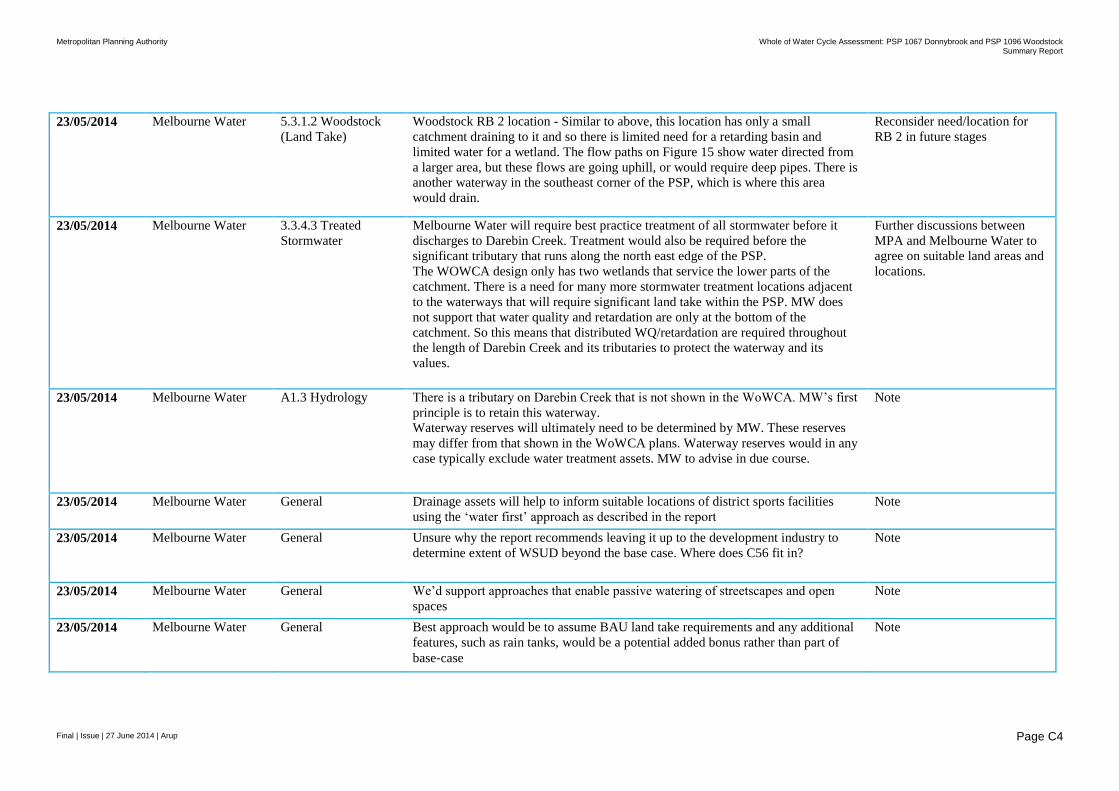
Metropolitan Planning Authority Whole of Water Cycle Assessment: PSP 1067 Donnybrook and PSP 1096 Woodstock
Summary Report
Final | Issue | 27 June 2014 | Arup
Page C4
23/05/2014 Melbourne Water 5.3.1.2 Woodstock
(Land Take)
Woodstock RB 2 location - Similar to above, this location has only a small
catchment draining to it and so there is limited need for a retarding basin and
limited water for a wetland. The flow paths on Figure 15 show water directed from
a larger area, but these flows are going uphill, or would require deep pipes. There is
another waterway in the southeast corner of the PSP, which is where this area
would drain.
Reconsider need/location for
RB 2 in future stages
23/05/2014 Melbourne Water 3.3.4.3 Treated
Stormwater
Melbourne Water will require best practice treatment of all stormwater before it
discharges to Darebin Creek. Treatment would also be required before the
significant tributary that runs along the north east edge of the PSP.
The WOWCA design only has two wetlands that service the lower parts of the
catchment. There is a need for many more stormwater treatment locations adjacent
to the waterways that will require significant land take within the PSP. MW does
not support that water quality and retardation are only at the bottom of the
catchment. So this means that distributed WQ/retardation are required throughout
the length of Darebin Creek and its tributaries to protect the waterway and its
values.
Further discussions between
MPA and Melbourne Water to
agree on suitable land areas and
locations.
23/05/2014 Melbourne Water A1.3 Hydrology There is a tributary on Darebin Creek that is not shown in the WoWCA. MW’s first
principle is to retain this waterway.
Waterway reserves will ultimately need to be determined by MW. These reserves
may differ from that shown in the WoWCA plans. Waterway reserves would in any
case typically exclude water treatment assets. MW to advise in due course.
Note
23/05/2014 Melbourne Water General Drainage assets will help to inform suitable locations of district sports facilities
using the ‘water first’ approach as described in the report
Note
23/05/2014 Melbourne Water General Unsure why the report recommends leaving it up to the development industry to
determine extent of WSUD beyond the base case. Where does C56 fit in?
Note
23/05/2014 Melbourne Water General We’d support approaches that enable passive watering of streetscapes and open
spaces
Note
23/05/2014 Melbourne Water General Best approach would be to assume BAU land take requirements and any additional
features, such as rain tanks, would be a potential added bonus rather than part of
base‐case
Note
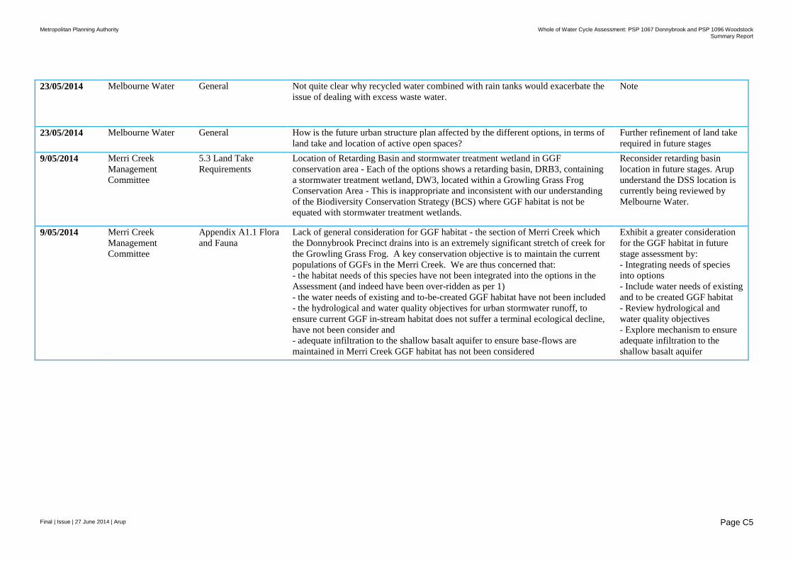
Metropolitan Planning Authority Whole of Water Cycle Assessment: PSP 1067 Donnybrook and PSP 1096 Woodstock
Summary Report
Final | Issue | 27 June 2014 | Arup
Page C5
23/05/2014 Melbourne Water General Not quite clear why recycled water combined with rain tanks would exacerbate the
issue of dealing with excess waste water.
Note
23/05/2014 Melbourne Water General How is the future urban structure plan affected by the different options, in terms of
land take and location of active open spaces?
Further refinement of land take
required in future stages
9/05/2014 Merri Creek
Management
Committee
5.3 Land Take
Requirements
Location of Retarding Basin and stormwater treatment wetland in GGF
conservation area - Each of the options shows a retarding basin, DRB3, containing
a stormwater treatment wetland, DW3, located within a Growling Grass Frog
Conservation Area - This is inappropriate and inconsistent with our understanding
of the Biodiversity Conservation Strategy (BCS) where GGF habitat is not be
equated with stormwater treatment wetlands.
Reconsider retarding basin
location in future stages. Arup
understand the DSS location is
currently being reviewed by
Melbourne Water.
9/05/2014 Merri Creek
Management
Committee
Appendix A1.1 Flora
and Fauna
Lack of general consideration for GGF habitat - the section of Merri Creek which
the Donnybrook Precinct drains into is an extremely significant stretch of creek for
the Growling Grass Frog. A key conservation objective is to maintain the current
populations of GGFs in the Merri Creek. We are thus concerned that:
- the habitat needs of this species have not been integrated into the options in the
Assessment (and indeed have been over-ridden as per 1)
- the water needs of existing and to-be-created GGF habitat have not been included
- the hydrological and water quality objectives for urban stormwater runoff, to
ensure current GGF in-stream habitat does not suffer a terminal ecological decline,
have not been consider and
- adequate infiltration to the shallow basalt aquifer to ensure base-flows are
maintained in Merri Creek GGF habitat has not been considered
Exhibit a greater consideration
for the GGF habitat in future
stage assessment by:
- Integrating needs of species
into options
- Include water needs of existing
and to be created GGF habitat
- Review hydrological and
water quality objectives
- Explore mechanism to ensure
adequate infiltration to the
shallow basalt aquifer

Metropolitan Planning Authority Whole of Water Cycle Assessment: PSP 1067 Donnybrook and PSP 1096 Woodstock
Summary Report
Final | Issue | 27 June 2014 | Arup
Page C6
9/05/2014 Merri Creek
Management
Committee
Appendix A1.1 Flora
and Fauna
and
3.3.4.3 Treated
Stormwater
Impact on Merri Creek ecological health - MCMC is deeply concerned at the
predictions of Walsh et al (2013) that use of current 'best practice' urban stormwater
management practices will result in the loss of existing ecological values in upper
Merri Creek.
Although Option 2 - Future Stretch - includes features that should help achieve
better than 'best practice' these standards don't seem to be specified. We would like
to see each of the options assessed against stormwater flow objectives, both the
extent to which they reduce the 'flashiness' of typical urban flows and the extent to
which they provide infiltration to maintain base-flows. In this way, impact on
stream ecological health can be assessed.
The only comparison the draft WWC Assessment provides by way of ecological
impacts on waterways is water quality (limited to 3 parameters). We are
disappointed that impacts on ecological health of Merri Creek are not (yet) an
explicit part of the assessment and hope to see this rectified.
Ensure that the ecological health
of the Merri Creek is an explicit
part of assessments in future
stages.
9/05/2014 Merri Creek
Management
Committee
3.3.2 Land Use
extents
Integration of water and biodiversity into open space networks - we note that in
each of the options, the proposed retarding basin/wetlands are separated from active
public open space by road/s and or/other facilities. Hopefully this is a schematic
oversight rather than a lost opportunity to provide high amenity passive open space,
containing water and created biodiversity landscapes, linked to other active open
space via green space. The mapped representation of retarding basins, with their
wetlands, located in isolation from the rest of the green space network, is
disappointing.
Optimise locations of
wetlands/RBs in future stages to
be within open space areas
where possible/allowable.
23/05/2014 Mirvac 3.3.4.3 Treated
Stormwater
The principle/methodology of using retarding basins for storage of stormwater for
use as irrigation on the Active Open space is questioned. To provide effective
retardation, retarding basins need to be empty prior to the storm event. As such, if
the RBs are to be designed to have storage for irrigation purposes, then they would
need to need to be deeper or have a larger area to accommodate this storage. This
will come with additional cost – particularly if you consider that they will be
constructed in solid basalt. These additional costs should be factored in.
Optimise locations of
wetlands/RBs in future stages to
account for ground conditions
as this information becomes
available.
23/05/2014 Mirvac 5.3.2 Land Take
Requirements
Alternative 1 and 2
It is noted that in Alternative 1 RB3 is split into two smaller Retarding basins
(RB3a and RB3b), with R3ba shown on previously identified developable land and
RB3b shown to provide stormwater re-use for the Active Open Space. The location
for the original (base case) RB3 was identified in the Conservation Reserve which
is an effective use of encumbered land. As such the Alternative 1 needs includes
additional cost for the land acquisition to construct.
Further discussion required
between parties to optimise
locations of RB/wetland assets
in future stage.
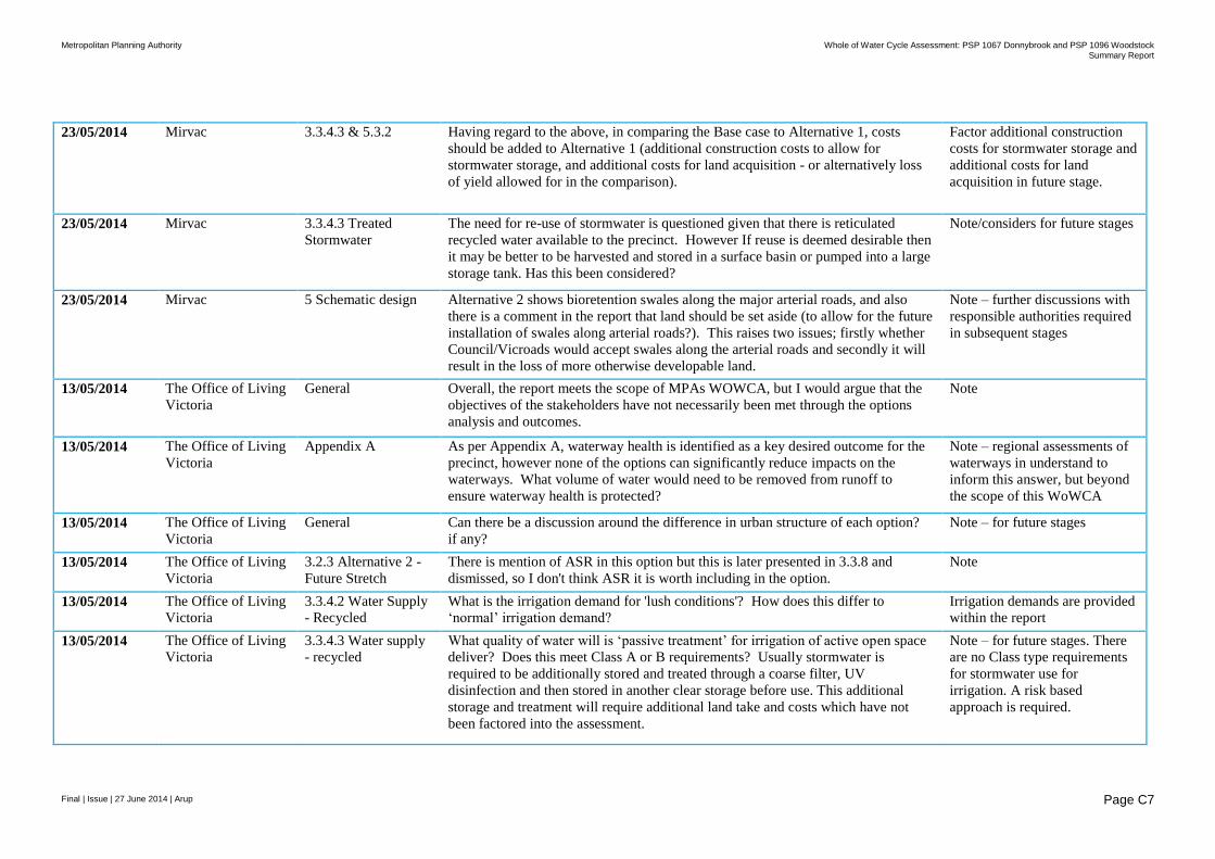
Metropolitan Planning Authority Whole of Water Cycle Assessment: PSP 1067 Donnybrook and PSP 1096 Woodstock
Summary Report
Final | Issue | 27 June 2014 | Arup
Page C7
23/05/2014 Mirvac 3.3.4.3 & 5.3.2 Having regard to the above, in comparing the Base case to Alternative 1, costs
should be added to Alternative 1 (additional construction costs to allow for
stormwater storage, and additional costs for land acquisition - or alternatively loss
of yield allowed for in the comparison).
Factor additional construction
costs for stormwater storage and
additional costs for land
acquisition in future stage.
23/05/2014 Mirvac 3.3.4.3 Treated
Stormwater
The need for re-use of stormwater is questioned given that there is reticulated
recycled water available to the precinct. However If reuse is deemed desirable then
it may be better to be harvested and stored in a surface basin or pumped into a large
storage tank. Has this been considered?
Note/considers for future stages
23/05/2014 Mirvac 5 Schematic design Alternative 2 shows bioretention swales along the major arterial roads, and also
there is a comment in the report that land should be set aside (to allow for the future
installation of swales along arterial roads?). This raises two issues; firstly whether
Council/Vicroads would accept swales along the arterial roads and secondly it will
result in the loss of more otherwise developable land.
Note – further discussions with
responsible authorities required
in subsequent stages
13/05/2014 The Office of Living
Victoria
General Overall, the report meets the scope of MPAs WOWCA, but I would argue that the
objectives of the stakeholders have not necessarily been met through the options
analysis and outcomes.
Note
13/05/2014 The Office of Living
Victoria
Appendix A As per Appendix A, waterway health is identified as a key desired outcome for the
precinct, however none of the options can significantly reduce impacts on the
waterways. What volume of water would need to be removed from runoff to
ensure waterway health is protected?
Note – regional assessments of
waterways in understand to
inform this answer, but beyond
the scope of this WoWCA
13/05/2014 The Office of Living
Victoria
General Can there be a discussion around the difference in urban structure of each option?
if any?
Note – for future stages
13/05/2014 The Office of Living
Victoria
3.2.3 Alternative 2 -
Future Stretch
There is mention of ASR in this option but this is later presented in 3.3.8 and
dismissed, so I don't think ASR it is worth including in the option.
Note
13/05/2014 The Office of Living
Victoria
3.3.4.2 Water Supply
- Recycled
What is the irrigation demand for 'lush conditions'? How does this differ to
‘normal’ irrigation demand?
Irrigation demands are provided
within the report
13/05/2014 The Office of Living
Victoria
3.3.4.3 Water supply
- recycled
What quality of water will is ‘passive treatment’ for irrigation of active open space
deliver? Does this meet Class A or B requirements? Usually stormwater is
required to be additionally stored and treated through a coarse filter, UV
disinfection and then stored in another clear storage before use. This additional
storage and treatment will require additional land take and costs which have not
been factored into the assessment.
Note – for future stages. There
are no Class type requirements
for stormwater use for
irrigation. A risk based
approach is required.
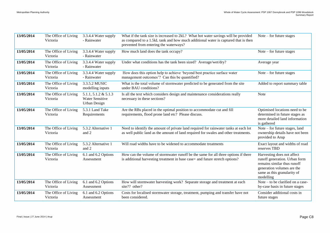
Metropolitan Planning Authority Whole of Water Cycle Assessment: PSP 1067 Donnybrook and PSP 1096 Woodstock
Summary Report
Final | Issue | 27 June 2014 | Arup
Page C8
13/05/2014 The Office of Living
Victoria
3.3.4.4 Water supply
- Rainwater
What if the tank size is increased to 2kL? What hot water savings will be provided
as compared to a 1.5kL tank and how much additional water is captured that is then
prevented from entering the waterways?
Note – for future stages
13/05/2014 The Office of Living
Victoria
3.3.4.4 Water supply
- Rainwater
How much land does the tank occupy? Note – for future stages
13/05/2014 The Office of Living
Victoria
3.3.4.4 Water supply
- Rainwater
Under what conditions has the tank been sized? Average/wet/dry? Average year
13/05/2014 The Office of Living
Victoria
3.3.4.4 Water supply
- Rainwater
How does this option help to achieve ‘beyond best practice surface water
management outcomes’? Can this be quantified?
Note – for future stages
13/05/2014 The Office of Living
Victoria
3.3.5.2 MUSIC
modelling inputs
What is the total volume of stormwater predicted to be generated from the site
under BAU conditions?
Added to report summary table
13/05/2014 The Office of Living
Victoria
5.1.1, 5.1.2 & 5.1.3
Water Sensitive
Urban Design
Is all the text which considers design and maintenance considerations really
necessary in these sections?
Note
13/05/2014 The Office of Living
Victoria
5.3.1 Land Take
Requirements
Are the RBs placed in the optimal position to accommodate cut and fill
requirements, flood prone land etc? Please discuss.
Optimised locations need to be
determined in future stages as
more detailed land information
is gathered
13/05/2014 The Office of Living
Victoria
5.3.2 Alternative 1
and 2
Need to identify the amount of private land required for rainwater tanks at each lot
as well public land as the amount of land required for swales and other treatments.
Note – for future stages, land
ownership details have not been
provided to Arup
13/05/2014 The Office of Living
Victoria
5.3.2 Alternative 1
and 2
Will road widths have to be widened to accommodate treatments Exact layout and widths of road
reserves TBD
13/05/2014 The Office of Living
Victoria
6.1 and 6.2 Options
Assessment
How can the volume of stormwater runoff be the same for all three options if there
is additional harvesting treatment in base case+ and future stretch options?
Harvesting does not affect
runoff generation. Urban form
remains similar thus runoff
generation volumes are the
same as this granularity of
modelling
13/05/2014 The Office of Living
Victoria
6.1 and 6.2 Options
Assessment
How will stormwater harvesting work? Separate storage and treatment at each
site?? other?
Note – to be clarified on a case-
by-case basis in future stages
13/05/2014 The Office of Living
Victoria
6.1 and 6.2 Options
Assessment
Costs for localised stormwater storage, treatment, pumping and transfer have not
been considered.
Consider additional costs in
future stages
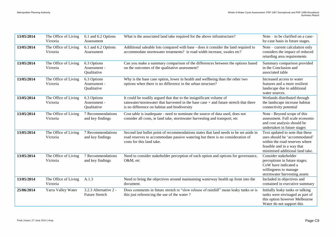
Metropolitan Planning Authority Whole of Water Cycle Assessment: PSP 1067 Donnybrook and PSP 1096 Woodstock
Summary Report
Final | Issue | 27 June 2014 | Arup
Page C9
13/05/2014 The Office of Living
Victoria
6.1 and 6.2 Options
Assessment
What is the associated land take required for the above infrastructure? Note – to be clarified on a case-
by-case basis in future stages.
13/05/2014 The Office of Living
Victoria
6.1 and 6.2 Options
Assessment
Additional saleable lots compared with base - does it consider the land required to
accommodate stormwater treatments? ie road width increase, swales etc?
Note – current calculation only
considers the impact of reduced
retarding area requirements
13/05/2014 The Office of Living
Victoria
6.3 Options
Assessment -
Qualitative
Can you make a summary comparison of the differences between the options based
on the outcomes of the qualitative assessment?
Summary comparison provided
in the Conclusion and
associated table
13/05/2014 The Office of Living
Victoria
6.3 Options
Assessment -
Qualitative
Why is the base case option, lower in health and wellbeing than the other two
options when there is no difference in the urban structure?
Increased access to water
features and a more resilient
landscape due to additional
water sources.
13/05/2014 The Office of Living
Victoria
6.3 Options
Assessment -
Qualitative
It could be readily argued that due to the insignificant volume of
rainwater/stormwater that harvested in the base case + and future stretch that there
is no difference on habitat and biodiversity
Wetlands distributed through
the landscape increase habitat
connectivity potential
13/05/2014 The Office of Living
Victoria
7 Recommendations
and key findings
Cost table is inadequate - need to nominate the source of data used, does not
consider all costs, ie land take, stormwater harvesting and transport, etc
Note - Beyond scope of this
assessment. Full scale economic
and cost analysis should be
undertaken in future stages
13/05/2014 The Office of Living
Victoria
7 Recommendations
and key findings
Second last bullet point of recommendations states that land needs to be set aside in
road reserves to accommodate passive watering but there is no consideration of
costs for this land take.
Text updated to note that these
uses should be ‘accommodated’
within the road reserves where
feasible and in a way that
minimised additional land take.
13/05/2014 The Office of Living
Victoria
7 Recommendations
and key findings
Need to consider stakeholder perception of each option and options for governance,
O&M, etc
Consider stakeholder
perceptions in future stages.
CoW have indicated a
willingness to manage
stormwater harvesting assets
13/05/2014 The Office of Living
Victoria
A.1.3 Need to bring the objectives around maintaining waterway health up front into the
document.
Included in objectives and
contained in executive summary
25/06/2014 Yarra Valley Water 3.2.3 Alternative 2 -
Future Stretch
Does comments in future stretch re “slow release of rainfall” mean leaky tanks or is
this just referencing the use of the water ?
Initially leaky tanks or talking
tanks were envisaged as part of
this option however Melbourne
Water do not support this

Metropolitan Planning Authority Whole of Water Cycle Assessment: PSP 1067 Donnybrook and PSP 1096 Woodstock
Summary Report
Final | Issue | 27 June 2014 | Arup
Page C10
approach and tank volume was
reduced to primarily meet hot
water demand.
25/06/2014 Yarra Valley Water 3.3.2 Land use
extents
Does an efficiency target of 20% mean building controls on appliances in the
houses? I.e. minimum stars for toilets etc?
To be clarified in future stages.
20% target was set by the
stakeholder group to explore
future efficiency requirements
that could be mandated.
25/06/2014 Yarra Valley Water 3.3.4.1 Water Supply
- Potable
Water supply may be transferred via the Yan Yean site (balancing storages tanks)
but may not actually be from Yan Yean Res as such. Melbourne Water are
currently working on bringing the Yan Yean Res on line but at this stage only the
clear water tank is in operation.
Note
25/06/2014 Yarra Valley Water 3.3.4.3 Water supply
- recycled
Will the treated stormwater be fit for purpose for all intended uses based on
wetland treatment?
Noted – additional treatment
requirements to be determined
in future stages
25/06/2014 Yarra Valley Water 3.3.4.4 Water supply
- Rainwater
Please confirm that the 1,500L tank provides 100% reliability. It is 16.6 Days
storage based on a 90.4 L/day use. Based on historical rainfall does this really mean
100% reliability?
As modelled by tankulator.com
25/06/2014 Yarra Valley Water 3.3.4.4 Water supply
- Rainwater
It needs to be made clearer that the 45L reduction is the hot water substitution with
rainwater. This is not clear at this point in the report. i.e 50% laundry and 50%
laundry.
Clarified in report
25/06/2014 Yarra Valley Water 3.3.4.4 Water supply
- Rainwater
Rainwater tanks feature only in Alternative 2 but the description refers to two
volumes (90.4L/d and 113L/d. Can you clarify what the second volume is referring
to?
Removed the 113 L/d - this is an
error
25/06/2014 Yarra Valley Water 3.3.6.1 Household
(Water demand)
It would be useful to split up the per household water use into total potable and
total non-potable and show the unit rates on the total water use tables in 4.1?
Note for YVW - Consider
splitting per household water
use and show unit rates
25/06/2014 Yarra Valley Water 3.3.6.2 Active open
space (water demand)
Please show the irrigation rates as ML/ha/yr. ML/ha/yr is not an appropriate
expression to determine scheme
reliability
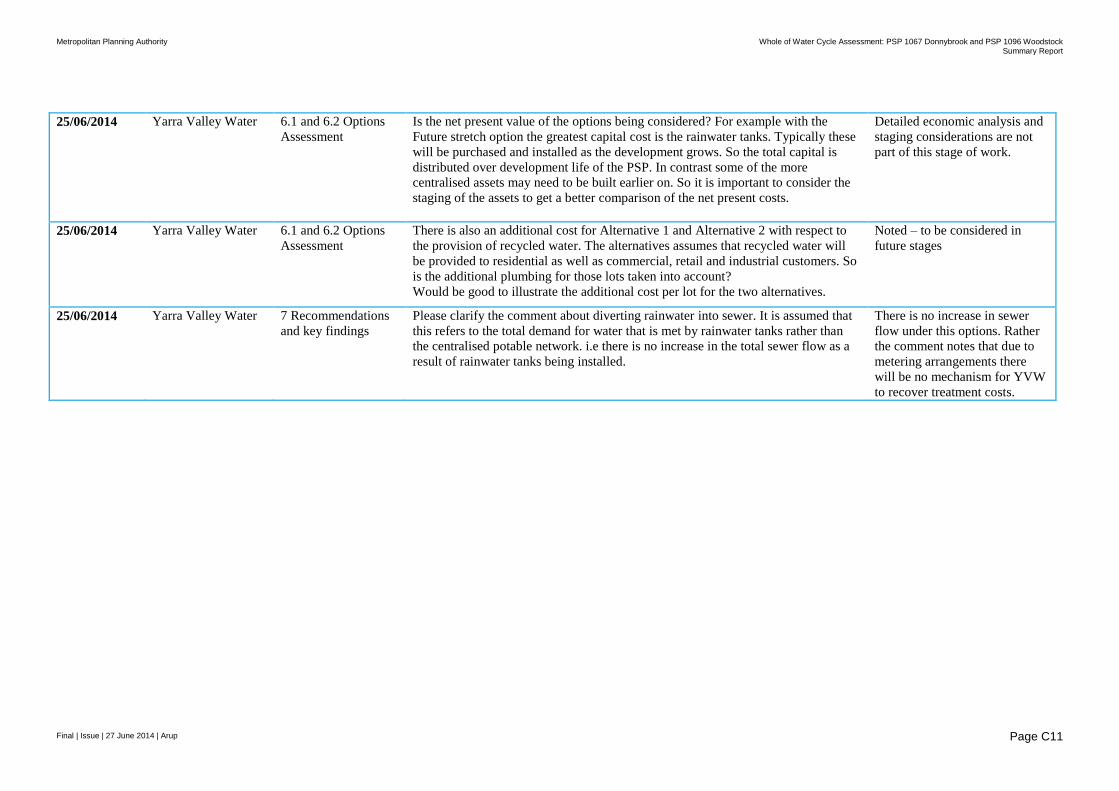
Metropolitan Planning Authority Whole of Water Cycle Assessment: PSP 1067 Donnybrook and PSP 1096 Woodstock
Summary Report
Final | Issue | 27 June 2014 | Arup
Page C11
25/06/2014 Yarra Valley Water 6.1 and 6.2 Options
Assessment
Is the net present value of the options being considered? For example with the
Future stretch option the greatest capital cost is the rainwater tanks. Typically these
will be purchased and installed as the development grows. So the total capital is
distributed over development life of the PSP. In contrast some of the more
centralised assets may need to be built earlier on. So it is important to consider the
staging of the assets to get a better comparison of the net present costs.
Detailed economic analysis and
staging considerations are not
part of this stage of work.
25/06/2014 Yarra Valley Water 6.1 and 6.2 Options
Assessment
There is also an additional cost for Alternative 1 and Alternative 2 with respect to
the provision of recycled water. The alternatives assumes that recycled water will
be provided to residential as well as commercial, retail and industrial customers. So
is the additional plumbing for those lots taken into account?
Would be good to illustrate the additional cost per lot for the two alternatives.
Noted – to be considered in
future stages
25/06/2014 Yarra Valley Water 7 Recommendations
and key findings
Please clarify the comment about diverting rainwater into sewer. It is assumed that
this refers to the total demand for water that is met by rainwater tanks rather than
the centralised potable network. i.e there is no increase in the total sewer flow as a
result of rainwater tanks being installed.
There is no increase in sewer
flow under this options. Rather
the comment notes that due to
metering arrangements there
will be no mechanism for YVW
to recover treatment costs.
Related Documents