
Welcome message from author
This document is posted to help you gain knowledge. Please leave a comment to let me know what you think about it! Share it to your friends and learn new things together.
Transcript


WETLAND DELINEATION REPORT
32.4-ACRE CHEVRON CINCINNATI FACILITY REMEDY CONSTRUCTION AREAS
HOOVEN, HAMILTON COUNTY, OHIO
Prepared for:
CHEVRON ENVIRONMENTAL MANAGEMENT COMPANY TRIHYDRO CORPORATION
Prepared by:
CIVIL & ENVIRONMENTAL CONSULTANTS, INC.
CINCINNATI, OHIO
CEC Project No. 071-242
July 9, 2007
W:\Projects\2007\071242\Wetland Delineation\Wetland Delineation rpt (2).doc
TABLE OF CONTENTS
Page 1.0 INTRODUCTION .....................................................................................................................1
1.1 General Information............................................................................................................1 1.2 Methodology.......................................................................................................................2
2.0 FINDINGS.................................................................................................................................4 2.1 National Wetlands Inventory Map......................................................................................4 2.2 Soils ....................................................................................................................................4 2.3 Plant Communities..............................................................................................................4 2.4 Hydrology ...........................................................................................................................5 2.5 Wetlands .............................................................................................................................7 2.6 Other Waters.......................................................................................................................7
3.0 REGULATORY CONSIDERATIONS.....................................................................................9 3.1 Meetings with Regulatory Agencies...................................................................................9 3.2 Regulatory Issues................................................................................................................9
4.0 CONCLUSIONS......................................................................................................................11 5.0 LEVEL OF CARE ...................................................................................................................12 6.0 REFERENCES ........................................................................................................................13
LIST OF FIGURES
Figure Site Location Map............................................................................................................................1 U.S.D.A. Soils Map .........................................................................................................................2 National Wetlands Inventory Map...................................................................................................3 Wetland Delineation Map ................................................................................................................4
LIST OF APPENDICES
Appendix Wetland Determination Data Forms ................................................................................................ I Site Photographs .............................................................................................................................II
R-071-242 - 1 - July 9, 2007
1.0 INTRODUCTION
1.1 General Information
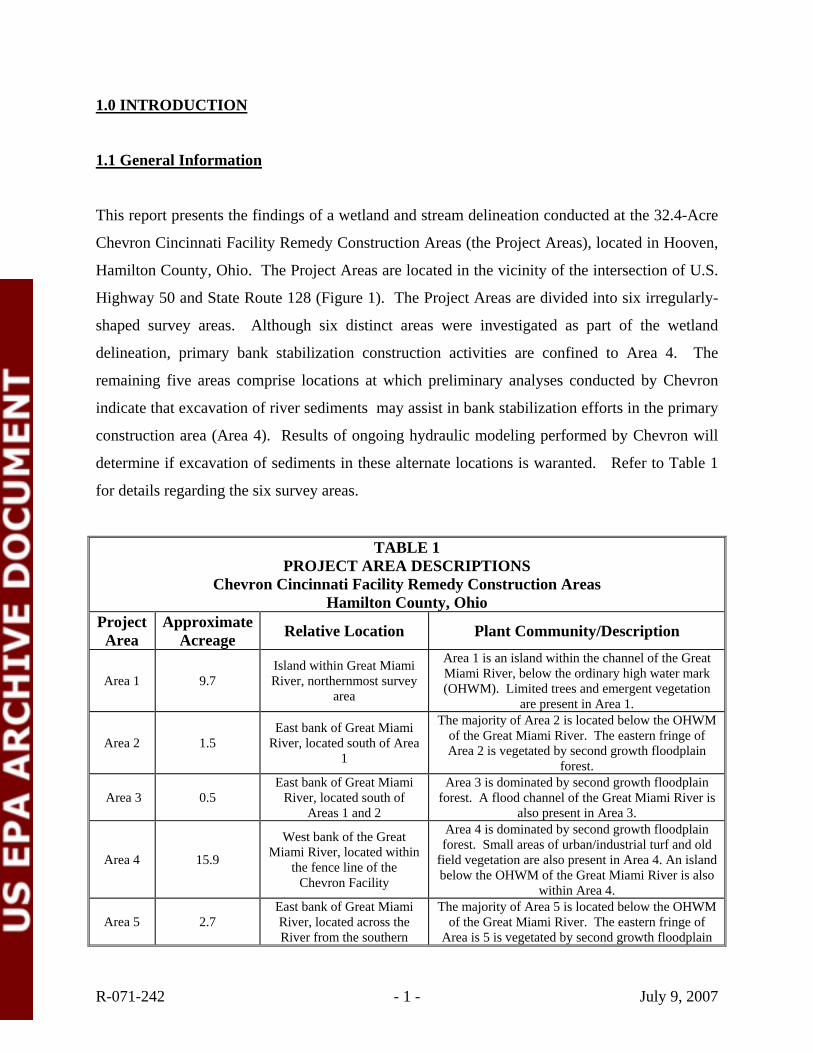
This report presents the findings of a wetland and stream delineation conducted at the 32.4-Acre
Chevron Cincinnati Facility Remedy Construction Areas (the Project Areas), located in Hooven,
Hamilton County, Ohio. The Project Areas are located in the vicinity of the intersection of U.S.
Highway 50 and State Route 128 (Figure 1). The Project Areas are divided into six irregularly-
shaped survey areas. Although six distinct areas were investigated as part of the wetland
delineation, primary bank stabilization construction activities are confined to Area 4. The
remaining five areas comprise locations at which preliminary analyses conducted by Chevron
indicate that excavation of river sediments may assist in bank stabilization efforts in the primary
construction area (Area 4). Results of ongoing hydraulic modeling performed by Chevron will
determine if excavation of sediments in these alternate locations is waranted. Refer to Table 1
for details regarding the six survey areas.
TABLE 1 PROJECT AREA DESCRIPTIONS
Chevron Cincinnati Facility Remedy Construction Areas Hamilton County, Ohio
Project Area
Approximate Acreage Relative Location Plant Community/Description
Area 1 9.7 Island within Great Miami River, northernmost survey
area
Area 1 is an island within the channel of the Great Miami River, below the ordinary high water mark (OHWM). Limited trees and emergent vegetation
are present in Area 1.
Area 2 1.5 East bank of Great Miami
River, located south of Area 1
The majority of Area 2 is located below the OHWM of the Great Miami River. The eastern fringe of Area 2 is vegetated by second growth floodplain
forest.
Area 3 0.5 East bank of Great Miami
River, located south of Areas 1 and 2
Area 3 is dominated by second growth floodplain forest. A flood channel of the Great Miami River is
also present in Area 3.
Area 4 15.9
West bank of the Great Miami River, located within
the fence line of the Chevron Facility
Area 4 is dominated by second growth floodplain forest. Small areas of urban/industrial turf and old
field vegetation are also present in Area 4. An island below the OHWM of the Great Miami River is also
within Area 4.
Area 5 2.7 East bank of Great Miami River, located across the River from the southern
The majority of Area 5 is located below the OHWM of the Great Miami River. The eastern fringe of
Area is 5 is vegetated by second growth floodplain

R-071-242 - 2 - July 9, 2007
TABLE 1 PROJECT AREA DESCRIPTIONS
Chevron Cincinnati Facility Remedy Construction Areas Hamilton County, Ohio
portion of Area 4 forest.
Area 6 2.1
East bank of Great Miami River, southernmost survey
area that spans north and south below the U.S. 50
bridge
The majority of Area 6 is within a flood channel of the Great Miami River. The eastern and western
banks of this channel are vegetated by second growth floodplain forest.
The wetland and stream delineation site visit was conducted by Civil & Environmental
Consultants, Inc. (CEC) on June 14-15, 2007.
1.2 Methodology
The purpose of the study was to identify and delineate the boundaries of wetlands and other
jurisdictional waters within the proposed Project Areas. The delineation was based on CEC’s
professional judgment and interpretation of the technical criteria presented in the 1987 U.S. Army
Corps of Engineers Wetlands Delineation Manual (USACE 1987).
The wetland delineation was conducted using the routine on-site determination method described
in the 1987 Corps Manual, supplemented by the National List of Plant Species That Occur in
Wetlands: Northeast Region (Region 1) (Reed 1988) and Hydric Soils of the United States
(USDA 1991). Additionally, in areas where disturbance had occurred, CEC made assumptions
based upon historic information contained in the soil survey and observed current site conditions.
CEC completed the following scope of services to identify and delineate jurisdictional wetland
boundaries at the site:
1. Office Data Review: CEC personnel reviewed the U.S. Geological Survey (USGS) topographic map (Figure 1), U.S. Department of Agriculture (USDA) Soil Survey of Hamilton County, Ohio (USDA 1992; Figure 2), U.S. Fish & Wildlife Service (USFWS) National Wetlands Inventory (NWI) Map (Figure 3), and the USDA Natural Resources Conservation Service (NRCS) list of hydric soils for Hamilton County, Ohio (USDA 2006). These resources were used to establish site characteristics that aided in the identification of potential wetland areas.

R-071-242 - 3 - July 9, 2007
2. Site Reconnaissance: CEC performed the wetland delineation on June 14-15, 2007. The wetland delineation work was completed using the routine on-site determination method. First, plant communities present on the site were identified. The dominant plant species within each community were identified and an assessment was made on whether or not the plant community was dominated by hydrophytic (wetland) plants. Next, a representative test site was located within the plant community and soils were sampled using a spade shovel to assess the presence of hydric soil indicators. Lastly, the test site was inspected for indicators of wetland hydrology (ponding, soil saturation, etc.). If areas having wetland vegetation, hydric soils, and wetland hydrology were found, a test site was located outside the wetland to delineate where the wetland boundary could be located. Additionally, wetlands (if located on the site) were marked in the field with consecutively numbered surveyor’s ribbon flags and subsequently located onto the Addyston and Hooven, Ohio quadrangles of the USGS 7.5-minute topographic map using a Trimble GeoXT Global Positioning System (GPS) unit. Other potential jurisdictional waters, such as ephemeral, intermittent or perennial streams located within the project area were also identified, where applicable.
3. Data Collection: Data forms for the routine on-site determination method were completed for six representative locations within the Project Area (see Figure 4 for locations and Appendix I for the wetland data forms). The data forms were completed to record the vegetation, soils and hydrology at each test site. Photographs of the wetlands, streams, and other representative habitats present on the property were also taken (Appendix II).
4. Preparation of Wetland and Stream Delineation Report: This wetland and stream delineation report documents CEC's methodology, findings, wetland delineation map, regulatory considerations, and conclusions.

R-071-242 - 4 - July 9, 2007
2.0 FINDINGS
2.1 National Wetlands Inventory Map
NWI maps have been prepared by the USFWS based on high altitude infrared aerial photography
and limited ground truthing. Wetlands and deep-water habitats are identified on these maps and
classified according to the system developed by Cowardin and co-workers (1979). The NWI
map for the Addyston and Hooven, Ohio quadrangles identified the Great Miami River as
R2UBH- riverine, lower perennial, unconsolidated bottom, and permanently flooded (Figure 3).
Based on the NWI maps, no other wetlands were identified within the boundaries of the Project
Areas.
2.2 Soils
The Soil Survey of Hamilton County, Ohio (USDA 1992) shows four soil types within the Project
Area (Table 2, Figure 2). Two of the four soil types within the Project Area have been identified
by the NRCS as hydric (USDA 2006).
TABLE 2 SOILS INFORMATION
Chevron Cincinnati Facility Remedy Construction Areas Hamilton County, Ohio
Soil Mapping Unit Name (Symbol) Taxonomy Hydric Soil List
Designation Casco silt loam, 25 to 35 percent slopes (CdE) Typic Hapludalfs Non-Hydric
Jules silt loam, occasionally flooded (Ju) Typic Udifluvents Hydric Stonelick fine sandy loam, frequently flooded (St) Typic Udifluvents Hydric
Pits, gravel (Po) -- Non-Hydric
2.3 Plant Communities
As outlined in Table 1, the majority of the Project Areas located above the OHWM of the Great
Miami River consisted of second growth floodplain forest. The overstory of the second growth
floodplain forests within the Project Areas were dominated by American sycamore (Platanus
occidentalis), silver maple (Acer saccharinum), green ash (Fraxinus pennsylvanica), common
R-071-242 - 5 - July 9, 2007
hackberry (Celtis occidentalis), box elder (Acer negundo), eastern cottonwood (Populus
deltoides) and black willow (Salix nigra). The moderately dense understory of these forests
were dominated by false nettle (Boehmeria cylindrica), wingstem (Verbesina alternifolia), black
snakeroot (Sanicula marilandica), Virginia creeper (Parthenocissus quinquefolia), honewort
(Cryptotaenia canadensis), aniseroot (Osmorhiza longistylis), garlic mustard (Alliaria petiolata),
Amur honeysuckle (Lonicera maackii), and poison hemlock (Conium maculatum).
Urban/industrial turf, which consisted of a gravel road, was present within the western portion of
Area 4, and paralleled the Great Miami River throughout the survey area. Old field vegetation
was identified within the southern portion of Areas 4 and 6, and included hooked buttercup
(Ranunculus recurvatus), yellow sweet clover (Melilotus officinalis), japanese honeysuckle
(Lonicera japonica), common mullein (Verbascum thapsus), goldenrod (Solidago spp.), and
daisy fleabane (Erigeron annuus).
The vegetation identified at each wetland sample point has been detailed in the individual
wetland determination data forms presented in Appendix I. Representative photos of each
habitat type identified in the Project Areas are presented in Appendix II.
2.4 Hydrology
The Project Areas primarily consisted of a relatively level floodplain with moderate to steeply-
sloped banks occurring along the Great Miami River. Elevations within the Project Areas ranged
from approximately 450 to 480 feet above mean sea level (AMSL). As seen in Figure 4,
hydrologic features within the Project Area include Hooven Ditch, located in Area 4 (Stream 1);
one unnamed intermittent stream, located in Area 6 (Stream 2); the Great Miami River which is
located throughout the Project Areas (Stream 3), and an overflow/flood channel of the Great
Miami River, which is located in Areas 3 and 6 (Stream 4). Drainage throughout the Project
Area is to the Great Miami River.
Stream 1 consisted of Hooven Ditch, a non-USGS-identified ephemeral stream located within
Area 4. This stream originates outside of Area 4, and functions as a storm water drainage ditch

R-071-242 - 6 - July 9, 2007
for the town of Hooven. Site drainage from the Chevron facility is reportedly not routed through
Hooven Ditch. Stream 1 enters into the northwest corner of Area 4 through a culvert underneath
a gravel access road, and flows southeast to the Great Miami River. Stream 1 was characterized
by a width of approximately 6 feet and a depth of approximately 1 foot. The substrate of Stream
1 consisted of rip rap (from the culvert), gravel, and silt. The steep banks of Stream 1 were
vegetated by second growth floodplain forest. No water was observed within the channel at the
time of the field survey.
Stream 2 consisted of an unnamed non-USGS-identified intermittent stream located within Area
6. Stream 2 enters into the eastern portion of Area 6 north of U.S. 50 through a culvert below a
construction lane and flows west to Stream 4, an overflow/flood channel of the Great Miami
River. Stream 2 was characterized by a width of approximately eight feet and a depth of
approximately three feet. The substrate of Stream 2 consisted of boulders, gravel, and silt. The
steep banks of Stream 2 were vegetated by second growth floodplain forest. No water was
observed within the channel at the time of the field survey.
Stream 3 consisted of the USGS-identified Great Miami River, which was located within the
survey area boundaries for each Project Area with the exception of Area 6. The width of Stream
3 was variable throughout the Project Area; depth and substrate could not be determined during
the site visit. The banks of Stream 3 ranged from gently sloping to steep, and were vegetated by
second growth floodplain forest. Water was observed flowing south in the channel at the time of
the survey, but the depth was not determined.
Stream 4 consisted of the non-USGS-identified overflow/flood channel of the Great Miami
River, which was located within Areas 3 and 6. This channel diverts flows from the Great
Miami River during high water events within Area 3 and rejoins the River south of Area 6. The
bank width of Stream 4 was variable within Areas 3 and 6, as was the depth. At the southern end
of Area 6, the width of this channel was approximately 40 feet. No water was observed in
Stream 4 within the Project Areas. The substrate of Stream 4 was characterized by sand and
gravel. The banks of Stream 4 were vegetated by second growth floodplain forest.

R-071-242 - 7 - July 9, 2007
2.5 Wetlands
No wetlands were identified or delineated within the Project Areas. Six sites within the Project
Areas were sampled using the on-site wetland determination method described above in Section
1.2. The wetland determination data forms for these six sites are provided in Appendix I. The
locations of these sample sites were recorded using a Trimble GeoXT GPS unit. The locations
of all sites within the Project Area that were sampled using the on-site determination method are
shown on Figure 4.
2.6 Other Waters
As part of this work scope, CEC identified on-site streams and open water features that could be
considered jurisdictional at the state and federal levels. Using CEC's professional judgment and
field indicators such as flow, substrate composition, embeddedness, defined bed and banks, and
vegetation, CEC classified the on-site streams into one of three categories: ephemeral,
intermittent, or perennial (Table 3). As noted in Section 2.4, four streams were identified in the
Project Area by CEC. The limits of the streams were recorded in the field with a Trimble
GeoXT GPS unit, and subsequently transferred to Figure 4. The on-site lengths of the
waterbodies are summarized below. The linear feet calculated for the Great Miami River
(Stream 3) is based upon linear measurements of the OHWM within the Project Areas. For Area
1, which was entirely located below the Great Miami River OHWM, the linear footage was
calculated based on the approximate length of the island located within Area 1. The portion of
the Great Miami River that is within the Project Area is listed by the U.S. Army Corps of
Engineers (USACE) as a Section 10 navigable water.
TABLE 3 STREAM INFORMATION
Chevron Cincinnati Facility Wetland Delineation Hamilton County, Ohio
Stream Segment Identifier Location Approximate On-site Length (linear feet)
Stream Classification
Stream 1-Hooven Ditch Area 4 457 Ephemeral Stream 2-Unnamed intermittent stream Area 6 191 Intermittent
Stream 3- Great Miami River Area 1 2,120 Perennial

R-071-242 - 8 - July 9, 2007
TABLE 3 STREAM INFORMATION
Chevron Cincinnati Facility Wetland Delineation Hamilton County, Ohio
Stream Segment Identifier Location Approximate On-site Length (linear feet)
Stream Classification
Area 2 480 Area 4 1931 Area 3 474 Stream 4- Overflow/flood channel of the
Great Miami River Area 6 677 Intermittent/ephemeral
Total 6,330 --

R-071-242 - 9 - July 9, 2007
3.0 REGULATORY CONSIDERATIONS
3.1 Meetings with Regulatory Agencies
No meetings between regulatory agencies and CEC have taken place at the time this report was
prepared. The wetland delineation findings presented in this document were developed based
upon CEC’s professional training and experience, and the results of the June 14-15, 2007, site
visit.
3.2 Regulatory Issues
Impacts to jurisdictional streams are regulated in the state of Ohio by the USACE and the Ohio
Environmental Protection Agency (OEPA). Discharges of dredged or fill material into waters of
the United States, as well as relocation of waters of the United States, require permits from the
USACE under the provisions of Section 404 of the Clean Water Act, as well as Section 401
Water Quality Certification from the OEPA Division of Surface Water.
Based on the results of the wetland delineation, CEC identified approximately 6,330 linear feet
of potentially jurisdictional streams within the study area. It is noted that this stream length is
“all inclusive” and may include significant portions of streams that may not be impacted as part
of Trihydro Corporation’s proposed bank reinforcement and other associated activities. It is also
noted that the Great Miami River within the Project Areas is considered a Section 10 water by
the USACE and a jurisdictional determination will be required to determine if the flood channel
within the Project Areas is classified as a part of the Great Miami River.
A formal jurisdictional determination conducted by the USACE, and potentially the OEPA, is
required to verify CEC’s wetland delineation findings, prior to initiation of permit issuance. The
jurisdictional determination may require a site visit by these agencies.
Two types of Section 404 Clean Water Act permits are available from the USACE for those
seeking to develop property, Nationwide Permits (NWPs) and Individual Section 404 Permits,

R-071-242 - 10 - July 9, 2007
which are both utilized in conjunction with OEPA 401 Water Quality Certifications. The
purpose of NWPs is to protect the aquatic environment and public interest while authorizing
activities that have minimal individual and cumulative adverse effects on the aquatic
environment. The NWPs were reissued by the USACE on March 17, 2007, and became
effective on March 19, 2007. These NWPs will expire on March 18, 2012. When impacts to
waterbodies are greater than allowed by NWPs, an Individual Section 404 Permit is typically
required. A pre-construction notification (PCN) may be required for coverage under a NWP
depending upon proposed waterbody impacts. The OEPA certifies the NWP by providing certain
regional conditions which must be met in order to satisfy the General Conditions of the NWP. In
this manner, the OEPA has pre-granted Section 401 Water Quality Certifications to the NWP, as
long as all regional conditions are met. If impacts to streams and wetlands exceed the limits set
forth under the NWP, then an Individual Section 404 Permit would be typically required from
the USACE and Section 401 Water Quality Certification would be typically required from the
OEPA.
The Chevron Facility Remedy Construction Areas project could potentially be authorized under
NWP 38 – Cleanup of Hazardous and Toxic Waste. NWP 38 authorizes activities required to
effect the containment, stabilization, or removal of hazardous or toxic waste materials that are
performed, ordered, or sponsored by a government agency with established legal or regulatory
authority. A PCN is required to be submitted to the District Engineer of the USACE in
accordance with the General Condition 27. NWP 38 does not limit the footage of stream impact.
The OEPA has issued Draft Section 401 Certifications for the reissued NWPs. The OEPA Draft
Certifications for NWP 38 grant authorization only to projects that are performed, ordered, or
sponsored by a state or federal government agency with established legal or regulatory authority.
The State of Ohio General Limitations and Conditions that limit the temporary and permanent
footage impacts to streams are waived for NWP 38. Based on the OEPA Draft Section 401
Certifications, no consultation is required with the OEPA for this project, as long as all regional
conditions are met for NWP 38.

R-071-242 - 11 - July 9, 2007
4.0 CONCLUSIONS
No wetlands were identified and delineated by CEC on the property. CEC identified one
ephemeral stream, one intermittent stream, the Great Miami River, and an overflow channel to
the Great Miami River within the Project Areas, together totaling approximately 6,330 linear feet
(Figure 4). The locations of these potentially jurisdictional waters were recorded by CEC using a
sub-meter accuracy Trimble GeoXT GPS unit.
R-071-242 - 12 - July 9, 2007
5.0 LEVEL OF CARE
The wetland delineation services performed by CEC were conducted in a manner consistent with
the criteria contained in the 1987 Corps Manual and with the level of care and skill ordinarily
exercised by members of the environmental consulting profession practicing contemporaneously
under similar conditions in the locality of the project. It must be recognized that the
jurisdictional wetland delineation was based on field observations and CEC's professional
interpretation of the criteria in the 1987 Corps Manual at the time of our fieldwork. Wetland
determinations may change subsequent to CEC's delineation based on changes in the regulatory
criteria, seasonal variations in hydrology, alterations to drainage patterns and other human
activities and/or land disturbances. Therefore, the findings and opinions are relevant to the dates
of our site work and should not be relied on to represent conditions at substantially later dates.
References herein to interpreted jurisdictional waters on the subject property are the opinion of
CEC and are subject to change pending formal review by the USACE and/or OEPA. The actual
regulated extent and limits of jurisdictional waters are not established until formally sanctioned
by the USACE and OEPA as part of a Jurisdictional Determination.
This report is intended for the use of Trihydro and Chevron only, consistent with the
qualifications outlined herein and the terms and conditions of CEC’s proposal. Our services
have been performed under mutually agreed upon terms and conditions. If other parties wish to
rely on this report, please have them contact us so that a mutual understanding and agreement of
the terms and conditions for our services can be established prior to their use of this information.

R-071-242 - 13 - July 9, 2007
6.0 REFERENCES
Cowardin, L. M., V. Carter, and F. C. Golet. 1979. Classification of Wetlands and Deep Water Habitats of the United States. U.S. Department of the Interior, Fish and Wildlife Service. Washington D. C. FWS/OBS-79/31.
U.S. Army Corps of Engineers (USACE), Environmental Laboratory. 1987. Corps of Engineers
Wetlands Delineation Manual, Technical Report Y-87-1, U.S. Army Engineer Waterway Experiment Station, Vicksburg, Mississippi.
Reed, Jr., Porter B. 1988. National List of Plant Species that Occur in Wetlands: Northeast
(Region 1). Biological Report 88 (26.1). U.S. Fish and Wildlife Service, Washington, D.C.
United States Department of Agriculture Soil Conservation Service (USDA). 1991. Hydric Soils
of the United States. In cooperation with the National Technical Committee for Hydric Soils. Soil Conservation Service, Washington, D.C.
United States Department of Natural Resources Conservation Service (USDA). 2006. Hydric
Soils of Hamilton County, Ohio. Natural Resources Conservation Service, Washington, D.C. 5 pp.
United States Department of Agriculture Soil Conservation Service (USDA). 1992. Soil Survey
of Hamilton County, Ohio. Soil Conservation Service. Washington, D.C. 219pp + maps.

Area 6
Area 5
Area 4
Area 3
Area 1
Area 2
�1,000 0 1,000 2,000500
Feet
Site Location Map
CHEVRON - CINCINNATI FACILITY
Hooven, Hamilton County, OhioState Route 128 and U.S. Bypass 50
PROJECT NO: FIGURE NO:
1071-242DATE:SCALE:DWN. BY:
CHKD. BY: June 2007AS NOTED
SOURCE: USGS 7.5 MINUTE TOPOGRAPHIC QUADRANGLE MAP - ADDYSTON 1982 AND HOOVEN, OHIO1982.
QUADRANGLE LOCATIONQUADRANGLE LOCATIONQUADRANGLE LOCATIONQUADRANGLE LOCATION
Civil & Environmental Consultants, Inc.Cincinnati, OH
(513) 985-0226 (800) 759-5614Pittsburgh, PA
Chicago, ILNashville, TN Export, PASt. Louis, MOColumbus, OH Indianapolis, IN
MJB
MVBJ:\Projects\2007\071242\M
aps\071242_Figure_1.m
xd - 6/27/2007 @
8:40:59 AM
Approximate Site Boundary

St
St
StJu
CdE
Ju
W
W
W
W
Ju
Ju
Area 6
Area 5
Area 4
Area 3
Area 2
Area 1
W
W
Rn
St
St
Po
Go
UmB
Ju
PfD
EdF
Ju
Lg
CdE
PhD PbC2
CcC2
Ju
Po
EdF
EcE
CdE
ArC2
ArC2
MaE2
�300 0 300 600150
Feet
USDA NRCS Soils Map
CHEVRON - CINCINNATI FACILITY
Hooven, Hamilton County, OhioState Route 128 and U.S. Bypass 50
PROJECT NO: FIGURE NO:
2071-242DATE:SCALE:DWN. BY:
CHKD. BY: June 2007AS NOTED
SOURCE: PORTION OF A NATIONAL AGRICULTURAL IMAGERY PROGRAM (NAIP) COUNTY COLOR AERIAL MOSAIC, HAMILTON COUNTY, OHIO 2006. SOILS DATA OBTAINED FROM THE USDA NRCS SOIL DATAMART WEBSITE, http://soildatamart.nrcs.usda.gov/
Civil & Environmental Consultants, Inc.Cincinnati, OH
(513) 985-0226 (800) 759-5614Pittsburgh, PA
Chicago, ILNashville, TN Export, PASt. Louis, MOColumbus, OH Indianapolis, IN
MJB
MVBJ:\Projects\2007\071242\M
aps\071242_Figure_2.mxd - 6/27/2007 @
8:44:09 AM
CdE - Casco loam, 25 to 35 percent slopesJu - Jules silt loam, occasionally floodedPo - Pits, gravelSt - Stonelick fine sandy loam, frequently floodedW - Water
USDA NRCS Soil Boundary
Approximate Site Boundary

Area 6
Area 5
Area 4
Area 3
Area 2
Area 1
R2UBH
R2UBH
PFO1A
PFO1Cx
PFO1A
PUBHx
�300 0 300 600150
Feet
USFWS - NWI Features Map
CHEVRON - CINCINNATI FACILITY
Hooven, Hamilton County, OhioState Route 128 and U.S. Bypass 50
PROJECT NO: FIGURE NO:
3071-242DATE:SCALE:DWN. BY:
CHKD. BY: June 2007AS NOTED
SOURCE: PORTION OF A NATIONAL AGRICULTURAL IMAGERY PROGRAM (NAIP) COUNTY COLOR AERIAL MOSAIC, HAMILTON COUNTY, OHIO 2006. WETLAND DATA OBTAINED FROM THE USFWS - WETLANDS DATA EXTRACTION TOOL WEBSITE - http://wetlandsfws.er.usgs.gov/NWI/download.html
Civil & Environmental Consultants, Inc.Cincinnati, OH
(513) 985-0226 (800) 759-5614Pittsburgh, PA
Chicago, ILNashville, TN Export, PASt. Louis, MOColumbus, OH Indianapolis, IN
MJB
MVBJ:\P
roje
cts
\2007\0
71242\M
aps\0
71242_Fig
ure
_3.m
xd - 6
/27/2
007 @
8:4
4:4
5 A
M
USFWS - NWI Feature
Approximate Site Boundary

!(!(
!(
!(
!(
!(
(®
(®
(®
(®
(®
(®
(®
(®
(®
Test Pit 1
Test Pit 3
Test Pit 4
Test Pit 2
Test Pit 6
Test Pit 5
Great Miami River/
Stream 3 Ordinary
High Water Mark
Hoover Ditch/
Stream 1
Great Miami River/
Stream 3 Ordinary
High Water Mark
Stream 2
Great Miami River
Flood Channel/Stream 4
Great Miami River
Flood Channel/Stream 4
Great Miami River/
Stream 3 Ordinary
High Water Wark
9
2
3
1
5
11
10
13
14
�300 0 300 600150
Feet
Wetland Delineation MapCHEVRON - CINCINNATI FACILITY REMEDYCONSTRUCTION AREAS
Hooven, Hamilton County, OhioState Route 128 and U.S. Bypass 50
PROJECT NO: FIGURE NO:
4071-242DATE:SCALE:DWN. BY:
CHKD. BY: June 2007AS NOTED
SOURCE: PORTION OF A NATIONAL AGRICULTURAL IMAGERY PROGRAM (NAIP) COUNTY COLOR AERIAL MOSAIC, HAMILTON COUNTY, OHIO 2006.
Civil & Environmental Consultants, Inc.Cincinnati, OH
(513) 985-0226 (800) 759-5614Pittsburgh, PA
Chicago, ILNashville, TN Export, PASt. Louis, MOColumbus, OH Indianapolis, IN
MJB
MVBJ:\
Pro
jec
ts\2
00
7\0
71
24
2\M
ap
s\0
71
24
2_F
igu
re_4
.mxd
- 6
/28
/20
07
@ 4
:21
:06
PM
Approximate Site BoundaryEphemeral Stream
Intermittent StreamOrdinary High Water Mark
Photo Location and Direction(® Great Miami River Overflow/Flood Channel

APPENDIX I
WETLAND DETERMINATION DATA FORMS

Project/Site: Date: 6/14/2007Applicant/Owner: County: HamiltonInvestigator(s): State: OH
Do normal circumstances exist on the site? Yes X No Community ID: Is the site significantly disturbed (Atypical?) Yes No XIs the area a potential problem area? Yes No X Plot ID: TP-1(if needed, explain on reverse.)
VEGETATIONDominant Plant Species: Stratum: Dominant Plant Species: Stratum: Indicator:
1. Tree 10.2. Tree 11.3. Herb 12.4. Herb 13.5. Herb 14.6. Herb 15.7. 16.8. 17.9. 18.
Remarks:
HYDROLOGYRecorded Data (Describe in Remarks) Wetland Hydrology Indicators:Stream, Lake, or Tide Gauge Primary Indicators:
X Aerial Photographs InundatedNo Recorded Data Available Saturated in upper 12 inches
Water MarksField Observations: Drift Lines
Sediment DepositsDepth of Surface Water: >16 (inches) Drainage Patterns in Wetlands
Depth to Free Water in Pit: >16 (inches) Secondary Indicators:Oxidized Root Channels in Upper 12 Inches
Depth to Saturated Soil: >16 (inches) Water Stained LeavesX Local Soil Survey Data
FAC-Neutral TestOthers (Explain in Remarks)
Remarks:
Area 4
071-242/Chevron Cincinnati Facility Remedy Construction Areas
DATA FORMROUTINE WETLAND DETERMINATION
Trihydro Corporation/ChevronMaggie Vuturo Bosiljevac
(1987 COE Wetland Delineation Manual)
Plantanus occidentalis
Alliaria petiolataSanicula marilandica
Percent of dominant species that are OBL, FACW or FAC (and excluding FAC-) = 50%
Celtis occidentalisBoehmeria cylindricaVerbesina alternifolia FAC
Indicator:
FACUFACW+
FACW-
FACU
Test pit in floodplain forest
NI/UPL

Project/Site: 071-242/Chevron Cincinnati Facility Remedy Construction AreasSite/Area ID:
SOILSMap Unit Name:(Series and Phase): Stonelick fine sandy loam, frequently flooded Drainage Class: Well Drained(Taxonomy Subgroup): Typic Udifluvents Field Observations Confirm Mapped Type?
Yes X No
Profile Description:
Depth (inches): Horizon:
Hydric Soil Indicators:
Histosol ConcretionsHistic Epipedon High Organic Content in Surface Layer in Sandy SoilsSulfidic Odor Organic Streaking in Sandy SoilAquic Moisture Regimes X Listed on Local Hydric Soils List
Reducing Conditions Listed on National Hydric Soils ListGleyed or Low Chroma Colors Other (Explain in Remarks)
Remarks:
WETLAND DETERMINATIONYes X NoYes No X YesYes No X No X
Remarks:
Wetland Hydrology Present?Hydric Soils Present?
sandy loamA/B 10YR 4/2 nonenone
TP-1
Hydrophytic Vegetation Present? Is this Sampling Point Within a Wetland?
Mottle Colors (Munsell Moist):
Matrix Color (Munsell Moist): Texture, Concretions, Structure:Mottle (Abundance/Size):
0-16+

Project/Site: Date: 6/15/2007Applicant/Owner: County: HamiltonInvestigator(s): State: OH
Do normal circumstances exist on the site? Yes X No Community ID:Is the site significantly disturbed (Atypical?) Yes No XIs the area a potential problem area? Yes No X Plot ID: TP-2(if needed, explain on reverse.)
VEGETATIONDominant Plant Species: Stratum: Dominant Plant Species: Stratum: Indicator:
1. Tree 10.2. Tree 11.3. Herb 12.4. Herb 13.5. Herb 14.6. Herb 15.7. 16.8. 17.9. 18.
Remarks:
HYDROLOGYRecorded Data (Describe in Remarks) Wetland Hydrology Indicators:Stream, Lake, or Tide Gauge Primary Indicators:
X Aerial Photographs InundatedNo Recorded Data Available Saturated in upper 12 inches
Water MarksField Observations: Drift Lines
Sediment DepositsDepth of Surface Water: >16 (inches) Drainage Patterns in Wetlands
Depth to Free Water in Pit: >16 (inches) Secondary Indicators:Oxidized Root Channels in Upper 12 Inches
Depth to Saturated Soil: >16 (inches) Water Stained LeavesX Local Soil Survey Data
FAC-Neutral TestOthers (Explain in Remarks)
Remarks:
Test pit in floodplain forest
NI/UPL
Indicator:
FACFAC+
FACW
FACW
Percent of dominant species that are OBL, FACW or FAC (and excluding FAC-) = 83%
Populus deltoidesRanunculus recurvatusVerbesina alternifolia FAC
Acer saccharinum
Conium maculatumSanicula marilandica
Area 3
071-242/Chevron Cincinnati Facility Remedy Construction Areas
DATA FORMROUTINE WETLAND DETERMINATION
Trihydro Corporation/ChevronMaggie Vuturo Bosiljevac
(1987 COE Wetland Delineation Manual)
Project/Site:Site/Area ID:
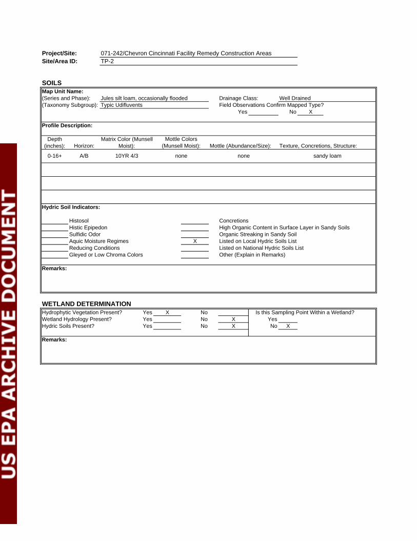
SOILSMap Unit Name:(Series and Phase): Jules silt loam, occasionally flooded Drainage Class: Well Drained(Taxonomy Subgroup): Typic Udifluvents Field Observations Confirm Mapped Type?
Yes No X
Profile Description:
Depth (inches): Horizon:
Hydric Soil Indicators:
Histosol ConcretionsHistic Epipedon High Organic Content in Surface Layer in Sandy SoilsSulfidic Odor Organic Streaking in Sandy SoilAquic Moisture Regimes X Listed on Local Hydric Soils List
Reducing Conditions Listed on National Hydric Soils ListGleyed or Low Chroma Colors Other (Explain in Remarks)
Remarks:
WETLAND DETERMINATIONYes X NoYes No X YesYes No X No X
Remarks:
TP-2
Hydrophytic Vegetation Present? Is this Sampling Point Within a Wetland?
Mottle Colors (Munsell Moist):
Matrix Color (Munsell Moist): Texture, Concretions, Structure:Mottle (Abundance/Size):
0-16+ 10YR 4/3 nonenone
Hydric Soils Present?
sandy loamA/B
071-242/Chevron Cincinnati Facility Remedy Construction Areas
Wetland Hydrology Present?

Project/Site: Date: 6/15/2007Applicant/Owner: County: HamiltonInvestigator(s): State: OH
Do normal circumstances exist on the site? Yes X No Community ID:Is the site significantly disturbed (Atypical?) Yes No XIs the area a potential problem area? Yes No X Plot ID: TP-3(if needed, explain on reverse.)
VEGETATIONDominant Plant Species: Stratum: Dominant Plant Species: Stratum: Indicator:
1. Tree 10.2. Tree 11.3. Herb 12.4. Herb 13.5. Herb 14.6. Herb 15.7. 16.8. 17.9. 18.
Remarks:
HYDROLOGYRecorded Data (Describe in Remarks) Wetland Hydrology Indicators:Stream, Lake, or Tide Gauge Primary Indicators:
X Aerial Photographs InundatedNo Recorded Data Available Saturated in upper 12 inches
Water MarksField Observations: Drift Lines
Sediment DepositsDepth of Surface Water: >16 (inches) Drainage Patterns in Wetlands
Depth to Free Water in Pit: >16 (inches) Secondary Indicators:Oxidized Root Channels in Upper 12 Inches
Depth to Saturated Soil: >16 (inches) Water Stained LeavesX Local Soil Survey Data
FAC-Neutral TestOthers (Explain in Remarks)
Remarks:
Area 3
071-242/Chevron Cincinnati Facility Remedy Construction Areas
DATA FORMROUTINE WETLAND DETERMINATION
Trihydro Corporation/ChevronMaggie Vuturo Bosiljevac
(1987 COE Wetland Delineation Manual)
Acer saccharinum
Viola sororia Geum laciniatum
Percent of dominant species that are OBL, FACW or FAC (and excluding FAC-) = 100%
Populus deltoidesBoehmeria cylindricaImpatiens pallida FACW
Indicator:
FACFACW+
FACW
FAC
Test pit in floodplain forest
FAC+

Project/Site:Site/Area ID:
SOILSMap Unit Name:(Series and Phase): Stonelick fine sandy loam, frequently flooded Drainage Class: Well Drained(Taxonomy Subgroup): Typic Udifluvents Field Observations Confirm Mapped Type?
Yes X No
Profile Description:
Depth (inches): Horizon:
Hydric Soil Indicators:
Histosol ConcretionsHistic Epipedon High Organic Content in Surface Layer in Sandy SoilsSulfidic Odor Organic Streaking in Sandy SoilAquic Moisture Regimes X Listed on Local Hydric Soils List
Reducing Conditions Listed on National Hydric Soils ListGleyed or Low Chroma Colors Other (Explain in Remarks)
Remarks:
WETLAND DETERMINATIONYes X NoYes No X YesYes No X No X
Remarks:
071-242/Chevron Cincinnati Facility Remedy Construction Areas
Wetland Hydrology Present?Hydric Soils Present?
sandy loamA/B 2.5YR 4/2 nonenone
TP-3
Hydrophytic Vegetation Present? Is this Sampling Point Within a Wetland?
Mottle Colors (Munsell Moist):
Matrix Color (Munsell Moist): Texture, Concretions, Structure:Mottle (Abundance/Size):
0-16+

Project/Site: Date: 6/15/2007Applicant/Owner: County: HamiltonInvestigator(s): State: OH
Do normal circumstances exist on the site? Yes X No Community ID:Is the site significantly disturbed (Atypical?) Yes No XIs the area a potential problem area? Yes No X Plot ID: TP-4(if needed, explain on reverse.)
VEGETATIONDominant Plant Species: Stratum: Dominant Plant Species: Stratum: Indicator:
1. Tree 10. Herb UPL2. Tree 11. Herb OBL3. Herb 12.4. Herb 13.5. Herb 14.6. Herb 15.7. Herb 16.8. Herb 17.9. Herb 18.
Remarks:
HYDROLOGYRecorded Data (Describe in Remarks) Wetland Hydrology Indicators:Stream, Lake, or Tide Gauge Primary Indicators:
X Aerial Photographs InundatedNo Recorded Data Available Saturated in upper 12 inches
Water MarksField Observations: Drift Lines
Sediment DepositsDepth of Surface Water: >16 (inches) Drainage Patterns in Wetlands
Depth to Free Water in Pit: >16 (inches) Secondary Indicators:Oxidized Root Channels in Upper 12 Inches
Depth to Saturated Soil: >16 (inches) Water Stained LeavesX Local Soil Survey Data
FAC-Neutral TestOthers (Explain in Remarks)
Remarks:
FACWNI/UPLFACU-NI/UPL
Sanicula marilandica
Indicator:
FACUFACW+
FAC+
FACU+
Oxalis strictaVeronica anagallis-aquatica
Percent of dominant species that are OBL, FACW or FAC (and excluding FAC-) = 36%
Celtis occidentalisBoehmeria cylindricaImpatiens pallida
Hemerocallis fulva
FACW
Acer negundo
Elymus canadensis Conium maculatum
Alliaria petiolata
Area 2
071-242/Chevron Cincinnati Facility Remedy Construction Areas
DATA FORMROUTINE WETLAND DETERMINATION
Trihydro Corporation/ChevronMaggie Vuturo Bosiljevac
(1987 COE Wetland Delineation Manual)

Project/Site:Site/Area ID:
SOILSMap Unit Name:(Series and Phase): Stonelick fine sandy loam, frequently flooded Drainage Class: Well Drained(Taxonomy Subgroup): Typic Udifluvents Field Observations Confirm Mapped Type?
Yes No X
Profile Description:
Depth (inches): Horizon:
Hydric Soil Indicators:
Histosol ConcretionsHistic Epipedon High Organic Content in Surface Layer in Sandy SoilsSulfidic Odor Organic Streaking in Sandy SoilAquic Moisture Regimes X Listed on Local Hydric Soils List
Reducing Conditions Listed on National Hydric Soils ListGleyed or Low Chroma Colors Other (Explain in Remarks)
Remarks:
WETLAND DETERMINATIONYes No XYes No X YesYes No X No X
Remarks:
TP-4
Hydrophytic Vegetation Present? Is this Sampling Point Within a Wetland?
Mottle Colors (Munsell Moist):
Matrix Color (Munsell Moist): Texture, Concretions, Structure:Mottle (Abundance/Size):
0-16+ 10YR 3/4 nonenone
Hydric Soils Present?
sandy loamA/B
071-242/Chevron Cincinnati Facility Remedy Construction Areas
Wetland Hydrology Present?

Project/Site: Date: 6/15/2007Applicant/Owner: County: HamiltonInvestigator(s): State: OH
Do normal circumstances exist on the site? Yes X No Community ID:Is the site significantly disturbed (Atypical?) Yes No XIs the area a potential problem area? Yes No X Plot ID: TP-5(if needed, explain on reverse.)
VEGETATIONDominant Plant Species: Stratum: Dominant Plant Species: Stratum: Indicator:
1. Tree 10.2. Herb 11.3. Herb 12.4. Herb 13.5. Herb 14.6. Herb 15.7. Herb 16.8. 17.9. 18.
Remarks:
HYDROLOGYRecorded Data (Describe in Remarks) Wetland Hydrology Indicators:Stream, Lake, or Tide Gauge Primary Indicators:
X Aerial Photographs InundatedNo Recorded Data Available Saturated in upper 12 inches
Water MarksField Observations: Drift Lines
Sediment DepositsDepth of Surface Water: >16 (inches) Drainage Patterns in Wetlands
Depth to Free Water in Pit: >16 (inches) Secondary Indicators:Oxidized Root Channels in Upper 12 Inches
Depth to Saturated Soil: >16 (inches) Water Stained LeavesX Local Soil Survey Data
FAC-Neutral TestOthers (Explain in Remarks)
Remarks:
Area 6
071-242/Chevron Cincinnati Facility Remedy Construction Areas
DATA FORMROUTINE WETLAND DETERMINATION
Trihydro Corporation/ChevronMaggie Vuturo Bosiljevac
(1987 COE Wetland Delineation Manual)
Salix nigra
Ranunculus recurvatusRumex orbiculatus
Percent of dominant species that are OBL, FACW or FAC (and excluding FAC-) = 71%
Phytolacca americanaSanicula marilandicaConium maculatum FACW
Indicator:
FACU+NI/UPL
FACW+
FAC+
Test pit on bank of flood/overflow channel of Great Miami River
OBLOBLPolygonum hydropiperoides

Project/Site:Site/Area ID:
SOILSMap Unit Name:(Series and Phase): Jules silt loam, occasionally flooded Drainage Class: Well Drained(Taxonomy Subgroup): Typic Udifluvents Field Observations Confirm Mapped Type?
Yes X No
Profile Description:
Depth (inches): Horizon:
Hydric Soil Indicators:
Histosol ConcretionsHistic Epipedon High Organic Content in Surface Layer in Sandy SoilsSulfidic Odor Organic Streaking in Sandy SoilAquic Moisture Regimes X Listed on Local Hydric Soils List
Reducing Conditions Listed on National Hydric Soils ListGleyed or Low Chroma Colors Other (Explain in Remarks)
Remarks:
WETLAND DETERMINATIONYes X NoYes No X YesYes No X No X
Remarks:
071-242/Chevron Cincinnati Facility Remedy Construction Areas
Wetland Hydrology Present?Hydric Soils Present?
sandy siltA/B 10YR 4/3 nonenone
TP-5
Hydrophytic Vegetation Present? Is this Sampling Point Within a Wetland?
Mottle Colors (Munsell Moist):
Matrix Color (Munsell Moist): Texture, Concretions, Structure:Mottle (Abundance/Size):
0-16+

Project/Site: Date: 6/15/2007Applicant/Owner: County: HamiltonInvestigator(s): State: OH
Do normal circumstances exist on the site? Yes X No Community ID:Is the site significantly disturbed (Atypical?) Yes No XIs the area a potential problem area? Yes No X Plot ID: TP-6(if needed, explain on reverse.)
VEGETATIONDominant Plant Species: Stratum: Dominant Plant Species: Stratum: Indicator:
1. Tree 10.2. Tree 11.3. Herb 12.4. Cryptotaenia canadensis Herb 13.5. Impatiens pallida Herb 14.6. Oxalis stricta Herb 15.7. Herb 16.8. 17.9. 18.
Remarks:
HYDROLOGYRecorded Data (Describe in Remarks) Wetland Hydrology Indicators:Stream, Lake, or Tide Gauge Primary Indicators:
X Aerial Photographs InundatedNo Recorded Data Available Saturated in upper 12 inches
Water MarksField Observations: Drift Lines
Sediment DepositsDepth of Surface Water: >16 (inches) Drainage Patterns in Wetlands
Depth to Free Water in Pit: >16 (inches) Secondary Indicators:Oxidized Root Channels in Upper 12 Inches
Depth to Saturated Soil: >16 (inches) Water Stained LeavesX Local Soil Survey Data
FAC-Neutral TestOthers (Explain in Remarks)
Remarks:
UPLFACW+Boehmeria cylindrica
Test pit on bank of flood/overflow channel of Great Miami River
Percent of dominant species that are OBL, FACW or FAC (and excluding FAC-) = 71%
Acer saccharinumPhytolacca americana
FAC
FACWFACU+
FACW
Salix nigra
Area 6
071-242/Chevron Cincinnati Facility Remedy Construction Areas
Maggie Vuturo Bosiljevac
Indicator:FACW+
DATA FORMROUTINE WETLAND DETERMINATION
Trihydro Corporation/Chevron
(1987 COE Wetland Delineation Manual)

Project/Site: 071-242/Chevron Cincinnati Facility Remedy Construction AreasSite/Area ID:
SOILSMap Unit Name:(Series and Phase): Jules silt loam, occasionally flooded Drainage Class: Well Drained(Taxonomy Subgroup): Typic Udifluvents Field Observations Confirm Mapped Type?
Yes X No
Profile Description:
Depth (inches): Horizon:
Hydric Soil Indicators:
Histosol ConcretionsHistic Epipedon High Organic Content in Surface Layer in Sandy SoilsSulfidic Odor Organic Streaking in Sandy SoilAquic Moisture Regimes X Listed on Local Hydric Soils List
Reducing Conditions Listed on National Hydric Soils ListGleyed or Low Chroma Colors Other (Explain in Remarks)
Remarks:
WETLAND DETERMINATIONYes X NoYes No X YesYes No X No X
Remarks:
TP-5
Hydrophytic Vegetation Present? Is this Sampling Point Within a Wetland?
Mottle Colors (Munsell Moist):
Matrix Color (Munsell Moist): Texture, Concretions, Structure:Mottle (Abundance/Size):
0-16+ A/B 10YR 4/3
sandy siltnonenone
Wetland Hydrology Present?Hydric Soils Present?

APPENDIX II
SITE PHOTOGRAPHS
CEC Project No. 071-242 Photographs Taken June 14-15, 2007
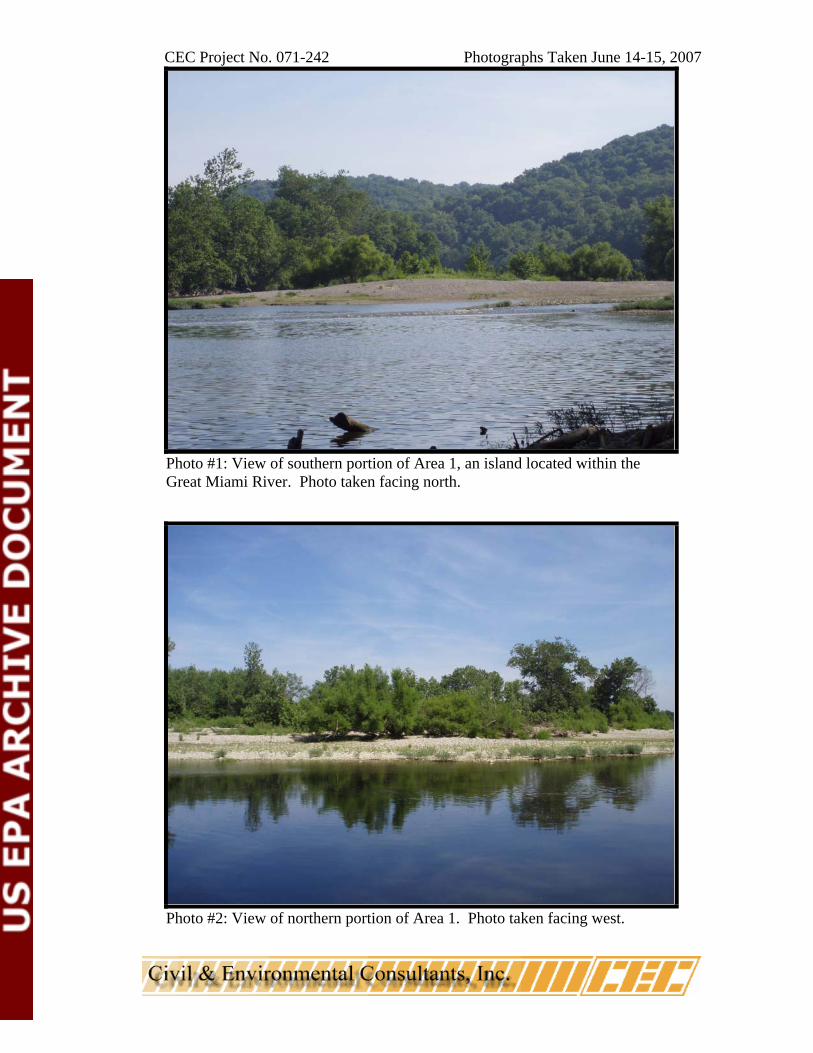
Photo #1: View of southern portion of Area 1, an island located within the Great Miami River. Photo taken facing north.
Photo #2: View of northern portion of Area 1. Photo taken facing west.

CEC Project No. 071-242 Photographs Taken June 14-15, 2007
Photo #3: View of Area 2, the majority of which is located below the OHWM of the Great Miami River. Second growth floodplain forest is located on the eastern fringe of Area 2. Photo taken facing south.
Photo #4: View from Test Pit 4 within Area 2. Photo taken facing northeast.

CEC Project No. 071-242 Photographs Taken June 14-15, 2007
Photo #5: View of the southern portion of Area 3, showing the flood channel of the Great Miami River and second growth floodplain forest. Photo taken facing north.
Photo #6: View of northern portion of Area 3, below the OWHM of the Great Miami River. Photo taken facing south.

CEC Project No. 071-242 Photographs Taken June 14-15, 2007
Photo #7: View from Test Pit 2 within Area 3. Photo taken facing northeast.
Photo #8: View from Test Pit 3 within Area 3. Photo taken facing northwest.

CEC Project No. 071-242 Photographs Taken June 14-15, 2007
Photo #9: View of second growth floodplain forest and urban/industrial turf within Area 4. Old field vegetation was present along the gravel road. Photo taken facing south.
Photo #10: View of northern portion of island in the Great Miami River within Area 4. Photo taken facing south.

CEC Project No. 071-242 Photographs Taken June 14-15, 2007
Photo #11: View of Hooven Ditch (Stream 1) within the northern portion of Area 4. Photo taken facing southeast.
Photo #12: View from Test Pit 1 within Area 4. Photo taken facing south.

CEC Project No. 071-242 Photographs Taken June 14-15, 2007
Photo #13: View of Area 5. Photo taken facing north.
Photo #14: View of Area 6, showing the flood channel of the Great Miami River and second growth floodplain forest. Photo taken facing east.

CEC Project No. 071-242 Photographs Taken June 14-15, 2007
Photo #15: View from Test Pit 5 within Area 6. Photo taken facing northwest.
Photo #16: View from Test Pit 6 within Area 6. Photo taken facing north.

CEC Project No. 071-242 Photographs Taken June 14-15, 2007
Photo #17: View of an unnamed intermittent tributary to the Great Miami River (Stream 2). Photo taken facing west.
Related Documents