WATER OCCURRENCES AND DEWATERING PRACTICE AT NKANA DIVISION Z.C.C.M. C.P. de Vente, Assistant Head of Geological Services, Nkana Divlsion. ABSTRACT. Division operates three mines along the east limb of the Chambishi Basin. from north to south: Shaft, Central Sflaft and South Orebody Shaft. From the beg inn i ng of m; ni ng operations actlve dewatLering of the hangingwal1 and to a lesser extent aquifers has been carried out. Several discrete often rather complex aquifers have been delineated. Dewatering is being carried out by means of boreholes drilled lnto the hangingwall from regular mining development or specially mined dewatering dr"ives in the hangingwall. To date dewatering in advance of the stoping face been quite successful, but at Central and South Orebody Shafts mining is approaching the complexly folded lower part of the Nkana Synclinorium with equally complex aquifers above it. The necessity to dewater these aquifers before by caving methods can safely be carried out has long been recognised, and several thousands of metres of hangingwall development has been mined for this purpose. More recently the possibility of minlng the synclinorium by backill methods has come into vogue, whi h would require a substantially smaller dewatering effort, espec ally for the higher aquifers. A sUbstantial amount of informat on about the aquifers has already been collected. however, and a qualitative picture of thei r recharge can be 9 -I ven. 220 International Mine Water Association Symposium Zambia 1993 | © IMWA 2009 | www.IMWA.info Reproduced from best available copy

Welcome message from author
This document is posted to help you gain knowledge. Please leave a comment to let me know what you think about it! Share it to your friends and learn new things together.
Transcript
WATER OCCURRENCES AND DEWATERING PRACTICE AT NKANA DIVISION Z.C.C.M.
C.P. de Vente, Assistant Head of Geological Services, Nkana Divlsion.
ABSTRACT.
N~ana Division operates three mines along the east limb of the Chambishi Basin. from north to south: Mi~dola Shaft, Central Sflaft and South Orebody Shaft. From the beg inn i ng of m; ni ng operations actlve dewatLering of the hangingwal1 and to a lesser extent footw~ll aquifers has been carried out. Several discrete often rather complex aquifers have been delineated. Dewatering is being carried out by means of boreholes drilled lnto the hangingwall from regular mining development or specially mined dewatering dr"ives in the hangingwall. To date dewatering in advance of the stoping face ~as been quite successful, but at Central and South Orebody Shafts mining is approaching the complexly folded lower part of the Nkana Synclinorium with equally complex aquifers above it. The necessity to dewater these aquifers before s~opjng by caving methods can safely be carried out has long been recognised, and several thousands of metres of hangingwall development has been mined for this purpose. More recently the possibility of minlng the synclinorium by backill methods has come into vogue, whi h would require a substantially smaller dewatering effort, espec ally for the higher aquifers. A sUbstantial amount of informat on about the aquifers has already been collected. however, and a qualitative picture of thei r recharge can be 9 -I ven.
220
International Mine Water Association Symposium Zambia 1993 | © IMWA 2009 | www.IMWA.info
Reproduced from best available copy
1. INTRODUCTION
Nkana Division of Zambla Consolidated Copper Mines perates three shafts along the southeastern end of the Chambishi asin irl the centre of the Copperbelt (figure 1). The three shaf S, from north to south, Mindola, Central and SOB (South Orebody), cover a total strike length of about 14 Km. Central and SOB Shafts actually make-up one orebody (the Nkana Orebody) separated from Mindola in the north by the Kitwe Barren Gap, a patchily mineralized dolomitic zone with a strike length of about 1.3 The lowest operating levels are 4180L at Mindola and 3760L at Nkana, but a shaft sinking programme down to 5220L is underway at Mindola with further resources at depth. The Nkana resources are expected to extend to about 5220L at the northern end of Central Shaft against the Barren Gap.
Together the three shafts produce about .5 M.tonnes of ore at 1.60% Cu and 0.09% Co. A fourth shaft, Chibuluma, delivering to the same concentrator, is located along the southern edge of the Chambishi Basin, but is of no further concern here.
Traditionally mining has been carried out by caving methods. This has necessitated active dewatering of the harlgingwall, which, as had been recognised from the earliest days, contained several discrete aquifers. About 45000 m3/d is presently pumped from each of the Mindola and Nkana Mines. About 75% can be attributed to direct aquifer inflow.
Timely dewatering of the largely unfolded eastlimbs of the orebodies has to date caused no major problems, and large efforts, both by mining special dewntering development and drilling have already been expended to dewater the complex folds at depth at Central and S08 Shafts (known as the Nkana Synclinorium). The latter exercize has recentl been downgraded because of a change in mining strategy to 111. A good understanding of the character of theft@rs and the ways of recharge is nevertheless required as the aquifer nearest to the orebody will still require dewatering:
Reviews of the dewatering have been presented by Tomkins and Coles (1971), outlining also a strategy to dewater the Nkana Synclinorium, and by Straskraba (1991), to assess the need of dewatering in the light of a change in mining method from caving to backfill.
2. GEOLOGY
Descriptions of the Geology of the Copperbelt can be found in Mendelsohn (1961), and in de Vletter (1971). A detailed description of the geology at Nkana can be found in the Geological Guide to the Nkana Division (1983). A stratigraphic ~olumn ;s shown in figure 2. .
221
International Mine Water Association Symposium Zambia 1993 | © IMWA 2009 | www.IMWA.info
Reproduced from best available copy

r'\\<:~,\ ~ CHAMl',I<;Hi
p .IN
. """
/' /
GEOLOGY. OF TtH ZAMBI~N 1
COPPERS£lT
\
... ~., ~~,' JI>.~D~lON[ _101[' t ••. J "Mf::::.' (.. M[ DQlQM II E. S~ ~.I
'" ') (
~UIHII.jlo., tUV:. S .. "d
ov.uM Ii. U"I~,\H'
~. ~ •• ; .! . ON",QM[ Rb.T!
.; ~O~"IdMIHTE,
-' N E ' :. ~ ~ Ii:" HIT[
International Mine Water Association Symposium Zambia 1993 | © IMWA 2009 | www.IMWA.info
Reproduced from best available copy
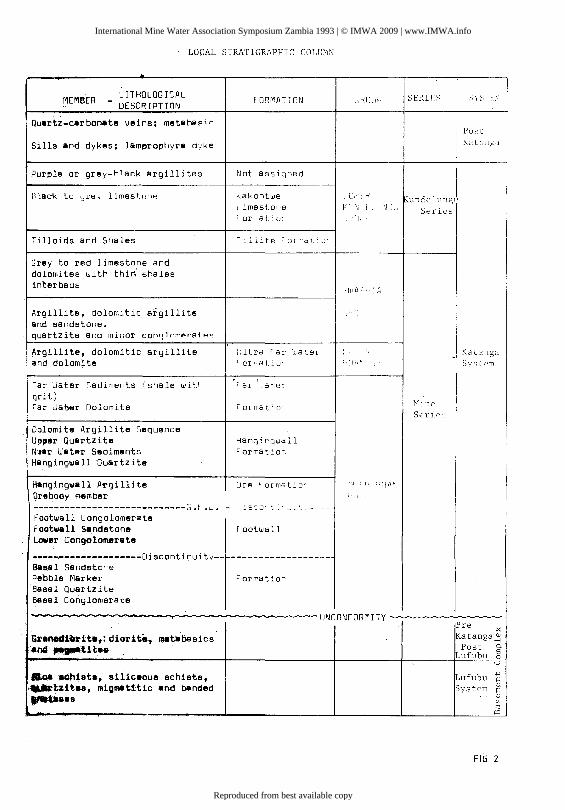
LOCAL STRATIGRAPHIC COLUMN
MEMBER l ITHOlOG leAL FORMATION "ROLJf-' SERIfS SYSTI.:I -.. DESL:R lPTION
Quartz-carbonate veins; metahaf'; r Post
Sills and dykes; lam~rophyre dvke Ka t,,,\ga
Pur~le or grey-hlAr.k argilli tes Not aSSiyr1ed
Black to Ljr~y 1 imest.ollfl Kakontwe 0" f R ~undcl11ngl' ~ imestor'8 I< ~J ~ . ,W;" Series Formatio: ,',UL;
Tilloids and Shales 1 :ll:te ~. or mdt: o'
Grey to red limestone and dolomites with thiri shales interbeds
'luA: .: A
Argillite, dolomitic argillite and sandstone. quartzite and minor COfl,]Joml9!'8tF'!"
~rgillite, dolomitic argillite L: ltra rar u.a~Br c" ; r;
- Katanga and dolomite Format i o' : < [I [, ~ System
Far Water Sediments : sha Ie with ' 81 , at.el grit)
Mille Far Waber Dolomite Formatio Serir" .
Dolomite Argillite Sequence Upper Quartzite Hang:rgwall N'3ar Water Sediments Format:or~
Hangingwall Quartzite
Hangingwall Itt-gillite Ole ' ormat:o' ,ll : l-.' UlA" Ore body member "II
----------------------------G.F .~. - : 5::'0' :',' ~:', ----Footwall Congolornerate Footwall Sandstone footwall Lower Congolomerate
-----,..--------------Discontinuity-- ------------------Bas.al Sandsto'e Pebble Marker Formatio~
Basal Quartzite Basal Conglomerate
.... .,.. II!II I!'" .. T UNCONFORMITY Pre >:
Gl'anadlbrite,:diorit_, _tabasies ~atanga~ _nd .. _ •• atH .. POst p.
Lufubu s 0
0
auaQhista, siliceous schists, Lufubu .w
" ,..-tz.ttea, migmaUtie and banded System ill S
.,..,.8es ill (f) (1j
f'Q
FIG 2
International Mine Water Association Symposium Zambia 1993 | © IMWA 2009 | www.IMWA.info
Reproduced from best available copy

The Roan Group, containing the Ore Formation and the aquifers was deposited on a high relief basement. Basement highs have had an influence on both depositional environment, giving rise to a more dolomitic facies commonly showing only patchy mineralisation, and structure; the highs, having resisted folding, form often the cores of large anticlines.
The Mindola and Nkana orebodies (see fig. 3) cover structurally different domains. The Mindola orebody, unfolded, varies in dip from about 35 deg. in the north to 80 deg. overturned in the south. The strike shows an asigmodial shape, draped around a basement high, the No 3 Shaft Granite. Several fissures radiate from this high, indicating the tensile stresses caused by its resistance to yielding. To the south of the Kitwe Barren Gap, the Nkana Orebody shows several folds on the mined east 1 mb, and at least another four highly complex folds have been delineated towards the base of the synclinorium, which forms a kind of panhandle to the Chambishi Basin. The average plunge is about 25 deg. to the northwest, but steepening, shallowing and even reversal of plunge are common. The strike of the folds in the synclinorium corresponds to the general trend of other basins to the north, but the strike of the synclinorium is about 15 deg. more to the north, which is seen as evidence of later crossfolding. Secondary folding is common and amplitudes can vary greatly over short distances. Jointing, especially axial plane jointing, is common, but actual faulting is rarely observed Figure 4 gives an impression of the folding in the synclinorium.
3. WATER OCCURENCES.
Three hangingwall aquifers have been recognized: the Near Water, Far Water and the Ultra Far Water. The iatter. only present at Mindola and the northern part of Central Shaft, is not actively dewatered and is not of real concern here.
The Near Water Sediments, starting 10-15 metres stratigraphically above the orebody, consist of a succession of sandy argillaceous dolomites with some sandstone bands, and have a thickness of 30-50 metres. The main water occurences are within the first 20 metres, but water can be intersected virtually anywhere in the formation.
The Far Water Aquifer begins immediately above the Upper Quartzite, 70-100 metres above the orebody. The main water occurences are found here in the Far Water Dolomite, but frequent intersections are also made in the Far Water Sediments, a succession of ~rgillites and gritty argillites with minor dolomite intercalations. Less frequently, but not uncommonly, intersections are made in the Dolomite Argillite Sequence between the Far Water Dolomite and the Upper Quartzite. The Upper Quartzite, about 10-15 meters thick is therefore the only real aquiclude between the Far Water and the Near Water.
224
International Mine Water Association Symposium Zambia 1993 | © IMWA 2009 | www.IMWA.info
Reproduced from best available copy

I II rll: :'~ ~ ,
1> 1>
I~'I ~III_-.:;,', ~ ~ S C) ~ r:-I 1>, ~ 7J
Z m Vl
,-
~
\
r' \ ;
I \" I ~ i
\ \\ \. \\" "\.
\\;,,~ G \ \ \~
r ~'.t. I I,.. \\ '"'~) I - H~ j ~ - ~ \ "] §;,-€ - L ____ _
225
International Mine Water Association Symposium Zambia 1993 | © IMWA 2009 | www.IMWA.info
Reproduced from best available copy

'f--+--- '2 I-tO L
St-..AL§V~ __
SECTION Al ZHO CfNT/2AL SHAFT
~f'110N A1 48005 ~~N1RAl SHAFT
.IU...r FWD- FAR WATER DOLOMITE
Uo. - UPPER QUARZITE
_~S~H ~LlVf.L~_ ~
S£tl'~" A1 4'O¢S ~¢~ ,SHAFT lKm
·2 ,4 ·66 ! ~
International Mine Water Association Symposium Zambia 1993 | © IMWA 2009 | www.IMWA.info
Reproduced from best available copy

At present the Near Water Aquifer produces about 13000 m3/d at Nkana and about 4500 m3/d at Mindola while the Far Water Aquifer produces about 5500 m3/d at Nkana and 7500 m3/d at Mindola.
At both orebodies the aquifers were continuous down to about 300 metres. At greater depth they are actually dry over large parts of the mines. At Mindola the aquifers are largely confined to the northern part of the mine, where they have been divided into two domains: North Mindola from about 3000N to 8000N, which has, according to water head readings continuous aquifers, and the Far North, where water head readings seem to indicate discontinuous aquifers. The Near Water Aquifer appears to close below 3400l. Some minor Near and Far Water occurences were found at the south of the mine against the Kitwe Barren Gap. They are dry at present.
At the Nkana Mines, the Near Water Aquifer is present in the far south of SOB Shaft, but from about 5000S to the boundary between SOB and Central Shafts no Near Water has been intersected. The Far Water starts at about 4600S SOB Shaft and continuous intersections have been made to the north of Central Shaft above the synclinorium. The East limb appears to have been largely dry.
Footwall water is also present at all shafts. At Mindola it is predominantly associated with fissure zones; at the Nkana Mines it appears to be most commonly associated with tight folding, but at Central Shaft an extensive zone of stratigraphically controlled water was found in the Footwall Sandstone on 3360L. Footwall Aquifers produce about 8000 m3/d at Nkana and 3000 m3/d at Mindola.
A further source. of water i nf 1 ow is formed by the so-call ed box-water. This is water flowing through old abandoned stopes and provides about 5000-6000 m3/d at Mindola and about 1000 m3/d at the Nkana Mines. It is of interest to note that at Mindola the area of box water inflow corresponds largely to the area of hangingwall aquifer presence. This would indicate that it is water from aquifers not actively dewatered high up in the hangingwall rather than from recharge through the caving area.
Another 10000 m3/d flow from unspecified sources into Mindola and 5000 m3/d into Nkana. This water enters the mine mainly from abandoned development and the sources are not always clear.
Black (1978) postulated that structural control was actually of more importance than stratigraphic control. At Mindola, water occurences are related to a tensional zone, where it ;s warped around the no 3 Shaft Granite, evidenced by the fissure zones, mentioned earlier. At the Nkana Mines water occurences would be concentrated into anticlinal zones. The total picture is then complicated by crossfolding, as evidenced by the difference in strike between the synclinorium axis and the individual fold axes. This crossfolding has created secondary synclines and
227
International Mine Water Association Symposium Zambia 1993 | © IMWA 2009 | www.IMWA.info
Reproduced from best available copy
antlclines on the folds and so structural domains that are either dry or water containing. Similarly crossfolding was thought to be responsible for the discontinuous aquifers at Mindola Far North.
4. DEWATERING PRACTICE AND ACHIEVEMENTS
At Mindola Shaft dewatering has always been straightforward and easily achieved. Boreholes of 200-250 metres length are drilled from footwall main level development at intervals of about 120 metres. A fan of holes is dril1ed until further drilling does not increase the inflow. Originally drilling was carried out from each main level, later this was chan~ed to every two main levels, a vertcal interval of nearly 150 metres. New drilling brings down the waterhead fairly quickly and flows reduce to a level which then remains more or less constant indicating the actual ra~e of recharge.
Boreholes are generally drilled for both the Near Water and Far Water Aquifer simultaneously. The Far Water head, being generaily higher than the Near Water, is commonly recorded. The Near Watsr head is established from the few holes that did not pass the Upper Quarzite.
At the Nkana Mines dewatering largely followed the same routine as at Mindola until the late sixties, with the exception of an occasional dewatering crosscut especially mined to dewater a
ld. that the folded bottom of the Synclinorium had been partly lineaLed, and it had bacome obvious that special efforts were requlred to dewater the complex aquifers above the synclinorium, if the folded orebodies were to be mined without a severe water hazard.
Tomkins and Coles (1971) proposed a basic strategy of crosscuts mlned through permanent dewatering pillars and from these dewatering drilli development mined along strike more or less over the centre 0 the synclinorium. This strategy was accepted and about 9000 metres of dewatering development has been mined since (see figure 5). Drilling followed as quickly as possible but the conventional air rigs in use made slow progress with the
ong and steep upholes that were required and the programme was soon running severe y behind schedule. By the mid eighties it was estimated that about 80000 metres of drilling was left to complete the exploratory dewatering drilling requirement. As quick progress became more urgent four hlgh power electrohydraulic rigs were purchased, and commissioned during the latter p3rt of 1987. About 20000 metres of dewatering drilling has been achieved since then, but the last few years the rigs have been mainly involved in exploration drilling as priorities have changed with the change of preferred mining method to backfill.
The drilling strategy that was used assumed a down-plunge movement of water so drilling would gradually move from south to
228
International Mine Water Association Symposium Zambia 1993 | © IMWA 2009 | www.IMWA.info
Reproduced from best available copy

"'s-
~
~QO
'" s:~~~
~~
~-
L r:
:J
~_~ '-
Jf
FW:"
" 3D
L1(
> ",~
d
......... ~
NIV
-+l>
(\()
"'1d
F
III-
2S
0CJ
tr)z
/q
?>~
r') S~B
SrlA
] r
~ ~ -
---O
UT
AREA
.~ ~
~---
STO
PE
D
r '-
--c
j
_,,1
[
~R'/
~ 1=
w-zo
o(:>
mS
/cJ
~
~
NW
-N
EA
R
WA
TER
F
W-F
AR
W
ATE
R
FT
W-
FO
OT
WA
LL
WA
TE
R
'>
00 °
t?0
~
<i'
NKA
NA
SY
NC
LIN
OR
IUM
D
EWAT
ERIN
G
DE
VE
LOP
ME
NTS
AN
D PR
ESEN
T W
AH
R
FLO
W S
~-.1' C
'c, o~~
lKm
lK
m
I -8
-6
-4
-2
I
International Mine Water Association Symposium Zambia 1993 | © IMWA 2009 | www.IMWA.info
Reproduced from best available copy
north, continuously drawing down the water heads. A successful example of this theory can be seen at SOB Shaft where water inflows from crosscuts~on 1250L and 1810L were reduced to iHsignificant when drilling from dewatering development ex 2090L/l030N and further to the north tapped all flows higher upplunge (see table 1). Flows on 1250L and 1810L were already decreasing as the original water storage above the intersections was drawn down, but this was probably accelerated and recharge has been nearly fully cut-off. It ;s of interest to note that drilling from 1250L/4600S reduced flows at 3600S, reversing the expected pattern.
At all shafts water flows are measured monthly and water heads quarterly at all accessible borehole collars.
5. CHARACTER OF THE AQUIFERS
It has long been known that the aquifers do not correspond to well defined stratigraphic horizons. Multiple intersections are common and water intersections made at a certain stratigraphic position may not be repeated in another nearby hole. At Mindola Shaft water heads are nevertheless fairly regular, at least in the North section of the mine. At the Nkana Mines both the size of inflow and the water heads can vary enormously from hole to hole.
The most striking example of the latter is found in a Near Water occurrence on the western limb of the B-Fold at 3360L/500S, Central Shaft. Near Water traditionally had not been much of a problem here, and the intersection in the mid seventies of a major aquifer giving large volumes of hot (45 deg.) water at initial pressures up to 25 bars was certainly unexpected. From one site about 30 holes were drilled giving a maximum flow of more than 18000 m3/d. Flows from individual holes varied from a trickle to more than 2000 m3/d, and pressures varied from less than 2 bars to 25 bars (although such pressures reduced fairly quickly to below 10 bars). Flows had dropped to about 9000 m3/d when drilling along strike to the south started over a length of 300 metres to 1500S. As table 2 on the next page shows, the main flows migrated southwards with the drilling. The pressures encountered south of 500S were at a maximum of about 10 bars,so dewatering from 500S had already succeeded in bringing down the water head over a considerable strike length.
At present flows are about 8000 m3/d with the boreholes at 1500S closed. The sites are virtually inaccessible because of ventilation problems.
Obviously the aquifer is of a complex nature. The large flows, which were intersected at close distance from each other, point to an essentially continuous aquifer, where water heads were the same before drilling started. At some intersections the water
230
International Mine Water Association Symposium Zambia 1993 | © IMWA 2009 | www.IMWA.info
Reproduced from best available copy

SO
g--r 0 '7
0
, 0
'7/
/25
0L
/ 4
(,0
0 5
12
5o
L/3
(;O
OS
2
55
0
2(;
,15
18
1C
AI7
00
N
24
£5
2
20
0 I
i-
I
() '7
1
35
30
28
70
:--------+
---t-~-
~ ~
! 18
101.
-/ ?
bo
N
/72
0
I 2
1 5
0
!
-
g8
5
--t
-
IB/O
L /
9(;
ON
2
81
0
3 0
95
2
20
0
I 9
10
-+
1
20
90
L/I
03
0N
tlZHO
-25O
"W)
TO
TA
L
1/0
83
5
97
75
I
_,!o
19
89
5
TABL
E 1
J1 7J1
. [7
'74
J'7
5
0'7
5
J)b
O
'7b
/40
5
1')
f,0
1
18
0
b8
0
57
5
I
19
25
9
05
/6
5
115
65
5
0
12
45
1
'],5
5
10
75
1
99
0
19
80
/7
70
2/0
1
75
1
50
11
5 11
5 9
0
/.3
40
1
2'5
1
40
.5
80
5
79
0
7/5
13
80
'J
.Jl.1
5 3
70
0
~G8D
/.I 9
{,0
8
54
5
~/OO
75
2.0
7
75
5
78
85
8
59
0
1/
74
5
FA/Z
WA7
ER..
F,W
WS
12
50L
I /8
/0L
, 2
09
0L
M-M~R.CI{
.1"-
juN
E
/)-
/)E
cEH
18E
1l.
I
J'7
7
J'7
8
]"'7
9
7'8
0
j'8
/ J'
8s
/IJ' 9
J
!
40
5
3'10
/9
5
18
0
(;0
5
5
bO
bO
15
6
0
/20
6
5
13
90
b
8S
n
o
655
/.J80
26
0
'0 (,
0
35
' P
Ry
88
0
f40
57
5
27
5
24
0
15
0
42
5
50
10
4
54
5
1JC
,40
42
'30
3
10
0
]11-
25
1'1
5
78
05
C
,21
0
C,l
fiD
5
11
00
4
00
0
39
55
2
0J/0
International Mine Water Association Symposium Zambia 1993 | © IMWA 2009 | www.IMWA.info
Reproduced from best available copy
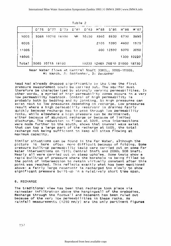
Table 2
I 0'75 0'77 0'79 0'81 0'83 M'85 S'85 M'86 M'87
500S 5065 10715 16100 NR 10330 9560 8630 6730 3890
600S 2105 5390 4600 1570
1100S 800 12590 8370 3050
1500S I 1300 10220 I
Total 15065 10715 16100 10330 12465 26610 21000 18730
Near Water flows at Central Shaft 3360L, 500S-1500S. M: March, S: September, 0: December
head had already dropped significantly by the time the first pressure measurement could be car'ried out. The aquifer must therefore be characterized by strongly varying permeabilities. In other words, a myriad of high permeability zones occurs in a very low permeability hostrock. Control of high permeability is probably both by bedding and by jointing. So high pressures can exist next to low pressures depending on recharge. Low pressures result where a high permeability reservoir is drained fairly quickly because recharge has to pass through low permeability rocks, while elsewhere a high pressure can be maintained, either because of abundant recharge or because of limited discharge. The reduction in flows at 500S, once intersections were made further to the south, shows that channel ways exist that can tap a large part of the recharge at 500S, the total recharge not being sufficient to keep all sites flowing at maximum capacity.
Similar situations can be found in the Far Water, although the picture is here often more difficult because of folding. Some pressure built-up permeability tests were carried out on some Far Water intersections on 1910L Central Shaft and 2090L SOB Shaft. Nearly all were carried out on steep upholes. Some tests show a rapid built-up of pressure where the borehole is being filled to the point of intersection to remain virtually constant after this point was reached. This reflects exactly what has been mentioned above: a fairly large reservoir is recharged too slowly to show significant pressure built-up in a relatively short time span.
6. RECHARGE
The traditional view has been that recharge took place via rainwater infiltration above the hangingwall of the orebodies. Recharge through the footwall and basement has been ruled out because of the very low permeabilities in these rocks. As rainfall measurements (1250 mm/y) are the only pertinent figures
232
International Mine Water Association Symposium Zambia 1993 | © IMWA 2009 | www.IMWA.info
Reproduced from best available copy

available, the establishment of a water balance would be highly tentative. Nevertheless attempts were made by Tomkins and Coles (1971) and Straskraba (1992). The rainwater infiltration surface area for the Nkana Orebody was set at about 20 Km2 by Tomkins and Coles. This includes a part of the hangingwall over Mindola. An infiltration of 35% was required to obtain a sufficient volume of water (27000 m3/d, allowing for an actual drawdown of 5000 m3/d). The infiltration area for Mindola was reckoned to be about 80 Km2 by Tomkins and Coles but this covers also a large part ot the area that recharges the Chibuluma Mines to the south.
Straskraba (1991) gives a figure of 10% for infiltration, but he lends great importance to the infiltration potential of Mindola Dam, a surface water expanse of about 3 Km2. It is related to a tailings dam and at its design it was stated that a level of 2 metres of tailings would provide an effective seal against infiltration, but it is not known if this was actually achieved. It cannot be claimed as evidence that no or very little infiltration takes place below Mindola Dam, but it worth notin, that the water level of the lake was little changed at the end of the dry season 1992, after below average rains which had shown its effect on many other surface waters by much reduced levels. Straskraba also considered that aquifers higher up in the succession could give considerable recharge.
At the Nkana Mines the Far Water Aquifer is currently producing some 6000 m3/d. Considering that few intersections have been made since about 1985, most of this water is probably recharge. Rainwater infiltration of 10% could largely account for this volume, but if infiltration is less, another source of recharge has to be present.
The Upper Quartzite is considered to be an effective aquiclude and because of this the need to dewater the Far Water Aquifer in case of backfill mining has been removed. The only place where pressures in a Near Water intersection indicated a water head above the Upper Quartzite is at 3360/4200N Central Shaft, but this has generally been linked to the nearby presence of a surface hole, through which water from much higher sources was being tapped.
The infiltration surface for the Near Water Aquifer is therefore quite restricted, and there seems to be no simple recharge pathway for the large flows of water encountered at 3360L/500S. Moreover, it should be pointed out that the water at this location is hot, about 45 deg. comparable to the water at the lowest dewatering level at Mindola, 3920L. It is doubtful if water passing through a relative short distance'could maintain such a temperature. In this connection it may also be pointed out that box water is much cooler than borehole water on the same level.
A main source of recharge could possibly be the Kitwe Barren Gap, but the fact that flows at the Far South of Mindola Shaft have
233
International Mine Water Association Symposium Zambia 1993 | © IMWA 2009 | www.IMWA.info
Reproduced from best available copy
dried-up does not point to a large reservoir, that could sustain recharge of the Near Water over a long period. The only possible path of inflow that remains is then from down-plunge, i.e. from far into the Chambishi Basin, and it is from there that it is postulated the main recharge is taking place, the water intelsections of the Near Water being likened to artesian wells. This does not prevent the sketched situations as at 3360L/500S where intersections at 1500S, now further away from the source, actually tap more water. Although the distance is longer the pat,1way is easier, possibly located below 3360L at 500S position.
At Mindola the situation is somewhat different as the surface area available for infiltration is much larger, but the potential for infiltration may well not be sufficient. As has already been mentioned, box water occurs only where aquifers are present. This has been explained by cave cracks tapping higher aquifers, the presence of which is controlled by the same tensional regime, which controls the presence of the Near Water and Far Water Aquifers. So, even over the caving area direct infiltration is probably quite low. Recharge from stratigraphically higher aquifers is a possibility, but the amount of box water flow would indicate that the potential is limited; only 5000 to 6000 m3/d through broken ground would point to lower flows through semiaquic1udes, although recharge could take place over a much larger strike length than just over the dewatered area of Mindola. Dir$ct recharge is considered most likely to come through the Near Water and Far Water Aquifers themselves from the north and from below. with regards to the Near Water Aquifer, recharge can only come from the north as the aquifer appears to close.
A'mode1 has then been constructed, that contains a much larger recharge area and aquifers, although highly irregular in permeability, that are essentially continuous.
This model disagrees at least partially with the structural domains as postulated by Black (1978). There is no doubt that the aquifers at the northern side of Mindola are structurally determined if not controlled. However, the proposal of crossfo1ding breaking-up aquifers in domains is not considered viable, if only because these domains would have very small potential for recharge.
7. FURTHER DEWATERING.
It has been agreed that with backfill mining there is no requirement to dewater the Far Water Aquifer any further. Some minor drilling is still being carried out to check on the continuity.
The Near Water Aquifer will still have to be dewatered. This asks for much less drilling than the Far Water Aquifer as holes can be much shorter and for that reason can also be much better
234
International Mine Water Association Symposium Zambia 1993 | © IMWA 2009 | www.IMWA.info
Reproduced from best available copy

targeted. However, as 3360L/500S has shown, flows can be significant, and according to the given model they will not decrease down-plunge. Drilling can to a large extent probably be carried out from regular development, but this should be carefully planned so dewatering can be effected in good time. Strictly all drilling could be done from the lowest level at the northernmost position by drilling a very dense fan.
8. CONCLUSIONS.
The aquifers are highly irregular with zones of very low permeability, virtual aquicludes, and zones of very high permeability.
The aquifers are essentially continuous, unless separated by folds or as at Mindola, where the water occurrences on the far south are probably only very indirectly connected with the occurences on the north side.
In the synclinorium the Near Water Aquifer is mainly recharged from a down-plunge direction, while the Far Water Aqulfer is probably recharged both from direct rainwater infiltration above the synclinorium and by up-plunge flow similar to the Near Water. At Mindola recharge occurs both from below and from the north with probably only minor recharge from rainwater falling on the immediate hangingwall area.
The rainwater infiltration recharge area covers a much larger area of the Chambishi Basin than previously assumed.
Acknowledgements.
The authhor wishes to thank Zambia Consolidated Copper Mines for the permission to publish this paper; Mr. T.W. Stalker, Chief Geologist of Nkana Division for his support and the useful discussions on the subject; Mr. F. Chipulu and Mr. I. 21mba, Chief Draughtsman and Senior Draughtsman respectively, for tIle preparation of the figures at short notice.
References.
BLACK, R.C., 1978 The influence of structure on underground water prediction and occurence at Rokana Mine, Kitwe, Zambia. SIAMOS-78, Granada, Spain.
DE VLETTER, D.R. et al., 1972 Geologie en Mijnbouw Vol.51 No.3. (Zambia Issue)
235
International Mine Water Association Symposium Zambia 1993 | © IMWA 2009 | www.IMWA.info
Reproduced from best available copy

MENDELSOHN, F. (Ed.), 1962 Geology of the Northern Rhodesian Copperbelt. McDonald & Co., London.
NKANA DIVISION, Geology Staff,Geological Guide to Nkana Division. 1983 Unpublished Z.C.C.M. Ltd. Company
Report.
STRASKRABA, V., 1991
TOMKINS, C.C. & COLES, J.J. 1971
236
Hydrologic study assessment of the existing situation Nkana Mine Expansion Project. Hydro-Geo Consultants for Z.C.C.M. Ltd.
The Water Report. Unpublished N.C.C.M. Ltd. Company Report.
International Mine Water Association Symposium Zambia 1993 | © IMWA 2009 | www.IMWA.info
Reproduced from best available copy
Related Documents