Introduction The Washpool/Gibraltar Group of the Central Eastern Rainforest Reserves of Australia (CERRA) is a World Heritage-listed area that contains the largest expanse of coachwood warm temperate rainforest in the world (RACAC 1996; Adam 1994). It also includes one of the largest areas of un-logged sclerophyll forest in New South Wales, and signiicant sections of wild and scenic rivers supporting riparian rainforest. Two declared wilderness areas occur within the study area: Bindery-Mann and Washpool. This paper presents part of the results of a comprehensive lora and vegetation survey of Gibraltar Range National Park and adjoining sections of eastern Washpool National Park. These areas lie approximately 65 km east of Glen Innes and 90 km west of Grafton (Fig. 1) (29°31’S 152°18’E). This investigation was commissioned by the Northern Tablelands Region of the NSW National Parks and Wildlife Service in order to provide baseline information to assist in determining appropriate land management strategies (Sheringham & Hunter 2002). In addition to the descriptions of vegetation communities we have also assessed changes in diversity attributes between the described assemblages. These diversity attributes can be used along with the baseline community information to provide further assess the conservation value and internal dynamics of the vegetation communities described. European landuse history and reservation Due to the rugged nature of the local terrain, the region was not accessed by graziers until around 1850. Gibraltar Range was initially used as a stock route linking the tablelands to the coast (Wright 1991). Tin and gold were discovered as early as 1852 leading to an inlux of people to the area. Commercial logging followed, particularly in the Washpool and Cangai areas up until the 1980s (Adam 1987). The Gwydir Highway, opened in 1960, runs through the middle of the study area and provides the main link between Grafton and Glen Innes. The building of this road was the catalyst for the establishment of Gibraltar Range as a reserve in 1963. The original dedication incorporated 14 000 ha for public recreation administered by the Department of Lands. In 1967 Gibraltar Range National Park was gazetted and taken under the management of the newly formed National Parks and Wildlife Service. Adjoining areas of State Forest have been added since that time, and presently Gibraltar Range National Park covers 25 406 ha. Washpool National Park was gazetted in 1983 as a result of the enactment of legislation designed to resolve disputes over the logging of rainforest in New South Wales. All rainforests on public land in New South Wales were protected as a result of the Forestry Revocation Act 1983. Washpool National Park was established following the enactment of the National Parks Reservation Act 1984. Washpool National Vegetation and floristic diversity in Gibraltar Range and part of Washpool National Parks, New South Wales John T. Hunter 1 and Paul Sheringham 2 1 School of Behavioural, Cognitive and Social Sciences, University of New England, Armidale, NSW 2351 ([email protected]); 2 Department of Environment & Climate Change, Locked Bag 914, Coffs Harbour, NSW 2450 AUSTRALIA Abstract: The vegetation of Gibraltar Range National Park and adjoining parts of eastern Washpool National Park, 65 km east of Glen Innes (29° 31’S 152° 18’E) on the eastern escarpment of New South Wales is described. In total 124, 20m x 50m full vascular plant loristic sites were recorded and information from an additional 53 sites was collated. Thirteen vegetation assemblages are deined based on lexible UPGMA analysis of cover-abundance scores of all vascular plant taxa. Many of the vegetation communities are typical of what is found along the north eastern escarpment of NSW. Three communities are considered to be rare and two vulnerable. A total of 878 vascular plant taxa from 138 families were recorded, of which only 21 (2%) were of introduced origin and 81 (9%) were found to be of conservation signiicance. Pattern diversity, species density, species accumulation and average geographic range size, along with general measures of richness and diversity, were analysed for all communities. Each of the communities described varied considerably in the diversity attributes measured. Communities with a high number of shrubs had greater constancy between sites compared to those that contained a high number of closed forest species. The community from rock outcrops had the largest average geographical range size. Cunninghamia (2008) 10(3): 439–474

Welcome message from author
This document is posted to help you gain knowledge. Please leave a comment to let me know what you think about it! Share it to your friends and learn new things together.
Transcript

Introduction
The Washpool/Gibraltar Group of the Central Eastern
Rainforest Reserves of Australia (CERRA) is a World
Heritage-listed area that contains the largest expanse of
coachwood warm temperate rainforest in the world (RACAC
1996; Adam 1994). It also includes one of the largest areas
of un-logged sclerophyll forest in New South Wales, and
signiicant sections of wild and scenic rivers supporting riparian rainforest. Two declared wilderness areas occur
within the study area: Bindery-Mann and Washpool.
This paper presents part of the results of a comprehensive
lora and vegetation survey of Gibraltar Range National Park and adjoining sections of eastern Washpool National Park. These areas lie approximately 65 km east of Glen Innes and 90 km west of Grafton (Fig. 1) (29°31’S 152°18’E). This investigation was commissioned by the Northern Tablelands
Region of the NSW National Parks and Wildlife Service in order to provide baseline information to assist in determining
appropriate land management strategies (Sheringham &
Hunter 2002). In addition to the descriptions of vegetation communities we have also assessed changes in diversity
attributes between the described assemblages. These diversity
attributes can be used along with the baseline community
information to provide further assess the conservation
value and internal dynamics of the vegetation communities
described.
European landuse history and reservation
Due to the rugged nature of the local terrain, the region was
not accessed by graziers until around 1850. Gibraltar Range was initially used as a stock route linking the tablelands to the coast (Wright 1991). Tin and gold were discovered
as early as 1852 leading to an inlux of people to the area. Commercial logging followed, particularly in the Washpool
and Cangai areas up until the 1980s (Adam 1987). The Gwydir Highway, opened in 1960, runs through the
middle of the study area and provides the main link between Grafton and Glen Innes. The building of this road was the
catalyst for the establishment of Gibraltar Range as a reserve
in 1963. The original dedication incorporated 14 000 ha for public recreation administered by the Department of Lands.
In 1967 Gibraltar Range National Park was gazetted and taken under the management of the newly formed National Parks and Wildlife Service. Adjoining areas of State Forest have been added since that time, and presently Gibraltar
Range National Park covers 25 406 ha.Washpool National Park was gazetted in 1983 as a result of the enactment of legislation designed to resolve disputes over
the logging of rainforest in New South Wales. All rainforests
on public land in New South Wales were protected as a result
of the Forestry Revocation Act 1983. Washpool National
Park was established following the enactment of the National Parks Reservation Act 1984. Washpool National
Vegetation and floristic diversity in Gibraltar Range and part of Washpool National Parks, New South Wales
John T. Hunter1 and Paul Sheringham2
1School of Behavioural, Cognitive and Social Sciences, University of New England, Armidale, NSW 2351 ([email protected]); 2Department of Environment & Climate Change, Locked Bag 914, Coffs Harbour, NSW 2450 AUSTRALIA
Abstract: The vegetation of Gibraltar Range National Park and adjoining parts of eastern Washpool National Park, 65 km east of Glen Innes (29° 31’S 152° 18’E) on the eastern escarpment of New South Wales is described. In total 124, 20m x 50m full vascular plant loristic sites were recorded and information from an additional 53 sites was collated. Thirteen vegetation assemblages are deined based on lexible UPGMA analysis of cover-abundance scores of all vascular plant taxa. Many of the vegetation communities are typical of what is found along the north eastern
escarpment of NSW. Three communities are considered to be rare and two vulnerable. A total of 878 vascular plant taxa from 138 families were recorded, of which only 21 (2%) were of introduced origin and 81 (9%) were found to be of conservation signiicance. Pattern diversity, species density, species accumulation and average geographic range size, along with general measures of richness and diversity, were analysed for all communities. Each of the
communities described varied considerably in the diversity attributes measured. Communities with a high number of
shrubs had greater constancy between sites compared to those that contained a high number of closed forest species.
The community from rock outcrops had the largest average geographical range size. Cunninghamia (2008) 10(3): 439–474

440 Cunninghamia 10(3): 2008 Hunter & Sheringham, Vegetation in Gibraltar Range, Washpool National Parks
Park is included on the World Heritage list (Gondwana Rainforests of Australia) and a signiicant proportion of the park is a declared wilderness area. Large areas of State Forest (Spirabo, Little Spirabo, Curramore, Moogem and Forest Land State Forests) were added to Washpool National Park in 1999 following the Comprehensive Regional Assessment of
public forests in upper northeast New South Wales. Further strategic purchases of adjoining private lands consolidated
the park During the 1990s Nymboida and Barool National Parks, which directly adjoin Gibraltar Range and Washpool National Parks, were also added to the reserve network.
Climate and weather
The climate of the study area is inluenced by its location on the edge of the Great Escarpment. Annual rainfall increases
with altitude along the eastern edge (1200–1300 mm) to the central plateau (>2000 mm) and decreases to the west (Bureau of Meteorology 1999). Mean annual temperatures range
between 12°–13°C on the central plateau and 17°–18°C on
the eastern escarpment. Mean maximum temperatures are in
the mid thirties on the eastern escarpment edge and the high
twenties on the plateau with a mean minimum temperature of
0°–5°C for the plateau and escarpment. The warmest months
are November to March.
During the early part of the day, tablelands winds dominate;
coastal winds move in during the mid to late afternoon.
Late afternoon thunderstorms accompanied by lightning
strikes, heavy rain and sometimes hail are a frequent event in summer. Widespread rain of reduced intensity but longer
duration is typical of winter weather patterns.
Landform
Much of the study area is of undulating to steep topography
dominated by extensive outcropping and subsurface granite
sheets, boulder ields and nubbins. Three main watercourses drain the study area (Dandahra, Coombadjah & Grassy
Creeks) frequently following joints and faults within the underlying granite and often forming waterfalls. The latter terrain on the central plateau contains areas of impeded
drainage forming large mires on Quaternary alluvium.
The Demon fault forms the western boundary of the study
area. Here the granite plateau drops precipitously into the
Cooraldooral Creek valley. This area forms a dividing line between the resistant Dandahra Granite and the weathered
metasediments of the Coffs Harbour Association. Boulder
and Boundary Creeks drain north and south respectively along this major fault line. The altitude within the study area
ranges from 300 m on the lower reaches of Dandahra Creek to over 1170 metres at Waratah Trig and Summit Mountain.
Earlier botanical explorations
Although botanical exploration took place in the north east of New South Wales in the early 1900s, detailed exploration
of the Gibraltar Range National Park did not take place until the early 1960s. At this time, botanist John Williams,
of the University of New England at Armidale, made many
plant collections in the Gibraltar Range and compiled an
unpublished species list of the rainforest and granite species.
Floyd (1990) undertook a detailed inventory of NSW rainforests using random irregular traverses. Many of these
were undertaken in the current study area. Hunter (1991) placed belt transects within the reserve in an investigation
into the demography of Brachyloma species. Some
investigations into species biology and ire responses have recently occurred (Caddy & Gross 2006; Croft et al. 2006; Vaughton & Ramsey 2006; Virgona et al. 2006; Williams & Clarke 2006).Though much botanical exploration has been done in the
Gibraltar Range area, particularly within close proximity
to the Gwydir Highway, few detailed systematic vegetation
surveys have been undertaken. During comprehensive regional surveys in north-eastern New South Wales (NRAC
1995; NPWS 1994; NPWS 1999) over 30 systematic sites were placed in the Gibraltar Range National Park Hunter (1999) placed 34 systematic sites to describe the granite outcrop communities. Hunter & Clarke (1998) subsequently described nine loristic elements and 28 vegetation communities on the New England Batholith, two of which
occur in the study area. Williams (1995) and Williams &
Clarke (1997) surveyed the sedge heaths in Gibraltar Range National Park. More recently Hunter & Bell (2007) surveyed the sedge heaths (bogs) of the region, including those in the
study area, and described these communities in detail along
with aspects of species composition and richness relating to
climatic and spatial factors.
Many adjoining areas have been systematically sampled for
lora and vegetation and include the state forests of the Glen Innes Management Area (Binns 1992), the western extensions to Washpool National Park (Hunter 1998b; 2000b; 2005a), Nymboida National Park (Benwell 2000) and Mann River Nature Reserve (Hunter 2004b).
Methods
Vegetation survey and community classification
The survey was carried out in a stratiied random manner in order to sample and replicate major environmental changes.
The strata used were a combination of mapped geological,
altitude and broad scale vegetation units (plateau complex,
dry open forest, wet open forest, disturbed remnant and
rainforest). The combination of these elements produced
24 strata; sites were allocated to these strata based on the number of hectares covered. Additional sites were placed
in specialised communities that were not included in the
a priori sampling strategy or to stratiied classes that were not spatially replicated in the sampling design. 124 x 0.1 ha full vascular plant loristic sites were surveyed speciically

Cunninghamia 10(3): 2008 Hunter & Sheringham, Vegetation in Gibraltar Range, Washpool National Parks 441
for this investigation, together with information from an
additional 53 sites; a database of 177 sites. Good quality voucher material of species that needed conirmation of identiication were lodged at the Coffs Harbour Herbarium (CFSHB). Nomenclature follows that of Harden (1993; 2000; 2002) except where more recent taxonomic changes have been made.
Analysis and data exploration were performed using options
available in the PATN Analysis Package (Belbin 1995a & b). A scree plot analysis was performed to assess the most
appropriate level of dissimilarity for community deinition. For inal presentation of results all species (including exotics) and their cover abundance scores were used. Analysis was
performed using the Kulczynski association measure, which is recommended for ecological applications (Belbin 1995a
& b) along with lexible Unweighted Pair Group arithmetic Averaging (UPGMA) and the default PATN settings. Rock outcrops were not part of the stratiication as these areas were deemed to have been suficiently surveyed and described (Hunter & Clarke 1998). Evidence for the distinctiveness of outcrop assemblages from the surrounding
matrix of the study area is given in Hunter (2002a).
Geographic range size
The mean geographic range size of the component lora has been calculated for each of the communities deined to assess their level of endemicity and uniqueness. This was achieved by creating a matrix of all species from each
community scored according to their occurrence in each of
the 97 ‘ecological regions’ of Australia, as deined by Hnatiuk (1990). The richness of each within each ‘ecological region’
Fig. 1. Location of the study area.

442 Cunninghamia 10(3): 2008 Hunter & Sheringham, Vegetation in Gibraltar Range, Washpool National Parks
was divided by the total species pool size of each community
as captured in survey sites. These scores were then summed
across all the 97 ‘ecological regions’ in order to produce a score that represented the average occupancy of the lora of each community across all the ‘ecological regions’. A higher score indicates that on average the lora of the community is more widespread, i.e. occupy more ‘ecological regions’ within Australia.
Species diversity patterns
Species diversity is derived from a combination of species
richness, measured as the number of species per sample area
(density) and the evenness of abundances. Aspects of richness
are the most commonly studied, and differences between
their values arise from geographical patterns of speciation,
extinction and re-establishment ability (Hunter 2005d) and therefore are of importance in designing management plans
for conservation.
Here species density is deined as the number of vascular plant species predicted to be found within 0.1 ha of sample
area after 1000 randomised iterations of each community
dataset with at least four samples using EstimateS (Colwell
1997). Modelling density in this fashion, within each deined community, is advantageous as it avoids spatial pseudo-
replication in subsequent between community comparisons (Hurlbert 1984; Srivastava 1999; Gering & Crist 2002; Hunter 2005d).
Fig. 2. Summary dendrogram of sites surveyed during this investigation using Kulczynski association and flexible UPGMA fusion strategy. Communities are defined at a dissociation of 0.8.
Cunninghamia 10(3): 2008 Hunter & Sheringham, Vegetation in Gibraltar Range, Washpool National Parks 443
It is of great importance that the method for determining
pattern diversity (spatial turnover within a habitat or
community) matches the aims of the study, as no single
estimator can model all aspects of geographical species
turnover (Heegaard 2004). Many issues arise from currently used methods for determining turnover particularly as many
measures tend to ignore the magnitude of gains and losses
between sample units, or describe compositional differences
more than differences in species richness (Whittaker 1960, Koleff et al. 2003). Here the slope of a log-log plot of the discontinuous Coleman curve (species accumulation curves)
which has been calculated after 1000 randomisations of each
community dataset containing a minimum of four sample
sites using EstimateS (Coleman 1981, Colwell 1997) is used as a surrogate for pattern diversity. This method was irst described and used by Hunter (2005d). As each community
has been delineated at the same dissimilarity they are
of at least a minimal and similar loristic independence (Kulczynski dissimilarity of 0.8.).
Results
Floristics
A total of 878 vascular plant taxa were recorded from existing
site data and subsequent sampling in the present study (Appendix 1). Only 21 (2%) taxa recorded were introduced/exotic. 552 taxa were recorded from the 124 new survey sites and a further 224 were recorded opportunistically. The remaining 97 taxa were recorded from previous surveys but not during this investigation. The recorded taxa represented
450 genera in 138 families. The families with the greatest
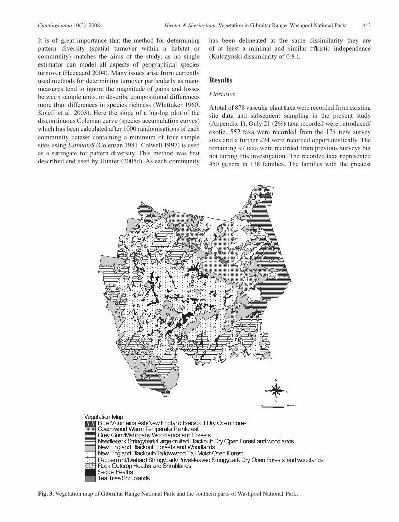
Fig. 3. Vegetation map of Gibraltar Range National Park and the southern parts of Washpool National Park.

444 Cunninghamia 10(3): 2008 Hunter & Sheringham, Vegetation in Gibraltar Range, Washpool National Parks
number of taxa recorded were Fabaceae (85 taxa), Myrtaceae (74), Orchidaceae (66), Asteraceae (42), Poaceae (44), Cyperaceae (33), Proteaceae (27), Rutaceae (25), Ericaceae (21), Euphorbiaceae (17) and Lauraceae (16). The richest genera were Eucalyptus (30), Acacia (24), Leptospermum (12), Hibbertia (11), Solanum (10), Pterostylis (8), Callistemon (8), Leucopogon (8), Lepidosperma (7), and Cryptocarya (7).
Vegetation
12 plant communities are described (Figure 2) with species listed in order of decreasing summed cover-abundance
score in each stratum. Species with low cover-abundance
scores were considered to have low constancy and not
included. Introduced taxa are not included. Figure 3 shows a generalised map of vegetation distribution .
Community 1: Eucalyptus olida (Gibraltar Ash) –
Eucalyptus ligustrina (Privet-leaved Stringybark) –
Eucalyptus cameronii (Diehard Stringybark) forest and
woodland
Habitat: associated with the Dandahra Granite. Found mainly on exposed to intermediate slopes in a range of topographic positions
including crests and drainage lines, on sandy granitic soils above 900
m. Soils are shallow to skeletal.Structure: heathy open forest and woodland or shrubland. Upper layer:
4–30 m; 10–40% cover. Upper middle layer: 2–8 m; 10–90% cover. Lower middle layer: 0.5–4 m; 15–80%; 0.1–2 m. Ground layer to 1 m, 10–90% cover. Trees: Eucalyptus olida, Eucalyptus ligustrina, Eucalyptus cameronii,
Eucalyptus radiata subsp. sejuncta, Eucalyptus pyrocarpa, Eucalyptus
oreades, Eucalyptus acaciiformis, Eucalyptus dalrympleana subsp.
heptantha, Eucalyptus caliginosa, Eucalyptus williamsiana.
Shrubs: Leptospermum trinervium, Dillwynia phylicoides, Hakea
laevipes subsp. graniticola, Petrophile canescens, Persoonia rufa,
Daviesia umbellulata, Monotoca scoparia, Dampiera stricta, Boronia
algida, Boronia microphylla, Banksia cunninghamii subsp. A,
Patersonia sericea, Leucopogon melaleucoides, Melichrus procumbens,
Grevillea acerata, Pimelea linifolia, Mirbelia speciosa, Comesperma
ericinum, Styphelia triflora, Phyllota phylicoides, Acacia venulosa,
Leptospermum polygalifolium, Acacia barringtonensis, Leucopogon
sp. aff. appressus, Hibbertia riparia, Hibbertia villosa, Conospermum
burgessiorum, Leucopogon microphyllus, Aotus subglauca.
Climbers & trailers: Billardiera scandens, Cassytha glabella,
Cassytha pubescens.
Ground cover: Caustis flexuosa, Platysace ericoides, Bossiaea neo-
anglica, Bossiaea scortechinii, Goodenia rotundifolia, Xanthorrhoea
johnsonii, Entolasia stricta, Patersonia sericea, Gleichenia dicarpa,
Dianella caerulea, Hovea heterophylla, Schoenus melanostachys,
Lindsaea linearis, Trachymene incisa, Lepidosperma laterale,
Gonocarpus teucrioides, Tetrarrhena juncea, Pteridium esculentum,
Poa sieberiana, Lomandra filiformis, Lomandra longifolia.
Variability: along drainage lines Eucalyptus radiata subsp. sejuncta
is often the dominant tree. Eucalyptus cameronii and Eucalyptus olida
are present in most sites, but are replaced by Eucalyptus ligustrina in
more exposed situations with skeletal soils. The understorey species composition comprises a uniform cover of shrubs in particular
Leptospermum trinervium and Hakea laevipes subsp. graniticola.
Notes: community 1 is the most widespread community throughout
the study area. Closely-related assemblages in which Eucalyptus olida-
Eucalyptus ligustrina-Eucalyptus williamsiana- Eucalyptus cameronii
co- dominate have been recorded from the Timbarra Plateau, Malara State Forest, Gibraltar Range/Washpool and south to Guy Fawkes River NP. This association is generally found at high altitude in outcropping granite areas with skeletal soils. Conservation status: community 1 is largely restricted to the study
area and is reserved elsewhere within Guy Fawkes River and Nymboida NPs. Occurrences of related floristic assemblages on the Timbarra Plateau and north east of Tenterfield (the Desert) are not reserved within Demon NR or Basket Swamp NP (Hunter et al. 1999; Hunter 2005ab). It is likely however that the majority of its distribution is contained within reserves and is relatively extensive; it should be considered
adequately reserved. Community 2: Eucalyptus olida (Gibraltar Ash) –
Eucalyptus pyrocarpa (Large-fruited Blackbutt) –
Eucalyptus planchoniana (Needlebark Stringybark)
forest and woodland
Habitat: granite sites on the plateau above 900 m. Usually found on
exposed ridge tops and northerly to westerly slopes on the edge of the
granite plateau on shallow to skeletal soils. Structure: mostly dry open forest to low open woodland and mallee
shrubland. Upper layer: 4–40 m; 15–50% cover. Middle layer: 1.5–10 m; 5–60% cover. Ground layer; 0.3–4 m; 20–80% cover.Trees: Eucalyptus olida, Eucalyptus pyrocarpa, Eucalyptus
planchoniana, Eucalyptus cameronii, Eucalyptus codonocarpa,
Eucalyptus caliginosa, Eucalyptus williamsiana, Eucalyptus oreades.
Shrubs: Leptospermum trinervium, Pultenaea tarik, Persoonia rufa,
Acacia obtusifolia, Petrophile canescens, Monotoca scoparia, Banksia
cunninghamii subsp. A, Leucopogon lanceolatus, Lomatia silaifolia,
Amperea xiphoclada, Leucopogon melaleucoides, Boronia algida,
Telopea aspera, Hibbertia villosa, Acacia novaanglica, Hibbertia
riparia, Acacia ulicifolia, Phyllota phylicoides, Hakea laevipes subsp.
graniticola, Boronia microphylla, Grevillea rhizomatosa, Choretrum
candollei, Xanthosia pilosa, Podolobium ilicifolium, Grevillea
acerata, Gompholobium latifolium, Elaeocarpus reticulatus, Dampiera
purpurea, Acacia suaveolens.
Climbers & trailers: Billardiera scandens, Smilax glyciphylla,
Cassytha pubescens, Cassytha glabella.
Ground cover: Platysace ericoides, Caustis flexuosa, Bossiaea
scortechinii, Patersonia sericea, Entolasia stricta, Patersonia
glabrata, Pteridium esculentum, Lepidosperma laterale, Dianella
caerulea, Bossiaea neo-anglica, Xanthorrhoea johnsonii, Gonocarpus
teucrioides, Lomandra longifolia, Lindsaea microphylla, Gonocarpus
tetragynus, Goodenia rotundifolia, Gahnia microstachya, Cryptostylis
subulata, Tetrarrhena juncea.
Variability: structure varies considerably from tall open forests to
mallee woodland. Three overstorey sub-associations are discernible in
the field. Firstly sites in which Eucalyptus olida dominates. Secondly
an association of Eucalyptus planchoniana and Eucalyptus pyrocarpa
with or without Eucalyptus olida and Eucalyptus williamsiana. At high
altitudes on the larger rock massifs mallee woodland merges with the taller woodlands within this assemblage.
Notes: as with Community 1, this assemblage is largely restricted to the
Gibraltar Plateau on Dandahra Granite. Within Nymboida NP 583 ha occur along the common boundary with Gibraltar Range NP (Benwell 2000). Conservation status: it is likely that this assemblage is almost entirely restricted to the study area with minor incursions into Nymboida
National Park. This community should be considered rare and therefore of importance, however due to its almost complete restriction within
the study region, it should be considered adequately reserved.

Cunninghamia 10(3): 2008 Hunter & Sheringham, Vegetation in Gibraltar Range, Washpool National Parks 445
Community 3: Baeckea omissa (Baeckea) – Epacris
obtusifolia (Blunt-leaf Heath) – Leptospermum arachnoides
(Prickly Tea-tree) Bogs (Sedge Heaths)
Habitat: within areas of impeded drainage at high altitude on granite.
Structure: most commonly low closed heath or sedgeland but
sometimes open woodland with emergent Banksia marginata or more
rarely Eucalyptus dissita or Eucalyptus ligustrina. Shrub/sedge layer
0–2 m; 40–90% cover. Often a sparse ground cover (10%) of Drosera
spatulata, Goodenia bellidifolia and Gonocarpus micranthus.
Trees: rarely emergent Eucalyptus ligustrina, Eucalyptus dissita or
Banksia marginata.
Shrubs: Baeckea omissa, Epacris obtusifolia, Leptospermum
arachnoides, Banksia marginata, Hibbertia rufa, Epacris microphylla,
Boronia polygalifolia, Prostanthera saxicola var. major, Hakea laevipes
subsp. graniticola, Notelaea linearis, Grevillea acanthifolia subsp.
stenomera, Dampiera stricta, Bauera rubioides, Mirbelia speciosa,
Comesperma defoliatum, Brachyloma daphnoides subsp. glabrum.
Climbers & trailers: Cassytha glabella.
Ground cover: Lepidosperma limicola, Lepyrodia scariosa, Drosera
spatulata, Baloskion fimbriatum, Amphipogon strictus, Xyris
operculata, Entolasia stricta, Gonocarpus micranthus, Blandfordia
grandiflora, Goodenia bellidifolia, Drosera binata, Tetrarrhena juncea,
Gymnoschoenus sphaerocephalus, Logania pusilla, Lindsaea linearis,
Thelionema caespitosum, Rhytidosporum diosmoides, Panicum
paludosum, Lycopodium laterale, Hypericum gramineum, Drosera
peltata, Boronia parviflora, Utricularia dichotoma, Trachymene incisa,
Thelionema grande, Sphaerolobium vimineum, Schoenus turbinatus,
Orthoceras strictum, Lepyrodia anarthria, Hybanthus monopetalus.
Variability: this community has a number of species with high
constance and many that were poorly associated, in particular many of
the shrub taxa are ubiquitous (Hunter & Bell 2007). These communities are generally isolated, small and of limited distribution in the landscape
and as such, although a number of species will usually be present and
dominant the other associated taxa are likely to be highly variable. The community as defined here may be separated into indistinct bands of
grass and cyperoid dominated areas along with shrubby patches. This
is primarily driven by depth and duration of water logging which may
vary from year to year (Hunter & Bell 2007). In a very few localities Sphagnum bogs have developed along small creek lines and may be only a few metres wide.
Notes: similar associations are restricted to higher altitudes on the
tablelands particularly along the eastern margin of the divide and are
included within Community 8 Baeckea omissa – Epacris obtusifolia/
Lepidosperma limicola – Xyris operculata Hunter & Bell (2007). This assemblage type is quite unlike other bogs of the Northern New England (Hunter & Bell 2007). Communities such as these are usually highly divergent across relatively small distances and as such most occurrences
are unique. This proven by the community scoring the highest pattern diversity score of all communities measured (Table 1). Hunter and Bell
(2007) have shown that this community is largely restricted to Gibraltar Range with an outlier on the Malara Plateau to the north. Conservation status: broadly similar assemblages are known to be reserved within Warra NP, New England NP, Basket Swamp NP, Boonoo Boonoo NP, Bald Rock NP, Girraween NP, Demon NR, Cathedral Rocks NP, Mann River NR, Coolah Tops NP, western Washpool Western NP, Werrikimbe NP, Capoompeta NP and Butterleaf NP (Hunter et al. 1999; Hunter 2000; Whinam & Chilcott 2002; Hunter 2004b & c; Hunter 2005a & c; Hunter & Bell 2007). In the narrow sense however this assemblage type is known from the Demon NR, Gibraltar Range NP and Carrai NP and SCA (Hunter & Bell 2007). Benson and Ashby (2000) considered this type of assemblage to be moderately conserved within the state. Despite the above, areas which
may develop peat are listed as endangered on the under the endangered
ecological community Montane peatlands and swamps of the New
England Tableland, NSW North Coast, Sydney Basin, South East
Corner, South Eastern Highlands and Australian Alps bioregions (17 December 2004) NSW Threatened Species Conservation Act (1995).
Only a few surviving samples of communities containing significant
amounts of Sphagnum are in good condition and it is likely that only a few hectares of these bogs occur across the whole tablelands (Whinam
& Chilcott 2002; Hunter & Bell 2007).Community 4: Eucalyptus campanulata (New England
Blackbutt) – Eucalyptus cameronii (Die-hard Stringybark)
forest and woodland
Habitat: all sites are located on Dandahra granite, predominantly on
sheltered to intermediate aspects on mid to lower slopes in more exposed
aspects or on upper slopes and ridge tops in sheltered to intermediate
aspects at altitudes of 800–1000 m. This assemblage usually occurs down slope of communities 1 and 2 but above 7 and 10. Soils are deep to shallow sand or loam.
Community Mean
range size
Pattern
diversity
Species
density
Site richness
range (average)
Number of
sites
Area in ha (%
of study area)
Number of
species recorded
Community 1 14.7 0.423 39.1 29–54 (39) 22 6,826 (31) 156Community 2 15.7 0.454 39.1 30–62 (39) 18 3,042 (14) 153Community 3 14.9 0.446 20.9 12–26 (20) 7 567 (3) 50Community 4 18.8 0.514 38.2 23–51 (38) 28 3,064 (14) 229Community 5 13.7 NA NA 25–32 (29) 2 2 (<0.1) 49Community 6 16.8 NA NA 20–45 (35) 3 2 (<0.1) 84Community 7 17.4 NA NA 21–22 (22) 2 27 (0.1) 31Community 8 22.9 0.765 38.3 28–54 (43) 4 1,053 (5) 98Community 9 20.3 0.477 42.6 39–48 (43) 4 1,054 (5) 82Community 10 14.0 0.621 36.9 30–44 (37) 5 1,699 (8) 100Community 11 13.4 0.595 30.4 19–35 (31) 5 1,058 (5) 79Community 12 17.8 0.626 33.8 13–57 (29) 5 1,058 (5) 85Community 13 17.7 0.440 35.7 25–47 (36) 25 2,373 (11) 164
Table 1. Summary of selected attributes measured for each described community.
446 Cunninghamia 10(3): 2008 Hunter & Sheringham, Vegetation in Gibraltar Range, Washpool National Parks
Structure: tall open forests to dry open forests. Upper layer: 10–45 m; 25–50% cover. Upper middle layer: 2–20 m; 5–60% cover. Lower middle layer: 0.5–6 m, 15–80% cover. Ground layer: 0.1–1.5 m, 10–70% cover. Trees: Eucalyptus campanulata, Eucalyptus cameronii, Eucalyptus
brunnea, Eucalyptus microcorys, Banksia integrifolia subsp. monticola,
Allocasuarina torulosa, Allocasuarina littoralis, Eucalyptus obliqua,
Eucalyptus olida, Corymbia intermedia, Eucalyptus caliginosa,
Eucalyptus saligna, Eucalyptus notabilis, Eucalyptus oreades,
Lophostemon confertus, Caldcluvia paniculosa.
Shrubs: Acacia nova-anglica, Dampiera purpurea, Leucopogon
lanceolatus, Pultenaea tarik, Lomatia silaifolia, Polyscias
sambucifolius, Acacia obtusifolia, Persoonia rufa, Hakea eriantha,
Amperea xiphoclada, Elaeocarpus reticulatus, Podolobium aestivum,
Choretrum candollei, Monotoca scoparia, Coopernookia chishomii,
Boronia algida, Leucopogon melaleucoides, Leucopogon melaleucoides,
Grevillea rhizomatosa, Trochocarpa laurina, Persoonia adenantha,
Ozothamnus diosmifolius, Hibbertia riparia, Hibbertia aspera, Hakea
salicifolia, Cryptocarya rigida, Hibbertia empetrifolia, Acrotriche
aggregata, Acacia ulicifolia.
Climbers & trailers: Glycine clandestina, Hibbertia dentata,
Billardiera scandens, Hibbertia scandens, Eustrephus latifolius,
Kennedia rubicunda, Hardenbergia violacea, Desmodium varians,
Cissus hypoglauca, Clematis aristata, Clematis glycinoides, Smilax
glyciphylla, Pandorea pandorana, Geitonoplesium cymosum, Rubus
parviflorus, Palmeria scandens, Muehlenbeckia gracillima, Morinda
jasminoides, Desmodium rhytidophyllum, Desmodium gangeticum,
Cissus antarctica.
Ground cover: Calochlaena dubia, Pteridium esculentum, Imperata
cylindrica, Lomandra longifolia, Dianella caerulea, Gonocarpus
teucrioides, Entolasia stricta, Poa sieberiana, Viola betonicifolia,
Viola hederacea, Blechnum cartilagineum, Patersonia glabrata,
Lepidosperma urophorum, Platysace ericoides, Lepidosperma laterale,
Lagenifera gracilis, Corybas aconitiflorus, Bossiaea scortechinii,
Opercularia hispida, Sorghum leiocladum, Patersonia sericea,
Tetrarrhena juncea, Hydrocotyle peduncularis, Goodenia rotundifolia,
Gonocarpus tetragynus, Xanthorrhoea glauca, Sticherus lobatus,
Pomax umbellata, Lomandra confertifolia, Lepidosperma elatius,
Goodenia hederacea, Geranium solanderi, Cyathea australis.
Variability: there are three field definable overstorey floristic sub-
assemblages. The first and most widespread is a tall open forest
dominated by Eucalyptus campanulata, with a tall shrub layer of Acacia
nova-anglica, a dense low shrub layer of Pultenaea sp ‘Gibraltar Range’ and a ground layer of grass and ferns. The second sub-association of
Eucalyptus obliqua with a mesic middle layer of tree ferns and a dense
ground layer of water and bracken fern. The third sub-association is of a dry open forest dominated by Eucalyptus campanulata with Corymbia
intermedia and Allocasuarina torulosa as a small tree layer, with a
sparse shrub layer and a dense cover of ferns and herbs.
Notes: Eucalyptus campanulata has an almost ten-fold greater cover
than the nearest tree in this grouping. The assemblage is allied to Beadles’ (1981) E. campanulata Alliance that is described as occurring at higher
altitudes from just over the Queensland border to the Barrington Tops
area (McDonald & Whiteman 1979; Binns & Chapman 1993; Binns 1995a & b; Hunter 2004; 2005a & c). All described occurrences are at altitudes above 900 m. Binns (1995b) considered this association
as possibly the most widespread community in the Tenterfield district
above 900 m on all geological substrates. Clarke et al. (1998) describe a slightly divergent but very similar community as occurring on a
metasediment pendant at Torrington.
Conservation status: this assemblage is well-represented locally and
across its range. Despite being fairly extensive in the broad sense, as
described here the assemblage is probably fairly restricted and centred
on the escarpment from Guy Fawkes River north to the Timbarra Plateau. It is well reserved in Nymboida NP (3,530ha) (Benwell 2000),
western areas of Washpool NP (9,363 ha) (Hunter 2005), Mann River NR (1,834 ha) (Hunter 2004), Guy Fawkes River NP (6,783 ha) (Hunter & Alexander 1999), Basket Swamp NP (1,059 ha) (Hunter 2004c) and the present study area (3,064ha).Community 5: Eucalyptus oreades (Blue Mountains Ash)
– Eucalyptus campanulata (New England Blackbutt)
woodland and shrubland
Habitat: restricted to fugitive outcrops particularly in riparian areas.
Structure: upper layer: 8–30 m; 10–30% cover; Upper mid layer: 4–10 m; 5–60% cover. Lower mid layer: 1–4 m; 30–50% cover. Ground layer: <1 m, 10–30% cover. Trees: Eucalyptus oreades, Eucalyptus campanulata, Ceratopetalum
apetalum, Banksia integrifolia subsp. monticola.
Shrubs: Leionema dentatum, Pultenaea tarik, Prostanthera caerulea,
Persoonia rufa, Leptospermum novae-angliae, Dillwynia rupestris,
Leptospermum trinervium, Kunzea bracteolata, Hakea salicifolia,
Epacris longiflora, Cassinia aureonitens, Brachyloma saxicola,
Boronia angustisepala, Polyscias sambucifolius, Orites excelsa,
Lomatia silaifolia, Leucopogon lanceolatus, Elaeocarpus reticulatus,
Comesperma ericinum, Callitris monticola, Boronia anethifolia, Bauera
rubioides, Alyxia ruscifolia, Allocasuarina rigida subsp. rigida.
Climbers & trailers: Smilax australis, Billardiera scandens.
Ground cover: Schoenus melanostachys, Lepidosperma urophorum,
Lepidosperma laterale, Pteridium esculentum, Lomandra longifolia,
Gonocarpus teucrioides, Dianella caerulea, Caustis flexuosa,
Trachymene incisa, Thelionema grande, Patersonia sericea, Laxmannia
compacta, Gleichenia dicarpa, Gahnia sieberiana, Entolasia
stricta, Calochlaena dubia, Blechnum cartilagineum, Asplenium
flabellifolium.
Variability: the two sampled sites vary structurally but are share
many taxa including the overstorey dominants. Eucalyptus oreades is
generally restricted in extent in the study area and is usually associated
with riparian areas on the granitic plateau.
Notes: overstorey associations of Eucalyptus oreades have been
recorded in disjunct occurrences from the Border Ranges NP to Werrikimbe NP. These other occurrences, however, differ considerably in understorey floristics compared to those recorded in Community 5.
Conservation status: this is one of the most limited communities
within the reserve. The assemblage should be considered vulnerable
due to its limited occurrence. Its full extent appears to be completely
within the study area, although a somewhat similar grouping of taxa is
known to occur in a limited area on rock outcrops in Basket Swamp NP (Hunter 2004c). Community 6: Callicoma serratifolia (Black Wattle) –
Eucalyptus oreades (Blue Mountains Ash) open forest
and shrubland
Habitat: restricted to open granite surfaces or fugitive outcrops in
riparian areas.
Structure: shrubby open forest or shrubland.
Trees: Callicoma serratifolia, Eucalyptus oreades, Ceratopetalum
apetalum.
Shrubs: Leptospermum polygalifolium, Callistemon pallidus,
Callistemon sieberi, Prostanthera caerulea, Hakea salicifolia, Bauera
rubioides, Baeckea omissa, Allocasuarina rigida subsp. rigida, Acacia
venulosa, Prostanthera scutellarioides, Leptospermum trinervium,
Hibbertia rufa, Epacris obtusifolia, Epacris microphylla, Acacia
floribunda.
Climbers & trailers: Billardiera scandens, Cassytha glabella.

Cunninghamia 10(3): 2008 Hunter & Sheringham, Vegetation in Gibraltar Range, Washpool National Parks 447
Ground cover: Gleichenia dicarpa, Sticherus lobatus, Schoenus
melanostachys, Tetrarrhena juncea, Pteridium esculentum, Lepyrodia
scariosa, Gonocarpus teucrioides, Entolasia stricta, Drosera spatulata,
Drosera binata, Corybas acontiflorus, Chiloglottis silvestris, Blechnum
cartilagineum.
Variability: the two sampled sites vary structurally but are share
many taxa including the overstorey dominants. Eucalyptus oreades is
generally restricted in extent in the study area and is usually associated
with shallow soils in riparian areas on the granitic plateau.
Notes: overstorey associations of Eucalyptus oreades have been
recorded in disjunct occurrences from the Border Ranges NP to Werrikimbe NP. These other occurrences, however, differ considerably in understorey floristics compared to those recorded here.
Conservation status: this is a very limited community within the
reserve. The assemblage should be considered vulnerable due to its
limited occurrence. Similar diverse shrubby communities area described
for riparian margins on granite in Warra, Basket Swamp and Washpool (western) NPs (Hunter 1998; Benson and Ashby 2000; Hunter 2004c; Hunter 2005c). Community 7: Leptospermum petersonii subsp. petersonii
(Lemon-scented Tea-tree) – Phebalium squamulosum
subsp. squamulosum (Phebalium) closed scrub.
Habitat: at high altitude on sedimentary rocks. Structure: closed scrub. Upper layer: 4–18 m; 70% cover. Middle layer: to 8 m; 30% cover. Ground layer: <1.5 m, 20–80% cover. Shrubs: Leptospermum petersonii subsp. petersonii, Phebalium
squamulosum subsp. squamulosum, Banksia integrifolia subsp.
monticola, Alyxia ruscifolia, Leucopogon lanceolatus, Trochocarpa
laurina, Tasmannia insipida, Zieria smithii, Notelaea longifolia,
Acmena smithii.
Climbers & trailers: Pyrrosia rupestris, Hibbertia scandens, Pandorea
pandorana, Cissus hypoglauca, Rubus nebulosus, Rubus moluccanus,
Parsonsia straminea.
Ground cover: Lomandra longifolia, Hydrocotyle peduncularis,
Dianella caerulea, Asplenium flabellifolium, Oplismenus aemulus,
Carex appressa, Galium propinquum, Aneilema acuminatum,
Plectranthus parviflorus, Oplismenus imbecillis, Histiopteris incisa,
Davallia solida var. pyxidata, Asplenium australasicum.
Variability: though varying in structure both sites were floristically
very similar.
Notes: this assemblage is included within Floyd’s (1990) sub-alliance 46 and is described as a closed scrub community characterised by the
occurrence of Leptospermum spp. Notelaea venosa and Prostanthera
spp. Such closed scrubs are described as occurring on high altitude
ridge tops with shallow soils in seasonally dry locations (Floyd 1990) such as the summit of Wilson’s Peak, Mt Lindesay, Mt Warning and on high exposed aspects in Washpool NP, including Hayden’s Trig. It differs from other occurrences of sub alliance 46 at Mt Nothofagus, New
England NP, and Werrikimbe NP, due to the absence of Cryptocarya
nova-anglica and at Mt Hyland, Dorrigo Escarpment by the replacement
of Leptospermum petersonii with Leptospermum polygalifolium. Some
broadly synonymous assemblages at high altitudes dominated by
Leptospermum petersonii have been described within New England
NP and further south within the Kempsey/Wauchope area (Binns & Chapman 1993).Conservation status: in the broad sense Community 6 is reserved in
the Border Ranges, Washpool, Gibraltar Range and Mt Warning NPs. In the strict sense, there appears to be a significant structural and floristic
variation within sub-alliance 46, which requires more detailed study. It should be considered vulnerable due to its limited extent.
Community 8: Eucalyptus biturbinata (Grey Gum) –
Lophostemon confertus (Brush Box) woodland and
forest
Habitat: lower to mid slopes (300–900 m) on the eastern escarpment on sedimentary soils.
Structure: grassy open forest or woodland. Upper layer: 8–30 m; 10–45% cover. Upper mid layer: 10–15 m, 20–55% cover. Lower mid layer: 2–6 m; 10–30%. Ground layer: < 2 m; 40–90% cover.Trees: Eucalyptus biturbinata, Lophostemon confertus, Allocasuarina
torulosa, Eucalyptus saligna, Eucalyptus pyrocarpa, Eucalyptus
microcorys, Eucalyptus fibrosa, Eucalyptus carnea, Eucalyptus
campanulata, Eucalyptus acmenoides.
Shrubs: Ricinocarpos speciosus, Persoonia sericea, Persoonia
oleoides, Ozothamnus diosmifolius, Monotoca scoparia, Maytenus
bilocularis, Lomatia silaifolia, Leucopogon lanceolatus, Indigofera
australis, Clerodendrum tomentosum, Brachyloma daphnoides subsp.
glabrum, Acacia melanoxylon.
Climbers & trailers: Desmodium varians, Rubus parviflorus,
Hibbertia scandens, Hardenbergia violacea, Glycine tabacina, Glycine
clandestina, Eustrephus latifolius, Desmodium rhytidophyllum,
Desmodium brachypodum, Commelina cyanea, Cissus hypoglauca.
Ground cover: Poa sieberiana, Imperata cylindrica, Xanthorrhoea
glauca, Viola betonicifolia, Vernonia cinerea, Senecio prenanthoides,
Pratia purpurascens, Plectranthus parviflorus, Lomandra longifolia,
Helichrysum scorpioides, Goodenia bellidifolia, Entolasia stricta,
Dichondra repens, Dianella caerulea, Cymbopogon refractus,
Cheilanthes sieberi, Arthropodium milleflorum, Wahlenbergia luteola,
Viola hederacea, Veronica calycina, Trachymene incisa, Themeda
triandra, Stackhousia viminea, Senecio quadridentatus, Senecio
lautus, Senecio amygdalifolius, Ranunculus lappaceus, Pteris tremula,
Pteridium esculentum, Pseuderanthemum variabile, Pomax umbellata,
Polygala japonica, Plantago debilis, Pellaea falcata, Panicum simile,
Oxalis exilis, Oplismenus imbecillis, Oplismenus aemulus, Opercularia
hispida, Lomandra multiflora, Lomandra filiformis, Lagenifera gracilis,
Hypericum gramineum, Hydrocotyle peduncularis, Hydrocotyle
laxiflora, Haloragis heterophylla, Gonocarpus teucrioides, Gonocarpus
tetragynus, Geranium solanderi, Euchiton sphaericus, Eragrostis
brownii, Echinopogon caespitosus, Doodia aspera, Dichelachne
micrantha, Capillipedium spicigerum, Botrychium australe, Asplenium
flavellifolium.
Variability: it is likely that this assemblage was under-sampled. Lophostemon confertus becomes more dominant in gullies and in other
protected localities.
Notes: this assemblage appears to be broadly related to grassy to
shrubby foothill and escarpment woodlands or forests that occur from
the Queensland border to the Hunter region.
Conservation status: in the broadest terms this community appears
to be represented within reserves across its range and locally is well
represented within the study area and also potentially within Nymboida
NP (10,645 ha) (Benwell 2000), Washpool (western) NP (4,578 ha) (Hunter 2005), Mann River NR (1,737 ha) (Hunter 2004) and within Guy Fawkes River NP (2,555 ha) (Hunter & Alexander 1999).Community 9: Eucalyptus carnea (Thick-leaved
Mahogany) – Syncarpia glomulifera (Turpentine) –
Corymbia intermedia (Pink Bloodwood) forest and
woodland
Habitat: on granite at lower altitudes (300–400 m), upper to lower slopes on exposed, intermediate and sheltered slopes.
Structure: grassy dry open forest. Upper layer: 18–35 m; 25–45% cover. Upper mid layer often present: 5–16 m; to 25% cover. Lower mid layer: 1.5–7 m; 35–55% cover. Ground layer: to 2 m; 70–80% cover.

448 Cunninghamia 10(3): 2008 Hunter & Sheringham, Vegetation in Gibraltar Range, Washpool National Parks
Trees: Eucalyptus carnea, Syncarpia glomulifera, Corymbia intermedia,
Allocasuarina torulosa, Eucalyptus microcorys, Eucalyptus pyrocarpa,
Eucalyptus planchoniana, Eucalyptus biturbinata, Lophostemon
confertus.
Shrubs: Leucopogon juniperinus, Dodonaea triquetra, Acacia blakei,
Hibbertia obtusifolia, Persoonia adenantha, Jacksonia scoparia,
Trochocarpa laurina, Pimelea linifolia, Orites excelsa, Dampiera
purpurea, Acrotriche aggregata.
Climbers & trailers: Desmodium rhytidophyllum, Desmodium varians,
Glycine clandestina, Hardenbergia violacea, Pandorea pandorana,
Hibbertia scandens, Geitonoplesium cymosum, Cassytha glabella.
Ground cover: Deyeuxia parviseta, Oplismenus imbecillis, Vernonia
cinerea, Panicum simile, Opercularia hispida, Lepidosperma laterale,
Imperata cylindrica, Pomax umbellata, Lomandra confertifolia,
Lagenifera gracilis, Eragrostis brownii, Entolasia stricta, Dianella
caerulea, Glossogyne tannensis, Digitaria parviflora, Cymbopogon
refractus, Corybas aconitiflorus, Cheilanthes sieberi, Aristida
queenslandica, Pterostylis nutans, Phyllanthus virgatus, Oplismenus
aemulus, Lomandra multiflora, Lomandra filiformis, Lepidosperma
urophorum, Goodenia hederacea, Brunoniella pumilio, Adiantum
hispidulum.
Variability: there are a range of overstorey associations that occur
within this assemblage in which either Syncarpia glomulifera,
Eucalyptus carnea and/or Eucalyptus microcorys may dominate.
Conservation status: in the broadest terms this community appears to
be represented within reserves across its range such as at Nymboida NP [10645 ha] (Benwell 2000), Western Washpool NP [2828 ha] (Hunter 2000) and Guy Fawkes NP (Hunter & Alexander 1999).Community 10: Eucalyptus campanulata (New England
Blackbutt) – Eucalyptus microcorys (Tallowwood) open
forest
Habitat: on sedimentary or acid volcanic rock types from 300–1000+ m. Usually on intermediate to sheltered aspects with deep soils.
Structure: tall open forest. Upper layer: 25–45 m; 30–45% cover. Upper mid layer: 4–20 m; 15–40% cover. Lower mid layer: 1–8 m; 15–80% cover. Ground layer: <1 m; 10–60% cover.Trees: Allocasuarina torulosa, Eucalyptus campanulata, Eucalyptus
microcorys, Caldcluvia paniculosa, Lophostemon confertus, Eucalyptus
carnea, Schizomeria ovata, Banksia integrifolia subsp. monticola,
Syncarpia glomulifera, Eucalyptus saligna, Eucalyptus obliqua,
Eucalyptus caliginosa.
Shrubs: Trochocarpa laurina, Acacia irrorata, Elaeocarpus reticulatus,
Lomatia silaifolia, Leucopogon lanceolatus, Archirhodomyrtus
beckleri, Zieria smithii, Archontophoenix cunninghamiana, Acacia
nova-anglica, Wilkiea huegeliana, Synoum glandulosum, Polyscias
sambucifolius, Pittosporum undulatum, Endiandra sieberi.
Climbers & trailers: Palmeria scandens, Hibbertia dentata, Smilax
glyciphylla, Smilax australis, Cissus hypoglauca, Eustrephus latifolius,
Hibbertia scandens, Rubus nebulosus, Parsonsia induplicata,
Glycine clandestina, Geitonoplesium cymosum, Billardiera scandens,
Streptothamnus moorei, Piper novae-hollandiae, Morinda jasminoides,
Parsonsia velutina, Marsdenia rostrata, Desmodium gangeticum,
Cephalaralia cephalobotrys.
Ground cover: Lomandra longifolia, Calochlaena dubia, Oplismenus
aemulus, Lepidosperma laterale, Dianella caerulea, Blechnum
cartilagineum, Viola hederacea, Lepidosperma elatius, Gonocarpus
oreophilus, Gahnia aspera, Xanthorrhoea glauca, Pteridium
esculentum, Oplismenus imbecillis, Lobelia trigonocaulis, Galium
propinquum, Entolasia stricta, Doodia aspera, Cyperus disjunctus,
Corybas aconitiflorus.
Variability: at higher altitudes Eucalyptus campanulata dominates
in association with Eucalyptus microcorys while at lower altitudes
Eucalyptus carnea may become more prominent along with an
occasional occurrence of Eucalyptus crebra or Eucalyptus tereticornis
particularly along drainage lines.
Notes: this community appears to be intermediate between many
currently described associations with E. campanulata, E. microcorys and
E. saligna as dominants. Differences with other similar communities in
the north-east of New South Wales are the lack of dominant and closed mesomorphic understorey of rainforest taxa and few or no sclerophyll
species. Communities with similar overstorey components are
described by Young and McDonald (1989) with a patchy distribution on the McPherson Range along the Queensland/New South Wales Border near Mount Nothofagus and Mount Ernest. In the survey of
the Demon Nature Reserve a similar forest is described with a more
or less prominent mesomorphic understorey fringing closed forests
(Hunter et al. 1999). Binns (1995c) describes a similar community in
the Casino Management Area. Binns & Chapman (1993) also describe a somewhat similar community in the Kempsey-Wauchope area.
From these accounts it is likely that similar, if not the same floristic associations, may occur from as far north as the McPherson Ranges along the Queensland border along the edge of the escarpment to as
far south as Clouds Creek or possibly to the Wauchope and Kempsey region. As described here however this assemblage is largely restricted
to the Washpool to northern Guy Fawkes River region. In the strictest sense, this assemblage appears to be largely centred around the study
region with a few occurrences extending not far north or south.
Conservation status: well reserved locally e.g. Washpool (western) NP (2,075 ha) (Hunter 2005), Nymboida NP (3,530 ha, possibly a further 6388 ha) (Benwell 2000) and Guy Fawkes NP (northern section; 1,031 ha) (Hunter & Alexander 1999). This assemblage should be considered
adequately reserved.Community 11: Cryptocarya rigida (Forest Maple) –
Synoum glandulosum (Scentless Rosewood) closed forest
Habitat: sediment and acid volcanic rock types above 700 m. Soils are deep clay loams.
Structure: Emergent layer: 20–50 m; 20–40% cover. Closed forest layer: 4–25 m; 60–80% cover. Ground cover: < 2 m; 15–20% cover.Trees: Cryptocarya rigida, Archontophoenix cunninghamiana, Synoum
glandulosum, Sloanea woollsii, Orites excelsa, Lophostemon confertus,
Eucalyptus saligna, Eucalyptus microcorys, Eucalyptus campanulata,
Cryptocarya obovata, Caldcluvia paniculosa.
Shrubs: Tasmannia insipida, Trochocarpa laurina.
Climbers & trailers: Parsonsia velutina, Palmeria scandens, Morinda
jasminoides, Cephalaralia cephalobotrys, Tylophora paniculata,
Smilax glyciphylla, Smilax australis, Rubus nebulosus, Piper novae-
hollandiae, Parsonsia induplicata, Pandorea pandorana, Legnephora
moorei, Eustrephus latifolius, Clematis glycinoides, Clematis aristata.
Ground cover: Lomandra spicata, Linospadix monostachya,
Lastreopsis microsora, Blechnum cartilagineum.
Variability: this structurally divergent assemblage commonly straddles
the ecotone between open forest and closed forest at higher altitudes
and thus usually contains a dense closed forest understorey with various
overstorey eucalypt taxa.
Conservation status: similar assemblages are considered adequately reserved across their range at present.
Community 12: Ceratopetalum apetalum (Coachwood) – Caldcluvia
paniculosa (Soft Corkwood) closed forest
Habitat: on granite usually at high altitudes on lower to mid slopes in
sheltered to intermediate aspects.

Cunninghamia 10(3): 2008 Hunter & Sheringham, Vegetation in Gibraltar Range, Washpool National Parks 449
Structure: Upper layer: 15–55 m; 80% cover. Mid layer rarely present: 1–6 m; 70%. Ground cover: < 1m; 20–40% cover. Trees: Ceratopetalum apetalum, Caldcluvia paniculosa, Sloanea
woollsii, Quintinia sieberi, Orites excelsa, Endiandra sieberi, Endiandra
discolor, Callicoma serratifolia, Cryptocarya meissneriana, Callicoma
serratifolia, Anopterus macleayanus, Acradenia euodiiformis.
Shrubs: Citriobatus pauciflorus, Tasmannia insipida.
Climbers & trailers: Smilax australis, Parsonsia induplicata,
Palmeria scandens, Morinda jasminoides, Tylophora paniculata,
Rubus moluccanus, Pandorea pandorana, Marsdenia rostrata,
Hibbertia scandens, Eustrephus latifolius, Clematis glycinoides, Cissus
hypoglauca, Cephalaralia cephalobotrys.
Ground cover: Microsorum scandens, Lomandra spicata, Lobelia
trigonocaulis, Linospadix monostachya, Histiopteris, incisa, Cyathea
australis, Carex appressa, Asplenium australasicum.
Variability: in general this association would be included within sub
alliance 35 of Floyd (1990) though at some localities the assemblage is more like sub-alliance 33. Conservation status: similar assemblages are considered adequately reserved across their range at present.
Community 13: Kunzea bracteolata (Granite Kunzea)
– Leptospermum nova-angliae (New England Tea-tree)
heaths and shrubland
Habitat: restricted to exposed granitic outcrops, particularly on sheet
granite where the community grows within crevices, cracks and shallow soil islands, but may occasionally occur in a shallow soil skirt around the margins of outcrops.
Structure: mainly closed heaths although the mallee Eucalyptus
codonocarpa may be present forming shrubby open scrubs (mallee).
Occasionally other trees species occur, such as Eucalyptus campanulata,
Eucalyptus olida, Eucalyptus caliginosa, giving a shrubby low open
woodland structure. In some instances Leptospermum novae-angliae at
its tallest and densest will form closed scrub.
Trees: Eucalyptus codonocarpa, Eucalyptus notabilis, Eucalyptus
ligustrina, Eucalyptus cameronii, Eucalyptus radiata subsp. sejuncta,
Eucalyptus acaciiformis.
Shrubs: Kunzea bracteolata, Leucopogon neoanglicus, Leptospermum
novae-angliae, Boronia anethifolia, Calytrix tetragona, Callistemon
comboynensis, Allocasuarina rigida subsp. rigida, Acacia suaveolens,
Mirbelia confertiflora, Grevillea acerata, Epacris microphylla,
Phebalium squamulosum, Ozothamnus diosmifolius, Dampiera stricta,
Leptospermum trinervium, Acacia brunioides subsp. brunioides,
Mirbelia rubiifolia, Brachyloma saxicola, Pseudanthus pauciflorus
subsp. pauciflorus, Persoonia rufa, Callitris monticola.
Climbers & trailers: Cassytha filiformis, Smilax glyciphylla, Smilax
australis.
Ground cover: Lepidosperma laterale, Lepidosperma gunnii,
Trachymene incisa var. incisa, Entolasia stricta, Laxmannia
compacta, Brachyscome stuartii, Lomandra longifolia, Schoenus
melanostachys, Aristida ramosa, Xanthorrhoea glauca, Schoenus
apogon, Platysace ericoides, Lepyrodia scariosa, Austrodanthonia
richardsonii, Gonocarpus teucrioides, Caustis flexuosa, Austrostipa
scabra, Goodenia bellidifolia, Gahnia sieberiana, Bulbostylis densa,
Tetrarrhena juncea, Lepidosperma neesii, Gonocarpus oreophilus,
Cheilanthes sieberi.
Variability: The small population sizes and the harsh environment
afforded by the rock outcrop habitat necessarily means that even adjacent occurrences are likely to contain very different species assemblages (Hunter 2000a; Hunter 2002; Hunter 2003a; Hunter 2004a). Although a few species may be dominant in most situations they may inexplicably
be missing, at least above ground, from nearby sites. Disturbances such
as fire can dramatically change the floristics and structure temporarily
as a suite of short lived disturbance ephemerals establish (Hunter 1995;
Hunter 1998a; Hunter et al. 1998; Hunter 2003b).
Fig. 4. Rarefaction curves for each community with at least four sample sites.

450 Cunninghamia 10(3): 2008 Hunter & Sheringham, Vegetation in Gibraltar Range, Washpool National Parks
Notes: this grouping includes three of the nine elements of granitic
outcrop vegetation delineated by Hunter and Clarke (1998). Two of these elements are only sparingly represented within the reserve, with
the majority of the rock outcrop communities within Gibraltar Range constituting Element 3 of Hunter and Clarke (1998). This element and its single constituent community are entirely restricted to Gibraltar Range.
This endemic community, though quite divergent, is broadly related to other outcrop associations that occur along the eastern escarpment of
the New England Batholith from Cathedral Rocks to Boonoo Boonoo (Hunter and Clarke 1998). Conservation status: considered adequately reserved and well represented both locally and across its range, and currently not under
any considerable threat. The assemblage is largely restricted to Gibraltar
Range NP.
Community attributes
Species accumulation varied greatly across communities
(Fig. 4). The highest accumulating curve was achieved by Community 8 (Eucalyptus biturbinata – Lophostemon
confertus) followed by Community 4 (Eucalyptus
campanulata) and Community 10 (Eucalyptus campanulata
– E. microcorys). The least accumulating curve was
Community 3 (Baeckea omissa – Epacris obtusifolia) which
was substantially lower than all others measured, with
second lowest being Community 11 (Cryptocarya rigida –
Synoum glandulosum). At the level of four sample sites (0.4
ha) it is expected that Community 3 will contain 41 taxa and Community 8, 110 taxa. Modelled species density however was highest within Community 9 (Eucalyptus carnea –
Eucalyptus microcorys) with 42.6 taxa per 0.1 ha (Table 1). This is in contrast to the Community 3 (Baeckea omissa –
Epacris obtusifolia) which contained only 20.9 taxa per 0.1 ha. Spatial turnover within communities (pattern diversity)
was also highly variable with Community 8 (Eucalyptus
biturbinata – Lophostemon confertus) having almost twice
as much turnover compared to Community 1 (Eucalyptus
olida – E. ligustrina – E. carnea) and Community 13 (Kunzea bracteolata – Leptospermum novae angliae) (Table
1). Comparatively high turnover was also found within
Community 10 (Eucalyptus campanulata – E. microcorys),
Community 11 (Cryptocarya rigida – Synoum glandulosum)
and Community 12 (Ceratopetalum apetalum– Caldcluvia
paniculosa).
Cumulative species occupancy as measured by average
geographic range size was highest in community 13 (Kunzea
bracteolata – Leptospermum novae angliae) followed
by community 8 (Eucalyptus biturbinata – Lophostemon
confertus) and community 9 (Eucalyptus carnea –
Syncarpia glomulifera – Corymbia gummifera) (Table 1).
The lowest average range size was obtained by Community
11 (Cryptocarya rigida – Synoum glandulosum) and then
Community 5 (Eucalyptus oreades – E. campanulata) and
Community 10 (Eucalyptus campanulata – E. microcorys)
(Table 1).
Rare and threatened species
81 species of special conservation signiicance were recorded from Gibraltar Range National Park and the southern section of Washpool National Park (Table 2). Seven taxa are listed or should be considered for listing on the NSW Threatened
Species Conservation Act 1995, including ive listed as endangered and two vulnerable (Table 2). 35 species are listed in Briggs and Leigh (1996) as ‘Rare or Threatened Australian Plants’ (ROTAPs) or have since been coded and published by other authors according to ROTAP criteria (Table 2). A further 40 species are considered to be of regional or local conservation signiicance according to Sheringham and Westaway (1995) (Table 2).
Discussion
Significance and conservation issues
The total of 878 taxa recorded within the study area (Gibraltar Range & southern Washpool NPs) represents a relatively high species richness and is similar to that found
for other recently surveyed large reserves on the eastern
escarpment (Hunter 1998b; Hunter 2004b; Benwell 2000). The vegetation relects its placement within the north east of New South Wales. Many of the major assemblages
along the eastern escarpment of the Northern Tablelands
have distributions that range from just over the border in
Queensland to Barrington in New South Wales. Gibraltar
Range lies almost in the centre of this distribution pattern.
It is not surprising therefore that many of the communities
circumscribed herein, in the strict sense, radiate from the
study area north and south and in the broad sense occur
as far north as the Queensland border and as far south as
Barrington. It is also not surprising that several communities
are apparently endemic to the study area, with few correlates,
even in the broad sense, occurring elsewhere.
Approximately 60% of the woody vegetation in the New England Bioregion has been cleared (Benson 1999). Half of
the communities described for the study area (Communities
1, 2, 5, 6 and 7) are endemic, or almost exclusively restricted to, to the area including Community 1 which is the most
widespread of those mapped. Communities 1, 4 and 10
are considered rare, in terms of distributional extent, and
Communities 5 and 7 should be considered as vulnerable, due to their very limited natural distribution. Despite half of these
assemblages being rare in the landscape, all are considered
to be adequately reserved, as much of their natural extent is currently within conservation reserves. The remaining
communities are thought to radiate further north and south
from the study area, but with signiicant local variation that is centred, in terms of distribution, within the study area.
81 species of special conservation signiicance have been recorded from Gibraltar Range National Park and southern section of Washpool National Park representing 10% of the

Cunninghamia 10(3): 2008 Hunter & Sheringham, Vegetation in Gibraltar Range, Washpool National Parks 451
Table 2. Summary of rare, threatened and regionally uncommon species. Codes in brackets are suggested but not yet ratified.
Upper North East Codes are those given by Sheringham and Westaway (1995).
Taxon TSC Act Listing RoTAP Code Upper NE NSW Code
1: Eucalyptus dissita Endangered 2RC- -
2: Grevillea mollis Endangered 2ECi -
3. Hibbertia rhynchocalyx [Endangered] [2ECi] -
4: Marsdenia longiloba Endangered 3RC- -
5: Tylophora woollsii Endangered 2E -
6: Cryptostylis hunteriana Vulnerable 3VC- -
7: Grevillea rhizomatosa Vulnerable 2VC-t -
8. Solanum nobile - 3VC- -
9: Acacia barringtonensis - 3RCa -
10: Acacia beadleana - 2VCit -
11: Acacia brunioides subsp. brunioides - 3RC- [Disjunct]
12: Acacia cangaiensis - 2RC- -
13: Boronia angustisepala - 2RCa -
14: Brachyloma saxicola - 2RCa -
15: Callitris monticola - 3RC- -
16: Chiloglottis sphyrnoides - 3KC- -
17: Conospermum burgessiorum - 3RCa -
18: Cryptandra lanosiflora - 3RCa -
19: Dillwynia rupestris - 3RC-t -
20: Dodonaea serratifolia - 2RC- -
21: Eucalyptus codonocarpa - 3RC- -
22: Eucalyptus olida - 2RCa -
23: Grevillea acanthifolia subsp. stenomera - 3RC- -
24: Grevillea acerata - 2RC-t -
25: Hakea macrorhyncha - [3RC-] -
26: Keraudrenia corollata var. denticulata - 3RC- -
27: Kunzea bracteolata - 3RC- -
28: Marsdenia liisae - 3RC- -
29: Leionema ambiens [Vulnerable] 3RC- [3VC-] -
30: Melaleuca tortifolia - 2RC-t -
31: Podolobium aestivum - 3RC- -
32: Persoonia rufa - 2RCa -
33: Pultenaea pycnocephala - 3RCa -
34: Pultenaea sp. B - 2RC-t -
35: Ricinocarpos speciosus - 3RCi -
36: Telopea aspera - 2RCa -
37: Thelionema grande - 3RC -
38: Westringia sericea - 3RC- -
39: Hibbertia villosa - 3KC- -
40: Plectranthus suaveolens - 3KC- -
41: Acacia mitchellii - - Disjunct; Northern Limit
42: Acianthus caudatus - - Regionally Rare; Northern Limit
43: Actinotus gibbonsii - - Regionally Rare
44: Bulbophyllum bracteatum - - Rare in NSW; Southern Limit
45: Caladenia alata - - Regionally Rare
46: Callistemon sp. ‘Big Red’ - - Regionally Rare
47: Callistemon linearis - - Regionally Rare; Disjunct
48: Callitriche muelleri - - Regionally Rare
49: Cassinia aureonitens - - Regionally Rare; Disjunct; Northern Limit
50: Cassinia compacta - - Regionally Rare; Endemic
51: Coopernookia barbata - - Regionally Rare; Northern Limit
52: Correa lawrenciana var. glandulifera - - Regionally Rare
53: Daviesia wyattiana - - Disjunct; Northern Limit
54: Euphrasia collina subsp. paludosa - - Regionally Rare

452 Cunninghamia 10(3): 2008 Hunter & Sheringham, Vegetation in Gibraltar Range, Washpool National Parks
total lora, many of which are endemic to the study area. This number of rare and threatened species is the highest yet
recorded for a single reserve within the Bioregion indicating
the signiicance of this conservation area in terms of the conservation of both regionally and continentally important
taxa.
Community attributes
Community 3, Baeckea omissa- Epacris obtusifolia Bog, has
the lowest modelled species density (per 0.1 ha), a low pattern
diversity (species turnover) and the component lora has on average low range sizes. In other words this community has
comparatively few species but most of them have a generally
strong constance between sample sites and a relatively
narrow range distribution (Table 1). The taxa of Community
3 are more highly restricted to their habitat, which may not be surprising as this is a community restricted to wetlands at
high altitudes, a situation that is poorly-represented across
Australia as a whole (Hunter & Bell 2007). The highest turnover was observed within Community 8, Eucalyptus
biturbinata- Lophostemon confertus forest, which also had
a comparatively high species density (Table 1). There is
generally poor constancy between sample sites within this
assemblage; many new taxa are found in each additional
site. The lora of Community 8 had the highest general range sizes.
In general the higher turnover was found within Communities
10, 11 and 12. All three of these assemblages share a prominent closed forest component; this is also partially true
for Community 8 (Table 1). In contrast the lower pattern diversity scores were found within Communities 1, 2 and 3 all of which share a prominent shrub component. This may imply that closed forest species are locally clumped
in distribution and poorly shared between sites, whereas
shrubby species have a more general dispersion, and locally
will be found within many sites. These proposals would,
however, require further investigation. The lora of Community 11 had the lowest average geographic range sizes in the study area; its component lora was the most restricted in terms of Australian distribution. Restriction
may be caused by a number of factors that may occur
independently or together within an assemblage. Reasons
for such general low broader distribution or restriction may
include: the component taxa have poor dispersal abilities,
there may be high numbers of endemic taxa, the taxa have
restrictive requirements or that many taxa may be refugial. The lora of Community 13 had one of the highest average geographic range sizes. Surprisingly, this same assemblage,
when compared with other rock outcrop communities, had one of the lowest range size scores (Hunter 2003a) but a high score for taxa restricted to the habitat (Hunter
2002). Larger geographic range sizes have been linked
55: Desmodium giganticum - - Regionally Rare; Southern Limit
56: Gahnia microstachya - - Regionally Rare; Disjunct; Northern Limit
57: Genoplesium bishopii - - Endemic
58: Gompholobium inconspicuum - - Regionally Rare; Disjunct; Northern Limit
59: Gompholobium pinnatum - - Disjunct; Northern Limit
60: Hibbertia rufa - - Regionally Rare; Northern Limit
61: Kunzea opposita - - Regionally Rare
62: Lasiopetalum ferrugineum var. cordatum - - Regionally Rare
63: Leionema dentatum - - Disjunct; Northern Limit
64: Lepidosperma neesii - - Disjunct; Northern Limit
65: Myriophyllum pedunculatum ssp.
pedunculatum- - Regionally Rare; Northern Limit
66: Nertera granadensis - - Regionally Rare; Disjunct; Northern Limit
67: Patersonia fragilis - - Disjunct
68: Pelargonium inodorum - - Regionally Rare
69: Pomaderris intermedia - - Regionally Rare; Northern Limit
70: Pomaderris ledifolia - - Regionally Rare; Northern Limit
71: Prostanthera howelliae - - Regionally Rare; Disjunct; Northern Limit
72.: Prostanthera saxicola var. major - - Regionally Rare; Disjunct
73: Pseudanthus pimeleoides - - Regionally Rare
74: Pterostylis daintreana - - Regionally Rare
75: Pultenaea linophylla - - Regionally Rare
76: Pultenaea petiolaris - - Disjunct
77: Sphaerolobium minus - - Regionally Uncommon
78: Sprengelia incarnata - - Regionally Rare; Northern Limit
79. Telfordia whitei - - Regionally Rare
80: Thelymitra cyanea - - Regionally Rare; Northern Limit
81: Tricostularia pauciflora - - Regionally Rare; Disjunct; Northern Limit

Cunninghamia 10(3): 2008 Hunter & Sheringham, Vegetation in Gibraltar Range, Washpool National Parks 453
to increasing available energy (light and heat) inputs and
larger available habitats (Kelly 1996; Hunter 2003a; Hunter 2005b). Rock outcrops are very exposed environments and may be considered to have higher levels of available
energy than other systems in the study area. The other two
assemblages with high average geographic ranges were from
Communities 8 and 9 (Table 1). Both these assemblages are generally restricted to lower altitudes and have potentially
higher energy inputs from heat. However on this regional
scale, differences in the average range sizes are likely to be due to a multitude of factors which would need much more
intensive investigation.
Acknowledgements
The authors would like to thank the staff of the Glen Innes East Area of the Northern Tablelands Region of the National
Parks and Wildlife Service, in particular Damien Hoffmeyer, Peter Croft, Kate Harrison and Steve Toms. Thanks to Stephanie Doelwes, Kate Harrison and Peter Croft for assistance with ield work. Thanks also to Alex Floyd, Barry Kemp and John Williams for identifying many dificult plant specimens. Lachlan Copeland provided helpful comments
on the signiicant plant section and draft species list. Thanks to Sonia Diepeeveen and Karen Martin for entering a large
proportion of the loristic site data. Vanessa Hunter aided in data compilation and Peter Richards provided useful comments on the draft of this manuscript.
References
Adam, P. (1994) Australian Rainforests. (Oxford University Press: Oxford).
Adam, P. (1987) New South Wales Rainforests. (National Parks and Wildlife Service of NSW: Sydney).
Beadle, N.C.W. (1981) The Vegetation of Australia. (Cambridge
University Press: Cambridge).Belbin, L. (1995a) Users Guide: PATN Pattern Analysis Package.
(Division of Wildlife & Ecology CSIRO: Canberra).
Belbin, L. (1995b) Technical Reference: PATN Pattern Analysis
Package. (Division of Wildlife & Ecology CSIRO: Canberra).
Benson, J.S. (1999) Setting the Scene: the Native Vegetation of
New South Wales. (Native Vegetation Advisory Council of New
South Wales: Sydney).
Benson, J.S. & Ashby, E. (2000) Vegetation of the Guyra 1:100 000 Map Sheet. Cunninghamia 6: 747–872.
Benwell, A. (2000) Nymboida National Park vegetation survey. New South Wales National Parks and Wildlife Service, Glenn Innes.
Binns, D.L. (1992) Flora survey, Glen Innes management area, northern region New South Wales. Forest Resources Series No.
23. (Forestry Commission of New South Wales: Sydney).Binns, D.L. (1995a) Flora Survey, Gloucester and Chichester
Management Areas, Central Region, New South Wales. Forest
Resources Series No. 34. (Research Division, State Forests of New South Wales: Sydney).
Binns, D.L. (1995b) Flora Survey, Tenterield Management Area, Northern Region New South Wales. Forest Resources Series
No. 30. (Research Division, State Forests of New South Wales: Sydney).
Binns, D.L. (1995c) Flora Survey, Casino Management Area, Northern Region, State Forests of New South Wales. Casino
Management Area Environmental Impact Statement Supporting
Document No. 7. (Research Division, State Forests of New South Wales).
Binns, D.L. & Chapman, W.S. (1993) Flora Survey, Kempsey and Wauchope Management Areas, Central Region, New South
Wales. Forest Resources Series no. 24. (Research Division,
State Forests of New South Wales: Sydney).Briggs, J.D. & Leigh, J.H. (1996) Rare or Threatened Australian
Plants. (CSIRO & the Australian Nature Conservation Agency:
Canberra).
Caddy, H.A.R. & Gross, C.L. (2006) Population structure and fecundity in the putative sterile shrub, Grevillea rhizomatosa
Olde & Marriott (Proteaceae). Proceedings of the Linnean
Society of New South Wales. 23: 11–18.Clarke, P.J., Copeland, L.M., Hunter, J.T., Nano, C.E., Williams,
J.B. & Wills, K.E. (1998) The Vegetation and Plant Species
of the Torrington State Recreation Area. (University of New
England: Armidale).
Coleman, B. D. (1981) On random placement and species-area relations. Mathematical Biosciences 54: 191–215.
Colwell, R. K. (1997) EstimateS: Statistical estimation of species richness and shared species from samples. Version 5. Users
guide and application published at – http://viceroy.eeb.uconn.
edu/estimates.
Croft, P., Hoffmeyer, D. & Hunter, J.T. (2006) Fire responses in four rare plant species at Gibraltar Range National Park, Northern Tablelands, NSW. Proceedings of the Linnean Society of New
South Wales 127: 57–62.Floyd, A.G. (1990) Australian Rainforests in New South Wales. Vol.
1 & 2. (Surrey Beatty & Sons Pty Ltd and the National Parks & Wildlife Service of New South Wales: Sydney).
Gering, J.C. & Crist, T.O. (2002) The alpha-beta-regional relationship: providing new insights into local-regional
patterns of species richness and scale dependence of diversity
components. Ecology Letters 5: 433–444. Harden, G.J. (1990–2002) Flora of New South Wales. Vol. 1 2nd Ed,
Vol. 2 2nd Ed, Vol. 3 1st Ed and Vol. 4 1st Ed. (University of New
South Wales Press: Sydney).Heegaard, E. (2004) Trends in aquatic macrophyte species turnover
in Northern Ireland – which factors determine the spatial distribution of local species turnover? Global Ecology and
Biogeography 13: 397–408. Hnatiuk, R.J. (1990) Census of Australian Vascular Plants.
Australian Flora and Fauna, Series 11. (Bureau of Flora and Fauna, Australian Government Publishing Service Press: Canberra).
Hunter, J.T. (1991) Infraspeciic variation in a widespread species, Brachyloma daphnoides. BSc Hons thesis, University of New
England, Armidale.
Hunter, J.T. (1995) Some observations on the ire responses of two rare species in the Girraween and Bald Rock National Parks. Queensland Naturalist 33: 146–147.
Hunter, J.T. (1998a) Granite outcrop vegetation of Wilson’s Promontory. Victorian Naturalist 115: 322–235.
Hunter, J.T. (1998b) Vegetation and loristics of Washpool National Park western additions. New South Wales National Parks and Wildlife Service, Glen Innes.
454 Cunninghamia 10(3): 2008 Hunter & Sheringham, Vegetation in Gibraltar Range, Washpool National Parks
Hunter, J.T. (1999) Floristics and Biogeography of the Granitic Outcrop Flora of the New England Batholith. PhD thesis. Division of Botany, University of New England, Armidale.
Hunter, J.T. (2000a) Fragmentation and its implications for species richness and conservation of vascular plants on granitic outcrops
of the New England Batholith. Journal of the Royal Society of
Queensland 109: 75–82.Hunter, J.T. (2000b) Vegetation and loristics of the Capoompeta
and Washpool Western additions National Parks. New South Wales National Parks & Wildlife Service, Glen Innes.
Hunter, J.T. (2002) How insular are ecological ‘islands’? An example from the granitic outcrops of the New England
Batholith of Australia. Proceedings of the Royal Society of
Queensland 110: 1–13.Hunter, J.T. (2003a) Factors affecting range size differences for
plant species on rock outcrops in eastern Australia. Diversity
and Distributions 9: 211–220.Hunter, J.T. (2003b) Persistence on inselbergs: the role of obligate
seeders and resprouters. Journal of Biogeography 30: 497–510.
Hunter, J.T. (2004a) Factors affecting the nestedness of rock outcrop loras of the New England Batholith of eastern Australia. Proceedings of the Royal Society of Queensland 111: 31–38.
Hunter, J.T. (2004b) Vegetation and loristics of Mann River Nature Reserve. New South Wales National Parks and Wildlife Service, Glen Innes.
Hunter, J.T. (2004c) Vegetation of Basket Swamp National Park, Northern Tablelands, New South Wales. Cunninghamia 8: 453–466.
Hunter, J.T. (2005a) Vegetation survey and mapping of further additions to western Washpool and Capoompeta National
Parks. New South Wales National Parks and Wildlife Service, Tenterield.
Hunter, J.T. (2005b) Phytogeography, range size and richness of Australian endemic Sauropus (Euphorbiaceae). Journal of
Biogeography 32: 63–73.Hunter, J.T. (2005c) Vegetation of Warra National Park and
Wattleridge, Northern Tablelands, New South Wales.
Cunninghamia 9: 255–274.Hunter, J.T. (2005d) Geographic variation in plant species richness
patterns within temperate eucalypt woodlands of eastern
Australia. Ecography 28: 505–514. Hunter, J.T. & Alexander, J. (1999) Vegetation and Floristics of
Guy Fawkes River National Park. New South Wales National Parks & Wildlife Service, Glen Innes.
Hunter, J.T. & Bell, D. (2007) The vegetation of montane bogs in east–lowing catchments of northern New England, New South Wales. Cunninghamia 10: 77–92.
Hunter, J.T. & Clarke, P.J. (1998) The vegetation of granitic outcrop communities of the New England Batholith of eastern Australia.
Cunninghamia 5: 547–618.Hunter, J.T., Fallavollita, E. & Hunter, V.H. (1998) Observations
on the ecology of Muehlenbeckia costata m.s. (Polygonaceae), a rare ire ephemeral species occurring on the New England Batholith of northern New South Wales and southern
Queensland. Victorian Naturalist 115: 9–17.Hunter, J.T., Wyatt, A., Hofmeyer, D., Brown, L., Barkwell, N.
& Beresford-Smith, N.J. (1999) Vegetation and loristics of the Demon Nature Reserve, Tenterield, New South Wales. Cunninghamia 6: 331–350.
Hurlbert, S. H. (1984) Pseudo-replication and the design of ecological ield experiments. Ecological Monographs 54: 187–211.
Koleff, P., Lennon, J.J. & Gaston, K.J. (2003) Are there latitudinal gradients in species turnover? Global Ecology and Biogeography
12: 483–498.
McDonald, W.J.F. & Whiteman, W.G. (1979) Moreton Region
Vegetation Map Series: Murwillumbah Sheet. (Botany Branch,
Queensland Department of Primary Industries: Brisbane).National Resources Audit Council (1995) Vegetation Survey and
Mapping of Upper North East New south Wales. (NSW National
Parks & Wildlife Service: Coffs Harbour).New South Wales National Parks and Wildlife Service (1994) Flora
of north-east New South Wales Forests. North East Forests
Biodiversity Study Report No. 4.
New South Wales National Parks and Wildlife Service (1995) Vegetation Survey and Mapping of Upper North East New
South Wales. Report to the Natural Resources Audit Council.
(NSW NPWS). New South Wales National Parks and Wildlife Service (1999)
Forest Ecosystem Classiication and Mapping for the Upper and Lower North East CRA Regions. (CRA Unit, Northern
Zone).
Sheringham, P. & Westaway, J. (1995) Signiicant Vascular Plants of Upper North East New South Wales. Report prepared for
the Natural Resource Audit Council (NSW National Parks & Wildlife Service: Sydney).
Sheringham, P.S. & Hunter, J.T. (2002) Vegetation and loristics of Gibraltar Range National Park. Unpublished report prepared for NSW National Parks and Wildlife Service, Glen Innes.
Srivastava, D. S. (1999). Using local-regional richness plots to test
for species saturation: pitfalls and potentials. Journal of Animal
Ecology 68: 1–16. Resource and Conservation Assessment Council (1996) Regional
Report of Upper North East New South Wales Vol. 4: Biodiversity
Attributes. (Resource and Conservation Assessment Council:
Sydney).
Vaughton, G. & Ramsey, M. (2006) Selfed seed set and inbreeding depression in obligate seeding populations of Banksia
marginata. Proceedings of the Linnean Society of New South
Wales. 23: 19–26.Virgona, S. Vaughton, G. & Ramsey, M. (2006) Habitat segregation
of Banksia shrubs at Gibraltar Range National Park. Proceedings
of the Linnean Society of New South Wales. 23: 39–48.Whinam, J. & Chilcott, N. (2002) Floristic description and
environmental relationships of Sphagnum communities in
NSW and the ACT and their conservation management.
Cunninghamia 7: 463–500.Whittaker, R. H. (1960) Vegetation of the Siskiyou mountains,
Oregon and California. Ecological Monographs 30: 279–338. Williams, P. (1995) Floristic Patterns within and between Sedge-
Heath Swamps of Gibraltar Range National Park, New South Wales. BSc Hons. Department of Botany, University of New
England, Armidale.
Williams, P.R. & Clarke, P.J. (1997) Habitat segregations by serotinous shrubs in heaths: post-ire emergence and seedling survival. Australian Journal of Botany 45: 31–39.
Williams, P.R. & Clarke, P.J. (2006). Fire history and soil gradients generate loristic patterns in montane sedgelands and wet heaths of Gibraltar Range National Park. Proceedings of the Linnean
Society of New South Wales. 23: 27–38.Young, P.A.R. & McDonald, T.J. (1989) Vegetation Map and
Description of Warwick South-Eastern Queensland. Queensland
Botany Bulletin No. 8. (Department of Primary Industries: Brisbane).
Manuscript accepted 3 March 2008

Cunninghamia 10(3): 2008 Hunter & Sheringham, Vegetation in Gibraltar Range, Washpool National Parks 455
Appendix 1 Vascular plant taxa recorded for plant communities in Gibraltar Range and Washpool Na-
tional Parks
Nomenclature follows that of Harden (1990–1993) except where recent changes have occurred (PlantNET 2006). * Indicates exotic species. Taxa found within the survey sites are scored according to their presence in each of the 13 communities deined. Some taxa were found in previous surveys or opportunistically and therefore are not assigned to a speciic community. Some orchids may be identiied in a broad taxonomic sense (sens. lat.).
Community 1 = Eucalyptus olida – Eucalyptus ligustrina – Eucalyptus cameronii,
Community 2 = Eucalyptus olida – Eucalyptus pyrocarpa – Eucalyptus planchoniana,
Community 3 = Baeckea omissa – Epacris obtusifolia,
Community 4 = Eucalyptus campanulata,
Community 5 = Eucalyptus oreades – Eucalyptus campanulata,
Community 6 = Callicoma serratifolia – Eucalyptus oreades,
Community 7 = Leptospermum petersonii – Phebalium squamulosum,
Community 8 = Eucalyptus biturbinata – Lophostemon confertus,
Community 9 = Eucalyptus carnea – Syncarpia glomulifera – Corymbia gummifera,
Community10 = Eucalyptus campanulata – Eucalyptus microcorys,
Community 11 = Cryptocarya rigida – Synoum glandulosum,
Community 12 = Ceratopetalum apetalum – Caldcluvia paniculosa
Community 13 = Kunzea bracteolata – Leptospermum novae-angliae.
O=opportunistic
1 2 3 4 5 6 7 8 9 10 11 12 13 O
Acanthaceae
Brunoniella pumilio 9
Adiantaceae
Adiantum aethiopicum 4 11
Adiantum formosum O
Adiantum hispidulum 1 6 9
Adiantum silvaticum O
Adiantum solensia 2Cheilanthes distans O
Cheilanthes sieberi subsp. sieberi 1 4 8 9 13Pellaea falcata 8 11 12Pellaea nana O
Agavaceae O
Cordyline stricta O
Alangiaceae
Alangium villosum subsp. polyosmoides 11
Anacardiaceae
Euroschinus falcata var. falcata O
Annoniaceae
Rauwenhoffia leichhardtii O
Anthericaceae
Arthropodium milleflorum 8Dichonopogon fimbriatus O
Laxmannia compacta 1 2 5 13Laxmannia gracilis 13Thysanotus tuberosus subsp. tuberosus 1 2 4

456 Cunninghamia 10(3): 2008 Hunter & Sheringham, Vegetation in Gibraltar Range, Washpool National Parks
Apiaceae
Actinotus gibbonsii O
Actinotus helianthi O
Daucus glochidiatus O
Centella asiatica 4
Hydrocotyle geraniifolia 12Hydrocotyle laxiflora 8Hydrocotyle pedicellosa 10 12Hydrocotyle peduncularis 4 7 10
Platysace ericoides 1 2 4 8 13Platysace lanceolata O
Trachymene incisa subsp. incisa 1 3 4 5 6 8 13Xanthosia pilosa 1 2 4 6 8Apocynaceae
Alyxia ruscifolia 5 7 12Parsonsia fulva O
Parsonsia induplicata 10 11 12Parsonsia purpurascens O
Parsonsia rotata O
Parsonsia straminea 7Parsonsia velutina 10 11
Araceae
Alocasia brisbanensis O
Cordyline rubra O
Cordyline stricta O
Gymnostachys anceps 4 10 12Araliaceae
Astrotricha latifolia O
Cephalaralia cephalobotrys 10 11 12Polyscias elegans 10 11
Polyscias murrayi 11
Polyscias sambucifolia 4 5 10
Arecaceae
Archontophoenix cunninghamiana 10 11
Linospadix monostachya 11 12Asclepiadaceae
Asclepias curavassica* O
Gomphocarpus fruiticosus* O
Hoya australis ssp. australis O
Marsdenia flavescens
Marsdenia jasminoides 4 12Marsdenia liisae
Marsdenia longiloba
Marsdenia rostrata 10 12Tylophora grandiflora
Tylophora paniculata 11 12Tylophora woollsii
Asphodelaceae O
Bulbine vagans
Aspidiaceae
Arachniodes aristata 10 11
Aspleniaceae
Asplenium attenuatum O
Asplenium australasicum 7 10 11 12Asplenium flaccidum subsp. flaccidum O
Asplenium flavellifolium 2 4 5 7 8Asplenium polyodon 11

Cunninghamia 10(3): 2008 Hunter & Sheringham, Vegetation in Gibraltar Range, Washpool National Parks 457
Asteliaceae
Cordyline petiolaris 11 12Cordyline rubra O
Cordyline stricta O
Asteraceae
Arrhenechthites mixta 4
Bidens pilosa* 8Brachyscome stuartii 6 13Cassinia aureonitens 5
Cassinia compacta O
Centratherum punctatum ssp. australianum O
Chrysocephalum apiculatum 4
Cirsium vulgare* O
Conyza bonariensis* O
Euchiton gymnocephalus
Euchiton involucratus O
Euchiton sphaericus 13Glossogyne tannensis 9
Helichrysum elatum 4 10 13Helichrysum rutidolepis O
Helichrysum scorpioides 4 8 9
Hypochaeris radicata* 4 6 8 9 13Lagenifera gracilis 1 4 8 9
Lagenifera stipitata 4
Olearia elliptica O
Olearia gravis O
Olearia microphylla O
Olearia nernstii 4 9
Olearia oppositifolia 1 4
Olearia ramosissima O
Ozothamnus diosmifolius 2 4 13Ozothamnus ferrugineus O
Podolepis jaceoides O
Pseudognaphalium luteoalbum O
Senecio amygdalifolius 8 9
Senecio bipinnatisectus O
Senecio madagascariensis* O
Senecio minimus O
Senecio prenanthoides 8Senecio quadridentatus 8Senecio tenuiflorus O
Senecio vagus O
Sigesbeckia orientalis subsp. orientalis 4 8Solenogyne bellioides 13Sonchus oleraceus* O
Taraxacum afficinale* 13Telfordia whitei O
Vernonia cinerea var. cinerea 4 8 9
Athyriaceae
Diplazium australe O
Diplazium dilatatum O
Baueraceae
Bauera rubioides var. rubioides 1 3 5 6
Bignoniaceae
Pandorea pandorana 4 7 9 11 12Blechnaceae
Blechnum cartilagineum 2 4 5 6 10 11 12 13Blechnum nudum 4 12

458 Cunninghamia 10(3): 2008 Hunter & Sheringham, Vegetation in Gibraltar Range, Washpool National Parks
Blechnum patersonii subsp.
queenslandicum O
Blechnum wattsii 6 12Doodia aspera 8 10
Doodia caudata O
Boraginaceae
Austrocynoglossum latifolium O
Ehretia acuminata var. acuminata O
Callitrichaceae
Callitriche muelleri O
Campanulaceae
Wahlenbergia littoricola
Wahlenbergia luteola 8Wahlenbergia stricta subsp. alterna 4
Wahlenbergia stricta subsp. stricta 1 4
Casuarinaceae
Allocasuarina littoralis 1 4 13Allocasuarina rigida subsp. rigida 1 5 6 13Allocasuarina torulosa 4 8 9 10 11
Celastraceae
Cassine australis var. australis 10 12Celastrus subspicata O
Denhamia celastroides 10
Denhamia pittosporoides O
Maytenus bilocularis 8Maytenus silvestris O
Centrolepidaceae 1
Centrolepis strigosa 1
Chenopodiaceae
Einadia polygonoides O
Clusiaceae
Hypericum gramineum 1 3 4 6 8 9 13Commelinaceae
Aneilema acuminatum 7Commelina cyanea 8Pollia crispata O
Convolvulaceae
Dichondra repens 4 8Crassulaceae
Crassula sieberiana 4
Cucurbitaceae
Zehneria cunninghamii O
Cunoniaceae
Aphanopetalum resinosum 12Caldcluvia paniculosa 4 10 11 12Callicoma serratifolia 6 11 12Ceratopetalum apetalum 5 6 11 12Schizomeria ovata 10 11 12Cupressaceae
Callitris monticola 1 2 5 13Cyatheaceae
Cyathea australis 4 10 11 12Cyathea cooperi O
Cyathea leichhardtiana O
Cyperaceae

Cunninghamia 10(3): 2008 Hunter & Sheringham, Vegetation in Gibraltar Range, Washpool National Parks 459
Baumea nuda O
Baumea rubiginosa O
Bulbostylis densa 13Carex appressa 4 7 12Carex gaudichaudiana O
Carex inversa 9
Caustis flexuosa 1 2 5 8 13Cyperus disjunctus 10 12Cyperus tetraphyllus O
Cyperus polystachyos O
Cyperus sanguinolentus O
Cyperus sphaeroideus O
Fimbristylis dichotoma 13Gahnia aspera 10
Gahnia clarkei 2 6
Gahnia melanocarpa O
Gahnia microstachya 2Gahnia sieberiana 2 5 6 10 12 13Gahnia subequiglumis
Gymnoschoenus sphaerocephalus 3Isolepis fluitans
Lepidosperma elatius 2 4 10
Lepidosperma filiforme 2 4
Lepidosperma gunnii 2 13Lepidosperma laterale 1 2 4 5 6 9 10 13Lepidosperma limicola 3Lepidosperma neesii 2 13Lepidosperma tortuosum 1 2Lepidosperma urophorum 2 4 5 9
Ptilothrix deusta O
Schoenus apogon 13Schoenus brevifolius 8Schoenus ericetorum 1
Schoenus melanostachys 1 2 4 5 6 13Schoenus nitens 6
Schoenus turbinatus 2 3 13Scleria mackaviensis O
Tricostularia pauciflora O
Davalliaceae
Arthropteris beckleri O
Arthropteris tenella 12Davallia solida var. pyxidata 2 4 7 13Dennstaedtiaceae
Calochlaena dubia 2 4 5 8 10 11 13Histiopteris incisa 7 12Hypolepis glandulifera 11
Pteridium esculentum 1 2 4 5 6 8 10 13Dicksoniaceae
Calochlaena dubia O
Dicksonia antarctica O
Dilleniaceae
Hibbertia acicularis 1
Hibbertia aspera subsp. pilosifolia 4
Hibbertia dentata 4 10
Hibbertia empetrifolia subsp. empetrifolia 2 4
Hibbertia obtusifolia 4 9
Hibbertia rhynocalyx 4

460 Cunninghamia 10(3): 2008 Hunter & Sheringham, Vegetation in Gibraltar Range, Washpool National Parks
Hibbertia riparia 1 2 4
Hibbertia rufa 3 6
Hibbertia scandens 4 7 8 9 10 12Hibbertia serpyllifolia 13Hibbertia villosa 1 2 13Dioscoreaceae
Dioscorea transversa O
Droseraceae
Drosera auriculata O
Drosera binata 3 6
Drosera peltata 2 3 13Drosera spatulata 2 3 6 13Dryopteridaceae
Arachnioides aristata O
Lastreopsis acuminata O
Lastreopsis decomposita O
Lastreopsis microsora 11 12Polystichum fallax O
Ebenaceae
Diospyros australis O
Diospyros pentamera 11
Elaeocarpaceae
Aristotelia australasica O
Elaeocarpus grandis O
Elaeocarpus kirtonii O
Elaeocarpus reticulatus 2 4 5 10
Sloanea australis 12Sloanea woollsii 11 12Ericaceae
Acrotriche aggregata 4 9
Brachyloma daphnoides subsp. glabrum 1 3 8Brachyloma saxicola 5 6 13Epacris longiflora 1 2 5 13Epacris microphylla 1 2 3 6 13Epacris obtusifolia 3 6 13Epacris pulchella 1
Leucopogon biflorus O
Leucopogon juniperinus 9
Leucopogon lanceolatus var. lanceolatus 1 2 4 5 7 8 10 13Leucopogon leptospermoides O
Leucopogon melaleucoides 1 2 4 13Leucopogon microphyllus var. pilibundus 1 13Leucopogon neoanglicus 1 2 13Leucopogon sp. aff. appressus 1 2Leucopogon virgatus 2Lissanthe strigosa subsp. subulata 2Melichrus procumbens 1 2 4 13Melichrus urceolatus O
Monotoca scoparia 1 2 4 8 13Sprengelia incarnata 4
Styphelia triflora 1 2 13Styphelia viridis O
Trochocarpa laurina 4 7 9 10 11
Escalloniaceae
Anopterus macleayana 11 12Cuttsia viburnea O
Polyosma cunninghamii 12

Cunninghamia 10(3): 2008 Hunter & Sheringham, Vegetation in Gibraltar Range, Washpool National Parks 461
Polyosma cunninghamii 11
Quintinia sieberi 10 11 12Quintinia verdonii O
Euphorbiaceae
Amperea xiphoclada var. xiphoclada 1 2 4 6 8Baloghia inophylla O
Breynia cernua 4 11
Claoxylon australe O
Cleistanthus cunninghamii O
Drypetes australasica O
Glochidion ferdinandi O
Mallotus philippensis O
Micrantheum hexandrum O
Omolanthus populifolius 11
Phyllanthus gunnii O
Phyllanthus hirtellus 2 4 6 13Phyllanthus similis 4
Phyllanthus virgatus 9
Poranthera microphylla 4
Pseudanthus pauciflorus subsp. pauciflorus 2 13Ricinocarpos speciosus 8 9
Eupomatiaceae
Eupomatia laurina 11
Fabaceae
Acacia baeuerlenii 1
Acacia barringtonensis 1 2 3 4 13Acacia beadleana 13Acacia blakei subsp. diphylla 9
Acacia brunioides subsp. brunioides 13Acacia brunioides subsp. granitica 1
Acacia cangaiensis 4
Acacia falciformis 1 2 4 10 13Acacia filicifolia 1 2 4 6
Acacia fimbriata O
Acacia floribunda 4 6 10 12Acacia hispidula 2Acacia irrorata 4 6 10 12Acacia maidenii O
Acacia melanoxylon 8Acacia mitchellii 1 2Acacia myrtifolia 4
Acacia neriifolia O
Acacia nova-anglica O
Acacia obtusifolia 1 2 4 6 8 13Acacia rubida O
Acacia stricta 1 6
Acacia suaveolens 1 2 13Acacia terminalis 8Acacia torulosa 4
Acacia ulicifolia 1 2 4 8 13Acacia venulosa 1 2 6 13Acacia viscidula 13Aotus subglauca var. filiformis O
Aotus subglauca var. subglauca 1 2Austrosteenisia blackii 11
Austrosteenisia glabristyla O
Bossiaea buxifolia O
Bossiaea neo-anglica 1 2 4 8 13Bossiaea prostrata 8

462 Cunninghamia 10(3): 2008 Hunter & Sheringham, Vegetation in Gibraltar Range, Washpool National Parks
Bossiaea rhombifolia O
Bossiaea scortechinii 1 2 4 6
Chamaecrista nomame var. nomame 12Crotalaria montana var. montana 9
Daviesia acicularis 1
Daviesia genistifolia O
Daviesia latifolia O
Daviesia nova-anglica O
Daviesia umbellulata 1 2 8Daviesia villifera
Daviesia wyattiana 2Derris involuta O
Desmodium brachypodum 8Desmodium gangeticum 4 10
Desmodium heterocarpon var.
heterocarpon O
Desmodium rhytidophyllum 4 8 9
Desmodium varians 4 8 9
Dillwynia phylicoides 1 2 4 13Dillwynia rupestris 2 5
Dillwynia sericea O
Dillwynia sieberi 13Glycine clandestina 4 8 9 10
Glycine cyrtoloba O
Glycine microphylla O
Glycine tabacina 8Gompholobium huegelii O
Gompholobium inconspicuum O
Gompholobium latifolium 1 2 4 8Gompholobium pinnatum O
Goodia lotifolia subsp. lotifolia 4
Hardenbergia violacea 2 4 8 9
Hovea heterophylla 1 2Hovea lanceolata 13Hovea pedunculata 1 2 6 13Indigofera australis 8Indigofera hirsuta O
Jacksonia scoparia 4 9
Kennedia prostrata 8Kennedia rubicunda 2 4
Lespedeza juncea subsp. sericea O
Mirbelia confertiflora 1 2 13Mirbelia pungens 13Mirbelia rubiifolia 1 2 6 13Mirbelia speciosa subsp. speciosa 1 2 3 13Oxylobium arborescens 1 4
Phyllota phylicoides 1 2 13Podolobium aestivum 4
Podolobium ilicifolium 2 4
Pultenaea daphnoides O
Pultenaea linophylla 1 2 4 6
Pultenaea petiolaris O
Pultenaea pycnocephala 1 2Pultenaea retusa 13Pultenaea tarik 1 2 4 5 6 10 13Sphaerolobium minus O
Sphaerolobium vimineum 1 2 3Swainsona brachycarpa O
Swainsona galegifolia O
Zornia dyctiocarpa subsp. dyctiocarpa 9

Cunninghamia 10(3): 2008 Hunter & Sheringham, Vegetation in Gibraltar Range, Washpool National Parks 463
Flacourtiaceae
Berberidopsis beckleri 11 12Streptothamnus moorei 10
Gentianaceae
Centaurium erythraea* O
Geraniaceae
Geranium neglectum O
Geranium retrorsum O
Geranium solanderi var. solanderi 4 6 8Pelargonium inodorum O
Gesneriaceae
Fieldia australis 12Gleicheniaceae
Gleichenia dicarpa 1 2 5 6
Gleichenia microphylla O
Gleichenia rupestris O
Sticherus lobatus 4 6 10
Goodeniaceae
Coopernookia barbata
Coopernookia chisholmii 4
Dampiera purpurea 1 2 4 9 10
Dampiera stricta 1 2 3 4 6 8 13Goodenia bellidifolia 1 2 3 4 6 8 13Goodenia gracilis O
Goodenia hederacea subsp. hederacea 4 9 13Goodenia heterophylla subsp. eglandulosa
Goodenia ovata O
Goodenia rotundifolia 1 2 4
Velleia spathulata
Grammitaceae
Grammitis billardieri
Grammitis stenophylla 6
Haemodoraceae
Haemodorum planifolium 13HaloragaceaeGonocarpus micranthus subsp.
ramosissimus 3 6 13Gonocarpus oreophilus 6 10 12 13Gonocarpus tetragynus 1 2 4 8Gonocarpus teucrioides 1 2 4 5 6 8 13Haloragis aspera O
Haloragis heterophylla O
Myriophyllum pedunculatum 6
Hymenophyllaceae
Cephalomanes caudatum O
Crepidomanes venosum O
Hymenophyllum cupressiforme O
Polyphlebium venosum 6
Hypoxidaceae
Hypoxis hygrometrica O
Icacinaceae
Citronella moorei 12Pennantia cunninghamii O
Iridaceae
Patersonia fragilis 6
Patersonia glabrata 1 2 4 8 13

464 Cunninghamia 10(3): 2008 Hunter & Sheringham, Vegetation in Gibraltar Range, Washpool National Parks
Patersonia sericea 1 2 4 5 13Juncaceae
Juncus bufonius* O
Juncus continuus O
Juncus pauciflorus O
Juncus remotiflorus O
Juncus subsecundus O
Luzula flaccida 13Lamiaceae
Ajuga australis
Plectranthus graveolens 9 13Plectranthus parviflorus 4 7 8Plectranthus suaveolens
Prostanthera caerulea 1 5 6 10
Prostanthera howelliae 1 2 4
Prostanthera microphylla 4
Prostanthera ovalifolia O
Prostanthera nivea 9
Prostanthera saxicola 1 3 13Prostanthera scutellarioides 1 6 13Teucrium corymbosum O
Westringia sericea O
Lauraceae
Beilschmiedia elliptica O
Cassytha filiformis 13Cassytha glabella 1 2 3 4 6 9
Cassytha pubescens 1 2 13Cinnamomum oliveri O
Cinnamomum virens O
Cryptocarya erythraxylon O
Cryptocarya foveolata O
Cryptocarya glaucescens O
Cryptocarya meissneriana 10 11 12Cryptocarya microneura O
Cryptocarya obovata 11
Cryptocarya rigida 4 10 11 O
Endiandra crassiflora 12Endiandra discolor 12Endiandra muelleri O
Endiandra sieberi 10 12Litsea australis O
Litsea reticulata O
Neolitsea australiensis 11
Neolitsea dealbata 11 12Lentibulariaceae 3Utricularia dichotoma 3Liliaceae
Blandfordia grandiflora 3 4
Schelhammera undulata O
Lindsaeaceae
Lindsaea linearis 1 2 3 4 6 13Lindsaea microphylla 1 2 4
Lobeliaceae
Isotoma axillaris O
Lobelia gibbosa O
Lobelia trigonocaulis 4 10 11 12Pratia purpurascens 4 8 10

Cunninghamia 10(3): 2008 Hunter & Sheringham, Vegetation in Gibraltar Range, Washpool National Parks 465
Loganiaceae
Logania albiflora 4
Logania pusilla 1 2 3 4
Mitrasacme palludosa O
Lomandraceae
Lomandra confertifolia subsp. pallida 4 10
Lomandra elongata O
Lomandra filiformis subsp. filiformis 1 2 4 8 9 10 13Lomandra longifolia 1 2 4 5 6 7 8 9 10 12 13Lomandra multiflora subsp. multiflora 1 2 4 8 9
Lomandra spicata 4 11 12Loranthaceae
Amyema bifurcatum var. bifurcatum O
Amyema congener 8Amylotheca dictyophleba O
Muellerina celastroides 8Luzuriagaceae
Eustrephus latifolius 4 8 10 11 12Geitonoplesium cymosum 4 9 10
Lycopodiaceae
Lycopodiella lateralis 3 6
Lycopodium deuterodensum 1 2Lythraceae
Lythrum hyssopifolia O
Malvaceae
Hibiscus splendens 9
Sida rhombifolia* O
Meliaceae
Dysoxylum fraserianum O
Dysoxylum rufum O
Melia azederach var. azederach O
Synoum glandulosum 4 10 11
Toona ciliata O
Menispermaceae
Legnephora moorei 11
Sarcopetalum harveyanum O
Stephania japonica var. discolor O
Monimiaceae
Daphnandra apetala O
Daphnandra micrantha
Doryphora sassafras O
Hedycarya angustifolia O
Palmeria scandens 4 10 11 12Wilkiea austroqueenslandica 11
Wilkiea huegeliana 10
Moraceae
Ficus coronata
Ficus rubiginosa forma rubiginosa 9
Maclura cochinchinensis O
Malaisia scandens subsp. scandens O
Streblus brunonianus
Myoporaceae O
Eremophila debilis O
Myrsinaceae
Embelia australiana

466 Cunninghamia 10(3): 2008 Hunter & Sheringham, Vegetation in Gibraltar Range, Washpool National Parks
Myrsine richmondensis 10
Myrsine variabilis 4
Myrtaceae
Acmena smithii 7 12Angophora subvelutina O
Archirhodomyrtus beckleri 4 9 10
Backhousia myrtifolia O
Baeckea gunniana O
Baeckea omissa 1 3 6 13Callistemon comboynensis 13Callistemon linearis O
Callistemon pallidus 1 2 6 13Callistemon pityoides O
Callistemon salignus O
Callistemon sieberi 6
Callistemon sp. aff. montanus 2Callistemon viminalis 6
Calytrix tetragona 2 13Corymbia citriodora subsp. variegata O
Corymbia gummifera 4 9
Corymbia intermedia O
Eucalyptus acaciiformis 1 13Eucalyptus acmenoides 8Eucalyptus biturbinata 8 9
Eucalyptus brunnea 4
Eucalyptus caliginosa 1 2 4 10
Eucalyptus cameronii 1 2 4 8 13Eucalyptus campanulata 2 4 5 8 10 11
Eucalyptus carnea 8 9 10
Eucalyptus codonocarpa 2 13Eucalyptus crebra O
Eucalyptus dalrympleana subsp. heptantha 1
Eucalytpus dissita O
Eucalyptus fibrosa 8Eucalyptus laevopinea O
Eucalyptus ligustrina 1 13Eucalyptus microcorys 4 8 9 10 11 12Eucalyptus notabilis 4 13Eucalyptus obliqua 4 10 12Eucalyptus olida 1 2 4
Eucalyptus oreades 1 2 4 5 6
Eucalyptus planchoniana 2 8 9
Eucalyptus pyrocarpa 1 2 8 9
Eucalyptus radiata subsp. sejuncta 1 13Eucalyptus saligna 4 10 11 12Eucalyptus siderophloia O
Eucalyptus subcaerulea 9
Eucalyptus tereticornis O
Eucalyptus tindaliae O
Eucalyptus williamsiana 1 2 O
Kunzea bracteolata 1 2 5 13Kunzea ericoides O
Kunzea opposita O
Leptospermum arachnoides 1 3 13 O
Leptospermum brachyandrum 13Leptospermum brevipes 13Leptospermum microcarpum 1
Leptospermum minutifolium 1 13Leptospermum novae-angliae 1 5 13 O

Cunninghamia 10(3): 2008 Hunter & Sheringham, Vegetation in Gibraltar Range, Washpool National Parks 467
Leptospermum petersonii subsp. petersonii 2 7 9 O
Leptospermum polygalifolium subsp.
cismontanum 1 2 4 6 9
Leptospermum polygalifolium subsp.
montanum 2Leptospermum polygalifolium subsp.
transmontanum O
Leptospermum trinervium 1 2 4 5 6 8 13Leptospermum variabile O
Lophostemon confertus 4 8 9 10 11
Melaleuca tortifolia O
Micromyrtus sessilis O
Rhodamnia rubescens 11 12Syncarpia glomulifera subsp. glomulifera 9 10
Syzygium australe O
Syzygium coryanthum O
Syzygium crebrinerve O
Syzygium francisii O
Syzygium luehmannii O
Syzygium oleosum O
Tristaniopsis laurina O
Oleaceae
Notelaea jonhnsonii 10
Notelaea linearis 1 3 4
Notelaea longifolia forma intermedia 4 7Notelaea sp. A 10 12Notelaea venosa O
Ophioglossaceae
Botrychium australe O
Osmundaceae
Todea barbara O
Orchidaceae
Acianthus caudatus O
Acianthus exsertus 4 O
Acianthus fornicatus 2 4
Bulbophyllum bracteatum O
Bulbophyllum elisae O
Caladenia alata O
Caladenia carnea O
Caladenia catenata O
Caladenia picta O
Calanthe triplicata O
Caleana major O
Caleana minor O
Calochilus campestris 4
Calochilus grandiflorus O
Calochilus paludosus O
Chiloglottis diphylla 4 13Chiloglottis sphyrnoides O
Chiloglottis sylvestris 1 6
Corybas aconitiflorus 2 4 6 9 10
Corybas fimbriatus O
Cryptostylis erecta O
Cryptostylis hunterana 1
Cryptostylis subulata 1 2 4 13Cymbidium canaliculatum O
Cymbidium suave O
Dendrobium aemulum O
Dipodium punctatum O

468 Cunninghamia 10(3): 2008 Hunter & Sheringham, Vegetation in Gibraltar Range, Washpool National Parks
Dipodium variegatum 4
Diuris maculata O
Diuris punctata O
Diuris sulphurea O
Dockrillia bowmanii O
Dockrillia linguiniformis O
Dockrillia pugioniformis 4 6 12 13Dockrillia schoenina O
Dockrillia teretifolia O
Eriochilus autumnalis O
Eriochilus cucullatus 4
Gastrodia sesamoides O
Genoplesium bishopii O
Genoplesium fimbriatum 13Glossodia minor O
Liparis coelogynoides O
Liparis reflexa O
Liparis swenssonii O
Microtis unifolia O
Orthoceras strictum 3Plectorrhiza tridentale O
Prasophyllum brevilabre 13Prasophyllum flavum O
Pterostylis abrupta O
Pterostylis baptistii O
Pterostylis curta O
Pterostylis daintreana O
Pterostylis longifolia 4 13Pterostylis nutans 4 9
Pterostylis parviflora 13Pterostylis pedunculata O
Sarcochilus ceciliae O
Sarcochilus falcatus O
Sarcochilus spathulatus 7Spiranthes sinensis 1
Thelychiton kingianus O
Thelychiton speciosus O
Thelychiton tarberi O
Thelymitra cyanea O
Thelymitra ixioides var. ixioides O
Oxalidaceae
Oxalis chnoodes O
Oxalis corniculata O
Oxalis exilis 4 8 10
Passifloraceae
Passiflora eudilis O
Passiflora herbertiana O
Peperomiaceae
Peperomia tetraphylla O
Phormiaceae
Dianella caerulea var. assera O
Dianella caerulea var. caerulea 1 2 4 5 7 8 9 10 11 12 13Dianella caerulea var. producta 1 2 4 5 12Dianella revoluta var. revoluta 1 13Dianella tasmanica 13Stypandra glauca 13Thelionema caespitosum 3 13Thelionema grande 3 5

Cunninghamia 10(3): 2008 Hunter & Sheringham, Vegetation in Gibraltar Range, Washpool National Parks 469
Phytolaccaceae
Phytolacca octandra* 13Piperaceae
Piper novae-hollandiae 10 11
PittosporaceaeBillardiera scandens var. scandens 1 2 4 5 6 10
Bursaria spinosa subsp. obovata 4 9
Hymenophyllum flavum O
Pittosporum multiflorum 11 12Pittosporum revolutum O
Pittosporum undulatum 4 10 11
Rhytidosporum procumbens 1 3Plantaginaceae
Plantago debilis 4
Poaceae
Amphipogon strictus 3 13Aristida queenslandica 9
Aristida ramosa 2 13Aristida vagans 4
Austrodanthonia bipartita O
Austrodanthonia monticola O
Austrodanthonia richardsonii 13Austrostipa bigeniculata 13Austrostipa pubescens 1 2Austrostipa ramosissima O
Austrostipa rudis subsp. nervosa O
Austrostipa scabra 13Austrostipa sp. A. 1
Axonopus affinis* 3 6
Bothriochloa macra O
Capillipedium parviflorum O
Capillipedium spicigerum 4 8Cleistochloa rigida 13Cymbopogon refractus 8 9
Deyeuxia mckiei O
Deyeuxia parviseta 9
Dichelachne micrantha 8Digitaria breviglumis 13Digitaria diffusa O
Digitaria parviflora 9
Echinopogon caespitosus var. caespitosus 8Enneapogon nigricans O
Entolasia stricta 1 2 3 4 5 6 8 9 10 13Eragrostis brownii 8 9
Eragrostis elongata O
Eragrostis leptostachya 2Eragrostis tenuifolia* O
Imperata cylindrica var. major 1 2 4 8 9
Joycea pallida O
Lachnagrostis aemula 10
Lachnagrostis filiformis O
Microlaena stipoides var. stipoides 2 4 8Oplismenus aemulus 4 7 8 9 10
Oplismenus imbecillis 4 7 8 9 10 11
Panicum paludosum 3Panicum simile 4 6 8 9 12Paspalidium constrictum 13Pennisetum clandestinum* O

470 Cunninghamia 10(3): 2008 Hunter & Sheringham, Vegetation in Gibraltar Range, Washpool National Parks
Poa queenslandica 4
Poa sieberiana 1 2 4 6 8 9 13Setaria pumila* O
Sorghum leiocladum 4
Sporobolus creber O
Sporobolus diander O
Tetrarrhena juncea 1 2 3 4 6 8 13Themeda triandra 4 8 13Tripogon loliiformis 13Urochloa foliolosa O
Polygalaceae
Comesperma defoliatum 3Comesperma ericinum 1 2 4 5 13Comesperma retusum O
Comesperma sphaerocarpum O
Muehlenbeckia gracillima 4
Muehlenbeckia rhyticarya O
Persicaria decipiens O
Polygala japonica 8Polypodiaceae
Dictymia brownii O
Microsorum scandens 11 12Platycerium bifurcatum subsp. bifurcatum 2 4 11 13Platycerium superbum O
Pyrrosia confluens O
Pyrrosia rupestris 4 7 12 13Portulacaceae
Calandrinia eremaea 13Calandrinia pickeringii O
Proteaceae
Banksia cunninghamii subsp. A 1 2 4
Banksia integrifolia subsp. integrifolia 4 5 7 10
Banksia marginata O
Banksia spinulosa var. collina 1 3 6 8 13Banksia spinulosa var. neoanglica O
Conospermum burgessiorum 1 2Conospermum taxifolium O
Grevillea acanthifolia subsp. stenomera 1 3Grevillea acerata 1 2 6 13Grevillea mollis 4 9
Grevillea mucronulata 13Grevillea rhizomatosa 1 2 4
Hakea eriantha 1 2 4
Hakea laevipes subsp. graniticola 1 2 3 6 13Hakea macrorrhyncha 2 13Hakea salicifolia 2 4 5 6 10
Helicia glabriflora O
Isopogon petiolaris 1 3 13Lomatia fraseri 4
Lomatia silaifolia 1 2 4 5 6 8 9 10
Orites excelsa 5 9 11 12Persoonia adenantha 4 9 10
Persoonia cornifolia 13Persoonia media O
Persoonia oleoides 2 4 8Persoonia rufa 1 2 4 5 8 13Persoonia sericea 4 8
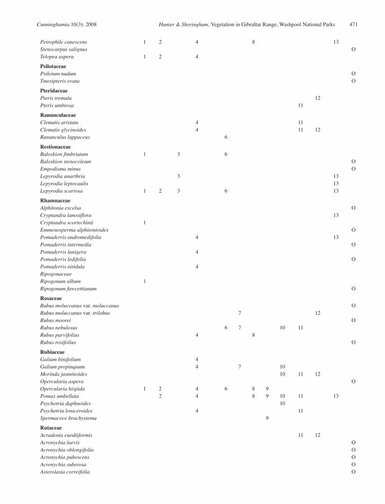
Cunninghamia 10(3): 2008 Hunter & Sheringham, Vegetation in Gibraltar Range, Washpool National Parks 471
Petrophile canescens 1 2 4 8 13Stenocarpus salignus O
Telopea aspera 1 2 4
Psilotaceae
Psilotum nudum O
Tmesipteris ovata O
Pteridaceae
Pteris tremula 12Pteris umbrosa 11
Ranunculaceae
Clematis aristata 4 11
Clematis glycinoides 4 11 12Ranunculus lappaceus 6
Restionaceae
Baloskion fimbriatum 1 3 6
Baloskion stenocoleum O
Empodisma minus O
Lepyrodia anarthria 3 13Lepyrodia leptocaulis 13Lepyrodia scariosa 1 2 3 6 13Rhamnaceae
Alphitonia excelsa O
Cryptandra lanosiflora 13Cryptandra scortechinii 1
Emmenosperma alphitonioides O
Pomaderris andromedifolia 4 13Pomaderris intermedia O
Pomaderris lanigera 4
Pomaderris ledifolia O
Pomaderris nitidula 4
Ripogonaceae
Ripogonum album 1
Ripogonum fawcettianum O
Rosaceae
Rubus moluccanus var. moluccanus O
Rubus moluccanus var. trilobus 7 12Rubus moorei O
Rubus nebulosus 6 7 10 11
Rubus parvifolius 4 8Rubus rosifolius O
Rubiaceae
Galium binifolium 4
Galium propinquum 4 7 10
Morinda jasminoides 10 11 12Opercularia aspera O
Opercularia hispida 1 2 4 6 8 9
Pomax umbellata 2 4 8 9 10 11 13Psychotria daphnoides 10
Psychotria loniceroides 4 11
Spermacoce brachystema 9
Rutaceae
Acradenia euodiiformis 11 12Acronychia laevis O
Acronychia oblongifolia O
Acronychia pubescens O
Acronychia suberosa O
Asterolasia correifolia O

472 Cunninghamia 10(3): 2008 Hunter & Sheringham, Vegetation in Gibraltar Range, Washpool National Parks
Boronia algida 1 2 4 13Boronia anethifolia 5 13Boronia angusepala 1 5
Boronia bipinnata O
Boronia microphylla 1 2 4 13Boronia parviflora 3Boronia polygalifolia 3Boronia rubiginosa O
Correa lawrenciana var. glandulifera O
Correa reflexa var. reflexa 4
Eriostemon australasius 2 13Geijera latifolia O
Leionema ambiens O
Leionema dentatum 5 13Medicosma cunninghamii O
Melicope hayesii O
Melicope micrococca 12Phebalium squamulosum 7 12 13Phebalium woombye
Sarcomelicope simplicifolia O
Zieria arborescens subsp. arborescens 12Zieria fraseri subsp. compacta 13Zieria furfuracea O
Zieria smithii subsp. smithii 4 6 7 10
Sambucaceae
Sambucus australasica O
Santalaceae
Choretrum candollei 1 2 4
Choretrum sp. A 13Exocarpos strictus 1 13Leptomeria acida O
Leptomeria aphylla O
Leptomeria drupacea O
Santalum obtusifolium O
Sapindaceae
Alectryon subcinereus O
Diploglottis australis O
Diploglottis cunninghamii 11 12Dodonaea megazyga O
Dodonaea serratifolia 4
Dodonaea triquetra 2 9
Dodonaea viscosa O
Guioa semiglauca 11
Schizaeaceae
Schizaea bifida 1 2 4 8 13Schizaea dichotoma O
Scrophulariaceae
Euphrasia collina subsp. paludosa O
Veronica calycina 8Veronica notabilis O
Veronica plebeia 4
Smilaceae
Smilax australis 1 4 5 10 11 12 13Smilax glyciphylla 2 4 5 6 10 11 13Solanaceae
Duboisia myoporoides 4 10
Solanum aviculare O

Cunninghamia 10(3): 2008 Hunter & Sheringham, Vegetation in Gibraltar Range, Washpool National Parks 473
Solanum campanulatum 4 10
Solanum mauritianum* 4
Solanum nemophilum 4 10
Solanum neoanglicum O
Solanum nobile O
Solanum opacum O
Solanum prinophyllum O
Solanum pungetium O
Solanum stelligerum O
Stackhousiaceae
Stackhousia viminea 1 4 8Sterculiaceae
Brachychiton acerifolius O
Keraudrenia corollata var. denticulata O
Lasiopetalum ferrugineum var. cordatum 2Rulingia dasyphylla O
Rulingia salviifolia O
Seringia arborescens O
Stylidiaceae
Stylidium graminifolium 4
Stylidium laricifolium 4 13Surianaceae
Guilfoylia monostylis O
Symplocaceae
Symplocos stawellii O
Symplocos thwaitesii O
Thelypteridaceae
Christella dentata O
Thymelaeaceae
Pimelea latifolia O
Pimelea ligustrina O
Pimelea linifolia 1 2 4 9 13Pimelea neo-anglica O
Tremandraceae
Tetratheca thymifolia 1
Trimeniaceae
Trimenia moorei 11
Ulmaceae
Aphananthe philippinensis O
Urticaceae
Dendrochnide excelsa O
Dendrochnide photinophylla O
Elatostema stipitatum O
Urtica incisa O
Verbenaceae
Clerodendrum tomentosum 4 8 10
Gmelina leichhardtii 10
Lantana camara* 10
Verbena rigida* O
Violaceae
Hybanthus enneaspermus 9
Hybanthus monopetalus 3 4
Hybanthus vernonii subsp. vernonii O
Viola betonicifolia 1 4 6 8Viola hederacea 2 4 8 10 12

474 Cunninghamia 10(3): 2008 Hunter & Sheringham, Vegetation in Gibraltar Range, Washpool National Parks
Vitaceae
Cayratia clematidea O
Cayratia eurynema O
Cissus antarctica 1 4 11
Cissus hypoglauca 4 7 8 10 11 12Cissus sterculifolia O
Tetrastigma nitens O
Vitteriaceae
Vittaria elongata O
Winteraceae
Tasmannia insipida 7 11 12Xanthorrhoeaceae
Xanthorrhoea acaulis 13Xanthorrhoea australis O
Xanthorrhoea glauca subsp. angustifolia 4 8 9 10 13Xanthorrhoea johnsonii 1 2 4
Xanthorrhoea latifolia 2 8Xyridaceae
Xyris gracilis O
Xyris operculata 3Zingiberaceae
Alpinia caerulea O
Related Documents