VARIABILITY IN WESTERN ARNHEM LAND SHELL MIDDEN DEPOSITS Fiona Mary Mowat B.A. (Hans) Thesis submitted for the degree of Master of Arts in the Faculty of Arts Northern Territory University January 1995

Welcome message from author
This document is posted to help you gain knowledge. Please leave a comment to let me know what you think about it! Share it to your friends and learn new things together.
Transcript

VARIABILITY IN
WESTERN ARNHEM LAND
SHELL MIDDEN DEPOSITS
Fiona Mary Mowat
B.A. (Hans)
Thesis submitted for the degree of
Master of Arts in the Faculty of Arts
Northern Territory University
January 1995

To the best of this candidate's knowledge and belief the work presented
in this thesis is original, except as acknowledged in the text. This
material has not been previously submitted, in whole or in part, for a
degree at this or any other University.
Fiona Mowat

Table of contents
List of figures .. .
List of tables .. .
Abstract ...
Acknowledgments
Chapter One · Introduction
•••
••• ••• • ••
Chapter Two · Mollusc biology and environmental change
Conventions ...
Phylum Mollusca
Class Gastropoda
Family Neritidae
Nerita balteata
Family Potamididae
Terebralia palustris
Telescopiufn telescopium
Cerithidea obtusa
Family Muricidae ...
Chicoreus capucinus
Family Melongenidae
Volema cochlidium
Family Auriculidae ...
Ellobium aurisjudae
Cassidula angulifera ...
Class Bivalvia
Family Arcidae
Anadara granos a
Barbatia amygdalumtostum
Family Ostreidae
Crassostrea amasa
Family Corbiculidae
Geloina coaxans
Family Veneridae ...
Marcia hiantina
Circe australe ...
. ..
• ••
•••
i iv
v vii
viii
I
6
7 11 13 13
13 15 16
18 21
22
22
24 24 25
26
26
28
28 29
31
31
31
33
33
35
35
37

Predicted temporal changes in molluscan communities
Geomorphic evolution ...
Change in habitats
Chapter Three · Previous interpretations of molluscan faunal assemblages in Arnhem Land archaeology
Initial perception of patterns ...
Further work in the region
A synthetic model
Evaluation of the model
Broader regional comparison
Sites on the Alligator River plains
Discussion
Conclusion
Chapter Four · Methodology ...
Sampling
Effects of sample size on relative abundance
Measurement of abundance ...
MNI v. NISP
MNI v. weight
Effects of breakage on apparent abundance
A case study
Explanation for fragmentation
Outline of my methodology ...
Chapter Five · Shell middens on the West and South
Alligator Rivers
Environmental features
West Alligator River sites
Field Island 1
Field Island 2
Field Island 3
Field Island 4
Field Island 5
Field Island 8
Field Island 9
... ••• • •• . .. . .. . ..
38 39 40
42
43
51 54 56
59
63
67 67
70
72
75 76
77
81
82
87
90
91
94 97
98
100
102
106
107
109
Ill
112
ii
South Alligator River sites
Kapalga H1
KapalgaH2 Kapalga J
KapalgaK
Kapalga L
Kapalga M
Kapalga Q
Conclusion
Chapter Six · Chronological change Change in midden composition
Model of increase in Cerithidea ...
Model of decrease in Cerithidea
Testing models of change in relative abundance
Abandonment of shelter sites
Review of dates from midden sites
Timing of mangrove retreat
Conclusions regarding the model of abandonment
Testing against open sites
Conclusion
Chapter Seven · Testing regional homogeneity ...
Field testing ...
Mounds, scatters, palaeochannel and coastal middens
Summary
Kapalga sites ...
Field Island sites
Comparison with other coastal middens
Comparison of middens from Field Island and Kapalga
Conclusion
Chapter Eight · Conclusion ... Bibliography ... . .. ... ...
...
. ..
113
113
115
116
118
119
120
121
123
124
126
127
128
130
133
133
136
137
137
139
140
141
142
146
147
150
155
157
159
. .. 161
•.. 165
iii

List of Figures
Figure 1.1: Location of the study area 2
Figure 2.1: Bivalve terminology... 9
Figure 2.2: Gastropod terminology 9
Figure 2.3: Nerita 14
Figure 2.4: Terebralia ... 14
Figure 2.5: Telescopiwn 17
Figure 2.6: Cerithidea 19
Figure 2.7: Chicoreus 19
Figure 2.8: Volema 23
Figure 2.9: Ellobiwn 27
Figure 2.10: Cassidula ... 27
Figure 2.11: Anadara . . . 30
Figure 2.12: Barbatia . . . 32
Figure 2.13: Crassostrea 32
Figure 2.14: Geloina 34
Figure 2.15: Marcia 36
Figure 2.16: Circe 36
Figure 3.1: Westem Amhem Land sites mentioned in the text 44
Figure 3.2: Percentage of Cerithidea, Malangangerr 49
Figure 3.3: Percentage of Cerithidea, Nawamoyn 49
Figure 3.4: Percentage of Cerithidea, Badi Badi 49
Figure 4.1: NISP and MNI values for different stages of fragmentation 84
Figure 4.2: Change in NISP and MNI values(%) for each stage of
fragmentation . . . 85
Figure 4.3: Proportion of highly fragmented Marcia valves for different
size classes, FI-2 and FI-4 88
Figure 4.4: Illustration of overlap method 92
Figure 5.1: Land systems of the West and South Alligator Rivers, showing
location of sites FI-1 to FI-9 and K-H to K-Q 96
Figure 5.2: West Alligator River, sites on the 5373 Field Island mapsheet 99
Figure 5.3: South Alligator River, sites on the 5372 Kapalga mapsheet 114
Figure 6.1: Percentage of Cerithidea, Kapalga sites of known age 132
Figure 6.2: Antiquity of midden layers in shelter sites ... 134
Figure 7.1: Relative proportions of three most numerous genera, Field
Island sites (arranged south to north) ... 152
Figure 7.2: Relative proportions of three most numerous genera, Field
Island sites (arranged according to inferred antiquity) 154
iv

List of Tables
Table 2.1: Synonyms for mollusc species 11
Table 2.2: Mollusc taxa found in Arnhem Land midden sites 12
Table 2.3: Habitat preferences for molluscs found in midden sites 38
Table 3.1: Percentage of shell by weight, Badi Badi midden zone 45
Table 3.2: Percentage of shell by weight, Malangangerr column samples 46
Table 3.3: Percentage of shell by weight, Nawamoyn column samples 47
Table 3.4: Sites with shell 55
Table 3.5: Dates from 'upper' midden levels 56 Table 3.6: South Alligator River middens 64
Table 4.1: Cave Bay Cave Trench V column samples by sample number 74
Table 4.2: Cave Bay Cave Trench V column samples by stratigraphic unit 75
Table 4.3: Regression equations and correlation coefficients MNI v NISP 79
Table 4.4: NISP and MNI values for different stages of fragmentation 84
Table 4.5: Elements used in calculation of MNI 92
Table 5.1: Summary information for West Alligator River shell mound sites 100
Table 5.2: Mollusc composition, site FI-1 101
Table 5.3: Radiocarbon estimations, site FI-1 102
Table 5.4: Mollusc composition, site FI-2 104
Table 5.5: Radiocarbon estimations, site FI-2 106
Table 5.6: Mollusc composition, site FI-3 107
Table 5.7: Radiocarbon estimations, site FI-3 107
Table 5.8: Mollusc composition, site FI-4
Table 5.9: Radiocarbon estimations, site FI-4
Table 5.10: Mollusc composition, site FI-5
Table 5.11: Mollusc composition, site FI -8
Table 5.12: Mollusc composition, site FI-9
Table 5.13: Summary information for South Alligator River sites
Table 5.14: Mollusc composition, site K-H2
Table 5.15: Radiocarbon estimations, site K-H
Table 5.16: Mollusc composition, site K-J
Table 5.17: Radiocarbon estimations, site K-J
Table 5.18: Mollusc composition, site K-K
Table 5.19: Radiocarbon estimations, site K-K
Table 5.20: Mollusc composition, site K-L
Table 5.21: Radiocarbon estimations, site K-L
Table 5.22: Mollusc composition, site K-M
Table 5.23: Radiocarbon estimations, site K-M ...
108
109
110
111
112
113
116
116
117
118
118
119
119
120
121
121
v

List of Tables, continued
Table 5.24: Mollusc composition, site K-Q 122
Table 5.25: Radiocarbon estimations, West and South Alligator River sites 123
Table 7.1: Summary of characteristics of midden types . . . 143
Table 7.2: Kapalga sites 147
Table 7.3: Descriptive statistics for Kapalga mound sites 148
Table 7.4: Species composition of Kapalga sites- proportion(% MNI) 149
Table 7.5: Field Island sites 150
Table 7.6: Descriptive statistics for Field Island mound sites 151
Table 7. 7: Species composition of Field Island sites -proportion (% MNI) 153
Table 7.8: Species composition of plains middens 158
Table 7.9: Variation for site dimensions, comparing Field Island and
Kapalga sites 159
vi

Abstract
This thesis addresses variability in shell middens deposited during the
Mid to Late Holocene in western Arnhem Land, Australia. Throughout
this time, the inhabitants of western Amhem Land exploited a wide
variety of marine resources. Evidence of exploitation of marine and
estuarine molluscs can be found in the form of shell middens deposited
throughout the landscape, on the coastal strip and estuarine plains
further south and in rockshelters situated in outliers of the escarpment.
I aim to test existing models which classified middens into a few
inflexible types, and which identified simple chronological changes. The
integrity of these models is examined by a review of the data used to
construct them, and by testing against them previously unrecorded
midden sites.
Some authors have identified chronological changes in the relative
abundance of species in middens, notably Cerithidea obtusa. and in the
location in which middens were deposited. Models of simple
unidirectional change in relative abundance of Cerithidea across a
broad geographic area are not supported. Rockshelters were not all
abandoned in favour of coastal plains at 3000 BP. Conversely, the
coastal plains were not only used after 3000 BP.
Midden variability has not been acknowledged by previous researchers.
Models regarding middens have typically characterised these sites as
being homogeneous. The present study has revealed a wide variety of
species abundance, antiquity, environmental context, species richness,
size and form of midden sites in western Arnhem Land.
vii

Acknowledgments
Thanks must be extended to all members of staff and my fellow
students at the Department of Anthropology for their assistance over the last few years. In particular I would like to thank my supervisor Peter Hiscock for suggesting this project, for putting up with my laziness and kicking me into action when necessary.
This project was carried out with the permission of the Australia Nature
Conservation Agency and the Aboriginal owners of Kakadu National
Park. Part of the project was facilitated by an ANCA travel grant. The initial recording was conducted during a consultancy for ANCA.
Thanks to all members of ANCA staff for their assistance, especially Victor Cooper (ANCA), and also to Robert Eager (CSIRO, Kapalga).
For assistance in the field I thank Dianne Bensley, Greg Bowen, Daryl Guse, Peter Hiscock, Robin Hodgson, Damien Huxtable, Virgil Kerr, Martinne Luedicke, Susan Mundheim, Gerard Niemoeller, Duncan Spencer, Michael Truelove, Annita Waghorn and Ian Walters.
For assistance with identification of molluscs I thank Dr Richard Willan of the Museum and Art Gallery of the Northern Territory.
For their support over the last several years, I have to thank several
non-exclusive groups of people:
First and foremost, my family, especially my parents Bill and Joyce Mowat, for their indispensable support. Your love has been the one constant, solid foundation in my life, and it often seems you are the only ones who I can count on to never let me down. Thank you so
much.
My fellow Anthropology-type cronies, in particular Peter Hiscock, Norma Richardson, Kim Akerman, Steve and Iolanthe Sutton, Daryl Guse, Greg
Bowen, Robin Hodgson, Sally Brockwell, Robin Gregory, Jason Kneebone, Gerard Niemoeller, Di Bensley, Jo Harrison, Peter Thorley, Ken Mulvaney, Ian Walters, David Mearns, Chris Healey, and special mention to Scottyboy Mitchell for convincing me to come to the Territory
in the first place.
My fellow University House residents, in alphabetical order Michelle Birrell, Simon Cresswell, Drew Cronin, Nick Evans, Melissa Hancock,
Richard Hill, Jac Knox, Peter Lunn, James Noblet, Belinda Pearson, Rob Pfitzner, Mary Pothos, my best friend Andrew John Reynolds,
Michelle Schlater, Jo-Anne Smith, and others too numerous to mention.
viii

CHAPTBKONB
INTRODUCTION
1

A plethora of researchers has studied archaeological sites in the
Northem Territory, especially in westem Arnhem Land including the
Alligator Rivers region (Figure 1.1) now encompassed by Kakadu
National Park. Traditionally, the contents of stratified rockshelter
deposits have been targeted, and notably those most durable remains of
human activity, stone artefacts. Researchers who have analysed shell
deposits in these rockshelters include Schrire (1982). and Allen (1987,
1989; Kamminga and Allen 1973; Allen and Barton nd). There are also
researchers who were interested in archaeological shell-bearing sites as
a means of answering geomorphological questions. including Baker
(1981) and Woodroffe et al. (1988).
D
Figure 1.1: Location of the study area. The Alligator Rivers area, indicated in the box at right, is presented in greater detail in Figure 5.1.
Several major issues have been addressed, one of the most
contentious areas of research being the antiquity of human occupation
of the area (Roberts et al. 1990; Bawdier 1990; Frankel 1990; Hiscock
2

1990; Allen 1994). Data from these sites have also been used to
determine and debate the antiquity of the small tool tradition (Jones
and Johnson 1985a; Bowdler and O'Connor 1991; Hiscock 1993; Allen
and Barton nd).
Another question concerns human occupation and exploitation of
the coastal floodplains. Schrire (1982) was one of the first researchers to
carry out excavations in the Kakadu region. In her work, use of the
plains was characterised on the basis of rockshelters situated in
outliers of the Amhem escarpment, and was contrasted with use of the
plateau itself. Conclusions drawn on the basis of the stone artefact
assemblages and organic remains were that the plateau and plains
represented a seasonal dichotomy, with the plains sites used during the
dry season and plateau sites used during the wet season (Schrire
1982:250). Changes in relative abundance of mollusc species were
identified in the middens deposited in the plains shelters (Schrire 1982).
More recent excavations have refined the chronological aspects of this
change and expanded the interpretations of change (Allen 1987, 1989;
Allen and Barton nd).
Further work moved onto the floodplain itself, and concentrated on
open sites along the freshwater wetland section of the South Alligator
River. Twelve large artefact scatters were recorded, and these were
inferred by Meehan et al. (1985:135) to be large dry season base camps.
More detailed analysis of the stone artefact assemblages from these
sites was carried out by Brockwell (1989), who stated that occupation of
these sites was linked to the development of freshwater wetlands during
the last 1500 years. Results of this research suggested that differences
in the distribution of certain types of stone artefacts between sites could
3
be connected to differences in use of the site and the season of
occupation (Brockwell 1989:iv).
These studies concentrated on analysis of stone artefact
assemblages in the escarpment and outliers, and the freshwater
wetlands. Until recently the coastal portion of the floodplains in Kakadu
has not been investigated. Midden sites reported by Woodroffe et al.
(1988) documented human use of the coastal plains from the Mid
Holocene until the recent past. However, their research was aimed at
identifying geomorphological changes to the South Alligator River, and
the sites were not recorded in enough detail to facilitate characterisation
of mollusc species composition, relative abundance of these taxa, or
species richness.
Allen ( 1987, 1989; Allen and Barton nd) compiled the first
synthesis of middens in the Kakadu region. This synthesis included
middens from the shelters excavated by Schrire (1982), and the shelters
excavated by Kamminga and Allen (1973), and also incorporated the
South Alligator River middens reported by Woodroffe et al. (1988). This
work used the information derived from the work of Woodroffe et al.
(1988) for plains middens, but acknowledged that more detailed
information was required to comprehensively characterise these open
sites in a fashion comparable to the middens in rockshelter sites (Allen
and Barton nd:l07).
The present study attempts to fill some of the gaps in our
understanding of use of the coastal plains. As well as examining other
researchers' published results, I examined midden sites in other areas
of Kakadu. These results were used to test hypotheses relating to
4

change through time in species exploitation, people's responses to
environmental changes and midden homogeneity.
The study comprises an examination of molluscan assemblages
from sites on the coastal plains and estuarine floodplains near the West
and South Alligator Rivers. Some of the sites recorded in the present
fieldwork have not previously been recorded in such great detail. Some
sites reported by Woodroffe et al. (1988) have been relocated and
recorded in enough detail to allow statements to be made about relative
abundance of species. This investigation aims to address questions of
shell taphonomy and measurement of mollusc species abundance.
Issues of chronological change in relative abundance of species and in
location of midden deposition will also be examined. These issues
specifically relate to perceived unidirectional change in abundance of a
few species, and the relationship of the location of midden deposition
and foraging behaviour to environmental change. A further issue
addressed here concerns the variability of midden composition
throughout the region.
Since one of the main objectives of the study is to document
variability in relative abundance of mollusc species in midden sites, it
was considered necessary to examine these animals in some detail. The
following chapter describes the mollusc species encountered in the
Alligator Rivers sites. It also addresses misidentifications of some
species, and gives the most recent mollusc species names.
5
CHAPTER TWO
MOLLUSC BIOLOGY AND
ENVIRONMENTAL CHANGE
6

Nomenclatural and taxonomic conventions used to describe molluscs
are outlined in the first part of this chapter, as well as terms used to
describe shell orientation and dimensions, and other relevant topics of
classification.
The second section provides basic information about molluscs. A
list is included of species commonly encountered in northem Australian
midden sites, and other species noted during the present study. For
each species, I present a description of their appearance, habitat
preference and behaviour. This includes a detailed physical description
of each shell, including an outline of diagnostic elements which can be
used to identify them. Given the different identification of species
mentioned in Chapter One, discussion is included on possible
misidentifications.
The chapter concludes with a discussion of mollusc ecology, and
ways in which changing environmental conditions could have affected
prehistoric mollusc populations. The time span of the shell-bearing sites
which this study examines, the Mid to Late Holocene, was a time of
dramatic environmental changes. I will outline the mollusc taxa likely to
have been most abundant at various stages of landscape evolution.
CONVENTIONS
All scientific names are written as for the following bivalve example:
Anadara granosa Linne, 1758. The first part of the name consists of
the genus name "Anadarci', and species name "granosci'. The second
part consists of the name of the person who first described the species
in the scientific literature "Linne" and the year in which this was done
"1758". Descriptions presented below for each species are not the
original descriptions made by the species' author, but the most recent
7

descriptions available. Usually only the first part of the name is used in
archaeological literature. After the full name has been used once, the
genus name is often abbreviated (A.granosa rather than Anadara
granosa). In later chapters when I discuss molluscs from midden
deposits, it is unusual for more than one member of a genus to be
present. In this case I use only the genus name, as this is usually more
familiar than species names (Anadara and Terebralia rather than
A.granosa and T.palustris).
Depending on which mollusc text is consulted, different
conventions will be used to describe shell anatomy and classification.
The following represent the conventions followed in this thesis.
Standards used for orientation, dimension, structure and sculpture of
bivalves and gastropods are illustrated in Figures 2.1 and 2.2
respectively. Sculpture can be intrusive (grooves, striae) or extrusive
(ribs, ridges, cords). Conventions mostly follow Lamprell and Whitehead
(1992) for bivalves, and Wilson and Gillett (1979, 1980) for gastropods.
These are the most comprehensive and recent syntheses dealing with
Australian taxa. Although the descriptions ofWells and Bryce (1988) are
relevant to taxa found in northern Australian midden deposits, they give
no outline of conventions of orientation, dimensions, etc.
Taxonomic conventions present several problems. As well as
normal Linnaean binomial nomenclature, sometimes a subgeneric name
is also used "when finer precision of meaning is required" (Wilson and
Gillett 1980:7). Subgeneric names are written after generic names and
in brackets, e.g. Marcia (Hemitapes) hiantina. For the purposes of this or
any other archaeological study, such detail is not essential, but where
subgeneric names have been mentioned in the literature, they are
included once for completeness and are thereafter abandoned. Another
8

RIGHT VALVE
Posterior Anterior
Ventral
LEFfVALVE
HEIGHT ·
LENGTH BREADTH
Figure 2.1: Bivalve terminology.
Posterior
DIAMETER
HEIGHT
Anterior
Figure 2.2: Gastropod terminology.
9
convention concerns the situation when the genus is known but the
species is unknown. For example, one species of Marcia would be
written as Marcia sp. If there is more than one species of the same
genus this is written Marcia spp., this abbreviation indicating a plural.
The fact that mollusc taxonomists constantly change shell names
is without doubt the most common frustration which confronts
archaeologists trying to describe shells found in sites. Taxonomy of
northern Australian molluscs is especially confused as Australian
malacologists once assumed that Australian species would be found
only in this country. While this may be true for most of southern
Australia, in the north many of our species are also found in elsewhere
in the Indian and Pacific regions (Wilson and Gillett 1980:7). Many new
names have been given to Australian species when names already
existed. When this happens, the new name is considered a synonym.
and must be rejected in favour of the name which was published first
(Wilson and Gillett 1980:7). Another instance of incorrect naming may
occur when a new species is published, and the name used to describe
it is already occupied by another species. This incorrect duplication of
names is referred to as a homonym, and must also be rejected (Wilson
and Gillett 1980:7). The earliest name always receives priority.
Therefore the first use of the duplicate name must be retained, and a
new name decided upon for the new species. Table 2.1 outlines the
current names of species from West and South Alligator River midden
sites along with their synonyms, with which archaeologists may be more
familiar. Unfortunately, mollusc taxonomists often mention that a
previous use of a name is incorrect, but do not always say whether the
incorrect name is a synonym or a homonym.
10

Table 2.1: Synonyms for mollusc species.
Current Name
Nerita balteata
Chicoreus capucinus
Volema cochlidium
Geloina coaxans
Marcia hiantina
Circe australe
Synonym/Homonym
Nerita lineata
Naquetia permaestus, Naquetia capucinus
Volegalea wardiana, Pugilina cochlidium
Polymesoda coaxans
Tapes hiantina
Gafrarium australis
PHYLUM MOLLUSCA
The phylum mollusca is the second largest in the animal kingdom,
generally estimated to consist of between 50,000 and 100,000 living
species and at least 35,000 extinct ones (Keeton and Gould 1986:1123;
Wilson and Gillett 1979:9). Although there are differences in the
appearance of members of the seven classes of mollusc, most of these
organisms have similar internal structure. Keeton and Gould record the
following characteristics of the molluscan body plan: the soft body,
consisting of a muscular foot, visceral mass and mantle; an open
circulatory system, with blood circulating through large open sinuses
where it bathes the tissues directly; and (for most marine molluscs) a
free-swimming larval stage in the animal's life cycle (Keeton and Gould
1986: 1123-1124).
As stated previously, there are seven recognised classes of mollusc:
Polyplacophora (chitons or coat-of-mail shells); Aplacophora
(solenogasters); Monoplacophora (a minor class of limpet-like deep sea
molluscs, thought to be extinct until the early 1950s); Gastropoda
(snails and slugs); Bivalvia (clams, oysters, razor shells and scallops);
Scaphopoda (tusk shells); Cephalopoda (octopus, squids and cuttlefish)
(Wells and Bryce 1988:12-13). Gastropods and bivalves are the
11

molluscs most commonly encountered in Australian archaeological
deposits, although chitons and occasionally cuttlefish remains may be
found in some areas.
Here I describe members of nine gastropod and bivalve families.
This only covers the taxa most commonly found in northern Australian
sites which are considered to be exploited as a food source, e.g. those
described by Meehan (1982), and other taxa found in sites described in
the present study (Table 2.2). Several specimens of terrestrial gastropod
(land snail, Xanthomelon sp.) were also identified during the present
study. As they are not regarded as an economically exploited taxon, and
there is little biological or environmental information available, they are
not dealt with in detail here.
Table 2.2: Mollusc taxa found in Arnhem Land midden sites.
Taxon Reference
Nerita balteata Meehan 1982; Hiscock and Mowat 1993
Terebralia palustris Meehan 1982; Schrire 1982; Hiscock and Mowat 1993
Telescopium telescopium Meehan 1982; Schrire 1982; Allen 1987; Hiscock and Mowat 1993
Cerithidea obtusa Schrire 1982; Allen 1987; Hiscock and Mowat 1993; Allen and Barton nd
Chicoreus capucinus Schrire 1982; Hiscock and Mowat 1993
Volema cochlidium Meehan 1982; Hiscock and Mowat 1993
Ellobium aurisjudae Schrire 1982; Allen 1987
Cassidula angulifera Schrire 1982; Allen 1987
Anadara granosa Meehan 1982; Hiscock and Mowat 1993
Barbatia amygdalumtostum Hiscock and Mowat 1993
Crassostrea amasa
Geloina coaxans
Marcia hiantin.a
Circe australe
Meehan 1982; Hiscock and Mowat 1993
Meehan 1982; Schrire 1982; Allen 1987; Allen and Bartonnd
Meehan 1982; Hiscock and Mowat 1993; Mowat 1994
Hiscock and Mowat 1993
12

Class Gastropoda
Gastropods usually possess a coiled shell, secreted by the mantle,
but in some cases the coiling is minimal, and in nudibranchs the shell
has been lost altogether. Most gastropods are marine, but there are
many species that inhabit freshwater habitats, and some are terrestrial.
Some gastropods browse and graze on algae, while others collect
plankton, or live as parasites inside anemones and echinoderms, or feed
on colonial animal growths such as sponges; still others are hunters,
drilling holes through bivalve shells, or even using radular teeth as
harpoons/arrows with which they may inject venom into their prey of
worms, other gastropods or fish (Purchon 1977:41-42).
Family Neritidae
Most nerites are marine and live on rocky shores high in the
intertidal zone (Cemohorsky 1978:42), but some members of the family
inhabit the sublittoral zone, as well as mangrove estuaries or freshwater
habitats (Wilson and Gillett 1979:47; Hill 1980:85; Wells and Bryce
1988:48). All nerites are vegetarians (Abbott 1991:22).
Nerita (Ritena) balteata Reeve, 1855
A specimen of N.balteata is illustrated in Figure 2.3. Wilson and
Gillett (1979:48) provide the following description for this species:
'Wide, low-spired, sculptured with numerous fine spiral ribs. Aperture
sharp-edged and weakly toothed within. Columellar deck smooth but
with several weak teeth centrally on the inner margin". This species is
commonly accepted to grow to 40mm (Cemohorsky 1972:51, 1978:42;
Wilson and Gillett 1979:49; Hill 1980:85).
13


Diagnostic elements for this species include the spiral ribs, which
can be seen as fine lines running around in the direction of the
gastropod's curled structure, as opposed to axial ribs which run directly
across, parallel to the aperture. The aperture may also be used to
identify this shell, and is distinctive for its almost semi-circular outer
margin notches perpendicular to the aperture. Fragments which may be
diagnostic also include the columellar deck. This is the flat platform
opposite the aperture to which the animal attaches itself. The surface of
this platform which is inside the shell has several muscle scars.
Cernohorsky (1978:42) states that Nerita lineata Gmelin, 1791
is pre-occupied by N.lineata Mueller, 1774, and cannot be used. Some writers have suggested N.articulo.t.a Gould, 1847, as a replacement name, but Gould's species has never been illustrated and the type is lost. However, N.essingtoni Recluz, 1850, may, when the types are examined, prove to be an earlier name for N.balteata Reeve.
Short and Potter (1987: 18) also state that the more commonly used
N.lineata is a synonym of N.balteata. Short and Potter were obviously
still of the opinion in 1987 that N.balteata was preferable to any other
options, so this is the name I have used.
N.balteata inhabit an area above, but close to, high tide level
(Coleman 1981:30). Members of this species live attached to the roots
of mangrove trees (Hill 1980:86; Coleman 1981:30; Cantera et al.
1983: 12).
family Potamididae
Members of this family are commonly referred to as mudwhelks or
sometimes creepers. Most species live on muddy shores near high tide
level, often in mangrove swamps (Short and Potter 1987:24; Wells and
Bryce 1988:54), and may live out of water for long periods of time
15

(Wilson and Gillett 1979:56; Houbrick 1984: 1). Potamidids can "attain
extremely high densities on sandflats and in mangrove systems" (Wells
1983:139).
Terebralia palustris Linne, 1767
A specimen of T.palustris is illustrated in Figure 2.4. This species is
described by Wilson and Gillett (1979:56) as a
large solid shell with a high, flat-sided spire. Whorls bear low axial folds, deeply incised sutures and three or four narrow deeply incised spiral grooves; base of shell with numerous spiral cords. Anterior canal short, outer lip reflexed partly occluding (but not surrounding) the canal. Columella with a small parietal ridge and a callus beside the anterior canal.
This species normally attains an adult height between 110mm
(Wells and Bryce 1988:54) and 120mm (Cemohorsky 1972:61; Wilson
and Gillett 1979:56), although a specimen from Java was reported to
measure 160mm (Houbrick 1991:308). and a 190mm individual from
Arnhem Land was reported by Loch (1987:4).
Diagnostic elements for this species include the spiral grooves and
axial folding. Most distinctive element is the callus, varix, or bulge
situated just behind the aperture.
T.palustris may be mistaken for Terebralia sulcata, which is very
similar but smaller overall and with more curved sides. Telescopium
telescopium has similar spiral grooves, but lacks the axial folds and
bulge.
These shells commonly occupy the muddy bottom inside the
mangrove forest (Nishihira 1983:45). T.palustris prefers fine mud
substrates (Wells 1980, 1983:152; Houbrick 1991:310). T.palustris have
been recorded in mangroves of the genera Bruguiera, Ceriops and
Avicennia, but it avoids Rhizophora stylosa, possibly because the
16

sediments of this mangrove species are too acidic (Wells 1980:4).
T.palustris prefers areas in the shade of the mangrove vegetation
(Houbrick 1991:333).
Wells' survey of Terebralia in the Bay of Rest in Western Australia
revealed that T.palustris occurred higher on the shore than T.sulcata
(Wells 1983:152), which occur in the upper intertidal zone (Khoo and
Chin 1983: 120), so the upper intertidal will be inferred to also apply to
T.palustris.
Wells (1980) noted densities up to 100/m2 at the Bay of Rest in
Western Australia. T.palustris have very high population density,
forming feeding aggregations, with many animals grazing on leaf litter
(Nishihira 1983:45), a behaviour which may enhance harvesting
potential.
Telescopium telescopium Linne, 1758
A specimen of T.telescopium is illustrated in Figure 2.5. Wilson and
Gillett (1979:56) describe this species as conical in shape, with a broad
and rather flat base and straight sides. Whorls are "short and
sculptured with several deep spiral striae. Anterior canal and columella
very short. Columella twisted, with a strong central spiral ridge" (Wilson
and Gillett 1979:56).
This large mudwhelk may reach an adult height of 1 OOmm to
110mm (Cernohorsky 1972:61; Wilson and Gillett 1979:56; Wells and
Bryce 1988:54), although Houbrick refers to a specimen 130mm in
height, recorded by Brandt (1974: 196), and notes that this is "a very
large specimen" (Houbrick 1991:292).
18
Diagnostic elements for this species include its conical shape, and
strong spiral grooves. The columella is thick and twisted. T.palusbis
also has spiral grooves, but can be distinguished by its accompanying
axial folds and less robust columella.
T. telescopium prefer "soft, nearly liquid, muddy substrates
associated with mangrove forests" (Houbrick 1991:300). T.telescopium
are frequently found in shady places in the more exposed parts of the
mangrove (Houbrick 1991:300). Budiman also notes that T.telescopium
live in open areas, and that shade is an important consideration
(1988:238, 240). They are typically the dominant gastropod in mangrove
forests of the genus Rhizoplwra (Macnae 1968: 177).
Houbrick describes distribution of this species as intertidal
(1991:300). The full range of intertidal habitats is occupied by
T.telescopium, from the upper intertidal (Lasiak and Dye 1986: 174) to
the lower intertidal (Budiman 1988:244).
Budiman found that T. telescopium in lower intertidal areas of
eastern Indonesia were active when exposed to air, and that activity
ceased during high tide (1988:242-243). Observations by Lasiak and
Dye in upper intertidal areas in northern Queensland indicate that
T.telescopium in this zone also have a "dispersed" and an "inactive"
phase (1986: 17 4). In contrast to the findings of Budiman, the active
phase of upper intertidal T.telescopium was associated with tidal
inundation, the animals remaining inactive until they are immersed by
tides; following immersion they may move distances up to and
exceeding lOrn per day (Lasiak and Dye 1986: 175).
During the inactive phase, Lasiak and Dye noted that large
numbers of T.telescopium cluster together under the mangrove trees,
suggesting that the mangroves may act as "refuge microhabitats"
20

(1986: 175). This shady area was noted to be much less harsh than
areas exposed to the sun, with substrate temperatures 10-15°C lower
and evaporative water loss three to four times lower (Lasiak and Dye
1986: 176). They believe that the clustering behaviour of T.telescopium
may be an adaptation to avoid heat stress and water loss (1986: 177).
This behaviour may also make the animal attractive as a food source,
on occasions when large numbers are available for exploitation in one
location.
Cerithidea obtusa Lamarck, 1822
A specimen of C.obtusa is illustrated in Figure 2.6. This species is
described by Wilson and Gillett (1979:57) as:
Relatively light and thin-shelled, protoconch usually missing in adults, with seven rounded whorls bearing axial ribs crossed by three or four spiral cords forming prominent nodules at the points of intersection. Base of shell spirally corded. Outer lip expanded, reflexed at the base over a short anterior canal. Parietal nodule lacking, columella smooth.
Diagnostic elements include the distinctive axial ribs and the small
overall size of complete specimens when compared to other gastropods.
Adult shells of this species grow to 44mm in height (Houbrick
1986:284; Abbott 1991:28).
All species of the genus Cerithidea are surface dwellers that occur
in the high intertidal zone (Houbrick 1984: 13). They have been observed
to live "almost entirely" on dry land in mangrove areas (Houbrick
1984:11). Macnae states that they are commonest on the landward
fringe of the mangrove (1968:167).
C.obtusa have been noted to occur on mud flats (Coleman 1981:35;
Abbott 1991:28). C.obtusa occur in mangrove trees and mud flats
(Abbott 1991 :28) and may be found on the roots, trunks and lower
branches of the trees (Coleman 1981:35). Macnae (1968:177) notes that
21

they may be found on mangrove trees from 50-175cm above the
substratum surface. They are most common in "avicennia and
bruguiera forests of the landward fringe" (Macnae 1968: 167).
Members of this species have been noted to occur in dense
aggregations (Houbrick 1984: 13). During low tide periods, they cluster
on the shady side of the trees, and while the tide is in they spread out
over the ground surface (Macnae 1968: 167). When clustered on
mangrove trees in this fashion, they would present an easy target for
harvesting.
Family Muricidae
Murex shells are common in the intertidal zone in rocky or coral
substrates (Wells and Bryce 1988:86), although some species can be
found on the roots of mangroves, notably Rhizophnra. All murex shells
are carnivorous (Abbott 1991:56), preying on most gastropods and
bivalves (Cemohorsky 1978:64).
Chicoreus (Rhizophorimurex) capucinus Lamarck, 1822
A specimen of C.capucinus is illustrated in Figure 2. 7. It is
described by Wilson and Gillett (1979: 142) as
Solid; compact, with a high spire, spirally ribbed whorls and a broad short anterior canal. Three varices per whorl, each varix ribbed and frilled but spineless, sometimes flared anteriorly. Outer lip toothed; columella.
C.capucinus may attain heights of up to 124.3mm (Houart
1992: 108). Diagnostic elements include the three varices, spiral ribs
and intervarical axial ridges.
22

The anterior portion of the columella resembles V.cochlidium. but
C.capucinus is generally smaller, less robust, and lacking the notch
characteristic of V.cochlidium Also the distinctive spiral ribs are far
more pronounced than in V.cochlidium
Chicoreus (Rhizophorimurex) capucinus is the most recent definition
of this species (Houart 1992:106-109). Other names which may be
encountered include Murex permaestus, Naquetia permaestus, Naquetia
capucinus, Pterynotus (Naquetia) permaestus.
C.capucinus may be found in the intertidal zone (Coleman 1981:27;
Abbott 1991:57). Members of this species inhabit the roots and
branches of mangrove trees (Wilson and Gillett 1979: 141; Coleman
1981:27), where it feeds on oysters (Abbott 1991:57).
Family Melongenidae
Whelks and conchs are represented in Australian waters by only a
few species. Conchs inhabit shallow water (Wells and Bryce 1988:98).
They are found on sand and mud flats, sometimes near mangroves, but
they may also occur subtidally (Short and Potter 1987:76). Their prey
includes bivalves, especially oysters (Abbott 1991:64). There are many
inconsistencies regarding nomenclature, and the following names are
used at the advice of Dr. Richard Willan of the Museum and Art Gallery
of the Northern Territory. According to Dr. Willan, there has not been
any comprehensive study to support the changes to names which some
authors have advocated.
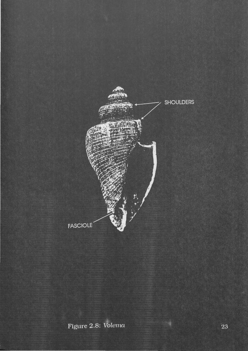
Volema (Pugilina) cochlidium Linne, 1758
A specimen of V.cochlidium is illustrated in Figure 2.8. Wilson and
Gillett ( 1979: 1 71) describe this species as
24

Elongate biconic to fusiform, anterior canal long, broad, open. Spire strongly shouldered, shoulders carinated and usually heavily nodulose. Whorls sculptured by spiral ribs. Aperture smooth, columella straight and smooth.
Heights attained by this shell are given estimations varying between
100mm and 150mm (Cemohorsky 1972:163; Wilson and Gillett
1979: 171; Coleman 1981:24; Wells and Bryce 1988:98; Abbott
1991:64).
Diagnostic elements for this species include its long anterior canal
with distinctive fasciole, the deep notch at the base of the anterior
canal. Also distinctive are the tabulate (stepped) posterior whorls, which
are also called shoulders.
Possible misidentifications include T.telescopium, which has similar
spiral sculpture, but these ribs are sharper and narrower in
V.cochlidium The anterior portion of the columella resembles
C.capucinus, but V.cochlidium is generally larger and more robust, and
the notch (fasciole) is quite useful in distinguishing it from C.capucinus.
This species is also known as Volegalea wardiana (which is a synonym)
and Pugilina cochlidium (Pugilina is a sub-genus).
According to Wilson and Gillett (1979: 171) and Coleman (1981:24),
this species is common on mud flats. Abbott (1991:64) also indicates
that V.cochlidium live in shallow muddy water close to shore. Coleman
(1981 :24) states that these shells can be found in the intertidal zone,
and also notes that this species is gregarious, which implies some
degree of clustering.
Family Auriculidae
Ellobiidae is a synonym for this family (Short and Potter 1987: 120).
Commonly known as ear shells, members of this family feed on detritus,
and can be found in the intertidal zone and above the high tide line on
rocks or vegetation in mudflat or saltmarsh areas (Short and Potter
1987:120).
25

Ellobium aurisjudae Linne, 1758
A specimen of E.awisjudae is illustrated in Figure 2.9. Coleman
(1981: 18) comments that "for an ear shell it is particularly long and
narrow". It can be easily recognised by its distinctive hook-shaped
aperture and fine axial ridges. This species may grow to a height of
50mm (Coleman 1981:18; Short and Potter 1987:120). Small anterior
portions of the aperture may be mistaken for C.angulifera but can be
differentiated by the distinctive fine axial ridges.
E.awisjudae lives in mangrove swamps (Coleman 1981:18),
especially bruguiera and rhizophora forests (Macnae 1968:218).
According to Macnae (1968:218), they are found on the "slimy mud
around the mangrove roots and pneumatophores", and are usually
found where fallen leaves are common. E.aurisjudae is an air breathing
shell (Coleman 1981: 18), and can be found in the lower levels of the
landward fringe and almost down to the seaward edges of the mangrove
forest (Macnae 1968:218).
Cassidula angulifera Petit, 1841
A specimen of C.angulifera is illustrated in Figure 2.10. "Members
of its family have enlarged teeth on the lip which prevent predators
entering the aperture" (Coleman 1981: 18). The surface of this shell is
smooth and devoid of sculpture or markings. The aperture is distinctive.
Anterior portions of the aperture may be mistaken for E.awisjudae,
which can be distinguished from C.angulifera by its fine axial ridges.
C.angulifera also exhibit teeth in the aperture. Cassidula rugata is
extremely similar to C.angulifera, but can be differentiated by its rough
surface. C.angulifera may grow to 25mm in height (Coleman 1981: 18).
26


Habitat given for members of this species is mangrove swamps
(Coleman 1981: 18). As for E.aurisjudae, these shells are found on the
"slimy mud around the mangrove roots and pneumatophores", and are
usually found where fallen leaves are common (Macnae 1968:218).
C.angulifera live in the upper reaches of mangrove swamps, and can be
found in the lower levels of the landward fringe and almost down to the
seaward edges of the bruguiera and rhizophora forest (Macnae
1968:218).
Class Bivalvia
Bivalves have a two part shell. The two "valves" are usually similar
in shape and size, and articulate at the hinge. The valves are attached
to one another on one side by means of a horny elastic ligament
composed of conchiolin (Lamprell and Whitehead 1992: 1). Members of
this class are filter feeders, and strain suspended food particles from
the water flowing across the surface of their gills. Some bivalves may
move by alternate lengthening and shortening of the foot or by rapid
closure of the valves, but in some bivalves (such as oysters) the animal
may become attached to other objects (Lamprell and Whitehead
1992:3).
Family Arcidae
Ark shells are common on intertidal and subtidal rocks and sand
(Broom 1985:4; Wells and Bryce 1988: 148). They can also be found on
the mudflats in front of mangroves (Morton 1983: 123). Although they
can be found in either sandy or muddy areas, they appear to prefer
warm water (Abbott 1991:88).
28

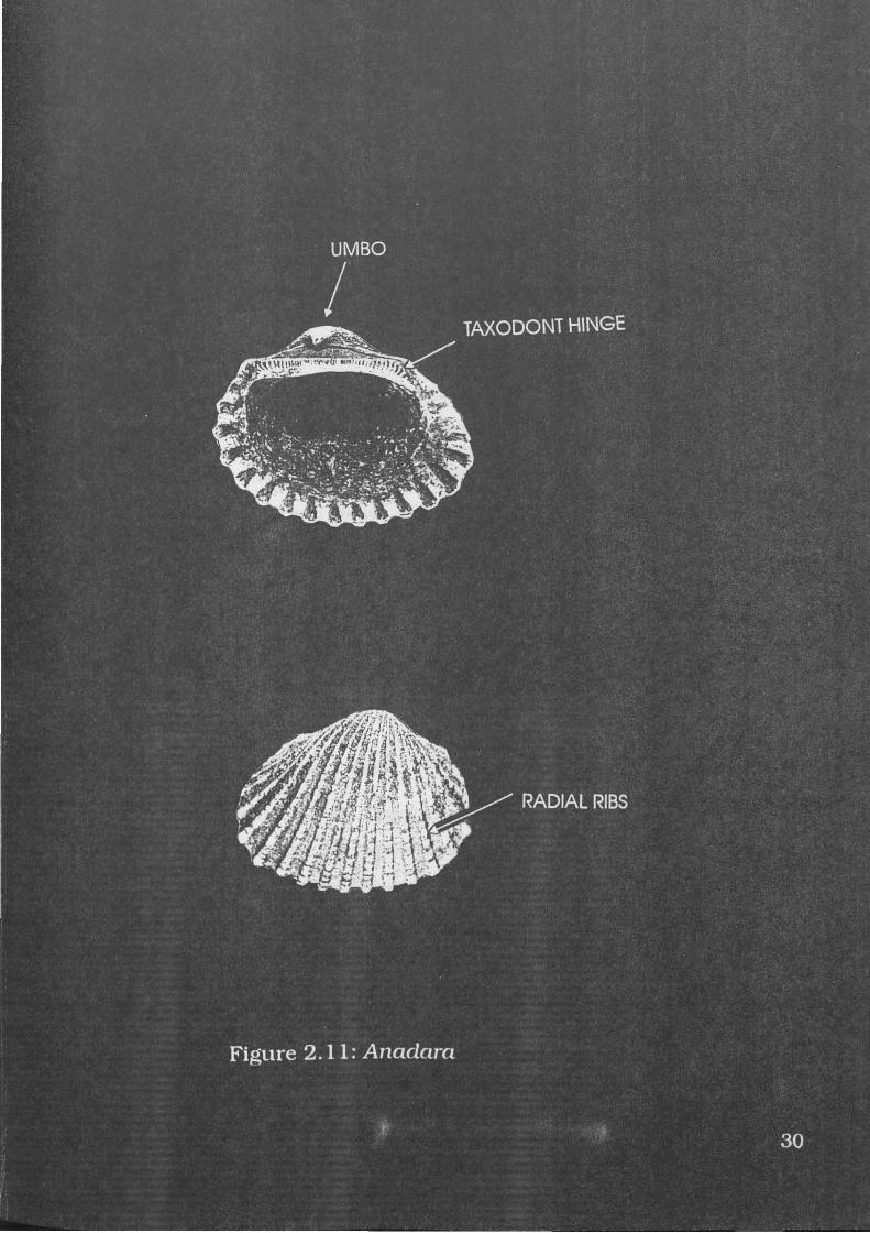
Anadara granosa Linne, 1758
A specimen of A.granosa is illustrated in Figure 2.11. A.granosa
are robust shells with distinctive granulose radial ribs. They possess a
large umbo with a 'taxodont' hinge in which the hinge line is straight
with numerous small 'teeth' (Wells and Bryce 1988:148). This taxodont
hinge is very distinctive, as is the umbo or beak, and radial sculpture.
A.granosa reaches lengths of about 80mm (Wells and Bryce 1988: 148).
B.amygdalumtostum has a similar hinge and sculpture, but its
shape is different. It is usually smaller, and its height is much smaller
in proportion to its length. A.granosa also has more pronounced axial
ridges.
This species can inhabit sandy mud substrates (Pathansali 1966).
Broom also states that A.granosa is found at high densities on mudflats
near, but not in, the mouth of large rivers (1985:6), presumably because
of low salinities in the river mouth. Meehan found A.granosa on sand
and mud flats in the mid-littoral zone (1982:59). Highest population
densities are found on the soft intertidal muds bordering mangrove
swamp forests (Pathansali 1966). Peak densities are found around
midtide level (Broom 1980), but populations may be dense subtidally in
some areas (Broom 1985:4). A.granosa can be found on the seaward
fringe of mangrove swamps (Morton 1983:96). In southern Thailand,
A.granosa has been noted to occur within mangroves as well as
extending onto the mud beyond (Morton 1983:101). When they are
feeding, they do not burrow into the mud to any depth, and frequently
lie with their posterior end protruding above the surface (Broom
1985:8).
29
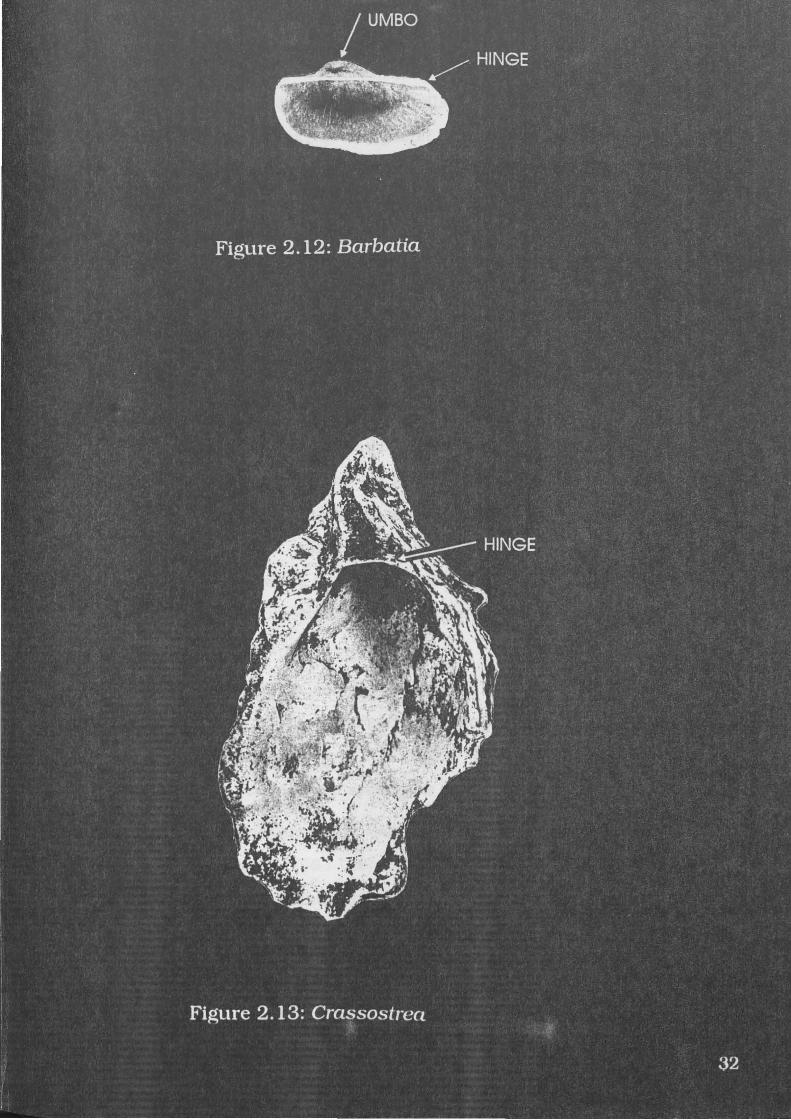
Barbatia amygdalumtostum Roding, 1798
A specimen of B.amygdalumtostum is illustrated in Figure 2.12.
This species is an oval-elongate shell, compressed laterally with fine
radial ribs (Abbott 1991:89). They have a large umbo with a 'taxodont'
hinge (Wells and Bryce 1988: 148). B.amygdalumtostum grows to 35mm
(Abbott and Dance 1982:293; Abbott 1991 :89).
Diagnostic elements include the umbo, hinge and radial ribs.
A.granosa has a similar hinge and sculpture, but has greater height in
proportion to length, and is generally larger and has more pronounced
radial ridges than B.amygdalumtostum
These shells can be found in coral reef areas under rocks (Abbott
1991:90; Abbott and Dance 1982:293). As these shells are found in reef
environments, intertidal distribution can be inferred.
Family Ostreidae
The common species of oysters live "in great abundance on
intertidal rocks, and some are found attached to mangrove trees" (Wells
and Bryce 1988:161-162).
Crassostrea amasa Iredale
A specimen of C.amasa is illustrated in Figure 2.13. Size and
shape of C.amasa are variable, as these shells grow to fit whatever
space is available. The resulting irregular shape is quite distinctive. The
'bottom' valve has a cup-like hinge (see Figure 2.13). Members of this
species are unlikely to be mistaken for any gastropods, but small
fragments may resemble the outer crenellated margins of older
specimens of A.granosa.
31
Thomson notes that this species can be found on rocks in the
intertidal zone (1954: 155). Meehan also mentions that C.amasa live in
rocky areas, but that Anbarra people remark upon oysters in this area
being different to mangrove oysters (1982:53). Meehan recorded the
presence of C. amasa in clusters on the trunks of mangroves and on the
mud between them (1982:99).
Family Corbiculidae
Members of this family can be found in freshwater and estuaries
(Abbott and Dance 1982:352).
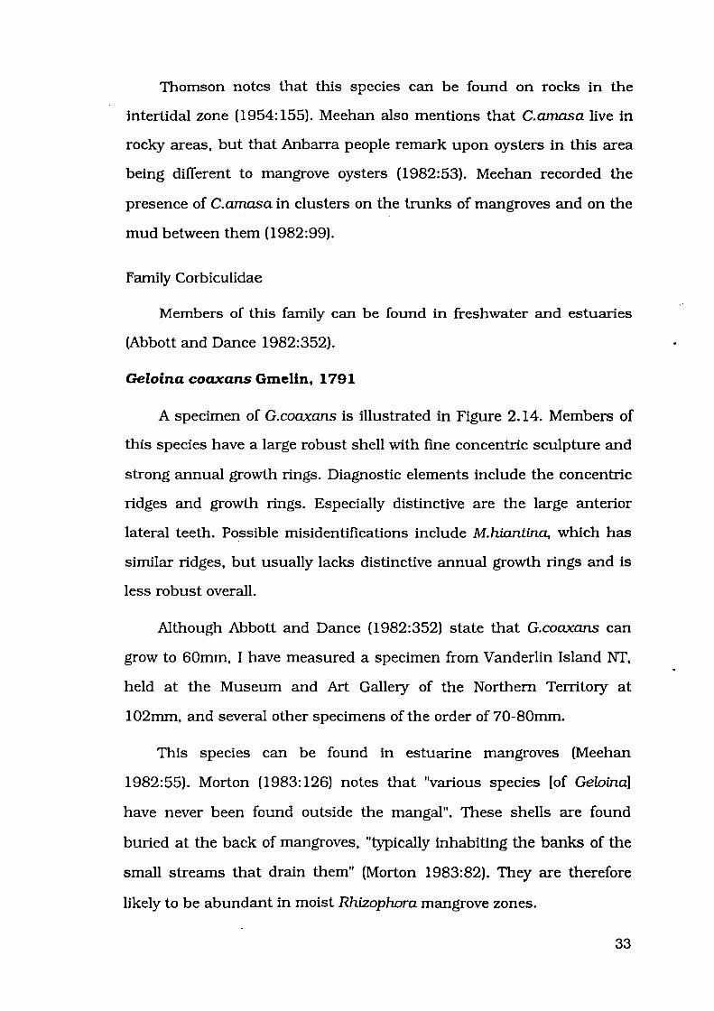
Geloina coaxans Gmelin, 1791
A specimen of G.coaxans is illustrated in Figure 2.14. Members of
this species have a large robust shell with fine concentric sculpture and
strong annual growth rings. Diagnostic elements include the concentric
ridges and growth rings. Especially distinctive are the large anterior
lateral teeth. Possible misidentifications include M.hiantina, which has
similar ridges, but usually lacks distinctive annual growth rings and is
less robust overall.
Although Abbott and Dance (1982:352) state that G.coaxans can
grow to 60mm, I have measured a specimen from V anderlin Island NT,
held at the Museum and Art Gallery of the Northern Territory at
1 02mm, and several other specimens of the order of 70-80mm.
This species can be found in estuarine mangroves (Meehan
1982:55). Morton (1983: 126) notes that "various species [of Geloina]
have never been found outside the mangal". These shells are found
buried at the back of mangroves, "typically inhabiting the banks of the
small streams that drain them" (Morton 1983:82). They are therefore
likely to be abundant in moist Rhizophora mangrove zones.
33


G.coaxans are rarely covered by the tides (Morton 1983: 112). They
have "physiological and behavioral adaptations to life high above the
level of neap tides (Morton 1983: 126). These shells lie hidden in the
mud "with one side visible from above" (Meehan 1982:93).
Family Veneridae
Venus shells are most common in shallow sandy or muddy areas of
protected bays and at the mouth of estuaries (Wells and Bryce
1988: 174). Allan (1950:323) records their substrate preference as sand
or sandy-mud bottoms, from shallow to deep water. They burrow into
the substrate, often leaving the upper surface of the shell protruding
(Wells and Bryce 1988:174).
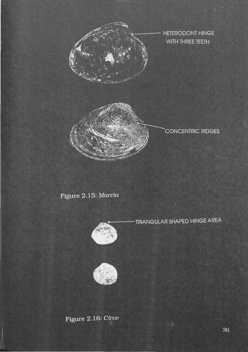
Marcia (Hemitapes) hiantina Lamarck, 1818
A specimen of M.hiantina is illustrated in Figure 2.15. Lamprell
and Whitehead ( 1992) describe this species as subovate in shape with
an angular posterior, and sculpture consisting of moderately wide,
irregular, concentric ridges. M.hiantina may attain a maximum length of
50mm (Lamprell and Whitehead 1992). This species may be more
commonly known as Tapes hiantina, but Lamprell and Whitehead
(1992) present the most recent revision of the Veneridae, and call this
species M.hiantina.
Diagnostic elements include a heterodont hinge with three teeth,
and concentric ribbed sculpture. Possible misidentifications include
G.coaxans, which has similar concentric ridges, but also has distinctive
lateral teeth lacking in Marcia. Geloina is also more robust and has
distinctive annual growth rings which are lacking in M.hiantina.
35

The substrate preferred by this species is sand or sand-mud flats
(Meehan 1982:59; Lamprell and Whitehead 1992). M.hiantina live in the
littoral zone, littoral referring to the area from intertidal to shallow
subtidal (Lamprell and Whitehead 1992:4). Meehan notes that they "are
usually found in areas where a few centimetres of sand overlie a dark
muddy matrix and can be collected from the junction between these two
strata" (1982:83). Meehan also notes that beds of M. hiantina are found
in the sublittoral fringe (1982:59), an area which is exposed at low tide
and immersed again at high tide. Clusters of shells can be found within
M. hiantina-bearing areas, as noted by Meehan:
.. .localised concentrations [of M.hiantina] are recognised by the presence of small depressions marking the spot where the shells have burrowed into the sand. Sometimes, part of the shell is visible - a side view of the hinge and lips - and at other times shells can be observed in motion, leaving a distinctive mark behind them (Meehan 1982:83).
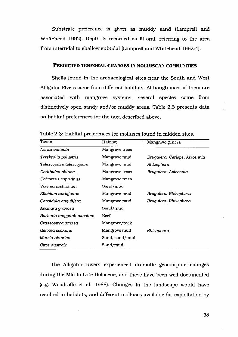
Circe australe Sowerby, 1851
A specimen of C.australe is illustrated in Figure 2.16. It is a small
shell with fine concentric sculpture. Members of this species may grow
to 25mm in length (Lamprell and Whitehead 1992). This species is
described by Lamprell and Whitehead (1992) as Gafrarium australis, but
this species almost certainly belongs to the genus Circe (Dr Richard
Willan, pers. comm.).
Diagnostic elements include its small overall size, and heterodont
hinge, which is somewhat triangular. Misidentifications are unlikely,
but if any were to occur, the hinge of large specimens of C.australe may
be mistaken for the hinge of small specimens of M.hiantina. The hinge
area of C.australe is flatter, M.hiantina being more rounded.
37
Substrate preference is given as muddy sand (Lamprell and
Whitehead 1992). Depth is recorded as littoral, referring to the area
from intertidal to shallow subtidal (Lamprell and Whitehead 1992:4).
PREDICTED TEMPORAL CHANGES IN MOLLUSCAN COMMUNITIES
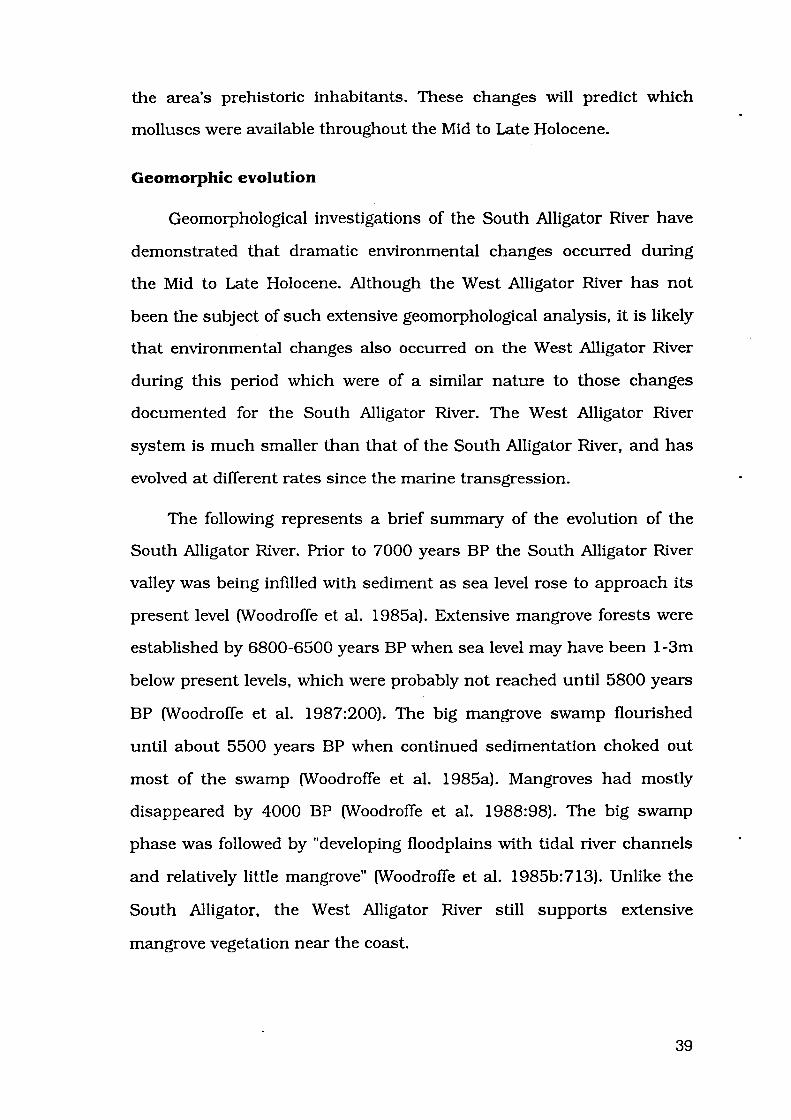
Shells found in the archaeological sites near the South and West
Alligator Rivers come from different habitats. Although most of them are
associated with mangrove systems, several species come from
distinctively open sandy and/ or muddy areas. Table 2.3 presents data
on habitat preferences for the taxa described above.
Table 2.3: Habitat preferences for molluscs found in midden sites.
Taxon
Nerita balteata
Terebralia palustris
Telescopium telescopium
Cerithidea obtusa
Chicoreus capucinus
Volema cochlidium
Ellobium aurisjudae
Cassidula angulifera
Anadara granosa
Barbatia amygdalumtostum
Crassostrea amasa
Geloina coaxans
Marcia hiantina
Circe australe
Habitat
Mangrove trees
Mangrove mud
Mangrove mud
Mangrove trees
Mangrove trees
Sand/mud
Mangrove mud
Mangrove mud
Sand/mud
Reef
Mangrove/rock
Mangrove mud
Sand, sand/mud
Sand/mud
Mangrove genera
Bruguiera., Ceriops, Avicennia
Rhizophora
Bruguiera., Avicennia
Bruguiera., Rhizophora
Bruguiera., Rhizophora
Rhizophora
The Alligator Rivers experienced dramatic geomorphic changes
during the Mid to Late Holocene, and these have been well documented
(e.g. Woodroffe et al. 1988). Changes in the landscape would have
resulted in habitats, and different molluscs available for exploitation by
38
the area's prehistoric inhabitants. These changes will predict which
molluscs were available throughout the Mid to Late Holocene.
Geomorphic evolution
Geomorphological investigations of the South Alligator River have
demonstrated that dramatic environmental changes occurred during
the Mid to Late Holocene. Although the West Alligator River has not
been the subject of such extensive geomorphological analysis, it is likely
that environmental changes also occurred on the West Alligator River
during this period which were of a similar nature to those changes
documented for the South Alligator River. The West Alligator River
system is much smaller than that of the South Alligator River, and has
evolved at different rates since the marine transgression.
The following represents a brief summary of the evolution of the
South Alligator River. Prior to 7000 years BP the South Alligator River
valley was being infilled with sediment as sea level rose to approach its
present level (Woodroffe et al. 1985a). Extensive mangrove forests were
established by 6800-6500 years BP when sea level may have been 1-3m
below present levels, which were probably not reached until 5800 years
BP (Woodroffe et al. 1987:200). The big mangrove swamp flourished
until about 5500 years BP when continued sedimentation choked out
most of the swamp (Woodroffe et al. 1985a). Mangroves had mostly
disappeared by 4000 BP (Woodroffe et al. 1988:98). The big swamp
phase was followed by "developing floodplains with tidal river channels
and relatively little mangrove" (Woodroffe et al. 1985b:713). Unlike the
South Alligator, the West Alligator River still supports extensive
mangrove vegetation near the coast.
39

Change in habitats
When the sea level first rose, the coast was further inland than at
present, and was parallel to the West Alligator River for over 10km. An
open sandy /muddy beach would have been present near the present
margin between the coastal plain and the eucalypt lowlands. Bivalves
such as Marcia and Anadara would have been available in the intertidal
portion of these beaches. With the establishment of the mangrove
forests, the gastropods associated with muddy mangrove sediments
would have been more numerous.
Changes within the mangroves would also affect the species
available. Such changes occurred on the South Alligator River during
the Late Holocene, and have been documented by Woodroffe et al.
(1986, 1988). Pollen cores taken in the central South Alligator River
valley indicate that during the big swamp phase, the mangrove forest
was dominated by Rhizophora, but towards the end of that phase
Ceriops and Bruguiera became more abundant, and finally these genera
were replaced by mangroves of the genus Avicennia (Woodroffe et al.
1986:131-132). These changes are to be expected. When the sea level
was higher, the muddy substrates would have been saturated. As the
sea level fell to its present level, these substrates would have dried out,
and mangroves preferring drier substrates would have become more
abundant. Rhizophora prefer moist substrates, and so would have been
among the first mangroves established. Bruguiera and Ceriops came
next, followed by Avicennia, which can withstand the driest substrates
of the four genera.
Change from moist substrates in Rhizophora-dominated mangroves
to drier Bruguiera- and Avicennia-dominated forests would decrease the
availability of species preferring moist substrates. Telescopillm Geloina,
40

Ellobium and Cassidula, for example, would decrease in abundance.
Under the same circumstances genera such as Terebralia. and
Cerithidea would increase in abundance. It is therefore expected that
Mid Holocene coastal sites will contain high proportions of beach
bivalves of the genera Anadara and Marcia. Late Holocene sites in all
areas will contain higher proportions of mangrove gastropods such as
Telescopium, Terebralia and Cerithidea, and bivalves Geloina. Where
stratification allows changes within the Late Holocene to be detected,
changes should reflect decreases in Telescopium and Geloina in favour
of Terebralia. or Cerithidea. An examination of published literature will
reveal whether these sorts of changes have already been detected by
other researchers.
41
CHAPTER THKBB
PREVIOUS INTERPRETATIONS OF
MOLLUSCAN FAUNAL ASSEMBLAGES
IN ARNHEM LAND ARCHAEOLOGY
42
Discussion of the major investigations of estuarine mollusc shell
bearing sites in the western Amhem Land area provide a useful
backdrop for this study. This will cover work by Schrire (1982),
Kamminga and Allen (1973), Allen and Barton (nd). Allen (1989) and
Woodroffe et al. (1988). Allen (1989; Allen and Barton nd) also refers to
shell-bearing deposits investigated by Jones and Johnson (1985b),
Meehan (1982, 1983), Smith (198la, 198lb) and Baker (1981). A
summary of their work will also be included here, as their work
influenced Allen's thinking.
INITIAL PERCEPTION OF PATTERNS
The first major study involving molluscan assemblages in the
Kakadu region was conducted in the mid 1960s by Carmel White (now
Schrire) as part of a PhD project. Her research was aimed at
establishing a cultural sequence in the region, and therefore focussed
on stratified shelter deposits which afforded her the best opportunity to
obtain material suitable for radiocarbon dating. Three of the shelters
she excavated - Badi Badi, Malangangerr, and Nawamoyn (Figure 3.1) -
were located in outliers of the Amhem Land escarpment and contained
estuarine shell midden deposits.
Archaeological deposit at Badi Badi (spelled Paribari by Schrire)
was composed of two separate sections, the midden zone and the non-,
midden zone. The midden zone consisted of a deposit dense in shell
remains (5332g/m3) accumulated in the east comer of the shelter, that
contained predominantly mangrove/mudflat species; this was overlain
by the outer non-midden zone, that contained less shell overall
(165.5g/m3), predominantly freshwater species (Schrire 1982:49, 51). A
charcoal sample which dated to 3120±100 years BP (ANU-17) was
resting on bedrock beneath the estuarine midden layer. No radiocarbon
estimations are available for the non-midden zone.
43

,j::. ,j::.
N
i f14
~ (0
~ ~ -:::::-:. <.0 ~ ~
Figure 3. 1: Western Arnhem Land sites mentioned in the text.
km
KEY
~I:!!i!!il Wetlands
20 I 1=·! ., Escarpment
D lowlands
e Site

The entire midden zone was treated as one unit and analysed in
three levels. Schrire presents shell species abundance as percentage by
weight for each level. These are reproduced in Table 3.1.
Table 3.1: Percentage of shell by weight, Badi Badi midden zone (after
Schrire 1982:52).
Level Geloina Cerithidea Telescopiwn Cassidula Neritina Ellobiwn
I 77.6 16.7 0.9 1.4 1.8 1.6
II 78.6 18.7 0.2 1.5 0.7 0.3
III 89.2 8.0 0.6 0.7 0.7 0.8
Schrire noted that there was a small increase in Cerithidea at the
expense of Geloina, but that this increase was not statistically
significant (1982:51). However, the tiny amounts of all the other genera
mean that any increase in either of these two species will be at the
expense of the other.
Deposits at Malangangerr consisted of a post-midden layer, or
"surface dust" (Schrire 1982:85). Below this was an estuarine midden
zone overlying a transition zone, which in tum overlay coarse
unstratified sands (1982:78). Schrire interpreted the transition zone as
an initial deposition of shell which was trodden into the sand layer
(1982:83). At Malangangerr two samples were taken for dating. One
from the base of the midden retumed an estimation of 5980±140 years
BP (GaK-627), and the other at the base of the surface dust dated to
370±80 years BP (GaK-626).
Four column samples of shell were retained for analysis, and the
midden was arbitrarily divided into an upper (level Ia) and lower (level
Ib) midden. As for Badi Badi, Schrire (1982:89) presents species
abundance as percentage by weight for each of these levels and the
transition zone (level II). These are reproduced in Table 3.2.
45
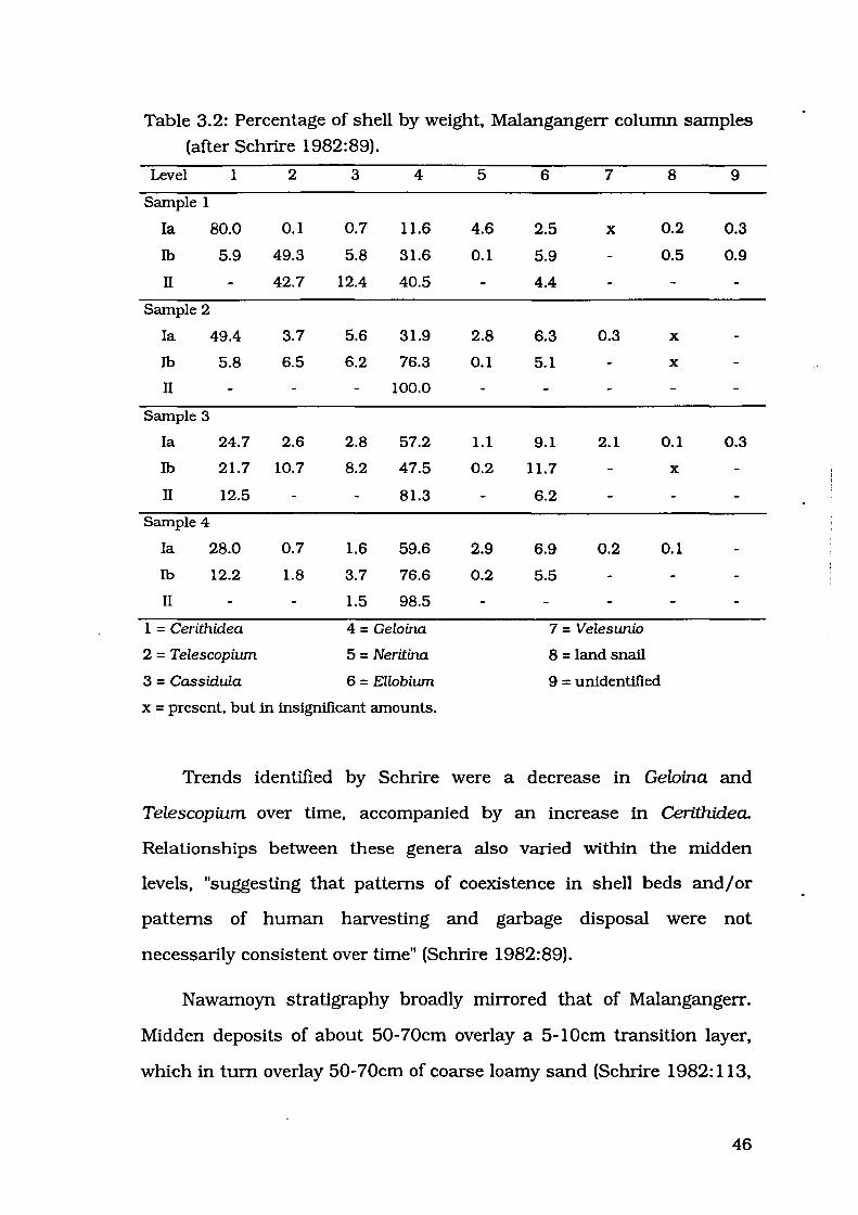
Table 3.2: Percentage of shell by weight. Malangangerr column samples
(after Schrire 1982:89).
Level 1 2 3 4 5 6 7 8 9
Sample 1
Ia 80.0 0.1 0.7 11.6 4.6 2.5 X 0.2 0.3
Ib 5.9 49.3 5.8 31.6 0.1 5.9 0.5 0.9
II 42.7 12.4 40.5 4.4
Sample 2
I a 49.4 3.7 5.6 31.9 2.8 6.3 0.3 X
Ib 5.8 6.5 6.2 76.3 0.1 5.1 X
II 100.0
Sample 3
I a 24.7 2.6 2.8 57.2 1.1 9.1 2.1 0.1 0.3
Ib 21.7 10.7 8.2 47.5 0.2 11.7 X
II 12.5 81.3 6.2
Sample 4
I a 28.0 0.7 1.6 59.6 2.9 6.9 0.2 0.1
Ib 12.2 1.8 3.7 76.6 0.2 5.5
II 1.5 98.5
1 = Cerithidea 4 = Geloina 7 = Velesunio
2 = Telescopium 5 = Neritina 8 = land snail
3 = Cassidula 6 = Ellobium 9 = unidentified
x = present, but in insignificant amounts.
Trends identified by Schrire were a decrease in Gelnina and
Telescopium over time. accompanied by an increase in Cerithidea.
Relationships between these genera also varied within the midden
levels. "suggesting that patterns of coexistence in shell beds and/ or
patterns of human harvesting and garbage disposal were not
necessarily consistent over time" (Schrire 1982:89).
Nawamoyn stratigraphy broadly mirrored that of Malangangerr.
Midden deposits of about 50-70cm overlay a 5-lOcm transition layer.
which in turn overlay 50-70cm of coarse loamy sand (Schrire 1982: 113.
46

117). Surface dust is mentioned by Schrire (1982: 117), but no depth is
noted. The oldest radiocarbon estimation associated with estuarine
shell at these three sites comes from Nawamoyn. Although shell is
found down into the transition zone, Schrire (1982: 117) considers that
this is invasive material, trodden into the existing sand deposits when
shell accumulation began. A sample of charcoal from the bottom of the
midden zone was dated at 7110±130 years BP (ANU-53).
Two column samples of shell were retained for analysis, and the
midden was arbitrarily divided into an upper Oevel Ia) and lower Oevel
Ib) midden. Schrire (1982:121) presents species abundance as
percentage by weight for each of these levels and the transition zone
Oevel II). These are reproduced in Table 3.3.
Table 3.3: Percentage of shell by weight, Nawamoyn column samples
(after Schrire 1982: 121).
Level 1 2 3 4 5 6 7 8 9
Sample 1
Ia 37.0 8.8 3.4 31.6 13.9 5.2 0.1
lb 1.7 2.3 2.0 92.6 0.5 0.9
II 100.0
Sample 2
Ia 41.8 12.3 2.1 36.4 3.7 2.6 0.4 0.1 0.6
lb 23.9 45.7 3.1 21.1 2.1 4.1 X X
II 6.9 30.5 4.2 58.4
1 = Cerithidea 4 = Geloina 7 = Terebralia
2 = Telescopium 5 = Neritina 8 = Chicoreus
3 = Cassidula 6 = Ellobium 9 = land snail
x = present, but in insignificant amounts.
47

As at Malangangerr, proportions of Cerithidea increased
throughout the midden at Nawamoyn while Telescopiu.m decreased.
However, there was no significant decrease in proportions of Geloina
(Schrire 1982:122).
Schrire's results led her to conclude that the proportion of
Cerithidea increased in the upper portion of the estuarine middens at
Malangangerr and Nawamoyn (1982:233). This trend is illustrated in
Figures 3.2 and 3.3. Although Cerithidea did not form a large proportion
of the faunal assemblage at Badi Badi, it nevertheless also exhibited the
pattem of being present in higher proportions in the upper levels of the
midden zone (Figure 3.4).
In addition to Nawamoyn, Malangangerr and Badi Badi, Schrire
(1982:231) reviewed dates from Malakunanja II and the initial trench at
Ngarradj Warde Djobkeng, grouping the five shelters into two groups.
Three of the shelters indicate early exploitation of mangrove
environments - 7110±130 BP (ANU-53) for Nawamoyn, 6355±250 BP
(SUA-264) for Malakunanja II, and 5980±140 BP (GaK-627) for
Malangangerr. The other two shelters indicate a time lag before people
began to take advantage of mangrove molluscs - 3450±125 BP (SUA-
164) for Ngarradj Warde Djobkeng and 3120±100 BP (ANU-17) for Badi
Badi. It is probable that proximity to the rivers is reflected in the
molluscan remains of the middens, i.e. sites closer to rivers were used
for deposition of shell material earlier than sites further away from
rivers. Schrire (1982:231) notes that both Ngarradj Warde Djobkeng and
Badi Badi are 8-1 Okm from present river and creek systems, while
Nawamoyn is only 5km and Malangangerr only 1km from the East
Alligator River and Malakunanja II is next to the Magela Creek.
48
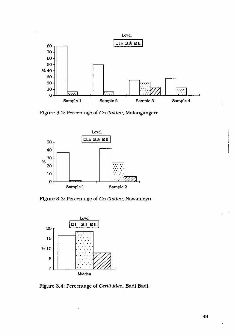
80 70
60 50
%40
30
20
10
Level
I D Ia Ellb 121 II I
0~--~~~--~--~~~---+~--~~~~~--~~._--~
Sample 1 Sample 2 Sample 3
Figure 3.2: Percentage of Cerithidea, Malangangerr.
%
50
40
30
20
Level
I D Ia Ellb 121 II I
1 o . ::::- >·.....,.v /...,...,I/~ /1 0~--~~L---~--~·~·~··~·V~//~//~A
.....
Sample 1 Sample 2
Figure 3.3: Percentage of Cerithidea, Nawamoyn.
Level
lo1 Gil ~ami 20 .. . . . . 15 . . . . . . . . . . . . . . . .
%10 . . . . . . . 5
. . 0
Midden
Figure 3.4: Percentage of Cerithidea, Badi Badi.
Sample 4
49
Dates from the base of midden deposits at these five shelters are
interpreted by Schrire (1982:231) as an indication of change in
availability of molluscs over time. Schrire (1982:231) states that
Nawamoyn is 5km from the East Alligator River. It is also adjacent to
the billabong at the base of Cannon Hill, a feature which could possibly
have supported mangrove vegetation in Mid Holocene times and been a
closer source of mangrove molluscs than the East Alligator River itself.
If this proposition holds, the early exploitation at Nawamoyn, very close
to a source of estuarine molluscs, equates well with the early
exploitation of mangrove molluscs at Malangangerr and Malakunanja II.
This would reinforce Schrire's explanation (1982:231) that "the age of
the appearance of middens at different sites may well be related to their
distance from sources of estuarine shells".
Schrire's discussions indicate that midden deposition began soon
after the sea level rise at ca. 7000 BP, at least for shelters close to the
rivers and creeks which were the source of the molluscs. Shell debris
was only deposited in shelters further from the creeks (Badi Badi and
Ngarradj Warde Djobkeng) much later, beginning at 3450 - 3120 BP.
She concluded that distance from the source of molluscs was the
determining factor in the timing of deposition of mollusc shell in these
shelter sites.
Schrire's (1982) review of mollusc remains in shelter sites
considered the effect that environmental change had on foraging.
Schrire (1982:233) first discussed the mollusc remains at shelter sites
in relation to Meehan's (1977: 117) perceptions of dietary preferences.
Geloina are the most popular, Telescopium are regarded as too strong to
constitute a staple, and are used as a relish, while Cerithidea are
50
scomed as being too time-consuming to collect and extract, and not as
tasty.
Schrire's results reflected a similar relationship between
Telescopium and Geloina. with Telescopium representing only a minor
proportion in comparison to Geloina. The increase in Cerithidea was less
easily explained simply in terms of preferences. Schrire considered the
possibility that habitat differences were responsible. Meehan informed
her that Geloina and Telescopium live in the mangrove root systems,
while Cerithidea could also be found on the less vegetated flats. An
increase in Cerithidea could therefore reflect a decline in mangrove
vegetation, with Geloina and Telescopium no longer being as easily
gathered, but Cerithidea still available from the mud flats behind the
mangrove forest proper. Conflicting information from Ponder (pers.
comm. in Schrire 1982:234) implied that all three species lived within
the tangled roots of the mangrove, so Schrire conceded that the
decrease in Geloina could represent overpredation by human agents
(Schrire 1982:234). Schrire recommended further work on
environmental factors, and also analysis of size and shape changes,
which can reveal indications of overharvesting (Swadling 1976).
FuRTHER WORK IN THE REGION
During the early 1970s, Kamminga and Allen conducted
archaeological surveys as part of the Alligator Rivers Region
Environmental Fact-Finding Study (Kamminga and Allen 1973). Part of
this work involved test excavations at several rockshelters, including
two with shell midden deposits - Ngarradj Warde Djobkeng and
Malakunanja II (Figure 3.1).
51
Kamminga and Allen (1973:29) described Ngarradj Warde
Djobkeng as an "open shelter site", with deposit accumulated at the
base of a cliff. Beneath the 1.5m of mounded deposit, a further 1m of
deposit extended beneath the level of the surrounding plain. Four
stratigraphic units were noted, with 10crn of light brown dust over
50cm of "stratified shell midden deposit" (Kamminga and Allen
1973:29). Radiocarbon estimations of material from the top of the
deposit and the middle of the midden zone were 545±90 BP (SUA-163)
and 3450±125 BP (SUA-164) respectively (Gillespie and Temple
1976: 100)." Sandy deposits containing bone but no shell extended for a
further 40cm, and SUA-225 from this layer returned an estimation of
3990±195 BP (Gillespie and Temple 1976:100). Another 115cm ofbrown
sandy deposit was encountered below this with charcoal the only
organic component.
A test pit at Malakunanja II revealed cultural material to a depth of
about 250cm, also with four stratigraphic units (Kamminga and Allen
1973:45). About 10cm of disturbed black dust containing European
items overlay 50cm of midden deposit with plentiful bone remains.
Charcoal from the base of the midden (SUA-264) dated to 6355±250 BP
(Gillespie and Temple 1976: 100). A sand layer beneath the midden
graded from brown to light yellowish sand at ca. 140-155cm. The yellow
sand extended down below the lowest stone artefacts. An intrusive layer
of light brown sand cut into the yellow sand (Kamminga and Allen
1973:47) .
• There is a discrepancy between dates cited by Kamminga and Allen (1973) and Gillespie and Temple (1976): e.g. SUA-164 is given as 3470±100 BP by Kamminga and Allen (1973:30) and as 3450±125 BP by Gillespie and Temple (1976:100). Allen and Barton (nd) use the dates as outlined by Gillespie and Temple, and I have followed this convention.
52

Little detail is available regarding mollusc species present in the
midden at Ngarradj Warde Djobkeng, Kamminga and Allen noting only
that "in levels 4-6, dated 3500 BP ... tidal mud-flat shell-fish, cockles
and whelks, became a major part of the diet" (1973:30). More elaborate
analysis was undertaken on midden remains from Malakunanja II,
where the range of species identified was said to be similar to those at
Badi Badi, Malangangerr, Ngarradj Warde Djobkeng and Nawamoyn
(Kamminga and Allen 1973:46). Less common species identified were
Telescopium telescopium, Ellobium aurisjudae, Neritina crepidularis,
Dosinia sp., Batissa sp. and Pitar sp., but Cerithidea obtusa made up
about "80% of the total bulk of shell in the midden zone" (Kamminga
and Allen 1973:46).
Allen and Barton (nd) have collaborated to present results of the
re-excavation of Ngarradj Warde Djobkeng which was undertaken in
1977. Allen and Barton noted here that the Ngarradj Warde Djobkeng
midden deposits were dominated by mangrove/mudflat species (nd:88),
but there was still no more precise quantification.
Allen and Barton (nd:90) presented dates from the "upper" levels of
midden layers at Malakunanja II and Ngarradj Warde Djobkeng. Dates
from Malakunanja II were: 4680±110 BP (SUA-263/S1) in spit two and
4050±50 BP (SUA-2264) in spit one. Dates from Ngarradj were much
less straightforward. Dates from this site were 3980±50 BP (SUA-2295)
from a depth of lOcm close to the front of the shelter, and 3760±70 BP
(SUA-2246) from a depth of 20cm near the back wall of the shelter.
These dates imply that midden deposition had almost ceased by 3760-
3980 BP.
A third estimation is of more concern - 3600±60 BP (SUA-2409)
from a depth of 50cm, also near the back wall of the shelter. Consulting
53

Allen and Barton's stratigraphic profile (nd:26) and the position of the
excavation layers (nd:28) of Ngarradj Warde Djobkeng, this sample from
spit E9 comes from the "brownish layers with decomposed shell",
beneath the greyish brown gritty shell layers from which the first two
samples were taken. It is of some interest that one of the two sites used
to demonstrate the timing of cessation of estuarine mollusc exploitation
has such a dating inconsistency. Allen and Barton discuss this reversal
(nd:29):
Making allowance for the reservoir correction for shell samples of -450 plus or minus 35 years, for other differences between charcoal and shell dates, the different shell species dated and an apparent date reversal between SUA-2246 and SUA-2409, we can argue that the shell midden layers at Ngarradj (I-III) were deposited between 3000 and 4000 years ago.
No mention was made of the "different species" used in the
radiocarbon estimations, other than this comment. In any case, the two
dates in question are close to being contemporaneous even though they
are separated by a depth of some 30cm, and are taken from samples in
different stratigraphic units. It is conceivable that the entire phase of
shell deposition took place quickly enough for the dates to overlap, but I
believe that these dates should still be viewed with caution.
A SYNTHETIC MODEL
Allen discussed various sites in the western .Anlhem Land area,
and divided levels of these sites into categories according to age: 200-
1000 years, 1000-3000 years, 3000-5000 years, 5000-7000 years,
7000-18,000 years, 18,000-25,000 years (1989:95-97, 101-102). Table
3.4 is a summary of the details for sites with mangrove/mudflat shell
material.
54
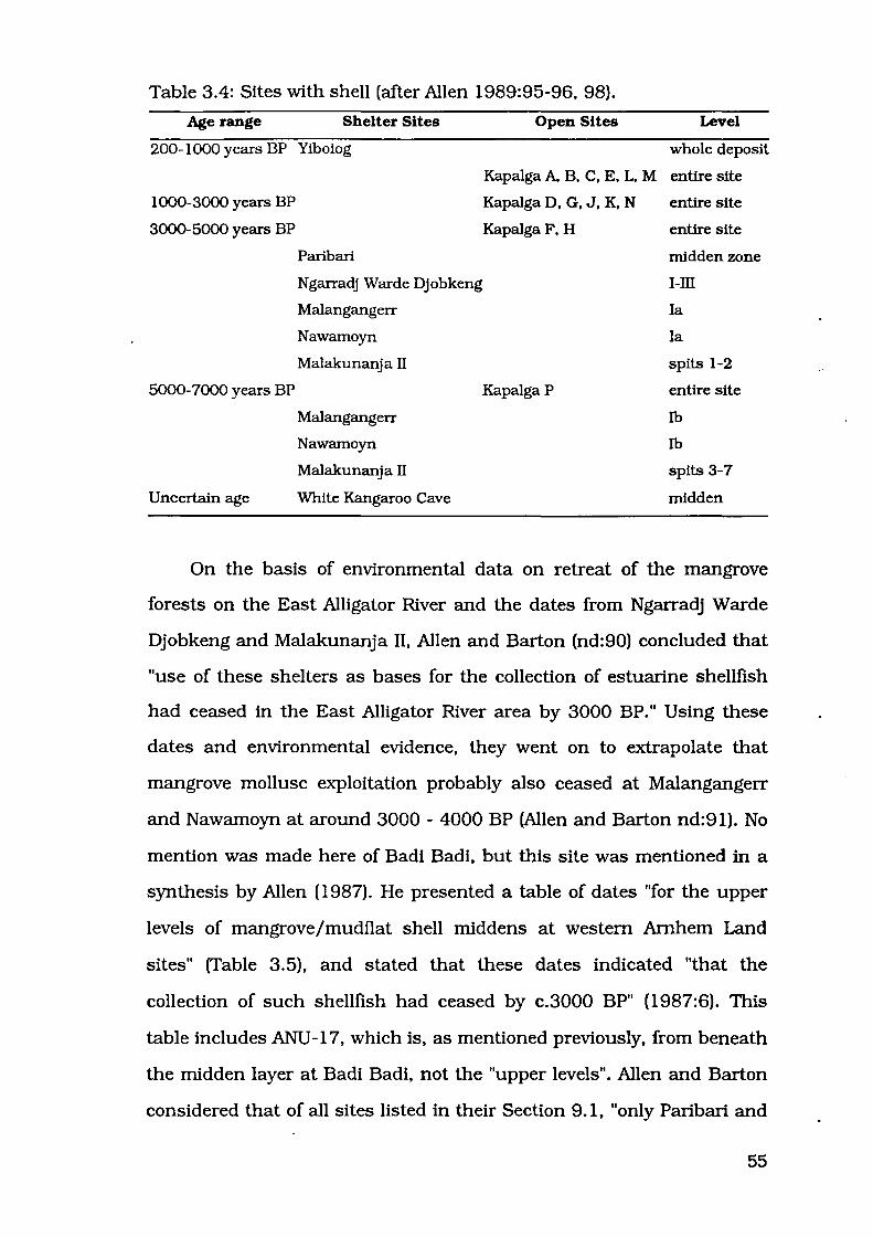
Table 3.4: Sites with shell (after Allen 1989:95-96, 98).
Age range Shelter Sites
200-1000 years BP Yiboiog
1000-3000 years BP
3000-5000 years BP
5000-7000 years BP
Uncertain age
Paribari
Ngarradj Warde Djobkeng
Malangangerr
Nawamoyn
Malakunanja II
Malangangerr
Nawamoyn
Malakunanja II
White Kangaroo Cave
Open Sites Level
whole deposit
Kapalga A, B, C, E, L, M entire site
Kapalga D, G, J, K, N entire site
KapalgaF, H
KapalgaP
entire site
midden zone
I-III
Ia
Ia
spits 1-2
entire site
lb
lb
spits 3-7
midden
On the basis of environmental data on retreat of the mangrove
forests on the East Alligator River and the dates from Ngarradj Warde
Djobkeng and Malakunanja II, Allen and Barton (nd:90) concluded that
"use of these shelters as bases for the collection of estuarine shellfish
had ceased in the East Alligator River area by 3000 BP." Using these
dates and environmental evidence, they went on to extrapolate that
mangrove mollusc exploitation probably also ceased at Malangangerr
and Nawamoyn at around 3000-4000 BP (Allen and Barton nd:91). No
mention was made here of Badi Badi, but this site was mentioned in a
synthesis by Allen (1987). He presented a table of dates "for the upper
levels of mangrove/mudflat shell middens at western Arnhem Land
sites" (Table 3.5), and stated that these dates indicated "that the
collection of such shellfish had ceased by c.3000 BP" (1987:6). This
table includes ANU -17, which is, as mentioned previously, from beneath
the midden layer at Badi Badi, not the "upper levels". Allen and Barton
considered that of all sites listed in their Section 9.1, "only Paribari and
55

Arguluk show any evidence of much continued occupation after 3000
BP". This must be a misprint, as Arguluk was not mentioned in Section
9.1 at all. As this site is undated, it was difficult to see how it showed
evidence of occupation after 3000 BP.
Table 3.5: Dates from 'upper' midden levels (from Allen 1987:6).
Site (material) Date Lab. number
Paribari (charcoal) 3210 ± 100· ANU-17
Ngarradj Warde Djobkeng (shell) 3760± 70 SUA-2246
Ngarradj Warde Djobkeng (shell) 3980 ±50 SUA-2295
Ngarradj Warde Djobkeng (shell) 3600±60 SUA-2409
Ngarradj Warde Djobkeng (charcoal) 3990 ± 195 SUA-225
Malakunanja II (shell) 4050 ±50 SUA-2264
Malakunanja II (shell) 4680 ± 110 SUA-263/S1
Allen's (1989) scenario for mollusc exploitation is that estuarine
habitats were exploited between 7000 and 3000 BP, and the debris was
discarded in rockshelters. Yiboiog is not included in this discussion
regarding estuarine middens, for reasons outlined later in this chapter.
Mter 3000 BP, the only shelter with continued discard of mollusc
material was Badi Badi, and these were freshwater species. This is
explained as being related to the decline in mangrove vegetation at
around this time. Molluscs were still exploited, but their remains were
discarded in open sites on the floodplain, and the formerly dominant
Cerithidea was incorporated to a much lesser extent.
Evaluation of the model
In a later chapter Allen and Barton (nd: 100) suggested "a revised
time and space framework", which included these sites. Extrapolations
misprinted in original: should read 3120±100.
56

were made for Ngarradj, using dates from both the 1972 and 1977
excavations. Various layers of different sites were grouped together
according to stratigraphy, artifactual content and chronology
(sometimes estimated). The three groups of interest here are 4500? -
7000, c. 3000 - 5000, and 0? - 3000. The sites included in the 4500? -
7000 age range were layer 1b at Malangangerr, layer 1b at Nawamoyn,
and spits 3-7 at Malakunanja II (Allen and Barton nd:102). In the c.
3000 - 5000 group, Allen and Barton included the midden zone at Badi
Badi, layers 1-111 at Ngarradj, layer 1a at Malangangerr, layer 1a at
Nawamoyn, and spits 1-2 at Malakunanja II (nd:101). The only site to
be included in the 0? - 3000 group was Badi Badi, and only the non
midden zone containing freshwater species was cited (Allen and Barton
nd: 101).
Allen and Barton (nd: 124) assert that the presence of Cerithidea,
Telescopium and Geloina at White Kangaroo Cave "suggests a somewhat
older date". Presence of these species must have been ascertained by
examination of museum collections, as McCarthy and Setzler (1960)
provided no list of species present. Assuming that the midden is older
just on the basis of the presence of Cerithidea represents a somewhat
circular argument. Geloina were present throughout the deposit at
Yiboiog, and the midden at Badi Badi only began to be deposited at
3120±100 BP, so there is no guarantee that mangrove/mudflat shell
deposition never occurred in shelter sites after 3000 BP .
• Allen (1987:6) quotes ANU-17 from Badi Badi and includes it in
his list of dates indicating that collection of mangrove/mudflat shells
had ceased by c.3000 BP. Allen (1987; Allen and Barton nd) has
obviously reinterpreted some of Schrire's radiocarbon estimates, notably
misprinted as 3210±100 instead of 3120±100.
57

Badi Badi. Allen's reason for estimating the chronology of the midden
zone at Badi Badi at c. 3000- 5000 years is unclear. The date obtained
by Schrire was 3120±100 BP (ANU-17) from beneath the midden zone,
lying on bedrock (Schrire 1982:51). The radiocarbon estimation of 3120
±100 BP should therefore date the beginning of estuarine mollusc
exploitation, not the cessation as interpreted by Allen and Barton
(nd:101). In this case, Badi Badi should also appear in the 1000- 3000
years category.
Another point is that Kapalga N should be 3000- 5000, not 1000-
3000. Woodroffe et al. (1988:97) report the date for this site as 3050±70
BP (ANU-4045). Allen has presumably taken 450 years to allow for the
marine reservoir effect. This may not be an appropriate correction factor
to apply in northern Australian sites, as implied by the fact that some of
the dates obtained by Woodroffe et al. ( 1988) were less than 450 years
old before any correction or calibration.
I believe it may also be oversimplifying things to infer that midden
deposition at other shelter sites such as Nawamoyn and Malangangerr
ceased at 3000 BP on the basis of the dates from Malakunanja II and
Ngarradj Warde Djobkeng, which are by no means straightforward.
Dates from upper levels of Malakunanja II suggest cessation of midden
deposition at around 4000 BP, and dates from Ngarradj Warde
Djobkeng are no younger than 3450 BP. There are no other dates from•
upper levels of shelter midden deposits. In short, the date of 3000 BP
seems to have been chosen largely on the strength of environmental
data for the East Alligator River. Use of this date may obscure the
relationship to sites in other areas where environmental changes may
have occurred at different times.
58

Broader regional comparison
Allen compared the middens excavated from these five shelters to
deposits which contained estuarine shell remains from other parts of
northern Australia. These include Yiboiog, a rockshelter excavated in
the early 1980s (Jones and Johnson 1985b), and open midden sites
from various areas, including the Blyth River area (Meehan 1982,
1983), Point Stuart (Baker 1981), Bullocky Point (Smith 1981a, 1981b)
and elsewhere along the South Alligator River (Woodroffe et al. 1988).
Excavations at Yiboiog shelter, in the escarpment outliers on the
freshwater wetlands of the South Alligator River, revealed 80cm of
deposit which contained land snails, freshwater mussels and "also a few
shells of a brackish water mangrove clam probably Geloina coaxans"
(Jones and Johnson 1985b:72). A charcoal sample close to the base of
the deposit returned an estimation of 1100±80 years BP (ANU-3209). It
is possible that these shells were transported over a great distance from
mangrove habitats for use as tools rather than as a subsistence article.
In fact, Jones and Johnson note that the "edges of several of these
[shells] were dentated, indicating use as cutting or scraping tools"
(1985b:72).
As these sparse shell remains are unlikely to represent exploitation
of Geloina as a food resource, it is probably inappropriate to include
Yiboiog in a discussion of sites containing the remains estuarine
molluscs deposited as food debris. The remaining plains middens are
much more likely to represent sites deposited primarily as food refuse.
Meehan conducted extensive ethnographic and archaeological
investigations in the Blyth River area (Figure 1.1) during the early
1970s as part of her PhD research. Of the ten sites she has dated, none
are more than 2000 years old and some were still being used in the
59
1970s (1983: 14). Meehan has described five of these sites; Aningarra,
Gunadjangga, Maganbal, Kula Kula, and Yuluk Yuluk (1982, 1983).
Middens which are attributed by Anbarra people to "dead men" are
similar in form to the middens being made in the 1970s, that is,
"extensive non-continuous midden deposits", but there was a much less
emphasis on Marcia hiantina (Meehan 1982:166-167). Large mounds of
shell were attributed to "dreaming" beings, for example the first dog in
the country formed the site of Kula Kula, and the large stingray Yuluk
was responsible for the site ofYuluk Yuluk (Meehan 1982:167-168).
Aningarra was about 2km inland and was composed of extensive
non-continuous midden deposits up to lm thick in places (Meehan
1982: 166). This site was dominated by Dosiniajuvenilis, which made up
33% of Meehan's sample (1983: 14). Other molluscs represented at this
site include Marcia hiantina, Mactra meretriciformis, Anadara sp., and
members of the family Mytilidae. A basal shell date for this site,
corrected for the marine reservoir effect, indicates earliest use of 290±80
years BP (ANU-2013B).
Gunadjangga was located close to the coast, and was also
dominated by Djuvenilis, which made up 60% of Meehan's sample
(1983: 15). Other species represented at this site included Coecella
horsfzeld~ Cerithidea anticipata, Tapes hiantina, and members of the
family Mytilidae. A corrected basal shell date for this site indicated
beginning of deposition at 150±110 years BP (ANU-2020B).
Maganbal was a "small midden mound" 25m x lOrn x 0.6m, and
was located at the boundary between the blacksoil floodplain and
mangroves (Meehan 1982: 167). Meehan's map (1982:27) indicated a
distance of approximately 5km from this site to the coast. A sample of
shell from this site was dominated by Anadara granosa, other species
60

including Cerithidea anticipata. Telescopiwn telescopiwn and Terebralia
palustris (Meehan 1982: 167). A.granosa was "available in the estuarine
environment extending as far as Matai territm:y" where this site was
located (Meehan 1982: 167). No dates were available for this site.
In the Blyth River area several groups of mounds were found,
which attained heights of 5m and diameters of 30m (Meehan 1982:167).
These large discrete mounds were located about 1km from the coast
and were quite different in form from the previously described non
continuous midden deposits (Meehan 1982:167, 1983: 15). The Kula
Kula or Dog Mounds were found on the west side of the river, and
another series of mounds was located adjacent to Ngalidjibama on the
east side of the river, including the site Yuluk Yuluk.
At least five species were represented at the site of Kula Kula, the
most numerous being Djuvenilis, making up 91% (Meehan 1983:15).
Other species represented were Mactra meretricifonnis, Terebralia
palustris, Tapes hiantina. and members of the family Mytilidae. A
corrected shell date from this site indicated occupation at 1440±100
years BP (ANU-2024).
Yuluk Yuluk was dominated by Coecella hnrsfzeld~ comprising 83%
of Meehan's sample (1982: 168). At least three other species were
represented in this mound, including Dosinia juvenilis, Mactra
meretricifonnis, and Mytilidae. Interestingly Anadara granosa was not
present, although it was available at the time of Meehan's fieldwork only
1km away (1982: 168). Possibly this site was formed some time ago,
before Anadara granos a beds had been established.
Meehan's work documents the exploitation of mollusc taxa over the
last 1500 years, especially the last few hundred years. Various taxa
61

were exploited, several sites dominated by Dosinia, one by Anadar~ and
another by Coecella.
Baker (1981) investigated sites in the Chambers Bay area, near
Point Stuart (Figure 1.1) in order to illustrate the relationship between
prehistory and geography. Using ethnographic sources, he stressed the
importance of plant foods such as Pandanus in these coastal plains
areas (1981:51). Baker only obtained two radiocarbon dates for any of
his sites. Samples of shell were taken from the surface of Site No.40,
which dated to 920±90 BP (ANU-2888), and shell from the top 5cm of
Site No.38 (ANU-2887) which returned a modern estimate (Baker
1981:62-63). Other sites could only be dated by association with
geomorphic features. For example, the plains surface was only formed
during the Holocene (Baker 1981:62). Baker concluded that the beach
ridges were a 'focus for human activity" (1981:84). He suggests a likely
location for a camp site would be the 1lrst beach ridge which has fresh
water in the wet season on its landward side~ with close fresh water,
the accompanying proximity to coastal resources, and also protection
from rain and winds (1981:77).
Baker (1981:Table 13) indicated that thirty-two of the sixty-six
sites he recorded near Point Stuart contained shell. Not all of these were
analysed, but Baker noted that five sites were dominated by shells from
sandy mud flats, and fifteen by shells from mangrove environments
(1981:Table 17). Only for Site 11 did Baker provide species composition
data (1981:Table 18). The most abundant species by weight were Tapes
sp., possibly Marcia hiantin~ (23.05-24. 78%) and Volema cochlidium
(20.59-22.13%). Cerithidea was not mentioned, but could possibly be
one of the "unknown" gastropods, in which case they made up an
inconsequential. proportion of the site, between 0.03% and 0.34% by
62

weight of the entire test pit. He also mentioned that Site 29 was
dominated by Crassostrea sp., the only site at which the oyster was
predominant. As these were the only references Baker made to mollusc
species composition, it is difficult to use all his sites in any models
about species composition.
Of the sites mentioned by Allen in his comparison over the broader
northern region, Yiboiog is not relevant to discussions regarding
exploitation of estuarine molluscs for dietary purposes, but has been
included for comprehensiveness. Blyth River sites certainly conform to
Allen's scenario for deposition on the plains only after 3000 BP, and for
Cerithidea to be largely absent. Point Stuart sites do not provide enough
data to allow us to make detailed comparisons of species composition.
As well as these areas further afield, Allen examined work conducted on
shell middens on the Alligator River plains.
Sites on the Alligator River plains
Smith recorded several shell middens and stone artefact scatters in
the area of the floodplain surrounding the eucalypt woodland at the
present CSIRO Kapalga Research Station in 1980 (1981a) and 1981
(1981b). No analysis of these sites was carried out by Smith.
Two middens at Bullocky Point (Figure 3.1) were described by
Smith (1981a) as "earth mounds". He made a contour map of Mound II,
which suggested dimensions of 40m x 45m and a height of ca. 80cm.
He tentatively identified shellfish species from Mound I as small
gastropod and Periglypta sp. In this report he also mentions two
mounds at Rookery Point. A photograph of these two mounds is
included in his report of 1981 fieldwork (1981b), but no details are
given of site size or species composition.
63
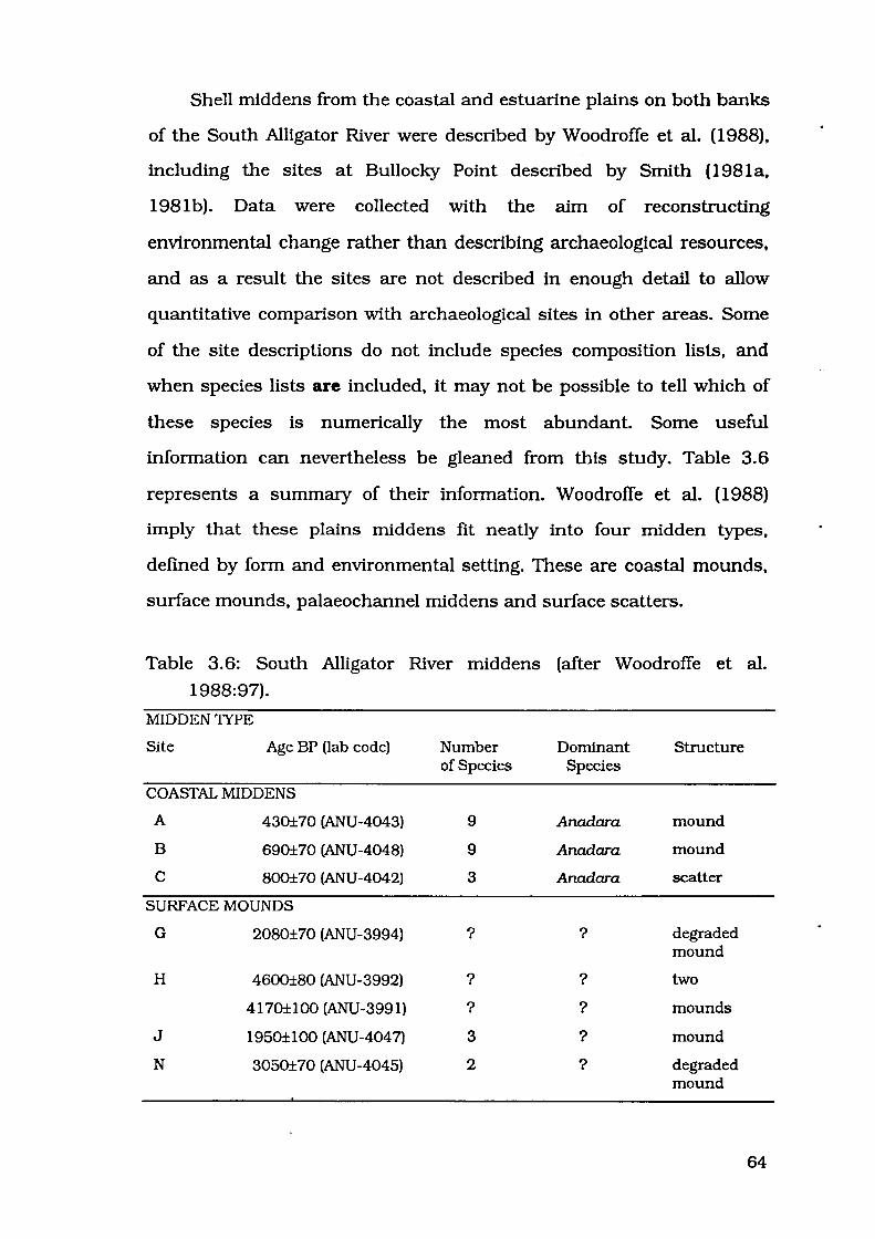
Shell middens from the coastal and estuarine plains on both banks
of the South Alligator River were described by Woodroffe et al. (1988),
including the sites at Bullocky Point described by Smith (1981a,
1981b). Data were collected with the aim of reconstructing
environmental change rather than describing archaeological resources,
and as a result the sites are not described in enough detail to allow
quantitative comparison with archaeological sites in other areas. Some
of the site descriptions do not include species composition lists, and
when species lists are included, it may not be possible to tell which of
these species is numerically the most abundant. Some useful
information can nevertheless be gleaned from this study. Table 3.6
represents a summary of their information. Woodroffe et al. (1988)
imply that these plains middens fit neatly into four midden types,
defined by form and environmental setting. These are coastal mounds,
surface mounds, palaeochannel middens and surface scatters.
Table 3.6: South Alligator River middens (after Woodroffe et al.
1988:97).
MIDDEN1YPE
Site Age BP (lab code) Number Dominant Structure of Species Species
COASTAL MIDDENS
A 430±70 (ANU-4043) 9 Anadara mound
B 690±70 (ANU-4048) 9 Anadara mound
c 800±70 (ANU-4042) 3 Anadara scatter
SURFACE MOUNDS
G 2080±70 (ANU-3994) ? ? degraded mound
H 4600±80 (ANU-3992) ? ? two
4170±100 (ANU-3991) ? ? mounds
J 1950±100 (ANU-4047) 3 ? mound
N 3050±70 (ANU-4045) 2 ? degraded mound
64

PALAEOCHANNEL MIDDENS
L 570±60 (ANU-3914) 1 Cerithidea mound
M 650±70 (ANU-4046) 5 ? mound
520±60 (ANU-4044)
K 2680±70 (ANU-4067) 2 ? scatter
F 3790±70 (ANU-3993) ? ? scatter
SURFACE SCATI'ERS
D 2480±70 (ANU-4041) 2 ? scatter
E 280±60 (ANU-3987) 2 ? scatter
p 6240±100 (ANU-4915) 1 Telescopium scatter (buried)
Coastal middens are designated as sites composed "principally of
shell" located "on the crest of chenier ridges ... [and] are generally <1m
high", ranging in age from 430±70 to 800±70 years (Woodroffe et al.
1988:96-97). Several species of intertidal and shallow marine molluscs
are represented in these sites, the most abundant being Anadara
granosa, which "dominates other coastal middens around the north
Australian coastline" (Woodroffe et al. 1988:96).
Surface mounds are 15-20m in diameter and less than 50cm high,
ranging in age from 1950±100 to 4600±80 years (Woodroffe et al.
1988:97). Their shelly-silt or shelly-clay matrix contains rock and bone
fragments, including stone artefacts. Meretrix meretrix and Cerithidea
sp. are the dominant shellfish species (Woodroffe et al. 1988:96).
Palaeochannel middens are found as mounds on degraded silt
levees or as scatters close to a palaeochannel bank and range in age
from 520±60 to 3790±70 years (Woodroffe et al. 1988:97). Mangrove
species including Polymesoda coaxans, Meretrix meretrix, Telescopium
telescopium and Terebralia palustris are found in these sites (Woodroffe
et al. 1988:96).
65
Surface scatters consist of a few gastropod shells with Telescopium
telescopium being the dominant species, ranging in age from 280±60 to
6240±100 years (Woodroffe et al. 1988:97). These are thought to
represent the remains of one or a few meals (Woodroffe et al. 1988:96).
Since Allen's model was proposed, further research on coastal
middens has been undertaken on sites from the Caimcuny Plain and
West Alligator River (Figure 3.1). The purpose of this study was to
document middens outside rockshelters, and to document inter-site
faunal variability (Hiscock and Mowat 1993: 19).
Caimcuny Plain sites were dominated by Anadara, which
contributed between 66.7% and 89.5% of the faunal assemblages at
54 73 P 0708, 54 73 P 0709 and 54 73 P 0710 (Hiscock and Mowat
1993:19). Site prefix 5473 is the 1:100 000 topographic mapsheet East
Alligator, on which these sites are located. Other genera represented at
these sites included Telescopium, Terebralia, Cerithidea, Nerita and
Chicoreus. Cerithidea was present in very small proportions, never
contributing more than 3% to any faunal assemblage.
West Alligator River sites are among those described in greater
detail in Chapter Five. Preliminary descriptions, however, revealed that
Cerithidea contributed 0.5% to the faunal assemblage at site 5373 P
0711 [Field Island 2], and was absent from the samples counted at sites
5373 P 0712 [Field Island 3] and 5373 P 0713 [Field Island 4] (Hiscock
and Mowat 1993:21). Site prefiX 5373 is the 1:100 000 topographic
mapsheet Field Island, on which these sites are located.
A high degree of variability in species composition was noted by
Hiscock and Mowat (1993:24). Most approaches to documenting coastal
plains sites emphasise homogeneity, and this is one of the few
investigations to avoid this tendency.
66

DISCUSSION
Blyth River sites recorded by Meehan ( 1982, 1983) certainly
support Allen's model, all being much less than 3000 years old and
containing less than 10% Cerithidea. Point Stuart sites reported by
Baker (1981) are not recorded in enough detail to allow any statements
to be made about either of these issues. All of Baker's sites are probably
less than 6000 years old, and two of them were certainly deposited
within the last thousand years. Baker's (1981) Site No.11 contained less
than 10% Cerithidea, but species abundance is not available for any
other sites. Caimcurry Plain and West Alligator River recorded by
Hiscock and Mowat ( 1993) contained less than 10% Cerithidea, but
these sites were not dated. Smith's (1981a) recording of Bullocky Point
sites was not detailed enough to allow statements to be made about
species composition or antiquity. South Alligator River sites reported by
Woodroffe et al. ( 1988) were of varying ages, from modem to over 6000
years old. Species abundance was not available for these sites, but
Cerithidea did occur at several of them, a fact which merits further
recording of these sites.
CONCLUSION
Schrire ascertained the first series of pattems of midden deposition
in the westem Arnhem Land region. Her excavations at Malangangerr,
Nawamoyn and Badi Badi established that exploitation of estuarine
mollusc shell commenced soon after the sea level rise at around 7000
BP for sites close to rivers and creeks (Malangangerr and Nawamoyn).
and later for sites further from these sources of molluscs, around 3000
BP (Badi Badi). Schrire perceived increases in the proportion of
Cerithidea through time at Malangangerr and Nawamoyn, and to a
67

lesser extent at Badi Badi, which she interpreted as a decline in
mangrove vegetation (1982:234).
Allen (1987, 1989; Allen and Barton nd) was responsible for the
first synthesis of midden deposits from sites throughout western
Arnhem Land. His model proposed that estuarine molluscs, notably
Cerithidea, were deposited in rockshelter sites between 7000 and 3000
BP. Mter this time, Cerithidea were much less important, and
deposition of shell debris shifted away from shelters onto the coastal
plains. Decline in mangrove forests is cited as the explanation for both
these changes identified by Allen at 3000 BP. Less mangrove vegetation
meant that Cerithidea were not as readily available, and the retreat of
the mangrove forests also meant that people could move more freely
about on the plains which had been densely vegetated until this time.
Previous researchers have distinguished trends relating to
chronological change in species composition, which are customarily
seen to be unidirectional and pertaining mainly to Cerithidea. These
trends are extrapolated to be uniform over the region stretching from
Point Stuart in the west to the Blyth River in the east.
It is maintained that shelter sites were abandoned because
estuarine mollusc resources were no longer available after a certain
time. Another question of change through time, therefore, concerns the
association of mangrove shell exploitation with the timing of
abandonment of shelter sites. Issues relating to these chronological
changes will be dealt with in chapter six.
Another obvious phenomenon to emerge from examination of the
literature is the perceived homogeneity of midden composition in the
region. Midden sites are often lumped together as "plains sites" or
"coastal middens", disguising possible variability of site size,
68

environmental context or species composition. A hypothesis that
middens across westem Arnhem Land are similar in size, context and
species composition will be tested in chapter seven.
Other issues arising from examination of these investigations relate
to different methods of quantification used by different authors.
Methods used to measure abundance of mollusc species have affected
the results used to make intersite comparisons. Schrire used weight of
shell, Meehan used minimum numbers of individuals, a method also
advocated by Allen. Minimum number calculations and weight of shell
are two methods most frequently used, and these will be discussed in
chapter four.
69

CHAPTER FOUR
METHODOLOGY
70

Reviews of methodology employed by other researchers analysing
midden deposits in Kakadu form the focus of this chapter. Schrire
(1982) used weight of shell per taxon to quantify species abundance in
the middens at Badi Badi. Malangangerr and Nawamoyn. In contrast,
Allen (1987; Allen and Barton nd) used minimum numbers of
individuals per taxon at Ngarradj Warde Djobkeng. There was no
standard methodology used by all researchers which can be adopted to
calculate species abundance. Weight of shell and minimum numbers
are among the methods I evaluated to decide which were the most
appropriate to use during my fieldwork.
My methodology was partly shaped by the conditions under which
fieldwork could be carried out. Time spent in the field was limited for
financial reasons. Apart from this, the areas I examined were remote,
hot and generally disagreeable, and for this reason it was desirable to
complete the fieldwork in the least possible amount of time. It was
logistically impossible to take large numbers of assistants into the field,
and I carried out much of the research alone when I was unable to find
anyone who could accompany me. The areas in which I could examine
sites were strictly delineated by the Australia Nature Conservation
Agency (ANCA), and I was not permitted to take any archaeological
material out of the park, apart from special permission obtained to
collect several shell samples for radiocarbon dating. As material could
not be removed from the park, excavation was not possible and all
analysis had to be non-destructive and be carried out on the site. In
spite of this, I was still able to achieve my objectives of determining
patterns of inter-site variability in relative abundance of mollusc taxa.
71

I begin this discussion by examining the methods used in
measurement of abundance, such as Minimum Number of Individuals
(MNI), Number of Identified Specimens (NISP) and shell weight per
taxon. In addition to this, I will address issues of sampling, and how
factors such as sample size and fragmentation can affect results of
different quantification methods, including an example of the effects of
fragmentation. Finally I will outline the methods used in the present
study.
SAMPLING
Complete characterisation of midden species composition can not
be achieved without excavation of the entire deposit (Treganza and Cook
1948; Ranson 1980). Examination of any smaller unit will only
characterise the species composition of that particular segment of the
site. As total excavation is a largely impractical solution in terms of
time, cost and other factors, a representative sample of midden material
must be taken.
Treganza and Cook (1948:292) stated that a "component of the site
which appears in large quantity and in a reasonably fine state of
subdivision may be estimated with a fairly high degree of precision by ...
samples of 1 to 5 pounds weight and from 15 to 30 in number". Here
they are more interested in characterising the rock, baked clay and
bone fragment components of the midden than the shell itself. Presence
of any large bones or rocks will heavily skew results, and in this case
larger samples would be required, conceivably as large as several
hundred pounds (Treganza and Cook 1948:292).
The number of samples advocated by Treganza and Cook ( 1948) is
adequate if there are no large objects, if you are excavating a
72

homogeneous site, and if your primary concern is to characterise the
non-shell components of the midden. However, if you are not excavating
the site and your primary concern is to characterise . the shell
component, then this number of samples will not necessarily be
appropriate. Depending on the homogeneity of the faunal assemblage,
considerably less than thirty should enable the researcher to
characterise the shell composition of the midden. If the site is large and
different portions of the site are obviously composed of different taxa or
different proportions of taxa, then one or more samples should be
placed in each of these areas. If the site is small and there is no
discernible difference in species composition on different parts of the
site, then one sample should be enough to give a picture of which taxa
are present and which, if any, predominates.
Bowdler (1983: 138-139) provided a critique of sampling methods
used by various researchers. For excavated sites, Bowdler (1983: 139)
found samples of 2000cm3 (around 2000g) per level to be "adequate".
Bowdler (1983: 139) noted that this was consistent with sample sizes
used by other researchers, e.g. Barz, where column samples of 6250cm3
were found to be more than adequate, but 500cm3 were totally
inadequate. In this context, Bowdler (1983: 137) was concerned with
characterising mollusc taxa abundance in order to understand "diet and ,
economy, nature of occupation, seasonality and so on".
Bowdler (1984:93) has described procedures for sampling a shell
midden when the primary concern is "obtaining information about the
subsistence of people who collected the shellfish as food", which were
used in her excavations at Cave Bay Cave on Hunter Island, Tasmania.
This example may at first seem somewhat out of place in a discussion of
tropical shell mounds, but this is one of few Australian studies where
73

methodology is outlined in great detail, and where the researcher
presents data which allow calculation of volumes of the samples and
the minimum numbers calculated in each of these samples.
Table 4.1: Cave Bay Cave Trench V column samples (after Bowdler
1984:23, 91, 94), arranged by sample number.
Sample Depth Thickness Spit Stratigraphic Volume Total MNI/ (em) (em) Equivalent Unit (cm3
) MNI 1000cm3
1 0-2 2 1 Surface 800 20 25.000
2 2-5 3 2 Upper Midden 1200 33 27.500
3 5-10 5 3 Upper Midden 2000 64 32.000
4 10-13 3 4 Upper Midden 1200 29 24.167
5 13-15 2 4 Upper Midden 800 4 5.000
6 15-18 3 5 Upper Midden 1200 7 5.830
7 18-23 5 5-6 Sterile 2000 2 1.000
8 23-30 7 6 Sterile 2800 3 1.070
9 30-34 4 7-8 Lower Midden 1600 1 0.625
10 34-40 6 9-10 Lower Midden 2400 1 0.417
11 40-44 4 10 Lower Midden 1600 3 1.875
12 44-50 6 10-llA Lower Midden 2400 4 1.670
13 50-60 10 llA-llC Lower Midden 4000 186 46.500
14 60-64 4 llC Lower Midden 1600 3 1.875
Table 4.1 presents Bowdler's minimum number estimates from
each column sample taken from the edge of Trench V at Cave Bay Cave.
Samples were 20cm x 20cm and of varying depth depending on the size
of the stratigraphic unit, between 800cm3 and 4000cm3• Total MNI for
each sample varies between 1 and 186. It is also possible to express
these results for each stratigraphic unit.
74
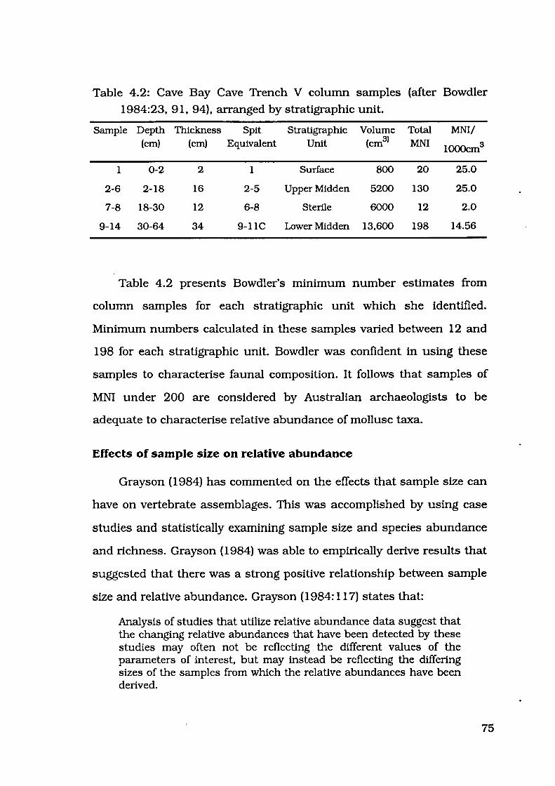
Table 4.2: Cave Bay Cave Trench V column samples (after Bowdler
1984:23, 91, 94), arranged by stratigraphic unit.
Sample Depth Thickness Spit Stratigraphic Volume Total MNI/ (em) (em) Equivalent Unit (cm3l MNI
1000cm3
1 0-2 2 1 Surface 800 20 25.0
2-6 2-18 16 2-5 Upper Midden 5200 130 25.0
7-8 18-30 12 6-8 Sterile 6000 12 2.0
9-14 30-64 34 9-11C Lower Midden 13,600 198 14.56
Table 4.2 presents Bowdler's minimum number estimates from
column samples for each stratigraphic unit which she identified.
Minimum numbers calculated in these samples varied between 12 and
198 for each stratigraphic unit. Bowdler was confident in using these
samples to characterise faunal composition. It follows that samples of
MNI under 200 are considered by Australian archaeologists to be
adequate to characterise relative abundance of mollusc taxa.
Effects of sample size on relative abundance
Grayson ( 1984) has commented on the effects that sample size can
have on vertebrate assemblages. This was accomplished by using case
studies and statistically examining sample size and species abundance
and richness. Grayson ( 1984) was able to empirically derive results that
suggested that there was a strong positive relationship between sample
size and relative abundance. Grayson (1984: 117) states that:
Analysis of studies that utilize relative abundance data suggest that the changing relative abundances that have been detected by these studies may often not be reflecting the different values of the parameters of interest, but may instead be reflecting the differing sizes of the samples from which the relative abundances have been derived.
75

This has seldom been taken into account by Australian midden
studies. Most midden deposits are dominated by one or a few taxa. The
larger the sample that is taken, the greater likelihood of picking up an
extra individual of an extremely unimportant species. This will affect
species richness, but will have a much lesser effect on relative
abundance of the most numerous taxa. As calculation of relative
abundance is the main aim of my research, I believe that smaller
samples will adequately identify the most abundant species.
MEASUREMENT OF ABUNDANCE
Measurement of abundance of different taxa in a site is usually
achieved by one or more of the following methods; calculation of
minimum numbers of individuals (MNI) per taxon, number of identified
specimens (NISP) per taxon, or weight per taxon.
Minimum numbers methodology was introduced to archaeological
literature by White (1953). His method of calculating MNI was to
"separate the most abundant element of the species found ... into right
and left components and use the greater number as the unit of
calculation" (1953:397).
Grayson (1984: 17) states that the "basic counting unit that must
be used in any attempt to quantify the abundances of taxa within a
given faunal assemblage is the identified specimen, the single bone or
tooth or fragment thereof assigned to some taxonomic unit". The NISP
for any given taxon is the total number of fragments identified.
Weight per taxon is the weight of all specimens identified as
belonging to this taxon. This method is not described in detail by
Grayson, as this method is used largely by midden analysts, and
Grayson ( 1984) spends little time · discussing the quantification of
76

invertebrate faunal assemblages. Each of these methods has its
supporters, and when choosing a method to use for any particular
study, it is important to be clear about the reasons for selecting one
method rather than another. The strengths and weaknesses of each
method must be assessed and the method most appropriate chosen
according to the type of assemblage being examined and the aims of the
study.
MNI v. NISP
Grayson ( 1984) provides one of the most comprehensive
discussions relating to the relative merits of MNI and NISP. In the 1950s
archaeologists were becoming disenchanted with the perceived
problems of the NISP method, and they accepted the use of MNI.
Grayson was quite critical of this attitude, as he believed that the MNI
posed as many problems as NISP.
Grayson (1984:20-23) identified many factors affecting NISP
values. Butchering pattems may vary between species, and if one
species is commonly butchered in such a way to fragment the bones
and another is not, then individuals of the species heavily butchered
will be represented by more fragments and therefore have a higher NISP
value. The ability of the analyst to identify all body parts of all taxa is
also important. If the analyst can identify every body part of one
species, but can only identify cranial elements of a second species, then
an individual of the first species could have a NISP of over two hundred,
whereas an individual of the second species could only have a NISP
which includes cranial fragments, not all other body parts. This is not
only an important factor for vertebrate NISP values. Some mollusc
species will be recognisable by their sculpture even for tiny fragments.
NISP will over-estimate the abundance of individuals belonging to this
77

species as opposed to other species which are mostly unrecognisable
when fragmented.
Deliberate or chance breakage may differ between taxa. Bones of a
species with relatively robust bones may not break, but the bones of
another species with relatively fragile bones may break into more
fragments as a result of, for example, human marrow extraction or of
chance breakage during post-depositional processes. Likewise, the
bones of different species may be subject to differential preservation,
where the bones of one species are preserved in their entirety but
relatively more fragile bones of another species may not survive so well.
This could mean that for the fragile species, NISP could be inflated by
post-depositional fracturing, with one of its bones become several
hundred fragments, each of which will add to the NISP value. The size of
mesh used in collection will affect whether small bones of small species
are retrieved or whether they fall through the sieve and are therefore
excluded from the analysis. It is also not possible to know that all
specimens are interdependent, that is whether the specimens came
from the same individual. Grayson also stated that "these criticisms
largely arose after minimum numbers had already become well
accepted as a counting unit, and thus were used to justify minimum
numbers, rather than to develop a new method of counting" (1984:24). ,
In Grayson's (1984) opinion, MNI is as fraught with difficulties as
NISP. Problems with MNI relate to vertebrates and the effects of
aggregation (Grayson 1984:67):
Given that minimum numbers measure not only abundance but also register the effects of aggregation procedures, it is difficult to see that they have much to offer as a measure of taxonomic abundance.
78

Grayson is objecting mainly to the use of MNI for stratified vertebrate
assemblages. If MNI values are calculated for each taxon with arbitrruy
levels within a stratum, and then calculated for the entire stratum, the
result will be lower MNI values for the larger unit. This is because there
is no guarantee that all elements from each animal will be found within
any arbitrruy level. Remains from one animal may be deposited
throughout a section of deposit which transcends the excavator's
arbitrruy divisions.
As there are objections to the use of MNI, Grayson (1984)
concludes that NISP problems can be as easily overcome, and since they
are not subject to effects of aggregation, they should be used in
preference to MNI. Grayson goes on to discuss the relationship between
MNI and NISP, and finds that "for any givenfauna, MNI values can be
tightly predicted from NISP counts" (1984:62, emphasis in original). If
MNI and NISP are so tightly related, then there should be no reason not
to use MNI values. Grayson (1984:53) has demonstrated statistically
that there is a strong relationship between NISP and MNI. This
relationship took the form MNI = a(NISP)b, a and b being constants
which vruy for each assemblage (Grayson 1984:55). For the six
assemblages Grayson analysed, the regression equations produced high
correlation coefficients (r) which are reproduced below (Table 4.3). If the
NISP and the MNI are so strongly related, then it is surely just as
meaningful to use MNI as NISP.
Table 4.3: Regression equations and correlation coefficients for the
relationship between MNI and NISP for six United States faunal
assemblages (from Grayson 1984:54).
Site Regression equation r p
Prolonged Drift MNI = .49(NISP) "64
.939 <.001
79

Apple Creek MNI = .69(NISP)'59
.937 <.001
Buffalo MNI = . 71 (NISP)'63
.957 <.001
Dirty Shame Stratum 2 MNI = 1.03(NISP)'64
.971 <.001
Dirty Shame Stratum 4 MNI ,;, 1.04(NISP)"62 .978 <.001
Fort Ligonier MNI = 1.11(NISP) .40 .785 <.001
When analysing vertebrate faunas, the conventional analytical
sequence, followed by Grayson (1984), identifies all specimens,
calculates NISP first, then decides which element to use for MNI
calculation by selecting the most numerous elemtent. This leads to
another objection against MNI (Grayson 1984:63).
As a result, the information on relative abundance that resides in MNI counts generally resides as well in NISP counts, and if relative abundance is the target of analysis, there would seem little reason to spend the time and effort to calculate minimum numbers.
Since in this case NISP is as useful as MNI, Grayson poses the question
as to why researchers should take the extra time to calculate MNI?
Molluscs have only one or two preservable body parts, so MNI
problems will be different from those for vertebrates with over two
hundred preservable body parts. Mollusc MNI values are not normally
calculated in the same fashion as vertebrate MNI values. It is often
known prior to identification and counting which element will be used
to define the minimum number of individuals. Diagnostic elements are
often very specific to the taxon being examined, for example the hinge
section of bivalves. It would actually take a far greater time to identify
every fragment to species level than to just identify the diagnostic
fragments. Shell in midden sites is often highly fragmented, and small
fragments are difficult to identify. The process of trying to identify tiny
fragments to species level is time consuming, and is also very difficult to
80
do accurately. The objection of time efficiency is also raised by Bowdler
(1983) against weight of shell in favour of MNI. For mollusc analysis the
use of MNI is far more cost effective than NISP in terms of time and
accuracy, and in most circumstances this off-sets the disadvantages of
aggregation, which can not be easily resolved.
MNI v. weight
Two of the researchers who use MNI are Allen and Barton (nd) and
Meehan (1982, 1983). Most Australian researchers dealing with midden
deposits choose to calculate proportions of different taxa by weight of
shell (e.g. Bailey 1975a, 1975b, 1977; Baker 1981; Barz 1982; Schrire
1982; Sullivan 1982; Beaton 1985). However, where molluscan species
vary markedly in size, the abundance of small-sized taxa may be
underestimated by measurement of weight. Differences in results of
weight of shell per taxon as opposed to MNI have been pointed out by
Allen and Barton (nd:88):
The small climbing snail Cerithidea sp. forms up to 90o/o of the middens in these rock shelters when proportions are calculated by number of individuals, but a smaller proportion when calculated by weight.
On the use of these different methods quantification, Bowdler has
described various methods of analysis that may be employed, and
suggested (1983: 140) that
if time is at a premium, minimum numbers only are estimated, and that the weight method might be used in addition, if time is available. The weight method, where all one's material (over a certain size) is sorted into groups, is prodigal of time and effort yet provides less accurate information than the individual method. For estimating minimum numbers the shell component only needs to be sorted into species on the basis of easily recognisable parts of the shell which are potentially useful for the minimum number estimates. Parts of the shell which are not unique to the individual are ignored, that is, small fragments which might be recognisable but are of no use for estimating the minimum numbers. The saving in time to the researcher should be obvious.
81

When shell is highly fragmented, as it is in the majority of midden
sites, it is certainly more accurate and expedient to calculate MNI than
weight or NISP. Timing of an experiment on calculation of abundance,
which is described in greater detail later in this chapter, revealed that
for whole shells MNI calculation took twice as long as NISP calculation.
However, when the shells were highly fragmented calculation of MNI
took nine minutes and fifteen seconds whereas NISP took fourteen
minutes and fifty-five seconds. In this experiment, only one easily
recognised species was used. In a real situation, the calculation of NISP
would take even longer for less easily identified species.
As Bowdler pointed out, weight and NISP methods require the
identification of every fragment of shell. Above a certain size class, this
may be possible; but the smaller the fragments are, the more difficult it
is to identify them and the more time it takes to do so. If only diagnostic
elements must be counted, as for MNI calculations, much less time is
required. For this reason alone the use of MNI was justified in the
fieldwork context of this study. However a further consideration also
reveals that MNI is the most appropriate measure.
EFFECTS OF BREAKAGE ON APPARENT ABUNDANCE
Grayson (1984:92) commented that in using NISP the "specimen
counts provide the same sort of information on relative abundances that
is provided by minimum numbers, yet are not affected by aggregation".
If MNI measures aggregation, it is just as important to acknowledge that
NISP measures fragmentation. When calculating abundance of mollusc
species, fragmentation is of great concern.
Molluscs have only one or two whole skeletal elements, and
therefore the effects of aggregation on MNI are not as great a problem as
82

for vertebrates. If different vertebrate skeletal elements were used to
calculate MNI in different analytical units, then one individual could
conceivably be counted more than once. It is possible that bones from
one individual could be spread over the boundary between two
analytical units. If the individual's tibia were located in one unit and
this element was the most numerous in that unit, the individual would
be counted once. If its humeri were located in the other unit and the
humerus was the most numerous element in the second unit, then the
individual would be counted again. Complete mollusc elements can only
exist in one place, or two in the case of bivalves. If the shells are highly
fragmented, then one individual could be spread throughout a deposit,
but calculation of MNI controls for this, as only the diagnostic parts of
each individual are counted, and there is usually only one diagnostic
part used for each species. Therefore each individual is only counted
once. For example, fragments of one individual Terebralia could be
found across the boundaries of an analytical unit, but the bulge of the
last varix is the only fragment counted, and this can only exist in one
place.
As fragmentation increases, NISP will increasingly over-estimate
the abundance of that species. I conducted an experiment in which
abundance was calculated for five different stages of fragmentation ..
Fifty Anadara valves were used in the experiment. MNI and NISP values
were calculated. Valves were broken into smaller fragments and these
values were calculated again. This process was carried out four times,
so the end result is MNI and NISP values for whole shells and four
further MNI and NISP values for shells in various stages of
fragmentation. The results of this experiment are presented in Figure
4.1 and Table 4.4.
83
1000
100
10
1
Stage 1
1-o-MNI
... .. .. ,
Stage 2
• e • NISP
... .. .. - -
Stage 3
Number of I Individuals
--,., ...... -
Stage 4
-
'V
Stage 5
Figure 4.1: NISP and MNI values for different stages of fragmentation.
Table 4.4: NISP and MNI values for different stages of fragmentation.
Measure Stage 1 Stage 2 Stage 3 Stage 4 Stage 5
Number of 33 33 33 33 33 individuals
Left hinges 17 16 16 16 13
Right hinges 33 32 32 31 29
MNI 33 32 32 31 29
NISP 50 141 229 410 664
Results of this experiment show that as fragmentation increases
the number of identifiable hinges slowly decreases, and thus the MNI
will slowly decrease. However, the NISP increases much faster than MNI
decreases. Figure 4.2 illustrates the percentage of change in each stage
of the experiment.
84
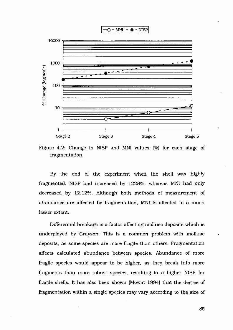
~ '@ t) Ill 'QD 0 e ~ 'QD
§ .!:: (.)
?f.
10000
1000
•• 100
10
1
Stage 2
--
1-o-MNI - • -NISPI
..... ... -.... ..
_.a
r-..- --.
Stage 3 Stage 4 Stage 5
Figure 4.2: Change in NISP and MNI values (%) for each stage of
fragmentation.
By the end of the experiment when the shell was highly
fragmented, NISP had increased by 1228%, whereas MNI had only
decreased by 12.12%. Although both methods of measurement of
abundance are affected by fragmentation, MNI is affected to a much
lesser extent.
Differential breakage is a factor affecting mollusc deposits which is
underplayed by Grayson. This is a common problem with mollusc
deposits, as some species are more fragile than others. Fragmentation
affects calculated abundance between species. Abundance of more
fragile species would appear to be higher, as they break into more
fragments than more robust species, resulting in a higher NISP for
fragile shells. It has also been shown (Mowat 1994) that the degree of
fragmentation within a single species may vary according to the size of
85
the individual. If one portion of a deposit consisted of large individuals,
and another portion consisted of the same number of smaller
• individuals , fragmentation could differentially affect the smaller
individuals, giving the impression of higher numbers of smaller
individuals, as NISP would be higher. In actual fact, more meat would
be obtained from the same number of larger individuals, but NISP has
concealed the relative abundance in this example.
A common instance in which fragmentation greatly increases NISP
is at the surface of midden sites (Mowat 1994). There, NISP would be
greatly inflated for surface levels of a midden when compared to
subsurface levels. This would alter the observer's impression of species
abundance in surface layers, as NISP would be higher than for the same
species in subsurface levels.
Shell from the surface of midden deposits is often highly
fragmented in open sites in the Kakadu region. One species noted to be
highly fragmented in north Australian archaeological sites is Marcia
hiantina, where one valve may be fractured into ten or more fragments
(Baker 1981; Hiscock and Mowat 1993; Mowat 1994).
This phenomenon has been observed by Baker (1981) immediately
west of Kakadu, where he noted the fragmentary nature of Marcia
hiantina on the surface of a midden site he examined on the Chambers
Bay coastal plains. Baker (1981) utilised shell weight to determine
relative proportions of different species. It is rarely possible to identify
small fragments of Marcia other than the hinge. Baker would not have
been able to identify all Marcia fragments, and this would have
·This could conceivably happen as a result of overpredatlon (Swadling 1976).
86

contributed to the small proportion of this taxon in his surface spit from
Site 11.
Excavation revealed that sub-surface Marcia hiantina consisted of
whole shell, as opposed to fragments on the surface. Marcia hiantina
was the most common species in spit three, a reversal of the surface
indications as outlined for spit one where Telescopium telescopium and
Volema cochlidium were the most common species and Marcia hiantina
was poorly represented (Baker 1981:78). Baker's calculation of
abundance for spit one probably underestimated Marcia hiantina for two
reasons. Small fragments would have passed through his sieves, and
those small fragments other than the hinges which were retained in the
sieve would have been mostly unidentifiable. The following example
illustrates in greater detail this effect of breakage of Marcia hiantina in
two open sites near the West Alligator River.
A case study
Many shell mounds located on the coastal plains in Kakadu have
been subjected to processes which have resulted in a high degree of
shell fragmentation. This poses a problem for researchers recording the
species composition of these sites. However, because it is impossible to
identify all small fragments, it will not always be easy to calculate the
relative abundance of each species using NISP or weight of shell per
taxon.
Fragmentation of Marcia in Field Island 2 and Field Island 4 is
demonstrated by the following results. Both sites contained large
numbers of Marcia hiantina in a wide range of sizes, allowing the
relationship between size and fragility to be tested. As FI-2 is a larger
site, three samples were examined to gain a more representative picture
87

of fragmentation in different parts of the site. Figures 4.3 illustrates the
proportions from the four samples of valves which were less than 40%
intact. This size was chosen to illustrate the proportion of valves which
had been highly fragmented, into fragments less than 40% intact as
opposed to valves which had simply snapped in half.
100
..... --<>--FI -2/ 1 u 90
.fS -D-FI-2/2
.s 80 ---lr--FI-2/4
::R 6 ~FI-4/1 -.:!' 70 § :; 60
r:tJ r:tJ Q)
50 -r:tJ Q)
~ 40 ...... 0 30 = 0
t 20 0 p. 0
10 '"' 0...
0
5 6 7 8 9 10 11 12 13 14 15
Valve Breadth (mm)
Figure 4.3: Proportion of highly fragmented Marcia valves for different
size classes, Fl-2 and Fl-4.
A strong linear relationship exists between valve size and breakage;
the larger the shell, the lower the proportion of broken valves. The r2
values are high for all surface samples, 0.900 for FI-2/1, 0.867 for FI-
2/4 and 0.903 for Fl-4/1. For the subsurface sample FI-2/2, the r2
value is slightly lower at 0. 755. The structure of Marcia hiantina
contributes to this correlation. Shells of this species are thickest at the
umbo and get progressively thinner toward the ventral margin. Marcia
88

hiantina also lack heavy external ribbing found in other bivalves such
as Anadara granos a, which acts to strengthen the shell.
Figure 4.3 also serves to compare fragmentation for the two
samples from the surface ofFI-2 (FI-2/1 and Fl-2/4) with fragmentation
for a sample from a goanna burrow spoil heap (FI-2/2), which is seen to
represent sub-surface material. Valves from the latter sample are much
more intact than their counterparts from the surface, as evidenced by
its smaller proportion of valves less than 40% intact in comparison to
samples Fl-2/1 and FI-2/4. High proportions of fragmentation seem to
be restricted to surface material, and this implies that fragmentation
occurred after the site was deposited, not during different stages of
deposition. A recent agent of breakage is suggested to be responsible,
and large feral mammals are the most likely cause of this
fragmentation.
Field Island sites discussed in this paper exhibit the characteristic
breakage of Marcia hiantina on the surface of the sites, but MNI analysis
reveals that they are numerically the most common species despite
their fragmentary nature. Although fragmented, the hinge area used in
MNI analysis has survived quite well in FI-2 for up to 4500 years. Sites
of lower topography like FI -4 and the middens examined by Baker
(1981) have been more severely affected by buffalo trampling, and
surface observations may not necessarily give a good indication of
midden composition.
Results of the present study suggest that detailed examination of
large surface samples is required, and MNI data is essential. In areas
where buffaloes have been affecting sites for decades, MNI figures will
likely give a better indication of species composition than weight of
shell. Allen and Barton (nd:88) have also noted that MNI calculations
89

yield different results from shell weight estimations.
The phenomenon of surface fragmentation appears to be
widespread, but varies at each site. As fragmentation is so variable, MNI
is a better measure of abundance than NISP.
EXPLANATION FOR FRAGMENTATION
Some conclusions can be made about the cause of fragmentation
in the surface of open midden sites. As fragmentation is ignored in the
following chapters discussing assemblage variation, the issue of
fragmentation is addressed here.
Muckle argued that "the degree of shell fragmentation reflects the
intensity of human activity on a shell deposit" (1985:75). FI-2 is around
3000 years older than FI-4 (see Chapter Five). and has thus been
subjected to trampling by the people using the sites for a longer period
of time. If any differences in degree of fragmentation were to be
expected, the older FI-2 should exhibit a greater degree of breakage. In
fact FI-2 has a lower proportion of highly fragmented valves than FI-4
(Figure 4.3). The implications of this are that there may not be a simple
relationship between antiquity and intensity of human activity, and that
factors other than antiquity and human trampling must be invoked to
explain the degree of shell fragmentation.
Figure 4.3 documents results which suggest that the breakage of
Marcia hiantina valves is much more extensive on the surface of the
sites. As subsurface shell is largely intact, I believe that most
fragmentation is of recent origin. If buffalo or pigs were responsible for
this breakage, then mound height may have contributed to the inter
site differences in degree of fragmentation. FI-4 is only around 40cm
high, with no vegetation growing on it, while FI-2 is up to 1.8m high
90
with a dense vegetation cover. The greater height of this site and dense
vegetation cover could have discouraged animals from walking over FI-
2, although the area immediately around the site was used, as
evidenced by a buffalo wallow just to the east of FI-2 under a banyan
tree which is used today by feral pigs. By comparison, Fl -4 is
unprotected, and there is nothing to deter animals from walking over
this site. Baker (1981:79) suggested that "the destructive forces of the
northern Australian climate have selectively affected the more fragile
shell". I would suggest that buffalo are more likely agents of breakage
than the climate.
Many factors must be taken into account when considering
explanations for degrees of fragmentation of shell in mounded deposits.
Although shell size contributes to preservation, this may not be
applicable when comparing samples from sites which have different
topographical characteristics or have been subjected to different post
depositional processes.
In spite of fragmentation, it is still possible to identify the species of
mollusc present in these sites.
OUTLINE Of' MY METHODOLOGY
In light of the previous discussions, the following methods were
selected for use in the present study.
1. Samples of shell were analysed at the site and then returned to the
place from which they were taken. This non-destructive method of
data recording complied with ANCA instructions that material not
be removed from the park.
2. I calculated the MNI for each species represented in the sample.
These are also presented as percentages, to allow comparison
91

with other sites. Diagnostic elements used in calculation of MNI are
presented in Table 4.5. In some gastropods, there is no element
which can be used to calculate MNI. In these instances, for
example Telescopium, it is necessary to line up all specimens and
count those which overlap in diameter. For example, in Figure 4.4,
specimens 1 and 2 could belong to the same individual, but
because of overlapping diameter measurements, specimens 2 and
3 could not belong to the same individual. This process of
comparison must be carried out for all specimens.
1.8cm
lcm
!Sl Scm
3cm
2
Figure 4.4: Illustration of overlap method.
Table 4.5: Elements used in calculation of MNI.
Taxon Diagnostic element/s
Outer lip, occasionally columellar deck
Varix just behind the aperture
4cm
3
Nerita
Terebralia
Telescopium Overlap method (see Figure 4.4), occasionally intact posterior portions
Cerithidea Overlap method, occasionally intact posterior portions
92
Chicoreus
Volema
Ellobium
Cassidula
Anadara
Barbatia
Crassostrea
Geloina
Marcia
Circe
Aperture, occasionally intact posterior portions
Columella, occasionally intact posterior portions
Aperture
Aperture
Umbo
Hinge
Hinge, occasionally lid
Hinge
Hinge
Hinge
3. Calculation of species richness was largely based on sample data,
but where a species not present in the counted sample was noted
elsewhere in the site, this was also recorded and used in
discussion of species richness.
4. For larger sites or sites with obvious differences in species
abundance in different parts of the site, more than one sample was
analysed.
5. Samples were most commonly 10,000 cm3, or 1m2 laid out on the
surface and the top centimetre examined. In the case of five of the
Field Island sites (FI-1 to FI-5), larger samples of approximately
40,000cm3 were examined in greater detail.
6. For 40,000cm3 samples, as well as use for calculation of MNI
values, each specimen was measured to the nearest millimetre for
each dimension described in Chapter Two and weighed to the
nearest gram before being returned to the site.
93

CHAPTER FIVE
SHELL MIDDENS ON
THE WEST AND SOUTH
ALLIGATOR RIVERS
94

Each site recorded during the present study is described in this
chapter. Newly recorded sites are located in an area near the mouth of
the West Alligator River (Figure 5.1). Previously reported sites are
located midway up the South Alligator River (Figure 5.1). In this chapter
I describe the general environmental context of the sites examined, and
then describe each site.
Radiocarbon estimations cited for the first time in this thesis were
calibrated. Raw radiocarbon estimations were calibrated using the
University of Washington's CALIB 3.03 program, using the marine
bidecal data set and standard Delta R value of -5±35 (Stuiver and
Reimer 1993). There is some question whether 450 years is an
appropriate marine reservoir correction factor for this part of the
country (Woodroffe et al. 1988; Scott Mitchell pers. comm.), so this
correction has not been carried out prior to calibration of dates from
samples of mollusc shell. In later chapters, dates obtained in the course
of this project are compared to charcoal dates published by other
researchers. As all work on sites in this region has used uncorrected
and uncalibrated dates, this convention is followed here to avoid
confusion. In these cases the original uncalibrated estimation is used.
This also facilitates comparison to geomorphological results, which are
usually uncalibrated charcoal dates.
Species composition was calculated from samples of either
40,000cm3 or 10,000cm3• Some species not present in a sample were
sometimes noted elsewhere in the site, and in this case they will appear
in the species list for the site, but not in the table of species
composition. Site prefiXes FI- and K-refer to the 1:100,000 topographic
mapsheet on which the site is located: FI- for 5373 Field Island, K-for
5372 Kapalga. I am using a land system framework to describe the
environmental context of the sites.
95
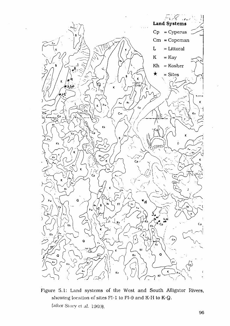
''. J
. ···r~ c;?' _)) Land'~~~te~~" / , :. ·
1 ,
Kh.
Cp = Cyperus
Cm =Copeman
L =Littoral
K =Kay
Kh =Kosher
*
Cot
Cp
Figure 5.1: Land systems of the West and South Alligator Rivers,
showing location of si les FI -1 to FI -9 and K-H to K -Q.
(afler Storv et a!. 19GD). 96

ENVIRONMENTAL FEATURES
The country stretching from the foot of the Amhem Escarpment to
the sea can be divided into four main types; dissected foothills,
Koolpinyah surface, alluvial plains, and coastal plains (Story 1969:20-
22). Sites investigated in the present study are located on the coastal
plains of the West and South Alligator Rivers. Some are located near the
margin between the plains and the lowlands of the Koolpinyah surface.
The coastal plains are sub-divided into four land systems on the
basis of geomorphology, soils and vegetation (Williams et al. 1969). The
Koolpinyah surface is similarly divided into nine land systems. The
relevant systems for the present study are the Copeman, Cyperus and
Littoral land systems of the coastal plains, and the Kay and Kosher land
systems of the Koolpinyah surface.
The Copeman system consists of ill drained, low swampy areas,
with black cracking clays over gleyed muds, supporting herbaceous
swamp vegetation (Williams 1969:93; Williams et al. 1969:29). These
areas had begun forming by buildup of sediment following the marine
transgression in the early Mid Holocene, but have not yet been
completely infilled.
The Cyperus system is a well drained, seasonally inundated area,
with black cracking clays over mainly calcic estuarine muds, with sedge
land vegetation (Williams 1969:93; Williams et al. 1969:32). These areas
were formed by buildup of sediment during the Mid Holocene.
The Littoral system is made up of level tidal flats and emergent
coastal plains with active and ftxed coastal sand ridges on the northern
coastal fringe (Williams et al. 1969:44). These have been formed by
progradation during the Late Holocene. This system is liable to tidal
97

flooding (Williams 1969:93). Soils are saline muds and grey cracking
clays, supporting samphire, sedge land or mangrove vegetation
(Williams et al. 1969:44).
Land systems of the Koolpinyah surface are of Late Tertiary
antiquity. The Kay system contains level, deeply weathered lowlands,
with gradational and uniform loamy and sandy red gravelly soils,
supporting tall open forest (Williams et al. 1969:37). The Kosher system
contains margins of deeply weathered lowlands sloping towards the
Cyperus land system, with colluvial gravelly and stony red and yellow
gradational soils and sandy derivatives, supporting patchy grassland,
Pandanus scrub, and mixed scrub (Williams et al. 1969:41).
WEST ALLIGATOR RIVER SITES
Seven shell mounds were located on the coastal plains on the west
bank of the West Alligator River (Figure 5.2). Systematic survey was
carried out in this region. The Littoral portion of the area was devoid of
vegetation, and visibility was excellent. The Copeman portion was
covered with grass, but this was only 10-20cm high, making visibility
good in this land system also. The mounds were also easily spotted by
the vegetation growing on them, which was higher than the surrounding
grass. It is unlikely that any large shell mounds exist other than those
described here. None of these sites has been recorded prior to this
study. Table 5.1 presents summary details of sites located during this
survey. Site prefiX "FI-" refers to the Field Island 1:100 000 topographic
mapsheet on which the sites are located. Length, width and height
dimensions are presented, but volume was not calculated due to the
irregular shape of several of the mounds, and the fact that it is not
known if midden shell continues to the base of these sites, or if other
98

Figure 5.2: West Alligator River, sites on the 5373 Field Island mapsheet.
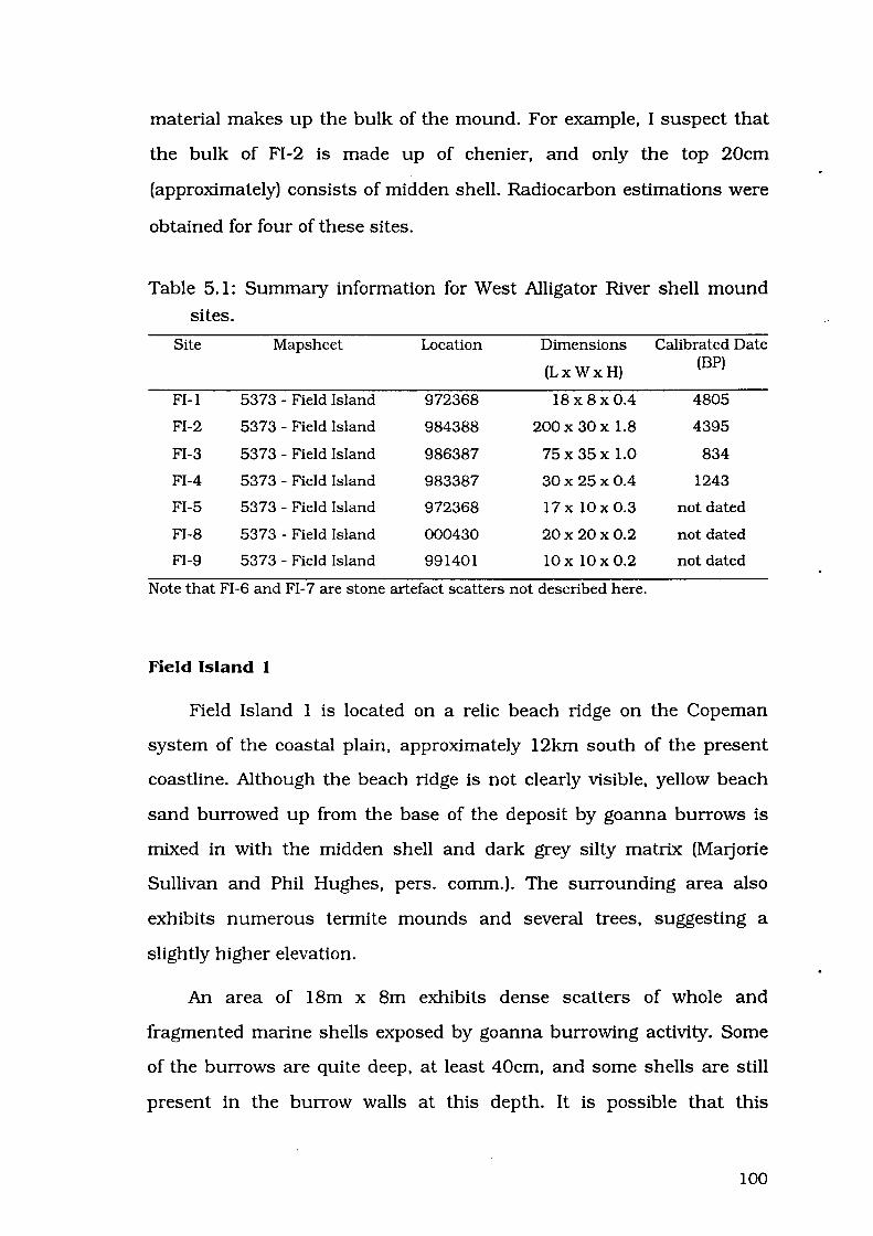
material makes up the bulk of the mound. For example, I suspect that
the bulk of FI -2 is made up of chenier, and only the top 20cm
(approximately) consists of midden shell. Radiocarbon estimations were
obtained for four of these sites.
Table 5.1: Summary information for West Alligator River shell mound
sites.
Site Mapsheet Location Dimensions Calibrated Date
(Lx Wx H) (BP)
FI-1 5373- Field Island 972368 18x 8x0.4 4805
FI-2 5373- Field Island 984388 200x30x 1.8 4395
FI-3 5373- Field Island 986387 75x 35x 1.0 834
FI-4 5373- Field Island 983387 30x 25x 0.4 1243
FI-5 5373 - Field Island 972368 17x lOx 0.3 not dated
FI-8 5373 - Field Island 000430 20x 20x 0.2 not dated
FI-9 5373- Field Island 991401 lOx 10x0.2 not dated
Note that FI-6 and FI-7 are stone artefact scatters not described here.
Field Island I
Field Island 1 is located on a relic beach ridge on the Copeman
system of the coastal plain, approximately 12km south of the present
coastline. Although the beach ridge is not clearly visible, yellow beach
sand burrowed up from the base of the deposit by goanna burrows is
mixed in with the midden shell and dark grey silty matrix (Marjorie
Sullivan and Phil Hughes, pers. comm.). The surrounding area also
exhibits numerous termite mounds and several trees, suggesting a
slightly higher elevation.
An area of 18m x Bm exhibits dense scatters of whole and
fragmented marine shells exposed by goanna burrowing activity. Some
of the burrows are quite deep, at least 40cm, and some shells are still
present in the burrow walls at this depth. It is possible that this
100

subsurface midden extends laterally further than the 18m x Bm
indicated on the surface.
At the time of occupation, this site would have been located on a
beach ridge near the ocean, before the infilling of the West Alligator
River. The Kay system of the Koolpinyah surface, covered with tall open
eucalypt forest, is today located about 250m to the west. There would
probably have been beach ridges between the site and the Koolpinyah
surface at the time of site deposition. Hyptis suaveolens, a woody weed,
grows on the site today, making it stand out from the surrounding
Copeman system which is covered with grass.
Most of the shells are in good condition, being only slightly
fragmented. Goanna burrowing has resulted in intense disturbance to
this deposit. It is extremely unlikely that any stratification would be
identified by excavation, unless sub-surface deposits exist around the
edge of the site.
Species present include Anadara granosa, Marcia hiantina,
Telescopium telescopium, Terebralia palustris, Cerithidea obfusa,
Chicoreus capucinus, Volema cochlidium, Nerita balteata, and Cassidula
angulifera. Proportions of the various species are presented in Table 5.2.
Table 5.2: Mollusc composition, site FI-1.
Genus MNI (n) Proportion (%)
Anadara 32 39.51
Telescopium 14 17.28
Cassidu.l.a 14 17.28
Terebralia 9 11.11
Nerita 4 4.94
Volema 3 3.70
Marcia 2 2.47
Cerithidea 2 2.47
Chico reus 1 1.23
101

Although there are no recognisable artefacts at this site, numerous
quartzite manuports were noted. Other faunal remains include small
numbers of snake and fish vertebrae. A sample of Anadara granosa
shell was submitted for radiocarbon dating, and returned an estimate of
4570±80 years BP (Beta-58405}, which calibrates to 4805 years cal BP,
indicating that the sample is probably between 4524 and 4972 years old
(Table 5.3).
Table 5.3: Radiocarbon estimations, site Fl-1.
Sample Date Calibrated 2 Sigma Range
Fl-1/ 1 4570±80 BP (Beta-58405) 4805 cal BP 4524 - 4972 cal BP
Field Island 2
Field Island 2 is located on the Copeman system of the coastal
plain about lOkm from the mouth of the river. Although the site
appears to lie directly on the coastal plain, burrowing by goannas has
exposed chenier shell. These specimens of Circe and Barbatia are a
distinctive orange colour, compared to the dark grey midden shell, and
they only occur in burrow spoil heaps, not on the undisturbed surface.
Burrows on this site have all collapsed, so it was not possible to
estimate the depth from which these shells had originated. These shells
also appear slightly more friable than the other species, and have
material concreted on the inner and outer surfaces. When considered
together with their colouring, this indicates that they are typical chenier
shells (Mm.jorie Sullivan pers. comm.). It is likely that the ridge was
once more extensive but that portions of the ridge not consolidated by
this capping of midden shell have since eroded away.
Whole and fragmented shells are present in a fine dark grey silt
matrix. Surface shell is fragmented, but subsurface shell revealed by
102

goanna burrowing is mostly intact. This large, irregularly shaped shell
mound measures 200m x 30m and is up to 1.8m high. The mound
actually appears to have been formed by several small mounds of
circular shape being deposited on top of a chenier, and subsequent
deposition joining them into one elongated mound.
Tall open eucalypt forest is approximately 30m to the west of the
site at the southern end of the site, and the northern end of the mound
is at the junction of the Kay and Copeman land systems. During the
Mid Holocene, this area was probably the closest chenier to the
woodland of the Koolpinyah surface. The site is presently covered with
grass, small shrubs such as wild passionfruit (Passiflora foetida) and
crab's eye vine (Abrus precatorius), and larger trees, including Pandanus
spiralis, Melaleuca sp., Tenninalia sp., banyan (Ficus virens) and
sandpaper fig (Ficus opposita). Many of these plants which today provide
protection for the site are edible species. There is debate as to whether
these edible species were fortuitously propagated when seeds were
disposed of after being eaten on the site, or whether they were
deliberately planted by people using the site (e.g. Cribb et al. 1988).
Most shell on the surface is highly fragmented, but shells exposed
by goanna burrowing activity are mostly intact. Goanna burrowing has
caused disturbance on and immediately below the surface of the site;
more so at the southern end. Feral pigs have made tracks through the
vegetation on the site, and this trampling may be contributing to
fragmentation of surface shell. It is noteworthy that the northern end of
the site has more vegetation. The foliage from the trees has created a
surface layer of mulch which provides protection for surface shell. Also,
fewer goanna burrows were noted at this end of the site. It is more likely
103

that stratigraphy would be visible at the northern end of the site if
future researchers decided to cany out excavation.
Species present include Marcia hiantina, Circe australe. Anadara
granosa, Barbatia amygdalumtostum, Crassostrea amasa, Telescopium
telescopium, Terebralia palustris, Cerithidea obtusa, Chicoreus
capucinus. Volema cochlidium, Nerita balteata, Cassidula angulifera and
land snail Xanthomelon sp (Table 5.4). Samples 1-4 were 40,000m3, S
and N were 10,000 cm3•
Table 5.4: Mollusc composition, site FI-2.
Sample 1 Sample 2 (chenier) Sample 3 (chenier)
Genus MNI (n) Proportion MNI (n) Proportion MNI (n) Proportion
Marcia 168 81.16 180 11.25 253 46.94
Circe 3 1.45 1358 84.88 215 39.89
Anadara 13 6.28 26 1.63 12 2.23
Barbatia 2 0.13 4 0.74
Crassostrea 6 1.11
Terebralia 7 3.38 9 0.56 9 1.67
Telescopium 5 2.42 8 0.50 4 0.74
Cerithidea 4 1.93 3 0.19 5 0.93
Nerita 3 1.45 6 0.38 11 2.04
Chicoreus 3 1.45 5 0.31 2 0.37
Volema 1 0.48 1 0.06 2 0.37
Cassidula 16 2.97
Xanthomelon 2 0.13
Sample 4 SampleS Sample N
Genus MNI (n) Proportion MNI (n) Proportion MNI (n) Proportion
Marcia 222 77.89 61 62.24 82 78.85
Circe 3 1.05 9 9.18 6 5.77
Anadara 17 5.96 17 17.35 9 8.65
Barbatia 1 1.02 1 0.96
Crassostrea
Terebralia 13 4.56 6 6.12
Telescopium 5 1.75 2 2.04 2 1.92
Cerithidea 2 0.70 1 0.96
104

Nerita 6 2.11 1 0.96
Chicoreus 13 4.56 1 0.96
Volema 1 0.35 2 2.04
Cassidula 3 1.05
Xanthomelon 1 0.96
Other archaeological material observed at this site includes an
edge ground axe made from a metamorphic material, and several
quartzite flakes. In order to establish if different parts of this site were
deposited at different times, samples of shell were taken from the centre
of the site, and from the southern end of the site. Both midden and
chenier shells were collected from the southern part of the site.
Radiocarbon dating of chenier shell from the southern end of the
site gives an estimation of 4670±80 years BP (Beta-58407). This is
calibrated to 4856 years cal BP, suggesting an age range of 4653 to
5158 years for this sample (Table 5.5). Age of the chenier sample
suggests that the midden could not have been deposited before
approximately 4850 calendar years ago.
The sample of midden shell from the centre of the site gives an
estimation of 4280±80 years BP (Beta-53304). This is calibrated to 4395
years cal BP, suggesting an age for the sample of 4127 to 4620 years cal
BP (Table 5.5). Shell from the southern end of the site was estimated at
4250±70 years BP (Beta-58406). This is calibrated to and 4359 years
cal BP, making it highly likely that the sample is between 4123- 4538
years old (Table 5.5). Indications are that these parts of the site were
occupied at the same time.
105

Table 5.5: Radiocarbon estimations, site FI-2.
Sample Date Calibrated 2 Sigma Range
FI-2/chenier 4670±80 BP (Beta-58407) 4856 cal BP 4653- 5158 cal BP
FI-2/centre 4280±80 BP (Beta-53304) 4395 cal BP 4127- 4620 cal BP
FI-2/south 4250±70 BP (Beta-58406) 4359 cal BP 4123-4538 cal BP
Field Island 3
Field Island 3 is located on the Copeman system of the coastal
plain about 1 Okm from the mouth of the river. In similar fashion to
Field Island 2, the site appears to lie directly on the coastal plain, but
goanna burrowing has exposed Circe australe of the distinctive orange
colouring and consistency of chenier shell. Once again, a more
extensive chenier ridge may have existed in the past, but the portions
not consolidated by a capping of midden shell have been eroded away.
Shells on the surface of the site are highly fragmented and the dark grey
matrix is extremely compacted, but subsurface shells exposed by
goanna burrowing activity are more intact than shells on the surface.
The open eucalypt forest of the Kay system lies about 300m to the
west. During the Late Holocene, this site would have been located on a
chenier ridge, possible close to the prograding coastline. Small shrubs
and trees cover the site, including some larger trees of the genus Ficus
which may provide edible fruit.
Most shell on the surface is slightly to highly fragmented, but
shells exposed by goanna burrowing activity are mostly intact. Goannas
are causing disturbance on and immediately below the surface of this
site. Feral pigs have made tracks through the vegetation on the site,
and their trampling may be contributing to fragmentation of surface
shell. A buffalo wallow is located under one of the larger trees on the
site.
106
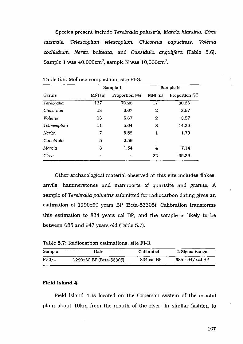
Species present include Terebralia palusbis, Marcia hiantina, Circe
australe, Telescopium telescopium, Chicoreus capucinus, Volema
cochlidium, Nerita balteata, and Cassidula angulifera (Table 5.6).
Sample 1 was 40,000cm3, sample N was 10,000cm3
•
Table 5.6: Mollusc composition, site FI-3.
Sample 1 Sample N
Genus MNI (n) Proportion (%) MNI (n) Proportion (%)
Terebralia 137 70.26 17 30.36
Chicoreus 13 6.67 2 3.57
Volema 13 6.67 2 3.57
Telescopiwn 11 5.64 8 14.29
Nerita 7 3.59 1 1.79
Cassidula 5 2.56
Marcia 3 1.54 4 7.14
Circe 22 39.29
Other archaeological material observed at this site includes flakes,
anvils, hammerstones and manuports of quartzite and granite. A
sample of Terebralia palusbis submitted for radiocarbon dating gives an
estimation of 1290±60 years BP (Beta-53305). Calibration transforms
this estimation to 834 years cal BP, and the sample is likely to be
between 685 and 94 7 years old (Table 5. 7).
Table 5. 7: Radiocarbon estimations, site FI-3.
Sample Date Calibrated 2 Sigma Range
FI-3/1 1290±60 BP (Beta-53305) 834 cal BP 685- 947 cal BP
Field Island 4
Field Island 4 is located on the Copeman system of the coastal
plain about lOkm from the mouth of the river. In similar fashion to
107

Field Island 2 and Field Island 3, the site appears to lie directly on the
coastal plain, but goanna burrowing has exposed Circe australe of the
distinctive orange colouring and consistency of chenier shell. This site
may have been deposited on the same chenier ridge as Field Island 2,
which lies just to the north of Field Island 4.
The open eucalypt forest of the Kay system lies about 30m to the
west, and the site itself has a light cover of the same grass that
characterises the surrounding coastal plain. Whole and fragmented
shells are contained in a fine silt matrix. This site measures about 30m
x 25m and is approximately 40cm high. Most shell on the surface is
slightly to highly fragmented, but shells exposed by goanna burrowing
activity are mostly intact.
Species present include Marcia hiantina, Circe australe, Anadara
granosa, Crassostrea amasa, Telescopium telescopium, Terebralia
palustris, Cerithidea obtusa, Chicoreus capucinus, Volema cochlidium,
Nerita balteata, Cassidula angulifera and the land snail Xanthomelon sp.
(Table 5.8).
Table 5.8: Mollusc composition, site FI-4.
Sample 1 Sample N
Genus MNI (n) Proportion (%) MNI (n) Proportion (%)
Marcia 105 43.21 6 22.22
Circe 38 15.64
Anadara 38 15.64 7 25.93
Terebralia 29 11.93 7 25.93
Telescopiwn 7 2.88 5 18.52
Crassostrea 6 2.47 1 3.70
Chicoreus 6 2.47
Cerithidea 4 1.65
Volema 4 1.65 1 3.70
Xanthomelon 3 1.23
108
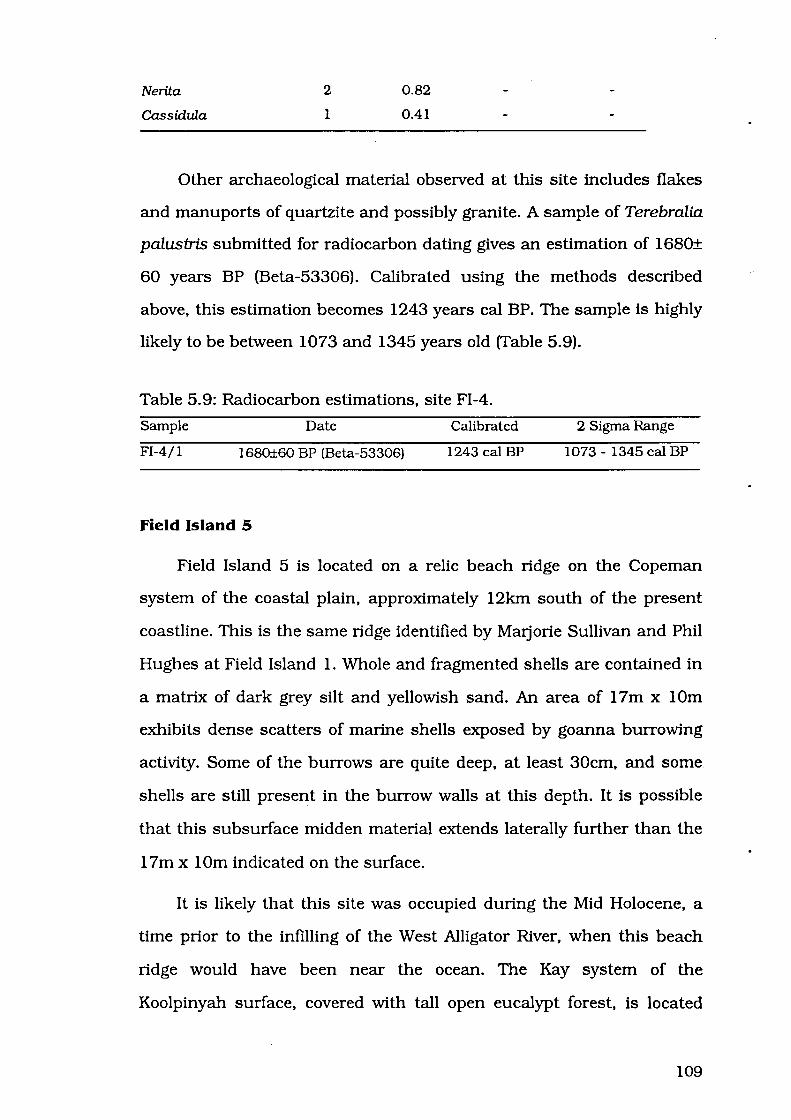
Nerita
Cassidula
2
1
0.82
0.41
Other archaeological material observed at this site includes flakes
and manuports of quartzite and possibly granite. A sample of Terebralia
palustris submitted for radiocarbon dating gives an estimation of 1680±
60 years BP (Beta-53306). Calibrated using the methods described
above, this estimation becomes 1243 years cal BP. The sample is highly
likely to be between 1073 and 1345 years old (Table 5.9).
Table 5. 9: Radiocarbon estimations, site FI -4.
Sample Date Calibrated 2 Sigma Range
Fl-4/l 1680±60 BP (Beta-53306) 1243 cal BP 1073- 1345 cal BP
Field Island 5
Field Island 5 is located on a relic beach ridge on the Copeman
system of the coastal plain, approximately 12km south of the present
coastline. This is the same ridge identified by Matjorie Sullivan and Phil
Hughes at Field Island 1. Whole and fragmented shells are contained in
a matrix of dark grey silt and yellowish sand. An area of 17m x lOrn
exhibits dense scatters of marine shells exposed by goanna burrowing
activity. Some of the burrows are quite deep, at least 30cm, and some
shells are still present in the burrow walls at this depth. It is possible
that this subsurface midden material extends laterally further than the
17m x 1Om indicated on the surface.
It is likely that this site was occupied during the Mid Holocene, a
time prior to the infilling of the West Alligator River, when this beach
ridge would have been near the ocean. The Kay system of the
Koolpinyah surface, covered with tall open eucalypt forest, is located
109
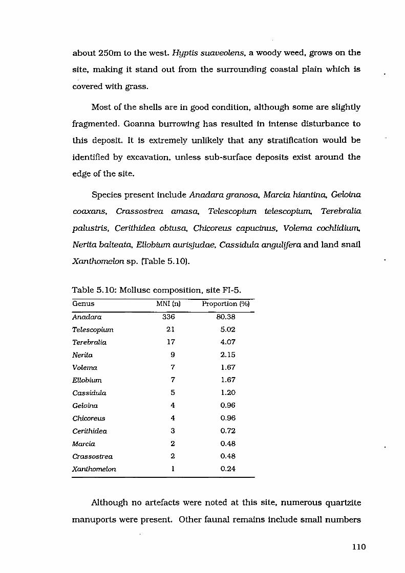
about 250m to the west. Hyptis suaveolens, a woody weed, grows on the
site, making it stand out from the surrounding coastal plain which is
covered with grass.
Most of the shells are in good condition, although some are slightly
fragmented. Goanna burrowing has resulted in intense disturbance to
this deposit. It is extremely unlikely that any stratification would be
identified by excavation, unless sub-surface deposits exist around the
edge of the site.
Species present include Anadara granosa, Marcia hiantina, Geloina
coaxans, Crassostrea amasa, Telescopium telescopium, Terebralia
palustris, Cerithidea obtusa, Chicoreus capucinus, Volema cochlidium,
Nerita balteata, Ellobium aurisjudae, Cassidula angulifera and land snail
Xanthomelon sp. (Table 5.10).
Table 5.10: Mollusc composition, site FI-5.
Genus MNI (n) Proportion (%)
Anadara 336 80.38
Telescopiwn 21 5.02
Terebralia 17 4.07
Nerita 9 2.15
Volema 7 1.67
Ellobiwn 7 1.67
Cassidula 5 1.20
Geloina 4 0.96
Chicoreus 4 0.96
Cerithidea 3 0.72
Marcia 2 0.48
Crassostrea 2 0.48
Xanthomelon 1 0.24
Although no artefacts were noted at this site, numerous quartzite
manuports were present. Other faunal remains include small numbers
110
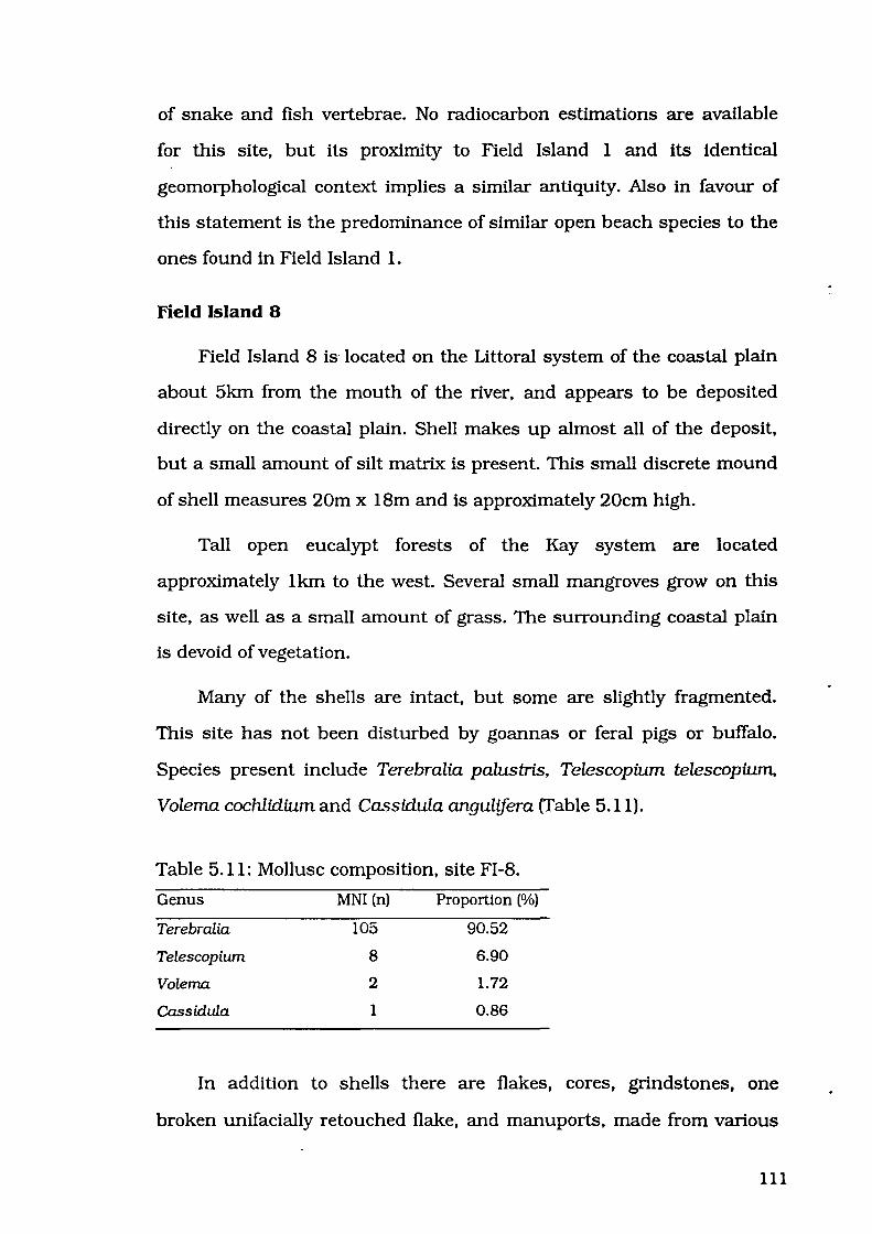
of snake and fish vertebrae. No radiocarbon estimations are available
for this site, but its proximity to Field Island 1 and its identical
geomorphological context implies a similar antiquity. Also in favour of
this statement is the predominance of similar open beach species to the
ones found in Field Island 1.
Field Island 8
Field Island 8 is· located on the Littoral system of the coastal plain
about 5km from the mouth of the river, and appears to be deposited
directly on the coastal plain. Shell makes up almost all of the deposit,
but a small amount of silt matrix is present. This small discrete mound
of shell measures 20m x 18m and is approximately 20cm high.
Tall open eucalypt forests of the Kay system are located
approximately 1km to the west. Several small mangroves grow on this
site, as well as a small amount of grass. The surrounding coastal plain
is devoid of vegetation.
Many of the shells are intact, but some are slightly fragmented.
This site has not been disturbed by goannas or feral pigs or buffalo.
Species present include Terebralia palustris, Telescopium telescopium.,
Volema cochlidium and Cassidula angulifera (Table 5.11).
Table 5.11: Mollusc composition, site FI-8.
Genus MNI (n) Proportion (%)
Terebralia 105 90.52
Telescopium 8 6.90
Volema 2 1. 72
Cassidula 1 0.86
In addition to shells there are flakes, cores, grindstones, one
broken unifacially retouched flake, and manuports, made from various
111

materials including quartz, quartzite and a very fine grained black
material. No radiocarbon estimations are available for this site.
Field Island 9
Field Island 9 is located on the Copeman system of the coastal
plain about 8km from the mouth of the river, and appears to be
deposited directly on the coastal plain. Shell makes up almost all of the
deposit, but a small amount of silt matrix is present. This small discrete
mound of shell measures 1Om x 1Om and is approximately 20cm high.
Tall open eucalypt forest of the Kay system is located
approximately 500m to the west. This site and the surrounding
floodplain are devoid of vegetation.
Many of the shells are intact, but some are fragmented. This site is
in good condition, not having been disturbed by goanna or buffalo,
however a four wheeled motorcycle track goes right through the site.
Species present include Terebralia palustris, Anadara granosa,
Telescopium telescopium, Cerithidea obtusa, Volema cochlidium, Nerita
balteata, Ellobium aurisjudae and Cassidula angulifera (Table 5.12).
Table 5.12: Mollusc composition, site FI-9.
Genus MNI (n) Proportion (%)
Terebralia 57 48.31
Cassidula 25 21.19
Telescopiwn 16 13.56
Nerita 8 6.78
Anadara 3 2.54
Cerithidea 3 2.54
Volema 3 2.54
Ellobiwn 3 2.54
112

In addition to shells there are flakes, grindstones, an anvil, a core
and manuports, made from quartzite and tuff. No radiocarbon
estimations are available for this site.
Souru ALLIGATOR RIVER SITES
Seven sites were located on the coastal plains on the west bank of
the South Alligator River (Figure 2.3). These sites have been previously
investigated for geomorphological purposes by Woodroffe, Chappell and
Thorn (1988). Table 5.13 presents summary details of these sites. Site
prefix "K-" refers to the Kapalga 1:100 000 topographic mapsheet on
which the sites are located.
Table 5.13: Summary information for South Alligator River sites.
Site Mapsheet Location Dimensions Calibrated Date
(LxWxH) (BP)
K-H1 5372- Kapalga 165138 17x 16x0.1 • K-H2 5372- Kapalga 165138 22 X 19 X 0.2 4818*
K-J 53 72 - Kapalga 193095 40x 40x 0.7 1502
K-K 5372- Kapalga 199090 15x 8x0.0 2339
K-L 53 72 - Kapalga 215085 30x25x0.4 243
K-M 5372- Kapalga 217083 20x20x0.2 283
K-Q 5372- Kapalga 196093 40x35x0.6 not dated
• = refer to discussion in site descriptions.
Kapalga HI
Kapalga H 1 is located on the Cyperus system of the coastal plain,
about 35km from the mouth of the river. Mixed scrub of the Kosher
system is located approximately 1.5km to the west. This site has less
grass cover than the surrounding floodplain. A dark grey matrix
contained shells which had been highly fragmented by buffalo
trampling. This site measures 17m x 16m and is about 10cm high.
113

K-Hl . •
K-H2
[YJ Eucalypt woodland
• . Palaeochannel
Mangrove
0 1 2 3 4 5
km
Figure 5.3: South Alligator River, sites on the 5372 Kapalga mapsheet.
114

Species present include Geloina coaxans, Telescopium telescopiu.m.
Cerithidea obtusa, Volema cochlidium, Nerita balteata, Ellobium
aurisjudae and small unidentified land snails. All shells are highly
fragmented, and it was not possible to discern which species, if any,
was the most numerous. A very large grindstone and several flakes are
located on the surface of this site.
I believe it more likely that the samples dated for site H by
Woodroffe et al. (1986, 1988) were taken from Kapalga H2. High
fragmentation of shells in H 1 has created a smooth surface and it would
have been easy to see the remnants of an auger hole, but no such
disturbance was noted. In any case, the proximity of the sites implies a
similar antiquity.
Kapalga H2
Kapalga H2 is located on the Cyperus system of the coastal plain,
about 35km from the mouth of the river. Mixed scrub of the Kosher
system is located approximately 1.5km to the west. This site has less
grass cover than the surrounding floodplain. Whole and fragmented
shells are contained in a dark grey silt matrix. This site measures 22m
x 19m and is about 20cm high.
Flakes, cores, grindstone fragments and a fish vertebra were noted
on this site. Most shell on the surface is highly fragmented as a result of
buffalo trampling, but those shells exposed by goanna activity are
intact. Species present include Cerithidea obtusa, Geloina coaxans,
Telescopium telescopium, Terebralia palustris, Chicoreus capucinus,
Volema cochlidium, Nerita balteata, Ellobium aurisjudae and Cassidula
angulifera (Table 5.14).
115
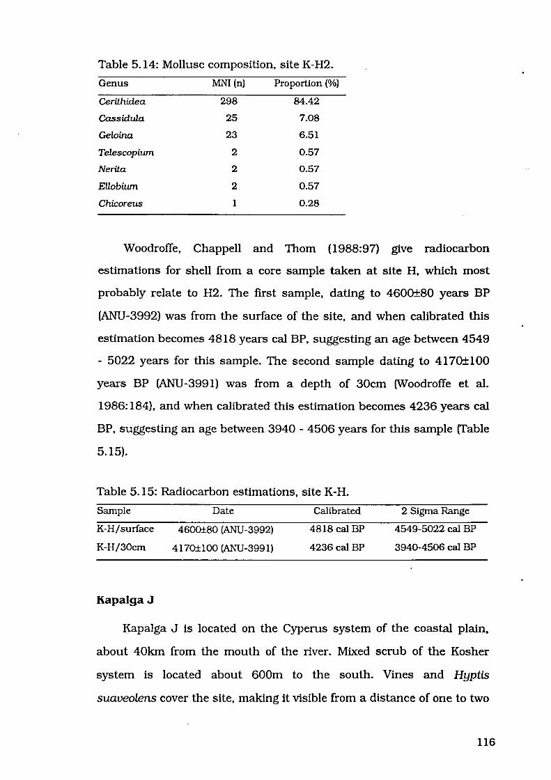
Table 5.14: Mollusc composition, site K-H2.
Genus MNI (n) Proportion (%)
Cerithi.dea 298 84.42
Cassi.dula 25 7.08
Geloina 23 6.51
Telescopiwn 2 0.57
Nerita 2 0.57
Ellobiwn 2 0.57
Chicoreus 1 0.28
Woodroffe, Chappell and Thorn (1988:97) give radiocarbon
estimations for shell from a core sample taken at site H, which most
probably relate to H2. The first sample, dating to 4600±80 years BP
(ANU -3992) was from the surface of the site, and when calibrated this
estimation becomes 4818 years cal BP, suggesting an age between 4549
- 5022 years for this sample. The second sample dating to 41 70± 100
years BP (ANU-3991) was from a depth of 30cm (Woodroffe et al.
1986: 184), and when calibrated this estimation becomes 4236 years cal
BP, suggesting an age between 3940 - 4506 years for this sample (Table
5.15).
Table 5.15: Radiocarbon estimations, site K-H.
Sample Date
K-H/surface 4600±80 (ANU-3992)
K-H/30cm 4170±100 (ANU-3991)
Kapalga J
Calibrated
4818 cal BP
4236 cal BP
2 Sigma Range
4549-5022 cal BP
3940-4506 cal BP
Kapalga J is located on the Cyperus system of the coastal plain,
about 40km from the mouth of the river. Mixed scrub of the Kosher
system is located about 600m to the south. Vines and Hyptis
suaveolens cover the site, making it visible from a distance of one to two
116

kilometres. Whole and fragmented shells are contained in a matrix of
fine dark grey silt. The site measures 40m x 40m and is approximately
70cm high.
Some surface shell is slightly fragmented, but shells exposed by
goanna burrows are mostly intact. Species present include Cerithid.ea
obtusa, Geloina coaxans, Ellobium aurisjudae and the land snail
Xanthomelon sp, and isolated specimens of Anadara granosa and
Telescopium telescopium (Table 5.16).
Table 5.16: Mollusc composition, site K-J.
Genus
Cerithidea
Geloina
Ellobium
MNI (n)
127
50
2
Proportion (%)
70.95
27.93
1.12
Woodroffe, Chappell and Thorn (1988:97) identified Cerithidea sp.,
Meretrix meretrix and Nerita lineata at this site. They also state that the
site was dominated by Meretrix and Cerithidea (1988:96). I saw no
specimens of Meretrix at this site, and as this is a supposedly dominant
taxon I believe that this was a misidentification of Geloina, which is the
second most abundant taxon I identified. I also saw no specimens of
Nerita, but as they only made up a minor proportion of the site, it is
possible that isolated specimens were present but I did not locate them,
or that all specimens were removed by Woodroffe and his colleagues for
dating. Other archaeological material consists of flakes, cores, ground
fragments, and a bifacial point, made from quartz, quartzite and tuff.
Human skeletal remains have been exposed by goanna burrowing
activity.
117

Woodroffe, Chappell and Thorn (1988:97) give a radiocarbon
estimation of 1950± 100 years BP (ANU -404 7) for this site. When
calibrated, this estimation becomes 1502 years cal BP, making it highly
likely that this sample is between 1282 and 1730 years old (Table 5.17).
Table 5.17: Radiocarbon estimations, site K-J.
Sample Date Calibrated 2 Sigma Range
K-J 1950±100 (ANU-4047) 1502 cal BP 1282-1730 cal BP
Kapalga K
Kapalga K is located on the Cyperus system of the coastal plain at
the edge of a palaeochannel, about 40km from the mouth of the river.
Mixed scrub of the Kosher system is located about 200m to the west.
Whole and fragmented shells lie directly on the surface of the blacksoil
floodplain. This low density scatter of shell measures 15m x 8m and has
no discernible depth.
Most shells are intact or slightly fragmented. In addition to
fragments of quartz, quartzite and possibly sandstone are found. The
material is non-diagnostic, but is presumed to have been transported to
the site by humans agents. Species present include Geloina coaxans
and Cerithidea obtusa as well as small unidentified land snails (Table
5.18).
Table 5.18: Mollusc composition, site K-K.
Genus MNI (n) Proportion (%)
Geloina 14 70.00
Cerithidea 6 30.00
118

Woodroffe, Chappell and Thorn (1988:97) give a radiocarbon
estimation of 2680±70 years BP (ANU -4067) for this site. When
calibrated, this estimation becomes 2339 years cal BP, suggesting an
age between 2165 and 2645 years for this sample (Table 5.19).
Table 5.19: Radiocarbon estimations, site K-K.
Sample Date Calibrated 2 Sigma Range
K-K 2680±70 (ANU-4067) 2339 cal BP 2165-2645 cal BP
Kapalga L
Kapalga L is located on the Cyperus system of the coastal plain on
the edge of a palaeochannel, about 40km from the mouth of the river.
Mixed scrub of the Kosher system is located approximately 1.5km to the
west. The site itself is covered with a woody weed resembling Hyptis
suaveolens. Shells are contained in a dark grey silt matrix. This mound
of shell measures 30m x 25m and is approximately 40cm high.
As well as shell, the site contains flaked pieces and ground
fragments made from quartz, quartzite and possibly granite, and some
human skeletal remains. Species present include Cerithidea obtusa, and
small numbers of Geloina coaxans, Cassidula angulifera and land snail
Xanthomelon sp. (Table 5.20).
Table 5.20: Mollusc composition, site K-L.
Genus
Cerithidea
Geloina
Cassidula
MNI (n)
58
9
2
Proportion (%)
84.06
13.04
2.90
Woodroffe, Chappell and Thorn (1988:97) give a radiocarbon
estimation of 570±60 years BP (ANU-3914) for this site. When
119

calibrated, this estimation becomes 243 cal BP, suggesting that the
sample is aged between 304 years and modem (Table 5.21).
Table 5.21: Radiocarbon estimations, site K-L.
Sample Date Calibrated 2 Sigma Range
K-L 570±60 (ANU-3914) 243 cal BP 0*-304 cal BP
o• =represents a 'negative' age BP.
Kapalga M
Kapalga M is located on the Cyperus system of the coastal plain on
the edge of a palaeochannel. about 40km from the mouth of the river.
Mixed scrub of the Kosher system is located approximately 1.6km to the
west. A woody weed resembling Hyptis suaveolens grows on this site in
small numbers. Two concentrations of shell in the north and south of
the site are separated by a distance of approximately 8m where goanna
burrowing has not turned up any shell or stone artefacts. Areas of the
site containing shells are dark grey and silty in texture, but the area
between these two concentrations is a yellowish colour. Subsurface
shell has been exposed in an area 20m x 20m and approximately 20cm
high.
Species I identified include Cerithidea obtusa, and small numbers
of Geloina coaxans, Ellobium aurisjudae and Cassidula angulifera (Table
5.22). Woodroffe, Chappell and Thorn (1988:97) identify Meretrix
meretrix, Cerithidea sp., Telescopium telescopium, Terebralia palustris
and Volema cochlidium at this site. These last three species were not
noted during the present investigation; it is possible that only isolated
specimens of these taxa were present, and were amongst the sample
collected by Woodroffe, Chappell and Thorn for dating.
120
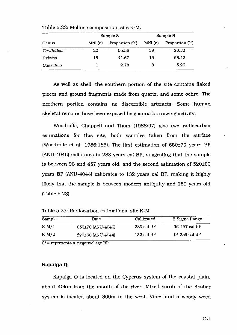
Table 5.22: Mollusc composition, site K-M.
SampleS Sample N
Genus MNI (n) Proportion (%) MNI (n) Proportion (%)
Cerithidea 20 55.56 39 26.32
Geloina 15 41.67 15 68.42
Cassidula 1 2.78 3 5.26
As well as shell, the southern portion of the site contains flaked
pieces and ground fragments made from quartz, and some ochre. The
northern portion contains no discernible artefacts. Some human
skeletal remains have been exposed by goanna burrowing activity.
Woodroffe, Chappell and Thorn (1988:97) give two radiocarbon
estimations for this site, both samples taken from the surface
(Woodroffe et al. 1986: 185). The first estimation of 650±70 years BP
(ANU -4046) calibrates to 283 years cal BP, suggesting that the sample
is between 96 and 45 7 years old, and the second estimation of 520±60
years BP (ANU -4044) calibrates to 132 years cal BP, making it highly
likely that the sample is between modem antiquity and 259 years old
(Table 5.23).
Table 5.23: Radiocarbon estimations, site K-M.
Sample
K-M/1
K-M/2
Date
650±70 (ANU-4046)
520±60 (ANU-4044)
o• =represents a 'negative' age BP.
Kapalga Q
Calibrated
283 cal BP
132 cal BP
2 Sigma Range
96-457 cal BP
0*-259 cal BP
Kapalga Q is located on the Cyperus system of the coastal plain,
about 40km from the mouth of the river. Mixed scrub of the Kosher
system is located about 300m to the west. Vines and a woody weed
121

resembling Hyptis suaveolens cover the site, making it visible from a
distance of one to two kilometres. Shells are contained in a dark grey
silt matrix. The site measures 40m x 35m and is approximately 60cm
high.
Species present include Cerithidea obtusa and Geloina coaxans and
small numbers of Ellobium aurisjudae and land snail Xanthomelon sp.
rrable 5.24).
Table 5.24: Mollusc composition, site K-Q.
Genus MNI (n) Proportion (%)
Cerithidea 47 48.94
Geloina 46 50.00
Ellobiwn 1 1.06
Some surface shell is slightly fragmented, but shells exposed by
goanna burrows are mostly intact. In addition to shells, flakes, cores,
and ground fragments are found, made from quartz, quartzite and tuff.
Human skeletal remains have been exposed by goanna burrowing
activity.
Woodroffe, Chappell and Thorn (1988) do not mention this site in
their text, but it appears on their Figure 4 (1988: 100), beside a date of
1400 years BP. More details of Woodroffe, Chappell and Thorn's dates
are published elsewhere (Woodroffe et al. 1986:183-189). The only date
of 1400 is ANU-3910, 1400±80 BP from a depth of 1.9m in core 10,
which is in the palaeochannel adjacent to Kapalga K (Woodroffe et al.
1986:76). Site Q has probably not been sampled, and therefore no age
estimations are available.
122

CONCLUSION
Sites described here cover a range of sizes, ages and species
compositions, and as such they provide a good opportunity to test the
issues raised in Chapter Three. They cover a time span from 5000 years
ago to the present (Tables 5.25).
Table 5.25: Radiocarbon estimations, West and South Alligator River
sites.
Sample Date Calibrated 2 Sigma Range
Fl-1/ 1 4570±80 BP (Beta-58405) 4805 cal BP 4524 - 4972 cal BP
Fl-2/centre 4280±80 BP (Beta-53304) 4395 cal BP 4127-4620 cal BP
Fl-2/south 4250±70 BP (Beta-58406) 4359 cal BP 4123-4538 cal BP
Fl-2/chenier 4670±80 BP (Beta-58407) 4856 cal BP 4653- 5158 cal BP
Fl-3/1 1290±60 BP (Beta-53305) 834 cal BP 685-947 cal BP
Fl-4/1 1680±60 BP (Beta-53306) 1243 cal BP 1073 - 1345 cal BP
K-H/surlace 4600±80 BP (ANU-3992) 4818 cal BP 4549 - 5022 cal BP
K-H/0.3m 4170±100 BP (ANU-3991) 4236 cal BP 3940 - 4506 cal BP
K-J 1950±100 BP (ANU-4047) 1502 cal BP 1282- 1730 cal BP
K-K 2680±70 BP (ANU-4067) 2339 cal BP 2165- 2645 cal BP
K-L 570±60 BP (ANU-3914) 243 cal BP o• - 304 cal BP
K-M/1 650±70 BP (ANU-4046) 283 cal BP 96 - 457 cal BP
K-M/2 520±60 BP (ANU-4044) 132 cal BP o• - 259 cal BP
o• represents a 'negative' age BP.
Research conducted during this study represents the first
quantification of relative abundance of mollusc taxa in open midden
sites in the Kakadu region. These sites from two separate areas cover
the same time span, from 5000 years ago up to the last millennium,
and these are comparable to the age of most of the midden deposits in
shelter sites. This especially allows us to examine chronological changes
which other authors identified in western Arnhem Land middens.
Issues of chronological change will be examined in Chapter Six.
123
CHAPTER SIX
CHRONOLOGICAL CHANGE
124

Westem Amhem Land shell bearing sites have been characterised by
Schrire (1982) and Allen (1987; Allen and Barton nd). In this chapter I
discuss their conclusions about mollusc exploitation and how they
characterised chronological change in midden deposition during the
Holocene.
Schrire ( 1982) discussed the three middens from her excavations
at Nawamoyn, Malangangerr and Badi Badi. Allen (1987; Allen and
Barton nd) presented a synthesis of data from many sites in the
Northem Territory, including Schrire's three sites, Ngarradj Warde
Djobkeng, Malakunanja II, and plains middens from the South
Alligator, Point Stuart and Blyth River regions. Both these authors
perceived chronological change in species composition in these
middens.
Schrire's research revealed several pattems in shelter midden
composition, the most dramatic being an increase through time in the
proportion of Cerithidea. Lower midden layers were dominated by
Geloina, but this was replaced by Cerithidea in upper midden layers at
Nawamoyn and Malangangerr. Cerithidea was never the dominant
species in the midden layer at Badi Badi, but the proportions of this
genus were higher in the upper portion of the deposit. Schrire
considered environmental change to be responsible for this increase in
Cerithidea (1982:234).
Allen's (1987: Allen and Barton nd) model of mollusc exploitation is
distinguished by the dichotomy he perceived to exist between middens
deposited during the mid Holocene and middens deposited during the
late Holocene. According to Allen, between 7000 and 3000 BP, estuarine
molluscs, predominantly of the genus Cerithidea, were exploited in the
extensive mangrove swamps formed during the Big Swamp phase.
125
Shells were deposited in rockshelters situated in outliers around the
margins of those mangrove swamps. Mter 3000 BP, the mangrove
swamps retreated. Accompanying this environmental change was a
decrease in the importance of mangrove molluscs, especially Cerith.idea.
Shelter sites were abandoned, and shell middens were now deposited on
the coastal plains. Essentially, after 3000 BP there was a decrease in
the exploitation of mangrove shells and a shift from shelters to plains.
Allen concluded that the shift away from exploitation of Cerithidea
could be explained in terms of the disappearance of the mangrove
swamps. Mter 3000 BP, these mangrove gastropods were no longer
available, as the mangroves were no longer situated close to the
outliers. Molluscs were still consumed, but people stopped depositing
their remains in shelters. As the coastal plain was no longer covered in
dense mangrove vegetation, people could now move more freely over this
area and middens were deposited there, closer to the source of
molluscs. So the consequences of the retreat of the mangrove swamp
were reduction in exploitation of Cerithidea, and a shift away from
shelter sites and on to the coastal plains.
I will examine issues of chronological change in two parts. First,
the perceived widespread unidirectional change in species composition,
and second, the perception that shelters were abandoned because of
environmental changes, in other words the correlation between foraging
patterns and changes to landforms and environment.
CHANGE IN MIDDEN COMPOSITION
There are two models of change in relative abundance of taxa in
midden bearing deposits in western Amhem Land. Initially, Schrire
( 1982) perceived an increase in Cerithidea at the expense of Telescopium
126

and/ or Geloina in the middens at Malangangerr and Nawamoyn. More
recently, Allen ( 1987, 1989; Allen and Barton nd) has perceived a
decrease through time in the importance of Cerithidea in western
Arnhem Land middens .
.Model of increase in Cerithidea
Three shifts in mollusc exploitation were perceived by Schrire
(1982:233). The first and most obvious of these shifts spans the last
6000 to 7000 years of deposition at Malangangerr and Nawamoyn.
Changes were noted between the upper and lower halves of the midden
layer. Cerithidea increased over time at both sites, while Telescopium
decreased. Geloina decreased at Malangangerr only. Schrire compares
these results with the midden layer at Malakunanja II, which was
dominated throughout by Cerithidea, comprising about 80% by weight
(Kamminga and Allen 1973:46).
A second shift concerns the last 3000 to 4000 years, represented
by the upper halves of the midden zones at Malangangerr and
Nawamoyn, and the midden zone at Badi Badi and Ngarradj Warde
Djobkeng. The increase in Cerithidea noted at Malangangerr and
Nawamoyn continued through the upper halves of the midden zone. A
similar increase in Cerithidea is tentatively identified at Badi Badi,
though Schrire (1982:233) notes that the numbers are too small to be
statistically significant. At Ngarradj Warde Djobkeng, Schrire (1982:233)
depicts the change at this time as change from land fauna to estuarine
molluscs. The midden at this site is dominated by Cerithidea
throughout.
Inferred timing of these changes is based on Schrire's (1971: 154)
assumption that midden deposition continued up until a few hundred
127

years before the present. As Allen ( 1987) has pointed out, it is likely
that the deposition of shelter middens ceased thousands of years prior
to this. In any case, Schrire ( 1982) proposes that proportions of
Cerithidea increased from lower to upper portions of these middens, and
continued to rise throughout the upper portions of the middens at these
two sites.
The third change is a dramatic increase in the freshwater mussel
Velesunio at Badi Badi in the non-midden zone. Velesunio is restricted
to the uppermost surface levels at Malangangerr, Nawamoyn,
Malakunanja II and Ngarradj Warde Djobkeng. This must be seen to
represent the exploitation of freshwater resources during the most
recent period of occupation.
If Schrire is correct, and deposition of Cerithidea was increasing
through time in shelter middens, then this mollusc should also be
present in more recent plains shell midden sites.
Model of decrease in Cerithidea
Since Schrire's (1982) model was proposed, Allen (1987, 1989;
Allen and Barton nd) has synthesised results from sites throughout
westem Arnhem Land, but he came to a very different conclusion.
Mter 3000 BP, molluscs were still exploited, but their remains were
discarded in open sites on the floodplain. The formerly dominant
Cerithidea was incorporated to a much lesser extent, a phenomenon
believed by Allen and Barton (nd: 1 06) to be associated with the
dramatic reduction in mangrove distribution which took place around
3000 BP.
Allen and Barton (nd: 105) assert that after 3000 BP, people began
camping on the alluvial floodplains, at least during the dry season.
128

Molluscs continued to be an important resource but Cerithidea no
longer formed a dominant part of the diet (Allen and Barton nd: 1 05).
Cerithidea is stated by Allen and Barton (nd: 105-1 06) to be:
either absent or present in tiny numbers in the shell midden heaps which occur on the South Alligator plains at Bullocky Point, dated ANU-3914 = 570±60 and ANU-4067 = 2680±70 (M.Smith pers. comm., Woodroffe et al. 1985[b]:23-24). Similarly Cerithidea forms only a minor proportion of the total shellfish in any of the 17 middens showing mangrove shells dominant, recorded by Baker and [sic] Point Stuart, or at Sampan Creek on the Mary River coastal plains or on top of beach ridges formed between 4500 and 1000 years BP (Clarke et al. 1979:91) ... Cerithidea comprises less than 10% of any of the recent shell middens on the Blyth River plains surveyed by Meehan (1983), where Meehan (in Jones 1985:294) notes 'Not one site ... has so far been dated to more than 1500 years old'.
Allen and Barton (nd: 106) conclude that changes in mollusc
species in recent coastal plains sites reflect changes in species
availability associated with the reduction in mangrove distribution, but
also note that results for plains surveys (they quote Baker 1981;
Meehan et al. 1985) are only recent, and that "it is impossible here to
deal comprehensively with the very recent archaeology of western
Arnhem Land (<3000 BP)" (Allen and Barton nd: 107).
In the case of Meehan's examination of shell middens in the Blyth
River region, it is possible to state that all sites were occupied more
recently than 3000 BP, and contain less than 10% Cerithidea. As
discussed in Chapter Three, Meehan's sites dated to between 150 and
1440 years BP, certainly well within Allen's 3000 year limit. Examining
species composition presented by Meehan (1982, 1983), clearly
percentages of Cerithidea were well below 10% in all cases.
Baker (1981), however, does not present detailed species
composition data for sites at Point Stuart, and it is not possible to use
his sites to confirm or refute the model. Also supporting Allen's model
129

are several sites recorded during the present study near the mouth of
the West Alligator River, all of which contain less than 10% Cerithidea
(these sites are described in Chapter Five).
If Allen is correct, and deposition of Cerithidea was decreasing
through time in shelter middens and after the abandonment of the
shelters, then this mollusc should be absent in all the recent plains
shell midden sites.
Testing models of change in relative abundance
Both Schrire and Allen identified unidirectional change in species
composition of midden sites during the Holocene. Schrire detected
increases in Cerithidea throughout the middens at Malangangerr and
Nawamoyn, and to a lesser extent at Badi Badi. In direct contrast to
this, Allen discerned a decrease through time in the exploitation of this
mollusc, especially after 3000 BP with the shift away from shelter sites.
At the Bullocky Point sites, the absence of Cerithidea was inferred
on the basis of information that was provided by Smith, whose tentative
identifications of mollusc species in these sites have proved to be
inaccurate. Cerithidea actually forms a high percentage of several of the
plains sites near Bullocky and Rookery Points dated both before and
after 3000 BP.
Woodroffe et al. (1988:97) list Cerithidea as being present at all
four sites they describe in the Bullocky Point area. I have relocated
these sites, and my observations are that all sites at Bullocky Point
contain Cerithidea, and in most cases it is the most numerous mollusc
species.
130

Figure 6.1 represents the proportion of Cerithidea for sites of
known age at Bullocky Point and nearby Rookery Point. Samples from
these sites suggest proportions of Cerithidea from 30% (site K-K) to over
84% (sites K-H2 and K-L). There is no apparent drop in Cerithidea after
3000 BP. In fact, proportions of Cerithidea are high in most of these
sites.
On the matter of the lack of Cerithidea in plains sites, Allen has
proved to be misinformed. Exploitation of Cerithidea was prevalent from
4500 BP to the present, as attested by the high proportions of
Cerithidea noted during the present study at several sites at Kapalga.
Problems with Allen's shift away from Cerithidea perhaps stem from an
attempt to stretch the model over such a broad area. Just because
Cerithidea was not available on the East Alligator River after 3000 BP, it
does not necessarily follow that it would be absent from all other areas.
Obviously Cerithidea were still present at least on the South Alligator
River after the decline of the big mangrove swamps. Each river system
may have experience unique environmental changes, so a model perfect
for one area may not apply to another area.
Results of the present study have indicated that some but not all
plains midden sites are devoid of Cerithidea. There is no universal
pattern of chronological change in relative abundance that applies over
the whole of western Arnhem Land. Results such as these must bring
into question the homogeneity which has previously been assumed to
exist in midden sites in this area. Before I examine this homogeneity in
more detail, I will move on to the second chronological change which
Allen (1987, 1989; Allen and Barton nd) noted in midden sites in
western Arnhem Land.
131
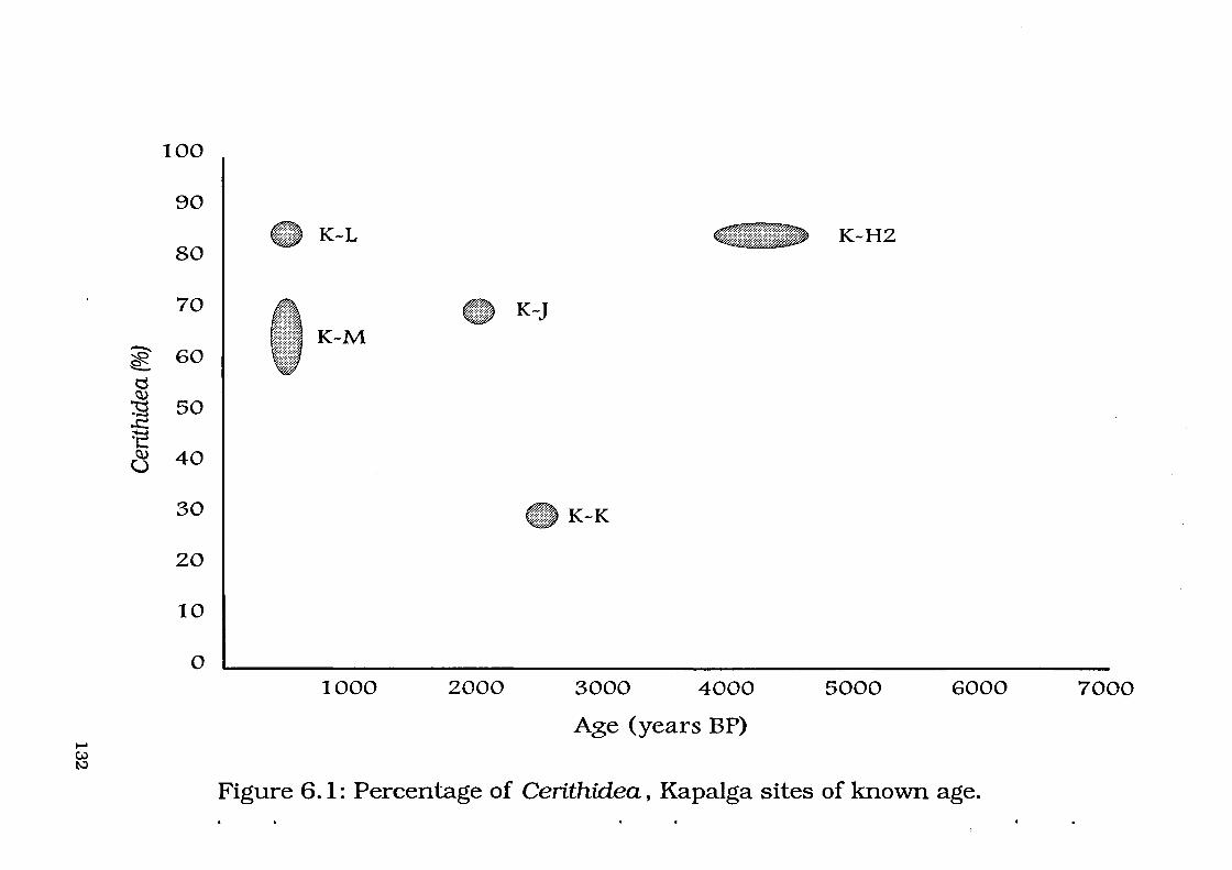
...... u:> t-.J
""0' ~ ""-
0 ~
~ ..t: ~ ~ u
100
90
80
70
60
50
40
30
20
10
0
- K-L ~K-HZ
- K-J K-M
-K-K
1000 2000 3000 4000 5000 6000 7000
Age (years BP)
Figure 6.1: Percentage of Cerithidea, Kapalga sites of known age.

ABANDONMENT OF' SHELTER SITES
A second major model of chronological change noted by Allen
( 1987, 1989; Allen and Barton nd) was the abandonment of rockshelter
sites in favour of open sites on the coastal plains after 3000 BP. 1\vo
tests will be applied to this model: a review of dates from shelter midden
layers and plains middens; and testing against open sites on another
part of the coastal plains which has been subjected to dramatic
environmental change. First I will examine dates for abandonment of
shelter sites and dates for establishment of plains sites. Radiocarbon
dates from shelter sites are presented in Figure 6.2.
Review of dates from midden sites
Upper levels at Malakunanja II have been dated at 4050±50 BP
(SUA-2264) in spit 1. Sample SUA-264 was from the base of the midden
deposit and had an estimation of 6335±250 BP (Gillespie and Temple
1976:100).
The deepest date from the midden at Ngarradj Warde Djobkeng is
also the youngest, 3450±125 BP (SUA-164) from the 1972 excavations
from a depth of 75cm. This indicates that there may be taphonomic
problems within the midden layers. Another date from the lower portion
of the midden at a depth of 50cm is 3600±60 BP (SUA-2409). On the
other hand, the upper levels returned older estimations; 3760±70 BP
(SUA-2246) from a depth of 20cm, and 3980±50 BP (SUA-2295) from a
depth of 10cm. In spite of the dating reversals at Ngarradj Warde
Djobkeng, no dates from its midden layers have returned estimations
younger than 3450±125 BP (SUA-164), and there is no conclusive
evidence for deposition after 3450 BP. Even though there is a reversal,
the three youngest dates are statistically the same at 95% level.
133
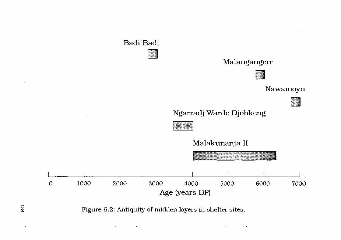
...... w *="
0
Badi Badi
Malangangerr
Nawamoyn
Ngarradj Warde Djobkeng
Malakunanja II
1000 2000 3000 4000 5000 6000 7000
Age (years BP)
Figure 6.2: Antiquity of midden layers in shelter sites.

However the uppermost date SUA-2295 (3980±50 BP) is significantly
different from all other dates when calibrated and tested using CALIB
(Stuiver and Reimer 1993). Until the dating issues can be resolved,
perhaps this site should not be used as the core of dating models.
In relation to other shelter sites with midden deposits, there are
issues that need addressing. Surface midden layers at Malangangerr
and Nawamoyn have not been dated - Allen has assumed that their
similarity to Malakunanja II and Ngarradj Warde Djobkeng midden
deposits implies similar antiquity. As stated earlier, the date of 3, 120±
100 BP (ANU -1 7) from beneath the midden layer at Badi Badi
represents a strong case for continued use of the shelter after 3000 BP.
Also the non-midden zone provides clear evidence that this shelter
continued to be used during the most recent freshwater period.
Dates from these five shelters do not show that midden deposition
ceased at all shelter sites at 3000 BP. There is no clear evidence to
support the assertion that shell midden deposition had ceased at all
sites and that all shelter sites were abandoned by 3000 BP. I am not
suggesting that there is no abandonment at any of these sites, but that
the timing of the abandonment is variable. The date of 3000 BP appears
to have been used mainly on the basis of environmental evidence from
the East Alligator River. Without consistent radiocarbon estimations of
3000 BP from the upper levels of all middens deposited in rockshelters,
it is perhaps unwise to extrapolate the same time of abandonment to all
other shelters.
From the other side of the argument, there are several plains
middens that are greater than 3000 years old. Woodroffe et al. (1988)
reported four middens from the South Alligator River in excess of this
age- site Pat 6240±100 years BP (ANU-4915), site Nat 3050±70 years
135
BP (ANU-4045}, and site Hat 4170±100 (ANU-3991) and 4600±80 years
BP (ANU-3992). Two of the sites dated during the present study also
exceeded this age- FI-1 at 4570±80 years BP (Beta-58405}, and FI-2 at
4280±80 years BP (Beta-53304) and 4250±70 years BP (Beta-58406). It
is probable that the undated FI-5 is of similar antiquity to FI-1, given
that they are both located on the same Mid Holocene land surface, and
are both dominated by open beach bivalve species which would have
been available during the Mid Holocene.
Several sites on the plains are older than 3000 BP, extending back
to 6240 BP. This suggests that molluscs were exploited and their shells
deposited in open sites on the plains as far back as the time of
establishment of the big mangrove swamps. Shelter sites were not all
abandoned at 3000 BP. Badi Badi almost certainly continued to be used
up until some time during the last thousand years. Dates for cessation
of midden deposition in most other shelter sites are not known. In
short, shelters were not used only before 3000 BP, and plains sites were
not used only after 3000 BP.
Timing of mangrove retreat
Change in the extent of mangrove cover on the East Alligator River
has been placed at 3000 BP by Clark and Guppy (1988:670). This is the
date most applicable to the shelter sites Allen discusses, but it may not
be appropriate for the plains middens around the South Alligator River,
or for sites near other river systems. According to Woodroffe et al.
( 1988) the mangroves began to retreat on the South Alligator River at
around 5300 BP, not 3000 BP. The Big Swamp phase lasted from 6800-
5300 BP, and the Sinuous phase, marked by the "elimination of
mangrove forests", lasted from 5300-2500 BP (Woodroffe et al. 1988:98).
136

Although "mangroves were still widespread 5500 years BP, [they] had
largely disappeared by 4000 BP" (Woodroffe et al. 1988:98). In this case,
3000 BP is not as appropriate as 4000 BP, and different dates will apply
to every river system. Environmental changes happened at different
times across the landscape, so the timing of change in archaeological
sites cannot simply be taken from one set of environmental data and
extrapolated to apply to sites in different areas. Notably, the mangrove
retreat in the East Alligator River area at 3000 BP will not be applicable
to plains sites near the South Alligator River.
Conclusions regarding the model of abandonment
Cessation of mollusc shell deposition in shelter sites after 3000 BP
has been inferred on the basis of dates from Malakunanja II and
Ngarradj Warde Djobkeng, and from environmental evidence. Without
consistent radiocarbon estimations of 3000 BP or older from the upper
levels of all middens deposited in rockshelters, it is perhaps unwise to
extrapolate the same time of abandonment to all other shelters. Badi
Badi provides the strongest support for the argument against
abandonment at 3000 BP, with its date of 3120±100 BP (ANU-17) from
beneath its estuarine midden zone. This argument for continued
occupation at Badi Badi after 3000 BP was also made by Hiscock (nd).
Timing of mangrove retreat occurred at different times on different
river systems. Using one set of environmental evidence to suggest a
widespread shift in midden deposition at 3000 BP fails to account for
variation in timing of environmental changes.
Testing against open sites
Demonstration of a capacity to use coastal landscapes despite
environmental change can be measured by looking at evidence for
137
human response to environmental change, such as the presence or
absence of midden sites on the coastal plain. Environmental changes
were widespread during the Mid to Late Holocene. In order to test the
model, we must examine behavioural responses to environmental
change in areas not previously examined to see if there really is a one
on-one correlation between change in landforms and foraging
behaviour. The example I will use to test the model concerns sites near
the mouth of the West Alligator River (described in Chapter Five).
People were exploiting the area on the west bank of the West
Alligator River well back in the Mid Holocene, as attested by sites Field
Island 1 and 2, dated to 4280±80 years BP (Beta-53304) and of 4570±
80 years BP (Beta-58405). Environmental change in this coastal area
was just as dramatic as changes closer to the shelters on the East
Alligator River and the inland plains sites at Bullocky Point. When the
West Alligator River area was first used, it was an open sandy/muddy
beach. People exploited open beach bivalves such as Anadara and
Marcia and deposited their remains in the large shell mounds
documented in Chapter Five. With the continued infilling of the river
valley, this area changed from open beach to mangrove swamp.
However, the response was not to abandon the area. People continued
to exploit molluscs, switching to the newly available mangrove species.
Exploitation of this food source continued until at least 1290±60 years
BP (Beta-53305). As only four sites from this area have been dated, it is
not possible to say when occupation of this area started or ended, but
that it lasted at least from around 4570 BP until 1290 BP.
Evidence from this area of western Arnhem Land indicates that
behavioural responses to dramatic environmental changes do not
always involve abandonment of the area. Hunter gatherers during the
138
Mid to Late Holocene were obviously carrying out a complex range of
procurement strategies, and were easily able to adapt to changing
habitats and the resources they provided.
CONCLUSION
Examination of midden contents and dates of shelter and plains
sites does not support a model of dichotomy between pre-3000 BP,
Cerithidea-rich shelter middens and post-3000 BP, Cerithidea
impoverished plains middens. Retreat of the mangrove swamps was
certainly responsible for changes in species available for exploitation,
but the disappearance of the mangrove swamps did not mean that
Cerithidea were no longer available anywhere in westem Arnhem Land.
Movement away from shelter sites may not be related solely to the
environmental changes. Some shelters continued to be used after 3000
BP. Several plains sites are older than 3000 BP, indicating use of this
area from the time of establishment of the mangrove swamps. In other
nearby areas, dramatic environmental changes occurred without driving
the inhabitants away.
Initially, examination of published literature gives the impression
of homogeneity of these sites. Shelter middens and plains middens have
been assumed to be discrete units. Discussion of chronological changes
has highlighted the variability in antiquity and species composition of
midden sites in the westem Arnhem Land region. Homogeneity will be
further examined in the following chapter.
139
CHAPTER SEVEN
TESTING REGIONAL HOMOGENEITY
140
Just a brief glimpse at literature relating to shell-bearing deposits in
western Arnhem Land is enough to reveal the assumption that middens
are homogenous in different parts of the landscape, and this is
unwarranted. Western Arnhem Land shell midden deposits have been
described by several researchers, but these researchers have seldom
emphasised variability in site size, environmental setting and species
composition.
An example of this which has already been addressed is Allen's
( 1987, 1989) conceptual difference between shell deposited in
rockshelters and open sites. No distinction was made between middens
of different composition. Another example is the work ofWoodroffe et al.
(1988), who have characterised open plains sites around the South
Alligator River as belonging to one of four categories. Even this
expansion of a single "plains" site type to four variations oversimplifies
the variability in site size, form and species composition. I will examine
the evidence used by these authors to conclude whether such
homogeneity really exists.
FIELD TESTING
During the present study I examined a range of sites from two
separate areas in order to test the hypothesis that midden sites can be
characterised into one of a few internally homogeneous categories. The
first area is located on the Kapalga 1:100,000 topographic mapsheet
(see Figure 5.3). Middens near Bullocky Point and Rookery Point on the
west bank of the South Alligator River have been described by
Woodroffe et al. (1988), who referred to them as surface mounds and
palaeochannel middens. For contrast, I examined middens on the west
bank of the West Alligator River from the coast to fifteen kilometres
141
inland (see Figure 5.2). This area is located on the Field Island
1:100,000 topographic mapsheet.
I will address the four categories of plains middens defined by
Woodroffe et al. (1988). Mter reviewing these categories I will describe
midden sites from the Kapalga and Field Island mapsheets. Data from
these sites will be used to evaluate the plains site categories. Sites from
the Field Island will be compared to coastal middens reported by
Woodroffe et al. (1988) to further illustrate the variety in species
composition and richness, environmental context and antiquity that can
be found to exist between coastal midden sites from different geographic
areas.
Mounds, scatters, palaeochannel and coastal middens
One attempt to characterise the diversity of plains middens was
undertaken by Woodroffe et al. (1988). Four basic midden types are
defined on the basis of environmental context ("coastal middens" and
"palaeochannel middens") and site size and form ("surface mounds" and
"surface scatters"). The following is a summary of their main
characteristics.
Coastal middens are designated as sites composed "principally of
shell" located "on the crest of chenier ridges ... [and] are generally <1m
high", ranging in age from 430±70 to 800±70 years (Woodroffe et al.
1988:96-97). Several species of intertidal and shallow marine molluscs
are represented in these sites, the most abundant being Anadara
granosa, which "dominates other coastal middens around the north
Australian coastline" (Woodroffe et al. 1988:96).
Surface mounds are 15-20m in diameter and less than 50cm high,
ranging in age from 1950±100 to 4600±80 years (Woodroffe et al.
142

1988:97). Shelly-silt or shelly-clay matrix contains rock and bone
fragments, including stone artefacts. Meretrix meretrix and Cerithidea
sp. are the dominant shellfish species (Woodroffe et al. 1988:96).
Palaeochannel middens are found as mounds on degraded silt
levees or as scatters close to a palaeochannel bank and range in age
from 520±60 to 3790±70 years (Woodroffe et al. 1988:97). Mangrove
species including Polymesoda coaxans, Meretrix meretrix. Telescopillm
telescopillm and Terebralia palustris are found in these sites (Woodroffe
et al. 1988:96).
Surface scatters consist of a few gastropod shells with Telescopillm
telescopillm being the dominant species, ranging in age from 280±60 to
6240±100 years (Woodroffe et al. 1988:97). These are thought to
represent the remains of one or a few meals (Woodroffe et al. 1988:96).
Initially, this classification of middens into four categories appears
quite concordant. Midden types appear to be clear-cut in terms of
environmental setting, form and dominant species (Table 7 .1).
Table 7.1: Summary of characteristics of midden types (after Woodroffe
et al. 1988:96).
Midden Type Environmental Age Range {BP} Form Dominant Taxa Setting (Span {years})
Coastal Middens Chenier crests 430-800 (370 Mound/ Anadara scatter
Palaeochannel Edge of 520-3790 (3270 Mound/ Geloina., Middens palaeochannels scatter Telescopium,
Terebralia
Surface Mounds Floodplains 1950-4600 (2650 Mound Geloina., Cerithidea
Surface Scatters Floodplains 280-6240 (5960 Scatter Telescopiwn
Sites on cheniers or near palaeochannels are given their own
categories; coastal middens and palaeochannel middens. Sites on the
143

surface of the blacksoil floodplain may belong to one of two categories;
surface mounds or surface scatters. There is no one-on-one correlation
between category and environmental setting. It is inconsistent to
classify some, but not all, sites according to their environmental setting.
I will now examine the homogeneity of these four midden types,
concentrating on environmental setting, antiquity, form and species
richness. On closer examination of individual site descriptions, the
categories are not always internally consistent. Within each category
there may be variation in the characteristics mentioned above (Table
7.3). In the following table, I have used species composition provided by
Woodroffe et al., but in the case of sites which I have re-recorded, I have
substituted my own identifications, which often differ from those of
Woodroffe et al. (1988). Species included by Woodroffe et al. (1988) but
that were not noted during the present study are in parentheses.
Coastal middens were chronologically of similar age ranges (430-
800 BP, representing a 370 year span), and all fell within the Cuspate
phase of river development. Surface mounds ranged from 1950-4600
BP, representing a 2650 year span in the Sinuous/Cuspate phases.
Palaeochannel middens ranged from 520-3790 BP, representing a 3270
year span which also covered the Sinuous/Cuspate phases. Surface
scatters represented both the oldest and the youngest sites described by
Woodroffe et al. (1988), ranging from 280-6240 BP. This represented a
5960 year range, occurring from the Big Swamp phase through to the
Cuspate phase. It would appear that within most categories there was
considerable variability in site antiquity.
As mentioned previously, coastal middens and palaeochannel
middens may be mounds or scatters of shell. Surface scatters may be
scatters or buried scatters. Woodroffe et al. (1988:97) describe surface
144
mounds as "mounds", "degraded mounds", or "two mounds". Variability
of topographic features is not accounted for in the four categories. Form
is used to define two of the four categories (surface mounds and surface
scatters). As with environmental setting, it seems inconsistent to
classify some, but not all, sites according to their form. Even within
these categories, there is variation in form.
Surface scatters have fewer species (one or two) compared with the
other sites. As these sites represent the remains of "one, or a few meals"
(Woodroffe et al. 1988:96), it is possible that these sites are all small,
and thus the consistently low species richness could be size related.
Within each of the other three categories, variable numbers of species
are present: three to nine for coastal middens; two to seven for
palaeochannel middens; and two to nine for surface mounds.
Coastal middens contain between three species (Site C) and nine
species (Sites A and B). Palaeochannel middens contain between two
species (Site K) and seven species (Site M). Although Woodroffe et al.
(1988:97) identified only five species at Site M, I noted two others when
I recorded the site, bringing the total to a possible seven. Surface
mounds contain between two species (Site N) and nine species (Site H).
Once again, nine species for Site H refers to my recording of these sites,
as Woodroffe et al. (1988) provided no species composition data. Surface
scatters contain between one species (Site P) and two species (Sites D
and E). Species richness also appears not to reflect any similarity within
the coastal midden, palaeochannel midden or surface mound
categories.
145
Summary
Although the midden types defined by Woodroffe et al. (1988)
appeared to be clear-cut, this has not survived closer examination.
Variability is suggested to occur within each of the four categories. As a
result of using a combination of environmental context and form to
define these categories, some contain variability in one of these
components (for example, coastal and palaeochannel middens have
variable form).
An examination of the four categories suggests that coastal
middens are the most homogeneous group, having similar
environmental settings and age ranges; the only variability noted was in
form and number of species. Another area near the coast was
examined, and results are presented below.
Only coastal middens were of similar antiquity. Sites within the
other three categories covered an age span of between 2650 and 5960
years. Indeed, the youngest and oldest sites were both found in the
same category.
Numbers of species represented in sites also varies within each
category. The exception to this is the case of surface scatters, with only
one or two species. Site size may contribute to this - these are likely to
be the smallest sites, and therefore the fact that they have consistently
low numbers of species may be a sample size phenomenon (eg. Grayson
1984).
Variation has been underestimated by Woodroffe et al. (1988). In a
similar fashion to other researchers, an attempt to characterise midden
deposits has emphasised their similarities while glossing over most of
the existing variation. Variation in species richness within most of the
146
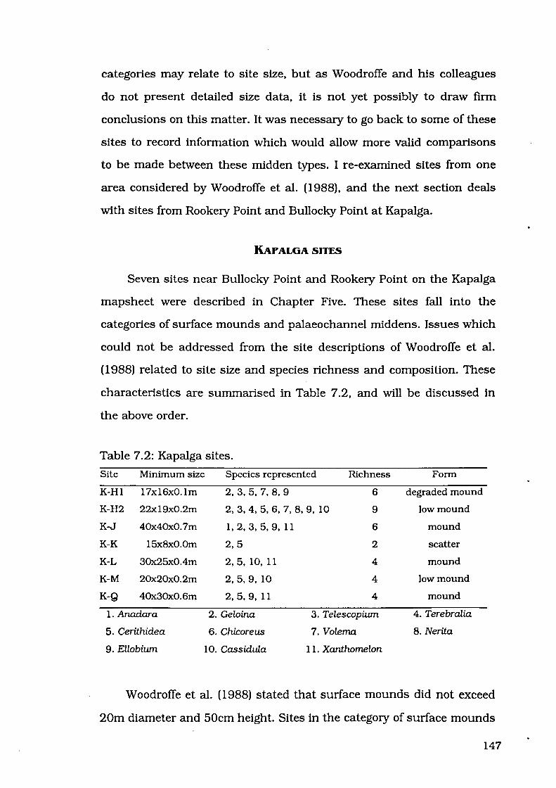
categories may relate to site size, but as Woodroffe and his colleagues
do not present detailed size data, it is not yet possibly to draw firm
conclusions on this matter. It was necessary to go back to some of these
sites to record information which would allow more valid comparisons
to be made between these midden types. I re-examined sites from one
area considered by Woodroffe et al. (1988}, and the next section deals
with sites from Rookery Point and Bullocky Point at Kapalga.
KAPALGA SITES
Seven sites near Bullocky Point and Rookery Point on the Kapalga
mapsheet were described in Chapter Five. These sites fall into the
categories of surface mounds and palaeochannel middens. Issues which
could not be addressed from the site descriptions of Woodroffe et al.
(1988) related to site size and species richness and composition. These
characteristics are summarised in Table 7 .2, and will be discussed in
the above order.
Table 7.2: Kapalga sites.
Site Minimum size Species represented Richness Form
K-H1 17x16x0.1m 2,3,5, 7,8,9 6 degraded mound
K-H2 22x19x0.2m 2,3,4,5,6, 7,8,9, 10 9 low mound
K-J 40x40x0.7m 1, 2, 3, 5, 9, 11 6 mound
K-K 15x8x0.0m 2,5 2 scatter
K-L 30x25x0.4m 2. 5. 10, 11 4 mound
K-M 20x20x0.2m 2,5,9, 10 4 low mound
K-Q 40x30x0.6m 2, 5, 9, 11 4 mound
1. Anadara 2. Geloina 3. Telescopiwn 4. Terebralia
5. Cerithidea 6. Chicoreus 7. Volema 8. Nerita
9. Ellobiwn 10. Cassidula 11. Xanthomelon
Woodroffe et al. (1988) stated that surface mounds did not exceed
20m diameter and 50cm height. Sites in the category of surface mounds
147

may exceed the 20m diameter and 50cm height limits described by
Woodroffe et al. (1988:96). Examples of surface mounds which exceed
50cm height are Kapalga sites J and Q. Sites greater than 20m
diameter are Kapalga sites J, L, Q and H2 which is at the upper limit,
measuring 22m in one dimension and 19m in the other. Table 7.3
indicates that for mound sites (therefore excluding K-K) the average
length and width both exceed 25m. These sites are obviously larger
than Woodroffe et al. (1988) proposed.
Table 7.3: Descriptive statistics for Kapalga mound sites.
Dimension Average Standard Deviation Coefficient of Variation
Length 28.2m 9.2m 0.33
Width 25.0m 8.lm 0.32
Height 0.4m 0.2m 0.50
These sites exhibit a degree of disparity in species richness, varying
from two to nine mollusc species. To some extent, this may relate to site
size. Site K-K with only two species represented is also the smallest site.
On the other hand, Site K-H2 with nine species is in the middle of the
size range. The largest sites have only four to six species. This suggests
that size and richness are related in small sites, but that this does not
apply to medium or large sites. Other factors which may have
contributed to the large number of species at site K-H2 include its age:
this site was occupied during the Big Swamp phase, at which time more
mangrove molluscs may have been available for exploitation. Species
richness is highly variable in this group of sites, and there is no
universal explanation for the variation.
These descriptions include details of species composition which
enable us to examine variability in species composition at these sites.
Percentages of species are presented in Table 7 .4.
148

Table 7.4: Species composition ofKapalga sites- proportion(% MNI).
Species H-2 J K L M-n M-s Q
Anadara X
Geloina 6.51 27.93 70.00 13.04 26.32 41.67 48.94
Telescopium 0.57 X
Terebralia X
Cerithidea 84.42 70.95 30.00 84.06 68.42 55.56 50.00
Chicoreus 0.28
Volema X
Nerita 0.57
Ellobium 0.57 1.12 X 1.06
Cassidula 7.08 2.90 5.26 2.78
Xanthomelon X X X
X = absent from counted sample, but present elsewhere in the site.
High proportions of Cerithidea are noted in several of these sites.
However, Geloina was the dominant genus at site K-K, and proportions
of these two genera were roughly equal at site K-Q and the southern
sample from site K-M. Sites covering the full age range from 4600 years
BP to 520 years BP were dominated by Cerithidea. An unusual feature
of this analysis is the presence of an isolated specimen of Anadara so
far from the coast.
As the Kapalga sites were located about 40-45km inland, the
coastal midden category was not covered by this examination.
Woodroffe et al. (1988) reported three middens falling in this category,
Sites A, B and C, all of which were located within 15km of the river
mouth. A similar area of the west bank of the West Alligator River was
examined. Sites in this area are found on the 5373 Field Island
1:100,000 topographic mapsheet, and are discussed in the following
section in order to examine the homogeneity of the coastal midden
category proposed by Woodroffe et al. (1988).
149

FIELD ISLAND SITES
Midden sites on the Field Island mapsheet were described in
Chapter Five. Coastal middens were the most homogeneous of the
midden types defined by Woodroffe et al. (1988), having similar
environmental settings and age ranges, although variability was noted
in form and number of species. In this section, Field Island sites are
compared to coastal middens described by Woodroffe et al. (1988) to
test the homogeneity of this category. Characteristics of the Field Island
sites are summarised in Table 7.5.
Table 7.5: Field Island sites.
Site Size Environmental Form Richness Species represented setting
FI-1 18x8x0.4m Degraded buried 9 1. 3. 7, 8, 9, 10, 11. beach ridge midden 12, 14
FI-2 200x30xl.8m Degraded mound 13 1, 2, 3, 4, 6, 7, 8, 9, chenier ridge 10, 11, 12, 14, 15
FI-3 75x35xl.Om Degraded mound 8 1. 2, 7, 8, 10, 11. 12, chenier ridge 14
FI-4 30x25x0.4m Degraded degraded 12 1,2,3,6, 7,8,9, 10, chenier ridge mound 11, 12, 14, 15
FI-5 17x10x0.3m Degraded buried 13 1,3,5,6, 7,8,9, 10, beach ridge midden 11. 12, 13, 14, 15
FI-8 20x20x0.2m Floodplain low mound 4 7, 8, 11, 14
FI-9 10xl0x0.2m Floodplain low mound 8 3, 7, 8, 9, 11, 12, 13, 14
1. Marcia 2. Circe 3. Anadara 4. Barbatia
5. Geloina 6. Crassostrea 7. Telescopium 8. Terebralia
9. Cerithidea 10. Chicoreus 11. Volema 12. Nerita
13. Ellobium 14. Cassidula 15. Xanthomelon
Middens may vary from lOrn diameter and 0.2m high to 200m x
30m and 1.8m high. This is a much higher degree of variation than is
found further inland at the Bullocky Point or Rookery Point areas, or
than is implied by Woodroffe et al. (1988) for coastal middens.
150

Especially notable in Table 7.6 is the enormous standard deviation and
coefficient of variation for site length, illustrating the high variability in
site size.
Table 7.6: Descriptive statistics for Field Island mound sites.
Dimension
Length
Width
Height
Average
52.9m
19.7m
0.6m
Standard Deviation Coefficient of Variation
63.3m 1.20
lO.Om 0.51
0.5m 0.83
Middens were noted to occur directly on the blacksoil of the coastal
plain, on degraded chenier ridges, or in beach ridges buried in the
blacksoil. This contrasts with the findings of Woodroffe et al. (1988:96)
whose coastal sites were always situated on top of chenier ridges.
Environmental setting is obviously more variable than suggested by
Woodroffe et al. (1988).
Field Island sites which have been dated range from 1290±60 BP
(Beta-53305) to 4570±80 BP (Beta-58405). In contrast, coastal middens
recorded by Woodroffe et al. ( 1988) all retumed radiocarbon estimations
within the last 1000 years. Obviously the sites examined by Woodroffe
et al. (1988) did not cover the full range of variation in antiquity.
Between four and thirteen species were found in the Field Island
sites, with an average of just over nine and a half. This exceeds the
maximum of nine species for sites A and B, indicating that even an
'average' Field Island site has greater species richness than the richest
site recorded by Woodroffe et al. (1988) in the coastal area.
Descriptions made during the present study include details of
species composition which enable us to examine variability in species
composition at Field Island sites. Percentages of species are presented
151

in Table 7.7. The dominant species from all samples belong to three
genera - Anadara., Marcia and Terebralia. The relative proportions of
these three genera have been plotted in the Figure 7 .1.
100
90
80
70
60
% 50
40
30
20
10
1--Anadara · · · · · Marcia - ·- ·Terebralial
.·
. ..
I
I
. '. I ., .. I •
., I , . ......
I ' ...... . '/
/
/
/
/
/
0~-~-~--~-~--~·+·---------+--------+---~~~-=~=+====~
FIS Fil FI4 FI2 FI3 FI9 FIB
S: Okm Okm 2km 2km 2km 4km 7km:N
Figure 7.1: Relative proportions of three most numerous genera, Field
Island sites (arranged south to north).
Variation in composition is clearly visible. FI-5 is dominated by
Anadara., which is also the most numerous family in the neighbouring
FI-1, although there is also a high proportion of mudwhelks at this
sites. 2km to the north, FI-2 and FI-4 are dominated by Marcia. but FI-4
still exhibits reasonably high proportions of Anadara and Terebralia. In
contrast to the Marcia-dominated FI-4 and FI-2, Site FI-3, which is only
about 200m away from FI-2, exhibits a dramatic change away from this
taxon in favour of Terebralia. This is also the dominant genus at the
smaller mounds to the north, FI -9 and FI -8.
152
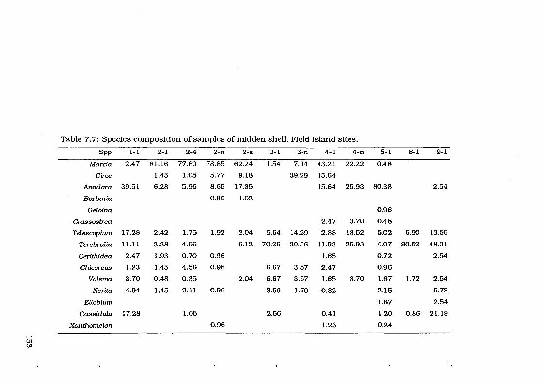
Table 7.7: Species composition of samples of midden shell, Field Island sites.
Spp 1-1 2-1 2-4 2-n 2-s 3-1 3-n 4-1 4-n 5-1 8-1 9-1
Marcia 2.47 81.16 77.89 78.85 62.24 1.54 7.14 43.21 22.22 0.48
Circe 1.45 1.05 5.77 9.18 39.29 15.64
Anadara 39.51 6.28 5.96 8.65 17.35 15.64 25.93 80.38 2.54
Barbatia 0.96 1.02
Geloina 0.96
Crassostrea 2.47 3.70 0.48
Telescopiwn 17.28 2.42 1.75 1.92 2.04 5.64 14.29 2.88 18.52 5.02 6.90 13.56
Terebralia 11.11 3.38 4.56 6.12 70.26 30.36 11.93 25.93 4.07 90.52 48.31
Cerithidea 2.47 1.93 0.70 0.96 1.65 0.72 2.54
Chicoreus 1.23 1.45 4.56 0.96 6.67 3.57 2.47 0.96
Volema 3.70 0.48 0.35 2.04 6.67 3.57 1.65 3.70 1.67 1.72 2.54
Nerita 4.94 1.45 2.11 0.96 3.59 1.79 0.82 2.15 6.78
Ellobiwn 1.67 2.54
Cassidula 17.28 1.05 2.56 0.41 1.20 0.86 21.19
Xanthomelon 0.96 1.23 0.24 --......
U1 Vl
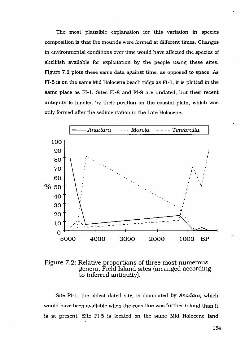
The most plausible explanation for this variation in species
composition is that the mounds were formed at different times. Changes
in environmental conditions over time would have affected the species of
shellfish available for exploitation by the people using these sites.
Figure 7.2 plots these same data against time, as opposed to space. As
FI -5 is on the same Mid Holocene beach ridge as FI -1, it is plotted in the
same place as Fl-1. Sites FI-8 and FI-9 are undated, but their recent
antiquity is implied by their position on the coastal plain, which was
only formed after the sedimentation in the Late Holocene.
--Anadara · · · · · Marcia - - · - Terebralia
100
90
80
70
60 Of<:> 50
40
30
20
10 "' .
0 5000
.--.---.--- 0--.
4000 3000
. --.--.--
2000
' I • \
I \
I
1000 BP
Figure 7.2: Relative proportions of three most numerous genera, Field Island sites (arranged according to inferred antiquity).
Site FI-1, the oldest dated site, is dominated by Anadara. which
would have been available when the coastline was further inland than it
is at present. Site FI-5 is located on the same Mid Holocene land
154
surface, and is likely to have been deposited at the same time as FI-1.
Supporting this is the fact that Fl-5 is also dominated by Anadara. Site
FI-2 is also of considerable antiquity, and is dominated by Marcia which
would also have been available during the Mid Holocene. Proportions of
Marcia were falling by the time of deposition of FI-4, and continued to
fall throughout the Late Holocene. Site FI -3, the youngest dated site, is
dominated by Terebralia, which would have been available after the
establishment of the mangrove swamps which are still present along the
West Alligator River today. Also dominated by Terebralia are sites Fl-8
and Fl-9, which must have been deposited during the Late Holocene
after progradation had deposited black clays in this area and the
mangroves were following the banks of the West Alligator River as they
moved toward their present position. These are the sorts of changes
predicted in Chapter Two, with open beach species in the Mid Holocene
replaced by mangrove species in the Late Holocene.
Comparison with other coastal middens
As has been demonstrated, the West Alligator River sites, all within
15km of the coast, show a considerable degree of variation in terms of
their size, environmental setting, antiquity, species richness, species
composition, especially the most abundant species. This seems to be in
contrast to the coastal shell mounds A, B and C described for the South
Alligator River by Woodroffe et al. (1988). Variation exists in the
environmental context, species composition and richness, and antiquity
of midden sites.
Sites A, B and C are all on the crests of chenier ridges. Although
Sites FI-2, FI-3 and FI-4 were deposited on cheniers, these cheniers do
not exist anywhere else but beneath the mounds. I was accompanied to
the sites by Marjorie Sullivan and Phil Hughes, who have informed me
155
that some of the shell uncovered by goannas at these sites resembles
chenier shell - in other words, these sites were probably deposited on
cheniers, but that only the portions of the chenier thus consolidated by
the Aboriginal shell midden have been preserved. There is no other
evidence of cheniers in the area. Sites FI -1 and FI -5 were deposited on
beach ridges, and Sites FI -8 and FI -9 were deposited directly on the
surface of the coastal plain.
Woodroffe et al. ( 1988) state that Anadara is the most abundant
shell in their coastal middens. Although this is the case at FI-5 and FI-
1, it is definitely not the case at the other sites described by the present
study. FI-4 and FI-2 are dominated by Marcia, and FI-3, FI-9 and FI-8
by Terebralia. In fact, for all practical purposes, no Anadara are visible
on the surface of FI -3 - none were recorded in sample squares, and
further search on other parts of the mound tumed up only two
fragments both <1cm2
• South Alligator coastal sites contain specimens
of Turritella, Mactra and Geloina, species not appearing in the West
Alligator sites. On the other hand, the West Alligator sites do have
Cerithidea and Volema, which are absent from the South Alligator
coastal area. Species richness in coastal middens is also variable.
Coastal sites recorded by Woodroffe et al. (1988) contained between
three and nine species, and Field Island sites recorded during the
present study contained between four and thirteen species.
Documentation performed in the present study opposes the impression
of uniformity of site contents in the coastal plains.
Timing of use of the coastal portion of the floodplains is also
expanded by the present study. Coastal sites recorded by Woodroffe et
al. (1988) were all formed within the last 800 years. West Alligator sites
have documented use of the coastal area over 5000 years ago.
156

Woodroffe et al. (1988) also documented mollusc exploitation during the
mid-Holocene, but these sites were considerably further up the river (ca.
30-50km inland). and they state that by this time the South Alligator
mangrove vegetation had disappeared. Unfortunately, they make no
record of the shellfish species contained in these sites aged between
3000 and 4500 years.
From descriptions of coastal middens provided by Woodroffe et al.
(1988), one could expect to find some variability in form and species
richness. Homogeneity was expected for environmental setting and age
range. These expectations were not met. Sites were not located only on
chenier ridges. Some were deposited on beach ridges, and some were
located directly on the coastal plain. Sites were not all deposited within
the last thousand years, the oldest site dating to 4570±80 BP. Sites
from the West Alligator River also serve to highlight the variability
within the midden types defined by Woodroffe et al. (1988).
This comparison of Field Island sites with coastal middens
recorded by Woodroffe et al. (1988) suggests that there is considerable
variation between the West Alligator River and South Alligator River
middens. I will now compare the West Alligator River coastal middens
with the South Alligator River estuarine middens at Kapalga.
COMPARISON OF MIDDENS FROM FIELD ISLAND AND KAPALGA
Variability within each of the areas examined during the present
study has already been established. But there is also considerable
variability between these two areas. Differences were noted in species
richness, the type of species in the sites, the dominant taxa, and site
size.
157
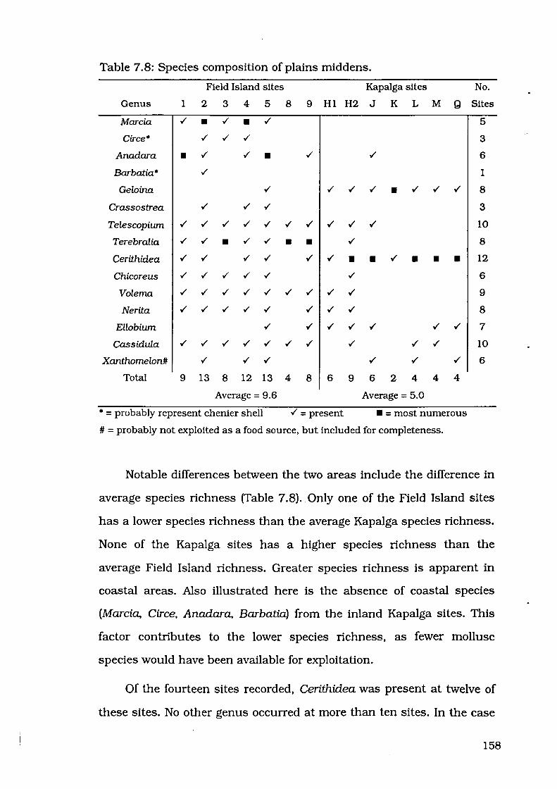
Table 7.8: Species composition of plains middens.
Field Island sites Kapalga sites No.
Genus 1 2 3 4 5 8 9 HI H2 J K L M Q Sites
Marcia ./ • ./ • ./ 5
Circe• ./ ./ ./ 3
Anadara • ./ ./ • 6
Barbatia* ./ 1
Geloina ./ ./ ./ ./ • ./ ./ ./ 8
Crassostrea ./ ./ ./ 3
Telescopium ./ ./ ./ ./ ./ ./ ./ ./ ./ ./ 10
Terebralia ./ ./ • ./ ./ • • ./ 8
Cerithidea ./ ./ ./ ./ ./ ./ • • ./ • • • 12
Chicoreus ./ ./ ./ ./ ./ ./ 6
Volema ./ ./ ./ ./ ./ ./ ./ ./ ./ 9
Nerita ./ ./ ./ ./ ./ ./ ./ ./ 8
Ellobium ./ ./ ./ ./ ./ ./ ./ 7
Cassidula ./ ./ ./ ./ ./ ./ ./ ./ ./ ./ 10
Xanthomelon# ./ ./ ./ ./ ./ ./ 6
Total 9 13 8 12 13 4 8 6 9 6 2 4 4 4
Average = 9.6 Average = 5.0
*=probably represent chenier shell ./=present • = most numerous
# = probably not exploited as a food source, but included for completeness.
Notable differences between the two areas include the difference in
average species richness (Table 7.8). Only one of the Field Island sites
has a lower species richness than the average Kapalga species richness.
None of the Kapalga sites has a higher species richness than the
average Field Island richness. Greater species richness is apparent in
coastal areas. Also illustrated here is the absence of coastal species
(Marcia, Circe, Anadara, Barbatia) from the inland Kapalga sites. This
factor contributes to the lower species richness, as fewer mollusc
species would have been available for exploitation.
Of the fourteen sites recorded, Cerithidea was present at twelve of
these sites. No other genus occurred at more than ten sites. In the case
158

of the Kapalga sites, Cerithidea was the most numerous genus
represented at five of the six sites quantified. In contrast to this,
Cerithidea never formed more than 3.0% of the samples quantified at
Field Island sites.
Site size was notably different in these two areas. Field Island sites
were more variable, as attested to by higher standard deviations and
coefficients of variation for each dimension (Table 7.9). Another
interesting factor to note is the shape of sites in each area. Kapalga
sites are almost circular in shape, and length and width are almost the
same. On the other hand Field Island sites are much more elongated
and, on average, length is more than two and a half times width (Table
7.9). Possible this is a reflection of the fact that several of the Field
Island mounds were deposited on beach ridges or chenier ridges, and
followed these landforms.
Table 7.9: Variation for site dimensions, comparing Field Island and
Kapalga sites.
Sites Length (av±sd - cv) Width (av±sd - cv) Height (av±sd - cv)
Field Island 52.9±63.3m- 1.20 19.7±10.0m- 0.51 0.6±0.5m- 0.83
Kapalga 28.2±9.2m - 0.33 25.0±8.lm - 0.32 0.4±0.2m - 0.50
CONCLUSION
An assessment of midden categories used by Woodroffe et al.
( 1988) has concluded that there is no consistency in the definition of
these categories. Surface mounds and scatters are defined by size and
form only. Coastal middens and palaeochannel middens are defined by
environmental setting only, with no regard to site size and form. Even
within each of these categories, much variation has been documented
by more detailed recording. The most homogeneous of the categories
159

used by Woodroffe et al. ( 1988) was coastal middens. Examination of
middens in the coastal area of the West Alligator River has
demonstrated high variability in the coastal midden category.
Comparisons of middens at Kapalga and Field Island have
demonstrated that variability is actually greater at the coastal Field
Island middens than at the surface mounds at Kapalga. Results of the
present study suggest that the amount of variability in site size, species
composition and richness, environmental setting and antiquity is too
great to construct categories using only a few sites.
160

CHAPTER EIGHT
CONCLUSION
161

Relatively speaking, the western Arnhem Land area is "one of the three
or four most intensively studied areas in Australia" (Jones 1988: 1). It is
a credit to the work of all archaeologists who have worked in this area
that they have devised testable models. The present study has
attempted to test some of these models by reviewing the published
literature, and by making comparison with sites on the Kapalga and
Field Island mapsheets.
In the South Alligator River area, most dated sites (twelve out of
fourteen) were deposited since the retreat of the mangrove swamps. This
is in agreement with Allen's model for increased use of the floodplains
after mangrove decline. Timing of the increase in use of the floodplains
differs on account of differences in the timing of environmental change.
The retreat of mangroves at 3000 BP on the East Alligator River will
only be relevant to the outlier shelter sites and open sites of this river
system. Open sites deposited on the plains of the South and West
Alligator Rivers reflect the timing of environmental changes which
occurred on those rivers. Each river system has its own independent
chronology. It is not possible to assume that changes occurred at the
same time on all river systems, or indeed that the same sort of changes
occurred.
Dates from plains sites, for example Site P dated at more than
6200 years old by Woodroffe et al. (1988), reveal that people were
exploiting mangrove molluscs on the coastal plains soon after the time
of establishment of extensive mangrove swamps in the area. Mid
Holocene hunter-gatherers living in the Kakadu area were exploiting a
wide range of habitats, including the estuarine plains and coastal strip
as well as the escarpment. These people were already familiar with the
resources available in this area by the time the mangrove retreat
162

allowed more easy access to these floodplain areas, as has been pointed
out by Allen (1987).
Past characterisations of middens have tended to overlook the high
variability present in sites deposited on the coastal plains. Referring to
sites simply as "coastal middens" or "plains middens" implies a
homogeneity which is not supported by my findings. Sites vary in size
and form, from small scatters to large elongated mounds of shell. They
are deposited on beach ridges, chenier ridges, beside palaeochannels or
directly on the surface of the coastal plain. A wide range of species
richness is represented in these sites, from a few species to more than a
dozen. The most abundant species varies, depending on the species
available in the area at the time of deposition.
Midden sites in shelters near the East Alligator River, and on the
coastal plains near the South Alligator River and West Alligator River
reveal much about the behaviour of prehistoric humans. Coastal plains
environments were exploited as early as the time of establishment of
extensive mangrove swamps in the mid-Holocene, in the coastal areas of
the West Alligator River, and also in the inland portion of the South
Alligator River valley. People continued to exploit molluscs right up until
the recent past. Changes in the species exploited reflect environmental
changes, implying that foraging habits were flexible. People did not
react to dramatic changes in landforms by abandoning an area. They
changed their foraging strategies to incorporate the newly available
species. This was possible because people were already utilising a
variety of habitats, and change of habitat in one area would not present
an insurmountable obstacle. Environmental changes did not
immediately remove one species from the environment and replace it
with an entirely unfamiliar one. The habitat changes altered the
163

proportions of these species. The behavioural changes therefore
represented a change on the emphasis of species already being
exploited, not a need to become familiar with previously unknown food
sources.
The present study has revealed a wide variety in species
composition and richness. Middens in the Alligator Rivers region may
contain from two to thirteen species, and may be dominated by any of a
number of mollusc genera. Sites may be deposited in a variety of
environmental settings. Size and form of midden sites are also highly
variable. The known antiquity of mollusc exploitation in the coastal
strip of the Alligator Rivers floodplain has been moved back from the
only last millennium to the Mid Holocene. Hunter-gatherers have been
exploiting mollusc resources as part of a complex subsistence system in
the floodplains of the Alligator Rivers region from the Mid Holocene up
until the recent past.
164

BIBLIOGRAPHY
Abbott, R.T. 1991 Seashells of southeast Asia. Graham Brash,
Singapore.
Abbott, R.T., and Dance, P.S. 1982 Compendium of seashells. E.P.
Dutton Inc., New York.
Allan, J. 1950 Australian shells. Georgian House, Melbourne.
Allen, H. 1987 Holocene mangroves and middens in northern Australia
and southeast Asia. Bulletin of the Indo-Pacific Prehistory
Association 7:1-16.
Allen, H. 1989 Late Pleistocene and Holocene settlement patterns and
environment, Kakadu, Northern Territory, Australia. Indo-Pacific
Prehistory Association Bulletin 9:92-117.
Allen, H. and Barton, G. nd Ngarradj Warde Djobkeng: White Cockatoo
Dreaming and the prehistory of Kakadu. Oceania Monograph 37.
University of Sydney, Sydney.
Allen, J. 1994 Radiocarbon determinations, luminescence dating and
Australian archaeology. Antiquity 68:339-343.
Bailey, G.N. 1975a The role of shell middens in prehistoric economies.
Unpublished PhD thesis, University of Cambridge, Cambridge.
165

Bailey, G.N. 1975b The role of molluscs in coastal economies: the
results of midden analysis in Australia. Journal of Archaeological
Science 2:45-62.
Bailey, G.N. 1977 Shell mounds, shell middens, and raised beaches in
the Cape York Peninsula. Mankind 11: 132-143.
Baker, R. 1981 The Aboriginal and environmental history of the
Chambers Bay coastal plains. Unpublished B.A (Hons) thesis.
Australian National University, Canberra.
Barz, K. 1982 Terranora 19: an estuarine midden at Tweed Heads, New
South Wales. In S.Bowdler (ed.) Coastal archaeology in eastern
Australia. Proceedings of the 1980 Valla Conference on Australian
Prehistory. Department of Prehistory, Research School of Pacific
Studies, Australian National University, Canberra.
Beaton, J .M. 1985 Evidence for a coastal occupation time-lag at
Princess Charlotte Bay (North Queensland) and implications for
coastal colonization and population growth theories for Aboriginal
Australia. Archaeology in Oceania 20(1): 1-20.
Bowdler, S. 1983 Sieving seashells: midden analysis in Australian
archaeology. In G.Connah (ed.) Australian field archaeology: a
guide to techniques, pp.135-144. Australian Institute of
Aboriginal Studies, Canberra.
Bowdler, S. 1984 Hunter Hill, Hunter Island: archaeological
investigations of a prehistoric Tasmanian site. Terra Australis 8.
166
Department of Prehistory, Research School of Pacific Studies,
Australian National University, Canberra.
Bowdler, S. 1990 50,000-year-old site in northern Australia- is it really
that old? Australian Archaeology 31:93.
Bowdler, S. and O'Connor, S. 1991 The dating of the Australian small
tool tradition, with new evidence from the Kimberley, W.A.
Australian Aboriginal Studies 1991(1):53-62.
Brandt, R.A.M. 1974 The non-marine aquatic Mollusca of Thailand.
Archiv fur Molluskenkunde 1 05( 1-4): 1-423.
Brockwell, C.J. 1989 Archaeological investigations of the Kakadu
wetlands, northern Australia. Unpublished MA thesis, Australian
National University, Canberra.
Broom, M.J. 1980 Community and production ecology of Anadara
granosa (L.) with particular reference to its gastropod predators.
Unpublished PhD thesis, University of Malaya, Kuala Lumpur.
Broom, M.J. 1985 The Biology and Culture of Marine Bivalve
Molluscs of the Genus Anadara. International Center for Living
Aquatic Resources Management, Manila, Philippines.
Budiman, A. 1988 Some aspects on the ecology of mangrove whelk
Telescopium telescopium (Linne, 1 758) (Mollusca, Gastropoda:
Potamididae). Treubia 29(4):237-245.
167

Cantera, J., Arnaus, P.M., and Thomassin, B.A. 1983 Biogeographic
and ecological remarks on molluscan distribution in mangrove
biotopes. 1. Gastropods. Journal of Molluscan Studies (1983),
Suppt. 12A: 10-26.
Cernohorsky, W.O. 1972 Marine Shells of the Pacific. Volume II.
Pacific Publications, Sydney.
Cernohorsky, W.O. 1978 Tropical Pacific marine shells. Pacific
Publications, Sydney.
Clark, R.L. and Guppy, J. 1988 A transition from mangrove forest to
freshwater wetland in the monsoon tropics of Australia. Journal of
Biogeography 15:665-684.
Clarke, M.F., Wasson, R.J. and Williams, M.A.J. 1979 Point Stuart
chenier and Holocene sea levels in Northern Australia. Search
10:90-92.
Coleman, N. 1981 What shell is that? Second edition. Paul Hamlyn,
Sydney.
Cribb, R., Walmbeng, R., Wolmby, R. and Taisman, C. 1988 Landscape
as cultural artefact: shell mounds and plants in Aurukun, Cape
York Peninsula. Australian Aboriginal Studies 1988(2):60-73.
Frankel, D. 1990 Time inflation. New Scientist 7 July 1990:52-53.
Gillespie, R. and Temple, R.B. 1976 Sydney University Natural
Radiocarbon Measurements III. Radiocarbon 18(1):96-109.
168

Grayson, D.K. 1984 Quantitative zooarchaeology: topics in the
analysis of archaeological faunas. Academic Press, Inc., Orlando.
Hill, D.S. 1980 The Neritidae (Mollusca: Prosobranchia) of Hong Kong.
In B.Morton (ed.) The Malacofauna of Hong Kong and Southern
China, pp.85-99. Hong Kong University Press, Hong Kong.
Hiscock, P. 1990 How old are the artefacts in Malakunanja II?
Archaeology in Oceania 25:122-124.
Hiscock, P. 1993 Interpreting the vertical distribution of stone points
within Nauwalabila I, Arnhem Land. The Beagle 10(1):173-178.
Hiscock, P. and Mowat, F. 1993 Midden variability in the coastal
portion of the Kakadu region. Australian Archaeology 37: 18-24.
Hiscock, P. nd Faunal succession in shell middens of Kakadu.
Unpublished manuscript, Department of Anthropology, Northern
Territory University, Darwin.
Houart, R. 1992 The genus Chicoreus and related genera
(Gastropoda: Muricidae) in the Indo-West Pacific. Memoires du
Museum National d'Histoire Naturelle, Paris.
Houbrick, R.S. 1984 Revision of higher taxa in genus Cerithidea
(Mesogastropoda: Potamididae) based on comparative morphology
and biological data. American Malacological Bulletin,
Vol.2(1984): 1-20.
169

Houbrick, R.S. 1986 Cerithidea reid~ spec. nov., from Western
Australia. The Veliger 28(3):280-286.
Houbrick, R.S. 1991 Systematic review and functional morphology of
the mangrove snails Terebralia and Telescopium (Potamididae;
Prosobranchia). Malacologia 33:289-338.
Jones, R. 1985 Archaeological conclusions. In R.Jones (ed.)
Archaeological research in Kakadu National Park, pp.291-298.
Australian National Parks and Wildlife Service, Special Publication
13.
Jones, R. 1988 The Alligator Rivers: A mirror to a continental
prehistory. In D.Wade-Marshall and P.Loveday (eds) Floodplains
Research. Northern Australia: progress and prospects, Volume
2. Appendix 1, pp.l-26. Australian National University, North
Australia Research Unit, Darwin.
Jones, R. and Johnson, I. 1985a Deaf Adder Gorge: Lindner Site,
Nauwalabila I. In R.Jones (ed.) Archaeological Research in
Kakadu National Park, pp.165-227. Australian National Parks
and Wildlife Service, Special Publication 13.
Jones, R. and Johnson, I. 1985b Rockshelter excavations: Nourlangie
and Mt Brockman massifs. In R.Jones (ed.) Archaeological
research in Kakadu National Park, pp.39-76. Australian National
Parks and Wildlife Service, Special Publication 13.
170

Kamminga, J. and Allen, H. 1973 Report of the archaeological
survey. Alligator Rivers Environmental Fact-Finding Survey,
Canberra.
Keeton, W.T., and Gould, J.L. 1986 Biological science. Fourth edition.
W.W.Norton and Company, New York.
Khoo, H.W., and Chin, E. 1983 Thermal effects on some mangrove
mollusks. The Veliger 26(2):119-123.
Lamprell, K., and Whitehead, T. 1992 Bivalves of Australia. Volume 1.
Crawford House Press, Bathurst NSW.
Lasiak, T. and Dye A.H. 1986 Behavioural adaptations of the mangrove
whelk, Telescopium telescopium (L.), to life in a semi-terrestrial
environment. Journal of Molluscan Studies 52:174-179.
Loch, I. 1987 A tremendous Terebralia. Australian Shell News 58:4.
Macnae, W. 1968 A general account of the fauna and flora of mangrove
swamps and forests in the Indo-West-Pacific region. Advances in
Marine Biology 6:73-270.
McCarthy, F.D. and Setzler, F.M. 1960 The archaeology of Arnhem
Land. In C.P.Mountford (ed.) Records of the American-Australian
Scientific Expedition to Arnhem Land. Vo1.2. Anthropology and
Nutrition, pp.215-295. Melbourne University Press, Melbourne.
Meehan, B. 1977 Man does not live by calories alone: the role of
shellfish in a coastal cuisine. In J.Allen, J.Golson and R.Jones
171

(eds) Sunda and Sahul: prehistoric studies in Southeast Asia,
Melanesia and Australia. Academic Press, London.
Meehan, B. 1982 Shell bed to shell midden. Australian Institute of
Aboriginal Studies, Canberra.
Meehan, B. 1983 A matter of choice? Some thoughts on shell gathering
strategies in northern Australia. In C.Grigson and J.Clutton-Brock
(eds) Animals and Archaeology, pp.3-17. BAR International Series
183, Oxford.
Meehan, B., Brockwell, S., Allen, J. and Jones, R. 1985 The wetland
sites. In R.Jones (ed.) Archaeological Research in Kakadu
National Park, pp.103-153. Australian National Parks and Wildlife
Service, Special Publication No.13.
Morton, B. 1983 Mangrove bivalves. In K.M.Wilbur (ed.) The Mollusca.
Volume 6, Ecology (W.D.Russell-Hunter, ed.), pp.77-138.
Academic Press, New York.
Mowat, F. 1994 Size really does matter: factors affecting shell
fragmentation. In M.Sullivan, S.Brockwell and A.Webb (eds)
Archaeology in the North, pp.201-210. Proceedings of the 1993
Australian Archaeological Association Conference. Australian
National University, North Australia Research Unit, Darwin.
172
Muckle, R.J. 1985 Archaeological considerations of bivalve shell
taphonomy. Unpublished M.A. thesis, Department of Archaeology,
Simon Fraser University, Burnaby, British Colombia.
Nishihira, M. 1983 Grazing of the mangrove litters by Terebralia
palustris (Gastropoda: Potamididae) in the Okinawa mangal:
preliminary report. Galaxea 2:45-58.
Pathansali, D. 1966 Notes on the biology of the cockle Anadara granosa
L. Proceedings of the Indo-Pacific Fisheries Council 11:84-98.
Purchon, R.D. 1977 The biology of the mollusca. Second edition.
Pergamon Press, Oxford.
Ranson, D. 1980 Open area excavation in Australia: a plea for bigger
holes. In !.Johnson (ed.) Holier Than Thou. Proceedings of the
1978 Kioloa conference on Australian Prehistory, pp.77-90.
Department of Prehistory, Research School of Pacific Studies,
Australian National University, Canberra.
Roberts, R.G., Jones, R. and Smith, M.A. 1990 Thermoluminescence
dating of a 50,000-year-old site in northern Australia. Nature
345:153-156.
Schrire, C. 1971 Ethno-archaeology models and subsistence behaviour
in Arnhem Land. In D.J.Clarke (ed.) Models in Archaeology,
pp.653-669. Methuen, London.
173

Schrire, C. 1982 The Alligator Rivers: prehistory and ecology in western
Arnhem Land. Terra Australis 7. Research School of Pacific
Studies, Australian National University, Canberra.
Short, J.W., and Potter, D.G. 1987 Shells of Queensland and the great
Barrier Reef: marine gastropods. Golden Press Pty Ltd,
Drummoyne NSW.
Smith, M.A. 1981a ·Field archaeologist's report for 1980.
Unpublished manuscript, Museums and Art Galleries of the
Northern Territory, Darwin.
Smith, M.A. 1981b Field archaeologist's report for 1981.
Unpublished manuscript, Museums and Art Galleries of the
Northern Territory, Darwin.
Story, R. 1969 Summary description of the Adelaide-Alligator area. In
R.Story, M.A.J.Williams, A.D.L.Hooper, R.E.O'Ferrall and
J.R.McAlpine (eds) Lands of the Adelaide-Alligator River area,
Northern Territory. Land Research Series No.38, pp.16-23.
Commonwealth Scientific and Industrial Research Organisation,
Melbourne.
Story, R., Williams, M.A.J ., Hooper, A.D.L., O'Ferrall, R.E. and
McAlpine, J.R. (eds) 1969 Lands of the Adelaide-Alligator River
area, Northern Territory. Land Research Series No.38.
Commonwealth Scientific and Industrial Research Organisation,
Melbourne.
174

Stuiver, M. and Reimer, P.J. 1993 University of Washington Quaternary
Isotope Lab radiocarbon calibration program Rev 3.0.3.
Radiocarbon 35:215-230.
Sullivan, M.E. 1982 Aboriginal shell middens in the coastal landscape
of New South Wales. Unpublished PhD thesis, Australian National
University, Canberra.
Swadling, P. 1976 Changes induced by human exploitation in
prehistoric shellfish populations. Mankind 1 0(3): 156-162.
Thomson, J.M. 1954 The genera of oysters and the Australian species.
Australian Journal of Marine and Freshwater Research 5:132-
168.
Treganza, A.E. and Cook, S.F. 1948 The quantitative investigation of
Aboriginal sites: complete excavation with physical and
archaeological analysis of a single mound. American Antiquity
13:287-297.
Wells, F.E. 1980 A comparative study of distributions of the mudwhelks
Terebralia sulcata and T. palustris in a mangrove swamp in
northwestern Australia. Malacological Review 13: 1-5.
Wells, F.E. 1983 The Potamididae (Mollusca: Gastropoda) of Hong Kong,
with an examination of habitat segregation in a small mangrove
system. In B.Morton and D.Dudgeon (eds) The Malacofauna of
175

Hong Kong and Southern China II. Volume 1, pp.139-154. Hong
Kong University Press, Hong Kong.
Wells, F.E., and Bryce, C.W. 1988 Seashells of Western Australia.
Revised edition. Western Australian Museum, Perth.
White, T.E. 1953 A method of calculating the dietary percentages of
various food animals utilized by aboriginal peoples. American
Antiquity 18:396-398.
Williams, M.A.J. 1969 Geomorphology of the Adelaide-Alligator area. In
R.Story, M.A.J.Williams, A.D.L.Hooper, R.E.O'Ferrall and
J.R.McAlpine (eds) Lands of the Adelaide-Alligator River area,
Northern Territory. Land Research Series No.38, pp.71-94.
Commonwealth Scientific and Industrial Research Organisation,
Melbourne.
Williams, M.A.J., Hooper, A.D.L. and Story, R. 1969 Land systems of
the Adelaide-Alligator area. In R.Story, M.A.J.Williams,
A.D.L.Hooper, R.E.O'Ferrall and J.R.McAlpine (eds) Lands of the
Adelaide-Alligator River area, Northern Territory. Land
Research Series No.38, pp.24-48. Commonwealth Scientific and
Industrial Research Organisation, Melbourne.
Wilson, B.R. and Gillett, K. 1979 A field guide to Australian shells:
prosobranch gastropods. Reed Books, Pty Ltd, Frenchs Forest
NSW.
176

Wilson, B.R. and Gillett, K. 1980 Australian shells: illustrating and
describing 600 species of marine gastropods found in
Australian waters. Reed, Sydney.
WoodrofTe, C.D., Chappell, J. and Thorn, B.G. 1988 Shell middens in
the context of estuarine development, South Alligator River,
Northern Territory. Archaeology in Oceania 23:95-103.
Woodroffe, C.D., Chappell, J., Thorn, B. and Wallensky, E. 1985a
Stratigraphy of the South Alligator tidal river and plains, Northern
Territory. In K.N.Bardsley, J.D.Davie and C.D.WoodrofTe (eds)
Coastal and Tidal Wetlands of the Australian Monsoon Region,
pp.l 7-30. Mangrove Monograph No.1. Australian National
University North Australia Research Unit, Darwin.
Woodroffe, C.D., Chappell, J.M.A., Thorn, B.G. and Wallensky, E. 1986
Geomorphological dynamics and evolution of the South
Alligator tidal river and plains, Northern Territory. Mangrove
Monograph No.3. Australian National University, North Australia
Research Unit, Darwin.
WoodrofTe, C.D., Thorn, B.G. and Chappell, J. 1985b Development of
widespread mangrove swamps in mid-Holocene times in northern
Australia. Nature 317:711-713.
WoodrofTe, C.D., Thorn, B.G., Chappell, J., Wallensky, E., Grindrod, J.
and Head, J. 1987 Relative sea level in the South Alligator River
region, north Australia, during the Holocene. Search 18:198-200.
177
Related Documents