Eos,Vol. 81, No. 43, October 24,2000 VOLUME 81 NUMBER 43 OCTOBER 24, 2000 PAGES 497-512 U.S.-Russia Venture Probes Siberian Peatlands' Sensitivity to Climate PAGES 497,503-504 The extent to which northern peatlands respond to or influence climate change is an unresolved question in Arctic science. Recent studies in Alaska, Canada, and Fennoscandia have raised concerns that northern peatlands, while currently a net sink or minor source of atmospheric C0 2 , may become a significant C0 2 source under a warming climate. Expanding peatlands emit methane but sequester atmospheric carbon through long- term accumulation of undecomposed plant matter. Drier conditions may reverse this process by increasing temperatures and low- ering the peatland water table, causing anaer- obic decomposition of stored peat and subsequent outgassing of C0 2 .While this process would likely reduce methane emissions and possibly enhance C uptake from increased soil nutrient mineralization rates [Oechel and Vourlitis, 1994], many scien- tists now believe that warming and drying of northern peatlands will liberate stored C for uptake by the atmosphere and biosphere. To test this hypothesis, Russian and U.S. scien- tists are studying the Holocene evolution and contemporary surface of the world s largest peatland. Early results suggest peatlands were rapidly established in West Siberia following the last glacial maximum at a time that coin- cides with the Greenland Ice Sheet Project (GISP) 2 record of atmospheric methane. The West Siberian Lowland The West Siberian Lowland (WSL) is the worlds largest high-latitude wetland, with a 1.8 x 10 6 km 2 forest-palustrine zone covering nearly two-thirds of western Siberia. At least half of this area consists of peatlands. Most occur between 55° and the Arctic Circle, with many underlain by continuous or discontinu- ous permafrost.Their total carbon content has been roughly estimated at -215 Pg C [Botch et al, 1995],a number which represents one- Fig. 1. Russian and American scientists drill into frozen peat near Noyabrsk, Siberia. Original color image appears at the back of this volume. EOS, T R A N S A C T I O N S , A M E R I C A N G E O P H Y S I C A L U N I O N

Welcome message from author
This document is posted to help you gain knowledge. Please leave a comment to let me know what you think about it! Share it to your friends and learn new things together.
Transcript
Eos,Vol. 81, No. 43, October 24,2000
VOLUME 81 NUMBER 43
OCTOBER 24, 2000
PAGES 497 -512
U.S.-Russia Venture Probes Siberian Peatlands' Sensitivity to Climate
PAGES 497,503-504
The extent to which northern peatlands respond to or influence climate change is an unresolved question in Arctic science. Recent studies in Alaska, Canada, and Fennoscandia have raised concerns that northern peatlands, while currently a net sink or minor source of atmospheric C0 2 , may become a significant C0 2 source under a warming climate.
Expanding peatlands emit methane but sequester atmospheric carbon through long-term accumulation of undecomposed plant matter. Drier conditions may reverse this process by increasing temperatures and lowering the peatland water table, causing anaerobic decomposition of stored peat and subsequent outgassing of C0 2.While this process would likely reduce methane emissions and possibly enhance C uptake from increased soil nutrient mineralization rates [Oechel and Vourlitis, 1994], many scientists now believe that warming and drying of northern peatlands will liberate stored C for uptake by the atmosphere and biosphere.
To test this hypothesis, Russian and U.S. scientists are studying the Holocene evolution and contemporary surface of the world s largest peatland. Early results suggest peatlands were rapidly established in West Siberia following the last glacial maximum at a time that coincides with the Greenland Ice Sheet Project (GISP) 2 record of atmospheric methane.
The West Siberian Lowland
The West Siberian Lowland (WSL) is the worlds largest high-latitude wetland, with a 1.8 x 10⁶ km2 forest-palustrine zone covering nearly two-thirds of western Siberia. At least half of this area consists of peatlands. Most occur between 55° and the Arctic Circle, with many underlain by continuous or discontinuous permafrost.Their total carbon content has been roughly estimated at -215 Pg C [Botch et al, 1995],a number which represents one-
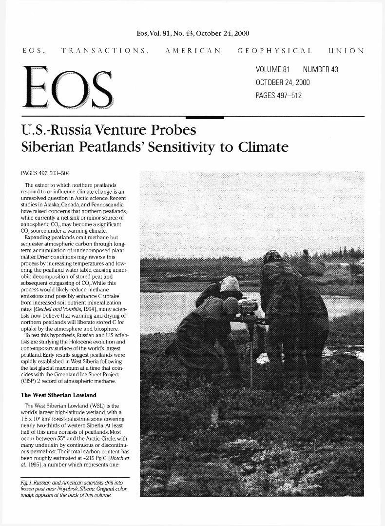
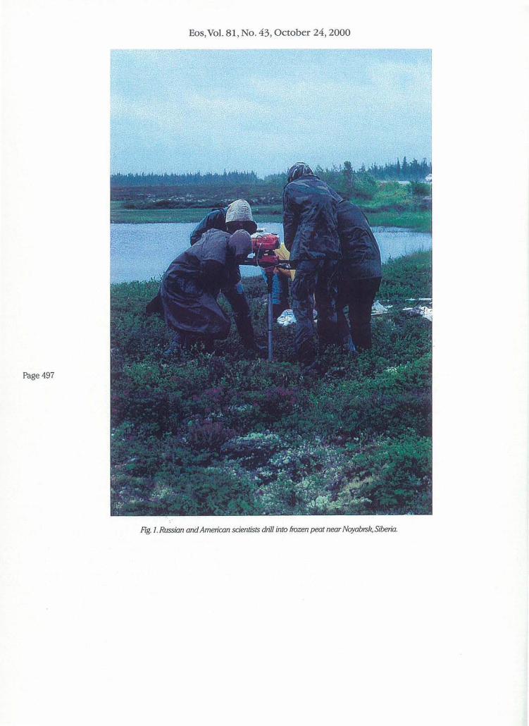
Fig. 1. Russian and American scientists drill into frozen peat near Noyabrsk, Siberia. Original color image appears at the back of this volume.
E O S , T R A N S A C T I O N S , A M E R I C A N G E O P H Y S I C A L U N I O N
Eos, Vol. 81, No. 43, October 24, 2000
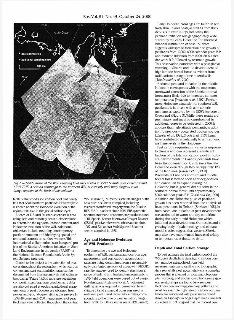
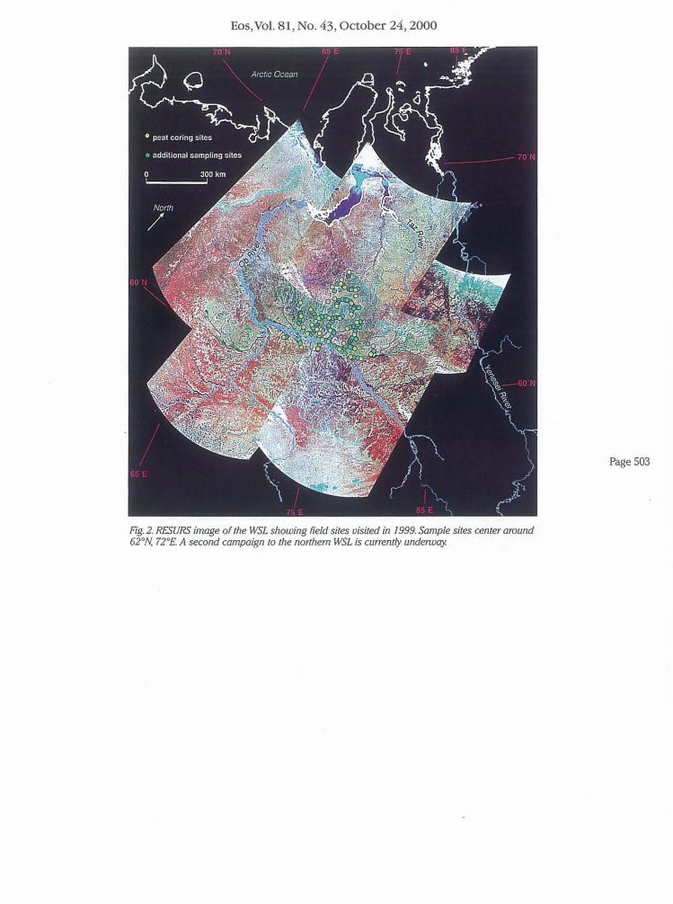
Fig. 2. RESURS image of the WSL showing field sites visited in 1999. Sample sites center around 62°N, 72°E. A second campaign to the northern WSL is currently underway. Original color image appears at the back of this volume.
tenth of the world's soil carbon pool and nearly half that of all northern peatlands. However, little is known about the Holocene evolution of the region or its role in the global carbon cycle.
A team of U.S. and Russian scientists is now using field and remotely sensed observations to determine the age, total carbon content, and Holocene evolution of the WSL. Additional objectives include mapping contemporary peatland function and identifying spatial and temporal controls on surface wetness.This international collaboration is an inaugural project of the Russian-American Initiative on Shelf-Land Environments in the Arctic (RAISE) of the National Science Foundations Arctic System Science program.
Central to the project is the extraction of peat cores throughout the region, from which carbon content and past accumulation rates can be determined from thermal analysis and radiocarbon dating (Figure l).Soil moisture, vegetation composition, and aqueous geochemistry data are also collected at each site. Additional measurements of peat thickness are obtained from probes and ground-penetrating radar surveys. In 1999,40 cores and -200 measurements of peat thickness were collected throughout the central
WSL (Figure 2). Numerous satellite images of the area have also been compiled, including visible/near-infrared imagery from the Russian RESURS01 platform since 1994, ERS synthetic aperture radar and scatterometer products since 1991, Special Sensor Microwave/Imager Dataset (SSM/I) passive microwave observations since 1987, and 52 Landsat Multi-Spectral Scanner scenes acquired in 1973.
Age and Holocene Evolution of WSL Peatlands
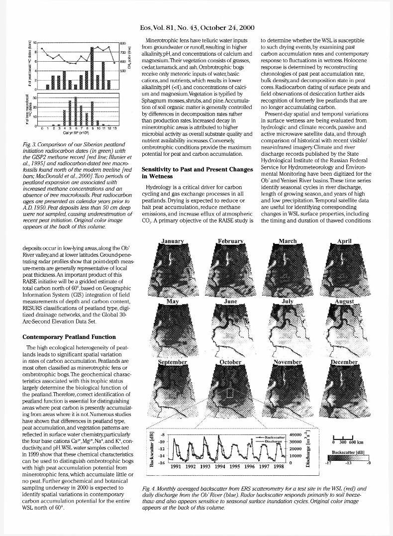
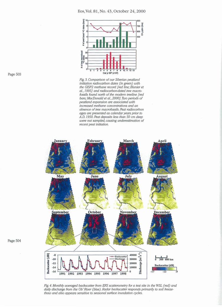
To determine the age and Holocene evolution of WSL peatlands, radiocarbon age, paleoextent,and past carbon accumulation rates are being determined from a geographically distributed network of cores, with RESURS satellite imagery used to identify sites from a range of upland and lowland environments. In 1999, field operations were based out of Surgut, Noyabrsk,and Nizhnevartovsk. A motorized drilling rig was required in permafrost terrain (Figure 1) and a manual corer was used in unfrozen peat. Basal radiocarbon dates, corresponding to the time of peat initiation, range from 12700 to 1000 calendar years B.P(Figure 3).
Early Holocene basal ages are found in relatively thin upland peats, as well as from thick deposits in river valleys, indicating that peatland initiation was geographically widespread by the early Holocene. The observed bimodal distribution of basal 1 4C dates suggests widespread formation and growth of peatlands from 13000-8000 calendar years B.P and reduced initiation from 8000-5000 calendar years B.P, followed by resumed growth. This observation correlates with a post-glacial warming of Siberia and the development of high-latitude boreal forest as evident from radiocarbon dating of tree macrofossils [MacDonaldet al., 2000].
Reduced peatland initiation in the middle Holocene corresponds with the maximum northward extension of the Siberian boreal forest, most likely due to increased summer temperatures [Velichko et al, 1997]. Furthermore, Holocene expansion of southern WSL peatlands is in phase with atmospheric methane as captured by the GISP2 ice core in Greenland (Figure 3).While these results are preliminary and must be corroborated by additional cores to be collected in 2000, it appears that high-latitude peatlands, in addition to previously postulated tropical sources [Blunier et al, 1995; Brook et al, 1996], may have contributed significantly to atmospheric methane levels in the Holocene.
Peat carbon sequestration varies in response to climate and can represent a significant fraction of the total soil carbon pool in northern environments. In Canada, peatlands have been the dominant soil C sink since the late Holocene, even though they occupy only 12% of the land area [Harden et al, 1993]. Peatlands in Canada's northern and middle boreal forest formed soon after deglaciation and continued to expand during the Holocene, but in general did not form in the southern boreal forest until approximately 5000 calendar years B.P [Zoltai andVitt, 1990]. A similar late Holocene pulse of peatland growth has been reported from the analysis of basal peat dates in Finland [Korhola, 1995].In both cases, late initiation of peat development was attributed to warm and dry conditions during the early to mid-Holocene, which inhibited peat development. Our results and a growing body of paleoecology and climate model studies suggest that western Siberia may also have experienced increased aridity or temperatures at the same time.
Depth and Total Carbon Storage
To best estimate the total carbon pool of the WSL, peat depth, bulk density and carbon content must be extrapolated from field measurements using satellite and topographic data sets.While peat accumulation is a complex process that is affected by local microtopogra-phy hydrology, and trophic conditions, some general relationships are found between peat thickness, peatland type, drainage patterns, and relief. For example, high rates of carbon accumulation are associated with palsa mires, raised string, and sphagnum bogs. Depth measurements collected in 1999 suggest that the thickest peat
Eos,Vol. 81, No. 43, October 24,2000
1 4
111 l l .1 m i i i n i i II IB
E 700 S
0 1 2 3 4 5 6 7 8 9 10 11 12 13 Cal yr BP(X103)
Fig. 3. Comparison of our Siberian peatland initiation radiocarbon dates (in green) with the GISP2 methane record [red line; Blunier et al, 1995] and radiocarbon-dated tree macro-fossils found north of the modern treeline [red bars; MacDonald et al, 2000J. Two periods of peatland expansion are associated with increased methane concentrations and an absence of tree macrofossils. Peat radiocarbon ages are presented as calendar years prior to A.D. 1950. Peat deposits less than 50 cm deep were not sampled, causing underestimation of recent peat initiation. Original color image appears at the back of this volume.
Minerotrophic fens have telluric water inputs from groundwater or runoff, resulting in higher alkalinity, pH, and concentrations of calcium and magnesium.Their vegetation consists of grasses, cedar, tamarack, and ash.Ombrotrophic bogs receive only meteoric inputs of water, basic cations, and nutrients, which results in lower alkalinity pH (<4),and concentrations of calcium and magnesium.Vegetation is typified by Sphagnum mosses,shrubs, and pine. Accumulation of soil organic matter is generally controlled by differences in decomposition rates rather than production rates. Increased decay in minerotrophic areas is attributed to higher microbial activity as overall substrate quality and nutrient availability increases. Conversely, ombrotrophic conditions provide the maximum potential for peat and carbon accumulation.
Sensitivity to Past and Present Changes in Wetness
Hydrology is a critical driver for carbon cycling and gas exchange processes in all peatlands. Drying is expected to reduce or halt peat accumulation, reduce methane emissions, and increase efflux of atmospheric C0 2 . A primary objective of the RAISE study is
to determine whether the WSL is susceptible to such drying events, by examining past carbon accumulation rates and contemporary response to fluctuations in wetness. Holocene response is determined by reconstructing chronologies of past peat accumulation rate, bulk density, and decomposition state in peat cores. Radiocarbon dating of surface peats and field observations of desiccation further aids recognition of formerly live peatlands that are no longer accumulating carbon.
Present-day spatial and temporal variations in surface wetness are being evaluated from hydrologic and climate records, passive and active microwave satellite data, and through comparison of historical with recent visible/ near-infrared imagery Climate and river discharge records published by the State Hydrological Institute of the Russian Federal Service for Hydrometeorology and Environmental Monitoring have been digitized for the Ob'and Yenisei River basins. These time series identify seasonal cycles in river discharge, length of growing season, and years of high and low precipitation.Temporal satellite data are useful for identifying corresponding changes in WSL surface properties, including the timing and duration of thawed conditions
Janua deposits occur in low-lying areas, along the Ob' River valley, and at lower latitudes. Ground-penetrating radar profiles show that point-depth meas-ure-ments are generally representative of local peat thickness. An important product of this RAISE initiative will be a gridded estimate of total carbon north of 60°, based on Geographic Information System (GIS) integration of field measurements of depth and carbon content, RESURS classifications of peatland type, digitized drainage networks, and the Global 30-Arc-Second Elevation Data Set.
Contemporary Peatland Function
The high ecological heterogeneity of peatlands leads to significant spatial variation in rates of carbon accumulation. Peatlands are most often classified as minerotrophic fens or ombrotrophic bogs.The geochemical characteristics associated with this trophic status largely determine the biological function of the peatland.Therefore, correct identification of peatland function is essential for distinguishing areas where peat carbon is presently accumulating from areas where it is not. Numerous studies have shown that differences in peatland type, peat accumulation, and vegetation patterns are reflected in surface water chemistry particularly the four base cations Ca^Mg^Na^and ^ . conductivity and pH.WSL water samples collected in 1999 show that these chemical characteristics can be used to distinguish ombrotrophic bogs with high peat accumulation potential from minerotrophic fens, which accumulate little or no peat. Further geochemical and botanical sampling underway in 2000 is expected to identify spatial variations in contemporary carbon accumulation potential for the entire WSL north of 60°.
« - 8
1 1 2
J - 1 4
t K 1 — Back scalier \ 1 Discharge -
1991 1992 1993 1994 1995 1996 1997 1998
40000 T «
30000 J ,
20000 %
10000 J
0 1
I I I 0 300 600 km
Backscattcr [dB]
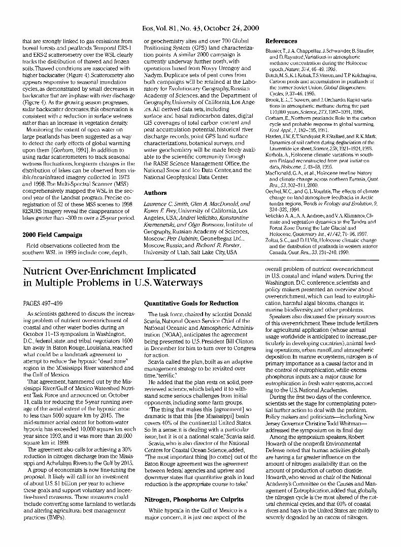
Fig. 4. Monthly averaged backscatter from ERS scatterometry for a test site in the WSL (red) and daily discharge from the Ob'River (blue). Radar backscatter responds primarily to soil freeze-thaw and also appears sensitive to seasonal surface inundation cycles. Original color image appears at the back of this volume.
Eos,Vol. 81, No. 43, October 24,2000
that are strongly linked to gas emissions from boreal forests and peatlands. Temporal ERS-1 and ERS-2 scatterometry over the WSL clearly tracks the distribution of thawed and frozen soils.Thawed conditions are associated with higher backscatter (Figure 4).Scatterometry also appears responsive to seasonal inundation cycles, as demonstrated by small decreases in backscatter that are in-phase with river discharge (Figure 4). As the growing season progresses, radar backscatter decreases; this observation is consistent with a reduction in surface wetness rather than an increase in vegetation density
Monitoring the extent of open water on large peatlands has been suggested as a way to detect the early effects of global warming upon them [Gorham, 1991].In addition to using radar scatterometers to track seasonal wetness fluctuations, long-term changes in the distribution of lakes can be observed from visible/near-infrared imagery collected in 1973 and 1998.The Multi-Spectral Scanner (MSS) comprehensively mapped the WSL in the second year of the Landsat program. Precise co-registration of 52 of these MSS scenes to 1998 RESURS imagery reveal the disappearance of lakes greater than -300 m over a 25-year period.
2000 Field Campaign
Field observations collected from the southern WSL in 1999 include core, depth,
PAGES 497-499
As scientists gathered to discuss the increasing problem of nutrient over-enrichment of coastal and other water bodies during an October 11-13 symposium in Washington, D.C., federal,state, and tribal negotiators 1600 km away in Baton Rouge, Louisiana, reached what could be a landmark agreement to attempt to reduce the hypoxic "dead zone" region in the Mississippi River watershed and the Gulf of Mexico.
That agreement, hammered out by the Mississippi River/Gulf of Mexico Watershed Nutrient Task Force and announced on October 11, calls for reducing the 5-year running average of the aerial extent of the hypoxic zone to less than 5000 square km by 2015. The mid-summer aerial extent for bottom-water hypoxia has exceeded 10,000 square km each year since 1993, and it was more than 20,000 square km in 1999.
The agreement also calls for achieving a 30% reduction in nitrogen discharge from the Mississippi and Achafalaya Rivers to the Gulf by 2015.
A group of economists is now fine-tuning the proposal. It likely will call for an investment of about US.$1 billion per year to achieve these goals and support voluntary and incentive-based measures. These measures could include converting some farmland to wetlands and altering agricultural best management practices (BMPs).
or geochemistry sites and over 700 Global Positioning System (GPS) land characterization points. A similar 2000 campaign is currently underway further north, with operations based from Novyy Urengoy and Nadym. Duplicate sets of peat cores from both campaigns will be retained at the Laboratory for Evolutionary Geography, Russian Academy of Sciences, and the Department of Geography, University of California, Los Angeles. All derived data sets, including surface and basal radiocarbon dates, digital GIS cover-ages of total carbon content and peat accumulation potential, historical river discharge records, point GPS land surface characterizations, botanical surveys, and water geochemistry will be made freely available to the scientific community through the RAISE Science Management Office, the National Snow and Ice Data Center, and the National Geophysical Data Center.
Authors
Laurence C. Smith, Glen A. MacDonald, and Karen E. Frey, University of California, Los Angeles, USA; Andrei Velichko, Konstantine Kremenetski, and Olga Borisova, Institute of Geography, Russian Academy of Sciences, Moscow;Petr Dubinin, Geoneftegaz Ltd., Moscow, Russia; and Richard R. Forster, University of Utah, Salt Lake City, USA
Quantitative Goals for Reduction
The task force, chaired by scientist Donald Scavia, National Ocean Service Chief of the National Oceanic and Atmospheric Administration (NOAA), anticipates the agreement being presented to U.S. President Bill Clinton in December for him to turn over to Congress for action.
Scavia called the plan, built as an adaptive management strategy to be revisited over time,"terrific."
He added that the plan rests on solid, peer-reviewed science, which helped it to withstand some serious challenges from initial opponents, including some farm groups.
"The thing that makes this [agreement] so dramatic is that this [the Mississippi] basin covers 40% of the continental United States. So in a sense, it is dealing with a particular issue, but it is of a national scale," Scavia said.
Scavia, who is also director of the National Centers for Coastal Ocean Science, added, "The most important thing [to come] out of the Baton Rouge agreement was the agreement between federal agencies and upriver and downriver states that quantitative goals in load reduction is the appropriate course to take."
Nitrogen, Phosphorus Are Culprits
While hypoxia in the Gulf of Mexico is a major concern, it is just one aspect of the
References BlunierJ., J. A. Chappellaz, J. Schwander, B. Stauffer,
and D. Raynaud,Variations in atmospheric methane concentration during the Holocene epoch,Nature,374,46-49,1995.
Botch, M. S., K. I. Kobak,T. S.Vinson, and T. P Kolchugina, Carbon pools and accumulation in peatlands of the former Soviet Union, Global Biogeochem. Cycles, 5,37-46,1995.
Brook, E. J.,T. Sowers, and J. Orchardo, Rapid variations in atmospheric methane during the past 110,000 years, Science, 273,1087-1091,1996.
Gorham, E., Northern peatlands: Role in the carbon cycle and probable response to global warming, Ecol.Appl, 1,182-195,1991.
Harden, J. W, E.T. Sundquist, R. FStallard, and R. K. Mark, Dynamics of soil carbon during deglaciation of the Laurentide ice sheet,Science, 258,1921-1924,1993.
Korhola, A., Holocene climatic variations in southern Finland reconstructed from peat initiation data, Holocene, 5,43-58,1995.
MacDonald, G. A., et al., Holocene treeline history and climate change across northern Eurasia, Quat. Res., 55,302-311,2000.
Oechel,WC.,and G.LVourlitis,The effects of climate change on land-atmosphere feedbacks in Arctic tundra regions, Trends in Ecology and Evolution, 9, 324-329,1994.
Velichko A. A., A. A. Andreev, and V A. Klimanov, Climate and vegetation dynamics in the Tundra and Forest Zone During the Late Glacial and Holocene, Quaternary Int., 41/42,71-96,1997.
Zoltai, S. C , and D. H.Vitt, Holocene climatic change and the distribution of peatlands in western interior Canada, Quat. Res., 33,231-240,1990.
overall problem of nutrient over-enrichment in U.S. coastal and inland waters. During the Washington, D.C. conference, scientists and policy makers presented an overview about over-enrichment, which can lead to eutrophi-cation, harmful algal blooms, changes in marine biodiversity, and other problems.
Speakers also discussed the primary sources of this over-enrichment.These include fertilizers for agricultural application (whose annual usage worldwide is anticipated to increase, particularly in developing countries),animal feeding operations, urban runoff, and atmospheric deposition. In marine ecosystems, nitrogen is of primary importance as a causal factor and in the control of eutrophication, while excess phosphorus inputs are a major cause for eutrophication in fresh water systems, according to the U.S. National Academies.
During the first two days of the conference, scientists set the stage for contemplating potential further action to deal with the problem. Policy makers and politicians—including New Jersey Governor Christine Todd Whitman— addressed the symposium on its final day
Among the symposium speakers, Robert Howarth of the nonprofit Environmental Defense noted that human activities globally are having a far greater influence on the amount of nitrogen availability than on the amount of production of carbon dioxide. Howarth, who served as chair of the National Academy's Committee on the Causes and Management of Eutrophication,added that, globally the nitrogen cycle is the most altered of the natural chemical cycles, and that 60% of coastal rivers and bays in the United States are mildly to severely degraded by an excess of nitrogen.
Nutrient Over-Enrichment Implicated in Multiple Problems in U.S. Waterways
Eos, Vol. 81, No. 43, October 24,2000
Page 497
FIB. J. Russian and American scientists drill into frozen peat near Nayabrsk, Sibena.
Eos,Vol. 81 , No. 43, October 24,2000
Fig. 2. RESURS image of the WSL showing field sites visited in J 999. Sample sites center around 62°N, 72°E. A second campaign to the northern WSL is currently undennay.
Page 503
Page 503
Page 504
Eos, Vol. 81, No. 43, October 24, 2000
0
, , ~ -"
, • , e
:1
~ /V \
II I - I. .11 ' 1.1 i I I
. I I I I I I I . o 1 2 3 4 5 6 1 8 9 10, 11 12 13
cal yr BP (1(11)1)
I
Fig. 3. Comparison of our Siberian peatland initiation radiocarbon dates (in green) with the GISP2 methane record [red fine; Blunier et al., J995} and radiocarbon-dated tree macrcr fossils found north of the modern treeline fred bars; MacDonald et al., 2000]. Two periads of peatland expansion are associated with increased methane concentrations and an absence of tree macrofossils. Peat radiocarbon ages are presented as calendar years prior to A.D J 950. Peat deposits less than 50 cm deep were not sampled, causing underestimation of recent peat initiation.
5' -8 40000 0;': :;;'~DC:bCIIIIC ~ !"I -10 - Dlscbnr a · 30000 .s ~ -12 20000 ~ j -14, 10000 •
'" -1. 1991 ' 1992 . 1993 . 1994 ' 1995 . 1996 1997 1998 0 a
L-L-I o 300 600 km
Backsclltter [dB)
Fig. 4. Monthly averaged backscatter from ERS scatterometry for a test site in the WSL ( red) and daily discharge from the Ob'River (blue). Radar backscatter responds primarily to soil freezethaw and also appears sensitive to seasonal surface inundation cycles.
Related Documents