Technical Memorand u m to d et er m i ne the se d imen t load ing ant ic ipa t ed along t hese f low paths and to determi n e the n e ed fo r sed i ment basi ns al ong F l o w Paths 38A and 38B. 3.0 RECOMMENDATIONS The f ollowi ng ar e r eco m me n dations f or potential m o difi ca tions t o the Land Study, l i st e d in no parti c ula r order : • Update the hydrolog i c modeling using the la tes t v er sion ofHEC - HMS to utilize t he 1DO- yea r , 24-hour rainfall depths in the DDM, the rainfall d i s ribution provided in the DDM, and the SCS Curve Nu m ber met hod. • Upda t e t h e hy d r a ulic m od el i n g u sing the latest version ofHEC-RAS to re f lec curr e nt topographic in formation when the Land Stud y are a pr ogresses in to the de ve lopment phase. •• E nsur e th at th e co n cret e lin e d c hann e l s eg me nts pro p o s d for Flo w P a ths 38 A a n d 38B a l ig n p r op e rly wi th the e xi s t ing rundo w ns int o Loma s d el Sol Pond # 3. •• Consider revising the loca t ion of the p a rk/pond adjacent to Flow Path 38B and the Land Study b oun d ar y to the a r e a be twe en Flo w Paths 38A and 38B and me r g i ng the proposed p a rk / pond wi th the exi stin g Lomas del Sol Pond #3. • Re e va l uat e pl ac ement of p a rkJponds located on Flow Path s 39 and 4 0 . • M a i n tain Flow P at h s 38A, 3 8B, a n d 4 0 as na t ural a rro y os t hro u gh t he L and St udy are a t o con f orm with the Gr ee n I n frastructur e Plan. o E va l u at e p la c em en t o f s e di m e nt b asi n s ne a r th e up stream li m i ts o f t h e f l o w p a ths wi t h i n th e L and Study a rea. • Incorporate th e open space land dedication to the F r a nklin Mo u ntai n State Park. C C : J a mes Sh el t o n- EP W U Rick French - URS F IN A L _ Te c hnic a l M e m o _ 20 0 9AprIO . d oc 50f5 U RS P r o je ct N o . 41 0 08 8 1 6 Centr al Fi l e Le e . 06 . 0 3

Welcome message from author
This document is posted to help you gain knowledge. Please leave a comment to let me know what you think about it! Share it to your friends and learn new things together.
Transcript

8/7/2019 URS 2009 Westside Recommendations
http://slidepdf.com/reader/full/urs-2009-westside-recommendations 1/6
Technical Memorandum
to determine the sediment loading anticipated along these flow paths and to determine the need for
sediment basins along Flow Paths 38A and 38B.
3.0 RECOMMENDATIONS
The following are recommendations for potential modifications to the Land Study, listed in no particular
order:
• Update the hydrologic modeling using the latest version ofHEC-HMS to utilize the 1DO-year,
24-hour rainfall depths in the DDM, the rainfall distribution provided in the DDM, and the SCS
Curve Number method.
• Update the hydraulic modeling using the latest version ofHEC-RAS to reflect current
topographic information when the Land Study area progresses into the development phase.
•• Ensure that the concrete lined channel segments proposed for Flow Paths 38A and 38B align
properly with the existing rundowns into Lomas del Sol Pond#3.
•• Consider revising the location of the park/pond adjacent to Flow Path 38B and the Land Study
boundary to the area between Flow Paths 38A and 38B and merging the proposed park/pond with
the existing Lomas del Sol Pond #3.
• Reevaluate placement ofparkJponds located on Flow Paths 39 and 40.
• Maintain Flow Paths 38A, 38B, and 40 as natural arroyos through the Land Study area to
conform with the Green Infrastructure Plan.
o Evaluate placement of sediment basins near the upstream limits of the flow paths within the LandStudy area.
• Incorporate the open space land dedication to the Franklin Mountain State Park.
CC:
James Shelton - EPWU
Rick French - URS
FINAL_Te chnical M emo_20 09AprIO.doc 50f5 U RS Pro je ct N o. 41 008 816
Central Fi le Le e. 06 .03
8/7/2019 URS 2009 Westside Recommendations
http://slidepdf.com/reader/full/urs-2009-westside-recommendations 2/6
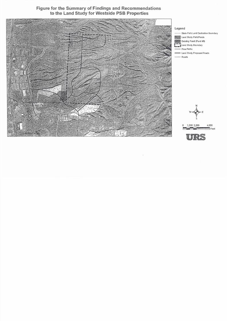
Figure for the Summary of Findings and Recommendations
to the Land Study for Westside PSB Properties
Legend
-- State Park Land DedicationRand Study Park/Ponds
_ Existing Pond (Pond #3)
/i'--Ibt_ULand Study Boundary
-- Row Paths
- Land Study Proposed Road
-- Roads
o 1,000 2,000 4
~~~__ ~~~~~~~,

8/7/2019 URS 2009 Westside Recommendations
http://slidepdf.com/reader/full/urs-2009-westside-recommendations 3/6
Technical Memorandum
Date: April 10, 2009
To: John E. Balliew, El Paso Water Utility
From: Nicole M Friedt, PE, CFM
Project: Drainage Review of Westside PSB Properties
Subject:Summary of Findings and Recommendations to the Land Studyfor Westside
PSB Properties
1.0 OVERVIEW
URS was contracted by the El Paso Water Utilities (EPWU) Public Service Board (PSB) to review the
drainage approach documented in the Land Study for Westside PSB Properties in the context of existing
and proposed development adjacent to the area covered by the Land Study, and against the documents
Mountains 10 River - A Green Infrastructure Plan For EI Paso, the City of EI Paso Drainage Design
Manual (DDM), and the City of El Paso Stormwater Master Pian (SNIP). The objective of this review is
to provide recommendations to EPWU on further efforts that may be required to update the Land Study.
As part of the review, URS met with EPWU staff along with representatives from City of EI Paso
Engineering, Development Services, and Parks & Recreation departments to discuss the drainage
approach, the development that has occurred since the Land Study in 2005, and any proposed
development expected within the vicinity of the site. URS also met with local land developers, Hunt
Communities and Plexxar, to discuss their plans for development within the area.
2.0 FINDINGS
URS met with local stakeholders during a series of meetings to determine how the Land Study would be
influenced by recent changes in regulations and development.
2.1 OPPORTUNITIES FOR SHARED STORMWATER FACILITIES
Hunt Communities owns a majority of the land immediately adjacent to the western and southwestern
boundaries of the Land Study. Another significant developer within the area is Plexxar. Together, Plexxar
and Hunt Communities have a development agreement for the area adjacent to the western boundary of
the Land Study. A majority of this area is currently undeveloped and due to recent changes in the
economic climate, development alternatives for the area are being reevaluated. However, there were
several consistent themes regarding drainage improvements for the development of the area. The two
main themes are detaining or retaining stormwater through ponding and the conveyance of stormwaterrunoff in natural arroyos by channelization.
2.1.1 Stormwater Detention/Retention
Hunt Communities recently completed construction of Pond #3 within the Lomas del Sol development.
Pond #3 falls on Flow Paths 38A and 38B, and is confined on the west by the PNG Pipeline and on the
east by the Land Study boundary, as outlined on the attached figure. The runoff from Flow Paths 38A and
38B enter the pond via rundowns. The location of the pond alters the configuration of the Flow Paths 38A
F INAL_T e ch n ic al Memo_2 009 AprLO .do c lof5 URS Project No. 41008816
C e nt ra l F il e L o c. 06 .03

8/7/2019 URS 2009 Westside Recommendations
http://slidepdf.com/reader/full/urs-2009-westside-recommendations 4/6
Technical Memorandum
and 38B where they leave the Land Study area. Additionally, due to it's proximity to the Land Study area,
there may be future potential to expand the limits of this pond into the Land Study area, and thus increase
its capacity, and have it serve duel purposes: to reduce runoff downstream and to detain the future
increased runoff from the Land Study developed area.
Hunt Communities and Plexxar envision the need for a pond on both Flow Paths 39 and 40 to allow for
development downstream along these reaches. There are no immediate plans for development or
construction of these ponds. However, both parties believe that a shared ponding facility or a series of
ponding facilities with the Land Study area would be preferred. Currently, the Land Study calls for a
park/pond to be located adjacent to flow paths and to Hunt property. Both parties noted that the proposed
location of the Land Study parkJponds fall on a 'ridge'.
2.1.2 Stormwater Conveyance Network
Due to the location of the Lomas del Sol Pond #3, the channel discharge locations for Flow Paths 38A
and 38B will need to align with the existing rundowns. During the design of the channels, the rundowns
should be evaluated to determine if improvements to the rundowns are needed as a result of the Flow
Paths being altered from their natural arroyo state.
It is currently anticipated that Flow Path 39 will be channelized downstream of the Land Study to allow
for development of the area. There are not immediate plans for improvements to Flow Path 40
downstream of the Land Study.
2.2 OPPORTUNITIES FOR OPEN SPACE
One of the key objectives by the local governing agencies within the City of E I Paso is to preserve and
maintain open space areas. The value of maintaining and preserving the natural drainage paths is
documented in the Green Infrastructure Plan for EI Paso as well as the SMP.
2.2.1 Natural Arroyos
Flow Paths 38A, 38B, and 40 are identified on a figure as 'Lands to Preserve' within the Open Space
Master Plan Recommendations section, page 5-8, of the Green Infrastructure Plan. However, these flow
paths are not specifically identified within any of the recommended open space preservation tables found
within the chapter. Based on discussions with the City of E I Paso Parks & Recreation Department, the
preference is to maintain natural arroyos upstream of the PNG pipeline with a particular emphasis on
maintaining Flow Paths 41 and 42 in their natural state.
2.2.2 Open Space
Figure 3- 1 of the Land Study indicates a large swath of open space proposed along the eastern boundaryof the study lands, adjacent to the Franklin Mountain State Park. This swath comprises a majority of the
recommended open space within the Land Study. This band is not currently required or prioritized within
any of the documents listed above and reviewed for this memorandum. However, recently a large portion
ofthis land has been dedicated to the Franklin Mountain State Park. The boundary of this dedication is
shown on the attached figure.
FINAL_Technical Memo_2009AprIO.doc 2of5 URS Project No. 41008816
Central File Loc. 06.03
8/7/2019 URS 2009 Westside Recommendations
http://slidepdf.com/reader/full/urs-2009-westside-recommendations 5/6
Technical Memorandum
2.2.3 Mountain to River Trail
The Parks and Recreation department provided URS with a Mountain to River Trail alignment that they
would like to see incorporated into the plan. The alignment currently goes east up Flow Path 42 from theRiver to the crest of the Franklin Mountains, where it follows the ridge south, crosses Trans-Mountain
Road, descends west down Flow Path 39 to where the flow path meander comes within close proximity to
Trans-Mountain Road, and then follows the Trans-Mountain Road Right-of-Way west.
The Trail Amenities Plan within the Land Study shows an undeveloped hike/bike trail following a similar
alignment. However, near the upper portion of Flow Path 39, the proposed trail heads south, opposite the
direction of the proposed Mountain to River Trail alignment. The Land Study should be updated to
incorporate the Mountain to River Trail alignment within the planning document.
2.3 COMPLIANCE WITH THE DRAINAGE DESIGN MANUAL
The City ofEI Paso issued the DDM as an official document authorized under the City ofEI PasoSubdivision Ordinance Chapter 19.19 Storm Water Management Requirements in June, 2008.
As noted in the Land Study, the flow paths traverse alluvial deposits with poorly defined channels. As
such, changes in flow path alignment and size are anticipated to occur over time. It is anticipated that the
flow paths could have been substantially altered as a result of the 2006 storm events that caused
significant flooding to west EI Paso. These drainage corridors through the Land Study area should be
reevaluated when the Land Study area progresses into the development phase.
2.3.1 Hydrology
The Land Study utilized the 1~O-year storm frequency for the hydrologic criteria. It is not clearly
identified within the Land Study what storm duration was used. Discussion with MCi noted that the
6-hour duration was used for the Land Study. The current criterion within the DDM is to use thel Otl-year, 24-hour storm for design of channels and ponding facilities.
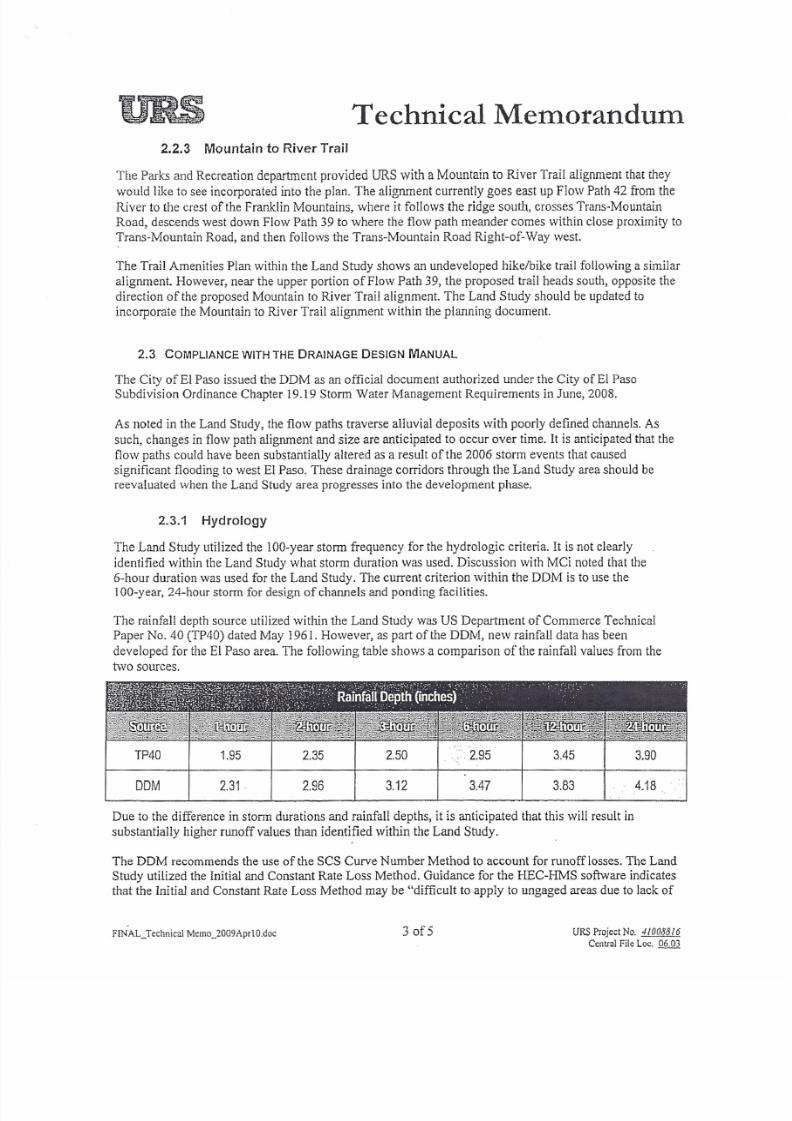
The rainfall depth source utilized within the Land Study was US Department of Commerce Technical
Paper No. 40 (TP40) dated May 1961. However, as part of the DDM, new rainfall data has been
developed for the El Paso area. The following table shows a comparison of the rainfall values from the
two source s.
TP40 2.35 . ·· ···2.95 3.90.95 2.50 3.45
4 .18 .D M 2 . 3 1 2.96 3.12 3.47 3.83
Due to the difference in storm durations and rainfall depths, it is anticipated that this will result in
substantially higher runoff values than identified within the Land Study.
The DDM recommends the use of the SCS Curve Number Method to account for runoff losses, The Land
Study utilized the Initial and Constant Rate Loss Method. Guidance for the HEC-I-nvIS software indicates
that the Initial and Constant Rate Loss Method may be "difficult to apply to ungaged areas due to lack of
FfNAL_Techn ic al M emo_2009AprlO .d oc 30f5 URS P roje ct N o. 41 008816
Cent ral F ile Loc, 06 .03

8/7/2019 URS 2009 Westside Recommendations
http://slidepdf.com/reader/full/urs-2009-westside-recommendations 6/6
Technical Memorandum
direct physical relationship of parameters and watershed properties" (pg. 51, USACE, HEC-HMS
Technical Reference Manual). No information was provided to determine if the loss rates used in the
analysis were developed for watersheds with similar characteristics. Closer evaluation of the development
of the loss rates identified within the Land Study is required to determine if they are applicable for the
area. For consistency with the DDM, utilization of the SCS Curve Number Method is recommended.
Due to the conceptual nature of the Land Study, the hydrologic results appear reasonable for the data used
in their development. However, the HEC- I hydrologic models were not available for detailed review for
this memorandum.
2.3.2 Hydraulics
The Land Study utilized topographic mapping dated 1996. Due to the braided nature of the natural flow
paths, it is anticipated that substantial changes to the channel configurations and alignments would have
occurred from 1996 to present. It is recommended that the HEC-RAS modeling be revised with current
topographic information at the time that the Land Study area progresses into the development phase.
Due to the conceptual nature of the Land Study, the hydraulic results are reasonable for the data used in
their development. However, the HEC-RAS models were not available for detailed review for this
memorandum.
2.4 CONSISTENCY WITH THE STORMWATER MASTER PLAN
The SMP was completed in early March 2009.
2.4.1 Recommended Improvement Projects
Along Flow Path 39, a sediment and detention basin is recommended for construction, as part of
improvement project NW5, within the area of the Land Study. It is recommended that the basin constrict
the peak flow to prevent capacity problems downstream. An additional benefit to the placement of this
proposed basin is to eliminate the localized split flow and direct flow in a predictable direction. The
location of this basin falls in the vicinity of a proposed park/pond in the Land Study. However, placement
of a sediment basin at this location will provide no sediment reduction benefit to the Land Study area.
Placement of the sediment basin further upstream should be evaluated. The sizing of the proposed
sediment basin within the SMP is conceptual in nature. Detailed evaluation of the sediment potential for
this flow path should be performed by a registered geologist.
Similar to Flow Path 39, a sediment and debris basin is recommended for construction, as part of
improvement project NW6, along Flow Path 40. The SMP currently locates this basin adjacent to the
Franklin Mountain State Park west boundary. This location would fall within the Open Space boundary of
the Land Study area. Again, the sizing of the proposed sediment basin within the SMP is conceptual in
nature. Detailed evaluation of the sediment potential for this flow path should be performed by a
registered geologist.
2.4.2 Identified Concerns
All flow paths crossing the Land Study area are identified as a 'potential sediment flow source' as shown
within Section 4, Figure 4-3 of the SMP. Detailed evaluation by a registered geologist will be necessary
FINAL_Technical Memo_2009AprlO.doc 4of5 URS Pro je ct N o. 41008816
Central File Lee. 06 .03
Related Documents