Chapter 9 Urban Development and Population Redistribution in Delhi: Implications for Categorizing Population Véronique Dupont l Metropolitan areas in Iodia are undergoing major transformations. This chapter focuses on the case of Delhi and highlights recent developments in urban forms and processes with a view to assessing the adequacy of local definitions and categorization of human settlements. The dynamics of the metropolitan area of Delhi will be analyzed from two interrelated perspectives: evolving urban form, focusing on the processes of periurbanisation and 'rurbanization', inc1uding expansion of suburbs, formation of new residential quarters in surrounding rural areas and the creation of satellite towns; population redistribution within the metropolitan area. Firstly the demographic and spatial dimensions of Delhi's metropolitan dynarnics in terms of population growth, distribution (and redistribution) and spatial expansion are analyzed. Then the factors contributing to urban deconcentration and outward expansion are examined. Sorne implications are drawn regarding categorizing population for further demographic analysis (reflecting upon the inadequacy of a simple rural/urban dichotomy), defining relevant limits for measuring urban growth and delimiting zones for the pUIpose of town and country planning. This analysis is based on two main sources of data: decennial population censuses (the most recent conducted in 2001), and a survey on population mobility conducted in 1995 complemented by indepth interviews and field visits (Dupont and Prakash, 1999). The survey inc1uded five peripheral zones that illustrate the The study presented here is part of a larger researeh program on spatial mobility and residential practiees of Delhi's population, and i15 effeet on the dynarnies of the metropolis. This prograrn has been finaneed by the Institut de Recherche pour le Développement (ex-ORSTOM) with additional funding from the CNRS within the frarnework of Action Concertée en Sciences Sociales (Coocerted Action in the Social Sciences) ORSTOM-CNRS and of PIR-Villes. In Iodia, the prograrn was eonducted with the collaboration and support of the Centre de Sciences Humaines based in Delhi (French Ministry of Extemal Affairs) and the Institute of Economie Growth (Delhi).

Welcome message from author
This document is posted to help you gain knowledge. Please leave a comment to let me know what you think about it! Share it to your friends and learn new things together.
Transcript
Chapter 9
Urban Development and PopulationRedistribution in Delhi: Implications for
Categorizing PopulationVéronique Dupontl
Metropolitan areas in Iodia are undergoing major transformations. This chapterfocuses on the case of Delhi and highlights recent developments in urban formsand processes with a view to assessing the adequacy of local definitions andcategorization of human settlements. The dynamics of the metropolitan area ofDelhi will be analyzed from two interrelated perspectives:
evolving urban form, focusing on the processes of periurbanisation and'rurbanization', inc1uding expansion of suburbs, formation of new residentialquarters in surrounding rural areas and the creation of satellite towns;population redistribution within the metropolitan area.
Firstly the demographic and spatial dimensions of Delhi's metropolitandynarnics in terms of population growth, distribution (and redistribution) andspatial expansion are analyzed. Then the factors contributing to urbandeconcentration and outward expansion are examined. Sorne implications aredrawn regarding categorizing population for further demographic analysis(reflecting upon the inadequacy of a simple rural/urban dichotomy), definingrelevant limits for measuring urban growth and delimiting zones for the pUIpose oftown and country planning.
This analysis is based on two main sources of data: decennial populationcensuses (the most recent conducted in 2001), and a survey on population mobilityconducted in 1995 complemented by indepth interviews and field visits (Dupontand Prakash, 1999). The survey inc1uded five peripheral zones that illustrate the
The study presented here is part of a larger researeh program on spatial mobility andresidential practiees of Delhi's population, and i15 effeet on the dynarnies of themetropolis. This prograrn has been finaneed by the Institut de Recherche pour leDéveloppement (ex-ORSTOM) with additional funding from the CNRS within thefrarnework of Action Concertée en Sciences Sociales (Coocerted Action in the SocialSciences) ORSTOM-CNRS and of PIR-Villes. In Iodia, the prograrn was eonducted withthe collaboration and support of the Centre de Sciences Humaines based in Delhi (FrenchMinistry of Extemal Affairs) and the Institute of Economie Growth (Delhi).
11- 2 New Forms ofUrbanization
dynamics of urban expansion, and covered a sample of 1249 households or 5981usual residents.
Delhi's Metropolitan Dynamics: Rapid Population Growtb and OutwardExpansion
Demographie and Spatial Growth ofDelhi Urban Agglomeration
The development of Delhi and its metropolitan area bears witness to a majortendency in the urbanization process in India: an increasing concentration of theurban population in metropolises of a million or more inhabitants.2 Yet, thedomination of the Indian urban scene by the bigger cities takes place within thecontext of a country which is predominantly rural and is likely to remain so in themedium term (in 1991 only 26 per cent of the population lived in urban areas, and28 per cent in 2001).3
The demographic evolution of Delhi during the 20th century is deeply markedby the country's turbulent history. Following the promotion of Delhi as the capitalof the British Indian Empire in 1911, the population ()f the city expanded from238,000 in 1911 to 696,000 in 1947, while quadrupling in area extent (Table 9.1).After Independence in 1947 Delhi became the capital of the newly fonned IndianUnion and had to face a massive transfer of population following the partition intoIndia and Pakistan. The 1941-51 period thus recorded the most rapid populationgrowth in the history of the capital-city, from almost 700,000 inhabitants in 1941to 1.4 million in 1951, corresponding to an annual growth rate of 7.5 per cent.Nevertheless, in the postîndependence period, the population growth of Delhi basbeen remarkably rapid for an urban agglomeration of this size, oscillating between
2In 1951, there were on1y 5 cities or urban agg10merations (see next note) with one millionor more inhabitants, accounting for 19 per cent of the total urban population of thecountry; in 2001 there were 35, accounting for 38 per cent of the total urban population.
3The definition of an 'urban unit' or town that has been applied since the 1961 Census ofIndia is as follows:a) AlI places which answer to certain administrative criteria, such as the presence of amunicipality, a corporation, a cantonment board, a notified town area committee, etc.These are called the statutoI)' towns.b) AlI other places which satisfy the following three criteria: i) a minimum population of5,000 inhabitants; ii) at 1east 75 per cent of the male working population engaged in nonagricultural pursuits; iii) and a population density of at 1east 400 persans per sq. km. Theseare called the census towns.In addition, the concept of urban agglomeration was introduced at the time of the 1971Census and remained unchanged in the 1981 and 1991 Censuses: 'An urbanagg1omeration is a continuous urban spread canstituting a town and its adjoining urbanoutgrowths, or two or more contiguous towns together and any adjoining urbanoutgrowths of such towns.' For the census of 2001, two other conditions were added: 'thecore town or at 1east one of the constituent towns of an urban agg1omeration shouldnecessary he a statutOI)' town and the total population of aIl constituents shou1d not be lessthan 20,000 (as per 1991 Census).'

Urban Development andPopulation Redistribution in Delhi 11- 3
4 per cent and 5 per cent per year, to reach 12.8 millions in 2001. Since 1961 Delhihas been the third largest Indian urban agglomeration, overshadowed only byMumbai and Kolkata.
Table 9.1 Population, area and density of Delhi Urban Agglomeration*from 1901 to 2001
Population Area DensityDecennial Annual
DecennialYearNumber growth growth Square growth Popl
rate rate km hectare% %
rate %
1901 214,1l5 n.a.1911 237,944 11.3 1.06 43.25 551921 304,420 27.94 2.49 168.09 288.64 181931 447,442 46.98 3.93 169.44 0.80 261941 695,686 55.48 4.51 174.31 2.87 401951 1,437,134 106.58 7.52 201.36 15.52 711961 2,359,408 64.17 5.08 326.55 62.07 721971 3,647,023 54.57 4.45 446.26 36.76 821981 5,729,283 57.09 4.62 540.78 2U7 1061991 8,419,084 46.94 3.92 624.28 15.44 1352001** 12,791,458 51.93 4.27 791.92 26.85 162
* In addition to the urban area circumscribed within the statutory boundaries of the city (thethree statutory towns corresponding to the Municipal Corporation of Delhi, the NewDelhi Municipal Council and the Cantonment Board), the urban agglomeration of Delhicomprises contiguous urban entities and extensions falling beyond these statu10ryboundaries. The limits of the urban agglomeration are redefined at each census in order 10take into account the MOSt recent urban extensions.
** Provisional results for population figures; area was estimated on the basis of thepublished census maps.
Source: CensusofIndia,Delhi, 1951, 1961, 1971, 1981, 1991 and 2001
The population growth was concurrent with a spatial expansion in alIdirections, inc1uding to the east of the Yamuna river. The official area of the urbanagglomeration was almost multiplied by four between 1951 and 2001 (Table 9.1);and its share in the total area of the National Capital Territory of Delhi4 (covering1483 sq. km) increased from 14 per cent to 53 per cent. Delhi's geographicsituation, in the Gangetic plain, and more particularly the absence of any realphysical barrier to urban progression (the Aravalli Bills - the Delhi Ridge - to thewest and south do not constitute an effective obstacle), have favored themultidirectional spreading of the urbanized area (Figure 9.1).
4The National Capital Terri10ry of Delhi is an administrative and political entity: aTerri10ry of the federaI Union of India, identified by the Constitution of 1949; itsboundaries are fixed (Figure 9.1) and correspond to the ancient Province of Delhi underthe British rule in India.

Figure 9.1
New Forms ofUrbanization
Spatial expansion of urbanized zones in the Delhi metropolitanarea from 1950 to 1997
___ Boundaries of the National Capital Territory of Delhi
-- __ -" Limits of Delhi Urban Agglomeration (1991 Census)
• Zones urbanized belere 1950
• Zones urbanized between 1950 and 1969n5
Ozones urbanized between 1969n5 and 1997
Sources: Survey of India,1950, scala 1:63,360,Survey of India,1970. 1976, 1980, scale 1:50,000,Image IAS1-e 1997.'Map of Delhi' in Census of India 1991, District Census Handbook, Delhi,Directorale of Census Operation, Delhi;'Delhi Metropolilan Area' in Masler Plan for Delhi, Perspective 2001,Delhi Development Authority, New Delhi, August 1990.
Inrerpretation: Bemard Lorlic . lADDigirized map: LCA· lAD (Bondy)
o!
10km1
© V. Dupont. IRD
Urban Development and Population Redistribution in Delhi 1'1-5
Contribution ofMigration to the Population Growth ofDelhi
Migration has played a major role in the demographic evolution of the capital.Following the partition of the country, Delhi whose population was about 900,000in 1947, had to receive 495,000 refugees from Pakistan, while 329,000 Muslimsleft the capital.5 In the postindependence era, migration continued to have asignificant contribution to urban growth although it slowed down in the eighties.Migrants with less than 10 years of residence accounted for 62 per cent of thepopulation of the National Capital Territory of Delhi in 1971,60 per cent in 1981,and it dec1ined to 50 per cent in 1991.6
Although the majority of migrants in Delhi come from rural areas, as many as44 per cent of the total migrants residing in the Territory of Delhi in 1991 werefrom urban areas: this underlines the specifie pull effect of a big rnetropolis in apredominantly rural country. Over two thirds of all migrants living in Delhi in1991 were from neighboring states in North India: Haryana, the Punjab, Rajasthanand Uttar Pradesh (Dupont, 20QOb).
An estimation of the respective share of the three components of urban growth(natural increase, net inmigration and reclassification of the urban/rural populationdue to changes in the spatial delimitation of the urban area) in the Territory ofDelhi was attempted for the 1971-81 intercensal period by the National Institute ofUrban Affairs (NIUA, 1988). It was estimated that: natural increase contributed for35 per cent to the total urban population growth, net inmigration for 41 per centand reclassification of population for 25 per cent. However, as the data are notavailable to estimate the three components of growth in recent years estimates aremade based on the following assumptions. Since the population of the NationalCapital Territory is mostly concentrated in the urban agglomeration of Delhi (90per cent in 1971 and 93 per cent in 2001), and the area of the Territory constant, anestimation of the two components of population growth (natural increase and netmigration) for the entire Territory provides a good approximate of the populationdynamics of the urban agglomeration. We attempted this exercise for the last threedecades: the average annual rate of naturaI growth for each intercensal period wascomputed on the basis of estimated rates provided by the Sample RegistrationSystem, and the contribution of net migration deducted as the residual from thetotal growth rate (Table 9.2). The estimated results not only confinn the crucialcontribution of migration to the population growth of the National CapitalTerritory, but also suggest that this contribution did not slow down during the lastdecade (1991-2001).
Source: Ministry of Rehabilitation, Annual Report on Evacuation, Relief andRehabilitation ofRefugees, 1954-55 (quoted in Datta, 1986).
6Since the 1971 Census, migrants are those who had resided in a place outside the place ofenumeration.
Table 9.2
New Forms ofUrbanization
Contribution of natural growth and net migration to the totalpopulation growth of the National Capital Territory of Delhi,1971-2001
Intercensal period
1971-811981-911991-2001*
* Provisional results
Average annualrate ofgrowth
(%)4.344.243.88
Average annualrate of naturalgrowth (%)
2.112.131.70
Average annualrate of net
migration (%)2.232.112.18
Source: Census of India and Sample Registratioo System
Differentiais in Population Growth andDensities Within the Territory ofDelhi
Differentiais within the urban agglomeration The overaIl demographic change inDelhi urban agglomeration conceals differences within the urban area. Between198J and 1991, the pattern ofgrowth in Delhi was 'c1early centrifugai' (Dupontand Mitra, 1995), continuing the trend highlighted by Brush (1986) for the 1961-71decade. Absolute decrease in population, indicating important net outwards moves,has occurred in the historical city core known as Old Delhi and the population hasalso declined in sorne parts of New Delhi (the area corresponding to the newcapital built by the British). On the other hand, the highest growth rates above 10per cent were recorded in neighborhoods of the outskirts (Figure 9.2).
During the 1991-2001 decade, these trends persisted. The depopulation of theold city area continued (-1.91 per cent in ten years). Population growth has alsobeen very low in New Delhi district (only +2.47 per cent in ten years), whereas. thedistricts including the peripheral zones of the urban agglomeration have recordedhigher decadal growth (for example: +62.52 per cent in the North East district,+61.29 per cent in the South-West district, and +60.12 per cent in the North-Westdistrict).
In 1991, the highest population densities were registered in the historical citycore: 616 persons per hectare on an average (740 in 1961) in the Walled City ofShajahanabad, established by the Mughals in the 171b century and covering an areaof almost 600 hectares. The old city also has a high concentration of commercialand small-..scale indus1rial activities with a rnixed land use pattern typical oftraditional Indian cities. On the other hand, New Delhi, the area planned in the1910s and 1920s according to a garden city model, had an average density of only70 persons per hectare. The Delhi Cantonment, which includes military land andthe international Airport, recorded an even lower density of 22 persons per hectare.The average population density in the urban agglorneration was 135 persons perhectare. The classical model of population density gradients, characterized by highdensities in the urban core, and a sharp decline towards the periphery, and whose
Urban Development and Population Redistribution in Delhi R-7
'original causes (...) can be summed up in three words: protection, prestige, andproximity' (Brush, 1962, p. 65), had largely survived in Delhi until1991.
Notable changes in the distribution of population densities have taken placeover the 1991-2001 period. For the first time, the highest residential densities arenot recorded in the old city core, but in two northeastern teshils (administrativedivisions below the district level): Shahdara (422 persons per hectare) andSeemapuri (402 persons per hectare), while in Old Delhi and its adjoiningneighborhoods densities are now lower than 350 persons per hectare. The lowestdensity is recorded in a teshil of New Delhi district (32 persons per hectare inChanakyapuri, a high status residential area where 1l}any embas.sies' quarters arealso located).
A more refined analysis of the pattern of population growth and changes indensity during the last decade was not permiued by the data available until now(mid 2002). Furthermore, 15 out of the 27 new teshils constituting the Territory ofDelhi in 2001 inc1ude both rural and urban areas; it is thus not possible at presentto test whether the official limits of the urban agglomeration are relevant in termsof rural/urban differentials in the sociodemographic and economic characteristicsof the concerned populations. Even after the forthcoming publication of the resultsof the 2001 census at the ward level, the comparison between 1991 and 2001 at thelevel of a fine spatial division will not be possible for ordinary census data's users,due to sorne changes in boundaries of spatial divisions and the lack of publishedinformation about the correspondence between the former and the newclassification. This difficulty that we already encountered for the previous censusesis compounded by the absence of published maps showing the basic spatialdivisions. There is a lack of concordance allowing accurate intercensalcomparisons of settlement classification.
Two distinct migration processes are contributing to the rapid populationgrowth in peripheral areas of Asia's megacities. One involves new inmigrants tothe city and the other natives of Delhi or migrants of longer standing livingpreviously in inner zones of the urban agglomeration, and who moved to newresidential sites. The 1995 survey of population mobility in the Delhi metropolitanarea allows us to evaluate the respective contribution of the two types of moves.We will focus here on three peripheral neighborhoods, which illustrate thedynamics of sett1ement in zones that have recorded a rapid population growth andinclude various types of housing estates and ditTerent income groups. These are:
Tigri, a working class neighborhood, with high residential density located inthe southern periphery.Badli-Rohini, an extensive zone located in the west-northern periphery,including an industrial area, and housing low and middle income groups; itspopulation density in 1991 was stilliow.Mayur Vihar-Trilokpuri, a residential zone located in the eastern periphery,including a large variety of housing estates, corresponding to a range ofincome groups; the population densities of the zone in 1991 varied frommiddle to very high.
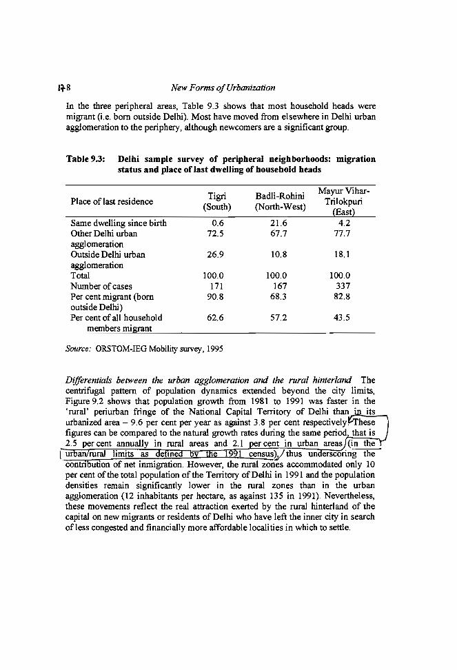
1~8 New Forms ofUrbanization
In the three peripheral areas, Table 9.3 shows that most household heads weremigrant (i.e. born outside Delhi). Most have moved from elsewhere in Delhi urbanagglomeration to the periphery, although newcomers are a significant group.
Table 9.3: Delhi sample survey of peripheral neighborhoods: migrationstatus and place of last dwelling of househoJd heads
Tigri Badli-RohiniMayur Vihar-
Place oflast residence Trilokpuri(South) (North-West)
(East)Same dwelling since birth 0.6 21.6 4.2Other Delhi urban 72.5 67.7 77.7agglomerationOutside Delhi urban 26.9 10.8 18.1agglomerationTotal 100.0 100.0 100.0Number ofcases 171 167 337Per cent migrant (born 90.8 68.3 82.8outside Delhi)Per cent of all household 62.6 57.2 43.5
members migrant
Source: ORSTOM-IEG Mobility survey, 1995
Differentiais between the urban agglomeration and the rural hinterland Thecentrifugal pattern of population dynamics extended beyond the city limits,Figure 9.2 shows that population growth from 1981 to 1991 was faster in the'rural' periurban fringe of the National Capital Territory of Delhi than· itsurbanized area - 9.6 per cent per year as against 3.8 per cent respectîvely. hesefigures can be compared to the natural growth rates during the same period that is2.5 per cent annually in rural areas and 2.1 er cent in urban areas (in the
1ur rural limits as e me 991 censusV thus un erscoring thecontn ution of net inmigration. However, the rural zones accommodated only 10per cent of the total population of the Territory ofDelhi in 1991 and the populationdensities remain significantly lower in the rural zones than in the urbanagglomeration (12 inhabitants per hectare, as against 135 in 1991). Nevertheless,these movements reflect the real attraction exerted by the rural hinterland of thecapital on new migrants or residents of Delhi who have left the inner city in searchofless congested and financially more affordable localities in which to settle.

Figure 9.2
Urban Development andPopulation Redistribution in Delhi Ho 9
Annual growtb rate of the population from 1981 to 1991 in theNational Capital Territory of Delhi, by census divisions
N
Î
Annual growth rate of the populationIrom 1981 to 1991 (%)
"[10,36[
.17,10[
1:::::::1 [4 7 [::::::: '
CJ[2,4[
IHl (0,2[
D[-3.5,0(
Boundaries of the NationalCapital Territory of Delhi
Limits of urban zonesaccording to 1991 census
Surveyed zones:
CD Tigri
o Badli-AohiniCD Mayur Vihar-Trilokpuri
Sourr:a of data: Census ollndia, District Census Handbook, Delhi, 1981 & 1991,Directorate of Census Operation, Delhi.
Digitized mapLCA - lAD (Bondy)
o1
51
10 km1
© V. Dupont. lAD
180 New Forms ofUrbanization
This process of periurbanisation around the capital is also expressed ineconomic terms, insofar as the composition of the working population residing inthe rural zones of the Territory of Delhi is doser to that of the national urbanpopulation than the rural population. Thus, in 2001, only 11 per cent of theworking population were employed in agriculture, as compared with 73 per cent inIndian rural areas and 8 per cent in the urban.
Although the administrative limits of the Delhi urban aggIomeration have beenextended several times (Table 9.1), the rapid growth of the rural population in theNational Capital Territory as weIl as changes in its economic charaeteristicsunderline the discrepancy between the administrative demarcation of urban Delhiand the real pattern of urban development. This points towards the development ofa transitional periurban type of area around the Indian capital, as observed in othermegacities of Asia (Ginsburg, Koppel and Mc Gee, 1991). Yet, the dichotomousclassification ofhuman settlements in India does not recognize this development.
The RapidDevelopment ofPeripheral Towns
The slowing down of the population growth rate in the urban agglomeration ofDelhi during the eighties as compared to the previous decades was not the result ofa decline in the rate of natural increase.7 There was deliberate planning from the1960s onward to develop towns on the periphery of Delhi to accommodatepopulation growth; eventually these areas grew faster than the centralagglomeration of Delhi (Table 9.4). The urban sprawl has followed the main roadsand railway lines, hence connecting the builtup area of the core city - Delhi - withthat of the peripheral towns, leading 10 the development of a multinodal urban area(Figure 9.1). The inappropriateness of CUITent definitions of urban agglomeration isshown by the faet that the continuous urban spread of Delhi overlaps State borders.The presently contiguous ring towns of Delhi are located in other states (UttarPradesh and Haryana) and are not considered as being part of the Delhi urbanagglomeration whose actual population size is thus underestimated by more thantwo millions (Table 9.4).
7According 10 estimates from the Sample Registration System, the average natural rate ofincrease in the urban areas of Delhi was 2.0 per cent per year from 1971 to 1980, and 2.1per cent from 1981 10 1990.
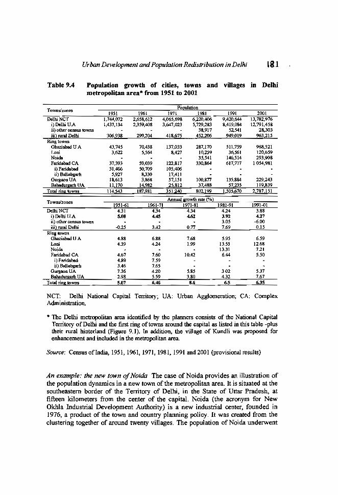
Table 9.4
Urban Development andPopulation Redistribution in Delhi '81
Population growtb of cities, towns and villages in Delhimetropolitan area"" from 1951 to 2001
Town~zonesPopulation
1951 1961 1971 1981 1991 2001Delhi NCT 1,744,072 2,658,612 4,065,698 6.220,406 9,420,644 13,782,976
i)Delhi UA 1,437,134 2,359,408 3,647,023 5,729,283 8,419,084 12,791,458ii) other census 1I>wns 38,917 52,541 28,303iii) rural Delhi 306,938 299,204 418,675 452,206 949,019 963,215
RingtownsGhaziabad U A 43,745 70,438 137,033 287,170 511,759 968,521Loni 3,622 5,564 8,427 10,259 36,561 120,659Noida 35,541 146,514 293,908Faridabad CA 37,393 59,039 122,817 330,864 617,717 1054,981
i) Faridabad 31,466 50,709 105,406ii) Ballabgarh 5,927 8,330 17,411
GurgaonUA 18,613 3,868 57,151 100,877 135,884 229,243Bahadurgarh UA 11,170 14,982 25,812 37,488 57,235 119,839
Total ring 1I>wns 114.543 187,981 351.240 802,199 1,505,670 2,787,151
Town~zonesAnnual growth rate (%)
1951-61 1961-71 1971-81 1981-91 1991-01DelhiNCT 4.31 434 4.34 424 3.88
i)Delhi U.A S.OS US 4.62 3.92 4.27ii) other census 1I>wns 3.05 -6.00iii) rural Delhi -0.25 3.42 0.77 7.69 0.15
Ring 1I>wnsGhaziabad U A 4.88 6.88 7.68 5.95 6.59Loni 4.39 424 1.99 13.55 12.68Noida 13.31 721Faridabad CA 4.67 7.60 1D.42 6.44 5.50
i) Faridabad 4.119 7.59ii) Ballabgarh 3.46 7.65
GurgaonUA 7.36 420 5.85 302 537Bahadurgarh UA 2.98 5.59 3.80 432 7.67
Total ring 1I>wns 5.07 6.46 S.6 6.5 6.35
NCT: Delhi National Capital Territory; UA: Urban Agglomeration; CA: ComplexAdministration.
• The Delhi metropolitan area identified by the planners consists of the National CapitalTerritory of Delhi and the first ring oftowns around the capital as listed in this table -plustheir rural hinterland (Figure 9.1). In addition, the village of Kundli was proposed forenhancement and included in the metropolitan area.
Sourçe: CensusofIndia, 1951, 1961, 1971, 1981,1991 and 2001 (provisionalresults)
An example.- the new town ofNoüia The case of Noida provides an illustration ofthe population dynamics in a new town of the metropolitan area. It is situated at thesoutheastem border of the Territory of Delhi, in the State of Uttar Pradesh, atfifteen kilometers from the center of the capital. Noida (the acronym for NewOkhla Industrial Development Authority) is a new industrial center, founded in1976, a product of the town and country planning policy. 1t was created from theclustering together of around twenty villages. The population of Noida underwent

182 New Forms ofUrbanization
very rapid growth during the 1980s and the 1990s, to reach 294,000 in 2001 (Table9.4).
According to the 1995 Mobility survey, in the town as a whole (including theoriginal villages, the planned areas and the sIums), 69 per cent of the householdswere headed by a migrant, this figure rises to 89 per cent in the new plannedsectors and 99 per cent in the sIums. A majority of all migrants (56 per cent) hadarrived directly from outside the Delhi-Noida conurbation. Among the householdsnot having always lived in the same dwelling, 33 per cent were living earlieroutside the Delhi-Noida conurbation, 39 per cent in Delhi itself (56 per cent amonghouseholds in the new planned sectors) and 27 per cent in a different dwelling inNoida. The acquisition ofa house or of an apartment was the reason for 44 per centof the last changes of residence from Delhi or a different dwelling in Noida (66per cent for the households of the planned sectors), and better or cheaper housingconditions for 41 per cent of them. These figures show to what extent the power ofattraction of the new industrial center extends beyond the metropolitan area ofDelhi, and they also testify to a manifest influx of population from the capital,arising out of considerations related to housing.
Consequently, about one fourth of Noida's working inhabitants commute dailyto work outside their town of residence, this proportion undergoing large variationsaccording to the sector ofhousing (1995 Mobility survey; Dupont, 2001a). AImostall workers living in the sIums (98 per cent) work in Noida. It is the attraction ofemployment opportunities offered by this new industrial center that has made themmigrate. But among those residing in the planned sectors, only 52 per cent work inNoida, the rest commuting to Delhi. Thus, for a notable section of its population,Noida is merely a satellite town of the capital, playing the role ofa dormitory.
Processes ofOutward Expansion: Contributing Factors and Variety of UrbanForms
The pattern of population distribution and growth is related to a number of factors:patterns of landuse, the availability and price of land or residential property, andthe accessibility of employment opportunities and urban services. If this last factorhelps explain the centripetaI force of the past, the actual centrifugaI tendency iscertainly associated with the scarcity of land for new residential constructions andits consequent appreciating value in central areas. The less congested peripheralzones provide more aiIordable housing possibilities, as weIl as more accessiblesites for squatting. The expansion of the urban periphery is the outcome of theinteractions between planning attempts and private initiatives and responses.
The Planned Development of Peripheral Zones: The Role of the DelhiDevelopment Authority and ofRegional Planning
The evolution of Delhi and its region have been strongly influenced by a town andcountry planning policy initiated in the late fifties, and that was prompted by thedesire to control the growth of the capital and to curb inmigration flows by
Urban Development and Population Redistribution in Delhi IB3
reorienting them towards other towns in the region. Within the capital itself, thisinteIVentionist policy was given concrete shape by means of a master plan, the firstof its kind in India, implemented in 1962. Particularly restrictive land controlmeasures were taken, housing programs were launched, while sorne old centralquarters and siums were destroyed and their inhabitants resettled in peripheralareas. However, these measures did not prevent a high level of speculation in landand proliferation of informal - considered as 'illegal' - quarters (the 'squattersettlements' and 'unauthorized colonies').
The Delhi Development Authority (DDA), the central administration createdin 1957, responsible for the elaboration and the execution of the Master Plan, hasplayed a direct role in the urban spread of the capital. The DDA set aside large landreseIVes, primarily through the acquisition of agricultural lands geared towards theimplementation ofvarious land development and housing programs:
the construction of blocks of flats for sale to private households of differentincome groups;the development ofland and the allotment of plots on a 99 year leasehold basisto private households and cooperative group housing societies;the servicing and allotment of land for the resettlement of sium dwellers andsquatters evicted from central areas of the city. This policy which resorted tocoercive measures was pursued most actively during the 'Emergency' (197577) during which time about 700,000 persons were forcibly displaced to'resettlement colonies' located on the urban outskirts (Ali, 1990, 1995; Tarlo,2000).
In sorne cases, these schemes were part of large-scale projeets aimed atdeveloping new peripheral zones and leading to the creation of satellite townships(Rohini, Dwarka-Papankala, and more recently Nare1a subcity) planned to receiveup to one million inhabitants or more (Jain, 1990, Chapter 7).
The 1995 Mobility sUIVey indicated that the housing and plot allotrnentsschemes of the DDA benefited mostly households which were already settled inDelhi. For instance, in Mayur Vihar, 85 per cent of the households sUIVeyed in theDDA flats moved from another dwelling located in Delhi as did 97 per cent amongthose sUIVeyed in blocks of flats built by cooperative group housing societies. InRohini, 92 per cent of the households surveyed in the planned sector had followeda sirnilar residential trajectory. Thus, these public urban development programshave contributed more to the redistribution of the population within the urbanagglomeration, than to the direct attraction of new migrants, in spite of theemergence of a significant private rentai sector among this segment of the housingstock.8
In the sample of dwellings surveyed in Mayur Vibar, 19 per cent of the DDA flats wererented (including accommodation provided by the employer) as were 49 per cent amongthe apartments of the co-operative sector; in Rohini, 16 per cent of the dwellings surveyedin the planned sector were occupied by renters.
New Forms ofUrbanization
At the regional level, planning policy laid emphasis 00 the promotion ofperipheral towns through the strengthening of their economic base, including thecreation of the new industrial town ofNoida. The first Master Plan of Delhi (1962)introduced the concept of metropolitan area, that encompassed the Territory ofDelhi and the towns located within a radius of35 kilometers around the capital andwhose demographic and economic development was interdependent with that ofDelhi and involved large-scale commuting. The developmeot of the metropolitanarea was further integrated within the larger planning framework of the NationalCapital Region, a region covering around 30,000 sq. km., and provided with aplanning board since 1985 (NCR Planning Board, 1988). However, the initialstress put on the promotion of the first ring of towns eventually strengthened theattraction of the whole metropolitan area and iotensified commuting within it(NID1\, 1988). Due to their proximity to the capital, these ring towns did notemerge as autonomous, alternative growth centers, and most of them can beconsidered satellite towns, alleviating housing problems in the capital, but exertinga heightened pressure on its amenities.
In the late 1980s, however, a new strategy of regional planning aimed atpromoting regiooal urban centers situated beyond the metropolitan area, at adistance large enough to discourage daily interactions with the capital. It isproposed to develop beyond the borders of the National Capital Region, fiveregional metropolises as countennagnets to intercept future migratory inflowstowards the metropolitan region (NCR Planning Board, 1988, 1996).
InformaI Urbanization of the Periphery: A Classic Pattern Among the Poor inMetropolises ofDeveloping Countries
Public housing policies have failed to meet the needs of large sections of the urbanpopulation, in particular the lower-middle classes and the poorer whô have had toresort to the infonnal housing sector.
Unauthorized colonies on agricultural land The proliferation of unauthorizedcolonies has contributed in a decisive way to the urbanizatioo of the rural fringes ofDelhi. These estates involve agricultural land not meant for urbanization, boughtfrom farmers by unscrupulous real estate developers who indulge in illegalsubdivisioning and selling ofunserviced plots. In 1983, 736 unauthorized colonieswere enumerated, housing an estimated population of 1.2 million, that is almost 20per cent of the population of the capital (Billand, 1990, pp.2-7); in 1995, theirofficial number had reached 1300 (Government ofNCT ofDelhi, 1996, p.II), andtheir total population in 1998 was estimated at about 3 millioos.9
These housing estates are not recognized by the municipality and therefore donot have the benefit of its services. Authorities have repeatedly introducedregularization procedures to legalize these unauthorized colonies. However, it
9Estimation provided by Common Cause, a citizens' association that took the matter ofunauthorised colonies to the Delhi High Court, against their regularisation.
Urban Development and Population Redistribution in Delhi 185seems that this policy has had the perverse effect of indirectly encouraging thedevelopment of new unauthorized colonies, since prospective buyers hope theirsettlement would obtain regular status in the future, thereby guaranteeing the longtenn economic profitability oftheir investments.
Initially, these colonies appealed 10 lower to middle income groups, peoplewhose limited resources meant that they could not rent or buy in the legal housingmarket and were prepared to accept limited utilities and resources. In order to maketheir investment profitable the new house owners often rent out one or severalrooms, or one story, in their house, hence contributing to the increasing residentialdensities ofthese colonies.
The unauthorized colonies surveyed in Mayur Vihar were almost ail occupiedby migrant households lO (they represent 92 per cent ofhouseholds according to the1995 Mobility survey). Arnong the migrants, 44 per cent arrived directly from atown or village situated outside the capital, and 56 per cent lived previously inanother locality (or several) within the Delhi urban agglomeration. Three quarters
had occupied another dwelling in Delhi before settling in the present one.In spite of a significant rentai sector (37 per cent of the households surveyed in thistype of quarters are tenants), the unauthorized colonies of Mayur Vihar are mainlya place of resettlement within the urban agglomeration, rather than a place of initialreception for new migrants.
Squatter settlements on vacant land The poorer sections of the urban populationlive in squatter settlements (Iocally calledjhuggi-jhonpri), which have continued toproliferate despite the 'sium clearance' policy (Ali and Singh, 1998; Majumdar,1983; Suri, 1994). In 1999, about 600,000 families Iived in a thousand ofjhuggi-jhonpri c1usters which varied in size from a dozen dwelling units 10 12,000; thesesquatter settlements altogether housed about 3 million persons or 20 to 25 per centof the total population of Delhi. ll Though squatter settlements are foundthroughout of the capital, insinuating themselves into ail the interstices of the urbanfabric wherever there is vacant land and where surveillance by the legal authoritiesis limited,12 the two biggest c1usters are located on the periphery, on what was stillthe urban-rural fringe at the initial time oftheir occupation. The population densityin squatter camps can be very high owing to the cramming together of families inone-room huts and very narrow lanes. In many squatter settlements, the structuresare reinforced and further extended by the frequent addition of a story to respond tofamilies' expansion, but also for rentai purposes. A process of increasingresidential density is at work in quarters already crowded and lacking basicinfrastructure and access to services.
Delhi's squatter settlements shelter mostly migrant households attracted by theemployment opportunities provided by the city. Yet, ail the migrants have not
10By 'migrant household' we mean household whose head is a migrant.
11Sium and Jhuggi Jhonpri Department, Municipal Corporation of Delhi.
12Numerous evictions of squatter settlements in 2000-2001 are however likely 10 havealtered this spatial pattern.
116 New Forms ofUrbanization
settled directly in their present squatter settlement upon their arrivaI in the capital.A significant proportion among them - that vary from one sIum to the other,depending on its specific history - have stayed previously in another place in Delhi(this was the case for 38 per cent of the migrants surveyed in the Tigri jhuggijhonpri camp, and 70 per cent of those surveyed in the jhuggi-jhonpri clusters ofBadli-Rohini - according to the 1995 Mobility survey). Often, the residentialtrajectory of the sIum dwellers is marked by eviction from one place, squat inanother one, until they are evicted again and eventually sent to a resettlementcolony. They may also move on their own to a better location, in the vicinity ofemployment sources (adjoining for instance an industrial area, like in BadliRohini).
Deconcentration ofthe Rich to the Rural Fringe
Residential strategies aimed at gaining access to more space and a betterenvironment outside the city proper have seen many move to Delhi's periphery andthe processes of periurbanisation and rurbanization have proceeded apace. 13 Giventhe lack of a mass transit system in the capital and its metropolitan area, it is thetremendous increase in private means of transportation that has allowed theemergence of residential estates in distant rural mnges suitable only for those whocan afford the price of commuting daily by car, or who compensate for theincreased transport cost by the cheaper housing costs. Two resulting types of urbanform have developed in the rural fringes: 'farmhouses', and large-scale housingschemes.
The farm hooses The deconcentration of upper-class families to the rural fringeshas created competition for land use, in particular in the southern agricultural beltwhere numerous 'farm houses' have been built (Soni, 2000). As they were initiallygenuine farms within agricultural lands, such zones are governed by planningregulations applying to farmlands, seeking to limit the builtup area in relation tothe natural green and cultivated spaces. The agricultural nature of such lands is,however, often distorted. Luxurious, sprawling villas, surrounded by large parksand protected by high walls have become the fashion instead. Usually, 'farmhouse' owners are people from the top income bracket who have been able to buildhavens of tranquility on the outskirts of one of the most polluted capitals of theworld.
Large-scale housing schemes The direct control exercised by the Delhiadministration on land suitable for urbanization has induced sorne private realestate developers to implement large-scale housing schemes outside the limits of
13Rurbanisation is understood here as 'the fixation in peri-urban countryside of residencesof city dwellers, the interweaving of rural and urban spaces', that is, 'one of the forms ofperi-urbanisation', without 'continuity between the town and the rurbanised countryside'(George, 1993, pAIl).
Urban Development andPopulation Redistribution in Delhi 187
the National Capital Territory of Delhi, often weil beyond the perimeter of itsurban agglomeration. The informal urbanization of the fringes of the capital hasalso prompted planners in the bordering states to intervene according to a differentstrategy, allowing private building societies to acquire large tracts of land in theframework of their master plans. These residential projeets are designed for wellto-do city dwellers, looking for a better quality of life. Thus, sorne propertydevelopers make use of the very outlying character of these new residential areasto emphasize the rustic 'green' nature of the fringe areas to attract high incomesettlers from central Delhi (Dupont, 2001b).
The 1995 Mobility survey conducted in the largest residential complex ofthistype, DLF Qutab Enclave, located 23 kms away from the center of Delhi near thesouthem ring town of Gurgaon provides insight into the population dynamicsassociated with this mode of periurbanisation. The peopling of this residentialneighborhood beginning in the 1980s resulted mainly from a deconcentrationmovement within the capital. Thus, 65 per cent of the inhabitants had livedpreviously in Delhi itself, only 9 per cent in the town of Gurgaon or itssurroundings, and 26 per cent outside of the metropolitan area of Delhi (althoughsorne of them had already familial or professional links with the capital).14 Thehigh status of the area is reflected in the fact that nearly three quarters of thehouseholds own their house or flat. Financial considerations are also involved here:the cost of plots or dwellings being more atTordable here than in neighbourhoodsof comparable standing in the capital. Nevertheless, the environmentalconsiderations are also important in the choice of residential location by settlers inthe area (Dupont, 2001 b).
The indispensable condition for having access to real estate outside the capitaland to a better environment, is the possession of a personal vehicle to makepossible daily journeys to distant workplaces, to realize certain types of shoppingand to maintain one's social network through visiting. About half of the gainfullyemployed inhabitants surveyed in DLF Qutab Enclave worked in Delhi proper,while half of the students attended a school or university in Delhi; yet, at the sametime, bus services, either public or chartered by the developers, were stilllimited.
The construction of business and commercial centers has supplemented thedevelopment of residential complexes in this decentralized area, and the spatialexpansion of the builtup area over largely spread zones is now combined withclusters of high-rise buildings in a similar way to the edge cities (Garreau, 1991) ofthe United States. The scale of the development schemes and the rapidity oftransformation of this peripheral zone of Delhi has seen its rural componentsquickly shrink (Dupont, 1997). In the early years of the development, thediscontinuity of builtup area between the city and these residential quarters in therural fringes was much more pronounced than today, and the countryside more
14To compute these percentages, we have excluded the persons who have lived in the samedwelling since their birth (i.e. the children boro after their family moved to DLF QutabEnclave), representing 2.5 percent of the residents (out of a total sample of 566residents).
188 New Forms ofUrbanization
present. The extension of the urban fabric and the increasing density ofconstruction has altered the panorama, contracted the rural space while encirclingthe village cores, and in the years to come these housing estates will beprogressively transformed into a continuous suburb. This illustrates the difficultyin 'demarcating urban and rural spaces' and in 'distinguishing what is continuoussuburb and discontinuous periurban' in a context of rapid urban growth common tonumerous metropolises in the developing countries (Steinberg, 1993, pp. 10-11).
Increasing Density and Transformation ofthe 'Urban' Villages
The process of urban expansion involves the annexation of agricultural land andthe absorption of the surrounding villages in the urban agglomeration. Over the1901-91 period, 185 new villages were incorporated within the limits of Delhiurban agglomeration (Diwakar and Qureshi, 1993), and 17 others during the 19912001 decade (Census of India, 2001). Many ofthese urbanized villages (designated'urban villages' by the planners) appear like spontaneously developed enclaveswithin highly planned areas. They are subject to very great pressures on land andimportant transformations oftheir economic functions, morphology and population(Sundaram, 1978, p.1I5; Lewis and Lewis, 1997, pp. 26-7, 30-1; Tari0, 1996,Chapter 9; Bentick, 2000). The habitat is transformed in response to the housingneeds of numerous migrants with low incomes who find in the urban villages rent1evels which are less than in the other planned areas of the capital. These urbanvillages enjoy a special status, and remain outside the purview of most townplanning rules, the objective being to preserve the original identity of village lifeand its traditional values. There is thus no restriction on the type of constructionerected nor on the type of activity conducted in these zones. Paradoxically, thisspecial status has accelerated the transformation of the original village nucleii. Ithas encouraged their commercialization and the proliferation of small industrialworkshops, by offering to entrepreneurs working space at rents lower than in therecognized commercial or industrial zones, while at the same time avoiding thecontrols of the municipality. The manifold increase of economic activities has alsoattracted a working c1ass of laborers who live if possible in the villages, thuscontributing to an increased density of population and of housing.
The case of Rarola, a village enc10sed in the new industrial town of Noida isexamined in detail elsewhere (Dupont, 2001a). This urbanized village exemplifiesin a spectacular way the radical transformations that may occur in the context ofdisruptions in sources of livelihood and in the local labor market, combined to ahigh demand for rentai lodging, in the absence of restriction on constructions.Although the town authorities have deployed an active housing policy in Noida, wesee borne out there a situation that is classic to cities in developing countries. Thisis the lack of any central measure in the rental sector, which is left entirely touncontrolled private initiative.
The population dynamics in urban villages are exemplified in the 1995Mobility survey in the peripheral zones of Mayur Vihar-Tri10kpuri and BadliRohini, as weIl as in the new town of Noida. In these areas the urban villages arethe on1y type of settlement where one can find household heads who have been
Urban Development andPopulation Redistribution in Delhi r89living in the same dwelling since their birth. Yet, there are still significantpercentages of migrant households in the urban villages (22 per cent in BadliRohini, 28 per cent in Noida, and 67 per cent in Mayur Vihar) indicating thatnewcomers contribute to the current dynamics at work .
Implications for Categorizing Population
The processes that underlie urban development in the metropolitan area of Delhicontribute to an interweaving of urbanized zones and countryside, as well as to ablurring of the distinction between rural and urban population categories. This isespecially evident at the fringes of megacities like Delhi. The continuousgeographical expansion of the urban agglomeration of Delhi entails, first of ail, aphysical integration of urban and rural spaces through the incorporation of villagesin the urbanized zone. The process of periurbanisation and rurbanization aroundDelhi is also expressed by a functional integration of the metropolis and newresidential neighbourhoods established in the rural fringes, without (necessarily)continuity of builtup space (at least during the initial phase of emergence of theseoutlying c1usters). The daily commuting of the new dwellers in the rural-urbanfringe between their decentralized housing estates and the centers of employmentin the capital reflects the link of economic dependency between the differentspaces.
However, the functional integration of urban and rural spaces is also at work inthe central urban agglomeration of Delhi due to the continuous inmovement ofconsiderable flows of migrants, main1y from rural origins. Although we have notelaborated on this aspect here, these migrants usually maintain relations of adiverse nature (economic, social, emotional, etc.) with their native place (BaneIjee,1986; Basu, Basu and Ray, 1987; Dupont, 2000a); their life space transcends theurban/rural borders, exceeding the limits of the city to incorporate their homevillages. Thus, the integration of urban and rural spaces extends beyond thegeographic continuum through circular movements of individuals (commuters aswell as migrants) between the different places with which they have relations(Dupont and Dureau, 1994).
The integration of urban and rural spaces, physical and functional, alsoinduces a crossing, a certain symbiosis, of urban and rural characters ofpopulations and the emergence of composite identities. Many inhabitants ofmetropolitan areas (like that of Delhi) appear to be neither exclusively urban, norexclusively rural, whether it be a matter of populations in the rural fringes in theprocess of urbanization, of commuters from rural hinterland, of city dwellers whohave shifted their residences into the surrounding rural zones or, of migrants stilllinked to their native villages. 15
l~
The fact that Many individuals, by virtue of their multipolar residential and work spaces,and the effect of circulation, are neither exclusively urban nor exclusively rural, has been

Igo New Forms ofUrbanization
The process of Delhi's metropolization must be viewed as a system ofreciprocal influences: on the one hand the urbanization of peripheral zones and ofsUITounding rural populations, as weil as the introduction of urban goods,infonnation, ideas, social and cultural values and behavioral patterns in farawayvillages through circulating or returning migrants. On the other hand, a certainrura1ization of the metropolis and of its inhabitants is occurring, through ruralmigrants importing their original values and behavioral patterns, and retainingthem to sorne extent in the city. This influences demographic behavior, Iikepatterns of nuptiality and fertility. Thus, constructing population categories thatwould be based on the criterion of a single place of residence at the time ofobservation proves to be too reducing for apprehending the spatial distributionpattern of populations and forfurther demographic analysis.
In order to analyze pluri-polar residential spaces, sorne authors haveintroduced the notion of intensity or density of residence (poulain, 1985; Dureau,1987) and tried to apprehend the residential space understood as a system ofresidence, a spatiotemporal configuration defined in relation to the various placesof stay and the density of residence in each one of them (Barbary and Dureau,1993). Yet, in the context of populations exposed to intense commuting, thegeographical and social environment of the workplace may exert an influence assignificant as - or even more significant than - the place(s) of residence of theindividuals to expIain sorne demographic behaviors.
A longitudinal approach proves also to be necessary in order to understand apattern of behavior at a given time. Rather than the place of residence, or even thesystem of residence, of an individual at the time of observation, what matters moreto explain hislher demographic behavior, is the duration of stay in successiveplaces and the successive modifications of hislher system of residence. Sorne ofthese issues have been tackled by life history surveys and event history analysis indemography (GRAB, 1999).
One should also be able not only 10 characterize the settlement patternprevailing in the residential space of reference at each step of the individual lifecourse, but a1so to take into account the transformations undergone by thesespaces. In this perspective, one specific difficulty for demographic analysis in thecontext of many metropolises of developing countries, as in the case of Delhi, isthe speed of urban spread and transfonnations, especially in the urban-ruralfringes.
This is a1so a difficulty for urban and regional planning: the evolution of theIndian capital and of the towns on its periphery shows sorne growing discrepanciesbetween the objectives of the planners and the actual development of themetropolitan area.
The rapidity of the urbanization process in the 'rural' hinterland alsoinvalidates the pertinence for demographic analysis of the administrative limits ofthe Delhi urban agglomeration, despite their periodic redefinition. The rise of atransitional periurban type of area around the Indian capital further underscores the
acknowledged for a long time by several authors. In the Asian and Pacifie eontext, see,among others: Goldstein, 1978; Hugo, 1982; Chapman and Prothero, 1983.

Urban Development and Population Redistribution in Delhi 1'1
inadequacy of the dichotomous classification of human settlements in India and theneed for the recognition of an intermediary category between rural and urban.
At the level of the National Capital Region, the distinction made between threeplanning zones (the Territory of Delhi, the ring towns in the metropolitan area, andthe zone beyond the metropolitan area), runs the risk of becoming an obsoletetheoretical distinction, overtaken by the rate at which the actual dynamics at workare evolving. In particular, the development of a multinodal quasi-continuousurban area caUs for a revision of the limits of the Delhi urban agglomeration, inorder to encompass the contiguous towns located beyond the National CapitalTerritory borders.
References
Ali, S. (1990), Siums within Siums. A Study ofresettlement Colonies in Delhi. New Delhi:Har-Anand and Vikas, 114 pp.
Ali, S. (1995), Environment and Resettlement Colonies ofDelhi, New Delhi: Har-Anand,140 pp.
Ali, S. and Singh, S.N. (1998), Major Problems of Delhi Siums, New Delhi: UppalPublishing House, 148 pp.
BaneIjee, B., (1986). Rural to Urban Migration and the Urban Labour Market. A CaseStudy ofDelhi, Delhi: Himalaya Publishing House, 285 pp.
Barbary O. and Dureau, F. (1993). 'Des citadins en mouvement Analyse des pratiquesrésidentielles à Quito (Equateur)', Cahiers des Sciences Humaines, Vol. 29(2-3), pp.395-418.
Basu, A., Basu, K. and Ray, R. (1987), 'Migrants and the Native Bond. An Analysis ofMicro-Level Data from Delhi', Economie and Political Weekly, Vol. XXII (19-20-21),Annual Number, May, pp. AN-145-54.
Bentick, 1. (2000), Unruly Urbanization ofthe Delhi 's Fringe. Changing Patterns ofLandUse and Livelihood, Rijksuniversiteit Groningen, Netherlands Geographical Studies,270,190 pp
Billand Ch. (1990), Delhi Case Study: Formai Serviced Land Development, New Delhi:USAID.
Brush,1. (1962), 'The Morphology ofIndian Cities', India's Urban Future. Roy TURNER(ed), Berkeley and Los Angeles: University ofCalifornia Press, pp. 57-70.
Brush, 1. (1986), 'Recent Changes in Ecological Patterns of Metropolitan Bombay andDelhi', in V.K. Tewari, lA. Weistein, V.L.S.P. Rao (eds), Indian Cities. EcologicalPerspectives, New Delhi: Concept, 1986, pp. 121-49.
Chapman, M. and Prothero, R.M. (1983), 'Themes on Circulation in the Third World',International Migration Review, Vol 17 (4), pp. 597-632.
Diwakar, A. and Qureshi, M.R. (1993), 'Physical Processes of Urbanization in Delhi',Urban India, Vol. XIII (2), pp. 94-106.
Datta V.N. (1986), 'Panjabi refugees and the urban development of Greater Delhi', in R.E.Frykenberg (ed.), Delhi through the ages. Essays in urban history. culture and society,Delhi: Oxford University Press, pp. 442-460.
Dupont, V. (1997) 'Les "rurbains" de Delhi', Espace. Populations, Sociétés, No. 2-3, pp.225-40.
New Forms ofUrbanization
Dupont, V, (2000a), 'Residential and Economic Strategies of Houseless People in Delhi', inV. Dupont, E. Tarlo and D. Vidal (eds), Delhi. Urban Space and Human Destinies,Delhi: Manohar-CSH, pp. 99-124.
Dupont, V. (2000b), 'Spatial and Demographic Growth of Delhi and the Main MigrationFlows', in V. Dupont, E. Tar10 and D. Vidal (eds), Delhi. Urban Space and HumanDestinies, Delhi: Manohar - CSH, pp. 229-239 +13 maps.
Dupont, V. (2001a), 'Noida: nouveau pôle industriel ou ville satellite de Delhi? Le projetdes planificateurs, ses Failles et son devenir', Revue Tiers Monde, No. 165, JanvierMars 2001, pp. 189-211.
Dupont, V. (2001b), 'Les nouveaux quartiers chics de Delhi. Langage publicitaire et réalitéspériurbaines', in H. Rivière d'Arc (ed.), Nommer les nouveaux territoires urbains,Paris, Editions UNESCO/Editions de la Maison des Sciences de l'Homme, 2001, pp.39-61
Dupont, V. and Dureau, F. (1994), 'Rôle des mobilités circulaires dans les dynamiquesurbaines. Illustrations à partir de l'Equateur et de l'Inde', Revue Tiers Monde, Vol.XXXV (140), pp. 801-29.
Dupont, V. and Mitra, A. (1995), 'Population Distribution, Growth and Socio-economicSpatial Patterns in Delhi. Findings from the 1991 Census Data', Demography India,Vol. 24 (1 and 2), pp. 101-32.
Dupont, V. and Prakash, 1. (1999), 'Enquête: Mobilités spatiales dans l'aire métropolitainede Delhi', in Biographies d'enquDte, Paris: INED-PUF/Diffusion, Coll. Méthodes etsavoirs, pp. 279-315.
Dureau, F. (1987), Migration et urbanisation. Le cas de la Côte d'Ivoire, Paris: ORSTOM,Coll. Etudes et Thèses, 654 pp.
Garreau,1. (1991), Edge City: Lift on the New Frontier, New York: Doub1eday.George, P. (1993), Dictionnaire de la géographIe, 51h edition, PUF, Paris, 499 pp.Ginsburg, N., Koppe1, B. and McGee, T.G. (1991), The Extended Metropolis: Settlement
Transition in Asia, Honolulu: University of Hawaï Press, 339 pp.Go1dstein, S. (I978), Circulation in the Context of Total Mobility in Southeast Asia', Paper
of the East-West Population Institute N° 53, Honolulu, East-West Population Institute,69 pp.
Government of National Capital Territory of Delhi (Planning Department) (1996),'Backgrounder', State Leve1 Seminar on Approach to Ninth Five Year Plan (19972002), Delhi: GovernmentofNational Capital Territory ofDelhi, December 1996.
GRAB - Groupe de Réflexion sur l'Approche Biographique (1999), BIOgraphies d'enquDte.Bilan de 14 collectes biographiques, Paris: INED-PUF/Diffusion, Coll. Méthodes etsavoirs, 340 pp.
Hugo, G. (1982), 'Circular Migration in Indonesia', Population and Development Review,Vol. 8(1), pp. 59-83.
Jaïn, A.K., (1990) The Making ofa Metropolis. Planning and growth ofDelhi, New Delhi:National Book Organisation, 283 pp.
Lewis, Ch. and Lewis, K. (1997), Delhi's Historie Villages. A Photographie Evocation,Delhi: Ravit Dayal Publisher, 150 pp.
Majumdar, T.K. (1983), Urbanising the Poor. A Sociological Study ofLow-Income MigrantCommunities in the Metropolitan City of Delhi. New Delhi: Lancers Publishers, 278pp.
NCR Planning Board (1988), Regional Plan 2001, National Capital Region, Delhi: NationalCapital Region Planning Board, Ministry ofUrban Deve10pment, Government ofIndia,167 pp.
NCR Planning Board (1996), National Capital Region. Growth and Development, NewDelhi: Har-Anand, 272 pp.
Urban Development and Population Redistribution in Delhi
NIUA (1988), National Capital Region. A Perspective on Patterns and Process ofUrbanization, Research Studies Series No 29, National Institute of Urban Affairs, NewDelhi, 56 pp.
Poulain, M. (1985), 'La Migration, concept et méthodes de mesure', Migrations Internes.Méthodes d'observation et d'analyse, Louvain: UCL, pp. 7-38.
Sidhu, M. (1995), 'Survey on Spatial Mobi1ities in the Metropo1itan Area of Delhi. WorkingPaper No. 2: Residential Profùe of the Studied Areas', ORSTOM-IEG, New Delhi, 143p.mimeo.
Soni, A., (2000), 'The Urban Conquest of Outer Delhi: Beneficiaries, lntennediaries andVictims. The Case of the Mehrauli CounlIyside', in V. Dupont, E. Tarlo and D. Vidal(eds), Delhi. Urban Space andHuman Destinies, Delhi: Manohar-CSH, pp. 75-94.
Tarlo, E. (1996), Clothing Matters. Dress and Idenmy in India, London: C. Hurst and Co.,360 pp. ('Fashion Fables in an Urban Village', Chapter 9, pp. 284-317).
Tarlo, E. (2000), 'Welcome 10 Histo1)': A Resttlement Colony in the Making', in V. Dupont,E. Tarlo and D. Vidal (eds), Delhi. Urban Space and Human Destinies, Delhi:Manohar-CSH, pp. 51-74.
Steinberg, 1. (1993), 'Le périurbain: définition, délimitation et spécificité', Métropolisationet périurbanisation, Cahiers du CREPIF, No. 42, Paris: Université de Paris Sorbonne,pp. 9-17.
Sundaram, K.V. (1978), 'Delhi: the National Capital', in P.P. Misra (00.), Mil/ion Cities ofIndia, New Delhi: Vikas Publishing House, pp. 105-54.
Suri, P. (1994), Urban Poor. Their Housing Needs and Govemment Response, Delhi: HarAnand Publications, 293 pp.
Source of Population Statistics
Census oflndia, 1951, 1961, 1971, 1981, 1991,2001.Census of lndia 1951, Punjab Population Sub-zone, General Population, Age and Social
Tables.Census oflndia 1961, Volume XIX, Delhi, Migration Tables.Census ofIndia 1971, Series 27, Delhi, Migration Tables.Census of lndia 1971, Series 27, Delhi, District Census Handbook, Delhi: Directorate of
Census Operations, 1972.Census of lndia 1981, Series 28, Delhi, District Census Handbook, DelhI: Directorate of
Census Operations, 1983.Census of India 1981, Series 28, Delhi, Migration Tables, Socio-cultural Tables.Census of lndia 1991, Series 31, Delhi, District Census Handhook, Village and Townwise
Primai)' Census Abstract, Delhi: Directorate of Census Operations, 1992.Census oflndia 1991, Series 31, Delhi, Migration Tables, Social and Cultural Tables, Delhi:
Directorate of Census Operations (on floppies).Census of India 2001, Series-8 Delhi, Provisional Population Totals, Paper 1 of 2001,
JINDGAR Bimla, Directorate ofCensus Operations, Delhi.Census of India 2001, Series-8 Delhi, Provisional Population Totals, Paper 2 of 2001:
Rural-Urban Distribution of Population, JINDGAR Bimla, Directorate of CensusOperation, Delhi.
Sample Registration System, Sample Registration Bul/etin, Office of the Registrar General,Vol. 6 (1972) 10 Vol. 35 (2001).
New Forms ofUrbanization:Beyond the Urban-Rural
Dichotomy
Edited by
TONY CHAMPIONSchool ofGeography, Politics and Sociology,
University ofNewcastle upon Tyne, United Kingdom
and
GRAEMEHUGODepartment ofGeographical and Environmental Studies,
University 0/Adelaide, Australia
for
International Union for the Scientific Study of Population
AshaatlAldershot • Burlington • Singapore • Sydney
© Tony Champion and Graeme Hugo 200,,"
AlI rights reserved. No part of this publication may be reproduced, stored in aretrieval system, or transmitted in any form or by any means, electronic,mechanical, photocopying, recording, or otherwise without the prior permission ofthe publisher.
Published byAshgate Publishing LimitedGowerHouseCroft RoadAldershotHants GUll 3HREngland
Ashgate Publishing Company131 Main StreetBurlington, VT 05401-5600 USA
British Library Cataloguing in Publication Data
Library of Congress Cataloging-in-Publication Data
ISBN 0754635880
Related Documents