FACIES 40 197-210 PI. 25 13 Figs. 4 Tab. ERLANGEN 1999 Upland Interfluve (Doab) Deposition: Alternative Model to Muddy Overbank Deposits Indra Bit Singh, Pradeep Srivastava, Shikha Sharma, Maneesh Sharma, Dhruv Sen Singh, Govindaraja Rajagopalan, Lucknow and Urea Kant Shukla, Nainital KEYWORDS: UPLAND INTERFLUVE - OVERBANK - FLOODPLAIN - MUDDY FLUVIAL DEPOSIT - GANGA PLAIN (INDIA)- QUATERNARY TO RECENT Summary Major alluvial plains contain large tracts of fine- grained muddy sediments, deposited away from the main river channels, which are mostly classed as overbank or floodplain deposits. Systematic study of the Ganga plain shows that such large tracts of deposition of muddy sediments are located several metres above the major channels, and are not flooded by overtopping of the major river channels. These surfaces are here designated as upland interfluve areas (Doab) where deposition of fine-grained sediments takes place independent of the processes operating in the main channels. The surfaces show distinct depositional domains with characteristic deposits. These include higher sloping surfaces (mottled silt), lower flat surfaces (variegated clayey silt), gulleys (sandy silt), small channels (mottled silty sand), ponds (shelly sandy clayey silt), lakes (shelly clayey silt). These deposits are prone to diagenetic changes, espe- cially the development of calcrete horizons. Redistribu- tion of these domains through time produces character- istic mud-dominant alluvial stratigraphy as observed in the Late Quaternary deposits of the Ganga plain. This succession shows similarity to mud-dominant deposits of the Siwalik succession. These Doab deposits are distinct from the overbank deposits formed close to the river channels affected by channel processes. It is argued that many of the thick mud-dominant fluvial deposits of the ancient fluvial record are products of deposition in upland interfluve areas. I Introduction Interfluve areas in most of the fluvial basins are Iow- 1 ying features showing development of floodplain, swamps and ponds. These areas are typically located at lower elevations than the river channels, hence they receive flood waters from the channels during high discharges and depo- sition takes place as crevasse-splays, and suspended fallout in the low-lying flood basins. These deposits are usually designated as overbank, or floodplain deposits, and studied by a few workers in modern sediments (SMITH & PEREZ- ARLUCEA 1994, TYE • COLEMAN 1989a, b, FARRELL 1987, RAY 1976, SINGH 1972). In the Ganga plain, most of the rivers are incised and possess rather narrow active floodplains (S~GH 1987, 1992, 1996 a,b). A distinctive landform of the Ganga plain consists of wide interfluve (interchannel) areas, situated tens of metres above the major river channels and beyond the reach of their floods. These upland interfluve areas of the Ganga plain are mostly described as Doab (meaning between two waters). They are densely populated and produce a distinc- tive landscape. Commonly these areas are also erroneously, referred to as floodplains and confused with the low-lying interchannel flood basins. Our study of the Ganga plain shows that these areas are to be described as upland inter- fluve areas (Doab), in contrast to the Iowland floodplain. The upland interfluve areas (Doab) show diverse deposi- tional systems, independent of the processes operating in the major river channels. The deposits of these areas are mud- dominant successions, which resemble the overbank or mud-dominant floodplain deposits; but have their own dis- tinctive features. In this paper, we describe deposits of the upland interfluve areas (Doab) of the Ganga plain. Compari- son with the muddy deposits of the Siwalik succession shows that such deposits may comprise significant propor- tions of some ancient alluvial sequences. 2 The Upland Interfluve (Doab) of the Ganga Plain The Ganga plain is an oversupplied and underfilled type of peripheral foreland basin where fluvial sedimentation is Addresses: Prof. Dr. I. B. Singh (Present address - Institute of Geology and Mineralogy, University of Erlangen-N0rnberg, Schlossgarten 5, D-91054 Erlangen), P. Srivastava, S. Sharma, M. Sharma, D. S.n Singh, Department of Geology, Lucknow University, Lucknow-226 007. Dr. U. K. Shukla, Department of Geology, Kumaun University, Nainital-263 002. Dr, G. Rajagopalan, Birbal Sahni Institute of Palaeobotany, Lucknow-226 007.

Welcome message from author
This document is posted to help you gain knowledge. Please leave a comment to let me know what you think about it! Share it to your friends and learn new things together.
Transcript

FACIES 40 197-210 PI. 25 13 Figs. 4 Tab. ERLANGEN 1999
Upland Interfluve (Doab) Deposition: Alternative Model to Muddy Overbank Deposits
Indra Bit Singh, Pradeep Srivastava, Shikha Sharma, Maneesh Sharma, Dhruv Sen Singh, Govindaraja Rajagopalan, Lucknow and Urea Kant Shukla, Nainital
KEYWORDS: UPLAND INTERFLUVE - OVERBANK - FLOODPLAIN - MUDDY FLUVIAL DEPOSIT - GANGA PLAIN (INDIA)- QUATERNARY TO RECENT
Summary
Major alluvial plains contain large tracts of fine- grained muddy sediments, deposited away from the main river channels, which are mostly classed as overbank or floodplain deposits. Systematic study of the Ganga plain shows that such large tracts of deposition of muddy sediments are located several metres above the major channels, and are not flooded by overtopping of the major river channels. These surfaces are here designated as upland interfluve areas (Doab) where deposition of fine-grained sediments takes place independent of the processes operating in the main channels. The surfaces show distinct depositional domains with characteristic deposits. These include higher sloping surfaces (mottled silt), lower flat surfaces (variegated clayey silt), gulleys (sandy silt), small channels (mottled silty sand), ponds (shelly sandy clayey silt), lakes (shelly clayey silt). These deposits are prone to diagenetic changes, espe- cially the development of calcrete horizons. Redistribu- tion of these domains through time produces character- istic mud-dominant alluvial stratigraphy as observed in the Late Quaternary deposits of the Ganga plain. This succession shows similarity to mud-dominant deposits of the Siwalik succession. These Doab deposits are distinct from the overbank deposits formed close to the river channels affected by channel processes. It is argued that many of the thick mud-dominant fluvial deposits of the ancient fluvial record are products of deposition in upland interfluve areas.
I Introduction
Interfluve areas in most of the fluvial basins are Iow- 1 ying features showing development of floodplain, swamps and ponds. These areas are typically located at lower
elevations than the river channels, hence they receive flood waters from the channels during high discharges and depo- sition takes place as crevasse-splays, and suspended fallout in the low-lying flood basins. These deposits are usually designated as overbank, or floodplain deposits, and studied by a few workers in modern sediments (SMITH & PEREZ- ARLUCEA 1994, TYE • COLEMAN 1989a, b, FARRELL 1987, RAY 1976, SINGH 1972).
In the Ganga plain, most of the rivers are incised and possess rather narrow active floodplains (S~GH 1987, 1992, 1996 a,b). A distinctive landform of the Ganga plain consists of wide interfluve (interchannel) areas, situated tens of metres above the major river channels and beyond the reach of their floods. These upland interfluve areas of the Ganga plain are mostly described as Doab (meaning between two waters). They are densely populated and produce a distinc- tive landscape. Commonly these areas are also erroneously, referred to as floodplains and confused with the low-lying interchannel flood basins. Our study of the Ganga plain shows that these areas are to be described as upland inter- fluve areas (Doab), in contrast to the Iowland floodplain. The upland interfluve areas (Doab) show diverse deposi- tional systems, independent of the processes operating in the major river channels. The deposits of these areas are mud- dominant successions, which resemble the overbank or mud-dominant floodplain deposits; but have their own dis- tinctive features. In this paper, we describe deposits of the upland interfluve areas (Doab) of the Ganga plain. Compari- son with the muddy deposits of the Siwalik succession shows that such deposits may comprise significant propor- tions of some ancient alluvial sequences.
2 The Upland Interfluve (Doab) of the Ganga Plain
The Ganga plain is an oversupplied and underfilled type of peripheral foreland basin where fluvial sedimentation is
Addresses: Prof. Dr. I. B. Singh (Present address - Institute of Geology and Mineralogy, University of Erlangen-N0rnberg, Schlossgarten 5, D-91054 Erlangen), P. Srivastava, S. Sharma, M. Sharma, D. S.n Singh, Department of Geology, Lucknow University, Lucknow-226 007. Dr. U. K. Shukla, Department of Geology, Kumaun University, Nainital-263 002. Dr, G. Rajagopalan, Birbal Sahni Institute of Palaeobotany, Lucknow-226 007.
198
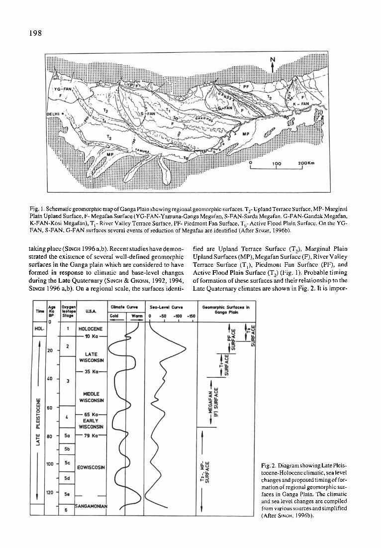
Fig. I. Schematic geomorphic map of Ganga Plain showing regional geomorphic surfaces. T 2- Upland Terrace Surface, MP- Marginal Plain Upland Surface, F- Megafan Surface (YG-FAN-Yamuna-Ganga Megafan, S-FAN-Sarda Megafan, G-FAN-Gandak Megafan, K-FAN-Kosi Megafan), T t- River Valley Terrace Surface, PF- Piedmont Fan Surface, T 0- Active Flood Plain Surface. On the YG- FAN, S-FAN, G-FAN surfaces several events of reduction of Megafan are identified (After SiNtm, 1996b).
taking place (S~6H 1996 a,b). Recent studies have demon- strated the existence of several well-defined geomorphic surfaces in the Ganga plain which are considered to have formed in response to climatic and base-level changes during the Late Quaternary (SINcH & GHOSH, 1992, 1994, S~6H 1996 a,b). On a regional scale, the surfaces identi-
fied are Upland Terrace Surface (T2), Marginal Plain Upland Surfaces (MP), Megafan Surface (F), River Valley Terrace Surface (Tl), Piedmont Fan Surface (PF), and Active Flood Plain Surface (T 2) (Fig. 1). Probable timing of formation of these surfaces and their relationship to the Late Quaternary climates are shown in Fig. 2. It is impor-
Fig. 2. Diagram showing Late Pleis- tocene-Holocene climatic, sea level changes and proposed timing of for- mation of regional geomorphic sur- faces in Ganga Plain. The climatic and sea level changes are compiled from various sources and simplified (After SINGH, 1996b).
199
\
,.. JLUCKNOW ' ~ " ~ r ~ ''~" ^ ~ ~'L,.
rc,,-.,.-Lr
t~
0 50 Km I I l I r l:
, . ~ r
H �9 %
= i
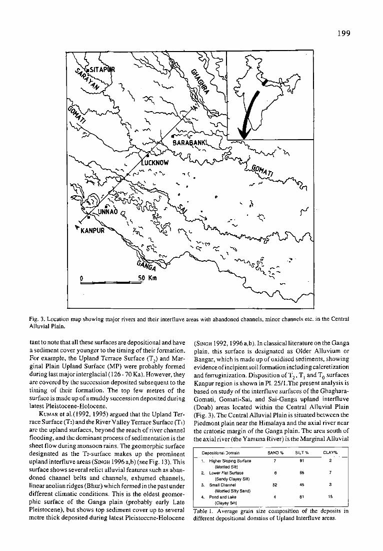
Fig. 3. Location map showing major rivers and their interfluve areas with abandoned channels, minor channels etc. in the Central Alluvial Plain.
tant to note that all these surfaces are depositional and have a sediment cover younger to the timing of their formation. For example, the Upland Terrace Surface (T2) and Mar- ginal Plain Upland Surface (MP) were probably formed during last major interglacial (126 - 70 Ka). However, they are covered by the succession deposited subsequent to the timing of their formation. The top few metres of the surface is made up of a muddy succession deposited during latest Pleistocene-Holocene.
KUMAR et a1.(1992, 1995) argued that the Upland Ter- race Surface (T2) and the River Valley Terrace Surface (T t) are the upland surfaces, beyond the reach of river channel flooding, and the dominant process of sedimentation is the sheet flow during monsoon rains. The geomorphic surface designated as the T2-surface makes up the prominent upland interfluve areas (SINoH 1996 a,b) (see Fig. 13). This surface shows several relict alluvial features such as aban- doned channel belts and channels, exhumed channels, linear aeolian ridges (Bhur) which formed in the past under different climatic conditions. This is the oldest geomor- phic surface of the Ganga plain (probably early Late Pleistocene), but shows top sediment cover up to several metre thick deposited during latest Pleistocene-Holocene
(SINGH 1992, 1996 a,b). In classical literature on the Ganga plain, this surface is designated as Older Alluvium or Bangar, which is made up of oxidised sediments, showing evidence of incipient soil formation including calcretization and ferruginization. Disposition of T 2 , T] and T O surfaces Kanpur region is shown in PI. 25/I .The present analysis is based on study of the interfluve surfaces of the Ghaghara- Gomati, Gomati-Sai, and Sai-Ganga upland interfluve (Doab) areas located within the Central Alluvial Plain (Fig. 3). The Central Alluvial Plain is situated between the Piedmont plain near the Himalaya and the axial river near the cratonic margin of the Ganga plain. The area south of the axial river (the Yamuna River) is the Marginal Alluvial
Deposittonal Domain SAND % SILT % CLAY%
1. Higher Sloping Surface 7 91 2 (Mottled Silt)
2. Lower Flat Surface 8 85 7 (Sandy Clayey Silt)
3. Small Channel 52 45 3 (Mottled Silty Sand)
4. Pond and Lake 4 81 15 (Clayey Silt)
Table 1. Average grain size composition of the deposits m different depositional domains of Upland Interfluve areas.
2 0 0
m. U
E
I-- 3:
LU "I"
12::
sw
130 -
120
110
100 + ,
0 Z 3 ( .1.,)
. . . I
i
G~,NGA GOMATI
NE
. . . . . .T
0 20 r 60 80 100 120 Ir
A DISTANCE (Kin) A ~
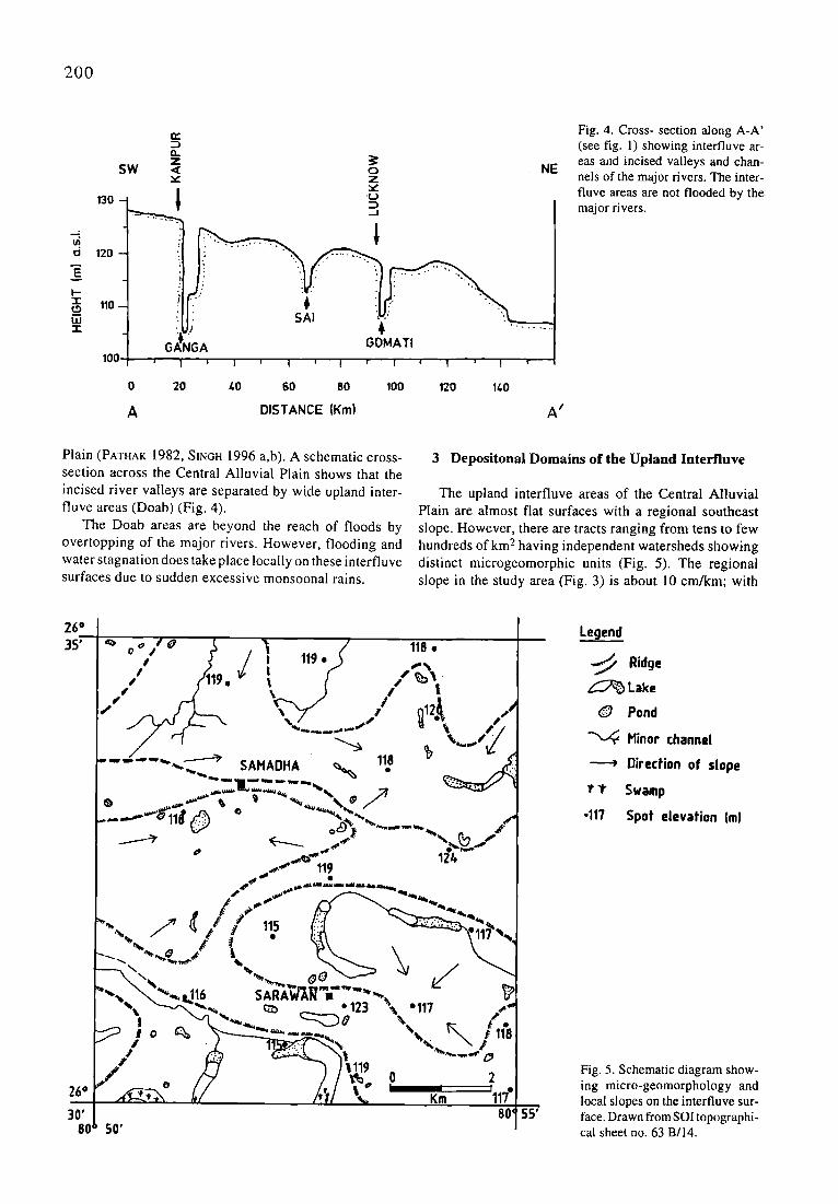
Fig. 4. Cross- section along A-A' (see fig. 1) showing interfluve ar- eas and incised valleys and chan- nels of the major rivers. The inter- fluve areas are not flooded by the major rivers�9
Plain (PATHAK 1982, SINGH 1996 a,b). A schematic cross- section across the Central Alluvial Plain shows that the incised river valleys are separated by wide upland inter- fluve areas (Doab) (Fig. 4).
The Doab areas are beyond the reach of floods by overtopping of the major rivers. However, flooding and water stagnation does take place locally on these interfluve surfaces due to sudden excessive monsoonal rains.
3 Depositonal Domains of the Upland Interfluve
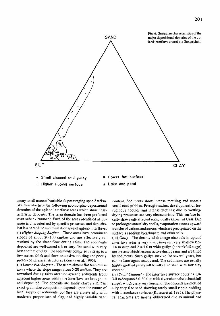
The upland interfluve areas of the Central Alluvial Plain are almost flat surfaces with a regional southeast slope. However, there are tracts ranging from tens to few hundreds o fkm 2 having independent watersheds showing distinct microgeomorphic units (Fig. 5). The regional slope in the study area (Fig. 3) is about 10 cm/km; with
2.6" 35'
26 ~
3080
"~ o ~ ~ . ~i / 118, , J J : 1 1 9 , ) ,..%
�9 (1119, v" l / / I ~ . / ,
.,, / '1
" " - - ""....,,,,, SAHAOHA ~ ,;u ...~....!] " - - 1 . . . . -,,,,. ~ / ~ . 1
,~,~ 11Y e
, ~ 4 , ~ ,m.~,t~ i ~ a l ~ ~,,~.L~ ~ t ~ t
_ -I _ " q , , " ' ~ . . . "-'-L.)O '%. r~ t �9
. / - )'11' o ,," o / ' / l l ," f . . : _ . , u / i I * I l I I I �9
A"I-..L-* .,\ /,,/ /~. ~'/ % Km 11"/ 80' 55'
50'
Legend
Ridge
Lake
O Pond
" ~ Hinor channel
Direction of slope
~, "r Swamp
�9 117 Spot elevation (m)
Fig. 5. Schematic diagram show- ing micro-geomorphology and local slopes on the interfluve sur- face. Drawn from SOI topographi- cal sheet no. 63 B/14.
2 0 1
ffAND Fig. 6. Grain size characteristics of the major depositional domains of the up- land interfluve area of the Ganga plain.
SILT CLAY
�9 Small channel and guUey
-F Higher sloping surface
o Lower flat surface
A Lake and pond
many small tracts of variable slopes ranging up to 2 m/km. We describe here the following geomorphic depositional domains of the upland interfluve areas which show char- acteristic deposits. The term domain has been preferred over subenvironment. Each of the areas identified as do- main is characterized by specific processes and deposits, but is a part of the sedimentation area of upland interfluve. (i) Higher S loping Sur face - These areas have prominent slopes of about 20-100 cm/km and are effectively re- worked by the sheet flow during rains. The sediments deposited are well-sorted silt or very fine sand with very low content of clay. The sediments comprise units up to a few metres thick and show extensive mottling and poorly preserved physical structures (KUMAR et al. 1995). (ii) L o w e r Fla t Sur face - These are almost flat featureless areas where the slope ranges from 5-20 cm/km. They are reworked during rains and fine-grained sediments from adjacent higher areas within the interfluve are brought in and deposited. The deposits are sandy clayey silt. The exact grain size composition depends upon the nature of local supply of sediments, but they are always silty with moderate proportions of clay, and highly variable sand
content. Sediments show intense mottling and contain small mud pebbles. Ferruginisation, development of fer- ruginous nodules and intense mottling due to wetting- drying processes are very characteristic. This surface lo- cally shows salt-affected soils, locally known as Usar. Due to prolonged annual dry spells, evaporation causes upward transfer of cations and anions which are precipitated on the surface as sodium bicarbonate and other salts. (iii) Gully - The density of drainage channels in upland interfluve areas is very low. However, very shallow 0.5- 1.0 m deep and 2.0-5.0 m wide gullys (at bankfull stage) are present which become active during rains and are filled by sediments. Such gullys survive for several years, but can be later again reactivated. The sediments are usually highly mottled sandy silt to silty fine sand with low clay content. (iv) Smal l Channel - The interfluve surface contains 1.0- 3.0 m deep and 5.0-30.0 m wide river channels (at bankfull stage), which carry very fine sand. The deposits are mottled silty very fine sand showing rarely small ripple bedding with discordance surfaces (KUMAR et al. 1995). The physi- cal structures are mostly obliterated due to animal and
2 0 2
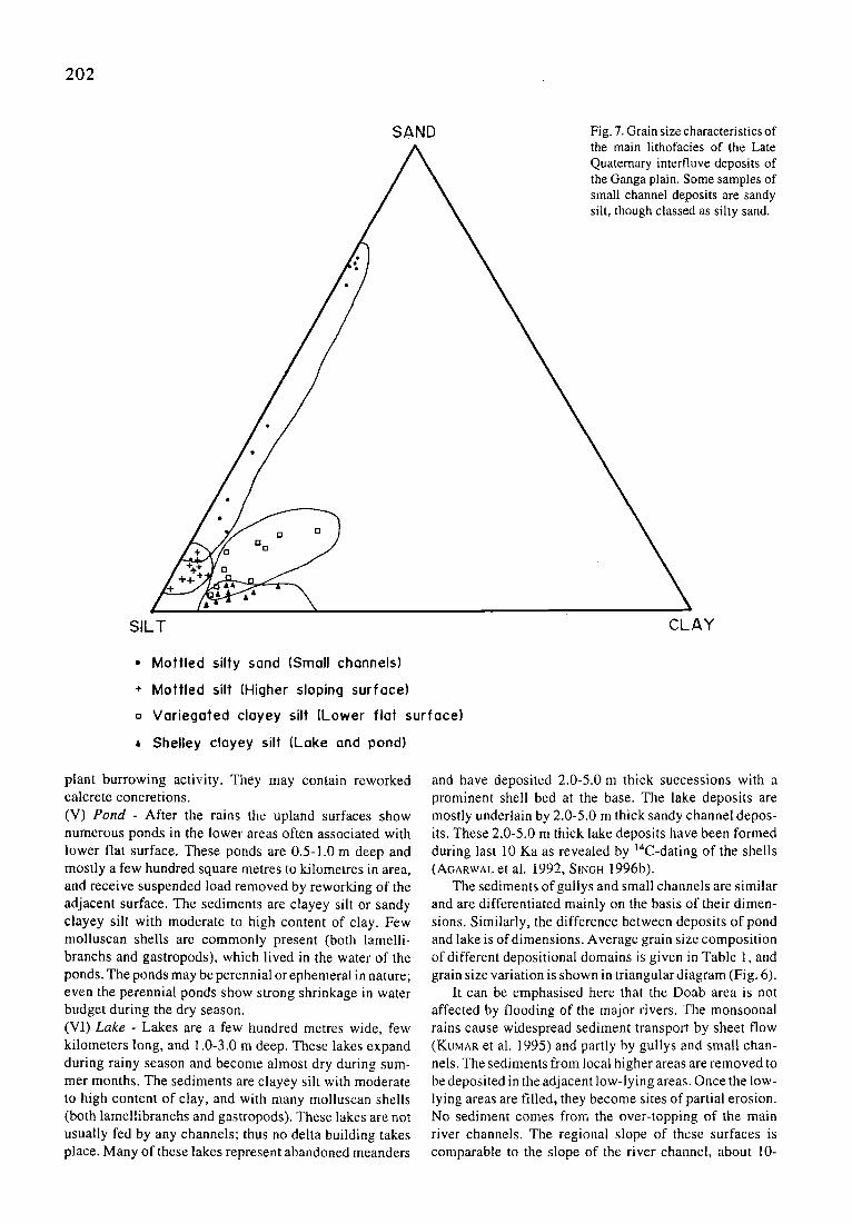
SAND Fig. 7. Grain size characteristics of the main lithofacies of the Late Quaternary interfluve deposits of the Ganga plain. Some samples of small channel deposits are sandy silt, though classed as silty sand.
0 0
0 0
SILT CLAY
�9 Mottled silty sand (Small channels]
+ Mottled silt [Higher sloping surface)
o Variegated clayey silt [Lower flat surface)
A Shelley clayey silt (Lake and pond)
plant burrowing activity. They may contain reworked calcrete concretions. (V) P o n d - After the rains the upland surfaces show numerous ponds in the lower areas often associated with lower flat surface. These ponds are 0.5-1.0 m deep and mostly a few hundred square metres to kilometres in area, and receive suspended load removed by reworking of the adjacent surface. The sediments are clayey silt or sandy clayey silt with moderate to high content of clay. Few molluscan shells are commonly present (both lamelli- branchs and gastropods), which lived in the water of the ponds. The ponds may be perennial or ephemeral in nature; even the perennial ponds show strong shrinkage in water budget during the dry season. (VI) L a k e - Lakes are a few hundred metres wide, few kilometers long, and 1.0-3.0 m deep. These lakes expand during rainy season and become almost dry during sum- mer months. The sediments are clayey silt with moderate to high content of clay, and with many molluscan shells (both lamellibranchs and gastropods). These lakes are not usually fed by any channels; thus no delta building takes place. Many of these lakes represent abandoned meanders
and have deposited 2.0-5.0 m thick successions with a prominent shell bed at the base. The lake deposits are mostly underlain by 2.0-5.0 m thick sandy channel depos- its. These 2.0-5.0 m thick lake deposits have been formed during last 10 Ka as revealed by 14C-dating of the shells (A~ARWAL et al. 1992, SINCH 1996b).
The sediments ofgullys and small channels are similar and are differentiated mainly on the basis of their dimen- sions. Similarly, the difference between deposits of pond and lake is of dimensions. Average grain size composition of different depositional domains is given in Table 1, and grain size variation is shown in triangular diagram (Fig. 6).
It can be emphasised here that the Doab area is not affected by flooding of the major rivers. The monsoonal rains cause widespread sediment transport by sheet flow (KUMAR et al. 1995) and partly by gullys and small chan- nels. The sediments from local higher areas are removed to be deposited in the adjacent low-lying areas. Once the low- lying areas are filled, they become sites of partial erosion. No sediment comes from the over-topping of the main river channels. The regional slope of these surfaces is comparable to the slope of the river channel, about 10-
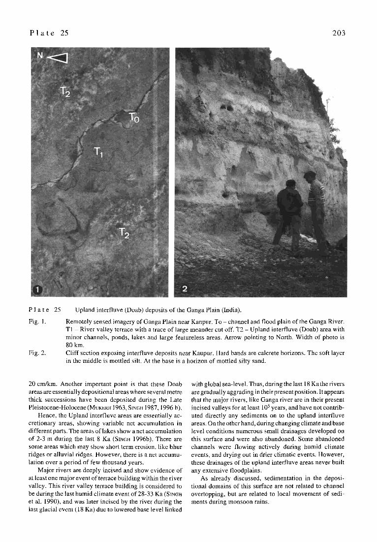
P l a t e 25 2 0 3
P l a t e
Fig. 1.
Fig. 2.
25 Upland interfluve (Doab) deposits of the Ganga Plain (India).
Remotely sensed imagery of Ganga Plain near Kanpur. To - channel and flood plain of the Ganga River. T1 - River valley terrace with a trace of large meander cut off. T2 - Upland interfluve (Doab) area with minor channels, ponds, lakes and large featureless areas. Arrow pointing to North. Width of photo is 80 km. Cliff section exposing interfluve deposits near Kaupur. Hard bands are calcrete horizons. The soft layer in the middle is mottled silt. At the base is a horizon of mottled silty sand.
20 cm/km. Another important point is that these Doab areas are essentially depositional areas where several metre thick successions have been deposited during the Late Pleistocene-Holocene (MuJceRj~ 1963, SINOH 1987, 1996 b).
Hence, the Upland interfluve areas are essentially ac- cretionary areas, showing variable net accumulation in different parts. The areas of lakes show a net accumulation of 2-3 m during the last 8 Ka (S~NGn 1996b). There are some areas which may show short term erosion, like bhur ridges or alluvial ridges. However, there is a net accumu- lation over a period of few thousand years.
Major rivers are deeply incised and show evidence of at least one major event of terrace building within the river valley. This river valley terrace building is considered to be during the last humid climate event of 28-33 Ka (S[NGn et al. 1990), and was later incised by the river during the last glacial event (18 Ka) due to lowered base level linked
with global sea-level. Thus, during the last 18 Ka the rivers are gradually aggrading in their present position. It appears that the major rivers, like Ganga river are in their present incised valleys for at least 105 years, and have not contrib- uted directly any sediments on to the upland interlluve areas. On the other hand, during changing climate and base level conditions numerous small drainages developed on this surface and were also abandoned. Some abandoned channels were flowing actively during humid climate events, and drying out in drier climatic events. However, these drainages of the upland interfluve areas never built any extensive floodplains.
As already discussed, sedimentation in the deposi- tional domains of this surface are not related to channel overtopping, but are related to local movement of sedi- ments during monsoon rains.
204
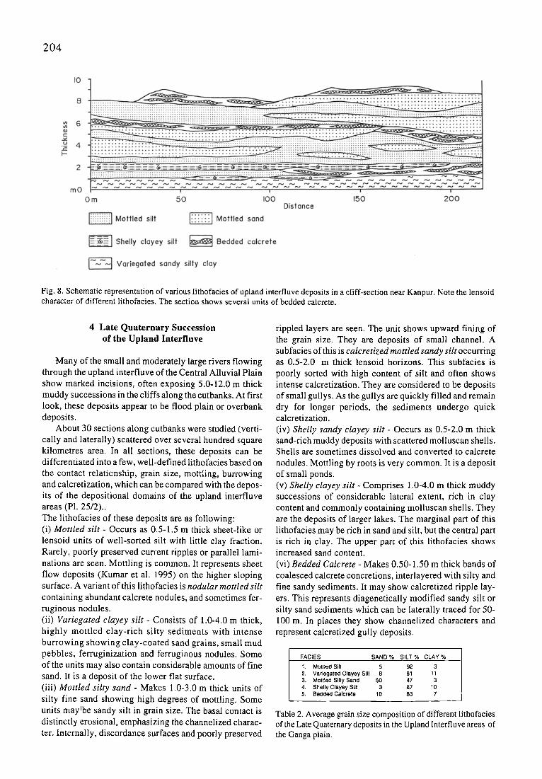
Fig. 8. Schematic representation of various lithofacies of upland interfluve deposits in a cliff-section near Kanpur. Note the lensoid character of different lithofacies. The section shows several units of bedded calcrete.
4 Late Quaternary Succession of the Upland Interfluve
Many of the small and moderately large rivers flowing through the upland interfluve of the Central Alluvial Plain show marked incisions, often exposing 5.0-12.0 m thick muddy successions in the cliffs along the cutbanks. At first look, these deposits appear to be flood plain or overbank deposits.
About 30 sections along cutbanks were studied (verti- cally and laterally) scattered over several hundred square kilometres area. In all sections, these deposits can be differentiated into a few, well-defined lithofacies based on the contact relationship, grain size, mottling, burrowing and calcretization, which can be compared with the depos- its of the depositional domains of the upland interfluve areas (P1.25/2).. The lithofacies of these deposits are as following: (i) Mot t l ed s i l t - Occurs as 0.5-1.5 m thick sheet-like or lensoid units of well-sorted silt with little clay fraction. Rarely, poorly preserved current ripples or parallel lami- nations are seen. Mottling is common. It represents sheet flow deposits (Kumar et al. 1995) on the higher sloping surface. A variant of this lithofacies is nodular mot t l ed silt containing abundant calcrete nodules, and sometimes fer- ruginous nodules. (ii) Var iegated c layey si l t - Consists of 1.0-4.0 m thick, highly mottled clay-rich silty sediments with intense burrowing showing clay-coated sand grains, small mud pebbles, ferruginization and ferruginous nodules. Some of the units may also contain considerable amounts of fine sand. It is a deposit of the lower flat surface. (iii) M ot t l ed si l ty sand - Makes 1.0-3.0 m thick units of silty fine sand showing high degrees of mottling. Some units maylbe sandy silt in grain size. The basal contact is distinctly erosional, emphasizing the channelized charac- ter. Internally, discordance surfaces and poorly preserved
rippled layers are seen. The unit shows upward fining of the grain size. They are deposits of small channel. A subfacies of this is calcre t i zed mot t led sandy si l t occurring as 0.5-2.0 m thick lensoid horizons. This subfacies is poorly sorted with high content of silt and often shows intense calcretization. They are considered to be deposits of small gullys. As the gullys are quickly filled and remain dry for longer periods, the sediments undergo quick calcretization. (iv) Shel ly sandy c layey si l t - Occurs as 0.5-2.0 m thick sand-rich muddy deposits with scattered molluscan shells. Shells are sometimes dissolved and converted to calcrete nodules. Mottling by roots is very common. It is a deposit of small ponds. (v) Shel ly c layey s i l t - Comprises 1.0-4.0 m thick muddy successions of considerable lateral extent, rich in clay content and commonly containing molluscan shells. They are the deposits of larger lakes. The marginal part of this lithofacies may be rich in sand and silt, but the central part is rich in clay. The upper part of this lithofacies shows increased sand content. (vi) Bedded Calcrete - Makes 0.50-1.50 m thick bands of coalesced calcrete concretions, interlayered with silty and fine sandy sediments. It may show calcretized ripple lay- ers. This represents diagenetically modified sandy silt or silty sand sediments which can be laterally traced for 50- 100 m. In places they show channelized characters and represent calcretized gully deposits.
FACIES SAND % SILT % CLAY %
1. Mottled Silt 5 92 3 2. Variegated Clayey Silt 8 81 11 3. Mottled Silty Sand 50 47 3 4. Shelly Clayey Silt 3 87 10 5. Bedded Calcrete 10 83 7
Table 2. Average grain size composition of different lithofacies of the Late Quaternary deposits in the Upland Interfluve areas of the Ganga plain.
2 0 5
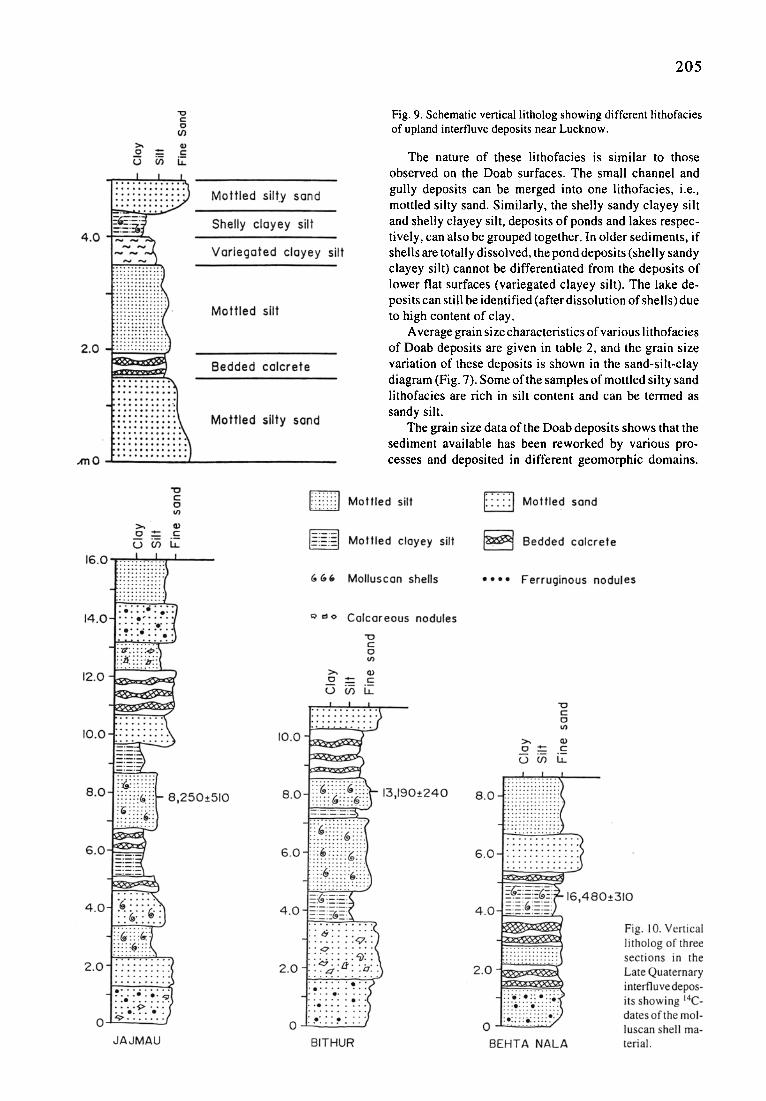
Fig. 9. Schematic vertical litholog showing different lithofacies of upland interfluve deposits near Lucknow.
The nature of these lithofacies is similar to those observed on the Doab surfaces. The small channel and gully deposits can be merged into one lithofacies, i.e., mottled silty sand. Similarly, the shelly sandy clayey silt and shelly clayey silt, deposits of ponds and lakes respec- tively, can also be grouped together. In older sediments, if shells are totally dissolved, the pond deposits (shelly sandy clayey silt) cannot be differentiated from the deposits of lower flat surfaces (variegated clayey silt). The lake de- posits can still be identified (after dissolution of shells) due to high content of clay.
Average grain size characteristics of various lithofacies of Doab deposits are given in table 2, and the grain size variation of these deposits is shown in the sand-silt-clay diagram (Fig. 7). Some of the samples of mottled silty sand lithofacies are rich in silt content and can be termed as sandy silt.
The grain size data of the Doab deposits shows that the sediment available has been reworked by various pro- cesses and deposited in different geomorphic domains.
206
There occurs removal of clay fraction which is preferen- tially deposited in the ponds and lakes, and also in the lower flat surfaces. The grain size parameters of the sediments from different lithofacies show considerable differences, especially in the content of clay. Neverthe- less, there is some overlap in the grain size plots of different lithofacies, as the processes operating upon them are not equally effective everywhere, and there are differ- ences in the availability of various grain sizes from one area to another. However, it is clear that deposition of these muddy successions is not the case of sedimentation simply from suspension, as is often visualised for deposition of muddy sediments in overbank floodplain areas.
The facies succession in a well-exposed cliff section near Kanpur is shown in Fig. 8, documenting both vertical and lateral variations. This clearly shows that different lithofacies described above occur as distinctive geom- etries, related to their depositional domain. These facies mostly occur as thin lensoid bodies, where variegated sandy silty clay and mottled sand make laterally extensive bodies, while mottled sand mostly occurs as laterally discontinuous thin lenses. Through time, these deposi- tional domains change their position to produce a charac- teristic mud-dominant deposit made up of 0.5-2.0 m thick lensoid and sheet-like geometries of differing lithofacies. An idealised vertical succession depicting different lithofacies of the upland interfluve deposits is shown in Fig. 9.
One may argue that the muddy successions of the Doab, exposed in the cliffs along river channels, represent very old floodplain deposits in which the present day river system is incised. In many of the sections studied by us,
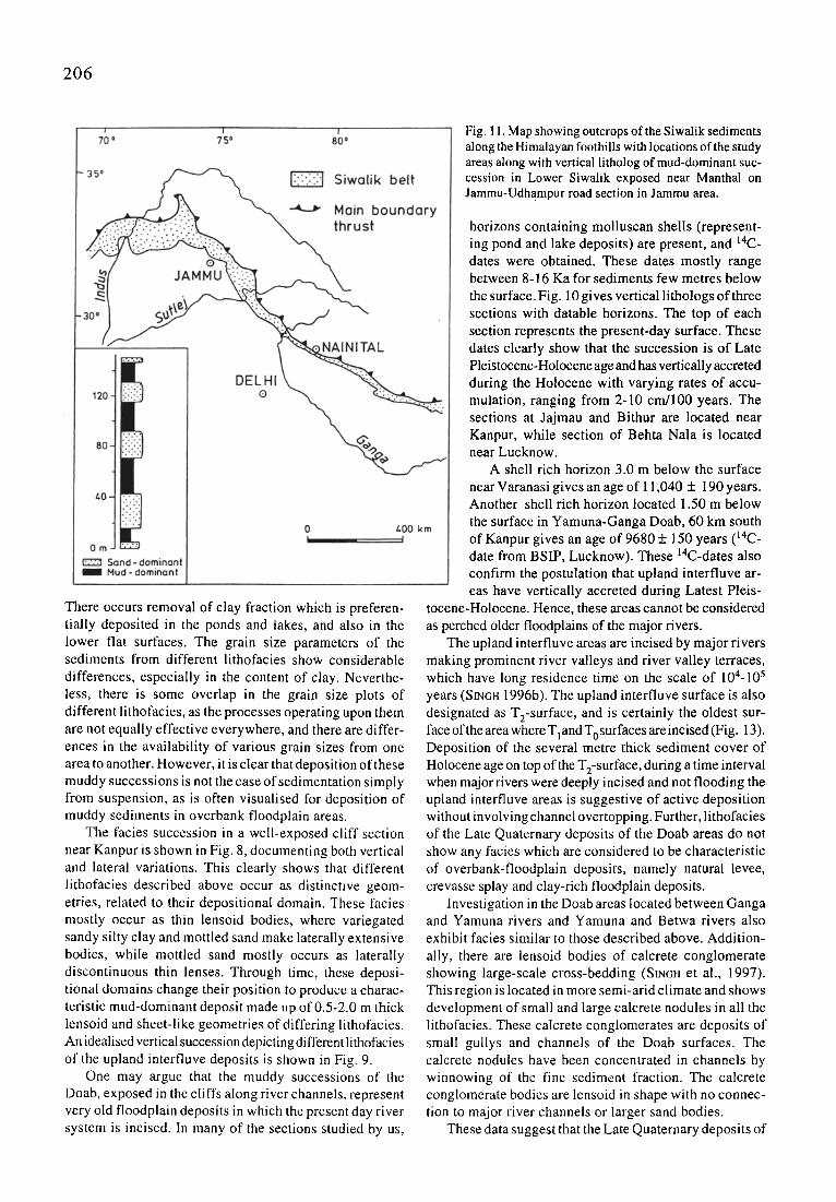
Fig. 11. Map showing outcrops of the Siwalik sediments along the Himalayan foothills with locations of the study areas along with vertical litholog of mud-dominant suc- cession in Lower Siwalik exposed near Manthal on Jammu-Udhampur road section in Jammu area.
horizons containing molluscan shells (represent- ing pond and lake deposits) are present, and 14C- dates were obtained. These dates mostly range between 8-16 Ka for sediments few metres below the surface. Fig. 10 gives vertical lithologs of three sections with datable horizons. The top of each section represents the present-day surface. These dates clearly show that the succession is of Late Pleistocene-Holocene age and has vertically accreted during the Holocene with varying rates of accu- mulation, ranging from 2-10 cm/100 years. The sections at Jajmau and Bithur are located near Kanpur, while section of Behta Nala is located near Lucknow.
A shell rich horizon 3.0 m below the surface near Varanasi gives an age of 11,040 + 190 years. Another shell rich horizon located 1.50 m below the surface in Yamuna-Ganga Doab, 60 km south of Kanpur gives an age of 9680 + 150 years (14C- date from BSIP, Lucknow). These 14C-dates also confirm the postulation that upland interfluve ar- eas have vertically accreted during Latest Pleis-
tocene-Holocene. Hence, these areas cannot be considered as perched older floodplains of the major rivers.
The upland interfluve areas are incised by major rivers making prominent river valleys and river valley terraces, which have long residence time on the scale of 104-105 years (SINGH 1996b). The upland interfluve surface is also designated as T2-surface, and is certainly the oldest sur- face of the area where Tland T0surfaces areincised (Fig. 13). Deposition of the several metre thick sediment cover of Holocene age on top of the T2-surface, during a time interval when major rivers were deeply incised and not flooding the upland interfluve areas is suggestive of active deposition without involving channel overtopping. Further, lithofacies of the Late Quaternary deposits of the Doab areas do not show any facies which are considered to be characteristic of overbank-floodplain deposits, namely natural levee, crevasse splay and clay-rich floodplain deposits.
Investigation in the Doab areas located between Ganga and Yamuna rivers and Yamuna and Betwa rivers also exhibit facies similar to those described above. Addition- ally, there are lensoid bodies of calcrete conglomerate showing large-scale cross-bedding (SINCH et al., 1997). This region is located in more semi-arid climate and shows development of small and large calcrete nodules in all the lithofacies. These calcrete conglomerates are deposits of small gullys and channels of the Doab surfaces. The calcrete nodules have been concentrated in channels by winnowing of the fine sediment fraction. The calcrete conglomerate bodies are lensoid in shape with no connec- tion to major river channels or larger sand bodies.
These data suggest that the Late Quaternary deposits of
207
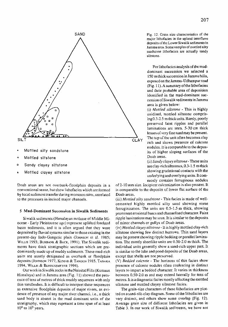
SAND Fig. 12. Grain size characteristics of the major lithofacies in the upland interfluve deposits of the Lower Siwalik sediments in Jammu area. Some samples of mottled silty sandstone lithofacies are actually sandy siltstone.
SILT
�9 Mott led silty sandstone
+ Mott led siltstone
o Sandy clayey siltstone
A Mott led clayey siltstone
Doab areas are not overbank-floodplain deposits in a conventional sense, but show lithofacies which are formed by local sediment transfer during monsoon rains, unrelated to the processes in incised major channels.
5 Mud-Dominant Succession in Siwalik Sediments
Siwalik sediments (Himalayan molasse of Middle Mi- ocene - Early Pleistocene age) represent uplifted foreland basin sediments, and it is often argued that they were deposited by fluvial systems similar to those existing in the present-day Indo-Gangetic plain (JOHNSON e ta l . 1985; WILLIS 1993; BURBANK & BECK, 1991). The Siwalik sedi- ments have thick stratigraphic sections which are pre- dominantly made up of muddy sediments. These mud-rich units are mostly designated as overbank or floodplain deposits (JOHNSON 1977, KUMAR 8s TANDON 1985, TANAKA 1994, WILLIS 8s BEHRENSMEYER 1994).
Our work in Siwalik rocks in the Nainital Hills (Kumaun Himalaya) and in Jammu area (Fig. 11) showed the pres- ence of tens of metres of thick muddy sequences with only thin sandbodies. It is difficult to interpret these sequences as extensive floodplain deposits of major rivers, as evi- dence of presence of any major river channel, i.e., a thick sand body is absent in the mud dominant units of the stratigraphy, which may represent a time span of at least 10 4 tO 105 years.
CLAY
For lithofacies analysis of the mud- dominant succession we selected a 150 m thick succession in Jammu hills, exposed on the Jammu-Udhampur road (Fig. 11). A summary of the lithofacies and their probable area of deposition identified in the mud-dominant suc- cession of Siwalik sediments in Jammu area is given below: (i) M o t t l e d s i l t s t o n e - This is highly oxidised, mottled siltstone compris- ing 0.3-2.5 m thick units. Rarely, poorly preserved faint ripples and parallel laminations are seen. 5-30 cm thick lenses of very fine sand may be present. The top of the unit often becomes clay rich and shows presence of calcrete nodules. It is comparable to the depos- its of higher sloping surfaces of the Doab areas. (ii) S a n d y c l a y e y s i l t s t o n e - These units are clay-rich siltstones, 0.3-1.5 m thick showing gradational contacts with the underlying and overlying units. It com- monly contains ferruginous nodules
of 2- I0 mm size. Incipient calcretization is also present. It is comparable to the deposits of lower flat surface of the Doab areas. (iii) M o t t l e d s i l t y s a n d s t o n e - This facies is made of well- cemented highly mottled silty sand showing some ferruginisation. The units are 0.5-1.5 m thick, showing prominent erosional bases and channelised character. Faint ripple laminations may be seen. It is similar to the deposits of minor channels or gullys of Doab areas. (iv) M o t t l e d c l a y e y s i l t s t o n e - It is highly mottled clay-rich siltstone showing few distinct burrows. Thin sand layers may be present showing ripple bedding or parallel lamina- tion. The mostly sheetlike units are 0.50-2.0 m thick. The individual units generally show a sand-rich upper part. It is similar to the lake and pond deposits of the Doab areas, except that shells are not preserved. (V) B e d d e d c a l c r e t e - The horizons of this facies show presence of calcrete nodules often coalescing in distinct layers to impart a bedded character. It varies in thickness between 0.50-2.0 m and may extend laterally for tens of metres. It is a diagenetic facies mostly affecting the mottled siltstone and mottled clayey siltstone facies.
The grain-size characters of these lithofacies are plot- ted on a sand-silt-clay diagram. Some of the lithofacies are very distinct, and others show some overlap (Fig. 12). Average grain size of different lithofacies are given in Table 3. In our work of Siwalik sediments, we have not
208
FACIES SAND % SILT % CLAY %
1, Mottled Siltstone 3 93 4 2. Sandy Clayey Siltstone 18 67 15 3, Mottled Silty Sandstone 40 56 4 4. Mottled Clayey Siltstone 1 81 18 5. Bedded Calcrete
a) Silty 2 93 5 b) Clayey 1 80 19
Table 3. Average grain size composition of different lithofacies of the Mud-dominant succession in Lower Siwalik, Jammu.
found any well-developed soil profiles or mature soils. Many of the thin sandy channel deposits of the mud- dominated Siwalik succession are actually independent small channels and not crevasse channels of large river as there is no thick channel sandbody present stratigraphically at the same level laterally or immediately below such deposits. Neither do such thin sandy units laterally merge into any channel sandbody. Detailed facies analysis of mud-dominant sequences in the Siwalik sediments are to be discussed separately.
6 Discussion
I f we try to synthesise our observations of lithofacies and their depositional domains in the upland interfluve areas, it is apparent that the local monsoonal rains effec- tively rework the sediments into silty fine sand deposits of channels and gullys, well-sorted silt of higher sloping surfaces, sandy clayey silt of lower flat surfaces, and clayey silt of lakes and ponds. These lithofacies are also identified in the Late Quaternary deposits of Doab areas. The Doab areas show a rapid rate of accumulation of 2- l 0 cm/100 years during last 16 Ka. Such high rates of accu-
mulation are not suitable for the development of mature soils and soil profiles. It needs to be emphasized that these successions are produced independent of the major river channels.
The presence of tens of metres thick successions over several hundred km 2 area of upland interfluve, which can at many outcrops be traced for hundreds of metres, show- ing specific facies association which is very different from those of overbank-floodplain deposit is one of the most remarkable characteristic of the deposits of upland inter- fluve areas.
SI~HA (1995) describes muddy deposits from interfan area between the Gandak and Kosi megafans in the north- ern plains of Bihar in the Ganga Plain. The succession is mainly composed of clayey silt and silty clay (flood basin), sandy clayey silt and sandy silty clay (crevasse splay). Although sandy deposits occur many kilometres away from any major river, and the supply of sand is not from the river channel or crevasse channels, they have been de- scribed as crevasse splay deposit. We would like to argue that such sandy deposits are the product of small channels which can be activated in interfluve areas from time to time; and not the crevasse splay, as they are not linked with major rivers.
Some of the mud-dominated successions of Lower Siwalik of Jammu area show marked similarity with those of the Doab areas of Ganga Plain and may represent deposition in settings similar to present-day upland inter- fluve (Doab) areas. However, the name overbank or flood- plain deposits for thick, mud-dominant succession of the type discussed above is not appropriate and they may be designated as 'upland interfluve' or 'Doab deposits'. It is
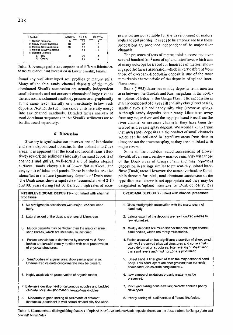
INTERFLUVE (DOAB) DEPOSITS - not linked with channel OVERBANK DEPOSITS - linked with channel processes processes
1. 1. No stratigraphic association with major channel sand body.
2. Lateral extent of the depsits are tens of kilometres.
3. Muddy deposits may be thicker than the major channel sand bodies, which are invariably multistoried.
Facies association is dominated by mottled mud. Sand bodies are lensoid, mostly mottled with poor preservation of physical structures.
5. Sand bodies of a given area show similar grain size. Channelized calcrete conglomerate may be present.
6. Highly oxidized; no preservation of organic matter.
7. Extensive development of calcareous nodules and bedded calcrete; local development of ferruginous nodules.
8. Moderate to good sorting of sediments of different lithofacies; prominent is well sorted silt and silty fine sand.
Close stratigraphic association with the major channel sand body.
2. Lateral extent of the deposits are few hundred metres to few kilometres.
3. Muddy deposits are much thinner than the major channel sand bodies, which are rarely multistoried.
4. Facies association has significant proportion of sheet sand with well preserved physical structures and some small- scale deformation structures. Interlayering of sheet sand, thin sand layers and mud horizons is prominent.
5. Sheet sand is finer grained than the major channel sand body. Thin sand layers are finer grained than the thick sheet sand. No calcrete conglomerate.
6. Low degree of oxidation; organic matter may be preserved.
7. Prominent ferruginous nodules; calcrete nodules poorly developed.
8. Poorly sorting of sediments of different lithofacies.
Table 4. Characteristic distinguishing features of upland interfluve and overbank deposits (based on the observations in Ganga plain and Siwalik sediments).
209
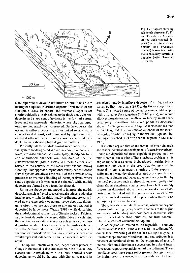
Fig. 13. Diagram showing relationship between T 0, T l , and T2-surfaces. A multi- storied thick channel de- posit (earlier phase mean- dering, and presently braided) is associated with the thick muddy interfluve deposits (After SmGH e t al. , 1990).
also important to develop definitive criteria to be able to distinguish upland interfluve deposits from those of the floodplain areas. In general the overbank deposits are stratigraphically closely related to the thick sandy channel deposits and show sandy horizons in the form of natural levee and crevasse-splay deposits, where physical struc- tures are moderately well-preserved. On the contrary, the upland interfluve deposits are not linked to any major channel sand deposit, and dominated by highly mottled, oxidised silty sediments. Sand occurs in small indepen- dent channels showing high degree of mottling.
Presently, all the mud-dominant successions in a flu- vial system are designated as overbank environment where levee, crevasse channel, crevasse splay, floodplain fines and abandoned channels are identified as specific subenvironments (MtaLL 1996). All these elements are related to the activity of the main river channel during flooding. This approach implies that muddy deposits in the fluvial system are always the result of the crevasse splay processes or overbank flooding of the major rivers, where sandy deposits are formed near the channel, while muddy deposits are formed away from the channel.
Using the above general model to interpret the muddy deposits in ancient fluvial successions, the minor sandbodies interlayered within the thick muddy sediments are consid- ered as crevasse splay or natural levee deposits, though quite often they are not close to any major sandbodies deposited by large rivers. WILLIS (1993), while describing the mud-dominant succession of Siwalik rocks in Pakistan as overbank deposits, expressed difficulties in explaining the sandbodies as natural levees or splays in an overbank deposition model. This succession can be easily explained with the 'upland interfluve model' of this paper, where sandbodies embedded within thick muddy successions would represent independent small channels in interfluve areas.
The upland interfluve (Doab) depositional pattern of Ganga Plain model is also able to explain the thick muddy successions interbedded with the thick braided stream deposits, as would be the case with Ganga river and its
associated muddy interfluve deposits (Fig. 13), and ob- served by BEmNAM et al. (1993) in the Eocene deposits of Spain. The incised nature of the major river would keep it within its valley for a long time (104-105 years), and would allow sedimentation on interfluve surface by small chan- nels, gullys, sheetflow, lakes and ponds as discussed above. The Ganga river near Kanpur is incised in the Doab surface (Fig. 13). The river shows evidence of the mean- dering-type earlier, changing to the braided-type and be- coming entrenched in its own channel deposit (SINcH et al. 1990).
It is often argued that abandonment of river channels and channel belts leads to development of extensive overbank- floodplain depositional areas, capable of producing thick mud dominant successions. There is a basic problem in this explanation. Once a channel is abandoned, it neither brings sediments nor water in the area; abandonment of the channel in any area means shutting off the supply of sediment and water by channel related processes. In such a setting, sediment and water movement is controlled by the local processes such as sheet flows, small gullys and channels, unrelated to any major river channels. The muddy succession deposited above the abandoned channel de- posit cannot be linked with the processes of channel below, because such deposition takes place when there is no activity in the channel below.
Thus, the extensive interfluve areas, which are beyond the reach of flooding by major river channels of the region are capable of building mud-dominant successions with specific facies association, quite distinct from channel- related deposits of overbank-floodplain.
Another problem related to the deposition in upland interfluve areas is the ultimate source of the sediment. No doubt, local reworking of the surface during heavy rains transfers large amount of sediment and redistributes it in different depositional domains. Development of tens of metres thick mud-dominant successions in upland inter- fluve areas requires replenishment of the sediment. These interfluve areas have some relict geomorphology; hence the higher areas are eroded to bring sediment to lower
210
areas. The regional s lope of these interfluve surfaces is comparable to the slope of the channels. There is possibi l- ity of some sediment transfer from the piedmont zone into the central plain by surface sheet flow. This aspect needs detailed studies in the future.
No doubt, there are independent deposits made by crevasse splay and related processes (FARRELL, 1987), l inked with the major river channels. We have tried to develop some criteria to dist inguish between interfluve deposi ts (not l inked with channel processes) and overbank deposi ts ( l inked with channel processes) based on our work in Ganga Plain and Siwalik sediments (Table 4).
Acknowledgements
This paper is outcome of a research programme to study the Ganga plain sediments. Part of this work has been supported by a research grant by DST, New Delhi (ESS/CA/A3-03/90). U.K. Shukla received financial support from DST, New Delhi (HR/ OY/A-I2/95); S. Sharma and D.S. Singh received financial support from C.S.I.R,, New Delhi; M.Sharma received financial support from University Grants Commission. Discussions with Dr. M. Singh, Mr. A.A. Ansari, Mr. S. Kumar, Dr. S. Chandra, Lucknow helped us to develop some of the ideas of the deposition on the interfluve areas. Dr. U.K. Shukla expresses his thanks to the Head, Department of Geology, Kumaun University for the support of this work. Final version of paper was written when I.B.S. was working as visiting professor at the Chair of Applied Geology, University of Erlangen-Narnberg. Financial support from DAAD is gratefully acknowledged. Thanks are expressed to Prof. H. J. Tobschall for providing the infrastructural facilities, and to Prof. E. Fl(igel for the help during finalization of the paper. Prof. E. Backhaus and Prof. T. Aigner critically read this text.
References
A(;ARWAL, A.K., R1zvl, M.H., SIN(;H, I.B., KUMAR, A. & CHANDRA, S. (1992): Carbonate deposits in Ganga Plain. - In: StN(;H, I.B., (1992, ed.): Gangetic Plain: Terra Incognita. - 35-44, Lucknow (Geology Department, Lucknow University)
BF.N'rHAM, P.A.. TaLLmC;. P.J. & BURBANK, D.W. (1993): Braided stream and flood plain deposition in rapidly aggrading basin: the Escanilia formation, Spanish Pyrenees. - In: BEST, J.L. & BRISTOW, C.S. (eds.): Braided Rivers. - Geol. Soc. London Spec. Publ., 75, 177-194, London
BURBANK, D.W. 8z B~CK, R.A. (1991): Models of aggradation versus progradation in the Himalayan Foreland. - Geol. Rundschau., 80, 623-638, Berlin
FARRELL, K.M. (1987): Sedimentology and facies architecture of overbank deposits of the Mississippi River, False River region, Louisiana. - In: ErHRItX~E, F.G., FLORES, R.M. & HARVEY, M.D. ( eds.): Recent Development in Fluvial Sedi- mentology. -Soc . Econ. Palaeont. Min., Special Publication, 39, 111-120, Tulsa
JOHNSON, G.D. ( 1977): Palaeopedology of Ramapithecus bearing sediments, North India. - Geol. Rundschau, 66, 192-216, Berlin
JOHNSON, M.N., STIX, J., TAUXE, L., CERVENY, P.F. & TAHIRKHELI, R.A.K. ( 1985): Palaeomagnetic chronology, fluvial processes and tectonic implications of the Siwalik deposits near Chinji Village, Pakistan. - J. Geol., 93, 27-40. Boulder
KUMAR, S., SINGH, I.B., SINOH, M. & SINGH, D.S. (1995): Deposi- tional pattern in upland surface of Central Ganga Plain near Lucknow. - J. GeoL Soc. India, 46, 545-555, Bangalore
KUMAR, S., SINGH, M., CHANDEI., R.S., & SINO,, I.B. (1992): Geomorphic evolution of Lucknow area using remote sens-
ing data analysis. - Proceeding National Symposium on Remote Sensing for Sustainable Development, R.S.A.C.- UP, 269-272, Lucknow
KUMAR, R. & TANDON, S.K. (1985): Sedimentology' of Plio- Pleistocene late orogenic deposits associated with intraplate subduction-The Upper Siwalik Subgroup of a part of Punjab Sub-Himalaya.- Sed. Geol., 42,105-158, Amsterdam
MLALL, A.D. (1996): The Geology of Fluvial Deposits.- 582 pp., Berlin (Springer)
MUKERJI, A.B. (1963): Alluvial morphology of Upper Ganga Yamuna Doab.- The Deccan Geographer, 2, 1-36, Hyderabad
PATHAK, B.D. (1982): Ground water resources of Uttar Pradesh, India.- In: SINGHAL, B.B.S. (ed.): Engineering Geoscience. - 111-131, New Delhi (Sarita Prakashan)
RAY, P., (1976): Structure and sedimentological history of the overbank deposits of a Mississippi River point bar. -J. Sed. Petrol., 46, 788-801, Tulsa
SIN~H, I.B. (1972): On the bedding in the natural-levee and the point bar deposits of the Gomti River, Uttar Pradesh, India. -Sed . Geol., 7, 309-317, Amsterdam
-- (1987): Sedimentological history of Quaternary deposit of Gangetic Plain. - lnd ian J. Earth Sci., 14, 272-282, Calcutta
-- (1992): Geological evolution of Gangetic Plain: Present status. - In: SINGH, I.B. (1992, ed.): Gangetic Plain: Terra lncognita. - 1-14, Lucknow (Geology Department, Lucknow University)
-- (1996 a): Late Quaternary sedimentation of Ganga Plain foreland basin. Proc. Symp. N.W. Himalaya and Foredeep. - Geol. Surv. India Special Publication, 21, 161-172, Lucknow
-- (1996 b): Geological evolution of Ganga Plain-An over- view. -J. Palaeontological Society of India, 41, 99-137, Lucknow
SIN~H, I.B. & Gnosn, D.K. (1992): Interpretation of Late Quater- nary geomorphic and tectonic features of Gangetic Plain using remote sensing techniques. -Proceeding National Sym- posium on Remote Sensing for Sustainable Development, R.S.A.C.-U.P., pp. 273-278, Lucknow
-- & -- (1994): Geomorphology and tectonic features of lndo- Gangetic Plain. In: Dikshit, K.R., Kale, V.S. & Kaul, M.N. (1994, eds.): India: Geomorphological Divers i ty . - 270- 286, New Delhi (Rawat Publications)
SINGH, I.B., RAJAGOPALAN, G., AGARWAL, K.K., SRIVASTAVA, P., SHARMA, M. & SIaARMA, S. (1997): Evidence of Middle to Late Holocene neotectonic activity in the Ganga Plain. - Current Science, 73, 1 114-1117, Bangalore
S~NHA, R. (1995): Sedimentology of Quaternary alluvial deposits of the Gandak-Kosi interfan, North Bihar plains. - J. Geol. Soc. India, 46, 521-532, Bangalore.
SMITh, N.D. & PEREZ-ARLUCEA, M. (1994): Fine-grained splay deposition in the avulsion belt of the lower Saskatchewan River, Canada. - J . Sed. Res., 64, 159-168, Tulsa
TANAKA, S. (1994): Palaeosols in the Churia (Siwalik) Group, West Central Nepal. - In: KUMAR, R., GHOSH, S.K. & I~ADATARE, N,R. (eds.): Siwalik Foreland Basin of India. - l 81-204, New Delhi (Oxford and IBH Publishing Co. Pvt. Ltd.)
TYE, R.S. & COLEMAN, J.M. ( 1989 a): Depositional processes and stratigraphy of fluvially dominated lacustrine deltas: Mis- sissippi Delta Plain. -J. Sed. Petrol., 59, 973-996, Tulsa
-- & -- (1989 b): Evolution of Atchafalaya lacustrine deltas, South-Central Louisiana. -Sed. Geol., 65, 95-112, Tulsa
WiLLiS, B. (1993): Ancient river systems in the Himalayan foredeep, Chinji village area, Northern Pakistan. - Sed. Geol., 88, 1-76, Amsterdam
WILUS, B.J. & BEHRENSr~mYER, A.K. (1994): Architecture of Miocene overbank deposits in Northern Pakistan. - J. Sed. Res., 64, 60-67, Tulsa
Manuscript received April 21, 1998 Revised version received November 14, 1998
Related Documents