by a. Paddapya, Pam

Welcome message from author
This document is posted to help you gain knowledge. Please leave a comment to let me know what you think about it! Share it to your friends and learn new things together.
Transcript
by a. Paddapya, P a m

R. Paddayya
With the exception of a few insignificant inliers of the Dharwars, the area is wholly occupied by the granite-gneiss of the Peninsular Crystalline Complex. Certain other rock formations such as the Deccan Trap and Bhima Series occur to the west and the north. Topographically, the area consists of an undulating plain country having an average elevation of about 400 m. above sea level. It is extensively covered with black cotton soil. The only feature which breaks up the monotony of the landscape is for- med by the residual ridges and knobs of the granite-gneiss and Dharwar schist. To the west and north, the area is flanked by low hill ranges and plateaux formed by the granite-gneiss and Bhima sedimen- tary rods respectively.
The drainage is mainly to the east and south-east. The Krishna and the Bhima, both rising in the Western Ghats, are the major rivers of the area; in fact the beak-shaped outline of the Doab is derived from the courses of these rivers. Both of them exhibit a mature stage of development and their courses are characterized by meanders. They are replenished by a number of tributary streams largely ephemeral in character, and these latter constitute the internal drainage system of the area. The nullahs named after the villages of Hunsgi, Kollur, Madarkal and Kothapalli are among the more prominent of these streams. Several of them take origin in the hill groups and plateau of the western and nothern margins of the area and wind their way into the major rivers. The drainage as a whole is dendritic in character.
T h e s i t e s
In this section descriptive studies are made of the stratigraphical and other forms of data obtained in the course of field investigations. The sites could be conveniently divided into two groups: a) high level gravel occurrences proper and b) implementiferous river bed sites with deposits containing material derived from the high level gravels.
a) H i g h l e v e l g r a v e l s
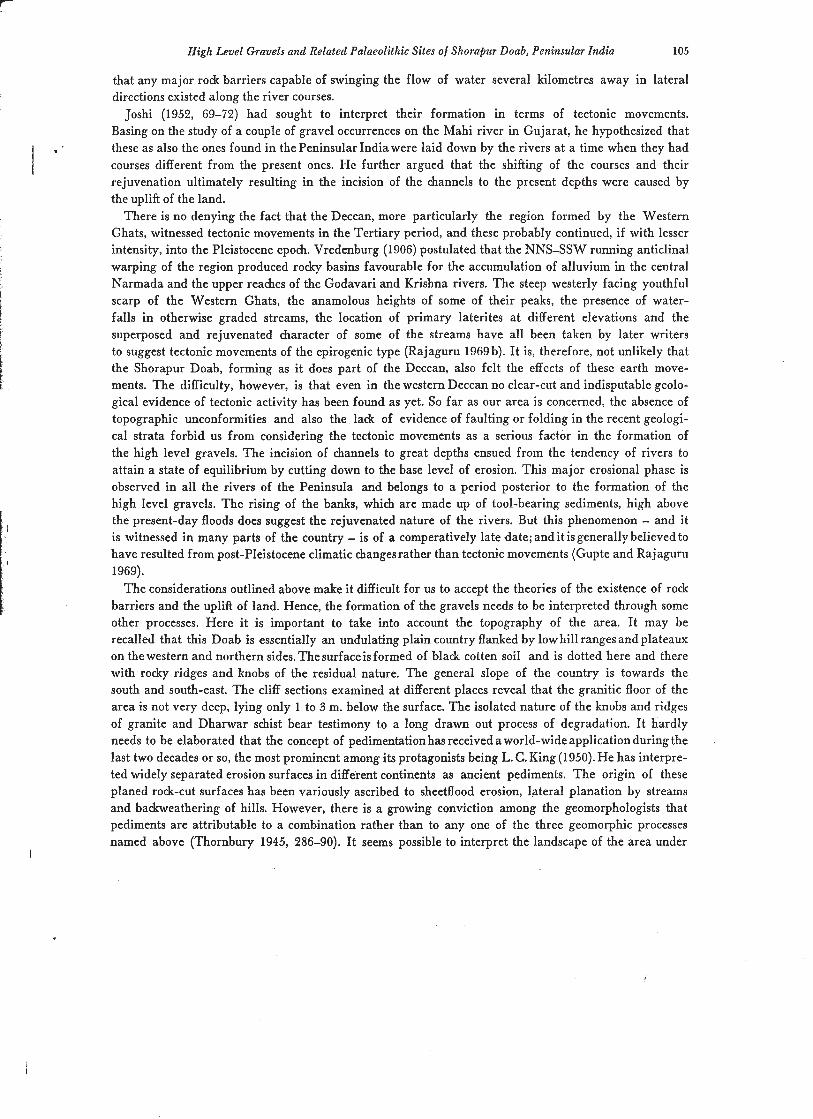
The runs of these gravels occur in the basins of both the Krishna and Bhima rivers. Their extent and areal distribution are shown in the accompanying map (fig. 1). There are in all 20 sites.
Firstly, the spreads on the Krishna river. Basing on their relation to the river courses, they may again $
be differentiated into two categories. The first group of occurrences lie close to the river bank They are found at Devapur, Hayal Buzurg, Chennur, Konal, Sangam, Gurjihal, Hindupur and Murardoddi, the last two sites showing dissected pathes. All of them are on the left bank of the river. Foote (1876, 239) refers to two more spreads, one at Kachapur and the other at Konechupli, both of them lying on the right bank (opposite to Chennur) in the territory of the Raichur district. The other group of spreads are situated at distances varying from 3 to 11 krn. away from the river. They are found at Kollur, Mardakal, Baswantpur, Hayal Khurd, Tumkur, Wadgira and Kothapalli. Under this group may also be included the extensive spread noted by Kazim (1941, 186) between the villages of Kankal, Yalar, Siddapur and Yelsetti. This run is to the east of the taluk headquarters of Yadgir and lies about 25 krn. due north of the site of Kothapalli mentioned above. Although lying away from the main river, all these gravel spreads are located on or dose to the tributary streams.
There are only three spreads on the Bhima river. One of them is at Govindahadgi on the left bank of the river. The other two are at Kumnur and between Naikal and Nalwadgi, both lying on the right bank. The exact extent of the last spread is not known.
At a few places like Gurjihal the exposures partly occupy barren ground and emerge from surrounding surfaces to form local eminences. Their height in relation to river bed varies from place to place. Thus at places like Hindupur and Kumnur they lie at an elevation of about 6 to 8 m. But at certain other places, e. g. Chennur and Gurjihal, they rise to greater heights ranging from 14 to 25 m. Here we

High Level Gravels and Related Palaeolithic Sites of Shorabur Doab, Peninsular India 97
Fig. 1 . Map of Shorapur Doab (Peninsular India) showing the distribution of high level gravels and implementife- rous river bed sites.
may take note of Foote's reference to the location of some of the Tungabhadra gravel spreads at an elevation of about 30 m. Another important feature is that all the exposures lie above the present-day flood levels. Partly because of the overburdening of the deposits with black cotton soil and in part owing to the secondary dispersal of the material consequent upon cultivation, rain action and other factors of disturbance, it is rather difficult to determine the areal extent of the spreads in precise terms. As could be read from the map, there does, however, seem* to be considerable variation in this regard also. Nearly half the number of spreads measure between 1 to 3 square kilometres and the rest between 4 to 6 square kilometres. The oval-shaped exposure lying to the west of Yadgir is by far the largest of all, measuring 8 km. by 5 km.
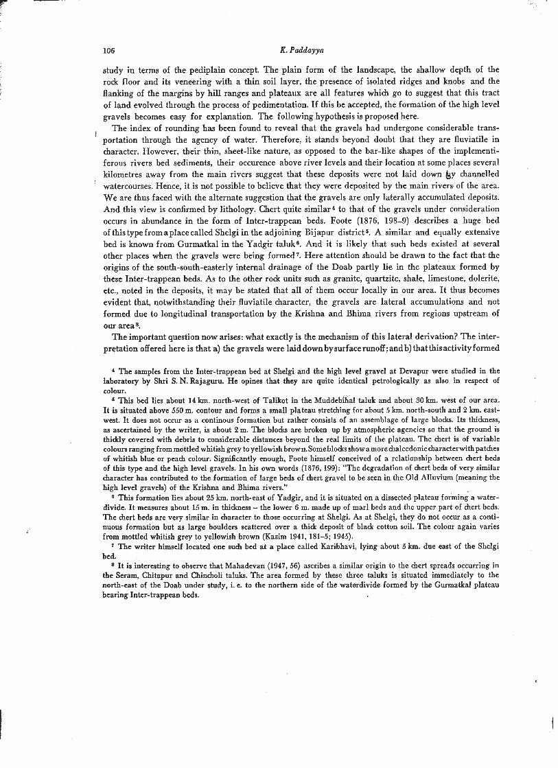
With a view to studying the gravel in the i n s i t u context and also to understanding its relationship with other surficial deposits, examination was made of as many vertical sections aspossible. The sections along the two main rivers proved to be of no help, since at none of the sites the gravels actually touch the banks. The ones exposed inland by erosional gullies, however, yielded fairly sufficient data. They were obser- ved at Devapur and Gurjihal, and at both the places they were found exposed on the gravel spreads themselves.
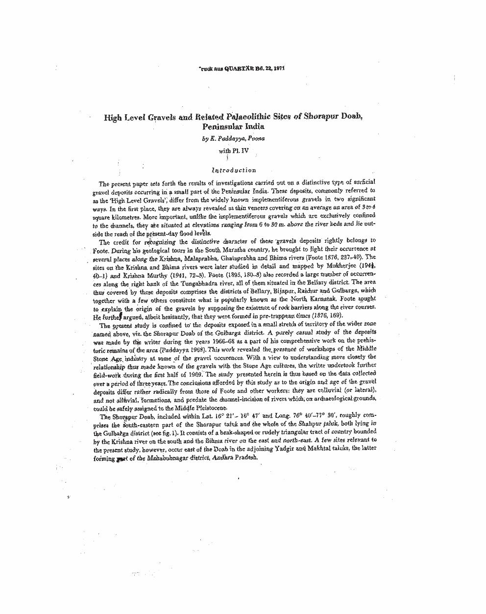
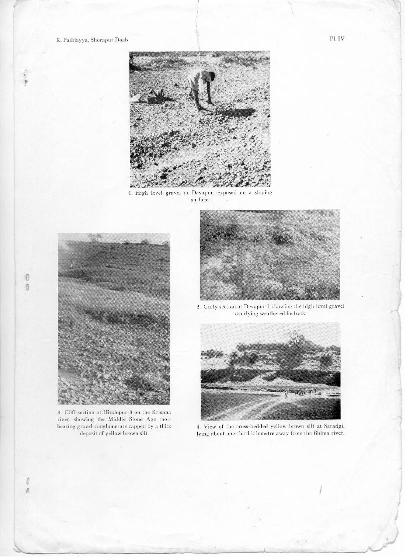
The locality at Devapur (DVP: 1) lies about 1-112 km. due east of the village. A gully section exposed on sloping ground (pl. IV, I ) , locally known as the A m r i t e g g i n a H o 1 a , revealed the basal stratum of fully weathered granite-gneiss (gruss) to a height of about 1 m. (fig. 2, no. 1; pl. IV, 2). It was uncon- formably overlain by gravel deposit varying from 6 cm. to half-a-metre in thickness. The top portion (2 to
7 Quartlr 22
K . Paddayya
R . BED
BLACK BROWN SlLT
PEBBLY COBBLY GRAVEL CONGLOMERATE-
OPEN-WORK HIGH LEVEL GRAVEL
R. BED
Fig. 2. River sections in Shorapur Doab (Peninsular India): 1, Devapur-1 (high level gravel); 2, Gurjihal-1 (high level gravel); 3, Devapur-2; 4, Kollur-2.
3 cm.) was found mixed up with black cotton soil. Wherever it was thin, the gravel was covered by a di- stinct layer (about a quarter-metre thick) of soil.
The section at Gurjihal (GJL: 1) is situated about 1 km. due north of the village (fig. 2, no. 2). Here a low mound, covering an area of about half a square kilometre, bulges out from the surface to a height of about 3 to 4 m. and forms a prominent local landmark. Its elevation above the bed of the Krishna river is of the order of about 15 m. The area is uncultivated and fully covered with the gravel. The gully sections examined at four or five spots revealed the bedrock, which is again weathered granite-gneiss, to a height varying from half-a-metre to 1 m. As at Devapur, it was unconformably overlain by gravel layer measuring between 10 cm. and 40 cm. in thickness. The latter was in turn sealed by a quarter-metre thidc deposit of black cotton soil.
From the foregoing description it is clear that these high level gravels occur as thin areal sheets co- vering considerably large plots of ground. While some of the spreads lie close to the Krishna and Bhima
High Level Gravels and Related Palaeolithic Sites of Shorapur Doab, Peninsular India
rivers, some occur inland several kilometres away from the river courses. The deposits rest on an uneven floor of granite-gneiss, which forms a well-marked terrace rising to heights ranging from 6 to 25 m. above river level. The gully sections reveal that the gravels hardly exceed half-a-metre in thickness. Finally, we may take note of the covering up of the deposits with an equally thin layer made up of black cotton soil.
With regard to the workshops of the Middle Stone Age industry, the field explorations brought to light their presence on the gravel exposures at Devapur, KoIIur (KLR: l), Tumkur (TKR: I), Gurjihal and Hindupur (HPR:l). At both Devapur and Gurjihal the workshop localities are right in the area of the gully sections described above. The artefacts, including large quantities of debitage, were found me- rely scattered on surface over wide areas. They are all in mint condition and do not show any traces of rolling. This evidence, considered in conjunction with the total absence of any artefacts in the gravel horizons exposed on the gully sections at Devapur and Gurjihal, proves for certain that the gravels were only utilised as sources of raw material by the artificer. In other words, there is no temporal relation- ship whatsoever between the formation of the gravel deposits and their exploitation by the Middle Stone Age people.
With these remarks on the stratigraphical position of the occurrences, we may now proceed to a mor- phological study of the gravel itself.
So far as the lithological composition is concerned, the gravels exhibit a striking uniformity'. The counts, each consisting of 100 examples, made at Devapur, Kollur and Gurjihal permit the following observations. The proportion of chert is of the order of 80 to 900/0; hence, the deposits could be called chert gravels. Next in order come granite-gneiss and quartz, each of them varying from 10 to 15 O/o.
Still rarer are the components of Trap-dolerite, quartzite, shale, limestone, quartz, chalcedony, agate, etc., and these together account for about 5 O/o.
Coming to the size-range of the phenoclasts, the gravels are in the main composed of pebbles and cob- blesz. On an average they measure about 10 cm. across the longer axis. The occurrence of boulders is but rare and the largest of them measure about 30 cm. in size. A fact of significance revealed from the studies at the gully sections as well as other places is that these gravels are of the 'open-work' type. That is, the interstices between the framework elements are devoid of any matrix materials like sand and silt. The small quantity of granular material that is present is in the nature of debris derived from the rotting of the constituents of the gravels themselves. Further, there is also no trace of any cementing medium. The fabric of the deposits could be termed 'isotropic' because the orientation of the clastic ele- ments is at random. Structurally, the gravels are not characterized by any distinct bedding phenomena. The pebbles and cobbles of her t generally show rather thickly patinated surfaces of brownish colour; in some cases the surfaces also exhibit pitted appearance.
In order to understand the mechanics of derivation and also to impart some degree of objectivity in the description of the physical state of preservation of the constituent elements, the index of rounding was calcuIated over samples of 50 pebbles from the sites of Devapur and Gurjihal. The criteria adopted are those of Pettijohn (1957, 57-9). Since chert forms the chief rock unit, all the specimens were selec- ted of this material only. In size they varied from 4.5 to 10 cm.
n The only exceptions are provided by the gravel spread lying the the east of Yadgir and the one exposed at
Govindahadgi on the Bhima river. The former one is made up of 'sub-angular and little worn' pebbIes of quartz, quartzite, granite-gneiss,dolerite and hornblend-schist (Kazim, 1941). The exposure at Govindahadgi is characterized by pebbles of chalcedony, jasper, wood opal, agate and other forms of hydrated silica suggesting their source from the Deccan Trap country further north (Krishna Murthy, 1941, 72).
4 The size limits are given in terms of the scale proposed by Pettijohn (1957, 19). A pebble measures between 4 mm. and 64 mm. along the longer axis and a cobble between 64 mm. and 256 mm.

Angular Sub-angular Sub-rounded Rounded Well-rounded
Devapur 4 010 18 % 16 O/o 38 O i o 24 Ole Gurjihal - 14 % 36 O/o 44 O/o 6 O/o
It is thus made h o r n that the gravels are by and large sub-rounded to rounded in haracter. This feature acquires significance because of the extremely hard textural make- up of dwrt. We may, ,
therefore, infer that the gravels su%ered transportation over considerable distances through the 'medium of water; further it is I ihly that this transportation was of a po1ycycIic type. Mass-wasting processes, involving the downslope movement of material under the influence of gavity, probably aided in the deriva- tion of rodr debris, and as such they played only a subservient roIe. We are thus compelled to conclude that the graveIs are fluviatile and not coiluvial in origina.
b) R i v e r b e d s i t e s
The stratigraphical position of these sites is quite similar to that of the implementiferous sites known from various parts of the country. Although situated in the vicinity of the high level gravel occurrences, they differ from the latter inasmu& as they are implementiferous and invariably confined tu the present hannels of the Krishna and Bhima rivers and their tributary streams. The deposits occurring at these sites contain, if in small proportions, rodr material derived secondarily from the high level: gravels and thereby furnish a valuable clue to the age of the latter deposits. The stratigraphical data obtained from the examination of cliff sections exposed at these sites are detailed below. In passing it may be mentioned that the sites of Devapur, K o h , Tumkur, Gurjibal and Hindupur are the same as those of the high level gravel spreads.
Devapur-DVP: 9 (fig. 2, no.3)
The section, exposed on a feeder stream of the Hunsgi nullah, lies to the no&-east of the village and abwt one-third kilometre downstream of the Shorapur-Lingsugur road. Laterally it was found to extend for about 100 m. in the form of discontinuous pathes on both the banksof the stream.
The lowest stream consisted of gruss rising to a height of about 1-112 m. from the stream bed. It was unconformably overlain by pebbly-cobbly conglomerate having a maximum thickness of about 1-114 m. This deposit showed graded bedding - lower part pebbly-cobbly and the upper (about 20 cm. thick) becoming pebbly and granular. The matrix was sandy and silty, while calcium carbonate for- med the cementing medium. The Bthological composition showed granite-gneiss (300/0), quartz (SOQlo), he r t (25%), Dharwar schist (10%), quartzite (4%), and limestone, Trap, shaIe and sandstone (I to 2%). The phenoclasts of granite-gneiss and quartz were sub-angular to sub-rounded. The conglomerate was
in turn capped by 1 m. thik deposit of bladc brown'silt bearing nodular fragments of kankar. About 150 m. downstream of the section described above,'a deposit (about 1 m, in thickness) of yeIlow
brown siIt was noted in the stream bed. It was found resting directly on the bedrock and yielded a smaH number of molluscan shells.
The expression 'fluviatile' ist used here to convey the waterborne cfiaracter of the deposits, though the literal meaning i s circumscribed to the phenomena connected with rivers. In the writings there i s some confusion regarding the word~'co1luvial'. Here it is meant to refer to the plastic flowage of materials under the iduence of gravity, i. e. wihtout the aid of any fluid agents su& as water and glacial ice.
High Level Gravels and Related Palaeolithic Sites of Shorapur Doab, Peninsular India
Kollur-KLR: 2 (fig. 2, no. 4)
The section, exposed on the left bank of the Kollur nullah, lies about 2 km. north-west of the high level gravel spread and about 1 km. downstream of the Birnur village. The basal stratum consisted of gruss exposed to a height of about 1-112 m. It was unconformably overlain by 10 cm. to half-a-metre thick deposit of pebbly-cobbly gravel consolidated in a matrix of sand and silt. The rock units included quartz (400/0), chert (300/0), granite-gneiss (150/0), dolerite (10010 and Dharwar schist (5010). The gravel was overlain by black brown silt varying from half-a-metre to 1 m. in thickness.
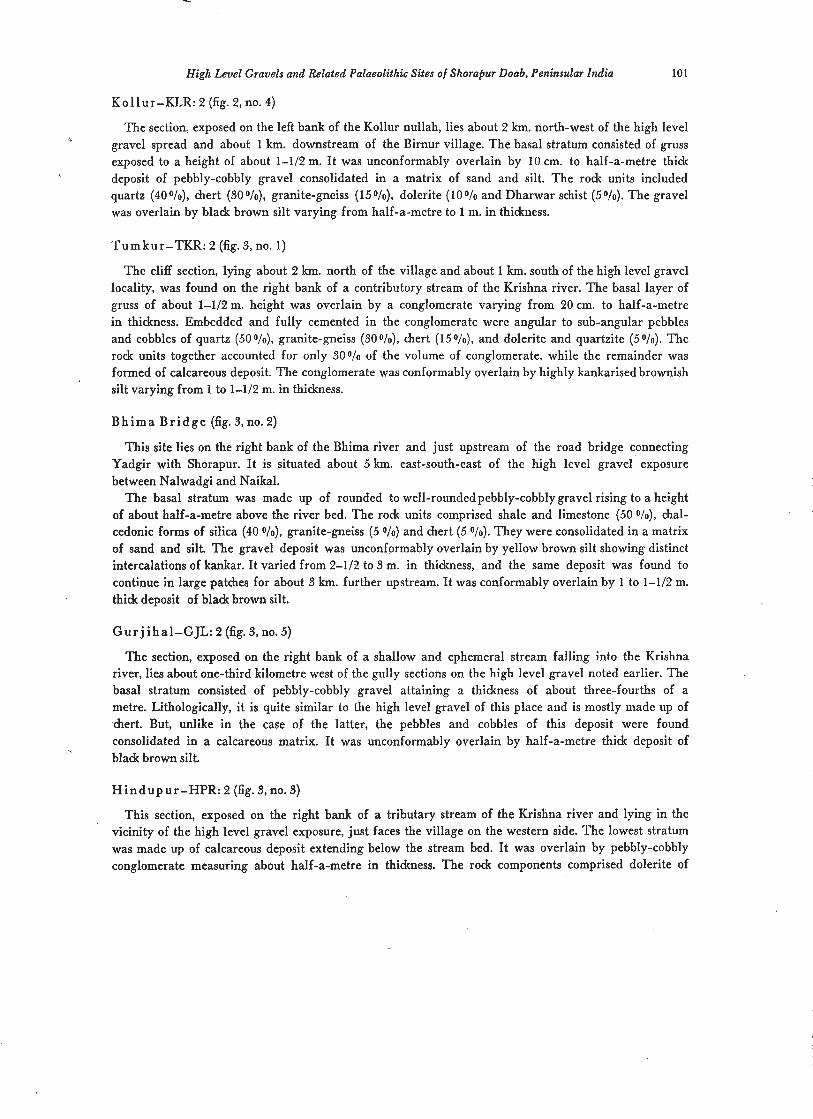
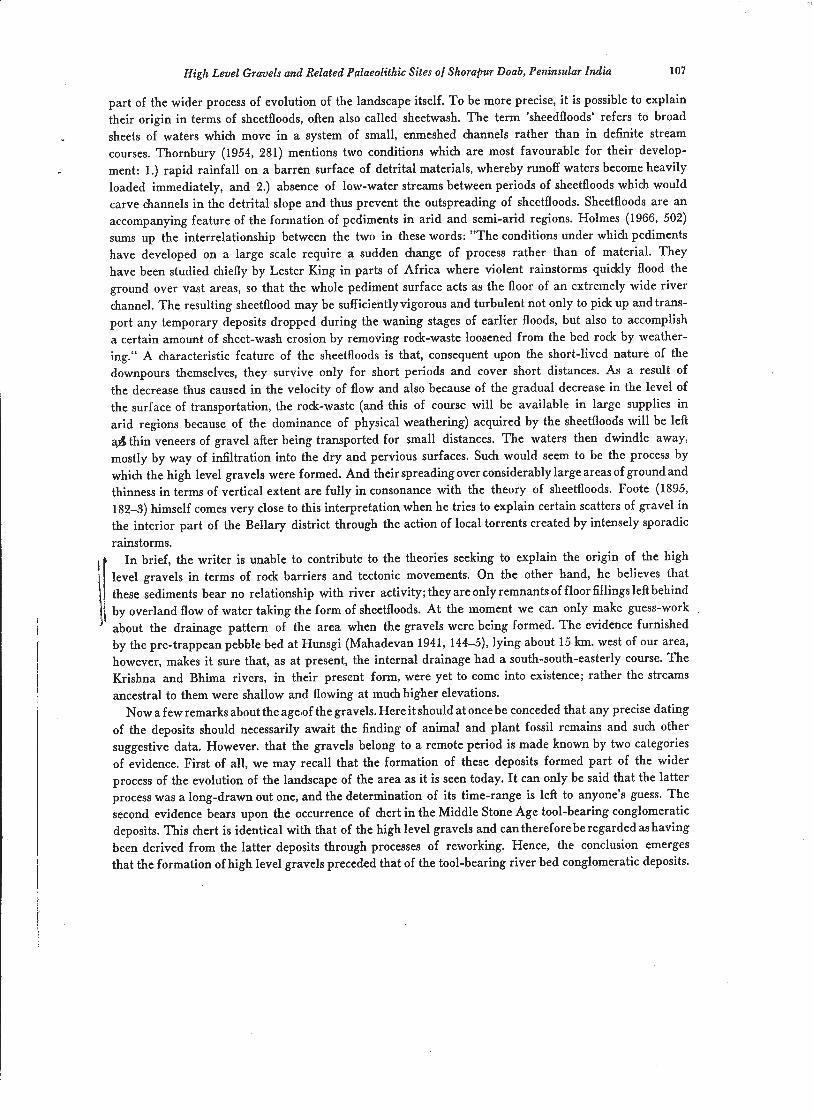
Tumkur-TKR: 2 (fig. 3, no. 1)
The cliff section, lying about 2 km. north of the village and about 1 krn. south of the high level gravel locality, was found on the right bank of a contributory stream of the Krishna river. The basal layer of gruss of about 1-112 m. height was overlain by a conglomerate varying from 20 cm. to half-a-metre in thickness. Embedded and fully cemented in the conglomerate were angular to sub-angular pebbles and cobbles of quartz (50O/o), granite-gneiss (300/0), chert (150/0), and dolerite and quartzite (5010). The rock units together accounted for only 30010 of the volume of conglomerate, while the remainder was formed of calcareous deposit. The conglomerate was conformably overlain by highly kankarised brownish silt varying from 1 to 1-112 m. in thickness.
B h i m a B r i d g e (fig. 3, no. 2)
This site lies on the right bank of the Bhima river and just upstream of the road bridge connecting Yadgir with Shorapur. I t is situated about 5 km. east-south-east of the high level gravel exposure between Nalwadgi and Naikal.
The basal stratum was made up of rounded to well-roundedpebbly-cobbly gravel rising to a height of about half-a-metre above the river bed. The rock units comprised shale and limestone (50 Olo), chal- cedonic forms of silica (40 Olo), granite-gneiss (5 010) and chert (5 010). They were consolidated in a matrix of sand and silt. The gravel deposit was unconformably overlain by yellow brown silt showing distinct intercalations of kankar. I t varied from 2-112 to 3 m. in thickness, and the same deposit was found to continue in large patches for about 3 km. further upstream. It was conformably overlain by 1 to 1-112 m. thick deposit of black brown silt.
Gur j iha l -GJL: 2 (fig. 3, no. 5)
The section, exposed on the right bank of a shallow and ephemeral stream falling into the Krishna river, lies about one-third kilometre west of the gully sections on the high level gravel noted earlier. The basal stratum consisted of pebbly-cobbly gravel attaining a thickness of about three-fourths of a metre. Lithologically, it is quite similar to the high level gravel of this place and is mostly made up of 'chert. But, unlike in the case of the latter, the pebbles and cobbles of this deposit were found consolidated in a calcareous matrix. It was unconformably overlain by half-a-metre thick deposit of black brown silt.
H i n d u p u r - H P R : 2 (fig. 3, no. 3)
This section, exposed on the right bank of a tributary stream of the Krishna river and lying in the vicinity of the high level gravel exposure, just faces the village on the western side. The lowest stratum was made up of calcareous deposit extending below the stream bed. It was overlain by pebbly-cobbly conglomerate measuring about half-a-metre in thickness. The rock components comprised dolerite of
K . Paddayya
R. BED -
-----
2. BHlMA BRIDGE
4. HPR- 8
Fig. 3. River sections in Shorapur Doab (Peninsular India): 1, Tumkur-2; 2, Bhima Bridge; 3, Hindupur-2; 4, Hindupur-3; 5, Gurjihal-2.
dyke origin (50 granite-gneiss (30 O/O), quartz (10 010) and chert (LO 010). The pebbles and cobbles of
the former three rocks were mostly angular. Calcareous matter formed the matrix as well as the cemen- ting material. The conglomerate was unconformably overlain by black brown silt varying from 1 t~ 1-112 m. in thickness.
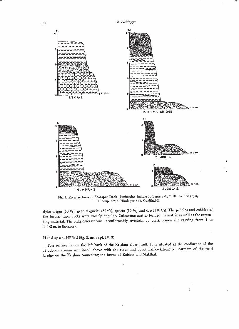
This section lies on the left bank of the Krishna river itself. It is situated at the confluence of the Hindupur stream mentioned above with the river and about half-a-kilometre upstream of the road bridge on the Krishna connecting the towns of Raichur and Makthal.
High Level Gravels and Related Palaeolithic Sites of Shorapur Doab, Peninsular India
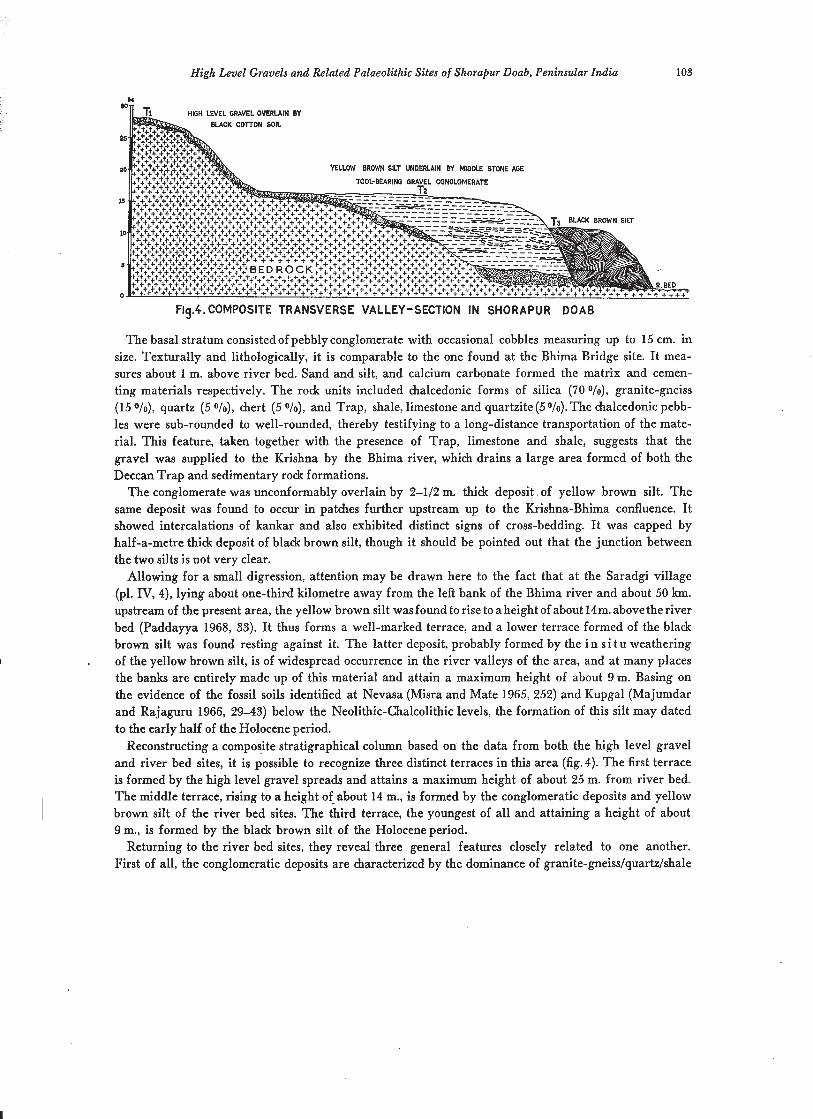
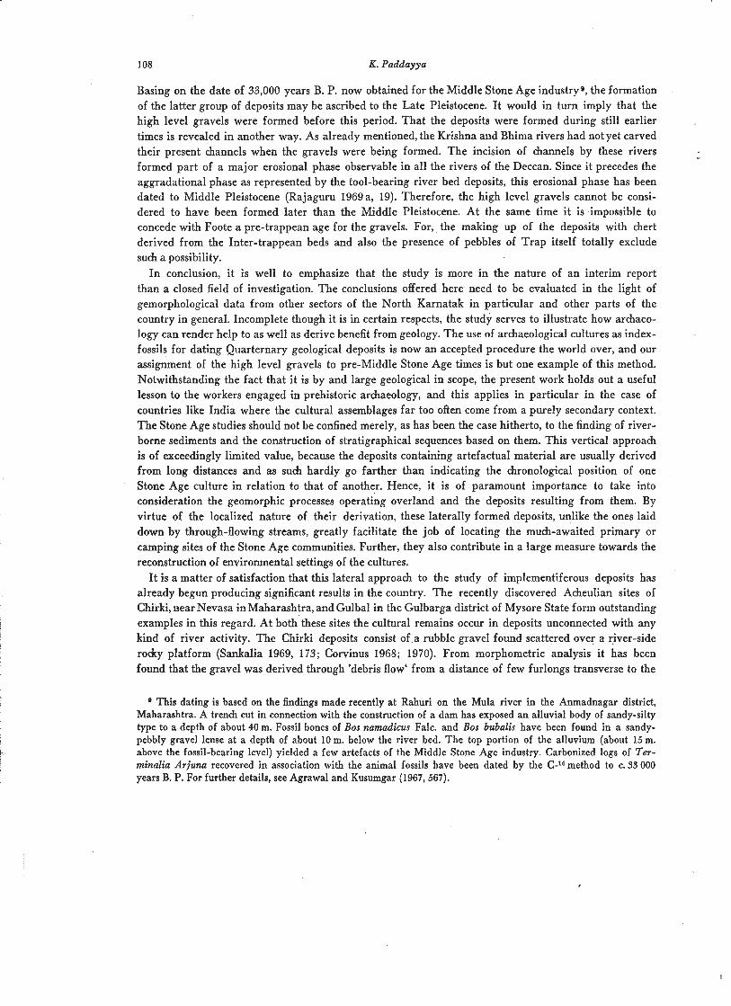
Fig.4. COMPOSITE TRANSVERSE VALLEY-SECTION IN SHORAPUR DOAB
The basal stratum consisted of pebbly conglomerate with occasional cobbles measuring up to 15 cm. in size. Texturally and lithologically, it is comparable to the one found at the Bhima Bridge site. It mea- sures about 1 m. above river bed. Sand and silt, and calcium carbonate formed the matrix and cemen- ting materials respectively. The rock units included chalcedonic forms of silica (70 Olo), granite-gneiss (15 Ole), quartz (5 O/o), chert (5 Ole), and Trap, shale, limestone and quartzite (5010). The chalcedonic pebb- les were sub-rounded to well-rounded, thereby testifying to a long-distance transportation of the mate- rial. This feature, taken together with the presence of Trap, limestone and shale, suggests that the gravel was supplied to the Krishna by the Bhima river, which drains a large area formed of both the Deccan Trap and sedimentary rock formations.
The conglomerate was unconformably overlain by 2-112 m. thick deposit of yellow brown silt. The same deposit was found to occur in patches further upstream up to the Krishna-Bhima confluence. It showed intercalations of kankar and also exhibited distinct signs of cross-bedding. It was capped by half-a-metre thick deposit of black brown silt, though it should be pointed out that the junction between the two silts is not very clear.
Allowing for a small digression, attention may be drawn here to the fact that at the Saradgi village (pl. IV, 4), lying about one-third kilometre away from the left bank of the Bhima river and about 50 km. upstream of the present area, the yellow brown silt was found to rise to a height of about 14m. above the river bed (Paddayya 1968, 33). I t thus forms a well-marked terrace, and a lower terrace formed of the black brown silt was found resting against it. The latter deposit, probably formed by the i n s i t u weathering
, of the yellow brown silt, is of widespread occurrence in the river valleys of the area, and at many places the banks are entirely made up of this material and attain a maximum height of about 9 m. Basing on the evidence of the fossil soils identified at Nevasa (Misra and Mate 1965,252) and Kupgal (Majumdar and Rajaguru 1966, 29-43) below the Neolithic-Chalcolithic levels, the formation of this silt may dated to the early half of the Holocene period.
Reconstructing a composite stratigraphical column based on the data from both the high level gravel and river bed sites, it is possible to recognize three distinct terraces in this area (fig. 4). The first terrace is formed by the high level gravel spreads and attains a maximum height of about 25 m. from river bed. The middle terrace, rising to a height of about 14 m., is formed by the conglomeratic deposits and yellow brown silt of the river bed sites. The third terrace, the youngest of all and attaining a height of about 9 m., is formed by the black brown silt of the Holocene period.
Returning to the river bed sites, they reveal three general features closely related to one another. First of all, the conglomeratic deposits are characterized by the dominance of granite-gneiss/quartz/shale
K . Paddayya
and limestone/chalcedony and its allied forms of silica. With the exception of the sites of Bhima Bridge and Hindupur-3 whose deposits seem to have been derived from considerable distances, the clastic ele- ments of the conglomerates at all the places were found to be mostly angular to sub-angular in character, and this leads to the suggestion that the deposits were of local derivation. Another noteworthy feature per- tains to the occurrence - in large numbers and in the i n s i t u context - of artefacts of the Middle Stone Age industry in the conglomeratic deposits. And this feature is common to all the sites. Typologically and technologically, the assemblages compare well with one another and as such could be ascribed to a single chronological horizon. The artefacts are predominantly of chert similar to that of the high-level gravels and show little or no traces of rolling. The most significant aspect of these sit,es, however, concerns with the occurrence of pebbles and cobbles of chert in the conglomeratic deposits. The proportion of this material was found to vary from 5 to 30010. Petrologically, it is identical with the one making up the high level gravels. The phenoclasts are in the same physical state of preservation (sub-rounded to rounded) as those of the latter gravels. A11 these considerations make the conclusion inescapable that the chert occurring in the tool-bearing conglomerates as also the artefacts manufactured on it were derived from the high level gravels through the processes of reworking; in other words, the latter category of deposits served as one of the several sources of debris supply in the formation of the former group of deposits. The chronological anteriority of the high level gravels over the river bed conglomeratic depo- sits is thus authenticated beyond doubt.
D i s c u s s i o n
The field b t a , stratigraphical and otherwise, obtained from various sites of the area enable us to arrive at certain conclusions about the origin and age of the high level gravels.
Firstly, the problem of origin of the deposits. Here we have two hypotheses of a conflicting type, one proposed by Foote and the other by Joshi. Both the hypotheses proceed from the assumption that the gravels are stream-laid deposits.
Foote, and after him Mukherjee and Krishna Murthy, concluded that the gravels were laid down as high flood accumulations of the main rivers before they had cut down their beds to the present levels. The high floods, according to these workers, were caused by rock barriers. Foote (1867, 237) writes: "There can be little doubt that these rivers (of Peninsular India) were affected by causes not now in action, by which their waters were raised to heights vastly exceeding the very highest flood levels now attained. The causes which thus affected the rivers were probably the existence of several barriers along their courses, by which their waters were dammed back to great heights above their present level. Such barriers doubtless crossed, in former times, the valleys of Krishna, Ghataprabha and Malapraba rivers . . . The existence of barriers is far more probable than that the general level of this part 'of India has been disturbed within late geological periods." The theory thus centers round the existence of' rock barriers along the river courses in former times. Although a detailed survey work yet remains to be done, the general observations made in the Krishna and Bhima valleys of the present area render the acceptance of this-theory difficult. A s already stated in the beginning, both the rivers .
show a mature stage of development. The cross profiles reveal U-shaped valleys with flat rock floors; the valley sides are made up of alluvium and as such do not give any indications of barriers. What is more important, the long profiles show that the courses are marked by extrdmely low gradients and do not show any marked irregularities or nickpoints which could be considered as an evidence for the existence of barriers in former times. And the few major nickpoints on the Krishna river lie outside the present area, i. e. in the upstream parts. The non-braided nature of the courses also goes against the existence of barriers. If the present conditions are any key to the past history of the rivers, it thus appears unlikely
High Level Gravels and Related Palaeolithic Sites of Shorapur Doab, Peninsular India
that any major rock barriers capable of swinging the flow of water several kilometres away in lateral directions existed along the river courses.
Joshi (1952, 69-72) had sought to interpret their formation in terms of tectonic movements. Basing on the study of a couple of gravel occurrences on the Mahi river in Gujarat, he hypothesized that these as also the ones found in the Peninsular India were laid down by the rivers at a time when they had courses different from the present ones. He further argued that the shifting of the courses and their rejuvenation ultimately resulting in the incision of the channels to the present depths were caused by the uplift of the land.
There is no denying the fact that the Deccan, more particularly the region formed by the Western Ghats, witnessed tectonic movements in the Tertiary period, and these probably continued, if with lesser intensity, into the Pleistocene epoch. Vredenburg (1906) postulated that the NNS-SSW running anticlinal warping of the region produced rocky basins favourable for the accumulation of alluvium in the central Narmada and the upper reaches of the Godavari and Krishna rivers. The steep westerly facing youthful scarp of the Western Ghats, the anamolous heights of some of their peaks, the presence of water- falls in otherwise graded streams, the location of primary laterites at different elevations and the superposed and rejuvenated character of some of the streams have all been taken by later writers to suggest tectonic movements of the epirogenic type (Rajaguru 1969 b). I t is, therefore, not unlikely that the Shorapur Doab, forming as it does part of the Deccan, also felt the effects of these earth move- ments. The difficulty, however, is that even in the western Deccan no clear-cut and indisputable geolo- gical evidence of tectonic activity has been found as yet. So far as our area is concerned, the absence of topographic unconformities and also the lack of evidence of faulting or folding in the recent geologi- cal strata forbid us from considering the tectonic movements as a serious factor in the formation of the high level gravels. The incision of channels to great depths ensued from the tendency of rivers to attain a state of equilibrium by cutting down to the base level of erosion. This major erosional phase is observed in all the rivers of the Peninsula and belongs to a period posterior to the formation of the high level gravels. The rising of the banks, which are made up of tool-bearing sediments, high above the present-day floods does suggest the rejuvenated nature of the rivers. But this phenomenon - and it is witnessed in many parts of the country - is of a comperatively late date; andit is generally believed to have resulted from post-Pleistocene climatic changesrather than tectonic movements (Gupte and Rajaguru 1969).
The considerations outlined above make it difficult for us to accept the theories of the existence of rock barriers and the uplift of land. Hence, the formation of the gravels needs to be interpreted through some other processes. Here it is important to take into account the topography of the area. It may be recalled that this Doab is essentially an undulating plain country flanked by low hill ranges and plateaux on thewestern and northern sides.Thesurfaceisformed of black cotten soil and is dotted here and there with rocky ridges and knobs of the residual nature. The general slope of the country is towards the south and south-east. The cliff sections examined at different places reveal that the granitic floor of the area is not very deep, lying only 1 to 3 m. below the surface. The isolated nature of the knobs and ridges of granite and Dharwar schist bear testimony to a long drawn out process of degradation. It hardly needs to be elaborated that the concept of pedimentation has received a world-wide application during the last two decades or so, the most prominent among its protagonists being L. C.King (1950). He has interpre- ted widely separated erosion surfaces in different continents as ancient pediments. The origin of these planed rock-cut surfaces has been variously ascribed to sheetflood erosion, lateral planation by streams and backweathering of hills. However, there is a growing conviction among the geomorphologists that pediments are attributable to a combination rather than to any one of the three geomorphic processes named above (Thornbury 1945, 286-90). I t seems possible to interpret the landscape of the area under
K. Paddayya
study in terms of the pediplain concept. The plain form of the landscape, the shallow depth of the rock floor and its veneering with a thin soil layer, the presence of isolated ridges and knobs and the flanking of the margins by hill ranges and plateaux are all features which go to suggest that this tract of land evolved through the process of pedimentation. If this be accepted, the formation of the high level gravels becomes easy for explanation. The following hypothesis is proposed here.
The index of rounding has been found to reveal that the gravels had undergone considerable trans- ' portation through the agency of water. Therefore, it stands beyond doubt that they are fluviatile in character. However, their thin, sheet-like nature, as opposed to the bar-like shapes of the implementi- ferous rivers bed sediments, their occurence above river levels and their location at some places several kilometres away from the main rivers suggest that these deposits were not laid down by channelled
' watercourses. Hence, it is not possible to believe that they were deposited by the main rivers of the area. W e are thus faced with the alternate suggestion that the gravels are only laterally accumulated deposits. And this view is confirmed by lithology. Chert quite similar4 to that of the gravels under consideration occurs in abundance in the form of Inter-trappean beds. Foote (1876, 198-9) describes a huge bed of thistype fromaplacecalled Shelgi in the adjoining Bijapur district5. A similar and equally extensive bed is known from Gurmatkal in the Yadgir taluks. And it is likely that such beds existed at several other places when the gravels were being formed7. Here attention should be drawn to the fact that the origins of the south-south-easterly internal drainage of the Doab partly lie in the plateaux formed by these Inter-trappean beds. As to the other rodr units such as granite, quartzite, shale, limestone, dolerite, etc., noted in the deposits, it may be stated that all of them occur locally in our area. It thus becomes evident that, notwithstanding their fluviatile character, the gravels are lateral accumulations and not formed due to longitudinal transportation by the Krishna and Bhima rivers from regions upstream of our area 8.
The important question now arises: what exactly is the mechanism of this lateral derivation? The inter- pretation offered here is that a) the gravels were laid down by surface runoff; and b) that this activity formed
4 The samples from the Inter-trappean bed at Shelgi and the high level gravel at Devapur were studied in the laboratory by Shri S.N.Rajaguru. He opines that they are quite identical petrologically as also in respect of colour.
This bed lies about 14 km. north-west of Talikot in the Muddeb'lhal taluk and about 30 km. west of our area. It is situated above 550 m. contour and forms a small plateau stretching for about 5 km. north-south and 2 km. east- west. It does not occur as a continous formation but rather consists of an assemblage of large blocks. Its thidcness, as ascertained by the writer, is about 2 m. The blocks are broken up by atmospheric agencies so that the ground is thidcly covered with debris to considerable distances beyond the real limits of the plateau. The chert is of variable colours ranging from mottled whitish grey to yellowish brown. Someblocks show amorechalcedonic characterwith patches of whitish blue or pea& colour. Significantly enough, Foote himself conceived of a relationship between chert beds of this type and the high level gravels. In his own words (1876, 199): "The degradation of chert beds of very similar character has contributed to the formation of large beds of chert gravel to be seen in the Old Alluvium (meaning the high level gravels) of the Krishna and Bhima rivers."
This formation lies about 25 km. north-east of Yadgir, and it is situated on a dissected plateau forming a water- divide. It measures about 15 m. in thickness - the lower 6 m. made up of marl beds and the upper part of chert beds. The chert beds are very similar in character to those occurring at Shelgi. As at Shelgi, they do not occur as a conti- nuous formation but as large boulders scattered over a thick deposit of bladc cotton soil. The colour again varies from mottled whitish grey to yellowish brown (Kazim 1941, 181-5; 1945).
The writer himself located one such bed at a place called Karibhavi, lying about 5 km. due east of the Shelgi bed.
8 It is interesting to observe that Mahadevan (1947,56) ascribes a similar origin to the chert spreads occurring in the Seram, Chitapur and Chinholi taluks. The area formed by these three taluks is situated immediately to the north-east of the Doab under study, i. e. to the northern side of the waterdivide formed by the Gurmatkal plateau bearing Inter-trappean beds.
High Level Gravels and Related Palaeolithic Sites of Shorapur Doab, Peninsular India
part of the wider process of evolution of the landscape itself. To be more precise, it is possible to explain their origin in terms of sheetfloods, often also called sheetwash. The term 'sheedfloods' refers to broad sheets of waters which move in a system of small, enmeshed hannels rather than in definite stream courses. Thornbury (1954, 281) mentions two conditions which are most favourable for their develop- ment: 1.) rapid rainfall on a barren surface of detrital materials, whereby runoff waters become heavily loaded immediately, and 2.) absence of low-water streams between periods of sheetfloods which would carve channels in the detrital slope and thus prevent the outspreading of sheetfloods. Sheetfloods are an accompanying feature of the formation of pediments in arid and semi-arid regions. Holmes (1966, 502) sums up the interrelationship between the two in these words: "The conditions under which pediments have developed on a large scale require a sudden change of process rather than of material. They have been studied chiefly by Lester King in parts of Africa where violent rainstorms quickly flood the ground over vast areas, so that the whole pediment surface acts as the floor of an extremely wide river channel. The resulting sheetflood may be sufficientlyvigorous and turbulent not only to pick up and trans- port any temporary deposits dropped during the waning stages of earlier floods, but also to accomplish a certain amount of sheet-wash erosion by removing rock-waste loosened from the bed rock by weather- ing." A characteristic feature of the sheetfloods is that, consequent upon the short-lived nature of the downpours themselves, they survive only for short periods and cover short distances. As a result of the decrease thus caused in the velocity of flow and also because of the gradual decrease in the level of the surface of transportation, the rock-waste (and this of course will be available in large supplies in arid regions because of the dominance of physical weathering) acquired by the sheetfloods will be left a$ thin veneers of gravel after being transported for small distances. The waters then dwindle away, mostly by way of infiltration into the dry and pervious surfaces. Such would seem to be the process by which the high level gravels were formed. And their spreading over considerably large areas of ground and thinness in terms of vertical extent are fully in consonance with the theory of sheetfloods. Foote (1895, 1823) himself comes very close to this interpretation when he tries to explain certain scatters of gravel in the interior part of the Bellary district through the action of local torrents created by intensely sporadic rainstorms.
In brief, the writer is unable to contribute to the theories seeking to explain the origin of the high
j level gravels in terms of rock barriers and tectonic movements. On the other hand, he believes that these sediments bear no relationship with river activity; they areonly remnantsof floor fillings left behind by overland flow of water taking the form of sheetfloods. At the moment we can only make guess-work about the drainage pattern of the area when the gravels were being formed. The evidence furnished by the pre-trappean pebble bed at Hunsgi (Mahadevan 1941, 144-5), lying about 15 km. west of our area, however, makes it sure that, as at present, the internal drainage had a south-south-easterly course. The Krishna and Bhima rivers, in their present form, were yet to come into existence; rather the streams ancestral to them were shallow and flowing at much higher elevations.
Now a few remarks about the age,of the gravels. Here it should at once be conceded that any precise dating of the deposits should necessarily await the finding of animal and plant fossil remains and such other suggestive data. However. that the gravels belong to a remote period is made known by two categories of evidence. First of all, we may recall that the formation of these deposits formed part of the wider process of the evolution of the landscape of the area as it is seen today. It can only be said that the latter process was a long-drawn out one, and the determination of its time-range is left to anyone's guess. The second evidence bears upon the occurrence of chert in the Middle Stone Age tool-bearing conglomeratic deposits. This h e r t is identical with that of the high level gravels and can therefore be regarded as having been derived from the latter deposits through processes of reworking. Hence, the conclusion emerges that the formation of high level gravels preceded that of the tool-bearing river bed conglomeratic deposits.
K. Paddayya
Basing on the date of 33,000 years B. P. now obtained for the Middle Stone Age industryo, the formation of the latter group of deposits may be ascribed to the Late Pleistocene. It would in turn imply that the high level gravels were formed before this period. That the deposits were formed during still earlier times is revealed in another way. As already mentioned, the Krishna and Bhima rivers had not yet carved their present channels when the gravels were being formed. The incision of channels by these rivers formed part of a major erosional phase observable in all the rivers of the Deccan. Since it precedes the aggradational phase as represented by the tool-bearing river bed deposits, this erosional phase has been dated to Middle Pleistocene (Rajaguru 1969a, 19). Therefore, the high level gravels cannot be consi- dered to have been formed later than the Middle Pleistocene. At the same time it is impossible to concede with Foote a pre-trappean age for the gravels. For, the making up of the deposits with chert derived from the Inter-trappean beds and also the presence of pebbles of Trap itself tokally exclude such a possibility.
In conclusion, it is well to emphasize that the study is more in the nature of an interim report than a closed field of investigation. The conclusions offered here need to be evaluated in the light of gemorphological data from other sectors of the North Karnatak in particular and other parts of the country in general. Incomplete though it is in certain respects, the study serves to illustrate how archaeo- logy can render help to as well as derive benefit from geology. The use of archaeological cultures as index- fossils for dating Quarternary geological deposits is now an accepted procedure the world over, and our assignment of the high level gravels to pre-Middle Stone Age times is but one example of this method. Notwithstanding the fact that it is by and large geological in scope, the present work holds out a useful lesson to the workers engaged in prehistoric archaeology, and this applies in particular in the case of countries like India where the cultural assemblages far too often come from a purely secondary context. The Stone Age studies should not be confined merely, as has been the case hitherto, to the finding of river- borne sediments and the construction of stratigraphical sequences based on them. This vertical approach is of exceedingly limited value, because the deposits containing artefactual material are usually derived from long distances and as such hardly go farther than indicating the chronological position of one Stone Age culture in relation to that of another. Hence, it is of paramount importance to take into consideration the geomorphic processes operating overland and the deposits resulting from them. By virtue of the localized nature of their derivation, these laterally formed deposits, unlike the ones laid down by through-flowing streams, greatly facilitate the job of locating the much-awaited primary or camping sites of the Stone Age communities. Further, they also contribute in a large measure towards the reconstruction of environmental settings of the cultures.
I t is a matter of satisfaction that this lateral approach to the study of implementiferous deposits has already begun producing significant results in the country. The recently discovered Acheulian sites of Chirki, near Nevasa inMaharashtra, and Gulbal in the Gulbarga district of Mysore State form outstanding examples in this regard. At both these sites the cultural remains occur in deposits unconnected with any kind of river activity. The Chirki deposits consist of a rubble gravel found scattered over a river-side rocky platform (Sankalia 1969, 173; Corvinus 1968; 1970). From morphometric analysis it has been found that the gravel was derived through 'debris flow' from a distance of few furlongs transverse to the
* This dating is based on the findings made recently at Rahuri on the Mula river in the Anmadnagar district, Maharashtra. A trench cut in connection with the construction of a dam has exposed an alluvial body of sandy-silty type to a depth of about 40 m. Fossil bones of Bos namadicus Falc. and Bos bubalis have been found in a sandy- pebbly gravel lense at a depth of about 10 m. below the river bed. The top portion of the alluvium (about 15 m. above the fossil-bearing level) yielded a few artefacts of the Middle Stone Age industry. Carbonized logs of Ter- minalia A ~ j u n a recovered in association with the animal fossils have been dated by the C-l4 method to c. 33 000 years B. P. For further details, see Agrawal and Kusumgar (1967,567).

High Level Gravels and Related Palaeolithic Sites of Shorapur Doab. Peninsular India
river channel, whereby revealing that the people were carrying on their activities in the environs. of the present locality (Rajaguru and Pappu 1971). T h e site of Gulbal is situated on a plainland lying a t the foot of a limestone plateau: the tool-bearing gravel conglomerate occurs as a fan deposit derived from the plateau through the combined action of surface washing, gravity flow and rill erosionlo. It is thus suggested that the Stone Age man chose the valley for his activities and chipped tools out of the material available there. One would sincerely hope that studies of this kind will be extended to various parts of the country and also in respect of the other cultural phases of the prehistoric past, so that we may be able to resuscitate the life-ways of former societies.
'0 This site was discovered by the writer in February 1969, and it lies about 25 km. west of the Shorapur Doab.
A c k n o w l e d g e m e n t s
This work was carried out by the writer while he was holding a Research Fellowship awarded by the University Grants Commission, New Delhi. He is thankful to Prof. H. D. Sankalia, Jawaharlal Nehru Memorial Research Fellow, for many helpful comments. He also wishes to acknowledge his grateful thanks to Shri S. N. Rajaguru, Rea- der in Environmental Archaeology, Deccan College, Poona, for kindly going through the first draft of the paper and offering many valuable suggestions.
R e f e r e n c e s
A g r a w a 1, D. P. and Ku sum g a r, S. 1967. Radiocarbon Dates of some Prehistoric and Pleistocene Samples, Cur- rent Science, vol. 36,566-8.
C o r v i nus , G., 1968. An Acheulian Occupation Floor at Chiriki on Pravara, Current Anthropology, vol. 9, nos. 2-3 216-18.
- 1970. The Acheulian Workshop at Chiriki on the Pravara River, Maharashtra, Indian Antiquary, vol. IV, 13-22. F o o t e . R. B., 1876. The Geological Features of the South Maratha Country and adjacent Districts, Memoirs of the
Geological Survey of India, vol. XII, 1-268. - 1895. Geology of Bellary District, Madras Presidency, ibid., vol. XXV, 1-218. G u p t e , R. B. and R a j a g u r u , S. N., 1969. Late Pleistocene Geomorphological History of Rivers of Western Ma-
harashtra, Paper read at the International Symposium on Deccan Traps held at Saugar in January 1969. H o 1 me s , A r t h u r , 1966. Principles of Physical Geology, E. L. B. S. Edition, London and Edinburgh. Josh i , R. V., 1952..High Level Gravels of the Mahi River, Journal of the M. S. University of Baroda, vol. I, 69
-72. K a z i m , S y e d , 1941. Geology of Yadgir Taluk, Gulbarga District, Journal of the Hyderabad Geological Survey,
vol. IV, pt. 1, 162-88. - 1945. The Intertrappean Chert Beds and their Fossils near Gurmatkal, Gulbarga District, ibid., vol. IV, pt. 2,
1-5. K i n g , L. C., 1950. The Study of the World's Plainlands: a New Approach in Geomorphology, Quarterly Journal
of the Geological Society of London, vol. 106, 101-27. (As quoted by Thornbury 1954,296.) K r i s h n a M u r thy, L. S., 1941. Geology of Parts of Mahabubnagar and Gulbarga Districts, Journal of the Hyder-
abad Geological Survey, vol. IV, pt. 1, 55-101. M a h a d e v a n , C., 1941. Geology of the South and South western parts of Surapur Taluk, Gulbarga District, ibid.,
102-61. - 1947. The Bhima Series and other Rocks in Gulbarga District, ibid., vol. V, pt. 1, 1-60. M a j um d a r , G. G. and R a j a gu r u , S. N., 1966. Ashmound Excavations at Kupgal, Deccan College, Poona. Mi s r a , V. N. and M a t e , M. S. (eds.), 1965. Indian Prehistory: 1964, Deccan College, Poona. Mu k h e r j e e , S. K., 1941. Geology of parts of Surapur and Shahpur Taluks, Gulbarga District, Journal of the Hy-
derabad Geological Survey, vol. IV, pt. 1,9-54. P a d d a y y a , K.. 1968. Pre- and Proto-historic Investigations in Shorapur Doab, Ph. D. Thesis, Poona University
and Deccan College Libraries. P e t t i j o h n , F. J., 1957. Sedimentary Rocks, Oxford Book & Stationery Co., Calcutta.
K. Paddayya
R a j a g u r u , S. N., 1969a. Some New Fossil Discoveries from Western Maharashtra, India, Puratattva, no. 2 (1968 -69), 16-20.
- 1969b. On the Late Pleistocene of the Deccan, India, Quarternaria, vol. XI, 241-53. R a j a g u r u , S. N. and P a p p u , R. S., 197 1. Environments as Reflected in the Alluvial Deposits of Chiriki-Nevasa,
Dt. Ahmednagar, Journal of the University of Poona (Science and Technology Section), no. 40, 115-21. S a n ka 1 i a , H. D., 1969. Early Man in India, Journal of the Asiatic Society of Bombay, vols. 41-42 (1966-67),
173-81. T h o r n b u r y , W i 11 i am , D., 1954. Principles of Geomwphology, Wiley International Edition, New York and
London. V r e d e n b u r g , G., 1906. Pleistocene Movements as indicated by Irregularities of gradient of the Narmada and
other Rivers in the Indian Peninsula, Records of the Geological Survey of India, vol. XXXIII, pt. 1, 33-46.
K. Paddayya, Shorapur Doah P1. IV
1. Hig!~ level gravel at Devapur, exposcd on a sloping surface.
2. Gully section at Dcvapur-I, s1io;:~i~ig the high level gravel overlying weathered bedrock.
3. Cliff-section at Ilindupur-3 on the Krishna river. showing the Middle Stone Age tool- beartng gravel conglomerate capped by a thick 4. V ~ e w ol the cross-bedded yellow brown slit ,tt S~rnt lg i ,
deposit of yellow brown silt. lying ahout one-third kilometre away from the Bhima nver.
Related Documents