I

Welcome message from author
This document is posted to help you gain knowledge. Please leave a comment to let me know what you think about it! Share it to your friends and learn new things together.
Transcript

I
r(
'p
I,'I
OFFICIAL USE ONLYPREDECISIONAL INFORMATION —EXEMPI'ront disclosure pursuant to the FOIA at 5 USC 552 Ih) IS)
Eis PRO)FCT - 6PP
DCS INPUT FORM
DCSN:
Instructions: Fill in bolded areas completely. See back of form for notes.
Document Identification Number"':
Document Title (or description)"'.
Document Date:
EGG-WMO-10279
ENVIRONMENTAL RESOURCE DOCUMENT FORTHE IDAHO NATIONAL ENGINEERINGLABORATORY UQJULY 1993
Parent Document"':
EIS Section Referenced to: VOLUME 1, APPENDIX B
File Guide Index: (DOE Order Numher) 5440.01.09
Author and Organization:
Technical Leader:
WBS Number:
Medium:
tKey Words"'.
I
Addressee Name"'nd Or ganization:
Signature Name"'nd Organization:
Document Type'n:
Record Determination:
Data Entry Verification:
Date:
JOHN S. IRVING
X Hard Copy DiskOther (Specify)
RESOURCES,
REFERENCE MATERIAL
HVAR y 0 PF X REF
DCSFRM.IVP REV. 3 (02/17/94)
EGG-WMO-1 0279July 1993
":-'-".-'-', Idiho '.". Niitioniii,
Engiii eerIn g,Labori toiy '.
Environmental Resource Document for theIdaho National Engineering Laboratory
Volume 2
'- Managed.'by ihe U.S.
';.'Oe ~OTtvtIt ~~Energy.
John S. IrvingPrincipai Investigator
EGG-WMO-1 0279
Environmental Resource Document for theIdaho National Engineering Laboratory
Yolume 2
John S. IrvingPrincipal Investigator
Published July 1993
Idaho National Engineering LaboratoryEG86 Idaho, Inc.
Idaho Falls, Idaho 83415
Prepared for theU.S. Department of Energy
Assistant Secretary for Environmental Restoration and Waste ManagementUnder DOE Idaho Operations Office
Contract DE-AC07-76IDO1 670
Contents i iii
CONTENTS
VOLUME 1
ABSTRACT nl
FOREWORD .
ACKNOWLEDGMENTS
1. DESCRIPTION OF THE INEL
2. LAND RESOURCES 2-1
3. AIR RESOURCES 3-1
4. WATER RESOURCES 4-1
5. ECOLOGICAL RESOURCES 5-1
6. SOCIOECONOMIC CHARACfERISTICS AND LAND USE ..7. CULTURAL, AESTHETIC, AND SCENIC RESOURCES
VOLUME 2
6-1
7-1
Appendix A-Land Resources
Appendix B-Air Resources
Appendix C-Water Resources
Appendix D-Ecological Resources
Appendix E-Socioeconomic Characteristics
Appendix F-Cultural Resources .
A-1
B-1
C-1
D-1
E-1
F-1
Appendix G—Environmental Resources Databases and Geographical Information Systems... G-1
Appendix H-Data Deficiencies and Needs H-1
Environmental Resource Document for the Idaho National Engineering Laboratory
July 1993 / Issue No. 001
Contents I v
DETAILED CONTENTS
VOLUME 1
ABSTRACT
FOREWORD .
Introduction
National Environmental Policy Act Documentation
ACKNOWLEDGMENTS
SECTION 1
ACRONYMS
1. DESCRIPTION OF THE INEL
1-lv
1.1 Introduction .
1.2 INEL Missions
1.2.1 Mission Statement1.2.2 Mission Areas of Primary Interest
1.3 Organization and Administration
1.4 Location
1-11-2
1-2
1-3
1.5 INEL Facilities 1-5
1.5.1 Overview
1.5.2 Facility Operations
1-51-6
REFERENCES
SECTION 2
ACRONYM S 2-vl
2. LAND RESOURCES 2-1
Environmental Resource Document for the Idaho National Engineering LaboratoryJuly 1993 / Issue No. 001
Contents 0 vi
2.1 Geology, Seismology, and Volcanism
2.1.1 Regional Geologic Setting2.1.2 Subsurface Stratigraphy at the INEL .2.13 Summary of Seismicity And Seismic Hazards
2.1.4 Volcanism and Volcanic Hazards
2-1 )
2-12-132-162-35
2.2 Soils . 2-45
2.2.1 Eolian Sediments Over Lava2.2.2 Alluvial Deposits2.2.3 'Lacustrine Deposits, Playas, and Sand Dunes2.2.4 Colluvial Deposits
REFERENCES
SECTION 3
ACRONYMS
2-472-482-492-50
2-51
3-v
3. AIR RESOURCES 3-1
3.1 INEL Climatic Conditions 3-1
3.1.1 INEL Meteorological Observation Network3.1.2 INEL General Weather Pattern3.1.3 Weather Hazards .
3-13-53-7
3.2 Air Quality .
3.2.1 Regulatory Overview
3.2.2 INEL Ambient Air Quality .3.2.3 Nonradioactive Airborne Effluent Monitoring3.2.4 Radioactive Effluent Monitoring
3.3 INEL Noise
3-8
3-83-83-9
3-17
3-18
3.3.1 INEL Ambient Noise3.3.2 INEL Man-Made Sources of Noise .. 3-18
3-18
REFERENCES 3-26
Environmental Resource Document for the Idaho National Engineering Laboratory
July 1993 / Issue No. 001
Contents 4 vii
SECIION 4
ACRONYMS
4. WATER RESOURCES
4.1 Surface Hydrology .
4-1
4-1
4.1.1 Stream How on the INEL4.1.2 Flooding Potential
4-14-5
4.2 Subsurface Hydrology . 4-6
4.2.1 Vadose Zone .4.2.2 Perched Water Conditions
4.2.3 Saturated Zone .
. 4-64-114-21
REFERENCES 4-30
SECTION 5
ACRONYMS
5. ECOLOGICAL RESOURCES
5-v
5-1
5.1 Biotic Resources 5-1
5.1.1 Overview
5.1.2 Historic activities and effects on ecosystem .5.1.3 Vegetation ..5.1.4 Fish and Wildlife
5.1.5 Threatened, Endangered, and Sensitive Species5.1.6 Unique or Special Habitats and Communities .5.1.7 Historic and Current Impacts
5-15-45-55-75-9
5-105-14
5.2 Wetland Resources 5-19
5.2.1 Overview
5.2.2 Wetland Classes on the INEL .5.2.3 Temporal Variability ..5.2.4 Ecological Significance .5.2.5 Potentially Important Wetlands5.2.6 Historic and Current Impacts5.2.7 Future FWS Survey Activities...
5-195-195-195-225-225-235-23
Environmental Resource Document for the Idaho National Engineering LaboratoryJuly 1993 / Issue No. 001
Contents 4 viii
5.3 Radioecology
REFERENCES
SECHON 6
5-23
5-25
ACRONYMS 6-v
6. SOCIOECONOMIC CHARACTERISTICS AND LAND USE . 6-1
6.1 Socioeconomic Characteristics 6-1
6.1.1 Demographic Characteristics..................6.1.2 Economy, Employment, and Income6.1.3 Housing6.1.4 School Services .6.1.5 Taxes6.1.6 Idaho National Engineering Laboratory6.1.7 Fire Protection and Emergency Services
6.1.8 Security Services6.1.9 Nonhazardous and Nonradioactive Solid Waste Disposal ..6.1.10 Health Care Delivery Services
6.2 Land Use ..
.. 6-16-56-8
6-106-136-156-19
. 6-216-216-22
6-24
6.2.1 Existing INEL Land Use, Plans, and Policies 6-24
6.2.1.1 General Description6.2.1.2 Functional Areas6.2.1.3 Other INEL Land Uses6.2.1.4 DOE Internal Land Use Plans
6.2.1.5 Other Plans and Policies Affecting the INEL
6.2.2 Surrounding Land Use and Policies.
6.2.2.1 General Description6.2.2.2 DOE Idaho Falls Facilities6.2.2.3 County Land Use
REFERENCES
6-246-246-246-306-31
6-33
6-336-346-34
6-37
Environmental Resource Document for the Idaho National Engineering LaboratoryJuly 1993 / Issue No. 001
Contents 4 ix
SEC%ON 7
ACRONYMS 7-iv
7. CULTURAL, AESTHETIC, AND SCENIC RESOURCES 7-1
7.1 Cultural Resources 7-1
7.1.1 Regulatory Overview
7.1.2 Procedural Overview .7.1.3 History of INEL Cultural Resource Management
7.1.4 Resource Overview
7-17-27-57-7
7.2 Aesthetic and Scenic Resources . 7-23
7.2.1 Visual Character of the Project Vicinity .7.2.2 Views of the INEL from Surrounding Areas7.2.3 Scenic Resource Policies .
7-237-257-32
REFERENCES
VOLUME 2
Appendix A-Land Resources
7-33
ACRONYMS A-vu
,A.1 Summary of the Results and Conclusions of the 1990-1992 Geoscience Investigations
for the NPR Program . A-1
A.1.1 Task 1 - Site Specific Geotechnical Investigations A-2
A.1.1.1 In situ Measurements
A.1.1.2 Laboratory Tests To Determine Static Mechanical And PhysicalProperties
A.1.1.3 Dynamic Property Tests
A-2
A-3A-3
A.1.2 Tasks 2, 3, and 4 - Fault InvestigationsA.1.3 Task 5 - Volcanic Rift Zone Investigations .A.1.4 Task 6 - Broadband Teleseismic NetworkA.1.5 Task 7 - Upgrade INEL Seismic Network
A.1.6 Task 8 - Regional Geomorphologic Investigations...A.1.7 Task 9 - Location Of The 1905 EarthquakeA.1.8 Task 10 - Heat How Determinations And Modeling .
A-3A-6A-8A-8A-8A-9A-9
Envfronmental Resource Document for the Idaho. National Engineering LaboratoryJuly 1993 / Issue No. OO1
Contents 0 x
A.1.9 Task 11 - Leveling Surveys .A.1.10 Task 12 - Reoccupy INEL GPS NetworkA.1.11 Task 13 - In situ Stress Determinations .A.1.12 Task 14 - Geophysical Investigations And ModelingA.1.13 Task 15 - Site Specific Ground Motion Assessment
A-11A-11A-12A-12A-13
A.2 Seismicity and Seismic Hazards ...A-15
A.2.1 Regional Seismotectonic Setting
A.2.2 Earthquake Data
A.2.3 Moderate to Large Earthquakes
A-15
A-15
A-17
A.2.4 Geologic Structures and Tectonic Activity A-22
A.2.4.1 Tectonic ProvincesA.2.4.2 Faults .A.2.4.3 Volcanic Rift Zones and Axial Volcanic Zone
A-22A-24A-31
A.2.5 Correlation of Earthquake Activity with Geologic Structures or TectonicProvinces . A-32
A.2.5.1 ESRP Province .A.2.5.2 Northern Basin and RangeA.2.5.3 Yellowstone Plateau .A.2.5.4 Northern Rockies .
A-35A-49A-50A-53
A.2.6 Maximum Earthquake Potential A-53
A.2.6.1 Lemhi Fault - Howe and Fallert Springs Segments ..A.2.6.2 Lost River Fault - Arco SegmentA.2.63 Beaverhead Fault - Blue Dome Segment .A.2.6.4 ESRP Boundary FaultsA.2.6.5 ESRP Volcanic ZonesA.2.6.6 ESRP Province .A.2.6.7 Northern Basin and Range Province ..A.2.6.8 Idaho Batholith ProvinceA.2.6.9 Yellowstone Plateau Province .
A-53A-55A-55A-55A-57A-58A-58A-58A-59
A.2.7 Seismic Wave Transmission Characteristics A-59
A.2.7.1 Regional AttenuationA.2.7.2 Near-surface Geological Attenuation
A-59.',....A-59
Environmental Resource Document for the Idaho National Enylneeriny LaboratoryJuly 1993 / Issue No. 001
Contents 4 xi
A.2.8 Ground Motion Studies A-60
A.2.8.1 1990 INEL Deterministic Evaluation
A.2.8.2 1993 INEL Probabilistic Evaluation
A-60A-60
A.3 Surface Faulting A-61
A.4 Description of Soil Classification and Mapping Information Available About theINEL-Summary . A-62
A.5 References A-63
A.6 Annotated Bibliography for Geoscience Investigations, New Production ReactorsProgram, and Other INEL Programs A-75
Appendn: B-Air Resources
B.1 Annotated Bibliography for Air Resources
B.2 Keyword List .
B.3 Subject List
B-1
B-15
B-19
Appendix C-Water Resources
ACR ONYMS C-v
C.1 Perched Water Data. C-1
C.1.1 Water QualityC.1.2 Test Reactor AreaC.1.3 Radioactive Waste Management AreaC.1.4 Idaho Chemical Processing Plant ..
C-1C-1C-1C-1
C.2 Groundwater Quality Data
C.3 References .
C-2
C-34
C.4 Annotated Bibliography for Water Resources C-35
C.5 Keyword List
C.6 Subject List
C-125
C-137
Environmental Resource Document for the Idaho National Engineering LaboratoryJuly 1993 / Issue No. 001

Contents 0 xii
Appendix D-Ecological Resources
ACRONYMS D-vi
D.l Ecological Setting D-1
D.1.1 Flora and Plant Communities D-2
D.1.1.1 Vegetation Mapping ...D.1.1.2 INEL Vegetation Communities Classification
D-3D-3
D.1.2 Fauna D-21
D.1.2.1 Mammals
D.1.2.2 Birds .D.1.2.3 Amphibians and Reptiles ..D.1.2.4 FishD.1.2.5 Invertebrai: s
...D-23. D-23...................D-37. D-37. D-37
D.1.3 Threatened, Endangered, and Sensitive Species D-39
D.1.3.1 PlantsD.1.3.2 Animals
. D-40
. D-42
D.1.4 Unique or Special Habitats and Communities D-42
D.1.4.1 Wetlands .D.1.4.2 CavesD.1.43 Manmade Structures and FacilitiesD.1.4.4 Soil Microflora .
D-42D-58D-58D-58
D.2 Habitat Analyses and Ecological Associations (Biological Assessment) D-63
D.2.1 Vegetation Communities . D-63
D.2.1.1 FragmentationD.2.1.2 Exotic SpeciesD.2.1.3 Ecological Importance .D.2.1.4 Vegetation Community Stratification
D-63D-63D-63D-63
D.2.2 Habitat and Ecological Associations-Hora D-65
Environmental Resource Document for the Idaho National Engineering Laboratory
July 1993 / Issue No. 001
Contents 4 xiii
D.23 Habitat and Ecological Associations —Fauna D-65
D.2.3.1 Mammals
D.2.3.2 Birds
D-66D-66
D.2.4 Habitat and Ecological Associations-Threatened and Endangered Species . D-66
D.2.4.1 FloraD.2.4.2 Fauna
D-66D-66
D.2.5 Unique or Special Habitats and Communities D-72
D.2.5.1 Wetlands .D.2.5.2 Caves .D.2.5.3 Manmade Structures and Facilities
D.2.5A Soil Microflora
D-72D-72D-73D-73
D.3 References D-75
D.4 Annotated Bibliography for Ecological Resources . D-81
D.S Keyword List
D.6 Subject List
D-147
D-155
Appendix E-Socioeconomic Characteristics
ACRONYMS
E.1 Demographic Characteristics
E.2 Economy, Employment, and Income .
E-v
E-1
E-7
E3 Housing E-11
E.4 School Services
E.S Taxes
E.6 Idaho National Engineering Laboratory .
E.7 Fire Protection and Emergency Services .
E-13
E-13
E-20
E-25
E8 Security Services E-25
Environmental Resource Document for the Idaho National Engineering LaboratoryJuly 1993 / Issue No. 001
Contents 4 x|v
E.9 Nonhazardous and Nonradioactive Solid Waste Disposal
E.10 Health Care Delivery Services
REFERENCES
E-25
E-25
E-31
Appendix F-Cultural Resources
ACRONYM 8 F-vt
F.1 Summary of Federal and State Guidelines Related to Cultural Resources on theINEL . F-1
F.1.1 Federal Law F-1
F-2F-2
F-5F-6
F.1.1.1 Antiquities Act of 1906 [Public Law (PL) 59-209; 16 U.S. Code(USC) 431-433) . F-2
F.1.1.2 Historic Sites, Buildings, and Antiquities Act of 1935, as amended
(PL 74-292; 16 U;..:.'461-467;49 Statute 666) .F.1.1.3 The Reservoir Salvage Act of 1960 (PL 86-523; 16 USC 469) .....F.1.1.4 National Historic Preservation Act (NHPA) of 1966, as amended
[PL 89-665; PL 96-515; 16 USC 470; 36 Code of FederalRegulations (CFR) 60, 61, 63, 64, 65, 67, 68, 800; 48 FR44716-44742] F-2
F.1.1.5 Federal Collections Act of 1966 (PL 89-508; 80 Stat. 309; 4 CFR 2) F-4F.1.1.6 National Environmental Policy Act (NEPA) of 1969 [PL 91-190;42
USC 4321-4361; 40 CFR 1500-1508; 10 CFR 1021; Executive Order
(E.O.) 11514;E.O. 119911 . F4F.1.1.7 Executive Order 11593 of 1971 (36 CFR 8921) F-4F.1.1.8 Archaeological and Historic Preservation Act (AHPA) of 1974 (PL
86-523; PL 93-291; 42 CFR 5375; 42 FR 5374; 16 USC 469) ......F-4F.1.1.9 Department of Transportation Act of 1976 (PL 89-670; 49 USC
4321-4361) F-5F.1.1.10Embezzlement and Theft Act of 1875, as amended (PL 93-203; PL
93-567; 18 USC 641) F-5F.1.1.11Destruction of Government Property, Malicious Mischief (18 USC
1361) ............................................F-5F.1.1.12American Indian Religious Freedom Act (AIRFA) of '1978 (PL
95-341; 42 USC 1996; 43 CFR 7; 25 CFR 262; 55 FR 2580-2583) ..F-5F.1.1.13Archaeological Resources Protection Act (ARPA) of 1979, as
amended (PL 96-95; PL 100-555; PL 100-588;16USC 470; 43 CFR7; 36 CFR 296; 18 CFR 1312; 32 CFR 229)
F.1.1.14Federal Cave Resources Protection Act of 1988 (PL 100-691).....
Environmental Resource Document tor the idaho National Engineering Labe-ratory
July 1993 / Issue No. 001
Contents I xv
F.1.1.15Curation of Federally-Owned and Administered ArchaeologicalCollections (36 CFR 79)
F.1.1.16Native American Grave Protection and Repatriation Act of 1990(PL 101-601) .
F-6
F-6
F.1.2 Department of Energy Directives F-6
F.1.2.1 U.S. DOE Order 1324.7:Departmental History Program (10/21/88) . F-6F.1.2.2 U.S. DOE Memorandum EH-231: Management of Cultural
Resources at Department of Energy Facilities (R. F. Pelletier,2/23/90) F-7
F.1.2.3 DOE-ID Directive: Management of Cultural Resources on the INEL(A. A. Pitrolo, 10/12/90) ................F-7
F.1.2.4 U.S. DOE Report ER-0246: DOE National Environmental ResearchParks (8/1/85) . F-7
F.1.3 Idaho State Laws F-7
F-8
F.1.3.1 Idaho Antiquities Act, Idaho Code, Chapter 41 ................F-7F.1.3.2 Idaho Burial Act, Idaho Code, Chapter 5, Title 27 and Chapter 70,
Title 18 . ..F-8F.1.3.3 Idaho Cave Protection Act, Idaho Code, Chapter 70, Title 18,
Section 7035 .
F.2 Comprehensive Catalog of INEL CRM Projects
F.3 Useful Plants Found on the INEL
F.4 Programmatic Priorities
F-9
F-15
F-19
F.4.1 Programmatic Agreements F-19
F.4.2 Communication Between INEL Programs/Managers and the INEL-CRMOffice . F-19
F.4.3 NHPA Section 110 Compliance
F.4.4 Law Enforcement
F.4.5 INEL Cave Resource Management Plan
F.4.6 INEL Paleontological Management Plan .
F.4.7 INEL History
F-19
F-20
F-20
F-20
F-20
Environmental Resource Document for the Idaho National Engineering LaboratoryJuly 1993 / Issue No. 001
Contents t xvi
F.S References .
F.6 INEL Archaeological Survey Maps .
..F-n )F-27
F.7 Annotated Bibliography for Cultural Resources of the INEL F-59
F.8 Keyword List
F.9 Subject List .
F-109
F-115
Appendix G-Environmental Resources Databases and Geographical Information Systems
ACRONYMS G-v
G.1 Environmental Resources Databases G-1
G.1.1 Wind G-1
G.1.1.1 CAP-88G.1.1.2 GENIIG.1.1.3 NOAA
G-1G-4G-4
G.1.2 Water
G.1.2.1 Hydraulic BibliographyG.1.2.2 Drinking Water Wells
G-4G-4
G.1.3 Geology, Seismology, and Volcanism G-4
G.1.3.1 Radioactive Waste Management Complex (RWMC) Bibliography ..G-4G.1.3.2 New Production Reactor (NPR) Bibliography G-4G.1.3.3 WAG 10 Well File Repository G-5G.1.3.4 NPR Geologic Database . G-5
G.1.4 Ecology, Cultural, and Socioeconomic Resources G-5
G.1.4.1 Radiological and Environmental Sciences Laboratory (RESL) .G.1.4.2 Intermountain Antiquities Computer System (IMACS)G.1.4.3 Predictive Model for Prehistoric ResourcesG.1.4.4 Cultural Resource ArchivesG.1.4.5 Socioeconomic Database for Southeastern Idaho...........
G-5G-5G-5G-6G-6
'
Environmenta/ Resource Document for the Idaho Nations/ Engineering Laboratory
July 1993 / Issue No. 001
Contents 4 xvii
G.1.5 Environmental Restoration and Waste Management G-7
G.1.5.1 Environmental Restoration Information System (ERIS)..........G-7G.1.5.2 Radioactive Waste Management Information System (RWMIS) ...G-8G.1.5.3 INEL Nonradiological Waste Management Information System
(INWMIS) . G-8G.1.5.4 Regulatory Compliance Office (RCO) Milestone Tracking System ..G-8
G.1.6 Site Facilities . G-8
G.1.6.1 INEL Boundary DistancesG.1.6.2 Contaminated Soils
G-8G-8
G.2 Geographic Information Systems G-9
G.2.1 GIS at the INEL G-10
G.2.2 Global Positioning System G-11
Appendix H-Data DeDciencies and Needs
ACRONYMS
H.1 Data Deficiencies and Needs
H-iv
H-1
H.2 Proposals and Categories and Priority Ranking .
FIGURES
H-10
1-1. Location of major facilities at the Idaho National Engineering Laboratory in
southeastern Idaho.. 1-4
2-1. Location of the INEL within the regional context of the northeastern Basin-and-
Range Province, the Snake River Plain, and the Yellowstone Plateau 2-2
2-2. Topographic character of the ESRP in contrast to that of the Basin-and-RangeProvince 2-3
2-3. Decreasing elevation of the ground surface from Yellowstone to the southwest alongthe ESRP (Brott et al. 1981) 2-4
2-4. Sevier (Mesozoic to Early Cenozoic) overthrust belt (Oldow et al. 1989) 2-6
2-5. Challis volcanic field and early Cenozoic tectonic features (Moye et al. 1988) 2-7
Environmental Resource Document for the Idaho National Engineering LaboratoryJuly 1888 / Issue No. 001
Contents 4 xviii
2-6. Track of the Yellowstone Hotspot and positions and ages of associated silicic volcanicflelds (Pierce and Morgan, 1990; 1992) 2-9
2-7. Younging age at inception of rhyolitic volcanism from southwest to northeast alongthe ESRP (Armstrong et al 1975; Hackett and Morgan 1988) 2-10
2-8. Eastern Snake River Plain topography, gravity, and crustal structure (Sparlin et al.
1982) 2-11
2-9. Stratigraphy of INEL based on lithologic logs and ages of rocks in four deep holes
(Doherty et al. 1979; Doherty 1979a,b; Hackett and Smith 1992) 2-14
2-10. Geologic section A-A't the Radioactive Waste Management Complex (Andersonand Lewis 1989) . 2-15
2-11. Idealized longitudinal section of a typical ESRP basalt lava flow . 2-17
2-12. Generalized geologic map of the INEL (adapted from Kuntz et ak 1990; Scott 1982) . 2-18
2-13. Parabolic zone of seismicity about the ESRP and centered on the Yellowstoneplateau 2-20
2-14. Location of the Intermountain Seismic Beit and Centennial Tectonic Belt with
respect to the Snake River Plain 2-21
2-15. Locations of the 1983 Borah Peak and 1959 Hebgen Lake earthquakes .
2-16. Basin-and-range faults important to INEL seismic hazards assessment
2-22
2-24
2-17. Possible rupture scenarios for the southern Lemhi fault (Woodward-ClydeConsultants 1992) . 2-25
2-18. Summary diagram of earthquake chronology for the southern Lemhi fault 2-26
2-19. Structural mapping suggests that Quaternary faulting terminates at cross fault A or atthe cross faults at Howe Point (Bruhn et al. 1992) . 2-27
2-20. Distribution of volcanic vents on and near the INEL (USGS 1991;Kuntz et aL 1990) 2-29
2-21. Volcanic rift zones and axial volcanic zone near the INEL (Kuntz et al. 1990; GolderAssociates 1992b) . 2-30
2-22. Volcanic rift zones of the ESRP (Kuntz et al. 1992) 2-31
Environmental Resource Document for the Idaho National Engineering Laboratory
July 1993 / Issue No. 001
Contents 4 xix
2-23. Modified "plains-style" volcanism on the ESRP near the INEL 2-32
2-24. Percentage of sediments in basalt section for holes drilled into the aquifer .........2-33
2-25. Basaltic volcanism and dike intrusion along volcanic rift zones (a) and rhyolite dome
eruption along the axial volcanic zone (b) 2-36
2-26. Soils at the INEL. 2-46
3-1. Location of the on-Site active INEL meteorological monitoring stations...... 3-3
3-2. Location of the off-Site active INEL meteorological monitoring stations..... 3-4
3-3. Detailed diagram of possible exposure pathways of INEL radioactive materials tomembers of the public 3-19
4-1. Surface water features near or on the INEL .. 4-2
4-2. Drainage basins affecting the INEL (Niccum 1973) 4-3
4-3. INEL Diversion Dam on the Big Lost River and associated spreading areas A, B,and C (Bennett 1986) . 44
4-4. Inundation map for the 100-year flood from Mackay Dam piping failure (Koslow and
Van Haaften 1986) . 4-7
4-5. Inundation map for the 500-year flood piping failure 4-8
4-6. Inundation map for the PMF-induced overtopping f"ilure of Mackay Dam (Koslowand Van Haaften 1986) . 4-9
4-7. Inundation map for the seismic failure of the dam, coincident with the 25-yearrecurrence interval flood 4-10
4-8. Idealized cross-section showing fractured basalt flows, rubble zones, sedimentaryinterbeds, and surficial sediment 4-12
4-9. Idealized cross-section of INEL perched water body .. 4-13
4-10. Dashed outline of perched water bodies at ICPP 4-15
4-11. Overlay of neutron logs for 1984, 1985, and 1986 for well 51. The shaded zoneindicates perched water (Cecil et al. 1991) 4-16
Environmental Resource Document for the Idaho National Engineering LaboratoryJuly 1993 / Issue No. 001
Contents 4 xx
4-12. Dashed line outlining shallow perched water at TRA, October 1985 (Pittman et ah
1988) . 4-17
4-13. Deep perched water body at TRA, March 1991 (Doornbos et al. 1991) ..... 4-18
4-14. Cross-section map through deep perched body at TRA 4-19
4-15. Locations of perched water wells at TAN (areal extent of perched water body
unknown) 4-20
4-16. Wells drilled into the perched water at the RWMC 4-22
4-17. Boundaries of the SRPA in Idaho 4-23
4-18. Regional fracturing associated with dike emplacement (Hackett et al. 1992) 4-24
4-19. Water table elevations of the SRPA and general direction ol'roundwater flow,
spring 1980 (Lindholm and Goodell 1986) 4-26
5-1. General map of the INEL
5-2. Wetlands on the INEL...
6-1. INEL Site map with primary functional areas
6-2. Hazardous and potentially exclusionary areas
5-2
5-20
6-27
6-29
6-3. County boundaries and adjoining land use/ownership
7-1. National Historic Preservation Act compliance
7-2. Cultural, geological, and ecological sequence of the INEL region
6-35
7-3
7-8
7-3. Aerial view of the INEL's Test Area North facilities showing industrial appearance .. 7-24
7-4. Land use and public access roads on the INEL. 7-26
7-5. Site photo index of the INEL 7-27
7-6. View of the southeastern section of the INEL from U.S. Highway 20 .. 7-28
7-7. View of the Central Facilities Area guardgate from the junction of U.S. Highways 20
and 26 . 7-29
Environmental Resource Document for the Idaho National Engineering Laboratory
July 1993 / Issue No. 001
Contents 4 xxi
7-8. View of the central section of the INEL from Idaho Highway 33 7-30
7-9. View of Test Area North facilities from Idaho Highway 33 . 7-31
A-1. Southeastern Idaho and adjacent states, including locations and magnitudes ofearthquake epicenters between 1884 and 1989 A-16
A-2. Locations, dates, and magnitudes of observed earthquakes with M ) 5.5 in the INELarea . A-20
A-3. Isoseismal-contour map for the M, 7.3, 1983 Borah Peak, Idaho earthquake (Stover1985) . A-21
A-4. Major physiographic, geologic, and seismotectonic elements of the INEL region .. A-23
A-5. Possible rupture scenarios for the southern Lemhi fault (Woodward-Clyde
Consultants 1992b) . A-27
A-6. Summary diagram of earthquake chronology for the southern Lemhi fault .........A-29
A-7. The southern Lemhi fault, including bedrock structure and Quaternary fault scarps(Ronald Bruhn, written communication, 1991) . A-30
A-8. Map of southern Idaho, showing the distribution of minimum-principal-stress
orientations . A-33
A-9. Strain-rate map of southern Idaho (Eddington et al. 1987) A-34
A-10. Historic earthquakes on the ESRP (Stover et al. 1986)
A-11. Isoseismal-contour map for the 1905 Shoshone, Idaho earthquake (Oaks 1992)
A-39
A-42
A-12. Isoseismal-contour map for the Mb 6.1, 197S Pocatello Valley, Idaho earthquake(Cook and Nye 1979) A-43
A-13. Earthquake epicenters and magnitudes, as located by the INEL seismic networkbetween 1972 and 1990 . A-44
A-14. Isoseismal-contour map for the M, 7.5, 1959 Hebgen Lake, Montana earthquake
(Eppley and Cloud 1961) A-51
A-1S. Isoseismal-contour map for the Mz 6.1, 1975 Yellowstone, Montana earthquake (Pittet al. 1979) . A-52
Environmental Resource Document for the Idaho National Engineering LaboratoryJuly 1993 / Issue No. 001
'Contents 4 xxii
A-16. Locations of VRZs on the ESRP and Quaternary normal faults of the surroundingB&R province (southern segments of faults near INEL are shown as bold lines) ....A-54
A-17. Comparison of fault dimensions, fault orientations, and calculated moment
magnitudes for dike-induced faults on the ESRP and normal faults of thesurrounding B&R tectonic province . A-56
C-1. Spacial distribution of temperature in the SRPA beneath the INEL C-3
C-2. Spacial distribution of dissolved solids in the SRPA beneath the INEL .. C-4
C-3. Spacial distribution of calcium in the SRPA beneath the INEL C-5
C-4. Spacial distribution of sodium in the SRPA beneath the INEL .. C-6
C-Sa. Spacial distribution of tritium in the SRPA beneath the INEL for 1961
C-Sb. Spacial distribution of tritium in the SRPA beneath the INEL for 1968
C-Sc. Spacial distribution of tritium in the SRPA beneath the INEL for 1985
C-5d. Spacial distribution of tritium in the SRPA beneath the INEL for 1988
C-7
C-8
C-9
C-10
C-6a. Spacial distribution of strontium-90 in the SRPA for 1964
C-6b. Spacial distribution of stroritium-90 in the SRPA for 1970
C-6c. Spacial distribution of strontium-90 in the SRPA for 1985
C-6d. Spacial distribution of strontium-90 in the SRPA for 1988
C-11
C-12
C-13
C-14
C-7a. Spacial distribution of chromium in the SRPA beneath the INEL for 1966 ..C-7b. Spacial distribution of chromium in the SRPA beneath the INEL for 1967 ..C-7c. Spacial distribution of chromium in the SRPA beneath the INEL for 1970 ..C-8. Location of wells sampled for purgeable organic compounds during 1987 ...
C-16
C-17
C-18
C-29
C-9. Location of wells sampled for purgeable organic compounds during 1988 and 1989...C-30
D-1..NWH-mapped wetlands and sites investigated during the wetlands survey .. D-45
D-2. Distribution of survey PUSJ sites D-52
)Environmental Resource Document for the Idaho National Engineering Laboratory
July '1993 / Issue No. 001
Contents 1 xxiii
D-3. Surveyed palustrine and lacustrine wetlands of the INEL D-54
D-4. Surveyed manmade wetlands of the INEL D-56
D-5. Surveyed riverine wetlands of the INEL...........D-6. Surveyed unmapped and unclassified areas on the INEL
D-57
D-59
TABLES
2-1. Characteristics of volcanism in the INEL area (see Figure 2-22 for map distribution
of volcanic zones and related features) 2-37
2-2. Hazards associated with basaltic volcanism on thc ESRP. Entrics arc listed from
highest to lowest relative hazard 2-41
2-3. Estimated volcanic-recurrence intervals (and eruption probabilities) for volcaniczones and borehole sites in the INEL area . 2-43
3-1. Active INEL meteorological monitoring stations as of January 1993'-23-2. Ambient air quality standards and maximum concentrations applicable to releases of
air contaminants at the INEL....................... 3-9
3-3. Inventory of existing sources of emissions for criteria pollutants for an estimated 1995baseline .. 3-11
3-4. Mobile source emission factors (g/mi) .
3-5. Existing vehicle miles traveled per year for the INEL .
3-6. Vehicular emissions for exhaust and tire wear at the INEL (g/yr)
3-12
3-14
3-14
3-7. Low-volume particulate concentrations in the air for 1989 3-15
3-8. Maximum individual effective dose equivalent (1991)(DOE 1992)
3-9. Measured noise levels at the INEL
3-20
3-21
3-10. Aircraft and weapons noise levels
3-11. Construction and vehicular noise sources (dBA)
3-12. Summary table for effects of noise on man.....
3-22
3-23
3-25
Environmental Resource Document for the Idaho National Engineering LaboratoryJuly 7993 / Issue No. 007
Contents 4 xxiv
3-13. OSHA permissible noise exposure levels 3-25
5-1. Summary of disturbance coverage for INEL vegetation communities 5-6
5-2. Vegetation cover classes for the INEL 5-8
5-3. Threatened and endangered species, special species of concern, and sensitive species
that may be found on the INEL 5-11
5-4. Summary of vegetation classes on the INEL 5-12
5-5. Summary of important wildlife found on the INEL . 5-13
5-6. Summary of impacts on INEL vegetation communities
5-7. Summary of impacts on rare plants found on the INEL
5-15
5-16
5-8. Summary of impacts on threatened and endangered species, and special species ofconcern . 5-17
5-9. Summary of impacts on unique or special habitats on the INEL 5-18
5-10. Summary of wetlands on the INEL 5-21
5-11. Summary of impacts on INEL wetlands 5-24
6-1. Estimated geographical distribution of INEL employees by their county of residence
as of January 1991 .................. 6-2
6-2. Total population and average annual population change for the seven-county region
and the State of Maho 6-3
6-3. Mean household size and median ages for the seven-county region and the State ofIdaho in 1990 6-4
6-4. Population projections for the seven-county region and the State of Idaho.....
6-5. Average annual labor force data for 1990 and 1991 for the seven-county region . 6-7
6-6. Income and poverty data for the seven-county region, the State of Idaho, and the
United States in 1989.... 6-7
6-7. Total 1990 housing units by type in the seven-county region 6-9
Environmental Resource Document for the Iriaho National Engineering Laboratory
July 1993 / Issue No. 00$
Contents 4 xxv
6-8. Honleowner and rental units, vacancy rates, median housing prices, and median rental
rates in 1990 6-9
6-9. Average daily attendance of Federal and military students and total number of INE~related students during fiscal year 1992 6-12
6-10. 1991 average property tax rates for urban and rural areas and distribution of sales tax
revenue in the seven-county region 6-15
6-11. Total number of workers employed at the INELduring fiscal years1989 to 1992 ....6-16
6-12. Estimated geographical distribution of INEL payroll by county . 6-18
6-13. INEL's estimated direct contribution through payroll disbursement to county income . 6-19
6-14. Land area, floor space, and land use description of INEL facilities 6-25
6-15. Withdrawals or purchases of Federal, state, and private land to create the INEL 6-33
6-16. Existing land use in counties adjacent to the INEL . 6-36
A-1. Geotechnical soils testing laboratory results for NPR A-4
A-2. Geotechnical rock core testing for NPR .
A-3. Time periods of earthquake data completeness ..A-5
A-18
A-4. Earthquakes with magnitudes greater than 5.5 within 322 km (200 mi) of the INEL ..A-19
A-5. Basin and range faults around the ESRP A-25
A-6. Earthquakes within 322 km (200 mi) that have occurred on tectonic structures A-36
A-7. Historical earthquakes possibly located within the ESRP A-40
A-8. Maximum magnitudes of earthquakes associated with dike injection in VRZs ..A-47
A-9. Calculated moment magnitudes from fault area for normal faults in ESRP VRZs.... A-48
C-1. Concentrations of selected organic compounds in groundwater C-20
C-2., Federal drinking water standards for organic compounds C-31
D-1. Plant species of the INEL D-4
Environmental Resource Document for the Idaho National Engineering Laboratory
July1993/ Issue No. 001
Contents 4 xxvi
D-2. Description of vegetative covers on the INEL D-17
D-3. Vegetation cover classes for the INEL D-22
D-4. Mammals recorded on the INEL (Reynolds et al. 1986)
D-5. Avifauna recorded on the INEL (updated from Reynolds et al. 1986)
D-24
D-28
D-6. Reptiles recorded on the INEL (Reynolds et al. 1986) .
D-7. Fish recorded on the INEL (Reynolds et al. 1986) ....D-38
D-39
D-8. Threatened and endangered species, special species of concern, and sensitive species
that may be found on the INEL D-41
D-9. Definitions of wetlands survey site classifications D-44
D-10. INEL wetlands survey data . D-46
D-11. INEL wetlands survey —plant species list
D-12. Criteria for vertical stratification of INEL vegetation communities (Short 1986)
D-50
D-64
D-13. Summary of vertical stratification for INEL vegetation communities D-64
D-14. Site profileMslragalus kenlrophyla var. jessiae (Cholewa and Henderson 1984) D-66
D-15. Important components of desert habitats (Jones 1986)
D-16. Example species habitat profile for the ferruginous hawk (Jones 1986)
D-67
D-69
E-1. Population for all counties, cities, unincorporated areas in the seven-county region
from 1940 to 1990 . E-2
E-2. Percent change by decade (1940-1990) for counties, cities, and unincorporated areas
in the seven-county region E-4
E-3. 1990 population densities for the seven-county region and the State of Idaho .. E-6
E-4. Major industries and businesses in the seven-county region . E-8
E-5. Percent of workforce by type of industry for the seven-county region, the state, and
the U.S. in 1989 . E-9
Environmental Resource Document for the Idaho National Engineering Laboratory
July 1993 / Issue No. 001
Contents 0 xxvii
E-6. Median household income and per capita income in the seven-county region and in
the State of Idaho in 1979 . E-10
E-7. Building trends since 1930 for the seven-county region and the State of Idaho ......E-12
E-8. Number of owner-occupied and renter-occupied housing units and vacancy rates forselected cities in the seven-county region in 1990 E-12
E-9. Enrollment and revenue statistics for public schools in the seven-county region duringthe 1990-1991academic year ...E-14
E-10. Prorated impact aid entitlements and estimated entitlements related to INELdependents for school districts during fiscal year 1992 E-15
E-11. Public school district expenditures in the seven-county region during the 1990-1991academic year E-16
E-12. Total revenues collected by the State of Idaho during fiscal years 1990 and 1991 ....E-17
E-13. Total revenues by source for county governments in the seven-county region during
FY 1991 . . E-18
E-14. Total expenditures by source for county governments in the seven-county region
during FY 1991 E-19
E-15. Projected INEL headcount by contractor for FY 1993 to 2002
E-16. INEL funding for FY 1989 to 1992 by program sponsor (in $ millions) ..E-21
E-22
E-17. INEL financial planning projections by program sponsors for FY 1993 through 2002 . E-23
E-18. INEL financial planning projections by program sponsors for FY 1996 to 2002 in
constant 1992 dollars E-24
E-19. Work performed by DOE-ID for other Federal agencies and other DOE offices and
laboratories during FY 1989 to 1992 E-26
E-20. Projected work load performed by DOE-ID for other Federal agencies and otherDOE offices and laboratories during FY 1993 to 2003 E-26
E-21. DOE Idaho Operations Office onsite funding by contractor for FY 1989 to 1992 ....E-27
E-22. Fire protection services in the seven-county region in 1992 E-27
Environmental Resource Document for the idaho National Engineering Laboratory
July 1993 / Issue No. 001//
Contents 4 xxviii
E-23. Law enforcement staffing levels in the seven-county region E-28
E-24. County landfill capacity in the seven-county region in 1992 . E-29
E-25. Hospital statistics for all hospitals in the seven-county region, October 1, 1989 toSeptember 30, 1990 E-30
F-1. Cultural resource surveys on the INEL, July 1984 to July 1992
F-2. Cultural resource testing projects on the INEL, July 1984 to July 1992 ..F-9
F-14
F-3. Edible, medicinal, and practical plants growing on the INEL F-15
G-1. GIS, GPS, and environmental database contacts .
G-2. GIS coverages and Landsat TM5 satellite images
G-2
G-11
G-3. DEC Arc/Info system coverages G-13
H-1. Land resources H-2
H-2. Water resources H-4
H-3. Ecological resources
H-4. Socioeconomic resources, demography, and land use
H-6
H.7
H-5. Cultural resources H-8
H-6. Air resources H-9
H-7. Priority rankings . H-11
Environmental Resource Document for the Idaho Nationai Engineering LaboratoryJuly 1993 / Issue No. 001
Appendix A
Appendix A
Land Resources
Richard P. Smith
Environmental Resource Document for the Idaho National Engineering LaboratoryJuly 1993 / Issue No. 061
Appendix A P A-iii
CONTENTS
ACRONYMS A-vn
A.1 Summary of the Results and Conclusions of the 1990-1992Geoscience Investigations
for the NPR Program A-1
A.1.1 Task 1- Site Specific Geotechnical Investigations A-2
A.1.1.1 In situ Measurements .A.1.1.2 Laboratory Tests To Determine Static Mechanical And Physical
Properties .A.1.1.3 Dynamic Property Tests
A-2
A-3A-3
A.1.2 Tasks 2, 3, and 4 - Fault Investigations .A.1.3 Task 5 - Volcanic Rift Zone Investigations
A.1.4 Task 6- Broadband Teleseismic Network .A.1.5 Task 7 - Upgrade INEL Seismic Network
A.1.6 Task 8 - Regional Geomorphologic Investigations
A.1.7 Task 9 - Location Of The 1905 Earthquake .A.1.8 Task 10 - Heat Flow Determinations And Modeling
A.1.9 Task 11 - Leveling Surveys .A.1.10 Task 12 - Reoccupy INEL GPS Network .A.1.11 Task 13 - In situ Stress Determinations
A.1.12 Task 14 - Geophysical Investigations And Modeling
A.1.13 Task 15 - Site Specific Ground Motion Assessment
A-3A-6A-8A-8A-8A-9A-9
A-11A-11A-12A-12A-13
A.2 Seismicity and Seismic Hazards . A-15
A.2.1 Regional Seismotectonic Setting
A.2.2 Earthquake Data
A.2.3 Moderate to Large Earthquakes
A-15
A-15
A-17
A.2.4 Geologic Structures and Tectonic Activity A-22
A.2.4.1 Tectonic Provinces
A.2.4.2 Faults .A.2.4.3 Volcanic Rift Zones and Axial Volcanic Zone
A-22A-24A-31
Environmental Resource Document for the Idaho National Engineering Laboratory
July $993 / Issue No. 001
Appendix A 0 A-iv
A.2.5 Correlation of Earthquake Activity with Geologic Structures or Tectonic
Provinces . A-32
A.2.5.1 ESRP Province .A.2.5.2 Northern Basin and Range
A.2.53 Yellowstone Plateau
A.2.5.4 Northern Rockies
A-35A-49A-50A-53
A.2.6 Maximum Earthquake Potential A-53
A.2.6.1 Lemhi Fault - Howe and Fallert Springs Segments
A.2.6.2 Lost River Fault - Area Segment
A.2.6.3 Beaverhead Fault - Blue Dome Segment
A.2.6.4 ESRP Boundary Faults
A.2.6.5 ESRP Volcanic Zones .A.2.6.6 ESRP Province .A.2.6.7 Northern Basin and Range Province .A.2.6.8 Idaho Batholith Province .A.2.6.9 Yellowstone Plateau Province
A-53A-55A-55A-55A-57A-58A-58A-58A-59
A.2.7 Seismic Wave Transmission Characteristics A-59
A.2.7.1 Regional Attenuation .A.2.7.2 Near-surface Geological Attenuation
A-59 )A-59
A.2.8 Ground Motion Studies A-60
A.2.8.1 1990 INEL Deterministic Evaluation
A.2.8.2 1993 INEL Probabilistic Evaluation
A-60A-60
A.3 Surface Faulting A-61
A.4 Description of Soil Classification and Mapping Information Available About the
INEL-Summary A-62
A.5 References . A-63
A.6 Annotated Bibliography for Geoscience Investigations, New Production Reactors
Program, and Other INEL Programs . A-75
Environmental Resource Document for the Idaho National Engineering Laboratory
July 1993/ Issue No. 001
Appendix A 4 A-v
FIGURES
A-1. Southeastern Idaho and adjacent states, including locations and magnitudes ofearthquake epicenters between 1884 and 1989 A-16
A-2. Locations, dates, and magnitudes of observed earthquakes with M ) 5.5 in the INELarea . A-20
A-3. Isoseismal-contour map for the M, 7.3, 1983 Borah Peak, Idaho earthquake (Stover1985) . A-21
A-4. Major physiographic, geologic, and seismotectonic elements of the INEL region .. A-23
A-5. Possible rupture scenarios for the southern Lemhi fault (Woodward-ClydeConsultants 1992b) . A-27
A-6. Summary diagram of earthquake chronology for the southern Lemhi fault A-29
A-7. The southern Lemhi fault, including bedrock structure and Quaternary fault scarps
(Ronald Bruhn, written communication, 1991) A-30
A-8. Map of southern Idaho, showing the distribution of minimum-principal-stress
orientations . A-33
A-9. Strain-rate map of southern Idaho (Eddington et aL 1987) A-34
A-10. Historic earthquakes on the ESRP (Stover et al. 1986) . A-39
A-11. Isoseismal-contour map for the 1905 Shoshone, Idaho earthquake (Oaks 1992) .....A-42
A-12. Isoseismal-contour map for the M„6.1,1975 Pocatello Valley, Idaho earthquake(Cook and Nye 1979) A-43
A-13. Earthquake epicenters and magnitudes, as located by the INEL seismic networkbetween 1972 and 1990 A-44
A-14. Isoseismal-contour map for the M, 7.5, 1959 Hebgen Lake, Montana earthquake
(Eppley and Cloud 1961) . A-51
A-15. Isoseismal-contour map for the ML 6.1, 1975 Yellowstone, Montana earthquake (Pittet al. 1979) . A-52
A-16. Locations of VRZs on the ESRP and Quaternary normal faults of the surroundingB&R province (southern segments of faults near INEL are shown as bold lines) ....A-S4
Environmental Resource Document for the Idaho National Engineering LaboratoryJuly 1993 / Issue No. 001
Appendix A 4 A-vi
A-17. Comparison of fault dimensions, fault orientations, and calculated momentmagnitudes for dike-induced faults on the ESRP and normal faults of thesurrounding B&R tectonic province . A-56
TABLES
A-1. Geotechnical soils testing laboratory results for NPR A-4
A-2. Geotechnical rock core testing for NPR .A-3. Time periods of earthquake data completeness
A-5
A-18
A-4. Earthquakes with magnitudes greater than 5.5 within 322 km (200 mi) of the INEL ..A-19
A-5. Basin and range faults around the ESRP A-25
A-6. Earthquakes within 322 km (200 mi) that have occurred on tectonic structures .. A-36
A-7. Historical earthquakes possibly located within the ESRP A-40
A-8. Maximum magnitudes of earthquakes associated with dike injection in VRZs A-47
A-9. Calculated moment magnitudes from fault area for normal faults in ESRP VRZs.... A-48
Environmental Resource Document for the Idaho National Engineering Laboratory
July 5993 / Issue No. 001
Appendix A 4 A-vii
ACRONYMS
ATRAVZB&RCTBESRPH-EBINELISBLR-HHAMRENPRSRPUSGSVRZ
Advanced Test Reactoraxial volcanic zonebasin and range
central tectonic beltEastern Snake River PlainHowe-East ButteIdaho National Engineering Laboratory
intermountain seismic beltLava Ridge-Hell's Half Acremost recent event
New Production ReactorSnake River Plain
U.S. Geological Survey
volcanic rift zone
Environmental Resource Document for the Idaho Nationai Engineering Laboratory
July 1993 / Issue No. 001
Appendix A 0 A-1
A.1 Summary of the Results and Conclusions of the 1990-1992Geoscience Investigations for the NPR Program
Following curtailment of New Production Reactor (NPR) geoscience field investigation in
late 1991, efforts have been made to finalize the results of several in-progress investigations in theform of final reports from various subcontractors. In addition, an effort has been made tosummarize all subcontractor reports in this summary document. The iollowing summary of eachof the 15 tasks, which make up the NPR geoscience program, includes a description of final
results, a discussion of the implications and conclusions that can be made from the final results in
light of the existing body of geoscience knowledge for the INEL area, and recommendations forfuture work necessary to complete the investigations. Important conclusion supported byinformation in this summary include:
1. In situ shear wave velocity measurements on both basalts and interbedded sediments, and
laboratory dynamic property tests on undisturbed sediment samples are badly needed for
improving site specific ground motion calculations.
2. Paleoseismic information is needed from the Lost River, Beaverhead, and Rexburg faults forprobabilistic seismic hazards assessment.
3. Understanding the processes of volcanic rift zones VRZs and the axial volcanic zone arecritically important for both probabilistic and deterministic seismic hazards assessment
because these seismic sources are closest to the NPR site. Deep drilling, improved agedetermination methods, subsurface correlation, and geophysical/geological modeling are all
critical to development of the understanding.
4. The INEL seismic network upgrade is now completely operational and has the potential togreatly improve our understanding of seismotectonic and volcanic processes in the INELarea.
5. Detailed investigations of tectonic geomorphology of the transition zones from the LostRiver and Lemhi faults into the Arco and Lava Ridge-Hells Half Acre VRZs has a high
potential of defining the southern extent of these fault zones.
6. The 1905 earthquake probably had its epicenter in northwestern Utah instead of near
Shoshone, Idaho.
7. Resolution of heat flow variations on the Eastern Snake River Plain (ESRP) will enable
improved understanding of the thermal structure of the crust and will help to test various
mechanisms for tectonic activity in the area.
8. First order leveling surveys have a high potential of constraining contemporary vertical
crustal deformation.
Environmental Resource Document for the Idaho National Engineering LaboratoryJuly 1993 / Issue No. 001
Appendix A 4 A-2
9. In situ stress determinations are vital for assessment of the maximum magnitude of random
(floating) earthquakes within the ESRP and for constraining the volcano-tectonic processesoperating beneath the Idaho National Engineering Laboratory (INEL).
10. In situ and laboratory density and magnetic property determinations are essential formodeling observed gravity and magnetic anomalies on the ESRP.
This summary and discussion is based on final reports of subcontractors, on publications by
EG&G Idaho geoscience personnel, and on regulatory guidelines relating to nuclear reactorsafety. A list of references is found in Section A.S. This summary considers each of the 15 tasks
in sequence and also includes at the end a discussion of the deterministic and probabilistic seismic
hazards assessment performed by Woodward-Clyde Consultants (1992a). This assessment was notone of the original 15 tasks, but it makes use of information from all of them and highlights theextreme sensitivity of seismic hazards assessments to the results of those tasks.
A.1.1 Task 1 - Site Specific Geotechnical Investigations
A.1.1.1 In situ Measurements. Cross-hole seismic surveys have given a good picture ofthe P- and S-wave velocities (and the variations thereof) in the basalt lava flows at the NPR site.Since the basalts at the NPR site are typical of ESRP basalts in general, the velocities should be
applicable elsewhere on INEL where no data exist. The range of Vp and Us determined by the
surveys (Vp = 1,524-3,962 m/s; Vs = 762-1,828 m/s) are very low compared to velocities
determined in the laboratory for small samples (Vp = 5,090 m/s) and compared to velocities
determined by borehole sonic logging at depths of several hundred to several thousand feet in
other INEL drill holes [Vp = 4,693-5,456 m/s at 122 to 244 m (400 to 800 ft) in Corehole 2-2A
and Vp = 4,877-6,401 m/s at 518 to 610 m (1,700 to 2,000 ft) in drillhole INEL-1]. This rapid
increase in Vp with depth is observed in other basalt terrains and is related to rapid closure offractures with increasing lithologic loads. Most fractures are closed within the first few hundred
feet of burial, so that the velocities increase rapidly at first. Below those depths, not much
additional fracture closure occurs and velocities increase much more slowly.
Since the interbeds are so thin at the NPR site, their P- and S-wave velocities may not be
well determined. The cross hole seismic work suggest that Vp = 610-1,067 m/s and
Vs = 305-610 m/s, but since the interbeds are so thin, these values may be affected by refractions
through the adjacent higher velocity basalts. The problem of measuring accurate velocities of thin
sedimentary interbeds could be resolved by a couple of methods:
1. Reduce the drill hole spacing for cross-hole surveys to 3 m (10 ft). The 6-m (20-ft) spacingthat was used at the NPR site was designed by Weston and the Construction Engineeringand General Atomics Consortium before drilling began, without knowledge of the trueinterbed thickness. Reducing the hole spacing is an expensive option because it would
require drilling additional 91 m (300 ft) drill holes and completing them with appropriatecasings and grouts.
Environmental Resource Document for the idaho National Engineering Laboratory
July 1993 / Issue No. 001
Appendix A 4 A-3
2. Perform a detailed surface to drill hole seismic survey (downhole survey) using knowledge ofinterbed positions to place a geophone string in the drill hole. By having geophones placedat critical interfaces and by using a shear wave source at the surface, the S-wave velocities ofthe sedimentary interbeds may be determined.
The surface-to-borehole seismic survey done by Weston did not produce P- and S-wave
velocities of the sediments because their downhole string of geophones was not operable, forcing
them to use one geophone placed at various depths while multiple seismic sources were activated
at the surface. This does not produce adequate detail for determining the velocities of the inter-
beds due to variability in the wave forms and propagation characteristics from one source event tothe next. Their survey gave an average velocity consistent with velocities determined by the cross-
hole survey for the stratigraphic section but did not give detailed velocities of specific layers.
A.1.1.2 Laboratory Tests To Determine Static Mechanical And Physical Properties.Soil and rock core tests are shown in Tables A-1 and A-2, respectively.
A.1.1.3 Dynamic Property Tests. The response of soils and interbeds to cyclic loading
are critical for ground motion and soil-structure interaction analyses. Undisturbed sampling was
planned for the geotechnical drill holes but only one or two were obtained because of unfavorable
conditions. Very thin interbeds and presence of gravels and basalt clasts in the sediment made it
impossible to obtain sufficient undisturbed material for cyclic loading or resonant column tests. Avery high priority should be placed on future drilling in the area to obtain acceptable undisturbed
samples for these tests.
The very good core recovery of interbed material in the deep drill hole (WO-2) gave hopethat properly preserved int rvals could be used for these tests. Interbeds in the interval from 183to 244 m (600 to 800 ft) were sealed in lexan tubes and representative samples from deeperinterbeds were wrapped in aluminum foil and dipped into molten paraffin to seal against moisture
loss. However, at the January 9, 1992 meeting of the Senior External Events Review Group, it
was decided that the coring process most likely disturbed the samples to some extent, so thatresults of tests done on them would always be'pen to question and therefore that it not be wise
to spend the time and effort necessary to perform dynamic tests on these samples.
A.1.2 Tasks 2, 3, and 4 - Fault Investigations
Excavation, logging, and age determinations of a fourth trench on the southern Lemhi fault
suggests that the previous segmentation model should be re-interpreted. The Howe and Fallert
Springs segments do not behave independently. Instead, the southernmost segment of the Lemhi
fault may extend from the Howe point area to Coyote Springs {about 75% of the combined
length of the Howe and Fallert Springs segments). However, the most likely scenario does notinvolve faulting of this entire length in single earthquake events. Offset segments or steps in thefault geometry determined from detailed bedrock mapping of the fault support this rupturescenario. According to this scenario, the maximum credible earthquake associated with thesouthern part of the Lemhi fault has a movement magnitude of 6.9.
Environmental Resource Document for the Idaho National Engineering LaboratoryJuly 1993 / Issue No. 001
Appendix A 0 A-4
Table A-1. Geotechnical soils testing laboratory results for
NPR.'oil
test Conclusions
Grain Size Analysis (Gradation)
Plasticity (Atterberg Limits)
Gravel sized material is rare to uncommon in interbedsbeneath the NPR site. Most sediments are silt/clay
(eolian) and sand (alluvial).
Liquid limits range from 22 to 42.Plastic limits range from 13 to 22.Plasticity indices range from 7 to 28.
Moisture content Natural moisture contents range from 13.4 to 36.4%.
Unit Weight
Specific Gravity
Dry densities range from 75.2 to 1103 pcf./1
Specific gravity ranges from 2.63 to 2.79. Only threesamples were measured.
Consolidated Drained Triaxial Shear StrengthMxnmum deviatoric stress varies from 72.0 to 280.3 psi ateffective confining pressures ranging from 25 to 75 psi.The lower deviatoric stresses correspond to tests doneunder lower confining pressures.
a. Golder Associates, November 18, 1991.
Rational arguments can be made for placing the southern terminus of the seismically active
part of the Lemhi fault just north of the highway near Howe Point. This is based on theobserved pattern of cross faulting and splay faulting which is consistent with fault termination
structures in other settings. Also a detailed gravity survey of the area near Howe Point suggests
the presence of an E-W trending graben structure, supporting the inferred fault terminus.
Detailed mapping was began on the southern Lost River fault. Scarp heights and tectonicdisplacements have been determined for the southern part of the fault.'hese suggest that thefaulting may extend south of Arco into the northern end of the Arco VRZ.
a. Letter report from Ron Bruhn, Deccinber 27, 1991.
Environmental Resource Document for the Maho National Engineering LaboratoryJuly 1993 / Issue No. 001
Appendix A 4 A-5
Table A-2. Geotechnical rock core testing for
NPR.'ock
core test Conclusions
Direct Shear Strength The best-fit line through the data for failure of 25 tested
natural fractures (mostly contraction joints), is defined by the
following equation: Y(Shear stress) = 1.225 x 0(Normal
stress). Depending on depth of the sample in corehole, the
normal stresses at which tests were run ranged from about 11
psi to 450 psi. The higher normal stresses correspond to
deeper samples. Depths ranged from 8 feet to 217 feet.
Elastic Modulii Poisson's Ratio is not well behaved in some NPR basalt cores.
In well behaved samples the ratio is relatively stable for
different axial loads and falls in the range of 0.2 to 0.4. For
most samples the ratio varies over a much wider range (i.e.,for one sample the range is 0.08 to 0.71). Most samples fall
between these extremes. The unusual response of many
samples is probably caused by the fact that most samples are
extremely vesicular, some with large vesicles compared to size
of the sample. 75 samples were tested.
Uniaxial Compressive Strength Unconfined uniaxial compressive strengths range from 3500 to
17,000 psi. Strength generally increases with increasing Bulk
Unit Weight (decreasing vesicularity). 75 samples were
tested.
Brazilian Tensile Strength Tensile strengths as determined by the Brazilian test for 20
samples range from 207 to 851 psi and generally increase with
increasing Bulk Unit Weight (decreasing vesicularity).
Point Load Tests Index strength values range from 171 to 1097 psi for 56
samples tested. Sample diameters ranged from 2 to 2.7inches.
Specific Gravity Bulk densities range from 2.40 to 2.86. Grain densities range
from 3.03 to 3.11.
a. Golder Associates, December 1991.
Environmental Resource Document for the Idaho National Engineering Laboratory
July 1993 / Issue No. 001
Appendix A 4 A-6
A field excursion to the southern end of the Lost River fault to select paleoseismic trenchsites was done in November, 1991. This effort shows that several excavations that already exist
along the fault can be used as is or modified somewhat to reveal fault history in the Arcosegment. Additional excavations may be desirable in the Pass Creek segment, but good trenchsites were not found."
A.1.3 Task 5 - Volcanic Rift Zone Investigations
Surface deformational structures that result from VRZ processes on the ESRP are fissures,
monoclines, and faults resulting from dike injection processes. They almost universally trendnorthwest, perpendicular to the inferred direction of regional extension. Measurements ofstructures in ESRP VRZs have shown that displacement magnitudes [up to about 10 m (33 ft)vertical displacement and several meters dilation) and mapped extent of structures [individual
fissure/fault structures up to 8 km (S mi) long occurring in zones up to 90 km (56 mi) long and
10 km (6 mi) wide) are consistent with those resulting from dike injection into active VRZs in
Iceland and Hawaii. Because of similarities in tectonic regime (dike injection in an area ofregional extension), Iceland serves as a better analogy to ESRP VRZ activity than does Hawaii.
Since individual dike injection events in Iceland produce faults with vertical displacements ofup to 1 m (3.3 ft), the 10 m (33 ft) of vertical offset observed in some Arco VRZ structures must
be a result of multiple dike injection events. This is consistent with geomorphic arguments that
the displacements must be the result of small multiple events in order for the Big Lost River
erosion to keep pace in the Box Canyon area. In Iceland, vertical displacements as large as 40 m
(131 ft) result from multiple dike injection events.
Preservation of vertical displacements of several meters in the Arco VRZ (and in Icelandic
VRZs) is consistent with a high proportion of dike intrusion to lava extrusion. Otherwise, thestructures would be buried (resurfaced) by young lava flows, concealing/covering the large vertical
displacements. In Hawaiian VRZs where effusion rates are higher, faults with several-meter
vertical displacements are rarely observed. The Great Rift VRZ may be atypical of ESRP VRZsbecause there have been several dike intrusion events in Holocene time, but no large vertical
displacements are preserved at the surface due to burial by high lava effusion rates in the Cratersof the Moon and Wapi/Kings Bowl lava fields.
Surficial measurements of VRZ structures on the ESRP (magnitudes of vertical
displacements, fissure dilation, fissure length and areal distribution of structures) are not sufficient
to constrain the geometry of subsurface dikes responsible for the deformation. This is because aspectrum of dike geometries can produce the same deformational features. The mechanical
models capable of constraining subsurface dike geometry require input of geodetic measurements
before and after dike injection events. Obviously, we do not have that information because therehave been no historic dike injection events on the ESRP. If seismic network monitoring ever
b. Letter report from Woodward-Clyde Consultants, December 9, 1991.
Environmental Resource Document for the Idaho National Engineering Laboratory
July 1993 / Issue No. 001
Appendix A 4 A-7
indicates rise of magma into upper crustal parts of an ESRP VRZ, every effort should be made toquickly perform appropriate detailed geodetic surveys across the rift zone before dike intrusion orvolcanism occurs. This would give a baseline to which post-dike-emplacement surveys could becompared to constrain subsurface dike geometry.
Maximum surface areas of dike-induced faults and maximum displacements constrain themagnitudes of volcanically induced earthquakes to about 5.5 or less. Similar maximum magnitudes
are indicated by analogy to recorded seismicity associated with dike injection in Iceland.
Comparison of the magnitude of Holocene extension in the adjacent basin-and-range (B&R)province to that from Holocene dike intrusion on the ESRP shows that extension on the plain
reasonably is accommodated by dike injection rather than normal faulting. Intrusion of dikes
perpendicular to the direction of regional extension reduces deviatoric stresses beneath the ESRPbecause magma pressure against the dike walls counteracts the tendency of regional extension todecrease the magnitude of minimum principal stress. This suppresses B&R-style normal faulting
and leads to the relative aseismicity of the ESRP.
In the northern end of the Arco VRZ, progress has been made in determining minimum
ages of structures. A set of river terraces estimated to have formed between 20,000 and 30,000years ago are not offset by the rift zone structures, indicating that rift zone structures are at leastas old as the latest movement on the Arco segment of the Lost River fault. Many of thenorthernmost structures are filled by and buried by thick loess and eolian sand deposits,
suggesting that they are at least as old as early Pinedale (-30,000 years ago). The relationship ofrift structures to deposits formed by a glacial outburst paleoflood, tentatively dated at 19,000 years
ago, suggest also a pre-Pinedale age for the rift zone structures. Also, fissures in the middle partof the rift zone are covered by a lava flow that erupted about 100,000 years ago.
More subsurface information from deep drilling and geophysical modeling are required in
order to reduce uncertainties about the spatial persistence of rift zones through time and aboutthe existence of the hypothesized Howe-East Butte VRZ. The degree of spatial persistencethrough time determines whether migration of rift zones or creation of new rift zones should beconsidered in seismic and volcanic hazards assessments. The existence of the hypothesizedHowe-East Butte VRZ has been identified as a major problem, because, if it exists, it lies veryclose to the NPR site and could be the controlling seismic source.
Development of ways to determine the minimum age of VRZ structures (flissures,
monoclines, faults, grabens) is also critical. Even if the Howe-East Butte rift zone does exist, it
may be so old that it is no longer considered capable of producing either volcanic or seismic
activity. We do not yet have a means to make the assessment of minimum age of the fissures that
are partially responsible for hypothesizing the rift zone.
Environmental Resource Document for the idaho National Engineering LaboratoryJuly 1993 / Issue No. 001
Appendix A 4 A-8
A.1.4 Task 6 - Broadband Teleseismic Network
Stanford University personnel deployed one broadband instrument during the summer and
fall of 1991, recording teleseismic events until November. At least 25 teleseismic events ofmagnitude greater than S.Swere recorded and should provide an adequate data base for analysis
of deep crustal and upper mantle structure. Analysis of data is underway by Stanford University
without necessity of NPR funding. Results will be made available to us when the analysis is
complete.
A.1.5 Task 7 - Upgrade INEL Seismic Network
The upgraded network is operational except for telemetry problems at two stations north ofthe ESRP. All of the stations on the ESRP have been placed in drill holes to reduce surfacenoise caused by wind.
Existing network coverage was insufficient to determine accurate epicenters and focalmechanisms for normal faulting earthquakes in the Basin and Range north of INEL and formicroseisms and possible VRZ earthquakes on the ESRP. The expanded network is designed toremove those deficiencies.
A.1.6 Task S - Regional Geomorphologic Investigations
A regional geomorphologic report and maps have been completed. All of southeastern Idahohas been investigated by interpretation of small scale air photographs (1:80,000scale), landsat
(1:250,000) and spot images (1:125,000),and side looking airborne radar (1:250,000) for evidence
of Quaternary faults. Field checks of ambiguous features have been completed. The resulting
final geomorphologic report has been completed by Golder Associates (New Production ReactorSite Characterization Regional Geomorphic Study, Task 4, February 25, 1992).
Most lineaments on the ESRP are of nontectonic and nonvolcanic origin (fire scars, modified
fire scars, eolian processes, color anomalies due to vegetative differences, and alignment of stream
channels along lava flow edges). No previously unrecognized Quaternary faulting was found.
Many features formerly suspected to be of tectonic origin have been shown to have other origins.Four lineaments have been identified that require further field investigations to ascertain their
origin. These are (a) a 6.4-km (4-mi) long northeast trending lineament between the railroad and
US-20 in the western part of INEL, (b) a 3.2-km (2-mi) long north trending lineament between
Quaking Aspen Butte and Big Southern Butte, (c) a 3.2-km (2-mi) long ENE trending lineament
along the west INEL boundary near the junction of US-20 and State Route 22, and (d) east-trending VRZ features (just north of Dubois) associated with the west end of the Spencer-HighPoint VRZ.
In the Box Canyon area of the Big Lost River, the use of geomorphic surfaces to constrain
ages and rates of uplift related to the Arco Rift Zone is complicated by the effects of the latePleistocene glacial-outburst flood that scoured the area and by a band of Holocene alluvium that
Environmental Resource Document for the Idaho National Engineering LaboratoryJuly 1993 / Issue No. 001
Appendix 4 4 4-9
crosses the rift zone just south of Arco. Some river terraces just southeast of Arco may be usefuL
Other approaches that should be explored for dating rift zone events in this area include
(a) excavations into sediment filled fissures to search for datable materials (organics forradiocarbon dating, silts for thermoluminescence dating) and (b) dating of rock surfaces exposedduring fissuring with cosmogonic radionuclides.
Field examinations of faint north-northwest trending lineaments in the Big Lost River Sinks
area south of Howe Point have shown that the lineaments are not directly related to tectonicactivity but may be developed over buried faults or fissures." Standard and shallow high
resolution reflection seismic surveys are needed to resolve the issue. A standard survey has beencompleted and processing of the data is done. Analysis of the resulting cross sections for faulting
has not been completed and deserves high priority for future funding. If the standard reflectionseismic survey indicates faulting, then high-resolution shallow seismic reflection surveys should bedone to ascertain how close the faults approach the surface. This should give some idea of theyouth of sediments faulted and suggest areas that could be trenched to see the effects of any
faults on near-surface sediments.
A.1.7 Task 9 - Location Of The 1905 Earthquake
A search of historical records (letters, journals, diaries, church and weather records, and
newspapers) in Idaho, Utah, Nevada, Oregon, Wyoming, Montana, Colorado, California, and
Washington, D.C. has been completed. The data strongly suggest but do not prove that theepicenter for the earthquake was near Snowville in northern Utah. Although isoseismals drawn
using the existing data center on the Snowville area, the data are so sparse in southern Idaho and
northeastern Nevada that other interpretations are permissible. The earthquake is likely to have
been centered in northern Utah because several B&R-style earthquakes of about the same
magnitude have occurred there in the period since 1905.
A search for seismograph records was made but none were found. Logbooks which describetwo seismograms of the earthquake were found in Vancouver, British Columbia and Toronto,Ontario. These descriptions allow estimations of magnitude to be made, assuming the location was
somewhere in southern Idaho or Northern Utah. The surface wave magnitude estimates are 4.7and 5.3 with an average of 4.9.
A.1.8 Task 10 - Heat Flow Determinations And Modeling
The objectives for the 1991/1992 heat flow investigations include the following:
Objective 1. Better determination of sub-aquifer heat flow in the ESRP and along its
boundaries with the Basin-and-Range province. Heat flow determinations are particularly difficult
in the ESRP because of the Snake River Plain (SRP) aquifer, which intercepts crustal heat and
b. Letter report from Woodward-Clyde Consultants, December 9, 1991.
Environmental Resource Document for the Idaho National Engineering LaboratoryJuly 1993 / Issue No. 001
Appendix A 4 A-10
prevents it from reaching the surface. Drill holes that penetrate beneath the aquifer are required
to make the determinations. With the drilling of corehole WO-2 in the summer of 1991, an
additional subaquifer drill hole is available. A detailed temperature log was made of the hole a
few days after drilling stopped. Although it was not an equilibrium temperature log, the bottom
hole temperature is higher than the temperature at equivalent depth [1,524 m (5,000 ft)] in
INEL-1 (Blackwell 1990). This suggests a slightly higher heat flow for the two holes, but a relog
of temperature after final equilibrium conditions are obtained, and determinations of thermal
conductivities from core samples are required before that conclusion is totally justified.
A relog of temperature in INEL-1, using today's precise temperature measurement logging
instruments, confirms earlier estimates of heat flow in that drill hole of 107 mWm 2. This
increases the confidence that the heat flow from the ESRP crust is about 25-30% higher than
that from the adjacent B&R crust and that the ESRP should be considered a province separate
from the B&R.
Objective 2. Evaluation of alternate models of the thermal structure of the crust b:neath
the ESRP. In the model of Brott and Blackwell (1981), the heat source associated with the
Yellowstone mantle plume was assumed to be contained within the crustal column directly
beneath the surface expression of the ESRP (i.e., it was not broader at depth than the width of
the ESRP). This type of model best fits the observed heat flow information and known crustal
structure but it does not allow the parabolic distribution of seismicity and late Quaternary faulting
around the ESRP to be genetically related to hotspot heating because the model shows that
heating effects do not extend far enough outside the ESRP margins to have any spatial
relationship to the seismicity parabola. The 1991 NPR work evaluated various additional models
in which the hotspot heat source extends up to 50 km (31 mi) outside the ESRP margins at
depths of 15 to 20 km (9 to 12 mi). Although considerable uncertainty exists in the configuration
of these models, they are allowed by uncertainties in crustal structure inferred from the 1982
ESRP seismic profiling experiment and in the available heat flow data from the ESRP and
surrounding regions.
The results of these various models suggest a way to use heat flow information to evaluate
whether or not the heat source extends beyond the ESRP boundaries. In all models in which the
heat source extends beyond the ESRP boundaries, the heat flow predicted for the margins of the
plain is not significantly different from that predicted for the axis of the plain. Only the models
with the heat source confined within the ESRP boundaries predict significantly lower heat flow at
the margins than along the axis. Existing subaquifer heat flow determinations are all located
about equidistant from the northwest margin of the Plain and thus do not supply the
observational data necessary for the test. Every effort should be made to obtain a subaquifer heat
flow determination at a location near the axis of the ESRP so that it can be compared to existing
data from locations near the northwest margin. Resolution of this problem has major implications
for Objective 3, below.
Objective 3. Evaluation of the potential for variations in heat flow to account for the
parabolic distribution of seismicity about the Yellowstone Plateau and the ESRP. It is difficult to
Environmental Resource Document for the Idaho National Engineering Laboratory
July 1993 / Issue No. 001
Appendix A 4 A-11
explain the, parabolic distribution of seismicity around the ESRP in terms of temperature, even ifthe crustal heat source related to the passage of the Yellowstone mantle plume extends
signiflcantly beyond the margins of the ESRP. Upward conduction of heat into the lower crust
from high temperature rocks in the upper mantle are required to produce seismicity and faulting
at such great distances from the ESRP margin {Blackwell et al. 1993).
Objective 4. Determination of whether the proposed dike injection mechanism of crustal
extension in the ESRP is consistent with observed heat flow. Injection of basalt dikes into the
upper crust to accommodate regional extension during the past 5 million years can be expected tocontribute some amount to the total heat flow of the ESRP. Using thermal models to predict themagnitude of that contribution and comparing the results to observed heat flow is a way to testthe adequacy of the dike injection mechanism of strain accommodation. The dike injection ratenecessary to accommodate extension determined by paleoseismology in the adjacent B&R is aboutone 1-m-thick dike every 2,000 to 3,000 years. This dike injection rate would add about 5 mWm z
to the heat flow of the ESRP, an amount undetectable given the variability of heat flow on and
around the ESRP.
A.1.9 Task 11 - Leveling Surveys
Comparisons of two existing first-order level line pairs indicate significant [30-40 mm
(1.2-1.6in.)] subsidence of parts of the ESRP with respect to its margins. Some or all of this may
be related to groundwater withdrawal by large irrigation wells, but the results are encouraging in
that they show that first-order leveling has the potential for establishing reliable vertical crustal
movement rates to constrain tectonic models over relatively short time periods. Also, comparisonof the new leveling with the old second-order lines has a high probability of yielding valuable
crustal deformation information.
A new first-order leveling survey across the INEL was completed in 1992 by other INELorganizations interested in having first-order leveling accuracy for water well surveys. The surveys
were conducted by the National Geodetic Service. The first-order lines follow the old second-order lines from Blackfoot to Arco via the railroad, from Arco to Howe, and from Howe to I-15via Mud Lake and Terreton. In addition, several lines were surveyed across parts of the INEL.These surveys will furnish a good baseline for comparison to future levelings to determine crustal
movements. Comparison of these first-order surveys to existing second-order surveys is in
progress.
A.1.10 Task 12 - Reoccupy INEL GPS Network
A baseline network consisting of 32 stations distributed across the ESRP and surrounding
B&R province was established in 1990. Reoccupations of stations in the network in future yearswill furnish information about horizontal crustal deformations.
Environmental Resource Document for the idaho National Engineering LaboratoryJuly 1993 / Issue No. 001
Appendix A 4 A-12
A.1.11 Task 13 - In situ Stress Determinations
A borehole televiewer log of INEL-1 to search for borehole breakouts as indicators ofprincipal horizontal stress orientations was done in 1990. Absence of borehole breakouts
indicates low deviatoric stresses beneath the plain. Hydrofrac tests in one or more deep drill
holes are required in order to determine orientation and magnitudes of principal stresses.
Hydrofrac is still possible in WO-2 by one of two options: (a) free the N rods in the hole and drill
it deeper to find competent rock zones; (b) If the rods cannot be freed, drill the hole deeper with
B rods to competent rock. Hydrofrac tests in other holes (INEL-1 or future new deep holes) may
be preferable to WO-2.
Plans to determine compressive strength of deep core samples from INEI 1 and WO-2 were
stopped when NPR shutdown was announced. This would have provided information that would
have allowed realistic design of a hydrofrac program and would have placed limits on the stress
differential existing at depth beneath the ESRP.
A.1.12 Task 14 - Geophysical Investigations And Modeling
Preliminary modeling shows that dike swarms are capable of generating observed gravity
anomalies on the ESRP. Other geometries and structures may also be capable of generating
observed anomalies. Gravity anomalies reflect deep structure (at least down to mid-crustal levels)
beneath the ESRP. Magnetic anomalies reflect near-surface rock bodies [( 1 km (0.6 ft) deep];
therefore, they may not be good indicators of deep dike swarms beneath rift zones or of other
deep structures. For these reasons, use of gravity and magnetic anomalies to help define VRZs
gives inconsistent results. We have so little knowledge of the in situ physical properties of ESRP
rocks that geophysical modeling is unconstrained. Therefore, obtaining densities, P- and S-wave
velocities, and magnetic susceptibilities of basalts, interbeds, and rhyolitic rocks is a high priority
for future work. The extreme gravity gradients mapped in the Hells Half Acre lava field area are
due to processing errors.'herefore, there is no need to postulate large mass anomalies to
explain them. A subsurface fault is recognized in one of the processed Sierra Geophysics lines
south of Arco (between Arco and the north end of exposed Arco Rift Zone structures). More
seismic lines recently completed in this area and at the south end of the Lemhi fault may help to
further define the extent of faulting in these areas.
Five hundred new gravity stations have been surveyed to fill in the ESRP gravity map with
approximately 5-km (3-mi) station spacing. All gravity data (published or proprietary) for the
ESRP has been recompiled with consistent correction factors at scales of 1:250,000 and 1:100,000.
Original flight line data for a 9,000-ft-elevation, 1-mi line spacing aeromagnetic survey of the
INEL area was obtained from the U.S. Geographical Survey (USGS) and has been compiled into
an aeromag map at a scale of 1:100,000. These surveys and recompilations furnish a consistent
c. John Karlo, Thesis, State University of New York.
Environmental Resource Document for the Idaho National Engineering Laboratory
July 1993 / Issue No. 001
Appendix A 4 A-13
regional data base, but modeling of anomalies will be difficult without in situ physical property
determinations of ESRP rocks.
Analysis of aeromagnetic anomaly gradients on the aeromagnetic maps indicates that the
observed anomalies reflect variations in magnetic properties of rocks in the upper 1-2 km of crust
only. Correlation of new and recompiled geophysical data with geology and subsurface
information from ESRP seismic profiling experiment will be useful in developing understanding of
subsurface structures.
A.1.13 Task 15 - Site Specific Ground Motion Assessment
The stratigraphic column beneath the NPR site as determined by examination of core from
the new deep hole (WO-2) contains sedimentary interbeds which may reduce ground motion at
the site. Previous assessments conservatively assumed no interbeds below 183 m (600 ft) because
no information was available. The large interval of unwelded, poorly welded, and fractured
rhyolitic ash flows beneath the basalt section may also be influential in attenuating ground motion
at the site.
Representative samples of all major interbeds in WO-2 have been preserved for laboratory
testing of physical properties. The judgement of members of the Senior External Events Review
Group and Walt Silva is that the core samples of interbeds are not appropriate for dynamic tests
since they were not collected by undisturbed sampling methods.
The necessity to leave drill rods in the WO-2 to keep the hole open has destroyed plans to
obtain borehole sonic velocity logs of the hole. Vertical seismic profiling to obtain seismic
velocities of interbeds and basalts in WO-2 and other existing drill holes may be a way ofobtaining some in situ shear wave velocity measurements.
The Deterministic Seismic Hazards report by Woodward-Clyde Consultants (1992a) contains
ground motion estimates based on the new information from WO-2 but still contains uncertainties
due to lack of shear wave velocity data and dynamic test results.
In the Deterministic and Probabilistic Seismic Hazards Reports, extensive use is made of the
information gained from the field investigations described above, especially the paleoseismic
investigations of the Lemhi fault, the segmentation studies of the Lemhi fault, the mapping of
VRZs, the deep stratigraphy determined from WO-2, the cross-hole seismic surveys, and the
borehole televiewer log of drill hole INEI 1. The paleoseismic and fault segmentation
information allow determination of earthquake maximum magnitudes and source-to-site distance
to a much higher degree of confidence than ever before for the Lemhi fault.
The VRZ mapping has furnished information that allows determination of source-to-site
distance to nearest rift zone structures exposed on the surface. Analogy to active VRZs
worldwide and estimation of the surface area of rift zone faults limits the maximum magnitudes of
Environmental Resource Document for the Idaho National Engineering Laboratory
July 1993 / Issue No. 001
Appendix A 0 A-14
volcanism-induced earthquakes to 5.5. This allows the rift zones to be treated with confidence in
both deterministic and probabilistic contexts.
The major issues for both deterministic and probabilistic assessments are (a) lack ofknowledge about the subsurface distribution of VRZs and uncertainty about the existence of the
proposed Howe-East Butte VRZ, (b) uncertainties in the minimum ages of fissures and otherstructures related to VRZ activity, and (c) uncertainties and differing viewpoints on how to treata "floating" earthquake on the ESRP.
The Howe-East Butte rift zone was originally hypothesized by Kuntz (1978). Thatspeculation was based on the presence of three volcanic vents (AEC Butte, State Butte, and
Horseshoe Butte) south of Howe and west of the Big Lost River. Since their craters have
northwest elongation it was thought that they could line up with some vents in the East Buttearea and represent a VRZ. In maps published after 1978, Kuntz removed that rift zone becausethe evidence for its existence was too meager (personal communication, 1990). In 1984-85, an
east trending fissure was found about a mile north of the Naval Reactors Facility and Golder's
mapping in the summer of 1991 revealed a second fissure about a mile north of the Naval
Reactors Facility fissure. These two fissures increase the evidence for a rift zone's existence in
the area but the indications are still meager in part because the fissures cannot be confidently tied
to any of the volcanic vents nearby. If such a rift zone exists, it is very old (AEC Butte and StateButte are estimated to be about 600,000 years old) and the vents are mostly buried by lava flows
that are more than 400,000 years old. The fissures, however, cut the same lava flows that aremore than 400,000 years old. This whole problem is a reflection of a more fundamental problem,
namely, the persistence of VRZs in space and time.
Development of a way to determine the minimum age of the fissures described above and
those in the Arco and Lava Ridge-Hells Half Acre VRZs is important for the seismic hazards
assessment of the NPR site. If it could be established that they formed several hundred thousand
years ago, their influence on the hazards assessments would be minimal.
The final issue is the concept of a floating earthquake on the ESRP. Some reviewers of theDeterministic and Probabilistic reports insist on the most conservative viewpoint, that a floating
earthquake of magnitude 6 should be used for the ESRP because that is the largest earthquake in
the BsrR for which no surface fracturing is expected. One way to ultimately counter that
assertion is to determine in situ stress conditions in deep drill holes beneath the plain and
demonstrate that deviatoric stress is significantly less than that outside the Plain. This is predicted
by the dike injection mechanism of extension accommodation but no independent evidence for itexists.
Environmental Resource Document for the Idaho Nationai Engineering LaboratoryJuly 7993 / Issue No. 001
Appendix A 4 A-15
A.2 Seismicity and Seismic Hazards
A.2.1 Regional Seismotectonic Setting
The ESRP is defined as the eastern portion of the SRP, extending from the YellowstonePlateau to the Great Rift (Figure A-1)". The relatively aseismic ESRP is surrounded by theseismically active Intermountain seismic and Centennial Tectonic belts. The Intermountain
seismic belt (ISB) is a zone of concentrated seismicity that extends from northwestern Montana
through eastern Idaho and central Utah into southern Nevada (Sbar and Barazangi 1970; Smith
and Sbar 1970; Smith and Sbar 1974; Arabasz and Smith 1981; Smith and Arabasz 1991). It is
divided into three parts, referred to as the northern (Montana), central (Idaho), and southern
(Nevada and Utah) ISB (Smith and Arabasz 1991). North of the ESRP seismicity extends from
Hebgen Lake, Montana westward into central Idaho and has been characterized as an
independent zone of earthquake activity referred to as the Centennial tectonic belt (CTB)(Stickney and Bartholomew 1987). Smith and Arabasz (1991)consider the CTB (formerly calledthe Idaho Seismic Zone) as a part of the central ISB which "wraps around" the ESRP. In thefollowing discussions, this zone of seismicity will be referred to as the CTB to distinguish it from
the north-trending zone of seismicity within the central ISB.
A.2.2 Earthquake Data
Figure A-1 shows the locations of earthquakes with magnitudes greater than 2.0 between
1884 and 1989 (years indicate locations of earthquakes with magnitude greater than 5.5). Thesedata were compiled by Woodward-Clyde Consultants (1992a) from the following sources:
AeencvINELUnited States Geological Survey (USGS)Montana Bureau of Mines and GeologyUnited States Bureau of ReclamationUniversity of Utah Seismograph StationsEngdahl and Rinehart (1988; 1991)
Dates1986-19891986-19891986-19891986-19891986-19891884-1985
Jackson (1993) lists the earthquake location parameters (date, location, depth, magnitude,data source, etc.) for earthquakes greater than magnitude 3.0 for a 322-km (200-mi) radius around
d. Epicentral data were compiled from the INEL, University of Utah, Montana Bureau of Mines and
Geology, U.S. Bureau of Reclamation and the Decade of North American Geology (Engdahl and
Rinehart, 1988) seismicity catalogs. Seismicity of the Intermountain Seismic Belt (north-trending zone
extending from northern Utah through the Yellowstone Plateau and into southern Montana) and CTB(east-west zone extending from Yellowstone Plateau to the Lost River fault) form a parabolic distribution
of epicenters around the ESRP. Also shown are Quaternary normal faults (dashed where approximatelylocated and dotted where concealed) and the Great Rift VRZ, as compiled from Witkind (1975), Bond(1978), Anderson and Miller (1979), Stickney and Bartholomew (1983), and Hccker (1991).
Environmental Resource Document for the Idaho National Engineering LaboratoryJuly 1993 / Issue No. 001
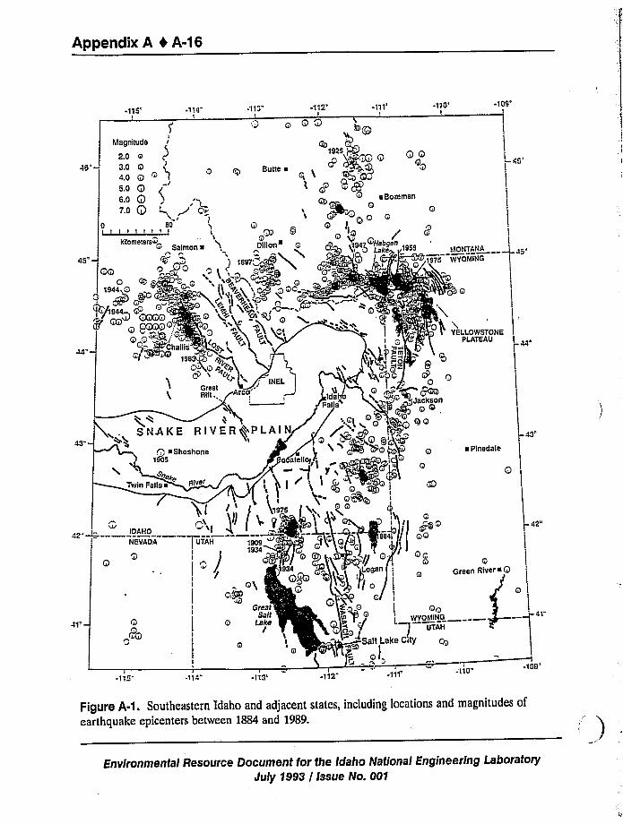
Appendix A 4 A-16
-115' ~1 I4"T
iMagnitude
2.O ~3.O Q4.o ot Q t50 Q,'.,g <,
70 Q
IkilometersQ
Salmon ~
-'l13I
Q
Butte ~m
Q IDillon e Q
1925+ OQ
e Bozemen
p~Q J
Q+ <194'ettgen 1959
I 10' ~
109'TANA
46
YOMING
LLOWSTONEPLATEAU
43"-~ Plnedale
43
42'Ci
IDAHO
Q
PQQ
~115T
I
.114 -l13"I
-'112
HKVT Oll THTHH TTHT
I
Ia/
IGreat ii I jt, ii,
Sa/1Q Lake jpij
II 'I
I
QQWYOMINGt
UTAH
Salt Lake CityOQJ
0I
~ 'I'I1'10H
Q Q
Q Green Aivere Q
41
-109"
Figure A-1. Southeastern Idaho and adjacent states, including locations and magnitudes ofearthquake epicenters between 1884 and 1989.
Environmental Resource Document for the Idaho National Engineering LaboratoryJuly 1993 / Issue No. 001
Appendix A 4 A-17
the ATR site. It does not include the entire listing of earthquakes within the B&R, Northern
Rocky Mountain, and Central Rockies tectonic provinces, only events within these provinces that
fall within the 322-km (200-mi) radius shown in Figure A-1.
For the central ISB, the earthquake record extends back to November 10, 1884, the date of
the first documented earthquake (with a magnitude of 6.3 on the Richter scale), which occurred
near Paris, Idaho. Prior to the 1960s, seismographic coverage of the ESRP and surrounding B&R
was relatively poor, with only earthquakes larger than magnitude 5.0 recorded by seismographs
worldwide. The detection of earthquakes prior to this time was based on felt and damage reports
made by local residents. Such epicentral locations may be in error by 100 km (62 mi) or more
(Woodward-Clyde Consultants 1992a). Over 90% of the earthquakes shown in Figure A-1 have
occurred between 1970 and 1989. The epicenters have been determined from localized seismic
networks within the intermountain region. Epicentral errors for this time period could range
from 1 to )20 km (0.6 to )12.4mi), depending on the number and spatial distribution of the
seismic stations recording the event.
In the early 1960s, seismographs were installed in the intermountain area by the University
of Utah Seismograph Stations and, in 1971, on the ESRP by the INEL. The USGS installed and
operated a seismic network at Yellowstone National Park from 1970-1981 and, the University of
Utah Seismograph Stations, from 1983 to present. Seismic stations were installed near Teton
Dam, Idaho (currently operated by Ricks College) beginning in 1980, in southwestern Montana
(by the Montana Bureau of Mines and Geology) starting in 1981, and in western Wyoming near
Jackson Lake (by the United States Bureau of Reclamation) during 1986. With additional seismic
stations, smaller magnitude earthquakes could be detected. Based on the number of seismic
stations operating over specific time intervals, periods of completeness can be established for
various magnitudes. The periods of completeness are the time periods over which independent
earthquakes (excluding aftershocks) can be considered to be completely detected (Woodward-
Clyde Consultants 1992a). Table A-3 shows the periods of completeness for various magnitudes
of the earthquake data shown in Figure A-1 (Youngs et al. 1987; Geomatrix Consultants 1989;
Engdahl and Rinehart 1988; Woodward-Clyde Consultants 1992a). The completeness periods
indicate that, for historic times, the data base for larger magnitude earthquakes is more complete
than for smaller magnitude events.
A.2.3 Moderate to Large Earthquakes
Moderate to large earthquakes of magnitude z 5.5 have occurred within a 322-km (200-mi)
radius of the INEL. For these events, Table A-4 lists the largest magnitude computed, moment
magnitude if computed, and Modified Mercalli intensities which are based on damage at the
epicenter. Since earthquakes (M a 2;5) occur at distances greater than 50 km (19.3mi) from the
Advanced Test Reactor (ATR), only events of M a 5.5 are listed in Table A-4. Figure A-2 shows
their locations relative to B&R normal faults and the ESRP. Also shown are locations of
Quaternary and Holocene normal faults in the Basin and Range province, and volcanic-rift zones
of the ESRP.
Environmental Resource Document for the Idaho Nationa/:Engineering Laboratory
July 1993 / Issue No. 001
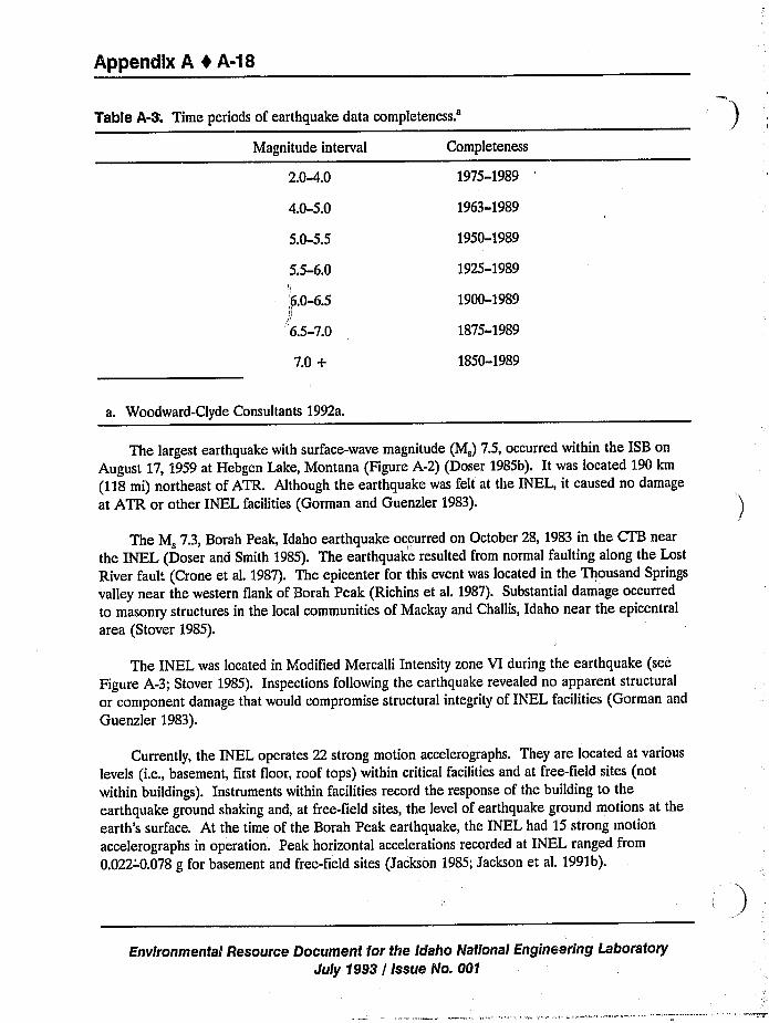
Appendix A t A-38
Table A-3. Time periods of earthquake datacompleteness.'agnitude
interval
2.0-4.0
4.0-5.0
5.0-5.5
5.5-6.0
6.0-6.5
J,'.5-7.0
7.0 +
Completeness
1975-1989
1963-1989
1950-1989
1925-1989
1900-1989
1875-1989
1850-1989
a. Woodward-Clyde Consultants 1992a.
The largest earthquake with surface-wave magnitude (M,) 7.5, occurred within the ISB on
August 17, 1959 at Hebgen Lake, Montana (Figure A-2) (Doser 1985b). It was located 190 km
(118mi) northeast of ATR. Although the earthquake was felt at the INEL, it caused no damage
at ATR or other INEL facilities (Gorman and Guenzler 1983).
The M, 7.3, Borah Peak, Idaho earthquake occurred on October 28, 1983 in the CTB near
the INEL (Doser and Smith 1985). The earthquake resulted from normal faulting along the Lost
River fault (Crone et al. 1987). The epicenter for this event was located in the Thousand Springs
valley near the western flank of Borah Peak (Richins et al. 1987). Substantial damage occurred
to masonry structures in the local communities of Mackay and Challis, Idaho near the epicentral
area (Stover 1985).
The INEL was located in Modified Mercalli Intensity zone VI during the earthquake (see
Figure A-3; Stover 1985). Inspections following the earthquake revealed no apparent structural
or component damage that would compromise structural integrity of INEL facilities (Gorman and
Guenzler 1983).
Currently, the INEL operates 22 strong motion accelerographs. They are located at various
levels (i.e., basement, first floor, roof tops) within critical facilities and at free-field sites (not
within buildings). Instruments within facilities record the response of the building to the
earthquake ground shaking and, at free-field sites, the level of earthquake ground motions at the
earth's surface. At the time of the Borah Peak earthquake, the INEL had 15 strong motiori
accelerographs in operation. Peak horizontal accelerations recorded at INEL ranged from
0.022-'0.078 g for basement and free-field sites (Jackson 1985; Jackson et al. 1991b).
Environmental Resource Document for the Idaho National Engineering Laboratory
July 1993 / Issue No. 001
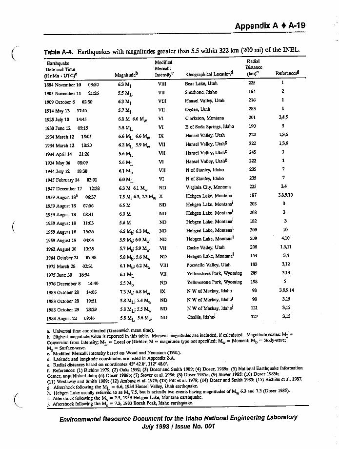
Appendix A 4 A-1 9
Table A-4. Earthquakes with magnitudes greater than 5.5 within 322 km (200 mi) of the INEL.
Earthquake
Date and Time
(Hr.Mn - UTC)a
1884 November 10 08:50
1905 November 11 21:26
1909 October 6 OZ:50
1914 May 13 17:15
1925 July 10 14:45
1930 June 12 09:15
1934 March 12 15:05
1934 March 12 18:20
1934 April 14 21;26
1934 May 06 08:09
1944 July 12 19:30
1945 February 14 03:01
1947 December 17 12:38
1959 August 18 06:37
1959 August 18 07:56
1959 August 18 08:41
1959 August 18 11:03
1959 August 18 15:26
1959 August 19 04:04
196Z August 30 13:35
1964 October 21 07:38
1975 March 28 02:31
1975 June 30 18:54
1976 December 8 14:40
1983 October 28 14:06
1983 October 28 19:51
1983 October 29 23:29
1984 August 22 09:46
Magnitude"
Modified
Mercalli
Intensity
6.5 Mb'I 6.3 M
5.9 Ms; 6.0 Mw
5.7 Msl 5'9 M
5.8 Mb', 5.6 M
6.1 Mb'.2 M
6.1 ML
5.5 Mb
7.3 Msl 6.8 Mw
5.8 ML, 5.4 lvl
5.8 MLI'5.5 M
5.8 ML 5.6 M
ND
ND
VII
ND
VIII
VII
ND
ND
ND
ND
6.3 Ml VIII
5.5 ML Vll
6.3 Ml VIII
5.7 MI Vll
6.8M 6.6M Vl
5.8 ML VI
6.6ML 6,6M IX
6,2 ML 5.9 M Vll
5.6 ML VII
5.6 ML Vl
6.™b VII
6.0 ML VI
6.3M 6.1M ND
75 M 6.3, 7.3 M X
6.5 M ND
6.0 M ND
5.6 M ND
Geographical Location
Bear Lake, Utah
Shoshone, Idaho
Hansel Valley, Utah
Ogden, Utah
Clarkston, Montana
E of Soda Springs, Idaho
Hansel Valley, Utah
Hansel Valley, Utahg
Hansel Valley, Utahg
Hansel Valley, Utahg
N of Stanley, Idaho
N of Stanley, Idaho
Virginia City, Montana
Hebgen Lake, Montana
Hebgen Lake,Montana'ebgen
Lake,Montana'ebgen
Lake,Montana'ebgen
Lake,Montana'ebgen
Lake,Montana'ache
Valley, Utah
Hebgen Lake,Montana'ocatello
Valley, Utah
Radial
Distance
I m)e
216
222
222
222
187
208
182
209
209
208
154
183
N W of Mackay, Idaho
N W of Mackay, Idahoi
N W of Mackay, Idahol
Challis, Idahol
93
98
121
127
Yellowstone Park, Wyoming 209
Yeaowstone Park, Wyoming 198
Referencesg
3,4,5
1,3,6
1,3,6
3,4
3,8,9,10
10
4,10
1,3,11
3,4
3,12
3,13
3,8,9,14
3,15
3,15
3,15
a. Universal time coordinated (Greenwich mean time).b. Highest magnitude value is reported in this table. Moment magnitudes are included, if calculated. Magnitude scales: Ml =Conversion from Intensity; ML = Local or Richter, M = magnitude type not specified; M = Moment; Mb = Body-wave;
Ms = Surface-wave.c. Modified Mercalli intensity based on Wood and Neumann (1931).d. Latitude and longitude coordinates are listed in Appendix Z-A.
e. Radial distances based on coordinates 43'2.0', 112'8.0'.f, References: (1)Richins 1979; (2) Oaks 1992; (3) Doser and Smith 1989; (4) Doser, 1989a; (5) National Earthquake Information
Center, unpublished data; (6) Doser 1989b; (7) Stover et al. 1986; (8) Doser 1985a; (9) Stover 1985; (10) Doser 1985b;(11)Westaway and Smith 1989; (12) Arabasz et aL 1979; (13) Pitt et al. 1979; (14) Doser and Smith 1985; (15) Richins et al. 1987.g. Aftershock following the ML = 6.6, 1934 Hansel Valley, Utah earthquake.h. Hebgen Lake usually referred to as M 7.5, but is actually two events having magnitudes of M 6.3 and 7.3 (Doser 1985).i. Aftershock following the Ms = 7.5, 1959 Hebgen Lake, Montana earthquake.j, Aftershock following the Ms = 7.3, 1983 Borah Peak, Idaho earthquake.
Environmental Resource Document for the Idaho National Engineering LaboratorySuly 1993 / Issue No. 001
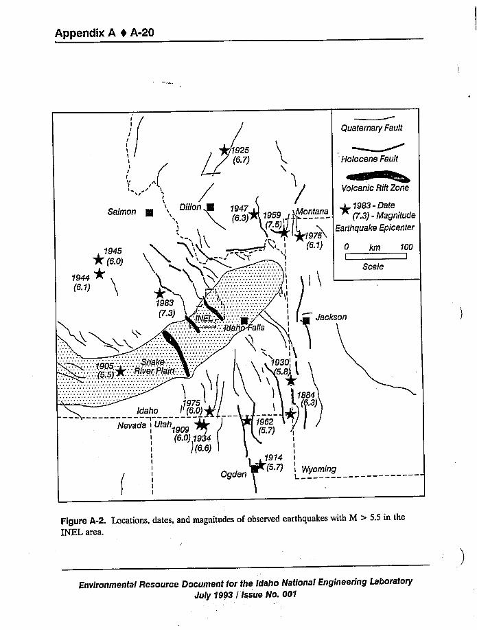
Appendix A 0 A-20
(I
II
I
Sa(mon g D ii n 1947(5 3) 1959 montana
1945
Quaternary Fault
Holocene Fault
Volcanic Rift Zone
p1983- DateP.3) - Magnitude
Earthquake Epicenter
0 km 100I I
Scale
Jackson
1914
Ogden) 'VYoming
Figure A-2. Locations, dates, and magnitudes of observed earthquakes with M > 5.5 in theINEL area.
Environmental Resource Document for the Idaho National Engineering Laboratory
July 1993 / Issue No. 001
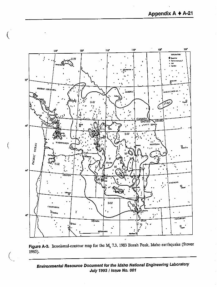
Appendix A 0 A-21
120 lid» 112'
for the M,M,73 1983 porah Peak, Idahoo earth uake (StoverFigure A-3 Isoseismal-contour map
1985).
r the Idaho National Engineering Laboratorytal Resource Document for the aEnvironmental eJuly 1993 / Issue No. 001
Appendix A 4 A-22
A.2A Geologic Structures and Tectonic Activity
A.2.4.1 Tectonic Provinces. The tectonic provinces of most concern for seismic andvolcanic hazards at INEL are the ESRP and the northern B&R province (Figure 2-1). Otherprovinces that are sufficiently close to INEL that may need to be considered, especially forprobabilistic seismic hazards assessments, are the Yellowstone Plateau and the Idaho Batholith.
The ESRP is distinguished from the surrounding provinces by subdued topography, lower
elevations, absence of B&R faults and mountain ranges (Figure 2-2), and historic aseismicity
(Anders et al. 1989).In addition, it is associated with regional high gravity (Bankey et aL 1985),positive aeromagnetic (Zeitz et aL 1978), and high seismic velocity (Sparlin et al. 1982) reflectingzones of dense, magnetic mafic rocks in the mid-crust beneath the Plain. This zone of maficmaterial in the mid-crust is believed to represent the zone of accumulation and solidification ofmafic magmas that were generated by the Yellowstone hotspot as it passed beneath the ESRP.
The northern Basin and Range province is distinguished by north-northwestern trending
block fault mountain ranges that formed in response to east-northeastern directed extension.Normal faults bounding these ranges have accumulated 1 to 2 km (0.6 to 1.2 mi) of vertical
displacement during Late Tertiary and Quaternary time (Pierce and Morgan 1992). Seismicityand Holocene paleoseismicity along these faults are concentrated in a parabolic zone that passes
through the Yellowstone Plateau and flanks both sides of the ESRP (Figure A-4) (Anders et al.1989).
The Yellowstone Plateau is distinguished by Quaternary and continuing crustal response torapid uplift over the Yellowstone hotspot in close proximity to areas (northeastern ESRP) that
are rapidly subsiding. This results in development of large faults with high slip rates (Pierce and
Morgan 1992) and with trends inconsistent with the direction of regional extension (for example,
the Centennial, Teton, and Hebgen/Red Canyon faults) (Figure A-4) (Doser 1985b; Eddington
et al. 1987; Peyton et al. 1991). In addition, the Yellowstone Plateau has much greater levels ofseismicity than either the ESRP or the northeastern B&R province (Smith and Arabasz 1991),asituation resulting from interaction of regional extension with rapid local vertical crustal move-
ments. Occurrence of voluminous Quaternary explosive silicic volcanism (Christiansen 1984) and
significant delays in teleseismic P-waves beneath the caldera area suggest extremely high tempera-tures and presence of magma in the crust and upper mantle (Iyer et al. 1981;Evans 1982).
The Idaho Batholith is distinguished by high, rugged topography, sparsity of B&R faults, and
absence of late Tertiary and Quaternary volcanism (Figures 2-1 and 2-2). Seismicity is much less
intense than that associated with the Basin and Range (Smith and Arabasz 1991),with maximum
magnitude of about 5. Nevertheless, the seismicity in the Idaho batholith is considered in seismic
hazards assessment for INEL. The batholith appears to have been relatively unaffected by
regional extension, perhaps because the granitic rocks are stronger or more coherent than rocks
in the B&R province to the east and southwest.
Environmental Resource Document for the Idaho National Engineering Laboratory
July 1993 / Issue No. 001
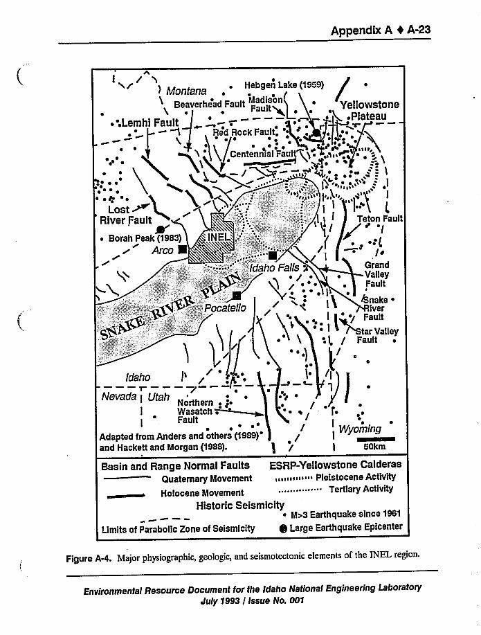
Appendix A I A-23
r w
) ~ Hebgen Lake (1959)
stoneeau
,II
on Fault'I
~ (/tandllsyult
ake ~
erult
Valley
I~ Wasatch .
Adapted from Anders and others (1989)'and Hackett and Morgan (1988). a"Basin and Range Normal Faults ESRP-Yellowstone Calderas
Quaternary Movement «I I «I « ~ i Pleistocene Activity
Holocene Movement "" """ Tertiary Activity
Historic Seismicity~ Mo 3 Earthquake since 1961
Umits of Parabolic Zone of Seismicity Large Earthquake Epicenter
Figure A-4. Major physiographic, geologic, and seismotectonic elements of the INEL region.
Environmental Resource Document for the Idaho National Engineering LaboratotyJuly 1993 / Issue No. 001
Appendix A I A-24
A.2.4.2 Faults. Faults of several ages and origins occur in the INEL region. Some of themare old and inactive, presenting no earthquake threat, whereas others are capable of generating
earthquakes that could affect INEL facilities. Detailed correlation of faults with earthquakes is
presented in Section A.2.5.
Mesozoic thrust faults occur in the mountain ranges bordering the ESRP (Figure A-4)(Skipp and Hait 1977; Link et al. 1988). They formed during a period of east-directed thrustingrelated to the Sevier orogeny. They are gently westward-dipping structures that separate majorPaleozoic thrust sheets. These faults are mostly inactive at the present time because thecompressional forces that created them is no longer in existence. However, it is possible that
parts of some of the thrust faults have been reactivated by basin-and-range normal faults in LateTertiary to Recent times (Smith and Bruhn 1984).
Eocene to Oligocene normal faults trend northward across the Lost River, Lemhi, and
Beaverhead ranges north of the ESRP (Janacke 1992). Although these faults have several
kilometers of accumulated displacement, their orientation with respect to the present stress field
is such that they have no tendency for movement. Therefore they are not active today and poseno threat for earthquake hazards.
Basin-and-Range normal faults (Figure A-4) of Miocene to Recent age bound the presentnorthwest trending mountain ranges north and south of the ESRP (Scott et ak 1985). Thesefaults have accumulated 1 to 3 km (0.6 to 1.9mi) of displacement in the past 4 to 7 million years
and are still active today as evidenced by fault scarps cutting latest Quaternary and Holocenealluvial fan deposits and by the occurrence of the 1983 Borah Peak earthquake. Table A-5summarizes the important characteristics of most Basin-and-Range normal faults around theESRP.
The closest of these faults to INEL facilities, the Lost River, Lemhi, and Beaverhead faults
(Figure A-4) each bound the southwest side of a mountain range, producing typical B8cR halfgraben. These are large normal faults that extend from the northern margin of the ESRPnorthwards to the Salmon River. Based on seismic and paleoseismic investigations, they arecapable of generating earthquakes of magnitude 7 (Doser and Smith 1985; Woodward ClydeConsultants 1992b). Because of their size, activity, and proximity to many INEL facilities, theycontrol much of the INEL seismic hazard. New facilities must be designed to withstand groundmotions that would be generated by earthquakes on these faults.
Detailed paleoseismic and structural investigations have been performed on the southernLemhi fault (Woodward-Clyde Consultants 1992b and Bruhn et al. 1992). Results are:
1. Segmentation of the southern Lemhi fault is redefined based on timing of paleoseismicevents and on detailed mapping of the structure of the fault in bedrock and surficial deposits
(Figure A-5).
Environmental Resource Document for the Idaho National Engineering Laboratory
July 1993 / Issue No. 001
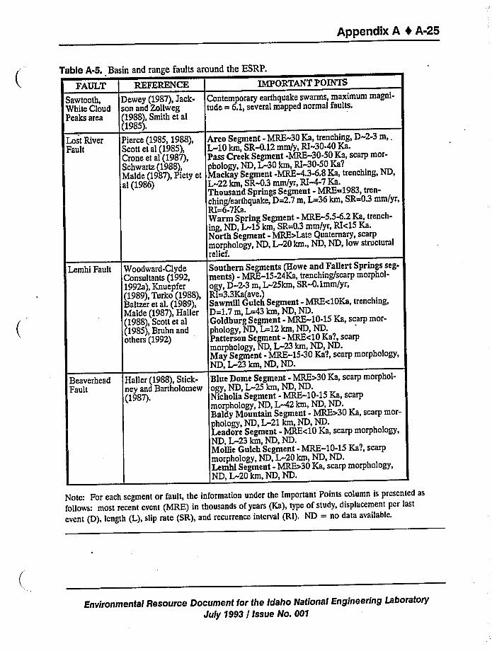
Appendix A 4 A-25
Table A-5. Basin and range faults around the ESRP.
FAULT REFERENCE IMPORTANT POINTS
Sawtooth, Dewey (1987),Jack- Contemporary earthquake swarms, maximum magni-White Cloud son and Zollweg tude = 6.1,several mapped normal faults.Peaks area (1988),Smith et al
(1985).Lost River Pierce (1985, 1988), Area Segment - MRE-30 Ka, trenching, D-2-3 m, .Fault Scott et al (1985), L-10 km, SR-0.12mm/y, RI-30-40 Ka.
Crone et al (1987), Pass Creek Segment -MRE-30-50 Ka, scarp mor-Schwartz (1988), phology, ND, L-30 km, RI-30-50 Ka?Malde (1987),Piety et Mackay Segment -MRE-4.348 Ka, trenching, ND,al (1986) L-22 km, SR-0.3 mm/yr, RI 4-7 Ka.
Thousand Springs Segment - MRE=1983, tren-ching/earthquake, D=2.7m, L=36 km, SR=0.3 mm/yr,RI=6-7Ka.Warm Spring Segment - MRE-5.54.2 Ka, trench-ing, ND, L-15 km, SR=0.3 mm/yr, RI<15 Ka.North Segment - MRE>Late Quaternary, scarpmorphology, ND, L«20 km., ND, ND, low structuralrelief.
Lemhi Fault
Beaver headFault
Woodward-ClydeConsultants (1992,1992a), Knuepfer(1989),Turko (1988),Baltzer et al. (1989),Ma!de (1987), HaIler1988),Scott et al1985), Bruhn and
others (1992)
Hailer (1988), Stick-ney and Bartholomew(1987).
Southern Segments (Howe and Fallert Springs seg-ments) - MRE-15-24Ka, trenching/scarp morphol-ogy, D-2-3 m, L-25km, SR-0.1mm/yr,RI=3.3Ka(ave.)Sawmill Gulch Segment - MRE<10Ka, trenching,D=1.7m, L=43 km, ND, ND.Goldburg Segment - MRE-10-15 Ka, scarp mor-phology, ND, L=12 km, ND, ND.Patterson Segment - MRE<10 Ka?, scarpmorphology, ND, L-23 km, ND, ND.May Segment - MRE-15-30 Ka?, scarp morphology,ND, L-23 km, ND, ND.
Blue Dome Segment - MRE>30 Ka, scarp morphol-ogy, ND, L-25 km, ND, ND.Nicholia Segment - MRE-10-15 Ka, scarpmorphology, ND, L«42 km, ND, ND.Baldy Mountain Segment - MRE>30 Ka, scarp mor-phology, ND, L-21 km, ND, ND.Leadore Segment - MRE<10 Ka, scarp morphology,ND, L-23 km, ND, ND.Mollie Gulch Segment - MRE-10-15 Ka?, scarpmorphology, ND, L-20 km, ND, ND.Lemhi Segment - MRE>30 Ka, scarp morphology,ND, L-20 km, ND, ND.
Note: For each segment or fault, the information under the Important Points column is presented asfollows: most recent event (MRE) in thousands of years (Ka), type of study, displacement per last
event (D), length (L), slip rate (SR), and recurrence interval (RI). ND = no data available.
Environmental Resource Document for the idaho National Engineering Laboratory
July 1993 / Issue No. 001
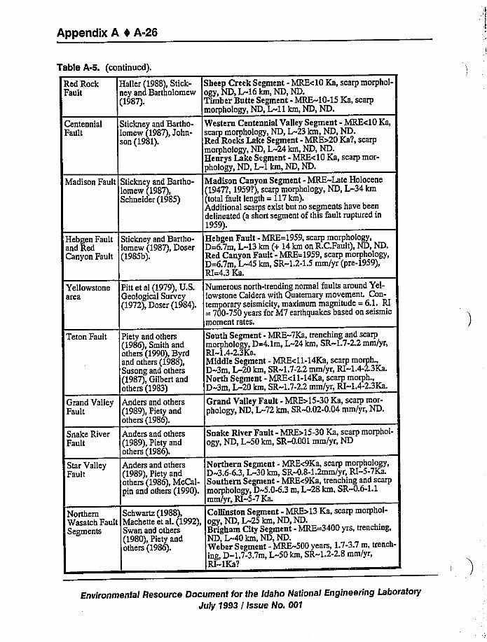
Appendix A 0 A-26
CentennialFault
Stickney and Bartho-lomew (1987),John-son (1981).
Madison Fault Stickney and Bartho-lomew (1987),Schneider (1985)
Hebgen Fault Stickney and Bartho-and Red lomew (1987), DoserCanyon Fault (1985b).
Table A-5. (continued).
Red Rock Hailer (1988), Stick-Fault ney and Bartholomew
(1987).
Sheep Creek Segment - MRE<10 Ka, scarp morphol-ogy, ND, L-16 km, ND, ND.Timber Butte Segment - MRE-10-15 Ka, scarpmorphology, ND, L-11km, ND, ND.
Western Centennial Valley Segment - MRE<10 Ka,scarp morphology, ND, L«23 km, ND, ND.Red Rocks Lake Segment - MRE>20 Ka?, scarpmorphology, ND, L-24 km, ND, ND.Henrys Lake Segment - MRE<10 Ka, scarp mor-phology, ND, L-1 km, ND, ND.
Madison Canyon Segment - MRE»Late Holocene1947?, 1959?),scarp morphology, ND, L-34 kmtotal fault length = 117km).
Additional scarps exist but no segments have beendelineated (a short segment of this fault ruptured in1959).
Hebgen Fault - MRE=1959, scarp morphology,D=6.7m, L-13 km (+ 14 km on R.C.Fault), ND, ND.Red Canyon Fault - MRE=1959, scarp morphology,D=6.7m, L-45 km, SR-1.2-1.5mm/yr (pre-1959),RI=4.3 Ka.
Yellowstonearea
Teton Fault
Grand ValleyFault
Snake RiverFault
Star ValleyFault
NorthernWasatch FaultSegments
Pitt et al (1979),U.S.Geological Survey(1972), Doser (1984).
Piety and others(1986), Smith andothers (1990),Byrdand others (1988),Susong and others(1987),Gilbert andothers (1983)
Anders and others(1989),Piety andothers (1986).
Anders and others(1989),Piety andothers (1986).
Anders and others(1989),Piety andothers (1986),McCal-pin and others (1990).
Schwartz (1988),Machette et al. (1992),Swan and others(1980),Piety andothers (1986).
Numerous north-trending normal faults around Yel-lowstone Caldera with Quaternary movement. Con-temporary seismicity, maximum magnitude = 6.1. RI= 700-750 years for M7 earthquakes based on seismicmoment rates.
South Segment - MRE-7Ka, trenching and scarpmorphology, D=4.1m, L-24 km, SR»1.7-2.2mm/yr,RI-1.4-2.3Ka.Middle Segment - MRE<11-14Ka, scarp morph.,D-3m, L-20 km, SR-1.7-2.2mm/yr, RI-1.4-2.3Ka.North Segment - MRE<11-14Ka, scarp morph.,D-3m, L™20km, SR-1.7-2.2mm/yr, RI-1.4-2.3Ka.
Grand Valley Fault - MRE>15-30 Ka, scarp mor-phology, ND, L-72 km, SR-0.02-0.04 mm/yr, ND.
Snake River Fault - MRE>15-30 Ka, scarp morphol-ogy, ND, L-50 km, SR-0.001 mm/yr, ND
Northern Segment - MRE<9Ka, scarp morphology,D-3.6-6.3,L-30 km, SR-0.8-1.2mm/yr, RI-5-7Ka.Southern Segment - MRE<9Ka, trenching and scarpmorphology, D-5.04.3 m, L-28 km, SR-0.6-1.1mm/yr, RI-5-7 Ka.
Collinston Segment - MRE>13 Ka, scarp morphol-
ogy, ND, L-25 km, ND, ND.Brigham City Segment - MRF-3400 yrs, trenching,ND, L-40 km, ND, ND.Weber Segment - MRE-500 years, 1.7-3.7m, trench-
ing, D-1.7-3.7m, L-50 km, SR-1.2-2.8mm/yr,RI-1Ka?
Environmental Resource Document for the Idaho National Engineering LaboratoryJuly?993 / Issue No. 001
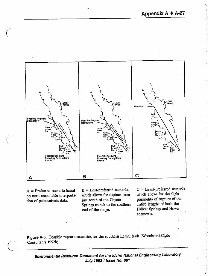
Appendix A 4 A-27
Deep Cre
Possible SBoundary V Possible
Bounder
Possible SegmentBoundary During SomeEvents y
Possible SegmenlBoundary During SomeBventsy
A = Preferred scenario based
on most reasonable interpreta-
tion of paleoseismic data.
B = Less-preferred scenario,which allows for rupture from
just south of the CoyoteSprings trench to the southernend of the range.
C = Least-preferred scenario,which allows for the slight
possibility of rupture of theentire lengths of both theFallert Springs and Howe
segments.
Figure A-5. Possible rupture scenarios for the southern Lemhi fault (Woodward-ClydeConsultants 1992b).
Environmental Resource Document for the Idaho National Engineering LaboratoryJuly 1993 / Issue No. 001
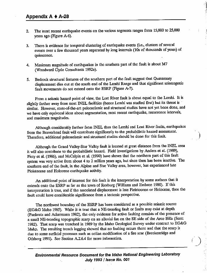
Appendix A 4 A-28
2. The 'most recent earthquake events on the various segments ranges from 15,000 to 25,000
years ago (Figure A-6).
3. There is evidence for temporal clustering of earthquake events (i.e., clusters of several
events over a few thousand years separated by long intervals (10s of thousands of years) of
quiescence.
4. Maximum magnitude of earthquakes in the southern part of the fault is about M7
(Woodward Clyde Consultants 1992a).
5. Bedrock structural features of the southern part of the fault suggest that Quaternary
displacement dies out at the south end of the Lemhi Range and that significant seismogenic
fault movements do not extend onto the ESRP (Figure A-7).
From a seismic hazard point of view, the Lost River fault is about equal to the Lemhi. It is
slightly farther away from most INEL facilities (hence Lemhi was studied first) but its threat is
similar. However, state-of-the-art paleoseismic and structural studies have not yet been done, and
we have only equivocal ideas about segmentation, most recent earthquake, recurrence intervals,
and maximum magnitudes.
Although considerably farther from INEL than the Lemhi and Lost River faults, earthquakes
from the Beaverhead fault will contribute significantly to the probabilistic hazard assessment.
Therefore, additional paleoseismic and structural studies should be done for this fault.
Although the Grand Valley-Star Valley fault is located at great distance from the INEL area
it will also contribute to the probabilistic hazard. Field investigations by Anders et al. (1989),
Piety et al. (1986), and McCalpin et al. (1990) have shown that the northern part of this fault
system was very active from about 4 to 2 million years ago, but since then has been inactive. The
southern end of the fault, in the Alpine and Star Valley area, however, has experienced late
Pleistocene and Holocene earthquake activity.
An additional point of interest for this fault is the interpretation by some authors that it
extends onto the ESRP as far as the town of Rexburg (Williams and Embree 1980). If this
interpretation is true, and if the associated displacement is late Pleistocene or Holocene, then the
fault could have considerable significance from a tectonic perspective.
The northwest boundary of the ESRP has been considered as a possible seismic source
(EG&G Idaho 1985). While it is true that a NE-trending fault or faults may exist at depth
(Pankratz and Ackermann 1982), the only evidence for active faulting consists of the presence of
a small NE-trending topographic scarp on an alluvial fan on the SE side of the Arco Hills (Scott
1982). That scarp was trenched in 1989 by the Idaho Geological Survey under contract to EG&G
Idahp. The resulting trench logging showed that no faulting occurs there and that the scarp is
due to some surficial processes such as eolian modification of a fire scar (Breckenridge and
Othberg 1991). See Section A.2.6.4 for more information.
Environmental Resource Document for the Idaho National Engineering Laboratory
July 1993 / Issue No. 001
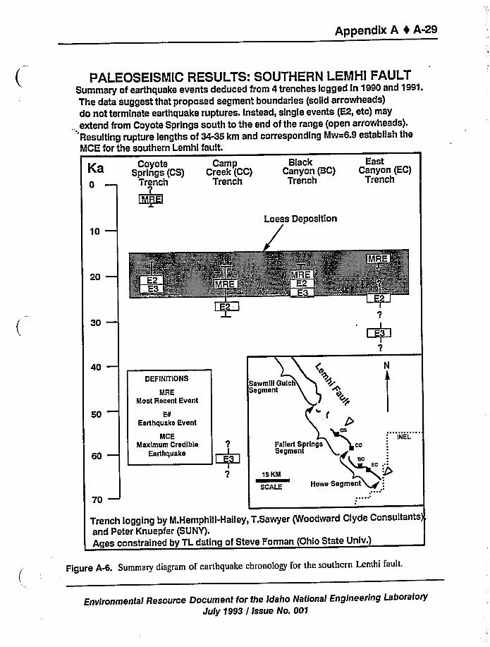
Appendix A 4 A-29
PALEOSEISMIC RESULTS: SOUTHERN LEMHI FAULTSummary of earthquake events deduced from 4 trenches logged ln 1990and 1991.The data suggest that proposed segment boundaries (solid arrowheads)do not terminate earthquake ruptures. instead, single events (E2, etc) may
., extend from Coyote Springs south to the end of the range {open arrowheads).Resulting rupture lengths of 34-35 km and corresponding Mw=6.9 establish theMCE for the southern Lemhl fault.
Ka0
CoyoteSprings (CS)
Trench?
I MREI
CampCreek (CC)
Trench
BlackCanyon (BC)
Trench
EastCanyon (EC)
Trench
10— Loess Deposition
20—
30—I
?I
i E31l
40—DEFlNlTlONS
MREMost Recent Event
ESEarthquake Event
SawmillSegmen
MCEMaximum Credible
60 EarthquakeI E3i
I
l
?
70—15K
scA
INEL
Trench logging by M.Hemphiil-Hailey, T.Sawyer (Woodward Clyde Consultants),and Peter Knuepfer (SUNY).Ages constrained by TL dating of Steve Forman (Ohio State Univ.)
Figure A-6. Summary diagram of earthquake chronology for the southern Lemhi i'ault.
Environmental Resource Document for the Idaho National Engineering Laboratory
July 1993 / Issue No. 001
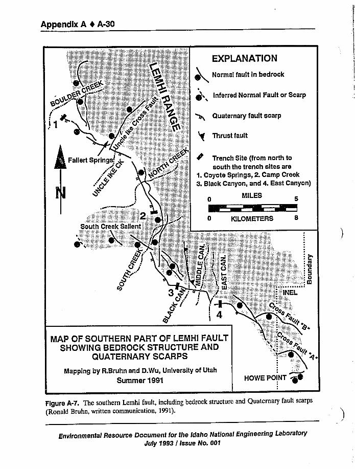
Appendix A 4 A-30
EXPLANATION
Normal fault in bedrock
gO~r.gD
~~I
i inferred Normal Fault or Scarp
Quaternary fault scarp
Thrust fault
Trench Site (from north
,~>+ on)
South Creek Sali
:.o-. Kl
MAP OF SOUTHERNSHOWING BEDROCK STRUCTURE AND
QUATERNARY SCARPS
NIapping by R.Bruhn and D.Wu, University of Utah
Summer 1991
,'.'.E:'. 0
eggs
0
HOWE POINT M
Figure A-7. The southern Lemhi fault, including bedrock structure and Quaternary fault scarps
{Ronald Bruhn, written communication, 1991).
Environmental Resource Document for the Idaho Nations/ Engineering LaboratoryJuly 1993 / Issue No. 001
Appendix A 4 A-31
Nontectonic lineaments on and near INEL can be observed from the air, on aerial
photographs, and on satellite images. One of the most pronounced of these lineaments, thePrincipal Lineament, has been studied extensively and shown to be caused by eolian modifications
to a large fire scar (Morin-Jansen 1987). This process produces many lineaments and perhapseven small topographic scarps on the ESRP. Other lineaments are caused by unmodified firescars, linear stream drainages, alignments of vegetative or soil contrast with unknown causes,fluvial (stream, river) deposits, paleoflood deposits, and eolian deposits (dunes) (GolderAssociates 1992; Breckenridge and Othberg 1991).
Late Tertiary caldera boundary faults are postulated to exist in the silicic volcanic rocksbeneath the Snake River Group. There are several bases for this postulation:
1. Calderas like those that exist on the Yellowstone Plateau today must have been associatedwith the late- Tertiary silicic volcanic fields occurring along the margins of the ESRP.
2. In some areas (southern ends of the Lemhi and Beaverhead Ranges near INEL, and
northern ends of the Caribou and Snake River Ranges near Rexburg) structures interpretedto be caldera boundary structures have been recognized (Morgan 1988).
3. The great thicknesses of silicic volcanic rocks observed in INEL deep exploration holes,INEL-1 and %0-2 (Figure 2-9), indicate that they were emplaced into an intra-caldera
setting.
The exact sizes, shapes, and locations of the buried calderas is uncertain, but interpretationshave been made (Figure A-4) on the basis of geophysical anomalies, positions of volcanic fields,
flow-direction indicators in ash flow sheets, and paleomagnetic data (Morgan 1988). Several
general observations are possible, however. Caldera size is such that some of them are likely to
span the entire width of the ESRP. Caldera shape, and thus the configuration of associatedcaldera boundary faults, are generally circular to oval. Given the tendency for calderas to overlap
each other (Figure A-4), it is likely that most of the ESRP boundary is characterized by caldera
boundary faults buried beneath the edges of the Snake River Group. Caldera boundary faults can
explain, in a manner consistent with data and concepts, Pankratz and Ackermann's (1982)interpreted buried fault along the northwest margin of the ESRP.
Several lines of evidence, summarized in Section 2.1.4,show that the calderas are no longer
active because the causative heat source has moved to a new position beneath Yellowstone. Thepossibility of reactivation of the faults due to contemporary tectonism should be considered, but
does not seem to be a cause for concern for two reasons: (a) Since the faults have a circular tooval configuration, they are not likely have long sections oriented properly for movement in
contemporary stress fields; (b) No late-Pleistocene or Holocene faulting that could be related toreactivation of these faults is observed on the ESRP (Golder Associates 1992).
A.2.4.3 Volcanic Rift Zones and Axial Volcanic Zone. Volcanic vents on the ESRP are
concentrated in NW-trending and NE-trending linear belts (Figure 2-21 and 2-22). The
Environmental Resource Document for the Idaho National Engineering LaboratoryJuly 1993 / Issue No. 001
Appendix A 0 A-32
NW-trending belts have associated ground deformation features and are referred to as VRZs
(VRZs). The ground deformation features are fissures, faults, grabens, and monoclines that form
due to dilational stresses above the tops of basalt dikes as magma moves from depth to the
surface. Three VRZs occur in the INEL region of the ESRP, the Great Rift VRZ (which
extends southeastward from Craters of the Moon National Monument), the Arco VRZ (which
extends SE from Arco across the southwestern corner of the INEL), and the Lava Ridge-Hells
Half Acre VRZ (which extends from the south end of the Lemhi Range to the Hells Half Acre
lava field) (Figure 2-22).
By analogy with active VRZs in other parts of the world (Iceland and Hawaii), it can be
inferred that VRZs are sources of earthquakes during periods of volcanic activity (see
Section 2.1.4). Even though the magnitudes of VRZ earthquakes are smaller (M(5.5) than those
of the BScR faults (M)7.0) (see Section A.2.6), their closer proximity to INEL facilities indicates
that they can be significant contributors to both deterministic and probabilistic seismic hazards
(Woodward-Clyde Consultants 1992a).
Some volcanic vents on the ESRP are concentrated in a northeast-trending zone along the
axis of the ESRP (Figure 2-21 and 2-22). This is called the Axial Volcanic Zone (AVZ) to
distinguish it from VRZs. It is important to make this distinction because the AVZ does not
contain northeast-trending ground deformation features that would qualify it to be a VRZ. The
few ground deformation features that do occur in the AVZ are NW-trending fissures. This
indicates that the volcanic vents in the AVZ are fed by NW trending dikes and that, even though
it is not a VRZ, seismicity can be associated with volcanism there. Thus it also plays an important
role in deterministic and probabilistic seismic hazards assessment (Woodward-Clyde consultants
1992a).
The VRZs and the northeast-trending Axial Volcanic Zone have remained as highlands
throughout much of the development of the ESRP and thus do not receive as much sediment as
the basins between. This results in large scale heterogeneities in seismic energy transmission
properties and in aquifer properties.
A.2.5 Gorrelatlon of Earthquake Activity with Geologic Structures or Tectonic Provinces
Figure A-8 shows a compilation of the minimum principal stress directions for the ESRP
region derived from focal mechanisms, geologic indicators, and borehole breakouts (Jackson et al.
1993;Pierce and Morgan 1992; Peyton et al. 1991; Zoback and Zoback 1989). The minimum
principal stress directions indicate northeast-trending extension northwest of the ESRP and more
east-trending direction south of the ESRP. Although a rotation in the stress field may occur
somewhere within the ESRP, the FSRP appears to be subjected to the same extensional stress
field as the surrounding region (Jackson et al. 1993). Strain rates have been compiled by
Eddington et al. (1987) for the ESRP region (Figure A-9). Strain rates for the region around the
ESRP range between 1.1 x 10 per sec for Yellowstone Plateau to 3.8 x 10 per sec for the
ISB. Preliminary estimates for the ESRP are 1 x 10 per sec based on the amount of extension
measured within the ESRP rift zones for the Holocene and is similar to strain rates outside the
Environmental Resource Document for the Idaho National Engineering Laboratory
July 1993 / Issue No. 001
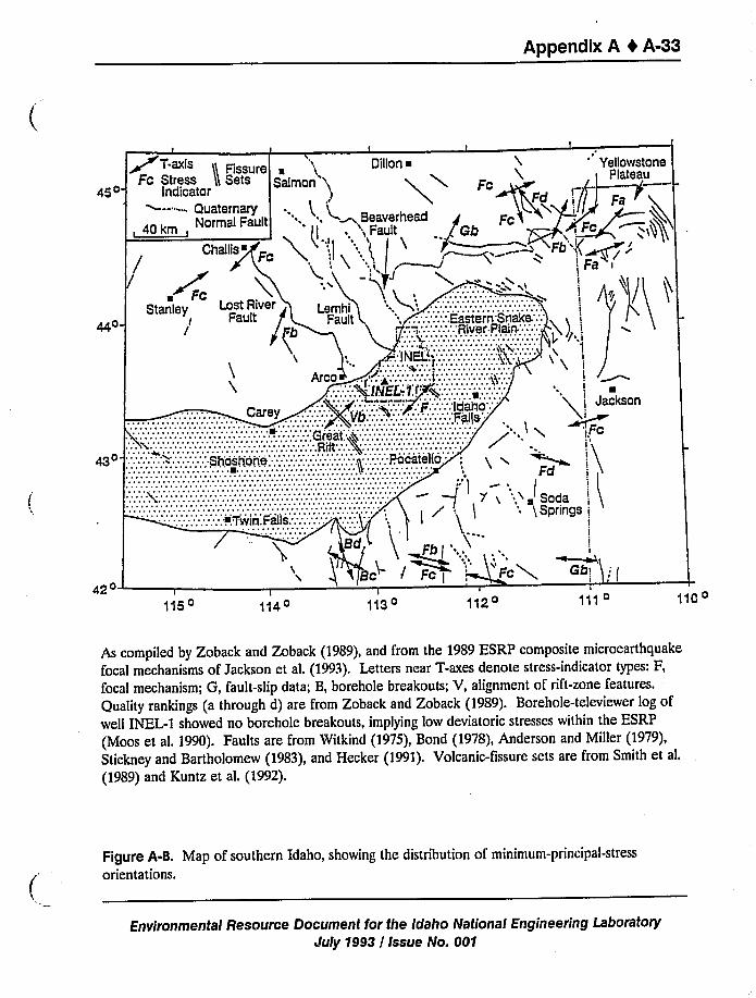
Appendix A 4 A-33
45o
T-axis Dillon ~ 'ellowstone
43o-
420 I
115o 114o 113oI
112oI
111 o
As compiled by Zoback and Zoback (1989), and from the 1989 ESRP composite microearthquake
focal mechanisms of Jackson et al. (1993). Letters near T-axes denote stress-indicator types: F,
focal mechanism; G, fault-slip data; B, borehole breakouts; V, alignment of rift-zone features.
Quality rankings (a through d) are from Zoback and Zoback (1989). Borehole-televiewer log of
well INEL-1 showed no borehole breakouts, implying low deviatoric stresses within the ESRP
(Moos et al. 1990). Faults are from Witkind (1975), Bond (1978), Anderson and Miller (1979),
Stickney and Bartholomew (1983), and Hecker (1991). Volcanic-fissure sets are from Smith et al.
(1989) and Kuntz et al. (1992).
Figure A-8. Map of southern Idaho, showing the distribution of minimum-principal-stress
orientations.
Environmental Resource Document for the Idaho National Engineering Laboratory
July 1993 / Issue No. 001
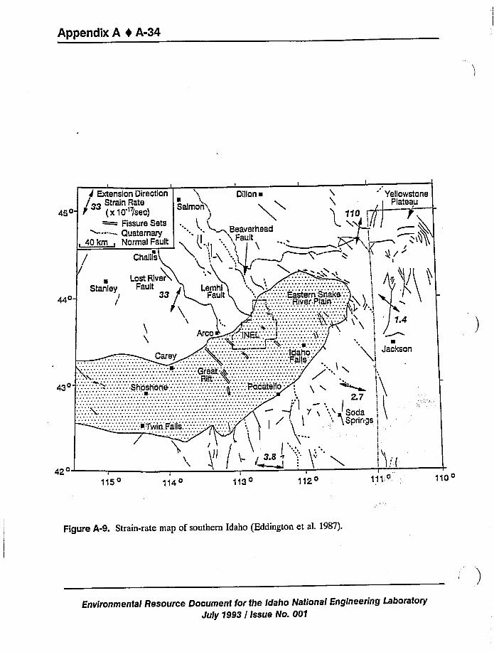
Appendix A 4 A-34
Extension Direction
33 Strain Rate45o (x10'/sec)—Fissure Sets~--- - Quaternary
, 40km, Norma!Fault
t
Dillon ~
Satman)
~.. h".<~ Beaverhead', Fatttt
Q1't0
I /f
gl y
42o '
115o 114o
darirtgs
I
'; JacksonI
.il.
I
11o 110o
Figure A-9. Strain-rate map of southern Idaho (Eddington et al. 1987).
Environmental Resource Document for the Idaho National Engineering LaboratoryJuly 1993 / Issue No. 001
Appendix A 0 A-35
measured within the ESRP rift zones for the Holocene and is similar to strain rates outside theESRP (Hackett et al. 1991).
Table A-6 lists earthquakes M z 5.5 that have occurred within a 322-km (200-mi) regionaround the INEL and that can be correlated with tectonic structures. This table includes theseismic moments, focal mechanisms, focal depths, rupture lengths, and horizontal and vertical
displacements computed by various seismological methods for these earthquakes {see references
in the table for more details). The following discussion of earthquakes and their relationships togeologic structures or provinces is separated into areas based on tectonic provinces.
A.2.5.1 ESRP Province.
A.2.5.1.1 Seismicity-Stover et al. (1986) noted 14 historic earthquakes that may
have possible locations within the SRP (Stover et al. 1986). Figure A-10 shows their locationsand Table A-7 lists their dates of occurrence, intensities, magnitudes (if reported), and locationuncertainties. Earthquakes listed in Table A-7 occurring between 1905 and 1937 have locationsbased on felt reports and, therefore, large location errors. The earthquakes listed for 1954, 1964,and 1969 have instrumentally determined locations, but due to the lack of local seismic networks
prior to 1970, they also have large location errors.
In compiling earthquake data {pre-1970) into the Decade of North American Geologycatalog for the western United States, Engdahl and Rinehart (1988; 1991) selected only large
magnitude earthquakes to represent earthquake source zones. Source zones were defined by
using instrumentally located epicenters (post-1970) to:l.,termine seismically active areas. Within
these areas, only large magnitude earthquakes (pre-1970) would be retained in the catalog. Thus,
Figure A-1 excludes the epicenters for eight of the possible SRP events due to their low
intensities (hence, low magnitudes) and large location errors, and includes only the epicenters forthe 1905 (ML 5.5) Shoshone, 1928 (ML 5.2) and 1937 (ML 5.4) events. Although, the epicentersfor the 1928 and 1937 events are outside of the SRP boundaries as shown in Figure A-1 (locatednear the Idaho-Nevada border), Woodward-Clyde Consultants (1992a) included it within the SRPsince Smith and Arabasz (1991)extend the SRP boundary to Idaho-Nevada border based ondistribution of rhyolitic volcanic rocks. More commonly, as shown in Figure A-1, the SRPboundaries are defined by topographic features which separate the flat, low-lying SRP region from
the surrounding mountainous region (B8cR province).
Figure A-1 shows that from 1884 through 1989, the 1905 earthquake near Shoshone, Idahois the only event located within the SRP. The November 11, 1905 Shoshone earthquake occurredbefore there was instrumental monitoring in Idaho and, since its location was based on felt
reports, it may have an error of 100 km or more. This earthquake is significant to assessing
seismic hazards at INEL, since it may have originated within the SRP.
A.2.5.1.2 1905 Shoshone Earthquake-Recently, Oaks (1992) conducted acomprehensive investigation of historical records throughout an eight-state region to determine
the magnitude and epicenter of the Shoshone earthquake. For the investigation, historical
Environmental Resource Document for the Idaho National Engineering LaboratoryJuly 1993 / Issue No. 001
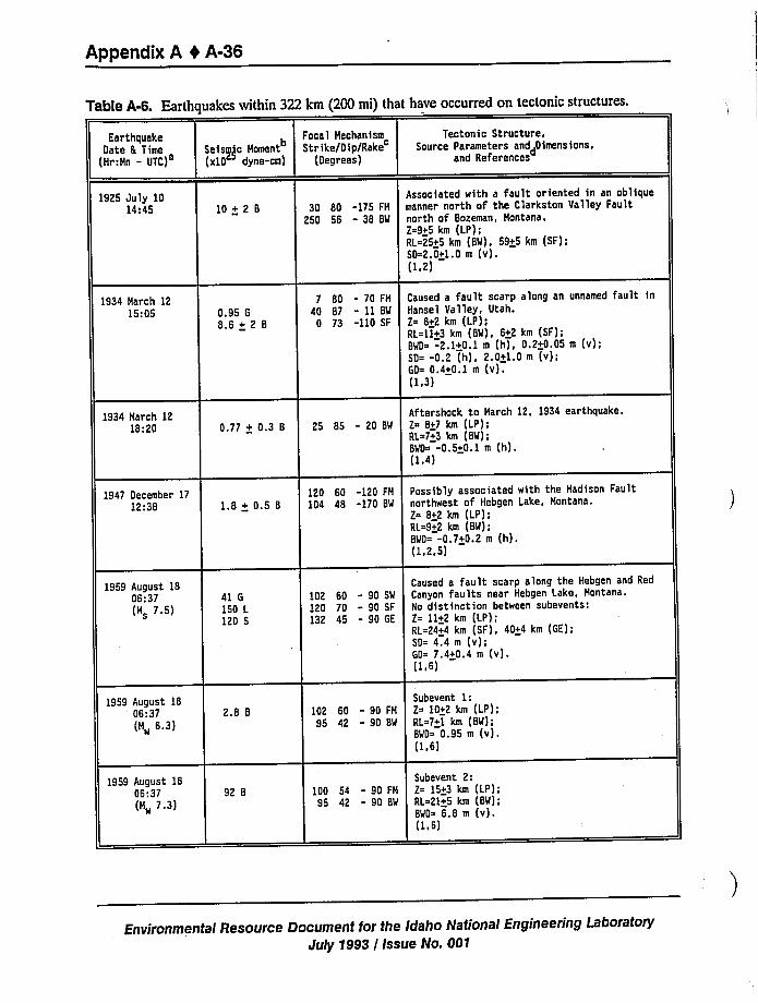
Appendix A 0 A-36
Table A-6. Earthquakes within 322 km (200 mi) that have occurred on tectonic structures.
EarthquakeDate 6 Time
{Hr:Hn - UTC)
Focal Mechanism
Seiss)jc Homent Strike/Dip/Rake(x10 dyne-cm) (Degrees)
Tectonic Structure,Source Parameters anddgimensions,
and References
1925 July 1014:45 10+2 8 30 80 -175 FH
250 56 - 38 BW
Associated with a fault oriented in an obliquemanner north of the Clarkston Valley Faultnorth of Sozeman, Hontana.2=9+5 km (LP);RL~25+5 km (BW), 59+5 km (SF);SD=2.0+1.0 m (v).(1,2)
1934 March 1215:05 0.95 G
8.6 + 2 8
7 80 - 70 FM
40 87 - 11 BW
0 73 -110 SF
Caused a fault scarp along an unnamed fault inHansel Valley, Utah.Z= 8+2 km (LP);RL=11+3 km (BW), 6+2 km (SF);BWD -2.1+0.1 m (h), 0.2+0.05 m (v);SD= -0.2 (h), 2.0+1.0 m (v);GD= 0.4+0.1 m (v).(1.3)
1934 March 1218:20 0.77 + 0.3 8 25 85 - 20 BW
Aftershock to March 12, 1934 earthquake.2= 8+7 km (LP);RL=7+3 km (SM);BMD= -0.5+0.1 m (h).(1.4)
1947 December 1712:38 1.8 + 0.5 8
120 60 -120 FM
104 48 -170 BW
Possibly associated with the Hadison Faultnorthwest of Hebgen Lake, Hontana.2= 8+2 km (LP);RL=9+2 km (BM);BWD= -0.7+0.2 m (h).(1,2,5)
1959 August 1806:37(H 7.5)
41 G
150 L
120 5
102 60 - 90 SW
120 70 - 90 SF132 45 - 90 GE
Caused a fault scarp along the Mebgen and RedCanyon faults near Hebgen Lake, Hontana.Ko distinction between subevents:Z= 11+2 km (LP);RL=24+4 km (SF), 40+4 km (GE);SD= 4.4 m (v);GD= 7.4+0.4 m {v).(1 6)
1959 August 1806;37 2.8 8
(H„ 6.3)102 60 - 90 FH
95 42 - 90 BM
Subevent 1:Z= 10+2 km (LP);RL=7+1 km (BM);BWD= 0.9S m (v).(1.6)
1959 August 1806:37(M„ 7.3)
92 8 100 54 - 90 FH
95 42 - 90 8'W
Subevent 2:Z= 15+3 km (LP);RL=21+5 km (BW);BWD= 6.8 m (v).(1,6)
Environmental Resource Document for the Idaho National Engineering Laborator)/
Jul)/1993 / Issue No. 001
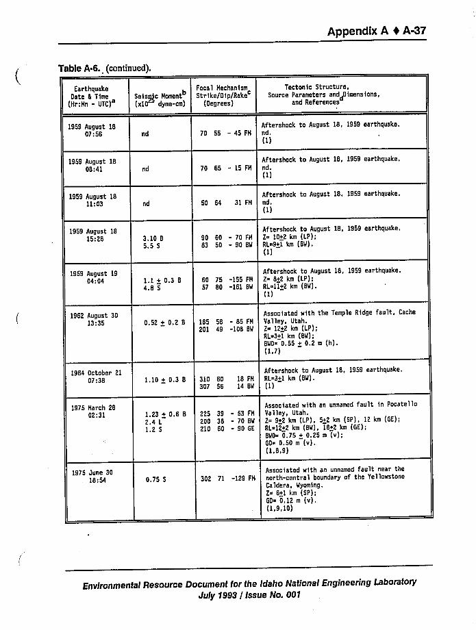
Appendix A 4 A-37
Table A-6. (Continued).
EarthquakeDate 8 Time
(Hr:Hn - UTC)Seismic
Homent
(xt0 dyne-cm)
Focal HechanismStrike/Dip/Rake
(Degrees)
Tectonic Structure,Source Parameters anddOimensions,
and References
1959 August 1807:56 nd 70 55 - 45 FH
Aftershock to August 18, 1959 earthquake.nd.(1)
1959 August 1808:41 nd 70 65 - 15 FH
Aftershock to August 18, 1959 earthquake.nd.(1)
1959 August 1811:03 nd 50 64 31 FH
Aftershock to August 18, 1959 earthquake.ed ~
(1)
1959 August 1815:26 3.10 8
5.5 590 60 - 70 FH
83 50 - 90 SM
Aftershock to August 18, 1959 earthquake.Z~ 10+2 km (LP);RL=9+1 km (SW).(1)
1959 August 1904:04 1.1 + 0.3 8
4.8 560 75 -155 FH
57 80 -161 BW
Aftershock to August 18, 1959 earthquake.Z~ 8+2 km (LP);RL~ll+2 km (BW).(1)
1962 August 3013:35 0.52 + 0.2 8 185 58 - 85 FH
201 49 -108 BM
Associated with the Temple Ridge fault, CacheValley, Utah.2= 12+2 km (LP);RL=3+1 km (BW);BWD 0.55 + 0.2 m (h).(1,7)
1964 October 2107:38 1.10 + 0.3 8 310 60
3D7 5618 FH
14 BM
Aftershock to August 18, 1959 earthquake.RL~3+1 km (BW).(1)
1975 Harch 2802:31 1.23 + 0.6 8
2.4 L
1.2 5
225 39 - 53 FH
200 38 - 70 BW
210 60 - 90 GE
Associated with an unnamed fault in PocatelloValley, Utah.2 9+2 km (LP), 5+2 km (SP), 12 km (GE);RL 12+2 km (BW), 18+2 km (GE);BMD= 0.75 + 0.25 m (v);60~ 0.50 m (v).(1.8,9)
1975 June 3018:54 0.75 5 302 71 -129 FH
Associated with an unnamed fault near thenorth-central boundary of the YellowstoneCaldera, Wyoming.Z= 6+1 km (SP);GD= 0.12 m (v).(1,9,10)
Environmental Resource Document for the Idaho National Engineering LaboratoryJuly 1993 / Issue No. 001
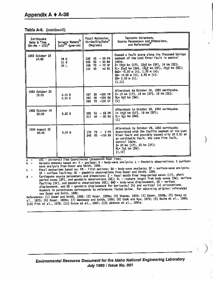
Appendix A 0 A-38
Table A-6. {Continued).
EarthquakeDate 6 Time
(Hr:Hn - UTC)Seisgc Homent
(xl0 dyne-cm)
Focal Hechanism Tectonic Structure,Strike/Oip/Rake Source Parameters anddDimensions,
(Degrees) and References
1983 October 2814:06 28 G
21 829 L
Caused a fault scarp along the Thousand Springs138 45 - 60 FH segment of the Lost River Fault in central155 50 - 65 BM Idaho.160 70 - 70 SF Z= 16+4 km (LP), 12+2 km (SP), 14 km (GE);152 49 nd GE RL 21+2 km (BM), 19+2 km (SF}, 20+2 km (GE};
BMD~ -0.20 m (h), 1.30 m (v);SO -0.30 m (h), 1.50 m (v);GD~ 2.10 m (v).(1,11)
1983 October 2819:51 0.13 8
0.24 5
Aftershock to October 28, 1983 earthquake.287 58 -165 FH Z~ 10 km (LP), 10 km (SP), 10 km (GE);282 48 -159 BM RL~ 6+2 km (BM).286 70 -155 SF (1)
1983 October 2923:29 0.20 8 309 51 - 65 FH
317 45 - 90 BM
Aftershock to October 28, 1983 earthquake.Z 19+9 km (LP), 10 km (SP);RL~ 8+1 km (BM).(I)
1984 August 2209:46 0.24 6 170 70 - 5 FH
348 85 -160 BM
Aftershock to October 28, 1983 earthquake.Associated with the Challis segment of the LostRiver fault and possibly caused slip (H 5.0) onan antithetic fault, the Lone Pine fault,central Idaho.Z 10 km (LP), 10 km (SP);RL= 7+I km (BM).(1,12)
a - UTC - Universal Time Coordinated (Greenwich Mean Time).b - Seismic moments based on: G - geology; 8 - body-wave analysis; L - Geodetic observations; S surface-
wave analysis from Doser and Smith, 1989.c - Focal mechanisms based on: FH - first motions; BM - body-wave analysis; SF - surface-wave analysis;
SF - surface faulting; GE - geodetic observations from Doser and Smith, 1989.d - Earthquake source parameters and dimensions: Z - focal depth from long-period waves (LP), short
period waves (SP), and geodetic observations (GE); RL - rupture length from body waves (BM). surfacefaulting (SF), and geodetic observations (GE); BMD - body-wave displacement, SD - surfacedisplacement, and GD - geodetic displacement for horizontal (h) and vertical (v) orientations.Numbers in parentheses corresponds to references listed below. For obtaining original referencessee Doser and Smith, 1989.
References: ( 1) Doser and Smith, 1989; (2) Doser, 1989a; (3) Shenon, 1936; (4) Doser, 1989b; (5) Dewey eta l., 1973; (6) Doser, 1985b; (7) Mestaway and Smith, 1989; (8) Cook and Nye, 1979; (9) Bache et al., 1980;(10) Pitt et al., 1979; (11) Crone et al., 1987; (12) Jackson et al., 1991a.
Environmental Resource Document for the Idaho National Engineering Laboratory
July 1993 / Issue No. 001
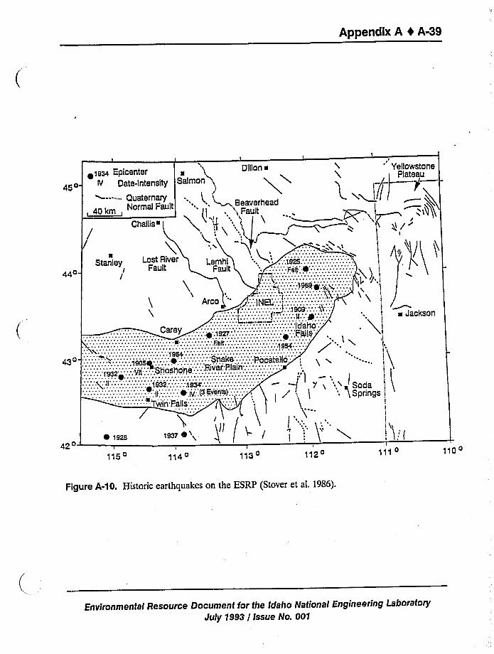
Appendix A I A-39
t I I
<es4 Epicenter a 3 Dillon ~
aaa- te Octa.tnteneny neiman n~
-""- QuaternaryNormal Fault '. ', ~~ Beaverhead
, 40 km, l ; ',Fault
44o- X),1
~ <eaa
116o 114oI
113o
leo74\ ( Q /
112o
I
a Jackson
I
darings i
I
I
111 o 110 o
Figure A-10. Historic earthquakes on the ESRP (Stover et al. 1986).
Environmental Resource Document for the Idaho National Engineering LaboratoryJuly 1993 / Issue No. 001
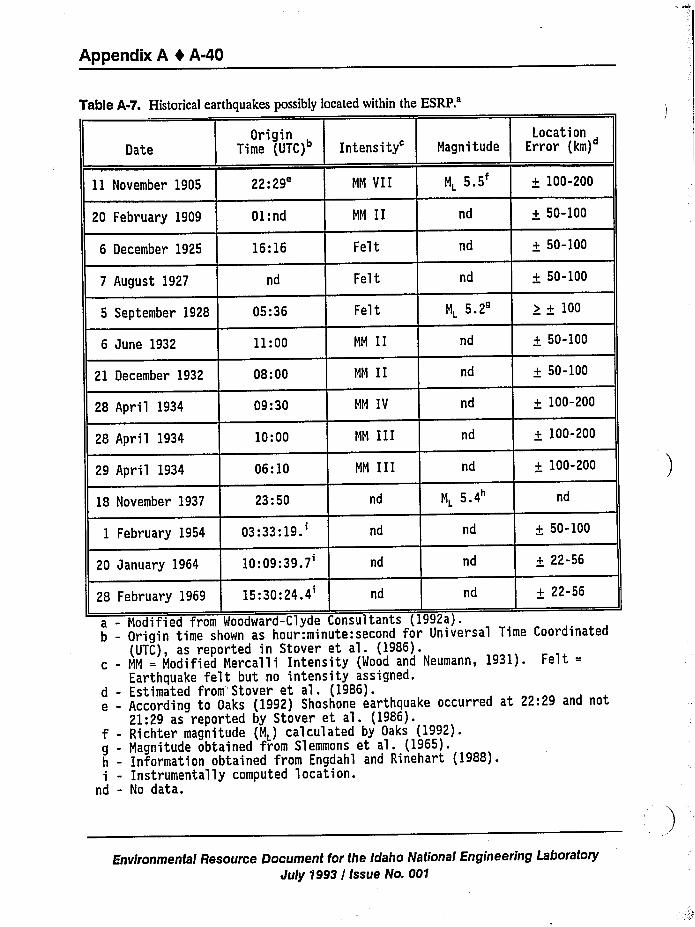
Appendix A 4 A-40
Table A-7. Historical earthquakes possibly located within theESRP.'ate
11 November 1905
20 February 1909
6 December 1925
7 August 1927
5 September 1928
6 June 1932
OriginTime (UTC)
22:29'1:
nd
16:16
nd
05:36
11:00
Fel t
Fel t
MM II
N„5.2a
nd
Intensity'agnitude
NN VII ML 5.5
MM II nd
Felt
LocationError (km)
+ 100-200
+ 50-100
+ 50-100
+ 50-100
) + 100
+ 50-100
21 December 1932 08:00 MN II nd + 50-100
28 April 1934 09:30
28 April 1934 10:00
29 April 1934 06:10
MN IV
NN 111
NN III
nd
nd
+ 100-200
+ 100-200
+ 100-200
18 November 1937 23:50 nd NL 5.4 nd
1 February 195403:33:19.'0
January 1964 10:09:39.7'dnd
nd
nd
28 February 1969 15:30:24.4'd nd
+ 50-100
+ 22-56
+ 22-56
a - Modified from Woodward-Clyde Consultants (1992a).b - Origin time shown as hour:minute:second for Universal Time Coordinated
(UTC), as reported in Stover et al. (1986).c - NM = Modified Mercalli Intensity (Wood and Neumann, 1931). Felt =
Earthquake felt but no intensity assigned.d - Estimated from"Stover et al. (1986).e - According to Oaks (1992) Shoshone earthquake occurred at 22:29 and not
21:29 as reported by Stover et al. (1986).f - Richter magnitude (M„) calculated by Oaks (1992).g - Magnitude obtained from Slemmons et al. {1965).h - Information obtained from Engdahl and Rinehart (1988).i - Instrumentally computed location.
nd - No data.
Environmental Resource Document for the Idaho National Engineering LaboratoryJuly 1993 I issue No. 001
Appendix A 4 A-41
documents were sought from Nevada, Oregon, Idaho, Utah, Wyoming, Montana, California,
Colorado, and Washington, D.C. Primary sources included original field notes of the Departmentof Agriculture weather observers reports, daily and monthly journal notations by U.S. Army
Surgeons and other scientific and military personnel at U.S. Army Command posts, personaldiaries, and church records. Secondary sources, those transcribed from primary sources for use in
another document, included newspapers, journal articles, books, maps, reports, and earthquake
catalogs.
From a compilation of damage reports, Oaks (1992) determined the Modified Mercalli
intensity for towns in Idaho, Utah, Nevada, and Oregon. Figure A-11 shows the contours forintensities IV and V, and the possible location of the epicenter near the Idaho-Utah border.
Both Shoshone, Idaho and Elko, Nevada reported damage which correspond to intensity VI. It is
noted that for other earthquakes (see Figure A-3 and A-12) these towns report higher intensities
than surrounding towns (Stover 1985). A magnitude of ML 5.5 ~ 0.5 was estimated for the
Shoshone earthquake based on notes of seismic-wave amplitudes observed on a seismogram
recorded by a station in Canada and measurements of the area within of the intensity V contour.
Comparison of the intensity contours for the 1905 earthquake with earthquakes occurring nearthe Idaho-Utah border in 1934 (ML 6.6), 1962 (ML 5.7), and 1975 (ML 6.0) also provides further
support for an origin outside the SRP. Even though this study suggests the earthquake may belocated outside the SRP, recent seismic hazards assessments at INEL estimated the level ofground motions from an earthquake similar in size to Shoshone occurring within the ESRP nearthe INEL.
A.2.5.1.3 INEL Seismic I".fonIAoring. Local seismic monitoring within the ESRP began in
December 1971 when a seismic static n was installed at INEL (King et al. 1987). By 1979, this
network included six stations located within and near the boundaries of the ESRP. Seismic
stations were added to the network beginning in 1986. Currently, the INEL seismic network
consists of 24 seismic stations (Figure A-13).
Earthquake data have been compiled by the INEL seismic network for a 19-year period from
1972-1990, primarily covering the ESRP (Figure A-13). During this period, approximately 19microearthquakes have been located within or near the boundary of the ESRP, indicating that
infrequent, small-magnitude earthquakes (M s 1.5) may be characteristic of ESRP seismicity
(Jackson et al. 1990; Pelton et al. 1990; Jackson et al. 1993). Although 13 of thesemicroearthquakes have occurred near or within the INEL boundary, Jackson et al. (1993) indicate
that the INEL aiea of the ESRP is not. more microseismically active than other areas, but rather
that the INEL seismic network has an adequate detection threshold (M = 0) to record thesesmall events.
Figure A-1 shows that 1884-1989 earthquakes (ML a 2.0) were located in the ISB and CZB,but not within the ESRP. Also, earthquakes are located closest to the margins of the ESRP near
the Yellowstone Plateau and farthest [up to 70 km (43.5 mi) away] from the ESRP margins near
the Great Rift and Pocatello. From similar compilations of earthquake data, several investigators
have concluded that the ESRP is aseismic (Smith and Sbar 1974; Smith 1978; Smith et al. 1985;
Environmental Resource Document for the Idaho National Engineering LaboratoryJuly 1993 / Issue No. OD1
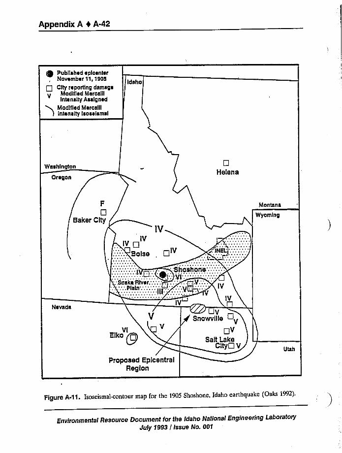
Appendix A t A-42
Publlahad aplcanter
Montana
Wyoming
Region
Figure A-11. Isoseismal-contour map for the 1905 Shoshone, Idaho earthquake (Oaks 1992).
Environmentai Resource Document for the Idaho Nationa/ Engineering Laboratory
July 1993 / Issue No. 001
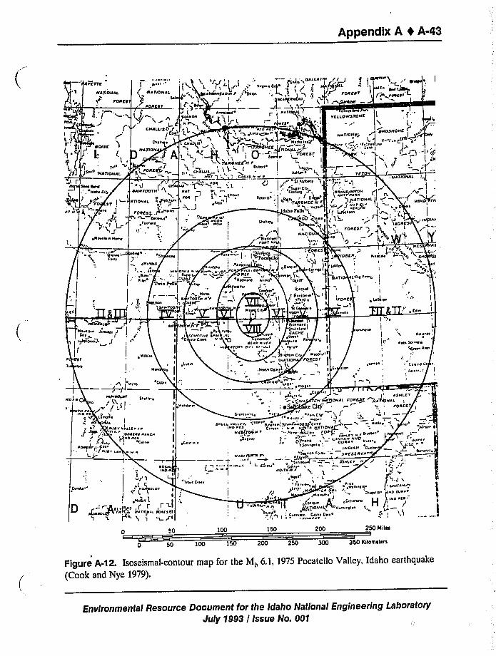
Appendix A I A-43
eeri—'rerre 11',.si
(gl '4 ~r~'s
>~ l 'rs)iib " 'g j ls
1~~ ~~1 jsrs rssrrsr <
l,ss, ar rrrsreer4+ rrsegrr l r ~04«!
stIsssssp sell t«nsyss Stssrs)rr'~h i
0 50
50 100
150
,ei'N:G ssas essss OsIrs
sn ac
250 ee iles
150 200 250 300 350 Kiloeretere
Figure A-12. Isoseismal-contour map for the Mb 6.1, 1975 Pocatcllo Valley, Idaho earthquake
(Cook and Nye 1979).
Environmental Resource Document for the Idaho National Engineering LaboratoryJuly 1993 / Issue No. 001
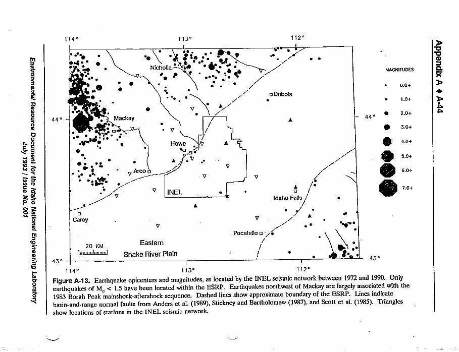
0
I0OI000
IO
~o
114'
ee
4+e
IIt''4 ~
~ eel
440
~e
0 e
113'
ee ~
e Ir
/
112'
~+
o Duboise
MAGNIr UOES
~ 0.0+
~ 1.0+
2.0+
z.o+
. 4.o+
5.0+
e1EO
CI0 oO QO Ie
0Ie
0I
0~V0
6.0+~ ~~ ~ e eWe
~ gt+ ~I
V
0Carey
V L/eo /
idaho Falls /
~ e
Pocatello o <e/
//
%11 8% 7.0+till@'NEL
Q+e ~
20 KMEastern
Snake River Plain43'
I I
114'13'12'igure
A-13. Earthquake epicenters and magnitudes, as located by the INEL seismic network between 1972 and 1990. Onlyearthquakes of M, < 1.5 have been located within the ESRP. Earthquakes northwest of Mackay are largely associated with the1983 Borah Peak mainshock-aftershock sequence. Dashed lines show approximate boundary of the ESRP. Lines indicatebasin-and-range normal faults from Anders et al. (1989), Stickney and Bartholomew (1987), and Scott et al. (1985). Trianglesshow locations of stations in the INEL seismic network.
Appendix A 4 A-45
Smith and Arabasz 1991). Contemporary seismic monitoring of the ESRP (1970-1991)suggests
that only infrequent small-magnitude earthquakes (19 events over 19 years of ML c 1.5) occur
within the ESRP as compared to the 1000s of events of similar and larger size that occur within
the surrounding region. Although it is recognized that historic earthquakes may have occurred
within the ESRP, their large location uncertainties do not support origins within the ESRP,
particularly when other geologic and geophysical data are considered.
A.2.5.1.4 Hypotheses for Aselsmlc Nature of ESRP-Earthquakes up to M, 7.5
associated with basin-and-range faults have occurred within the ISB, but only small magnitude
earthquakes (ML c 1.5) have been detected instrumentally within the ESRP. Several
investigators have attempted to explain the lower seismicity within the ESRP compared to the
CTB and ISB. Their analyses have considered the distribution of instrumental seismicity and
active faults, topography (surficial geologic features), the historical geologic record (formation of
the ESRP and B&R province), tectonic stress patterns, crustal heat flow, and crustal- and upper-
mantle compositions and properties. Earthquakes in the CTB and ISB indicate that the region
around the ESRP is subjected to a tectonic extensional stress field that actively extends the crust
by normal faulting which over millions of years produces mountains and valleys. The ESRP is
also subjected to this same stress field and possibly similar strain rates (Figures A-8 and A-9), but
crustal normal faults of this nature are not present within the ESRP, leading investigators to
propose alternative mechanisms for extensional deformation:
1. Aseismic Creep. Smith and Sbar (1974) and Brott et al. (1981) suggest that deformation
occurs by creep in response to high crustal temperatures beneath the ESRP. Comparisons
of heat flow data in and outside the ESRP suggests that temperatures are higher beneath
the ESRP (Brott et al. 1981; Blackwell 1989; 1992). Unlike the Basin and Range where
brittle deformation (rock fracture) occurs in the form of earthquakes to raise the mountains
and lower the valleys, the ESRP would experience ductile deformation (aseismic creep)
because high temperatures near the mid-crust would allow rocks to flow rather than fracture.
2. Crustal Strength. Anders et al. (1989) suggest that the ESRP and the adjacent region near
its boundary or "collapse shadow" region have increased integrated-lithospheric strength.
They propose that the presence of a mid-crustal maflic intrusion (see Figure 2-8) strengthens
the crust so that it is too strong to fracture. Smith and Arabasz (1991) also suggested that
the mid-crustal maflic body beneath the ESRP may act to increase crustal strength and
thereby, reduce the seismic capability of the ESRP.
3. Dike-Injection. Parsons and Thompson (1991)proposed that magma overpressure through
dike injection suppresses normal faulting and associated seismicity by altering the local
tectonic stress field. This process also provides a way for the ESRP to extend and keep pace
with extension occurring in the surrounding Basin and Range province or ISB (Rodgers
et al. 1990; Hackett and Smith 1992). As dikes are injected, they push a part the
surrounding rocks and the net effect is to extend the crust.
Environmental Resource Document for the Idaho National Engineering Laboratory
July 1993 / Issue No. 001
Appendix A 1A-46
4. Crusthl Strain Rates. Anders and Sleep (1992) proposed a model of magmatism and
extension to explain the lower rates of seismicity and latest Quaternary faulting within the
"collapse shadow" region. They suggest that the introduction of mantle-derived maflc
magmas into the mid-crust beneath the ESRP affects the crustal structure and properties,
which in-turn influence the strain rates (causes accelerated faulting and subsequent fault-
quiescence) during and after the passage of the Yellowstone hotspot.
A.2.5.1.5 Causes of ESRP Mlcroearthquakes-Investigators have also suggested
possible mechanisms for microearthquakes that occur within the ESRP. Because the ESRP is a
volcanic province, magmatic processes have been considered as a possible mechanism for the low-
level microearthquakes. Brott et al. (1981)suggested that microearthquakes may be a result ofsubsidence due to cooling and contraction of the ESRP following the passage of the hotspot.
Pelton et al. (1990) suggested associatiort with dike-injection or mass loading of the crust by the
rhyolite domes located near the axis of the ESRP. Jackson et al. (1993) observed that the
microearthquakes which have occurred in the ESRP from 1972-1990do not have the distinct
spatial or temporal patterns observed during contemporary dike-injection events at Kilauea,
Hawaii or Krafla, Iceland (Brandsdottir and Einarsson 1979; Einarsson and Brandsdottir 1980;
Klein et al. 1987) and therefore are not due to volcanism. Although no detailed analyses of mass
loading and its role in producing microearthquakes within the ESRP has been performed, Jackson
et al. (1993) attribute the occurrence of microearthquakes (M c 1.5) to small-scale faulting in the
shallow crust, in response to the regional extensional tectonic stress field.
A.2.5.1.6 Volcanic Seismicity-There are small dike-induced normal faults located
within the VRZs (see Section 2.1.4). Seismic studies at active VRZs, such as in Hawaii and
Iceland, and theoretical and physical models of the resulting surflcial deformation features indicate
that dike-injection can produce small normal faults which extend to or slightly below the top ofthe dike [2-4 km (1.2-2.5mi)] (Mastin and Pollard 1988; Ryan 1987; Rubin and Pollard 1987;
1988; Rubin 1990, 1992). Since a dike-injection event has not been observed within an ESRP rift
zone, active analogs are used to estimate the maximum magnitude ol'arthquakes that would
accompany future ESRP volcanism (Table A-8). Small magnitude earthquakes, commonly less
than 4.5, usually accompany basalt dike injection, although magnitude 5.5 earthquakes have been
observed (Hackett et al. in press; Woodward-Clyde Consultants 1992a). Rubin (1992) suggests
that some small normal faults form aseismically through multiple offsets as dike-injection occurs.
Bjornsson et al. (1977) observed offsets of 1-2 m (33-6.6 ft) along normal faults during intrusion
into a Krafla rift zone where the largest magnitude of the associated seismicity was 3.8.
In addition to observed seismicity during active dike-injection events, the empirically based
relationship of fault-area vs. moment magnitude (M„) developed by Wells and Coppersmith (in
press) is used to estimate the upper bound for the maximum magnitude of seismicity associated
with dike-injection in ESRP VRZs. Table A-9 shows the range of magnitudes, 3.3 c M„c 5.3,derived from the fault area vs. moment magnitude relationship for normal fault lengths within the
Arco and Lava Ridge-Hells Half Acre VRZs. These values are somewhat similar to the
observational values shown in Table A-8. Using the fault-area versus maximum magnitude
relationship to estimate the maximum magnitude, the result is in an upper bound l'or several
Environmental Resource Document for the Idaho National Engineering Laboratory
July 1993 / Issue No. 001
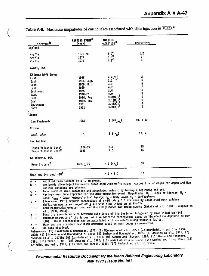
Appendix A 0 A-47
Table A-8. Maximum magnitudes of earthquakes associated with dike injection in
VRZS.'OCATION
Iceland
KraflaKraflaKraf la
RIFTING EVENT
(Year)
1975-7619771978
MAXIMUMd
MAGNITUOE
5 0
3.8'.1
REFERENCES
1,234
Hawaii, USA
Kilauea Rift ZonesEastEastEastEastSouthwestEastEastEastSauthwestEast
Japan
Izu Peninsula
Africa
Asal, Afar
New Zealand
Taupo Volcanic ZoneTaupo Volcanic Zone
California, USA
Mono Craters
Hean and I-sigma/n=IB
19651968, Aug.1968, Oct.196919751976-771980, Aug.1980, Nov.19811982
1989
1978
1964-651983
1325 + 20
4.4(HL)3.3 "3.14.73.04.03.0(M,)f3.1(M )f3.4(H )3.0(M )
5.5(HJMA)
5.3 (Hb)
4.64.3
6.5(H )
4.1 + 1.0
10,11.12
13,14
1515
16
17
cd
gh
Modified fram Hackett et al., in press.Worldwide dike-injection events associated with mafic magma; composition of magma for Japan and New
Zealand episodes are unknown.An episode of dike-injection and associated seismicity having a beginning and end.Haximum magnitude reported for the dike-injection event. Hagnitudes: ML
- Laca'I or Richter; M
Coda; HJMA Japan Hetearological Agency; Hb- Body-wave; H - Surface-wave.
e - Einarsson (1991) reports earthquakes of magnitude + 5.0 are usually associated with calderadeflation events and magnitude « 4.0 with dike injection at Krafla.
f - Coda magnitudes greater than amplitude magnitudes for these events (Nakata et al., 1981; Tanigawa etal., 1980, 1983).Possibly associated with tectonic subsidence of the basin or triggered by dike injection {14).Hinimum estimate of the largest af five historic earthquakes based on liquefaction deposits as per(16). These earthquakes may be associated with movements along tectonic faults.
i - Hean and one standard deviation computed based an magnitudes as presented.nd - No data obtained.References: (1) Einarsson 8 Bjornsson, 1979; (2) Bjornsson et al., 1977; (3) Brandsdottir and Einarsson,1979; (4) Einarsson and Brandsdottir, 1980; (5) Bosher and Ouennebier, 1985; (6) Jackson et al., 1975: (7)Swanson et al., 1976b; (8) Ozurisin et al., 1980; (9) Karpin and Thurber, 1987; (10) Okada and Yamamato,
1991: (ll) Takeo, 1992: {12) Oura et al., 1992; (13) Abdallah et al.. 1979; (14) Lepine and Him, 1992; (15)Grindley and Hull, 1986; (16) Sich and Bursik, 1986; (17) Hackett et al., in press.
Environmental Resource Document for the Idaho National Engineering LaboratoryJuly 1993 / Issue No. ON
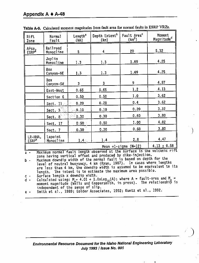
Appendix A 4 A-48
Table A-9. Calculated moment magnitudes from fault area for normal faults in ESRP VRZs.
Rift2one
Arco,ESRP'ormal
Fault
RailroadMonocline
Length'km)
I
20 5.32
Depth Extent Fault Area'oment{km) {km ) Magnitude
Jayl inMonocline
BoxCanyon-NE
BoxCanyon-SW
East-West
Section 6
Sect. 11
Sect. 3
Sect. 8
Sect. 17
Sect. 7
1.3
1.3
0.65
0.50
0.20
.Q.10
'0 30
0.50;-
0.30
1.3
1.3
0.65
0.50
0.20
0.10
0.30
0.50
0.30
1.69
1.69
1.2
0.4
0.20
0.60'..00
0.60
4.25
4.25
4.97
4.13
3.62
3.62
3.32
3.80
4.02
3.80
LR-HHA,ESRP'apointMonocline 1.4 2.8 4.47
b-
cd
e-
Mean +1-sigma (N=12) 4.13 + 0.58Maximum normal fault length observed at the surface in the volcanic riftzone having vertical offset and produced by dike-injection.Maximum downdip width of the normal fault is based on depth for thelevel of neutral buoyancy, 4 km (Ryan, 1987). In cases where lengthsare less than 4 km, the downdip width is assumed to be equivalent to itslength. The intent is to estimate the maximum area possible.Surface length x downdip width.Calculated using: M„= 4.01 + 1.0xLog»{A); where A = fault-area and M„
=
moment magnitude (Wells and CoppersmVth, in press). The relationship isindependent of the sense of slip.Smith et al., 1989; Golder Associates, 1992; Kuntz et al., 1992.
Environmental Resource Document for the Idaho National Engineering LaboratoryJuly 1993 / Issue No. 001
Appendix A 4 A-49
reasons (Hackett et al. in press): (a) deformation can occur aseismically and seismic moment
release may be small compared to total moment released through inelastic deformation (Filsonet al. 1973; Stein et al. 1991;Rubin 1992), (b) faults move in small increments due to slow dike
propagation resulting in short, discontinuous segments with variations in amounts of displacement,
(c) dike-induced normal faults have shallow downdip widths resulting in small areas for rupture(Daz and Scholtz 1983), (d) using magnitude-fault area relationships assumes rupture along theentire length, but observations indicate that the faults move in small increments or even
aseismically, and (e) the relationship of moment magnitude to fault area assumes a crustal valuefor rigidity (3 x 10 dyne/cm ), which may be lower for near-surface volcanic rocks toappropriately describe volume changes (-0.5-1.8x 10"dyne/cm; Filson et aL 1973; Mori et aL
1989; Stein et al. 1991).
Recurrence intervals of the dike-induced seismicity within the ESRP VRZs are based on thevolcanic rock record. For the current probabilistic assessments, the maximum magnitude
earthquake is assumed to occur during each dike-injection episode (see Section 2.1.4).Observational seismicity during dike-injection events at Krafla and Hawaii suggest that someproportion of the episodes of dike injection are not accompanied by magnitude 5.5 earthquakes.
A.2.5.2 Northern Basin and Range.
A.2.5.2.1 CTB-The 1983 M, 73 Borah Peak, Idaho earthquake is the largest eventto occur in the CTB (Figures A-1 and A-2). Figure A-3 shows a map of intensity distributions
(Stover 1985). It originated at a depth of 16 ~ 4 km (10 + 2.5 mi), near the base of theseismogenic crust (Doser and Smith 1985). It ruptured to the northwest producing 36 km
(22A mi) of surface faulting along the Thousand Springs and a portion of the Warm Springs
segments of the Lost River fault. It also produced a surface scarp with a maximum of 2.7 m
(89 ft) vertical displacement (Crone et al. 1987). The Borah Peak mainshock and aftershocksdefine a normal fault dipping 40 to 50 degrees to the southwest which is consistent with dips
determined from first motions, body-wave analysis, and geodetic observations (Table A-6) (Richinset al. 1987). The stress drop determined from seismic moment is 17 bars and from geologic data,12 bars. Even considering the possible sources of error in the calculations, the stress dropprobably did not exceed 75 bars suggesting that the Borah Peak earthquake was a low stress-dropevent when compared to other normal faulting earthquakes in the same magnitude range (Doserand Smith 1985).
A.2.5.2.2 ISB-Several moderate to large magnitude earthquakes that can becorrelated to tectonic structures, have occurred within the central part of the ISB near the ESRP(Figure A-2):
1. Hansel Valley. The March 12, 1934, ML 6.6, Hansel Valley Utah earthquake was felt over
an area of 440,000 kmz and reached Modified Mercalli intensity VIII (Smith and Arabasz
1991). Shenon (1936) mapped north-: ~ nding subparallel fractures displacing salt tlats and
unconsolidated late Quaternary sediments in the southwestern part of Hansel Valley over an
area 6 km (3.7 mi) wide and 12 km (7.5 mi) long. Up to 50 cm (20 in.) of vertical
Environmental Resource Document for the Idaho Nationai Engineering LaboratoryJuly 1993 / Issue No. 001
Appendix A 0 A-50
displacement and 25 cm (10 in.) horizontal offset were reported by dePolo et al. (1989).The focal mechanism from seismic wave-form modeling by Doser (1989b) indicates that the
mainshock occurred along a strike-slip fault with left-lateral slip on a northeast-trending
structure. The event originated at focal depth of 8-10 km (5-6.2 mi) and had a subsurface
rupture length of 11 km (6.8 mi) (Doser 1989b).
2. Cache Valley. Re-analysis of seismograms for the August 30, 1962, M, 5.7, Cache Valley
earthquake indicates that it may be associated with the Temple Ridge fault, a less prominent
feature with only 500 m (1,640 ft) of Neogene throw located east of the East Cache fault
(Westaway and Smith 1989). Focal depth is estimated to be 10 ~ 2 km (6.2 + 1.2 mi) and
focal mechanisms from first motions and body wave analysis suggest a dip of 49 and
58 degrees, respectively, to the west (Table A-6). Woodward-Clyde Consultants (1992a)estimated Brune and RMS stress drops of 25.2 ~ 5.2 bars and 45.4 bars, respectively.
3. Pocatello Valley. The March 28, 1975, Mb 6.1,Pocatello Valley earthquake occurred along a
northeast-trending structure with a large left-lateral component of slip (Bache et al. 1980).
Figure A-12 shows the Modified Mercalli intensity distribution (Cook and Nye 1979).Studies of the aftershock sequence were consistent with a fault dip of 39 degrees to the
northwest (Arabasz et al. 1979). The event originated at a focal depth of about 9 km
(5.6 mi) (Table A-6) and has an inferred stress drop of about 50 bars for initial faulting
(Bache et al. 1980).
A.2.5.3 Yellowstone Plateau.
A.2.5.3.1 Hebgen Lake-The August 18, 1959, M, 7.5, Hebgen Lake earthquake is
the largest event to occur in the ISB region. Figure A-14 shows the Modified Mercalli intensity
distribution from (Eppley and Cloud 1961). Seismic waveform analysis by Doser (1985b) indicates
that the mainshock was a double event consisting of subevent one, an Mb 6.3 followed 5 sec later
by subevent two, an Mb 7.0. Her analysis also suggests that the rupture occurred along one or
more fault planes with east-west strike orientations (Table A-6) slightly discordant with the trace
of surface faulting along the Hebgen and Red Canyon faults. Maximum vertical displacements of6.7 m (22 ft) over a surface scarp length of 23 km (143 mi) and 6.1 m (20 ft) over 14.5 km
(9.0 mi) were observed along the Red Canyon and Hebgen faults (Myers and Hamilton 1964;
Witkind 1964). A 1-m (3.3-ft) scarp was observed along a 3-km (1.9-mi) segment of a fault
adjacent to Madison Canyon, but it was difficult to determine whether it was related to coseismic
movement associated with the Hebgen Lake earthquake (Myers and Hamilton 1964).
Focal mechanisms derived from first motions and body-wave analysis for the subevents
indicates fault dips ranging between 40-60 degrees to the southwest. Subevent 1 initiated at a
focal depth of 10 km (6.2 mi) and subevent 2, 15 km (9.3 mi). The estimated stress drop for the
mainshock is 115 bars (Doser 1985b).
A.2.5.3.2 Yellowstone Caldera —The June 30, 1975, ML 6.1,Yellowstone Park
earthquake occurred near the northern rim of the Yellowstone caldera. Figure A-15 shows the
Environmental Resour"e Document for the Idaho National Engineering Laboratory
July 1993 / Issue No. 001
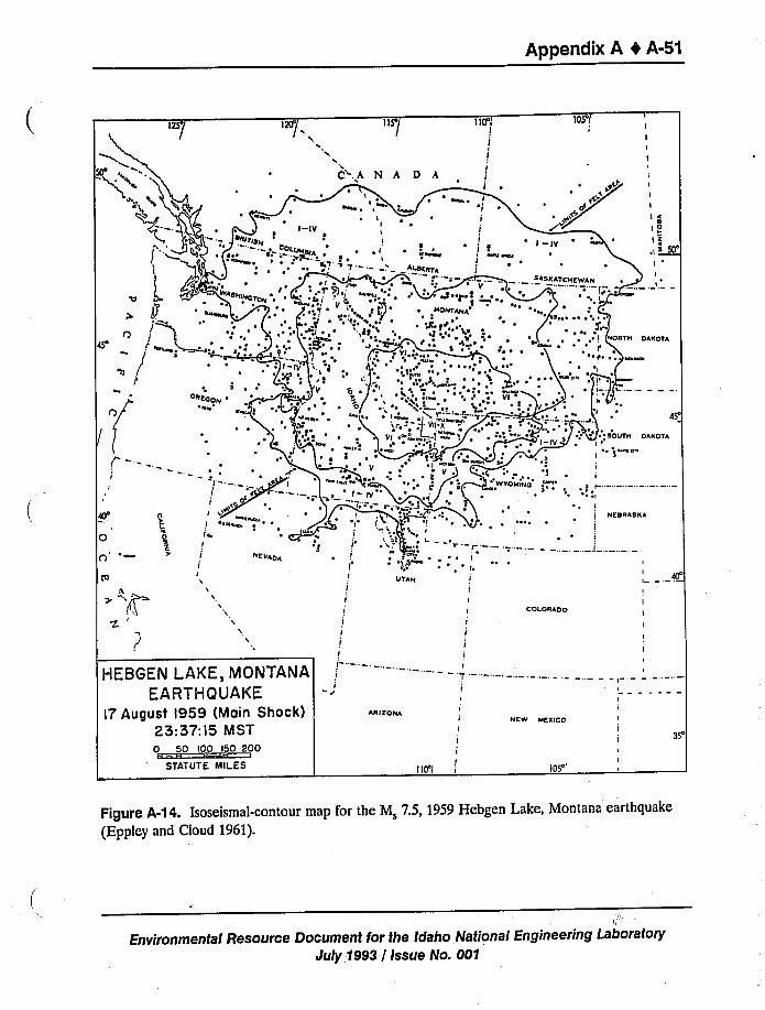
Appendtx A 4 A-5t
12$/ 1ÃP/ 11S/ 110's 1OS'!
I
I
I
II
~NIT
t ~
IQ
I'X
DREODN 'N ~K
I -IV
C'A'I
MKK ~IlI
I
I
~ IX
A D h
~!I
I
!~ i
I
I
I —IV
HEWAN
~ ~
I
I
I
I
K
I 0I*
,I. > 50'
I
I
I 4s'
~SOUTH DAKOTA
1~ae
~ ~ ~ ~ I
NORTH DAKOTAI'
~ IC ~~ ~
I
III olR
0n'
0RT.R
NEVADA
HEBGEN LAKE, MONTANA
EARTHQUAKEl7 August l959 (Main Shock)
25:57:l5 M ST0 50 100 150 200
STATUTE MILES
I\
~ I
IUTAH I
I II I
I
I I
I I
II
II
I
I TI
IJI
IARIZONA
I
I
I
I110'I
COLORADO
NEW MEXICO
105'
I
P"
I
j NESRASKA
I
e M 7.5, 1959 Hebgen Lake, Montana earthquakeFigure A-14. Isoseismal-contour map for the
(Eppley and Cloud 1961).
National Engineering LaboratoryEnvironmental Resource Document for the Idaho a ioJuly 1993 / Issue No. 001
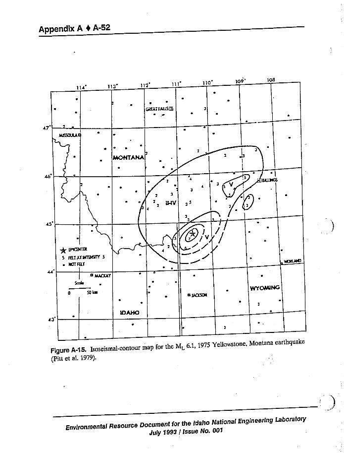
Appendix A 4 A-52
113 110 ]09'08
GREAT TAlLSQJ
47~I
0 4
45
*elena5 TttT AT NTETsnY 5~ ICTT 1RT
MACKAY
San
0
50k'(y)I Ji
a 1ACKsna
Figure A-15. Isoseismal-contour map for the ML 6.1, 1975 Yellowstone, Montana earthquake(Pitt et al. 1979).
Environmental Resource Document for the Idaho National Engineering Laboratory
duly 1993 / Issue No. 00'I
Appendix A 0 A-53
Modified Mercalli intensity distribution from (Pitt et al. 1979). The focal depth of this event was
shallow, 6 km (3.7 mi). Aftershock studies and first motions suggest normal faulting along anorthwest-trending structure dipping about 70 degrees to the northeast (Pitt et al. 1979; Bacheet aL 1980).
A.2.5.4 Northern Rockies.
A.2.5.4.1 Clarkston Valley-The July 10, 1925, M 6.8, Clarkston, Montana
earthquake was felt over an 800,000 kmz area and reached a Modified Mercalli intensity of VIIIin the epicentral area (Smith and Arabasz 1991). Although this earthquake was large, it producedno surface scarp, but some ground cracks were observed (Pardee 1926). Seismic wave analysis
indicates a focal depth of 9 km (5.6 mi), a rupture length of 25 km (1S.Smi), and oblique normal
slip on a northwesterly-dipping plane trending north-south (Table A-6) (Doser 1989a).
A.2.5.4.2 Virginia City-The November 23, 1947, M 6.3, Virginia City earthquake
may be associated with rupture along a portion of the northwest-trending Madison Canyon fault
based on first motions (Dewey et al. 1973). Re-analysis using seismic waveforms by Doser(1989a) suggests right-lateral slip along a fault striking east-west. She suggests that fault motion
at depth in this part of the Hebgen Lake/Madison region occurs along structures striking nearlyeast-west and that the northwest-strike of surface faulting may reflect thc trend of preexistingweaknesses that the earthquake ruptures exploited as they propagated to the surface. The event
originated at a focal depth of about 8 km (5 mi) (Doser 1989a).
A.2.6 Maximum Earthquake Potential
Patterns of seismicity and locations of mapped faults have been used to assess potentialsources of future earthquakes for estimating ground shaking at INEL. The sources and maximum
magnitudes of earthquakes which could produce the maximum levels of ground motions at INELfacilities include the following (Figure A-16): (a) a magnitude 7.0 earthquake at the southern end
of the Lemhi fault along the Howe and Fallert Springs segments, (b) a magnitude 7.0 earthquakeat the southern end of the Lost River fault along the Arco segment, (c) a magnitude 5.5earthquake associated with dike-injection in either the Arco or Lava Ridge-Hell's Half AcreVRZs and the axial volcanic zone, and (d) a "random" magnitude 5.5 earthquake occurring within
the ESRP (Woodward-Clyde Consultants 1992a). Ground motion contributions from othersources such as the postulated ESRP boundary fault, northern Basin and Range province,Yellowstone Plateau, and Idaho Batholith are significantly smaller due to their distant locations orlower maximum magnitudes.
A.2.6.1 Lemhi Fault - Howe and Fallert Springs Segments. The Howe and Fallert
Springs segments are located at the southern end of the Lemhi segment and the Howe segment is
closest to INEL (Figure A-16). The most recent event (MRE) occurred between 15,000 and
24,000 years ago (Woodward-Clyde Consultants 1992b). The lengths of the Howe and Fallert
Springs segments are approximately 15-20 km (9.3-12.4mi) and 25-30 km (15.5-18.6mi),respectively (Turko 1988; Baltzer et al. 1989; Hailer 1988). Recent paleoseismic investigations
Environmental Resource Document tor the Idaho National Engineering LaboratoryJuly 1993 / Issue No. 001
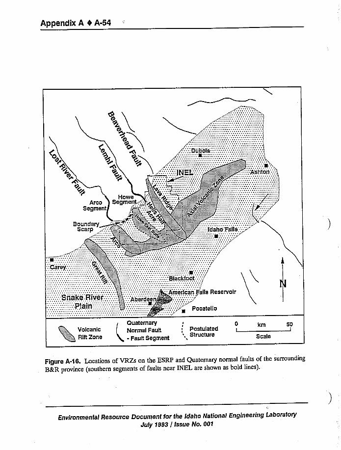
Appendix A 0 A-54
Quaternary 0Volcanic Normal Fault, Postulated
':::::::::::,RlftZone auit Segment ruct re Scale
50I
Figure A-16. Locations of VRZs on the ESRP and Quaternary normal faults of the surrounding
B&R province (southern segments of faults near INEL are shown as bold lines).
Environmental Resource Document for the idaho National Engineering Laboratory
July 1993 / Issue No. 001
Appendix A I A-55
(four trenches excavated across the fault segments) by Woodward-Clyde Consultants (1992a;1992b) indicate that the MRE could have ruptured portions of both the Howe and Fallert Springssegments resulting in a total length of 35 km (22 mi). For the MRE, maximum and average
displacements are 2.5 m (8 ft) and 1.5 m (5 ft), respectively (Woodward-Clyde Consultants 1992b).The maximum magnitude estimated for the MRE is 7.0 based on empirical data from Wells and
Coopersmith (in press) using the following: (a) surface rupture length, (b) subsurface rupture
length, (c) rupture area [length x downdip extent; 31 x 21 km (20 x 13 mi); Figure A-17J, (d)maximum displacement, and (e) average displacement (Woodward-Clyde Consultants 1992a). Theslip rate of 0.1 mm/yr for both the Howe and Fallert Springs segments is lower than 0.3 mm/yr forthe Thousand Springs segment of the Lost River fault indicating that the Howe segment is less
active (Crone et al. 1987).
A.2.6.2 Lost River Fault - Arco Segment. The Arco segment is located at the southern-most end of the Lost River fault and is the closest part of the fault to INEL (Figure A-16).Reconnaissance paleoseismic studies conducted by Malde (1987) and Pierce (1985, 1988) alongthe Area segment suggest that the MRE occurred about 30,000 years ago. The length of thefault segment is about 10 km (6.2 mi) and MRE caused about 2-3 m (6.6-9.8ft) of displacement
(Pierce 1985; Crone et al. 1987). The maximum magnitude estimated for the MRE is 7.0 by
analogy to paleoseismic studies of the Howe and Fallert Springs segments of the Lemhi fault sinceno detailed studies have been performed for the southern Lost River fault. The analogy is
supported by conclusions that faults northwest of the INEL are undergoing similar deformational
processes (Crone et al. 1987; Woodward-Clyde Consultants 1992a). The slip rate of 0.12 mm/yr
for the Arco segment is lower than 0.3 mm/yr for the Thousand Springs segment (Borah Peakearthquake) indicating that the Arco segment is less active (Crone et al. 1987).
A.2.6.3 Beaverhead Fault - Blue Dome Segment. The Blue Dome segment is located atthe southern-most end of the Beaverhead fault (Figure A-16). Based on scarp morphology, theMRE occurred more than 30,000 years ago (Stickney and Bartholomew 1987), and recentunpublished mapping in the area suggests that it has not been active for several hundred thousand
years (G. Embree, personal communication). The length of the segment is estimated to be about25 km (15.5mi) (Hailer 1988). Since no detailed paleoseismic investigations have been conducted
along this segment and faults northwest of INEL are undergoing similar deformational processes,Woodward-Clyde Consultants (1992a) estimates a maximum magnitude of 7.0 for an earthquake
on along the Blue Dome fault. No data are available to quantitatively estimate a slip rate, butseveral investigators suggest that this'egment has an activity rate similar to the southern segments
of the Lemhi and Lost River faults (Crone et al. 1987; Anders et al. 1989).
A.2.6.4 ESRP Boundary Faults. Deep seismic refraction profiling across the northwest
boundary of the ESRP near the INEL suggests the presence of a buried northeast-trending fault
parallel to the ESRP boundary (Pankratz and Ackerman 1982). Scott (1982) suggested that anortheast-trending topographic scarp observed on an alluvial fan along the southeast side of theArco Hills may be a result of past movement on a boundary fault. Breckenridge and Othberg
(1991)excavated a trench across the scarp. Their trench logs indicate that no fault offset is
Environmental Resource Document for the Idaho National Engineering LaboratoryJuly 1993 / Issue No. 001
Arco Rift ZoneBox Canyon Graben
Lemhi FaultHowe and Fallert Springs Segments
urface
Dike induced Faulting Basin-and-Range Faulting
Figure A-17. Comparison of fault dimensions, fault orientations, and calculated moment magnitudes for dike-induced faults on
the ESRP and normal faults of the surrounding B&R tectonic province.
Appendix A 0 A-57
present within the alluvial fan deposits. They conclude that the scarp may have developed from abuildup of eolian sediments along an old fire scar.
Other investigations have been conducted on northeast-trending faults at the southernterminations of the Lemhi Range and Beaverhead Mountains near the margins of the ESRP(Rodgers and Zentner 1988; Zentner 1989; Bruhn et al. 1992). Results of their studies indicatethat these faults were active more than 2 million years ago. Based on the following lines ofevidence these faults are not considered significant seismogenic sources: (a) their northeast trend
is not consistent with the direction of the active northwest-trending normal faults which areproduced by regional extensional stress field, (b) they do not displace sediments and volcanicrocks younger than 2 million years old, and (c) their lengths are small, generally less than 10 km
(6.2 mi), and they have small total displacements. Furthermore, even if they were active, thesefaults would be capable of producing earthquakes of magnitude 5.0 based on their fault lengths
and small displacements. This magnitude does not exceed the magnitudes of earthquakes that
could occur in the Arco VRZ or randomly on the ESRP at equal or closer distances (Woodward-
Clyde Consultants 1992a).
A.2.6.5 ESRP Volcanic Zones.
A.2.6.5.1 Arco Volcanic Rift Zone —The Arco VRZ extends from the southern end
of the Lost River Range across the southwestern tip of the INEL (Figure A-16). The rift zone is
about 6 km (3.7 mi) wide and 20 km (12.4 mi) long (Kuntz et al. 1990, 1992; Smith et al. 1989).Small normal faults within the rift zone are 5-6 km (3.1-3.7mi) in length, have cumulative
vertical offsets of about 12 m (39.5 ft) (multiple offsets) and are postulated to extend to a depthof 2 km (1.2 mi) below the surface (Mastin and Pollard 1988; Smith et al. 1989; Kuntz et. al. 1990;Woodward-Clyde Consultants 1992a). A set of fissures in the Box Canyon graben area is colinearwith the small normal faults [5 km (3 mi) long] (Table A-9) bounding the graben which results in
a total length of 8 km (5 mi). Based on the compilation of earthquake data for active rift zones
(Table A-8) a maximum magnitude of 5.5 is assumed possible for future dike-injection events
within the rift zone. This is consistent with a magnitude of 5.2 based on the assumption that an
earthquake associated with dike injection ruptures a fault area of 16 kmz [length x depth;8 x 2 km (5 x 1.2 mi)] (Figure A-17) (Woodward-Clyde Consultants 1992a). The most recentvolcanic activity within the rift zone appears to have been about 95,000 years ago (Kuntz et al.
1990; Smith et al. 1989; Forman et al. in press).
A.2.6.5.2 Lava Ridge-Hell's Half Acre Volcanic Rift Zone —The Lava Ridge-Hell'
Half Acre (LR-HHA) VRZ extends from the southern end of the Lemhi range across the INELto the southeastern corner (Figure A-16). The rift zone is 3-6 km (1.9-3.7mi) wide and 50 km
(31 mi) long. At the southern end of the rift zone, two sets of fissures, which may or may not beassociated with small normal faults [1.4km (0.9 mi) in Table A-9], are about 4 km (2.5 mi) long
(Golder et al. 1992). Since portions of the fissures are covered by younger lava flows, the fissure
sets could extend 11 km (6.8 mi) farther south. A maximum magnitude of 5.5 was assumed
possible for earthquakes associated with future dike-injection events within the LR-HHA rift zonebased on the compilation of earthquake data shown in Table A-8. This is consistent with a
Environmental Resource Document for the Idaho National Engineering LaboratoryJuly 1993 / Issue No. 001
Appendix A 4 A-58
magnitude of 5.5 which was estimated using fault area (15 x 3 km = 30 kmz) and assuming
rupture along the entire fissure lengths (Woodward-Clyde Consultants 1992a). The most recent
volcanic activity within the LR-HHA rift zone occurred about 5,200 years ago (Kuntz et al. 1990).
A.2.6.5.3 Howe-East Butte Volcanic Rift Zone-The postulated Howe-East Butte
(H-EB) VRZ extends across the central portion of the INEL from the range-front south of Howe
to East Butte (Figure A-16). It is poorly expressed surficially and is mostly covered by younger
lava flows and fluvial and lacustrine sediment (Kuntz et al. 1990) (see Section 2.1.4). Woodward-
Clyde Consultants (1992a) considered the maximum magnitude for the H-EB to be 5.5 similar to
the Arco and LR-HHA VRZs. Volcanic vents in the H-EB VRZ are estimated to be 580,000 to
641,000 years old (Kuntz et al. 1990) and a conservative minimum age for the VRZ is established
by its being overlain by a dated lava flow 230,000 years old.
A.2.6.5.4 Axial Volcanic Zone-The Axial Volcanic Zone (AVZ) is located along the
ESRP axis and crosses southeastern portions of the INEL. Dike-induced features are located
near the intersections of the Arco and LR-HHA VRZs with the AVZ. Thus, a maximum
magnitude of 5.5 is assumed possible based on the close proximity of the AVZ to these VRZs.
The most recent volcanic activity 5,000 years ago (Kuntz et al. 1988).
A.2.6.6 ESRP Province. Although instrumental seismicity indicates that the ESRP is
relatively aseismic, an earthquake similar in size to the 1905 Shoshone event is considered
possible within the ESRP. For estimating ground motions at INEL, an earthquake of maximum
magnitude 5.5 is postulated to occur anywhere within a 25-km (15.5-mi) radius of each facility.
This is referred to as a "random earthquake" and is commonly used for design of commercial
nuclear reactors to assess effects from earthquakes that may occur on unknown faults (those
without surface exposures).
A.2.6.7 Northern Basin and Range Province. The northern Basin and Range source
region surrounds the ESRP. Excluding known normal faults which are capable of generating
magnitude 7.0 events, an earthquake with a maximum magnitude of 6.75 is postulated to occur
anywhere within this source region on an unknown subsurface structure (Woodward-Clyde
Consultants 1992a). Doser (1985a) suggests that earthquakes of magnitude 6.0-6.75 could occur
in the ISB without producing fault scarps for evidence of their past occurrence. An example ofthis phenomena is the 1975 ML 6.0 Pocatello Valley earthquake near the Idaho-Utah border.
This event occurred on a "blind" (not evident in surface geology) cross-fault which trended
transverse to the trend of nearby B&R normal faults (Arabasz et al. 1981).
A.2.6.8 Idaho Batholith Province. The Idaho Batholith is seismically quiet region and its
boundaries are defined by the extent of granitic rocks associated with the batholith. No extensive
or well-defined Quaternary faults are mapped within the Idaho Batholith (Woodward-Clyde
Consultants 1992a). Although seismographic coverage is poor (a detection threshold of M a 3), it
appears to have a low seismic potential (Smith and Arabasz 1991). Woodward-Clyde Consultants
(1992a) estimated the maximum magnitude to be M„5.5.
Environmental Resource Document for the Idaho National Engineering Laboratory
July 1993 / Issue No. 001
Appendix A 4 A-59
A.2.6.9 Yellowstone Plateau Province. The Yellowstone Plateau province includes thefaults associated with the 1959 Hebgen Lake event, largest earthquake in the ISB. Thus, the
maximum magnitude is M, 7.5 based on this event (Woodward-Clyde Consultants 1992a).
A.2.7 Seismic Wave Transmission Characteristics
A.2.7.1 Regional Attenuation. For the ground motion modeling studies, regionalattenuation was characterized by a frequency-dependent quality factor, Q(f). Singh and Herrman
(1983) determined a regional crustal coda Q, of 450 and ri of 0.2 for Q(f) in the B&R northwest
of the ESRP. Braile et al. (1982) observed high attenuation in the 1978 ESRP seismic refraction
experiment within the ESRP for the P-wave quality factor Q„. They attributed it to low Q values
in the volcanic rocks (Q 20 to 200) and throughout the crust (Q 160 to 300). Woodward-Clyde
Consultants (1992a) used the model parameters of Q, and ri from Singh and Herrman (1983) in
their 1990 deterministic analysis. They also suggest that the relatively short source-to-site distance
of 20 km (12.4 mi) [less than 30 km (18.6mi)] does not significantly attenuate earthquake ground
motions.
A.2.7.2 Near-surface Geological Attenuation. Woodward-Clyde Consultants (1990)indicate that near-surface geology [0-5 km (0-3.1 mi) depthj has a significant influence onearthquake ground motions at a site, in addition to amplification resulting from soil overlying
bedrock. The INEL resides upon the ESRP which is covered with basalt lava flows and sediments
(see Section 2.1.2). Boreholes located throughout the INEL site indicate the basalt is
interbedded with sedimentary layers; in some areas, the percentage of interbeds is as great as
50%.
This unique stratigraphy has the affect of deamplifying or decreasing the level of earthquake
ground motions because seismic waves travel through a sequence of alternating high (basalt) and
low (sediments) velocity zones which tend to scatter the seismic energy. Also, seismic energy is
intrinsically dampened by the sedimentary interbeds. The net effect of the interbedded basalt is
to reduce the level of earthquake ground motions when compared to a homogeneous basalt (nointerbeds) (Woodward-Clyde Consultants 1990). The amount of deamplification is dependent onthe difference between the velocities for the basalt and sedimentary layers, and the thickness ofthe sedimentary layers.
As an example, Figures A-18 and A-19 show the shear-wave velocity (Vs) profiles (actualand smoothed models) determined to estimate earthquake ground motions at ATR (Woodward-
Clyde Consultants 1992a). The velocity model was derived from using well and'borehole logslocated near the Test Reactor Area. Since the velocity model has large contrasts (basalt vs
sediment), the velocity profiles were smootned to taper the large effects of scatting which resulted
in low-amplitude spectra. Regional earthquakes were digitally recorded near two boreholes at theTest Reactor Area. These data were used to estimate the near-surface attenuation, K, and todetermine the amount of smoothing in the velocity profiles.
Environmental Resource Document for the Idaho National Engineering Labora'yJuly 1993 / Issue No. 001
Appendix A 4 A-60
A.2.8 Ground Motion Studies
Seismic hazards assessments to evaluate potential earthquake ground motions have been
conducted at INEL since the early 1970s for establishing seismic design criteria. Since that time,
ground motion seismology and federal regulations have continued to evolve, and geoscience
investigations have continued at INEL. To keep pace with these changes, a deterministic (worst-
case scenario) earthquake hazard assessment was conducted recently for all facilities at INEL
using new geologic data and state-of-the-art ground motion modeling techniques (Woodward-
Clyde Consultants 1990). Deterministic and probabilistic hazards assessments were conducted for
the proposed NPR site at INEL, which evaluated ground motion contributions from the "random"
ESRP earthquake (Woodward-Clyde Consultants 1992a). Also, an INEL probabilistic seismic
hazard assessmentiis currently underway to assess the contributions from all earthquake sources
on the levels of ground motions and their return periods. This study includes an evaluation for
ATR.
A.2.8.1 1990 INEL Deterministic Evaluation. The 1990 deterministic study estimated
peak ground accelerations based on the largest earthquake (M 7) that could occur along the
Lemhi fault (Woodward-Clyde Consultants 1990). This evaluation incorporated all available
results from geoscience investigations pertaining to the earthquake source and subsurface
stratigraphy beneath the ESRP (crustal structure) and INEL facilities (near-surface stratigraphy).
Woodward-Clyde Consultants (1990) used site-specific geologic profiles beneath INEL facilities to
assess the nature of seismic-wave propagation from the Howe fault. The geologic profiles were
used with the band-limited-white-noise ground motion model to determine site-specific
accelerations for anticipated levels of earthquake ground motions. Sensitivity analyses were
performed on the results which indicated that the size of the earthquake (stress drop) and near-
surface geology (x) had the most significant affects on the levels of earthquake ground motions.
Peak horizontal and vertical accelerations and response spectra were estimated for the 50th and
84th percentiles based on the range of uncertainties in the geologic input.
A.2.8.2 1993 INEL Probabilistic Evaluation. A probabilistic seismic hazard study for
INEL facilities will be completed in April 1993. This evaluation will provide seismic haz'.id
curves (peak ground accelerations vs return periods) and response spectra. The geologic input
will be similar to the input used in the NPR probabilistic evaluation with minor exceptions
(Woodward-Clyde Consultants 1992a). Geologic profiles were refined from those in the 1990
deterministic evaluation based on new borehole information and additional estimates of.V,. The
band-limited-white-noise ground motion model will be used along with empirical relationships.
Sensitivity analyses will be performed to determine the seismic sources contributing to the hazard.
'nvironmental Resource Document for the Idaho National Engineering Laboratory
July 1993 / Issue No. 001

I/
- IU'
Appendix A I A-61
A.3 Surface Faulting
Surface faulting, defined as the rupture of the earth's surface due to tectonic or magmatic
activity, is of concern in some areas of INEL. Surface faulting related to tectonic activity could
occur near the southern tip of the Lemhi fault (Figures A-4 and A-5). Such surface faulting
would be associated with an earthquake on the Howe and Fallert Springs segments and could
extend into the INEL for a distance of several kilometers in the area just east of the Big LostRiver Sinks. The age of most recent earthquake activity on the southern Lemhi fault is given in
Sections A.2.4.2 and A.2.6.1.
Other areas in which surface faulting is of concern are in VRZs (see Section 2.1.4). Areas
in and near the Arco and the Lava Ridge-Hells Half Acre VRZs (Figure 2-21) have the greatest
potential for such dike-induced surface faulting (see Section 2.1.4for a description of the surface
deformation process). Also, the fissures north of the Naval Reactors Facility (Figure 2-20) appearto be dike-induced fissures. The potential recurrence of such fissuring is tied closely to periods ofvolcanic activity in VRZs and is quantified in Section 2.1.4.
Environmental Resource Document for the Idaho National Engineering LaboratoryJuly 1993 / Issue No. 001
Appendix A 4 A-62
A.4 Description of Soil Classification andMapping Information Available About the INEL—Summary
The Soil Conservation Service has mapped portions of the INEL in Jefferson and Bonneville
Counties, which comprises about 25% of the reservation. This portion of the INEL has not beensignificant for waste management or environmental restoration activities to date. There are nodevelopments or facilities on these sections. The Soil Conservation Service did not penetrate theINEL boundary in the published Bingham and Butte County surveys. Revised, more detailed soil
surveys will be published for Bingham and Butte Counties, however, information is not available
at this time. Special soil surveys were written for Butte and Bonneville counties. These show the
types of soil present and classify their irrigability (Chugg et al. 1968a, 1968b).
There are two maps of the INEL that delineate soils on the INEL, but neither have beenverified for accuracy, and both are seemingly inaccurate. McBride et al. (1978) published a soil
map of the INEL, which was compiled from various sources including the draft Jefferson County
Soil Survey, Butte County Special Soil Survey (Chugg et al. 1968a), and the Bonneville County
Special Soil Survey (Chugg et al. 1968b). Mapping units were not uniformly defined in theoriginal documentation, and the lines around the units uo not correlate at the boundaries.McBride et al. (1978) interpolated the boundaries, but did not explain the rationale for doing so,and they also made interpretations of the mapping units in order to define a new set of common
units. The new units are related to the irrigability of soils, which has limited benefit for most land
use planning at the DOE reservation.
A surficial geology map was published by Scott (1982), but the information is limited to thegeological setting (e.g., fan alluvium, discontinuous loess, dune deposits) and does not provide any
soil characteristics information, which is necessary for interpreting the suitability of the soils forvarious land uses.
Other maps of INEL soils provide small islands of information, and lack the overall contextthat would be provided by a site-wide map. Breckenridge and McGrath (1989) published soils
maps of the two NPR sites. This report is frequently cited in INEL reports that describe INELsoils, however, the NPR mapping covered only two 2.6-km (1-mi ) patches within the INEL's2,300-km (890-mi ) area, and may not be representative of the INEL soils in general. Moreover,the specific boundaries and locations of the square mile patches are not well documented in thereport. Martin et al. (1992) published some information and maps of soil types around some ofthe EG&G Idaho-managed facilities, but the mapping units have not been correlated, and the
mapping only covers four isolated areas at the INEL, and does not include areas in or around theRadioactive Waste Management Complex, Argonne National Laboratory-West, the IdahoChemical Processing Plant, and the Naval Reactors Facility.
Environmental Resource Document for the Idaho National Engineering LaboratoryJuly 1993 / Issue No. 001
Appendix A 0 A-63
A.5 References
Anders, M.H., J.W. Geissman, L.A. Piety, and J.T. Sullivan, 1989, Parabolic distribution ofcircumeastern Snake River Plain seismicity and latest Quaternary faulting: Migratory pattern
and association with the Yellowstone Hotspot; Journal of Geophysical Research, v.94, no.B2,
p. 1589-1621.
Anders, M. H. and N. H. Sleep, 1992, Magmatism and extension: The thermal and mechanical
effects of the Yellowstone hotspot, J. Geophys. Res. 97, 15379-15393.
Anderson, L. W. and D. G. Miller, 1979, Quaternary fault map of Utah, Furgo, Inc. Long Beach,
CA, 1 plate, 35 pp.
Arabasz W.J., W.D. Richins, and C.J. Langer, 1979, The Pocatello Valley (Idaho-Utah border)
earthquake sequence of March to April 1975 in Earthquake Studies in Utah 1850 to 1978,W.J. Arabasz, R.B.Smith, and W.D. Richins, editors, University of Utah Special Publication,
p. 339-374.
Arabasz W.J. and R.B.Smith, 1981, Earthquake prediction in the Intermountain seismic belt: An
intraplate extensional regime, in Earthquake Prediction: An International Review, D.W.Simpson and D.W. Richards, editors, American Geophysical Union, Maurice Ewing Series 4,
p. 238-258.
Bache, T.C., D.G. Lambert and T.G. Barker, 1980, A source model for the March 28, 1975,Pocatello Valley earthquake from time-domain modeling of teleseismic P waves, Bull. Seis.Soc. Am., v. 70, p. 405-418.
Baltzer, E. M., P. L. K. Knuefer, and M. J. Turko, 1989, Late Quaternary slip events along thecentral Lemhi fault, Idaho (Abstract), Geol. Soc. Am. Abstr. Progr., v. 21, no. 5, p. 53.
Bjornsson, A., K. Saemundsson, P. Einarsson, E. Tyggvason, and K. Gronvald, 1977, Current
rifting episode in north Iceland, Nature, v. 266, p. 318-323.
Blackwell, D. D., 1989, Regional implications of heat flow of the Snake River Plain, northwestern
United States, Tectonophysics, v.164, p. 323-343.
Blackwell, D. D., 1990, Temperatures and Heat How in INEL-GT-1 and WO-2 boreholes, Snake
River Plain, Idaho, EGG-NPR-10690.
Blackwell, D. D., 1992, Heat flow modeling of the Snake River Plain, EGG-C91-103450, 109 pp.
Blackwell, D. D., S. Kelley, and J. L. Steele, 1993, Heat Flow and Seismicity Patterns in the
Vicinity of the ESRP, Idaho, Geological Society of America, Vol. 25, No. 5, p. 10.
Environmental Resource Document for the Idaho National Engineering LaboratoryJuly 1993 / Issue No. 001
Appendix A 4 A-64
Bond, J.G., 1978, Geologic map of Idaho, Bureau of Mines and Geology, Moscow, Idaho, Scale1:500,000.
Braile, L. W., R. B.Smith, J. Ansorge, M. R. Baker, M. A. Sparlin, C. Prodehl, M. M. Schilly, J.H. Healy, ST. Mueller, and K. H. Olsen, 1982, The Yellowstone-Snake River Plain Seismic
Profiling Experiment: Crustal Structure of the Eastern Snake River Plain, Journal ofGeophysical Research, v. 87, no. B4, p. 2597-2610.
Brandsdottir, B. and P. Einarsson, 1979, Seismic activity associated with the September 1977deflation of the Krafla central volcano in northeastern Iceland, J. Vol. Geothm. Res., v. 6,p. 197-212.
Breckenridge, R. P. and C. L. McGrath, 1989, Soil Classification of Proposed NPR Sites at theIdaho National Engineering Laboratory, EGG-CEMA-8510, May 1989.
Breckenridge, R. M. and K. L. Othberg, 1991, Geologic interpretation of a trench excavation nearArea Hills on the northwest margin of the INEL, Snake River Plain, Idaho; IdahoGeological Survey Technical Report 91-2, 20 p.
Brott, C. A., D. D. Blackwell, and J. P. Ziagos, 1981,Thermal and tectonic implications of heatflow in the eastern Snake River Plain, Idaho, J. Geophy. Res., v. 86, p. 11709-11734.
Bruhn, R.L, Wu, D., and Lee, J-J, 1992, Final Report on the structure of the southern Lemhi and
Arco fault zone, Idaho; EGScG Idaho, Inc., EGG-NPR-10680, 6 plates, 26 p.
Christiansen, R.L., 1984, Yellowstone magmatic evolution: Its bearing on understanding
large-volume explosive volcanism; in Explosive Volcanism: Inception, Evolution, and
Hazards; National Academy Press, Washington, D.C., p. 84-95.
Chugg, J. C., W. Jorgensen, M. A. Fosberg, 1968a, Special Soil Survey Butte County, Idaho.IWRB Report No. 5, September 1968.
Chugg, J. C., V. S. Webb, and M. A. Fosberg, 1968b, Special Soil Survey, Bonneville County,
Idaho, Idaho Water Resources Board Report No. 7, September 1968.
Cook, K. L. and R. K. Nye, 1979, Effects of the Pocatello Valley (Idaho-Utah border) earthquakeof March 28, 1975 (UTC), Earthquake Studies in Utah 1850 to 1978, W. J. Arabasz, R. B.Smith, and W. D. Richins, editors, p. 445-457.
Crone, A.J., M.N. Machette, M.G. Bonilla, J.J.Lienkaemper, K.L. Pierce, W.E. Scott, and R.C.Bucknam, 1987, Surface faulting accompanying the Borah Peak earthquake and segmentation
of the Lost River fault, central Idaho; Bulletin Seismological Society of America, v.77, no.3,
p. 739-770.
Environmental Resource Document for the Idaho Nationai Engineering LaboratoryJu/y 1993 / Issue No. 001
Appendix A 0 A-65
Daz, S. and Scholz, C.H., 1983, Why large earthquakes do not nucleate at shallow depths: Nature,
305, 621-623.
de Polo, C.M., D.G. Clark, D.B.Slemmons, and W.H. Aymard, 1989, Historical Basin and Range
province surface faulting and fault segmentation in Fault segmentation and controls ofrupture initiation and t.rmination, D.P. Schwartz and R.H. Sibson, editors, Proceedings
Conference XLV, Palm Springs, U.S. Geol. Surv. Open-file Rept. 89-315, p. 131-162.
Dewey, J. W., 1987, Instrumental seismicity of central Idaho, Bull. Seis. Soc. Am., v. 77, no. 3,
p. 819-836.
Dewey, J.W., W.H. Dillinger, J. Taggart, and S.T.Algermissen, 1973, A technique for seismic
zoning: Analysis of earthquake locations and mechanisms in northern Utah, Wyoming, Idaho,
and Montana, in Contributions to seismic zoning, S.T.Harding, editor, NOAA Technical
Rept. ERL 267-ESL 30, p. 541-575.
Doser, D. I., 1985a, The 1983 Borah Peak, Idaho and 1959 Hebgen Lake, Montana earthquakes:
Models for normal fault earthquakes in the Intermountain seismic belt, in Proceedings ofConference XXVIII on the Borah Peak, Idaho Earthquake, U.S. Geol, Surv., Open-File
Rept. 85-290, p. 368-384.
Doser, D.I., 1985b, Source parameters and faulting processes of the 1959 Hebgen Lake, Montana,
earthquake sequence, J. Geophy. Res., v. 90, no. B6, p. 4537-4555.
Doser, D. I., 1989a, Source parameters of Montana earthquakes, 1925,964) and tectonic
deformation in the northern Intermountain Seismic Belt, Bull. Seis. Soc. Am., 79, No. 1,31-50.
Doser, D. I., 1989b, Extensional tectonics in northern Utah-southern Idaho, U.S.A., and the 1934
Hansel Valley sequence, Physics of the Earth and Planetary Interiors, v. 54, p. 12-134.
Doser, D.I. and R.B.Smith, 1985, Source parameters of the 28 October 1983 Borah Peak, Idaho
earthquake from body wave analysis, Bull. Seis. Soc. Am. 75, 1041-1051.
Doser, D.I. and R.B.Smith, 1989, An assessment of source parameters of earthquakes in the
Cordillera of the western United States, Bull. Seis. Soc. Am. v. 79, p. 1383-1409.
Eddington, P. K., R. B.Smith, and C. R. Renggli, 1987, Kinematics of Basin and Range intraplate
extension, in Continental Extensional Tectonics, M. P. Coward, J. F. Dewey, and P. L.Hancock, editors, Geol. Soc. Special Publ. No. 28, 371-392.
Einarsson, P., 1991, Earthquakes and present-day tectonism in Iceland, Tectonophysics v. 189,
p. 261-279.
Environmental Resource Document for the Idaho National Engineering Laboratory
July 1993 / Issue No. 001
Appendix A 4 A-66
Einarsson, P. and A. Bjornsson, 1979, Earthquakes in Iceland, Jokull, v. 29, p. 37-43.
Einarsson, P. and B.Brandsdottir, 1980, Seismological evidence for lateral magma intrusion during
the July 1978 deflation of the Krafla volcano in NE-Iceland, J. Geophy., v. 47, p. 160-165.
Engdahl, E.R. and W.A. Rinehart, 1988,Seismicity map of North America, Continent-scale
Map-004, Decade of North American Geology, Geol. Soc. Am., Scale 1:5,000,000,4 sheets.
Engdahl, E.R. and W.A. Rinehart, 1991, Seismicity map of North America Project; in Slemmons,
D.B, Engdahl, E.R., Zoback, M.D., and Blackwell, D.D., editors, Neotectonics of North
America, Geological Society of America Decade Map Volume 1, p. 21-27.
Eppley, R.A. and W.K. Cloud, 1961, United States earthquakes 1959, U.S. Coast and GeodeticSurvey, 115 p.
Evans, J.R., 1982,Compressional wave velocity structure of the upper 350 km under the easternSnake River Plain near Rexburg, Idaho; Journal ol'eophysical Research, v.87, p. 2654-2670.
Filson, J., Simkin, T, and Leu, L-K, 1973, Seismicity of a caldera collapse: Galapagos Islands 1968:Journal of Geophysical Research, v.78, p. 8591-8622.
Forman, S.L.,Smith, R.P., Hackett, W.R., Tullis, J.A., and McDaniel, P.A., in press, Age of latePleistocene loess on the eastern Snake River Plain, Idaho: Evidence for the timing of lateQuaternary glaciations in the western United States: Quaternary Research.
Geomatrix Consultants, 1989, Seismotectonic evaluation for Little Wood River Dam Site,unpublished report, U.S. Bureau of Reclamation.
Gilbert, J. D., D. Ostenaa, and C. Wood, 1983, Seismotectonic study for Jackson Lake dam and
reservoir, Minidoka Project, Idaho-Wyoming (unpubl.), Boise, Idaho and Denver, Colorado,U.S. Bur. Rec. Pacific Northwest Regional Office and Engineering and Research Center,Seismotectonic Report 83-8, 123 p.
Golder Associates, 1992, New Production Reactor Site Characterization, Volume I: VolcanicZones Mapping Report, Volume II: Regional Geomorphic Study, and Volume III: NPR SiteGeologic Report; EGG-NPR-10625.
Gorman, V. W. and R. C. Guenzler, 1983, The 1983 Borah Peak earthquake and INEL structural
performance, EGG-EA-6501, 76 p.
Hackett, W.R., R.P. Smith, and N.E. Josten, 1991, Interaction of Quaternary volcanic and tectonicprocesses, eastern Snake River Plain, Geol. Soc. Am. Abstracts with Programs v. 23, p. 32.
Environmental Resource Document for the Idaho National Engineering LaboratoryJuly 1993 / Issue No. 001
Appendix A 0 A-67
Hackett, W. R. and R.P. Smith, 1992, Quaternary volcanism, tectonics, and sedimentation in the
Idaho National Engineering Laboratory area, in Field Guide to Geologic Excursions in Utah
and Adjacent Areas of Nevada, Idaho, and Wyoming, J. K. Wilson editor, Geol. Soc. Am.,
Misc. publ. 1992-93, p. 1-17.
Hackett, W. R., S.M. Jackson, and R.P. Smith, in press, Volcano extensional environments, in
Techniques in Paleoseismology, J.P. McCalpin and T.K. Rockwell, Academic Press, New
York.
Hailer, K. M., 1988, Segmentation of the Lemhi and Beaverhead faults, east-central Idaho, and
Red Rock fault, southwest Montana, during the late Quaternary (Unpubl.), M.S. Thesis,
University of Colorado, 141 p.
Hecker, S., 1991, Quaternary tectonics of Utah, Utah Geol. Min. Surv., Survey Notes 24, 12-17.
Iyer, H.M., Evans, J.R., Zandt, G., Stewart, R.M., Coakley, J., and Roloff, J., 1981,A deep
magma body under the Yellowstone caldera: Delineation using telcseismic P-wave residuals
and tectonic interpretation; Geological Society of America Bulletin, v.92, p. 1471-1646.
Jackson, D.B.,Swanson, D.A., Koyanagi, R.Y., and Wright, T.L., 1975, The August and October
1968 East Rift eruptions of Kilauea volcano, Hawaii: U.S. Geological Survey Professional
Paper 890, 33 p.
Jackson, S. M., 1985, Acceleration data from the 1983 Borah Peak, ID earthquake recorded at
the Idaho National Engineering Laboratory, in Workshop XXVIII on the Borah Peak, IDearthquake, U.S. Geol. Surv. Open-File Rept, 85-290, p. 385-400.
Jackson, S. M., 1993, Summary list of earthquakes (M z 3.0) within 200-mi radius of INEL,EG&G Idaho, Inc., Idaho Falls, Idaho, Engineering Design I'ile EDF-SEIS-0001, 40 p.
Jackson, S. M. and J. E. Zollweg, 1988, Seismic studies of an earthquake sequence in the White
Cloud Peaks, Idaho (Abstract), Seis. Res. Lett. v. 59, no. 1, January-March, p. 6.
Jackson, S. M., G. S. Carpenter, and I. G. Wong„1990, Microearthquake investigations of the
eastern Snake River Plain, Idaho (abstract), Seismological Research Letters, v. 61, p. 41.
Jackson, S. M., J. E. Zollweg, and C. J. Langer, 1991a, 1984 Devil Canyon sequence near Challis,
Idaho: Structural complexity near the north end of the Borah Peak aftershock zone, Seis.
Res. Lett. 62, 51.
Jackson, S. M., J.J.King, D.M. Anderson, G.S. Carpenter, and H.A. Adams, 1991b, Strong ground
motion data recorded at the Idaho National Engineering Laboratory during the 1983 Borah
Peak, Idaho earthquake, EG&G Idaho, Inc., Idaho Falls, EGG-BG-9249, 136 p.
Environmental Resource Document for the Idaho National Engineering LaboratoryJuly 1993 / Issue No. 001
Appendix A 4 A-68
Jackson, S.M., Wong, I.G., Carpenter, G.S., Anderson, D.M., and Martin, S.M., 1993,Contemporary seismicity in the eastern Snake River Plain, Idaho based on microearthquake
monitoring: Bulletin of the Seismological Society of America, v.83.
Johnson, P. P., 1981, Geology of the Red Rock fault and adjacent Red Rock Valley, Beaverhead
County, Montana, M.S. Thesis, University of Montana, Missoula, Montana, 73 p.
King, J.J., T. E. Doyle, and S. M. Jackson, 1987, Seismicity of the eastern Snake River Plain
region, Idaho, prior to the Borah Peak, Idaho earthquake: October 1972 - October 1983,Bull. Seis. Soc. Am., v. 77, no. 3, p. 809-818.
Klein, F. W., R. Y. Koyanagi, J. S. Nakata, and W. R. Tanigawa, 1987, The seismicity of Kilauea's
magma system, in Volcanism in Hawaii, R. W. Decker, T. L. Wright, and P. H. Stauffer eds.,U.S. Geol. Sur. Prof. Paper 1350, p. 1019-1185.
Knuefer, P. L. K., 1989, Late Quaternary segmentation and recurrence, southern Lemhi fault,
Idaho, report written to R. P. Smith, EG&G Idaho Inc., Idaho Falls, Idaho.
Kuntz, M. A., 1978, Geology of the Arco-Big Southern Butte area, eastern Snake River Plain,
and potential volcanic hazards to the Radioactive Waste Management Complex and other
waste storage and reactor facilities at the Idaho National Engineering Laboratory, Idaho,
U.S. Geol. Surv. Open-File Report 78-691, 70 p.
Kuntz, M. A., D. E. Champion, R. H. Lefebvre, and H. R. Covington, 1988, Geologic map of the
Craters of the Moon, Kings Bowl, Wapi lava fields and the Great Rift volcanic rift zone,south-central Idaho, U.S. Geol. Surv. Misc. Invest. Series Map I-1632, scale 1:100,000.
Kuntz, M. A., B. Skipp, M. A. Lanphere, W. E. Scott, K. L. Pierce, G. B. Dalrymple, L. A.Morgan, D. E. Champion, G. F. Embree, R. P. Smith, W. R. Hackett, and D. W. Rodgers,
1990, Revised geologic map of the INEL and adjoining areas, eastern Idaho, U.S. Geol.Surv. Open-file Rept. 990-333, scale 1:100,000.
Kuntz, M. A., H. R. Covington, and L. J. Schorr, 1992, An overview of basaltic volcanism of theeastern Snake River Plain, Idaho, in Regional Geology of Eastern Idaho and Western
Wyoming, Link, P. K. Kuntz, M. A., and Platt, L. B. editors, Geol. Soc. Am. Memoir 179,227-267.
Link, P.K., Skipp, B.,Hait, M.H., Janecke, S.U., and Burton, B.R.,1988, Structural and
stratigraphic transect of south-central Idaho: A field guide to the Lost River, White Knob,
Pioneer, Boulder, and Smoky Mountains; Idaho Geological Survey Bulletin 27, p. 5-42.
Lepine, J-C. and Him, A., 1992, Seismotectonics in the Republic of Djibouti, linking the Afar
Depression and the Gulf of Aden: Tectonophysics, 209, 65-86.
Environmental Resource Document for the idaho National Engineering Laboratory
July 1993 / issue No. 001
Appendix A I A-69
Machette, M.N., S.F.Personius, and A.R. Nelson, 1992, Paleoseismology of the Wasatch fault
zone: A summary of recent investigations, interpretations, and conclusions„ in Assessments ofregional earthquake hazards and risk along the Wasatch Front, Utah, P.L Gori and W.W.
Hays, editors, U.S. Geol. Surv. Professional Paper 1500, p. A1-A71.
Malde, H. E., 1987, Quaternary faulting near Arco and Howe, Idaho, Bull. Seis. Soc. Am., v. 77,no. 3, p. 847-867.
Martin, K. L., C. J. Barnard, A. L. Freeman, M. R. Groh, K. T. Kissell, S. J. Lord, G. L. Olson, P.D. Randolph, R. N. Wilhelmsen, 1992, Preliminary Assessment of Surface Soils at Active
EG&G Idaho Facilities Data Document, EGG-ESQ-9225, Revision 1, May 1992.
Mastin, L. G. and D. D. Pollard, 1988, Surface deformation and shallow dike intrusion processes
at Inyo Craters, Long Valley, California, J. Geophy. Res., v. 93, p. 13,221-13,235.
McCalpin, J.P.,L.A. Piety, and M.H. Anders, 1990, Part 1. Latest Quaternary faulting and
structural evolution of Star Valley, Wyoming, in Geologic field tours of western Wyoming
and parts of adjacent Idaho, Montana, and Utah, S. Roberts, editor, Geol. Surv. Wyoming
Public Information Circular No. 29, p. 5-14.
Moos, D., C. A. Barton, and R. P. Smith, 1990, Results of borehole televiewer logging to 3 km
depth in the Snake River Plain - In situ stress and fractures, EOS 43, 1622.
Morgan, L.A., 1988, Explosive rhyolitic volcanism of the eastern Snake River Plain (unpublished,
Ph.D. Thesis), Manoa, University of Hawaii, 191 p.
Mori, J., McKee, C., Itikarai, I., Lowenstein, P., de Saint Ours, P., and Tali, B., 1989, Earthquakes
of the Rabaul seismo-deformational crisis September 1983 to July 1985: Seismicity on a
caldera ring fault, in J.H. Latter, editor, Volcanic Hazards: IAVCEI Proceedings in
Volcanology 1, p. 429-462.
Morin-Jansen, A., 1987, Study of the Principal Lineament and associated lineaments; Masters
Thesis, Idaho State University, Pocatello.
Myers, W. B. and W. Hamilton, 1964, Deformation accompanying the Hebgen Lake earthquake
of August 17, 1959, U.S. Geol. Surv. Bull. 435-I, 55-98.
Nakata, J.S.,Tanigawa, W.R., and Klein, F.W., 1982, Hawaiian Volcano Observatory Summary 81,Part 1, Seismic data, January to December, 1981:U.S. Geological Survey Report.
Oaks, S.D., 1992, Historical seismicity investigation for the November 11, 1905 earthquake;EGG-GEO-10203, 106 p.
Environmental Resource Document for the Idaho National Engineering Laboratory
July 1993 / Issue No. 001
Appendix A t A-70
Pankratz, L. W. and H. D. Ackerman, 1982, Structure along the northwest edge of the SnakeRiver Plain interpreted from seismic refraction, Journal of Geophysical Research, v. 84, no.
B4, p. 2676-2682.
Pardee, J.T., 1926, The Montana earthquake of June 27, 1925, U.S. Geol. Surv. Professional
Paper 147-B, 17 p.
Parsons, T. and G. Thompson, 1991, The role of magma overpressure in suppressing earthquakes
and topography: Worldwide examples, Science, v. 253, p. 1399-1402.
Pelton, J. R., R. J. Vincent, and N. J. Anderson, 1990, Microearthquakes in the Middle
Butte/East Butte area, eastern Snake River Plain, Idaho, Bull. Seis. Soc. Am., v. 80, no. 1,p. 209-212.
Peyton, S. L., R. B. Smith, and J. C. Pechmann, 1991, Seismotectonics of the Yellowstone-Hebgen
Lake region from earthquake focal mechanisms and stress field inversion, EOS 72, 335-336.
Pierce, K. L., 1985, Quaternary history of faulting on the Arco segment of the Lost River fault,
central Idaho, in Proceedings of Conference XXVIII on the Borah Peak, Idaho Earthquake,
U.S. Geol, Surv., Open-File Rept. 85-290, p. 195-206.
Pierce, K. L., 1988, Field guides to the Quaternary geology of central Idaho: Part E. History ofQuaternary faulting and scarp degradation studies, southern Lost River Valley, Guidebook tothe Geology of Central and Southern Idaho, Idaho Geol. Surv. Bull., 27, p. 233-240.
Pierce, K.L. and Morgan, L.A., 1992, The track of the Yellowstone hot spot: Volcanism, faulting,
and uplift, in P.K. Link et al. editors, Regional Geology of Eastern Idaho and Western
Wyoming: Geological Society of America Memoir 179, pp. 1-54.
Piety, L. A., C. K. Wood, J. D. Gilbert, J. T. Sullivan, and M. H. Anders, 1986, Seismotectonic
study for Palisades Dam and Reservoir, Palisades Project: U.S. Bureau of Reclamation,
Engineering Research Center, Seismotectonic Division, Denver, Colorado, and PacificNorthwest Region Geology Branch, Boise Idaho, Seismotectonic Report 86-3, 198 pp.
Pitt, A.M., Weaver, C.S., and Spencer, W., 1979, The Yellowstone Park earthquake of June 30,1975:Bulletin of the Seismological Society of America, 69, pp. 187-205.
Richins, W.D., 1979, Earthquake data for the Utah region, 1850 to 1978, in Arabasz, W.J., Smith,
R.B.and Richins, W.D., editors, Earthquake studies in Utah 1850 to 19/8, University ofUtah, p. 57-251.
Richins, W. D., J. C. Pechmann, R. B.Smith, C. J. Langer, S. K. Goter, J.E.Zollweg, and J. J.King, 1987, The 1983 Borah Peak, Idaho earthquake and its aftershocks, Bull. Seis. Soc.Am., v. 77, no. 3, p. 694-723.
Environmental Resource Document for the Idaho National Engineering LaboratoryJuly 1993 / Issue No. 001
Appendix A 4 A-71
Rodgers, D.W., Hackett, W.R., and Ore, H.T., 1990, Extension of the Yellowstone plateau,
eastern Snake River Plain, and Owyhee plateau: Geology, v.18, p. 1138-1141.
Rodgers, D.W. and N.C. Zentner, 1988, Fault geometries along the northern margin of the
Eastern Snake River Plain, Idaho, Geol. Soc. Am. Abstr. with Programs v. 20, p. 465-466.
Rubin, A. M., 1990, A comparison of rift-zone tectonics in Iceland and Hawaii, Bull. Volcano. v.
52, p. 302-319.
Rubin, A. M., 1992, Dike-induced faulting and graben subsidence ir. volcanic ril't zones, J.Geophys. Res. v. 97, p. 1839-1858.
Rubin, A. M., and D. D. Pollard, 1987, Origins of blade-like dikes in volcanic rift zones, in
Volcanism in Hawaii, R. W. Decker, T. L. Wright, and P. H. Staufl'er eds., U.S. Geol. Sur.
Prof. Paper 1350, p. 1449-1470.
Rubin, A. M., and D. D. Pollard, 1988, Dike-induced faulting in rift zones of Iceland and Afar,
Geology, v. 16, p. 413-417.
Ryan, M. P., 1987, Neutral buoyancy and the mechanical evolution of magmatic systems, in
Magmatic Processes: Physiochemical Principles, The Geochemical Society Special Publication
No. 1, B.O. Mysen, editor, p. 259-287.
Sbar, M.L. and Barazangi, M., 1970, Tectonics of the Intermountain Seismic Belt, western United
States, Part I: Microearthquake seismicity and composite fault plane solutions; Geological
Society of America Abstracts with Programs, v.2, p. 675.
Schneider, N. P., 1985, Morphology of the Madison Range fault scarp, southwest Montana:
implications for fault history and segmentation (Unpubl.), M. S. Thesis, Miami University,
Oxford, Ohio, 131 p.
Schwartz, D. P., 1988, Geologic characterization of seismic sources: moving into the 1990s,
Earthquake Engineering and Soil Dynamics II Proceedings, ASCE meeting in Park City,
Utah, June, 42 p.
Scott, W. E., 1982, Surficial Geologic Map of the Eastern Snake River Plain and Adjacent Areas,
Idaho and Wyoming; U.S. Geological Survey Miscellaneous Investigation Map I-1372, scale
1:250,000.
Scott, W. E., K. L. Pierce, and M. H. Hait, Jr, 1985, Quaternary tectonic setting of ihe 1983
Borah Peak earthquake, central Idaho; Bulletin of the Seismological Society of America,
v.75, no.4, p. 1053-1066.
Environmental Resource Document for the Idaho National Engineering Laboratory
July 1993 / Issue No. 001
Appendix A 4 A-72
Shenon, P. J., 1936, The Utah earthquake of March 12, 1934 (extracts from unpublished report),in Neumann, F., United States Earthquakes, 1934, U.S. Coast and Geodetic Survey, Serial593, pp. 43-48.
Singh, S. and Herrman R.B.,1983, Regionalization of crustal coda Q in the continental U.S., J.Geophys. Res. v. 88, p. 527-538.
Skipp, B. and Hait, M.H., 1977, Allochthons along the northeast margin of the Snake River Plain,Idaho; Wyoming Geological Association 29th Annual Field Conference Guidebook,
p. 499-515.
Slemmons, D.B.A.E. Jones, and J.I.Gimlett, 1965, Catalog of Nevada earthquakes, 1852-1960,Bull. Seis. Soc. Am. v. 55, p. 519-565.
Smith, R.B., 1978, Seismicity, crustal structure, and intraplate tectonics of the interior of thewestern cordillera; in Smith, R.B. and Eaton, G.P., editors, Cenozoic Tectonics and RegionalGeophysics of the Western Cordillera, Geological Society of America Memoir 152,p. 111-144.
Smith, R. B. and W. J. Arabasz, 1991, Seismicity of the Intermountain seismic belt, in
Neotectonics of North America, D. B.Slemmons, E. R. Engdahl, M. D. Zoback, and D. D.Blackwell, editors, Geol. Soc. Am., Decade Map Volume 1, Boulder Colorado, p. 185-221.
Smith, R.B.,J.O. Byrd, D.D. Susong, A.G. Sylvester, R.L. Bruhn, and J.W. Geissman, 1990, Threeyear progress report: An evaluation of earthquake hazards of the Grand Teton NationalPark emphasizing the Teton fault (unpublished) University of Utah, Salt Lake City, Utah,149 p.
Smith, R. B., W. D. Richins, and D. I. Doser, 1985, The 1983 Borah Peak, Idaho earthquake:Regional seismicity, kinematics of faulting, and tectonic mechanism, in Proceedings ofConference XXVIII on the Borah Peak, Idaho Earthquake, U.S. Geol. Surv. Open-FileRept. 85-290, pp. 236-263.
Smith R. B., and M. L. Sbar, 1970, Seismicity and tectonics of the Intermountain seismic westernUnited States, Part II, Focal mechanism of major earthquakes, Geol. Soc. Am. Abstracts with
Programs v. 2, p. 657.
Smith R. B., and M. L. Sbar, 1974, Contemporary tectonics and seismicity of the western UnitedStates with emphasis on the Intermountain seismic belt, Geol. Soc. Am. Bull. 85,pp. 1205-1218.
I
'mith,R. P., W. R. Hackett, and D. W. Rogers, 1989, Geological Aspects of seismic hazardsassessments at the INEL, Southeastern Idaho, in proceedings of the second DOE NaturalHazards Mitigation Conference, Knoxville, Tennessee, pp. 282-289
Environmental Resource Document for the Idaho National Engineering LaboratoryJuly 1993 / Issue No. 001
Appendix A 4 A-73
Stickney, M. C. and M. J. Bartholomew, 1983, Preliminary map of late Quaternary faults in
western Montana, Montana Bureau of Mines and Geology, Open-File Rept. 186, 1 plate.
Stickney, M. C. and M. J. Bartholomew, 1987, Seismicity and late Quaternary faulting of the
northern Basin and Range province, Montana and Idaho, Bull. Seis. Soc. Am. v. 77,
pp. 1602-1625.
Stein, R. S., P. Briole, J. C. Ruegg, P. Tapponnier, and F. Gasse, 1991, Contemporary, Holocene,
and Quaternary deformation of the Asal rift, Djibouti: Implications for the mechanics ofslow-spreading ridges, J. Geophys. Res. v. 96, p. 21789-21806.
Stover, C. W., 1985, The Borah Peak, Idaho earthquake of October 28, 1983 - Isoseismal map and
intensity distribution, Earthquake Spectra, 2, No. 1, pp. 11-21.
Stover, C. W., G. E. Reagor, and S. T. Algermissen, 1986, Seismicity map of the state of Idaho,
U.S. Geological Survey Map MF1857.
Susong, D.D., R.B.Smith, and R.L. Bruhn, 1987, Quaternary faulting and segmentation of the
Teton fault zone, Grand Teton National Park, Wyoming, EOS Transactions, Am. Geophys.
Union, v. 68, p. 1452.
Swan, F. H. III, D. P. Schwartz, and L. S. Cluff, 1980, Recurrence of moderate to large magnitude
earthquakes produced by surface faulting on the Wasatch fault zone, Utah, Bull. Seis. Soc.Am., v. 70, p. 1438-1462.
Swanson, D.A., Jackson, D.B.,Koyanagi, R.Y., and Wright, T.L., 1976, The February 1969 EastRift eruption of Kilauea volcano, Hawaii: U.S. Geological Survey Professional Paper 891,30 p.
Tanigawa, W.R., Nakata, J.S.,and Klein, F.W., 1981, Hawaiian Volcano Observatory Summary 80,part 1, Seismic Data, January to December 1980:U.S. Geological Survey Report.
Tanigawa, W.R., Nakata, J.S.,and Klein, F.W., 1983, Hawaiian Volcano Observatory Summary
82, part 1, Seismic Data, January to December 1980:U.S. Geological Survey Report.
Turko, J. M., 1988, Quaternary Segmentation History of the Lemhi Fault, Idaho, (Unpublished)M.S. Thesis, State University of New York at Bringhamton.
U.S. Geological Survey, 1972, Geologic map of Yellowstone National Park, U.S. Geol. Surv. Misc.
Geologic Invest. Map I-711, scale 1:125,000.
Wells, D.L. and Coppersmith, K.J., in press, Updated empirical relationships among magnitude,
rupture length, rupture area, and surface displacement: submitted to Bulletin of theSeismological Society of America, January 1993.
Environmental Resource Document for the Idaho National Engineering LaboratoryJuly 1993 / Issue No. 00$
Appendix A 4 A-74
Westaway,'R. and R. B.Smith, 1989, Source parameters of the Cache Valley (Logan), Utah
; earthquake of 30 August 1962, Bull. Seis. Soc. Am., v. 79, no. 5, pp. 1410-1425.
Williams, E. J. and G. F. Embree, 1980, Pleistocene movement on Rexburg fault, eastern Idaho
(Abstract), Geol. Soc. Am. Abstr. with Prog., Rocky Mountain Section, v. 12, no. 6, p. 308.
Witkind, I. J., 1964, Reactivated faults north of Hebgen Lake, U.S. Geol. Surv. Professional Paper
435, pp. 37-50.
Witkind, I. J., 1975, Preliminary map showing known and suspected active faults in Wyoming, U.S.Geol. Surv. Open-file Rept. 75-279, 36 pp.
Wood, H.O. and F. Neumman, 1931,Modified Mercalli intensity scale of 1931, Seis. Soc. Am.
Bull. v. 52, no. 4, pp. 163-180.
Woodward-Clyde Consultants, 1990, Earthquake strong ground motion estimates for the Idaho
National Engineering Laboratory: Final Repoit, Volume I: Summary, Volume II:Methodology and Analyses, and Volume III: Appendices, EG&G Idaho, Inc. EGG-BG-9350
Woodward-Clyde Consultants, 1992a, Earthquake strong ground motion evaluations for the
proposed New Production Reactor at the Idaho National Engineering Laboratory, Volume I:Deterministic Evaluation and Volume II: Probabilistic Evaluation, EG&G Idaho, Inc.,EGG-GEO-10304.
Woodward-Clyde Consultants, 1992b, Paleoseismic investigations of the southern Lemhi Fault,
Idaho, EG&6 Idaho, Inc., EGG-GEO-10178, 32 p.
Youngs, R.R., F.H. Swan, M.S. Power, D.P. Schwartz, and R.K. Green, 1987, Probabilistic analysis
of earthquake ground shaking hazard along the Wasatch Front, Utah in Assessment ofregional earthquake hazards and risk along the Wasatch Front, Utah, U.S. Geol. Surv. Open-file Rept. 87-585, v. II, pp. 1-110.
Zeitz, I., Gilbert, F.P., and Kirby, J.R., 1978, Aeromagnetic map of Idaho, U.S. Geological Survey
Map GP-920.
Zentner, N.C., 1989, Neogene normal faults related to the structural origin of the eastern SnakeRiver Plain, Idaho, unpublished M.S. Thesis, Idaho State University, 48 p.
Zoback, M. L. and M. D. Zoback, 1989, Tectonic stress field of the continental United States, in
Geophysical framework of the Continental United States, L. C. Pakiser and W. D. Mooney
(eds), Geol. Soc. Am. Memoir 172, pp. 523-539.
Environmental Resource Document for the Idaho National Engineering Laboratory
July 1993 / Issue No. 001
Appendix A 4 A-75
A.6 Annotated Bibliography for Geoscience Investigations,New Production Reactors Program, and Other INEL
Programs'.
Ansley, S.L; Smith, R. P.; Tullis, J.A., and Zeislol't, J.A., 1992, Summary Report: NPR
1991 Geotechnical Drilling, EG&G Idaho, Inc., Idaho Falls, ID.
Final documentation ofpurpose, procedures, and results of the 1991NPR drilling program.
contains a 29page text summary of the program, technical specifications for drilling health
and safety plan, inventory ofphotographs of drill core, geophysical logs of drill holes,
inventory of downhole video records grout logs, fieId point load tests, daily drilling reports,
geologic logs, "as built" well diagrams, and lessons learned.
Subject: NPR drilling program reportKeywords: HEALTH & SAFETY / DRILL CORE / LOAD TEST / LOGSLocation: R.P. Smith Files; S.L.Ansley Files; INEL Well File Repository
2. Blackwell, D. D., 1990, Temperatures and Heat Flow in INEL- GSI, and WO-2 Boreholes,
Snake River Plain, Idaho, EG&G Idaho, Inc., EGG-NPR-10690, Idaho Falls, ID.
High resolution temperature logs and recalculation of heat flow from the deepest drill hole
on the INEL.
Subject: Temperature and heat flow in INEL-G51Keywords: INEL-GT1 / TEMPERATURE / HEAT FLOWLocation: R.P. Smith Files; W.R. Hackett Files; S.M. Jackson Files
3. Blackwell, D. D.; Kelley, S., and Steele, J.L, 1992, Heat Flow Modeling of the Snake River
Plain, Idaho, EG&G Idaho, Inc., EGG-NPR-10790, Idaho Falls, ID.
Summary of new temperature logs of drill holes in southeastern Idaho and modeling of the
temperature structure of the crust beneath the ESRP and adjacent basin and range
province.
Subject: Heat flow modeling
Keywords: LOGS / TEMPERATURE / ESRP / CRUST / MODELINGLocation: R.P. Smith Files; W.R. Hackett Files; S.M. Jackson Files
4. Breckenridge, R. IvL, and Othberg, K. I, 1991,Geologic Interpretation of a Trench
Excavation near Arco Hills on the Northwest Margin of the INEL, srp, Idaho, EG&GIdaho, Inc., Idaho Geological Survey Technical Report 91-2, Idaho Falls, ID.
e. Not all references are annotated. Those not annotated are provided for your information.
Environmental Resource Document for the Idaho National Engineering LaboratoryJuly 1993 / Issue No. 001
Appendix A 4 A-76
Documentation of logging ofa trench across a possible northeast-trending boundary fault tothe ESRP near the west border of the INEL Concludes that no fault exists and the scarpresults from surficial processes.
Subject:Keywords:
Location:
Trench excavation near the Arco Hills
NORTHEAST-TRENDING / BOUNDARY FAULTS / TRENCHEXCAVATION / ARCO HILLSIdaho Geological Survey
5. Breckenridge, R. P., and McGrath, G L, 1989, Soil classification ofproposed NPR sites at the
Idaho National Engineering Laboratory, EG&G Idaho, Inc., EGG-CEMA-8510, Idaho
Falls, ID, May, 1989.
Two areas at the INEL were selected for possible location of the proposed NPR This
report describes the soils at those two sites. The sites were located west of the IdahoChemical Processing Plant, and were each about one square mile. Soils are described and
mapped to the soil series (ie., very detailed, level.
Location: INEL Technical Library
6. Bruhn, R. L, 1992, Final Report on Structure of the Southern Lemhi and Arco Fault Zones,
Idaho, EG&G Idaho, Inc., EGG-NPR-10680, Idaho Falls, ID.
Describes results offield work in 1990and 1991 which documents the segmentation of the
southern Lemhi fault and shows that it terminates at the northern margin of the ESRP.
Subject: Structure of Lemhi & Arco faults
Keywords: LEMHI FAULT / ARCO FAULT / ESRPLocation: R.P. Smith Files; W.R. Hackett Files; S.M. Jackson Files
7. Chugg, J. C.; Jorgensen, W., and Fosberg, hL A., 1968, Special soil survey Butte County,
Idaho, Idaho Water Resources Board, No. 5, September 1968.
An inventory of soils, approximate distnbution, acreage and inigability interpretations. The
report covers only Butte County, which accounts for about 60percent of the INEL Soilcharacteristics data are tabulated, including: surface depth and texture, subsoil depth andtexture, restrictive layers (ifany), underlying material (e.g., sand and gravel, basalt), slope
(%), available water holding capacity to 48 in., soil limitations (e.g, permeability, alkali),and irrigable class (1-6). For each mapping unit, the geomorphologic and general soilinformation is provided. Information on the inigability of the soils is somewhat useful forland use planning s&ice inigability is related to soil depth, permeability, slope, infitrationand water holding capacity.
Location: INEL Technical Library
Environmental Resource Document for the Idaho National Engineering Laboratory
July 1993 / Issue No. 001
Appendix A 4 A-77
8. Chugg, J.C; Webb, V. S., and Fosberg, IVL A., 1968, Special soil survey Bonneville County,
Idaho, Idaho Water Resources Board, No. 7, September 1968.
A small section in the southeast comer of the INEL is in Bonneville County. This report
preceded the SCS's Bonneville County Soil Survey, and lacks the detail and refinement
found in that report (there is one mapping unit for the Bonneville County section of the
INEL). McBride et aL (1978) used this map in compiling the soil map of the INELMapping units contain complexes of soil series, and they do not correlate with the mapping
units from the Butte County report by the same authors.
Location: INEL Technical Library
9. Fishel, M., 1992, Geology and Petrology of Uplifted Mafic Lavas on Big Southern Butte,
Eastern Snake River Plain, Idaho, Masters Thesis, Idaho State University, Pocatello, ID.
Describes the 1 km thick block of basaltic lava Jlows uplifted by the Big Southern Butte
rhyolite dome and conelates lava flows in the block to surface and subsurface lava flows in
the southern INEL area.
Subject: Uplifted mafic lavas on Big Southern Butte
Keywords: BIG SOUTHERN BUTTE / UPLIFI'AFIC LAVALocation: Idaho State University Library
10. Forman, S.L; Smith, R. P.; Hackett, W. R., and Tullis, J.A., In Press, "Stratigraphic and
chronologic constrains on late Pleistocene loess deposition on the Snake River Plain,
Idaho", Quaternary Research.
Location: Published Article
11. Geomatrix Consultants, Woodward-Clyde Consultants, and Pacilic Engineering and Analysis,
1992, Earthquake Ground Motion Evaluations for the Proposed NPR at the INEL, Volume
Il: Probabilistic Evaluation, EG&G Idaho, Inc., EGG-GEO-10304, Idaho Falls, ID.
Probabilistic seismic hazard assessment for NPR based on newest information resulting from
the 1990-1991field investigations for NPR Considers all earthquake sourcesi Lemhi fault,
Lost River fault, Beaverhead fault, volcanic njt zones, axial volcanic zone, and random
gloating) earthquake.
Subject: Earthquake hazard assessment
Keywords: EARTHQUAKE / NPR / SEISMIC HAZARD / LEMHI FAULT / LOSTRIVER FAULT / BEAVERHEAD FAULT
Location: INEL Technical Library
Environmental Resource Document for the Idaho National Engineering Laboratory
July 1993 / Issue No. 001
Appendix A I A-78
12. Geotrace, Inc., 1991,Reprocessing of Sierra Geophysics Reflection Lines at South Ends of LostRiver and Lemhi Faults.
State-of-the-art computer processing of the reflection seismic lines run by Siena Geophysicsat the south ends of the Lost River and Lemhi faults in 1984for the NPR progranL Shows
possible fault displacement on some layers at depths of several hrutdreM feet near thesouthern termini of the faults.
Subject: Reflection seismic lines
Keywords: REFLECTION LINFS / LOST RIVER FAULT / LEMHI FAULT / NPR
Location: R.P. Smith Files; G.S. Carpenter Files
13. Geotrace, Inc., 1992, Processing ofEG&G Idaho Seismic Rejlection Lines at the South Ends
of the Lost River and Lemhi Faults.
Slate-of-the-art computer processing of reflection seismic lines run by EG&G IdahoGeosciences in December of 1991. The seismic sections have not yet been analyzed forpresence or absence offaults.
Subject:Keywords:
Location:
Reflection seismic lines
REFLECTION SEISMIC LINES / LEMHI FAULT / LOST RIVERFAULTR.P. Smith Files; G.S. Carpenter Files
14. Golder Associates, 1991, Geotechnical Soil Testing Laboratory Results for the NPR, FinalReport, Volume 1, EGG-NPR-10688.
Documentation of determinations ofphysical and mechanical properties of subsurface(sedimentary interbeds) and surface soils collected during the 1991drdling program at theNPR site.
Subject: Soils testing
Keywords: SEDIMENTARY INTERBED / SURFACE SOIL / NPRLocation: R.P. Smith Files; W.R. Hackett
15. Golder Animates, 1991,NPR project, Idaho, Laboratory test results, final rock core test report,
3 volumes. Volume 1:Results of direct shear testing; Volume 2: Results of elastic moduli
testing; and Volume 3:Results of uniaxial compression testing Brazilian tensile testing
point load testing, and specific gravity determination.
Documentation of determinations ofphysical and mechanical properties of subsurfacebasalt rock cores collected dunng the 1991drilling program at the NPR sue.
Environmental Resource Document for the Idaho National Engineering LaboratoryJuly 1993 / Issue No. 001
Appendix A t A-79
Location: Files of R.P. Smith & W.R. Hackett
16. Golder Associates, 1992, New Production Reactor site characterization, EG&G Idaho, Inc.,EGG-NPR-10625, Volume 1-3, Idaho Falls, ID.
Documents results of regional geomorphic investigations of southeastern Idaho by analysis
of remote sensing imagery and field checks of aU features (lineaments) that may have
tectonic or volcanic origin. Concludes that no previously unknown tectonic structure exist
in the area, but that several lineaments on the near ESRP deserve field investigation.
Location: Files of R.P. Smith & W.R. Hackett
17. Hackett, W. R., and Smith, R. P., 1992, "Quaternary volcanism, tectonics, and sedimentation
in the Idaho National Engineering Laboratory Area", Utah Geological Survey
Miscellaneous Publication, 92(3):1-18.
Location: Published Article
18. Hackett, W. R.; Smith, R. P., and Josten, N. E., In Preparation, "Interaction of Quaternary
Volcanic and Tectonic Processes, Eastern Snake River Plain, Idaho," GSA Cordilleran
Section Symposium, Volcanic Hazards and Cenozoic Volcanism in the Cordillera, March
1991.
19. Hayden, K., 1992, Geology and petrology of Cedar Butte eruptive center, M.S. Thesis, Idaho
State University, Pocatello, ID.
Describes and interprets the volcanic history and origin of lavas at Cedar Butte. Conelates
Cedar Butte lavas to surface and subsurface lavas in the area of the southern INEL
Location: Idaho State University, Pocatello, ID
20. Hironaka, M; Fosberg, M. A., and Winward, A. K, 1983, Sagebrush-grass habitat types ofsouthern Idaho, University of Idaho, Bulletin Number 35, Moscow, ID, May 1983.
This report provides a good overview of the habitat types in southern Idaho. Included with
the descriptions of the habitat types is a description of the associated soils. Many of the
habitat types described in the document occur on the INEL.
Location: INEL Technical Library
21. Jackson, S. IvL; King, J.J.;Anderson, D. M.; CarPenter, G. S., and Adams, H. J., 1991,Strong ground motion data recorded at the INEL during the 1983 Borah Peak, Idaho
earthquake, EG&G Idaho, Inc., EGG-BG-9249, Idaho Falls, ID.
Environmental Resource Document for the Idaho National Engineering LaboratoryJuly 1993 / Issue No. 001
Appendix A 1 A-80
Docitments recordings of strong motion accelerographs at INEL facilities due to the 19B3earthquake arul absence of structural or safely-related damage to INEL facilities.
22. Kuntz, M. A.; Skip, B.;Lanphere, M. A.; Scott, W. E.;Pierce, K. L; Dalrymple, G. B.;Morgan, L A.; Champion, D. E.;Embree, G. F.;Smith, R. p.; Hackett, W. R., and
rodgers, D. W., 1990, Revised geologic map of the Idaho National Engineering Laboratory
and adjoining areas, eastern Idaho, EG&G Idaho, Inc., U.S. Geol. Survey Open FileReport, 90-333, Idaho Falls, ID.
23. Martin, K. L; Barnard, C J.;Freeman, A. L; Groh, M. R.; Kissel, K. T.; Lord, S.J.;Olson,
G.I;Randolph, P. D., and Wilhelmsen, R. N., 1992, Preliminary assessment of surface
soils at active EG&G Idaho facilities data document, EG&G Idaho, Inc., EGG-ESQ-9225,Revision 1, Idaho Falls, ID, May 1992.
More than 300 samples were collected from EG&G Idaho facilities at the INEL, andanaIyzed for metals (by ICP, and FAA for mercury) and for radionuclides (gamma spectral,
gross alpha, and some alpha spectral analyses). Results are presented in this report. Also
included in the report is a discussion of the soil types around each of the facilities (TestReactor Area, Test Area North, Central Facilities Area, and Power Burst Facility area), with
soil maps showing the diferent soil series present.
Location: INEL Technical Library
24. McBride, R.; French, N. R.; Dahl, A. H., and Detmer, J.E., 1978, Vegetation types and
surface soils of the Idaho National Engineering Laboratory Site, DOE, IDO-12084, Idaho
Falls, ID.
This document provides a soil map of the INEL Mapping units are distinguished on the
basis of their "arability" class. Information was compiled from: Chugg et aL 196B;Salzmann 1973; and the draft Jefferson County Soil Survey 1976). Classification of soils
was not the same in all the original reports, therefore, an attempt was made to use theButte County classification for the INEL soil map.
Location: INEL Technical Library
25. Moos, D., and Barton, C. A., 1990, In situ stress and natural fracturing at the INEL site,
Idaho, EG&G Idaho, Inc., EDF iliNPR- MHTGR-0333, Idaho Falls, ID.
Results and conclusions of the borehole televiewer logging of drill holes INEL-I, USGS-7,
USGS Site 17, and No-Name. Absence of borehole breakouts interpreted to suggest low
deviatoric stresses beneath the INEL area.
Location: EG&G Idaho NPR Department
Environmental Resource Document for the Idaho National Engineering LaboratoryJuly 1993 / Issue No. 001
Appendix A 0 A-81
26. Moos, D.; Barton, C A., and Smith, R. P., 1990, "Results of borehole televiewer logging to 3
km depth in the Snake River Plain - In situ stress and natural fracturing", Abstract, EOS,71(43):1622.
27. Nace, R. L; Deutsch, IUL, and Voegeli, P. T., 1972, Physical environment of the ¹tionalReactor Testing Station, Idaho, USGS, USGS Geological Survey Professional Paper
725-A.
Discusses the geographic setting of the INEL, and esplains the parent materials from which
the soils were formed (e.g, alluvialfeatures lake floors eolianfeatures etc.) and some ofthe soil forming factors specific to the area (e.g, freezing and thawing, wind, torrential rain).
Location: INEL Technical Library
28. Nace, R.I;Voegeli, P. T.; Jones, J.R., and Deutsch, M., 1975, Generalized geologic
framework of the National Reactor Testing Station, Idaho, USGS, USGS Geological
Survey Professional Paper 725-B.
Discusses the characteristics of the geologic materials on the INE4 including the basalt, Big
Lost River alluvium, loess, and the Birch Creek playa sediments. Grain size and some
chemical composition information is provided for some sediments, including information on
clay types. A hypothesisis presented on the formation of earth cracks in the Birch Creek
playa, and the authors also discuss some of the constraints associated with constructing or
dumping materials in that type of material.
Location: INEL Technical Library
29. National Geodetic Survey, 1991,Crustal motion survey, Eastern Snake River Plain, Idaho,
EDF ONPR-MHTGR-0327.
Final report on establ'ishmenl of the INEL global position system network Describes
procedures arul precision/accuracy ofstation location and shows station locations on a map
of southeastern Idaho.
Location: EG&G Idaho NPR Department
30. Oaks, S.D., 1992, Historical seismicity investigation for the November 11, 1905 earthquake,
EG&G Idaho, Inc., EGG-GEO- 10203, Idaho Falls, ID.
Documentation of the search of historical records of the 1905 earthquake and resulting
isoseismal map which suggests that the epicenter for the earthquake was in northwestern
Utah.
Location: Files of S.M. Jackson
Environmental Resource Document for the Idaho National Engineering Laboratory
July 1993 / Issue No. 001
Appendix A 4 A-82
31. Oaks, S.D. Jackson, S.M., 63, "An investigation of the 11 November 1905 Shoshoni:, Idahoearthquake: Implications for seismic hazards within the Eastern Snake River Plain",
Seismological Research Letters, 1(22)
32. Parsons, T., and Thompson, G. A., 1991, "The role of magma overpressure in suppressing
earthquakes and topography: world wide exampl.s", Science, 253:1339-1402.
Location: Published Article
33. Pelton, J.R., 1991,Analysis of geodetic leveling data in the vicinity ""INEL; EDF 4NPR-MHTGR-0332, 4 Volumes. Volume 1:Main report plus Appendices 1, 2, and 3; ~
Volume 2: Appendix 4, part 1 (lines 60134 through L16681); Volume 3: Appendix 4, part 2(lines L16994 through L18004. Volume 4: Appendix 4, part 3 (lines L21136 through
L24756), EGBcG Idaho, Inc., EGG-NPR-10691.
Results of analysis of errors and accuracy ofprevious geodetic levelling surveys in the INELShows that ESR has subsided by measurable amounts in the area north and just southwest
of Idaho Falls along I-15..
Location: EGBcG Idaho NPR Department
34. Scott, W. E., 1982, Surficial geologic map of Eastern Snake River Plain and adjacent areas,
lll degrees to 115degrees W., Idaho and Wyoming, Department of the Interior, United
States Geological Survey, Miscellaneous Investigations Series, Map I- 1372.
This is a geologic map, with descriptions of the geologic events pertinent to the ESRP,including the INEL. Categories for the mapping units include: deposits of modem Poodplain, deposits of cut terraces fan alluvium, moderately thick loess over basalt, etc. No
specific soils information is provided with this publication; some inferences can be madeabout the properties of the soils within the mapping units.
Location: INEL Technical Library
35. Smith, R. P.; Hackett, W. R., and Jackson, S.M., 1991, "Geoscience investigations forseismic and volcanic hazards assessment at the INEL," Proceedings of the Third DOENatural Phenomena Hazards Mitigation Conference.
36. Smilh, R. P.; Hackett, W. R., and Rodgers, D. W., 1989, "Relationship of volcanic rift zones
to seismic and volcanic hazards at the Idaho National Engineering Laboratory,"
Proceedings of the 31st Annual Symposium, Idaho Falls, ID, April.
Location: Published Article
Environmental Resource Document for the Idaho National Engineering LaboratoryJuly 1993 / Issue No. 001
Appendix A 4 A-83
37. Smith, R. P.; Hackett, W. R., and Rodgers, D. W., 1989, "Surface deformation in the ArcoRift Zone, Eastern Snake River Plain, Idaho", Geol. Soc. Am., Abstracts with Programs,21(5): 146.
38. Smith, R. P.; Hackett, W. R.; Wong, L G., and Jackson, S.M., 1990, "Geologic hazardsassessment at the Idaho National Engineering Laboratory, Southeastern Idaho,"Circum-Pacific Energy and Mineral Resource, July.
39. TerraSense, Inc., 1991,Map compilation of 1964 airborne magnetic survey of INEL; 12p. plusplates, TerraSense.
Detailed map of aeromagnetic anomalies recorded in the 1964 survey. Compilation oforiginal jlight data resulted in much more detailed map than previously available.
Location: Files of Smith, R.P. and Carpenter, G.S.
40. Thompson, G. A.; Parsons, T., and Smith, R. P., 1990, "Examples of magma overpressuresuppressing normal faulting and inhibiting seismicity: Snake River Plain, Idaho",Abstracts, EOS, 71(43):1622.
41. UNC Geotech, 1988,An informal data report on the results of the helium soil-gas survey.
Results of an attempt to use helium content of soil gas lo locate faults and fissures in theArco volcanic rift zone and the south of the Lost River fault.
Location: File of R.P. Smith
42. UNC Geotech, 1989,Analysis ofpossible fault scarps in the Arco-Butte City area, Idaho.
Geomorphic analysis ofscaips in the northern part of the Arco volcanic rif zones areinterpreted to be river tenaces based on elevations with respect to terraces along the west
side of the Big Lost river.
Location: Files of R.P. Smith
43. United States Department of Agriculture Soil Conservation Service, 1979, Soil survey ofJefferson County, Idaho.
This soil survey contains taxonomic classes, descriptions, and characteristics for soi7s inJefferson County, including the portion of the county occupied by the INEL. The survey isvery useful, but covers only Jefferson County.
Location: Idaho Falls Public Library
Environmental Resource Document for the lrfaho National Engineering LaboratoryJuly 1993 / Issue No. 001
Appendix A 4 A-84
44. Unitetl States Department of Agriculture Soil Conservation Service, 1981,Soil survey ofBonneville County Area, Idaho.
A small portion of the INEL is in Bonneville County. This soil survey provides soilclassification information to the soil series level, which is very detailed and provides
information about the engineering and chemical properties of the soils (see Jefferson CountySoil Survey categories).
Location: USDA Soil Conservation Service Bonneville County Office
45. U.S. Department of Interior Bureau of Land Management, 1984, Medicine Lodge resource
management plan, Environmental Impact Statement, Idaho Falls District, Draft 1984, U.S.BLM, Idaho Falls, ID.
(,'his
document contains a soils map for BLM's Medicine Lodge resource area, wi~mh
includes the part of the INEL which lies in Jefferson County. The soil map was compiled
from the Jefferson County Soil Survey and some original mapping done by rhe BLMinBingham County.
Location: BLM Idaho Falls Office
46. U.S. Geological Survey, 1989, Mineralogy and grain size of surficial sediment from the Big LostRiver Drainage and vicinity, with chemical and physical characteristics of geologic materials
from selected sites at the Idaho National Engineering Laboratory, Idaho, USGS, Open-FileReport 89-384.
The authors report specific characteristics of the surficial sediments on the INEL's Big LostRiver drainage, demonstrating that Big Lost River channel deposits are coarser than other
types of deposits. Laboratory analysis was performed on a variety of Big Lost Riversediments (downstream, overbank, INEL spreading areas, sink and playa, etc.). ISU ranX-ray diffraction on 27 samples to amve at qualitative estimates of the abundance of clayminerals in the samples. The report also summarizes findings of clay nuneralogy from otherreports.
Location: USGS Office at the INEL
47. U.S. Geological Survey, 1989, Mineralogy and grain size of surficial sediment from the LittleLost River and Birch Creek drainages, Idaho National Engineering Laboratoiy, Idaho,USGS, Open-File Report 89-385.
Grain size analysis was performed on samples from 13 sites. Samples were sieved for thelarger particles size analysis, and the pipeue method was used for analysis of clay and siltsize fractions. X-ray diffraction analysis was used to determine bulk mineralogy of allparticles in a sample less than 0.5 mm, and clay mineralogy ofparticles less than 0.004 mm
Environmental Resource Document for the Idaho National Engineering LaboratoryJuly 1993 / Issue No. 001
Appendix A 0 A-85
in diameter. Semiquantitative analysis was used to determine the relative abundance ofminerals in the samples.
Location: USGS Office at the INEL
48. Volcanism Working Group (D.H. Chung, D.W. Carpenter, B.M.Croute, G.F.Embree, W.R.Hackett, S.lvL Jackson, lvLA. Kuntz, W.P. Leeman, KI McKague, and R.P. Smith, 1990,Assessment ofpotential volcanic hazards for New Production Reactor site at the IdahoNational Engineering Laboratory, EG&G Idaho, Inc., EGG-NPR- 10624, Idaho Falls, ID.
Summarizes the geologic setting characteristics of volcanism, an assessment hazard from
each type of volcanism, and a preliminary probabilistic volcanic hazard assessment.
Concludes that the hazard from volcanic activity is 10 x E-5/year or less..
Location: Files of R.P. Smith and W.R. Hackett
49. Weston Geophysical Corporation and Purdue University, 1991,Final gravity map of the SRP(1:250,000scale) and INEL area (1:100,000 scale), 2 map sheets.
Final maps ofgravity anomalies in the ESRP and INEL areas from recompilation ofdata
from all available sources and on new gravity data collected during 1991field investigations
for NPR.
Location: Files of R.P. Smith and G.S. Carpenter
50. Weston Geophysical Corporation, 1991, Geophysical investigation, New Production Reactor
Complex, Idaho National Engineering Laboratory, EGG-NPR-10689.
Summary of borehole geophysical logging done during the 1991NPR drilling program. Also
includes the results of cross-hole determinations ofP- and S-wave seismic velocities through
the basalts and interbeds.
51. Wong, I. G., 1990, "Normal faulting earthquake in southeastern Idaho," Proceedings of the
Fourth DOE Natural Phenomena Hazards Mitigation Conference.
52. Wong, I. G., 1992, "Addressing earthquake strong motion issues at the INEL," Proceedings
of the Third DOE Natural Phenomena Hazards Mitigation Conference.
53. Wong, I.G, et al. 1992, "Modeling strong ground motions in the near-field of a Basin-and
Range", Seismological Research Letters, 63(1):33.
54. Wong, I. G.; Silva, W. J.; Jackson, S. M., and Smith, R.P., 1989, "Earthquake strong ground
motions studies at the Idaho National Engineering Laboratory," Proceedings of the 2nd
Environmental Resource Document for the Idaho National Engineering LaboratoryJuly 1993 / Issue No. 001

Appendix A 4 A-86
Department of Energy Phenomena Hazards Mitigation Conference, Knoxville, TN, October
1989.
55. Woodward-Clyde Consultants, 1990, Earthquake strong ground motion estimates for the Idaho'ationalEngineering Laboratory, Woodward-Clyde Consultants, EGG-BG-9350, 3
volumes.
Models deterministic ground motion for each INEL facility but sues only the lemhi fault asan earthquake source.
56. Woodward-Clyde Consultants, 1991,Lost River fault trip report, 12-14 November 1991,EG&G Idaho, Inc., Letter Report, Idaho Falls, ID.
57. Woodward-Clyde Consultants, 1992a, Earthquake ground motion evaluations for the proposedNPR at the INEL, Volume: Deterministic Evaluation, EGG-GEO-10304.
Deterministic seisnuc hazard assessment for NPR based on newest information resulting
from 1990-1991field investigations for NPR Considered all earthquake sources; Lemhi
fault, Lost River fault, Beaverhead faults, volcanicrijt zone, axial volcanic zone, andrandom (floating) earthquake.
58. Woodward-Clyde Consultants, 1992b, Paleoseismic investigations of the southern Lemhi fault,
Idaho, EG&G Idaho, Inc., EGG-GEO-10178, Idaho Falls, ID.
Final report sununarizing findings and conclusions from logging offour new trenches across
the southern Lemhi fault and from mapping of surficial deposits in the area of the trenches.
Documents late Pleistocene earthquake history of the southern part of the fault; earthquake
magnitude, recurrence intervals, most recent events, and ages of events.
Environmental Resource Document for the Idaho National Engineering Laboratory
July 1993 / Issue No. 001
Appendix B
Appendix B
Air Resources
Patrick R. Leonard
Environmental Resource Document for the Idaho National Engineering LaboratoryJuly 1993 / Issue No. 001
Appendix B 4 B-iii
CONTENTS
8.1 Annotated Bibliography for Air Resources
B.2 Keyword List
B.3 Subject List
B-1
B-15
B-19
Environmental Resource Document for the Idaho National Engineering LaboratoryJuly 1993 / Issue No. 001
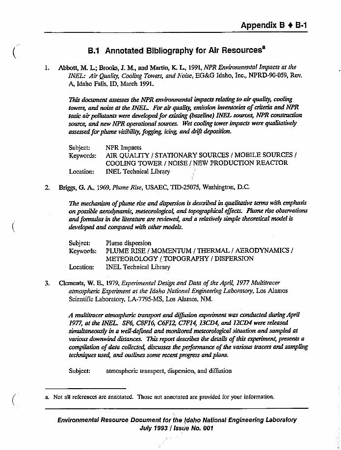
Appendix B 0 B-1
B.1 Annotated Bibliography for AirResources'.
Abbott, I'LL L; Brooks, J.M., and Martin, K. L, 1991,NPR Environmental Impacts at the
INEL: Air Quality, Cooling Towers, and Noise, EG&G Idaho, Inc., NPRD-90-059, Rev.
A, Idaho Falls, ID, March 1991.
This document assesses the NPR environmental impacts relating to air quality, cooling
towers, and noise at the INEL. For air quality, emission inventories of cnteria and NPR
toxic air poltutants were developed for existing (baseline) INEL soruces, NPR construction
sorus, and new NPR operational sources. Wet cooling tower impacts were qualitatively
assessed for plume visibility, fogging, icing and drift deposition.
Subject: NPR ImpactsKeywords: AIR QUALITY / STATIONARY SOURCES / MOBILE SOURCES /
COOLING TOWER / NOISE / NEW PRODUCTION REACTORLocation: INEL Technical Library
2. Briggs, G. A., 1969, Plume Rise, USAEC, TID-25075, Washington, D.C.
The mechanism ofplume rise and dispersion is described in qualitative terms with emphasis
on possible aerodynamic, meteorological, and topographical effects. Plume nse observations
and formulas in the literature are reviewed, and a relatively simple theoretical model isdeveloped and compared wuh other models.
Subject: Plume dispersion
Keywords: PLUME RISE / MOMENTUM / THERMAL / AERODYNAMICS /
METEOROLOGY / TOPOGRAPHY / DISPERSIONLocation: INEL Technical Library
3. Clcments, W. E., 1979, Experimental Design and Data of the April, 1977Multitracer
atmospheric Experiment at the Idaho National Engineering Laboratory, Los Alamos
Scientific Laboratory, LA-7795-MS, Los Alamos, NM.
A multitracer atmospheric transport and diffusion experiment was conducted during April
1977, at the INEL SF6, CSF16, C6F12, C7F14 13CD4 and 12CD4 wen. released
simultaneously in a well-defined and monitored meteorological situation and sampled atvarious downwind distances. This report describes the details of this experiment, presents acompilation ofdata collected, discusses the performance of the various tracers and samplingtechniques used, and outlines some recent progress and plans.
Subject: atmospheric transport, dispersion, and diffusion
a. Not all references are annotated. Those not annotated are provided for your information.
Environmental Resource Document for the idaho National Engineering LaboratoryJuly 1993 / Isstie No. 001
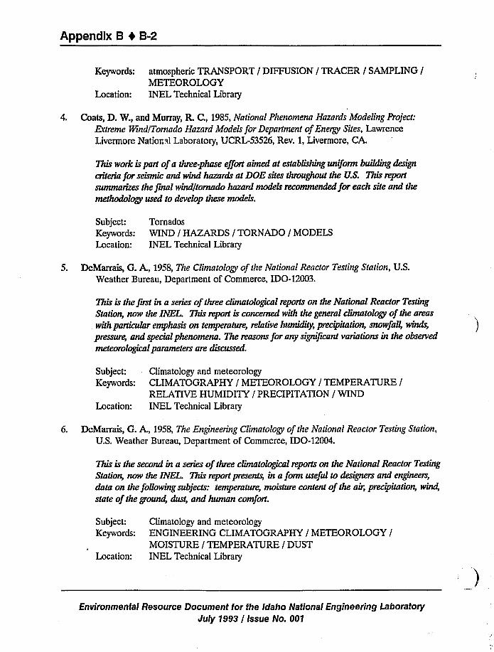
Appendix B 4 B-2
Keywords: atmospheric TRANSPORT / DIFFUSION / TRACER / SAMPLING /
METEOROLOGYLocation: INEL Technical Library
4. Coats, D. W., and Murray, R. C., 1985, National Phenomena Hazards Modeling Project:Extreme Wind(Tornado Hazard Models for Department of Energy Sites, Lawrence
Livermore National Laboratory, UCRL-53526, Rev. 1, Livermore, CA.
This work is part ofa three-phase effort aimed at establishing uniform building design
criteria for seismic and wind hazards at DOE sites throughout the U.S. This report
summarizes the jrnal wind/tornado hazard models recommended for each site and the
methodology used to develop these models.
Subject: Tornados
Keywords: WIND / HAZARDS / TORNADO / MODELSLocation: INEL Technical Library
5. DeMarrais, G. A., 1958, The Climatology of the National Reactor Testing Station, U.S.Weather Bureau, Department of Commerce, IDO-12003.
This is the first in a series of three climatological reports on the National Reactor Testing
Station, now the INEL. This report is concerned with the general climatology of the areas
with particular emphasis on temperature, relative Iu~, pr.cipitation, snowfall, winds,
pressure, and special phenomena. The reasons for any significant variations in the observed
meteorological parameters are discussed.
Subject: Climatology and meteorologyKeywords: CLIMATOGRAPHY / METEOROLOGY / TEMPERATURE /
RELATIVE HUMIDITY / PRECIPITATION / WINDLocation: INEL Technical Library
6. DeMarrais, G. A., 1958, The Engineering Climatology of the National Reactor Testing Station,
U.S. Weather Bureau, Department of Commerce, IDO-12004.
This is the second in a series of three climatological reports on the National Reactor Testing
Station, now the INEL This report presents, in a form useful to designers and engineers,
data on the following subjects: temperature, moisture content of the air, precipitation, wind,
state of the ground, dust, and human comfort.
Subject: Climatology and meteorologyKeywords: ENGINEERING CLIMATOGRAPHY / METEOROLOGY /
MOISTURE / TEMPERATURE / DUSTLocation: INEL Technical Library
Environmental Resource Document for the Idaho National EngineeringLaboratory'uly
1993/ Issue No. 001
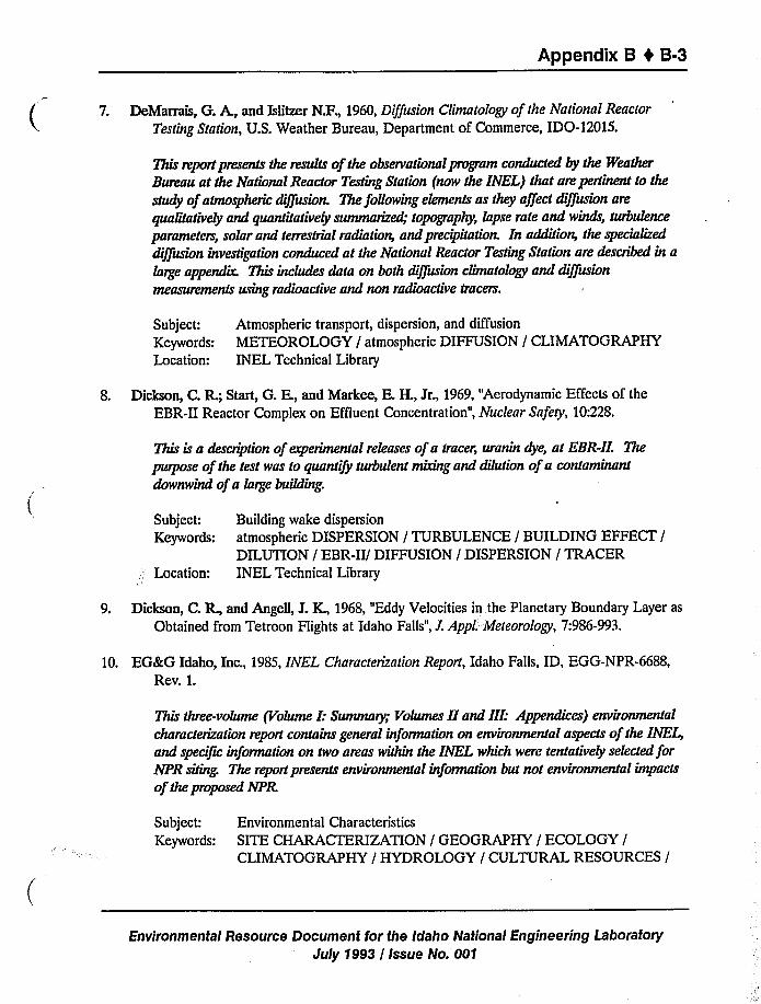
Appendix B 0 B-3
7. DeMarrais, G. A., and Islitzer N.F., 1960, Diffusion Climatology of the National Reactor
Testing Station, U.S. Weather Bureau, Department of Commerce, IDO-12015.
This report presents the ~of the observational program conducted by the Weather
Bureau at the National Reactor Testing Station (now the INEL) that are pertinent to the
study of atmospheric diffusion. The following elements as they affect diffusion are
qualitatively and quantitatively summarized; topography, lapse rate and winds, turbulence
parameters, solar and terrestrial radiation, and precipitation. In addition, the specialized
diffusion investigation conduced at the National Reactor Testing Station are described in alarge appendir. This includes data on both diffusion climatology and diffusion
measurements using radioactive and non radioactive tracers.
Subject: Atmospheric transport, dispersion, and diffusion
Keywords: METEOROLOGY / atmospheric DIFFUSION / CLIMATOGRAPHYLocation: INEL Technical Library
8. Dickson, C. R.; Start, G. E, and Markee, E.H., Jr., 1969, "Aerodynamic Effects of the
EBR-II Reactor Complex on Effluent Concentration", Nuclear Safety, 10:228.
This is a description of experimental releases of a tracer, uranin dye, at EBR-II. The
purpose of the test was to quantify turbulent mixing and dilution ofa contaminant
downwind of a large building.
Subject:Keywords:
Location:
Building wake dispersion
atmospheric DISPERSION / TURBULENCE / BUILDING EFFECT /
DILUTION / EBR-II/ DIFFUSION / DISPERSION / TRACERINEL Technical Library
9. Dickson, C. R., and Angell, J.K., 1968, "Eddy Velocities in the Planetary Boundary Layer as
Obtained from Tetroon Flights at Idaho Falls", L Appl. Meteorology, 7:986-993.
10. EG&G Idaho, Inc., 1985, INEL Characterization Report, Idaho Falls, ID, EGG-NPR-6688,Rev. 1.
This three-volume (Volume I: Summary; Volumes II and III: Appendices) environmental
characterization report contains general information on environmental aspects of the INE4and speciJic information on two areas within the INEL which were tentatively selected forNPR siting. The report presents environmental information but not environmental impacts
of the proposed NPR
Subject: Environmental Characteristics
Keywords: SITE CHARACTERIZATION / GEOGRAPHY / ECOLOGY /
CLIMATOGRAPHY / HYDROLOGY / CULTURAL RESOURCES /
Environmental Resource Document for the Idaho National Engineering Laboratory
July 1993 / Issue No. 001
Appendix B 4 B-4
ENVIRONMENT / ENVIRONMENTAL MONITORING / NEWPRODUCTION REACTORINEL Technical LibraryLocation:
11. EG&G Idaho, Inc., 1989, Site Transportation Plan for the New Production Reactor at the
INEL, Part 1: Existing Facilities and Activities, Draft, NPR-DEIS-SR-0026, Idaho Falls,
ID.
This draft document describes the INEL transportation system, including roadways,
railroads equipment, and other facilities. Data are provided on current and recent
shipment and traffic activity.
Subject: INEL Transportation System
Keywords: TRANSPORTATION / RAILROADS / HIGHWAYS / TRAFFIC /
RADIOLOGICAL RISK / TRAILSLocation: INEL Technical Library
12. EG&G Idaho, Inc., 1991,Formal Documentation Showing the origins, Path, and Methods
Underlying the Creation of Some of the CAP-88-Readable Wind Files in Use by the EMA
Unit, Engineering Design File, EDF CAP-PROT-91-005, Idaho Falls, ID, March 1991.
This technical report details the methods used by EG&G air dispersion modelers to create
CAP-88 wind files starting wuh joint frequency distributions (JFD) provided by the NOAA.
JFD's are tabular listings of the hours that the wind blows in each of the 16compass
directions, at each of a set of wind speed classes, and for a set of stability categories. JFDsfor facilities at the INEL are converted to wind files usable by the EPA CAP-88 code.
Subject: Wind data
Keywords: WIND FILES / WIND DATA / METEOROLOGY / CAP-88 / JFDLocation: Unit Files, Subsurface and Environmental Modeling Unit, EG&G
13. EG&G Idaho, Inc., 1992, Formal Documentation of 1987-1991INEL Wind Files Used in
CAP-88, Engineering Design File, EDF CAP-PROT-91-011, Idaho Falls, ID, February 12,1992.
This EDF is similar to EG&G, 1991;this report contains INEL wind data from 1987through 1991. Less detail on methods is contained in this report.
Subject: Wind data
Keywords: WIND FILES / WIND DATA / METEOROLOGY / CAP-88 / JFDLocation: Unit files, Subsurface and Environmental Modeling Unit
Environmental Resource Document for the Idaho National Engineering Laboratory
July 1993 / issue No. 001
Appendix B 4 B-5
14. Environmental Protection Agency, 1985, Compilation ofAir Pollutant Emission Factors,
AP-42, Fourth Edition, PB86-124906, September 1985.
Emission data obtained from source tests, material balance studies, engineering estimates,
etc. have been compiled for use by individuals and groups responsible for conducting air
pollution emission inventories. Emission factors given in this two-volume document cover
most of the common stationary, area, and mobile soiuce emission categones: fuel
combustion, combustion of solid wastes, evaporation offuels solvents, and other volatile
substances, various industrial processes, vehicle exhausts, and misc. sources.
Subject:Keywords:
Location:
Air pollutant emissions
EMISSIONS / STATIONARY SOURCES / AREA SOURCES /
MOBILE SOURCES / FUEL COMBUSTION / EMISSIONINVENTORIES / EXHAUST EMISSIONS / COMBUSTION /
EVAPORATIONINEL Technical Library
15. Environmental Protection Agency, 1989, User's Guide to MOBILE4 (Mobile Source Emission
Factor Model), EPA-AA- TEB-89-01, February 1989.
MOBILE4 is a computer program that calculates emission factors for hydrocarbon (HC),
carbon monoxide (CO), and oxides of nitrogen (NOx) from gasoline-fueled and diesel
highway motor vehicles. The program uses the calculation procedures and emission factors
presented in Comnilation o+Air Pollutant Emission Factors: Highwav Mobile Source
(AP-42, Fourth Edition, September I985). MOBILE4 calculates emission factors for eight
individual vehicle types in two regions of the country. MOBILE4 emission estimates
depend on various conditions such as ambient temperature, speed, and mileage accrual
rates.
Subject:Keywords:
Location:
Air Pollutant Emissions
HYDROCARBONS / CARBON MONOXIDE / NITROGEN OXIDES /
MOTOR VEHICLES / REGULATIONS / COMPUTER PROGRAMS /
AIR POLLUTION / EXHAUST EMISSIONSINEL Technical Library
16. Fuguay, J.J.;Simpson, C. L, and Hinds, W. T., 1963, Prediction of Environmental Exposures
from Sources Near the Ground, Based on Hnnford E'xperimental Data, Hanford Atomic
Products Operation, General Electric Co., Richland, WA.
This report presents experimental data on plume lateral growth in air. The lateral growth isexpressed as a function of travel time and the product of the standard deviation of the wind
direction and the mean wind speed near the release height. A method of obtaining
.'ross-wind prediction solely from low-level wind and temperature data is proposed and
demonstrated for a set of ten independent field tests.
Environmental Resource Document for the Idaho National Engineering Laboratory
July 1993 / Issue No. 001
Appendix B 4 B-6
Subject:Keywords:
Location:
Plume dispersion
atmospheric DISPERSION / DIFFUSION / WIND DIRECTION /
WINDSPEED / RICHARDSON NUMBER / GROUND RELEASEIdaho Falls NOAA Office
17. Hilsmeier, W. F., and Gifford, F.A., Jr., 1962, Graphs for Estimating atmospheric Dispersion,
U.S. AEC Report, ORO-545, Oak Ridge, TN, July 1962.
This is a short description ofa method for determining chi/Q values using graphs. The
graphs give the dispersion parameter versus distance and chi/Q versus distance for the six
stability categories A through F.
Subject:Keywords:
Location:
Dispersion parameters and stability categoriesSTABILITY CATEGORY / atmospheric DISPERSION / DISPERSIONCOEFFICIENTS / STANDARD DEVIATIONS / SPECIFICCONCENTRATIONINEL Technical Library
18. Holtzworth, G. C., 1967, "Mixing Depths, Wind Speeds and Air Pollution Potential for
Selected Locations in the United States", Journal ofApplied Meteorology, 6(6):1039-1044.
Daily estimates ofmorning and afternoon mixing depths and average wind speeds through
the mixing layers are calculated and summarized for seven locations in several climatic
regions of the contiguous US. Monthly averages of morning and afternoon mixing depth
and wind speed are presented graphically.
Subject:Keywords:
Location:
Mixing depth variation
MIXING DEPTH / LID / MIXING LAYERS / WINDSPEED /
DIFFUSION / POLLUTANT / CONCENTRATIONIdaho Falls NOAA Office
19. Holzworth, G. C., 1972, Mixing Heights, Wind Speeds, and Potential for Urban Air Pollution
Throughout the Contiguous United States, EPA, Pub. No. AP-101, Research Triangle
Park, NC.
20. Humphrey, P. A.; Wilkins, E.M., and Morgan, D. M., 1953,Atmospheric Dust at the
National Reactor Tesdng Station, Final Report, U.S. Department of Commerce, Weather
Bureau Office, Idaho Falls, ID.
Environmental Resource Document for the Idaho National Engineering Laboratory
July 1993 / Issue No. 001
Appendix 8 t 8-7
21. Idaho Air Quality Bureau, 1989, Rules and Regulations for the Control ofAir Pollution inIdaho, IDAPA 16.01,June 15, 1989.
This set of Idaho State Regulations pertaining to air pollution contains detailed limits onspecified pollutants; most are identical to the National Ambient Air Quality Standards(NAAQS).
Subject:Keywords:
Location:
Idaho State Air Quality RegulationsIDAHO STATE REGULATIONS / AIR QUALITY / POLLUTION /
POLLUTANT / IDAPA / OCCUPATIONAL EXPOSURE LEVEL /THRESHOLD LIMIT VALUE / AMBIENT AIR / NAAQSINEL Technical Library
22. Islitzer, N. F., 1961, "Short-Range atmospheric-Dispersion Measurements from an ElevatedSource", Journal of Meteorology, 18(4 (August 1961)):443-450.
Dispersion measurements ofa tracer, uranin dye in solution, were made out lo two milesfrom the release point in unstable atmospheres. The tracer was released from the top ofa150foot tower and sampled at ground level by 100high-volume air samplers.
Subject: atmospheric transport, dispersion, and diffusion
Keywords: atmospheric DISPERSION / DIFFUSION / TRACER / TOWERRELEASE / CONCENTRATION / TURBULENCE
Location: Idaho Falls NOAA Office
23. Islitzer, N. F., 1965,Aerodynamic Effects of Large Reactor Complexes Upon atmosphericTurbulence and Diffusion, U.S. AEC, U.S. Weather Bureau, IDO-12041, Idaho Falls, ID.
The additional turbulence immediately downwind of a large reactor complex (MTR-ETR)due to aerodynamic effects from the buildings was measured Wind stations employinganemometers and bivanes were used, as well as sampling stations that directly measureddiffusion of a tracer, uranin dye.
Subject: Building wake dispersionKeywords: atmospheric DISPERSION / TRACER / TURBULENCE / DISPERSION
/ DIFFUSION / BUILDING EFFECTLocation: INEL Technical Library
24. hlitzer, N. F., and Dumbauld, R. K., 1963, "atmospheric Diffusion-Deposition Studies OverFlat Terrain", International Journal ofAir and Water Pollution, 7:999-1022.
This report evaluates measurements ofparticle dispersion from a ground-level source out totwo miles. This is done in terms of wind-dinection statistics from time-averaged data. Thetests were camed out with uranin dye as a tracer.
Environmental Resource Document for the Idaho National Engineering LaboratoryJuly 1993 / Issue No. 001
Appendix B 0 B-8
Subject: atmospheric transport, dispersion, and diffusion
Keywords: atmospheric DISPERSION / DIFFUSION / DEPOSITION / TRACER /
CONCENTRATION / POLLUTANTLocation: Idaho Falls NOAA Office
25. Johnson, O. J., and Dickson, C. R., 1962, An Eight Year Summary of the Temperature
Gradient Below 250 feet at the National Reactor Testing Station, U.S. Weather Bureau,Department of Commerce, IDO-12025, May 1962.
This technical report gives a monthly breakdown of an eight year period (1953-1960)oftemperature gradient data below 250 feet. The data are compiled in tabular form showing
the time offormation, duration, maximum intensity, and dissipation ofinversions for eachmonth.
Subject:Keywords:
Location:
Near surface temperature data
TEMPERATURE / INVERSION / LAPSE RATE / LOCAL CLIMATE /
METEOROLOGYINEL Technical Library
26. Markee, E.H., Jr., 1963, "Methods of Estimating Air Pollutant Dispersion Over Relatively
Smooth Terrain from Routine Meteorological Observations," 219th National Meeting ofthe American Meteorological Society, Palo Alto, CA, June 20, 1963.
This is a report on techniques used to compute dispersion of an atmospheric pollutant for1-hour sampling times out to 3200 meters over desert-type tenain. The techniques were
derived from diffusion experiments carried out at the INEL.
Subject: atmospheric transport, dispersion, and diffusion
Keywords: atmospheric DISPERSION / POLLUTANT / DIFFUSION / STABILITYCATEGORY
Location: Idaho Falls NOAA Office
27. Markee, E H., Jr.; Bcckerly, J.G., and Sanders, K. E., 1974, Technical Basis for Interim
Regional Tornado Criteria, USAEC, WASH-1300.
The objective of this study was to determine from available information a regionalized
design basis tornado for the contiguous US. From an analysis of tornado classificationdata from the National 8'cather Service Offices for 1971 and 1972 and tornado occurrencedata, it was concluded that three general regions with associated tornado severity andfrequency of occurence could be determined. Probable windspeeds were calculated, andcorresponding pressure drops and rates ofpressure drop were determined from thecycloslrophic equation.
Subject: Tornados
Environmental Resource Document for the Idaho National Engineering Laboratoryduly 1993 / Issue No. 001
Appendix B 4 B-9
Keywords: TORNADO / WINDSPEED / OCCURRENCE / PRESSURE DROP /
DESIGN BASIS / SEVERITY / GEOGRAPHICAL REGIONSLocation: INEL Technical Library
28. Nace, R.I;Voegeli, P. T.; Jones, J. R., and Deutsch, M., 1975, Generalized GeologicFramework of the National Reactor Testing Station, Idaho, USGS, USGS Prof. Paper725-B, Washington, D.C.
29. Pasquill, F., 1961, "The Estimation of the Dispersion of Windborne Material", Meteorology
Magazine, 90:33-459.
Diffusion experiments using fluorescent particles are described and data on travel andhorizontal spread over distances of 10-80 miles are summarized.
Subject: atmospheric transport, dispersion, and diffusion
Keywords: atmospheric DIFFUSION / HORIZONTAL SPREAD / TURBULENCE /
VERTICAL SHEAR / TRACERLocation: Idaho Falls NOAA Office
30. Sagendorf, J.F., and Dickson, C. R., 1974, Diffusion under Low Windspeed Inversion
Condition, NOAA Technical Memorandum, ERL ARL-52, December 1974.
A series of diffusion tests conducted under stable conditions with windspeeds less than 2m/sec is described.
Subject: Low windspeed diffusion
Keywords: atmosphere: DIFFUSION / DISPERSION / LIGHT WINDS / LOWWINDSPEED / INVERSION / LAPSE RATE / TRACER
Location: Idaho Falls NOAA Office
31. Sagendorf, J.F.; Ricks, N. R.; Start, G. E., and Dickson, C. R., 1980, Diffusion ¹ar Building
as Determined from atmospheric Tracer Experiments, NOAA Technical Memorandum,
ERL ARL-84, September 1980.
Data from the innermost arcs and rooftop samplers of the Rancho Seco and EOCR fieldstudies were sued to eramine diffusion close to a building. The minimum length plume
paths were determined from each release location to each sampler posuion at the two test
sites.
Subject: Building wake dispersion
Keywords: atmospheric DISPERSION / DIFFUSION / TRACER / RANCHO SECO/ BUILDING WAKE / TURBULENCE
Location: Idaho Falls NOAA Office
Environmental Resource Document for the Idaho National Engineering LaboratoryJuly 1993 / Issue No. 001
Appendix B I B-10
32. Slade, D. K, 1968, Meteorology and Atomic Energy, USAEC, TID-24190, July 1968.
This volume is a combination ofguide, handbook, textbook, and research report on subjects
relating to the distnbution ofpollutants in the atmosphere..
Subject:Keywords:
Location:
atmospheric transport, dispersion, and dil'fusion
atmospheric TRANSPORT / DIFFUSION / INSTRUMENTS /
WEATHER / WIND / CLIMATOGRAPHY / METEOROLOGY /
DEPOSITION / SCAVENGING / WASHOUT / BUILDING EFFECT /
PLUME / CLOUD / DOSE/ SAFETYINEL Technical Library
33. Solar Energy Research Institute, 1981, Solar Radiation Energy Resource Atlas of the United
States, Solar Energy Research Institute, SERI/SP-642-1037, Washington, D.C.
34. Stan, G. E.;Hukari, N. F.;Sagendorf, J. F.; Cate, J.H., and Dickson, C. R., 1980, EOCRBuilding Wake Effects on Atmospheric Diffusion, U.S. Dept. of Commerce, NOAA, Env.Res. Lab., Air Res. Lab., Technical Memorandum ERL/ARL-91, Idaho Falls, ID.
35. Stan, G. E.;Cate, J. H.; Sagendorf, J. F.;Ackcrmann, G. R.; Dickson, C. R.; Hukari, N. H.,and Thorngren, L G., 1985, Comparisons of Trajectories, Tracer Concentration Patterns
and MESODIF Model Calculations: Idaho Field Experiment 1981, Vol. III, U.S. Dept. ofCommerce, NOAA, Env. Res. Lab., Air Res. Lab,, NUREG/CR-3488, Idaho Falls, ID.
36. Start, G. F; Cate, J.H.; Sagendorf, J. F.;Ackerman, G. R.; Dickson, C. R.; Hukari, N. K,and Thorngren, L G., 1985, Idaho Field Experiment 1981, Volume 3: Comparison ofTrajectories, Tracer Concentration Patterns, and MESODIF Model Calculations,
NUREG/CR-3488, February 1985.
Release of sulfur hexafluoride tracer gas were made for 8-hour from 46 m above groundTracer was sampled hourly, jor 12 sequential hours, at 100 locations.
Subject: Aerial dispersion data
Keywords: atmospheric DISPERSION / MESODIF / TRACERLocation: INEL Technical Library
37. Start, G. E.;Dickson, C. R.; Sagendorf, J.F.;Ackerman, G. R.; Ciawson, K. L; Johnson, R.C., and Hukari, N. F., 1989,Atmospheric Diffusion for Airflows in the Vicinity of the JamesForrestal Campus, Final Report, Princeton University, May 1989.
A field measurement program was conducted to directly evaluate atmospheric diffusioncondition in the vicinity of the Princeton Plasma Physics Laboratory. Gaseous tracerreleases were made from selected locations. A sile-specijic diJfusion climatography was
developed for PPPL.
Environmental Resource Document for the Idaho National Engineering LaboratoryJuly 1993 / Issue No. 001
Appendix B 4 B-11
Subject:Keywords:
Location:
Building wake dispersion
atmospheric DIFFUSION / TRACER / PRINCETON PLASMAPHYSICS LABORATORY / STABILITY CATEGORY / BUILDINGWAKE / TURBULENCEIdaho Falls NOAA Office
38. Start, G. E.;Hukari, N. F.;Sagendorf, J. F.; Cate, J.K, and Dickson, C. R., 1980, EOCRBuilding Wake Effects on atmospheric Diffusion, NOAA Technical Memorandum, ERLARL-91, November 1980.
A series of 22 simultaneous releases of three gaseous tracers was conducted around the
EOCR test reactor building at the INEL Hourly averaged tracer concentrations were
sampled on several concentric sampling arcs and at limited number of elevated locations.
Subject: Building wake dispersion
Keywords: atmospheric DIFFUSION / BUILDING EFFECT / BUILDING WAKE /
TRACER / VERTICAL DIFFUSIONLocation: Idaho Falls NOAA Office
39. Start, G. E,, and Wendell, L I, 1974, Regional Effluent Dispersion Calculations Considering
Spatial and Temporal Meteorological Variations, NOAA Technical Memorandum, ERLARL-44, May 1974.
An objective regional trajectory analysis scheme has been combined with a Gaussian
diffusion model to yield a technique called MESODIF - mesoscale dijrusion. The trajectory
analysis scheme utilized wind data from a network of toN er-mounted wind sensors toconsider the effects of spatial variabiluies of horizontal wind flow near the surface,
incorporated time changes in rates of diffusion, and used an upper level lid to vertical
nusulg.
Subject: MESODIF model development
Keywords: atmospheric DIFFUSION / MESODIF / TRAJECTORY ANALYSIS /
CONCENTRATIONLocation: Idaho Falls NOAA Office
40. Start G.F,ed., 1984, Climatography of the Idaho National Engineering Laboratory,
IDO-12048A and B, Idaho Falls, ID.
41. Sutton, O. G., 1955, Micrometeorology, New York, NY, McGraw-Hill Book Co.
42. Turner, D. B., 1970, Workbook ofAtmospheric Dispersions Estimates, Revised, EPA, Research
Triangle Park, NC.
Environmental Resource Document for the Iclaho National Engineering Laboratory
July 1993 / Issue No. 001
Appendix B 1 B-12
43. U.S. Department of Energy, 1982, INEL Architectural-Engineering Standards for the US.Department of Energy, Revision 3.
44. U.S. Department of Energy, 1989, Climatography of the Idaho National Engineering
Laboratory, 2nd Edition, National Oceanic and Atmospheric Administration,
Environmental Research Laboratories, Air Resources Laboratory, Field Research
Division, DOE/ID-12118, Idaho Falls, ID.
45. U.S. Department of Energy, 1989, INEL Environmental Characterization Report, Volume 1,EG&G Idaho, Inc., EGG-NPR-6688, Idaho Falls, ID.
46. U.S. Department of Energy, 1990, NPR Environmental Impacts at the INEL: Air Quality,
Cooling Towers, and Noise, New Production Reactor MHTGR, NPRD-90-059, Idaho Falls,
ID.
47. U.S. Department of Energy, 1992, The Idaho National Engineering Laboratory Site
Environmental Report, Department of Energy, DOE/ID-12082, Idaho Falls, ID.
This report, issued periodically, contains information relative to environmental surveillance
at the INEL. The 1992 issue presents data for CY 1991. The report describes the
surveillance program, the collection offoodstuffs at the INEL boundary and distant
locations, and the collection of air and water samples at onsite locations and offsite
boundary and distant locations. The report also compares and evaluates the sample results
and discusses implications, if any. Non radioactive and radioactive effluent monitoring atthe Site, and the USGS ground-water monitoring program are also summarized.
Subject:Keywords:
Location:
Environmental surveillance
ENVIRONMENTAL SURVEILLANCE / REGULATIONS /
MONITORING / RADIOACTIVE / NON RADIOACTIVE / GROUNDWATER / SAMPLING / CERCLA / NESHAP / RCRA / SDWA / NEPA
/ CAA / TSCAINEL Technical Library
48. U.S. Nuclear Regulatory Commission, 1972, Onsite Meteorological Programs, NRC,
Regulatory Guide 1.23, Washington, D.C.
49. Wendell, I L, 1972, "Mesoscale Wind Fields and Transport Estimates Determined from a
Network of Wind Towers", Monthly Weather Review, 100:565-578.
Techniques are developed to use wind data from a network of stations to study mesoscale
flow patterns and transport in the lower planetary boundary layer. The data sample for this
study is hourly averaged wind data for the year 1969Jiom 21 stations over the Upper Snake
River Plain.
Environmental Resource Document for the Idaho National EngineeringLaboratory'uly
1993 / Issue No. 001
Appendix B 4 B-13
Subject: Wind dataKeywords: atmospheric DISPERSION / MESOSCALE / WIND FIELDS /
TRANSPORT / FLOW PA ITERNSLocation: Idaho Falls NOAA Office
50. Yanskey, G. R.; Markee, E.H., Jr., and Richter, A. P., 1966, Climatography of the National
Reactor Testing Station, Environmental Science Services Administration, Department ofCommerce, IDO-12048, January 1966.
This is the first edition ofa general climatography report of the reserve that was once known
as the National Reactor Testing Station, now the INEL It contains data up to 1964. Inaddition to the subjects mentioned under clawson et aL, 1989, it contains a discussion ofmodt Jtcations to the basic diffusion equation and persistence data for wind speed and
direction.
Subject:Keywords:
Location:
Climatology and meteorologyCLIMATOGRAPHY / METEOROLOGY / NATIONAL reactor
TESTING STATION / atmospheric TRANSPORT / DIFFUSIONINEL Technical Library
Environmental Resource Document for the Idaho National Engineering Laboratory
July 1993 / Issue No. 001
Appendix B 4 B-15
B.2 Keyword List"
AERODYNAMICS: 2
AIR POLLUTION: 15
AIR QUALITY: 1, 21
AMBIENT AIR: 21
AREA SOURCES: 14
CONCENTRATION: 18, 22, 24, 39
COOLING TOWER: 1
CULTURAL RESOURCES: 10
DEPOSITION: 24, 32
DESIGN BASIS: 27
ATMOSPHERIC DIFFUSION: 7, 29, 30,37, 38, 39
DIFFUSION: 3, 8, 16, 18, 22, 23, 24, 26, 31,32, 50
ATMOSPHERIC DISPERSION: 8, 16, 17,22, 23, 24, 26, 31, 36, 49
ATMOSPHERIC TRANSPORT: 3, 32, 50
BUILDING EFFECT: 8, 23, 32, 38
BUILDING WAKE: 31, 37, 38
CAA: 47
CAP-88: 12, 13
CARBON MONOXIDE: 15
CERCLA: 47
CLIMATOGRAPHY: 5, 7, 10, 32, 50
CLOUD: 32
COMBUSTION: 14
COMPUTER PROGRAMS: 15
DILUTION: 8
DISPERSION: 2, 8, 23, 30
DISPERSION COEFFICIENTS: 17
DOSE: 32
DUST: 6
EBR-II: 8
ECOLOGY: 10
EMISSION INVENTORIES: 14
EMISSIONS: 14
ENGINEERING CLIMATOGRAPHY: 6
ENVIRONMENT: 10
ENVIRONMENTAL MONITORING: 10
b. Numbers refer to numbered references in Section B.l, Annotated Bibliography for Air Resources.
Environmental Resource Document for the Idaho National Engineering LaboratoryJuly 1993 / Issue No. 001
,.Appendix B 4 B-16
ENVIRONMENTAL SURVEILLANCE:47
EVAPORATION: 14
EXHAUST EMISSIONS: 14, 15
FLOW PATTERNS: 49
FUEL COMBUSTION: 14
GEOGRAPHICAL REGIONS: 27
GEOGRAPHY: 10
GROUND RELEASE: 16
GROUND WATER: 47
HAZARDS: 4
HIGHWAYS: 11
HORIZONTAL SPREAD: 29
HYDROCARBONS: 15
HYDROLOGY: 10
IDAHO STATE REGULATIONS: 21
IDAPA: 21
INSTRUMENTS: 32
INVERSION: 25, 30
JFD: 12, 13
LAPSE RATE: 25, 30
LID: 18
LIGHT WINDS: 30
LOCAL CLIMATE: 25
LOW WINDSPEED: 30
MESODIF: 36, 39
MESOSCALE: 49
METEOROLOGY: 2, 3, 5, 6, 7, 12, 13, 25,32, 50
MIXING DEPTH: 18
MIXING LAYERS: 18
MOBILE SOURCES: 1, 14
MODELS: 4
MOISTURE: 6
MOMENTUM: 2
MONITORING: 47
MOTOR VEHICLES: 15
NAAQS: 21
NATIONAL REACTOP. T STINGSTATION: 50
NEPA: 47
NESHAP: 47
NEW PRODUCTION REACTOR: 1, 10
NITROGEN OXIDES: 15
NOISE: 1
NON RADIOACTIVE: 47
Environmental Resource Document for the Idaho National Engineering Laboratory
July 1993 / Issue No. 001
Appendix 8 4 8-17
OCCUPATIONAL EXPOSURE LEVEL:21
OCCURRENCE: 27
PLUME: 32
PLUME RISE: 2
POLLUTANT: 18, 21, 24, 26
POLLUTION: 21
PRECIPITATION: 5
PRESSURE DROP: 27
PRINCETON PLASMA PHYSICSLABORATORY: 37
RADIOACTIVE: 47
RADIOLOGICAL RISK: 11
RAILROADS: 11
RANCHO SECO: 31
RCRA: 47
REGULATIONS: 15, 47
RELATIVE HUMIDITY: 5
RICHARDSON NUMBER: 16
SAFETY: 32
SAMPLING: 3, 47
SCAVENGING: 32
SDWA: 47
SEVERITY: 27
SITE CHARACTERIZATION: 10
SPECIFIC CONCENTRATION: 17
STABILITY CATEGORY: 17, 26, 37
STANDARD DEVIATIONS: 17
STATIONARY SOURCES: 1, 14
TEMPERATURE: 5, 6, 25
THERMAL: 2
THRESHOLD LIMIT VALUE: 21
TOPOGRAPHY: 2
TORNADO: 4, 27
TOWER RELEASE: 22
TRACER: 3, 8, 22, 23, 24, 29, 30, 31,36,37, 38
TRAFFIC: 11
TRAILS: 11
TRAJECTORY ANALYSIS: 39
TRANSPORT: 49
TRANSPORTATION: 11
TSCA: 47
TURBULENCE: 8, 22, 23, 29, 31, 37
VERTICAL DIFFUSION: 38
VERTICAL SHEAR: 29
Environmental Resource Document for the Idaho National Engineering Laboratory
July 1993 / Issue No. 001
Appendix B 4 B-18
WASHOUT: 32
WEATHER: 32
WIND: 4,5,32
WIND DATA: 12, 13
WIND DIRECTION: 16
WIND FIELDS: 49
WIND FILES: 12, 13
WINDSPEED: 16, 18, 27
Environmental Resource Document for the idaho National Engineering Laboratory
July 1993 / Issue No. 007
Appendix B 4 B-19
B.3 SubjectList'ERIAL
DISPERSION DATA: 36
AIR POLLUTANT EMISSIONS: 14, 15
ATMOSPHERIC TRANSPORT,DISPERSION, AND DIFFUSION: 3,7, 22, 24, 26, 29, 32
BUILDING WAKE DISPERSION: 8, 23,31, 37, 38
CLIMATOLOGY AND METEOROLOGY:5,6,50
DISPERSION PARAMETERS ANDSTABILITY CATEGORIES: 17
ENVIRONMENTALCHARACTERISTICS: 10
ENVIRONMENTAL SURVEILLANCE:47
IDAHO STATE AIR QUALITYREGULATIONS: 21
INEL TRANSPORTATION SYSTEM: 11
LOW WINDSPEED DIFFUSION: 30
MESODIF MODEL DEVELOPMENT: 39
MIXING DEPTH VARIATION: 18
NEAR SURFACE TEMPERATUREDATA: 25
NPR IMPACTS: 1
PLUME DISPERSION: 2, 16
TORNADOS: 4, 27
WIND DATA: 12, 13, 49
c. Numbers refer to numbered rcfcrcnccs in Section B.l, Annotated Bibliography for Air Resources.
Environmental Resource Document for the Idaho National Engineering Laboratory
July 1993 / Issue No. 001
Appendix C
Appendix C
Water Resources
Meredith Newman
Carolyn W. Bishop
Environmental Resource Document for the Idaho National Engineering LaboratoryJuly 1993 / Issue No. 001
Appendix C 4 C-iii
CONTENTS
ACRONYMS
C.1 Perched Water Data
C-v
C-1
C.1.1 Water Quality .C.1.2 Test Reactor Area ..C.1.3 Radioactive Waste Management Area
C.1.4 Idaho Chemical Processing Plant
C.2 Groundwater Quality Data .
C.3 References
C-1C-1C-1C-1
C-2
C-34
C.4 Annotated Bibliography for Water Resources
C.S Keyword List
C-35
C-125
C.6 Subject List C-137
FIGURES
C-1. Spacial distribution of temperature in the SRPA beneath the INEL C-3
C-2. Spacial distribution of dissolved solids in the SRPA beneath the INEL .. C-4
C-3. Spacial distribution of calcium in the SRPA beneath the INEL
C-4. Spacial distribution of sodium in the SRPA beneath the INEL .
C-Sa. Spacial distribution of tritium in the SRPA beneath the INEL for 1961
C-Sb. Spacial distribution of tritium in the SRPA beneath the INEL for 1968
C-Sc. Spacial distribution of tritium in the SRPA beneath the INEL for 1985
C-Sd. Spacial distribution of tritium in the SRPA beneath the INEL for 1988
C-6a. Spacial distribution of strontium-90 in the SRPA for 1964
C-6b. Spacial distribution of strontium-90 in the SRPA for 1970
C-6c. Spacial distribution of strontium-90 in the SRPA for 1985
C-5
C-6
C-7
C-8
C-9
C-10
C-11
C-12
C-13
Environmental Resource Document for the Idaho National Engineering Laboratory
July 1993 / Issue No. 001
Appendix C 4 C-iv
C-6d. Spacial distribution of strontium-90 in the SRPA for 1988
C-7a. Spacial distribution of chromium in the SRPA beneath the INEL for 1966 ..C-7b. Spacial distribution of chromium in the SRPA beneath the INEL for 1967 ..C-7c. Spacial distribution of chromium in the SRPA beneath the INEL for 1970 ..C-8. Location of wells sampled for purgeable organic compounds during 1987 ...
C-14
C-16
C-17
C-18
C-29
C-9. Location of wells sampled for purgeable organic compounds during 1988 and 1989...C-30
TABLES
C-1. Concentrations of selected organic compounds in groundwater
C-2. Federal drinking water standards for organic compounds
C-20
C-31
Environmental Resource Document for the Idaho National Engineering LaboratoryJuly 1993 / Issue No. 001
Appendix C I C-v
ACRONYMS
CFADOEEPAICPPINELNRFRWMCSRPATANTRA
Central Facilities AreaU.S. Department of EnergyU.S. Environmental Protection AgencyIdaho Chemical Processing PlantIdaho National Engineering LaboratoryNaval Reactors FacilityRadioactive Waste Management ComplexSnake River Plain AquiferTest Area North
Test Reactor Area
Environmental Resource Document for the Idaho National Engineering Laboratory
July 1993 / Issue No. 001
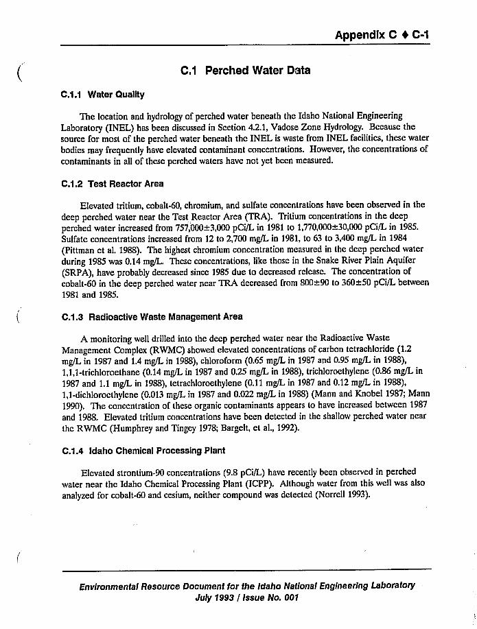
Appendix C I C-1
C.i Perched Water Data
C.1.1 Water Quality
The location and hydrology of perched water beneath the Idaho National Engineering
Laboratory (INEL) has been discussed in Section 4.2.1,Vadose Zone Hydrology. Because the
source for most of the perched water beneath the INEL is waste from INEL facilities, these water
bodies may frequently have elevated contaminant concentrations. However, the concentrations ofcontaminants in all of these perched waters have not yet been measured.
C.1.2 Test Reactor Area
Elevated tritium, cobalt-60, chromium, and sulfate concentrations have been observed in the
deep perched water near the Test, Reactor Area (TRA). Tritium concentrations in the deep
perched water increased from 757,'000+3,000 pCi/L in 1981 to 1,770,000~30,000 pCi/L in 1985.Sulfate concentrations increased from 12 to 2,700 mg/L in 1981, to 63 to 3,400 mg/L in 1984
(Pittman et al. 1988). The highest chromium concentration measured in the deep perched water
during 1985 was 0.14 mg/L. These concentrations, like those in the Snake River Plain Aquifer
(SRPA), have probably decreased since 1985 due to decreased release. The concentration ofcobalt-60 in the deep perched water near TRA decreased from 800~90 to 360~50 pCi/L between
1981 and 1985.
C.1.3 Radioactive Waste Management Area
A monitoring well drilled into the deep perched water near the Radioactive Waste
Management Complex (RWMC) showed elevated concentrations of carbon tetrachloride (1.2mg/L in 1987 and 1.4 mg/L in 1988), chloroform (0.65 mg/L in 1987 and 0.95 mg/L in 1988),1,1,1-trichloroethane (0.14 mg/L in 1987 and 0.25 mg/L in 1988), trichloroethylene (0.86 mg/L in
1987 and 1.1 mg/L in 1988), tetrachloroethylene (0.11 mg/L in 1987 and 0.12 mg/L in 1988),1,1-dichloroethylene (0.013 mg/L in 1987 and 0.022 mg/L in 1988) (Mann and Knobel 1987; Mann
1990). The concentration of these organic contaminants appears to have increased between 1987
and 1988. Elevated tritium concentrations have been detected in the shallow perched water near
thc RWMC (Humphrey and Tingey 1978; Bargelt, et al., 1992).
C.1.4 Idaho Chemical Processing Plant
Elevated strontium-90 concentrations (9.8 pCi/L) have recently been observed in perched
water near the Idaho Chemical Processing Plant (ICPP). Although water from this well was also
analyzed for cobalt-60 and cesium, neither compound was detected (Norrell 1993).
Environmental Resource Document for the Idaho National Engineering Laboratory
July 1993 / Issue No. 001
Appendix C 4 C-2
C.2 Groundwater Quality Data
Figures C-1, C-2, C-3, and C-4 show the spacial distribution of temperature, total dissolved
solids, calcium, and sodium, respectively, in the SRPA beneath the INEL.
In addition to the naturally occurring compounds found in the SRPA beneath the INEL,U.S. Department of Energy (DOE)/INEL activities have introduced radioactive compounds,nonradioactive metals, inorganic salts, and organic compounds into the subsurface materials and
groundwater.
Radionuclides released and observed in the soils and groundwater of the INEL includetritium, strontium-90, iodine-129, cobalt-60, cesium-137, plutonium-238, plutonium-239, -240(undivided), and americium-241. Radionuclide concentrations in the SRPA beneath the INELhave generally decreased since the middle 1980s. These reduced concentrations have resultedfrom changes in INEL disposal practices, radioactive decay, adsorption of the radionuclides to thesurfaces of rocks and minerals within the aquifer, and dilution by natural surface and groundwaters entering the SRPA (Pittman ct al. 1988; Orr and Cecil 1991).
Figures C-5a through C-Sd show the spacial distribution of tritium in the SRPA beneath theINEL for the years 1961, 1968, 1985, and 1988, respectively. The size of the tritium plumeincreased to a maximum area of 132 kmz (51 miz) by 1985, and extended just south of the INELboundary. The tritium concentrations within the small portion of the plume that extended outsideof the INEL boundary were less than the maximum contaminant level ol'60,900 pCi/L set by theEnvironmental Protection Agency (EPA) (56 FR 3350, 1991). Natural concentrations of tritium
occurring in the SRPA generally range from 75 to 150 pCi/L (Orr and Cecil 1991).
Figures C-6a through C-6d show the distribution of strontium-90 in the SRPA for the years1964, 1970, 1985, and 1988, respectively. Unlike tritium, strontium adsorbs to rock and mineral
surfaces and has not migrated through the SRPA to the extent of tritium. In 1985, the area ofthe strontium-90 plume reached 5.2 km (2 mi ), from which it declined to 2.1 km (0.8 mi ) by1988. The highest strontium-90 concentration observed in 1988 was 48~33 pCi/L (Pittman et al.1988; Orr and Cecil 1991). Strontium-90 does not naturally occur in groundwater.
The maximum iodine-129 concentrations observed in the SRPA were 27+1 pCi/L in 1977,41~2 pCi/L in 1981, and 3.6~0.4 pCi/L in 1986. The ~lume area has decreased from 2.1 km
(0.8 miz) exceeding 5 pCi/L in 1981 to 1.0 kmz (0.4 mi ) exceeding 3 pCi/L in 1986 (Mann et al.1988). However, Mann"'as recently observed iodine-129 at concentrations slightly higher thannatural (but much less than the maximum contaminant level) 9.7 km (6 mi) outside of the INEL.Natural concentrations of iodine-129 in the SRPA range from 0 to 0.05 pCi/L (Orr and Cecil1991).
Measurable cobalt-60 concentrations were observed in well 65 near the TRA through 1985.Cobalt has not been detected in this well since 1986. A cobalt-60 concentration of 890~9 pCi/Lwas observed in the Test Area North (TAN) disposal well in 1987 (Pittman et al. 1988).
a. Private communication with L. J. Mann, 1993.
Environmental Resource Document for the Idaho National Engineering LaboratoryJuly 1993 / issue No. 001
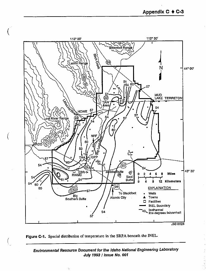
Appendix C 4 C-3
113'0'12'0'4'0'3'0'7
J93 0028
Figure C-1. Spacial distribution of temperature in the SRPA beneath the INEL.
Environmental Resource Document for the Idaho National Engineering LaboratoryJuly 1993 / Issue No. 001
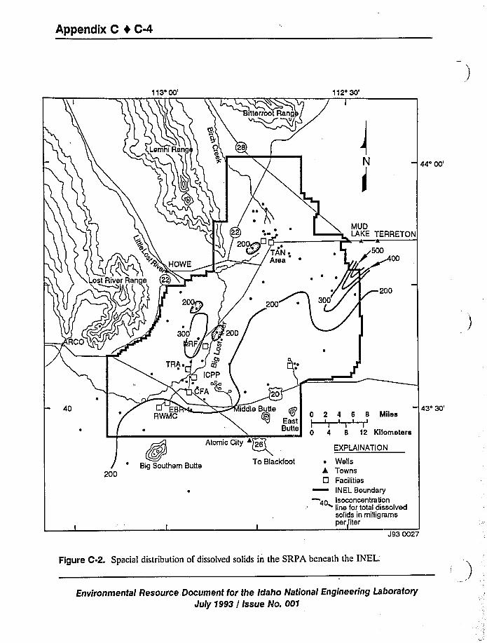
Appendix C 4 C-4
113'0'12'0'
44'0'D
LAKE TERRETON
I~00
~200
Atomic City
Qo
Big Southern Butte To Blacldoot
200
8 MilesI
I
12 Kilometers
EXPLAINATION
~ Wellsk Towns0 Facilities
INEL Boundary
40 Isoconcentration~ line for total dissolvedsolids in milligramsper)iter
43'0'93
0027
Figure C-2. Spaciai distribution of dissolved solids in the SRPA beneath the
INEL.'nvironmental
Resource Document for the Idaho National Engineering Laboratory
July 1993 / Issue No. 001
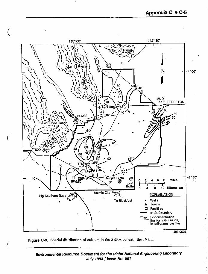
Appendix C t C-5
113'0'12'0'4'0'ETON
800
43'0's
Big Southern Butte
30
Atomic City
To Blackfoot
EXPLAINATION
ters
~ Wells4 Towns
Cl Facilities
INEL BoundaryIsoconcentration~ line for calcium ion,in milligrams per liter
l
J93 0026
Figure C-3. Spacial distribution of calcium in the SRPA beneath the INEL.
Environmental Resource Document for the Idaho National Engineering LaboratoryJuly 1993 / Issue No. 001
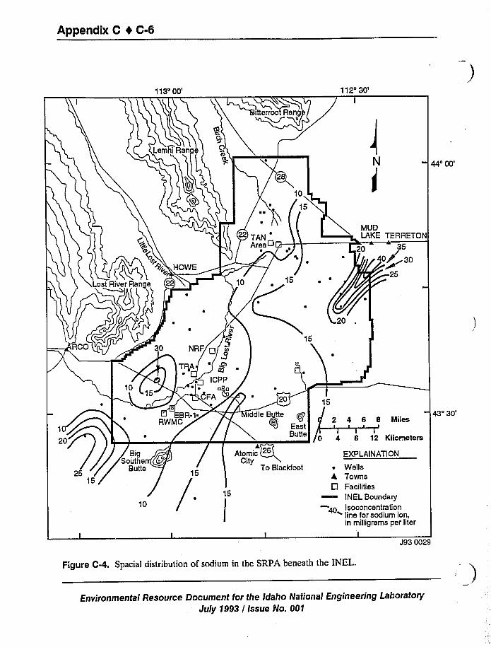
Appendix C 4 C-6
113'0'12'0'
44'0'UD
LAKE TERRETON
3540+ 30
g~25
I
43'0'8 Miles
~ II I
8 12 Kilometers
PLAINATION
Wellsowllsacilities
NEL BoundaryIsoconcentration~ line for sodium ion,in milligrams per liter
I
J93 0029
Figure C-4. Spacial distribution of sodium in the SRPA beneath the INEL.
Environmental Resource Document for the Idaho National Engineering Laboratory
July 1993 / Issue No. 001
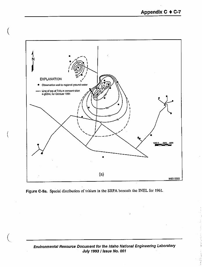
Appendix C t C-7
M93 0093
Figure C-5a. Spacial distribution of tritium in the SRPA beneath the INEL for 1961.
Environmental Resource Document for the Idaho National Engineering Lal3oratory
July 1993 / Issue No. 005
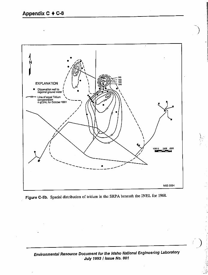
Appendix C 0 C-8
~ rx~
M93 0094
Figure C-5b. Spacial distribution of tritium in the SRPA beneath the INEL for 1968.
Environmental Resource Document for the Idaho National Engineering Laboratory
July 1993 / Issue No. 001
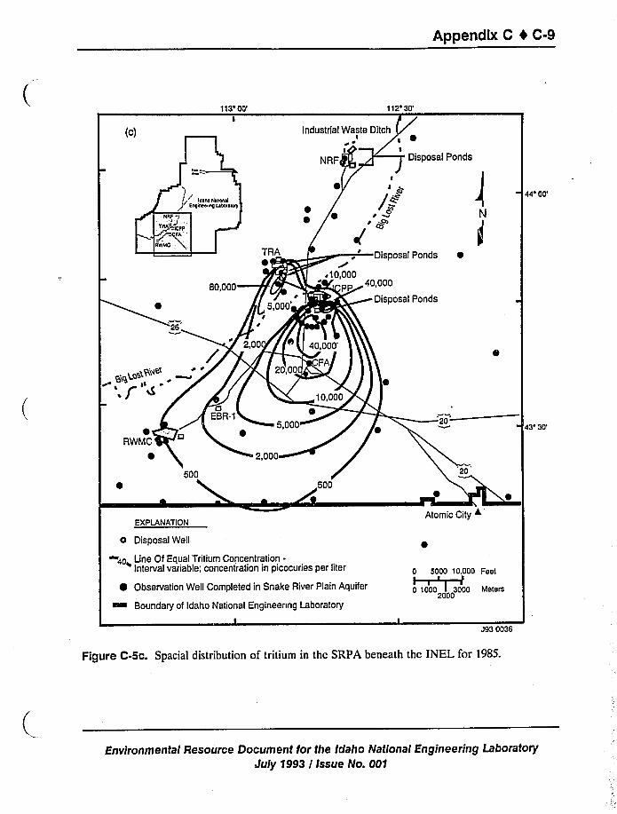
Appendix C t C-9
113400'12'0'c)
44'0'
405~9,"4
',J
RWMC
43'0'XPLANATION
o Disposal Well
Line Of Equal 'Tritium Concentration-Interval variable; concentration in picocuries per liter
0 Observation Well Completed in Snake River Plain Aquifer
Boundary of Idaho National Engineenng Laboratory
Atomic City +
0 5000 10,000 Feet~ ~ I ~
0 1000 I 3000 Meters2000
J93 0036
Figure C-5c. Spaciai distribution of tritium in the SRPA beneath the INEL for 1985.
Environmental Resource Document for the Idaho National Engineering Laboratory
July 1993 / Issue No. 001
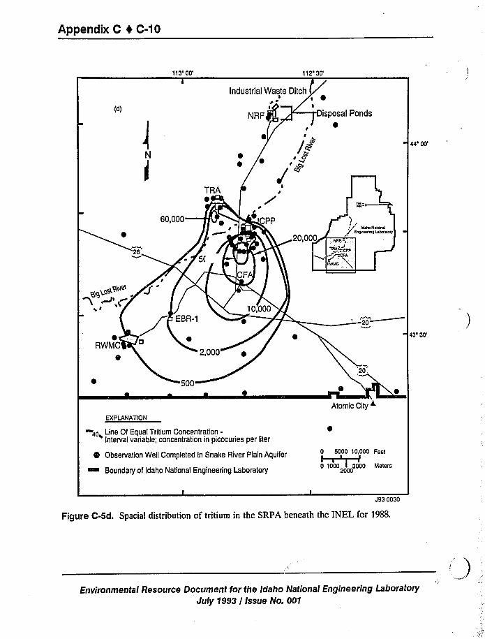
Appendix C 4 C-10
113'0'12'0'4'0'WMC
43'0'XPLANATION
Line Of Equal Tritium Concentration-Interval variable; concentration in picocuries per liter
Observation Well Completed in Snake River Plain Aquifer
~ Boundary of Idaho National Engineering Laboratory
Atomic City ~
0 5000 10.000 Feet~ I I ~
0 1000 I 3000 Meters2000
J93 0030
Figure C-5d. Spacial distribution of tritium in the SRPA beneath the INEL for 1988.
Environmental Resource Document for the Idaho National Engineering Lai3oratory
July 1993 / Issue No. 001
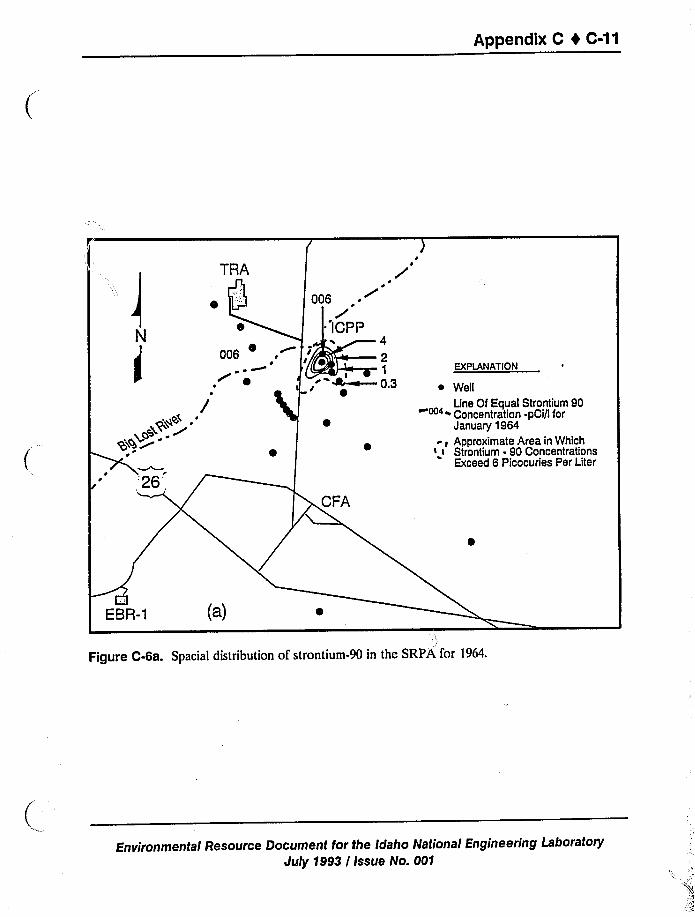
APPegdix C I C-11
cntium 90Qi/I ter
in Whichncentrationsiea per Liter
EBR-1
90 in the SRPA foaclal istri u'''h tion of strontiumFigure C-6a. Spa
'neeringLaboratorytfort eh Idaho National Enginesource DocumenEnvironmental Res
July 1993 / Issue No. 001
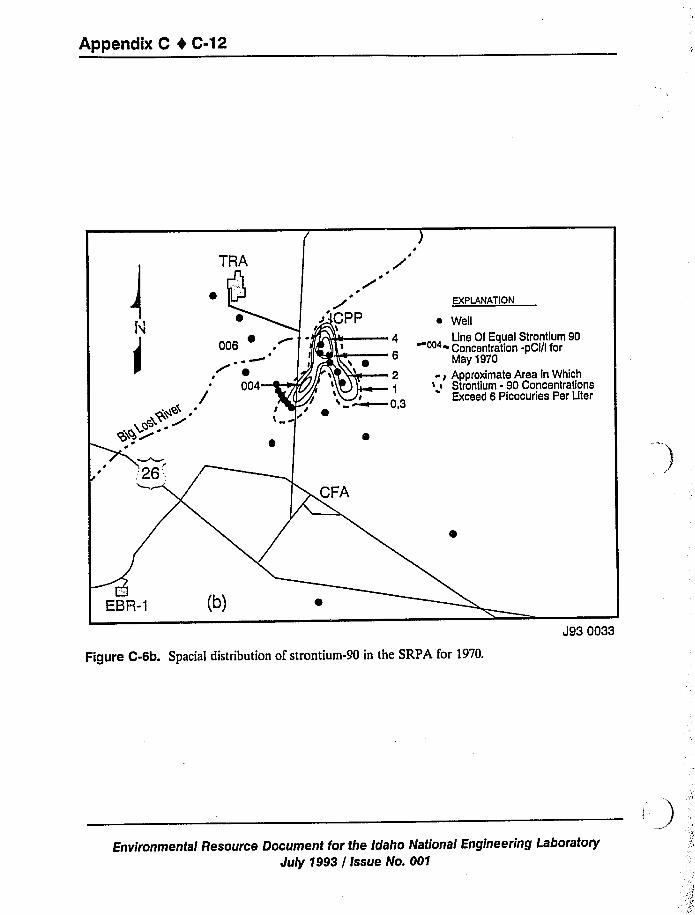
Appafldix C 4 C
ontium 90Cl/I for
a in Whichncentrationsiee per Liter
Jg3 QQ33
-90 in the SRPA for 1970.Figure C-6b. Spaciai distributio'on of strontium-90 in e
ineering Laboratoryfor the ah Idaho National Enginee*
Environmental Ressource Document h aJuly 1993 / Issue No. 001
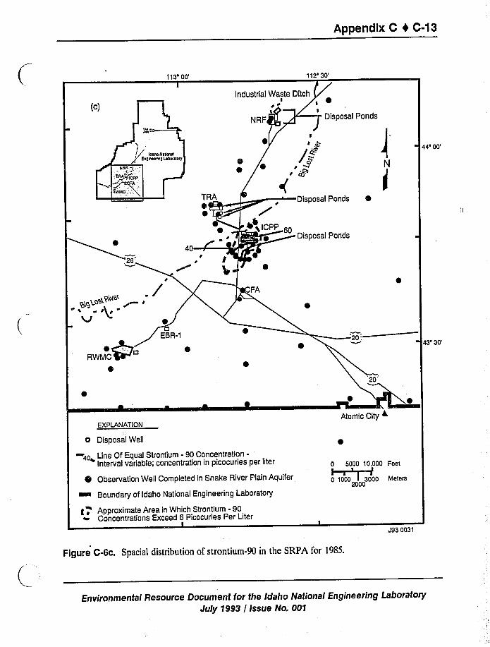
Appendix C 4 C-13
113'0'12'0'4'0'3'0'XPLANATION
o Disposa(Well
40+ Line Of Equal Strontium - 90 Concentration-Interval variable; concentration in picocuries per liter
Observation Well Completed in Snake River Plain Aquifer
~ Boundary of Idaho National Engineering Laboratory
g, Approximate Area in Which Strontium - 90Concentrations Exceed 6 Picocuries Per Liter
I
Atomic City +
0 5000 10.000 Fest~ ~
0 1000 I 3000 Meters2000
J93 0031
Figure C-6c. Spaciai distribution of strontium-90 in the SRPA f'r 1985.
Environmental Resource Document for the Idaho National Engineering LaboratoryJuly 1993 / Issue No. 001
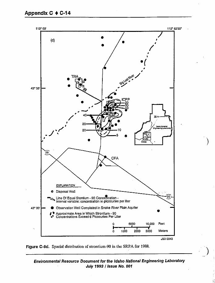
Appendix C 0 C-14
113o00'12452'30'd)
I
~ (
43'35'
I
~o f
r
40
30
20
~ ICPP/ 30
lip $0
-10
o
IW
Idata N
Enemy
43'30' I Observation Well Completed in Snake River Plain Aquifer
f > Approximate Area in Which Strontium - 90~'oncentrations Exceed 6 Picocuries Per Liter
0 5000
0 1000 2000
10,000 Feet
3000 Meters
Figure C-6d. Spacial distribution of strontium-90 in the SRPA for 1988.
J93 0043
Environmental Resource Document for the Idaho National Engineering Laboratory
July 1993 / Issue No. 001
Appendix C I C-15
Cesium-137 was detected in two wells near the ICPP between 1982 and 1985. The maximum
concentration observed was 237~34 pCi/L Cesium has not been detected in these wells after1985. A cesium-137 concentration of 3,800~160 pCi/L was observed in the TAN disposal well in1986. A total of 3,060~120 pCi/L of cesium-137 were observed in the TAN well in 1988.Although cesium-137 was also released at the TRA, it has never been observed in monitoringwells near the TRA (Pittman et al. 1988; Orr and Cecil 1991).
Measurable plutonium-238 concentrations were observed in two wells near the ICPP prior to1986. The highest concentration observed was 0.5~0.06 pCi/L in 1983. No plutonium-238 hasbeen detected in these wells since 1986. A plutonium-239, -240 concentration of 5.5+0.4 pCi/Lwas detected in one of these wells in 1987. Plutonium-239, -240 has not been detected in eitherwell since 1987. The plutonium-238 concentration in the TAN disposal well was 1.22~ 0.09 pCi/Lin 1987 and 0.19+0.05 pCi/L in 1988. The plutonium-239, -240 concentration in the TANdisposal well was 5~0.02 pCi/L in 1987 and 0.96~0.08pCi/L in 1988. A plutonium-238concentration of 0.11+0.03pCi/L was observed in a well near the Central Facilities Area in 1987.No plutonium-238 has been detected in the well since 1987 (Pittman et al. 1988; Orr and Cecil1991).
Americium-241 is a decay product of plutonium-241. Measurable americium-241 wasobserved in four wells near the RWMC from 1972 through 1982. The highest americium-241concentration observed was 5+1 pCi/L. No americium-241 has been detected in any of thesewells since 1982. Also, 2.1~0.04 and 1+0.03 pCi/L were observed in the TAN disposal well in1987 and 1988, respectively (Pittman et al. 1988; Orr and Cecil 1991).
The nonradioactive metals, sodium, chromium, mercury, and lead have been released into thesubsurface by human activities at the INEL. Of these metals, sodium was released in greatestquantity. It is estimated that a total of 25,410 kg (55,979 Ib) of chromium, 154 kg (340 lb) oflead, and 68 kg (150 Ib) of mercury were discharged at the INEL prior to 1984. None of thesemetals have been discharged by INEL facilities since 1984. Approximately 1.5 million kg(3.2 million Ib) of sodium were discharged at the INEL between 1986 and 1988 (Orr and Cecil1991).
A plume of elevated sodium concentration in the northeastern portion of the INEL isevident. This plume may be duc to infiltration of irrigation water in the Mud Lake regionnortheast of the INEL. Sodium concentrations greater than 10 mg/L have been observed in
several wells near the RWMC. Thc maximum sodium concentration measured in a well near theRWMC was 52 mg/L The maximum sodium concentration observed in wells near the NavelReactors Facility (NRF) during 1988 was 114 mg/L. Sodium disposal from the NRF decreasedfrom about 39,010 kg (86,000 Ib) in 1986 to about 6,350 kg (14,000 lb) in 1988 (Pittman et al.1988; Orr and Cecil 1991).
Figures C-7a through C-7c show the distribution of chromium in the SRPA beneath theINEL in 1966, 1967, and 1970, respectively. Although chromium has been discharged at theTRA, NRF, Experimental Brccdcr Reactor II, ICPP, and Power Burst Facility (PBF) at varioustimes measurable chromium concentrations have only been observed near the TRA. The highest
Environmental Resource Document for the Idaho National Engineering LaboratoryJuly 1993 / Issue No. 001
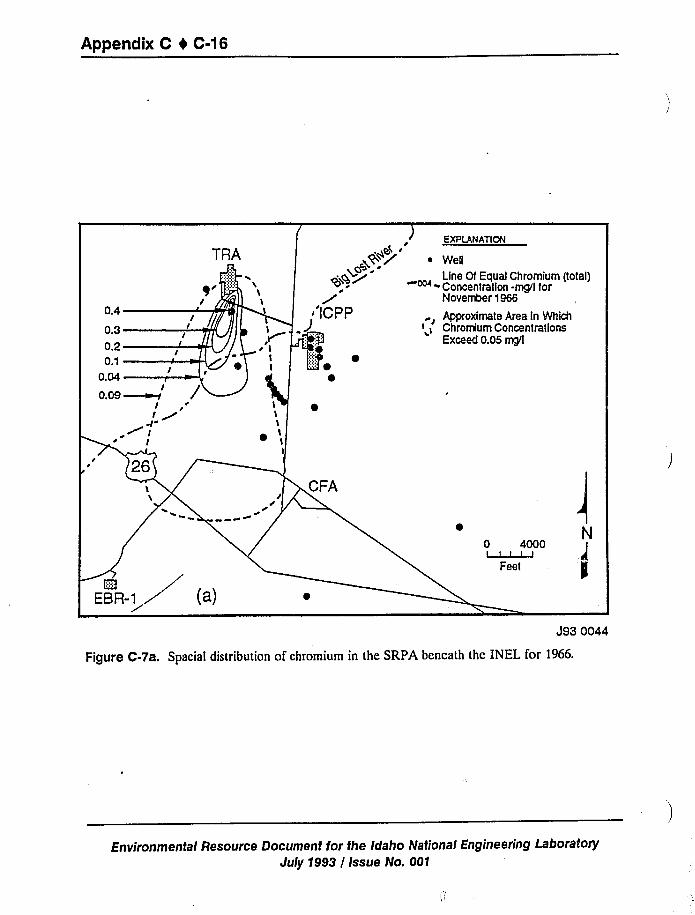
Appendix C 4 C-16
romium (total)mg/f for
a ln Whichcentrations
I
N000
J93 0044
'inthe' 'RPA beneath the INEEL for 1966.acial distribution of chromium 'igureC-7a. Spacial istri u
'dahoa iN t'onal Engineering Laboratoryesource Document for theE
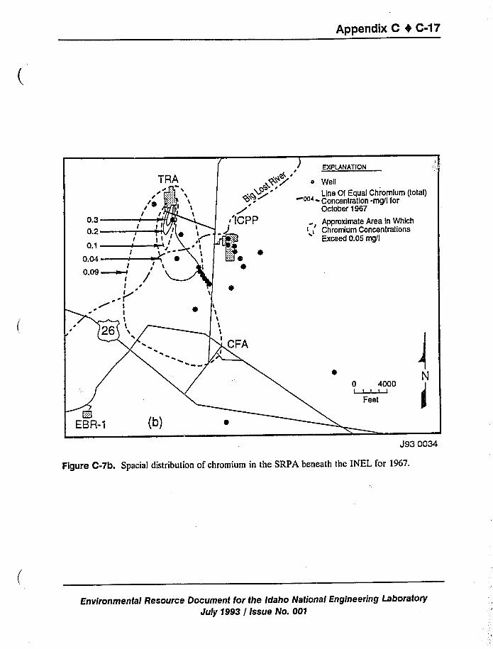
Appendix C ~
romium (total)mgj't for
a in Whichcantrations
mgj't
N
J93 QQ34
SRPA beneath the INEL for 1967.ion of chromium in theFigure C-7b Spacial distribution o
erin Laboratorydaho Nati ona/ Engineeringesource Document for the I a oE vironmental R
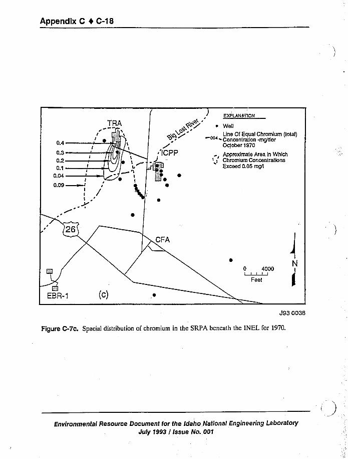
Appendix C 4 C-18
romium (tot<)mg/Ifor
a in Whic"cantrations
N4000
Jg3 0038
in the SRpA beneath the INEEL for 1970.ial distribution of chromium 'igureC-7c. Spacial istri u
'oratoryIdaho Nationa nI Engineering Labo ryesource oDocument for the aE wronmental R
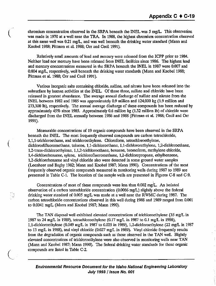
Appendix C 0 C-19
chromium concentration observed in the SRPA beneath the INEL was 5 mg/L This observationwas made in 1970 at a well near the TRA. In 1988, the highest chromium concentration observed
at this same well was 0.21 mg/L, and was well beneath the drinking water standard (Mann and
Knobel 1988; Pittman et al. 1988; Orr and Cecil 1991).
Relatively small amounts of lead and mercury were released from the ICPP prior to 1984.Neither lead nor mercury have been released from INEL facilities since 1986. The highest leadand mercury concentrations measured in the SRPA beneath the INEL in 1987 were 0.007 and
0.004 mg/L, respectively, well beneath the drinking water standards (Mann and Knobel 1988;Pittman et al. 1988; Orr and Cecil 1991).
Various inorganic salts containing chloride, sulfate, and nitrate have been released into thesubsurface by human activities at the INEL. Of these three, sulfate and chloride have beenreleased in greatest abundance. The average annual discharge of sulfate and nitrate from theINEL between 1982 and 1985 was approximately 0.9 million and 124,000 kg (1.9million and
273,300 lb), respectively. The annual average discharge of these compounds has been reduced by
approximately 45% since 1985. Approximately 0.6 million kg (1.32million lb) of chloride were
discharged from the INEL annually between 1986 and 1988 (Pittman et al. 1988; Cecil and Orr1991).
Measurable concentrations of 19 organic compounds have been observed in the SRPAbeneath the INEL. The most frequently observed compounds are carbon tetrachloride,1,1,1-trichloroethane, and trichloroethylene. Chloroform, tetrachloroethylene,dichlorodifluoromethane, toluene, 1,1-dichloroethane, 1,1-dichlororethylene, 1,2-dichloroethane,1,2-trans-dichloroethylene, 1,1,2-trichloroethane, benzene, bromoform, methylene chloride,1,4-dichlorobenzene, xylene, trichlorofluoromethane, 1,2-dichloropropane, ethylbenzene,1,2-dichlorobenzene and vinyl chloride also were detected in some ground water samples
(Leenheer and Bagby 1982; Mann and Knobel 1987; Mann 1990). Concentrations of the most
frequently observed organic compounds measured in monitoring wells during 1987 to 1989 arepresented in Table C-1. The location of the sample wells are presented in Figures C-8 and C-9.
Concentrations of most of these compounds were less than 0.002 mg/L. An isolatedobservation of a carbon tetrachloride concentration (0.0066 mg/L) slightly above the federal
drinking water standard of 0.005 mg/L was made at a well near the RWMC during 1987. Thecarbon tetrachloride concentrations observed in this well during 1988 and 1989 ranged from 0.001to 0.0041 mg/L (Mann and Knobel 1987; Mann 1990).
The TAN disposal well exhibited elevated concentrations of trichloroethylene (35 mg/L in
1987 to 24 mg/L in 1989), tetrachloroethylene (0.17 mg/L in 1987 to 0.1 mg/L in 1988),1,1-dichloroethylene (0.049 mg/L in 1987 to 0.025 in 1989), 1,2-dichloroethylene (22 mg/L in 1987to 13 mg/L in 1988), and vinyl chloride (0.027 mg/L in 1989). Vinyl chloride frequently results
from the degradation of organic compounds such as those observed in the TAN well. Slightly
elevated concentrations of trichloroethylene were also observed in monitoring wells near TAN
(Mann and Knobel 1987; Mann 1990). The federal drinking water standards for these organic
compounds are listed in Table C-2.
Environmental Resource Document for the Idaho National Engineering Laboratory
July 1993 / Issue No. 001
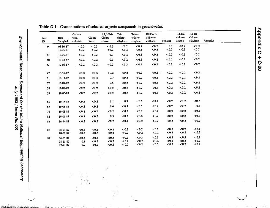
Table C-1. Concentrations of selected organic compounds in groundwater.
III(
~N
Ito0CntO
OG
c rlI
BtD
tOro~ o
r
rn P'nIIIO
O 'ea'.
O ttr
0
Ittr
B
Cy'
ttr
0
Well
ID
37
40
43
47
51
57
58
59
65
67
76
82
83
86
87
Date
Sampled
07-30-8710-05-87
10-05-87
10-13-87
10-05-87
10-26-87
10-13-87
10-09-87
10-08-87
10-06-87
10-14-87
10-06-87
10-08-87
10-06-87
10-14-87
08-04-8710-06-87
06-03-8708-11-8709-23-87
Carbontetra-
chloride
<0.2<0.2
Chloro-form
<0.2<0.2
<0.2 <0.2
<0.2 <0.2
<0.2 <0.2
<0.2 <0.2
<0.2 <0.2
<0.2
<0.2
<0.2
<0.2
<0.2 <0.2
<0.2 <0.2
<0.2 <0.2
<0.2<0.2
<0.30.30.7
<0.2<0.2
<0.3<0.2<0.2
<0.2 <0.2
<0.2 <0.2
<0.2 <0.2
l,l,l-Tri-Chloro-ethane
<0.2<0.2
0.7
0.3
<0.2
Trl-chloro-
ethylene
<0.2<0.2
<0.2
<0.2
<0.2
Tetra-chloro-ethylene
<0.2<0.2
<0.2
<0.2
<0.2
<0.2 <0.2 <0.2
0.7
0.5 <0.2 <0.2
<0.2 <0.2 <0.2
<0.2 <0.2 <0.2
0.6
<0.2
0.3
<0.2
0.2
<0.2
<0.2
<0.2
<0.2
<0.2
<0.2
<0.2
<0.2
<0.2
<0.2<0.2
<0.3<0.2<0.2
<0.2<0.2
<0.3<0.2<0.2
<0.2<0.2<0.3<0.2<0.2
<0.2 <0.2
Dichloro-difluoro-
methane
<0.2<0.2
Toluene
0.3<0.2
I,I-Di-chloro-ethane
<0.2<0.2
<0.2
<0.2
<0.2
<0.2
<0.2 <0.2
<0.2 <0.2
<0.2 <0.2
<0.2 <0.2
<0.2
<0.2
<0.2
<0.2
<0.2 <0.2
<0.2 <0.2
<0.2 <0.2
<0.2
<0.2
<0.2
<0.2 <0.2
<0.2 <0.2
<0.2 <0.2
<0.2 <0.2 <0.2
<0.2 <0.2 <0.2
<0.2<0.2
<0.3<0.2<0.2
<0.2<0.2
<0.3<0.2<0.2
<0.2<0.2
<0.3<0.2<0.2
<0.2 <0.2
I,I-Di-chloro-
ethylene Remarks
<0.2<0.2
<0.2
<0.2
<0.2
<0.2
<0.2
<0.2
<0.2
<0.2
<0.2
0.2
<0.2
<0.2
<0.2
<0.2<0.2
<0.3<0.2<0.2
0'a
D.XO+OlOC)
1
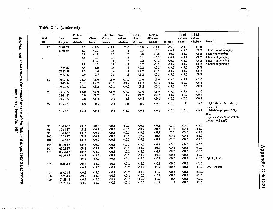
Table C-1. (continued).
ftI
t3
B
It/t0t
0ttt
0t3OI
B~ o
~ t3
to It
tu
O
O 'es:o tu
0
tet
ttttb
r
tet
ct
WellID
88
DateSampled
06-03-8707-08-87
89
90
92
07-15-8708-11-8709-22-87
06-03-8708-12-8709-22-87
06-03-8708-11-8709-23-87
10-23-87
10-22-87
979899100101
10-14-8710-14-8710-14-8710-20-8710-27-87
103 09-24-87104 09-24-87105 07-30-87
09-28-87
106 10-06-87
107 10-09-87108 09-28-87109 07-31-S7
09-28-87
Carbontetra-chloride
6.62.73.23.12.92.84.42.12.9
<3.0<0.2<0.2
<3.00.60.8
1,200
Chloro-form
<3.0<0.2<0.2<0.2<0.2<0.2
1.00.40.7
<3.0<0.2<0.2
<3.0<0.2<0.2
650
<0.2<0.2<0.2<0.2<0.2
<0.2<0.2<0.2<0.2<0.2
<0.2<0.2
<0.2<0.2<0.2<0.2
<0.2<0.2<0.2<0.2<0.2
<0.2<0.2<0.2<0.2<0.2
<0.2<0.2
<0.2<0.2<0.2<0.2
<0.2 <0.2
l,l, I-Tri-Chloro-
ethane
<3.00.60.70.70.60.60.90.40.5
<3.0<0.2<0.2
<3.00.20.2
140
Tri-chloro-ethylene
<3.0I.l1.21.21.21.21.41.21.1
<3.0<0.2<0.2
<3.00.20.3
860
Tetra-chloro-ethylene
<3.00.20.20.20.20.2
<0.2<0.2<0.2
<3.0<0.2<0.2
<3.0<0.2<0.2
110
<0.2<0.2<0.2<0.2<0.2
<0.2<0.2<0.2<0.2<0.2
<0.2<0.2
<0.2<0.2<0.2<0.2
<0.2<0.2<0.2<0.2<0.2
<0.2<0.2<0.2<0.2<0.2
<0.2<0.2
<0.2<0.2<0.2<0.2
<0.2<0.2<0.2-:0.2<0.2
<0.2<0.2<0.2<0.2<0.2
<0.2<0.2
<0.2<0.2<0.2<0.2
0.2 <0.2 <0.2
Dichloro-d i ituoro-
methane
<3.00.3
<0.2<0.2<0.2<0.2<0.2<0.2<0.2
<3.0<0.2<0.2
<3.0<0.2<0.2
<0.2
<0.2
<0.2<0.2<0.2<0.2<0.2
<0.2<0.2<0.2<0.2<0.2
<0.2<0.2
<0.2<0.2<0.2<0.2
Toluene
<3.0<0.2<0.2<0.2<0.2<0.2<0.2<0.2<0.2
<3.0<0.2<0.2
<3.0<0.2<0.2
<0.2
I, I-Di-chloro-ethane
<3.0<0.2<0.2<0.2<0.2<0.2<0.2<0.2<0.2<3.0<0.2
0.3
<3.0<0.2<0.2
13
<0.2<0.2<0.2<0.2<0.2
<0.2<0.2<0.2<0.2<0.2
<0.2<0.2<0.2<0.2<0.2
<0.2<0.2<0.2<0.2<0.2
<0.2<0.2
<0.2<0.2
0.71.0
<0.2<0.2
<0.2<0.2<0.2<0.2
<0.2 <0.2
I,I-Di-chlom-ethylene
<3.0<0.2<0.2<0.2<0.2<0.2<0.2<0.2<0.2
<3.0<0.2<0.2
<3.0<0.2<0.2
0.8
<0.2
<0.2<0.2<0.2<0.2<0.2
<0.2<0.2<0.2<0.2<0.2
<0.2<0.2
<0.2<0.2<0.2<0.2
Remarks
40 minutes of pumping
I hour of pumping
2 hours of pumping3 hours of pumping4 hours of pumping
1,1,2,2-Tetrachloroethane,I.O p g/L
1,2-Dchloro copen, 5.9 /t
g/LEtluipmcnt blank for well 92;styrene, 0.5 /t g/L
QA Replicate
QA Replicate
DXl0
Ity
CL
Aan
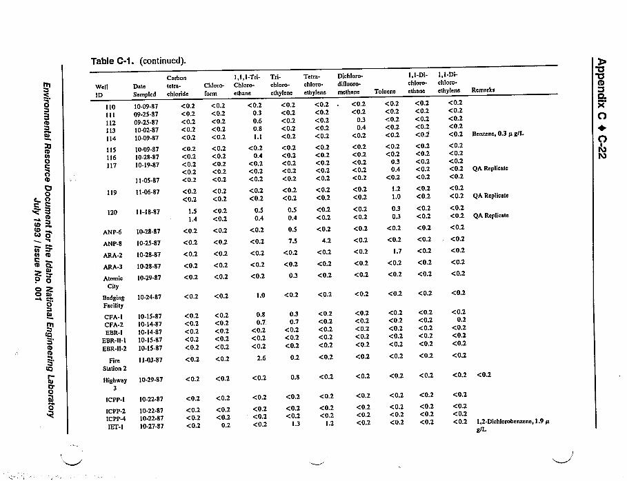
Table C-1. (Continued).
Itt'C
r0BI
ttttoOCOtD
OOO
0r
W@II
ID
110I I I
112113114
115116117
DateSampled
10-09-8709-25-8709-25-8710-02-8710-09-$7
10-09-$710-28-8710-19-87
119
11-05-87
11-06-87
120 11-18-87
ANP-6 10-28-87
ANP-8 10-25-87
Carbontetra-
chloride
(0.2<0.2<0.2<0.2(0.2(0.2<0.2<0.2<0.2(0.2
Chloro-
form
(0.2<0.2<0.2<0.2<0.2
<0.2(0.2<0.2<0.2<0.2
(0.2 <0.2(0.2 <0.2
1.51.4
(0.2
(0.2<0.2
(0.2(0.2 (0.2
I,I,I-Tri-Chloro-
ethane
(0.20.30.60.81.1
<0.20.4
<0.2<0.2<0.2
Tfl"chloro-
ethylene
<0.2<0.2<0.2<0.2<0.2<0.2<0.2<0.2<0.2<0.2
Tetra-«hloro-
ethylene
<0.2<0.2<0.2<0.2<0.2
<0.2<0.2<0.2<0.2<0.2
<0.2<0.2
0.50.4
0.5 <0.20.4 <0.2
<0.2
<0.2
0.5
7.5
<0.2
4.2
<0.2 <0.2<0.2 <0.2
Dichloro-dilluoro-
methane
<0.2<0.2
0.30.4
<0.2
<0.2<0.2<0.2<0.2<0.2
<0.2<0.2
<0.2(0.2<0.2
(0.2
Toluene
<0.2<0.2(0.2(0.2<0.2
<0.2<0.2
0.30.4
<0.2
1.21.0
0.30.3
I,I-Di-chloro-ethane
<0.2(0.2<0.2<0.2<0.2
<0.2<0.2<0.2<0.2<0.2
<0.2<0.2
<0,2(0.2
<0.2 <0.2
(0.2 <0.2
I,I-Di-chloro-ethylene
<0.2<0.2<0.2<0.2<0.2
<0.2<0.2<0.2<0.2<0.2
Remarks
Benzene, 0.3 /r g/L
QA Replicate
<0.2<0.2
<0.2
<0.2
gA Replicate
<0.2<0.2 QA Replicate
0'aID
CLPc
O
OlO!O
tb
O
O
Cl
Q.ttr
0
ARA-2
ARA-3
AtomicCity
10-28-87
10-28-87
10-29-87
(0.2 <0.2
<0.2 (0.2(0.2 <0.2 <0.2
<0.2
<0.2
0.3
<0.2 <0.2 <0.2
<0.2
<0.2
<0.2
<0.2
<0.2
1.7 <0.2
<0.2 <0.2
<0.2 <0.2
<0.2
<0.2
<0.2
Otn
ftt
tCI
tb
r
5tg)
Ct
BadgingFacility
CFA-ICFA-2EBR-I
EBR-n-IEBR-11-2
FireStation 2
Highway3
ICPP-I
ICPP-2ICPP-4IEf-I
10-24-87
10-15-8710-14-8710-14-8710-15-8710-15-87
11-03-87
10-29-87
10-22-87
10-22-8710-22-$710-27-$7
<0.2 <0.2
<0.2(0.2<0.2<0.2<0.2
(0.2(0.2<0.2<0.2(0.2
<0.2 <0.2
(0.2 <0.2
<0.2<0.2<0.2
(0.2(0.2
0.2
(0.2 (0.2
1.0
0.80.7
<0.2<0.2<0.2
2.6
<0.2
<0.2
<0.2(0.2(0.2
<0.2
0.30.7
<0.2<0.2<0.2
0.2
0.8
<0.2
<0.2<0.2
1.3
<0.2
<0.2<0.2<0.2<0.2<0.2
<0.2
<0.2
<0.2
<0.2<0.2
1.2
<0.2 <0.2 <0.2 <0.2
<0.2<0.2<0.2<0.2<0.2
<0.2<0.2<0.2(0.2(0.2
<0.2<0.2<0.2<0.2<0.2
<0.20.2
<0.2<0.2<0.2
<0.2 <0.2 <0.2 <0.2
<0.2 <0.2 <0.2 <0.2
<0.2(0.2<0.2
<0.2<0.2<0.2
<0.2<0.2<0.2
<0.2<0.2<0.2 1,2-Dichlorobenzene, 1.9/r
g/L
<0.2 <0.2 <0.2 <0.2 <0.2
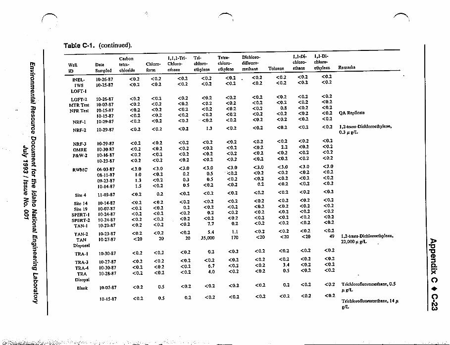
Table C-1. (Continued).
III
0
XIItoOIOOr
O0c n
C
~4 ItOtO4II
toot III0O 'es.'
tu
0
tCI
Ittr
Oll)
t3
Well
ID
IN EL-IWS
LO¹1LOFI'-2
MTR TestNPR Test
NRF-I
Date
Sampled
10-26-8710-25-87
10-26-8710-07-8710-15-8710-15-8710-29-87
NRF-3OMREPdrW-2
RWMC
Site 4
Site 14Site 19
8PERT- I
SPERT-2TAN-I
TAN-2TAN
Disposal
TRA-I
TRA-3TRA-4TRA
Disopal
Blank
10-29-$710-30-$710-16-8710-23.$7
06-03.8708-11-8709-23-8710-14-87
11-03-87
10-14-8710-07-8710-24-8710-24-8710-23-87
10-23-8710-27-87
10-30-87
10-27-8710-30-8710-28-87
10-07-87
10-15-$7
NRF-2 10-29-$7
Carbontetra-
chloride
(0.2<0.2
Chloro-lorm
<0.2(0.2
(0.2(0.2(0.2(0.2(0.2
<0.2(0.2<0.2<0.2(0.2
<0.2 <0.2
(0.2(0.2(0.2(0.2<3.0
1.01.31.5
<0.2
<0.2(0.2(0.2(0.2(0.2(0.2<20
<0.2<0.2<0.2<0.2
<3.0<0.2<0.2(0.2
0.2
(0.2<0.2(0.2<0.2<0.2
(0.220
<0.2(0.2(0.2
(0.2<0.2<0.2
(0.2 0.5
<0.2 0.5
<0.2 (0.2
I, I, I-Tri-Chloro-
ethane
(0.2(0.2
Tllchloro-
ethylene
<0.2<0.2
<0.2<0.2<0.2<0.2<0.2
<0.2
<0.2<0.2<0.2<0.2<0.2
1.3
<0.2<0.2<0.2<0.2
<3.00.20.30.5
<0.2
<0.20.2
<0.2<0.2<0.2
<0.220
<0.2<0.2<0.2<0.2
<3.00.50.5
<0.2
<0.2
<0.2<0.2
0.2(0.2
7.7
5.435,000
<0.2
<0.2<0.2<0.2
0.2
<0.26.74.0
<0.2 <0.2
0.2 <0.2
Tetra-chloro-
ethylene
<0.2<0.2
<0.2<0.2<0.2<0.2<0.2<0.2
<0.2<0.2(0.2<0.2
<3.0<0.2<0.2<0.2
<0.2
<0.2<0.2<0.2<0.2
0.2
I.l170
<0.2
<0.2<0.2<0.2
<0.2
<0.2
Dichloro-dilluoro-
methane
<0,2<0.2
<0,2<0.2<0.2<0.2<0.2<0.2
<0.2<0.2<0.2<0.2
<3.0<0.2<0.2
0.2
<0.2
<0.2<0.2<0.2<0.2<0.2
<0.2<20
<0.2
<0.2<0.2<0.2
<0.2
<0.2
Toluene
(0.2<0.2
I,I-Di-chloro-ethane
<0.2<0.2
I,I-Di-chloro-
ethylene
<0.2<0,2
<0.2<0.2
0.$<0.2<0.2
<0.2<0.2<0.2<0.2<0.2
<0.2<0.2<0.2<0.2<0.2
<0.2 <0.2 <0.2
<0.22.2
<0.2<0.2
<3.0<0.2<0.2<0.2
<0.2<0,2<0.2<0,2
<3.0<0.2<0.2<0.2
<0.2<0.2<0.2<0.2
<3.0<0.2<0.2<0.2
<0.2 <0.2 <0.2
<0.2<0.2<0.2<0.2<0.2
<0.2<20
<0.2<0.2<0.2<0.2<0.2
<0.2(20
<0.2<0.2<0.2<0.2<0.2
<0.249
<0.2 <0.2 <0.2
<0.23.40.5
<0.2<0.2<0.2
<0.2<0.2<0.2
<0.2 <0.2 <0.2
0.2 <0.2 <0.2
Remarks
QA Replicate
I 2-trans-Dichloroethylene0.3 /t g/L
1,2-trans-Dichloroethylene,22,000 /r g/L
Trichlorofluoromethane, 0.5/t g/L
Trichlorolluoromethane, 14 /r
g/L
0'IIQ.OC
O+0lOCay
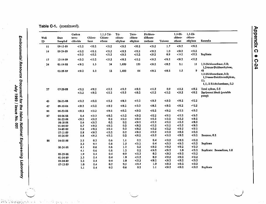
Table C-1. (continued).
0
IcoOOnr
ttr
OO
c nO
IecrCtMO
to Oto IO
Z ~0 Oo ZO
0
tO
tDtD
tO '
0
Well
ID
17
24
27
43
47
86
$7
88
DateSampled
09-13-89
09-24-89
12-14-89
01-14-88
02-28-89
07-20-88
06-21-8$
09-30-88
06-22-8S
04-06-8806-22-8810-18-8801-04-8904-05-8907-11-8910-26-89
04-05-$8
06-24-88
09-29-8801-04-8904-04-8907-12-89
Carbontetra-
chloride
Chloro-form
<0.2<0.2
<0.2<0.2
<0.2 <0.2
<0.2 1.3
<0.2 1.0
<0.2<0.2
<0.2<0.2
<0.2 <0.2
<0.2 <0.2
<0.2 <0.2
0.4<0.2
0.60.70.60.80.8
2.52.34.14.11.92.32.21.0I.l
<0.2<0.2<0.2<0.2<0.2<0.2<0.2
0.50.50.60.60.40.40.40.40.4
<0.2 <0.2
I,I, I-Tri-Chloro-ethane
<0.2
<0.2<0.2
<0.2
24
Tfl-chloro-
elhylen»
<0.2
<0.2<0.2
<0.2
1,600
12 1,400
<0.2
<0.2
<0.2
<0.20.20.2
<0.2<0.2<0.2<0.2
0.60.60.80.80.40.40.40.20.2
<0.2
<0.2
<0.2
<0.2<0.2
0.20.20.20.20.2
1.11.01.21.20.91.01.00.50.6
<0.2 <0.2<0.2 <0.2
Tetra-chloro-
ethylene
<0.2
<0.2<0.2
<0.2
120
64
<0.2<0.2
<0.2
<0.2
<0.2
<0.2<0.2<0.2<0.2<0.2<0.2<0.2
0.2<0.2
0.20.2
<0.2<0.2<0.2<0.2
0.2
Dichloro-difluoro-
methane
<0.2
<0.2<0.2
Toluene
1.7
1.00.9
I,I-Di-chloro-ethane
<0.2
<0.2<0.2
<0.2 <0.2 <0.2
<0.2 <0.2 2.1
<0.2 <0.2 1.5
<0.2<0.2
0.9<0.2
<0.2<0.2
<0.2 <0.2 <0.2
<0.2 <0.2 <0.2
<0.2<0.2<0.2<0.2<0.2<0.2<0.2
0.40.4
<0.2<0.2
0.20.3
<0.21.01.1
<0.2<0.2<0.2<0.2<0.2<0.2<0.2<0.2<0.2<0.2<0.2<0.2<0.2<0.2<0.2<0.2
<0.2<0.2<0.2<0.2<0.2<0.2<0.2
<0.2<0.2<0.2
1.0<0.2<0.2<0.2<0.2<0.2
<0.2 <0.2 <0.2
I, I-Di-chloro-ethylene
<0.2
Remarks
<0.2<0.2
<0.2<0.2
<0.2
<0.2<0.2<0.2<0.2<0.2<0.2<0.2
<0.2<0.2<0.2<0.2<0.2<0.2<0.2<0.2<0.2
Total xylene, 0.5Equipment blank fportable
pump)
Benzene, 0.2
Replicate
Replicate: Bromoform, 1.0
Replicate
<0.2<0.2 Replicate
<0.21,2-Dichloroethane, 0.8;
1,2-trans-Dichlorethylene,481,2-Dichloroethane, 0.5;
1,2-trans-Deichloroethylene,
II;1,1,-2-Tricholorethane, 0.3
'U'QIQ.XO+0lO
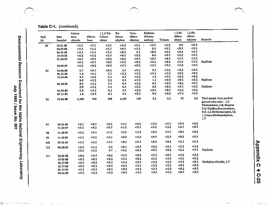
Ill
0BED
tu~V
tDroOC0IUOOt
W IrotOCo O
I
rn Itttt
O Oo Ro tuPb
0Iu
frt
tttItO
O'
0
Table C-1. (Continued).
Well
ID
89
90
92
Date
Sampled
02-01-8804-05-8806-24-8810-18-8801-04-89
04-04-89
04-06-8&06-22-88io-is-SS
01-18.89
04.05.$907-11.$9
04-06-$$
Carbontetra-
chloride
<0.2<0.2<0.2<0.2<0.2<0.2<0.2
0.71.00.70.80.90.90.8I.O
1,400
Chloro-form
<0.2<0.2<0.2<0.2<0.2<0.2<0.2
<0.2<0.2<0.2<0.2<0.2<0.2<0.2<0.2
940
97 09-26-88 <0.211-30-89 <0.2
<0.2<0.2
98 11-29-89 <0.2 <0.2
99 11-30-89 <0.2 <0.2
112 09-28-88 <0.2<0.2
<0.2<0.2
117 02-01-8804-05-8806-27-8810-17-8801-12-8904-03-89
<0.2<0.2<0.2<0.2<0.2<0.2
<0.2<0.2<0.2<0.2<0.2<0.2
108 09-05-89 <0.2 <0.2
1,1,1-Tri-Chloro-
ethane
<0.2<0.2<0.2<0.2<0.2<0.2<0.2
<0.20.30.20.20.20.20.20.3
250
Trlchloro-ethylene
<0.2<0.2<0.2<0.2<0.2<0.2<0.2
0.3<0.2
0.30.30.40.40.30.4
1,100
<0.2 <0.2<0.2 <0.2
<0.2 <0.2
<0.2 <0.2
<0.2 <0.2
0.6 <0.20.7 <0.2
<0.2 <0.2<0.2 <0.2<0.2 <0.2<0.2 <0.2<0.2 <0.2<0.2 <0.2
Tetra-chloro-ethylene
<0.2<0.2
0.3<0.2<0.2<0.2<0.2
<0.2<0.2<0.2<0.2<0.2<0.2<0.2<0.2
120
<0.2<0.2
<0.2<0.2
<0.2
<0.2<0.2
<0.2<0.2<0.2<0.2<0.2<0.2
Dichiom-dilluoro-
methane
<0.20.3
<0.20.4
<0.2<0.2<0.2
0.3<0.2
1.61.10.20.3
<0.20.4
0.3
Toluene
<0.2<0.2<0.2<0.2<0.2<0.2<0.2
<0.2<0.2<0.2<0.2<0.2<0.2<0.2<0.2
0.3
I,I-Di-ch!urn-ethane
0.8<0.2<0.2<0.2<0.2<0.2<0.2
<0.2<0.2<0.2<0.2<0.2<0.2<0.2<0.2
22
<0.2 <0.2 <0.2<0.2 <0.2 <0.2
<0.2 <0.2 <0.2
<0.2 <0.2 <0.2
<0.2 <0.2 <0.2
<0.2 <0.2 <0.2<0.2 <0.2 <0.2
<0.2 <0.2 <0.2<0.2 <0.2 <0.2<0.2 <0.2 <0.2<0.2 <0.2 <0.2<0.2 <0.2 <0.2<0.2 <0.2 <0.2
I, I-Di-chloro-ethylene
<0.2<0.2<0.2<0.2<0.2<0.2<0.2<0.2<0.2<0.2<0.2<0.2<0.2<0.2<0.2
2.6
<0.2<0.2
Remarks
Replicate
Replicate
Replicate
Thief sample from perched
ground-water zone. 1,2-Dicloroethane, 1.6;Benzene
0.2; Trichlorolluoromethane,
0.4; 1,2-Dichloropropane, 12;1,2-trans-Dichlorocthylene,1.7
<0.2
<0.2
<0.2
<0.2<0.2 Replicate
<0.2<0.2<0.2 Methylene chloride, 1.7<0.2<0.2<0.2
'a'aQ
Q.ltd
O+0lOQl
Table C-1. (continued).
nI
02I
O
OIO0OCBI0
I
Pso ICth
rtt
O
OO ttt
0
frt
tOBIDCl
tO
O
0
Well
ID
119
120
Dale
Sampled
02-01-8804-05-8806-27-$810-17-$801-12-8904-03-$9
02-01-8$04-05-8806-27-8810-1&-8801-12-8904-04-$907-12-$9
Arbor
Test
Atomic
City
EBR I
Highway3
IET I
NRF-I
NRF-2
NRF-3
02-15.&9
05-18-88
10-28-8810-28-$$
05-18-8$11-01-8&
03-01-$9
12-19-89
05-23-8912-21-89
12-19-$9
NRF-4 12-19-89
NRF-5 12-21-89
ANP-8 12-13.lt9
Carbontetra-
chloride
<0.2<0.2<0.2<0.2<0.2<0.2
1.91.52.1I.I0.70.81.0
Chloro-form
<0.2<0.2<0.2<0.2<0.2<0.2
0.2<0.2
0.2<0.2<0.2<0.2<0.2
<0.2 <0.2
<0.2 <0.2
<0.2 <0.2
<0.2<0.2
<0.2<0.2
<0.2<0.2
<0.2<0.2
<0.2 <0.2
<0.2 <0.2
<0.2<0.2
<0.2<0.2
<0.2 <0.2
<0.2 <0.2
<0.2 <0.2
I,I, I-Tri-Chloro-etttsne
<0.2<0.2<0.2<0.2<0.2<0.2
<0.20.40.50.2
<0.20.20.2
Tfl-chloro-
ethylene
<0.2<0.2<0.2<0.2<0.2<0.2
0.60.50.50.30.20.20.2
<0.2
<0.2
6.4
<0.2
<0.2 <0.2
<0.2<0.2
<0.2<0.2
<0.2
<0.2
<0.2<0.2
<0.2
<0.2<0.2
<0.2<0.2
0.3
<0.2
<0.2<0.2
<0.2
<0.2 <0.2
<0.2 <0.2
Tetrs-chloro-ethylene
<0.2<0.2<0.2<0.2<0.2<0.2<0.2<0.2<0.2<0.2<0.2<0.2<0.2
3.7
<0.2
<0.2
<0.2<0.2
<0.2<0.2
0.7
<0.2
<0.2<0.2
<0.2
<0.2
<0.2
Dichloro-
di lluoro-
methane
<0.2<0.2<0.2<0.2<0.2<0.2
<0.2<0.2<0.2<0.2<0.2<0.2<0.2
Toluene
<0.2<0.2<0.2<0.2<0.2<0.2
<0.2<0.2<0.2<0.2<0.2<0.2<0.2
I,I-Di-chloro-ethane
<0.2<0.2<0.2<0.2<0.2<0.2
<0.2<0.2<0.2<0.2<0.2<0.2<0.2
I,I-Di-chloro-
ethylene
<0.2<0.2<0.2<0.2<0.2<0.2
<0.2<0.2<0.2<0.2<0.2<0.2<0.2
Remarks
Bromoform, 1.0
<0.2 <0.2 <0.2 <0.2
<0.2 <0.2 <0.2 <0.2
<0.2 <0.2 <0.2 <0.2
<0.2<0.2
<0.2 <0.2<0.2 <0.2
<0.2<0.2 Replicate
<0.2<0.2
5.2<0.2
<0.2<0.2
<0.2<0.2
<0.2
<0.2
<0.2 <0.2
<0.2 <0.2
<0.2<0.2
0.3<0.2
<0.2<0.2
<0.2<0.2 Total xylene, 0.5
<0.2 <0.2 <0.2 <0.2
<0.2 <0.2 <0.2 <0.2
<0.2 <0.2 <0.2 <0.2 Thtef sample
<0.2 1,4-Dichlorobenzene,0.8
<0.2
'a'QIty
Q.XO
OlOC33
Table C-1. (Continued).
Well
IDDate
Sampled
Carbontetra-
chloride
Chloro-form
l,l, I-Tri-Chloto-ethane
Tll-chloro-
ethylene
Tetra-chloro-ethylene
Dichloro-dinuoro-
methane Toluene
I,I-Di-chloro-ethane
I, I-Di-chloro-
ethylene Remarks
TANDisposal
04-06-8807-21-8810-28-SS11-28-8812-28-8801-18-8902-16-8903-23-8904-Z5-8905-24-8906-20-8907-11-8908-29-8909-28-8910-26-89
01-11-88
03-07-89
RWMC 02-18-88 1.2I.I1.11.41.01.1i.51.51.51.41.31.31.31.51.31.41.6
<0.2
<0.2<0.2<0.2<0.2<0.2<0.2<0.2<0.2<0.2<0.2<0.2<0.2<0.2<0.2<0.2<0.2<0.2
0.3
<0.2 0.4
< 100 < 100
0.30.30.40.4
<0.20.30.40.30.40.30.30.30.30.30.30.30.4
0.60.60.50.60.50.50.70.70.70.50.50.6
0.50.50.40.6
0.7 26,000
1.3 29,000
<100 24,000
<0.2<0.2<0.2<0.2
020.20.2
<0.2<0.2<0.2<0.2<0.2<0.2<0.2<0.2<0.2<0.2
100
120
< 100
<0.2<0.2<0.2<0.2(0.2<0.2(0.2(0.2<0.2<0.2(0.2(0.2(0.2<0.2<0.2(0.2
'0.2<0.2
<0.2
<0.2<0.2<0.2<0.2<0.2<0.2<0.2<0.2<0.2<0.2<0.2<0.2<0.2<0.2<0.2<0.2<0.2
1.0
<0.2<0.2<0.2<0.2<0.2<0.2<0.2<0.2<0.2<0.2<0.2<0.2<0.2<0.2<0.2<0.2(0.2
1.7
1.8
< 100 < 100
<0.2<0.2<0.2<0.2<0.2<0.2<0.2<0.2<0.2<0.2<0.2<0.2<0.2<0.2<0.2<0.2<0.2
25
25
<100
Pumped at ZO gal/min;1,2-trans-Dichloroethylenc,
15,0001,2-Dichloroethane, 0.4;Benzene, 0,5; Ethylbenzene,
0.4;1,2-Dichlorobenzene, 4.6;1,4-Dichlorobenzenc, 0.4;
Vinyl
chloride, 26; Total xylene,2.0Pumped at 37 gal/min;
1,2-trans-Dichloroethylene,13,000
I 2-Dichloroethane 0 5.Benzene, 0.6
Ethylbenzene, 0.5;1,2-Dichlorob enzene5.1;1,4-Dichlorobenzene,0.6;
Vinyl
chloride, 27; Total xylene,2.41,2-trans-Dichloroethylen,13,000
Table C-1. (continued).
Ct
IcoCtI
O
OCt
e OI=
Itts
MO
7t Pto
tD
0O Pcs tu
0
tCI
ttrItCI
0
0
Well
IDDate
Sampled
TTD- I 03-02-89
TDD-3 12-13-8912-13-89
INEL-IWS
Blank
12-14-89
01-05-8802-01-8802-18-8804-07-8805-I g.lilt
06-24-88
06-29-88
10-03-88
Equipment
Blank(gardenhose)
12-14-89
TDD-2 03-06-89
Carbontetra-
chloride
Chloro-
form
<0.2 0.4
<0.2<0.2
<0.2<0.2
<0.2 <0.2
<0.2<0.2<0.2<0.2<0.2<0.2
<0.2<0.2<0.2<0.2<0.2<0.2
<0.2 0.3
<0.2 <0.2
<0.2 <0.2
<0.2 <0.2
I,I,I-Tri-Chloro-ethane
0.3
0.3
0.4<0.2
<0.2
<0.2<0.2<0.2<0.2<0.2<0.2
<0.2
<0.2
<0.2
Tfl-chloro-
ethylene
Tetra-chloro-ethylene
Dichloro-dilluoro-
methane
9.2 ~ <0.2
180 <0.2
<0.2<0.2
<0.2<0.2
<0.2<0.2
<0.2 <0.2 <0.2
<0.2<0.2<0.2<0.2<0.2<0.2
<0.2<0.2<0.2<0.2<0.2<0.2
<0.2<0.2<0.2<0.2<0.2<0.2
<0.2
<0.2 <0.2 <0.2
<0.2 <0.2 <0.2
<0.2 <0.2
Toluene
<0.2
I,I-Di-chloro-
ethane
0.3
I,I-Di-chloro-
ethylene
<0.2
<0.2 <0.2 <0.2
<0.20.3
<0.2<0.2
<0.2<0.2
<0.2 <0.2 <0.2
0.61.4
<0.2<0.2<0.2
1.3
<0.2<0.2<0.2<0.2<0.2<0.2
<0.2<0.2<0.2<0.2<0.2<0.2
<0.2 <0.2 <0.2
0.7 <0.2 <0.2
0.2 <0.2 <0.2
Remarks
1,2-trans-Dichloroethylene,0.9
1,2-trans-Dichloroethylene,
1.2
Pumped sampleBailer sample; Total xylene,0.3
Total xylene, 0.2
hfethylene chloride, 1.4;Total xylene, 0.9
1,2-Dichloroethane, 0.8;Bromoform, 2.8;Dib romochlora mathsne, 0.3
Benzene, 0.2; Ethylbenzene,
0.3;Methylenc chloride, 0.3;Total styrene, 0.2;Total xylene, 4.3
'a'aICL
Oe0lbCO
Appendix C 0 C-29
TRA
Site:..19e.
112'0'
~lCPP-'4fCPP-:f
4$
, '.59
g P ',: '.'. ", e67.~e.,P ''tfe"~ fis:.-e««
EXPLANATION',".:;: ':—~ ' 2,::1148 1.12TRA-1o Well sampled for ',. Q
purgeabid ors'a'nlc
compounds' TRA-'1:: jjOO ''.2122121
fs focal TEjett fdeniiTiei. (:..::,...::ij: ..Ehj ~,«N M„„,J93'6037
INEL
P&W2
ANPNIET-1
LOFT.2~ STAN-2
ANP-8TAN disposal
Montevfew
LTerreton
44'0'
Site 14
LArco
RF-1NRF-2
NRF-3
EBR-II-2NPR Test ~ EBR-II-1
jj'jjpp'~EPERT 1 1112CPA j''!2--."'2",, 'i@PERT 2CFA-2 ~1
ORME~ ARA-3 101
gg 8792 ~ +ARA-2117 g EBR-1 g3 EBadging Facility
~ 88+ ~ 1 0786 f2Q 90
fQ8104
g 109 1 03 110
Atomic CitRWMC
I
43'0'
2 4 6 8 MilesI I
I I I I
0 4 8 12 Kilometers
EXPLANATION
NRF-1 ~ Well sampled for purgeableorganic compounds —NRF-1 islocal well identifier
k Towns
J93 0040
Figure C-B. Location of wells sampled for purgeable organic compounds during 1987.
Environmental Resource Document for the Idaho National Engineering LaboratoryJuly 1993 / Issue No. 001
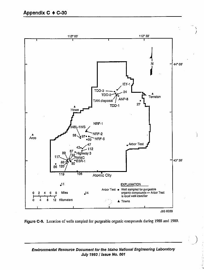
Appendix C 4 C-30
113'0' 112'0'
N
44'0'DD-3
~ 24TDD-2+@+
TAN disposal /TDD-1
JTerreton
27
NRF-1
kArco
NRF-2~NRF-5
47
87 ~~+ 112
89 I 2'Highway 3I RWMC
EBR-1
881
~ Arbor Test
43'0'19
Atomic City
0 2 4 6 8 MilesI I I ~
I I i I
0 4 8 12 Kilometers
o14
EXPtANATION
Arbor Test ~ Well sampled for purgeableorganic compounds —Arbor Testis local well identiTier
L Towns
J93 0039
Figure C-9. Location of wells sampled for purgeable organic compounds during 1988 and 1989.
Environmental Resource Document for the Idaho National Engineering Laboratory
July 1993 / Issue No. 001
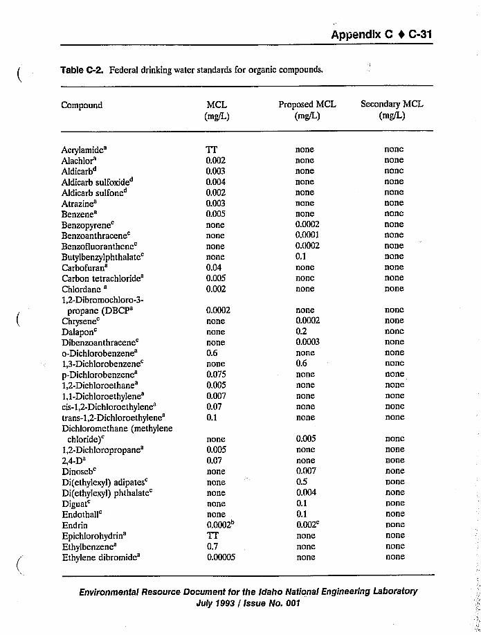
Appendix C t C-31
Table C-2. Federal drinking water standards for organic compounds.
Compound MCL(mg/L)
Proposed MCL
(mg/L)
Secondary MCL(mg/L)
Acrylamide'lachlor'ldicarb4
Aldicarb sulfoxide4
Aldicarb sulfone4
Atrazine'enzene'enzopyrene'enzoanthracene'enzofluoranthene'utylbenzylphthalate'arbofuran'arbon
tetrachloride'hlordane
',2-Dibrorno chio ro-3-propane
(DBCP'hrysene'alapon'ibenzoanthracene'-Dichlorobenzene',3-Dichlorobenzene'-Dichlo
rob
enzene',2-Dichloroethane',1-Dichloroethylene'is-1,2-Dichloroethylene'rans-1,2-Dichloroethylene'ichloromethane
(methylene
chloride)',2-Dichloropropane',4-D'inoseb'i(ethylexyl)
adipates'i(ethylexyl)
phthalate'iguat'ndothall'ndrin
Epichlorohydrin'thylbenzene'thylene
dibromide'r
0.0020.0030.0040.0020.0030.005nonenonenonenone0.040.0050.002
0.0002nonenonenone0.6none0.0750.0050.0070.070.1
none0.0050.07nonenonenonenonenone0.0002~Tr0.70.00005
nonenonenonenonenonenonenone0.00020.00010.00020.1nonenonenone
none0.00020.20.0003none0.6nonenonenonenonenone
0.005nonenone0.0070.50.0040.10.1
0.002'one
nonenone
nonenonenonenonenonenonenonenonenonenonenonenonenonenone
nonenonenonenonenonenonenonenonenonenonenone
nonenonenonenonenonenonenonenonenonenonenonenone
Environmental Resource Document for the Idaho National Engineering Laboratory
July 1993 / Issue No. 001
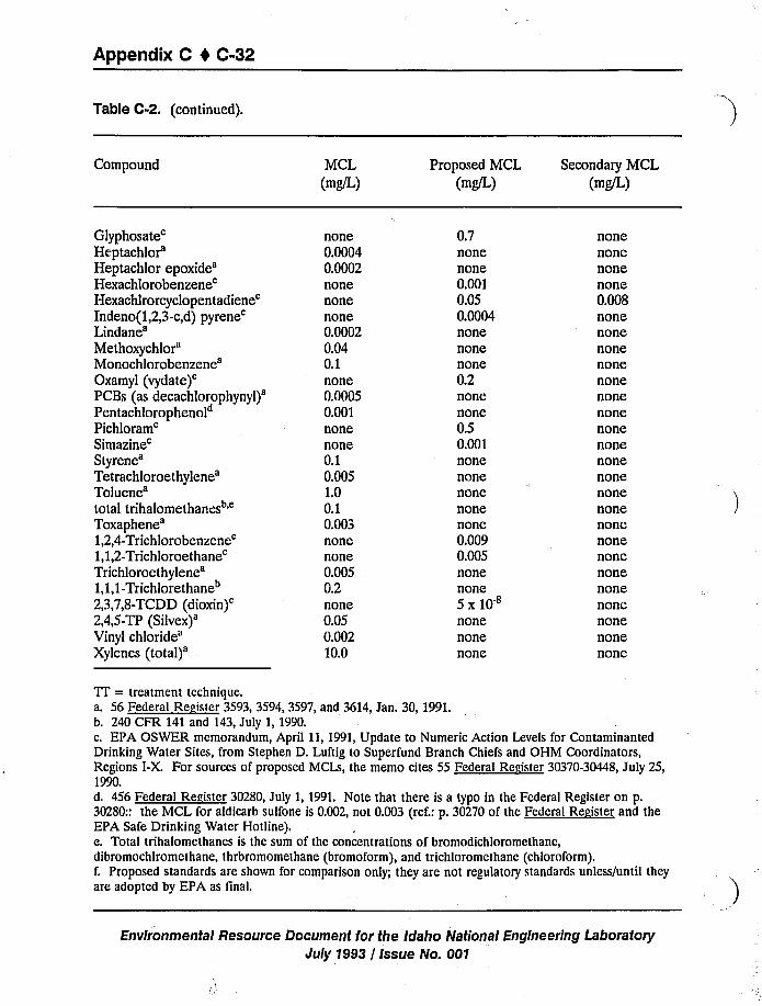
Appendix C 4 C-32
Table C-2. (continued).
Compound MCL
(mg/L)
Proposed MCL(mg/L)
Secondary MCL(mg/L)
Glyphos
ate'eptachlor'eptachlor
epoxide'exachlorobenzene'exachlrorcyclopentadiene'ndeno(1,2,3-c,d)
pyrene'indane'ethoxychlor'ono
chloroben zene'xamyl
(vydate)'CBs
(asdecachlorophynyl)'entachlorophenol"
Pichloram'imazine'tyrene'etrachloroethylene'oluene'otal
trihalomethanes
'oxaphene',2,4-Trichlorobenzene',1,2-Trichloroethane'richloroethylene',1,1-Trichlorethane"
2,3,7,8-TCDD(dioxin)',4,5-TP
(Silvex)'inyl
chloride'ylenes
(total)'one
0.00040.0002nonenonenone0.00020.040.1none0.00050.001nonenone0.10.0051.00.10.003nonenone0.0050.2none0.050.00210.0
0.7nonenone0.0010.050.0004nonenonenone0.2nonenone0.50.001nonenonenonenonenone0.0090.005nonenone5 x10nonenonenone
nonenonenonenone0.008nonenonenonenonenonenonenonenonenonenonenonenonenonenonenonenonenonenonenonenonenonenone
TT = treatment technique.a. 56 Federal Resister 3593, 3594, 3597, and 3614, Jan. 30, 1991.b. 240 CFR 141 and 143, July 1, 1990.c. EPA OSWER memorandum, April 11, 1991,Update to Numeric Action Levels for ContaminantedDrinking Water Sites, from Stephen D. Luftig to Superfund Branch Chiefs and OHM Coordinators,Regions I-X. For sources of proposed MCLs, the memo cites 55 Federal Resister 30370-30448, July 25,1990.d. 456 Federal Resister 30280, July 1, 1991. Note that there is a typo in the Federal Register on p.30280:: the MCL for aldicarb sulfone is 0.002, not 0.003 (ref.: p. 30270 of the Federal Reeister and theEPA Safe Drinking Water Hotline).e. Total trihalomethancs is the sum of the concentrations of bromodichloromethane,dibromochlromcthane, thrbromomethane (bromoform), and trichloromethanc (chloroform).f. Proposed standards are shown for comparison only; they are not regulatory standards unless/until theyare adopted by EPA as linal.
Environmental Resource Document for the Idaho National Engineering LaboratoryJuly 1993 / Issue No. 001
Appendix C I C-33
Tritium and iodine-129, the only contaminants detected outside the INEL boundaries, were
found in extremely low concentrations slightly beyond the southern INEL boundary. Tritium was
observed past the boundary in 1985, but the plume has since receded and decreased in size and is
now contained within the INEL Site (Pittman et al. 1988; Orr and Cecil 1991;Orr et al. 1991).Iodine-129 concentrations much below the EPA maximum contaminant levels have recently been
measured in two wells approximately 6.4 and 12.8 km (4 and 8 mi) south of the INEL boundary.
b. Private communication with L. J. Mann, April 1993.
Environmental Resource Document for the idaho National Engineering Laboratory
July 1993 / issue No. 001
Appendix C 4 C-34
C.3 References
Bargelt, R. J., Dicke, C. A., Hubbell, J. M., Paarmann, M., Ryan, D., Smith, R. W., and Wood, T.R., 1992, Summary of RWMC Investigations Report, EG&G, INEL, EGG-9708.
Humphrey, T. G., and Tingey, F. H., 1978, The Subsurface Migration of Radionuclides at the
Radioactive Waste Management Complex 1976-1977, EG&G Idaho, Inc., TREE-1171,Idaho
Falls, ID.
Leenheer, J. A., and Bagby, J. C., 1982, Organic Solutes in Groundwater at the Idaho National
Engineering Laboratory, USGS, USGS Water Resources Investigation 82-15,IDO-22061-USGS, Idaho Falls, ID.
Mann, L. J., 1990, Purgeable Organic cnmpounds in Groundwater al the Idaho National
Engineering Laboratory, Idah'o 19!tBand 1989, USGS, Open-File Report 90-367, IDO-22089
Mann, L. J., and Knobel, L. L., 1987;.,Pa!pebble Organic Compounds in Ground Water at the Idaho
National Engineering Laboratory, U"GS, Open File Report 87-766, DOE/ID-22074.
1
'ann,L. J., and Knobel, L. L., 1988, Concentrations of Nine Trace Metals in Ground Water at the
Idaho National Engineering Laboratory, USGS, Open File Report 88-332, DOE/ID-22075.
Mann, L. J.; Chew, E. W.; Morton, J. S., and Randolph, R. B., 1988, Iodine-129 in the Snake
River Plain Aquifer at the INEL, Idaho, USGS, Water Resources Investigations Report88-4165, DOE/ID-22076.
Norrell, G., 1993, EG&G, Idaho, Inc., Personal Communication, February 19, 1993.
Orr, B. L.; Cecil, L. D., and Knobel, L. L., 1991,Background Concentrations of Selected
Radionuclides, Organic Compounds, and Chemical constituents in Ground Water in the
Vicinity of the Idaho National Engineering Laboratory, USGS, Water Resources Investigation
Report 91-4015, DOE/ID-22094.
Orr, B. R., and Cecil, L. D., 1991,Hydrologic Conditions and Distribution of Selected Chemical
Constituents in Water, Snake River Plain Aquifer, Idaho National Engineen'ng Laboratory,
Idaho 1986 to 1988, USGS, Water Resources Investigations Report 91- 4047, IDO-22096.
Pittman, J. R.; Jensen, R. G., and Fischer, P. R., 1988, Hydrologic Conditions at the IdahoNational Engineering Laboratory 1982 to 1985, USGS, Water Resources Investigation Report89-4008, DOE/ID-22078.
Environmental Resource Document for the Idaho National Engineering Laboratory
July 1993 / Issue No. 001
Appendix C 0 C-35
C.4 Annotated Bibliography for WaterResources'.
Ackerman, D. J., 1991, Transmissivity of the Snake River Plain Aquifer at the Idaho National
Engineering Laboratory, Idaho, DOE, DOE/ID-22097, Idaho Falls, ID.
Aquifer test data of183 single-well tests at 94 wells in the ESRP aquifer were analyzed toestimate values of transmissivity. Estimates of transmissivity for individual wells ranged from
l.l to 7.6xl0+5feet squarnl per day. These data were determined in consistent manner
and are useful for describing the distribution of transmissivity at the INEL.
Subject: Aquifer testing at the INELKeywords: TRANSMISSIVITY / ESRP AQUIFER / BASALTLocation: Arnett Files, Sondrup Files
2. Ackcrman, D. J., 1991, Transmissivity of Perched Aquifers at the Idaho National Engineering
Laboratory, Idaho, DOE, DOE/ID-22099, Idaho Falls, ID.
Aquifer test data from twenty-two perched water wells was analyzed to determine
transmissivity. Data and discussion are presented
Subject: Aquifer testing at the INELKeywords: TRANSMISSIVITY / PERCHED GROUNDWATER / BASALTLocation: Sondrup Files
3. Adamic, M. L; Burr, J.R., and McManus, G. J., 1984, Baseline Levels of ControUed
Pollutants in the Vicinity of ICPP Processes, WINCO, WINCO-1018, Idaho Falls, ID.
Baseline levels of controUed poUutants at the ICPP were determined Pollutants included in
this study were: hydrogen sulfide, sulfur dioxide, nonmethane hydrocarbons, particulates,
mercury, and cadmium.
Subject: Background levels at the INELKeywords: ICPP / CONTAMINANT / BACKGROUND / MERCURY / CADMIUM
Location: INEL Technical Library
4. Adams, L E.;Janke, D. K, and Dickman, P. T., 1979,Annual Report-1978 Environmental
Surveillance Report for the Idaho National Engineering Laboratory Radioactive Waste
Management Complex, EG&G Idaho, Inc., TREE-1357, Idaho Falls, ID.
This document is the 1978 annual environment',-.I surveillance report for the ROC of the
INEL. Included are tabulated data from and'.'iscussions about routine radiological
monitoring of atmospheric, hydrologic, geologic, and biotic environments of the RWMC.
c. Not ail references are annotated. Those not annotated are provided for your information.
Environmental Resource Document for the Idaho National Engineering Laboratorl/
July 1993 / Issue No. 001
Appendix C 1 C-36
Subject: Environmental surveillance at the INELKeywords: ENVIRONMENTAL MONITORING / RWMC / GROUNDWATER /
WASTE MANAGEMENTLocation: WAG 10 Files
5. Anderson, B.C, and Schletter, R. M., 1979,A History of the Radioactive Waste Management
Complex at the Idaho National Engineering Laboratory, PR-W-79-038.
This report presents information on the site selection and development of the RWMC. Itdiscusses waste burial and management as well as the environmental surveillance.
Subject:Keywords:
Location:
RWMC HistoryRWMC / WASTE MANAGEMENT / GROUNDWATER /
ENVIRONMENTALWAG 10 Files
6. Anderson, S.R., 1991,Stratigraphy of the Unsaturated Zone and Uppermost Pari of the Snake
River Plain Aquifer at the Idaho National Engineering Laboratory, Idaho, USGS, WRIR91-4010, DOE/ID-22095.
Stratigraphic data are presented for basalt jlows and sedimentary interbeds underlying the
ICPP and TRA at the INEL in eastern Idaho. Data includes flow dating petrographicaland mineralogical analysis. Stratigraphic data was gathered from core samples, geophysical
logs, lithologic logs, and laboratory analysis.
Subject:Keywords:
Location:
Characterization of INEL basalts
STRATIGRAPHY / BASALT / ESRP AQUIFER / UNSATURATEDZONEC.W. Bishop Files
7. Anderson, S.R., and Lewis, B.D., 1989, Stratigraphy of the Unsaturated Zone at the
Radioactive Waste Management Complex, Idaho National Engineering Laboratory, Idaho,U.S. Geological Survey, WRIR 89-4065, IDO-22080.
Stratigraphic data are presented for the layered basalt flows cinders, and sediment underlies
the RWMC. Wells drilled to 700feet penetrate a sequence of 10 basalt-flow groups and 7major sedimentary interbeds that range in age from about 100,000 to 600,000years osThe 10flo groups consist of 22 separate lava flows and flow-units.
Subject:Keywords:
Location:
Characterization of INEL basalts
STRATIGRAPHY / LAYERED BASALT / CINDERS / SEDIMENT /
RWMCC.W. Bishop Files
Environmental Resource Document for the Idaho National Engineering Laboratory
July 1993 / Issue No. 001
Appendix C 4 C-37
8. Ansley, S.L, 1990, Sampling and Analysis Plan for the Hydrogeologic Characterization of the
Interbed Soil Beneath CFA Landfills II and III, EG&G Idaho, Inc., EGG-ER-8721,Rev. 2, Idaho Falls, ID.
This sampling and analysis plan is part of an investigation in response to requirements of40 CFR 265.90 Subpart F (negulations for groundwater monitoring at landfills) and isgoverned by hazanlous waste regulations promulgated under the RCRA. This plan includes
the sampling objectives, project organization and responsibimy, sampling strategy and
procedures, sample control and document management, equipment, analytical procedures
data management, quality assurance, and safely and training.
Subject: CFA landfills
Keywords: SAMPLE AND ANALYSIS PLAN / CFA LANDFILL / SAMPLING
Location: S.L,. Ansley Files
9. Ansley, S.L, 1990, Technical Work Plan for the Hydrogeologic Characterization of CFA
Landfills II and III, EG&G Idaho, Inc., EGG-WM-9119, Idaho Falls, ID.
The purpose of the document is to establish and document the methods and procedures
that will be used to accomplish the drilling and completion of wells.
Subject: Wells at the INELKeywords: DRILLING / COMPLETION OF WELL / SAMPLING / CFA
LANDFILL / DECONTAMINANT / DOCUMENTATION
Location: S.L.Ansley Files
10. Ansley, S.L; Hull, L C., and Burns, S.M., 1988, Shallow Drilling Report for CFA Landfills
II and III -FY-1988, EG&G Idaho, Inc., EGG-ER-8291, Idaho Falls, ID.
A shallow drilling program was implemented at CFA Landfills II and III to define the
geologic and hydrologic characteristics of the shallow surficial sediments at the landfills, to
quantify the amounts and rates of water movement into and through the sediments, and to
sample the sediments and soil gas for contaminants. Results ofinfiltration studies are
presented.
Subject:Keywords:
Location:
Wells at the INELSHALLOW DRILLING / CFA LANDFILL / HYDRAULICPROPERTIES / INSTRUMENTATIONS.L.Ansley Files
Environmental Resource Document for the idaho National Engineering Laboratory
July 1993 / Issue No. 001
Appendix C 4 C-38
11. Armstrong, A. L; Leeman, W. P., and Malde, H. E, 1975, "Dating of Quaternary and
Neocene Volcanic Rocks of the Snake River Plain, Idaho", American Journal of Science,275:225-231.
Snake River Plain basalts are stratigraphically correlated and age dated.
Subject: Characterization of INEL basalts
Keywords: AGE DATING / BASALT / SNAKE RIVER PLAIN / STRATIGRAPHYLocation: Published Article
12. Arnett, R. C.; Estey, S.A., and Aichele, D. R., 1986, Verification and Benchmarking of the
MAGNUM-3D Groundwater Floe Code, Rockwell Hanford Operation,RHO-BW-ST-69P, Richland, WA.
H& document reports the verification and benchmarking of MAGNUM-3D. Included is asoftware summary, matheniatical model, numerical methods, users manuals, codeassessment and support, and continuing documentation and code listing.
Subject: Benchmarking and verification
Keywords: MAGNUM-3D / BENCHMARKING / VERIFICATION /
GROUNDWATERLocation: R.C. Arnett Files
13. Arnett, R. C, and Martineau, 1990, Preliminary Numerical Model of Contaminant Transport
in the Snake River Plain Aquifer Near the Idaho National Engineering Laboratory, EG&GIdaho, Inc., EGG-WM-8820, Idaho Falls, ID.
Two-dimensional groundwater flow and transport models were used to simulate pasttransport and predict future movement of selected contaminants in the aquifer in and nearthe INEL,. Modeling for Tritium, strontium-90, and iodine-129 plumes are reported.
Subject: Contaminant modeling at the INELKeywords: CONTAMINANT TRANSPORT / ESRP AQUIFER / MODELING /
BASALT / TRITIUM / STRONTIUM / IODINELocation: C.W. Bishop Files
14. Baca, R. G., and Hubbell, J.hL, 1987, Modeling Moisture Transport through the Vadose Zone
of the Radioactive Waste Management Complex, EG&G Idaho, Inc., Idaho Falls, ID.
This report documents a preliminary study of the problem of modeling the patterns andrates of soil-moisture transport through the vadose zone beneath the RWMC. Also included
in the report is a discussion of the relevant hydrologic scenarios that will be considered infuture modeling studies.
Environmental Resource Document for the Idaho National Engineering Laboratory
July 1993 / Issue No. 001
Appendix C 4 C-39
Subject: Vadose zone propertiesKeywords: CONTAMINANT TRANSPORT / ESRP AQUIFER / MODELING /
BASALT / V>GOOSE ZONE / RWMCLocation: Sondrup Files
15. Baca, R. G.; Magnuson, S. O.; Nguyen, K D., and Martin, P., 1992,A Modeling Study ofWater Flow in the Vadose Zone Beneath the Radioactive Waste Management Complex,
EG&G Idaho, Inc., EGG-GEO-10068, Idaho Falls, ID.
A numerical modeling study was conducted to investigate; 1) relationship between
meteorologic conditions and net infiltration, 2) water movements after floods, and 3) water
travel time in the vadose zone. The processes modeled include precipitation, evaporation,
infiltration, and soil-moisture redistribution. The time periods coveted are 195$-1N4 and
1984-1990. Using a Monte Carlo simulation approach, the statistical distribution of water
travel time exhibits a log-normal trend wuh a geometric mean travel time of 610years.
Simulation models used an.: UNSAT-H, FLASH, PORFLOW, and FLOWMC.
Subject: Groundwater modeling at the INELKeywords: MODELING / VADOSE ZONE / RWMC / STREAMFLOWLocation: C.W. Bishop Files
16. Baca, R. G., and Walton, J. C., 1988, Preliminary Conceptual Models of Contaminant
Migration at the RWMC, EG&G Idaho, Inc., EGG-WM-8023, Idaho Falls, ID.
This report presents the conceptual models that have been formulated to esplain the
migration of radiological and nonradiological contaminants at the RWMC.
Subject:Keywords
Contaminant modeling at the INELCONTAMINANT TRANSPORT / MODELING / RWMC /
RADIOLOGICAL / NON-RADIOACTIVELocation: INEL Technical Library
17. Baca, R. G.; Walton, J. C., and Arnett, R. C., 1989, Preliminary Monitoring Plan for the
Vapor Vacuum Extraction Demonstration Project, EG&G Idaho, Inc., EGG-WM-8422,
Idaho Falls, ID.
This report presents a study that was conducted to formulate a technical plan for the VVE
demonstration. The study consists of: 1) computer modeling of the ViYE demonstration, 2)detailed specifications of the data that will be collected before, during and after the
demonstration, and3) an evaluation offour alternative demonstration strategies.
Subject: VVE demonstration at RWMCKeywords: VAPOR VACUUM EXTRACTION / ORGANIC COMPOUNDS /
RWMC
Environmental Resource flocument for the Idaho National Engineering Laboratorlr
July 1993 / Issue No. 001
Appendix C 1 C-40
Location: INEL Technical Library
18. Baca, R. G.; Walton, J. C.; Rood, A. S., and Otis, M. D., 1988, Organic Contaminant
Released from a Mixed Waste Disposal Sile: A Computer Simulation Study of Transport
Through the Vndose Zone and Site Remediation, CONF-880839.
Analysis ofsoil gas samples and ground water samples indicate that organic vapors arebeing emitted from disposal pits in the Subsurface Disposal Area of the RWMC. The
primary source of the organic vapor is organic waste disposed at the site in the mid 1960's.This paper descnbes the technical approach and preliminary results from an ongoing
computer modeling study of the organic vapor releases from the RWMC.
Subject:Keywords:
Location:
Contaminant modeling at the INELCONTAMINANT / TRANSPORT / ORGANIC COMPOUNDS /
GROUNDWATER / ORGANIC VAPOR / DISPOSAL PIT / RWMCC.W. Bishop Files
19. Bagby, J. C; Ghering, G. E.;Jensen, R. G., and Barraclough, J.T., 1981,A Wind-powered,
Ground Water Monitoring Installation at a Radioactive Waste Management Site in Idaho,U.S. Geological Survey/Water Resources, Open File Report 81-493, IDO-22059-USGS .
This document reports drilling and installation of and monitoring systems installed in fourwells drilled outside the RWMC in 1971.
Subject: Wells at the INELKeywords: RWMC / MONITORING / INSTALLATION / GROUNDWATER /
RADIOACTIVE WASTELocation: INEL Technical Library
20. Bagby, J. C.; White, L J.;Barraclough, J.T., and Jensen, R. G., 1984, Ground Water Site
Inventory Data for Selected Wells on or near the Idaho National Engineering Laboratory,
1949 through 1982, USGS, Open-File Report 84-231, DOE/ID-22064.
This report includes a tabulation of construction and completion data for water-table wells
on arui near the INEL. The majority of the data are reported for 1949 through 1982.Maps showing the location of the wells are included as will as a reference list of reports
which:interpret the data.
Subject: Wells at the INELKeywords: WELL / CONSTRUCTION / COMPLETION OF WELLLocation: J.T. Barraclough Files
Environmental Resource Document for the Idaho National Engineering Lab(Iratory
July 1993 / Issue No. 001
Appendix C 4 C-41
21. Bagby, J.C; White, L J., and Jensen, R. G., 1984, Water-Level Data for Selected Wells on or
near the Idaho National Engineering Laboratory, 1949 through 1982, USGS, Open File
Report 84-239, IDO'22065-USGS.
22. Bagby, J.C.; White, L J., and Jensen, R. G., 1985, Water-Quality Dntn for Selected Wells on
or near the Idaho National Engineering Laboratory, 1949 through 1982, USGS, Open-File
Report 84-714, DOE/ID-22068.
Because radionuclide and chemical wastes have been disposed to the Snake River Plain
aquifer for the past 34 years of INEL operations, water quality is monitored. During 1949to 1982, several thousand water samples have been collected from an observation well
network on the INEL. These data have been assembled on magnetic computer tape and
this report is a listing, in tabular form, of the water quality data available on magnetic tape.
Included are water quality data for water table wells, on and near the INEL for 1949through 1982. Maps are included.
Subject: Groundwater properties at thc INELKeywords: GROUNDWATER QUALITY / SAMPLING / WELL NETWORK /
RADIONUCLIDES / CHEMICALLocation: J.T.Barraclough Files
23. Bargclt, R. J.;Dickc, C. A.; Hubbcll, J. M.; Paarmann, M.; Ryan, D.; Smith, R. W., and
Wood, T. R., 1992, Summary of RWMC Investigations Report, EG&G Idaho, Inc.,EGG-WM-9708.
24. Barraclough, J.T., 1974, "Geohydrology of the Idaho National Engineering Laboratory,"
Proceeding of the National Environmental Research Park Symposium.
This paper presents information of the surface water at the INEL and regional and site
specific hydraulic information of the aquifer. It shows contaminant plumes for tritium,
cobalt-60, and chromium-51.
Subject: Groundwater monitoring at the INELKeywords: GROUNDWATER / ESRP AQUIFER / RADIONUCLIDES /
CONTAMINANTLocation: WAG 10 Files
25. Barraclough, J.T.; Bagby, J.C, and White, L J. /. J.R. G., 1984, Water-Level data forselected wells on or near the Idaho National Engineering Laboratory, 1949 through 1982,USGS, Open-File Report 84-239, DOE/ID 22065.
This report is a tabulation of the water-level data available on magnetic tape and includes
water-level data for wells on or near the INEL which penetrate the Snake River Plain
Aquifer.
Environmental Resource Document for the Idaho National Engineering LaboratogiJuly 1993 / Issue No. 001
Appendix C 4 C-42
Subject: Wells at the INELKeywords: WATER TABLES / GROUNDWATER / ESRP AQUIFERLocation: INEL Tech. Library
26. Barraclough, J.T„and Jensen, R. G., 1976, Hydrologic Data for the Idaho National
Engineering Laboratory Site, Idaho, USGS, Open-File Report IDO-22055-USGS.
Groundwater samples were collected to determine the migration and the concentration ofradioactive wastes in the subsurface. Water altitude jtucluations within both the regional
and perched water systems were monitored and mapped. Recharge from the Big Lost River
and other streams to the north of INEL caused the water table in the aquifer to rise torecord highs in 1972 or 1973 over much of the INEL Infiltration from TRA ponds has
formed a large perched water body in the basalt. ICPP discharges low-level radioactive
waste and chemical waste directly into the SRPAquifer through a 600-foot disposal welL
The average yearly discharge was about 300 million gallons.
Subject: Hydraulic properties at the INELKeywords: GROUNDWATER / SAMPLING / CONTAMINANT / PERCHED
GROUNDWATER / AQUIFER RECHARGE / DISCHARGE / ESRPAQUIFER
Location: J.T.Barraclough Files
27. Barraclough, J.T.; Lewis, B.D., and Jensen, R. G., 1981,Hydroloy'c Conditions at the Idaho
National Engineering Laboratory, Idaho Emphasis: 1974-1978, USGS / Water Resource,
Open-File Report 81-526, IDO-22060-USGS.
During the period of reconi, 1974 through 1978 the regional water table has declined
Recharge from surface water has been minimal or non-existent during the latter part of this
period. A large perched water body has formed in the basalt under TRA disposal ponds.
Chemical components of the perched water and contaminant plumes for the water table are
presented.
Subject:Keywords
Hydraulic properties at the INELHYDROLOGY / ESRP AQUIFER / GROUNDWATER / AQUIFERRECHARGE / CONTAMINANT / PLUMES / PERCHEDGROUNDWATER
Location: J.T. Barraclough Files
28. Barraclough, J.T.; Lewis, B.D., and Jensen, R. G., 1982, Hydrologic Conditions at the Idaho
National Engineering Laboratory, Idaho, Emphasis: 1974-1978, USGS, Water-Supply
Paper, 2191-USGS.
From 1974-1978 the water table beneath the INEL has declined, a perched water body has
formed beneath the TRA waste disposal ponds wtuch contains radioactive ions, the ICPP'
Environmental Resource Document for the Idaho National Engineering Laboratorlt
July 1993 / Issue No. 001
Appendix C 0 C-43
well ejected low concentration radioactive material into the aqui%r resulting in formation ofwaste plumes. Radioactive plume size aruf concentrations are controlled by aquifer flow
conditions, the quantity discharged, radioactive decay, sorption, dilution by dispersion, and
other chemical reactions.
Subject: Geology and hydrology at the INELKeywords: GROUNDWATER / PERCHED GROUNDWATER / CONTAMINANT
PLUMES / RADIONUCLIDESLocation: J.T.Barraclough Files
29. Barraclough, J.T.; Robertson, J.B., and Janzer, V. J., 1976, Hydrology of the Solid Waste
Burial Ground, As Related to the Potential Migration of Radionuclides, Idaho National
Engineering Laboratory, with a Section on Drilling and Sample Analysis, by L. G. Saindon,
USGS, Open-File Report 76-471, IDO-22056-USGS.
Work at the RWNIC was conducted to (1) evaluate the hydrologic, radiologic and
geochemical variables that control the potential for subsurface migration of waste
radionuclides from the burial trenches to the SRPAquifer; (2) to determine the eztent ofradionuclide migration and, (3) to construct monitoring wells into the aquifer. Wells were
drilled and basalt and interbed samples collected and analyzed.
Subject: Hydraulic properties at the INELKeywords: RADIONUCLIDES / RWMC / DRILLING / ESRP AQUIFER /
GROUNDWATER/GEOCHEMISTRYLocation: J.T. Barraclough Files
30. Barraclough, J.T.; Robertson, J.B.;Janzer, V. J.;Carter, M. W.; Moghissi, A. A., and Kahn,
B., 1979, Geohydraulic Study of a Burial Site for Solid Low-Level radioactive Wastes at the
Idaho National Engineering Laboratory, Elmsford, NY, Pergamon Press.
31. Barraclough, J.T.; Teasdale, W. E., and Jensen, R. G., 1967, Hydrology of the National
Reactor Testing Station Area, Idaho: Annual Progress Report 1965, USGS, Open-File
Report IDO-22049.
This annual report discusses investigations at the INEL during 1965. Effects of radioactive
waste disposal, floods, infdtration, pumpage on the groundwater and the aquifer areevaluated.
Subject: Geology and hydrology at the INELKeywords: ESRP AQUIFER / GROUNDWATER / ESRP AQUIFER /
HYDROLOGY / SPREADING AREASLocation: J.T.Barraclough Files
Environmental Resource Document for the Idaho National EngineeririgLaboratory'uly
1993 / Issue No. 001
Appendix C I C-44
32. Barraclough, J.T.;Teasdale, W. E; Robertson, J.B.,and Jensen, R. G., 1967, Hydrology ofthe National Reactor Testing Station Idaho 1966, USGS, Open-File Report IDO-22049.
The report describes on-going studies to delernune the hydrologic effects ofdisposal ofradioactive waste to the ground at the NRTS. Water sample analysis, groundwater maps,
recharge effects perched water bodies, and contamination plumes are discussed.
Subject: Geology and hydrology at the INELKeywords: HYDROLOGY / WASTE DISPOSAL / RADIONUCLIDES / GAS
INJECTION / AIR-FLOW IN BASALTLocation: J.T. Barraclough Files
33. Barraclough, J.T.;Teasdale, W. E, and Jensen, R. G., 1965, Hydrology of the National
Reactor Testing Station, IdahoMnnual Progress Report, USGS, Open File Report,ID0-22048.
34. Barraclough, J.T.;Teasdale, W. E; Robertson, J.B.,and Jensen, R. G., 1966, Hydrology ofthe National Reactor Testing Station, Idaho: 1966, USGS, Open File Report, IDO-22049.
35. Barraclough, J.T.; Teasdale, W. E, and Jensen, R. G., 1967, Hydrology of the National
Reactor Testing Station, Idaho: 1965, USGS, Open File Report, IDO-22048.
36. Bartholomay, R. C., 1990, Digitized Geophysical Logs for Selected Wells on or near the Idaho
National Engineering Laboratory, Idaho, USGS, Open-File Report 90-366,DOE/ID-22088.
This report contains digitized geophysical logs from wells, at the INEL logged prior to
August 1989. Data sheets wuh information on the wells are presented along with selected
neutron, gamma-gamma, gamma, and caliper logs.
Subject: Wells at the INELKeywords: LOGS / GAMMA ACTIVITYLocation: INEL Technical Library, Norrell Files
37. Bartholomay, R. C., 1990,Mineralogical correlation of surficial sediment from area drainages
with selected sedimentary interbeds at the INEL, Idaho, USGS, WRIR 90-4147,DOE/ID-22092.
Mineralogical data are used to Correlate surficial sediment samples from the Big Lost River,
Little Lost River, and Birch Creek drainages with selected sedimentary interbed core
samples taken from test holes at the RWMC, TRA, ICPP, and TAN. Conelating the
mineralogy of a particular present-day drainage area with a particular sedimentary interbed
provides information on historical source of sediment interbeds in and near the INEL This
docuntent describes the regional geology, stratigraphy, sediments, mineralogy, fractures, and
environmental Resource Document for the Idaho National Engineering LaboratoryJuly 1993 / Issue No. 001
Appendix C 4 C-45
hydrology of the RHrMC area, as well as a brief description of the opemlion of the diversion
ponds.
Subject:Keywords:
Location:
Mineralogy of surficial sediments
MINERALOGY / SURFICIAL SEDIMENTS / SEDIMENTARYINTERBEDINEL Technical Library
38. Bartholomay, R. C., 1990, Mineralogy, Petrology, and Grain Size of Surficial Sediment from
the Big Lost River, Little Lost River, and Birch Creek Drainages, Idaho National
Engineering Laboratory, Masters Thesis, Idaho State University', Pocatello, ID.
39. Bartholomay, R. C., and Knobel, L I, 1989, Mineralogy and Grain Size of Surficial Sediment
from the Little Lost River and Birch Creek Drainages, Idaho National Engineering
Laboratory, Idaho, USGS, Open-File Report 89-385, DOE/ID 22082.
Thirteen samples of surficiai sediment from the Little Lost River and Birch Creek drainages
were collected for grain size distribution, bulk mineralogy, and clay mineralogy. Samples
were collected from the Little Lost River and Birch Creek.
Subject:Keywords:
Location:
Mineralogy of surficial sediments
MINERALOGY / SEDIMENT / SURFICIAL SEDIMENTS / X-RAYDIFFRACTION / LITTLE LOST RIVER / BIRCH CREEKINEL Technical Library
40. Bartholomay, R. C.; Knobcl, L L, and Davis, L C.„1989,Mineralogy and Grain Size ofSurficial Sediment from the Big Lost River Drainage and Vicinity, with Chemical and
Physical Characteristics of Geologic Materials from Selected Sites at the Idaho National
Engineering Laboratory, Idaho, USGS, Open-File Report 89-384, DOE/ID-22081.
Samples of surficial sediment from the Big Lost River drainage and vicinity were co8ected
for analysis ofgrain size distribution, bulk mineralogy, and clay mineraIogy. Twenty-five
core samples from eight wells were analyzed for bulk and clay mineralogy. These included
basalt flows, vesical and fracture fillings, and sedimentary interbeds. Data distrt'buted
include cation erchange capacity, bulk chemistry, specific gravity, bulk mineralogy, silt and
clay mineralogy, and grain size analyses.
Subject:Keywords:
Location:
Mineralogy of surficial sediments
MINERALOGY / SEDIMENT / BIG LOST RIVER / SEDIMENT /
SEDIMENTARY INTERBEDINEL Technical Library
Environmental Resource Document for the Idaho National Engineering LaboratoryJuly 1993 / Issue No. 601
Appendix C 4 C-46
41. Beard, K. V., and Kaminsky, J.F., 1991, INEL Well Inspection and Surveying Project, EGScGIdaho, Inc., EGG-WM-9890, Idaho Falls, ID.
This document describes methods, procedures, qualily assurance measures, and health and
safety precautions that will be used during the INEL well inspection and surveying project.
Subject: Wells at the INELKeywords: WELL SURVEY / PROCEDURES / QUALITY ASSURANCE /
SAFETYLocation: J.F.Kaminsky Files
42. Bennett, C. M., 1986, Capacity of the diversion channel below the flood-control dam on the
Big Lost River at the INEL, Idaho, USGS / Water Resource, Investigation Report86-4204, DOE/ID-22071.
Stage-discharge relations were computed for two selected cross sections of a diversion
channel at the INEL for discharges between 2,000 and 7,200 cfs. The channel di verts
water from the Big Lost River into four spreading areas. Computed water-surface profiles,
based on channel conditions in the summer of 1985, indicate that the diversion channel
will cany a maximum discharge of 7,200 cfs from the Big Lost River into the first spreading
areas. An additional 2,100 cfs will pass through two low swales west of the main channel
for a combined maxinuon diversion capacity of 9,300 cfs.
Subject: Hood Control at the INELKeywords: FLOODING / BIG LOST RIVER / WATER DIVERSIONLocation: INEL Technical Library
43. Bennett, C. M., 1990, Strenmf/ow losses and groundwater level changes along the Big LostRiver at the INEL, Idaho, USGS / Water Resources, Investigation Report 86-4204,DOE/ID-22091.
Streamflow from the Big Lost River infiltrates the bed of the river channel, the spreading
areas and playas located at the terminus of the river. Average annuai streamflow for1965-1987for the Big Lost River are presented. Infiltration and evaporation losses arediscuss'ater levels in the area immediately southwest of the RWMC and the areabetween the NRF and playas I and 2 were substantially affected by recharge from the BigLost River.
Subject:Keywords:
Location:
Streamfiow lossesSTREAMFLOW / GROUNDWATER / BIG LOST RIVER /
SPREADING AREASINEL Technical Library
jEnvironmental Resource Document for the Idaho National Engineering Laboratory
July 1993 / Issue No. 001

I
tI
'I ~
Appendix C P C-47
44. Binda, R. E., 1981,Evaluation ofFinal Surface Cover Proposal for the INEL Subsurface
Disposal Area, Internal Technical Report, WM-F1-81-007.
This document presents a closure proposal for the INEL subsurface Disposal area. It callsfor a nunimum of I.Sm of compacted soil over buried waste, which would be covered with
0.2 m of topsoil, and planted with a shallow-rooting perennial grass species The documentalso addresses potential problems arising from plant root penetration of soils and what canbe done to prevent penetration ofburied waste.
Subject: Closure plans
Keywords: RWMC / WASTE DISPOSAL / CLOSURE PLANS / SOILLocation: INEL Technical Library
45. Bishop, C. W., 1991,Abbreviated Sampling and Analysis Plan Test Reactor Area PerchedWater Zone Testing to Determine Aquifer Properties, EG&G Idaho, Inc., EGG-WM-9718,Idaho Falls, ID.
The sampling and analysis plan provides guidelines and procedures for conducting aquifertests induding pumping and slug tests in TRA perched water.
Subject: Aquifer testing at the INELKeywords: AQUIFER TEST / SLUG TEST / PUMPING TEST / TEST REACTOR
AREA / PERCHED GROUNDWATERLocation: C.W. Bishop Files
46. Bishop, C. W., 1991,Hydraulic Properties of Vesicular Basalt, Masters Thesis, University of ',:.Arizona, Tucson, AZ.
A large block of vesicular basalt from the RWMC was transported to the University ofArizona, Department of Hydrology and Water Resoiuces, and subsarnpled. Samples were
tested to determine matrir hydraulic properties of vesicular basalt. Data obtained includedbulk density, skeletal density, effective porosity, saturated hydraulic conductivity, moisturecharacteristic curves some showing hysteresis, unsaturated filling parameters which were
used to calculate unsaturated hydraulic conductivity and diffusivity. Inhibition curves were
also developed for a large block of vesicular basalt.
Subject: Hydraulic properties at the INELKeywords: HYDRAULIC PROPERTIES / BASALT / MATRIX SUCTIONLocation: C.W. Bishop Files
Environmental Resource Document for the Idaho National Engineering LaboratoryJuly 1993 / Issue No. 001
Appendix C 4 C-48
47. Bishop, C. W.; Wylie, A. H., and Matticlr, J.L, 1992, Results of Perched Water Aquifer
Testing at the Test Reactor Area, Idaho National Engineering Laboratory, Idaho, EG&G
Idaho, Inc., EGG-WM-10014, Idaho Falls, ID.
This n port describes testing procedures and presents and interprets field data concerning
tests performed on monitoring wells in the deep perched groundwater at the TRA. TRA
wells were tested to estimate hydraulic conductivity, transmissivily and storativity. A 24-hr
pumping test was conducted in well PW-8.
Subject: Aquifer testing at the INELKeywords: PUMPING TEST / SLUG TEST / TEST REACTOR AREA / PERCHED
GROUNDWATERLocation: C.W. Bishop Files
48. Blanchoeld, I A., and Hoffman, L G., 1984, Annual Report 1983 Environmental Surveillance
for the Idaho National Engineering Laboratory, Radioactive Waste Management Complex
and Other Areas, EG&G Idaho, Inc., EGG-2312, Idaho Falls, ID.
This report describes the air, water, soil, and ambient radiation monitoring activities
performed at the RWMC the WERF, two surplus facilities, and background control
locations during 1983. The report presents and evaluates results of these activities.
Subject: Environmental monitoring at the INEL
Keywords: AIR QUALITY / ENVIRONMENTAL MONITORING /
GROUNDWATER / RWMC
Location: WAG 10 Files
49. Borghese, J. B., 1991,Hydraulic Characteristics of Soil Cover Subsurface Disposal Area Idaho
National Engineering Laboratory, Masters Thesis, Department of Geology, University of
Idaho, Moscow, ID.
The characteristics of 14 samples from the soil cover of the subsurface disposal area INEL
were examined for saturated conductivity (K), grain size distribution, dry bulk density, and
porosity. The range of saturated vertical hydraulic conductivity of the samples tested is 7.7x 10(-6) to 8.4x 10(-2) centimeters per second. The analysis ofgrain sizes indicates that
the samples are predominantly silt size, dry bulk densities range from 1 to 1.5grams per
cubic centimeter. Porosuy ranged from 25% to 38%.
Subject: Hydraulic properties at the INELKeywords: HYDRAULIC PROPERTIES / SEDIMENT / SEDIMENT /
PROPERTIES / RWMC
Location: C.W. Bishop Files, Hubbell Files
Environmental Resource Document for the Idaho National Engineering Laboratory
July 1993 / Issue No. 001
Appendix C 4 C-49
50. Bowman, A. I;Downs, W. F.;Moor, K. S., and Russell, B.F., 1984, INEL Environmental
Characterization Report Volume I and II, EG&G Idaho, Inc., EGG-NPR-6688, IdahoFalls, ID.
This environmental characterization report contains general information on environmental
aspects of the INEL, and specific information on two areas within the INEL which havebeen tentatively selected for NPR siting. The objective of this n port is to presentenvironmental information, but not assess environmental impacts. Topics addressed
include geography, physiography, and demography of the INEL; ecoiogyi climatology
overview; geology and seismology; hydrology; cultural resources assessment; baseline
socioeconomic data; description of INEL facilities; effluent and environmental
measurements and monitoring programs; exposure pathways; and environmental laws andregulations. The hydrology section contains a general overview of the siuface water thatimpacts the site (Big Lost River, Little Lost River, and Birch Creek), the regional aquifer,and water quality. Recharge to the aquifer is discussed qualitatively.
Subject:Keywords:
Location:
Environmental characterization at the INELGEOGRAPHY / PHYSIOGRAPHY / DEMOGRAPHY / ECOLOGY /
CLIMATE / GEOLOGY / HYDROLOGY / ENVIRONMENTAL LAW /
REGULATIONS / CONTAMINANT PATHWAYSJ.T.Barraclough Files
51. Bowman, A. L; Downs, W. F.;Moor, K S., and Russell, B.F., 1984, INEL Environmental
Characterization Report Volume III: Appendix C, EG&G Idaho, Inc., EGG-NPR-6888,Vol 3, Idaho Falls, ID.
Appendices C and E through H are: Site Specific climatology summary. Appendix C is adiscussion on precipitation for the candidate sites for the NPR Included is precipitationdata for selected hourly and daily time periods and snowfall'mounts and depths, snow
occurrence.
Subject:Keywords
Environmental characterization at the INELGEOGRAPHY / PHYSIOGRAPHY / DEMOGRAPHY / ECOLOGY /
CLIMATE / GEOLOGY / HYDROLOGY / ENVIRONMENTAL LAW /
REGULATIONS / CONTAMINANT PATHWAYSLocation: J.W. Barraclough Files
52. Brooks, J. M.; Matzen, T. A.; Spry, IVL J.; Burns, S. M.; Ludi, K. M., and Stanisich, S. N.,1990, Sampling and Analysis Plan for the Auxiliary Reactor Area-III Facility, EG&GIdaho, Inc., EGG-WM-9003, Idaho Falls, ID.
This n pmt outlines a sampling and analysis plan for assessing the extent of siteconlaminantion at the ARA III. The document reviews site specific information aboutsurface and subsurface geology, mineralogy, cation exhange capacity, KD (sorption
Environmental Resource Document for the Idaho National Engineering LaboratoryJuly 1993 / Issue No. 001
Appendix C 4 C-50
coefficient) and soiles. It reviews site hydrology, and includes a list of sample handling
techniques, radionuclide half lives, and detection limits.
Subject: Sampling and Analysis Plan
Keywords: SAMPLING / GROUNDWATER / TRANSPORT / DATA QUALITY /
ARALocation: INEL Technical Library
53. Burgus, W. K, and Maestas, S.E., 1976, The 1975 RWMC Core Drilling Program; A Further
Investigation of Subsurface Radioactivity at the Radioactive Waste Management Complex,
Idaho National Engineering Laboratory, IDO-10065, Idaho Falls, ID.
Samples of materials taken from cores of three wells drilled in 1975at the TWMC at INEL
were radiochemically analyzed for the presence of radioactive waste nuclides. None of the
results of the sample analysis were statistically posuive indicating no detectable downward
migration to and retention in either of two major sedimentary beds underlying the areas at
depths of about IIO and 240 ft.
Subject: RWMC drilling program»
Keywords: RWMC / DRILLING / SUBSURFACE RADIOACTIVITY / SAMPLING
/ RADIONUCLIDESLocation: INEL Technical Library
54. Burns, S.M.; Stanisich, S.N. /. S.M. J., and Shoop, D. S., 1990, Closure Plan for the Test
Reactor Chemical Waste Pond (COCA Unit TRA-06), EG&G Idaho, Inc.,
EGG-WM-9193, Idaho Falls, ID.
The document describes the proposed plans for ciosure of the TRA Chemical Waste Pond
(TRA-06) in accordance with the Consent Order and Compliance Agreement. A cost
estimate and tentative schedule are presented.
Subject: Closure plans
Keywords: CLOSURE PLANS / WASTE POND / TEST REACTOR AREA
Location: INEL Technical Library
55. Burr, J.R.; McManus, G. J.;Hohorst, F.A.; Duce, F. A.; Peterson, G. L, and Fernandez, S.J., 1983, Determination of Baseline Levels of Toxic Non-Radioactive Substances at the
ICPP, ENICO-1136.
This report documents the concentrations of nonradioactive hazardous materials in offgas,
precipitation, and soil at the ICPP. Also, methods of collection and analysis were
evaluated for boron, cadmium, fluoride, and mercury in ICPP offgas and for mercury and
cadmium in ICPP soil.
Environmental Resource Document for the Idaho National Engineering Laboratory
July 1993 / Issue No. 001
Appendix C 4 C-51
Subject:Keywords:
Location:
Background levels at the INELNON-RADIOACTIVE / MERCURY/ CADMIUM / BORON /
FLUORIDE / ICPPINEL Technical Library
56. Carrigan, P. H. Jr., 1972, Probability of exceeding capacity offlood-control system at the
NRTS, Idaho, USGS, IDO-22052.
Flood~ntrol at the NRTS consists of earth-fill embankments which partially dam flow inthe Big Lost River, near the southwest comer of the station, and which conJine the Jlowdiverted at the dam to four spreading grounds. Analyses of historical stneamJIow
information indicate that Jloods in the Big Lost River would overtop the flood-controldiversion dam about once every 55years on the averagei if the culveits in the dam are
completely plugged, overtopping of the dam would occur about once every 16years.Snowmelt flood analyses indicate that the diversion dam will not be overtopped by a300-year Jlood if the capacity of the diversion to the spreading grounds is doubled.
Subject: Flood Control at the INELKeywords: FLOODING / NRTSLocation: INEL Technical Library
57. Cassidy, G. B., 1982, Radionctive Waste Manngement Information 1981 Summary andRecord-To-Date, EG&G Idaho, Inc., IDO-10054(81), Idaho Falls, ID.
This document summarizes radioactive waste data records for the INEL compiled since
1952. Updated annually, the report includes inJormation on volume, radioactivity, isotopic
identity, origin, and decay status. The radioactive waste data presented was obtained fromthe INEL Waste Management System.
Subject: RWMC data summary
Keywords: RWMC / LIQUID WASTE / AIRBORNE WASTELocation: INEL Technical Library
58. Cecil, D. L; Beasley, T. M.; Pittman, J. R.; Michel, R. I;Kubik, P. W., and Sjarma, P.,1992, Water Infiltration Rates in the Unsaturated Zone at the Idnho National Engineering
Laboratory Estimated from Chlorine-36 nnd Tritium Profiles, nnd Neutron Logging,Water-Rock Interaction, Balkema, Rotterdam.
Environmental tracers (chlorine-36 and tritium) were used at the RWMC to estimate
natural water infiltration rates in the unsaturated zone near buried nuclear waster
Chlorine-36 and tritium were measured in the soil column to determine the depth of themaximum concentration of these radionuclides produced by atmospheric testing of nucleardevices in the late 1950's and early 1960's.
Environmental Resource Document for the Idaho National Engineering LaboratoryJuly 1993 / Issue No. 001
Appendix C 4 C-52
Subject: ENVIRONMENTAL SURVEILLANCE AT THE INEL
Keywords: TRITIUM / CHLORINE / INFILTRATION / RWMC / VADOSE ZONE
Location: C.W. Bishop Files
59. Cecil, D. L; Knobel, I L, and Wegncr, S.J., 1989, Evaluation of Field Sampling and
Preservation Methods for Strontium-90 in Ground Water at the Idaho National Engineering
Laboratory, Idaho, IDO-22046-USGS, Idaho Falls, Idaho.
Water from four wells completed in the SRP aquifer was sampled to determine
concentrations of Strontium-90in the INEL groundwater. Sampling and analytical
procedures are presented.
Subject: Radionuclide studies at the INEL
Keywords: STRONTIUM / GROUNDWATERLocation: INEL Technical Library
60. Cecil, D. L; Orr, B.R.; Norton, T., and Anderson, S.R., 1991,Formation of Perched
Ground-water Zones and Concentrations of Selected Chemical Constituents in Water,
Idaho National Engineering Laboratory, Idaho, 1986-88, USGS, WRIR 91-4166,
DOE/ID-22100.
this document discussed formation ofperched water and features controlling its formation,
i e., contrasts in vertical hydraulic conductivity, baked-zone alterations, unfractured basalt,
and fracture filling. Concentrations of chemical and radionuclide contaminants present in
fhe perched water are reported.
Subject:Keywords:
Location:
Perched water and contaminants at the INELPERCHED GROUNDWATER / ESRP AQUIFER / RADIONUCLIDES
/ BASALT / SEDIMENTARY INTERBED / TRITIUM / STRONTIUM /
SODI UM / CHLORIDE / CESIUM / CHROMIUM / COBALT
T.R. Wood Files
61. Chase, G. H.; Teasdale, W. E.;Ralston, D. A., and Jansen, R. G., 1984, Completion Report
for Observation Wells I through 49, 51, 54, 55, 56, 80, and 81 at the National Reactor
Testing Station, Idaho, USGS, IDO-22045-USGS.
This report presents lithologic and geophysical logs and construction data for NRTS
research observation wells I through 49 and for wells 51, 54, 55, 56, 80, and 81.
Subject: Lithology description
Keywords: LITHOLOGY / LOGS / GEOPHYSICAL / NRTS
Location: INEL Technical Library
Environmental Resource Document for the Idaho National Engineering Laboratory
July 1993 / Issue No. 00'
Appendix C 4 C-53
62. Chaves, A., 1988, Special Core Analysis of Basalt Samples, Terra Tek Core Services, TR
89-27.
This report presents results from testing four basalt cores for porosity, permeability and other
propeltles.
Subject: Characterization of INEL basalts
Keywords: BASALT / POROSITY / PERMEABILITYLocation: C.W. Bishop Files
63. Clawson, K. L; Start, G. E., and Ricks, N. R., 1989, Climatography of the Idaho National
Engineering Laboratory, DOE/ID-12118.
64. Colwcll, F. S., 1988, Microbial Examination of RWMC Surface and Subsurface Soils and
Biodegradation of Low Molecular Weight Hydrocarbons Using Microorganisms Indigenous
to RWMC, EG&G Idaho, Inc., Internal Technical Report, ST-BEG-03-88, Idaho Falls,
ID.
This report documents microbial investigations performed on surface sediments and
subsurface interbeds. The findings provide important basic information regarding the
utilization of bacteria indigenous to the RWMC to degrade hazardous low molecular weight
halocarbons.
Subject: RWMC microorganism
Keywords: RWMC / BACTERIA / SEDIMENT / SEDIMENTARY INTERBED /
CONTAMINANT DEGRADATION
Location: C.W. Bishop Files
65. Copeland, D. F., and Spry, M. J., 1991, Closure Plan for the Test Reactor Area North Sulfuric
Acid Spill Area (COCA Unit LOFT-10), EG&G Idaho, Inc., EGG-WM-9255, Idaho Falls,
ID.
This document presents the proposed plans for closure of the TAN Sulfuric Acid Spill Area
at the INEL in accordance wuh RCRA Interim Status Closure Guidelines.
Subject: Closure plans
Keywords: TEST AREA NORTH / CLOSURE PLANS / CONTAMINANT
Location: INEL Tcchnical Library
Environmental Resource Document for the Idaho National Enginee!ing Laboratory
July 1993 / Issue No. 001
Appendix C 4 C-54
66. Davis; L G, and Pittman, J.R., 1990, Hydrological, Meteorological, and Geohydrological Data
for an Unsaturated Zone Study near the Radioactive lVaste Management Complex, IdahoNational Engineering Laboratory, Idaho-1987, USGS, Open-File Report 90-114,DOE/ID-22086.
Data including hydrological, soil temperature, capillary pressure, soil moisture content,
meteorological, air temperature, relative hunudity, and wind speed and directio'n,
precipitation, grain size distribution, carbonate content, color, particle roundness andsphericity, mineralogic and clastic constituents were collected in 1987from the test trench
area. Data are presented and discussed.
Subject: Climatic conditions at the INELKeywords: HYDROLOGY / METEOROLOGY / GEOHYDROLOGY /
UNSATURATED ZONE / RWMCLocation: Sondrup Files
67. Dcl Dcbbio, J. A., and Thomas, T. R., 1989, Transport Properties of Radionuclides andHazardous Chemical Species in Soils at the Idaho Chemical Processing Plant, WINCO,WINCO-1068, Idaho Falls, ID.
Laboratory studies have been completed to provide transport parameters for transport
modeling Retardation factors and dispersion coefficients for Tc-99 (technetium, aspertechnetateion) and Se-79 (selenium, as selenate ion) were measured in water-saturated
soil columns of surficial and interbed sediments and crushed basalt. A retardation factorwas also determined for selenite ion in basalt.
Subject: 'ransport parameters
Keywords: TRANSPORT MODELING / SOIL COLUMNS / BASALT /
RETARDATION FACTORSLocation: INEL Technical Library
68. Dcutsch, M. W. M. C., and West, S. W., 1952, Geology of Site 14 and vicinity National
Reactor Testing Station, Idaho, IDO-22019-USGS.
The report summarizes geology and geohydrology of Sue 14, which is an areas containing
about 12 square miles ofNRTS. It is located about 16miles northeast of the CPA and 6miles east of the Big Lost River.
Subject: Site 14 description
Keywords: NRTS / GEOLOGY / GEOHYDROLOGY / GROUNDWATERLocation: INEL Technical Library
Environmental Resource Document for the idaho National Engineering LaboratoryJuly 1993 / issue No. 001
Appendix C 1 C-55
69. Deutsch, M. W. M. C.; Nace, R. L, and Shuter, E, 1954, Geology and Groundwater
Resources of a Part of Western Jefferson County Adjacent to the NRTS, Idaho,
IDO-22028-USGS, Idaho Falls, ID.
This report is a quantitative evaluation of the potential perennial supply ofgroundwater that
is available in an area adjacent to the northeastern part of the NRTS, south of the Mud
Lake Basin, Idaho. Included are data on the chemical quality of the groundwater that is
present in the area and a discussion of the direction ofgroundwater flow.
Subject:Keywords
Location
Groundwater properties at the; rlIlEL
GROUNDWATER / NRTS / CHEMICAL / STREAMFLOW /
JEFFERSON COUNTYINEL Technical Library
70. Deutsch, M.; Nace, R.I, and Voegeli, P. T., 1952, Geology, Ground Water, and
Waste-Disposal at the Aircraft Nuclear Propulsion Project Site, National Reactor Testing
Station, Idaho, USGS, IDO-22023-USGS.
A summary of the principal results of a detailed ground water and geologic study of the
proposed Aircraft Nuclear Propulsion Project Site is presented. Geologic details, the source
and occurrence ofground water, the directions ofground-water movement, and the
hydraulic properties of water-bearing materials are considered in relation to tlu. special
nature of the ANP facility.
Subject: Waste management and dispc ~: . 'ELKeywords: GEOLOGY / GROUNDWAI....'s E DISPOSAL
Location: INEL Technical Library
71. Deutsch, M.; Voegeli, P. T.; Nace, R. L, and Jones, J. R., 1952, Geology and Ground Water
in the Northeastern Part of the National Reactor Testing Station, Idaho, USGS,
IDO-22022-USGS.
A summary of the principal restdts of a detailed study of the ground water and geo~~ ofthe Northeastern Part of the NRTS is presented. The investigations emphasize evaluation,
development, conservation, and protection ofground water resources Emphasis is on the
rocks, soils, and sediments present at the land surface, their types, surficial distribution, and
probable subsurface extensions.
Subject: Groundwater properties at the INEL
Keywords: GROUNDWATER / NRTS / GEOLOGYLocation:
Environmental Resource Document for the Idaho National Engineering Laboratory
July 1993 / Issue No. 001
Appendix C 4 C-56
72. Dolcnc, hL R., and Janke, D. H., 1977, Environmental Surveillance Report for the Idaho
National Engineering Laboratory Radioactive Waste Management Complex Annual
Report-1 976, TREE-1078.
This repor describes the environmental surveillance activities during 1976 at fhe two solid
wasfe facilities on the INEL The monitoring program encompasses periodic and random
sampling ofair, water, soil withal and adjacent to the RWMC and SL-I Burial Ground.
Subject: ENVIRONMENTAL surveillance AT THE INEL
Keywords: AIR QUALITY / RWMC / SL-1 / BURIAL GROUND /
RADIOACTIVE WASTE / GROUNDWATER
Location: WAG 10 Files
73. Domcnico, P. A., and Schwartz, F. W., 1990, Physical and Chemical Hydrogeology, Hamilton
Printing Company.
74. Doornbos, M. H.; Mattick, J.L; McElroy, D. L; Strcct, I V.; Blackmorc, C. S., and Dicke,
C. A., 1%1,Environmental Characterization Report for the. Test Reactor Area, Vol. I,EGG-WM-9690. 1
75. DrulIcl, L; Stiltner, G. J., and Kcefcr, T. N,,1979, Probable Hydrologic Effects of a
Hypothetical Failure of Mackay Dam on the Big Lost River Valley from Mackay, Idaho to
the INEL, USGS, WRI 79-99, IDO-22058-USGS.
Mackay Dam is an inigation reservoir on the Big Lost River, Idaho, approx. 7.2 Ion
northwest of Mackay, Idaho. Consequences ofpossible rupture of the dam have concerned
management of waste disposal facilities on the INEL The objective of this report is to
calculate and route the flood wave resulting from the hypothetical failure of Mackay Dam
downstream to the INEL. Both a full and a 50%partial breach of this dam are
investigated.
Subject: Hood control at the INELKeywords: MACKAY DAM / FLOODING / BIG LOST RIVERLocation:
76. Edwards, D. D.; Bartholomay, R. G, and Bennett, C M., 1990, Nutrients, Pesticides,
Surfactants, and Trace Meta!sin Ground Water from the Howe and Mud Lake Areas
Upgradient from the Idaho National Engineering Laboratory, Idaho, USGS, Open-File
Report 90-565, DOE/ID 22093.
Samples from wells and one canal upgradient of the INEL were analyzed for nutrients,
herbicides, insecticides, polychlor& fated compounds, surfactanls, and heavy metals.
Analytical concentrations ate reporte.
Environmental Resource Document for the Idaho National Engineering Laboratory
July f993/Issue No. 001
Appendix C 4 C-57
Subject:Keywords:
Location:
Background levels at the INELTRACE METALS / SURFACf ANTS / GROUNDWATER /
NUTRIENTS / PESTICIDES / MUD LAKE / HOWEJ.T. Barraclough Files
77. EG&G Idaho, Inc., 1979, Radioactive Waste Management Information 1978 Summary andRecord-To-Date, EG&G Idaho, Inc., IDO-100S4(78), Idaho Falls, ID.
This document summarizes radioactive waste data records for the INEL compiled since
195K ISuh ofinformation include volume, radioactivity, isotopic identity, origin, anddecay status of waste.
Subject: Waste management and disposal at the INELKeywords: RWMC / RADIOACTIVE WASTE / CHEMISTRY / RADIONUCLIDESLocation: INEL Technical Library
78. EG&G Idaho, Inc., 1984, INEL Environmental Characterization Report Volume II:Appendices A-C, EG&G Idaho, Inc., EGG-NPR-6688, Vol. 2, Idaho Falls, ID.
The socioeconomic data base is a compilation of relevant socioeconomic data for that partof southeast Idaho which would be impacted by the proposed expansion of the INEL toacconumxfate the NPR.
Subject: Environmental characterization at the INELKeywords: ENVIRONMENTAL CHARACTERIZATION / SOCIOECONOMICLocation: J.T.Barraclough Files, Hubbell Files
79. EG&G Idaho, Inc., 1984, INEL Environmental Characterization Report Volume VI:
Appendices D-H, EG&G Idaho, Inc., EGG-NPR-688, Vol. 4, Idaho Falls, ID.
As part of the INEL characterization some special geologic studies were conductetL Thesestudies are summarized in or included as Appendices Dl through D7.
Subject:Keywords:
Location:
Environmental characterization at the INELENVIRONMENTAL CHARACTERIZATION / GEOLOGY /
HYDROLOGYJ.T. Barraclough Files, Hubbell Files
80. EG&G Idaho, Inc., 1984, INEL Environmental Characterization Report Vol I, Summaries,EG&G Idaho, Inc., EGG-NPR-6688, Idaho Falls, ID.
Environmental Resource Document for the Idaho National Engineering LaboratoryJuly 1993 / Issue No. 001
Appendix C 4 C-58
81. EG&G Idaho, Inc, 1988, Radioactive Waste Management Complex Subsurface Investigations
Program Peer Review Report, EG&G Idaho, Inc., EGG-BEG-8071, Idaho Falls, ID.
The Subsurface Investigations Program, established in 1983for the RWIVIC at the INEL,was subjected to a peer review Natch 7-11, 1988. The panel reviewed the program sprogress and plans for future work This report presents the results of that review.
Subject: Subsurface investigation
Keywords: SUBSURFACE INVESTIGATIONS / RWMC / DRILLING /
CHARACTERIZATION / EB(DRAULIC PROPERTIES / FLUX /
TRANSPORT / ORGANIC COMPOUNDSLocation: Sondrup Files
82. EG&G Idaho, Inc., 1989, Closure Plan for the Test Area ¹rth Technical Support Facility
Disposal Pond (COCA Unit TSF-07), EG&G Idaho, Inc., EGG-8405-R1, Idaho Falls, ID.
83. EG&G Idaho, Inc., 1990, Sampling and Analysis Plan/Quality Assurance Project Plan forGroundwater Sampling at CFA Landfills II and III, EG&G Idaho, Inc., EGG-ER-8807,Idaho Falls, ID.
This document pertains to the environmental data collection, evaluation, and review ofactivities specific to the groundwater sampling conducted at CFA Landfills II and III.
Subject: Sampling and Analysis PlanKeywords: GROUNDWATER / SAMPLING / CFA LANDFILL / QUALITY
ASSURANCELocation: INEL Technical Library
84. EG&G Idaho, Inc., 1991, Closure Plan for the Technical Support Facility Heat Transfer
Reactor Experiment III Mercury Spill Area (COCA Unit TSF-08), EG&G Idaho, Inc.,EGG-WM-9355, Idaho Falls, ID.
85. EG&G Idaho, Inc., 1991, Closure Plan for the TSF Paint Shop Floor Drain Leach Field
(COCA Unit TSF-27j, EG&G Idaho, Inc., Idaho Falls, ID.
86. EG&G Idaho, Inc., 1991,Inorganic TRA Warm Waste Pond Data 1988 Sampling Effort,EG&G Idaho, Inc., RDG-15-91, Idaho Falls, ID.
This report summarizes the results of analytical data for metals total organic carbon,
sulfide, and cyanide in soil samples taken from Ithe TRA Warm Waste Pond.
Subject: TRA warm waste ponds
Environmental Resource Document for the Idaho National Engineering LaboratoryJuly 1993 / Issue No. 001
Appendix C 4 C-59
Keywords: TEST REACTOR AREA / WARM WASTE PONDS / SAMPLING /INORGANIC COMPOUNDS
Location:
87. EG&G Idaho, Inc., 1991, Validation Inorganic Data from TRA Warm Waste Pond 1988Sampling Effort, EG&G Idaho, Inc., RDG-16-91, Idaho Falls, ID.
This report contains the validation data for the inorganic analysis for several soil samples.These soil samples were taken at the TRA warm waste leaching pond area in 1988.
Subject: TRA warm waste ponds
Keywords: TEST REACTOR AREA / WARM WASTE PONDS / SAMPLING /
INORGANIC COMPOUNDSLocation:
EG&G Idaho, Inc., 1991, Vnlidntion of Rndiologicnl Dnln From TRA Wnrm Waste LeachingPond, EG&G Idaho, Inc., DAA-05-91, Idaho Falls, ID.
Soil and water samples, taken from in and aroun'; the TRA Warm Waste Ponds at the
INE4 were analyzed for radiochemical constituents at the EG&G Idaho, RadiationMeasurements Laboratory. This report presents interpretation of the data, the quality levels
achieved by the reported sample results, conclusions that can be drawn from the data, andsample results tables.
Subject: Radionuclide studies at the INELKeywords: RADIOLOGICAL / TEST REACTOR AREA / WARM WASTE
PONDS / QUALITY ASSURANCELocation:
89. EG&G Idaho Inc., 1991, Vnlidntion of Semi-Volntile Organic Dntn from the 1988 TRA Warm
Waste Pond Project, EG&G Idaho, Inc., RDG-07-91, Idaho Falls, ID.
Several soil samples were taken from in and around the TRA Warm Waste Ponds at theINEL. These samples were analyzed for semi-volatile organics. The results of thevalidation process is presented and the reason for the qualification.
Subject: Organic compounds
Keywords: ORGANIC COMPOUNDS / TEST REACTOR AREA / WARM WASTEPONDS / QUALITY ASSURANCE
Location:
Environmental Resource Document for the Idaho National Engineering LaboratoryJuly 1993 / Issue No. 001
Appendix C 4 C-60
90. EG&G Idaho, Inc., 1991, Validation of Volatile Organic Data from the 1988 TRA Warm
Waste Pond Project-SDG-TRA0388001, EG&G Idaho, Inc., RDG-09-91, Idaho Falls, ID.
This report contains the validation of volatile organic data from the 1988 TRA warm waste
pond project. The samples were analyzed for volatile organics. The samples were tested forthe compounds acetone and acrylonitrile. The results of these tests were provided with the
validation process used.
Subject:Keywords:
Location:
Organic compounds
ORGANIC COMPOUNDS / TEST REACTOR AREA / WARM WASTE
PONDS / QUALITY ASSURANCE
91. EG&G Idaho, I., 1992, Sitewide Groundwater Monitoring Plan Vol. 1, 11, and 111, EG&G
Idaho, ID, EGG-WMO-10383, Idaho Falls, ID.
The three volumes present the sitewide groundwater monitoring plan for the INEL. An
overview is given, followed by specific site descriptions. For each site past and current
operations, physical setting water quality, groundwater turzard assessment and finally
groundwater monitoring programs are discussed.
Subject:Keywords:
Location:
Groundwater monitoring at the INELGROUNDWATER / ESRP AQUIFER / QUALITY ASSURANCE /
MONITORING / HAZARD / SURFACE WATER / BASALT /
COMPLIANCE / CONTAMINANT / PERCHED GROUNDWATER /
RISK / STREAMFLOWT.R. Wood Files, Honeycutt Files
92. Freeze, R. A., and Cherry, J.A., 1979, Groundwater, Englewood Cliffs, NJ, Prentice-Hall.
93. Garabedian, S. P., 1986, Application of a Parameter-Estimation Technique to Modeling the
Regional Aquifer Underlying the Eastern Snake River Plain, Idaho, USGS, Paper 2278,
USGS-86-2278.
A nonlinear, least-squares regression technique for the estimation ofground-water flow
model parameters was applied to the regional aquifer underlying the eastern Snake River
Plain, Idaho. The technique uses a computer program to simulate two-diinensional,
steady-state ground-water flow. Hydrologic data for the 1980 water year were used to
calculate recharge rates, boundary fluxes and spring discharges.
Subject: Groundwater modeling at the INELKeywords: MODELING / ESRP AQUIFER / GROUNDWATER
Location: WAG 10 Files
Environmental Resource Document for the Idaho National Engineering Laboratory
July 1993 / Issue No. 001
Appendix C 4 C-61
94. Garabedian, S.P., 1989, Hydrology and Digital Simulation of the Regional Aquifer System,
Eastern Snake River Plain, Idaho, USGS, Open-File Report 87-237.
This report primarily discusses the groundwater flow for the entire SRP aquifer. Not muchattention is paid specijically to the INEL site and il's related drainages. Regionalgroundwater flow is generally from northeast to southwest, from areas of recharge to areas
ofdischarge. The flow was simulated wuh numerical groundwater models.
Subject: ESRP aquifer
Keywords: ESRP AQUIFER / SIMULATION / WATER TABLESLocation:
95. Goider Associates, Inc., 1990, Final Well Completion Report for Wells ¹121, ¹122, and ¹123at the Idaho Chemical Processing Plant, Golder Associates, Inc., GOLDER-90-01.
Subject: Groundwater monitoring at the INELKeywords: INSTALLATION / WELL MONITORING / COMPLETION OF WELLLocation:
96. Golder Associates, Inc., 1991,Geohydraulic and Petrographic Analyses of Samples from Well
¹121 and ¹123, Golder Associates, Inc., GOLDER-91-01.
This report describes the testing methods and presents the muits ofgeoh~draulic andpetrographic analyses of nine samples, selected from soil and rock core collected while
drilling monitoring wells, 121 and 123.
Subject: Geohydraulic and petrographic analyses
Keywords: ICPP / GEOHYDROLOGY / PETROGRAPHIC / SAMPLINGLocation:
97. Golder Associates, Inc., 1991,Report for the Idaho Chemical Processing Plant Drilling andSampling Program at Land Disposal Units CPP-39, Golder Associates, Inc., Golder893-1195310.
The objectives of the environmental investigation al land disposal units (LDU, CPP-39)were to determine the nature and extent of any hazanlous constuuents released to acontainment vault and dry well as a result of hydrofluoric acid storage arA disposaL This
work was performed in acconlance with "The Technical Work Plan for the ICPP. Thehazardous constituents detected (PAH) and (BEHP) cannot be attributable to disposaI oflisted hazardous wastes at LDU CPP-39.
Subject: Wells at the INELKeywords: DRILLING / SAMPLING / LAND DISPOSAL UNIT / ICPPLocation:
Environmental Resource Document for the Idaho Nationa/ Engineering LaboratoryJuly 1993 / Issue No. 001
Appendix C C-62
98. Golder Associates, Inc., 1991,Report for the Idaho Chemical Processing Plant Drilling and
Sampling Program at Land Disposal Unit CPP-59, Golder Associates, Inc., Golder-91-002.
Eleven boreholes were drilled and sampled for chemical analysis at LDU CPP-59. Samples
were analyzed for volatile organic compounds and total petroleum hydrocarbons (TPA).
The resttlts of the sampling analysis show that total petroleum hydrocarbons indicative ofthe spilled kerosene were detected at the site. The volatile components of kerosene ofprimary tazological concern, benzene, toluene and ethylbenzene wen. not detected.
Although LDU CPP5-59 has been the site of reported kerosene spills, further RCRA dosing
activities are not recommended for the site because kerosene is not a RCRA hazardous
waste. Recommendations for further work on LDU CPP-59 are inctudtsl.
Subject: Wells at the INELKeywords: DRILLING / SAMPLING / LAND DISPOSAL UNIT / ICPP
Location:
99. Golder Associates, Inc., 1991,Report for the Chemical Processing Plant Drilling and Sampling
Program at Land Disposal Unit CPP-59, Goldcr Associates, Inc., Ref: C86-131159,Task
6, Mod 4..
100. Golder Associates, Inc., 1991,Report for the Chemical Processing Plant Drilling and Sampling
Program at Solid Waste Management Unit CPP-51, Golder Associates, Inc., Ref:C86-131159,Task 6, Mod 4..
101. Golder Associates, Inc., 1991,Report for the Chemical Processing Plant Drilling and Sampling
Program at Solid Waste Management Unit CPP-54, Golder Associates, Inc., Ref:C86-131159,Task 6, Mod 4..
102. Goldstein, F. J., and Weight, W. D., 1982, Subsurface Information from Eight Wells Drilled at
the Idaho National Engineering Laboratory, Southeastern Idaho, USGS, Open-File Report
82-0644, IDO-22063-USGS.
Six wells were drilled and two ezisting wells were deepened at the INEL from 1969 through
1974. Water levelsin three wells near the Big Lost River respond to changes in recharge to
the Snake River Plain aquifer from the Big Lost River. Measured water levels in multiple
piezometers in one well indicate increasing pressure heads with depth. A marked decline in
water levels in the well since 1977is attributed to lack of recharge to the Snake River Plain
Aquifer.
Subject: Wells at the INELKeywords: HYDROLOGY / ESRP AQUIFER / INSTRUMENTATION
Location: J.T.Barraclough Files
Environmental Resource Document for the Idaho National Engineering Laboratory
July 1993 / Issue No. 001
Appendix C 4 C-63
103. Hackett, B.;Pelton, J., and Brockway, C, 1986, DOE/ID.
The pamphlet describes the hydrogeologic environment at the INEL and ESRP aquifer. Itdeals with recharge, discharge, water movement widun the aquifer, and volcanism and
seismicity of the SRP.
Subject: Hydraulic properties at the INELKeywords: ESRP / VOLCANISM / HYDROLOGY / AQUIFER RECHARGE /
DISCHARGE / SEISMOLOGYLocation: C.W. Bishop Files
104. Hackett, W. R., and Smith R.P., 1992, "Quaternary Volcanism, Tectonics, and Sedimentation
in the Idaho National Engineering Laboratory Area," Rocky Mountain Section Meeting,
Geological Society ofAmerica and Utah Geological Survey.
105. Hardy, C. E., and Brower, J.H., 1985, Conceptual Design Report for the TRA Radioactive
Liquid Waste Cleanup System Phase III, PR-T-80-014 (rev. 6).
Modifications are presented to Phase IIIof the TRA Radioactive Liquid Waste Cleanup
System and extends the capabilities ofPhases I and II to provide zero discharge ofradioactive liquid to the aquifer.
Subject: Waste management and disposal at the INEL
Keywords: TEST REACTOR AREA / RADIOACTIVE WASTE / WATER
TREATMENT / DISPOSAL POND
Location: INEL Technical Library
106. Hardy, C. K, and Stanisich, S. N., 1990, Closure Plan for the ARA-I Chemical Evaporation
Pond (COCA Unit ARA-1), EG&G Idaho, Inc., EGG-WM-9114, Idaho Falls, ID.
107. Harness, J.I, and Passmore, R. W., 1976, Onsite Environmental Surveillance Report for the
Idaho National Engineering Laboratory, Radioactive Waste Management Complex Annual
Report-1974, TREE-1014.
This report indicated that operation of the RWMC during 1974 had liule impact upon the
envirorunent. The most measurable effect was increased radiation levels at the peruneter ofthe RWMC.
Subject: Environmental surveillance at the INELKeywords: AIR QUALITY / ENVIRONMENTAL / RWMC / RADIONUCLIDES /
BURIED WASTE / GROUNDWATERLocation: WAG 10 Files
Environmental Resource Document for the Idaho National Engineering Laboratory
July 1993 / Issue No. 001
Appendix C 4 C-64
108. Harness, J.L, and Passmore, R. W., 1976, Onsite Environmental Surveillance Report for the
Idaho National Engineering Laboratory, Radioactive Waste Management CompIex Annual
Report-1975, TREE-1013.
This report documents the continuing INEL RWMC envuonmental surveillance program.The 1975monitoring program results indicate that operation of the RWMC continues tohave minimal impact on the environment.
Subject: RWMC operational impact to the environment
Keywords: AIR QUALITY / ENVIRONMENTAL / RWMC / BURIED WASTE /
RADIONUCLIDES / SURVEILLANCELocation: WAG 10 Files
109. Hawkins, D. B.,and Foster, D. C., 1963,A Comparison of Two Methods of Sampling Gravel
for the Evaluation of a Ground-Disposal Site for Radioactive Liquid Waste, IDO-12027.
This document compares two methods for sampling alluvium and their ability to provideaccurate estimates of total fine-grained material.
Subject: Sampling and analysis planKeywords: GRAVEL / RADIOACTIVE WASTE / GROUND DISPOSALLocation: INEL Technical Library, Microfiche, WAG 10 Files
110. Hawkins, D. B.,and Schmalz, B.L, 1965, Environmental Tritium Studies at the National
Reactor Testing Station, IDO-12043.
Information on the concentration of tritium in waste, precipitation, surface and groundwater at the NRTS and surrounding areas is presented. These data have been gathered todetermine the effect ofNRTS operations on the sunounding region and to elucidate the
hydrology ofground water at the NRTS.
Subject: Radionuclide studies at the INELKeywords: TRITIUM / NRTS / GROUNDWATERLocation: INEL Technical Library
111.Hawkins, D. B.,and Shorttle, H. L, 1965, Equations for the Sorption of Cesium andStrontium on Soil and Ciinoptilolite, IDO-12046.
Four equations have been developed which pernut the calculation of the distribution
coefficient for the sorption of cesium and Strontium on soil and ciinoptilolite. These
equations hold over the following concentration ranges of the solution phase: cakiurn 5 to500ppm, magnesium 1 to,-L>$.ppm, cesium 0.05 to 5ppm, phosphate 0.1 to 10ppm, andpH4to 9.
)'/
I(
Environmental Resource Document for the Idaho National Engineering LaboratoryJuly 1993 / Issue No. 001
Appendix C 4 C-65
Subject: Radionuclide studies at the INELKeywords: DISTRIBUTION COEFFICIENT / CESIUM / STRONTIUM / SOIL
contaminantION / RETARDATION FACTORSLocation: INEL Technical Library
112. Hedahl, T. G., and Janke, D. K, 1977, Environmental Surveillance Report for the IdahoNational Engineering Laboratory Radioactive H'aste Management Complex Annual
Report-1977, TREE-1251.
This annual report describes the environmental surveillance (routine and random sampling
of air, water, and soil) activities, conducted through 1977, at the RHrMC.
Subject: ENVIRONMENTAL surveillance AT THE INELKeywords: AIR QUALITY / ENVIRONMENTAL / MONITORING /
GROUNDWATER / SOIL contaminantION / RWMCLocation: WAG 10 Files
113. HoK, D. L; Chew, E. W., and Rope, S. R, 1987, 1986 Environmental Monitoring program
Report for the Idaho National Engineering Laboratory Site, DOE, DOE/ID-12082, Idaho
Falls, ID.
114. Hoff, D. L; Mitchell, R. G.; Bowman, G. C., and Moore, R., 1989, The Idaho National
Engineering Laboratory Site Environmental Report for Calendar Year 1989,DOE/ID-12082(89).
A summary of the environmental surveillance program at the INEL is given. Results fromthe various monitoring programs for 1989are presented. The environmental monitoring
programs include air, water, foodstuff, arul soil sampling environmental radiationmeasurement and big game species, radioactive eJJluent, and groundwater.
Subject: Environmental report for the INELKeywords: ENVIRONMENTAL / RADIOLOGICAL / GROUNDWATER /
MONITORINGLocation: INEL Technical Library
115. Hubbell, J.M., 1990, "Monitoring and Sampling Perched Ground Water in a BasalticTerrain," Fourth National Outdoor Conference on Aquifer Restoration, Groundwater
Monitoring and Geophysical Methods.
This paper describes the distnbution and characteristics ofperched groundwater at theRWMC at the INEL. Il discusses perched water below the surficial sediments in wells atthe RH%fC the characteristics oJ chemical contaminant transport in the unsaturated zone
of water, and the lateral extent ofperched water.
Environmental Resource Document for the Idaho National Engineering LaboratoryJuly 1993/ Issue No. 001
Appendix C 4 C-66
Subject: Perched water and contaminants at the INELKeywords: SAMP)'NG / MONITORING / PERCHED GROUNDWATER /
BASALTLocation: J.M. Hubbell Files
116. Hubbell, J.M., 1990, Perched Ground Water at the Radioactive Waste Management Complex
of the Idaho National Engineering Laboratory, EG&G Idaho, Inc., EGG-ER-8779, IdahoFalls, ID.
This report is an assessment of the presence, extent, sorus and quality ofperched groundwater at the RWMC It was written to aid in the overall understanding of the hydrogeologic
environment of the unsaturated zone at the RWMC.
Subject: Perched water and contaminants at the INELKeywords: PERCHED GROUNDWATER / RWMC / BASALT / UNSATURATED
ZONELocation: J.M. Hubbell Files
117. Hubbell, J.M., 1991,Evaluation of Vapor Monitoring and Testing Sites at the RWMC, EG&GIdaho, Inc., Engineering Design File, ERP-VVED-065, Idaho Falls, ID.
This report presents a study undertaken at the RWMC to evaluate potential sites for vaporvacuum extraction. These sites include open wells neutron access tubes, groundwater wells,
subpit sampling wells, monitoring ports, and suction lysimeters.
Subject: Vacuum extraction sampling
Keywords: VAPOR VACUUM EXTRACTION / SAMPLING / VADOSE ZONE /
RWMC / ESRP AQUIFERLocation: J.M. Hubbell Files
118. Hubbcll, J.M.; Hull, I C.; Humphery, T. G.; Russell, B.F.; Pittman, J. R., and Cannon, K.IVL, 1985,Annual Progress Report: FY-1985 Subsurface Investigations Program at the
Radioactive Waste Management Complex of the Idaho National Engineering Laboratoiy,DOE/ID-10136, Idaho Falls, Idaho.
This report describes work conducted in FY-8$ in support of the Subsiuface Investigations
Program al the RWMC of the INEL. The objective of the work is to define and predictradionuclide migration from the buried waste. Wo:*includes drilling to evaluate
radionuclide content in the surficiat sediments and characterize the hydrogeologic
environment.
Subject:Keywords:
Subsurface investigation
SUBSURFACE INVESTIGATIONS / GROUNDWATER / BASALT /
HYDROLOGY / RWMC
Environmental Resource Document for the Idaho National Engineering Laboratory
July 1993 / Issue No. 001
Appendix C 1 C-67
Location: J.T.Barraclough Files
119. Hubbell, J.M.; Hull, I G; Humphery, T. G.; Russell, B.F.;Pittman, J.R., and Fisher, P. R.,1987,Annual Progress Report: FY-1986 Subsurface Investigations Program at the
Radioactive Waste Management Complex of the Idaho National Engineering Laboratory,
DOE/ID-10153, Idaho Falls, ID.
This report summarizes the work performed in support of the Subsurface Investigations
Program during FY-1986. The work is part ofa continuing effort to define and predict
radionuclide migration from buried waste. Work included shallo~ augering and deep
drilling. So,:„.choles were instnunented with lysimeters, tensiometers, dissipation sensors and
psychrometers. Instnunentreadings weretaken on a monthly basis. Porewater, core, and
weighing lysimeter samples were collected and analyzed.
Subject: Subsurface investigation
Keywords: SUBSURFACE INVESTIGATIONS / RWMC / CHARACTERIZATION
/ GROUNDWATER / VADOSE ZONELocation: J.T.Barraclough Files
120. Hubbell, J.M., and Wood, T. R., 1991,A Hydrologic Evaluation of the RWMC Production
Well and USGS Well 90, EG&G Idaho, Inc., EGG-WM-10123, Idaho Falls, ID.
This report presents test methods for pumping tests that were iun at the RWMC in Nov.
1974 arul 1990. It also presents hydraulic data, data analyses, and makes
recommendations for subsequent pumping tests.
Subject:Keywords:
Location:
Pump tests at the INELPUMPING TEST / RWMC / ESRP AQUIFERJ.M. Hubbell Files
121. Hull, L C., 1987, Hydrogeologic Assessment of Land Disposal Unit, CPP-37 ICPP Gravel
Pit 42, EG&G Idaho, Inc., EGG-87-01, Idaho Falls, ID.
this report describes the geology and hydrology of the Land Disposal Unit CPP-37, which
consists of Gravel Pit 42 in the northeast corner of the ICPP compound at the INELExtensive work over the past 30years provides a very good picture of the geologic and
hydrologic characteristics of the INEL.
Subject: Waste management and disposal at the INELKeywords: HYDROLOGY / GEOLOGY / ICPPLocation:
Environmental Resource Document for the Idaho National Engineering Laboratory
July 1993 / Issue No. 001
Appendix C t C-68
122. Hull, L C, 1989, Conceptual Model and Description of the Affected Environment for the TRA
Warm Waste Pond (Waste Management Unit TRA-03), EG&G Idaho, Inc.,EGG-ER-8644, Idaho Falls, ID.
This report discusses the development ofa conceptual model of the movement of water and
contaminanls associated with the TRA warm waste pond based on an analysis of existing
data The conceptual model is a verbal description of the processes which are important forcontaminant nugration.
Subject: Contaminant modeling at the INELKeywords: MODELING / CONTAMINANT / WARM WASTE PONDS
Location: C.W. Bishop Files
123. Hull, I C., and Wood, T. R., 1989, Groundwater Monitoring Plan for the Test Reactor Area
Paint Shop Ditch, Revision 1, EG&G Idaho, Inc., Informal Report, EGG-ER-8554, Idaho
Falls, ID.
This document presents the groundwater monitoring plan for the Paint Shop Duch at the
TRA of the INEL.
Subject: Groundwater monitoring at the INELKeywords: GROUNDWATER / SITE CHARACTERIZATION / ESRP AQUIFER /
TEST REACTOR AREALocation: T.R. Wood Files
124. Humphery, T. G.; Smith, T. H., and Pope, M. C., 1982, "Projected subsurface migration ofradionuclides from the buried Idaho National Engineering Laboratory Transuranic
Waste", Nuclear Technology, 58:136-149.
This article reports on computer migration projections based on three alternative isolation
methods of wastes buned al the RWMC at the INEL.
Subject: Radionuclide studies at the INELKeywords: RADIONUCLIDE / MIGRATION / BURIED WASTE / SNAKE RIVER
PLAIN AQUIFER / MODELINGLocation: INEL Technical Library
125. Humphrey, T. G., 1980, Subsurface Migration of Radionuclides at the Radioactive Waste
Management Complex 1978, EG&G Idaho, Inc., DOE-EGG-2026, Idaho Falls, ID.
An investigation conducted by EGhG Idaho lo determine the extent of radionuclide
migration from waste buried at the RWMC. Il is described in a series ofinvestigations
conducted with the same objectives.
Environmental Resource Document for the Idaho National Engineering Laboratory
July 1993 / Issue No. 001
Appendix C 4 C-69
Subject: Radionuclide studies at the INELKeywords: RADIONUCLIDES / MIGRATION / BURIED WASTE / RWMC /
DRILLING / SAMPLINGLocation: J.T.Barraclough Files
126. Humphrey, T. G., and Rcno, H. W., 1981, 1979 Subsurface Investigation at the Radioactive
Waste Management Complex of the Idaho National Engineering Laboratory, EG&G Idaho,
Inc., EGG-2083, Idaho Falls, ID.
This report descnbes the 1979subsurface investigation of radionuclide movement beneath
the R$VMC of the INEL TItree wells were drilled in the area Analytical results from these
efforts are compared with previous results.
Subject: Subsurface investigation
Keywords: RWMC / GROUNDWATER / BURIED WASTE / RADIONUCLIDES /
MIGRATIONLocation: . WAG 10 Files
127. Humphrey, T. G., and Tingcy, F. H., 1978, The Subsurface Migration of Radionuclides at the
Radioactive Waste Management Complex 1976-1977, EG&G Idaho, Inc., TREE-1171,Idaho Falls, ID.
Samples ofsubsurface material from the RWMC at the INEL wen. collected and
radiochemically analyzed The purpose of this study was to determine the extent ofradionuclide migration from buried waste. The material came from eight core drilled wells
and from four sample trenches excavated beneath buned waste. One well provided deeper
samples from directly under buried waste. It is concluded from this study that radionuclide
migration will not be a future hazard to the Snake River Plain aqui%r under present
climatic conditions.
Subject: Radionuclide studies at the INELKeywords: RADIONUCLIDES / MIGRATION / RWMC / SUBSURFACE
RADIOACTIVITY / ESRP AQUIFERLocation: J.T.Barraclough Files
128. Idaho Department of Health and Welfare and EG&G Idaho, Inc., 1990, INEL's Test ReactorArea (TRA) Evaporation Pond --Prevention of Significant Deterioration (PSD) Application
for a Permit to Construct (PTC)-Response Package, Department of Environmental
Quality, DEQ-90-01, Boise, ID.
This is number 1 of a three volume set that contains information about an application foran evaporation pond at the TRA at INEL. They include the application, Comespondence,
and a record ofpublic comment. Since the pond will be lined, the radionuclide Tritium will
be released into the air, so a permit is necessaty. These documents contain some data on
Environmental Resource Document for the Idaho National Engineering LattoratotyJuly 1993 / Issue No. 001
Appendix C 1 C-70
quantity and quality of the waste stream from TRA as well as a calculation ofpotential
dosage finm the site.
Subject:Keywords
Location:
TRA dataTEST REACTOR AREA / EVAPORATION POND / TRITIUM /
WAS"t'E STREAM / GROUNDWATER
129. Idaho Dcpartmcnt of Health and Welfare and EG&G Idaho, Inc., 1990, INEL's Test Reactor
Area (TRA) Evaporation Pond --Prevention of Significant Deterioration (PSD) Application
for a Permit to Construct (PTC)—Public Comment Package, Department of Environmental
Quality, DEQ-90-02, Boise, ID.
This is number 2 of a three volume sel that contains infonrmtion about an application foran evaporation pond at the TRA at INEL They include the application, Correspondence,
and a record ofpublic comment. Since Ihe pond will be lined, the radionuclide Tritium will
be released into the air, so a permit is necessary. These documents contain some data on
quantity and quality of the waste stream from TRA as well as a calculation ofpotential
dosage from the site.
Subject: TRA data
Keywords: TEST REACTOR AREA / EVAPORATION POND / TRITIUM /
WASTE STREAM / GROUNDWATER
Location:
130. Idaho Department of Health and Welfare and EG&G Idaho, Inc., 1990, INEL's Test Reactor
Area (TRA) Evaporation Pond --Prevention of Significant Deterioration (PSD) Application
for a Permit to Construct (PTC)-Public Comment Package Addendum, Department ofEnvironmental Quality, DEQ-90-03, Boise, ID.
This is number 3 of a three volume set that contains information about an application foran evaporation pond al the TRA at INEL They include lb.".;,application, Conespondence,
and a record ofpublic comment. Since the pond will be lined, the radionuclide Tritium will
be released info the air, so a permit is necessary. These documents contain some data on
quantity and quality of the waste stream from TRA as well as a calculation ofpotential
dosage from the sile.
Subject: TRA data
Keywords: TEST REACTOR AREA / EVAPORATION POND / TRITIUM /
WASTE STREAM / GROUNDWATERLocation:
Environmental Resource Document for the Idaho National Engineering Laboratory
July 1993 / Issue No. 001
Appendix C 4 C-71
131.Janke, D. K, 1983, Environmental Surveillance for the Idaho National Engineering Laboratory
Radioactive Waste Management Complex and other Areas, EG&G Idaho, Inc., EGG-2256,
Idaho Falls, ID.
This report presents analytical results for air and water monitoring during 19'esultsindicate that RWMC operations produced minimal impact on the environment.
Subject: RWMC operational impact to the environment
Keywords: AIR QUALITY / RWMC / WASTE DISPOSAL / RADIONUCLIDES /
GROUNDWATERLocation: WAG 10 Files
132. Janke, D. K; Rcno, H. W., and Wickham, L E., 1980, Environmental Surveillance for the
Idaho National Engineering Laboratory Radioactive Waste Management Complex-1980,
EG&G Idaho, Inc., EGG-2128, Idaho Falls, ID.
The 1980 environmental surveillance report for RWMC of the INEL contains data and
discussions about routine radiological monitoring of the atmospheric, hydrologic, and
geologic environments of the RWMC.
Subject: Environmental monitoring at the INELKeywords: AIR QUALITY / ENVIRONMENTAL / MONITORING /
HYDROLOGYLocation: WAG 10 Files
133. Janke, D. H., and Zahn, T. P., 1982,Annual Report 1981 Environmental Surveillance for the
Idaho National Engineering Laboratory Radioactive Waste Management Complex, EG&G
Idaho, Inc., EGG-2209, Idaho Falls, ID.
The 1981 environmental surveillance report for the RWMC of the INEL contains data and
discussions about routine radiological monitoring of the atmospheric, hydrologic, and
geologic environments of the RWMC.
Subject: Environmental monitoring at the INELKeywords: AIR QUALITY / ENVIRONMENTAL / MONITORING /
HYDROLOGYLocation: WAG 10 Files
134. Jones, J. R.; Deutsch, M., and Vocgcli, P. T., 1951, Geology and Ground Water at Site 3,
Reactor Testing Station, idaho, USGS, IDO-22002-USGS, Idaho Falls, ID.
A summary of the principal results of a detailed study of the ground water and geology ofSite 3 (NRF) on the NRTS is presented. The investigations emphasize evaluation,
development, conservation, and protection ofground water resources. Emphasis is on the
Environmental Resource Document for the Idaho National Engineering Laboratory
July 1993 / Issue No. 001
Appendix C I C-72
neks, soils and sediments present at the land surface, their types, surficial distribution, andprobable subsurface extensions.
Subject: Groundwater properties at the INELKeywords: NRTS / GROUNDWATER / SITE 3 / GEOLOGYLocation: TBD
135. Jones, J.R., and Jones, S.I, 1951,Memorandum Report on Compiled Logs ofAEC Wells
STR-2 and CPP-2, USGS, IDO-22014-USGS, Idaho Falls, ID.
This document presents a description of lithology encountered in drill holes STR-2 andCPP-2.
Subject: Lithology descriptionKeywords: LOGS / LITHOLOGY / CPP-2 / STR-2Location: INEL Technical Library
136. Jones, J.R., and Jones, S.I, 1952, Logs of Test Holes in the Central Snake River Plain,
Idaho, USGS, IDO-22015-USGS, Idaho Falls, ID.
The preliminary drillers logs ofII test holes, three abandoned holes, and two productionwells is presented The logs are stnctiy factual descriptions of the materials and conditions
encountered during dnlling.
Subject: Wells at the INELKeywords: LOGSLocation: INEL Technical Library
137. Jones, J.R., and Voegeli, P. T., 1951, Geology and Ground Water at Site 2A, Reactor Testing
Station, Idaho, USGS, IDO-22001-USGS, idid.
A summary of the principal results of a detailed study of the ground water and geology ofSite 2A (MTR) on the NRTS is presented. The investigations emphasize evaluation,
development, conservation, and protection ofground water resources. Emphasis is on therocks soils and sediments present at the land surface, their types, surficial distribution, andprobable subsurface extensions.
Subject: Groundwater properties at the INELKeywords: GROUNDWATER / NRTS / SITE 2ALocation: INEL Technical Library
Environmental Resource Document for the Idaho National Engineering LaboratoryJuly 1993 / Issue No. 001
Appendix C 0 C-73
138. Jones, P. K, 1961,Hydrology of Waste Disposal National Reactor Testing Station, Idaho,
USGS, IDO-22042-USGS, Idaho Falls, ID.
First year summary of advanced research on the hydrology of waste disposal at the NRTS is
presentetL The purpose of the research is to provide detaded and accurate information on
the occurrence, movement, quality, and geologic environment of water beneath the land
surface.
Subject: Geology and hydrology at the INELKeywords: NRTS / HYDROLOGY / WASTE DISPOSAL / GROUNDWATER /
ESRP AQUIFERLocation: J.T. Barraclough Files, INEL Tcchnical Library
139. Jones, P. H., 1961, Hydrology of Radioactive Waste Disposal at the Idaho Chemical Processing
Plant National Reactor Testing Station, Idaho, USGS, IDO-22041-USGS, Idaho Falls, ID.
This report briejly describes work completed and in progress to determine the capacity of the
Snake River Plain aquifer in the vicinity of the ICPP to receive and attenuate radioactive
waste.
Subject: Geology and hydrology at the INELKeywords: HYDROLOGY / WASTE DISPOSAL / NRTS / ICPP
Location:
140. Kaminsky, J.F., 1991,Experimental Test Plan for Laboratory analysis of Drilling Additives
proposed to be used during Drilling Operations at the Idaho National Engineering
Laboratory, EG&G Idaho, Inc., EGG-WM-9733, Idaho Falls, ID.
The report presents a proposed test to determine if drilling additives have adverse effects on
groundwater quality.
Subject: Wells at the INELKeywords: DRILLING ADDITIVES / LABORATORY / GROUNDWATER
Location: J.F.Kaminsky Files
141.'Kaminsky, J.F., 1991,In Situ Characterization of Unsaturated Hydraulic Properties of Surficial
Sediments Adjacent to the Radioactive Waste Management Complex, Idaho National
Engineering Laboratory, Idaho, Idaho State University, ISU-91-000, Pocatello, ID.
In situ estimates of hydraulic properties of surftcial sediments adjacent to the RWMC were
obtained from a field infiltration/ drainage test instrumented with tensiometers and two
neutron probe access tubes which was flooded for 24 hours, then covered and allowed to
drain.
Environmental Resource Document for the Idaho National Engineering Laboratory
July 1993 / Issue No. 001
Appendix C 4 C-74
Subject: Hydraulic properties at the INELKeywords: HYDRAULIC PROPERTIES / SEDIMENT / RWMC
Location: Geoscience Files
142. Kaminsky, J.F., 1991, In Situ Characterization of Unsaturated Hydraulic Properties of Surficial
Sediments Adjacent to the Radioactive Waste Management Complex, Idaho National
Engineering Laboratory, Idaho, Masters Thesis, Idaho State University, Pocatello, ID.
143. Kcy, W. S., 1963, Drilling, Casing and Cementing Observation Wells at the National Reactor
Testing Station, Idaho, IDO-12022, Idaho Falls, ID.
This report summarizes the costs, drilling casing experience, and results of drilling 27 wells
at the NRTS.
Subject: Wells at the INELKeywords: NRTS / DRILLING / COMPLETION OF WELL / GROUNDWATER
Location: WAG 10 Files
144. Knobcl, I L; Bartholomay, R. C.; Cecil, L D.; Tucker, B.J., and Wegncr, S.J., 1992,
Chemical Constituents in the Dissolved and Suspended Fractions of Ground Water from
Selected Sites, Idaho National Engineering Laboratory and vicinity, Idaho, 1989, USGS,
Open File Report 92-51, DOE/ID-22101..
145. Knobcl, I L, and Mann, L J., 1988, Radionuclidesin Ground Water at the Idaho National
Engineering Laboratory, Idaho, USGS, Open-File Report 88-731, DOE/ID-22077.
During November 1987, 80 wells completed in the Snake River Plain aquifer and one in aperched water body were sampled and analyzed for radionuclides. Sampling procedures and
analyses results are reported.
Subject: Radionuclide studies at the INELKeywords: GROUNDWATER / RADIONUCLIDES / ESRP AQUIFER /
PERCHED GROUNDWATER / SAMPLING
Location: C.W. Bishop Files
146. Knutson, C. F.;Harrison, W. E., and Smith, R. P., 1989, "Petrophysical Characterization ofVadose Zone Basalt, Idaho National Engineering Laboratory, Eastern Snake River
Plain," Proceedings of 3rd International Symposium on Borehole Geophysics, October 2-5,
1989.
Vadose zone basalts have been characterized by measunng bulk densuies, porosities,
permeabililies. Variability between individual flows have been established.
Subject: Characterization of INEL basalts
Environmental Resource Document for the Idaho National Engineering Laboratory
July 1993 / Issue No. 001
Appendix C 1 C-75
Keywords: BASALT / BULK DENSITY / POROSITY / PERMEABILITY /
STREAM FLOWLocation: C.F. Knutson Files
147. Knutson, C. F.;McCormick, S.R. P.; Hackett, W. R.; O'rien, J.P., and Crocker, J.C.,
1989,FY89 Report RWMC Vadose Zone Basalt Characterization, EG&G Idaho, Inc.,
EGG-WM-8949, Idaho Falls, ID.
This report summarizes the petrological information developed as an initial step in the
characterization of basalt in the vadose zone beneath the RWMC. A petrologic study,
inchding hthologic logging of the core and representative samples of basaLt, was performed
Petrophysical studies were performed measuring porosity, permeability, grain density,
equilibrium water saturation, and pore-size distribution offlow groups. Thin cylindrical
slices were cut from petrophysical plugs, and petrographic studies analyzing texture and
mineralogy were accomplished using a petrographic microscope.
Subject: Vadose zone properties
Keywords: BASALT / RWMC / VADOSE ZONE / HYDRAULIC PROPERTIES /
PROPERTIES/CORELocation: R.P. Smith Files
148. Knutson, C. F.;McCormick, K. A.; Crocker, J. C.; Glenn, M. A.; Fishel, M. L, and
Whitaker, C. A., 1992, 3D RWMC Vadose Zone Modeling, EG&G Idaho, Inc.,
EGG-ERD-10246, Idaho Falls, ID.
Modeling and geostatislical studies reported provided a summary of Ihe RWMC vadose zone
basalt characterization, a view ofa prototype 3D stochastic geological model of the
subsurface, and suggestions for additional work.
Subject: Vadose zone properties
Keywords: RWMC / BASALT / STATISTICAL MODELING
Location: C.F. Knutson Files
149. Koeppen, I D.; Casey, C.; McBride, D. W., and Gehrke, R. J., 1988, Gamma-Ray Analysis
of TRA Warm Waste Leaching Pond Soil and Water Samples for the Consent Order and
Compliance Agreement (COCA) Sampling Program, ST-CS-039-88.
this report contains the results from the gamma-ray analysis of soil and water samples from
the TRA warm waste leaching ponds. Sou samples from boreholes at the leaching pond site
were counted/analyzed using Ge ganuna-ray spectrometry.
Subject: TRA warm waste ponds
Keywords: WASTE / TEST REACTOR AREA / GAMMA-RAY ANALYSIS / SOIL
CONTAMINANTION / SEDIMENT
Environmental Resource Document for the Idaho Nationai Engineering Laboratory
July 1993 / Issue No. 001
Appendix C 4 C-76
Location: INEL Technical Library
150. Koslow, K. N., and Van Haaften, D. H., 1986, Flood Routing Analysis for Failure of Mackay
Dam, EG&G Idaho, Inc., EGG-EP-7184, Idaho Falls, ID.
DAMBRK the National Weather Service computer code, was used to provide information
necessary to establish the appropriate level ofprotection for the INEL facilities from
possible floodtng of the Big Lost River due to failure of Mackay Dam. The results of ttus
study provided the basis for assessing and developing a flood protection system for the
INEL.
Subject: Flood Control at the INELKeywords: FLOODING / MACKAY DAM / BIG LOST RIVER
Location: Keck Files
151. Krivanek, K. R., 1988, ICPP Environmental Monitoring report CY-1987, WINCO,
WINCO-1055, Idaho Falls, ID.
Summarized in this report are the data collected through environmental monitoring
programs conducted at the ICPP.
Subject: Environmental monitoring at the INELKeywords: AIRBORNE WASTE / RELEASES / SEWAGE / INJECTION
Location: INEL Technical Library
152. Lamke, R. D., 1969, Stage-Discharge Relations on Big Lost River within NRTS, Idaho, USGS,
Open-File Report, IDO-22050-USGS, Idaho Falls, ID.
Theoretical stage-discharge relations (ratings curves) were computed for 11 selected sites on
the Big Lost River system within the NRTS and are given in this report. These ratings
curves were computed by various techniques, which are dependent upon the hydraulic
characteristics of each site. The',rating curves apply only for the stated conditions and forthe physical and hydraulic charar:teristics casting in April 1988.
Subject: Big Lost River Drainage basin data
Keywords: BIG LOST RIVEP. / WATER DIVERSION / PLAYAS
Location: INEL Technical Lillrary
Environmental Resource Document for the Idaho National Engineering Laboratory
July 1993 / Issue No. 001
Appendix C 0 C-77
153. Laney, P. T.; Minkin, S. C.; Baca, R. G.; McElroy, D. L; Hubbell, J.M.; Hull, L C; Russell,B.F.;Stormberg, G. J., and Pitman, J.T., 1988,Annual Progress Report FY-1987Subsurface Investigations Program at the Radioactive Waste Management Complex of theIdaho National Engineering Laboratory, DOE/ID-10183, Idaho Falls, ID.
This doctonent reports the progress made in FY87 toward the goals offield calibrating amodel to predict long-tenn radionuclide migration and measurement of the actual migration
to date at the RWMC.
Subject: Subsurface investigation
Keywords: SUBSURFACE RADIOACTIVITY / RADIONUCLIDES / CHEMICAL/ RADIOACTIVE WASTE / GROUNDWATER / RWMC
Location: J.T.Barraclough Files
154. Langlord, J.E, 1971, TRA Retention Basin Study, Idaho Nuclear Corporation.
155. Lee, C. B., 1990, Interoffice Correspondence.
156. Leenheer, J. A., and Bagby, J. C., 1982, Organic Solutes in Groundwater at!he IdahoNational Engineering Laboratory, USGS, USGS Water Resources Investigation 82-15,IDO-22061-USGS, Idaho Falls, ID.
A summary of the results ofa reconnaissance survey oforganic sohdes in dnnlang water
sources, ground-water monitoring wells, perched water table monitoring wells, and in selectwaste streams at the INEL is presented Dissolved organic carbon (DOC), insecticides andherbicides, volatile and semivolatile organic compounds were analyzed for in samplescollected from numerous wells. Results are presented.
Subject:Keywords
Location:
Organic compounds
ORGANIC COMPOUNDS / GROUNDWATER / SAMPLING /
HYDROLOGYSondrup Files, INEL Technical Library
157. Lewis, B.D.; Eaglcton, J. M., and Jensen, R. G., 1985, Aqueous Radioactive-andIndustrial-Waste Disposal at the Idaho National Engineering Laboratory through 1982,USGS, Open-File Report 84-636, DOE/ID-22069.
Aqueous waste disposal data, plus related and pertinent hydrologic and ground water qualitydata, have been assembled on magnetic computer tape and are now available forcomparison and evaluation of various digital ground water solute transport models.
Subject: Waste management and disposal at the INELKeywords: RADIOACTIVE WASTE / CHEMICAL / AQUEOUS WASTE /
GROUNDWATER
Environmental Resource Document for the Idaho National Engineering LaboratoryJuly 1993 / Issue No. 001
Appendix C 0 C-78
Location: INEL Technical Library
158. Lewis, B.D., and Goldstein, F.J., 1982, Evaluation of a Predictive Ground-Water
Solute-Transport Model at the Idaho National Engineering Laboratory, Idaho, USGS,
Water Resources Investigations 82-25, IDO-22062-USGS.
Eight wells were drilled during the summer of 1980near the southern boundary to fill
existing gaps in the INEL hydrogeological data base, to delineate the leading edge of the
waste pliunes, and to monitor for first arrivals of aqueous wastes at the exiting boundary ofthe INEL. The data from the eight wells were used to evaluate the accuracy of the
predictive model, and the assumptions used Data interpretation from the drilling program
indicates that the subsurface geology in the southwestern INEL vicinity is dominated by thin
basalt flows interbedded with layers of sediment. The Arco volcanic nft zone was found to
have a marked effect on the regional ground water flow regimen, and perhaps, on water
quality.
Subject: Wells at the INELKeywords: HYDRAULIC PROPERTIES / CHARACTERIZATION / AQUEOUS
WASTE / SOUTHERN BOUNDARY
Location: J.T. Barraclough Files
159. Lewis, B.D., and Jensen, R. G., 1983, Hydrologic Conditions at the Idaho National
Engineering Laboratory, Idaho: 1979-1981 Update, USGS, Hydrologic Investigations
Atlas, HA-674.
Contains maps with explanation. Reports constituents in Snake River Plain Aquifer and
describes the continuing effects of the disposal of liquid radioactive and chemical wastes on
the quality of the water in the Snake River Plain aquifer at the INEL with an emphasis on
1979-81.
Subject: Hydraulic properties at the INELKeywords: HYDRAULIC PROPERTIES / CHEMICAL / RADIONUCLIDES /
LIQUID WASTE / QUALITY ASSURANCE
Location: J.T. Barraclough Files
160. Lewis, B.D., and Jensen, R. G., 1984, Hydrologic Conditions at the Idaho National
Engineering Laboratory, Idaho, USGS, Open-File Report 84-230, DOE/ID 22066.
Studies from 1979 through 1981have shown the perpetuation of a perched ground water
zone in the basalt underlying the waste disposal ponds al the TRA and of the ICPP. The
perched zone contains tritium, Cr-51, Co-60, Sr-90, and several nonradioactive chemicals.
Tritiated waste water has formed the laigest plume south of the ICPP, and accounts for 99
percent of the total radioactivity disposed of through the ICPP disposal welL Waste plumes
with similar configurations and flow paths contain sodium, chloride, nitrate, and 1-129.
Environmental Resource Document for the Idaho National Engineerirg Laboratory
July 1993 / Issue No. 001
Appendix C 4 C-79
Sr-90 and Cs-137 are also discharged through the well but they are sorbed from solution asthey move through the aquifer.
Subject: Hydrologic investigation at the INELKeywords: HYDROLOGY / PERCHED GROUNDWATER / RADIONUCLIDES /
CONTAMINANT PLUMESLocation: Sondrup Files
161. Lindholm, 6.F., n.d., The Basalt Aquifer System Underlying the Eastern Snake River Plain inIdaho and Hydrologic Changes Due to 100 Years of Irrigation, USGS, Unpublished.
162. Lindholm, G. F., and Goodell, S.A., 1986, Inigated Acreage and Other Land Uses on theSnake River Plain, Idaho and Eastern Oregon, USGS, Hydrologic Investigations Atlas,Atlas Ha-691.
163. Luni, K. M.; Burns, S. M.; Hardy, C. K.; Fugate, M., and Stanisich, S. N., 1990, Closure Plan
for the Power Burst Facility Corrosive Waste Sump and the Power Burst FacilityEvaporation Pond (COCA Units PBF-08 and PBF-10), EG&G Idaho, Inc.,EGG-WM-8996, Idaho Falls, ID.
164. MacLean, S. C.; Coles, D. G., and Weed, H. C., 1978, Measurement of Sorption Ratios forSelected Radionuclides on Various Geologic Media, UCID-17928.
This report documents distribution coefficient measurements made on a variety of rocktypes. Measurements for basalt from the Sentinel Gap formation are ofinterest in INELactivuies. Values for Sr (45+-3 ml/g), Cs (290+-24 ml/g), and Pu (580+-2.1 ml/g) were
calculated based on esperimenls conducted at several laboratories. The use of a simuLated
brine groundwater altered the IQ significantly. Distribution coefficients for Sr and Cs were
dramatically reduced wMe Pu values were elevated.
Subject:Keywords:
Location:
Characterization of INEL basalts
RETARDATION FACTORS / RADIONUCLIDES / MOBILITY /
DISTRIBUTION COEFFICIENT / STRONTIUM / CESIUM /
PLUTONIUMWAG-10 Data Repository
165. Mann, L J., 1986, Hydraulic Properties of Rock Units and Chemical Quality of Water forINEL-I-A 10,365-foot Deep Test Hole Drilled at the Idaho National Engineering
Laboratory, Idaho, USGS, Water Resources Investigation Report 86-4020,DOE/ID-22070,A deep borehole has been drilled at the INEL Aquifer testing shows that the hydraulic
conductivity decrease wuh depth and is much lower for the rock underlying the Snake RiverPlain Aquifer. The base of the SRPAquifer is estimated to be between 840 and I, 220 feetbelow land surface al the borehole.
Environmental Resource Document for the Idaho National Engineering LaboratoryJuly 1993 / Issue No. 001
Appendix C I C-80
Subject:Keywords:
Location:
Hydraulic properties at the INELESRP AQUIFER / GROUNDWATER / HYDROLOGY / HYDRAULICPROPERTIESWAG-10 Data Repository
166. Mann, L J., 1989, Tritium Concentrations in Flow from Selected Springs that Discharge to theSnake River, Twin Falls-Hagerman Area, Idaho, USGS, Water Resources Investigation
Report 89-4'156, DOE/ID-22084.
Summary of spring sampling conducted in fall of 1988and spring of 1989in the Twin
Falls-Hagerman Area of Idaho. Report indicates that INEL site activities have notimpacted the groundwater in the Twin Falls-Hagennan area in regard to tritium.
Subject:Keywords:
Location:
Radionuclide studies at the INELTRITIUM / SPRINGS / ESRP AQUIFER / GROUNDWATER /
QUALITY ASSURANCEWAG-10 Data Repository
167. Mann, L J., 1990, Purgeable Organic compounds in Groundwater at the Idaho National
Engineering Laboratory, Idaho 1988 and 1989, USGS, Open-File Report 90-367,ID0-22089.
Ground water samples from 38 wells at the INEL were analyzed for 36purgeable organic
compounds. analyses of water from 22 wells indicated that the aquifer locally containeddetectable concentrations ofat least 1 of 19purgeable organic compounds. Except for fivewells, the maximum concentration of a specific compound in ground water was 6.4micrograms per liter or less; the concentration ofmost compounds were less than 0.2micrograms per liter. Water from a well that obtains water from a discontinuous perchedgroundwater zone at the RWNIC contained significant concentrations of carbontetrachloride, chloroform, 1,1,1-trichloroethane, and trichloroethylene.
Subject: Organic compounds
Keywords: GROUNDWATER / QUALITY ASSURANCE / WATER CHEMISTRY/ GEOCHEMISTRY / ORGANIC COMPOUNDS
Location: WAG-10 Data Repository
168. Mann, L J., and Cecil, L D., 1990, Tritium in Ground Water at the Idaho National,Engineering Laboratory, Idaho, USGS, Water Resources Investigation Report 90-4090,DOE/ID-22090.
From 1952 to 1988, approximately 30,900 curies of tritium were contained in waste water
generated by the ICPP and T&t at the INEL. The waste water at the ICPP was discharged
directly lo the Snake River Plain Aquifer through a disposal well until Feb. 9, 1984, when
routine use of the well was discontinued and unlined inJRtration ponds were put to use.
Environmental Resource Document for the Idaho National Engineering LaboratoryJuly 1993 / Issue No. 001
Appendix C 4 C-81
Waste water disposal at the TRA has been discharged to some to three t'nfdtration pondssince 195K The average annual concentration of tritium in water from 26 selected well atthe INEL decreased from 250pCilml in 1961 to 18pCi/Ml in 1988. Four factors areresponsible for this decrease in tritium concentration: (1) a decrease in the amount oftntium disposed annually to ponds and wells from 1961 to 1988; (2) the change from theuse ofa disposal well to infiltration ponds at the ICPP; (3) radioactive decay; and (4)dilution from recharge.
Subject:Keywords:
Location:
Radionuclide studies at the INELBIG LOST RIVER / DISCHARGE / LIQUID WASTE /RADIONUCLIDES / VOLUME / HYDROGEN (H-3) / QUALITYASSURANCE / INJECTION / INFILTRATION / QUALITYASSURANCE
169. Mann, L J.; Chew, E.W.; Morton, J.S., and Randolph, R. B., 1988, Iodine-129 in the SnakeRiver Plain Aquifer at the INEL, Idaho, USGS, Water Resources Investigations Report88-4165, DOE/ID-22076.
From 1953 to 1984 iodine-129 wastewater generated by the ICPP at the INEL was directly
discharged to the Snake River Plain Aquifer through a deep disposal welL The well was
discontinued and replaced by unlined inJiltration porufs. The average concentration ofiodine-129in water from 18 wells that were sampled in 1977, 1981, and 1986 was 4.0, 6.7,and 1.3pCi/L, respectively. The marked decrease in the iodine-129 concentrations from1981 to 1986 was the result of three factors: (I) the amount ofiodine-129 disposed
annually, (2) a change from the routine use of the disposal well to the infiltration ponds;and (3) dilution of the iodine-129in the aquifer by an increase in recharge from the BigLost River at Lincoln Boulevard from 1980 to 1986. To determine what effect dilution hadon the concentration of iodine-129, the amount of recharge to the aquifer was estimated
using the number of days during which Jlow occuned and the inJdtration rate of water fromthe channel.
Subject: Radionuclide studies at the INELKeywords: GROUNDWATER / IODINE / ICPP / INJECTION / INFILTRATION /
RECHARGELocation:
170. Mann, L J., and Knobcl, L L, 1987, Purgeable Organic Compounds in Ground Water at theIdaho National Eny'neering Laboratory, USGS, Open File Report 87-766,DOE/ID-22074.
Summary of sampling activities during the summer and fall of 1987for piugeable organiccompounds at the INEL. Twelve compounds were detected in the groundwater. Very high
Environmental Resource Document for the Idaho National Engineering LaboratoryJuly 1993 / Issue No. 001
Appendix C 1 C-82
levels of organics were detected in a well previously used for contaminant inIeclion and in adiscontinuously perched aquifer zone.
Subject:Keywords:
Location:
Organic compoundsCARBON TETRACHLORIDE / 1,1,1-TRICHLOROETHANE /
TRICHLOROETHYLENE / TETRACHLOROETHYLENE /
TOLUENE / ORGANIC COMPOUNDS / GROUNDWATER /
QUALITY ASSURANCEWAG-10 Repository
171. Mann, L J., and Knobcl, L L, 1988, Concentrations of Nine Trace Metals in Ground Water
at the Idaho National Engineering Laboratory, USGS, Open File Report 88-332,DOE/ID-22075.
Groundwater samples from 81 wells in the Snake River Plain Aquifer were collected and
analyzed for arsenic, barium, beryllium, cadmium, chromium, lead, mercury, selenium, andsilver. Collection and sample preservation techniques are discussed.
Subject: ESRP aquifer
Keywords: ESRP AQUIFER / GROUNDWATER / GEOCHEMISTRY / QUALITYASSURANCE / METALS / ARSENIC / BARIUM / BERYLLIUM /
CADMIUM / CHROMIUM / LEAD / MERCURY / SELENIUM /
SILVERLocation: WAG-10 Repository
172. Mann, L J., and Knobel, L L, 1990, Radionuclides, Metals, and Organic Compounds in8'ater, Eastern Part ofA «k B Irrigation Distrt'ct, Minidoka County, Idaho, USGS, OpenFile Report 90-191, DOE/ID-22087.
Summary ofgroundwater analyses for radionuclides, metals, and organic compounds forwells in the Snake River Plain Aquifer. Contains sample collection and analytic mndls forall contaminant types mentioned in the keywonl section.
Subject:Keywords:
Location:
Background levels at the INELTRITIUM / RADIONUCLIDES / URANIUM / RADIUM / RADON /
STRONTIUM / TRACE METALS / ORGANIC COMPOUNDS /
NUTRIENTS / PESTICIDES / GROUNDWATER / ESRP AQUIFERWAG-10 Repository
Environmental Resource Document for the Idaho National Engineering LaboratoryJuly 1993 / Issue No. 001
Appendix C I C-83
173. Markham, O. D., 1987, Summaries of the Idaho National Engineering Laboratory
Radioecology and Ecology Program Research Projects, U.S. Department of Energy,DOE/ID-12111, Idaho Falls, ID.
This report summarizes vegetation and animal studies conducted at the INEL to determine
the relationship between plant life on waste disposal and the relationstup between waste
disposal and the animal population at the INEL.
Subject: Ecological and soil resources of the INELKeywords: VEGETATION / PLANT ROOTS / PLANT ROOTS / MAMMALS /
RAPTORS / BIBLIOGRAPHYLocation: WAG-10 Repository
174. Martin, K. L; Barnard, C. J.;Freeman, A. L; Groh, M. R.; Kisscl, K. T.; Lord, S.J.;Olscn,G.I;Randolph, P. D., and Wilhclmscn, R. N., 1992, Preliminary Assessment of SurfaceSoils at Active EG&G Idaho Facilities, EG&G Idaho, Inc., EGG-ESQ-9225, Rev. 1,Idaho Falls, ID.
This report provides a comprehensive reference document on the properties, metals, andradioactive content of surface soils at active nonwaste management EG&Gfacilities.Results of sample analysis indicated that most soils for systematic sample locations did nothave concentrations of metals or radionuclides above the concentrations in background
samples. However, systematic sample areas at TAN were contaminated with radionuclides
at concentrations well above background. Evaluation ofmetal concentrations in soilsindicate that the soil type will have an impact on the concentration of metals detected NoConflation between soil type and radionuclide concentration was noted. The specific sitesstudied indude the CFA, PBF, TAN, TRA, and Radioactive Mired 8'aste Storage Facility
(S PERT-I&7.
Subject:
Keywords:
Location:
Radionuclide studies at the INELSOIL CONTAMINATION / PH / CATION EXCHANGE CAPACITY /
METALS / RADIONUCLIDES / BACKGROUND / CFA / PBF / TESTAREA NORTH / TEST REACTOR AREA / MIXED WASTE
175. Marts, S.T.; Wood, T. R., and Bishop, C. W., 1991,Evaluation of Devices for SamplingVolatile Organic Compounds from Deep Groundwater It'elis at the Idaho National
Engineering Laboratory, EG&G Idaho, Inc., EGG-WM-9787, Idaho Falls, ID.
A series of tests were conducted using gas piston, centrifugal, bailer, and bladder pumps todetermine the pumping method that provides the most representative results for VOCs.
Subject: Pump tests at the INEL
Environmental Resource Document for the Idaho National Engineering LaboratoryJuly f993 / Issue No. 00'f
Appendix C 4 C-84
Keywords: ORGANIC COMPOUNDS / GAS PISTON PUMP / CENTRIFUGALPUMP / BAILER / BLADDER PUMP
Location: WAG-10 Repository
176. Marusich, M. E., 1981, Conceptual Design Report-Subsurface Disposal Area Drainage
Improvements, EG&G Idaho, Inc., Internal Technical Report, WM-F1-81-005, IdahoFalls, ID.
This report outlines the design of drainage system to prevent flooding of the RNlfC during
high precipitation events.
Subject: Flood control at the INELKeywords: RWMC / DRAINAGE BASIN / PRECIPITATION / SDALocation: WAG-10 Repository
177. Mattick, J.L, and Doornbos, M. H., 1990,Evaluation of Wells Installed from 1949 to 1986 atthe Test Reactor Area of the Idaho National Engineering Laboratory, EG&G Idaho, Inc.,Informal Report EGG-WM-9100, Idaho Falls, ID.
This study was conducted lo assist in the delernrrnation of whether the eusting wells at TRA
are suitable for use during the Warm Waste Pond Remediation Investigation. The reportincludes a brief description of the hydrogeology of the operable unit, an evaluation of the
existing wells based on construction details and well locations, and proposedrecommendations.
Subject:Keywords:
Location:
TRA dataTEST REACI'OR AREA / WELL CONSTRUCTION /
HYDROGEOLOGY / WELL LOCATION / GEOLOGY /
GROUNDWATERWAG-10 Repository
178. McBride, R.; French, ¹R.; Dahl, A. H., and Dctmcr, J. E., 1978, Vegetation Types andSurface Soils of the Idaho National Eny'neering Laboratory Site, Radiological and
Environmental Sciences Lab., EG&G Idaho, Inc., IDO-12084, Idaho Falls, ID.
Provides vegetation type map and description of the different vegetation types located at the
INEL site. A preliminary soil type map is also included based on the vegetation type map.
Subject: Ecological and soil resources of the INELKeywords: SOIL TYPES / VEGETATION / MAPSLocation: WAG-10 Repository
Environmental Resource Document for the Idaho National Engineering LaboratoryJuly 1993 / Issue No. 001
Appendix C I C-85
179. McCaslin, J.W., and Savignac, B.F., 1969, Operations of the Naval Reactor Testing Site
Burial Ground, Idaho Nuclear Corporation Report, Idaho Falls, ID.
The handling of "routine" and "no-routine" waste to be sent to the burial ground aredescribed. The primary means of containment is cardboard boxes. No liquid waste isallowed in this type ofdisposal.
Subject:Keywords:
Location:
Waste management and disposal at the INELWASTE DISPOSAL / ROUTINE WASTE / NON-ROUTINE WASTE /
PITS / TRENCHESWAG-10 Repository
180. McElroy, D. L, 1990, Vadose Zone Monitoring nt the Radioactive Waste Management
Complex at the Idaho National Engineering Laboratory 1985-1989, EG&G Idaho, Inc.,Informal Report EGG-WM-9299, Idaho Falls, ID.
Summary ofdata from instnunentation of the RSqtfC surficial sediments and interbeds
from psychrometers, heat-dissipation sensors, gypsum blocks, tensiometers, and neutron logs
is presented. Snowmelt is major source ofinfillration water. Lithologic contacts may
partially control moisture distribution in the surficial sediments and sedimerttary interbeds.
Some downward movement of moisture in the interbeds is indicated.
Subject: Vadose zone propertiesKeywords: RWMC / VADOSE ZONE / SOIL MOISTURE / PSYCHROMETERS /
GYPSUM BLOCKS / TElilSIOMETERS / NEUTRON PROBES /
MATRIX POTENTIAI. / INFILTRATION / SEDIMENTARYINTERBED
Location: WAG-10 Repository
181. McElroy, D. L, and Hubbell, J. M., 1989, "Vadose Zone Monitoring at the RadioactiveWaste Management Complex, Idaho National Engineering Laboratory," Focus '89,
Nuclear Waste Isolation in the Unsaturated Zone Conference Proceedings, Las Vegas, NV.
A network of vadose zone instruments was installed in sediments at the RMlfC at theINEL to measure capillary pressure and monitor water movement in an effort to develop anunderstanding of the hydrogeologic and contaminant transport process al the RWMC.Instruments were installed at depths up to 70 m below land surface in sediments which
overlie and are intercalated with basalt flows. An array of instnunenls, which included
psychrometers, gypsum blocks, heat-dissipation sensors, and tensiometers, porous-cuplysimeters, and neutron access tubes, were installed. Thispaper presents preliminary results
pertaining to water movement in the surficial sediments and interbeds al the RWMC asinferred by collected data. Capillary pressures range and trends in the surficial sediments
and interbeds are discussed Hydratdic gradients are presented for selected boreholes
Environmental Resource Document for the Idaho National Engineering LaboratoryJuly 1993 / Issue No. 001
Appendix C 0 C-86
Subject:Keywords:
Location:
Vadose zone propertiesSTRATIGRAPHY / SURFICIAL SEDIMENTS / CAPILLARYPRESSURE / HYDRAULIC PROPERTIES / SEDIMENTARYINTERBED / PSYCHROMETERS / GYPSUM BLOCKS /
HEAT-DISSIPATION SENSORS / TENSIOMETERS / LYSIMETERS /
NEUTRON ACCESS TUBES / VADOSE ZONEWAG-10 Repository
182. McElroy, D. L, and Hubbcii, J.M., 1990, Hydrologic and Physical Properties of Sediments atthe Radioactive Waste Management Complex, EG&G Idaho, Inc., EGG-BG-9147, IdahoFalls, ID.
Sediment samples from ROC were analyzed for hydrologic and physical propertiespertinent to contaminant migration at the RWMC. These sediments overlie and areintercalated with fractured basalls al the RWMC. Grain size distributions and particledensity are representative ofin situ combinations for all of the samples. The long storagetime of the samples prior to analysis yielded in situ moisture contents which may be less
than the in situ field values. Some of the saturated hydraulic conductivuies from these
recent analyses were compared to previous hydraulic conductivity determined for the same
samples. The results prior to storage and after two years of storage agreed within two orders
ofmagnitude. Due to the long shelf life and sample compaction, some of the dry bulk
density, moisture characteristics, saturated and unsaturated hydraulic conductivity and airpermeability results have limited value and caution should be used in applying the data.
Subject: Hydrologic investigation at thc INELKeywords: SEDIMENT / BULK DENSITY / POROSITY / PARTICLE SPECIFIC
GRAVITY / SOIL MOISTURE / UNSATURATED HYDRAULICPROPERTIES / AIR PERMEABILITY
Location: WAG-10 Repository
183. McElroy, D. L; Porro, I.; Bishop, C. W.; Keck, K. N., and Kamninkk, J. F., 1992, RWMC
SDA Engineered-Barrier Test Plan, EG&G Idaho, Inc., Draft Report EGG-WMO-10284,Idaho Falls, ID.
Provides experimental design for hydrologic perfonnance testing of two engineered-bamer
designs. Focus was on developing water budgets for the two designs.
Subject: Engineered barriers at the RWMCKeywords: ENGINEERED BARRIER / WATER BUDGET / EVAPORATION /
PRECIPITATION / RUN-OFF / WATER STORAGE / VEGETATION /
MONITORINGLocation: WAG-10 Repository
Environmental Resource Document for the Idaho National Engineering LaboratoryJuly 1993 / Issue No. 001
Appendix C t C-8?
184. McElroy, D. L; Rawson, S.A.; Hubbcll, J.RL; Mnkin, S. C; Baca, R. G.; Vigil, M. J.;Bonzon, C J.;Landon, J.L, and Laney, P. T., 1989,Annual Progress Report: FY-1988,
Site Characterization Program al the Radioactive Waste Management Complex of the Idaho
National Engineering Laboratory, U.S. Department of Energy & EG&G Idaho, Inc.,
DOE/ID-10233(88), Idaho Falls, ID.
A variety of studies were conducted in an effort lo further characlerize the vadose zone at
the INEL Slratigraphy, hydraulic properties of sediments and the 240 foot interbed
sediments at the SDA did not confirm the presence of radionuclide. Analyses of subsurface
air and groundwater samples idenlified five volatile organic compounds of concern: carbon
telrachloride, trichloroelhylene, l,l,l-trichloroelhane, chloroform, and tetrachloroethylene.
Dala from vadose zone instrumentation suggests that occurrence of downward movement ofsoil water for large portions of the year. Preliminary solule transport modeling under
unsaturated flow conditions is in general agreement with observed radionuclide migration
and subsur face water contents. These modeling resulls suggest that fractures may play an
important role in unsalurafed flow and solute transport.
Subject:Keywords:
Location:
Environmental characterization at the INELLITHOLOGY / STRATIGRAPHY / VADOSE ZONE / LOGS /
HYDRAULIC PROPERTIES / TEMPERATURE / SURFICIAL
SEDIMENTS / RADIONUCLIDES / GROUNDWATER QUALITY /
GROUNDWATER / MODELINGWAG-10 Repository
185. McKinley, K. B.,and McKinney, J.D., 1978, Early Waste Retrieval Interim Report, EG&G
Idaho, Inc., TREE-1265, Idaho Falls, ID.
This report discusses the resulls of lhe Early Waste Relrieval Interim Program for Fiscal
Year 1977. Eslimate of contaminant failures are given for drums and discussion of waste
lypes found in pits and trenches is provided.
Subject:Keywords:
Location:
Waste management and disposal at thc INELRWMC / WASTE RETRIEVAL / WASTE DRUMS / SOILcontaminantION / TRANSURANIC WASTEWAG-10 Repository
186. McKinley, K. B., and McKinney, J. D., 1978, Initial Drum Retrieval Final Report, EG&G
Idaho, Inc., TREE-1286, Idaho Falls, ID.
Report summarizes the activuies of the Initial Drum Relrieval Program. Operations and
results are discussed along wuh cosls of lhe program.
Subject: Waste management and disposal at the INEL
Environmental Resource Document for the Idaho National Engineering Laboratory
July 1993 / Issue No. 001
Appendix C 4 C-88
Keywords:
Location:
BURIED WASTE / WASTE DRUMS / RADIONUCLIDES / WASTEDRUMSWAG-10 Repository
187. McKinney, J.D., 1985, Big Lost River 1983-1984Flood Threat, EGAG Idaho, Inc.,PPD-FPB-002, Idaho Falls, ID.
This report documents the flooding events that occurred at the INEL Big Lost Riverdiversion system. The report is historical in nature and looks at the Big Lost River flowreconfs INEL diversion system, 1983Mount Borah Earthquake, record low temperaturesinDecember 1983, and the resulting icejam on the diversion system which forced the river topond next to and nearly overtop Dike 1.
Subject: Flood Control at the INELKeywords: RWMC / BIG LOST RIVER / WATER DIVERSION / FLOODING /
ICE JAM / STREAMFLOW / DIKE / EARTHQUAKE / CLIMATELocation: WAG-10 Repository
188. Morris, D.; Nace, R.I, and Voegeli, P. T., 1952, Geology, Ground Water, andWaste-Disposal at the Aircraft Nuclear Propulsion Project Site, National Reactor Testing
Station, Idaho, USGS Water Resources Division Ground Water Branch,IDO-22023-USGS.
189. Morris, D. A.; Barraclough, J.T.; Chase, G. H.; Teasdale, W. E., and Jensen, R. G., 1965,Hydrology of Waste Disposal National Reactor Testing Station Idaho Annual Progress
Report 1964, USGS, IDO-22047-USGS, Idaho Falls, ID.
Summary of research on the hydrology of waste disposal at the NRTS. Describes on-going
efforts to provide detailed and accurate information on the occurrence, movement, quality,
and geologic environment of water beneath the land surface. The report discusses the use
of aeroradioactivity survey in conjunction with characterizing the geologic structure of theNRTS, geochemical study of the groundwater, gas-injection tests, study of the TRA waste
disposal poind area, the effect of the Alaskan earthquake on groundwater levels, study ofregional hydrology, air flow in basalt, relationship of disposal pond levels to region andperched water levels, and the site wide drilling, geophysical and water level measurement
program.
Subject:Keywords:
Environmental characterization at the INELINFILTRATION / WELL HYDROGRAPH / STREAMFLOW /
LITHOLOGY / LOGS / WELL PUMPAGE / BASALT /
MINERALOGY / SURFICIAL SEDIMENTS / SOIL MOISTURE /
SPECIFIC GRAVITY / BULK DENSITY / SPECIFIC RETENTION /
POROSITY / SPECIFIC YIELD / HYDRAULIC PROPERTIES /
SEDIMENT / QUALITY ASSURANCE / SPECIFIC CONDUCTANCE /
Environmental Resource Document for the Idaho National Engineering LaboratoryJuly 1993 / Issue No. 001
Appendix C 4 C-89
RADIOACTIVITY / RADIONUCLIDES / METALS / PERCHEDGROUNDWATER / TEST REACTOR AREA
Location: WAG-10 Repository
190. Morris, D. A.; Hogenson, G. M.; Teasdale, W. E., and Shuter, E., 1963, Hydrology of Waste
Disposal Nationnl Reactor Testing Station Idaho Annual Progress Report 1962, USGS,IDO-22044-USGS, Idaho Falls, ID.
The purpose of the study of the hydrology of subsurface waste disposal at the NRTS is todetermine the concentration of any increment of aqueous waste disposed to the environment
and to define it qualitatively in lime and place. This requires a knowledge of the travel
path and velocity of the host water, an estimate of the volume of water moving through theenvironment, the amount of transverse and longituduuil dispersion of radtonur Jides ingroundwater, and specific information on the chemical and physical effects of the geologicand hydrologic environment upon the adsorption and ion-erchange dmractenstrcs of thedissolved isotopes. The current report sketches in brief form the progress made byhydrologic investigations during the year 1962.
Subject: Hydrologic investigation at the INELKeywords: WELL HYDROGRAPH / INFILTRATION / BAROMETRIC
EFFICIENCY / SURFICIAL SEDIMENTS / STRATIGRAPHY /
LITHOLOGY / LOGS / SEDIMENT / SPECIFIC GRAVITY / BULKDENSITY / SOIL MOISTURE / SPECIFIC RETENTION / POROSITY /
SPECIFIC YIELD / HYDRAULIC PROPERTIES / QUALITYASSURANCE / RADIOACTIVITY / HYDROGEN (H-3) / SPECIFICCONDUCTANCE / RADIONUCLIDES / PERCHEDGROUNDWATER / GROUNDWATER / TEST REACTOR AREA /
ICPP / BASALTLocation:
191. Morris, D. A.; Teasdale, W. E; Chase, G. H.; Barraclough, J. T.; Ralston, D. A.; Jensen, R.G., and Shuter, E., 1964, Hydrology of Subsurface Waste Dr'sposnl Nntionnl ReactorTesting Stntion Annual Progress Report, USGS, Idaho Falls, ID.
The emphasis of this report is directed towards the investigation of regional geohydrology ofthe INEL. A preliminary study ofphysical and chemical quality ofground water
throughout the INEL is provided. This report indicates additional progress in interpretation
of the geology of the area on the basis ofpreliminary gravity and magnetic surveys andsketches the p~~ess made in the operational phases of the study of the hydrology of waste
disposaL Results from microscopic studies of the geohydrology of waste disposal at NRFand ICPP are presented along with data from the site wide drilling program.
Subject: Geology and hydrology at the INEL
Environmental Resource Document for the Idaho National Engineering LaboratoryJuly 1993 / Issue No. 001
Appendix C I C-90
Keywords: QUALITY ASSURANCE / WATER CHEMISTRY / METALS /
RADIONUCLIDES / SPECIFIC CONDUCTANCE / RADIOACTIVITY/ BASALT / ICPP / NRF / SEDIMENT / STRATIGRAPHY / LOGS /SOIL MOISTURE / LOFI' SEDIMENT / SPECIFIC GRAVITY /
BULK DENSITY / SOIL MOISTURE / SPECIFIC RETENTION /POROSITY / SPECIFIC YIELD / HYDRAULIC PROPERTIES /
PERCHED GROUNDWATER / TEST REACTOR AREALocation:
192. Mudra, P. J., and Schmalz, B.L, 1965,An Appraisal of Gaseous Waste Disposal into theLithosphere at the National Reactor Testing Station, Idaho, IDO-12024, Idaho Falls, ID.
Reports results ofgaseous waste injection into the lithosphere to determine storage capacity
of the lithosphere, direction and velocity of migration of the injected gas, dilution anddispersion effects on the initial concentration of the gas, and pressures reqtured for injection.Injection was done at a maxinuun of400 feet below surface with He. Injection was viewed
as feasible for volumes up to G million cubic feet.
Subject: Gaseous injection of waste
Keywords: GASEOUS WASTE / INJECTION / HELIUMLocation: WAG-10 Repository
193. Nace, R. L, 1949, Memorandum Report on Pumping Test ofArco Reactor Testing StationProduction Test Well No. 1, with Recommendations for Well-Finishing, USGS,IDO-22005-USGS.
Data are presented from pump testing at well number I at the INEL.
Subject:Keywords:
Location:
Pump tests at the INELHYDROLOGY / PUMPING TEST / DISCHARGE / DRAWDOWN /
WATER TABLESWAG-10 Repository
194. Nace, R.I, 1952, Water Supply and Waste Disposal at Proposed ANPR Site, National ReactorTesting Station, Idaho, USGS, IDO-22021-USGS.
Summary ofgroundwater availability and waste disposal options at the ANPR Site. Theanalysis rules out surface ponds for waste disposal.
Subject: Waste management and disposal at the INELKeywords: GROUNDWATER / WASTE DISPOSAL / LOGS / DISPOSAL PONDLocation:
Environmental Resource Document for the Idaho National Engineering LaboratorltJuly 1993 / Issue No. 001
Appendix C 4 C-91
195. Nacc, R. L, 1953,Altitude and Configuration of the Water Table Beneath the National
Reactor Testing Station, Idnho, USGS, IDO-22024-USGS.
Initial report on the water table levels of the Snake River Plain Aquifer at the INEL.
Subject: Groundwater monitoring at the INELKeywords: GROUNDWATER / HYDROLOGY / WATER TABLES / ESRP
AQUIFERLocation: WAG-10 Repository
196. Nace, R.I, 1955, Water Supply and Waste Disposal for Proposed Engineering Test Reactor,
Large Ship Reactor, and Oiganic-Moderator Reactor Experiment, National Reactor Testing
Station, Idaho, USGS, IDO-22031-USGS.
Discusses water supply and waste disposal requirements at the reactor sites.
Recommendations for water supply and waste disposal are presented. Water quality fromexisting well are reportedly held by the US. Atonuc Energy Commission.
Subject: Waste management and disposal at the INELKeywords: WATER SUPPLY / GROUNDWATER / WASTE DISPOSAL /
QUALITY ASSURANCELocation:
197. Nacc, R. L, 1959, Geography, Geology, and Water Resources of the Nationnl Reactor Testing
Station, Idaho; Part I, Purpose, History, and Scope of Investigations, USGS,ID0-22033-USGS.
Provides information on the types offacilities at the site to day (1959) with basics ofactivities being conducted at each facility. Contains surface and groundwater information
on hydrology ofbasalt, geochemical parameters, well construction and geophysical surveys.
Subject:Keywords
Location
Geology and hydrology at the INELGROUNDWATER / SURFACE WATER / HYDROLOGY /
GEOLOGY/GEOCHEMISTRYWAG-10 Repository
198. Nacc, R.I, 1964, Geography, Geology, nnd Wnter Resources of the Nationnl Reactor Testing
Station, Idaho; Part 4, Geologic and Hydrologic Aspects of Waste Management, USGS,IDO-22035-USGS,Focuses on the relationship of radioactive waste management with the geology andhydrology of the INEL sue. Summarizes data pertinent to furthering the understanding ofradioactive waste and the interactions with its environment.
Subject: Waste management and disposal at the INEL
Environmental Resource Document for the Idaho National Engineering LaboratoryJuly 1993 / Issue No. 001
Appendix C I C-92
Keywords: HYDROLOGY / GEOLOGY / RADIONUCLIDESLocation: WAG-10 Repository
199. Nace, R. L, and Barraciough, J.T., 1952, Groundwater Recharge from the Big Lost River
Below Arco, Idaho, USGS, IDO-22016-USGS.
The Big Lost Riverrises from tributaries on the northeast slopes of the Pioneer and Bouldermountains. The river channel ends in the northern part of the NRTS, where the river isintermittent. Unseasonable high runoff in the Big Lost River during the latter half of 1951permitted useful information to be collected about groundwater increments and seepagelosses from the river. Relevant data concern the volume and rate offlow of the river,
seepage losses (infiltration rates) in various segments and reaches channel form andcapacity, and jtuctuations of the water table (from recharge).
Subject: Groundwater properties at the INELKeywords: PRECIPITATION / BIG LOST RIVER / DISCHARGE /
INFILTRATION / AQUIFER RECHARGE / STREAMFLOWLocation:
200. Nace, R. L; Deutsch, M., and Voegeli, P. T., 1956, Geography, Geology, and Water Resources
of the National Reactor Testing Station, Idaho, Part 2, USGS, IDO-22033-USGS.
Geologic factors in the physical environment of the NRTS control the amount andavailability of the water supply, the methods and efficiency of obtaining water, and thebehavior of waste matenals that are disposed on the ground or beneath the land surface.These factors also effect construction and operation. For those reasons, areal andsubsurface geologic study arut mapping were a major part ofinvestigations on the NRTS.
Subject: Geology and hydrology at the INELKeywords: GEOLOGY / HYDROLOGY / GROUNDWATER / QUALITY
ASSURANCE / WATER SUPPLY / SOIL MOISTURE / LITHOLOGY /
LOGS / BASALT / MINERALOGY / ALLUVIAL SEDIMENT /
SEDIMENT / CLAY / BEARING CAPACITY / COMPACTION /
ATTERBERG LIMITSLocation:
201. Nacc, R. L; Jones, J. H.; Vocgcli, P. T., and Dcutsch, M., 1951, Geology and Ground Water
in the Central Construction Area, Reactor Testing Station, Idaho, USGS,ID0-22044-USGS.
Summary of the principal results ofa detailed study of the groundwater and geology of theCFA on the INEL. The investigations emphasize evaluation, development, conservation,and protection ofground water resources. The geologic information gathered is usefid inengineering planning and design, well construction, liquid waste disposal, drainage, road
Environmental Resource Document for the Idaho National EngineeringLaboratory'uly
1993 / Issue No. OO1
Appendix C 4 C-93
construction, and excavatron. Emphasisis on the rocks soils, and sediments present at theland surface, their types, surficial distribution, and probable subsurface extension.
Subject: Geology and hydrology at the INELKeywords: SEDIMENT / NEAR SURFACE STRATIGRAPHY / SUBSURFACE
BASALT CONTOUR / FENCE DIAGRAM / DISCHARGE / QUALITYASSURANCE / WATER CHEMISTRY / LOGS
Location:
202. Nace, R. L, and Jones, J. R., 1950, Reconnaissance of the Geology in the Atomic
Reactor-testing Station, Idaho, IDO-22012-USGS.
Outlines general geologic features of the Snake River Plain in the vicinity of the INEL.Report includes principal rock types and surficial sediments.
Subject: Geology and hydrology at the INELKeywords: GEOLOGY / SEDIMENTLocation: WAG-10 Data Repository
203. Nace, R. L; Stewart, J. W., and Walton, W. C, et. al, 1959, Geography, Geology, and Water
Resources of the National Reactor Testing Station, Idaho, Part 3, USGS, Hydrology and
Water Resources, Open File Report, IDO-22034-USGS.
The report describes the hydrology and evaluales the water resources of the INEL, sets these
in their regional perspective, and forecasts conddions and effects during future years.
Surface and groundwater studies are summarized as well as structural and hydrologic
properties of the basafts comprising the Snake River Plain Aquifer.
Subject: Geology and hydrology at the INELKeywords: BASALT / HYDROLOGY / GROUNDWATER / SURFACE WATER /
GEOCHEMISTRYLocation: WAG-10 Data Repository
204. Nace, R. L; Voegcli, P. T.; Jones, J. R., and Dcutsch, M., 1975, Generalized GeologicFramework of the National Reactor Testing Station, Idaho, USGS, USGS Professional
Paper 725-B.
Provides a general overview of the sue geology covering geologic events, rock structures,
materials distribution including: volcanic rock with composuions, and sediments. Alsodiscusses some test drilling, electrical-resistivuy and seismic surveying, ion exchange anddesiccation cracking of surficial sediments. Relates geology to construction concerns (e.g.,earthquake, volcanism, excavation).
Subject: Geology and hydrology at the INEL
Environmental Resource Document for the Idaho National Engineering LaboratoryJuly 1993 / Issue No. 001
Appendix C I C-S4
Keywords: GEOLOGY / SEISMOLOGY / GEOCHEMISTRY / BASALT /
SEDIMENT / CONSTRUCTION
Location: WAG-10 Data Repository
205. Nace, R. L, and Vocgili, P. T., 1951, Geology and Ground Water at the Site I and an
Adjacent Areas to the East, Reactor Testing Station, USGS, IDO-22003-USGS.
Summary of the principal results ofa study of the ground water and geology ofSite 1(EBR) and an adjoining areas offour and one-half sections to the east utilization ofground wafer, location and anungement of reactor plants and facilities, and management ofliquid waste disposaL The report describes the types of rocks, soils, and sediments present
at the land surface, their surficial distribution, and their probable subsurface extensions.
Subject: Groundwater properties at the INELKeywords: SEDIMENT / DISCHARGE / LOGS / LIQUID WASTE / FACILITIES
DESCRIPTIONLocation:
206. National Oceanic and Atmospheric Administration (NOAA), 1991,Meteorological
Information for FWMC Flood Potential Studies, August 14, 1991.
207. Niccum, M. R., 1973, Flooding Potential at the Idaho Chemical Processing Plant, Internal
Report, Construction Engineering Division.
208. Nichols, W. D., 1987, Geohydrology of the Unsaturated Zone at the Burial Site for Low-Level
Radioactive Waste Near Beatty, Nye County, Nevada, USGS, USGS-87-2312.
Low-level radioactive solid waste has been buned in trenches al a site near Beatty, Nevada.
The geohydrology of the waste burial sue has been studied to unsaturated zone beneath the
waste burial trenches. The site is underlain by poorly stratified deposits ofgravelly or silty
sand and sandy gravel and thick beds of clay sediments. Evaporation studies over a two
year period were used to calibrate a numerical procedure for analyzing long-term
precipitation data and estimating annual water budgets. This analysis demonstrated that a
potential exists for deep percolation (greater than two meters) and provided predictions ofthe time ofyear and the antecedent conditions that enhance the probability of deep
percolation. Soil moisture profiles demonstrate that deep percolation does occur.
Subject: Subsurface investigation
Keywords: HYDROLOGY / SURFICIAL SEDIMENTS / INFILTRATION /
EVAPORATION / SOIL MOISTURE / HYDRAULIC PROPERTIES
Location:
Environmental Resource Document for the Idaho National Engineering Laboratory
July 1993 / Issue No. 001
Appendix C I C-95
209. Northing Engineering and Testing, Inc., 1988, Final Report Geohydrologic Investigation ofIndustrial Waste Poind at Argonne National Laboratory-West, Idaho Falls, Idaho,
Northern Engineering and Testing, Inc., NE497.HG, Idaho Falls, ID.
This report summarizes ground water investigations and associated water quality analyses.
The primary objectives of this investigation were to characterize the geology and
hydrogeology of the area adjacent to the industrial wastewater pond and document the
water quality of the uppermost aqui Jer. The targeted sedimentary interbed occuning at an
approximate depth of 40 to 50feet b"low the ground surface is not aerially extensive arul is
noticeable absent west of the industrial waste quality. Several factors combine to account
for the absence ofa perched water body (I) relatively low discharge volume of waste water,
(2) grain size of interbed does nol limit vertical flow significantly, and (3) interbeds are not
really extensive or thick.
Subject: Perched water and contaminants at the INELKeywords: BOREHOLE / LOGS / LITHOLOGY / QUALITY ASSURANCE /
SEDIMENTARY INTERBEDLocation:
210. Norton, T. J., 1990, Development of Perched Water Zones Associated with the Idaho Chemical
Processing Plants Unlined Aques Waste Infiltration Ponds, Washington State University,
Pullman, WA.
Discharge of chemical radioactive waste from the ICPP has led to the development ofseveral perched water zones. Using geophysical neutron logs taken in three consecutive
years for two wells in close proximity to the inJiltration ponds, development ofperched water
zones at 30 to 100, 150 and 330feet below the ground surface can be delineated. Three
dimensional numerical simulations have been conducted suing available data.
Subject: Perched water and contaminants at the INEL
Keywords: BOREHOLE / LOGS / HYDRAULIC PROPERTIES / LITHOLOGY /
LOGSLocation:
211. Olmstcd, F. H., 1962, Chemical and Physical Character of Ground Water in the National
Reactor Testing Station, Idaho, USGS, IDO-22043-USGS.
This report describes the chemical and physical properties of the ground water beneath the
NRTS. The chemical properties described are chiefly the concentration and proportions ofthe dissolved consluuents. The physical properties include temperature, specific
conductance, density, and viscosity.
Subject: Groundwater properties at the INEL
Environmental Resource Document for the Idaho National Engineering Laboratoqr
July 1993 / Issue No. 001
Appendix C I C-96
Keywords: AQUIFER RECHARGE / BASALT / MINERALOGY / QUALITYASSURANCE / TEMPERATURE / SPECIFIC CONDUCTANCE /
TEMPERATURELocation:
212. Orr, B.L; Cecil, I D., and Knobel, L L, 1991,Background Concentrations of Selected
Radionuclides, Organic Compounds, and Chemical constituents in Ground Water in the
Vicinity of the Idaho National Engineering Laboratory, USGS, Water ResourcesInvestigation Report 91-4015, DOE/ID-22094.
This report addresses background concentrations of radionuclides, organic compounds, andchemical constituents in the Snake River Plain Aquifer. Concentrations of metalsradionuclides, and organic compouttdsin ground water have been increased by site
activities.
Subject: Background levels at the INELKeywords: GROUNDWATER / RADIONUCLIDES / METALS / ORGANIC
COMPOUNDS / HYDROLOGY / GEOCHEMISTRYLocation: WAG-10 Data Repository
213. Orr, B.R., and Cecd, L D., 1991,Hydrologic Conditions and Distribution of Selected
Chemical Constituents in Water, Snake River Plain Aquifer, Idaho National Engineering
Laboratory, Idaho 1986 to 1988, USGS, Water Resources Investigations Report 91-4047,ID0-22096.
This report presents an analysis of water level and water quality data collected from theSnake Rrver Plain Aquifer during 1986-1988as part of the continuing hydrogeologic
investigation at the INEL Detectable concentrations of radionuclide and chemical waste
constituents in water from the Snake Ri v'. Plain Aquifer at INEL decreased during
1986-1988. Decreased radionuclide concentrarions are attributed to reduced rates ofradionuclide waste disposal, sorption processes, radioactive decay, dilution from recharge,
and changes in waste disposal practices.
Subject:Keywords:
Location:
Groundwater properties at thc INELESRP AQUIFER / QUALITY ASSURANCE / BIG LOST RIVER /
WATER TABLES / LIQUID WASTE / SOLID WASTE / TRITIUM /
STRONTIUM / COBALT / CESIUM / PLUTONIUM / PLUTONIUM /
AMERICIUM / CHROMIUM / SODIUM / CHLORIDE / NITRATE /
LEAD / MERCURY / SPECIFIC CONDUCTANCEWAG-10 Data Repository
Environmental Resource Document for the Idaho National Engineering Laboratoryduly 1993 / Issue No. 001
Appendix C 4 C-97
214. Osloond, J.H., 1970, Waste Disposal Data for the National Reactor Testing Station Idaho,Atomic Energy Commission, Idaho Operations Office, IDO-12074, Idaho Falls, ID.
A total liquid waste volume ofZ82E9 liters and a gross activity quantity of4,180 cuneswere discharged to the NRTS lithosphere during 1969. About 72% was composed ofrudionuclides having a halflife of less than 30 days and tritium compnsed 21%. The totalradioactivity released to the atmosphere during 1969 was 76,400 curies. The totalradioactivity released to the atmosphere during 1969 was 76,400 curies. ¹inety-eight percentin the form of noble gases. The noble gas radionucLdes identified were ArAI, Er-88-89,and Xe-137-138which have half-lives of two hours or less. During 1969a total of 972,000curies in 410,000 cfof solid waste was deposited in the NRTS burial ground. Approx.24? 000 cfcontaminated with 36,000 curies originated at the Rocky Flats establishment.
This waste was contaminated with plutonium isotopes and Am-241. The specific activity
was about 0.2 curies per cf. The primary contaminant in the on-site generated waste was
Co-60. The specific activity of the on-sile waste was approzimateiy 5'.6 cunes per cf.
Subject:Keywords:
Location:
Waste management and disposal at the INELLIQUID WASTE / RADIONUCLIDES / VOLUME / SETTLEABLESOLIDS / BOD / CHLORINATION RESIDUAL / MEAN DISCHARGE/ AIRBORNE WASTE / SOLID WASTE / CONTAINER TYPE /
RWMC / EBR-II STORAGE AREA
215. Paigc, B.E.; Sicdenstrang, F. A., and Niccum, M. R., 1972, Evaluation of Hazards andCorrosion of Buried Waste Lines in NRTS Soils, Allied Chemical Corporation, IdahoChemical Programs, Operations Office, ICP-1013.
The purpose of this study was to locate and categorize buried wastelines and to establish
corrosion control and monitoring program for potentiaiji hazardous underground pipingsystems. Primary attention was given to the study of lines transfening radioactive waste.
Evaluation of the degree of hazard from waste lines was based on composition and activity
of the waste handled. The potential for contaminantion of the environment was based onthe construction of lines, frequency of use, and existing methods of monitoring the lines.
Because ezternal corrosion can be significant on buried lines, the NRTS soils were reviewed
for soil profile, hydraulic conductivuy, and moisture content.
Subject: Buried pipelines at the INELKeywords: SURFICIAL SEDIMENTS / RESISTIVITY / SOIL MOISTURE / PH /
CARBONATE / BICARBONATE / CHLORIDE / SULFATE /
HARDNESS / STRATIGRAPHY / SEDIMENT / HYDRAULICPROPERTIES / INFILTRATION
Location:
Environmental Resource Document for the Idaho National Engineering LaboratoryJuly 1993 / Issue No. 001
Appendix C t C-98
216. Peckham, A. E, 1959, Investigation of Underground Waste Disposal, Chemical Processing
Plant Area, National Reactor Testing station, Idaho, USGS, IDO-22039-USGS.
This report describes the progress made in observations of the rate and direction ofmovement of liquid waste discharged through the disposal well at the ICPP. The report
contains tabulated data and tentative conclusions based on explorations through March
1958.
Subject: Wells at the INELKeywords: STORAGE COEFFICIENT / STREAMFLOW / QUALITY
ASSURANCELocation:
217. Pickctt, S.L, and Spry, M. J., 1991,Closure Plan for ihe ARA-III, ARA-740 Sanitary Sewer
Leach Field (COCA Unit ARA-13), EG&G Idaho, Inc., Informal Report EGG-WM-9471,
Idaho Falls, ID.
This report describes the closure plan for the ARA Sanitary Sewer Leach Field in
accordance with COCA. The location and physical characteristics of the site are descnbed,
and the results of sampling and analysis are discussed. Some removal of waste is required
due to concentrations of contaminants in the distribution bar and septic tank No removal
is required for the leach field.
Subject: Closure plans
Keywords: TEST REACTOR AREA / PAINT SHOP DITCH / GEOLOGY /
HYDROLOGY / CLIMATE / CONTAMINANT / METALS / ORGANIC
COMPOUNDSLocation: WAG-10 Data Repository
218. Pickett, S.L, and Stanisich, S. N., 1990, Closure Plan for the Test Reactor Area Paint Shop
Ditch (COCA Unit TRA-02), EG&G Idaho, Inc., Informal Report EGG-WM-9212, Idaho
Falls, ID.
This report describes the closure plan for the TRA Paint Shop Ditch in accordance with
COCA. The location and physical characteristics of the site are described, and the results
of sampling and analysis are discussed. Contaminants were found to be near background
or below cleanup regulatory limits.
Subject: Closure plans
Keywords: TEST REACTOR AREA / PAINT SHOP DITCH / GEOLOGY /
HYDROLOGY / CLIMATE / CONTAMINANT / METALS / ORGANIC
COMPOUNDSLocation: WAG-10 Data Repository
Environmental Resource Document for the Idaho National Engineering Laboratory
July 1993 / Issue No. 001
Appendix C 4 C-SS
219. Pierce, K.I;Fosberg, M. A.; Scott, W. E; Lewis, G. G, and Colman, S.M., 1982, LoessDeposits of Southern Idaho: Age and Correlation of the Upper Two Loess Units, IdahoBureau of Mines and Geology, USGS Report.
Reconstruction of loess deposition is reconstructed for loess units A and B (back to apprar.150,000years bp.). correlations are drawn from relationships to major geologic events suchas Wisconsin and Pinedale Glaciations and Bonneville FEoosL The bulk of the loess
'eposits are suggested to have been deposited during glacial times on jlood plains of largestreams and the active alluvial fans on and adjacent to the Snake River Plain.
Subject: Ecological and soil resources of the INELKeywords: LOESS / GLACIATION / FLOODING / ESRP / ALLUVIAL FAN /
RADIOMETRIC DATINGLocation: WAG-10 Data Repository
220. Piggot, W., 1989, Monitoring, Annlysis, nnd Test Plan, TRA-36-ETR Cooling Tower, EG&GIdaho, Inc., Informal Report EGG-ER-8544, Idaho Falls, ID.
This report states the objectives of the test plan, gives a brief history of the area, addresses
the geological conduions at the INEL, and addresses proposed sampling and analysis plans.
Subject:Keywords:
Location:
TRA data
TEST REACTOR AREA / ETR / GEOLOGY / BASALT / ALLUVIALSEDIMENT / MINERALOGY / SEDIMENTWAG-10 Data Repository
221. Pittman, J.R., 1989, Hydrological and Meteorological Dnta for an Unsnturnted Zone Study
near the Radioactive Waste Management Complex, Idaho Nntionnl Engineering Laboratory,Idnho —1985-86, USGS, Open File Report 89-74, IDO-22079.
Presents the progress of a study to obtain a reliable estimate of the amount of water that
infillrates the surficial sediment and eventually recharges the aquifer by quantifying ETrates, soil moisture content and variabduy, soil-moisture jtux, hydraulic conductivities, soilmoisture velocities, and soil temperatures. Two test trenches were installed in the stuficialsediment adjacent to the RWMC burial ground to collect hydrologic data from undisturbed
and disturbed soil.
Subject:Keywords:
Location:
Subsurface investigation
TEST TRENCH / CAPILLARY PRESSURE / BULK DENSITY / SOILMOISTURE / TOTAL SOLAR RADIATION / REFLECTED SOLARRADIATION / WIND SPEED / RELATIVE HUMIDITY / AIRTEMPERATURE / PRECIPITATIONWAG-10 Data Repository
Environmental Resource Document for the Idaho National Engineering LaboratoryJuly 7993 / Issue No. 007
Appendix C P C-100
222. Pittman, J.R.;Jensen, R. G., and Fischer, P. R., 1988, Hydrologic Conditions at the IdahoNational Engineering Laboratory 1982 to 1985, USGS, Water Resources Investigation
Report 89-4008, DOE/ID-22078.
Aqueous chemical and radioactive wastes discharged since 1952 to unlined ponds and wells
at the INEL have affected water quality in perched ground water zones and in the SnakeRiver Plain Aquifer. Routine waste water disposal has changed from a deep injection well
to ponds at the ICPP in 1984. During 19S2-85, tritium concentrations increased in perchedgroundwater zones under disposal ponds, but Co-60 concentrations decreased. During
1982-85, tritium concentrations in water in the Snake River Plain Aquifer decreased asmuch as 80pCi/ml near the ICPP. Tiitium was detected in groundwater near the southern
boundary of the INEL 9 miles south of the ICPP and TRA. Sr-90 concentrations ingroundwater generally were smaller than 1981 concentrations. Sodium and chloride
concentrations generally decreased during 1982-19S5. Nitrate concentrations increased nearTRA and NRF and decreased near the ICPP.
Subject:Keywords:
Location:
Waste management and disposal at the INELBIG LOST RIVER / WATER TABLES / WELL HYDROGRAPH /
LIQUID WASTE / RADIONUCLIDES / TRITIUM / SULFATE /
SODIUM / CHLORIDE / STRONTIUM / COBALT / CESIUM /
PLUTONIUM / PLUTONIUM / PERCHED GROUNDWATER /
AREAL EXTENT / CHROMIUM / NITRATE / TEMPERATURE /
QUALITY ASSURANCE / LEAD / MERCURY / SPECIFICCONDUCTANCEWAG-10 Data Repository
223. Polzer, W. L; Percival, D. R., and Barraclough, J.T., 1976, Special Analyses for Plutonium
and Americium in Water from the Snake River Plain Aquifer, Idaho National EngineeringLaboratory Report IDO-12081, Idaho Falls, ID.
Analyses for plutonium and americium were made for samples from five wells in the SnakeRiver Plain Aquifer near the INEL No samples were found to exceed the background"
level for these radionuclides.
Subject:Keywords:
Location:
Radionuclide studies at the INELPLUTONIUM / AMERICIUM / GROUNDWATER / ESRP AQUIFER /
RWMCWAG-10 Data Repository
224. Prcstwich, S. M., and Bowman, J.A, et. al.„1980,Completion and Testing Report; INELGeothermal Exploratory Well One /INEL-I), DOE, IDO-10096, Idaho Falls, ID.
Discusses the drilling ofa geothermal test well for potential use at the ICPP. The well was
drilled lo a total depth of 10,333ft wuh no significant production or'igh temperatures.
Environmental Resource Document for the Idaho National Engineering LaboratoryJuly 1993 / Issue No. 001
Appendix C 0 C-101
Bock cores geophysical logs, and hydrologic tests of the well indicate that no useful
geothermal resource exists at this location.
Subject: Geothermal Drilling at the INELKeywords: GEOTHERMAL / DRILLING / LOGS / ROCK CORES /
HYDROLOGY / ICPPLocation: WAG-10 Data Repository
225. Rasco, R. D., and Spry, M. J., 1991,Closure Plan for the Central Facilities Area FrenchDrains (COCA Unit CA-07), EG&G Idaho, Inc., Informal Report EGG-WM-9494, Idaho
Falls, ID.
This document describes the proposed plans for closure of the CFA French Drain inaccordance with COCA. The location and physical characteristics of the site are described.
The sue has not been characterized in regard to the presence or extent of hazardous waste.
Characterization activities are described.
Subject: Closure plans
Keywords: CFA / FRENCH DRAIN / GEOLOGY / GROUNDWATER / CLIMATE/ SOIL
Location: WAG-10 Data Repository
226. Rasco, R. D., and Spry, M. J., 1991,Closure Plan for the Central Facilities Area French
Drains (COCA Unit CA-12), EG&G Idaho, Inc., Informal Report, EGG-WM-9495,Idaho Falls, ID.
This document describes the proposed plans for closure of the CFA French Drain inaccordance with COCA. The location and physical charactenstics of the site are describerL
The site has not been characterized in regard lo the presence or extent oJ'hazardous waste.
Characterization activities are described.
Subject:Keywords:
Location:
Closure plans
CFA / FRENCH DRAIN / GEOLOGY / GROUNDWATER / CLIMATE/ SOILWAG-10 Data Repository
227. Rawson, S. A., and Hubbcll, J.M., 19S9, "Geochemical Controls on the Composition of SoilPore Waters Beneath a Mixed Waste Disposal Site in the Unsaturated Zone,"Proceedings of the Nuclear Waste Isolation in the Unsaturated Zone, Focus 1989.
Paper summarizes results of analysis and geochemical modeling activuies of surjuial andinterbed pore water sampling It is suggested that the use of silica Jlour in the installation ofthe suction lysimelers may impact the chemistry of the pore fluid collected This is based on
equilibrium geochemical calculations made on the sample results.
Environmental Resource Document for the Idaho National Engineering LaboratotyJuly 1993 / Issue No. 001
Appendix C t C-102
Subject:Keywords:
Location:
Subsurface investigation
LYSIMETER / RWMC / SUBSURFACE DISPOSAL AREA /
GEOCHEMISTRY / RADIONUCLIDES / SEDIMENTARYINTERBED / SURFICIAL SEDIMENTSWAG-10 Data Repository
228. Rawson, S.A.; Walton, J. C., and Baca, R. G., 1989, "Modeling Potential Migration ofPetroleum Hydrocarbons from a Mixed-Waste Disposal Site in the Vadose Zone,"Proceedings of the Petroleum Hydrocarbons and Organic Chemicals in Ground Water:
Prevention, Detection and Restoration.
A one-dimensional model was sued to estimate the vertical i!isA&ution of vapor phase,aqueous phase, and immiscible free liquid ofmachine oil cosign.>noted with radionuclidesin the vadose zone. Simulations indicate that the oil may migrate to significant depths.
Subject:Keywords:
Location:
Radionuclide studies at the INELVAPOR PHASE TRANSPORT / AQUEOUS PHASE TRANSPORT /
TRANSURANIC WASTE / MACHINE OIL / TRANSPORTMODELINGWAG-10 Data Repository
229. Rchak, E. IvL, 1989, Statistical Analysis of TRA Warm Waste Pond Chemical Data, EG&GIdaho, Inc., EGG-SARE-8712, Idaho Falls, ID.
This report contains the results of the statistical analysis of the chemical data from theRemedial Investigation sampling performed in the TRA Warm Waste Pond in May, June,and July of 1988. The objects of this investigation were to identify the principle locations ofhazardous constituents identified in the Preliminary Investigation and determine the spatialdistribution of these contaminants. In order to assess the extent of the contaminantion>
sampling was done Arcoss the three ponds.
Subject:Keywords:
Location:
TRA warm waste pondsBOREHOLE / SURFICIAL SEDIMENTS / ACETONE /
ACRYLONITRILE / BIS(2-ETHYLHEXL) PHTHALATE /
DI-N-BUTYLPHTHALATE / DI-N-OCTYLPHTHALATE /
PENTACHLOROPHENOL / ARSENIC / BERYLLIUM / CADMIUM /
CHROMIUM / COPPER / CYANIDE / HEXAVALENT CHROMIUM /
MERCURY / SILVER / SULFIDE / TOC / ZINC
Environmental Resource Document for the Idaho National Engineering LaboratoryJuly 1993 / Issue No. 00'I
Appendix C I C-503
230. Reyes,'. D.; Case, M. J., and Wilhelmsen, R. N., 1986,Annual Report 1985, EnvironmentalSurveillance for the EG&G Idaho Radioactive Waste Management Complex at the IdahoNational Engineering Laboratory, EG&G Idaho, Inc., EGG-2451, Idaho Falls, ID.
Describes monitoring activities al the RWMC facilities during 1984. Report comparesmonitonng results with past histones for trend analysis.
Subject: Environmental monitoring at the INELKeywords: AIR QUALITY / RWMC / ENVIRONMENTAL MONITORING /
RADIONUCLIDESLocation: WAG-10 Data Repository
231. Reyes, B.D.; Case, M. J., and Zahn, T. P., 1985,Annual Report 1984, Environmental
Surveillance for the Idaho National Engineering Laboratory rnc and other Areas, EG&GIdaho, Inc., EGG-2386, Idaho Falls, ID.
Describes monitoring activities at RWMC faciluies during 1984. Report compares monitoringresults wuh past histories for trend analysis.
Subject:Keywords:
Location:
Environmental monitoring at the INELAIR QUALITY / RWMC / ENVIRONMENTAL MONITORING /
RADIONUCLIDESWAG-10 Data Repository
232. Reyes, B.D.; Tkachyk, J. W., and Ritter, P. D., 1987, Environmental Surveillance for the
EG&G Idaho Radioactive Waste Management Complex at the Idaho National Engineering
Laboratory, Annual Report 1986, EG&G Idaho, Inc., EGG-2502, Idaho Falls, ID.
Describes monitoring activuies at RWMC facilities during 1986. Report compares monitoring
results wuh past histories for trend analysis.
Subject: Environmental monitoring at the INELKeywords: AIR QUALITY / RWMC / ENVIRONMENTAL MONITORING /
RADIONUCLIDESLocation: WAG-10 Data Repository
233. Rightmire, C. T., 1984, Description and Hydrologic Implications of Cored Sedimentary Material
from the 1975 Drilling Program at the Radioactive Waste Management Complex, Idaho,USGS, IDO-22067, Idaho Falls, ID.
Samples of sedimentary material from interbeds between basalt flows and from fractures inthe flows, from beneath the RWMC were analyzed for (1)particle size distribution, (2) bulk
mineralogy, (3) clay mineralogy, (4) cation exchange capacity, and (5) carbonate content.Thin sections of selected sedimentary interbed material were made for petrographic
Environmental Resource Document for the idaho National Engineering LaboratoryJuly 1993 / issue No. 007
Appendix C 4 C-104
examination. The results of these analyses are intetpreted as a first step in characterizing
the paths and rates of movement of radionuclides transported by infiltrating water.
Preliminary interpretations indicate that (1)it may be possible to distinguish the various
sedimentary interbeds on the basis of their mineralogy, (2) the presence ofcarbonatehorizons in sedimentary interbeds may be utilized to approximate the time of andorientation offracture-filling material may be utiTized to determine the mechanism by which
fractures were filled.
Subject:Keywords:
Location:
RWMC drilling programSEDIMENTARY INTERBED / HYDROLOGY / VADOSE ZONE /
SEDIMENT / SPECIFIC GRAVITY / BULK MINERALOGY /
QUARTZ / K-SPAR / PLAGIOCLASE / CALCITE / PYROXEDNE /
CLAY / CHORITE / ILLITE / MONTMORILLONTE / KOAOLINITE /
CARBONATE / LITHOLOGY / LOGSWAG-10 Data Repository
234. Rightnure, C. T., and Lewis, B.D., 1987, Geologic Data Collected and Analytical ProceduresUsed During a Geochemical Investigation of the Unsaturated Zone, Radioactive Waste
Management Complex Idaho National Engineering Laboratory, Idaho, USGS, Open FileReport 87-246, DOE/ID-22072.
Describes the cored material and subpit sedimentary samples, and documents the sample
preparation and analytical techniques used to characterize the hydrologic and geochemicalenvironment of the unsaturated zone at the RWMC. This characterization is needed todevelop a conceptual model of the hydrogeochemical environment of the shallow
unsaturated zone, and fo determine how changes in that environment may influence themobility and migration of waste radionuclides buried in pits and trenches at the RWMCbetween the early 1950's and early 1970's. Visual and optical inspections of cored matenalcollected from 8 weIl drilled during a 1976-1977drilling program, along with subpit
sedimentary samples, provided the needed hydrogeologic data.
Subject: Geochemical data for the RWMCKeywords: GEOCHEMISTRY / CORE DESCRIPTION / THIN SECTIONS /
UNSATURATED ZONE / RWMC / GEOLOGYLocation: WAG-10 Data Repository
235. Rightmire, C. T., and Lewis, B.D., 1987, Hydrogeology and Geochemistry of the Unsaturated
Zone, Radioactive Waste Management Complex (RWMC), Idaho National Engineering
Laboratory, Idaho, USGS, Water Resources Investigation Report 87-4198,DOE/ID-22073.
Slableisotope and chemical data suggest that the perched water observed beneath theRWMC is not due to vertical infiltration through the ground surface al the RWMC but isdue to lateral flow of water that infiltrated through the diversion potu&. It is hypothesized
Emiironmental Resource Document for the Idaho National Engineering LaboratoryJuly 1993 / Issue No. 001
Appendix C I C-105
that the waler accumulates as a perched mound on the thick, lalerally conlinuous
sedimentary interbed al a depth of 73 melers (m) and then moves about 1.5kilometers tothe northeast through sedimentary material and open fractures at least to the interbed at adepth of 73 m.
Subject:Keywords:
Location:
Perched water and contaminants at the INELSURFICIAL SEDIMENTS / SEDIMENT / MINERALOGY / STABLEISOTOPES / CLAY / CATION EXCHANGE CAPACITY /
CARBONATE / X-RAY DIFFRACTION / SEDIMENTARYINTERBED / BASALT / BIG LOST RIVER / GROUNDWATER /
WATER TABLES / PERCHED GROUNDWATER / ALKALINITY /
PH / TEMPERATURE / STABLE ISOTOPES / POROSITY /
HYDRAULIC PROPERTIES / INFILTRATION / AQUIFERRECHARGE / PRECIPITATION / PH / SPECIFIC CONDUCTANCE /
DEUTERIUM / OXYGEN {0-18)/ QUALITY ASSURANCEWAG-10 Data Repository
236. Robertson, J. B., 1969, Behavior of Xenon-133 Gas nfter Injection Underground: Molecular
Diffusion, Mnterinls Bnlnnce, and Barometric Pressure Effects, USGS, IDO-22051.
Nine hundred and eight-seven curies of radioactive Xenon-133 gas were injected rapidly
under pressiue to 1.5to 1.65psig with one million cubic feel of air into permeable basaltstrata. A capping layer offine-grained playa sediments corifined lhe gas underground.
Underground distribution patterns afler injection pressure had dissipated were evaluated bymaterials-balance analysis. The results indicated that most of the Xenon-133 gas remained
underground and decayed radioaclively. Molecular diffusion rates ofXenon-133 from the
ground were estimated using a simplified numerical model.
Subject: Gaseous injection of waste
Keywords: GAS INJECTION / XENEON / POROSITY / EFFECTIVE POROSITY /
DIFFUSION COEFFICIENT / SOIL MOISTURE / DIFFUSION RATE /
PERMEABILITY / BAROMETRIC FLUX RATELocation:
237. Robertson, J.B., 1974, Digital Modeling of Radioactive and Chemical Waste Transport in the
Snnke River Plain Aquifer at the National Reaclor Testing Stalion, Idaho, USGS,ID0-22054.
A tensional model was developed lo simulate contaminant movement in the SnakeRiver Plain Aquifer. The modeling results indicate thai hydraulic dispersion is a muchmore significant influence than previously suggested by earlier studies. The model is used toestimate fulure waste migralion patlems for varied assumed hydrological and waste
conditions up through the year 2000. The hydraulic effects of recharge from the Big LostRiver have an important influence on the simulaled future migration patterns.
Environmental Resource Document for the Idaho National Engineering LaboratoryJuly 1993 / Issue No. 001
Appendix C 0 C-106
Subject:Keywords:
Location:
Contaminant modeling at the INELLIQUID WASTE / RADIONUCLIDES / TRITIUM / SULFURIC ACID/ SODIUM HYDROXIDE / CHLORIDE / DISSOLVED SOLIDS /
QUALITY ASSURANCE / CHLORIDE / TRITIUM / STORAGECOEFFICIENT / TRANSMISSIVITY / POROSITY / DISPERSIVITY /
DISTRIBUTION COEFFICIENTWAG-10 Data Repository
238. Robertson, J. B., 1977, Numencal Modeling of Subsurface Radioactive Solute Transport fromWaste-Seepage Ponds at the Idaho National Engineering Laboratory, USGS, IDO-22057.
Keywords: STRATIGRAPHY / POROSITY / HYDRAULIC PROPERTIES /
LIQUID WASTE / SULFURIC ACID / SODIUM HYDROXIDE /
SODIUM CHORIDE / QUALITY ASSURANCE / PERCHEDGROUNDWATER / RADIONUCLIDES
239. Robertson, J.B.;Schocn, R., and Barraclough, J.T., 1974, The Influence of Liquid Waste
Disposal on the Geochemistry of Water at the National Reactor Testing Station, Idaho:1952-1970, USGS, IDO-22053.
This report presents a summarized evaluation of the geology, hydrology, and water
geochemistry of the NRTS and the associated influences of subsurface liquid waste productsdischarged from the NRTS facilities. The progressive buildup, distribution, and changes ofboth radioactive and chemical wastes are analyzed for the total disposal period —1952-70.Ofprincipal concern is the fate of wastes discturrged from the NRTS in the Snake RiverPlain Aqtufer.
Subject:Keywords:
Location:
Groundwater properties at the INELWELL HYDROGRAPH / BIG LOST RIVER / INFILTRATION /
AQUIFER RECHARGE / STRATIGRAPHY / DISTRIBUTIONCOEFFICIENT / TRANSMISSIVITY / STREAMFLOW / QUALITYASSURANCE / WATER CHEMISTRY / TEMPERATURE / COLOR /
PH / SPECIFIC CONDUCTANCE / TOTAL DISSOLVED SOLIDS /
HARDNESS / PERCHED GROUNDWATER / ICPP / TESTREACTOR AREA / NRF / WELL HYDROGRAPH / LIQUID WASTE/ RADIONUCLIDESWAG-10 Data Repository
240. Rood, A. S., 1992, ground water SCREEN: A Semi Analytical Model for Assessment of the
Ground Water Pathway From Surface or Varied contaminantion: Theory and Users
Manual, EG&G Idaho, Inc., Informal Report, EGG-GEO-10158, Idaho Falls, ID.
ground water SCREEN was developed for assessment of the groundwater pathway forleaching of radioactive and nonradioactive substances from surface or buried sources. The
Environmental Resource Document for the Idaho National Engineering LaboratoryJuly 1993 / Issue No. 001
Appendix C 1 C-107
code was designed forimplementalion in the track I and track 2 assessment ofcoinprehensive environmenlal resource, compensation and liability act (CERCLA). Thecode uses a mass conservalion approach to model three processes; Conlaminant release
fiom source volume, contaminant transport in fhe unsaturated zone and contaminanttransport in the saturated zone. The source model considers adsoiptive properlies andsolubility of the contaminant. Transpoit in the unsatwuted zone is described by a plugged
flow modeL Transport in the saturated zone is calculated with a semi analytical solution tothe advective dispersion equafion for Iransienl mass Jtux input.
Subject: Contaminant modeling at the INELKeywords: PATHWAY'NALYSIS / MODELING / GROUNDWATER /
CONTAMINANTLocation: WAG-10 Data Repository
241. Rood, A. S.;Arnett, R. G, and Barraclough, J.T., 1989, Contaminant Trnnspoit in the SnakeRiver Plain Aquifer; Phnse I, Simple Annlylicnl Model of Individual Plumes, EG&G Idaho,Inc., Informal Report, EGG-ER-8623, Idaho Falls, ID.
Preliminary screening calculations for transport of several contaminants found at the INELbased on a simple analytical groundwater modeL Madel matches current plumeconfiguralions reasonably welL Pinfictions show that CCl-4 and I-I29 may need furtherevaluation because they reach lhe site boundary at or near the groundwater regulalory
guidelines.
Subject:Keywords:
Location:
Contaminant modeling at the INELRADIONUCLIDES / ORGANIC COMPOUNDS / ICPP / TESTREACTOR AREA / RWMC / DISPOSAL POND / INJECTION /
CONTAMINANT TRANSPORT / GROUNDWATER MODEL /
GROUNDWATERWAG-10 Data Repository
242. Rope, S.K.; Arthur, W. J.; Craig, T. H., and Craig, E. H., 1988, Nulrienl nnd Trace Elements
in Soil and Desert Vegetation of Southern Idaho, DOE, RESL-88-002, Idaho Falls, ID.
Concenlrafions of30 elements were measured in slrong acid extracts of soil, sagebrush,
(Artemisia tridenlala SSP), leaves and perennial grass from the INEL and two referencesites in southern Idaho. A bicarbonate-chelaling extract ofsoil was used to estimate
plant-available concenlralions. The results provide baseline data prior lo slart up of a coalfired steam generator facility on the INEL and other developments in the region. Inaddition, existing impact from effluenfs from 30years ofa nuclear fuel processing facility onfhe INEL was evatuateiL Based on the spalial distribution of element concentrations, aswell as comparison with reference sites, we conclude that concentrations ofzinc, andperhaps nu:ket, cadmium and vanadium are currently elevated around lhe fuel processing
facility.
Environmental Resource Document for the Idaho National EngineeringLaboratory'uly
1993 / Issue No. 001
Appendix C 4 C-108
Subject: Radionuclide studies at the INELKeywords: SURFICIAL SEDIMENTS / PH / ORGANIC COMPOUNDS / CATION
EXCHANGE CAPACITY / TEXTURE / QUALITY ASSURANCE /
WATER CHEMISTRYLocation:
243. Russell, B.P.; Hubbell, J.M., and Humphrey, T. G., 1987, Waste Management '87.
Provides a summary of activities of the Subsurface Investigations Program at the RWMC.This includes shallow and deep drilling activuies complete with instnunenfations and results
of radionuclides analyses ofpore fluks from the unsaturated zone.
Subject:Keywords:
Location:
Wells at the INELRWMC / SHALLOW DRILLING / DEEP DRILLING / SUBSURFACEINVESTIGATIONS / LYSIMETER / RADIONUCLIDES /
PLUTONIUM / AMERICIUM / STRONTIUM / CERIUM / CESIUM /
COBALTWAG-10 Data Repository
244. Sagendorf, J., 1991,Meteorological Information for RWMC Flood Potential Studies, U.S.Dept. of Commerce, NOAA, Environmental Research Laboratories, Air ResourcesLaboratory Field Research Division, Idaho Falls, ID.
This report addresses meteorological information related to modeling the potential for floodsat the RWMC. Descriptive data and statistics such as estimates of 25 and 100year return
periods for nraxinrum 24 hour precipitation amounts and also 25 and 100year maximum
snow depths are provided. The results are to assist in development of a design basis storm.
Subject: Hood control at the INELKeywords: RWMC / FLOODING / METEOROLOGY / PRECIPITATIONLocation: WAG-10 Data Repository
245. Schmalz, B.I, 1968, Liquid Waste at the National Reactor Testing Station, Idaho, U.S.Atomic Energy Commission, Idaho Operations Office, IDO-12066.
Briefly describes the systems which dispose of liquid waste to the lithosphere. It is organized
on the basis of three categories, sanitary sewage, radioactive, and industrial wastes andsummarizes the volumes and contaminants involved.
Subject: Waste management and disposal at the INELKeywords: SEWAGE / LIQUID WASTE / RADIONUCLIDES / SLIMICIDE /
QUALITY ASSURANCE / WATER CHEMISTRYLocation:
Environmental Resource Document for the Idaho National Engineering LaboratoryJuly 1993 / Issue No. 001
Appendix C t C-109
246. Schmalz, B.L, 1972, Radionuclide Distribution in Soil Mantle of the Lithosphere as a
Consequence of Waste Disposal at the National Reactor Testing Station, U.S. Atomic
Energy Commission, Idaho Operations Office, IDO-10049.
this report is a study of the distribution of radionuclides in the soil resrdting from disposal ofliquid and solid waste at the NRTS. The situation involving liquid waste is appraised by:
(I) mathematical models using parameters determined in the laboratory, (2) physical
models using soil samples and simulated waste solutions, and (3) sampling ofsoil and
water where waste is being dischargetL Leaching of waste and the migration of some fission
products as well as plutonium isotopes and daughter products is shown to have occurred to
a very limited extent.
Subject:Keywords:
Location:
Waste management and disposal at the INELDISTRIBUTION COEFFICIENT / STRONTIUM / CESIUM / COBALT
/ CERIUM / URANIUM / AMERICIUM / TRITIUM / LEACHING /
SURFICIAL SEDIMENTS / QUALITY ASSURANCE /
GEOCHEMISTRY / BURIED WASTEWAG-10 Data Repository
247. Schmalz, B.I, and Polzcr, W. L, 1969, "Tritiated Water Distribution in Unsaturated Soil",
Soil Science, 108:43-47.
Soil water samples were collected and analyzed for tritium content from locations on the
INEL to aid in the determination of water movement in the unsaturated zone.
Subject: Groundwater properties at the INELKeywords: TRITIUM / UNSATURATED ZONE / WATER MOVEMENT
Location: WAG-10 Data Repository
248. Shuman, R. D.; Case, M. J., and Rope, S. K., 1985, Documentation of a Simple
Environmental Pathways Model of the Radioactive Waste Management Complex at the
Idaho National Engineering Laboratory, EG&G Idaho, Inc., EGG-WM-6916, Idaho Falls,
ID.
This report documents the search and modification of a simulation code for modeling
applications at the RWMC. The conceptual model, mathematical description and iesrdts
for the waste site are given.
Subject:Keywords:
Location:
Contaminant modeling at the INELGROUNDWATER TRANSPORT / MODELING / RWMC /
RADIONUCLIDESWAG-10 Data Repository
Environmental Resource Document for the Idaho National Engineering Laboratory
July 1993 / Issue No. 001
Appendix C I C-110
249. Shuter, E, and Brandvold, G. E, 1952, Water Levels in Wells in Bingham, Bonneville, Butteand Jefferson Counties, Idaho, USGS, IDO-22017-USGS.
The report summarizes investigations relating to the occurrence, sources quality, utilization,
and conservation ofground water in the Snake River Plain Plain. More spedalized studies
inclttding perfonnance ofproduction wells, hydraulic properties of the aqtu%r, physicalcharactenstics of the geologic materials, and sources ofground water recharge an. given forthe INFL.
Subject:Keywords:
Location:
Groundwater monitoring at the INELGROUNDWATER / WATER TABLES / ESRP AQUIFER / GEOLOGY/ RECHARGEWAG-10 Data Repository
250. Sisson, J.B.,and Ellis, G. C., 1990, Summary Report of Results of the Vnpor Vacuum
Extraction Test at the RWMC, EG&G Idaho, Inc., EGG-WM-9301, Idaho Falls, ID.
A test scale vapor vacuum extraction system was operated for four months at the RWMC.The enraction system removed more than 65 million cubic feet ofsoil gas containing 429Eg of carbon tetrachloride and 164 Kg of trichloroethylene. Hydraulic properties of thebasalts were estimated and input into a numerical transport modeL The model simulationsindicated that a rubble zone at 190ft dominated the soil gas flow pattern.
Subject: Vacuum extraction samplingKeywords: SOIL GAS / VACUUM VS. FLOW RATE / BOREHOLE /
HYDRAULIC PROPERTIES / CARBON TETRACHLORIDE /
CONCENTRATION PROFILELocation: WAG-10 Data Repository
251. Sisson, J. B.;Walton, J. C., 1989, Idaho Falls, ID.
252. Smith, C. J., 1984, A History of the Radioactive Waste Management Complex at the IdahoNational Engineering Laboratory, EG&G Idaho, Inc., Waste Management ReportWM-F1-81-003, rev. 2, Idaho Falls, ID.
Report summarizes major waste management developments, decisions, and practices at iheRWMC in the following categories; early disposal (1952-59), interim burial ground
(1960-63), mid to late 60s (1964-1969), and 1970-1984. Terminology changes andArconyms are listed. Information is drawn from available documentation.
Subject:Keywords:
Location:
Waste management and disposal at the INELRWMC / WASTE MANAGEMENT / EARLY DISPOSAL / BURIALGROUNDWAG-'l0 Data Repository
Environmental Resource Document for the Idaho National Engineering LaboratoryJuly 1993 / Issue No. 001
Appendix C 4 C-111
253. Stewart, J.W., 1951,Results of Tests on Wells at Sites 3 and 7, NRTS, Idaho, USGS,ID0-22011.
This memorandum summarizes and reviews the results ofartificial n.charge,discharge-drawdown, and pumping tests by the USGS at ICPP and STR The purpose ofthe tests was to obtain Information about the water-bearing properties of the aquifersbuild-up of the water level in intake wells, the local effect of this build-up on the water
table, the lateral extent of the cones of elevation and depression, and the minunum
desirable spacing ofproduction and waste disposal wells.
Subject: Wells at the INELKeywords: DISCHARGE / DRAWDOWN / TRANSMISSIVITY / STORATIVITY /
LOGS / RECHARGELocation:
254. Stewart, J. W.; Nace, R. L; Fowlcr, K. H.; Pcckham, A. E., and Vocgcli, P. T., 1960,Geography, Geology, and Water Resources of the NRTS, Appendix 2, Basic Hydrological
Data, USGS, IDO-22034-USGS.
Report contains data on altuude and fluctuations of water table, discharge ofBig LostRiver, aquifer testing at various INEL site facilities.
Subject: Geology and hydrology at the INELKeywords: GEOLOGY / HYDROLOGY / AQUIFER TEST / WATER TABLESLocation: WAG-10 Data Repository
255. Teasdale, W. E,, and Pemberton, R. R., 1990, Experimental Suction Drillingin Basalts at theIdaho National Engineering Laboratory, Idaho, USGS, Water Resources Investigation
Rcport 90-4206.
256. Thomas, T. R., 1988, Modeling Hypothetical Groundwater Transport of Nitrates, Chromium,
and Cadmium at the Idaho Chemical Processing Plant, WINCO, Inc., WINCO-1060,Idaho Falls, ID.
This report provides information that will ultimately result in a decision on waste disposal
of materials generated at ICPP. Also models transport of three contaminants from calcinedue to rainwater recharge.
Subject:Keywords
Waste management and disposal at the INELICPP / CALCINE / TRANSPORT MODELING / NITRATE /
CHROMIUM / CADMIUM / GROUNDWATERLocation: WAG-10 Data Repository
Environmental Resource Document for the Idaho National Engineering Laboratory/
July 1993 / Issue No. 001
Appendix C 4 C-112
257. Thompson, R. J., 1972, Solid Radioactive Waste Retrieval Test, Allied Chemical Corporation,
ACI-120.
Report summarizes the solid waste retrieval test conducted to determine if Rocky Flats waste
disposal af the INEL could be s%1y exhumed and handled.
Subject: Rocky Flats waste retrieval
Keywords: ROCKY FLATS / RADIOACTIVE WASTE / TRANSURANIC WASTE
/ WASTE RETRIEVALLocation: WAG-10 Data Repository
258. Tkackyk, J.W.; Ritter, P. D., and Wilhclmscn, R. N., 1988,Annual Report-1987
Environmental Surveillance for the EG&G Idaho Radioactive Waste Management Areas at
the Idaho National Engineering Laboratory, EG&G Idaho, Inc., EGG-2550, Idaho Falls,
ID.
Describes monitoring activities at RWMC faciluies during 1987. Report compares monitoring
results wuh past histories for trend analysis.
Subject:Keywords:
Location:
Environmental monitoring at the INELAIR QUALITY / RWMC / ENVIRONMENTAL MONITORING /
RADIONUCLIDESWAG-10 Data Repository
259. Tkackyk, J. W.; Wright, K. C.; Ritter, P. D.; Wilhclmsen, R. N., and Hcilcson, W. M., 1989,
Annual Report —1988 Environmental Monitoring for EG&G idaho Facilities at the Idaho
National Engineering Laboratory, EG&G Idaho, Inc., EGG-2564, Idaho Falls, ID.
This report describes the 1988 environmental monitoring activities at EG&G operated
faciluies at the INEL. Adduional monitoring activities are also discussed, including
preliminary radioloycal characterization of other facilities, drinking water monitoring,
non-radiological liquid effluent monitoring, subsurface investigation, and data management.
Subject:Keywords:
Location:
Environmental modeling at the INELAIR QUALITY / QUALITY ASSURANCE / SPECIFICCONDUCTANCE / SOIL contaminantION / RADIONUCLIDES /
ORGANIC COMPOUNDSWAG-10 Data Repository
Environmental Resource Document for the Idaho National Engineering Laboratory
July 1993 / Issue No. 001
Appendix C 4 C-113
260. Tkackyk, J.W.; Wright, K. C., and Wilhelmsen, R. N., 1990,Annual Report-1989Environmental Monitoring for EG&G Idaho Facilities at the Idaho National Engineering
Laboratory, EG&G Idaho, Inc., EGG-2612, Idaho Falls, ID.
This report describes the 1989environmental monitoring activities at EG&G operated
facilities at INEL Additional monitoring activities are also discussed, including drinkingwater monitoring, non radiological liquid effluent monitoring as well as data management.The primary purposes of monitoring are to evaluate environmental conditions and toprovide information, in compliance with applicable regulations and interpreted as necessary,
for insunng protection ofpersonnel, the public and the envir'onment.
Subject: Environmental monitoring at the INELKeywords: AIR QUALITY / MAMMALS / QUALITY ASSURANCE / SPECIFIC
CONDUCTANCE / RADIONUCLIDES / ORGANIC COMPOUNDS /
METALSLocation: WAG-10 Data Repository
261. Travis, W. L, 1954, Progress Report on Operations of Stream-Gaging Station, Big Lost River
Near Arco, Idaho, Water Fear 1953, USGS, IDO-22029-USGS.
Reports Arco gay'ng station data for the year 1953.
Subject:Keywords:
Location:
Big Lost River Drainage Basin data
BIG LOST RIVER / DRAINAGE BASIN / STREAMFLOW /
HYDROLOGYWAG-10 Data Repository
262. Travis, W. I., 1955, Progress Report on Operations of Stream-Gaging Station, Big Lost River
¹ar Arco, Idaho, Water Year 1954, USGS, IDO-22030-USGS.
This report outlines the general relationship of the Arco gaging station to the hydrology ofthe Big Lost River drainage basin.
Subject:Keywords:
Location:
Big Lost River Drainage Basin data
BIG LOST RIVER / DRAINAGE BASIN / STREAMFLOW /
HYDROLOGYWAG-10 Data Repository
263. U. S. Geological Survey, 1989, Water Qualtty Data —USGS Wells 1 lo 120; Wells, ponds, rivers,
springs, (1980-1988),USGS.
264. U.S. Bureau of Reclamation (USBR), 1977, Design of Small Dams, Chapter III, Government
Printing Ol'fice, Revised Reprint.
Environmental Resource Document for the Idaho National Engineering LaboratoryJuly 1993 / Issue No. 001
Appendix C 4 C-114
265. U.S. Department of Energy, 1980, 1979 Environmental Monitoring Program Report for IdahoNational Engineering Laboratory Site, DOE, IDO-12082(79), Idaho Falls, ID.
266. U.S. Department of Energy, 1981, 1980 Environmental Monitoring Program Report for IdahoNational Engineering Laboratory Site, DOE, IDO-12082(80), Idaho Falls, ID.
267. U.S. Department ot'nergy, 1984, Collection and Radiochemical Analyses of Sedimentary
Interbed Samples from the Radioactive Waste Management Complex, Idaho National
Engineering Laboratory: 1979, EG&G Idaho, Inc., EGG-2083, Idaho Falls, ID.
268. U.S. Department of Energy, 1984, Environmental and Other Evaluations of Low-level Waste
at the Radioactive Waste Management Complex, EG&G Idaho, Inc., EGG-WM-6523,Idaho Falls, ID.
This report presents a detailed technical environmental evaluation of the low-level
radioactive waste buried at Ihe RWMC of the INEL It discusses the existing environment
at and around the RWMC; the quantity and nature of the acti vuies. Il compares the
monitoring results with ambient concentrations of naturally occumng and falloutradionuclides. It presents the effects of cunent operations and conditions, and projects the
effects from future operations and conditions.
Subject: Environmental characterization at the INELKeywords: RWMC / ENVIRONMENTAL / GROUNDWATER / BURIED WASTE
/ RADIONUCLIDESLocation: WAG 10 Files
269. U.S. Department of Energy, 1991,INEL Site Environmental Surveillance Dntn for the First
t2uarter, DOE, DOE-91-01, Idaho Falls, ID.
This report summarizes data from sample analyses collected at INEL Sue locations during
the just quarter of calendar year 1991. Data were obtained from analyses of air and fromanalyses of well and surface water samples.
Subject: Environmental surveillance AT THE INELKeywords: ENVIRONMENTAL / SURVEILLANCE / AIR QUALITY / WATERLocation: INEL Technical Library
270. U.S. Department of Energy, 1991, INEL Site En»ironmcntal Surveillance Data for the Fourth
Quarter, 1990, DOE, DOE-90-04, Idaho Falls, ID.
This report summarizes data from analyses of samples collected at INEL Site locations
during the fourth quarter of calendar year 1990. Data were obtained from analyses of airand from analyses of well and surface water samples, and from direct radiation
measurements.
Environmental Aesource Document for the Idaho National Engineering Laboratory
July 1993 / Issue No. 001
Appendix C t C-115
Subject:Keywords:
Location:
Environmental surveillance AT THE INELENVIRONMENTAL / SURVEILLANCE / AIR QUALITY / WATERCHEMISTRYINEL Technical Library
271. U.S. Department of Energy, 1991,INEL Site Environmental Surveillance Data for the FirstQuarter, 1991,DOE, DOE-91-01.
This report summarizes data from analyses of samples collected at INEL Sue locations
during the first quarter of calendar year 1991. Data were obtained from analyses of air andfrom analyses of well and surface water samples.
Subject:Keywords:
Location:
Environmental monitoring at the INELMONITORING / WATER TABLES / PERCHED GROUNDWATER /
AIR QUALITY / QUALITY ASSURANCE / SPECIFICCONDUCTANCE / ORGANIC COMPOUNDS / METALS /
RADIONUCLIDES
272. U.S. Department of Energy, 1991,INEL Site Environmental Surveillance Data for the FirstQuarter, 1991,DOE, DOE-91-01.
This report summarizes data from analyses of samples collected at INEL Site locations
during the first quarter of calendar year 1991. Data were obtained from analyses of air andfrom analyses of well and surface water samples.
Subject:Keywords:
Location:
Environmental monitoring at the INELMONITORING / WATER TABLES / PERCHED GROUNDWATER /
AIR QUALITY / QUALITY ASSURANCE / SPECIFICCONDUCTANCE / ORGANIC COMPOUNDS / METALS /
RADIONUCLIDES
273."II.S.Department of Energy, 1991,INEL Site Environmental Surveillance Data for the Fourth
Quarter, 1990, DOE, DOE-90-04.
This report summarizes data from analyses of samples collected at INEL Site locations
during the fourth quarter of calendar year 1990. Data were obtained from analyses of airand from analyses of well and surface water samples, and from direct radiationmeasurements.
Subject: Environmental Monitoring at the INELKeywords: MONITORING / WATER TABLES / PERCHED GROUNDWATER /
AIR QUALITY / QUALITY ASSURANCE / SPECIFIC
Environmental Resource Document for the Idaho National Engineering LaboratoryJuly 1993 / Issue No. 001
Appendix C I C-116
Location:
CONDUCTANCE / RADIONUCLIDES / METALS / ORGANICCOMPOUNDS
274. U.S. Environmental Protection Agency, 1990, Support Document for Designation of the
Eastern Snake River Plain Aquifer as a Sole Source Aquifer, EPA, Region 10, Office ofGroundwater, EPA 910/9-90-020.
This document summarizes readily available information about the eastern Snake RiverPlain, and served as the technical basis for the EPA designation of the ESRP aqui%r as asole source aqui Jer.
Subject: ESRP AQUIFERKeywords: ESRP AQUIFER / SOLE SOURCE AQUIFER / GROUNDWATER /
CONTAMINANT / BOUNDARIES / GEOLOGYLocation: C.W. Bishop Files
275. U.S. Geological Survey, 1962, Hydrology of Waste Disposal National Reactor Testing Station,
Idaho, Annual Progress Report, 1962, U.S. Department of Interior, IDO-22044-USGS.
The purpose of this investigation is to determine the effect of underground disposal of liquidradioactive waste upon the regional groundwater resource. This requires a knowledge of thetravel path, velocity and volume of the host water, the nature and volume of the waste, andthe extent to which ion exchange, decay, and dispersion reduce any hazard from the waste.
Subject: Radionuclide studies at the INELKeywords: GROUNDWATER / ESRP AQUIFER / BASALT / RADIONUCLIDES /
WASTE DISPOSALLocation: Wag 10 Files
276. U.S. Geological Survey, 1962, Hydrology of Waste Disposal at the National Reactor Testing
Station, Idaho; Annual Progress Report 1962, USGS, IDO-22044-USGS.
Tritium artificially induced into the ground water has been used to determine the direction
of velocity of the ground water flow and the amount of dispersion or dilution that takesplace. Rates ofground water movement based on "Jirst amval" ranged from 19 to 140feetper day and averaged 60 feet per day. However, analysis of the tracer by center of mass, ormaximum tritium concentration, indicate average ground water velocity is 10 to 13feet perday. MTR pond study is described (perching).
Subject: Groundwater properties at thc INELKeywords: QUALITY ASSURANCE / TRITIUM / PH / SPECIFIC
CONDUCTANCE / GAMMA ACTIVITY / LITHOLOGY / SEDIMENT
Envirortjmental Resource Document for the Idaho National Engineering LaboratoryJuly 1993 / Issue No. 001
Appendix C 4 C-117
/ INFILTRATION / LOGS / WATER TABLES / AQUIFERRECHARGE / BIG LOST RIVER
Location: WAG-10 Data Repository
277. U.S. Geological Survey, 1988, Routine Sampling for Wells Near the Radioactive Waste
Management Complex, USGS.
278. Van Deusen, I, and Trout, b., 1990, Phase I Remedial Investigation/Feasibility Study Work
Plan and Addendums for the Warm Waste Pond Operable Unit at the Test Reactor Area ofthe Idaho National Engineering Laboratory (Volume I and II), EG&G Idaho, Inc.,EGG-WM-8814, Idaho Falls, ID.
The purpose of the RI/FS for the TRA warm waste pond operable unit at the IdahoNational Engineering Laboratory is determine the means ofremedial action. In connectionwith the study, ttus work plan will include site background, initial evaluation, data quality
objectives, RI/FS tasks, costs, and schedule. The site background includes meteorology andair quality monitoring regional and local geology, hydrogeology, vegetation and wildlife,
waste descrqNions and existing characterization data.
Subject:Keywords:
Location:
TRA warm waste ponds
AIR QUALITY / PRECIPITATION / LITHOLOGY / GEOLOGICCROSS SECTION / WATER TABLES / SPECIFIC CONDUCTANCE /
LITHOLOGY / LOGS / BIG LOST RIVER / QUALIT".ASSURANCE /
GEOLOGY / BASALT / SEDIMENTARY INTERBElr / BOREHOLE /
POROSITY / TRANSMISSIVITY / SEDIMENT / STORAGECOEFFICIENT / AQUIFER THICKNESS / CONTAMINANT PLUMES/ PERCHED GROUNDWATER / VEGETATION / SMALL ANIMALS
/ BIG GAME / LIQUID WASTE / RADIONUCLIDES / SURFICIALSEDIMENTS / ORGANIC COMPOUNDS
279. Van Haaften, D. H.; Kaslow, K. ¹, and Naretto, C. J., 1984, Hydrologic analysis of a MackayDam Failure During n Probable Maximum Flood on the Big Lost River, Idaho, EG&GIdaho, Inc., Internal Technical Report No. SE-A-84-018, May 1984.
280. Vernon, D., and DeMartinis, K., 1991,Scope of Work Perched Water System RI/FS, Test
Reactor Area, Idaho National Engineering Laboratory.
281. Vigil, M. J., 1989, Subsurface Disposal Area (SDA) Waste Identification (1952-1970Emphasis), EG&G Idaho, Inc., EGG-WM-8727, rev. 2, Idaho Falls, ID.
Summary of available information concerning the general identiftcation of hazardous andradioactive contaminated waste disposed in the SDA. Data was obtained from shippingrecords, data bases, logbooks, research, and interviews with SDA operations personnel.
Environmental Resource Document for the Idaho National Engineering LaboratoryJuly 1993 / Issue No. 001
Appendix C 0 C-11S
Subject:Keywords:
Location:
SDA waste identification
SUBSURFACE DISPOSAL AREA / RWMC / LOW-LEVEL WASTE /
TRANSURANIC WASTE / ROCKY FLATSWAG-10 Data Repository
282. Voegeli, P. T., and Deutson, M., 1953, Geology, Water Supply, and Waste Disposal at Sites IIand IIa, Burial Ground D and Vicinity, National Reactor Testing Station, Idaho, USGS,IDO-22027-USGS.
This report summarizes geology, water-supply, and waste disposal data for actual andpotential construction sites at the INEL.
Subject: Facility siting
Keywords: GEOLOGY / HYDROLOGY / WASTE DISPOSAL / WATER SUPPLY/ WELL CONSTRUCTION / DRAINAGE BASIN
Location: WAG-10 Data Repository
283. Walker, E. H., 1960,Analysis ofAquifer Test, January 1958-one 1959, at the National
Reactor Testing Station, Idaho, USGS, IDO-22040-USGS.
This report summarizes the aqu%r tests that were conducted on the INEL in 1958andmidyear 1959. Data collected proved specitu: capacity and transmissivity values for thewells. Water level measurements well discharge, and atmospheric pressure measurements
were made for each of the pump tests.
Subject:Keywords:
Location:
Pump tests at the INELGROUNDWATER / HYDROLOGY / PUMPING TEST / ESRPAQUIFER / DRAWDOWN / BASALT / TRANSMISSIVITY /
STORATIVITYWAG-10 Data Repository
284. Walton, J. C.; Rood, A. S.; Baca, R. G., and Otis, M. D., 1988, "Model for Estimation ofChlorinated Solvent Release from Waste Disposal Sites", Journal of Hazardous Materials,21:15-34.
A mathematical model was developed to estimate the release and transport of chlorinatesolvents from hazardous waste sites located in the vadose zone. The model formulationaccounts for container degradation, interphase mass transfer, waste decomposition, soiltemperature effects on physical and chemical properties of the waste, and mass transport
through geologic media. Aqueous, nonaqueous, and vapor transport were consideredCalculations indicate the dominant transport mechanism is vapor diffusion to the surfaceand vadose zone.
Subject: Contaminant modeling at the INEL
Environmental Resource Document for the Idaho National Engineering LaboratoryJuly 1993 / Issue No. 001
Appendix C I C-119
Keywords:
Location:
SURFICIAL SEDIMENTS / CARBON TETRACHLORIDE /
MACHINE OIL / TETRACHLOROETHYLENE /
TETRACHLOROETHYLENE / CHLOROFORM, 1,1,1-TRICHLOROETHANEWAG-10 Data Repository
285. Walton, W. C., 1958,Analysis ofAquifer Tests at the National Reactor Testing Station, Idaho,1949-1957, USGS, IDO-22034.
Report provides a summary of 49pump tests conducted on INEL wells from 1949 to 1957.Determination of specific capacities and transmissivilies and storativilies are made. Range
ofhydraulic characteristics of the basalt are given.
Subject: Aquifer testing at the INELKeywords: GROUNDWATER / HYDROLOGY / PUMPING TEST /
DRAWDOWN / TRANSMISSIVITY/ STORATIVITY / BASALTLocation: WAG-10 Data Repository
286. Wccks, E. P., 1977, Field Determination of Vertical Permeability to Air in the Unsaturated
Zone, USGS, Open File Report 77-346.
287. Wccks, E. P., 1978, Field Determination of Vertical Permeability to Air in the Unsaturated
Zone, USGS, Professional Paper 1051.
288. Wcgncr, S.T., 1989, Selected l2uality Assurance Data for Water Samples Collected by the U.S.Geological Survey, Idaho National Engineering Laboratory, 1980 to 1988, DOE,DOE/ID-22085,Water sample analyses were conducted at six different laboratories between 1980 and 1988to investigate agreement using descriptive statistics. The laboratory results showed a median
agreement of 95percent between all usable data pairs. Some samples could not becompared because analytical uncertainties were not consistently reported.
Subject:Keywords:
Location:
Groundwater properties at, the INELGEOCHEMISTRY / GROUNDWATER QUALITY /
RADIONUCLIDES / ORGANIC COMPOUNDS / TRACE METALS /
SPECIFIC CONDUCTANCEWAG-10 Data Repository
289. Westinghouse Idaho Nuclear Co., 1991, CPP-66/06 Sampling and analysis Data Package,WINCO and Golder and Associates, WINCO-91-01.
This is a collection of soil and water sample data from the area around the ICPP.
Subject: Groundwater properties at the INEL
Environmental Resource Document for the Idaho National Engineering LaboratoryJuly 1993 / Issue No. 001
Appendix C 0 C-120
Keywords: PERCHED GROUNDWATER / RADIONUCLIDES / GAMMA SCAN /SEDIMENTARY INTERBED / BASALT / BIOXINS / FURANS /
HERBICIDES / METALS / PESTICIDES / PCB / ORGANICCOMPOUNDS / SPECIFIC CONDUCTANCE / PH / TEMPERATURE /
TURBIDITY / ORGANIC COMPOUNDS / HYDROCARBONS /
SURFICIAL SEDIMENTSLocation:
290. Wickharn, L E., and Jankc, D. H., 1980,Annual Report-1979 Environmental Surveillance forthe Idaho National Engineering Laboratory, Radioactive Waste Management Complex,EG&G Idaho, Inc., EGG-2042, Idaho Falls, ID.
This report contains the monitoring data for 1979for the RWMC. Atmospheric, hydrologic,
geologic, and biotic environmental monitoring results are inctudetL Non radiologic
contaminants are aLro discussed.
Subject:Keywords:
Location:
Environmental monitoring at the INELRWMC / ENVIRONMENTAL MONITORING / GROUNDWATER /
GEOLOGY / AIR QUALITY / BIOTIC / RADIONUCLIDES /
METALSWAG-10 Data Repository
291. Wood, T. R., 1989, Preliminary Assessment of the Hydrology at the Radioactive Waste
Management Complex, Idaho National Engineering Laboratory, EG&G Idaho, Inc.,Informal Report, EGG-WM-8694, Idaho Falls, ID.
This report provides a preliminary assessment of the hydrogeoIogy at the RWMC. The datawas used to evaluate the amount of effort and data required to adequately characterize the
aquifer in the vicinity of the RWMC.
Subject:Keywords:
Location:
Geology and hydrology at the INELRWMC / HYDROLOGY / GEOLOGY / GROUNDWATERMOVEMENTWAG-10 Data Repository
292. Wood, T. R., 1989, Test Area North Pumping Tests 1953-1987, EG&G Idaho, Inc.,EGG-WM-9668, Idaho Falls, ID.
This report provides an interpretation of the 1987 TAN pumping tests and summarizes the1950's pumping tests. The 1950's tests of the TAN wells are discussed in a number ofUSGS documents.
Subject: Pump tests at the INELKeywords: GROUNDWATER / WATER TABLES / PUMPING TEST
Environmental Resource Document for the Idaho National Engineering LaboratoryJuly I993 / Issue No. 001
Appendix C 4 C-121
Location: WAG-10 Data Repository
293. Wood, T. R., 1990, "Impact of Surface Water Recharge on the Design of a Groundwater
Monitoring System for the Radioactive Waste Management Complex, Idaho National
Engineering Laboratory," Proceedings of the 1990Annual Symposium on Engineering
Geology «fc Geotechnical Engineering, Idaho State University.
Characterization of the water levels in wells near the RWMC indicate that the flow directionchanges with time. This is attributed to the diversion of water from the Big Lost River
during high flow peniods to the spreading ar.a. The diverted water infillrates and creates agroundwater mound changing the Jlow direction from south-southwest to east.
Subject: Groundwater properties at the INELKeywords: GROUNDWATER / HYDROLOGY / WATER TABLESLocation: WAG-10 Data Repository
294. Wood, T. R., 1991, Ground Water Characterization Plan for the Subsurface Disposal Area,Idaho National Engineering Laboratory, EG&G Idaho, Inc., Informal ReportEGG-WM-9668, Idaho Falls, ID.
Data from monitoring wells at the RWMC indicate ground water movement is dynamic,and the rate and direction ofground water Jlow is strongly influenced by diversion of water
from the Big Lost River to spreading areas to the est and southwest of the facility. Theregional ground water flow is from the north to the south-southwest. However, near theRWMC a recharge mound from seepage from the INEL diversion area causes a change inthe flow direction to south-southwest to east.
Subject:Keywords:
Location:
Groundwater properties at the INELGROUNDWATER / AQUIFER RECHARGE / WATER TABLES /
WATER DIVERSIONWAG-10 Data Repository
295. Wood, T. R., 1991, Impact of Surface Water Recharge on the Design of a Groundwater
Monitoring System for the RWMC, INEL, EG&G Idaho, Inc., EGG-M-9016, Idaho Falls,ID.
Measured water levels in wells penetrating the Snake River Plain Aquifer near the RWlfCand the corresponding direction offlow show change over time. this change is related towater table mounding caused by recharge from ercess water diverted from the Big LostRiver for flood protection during high flows. Water levels in most wells near the RWMC rise
on the order of 10ft in response to recharge, with water in one well rising over 60ft.Recharge changes the normal south-southwest direction ofJlow to the east.
Subject: Groundwater monitoring at the INEL
Environmental Resource Document for the Idaho National Engineering LaboratoryJuly 1993 / Issue No. 001
Appendix C 4 C-122
Keywords: GROUNDWATER / AQUIFER RECHARGE / WATER TABLES /
WELL HYDROGRAPH / WATER DIVERSIONLocation: WAG-10 Data Repository
296. Wood, T. R.; Hull, L C., and Doornbos, M. K, 1989, Groundwater Monitoring Plan andInterim Status Report for Central Facilities Landfill III, EG&G Idaho, Inc., Informal
Report EGG-ER-8521, Idaho Falls, ID.
Provides a description of work completed and planned for Landfll III at CFA. Thedocument contains: facility description, physiography, climatology, regional geology,
groundwater hydrology, and drilling program.
Subject:Keywords:
Location:
CFA landfills
GROUNDWATER / GEOLOGY / HYDROLOGY / DRILLING /
MONITORING / ESRP AQUIFER / WELL CONSTRUCTIONWAG-10 Data Repository
297. Wood, T. R.; Hull, L C., and Doornbos, M. K, 1989, Groundwater Monitoring Plan andInterim Status Report for Central Facilities Landfill II, EG&G Idaho, Inc., EGG-ER-8496,Idaho Falls, ID.
This document reports activities concerning the Groundwater Monitoring Plan for CFA
Landfill II. This document provides description ofLandfill II, and describes the work thathas been conducted to date, the work which is planned to characterize the hydrogeology atthe site. Selecting a post-closure option for Landfill II requires the implementation ofadetection ground water monitoring system.
Subject: CFA landfills
Keywords: BOREHOLE / SOLID WASTE / CLIMATE / PHYSIOGRAPHY /
GEOLOGY / ESRP AQUIFER / TRANSMISSIVITY / STORAGECOEFFICIENT / CONTAMINANT PLUMES / SPECIFICCONDUCTANCE / CHLORIDE / MONITORING / QUALITYASSURANCE / SURFICIAL SEDIMENTS / ORGANIC COMPOUNDS/ ORGANIC COMPOUNDS / PCB / PAH / METALS
Location:
298. Wood, W. W., and Low, W. H., 1988, Solute GeochemLrtry of the Snake River Plain Regional
Aquifer System, Idaho and Eastern Oregon, USGS Professional Paper 1408-D, USGS.
Four geochemical approaches were used to determine chemical reactions controlling soluteconcentrations in the Snake River Plain Regional Aqui%r system: (I) calculations of asolute balance wuhin the aquifer, (2) identification of weathered productsin the aquiferframework, (3) comparison of thermodynamic mineral saturation indices with plasiblesolute reactions, and (4) comparison of stable-isotope ratios of the solutes with those in the
Environmental Resource Document for the Idaho National Engineering LaboratoryJuly 1993 / Issue No. 001
Appendix C 4 C-123
aquifer framework Solutes in the geothermal groundwater system underlying the main
aquifer were eramined by calculating thermodynamic mineral saturation indices,
stable-isotope ratio, geothermomelry, and radiocarbon dating.
Subject: ESRP aquiferKeywords: GEOCHEMISTRY / ESRP AQUIFER / WEATHERING /
SATURATION INDICES / STABLE ISOTOPES / GEOTHERMALLocation: WAG-10 Data Repository
299. Yanskey, G. R.; Markee, E.G. Jr., and Richter, A. P., 1966, Climatography of the National
Reactor Testing Station, AEC, IDO-12048.
Report contains information on site topography, climatology, calctdations of atmospheric
dispersion from site sources persistence and estreme values ofclimatological parameters,and atmospheric transport.
Subject: Climatic conditions at the INELKeywords: CLIMATE / TOPOGRAPHY / AIR TEMPERATURE /
PRECIPITATION / WIND SPEEDLocation: WAG-10 Data Repository
Environmental Resource Document for the Idaho National Engineering LaboratoryJuly 1993 / Issue No. 001
Appendix C 4 C-125
C.5 Keyword List"
1,1,1-TRICHLOROETHANE: 170
ACETONE: 229
ACRYLONITRILE: 229
AGE DATING: 11
AIR PERMEABILITY: 182
AIR QUALITY: 48, 72, 107, 108, 112, 131,132, 133, 230, 231, 232, 258, 259, 260,
269, 270, 271, 272, 273, 278, 290
AIR TEMPERATURE: 221, 299
AIRBORNE WASTE: 57, 151, 214
AIR-FLOW IN BASALT: 32
ALKALINITY: 235
ALLUVIAL FAN: 219
ALLUVIAL SEDIMENT: 200, 220
AMERICIUM: 213, 223, 243, 246
AQUEOUS PHASE TRANSPORT: 228
AQUEOUS WASTE: 157, 158
AQUIFER RECHARGE: 26, 27, 103, 199,211, 235, 239, 276, 294, 295
AQUIFER TEST: 45, 254
AQUIFER THICKNESS: 278
ARA: 52
AREAL EXTENT: 222
ARSENIC: 171, 229
A ITERBERG LIMITS: 200
BACKGROUND: 3, 174
BACTERIA: 64
BAILER: 175
BARIUM: 171
BAROMETRIC EFFICIENCY: 190
BAROMETRIC FLUX RATE: 236
BASALT: 1,2, 6, 11, 13, 14,46,60, 62,67,91, 115, 116, 118, 146, 147, 148, 155,
189, 190, 191,200, 203, 204, 211, 220,
235, 275, 278, 283, 285, 289
BEARING CAPACITY: 200
BENCHMARKING: 12
BERYLLIUM: 171, 229
BIBLIOGRAPHY: 173
BICARBONATE: 215
BIG GAME: 278
d. Numbers refer to numbered references in Section C.4, Annotated Bibliography for Water Resources.
Environmental Resource Document for the Idaho National Engineering Laboratory
July 1993 / Issue No. 001
Appendix C 0 C-326
BIG LOST RIVER: 40, 42, 43, 75, 150, 152,
168, 187, 199, 213, 222, 235, 239, 261,262, 276, 278
BIOTIC: 290
BIOXINS: 289
BIRCH CREEK: 39
BIS(2-ETHYLHEXL) PHTHALATE: 229
BLADDER PUMP: 175
BOD: 214
BOREHOLE: 209, 210, 229, 250, 278, 297
BORON: 55
BOUNDARIES: 274
BULK DENSITY: 146, 155, 182, 189, 190,191, 221
CATION EXCHANGE CAPACITY: 174,235, 242
CENTRIFUGAL PUMP: 175
CERIUM: 243, 246
CESIUM: 60, 111, 164, 213, 222, 243, 246
CFA: 174, 225, 226
CFA LANDFILL: 8, 9, 10, 83
CHARACTERIZATION: 81, 119, 158
CHEMICAL: 22, 69, 153, 157, 159
CHEMISTRY: 77
CHLORIDE: 60, 213, 215, 222, 237, 297
CHLORINATION RESIDUAL: 214
CHLORINE: 58
BULK MINERALOGY: 233
BURIAL GROUND: 72, 252
BURIED WASTE: 107, 108, 124, 125, 126,186, 246, 268
CADMIUM: 3, 55, 171, 229, 256
CALCINE: 256
CALCITE: 233
CAPILLARY PRESSURE: 181, 221
CARBON TETRACHLORIDE: 170, 250,284
CARBONATE: 215, 233, 235
CHLOROFORM,1,1,1-TRICHLORO-ETHANE: 284
CHLORITE: 233
CHROMIUM: 60, 171, 213, 222, 229, 256
CINDERS: 7
CLAY: 200, 233, 235
CLIMATE: 50, 51, 187, 217, 218, 225, 226,297, 299
CLOSURE PLANS: 44, 54, 65
COBALT: 60, 213, 222, 243, 246
COLOR: 239
Environmental Resource Document for the Idaho National Engineering Laboratory
July 1993 / Issue No. 001
Appendix C 4 C-127
COMPACTION: 200
COMPLETION OF WELL: 9, 20, 95, 143
COMPLIANCE: 91
CONCENTRATION PROFILE: 250
CONSTRUCTION: 20, 204
CONTAINER TYPE: 214
CONTAMINANT: 3, 18, 24, 26, 27, 65, 91,122, 217, 218, 240, 274
CONTAMINANT DEGRADATION: 64
CONTAMINANT PATHWAYS: 50, 51
CONTAMINANT PLUMES: 28, 160, 278,297
CONTAMINANT TRANSPORT: 13, 14,16, 241
COPPER: 229
CORE: 147
CORE DESCRIPTION: 234
CPP-2: 135
CYANIDE: 229
DATA QUALITY: 52
DECONTAMINANT: 9
DEEP DRILLING: 243
DEMOGRAPHY: 50, 51
DEUTERIUM: 235
DIFFUSION COEFFICIENT: 236
DIFFUSION RATE: 236
DIKE: 187
DI-N-BUTYLPHTHALATE: 229
DI-N-OCTYLPHTHALATE: 229
DISCHARGE: 26, 103, 'l68, 193, 199, 201,205, 253
DISPERSIVITY: 237
DISPOSAL PIT: 18
DISPOSAL POND: 105, 194, 241
DISSOLVED SOLIDS: 237
DISTRIBUTION COEFFICIENT: 111,164, 237, 239, 246
DOCUMENTATION: 9
DRAINAGE BASIN: 176, 261, 262, 282
DRAWm'O~A>.'93 253 283 285
DRILLING: 9, 29, 53, 81, 97, 98, 125, 143,224, 296
DRILLING ADDITIVES: 140
EARLY DISPOSAL: 252
EARTHQUAKE: 187
EBR-II STORAGE AREA: 214
ECOLOGY: 50, 51
EFFECTIVE POROSITY: 236
Environmental Resource Document for the idaho National Engineering LaboratoryJuly 1993 / Issue No. 001
Appendix C 0 C-128
ENGINEERED BARRIER: 183
ENVIRONMENTAL: 5, 107, 108, 112, 114,132, 133, 268, 269, 270
ENVIRONMENTALCHARACTERIZATION: 78, 79
ENVIRONMENTAL LAW: 50, 51
ENVIRONMENTAL MONITORING: 4,48, 230, 231, 232, 258, 290
ESRP: 103, 219
ESRP AQUIFER: 1, 6, 13, 14, 24, 25, 26,27, 29, 31, 60, 91, 93, 94, 102, 117, 120,123, 127, 138, 145, 165, 166, 171, 172,'195, 213, 223, 249, 274, 275, 283, 296,297, 298
ETR: 220
EVAPORATION: 183, 208
EVAPORATION POND: 128, 129, 130
FACILITIES DESCRIPTION: 205
FENCE DIAGRAM: 201
FLOODING: 42, 56, 75, 150, 187, 219, 244
FLUORIDE: 55
FLUX: 81
FRENCH DRAIN: 225, 226
FURANS: 289
GAMMA ACTIVITY: 36, 276
GAMMA SCAN: 289
GAMMA-RAY ANALYSIS: 149
GAS INJECTION: 32, 236
GAS PISTON PUMP: 175
GASEOUS WASTE: 192
GEOCHEMISTRY: 29, 167, 171, 197, 203,204, 212, 227, 234, 246, 288, 298
GEOGRAPHY: 50, 51
GEOHYDROLOGY: 66, 68, 96
GEOLOGIC CROSS SECTION: 278
GEOLOGY: 50, 51, 68, 70, 71, 79, 121, 134,177, 197, 198, 200, 202, 204, 217, 218,220, 225, 226, 234, 249, 254, 274, 278,282, 290, 291, 296, 297
GEOPHYSICAL: 61
GEOTHERMAL: 224, 298
GLACIATION: 219
GRAVEL: 109
GROUND DISPOSAL: '109
GROUNDWATER: 4, 5, 12, 18, 19, 24, 25,26, 27, 28, 29, 31, 43, 48, 52, 59, 68, 69,70, 71, 72, 76, 83, 91, 93, 107, 110, 112,114, 118, 119, 123, 126, 128, 129, 130,131, 134, 137, 138, 140, 143, 145, 153,156, 157, 165, 166, 167, 169, 170, 171,172, 177, 184, 190, 194, 195, 196, 197,200, 203, 212, 223, 225, 226, 235, 240,241, 249, 256, 268, 274, 275, 283, 285,290, 292, 293, 294, 295, 296
GROUNDWATER MODEL: 241
Environmental Resource Document for the Idaho National Engineering LaboratoryJuly 1993 / Issue No. 001
Appendix C 4 C-129
GROUNDWATER MOVEMENT: 291
GROUNDWATER QUALITY: 22, 184,
288
GROUNDWATER TRANSPORT: 248
GYPSUM BLOCKS: 180, 181
HARDNESS: 215, 239
HAZARD: 91
HEAT-DISSIPATION SENSORS: 181
HELIUM: 192
HERBICIDES: 289
HEXAVALENT CHROMIUM: 229
HOWE: 76
HYDRAULIC PROPERTIES: 10, 46, 49,
81, 141, 147, 158, 159, 165, 181, 184,189, 190, 191, 208, 210, 215, 235, 238,250
HYDROCARBONS: 289
HYDROGEN (H-3): 168, 190
HYDROGEOLOGY: 177
ILLITE: 233
INFILTRATION: 58, 168, 169, 180, 189,
190, 199, 208, 215, 235, 239, 276
INJECTION: 151, 168, 169, 192, 241
INORGANIC COMPOUNDS: 86, 87
INSTALLATION: 19, 95
INSTRUMENTATION: 10, 102
IODINE: 13, 169
JEFFERSON COUNTY: 69
KOAOLINITE: 233
K-SPAR: 233
LABORATORY: 140
LAND DISPOSAL UNIT: 97, 98
LAYEhED BASALT: 7
LEACHING: 246
LEAD: 171, 213, 222
LIQUID WASTE: 57, 159, 168, 205, 213,214, 222, 237, 238, 239, 245, 278
HYDROLOGY: 27, 31, 32, 50, 51, 66, 79,
102, 103, 118, 121, 132, 133, 138, 139,156, 160, 165, 193, 195, 197, 198, 200,
203, 208, 212, 217, 218, 224, 233, 254,
261, 262, 282, 283, 285, 291, 293, 296
ICE JAM: 187
ICPP: 3, 55, 96, 97, 98, 121, 139, 169, 190,
191, 224, 239, 241, 256
LITHOLOGY: 61, 135, 184, 189, 190, 200,
209, 210, 233, 276, 278
LITTLE LOST RIVER: 39
LOESS: 219
LOFT: 191
Environmental Resource Document for the Idaho National Engineering Laboratory
July 1993 / Issue No. 001
Appendix C 0 C-130
LOGS: 36, 61, 135, 136, 184, 189, 190, 191,194, 200, 201, 205, 209, 210, 224, 233,253, 276, 278
LOW-LEVEL WASTE: 281
LYSIMETER: 227, 243
LYSIMETERS: 181
MACHINE OIL: 228, 284
MACKAY DAM: 75, 150
MAGNUM-3D: 12
MAMMALS: 173, 260
MAPS: 178
MATRIX POTENTIAL: 180
MATRIX SUCfION: 46
MEAN DISCHARGE: 214
MERCURY: 3, 55, 171, 213, 222, 229
METALS: 171, 174, 189, 191, 212, 217, 218,260, 271, 272, 273, 289, 290, 297
MONITORING: 19, 91, 112, 114, 115, 132,133, 183, 271, 272, 273, 296, 297
MONTMORILLONTE: 233
MUD LAKE: 76
NEAR SURFACE STRATIGRAPHY: 201
NEUTRON ACCESS TUBES: 181
NEUTRON PROBES: 180
NITRATE: 213, 222, 256
NON-RADIOACTIVE: 16, 55
NON-ROUTINE WASTE: 179
NRF: 191, 239
NRTS: 56, 61, 68, 69, 71, 110, 134, 137, 138,139, 143
NUTRIENTS: 76, 172
ORGANIC COMPOUNDS: 17, 18, 81, 89,90, 156, 167, 170, 172, 175, 212, 217,218, 241, 242, 259, 260, 271, 272, 273,278, 288, 289, 297
METEOROLOGY: 66, 244
MIGRATION: 124, 125, 126, 127
MINERALOGY: 37, 39, 40, 189, 200, 211,220, 235
MIXED WASTE: 174
MOBILITY: 164
MODELING: 13, 14, 15, 16, 93, 122, 124,184, 240, 248
ORGANIC VAPOR: 18
OXYGEN (0-18): 235
PAH: 297
PAINT SHOP DITCH: 217, 218
PARTICLE SPECIFIC GRAVITY: 182
PATHWAY ANALYSIS: 240
PBF: 174
Environmental Resource Document for the Idaho National Engineering LaboratoryJuly 1993 / Issue No. OD1
Appendix C 4 C-131
PCB: 289, 297
PENTACHLOROPHENOL: 229
PERCHED GROUNDWATER: 2, 26, 27,28, 45, 47, 60, 91, 115, 116, 145, 160,189, 190, 191, 222, 235, 238, 239, 271,272, 273, 278, 289
PERMEABILITY: 62, 146, 155, 236
PESTICIDES: 76, 172, 289
PETROGRAPHIC: 96
PH: 174, 215, 235, 239, 242, 276, 289
PHYSIOGRAPHY: 50, 51, 297
PITS: 179
PLAGIOCLASE: 233
PLANT ROOTS: 173
PLAYAS: 152
PLUMES: 27
PLUTONIUM: 164, 213, 222, 223, 243
POROSITY: 62, 146, 155, 182, 189, 190,191, 235, 236, 237, 238, 278
PRECIPITATION: 176, 183, 199, 221, 235,244, 278, 299
PROCEDURES: 41
PROPERTIES: 49, 147
PSYCHROMETERS: 180, 181
PUMPING TEST: 45, 47, 120, 193, 283,285, 292
PYROXEDNE: 233
QUALITY ASSURANCE: 41, 83, 88, 89,90, 91, ']59, 166, 167, 168, 170, 171, 189,190, 191, 196, 200, 201, 209, 211, 213,216, 222, 235, 237, 238, 239, 242, 245,246, 259, 260, 271, 272, 273, 276, 278,297
QUARTZ: 233
RADIOACTIVE WASTE: 19, 72, 77, 105,109, 153, 157, 257
RPJ3IOACTIVITY: 189, 190, 191
RADIQI.,OGICAL: 16, 88, 114
RADIOMETRIC DATING: 219
RADIONUCLIDE: 124
RADIONUCLIDES: 22, 24, 28, 29, 32, 53,60, 77, 107, ]08, 125, 126, 127, 131, 145,153, 159, 160, 164, 168, 172, 174, 184,186, ]89, 190, 191, 198, 212, 214, 222,227, 230, 231, 232, 237, 238, 239, 241,243, 245, 248, 258, 259, 260, 268, 271,272, 273, 275, 278, 288, 289, 290
RADIUM: 172
RADON: 172
RAPTORS: 173
RECHARGE: 169, 249, 253
REFLECTED SOLAR RADIATION: 221
REGULATIONS: 50, 51
Environmental Resource Document for the Idaho National Engineering LaboratoryJuly 1993 / Issue No. 001
Appendix C 4 C-132
RELATIVE HUMIDITY: 221
RELEASES: 151
RESISTIVITY: 215
RETARDATION FACTORS: 67, 111, 164
RISK: 91
ROCK CORES: 224
ROCKY FLATS: 257, 281
ROUTINE WASTE: 179
RUN-OFF: 183
RWMC: 4, 5, 7, 14, 15, 16, 17, 18, 19,29,44, 48, 49, 53, 57, 58, 64, 66, 72, 77, 81,107, 108, 112, 116, 117, 118, 119, 120,
125, 126, 127, 131, 141, 147, 148, 153,
155, 176, 180, 185, 187, 214, 223, 227,
230, 231, 232, 234, 241, 243, 244, 248,
252, 258, 268, 281, 290, 291
SAFETY: 41
SAMPLE AND ANALYSIS PLAN: 8
SAMPLING: 8, 9, 22, 26, 52, 53, 83, 86, 87,
96, 97, 98, 115, 117, 125, 145, 156
SATURATION INDICES: 298
SDA: 176
SEDIMENT: 7, 39, 40, 49, 64, 141, 149,155, 182, 189, 190, 191, 200, 201, 202,
204, 205, 215, 220, 233, 235, 276, 278
SEDIMENTARY INTERBED: 37, 40, 60,64, 180, 181, 209, 227, 233, 235, 278,
289
SEISMOLOGY: 103, 204
SELENIUM: 171
SETTLEABLE SOLIDS: 214
SEWAGE: 151, 245
SHALLOW DRILLING: 10, 243
SILVER: 171, 229
SIMULATION: 94
SITE 2A: 137
SITE 3: 134
SITE CHARACTERIZATION: 123
SL-1: 72
SLIMICIDE: 245
SLUG TEST: 45, 47
SMALL ANIMALS: 278
SNAKE RIVER PLAIN: 11
SNAKE RIVER PLAIN AQUIFER: 124
SOCIOECONOMIC: 78
SODIUM: 60, 213, 222
SODIUM CHLORIDE: 238
SODIUM HYDROXIDE: 237, 238
SOIL: 44, 22.', 226
SOIL COLUMNS: 67
Environmental Resource Document for the Idaho National Engineering Laboratory
July 1993 / Issue No. 001
Appendix C 4 C-133
SOIL CONTAMINATION: 111, 112, 149,
185, 259
SOIL CONTAMINATION: 174
SOIL GAS: 250
SOIL MOISTURE: 180, 182, 189, 190, 191,200, 208, 215, 221, 236
SOIL TYPES: 178
SOLE SOURCE AQUIFER: 274
SOLID WASTE: 213, 214, 297
SOUTHERN BOUNDARY: 158
SPECIFIC CONDUCTANCE: 189, 190,
191, 211, 213, 222, 235, 239, 259, 260,
271, 272, 273, 276, 278, 288, 289, 297
SPECIFIC GRAVITY: 189, 190, 191, 233
SPECIFIC RETENTION: 189, 190, 19
SPECIFIC YIELD: 189, 190, 191
SPREADING AREAS: 31, 43
SPRINGS: 166
STABLE ISOTOPES: 235, 298
STATISTICAL MODELING: 148
STATISTICAL SUMMARY: 155
STORAGE COEFFICIENT: 216, 237, 278,
297
STORATIVITY: 253, 283, 285
STR-2: 135
STRATIGRAPHY: 6, 7, 11, 181, 184, 190,
191, 215, 238, 239
STREAMFLOW: 15, 43, 69, 91, 146, 187,189, 199, 216, 239, 261, 262
STRONTIUM: 13, 59, 60, 111, 164, 172,
213, 222, 243, 246
SUBSURFACE BASALT CONTOUR: 201
SUBSURFACE DISPOSAL AREA: 227,
281
SUBSURFACE INVESTIGATIONS: 81,118, 119, 243
SUBSURFACE RADIOACTIVITY: 53,127, 153
SULFATE: 215, 222
SULFIDE: 229
SULFURIC ACID: 237, 238
SURFACE WATER: 91, 197, 203
SURFACTANTS: 76
SURFICIAL SEDIMENTS: 37, 39, 181,184, 189, 190, 208, 215, 227, 229, 235,
242, 246, 278, 284, 289, 297
SURVEILLANCE: 108, 269, 270
TEMPERATURE: 184, 211, 222, 235, 239,289
TENSIOMETERS: 180, 181
TEST AREA NORTH: 65, 174
Environmental Resource Document for the Idaho National Engineering Laboratory
July 1993/ Issue No. 001
Appendix C I C-134
TEST REACTOR AREA: 45, 47, 54, 86,
87, 88, 89, 90, 105, 123, 128, 129, 130,
149, 174, 177, 189, 190, 191, 217, 218,
220, 239, 241
TEST TRENCH: 221
TETRACHLOROETHYLENE: 170, 284
TEXTURE: 242
THIN SECTIONS: 234
TOC: 229
TOLUENE: 170
TOPOGRAPHY: 299
TOTAL DISSOLVED SOLIDS: 239
TOTAL SOLAR RADIATION: 221
TRACE METALS: 76, 172, 288
TRANSMISSIVITY: 1, 2
TRANSMISSIVITY: 237, 239, 253, 278,
283, 285, 297
TRANSPORT: 18, 52, 81
TRANSPORT MODELING: 67, 228, 256
TRANSURANIC WASTE: 185, 228, 257,
281
TRENCHES: 179
TRICHLOROETHYLENE: 170
TRITIUM: 13, 58, 60, 110, 128, 129, 130,
166, 172, 213, 222, 237, 246, 247, 276
TURBIDITY: 289
UNSATURATED HYDRAULICPROPERTIES: 182
UNSATURATED ZONE: 6, 66, 116, 234,247
URANIUM: 172, 246
VACUUM VS. FLOW RATE: 250
VADOSE ZONE: 14, 15, 58, 117, 119, 147,
180, 181, 184, 233
VAPOR PHASE TRANSPORT: 228
VAPOR VACUUM EXTRACTION: 17,117
VEGETATION: 173, 178, 183, 278
VERIFICATION: 12
VOLCANISM: 103
VOLUME: 168, 214
WARM WASTE PONDS: 86, 87, 88, 89,90, 122
WASTE: 149
WASTE DISPOSAL: 32, 44, 70, 131, 138,
139, 179, 194, 196, 275, 282
WASTE DRUMS: 185, 186
WASTE MANAGEMENT: 4, 5, 252
WASTE POND: 54
WASTE RETRIEVAL: 185, 257
Environmental Resource Document for the Idaho National Engineering Laboratory
July 1993 / Issue No. 001
Appendix C t C-135
WASTE STREAM: 128, 129, 130
WATER: 269
WATER BUDGET: 183
WATER CHEMISTRY: 167, 191,201, 239,242, 245, 270
WATER DIVERSION: 42, 152, 187, 294,295
WATER MOVEMENT: 247
WATER STORAGE: 183
WATER SUPPLY: 196, 200, 282
WATER TABLES: 25, 94, 193, 195, 213,222, 235, 249, 254, 271, 272, 273, 276,278, 292, 293, 294, 295
WATER TREATMENT: 105
WEATHERING: 298
WELL: 20
WELL CONSTRUCTION: 177, 282, 296
WELL HYDROGRAPH: 189, 190, 222,239, 295
WELL LOCATION: 177
WELL MONITORING: 95
WELL NETWORK: 22
WELL PUMPAGE: 189
WELL SURVEY: 41
WIND SPEED: 221, 299
XENEON: 236
X-RAY DIFFRACTION: 39, 235
ZINC: 229
Environmental Resource Document for the Idaho National Engineering LaboratoryJuly 1993 / Issue No. 001
Appendix C 4 C-137
C.6 Subject
List'QUIFER
TESTING AT THE INEL: 1, 2,
45, 47, 285
ENVIRONMENTAL MODELING ATTHE INEL: 259
BACKGROUND LEVELS AT THE INEL:3, 55, 76, 172, 212
BENCHMARKING ANDVERIFICATION: 12
BIG LOST RIVER DRAINAGE BASIN
DATA: 152, 261, 262
BURIED PIPELINES AT THE INEL: 215
CFA LANDFILLS: 8, 296, 297
CHARACTERIZATION OF INELBASALTS: 6, 7, 11, 62, 146, 164
CLIMATIC CONDITIONS AT THE INEL:66, 299
CLOSURE PLANS: 44, 54, 65, 217, 218,225, 226
CONTAMINANT MODELING AT THEINEL: 13, 16, 18, 122, 237, 240, 241,248, 251, 284
ECOLOGICAL AND SOIL RESOURCESOF THE INEL: 173, 178, 219
ENGINEERED BARRIERS AT THERWMC: 183
ENVIRONMENTAL CHARACTERIZA-TION AT THE INEL: 50, 51, 78, 79,184, 189, 268
ENVIRONMENTAL MONITORING ATTHE INEL: 48, 132, 133, 151, 230,231, 232, 258, 260, 271, 272, 273, 290
ENVIRONMENTAL REPORT FOR THEINEL: 114
ENVIRONMENTAL SURVEILLANCEAT THE INEL: 4, 58, 72, 107, 112,269, 270
ESRP AQUIFER: 94, 171, 274, 298
FACILITY SITING: 282
FLOOD CONTROL AT THE INEL: 42,
56, 75, 150, 176, 187, 244
GASEOUS INJECTION OF WASTE: 192,
236
GEOCHEMICAL DATA FOR THERWMC: 234
GEOHYDRAULIC AND PETRO-GRAPHIC ANALYSES: 96
GEOLOGY AND HYDROLOGY AT THEINEL: 28, 31, 32, 138, 139, 191, 197,200, 201, 202, 203, 204, 254, 291
GEOTHERMAL DRILLING AT THEINEL: 224
e. Numbers refer to numbered references in Section C.4, Annotated Bibliography for Water Resources.
Environmental Resource Document for the Idaho hlational Engineering Laboratory
July 1993 / issue No. 001
Appendix C 4 C-138
GROUNDWATER MODELING AT THEINEL: 15,93
GROUNDWATER MONITORING ATTHE INEL: 24, 91, 95, 123, 195, 249,295
RWMC HISTORY: 5
RWMC MICROORGANISM: 64
RWMC OPERATIONAL IMPACT TOTHE ENVIRONMENT: 108, 131
GROUNDWATER PROPERTIES ATTHE INEL: 22, 69, 71, 134, 137, 199,205, 211, 213, 239, 247, 276, 288, 289,293, 294
HYDRAULIC PROPERTIES AT THEINEL: 26, 27, 29, 46, 49, 103, 141, 159,165
HYDROLOGIC INVESTIGATION ATTHE INEL: 160, 182, 190
LITHOLOGY DESCRIPTION: 61, 135
SAMPLING AND ANALYSIS PLAN: 52,
83, 109
SDA WASTE IDENTIFICATION: 281
SITE 14 DESCRIPTION: 68
STATISTICAL SUMMARY: 155
STREAMFLOW LOSSES: 43
SUBSURFACE INVESTIGATION: 81,118, 119, 126, 153, 208, 221, 227
MINERALOGY OF SURFICIALSEDIMENTS: 37, 39, 40
ORGANIC COMPOUNDS: 89, 90, 156,
167, 170
PERCHED WATER ANDCONTAMINANTS AT THE INEL:60, 115, 116, 209, 210, 235
'TRA DATA: 128, 129, 130, 177, 220
TRA WARM WASTE PONDS: 86, 87, 149,229, 278
TRANSPORT PARAMETERS: 67
VACUUM EXTRACTION SAMPLING:
117, 250
PUMP TESTS AT THE INEL: 120, 175,193, 283, 292
VADOSE ZONE PROPERTIES: 14, 147,
148, 180, 181
RADIONUCLIDE STUDIES AT INEL:59, 88, 110, 111, 124, 125, 127, 145, 166,
168, 169, 174, 223, 228, 242, 275
ROCKY FLATS WASTE RETRIEVAL:257
RWMC DATA SUMMARY: 57
RWMC DRILLING PROGRAM: 53, 233
VVE DEMONSTRATION AT RWMC: 17
WASTE MANAGEMENT AND
DISPOSAL AT THE INEL: 70, 77,
105, 121, 157, 179, 185, 186, 194, 196,
198, 214, 222, 245, 246, 252, 256
WELLS AT THE INEL: 9, 10, 19, 20, 25,
36, 41, 97, 98, 102, 136, 140, 143, 158,
216, 243, 253
Environmental Resource Document for the Idaho National Engineering Laboratory
July 1993 / Issue No. 001
Appendix D
Appendix D
Ecological Resources
Ron C. RopeNancy L Hampton
John S. IrvingChris S. StaleyKay A. Finley
Environmental Resource Document for the Idaho National Engineering LaboratoryJuly 1993 / Issue No. 001
Appendix D 0 D-iii
CONTENTS
ACR ONYMS
D.1 Ecological Setting
D-vt
D-1
D.1.1 Hora and Plant Communities D-2
D.1.1.1 Vegetation Mapping .D.1.1.2 INEL Vegetation Communities Classification
D-3D-3
D.1.2 Fauna D-21
D.1.2.1 Mammals
D.1.2.2 BirdsD.1.2.3 Amphibians and ReptilesD.1.2.4 FishD.1.2.5 Invertebrates .
D-23D-23D-37D-37D-37
D.1.3 Threatened, Endangered, and Sensitive Species D-39
D.1.3.1 Plants .D.1.3.2 Animals
D-40D-42
D.1.4 Unique or Special Habitats and Communities D-42
D.1.4.1 Wetlands.....................D.1.4.2 Caves .D.1.4.3 Manmade Structures and FacilitiesD.1.4.4 Soil Microflora
D-42D-58D-58D-58
D.2 Habitat Analyses and Ecologtcal Associations (Biological Assessment) D-63
D.2.1 Vegetation Communities D-63
D.2.1.1 FragmentationD.2.1.2 Exotic SpeciesD.2.1.3 Ecological Importance ..D.2.1.4 Vegetation Community Stratification .
D-63D-63D-63D-63
a. Parts of this appendix are being completed by EG&G Idaho and will be included in the next revision,which will provide morc information on the ecology of the INEL and a section on wetlands.
Environmental Resource Document for the Idaho Nat onal Engineering LaboratoryJuly 1993 / Issue No. 001
Appendix D 0 D-iv
D.2.2 Habitat and Ecological Associations-Flora .
D.2.3 Habitat and Ecological Associations-Fauna
D-65
D-65
D.2.3.1 Mammals
D.23.2 Birds .D-66D-66
D.2.4 Habitat and Ecological Associations-Threatened and Endangered Species .....D-66
D.2.4.1 FloraD.2.4.2 Fauna
D-66D-66
D.2.5 Unique or Special Habitats and Communities D-72
D.2.5.1 Wetlands...D.2.5.2 Caves ..D.2.5.3 Manmade Structures and FacilitiesD.2.5.4 Soil Microflora
D-72D-72D-73D-73
D3 References D-75
D.4 Annotated Bibliography for Ecological Resources D-81
D.S Keyword List
D.6 Subject List
D-147
D-155
FlGURES
D-1. NWI-mapped wetlands and sites investigated during the wetlands survey D-45
D-2. Distribution of survey PUSJ sites D-52
D-3. Surveyed palustrine and lacustrine wetlands of the INEL D-54
D-4. Surveyed manmade wetlands of the INEL D-56
D-5. Surveyed riverine wetlands of the INEL D-57
D-6. Surveyed unmapped and unclassified areas on the INEL D-59
Environmental Resource Document for the Idaho National Engineering LaboratoryJuly 1993 / Issue No. 001
Appendix D 0 D-v
TABLES
D-1. Plant species of the INEL
D-2. Description of vegetative covers on the INEL
D-4
D-17
D-3. Vegetation cover classes for the INEL D-22
D-4. Mammals recorded on the INEL (Reynolds et al. 1986) D-24
D-5. Avifauna recorded on the INEL (updated from Reynolds et al. 1986) D-28
D-6. Reptiles recorded on the INEL (Reynolds et al. 1986)
D-7. Fish recorded on the INEL (Reynolds et al. 1986)
D-38
D-39
D-8. Threatened and endangered species, special species of concern, and sensitive speciesthat may be found on the INEL D-41
D-9. Definitions of wetlands survey site classifications D-44
D-10. INEL wetlands survey data . D-46
D-11. INEL wetlands survey —plant species list D-50
D-12. Criteria for vertical stratification of INEL vegetation communities (Short 1986) D-64
D-13. Summary of vertical stratification for INEL vegetation communities D-64
D-14. Site profile —Astragalus kenrrophyla var.jessiae (Cholewa and Henderson 1984) D-66
D-15. Important components of desert habitats (Jones 1986) D-67
D-16. Example species habitat profile for the ferruginous hawk (Jones 1986) D-69
Environmental Resource Document for the Idaho National Engineering LaboratoryJuly 1993 / Issue No. 001
Appendix D 4 D-vi
ACRONYMS
COEDOEEPAFWSGISGPSINELNWIRWMC
U.S. Army Corps of EngineersU.S. Department of EnergyEnvironmental Protection AgencyU.S. Fish and Wildlife Service
geographical information system
global positioning system
Idaho National Engineering LaboratoryNational Wetlands Inventory
Radioactive Waste Management Complex
Environmental Resource Document for the Idaho National Engineering Laboratory
July 1993 / Issue No. 001
Appendix D 4 D-1
Appendix 0
Ecological Resources
Section D.1 discusses the ecological characteristics at thc Idaho National EngineeringLaboratory (INEL) and provides a bioassessment of ecological conditions. Information on theflora and fauna are presented. Section D.2 presents a discussion of thc habitat relationshipsbetween vegetative communities and animal species on the INEL.
Flora references in this appendix are generally made using scientiric names since common
names of plant species are not always available. For fauna references, the rcvcrse is generally thecase, with common names preceding the scientific names, which are in parentheses.
D.i Ecological Setting
The INEL is a facility managed by the U.S. Department of Energy (DOE) and was originally
established in 1949 as the National Reactor Testing Station. The INEL is onc of five national
environmental research parks established to provide protected lands for research and education in
environmental sciences and to study the environmental impacts of energy development.
The INEL occupies approximately 2,305 km (890 mi ) of thc northwcstcrn portion of the
Eastern Snake River Plain in southeast Idaho. It is nearly 63 km (39 mi) long from north tosouth and about 58 km (36 mi) wide in its broadest southern portion (Figure 5-1). The INEL is
bounded on the northwest by three major mountain ranges: Lost River, Lemhi, and Bitterroot.The remainder of the INEL is bounded by the Eastern Snake River Plain.
The surface of the INEL is a relatively flat, semiarid, sagebrush steppe dcsert, with somevolcanic buttes and basalt flows. The average elevation of the INEL is 1,526 m, (5,000 ft) above
sea level. A broad topographic ridge, which extends northward, cffcctivcly separates the drainage
of mountain ranges northwest of thc INEL from thc Snake River. INEL soils arc dcrivcd from
silicic volcanic and Paleozoic rocks from nearby mountains and buttes and arc underlain by basalt.In the southern part of the INEL, soils are gravelly to rocky and generally shaH!aw; the northern
portion is covered by lake and eolian deposits, mostly composed of unconsolidated clay, silt, and
sand.
The continental climate of the area is characterized by large diurnal and seasonaltcmpcraturc fluctuations. Winters are cold, wit.h 2 to 3 months having mean tcmpcraturcs below
freezing. Topsoils usually remain frozen from mid-to-late November through mid-February orearly March. Snow cover typically persists for two to three months or morc. In summer, low
humiditics and clear skies result in a high temperature from 30 to 35'C (86 to 95'F) and high
evaporative demand during the day and low temperatures at night. Thc avcragc annual
temperature is 5.4'C (41.7'F), and the frost-frce period is about 90 days.
Environmental Resource Document for the Idaho National Engineering LaboratoryJuly 1993 I Issue No. 001

.~
'I
1 I+'
/
Appendix D I D-2
The area lies in the rain shadow of the numerous mountain ranges of south-central Idaho.
Mean annual precipitation is 224 mm (8.74 in.). On average, over one-third of the precipitation
falls early in the growing season during April, May, and June. Melting snow and spring rains
account for virtually all of the annual recharge of moisture in the soil profile (Anderson et al.
1987).
Some areas within the boundaries of INEL are relatively undisturbed and provide important
habitat for species native to the region. Several nuclear production facilities are located on the
Site, and 60% of the Site is grazed by sheep and cattle (McBride et al. 1978).
0.1.1 Flora and Plant Communities
The INEL is within a cool desert ecosystem characterized by shrub-steppe communities.
Sagebrush communities occupy the greater part of the INEL, but communities dominated by
juniper, crested wheatgrass, and Indian ricegrass are also present.
Most of the natural vegetation at the INEL consists of a shrub overstory with an understory
of perennial grasses and forbs. The most common shrub is Wyoming big sagebrush (Artemisia
tridentata ssp. wyomingensis). Basin big sagebrush (Artemisia tridentata ssp. tridentata) may
dominate or be co-dominant with Wyoming big sagebrush on sites having deep soils or sand
accumulations (Shumar and Anderson 1986). Communities dominated by big sagebrush occupy
most of the central portions of the INEL. Green rabbitbrush (Chrysothamnus viscidiflorus) is the
next most abundant shrub. Other common shrubs include winterfat (Ceratoides lanata), spiny
hopsage [Atriplex spinosa (Graya spinosa)], prickly phlox (Leptodactylon pungens), and gray
rabbitbrush (Chrysothamnus nauseosus). Communities dominated by Utah juniper (Juniperus
osteosperma), threetip sagebrush (Artemisia tripartita), and/or black sagebrush (Artemisia nova) are
found along the periphery of the INEL on slopes of the buttes and foothills of adjacent mountain
ranges.
At thc lowest elevations, the rhizomatous thick-spiked wheatgrass (Agropyron dasystachyum)
is the most abundant graminoid; bottlcbrush squirreltail (Sitanion hyslrix), Indian ricegrass
(Oryzopsis hymenoides), and needle-and-thread (Stipa comata) are common bunchgrasses. Patches
of creeping wildrye (Elymus triticoides) and western wheatgrass (Agropyron smithii) are locally
abundant. Communities dominated by Great Basin wildrye (Elymus cinereus) are l'ound in
scattered depressions between lava ridges and in other areas having deep soils. Bluebunch
wheatgrass (Agropyron spicatum) is quite rare at the lowest elevations but common on slightly
higher clcvations in the southwest and east of the INEL.
Unlike much of the sagebrush steppe region, which has a long history of livestock grazing,
the INEL supports a high diversity of forbs. Because of the richness of native forbs and
protection from grazing by domestic livestock, the INEL is an important reservoir of the genetic
diversity of sagebrush steppe ecosystems, which occupy some 45 million ha of the Intermountain
West (West 1983).
Environmental Resource Document for the Idaho National Engineering Laboratory
July 1993 / Issue No. 001
Appendix 0 Q 0-3
Flora and plant communities of the INEL have been studied and described by several
researchers (see the Bibliography in Section D.4). Plant species for the INEL are listed on
Table D-1. Substantial data and information for INEL flora exist. Vegetative communities of the
INEL have been defined and were recently mapped and classified using LANDSAT Thematic
Mapper imagery and field measurements from INEL vegetation plots (Rope et al. in press;
Kramber et al. 1992; Anderson 1991).
An extensive survey for rare and endangered plant species was conducted by Cholewa and
Henderson (1983, 1984) from 1980 to 1982. With the exception of vegetation communities
associated with wetlands (see Section D.2.5.1),no additional surveys were conducted for rare and
endangered species for this environmental impact statement. Current work being conducted by
Idaho State University will provide additional information on the INEL communities and the
status sensitive plant species.
0.1.1.1 Vegetation Mapping. Vegetation maps depicting major vegetation types at the
INEL were prepared by Harniss and West (1973) and McBride et al. (1978). These maps are too
general to adequately describe the spatial distribution of the INEL plant communities.
Furthermore, no accuracy assessment of the maps is available, and some communities at the INEL
may have changed significantly since the maps were produced (Anderson and Inouye 1988).
In 1990, a vegetation map was developed for the INEL to support environmental assess-
ments, monitoring, and restoration activities (Rope et al. in press; Anderson 1991).The information provided by the map can be used to assess vegetation community characteristics,
distributions, and habitat use. The methodology included principal component analysis of a
multidate Landsat Thematic Mapper scene, and an unsupervised classification procedure
(Kramber et al. 1992). Two to four field sample sites from each vegetation class were selected for
field characterization. The field sample site coordinates were determined using a global
positioning system (GPS) receiver.
The use of sateliite imagery to map vegetation is based on the assumption that vegetation
communities have unique spectral properties. In arid regions where vegetation is sparse, however,
the spectral signature of an area may depend largely on the spectral characteristics of the soil
surface and/or the shadows cast by individual trees or shrubs (Tueller 1987; Smith and Nowak
1990). To the extent that soil spectral properties and vegetation are not related, we can expect
limits on the ability to map vegetation using satellite imagery.
D.1.1.2 INEL Vegetation Communities Classification. Twenty-two vegetation
communitics were recognized as a result of the field work to support the 1990 vegetation mapping
effort (Anderson 1991); some were represented by a single sample plot and may not be
representative of a recognizable plant community type. The 15 vegetation cover classes that were
recognized as a result of the vegetation mapping effort are discussed below (Table D-2). Some
vegetation cover classes consist of several similar plant communities. Combining these
communities was necessary because they have similar spectral signatures and could not be
differentiated using the satellite data available.
Environmental Resource Document for the Idaho National Engineering Laboratory
July 1993 / Issue No. 001
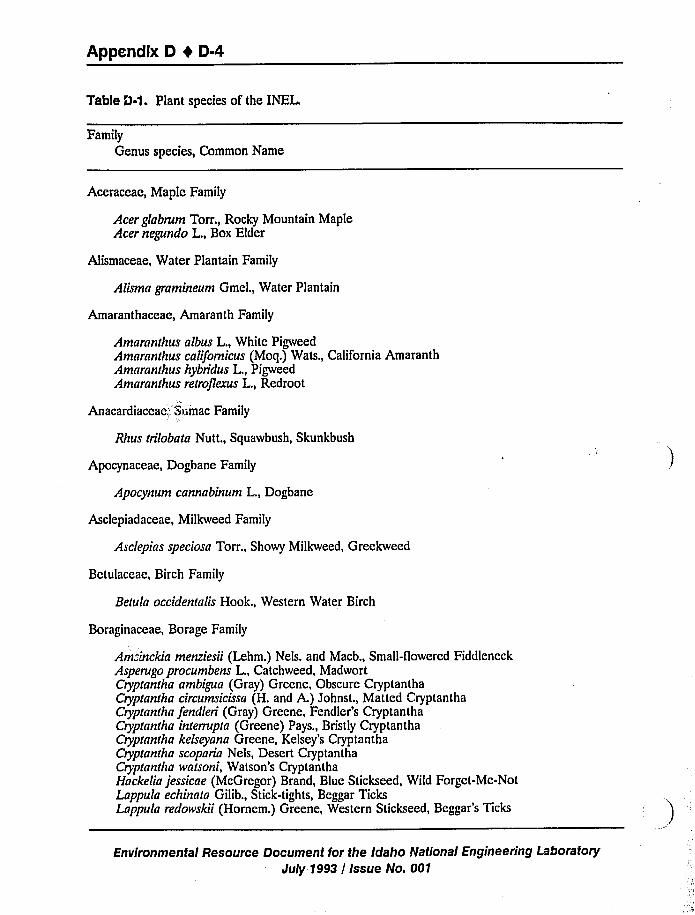
Appendix D 0 0-4
Table 0-1. Plant species of the INEL
Family
Genus species, Common Name
Aceraceae, Maple Family
Acer glabrum Torr., Rocky Mountain MapleAcer negundo L., Box Elder
Alismaceae, Water Plantain Family
Alisma gramineum Gmel., Water Plantain
Amaranthaceae, Amaranth Family
Amaranthus albus L., White PigweedAmaranthus californicus (Moq.) Wats., California AmaranthAmaranthus hybridus L., PigweedAmaranthus retroflexus L., Redroot
Anacardiaceae„Sumac Family
thus trilobata Nutt., Squawbush, Skunkbush
Apocynaceae, Dogbane Family
Apocynum cannabinum L., Dogbane
Asclepiadaceae, Milkweed Family
Asclepias speciosa Torr., Showy Milkweed, Greekweed
Betulaceae, Birch Family
Betula occidentalis Hook., Western Water Birch
Boraginaceae, Borage Family
Ams!nckia menziesii (Lehm.) Nels. and Macb., Small-flowered FiddleneckAsperugo procumbens L., Catchweed, MadwortCryptantha ambigua (Gray) Greene, Obscure CryptanthaCryptantha circumsicissa (H. and A.) Johnst., Matted CryptanthaCryptantha fendleri (Gray) Greene, Fendler's CryptanthaCryptantha interrupta (Greene) Pays., Bristly CryptanthaCryptantha kelseyana Greene, Kelsey's CryptanthaCryptantha scoparia Nels, Desert CryptanthaCryptantha watsoni, Watson's CryptanthaHackelia jessicae (McGregor) Brand, Blue Stickseed, Wild Forget-Mc-NotLappula echinata Gilib., Stick-tights, Beggar TicksLappula redowskii (Hornem.) Greene, Western Stickseed, Beggar's Ticks
Environmental Resource Document for the Idaho National Engineering Lahoratoqr
July 1993 / Issue No. 001
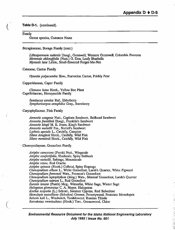
Appendix D t D-5
Table D-1. (continued).
FamilyGenus species, Common Name
Boraginaceae, Borage Family (cont.)
Lithospermum ruderale Dougl., Gromwell, Western Gromwell, Columbia PuccoonMertensia oblongifolia (Nutt.) G. Don, Leafy BluebellsMyosotis laxa Lehm., Small-flowered Forget-Me-Not
Cataceae, Cactus Family
Opuntia polyacantha Haw., Starvation Cactus, Prickly Pear
Capparidaceae, Caper Family
Clemone lutea Hook., Yellow Bee PlantCaprifoliaceae, Honeysuckle Family
Sambucus cerulea Raf., ElderberrySymphoricarpos oreophilus Gray., Snowberry
Caryophyllaceae, Pink Family
Arennrin congesta Nutt., Capitate Sandwort, Ballhead SandwortArennria franklinii Dougl., Franklin's SandwortArennrin kingii M. E. Jones, King's SandwortArennrin nuuallii Pax., Nuttall's SandwortLychnis apetala L., Catchfly, CampionSilene douglasii Hook., Catchfly, Wild PinkSilene menziesii Hook., Catchfly, Wild Pink
Chcnopndiaceae, Gooscfoot Family
Atriplex cnnescens (Pursh) Nutt., WingscaleAtriplex confertifolia, Shadscale, Spiny SaltbushAtriplex nuttallii, Saltsage, MoundscaleAtriplex rosea, Rcd OracheAtriplex spinosa (Hook.) Collotzi, Spiny HopsageChenopodium nlbum L., White Goosefoot, Lamb's Quarter, White PigweedChenopodium fremontii Wats., Fremont's GoosefootChenopodium leptophyllum (Mog.) Wats., Slimleaf Goosefoot, Lamb's QuarterChenopodium rubrum L., Red GoosefootEurotin lannta (Pursh) Mog., Winterfat, White Sage, Winter SageHnlogeton glomeratus C. A. Meyer, HalogetonKochin scopnria (L.) Schrad., Summer Cypress, Red BelvedereMonolepis nuunllinnn (Schultes) Greene, Povertyweed, Prostrate MonolcpsisSalsola knli L., Windwitch, Tumbleweed, Russian ThistleSnrcobntus vermiculntus (Hook.) Torr., Greasewood, Chico
Environmental Resource Document for the Idaho National Engineering LaboratoryJuly 1993 I Issue No. 001
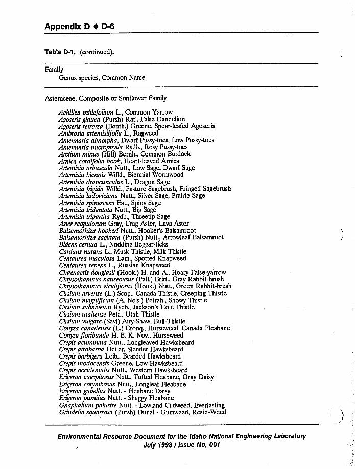
Appendix D 0 D-6
Table D-1 ~ (continued).
Family
Genus species, Common Name
Asteraceae, Composite or Sunflower Family
Achillea millefolium L., Common YarrowAgoseris glauca (Pursh) Raf., False DandelionAgoseris retrorsa (Benth.) Greene, Spear-leafed AgoserisAmbrosia artemisiifolia L., RagweedAntennaria dimorpha, Dwarf Pussy-toes, Low Pussy-toesAntennaria microphylla Rydb., Rosy Pussy-toesArctium minus (Hill) Bernh., Common BurdockArnica cordifolia hook, Heart-leaved ArnicaArtemisia arbuscula Nutt., Low Sage, Dwarf SageArtemisia biennis Willd., Biennial WormwoodArtemisia drancunculus L., Dragon SageArtemisia frigida Willd., Pasture Sagebrush, Fringed SagebrushArtemisia ludoviciana Nutt., Silver Sage, Prairie SageArtemisia spinescens Eat., Spiny SageArtemisia tridentata Nutt., Big SageArtemisia tripartita Rydb., Threetip SageAster scopulorum Gray, Crag Aster, Lava AsterBalsamorhiza hookeri Nutt., Hooker's BalsamrootBalsamorhiza sagittata (Pursh) Nutt., Arrowleaf BalsamrootBidens cernua L., Nodding Beggar-ticksCarduus nutans L., Musk Thistle, Milk ThistleCentaurea maculosa Lam., Spotted KnapweedCentaurea repens L., Russian KnapweedChaenactis douglasii (Hook.) H. and A., Hoary False-yarrowChrysothamnus nauseousus (Pall.) Britt., Gray Rabbit brushChrysothamnus vicidiflorus (Hook.) Nutt., Green Rabbit-brushCirsium arvense (L.) Scop., Canada Thistle, Creeping ThistleCirsium magnificum (A. Nels.) Petrah., Showy ThistleCirsium subni»eum Rydb., Jackson's Hole ThistleCirsium utahense Petr., Utah ThistleCirsium»ulgare'Savi) Airy-Shaw, Bull-ThistleConyza canadensis (L.) Cronq., Horseweed, Canada FleabaneConyza floribunda H. B. K. Nov., HorseweedCrepis acuminnta Nutt., Longleaved HawksbeardCrepis atrabarba Heller, Slender HawksbeardCrepis barbigera Leib., Bearded HawksbeardCrepis modocensis Greene, Low HawksbeardCrepis occidentalis Nutt., Western HawksbeardErigeron caespitosus Nutt., Tufted Fleabane, Gray DaisyErigeron corymbosus Nutt., Longleaf FleabaneErigeron gabellus Nutt. - Fleabane DaisyErigeron pumilus Nutt. - Shaggy HeabaneGnaphalium palustre Nutt. - Lowland Cudweed, EverlastingGrindelia squarrosa (Pursh) Dunal - Gumweed, Resin-Weed
Environmental Resource Document for the Idaho National Engineering Laboratory
July 1993 / Issue No. 001
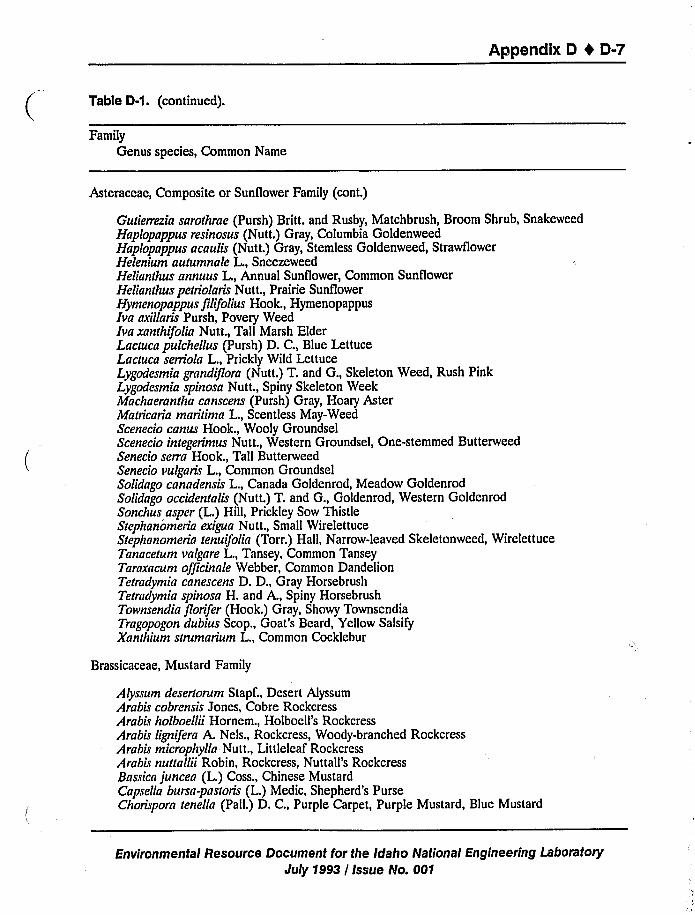
Appendix D 1 D-7
Table D-1 ~ (continued).
FamilyGenus species, Common Name
Asteraceae, Composite or Sunflower Family (cont.)
Snakeweed
ttuce
Gutierrezia sarothrae (Pursh) Britt. and Rusby, Matchbrush, Broom Shrub,Haplopappus resinosus (Nutt.) Gray, Columbia GoldenweedHaplopappus acaulis (Nutt.) Gray, Stemless Goldenweed, StrawflowerHelenium autumnale L., SneezeweedHelianthus annuus L., Annual Sunflower, Common SunflowerHelianthus petriolaris Nutt., Prairie SunflowerHymenopappus filifolius Hook., HymenopappusIva axillaris Pursh, Povery WeedIva xanthifolia Nutt., Tall Marsh ElderLactuca pulchellus (Pursh) D. C., Blue LettuceLactuca serriola L., Prickly Wild LettuceLygodesmia grandiflora (Nutt.) T. and G., Skeleton Weed, Rush PinkLygodesmia spinosa Nut t., Spiny Skeleton WeekMachaerantha canscens (Pursh) Gray, Hoary AsterMatricaria maritima L., Scentless May-WeedScenecio canus Hook., Wooly GroundselScenecio integerimus Nutt., Western Groundsel, One-stemmed ButterweedSenecio serra Hook., Tall ButterweedSenecio vulgaris L., Common GroundselSolidago canadensis L., Canada Goldenrod, Meadow GoldenrodSolidago occidentalis (Nutt.) T. and G., Goldenrod, Western GoldenrodSonchus asper (L.) Hill, Prickley Sow ThistleStephanomeria exigua Nutt., Small WirelettuceStephanomeria tenuifolia (Torr.) Hall, Narrow-leaved Skeletonweed, WireleTanacetum valgare L., Tansey, Common TanseyTaraxacum officinale Webber, Common DandelionTetradymia canescens D. D., Gray HorsebrushTetradymia spinosa H. and A., Spiny HorsebrushTownsendia florifer (Hook.) Gray, Showy TownsendiaTragopogon dubius Scop., Goat's Beard, Yellow SalsifyXanthium strumarium L., Common Cocklebur
Brassicaceae, Mustard Family
Alyssum desertorum Stapf., Desert AlyssumArabis cobrensis Jones, Cobre RockcressArabLr holboellii Hornem., Holboell's RockcressArabis lignifera A. Nels., Rockcress, Woody-branched RockcressArabis microphylla Nutt., Littleleaf RockcressArabis nuaallii Robin, Rockcress, Nuttall's RockcressBassica juncea (L.) Coss., Chinese MustardCapsella bursa-pastoris (L.) Medic, Shepherd's PurseChorispora tenella (Pall.) D. C., Purple Carpet, Purple Mustard, Blue Mustard
Environmental Resource Document for the Idaho National Engineering Laboratory
July 1993 / Issue No. 001
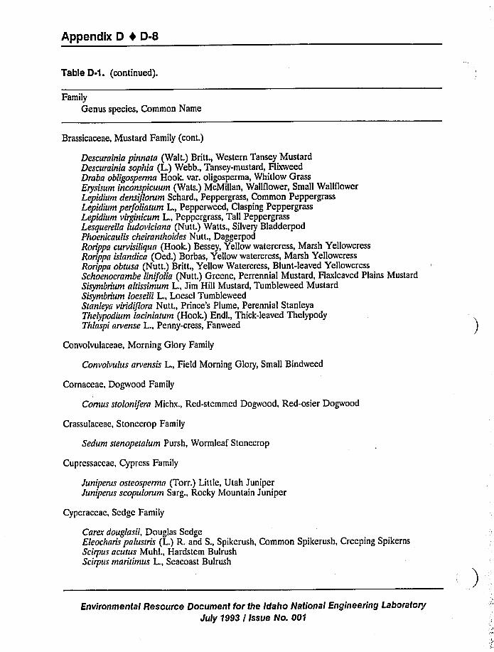
Appendix D I D-8
Table 0-1. (continued).
Family
Genus species, Common Name
Brassicaceae, Mustard Family (cont.)
Descurainia pinnatn (Walt.) Britt., Western Tansey MustardDescurainia sophia (L.) Webb., Tansey-mustard, FlixweedDraba obligosperma Hook. var. oligosperma, Whitlow GrassErysisum inconspicuum (Wats.) McMillan, Wallflower, Small Wallflower
Lepidium densiflorum Schard., Peppergrass, Common PeppergrassLepidium perfoliatum L., Pepperweed, Clasping PeppergrassLepidium virginicum L., Peppergrass, Tall PeppergrassLesquerella ludo»icinna (Nutt.) Watts., Silvery BladderpodPhoenicaulis cheiranthoides Nutt., DaggerpodRorippa curvisiliqun (Hook.) Bessey, Yellow watercress, Marsh Yellowcress
Rorippa islandica (Oed.) Borbas, Yellow watercress, Marsh Yellowcress
Rorippa obtusa (Nutt.) Britt., Yellow Watercress, Blunt-leaved YellowcressSchoenocrambe linifolia (Nutt.) Greene, Perrennial Mustard, Flaxleaved Plains Mustard
Sisymbrium altissimum L., Jim Hill Mustard, Tumbleweed MustardSisymbrium loeselii L., Loesel TumbleweedStnnleya viridiflora Nutt., Prince's Plume, Perennial StanleyaThelypodium laciniatum (Hook.) Endl., Thick-leaved ThelypodyThlaspi arvense L., Penny-cress, Fanweed
Convolvulaceae, Morning Glory Family
Convolvulus nrvensis L., Field Morning Glory, Small Bindweed
Cornaceae, Dogwood Family
Comus stolonifera Michx., Red-stemmed Dogwood, Red-osier Dogwood
Crassulaceac, Stonecrop Family
Sedum stenopetnlum Pursh, Wormleaf Stonecrop
Cuprcssaccae, Cypress Family
Juniperus osteosperma (Torr.) Little, Utah JuniperJuniperus scopulorum Sarg., Rocky Mountain Juniper
Cypcraccac, Scdgc Family
Carex douglasii, Douglas SedgeEleochans pnlustris (L.) R. and S., Spikerush, Common Spikerush, Creeping SpikernsScirpus acutus Muhl., Hardstem BulrushScirpus maritimus L., Seacoast Bulrush
Environmental Resource Document for the Idaho National Engineering Laboratory
July 1993 / Issue No. 00f
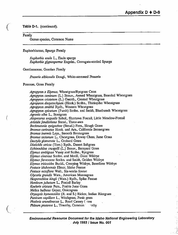
Appendix D 4 D-9
Table D-1. (continued).
Family
Genus species, Common Name
Euphorbiaceae, Spurge Family
Euphorbia esula L., Esula spurgeEuphorbia glyptosperma Engelm., Corrugate-seeded Spurge
Gentianaceae, Gentian Family
Fraseria albicaulis Dougl., White-stemmed Fraseria
Poaceae, Grass Family
Agropyron x Elymus, Wheatgrass/Ryegrass Cross
Agropyron caninum (L.) Beauv., Awned Wheatgrass, Bearded Wheatgrass
Agropyron cristatum (L.) Gaerth., Crested Wheatgrass
Agropyron dasystachyum (Hook.) Scribn., Thickspike Wheatgrass
Agropyron smithii Rydb., Western Wheatgrass
Agropyron spicatum (Pursh) Scribn. and Smith, Bluebunch WheatgrassAgrostis alba L., BentgrassAlopecurus aequalis Sobol., Shortawn Foxtail, Little Meadow-FoxtailAristida fendleriana Stend., Three-awnBeckmannia syzigachne (Steud.) Fern., Slough GrassBromus carinatus Hook. and Arn., California BromegrassBromus inermis Leys., Smooth BromegrassBromus tectorum L., Cheatgrass, Downy Chess, June GrassDactylis glomerata L., Orchard GrassDistichlis stricta (Torr.) Rydb., Desert SaltgrassEchinochloa crusgalli (L.) Beauv., Barnyard GrassElymus ambiguus Vasey and Scribn., RyegrassElymus cinereus Scribn. and Merill, Giant Wildrye
Elymusflavescens Scribn. and Smith, Golden WildryeElymus triticoides Buckl., Creeping Wildrye, Beardless WildryeFestuca idahoensis Elmer, Idaho FescueFestuca octoflora Walt., Six-weeks fescueGlyceria grandis Wats., American MannagrassHesperochloa kingii (Wats.) Rydb., Spike FescueHordeum jubatum L., Foxtail BarleyKoeleria cristata Pers., Prairie June GrassMelica bulbosa Geyer, OniongrassOryzopsis hymenoides (R. and S.) Ricker, Indian RicegrassPanicum capillare L., Witchgrass, Panic grassPhalaris arundinacea L., Reed Canary C rass
Phleum pratense L., Timothy, Common 'thy
Environmental Resource Oocument for the Idaho National Engineering LaboratorySuly 1993 / Issue No. 001
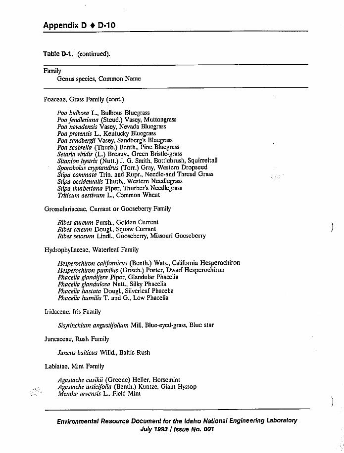
Appendix D I D-10
Table D-1. (continued).
Family
Genus species, Common Name
Poaceae, Grass Family (cont.)
Poa bulbosn L., Bulbous BluegrassPon fendleriana (Steud.) Vasey, MuttongrassPon nevadensis Vasey, Nevada BluegrassPoa prarensis L., Kentucky BluegrassPoa sandbergii Vasey, Sandberg's BluegrassPoa scabrella (Thurb.) Benth., Pine BluegrassSelaria viridis (L.) Breauv., Green Bristle-grassSiranion hysrrix (Nutt.) J. G. Smith, Bottlebrush, SquirreltailSporobolus cryprandrus (Torr.) Gray, Western DropseedStipa commnra Trin. and Rupr., Needle-and Thread GrassSdpn occidentalis Thurb., Western NeedlegrassSdpa Ihurberiana Piper, Thurber's NeedlegrassTriticum aesdvum L., Common Wheat
Grossulariaceae, Currant or Gooseberry Family
Ribes nureum Pursh., Golden CurrentRibes cereum Dougl., Squaw CurrantRibes setosum Lindl., Gooseberry, Missouri Gooseberry
Hydrophyllaceae, Waterleaf Family
Hesperochiron californicus (Benth.) Wats., California HcsperochironHesperochiron pumilus (Griseb.) Porter, Dwarf HesperochironPhacelin glandifera Piper, Glandular PhaceliaPhacelia glnndulosn Nutt., Silky PhaceliaPhncelia hasrnra Dougl., Silverleaf PhaceliaPhacelia humilis T. and G., Low Phacelia
Iridaceae, Iris Family
Sisyrinchium nngusufolium Mill, Blue-eyed-grass, Blue star
Juncaceae, Rush Family
Juncus baldcus Willd., Baltic Rush
Labiatae, Mint Family
Agastache cusikii (Greene) Heller, HorsemintAgnstnche urticifolin (Benth.) Kuntze, Giant HyssopMentha arvensis L., Field Mint
Environmental Resource Document for the Idaho National Engineering Laboratory
July 1993 / Issue No. 001
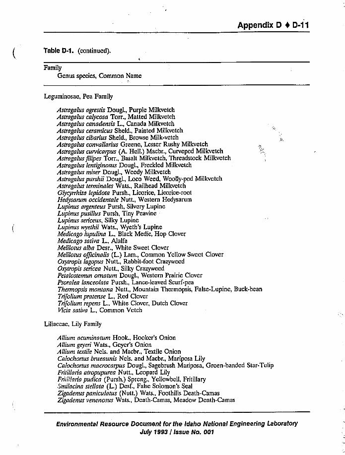
Appendix D 4 D-11
Table D-1. (continued).
Family
Genus species, Common Name
Leguminosae, Pea Family
Astragalus agrestis Dougl., Purple MilkvetchAstragalus calycosa Torr., Matted MilkvetchAstragalus canadensis L., Canada MilkvetchAstragalus ceramicus Sheld., Painted MilkvetchAstragalus cibarius Sheld., Browse Milk-vetchAstrngalus convallarius Greene, Lesser Rushy MilkvetchAstragalus curvicarpus (A. Hell.) Macbr., Curvepod MilkvetchAstrngnlus filipes Torr., Basalt Milkvetch, Threadstock MilkvctchAstragalus lentiginosus Dougl., Freckled MilkvetchAstrngalus miser Dougl., Weedy MilkvetchAstragalus purshii Dougl., Loco Weed, Woolly-pod MilkvetchAstragalus terminnles Wats., Railhead MilkvetchGlycyrrhiza lepidota Pursh., Licorice, Licorice-rootHedysnrum occidentnle Nutt., Western HedysarumLupinus argenteus Pursh, Silvery LupineLupinus pusillus Pursh, Tiny PeavineLupinus sericeus, Silky LupineLupinus wyethii Wats., Wyeth's LupineMedicngo lupulina L., Black Medic, Hop CloverMedicago sativa L., AlalfaMelilotus alba Desr., White Sweet CloverMelilotus officinalis (L.) Lam., Common Yellow Sweet CloverOxytropis lagopus Nutt., Rabbit-foot CrazyweedOxytropis sericea Nutt., Silky CrazyweedPetnlostemun ornntum Dougl., Western Prairie CloverPsoralea lnnceolnta Pursh., Lance-leaved Scurf-peaThermopsis montana Nutt., Mountain Thermopsis, False-Lupine, Buck-beanTrifolium prntense L., Red CloverTrifolium repens L., White Clover, Dutch CloverVicin sativa L., Common Vetch
Liliaccae, Lily Family
Allium acuminatum Hook., Hooker's OnionAllium geyeri Wats., Geyer's OnionAllium textile Nels. and Macbr., Textile OnionCnlochortus brueaunis Nels. and Macbr., Mariposa LilyCalochortus macrocnrpus Dougl., Sagebrush Mariposa, Green-banded Star-TulipFritillaria atropupuren Nutt., Leopard LilyFrii/Ynrin pudica (Pursh.) Spreng., Yellowbell, FritillaryS'milncinn stellnta (L.) Dcsf., False Solomon's SealZigndenus paniculatus (Nutt.) Wats., Foothills Death-CamasZigadenus venenosus Wats., Death-Camas, Meadow Death-Camas
Environmental Resource Document for the Idaho National Engineering Laboratory
July 1993 / Issue No. 001
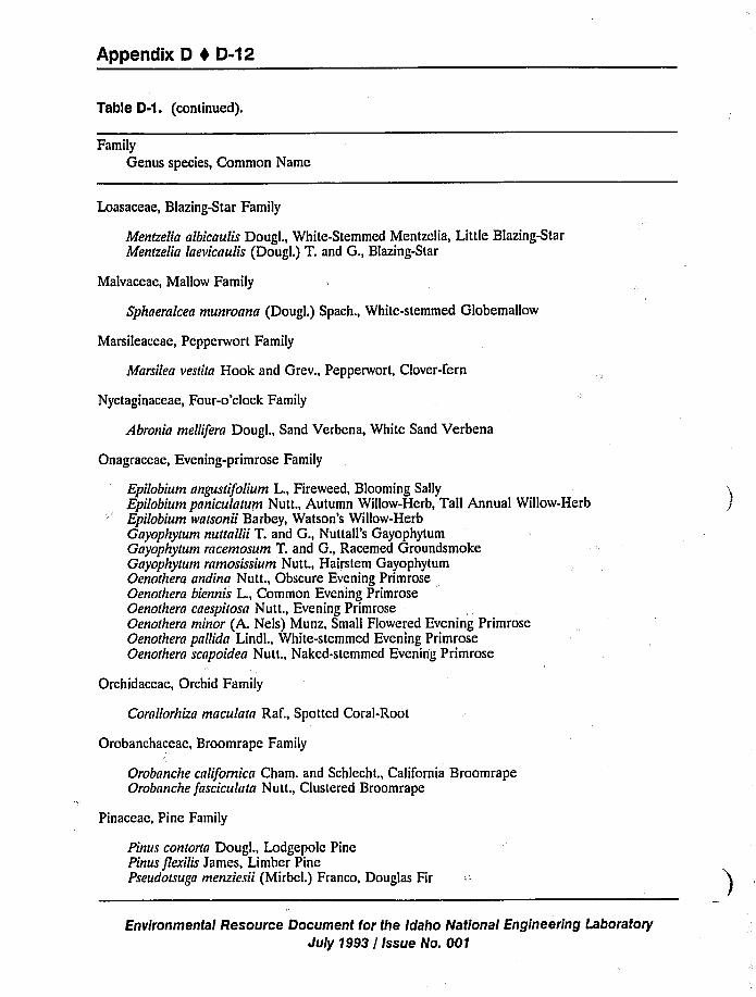
Appendix D 4 D-12
Table D-1. (continued).
Family
Genus species, Common Name
Loasaceae, Blazing-Star Family
Menlzelia albicaulis Dougl., White-Stemmed Mentzelia, Little Blazing-StarMentzelia laevicnulis (Dougl.) T. and G., Blazing-Star
Malvaceae, Mallow Family
Sphaeralcea munroana (Dougl.) Spach., White-stemmed Globemallow
Marsileaceae, Pepperwort Family
Marsilea veslila Hook and Grev., Pepperwort, Clover-fern
Nyctaginaceae, Four-o'lock Family
Abronia mellifern Dougl., Sand Verbena, White Sand Verbena
Onagraceae, Evening-primrose Family
Epilobium angusu'folium L., Fireweed, Blooming SallyEpilobium paniculatum Nutt., Autumn Willow-Herb, Tall Annual Willow-HerbEpilobium walsonii Barbey, Watson's Willow-HerbGayophyrum nuunllii T. and G., Nuttall's GayophytumGayophylum rncemosum T. and G., Racemed GroundsmokeGayophyrum ramosissium Nutt., Hairstem GayophytumOenothera andinn Nutt., Obscure Evening PrimroseOenorhera biennis L., Common Evening PrimroseOenothern cnespirosa Nutt., Evening PrimroseOenorhera minor (A. Nels) Munz, Small Flowered Evening PrimroseOenothera pallida Lindl., White-stemmed Evening PrimroseOenorhern scnpoidea Nutt., Naked-stemmed Evening Primrose
Orchidaceae, Orchid Family
Cornllorhizn macularn Raf., Spotted Coral-Root
Orobanchaceae, Broomrape Family
Orobanche cnlifornicn Cham. and Schlecht., California BroomrapeOrobnnche fasciculatn Nutt., Clustered Broomrape
Pinaceae, Pine Family
Pinus contortn Dougl., Lodgepole PinePinus flexilis James, Limber PinePseudotsugn menziesii (Mirbel.) Franco, Douglas Fir
Environmental Resource Document for the Idaho National Engineering Laboratory
July 1993 / Issue No. 001
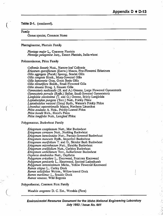
Appendix D I D-13
Table 0-1. (continued).
Family
Genus species, Common Name
Plantaginaceae, Plantain Family
Plantago major L., Common PlantainPlantago patagonica Jacq., Desert Plantain, India-wheat
Polemoniaceae, Phlox Family
Collomia linearis Nut t., Narrow-leaf CollomiaEriastrum sparsijlorum (Eastw.) Mason, Few-Flowered EriastrumGilia aggregata (Pursh) Spreng., Scarlet GiliaGilia congesta Hook., Many-flowered GiliaGilia leptomeria Gray, Great Basin GiliaGilin minutiflora Benth., Small Flowered GiliaGilia sinuata Doug. i, Sinuate GiliaGymnosteris nudicaulis (H. and A.) Greene, Large Flowered GymnosterisGymnosteris pnrvula (Rydb.) Heller, Small-flowered GymnosterisLnngloisia setosissima (T. and G.) Greene, Bristly LangloisiaLeptodactylon pungens (Torr.) Nutt., Prickly PhloxLeptodnctylon eatsoni (Gray) Rydb., Watson's Prickly PhloxLinanthus septentrionalis Mason, Northern LinanthusPhlox nculentn A. Nels., Prickly-Leaved PhloxPhlox hoodii Rich., Hood's PhloxPhlox longifolia Nutt., Longleaf Phlox
Polygonaceae, Buckwheat Family
Eriogonum cnespitosum Nutt., Mat BuckwheatEriogonum cemuum Nutt., Nodding BuckwheatEriogonum herncleoides Nut t., Parsnip-flowered BuckwheatEriogonum mnncum Rydb., Imperfect BuckwheatEriogonum mnrifolium T. and G., Slender Bush BuckwheatEriogonum microthecum Nutt., Shrubby BuckwheatEriogonum ovalifolium Nutt., Cushion BuckwheatEriogonum umbellatum Torr., Sulfurflower BuckwheatOxytheca dendroidea Nutt., OxythecaPolygonum aviculnre L., Doorweed, Prostrate KnotweedPolygonum persicnrin L., Heartweed, Spotted LadysthumbPolygonum rnmosissimum Michx., Yellow Flowered KnotweedRumex crbpus L., Curley DockRumex snlicifolius Weinm., Willow-leaved DockRumex maritimus L., Seaside DockRumex venosus, Wild Begonia
Polypodiaceae, Common Fern Family
Woodsia oregnnna D. C. Eat., Woodsia (Fern)
Environtnental Resource Document for the Idaho National Engineering LaboratoryJuly 7993 / Issue No. 001
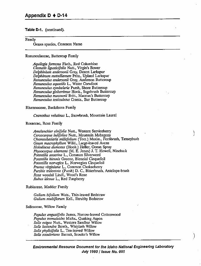
Appendix D 0 0-14
Table 0-1. (continued).
FamilyGenus species, Common Name
Ranunculaceae, Buttercup Family
Aquilegia formosa Fisch., Red ColumbineClematis ligusticifolia Nutt., Virgin's BowerDelphinium andersonii Gray, Desert LarkspurDelphinum nuttallianum Pritz., Upland LarkspurRanunculus andersonii Gray, Anderson ButtercupRanunculus aquatilis L., Water CorwfootRanunculus cymbalaria Pursh, Shore ButtercupRanunculus glaberrimus Hook., Sagebrush ButtercupRanunculus macounii Britt., Macoun's ButtercupRanunculus testiculatus Crantz., Bur Buttercup
Rhamnaceae, Buckthorn Family
Ceanothus velutinus L., Snowbrush, Mountain Laurel
Rosaceae, Rose Family
Amelanchier alnifolia Nutt., Western ServiceberryCercocarpus ledifolius Nutt., Mountain MahagonyChamaebatiaria millefoiium (Torr.) Maxim., Fernbrush, TanseybushGeum macrophyilum Willd., Large-leaved AvensHolodiscus dumosus (Hook.) Heller, Ocean SprayPhysocarpus altemans (M. E. Jones) J. T. Howell, NinebarkPotentilla anserina L., Common SilverweedPotentilla biennis Greene, Biennial CinquefoilPotentilla norvegica L., Norwegian CinquefoilPrunus virginiana L., Common ChokecherryPurshia tridentata (Pursh) D. C., Bitterbrush, Antelope-brushRosa woodsii Lindl., Wood's RoseRubus ideaus L., Red Raspberry
Rubiaceae, Madder Family
Galium bifolium Wats., Thin-leaved BedstrawGalium multiflorum Kell., Shrubby Bedstraw
Salicaceae, Willow Family
Populus angustifolia James, Narrow-leaved CottonwoodPopulus tremuloides Michx., Quaking AspenSalir exigua Nutt., Western Sandbar WillowSalir lasiandra Benth., Whiplash WillowSalir phylicifolia L., Tea-leaved WillowSalix scouleriana Barratt, Scouler's Willow
Environmental Resource Document for the Idaho National Engineering Laboratory
July 1993 / Issue No. 001
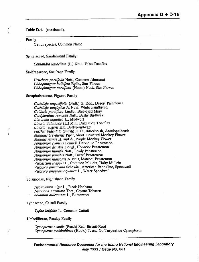
Appendix D 4 D-15
Table 0-1.'continued).
Family
Genus species, Common Name
Santalaceae, Sandalwood Family
Comandra umbellata (L.) Nutt., False Toadflax
Saxifragaceae, Saxifrage Family
Heuchera parvifolia Nutt., Common AlumrootLithophragma bulbifera Rydb., Star HowerLithophragma parviflora (Hook.) Nutt., Star Flower
Scrophularaceae, Figwort Family
Castelleja angustifolia (Nutt.) G. Don., Desert PaintbrushCastelleja longispica A. Nels., White PaintbrushCollinsia parviflora Lindle., Blue-eyed MaryCordylanthus ramosus Nutt., Bushy BirdbeakLimosella aquatica L., MudwortLinaria dalmatica (L.) Mill., Dalmation ToadflaxLinaria vulgaris Hill, Butter-and-eggsPurshia tridentata (Pursh) D. C., Bitterbrush, Antelope-brushMimulus breviflorus Piper, Short Howered Monkey HowerMinulus nanus H. and A., Purple Monkey FlowerPenstemon cyaneus Pennell, Dark-blue PenstemonPenstemon deustus Dougl., Hot-rock PenstemonPenstemon humilis Nutt., Lowly PenstemonPenstemon pumilus Nutt., Dwarf PenstemonPenstemon radicosus A. Nels, Matroot PenstemonVerbascum thapsus L., Common Mullein, Hairy MulleinVeronica americana Schewin., American Brookline, SpeedwellVeronica anagallis-aquatica L., Water Speedwell
Solanaceae, Nightshade Family
Hyoscyamus niger L., Black HenbaneNicotiana anenuata Torr., Coyote TobaccoSolanum dulcamara L., Bittersweet
Typhaceae, Cattail Family
Typha latifolia L., Common Cattail
Umbellifcrae, Parsley Family
Cymopterus acaulis (Pursh) Raf., Biscuit-RootCymopterus terebinthinus (Hook.) T. and G., Turpentine Cymoptcrus
Environmental Resource Document for the Idaho National Engineering Laboratory
July 1993 / Issue No. 001
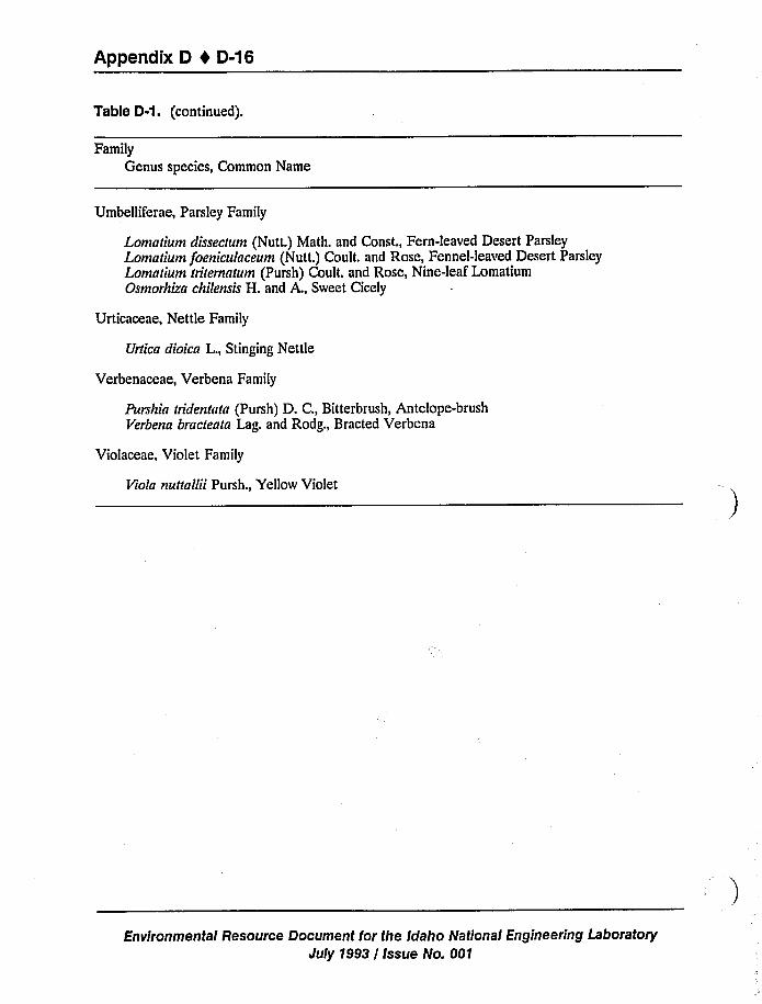
Appendix D 1 D-16
Table D-1 ~ (continued).
Family
Genus species, Common Name
Umbelliferae, Parsley Family
Lomatium dissectum (Nutt.) Math. and Const., Fern-leaved Desert ParsleyLomatium foeniculaceum (Nutt.) Coult. and Rose, Fennel-leaved Desert ParsleyLomatium tritematum (Pursh) Coult. and Rose, Nine-leaf LomatiumOsmorhiza chilensis H. and A., Sweet Cicely
Urticaceae, Nettle Family
Urtica dioica L., Stinging Nettle
Verbenaceae, Verbena Family
Purshia tridentata (Pursh) D. C., Bitterbrush, Antelope-brushVerbena bracteala Lag. and Rodg., Bracted Verbena
Violaceae, Violet Family
Viola nuttallii Pursh., Yellow Violet
Environmental Resource Document for the Idaho National Engineering Laboratory
July 1993 / Issue No. 001

Appendix D 4 D-17
Table D-2. Description of vegetative covers on the INEL.
Name Description
Juniper Woodlands Juniperus osteosperma (Utah juniper) typically dominate thiscover class; however, some areas containing junipers aredominated by Artemisia tridentata ssp. wyomingensis and Artemisianova. Even when not dominant, these two species were also veryabundant on other juniper stands. The areas used tocharacterize this community indicate that there is not a singlespecies association characterized by the presence of juniper.
The "Lava" and the "Sagebrush/Low Sagebrush/Rabbitbrush onLava" cover classes may occasionally have juniper trees associatedwith them. These individual oi sparsely associated trees providenesting sites for raptors and can be important habitat for otherorganisms.
Native Grasslands Communities
Great Basin Wildrye
Steppe (bunchgrass)
This cover class includes nearly pure stands of Elymus cinereus(Great Basin wildrye) that occur on low lying areas between lava
ridges where deep soils accumulate. Artemisia tridentata ssp.wyomingensis and Chrysothamnus viscidiflorus or Chrysothamnusnauseosus are typically present. Descurainia sophia is common in
the understory. Some other native grasslands will occasionally beconfused with this class on the vegetation map (see next 2groups).
This cover class includes areas dominated by native bunchgrassessuch as Sitanion hystrix or Stipa comata. The annuals Bromustectorum and Sisymbrium altissimum are common andcodominants in some areas.
Grassland This cover class is dominated by rhizomatous species (e.g.Agropyron dasystachyum and Carex douglasii). They arecharacterized by the abundance of native graminoids and a sparsecover of shrubs. Common dominants include Agropyrondasystachyum, Carer douglasii. The annuals Bromus tectorum,Lappula redowski, Descurainia pinnata, and Sisymbriumallissimum are common in some areas.
Big Sagebrush Communitics
Sagebrush-Steppe off Lava This cover class is similar to the Sagebrush-Steppe on Lava classdescribed below except that the communities are located off thelava flow that covers the central area of the INEL. These areastypically have deeper soils and are associated with the floodplain, alluvium deposits, sand dunes, or deposition zones for windblown materials.
Environmental Resource Document for the Idaho National Engineering LaboratoryJuly 1993 / Issue No. 001
Appendix D 0 D-18
Table 0-2. (continued).
Name Description
Sagebrush-Steppe on Lava
Basin Big Sagebrush Steppe
Wyoming Sagebrush Steppe
This cover class is characterized by the dominance ofArtemisia tridentata ssp. wyomingensis (Wyoming bigsagebrush) and Artemisia tridentata ssp. tridentata (basin bigsagebrush) and are located on the large lava flow that coversmuch of the INEL. The two primary communities addressed
by this cover class are described below.
This community is characterized by the dominance ofArtemisia tridenlata ssp. tridenlata (basin big sagebrush). Thedifferential distributions of Artemisia tridentata ssp. tridentataand Artemisia tridentata ssp. wyomingensis at the INEL arerelated to gradients of soil texture (Shumar and Anderson1986). Artemisia tridentatn ssp. tridentata occurs on sandysoils that are often deep and well drained, whereas Artemisiatridentata ssp. wyomingensis is dominant on fine-textured,shallower soils having limited depths of water penetration.At the INEL, pockets of Artemisin tridentnta ssp. tridentatawithin extensive stands of Artemisin tridentata ssp.wyomingensis occur on the lee sides of lava ridges where sandaccumulates; additionally, extensive patches ofArtemisiatridentala ssp. tridentata as large as 65 kmz occur, mostly onthe eastern half of the area (Shumar 1983). Aside from thedominance of Artemisin tridentnta ssp. tridenlala, thesecommunities do not have a unique species composition.Rather, they share the suite of subordinate species found in
the other big sagebrush communities. Transitional standsco-dominated by both subspecies of big sagebrush arecommon between stands dominated by one subspecies or theother. It appears unlikely that it will bc possible to separatecommunities dominated by the two the subspecies ofArtemisia lridentntn using Landsat imagery.
This community is characterized by the dominance ofArlemisia tridentata ssp. wyomingensis (Wyoming bigsagebrush). It is similar to the Basin Big Sagebrush Steppecommunity described above, except that native perennialbunchgrasses are much more abundant in these areas.Bromus tectorum was rare or absent, in contrast to the BasinBig Sagebrush Steppe community. Artemisin tridentala ssp.wyomingensis and Chrysothamnus viscidiflorus weredominants, but the combined cover of perennial bunchgrasseswas similar to that of the shrubs.
Environmental Resource Document for the Idaho National Engineering Laboratory
July 1993 / Issue No. 001
Appendix D 4 D-19
Table 0-2. (continued).
Name Description
Sagebrush-Winterfat Most of these areas are dominated by Artemisia tridentata ssp.wyomingensis; Ceratoides lanata is present on these areas andoften abundant. It is dominant or co-dominant on a few areas.Chrysothamnus viscidiflorus is common, as are members of thesuite of native perennial grasses, especially Oryzopsishymenoides. Native forbs are abundant. Bromus tectorum wasnot recorded on any of these areas. Most of these areasappear to be intermediate between the Salt Desert Shrub andSagebrush/Rabbitbrush communities. This may reflect agradient from upland loess soils to the more halomorphiclacustrine soils of prehistoric Lake Terreton. Native grassesare abundant at some areas.
Salt Desert Shrub This cover class consists of several communities; three aredescribed below:
Nuttall Saltbush
Shadscale
Winterfat
This community is dominated by suffrutescent shrubs, Atriplexnuttallii (Nuttall saltbush) and Eriogonum microthecum(shrubby buckwheat) and Ceratoides lanata (winterfat).This community is dominated by Alriplex confertifolia(shadscale). Chrysothamnus viscidiflorus (green rabbitbrush)and Ceratoides lanata were common shrubs. Atriplex nuttalliiis also present.This community is dominated by Ceratoides lanata, but Atriplexcanescens (four-wing saltbush) is also common. No perennialgrasses and only two forbs were recorded on the sample site(only four species were found at the plot).
Most of the salt desert shrub communities have a highpercentage of bare ground, so it is likely that areas supportingsuch communities will be classified as "Salt Desert Shrub" or"Playa-Bare Ground" depending on the spectral properties ofthe soil and percent cover of the vegetation.
Sagebrush/Rabbitbrush This cover class includes areas that are dominated by Anemisiatridentata ssp. ivyomingensis and/or Chrysothamnus viscidiflorus.Most of these areas have a fairly rich understory of nativeperennial grasses and forbs. Bromus tectorum was observed inthese areas and was moderately to very abundant on most.This cover class occurs both on and off of lava flows.
Sagebrush/Low Sagebrush/Rabbitbrush on Lava
These areas are characterized by the presence of Artemisianova (black sagebrush), though generally it is not dominant.Chrysothamnus viscidiflorus and Gutierrezia sarothrae arecommon. Artemisia tridentata ssp. wyomingensis and Ceratoideslanata are also present in some areas. Generally, nativegrasses and forbs are abundant.
Environmental Resource Document for the Idaho National Engineering LaboratoryJuly 1993/ Issue No. 001
Appendix D 4 D-20
Table D-2. (continued).
Name Description
Wetlands
Playa/Bare ground
Lava
Old Fields, DisturbedCommunities,and Seedings
Summer Cypress
Saltbush-Grass
These areas on the vegetation map are south of the Big Lost River Sinks,in locations that are periodically flooded. Eleocharis palustris (commonspike-rush) was dominant. Some locations had been a cattail (Typhalatifolia) marsh in the early to mid 1980's; it is likely that this is arecurring marsh during periods of above average precipitation. Agropyronsmithii was also common in some areas. Species diversity is very low.
The wetlands delineated by the FWS include the wetlands on thevegetation map, however there are other areas that may be classified asbare ground/playas that are also considered wetlands by the FWS.
This cover class includes areas that are primarily'arren and have highreflectance soils. The map may potentially confused these areas with the"Salt Desert Shrub" and "Old Fields, Disturbed Communities, andSeedings" (see below) cover classes. Some of these areas have beenmapped by the FWS as wetlands.
This class is dominated by exposed lava outcrops and rubble. Thevegetation in this class is dominated by Artemisia tridentata ssp. tridentata.Chamaebatiaria millefolia (fern-bush) and Chrysothaninus nauseosus iscommon. Chamaebatiaria millefolia is common on lava flows and alongdesert canyon walls, but is rare over most of the INEL. Only fourvascular plant species were recorded at the sample plots used forcharacterizing this cover class.
This cover class occasionally has junipers associated with it. The cracks,crevices, and cliffs also provide habitat for raptors, small and largemammals, and reptiles. There is also a greater probability forarchaeological finds in these areas.
These areas typically have exposed soils consistent with disturbed areasand playas. Recent seedings and/or those that still have a significantamount of bare ground fall into this classiTication. There will be someconfusion between this class, bunchgrass communities, and bare groundclasses on the vegetation map.
Some areas are dominated by the exotic annual, Kochia scoparia. Verbenabracteata and Iva axillaris (poverty-weed) occurred at these sites. Salsolakali (Russian thistle) was common at other locations. No perennialshrubs or grasses were recorded at these sites.
Another area in this class is dominated by Salsola kali. Kochia scopariaand Iva axillaris are common, as is the native shrub, Atriplex canescens.Agrophyron dasystachyum is present.
This cover class has not bccn adequately characterized at present. Itoccurs primarily in association with the grassland, sagcbrush-winterfat, andsagebrush-steppe off lava vegetation cover classes.
Environmental Resource Document for the Irfaho National Engineering LaboratoryJuly 1993 / Issue No. 001
Appendix D 4 D-21
Cover classes that are potentially ecologically important include juniper woodlands, lava,
sagebrush/low-sagebrush/rabbitbrush on lava, wetlands, and the grassland communities (GreatBasin wildrye, steppe, grassland). Playa areas also present features that could be important during
wet periods by collecting and holding water longer than surrounding areas. The importance ofthese communities is discussed further in Section D.1.6.
Table D-3 summarizes the 15 cover classes and associated areal extent on the INEL.Relative abundances of common species for these cover classes are summarized on Table D-3.
The classification presented is not hierarchical, nor are the groups equally distinct. Some
classes were readily recognized and quite distinct from most or all other classes (e.g., wetlands,
new lava, saltbush desert communities, disturbance communities, Great Basin wildrye). Others
were either quite heterogeneous (e.g., juniper woodlands, native grassland) or they overlapped
considerably and the distinctions are very arbitrary (e.g., the five big sagebrush communities). In
almost all cases, communities that are intermediate in species composition occur between classes
that, by themselves, are quite distinct from each other. For example Wyoming sagebrush/winterfat
communities appear to be transitional between other sagebrush classes and the saltbush desert
communities.
It is clearly evident that the vegetation at the INEL forms a continuum (Anderson 1991).The data emphasize that vegetation is a continuously varying phenomenon, a consequence of the
distribution and proportional abundance of individual species, rather than a mosaic of discrete
"types" (e.g., Whittaker 1975; Miles 1979). For the most part, plant species are distributed
independently, each according to its own requirements, characteristics, and interactions with other
species in a particular locale.
Cover classes that are potentially ecologically unique include juniper woodlands, lava,
sagebrush/low-sagebrush/rabbitbrush on lava, wetlands, and the grassland communities (GreatBasin wildrye, steppe, grassland). Playa areas also present features that could bc important during
wct periods by collecting and holding water longer than surrounding areas. Thc importance ofthese communitics is discussed further in Section D.2.
D.1.2 Fauna
Numerous animal species have been observed on the INEL including one amphibian, nine
rcptile, 184 bird, and 37 mammal species. Withdrawn from public domain since 1949, public
access has been restricted, and some areas remain relatively undisturbed. Although lists provided
here are as current as available, because of the size and diversity of INEL habitats, less commonly
occurring species may have been overlooked by some surveys (Reynolds et al. 19S6).
Environmental Resource Document for the Idaho National Engineering Laboratory
July 1993 / Issue No. 001
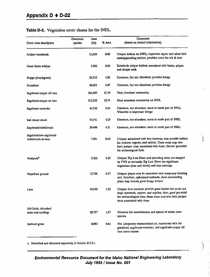
Appendix D 0 D-22
Table D-3. Vegetation cover classes for the INEL.
Cover class description
Dominant Area
species (ha) % Area
Comments
(based on limited information)
Juniper woodlands 11,620 0,88 Unique habitat on INEL; important raptor and other bird
nesting/perching habitat, provides cov.r for eik & deer
Great Basin wildrye 4,366 0,33 Relatively unique habitat; associated with basins, playas,
and deeper soils
Steppe (bunchgrass)
Grassland
24,510
88,051
1.86 Common, but not abundant; provides forage
6.67 Common, but not abundant; provides forage
Sagebrush-steppe off lava
Sagebrush-steppe on lava
Sagebrush-winterfat
366,689 27.79 Very abundant community
313,225 23.74 Most abundant community on INEL
46,732 3.54 Common, not abundant; more in north part of INEL;
Winterfat is important forage
Salt desert shrub
Sagebrush/rabhitbrush
54,741
59.490
4.15 Common, not abundant; more in north part of INEL
4.51 Common, not abundant; more in north part of INEL
Sagebrush/low sagebrush
rabbitbrush on lava 7,301 0.55 Unique: associated with lava outcrops, may provide habitat
for rodents, raptois, and rabbits; These areas may also
have juniper trees associated with them; Greater potential
for archeological finds
Wetlandsa 3.322 0.25 Unique; Big Lost River and spreading areas are mapped
by FWS as wetlands; Big Lost River has significant
vegetation (tree and shrub) and lava outcrops.
Playa/bare ground 12,738 0.97 Unique; playas may be associated with temporary flooding
and. therefore, ephemeral wetlands: Area surrounding
playa may include good forage habitat
Lava 24,028 1.82 Unique; lava outcrops provide good habitat (or small and
large mammals, raptors. and reptiles; Also, good potential
for archaeological sites; these areas may also have juniper
trees associated with them
Old fields, disturbed
areas and secdings 20,757 1.57 Potential for establishment and spread of exotic plant
species
Saltbush-grass 8,083 0.61 Not adequately characterized ye(; Associated with the
grassland, sagebrush-wintcrfat, and sagebrush-steppe off
lava cover classes
a, Described and discussed separately in Section D.2.5.1.
Environmental Resource Document for the Idaho National Engineering Laboratory
July 1993 / Issue No. 001
Appendix D 0 D-23
D.1.2.1 Mammals. Thirty-seven species of mammals have been recorded on the INEL and
are listed on Table D-4. Fourteen of these species are rodents; four are lagomorphs; six arechiropterans (bats); six are carnivores; and one, Merriam's shrew, belongs to the Insectivora. TheINEL supports resident populations of mule deer, elk, and pronghorn. Moose, mountain sheep,and mountain lion have been reported, but are species that are not generally found on the INEL(Reynolds et al. 1986). Mule deer are considered uncommon and are generally concentrated in
the southern and central portion of the INEL. They exist in greater numbers on the buttes and
mountains surrounding the INEL. At least two herds of elk resided on the INEL in 1990 (updatethis with current management results). Home ranges for the INEL elk herds encompass lands
surrounding the INEL. Pronghorn are found throughout the INEL and are considered abundant.
Most pronghorn in southeastern Idaho are migratory. This species has been the subject of anumber of studies on the INEL (generate table from bibliography). The Townsend's ground
squirrel, least chipmunk, Great Basin pocket mouse, Ord's kangaroo rat, western harvest mouse,
deer mouse, bushy-tailed wood rat, and montane vole are the most common small mammals on
the INEL. Four species of leporids occur on the INEL and all but the white-tailed jackrabbit areconsidered abundant or common (Reynolds et al. 1986).
The number of black-tailed jackrabbits on the INEL varies dramatically and periodically from
less than 0.5 to more than 142 animals/km~ (Stoddart 1983). Seven furbearing species have been
recorded on the INEL (Reynolds et al. 1986). The muskrat and beaver are confined to areas
near water and are considered rare or vary local in distribution. The coyote and long-tailed
weasel are considered common species, while the bobcat and badger are considered uncommon.
Bobcats and coyotes have both been studied at the INEL, and the abundance of these species
depends, in part, on the abundance of jackrabbits (Knick 1990; MacCracken and Hansen 1987).The spotted skunk is listed as a rare species on the INEL (Reynolds et al. 1986). The pygmy
rabbit and Townsend's big-eared bat are Federally listed as Category 2 (C2) species, and the
western pipstrelle (bat), which may exist on the INEL (Reynolds et al. 1986), is listed as a species
of special concern for the State of Idaho.
D.1.2.2 Birds. A total of 164 avian species were recorded for thc INEL in 1986 (Reynoldset al. 1986). Since then, 21 additional species have been recorded. A list of bird species
recorded on the INEL is given on Table D-5. Additional species may be present on the INELbecause over 216 avian species have been reported in southeastern Idaho in habitats similar to
those found on the INEL (Trost et al. 1977). Breeding bird surveys have been conducted through
the Radiological and Environmental Sciences Laboratory. Thirty-two species of game birds have
bccn recorded on the INEL. Twenty-six of these arc waterfowl (including American coot and
common snipe). Six upland game birds have been recorded on the INEL. Eighty-two species ofpasscrincs have bccn recorded on the INEL (Reynolds et aL 1986). The most common species
arc the horned lark, black-billed magpie, robin, sage thrasher, Brewer's sparrow, sage sparrow, and
western meadowlark.
b. Private communication with T. D. Reynolds, 1990.
Environmental Resource Document for the Idaho National Engineering Laboratory
July 1993/ Issue No. 001
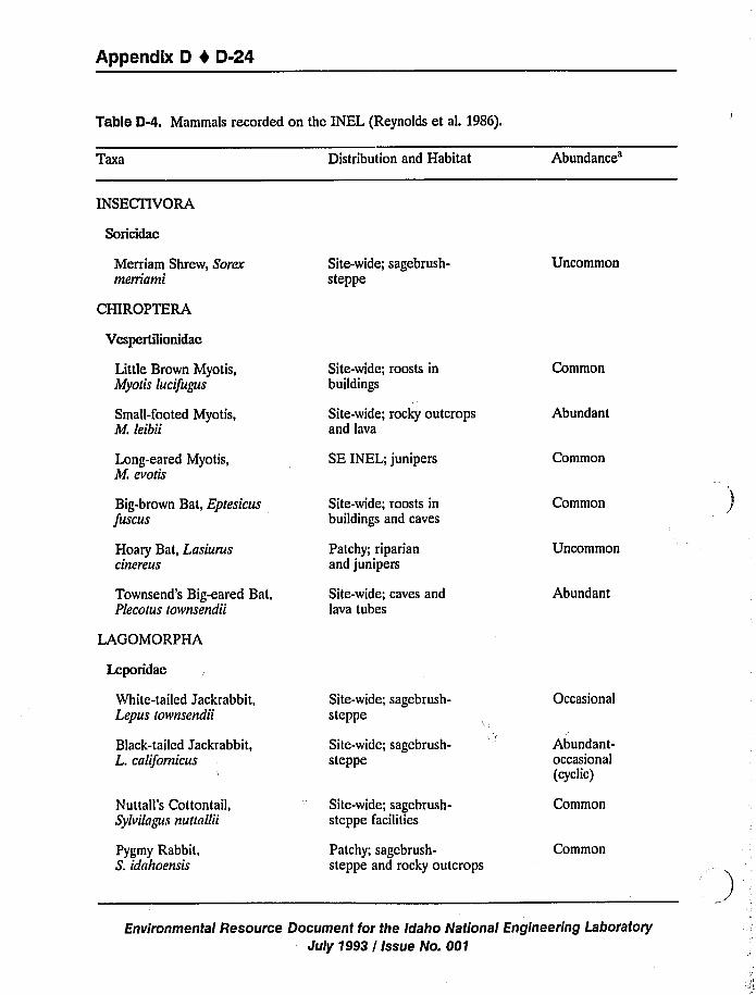
Appendix D 4 D-24
Table D-4. Mammals recorded on the INEL (Reynolds et ak 1986).
Taxa Distribution and Habitat
Abundance'NSECTIVORA
Soricidae
Merriam Shrew, Sorexmerriami
CHIROP TERA
Site-wide; sagebrush-steppe
Uncommon
Vespertilionidae
Little Brown Myotis,Myotis lucifugus
Small-footed Myotis,M. leibii
Site-wide; roosts inbuildings
Site-wide; rocky outcropsand lava
Common
Abundant
Long-eared Myotis,M. evotLs
SE INEL; junipers Common
Big-brown Bat, Eptesicusfuscus
Hoary Bat, Lasiuruscinereus
Townsend's Big-eared Bat,Plecorus rownsendii
Site-wide; roosts inbuildings and caves
Patchy; riparianand junipers
Site-wide; caves andlava tubes
Common
Uncommon
Abundant
LAGOMORPHA
Leporidae
White-tailed Jackrabbit,Lepus tovvnsendii
Black-tailed Jackrabbit,L. californicus
Site-wide; sagebrush-steppe
Site-wide; sagebrush-steppe
Occasional
Abundant-occasional(cyclic)
Nuttall's Cottontail,Sylvilagus nutlallii
Pygmy Rabbit,S. idahoensLs
Site-wide; sagcbrush-steppe facilities
Patchy; sagebrush-steppe and rocky outcrops
Common
Common
Environmental Resource Document for the Idaho National Engineering Laboratory
July 1993 / Issue No. 001
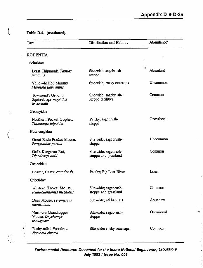
Appendix D 1 D-25
Table D-4. (continued).
TBxa Distribution and HabitatAbundance'ODENTIA
Sciuridae
Least Chipmunk, Tamiasminimus
Yellow-bellied Marmot,Marmota flaviventris
Townsend's GroundSquirrel, Spermophilustownsendii
Site-wide; sagebrush-steppe
Site-wide; rocip outcrops
Site-wide; sagebrush-steppe facilities
Abundant
Uncommon
Common
Geomyidae
Northern Pocket Gopher,Thomomys talpoides
Heteromyidae
Patchy; sagcbrush-steppe
Occasional
Great Basin Pocket Mouse,Perognalhus parvus
Site-wide; sagebrush-steppe
Uncommon
Ord's Kangaroo Rat,Dipodomys ordii
Castoridae
Site-wide; sagebrush-steppe and grassland
Common
Beaver, Castor canadensis Patchy; Big Lost River Local
Cricetidae
Western Harvest Mouse,Reithrodontomys megalotis
Deer Mouse, Peromyscusmani culatus
Site-wide; sagebrush-steppe and grassland
Site-wide; all habitats
Common
Abundant
Northern GrasshopperMouse, Onychomysleucoga ster
Bushy-tailed Woodrat,Neotoma cinerea
Site-wide; sagcbrush-steppe
Site-wide; rocky outcrops
Occasional
Common
Environmental Resource Document for the Idaho National Engineering Laboratory
July 1993 I Issue No. 001
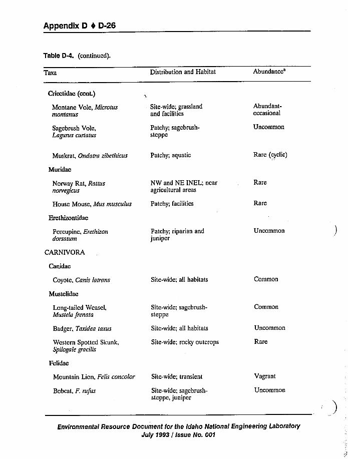
Appendix D 4 D-26
Table D-4. (continued).
Taxa Distribution and Habitat
Abundance'ricctidae
(cont.)
Montane Vole, Microtusmontanus
Site-wide; grasslandand facilitics
Abundant-occasional
Sagebrush Vole,Lagurus curlatus
Patchy; sagcbrush-steppe
Uncommon
Muskrat, Ondatra zibethicus
Muridae
Patchy; aquatic Rare (cyclic)
Norway Rat, Rattusnorvegt'cus
House Mouse, Mus musculus
Ercthizontidac
NW and NE INEL; nearagricultural areas
Patchy; facilities
Rare
Rare
Porcupine, Erethizondorsatum
CARNIVORA
Patchy; riparian andjuniper
Uncommon
Canidae
Coyote, Canis latrans Site-wide; all habitats Common
Mustclidae
Long-tailed Weasel,Mustela frennta
Badger, Tnxidea taxus
Western Spotted Skunk,Spilogale gracilis
Fclidae
Site-wide; sagcbrush-steppe
Site-wide; all habitats
Site-wide; rocky outcrops
Common
Uncommon
Rare
Mountain Lion, FelLr concolor
Bobcat, F. rufus
Site-wide; transient
Site-wide; sagcbrush-steppe, juniper
Vagrant
Uncommon
Environmental Resource Document for the Idaho National Engineering Laboratory
July 1993 / Issue No. 001
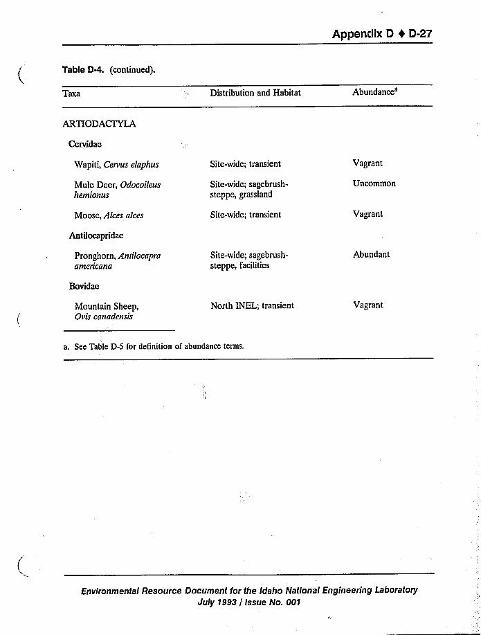
Appendix D t D-27
Table D-4. (continued).
Taxa Distribution and Habitat
Abundance'RTIODACTYLA
Cervidae
Wapiti, Cervus elaphus
Mule Deer, Odocoileushemionus
Site-wide; transient
Site-wide; sagebrush-
steppe, grassland
Vagrant
Uncommon
Moose, Alces alces Site-wide; transient Vagrant
Antilocapridae
Pronghorn, Anlilocapraamericana
Site-wide; sagebrush-
steppe, facilities
Abundant
Bovidae
Mountain Sheep,Ovis canadensis
North INEL; transient Vagrant
a. See Table D-5 for definition of abundance terms.
Environmental Resource Document for the Idaho National Engineering Laboratory
July 1993 / issue No. 001
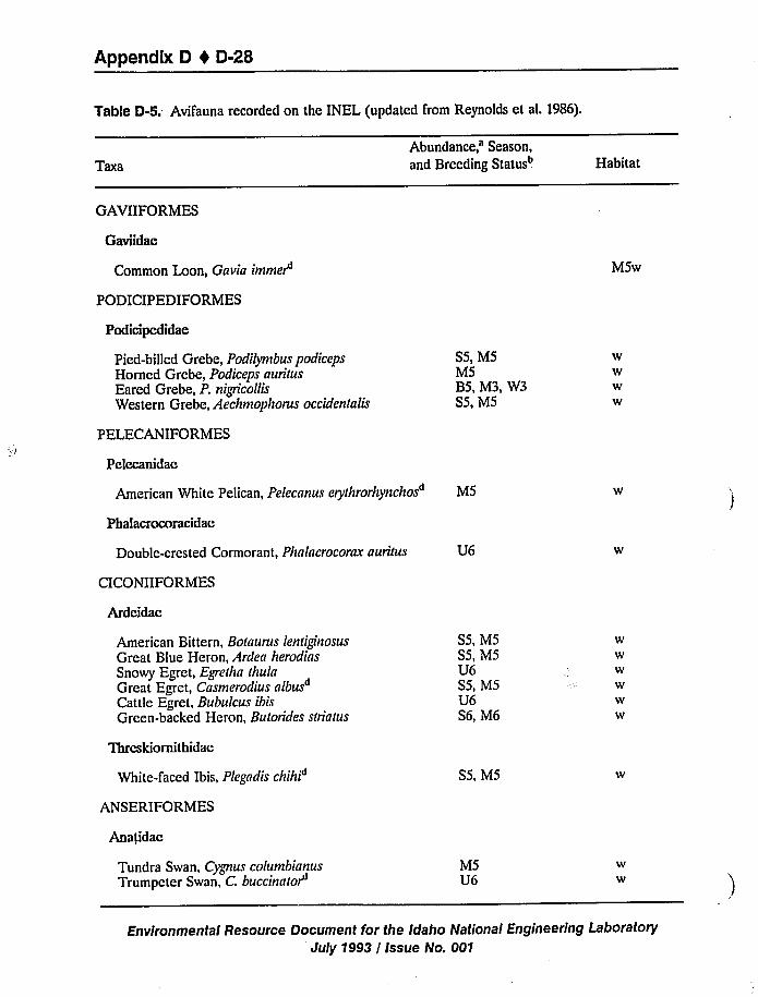
Appendix D 1 D-28
Table D-5. Avifauna recorded on the INEL (updated from Reynolds et al. 1986).
Taxa
Abundance,'eason,and Breeding Statusb Habitat
GAVIIFORMES
Gaviidae
Common Loon, Gavia immet MSw
PODICIPEDIFORMES
Podicipedidae
Pied-billed Grebe, Podilymbus podicepsHorned Grebe, Podiceps auritusEared Grebe, P. nigricollisWestern Grebe, Aechmophorus occidentalis
S5, MSMSBS, M3, W3SS, MS
wwww
PELECANIFORMES
Pelecanidae
American White Pelican, Pelecanus erythrorhynchos MS
Phalacrocoracidae
Double-crested Cormorant, Phalacrocorax auritus
CICONIIFORMES
Ardeidae
U6
American Bittern, Botaurus lentiginosus
Great Blue Heron, Ardea herodiasSnowy Egret, Egretha thulaGreat Egret, Casmerodius albusCattle Egret, Bubulcus ibisGreen-backed Heron, Butorides striatus
Thrcskiornithidae
White-faced Ibis, Plegadis chihi
ANSERIFORMES
Ana<idac
SS, MSSS, MSU6SS, MSU6S6, M6
SS, M5
ww
Tundra Swan, Cygnus columbianusTrumpeter Swan, C. buccinatot
MSU6
ww
Environmental Resource Document for the Idaho National Engineering Laboratory
July 1993 / Issue No. 001
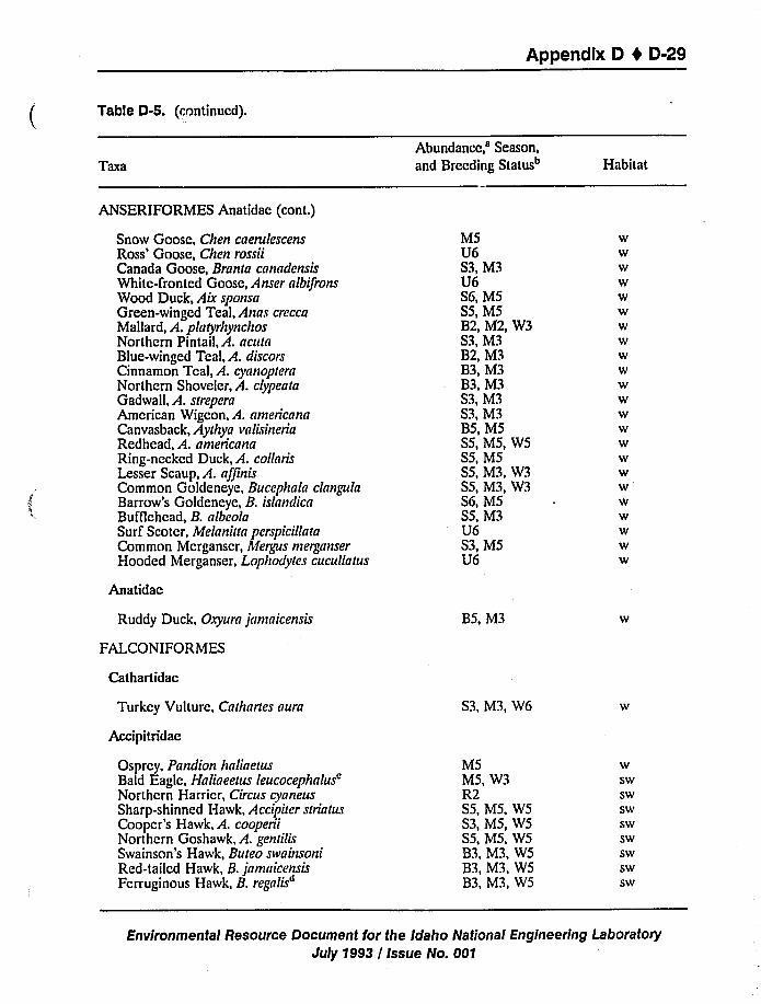
Appendix 0 I 0-29
Table D-5. (continued).
TBxa
Abundance,'eason,and Breeding Status Habitat
ANSERIFORMES Anatidae (cont.)
Snow Goose, Chen caerulescensRoss'oose, Chen rossiiCanada Goose, Branra cnnndensisWhite-fronted Goose, Anser albifronsWood Duck, Aix sponsaGreen-winged Teal, Anas creccaMallard, A. plaryrhynchosNorthern Pintail, A. acutaBlue-winged Teal, A. discorsCinnamon Teal, A. cyanopternNorthern Shoveler, A. clypearaGadwall, A. srreperaAmerican Wigeon, A. nmericanaCanvasback, Aythya valisineriaRedhead, A. americnnaRing-necked Duck, A. collnrisLesser Scaup, A. nffinisCommon Goldeneye, Bucephala clnngulaBarrow's Goldeneye, B. islnndicaBufflehea, B. nlbeolaSurf Scoter, Melnniun perspicillataCommon Merganser, Megpcs merganserHooded Merganser, Lophodytes cucullatus
Anatidac
Ruddy Duck, Oxyurn jamaicensis
FALCON I FOR MES
Cathartidac
Turkey Vulture, Cathnrtes aura
Accipitridae
Osprey, Pandion hnliaetusBald Eagle, Halineetus
leucocephalus'orthern
Harrier, Circus cynneusSharp-shinned Hawk, Accipiter striatusCooper's Hawk, A. cooperiiNorthern Goshawk, A. gendlisSwainson's Hawk, Bureo swninsoniRed-tailed Hawk, B.jnmnicensisFerruginous Hawk, B. regalis
MSU6S3, M3U6S6, MSS5, MSB2, M2, W3S3, M3B2, M3B3, M3B3, M3S3, M3S3, M3BS, MSSS, MS, WSSS, M5SS, M3, W3SS, M3, W3S6, MSSS, M3U6S3, MSU6
B5, M3
S3, M3, W6
MSMS, W3R2SS, MS, WSS3, MS, WSSS, MS, W583, M3, WSB3, M3, WSB3, M3, WS
wwwwwwwwwwwwwwwwwwwwwww
wswswswswswswswsw
Environmental Resource Document for the Idaho National Engineering Laboratory
July 1993 / Issue No. 001
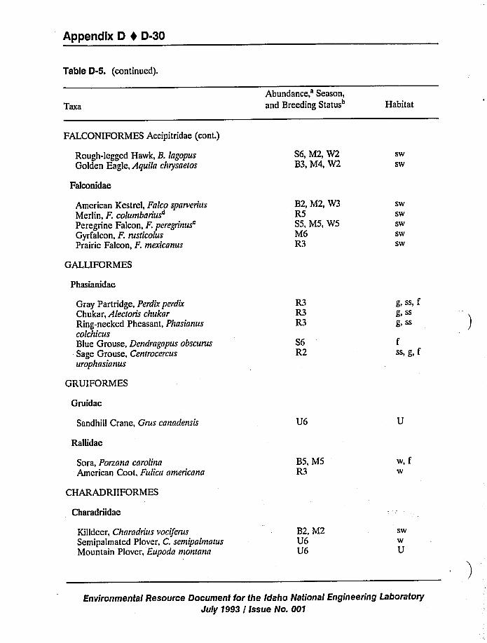
Appendix D I D-30
Table D-5. (continued).
TBxa
Abundance,'eason,and Breeding Status" Habitat
FALCONIFORMES Accipitridae (cont.)
Rough-legged Hawk, B. lagopusGolden Eagle, Aquila chrysaelos
S6, M2, W2B3, M4, W2
Sw
SW
Falconidae
American Kestrel, Falco sparverius
Merlin, F. columbariusPeregrine Falcon, F.
peregrinus'yrfalcon,F. rusdcolusPrairie Falcon, F. mexicanus
B2, M2, W3R5S5, M5, W5M6R3
SW
Sw
Sw
Sw
SW
GALLIFORMES
Phasianidae
Gray Partridge, Perdir perdirChukar, Alecroris chukarRing-necked Pheasant, PhasianuscolchicusBlue Grouse, Dendragapus obscurus
Sage Grouse, Cenrrocercusurophasianus
GRUIFORMES
Gruidae
Sandhill Crane, Grus canadensis
Rallidae
R3R3R3
S6R2
U6
g,ss,fg) SS
g, SS
fss,g, f
Sara, Porzana carolinaAmerican Coot, Fulica americana
B5, MSR3
w,fW
CHARADRIIFORMES
Charadriidae
Killdeer, Charadrius vociferusSemipalmated Plover, C. semipalmatusMountain Plover, Eupoda montana
B2, M2U6U6
SW
W
U
Environmental Resource Document for the Idaho National Engineering Laboratory
Jultj 1993 / Issue No. 001
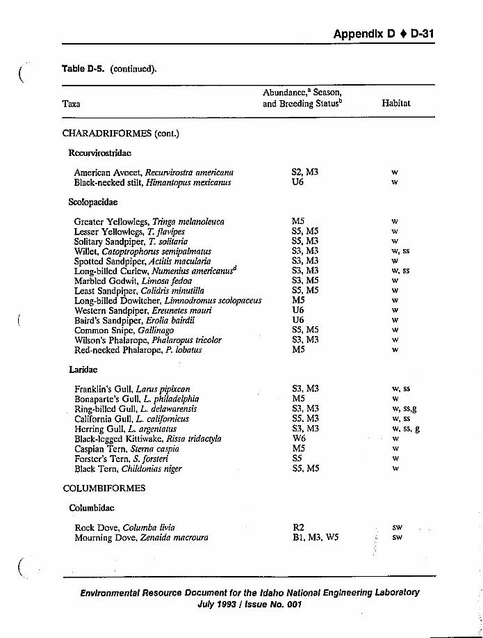
Appendix D 4 D-31
Table D-S. (continued).
TGxa
Abundance,'eason,and Breeding Status" Habitat
CHARADRIFORMES (cont.)
Recurvirostridae
American Avocet, Recurvirostra americanaBlack-necked stilt, Himantopus mexicanus
Scolopacidae
S2, M3U6
W
W
Greater Yellowlegs, Tringa melanoleucaLesser Yellowlegs, T. flavipesSolitary Sandpiper, T. solitariaWillet, Catoptrophorus semipalmatusSpotted Sandpiper, Actitis maculariaLong-billed Curlew, Numenius americanus"Marbled Godwit, Limosa fedoaLeast Sandpiper, Calidris minutillaLong-billed Dowitcher, Limnodromus scolopaceusWestern Sandpiper, Ereunetes mauriBaird's Sandpiper, Erolia bairdiiCommon Snipe, GallinagoWilson's Phalarope, Phalaropus tricolorRed-necked Phalarope, P. lobatus
Laridae
M5S5, M5S5, M3S3, M3S3, M3S3, M3S3, M5S5, M5M5U6U6SS, MSS3, M3MS
W
W, SS
W
W, SS
W
W
W
W
W
W
W
W
Franklin's Gull, Larus pipixcanBonaparte's Gull, L. philadelphiaRing-billed Gull, L. delawarensisCalifornia Gull, L. californicusHerring Gull, L. argentatusBlack-legged Kit tiwake, Rissa tridactylaCaspian Tern, Sterna caspiaForster's Tern, S. forsteriBlack Tern, Childonias niger
S3, M3MSS3, M3S5, M3S3, M3W6M5S5S5, M5
W, SS
W
W, SS)g
W> Ss
W,SS,gW
COLUMBIFORMES
Columbidac
Rock Dove, Columba livia
Mourning Dove, Zenaida macrouraR2BI, M3, W5
Sw
Sw
Environmental Resource Document for the Idaho National Engineering LaboratoryJuly 1993 / Issue No. 001
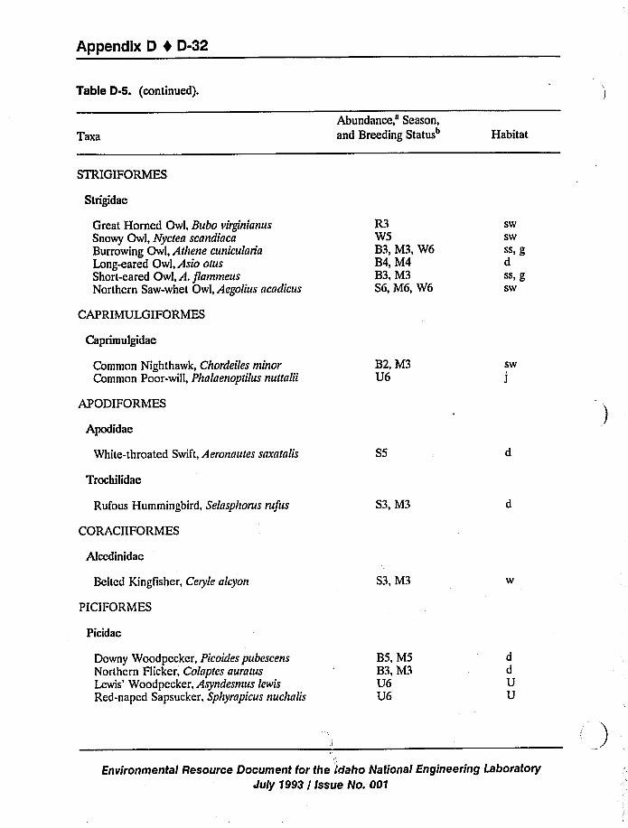
Appendix D I 0-32
Table D-5. (continued).
Taxa
Abundance,'eason,and Breeding Status" Habitat
STRIGIFORMES
Strigidae
Great Horned Owl, Bubo virgt'nianus
Snowy Owl, Nyctea scandiacaBurrowing Owl, Athene cuniculariaLong-eared Owl, Asio otusShort-eared Owl, A. flammeusNorthern Saw-whet Owl, Aegolius acadicus
CAP RIMULGIFORMES
R3W5B3, M3, W6B4, M4B3, M3S6, M6, W6
swswSS, gdSS> gsw
Caprimulgidae
Common Nighthawk, Chordeiles minorCommon Poor-will, Phalaenoptilus nuttalii
APODIFORMES
Apodidae
White-throated Swift, Aeronautes snxatalis
Trochilidae
Rufous Hummingbird, Selasphorus rufus
CORACIIFOR MES
Alccdinidac
B2, M3U6
S5
S3, M3
sw
J
Belted Kingfisher, Ceryle alcyon S3, M3
PICIFORMES
Picidae
Downy Woodpecker, Picoides pubescensNorthern Flicker, Colaptes auratusLewis'oodpecker, Asyndesmus lewis
Red-napcd Sapsucker, Sphyrapicus nuchalis
BS, M5B3, M3U6U6
ddUU
Il
Environmental Resource Document for the i'daho National Engineering Laboratory
July 1993 / Issue No. 001
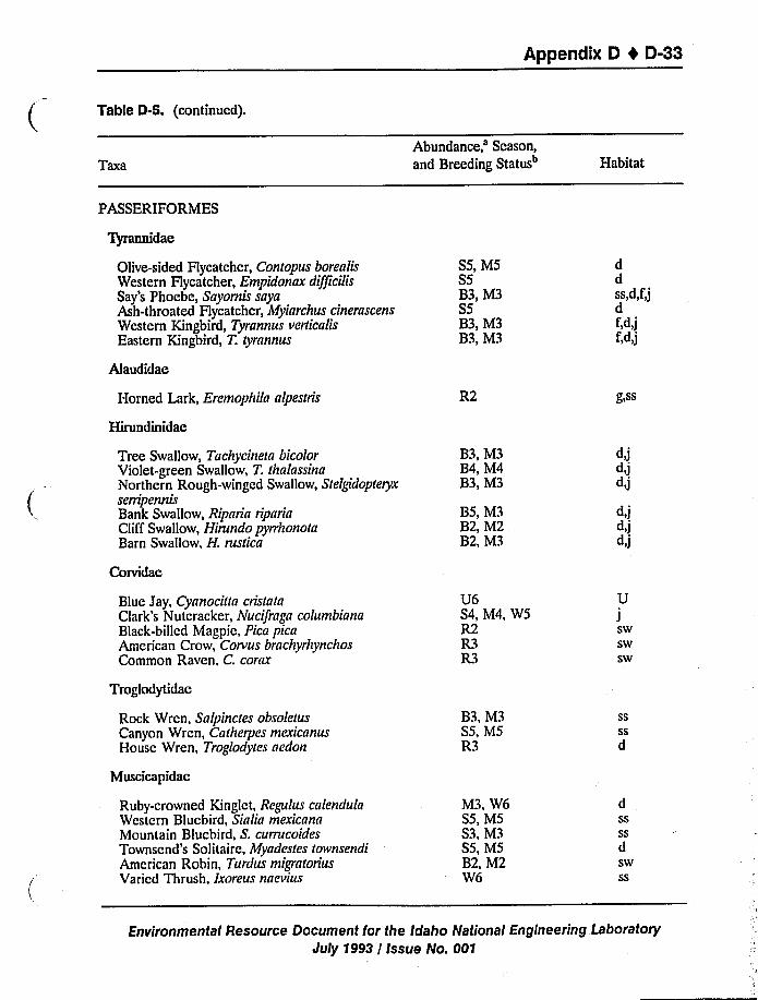
Appendix D 4 D-33
Table D-5. (continued).
Taxa
Abundance,'eason,and Breeding Status Habitat
PASSERIFORMES
Tyrannidae
Olive-sided Flycatcher, Contopus borealisWestern Hycatcher, Empidonax difficilisSay's Phoebe, Sayornis sayaAsh-throated Hycatcher, Myiarchus cinerascensWestern Kingbird, Tyrannus verticalisEastern Kingbird, T. ryrannus
Alaudidae
Horned Lark, Eremophila alpesrris
Hirundinidae
Tree Swallow, Tachycineta bicolorViolet-green Swallow, T. rhalassinaNorthern Rough-winged Swallow, StelgidopreryxserripennisBank Swallow, Riparia ripariaCliff Swallow, Hirundo pyrrhonotaBarn Swallow, H. rustica
Corvidae
SS, MSSSB3, M3SSB3, M3B3, M3
R2
B3, M3B4, M4B3, M3
BS, M3B2, M2B2, M3
ddss,d,f,jdf,d,jf,d,j
g)SS
d>J
d,jd,j
d,jd,jd>J
Blue Jay, Cyanociua crisrataClark's Nutcracker, Nucifraga columbianaBlack-billed Magpie, Pica picaAmerican Crow, Corvus brachyrhynchosCommon Raven, C. corax
U6S4, M4, WSR2R3R3
UJswswsw
Troglodytidae
Rock Wren, Salpinctes obsoletusCanyon Wren, Carherpes mexicanusHouse Wren, Troglodytes aedon
Muscicapidac
B3, M3SS, MSR3
ssssd
Ruby-crowned Kinglet, Regulus calendulaWestern Bluebird, Sialia mexicanaMountain Bluebird, S. currucoidesTownsend's Solitaire, Myadesles rownsendi
American Robin, Turdus migraloriusVaried Thrush, lxoreus naevius
M3, W6SS, MSS3, M3SS, M5B2, M2W6
dssssdswss
Environmental Resource Document for the Idaho National Engineering Laboratory
July 1993 / Issue No. 001
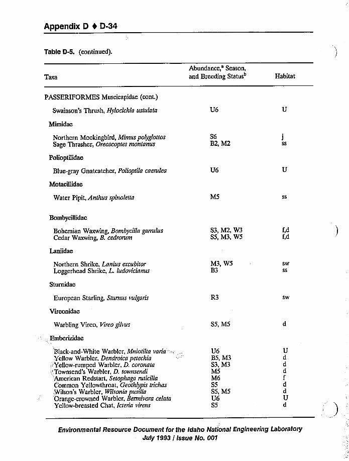
Appendix D 4 D-34
Table D-5. (continued).
Taxa
Abundance,'eason,and Breeding Status Habitat
PASSERIFORMES Muscicapidae (cont.)
Swainson's Thrush, Hylocichla ustulata
Mimidac
U6
Northern Mockingbird, Mimus polyglottosSage Thrasher, Oreoscoptes montanus
Polioptilidae
Blue-gray Gnatcatcher, Polioptila caerulea
Motacillidae
Water Pipit, Anthus spinoletta
S6B2, M2
U6
M5
Jss
ss
Bombycillidae
Bohemian Waxwing, Bombycilla garrulusCedar Waxwing, B. cedrorum
Laniidac
S3, M2, W3S5, M3, W5
f,df,d
Northern Shrike, Lanius excubitorLoggerhead Shrike, L. ludovicianus
Sturnidae
European Starling, Sturnus vulgaris
Virconidac
Warbling Vireo, Vireo gilvus
Embcrizidac
M3, W5B3
R3
S5, MS
swss
sw
Black-and-White Warbler, Mniotilta varia:Yellow Warbler, Dendroica petechia
,'ellow-rumped Warbler, D. coronata.'Townsend's Warbler, D. townsendi'i4anerican Redstart, Setophaga ruticillaC'ommon Yellowthroat, Geothlypis trichas.Wilson's Warbler, Wilsonia pusillaOrange-crowned Warbler, Bermivora celataYellow-breasted Chat, Icteria virens
U6B5, M3S3, M3M5M6S5SS, M5U6S5
UdddfddUd
Environmental Resource Document for the Idaho National Engineering Laboratory
July 1993 / Issue No. 001
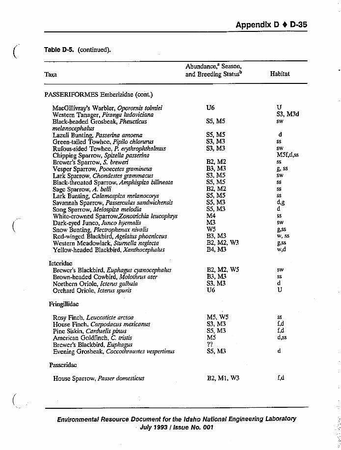
Appendix D 4 D-35
Table D-5. (continued).
TaxaAbundance, Season,and Breeding Status" Habitat
PASSERIFORMES Emberizidae (cont.)
MacGillivray's Warbler, Oporornis tolmieiWestern Tanager, Piranga ludovicianaBlack-headed Grosbeak, PheucticusmelanocephalusLazuli Bunting, Passerina amoenaGreen-tailed Towhee, Pipilo chlorurusRufous-sided Towhee, P. erythrophthalmusChipping Sparrow, Spizella passerinaBrewer's Sparrow, S. breweri
Vesper Sparrow, Pooecetes gramineusLark Sparrow, Chondestes grammacusBlack-throated Sparrow, Amphispiza bilineata
Sage Sparrow, A. belliLark Bunting, Calamospiza melanocorysSavannah Sparrow, Passerculus sandwichensisSong Sparrow, Melospiza melodiaWhite-crowned Sparrow,Zonotrichia leucophrysDark-eyed Junco, Junco hyemalisSnow Bunting, Plectrophenax nivalisRed-winged Blackbird, Agelaius phoeniceusWestern Meadowlark, Sturnella neglectaYellow-headed Blackbird, Xanthocephalus
IcteridaeBrewer's Blackbird, Euphagus cyanocephalusBrown-headed Cowbird, Molothrus aterNorthern Oriole, Icterus galbulaOrchard Oriole, Icterus spuris
U6
SS, MS
SS, MSS3, M3S3, M3
B2, M2B3, M3S3, MSSS, MSB2, M2SS, MSSS, M3SS, M3M4M3WSB3, M3B2, M2, W3B4, M3
B2, M2, WSB3, M3S3, M3U6
US3, M3dSw
dSs
Sw
MSf,d,ssSs
g) SS
Sw
Ss
SsSs
d,gdSsSw
g)SSw, ssg,SSw)d
Sw
SsdU
Fringillidae
Rosy Finch, Leucosticte arctoaHouse Finch, Carpodacus mexicanusPine Siskin, Carduelis pinusAmerican Goldfinch, C. tristisBrewer's Blackbird, EuphagusEvening Grosbeak, Coccothraustes vespertinus
Passeridac
House Sparrow, Passer domesticus
MS, WSS3, M3SS, M3MS'I'7
SS, M3
B2, M1, W3
SS
f,df,dd,SS
f,d
Environmental Resource Document for the Idaho National Engineering Laboratory
July 1993 / Issue No. 001
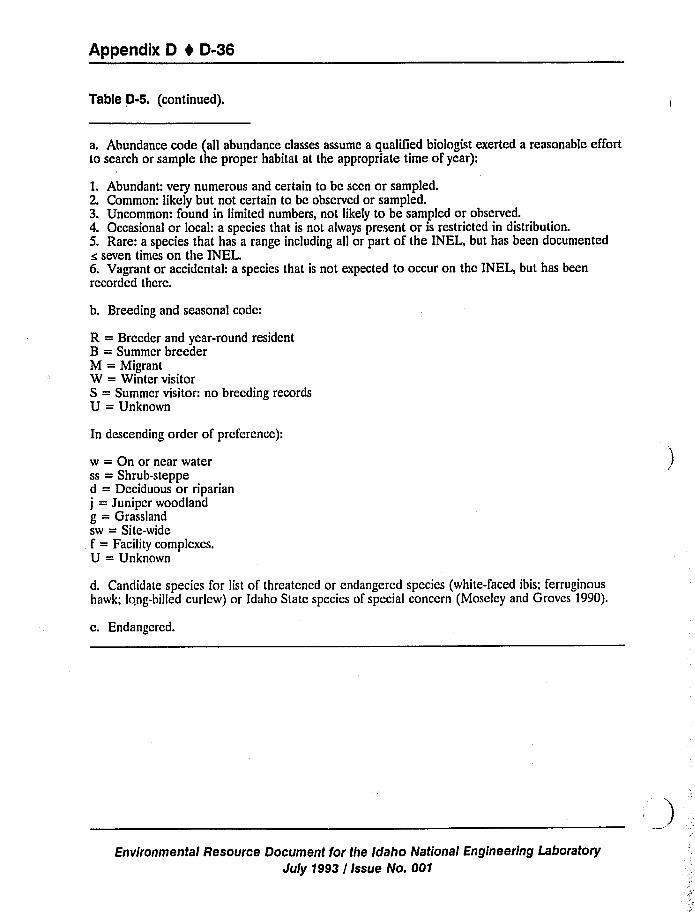
Appendix D I D-36
Table D-5. (continued).
a. Abundance code (all abundance classes assume a qualiTied biologist exerted a reasonable effortto search or sample the proper habitat at the appropriate time of year):
1. Abundant: very numerous and certain to be seen or sampled.2. Common: likely but not certain to be observed or sampled.3. Uncommon: found in limited numbers, not likely to be sampled or observed.4. Occasional or local: a species that is not always present or is restricted in distribution.5. Rare: a species that has a range including all or part of the INEL, but has been documentedc seven times on the INEL.6. Vagrant or accidental: a species that is not expected to occur on the INEL, but has beenrecorded there.
b. Breeding and seasonal code:
R = Breeder and year-round residentB = Summer breederM = MigrantW = Winter visitorS = Summer visitor: no breeding recordsU = Unknown
In descending order of preference):
w = On or near waterss = Shrub-stepped = Deciduous or riparian
j = Juniper woodland
g = Grasslandsw = Site-wide
.. f = Facility complexes.U = Unknown
d. Candidate species for list of threatened or endangered species (white-faced ibis; ferruginoushawk; long-billed curlew) or Idaho State species of special concern (Moseley and Groves 1990).
c. Endangered.
Environmental Resource Document for the Idaho National Engineering Laboratory
July 1993 / Issue No. 001
Appendix D 0 D-37
The INEL is an important nesting and wintering area for raptors. Twenty-two species ofhawks, falcons, owls, or vultures have been observed on the INEL (Reynolds et al. 1986). Tenspecies nest on or near the INEL. The most abundant, breeding species are American kestrelsand long-eared owl. American rough-legged hawks, American kestrels, prairie falcons, and goldeneagles are the most abundant raptors observed during the nonbreeding season. As many as 108golden eagles and 15 bald eagles have been observed on the INEL in a single day (Watson 1984).The numbers of some wintering raptors are closely tied to fluctuation in black-tailed jackrabbitabundance, while others are closely tied to the population of small rodents. Two species, the baldeagle and the peregrine falcon, are Federally listed endangered species. Six additional species arelisted as Idaho special species of concern and/or sensitive by the Bureau of Land Management orthe U.S. Forest Service.
D.$;2.3 Amphibians and Reptiles. One amphibian and 10 reptilian species have beenrecorded on t.",e INEL and are listed on Table D-6 (Reynolds et al. 1986). Of these, five speciesare consider;red common or abundant. There is only one confirmed record for the rubber boa onthe INEL. I The western racer was only recently recorded on the INEL. The only amphibianrecorded, t'ae Great Basin spadefoot toad, is typically associated with the Big Lost River, the BigLost River Sinks, and the spreading areas near the Radioactive Waste Management Complex(RWMC) (Reynolds et al. 1986) and because of drought, has not bred on the INEL for sometime. Published ranges indicate that an additional four reptile species could possibly be found onthe INEL (Nussbaum et al. 1983); however, of these, it is likely that only the night snake exists onthe Site.'he night snake and the ringnecked snakes are listed as sensitive species by theBureau of Land Management and are discussed in Section D.13.
D.1.2.4 Fish. Six species of fish have been identified during the Big Lost River SalmonidSurveys (Overton 1977) in that portion of the Big Lost River that flows onto the INEL and arelisted on Table D-7 (Reynolds et al. 1986). Four of these were game species (salmonids) and twowere nongame species. Additional game and nongame species may have been present but werenot observed or are present only during some years of normal stream flow. Not since October1986 has there been sufficient water in the Big Lost River to reach the INEL. That year, waterflowed as far as the Big Lost Sinks. Since that time, low runoff, combined with upstreamdiversions, has prevented sustained flow and hence aquatic biota in the Big Lost River on theINEL.
D.1.2.5 Invertebrates. A total of 740 insect species have been collected on the INEL. Asignificant portion of these (226) have not been identified beyond the family level. The majorityof the abundant species are Hymenoptera (wasps and ants), Diptera (flies), including parasitic andpredatory forms, and Coleoptera (beetles) (Stafford 1983, 1987; Stafford et al. 1986; Youdie1986). A diverse insect community is associated with the sagebrush and great basin wildryecommunities on the INEL, and these insects play an important role in the food chains of INELecosystems (Stafford 1983, 1987; Youdie 1986). A prominent feature of the area is harvester ant
c. Private communication with Peterson, 1990.
Environmental Resource Document for the Idaho National Engineering LaboratoryJuly 1993 / Issue No. 001
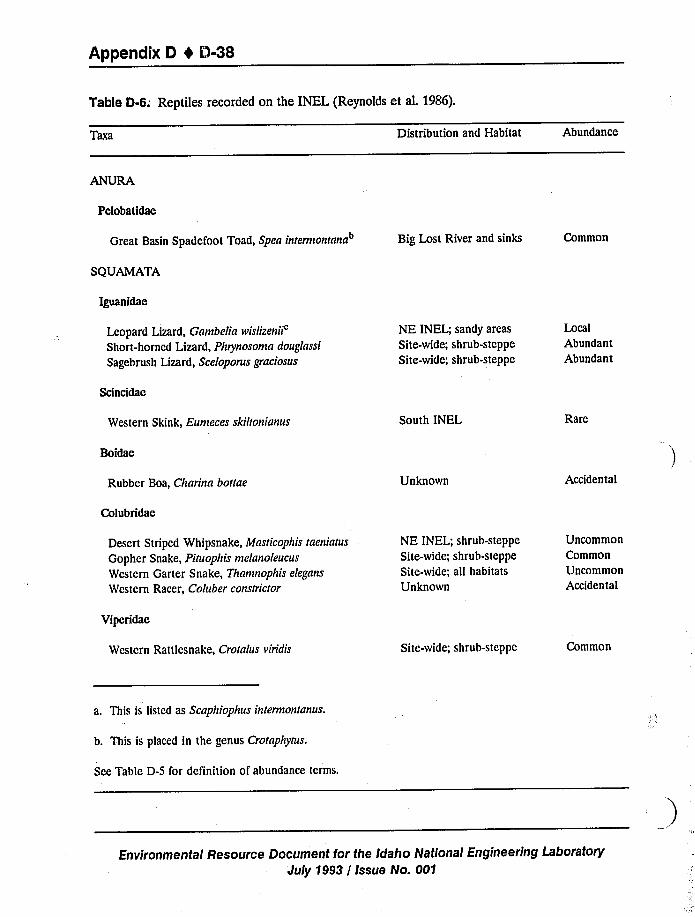
Appendix D I 0-38
Table D-6; Reptiles recorded on the INEL (Reynolds et al. 1986).
Taxa Distribution and Habitat Abundance
ANURA
Pelobatidae
Great Basin Spadefoot Toad, Spea inrermontana"
SQUAMATA
Iguanidae
Big Lost River and sinks Common
Leopard Lizard, Gambeliarvislizenii'hort-horned
Lizard, Phrynosoma douglassi
Sagebrush Lizard, Sceloporus graciosus
NE INEL; sandy areas
Site-wide; shrub-steppe
Site-wide; shrub-steppe
LocalAbundant
Abundant
Scincidae
Western Skink, Eumeces skillonianus South INEL Rare
Boidae
Rubber Boa, Charina bouae Unknown Accidental
Colubridae
Desert Striped Whipsnake, Mash'cophis raeniatus
Gopher Snake, Piruophis melanoleucus
Western Garter Snake, Thamnophis elegans
Western Racer, Coluber consrricror
NE INEL; shrub-steppe
Site-wide; shrub-steppe
Site-wide; all habitats
Unknown
Uncommon
Common
Uncommon
Accidental
Vipcridae
Western Rattlesnake, Croralus viridis Site-wide; shrub-steppe Common
a. This is listed as Scaphiophus inrermonranus.
b. This is placed in the genus Crotaphytus.
Sce Table D-5 for definition of abundance terms.
Environmental Resource Document for the Idaho National Engineering Laboratory
July 1993 / Issue No. 001
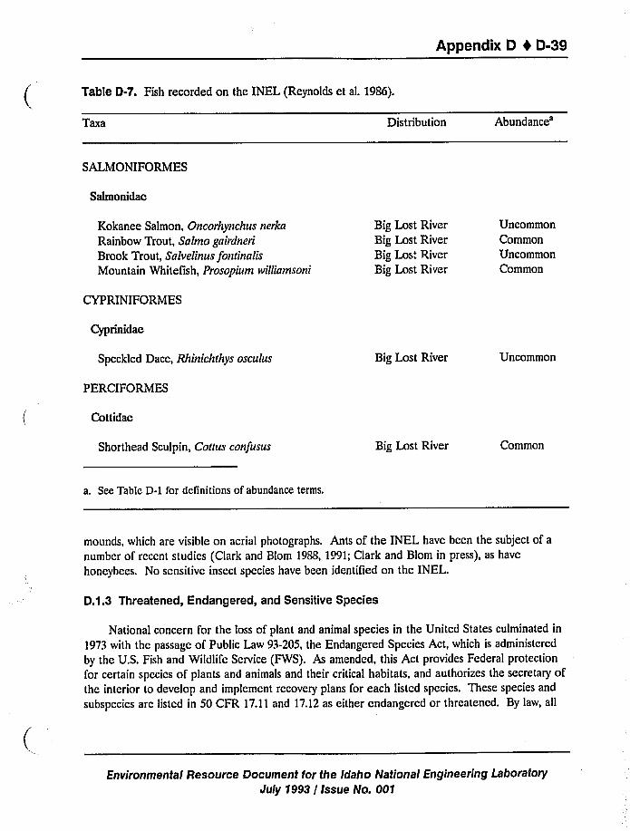
Appendix D 4 D-39
Table D-7. Fish recorded on the INEL (Reynolds et al. 1986).
TBxa Distribution
Abundance'ALMONIFORMES
Salmonidae
Kokanee Salmon, Oncorhynchus nerka
Rainbow Trout, Salmo gairdneri
Brook Trout, Snlvelinus fonrinalis
Mountain Whitefish, Prosopium ivilliamsoni
Big Lost River
Big Lost River
Big Los'. River
Big Lost River
Uncommon
Common
Uncommon
Common
CYPRINIFORMES
Cyprinidae
Speckled Dace, Rhinichrhys osculus
PERCIFORMES
Cottidae
Shorthead Sculpin, Coitus confusus
Big Lost River
Big Lost River
Uncommon
Common
a. See Table D-1 for definitions of abundance terms.
mounds, which are visible on aerial photographs. Ants of the INEL have been the subject of a
number of recent studies (Clark and Blom 1988, 1991;Clark and Blom in press), as have
honeybees. No scnsitivc insect species have been identified on the INEL.
D.1.3 Threatened, Endangered, and Sensitive Species
National concern for the loss of plant and animal species in the United States culminated in
1973 with the passage of Public Law 93-205, the Endangered Species Act, which is administered
by the U.S. Fish and Wildlife Service (FWS). As amended, this Act provides Federal protection
for certain species of plants and animals and their critical habitats, and authorizes the secretary ofthe interior to develop and implement recovery plans for each listed species. These species and
subspccics are listed in 50 CFR 17.11 and 17.12as either endangered or threatened. By law, all
Environmental Resource Docuinent for the Idaho National Engineering Laboratory
July 1993 / Issue No. 001
Appendix 0 4 0-40
Federal agencies are required to consider in their management plans those plant and animal
species considered to be endangered, threatened, or proposed for such status (candidate species).
Listed endangered species are defined as those taxa in danger of extinction throughout all ora significant portion of their range. Listed threatened species are defined as taxa likely to beclassified as endangered within the foreseeable future throughout all or a significant portion oftheir range. Candidate species for endangered and threatened status are defined as taxa forwhich the FWS currently has substantial information on hand to support the biological
appropriateness of proposing to list as endangered or threatened; taxa for which information now
in possession of the FWS indicates that proposing to list as endangered or threatened is possibly
appropriate, but for which conclusive data on biological vulnerability and threat are not currently
available to support proposed rules; and taxa that were once being considered for listing as
endangered and threatened, but are no longer receiving such consideration.
The Idaho Department of Fish and Game is mandated under Idaho Code Section 36-103 to
preserve, protect, perpetuate, and manage all wildlife. A law protecting native wildflowers in
Idaho was enacted in 1967 (Idaho Code Section 18-3913), that gives the Idaho Department ofParks and Recreation the authority to establish and amend a list of plants in need of protection
because they may become extinct or they may affect the scenic beauty of public roads or public
land.
Certain species (found on the INEL) are protected by Idaho law and cannot be hunted,
taken, or possessed except under special circumstances. Those species include all threatened or
endangered wildlife including peregrine falcons and bald eagles; all protected nongame species
such as chipmunks, all hawks, owls, eagles, and vultures; and all nongame birds except the starling,
English sparrow, and feral pigeon.
A comprehensive list of plant and animal species from Federal and/or state threatened,
endangered, and sensitive lists is presented on Table D-8. Although species of special concern
and sensitive species do not receive legal protection, they are included here because of their
regional importance.
D.1.3.1 Plants. An extensive survey for rare and endangered plant species was conducted
by Cholcwa and Henderson (1983, 1984) from 1980 to 1982. With the exception of vegetation
communitics associated with wetlands (see Section D.2.5.1),no additional surveys were conducted
for rare and endangered species for this environmental impact statement. Current work being
conducted by Idaho State University will provide additional information on thc INEL communities
and the status sensitive plant species. Rare and sensitive plant species found on the INEL are
discussed in Section D.1.1.5.
No plant species at the INEL are currently considered Federally threatened or endangered
(50 CFR 17.11,17.12). Several species known to exist at the INEL are on State of Idaho special
species of concern, Bureau of Land Management (BLM), and U.S. Forest Service (USFS) lists
(sce Table D-8). Ten plants appear on the state rare plant list including Lemhi milkvetch, plains
Environmental Resource Document for the Idaho National Engineering Laboratory
July 1993 / Issue No. 001
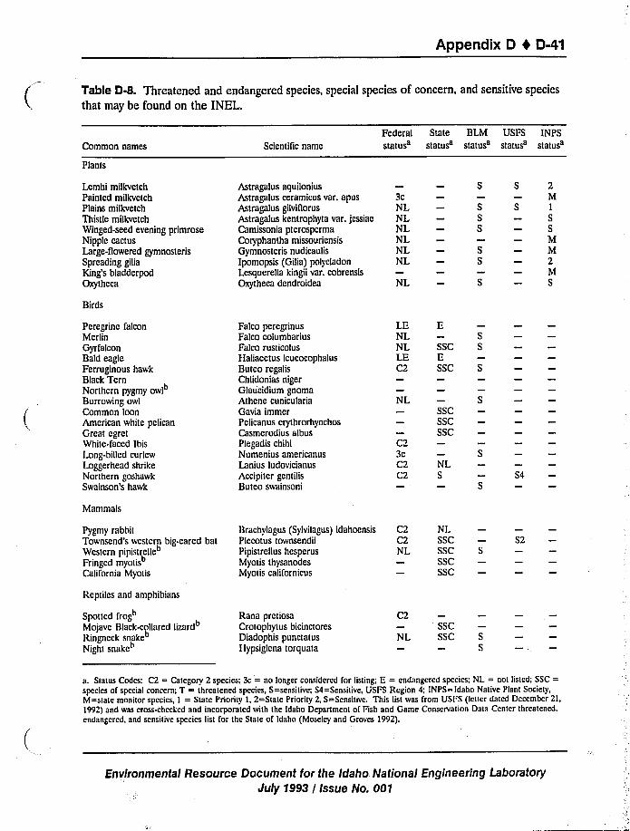
Appendix D I D-41
Table 0-8. Threatened and endangered species, special species of concern, and sensitive species
that may be found on the INEL.
Common names Scientific name
Federal State BLM USFS INPSstatus status status status status
Plants
Lemhi milkvetchPainted milkvetchPlains milkvetchThistle milkvctchWinged-seed evening primroseNipple cactusLarge-flowered gymnosterisSpreading giliaKing's bladderpodOxytheca
Birds
Astragalus aquiloniusAstragalus ceramicus var. apusAstragalus gilviflorus
Astragalus kentrophyta var. jessiaeCamissonia pterospermaCoryphantha missouriensisGymnosteris nudicaulis
Ipomopsis (Gilia) polycladonLesquerella kingii var. cobrensisOxytheca dendroidea
3cNLNLNLNLNLNL
NL
SSS
2M1SSMM2MS
Peregrine falconMerlinGyrfalconBald eagleFerruginous hawkBlack TernNorthern pygmy owlBurrowing owl
Common loonAmerican white pelicanGreat egretWhite-faced IbisLong-billed curlewLoggerhead shrikeNorthern goshawkSwainson's hawk
Falco peregrinusFalco columbariusFalco rusticolusHaliaeetus leucocophalusButeo regalisChlidonias nigerGlaucidium gnomaAthene cuniculariaGavia immerPelicanus erythrorhynchosCasmerodius albusPlegadis chihi
Numenius americanusLanius ludovicianus
Accipiter gcntilisButeo swainsoni
LENLNLLEC2
NL
3cC2C2
SSCESSC
SSCSSCSSC
NLS
SS4
Mammals
Pygmy rabbitTownsend's western bleared batWcstcrn pipistrelle"Fringed myotisCalifornia Myotis
Brachylagus (Sylvilagus) idahoensisPlccotus townsendiiPipistrcllus hesperusMyotis thysanodesMyotis californicus
C2
NL
NLSSCSSCSSCSSC
S2
Reptiles and amphibians
Spotted frog"Mojave Btack<ollared lizard
Ringncck snake"Night snakc"
Rana prctiosaCrotophytus bicinctoresDiadophis punctatusPlypsiglcna torquata
C2
NLSSCSSC S
S
a. Status Codes: C2 = Category 2 species; 3c = no longer considered for listing; E = endangered species: NL = noi listed; SSC =species of special concern; T = threatened species, S=scnsitive; S4=Scnsiiive, VSFS Region 4; INPS= Idaho Naiive Plant Society,M=siaie monitor species, I = State Priority I, 2=state Priority 2, S=Scnsiiive. This list was from VSFS (Inner dated December 21,1992) and was cross-checked and incorporated with the Idaho Department of Fish and Game Conservation Dais Center threatened,
endangered, and sensitive species list for the State of Idaho (Moselcy and Groves 1992).
Environmental Resource Document for the Idaho National Engineering Laboratory
July 1993 / Issue No. 001
Appendix D 4 D-42
milkvetch, thistle milkvetch, winged-seed evening primrose, nipple cactus, large-flowered
gymnosteris, spreading gilia, King's bladderpod, Oxytheca, and painted milkvetch (recently
removed from C2 status). Habitat and distribution information for these species is given in
Section D.2.4.1.
D.1.3.2 Animals. The only species at the INEL currently recognized as threatened or
endangered under the Endangered Species Act are the bald eagle, a winter visitor, and the
peregrine falcon. Several species that are candidates for the Federal list are known to exist at the
INEL. They are the ferruginous hawk, white-faced ibis, black tern, northern goshawk, pygmy
rabbit, and the Townsend's big-eared bat (Arthur et al. 1984). These candidate species are those
for which the FWS has information suggesting that a change in status to threatened or
endangered may possibly be appropriate, but for which conclusive data are not available. The
long-billed curlew is currently considered to be more widespread than previously believed, or is
not subject to identifiabl threats and has been designated 3C (removed from C2 status) (Moseley
and Groves 1992).
The State of Idaho recognizes two separate classes of rare fauna: species of special concern
and threatened and endangered wildlife. Species of special concern known to exist at the INEL
include the common loon, American white pelican, ferruginous hawk, Northern pygmy owl,
California myotis, merlin, and great egret (Moseley and Groves 1992).
D.1.4 Unique or Special Habitats and Communities
This section addresses INEL ecological communities and habitats with unique or special
characteristics. For this assessment, wetlands (including riparian and aquatic communities), caves,
buttes, man-made structure and facilities, and soil microflora are included.
D.1.4.1 Wetlands. Over 130 areas within the boundaries of the INEL have been assigned
wetland status as part of the FWS National Wetlands Inventory (NWI). The geographic coverage
of the INEL includes 30 7.5-ft U.S. Geological Survey topographic quadrangles. Finalized NWI
maps have been generated for 23 of these quadrangles.
To support this environmental impact statement, a survey of a sample of these wetlands was
conducted in fall of 1992. As part of this survey, designated wetlands from the completed NWI
inventory maps were digitized and entered into a geographical information system (GIS) at the
INEL. A map of INEL wetlands was created and combined with other coverages already
available in the GIS database. The survey methodology and results are described in detail
elsewhere (Hampton et al. 1993). Habitat and ecological associations for INEL wetlands are
prescntcd in Section D.2.S.1.
The NWI maps for the INEL werc finalized prior to FWS adoption of 1989 manual and
tcchnical criteria to be applied in assessing vegetation, soils, and hydrology are not speciTicd under
10 CFR 1022.11(c)(DOE 1992). Consequently, technical criteria drawn from the 1989 Federal
manual were used to develop data collection requirements and field methodology for this survey.
Environmental Resource Document for the Idaho National Engineering Laboratory
July 1993 / Issue No. 001
Appendix D 4 D-43
NWI wetlands maps, U.S. Geological Survey 7.5-ft topographic maps and 1991 aerial photographs
(1:40,000)were the primary sources of information for the survey.
It is unclear whether the DOE definition requires application of mandatory technical criteria
conforming to the Environmental Protection Agency (EPA)/U.S. Army Corps of Engineers
(COE) definitions or those of the FWS. The NWI sites for which wetland vegetation and/or
wetland hydrologic criteria were confirmed satisfy the FWS single criteria requirement. However,
no verification with regard to the EPA/COE three-criteria requirement can be made for these
sites without confirmation of hydric soils. Collection of soil data was beyond the scope of the
preliminary survey.
Since the completion of the INEL preliminary wetlands survey in November 1992, proposedrevisions to the 1989 manual (EPA 1991)have been challenged. Pending resolution of questions
regarding wetland delineation criteria, the EPA and COE have adopted the COE Wetlands
Delineation Manual (COE 1987). It is unclear whether the FWS will also use the 1987 manual.
D.1.4.1.1 Survey Summary-Sixteen separate NWI FWS classifications arerepresented by approximately 130 wetland sites within INEL boundaries. These NWI
classifications are denoted by a descriptive acronym assigned by the FWS and are defined (and
summarized) on Table D-9. Two additional classes were created for the INEL preliminary
wetlands survey to include investigation of (a) potential wetlands that exist in the seven
quadrangles not yet mapped by the FWS NWI (UNMAP) and (b) areas within th" mapped
quadrangles that have characteristics similar to mapped wetlands, but were not classified as
wetlands (UNCLASS).
NWI mapped wetlands and sites investigated during the survey are shown on Figure D-1.Field descriptions were completed for 105 sites in 16 NWI and two special categories. In
addition, 20 sites were inspected as part of the verification of grouped wetland sites. Theinformation collected as part of the survey is summarized on Table D-10. Plant species identiTied
during the survey are listed on Table D-11. Wetland classes across the INEL have geographic orcharacteristic similarities that facilitate grouping into six categories and are discussed in the
following sections. Further details of the survey methodology and results are discussed in the
formal survey documentation (Hampton et al. 1993).
Conditions associated with extended drought and the season in which field investigations
were conducted limited the collection of important vegetative and hydrological information, and
other information such as wildlife use is not available. This relative ranking procedure can only
be considered a subjective estimate of potential importance of each wetland relative to the
conditions present during the survey.
D.1.4.1.2 PUSJ Classified Wetlands —About 70% of the individual NWI wetlands
within INEL boundaries are classified as PUSJ. The distribution of surveyed PUSJ sites is shown
on Figure D-2. Total area encompassed by PUSJ wetlands is just under 20 ha (50 acres). Thesmallest PUSJ site is approximately 0.04 ha (0.1 acre), and the largest is about 3 ha (7 acres).
Environmental Resource Document for the Idaho National Engineering LaboratoryJuly 1993 / Issue No. 001
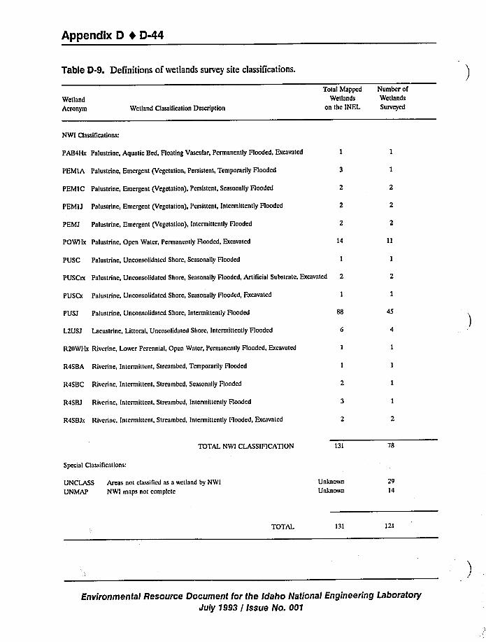
Appendix D I D-44
Table D-9. Definitions of wetlands survey site classlTications.
Wetland
Acronym Wetland Classification Description
Total Mapped Number ofWetlands Wetlands
on thc INFL Surveyed
NWI Classifications:
PAB4Hx Palustrine, Aquatic Bed, Floating Vascular, Permanently Flooded, Excavated 1
PEMIA Palustrine, Emergent (Vegetation, Persistent, Temporarily Hooded
PEMIC Palustrine, Emergent (Vegetation), Persistent, Seasonally Flooded
PEMI J Palustrine, Emergent (Vegetation), Persistent, Intermittently Flooded
PEMJ Palustrine, Emergent (Vegetation), Intermittently Flooded
POWHx Palustrine, Open Water, Permanently Flooded, Excavated
PUSC Palustrine, Unconsolidated Shore, Seasonally Flooded
14
PIJSCrx Palustrine, Unconsolidated Shore, Seasonally Flooded, ArtiTicial Substrate, Excavated 2
PUSCx Palustrine, Unconsolidated Shore, Seasonally Flooded, Excavated
PUSJ Palustrine, Unconsolidaied Shore, Intermittently Hooded
L2USJ Lacustrine, Littoral, Uncosolidated Shore, Intermittently Flooded
R20WHx Riverine, Lower Perennial, Open Water, Permanently Flooded, Excavated
R4SBA Riverine, Intermittent, Streambed, Temporarily Flooded
R4SBC Riverine, Intermittent, Streambcd, Seasonally Flooded
R4SBJ Riverine, Intermittent, Streambed, Intcrminently Flooded
R4SBJx Riverine, Intermittent, Streambed, Intermittently Hooded, Excavated
45
TOTAL NW! CLASSIFICATION 131 78
Special Classilica(ions:
UNCLASS Areas not classified as a wetland by NWI
UNMAP NWI maps not complete
Unknown
Unknown
29
14
TOTAL 131 121
Environmental Resource Document for the Idaho National Engineering Laboratory
July 1993 / Issue No. 001
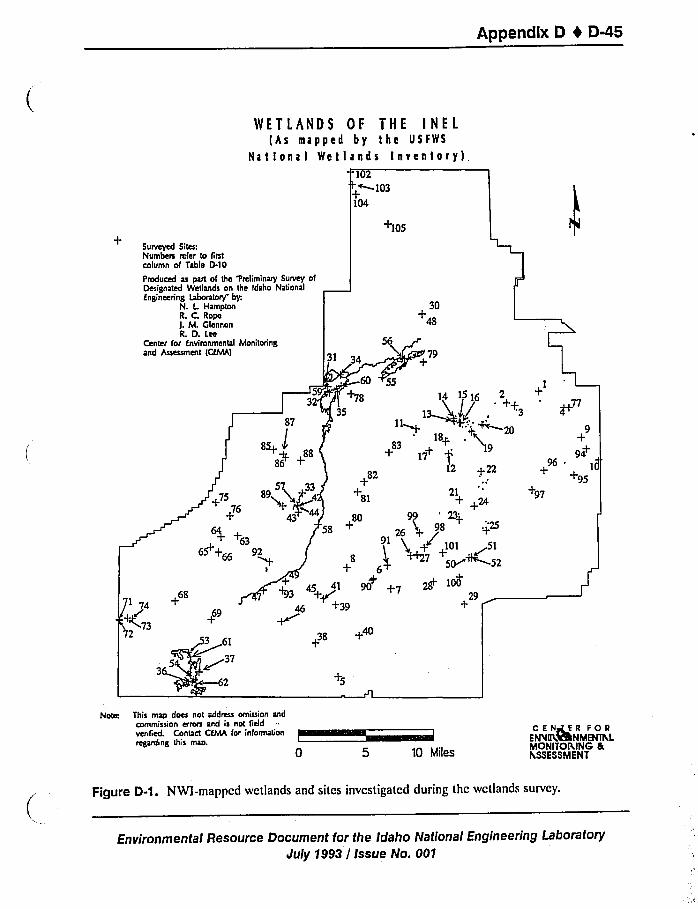
Appendix D 4 D-45
WETLANDS OF THE INEL(hs mapped by the USFWS
National Wetlands Inventory),102
'~+~103104
+105
Surveyed Sites:Numbes refer to firstcolumn of Table D-10
Produced as part of the Pmliminary Survey ofDesignated Wetlands on the Idaho NagonalEngineering Laboratory by:
N. L HamptonR. C. Ropel. M. OfennonL D. Lee
30+48
79
7369
61
~37+40
+
14 15 16 2
21+ +24
98
101 ~515M~52
29
1
9
94+
tiI+95
+97
Note This map does not address omission andcommission erros and is not fiddvenfied. Contact CfMA for information
reganling this map.
10 Miles
C E Nary E R FOREPN IILVRNMENlhLMONITORING nthSSESSMENT
Figure D-1. NWI-mapped wetlands and sites investigated during the wetlands survey.
Environmental Resource Document for the Idaho National Engineering Laboratory
July 1993 / Issue No. 001
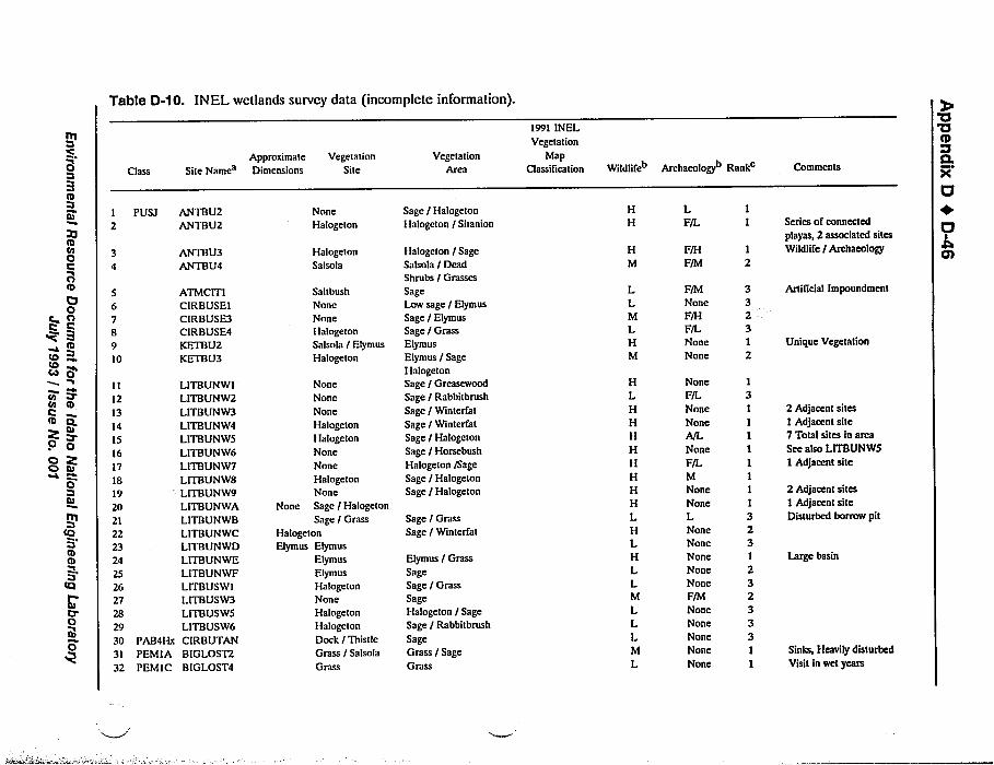
Table D-10. INEL wetlands survey data (incomplete information).
rt1
'C
0
ni
tttta0QO
O0c A
QBtti
tOCOco 0
I
taP'n
tDQtb
0O gO tu
0
littQBtbrn
tQ
0
5678910
1112131415161718192021222324
2526272829303132
Class
PUSI
PAB4HxPEMI APEMIC
Site Names
ANTBU2ANTBU2
ANTBU3ANTBU4
ATMCITICIRBUSEICIRBUSE3CIRBUSE4KETBU2KETBU3
LITBUNWILITBUNW2LITBUNW3LITBUNW4LITBUNW5LITBUNW6LITBUNW7LITBUNW8LITBUNW9LITBUNWALITBUNWBLITBUNWCLITBUNWDLITBUNWELITBUNWFLITBUSWILITBUSW3LITBUSW5LITBUSW6CIRBUTANBIGLOST2BIG LOST4
ApproximateDimensions
Vegetation
Site
NoneHalogeton
Halogeton
Salsola
Saltbush
NoneNoneHalogeton
Salsola / Elymus
Halogeton
None
Halogeton
Elymus Elymus
Elymus
Elymus
HalogetonNone
Halogeton
Halogeton
Dock / ThistleGrass / Salsola
Grass
None
None
None
HalogetonHalogeton
None
None
HalogetonNone
Sage / Halogeton
Sage / Grass
Vegetation
Area
Sage / Halogeton
Halogeton / Sitanion
Halogeton / SageSalsola / DeadShrubs / Grasses
SageLow sage / Elymus
Sage / Elymus
Sage / Grass
Elymus
Elymus / SageHalogetonSage / Greasewood
Sage / Rabbitbrush
Sage / Winterfat
Sage / Winterfat
Sage / Halogeton
Sage / Hotsebush
Halogeton /Sage
Sage / Halogeton
Sage / Halogeton
Sage / Grass
Sage / Winterfat
Elymus / Grass
SageSage / Grass
SageHalogeton / Sage
Sage / Rabbitbrush
SageGrass / Sage
Grass
1991 INELVegetation
MapClassification
HH
LF/L
HM
LLMLHM
F/M
None
F/H
F/LNone
None
HLHHH
HHHH
HLHLHLLM
LLLM
L
None
F/LNone
None
A/L
None
F/LMNone
NoneLNoneNone
NoneNoneNoneF/M
NoneNone
NoneNone
None
13I111I111323
232333I1
Wildlifeb Archaeologyb Rankc Comments
Series of connected
playas, 2 associated sites
Wildlife / Archaeology
Artificial Impoundment
Unique Vegetation
2 Adjacent sites1 Adjacent site7 Total sites m area
See also LITBUNW51 Adjacent site
2 Adjacent sites
1 Adjacent siteDisturbed borrow pit
Large basin
Sinks, Heavily disturbed
Visit in wet years
'a'UCD
Q.
U+O
Ch
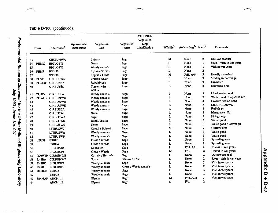
Table D-10. (continued).
0B
~Vtli
ttsos000IO0
e OC
tcstts
to 0tn
P'e
roItts
tu
0C) Q
0tu
PQ
tts
tO
00
33343536373B3940
4142434445464748495051525354
555657SB
596061626364
Class
P EMIJ
PEMJ
PUSCPUSCrx
CIRBUNWABIGLOSTIBIGLOSTSBSBV3BSBU6CIRBUSW3CIRBUSE7CIRBVSEB
CIRBUSE6CIRBUNWCCIRBUNWDCIRBUNWECIRBUSEACIRBUSWICIRBUSW2CIRBUTANCIRBVSW6LITBUSW9LITEUSWA
LITBUSWBBSBUIBSBU4BIGLOSTBBIGLOST9CIRBUNWBCIRBUNW7BIGLOST3BIGLOST6BSBU2BSBUSARCH ILIARCH IL2
PUSCxPOWHx
L2USJ
R20WHxR4SBAR4SBCR4SBJR4SBJx
UNMAP
Approximate
Site Names Dimensions
VegetationSite
Bulrush
Grass
Weedy annuals
Elymus / Grass
Lupine / Grass
Crested wheat
Rabbitbrush
Crested wheat
Willow
Weedy annuals
Weedy annuals
Weedy annuals
Weedy annuals
Weedy annuals
None
SageDock /Thistle
None
Cattail / Bulrush
Weedy annuals
Weedy annuals
Grass / Weeds
Grass / Weeds
Milkvetch
Grass / Weeds
Cattails / Bulrush
SparseWeedy annuals
Weedy annuals
Weedy annuals
Weedy annuals
Elymus
Elymus
SageSage
SageSageSageSage
SageSage
SageSageSageSageSageSage
SageSageSage
Sage
SageSageSage
SageSage
SageSageWillow / RoseSageGrass
SageSageSage
Sage
/ Weedy annuals
1991 INELVegetation
Vegetation MapArea Classification
M
LLLM
LLL
NoneNone
None
None
F/H, A/M
None
None
None
LLLLLLLLLM
LLLLLM
LLLLLLM
L
None
None
None
NoneNone
None
None
None
None
None
None
NoneNone
None
F/H, A/L
F/LNoneNone
None
None
None
None
F/H, A/M
F/L
Wildlifeb Archaeologyb Rankc Comments
Outflow channel
Sinks - Visit in wet yearsVisit in wet years
Heavily disturbed
Seedmg m borrow pitExcavated
Old waste area
Lined waste pond
Waste pond, 1 adjacent siteCovered Waste Pond
See CIRBUNWCRubble pitManganese pile
Firing range
Waste pond
Waste pond / Gravel pitOutflow areaWaste pondWaste pond
Spreading area
Spreading areaRevisit in wet yearsRevisit in wet yearsOutflow channc:I
River - visit in wet years
Visit in wet yearsVisit in wet yearsVisit in wet yearsVisit in wet yearsVisit in wet years
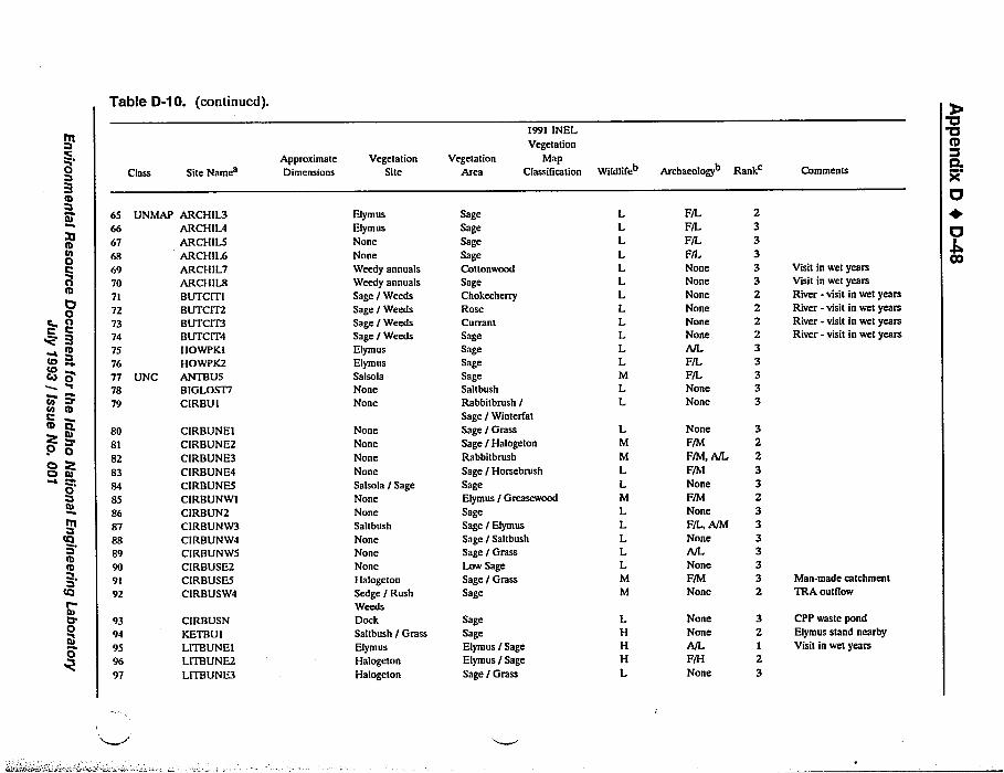
Table 0-10. (continued).
0
to00OIO0O0rn
trstrsCo 0cnto OCI gk
0Oo tu
Q0
rtt
Cl
tnIt0
~V0
656667686970717273747576777879
80818283848586878889909192
9394959697
Class
UNMAP
UNC
Site Names
ARCH IL3ARCH IL4ARCHIL5ARCH IL6ARCH IL7ARCH IL8BVTCITIBUTCIT2BUTCIT3BUTCIT4HOWPKIHOWPK2ANTBUSBIGLOST7CIRBU I
CIRBUNEICIRBUNE2CIRBUNE3CIRBUNE4CIRBVNESCIRBUNWICIREUN2CIRBUNW3CIRBUNW4CIRBUNW5CIRBUSE2CIRBUSE5CIRBUSW4
CIRBUSNKETBU ILITBUNEILITBUNE2LITBUNE3
ApproiomateDimensions
VegetationSite
Elymus
Elymus
None
None
Weedy annuals
Weedy annuals
Sage / Weeds
Sage / Weeds
Sage / WeedsSage / Weeds
Elymus
Elymus
SalsolaNoneNone
NoneNone
None
NoneSalsola / SageNoneNoneSaltbush
NoneNone
NoneHalogeton
Sedge / RushWeedsDockSaltbush / GrassElymus
Halogeton
Halogeton
Vegetation
Area
1991 INELVegetation
MapClassification
SageSageSageSageCottonwood
SageChokecherry
RoseCurrantSageSageSageSageSaltbush
Rabbitbrush /
Sage / Winterfat
Sage / Grass
Sage / Halogeton
Rabbitbrush
Sage / Hotsebrush
SageElymus / Greasewood
SageSage / Elymus
Sage / Saltbush
Sage / GrassLow SageSage / Grass
Sage
SageSageElymus / SageElymus / Sage
Sage / Grass
LLLLLLLLLLLLMLL
F/LF/LF/LF/LNoneNoneNoneNoneNoneNoneA/LF/LF/LNone
None
233333222233333
LM
M
LLM
LLLLLMM
None
F/M
F/M, A/L
F/M
NoneF/M
None
F/L, A/M
NoneA/L
NoneF/M
None
LH
HHL
NoneNone
A/L
F/H
None
32123
Wildlife Archaeology Rank Comments
Visit in wet yearsVisit in wet yearsRiver - visit in wet yearsRiver - visit in wet yearsRiver - visit in wet yearsRiver - visit in wet years
Man-made catchment
TRA outliow
CPP waste pond
Elymus stand nearby
Visit in wet years
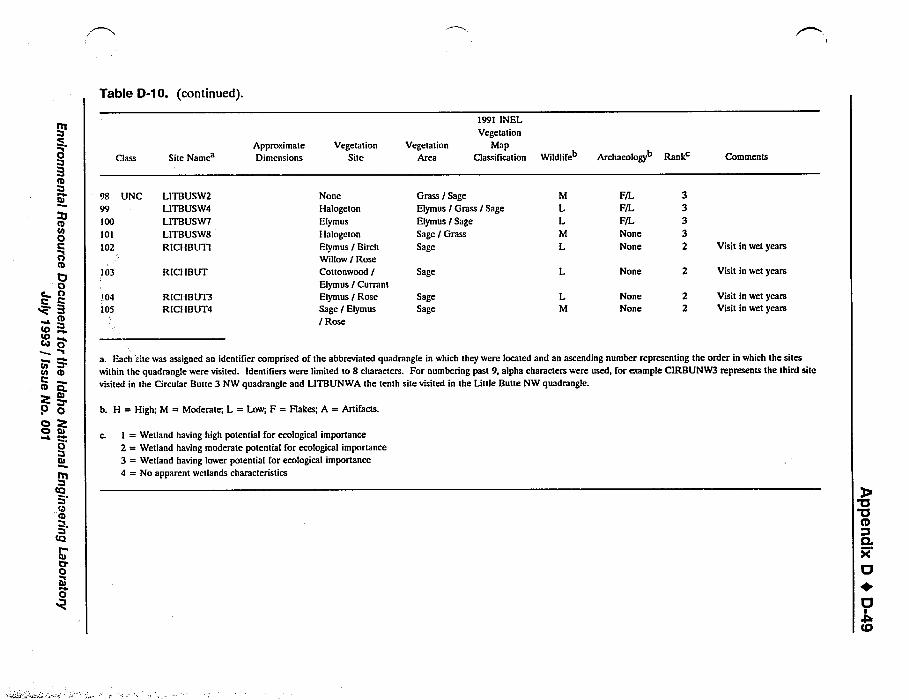
Table D-10. (continued).
0
Irft0COCl
ClO
rn
tc)co O
P P'n
O
tu
0 OO Po tu
0
tQ
rarn
O
0
Class Site NamesApproximate
Dimensions
VegetationSite
VegetationArea
1991 INELVegetation
MapClassification Wildlife Archaeology Rank Comments
98 UNC99100101102
LITBUSW2LITBUSW4LITBUSW7LITBUSWSRICI IBUTI
103 RICHBUT
104105
RICHBUT3RICH BUT4
None
Halogeton
Elymus
Halogeton
Elymus / BirchWillow / RoseCottonwood /
Elymus / Currant
Elymus / RoseSage / Elymus
/ Rose
Grass / Sage
Elymus / Grass / Sage
Elymus / Sage
Sage / Grass
Sage
Sage
SageSage
M
LLM
L
L
LM
F/L
F/LF/L
None
None
None
NoneNone
Visit in wet years
Visit in wet years
Visit in wet yearsVisit in wet years
b. H = High; M = Moderate; L = Low; F = Flakes; A = Artifacts.
I = Wetland having high potential for ecological importance
2 = Wetland having moderate potential for ecological importance
3 = Wetland having lower potential for ecological importance
4 = No apparent wetlands characteristics
a. Each site was assigned an identifier comprised of the abbreviated quadrangle in which they were located and an ascending number representing the order in which the sites
within the quadrangle were visited. Identifiers were limited to B characters. For numbering past 9, alpha characters were used, for example CIRBUNW3 represents the third site
visited in the Circular Butte 3 NW quadrangle and LITBUNWA the tenth site visited in the Little Butte NW quadrangle.
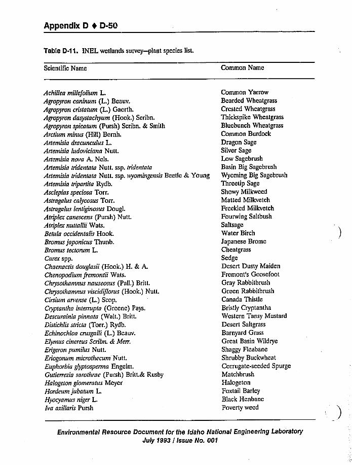
Appendix D t D-5Q
Table D-11. INEL wetlands survey-plant species list.
Scientific Name Common Name
Achillea millefolium L.Agropyron caninum (L.) Beauv.
Agropyron cristatum (L.) Gaerth.Agropyron dasystachyum (Hook.) Scribn.
Agropyron spicatum (Pursh) Scribn. & Smith
Arctium minus (Hill) Bernh.Artemisia dracunculus L.Artemisia ludoviciana Nutt.Artemisia nova A. Nels.Artemisia tridentata Nutt. ssp. tridentata
Artemisia tridentata Nutt. ssp. wyomingensis Beetle & YoungArtemisia tripartita Rydb.Asclepias speciosa Torr.Astragalus calycosus Torr.Astragalus lentiginosus Dougl.Atriplex canescens (Pursh) Nutt.
Atriplex nuttallii Wats.Betula occidentalis Hook.Bromus japonicus Thunb.Bromus tectorum L.Carex spp.Chaenactis douglnsii (Hook.) H. & A.Chenopodium fremontii Wats.Chrysothamnus nnuseosus (Pall.) Britt.Chrysothnmnus viscidiflorus (Hook.) Nutt.
Cirsium arvense (L.) Scop.Cryptanthn interrupta (Greene) Pays.Descurninin pinnnta (Walt.) Britt.Distichiis stricta (Torr.) Rydb.Echinochloa crusgalli (L.) Beauv.
Elymus cinereus Scribn. & Merr.
Erigeron pumi !us Nut t.Eriogonum microthecum Nut t.Euphorbia glyptospermn Engelm.Gutierrezin sarothrae (Pursh) Britt.& Rusby
Halogeton glomeratus McyerHordeum jubatum L.Hyocyamus niger L.Iva axillaris Pursh
Common YarrowBearded Wheatgrass
Crested Wheatgrass
Thickspike Wheatgrass
Blucbunch Wheatgrass
Common Burdock
Dragon SageSilver SageLow Sagebrush
Basin Big Sagebrush
Wyoming Big Sagebrush
Threetip SageShowy Milkweed
Matted Milkvetch
Freckled Milkvetch
Fourwing Saltbush
SaltsageWater BirchJapanese BromeCheatgrass
SedgeDesert Dusty Maiden
Fremont's GoosefootGray Rabbitbrush
Green Rabbitbrush
Canada Thistle
Bristly Cryptantha
Western Tansy Mustard
Desert Saltgrass
Barnyard Grass
Great Basin Wildrye
Shaggy Fleabane
Shrubby Buckwheat
Corrugate-seeded SpurgeMatchbrush
Halogeton
Foxtail BarleyBlack Henbane
Poverty weed
Environmental Resource Document for the Idaho National Engineering Laboratory
duly 1993 / Issue No. 601
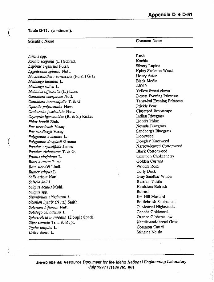
Appendix D 4 D-51
Table D-1 1. (continued).
Scientific Name Common Name
Juncus spp.Kochia scoparia (L.) Schrad.Lupinus argenteus Pursh
Lygodesmia spinosa Nutt.Machaeranthera canescens (Pursh) Gray
Medicago lupulina L.Medicago sativa L.Melilotus officinalis (L.) Lam.Oenothera caespitosa Nutt.Oenothera tanacetifolia T. & G.Opuntia polyacantha Haw.Orobanche fasciculata Nutt.
Oryzopsis hymenoides (R. & S.) RickerPhlox hoodii Rich.Poa nevadensis VaseyPoa sandbergii Vasey
Polygonum aviculare L.Polygonum douglasii GreenePopulus angustifolia James
Populus trichocarpa T. & G.Prunus virginiana L.Ribes aureum Pursh
Rosa ivoodsii Lindl.
Rumex crispus L.Salix exiyra Nutt.
Salsola kali L.Scirpus acutus Muhl.
Scirpus spp.Suymbrium altissimum L.Sitanion hystrix (Nutt.) Smith
Solanum triflorum Nutt.Solidago canadensis L.Sphaeralcea munroana (Dougl.) Spach.
Stipa comata Trin. & Rupr.
Typha latifolia L.Urtica dioica L.
RushKochiaSilvery Lupine
Kpiny Skeleton Weed
Hoary AsterBlack MedicAlfalfa
Yellow Sweet-clover
Desert Evening Primrose
Tansy-lvd Evening Primrose
Prickly PearClustered BroomrapeIndian RicegrassHood's Phlox
Nevada BluegrassSandbcrg's Bluegrass
DoorweedDouglas'notweedNarrow-leaved Cottonwood
Black Cottonwood
Common ChokecherryGolden CurrantWood's RoseCurly DockGray Sandbar Willow
Russian Thistle
Hardstem Bulrush
Bulrush
Jim Hill Mustard
Bottlcbrush Squirreltail
Cut-leaved Nightshade
Canada Goldenrod
Orange Globemallow
Needle-and-thread Grass
Common Cattail
Stinging Nettle
Environmental Resource Document for the Idaho National Engineering Laboratory
July 1993 / Issue No. 001
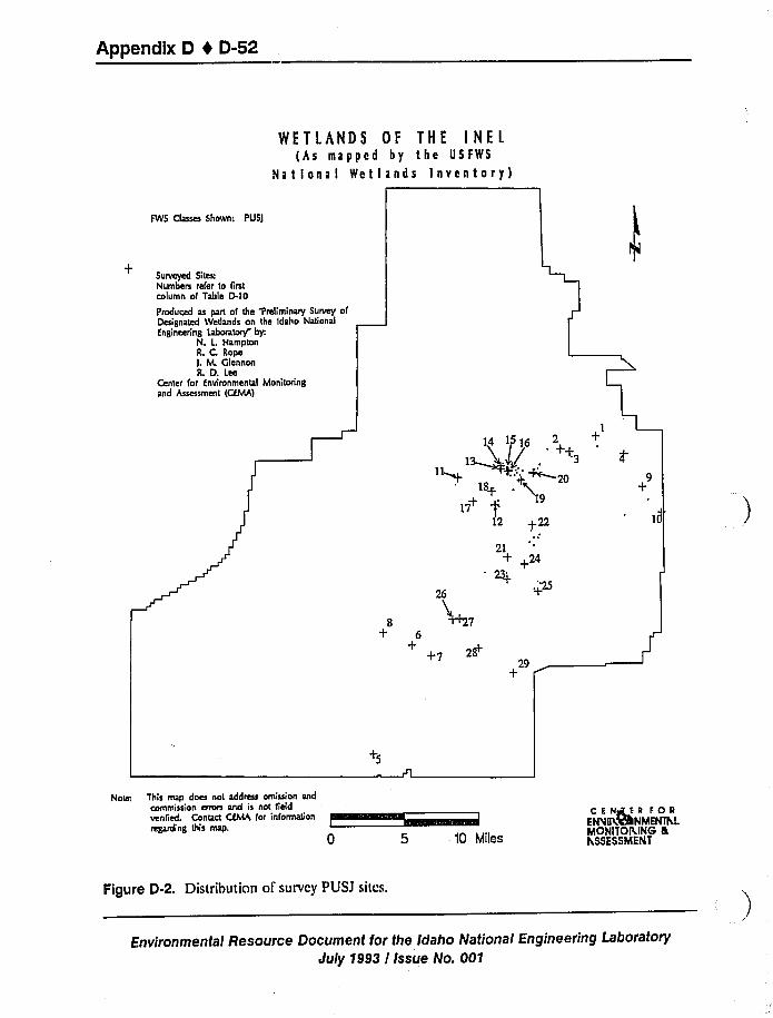
Appendix D 4 D-52
WETLANDS OF THE INEL(As mapped by the USFWS
National Wetlands Inventory)
FWS Classes Shown: Pusl
+Surveyed Sites;Numbem refer to frrstcolumn of Table D.lo
Produced as part of the Preliminary Survey ofDesignated Wetlands on the Idaho National
Engineenng laboratory by:N. L HamptonR. C, Ropel. M. GlennonR. D. Lee
Center for Environmental Monitoringand Assessment (CEMA)
1
14 15 16 2 +
18'7
12 +22
21+ +2423+
+25
8 M7+ 6
+~7
29+
Notcr. This map does not address omission andcommission ainus and is not fieldvenfied. Contact CEMA for information
regarding gus map.
I
10 Miles
CENsstER FORENsa!KVhNMENThLMONITORING nthSSESSMENT
Figure D-2. Distribution of survey PUSJ sites.
Environmental Resource Document for the Idaho National Engineering Laboratory
July 1993 I Issue No. 001
Appendix D 4 D-53
Thirty-seven of the 44 surveyed PUSJ wetlands are dry, bare playas with scattered halogeton
(Halogeton glomeratus) plants established in mud cracks. Four sites are basins containing
primarily basin wildrye (Elymus cinereus). Other established vegetation at PUSJ sites was rare.
Nearly all sites are surrounded by sagebrush (Arremisia spp.) in some combination with other
species including weeds, grasses, greascwood (Snrcobatus vermiculatus), rabbitbrush
(Chrysothnmnus spp.), or winterfat (Ceratoides lanara).
Although no water was present at any PUSJ site during the fall survey, their characteristics
indicate that water is present during some parts of the year. No obligate or facultative wetland
vegetation was observed. Playa soil texture was generally fine (silty clay or silty clay loam) and
compacted, with surfaces broken by mud cracks. Many of the sites were surrounded by large
areas of dead and dying sagebrush (Anemisin spp.). Evidence of wildlife was present at all PUSJsites, and nearly one third of thc sites had signs of heavy use. No rare or endangered species
were observed.
D.1.4.1.3L2USJ, PEM1A, PEM1C, PEM1J, and PEMJ ClassifiedWetlands —Lacustrine (L2USJ) and palustrine (PEMJ, PEMIJ, PEMIA, and PEMIC)classiTications cover large portions of the Big Lost River spreading areas and thc outflow areas
from the Big Lost River Sinks. The distribution of these wetlands and location of surveyed sites
are shown Figure D-3. The largest single area encompassed by L2USJ wetlands is approximately
325 ha (800 acres). Area totals for PEMJ, PEMIJ, PEMIA, and PEMIC wetlands are between
160 ha (400 acres) and 290 ha (700 acres). INEL wetlands included in these classifications cover
a total of approximately 1,417 ha (3,500 acres).
Wetlands for these five classifications are expansive, with large areas of bare ground and
perennial weed cover. Most areas are heavily grazed by cattle. Native perennials are present in
small numbers for both PEMIJ sites, and some native grasses were found among many weed
species at the PEMIA site. Communities dominated by sagebrush (ArtemLrin spp.) surround both
lacustrine and palustrine wetlands for all five classiTications.
Remains of obligate wetland vegetation [bulrush (Scirpus acutus) j were observed at an
outflow area north of Naval Reactors Facility (PEMIC), and remains of cattails (Typha lnlifolia)
were found in areas of thc Big Lost Sinks (PEMIC). However, a combination of extended
drought, upstream water diversion, and heavy cattle grazing have reduced vcgctation in the BigLost Sinks to bare ground and weed cover. Gray sandbar willow (Salix exigun), an obligate
wetland spccics, was idcntiTied in the L2USJ areas cast ol'hc Big Lost Sinks, and several
facultative wetland species such as curly dock (Rumex crispus), doorwecd (Polygonum aviculnre),
and dcsert saltgrass (DLi'richlis slricrn) werc also identiTied at L2USJ and PEM I A sites. Soils were
generally loose, disturbed, and flinc (sandy silt). Low to moderate evidcncc of wildlife use was
observed for all 11 of these sites. No rare or endangered species were observed. Thenorthernmost PEMIA site located in the Big Lost Sinks is the only INEL wetland that has been
ground-truthcd by thc FWS for thc NWI.
Environmental Resource Document for the Idaho National Engineering Laboratory
July 1993 / Issue No. 001
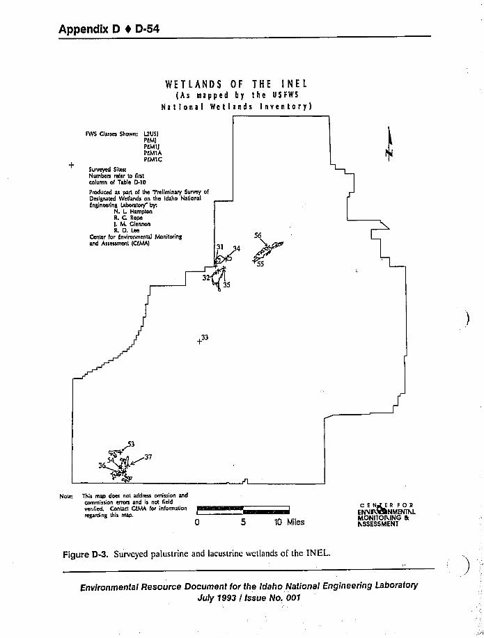
Appendix D 1 D-54
WETLANDS OF THE INELlAs mapped by tbe USFWS
National Wetlands Inventory)
FWS Classes Shown: l2USIPfMlPEM1IPEMIA
+PEM1C
Surveyed Sites:Numbers refer to firstcolumn of Table D.10
Pmduced as part of the Preliminary Survey ofDesignated Wetlands on the Idaho NationalEngineeding laboratory by:
N. L HamptonR. C, RopeI, fvt ClennonR. D. Lee
Center for Environmental Monitoringand Assessment (CEMA)
32
56
34
55
33
g3~ ~3T3
Note This map does not address omission andcommission errors and is not fieldverified. Contact CEMA for informationregarding this map.
0 5 10 Miles
C E Ms' R FOREtAnt VRNMENITvLMONITOP ING gtASSESSMENT
Figure D-3. Surveyed palustrine and lacustrine wetlands of the INEL.
Environmental Resource Document Ior the idaho National Engineering Laboratory
July 1993 / Issue No. 001
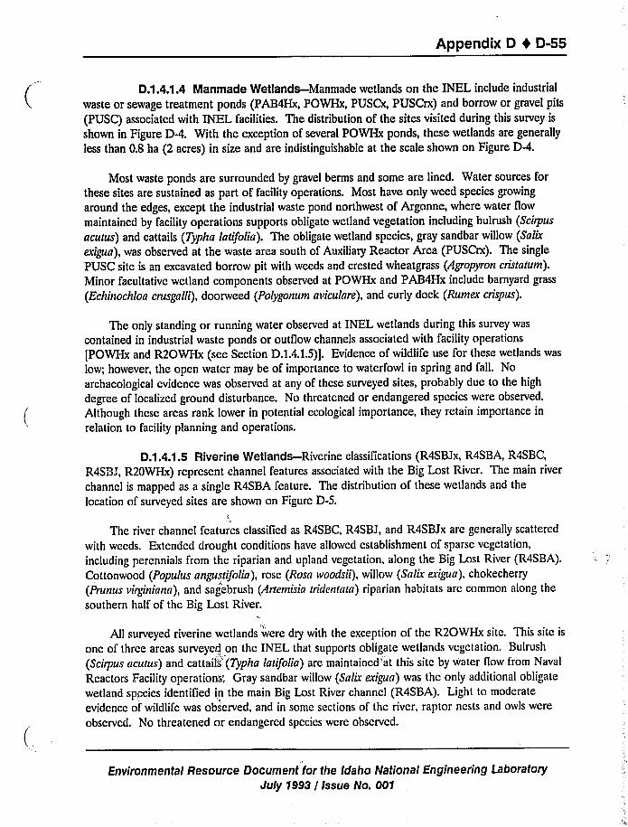
Appendix D t D-55
D.1.4.1.4 Manmade Wetlands —Manmade wetlands on the INEL include industrial
waste or sewage treatment ponds (PAB4Hx, POWHx, PUSCx, PUSCrx) and borrow or gravel pits
(PUSC) associated with INEL facilities. The distribution of the sites visited during this survey is
shown in Figure D-4. With the exception of several POWHx ponds, these wetlands are generally
less than 0.8 ha (2 acres) in size and are indistinguishable at the scale shown on Figure D-4.
Most waste ponds are surrounded by gravel berms and some are lined. Water sources for
these sites are sustained as part of facility operations. Most have only weed species growing
around the edges, except the industrial waste pond northwest of Argonne, where water flow
maintained by facility operations supports obligate wetland vegetation including bulrush (Scirpus
acutus) and cattails (Typha latifolia). The obligate wetland species, gray sandbar willow (Salix
cxt'gua), was observed at the waste area south of Auxiliary Reactor Area (PUSCrx). The single
PUSC site is an excavated borrow pit with weeds and crested wheatgrass (Agropyron cristatum).
Minor facultative wetland components observed at POWHx and PAB4Hx include barnyard grass
(Echinochloa crusgalli), doorweed (Polygonum aviculare), and curly dock (Rumex crispus).
The only standing or running water observed at INEL wetlands during this survey was
contained in industrial waste ponds or outflow channels associated with facility operations
[POWHx and R2OWHx (see Section D.1.4.1.5)j.Evidence of wildlife use for these wetlands was
low; however, the open water may be of importance to waterfowl in spring and fall. No
archaeological evidence was observed at any of these surveyed sites, probably due to the high
degree of localized ground disturbance. No threatened or endangered species were observed.
Although these areas rank lower in potential ecological importance, they retain importance in
relation to facility planning and operations.
D.1.4.1.5 Riverine Wetlands —Riverine classifications (R4SBJx, R4SBA, R4SBC,
R4SBJ, R20WHx) represent channel features associated with the Big Lost River. The main river
channel is mapped as a single R4SBA feature. The distribution of these wetlands and the
location of surveyed sites are shown on Figure D-S.
The river channel features classiTicd as R4SBC, R4SBJ, and R4SBJx are generally scattered
with weeds. Extended drought conditions have allowed establishment of sparse vegetation,
including percnnials from the riparian and upland vegetation, along the Big Lost River (R4SBA).Cottonwood (Populus angustifolia), rose (Rosa ivoodsii), willow (Salix exigua), chokecherry
(Prunus viry'niana), and sagebrush (Artemisia tridentatn) riparian habitats arc common along the
southern half of the Big Lost River.
All surveyed riverine wetlands were dry with the exception of the R2OWHx site. This site is
one of three areas surveyed on the INEL that supports obligate wetlands vegetation. Bulrush
(Scirpus acutus) and cattails"(Typha latifolia) are maintained"at this site by water flow from Naval
Reactors Facility operations'„Gray sandbar willow (Salix exigua) was the only additional obligate
wetland species identiTied in the main Big Lost River channel (R4SBA). Light to moderate
evidcncc of'wildlife was observed, and in some sections of the river, raptor nests and owls were
observed. No threatened or endangered species were observed.
Environmental Resource Document for the Idaho National Engineering Laboratory
July 1993 / Issue No. 001
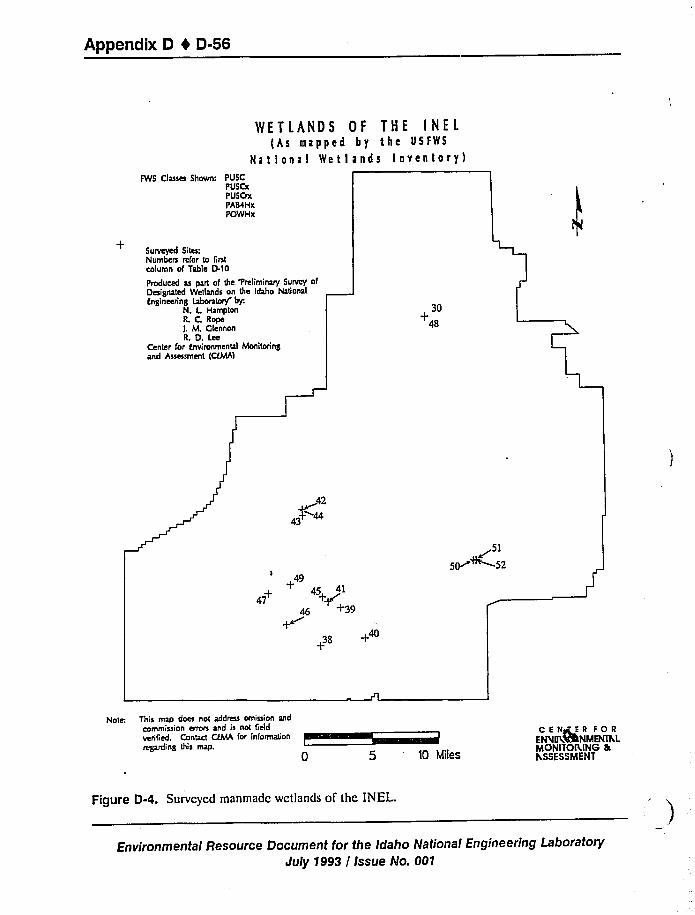
Appendix D 0 D-56
WETLANDS OF THE INEL(As mapped by the USFWS
National WetIands Inventory)FWS Classes Shown: PUSC
PUSCxPUSCrxPABaHxPOWHx
+Surveyed Sites:Numbers refer to firstcolumn of Table D.ln
Produced as part of the Preliminary Survey ofDesignated Wetlands on the Idaho NationalEngineering Laboratory by:
N. L HamptonR. C, Ropel. M. ClennonR. D. Lee
Center for Envimnmental Monitoringand Assessment (CFMA)
30
48
42
43%44
49
+ 45 41
+39
~515~~52
+38 +
Note This map does not address omission andcommission errors and is not fieldverified. Contact CFMA for information
ruing this map.
5 '0 Miles
CENrsEER FOREMirt VRNMENthLMONlTOMNS fkh.SSESSMENT
Figure D-4. Surveyed manmade wetlands of the INEL.
Environmental Resource Document for the Idaho National Engineering LaboratoryJuly y993 / Issue No. 001
Appendix D I D-57
WETLANDS OF THE INEL(hs mapped by the USfWS
National Wetlands Inventory)
FWS Classes Shown: R4SBAR4SBCR4SBIR4sglxR2OWHx
+Surveyed Sites:Numbes refer to fistcolumn of Table D.l
Produced as part of the Preliminary Survey ofDesignated Wedands on the Idaho kagonalEngineering Laboratory by
N. L HamptonL C RopeI. M. ClennonIL D. Lee
Center for tnvironrnental Monitoringand Assessment (CfMA)
~61~2
Note This map does not address omission andcommission erros and is not fidd
'BA. G CiMA i i i~'egardingthis map.
0 5 10 Miles
CSNsrtrn FORENsf IKVlhNMENihLMONITORING gthSSESSMENT
Figure D-5. Surveyed riverine wetlands of the INEL.
Environmental Resource Document for the Idaho National Engineering LaboratoryJuly 1993 / Issue No. 001
Appendix D I D-58
D.1.4.1.6Wetland Areas in UNMAPPED Quadrangles-The 14 unmapped sites
(UNMAP) included in this survey are located in seven quadrangles for which NWI maps have not
been completed by the FWS (see Figure D-6). These maps cover the westernmost areas of the
INEL, and the sites visited include riverine classifications along the Big Lost River, as well as sites
that are similar to the PUSJ sites that were investigated in other areas of the INEL. Unmapped
riverine sites were similar to the R4SBA sites described in Section D.1.4.1.5.The remaining sites
were similar in most respects to PUSJ sites described in Section D.1.4.1.2,except that playa areas
dominated by basin wildrye (Elymus cinereus) were more common. The unmapped sites visited
for the survey are included on Figure D-6.
D.1.4.1.7 UNCLASSIFIED Areas-Twenty-nine unclassified areas (UNCLASS) on
the INEL were included as part of this survey. Non-riverine sites in this classification were similar
in all respects to those classified as PUSJ (Section D.1.4.1.2).Most sites were bare playas orbasins dominated by basin wildrye (Elymus spp.); however, disturbed areas with numerous weedy
species were also included. Some unclassified areas had substantial signs of wildlife use and
archaeological evidence. All areas appeared to retain water for some duration during normal
precipitation years. A number of these areas are represented as intermittent water (blue) on the
U.S. Geological Survey 7.5-ft topographical maps covered by the NWI; however, they were not
selected for NWI classiTication. The unclassiTied sites surveyed are included on Figure D-6.
The only unclassified riverine area included for this survey was the Birch Creek drainage.
The creek system contains areas with important riparian communities including of cottonwoods
(Populus spp.), willow (Snlix spp.), birch (Betula spp.), chokecherry (Prunus virginiana) and rose
(Rosa woodsii).
D.1.4.1.8 Riparian Areas-These areas are generally included in the discussion for
riverine, unmapped, and unclassiTied wetlands. They include the Big Lost River and Birch Creek
drainages.
D.1.4.2 Caves. This section will be completed as part of GIS analysis.
D.1.4.3 Manmade Structures and Facilities. This section will be completed as part ofGIS analysis.
D.1.4.4 Soil Microflora. Given the magnitude of mass and energy that cycles through
microbial biomass and thc pivotal nature of their associations with plant species, the impact of site
development and environmental restoration activities on microbial communities should not be
ignored. The ecological significance of soil microorganisms, their distribution in the environment,
and recent work describing the role of microorganisms in disturbed and restored environments is
cited below. The microbiology of shrub-steppe ecosystems is not well understood. At the INEL,detailed Site-wide data are not available describing the distribution and activities of soil
microorganisms. Limited microbiology data exist for several subsurface basalt/sediments cored
during 1988 and 1990 and from the Snake River Plain Aquifer sampled at discrete well locations.
Environmental Resource Document for the Idaho National Engineering LaboratoryJuly 1993 / Issue No. 001
Appendix D 4 D-59
FWS Classes Shown: UNMAPPEDUNCIASSIFIED
+105
WETLANDS OF THE INEL(As mapped by the USFWS
National Wetlands inventory)102
+104
+Surveyed Sites:Numbes refer to firstcolumn of Table D.IO
Pmduced as part of the 'Preliminary Survey ofDesignated Wetlands on the Idaho Nagonal
Engineering Laboratory byN. L HamptonR. C. RopeI. M. GlennonR. D. Lee
Center for Environmental Monitoding
and Assessment (CEMA) 79+
68174 +
273
87
8+6 +
89~
6365 +66 92
82
81
80
83
9891 101
10i%
+77
9496+
+95+97
Note: This map does not address omission and
coinmission erros and is not field
verifiecL Contact CEMA for information
regarding this map.
0 5 10 Miles
CENeTER FORENsIIP%%NMENlhLMONITOP ING etFi SSESSMENT
Figure 0-6. Surveyed unmapped and unclassified areas on the INEL.
Environmental Resource Document for the Idaho National Engineering Laboratory
July 1993 / Issue No. 001
Appendix D 4 D-60
Soil microorganisms influence the success or failure of plant growth by regulating the
quantity and form of nutrients and toxicants. In addition, microorganisms synthesize vitamins,
amino acids, growth factors, auxins, and allelopathic substances. In the immediate vicinity of the
plant's rhizosphere, there are increased numbers of microorganisms; this enhancement is known as
the rhizosphere effect. Many of the microorganisms that reside in the rhizosphere are involved in
some type of mutualistic relationship with the host plant species. Some of these relationships are
loosely defined such as the increased bioavailability of nutrients in exchange for labile carbon
from root exudates. Symbiotic relationships between plants and nitrogen-fixing bacteria and
associations with mycorrhizae fungi necessitate physical integration of these species into the plant
structure. All of these interactions may contain nuances in the mechanisms of material exchange
and the presence of elaborate feedback signals. Soil microorganisms further modify the plant's
environment by contributing to soil particle structure, both with their living biomass and
extracellular polymer production.
Microorganisms mediate transformations of nearly all inorganic and organic substances.
Collectively, they share the primary responsibility for material recycling in all ecosystems. Their
ability to make a local impact (nutrient bioavailability) or a global impact (climate change) is a
direct function of their large numbers (for bacteria alone: ca. 10 /g soil and 10 /mL water). The
role of soil microorganisms in terrestrial ecosystems is particularly critical as the upper soil
horizons function as reservoirs containing organic matter and inorganic nutrients in these systems.
The biogeochemical cycles of C, 0, and H are heavily influenced by microbes. Soil
microorganisms, especially bacteria and fungi, are largely responsible for the decomposition oforganic matter (to COz, water, and simple inorganic molecules) in terrestrial systems. These
organic substrates include those considered as contaminants such as hydrocarbons and xenobiotics.
They also incorporate inorganic (and organic) carbon into biomass and provide a food source for
higher heterotrophic organisms such as grazers. The consumption of oxygen during the
metabolism of aerobic microorganisms often determines the level of Oz in the soil atmosphere.
Due to the enormous physiological diversity of microorganisms, significant numbers of species are
involved in metabolic transformations which consume or evolve Hz, altering the flow of electrons
in the environment.
All of the major, minor, and trace nutrients are directly or indirectly influenced by the
activity of soil microorganisms. These elements are used not only as nutricnts, but as energy
sources and alternate terminal electron acceptors by varying segments of the microbial community.
Nitrogen is one the most actively cycled elements in the soil and is often limiting to plant
productivity. Organic N can be mineralized or assimilated. Inorganic nitrogen can be oxidized or
reduced. These biologically-catalyzed reactions result in conversion of N to any one of its
oxidation states and may partition the N into any phase. These transformations affect the
mobility and bioavailability of N in the environment with the extreme case being a loss of N from
thc system (e.g., dcnitriTication, leaching of NO3) or a gain (e.g., Nz fixation). Iron and sulfur are
cycled as intensively and along many of the same routes as nitrogen. Phosphorous is less actively
cycled, mostly between organic and inorganic forms. The bioavailability of many elements
Environmental Resource Document for the Idaho National Engineering Laboratory
July 1993 / Issue No. 001
Appendix D t D-61
essential for life such as Mn, Ca, Si, Cu, and Zn are influenced by the activities of the soil
microflora.
The speciation of nearly all trace metals, and therefore form, mobility, bioavailability, and
toxicity, may be altered by microorganisms. These alterations may be direct, e.g., reduction of a
metal as a terminal electron acceptor, oxidation as an energy source, methylation or assimilation
of that metal. Immobilization of the metal may involve sorption processes at the cell surface, or
these transformations may be more indirect. The metabolism of microorganisms can result in
gradients in redox potential or pH; both affect sorption phenomena and mineral solubility.
Microorganisms produce extracellular organic compounds, which function as simple ligands ormultidentate chelators for metals. These compounds include enzymes, extracellular polysaccharide
polymers, siderophores, and incompletely oxidized organic substrates. These organic compounds
can profoundly alter the speciation, solubility, bioavailability, and partitioning of metals in the
environment.
As a group, microorganisms respond to a multitude of environmental variables that
determine their distribution and activity. Among bacteria and fungi, species may respond
differently to these factors and exhibit quite a range of tolerances and optima. Within species,
there is variability attributable to the individual. In general, microorganisms are uniquely qualified
to react to trace quantities of a chemical in the environment. The physical, chemical, and
biological variables that microorganisms respond to are present in the environment in
concentration gradients that vary in length scale from submicron to kilometers. The large number
of influential variables and their varying length scales combine to ensure that microorganisms will
be heterogeneously distributed in time and space. Certainly, the presence of plant species will
affect the distribution of microbes in soils. Key variables that affect microbial activity are
temperature, moisture, quantity, and quality of organic carbon, nutrients, and electron acceptors,
such as oxygen, nitrate, and sulfate.
The soil microbial community and its functions are affected by disturbance-whether
introduction of contamiriants such as hydrocarbons (Atlas et al. 1991)or pesticidcs (Duah-
Ycntumi and Johnson 1986) or by excavation and stockpiling (Johnson et al. 1988). The ability ofcontaminated, remediated, or restored soil to support revegetation with the original complement
of flora is uncertain. Further, the impact of remedial operations (if necessary) on the soil
microflora is undclincd. Anticipated alterations due to remedial actions might include changes in
thc native microbial community structure and function and concomitant effects in carbon and
nutrient flow and storage (Fender 1992). Impact on bacteria involved in mutualistic associations
with vegetation may translate to decreased plant growth or inability to reestablish native
vegetation. Effects at higher trophic levels would be expected.
Rcscarch has indicated that recolonization of soils by the appropriate microbial communities
is critical to the success of land reclamation efforts (Shubcrt and Starks 1985). Maxwell (1991)reported thc requirement of a diverse autotrophic soil microflora community for long-term
revegetation of reclaimed metal-contaminated lands. Williamson and Johnson (1991)showed that
rcstorcd soils at open-cast coal sites have lower nitrogen bioavailability than undisturbed soils.
Environmental Resource Document for the Idaho National Engineering Laboratory
July 1993 / Issue No. 00'f
Appendix D 0 D-62
This decrease in bioavailable N is due to complex changes in the relative abundances of microbial
guilds in response to the availability of terminal electron acceptors. Nitrogen is lost from the
system by leaching and denitriTication and immobilized by microbial assimilation (Johnson et al.
1988). Lack of bioavailable N causes increased competition between soil microorganisms and
plants for N with a consequence of lower plant production. Decreased biomass and a lower
percentage of active biomass (Harris and Birch 1989) occur in restored soils relative to
undisturbed soils. Williamson and Johnson (1991)have demonstrated low soil-biomass-C:soil-C
ratios and increasing C:N ratios of soil organic matter 3 years after soil restoration at open-cast
coal sites, which indicates long-term implications for soil fertility.
It has always been assumed that microbes are ubiquitous and that they appear spontaneously
with the correct blend of physiologies-by immigration, mutation, or transfer of genetic material.
This may not be a sound assumption. Microorganisms have evolved over geological time (e.g.,millions of years). Anthropogenic disturbances have occurred over much shorter time periods.
While it is true that short generation times, high mutation rates, and horizontal gene transfer
among microbial populations confer tremendous selective advantage to bacteria and allow them to
rapidly adapt to changing conditions, critical microbial niches may go unoccupied. It has been
shown that disturbed environments may exhibit long-term deviations in the processing of energy
and materials relative to undisturbed locations. Manipulation of microbial populations via
bioaugmentation or biostimulation or by controlling environmental variables during site
remediation may be required for successful restoration of disturbed sites, particularly where
revegetation is a criteria. When appropriate microbial populations are deficient in the
rhizosphere, plant growth is inhibited (Campbell 1985). This conclusion is due to the general role
of soil microorganisms in maintaining soil fertility through materials cycling and their effect on soil
structure and by specific roles provided by microorganisms that engage in mutualistic associations
with plant species.
Environmental Resource Document for the Idaho National Engineering Laboratory
July 1993 / Issue No. 001
Appendix D 4 D-63
D.2 Habitat Analyses and Ecological Associations(Biological Assessment)
This section describes the methods and the strategy employed to establish a habitat
relationship between vegetative communities and animal species for the INEL. By identifying
wildlife habitat associations and by utilizing the INEL vegetation map (Section D.1.1.1),mapping
(GIS) analyses can be applied to analyze potential impacts at the community level.
D.2.1 Vegetation Communities
D.2.1.1 Fragmentation. This section will be completed as part of GIS analysis.
D.2.1.2 Exotic Species. This section will be completed as part of GIS analysis.
D.2.1.3 Ecological Importance. This section will be completed as part of GIS analysis.
D.2.1.4 Vegetation Community Stratification. Because community and individual datafor INEL flora and fauna are incomplete for the INEL, a habitat model approach was applied todevelop a baseline structure for INEL plant and wildlife communities. Ecological studies for theINEL were compiled, reviewed, and evaluated to extract data that were appropriate for GIS and
mapping assessments and to support the development of habitat profiles for individual species.
Short and Burnham (1982) have developed a wildlife habitat evaluation model based on thevertical structure of vegetation communities that has been used to assess impacts to rangeland
habitats (see also Short 1982, 1986). The relationship between the number of species and thenumber of vegetation layers in a community has been shown to be significant, especially for birds
and reptiles (Short 1982, 1986; Jones 1986). The model is based on the assumption that greatervertical and horizontal diversity in desert habitats results in greater niche diversity and a morediverse wildlife association (Short 1986; Jones 1986; Anderson 1991). This vertical stratification
approach was applied to allow a coarse scale association of wildlife groups and individual specieswith vertical habitat "layers" within INEL vegetation communities.
Dominant specie life forms for each of the 14 INEL vegetation communities were used todetermine a maximum plant canopy height. Each of the communities were stratified by vertical
habitat structure according to the criteria suggested by Short and Burnham (1982) and defined onTable D-12. The resultant vertical stratirication for INEL communities is illustrated on
Table D-13.
Community associations for individual plant and animal species were drawn through
development of habitat profiles or "models" (FWS 1981; Short 1986) to allow linkage to stratawithin one or morc INEL vegetation communities.
Environmental Resource Document for the Idaho National Engineering LaboratoryJuly 1993 / Issue No. 001
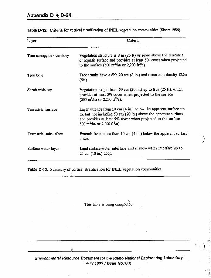
Appendix D 4 D-64
Table D-12. Criteria for vertical stratification of INEL vegetation communities (Short 1986).
Layer Criteria
Tree canopy or overstory Vegetation structure is 8 m (25 ft) or more above the terrestrial
or aquatic surface and provides at least 5% cover when projectedto the surface (500 m /ha or 2,200 ft /a).
Tree bole Tree trunks have a dbh 20 cm (8 in.) and occur at a density 12/ha
(5/a).
Shrub midstory Vegetation height from 50 cm (20 in.) up to 8 m (25 ft), which
provides at least 5% cover when projected to the surface
(500 m2/ha or 2,200 ft2/a).
Terrestrial surface Layer extends from 10 cm (4 in.) below the apparent surface up
to, but not including 50 cm (20 in.) above the apparent surface
and provides at least 5% cover when projected to the surface
500 m /ha or 2,200 ft /a).
Terrestrial subsurface Extends from more than 10 cm (4 in.) below the apparent surface
down.
Surface water layer Land surface-water interface and shallow water interface up to25 cm (10 in.) deep.
Table D-13. Summary of vertical stratification for INEL vegetation communities.
This table is being completed.
Environmental Resource Document for the Idaho National Engineering Laboratory
July 1993 / Issue No. 001
Appendix D 4 D-65
D.2.2 Habitat and Ecological Associations-Flora
Plant site profiles were developed from INEL ecological studies and other associated
literature. Only profiles for threatened, endangered, and sensitive species were compiled. Several
habitat components were used to correlate individual plant species with INEL vegetation
communities including:
~ Dominant species within the community or communities in which the plant has been
located and with which it is generally associated
~ Soil type and characteristics
~ Specific landforms with which the plant may be associated.
Only profiles for sensitive plant species were complied for this assessment to allow
association of individual species with the INEL mapped vegetation communities discussed in
Section D.1.1.2. An example of the profile developed for Thistle milkvetch (Astrngalus
kentrophytn var. jessine) is shown on Table D-14. Other habitat ecological associations for
sensitive plant species are presented in Section D.1.4.
Section D.2.2 to be completed as part of GIS analysis.
D.2.3 Habitat and Ecological Associations-Fauna
Data on the relative abundance, habitat use, and seasonal occurrence of species of fish,
amphibians, reptiles, birds, and mammals recorded on the INEL were updated in 1986 (Reynolds
et al. 1986). Previous ecological studies conducted on the INEL and correspondence with INELresearchers and personnel provided the basis for the analyses and data reported in this appendix.
See Section D.4 for an annotated bibliography of INEL ecological studies.
Habitat profiles were developed for individual animal species of interest, including
threatened, endangered, and sensitive species. Thc profiles were constructed around 18
components of dcsert ecosystems considered to be critical to desert wildlife and presented on
Table D-15 (Jones 1986). INEL vegetation, soil, and geologic studies were evaluated to compile
information on how these habitat components are distributed. Ecological research and other
literature was reviewed to obtain information about how individual species utilize habitat
components on the INEL. In addition, the FWS has developed habitat suitability index models in
support of their Habitat Evaluation Program (FWS 1981). These models were used to construct
habitat profiles for several species including the pronghorn (Artilocapra nmericana) and the
ferruginous hawk (Buleo regalis) (Table D-16) (Jasikoff 1982).
The resulting profiles were used to associate individual species with the appropriate vertical
strata using breeding and feeding loci as demonstrated by Short (1982, 1986). This prevented
evaluation of communities unrepresentative of the species vertical niche. The verbal profiles were
then used to identify vegetation community association throuiIh the process of elimination.
Environmental Resource Document for the Idaho National Engineering Laboratory
July 1993 / Issue No. 001
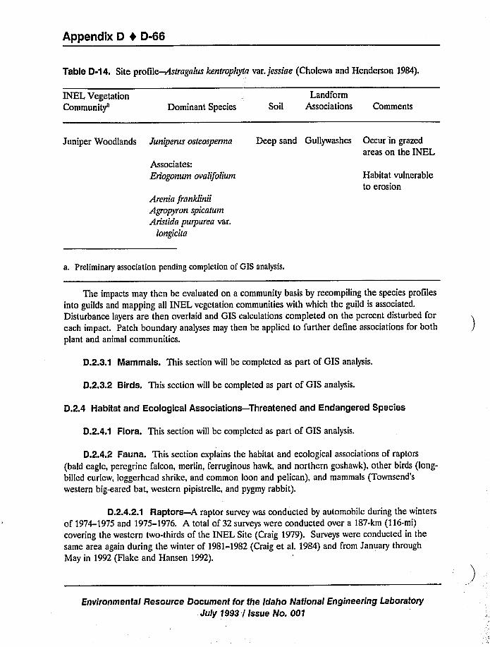
Appendix D 4 D-66
Table D-14. Site profile-Astragalus kenfrophyfn var. jessiae (Cholewa and Henderson 1984).
INEL VegetationCommunity'ominant Species
Landform
Soil Associations Comments
Juniper Woodlands Juniperus osteosperma
Associates:Eriogonum ovalifolium
Arenia franklinii
Agropyron spicarum
Aristida purpurea var.
longt'cia
Deep sand Gullywashes Occur in grazed
areas on the INEL
Habitat vulnerable
to erosion
a, Preliminary association pending completion of GIS analysis.
The impacts may then be evaluated on a community basis by recompiling the species profiles
into guilds and mapping all INEL vegetation communities with which the guild is associated.
Disturbance layers are then overlaid and GIS calculations completed on the percent disturbed for
each impact. Patch boundary analyses may then be applied to further define associations for both
plant and animal communities.
D.2.3.1 Mammals. This section will be completed as part of GIS analysis.
D.2.3.2 Birds. This section will be completed as part of GIS analysis.
D.2.4 Habitat and Ecological Associations-Threatened and Endangered Species
D.2.4.1 Flora. This section will be completed as part of GIS analysis.
D.2A.2 Fauna. This section explains the habitat and ecological associations of raptors
(bald eagle, peregrine falcon, merlin, ferruginous hawk, and northern goshawk), other birds (long-
billed curlew, loggerhead shrike, and common loon and pelican), and mammals (Townsend'
western big-eared bat, western pipistrelle, and pygmy rabbit).
D.2.4.2.1 Raptors —A raptor survey was conducted by automobile during the winters
of 1974-1975 and 1975-1976. A total of 32 surveys were conducted over a 187-km (116-mi)
covering the western two-thirds of the INEL Site (Craig 1979). Surveys were conducted in the
same area again during the winter of 1981-1982 (Craig et al. 1984) and from January through
May in 1992 (Flake and Hansen 1992).
Environmental Resource Document for the Idaho National Engineering Laboratory
July 1993 / Issue No. 001
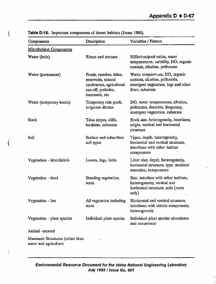
Appendix D 4 0-67
Table D-15. Important components of desert habitats (Jones 1986).
Components
Microhabitat Comnonents
Water (lotic)
Water (permanent)
Water (temporary lentic)
Rock
Soil
Vegetation - litter/debris
Vegetation - dead
Vegetation - live
Vegetation - plant species
Animal -created
Description
Rivers and streams
Ponds, marshes, lakes,
reservoirs, natural
catchments, agricultural
run-off, potholes,manmade, etc.
Temporary rain pools,
irrigation ditches
Talus slopes, cliffs,
boulders, substrate
Surface and subsurface
soil types
Leaves, logs, limbs
Standing vegetation,roots
All vegetation including
roots
Individual plant species
Variables / Factors
Riffle/run/pool ratios, water
temperatures, turbidity, DO, organiccontent, siltation, pollutants
Water temperature, DO, organiccontent, siltation, pollutants,
emergent vegetation, logs and otherlit ter, substrate
DO, water temperatures, siltation,
pollutants, duration, frequency,
emergent vegetation, substrate
Rock size, heterogeneity, interfaces,
origin, vertical and horizontal
structure
Types, depth, heterogeneity,horizontal and vertical structure,
interfaces with other habitat
components
Litter size, depth, heterogeneity,horizontal structure, type, moisture
retention, temperature
Size, interface with other habitats,
heterogeneity, vertical and
horizontal structure, soils (rootsonly)
Horizontal and vertical structure,interl'aces with abiotic components,
heterogeneity
Individual plant species abundance
and occurrence
Manmade Structures (othcr than
water and agriculture
Environmental Resource Document for the Idaho National Engineering LaboratoryJuly 1993 / Issue No. 001
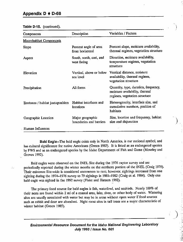
Appendix D t D-68
Table D-15. (continued).
Components
Macrohabitat Comnonents
Description Variables / Factors
Slope
Aspect
Percent angle of area
from horizontal
South, north, east, and
west facing
Percent slope, moisture availability,
thermal regimes, vegetation structure
Direction, moisture availability,
temperature regimes, vegetation
structure
Elevation Vertical, above or below Vertical distance, moisture
sea level availability, thermal regimes,
vegetation structure
Precipitation All forms Quantity, type, duration, frequency,
moisture availability, thermal
regimes, vegetation structure
Ecotones / habitat juxtaposition Habitat interfaces and
locations
Heterogeneity, interface size, and
cumulative numbers, position ofhabitats
Geographic Location
Human Influences
Major geographicboundaries and barriers
Size, location and frequency, habitat
size and disjunction
Bald Eagle —The bald eagle exists only in North America, is our national symbol, and
has cultural significance for native Americans (Green 1985). It is listed as an endangered species
by FWS and as an endangered species by the Idaho Department of Fish and Game (Moseley and
Groves 1992).
Bald eagles were observed on the INEL Site during the 1976 raptor survey and are
periodically reported during the winter months on the northern portion of the INEL (Craig 1979).
Their existence Site-wide is considered uncommon to rare; however, sightings increased from one
sighting during the 1974-1976 survey to 79 sightings in 1981-1982 (Craig ct aL 1984). Only one
bald eagle was sighted in the 1992 survey (Flake and Hansen 1992).
Thc primary food source for bald eagles is fish, waterfowl, and seabirds. Nearly 100% of
their nests are found within 2 mi of a coastal area, lake, river, or other body of water. Wintering
sites are usually associated with water but may be in areas without open water if food sources
such as rabbit and deer are abundant. Night roost sites in tall trees are a major characteristic of
winter habitat (Grccn 1985).
Environmental Resource Document for the Idaho National Engineering Laboratory
July 1993 / Issue No. 001
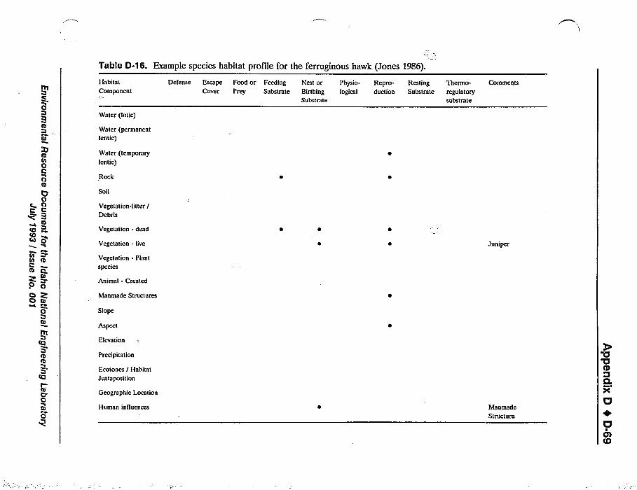
Table D-16. Example species habitat profile for the ferruginous hawk (Jones 1986).
ttt
0
I00oIO0o
0I
rir eCID
Z0 0o Z
0
t0
Ib
0
Habitat
Component
Water (lotic)
Water (permanent
lentic)
Water (temporary
lentic)
Soil
Vegetation-litter /
Debris
Vegetation - dead
Vegetation - live
Vegetation - Plant
species
Animal - Created
Manmade Structures
Slope
Aspect
Elevation
Precipitation
Ecotones / Habitat
Juxtaposition
Geographic Location
Human influences
Defense Escape Food or Feeding Nest or Physio- Repro- RestingCover Prey Substrate Birthing logical duction Substrate
Substrate
Thermo- Comments
regulatory
substrate
Juniper
Manmade
Structure
Appendix D 0 D-70
Peregrine Falcon-The peregrine falcon migrates over the INEL (Craig 1979).Sightings on the INEL have been rare but have occurred in both summer and winter (Arthur
et al. 1984). The peregrine falcon is listed by FWS as an endangered species (Moseley and
Groves 1992) due to the population decline in the 1950s and 1960s (Craig 1986). Efforts to
reintroduce the species into Idaho were begun in the early 1980s (Craig 1986).
There is no record of peregrine falcons breeding on the INEL; however, the known breeding
range extends along the rocky mountains from the arctic to Mexico (Craig 1986). Breeding
occurs primarily in March and April, and eggs are laid in scrapes on high escarpments or
sometimes on ledges of tall, man-made structures (Craig 1986).
Peregrine falcons feed primarily on shore birds, other birds (Craig 1986), and small mammals,
reptiles, and insects (Craig 1979). Marshes and riparian areas are important for their foraging
(Craig 1986). Because they are at the apex of the food chain, small perturbations in the system
have dramatic effects on them. DDT and chlorinated hydrocarbons are considered to be one ofthe primary causes of their decline (Craig 1986).
Merlin-The merlin is a species of special concern for the state of Idaho and a
sensitive species for the Bureau of Land Management (Moseley and Groves 1992).
The merlin is a Site-wide resident but its existence is rare (Arthur et al. 1984). Only one
merlin was sighted on the INEL during the winter 1992 survey (Flake and Hansen 1992).
The distribution of the mcrlins is from the northwestern corner of Oregon, up through
northern Washington and Idaho, and back down through Montana, Wyoming, and Eastern Idaho.
They winter throughout the region and breed primarily in the prairie-parkland, rarely breeding in
juniper. Two ncstings of merlin close to the INEL have been recorded (Craig and Renn 1977).
Ferruginous Hawk —The ferruginous hawk is a candidate species (C2) for the FWS
and listed as a species of special concern by the Idaho Department of Fish and Game (Moseley
and Groves 1992). It is a migrant species, arriving on the INEL Site in mid-March and leaving in
September. It has been seen Site-wide but is considered uncommon and rarely seen in the v,inter
(Arthur ct al. 1984).
During the 1974-1976 raptor survey (Craig 1979), three areas on thc Site were determined
to be breeding sites for ferruginous hawks. Evidence of at least 35 older nesting sites (Craig
1984) werc found, which lcd the researchers to conclude that ferruginous hawks were declining in
the area as they are throughout much of their territory (Harlow and Bloom 1987). Powers and
Craig (1976) describe the INEL as a part of the most concentrated Ferruginous hawk nesting area
in southeastern Idaho.
Ferruginous hawks are commonly found in grassland, sagebrush, and pinion-juniper habitats.
A versatile nester, thc ferruginous hawk nests in trees, cliffs, buttes, and even manmade structures
(Jasikoff 1982) Their decline is generally attributed to human disturbance and the conversion of
Environmental Resource Document for the Idaho National Engineering Laboratory
July 1993 / Issue No. 001
Appendix D 4 D-71
grassland to agricultural lands, not to the loss of breeding sites (Harlow and Bloom 1987).Researchers of the INEL have attributed their decline on the Site to the reduced blacktailjackrabbit population at the time of the survey (Craig 1979) and reported that ferruginous hawkswere regularly seen during the winter of 1981-1982when jackrabbit populations were increasing(Craig et al. 1984). Ferruginous hawks were sighted 41 times during the 1992 survey (Hake andHansen 1992).
Northern Goshawk —The northern goshawk is listed by the FWS as C2, taxa forwhich information indicates that endangered or threatened status may be appropriate but forwhich conclusive data on vulnerability are not available. Also, it is listed by Region 4 of theU.S. Forest Service as a sensitive species (Moseley and Groves 1992).
The northern goshawk is a migratory species that is rare at the INEL; however, some havebeen sighted in the spring and fall near Big Southern Butte or along the edge of the mountains tothe northwest, and in the winter along the Big Lost River.
Northern goshawks are associated with woodlands and forests. Their rounded wings andlong tail are adapted for flight agility in dense vegetation (Reynolds 1987). Their preferredbreeding habitat is older, tall forests, but wintering habitat can be in more open scrublands andwoodlands. Typical prey are quail, jay, American robin, snowshoe hare, tree squirrel, and groundsquirrel.
D.2.4.2.2 Other Birds —This section covers the long-billed curlew, the loggerheadshrike, and the common loon and pelican.
Long-Billed Curlew —The long-billed curlew is listed as 3C by FWS, a species morewidespread or abundant than previously believed or not subject to idcntiTiablc threats (Moseleyand Groves 1992) but is listed by the Bureau of Land Management as a sensitive species. Thespecies has been declining in the Great Basin region and throughout t»c West (Arthur et al.1984).
The long-billed curlew is the largest of the North American shorebirds (Ryscr 1985). It hasbeen sighted on thc INEL near water and in sagebrush-steppe communities (Arthur et aL 1984).It is a migratory bird that is not known to breed on the INEL. Long-billed curlews usually breedin grassy areas near marshcs but have been known to breed in dry upland areas and even in alkaliflats (Arthur et al. 1984). Insects and other invertebrates are their primary food source.
Loggerhead Shrike —The loggerhead shrike is listed by thc FWS as C2, taxa for whichinformation indicates that endangered or threatened status may be appropriate but for whichconclusive data on vulnerability are not available.
They are not common to the INEL, but some breed there. They generally are found in
open areas with shrubs and small trees for nesting sites. The loggerhead shrike is declining
Environmental Resource Document for the Idaho National Engineering LaboratoryJuly 1993 / Issue No. 001
Appendix 0 4 0-72
throughout the United States, but are most prevalent in the brushlands and deserts of the
southwest. They eat a wide variety of small mammals, bird"., reptiles, and insects.
Common Loon and Pelican-The common loon and pelican are both listed as special
species of concern for the State of Idaho. Both species migrate over the INEL, but their
existence on the Site is rare. Since the INEL has no extensive aquatic habitat, the activities there
are not likely to affect these species.
D.2.4.2.3 Mammals-This section covers Townsend's western big-eared bat, the
western pipistrelle, and the pygmy rabbit.
Townsend's Western Big-Eared Bat—Townsend's big-eared bat is listed by FWS as
category C2, is listed as a sensitive species by Region 4 of the Forest Service, and is a species ofconcern for the State of Idaho (Moseley and Groves 1992).
In a study of hibernating bats in lava tubes, 177 Townsend's big-eared bats were counted
(Genter 1986). Wackenhut reported Townsend's big-eared bats summering on the INEL and
hibernating in caves in groups of 3 to 406 (Genter 1986). The species is seldom abundant, but is
widespread, occupying a variety of habitats, but most typically in the arid western desert scrub,
pinon-juniper, and pine forest regions. In arid regions, it uses caves rather than buildings for
daytime roosts, but uses buildings for nighttime roosts. The main food source for Townsend's big-
eared bat is lepidoptera.
Western Pipistrelle —The western pipistrelle is a species of special concern for the
State of Idaho (Moseley and Groves 1992). This species has not been found on the INEL, but is
a summer resident of the lava tubes and caves in Lincoln and Gooding counties (Wackenhut
1990).
Pygmy Rabbit —The pygmy rabbit is listed as C2, taxa for which information indicates
that endangered or threatened status may be appropriate but for which conclusive data on
vulnerability are not available (Moseley and Groves 1992),
''hepygmy rabbit is a resident of the INEL and is abundant particularly in the southwestern
section of the INEL (Fisher 1979). It is dependent upon the presence of dense stands of big
sagebrush for defense, reproduction, and food (Wilde 1978). Pygmy rabbits apparently dwell only
in big sagebrush habitats, but require some rock outcrops as well (Fisher 1979).
D.2.5 Unique or Special Habitats and Communities
D.2.5.1 Wetlands. This section will be completed as part of GIS analysis.
D.2.5.2 Caves. This section will be completed as part of GIS analysis.
Environmental Resource Document for the Idaho National Engineering Laboratory
July 1993 / Issue No. 001
Appendix D t D-73
D.2.5.3 Manmade Structures and Facilities. This section will be completed as part ofGIS analysis.
D.2.5.4 Soil Microflora. This section will be completed as part of GIS analysis.
Environmental Resource Document for the Idaho National Engineering LaboratoryJuly 1993 / Issue No. 001
Appendix D 1 D-75
D.3 References
Anderson, J. E., and Inouye, R., 1988, Long-term dynamics of vegetation in a sagebrush steppe ofsoutheastern Idaho, Final Report, April 1988.
Anderson, J. E.; Shumar, M. L.; Toft, N. L., and Nowak, R. S., 1987, "Control of the soil water
balance by sagebrush and three perennial grasses in a cold-desert environment", Arid Soil
Res. and Rehabilitation, 1:229-244.
Anderson, J. E., 1991,Final Report, Field Work to Support the NPR Environmental Impact
Statement, Idaho Falls, ID, May 1991.
Arthur, W. J.; Connclly, J. W.; Halford, D. K., and Reynolds, T. D., 1984, Vertebrates of the Idaho
National Engineering Laboratory, DOE/ID-120999.
Atlas, R. M.; Horowitz, M.; Krickevsky, and Bej, A. K., 1991, "Response of Microbial Populations
to Environmental Disturbance", Microb. Ecol., 22:249-256.
Campbell, R., 1985, Plant Microbiology, London, Edward Arnold Publishers.
Cholewa, A. F., and Henderson, D., 1983, "Noteworthy collections- Idaho: Lesquerilla kingii S.wats, var. cobrenses Roll. and Shaw, Astragalus kentrophyla Gray var.jessiae (Peck) Barneby,
Gilia polycladon Torrey", Madrono, 30:63-64.
Cholewa, A. F., and Henderson, D. M., 1984, A Survey and Assessment of the Rare Vascular Plants
of the Idaho National Engineering Laboratory Site, Radiological and Environmental Sciences
Laboratory, DOE/ID-12100, Idaho Falls, ID, pp. 45.
Clark, W. H., and Blom P. E., In Press, "Chemotaxonomic Study of an Undescribed Species ofMyrmica Ant from Idaho", Journal of Clremical Ecology.
Clark, W. H., and Blom, P. E., 1988, "Observations on the relationship bctwccn ants
(Hymcnoptcra: Formicidae: Myrmicinae, Dorylinae) and Araeoschizus (Coleopter:Tcncbrionidac)", J. Idaho Acad. Sci., 24:34-37.
Clark, W. H., and Blom, P. E., 1991, "Observations of Ants (Hymcnoptera: Formicidac:
Myrmicinae, Formicinae, Dolichodcrinae) Utilizing Carrion", Southwestern Naturalist,
36:140-142.
COE (U.S. Army Corps of Engineers), 1987, Corps of Engineers Wetlands Delineation Manual,
Y-87-1, U.S. Army Enginccr Waterways Experiment Station, Vicksburg, MS, 100 pp.
Craig, G., 1986, "Peregrine Falcon," in Audubon Wildlife Report 1986, S. Amos, R. L. DiSilvestro,
and W. J. Chandler (cds), The National Audubon Society, Ncw York, NY, pp. 807-824.
Environmental Resource Document for the Idaho National Engineering Laboratory
July 7993 / Issue No. 001
Appendix D t D-76
Craig, T. H., 1979, Raptors of the Idaho National Engineering Laboratory Site, DOE, IDO-12089,
Idaho Falls, ID.
Craig, T. H. and F. Renn, 1977, "Recent Nesting of the Merlin in Idaho," Condor, 57, p. 392.
Craig, T. H., Craig, E. H., and Powers, L. R., 1984, "Recent changes in eagle and buteo
abundance in southeastern Idaho", Murrelet, 65:91-93.
DOE (U.S. Department of Energy), 1992, "Compliance With the National Environmental Policy
Act, Part 1021, 1992," in Code of Federal Regulations, Energy Part 500 to End, Olfice of the
Federal Register National Archives and Records Administration, U.S. Government Printing
Office, Washington, DC.
Duah-Yentumi and Johnson, 1986, "Changes in Soil Microflora in Response to Repeated
Applications of Some Pesticides," Soil Biology Biochemical, 18, pp. 629-635.
EPA (U.S. Environmental Protection Agency), 1991,Proposed Revisions to the Federal Manual forDelineating Wetlnnds, U.S. EPA, Office of Wetlands, Oceans, and Watersheds.
Fender, B., 1992, "Environmental Release of Nonindigenous Bioremediation Organisms: How do
we Assess Environmental Release?," 92nd Annual Meeting, Am. Soc. Microbiol., New
Orleans, LA.
Fisher, J. S., 1979, Reproduction in the Pigmy Rabbit in Southeastern Idnho, M.S. Thesis, Idaho
State University, Pocatello, ID, 33 p.
Flake, L. D., and Hansen, R. W., 1992, Breeding nnd Wintering Raptor Populations on the Idaho
National Engineering Sile, Progress Report, October 1991 to September 1992.
FWS (U.S. Fish and Wildlife Service), 1981, Standnrds for the Development of Habitat Suitability
Index Models, U.S. FWS, Div. Ecol. Serv., 013 ESM.
Gcntcr, D. L., 1986, "Wintering Bats of the Upper Snake River Plain: Occurrence in Lava-Tube
Caves," Great Basin Naturalist, 46 ('2), pp. 241-244.
Green, N., 1985, "Thc Bald Eagle," in The Audubon Wildlife Report 1985, A. S. Enos and R. L.DiSilvcstro (cds), National Audubon Society, New York, NY.
Hampton, N. L., R. C. Rope, J. M. Glennon, and K. S. Moor, 1993,A Preliminnry Survey ofDesignated Wetlnnds on the INEL, EGG-EEL-0629, March.
Harlow, D. L., and Bloom, P. H., 1987, "Buteos and the Golden Eagle," Proceedings of the
Western Rnptor Mnnngement Workshop.
Environmental Resource Document for the Idaho National Engineering Laboratory
July 1993 / Issue No. 001
Appendix D 4 D-77
Harniss, R. O. and N. E. West, 1973, "Vegetation Patterns of the National Research TestingStation, Southeast Idaho," Northwest Science, 47, pp. 30-43.
Harris, J. A., and Birch, P., 1989, "Soil Microbial Activity in Opencast Coal Min Restorations",Soil Use and Management, 5:155- 160.
Jasikoff, T. M., 1982, Habitat Suitability Index Models: Ferruginous Hawk, FWS/OBS-82/10.10.
Johnson, D. B.;Williamson, J. C., and Bailey, A. J., 1988, "Response of Soil Microorganisms toStockpiling and Land Restoration," Ten Years of Research - What Next?, Seminar
Proceedings, British Coal Opencast Executive.
Jones, 1986, "Deserts," Chapter 7 of In»entory and Monitoring of Wildlife Habitat, A. Y.Cooperrider, R. J. Boyd, and H. R. Stuart (eds), U.S. Department of the Interior, Bureau ofLand Management Service Center, Denver, CO.
Knick, S. T., 1990, "Ecology of Bobcats Relative to Exploitation and a Prey Decline in
Southeastern Idaho," Wildlife Monographs, 108, 42 p.
Kramber, W. J.; Rope, R. C.; Anderson, J.; Glennon, J., and Morse, A., 1992, "Producing aVegetation Map of the Idaho National Engineering Lab Using LANDSAT Thematic
Mapper Data," 1992ASPRS/ACSM Annual Meeting and Convention, Albuquerque, NM,
February 29 - March 5, 1992.
MacCracken, J. G. and R. M. Hansen, 1987, "Coyote Feeding Strategies in Southeastern Idaho:Optimal Foraging by an Opportunistic Predator?" Journal of Nldlife Management, 51,pp. 278-285.
Maxwell, C. D., 1991, "Floristic Changes in Soil Algae and Cyanobacteria in Reclaimed,Metal-Contaminated Land at Sudbury", Water Air Soil Poll., 60:381-393.
McBride, R.; French, N.R.; Dahl, A.H., and Detmer, J.E., 1978, Vegetation types and surface soils
of the Idaho National Engineering Laboratory Site, DOE, IDO-12084, Idaho Falls, ID.
Miles, J., 1979, Vegetation Dynamics, Chapman and Hall, London, 80 p.
Moscley, R., and Groves, C., 1992, Rare, Threatened, and Endangered Plants and Animals ofIdaho, Idaho Department of Fish and Game, Conservation Data Center Nongame and
Endangered Wildlife Program, Boise, ID.
Nussbaum, P. A., E. D. Brodie, Jr., and R. M. Storm, 1983,Amphibians and Reptiles of the PacificNorth~est, University Press of Idaho, Moscow, ID, 330 p.
Environmental Resource Document for the Idaho National Engineering LaboratoryJuly 1993 / Issue No. 001
Appendix D I D-78
Oveton, C. K., 1977, Description, distribution, and density of Big Lost River salmonid populations,
M.S. Thesis, Idaho State University, Pocatello, ID.
Powers, L. R., and Craig, T., 1976, "Status of Nesting Ferruginous Hawks in the Little Lost River
Valley and Vicinity", The Murrelet, 57, p. 46.
Reynolds, R. T., 1987, "Accipiters," Proceedings of the Western Raptor Management Symposium
and Workshop, National Wildlife Federation Scientific and Technical Series No. 12,
pp. 92-98.
Reynolds, T. D.; Connelly, J. W.; Halford, D. K., and Arthur, W. J., 1986, "Vertebrate fauna ofthe Idaho National Environmental Research Park", Great Basin Natur., 46:513-527.
Rope, R. C., J. E. Anderson, and W. J. Kramber, in press, "Delineation of Vegetation
Communities on the Idaho National Engineering Laboratory using Landsat Thematic
Mapper Data," Great Basin Naturalist.
Ryser, F. A., 1985, Birds of the Great Basin, University of Nevada Press, pp. 187-189.
Short, H. L., 1982, "Development and Use of a Habitat Gradient Model to Evaluate Wildlife
Habitat," Transactions of the North American Wildlife Conference, 47, pp. 57-72.
Short, H. L., 1986, "Rangelands," Chapter 6 of Inventory and Monitoring of Wildlife Habitat, A. Y.Cooperridcr, R. J. Boyd, and H. R. Stuart (eds), U.S. Department of the Interior, Bureau ofLand Management Service Center, Denver, CO.
Short, H. L. and K. P. Burnham, 1982, "Techniques for Structuring Wildlife Guilds to Evaluate
Impacts on Wildlife Communities," U.S. Department of Interior Fish and Wildlife Service,
Science Report —Wildlife, 244, 34 p.
Shubert, L.E. and T. L. Starks, 1985, in R. L. Tate and D. A. Klien (eds.), Soil Reclamation
Processes, NY, Marcel Dekker, Inc..
Shumar, M. L. and J. E. Anderson, 1986, "Gradient Analysis of Vegetation Dominated by Two
Subspecies of Big Sagebrush," Journal of Range Management, 39, pp. 156-160.
Smith, S. D., and Nowak, R. S., 1990, "Ecophysiology of plants in the intermountain lowlands,"
Ecologr'cal Studies.
Stafford, M. P., 1983, Surface-dwelling Coleoptera inhabiting sagebrush communities in southeastern
Idaho, M.S. Thesis, University of Idaho, Moscow, ID.
Environmental Resource Document for the Idaho National Engineering Laboratory
July 1993 / Issue No. 001
Appendix D 1 D-79
Stafford, M. P., 1987, Insect interactions with four species of sagebrush (Artemisia) in asoutheastern Idaho high desert rangeland, Ph.D. Dissertation, University of Idaho, Moscow,ID.
Stafford, M. P.; Barr, W. F., and Johnson, J. B., 1986, "Coleoptera of the Idaho National
Engineering Laboratory Site: An annotated checklist", Great Basin Natur., 46:287-293.
Stoddart, L. C., 1983, Relative Abundance of Coyotes, Lagomorphs, and Rodents on the Idaho¹tional Engineering Laboratory, 1983 Progress Report, DOE/IDO-12098, Idaho National
Engineering Laboratory Radioecology and Ecology Programs, O. D. Markham (ed), NationalTechnical Information Service, Springfield, VA, pp. 268-277 and 434.
Trost, C. H., S. L. Findholt, and T. D. Rich, 1977, Field Check List, Department of Biology, IdahoState Universtiy, Pocatello, ID.
Tueller, P. T., 1987, "Remote Sensing of Science Applications in Arid Environments," Remote
Sensing of Environments, 23, pp. 143-154.
Wackenhut, M. C., 1990, "Bat Species Overwintering in Lava-Tube Caves in Lincoln, Gooding,Blaine, Bingham, and Butte Counties, Idaho, with Special Reference to Annual Return ofBanded Plecotus townsendii," M.S. Thesis, Idaho State University, Pocatcllo, ID.
Watson, J. W., 1984, Rough-legged hawk winter ecology in southeastern Idaho, M.S. Thesis,Montana State University, Bozeman, MT.
West, N. E., 1983, "Western Intermountain Sagebrush Steppe," Temperate Deserts and Semi-
deserts, N. E. West (ed), Elsevier Scientific Publishing Company, NY, pp. 351-374.
Whittakcr, R. H., 1975, Cummunities and Ecosystems, MacMillan Publishing Company, New York,NY, 385 p.
Wilde, D. B., 1978, "A Population Analysis of thc Pigmy Rabbit on the Idaho National
Engineering Laboratory," Ph.D. Dissertation, Idaho State University, Pocatcllo, ID, 172 p.
Williamson, J. O. and D. B. Johnson, 1991, "Microbiology of Soils at Opencast Coal Sites.II. Population Transformation Occurring Following Land Restoration and the Inlluences ofRycgrass/Fcrtilizcr Amcndmcnts," Journal of Soil Sciences, 42, pp. 9-15.
Youdie, B. A., 1986, The Insect Fauna Associated with Great Basin 8 ddrye in Southern Idaho,M.S. Thesis, University of Idaho, Moscow, ID.
Environmental Resource Document for the Idaho National Engineering LaboratoryJuly 1993 / issue No. 001

Appendix D 1 D-81
D.4 Annotated Bibliography for Ecological Resources"
1. Anderson, J.E., and Inouye, R., 1988, Long-term dynamics of vegetation in a sagebrush steppe
of southeastern Idaho, Final Report, April 1988.
The vegetation in established long-term plots was identified and cover, density, and
frequency calculated Results are discussed along with observable trends in the grass, forb,and shrub cover since grazing was halted in dus portion of the INEL Also, status of the
noxious weed cheatgrass on the INEL is discussed.
Subject: Vegetative studies on the INELKeywords: VEGETATION / SAGEBRUSH / CHEATGRASSES / GRAZING
2. Abbott, IVL L, and Fraley, L Jr., 1991, "A review: radiotracer methods to determine rootdistribution," Experimental and Environmental Botany, 31:1-10.
Summarized in Markham, 1991.
3. Abbott, M. L; Fralcy, I J., and Reynolds, T. D., 1991, "Root profiles of selected cold desert
shrubs and grasses in disturbed and undisturbed soils," Environmental and Experimental
Botany, 31:165-178.
Summarized in Markham, 1991.
4. Anderson, J. E., 1986, "Development and structure of sagebrush steppe plant communities,"
In: Joss, P. J.; Lynch, P. W.; Williams, O. B.,Rangelands: A Resource Under Siege,
Proceedings, 2nd International Rangeland Congress, Adelaide, Australia.
Data spanning more than three decades indicate that succession on sagebrush dominated
rangeland does not proceed in a deterministic, directional manner to some climax
composuion. The species present were stable but the variability in relative abundance
provides widely differing community structure.
Subject: Sagebrush steppe plant communities
Keywords: SAGEBRUSH / PLANT COMMUNITIES / CLASSICAL SUCCESSIONLocation: Published Article
d. Noi ail references are annotated. Those noi annotated are provided for your information.
Environmental Resource Document for the Idaho National Engineering LaboratoryJuly 1993 / Issue No. 001
Appendix D 4 D-82
5. Anderson, J.E., 1991, Final Report, Field Work to Support the NPR Environmental Impact
Statement, Idaho Falls, ID, May 1991.
A compilation of all the data collected during the vegetation studies in support of the NPR
Environmental Impact Statement. This includes all vegetative species, widlife, plot location
and site information, and soil data collected al NPR plots, surrounding Long Tenn
Vegetation plots, and other GISplots supporting the INEL vegetation mapping Copies ofall data collected and results of analysis are included.
Subject: Vegetative studies on the INELKeywords: NPR / ENVIRONMENTAL IMPACT STATEMENT / VEGETATION /
GIS / VEGETATION / SOIL / WILDLIFE & HABITATLocation: Submitted report to EG&G Idaho
6. Anderson, J.E.;Nowak, R. S.; RatzlaK, T. D., and Markham, O. D., 1991,Managing Soil
Moisture on Waste Burial Sites, DOE/ ID-12123, Idaho Falls, ID.
Summarized in Markham, 1991.
7. Anderson, J. E., and Holte, K. E., 1981, "Vegetation development over 25 years without
grazing on sagebrush dominated rangeland in southeastern Idaho," L Range Manage.,
34:25-29.
A study conducted to determine what changes had taken place in the vegetation complez
over the past 25 years on the INEL. Data from permanent vegetation transects established
in 1950, were analyzed to determine what changes had taken place in the absence ofgrazing Cover of shrubs and perennial grasses nearly doubled. No evidence of serial
replacement, as predicted by classical succession, was found.
Subject: Vegetative studies on the INELKeywords: VEGETATION / SHRUB-STEPPE / GRASSES / FORBS / GRAZING /
CLASSICAL SUCCESSIONLocation: Published Material
8. Anderson, J. E., and Inouye, R., 1988, Long-term dynamics of vegetation in n sagebrush steppe
of southeastern Idaho, Final Report, April 1988.
The vegetation in established long-term plots was identified and cover, density, and
frequency calculaterl results are discussed along with observable trends in the grass, forb,
and shrub cover since grazing was halted in this portion of the INEL. Also, status of the
noxious weed cheatgrass on the INEL is discussed.
Subject: Vcgctativc studies on the INELKeywords: VEGETATION / SAGEBRUSH / CHEATGRASSES I GRAZING
Environmental Resource Document for the Idaho National Engineering Laboratory
July 1993 / Issue No. 001
Appendix D 4 D-83
9. Anderson, J.E., and Marlcttc, G. hL, 1986, "Probabilities of seedling recruitment and the
stability of crested wheatgrass stands," p. p. 97-105 In: Johnson, K. L., In Crested
Whentgrassi Its Values, Problems, nnd Myths, Symposium Proceedings, Utah State
University, Logan, UT,Presents the results ofa study on the probabilities of seedling recndtment of nalive species
into crested whealgrass stands.
Subject: Vegetative studies on the INELKeywords: CRESTED WHEATGRASSES / NATIVE VEGETATION /
SEEDLINGS / REVEGETATIONLocation: Utah State University
10. Anderson, J.E., and Shumar, M. I, 1986, "Impacts of black- tailed jackrabbits at peak
population densities on sagebrush- steppe vegetation," L Range Mnnngement, 39:152-156.
Reports on the results of a study of the impacts ofpeak populalion density of black-tailed
jackrabbits on sagebrush- steppe vegetation. Total plant cover was reduced bul no single
species was irreparably impacted.
Subject: Black-tail jackrabbit and nuttall cottontail ecologyKeywords: JACKRABBIT / SAGEBRUSH / WINTERFAT / RABBITBRUSH /
SHRUB-STEPPE / GRASSES / FORBSLocation: Published Article
11. Anderson, J.E.;Shumar, M. L; Toft, N. L, and Nowak, R. S., 1987, "Control of the soil
water balance by sagebrush and three perennial grasses in a cold-desert environment,"
Arid Soil Res. nnd Rehnbililnlion, 1:229-244.
n suits of lhe comparison of evapolranspiralion and soil water extraction by four species
when grown in a monoculture to those of a natural sagebrush steppe conununily. The
effective waler storage capacity of the soil and the nunimum depth of soil caps adequate lostore the annual precipilalion and preclude deep drainage were determined.
Subject: Soil water balance by sagebrush and grassesKeywords: SOIL / EXTRACTABLE WATER / EVAPOTRANSPIRATION /
WATER BALANCE / WASTE MANAGEMENTLocation: Published Article
12. Anderson, J. E., and Shumar, M. L, 1989, Guidelines for revegelnlion of dislurhed sites nl the
Idnho National Engineering Laboratory, DOE-ID, DOE/ID-12114, Idaho Falls, ID.
This document covers importanl consideralions for lhe revegetation of arid climates.
Characlerislics ofplant species recommended for revegelalion projects are presented.
Specific communities, seeding waste management sites and roadsides, and eslablishing strips
Environmental Resource Document for the Idaho National Engineering Laboratory
July 1993 / Issue No. 001
Appendix D 1 D-84
offire-resistant vegetation are included Techniques for preparing seedbeds, seeding, and
transplanting are discussetL Guidelines for evaluating the success of revegetation projects
are given.
Subject: Revegetation projects in arid climates
Keywords: REVEGETATION / ARID ECOSYSTEM / SHRUB-STEPPE /
GRASSES / FORBS / WILDLIFE & HABITAT / SEEDLINGS /
TRANS PLANTING
Location: INEL Technical Library
13. Arthur, W. J., 1982, "Radionuclide concentrations in vegetation at a solid radioactive waste
disposal area in southeastern Idaho," I. Envir. Qual., 11:394-399.
A report on a study conducted to determine radionuclide concentrationsin vegetation atINEL. Concentrations ofPu-238, Pu-239,240, and Am-241 in crested wheatgrass
(Aerotivron cnstatum) and Russian thistle (Salsola k~ali samples collected from a solid
radioactive waste disposal area at INEL were signi jicantly greater than concentrations in
control vegetation.
Subject: Radionuclide concentration and transport in flora & fauna of the INEL
Keywords: RADIONUCLIDE / VEGETATIONLocation: Published Material
14. Arthur, W. J.;Connclly, J. W.; Halford, D. K., and Reynolds, T. D., 1984, Vertebrntes of the
Idaho National Engineering Laboratory, DOE/ID-120999.
Abundance, habuat use, and seasonal occurrence are reported for the 5 fish, 1 amphibian,
9 reptile, 159 birds and 37 mammal species recorded on the INEL. An additional 45
species, for which site records are lacking, were listed as possibly occumng because portions
of their documented range and habuat overlap the INEL. Species of special concern on the
federal and state level are discussed. Data is qualuative.
Subject: Vertebrates on the INELKeywords: VERTEBRATE / FISH / AMPHIBIAN / REPTILE / AVIAN /
MAMMAL / ENDANGERED SPECIES / SPECIES OF CONCERN
Location: INEL Tcchnical Library
15. Arthur, W. J., and Gates RJ., 1988, "Trace element intake via soil ingestion in pronghorn
and in black-tailed jackrabbits," J. Range Management, 41:162-166.
Documents the soil ingestion rations in pronghorn and black- tailed jackrabbits. Estimates
the importance of soil and vegetation pathways for trace, toxic, and radioactive elemental
intake.
Environmental Resource Document for the Idaho National Engineering Laboratory
July 1993 / Issue No. 001
Appendix D 4 D-85
Subject: Radionuclide concentration and transport in flora & fauna of the INEL'eywords:JACKRABBIT / ENVIRONMENTAL CONTAMINANTS / NUTRITION
/ PRONGHORN / SOIL / TRACE ELEMENTSLocation: Published Article
16. Arthur, W. J., and Janke, D. H., 1986, "radionuclide concentrations in tissues of wildlil'e
occurring at a solid radioactive waste disposal area," Northwest Sci., 60:154-159.
A study to compare radionuclide concentrations in tissues of common vertebrae species. Of18mammalian species observed during a 24 month period at INE4 deer mice had the
highest concentration of radionuclides. Background levels of radionuclides were detected inhorned lark; mourmng dove, and sage grouse. Coyote fecal samples from the disposal areahad signitu:antly greater concentrations ofAm-241 than those from a control area.
Subject: Radionuclide concentration and transport in flora &. fauna of the INELKeywords: RADIONUCLIDE / WILDLIFE & HABITAT / SMALL MAMMAL /
AVIAN / INVERTEBRATE / REPTILELocation: Radionuclides in wildlife
17. Arthur, W. J.;Markham, D. O.; Groves, C. R., and Kcllcr, B.L, 1987, "Radionuclidc export
by deer mice at a solid radioactive waste disposal area in southcastcrn Idaho," Henlth
Physics, 52:45-53.
Summarized in Markham 1991.
18. Arthur, W. J., and Markham, O. D., 1982, "Ecological vectors of radionuclidc transport at a
solid radioactive waste disposal facility in southeastern Idaho," p. 574-580 In: M.A.Fcraday, Proceedings of Internntionni Conference on Rndionctive Wnste Mnnngement,
Winnipeg, Manitoba, Sept. 12-15, 1982.A brief description of research at the INEL to define and model the quantuy of
'adionuclides transported by various ecosystem components and to determine the impact ofsubsurface disposal of radioactive wastes on biotic species in the area.
Subject: Radioecology & Ecology research projects at the INELKeywords: RADIONUCLIDE / ECOLOGICAL VECTORS / SMALL MAMMAL /
COYOTE / WHEATGRASSES / RUSSIAN THISTLE / SOIL /
BURROWINGLocation: INEL Tcchnical Library
Environmental Resource Document for the Idaho National Engineering LaboratoryJuly 1993 / Issue No. 001
Appendix D 0 D-86
19. Arthur, W. J., and Markham, O. D., 1982, "Radionuclide export and elimination by coyotes
at two radioactive waste disposal areas in southeastern Idaho," Health Physics, 43:493-
500.
Coyote feces were analyzed to determine the extent of any radionuclide Contamination
spread by coyotes inhabiting the INEL. Concludes that coyotes are a mode of radionuclide
transport from the two radioactive waste disposal areas, but doubtful that any significant
environmental consequences occur as a result of this transport mechanism.
Subject: Radionuclide concentration and transport in flora & fauna of the INEL
Keywords: COYOTE / RADIONUCLIDE / SCATS
Location: Published Material
20. Arthur, W. J., and Markham, O. D., 1983, "Small mammal soil burrowing as a radionuclide
transport vector at a radioactive waste disposal area in southeastern Idaho," J. Envir.
Qual., 12: 117-122.
Reports on a study lo estimate the mass of soil ercavated to the surface by small manimals,
to determine the radionuclide concentrations in these soils, and to estimate the total
inventory of radionuclides brought to the soil surface by sriall mammal burrowing. The
total amount ofplutonium in ercavated soils was only 0.05Vo of the amount estimated to
occurin waste disposal area surface soils.
Subject: Small mammals and radioactive waste disposal sites
Keywords: SMALL MAMMAL / BURROWING / RADIONUCLIDE
Location: Published Material
21. Arthur, W. J., and Markham, O. D., 1984, "Polonium-210 concentrations in soil, vegetation
and small mammals in southeastern Idaho," Health Physics, 46:793-799.
Reports on the determination of Polonium-210 concentrations for soil, vegetation and small
mammal tissues collected at a solid radioactive waste disposal area, near a phosphate ore
processing plant and at two rural areas in southeastern Idaho.
Subject: Radionuclide concentration and transport in flora & fauna of the INEL
Keywords: POLONIUM-210 / SOIL / VEGETATION / SMALL MAMMAL
Location: Published Article
22. Arthur, W. J.; Markham, O. D.; Groves, C. R.; Keller, B.L, and Halford, D. K, 1986,
"Radiation does to small mammals inhabiting a solid radioactive waste disposal area," J.
Applied Ecology, 23:13-26.
Radiation dose rates received by deer mice and Ord's kangaroo rats inhabiting a waste
disposal area from surgically implanted thermoluminescent dosimeter to provide an indirect
Environmental Resource Document for tne Idaho National Engineering Latroratory
July 1993 / Issue No. 001
Appendix D 4 D-87
method ofmeasuring biological intrusion into soil covers over solid low- level radioactive
waste disposal areas.
Subject:Keywords:
Location:
Small mammals and radioactive waste disposal sites
SMALL MAMMAL / DEER MICE / KANGAROO RAT / RADIATION
DOSE / WASTE MANAGEMENT / THERMOLUMINESCENTDOSIMETERPublished Article
23. Autcnrieth, R E.;Copcland, G. L; Connclly, J.W., and Reynolds, T. D., 1980, Job Progress
Report, Project W-160-R-7, Antelope-Sage Grouse Ecology, Idaho Department of Fish and
Game, Boise, ID.
Location: Idaho Department of Fish and Game, Boise, ID
24. Autenricth, R. E.;Copcland, G. L, and Reynolds, T. D., 1981, "Captur'ing pronghorn
antelope using a helicopter and etorphine hydrochloride," Wildl. Soc, Bull., 9 314-319.
Location: Published Material
25. Bent, G. C., 1988, Surface erosion and hydrology of earth covers used in shallow ljirtd burial oflow-level radioactive waste, M.S. Thesis, Utah State University, Logan, UT.
26. Best, I B., and Pctcrscn, K L, 1982, "Effects of stage of the breeding cycle on sage
sparrow detectability," Auk, 99:788- 791.
An evaluation of the effects of the stage of breeding cycle on bird detectabiluy with
consequences for the accuracy of bird census procedures. Compares the detectability ofsage span ows with jield sparrows.
Subject: Sparrow ecology
Keywords: SPARROW / FIELD SPARROW / DETECTABILITY / AVIAN /
NESTINGLocation: Published Material
27. Best, I B.,and Pctcrson, K. L, 1985, "Seasonal changes in detectability of sage and brewer'
sparrows," Condor, 87:556-558.
Determines the seasonal changes in the detectability of bird species in a shrubsteppe.
Subject: Sparrow ecologyKeywords: SPARROW / SEASONAL DETECTABILITY / POPULATION
PARAMETERSLocation: Published Article
Environmental Resource Document for the Idaho National Engineering Laboratory
July 1993 / Issue No. 001
Appendix D 4 D-88
28. Blom, P. E., 1990, Ecological characteristics and preferential edge use of small mammal
populations inhabiting a radioactive waste disposal area, M.S. Thesis, Idaho State
University, Pocatello, ID.
Investigation of ecological characteristics ofsmall mammals by live trapping and tracking
with fluorescent pigments in a vegetative edge habitat near a nulioactive waste disposal
area.
Subject: Small mammal ecology
Keywords: SMALL MAMMAL / VEGETATION / EDGE / RADIOACTIVE
DISPOSAL AREA / COLLECTION TECHNIQUES
Location: Idaho State University
29. Blom, P. E.;Clark, W. H., and Johnson, J.B., 1991, "Colony Densities of thc Seed
Harvesting Ant Pogonomymex salinus (Hymcnoptera: Formicidac) in Seven Plant
Communities on the Idaho National Engineering Laboratory," L Idaho Academy Science,
27:28-36.
Blom, P.E.; Clark, O'.H.; Johnson, J.B.Describes the variabiTuy of colony density of harvester ants over seven vegetation
communuies on the INEL. Suggests that soil characteristics may be a factor in colony
densities.
Subject: Colony Density of Harvester Ant
Keywords: ANTS / COLONY DENSITYLocation: Published Article
30. Blom, P. E.;Johnson, J. B.,and Rope, S. K., 1991, "Concentrations of 117Cs and 60 Co in
Nests of the Harvester Ant, Pogonomyrmex snlinus, and associated soils near nuclear
reactor waste water disposal ponds," American Midland Naturalist, 126: 140-151.
Higher concentrations of Cs-137 and Co-60 in ant mounds near waste water disposal
ponds. Levels were probably from exhumation of deeper soils during nest construction.
Mounds and nearby soils and reference soils were studied.
Subject: Higher concentration of Cs and Co in ant mounds
Keywords: ANTS / ANT-MOUND CONSTRUCTION / LEACHING POND / CS-
137 / CO-60 / TRALocation: Published article
Environmental Resource Document for the Idaho National Engineering Laboratory
July 1993 / Issue No. 001

Appendix D 4 D-89
31. Bright, R. G, and Davis, O. K., 1982, "Quaternary paleoecology of the Idaho National
Engineering Laboratory, Snake River Plain, Idaho," Amer. Midi. Natur., 108:21-33.
Reports on the sampling of t2uatemary sediments and fossils. The Holocene vegetation
history has been one of sagebrush steppe that became increasingly similar to shadscale
steppe. Radiocarbon dating show that Lake Terreton was filled as recently as 700 years
ago.
Subject: Quaternary sediments and fossils on the INEL
Keywords: QUATERNARY / SEDIMENTS / FOSSILS / WOODRAT MIDDENS /
POLLEN / LAKE TERRETONLocation: Published Material
32. Bromenshenk, J. J., "Regional monitoring of pollutants with honey bccs," Wise, S.A.; Zeiser,
R.; Goldstein, G. M., Progress in En»ironmenlal Specimen Banking, Special Publication
740, 156- 170, Nat. Bur. Stand..
33. Browers, H. Jr., 1981, "Dispersal of sage grouse from thc Test Reactor Area of the Idaho
National Engineering Laboratory," Trnns West. Stales Sage Grouse Workshop.
Location: Published Material
34. Browcrs, H. W., 1983, Dispersal nnd harvest of snge grouse utilizing the Test Renctor Area oflhe Idnho Nnlionnl Engineering Laboratory, M.S. Thesis, South Dakota State University,
Brookings, SD.
Documents the radio telemelric study of sage grouse to determine habitat, home range,
brood breakup, fall movementr, and harvest of sage grouse in a desert ecosyslem.
Subject: Avian ecology
Keywords: SAGE GROUSE / HOME RANGE / ACTIVITY PATTERNS / BROOD
BREAKUPLocation: INEL Technical Library
35. Browcrs, H. W., and Connclly, J. W., 1986, "Capturing sage grouse with mist nets," Prnirie
Nntur., 18:185-188.
This study compares the advantages of using a mist nel to drive trapping in the capluring ofgrouse. Mist netting was easier lo transport and assemble and produced a lower mortality
rale.
Subject: Evaluation of trap types
Keywords: SAGE GROUSE / COLLECTION TECHNIQUES
Location: Published Article
Environmental Resource Document for the Idaho National EngineeringLaboratory'uly
1993 / Issue No. 001
Appendix D 4 0-90
36. Browers, H. W., and Flak, L D., 1985, "Breakup and sibling dispersal of two sage grouse
broods," Prairie Nntur., 17:248-249.
Location: Published Article
37. Cholcwa, A. F., and Henderson, D., 1983, "Noteworthy collections-Idaho: Lesquerilla kingii S.wats, var. cobrenses Roll. and Shaw, Astragalus kentrophyta Gray var jcssiae (Peck)
Barneby, Gilia polyclndon Torrey," Madrono, 30:63-64.
Documents the location of rare vascular plants found on the INEL. Map coonlinates are
given.
Subject: Rare plants on the INELKeywords: RARE VASCULAR PLANTS
Location: Published Material
38. Cholcwa, A. F., and Hcndcrson, D. M., 1984, "A survey and assessment of the rare vascular
plants of the Idaho National Engineering Laboratory Site," Great Basin Natur.,
44:140-144.
Documents the abundance and distribution of all ran.'lant tara occuning on the INEL,
assesses subjectively current or potential threats to survival of the plants, and makes
preliminary recommendations to the Department of Energy concerning the status and
management of habitats supporting rare plant taxa.
Subject: Rare plants on the INELKeywords: RARE VASCULAR PLANTS / SURVEY / ASSESSMENT
Location: Published Article
39. Cholcwa, A. F., and Hcndcrson, D. M., 1984,A survey and assessment of the rare vascular
plants of the Idaho National Engineering Laboratory, IDO-12100.
Location: National Technical Information Service, VA
40. Qark, W. H., and Blom, P. E, 1991, "Observations of Ants (Hymenoptera: Formicidae:
Myrmicinae, Formicinae, Dolichodcrinae) Utilizing Carrion," Southwestern Naturnlist,
36:140-142.
Location: Summarized in Markham, 1991
41. Qark, W. H., and Blom, P., 1988, "Observations on the relationship between ants
(Hymcnoptcra: Formicidae: Myrmicinae, Dorylinae) and Araeoschizus (Colcopter:
Tcncbrionidae)," J. Idnho Acnd. Sci., 24 34-37.
Environmental Resource Document for the Idaho National Engineering Laboratory
July 1993 / Issue No. 001

Appendix D 4 D-91
Location: Summarized in Markham 1991
42. Clark, W. H., and Blom, P. E., 1989, "A collection technique for mound-building ants
(Hymenoptera: Formicidae)," Ent. News, 100:127-128.
A simple, fast, andbmpensive method for collecting relatively clean samples ofmound-building ants. The method consists of creating a miniature pitfall trap in the
mound with a collecting tube.
Subject: Evaluation of trap types
Keywords: ANT-MOUND CONSTRUCTION / COLLECTION TECHNIQUES
Location: Published Article
43. Cole, N. K., 1987, The growth and water relations of Leymus cinereus following a prescribed
burn, Masters Thesis, Idaho State University, Pocatello, ID.
This study examined the fire ecology and water relations of Great Basin wildrye in the cold
desert steppe of the Great Basin. results showed a vigorous response to burning and an
increase in uptake of water which resulted in less water for other species.
Subject: Fire ecology and water relations of Great Basin wildrye
Keywords: WILDRYE / FIRE ECOLOGY / WATER BALANCE / SAGEBRUSH
Location: Idaho State University
44. Colwcll, F. S., 1988, Microbiological examination of RWMC surface and subsurface soils and
biodegradation of low molecular weight hydrocarbons using microorganisms indigenous to
RWMC, EG&G Idaho, Inc., ST-BEG-03-88, Idaho Falls, ID, October 1988.
Final report on a study to determine whether microbes exist in the subsurface sediments
below the RWMC of the INEL Studies were conducted to determine whether microbial
isolates from the RWMC are capable of degrading low molecular weight halocarbons.
Subject: Bacteria in deep subsurface soils
Keywords: MICROBIOTA / BACTERIA / HALOCARBONS / SOILLocation: Published Article
45. Colwcll, F. S., 1989, "Microbiological comparison of surface soil and unsaturated subsurface
soil from a semiarid high desert," Applied and Environmental Microbiology,
55(9):2420-2423.
Compares the microbial conuniuuly of surface and deep (70 m) subsurface soils al the
RWMC al the INEL The study provides evidence of microbial swvival in a subsurface
habitat different from those studied previously and highly relevant wuh regard to waste
storage sues and future attempts at bioremediation.
Environmental Resource Document for the Idaho National Engineering Laboratory
July 1993 / Issue No. 001
Appendix D 4 D-92
Subject: Bacteria in deep subsurface soils
Keywords: MICROBIOTA / BACTERIA / SOILLocation: Published Article
46. Connclly, J. W., 1979, Ecology of sage grouse on the INEL site, In: Antelope-Sage Grouse
Ecology, Idaho Department of Fish and Game Job Progress Report, W-160R-6, pp.43-49,Idaho Department of Fish and Game, Boise, ID.
47. Connelly, J. W., 1979, "A preliminary report on sage grouse studies on the Idaho National
Engineering Laboratory," Trans. West. States Sage Grouse Workshop, 11:11-12.
Location: Published Material
48. Connelly, J. W., 1980, Ecology of sage grouse on the INEL Site, Idaho Department of Fish
and Game, Boise, ID.
Location: Idaho Department of Fish and Game, Boise, ID
49. Connelly, J. W., 1981, "Winter flocking behavior and habitat use by sage grouse in
southeastern Idaho," Trans. West Slates Sage Grouse Workshop.
Location: Published Material
50. Connelly, J. W., 1982, An ecological study of sage grouse in southeastern Idaho, Ph.D.,
Washington State University, Pullman, WA.
Reports on the seasonal movements, radionuclide concentrations, flocking characteristics,
and habitat use of sage grouse in southeastern Idaho. Sage grouse did act as a transport
mechanism for radionuclides, though the quantuies removed per individual were smalL To
maintain sage grouse populations summer and winter ranges along the migration routes
should be preserved.
Subject: Sage grouse ecology
Keywords: SAGE GROUSE / RADIONUCLIDE / HOME RANGE / WINTER
RANGE / MOVEMENT PATTERNSLocation: INEL Technical Library
51. Connclly, J. W., 1983, "Whata you do with a grouse in yer face," Idaho Wildlife, 4:14-16.
Location: Published Material
Environmental Resource Document for the Idaho National Engineering Laboratory
July 1993 / Issue No. 001

Appendix D 4 D-93
52. Connclly, J.W.; Arthur, W. J., and Markham, O. D., 1981, "Sage grouse leks on recently
disturbed sites," J. Range Manage., 34:153-154.
A description of three sage grouse leks located on recently disturbed areas on the INELThis species'cceptance of newly cleaned sites for display area may have potential as amanagement tool.
Subject: Sage grouse ecology
Keywords: SAGE GROUSE / LEKS / DISTURBED AREAS
Location: Published Material
53. ConneHy, J.W.; Browers, H. W., and Gates, R. J., 1988, "Seasonal movements of sage grouse
in southeastern Idaho," J. Wildlife Management, 52:116-122.
Study of sage grouse wintering, breeding and summer range looking at differences between
males and females. Suggestions that populations should be defined on a temporal and
geographic basis and protection of areas around leks may not be enough to ensure
protection ofyear-long habitat requirements.
Subject: Avian ecology
Keywords: SAGE GROUSE / LEKS / RADIO-TELEMETRY / AVIAN / NESTING
/ AVIAN
Location: Published Article
54. Connclly, J. W., and Gates, R. J., 1981, "First record of a black-legged kittiwake in Idaho,"
Condor, 83:272-273.
Documents the first record of a Black-legged JGlliwake in Idaho and to review past records
of the kittiwake in adjacent states.
Subject: Black-legged Kit tiwake
Keywords: BLACK-LEGGED KITHWAKELocation: Published Material
55. Connclly, J. W.; Gates, R. J., and Browcrs, H. W., 1983, Seasonal movements of sage grouse
in southeastern Idaho, Trans. West. States Sage Grouse Workshop 13.
56. Connclly, J. W., and Markham, O. D., 1983, "Movements and radionuclidc concentrations of
sage grouse in southeastern Idaho," J. Wildlife Management, 47(169-177)
Movements and radionuclide concentrations of sage grouse (Centrocercus urophasianus)
summering near nuclear facilities on the INEL were studied from 1977 through 1980.
radionuclide concentrations were higher in sage grouse summering near a facility with liquid
Environmental Resource Document for the Idaho National Engineering Laboratory
July 1993 / Issue No. 001
Appendix D I D-94
radioactive waste storage than in grouse summering near a solid radioactive waste disposal
area.
Subject: Radionuclide concentration and transport in flora & fauna of the INEL
Keywords: RADIONUCLIDE / RESIDENCE TIME / SAGE GROUSE /
MOVEMENT PATTERNS
Location: Published Material
57. Craig, E H.; Craig, T. H., and Powers, L R., 1988, "Activity patterns and home-range use of
nesting longeared owls," Wilson Bull., 100:204-213.
A study of two pairs of Long-eared owls during nesting season looking at activity patterns,
movements, and home range use with the use of radio-telemetry.
Subject: Avian ecology
Keywords: OWLS / RADIO-TELEMETRY / AVIAN / NESTING / HOME RANGE
/ AVIAN
Location: Published Article
58. Craig, E. H.; Craig, T. H., and Powers, L R., 1986, "Habitat use by wintering golden eagles
and American rough-legged hawks in southeastern Idaho," Raptor Research, 20:69-71.
Location: Published Article
59. Craig, T. H., 1977, Raptors of the Idaho National Engineering Laboratory Site, M.S. Thesis,
Idaho State University, Pocatello, ID.
Location: Idaho State University, Pocatcllo, ID
60. Craig, T. H., 1978, "A car survey for raptors in southeastern Idaho," Raptors Res., 12:40-45.
Location: Published Material
61. Craig, T. H., 1979, Rnptors of the Idaho National Engineering Laboratory Site, DOE,
IDO-12089, Idaho Falls, ID.
62. Craig, T. H., 1986, "A day in the life of a raptor biologist," Idaho Wildlife, 5:11-14.
Location: Published Article
Environmental Resource Document for the Idaho National Engineering Laboratory
July 1993 / Issue No. 001
Appendix 0 0 0-95
63. Craig, T. H., and Craig, E.H., 1984, "A large concentration of roosting eagles in
southeastern Idaho," Auk, 101:610-613.
A description ofa large concentration of nocturnally roosting Golden Eagles, some of which
roosted commtmally on powerline structures.
Subject: Roosting of Golden Eagles on powerline structures
Keywords: EAGLE / COMMUNAL ROOST / POWERLINE STRUCTURESLocation: Published Article
64. Craig, T. H.; Craig, E.H., and Powers, L R., 1984, "Recent changes in eagle and buteo
abundance in southeastern Idaho," Murrelet, 65:91-93.
Reports on a study to determine changes in eagle and buteo population levels between
1974-1976and 19SI-19S2. A large increase in eagles and buteos tha! winter and nest on
the INEL occurred simultaneously with an increase in Jackrabbit numbers.
Subject: Eagle and buteo abundance
Keywords: EAGLE / RAPTOR / AVIAN / NESTING / POPULATIONPARAMETERS
Location: Published Article
65. Craig, T. H.; Craig, E. H., and Powers, I R., 1985, "Food habits of long-eared owls (Asio
otus) at a communal roost site during the nesting season," Auk, 102:193-195.
Documentation ofa large communal roost of long-eared owls on the INEL and description
of their food habits determined from castings found at the roost.
Subject: A communal roost of long-eared owls
Keywords: OWLS / COMMUNAL ROOST / DIET & FOOD HABITS / CASTINGLocation: Published Article
66. Craig, T. H.; Hallord, D. K., and Markham, O. D., 1979, "Radionuclide concentrations in
nestling raptors near nuclear facilities," Wilson Bull., 91:72-77.
Reports on a study conducted to determine the level of Contamination by gamma-ertutting
radionuclides in nestling raptors near 2 nuclear facilities at the INEL. Concluded that the
influences of ICPP and TRA on radionuclide concentrations in nestling raptors were limited
to a area within 3.5km of the facility.
Subject: Radionuclide concentration and transport in flora & fauna of the INELKeywords: RAPTOR / AMERICAN KESTRELS / OWLS / RAPTOR /
RADIONUCLIDELocation: Published Material
Environmental Resource Document for the Idaho National Engineering Laboratory
July 1993 / Issue No. 001
Appendix D 4 0-96
67. Craig, T. H., and Renn, F., 1977, "Recent nesting of the Merlin in Idaho," Condor, 57:392.
brief report of the sighting ofa Merlin and a magpie nest containing Merlin eggs on the
wester edge of the Snake River Plain.
Subject: Merlin nest in Idaho
Keywords: MERLIN / AVIAN / NESTINGLocation: Published Material
68. Craig, T. H., and Trost, C. H., 1979, "The biology and nesting density of breeding American
kestrels and long-eared owls on the Big Lost River, southeastern Idaho," Wilson Bull.,
91:50-61.
This study addresses some nesting parameters ofAmerican Keslrels and Long-eared owls in
a desert environment. The percent biomass ofprey items in the diet of these raptors was
calculated.
Subject: Avian ecologyKeywords: AMERICAN KESTRELS / OWLS / PRODUCTIVITY / AVIAN /
NESTING / DIET 8'. FOOD HABITS / FLEDGLINGLocation: Published Material
69. Cronn, R. C., 1991,Determination of Cadmium toxicity and the Relationship Between Dose
and Metnllothionein Levels in the Honey Bee, Apis mellifera, Master's thesis, University ofMontana, Missoula, MT.
70. Culp, T., 1986, Plutonium distribution and physiochemical characteristics in test reactor
leaching ponds, M.S. Thesis, Colorado State University, Ft. Collins, CO.
Location: Colorado State University, Ft. Collins, CO
71. Davis, O. K., 1981, Vegetation migration in southern Idaho during the late-Quaternary and
Holocene, Ph.D. Dissertation, University of Minnesota, Minneapolis, MN.
Location: University of Minnesota, MN
72. Davis, O. K., 1984, "Multiple thermal maxima during the holocene," Science, 225:617-619.
Three different vegetation types in southern Idaho indicate thermal maxima al different
times during the Holocene, depending on the climatic variable controlling each type.
Subject: Vegetative studies on the INELKeywords: HOLOCENE / THERMAL MAXIMA / VEGETATION
Location: Published Article
Environmental Resource Document for the Idaho National Engineering Laboratory
July 1993 / Issue No. 001
Appendix D 4 D-97
73. Davis, O. K.; Sheppard, J. C., and Robertson, S., 1986, "Contrasting climatic histories for the
Snake River Plain, Idaho, resulting from multiple thermal maxima," Quaternary Res.,
26:321- 339.
Sediment cores and pollen gain collection from high and low elevation sites on the Snake
River Plain show consistent differences in climatic histories.
Subject:Keywords:
Location:
Holocene climatic histories
CLASSICAL SUCCESSION / SNAKE RIVER PLAIN / SEDIMENTCORES / POLLEN / HOLOCENE / SUMMER INSOLATION / FALL
INSOLATIONPublished Article
74. Davison, R. P., 1980, The effect of exploitation on some parameters of coyote populations,
Ph.D. Dissertation, Utah State University, Logan, UT.
Location: Utah State University, Logan, UT
75. Evenson, L M., 1981, Systemic effects of radiation exposure on rodents inhabiting liquid and
solid waste disposal areas, M.S. Thesis, University of Idaho, Moscow, ID.
results of a study to determine the possible physiological effects, chromosomal aberrations,
changes in lymphocyte and erythrocyte counts and morphology, and changes in the
incidence of tumors due to chronic inadiation of deer mice populations inhabiting both
solid and liquid radioactive waste disposal areas. Deer mice received average dose
equivalents of 160 mrem/ day.
Subject:Keywords:
Location:
Systematic effects of radiation exposure on rodents on the INELDEER MICE / CHRONIC IRRADIATION / HEMATOPOIETICSYSTEM / CHROMOSOMESINEL Technical Library
76. Fazio, J. R., 1980, The conceptual desi'f interpretive exhibits for Idaho National
Environmental Research Park, Forest, Wildlife anil Range Experiment Station, No. 192,
Moscow, ID.
77. Filipovich, M. A., 1983, Small mammal density, movement, and food habitat on the SL-Iradioactive-waste disposal area, Idaho National Engineering Laboratory, M.S. Thesis,
Idaho State University, Pocatcllo, ID.
Documents seasonal patterns of small mammal movements and to determine whether',1
species composuion and density of small mammal populations were similar among 3 areas
of the INEL Also assess the use of radiotelemetric methods for rodent studies.
Environmental Resource Document for the Idaho National Engineering Laboratory
July 1993 / Issue No. 001
Appendix D I D-98
Subject: Small mammal ecology
Keywords: SMALL MAMMAL / RODENTS / MOVEMENT PATTERNS / DIET Ec
FOOD HABITSLocation: INEL Technical Library
78. Fisher, J.S., 1979, Reproduction in the pygmy rabbit in southeastern Idaho, M.S. Thesis, Idaho
State University, Pocatello, ID.
79. FIOy, D. A., 1982,A comparison of three methods used for estimating vegetal cover on a
controlled burn site in southeastern Idaho, M.S. Thesis, Idaho State University, Pocatcllo,
ID.
Location: Idaho State University, Pocatcllo, ID
80. Floyd, D. A., and Anderson, J.E., 1982, "A ncw point interception frame for estimating
cover of vegetation," Vegetation, 50:185-186.
The description of a simple, widely applicable point sighting frame that can be used to
establish a dot grid on underlying vegetation or ground. The paper describes construction
and use of the frame and presents a comparison ofits cover estimates to those of the line
interception.
Subject: Construction and use of a point interception
Keywords: POINT INTERCEPTION / CANOPY COVER / VEGETATION
Location: Published Material
81. Floyd, D. A., and Anderson, J. E., 1987, "A comparison of three methods for estimating
plant cover," L Ecol., 75:221-228.
Documents the results of a comparison of line intercept, point intercept, and canopy
coverage estimation for determining plant cover in a sagebrush steppe community.
Subject: Methods for determining plant cover
Keywords: PLANT COMMUNITIES / LINE INTERCEPTION / CANOPY COVER
/ SAGEBRUSHLocation: Published Article
82. Fralcy, I Jr.; Bowman, G. C., and Markham, O. D., 1982, "Iodine-129 in rabbit thyroids near
a nuclear fuel rcprocessing plant in Idaho," Health Physics, 43:251-258.
Reports on research to determine the 1-129and 1-127concentrations, and the ratios of the
two isotopes in rabbit thyroids on the INEL. Concludes that it is unScely that 1-129
concentrations in rabbit fhyroids would result in any detectable health hazard to the rabbits.
Environmental Resource Document for the Idaho Nationa/ Engineering Laboratory
July 1993 / Issue No. 001
Appendix D t D-99
Subject: Radionuclide concentration and transport in flora & fauna of the INELKeywords: RABBIT / THYROID / IODINE-129 / IODINE-127 / RADIONUCLIDELocation: Published Material
83. French, N. R., and Mitchell, J.E., 1984, Long-term vegetation changes in permanent
quadrants at the Idaho National Engineering Laboratory Sile, University of Idaho Forest
Wildlife and Range Expel. Station, Bull. No 36, Moscow.
84. Fuller, R. K.,'981, Habitat utilization, invertebrate consumption, and movement by salmonid
fishes under fluctuating flow conditions in the Big Lost River, Idaho, M.S. Thesis, Idaho
State University, Pocatello, ID.
Investigates the habital utilization by rainbow trout and mountain whitefish in an
intermittent imgalion canaL Initial study undertaken to assess Big Lost River channel on
INEL bul it was dry during the time of sludy.
Subject: Salmonid populations on the INELKeywords: SALMONID HABITAT / RAINBOW TROUT / MOUNTAIN
WHITEFISH / INVERTEBRATELocation: INEL Technical Library
85. Gasser, K. W.; Cannamclla, D. A., and Johnson, D. W., 1981, "Contributions to the life
history of the shorthead sculpin, Cotlus confusus, in the Big Lost River, Idaho: age,
growth and fecundity," Northwest Sci., 55:174-181.
Examuies the age, growlh, and fecundity of 513 shorthead sculpin collected from lhe BigLost Kver, Idaho. Age determinations by otoliths revealed sir age classes with growth
being fastest the first year and slower thereafter. Age class composition and condition
varied with the habitat. Condilion also fluctuated seasonally.
Subject: Sculpin ecologyKeywords: SHORTHEAD SCULPIN / AGE / GROWTH / POPULATION
PARAMETERSLocation: Published Material
86. Gates, R. J., 1981, "Summer usc by sage grouse of irrigated agriculture in southeastern
Idaho," Trans. West. Slnles Sage Grouse Workshop.
Location: Published Material
Environmental Resource Document for the Idaho National Engineering Laboratory
July 1993 / Issue No. 001

Appendix D I D-100
87. Gates, R. J., 1983, Sage grouse, lagomorph and pronghorn use of sagebrush-grassland burn site
on the Idaho National Engineering Laboratory, M.S. Thesis, Montana State University,
Bozeman, MT.
Relative use ofa burn site on the INEL by 4 species was determined for 2 years before and
I year after treatment. This thesis reports on the effects of a prescribed burn on pygmy
rabbits but results ofpost-burn studies of vegetation, grouse, and pronghorn were not
concluded.
Subject: Habitat use on the INELKeywords: FIRE ECOLOGY / PRONGHORN / JACKRABBIT / PYGMY RABBIT
/ SAGE GROUSE / VEGETATIONLocation: INEL Technical Library
88. Gates, R. J., 1985, "Observations on the formation of a sage grouse lck," Wilson Bull.,
97:219-221.
Documents the establishment of a sage grouse lek on a prescribed burn site on the INEL.
Subject: Sage grouse ecologyKeywords: SAGE GROUSE / LEKS / FIRE ECOLOGYLocation: Published Article
89. Gates, R. L, 1983,A preliminary interpretation of the effects offire on sage grouse in nn arid
sagebrush grassland, Trans. West. State Sage Grouse Workshop 13.
90. Gcntcr, D. I, 1986, "Wintering bats of the upper Snake River Plain: occurrence in
lava-tube caves," Great Basin Nntur., 46:241-244.
Reports on the distribution and habitat selection of hibernating bats al the INEL and
adjacent areas.
Subject: Bats in lava-tube caves
Keywords: BATS / LAVA-TUBE CAVES / HIBERNATIONLocation: Published Article
91. Gcntcr, D. L, 1987, "Dolphins of the sky," Idaho Wldli% Review, 7:18-20.
92. Gleason, R., and Craig, T. H., 1979, "Food habits of burrowing owls in southeastern Idaho,"
Great Basin Nntur., 39: 274-276.
Food habits of a population of the Burrowing Owl were studierL Invertebrates, Largely
insects, constituted 91percent of the total prey item, but ordy 29 percent of the total
'iomass. The prey were mostly ruiclurnal species.
Environmental Resource Document for the Idaho National Engineering Laboratory
July 1993 / Issue No. 001
Appendix D I D-101
Subject: Avian diet and food habits
Keywords: OWLS / DIET & FOOD HABITS / FECAL PELLETS /
INVERTEBRATE / SMALL MAMMAL
Location: Published Material
93. Gleason, R. S., 1978,Aspects of the breeding biology of burrowing owls in southeastern Idaho,
M.S. Thesis, University of Idaho, Moscow, ID.
Location: University of Idaho, Moscow, ID
94. Gleason, R. S., and Johnson, D. R., 1985, "Factors influencing nesting success of burrowing
owls in southeastern Idaho," Great Basin Natur., 45:81-84.
Discusses the effects of nest site and prey availability on the reproductive success of aburrowing owl population based on emerging broods.
Subject: Avian ecologyKeywords: OWLS / AVIAN / NESTING / PREDATOR-PREY / POPULATION
PARAMETERSLocation: Published Article
95. Goff, B.F., 1991, Hydroloy'c and Erosion Response of a Disturbed Sagebru.rh Hillslope,
Dissertation, Utah State University, Logan, Ut.
96. Goodrich S.; Cholcwa, A., and Henderson, D., 1983, "Noteworthy collections: Idaho,
Astragalus gt'lvi Jlorus Sheld," Modrono, 30:63.
Location: Published lvtaterial
97. GrifIith, J. S., 1981, "Water bodies should be managed to maintain a balanced and indigenous
community," Proceedings, Fifth National Workshop on Entrainment and Impingement, San
Francisco, CA, May 5-7, 1980.
Location: Published IVlatcrial
98. Groves, C. R., 1981, The ecology of small mammals on the subsurface disposal area, Idaho
National Eny'neering Laboratory Site, M.S. Thesis, Idaho State University, Pocatello, ID.
Reports on a study of seasonal changes, species diversity, movements, and population
density of small mammals on the INEL. The largest number of species and the highest
species diversuy was recorded for sagebrush habitaL Limited long-distance movement ofsmall mammals occurred.
Subject: Small mammal ecology
Environmental Resource Document for the Idaho National Engineering Laboratory
July 1993 / Issue No. 001
Appendix D 4 D-102
Keywords:
Location:
SMALL MAMMAL / RODENTS / SPECIES COMPOSITION &DIVERSITY / POPULATION PARAMETERS / SAGEBRUSH /
CRESTED WHEATGRASSES / RUSSIAN THISTLEINEL Technical Library
99. Groves, C. R., and Kcllcr, B.I, 1983, "Ecological characteristics of small mammals on a
radioactive waste disposal area in southeastern Idaho," Amer. Midi. Natur., 109:253-265.
Species composuion, diversity, biomass and densities of small mammal populations were
eramined in crested wheatgrass, Russian thistk and sagebrush habitats. The peak small
mammal biomass of5000 g/ha in crested wheatgra.vs and sagebrush habitats was
considerably higher than previously reported for similar habitats. Differences in diversity
and biomass between the disposal area and surrotrnding native habitat are most likely
related to differences in soil compaction and vegetation between these two areas.
Subject: Small mammal ecologyKeywords: SMALL MAMMAL / DEER MICE / KANGAROO RAT / VOLE /
CRESTED WHEATGRASSES / RUSSIAN THISTLE / SAGEBRUSH /
SPECIES COMPOSITION & DIVERSITY / BIOD)VERSITY /
BIOMASSLocation: Published Material
100. Groves, C. R., and Anderson, J. E., 1981, "Allclopathic effects of Artemisin tridentata leaves
on germination and growth of two grass species," Amer. Midi. Natur., 106:73-79.
Location: Published Material
101. Groves, C. R.; Arthur, W. J.; Keller, B.L, and Markham, O. D., 1986, "El'fccts of surgically
implantingsg thermoluminesccnt dosimeters in small mammals," Health Physics,
51:142-145.
The purpose of this study was lo compare three populations statistics (mean surviva,
trappability and weight) between small mammals that were implanted with
thennoluminescent dosimeter packets and those that were not.
Subject: Small mammal ecologyKeywords: SMALL MAMMAL / RADIATION DOSE / THERMOLUMINESCENT
DOSIMETER / SURGICAL TECHNIQUESLocation: Published Article
Environmental Resource Document for the Idaho National Engineering Laboratory
July 1993 / Issue No. 001
Appendix D 4 D-103
102. Groves, C. R., and Keller, B.L, 1984, "Hip glands in a natural population of montane voles
(Microtus montnnus)," Great Basin Natur., 44:468-470.
A companson of reproductive charactenstics and weights of voles in which hip glands were
present or absenL Suggests they may be important in behavioral changes that occur in
fluctuating vole populations.
Subject: Hip glands in montane voles
Keywords: VOLE / HIB GLANDSLocation: Published Article
103. Groves, C. R., and Kcllcr, B.L, 1986, "Movements by small mammals on a radioactive waste
disposal area in southeastern Idaho," Great Basin Nntur, 46:404-410.
Subject: Small mammals and radioactive waste disposal sites
Location: Summarized in Markham 1991
104. Guycr, C., 1978, Home range and homing ability in Sccloporus graciousus and Phrynosoma
douglassi, M.S. Thesis, Idaho State University, Pocatcllo, ID.
Location: Idaho State University, Pocatcllo, ID
105. Guyer, C., and Lindcr, A. D., 1985, "Growth and population structure of the short-horned
lizard (Phrynosomn douglnssi) and the sagebrush lizard (Sceloporous grnciosus) in
southeastern Idaho," Northwest Sci., 59:294-303.
The major objective of this study was to collect data on selected ecological aspects ofP.douglassi and S. eraciosus near the northern limits of their ranges. Estimates ofgrowth
rates, population size, survivorship, and ser ratios are compared with predictions made by
theories of reproductive strategies.
Subject; ... Lizard ecologyKeywords: LIZARD / GROWTH / POPULATION PARAMETERS /
SURVIVORSHIP / SEX RATIOLocation: Published Article
106. Guycr, C., and Lindcr, A. D., 1986, "thermal ecology and activity patterns of the
short-horned lizard (Phrynosomn douglassi) and the sagebrush lizard (Scaloporus
graciousus) in southeastern Idaho," Great Basin Natur, 45:607-614.
A mark-recapture study of the short-horned lizard and the sagebrush lizard showing ecology,
thermal ecology, and activity patterns in sagebrush steppe-corruruuuties.
Subject: Lizard ecology
Environmental Resource Document for the Idaho National Engineering Laboratory
July 1993 / Issue No. 001
Appendix D 1 D-104
Keywords: LIZARD / SAGEBRUSH / REPTILE / HERPTOFAUNA
Location: Published Article
107. Haiford, D. K., 1981, "Repopulation and food habits of Peromyscus maniculatus on a burned
sagebrush desert in southeastern Idaho," Northwest Sci, 55:44-49.
This study was conducted tojudge the effects offire in a desert sagebrush comnuinity on
rodent food habits. Although sir species of rodents were trapped on the study area, deer
mice constituted 87percent of the total sample. The kangaroo rate was the only species
which was more abundant in the burned areas than in the control areas. Studies on
seasonal food habits are needed to explain the effects ofJim on small mammal
repopulation ofa desert ecosystem.
Subject: Small mammal ecology
Keywords: SMALL MAMMAL / FIRE ECOLOGY / REPOPULATION / DESERTECOSYSTEM
Location: Published Material
108. Halford, D. K., 1987, "Effect of cooking on radionuclide concentrations in waterfowl tissues,"
J. En»ir. Radioact., 5:229- 233.
Location: Summarized in Markham 1991
109. Halford, D. K., 1987, "Transuranic inventory in tissues of small mammals at a liquid
radioactive waste disposal area," Proc. of Sym. En»ironmental Research on Actinide
Elements, CONF- 86008713, Hilton Head, SC, November 7-11, 1983.
110. E'(alford, D. K., and Markham, O. D., 1984, "Iodine-129 concentrations in muscle from
waterfowl using a liquid radioactive waste pond," Health Physics, 46:1259-1263.
Determination of the 1-129/127 atom ratios and 1-129 concentrations in waterfowl muscle
and to determine fhe resultant whole-body dose to waterfowl and thyroid dose lo man
connuning these waterfowl were made. The Ii%lime thyroid dose commitment lo man
consuming a wild duck from the leaching ponds was 1.3x 10⁻⁴ mrem
Subject: Radionuclide concentration and transport, in flora & l'auna of the INEL
Keywords: WATERFOWL / IODINE-129 / RADIONUCLIDE / DOSE TOHUMANS
Location: Published Article
Environmental Resource Document for the Idaho National Engineering Laboratory
July 1993 / Issue No. 001
Appendix D 4 D-105
111.Halford, D. K.; Arthur, W. J., and Markham, O. D., 1982, "Biotic transport of radioactive
materials at the INEL site," Trans. of the American Nuclear Society, 41:63.
Reviews the research and monitoring programs that identify and model quantities ofradionuclides transported through biotic pathways at the INEL site.
Subject: Radioccology & ecology research projects at the INELKeywords: BIOTA & RADIONUCLIDE / RADIONUCLIDE / PROGRAM
REVIEWLocation: Published Material
112. Halford, D. K., and Markham, O. D., 1978, "Radiation dosimetry of small mammals
inhabiting a liquid radioactive waste disposal area," Ecology, 59:1047-1054.
An inventory of the terrestrial vertebrate fauna and the seasonal occurrence of each species
was determined for a radioactive leaching pond compler. It appears that the TRA
radioactive leaching pond compler is an important water source and provides habitat forsome species of wildlife.
Subject: Man-made ponds and wildlife
Keywords: VERTEBRATE / LEACHING POND / SPECIES LISTLocation: Published Material
113. Halford, D. K.; Markham, O. D., and Dickson, R. L, 1982, "Radiation doses to waterfowl
using a liquid radioactive waste disposal area," L Wildl. Manage., 46:905-914.
This study was conducted to determine the total combined radiation doses received by
waterfowl from internal and esternal radiation sources at a liquid radioactive waste disposal
area. Internal doses were highly variable, accounted for amount of tur,e spend on ponds,
differences in food habits and metabolism.
Subject:
Keywords:
Location:
Radionuclidc concentration and transport in flora & fauna of the INELWATERFOWL / RADIATION DOSE / LIQUID RADIOACTIVEWASTEPublished Material
114. Halford, D. K.; Markham, O. D., and White, G. C., 1983, "Biological elimination ofradioisotopcs by mallards CONTAMINANTed at a liquid radioactive waste disposal
area," Health Physics, 45:745-756.
The biological elimination of radioisotopes was studied in mallards which were released
onto liquid radioactive waste ponds. The ducks were removed from the CONTAMINANTed
environment and place in metabolic cages after 68, 75, or I45 days. Indicates the dose to
man consuming these ducks would be inconsequential.
Environmenfal Resource Document for the Idaho National Engineering Laboratory
July 1993 / Issue No. 001
Appendix D 1 D-106
Subject: Radionuclide concentration and transport in flora & fauna of the INEL
Keywords: MALLARD / BIOLOGICAL ELIMINATION RATES /
RADIONUCLIDE / LIQUID RADIOACTIVE WASTELocation: Published Material
115. Halford, D. K., and Millard, J. B., 1978, "Vertebrate fauna of a radioactive leaching pond
complex in southeastern Idaho," Great Basin Natur., 38:64-70.
Location: Published Material
116. Halford, D. K.; Millard, J.B.,and Markham, 0 D., 1981, "Radionuclide concentrations in
waterfowl using a liquid radioactive waste disposal area and the potential radiation dose
to man," Health Physics, 40:173-181.
A study conducted to determine (1) species and numbers of waterfowl using the waste
ponds, (2) levels of radioactivuy accumulated by waterfowl and the estimated extent ofitsremoval, and (3)potential radiation dose commitment to a hunter consuming
CONTAMINANTed waterfowl tissues. Over 3100ducks, geese, swans and Amencan coots
were censused from 1974 to 1978. The potential whole-body and thyroid dose comnutment
to man from consuming one waterfowl that was CONTAMINANTed with the average
radionuclide concentrations observed would be 12 and 7 mrem, respectively.
Subject: Radionuclide concentration and transport in flora & fauna of the INEL
Keywords: WATERFOWL / RADIONUCLIDE / WHOLE-BODY DOSE /
THYROIDLocation: Published Material
117. Harris, C. E., 1983, Differential behavior of coyotes with regard to home range limits, Ph.D
Dissertation, Utah State University, Logan, UT.
118. Hoskinson, R. L, 1977, Migration behavior ofpronghorn antelope and summer movements
and fall migrations ofpronghorn fawns in southeastern Idaho, Ph.D. Dissertation,
University of Minnesota, Minneapolis, MN.
Location: University of Minnesota, Minneapolis, NM
119. Hoskinson, R. L, and Tester J.R., 1980, "Migration behavior of pronghorn antelope in
southeastern Idaho," J. Wildl. Manage., 44:132-144.
Reports on the radio-collaring ofpronghorns to provide detailed information on summer
and winter home-ranges. The studies support the hypothesis tat pronghorn fall nugrations
are stimulated by changes in moisture content of vegetation. Snow cover affects the
location of winter ranges, the start of spring migration, and the rate at whu:h the pronghorn
'
Environmental Resource Document for the Idaho National Engineering Laboratory
July 1993 / Issue No. 001
Appendix D 4 D-107
migrate to summer ranges. Fall migration occurred without snow or storms and coincided
with the shift down the valleys in the location of the most moist vegetation.
Subject: The migration patterns of radio-collared pronghorns
Keywords: PRONGHORN / MOVEMENT PATIERNS / RADIO-TELEMETRY /
SNOW COVER / MOISTURE IN VEGETATIONLocation: Published Material
120. Howe, F. P., 1986,An ecological study of mourning doves in a cold desert ecosystem on the
Idaho National Engineering Laboratory, M.S. Thesis, South Dakota State University,
Brookings, SD.
Study conducted to determine use of man-made ponds, daily movements around ponds,
and nesting ecology of mourning doves on the INEL Radiotelemetry techniques were used.
Subject: Avian ecologyKeywords: MOURNING DOVE / MOVEMENT PATTERNS / AVIAN / NESTING
Location: INEL Technical Library
121. Howe, F. P., and Hake, I D., 1989, "Mourning dove use of mad-made ponds in a cold
desert ecosystem in Idaho," Great Basin Naturalist, 49:627-631.
Use of man-made ponds by mourning doves for watering, feeding gritting, loafing, and
courting Conclusions on the importance of these sources where water availability may limit
productivity and abundance and use of amval rates as a population index.
Subject: Man-made ponds and wildlife
Keywords: MOURNING DOVE / LEACHING POND / POPULATION
PARAMETERS / ARRIVAL RATE / AVIAN
Location: Published Article
122. Howe, F. P., and Hake LD., 1988, "Mourning dove movcmcnts during thc reproductive
season in southeastern Idaho," L Wildlife Management, 52:477-480.
Determination of mourning dove movements in relation to man-made ponds using
radiotelemetry. results irulicate populations could be enhanced by establishing additional
man-made watering sacs. Also, minimal opportunities for transport of radionuclides exists.
Subject: Avian ecology
Keywords: MOURNING DOVE / RADIO-TELEMETRY / RADIONUCLIDE /
LEACHING POND / AVIAN / NESTING
Location: Published Article
Environmental Resource Document for the Idaho National Engineering Laboratory
July 1993 / Issue No. 001
Appendix D 1 D-108
123. Howe, F.P., and Hake, I D., 1989, "Nesting ecology of mourning doves in a cold desert
ecosystem," Wilson Bull., 101:467-472.
A study of the nesting habits, nesting success, fledgling survival, etc. of nunirnuig doves.
Distribution and observations are reported.
Subject: Avian ecology
Keywords: MOURNING DOVE / AVIAN / NESTING / FLEDGLING
Location: Published Article
124. Ibrahim, S., and Culp T., 1989, "Plutonium distribution and oxidation states in a reactor
leaching ponds system," Health Physics, 57:607-614.
125. Jackson, B.D.; Kccgans, S. J.; Morgan, E D.; Clark, W. H., and Blom, P. E, 1991,"Chemotaxonomic study of undescribed species of Mymica ant from Idaho," J. Chem.
Ecol., 17:335-342.
Location: Summarized in Markham 1991
126. Janke, D. H., and Arthur, J. W., 1985, "Radionuclide transport by cottontail rabbits at a
radioactive waste disposal area," Northwest Sci., 59:221-229.
Location: Published Article
127. Johnson, D. W.; Channamcla, D. A., and Gasser, K. W., 1983, "Food habits of the shorthcad
sculpin (Cottus confusus) in the Big Lost River, Idaho," Northwest Sci., 57:229-239.
Feeding habits of the shorthead sculpin (Cottus con/usus) were analyzed by size in both
autumn and spring, arul by habitat type in the spring. Trichopteru, Diptera, and
Ephemeroptera larvae were the most important food items with some seasonal variation.
Subject: Sculpin ecology
Keywords: SHORTHEAD SCULPIN / DIET & FOOD HABITS / SALMONID
HABITAT / TRICHOPTERA / INVERTEBRATE /
BOTI'OM-FEEDINGLocation: Published Material
128. Johnson, J. B., and Stafford, M. P., 1986, "Adult Noctuidae feeding on aphid honeydew, and
a discussion f honeydew feeding by adult Lcpidoptcra," J. Lepidopiera Soc., 39:321-327.
Docunientation of the feeding of adult Aseptis characta and Rhvnchaerotis erertivtiena on
the honeydew of Zvxaphis canae on basin big sagebrush. Means by which the moths could
locate honeydew sources and the adaptive value of this abiluy in specific situations are
considered.
Environmental Resource Document for the Idaho National Engineering Laboratory
July 1993 / Issue No. 001
Appendix D 1 D-109
Subject: The feeding of Noctuidae on aphid honeydew
Keywords: NOCTUIDAE / HOMOPTERA / INVERTEBRATE / APHIDSLocation: Published Article
129. Johnson, M. K., 1978, Food habits of coyotes in southcenlrnl Idaho, Ph.D. Dissertation,
Colorado State University, Fort Collins, CO.
Location: Colorado State University, Fort Collins, CO
130. Johnson, M. K., 1978, "What do coyotes eat?," Idaho Wildlife, 1:25-26.
Location: Published Material
131. Johnson, M. K., 1979, "Foods of primary consumers on cold dcsert shrub-steppe ofsouthcentral Idaho," L Rnnge Mnnnge., 32: 365-368.
Trophic relationships of rabbits, black-tailed jackrabbits, pronghorn, sheep, and cattle were
eramined on a cold desert stuub-steppe. Grasses were the most important foods oflagomorphs and livestock pronghorn depended mostly on basin big sagebrush.
Subject:Keywords:
Location:
Primary consumers on cold desert shrub-steppe
RABBIT / JACKRABBIT / PRONGHORN / SHEEP / CATTLE /
GRASSES / SAGEBRUSH / PRIMARY CONSUMERS / DIET &FOOD HABITS / COMPETITIONPublished Material
132. Johnson, M. K., 1981, "Estimating coyote diet: a validation," Amer. Midi. Nntur.,
106:399-400.
Validates the use of a method for estimating predator food intake. Scat analysis produced
estimates of ingested biomass near to the biomass actually eaten for each prey.
Subject: Coyote diet, habitat, & home range
Keywords: COYOTE / DIET & FOOD HABITS / DRY MATTER INTAKE /
BIOMASSLocation: Published Material
133. Johnson, M. K., 1982, "Response of small mammals to livestock grazing in southcentral
Idaho," J. Rnnge Mnnnge, 35:51- 53.
Reports on conflicting conclusions of different studies which compare Ihe effects of sheep
grazing on vertebrate populations. This study concludes that small mammal abundance
varies site speci%cally and that there is no proof that differences in small mammal
abundance resulted from the land use practices. Recommends studies be conducted with
Environmental Resource Document for the Idaho National Engineering LaboratoryJuly 1993 / Issue No. 001
Appendix D I D-110
replication and strict controls before correlated dala is accepted as indicators of cause and
effect relafionstups.
Subject: Small mammal ecologyKeywords: SMALL MAMMAL / CATrLE / CAUSE AND EFFECT
RELATIONSHIPS / GRAZINGLocation: Published Material
134. Johnson, M. K., and Hanscn, R. M., 1977, "Comparison of point frame and hand separation
ol'oyote seats," J. 8 ddL Manage., 41:319-320.
Eslimaled mean dry weights of iasotuble fragmenls in coyote scat were not significantly
different from dry weighls delennined by hand separalion.
Subject:
Keywords:Location:
Methods for determining the mean dry weights of insoluble fragments for
coyote scatCOYOTE / INSOLUBLE FRAGMENTS / POINT INTERCEPTIONPublished Material
135. Johnson, M. K., and Hanscn, R. M., 1978, "Estimating dry weight per occurrence for taxa in
coyote scat," J. Nldlife Manage., 42:913-915.
Reports on the use ofa point frame to eslimale dry weight fractions of sand, bone, plant,
feather, hair etc. found in predator feces on the INEL.
Subject: Coyote diet, habitat, & home range
Keywords: COYOTE / SCATS / MACROFRAGMENTS / POINT INTERCEPTION
Location: Published Material
136. Johnson, M. K., and Hanscn, R. M., 1979, "Coyote food habits on the Idaho National
Engineering Laboratory," L Wildk Manage., 43:951-956.
Describes the coyote food habils on lhe INEL during a period when black-lailed jackrabbits
populations densities were extremely low. A comparison of lhe use of coyote control areas
versus those areas where coyole control is prohibued. Supports the hypothesis lhal the
coyote is highly seleclive rather than opporfunislic. There was no evidence lo suggest that
coyotes are altracled lo seasonally abundant livestock The relalive lack nf rabbits in
livestock-grazed areas may have been responsible for a low level of liveslock predalion
compared lo what might have occurred if livestock had been grazed in closer proximity to
fhe coyote slaple.
Subject: Coyote diet, habitat, & home range
Keywords: COYOTE / DIET & FOOD HABITS / CATTLE / PREDATOR-PREY /
RABBIT
Environmental Resource Document for the Idaho National Engineering Laboratory
July 1993 / Issue No. 001
Appendix D 0 D-111
Location: Published Material
137. Johnson, M. K., and Hansen, R. M., 1979, "Estimating coyote food intake from undigested
residues in seats," Amer. Midi. Natur., 102:363-367.
Demonstrates how the food intake of a coyote population nught be elucidated fromknowledge of the contents of seats and the digestibility ofprey.
Subject: Coyote diet, habitat, & home range
Keywords: COYOTE / SCATS / UNDIGESTED FRAGMENTS / DIGESTIBILITYINDEXES
Location: Published Material
138. Johnson, M K., and Hansen, R. M., 1979, "Food habits of cottontails and woodrats in
southcentral Idaho," J. Mammal., 60: 213-215.
Reports on the trophic relationship between bushytail woodrats and Nuttall cottontails
Similarities in cottontail fecal compositions between dens and non-sen sties suggest that
activities of woodrats have lutle influence on the food habits of coltontails that inhabit
woodrat den sites.
Subject: Analysis of bushytail woodrats and Nuttall cottontails feces
Keywords: BUSHYTAILED WOODRATS / NUTTALL COTI'ONTAIL / SCATS /
DIET & FOOD HABITSLocation: Published Material
139. Johnson, M. K.. and MacCracken, J. G., 1978, "Similarity between pronghorn and mule deer
fecal pellets," Great Basin ¹tur., 38:222-224.
Reports on the drJferences of between pH values and botanical composition for mule deer
and pronghorn fecal pellets. Concludes that pH analysis offecal pellets can distinguish
between the two species.
Subject: A method to distinguish fecal pellets of mule deer and pronghorn
Keywords: PRONGHORN / MULE DEER / FECAL PELLETS / PH ANALYSISLocation: Published Material
140. Johnson, R. D., 1982, Relationships of black-tailed jackrabbit diets to population density and
vegetal components of habitat, M.S. Thesis, Idaho State University, Pocatello, ID.
Location: Idaho State University, Pocatello, ID
Environmental Resource Document for the Idaho National Engineering LaboratoryJuly 1993 / Issue No. 001
Appendix D 1 D-112
141. Johnson, R. D., and Anderson, J.E., 1984, "Diets of black- tailed jack rabbits in relation to
population density and vegetation," J. Range Manage., 37:79-83.
The results of a study lo compare the composition of vegetation among areas having
differen population densities of black-tailed jack rabbits and lo compare diet with vegetal
composition in these areas. Jack rabbits appeared to select open, grass- dominated habilats
and then tended lo eat whatever grasses were found there.
Subject: Black-tail jackrabbit and nuttall cottontail ecology
Keywords: JACKRABBIT / GRASSES / POPULATION PARAMETERS
Location: Published Article
142. Johnson, W. C., 1977, Examination of censusing techniques for small mammals in a high
desert ecosystem, M.S. Thesis, Idaho State University, Pocatcllo, ID.
Location: Idaho State University, Pocatcllo, ID
143. Johnson, W. C., and Kcllcr, B.L, 1983, "An examination of snap-trapping techniques for
estimating rodent density in high desert," Northwest Sci., 57:194-204.
An evaluation of various trapping techniques to establish a reliable method for estimating
abundance of small mammals in desert communities. Recommends nuuinuun rodent
abundance be assessed in spring, two Museum Special traps and one treadle rat trap perstation be used, bailed, unset snap-traps should be placed at each sample station for several
days prior to snap trapping.
Subject: Evaluation of trap types
Keywords: SMALL MAMMAL / COLLECTION TECHNIQUES / POPULATION
PARAMETERS / DESERT ECOSYSTEMLocation: Published Material
144. Johnson, W. C., and Kcllcr, B.L, 1983, "Examination of the area of effect of snap-trap
transccts in Idaho desert," Canadian J. Zool., 61:403-410.
The objective of this study was to determine the accuracy of snap trapping on rodent density
and dispersion. The experiment established that all marked individuals were not equally
susceptible to capture in a central snap-trap transect line and that no clear area of removal
could be defined for any species enumerated.
Subject: Evaluation of trap types
Keywords: RODENTS / COLLECTION TECHNIQUES / POPULATIONPARAMETERS
Location: Published Material
Environmental Resource Document for the idaho National Engineering Laboratory
July 1993 / Issue No. 001
Appendix 0 4 0-113
145. Keller, B.L; Groves, C. R.; Pitcher, E.J., and Smolen, IvL J., 1982, "A method to trap
rodents in snow, sleet, or rain," Can. J. Zool., 60:1104-1106.
Descnbes the construction and use of bucket shelters for live trapping of small mammals inwinter.
Subject: Evaluation of trap types
Keywords: BUCKET SHELTERS / SMALL MAMMAL / COLLECTIONTECHNIQUES
Location: Published Material
146. Knick, S. T., 1987, Ecology of bobcats in southeastern Idaho, Ph.D. Dissertation, University ofMontana, Missoula, MT.
A study of harvested and unharvested bobcat populations on and around the INEIReports on population parameters, social organization, home range dynamics, activity
patterns and response tojack rabbit decline.
Subject: Bobcat ecologyKeywords: BOBCAT / PREDATOR-PREY / HOME RANGE / ACTIVITY
PATTERNS / RADIO-TELEMETRY / JACKRABBIT / POPULATIONPARAMETERS
Location: INEL Technical Library
147. Knick, S. T., 1987, "What do the bobcats do when the jackrabbits are gone?," Idaho Wildlife,
7:14-17.
148. Knick, S. T., 1990, "Ecology of bobcats relative to exploitation and a prey decline in
southeastern Idaho," IVddlife Monogrnphs, 108
Location: Published Article
149. Knick, S. T., and Bailey, T. N., 1986, "Long distance movements by two bobcats from
southeastern Idaho," Amer. Midi. Nalur, 1'l6:222-223.
A report of the longest reported movements ofbobcats (I82 and I58 km straight-line
distances). this occurred after a decline in prey base population.
Subject: Bobcat ecologyKeywords: BOBCAT / MAMMAL / RADIO-TELEMETRY / EAR-TAGGEDLocation: Published Article
150. Kochlcr, D. K., 1988, Small mammal movement patterns around a radioactive waste dLrposal
area in southeastern Idaho, M.S. Thesis, University of Wyo. ~ing, Laramic, WY.
Environmental Resource Document for the Idaho National Engineering LaboratoryJuly 1993 / Issue No. 001
Appendix D I D-114
Location: Summarized in Markham 1991
151. Koehler, D. K., and Anderson, S. H., 1991, "Habitat use and food selection of small
mammals near a sagebrush/crested wheatgrass interface in southeastern Idaho," Great
Basin ¹turalist, 51:249-255.
Habitat use and food selection data were collected for deer mice, montane voles, Ord's
kangaroo rates and Townsend's ground squirrels near a big sagebrush/crested wheatgrass
interface in SE Idaho.
Subject:Keywords:
Location:
Small mammal ecologySMALL MAMMAL / DIET & FOOD HABITS / HABITAT / DEERMICE / VOLE / KANGAROO RAT / TOWNSEND'S GROUND
SQUIRRELJournal Article
152. Kochlcr, D. K; Reynolds, T. D., and Anderson, S. H., 1985, "Use of intcrperitoneal
transmitter implants to monitor small mammal movements," L Colorado-Wyoming Acad.
Sci., 17:38.
Location: Published Article
153. Kochlcr, D. K.; Reynolds, T. D., and Anderson, S.H., 1987, "Radio-transmitter implants in 4
species of small mammals," L Wldlife Management, 51:105-108.
A simple surgical procedure was used to implant radio transmitters intraperitoneal in deer
mice, montane voles, Ord's kangaroo rats, and Townsend's ground sqturrels. The technique
appeared to offer a viable method offuting these senufosonal species with radio
transmitters.
Subject:Keywords:
Location:
Radio-Telemetry in small mammals
RADIO-TELEMETRY / SURGICAL TECHNIQUES / SMALL
MAMMAL / DEER MICE / VOLE / KANGAROO RAT /
TOWNSEND'S GROUND SQUIRRELPublished Article
154. Krambcr, W. J.;Rope, R. C.; Anderson, J.;Glcnnon, J., and Morse, A., 1992, "Producing a
Vegetation Map ol'he Idaho National Engineering Lab Using LANDSAT Thematic
Mapper Data," 1992 ASPRS/ACSM Annual Meeting and Convention, Albuquerque, NM,
February 29 - March 5, 1992.producing a vegetation map of the INEL for use in Environmental Assessments, monitoring
and restoration activities from LANDSAT images. Using spectral classes the comnuinity
character& lies were identified, field work undertaken for verification, and final spectral
Environmental Resource Document for the Idaho National EngineeringLaboratory'uly
1993 / Issue No. 001
Appendix D 4 D-115
classes established for idenlified comnuurities. Report discusses all aspects of Ihe study with
main emphasis on L4VDSAT image manipulalion.
Subject: LANDSAT images to produce vegetation maps
Keywords: LANDSAT / VEGETATION / GIS / GPS / SPECTRAL CLASSES /
ENVIRONMENAL ASSESSMENT / MONITORING / RESTORATION
/ PLANT COMMUNITIESLocation: Published
155. Kuzo, G. B.;Fraley, I Jr.; Whicker, F. W., and Markham, O. D., 1987, "Comparative
behavior and distribution of transuranium nuclides in selected components of Test
Reactor Leaching Ponds," proc. of Sym. Environmental Research on Acdnide Elements,
CONF- 86008713, Hilton Head, SC, November 7-11, 1983.
156. Landre, J. W., 1981, "Temporal variation in coyote vocalization rates," J. Wildl. Manage.,
45:767-769.
Documeruarion of seasonal and diel variation in coyote vocalization rates. Seasonal and
diel variations were found. A recommendalion was,made for further study.
Subject: Seasonal and diel variation in coyote vocalization
Keywords: COYOTE / VOCALIZATION RATE / TEMPORAL VARIATIONLocation: Published Material
157. Landre, J. W., and Keller, B.I, 1981, "Home-range use by coyotes in Idaho," Anim. Behav.,29:449-461.
Documents a study ro resl the following null hypothesis (1) no significant relationship exist
between how ofien an areas is used and the movement in that area, (2) patterns in spalial
and behavioral use are nor significantly allered on a daily or seasonal basis, and (3) their isno significant difference between the paaerns of use for male and female coyotes.
Ulilizalion of the home range was found Io vary spatially and behavioral.
Subject: Coyote diet, habitat & home range
Keywords: COYOTE / HOME RANGE / TEMPORAL VARIATION / SPATIALVARIATION
Location: Published Material
158. Landre, J. W., and Keller, B.L, 1983, "Trappability of coyotes relative to home range
boundaries," Canadian J. Zool., 61:1932-1934.
Trappabiluy of coyoles relative lo location of the home range boundary was eramined lodefermine whelher animals were more susceplible lo caplure in an unfamiliar area.
Susceplibilily to trapping did nor appear to increase on the edge or outside of home ."ange
Environmental Resource Document for the Idaho National Engineering Laboratory
July 1993 / Issue No. 001
Appendix D I D-116
boundanes, but equal probability of capture in areas receiving diJferent intensities of use still
needs to be assessed.
Subject: Coyote diet, habitat, & home range
Keywords: COYOTE / COLLECTION TECHNIQUES / HOME RANGE
Location: Published Material
159. Landre, J. W.; Reynolds, T. D.; Knick, S. T., and Ball, I.J., 1987, "Accuracy of daily point
relocations in assessing real movements of radio-marked animals," J. Wildlife Management,
51:937-940.
Correlations between telemetry taken at 24-hour intervals and al more frequent times fordifferences between "reaP and perceived" distances travelled for pronghonu, coyotes,
bobcats, and mallards showing daily relocation data may nol be valid.
Subject: Radio-Telemetry in small mammals
Keywords: RADIO-TELEMETRY / PRONGHORN / COYOTE / BOBCAT /
MALLARD / AVIAN
Location: Published Article
160. Laundrc, J. W., 1979,A behavioral study of home range utilization by coyotes on the INEL site
in southeastern Idaho, Ph.D. Thesis, Idaho State University, Pocatcllo, ID.
161. Laundre, J. W., 1989, "Burrows of least chipmunks in southeastern Idaho," NW Naturalist,
70:18-20.
Location: Summarized in Markham 1991
162. Laundre, J. W., 1989, "Estimating soil bulk density with expanding polyurethane foam," Soil
Sci., 147:223-224.
Location: Summarized in Markham 1991
163. Laundrc, J. W., 1989, "Horizontal and vertical diameter of burrows of five small mammal
species in southeastern Idaho," Great Basin Naturalist, 49:646-649.
Bturow cross-sections for Townsend's ground squirrel, Wyoming ground squurel, Ord's
kangaroo rat, montane vole, and deer mouse were ezaminetL Burrows were compared with
each animal and among animals. Relative sizes are reported and effect of soil bulk density
and texture on bunow diameter for each species.
Subject: Small mammal ecologyKeywords: SMALL MAMMAL / SOIL / BURROWINGLocation: Published Article
Environmental Resource Document for the Idaho National EngineeringLaboratory'uly
1993 / Issue No. 001
Appendix D 1 D-117
164. Laundre, J.W., 1990,Assessment of CREAMS and ERHYM-II computer models for simulating
soil water movement on the Idaho National Engineering Laboratory, DOE-ID,DOE/ID-12116, Idaho Falls, ID.
Location: Summarized in Markham 1991
165. Laundrc, J.W., 1990, "Calibration and sensitivity testing of CREAMS and ERHYM-II
computer models for use in cold desert environment,"Arid Soil Research Rehabilitation,
4:205-222.
Location: Summarized in Markham 1991
166. Laundre, J.W., 1990, "Soil moisture patterns below mounds of harvester ants," L Range
Management, 43:10-12.
Location: Summarized in Markham 1991
167. Laundrc, J.W.; Davison, R.; Johnson, M. K.; Keller, B.I, and Wilde, D. B., 1978,
"Coyote-prey assessment on a NERP site in southeastern Idaho," Great Basin Natur.,
38:55-67.
Location: Published Material
168. Laundre, J. W.; Davison, R.; Johnson, M. K.; Kcllcr, B.L; Stoddart, I C., and Wilde, D. B.,1978, "Coyote-prey assessment on a National Environmental Research Park in
southeastern Idaho," In: Ketching, J. T.; Tarr, N. E., National Enviromnental Research
Park Symposium: Natural Resource Inventory, Characterization and Analysis, Oak Ridge
National I.aborntory, Oak Ridge, TN,
Outlines methods used to assess populations and behavior parameters of the coyote and the
various prey species available to it. The methods outlined were employed in areas protected
from predator management programs and in areas where these activities are prevalenL
Subject: Coyote-prcy dynamics
Keywords: COYOTE / LONG-TERM STUDIES / NERPLocation: Published Material
169. Laundrc, J. W., and Kcllcr, B.L, 1984, "Home range of coyotes - a critical rcvicw," J.Wildlife Management, 48:127-139.
A review of methods used to collect and analyze home-range data, presents uniform
guidelines to assess the validity of eristing data, and auempts to test current hypotheses
concenung home- range size.
Subject: Coyote dict, habitat, & home range
Environmental Resource Document for the Idaho National Engineering Laboratorlr
July 1993 / Issue No. 001
Appendix D 4 D-118
Keywords: COYOTE / HOME RANGELocation: Published Article
170. Laundre, J.W., and Wilkosz, R. J., 1991, "The use of cluster analysis to analyze habitat use
by coyotes in an area of low vegetal heterogeneity," Northwestern Naturalist, 72:12-20.
Using cluster analysis lo study vegetation data in areas used by coyotes for hunting or
nesting Relationships between coyote activity and similar clustered plots for percent gruss
cover, percent ground litter, and percent rock and bare ground.
Subject: Coyote diet, habitat, & home range
Keywords: COYOTE / VEGETATION / CLUSTER ANALYSIS
Location: Published Article
171. Lennstrom, H. A., 1985, Holocene vegetation history of the eastern Snake River Plain: An
analysis of seventeen woodrnt (Neotoma) middens, M.S. Thesis, University of Minnesota,
Minneapolis, MN.
Location: University of Minnesota, Minneapolis, MN
172. Lindcr, A. D., and Schman, R. W., 1977, "Heptofauna of the Idaho National Engineering
Laboratory Site," J. Idaho Acnd. of Sci., 13(2):43-46.
A list of the reptiles and amphibians inhabiting the INEL General descnptions and
locations of habitat are included.
Subject: Amphibians and reptiles
Keywords: HERPTOFAUNA / REPTILE / AMPHIBIAN
Location: Published Material
173. Lindcr, A. D., and Schman, R. W., 1978, "The herptofauna of the Idaho National
Engineering Laboratory Site," L Idaho Acad. Sci., 13:47-50.
Location: Published Material
174. MacCrackcn, J. G., 1980, Feeding ecology of coyotes on the upper Snake River Plain, Idaho,
M.S. Thesis, Colorado State University, Fort Collins, CO.
Location: Colorado State University, Fort Collins, CO
Environmental Resource Document for the Idaho National Engineering Laboratory
July 1993 / Issue No. 001
Appendix D I D-119
175. MacCracken, J.G., and Hanscn, R. M., 1982, "Herbaceous vegetation of habitat used by
black-tailed jackrabbits and Nuttall cottontails in southeastern Idaho," Amer. Midi. Nat.,107:180-184.
This paper presents data on biomass of herbaceous vegetation in habital used by black-lail
jackrabbits and nullail cottontails, in southeastern Idaho. 7hese Ieporids were most
abundant where biomass ofherbaceous vegelalion was greatest, but abundance of black-lail
jackrabbits and nuttall cotlontails was related inversely.
Subject: Black-tail jackrabbit and nuttall cottontail ecologyKeywords: JACKRABBIT / NUTI'ALL COTI'ONTAIL / FECAL PELLETS!
VEGETATION / GRASSES / FORBSLocation: Published Material
176. MacCracken, J. G., and Hansen, R M., 1982, "Seasonal foods of coyotes in southeastern
Idaho: a multivariate analysis," Great Basin Nalur., 42:45-49.
A study in which seasonal Joods of coyotes (Canis Iatrans) inhabiling the INEL site were
eramined using slep-wise discriminant analysis. Significant differences (P less than or equal
O.OOI) were delecled among seasons in food consumption by coyotes, where univariale
stalislical analysis failed lo recognize differences. The role opportunistic behavior plays in
coyole food seleclion on lhe sludy area is questioned.
Subject: Coyote diet, habitat, & home range
Keywords: COYOTE / DIET & FOOD HABITS / SMALL MAMMAL /
INVERTEBRATELocation: Published Material
177. MacCrackcn, J. G., and Hansen, R. M., 1984, "Seasonal foods of black-tail jackrabbits and
Nuttall cottontails in southeastern Idaho," L Range Management, 37:256-259.
Sludy of the diets of black-lail jackrabbils and Nullall collonlails. Distinct seasonal
differences in diet were ascertained. The grealesl diversity in diet occurred during lhe spring.
Livestock grazing appean.d lo limit leporid population density ralher lhan aller leporid foodhabits.
Subject: Black-tail jackrabbit and nuttall cottontail ecologyKeywords: JACKRABBIT / NUTTALL COTI'ONTAIL / DIET & FOOD HABITS /
CATTLELocation: Published Article
Environmental Resource Document for the Idaho National Engineering Laboratory
July 1993 / Issue No. 001
Appendix D 1 D-120
178. MacCrackcn, J. G., and Hanscn, R. M., 1986, "Energy and protein content of coyote prey in
southeastern Idaho," Great Basin Nntur., 46:274-276.
Gross energy, digestible energy cnrde protein, and digestible crude protein were estimated fortwo Ieponds and five rodents thai were the primary prey of coyoles (Canis Intrans) insoutheastern Idaho.
Subject: Coyote diet, habitat, & home range
Keywords: COYOTE / ENERGY CONTENT / DIGESTIBLE PROTEIN / CRUDEPROTEIN / SMALL MAMMAL / INVERTEBRATE / RODENTS /
DEER MICE / TOWNSEND'S GROUND SQUIRREL / KANGAROO
RAT / LEAST CHIPMUNK / JACKRABBIT / NUTI'ALLCOTTONTAIL / VOLE
Location: Published Article
179. MacCrackcn, J. G., and Hanscn R.M., 1987, "Coyote feeding strategies in southeastern
Idaho: optimal foraging by an opportunistic predator?," Wldlife Mnnngement, 51:278-285.
results of an examination of coyote food habits, abundance, and distribution in relalion to
changes in abundance of their major prey (leporids).
Subject: Coyote dict, habitat, & home range
Keywords: COYOTE / JACKRABBIT / DIET & FOOD HABITS / FEEDINGSTRATEGIES
Location: Published Article
180, Markham, O. D., 1973, National Reactor Testing Station environmentnlly relnted publications,
U.S. Atomic Energy Commission, IDO-12078, Idaho Falls, ID.
181. Markham, O. D., 1974, "Environmental and radiological monitoring at thc National Reactor
Testing Station during FY- 1973,"Rad, Dntn and Reports, 15:227-246.
Location: Published Material
182. Markham, O. D., 1974, "Radioccology ol'daho National Engineering Laboratory-
radioccology and thc ecology programs at Idaho National Engineering Laboratory," Rnd.
Data and Reports, 15:33-34.
Location: Published Material
183. Markham, O. D.. 1978, Activation and fission producls in the environmenl near the Idaho
Nalionnl Eny'neeringLaborntory Radionctive Waste Mnnagement Complex, DOE,IDO-12085, Idaho Falls, ID.
Environmental Resource Document for the Idaho National Engineering Laboratory
July 1993 / Issue No. 001
Appendix D 4 D-121
184. Markham, O. D., 1985, Summaries of Idaho National Engineering Laboratory Radioecology
and Ecology Program's waste management related studies, DOE/ID 12103.
Location: National Technical Information Service, VA
185. Markham, O. D., 1987, Summaries of the Idaho National Engineering Laboratory
Radioecology and Ecology Programs research projects, DOE-ID, DOE/ID-12111, Idaho
Falls, ID.
This report provides summaries ofindividual research projects conducted by the INELRadioecology and Ecology Program. Summanes include projects that were published priorto 1987 to those that were just began druing that year.
Subject:Keywords:
Location:
Radioecology & Ecology research projects at the INELVEGETATION / REVEGETATION / WILD PLANTS / SOIL / ROOTPROFILES / SHRUB-STEPPE / NATIVE VEGETATION / CRESTEDWHEATGRASSES / WILDRYE / WATER BALANCE / MODELING /
ANTS / APHIDS / INVERTEBRATE / HONEY BEE / TRACEELEMENTS / LICHEN / RODENTS / SMALL MAMMAL /
TOWNSEND'S GROUND SQUIRREL / JACKRABBIT / BOBCAT /
SAGE GROUSE / PRONGHORN / BATS / RAPTOR / AVIAN /
NESTING / MOURNING DOVE / WATERFOWLINEL Technical Library
186. Markham, O. D., 1991, Summaries of Idaho National Engineering Laboratory Radioecology
and Ecology Program Environmental Restoration and Wnste Management Related
Research, DOE-ID, DOE/ID-12124, Idaho Fall, ID.
Documentation of waste management and environmental restoration related research
projects being conducted or proposed by the INEL Radioecology and Ecology Program
within the Radiological and Environmental Sciences Laboratory.
Subject: Radioecology & Ecology research projects at the INELKeywords: ENVIRONMENTAL RESTORATION / WASTE MANAGEMENT /
EVAPOTRANSPIRATION / SOIL / SMALL MAMMAL /
BURROWING / ROOT PROFILES / REVEGETATION /
CHEATGRASSES / ANTS / BIOBARRIER / HONEY BEE /
TRANSURANICS / LICHEN / TRACE ELEMENTS / WILDLIFE &HABITAT / WATERFOWL
Location: INEL Tcchnical Library
187. Markham, O. D. (ed.), 1976, Progress report Idaho National Eny'neering Laboratory Site
radioecoloy-ecology programs, DOE, IDO-12080, Idaho Falls, ID.
Environmental Resource Document for the Idaho National Engineering LaboratoryJuly 1993 / Issue No. 001

Appendix D I D-122
Location: National Technical Information Service, Springfield, VA
188. Markham, O. D. (et'), 1976, Summaries of the Idaho National Engineering Laboratory Site
Ecological Information Meeting July 10-11, 1975, DOE, IDO-12079, Idaho Falls, ID.
Location: National Technical Information Service, Springfield, VA
189. Markham, O. D. (cd.), 1978, Ecological studies on the Idaho National Engineering Laboratory
Site, 1978 Progress Report, DOE, IDO-12087, Idaho Falls, ID.
190. Markham, O. D. (. )., 1983, Idaho National Engineering Laboratory Radioecology and Ecology
, i rogram 1983 Progress Report, DOE-ID, DOE/ID-12098, Idaho Falls, ID.
Summarizes 42 on-going and completed radioecology and ecology research projects at the
INEL Lists researchers, publications, and oral publications.
Subject:Keywords:
Location:
Radioecology & Ecology research projects at the INELRADIONUCLIDE / IODINE-129 / BIOTA & RADIONUCLIDE /
BIOLOGICAL INTRUSIONS / SOIL / RARE VASCULAR PLANTS /
VEGETATION / CRESTED WHEATGRASSES / SAGEBRUSH /
CONTROLLED BURN SITE / PRONGHORN / COYOTE / BOBCAT /
RABBIT / JACKRABBIT / RODENTS / SMALL MAMMAL /
WATERFOWL / RAPTOR / SAGE GROUSE / SPARROWINEL Technical Library
191. Markham, O. D., and Arthur, W. J., 1979, "Desert Island," Idaho Wildl., 1:14-17.
192. Markham, O. D., and Arthur, W. J. (cds.), 1979, Proceedings of the Symposium on the Idaho
National Engineering Laboratory Ecology Programs, Grand Teton National Pork,
September 10-12, 1978.
193. Markham, O. D.; Autcnricth, R., and Hoskinson, R., 1976, "Concentration of radionuclidcs
in tissue of antelope on and near the Idaho National Engineering Laboratory Site,"
Proceedings of the 7th Biennial Pronghorn Antelope 8'orkshop, Twin Falls, ID.
194. Markham, O. D.; Autcnricth, R. E., and Dickson, R. L, 1979, "Plutonium in pronghorn
antelope lungs near a nuclear fuel rcproccssing plant," Health Physics, 37:398-400.
195. Markham, O. D.; Hakonson, T. E.; Whicker, F. W., and Morton, J. S., 1983, "Iodine-129 in
mule deer thyroids from Rocky Mountain States," Health Physics, 45:31-38.
Doctunentatum of Iodine-129/Iodine-127 ratios in mule deer thyroids from portions from
portions of the Rocky Mountain region. Although of no health consequences to the
Environmental Resource Document for the Idaho National Engineering Laboratory
July 1993 / Issue No. 001
Appendix D 4 D-123
animals, Iodine-129 in deer thyroids may be a sensuive indicator of contaminants fornuclear fuel reprocessing plants.
Subject: Radionuclide.concentration and transport in flora & fauna of the INELKeywords: MULE DEER / IODINE-129 / IODINE-127 / BIOINDICATOR /
THYROIDLocation: Published Material
196. Markham, O. D.; Halford, D. K.; Bihl, D. E., and Authcnricth, R. E., 1980, "Iodine-131
concentrations in air, milk, and antelope thyroids in southeastern Idaho," Health Physics,
38:321-326.
A determination of1-131concentrations in air, milk arul antelope thyroids resulting from
atmospheric releases from INEL facilities and fallout from nuclear detonations. The
relative sensitivuies of the three media in detecting Iodine-131 in the environment are
discussed Iodine-131 concentrations increased after five above-ground nuclear weapon
detonations were conduced by the People's Republic of China.
Subject: Radionuclide concentration and transport in flora & fauna of the INELKeywords: IODINE-131 / MILK / PRONGHORN / THYROID / PEOPLE'
REPUBLIC OF CHINALocation: Published Material
197. Markham, O. D.; Halford, D. K., and Autcnricth, R. E., 1980, "Strontium-90 concentrations
in pronghorn antelope bones near a nuclear fuel reprocessing plant," Health Physics,
38:811-816.
The analysis ofpronghorn bones revealed an average radiation dose of 40 mrad/yr to
endosleal cells and 20 mrad/yr to active bone marrow. The study concludes that the
increase dose from INEL of strontium-90 would result in significant health problems for the
antelope.
Subject: Radionuclide concentration and transport in flora & launa of the INEL
Keywords: PRONGHORN / STRONTIUM-90 / RADIONUCLIDELocation: Published Material
198. Markham, O. D., and Halford, D. K., 1982, "Radionuclides in mourning doves near a nuclear
facility complex in southeastern Idaho," Wilson Bull., 94:185-197.
This study was conducted to determine the concentrations of radionuclides in moiuning
dove tissues, the consequent radiation dose lo doves, the consequent of the transfer ofradionuclides through the food chain, and to relate these concentrations to potential
radiation doses lo man.
Environmental Resource Document for the Idaho National Engineering Laboratory
July 1993 / Issue No. 001
Appendix D I D-124
Subject: Radionuclide concentration and transport in flora & fauna of the INELKeywords: MOURNING DOVE / RADIONUCLIDE / RADIATION DOSELocation: Published Material
199. Markham, O. D.; Hallord, D. K.; Autenricth, R. E., and Dickson, R. L, 1982, "Radionuclides
in pronghorn resulting from nuclear fuel reprocessing and worldwide fallout," J. Wildl.
Manage., 46:30-42.
results of a study to (I) determine concentrations of ntdionuclides in tissues ofpronghornboth on and off the INEL site, (2) assess possible radionuclide intake by sportsmen
consunung pronghorn tissues; and (3) assess radiation doses received by pronghorn as aresult of the various radionuclides in worldwide fallout and INEL atmospheric effluents.
Radiation doses to pronghorn and fo man eating the pronghorn are below current guidelines
established for man. Pronghorn appear to be useful bioindicators of radionuclides in the
environment.
Subject: Radionuclide concentration and transport in flora & fauna of the INELKeywords: PRONGHORN / RADIONUCLIDE / BIOINDICATORLocation: Published Material
200. Markham, O. D., and Halford, D. K., 1985, "Effects of decreased cffluents from nuclear fuel
reprocessing on Cs-137 concentrations in wildlife," Northwest Sci., 59:180-184.
Presents the effects of additional filtering of atmospheric effluents on the radionuclide
concentrations in edible tissues ofgame animals on the INEL and to estimate the
subsequent potential radiation dose to man consuming tissues of willi%.
Subject: Effect of additional filtering of atmospheric at the ICPP on wildlife
Keywords: WILDLIFE & HABITAT / CESIUM / HEPA FILTERS /
RADIONUCLIDELocation: Published Article
201. Markham, O. D.; Hall'ord, D. K.; Rope, S. K., and Kuzo, G. B., 1988, "Plutonium, Am, Cm
and Sr in ducks maintained on radioactive leaching ponds in southeast Idaho," Health
Physics, 55:517-524.
Location: Summarized in Markham 1991
Environmental Resource Document for the Idaho National Engineering Laboratory
July 1993 / Issue No. 007
Appendix D 1 D-125
202. Markham, O. D.; Puphal, K. W., and Filer, T. D., 1978, "Plutonium and americium
CONTAMINANTion near a transuranic storage area in southeastern Idaho," I. Environ.
Qual..
Reports on a study conducted to determine concentrations of PU- 238, PU-239, Am-241 in
the soil and small mammals on the INEL The data indicate the radionuclides may have
different transport mechanisms in the terrestrial environment;
Subject: Radionuclide concentration and transport in ilora & fauna of the INEL
Keywords: RADIONUCLIDE / SMALL MAMMAL
Location: Published Material
203. Markham, O. D.; Reynolds, T. D., and Rope, S. K., 1985, Descriptions of the Idaho Nntionnl
Environmentnl Research Park, p. 13-20, IN; Department of Energy National Environmental
Resenrch Pnrks, DOE/ER-0246.
A description of the INEL Research Park Includes name, size, location, principle biome,
research summaries, site acti vuies, esisting data bases.
Subject: INEL's National Environmental Research Park
Keywords: NERPLocation: INEL Technical Library
204. Markham, O. D., and Reynolds, T. D., 1991,Publicntions of the Idnho National Engineering
Laboratory Rndioecology and Ecology Progrnm: 1974-1991,DOE-ID, DOE/ID-12125,Idaho Falls, ID.
A list of 300publications that have resulted from research conducted by the INELRadioecology and Ecology Program during the years 1974 - 1991.
Subject: Radioecology & Ecology research projects at the INELKeywords: RADIOECOLOGY / AVIAN / CONTAMINANT TRANSPORT AND
DISTRIBUTION / DIET & FOOD HABITS / FISH / HABITAT / ICPP /
INVERTEBRATE / LICHEN / MAMMAL / PALEOECOLOGY /
PHYSIOLOGY / RWMC / REPTILE / AMPHIBIAN / SOIL / SPECIESLIST / TECHNIQUES
Location: INEL Tcchnical Library
205. Markham, O. D., and Trost, C. H., 1986, "Summer foods of mourning doves in southeastern
Idaho," Murrelet, 67:60-62.
Food habuats of Mounung doves inhabiting sagebrush dominated areas which have
previously not been reported in the literature.
Environmental Resource Document for the Idaho National Engineering Laboratory
July 1993 / Issue No. 001
Appendix D 0 D-126
Subject: Avian diet and food habits
Keywords: MOURNING DOVE / SAGEB~.USH / AVIANLocation: Published Article
206. Marlettc, G. IVL, 1982, Stability nnd succession in crested wheatgrass seedings on lhe Idaho
National Engineering Laboratory Sile, M.S. Thesis, Idaho State University, Pocatello, ID.
Location: Idaho State University, Pocatello, ID
207. Marlctte, G. IVL, and Anderson, J.E., 1986, "Seed banks and propagule dispersal in
crested-wheatgrass stands," L Applied Ecol., 23:161-175.
Documenls the resulls ofa study which found a lack of native propagutes in crested
whealgrass staruLr on the INEL. Cresled wheatgrass slands retarded lhe development ofadiverse plant conununily.
Subject: Vcgctative studies on thc INELKeywords: CRESTED WHEATGRASSES / SEMI-ARID PLANT COMMUNITIES!
NATIVE VEGETATION / REVEGETATIONLocation: Published Article
208. McBridc, R.; French, N. R.; Dahl, A. H., and Dctmcr, J.E., 1978, Vegetation types nnd
surface soils of the Idaho Nalionnl Engineering Lnborntory Sile, DOE, IDO-12084, Idaho
Falls, ID.
Location: National Tcchnical Information Service, Springfield, VA
209. McGiff, T. J., 1985, Determinntion of 1-129 and I-127in vegetnlion al the Idnho National
Eny'neering Lnbornlory, M.S. Thesis, Colorado State University, Ft. Collins, CO.
Documents the resulls of a sludy of Iodine-129 in the vegelalion on the INEL. The data
was used lo calculale an eslimated dose lo humans from rruik, beef, and anlelope meaL
Subject: Radionuclide concentration and transport in flora & fauna of the INELKeywords: VEGETATION / IODINE-129 / DOSE TO HUMANS / MILK / BEEF /
PRONGHORNLocation: INEL Tcchnical Library
210. Millard, G. C.; Fralcy, L Jr., and Markham, O. D., 1983, "Deposition and retention ofCc-141 and Cs-134 aerosols on cool desert vegetation," Henlth Physics, 44:349-358.
Deposilion velocuies and relenlion limes were oblained for submicron aerosols ofCerium-141 and Cesium-134 on sagebrush and grass in a major ecosystem - the sagebrush
Environmental Resource Document for the Idaho National Engineering Laboratory
July 1993 / Issue No. 001
Appendix D 1 D-127
steppes of western North America. This study indicates thai species differences in vegetation
an. the major factors affecting deposition and relenlion offine particies.
Subject: Aerosols on sagebrush and grass in sagebrush steppesKeywords: SUBMICRON AEROSOLS / CE-134 / CS-141 / SAGEBRUSH /
GRASSES / DEPOSITION VELOCITIESLocation: Published Material
211. Millard, G. E., 1986, The deposition and retention of radioactive aerosols on desert vegetation,
Ph.D. Dissertation, Colorado State University, Ft. Collins, CO.
Research conducted lo (1) eslimale deposuion velocities and retention limes for submicron
aerosols of Ce-141 and Cs-134, (2) compare deposition and retention on desert species, (3)determine if any seasonal factors affect deposilion or relenlion. Dala indicate that species
dilferences in vegelalion are the major factors affecting deposition and retention offineparticles. Hairy leaved shrubs appeared more effective in trapping fine particles.
Subject:Keywords:
Location:
submicron aerosol deposition on desert speciesCS-134 / CE-141 / DESERT ECOSYSTEM / SAGEBRUSH / GRASSES /
SEASONAL DEPOSITION RATESINEL Technical Library
212. Millard, J.B.;Craig, T. H., and Markham, O. D., 1978, "Cannibalism in adult great-horned
owls," Wilson Bull., 90:449.
Reports lhe observalion of cannibalism in great horned owls.
Subject: Avian dict and food habits
Keywords: OWLSLocation: Published Material
213. Millard, J. B.;Whicker, F. W., and Markham, O. D., 1990, "Radionuclidc uptake and growth
of barn swallows nesting by radioactive leaching ponds," Health Physics, 58:429-439.
Uptake of radionuclides by nesting barn swallows near a radioactive leaching pond was
studied. Higher concenlralions were delennined in immature and adult birds. The growlh
rates ofyoung were eramined and compared wuh birds from other locations. Differences
were seen bul all rales were wuhin lhe normal range reported in the lileralure.
Subject: Radionuclidc concentration and transport in flora & fauna of the INELKeywords: RADIONUCLIDE / SWALLOW / LEACHING POND / TRA /
NESTING / AVIAN
Location: Published Article
Environmental Resource Document for the Idaho National Engineering Laboratory
July 1993 / Issue No. 001
Appendix D I D-128
214. Moritz, W. E., 1988, Wildlife use ofJire-disturbed areas in sagebrush steppe on the Idaho
National Engineering Laboratory, M.S. Thesis, Montana State University, Bozeman, MT.
Investigates the long-tenn impact offire in a sagebrush steppe contmttruty by examining
wddhfe use of 9fire-disturbed areas (fire scam) ranging from 0 to 75years old, on the
INEL Indicates that wildfire has a long-tenn influence on the flora and fauna of the
INEL Corr~ and animal density influence use of a fire scar.
Subject:Keywords
Location:
Revegetation of burn areas and wildlife use of fire scars
HRE ECOLOGY / VEGETATION / SAGE GROUSE / PRONGHORN
/ ELK / SMALL MAMMAL / SAGEBRUSH / CHEATGRASSES /
RABBITBRUSHINEL Technical Library
215. Morton, J.S.;Hallord, D. K., and Parker, D., 1980, "A confinement device for the
determination of radionuclide concentrations in live ducks," Health Physics, 38:234-236.
Details the construction and use of a confinement device for whole-body counts of live
ducks.
Subject: Radionuclide concentration and transport in flora & fauna of the INEL
Keywords: DUCKS / COLLECTION TECHNIQUES / RADIONUCLIDE /
WHOLE- BODY DOSELocation: Published Material
216. Morton, J. S.; Hall'ord, D. K., and Parker, D., 1980, "A confinement device for the
determination of radionuclide concentrations in live ducks," Health Physics, 38:234-236.
Location: Published Material
217. Mullican, T. R., 1985, Ecology of the sagebrush vole (Lcmmiscus curtatus) in southeastern
Idaho, M.S. Thesis, Idaho State University, Pocatello, ID.
The population ecology and life history of Lemmircus curtatus was studied in sagebntsh
steppe of southeastern Idaho on the INEL Details trapping techniques required to catch
Lemmivcus. Sagebrush voles in the study were nol colonial during the summer months.
Subject: Vole ecologyKeywords: VOLE / COLLECTION TECHNIQUES / BEHAVIOR
Location: INEL Technical Library
218. Mullican, T. R., 1986, "Additional records of Sorex merriami from Idaho," Murrelet, 67:19-20.
Reports on the collections of Memam's shrew (Sorcx merriami) al the INEL.
Environmental Resource Document for the Idaho National Engineering Laboratory
July 1993 / Issue No. 001
Appendix D 4 D-129
Subject: Mcrriam's shrew
Keywords: MERRIAM'S SHREW / MAMMAL
Location: Published Article
219. Mullican, T. R., and Kcllcr, B.I, 1986, "Ecology of the sagebrush vole (Lemmiscus curtatus)
in southeastern Idaho," Canadian L Zool, 64:1218-1223.
Study of sagebrush vole on dispersion, food, and mprodttctton.
Subject: Vole ecologyKeywords: VOLE / SAGEBRUSHLocation: „Published Article
220. Nowak, R. S.;Anderson, J. E., and Tol't, N. L, 1988, "Gas exchange of Agropyron
desertorum: diurnal patterns and responses to water vapor gradient and temperature,"
Oecologia, 77:289-295.
Location: Summarized in Markham 1991
221. Nowak, F~ S.; Nowak, C. L; DcRocher, T.; Jones, M. A., and Cole, N., 1990, "Prevalence of
Oryzopis hymenoides near harvester ant mounds: Indirect facilitation by ants," Oikos,
58:190-198.
Location: Sutnmarized in Markham 1991
222. Ovcrton, C. K.; Cannamcla, D. A., and Johnson, D. W., 1978, "Assessing environmental
effects of river fluctuations on the INEL National Environmental Research Park," Wilson
Bull., 90:68- 82.
Location: Published Material
223. Ovcton, C. K., 1977, Description, distribution, and density of Big Lost River snlmonid
populations, M.S. Thesis, Idaho State University, Pocatello, ID.
resulls of a study of salmonid populations in the Big Lost River on the INEL Salmonid
populations fluctuated with waterflow fluctuations resulting from man's activities.
Subject: Salmonid populations on thc INELLocation: Idaho State University, Pocatello, ID
224. Parmcntcr, R. A., 1985, Food and energy intake of coyotes determined from turnover oftritinted water and sodium-22, M.S. Thesis, Colorado State University, Ft. Collins, CO.
Location: Colorado State University, Ft. Collins, CO
Environmental Resource Document for the Idaho National Engineering Laboratory
July 1993 / Issue No. 001
Appendix D 1 D-130
225. Pearson, L G, and Rope, S.K., 1987, Lichens of the Idaho Nalional Engineering Laboratory,
DOE-ID, DOE/ID-12110, Idaho Falls, ID.
provides a species list and species abundance of lichen at the INEL Includes a brief
presentation on lichen morphology arut idenliJicalion. gives genera descnption and includes
some pholographs of lichen al lhe INEL.
Subject: Lichen
Keywords: LICHENLocation: INEL Technical Library
226. Pctcrscn, K. L, 1982, Breeding ecology ofpasserine birds in a sagebrush-dominated
community, M.S. Thesis, Iowa State University, Ames, IO.
A description ofa nongame bint comnuuuly on the INEL and sage sparrow, Brewer'
sparrow, and sage thrasher breeding biology. The second part of the thesis details nest-sile
characlerislics and preferences of sage and Brewer's spa now, and sage thrasher.
Subject: Nongame bird communities
Keywords: SPARROW / SAGE THRASHER / AVIAN / NESTINGLocation: INEL Technical Library
227. Pctcrscn, K. L, and Best, I B., 1985, "Brewer's sparrow nest-site characteristics in a
sagebrush community," J. Field Ornilhol., 56:23-27.
Reports on a study to further the understanding of nest-sue seleclion by Brewer's sparrow.
Nesl-sue characteristics were measured and nest-sile preferences assessed.
Subject: Avian ecologyKeywords:, SPARROW / AVIAN / NESTING / SAGEBRUSHLocation: Published Article
228. Pctcrscn, K. L, and Best, L B., 1985, "Nest-site selection by sage sparrows," Condor,
87:217-221.
A comprehensive measurement oJ'est-sue selection by Sage Sparrows occupying asagebrush community.
Subject: Avian ecologyKeywords: SPARROW / AVIAN / NESTINGLocation: Published Article
Environmental Resource Document for the Idaho National Engineering Laboratory
July 1993 / Issue No. 001
Appendix D 1 D-131
229. Petersen, K. L, and Best, I B., 1986, "Diets of nestling Sage sparrows and Brewer'
sparrows in an Idaho sagebrush community," J. Field Ornilhol, 37:283-294.
Sage and Brewer s sparrow neslling diets and faclors influencing them in a sagebrush
dominated comnuouly.
Subject: Avian diet and food habits
Keywords: SPARROW / AVIAN / SAGEBRUSHLocation: Published Article
230. Petcrsen, K.I, and Best, L B., 1987, "Effects of prescribed burning on nongame birds in a
sagebrush community," Wildlife Society Bullelin, 15:317-329.
231. Peterson, K. I, 1986,Avian ecologicnl studies in n sagebrush community: Bird responses to
fire nnd terrilory dynnmics in n spnrrow population, Ph.D. Dissertation, Iowa State:-'niversity,Ames, IO.
The inponse of nongame buds to a prescribed fire in soulheastem Idaho. After the fire,
burned plots consistently supported 1 more species than control plots. Tolal bud densities
declined moderalely lhe year afler fire, but by the fourth poslbum season, tolal densities on
esperimental plots were greater than those on controls. Also reports on a study of temlory
dynamics in a sage sparrow populalion.
Subject: Nongame bird communities
Keywords: SPARROW / HABITAT / AVIAN / NESTINGLocation: INEL Technical Library
232. Peterson, K. L, and Best, L B., 1987, "Territory dynamics in a sage sparrow population:
Are shifts in site use adaptive?," Behnv. Ecol. nnd Sociobiol., 21:351-358.
Sage Sparrow populations were sludied to evaluale Ihe hypolhesis that lenilory shiftsrepresenl adaptive adjustments in sile use. Territory shifting seems lo be adaptive behavior
aimed primarily al increasing territory size.
Subject: Avian ecologyKeywords: SPARROW / HABITAT / AVIANLocation: Published Article
233. Pctcrson, K. L, and Best, L B., 1991, "Nest-site selection by sage thrasher in southeastern
Idaho," Great Bnsin Nnlurnlisl, 51:261-266.
Nest sites selected by Sage Thrashers in SE Idaho were characterized and compared with
available habitat. Vegelation, directional exposure and shrub characteristics were relaled lo
nest placement.
Environmental Resource Document for the Idaho National Engineering Laboratory
July 1993 l Issue No. 001
Appendix D I D-132
Subject: Avian ecologyKeywords: SAGE THRASHER / SAGEBRUSH / SHRUB-STEPPE / AVIAN /
NESTINGLocation: Published Article
234. Peterson, K. L; Best, L B.,and Winter, B.M., 1986, "Growth of nesting sage sparrows and
Brewer's sparrow," Wilson Bull., 98:535-546.
Characterizes Sage sparrow and Brewer's spanow nestling growth and evaluated prorimate
factors potentially influencing growth in a shrub steppe comntunity. Effects cotdd be
correlated with factors in Sage spanows, but in Brewer's spanows little variation was
explatned by the variables measured.
Subject: Sparrow ecologyKeywords: SPARROW / AVIAN / SAGEBRUSHLocation: Published Article
235. Powers, I R., and Craig, T H., 1976, "Notes on the status of nesting ferruginous hawks
(Buteo regalis) in Little Lost River Valley and vicinity, southeastern Idaho," Murrelet,
57:46.
Location: Published Material
236. Powers, I R., and Wheclcr, M. J., 1987, "Brewer's blackbird feeding on a barn swallow,"
Wilson Bull., 99:294-295.
Observation of a Brewer's Blackbird feeding on a dead bam swallow.
Subject: Avian dict and food habits
Keywords: BLACKBIRD / SWALLOW / DIET & FOOD HABITS / AVIAN
Location: Published Article
237. Reynolds, T. D., 1978, The response of native vetebrate populations to different land
management practices on the idaho National Engineering Laboratory Site, Ph.D. Thesis,
Idaho State University, Pocatello, ID.
Location: Idaho State University, Pocatcllo, ID
238. Reynolds, T. D., 1979, "Thc impact of loggerhead shrikes on nesting birds in a sagebrush
environment," A uk, 96:798-800.
Location: Published Material
Environmental Resource Document for the idaho National Engineering Laboratory
July 1993 / Issue No. 001
Appendix D 4 D-133
239. Reynolds, T. D., '1979, "Response of the reptile populations to different land management
practices on the Idaho National Engineering Laboratory Site," Great Basin Natur.,39:255-262.
Evaluales the response of reptile populations to different land management practices on theINEL The sagebrush lizard was most abundant in the native, ungrazed, sagebrush habuat,and the short-horned lizard was most plentiful in the sheep-grazed area dominated by bigsagebrush.
Subject: Amphibians and reptilesKeywords: REPTILE / LIZARD / GRAZINGLocation: Published Material
240. Reynolds, T. D., 1980, "The cffccts of some different land management practices on small
mammal populations," J. Mammal., 61:558-561.
Compares the relative densuies and species diversities of small mammals among four areassubjected to diJferent land management practices. Different land management practices onthe INEL sile resulted in changes in the distribution and abundance of small mammals.
Subject: Small mammal ecologyKeywords: SMALL MAMMAL / LAND MANAGEMENT PRACTICESLocation: Published Material
241. Reynolds, T. D., 1980, "Save some sage," Idaho Wildlife, 2: 10-13.
242. Reynolds, T. D., 1980, "Seasonal ranges and migration of antelope in southeastern Idaho, p.13,"Job Progress Report, Antelope-Sage Grouse Ecology, pp. p. 9-13, Boise, Idaho, IdahoDepartment of Fish and Game, Job Progress Rcport, Federal Aid Project W-160-R-7.
243. Reynolds, T. D., 1983, "Nesting of the sage thrasher, sage sparrow, and Brewer's sparrow in
southeastern Idaho," Condor, (61-64)
Location: Published Material
244. Reynolds, T. D., 1983, "Pronghorn rcsponsce to hunting coyotes," Great Bnsin Natur.,43:88-92.
Observation ofpronghorns attacking coyotes. Sir different events are described, oneincluding the joint pursuit by a Short- eared owl.
Subject: The pursuit of coyotes by pronghornsKeywords: PRONGHORN / COYOTE / OWLS / PREDATOR-PREYLocation: Published Material
Environmental Resource Document for the Idaho National Engineering LaboratoryJuly 1993 / Issue No. 001
Appendix D I D-134
245. Reynolds, T. D., 1984, "Daily summer movement, activity patterns, and home range ofpronghorn," Norlhwesl Sci., 58:300- 311.
Daily movemenls, acti vily pallerns, and spatial and behavioral use of summer home ranges
ofpronghorn (Antilocarpra americana) were esamined by radiotelemetry in soulheastern
Idaho from June through August 1980. lolal daily suriuner movemenls in escess of 15km
were not uncommon for pronghorns. ¹ne of lhe study animals moved lo and used open
waler during any of the 24-hour sampling periods.
Subject: Migration patterns of radio-collared pronghorns
Keywords: PRONGHORN / DAILY ACTIVITY PATrERNS / HOME RANGE /
RADIOTELEMETRYLocation: Published Article
246. Reynolds, T. D., 1988, "Seasonal abundance and distribution of pronghorn on the Idaho
National Environmental Research Park," In: Hess, M., Proceedings, 12lh Biennial
Pronghorn Antelope Workshop, Special Publication, Reno, NV, Mnrch 11-13, 1986.
247. Reynolds, T. D., 1990, "Efiectiveness of three natural biobarries in reducing root intrusion by
four semi-arid plant species," Health Physics, 59:849-852.
Location: Summarized in Markham 1991
248. Reynolds, T. D., 1990, "Root mass and vertical root distribution of five species of semi-arid
land plants," Health Physics, 58:191-197.
Experimental results of root mass and vertical dislribution studies offive semi-and plants
transplanted to containers.
Subject:Keywords:
Location:
Vegetative studies on the INELROOT PROFILES / ROOT DISTRIBUTION / SAGEBRUSH /
WILDRYE / RUSSIAN THISTLE / WHEATGRASSES / CRESTEDWHEATGRASSESPublished Article, Summarized in Markham 1991
249. Reynolds, T. D., 1991, "Movement of gravel by the Owyhee harvester ant, Pogonomyrmex
snlinus (Hymcnoptera: Formicidae," Entomological News, 102:118-124.
Colored aquarium gravel was used in a study lo determine the sotuce of small fossil and
modern zoologual and archaeological specimens accumulated in the mounds of harvesler
ants. results suggesl thai mature colonies of harvester ants collecl, ralher then ercavate,
most of lhe materials used lo reconstruct ntourids
Subject: Harvester ant mound construction
Environmental Resource Document for the Idaho National Engineering Laboratory
July 1993 / Issue No. 001
Appendix D I D-135
Keywords: ANTS / ANT-MOUND CONSTRUCTION / ARCHAEOLOGY /
FOSSILSLocation: Published Article
250. Reynolds, T. D., and Autcnnicth, R. E., 1980, "Dcxamethasone and its effect on the natality
of preparturiant pronghorn antelope does," J.Am. Vetr. Med. Assoc., 177:943-945.
Location: Published Material
251. Reynolds, T. D.; Connclly, J.W.; Halford, D. K., and Arthur, W. J., 1986, "Vertebrate fauna
of the Idaho National Environmental Research Park," Great Basin Nntur., 46:513-527.
The relative abundance, habitat use, and seasonal occunence are report for the 6 fish, Iamphibian, reptile, 164 bird, and 39 mammal species recorded on the INEL.
Subject: Vcrtcbrates on the INELKeywords: FISH / AMPHIBIAN / REPTILE / HERPTOFAUNA / AVIAN /
MAMMAL / VERTEBRATELocation: Published Article
252. Reynolds, T. D., and Fralcy, L J., 1989, "Root profiles of some native and exotic plant
species in southcastcrn Idaho," Environ. & Expt. Bot., 29:241-241,
Location: Published Article
253. Reynolds, T. D., and Laundrc, J. W., 1988, "Vertical distribution of soil removed by four
species of burrowing rodents in disturbed and undisturbed soils," Health Physics,
54:445-450.
Documents the results of the measurement of burrow vollmes of rodents in disturbed and
undisturbed soil on the INEL.
Subject: Burrow volumes of rodents in disturbed and undisturbed soil
Keywords: BURROWING / RODENTS / SOIL / VOLE / DEER MICE /
TOWNSEND'S GROUND SQUIRREL / KANGAROO RATLocation: Published Article
254. Reynolds, T. D., and Laundrc, J. W., 1990, "Time intervals for estimating pronghorn and
coyote home ranges and daily movcmcnts," J. Wild/i% Management, 54:316-322.
Compares estimates of home range and daily movement of coyotes and pronghorns based
on subsamples of data collected al short intervals. Relationships suggest that restricting
sampling effiNt sacnfices biologically significant information.
Environmental Resource Document for the Idaho National Engineering Laboratory
July 1993 / Issue No. 001
Appendix D I D-136
Subject: Migration patterns of radio-collared pronghorns
Keywords: PRONGHORN / COYOTE / HOME RANGE / DAILY ACITVITYPATTERNS / RADIO-TELEMETRY
Location: Published Article
255. Reynolds, T. D., and Markham, O. D., 1987, Publications of the Idaho National Engineering
Laboratory Radioecology and Ecolo~ Program: 1974-1986, DOE-ID, DOE/ID-12109,Idaho Falls, ID.
A list ofpublications of the Idaho National Engineenng Laboratory Radioecology and
Ecology Program from the years 1974 to 1986. Publications are cross-referenced under key
wonfs.
Subject: Radioccology & Ecology research projects at thc INELKeywords: AVIAN / CONTAMINANT TRANSPORT AND DISTRIBUTION /
DIET & FOOD HABITS / FISH / HABITAT/ ICPP / INVERTEBRATE
/ MAMMAL / PALEOECOLOGY / PHYSIOLOGY / RWMC /
REPTILE / AMPHIBIAN / SOIL / SPECIES LIST / TECHNIQUES /
TRA / VEGETATIONLocation: INEL Technical Library
256. Reynolds, T. D., and Rich, T. D., 1978, "reproductive ecology of the sage thrasher
(Oreoscoptes montnnus) on thc Snake River Plain in southcentral Idaho," Auk,
95:580-582.
Thirtyfour sage thrasher nests were located and followed closely until fledgling. Nest
success, egg success, hatching rate, and fledgling success were reported.
Subject: Avian ecology
Keywords: SAGE THRASHER / AVIAN / NESTINGLocation: Published Material
257. Reynolds, T. D.; shccpard R.B.;Laundrc, J. W., and Winter, C. L, 1987, "Calibrating
rcsistancc-type soil moisture units in a high clay content soil," Soil Sci., 144:237-241.
Location: Summarized in Markham 1991
258. Reynolds, T. D., and Shorcy, D. P., 1983, "Unusual behavior of the horned lark," Western
Birds, 14:209-210.
Documentation ofpostmortem mate Jidelity of a homed lark, a passerine species that, al
the most, forms a pair bond for only one breeding season.
Subject: Horned lark behavior
Environmental Resource Document for the Idaho National Engineering Laboratory
July 1993 / Issue No. 001
Appendix D 4 D-137
Keywords: HORNED LARK / AVIAN / BEHAVIORLocation: Published Material
259. Reynolds, T. D., and Trost, C. H., 1978, "vetebrate population levels correlated with different
land use practices on the INEL National Environmental Research Park," In: Ketching,
J. T.; Tarr, N. E., National Environmental Research Park Symposium: Natural Resource
Inventory, Characterization and Analysis, Oak Ridge National Laboratory, Oak Ridge, TN.
260. Reynolds, T. D., and Trost, C. H., 1979, "The el'feet of crested wheatgrass plantingsgs on
wildlife on the Idaho National Engineering Laboratory Site.," The Mitigation Symposium:
A National Workshop on Mitigating Losses of Fish and Wildlife Habitats.
261. Reynolds, T. D., and Trost, C. H., 1980, "The response of native vertebrate populations to
crested wheatgrass plantings and grazing by sheep," J. Range Manage, 33:122-125.
A study conducted to determine the species diversuy and relative density of birds, mammals,
and reptiles in grazed and ungrazed habitats dominated by big sagebrush and crested
whealgrass. In sagebrush, grazing did nol signif'icanlly aller the species di versity or the
density of reptiles or nesting binls. Both the diversity and the relative density of small
mammals were significantly reduced Crested wheatgrass supported fewer nesting bird
species and a lower density and a lower of birds, mammals, and reptiles.
Keywords: AVIAN / NESTING / REPTILE / SMALL MAMMAL / SAGEBRUSH /
CRESTED WHEATGRASSES / GRAZING / BIODIVERSITYLocation: Published Material
262. Reynolds, T. D., and Trost, C. H., 1981, "Grazing, crested wheatgrass, and bird populations
in southeastern Idaho," Northwest Sci., 55:225-234.
Location: Published Material
263. Reynolds, T. D., and Wakkincn, W., 1987, "Characteristics of thc burrows of rodents in
undisturbed southeastern Idaho soils," Amer. Midi. Natur., 118:245-250.
Dimensions and depth characteristics of bunows of Townsend's ground squurels Ord's
kangaroo rats, montane voles, and deer mice in undisturbed soils.
Subject: Small mammal ecologyKeywords: SMALL MAMMAL / TOWNSEND'S GROUND SQUIRREL /
KANGAROO RAT / VOLE / DEER MICE / BURROWINGLocation: Published Article
264. Rope, S. K.; Arthur, W. J.; Craig, T. H., and Craig, E H., 1988, "Nutrient and trace elements
in soil and dcsert vcgctation of southern Idaho," Environ. Monit. and Assess., 10:1-24.
Environmental Resource Document for the Idaho National Engineering Laboratory
July 1993 / Issue No. 001
Appendix D I D-138
Location: Summarized in Markham 1991
265. Rope, S.K.; Jornitz, R. S., and Schre, D. T., 1987,Availnbility of trace elements in solid waste
from Jluidized bed combustion of coal, DOE-ID, DOE/ID-12112, Idaho Falls, ID.
Location: Summarized in Markham 1991
266. Rope, S. K., and Pcarson, L C., 1990, "Lichens as air pollution biomonitors in a semiarid
environment in Idaho," The Bryologist, 93:50-61.
Location: Published Article, Summarized in Markham 1991
267. Ruckcr, R. I, "The home range of the coyote on the Idaho National Engineering
Laboratory," In Nnlionnl Environmentnl Research Park Symposium, Idnho Fnlls, ID.
268. Seal, U. S., and Hoskinson, R. I, 1978, "Metabolic indicators of habitat condition and
capture stress in pronghorn," I. H ddl. Mnnnge., 42:755-763.
Blood samples were collected from pronghorn anlelope for hematology and melabolic and
hominal paramelers as possible indices of herd condition and range condilion. The blood
chemistry showed differences between the popukrtions indicative of differences in the
nulrilional history, in stress al the time of blood sample collection, age, and sex.
Subject: Blood chemistry in pronghorn
Keywords; PRONGHORN / BLOOD CHEMISTRY / NUTRITION / STRESSLocation: Published Material
269. Scclcy, R. R., and Reynolds, T. D., 1989, "Thc effects of indomethacin-trcated wheat on a
wild population of montane voles," Grenl Bnsin Nnlurnlist, 49:556-561.
Use of Indomelhacin-lrealed wheal lo conlrol pregnancy in wild populalions of monlane
voles for populalions controL After the esperiment all categories of the control was
unchanged while they were sigm'ficantly lower in the esperimental group.
Subject: Vole ecology
Keywords: IDOMETHACIN / TREATED WHEAT / VOLE / POPULATIONPARAMETERS / SMALL MAMMAL
Location: Published Article
270. Schman, R. W., 1977, Hibernnculum dynamics of the grcnt bnsin rnlllesnnke (Crotalus viridis
lutosus), M.S. Thesis, Idaho State University, Pocatcllo, ID.
Location: Idaho State University, Pocatcllo, ID
Environmental Resource Document for the Idaho National Engineering Laboratory
July 1993 / Issue No. 001
Appendix D I D-139
271. Sheman, R. W., and Lindcr, A. D., 1978,Amphibian and reptilian fauna of the IdahoNational Engineering Laboratory Sile, DOE, IDO-12086, Idaho Falls, ID.
Location: National Technical Information Service, Springfield, VA
272. Shumar, M. I, 1983, Factors affecting the distribution of lwo subspecies of big sagebrush, M.S.Thesis, Idaho State University, Pocatello, ID.
Ertensive pure and rrured slands of two Artenusa tridentala subspecies were investigated lodescribe vegetation, soils, and dominance-diversity relalionships. Distributions of the
sagebrush subspecies were consistently associated wilh gradients in soil testure.
Subject:Keywords:
Location:
Distribution of two subspecies of sagebrush
SAGEBRUSH / SOIL / VEGETATION / DOMINANCE-DIVERSITYRELATIONSHIPINEL Technical Library
273. Shumar, M. L; Anderson, J.E., and Reynolds, T. D., 1982, "IdentiTication of subspecies ofbig sagebrush by ultraviolet spcctrophotoneetr," J. Range Manage., 35:60-62.
Describes a technique for distinguishing three subspecies of big sagebrush (Artemisia
tridentata) by UV speclrophotomelry. Alcohol leaf estracts of the three subspecies produce
relalive absorbance graphs lhal differ markedly from one another belween 230 and 280 nm.
Subject: The identification of subspecies of big sagebrush by UV spectrophotometry
Keywords: SAGEBRUSH / IDENTIFICATION OF SUBSPECIES /
ULTRAVIOLET SPECTROPHOTOMETRYLocation: Published Material
274. Shumar, M. L, and Anderson, J. E., 1986, "Gradient analysis of vegetation dominated by two
subspecies of big sagebrush," J. Range Management, 39:156-160.
Detrended correspondence analysis and correlation were used lo elucidate potenlial
relationships between vegetalion pauerns and soil factors along a gradient from stands
having only lhe subspecies lridenlala lo slands having only lhe subspecies wvomint.ensis.
Distribution of the subspecies were consistently associaled wilh changes in soil texture ralher
than actual amounts of sand, silt, or clay.
Subject: Vcgctativc studies on the INELKeywords: SAGEBRUSH / SOILLocation: Published Article
Environmental Resource Document for the Idaho National Engineering LaboratoryJuly 1993 / Issue No. 001
Appendix D 4 D-140
275. Shumar, M. L, and Anderson, J.E., 1986, "Water Relations of two subspecies of big
sagebrush on sand dunes in southeastern Idaho," Northwest Sci., 60:179-185.
Compares plant and soil water potentials among dune tops, dune margins, and adjacentslacks. Two subspecies of sagebrush (tridentata and wvominsensis) were found to have no
difference in plant water potential when growing together on the dune margins
Subject: Vegetative studies on thc INELKeywords: SAGEBRUSH / SAND DUNES / WATER BALANCELocation: Published Article
276. Shumar, M. L, and Anderson, J.E., 1987, "Transplanting seedlings in small rcvcgetation
projects," Arid Soil Res. and Rehnbilit., 1;253-256.
Results of the transplanting of natural vegetation from the vicinity to revegetate small
severely disturbed sites at the INEL. Survival was high for all species, ranging from about
80% for Artemisa tridentata and Chivsothamnuv viscidillorus to nearly 100%forAsronhvron.
Subject: Vegetative studies on the INELKeywords: REVEGETATION / TRANSPLANTING / SEEDLINGSLocation: Published Article
277. Simc, C. A., 1991, Sage grouse use of burned, non-burned, and seeded vegetation communities
on the Idaho National Eny'neering Laboratory, Idaho, M.S. Thesis, Montana State
University, Bozeman, MT.
This study was designed to describe sage grouse distribution and movement patterns in and
around vegetation contrrumities altered by fire and an artificial seeding of crested
wheatgrass. Field work was conducted from mid-March to early-September in 1988 and
1989. On this study area, alteration of the sagebrush community did not appear to
discourage sage grouse use.
Subject:Keywords:
Location:
Sage grouse ecologySAGE GROUSE / FIRE ECOLOGY / CRESTED WHEATGRASSES /
MOVEMENT PATI ERNS / RADIO-TELEMETRYINEL Tcchnical Library
278. Sirotnak, J. M., 1990, Inierspecific nnd intraspecific competition in Lcymus cincreus and
Chrysothamnus nauscosus in a cold-desert environment, M.S. Thesis, Idaho StateUniversity, Pocatcllo, ID.
This study examined intraspecific competuion among Great Basin wildiye and interspecific
competition between Great Basin Rddrye and Gray Rabbubrush in a sagebrush steppe
Environmental Resource Document for the Idaho National Engineering Laboratory
July 1993 / Issue No. 001
Appendix D 4 D-141
ecosystenL results show rabbitbrush has tittle effect on wiidrye bul wildrye has effects on
rubbilbrush and olher wildrye plants.
Subject:Kepvords:
Location:
Vegetative studies on the INELVEGETATION / WILDRYE / RABBITBRUSH / COMPETITION /
SAGEBRUSHIdaho State University
279. Smith, S. D., and Nowak, R. S., 1990, "Ecophysiology ol'lants in the intcrmountain
lowlands," In: Osmond, C. B.; Pitclka, L. F.; Hidy, G. M., Ecoloycal Studies.
Location: Published Article
280. Statford, M. P., 1983, Surface-dwelling Coleoplera inhnbiling sagebrush communilies in
soulheaslern Idaho, M.S. Thesis, University of Idaho, Moscow, ID.
A study of lhe surface-dwelling Coleoplera in lwo sagebrush habuats localed on Ihe INEL
was conducled in the sununers of 1981 and 198K The objectives of this study were lo
document lhe taxonomic composilion, seasonal occurrence, and relative abundance of this
beetle fauna.
Subject: Colcoptera of the INELKeywords: INVERTEBRATE / SAGEBRUSHLocation: INEL Technical Library
281. Stafford, M. P., 1987, Insecl interactions wilh four species of sagebrush (Artemisiaj in n
southeastern Idaho high desert rangeland, Ph.D. Dissertation, University of Idaho,
Moscow, ID.
282. Stafford, M. P.; Barr, W. F., and Johnson, J. B., 1986, "Coleoptcra ol'he Idaho National
Enginccring Laboratory Site: An annotated checklist," Great Basin Nntur., 46:287-293.
An annolaled list of coleoplera of the INEL. Gives information on abundance, method ofcolleclion and dales of adult occurrence.
Subject: Colcoptcra ol'hc INELKeywords: INVERTEBRATELocation: Published Article
Environmental Resource Document for the Idaho National Engineering Laboratory
July 1993 / Issue No. 001
Appendix D I D-142
283. Stafford, IvL P., and Johnson, J.B., 1986, phytophagous insects ofgreen rabbitbrush in
southeastern Idaho, p. 211-214. In: McArthur, E.D. and Welch, B.L. (Compilers), Intermtn
Forest and Range Exp. Stat., USDA Gen. Tech. Rep. INT-200, Ogden UT.
Insects associaled wuh green rabbubrush were surveyed throughout lhe summers of 1981-82
in southeastern Idaho. Results indicaled that a diverse insect fauna is associated with green
rabbitbrush and nearly all plant parts are attacked The impact of these insects on the host
has not been well documented and is in need offurther study.
Subject: Insects which feed on the various parts of green rabbitbrush
Keywords: INVERTEBRATE / RABBITBRUSH / ROOT BORER /
DEFOLIATORS / GALL-FORMERS / FLOWER & FLUID FEEDERSLocation: Intermountain Forest & Range Exp. Sta., Ogden, UT
284. Stalcy, C. S., and Case, M. J., 1987, "An Evaluation of IN SITU microcosms for validating
aquatic fate and transport models," Environmenlnl P~'ou!toring and Assessment, 8:103-112.
The fates of lwo conpounds,? 4-DBEE and 1,4-DCB, were exanuned in IN SITU.
Subject:Keywords
Location:
Validating aquatic fate and transport models with IN SITU microcosms
2,4-DBE / 1,4-DCB / IN SITU MICROCOSMS / DECAY RATES /
AQUATIC FATE / TRANSPORT MODELS! 'ACHING POND
microcosms placed in a pond and compared with the pond itself. results ofdecay rates were compared with predictions and models
285. Staubcr, E. H.; Autcnricth, R. E., and Markham, O. D., 1980, "A seroepidemiologic survey
of three southeastern Idaho pronghorn populations, 1975-1977,"J. Wiidl. Dis., 16:109-115.
ttus study was conducled lo lesl antelope sera for antibodies against Bruscella abortus and
viruses which were suspected of conlnbuting lo weak calf syndrome. There were no reactors
lo brucellosis, biuetongue, or epizootic hemorrhagtc disease. The prevalence of reactors
varied considerable for different locations and for different years.
Subject: Weak calf syndrome
Keywords: SEROEPIDEMIOLOGIC SURVEY / PRONGHORN / BRUCELLAABORTUS / WEAK CALF SYNDROME / CATTLE
Location: Published Material
286. Tol'I, N., and Anderson, J. E., 1989, Water and nitrogen processes in sagebrush steppe
communities, DOE-ID, Progress Report for the Idaho National Engineering Laboratory,
Radioccology and Ecology Programs, Idaho Falls, ID, February 1989.
This report on a study to assess lhe extent lo which lhe pholosynthetic capacity of cold
desert species was limiled by Ihe availabililies of water and nilrogerL The effecls of waler
Environmental Resource Document for the Idaho National Engineering Laboratory
July 1993 / Issue No. 001
Appendix D t D-143
and nitrogen availabililies on water use were also studierL The sludies revealed a number
of differences among species wilhin this sagebrush-grass steppe community.
Subject:
Keywords:
Location:
The effects of the availability of water and nitrogen on cold desert plant
speciesSAGEBRUSH / NITROGEN / WATER BALANCE / SAGEBRUSH /
WINTERFAT / WHEATGRASSES / GRASSESINEL Radioecology and Ecology Program
287. Toft, N. L; Anderson, J.E., and Nowak, R. S., 1989, "Water use efficiency and carbon
isotope composition of plants in a cold desert environment," Oecologia, 80:11-18.
Documenls the eq~rimenlal results offour treatments of water and nitrogen on water use
efficiency ofplanls. Water use efficiency and carbon isolope composition offour species ofplants in a nalural sagebrush steppe communily were studied.
Subject: Water use efficiency of plants in a sagebrush community
Keywords: CARBON ISOTOPE COMPOSITION / PHOTOSYNTHESIS / WATERBALANCE / NITROGEN
Location: Published Article
288. U.S. Department of Energy, 1982, "Idaho National Engineering Laboratory, Hanford Site
and Los Alamos National Laboratory," Symposium on Radioecology and Ecology,
IDO-12095, Grand Teton National Park, Aug. 24-27, 1982.
Papers presented lo the Symposium on Radioecology and Ecology. Includes 28papers on
research at the INEL.
Subject:Keywords:
Location:
Radioccology & Ecology research projects at the INELSOIL / TRACE ELEMENTS / RADIONUCLIDE / CONTROLLEDBURN SITE / BASELINE VEGETATION / PLANT COMMUNITIES /
SAGEBRUSH / PLANT COMMUNITIES / FORAGING ECOLOGY /
PRONGHORN / BOBCAT / COYOTE-RABBIT RELATIONSHIP /
COYOTE / RABBIT / JACKRABBIT / RODENTS / SAGE GROUSE /
SPARROW / RAPTOR / OWLS / WATERFOWL / INVERTEBRATE /
IODINE-129INEL Tcchnical Library
289. Vcith, R. D., 1983, Dispersal, relalive density, and speed of cnm'on locnlion of the burying
beelle, Nicrophorus heacale Bland (Coleoptera:Silphidae) in soulhenslern Idaho, M.S.Thesis, Idaho State University, Pocatello, ID.
Docwnents the results of a sludy in which carrion beelles were found lo disperse 2 km from
the release point lo canion-baued traps. concludes lhal carrion beetles are capable of
Environmental Resource Document for the Idaho National Engineering LaboratoryI July 1993 / Issue No. 001
Appendix D 1 D-144
transporting radionuclides received from contaminated small mammal carcasses found on
radioactive disposal sites.
Subject: Carrion beetles and radioactive waste disposal sites
Keywords: INVERTEBRATE / RADIONUCLIDE / VECTORSLocation: INEL Technical Library
290. Wackcnhut, M. C., 1990, Bat species overwintering in lava- tube caves in Lincoln, Goodinl'~,
Blaine, Bingham, and Butte Counties, Idaho with special reference to annual return ofbanded Plecotus townsendii, M.S. Thesis, Idaho State University, Pocatello, ID.
A study of bal populations in lava tube caves with species identified, population numbers,
and data on banded bat returns.
Subject: Bats in lava-tube caves
Keywords: MAMMAL / BATS / LAVA-TUBE CAVES
Location: Idaho State University
291. Watson, J. W., 1984, Rough-legged hawk winter ecoloy in southeastern Idaho, M.S. Thesis,
Montana State University, Bozeman, MT.
Ecology of i<he American rough-legged hawk was investigaterL Transmission lines were
found to influence range shape and size and were sued extensively as hunting and roosting
subsuates. Other aspects of social behavoir, hunting success, roosting behavior and foodhabits were reported.
Subject: Raptor ecology
Keywords: RAPTOR / WINTER ECOLOGY / POPULATION PARAMETERSLocation: INEL Technical Library
292. Watson, J. W., 1985, "Trapping, marking and radio-monitoring American rough-legged
hawks," North American Bird Bander, 10:9- 10.
Location: Published Article
293. Watson, J. W., 1986, "Range use by wintering American rough- legged hawks in southeastern
Idaho," Condor, 88:256-258.
Information on the winter ecology of rough-legged hawks looking al home range, range use
and fidelity, and inigration in a sagebrush steppe community.
Subject: Raptor ecologyKeywords: RAPTOR / SAGEBRUSH / RADIO-TELEMETRY / HOME RANGE /
MOVEMENT PATTERNS
Environmental Resource Document for the Idaho National Engineering Laboratory
July 1993 / Issue No. 001
Appendix D 4 D-145
Location: Published Article
294. Watson, J.W., 1986, "Temporal fluctuations of rough-legged hawks during carrionabundance," Raptor Research, 20:42-43.
Location: Published Article
295. White, J.A.; McDonald, H. G.; Anderson, E., and Soiset, J.M., 1984, "Lava blisters as
carnivore traps," Cnmegie Special Publ., 8:241-256.
Location: Published Article
296. Wilde, D. B., 1978,3 populntion analysis of the pygmy rabbit (Sylvilagus idahoensis) on the
INEL Site, Ph.D. Dissertation, Idaho State University, Pocatello, ID.
Location: Idaho State University, Pocatello, ID
297. Wilde, D. B., 1981, "Pygmy rabbit reproduction: possible modification by droughtconditions," Proceedings of the World Lagomorph Conference, Guelph, Ontario.
Location: Published Material
298. Wilkosz, R. J., 1980, Coyote habitat preferences on the Idaho Nntionnl Engineering LaboratorySite in southenstern Idaho, M.S. Thesis, Idaho State University, Pocatcllo, ID.
Habitat charactenstics from known coyote hunting and resting areas were studied todetermine if a relationship eusted between coyote activity and features of vegetation ortopography. Data was gathered from the home ranges offour adult coyotes, two males andtwo females. Habuat features eramined included % cover of aU perennial plant species,
average sluub height, texture of surface soil, and topographic conJiguration and contour.
Subject: Coyote dict, habitat, & home rangeKeywords: COYOTE / HABITAT / VEGETATION / HOME RANGELocation: INEL Tcchnical Library
299. Winter, B.M., 1984, Effects ofprescribed burning on nvinn foraging ecology and arthropod
abundance in sngebrush grassland, M.S. Thesis, Iowa State University, Ames, IO.
Location: Iowa State University, Ames, IO
Environmental Resource Document for the Idaho National Engineering LaboratoryJuly 1993 / Issue No. 001
Appendix D 4 D-146
300. Winter, B.M., and Best, I B., 1985, "Effect of prescribed burning on placement of sage
sparrow nests," Condor, 87:294-295.
A report on the placement of Sage sparrow nests in a sagebrush- grassland before and afterprescribed burrung.
Subject: Avian ecologyKeywords: SPARROW / AVIAN / NESTING / SAGEBRUSH / FIRE ECOLOGYLocation: Published Article
301. Woodruff, R. A., 1977,Annual dispersal, daily activity pattern and home range of Canis
latrans on the Idaho National Engineering Laboratory Site, M.S. Thesis, Idaho State
University, Pocatello, ID.
Location: Idaho State University, Pocatello, ID
302. WoodruE R. A., and Keller, B.L, 1982, "Dispersal daily activity, and home range of coyotes
in southeastern Idaho," Northwest Sci., 56:199-207.
This sludy, lhe thinl in a series of coyote home range investigations on the INEL was
designed to sludy coyole movemenls in southeastern Idaho. Analysis of 15 minute interval
fires oblained over a 24-hour period suggested that some areas wilhin the home range
received more inlensive use than others, partictdarly areas around resting points.
Subject: Coyote diet, habitat, & home range
Keywords: COYOTE / HOME RANGE / ACTIVITY PATTERNSLocation: Published Material
303. Youtic, B.A., 1986, The insect fauna associaled wilh Great Basin wildrye in southern Idaho,
M.S. Thesis, University of Idaho, Moscow, ID.
Location: University of Idaho, Moscow, ID
304. Youtic, B.A.; Stafford, M. P., and Johnson, J. B., 1987, "Herbivorous and parasitic insect
guilds associated with Great Basin wildrye (Elymus cinereus) in southern Idaho," Great
Basin Nalur., 47:644-651.
Reports on the insects inhabiting Great Basin wildrye (Elymus cinereus) at lwo siles on the
Snake River Plain in soulhern Idaho during 1982 and 1983. Forty-six species ofphytophagous irLrects were observetL Life slage, abundance, planl part utilized, and the
study sile were recorded for each insecl species collected.
Subject: Insects inhabiting Great Basin wildrye
Keywords: WILDRYE / INVERTEBRATE / INSECT GUILDSLocation: Published Article
Environmental Resource Document for the Idaho National Engineering Laboratory
July 1993 / Issue No. 001
Appendix D 4 D-147
D.5 KeywordList',4-DCB:
284
2,4-DBE: 284
ACTIVITY PATTERNS: 34, 146, 302
AGE: 85
AMERICAN KESTRELS: 66, 68
AMPHIBIAN: 14, 172, 204, 251, 255
ANT-MOUND CONSTRUCTION: 30, 42,249
ANTS: 29, 30, 185, 186, 249
APHIDS: 128, 185
AQUATIC FATE: 284
ARCHAEOLOGY: 249
ARID ECOSYSTEM: 12
ARRIVAL RATE: 121
ASSESSMENT: 38
AVIAN: 14, 16, 26, 53, 57, 64, 67, 68, 94,120, 121, 122, 123, 159, 185, 204, 205,213, 226, 227, 228, 229, 231, 232, 233,234, 236, 251, 255, 256, 258, 261, 300
BACTERIA: 44, 45
BASELINE VEGETATION: 288
BATS: 90, 185, 290
BEEF: 209
BEHAVIOR: 217, 258
BIOBARRIER: 186
BIODIVERSITY: 99, 261
BIOINDICATOR: 195, 199
BIOLOGICAL ELIMINATION RATES:114
BIOLOGICAL INTRUSIONS: 190
BIOMASS: 99, 132
BIOTA & RADIONUCLIDE: 111, 190
BLACKBIRD: 236
BLACK-LEGGED KITHWAKE: 54
BLOOD CHEMISTRY: 268
BOBCAT: 146, 149, 159, 185, 190, 288
BOTTOM-FEEDING: 127
BROOD BREAKUP: 34
BRUCELLA ABORTUS: 285
BUCKET SHELTERS: 145
BURROWING: 18, 20, 163, 186, 253, 263
e. Numbers refer to numbered references in Section D.4, Annotated Bibliography for Ecological
Resources.
Environmental Resource Document for the Idaho National Engineering Laboratory
July 1993 / Issue No. 001
Appendix D 0 D-148
BUSHYTAILED WOODRATS: 138
CANOPY COVER: 80, 81
COYOTE: 18, 19, 132, 134, 135, 136, 137,156, 157, 158, 159, 168, 169, 170, 176,178, 179, 190, 244, 254, 288, 298, 302
CARBON ISOTOPE COMPOSITION: 287 COYOTE-RABBIT RELATIONSHIP: 288
CASTING: 65
CAITLE: 131, 133, 136, 177, 285
CAUSE AND EFFECT RELATIONSHIPS:133
CE-134: 210
CE-141: 211
CESIUM: 200
CHEATGRASSES: 8, 186, 214
CHROMOSOMES: 75
CHRONIC IRRADIATION: 75
CLASSICAL SUCCESSION: 4, 7, 73
CLUSTER ANALYSIS: 170
CO-60: 30
COLLECTION TECHNIQUES: 28, 35, 42,143, 144, 145, 158, 215, 217
COLONY DENSITY: 29
COMMUNAL ROOST: 63, 65
COMPETITION: 131, 278
CONTAMINANT TRANSPORT ANDDISTRIBUTION: 204, 255
CONTROLLED BURN SITE: 190, 288
CRESTED WHEATGRASSES: 9, 98, 99,185, 190, 207, 248, 261, 277
CRUDE PROTEIN: 178
CS-134: 211
CS-137: 30
CS-141: 210
DAILY ACTIVITY PATrERNS: 245, 254
DECAY RATES: 284
DEER MICE: 22, 75, 99, 151, 153, 178, 253,263
DEFOLIATORS: 283
DEPOSITION VELOCITIES: 210
DESERT ECOSYSTEM: 107, 143, 211
DETECTABILITY: 26
DIET & FOOD HABITS: 65, 68, 77, 92,
127, 131, 132, 136, 138, 151, 176, 177,179, 204, 236, 255
DIGESTIBILITY INDEXES: 137
DIGESTIBLE PROTEIN: 178
DISTURBED AREAS: 52
DOMINANCE-DIVERSITYRELATIONSHIP: 272 ')
Environmental Resource Document for the Idaho National Engineering Laboratory
July 1993( Issue No. 001
Appendix D 4 D-149
DOSE TO HUMANS: 110, 209
DRY MATTER INTAKE: 132
DUCKS: 215
EAGLE: 63, 64
EAR-TAGGED: 149
ECOLOGICAL VECTORS: 18
EDGE: 28
ELK: 214
ENDANGERED SPECIES: 14
ENERGY CONTENT: 178
ENVIRONMENAL ASSESSMENT: 154
ENVIRONMENTAL CONTAMINANTS:
15
ENVIRONMENTAL IMPACTSTATEMENT: 5
ENVIRONMENTAL RESTORATION: 186
EVAPOTRANSPIRATION: 11, 186
EXTRACTABLE WATER: 11
FALL INSOLATION: 73
FECAL PELLETS: 92, 139, 175
FEEDING STRATEGIES: 179
FIELD SPARROW: 26
FIRE ECOLOGY: 43, 87, 88, 107, 214, 277,300
FISH: 14, 204, 251, 255
FLEDGLING: 68, 123
FLOWER & FLUID FEEDERS: 283
FORAGING ECOLOGY: 288
FORBS: 7, 10, 12, 175
FOSSILS: 31 249
GALL-FORMERS: 283
GIS: 5, 154
GPS: 154
GRASSES: 7, 10, 12, 131, 141, 175, 210, 211,286
GRAZING: 7, 8, 133, 239, 261
GROWTH: 85, 105
HABITAT: 151, 204, 231, 232, 255, 298
HALOCARBONS: 44
HEMATOPOIETIC SYSTEM: 75
HEPA FILTERS: 200
HERPTOFAUNA: 106, 172, 251
HIB GLANDS: 102
HIBERNATION: 90
HOLOCENE: 72, 73
HOME RANGE: 34, 50, 57, 146, 157, 158,
169, 245, 254, 293, 298, 302
Environmental Resource Document for the Idaho National Engineering Laboratory
July 1993 / Issue No. 001
Appendix D 1 D-150
HOMOPTERA: 128
HONEY BEE: 185, 186
HORNED LARK: 258
ICPP: 204, 255
IDENTIFICATION OF SUBSPECIES: 273
IDOMETHACIN: 269
IN SITU MICROCOSMS: 284
INSECT GUILDS: 304
INSOLUBLE FRAGMENTS: 134
INVERTEBRATE: 16, 84, 92, 127, 128, 176,
178, 185, 204, 255, 280, 282, 283, 288,289, 304
IODINE-127: 82, 195
IODINE-129: 82, 110, 190, 195, 209, 288
IODINE-131: 196
JACKRABBIT: 10, 15, 87, 131, 141, 146,175, 177, 178, 179, 185, 190, 288
KANGAROO RAT: 22, 99, 151, 153, 178,253, 263
LAKE TERRETON: 31
LAND MANAGEMENT PRACTICES: 240
LANDSAT: 154
LAVA-TUBE CAVES: 90, 290
LEACHING POND: 30, 112, 121, 122, 213,284
LEAST CHIPMUNK: 178
LEKS: 52, 53, 88
LICHEN: 185, 186, 204, 225
LINE INTERCEPTION: 81
LIQUID RADIOACTIVE WASTE: 113,114
LIZARD: 105, 106, 239
LONG-TERM STUDIES: 168
MACROFRAGMENTS: 135
MALLARD: 114, 159
MAMMAL: 14, 149, 204, 218, 251, 255, 290
MERLIN: 67
MERRIAM'S SHREW: 218
MICROBIOTA: 44, 45
MILK: 196, 209
MODELING: 185
MOISTURE IN VEGETATION: 119
MONITORING: 154
MOUNTAIN WHITEFISH: 84
MOURNING DOVE: 120, 121, 122, 123,
185, 198, 205
MOVEMENT PATTERNS; 50, 56, 77, 119,120, 277, 293
MULE DEER: 139, 195
Environmental Resource Document for the Idaho National Engineering Laboratory
July 1993 / Issue No. 001
Appendix D t D-151
NATIVE VEGETATION: 9, 185, 207
NERP: 168, 203
NESTING: 26, 53, 57, 64, 67, 68, 94, 120,122, 123, 185, 213, 226, 227, 228, 231,233, 256, 261, 300
PREDATOR-PREY: 94, 136, 146, 244
PRIMARY CONSUMERS: 131
PRODUCTIVITY: 68
PROGRAM REVIEW: 111
NITROGEN: 286, 287
NOCTUIDAE: 128
NPR: 5
NUTRITION: 15, 268
NUTTALL COTTONTAIL: 138, 175, 177,178
OWLS: 57, 65, 66, 68, 92, 94, 212, 244, 288
PALEOECOLOGY: 204, 255
PEOPLE'S REPUBLIC OF CHINA: 196
PH ANALYSIS: 139
PHOTOSYNTHESIS: 287
PHYSIOLOGY: 204, 255
PLANT COMMUNITIES: 4, 8], 154, 288
POINT INTERCEPTION: 80, ]34, 135
POLLEN: 31, 73
POLONIUM-210: 21
POPULATION PARAMETERS: 27, 64, 85,94, 98, ]05, 121, 14], 143, 144, 146, 269,29]
POWERLINE STRUCTURES; 63
PRONGHORN: 15, 87, 119, 131, 139, 159,185, 190, 196, ]97, 199, 209, 214, 244,245, 254, 268, 285, 288
PYGMY RABBIT: 87
QUATERNARY: 31
RABBIT: 82, 131, 136, 190, 288
RABBITBRUSH: 10, 214, 278, 283
RADIATION DOSE: 22, 101, 113, 198
RADIOACTIVE DISPOSAL AREA: 28
RADIOECOLOGY: 204
RADIONUCLIDE: 13, 16, 18, 19, 20, 50, 56,66, 82, 110, 11], 114, 116, 122, 190, 197,198, 199, 200, 202, 2]3, 215, 288, 289
RADIO-TELEMETRY: 53, 57, 119, 122,146, ]49, 153, ]59, 245, 254, 277, 293
RAINBOW TROUT; 84
RAPTOR: 64, 66, ]85, ]90, 288, 291, 293
RARE VASCULAR PLANTS: 37, 38, 190
REPOPULATION: 107
REPTILE: ]4, 16, 106, 172, 204, 239, 251,255, 261
Environmental Resource Oocument for the Idaho National Engineering LaboratoryJuly 1993 / issue No. 001
Appendix D 0 D-152
RESIDENCE TIME: 56
RESTORATION: 154
REVEGETATION: 9, 12, 185, 186, 207, 276
RODENTS: 77, 98, 144, 178, 185, 190, 253,288
ROOT BORER: 283
ROOT DISTRIBUTION: 248
ROOT PROFILES: 185, 186, 248
RUSSIAN THISTLE: 18, 98, 99, 248
RWMC: 204, 255
SAGE GROUSE: 34, 35, 50, 52, 53, 56, 87,88, 185, 190, 214, 277, 288
SAGE THRASHER: 226, 233, 256
SEMI-ARID PLANT COMMUNITIES: 207
SEROEPIDEMIOLOGIC SURVEY: 285
SEX RATIO: 105
SHEEP: 131
SHORTHEAD SCULPIN: 85, 127
SHRUB-STEPPE: 7, 10, 12, 185, 233
SMALL MAMMAL: 16, 18, 20, 21, 22, 28,77, 92, 98, 99, 101, 107, 133, 143, 145,151, 153, 163, 176, 178, 185, 186, 190,202, 214, 240, 261, 263, 269
SNAKE RIVER PLAIN: 73
SNOW COVER: 119
SOIL: 5, 11, 15, 18, 21, 44, 45, 163, 185, 186,
190, 204, 253, 255, 272, 274, 288
SAGEBRUSH: 4, 8, 10, 43, 81, 98,99, 106,131, 190, 205, 210, 211, 214, 219, 227,229, 233, 234, 248, 261, 272, 273, 274,
275, 278, 280, 286, 288, 293, 300
SPARROW: 26, 27, 190, 226, 227, 228, 229,231, 232, 234, 288, 300
SPATIAL VARIATION: 157
SALMONID HABITAT: 84, 127
SAND DUNES: 275
SCATS: 19, 135, 137, 138
SEASONAL DEPOSITION RATES: 211
SEASONAL DETECTABILITY: 27
SEDIMENT CORES: 73
SEDIMENTS: 31
SEEDLINGS: 9, 12, 276
SPECIES COMPOSITION & DIVERSITY:98, 99
SPECIES LIST: 112, 204, 255
SPECIES OF CONCERN: 14
SPECTRAL CLASSES: 154
STRESS: 268
STRONTIUM-90: 197
SUBMICRON AEROSOLS: 210
Environmental Resource Document for the Idaho National Engineering Laboratory
July 1993 / Issue No. 001
Appendix D I D-153
SUMMER 'INSOLATION: 73
SURGICAL TECHNIQUES: 101, 153
SURVEY: 38
SURVIVORSHIP: 105
SWALLOW: 213, 236
TECHNIQUES: 204, 255
TEMPORAL VARIATION: 156, 157
THERMAL MAXIMA: 72
THERMOLUMINESCENT DOSIMETER:22, 101
THYROID: 82, 116, 195, 196
VECTORS: 289
VEGETATION: 5, 7, 8, 13, 21, 28, 72, 80,87, 154, 170, 175, 185, 190, 209, 214,255, 272, 278, 298
VERTEBRATE: 14, 112, 251
VOCALIZATION RATE: 156
VOLE: 99, 102, 151, 153, 178, 217, 219, 253,263, 269
WASTE MANAGEMENT: 11, 22, 186
WATER BALANCE: 11, 43, 185, 275, 286,287
WATERFOWL: 110, 113, 116, 185, 186,190, 288
TOWNSEND'S GROUND SQUIRREL:151, 153, 178, 185, 253, 263
TRA: 30, 213, 255
TRACE ELEMENTS: 15, 185, 186, 288
TRANSPLANTING: 12, 276
TRANSPORT MODELS: 284
TRANSURANICS: 186
TREATED WHEAT: 269
TRICHOPTERA: 127
ULTRAVIOLET SPECTRO-PHOTOMETRY: 273
UNDIGESTED FRAGMENTS: 137
WEAK CALF SYNDROME: 285
WHEATGRASSES: 18, 248, 286
WHOLE-BODY DOSE: 116, 215
WILD PLANTS: 185
WILDLIFE & HABITAT: 5, 12, 16, 186,200
WILDRYE: 43, 185, 248, 278, 304
WINTER ECOLOGY: 291
WINTER RANGE: 50
WINTERFAT: 10, 286
WOODRAT MIDDENS: 31
Environmental Resource Document for the Idaho National Engineering LaboratoryJuly 1993 / Issue No. 001
Appendix D 1 D-'155
D.6 Subject List
AEROSOLS ON SAGEBRUSH ANDGRASS IN SAGEBRUSH STEPPES:210
CARRION BEETLES AND RADIO-ACTIVE WASTE DISPOSAL SITES:289
AMPHIBIANS AND REPTILES: 172, 239
ANALYSIS OF BUSHYTAIL WOODRATSAND NUTI'ALL COTTONTAILSFECES: 138
AVIAN DIET AND FOOD HABITS: 92,205, 212, 229, 236
AVIAN ECOLOGY: 34, 53, 57, 68, 94, 120,122, 123, 227, 228, 232, 233, 256, 300
BACTERIA IN DEEP SUBSURFACESOILS: 44, 45
COLEOPTERA OF THE INEL: 280, 282
COLONY DENSITY OF HARVESTERANT: 29
COMMUNAL ROOST OF LONG-EAREDOWLS: 65
CONSTRUCTION AND USE OF A POINTINTERCEPT.'ON: 80
COYOTE DIET, HABITAT, & HOMERANGE: 132, 135, 136, 137, 157, 158,169, 170, 176, 178, 179, 298, 302
BATS IN LAVA-TUBE CAVES: 90, 290
BLACK-LEGGED KITTIWAKE: 54
BLACK-TAIL JACKRABBIT ANDNUTTALL COTTONTAILECOLOGY: 10, 141, 175, 177
BLOOD CHEMISTRY IN PRONGHORN:268
BOBCAT ECOLOGY: 146, 149
BURROW VOLUMES OF RODENTS IN
DISTURBED AND UNDISTURBEDSOIL: 253
COYOTE-PREY DYNAMICS: 168
DISTRIBUTION OF TWO SUBSPECIESOF SAGEBRUSH: 272
EAGLE AND BUTEO ABUNDANCE: 64
EFFECT OF ADDITIONAL FILTERINGOF ATMOSPHERIC AT THE ICPPON WILDLIFE: 200
EFFECTS OF THE AVAILABILITY OFWATER AND NITROGEN ON COLDDESERT PLANT SPECIES: 286
EVALUATION OF TRAP TYPES: 35, 42,
143, 144, 145
f. Numbers refer to numbered references in Section D.4, Annotated Bibliography for Ecological
Resources.
Environmental Resource Document for the Idaho National Engineering Laboratory
July 1993 / Issue No. 001
Appendix D 1 D-156
FEEDING OF NOCTUIDAE ON APHIDHONEYDEW: 128
FIRE ECOLOGY AND WATERRELATIONS OF GREAT BASINWILDRYE: 43
HABITAT USE ON THE INEL: 87
HARVESTER ANT MOUNDCONSTRUCTION: 249
HIGHER CONCENTRATION OF CS AND,', CO IN ANT MOUNDS: 30
HIP GLANDS IN MONTANE VOLES: 102
HOLOCENE CLIMATIC HISTORIES: 73
HORNED LARK BEHAVIOR: 258
IDENTIFICATION OF SUBSPECIES OFBIG SAGEBRUSH BY UVSPECTROPHOTOMETRY: 273
INEL'S NATIONAL ENVIRONMENTALRESEARCH PARK: 203
INSECTS INHABITING GREAT BASINWILDRYE: 304
INSECTS WHICH FEED ON THEVARIOUS PARTS OF GREENRABBITBRUSH: 283
LANDSAT IMAGES TO PRODUCEVEGETATION MAPS: 154
LICHEN: 225
LIZARD ECOLOGY: 105, 106
MAN-MADE PONDS AND WILDLIFE:112, 121
MERLIN NEST IN IDAHO: 67
MERRIAM'S SHREW: 218
METHOD TO DISTINGUISH FECALPELLETS OF MULE DEER ANDPRONGHORN: 139
METHODS FOR DETERMINING PLANTCOVER: 81
METHODS FOR DETERMINING THEMEAN DRY WEIGHTS OFINSOLUBLE FRAGMENTS FORCOYOTE SCAT: 134
MIGRATION PATI'ERNS OFRADIO-COLLARED PRONGHORNS:119, 245, 254
NONGAME BIRD COMMUNITIES: 226,231
PRIMARY CONSUMERS ON COLDDESERT SHRUB-STEPPE: 131
PURSUIT OF COYOTES BYPRONGHORNS: 244
QUATERNARY SEDIMENTS AND
FOSSILS ON THE INEL: 31
RADIOECOLOGY & ECOLOGYRESEARCH PROJECTS AT THEINEL: 18, 111, 185, 186, 190, 204, 255,
288
RADIONUCLIDE CONCENTRATIONAND TRANSPORT IN FLORA &FAUNA OF THE INEL: 13, 15, 16, 19,21, 56, 66, 82, 110, 113, 114, 116, 195,196, 197, 198, 199, 202, 209, 213, 215
Environmental Resource Document for the Idaho National Engineering Laboratory
July 1993 / Issue No. 001
Appendix D I D-157
RADIO-TELEMETRY IN SMALLMAMMALS: 153, 159
RAPTOR ECOLOGY: 291, 293
RARE PLANTS ON THE INEL: 37, 38
REVEGETATION OF BURN AREASAND WILDLIFE USE OF FIRESCARS: 214
REVEGETATION PROJECTS IN ARIDCLIMATES: 12
ROOSTING OF GOLDEN EAGLES ONPOWERLINE STRUCI'URES: 63
SAGE GROUSE ECOLOGY: 50, 52, 88,277
SAGEBRUSH STEPPE PLANTCOMMUNITIES: 4
SALMONID POPULATIONS ON THEINEL: 84, 223
SCULPIN ECOLOGY: 85, 127
SEASONAL AND DIEL VARIATION IN
COYOTE VOCALIZATION: 156
SMALL MAMMALS AND RADIOA~WASTE DISPOSAL SITES: 20, 22,103
SOIL WATER BALANCE BYSAGEBRUSH AND GRASSES: 11
SPARROW ECOLOGY: 26, 27, 234
SUBMICRON AEROSOL DEPOSITIONON DESERT SPECIES: 211
SYSTEMATIC EFFECTS OF RADIATIONEXPOSURE ON RODENTS ON THEINEL: 75
VALIDATING AQUATIC FATE ANDTRANSPORT MODELS WITH INSITU MICROCOSMS: 284
VEGETATIVE STUDIES ON THE INEL:5, 7, 8, 9, 72, 207, 248, 274, 275, 276, 278
VERTEBRATES ON THE INEL: 14, 251
VOLE ECOLOGY: 217, 219, 269
WATER USE EFFICIENCY OF PLANTSIN A SAGEBRUSH COMMUNITY:287
SMALL MAMMAL ECOLOGY: 28, 77, 98, WEAK CALF SYNDROME: 28599, 101, 107, 133, 151, 163, 240,?63
Environmental Resource Document for the Idaho National Engineering LaboratoryJuly 1993 / Issue No. 001
Appendix E
Appendix E
Socioeconomic Characteristics
Ecology and Environment,
Inc.'.
This section was written by Ecology and Environment, Inc. for the U.S. Department of Energy under
DOE Idaho Operations Office Contract DE-AC07-91ID 12919.
Environmental Resource Document for the Idaho National Engineering LaboratoryJuly 1993 / Issue No. 001
Appendix E 1 E-iii
CONTENTS
ACRONYM S
E.1 Demographic Characteristics
E-v
E-1
E.2 Economy, Employment, and Income .. E-7
E.3 Housing E-11
E.4 School Services E-13
E.5 Taxes .
E.6 Idaho National Engineering Laboratory
E.7 Fire Protection and Emergency Services
E-13
E-20
E-25
E.8 Security Services E-25
E.9 Nonhazardous and Nonradioactive Solid Waste Disposal E-25
E.10 Health Care Delivery Services
REFERENCES
E-25
E-31
TABLES
E-1. Population for all counties, cities, unincorporated areas in the seven-county region
from 1940 to 1990 . E-2
E-2. Percent change by decade (1940-1990) for counties, cities, and unincorporated areas
in the seven-county region E-4
E-3. 1990 population densities for the seven-county region and the State of Idaho
E-4. Major industries and businesses in the seven-county region .
E-6
E-8
E-5. Percent of workforce by type of industry for the seven-county region, the state, and
the U.S. in 1989 E-9
E-6. Median household income and per capita income in the seven-county region and in
the State of Idaho in 1979 E-10
E-7. Building trends since 1930 for the seven-county region and the State of Idaho E-12
Environmental Resource Document for the Idaho National:Engineering Laboratory
July 5993'/ Issue No. 005
Appendix E 1 E-iv
E-8. Number of owner-occupied and renter-occupied housing units and vacancy rates for
selected cities in the seven-county region in 1990 . E-12
E-9. Enrollment and revenue statistics for public schools in the seven-county region during
the 1990-1991academic year . E-14
E-10. Prorated impact aid entitlements and estimated entitlements related to INELdependents for school districts during fiscal year 1992 E-15
E-11. Public school district expenditures in the seven-county region during the 1990-1991academic year E-16
E-12. Total revenues collected by the State of Idaho during fiscal years 1990 and 1991 E-17
E-13. Total revenues by source for county governments in the seven-county region during
FY 1991 . E-18
E-14. Total expenditures by source for county governments in the seven-county region
during FY 1991 E-19
E-15. Projected INEL headcount by contractor for FY 1993 to 2002 .
E-16. INEL funding for FY 1989 to 1992 by program sponsor (in $ millions) ..E-21
E-22
)E-17. INEL financial planning projections by program sponsors for FY 1993 through 2002 . E-23
E-18. INEL financial planning projections by program sponsors for FY 1996 to 2002 in
constant 1992 dollars . E-24
E-19. Work performed by DOE-ID for other Federal agencies and other DOE offices and
laboratories during FY 1989 to 1992 .. E-26
E-20. Projected work load performed by DOE-ID for other Federal agencies and other
DOE offices and laboratories during FY 1993 to 2003 . E-26
E-21. DOE Idaho Operations Office onsite funding by contractor for FY 1989 to 1992....E-27
E-22. Fire protection services in the seven-county region in 1992 E-27
E-23. Law enforcement staffing levels in the seven-county region E-28
E-24. County landfill capacity in the seven-county region in 1992 E-29
E-25. Hospital statistics for all hospitals in the seven-county region, October 1, 1989 to
September 30, 1990 E-30
Environmental Resource Document for the Idaho National Engineering Laboratory
July 1993 / Issue No. 001
Appendix E 1 E-v
ACRONYMS
ANL-WB&WDODDOEDOE-IDEISER&WMFYINELMK-FICNRCNRFPTIWECWINCO
Argonne National Laboratory-WestBabcock & Wilcox
Department of DefenseU.S. Department of EnergyU.S. Department of Energy Idaho Operations OfficeEnvironmental Impact StatementEnvironmental Restoration and Waste Management
fiscal yearIdaho National Engineering LaboratoryMorrison/Knudson-Ferguson of Idaho CompanyNuclear Regulatory Commission
Naval Reactors FacilityProtection Technology, Inc.Westinghouse Electric CorporationWestinghouse Idaho Nuclear Company, Inc.
Environmental Resource Document for the Idaho National Engineering Laboratory
July 1993 / Issue No. 001
Appendix E I E-1
Appendix E
Socioeconomic Characteristics
This appendix provides supplemental information on the social and economic characteristicsof the counties and communities surrounding the INEL. Detailed data on demographiccharacteristics, employment, the housing market, public school districts, public revenues, and
community services and facilities are discussed. In addition, data on INEL's historical and futurework force and budgets are included.
Some of the tables included in this appendix have been referred to in the main body of thetext. Other tables will include statistics that will support general statements made in Section 6.
This appendix is divided into 10 sections corresponding with the 10 sections in Section 6.These sections include information on demographic characteristics; economy, employment, and
income; housing; school services; taxes; INEL; fire protection and emergency services; securityservices; nonhazardous and nonradioactive solid waste disposal; and health care delivery services.
E.1 Demographic Characteristics
Tables E-1, E-2, and E-3 show demographic data for the seven-county region. Thepopulation of all counties, cities, and unincorporated areas in the seven-county region between1940 and 1990 is shown on Table E-1. Table E-2 displays the percent change in population by
decade (1940-1990) for counties, cities, and unincorporated areas in the seven-county region.The range of population densities found in the seven-county region and in the State of Idaho is
illustrated on Table E-3.
As shown on Table E-1, population densities in the region range from a high of 59.39persons per square mile in Bannock County to only 0.43 persons per square mile in Clark County.
Also, the character of the counties in the study area varies between urban and rural. Accordingto the U.S. Bureau of the Census, Bannock and Bonneville Counties are defined as being 83.6%and 78.2% urban, respectively. In contrast, Clark and Butte counties have no urban population(see Table E-3).
Environmental Resource Document for the Idaho National Engineering LaboratoryJuly 1993 / Issue No. 001
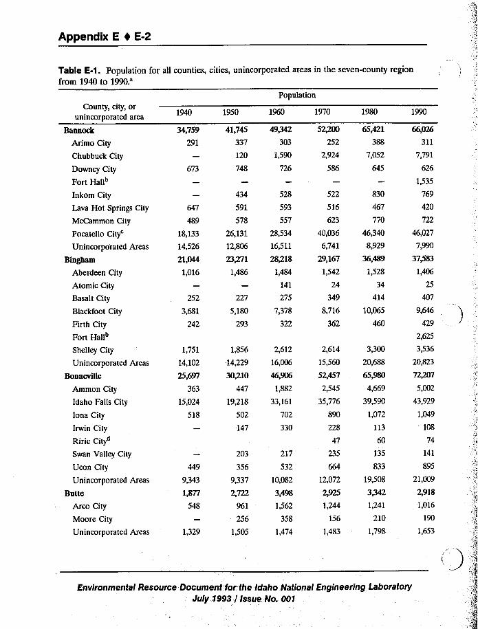
Appendix E 1 E-2
Table E-1. Population for all counties, cities, unincorporated areas in the seven-county region
from 1940 to 1990.'opulationCounty, city, or
unincorporated area
Bannock
Arimo City
Chubbuck City
Downey City
Fort Hall"
Inkom City
Lava Hot Springs City
McCammon City
PocatelloCity'nincorporated Areas
Bingham
Aberdeen City
Atomic City
Basalt City
Blackfoot City
Firth City
Fort Hall~
Shelley City
Unincorporated Areas
Bonneville
Ammon City
Idaho Falls City
Iona City
Irwin City
Ririe City
Swan Valley City
Ucon City
Unincorporated Areas
Butte
Arco City
Moore City
Unincorporated Areas
1940
34,759
291
673
489
18,133
14,526
21,044
1,016
252
3,681
242
1,751
14,102
25,697
363
15,024
518
9,343
1,877
548
1,329
1950
41,745
337
120
748
434
591
578
26,131
12,806
23+71
1,486
227
5,180
293
1,856
14,229
30/10447
19,218
502
147
203
356
9,337
2 722
961
256
1,505
1960
49@42
303
1,590
726
528
593
557
28,534
16,511
28/18
1,484
141
275
7,378
322
2,612
16,006
46,906
1,882
33,161
702
330
217
532
10,082
3,498
1,562
358
1,474
1970
52+00
252
2,924
586
522
516
623
40,036
6,741
29,167
1,542
24
349
8,716
362
2,614
15,560
52,457
2,545
35,776
890
228
47
235
12,072
2,925
1,244
156
l,483
1980
65,421
388
7,052
645
830
467
770
46,340
8,929
36,489
1,528
34
414
10,065
460
3,300
20,688
65,980
4,669
39,590
1,072
113
60
135
833
19,508
33421,241
210
1,798
66,026
311
7,791
626
1,535
769
420
722
46,027
7,990
37/83
1,406
25
9,646
429
2,625
3,536
20,823
72/07
5,002
43,929
1,049
108
74
141
895
21,009
2,918
1,016
190
1,653
Environmental Resource Document for the Idaho National Engineering LaboratoryJuly,1993 '/ Issue No. 001
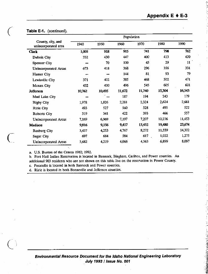
Appendix E 4 E-3
Table E-1. (continued).
Population
County, city, and
unincorporated area
Chrk
Dubois City
Spencer City
Unincorporated Areas
Hamer City
Lewisville City
Mcnan City
Jefferson
Mud Lake City
Rigby City
Ririe City
Roberts City
Unincorporated Areas
Madison
Rexburg City
Sugar City
Unincorporated Areas
1940
1,005
332
673
371
432
10,762
1,978
493
319
7,169
9,816
3,437
697
5,682
1950
918
430
70
418
402
430
10,495
1,826
527
341
6,969
9,156
4,253
684
4,219
915
447
100
368
144
385
496
11,672
187
2,281
560
422
7,197
9,417
4,767
584
4,066
1970
741
400
45
296
81
468
545
11,740
194
2,324
528
393
7,207
13,452
8,272
617
4,563
1980
798
413
29
356
93
502
605
15/04243
2,624
495
10,276
19,480
11,559
1,022
6,899
762
420
11
331
79
471
601
16~3179
2,681
522
557
11,453
23,674
14,302
1,275
8,097
a. U.S. Bureau of the Census 1982; 1992.b. Fort Hall Indian Reservation is located in Bannock, Bingham, Caribou, and Power counties. An
additional 903 residents who are not shown on this table live on the reservation in Power County.
c. Pocatello is located in both Bannock and Power counties.
d. Ririe is located in both Bonneville and Jefferson counties.
Environmental Resource Document for the Idaho National Engineering Laboratory
July 1993 / Issue No. 001
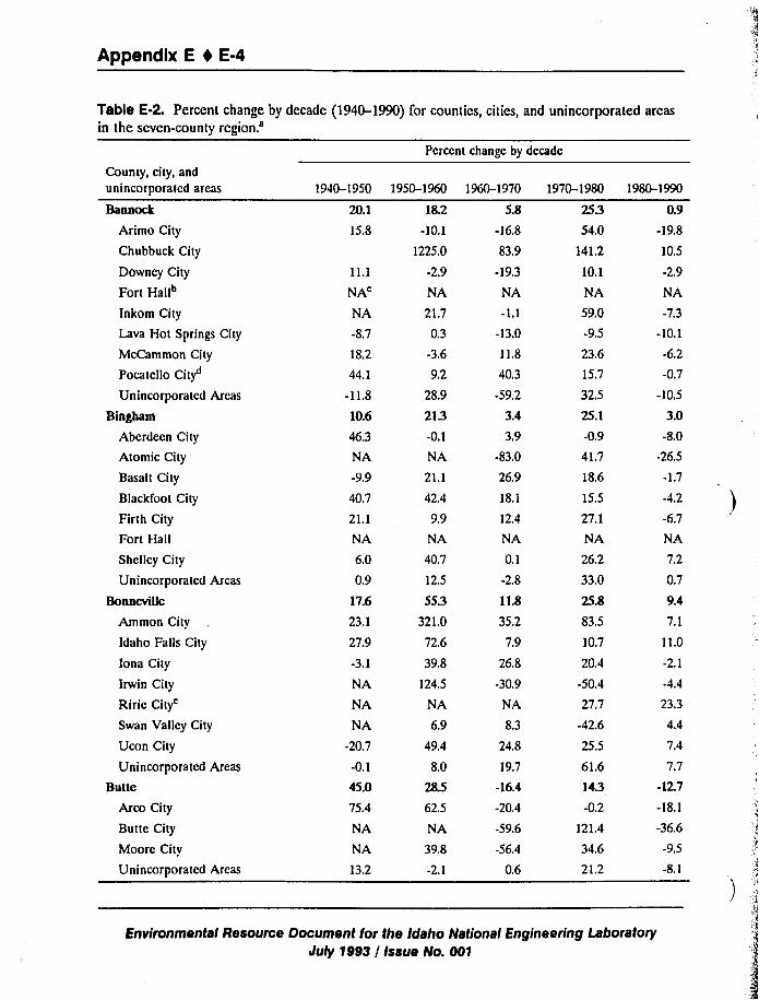
Appendix E 0 E-4
Table E-2. Percent change by decade (]940-1990) for countics, cities, and unincorporated areasin the seven-county region.'ercent
change by dccadc
County, city, and
unincorporated areas
Bannock
Arimo City
Chubbuck City
Downcy City
Fort Hallb
Inkom City
Lava Hot Springs City
McCammon City
Pocatcllo City"
Unincorporated Areas
Bingham
Aberdeen City
Atomic City
Basalt City
Blackfoot City
Firth City
Fort Hall
Shelley City
Unincorporated Areas
Bonneville
Ammon City
Idaho Falls City
Iona City
Irwin City
RirieCity'wan
Valley City
Ucon City
Unincorporated Areas
Butte
Arco City
Butte City
Moore City
Unincorporated Areas
1940-1950
20.1
15.8
11.1
NA
NA
-8,7
18,2
44.1
-11,8
10.6
46,3
NA
-9.9
40,7
21.1
NA
6.0
0,9
17.6
23.1
27.9
-3.1
NA
NA
NA
-20.7
-0.1
45.0
75.4
NA
NA
13.2
18.2
-10.1
1225.0
-2.9
NA
21.7
0.3
-3.6
9.2
28.9
213-0.1
NA
21.1
42.4
9.9
NA
40.7
12.5
553321.0
72,6
39.8
124.5
NA
6.9
49.4
8.0
28.5
62.5
NA
39.8
-2.1
5.8
-16.8
83.9
-19,3
NA
-1.1
-13.0
11.8
40.3
-59,2
3.4
3,9
-83.0
26.9
18.1
12,4
NA
0.1
-2.8
11.8
35.2
7,9
26.8
-30.9
NA
8.3
24.8
19.7
-16.4
-20.4
-59.6
-56.4
0.6
25354.0
141.2
10,1
NA
59.0
-9.5
23.6
15.7
32.5
25.1
-0.9
41,7
18,6
15,5
27,1
NA
26.2
33.0
25.8
83,5
10.7
20.4
-50.4
27.7
-42.6
25.5
61.6
143-0.2
121.4
34.6
21.2
0.9-19,8
10.5
-2.9
NA
-7.3
-10.1
-6.2
-0.7
-10.5
3.0-8.0
-26.5
-1.7
4.2
-6.7
NA
7.2
0.7
9.4
7.1
11.0
-2.1
23.3
7.4
7.7
-12.7
-18.1
-36.6
-9.5
-8.1
1950-1960 1960-1970 1970-1980 1980-1990
Environmental Resource Document for the Idaho National Engineering LaboratoryJuly 1993 / Issue No. 001
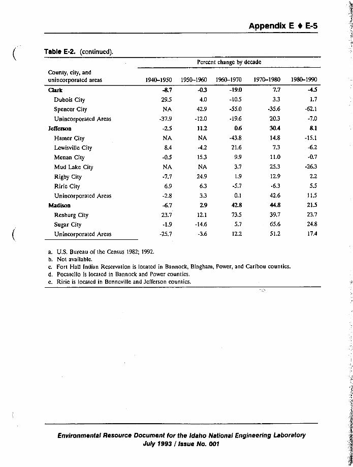
Appendix E t E-5
Table E-2. (continued).
County, city, and
unincorporated areas
Clark
Dubois City
Spcnccr City
Unincorporated Areas
Jctfertton
Hamcr City
Lcwisvillc City
Mcnan City
Mud Lake City
Rigby City
Riric City
Unincorporated Areas
Madison
Rcxburg City
Sugar City
Unincorporated Areas
Pcrecnt change by decade
29.5
NA
-37.9
NA
8.4
-0.5
NA
-7.7
6.9
-2.8
-6.7
23.7
-1.9
-25.7
-034.0
42.9
-12,0
11.2
NA
-4.2
15.3
NA
24.9
6.3
3.3
2.9
12.1
-14,6
-3.6
-19.0
-10.5
-55.0
-19.6
0.6
-43.8
21.6
9.9
3.7
1.9
-5.7
0.1
42.8
73.5
5.7
12,2
7.7
3.3
-35.6
20.3
30.4
14.8
7.3
11.0
25.3
12,9
-6,3
42.6
44.8
39.7
65.6
51.2
1.7
-62.1
-7.0
-15.1
-6.2
-0.7
-26.3
2.2
5.5
1 1.5
21523.7
24.8
17.4
1940-1950 1950-1960 1960-1970 1970-1980 1980-1990
a. U,S. Bureau of thc Census 1982; 1992.b. Not available.
c. Fort Hall Indian Rcscrvation is iocatcd in Bannock, Bingham, Power, and Caribou countics.d. Pocatcllo is located in Bannock and Power counties.e. Riric is located in Bonncvillc and Jefferson countics.
Environmental Resource Document for the Idaho National Engineering LaboratoryJuly 1993 / Issue No. 001
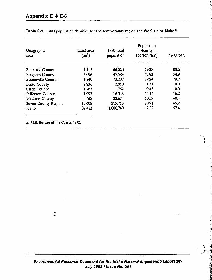
Appendix E 1 E-6
Table E-3. 1990 population densities for the seven-county region and the State of
Idaho.'eographic
areaLand area
(mi )1990 total
population
Populationdensity
(persons/mi ) % Urban
Bannock CountyBingham CountyBonncvillc CountyButte CountyClark CountyJefferson CountyMadison CountySeven-County RegionIdaho
1,1122,0961,8402,2361,7631,093
46810,60882.413
66,02637,58372,2072,918
76216,54323,674
219,7131,006,749
59.3817.9339.24
1.310.43
15.1450.5920.7112.22
83.638.978.20.00.0
16.260.465.257.4
a. U.S. Bureau of thc Census 1992.
Environmental Resource Document for the Idaho National Engineering Laboratory
July 1993 / Issue No. 001
Appendix E 1 E-7
E.2 Economy, Employment, and Income
This section provides additional data on the economy of the seven-county region. As shownon Table E-4, farming, ranching, food processing, higher education, and INEL technology transferare all industries important to the regional economy. This table lists major industries andbusinesses located in the seven-county region. The vast majority of businesses in the region aredirectly related to agriculture, food processing, or the INEL.
Table E-5 lists the percentage of employed persons in each county by type of industry. In1989, 6.9% of the total work force in the seven-county region was employed in agriculture,forestry, and fisheries industries. This percentage, when compared with the national average of2.7% for these industries, shows the importance of this employment sector to the regionaleconomy. Approximately 6.6% of the 1989 employed;workforce in the seven-county region was
employed in the construction industry. This number is slightly larger than the state-wide averageof 6.5% and the national average of 6.2%. Approximately 8% of the workl'orce in theseven-county region is employed in the manufacture of nondurable goods. Food processing is themost signiTicant type of manufacturing that occurs in the region. The manufacture of durablegoods is considerably less important to employmcnt in the region than in the nation as a whole.The percentage of the workforce that is employed in wholesale and retail trade (53% and 17.6%,respectively) in the area is slightly greater than the state and national averages. Financial,business, health, and personal services in the region employ a slightly smaller percentage of theworkforce than the percentages employed by these services in Idaho or the United States (seeTable E-5).
Educational services provide 11.4%of the region's employment. Approximately one quarterof Madison County's 1989 employment was related to education, underscoring the importance ofRicks College to the county's economy. Approximately 1.3%of the employed workforce in theseven-county region works in the entertainment and recreation industries, which include hotels/motels, eating and drinking establishments, and other recreational providcrs. Many of the servicesutilized by tourists are included in this category. Finally, a significantly higher percentage ofworkers are employed in other professional and related industries in the seven-county region(10.2%) than in thc state (6.5%) or the nation (6.6%). INEL contractors are the primary causefor the grcatcr than average employmcnt levels in other professional and related industries in theseven-county region (10.2%) than in the state (6.5%) or thc nation (6.6%). INEL contractors arethe primary cause for- the greater than average employment levels in other professional andrelated industries. Nearly 17% of the employed residents of Bonncvillc County work for otherprofessional and related industries (see Table E-5).
Median household income levels and pcr capita income levels during 1979 are shown onTable E-6. In addition, these measurements have been inflated to 1989 dollars so that they canbc directly comparable to 1989 income levels shown on Table 6-6 in the main text. Medianhousehold income levels varied signiTicantly throughout the seven-county region during 1979.Clark County recorded the lowest median family income of $ 11,463 while Bingham Countyenjoyed the highest median household income during the same time period.
Environmental Resource Document for the Idaho National Engineering LaboratoryJuly 1993 / Issue No. 001
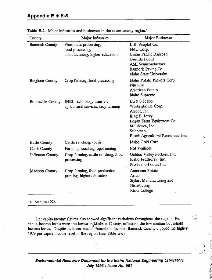
Appendix E 1 E-8
Table F-4. Major industries and businesses in the seven-countyregion.'ounty
Bannock County
Major Industries
Phosphate processing,food processing,manufacturing, higher education
Bingham County Crop farming, food processing
Butte County
Clark County
Jefferson County
Cattle ranching, tourism
Farming, ranching, opal mining
Crop farming, cattle ranching, food
processing
Madison County Crop farming, food production,
printing, higher education
Bonneville County INEL technology transfer,
agricultural services, crop farming
Major Businesses
J. R. Simplot Co.FMC Corp.Union Pacific RailroadOre-Ida FoodsAMI Semiconductors
Bannock Paving Co.Idaho State University
Idaho Potato Packers Corp.Pillsbury
American PotatoIdaho Supreme
EGBcG Idaho
Westinghouse Corp.Amcor, Inc.King B.Jerky
Logan Farm Equipment Co.Melaleuca, Inc.ScientechBusch Agricultural Resources, Inc.
Idaho Gold Corp.
Not available
Golden Valley Packers, Inc.Idaho Fresh-Pak, Inc.Pro-Idaho Foods, Inc.
American PotatoArtcoStylart Manufacturing and
Distributing
Ricks College
a. Stapilus 1992.
Per capita income figures also showed signiTicant variations throughout the region. Per
capita income levels were the lowest in~,l'vladison County, reflecting the low median household
income levels. Despite its lower median'household income, Bannock County enjoyed the highest
1979 per capita income level in the region (see Table E-6).
Environmental Resource Document for the Idaho National Engineering Laboratory
July 1993 / Issue No. 001
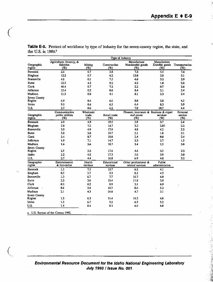
Appendix E I E-9
Table E-5. Percent of workforce by type of industry for the seven-county region, the state, and
the U.S. in
1989.'eographic
region
BannockBingham
Bonneville
ButteClarkJeffersonMadison
Seven CountyRegionIdaho
U.S.
Geographicregion
Bannock
BinghamBonneville
BuueClark
JeffemonMadison
Seven CountyRegionIdahoU.S.
Geographicregion
BannockBingham
Bonneville
ButteClark
JeffersonMadison
Seven CountyRegion
Idaho
U.S.
Agriculture, forestry, &fisheries
(%)2.612.24.122.546.415.411.3
6.99.02.7
Communicationpublic utilities
(%)2.02.83.03.82.41.91.6
2.52.22.7
Entertainmcnt& recreation
1.50.51.32.30.20.62.1
1.31.31.4
Mining(%)0.70.70.14.20.70.20.0
0.40.60.6
Wholesaletrade(%)4.97.24.93.80.77.13.6
5.34.84.4
HealthSCIVICCS
7.55.76.73.60.23.64.3
6.36.78.4
Construction(%)5.86.2759.27.28.64.1
6.66.56,2
Retail trade(%)19.514,717.910.710.814.718.7
8.06.47.0
Finance, insurance &real estate
(%)5.93.24.82.12.43.33.4
17.617.316.8
EducationalSCNICCS
12.79.37.7
10.48.9
10.724.6
4.65.06.9
Other professional &related services
6.28.2
16.711.83.18.64.7
11.49.28.3
10.26.56.6
Type of Industry
ManufactureNondurable goods
(%)79
13.06.64.22.28.48.1
ManufactureDurable goods
(%)5.53.83.21.00.72.12.3
3.88.3
10.7Business & repair
sctvlccs(%%d)
3.72.854.21.80.02.72,5
3.53.94.8
Publicadministration
4.14.56.03.88.95.23.1
4.85.24.8
Transportation(%)7.63,12.92.82.65.42.4
4.53.94.4
PetsonalSCIVICC
(%)2.42,22.22.12.41.53.0
2.33.03.2
a. U.S. Bureau of the Census 1992.
Environmental Resource Document for the Idah'o National Engineering LaboratoryJuly 1993 / Issue No. 001
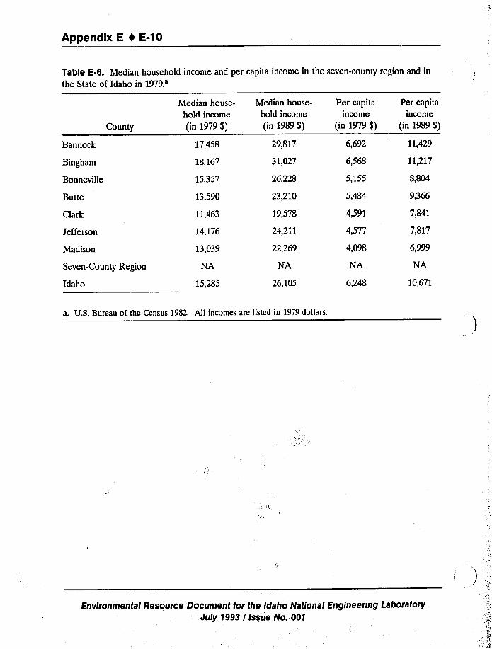
Appendix E I E-10
Table E-6. Median household income and per capita income in the seven-county region and in
the State of Idaho in
1979.'annock
Bingham
Bonneville
Butte
Clark
County
Jefferson
Madison
Seven-County Region
Idaho
Median house-
hold income
(in 1979 $)
17,458
18,167
15,357
13,590
11,463
14,176
13,039
NA
15,285
Median house-
hold income
(in 1989 $)
29,817
31,027
26,228
23,210
19,578
24,211
22,269
NA
26,105
Per capitaincome
(in 1979 $)
6,692
6,568
5,155
5,484
4,591
4,577
4,098
NA
6,248
Per capitaincome
(in 1989 $)
11,429
11,217
8,804
9,366
7,841
7,817
6,999
NA
10,671
a. U.S. Bureau of the Census 1982. All incomes are listed in 1979 dollars.
Environmental Resource. Document for the Idaho National Engineering Laboratory
July 1993 I Issue No. 001
Appendix E I E-11
E.3 Housing
Between 1980 and 1990, the regional housing supply enjoyed moderate growth, with an
increase of 11,063 units. Table E-7 displays the total number of housing units that existed in 1990in each county and indicates the decade in which these units were built. Growth in the housing
stock in the seven-county region has remained relatively constant since 1940, increasing by 1,100to 1,200 units annually. With the exception of the slow housing growth in the 1940s due toWorld War II and the rapid expansion that occurred in the 1970s, the trend has remained rela-
tively constant since the 1930s.
Table E-8 shows the number of occupied housing units, and vacancy rates, for the six cities
in the seven-county region that had populations greater than 5,000 residents in 1990 and their
corresponding counties.
Vacancy rates for owner-occupied housing units in the cities are similar to the rates found in
the counties as a whole. The cities of Pocatello and Rcxburg had vacancy rates for owner-
occupied housing units that are slightly greater than total rates for their respective counties. Thecities of Blackfoot, Chubbuck, and Ammon had vacancy rates that are slightly less than their
county totals while the vacancy rate in Idaho Falls matched Bonneville County's rate. However,
the vacancy rates in all these cities do not vary more than one percentage point from the countyrates (see Table E-8).
With the exception of the cities of Blackfoot and Chubbuck, vacancy rates on rental units
are approximately one percentage point less in the cities than in the counties as a whole. During
1990, the City of Chubbuck had a rental vacancy rate of 14.6% compared to Bannock County's
rate of 10.3%, (see Table E-8).
Three basic programs provide affordable housing on the Fort Hall Indian Reservation: themutual help program, a rental program, and an elderly housing complex. The mutual help
program provides home ownership opportunities to qualiTied residents. The home buyer is
required to make monthly payments that are based on 15% of his or her adjusted monthly
income. Currently, 133 homes have been built under this program and 41 are under construction
(Tribal Health and Human Services Department n.d.). The rental program provides rental
housing to low-income families. Participants in this program pay 30% of their adjusted monthly
income as rent. Presently, there are 75 rental units on the Fort Hall Indian Reservation. Finally,
an elderly housing complex consisting of 19 units provides housing to elderly and handicapped
persons.
Environmental Resource Document for the Idaho Nationa/ Engir eering Laboratory
July 1993 / Issue No. 001
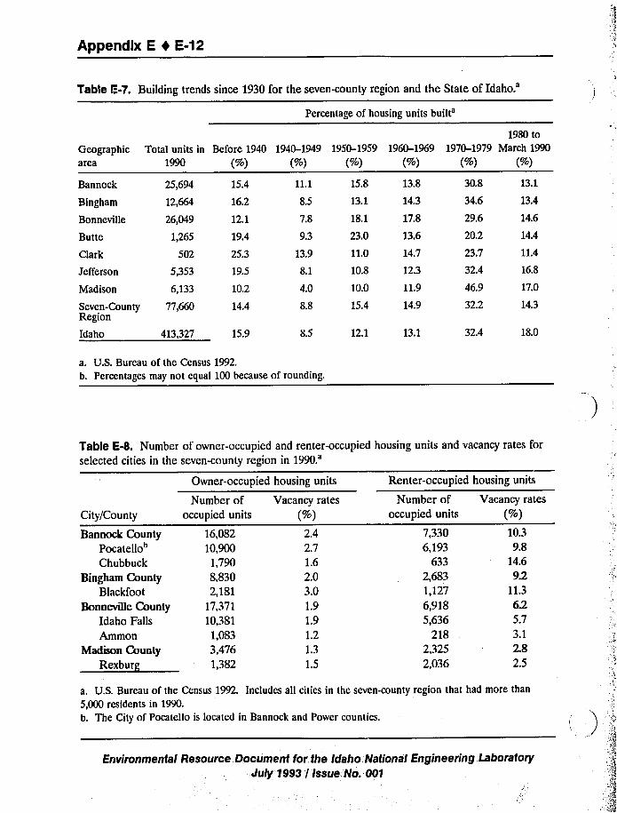
Appendix E 4 E-12
Table E-7. Building trends since 1930 for the seven-county region and the State ofIdaho.'ercentage
of housing units
built'eographic
area
1980 to
Total units in Before 1940 1940-1949 1950-1959 1960-1969 1970-1979 March 19901990 (%) (%) (%) (%) (%) (%)
Bannock
Bingham
Bonneville
Butte
Clark
25,694
12,664
26,049
1,265
502
Madison 6,133
Seven-County 77,660Region
Idaho 413,327
Jefferson 5,353
15.4
16.2
12.1
19.4
25.3
19.5
10.2
14.4
15.9
11.1
8.5
7.8
9.3
13.9
8.1
4.0
8.8
8.5
15.8
13.1
18.1
23.0
11.0
10.8
10.0
15.4
13.8
14.3
17.8
13.6
14.7
12.3
11.9
14.9
12.1 13.1
30.8
34.6
29.6
20.2
23.7
32.4
46.9
32.2
32.4
13.1
13.4
14.6
14.4
11.4
16.8
17.0
14.3
18.0
a. U.S. Bureau of the Census 1992.b. Percentages may not equal 100 because of rounding.
Table E-8. Number of owner-occupied and renter-occupied housing units and vacancy rates for
selected cities in the seven-county region in
1990.'ity/County
Bannock CountyPocatcllo"Chubbuck
Bingham CountyBlackfoot
Bonneville County
Idaho Falls
Ammon
Madison County
Rexburg
Owner-occupied
Number ofoccupied units
16,08210,9001,7908,8302,181
17,37110,381
1,0833,4761,382
housing units
Vacancy rates
(%)2.42.71.62.03.01.91.91.21.31.5
Renter-occupied
Number ofoccupied units
7,3306,193
6332,6831,1276,9185,636
2182,3252,036
housing units
Vacancy rates
(%)10.39.8
14.692
11.3625.73.12.82.5
a. U.S. Bureau of the Census 1992. Includes all cities in the seven-county region that had more than
5,000 residents in 1990.b. The City of Pocatello is located in Bannock and Power counties.
'
Environmental Resource Document for the Idaho. National Engineering Laboratory
July 1993 / Issue No. 001
Appendix E I E-13
E.4 School Services
Table E-9 presents the 1990-1991 total enrollment, student-teacher ratio, revenues, and
revenues per pupil for each public school district in the seven-county region. Total fiscal year
(FY) 1992 impact aid entitlements for each school district are shown on Table E-10. PocatelloSchool District No. 25 receives the largest amount of impact aid of any district in the seven-
county region ($396,190). However, less than 4% of this funding is related to civilian INELemployment. Similarly, Blackfoot School District No. 55 received $336,867 in impact aid during
FY 1992. However, only 5% of this aid was provided as a result of INEL dependents. Themajority of the aid received by these two districts is due to the large number of American Indian
students who attend these school districts. In contrast, Idaho Falls School District No. 91, which
received $340,000 in impact aid during FY 1992, and Arco School District No. 111,which
received $35,506 in impact aid during FY 1992, were almost entirely funded because of INELemployment. Total public school district expenditures during the 1990-1991academic year areshown on Table E-11 for each school district in the seven-county region.
E.S Taxes
The total amount of revenues collected by the State of Idaho by source during fiscal years
1990 and 1991 are shown on Table E-12. The largest single revenue source for the State ofIdaho was personal income tax payments. The state received $436,429,000 from individual income
tax during fiscal year 1991. The 5% sales and use tax was the next largest revenue generator,followed by the motor fuel tax and the corporate income tax. All major taxes levied by the Stateof Idaho during fiscal year 1990 and 1991 are included on Table E-12.
The State of Idaho has a progressive personal income tax structure with rates ranging from
2% to 8.2% and a corporate income tax rate of 8%. These taxes are imposed on all taxable
income received in the State of Idaho. A sales and use tax of 5% is levied on all retail sales oftangible personal property as well as hotel and motel accommodations, admissions fees, and feesfor recreation (Idaho State Tax Commission 1991).
The State of Idaho also assesses a gasoline and special fuels tax on motor vehicle fuels.
Gasoline and diesel fuel are taxed at $0.21/gal, gasohol at $0.17/gal, and propane at $0.152/gal.
All civilian aviation fuel is taxed at $0.055/gal; a $0.045/gal tax is levied on jet fuel; and natural gasis taxed at $0.165 per therm of natural gas (Idaho State Tax Commission 1991).
Financial information for the county governments of the seven-county region are discussed
on Tables E-13 and E-14. Total revenues by source for fiscal year 1991 are shown on Table E-13.This table details the percent of revenue that each county government collected through taxes;
licenses, permits, fees, fines, charges, and forfeitures; intergovernmental revenue; investment
income; and other income sources.
The total annual expenditures of county governments are shown on Table E-14. Theseexpenditures were also divided into categories labeled as general government, public safety, health
and welfare, sanitation/public works, trust remittances, roads, debt service, and other expenses.
Environmental Resource Document for the Idaho National Engineering. LaboratoryJuly 1993 / Issue No. 001
Appendix E 4 E-14
Table E-9. Enrollment and revenue statistics for public schools in the seven-county region during
the 1990-1991academic
year.'ounty
TotalEnrollment
Revenues
TotalPer Pupil
(~)
Number ofStudents/
Teacher
Bannock CountyMarsh Valley, No, 21Pocatello, No. 25Non-Public
1,62313,832
340
6,021,09441,988,268
3.7103,036
18.95
NA
Bingham CountySnake River, No. 52Blackfoot, No. 55Aberdeen, No. 58Firth, No. 59Shelley, No. 66Non-Public
2,4154,592
8581,0432,403
93
7,577,41614,417,4783,142,1633,460,4448,133,424
3,1383,1403,6623,3183,385
22.120.717.922.221.9NA
Bonneville CountyIdaho Falls, No. 91Swan Valley, No. 92Bonneville, No. 93Non-Public
10,24990
7,557
361'9,593,747516,85334,685,714
4,8495,7434,590
21.730.021.2NA
Butte CountyAr~m, No. 111
Clark County
Clark, No. 161
765 2,804,908
929,167
3,677
5,597
19.8
13.8
JclIcrson County
Jefferson, No. 251Ririe, No. 252West Jefferson, No. 253
3,875690774
11,373,6862,574,7082,940,416
2,9353,7313,799
21.721.219.7
Madison County
Madison, No. 321Sugar-Salem, No. 322
4,4521,515
13,668,6505,012,229
4,0783,308
23.519.3
a. Idaho Department of Education 1991a, 1991b, n.d.
Environmental Resource;Document for the Idaho National Engineering Laboratory
July 1993 / Issue No. 001
Appendix E 4 E-15
Table E-10. Prorated impact aid entitlements and estimated entitlements related to INELdependents for school districts during fiscal year
1992.'chool
district
Bannock County
Total prorated impact aid Estimated prorated entitlement
entitlement related to INEL dependents
Pocatello, No. 25
Bingham County
Snake River, No. 52
Blackfoot, No. 55
Shelley, No. 66
Bonneville County
Idaho Falls, No. 91
Bonneville Joint, No. 93
Butte County
Arco, No. 111
Clark County
Clark County, No. 161
Jefferson County
Ririe, No. 252
West Jefferson, No. 253
Madison County
Sugar-Salem, No. 322
$396,190
33,674
336,867
10,119
340,000
264,639
35,506
23,290
1,781
NA
1,684
$13,333
25,256
17,790
9,411
306,249
220,891
35,506
1,414
NA
1,323
a. Private communication from K. L. Shelly, Ecology and Environment, Inc., Lancaster, New York, toMarilyn Galvin, U.S. Department of Education, Impact Aid Program, December 2 and 31, 1992.
b. These estimates assume that all INEL-related dependents were "B"students. Also, where the average
daily attendance of INEL-rclatcd dependents was not known, it was assumed to be 95% of the total
number of INEL-rclatcd depcndcnts claimed for impact aid purposes,
Environmental Resource Document for the Idaho National Engineering LsboratoryJuly 1993 / Issue No. 001
Appendix E 1 E-16
Table E;11, Public school district expenditures in the seven-county region during the 1990-1991academic year.
District
Bannock County
Marsh Valley No. 21
Pocatello, No. 25
Bingham County
Snake River, No. 52
Blackfoot, No. 55
Aberdeen, No. 58
Firth, No. 59
Shelley, No. 60
Bonneville County
Idaho Falls, No. 91
Swan Valley, No. 92
Bonneville, No. 93
Butte County
Arco, No. 111
Clark County
Clark No. 161
Jefferson County
Jefferson, No. 251
Ririe, No. 252
W. Jefferson, No. 253
Madison County
Madison, No. 321
Sugar-Salem, No. 322
(
a. Idaho Department of Education 199th, n.d.
Total
5,991,859
43,250,394
7,788,025
14,220,819
3,080,312
3,508,495
12,375,963
47,096,722
743,812
26,537,081
2,742,290
881,998
10,918,915
2,286,650
3,029,769
14,003,603
4,971,517
Pcr pupil
(>)
3,692
3,127
3,225
3,097
3,590
3,364
5,150
4,595
8,265
3,512
3,585
5,313
2,818
3,314
3,914
4,178
3,282
Environmental Resource Document for the Idaho National Engineering LaboratoryJuly 1993 / Issue No. 001
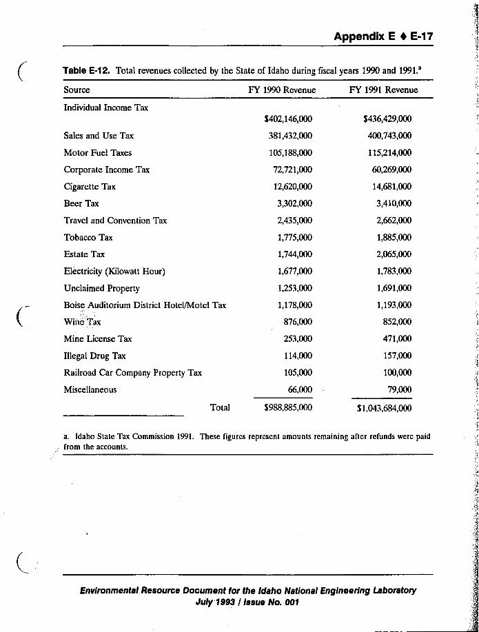
Appendix E 1 E-17
Table E-12. Total revenues collected by the State of Idaho during fiscal years 1990 and1991.'ource
Individual Income Tax
FY 1990 Revenue FY 1991 Revenue
Sales and Use Tax
Motor Fuel Taxes
Corporate Income Tax
Cigarette Tax
Beer Tax
Travel and Convention Tax
Tobacco Tax
Estate Tax
Electricity (Kilowatt Hour)
Unclaimed Property
Boise Auditorium District Hotel/Motel Tax
Witt'e Tax
Mine License Tax
Illegal Drug Tax
Railroad Car Company Property Tax
Miscellaneous
Total
$402,146,000
381,432,000
105,188,000
72,721,000
12,620,000
3,302,000
2,435,000
1,775,000
1,744,000
1,677,000
1,253,000
1,178,000
876,000
253,000
114,000
105,000
66,000
$988,885,000
$436,429,000
400;743,000
115,214,000
60,269,000
14,681,000
3,410,000
2,662,000
1,885,000
2,065,000
1,783,000
1,691,000
1,193,000
852,000
471,000
157,000
100,000
79,000
$ 1,043,684,000
a. Idaho State Tax Commission 1991. These figures reprcscnt amounts remaining after refunds were paid
from the accounts,
Environmental Resource Document for the Idaho National Engineering LaboratoryJuly 1993 / Issue No. 001
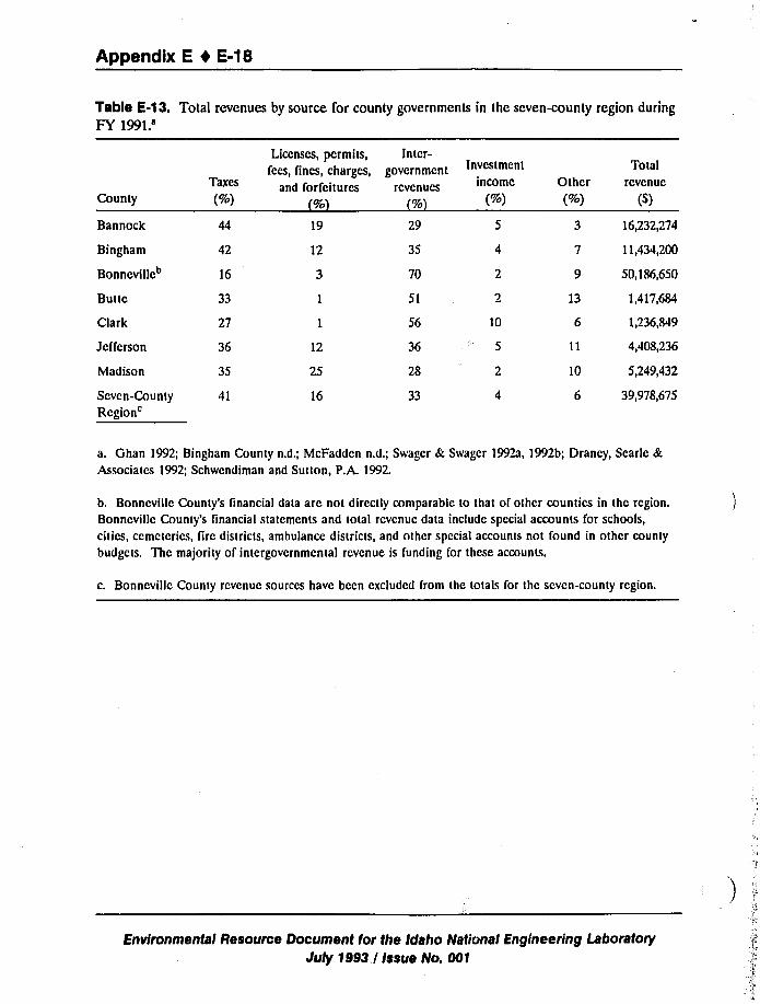
Appendix E 4 E-18
Table E-13. Total revenues by source for county governments in the seven-county region during
FY
1991.'ounty
Bannock
Bingham
Bonneville
Butte
Clark
Jefferson
Madison
Scvcn-County
Region'axes
(%)
44
42
16
33
27
36
35
19
12
12
25
16
29
35
70
51
56
36
28
33
Licenses, permits, Intcr-
(ees, fines, charges, government
and forfeitures rcvcnucs
(%1
Invcstmcnt
income
(%)
10
13
10
16,232,274
11,434,200
50,186,650
1,417,684
1,236,849
4,408,236
5,249,432
39,978,675
TotalOther rcvenuc
(%) (~)
a. Ghan 1992; Bingham County n.d.; McFadden n.d.; Swagcr 8c Swagcr 1992a, 1992b; Draney, Searle 8c
Associates 1992; Schwendiman and Sutton, P.A. 1992.
b. Bonncvillc County's financial data are not directly comparable to that of other countics in the region.
Bonneville County's financial statements and total rcvcnuc data include special accounts for schools,
cities, ccmctcrics, fire districts, ambulance districts, and other special accounts not found in other county
budgets. The majority of intergovernmental revenue is funding for these accounts.
c. Bonncvillc County rcvcnuc sources have bccn cxcludcd from the totals for thc seven-county region.
Environmental Resource Document for the Idaho National Engineering Laboratory
July 1993 / Issue No. 001
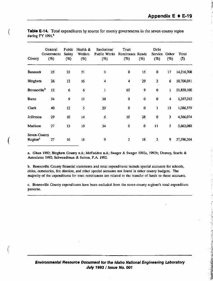
Appendix E 4 E-19
Table E-14. Total expcnditurcs by source for county govcrnmcnts in the seven-county region
during FY
1991.'eneral
Public Health & Sanitation/ Trust DebtGovcrnmcnt Safety Wclfarc Public Works Rcmittancc Roads Scrvicc Other Total
County (%) (%) (%) (%) (%) (%) (%) (%) (S)
Bannock 25
Bingham 26
Bonneville 12
Butte 34
Clark 40
Jefferson 29
Madison 27
15
12
10
13 10
22 21
12 16
38
29
34
65
10
15 0 17 14,216,708
29 3 6 10,708,011
9 0 1 51,850,100
0 0 4 1,397,012
0 1 13 1,086,379
28 0 3 4,566,074
0 11 5 5,662,080
Scvcn-County
Region'7 16 16 18 3 9 37,596,264
a. Ghan 1992; Bingham County n.d.; McFaddcn n.d,; Swagcr & Swagcr 1992a, 1992b; Drancy, Scarlc &Associates 1992; Schwcndiman & Sutton, P.A. 1992.
b. Bonncvillc County linancial statcmcnts and total cxpcnditurcs include special accounts for schools,cities, ccmctcrics, fire districts, and other special accounts not found in other county budgets. The
majority of thc expenditures for trust remit tanccs are rclatcd to thc transfer of funds to these accounts.
c. Bonneville County cxpcnditurcs have bccn excluded from thc scvcn-county regions's total cxpcnditurcpatterns.
Environmental Resource Document for the Idaho National Engineering LaboratoryJuly 1993 / Issue No. 001
Appendix E I E-20
E.6 Idaho National Engineering Laboratory
EG&G Idaho was the largest operating contractor at the INEL in January 1992, with 5,265employees, and Westinghouse Idaho Nuclear Company, Inc. (WINCO) was the second largest
operating contractor, with 1,796 personnel. During the same time period, WEC and ANL-W had
980 and 858 personnel, respectively (sce Table 4-11).
As total employment at the INEL increased from 1989 to 1992, the distribution of employeeschanged. EG&G Idaho received the largest benefit from the increase in employment, with an
addition of 1,534 workers. Employment at architectural, engineering, and construction firms
increased by 741 employees, or 235%, in the four years. The U.S. Department of Energy Idaho
Operations Office (DOE-ID) also enjoyed significant growth during that time, with staffing of thefield office increasing by more than 45% (see Table E-15). Rockwell-INEL employment was
completely curtailed in 1991,when DOE-ID did not renew their contact. By January 1992, noRockwell-INEL employees werc working at the facility. Babcock & Wilcox (B&W) received the
contract to operate the former Rockwell-INEL projects. Employment at WEC declined slightly
from 1,002 employees in 1989 to 980 employees in 1992 (see Table 4-11).
The total INEL workforce is expected to decline by nearly 1,000 workers over the next 10years. This reduction will be primarily due to reductions in employment at EG&G Idaho,WINCO, and Naval Reactors Facility (NRF). From FY 1993 to 2002, the total subcontractor
workforce is expected to fluctuate considerably. The remaining employees are projected tomaintain a near constant staffing level through the next decade.
These projections do not take into account the decision made by DOE-ID to consolidate its
operations at the INEL and employ only one basic contractor by 1994. This consolidation is
expected to further reduce the INEL work force.
DOE-ID employment levels rose steadily between FY 1982 and FY 1991 despite someannual Iluctuations. Employment declined in FY 1992, and this decline is projected to continue
through the end of the century.
The total INEL funding levels for FY 1989 to 1992 are shown on Table E-16. The facility
received a total of $1,147.9million to operate DOE-ID, NRF, and ANL-W programs. DOE-IDwas appropriated $967.3 million for onsite programs, NRF was appropriated $102 million, and
ANL-W was appropriated $78.6 million. Table E-16 illustrates INEL funding sources by program
sponsors for FY 1989 to 1992.
The Assistant Secretary for Environmental Restoration and Waste Management (ER&WM)was the single largest sponsor of DOE-ID programs; in 1992 DOE-ID received approximately
$340 million (35% of its entire funding) from the Assistant Secretary for ER&WM. The next
largest sponsor was the Assistant Secretary for Defense Programs, which supplied approximately
$265 million. The other two significant funding sources for the DOE-ID were the Assistant
Environmental Resource Document for the Idaho National Engineering LaboratoryJuly 1993 / Issue No. 001
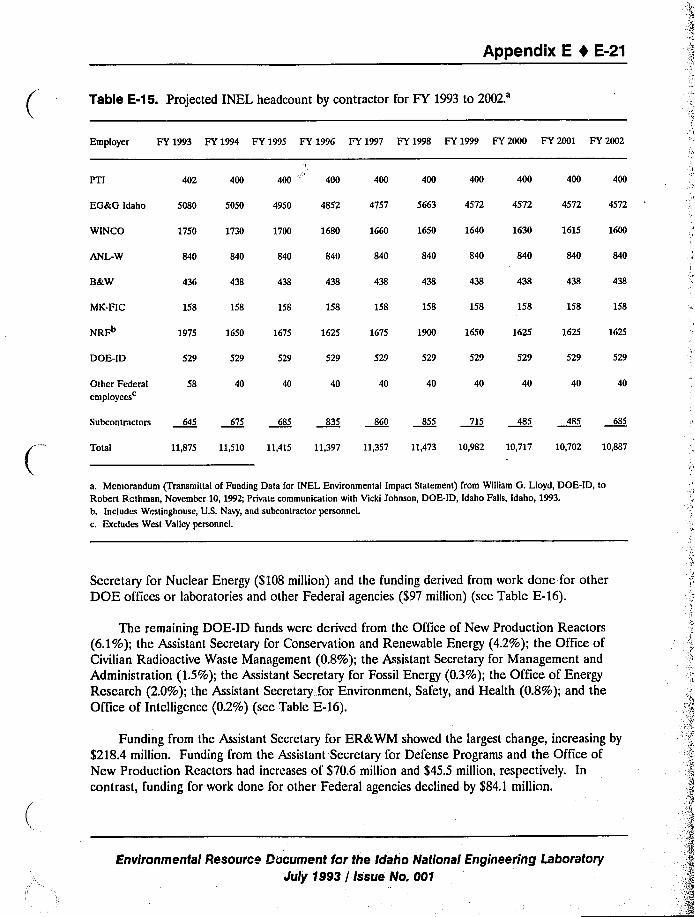
Appendix E 4 E-21
Table E-15. Projected INEL headcount by contractor for FY 1993 to
2002.'mployer
FY 1993 FY 1994 FY 1995 FY 1996 FY 1997 FY 1998 FY 1999 FY 2000 FY 2001 FY 2002
PTI 402 400 400
EGstG Idaho
WINCO
5080
1750
5050
1730
4950
1700
4852
1680
4757
1660
5663
1650
4572
1640
4572
1630
4572
1615
4572
1600
ANL-W 840 840 840 840 840 840 840 840 840 840
B&W 438
MK-FIC 158 158 158 158 158 158 158 158 158 158
NRFb 1975 1650 1675 1625 1675 1650 1625 1625
DOE-ID 529 529 529 529 529 529 529 529 529 529
Other Federalemployeesc
58 40 40 40 40 40 40 40 40 40
Subcontractors 675 835 860 855 715 485 485
Total 11,875 11,510 11,415 11,397 11,357 11,473 10,982 10,717 10,702 10,887
a. Memorandum (Transmittal of Funding Data for INEL Environmental Impact Statement) from William G. Lloyd, DOE-ID, to
Robert Rothman, November 10, 199Z; Private communication with Vicki Johnson, DOE-ID, Idaho Falls, Idaho, 1993.b. Includes Westinghouse, U.S. Navy, and subcontractor personnel.
c. Excludes West Valley personnel.
Secretary for Nuclear Energy ($108 million) and the funding derived from work done for other
DOE offices or laboratories and other Federal agencies ($97 million) (see Table E-16).
The remaining DOE-ID funds were derived from the Office of New Production Reactors
(6.1%);the Assistant Secretary for Conservation and Renewable Energy (4.2%); the Office ofCivilian Radioactive Waste Management (0.8%); the Assistant Secretary for Management and
Administration (1.5%);the Assistant Secretary for Fossil Energy (0.3%); the Office of EnergyResearch (2.0%); the Assistant Secretary;for Environment, Safety, and Health (0.8%); and theOffice of Intelligence (0.2%) (sec Table E-16).
Funding from the Assistant Secretary for ER&WM showed the largest change, increasing by
$218.4 million. Funding from the Assistant Secretary for Defense Programs and the Office ofNew Production Reactors had increases of $70.6 million and $45.5 million, respectively. In
contrast, funding for work done for other Federal agencies declined by $84.1 million.
Environmental Resource Document for the Idaho National Engineering Laboratory
July 1993 / Issue No. 001
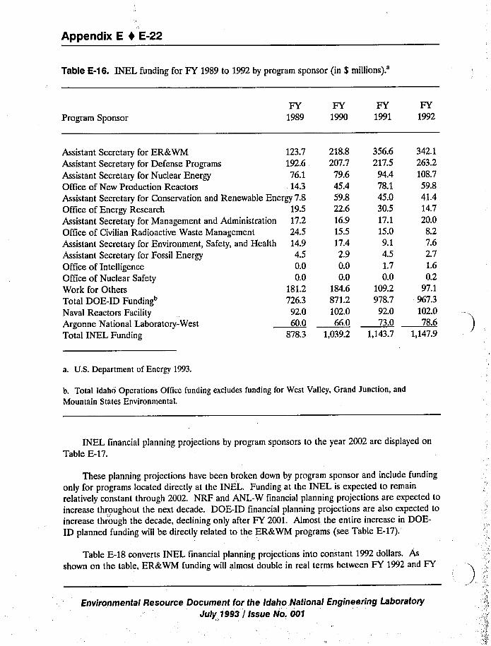
Appendix E I E-22
Table E-16. INEL funding for FY 1989 to 1992 by program sponsor {in $
millions).'rogram
Sponsor
FY FY FY FY1989 1990 1991 1992
Assistant Secretary for ER&WM 123.7Assistant Secretary for Defense Programs 192.6Assistant Secretary for Nuclear Energy 76.1Office of New Production Reactors 14.3Assistant Secretary for Conservation and Renewable Energy 7.8Office of Energy Research 19.5Assistant Secretary for Management and Administration 17.2Office of Civilian Radioactive Waste Management 24.5Assistant Secretary for Environment, Safety, and Health 14.9Assistant Secretary for Fossil Energy 4.5Office of Intelligence 0.0Office of Nuclear Safety 0.0Work for Others 181.2Total DOE-ID Funding 726.3Naval Reactors Facility 92.0Argonne National Laboratory.-West 60.0Total INEL Funding 8783
218.8 356.6207.7 217.579.6 94.445.4 78.159.8 45.022.6 30.516.9 17.115.5 15.017.4 9.12.9 4.50.0 1.70.0 0.0
184.6 109.2871.2 978.7102.0 92.066.0 73.0
1,039.2 1,143.7
342.1263.2108.759.841.414.720.08.27.62.71.60.2
97.1967.3102.078.6
1,147.9
a. U.S. Department of Energy 1993.
b. Total Idaho Operations Office funding excludes funding for West Valley, Grand Junction, and
Mountain States Environmental.
INEL financial planning projections by program sponsors to the year 2002 are displayed on
Table E-17.
These planning projections have been broken down by program sponsor and include funding
only for programs located directly at the INEL. Funding at the INEL is expected to remain
relatively constant through 2002. NRF and ANL-W financial planning projections are expected to
increase throughout the next decade. DOE-ID financial planning projections are also expected to
increase through the decade, declining only after FY 2001. Almost the entire increase in DOE-
ID planned funding will be directly related to the ER&WM programs (see Table E-17).
Table E-18 converts INEL financial planning projections into constant 1992 dollars. As
shown on the table, ER&WM funding will almost double in real terms between FY 1992 and FY
Environmental Resource Document for the Idaho National Engineering Laboratory
July 1993 / Issue No. 001
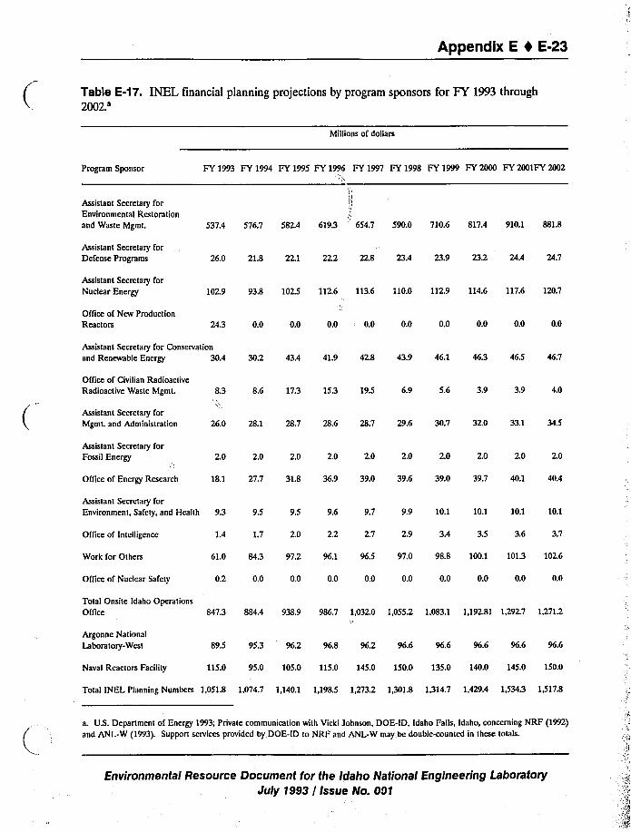
Appendix E I E-23
Table E-17. INEL financial planning projections by program sponsors for FY 1993 through2002.'illionsof dollars
Program Sponsor
Assistant Secretary forEnvironmental Restorationand Waste Mgmt.
FY1993 FY 1994 FY1995 FY1996 FY1997 FY1998 FY 1999 FY 2000 FY2001FY 2002
/ ~
537.4 576.7 582.4 619.3 654.7 590.0 710.6 817.4 910.1 881.8
Assistant Secretary forDefense Programs 26.0 21.8 22.1 22,2 22.8 23.4 23.9 23.2 24.4 24.7
Assistant Secretary forNuclear Energy 102.9 93.8 102.5 112,6 113.6 110.0 112.9 114.6 117.6 120.7
Office of New ProductionReactors 24.3 0.0 0.0 0.0 " 0.0 0.0 0.0 0.0 0.0 0.0
Assistant Sccretaty for Conservation
and Renewable Energy 30.4 30.2 43.4 41.9 42.8 43.9 46.1 46.3 46.5 46.7
Office of Civilian RadioactiveRadioactive Waste Mgm(. 8.3 8.6 17.3 15.3 195 6.9 5.6 3.9 3.9 4.0
Assistant Secretary forMgmt. and Administration 26.0 28.1 28.7 28.6 28.7 29.6 30.7 32.0 33.1 34.5
Assistant Secretary forFossil Energy C,'.0 2.0 2.0 2.0 2.0 2.0 2.0 2.0 2.0 2.0
Oflice of Energy Research 18.1 27.7 31.8 36.9 39.0 39.6 39.0 39.7 40.1 40.4
Assistant Secretary forEnvironment, Safety, and Health 9.3 9.9 10.1 10.1 10.1 10.19.5 9.5 9.6 9.7
1.7 2.0 2.2 2.7 3.5 3.6 3.72.9 3.41.4Office of Intelligence
Work for Others 61.0 84.3 97.2 96.1 96.5 97.0 98.8 100.1 101.3 102.6
Office of Nuclear Safety 0.2 0.0 0.0 0.0 0.0 0.0 0.0 0.0 0.0 0.0
Total Onsite Idaho Operations
Oflice 847.3 884.4 938.9 986.7 1,032.0 1,055.2 1.083.1 1.192.81 1,292.7 1,271.2
Argonne National
Laboratory-West 89.5 95.3 96.2 96.8 96.2 96.6 96.6 96.6 96.6 96.6
Naval Reactors Facility 115.0 95.0 105.0 115.0 145.0 150.0 135.0 140.0 145.0 150.0
Total INEL Planning Numbers 1,051.8 1,074.7 1,140.1 1,198.5 1,273.2 1,301.8 1,314.7 1,429.4 1,534.3 1,51'7.8
a. U.S. Dcpartmcnt of Energy 1993; Private communication with Vicki Johnson, DOE-ID, Idaho Falls, Idaho, concerning NRF (1992)and ANL-W (1993). Support services provided by DOE-ID to NRF and ANL-W may be double~ounted in these totals.
Environmental Resource Document for the Idaho National Engineering LaboratoryJuly 1993 / Issue No. 001
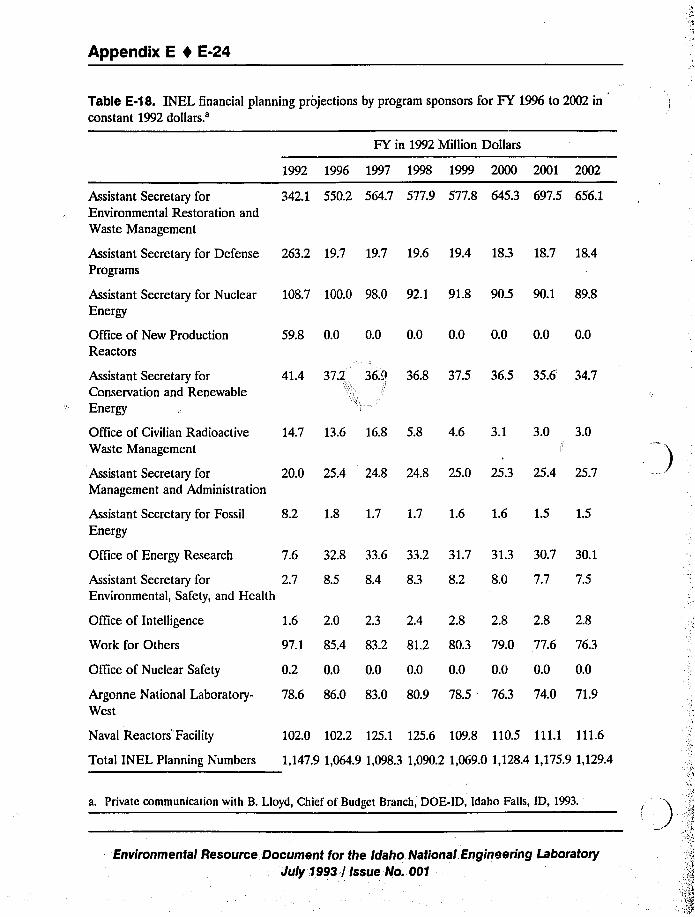
Appendix E 1 E-24
Table E-18. INEL financial planning projections by program sponsors for FY 1996 to 2002 in
constant 1992
dollars.'ssistant
Secretary forEnvironmental Restoration and
Waste Management
Assistant Secretary for DefensePrograms
Assistant Secretary for Nuclear
Energy
Office of New ProductionReactors
FY in 1992 Million Dollars
1992 1996 1997 1998 1999 2000 2001 2002
342.1 550.2 564.7 577.9 577.8 645.3 697.5 656.1
263.2 19.7 19.7 19.6 19.4 18.3 18.7 18.4
108.7 100.0 98.0 92.1 91.8 90.5 90.1 89.8
59.8 0.0 0.0 0.0 0.0 0.0 0.0 0.0
Assistant Secretary forConservation and Renewable
Energy
41.4 37.2, 36.9!! 36.8 37.5 36.5 35.6 34.7
Office of Civilian RadioactiveWaste Management
Assistant Secretary forManagement and Administration
Assistant Secretary for Fossil
Energy
Of."ice of Energy Research
14.7 13.6 16.8 5.8 4.6 3.1 3.0 3.0
20.0 25.4 24.8 24.8 25.0 25.3 25.4 25.7
8.2 1.8 1.7 1.7 1.6 1.6 1.5 1.5
7.6 32.8 33.6 33.2 31.7 31.3 30.7 30.1
Assistant Secretary for 2.7 8.5 8.4 8.3 8.2 8.0 7.7 7.5Environmental, Safety, and Health
Office of Intelligence
Work for Others
Office of Nuclear Safety
Argonne National Laboratory-West
Naval Reactors Facility
1.6 2.0 2.3 2.4 2.8 2.8 2.8 2.8
97.1 85.4 83.2 81,2 80.3 79.0 77.6 76.3
0.2 0.0 0.0 0.0 0.0 0.0 0.0 0.0
78.6 86.0 83.0 80.9 78.5 763 74.0 71.9
102.0 102.2 125.1 125.6 109.8 110.5 111.1 111.6
Total INEL Planning Numbers 1,147.9 1,064.9 1,098.3 1,090.2 1,069.0 1,128.4 1,175.91,1294
a. Private communication with B. Lloyd, Chief of Budget Branch, DOE-ID, Idaho Falls, ID, 1993.
Environmental Resource Document for the Idaho National. Engineering Laboratory
July 1993 / Issue No. 001
Appendix E I E-25
2002. Total INEL funding will be less than FY 1992 levels for all years between FY 1996 and
2002 except FY 2001.
The Department of Defense (DOD) and the Nuclear Regulatory Commission (NRC) are
the largest beneficiaries of work performed by the DOE-ID for other federal agencies. During
FY 1992, the DOD programs had budgets of approximately $70 million. This level of expenditure
is projected to be significantly reduced in FY 1993 and then gradually increased through FY 2002.
The NRC had programs performed by the DOE-ID that accounted for approximately $22 million
in FY 1992. This funding level is also predicted to remain at nearly $23 million annually to the
year 2002. The EPA, the National Aeronautical and Space Administration (NASA), and the U.S.
Department of Transportation are the other major beneficiaries of the DOE-ID's work. Since
FY 1989, the dollar value of the work performed by the DOE-ID for the DOD has almost
halved. Work for the NRC has remained relatively constant, and work for the EPA has
diminished significantly (see Tables E-19 and E-20). DOE-ID funding by contractor for FY 1989
to FY 1992 is depicted on Table E-21.
E.7 Fire Protection and Emergency Services
Detailed information on the facilities, personnel, and equipment of local fire districts in the
seven-county region are shown on Table E-22. This table lists the number of fire stations located
within each county, the number of paid and volunteer firefighters assigned to these stations, the
number of firefighting vehicles utilized, and the names of each fire district located within the
county.
E.S Security Services
As illustrated on Table E-23, in 1991, there were between 13 and 2.5 law enforcement
personnel per 1,000 residents in most counties in the study area. Clark County is the one excep-
tion; during 1991, there were an average of 6.3 law enforcement personnel per 1,000 residents
(see Table E-23).
E.9 Nonhazardous and Nonradioactive Solid Waste Disposal
Landfills located in the seven-county region are listed on Table E-24. The expected useful
lifespan of the landfills and any information on their compliance status with EPA standards are
also included on this table.
E.10 Health Care Delivery Services
The eight hospitals that serve the seven-county region are listed on Table E-25. In addition,
the total number of licensed beds, the number of patient days, the annual occupancy rate, and a
listing of available services by each hospital are provided.
Environmental Resource Document for the Idaho National Engineering Laboratory
July 1993 / Issue No. 001
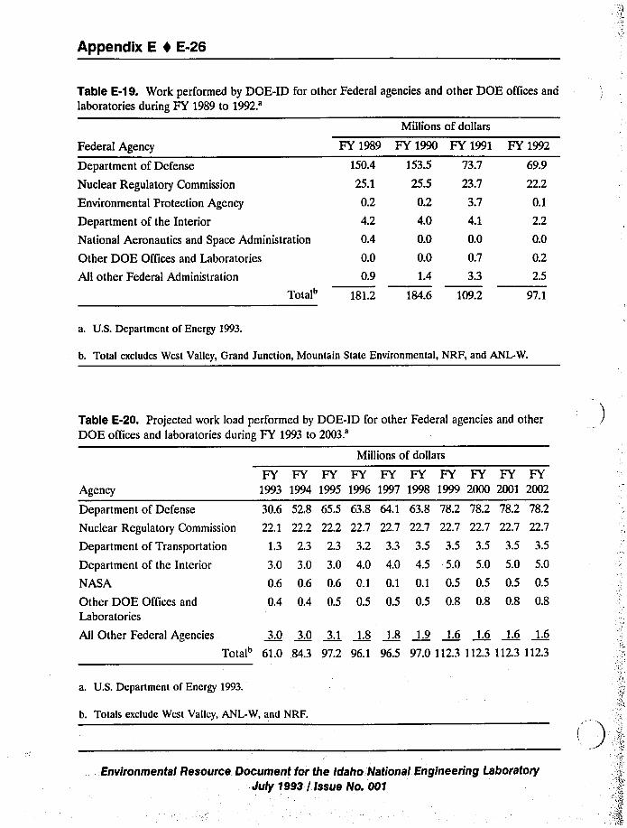
Appendix E 4 E-26
Table E-19. Work performed by DOE-ID for other Federal agencies and other DOE offices and
laboratories during FY 1989 to 1992.'illionsof dollars
FY 1989 FY 1990 FY 1991
150.4 ]53.5 73.7
25.1 25.5 23.7
0.2 0.2 3.7
4.2 4.0 4.1
0.4 0.0 0.0
0.0 0.0 0.7
0.9 1.4 3.3
Total" 181.2 184.6 109.2
All other Federal Administration
Federal Agency
Department of Defense
Nuclear Regulatory Commission
Environmental Protection Agency
Department of the Interior
National Aeronautics and Space Administration
Other DOE Offices and Laboratories
FY 1992
69.9
22.2
0.1
2.2
0.0
0.2
2.5
97.1
a. U.S. Department of Energy 1993.
b. Total excludes West Valley, Grand Junction, Mountain State Environmental, NRF, and ANL-W.
Table E-20. Projected work load performed by DOE-ID for other Federal agencies and other
DOE offices and laboratories during FY 1993 to
2003.'gency
Department of Defense
Nuclear Regulatory Commission
Department of Transportation
Department of the Interior
NASA
Other DOE Offices and
Laboratories
30.6 52.8 65.5
22.1 22.2 22.2
1.3 2.3 2.3
3.0 3.0 3.0
0.6 0.6 0.6
0.4 0.4 0.5
63.8 64.1 63.8 78.2
22.7 22.7 22.7 22.7
3.2 3.3 3.5 3.5
4.0 4.0 4.5 5.0
0.1 0.1 0.1 0.5
0.5 0.5 0.5 0.8
78.2 78.2 78.2
22.7 22.7 22.7
3.5 3.5 3.5
5.0 5.0 5.0
0.5 0.5 0.5
0.8 0.8 0.8
Millions of dollars
FY FY FY FY FY FY FY FY FY FY1993 1994 1995 1996 1997 1998 1999 2000 2001 2002
All Other Federal Agencies 3.0 3.0 3.1 1.8 1.8 1.9 1.6 1.6 1.6 1.6
Total 61.0 84.3 97.2 96.1 96.5 97.0 112.3 112.3 1123 112.3
a. U.S. Department of Energy 1993.
b. Totals exclude West Valley, ANL-W, and NRF.
Environmental Resource Document for the Idaho. National Engineering Laboratory
July 1993 / Issue No. 001
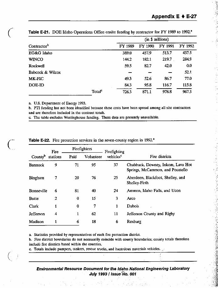
Appendix E 4 E-27
Table E-21. DOE Idaho Operations Office onsite funding by contractor for FY 1989 to
1992.'ontractor
EG&G Idaho
WINCO
Rockwell
Babcock & Wilcox
MK-FIC
DOE-ID Total'Y
1989
389.0
144.2
59.5
49.3
84.3
7263
(in $ millions)
FY 1990 FY 1991
457.9 513.7
182.1 219.7,82.7 42.0
52.6 86.7
95.8 116.7
871.1 978.8
FY 1992
437.5
284.9
0.0
52.1
77.0
115.8
967.3
a. U.S. Department of Energy 1993.b. PTI funding has not been identified because these costs have been spread among all site contractors
and are therefore included in the contract totals.c. The table excludes Westinghouse funding. These data are presently unavailable.
Table E-22. Fire protection services in the seven-county region in1992.'ire
County stations
FirefightersFirefighting
Paid Volunteer vehicles'ire districts
Bannock 9 71 95 37 Chubbuck, Downey, Inkom, Lava HotSprings, McCammon, and Pocatello
Bingham 7 20 76 25 Aberdeen, Blackfoot, Shelley, and
Shelley-Firth
Bonneville 6
Butte 2
Clark 1
Jefferson 4
Madison 1
81 40
0 15
0 7
1 62
6 18
24
6 Rexburg
Ammon, Idaho Falls, and Ucon
Arco
Dubois
Jefferson County and Rigby
a. Statistics provided by representatives of each fire protection district.
b. Fire district boundaries do not necessarily coincide with county boundaries; county totals therefore
include fire districts based within the counties.
c. Totals include pumpers, tankers, rescue trucks, and hazardous materials vehicles.
Environmental Resource Document for the Idaho National Engineering LsboratoryJuly 1993 / Issue'IIlo. 001
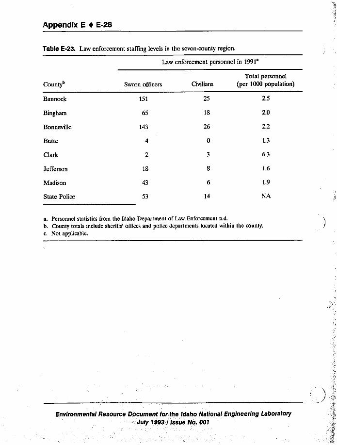
Appendix E 1 E-28
Table E-23. Law enforcement staffing levels in the seven-county region.
Law enforcement personnel in
1991'ounty
Bannock
Bingham
Bonneville
Butte
Sworn officers
151
65
143
Civilians
25
18
26
0
Total personnel
(per 1000 population)
2.5
2.0
2.2
Clark 6.3
Jefferson
Madison
State Police
18
43
53 14
1.6
1.9
NA
a. Personnel statistics from the Idaho Department of Law Enforcement n.d.
b. County totals include sheriffs'ffices and police departments located within the county.
c. Not applicable.
Environmental Resource Document for the Idaho National:Engineering Laboratory- July 1993 / Issue No. 001
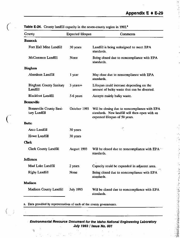
Appendix E 0 E-29
Table E-24. County landfill capacity in the seven-county region in1992.'ounty
Bannock
Expected lifespan Comments
Fort Hall Mine Landfill 30 years Landfill is being rcdesigned to meet EPAstandards.
McCammon Landfill
Bingham
Aberdeen Landfill
None
1 year
Being closed due to noncompliance with EPAstandards.
May close due to noncompliance with EPAstandards.
Bingham County SanitaryLandfill
Blackfoot Landfill
Bonneville
3 years+ Lifespan could increase depending on theamount of bulky waste that can be diverted.
5-6 years Accepts mainly bulky waste.
Bonnevilie County Sani-
tary Landfill
Butte
October 1993 Will be closing due to noncompliance with EPAstandards. New landfill will then open with an
expected lifespan of 50 years.
Arco Landfill
Howe Landfill
Clark
30 years
30 years
Clark County Landfill
Jefferson
August 1993 Will be closed duc to noncompliance with EPAstandards.
Mud Lake Landfill
Rigby Landfill
Madison
2 years
None
Capacity could be expanded in adjacent area.
Being closed due to noncompliance with EPAstandards.
Madison County Landfill July 1993 Will be closed due to noncompliance with EPAstandards.
a. Data provided by representatives of each of the county governments.
Environmental Resource Document for the Idaho National Engineering LaboratoryJuly 1993 / Issue No. 001
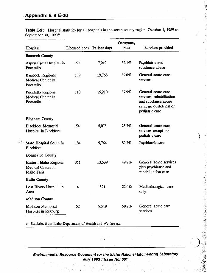
.,Appendix E I E-30
Table E-25. Hospital statistics for all hospitals in the seven-county region, October 1, 1989 to
September 30,
1990.'ospital
Bannock County
Occupancy
Licensed beds Patient days rate Services provided
Aspen Crest Hospital in 60Pocatello
7,019 32.1% Psychiatric and
substance abuse
Bannock RegionalMedical Center in
Pocatello
139 19,768 39.0% General acute careservices
Pocatello RegionalMedical Center in
Pocatello
Bingham County
110 15,210 37.9% General acute careservices; rehabilitationand substance abuse
care; no obstetrical orpediatric care
Blackfoot Memorial
Hospital in Blackfoot
State Hospital South in
Blackfoot
54
184
5,075
9,764
25.7% General acute careservices except no
pediatric care
89.2% Psychiatric care
Bonneville County
Eastern Idaho RegionalMedical Center in
Idaho Falls
311 53,539 49.8% General acute services
plus psychiatric and
rehabilitation care
Butte County
Lost Rivers Hospital in
Arco
Madison County
Madison Memorial
Hospital in Rexburg
52
321
9,519
22.0% Medical/surgical careonly
50.2% General acute careservices
a. Statistics from Idaho Department of Health and Welfare n.d.
Environmental Resource Document for the Idaho National Engineering. Laboratory
July 1993 '/'Issue No. 001
Appendix E 4 E-31
REFERENCES
Anthony, Bruce, July 31, 1992, Fire Chief, Shelley/Firth Fire District, Firth, Idaho, personalcommunication with C. Kouris, Ecology and Environment, Inc., Idaho Falls, Idaho.
Barney, Del, July 14, 1992, Madison County Commission, Madison County, Idaho, personalcommunication with C. Kouris, Ecology and Environment, Inc., Idaho Falls, Idaho.
Belcher, Rod, July 23, 1992, Supervisor of Roads, Bridges, and Solid Waste, Clark County
Department of Roads, Bridges, and Solid Waste, Dubois, Idaho, personal communicationwith C. Kouris, Ecology and Environment, Inc., Idaho Falls, Idaho.
Biel, Seth, July 27, 1992, County Commissioner, Butte County Department of Roads, Bridges, and
Solid Waste Disposal, Butte County, Idaho, personal communication with C. Kouris, Ecologyand Environment, Inc., Idaho Falls, Idaho.
Brinkerhoff, Marlene, June 11, 1993, Senior Occupational Nurse, EG&G Idaho, Inc., Idaho Falls,
Idaho, personal communication with S. Myers, Ecology and Environment, Inc., Lancaster,New York.
Bingham County, n.d, General Purpose Financial Statements for Bingham County, Idaho for YearEnded September 30, 1991, Bingham County, Idaho.
Campbell, Cary, July 8, 1992, Chubbuck Fire Department, Chubbuck, Idaho, personalcommunication with C. Kouris, Ecology and Environment, Inc., Idaho Falls, Idaho.
City of Idaho Falls, January 1991,Populnlion and Growth Package of Idaho Falls, Idaho Falls,
Idaho.
Clark, Alan, July 21, 1992, Director of Institutional Research, Ricks College, personalcommunication with C. Jacobsen, Ecology and Environment, Inc., Idaho Falls, Idaho.
Crandall, James, July 13, 1992, Principal Operations Specialist, EG&G Idaho, Inc., Idaho Falls,
Idaho, personal communication with C. Kouris, Ecology and Environment, Inc., Idaho Falls,
Idaho.
Crandall, James, June 10, 1993, Principal Operations Specialist, EG&G Idaho Inc., Idaho Falls,
Idaho, personal communication with S. Myers, Ecology and Environment, Inc., Lancaster,New York.
Dickman, Charlie, July 24, 1992, Chubbuck Fire Department, Chubbuck, Idaho, personalcommunication with C. Kouris, Ecology and Environment, Inc., Idaho Falls, Idaho.
Environmental Resource Document for the Idaho National Engineering LaboratoryJuly 1993 / issue No..001
Appendix E 1 E-32
Draney, Searle & Associates, March 8, 1992, Jefferson County General Purpose FinancialStatements Ended September 30, 1991, Idaho Falls, Idaho.
Dwight, Richard, February 23, 1993, Idaho Department of Commerce, personal communication
with K. L. Shelly, Ecology and Environment, Inc., Lancaster, New York.
EG&G Idaho, Inc, May 31, 1991,Interim CFA/JNEL.Emergency Plan, Idaho Falls, Idaho.
Eastern Idaho Technical College, June 1991,Annual Report.
Edredge, Steve, July 8, 1992, Idaho Falls/Bonneville County Fire Department, Idaho Falls, Idaho,
personal communication with C. Kouris, Ecology and Environment, Inc., Idaho Falls, Idaho.
Eld, Marvin, July 21, 1992, Assistant Director, University of Idaho, personal communication with
C. Jacobson, Ecology and Environment, Inc., Idaho Falls, Idaho.
Farnsworth, Brian, July 10, 1992, Ucon Fire Department, Ucon, Idaho, personal communication
with C. Kouris, Ecology and Environment, Inc., Idaho Falls, Idaho.
Ghan, Larry W, January 15, 1992, Bannock County, Idaho Comprehensive Annual Financial
Report for the FY Ended September 30, 1991,Pocatello, Idaho.
Goodlife, Marv, July 8, 1992, Rexburg/Madison County Fire Department, Rexburg, Idaho,
personal communication with C. Kouris, Ecology and Environment, Inc., Idaho Falls, Idaho.
Gray, Kevin, July 24, 1992, Blackfoot Fire Department, Blackfoot, Idaho, personal communication
with C. Kouris, Ecology and Environment, Inc., Idaho Falls, Idaho.
Hansen, Belva, July 28, 1992, City Clerk, McCammon, Idaho, personal communication with
C. Kouris, Ecology and Environment, Inc., Idaho Falls, Idaho.
Hansen, Bruce, July 23, 1992, Fire Chief, Lava Hot Springs Fire Department, Lava Hot Springs,
Idaho, personal communication with C. Kouris, Ecology and Environment, Inc., Idaho Falls,
Idaho.
Hardinger, Dottie, April 1990, Socioeconomic Database for Southeastern Idaho, EG&G Idaho,
Inc., Idaho Falls, Idaho.
Herman, Lester, July 28, 1992, Dubois Fire Department, Dubois, Idaho, personal communication
with C. Kouris, Ecology and Environment, Inc., Idaho Falls, Idaho.
Henry, Robert, July 21, 1992, Landfill/Solid Waste Supervisor, Bonneville County Department ofRoads, Bridges, and Sanitary Landfill, Idaho Falls, Idaho, personal communication with
C. Kouris, Ecology and Environment, Inc., Idaho Falls, Idaho.
Environmental Resource Document for the Idaho. National Engineering Lattoratory
July;1993 / Issue No. 001
Appendix E I E-33
Hugie, Vaughn, January 7, 1993, Assistant Superintendent, Blackfoot School District No. 55,written communication to J. Guerin, Ecology and Environment, Inc., Lancaster, New York.
Idaho Department of Education, Finance Division, March 1991,Annual Statistical Report, Public
School Certified Personnel and Employees in Noncertified Positions 1990-1991,Boise, Idaho.
Idaho Department of Education, Finance Division, September 27, 1991,Public and Non public
School Membership 1990-1991School Year, Boise, Idaho.
Idaho Department of Education, Finance Division, n.d, Financial Summaries: Idaho SchoolDistricts, July 1, 1990 - June 30, 1991,Boise, Idaho.
Idaho Department of Health and Welfare, Office of Health Policy and Rescue, n.d, 1990 Hospital
Utilization Report, Boise, Idaho.
Idaho Department of Law Enforcement, Bureau of Criminal Identification. n.d, 1991 Crime in
Idaho, Boise, Idaho.
Idaho State Tax Commission, 1991,1991Annual Report, Boise, Idaho.
Idaho Falls Board of Realtors, 1993, Multiple Listing Service, Activity Statistic Report, Idaho
Falls, Idaho.
Intermountain Demographics, 1992, Housing Market Analysis, Naval Administrative Unit, Idaho
Falls, Idaho, Boise, Idaho.
Ivory, Don, July 24, 1992, Training Director, Electrical Workers Joint Apprenticeship and
Training Committee, personal communication with C. Jacobsen, Ecology and Environment,
Inc., Idaho Falls, Idaho.
Johnson, Dennis, July 24, 1992, Chief Engineer of Medical Services, Idaho Falls/Bonneville
County Fire Department, Idaho Falls, Idaho, personal communication with C. Kouris,
Ecology and Environment, Inc., Idaho Falls, Idaho.
Klein, Seb, 1992, U.S. Department of Energy, Idaho Operations Office, Financial Office, personal
communications with K. L. Shelly of Ecology and Environment, Inc., data on INEL taxes and
payroll expenditures.
Landwater, E. W, March 18, 1993, Fire Chief, Aberdeen Fire Department, Aberdeen, Idaho,
personal communication with J. Guerin, Ecology and Environment, Inc., Idaho Falls, Idaho.
Mangum, Dell, July 8, 1992, Blackfoot Fire Department, Blackfoot, Idaho, personal
communication with C. Kouris, Ecology and Environment, Inc., Idaho Falls, Idaho.
, Environmental Resource Document for the Idaho National Engineering Laboratory
July 1993,/ Issue. No. 001
Appendix E 4 E-34
Martin, Sandra, July 24, 1992, Director, Idaho State University, personal communication with
C. Jacobsen, Ecology and Environment, Inc., Idaho Falls, Idaho.
Martindale, Paul, July 8, 1992, U.S. Department of Energy, Idaho Operations Office, FireDepartment, personal communication with C. Kouris, Ecology and Environment, Inc., Idaho
Falls, Idaho.
McFadden, Janet, n.d, 1991Annual Financial Report of Bonneville County, Idaho at the Close ofBusiness September 30, 1992, Idaho Falls, Idaho.
Moise, Evan, July 13, 1992, Downey Fire Department, Downey, Idaho, personal communication
with C. Kouris, Ecology and Environment, Inc., Idaho Falls, Idaho.
Mortinsen, Joyce, July 8, 1992, Dubois Fire Department, Dubois, Idaho, personal communication
with C. Kouris, Ecology and Environment, Inc., Idaho Falls, Idaho.
Nalder, Dale, July 8, 1992, Jefferson County Fire Department, personal communication with
C. Kouris, Ecology and Environment, Inc., Idaho Falls, Idaho.
Ogilvie, Clayton, July 13, 1992, Emergency Planning Specialist, U.S. Department of Energy Idaho
Operations Office, Idaho, Idaho Falls, Idaho, personal communication with C. Kouris,
Ecology and Environment, Inc., Idaho Falls, Idaho.
Rice, Neil, July 13, 1992, U.S. Department of Energy Idaho Operations Office, Idaho, Security
Operations Branch, personal communication with C. Kouris, Ecology and Environment, Inc.,
Idaho Falls, Idaho.
Schwendiman & Sutton, P.A, January 28, 1992, Madison County, Idaho Financial Statements,
Supplemental Data and Independent Auditor's Reports for Year Ended September 30, 1991,Rexburg, Idaho.
Settles, S, July 8, 1992, Assistant Chief, U.S. Department of Energy Idaho Operations Office,
Idaho, Fire Department, personal communication with C. Kouris, Ecology and Environment,
Inc., Idaho Falls, Idaho.
Smith, Cal, July 23, 1992, Ammon Fire Department, Ammon, Idaho, personal communication with
C. Kouris, Ecology and Environment, Inc., Idaho Falls, Idaho.
Stapilus, Randy, 1992, 1992: The Idaho Political Almanac, Ridenbaugh Press, Boise, Idaho.
State of Idaho, Department of Employment, Research and Analysis Bureau, 1991,Labor Forcein
Idaho 1985-1990.
('g
Environmental Resource:Document for the Idaho National Engineering Laboratory
July 1993 / Issue No. 001
Appendix E I E-35
State of Idaho, Department of Employment, Research and Analysis Bureau, February - March
1992, Idaho Employment.
Stuart, Roscoe, July 10, 1992, Fire Chief, Inkom Fire Department, Inkom, Idaho, personal
communication with C. Kouris, Ecology and Environment, Inc., Idaho Falls, Idaho.
Swager & Swager, December 27, 1992a, Clark County, Idaho General Purpose Financial
Statements and Supplementary Information with Report of Certified Public Accountant Year
Ended September 30, 1991, Rigley, Idaho
Swager & Swager, December 27, 1992b, Butte County, Idaho Audited General Purpose Financial
Statements with Report of Certified Public Accountant for Year Ended September 30, 1991,Rigby, Idaho.
Tribal Health and Human Services Department, n.d, Shoshone-Bannock Tribes.
U.S. Bureau of the Census, 1982, 1980 Census of Population and Housing, Washington, D.C.
U.S. Bureau of the Census, 1992, 1990 Census of Population and Housing, Washington, D.C.
U.S. Department of Energy, September 30, 1989, INEL Employment Report DOE Operations
Office and Contractors Report for FY 1989.'.')
U.S. Department of Energy, September 30, 1990, INEL Employment Report DOE Operations
Office and Contractors Report for FY 1990.
U.S. Department of Energy, September 30, 1991a, INEL Employment Report DOE Operations
Offices and Contractors Report for FY 1991.
U.S. Department of Energy, 1991b, INEL Personnel Survey Results, Idaho Falls, Idaho./
'r
II U.S. Department of Energy, February 20, 1992a, U.S. Department of Energy, Idaho Operations
Office, Emergency Plan (Volume 1), Idaho Falls, Idaho.
U.S. Department of Energy, July 31, 1992b, INEL Employment Report DOE Operations Offices
and Contractors Report for FY 1992.
U.S. Department of Energy, 1993, Transmittal of DOE-ID Headcount Information and DOE-IDTotal Operating Dollars, Idaho Falls, Idaho.
U.S. West Directories, 1992, Easy Reference Guide.
Environmental Resource Document for the Idaho'National Engineering LeboratotyJuly .1993 / Issue No. 001

,! ';i e
'I
i
ip4 '
3
Appendix E 4 E-36
VanderBoegh, Robert, July 22, 1992, Supervisor of Roads, Bridges, and Solid Waste, Bannock
County Department of Roads, Bridges, and Solid Waste, Bannock County, Idaho, personal
communication with C. Kouris, Ecology and Environment, Inc., Idaho Falls, Idaho.
Walters, Larry, July 10, 1992, Shelley Fire Department, Shelley, Idaho, personal communication
with C. Kouris, Ecology and Environment, Inc., Idaho Falls, Idaho.
Waring, Arline, July 22, 1992, Personnel Director, Bingham County, Blackfoot, Idaho, personal
communication with C. Kouris, Ecology and Environment, Inc., Idaho Falls, Idaho.
Williams, Tim, July 8, 1992, Assistant Fire Chief, Arco Fire Department, Arco, Idaho, personal
communication with C. Kouris, Ecology and Environment, Inc., Idaho Falls, Idaho.
Wolfe, Richard, July 8, 1992, Pocatello Fire Department, Pocatello, Idaho, personal
communication with C. Kouris, Ecology and Environment, Inc., Idaho Falls, Idaho.
Young, Allen, July 21, 1992, Coordinator, Brigham Young University and Ricks College
Continuing Education Center in Idaho, personal communication with C. Jacobsen, Ecology
and Environment, Inc., Idaho Falls, Idaho.
Environmental Resource Document for the Idaho National Engineering Laboratory
July 1993 / Issue No. 001
Appendix F
Appendix F
Cultural Resources
Brenda I Ringe
Environmental Resource Document for the Idaho National Engineering Laboratory
July 1993 / Issue No. 001
Appendix F 4 F-lii
CONTENTS
ACRONYMS F-vi
F.1 Summary of Federal and State Guidelines Related to Cultural Resources on the INEL . F-1
F.1.1 Federal Law F-1
F.1.1.1
F.1.1.2
F.1.1.3F.1.1.4
F.1.1.5F.1.1.6
F.1.1.7F.1.1.8
F.1.1.9
F.1.1.10
F.1.1.11
F.1.1.12
F.1.1.13
F.1.1.14F.1.1.15
F.1.1.16
F-5
F-5
F-5F-6
F-6
Antiquities Act of 1906 [Public Law (PL) 59-209; 16 U.S. Code
(USC) 431-433) . F-2Historic Sites, Buildings, and Artiquities Act of 1935, as amended (PL74-292; 16 USC 461-467; 49 Statute 666).....F-2The Reservoir Salvage Act of 1960 (PL 86-523; 16 USC 469) ........F-2National Historic Preservation Act (NHPA) of 1966, as amended [PL89-665; PL 96-515; 16 USC 470; 36 Code of Federal Regulations
{CFR)60, 61, 63, 64, 65, 67, 68, 800; 48 FR 44716-44742] ...........F-2Federal Collections Act of 1966 (PL 89-508; 80 Stat. 309; 4 CFR 2) ...F-4National Environmental Policy Act (NEPA) of 1969 [PL 91-190;42USC 4321-4361; 40 CFR 1500-1508; 10 CFR 1021; Executive Order
(E.O.) 11514;E.O. 11991].Executive Order 11593 of 1971 (36 CFR 8921) .Archaeological and Historic Preservation Act (AHPA) of 1974 (PL86-523; PL 93-291; 42 CFR 5375; 42 FR 5374; 16 USC 469) .........Department of Transportation Act of 1976 (PL 89-670; 49 USC4321-4361)Embezzlement and Theft Act of 1875, as amended (PL 93-203; PL93-567; 18 USC 641)Destruction of Government Property, Malicious Mischief (18 USC1361)American Indian Religious Freedom Act (AIRFA) of 1978 (PL 95-341;42 USC 1996; 43 CFR 7; 25 CFR 262; 55 FR 2580-2583) ...........Archaeological Resources Protection Act (ARPA) of 1979, as amended
{PL96-95; PL 100-555; PL 100-588;16 USC 470; 43 CFR 7; 36 CFR296; 18 CFR 1312; 32 CFR 229)Federal Cave Resources Protection Act of 1988 (PL 100-691)........Curation of Federally-Owned and Administered ArchaeologicalCollections (36 CFR 79)Native American Grave Protection and Repatriation Act of 1990(PL 101-601) .
Environmental Resource Document for the Idaho National Engineering LaboratoryJuly 1993 / Issue No. 001
Appendix F I F-iv
F.1.2 Department of Energy Directives F-6
F-7
F.1.2.1 U.S. DOE Order 1324.7:Departmental History Program (10/21/88) ...F-6
F.1.2.2 U.S. DOE Memorandum EH-231: Management of Cultural Resources
at Department of Energy Facilities (R. F. Pelletier, 2/23/90) .........F-7
F.1.2.3 DOE-ID Directive: Management of Cultural Resources on the INEL
(A. A. Pitrolo, 10/12/90)
F.1.2.4 U.S. DOE Report ER-0246: DOE National Environmental Research
Parks (8/1/85)
F.L3 Idaho State Laws F-7
F.1.3.1F.1.3.2
F.1.3.3
Idaho Antiquities Act, Idaho Code, Chapter 41Idaho Burial Act, Idaho Code, Chapter 5, Title 27 and Chapter 70,
Title 18Idaho Cave Protection Act, Idaho Code, Chapter 70, Title 18, Section
7035 .
F-7
F-8
F-8
F.2 Comprehensive Catalog of INEL CRM Projects F-9
F.3 Useful Plants Found on the INEL F-15
F.4 Programmatic Priorities F-19
F.4.1 Programmatic Agreements F-19
F.4.2 Communication Between INEL Programs/Managers and the INEL-CRM Office F-19
F.43 NHPA Section 110 Compliance F-19
F.4.4 Law Enforcement . F-20
F.4.5 INEL Cave Resource Management Plan
F.4.6 INEL Paleontological Management Plan
F-20
F-20
F.4.7 INEL History F-20
F.5 References . F-21
F.6 INEL Archaeological Survey Maps F-27
F.7 Annotated Bibliography for Cultural Resources of the INEL F-59
Environmental Resource Document for the Idaho National Engineering Laboratory
July 1993 / Issue No. 001
Appendix F 4 F-v
F.8 Keyword List F-109
F.9 Subject List F-115
TABLES
F-1. Cultural resource surveys on the INEL, July 1984 to July 1992
F-2. Cultural resource testing projects on the INEL, July 1984 to July 1992 ..F-9
F-14
F-3. Edible, medicinal, and practical plants growing on the INEL F-15
Environmental Resource Document for the Idaho National Engineering Laboratory
July 1993 / Issue No. 001
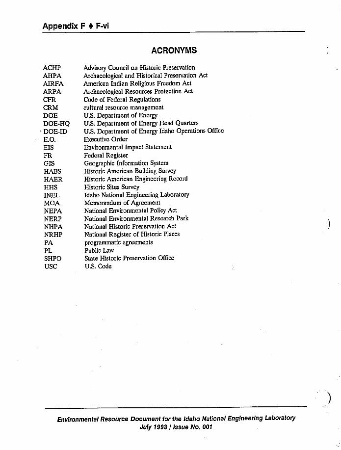
Appendix F 4 F-vi
ACRONYMS
ACHPAHPAAIRFAARPACFRCRMDOEDOE-HQDOE-IDE.O.EISFRGISHABSHAERHHSINELMOANEPANERPNHPANRHPPAPLSHPOUSC
Advisory Council on Historic Preservation
Archaeological and Historical Preservation Ac
American Indian Religious Freedom Act
Archaeological Resources Protection Act
Code of Federal Regulationscultural resource management
U.S. Department of EnergyU.S. Department of Energy Head Quarters
U.S. Department of Energy Idaho Operations
Executive OrderEnvironmental Impact Statement
Federal RegisterGeographic Information System
Historic American Building Survey
Historic American Engineering Record
Historic Sites Survey
Idaho National Engineering Laboratory
Memorandum of Agreement
National Environmental Policy Act
National Environmental Research Park
National Historic Preservation ActNational Register of Historic Places
programmatic agreements
Public Law
State Historic Preservation Office
U.S. Code
Office
Environmental Resource Document for the Idaho National Engineering Laboratory
July 1993 / Issue No. 001
Appendix F 0 F-1
F.1 Summary of Federal and State Guidelines Related toCultural Resources on the INEL
F.1.1 Federal Law
The following summary of federal statutes and guidelines is organized chronologically to give
a sense of the development of national thought on historic protection. Several of the earlier acts
have been strengthened or superseded by later legislation. Although all laws listed apply, those
listed below are the leading and most relevant to the daily routine of the Idaho National
Engineering Laboratory (INEL) and long range planning by the Cultural Resource Management
(CRM) Office.
American Indian Religious Freedom Act (AIRFA) of 1978, Section F.1.1.12
Archaeological and Historic Preservation Act of 1974, Section F.1.1.8
Archaeological Resources Protection Act (ARPA) of 1979, Section F.1.1.13
Curation of Federally-Owned and Administered Archaeological Collections,
Section F.1.1.15
Destruction of Government Property, Malicious Mischief, Section F.1.1.11
U.S. Department of Energy Idaho Operations Office (DOE-ID) Directive:
Management of Cultural Resources on the INEL (A. A. Pitrolo, 10/12/90),
Section F.1.2.3
Embezzlement and Theft Act of 1875, Section F.1.1.10
Federal Cave Resources Protection Act of 1988, Section F.1.1.14
National Environmental Policy Act (NEPA) of 1969, Section F.1.1.6
National Historic Preservation Act (NHPA) of 1966, Section F.1.1.4
Native American Grave Protection and Repatriation Act of 1990, Section F.1.1.16
U.S. DOE Memorandum EH-231: Management of Cultural Resources at Department
of Energy Facilities, Section F.1.2.2
U.S. DOE Order 1324.7:Departmental History Program, Section F.1;2.1.
Environmental Resource Document for the Idaho National Engineering Laboratory
July 1993 / Issue No. 001
Appendix F 4 F-2
F.1.1.1 Antiquities Act of 1906 [Public Law (PL) 59-209; 16 U.S. Code(USC) 431-433). This was the first statute to protect antiquities on federal lands. It states that
objects of antiquity (including paleontological resources) are to be preserved, restored and
maintained, and disturbed only under excavation permits issued by the federal government. The
law also provides criminal sanctions for unauthorized disturbance and clarifies that all artifacts and
associated documents amassed under permit are to be cared for in public museums.
Requirements of the Antiquities Act, including the permitting process, have been expanded,
strengthened, and superseded by the Archaeological Resources Protection Act. However, the
recent statute does not include paleontological remains in the revised definition of antiquities or
cultural resources.
F.1.1.2 Historic Sites, Buildings, and Antiquities Act of 1935, as amended (PL
74-292; 16 USC 461-467; 49 Statute 666). This act expands the basic principles ofpreservation set forth in the Antiquities Act and sets a national policy of preserving historic sites,
buildings, and objects of national significance. It provides the Secretary of Interior with the
power to restore and maintain such sites through the National Historic Landmarks Program and
also establishes the National Survey of Historic Sites and Buildings (now the National Register of
Historic Places), the Historic Sites Survey (HSS), the Historic American Buildings Survey
(HABS), and the Historic American Engineering Record (HAER). This was the first act that
officially recognized that the federal government has a responsibility to alleviate impacts that it
regularly causes to cultural resources and authorizes the expenditure of funds for archaeological
studies on major land modification projects.
F.1.1.3The Reservoir Salvage Act of 1960 (PL 86-523; 16 USC 469). This statute
provides for salvage and preservation of historic and archaeological data that might otherwise be
destroyed or harmed as a result of federal dam and reservoir construction. The law is extensively
amended by the Archaeological and Historical Preservation Act of 1974.
F.1.1.4 National Historic Preservation Act (NHPA) of 1966, as amended |PL 89-665;
PL 96-515; 16 USC 470; 36 Code of Federal Regulations (CFR) 60, 61, 63, 64, 65, 67, 68,
800; 48 FR 44716-44742]. This act furthers the principles of the Historic Sites, Buildings and
Antiquities Act of 1935 by explicitly outlining the leadership role of the federal government in
preservation of prehistoric and historic resources and promoting a policy of cooperation between
federal agencies, Indian tribes, and other nations, states, and local governments. It directs federal
agencies to assume responsibility for considering cultural resources in their activities and provides
a process by which historically and scientiTically important properties must be recognized and
protected. The act establishes the National Register of Historic Places (NRHP), State Historic
Preservation Office (SHPO), state historic preservation plans, procedures for forming approved
state and local government historic preservation programs, and also provides further guidance for
the National Histo.ic Landmarks Program. It also creates the independent National Advisory
Council on Historic "servation (ACHP) to serve as counsel on preservation issues to the
President, Congress, and federal and state agencies.
Environmental Resource Document for the Idaho National Engineering Laboratory
July 1993 / Issue No. 001
Appendix F t F-3
The following are sections of NHPA that are especially important to the relationship
between cultural resources protection and activities on federal land:
F.1.1.4.1 NHPA Section 106-The ACHP, created by the NHPA, is responsible for
implementation of Section 106. This important section requires that federal agencies consider the
potential impact of their activities on properties on or eligible to the National Register and give
the ACHP sufficient information and time to comment on federal activities. It provides a process
to be followed to meet this requirement and maintain compliance with federal law. Federal
agencies can comply with Section 106 by following procedures for individual projects or by
developing programmatic agreements (PA) for large, long-term, or complicated projects. PAs are
developed in consultation with the SHPO, ACHP, Native Americans, and other interested groups.
Federal agencies can also develop their own regulations (subject to approval by the ACHP)
and/or follow a state review system, approved by ACHP and the state, which substitutes for the
federal process.
Basic compliance with Section 106 of the NHPA involves the following steps: (a)identiTication and evaluation of historic properties within the project area, (b) assessment of the
effects of the project on those properties, (c) consultation with the SHPO and other interested
parties on ways to avoid or minimize adverse effects [e.g., developing a PA, Memorandum ofAgreement (MOA), and/or mitigation plan], (d) providing an opportunity for the SHPO and
ACHP to comment on the plan or the MOA, and (e) making a final agency decision on whether
or how to proceed (imnlementation).
F.1.1.4.2NHPA Section 110-This section directs federal agencies to establish
programs to locate, evaluate, and nominate all eligible cultural properties under their jurisdiction
to the National Register. This requirement is important because it stresses that federal agencies
must take an active role in the preservation and management of all significant cultural resources
under their jurisdiction and not only those that happen to fall within the path of construction.
Compliance with Section 110 also implies monitoring of known resources and when necessary the
taking of action to prevent any loss of information. Guidelines for large scale inventory and
monitoring programs such as this have been proposed by the National Park Service (53 FR 4727).
Federal agencies are also responsible for historic properties previously unidentified, which
may be discovered during project implementation, even after completion of the Section 106
review process and/or implementation of a mitigation plan. Compliance can be met for this rule
and the applicable laws by (a) incorporating the treatment protocol for unexpected discoveries in
the project plan, (b) complying with Section 36 CFR 800.6 when discoveries are made, (c)restarting the 106 process, or (d) notifying the Secretary of the Interior under PL 93-291.
F.1.1.4.3NHPA Section 304—This section addresses confidentiality by directing
federal agencies, after consultation with the Secretary of the Interior, to "withhold from disclosure
to the public, information relating to the location or character of historic resources whenever the
head of the agency or the Secretary determines that the disclosure of such information may create
a substantial risk of harm, theft, or destruction to such resources or to the area or place where
Environmental Resource Document for the Idaho National Engineering Laboratory
July 1993 / Issue No. 001
Appendix F 0 F-4
such resources are located." This section is also used to protect sensitive information related to
religious or sacred properties that is provided by traditional cultural leaders.
F.1.1.5Federal Collections Act of 1966 (PL 89-508; 80 Stat. 309; 4 CFR 2). Historic
and prehistoric sites have been clearly defined as resources under many legislative acts and, as
such, their deliberate or inadvertent destruction or disturbance constitutes damage to public
property. This act requires that agencies attempt to collect for damages arising from activities on
federal land, including cases that address unauthorized/illegal damage or destruction to cultural
resources. In these situations, professional archaeological appraisal is required to translate site
damage into monetary terms and evidential requirements for court cases.
F.1.1.6National Environmental Policy Act (NEPA) of 1969 [PL 91-190; 42 USC
4321-4361; 40 CFR 1500-1508; 10 CFR 1021; Executive Order (E.O.) 11514; E.O. 11991].This important act outlines a federal policy of general environmental protection by forcing
information-gathering, planning, and assessment in advance of projects or actions that occur on
federal land or are federally licensed or funded. It requires the use of natural and social sciences
in planning and decision-making with regard to project impacts on all aspects of the environment,
including cultural resources. Federal agencies must prepare detailed environmental impact
statements (EISs) outlining the scope, environmental effects of, and alternatives to the action
planned and must also allow for and incorporate public, scientific, and legal comment. Because
EISs must address the environmental consequences of a project to cultural resources, NEPA
forces the involvement of archaeologists early in project planning stages. This results in detailed
inventories of cultural resources for project areas as well as evaluations of potential impacts on
them, alternative actions, and programs of appropriate mitigation if the project or one of its
alternatives is slated to proceed. It is also important to note that categorical exclusions under
NEPA (45 FR 20694, 47 FR 7976 for DOE) do not eliminate the need to comply with Section
106 of the NHPA, requiring the identification and evaluation of cultural resources in the path of
construction projects.
F.1.1.7 Executive Order 11593of 1971 (36 CFR 8921)~ This directive formally
designates the federal government as leader in "preserving, restoring, and maintaining the historic
and cultural environment of the Nation." It gives federal agencies the responsibility for locating,
inventorying, and nominating to the National Register those sites that qualify and urges caution to
ensure that eligible properties are not transferred or altered during the process of this inventory
and nomination. The primary philosophy and requirements of E.O. 11593were incorporated into
1980 amendments to the NHPA.
F.1.1.8Archaeological and Historic Preservation Act (AHPA) of 1974 (PL 86-523;
PL 93-291; 42 CFR 5375; 42 FR 5374; 16 USC 469). Also known as the "Archaeological
Recovery Act" and the "Reservoir Salvage Act," this law was written to preserve archaeological
data threatened by any federal ground-disturbing program or activity, or project requiring a
federal license. More importantly, the act provides that up to 1% of the total project
appropriation may be dedicated to cultural resources data recovery. (The NHPA also authorizes
project and project planning funds to be used in this manner). PL 96-515 defines this 1% for site
Environmental Resource Document for the Idaho National Engineering Laboratory
July 1993 / Issue No. 001
Appendix F 4 F-5
identiTication, surveys, and evaluations as part of planning, not mitigating, budgets. This limitationcan be waived with the concurrence of the Secretary of the Interior and review by the National
Park Service's consulting archaeologist.
F.1.1.9Department of Transportation Act of 1976 (PL 89-670; 49 USC 4321-4361).This law states that no Federal Highway Administration, Federal Aviation Administration, UrbanMass Transit Administration, or U.S. Coast Guard project may be undertaken if it requires theuse of land from cultural resources of national, state, or local signiTicance unless there is nofeasible alternative and unless the program includes planning to minimize harm to the properties.
F.1.1.10 Embezzlement and Theft Act of 1875, as amended (PL 93-203; PL 93-567;18 USC 641)~ This act describes acts of theft and embezzlement against the federal governmentand prescribes fines and punishments. Together with the malicious mischief statute, this
legislation may be used in coordination with the ARPA to establish the liability of individuals who
loot cultural resources as well as their connected commercial agents or dealers in artifacts.
F.1.1.11Destruction of Government Property, Malicious Mischief (18 USC 1361).This law provides penalties for willful destruction of federal government property. When appliedto litigation against looters and vandals, the penalties of this statute may be applied to partial sitedestruction or to destruction or removal of smaller non-replaceable artifacts such as pots, stonetools, and perishable materials.
F.1.1.12American Indian Religious Freedom Act (AIRFA) of 1978 (PL 95-341; 42USC 1996; 43 CFR 7; 25 CFR 262; 55 FR 2580-2583). This act reaffirms Native American
religious freedom rights under the First Amendment and sets U.S. policy to protect and preserve
the inherent and constitutional right of American Indians to believe, express, and exercise their
traditional religions. The act requires that federal actions avoid interfering with access to sacred
locations and traditional resources that are integral to the practice of religions. Although not
specifically mandated in AIRFA, a subsequent court ruling states that consultation by agencies
with interested Native American groups and leaders during the project decision-making processwill satisfy compliance with the act. (Section 10a of the ARPA requires consideration of AIRFAin developing regulations.)
F.1.1.13Archaeological Resources Protection Act (ARPA) of 1979, as amended (PL96-95; PL 100-555; PL 100-588;16 USC 470; 43 CFR 7; 36 CFR 296; 18 CFR 1312;32CFR 229). This is the primary archaeological protection law for federal and tribal lands. Itdefines archaeological resources and ensures the confidentiality of locational information. Thelaw specifically prohibits unauthorized excavation or removal of materials from archaeologicalresources on federal lands as well as the buying and selling of antiquities. Protection measures
are also extended to resources defined as sacred by Native American groups. For those who
would disregard these sanctions, ARPA provides strict criminal and civil penalties. Implementing
regulations outline procedures for the legal excavation and removal of archaeological resources
(which remain the property of the federal government or Indian tribe), including necessary
permitting. Recent amendments complement Section 110 of thc NHPA by requiring that federal
Environmental Resource Document for the Idaho National Engineering LaboratoryJuly 1993 / Issue No. 001
Appendix F 0 F-6
agencies develop plans for surveying lands not immediately scheduled for development. Agenciesare also tasked with developing and implementing systems for reporting and recording violations
of the act and with developing public awareness programs.
F.1.1.14Federal Cave Resources Protection Act of 19SS (PL 100-691). The statedpurposes of this act are "...tosecure, protect, and preserve significant caves on Federal lands forthe perpetual use, enjoyment, and benefit of all people...to foster increased cooperation and
exchange of information between governmental authorities and those who utilize caves located onFederal lands for scientiTic, education, or recreational purposes..." Much like ARPA, this actaddresses confidentiality of locational information, collecting, permitting, and civil and criminal
penalties for violations.
F.1.1.15Curation of Federally-Owned and Administered Archaeological Collections(36 CFR 79). This statute provides standards and guidelines to be followed by federal agenciesto preserve artifacts and associated records recovered in conjunction with federal projects.
F.1.1.16Native American Grave Protection and Repatriation Act of 1990(PL 101-601). This law directs the Secretary of Interior to guide responsibilities in repatriationof federal archaeological collections and collections held by museums receiving federal funding. Itis expected that major actions under this new law will be undertaken within the year for theSecretary by the Departmental Consulting Archaeologist and the Archaeological AssistanceDivision of the National Park Service. Important actions ordered under this act include: (a)establishing a review committee with monitoring and policy-making responsibilities; (b) developingregulations for repatriation, including procedures for identifying lineal descent or cultural
affiliation needed for claims; {c)oversight of museum programs designed to meet the inventory
requirements and deadlines of this law; and (d) developing procedures to handle unexpecteddiscoveries of graves and/or grave goods during activities on federal or tribal lands.
F.1.2 Department of Energy Directives
Within recent years, DOE has exhibited a heightened awareness of compliance with federal
and state antiquities legislation. The following directives have been issued as a result of this
increased attention.
F.1.2.1 U.S. DOE Order 1324.7:Departmental History Program (10/21/88). Thisdirective states that "...itis Departmental {DOE) policy to establish a history program to write theoflicial history of the Department and its predecessor agencies, create and maintain theDepartment's historical archives, and provide institutional memoir for thc Department, its
laboratories, and contractors. The objectives of the history program are to record theDepartment's official history and to create and maintain historical archives useful fordecision-makers who must evaluate current and proposed policics within a framework ofDepartmental precedent." The document provides references, defines responsibilities, and
dcscribcs the types of archival information that are to bc managed by all DOE elements, offices,divisions and contractors.
Environmental Resource Document for the Idaho National Engineering Laboratory
July 1993 / Issue No. 001
Appendix F 4 F-7
F.1.2.2 U.S. DOE Memorandum EH-231: Management of Cultural Resources at
Department of Energy Facilities (R. F. Pelletier, 2/23/90). The stated intent of this document
is "...toinform all Department of Energy (DOE) facilities and programs of the requirements for
complying with the various executive orders, statutes and implementing regulations governing the
management of cultural resources..." To this end, the memo describes applicable regulations and
mandates the development of specific programs for the identification, evaluation, protection and
mitigation of cultural resources located on DOE-owned or leased facilities.
F.1.2.3 DOE-ID Directive: Management of Cultural Resources on the INEL (A. A.
Pitrolo, 10/12/90). This directive outlines the DOE-ID response to the DOE Headquarters
(DOE-HQ) memorandum directing all DOE facilities to comply with cultural resources legislation.
It commits to rigorous compliance and advises cooperation between INEL contractors in the
development and implementation of a CRM plan for the INEL.
F.1.2.4 U.S. DOE Report ER-0246: DOE National Environmental Research Parks
(8/1/85). The DOE National Environmental Research Park (NERP) Program was established for
the purpose of utilizing the often large landholdings of DOE facilities as outdoor laboratories for
research in environmental sciences and energy technology options. The INEL is the second
largest in land area of six DOE NERPs. Research at the NERPs includes basic natural history
and baseline data-gathering, wetlands, soils, climate, biodiversity, bioremediation, and ecosystem
dynamics. Archaeology and paleontology fit into NERP programs both conceptually (human and
non-human environmental characterization, past and present ecological adaptations, climatic
modeling) and practically (baseline studies, need to maintain the integrity of the Parks for
scientific research, environmental compliance requirements).
F.1.3 Idaho State Laws
On the INEL, as on other federal reserves, federal statutes usually supersede existing state
legislation pertaining to cultural resources. However, both sets of statutes are complementary in
their message of preservation.
F.1.3.1 Idaho Antiquities Act, Idaho Code, Chapter 41. This statute establishes
protection of archaeological and vertebrate palcontological resources on public (state) lands in
Idaho. Like its federal counterpart, the Idaho Act provides for the permitting of qualified
individuals or institutions to excavate, and establishes penalties for violation of the code.
However, the Idaho Act is superseded by federal law on the INEL.
Environmenfal Resource Document for the Idaho National Engineering Laboratory
July 1993 / Issue N".:001.
Appendix F t F-8
F.1.3.2 Idaho Burial Act, Idaho Code, Chapter 5, Title 27 and Chapter 70, Title 1S.This act prohibits the desecration of human burials on public (state) lands in Idaho. Penalties are
established for unlawful removal of human remains and associated grave goods. The statute also
defines permitted activities and establishes guidelines for the legal removal of human remains.
These guidelines require that excavation be conducted by a qualified archaeologist under
consultation and with written permission of the appropriate Indian tribe and that human remains
and associated items be reinterred in an area approved by the tribe.
F.1.3.3 Idaho Cave Protection Act, Idaho Code, Chapter 70, Title 18, Section 7035.This state law makes it unlawful to damage caves or their features or contents through vandalism
or unauthorized removal of materials. The law applies to caves on federal, state, or private land.
Violation of the act is considered a trespass and malicious injury to property misdemeanor.
Environmental Resource Document for the Idaho National Engineering Laboratory
July 1993 / Issue No. 001
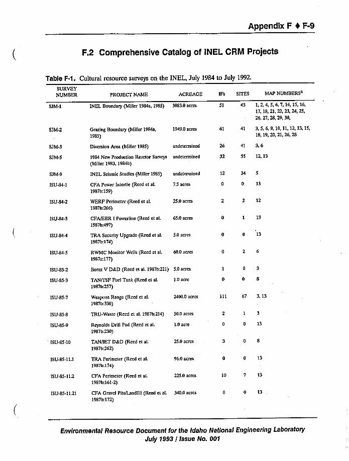
Appendix F t F-9
F.2 Comprehensive Catalog of INEL CRM Projects
Table F-1. Cultural resource surveys on the
SURVEYNUMBER PROJECT NAME ACREAGE IFs SITES
INEL, July 1984 to July 1992.
MAP NUMBERSa
SJM-1 INEL Boundary (Miller 1984a, 1985) 3083.0 acres 51 43 1, 2, 4, 5, 6, 7, 14, 15, 16,
17, 18, 21, 22, 23, 24, 25,
26, 27, 28, 29, 30>
SJM-2 Grazing Boundary (Miller 1984a,
1985)
1949,0 acres 61 41 3, 5, 6, 9, 10, 11,12, 13, 15,18, 19, 20, 21, 26, 28
SJM-3
SJM-5
SJM-9
ISU414-1
Diversion Area (Miller 1985)
1984 New Production Reactor Surveys
(Miller 1983, 1984b)
INEL Seismic Studies (Miller 1985)
CFA Power Intertie (Reed et al.
1987b:159)
undetermined
undetermined
undctcrmined
7.5 acres
32
12
dt 3,6
34 5
0 13
55 12, 13
ISU-84-2
ISU-84-3
ISU-84-4
ISU44-5
WERF Perimeter (Reed et al.
1987b:266)
CFA/EBR I Powerline (Reed et al.
1987b:497)
TRA Security Upgrade (Reed et ak
1987b:174)
RWMC Monitor Wells (Reed et al.
1987a:177)
25.0 acres
65.0 acres
5.0 acres
60.0 acres
2 2 12
0 1 13
0 0 13
0 2 6
ISU-85-2
ISU-85-3 TAN/ISF Fuel Tank (Reed et al.
1987b:257)
1.0acre
Borax V D&D (Reed et al. 1987b;221) 5.0 acres 1 0 3
0 0 8
ISU-85-7
ISU41541
ISU 415-9
ISU 415-10
I SU 415-11.1
ISU415-11.2
ISU415-11.21
Weapons Range (Reed et al.
1987b:330)
TRU-Waste (Reed et al. 1987b:214)
Reynolds Drill Pad (Reed et al.
1987b:230)
TAN/IET D&D (Reed et al.
1987b:262)
TRA Perimeter (Reed et al.
1987b:174)
CFA Perimeter (Reed et al.
1987b:161-2)
CFA Gravel Pits/Landlill (Reed et al.
1987b:172)
2400.0 acres
50.0 acres
1.0acre
25.0 acres
96.0 acres
225.0 acres
340.0 acres
111 67 3, 13
2 I 3
0 0 13
3 0 8
0 0 13
10 7 13
0 0 13
Environmental Resource Document for the Idaho National Engineering Laboratory
July 1993 / Issue No. 001
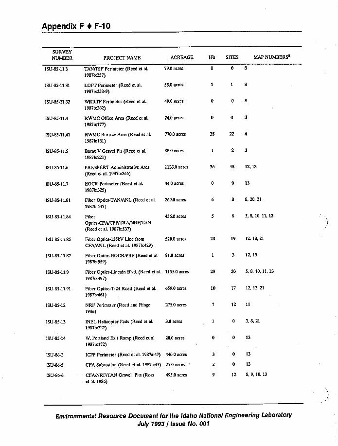
Appendix F 4 F-10
SURVEYNUMBER
ISU45.11.3
ISU-85-11.31
ISU4I5-11.32
ISU-85-11.4
ISU4I5-11.41
ISU415-11.5
ISU4I5-11.6
ISU-$5-11,7
ISU-85-11,81
ISU-85-11.84
ISU-85-11.85
ISU415-I L87
PROJECT NAME
TAN/PSF Perimeter (Reed et al.
1987b:257)
LOFT Perimeter (Reed et al.
1987b:258-9)
WRRTF Perimeter (Reed et al.
1987b:262)
RWMC Oflice Area (Reed et aL
19$7b;177)
RWMC Borrow Area (Reed et al.
1987b:181)
Borax V Gravel Pit (Reed et al.
1987b;221)
PBF/SPERT Administrative Area
(Reed et al. 1987b:266)
EOCR Perimeter (Reed et aL
1987b:325)
Fiber Optics-TAN/ANL (Reed et al.
1987b:547)
FiberOptics-CFA/CP P/IRA/NRF/PAN
(Reed et aL 1987b:537)
Fiber Optics-135kV Line from
CFA/ANL (Reed et al. 1987b:429)
Fiber Optics-EOCR/PBF (Reed et al.
1987b:559)
ACREAGE
79.0 acres
55.0 acres
49.0 acres
24.0 acres
770.0 acres
88.0 acres
1133.0acres
44.0 acres
269.0 acres
456.0 acres
520.0 acres
91.0acres
IFs SITES MAP NUMBERS
0 0 8
1 1 8
0 0 8
0 0 3
35 22 6
1 2 3
36 48 12, 13
0 0 13
6 8 8,20,21
5 8 5,8,10,11,13
20 19 12, 13, 21
I 3 12 13
ISU-85-11.9 Fiber Optics-Lincoln Blvd. (Reed et al. 1155.0acres
1987b:497)
28 20 5.8,10,11,13
ISU-85-11.91
ISU-85-12
ISU-85-13
ISU-85-14
Fiber Optics-T-24 Road (Reed et al.
1987b:461)
NRF Perimeter (Reed and Ringe
1986)
INEL Ilelicopter Pads (Reed et al.
1987b:327)
W. Portland Exit Ramp (Reed et al.
19871%172)
659.0 acres
275.0 acres
3.0 acres
20.0 acres
10 17 12, 13, 21
7 12 11
I 0 3.8,21
0 0 13
ISU-86-2
ISU4I6-5
ISU-86-6 CFA/NRF/TAN Gravel Pits (Rosset al. 1986)
495.0 acres
ICPP Perimeter (Reed et al. 1987a:47) 440.0 acres
CFA Substation (Reed et al. 1987a:45) 25.0 acres
3 0 13
2 0 13
9 12 8,9,10,13
Enl/ironmental Resource Document for the Idaho National Engineering Lal3oratory
July '1993 / Issue No. 001
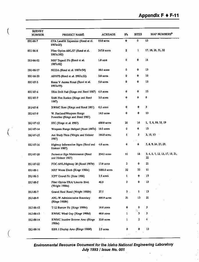
Appendix F I F-11
SURVEYNUMBER
ISU46-7
ISU-864
ISU46-12
ISU46-17
ISU-86-20
ISU47-3
PROJECT NAME
CFA Landfill Expansion (Reed et al.
1987a:25)
Fiber Optics-ANL/IF (Reed et al.
1987a:102)
NRF Topsoil Pit (Reed et al.
1987a:62)
NODA (Reed et al. 1987a:54)
ARVFS (Reed et al. 1987a:52)
Borax V Access Road (Reed et al.
1987a:99)
ACREAGE
15.0acres
247.0 acres
1.0acre
10.0 acres
3.0 acres
5.0 acres
IFs SITES MAP NUMBERSa
0 0 13
2 1 17,18,21,31,32
0 0 11
0 0 13
0 0 10
0 0 13
ISU-87-6
ISU47-7
ISU47-8
ISU47-9
ISU-87-12
I SU-87-14
ISU-87-15
TRA Drill Pad (Ringe and Reed 1987) 6.0 acres
TAN Fire Station (Ringe and Reed
1987)3.0 acres
RWMC Bore (Ringe and Reed 1987) 0.5 acres
W. Portland/Weapons Range
Powerline (Ringe and Reed 1987)
SSC (Ringe et al. 1987)
14.0 acres
600.0 acres
Ant Study Plots (Wright and Holmer
1987)
104.0 acre
Weapons Range Helipad (Reed 1987a) 10.0 acres
0 0 13
0 0 8
0 0 3
0 0 13
31 16 1, 5,8,10,18,19
0 0 13
5 3 3 10 13
ISU-87-16
ISU47-20
Highway Information Signs (Reed and
Holmer 1987)
Perimeter Sign Maintenance (Reedand Holmer 1987)
4.0 acres
254.0 acres
0 0 5,8,9,24,27,29,
18 3,4,5,7,12,13,17,18,21,22
ISU-87-22
ISU-88-1
ISU-88.3
ISU-88-5
NRF Waste Ditch (Ringe 1988a)
ICPP Gravel Pit (Ross 1988)
Fiber Optics-TRA/ Lincoln Blvd.
(Wright 1988a)
1000.0acres
2.5 acres
46.0
FOC-ANL/Highway 20 (Reed 1987b) 17.0acres
32
0 21
32 11
0 13
0 13
ISU-88-7
ISU48-9
ISU-88-12
I SU-88-13
ISU48-14
Gravel Haul Road (Wright 1988b)
ANL-W Administrative Boundary
(Ringe 1988b)
T-12 Borrow Pit (Ringe 1988c)
RWMC Wind Gap (Ringe 1988d)
RWMC Inactive Borrow Area (Ringe
1988e)
37.5
600.0 acres
10.0acres
60.0 acres
53.0 acres
21
1 13
13 21
0 0 3
1 3 3
I 2 6
ISU48-I 6 EBR I Display Area (Ringe 1988f) 2.5 acres 0 0 13
Environmental Resource Document for the Idaho National Engineering Laboratory
July 1993 / Issue No. 001
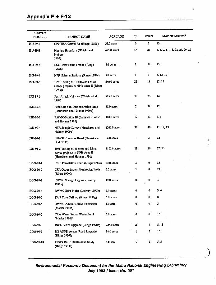
Appendix F 1 F-12
SURVEYNUMBER
ISU-89-1
ISU-89-2
PROJECT NAME ACREAGE
Hunting Boundary (Wright and
Holmer
1990)
675.0 acres
CPP/IRA Gravel Pit (Ringe 1989a) 35.0 acres
IFs SITES MAP NUMBERS
0 1 13
18 27 1,5,9,11,15,22,24,29,30
ISU-89-3 Lost River Fault Trench (Ringe
1989b)
4.0 acres 1 0 15
ISU-89-4
ISU419-5
NPR Seismic Stations (Ringe 1989c) 5.0 acres
1990 Testing of 10 sites and Misc. 240.0 acres
survey projects in NPR Area E (Ringe
1990d)
1 1 5,12,19
25 18 12, 13
ISU49-6
ISU-89-8
ISU-90-2
ISU-90-4
ISU-91-1
ISU-91-2
Fast Attack Vehicles (Wright et al.
1989)
Fenceline and Demonstration Area
(Henrikson and Holmer 1990a)
RWMC/Section 18 (Sammons-Lohse
and Holmer 1990)
NPR Sample Survey (Henrikson and
Holmer 1990b)
PBF/NPR Access Road (Henrikson
et aL 1990)
1991 Testing of 41 sites and Misc.
survey projects in NPR Area E(Henrikson and Holmer 1991)
915.0acres
45.0 acres
400.0 acres
1200.0 acres
64.0 acres
1105.0acres
30 33 13
2 0 12
17 13 3,6
38 40 11, 12, 13
1 3 12
18 16 12, 13
EGG-90-1
EGG-90-2 CFA Groundwater Monitoring Wells
(Ringe 1990f)
2.5 acres
ICPP Percolation Pond (Ringe 1990e) 54,0 acres 0 13
0 13
EGG-90-3 RWMC Sewage Lagoon (Lowrey
1990a)
12.0 acres 0 0 3
EGG-904
EGG-90.5
EGG-904
TAN Core Drilling (Ringe 1990g)
RWMC Administrative Expansion
(Marler 1990a)
5.0 acres
1.0acre
RWMC Bore Holes (Lowrey 1990b) 3.0 acres 0 0 3,6
0 0 8
0 0 3
EGG-90-7 TRA Warm Water Waste Pond
(Marlcr 1990b)1.0acre 0 0 13
EGG-90-8
EGG-90-9 ICPP/NPR Access Road Upgrade
(Ringe 1990f)84.0 acres
INEL Sewer Upgrade (Ringe 1990e) 225.0 acres 25 4 8 13
I 3 13
EGG-90-10 Cinder Butte Rattlesnake Study
(Ringe 1990c)1.0acre 0 I 5,8
Environmental Resource Document for the Idaho National Engineering Laboratory
July 1993 / Issue No. 001
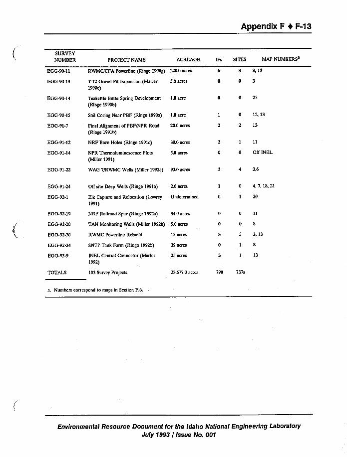
Appendix F 4 F-13
SURVEYNUMBER
EGG-90-11
EGG-90-13
PROJECT NAME ACREAGE
T-12 Gravel Pit Expansion (Marler
1990c)5.0 acres
RWMC/CFA Powerline (Ringe 1990g) 220.0 acres
IF SITES MAP NUMBERS
6 8 313
0 0 3
EGG-90-14 Teakettle Butte Spring Development
(Ringe 1990b)
1.0acre 0 0 25
EGG-90-15
EGG-91-7 Final Alignment of PBF/NPR Road
(Ringe 1991b)20.0 acres
Soil Coring Near PBF (Ringe 1990a) 1.0acre 1 0 12, 13
2 2 13
EGG-91-12
EGG-91-14
NRF Bore Holes (Ringe 1991c)
NPR Tbermoluminescence Plots
(Miller 1991)
38.0 acres
5.0 acres
2 I 11
0 0 Ofl'NEL
EGG-91-22 WAG 7/RWMC Wells (Miller 1992a) 93.0 acres 3 4 3,6
EGG-91-24
EGG-92-1
Off site Deep Wells (Ringe 1991a)
Elk Capture and Relocation (Lowrey
1991)
2,0 acres
Undetermined
I 0 4,7,18,21
0 1 20
EGG-92-19
EGG-92-20
EGG-92-30
EGG-92-34
EGG-93-9
NRF Railroad Spur (Ringe 1992a) 34.0 acres
RWMC Powerline Rebuild
SNTP Tank Farm (Ringe 1992b)
INEL Central Connector (Marler
1992)
15 acres
39 acres
25 acres
TAN Monitoring Wells (Miller 1992b) 5.0 acres
0 11
0 8
5 3,13
1 8
I 13
TOTALS 103 Survey Projects 23,677.0 acres 790 737s
a. Numbers correspond to maps in Section F.6.
Environmental Resource Document for the Idaho National Engineering Laboratory
July 1993/ Issue No. 001
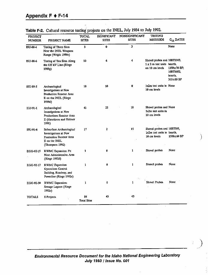
Appendix F 4 F-14
Table F-2. Cultural resource testin j projects on the INEL, July 1984 to July 1992.
PROJECT TOTAL SIGNIFICANT NONSIGNIFICANT TESTING
NUMBER PROJECT NAME SITES SITES SITES METHODS C14 DATES
ISU-884
ISU484
Testing of Three Sites
Near the INEL Weapons
Range (Wright 1988a)
Testing of Ten Sites Along
the 135 kV Line (Ringe
1988g)
10
None
Shovel probes and 10BT1043,
1x 2m test units hearth,
on 10 cm levels 1350~70 BP;10BT1052,hearth,
310~80 BP
ISU-89-5
ISU-91-1
ISU-91-6
Archaeological
Investigations at New
Production Reactor Area
E on the INEL (Ringe
1990d)
Archaeological
Investigations at New
Productions Reactor Area
E (Henrikson and Holmer
1991)
Subsurface Archaeological
Investigations at New
Production Reactor Area
E on the INEL
(Thompson 1992)
10
41
17
10
18
15
Ix2m test units in None
10 cm levels
Shovel probes and None
Ix2m test units in
10 cm levels
Shovel probes and 10BT395,1x2m test units in hearth,
10 cm levels 1500~60 BP
EGG-92-15
EGG-92-17
RWMC Expansion: Pit
Nine Administrative Arcs
(Ringe 1992d)
RWMC Expansion:
Operations Control
Building, Roadway, and
Powerline (Ringe 1992e)
1 Shovel probes None
I Shovel probes None
EGG-92-30 RWMC Expansion:
Sewage Lagoon (Ringe
1992c)
TOTALS 8 Projects 84Total Sites
43
I Shovel Probes None
43
Environmental Resource Document for the Idaho National Engineering Laboratory
July 1993 / Issue No. 001
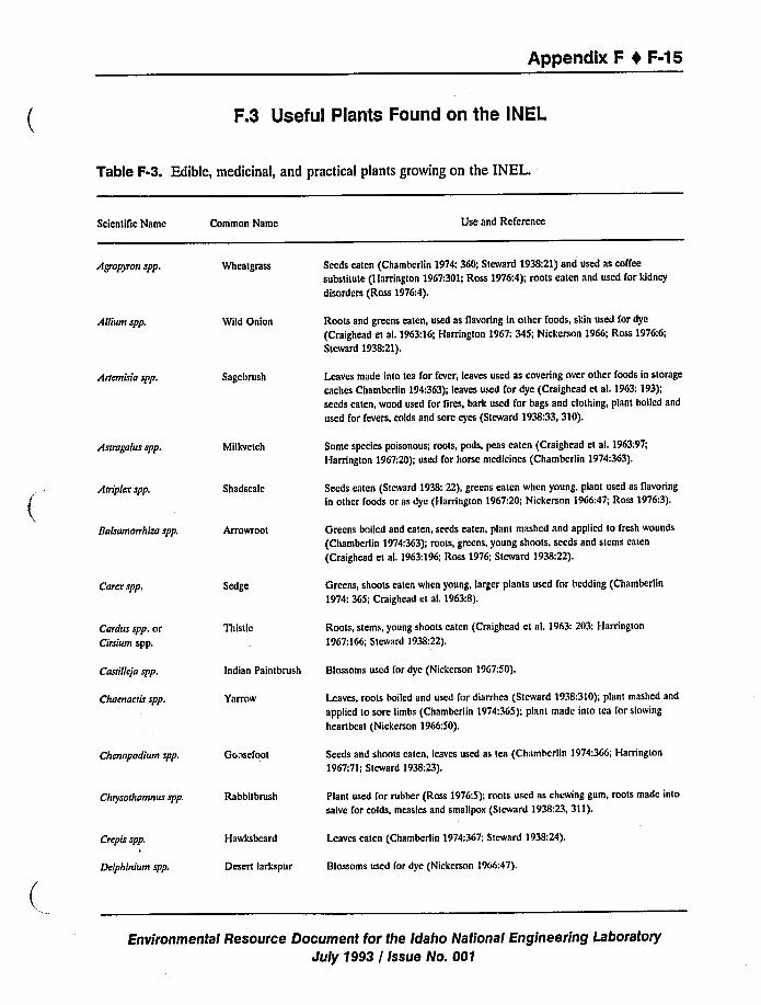
Appendix F I F-15
F.3 Useful Plants Found on the INEL
Table F-3. Edible, medicinal, and practical plants growing on the INEL.
ScientiTic Name Common Name Use and Reference
Agroplvon spp. Wheatgrass Seeds eaten (Chamberlin 1974: 360; Steward 1938:21)and used as coffee
substitute (Harrington 1967:301;Ross 1976:4); roots eaten and used for kidney
disorders (Ross 1976:4),
Allium spp. Wild Onion Roots and greens eaten, used as flavoring in other foods, skin used for dye
(Craighead et al. 1963:16;Harrington 1967: 345; Nickerson 1966; Ross 1976:6;
Steward 1938:21).
Attemisia spp. Sagebrush Leaves made into tea for fever, leaves used as covering over other foods in storage
caches Chamberlin 194;363); leaves used I'or dye (Craighcad et ai. 1963: 193);seeds eaten, wood used for fires, bark used for bags and clothing, plant boiled and
used for fevers, colds and sore eyes (Steward 1938:33,310).
A suagalus spp. Milkvctch Some species poisonous; roots, pods, peas eaten (Craighead et al. 1963:97;
Harrington 1967:20);used for horse medicines (Chambcrlin 1974:363).
A triplex spp. Shadscale Seeds eaten (Steward 1938: 22), greens eaten when young, plant used as flavoring
in other foods or as dye (Harrington 1967:20; Nicketson 1966:47; Ross 1976:3),
Bafsamonhiza spp, Arrowroot Greens boiled and eaten, seeds eaten, plant mashed and applied to fresh wounds
(Chambcrlin 1974:363);roots, greens, young shoots. seeds and stems eaten
(Craighead et al. 1963:196;Ross 1976; Steward 1938:22).
Cores spp, Sedge Greens, shoots eaten when young, larger plants used for bedding (Chamberlin
1974: 365; Craighead et al. 1963:8).
Cardus spp. orCirsium spp.
Thistle Roots, stems, young shoots eaten (Craighcad ct al. 1963:203; Harrington
1967;166; Steward 1938:22),
Costi lleja spp.
Chaenaetis spp.
Indian Paintbrush
Yarrow
Blossoms used for dye (Nicketson 19G7:50).
Leaves, roots boiled and used for diarrhea (Steward 1938:310);plant mashed and
applied to sore limbs (Chambcrlin 1974:3G5); plant made into tea for slowing
heartbeat (Nicketson 1966:50).
Chenopodium spp. Gooscfoot Seeds and shoots eaten, leaves used as tea (Chambcrlin 1974:366; Harrington
1967:71;Steward 1938:23).
Cluysothamnus spp. Rabbitbrush Plant used for rubber (Ross 1976:5); roots used as chewing gum, roots made into
salve for colds, measles and smallpox (Steward 1938:23,311).
Crepis spp.
Delphinium spp.
Hawksbeard
Desert larkspur
Leaves eaten (Chambcrlin 1974:367; Steward 1938:24).
Blossoms used (or dye (Nickcrson 1966:47).
Environmental Resource Document for the Idaho National Engineering Laboratory
July 1993 / Issue No. 001
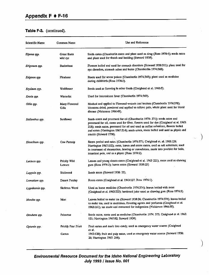
Appendix F I F-16
Table F-3. (continued).
ScientiTic Name Common Name Use and Reference
Elymus spp. Great Basin
wild rye
Seeds eaten (Chambcriin eaten and plant used as drug (Ross 1976:4);seeds eaten
and plant used for thatch and bedding (Steward 1938).
Erigonum spp. Buckwheat Howers boiled and used for stomach disorders (Steward 1938:311);plant used for
eye disorders, stomach aches and burns (Chambcrlin 1974:368).
Erigeron spp. Fleabane Roots used for arrow poison (Chamberlin 1974:3G8); plant used as medicine
during childbirth (Ross 1976:5).
Erysisum spp.
Eroiia spp.
Gilia spp.
Wallflower
Wintcrfat
Many Flowered
Gilia
Seeds used as flavoring in other foods (Craighcad et al. 1963:5),
Used for intermiflent fever (Chamberlin 1974:369).
Mashed and applied to Rowered wounds and bruises (Chambcrlin 1974:370);
blossoms dried, powdered and applied to rclicve pain, whole plant used for blood
disease (Nickerson 1966:49).
Helianihus spp. Sunflower Seeds eaten and proccsscd for oil (Chamberlin 1974: 371); seeds eaten and
processed for oil, stems used for fiber, flowers used for dye (Craighead et al. 1963:
218); seeds eaten. processed for oil and used as coffee substitute, flowers boiled
and eaten (I-larrington 1967:314);seeds eaten, roots boiled and used as physic and
emetic (Steward 1938).
Heraeleum spp. Cow Parsnip Stems peeled and cate. (Chambcrlin 1974:371;Craighead et. al. 1963:126;
Harrington 1967:132);roots, leaves and stems eaten. used as sall substitute, used
in treatment of rheumatism, fainting or convulsions, made into poultice for boils,
intestinal pain, and as a physic (Ross 1976:2).
Laemea spp. Prickly Wild
Lettuce
Leaves and young shoots eaten (Craighcad et al, 19G3 221), roots used as chewing
gum (Ross 1976:2); leaves eaten (Steward 1938:25)
Lappula spp.
Lomaiium spp.
L>godesmia spp.
Stickwccd
Desert Parsley
Skeleton Weed
Seeds eaten (Steward 1938: 25).
Roots eaten (Craighead et al, 1963:127;Ross 1976:1).
Used as home medicine (Chambcrlin 1974:374); leaves boiled with meat
(Craighcad et al. 1963:222); hardened juice used as chewing gum (Ross 1976:5).
Mendta spp. Mint Leaves boiled to make tea (Steward 1938;26: Chambcrlin 1974:374); leaves boiled
to make tea. used in medicines, flavoring agents and perfumes (Craighead et al.
1963:161);tea made and consumed for indigestion (Nickerson 1966:50).
Oendt era spp, Primrose Seeds catcn, roots used as medicine (Chamberlin 1974: 375; Craighead et al. 1963:
121; Harrington 1967:82; Steward 1938).
Opiunia spp. Prickly Pear Fruit
Cactus
Fruit eaten and mad" into candy, used as emergency water source (Craighead
et al.
1963;120); fruit and pulp eaten, used as emergency water source (Steward 1938:
26; Harrington 19G7: 248).
Environmental Resource Document for the Idaho National Engineering Laboratory
July 1993 / Issue No. 001
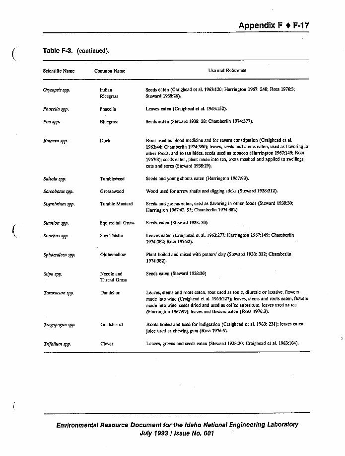
Appendix F 4 F-17
Table F-3. (continued).
Scientific Name Common Name Use and Rcfcrencc
Oryzopsfs spp. Indian
Ricegrass
Seeds eaten (Craighead et al. 1963:120;Harrington 1967:248; Ross 1976:3;Steward 1938:26).
Phacelia spp.
Poa spp.
Phacelia
Bluegrass
Leaves eaten (Craighead et al. 1963:152).
Seeds eaten (Steward 1938:28; Chamberlin 1974:377).
Aumcra spp. Dock Root used as blood medicine and for severe constipation (Craighcad et al.
1963:44; Chambcrlin 1974:380); leaves, seeds and stems eaten, used as flavoring in
other foods, and to tan hides, seeds used as tobacco (Harrington 1967:145;Ross
1967:3);seeds eaten, plant made into tea, roots mashed and applied to swellings,
cuts and sores (Steward 1938:29).
Salsola spp.
Sarcobarusspp.
Sisymbrium spp.
Tumbleweed
Greascwood
Tumble Mustard
Seeds and young shoots eaten (Harrington 1967:93).
Wood used for arrow shafts and digging sticks (Steward 1938:312).
Seeds and greens eaten, used as flavoring in other foods (Steward 1938:30;
Hamngton 1967:62, 95; Chamberlin 1974:382).
Shani on spp.
Sonchus spp.
Squirreltail Grass
Sow Thistle
Seeds eaten (Steward 1938:30)
Leaves eaten (Craighead et al. 1963:277; Harrington 1967:149;Chamberlin
1974:382; Ross 1976:2).
Sphaeralcea spp. Globem allow Plant boiled and mixed with potters'lay (Steward 1938:312; Chamberlin
1974:382).
Stipa spp. Needle and
Thread Grass
Seeds eaten (Steward 1938:30)
Tararacum spp. Dandelion Leaves, stems and roots eaten, root used as tonic, diuretic or laxative, flowers
made into wine (Craighcad et al. 1963:227); leaves, stems and roots eaten, flowers
made into wine, seeds dried and used as coffee substitute, leaves used as tea
(I-larrington 1967:99);leaves and flowcrs catcn (Ross 1976:3).
Trogopognn spp. Goatsbcard Roots boiled and used for indigestion (Craighead ct al. I963: 231); leaves eaten,
juice used as chewing gum (Ross 1976:5).
Tn%lium spp. Clover Leaves, greens and seeds eaten (Steward 1938:30;Craighcad et al. 1963:104).
Environmental Resource Document for the Idaho National Engineering Laboratory
July 1993 / Issue No. 001
Appendix F 4 F-49
F.4 Programmatic Priorities
The ongoing management of INEL cultural resources is guided by the "INEL Management
Plan for Cultural Resources" (Miller 1992b), now in draft form and being reviewed by DOE-ID
and INEL contractors. The stated purposes of this document are the following: (a) respond to
DOE directives and memoranda issued in regard to cultural resources, (b) serve as a handbook
for DOE-ID and its contractors for environmental planning and cultural resource compliance
activities in regard to land-use decisions on the INEL, (c) direct the compliance and research
commitments of the INEL-CRM Office, (d) summarize the philosophical and legal background of
cultural resource protection on federal land, and (e) define the nature and extend of INEL
cultural resources (prehistory, history, paleontology, ethnography). Sections F.4.1 through F.4.7
below identify the outstanding requirements/needs that are integral for successful implementation
of this document.
F.4.1 Programmatic Agreements
Agreements between the DOE-SHPO-ACHP, DOE-Shoshone/Bannock Tribes, and
DOE-Curation Facility are needed immediately. These agreements will streamline
communications between all offices and agencies with cultural resource interests on the INEL,
and will set standards and procedures for cultural resource compliance activities.
F.4.2 Communication Between INEL Programs/Managers and the INEL-CRM Office
The methods by which the INEL-CRM Office is notified about impending projects needs to
be formalized and streamlined to prevent possible construction delays. Maintenance of up-to-date
survey and resource files is essential for responsible management of INEL cultural resources.
Survey files are regularly updated as a result of NEPA and NHPA-driven compliance activities.
However, computerized archaeological site registrations are currently backlogged for the years
1984 through 1988. Integration of INEL-CRM data with the INEL Geographical Information
System (GIS) would also facilitate project planning.
F.4.3 NHPA Section 110 Compliance
Section 110 of the National Historic Preservation Act requires federal land managers, like
DOE-ID, to actively manage all potentially significant cultural resources on lands under their
jurisdiction. Current efforts are only focussed on resources in danger of impact by INEL
construction projects. A system should be established to inventory all important resources on the
INEL. This must be guided by a comprehensive research design and predictive model. A system
for monitoring the condition of known sites that are currently in high impact areas or subject to
vandalism, erosion, and other forms of adverse impact must also be established.
Environmental Resource Document for the Idaho National Engineering Laboratory
duly 1993 / Issue No. 001
Appendix F 4 F-20
F.4.4 Law Enforcement
Violations of the Archaeological Resource Protection Act in the form of vandalism to
pictographs (indian rock paintings), illegal artifact collection, unauthorized excavation,
uncontrolled off-road vehicle travel, and other activities are known to occur on the INEL.Currently, no mechanisms exist to discourage these activities and training programs must beestablished.
F.4.5 INEL Cave Resource Management Plan
Caves are among the most significant resources located on the INEL, for their cultural as
well as biological aspects. Over 25 caves are known to exist within INEL boundaries but few
have been examined and appropriately documented. Many are also subject to adverse impact in
the form of graffiti, unauthorized excavation, unauthorized camping, and erosion, among others.
A comprehensive inventory and management plan must be developed for these unique resources.
F.4.6 INEL Paleontological Management Plan
The INEL contains many paleontological localities that contain important taxonomic,
phylogenetic, ecologic, taphonomic, temporal, climatic, and stratigraphic data. Measures to
inventory and manage these resources are currently nonexistent, and must be developed.
F.4.7 lNEL History
The INEL has a rich and varied history as a nuclear research laboratory and many of its
facilities are eligible for nomination to the National Register of Historic Places. Because no
program exists to assemble this important information, a great deal is being lost as a result of
facility decontamination/decommissioning, and even through employee retirement. To remain in
compliance with the National Historic Preservation Act, a program to collect and archive this
important information is required.
Environmental Resource Document for the Idaho National Engineering Laboratory
July 1993 / Issue No. 001
Appendix F 0 F-21
F.5 References
Chamberlin, R. V., 1974, "The Ethno-Botany of the Gosiute Indians of Utah", American
Anthropological Association Report, 2(5):331-405.
Craighead, J.J., and Craighead, F.C. Jr., 1963,A Field Guide to Rocky Mountain II "rldflowers,
Boston, MA, Houghton and Mifflin Co.
Harrington, H.P., 1967, Edible Native Plants of the Rocky Mountains, Albuquerque, NM,
University of New Mexico Press.
Henrikson, L. S., and Holmer, R.N., 1990a, The New Production Reactor Archaeological Sample
Survey 1990, Northern Intermountain Quaternary Institute Reports of Investigations, No.
90-4, Pocatello, ID.
Henrikson, L. S., and Holmer, R.N., 1990b, The New Production Reactor Archaeological Sample
Survey, Northern Intermountain Quaternary Institute Reports of Investigations, No. 91-2,
Pocatello, ID.
Henrikson, L. S., and Holmer, R.N., 1991,Archaeological Investigations at NPR Area E, Northern
Intermountain Quaternary Institute Reports of Investigations, No. 91-2.
Henrikson, N. D.; Henrikson, L.S., and Holmer, R.N., 1990,Archaeological Survey of the
PBF/NPR Area E Road Corridor, Northern Intermountain Quaternary Institute Reports ofInvestigations, No. 91-1, Pocatello, ID.
Lowrey, D.L., 1990a, Letter, J.L. Mayberry, "Archaeological Clearance Recommendation for
Construction of a Sewage Line and Lagoon Northeast of RWMC Facilities", DLL-01-90,
1/17/90, INEL Archaeological Research Center, Idaho Falls, ID.
Lowrey, D.L., 1990b, Letter, J.J.Jessmore, "Archaeological Clearance Recommendation for
Excavation of Three Bores Associated with RWMC ERP Site Characterization", DLL-02-90,
3/29/90, INEL Archaeological Research Center, Idaho Falls, ID.
Lowrey, D.L., 1991, Letter, T.D. Reynolds, "Archaeological Survey and Recommendations for the
Proposed Elk Capture and Relocation Project", DLL-17-91, INEL Archaeological Research
Center, Idaho Falls, ID.
Marler, C.F., 1990a, Letter, J.B.Taylor, "Archaeological Clearance Recommendation for Northern
Expansion of RWMC Administrative Facilities", CFM-03-90, 1/24/90, INEL Archaeological
Research Center, Idaho Falls, ID.
Environmental Resource Document for the Idaho National Engineering Laboratory
July 1993 / Issue No. 001
Appendix F 4 F-22
Marler, C.F., 1990b, Letter, J.L. Mattick, "Archaeological Clearance Recommendation for TRA
Warm Waste Pond RI/FS ", CFM-18- 90, 6/14/90, INEL Archaeological Research Center,
Idaho Falls, ID.
Marler, C.F., 1990c, Letter, J.J.Reidesel, "Archaeological Report and Clearance Recommendation- T-12 Borrow Pit Expansion Phase II", CFM-22-90, 11/8/90, INEL Archaeological Research
Center, Idaho Falls, ID.
Marler, C.F., 1992, Letter, R. L. Twitchell, "INEL Central Connector Archaeological Survey",
CFM-22-92, INEL Archaeological Research Center, Idaho Falls, ID.
Miller, S. J., 1983, Preliminaty Cultural Resources Assessment of Two Study Areas on the Idaho
National Engineering Laboratory, Southeastern Idaho, EG&G Idaho, Inc., Idaho Falls, ID.
Miller, S. J., 1984a, A Cultural Resources Inventory of the Perimeter Boundary, Grazing Boundary,
and 1984 Project Areas, Idaho National Engineering Laboratory, Southeastern Idaho, EG&G
Idaho, Inc., Archaeological Research Center, Idaho Falls, ID.
Miller, S. J., 1984b, A Cultural Resources Inventory of the NPR Study Area E, Idaho National
Engineering Laboratory, Southeastern Idaho, EG&G Idaho, Inc., Archaeological Research
Center, Idaho Falls, ID.
Miller, S. J., 1985,Archaeological Clearance Surveys and Cultural Resource Inventories on the
Idaho National Engineering Laboratory, Southeastern Idaho, INEL Archaeological Research
Center, Idaho Fall, ID.
Miller, S.J., 1991, Letter, J.A. Tullis, "Archaeological Clearance Survey for Nine
Thermoluminescence Dating Sites on the Eastern Snake River Plain", SJM-44-91, 7/11/91,
INEL Archaeological Research Laboratory, Idaho Falls, ID.
Miller, S.J., 1992a, Letter, B.D. Higgs, "INEL Archaeological Clearance Survey, WAG-7 Wells,
RWMC Vicinity, INEL", SJM-25-92, 4/21/92, INEL Archaeological Research Laboratory,
Idaho Falls, ID.
Miller, S.J., 1992b, Letter, "Archaeological Survey for Additional Wells, in the Test Area North
(TAN) Vicinity, Idaho National Engineering Laboratory (INEL)", SJM-27-92, 5/4/92, INEL
Archaeological Research Laboratory, Idaho Falls, ID.
Nickerson, G. S., 1966, "Some Data on Plains and Great Basin Indian Uses of Certain Native
Plants", Tebiwa, 9(1):45-51.
Reed, W. G., 1987a, An Archaeological Survey of the Weapons Ranges Helipad and Access Road
on the Idaho National Engineering Laboratory, Swanson/Crabtree Anthropological Research
Laboratory Reports of Investigations, 87-14, Pocatello, ID.
Environmental Resource Document for the Idaho National Engineering Laboratory
July 1993 / Issue No. 001
Appendix F 4 F-23
Reed, W. G., 1987b, An Archaeological Survey of an Alternate Route for a Fiber Optic Line from
ANL-W to Highway 20, Swanson/ Crabtree Anthropological Research Laboratory Reports ofInvestigations, No. 87-22, Pocatello, ID.
Reed, W. G., and Ringe, B.L., 1986,An Archaeological Survey of the Idaho National Engineering
Laboratory: The Naval Reactor Facility, Swanson/Crabtree Anthropological Research
Laboratory Reports of Investigations, No. 85-12, Pocatello, ID.
Reed, W. G.; Ross, J.W.; Ringe, B.L.,and Holmer, R.N., 1987a, Annual Review ofArchaeological
Investigations on the INEL 1986 - 1987, Swanson/Crabtree Anthropological Research
Laboratory Reports of Investigations, No. 87-2, Pocatello, ID.
Reed, W. G.; Ross, J.W.; Ringe, B.L.,and Holmer, R.N., 1987b, Archaeological Investigations on
the Idaho National Engineering Laboratoryt 1984-1985, Swanson/Crabtree Anthropological
Research Laboratory Reports of Investigations, No. 87-1, Pocatcllo, ID.
Reed, W. G., and Homer, R.N., 1987,An Archaeological Survey for the Idaho National Engineering
Laboratory Perimeter Sign Maintenance Project, Swanson/Crabtree Anthropological Research
Laboratory Reports of Investigations, No. 87-20, Pocatello, ID.
Ringe, B. L., 1988a, Archaeological Investigations on the Idaho National Engineering Laboratory:
The Naval Reactors Facility Industrial Waste Ditch, Swanson/Crabtree Anthropological
Research Laboratory Reports of Investigations, No. 88-1, Pocatello, ID.
Ringe, B. L., 1988b, Archaeological Investigations on the Idaho National Engineering Laboratory:
The Argonne National Laboratory-West Administrative Boundary, Swanson/Crabtree
Anthropological Research Laboratory Reports of Investigations, No. 88-9, Pocatello, ID.
Ringe, B. L., 1988c,Archaeological Investigations on the Idaho National Engineering Laboratory:
The T-12 Borrow Pit, Swanson/ Crabtree Anthropological Research Laboratory Reports ofInvestigations, No. 88-12, Pocatello, ID.
Ringe, B. L., 1988d, Archaeological Investigations on the Idaho National Eny'nearing Laboratory:
The RWMC Wind Gap, Swanson/ Crabtree Anthropological Research Laboratory Reports ofInvestigations, No. 88-13, Pocatello, ID.
Ringe, B. L., 1988c, Archaeological Invest'gation on the Idaho National Engineering Laboratory:
The Inactive Borrow Area Near the RWMC, Swanson/Crabtree Anthropological Research
Laboratory Reports of Investigations, No. 88-14, Pocatcllo, ID.
Ringe, B. L., 1988f, Archaeological Investigations on the Idaho National Engineering Laboratory:
The Experimental Breeder Reactor I HTRE Display Pad, Swanson/Crabtree Anthropological,
Rcscarch Laboratory Reports of Investigation, No. 88-16, Pocatcllo, ID.
Environmental Resource Document for the Idaho National Engineering Laboratory
July 1993 / Issue No. 001
Appendix F 4 F-24
Ringe, B.L., 1988g, Test Excavation of Ten Sites Along the Powerline Between PBF and EBR II,Idaho National Engineering Laboratory, Draft, Swanson/Crabtree Anthropological ResearchLaboratory Reports of Investigations, No. 88-6, Pocatello, ID.
Ringe, B.L., 1989a, Archaeological Investigations on the Idaho National Engineering Laboratory:The CPP/TRA Gravel Pit, Swanson/Crabtree Anthropological Research Laboratory Reportsof Investigations, No. 89-1, Pocatello, ID.
Ringe, B.L., 1989b, Archaeological Investigations on the Idaho National Engineering Laboratory:The Lost River Fault Trench, Swanson/Crabtree Anthropological Research LaboratoryReports of Investigations, No. 89-3, Pocatello, ID.
Ringe, B.L., 1989c,Archaeological Investigations on the Idaho National Engineering Laboratory:The NPR Seismic Study, Swanson/ Crabtree Anthropological Research Laboratory Reports ofInvestigations, No. 89-4, Pocatello, ID.
Ringe, B.L.,1990a, Letter, T.D. Reynolds, "Archaeological Clearance Recommendation for Soil
Coring Near PBF', BLR-27-90, 11/5/90, Idaho Falls, ID.
Ringe, B.L.,1990b, Letter, T.D. Reynolds, "Archaeological Clearance Recommendations forDevelopment of Well Near Teakettle Butte", BLR-25-90, 10/23/90, Idaho Falls, ID.
Ringe, B.L.,1990c, Letter, C. Peterson, "Archaeological Clearance Recommendation for Drilling
Near Cinder Butte on the Idaho National Engineering Laboratory", BLR-17,90, 9/19/90,
Idaho Falls, ID.
Ringe, B. L., 1990d, Archaeological Investigations at New Production Reactor Area E on the IdahoNational Engineering Laboratory, EGG-NPR-9032, Idaho Falls, ID, June 1990.
Ringe, B. L., 1990e, Archaeological Survey for the Idaho National Engineering Laboratory Sewer
Upgrade, EGG-CRM-90-8-2, Idaho Falls, ID, November 1990.
Ringe, B. L., 1990f, Archaeological Survey of the Access Road Between the Idaho Chemical
Processing Plant and New Production Reactor Area E on the Idaho National Engineering
Laboratory, EGG- CRM-90-9-1, Idaho Falls, ID, October 1990.
Ringe, B. L., 1990g, Archaeological Survey of a Powerline Corridor Between Central Facilities and
the Radioactive Waste Management Complex on the Idaho National Engineering Laboratory,EGG-CRM-90-11-3, Idaho Falls, ID.
Ringe, B.L.,1991a, Letter, J.A. Tullis, "Archaeological Clearance Recommendation for DeepCoreholes on and Near the Idaho National Engineering Laboratory", BLR-43-91, Idaho
Falls, ID.
Environmental Resource Document for the Idaho National Engineering Laboratory
July 1993 / Issue No. 001
Appendix F 4 F-25
Ringe, B.L., 1991b,Archaeological Survey of the Final Alignment for a Road Between PBF and
NPR Area E on the Idaho National Engineering Laboratory, NPRD-91-010, Idaho Falls, ID,April 1991.
Ringe, B.L., 1991c,Archaeological Investigations for the Naval Reactor Facility Sewage Pond,
Draft, EGG-CRM-91-12-1, Idaho Falls, ID.
Ringe, B.L.,1992a, Letter, K.D. Christianson, "Archaeological Survey of the Area Between the
A1W and SSG Railroad Spurs Near the Naval Reactors Facility (NRF) on the Idaho
National Engineering Laboratory (INEL)", BLR-14-92, Idaho Falls, ID.
Ringe, B.L., 1992b, Letter, T.J.Hill, "Archaeological Survey for the SNTP Tank Farm Northeast
of LOFT on the INEL", BLR-41-92, 10/5/92, Idaho Falls, ID.
Ringe, B. L., 1992c„archaeological Test Excavation of 10-BT- 1605, EG&G Idaho, Inc.,EGG-CS-10448, Idaho Falls, ID, September 1992.
Ringe, B.L., 1992d, Archaeological Test Excavation of 10-BT- 1230, EG&G Idaho, Inc.,EGG-CS-10268, Idaho Falls, ID, May 1992.
Ringe, B.L., 1992e, Archaeological Test Excavation of 10-BT- 1609, EG&G Idaho, Inc.,EGG-CS-10334, Idaho Falls, ID, July 1992.
Ringe, B.L.; Holmer, R.N.; Miller, S.J.;Hearst, J., and Akersten, W., 1987,Archaeological and
Paleontological Survey of the Idaho National Engineering Laboratory for the Super Conducting
Super Collider, Idaho Museum of Natural History Reports of Investigations, No. 87-12,
Pocatello, ID.
Ringe, B.L.,and Reed, W.G., 1987, Letter, N.E. Stanley, "Archaeological Clearance of TAN Fire
Station, TRA Drill Pad, RWMC Borehole, and Weapons Range Powerline", 6/15/87, Idaho
Falls, ID.
Ross, J. W., 1988, An Archaeological Survey of a Proposed Borrow Area Near the Chemical
Processing Plant on the Idaho National Engineering Laboratory, Swanson/Crabtree
Anthropological Research Laboratory Reports of Investigations, No. 88-3, Pocatello, ID.
Ross, J. W.; Ringe, B.L.;Reed, W.G., and Holmer, R.Ã., 1986,Archaeological Surveys of Three
INEL Gravel Pit Locations, Swanson/Crabtree Anthropological Research Laboratory Reports
of Investigations, No. 86-6, Pocatello, ID.
Ross, R. L., 1976, Wild, Edible, and Medicinal Plants, Montana State University Cooperative
Extension Service, Circular No. 11183,Bozeman, MT.
Environmental Resource Document for the Idaho National Engineering Laboratory
July 1993 / Issue No. 001
Appendix F I F-26
Sammons-Lohse, D., and Holmer, R.N., 1990,Archaeological Survey of the Radioactive Waste
Management Center Perimeter, Northern Intermountain Quaternary Institute Reports ofInvestigations, No. 90-2, Pocatello, ID.
Steward, J. H., 1938, Basin Plateau Aboriginal Sociopolitical Groups, Bureau of American
Ethnology Bulletin, No. 120, Washington, D.C.
Thompson, R. W., 1992, Subsurface Archeologt'cal Investigations at New Production Reactor Area Eon the Idaho National Engineering Laboratory, North Intermountain Quaternary Institute
Archaeological Reports, No. 91-6, Pocatello, ID.
Wright, S., 1988a, An Archaeological Survey of a Proposed Underground Telephone Cable Route
Between TRA and Lincoln Blvd, Idaho National Engineering Laboratory, Swanson/Crabtree
Anthropological Research Laboratory Reports of Investigations, No. 88-5, Pocatello, ID.
Wright, S., 1988b, An Archaeological Survey of a Proposed Gravel Haul Road Between Borrow Pits
Near CFA and the Weapons Range at the Idaho National Engineering Laboratory,
Swanson/Crabtree Anthropological Research Laboratory Reports of Investigations, No. 88-7,
Pocatello, ID.
Wright, S.; Henrikson, N.D., and Homer, R.N., 1989,Archaeological Survey of the Fast Attack
Vehicle Off-road Training Area, Northern Intermountain Quaternary Institute Reports ofInvestigations, No. 89-6, Pocatello, ID.
Wright, S., and Holmer, R.N., 1987,An Archaeological Survey of Three Ant Study Areas on the
Idaho National Engineering Laboratory, Swanson/Crabtree Anthropological Research
Laboratory Reports of Investigations, No. 87-15, Pocatello, ID.
Wright, S., and Holmer, R.N., 1990,Archaeological Investigation on the Idaho National
Engineering Laboratory: The Hunting Boundary Signing Project, Swanson/Crabtree
Anthropological Research Laboratory Reports of Investigations, No. 90-2, Pocatello, ID.
Environmental Resource Document for the Idaho National Engineering Laboratory
July 1993 / Issue No. 001
Appendix F 4 F-27
No.'.6INEL Archaeological Survey Maps
This section contains the following quadrangle maps:
Quadrant Name Page
1.2.3.4.5.6.7.8.9.101112131415161718192021222324252627282930
ARCO HILLS SE, IDAHO QUADRANGLE .CIRCULAR BUTTE 3 SW, IDAHO QUADRANGLECIRCULAR BUTTE, IDAHO QUADRANGLE
CIRCULAR BUTTE 3 NW, IDAHO QUADRANGLE .BIG SOUTHERN BUTTE, IDAHO QUADRANGLECIRCULAR BUTTE 3 NE, IDAHO QUADRANGLE .CIRCULAR BUTIE 3 SE, IDAHO QUADRANGLE .LITTLE BUTTE SW, IDAHO QUADRANGLEMONTEVIEW, IDAHO QUADRANGLE .MIDDLE BUTIE, IDAHO QUADRANGLE .HOWE IDAHO, QUADRANGLE .ATOMIC CITY, IDAHO QUADRANGLEARCO HILLS, IDAHO QUADRANGLESCOVILLE, IDAHO QUADRANGLEKETTLE BUTTE SW, IDAHO QUADRANGLE
KETTLE BUTTE NW, IDAHO QUADRANGLE ..LITTLE BUTTE, IDAHO QUADRANGLEQUAKING ASPEN BUTTE, IDAHO QUADRANGLESCOTT BUTTE, IDAHO QUADRANGLE .BUTTE CITY, IDAHO QUADRANGLE .HOWE PEAK, IDAHO QUADRANGLELITTLE BUTTE NW, IDAHO QUADRANGLE ....LITTLE BUTTE NE, IDAHO QUADRANGLETERRETON, IDAHO QUADRANGLE...ANTELOPE BUTTE, IDAHO QUADRANGLE .....BIG LOST RIVER SINKS, IDAHO QUADRANGLERICHARD BUTI'E, IDAHO QUADRANGLESNAKY CANYON, IDAHO QUADRANGLE .CIRCULAR BUTTE NW, IDAHO QUADRANGLE .LITTLE LOST RIVER SINKS, IDAHO QUADRANGLE
F-29F-30F-31F-32F-33F-34F-35F-36F-37F-38F-39F-40F-41F-42F-43F-44F-45F-46F-47F-48F-49F-50F-51F-52F-53F-54F-55F-56F-57F-58
a. Numbers refer to the Map Numbers shown on Table F-1 in Section F.2 (sec pages F-9 through F-13).
Environmental Resource Document for the Idaho National Engineering Laboratory
July 1993 / Issue No. 001
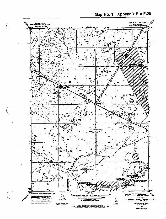
Map No. 1 Appendix F 4 F-29
UHIIEU STATESDEFARTIOUIT OF THE IHITHNR
OEOIOOICAL SURVEYIlcrrcr V O w
L I W O-ss ~
,r/AIICO HILLS SE OUAURAHOLE
loiro oolss coIO COWCCS OOOlOO POOCHOAHOCI
1'irrr1I ~'lr
A l I) gO
9~.
O.J+yI .
.5g.',,: ""oQ.-"~I
O,Y,"
v
,",jI O' I 0" N A L~/
", OO
is
I
r
Ior IH I COOI
~ ~""[I) ~ 'i~C
~ ~
r ~,ww wwrwcreC I Wl OCW
Ircll I ~
Hrc lrrrl
CO COW Cl «ll Il4 I I wl r W
r IoII I'Cr
~wo clowc r i+ .lo ~ Wo
1I
o sr Ja owc 1~ lr CC
l Col w rwwrrrrw recco rrr ol
ARCS HILLS SE, IUAHOrl Ilail ~
~ 1
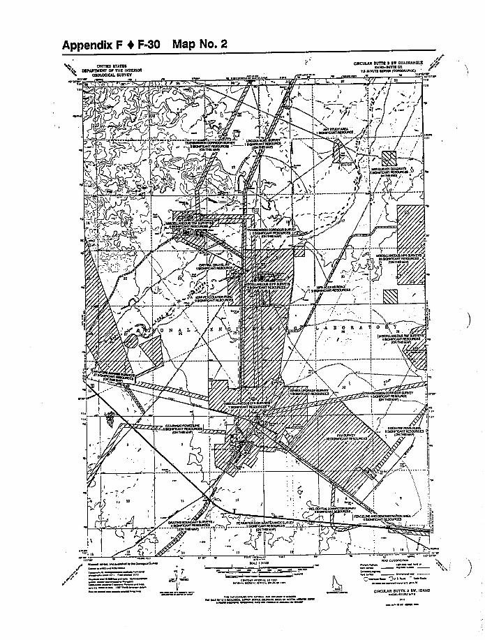
Appendix F 4 F-30 Map No. 2
BUTTED OTATEODEFARTTTENT'F TNE INTETTIDIT
OEDLDOIDAL BUTTVEY
T "t~~/ 101)( 4 /~mt HIP ~ IHT An
n'UTIAEAR BUTTE l BT OUADRANOLEIOAHO DITTO CO.
TA HMICN OOAIRO Noloolervtctts ne,e HI'IIVS
el'Irorll I ~
II~
U v
I I
/ g/
.f.~
g«I t
A ', /L(-I T'
oe1 .l/
I
/I /I', THHOOVOVOIIACRATO AICOOARCIIOHHOIINN,+ S OO
+f1:
SC
I.IL
X // I. '
It
II
A B "0 E ATl
I! --. '1I
I
,r"'---I'I.„„„,'I,
I Cl
0 g7
~ SOORCAMr IOOOOHCO TIIAIOHRHtn CCOIRCMS IORVIVI OCOIFHAHT IHOOAICR
IOH Tntl MArt
n
H
I
g
COSHCIOI Hlnvv
lvnnclol
I~~I'
IITS ~ er I'
s"r"
r
H~ ssomsssnsoooneso~c see NFN
I~ tt ~ I
IOSS p
I
, /'j'CIII I le ate
el nw s nil tnO HIS I CS I I
~ n s ~I nelsnn nil ~ law osl wwsotl \IN IWIn ~ I I
MINI RAIOIN NO
O
tl I
Jv ~ I Nsa~ onn
ITHIULIR BUTTE l BM. IDAHO«nl ~I lnl S
ln
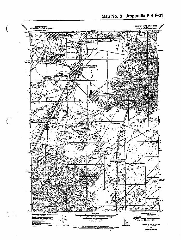
Map No. 3 Appendix F 4 F-31
UNITUD UTATUUDEPAUINUNT DU THU INIUUOU
OIOIDOICAL UUDVUTsir»srsssr
CUICUIAU NOTTE OUADUANOAUNSSN~—.,—.-.—'----': RiWD:."."::::-.::~M=="i~"::
.'((II
s , IP rssss ssr
I 8/
0
0
tS~SSSNSSI IUSISSSNSi 'OS DN SSSSI
s 'i
O'',
~ '
l
+ss
;r4 O
0 s ~ T I ~ ss 0 s
s I
T
U
sir s W re ve ~v as~~w~st ihl iHssrs ssssw siss w st sissfats~~b W s ~IW
Isis%w ~ ~ ssrs sl
Is
NSS IISUS
~i srs srs s Isirs sw s iss
i~H sss r s s wUlsss
~ slsslsss~ewe~ssrW» ~ W ~
P~aa Psst Qwsss
CISCUIAU UUITL IDAHO~II ~ i ~
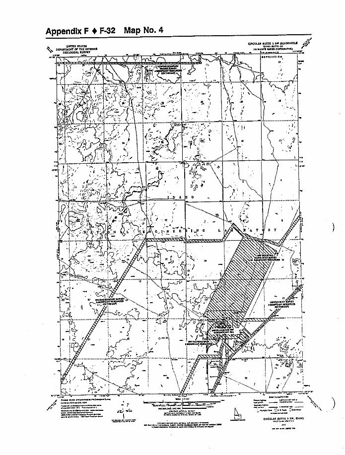
Appendix F 0 F-32 Map No. 4
UtlHSD STATESDEFARtllEIIT OF THE ttITERIOR
OEOUXHCAI SUCCTET~OI'« r aaoa'se wa
J':l".bn'.W~»e«
CftlCUIAR SUTTE 1 HR OCCADttAHOtk aaaoDVloaso SETTE co
IE UOOITE IECSO HOIOOAI«ICI«1 nvvea~e «'
wIn
OI
oo
.....J...P A
JI F
I
)! I - lt
I! G t«N EE
'I I'I
-'I ooh c'os 'cn o«
N 0
Jo
'S
gt
'8,vt.t! i~o„ I +
I
o'
j/
'I,I
uI
!
S
!I
! I
!IC C! VI, a
ol
O ~ I
T-.r«
! ~I /
IE!
DAAD«aoaoeRISvlaaa jt ..'n E«O«VIVI
O
oo I
I I'I
O ll'I
oo
IVa aw ««I wwoao««wa«wsHwc \ \Sew ea sw
~ I ~ o
~ aw ao ~
o ~ w Cop«
I
ASV Otna
~ «'«SI liana
I'IS'o
Ole'ICOS'wo
coalvoa tesW I I
lwsa M
Vta ~ n« ~v«a
'I w an woO«SOI « ~ «Saeaa CWV «an weo I~ Is«nwww ~ o oa IwCUICUIAR UUTTE I CIV. IDAHO
oooo ~ lolnl o ~
~n
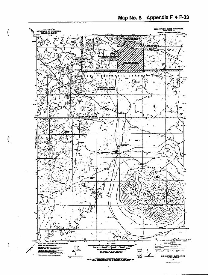
Map No. 5 Appendix F 4 F-33
ENDED STATESDCFARTS CRT OF TNC INFERNOS
DCDIOOIDAA SDRTCTI I CHIO«44« ~' ~
SID SODTTIERN SITTTE ODADRANOLEIDAHO NOTS CO
Is NSNIO SIRES 1ToroootpoHI,4 t« HI'«I
II 4IOT'
(I
WIO~TOCNIS I
«1
j«J-'.. I
O
IIItII
I
I,!
Irvr
4
ll I fI
PO g,, Zg
FJ
J
Q'«l
III'lt 4'I I«44 VC4 t4««44«C«OI«44IMc r«l «4 cl wtlct
I ~ I I t«lll «4
I« I ~I~ IV
4 III
',
'!'
~I
V«l I IIVOI
~I I« I«« lO 4 l«IV«4 COW I«
rv'4CICV Ot«««4 ~
QC ~ ««Qh
I'tl'4'I I'oI
'W I «CI «SIO SOUTHERN SUTTE, IDAHO
VI ~ I «« ~
IVI
Appendix F I F-34 Map No. 6
UNITES STATESORFAHTIIENT OF TNE (NTRHIOR
OSO(OO(CAI SURVEYItt»it»
1» ~ ' ~t W»t ~t»
C(RCUCAR SUITS 4 HS OUAORANOCRIDAHO ~IthX CO
f4 HHfUIE 444144 ITOKHIAA»HICI Ul''''
II
(t(II )ITTf I I
I
DT»HCsa(RH
=. »C
I~DIIEV
HAIT-- 4—EI
I
"'h
~rr
IE
ir
O' II 04 .- I-'
q.
Tu..'I O
E I1 F
i
r»''
I
4I
1
0F,) EP
il..~it h r ~ flII
»
4
.I "'-"/
I IF.
I',mg-:i:—
I''I
»'t»tt« I '1 ~1 » ~ ~
«w «w w«»««t wc«H«»r««tl «»Kl
I
VF 1 "tt hl«FF Owl
I ~ tt
t
Ir.« 1
ao ott»tvr a 1,
'I» \
n ..:.'j,C,KlO I~II AOIIVAY OUAOI»hf ~ 4 CD Af tCA I(f IHDOVACID
»
t A ~ ««~ tt» »tlt
CHIC((LA(I Sl/TTE I HL IDAHOtt ~ ttt ~
tt I
leap No. 7 Appendix F I F-35
UNITKD STATUSDKPAKTNSNT OT TNK LNIILRIOR
OKOLOOICAL DUROKTHUSVW UWlI~I
WWS 4 SV
W SSOVCVHIHVHSWOU"SVHVSHSTOVOHSIO „.
]UNSOWN,
'IRCULARSUITS S SK OUADRAHOLR
NSHOfA VNNt ~SOIOO ITOSOOSSIVHl
ltll 4 UWUUV Us'UU,I~
'' 'P'
i
Kl
Ts'f
sttfl ~
I'lifts t 4
V WU UW WUWWI ~I VUSW 4
~l ~ I
I WIW
l ~ IU
1
VUI I I VO
ls ISU 144 IS lrt~4 \4 W 4 W
St 4 l
I VUSWWUV ~ UUVW UWU UWWWU V
"'"l
IU'UIO IUWC O
WWI
I
4 '3v I sw i s~ I 4
CIRCULAR DlflTE I SL IDAHOI» IUU ~
W
Appendix F 4 F-36 Map No. 8
UNITES STATESORPARTNERT OF TNE INTERIOR
OEOIOOIOAL SURREY
" gW~ I "4'.i---.~ DI mI' l -':jA'(-:. gjj~AU
PRIanna SUTTE SW OUAORANOAE
IRORDIR NIRNTS RRRIRR IIOPDDROI RE)
I IN II'Olu IORO
'SIP
litt% IIR \ ~
RUMI 'yQRW)
Iz
IC
.IC
I'T
IP
0'lltN
,O,
F'IOONOOWOV~NN RMMRIMOC Ill Wl'WM ICII~D~
INI ~lt I
10 MI
I I 01
KRI 10 100
CMD I ll IIIMO O 0 M
U R MtlR IOC & ~ Nl M OOO IIM MMo MII I
~Dkl CUSS 10 IOO M
~t OIN 11
AITTLE BUTTE SN. IOANOlll III I ~
I ~ I
Map No. 9 Appendix F 0 F-37
IIH!IEO STATESEEFAE!llEHT OT lllE NTEE!OE
OEOAOOICAA TOE!ETall'lt«,01«
~/
IIOHTEVIEW OOAOEAHOLE ~ I/PI!PUP HIVSWI CO
'IS HUSH! SSSOS IICICI««HI!I
gQ,: L-
I
V «11'5@55 v ~ 01 ~ ~ v„, «r«
s// !.
110~ ta
~rpr gt +
1
III
I
//
/
I
I
+'I
I
I
I
II
IS I
!
I
I
I
1 ~
Jl~
IIt«'--
4rVO CIVIC-«v
I
I"r '
'I !
FAT/A
«"
I/.
'I,
0
! I'
~I
tl
~II
c
Sl. ''I'I
taloaa scaaswlv IVUscl stttvsvIcttttc«H assoStcss
I
I
I'+
I
!!!I
I
'\
1,
01
1
I
11stltvav
ISOUHCSS
rFfv
!I 1,II
I
H
la
0~ «vt avpavvt««0«a«aavrF I «at mat
v «t0 «
1
Kl I I /POtt
10 0 Itv ~ Ifr4 0 1 g 0
ar
I
I'Iv«1111111 0
MaP 0 Q I ~ Qt
vy100 aat ~ 0 ~ 011 Mvt vv«01 ~tattt 0 ~to 0 I«00 ~
HOH!EVIEW, IOAHOad 100 ~
tat00 ~
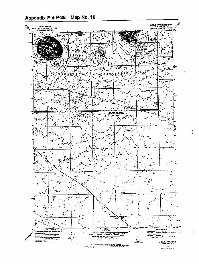
Appendix F t F8 Map No. 10DOITED KTATKO
DKPAOTNKKT OF TIIK ID(KENOOKOIOOICAL KUKOKT
DIDDLE DUTTK OIIADDADOLK ttN'rSINO ~INONIN CO
IO NNIUTO OAT A ITOIOOON(NCI
D
(
( ''..ht~{',
II . '<M(! I
/
I I~'lt~NO'~=="'- '-''IM""i).-- '-
N
I
F L:,'j, I .. ;, , : ,I
(\
A TOIll
. 1MIt
N'ttN'yA.(J,
7 I»
!'( r J i &~dr O'
I
(\
~R OOOON(N MITT I
.1t
11
, (I
/
I~
',)I
I "''ll
NIt ~
ll W\ tNt N(NONNII Nt~~I NNIIH N Nt
orrTN ttlPt lt tN
IWt I I
N
IO I I tltNI
CO NN I N t ttIW t (««W
II II
NNI QN(ttt(NI\lr
N ~1Nt NN ~ ~ NN4W t t N
It(DOLE SOTTE, (DIDONN(" Itt ~ ~
~ I
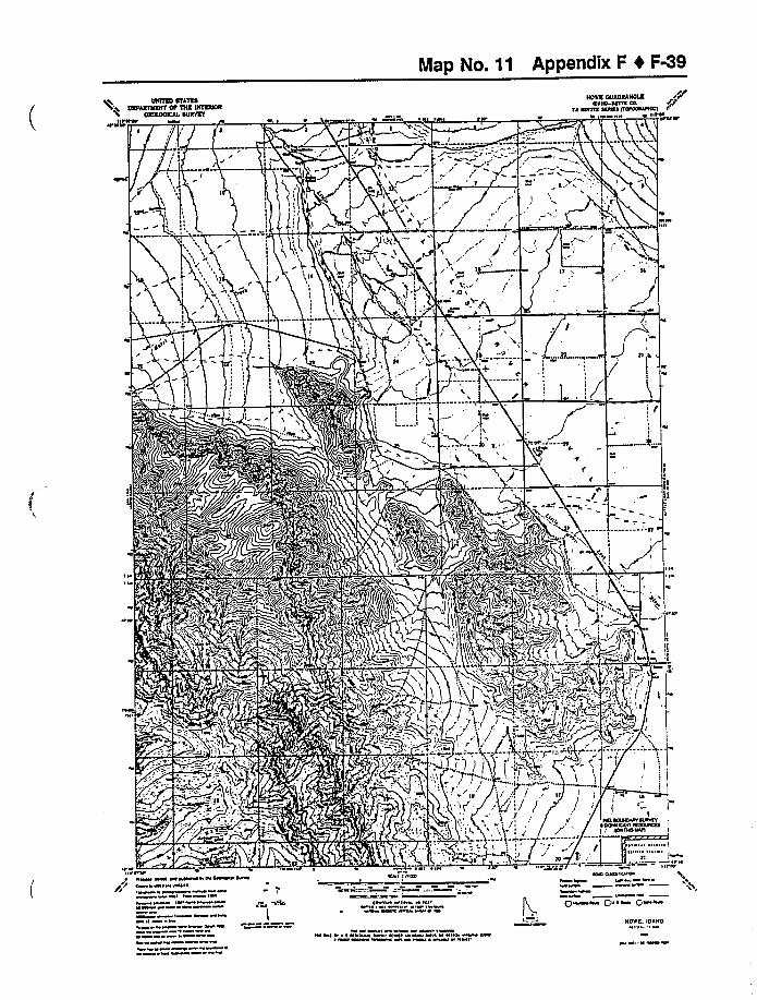
Map No. 11 Appendix F 4 F9UNNRD RFATRE
DRUANlllRNT OF CNR DICRRIOROROCOOICAL RUNFRY
Ilg«M
IlA«« 'I e«e
NOON OUADRANOCRIOIHO OOIIE CO.
la NWOIE IC«EC IOHCH«AIIOCIM «
I«I ~
~eÃ
~«PI «M e««MMIIO OM«M~ a«e ««ee
I« Ie«I««M
I«I ~a«M 0
'I«
I
I MICIH I«oo
«
M IM a«a ~ ~ «I «c««M eeM aa«MM«««IM M Ia«l«MM «M ~~
~I«l cia«aa aeIMMM M ~
II«W
HONE. IDAHO
M«
I
QM IM QaiaM Qa ~

Appendix F 4 F-40 Map No. 12
TOUTEDOFAY'EDARTHEHTOF THE tHTERtOR
OCOTOOtCAL OUR FEYO'IIV WVVW 'V ~ J I ~ V
ATUIIC CITY OUAORAHOTH ttPIDAHO
IO HNUTE OIDITO ItOPOOIIFHICI
WWVV~I
~II
)
IT v
,'t +=-M'W —IV
T'-"'TT
ol R,A Y'.P R '7Y
Ij '/
Y
'T'
I I gP
-~p'8
\
F)-t.I
i<~ .,t
I ~'V V'VVW VW WWVWVM IVWCe OMVI VII W'V
I
MI
~ W IV
Hvl It «0
IOI VV I»V V IIVWV IW ~ V IV
I MV WWW
V h IIW: \ V
„i-~
I'lI'11'
I« IWWV IV VVI VVI WIO VlW «\ ~
ATOMIC CITT. IDAHOIII- I I ~ ~
I~II
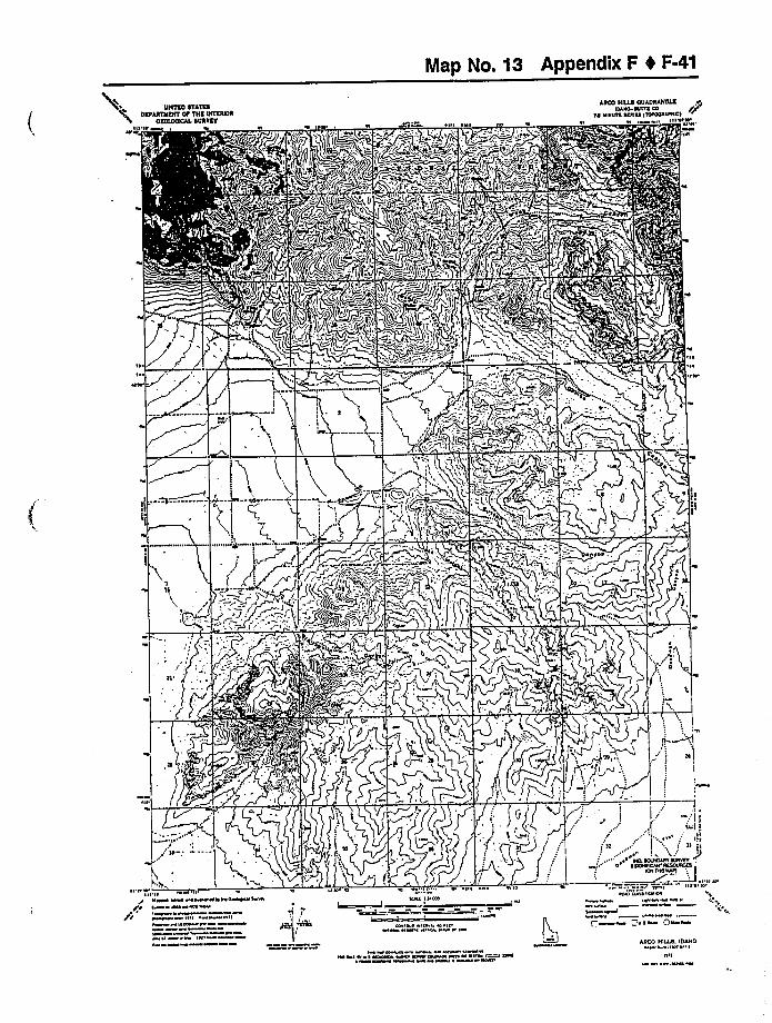
Map Nn. 53 Appendix F 4 F-41
%1UHHCD RCAlCD
DEFARlHCHT OF THC DHERCOROCCROOCDAA DURVCF
OH»HI Ia trar ~ Pl I ~
ARED HEAD OUADRAHOlRIAIDO ~IHTC CD
CA CINDIA atafaa HCWNAAOHCD
~I II I'll'N''tl'
<H
I~
~I~OM
JiIl
li',
I'l Or'II'I ~
IIIMO OOM MOMMO HOOOMaco MMC HOIM al W
OFII IHI ~l IIM ~
M ~tI~ H
I ra 'o
Hkl IDIO
ta OW I O I la~«MIO \ S l IM
MO C&laat IOA
I
I, ~a "taaM Qs a
M HMO a MMMI ~ a ~ OMM MO OWNMMOO MH W I ~OMI I WM
ARCH HICAD. IDAHOH I tll ~ ~
Htl
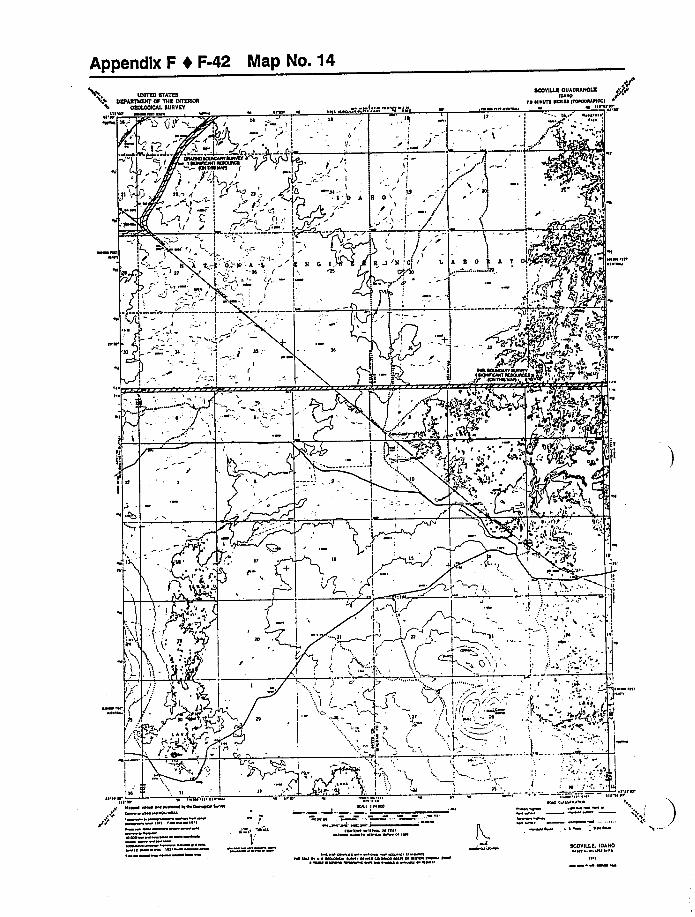
Appendix F I F-42 Map No. 14
UHTTRO STATESOEFARTVCERF OF VHC CHTCRNR
OCOUXIICAI SURVEY
~I VIII PP WW VV ~PPV CV VCV
Tlv ~I ~IIIII
III
W
V VFIPPP~'ll
SOOVSJC OUADRAHOlR.o"
'll HVIVIS VVPIVP CIOPOQPIPHCI
V
II III
IIII
II
I
':PEI
IL A C O 'f A
IIV CV III
~I
Ft \i
TT FP'jp
I
S
V
V]"''F,l~~
/
IP '. l l
f'~
IC ',~ 'l PP
I I I'I~VVW IVV WP ~ VWVI AVIV IVWII VII 0 PIV
~PP ~ Wl ~ I
IV
I~ I'V
I
Hill I IIICP
CD VV I~ V V IllI WW VW
V 'V I
'I ~I IW VV V ~ V VC VW CVWIP PVV V I~ I W IVV~ I
'IPV'IVPPP
VVP CVIWC IV
I 4I IS
IV IWV
SCOVSLE. IOAHOvl\ lllul ~
~ I
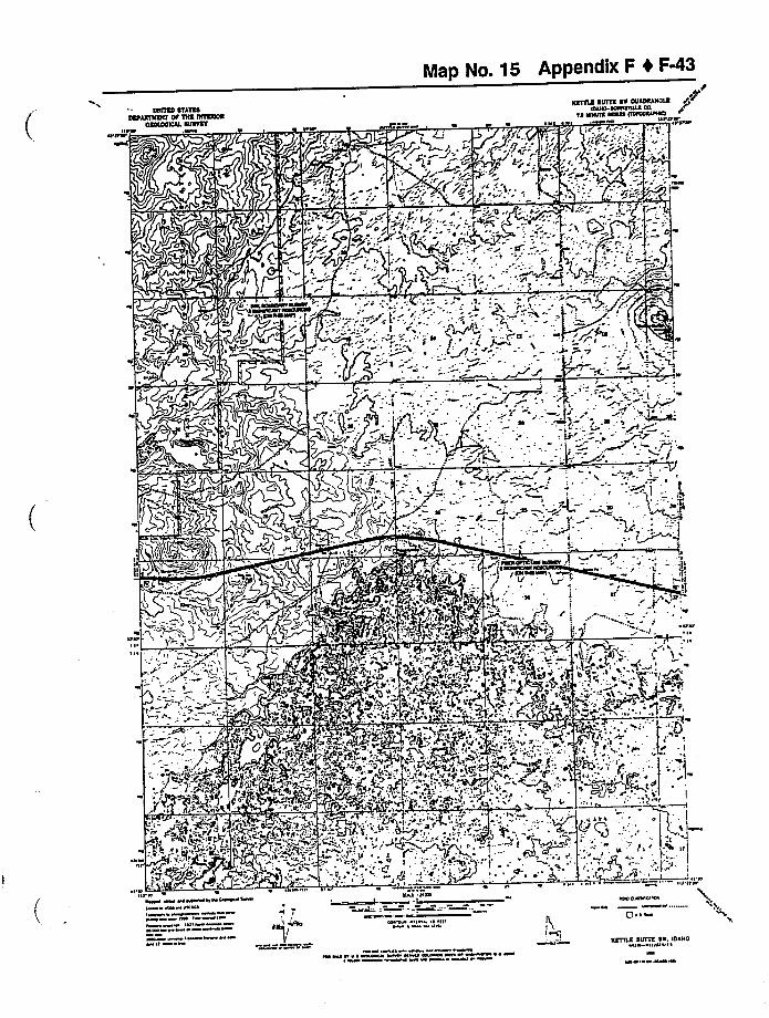
Map No. 15 Appendix F 4 F%3
lsslss Sill\IosssslMssr or SHO osl\ONO
OSXOOICIL SOSlsf
Ksllls sorrs ST ovloslsolsStue-asSSSnus CO
1S IWSIIS SSOSS OSIOSSIIISO ~
~ ~ I» tWWW «rttw~I'Iwr
.wwlw
l~I;.lll r.
1'
I
(
I ~ I
:r " - i <Owe
I
POI pj
~" i'd@"6
wtw ww w wtCw tl w CwttalC I WII W CSICII ww t~
IIII IIIII W
lt WIW I
~ ~ 0Sl I HSS
I
~I Wt WIW I~ till
~IW SWICt'WIw, IC
Q» ~ ~
IW CW P ~ CWIWA IWW tl C W 04 WII tt tw ~ ~ WS
ssrtcs svrrs sr. Iostcolt Illll II
IW
WP ~ OW W
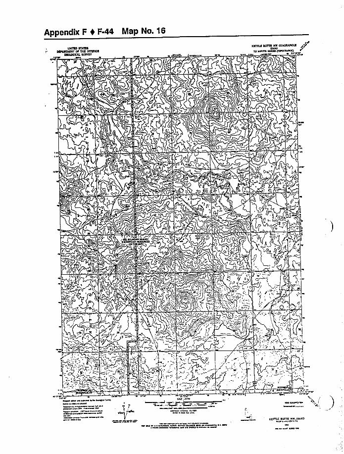
Appendix F 0 F-44 Map No. 16
~ I~
~ ~
, ~p
I IICDI II'll'«WI
IIDI «4~ll ~ CWVQ'I 4 WN 6@44
I '44 «WIII
I~ 4144
I~
. AI
ICDI llc44
CD I '&% l4 IPI ~ ~ \
4
II S ~
I Ul 'III 444 I ~ ICO DQ h&l CDUWW 4C ~
~ WW
KETTLE BISITE NI4.104HOII ~ I III I'
III44 D
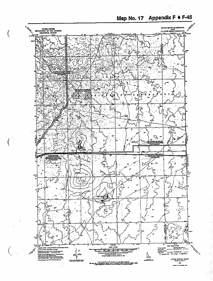
Map No. 17 Appendix F I FQS
RIOTER STATESDEFARTRERT OF TIIE IHTEROR
OEOIOOIOAL SURVEY1'I~I'ION' ttP ~ I
„rLITTLE SOTTO OUAOSAROLE
INONO
IA 4 IMIIE 4(II(4 ((NCOINIIIIOII I I P 4 Nl P
~'
l'll',-'A;"O~k&C~
==.(-'".~5» ~ i', I -"Y II.""':=-4 -CII
M
,/
TO4
NMN
),f
IP
-.'r
!I
t
g,ll 'S/ (,4 II I~
ISCROFIOCORSuiVR(l )F
-, Q,::-).
Nl
.Qf~ I
I
Ii
IP P
)
('~
I O'N'N4 MP. OM.4444 PMNIO
~p C ONI PN Hl ICI
~ I I I~ IIONPMM
IONII IN
INII Ill(40
COMM IM I l4 ~IIM4 PM 4 WMM P W
NN IM M ~ POOWP 444 NMO COIMIO Nl I MN MN
I'''„s.„
II 0'"v',,
IN PINO CIA(I IN IN
PtM
M(4 I ~ ( I
LIT(LE SUTTE, IOAHONO IIII ~
INC
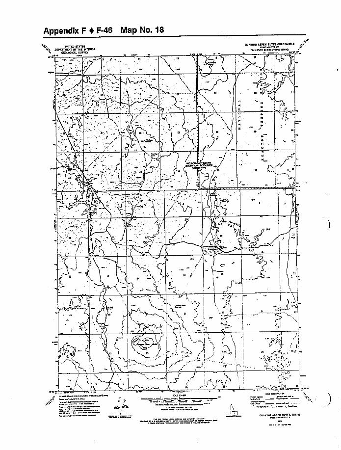
Appendix F 4 F-46 Map No. 18
UNITED 4TATESOEPANTNENT OF TNE UITECUON
OEOIOOKAL SURVET
OUAKINO ASPEN NOTTE OUADNANDIEKIIK IVIII CO
IS NI&INI ~IIIII INICOICACCKIh HI'll'&II'h h
I O
~CCV
zKl
I
.)-!'AAO.
NV IVIVIV
:)(';
I
00
~I0I
AI
H
hl
U
4Tj
I
hl
I
C
i
j'
hl
i
J„:I
)t,„(, ICV
I'V
Ar„r
h ZP
~ A
&00&0. 0&0.0&0 &Col ~ I Oh&0&MC &&00 & If
~ I ~f ~ II &0 0
IWII IM
Khl I &000
CC I ff h& H~if&& «0 ~ «0&
WO ~ I ~ ~
ICK C&CCIC 000I hh
Clh 'I hh
OUANUIO ASPEN SUITE, IDAHO&le & I ~
I~ I
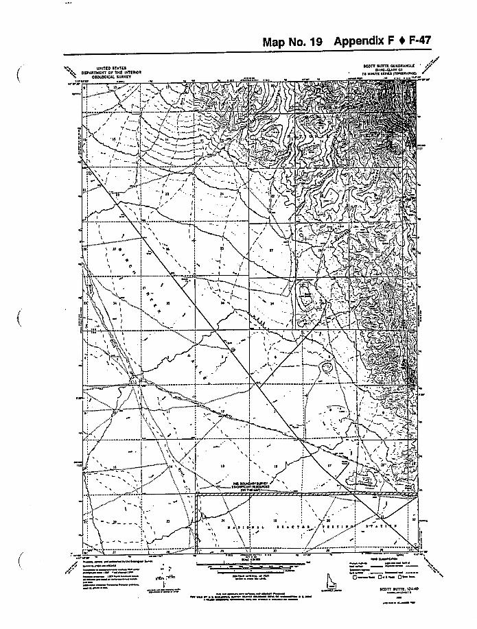
Map No. 19 Appendix F 4 F-47
UNITES STATESOCPARTNEHT Of THC IHTCROR
OEOIOOIOAA SURVEYVfVla'IWIV'VV'V' r/
STOVE SOTTO OUAOR»OICOIPMAVM CU
~A Nvms RAINS UUNNIIIMlcI
~Wm
r.,VVI II'fV
I VWVW \WWV VW~ Wl WVI
IIf ~ W IWVl
UOMVW flm ~I l I'
I W
INJV INNA
~0 NW ~ l ~ Vl
I II'OV OmfVflm
~ ~
Q «Q» ~ ~ Qa ~
Jl
If':l
VVl
~w MI ~ f A vww ww ww wwm MAW «ww ~ A wf~OOTT SOTTO. IOANO~IIW ~
W l ~ V
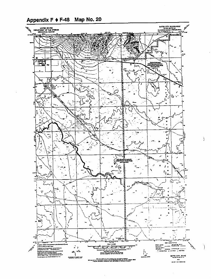
Appendix F 0 F-48 Map No. 20OmTRD OTATDO
DOOARTHNIT Dl'HE DITDROROOTROOICAL ODD TET
N PIPIt t'I ~ 1tWy OOI ' ~ -Ot 'NIRVN~NHA Dlt 7 tf TOPIOTI- rtuNI
OOTTO CITY OUADRAHOAOIOINO NIITO CO
Io Nwllo uatu Iloraotrrct Pt N' N'
I
t
gi't~c
NtrN
n ) 1
~ D~ Q II
l
1
tr V'
IIrttgr
C,.
I
~,~ O
I
~I'tt NN
IIO 'I' It ~ IL
NwN pNN wpNNNNrrtwNpHw~ Wt
I
~ » IN
AN. «tX»
NNI It ON
IPN N tllWt tl P
PWP ~ PWNW Itr tNPNNNNTPNI W IW
PN INIVtW
OOTTA CfIT. IDAHOtN INN ~
~ IW
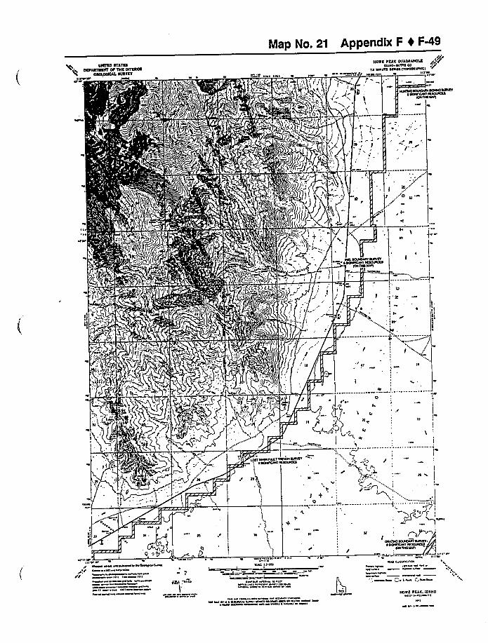
Map No. 21 Appendix F 4 F%9USOSEO OSATEO
OEPAOSVESCF OP TSSE SHSEESOO~EOAPESNvvlr'ttt NC I I
FF tHOVE PEAK OOAONAHOSE
INANE ~CIPIE CO~N VNNVE CANNA CIIVCNVCPNNC
N N~E I w«e e I II't
IV
ICVVO NOAONV VONO VPNST~ OVVVCNI CNCCANNVE
CONVVNIPS
I r
2tr
~ ~
CVCV t
N'S
IC
CS
~ ISSISlS
I
I ", /
I~
VIV
. CENTIVV I
NCN WN WCNVWNWIWVCVM~ WI WW
W ttlV Wt
I I INI
I
ISEIS N'w
NNI I CION
~I W I N l lilt~vwc f~ r
~VWNNNN ~ V ~ NNWNNW N I CN Nl Nl I~ W INNWW~ I
II I'NI
~CN CVII I N
WI
I cw IAS
HOVE PEAK. IOAHON I NN ~
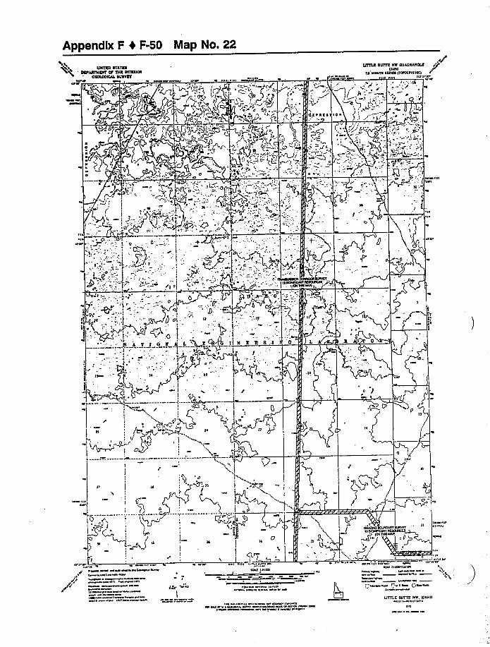
Appendix F 4 F-50 Map No. 22
+%.0 UNITED ETATND'EPAETNIIT Of lllE INIEEIOE
OEDAOOICAA DUETETIV V
~P O VV'OV I HI H
VH'
i
l
l
vl
l
ii
, lr q,' g I I
IITTLE BUTI NH OUAOHANDAEIDIHD
IO'H SSHS SSSIES IIDHHSAIHH>V H i', . w ~ H I I~ 8'H
I'OO
0 I.'~'-~
Ol
, o
8IHHSSHSS PQ 0 .
julID
.q.rO g
IP '".t
O 'I'H.
H
t
x„JI
I
hiHPV
HV VIH ~ OO OOI 8 ~ SVHOO W~ I O VII~ OPVOI
I I If~ ~m
1~ Hl ~
H ' 0HHI IHHS
IH 10 ~IVVI 0 I I
Ol
~Wl IIIISIC tspr
~ PTO I ~ ps
UTILE BUTTE HH. IDAHO«I ~ HIHPI ~
H ~
Map No. 23 Appendix F 4 F-51
UNITED STATESOEPARTNENT OF THE INTERIOR
OEOlOOIEAI. SURVEY
LlllLR SOTTO HR OUADRANOLEIOIAO
IA NINITE ~CAINE IIONKAIFIIK1N II' I, II.VI I II, III I Y,~ I I II W
gg .'M +
1"~
".C.-"—;f ">"M»
LF;,': -:,!I, : '-,:,::;r.1—.';,''-''.~~& -.':ju~r«. C
/I II
l I I
Kf
,.TE .E E EN A L:. 'EL tl G E 'E R E N A 'I, i B 0 E h Pf(O $ T
i
Q Pq
I
'.2'
I II
I
'- TI ~ Il
r 'J»
j; ll
I
I
r
-T
~ L NIIlNtlMIMWIVNNVIV
( Ql »x ~ 1 +Atu 4wA,: I 7 C, '
M AFLI I II II
««I » I &uuuuutuA»Ku Iwuw»II
~ II I
«I
KCI ININ
I C» I II INI u n
4 uu ~ ~ «uww I Il«I
tuA cull Icu u
LITTLE SUTIE HE. IDAHOK I IW
«IIWO
Appendix F 0 F-52 Map No. 24
Ill Iavr»»'EOUXIICAE EUAVET
I
.I f
I
I
I
I- —t---
UNITEO OTATEAOEAAlfWSff OA TNE INTEAIOA
00»'—
I
I
r, Iv r ~ 0 ~
TEAAEION OUAOAANOIS~ ANO-ICIIOAV» CO
'IC VOOIIO CA»CO IIOPOO~ICIav «0 r «rlfar
~«var
I
I
Iv
0$ll,r
I,fl
I
I I
I
I
I u
ONE
I~
0
P
I
I
I
I
I
I
f
II
I
I
I
I
a««»
II' +II
I
I
I
f
=L,i~
+i
I
1
~'
vrr
p~<+(i
I
(y"'
a
r ', I
......------ !~CC VVCONN O»ttvI ccvrvc»N Ivvvllcc
~ION OW Vial
,z
0 'v
f+I I
~OV»» ~~ iy~p
10 I I 0 a 0 C
TCCTI»CIg~ ~J
0
C 0»00 Vtvlal
I(g Et~
~ ',I M /'~lI I I
Alf ~'I .': >Ca -'
I I lv'
ICICI I IIVO »r 000»0010»
00 ~laa
«
«0
~ 00 ~ r I00»r ~ 0 «~ 0»a al la»ar rlv 0
TEAAEtON. IDAHO0 0 «000«I\
Map No. 25 Appendix F 4 F-53
ISPANNSNl'P ONE EALREPOO
4
~I
+ED
J t~/
IOP, Y
O ~
I )'04
ANTELOPE NOTTE OUAOOANOLEIOCNO IDIEDIN CO
IA NDNE DAIAI NOIOOIIINNII, D~ III'01I'ICN
~040
'1
i
DII
4
I~,
,N
I0'f)
O LJ /~i '.r'
I
4 .N'04 .r.;I.'>',c 'ef
ScIT I 84
N
jA
P 1
I
T f 0 N'.
1
1 ~
D ~ ~:3I
k
IN
I
1
.I1 ,:I 0 \ ~
4~ 0
10'D
., gr., LCD
A
..II, Icf+'ll'
,,:—:,: '-" „:+t::.".—:--„:;".,.:":'--: W';:-,,;,::g,'-:::::-ffW$ ,:::,',Nf::i
c 4 000 00 elcccNA4 I E
INC ~IIW0 ~ INC~~ . miselllC ~ JEC. 0 Cw 044 ~ p~NC Qel~ Ql ~
104 1Il ~
ANTELOPE IINTTL IOANO4 I ~ 11110'
&eccl w 0CN4444 444 01 Il.coUww440 0 ~4 4c D4 140
W S~ W
Appendix F 1 F-54 Map No. 26
UNllml STATKSOKFARTTAKNT OF TNK lNWSN
OKOOOOCAL SURVKTIu PP
~'MiPxd6'~TI,@ ')r
,!.'h, Oi ~~ Ve e I F'(/gg
I
P v ~~ IF " 'tv, VI v
SIO lOST RIVKR SINKS OUASRANOUKIOANO OVVIK CO
~o NRNRK VARNA NoeooeeeNKIIIRP
tPP'M
ve
ll(>)Wk%((
I'.
ll. "" I' I 8 T I N,Gn see Il
I /I'I
)1
+I
O'" tlI
I
~ IA
IVt S T A T I',II
I
II - t
ESl
I ~
.; ~ l
VMM vve I ~ Iw eve IIet ovetM IMVe VPOIMPIIIII~V~
IV ~IVIIVI
IceoIw I v ~
II
Kee IHNO
Ce M I~NI NI I IV IvMe v M
V Ieel clevec vv
M ve
P ~ Qt ~ ~ Q»
~t eItt
ev
we eee ~ e ~ elevvvl PM R w PPMV Mv 0 MMM ~ c MvSIO lOST RIVER SINKS, IUANO
~Wl IIIW ~
Map No. 27 Appendix F 4 F-55
UNITED ETATEODEFAETNICT OF TTIE INTEIUOE
OEOIOOICAL EUNTET«I'PR
~I'R ~ I I ~ ~ I ~ IO
,rPRICHARD SOTTO OUADRANOIS
looeo ~r'A
VRVNE RARVC ITOOOORIWV)
w ee e «e ~
eeI I
~ ~
~ I
I ~
~ ~
I
IIo
~ole~Ie'
I
W I~I
u'Re'IOIIO ePew. Rec w wew eoe Oeww AewC Wl RCRI
1«t IW~IWCeo
ceoIW W o
«
I"Ioel I l«el
co ew I « lo I«
I ewe 1~oo «II R ~ Ro oece ww CI I eolwRwe 1 wR c we
OPRI ICO
«wl c«elec«eW
IW
Q ew Qo ~ ~ Qo
RICHARD OUTTE IDAHOW \ I IIW ~
IW

Appendix F 4 F-56 Map No. 28
UCUTEO SYCYSSOEFARYCAENY OF YNF. INYERIOR
OEOCDOCCAL SURYA TII~'M
~I'CICI ~IC' M M I M
SNAKY CACCYOH OUAORANOCEIDAHO
IA HIIISIC CCCICC CYCCOOCAIHICA
~ «I \UI IH'IIH'
'IICI'M
~I
FIICC
'',i
C
E
CiCC~
/II ~
MI
C
i ~
I ~
I ~
WWH
OIICAC
ISAAC'�'CYCCYIHG
I Y HHIYOCCICHHHCCCMOCIHYCYI CCARCAHI ACCCACKA
ION HHI HAIC
Ilt IMAC II MM. MM. IM IMMM II I M CMM
MMI ~I~IMI I I
IH MMIAAIM C
Ml I
M 0 W
~ M IM M M AM M I
'C MNAII IHCtC
I Il I4W MMM M
M IllIM VH ~ II ~ Cll ICC IMM IIM IMII HIM MM ICWCM CMM MMM I ~ W IM
/'M
II'I II II IHWI CIIH C IA
M M'MM
Q M Put ~ Q»
SHAKY CANYON.IDAHOI IH V ~
MW
Map No. 29 Appendix F I F-57
tsotoo srs)osSA))tolls OO )HS Ollso)OO~~suoe\T
ff Wlff OWW coo)t'4 «a ~ ~ ~ IW « . » W ffffeff .' ~ ~ I ~ ~ ~
too)toes sut)s Hs oueosesoto
re fetes eeeoe testee»eecctct
~IIII~
~I
a»
II»'I
II
flte I'
'I tilt tt IO
' eceaclffr»eccescef
teff Hei ffat -. -Ct
«P ~ff«W Nffel«VONWNSC I «« I«CIIIIWWIWN I
ffff I W IWI«IV I
10«lW I N Off t
CI
ff W ' ffICIC I fflte
Cl IN I ff ll IIffffl WI ff ffff
NW C«HOOIOVI
NO 1«Q~»ff QCCOW QCWVN
~ W 1WWM I ~ ff W «WC ~ WW~» WC» II ~ «IIWCN IW« Wff«0COUNWWNI W ON 0 C WlW ~ ~ W WW
Cteoutee stlTts HH. IuluoW« I IUI Vl ~
IW\I W»
Appendix F 4 F-58 Map No. 30UHITEO STATES
DEFARtHEHT OF THE IHTEIIIOROEOLOOIEAL SURVEY
FltN'II'P N ( lt»N I ~ N ~ ~ N I lt
LmLE LOSt RIVER SHIES OUADRAHOLEIll»0 CITIS CO.
tIO Cll»HS llllll HOIOO»tt»C(
V I (FNN''llP
V I
Nl
I'I
H ICI +I
V
.IE~T»L I T.T L E
IL
I. 0 S T
L LE V
= IMtm !
Sipl
I
!II
g)li'
»
I,IHI )',
\ l + (N
((
(
I (I
I
Ir CN»ll Cttl
I
0 I IC l I I I 0»I
MFC»CO(»NWN»(»NC CHIVY jH A T I 0 0 0 ICCNC/Nt CC»»COO
IOI CCI CAH
S ~ 0,$ 0
I
II
I
YVSTIOOI
~ TOY ION
N NII/P N
~N»N~ VNNNNN NON»NNNV(~ Nt N(NI
»N ~NNIN/h
(PN t ( k%nl ~~W ~0
~ NI~
»t ICct I COO
t(N»N» 0 l N tNNV» I (N ~ tNP ~ N INNV
'V
'1P
~NO (NN/C/»I
P~NN Pt I a P»
Nt'ltP
LITTLE LOST RIVER SIRES. IDAHOVNN I»IN( ~
I
~»N
Appendix F t F-59
F.7 Annotated Bibliography for Cultural Resources
1. Advisory Council on Historic Preservation, 1980, Treatment ofArchaeological Properties: A
Handbook, Washington D.C., November 1980.
General guidance on the principles, procedures and methods of dealing with archaeological
resources in the contest ofhistoric preservation law and in specific compliance with the
National Historic Preservation Act and 36 CFR Part 800.
Subject: Archaeological research for compliance purposes
Keywords: ARCHAEOLOGICAL RESEARCH / CULTURAL RESOURCES /
COMPLIANCE / HISTORIC PRESERVATION / MITIGATION /
EXCAVATION / ARCHAEOLOGICAL SURVEYLocation: INEL CRM Library
2. Advisory Council on Historic Preservation, 1986, 36 CFR 800, "Protection of Historic
Properties: Regulations of the Advisory Council on Historic Preservation Governing the
Section 106 Review Process," Washington, D.C., October 1986.
General guidance on compliance with the National Historic Preservation Act, particularly
Section 106, which requires federal agencies to consult with state and federal preservation
agencies after the identi/ication and evaluation of historic properties in danger ofimpact by
federal actions.
Subject: Compliance with the National Historic Preservation Act
Keywords: CULTURAL RESOURCES / COMPLIANCE / HISTORICPRESERVATION / NATIONAL HISTORIC PRESERVATION ACT
Location: INEL CRM Library
3. Advisory Council on Historic Preservation and National Park Service, 1988, Identification ofHistoric Properties: A Decision-Making Guide for Managers, Washington, D.C.,September 1988.
Outline of basic principles and approaches for identifying and considering historic properties
in the planning and implementation of land use and development projects on federal lands.
General discussion of how to apply these principles in varying circumstances while
remaining in compliance with Section 106 of the National Historic Preservation Act.
Subject: Identification of cultural resources
Keywords: CULTURAL RESOURCES / COMPLIANCE / HISTORICPRESERVATION / COMPLIANCE / ARCHAEOLOGICAL SURVEY /
b. Not ail references are annotated. Those not annotated are provided for your information.
Environmental Resource Document for the Idaho National Engineering Laboratory
July 1993 / Issue No. 001
Appendix F 1 F-60
ARCHITECTURAL SURVEY / NATIONAL HISTORICPRESERVATION ACT
Location: INEL CRM Library
4. Advisory Council on Historic Preservation, 1989, Preparing Agreement Documents: How to
Write Determinations of No Adverse Effect, Memoranda ofAgreement, and Programmatic
Agreements under 36 CFR Part 800, Washington, D.C., September 1989.
General guidance on the preparation offormal documentation of compliance with the
National Historic Preservation Act when it is determined that an action will have some
effect on significant or potentially significant cuLtural properties.
Subject: Preparation of agreement documents
Keywords: CULTURAL RESOURCES / MOA'S / PA'S MITIGATION / HISTORIC
PRESERVATION / COMPLIANCE / NATIONAL HISTORIC
PRESERVATION ACTLocation: INEL CRM Library
5. Advisory Council on Historic Preservation and National Park Service, 1989, The Section 110
Guidelines: Annotated Guidelines for Federal Agency Responsibilities Under Section 110ofthe National Historic Preservation Act, Washington, D.C., November 1989.
General guidance on implementing Section 110of the National Historic Preservation Act
which ensures that historic preservation is fully integrated into the ongoing programs and
missions of Federal agencies.
Subject: Compliance with the National Historic Preservation Act
Keywords: CULTURAL RESOURCES / COMPLIANCE / HISTORICPRESERVATION / NATIONAL HISTORIC PRESERVATION ACT
Location: INEL CRM Library
6. Advisory Council on Historic Prcscrvation, 1991,Balancing Historic Preservation Needs with
the Operation of Highly Technical or Scientific Facilities, Washington, D.C.
Outline and discussion of basic principles and approaches for margin historic preservation
needs with the management and operation of highly technical/scientific facilities (i e.,
nuclear reactors).
Subject: Historic preservation of facilities
Keywords: CULTURAL RESOURCES / COMPLIANCE / NUCLEAR HISTORY /
SCIENTIFIC SIGNIFICANCELocation: INEL CRM Library
Environmental Resource Document for the Idaho National Engineering Laboratory
July 1993 / issue idio. 001
Appendix F 4 F-61
7. American Nuclear Society, 1992, Controlled Nuclear Chain Reaction: The First 50 Years,
American Nuclear Society, LaGrange, IL.
8. Antcvs, E., 1948, 'The Great Basin, With Emphasis on Glacial and Post-Glacial Times:
Climatic Changes and Pre-White Man," University of Utah Bulletin, 33(20):168-191.
Generalized sequence of climatic change for the Great Basin also appropriate forcornpanson with more detailed local (INEL regt'on) reconstructions.
Subject:Keywords:
Location:
Large scale climate change
PALYNOLOGY / PALEOECOLOGY / PALEOCLIMATE /
ALTITHERMAL / ANATHERMAL / MEDITHERMAL / ICE AGE
INEL CRM Library
9. Arthur, W. J.; Connelly, J. W.; Halford, D. K., and Reynolds, T. D., 1984, Vertebrates of the
Idaho National Engineering Laboratory, DOE/ID-120999.
Abundance, habitat use, and seasonal occurrence are reported for the 5fish, 1 amphibian,
9 reptile, 159 birds and 37mammal species reconled on the INEL. An additional 45
species, for wtuch site records are lacking, were listed as possibly occumng because portions
of their documented range and habitat overlap the INEL Species of special concern on the
federal and state level are discussed. Data is qualitative.
Subject: Vertebrates on the Idaho National Engineering Laboratory
Keywords: VERTEBRATES / FISH / AMPHIBIANS / REPTILES / BIRDS /
MAMMALS / ENDANGERED SPECIES / SPECIES OF CONCERN
Location: INEL Technical Library
10. Atwood, N. D., 1970, "Hora of the National Reactor Testing Station," Brighnm Young
University Science Bulletin, Biological Series, 11:1-46.
Listing ofplants currently present in the INEL region useful for comparison with studies ofNative American plant use to develop hypotheses about prehistoric use of the area.
Subject: Vegetation patterns on the INELKeywords: PLANTS LIST / MODERN VEGETATION / SAGEBRUSH
GRASSLANDLocation: INEL CRM Library
11. Beal, M. D., 1942, A History of Southeastern Idaho, Caldwell, Id, Caxton Printers, Ltd.
Historic oveniew for southeastern Idaho.
Subject: Idaho history
Environmental Resource Document for the Idaho National Engineering Laboratory
July 1993 / Issue No. 001
Appendtx F 4 F-62
Keywords: IDAHO HISTORY / AGRICULTURE / MINING / FUR TRADE /
SHOSHONE INDIANSLocation: Idaho Falls Public Library
12. Benedict, James B., 1979, "Getting Away From It All: A Study of Man, Mountains, and the
Two-Drought Altithcrmal," Soutlrwestern Lore, 54(3):11-12.
13. Bonnichsen, B.,and Breckenridge, R. IvL, 1982, "Cenozoic Geology of Idaho," (editors),
Idaho Bureau of Mines and Geology Bulletin, No. 26, Moscow, ID.
A collection of reports on regional geology covering various topics. Of special interest are
the following chapters: General Features of the Snake River Plain, Volcanic Rocks,
Rhyolitic Volcanism, Basalt Volcanism, Stratigraphy and Structural Relationships,
Stratigraphy of Lacustrine Sediments, Stratigaphy and Paleontology, Pleistocene Lava
Dams, Mountain Glaciation, Pleistocene Flood Deposits and Gravels, Pleistocene Episodes
ofAlluvial-Gravel Deposuion, and Loess Deposits.
Subject:Keywords:
Location:
Idaho GeologyPLEISTOCENE / VOLCANISM / GLACIATION / STRATIGRAPHY /
PALEONTOLOGY / SNAKE RIVER BASIN
INEL CRM Library
14. Bottolfscn, C. A., 1926, "Little Bits of Lost River History," Arco Advertiser, Arco, Idaho.
Newspaper article on Idaho History.
Subject: Idaho history
Keywords: BIG LOST RIVER / IDAHO HISTORY / CULTURAL RESOURCES
Location: Idaho Falls Public Library
15. Bottoll'scn, C. A., 1926, "Pioneer Lore," Blackfoot ~Dail Bulletin, Blackfoot, Idaho. January
18, 1926.
Newspaper article on Idaho history.
Subject: Idaho history
Keywords: IDAHO HISTORY / CULTURAL RESOURCESLocation: Idaho Falls Public Library
Environmental Resource Document for the Idaho National Engineering Laboratory
July 1993 / Issue No. 001
Appendix F 4 F-63
16. Bright, R. G, 1966, "Pollen and Seed Stratigraphy of Swan Lake, Southeastern Idaho: Its
Relation to Regional Vegetational History and to Lake Bonneville History," Tebiwa,
9(2):1-47.
Analyses offossil pollen, spores, and seeds from a core of Swan Lake sediments are
compared with modern pollen rani samples to reveal the vegetational history of the area
during the past I?090years.
Subject: Vegetation patterns on the INELKeywords: PALYNOLOGY / PALEOECOLOGY / PALEOCLIMATE / LAKE
BONNEVILLE / SNAN LAKE / PLEISTOCENELocation: INEL CRM Library
17. Bright, R. C., and Davis, O. K., 1982, "Quaternary Paleoecology of the Idaho National
Engineering Laboratory, Snake River Plain, Idaho," American Midland Naturalist,
108(1):21-23.
Plant and animal fossils from several depositional contests are analyzed to document the
Holocene vegetation history of the INEL region. Results show the continued presence ofsagebrush/ shadscale steppe throughout the period with a brief time of increased moisture at
700 B.P.when a portion of the Lake Terreton basin is suspected of being filled.
Subject:Keywords:
Location:
Palcoccology of the INELPALYNOLOGY / PALEOECOLOGY / PALEOCLIMATE / LAVA
TUBES / MIDDLE BUTTE CAVE / RATTLESNAKE CAVE /
QUATERNARY / LAKE TERRETON / PACKRAT MIDDENS
INEL CRM Library
18. Brosnan, G J., 1948, History of the State of Idaho, New York, NY, Charles Scribner's Sons.
A detailed history of Idaho from pre-European contact lo 1935. Covers: Lewis and Clark,
Indians, the fur trade, missionaries, mining agriculture, ranching pioneers, statehood,
geology, elc.
Subject: Idaho history
Keywords: HISTORY / FUR TRADE / AGRICULTURE / PIONEERS /
STATEHOOD / INDIANS
Location: Idaho Falls Public Library
19. Butler, B.R., 1968, "An Introduction to Archaeological Investigations in the Pioneer Basin
Locality of Eastern Idaho," Tebiwa, 11(1):1-36.
Preliminary description of research conduced from 1965-1967al the 8'asden site/Owl Cave
on the northeastern Snake River Plain near the INEL.
Environmental Resource Document for the Idaho National Engineering Laboratory
July 1993 / Issue No. 001
Appendix F 4 F-64
Subject:Keywords:
Location:
Archaeological excavation of the Wasden Site
CULTURAL RESOURCES / ARCHAEOLOGICAL EXCAVATION /
WASDEN SITE / OWL CAVE / LAVA TUBES / CLIMATE /
ECOLOGY / PIONEER BASIN / PREHISTORY / PIONEER BASIN
INEL CRM Library
20. Butler, B.R., 1970, "A Report on the 1967-69 Archaeological Survey of the National
Reactor Testing Station, Idaho," Tebiwa, 13(1):58-75.
Documentation of the first archaeological surveys conducted on the INEL Over the three
year span of this intuitively-based examination of the area, 41prehistoric sites were
recorded Although the data are difficult to work with (largely due to vague locational
information), they do document the human occupation of the INEL region for at least
12,000years and clearly show that much of the area is archaeologically sensitive.
Subject: Intuitive archaeological survey of the INEL
Keywords: CULTURAL RESOURCES / INTUITIVE ARCHAEOLOGICAL
SURVEY / PREHISTORY / PIONEER BASIN / LAKE TERRETON
Location: INEL CRM Library
21. Butler, B.R., 1978, "A Guide to Understanding Idaho Archaeology: The Upper Snake and
Salmon river Country," Special Publication of the Idaho Museum of Natural History,
Pocatello, ID.
A broad, non-technical overview of the prehistory of Southeastern Idaho wuh discussions on
the history of archaeological research in the region, environmental change, cultural
chronology, and prehistoric lifeways. The proposed cultural sequence includes an Early Big
Game Hunting traduion followed by an extensive Archaic tradition and brief Equestrian
tradition. Although these traditions are interpreted as being related to similar manifestations
in the Great Basin, a greater reliance on the hunting of big game (bison and mountain
sheep) is interpreted for southeastern Idaho.
Subject:Keywords:
Location:
Prehistory of southeastern Idaho
ARCHAEOLOGICAL EXCAVATION / WILSON BUTTE CAVE /
BIRCH CREEK VALLEY / PREHISTORY / WASDEN SITE /
CULTURAL RESOURCES / PREHISTORIC RESOURCES /
PIONEER BASIN / LAKE TERRETON / BIG GAME HUNTING /
CULTURAL CHRONOLOGYINEL CRM Library
Environmental Resource Document for the Idaho National Engineering Laboratories
July 1993 / Issue No. 001
Appendix F 4 F-65
22. Butler, B.R., 1981, "Little Lost River Cave No. 1, the Birch Creek Project and the Antiquity
of the Northern Shoshone," Occasional Papers of the Idaho Museum of Natural History,
No. 32, Pocatello, ID.
Briefpresentation of the results of archaeological ercavations conducted in 1954 at Little
Lost River No. 1, located north of the INEI Meager notes arut records indicate that
excavation revealed three stratigraphic levels probably dating from 150 to 3000 B.P.Fragments of basketry recovered from the excavation are ciassified as Fremont in affiliation
and are key in the constniction of an argument for the persistence of the Fremont Culture
in southeastern Idaho, long after its apparent collapse in Utah. The article concludes with
a discussion ofNumic expansion and the antiquity of Northern Shoshonean occupation in
the region.
Subject:Keywords:
Location:
Archaeological excavation of Little Lost River Cave No. 1
CULTURAL RESOURCES / PREHISTORIC RESOURCES / CAVE /
ARCHAEOLOGICAL EXCAVATION / BASKETRY / FREMONT
CULTURE / SHOSHONE INDIANS / BITTERROOT CULTURE /
NUMIC EXPANSIONINEL CRM Library
23. Butler, B.R., 1986, "Prehistory of the Snake and Salmon River Area," D'Azcvcdo, W. I,(editor), Great Basin, Vol. 11, pp. 127-134.
A discussion on the prehistory of southeasleni Idaho covering the Early Big Game Hunting
Period (I?$00-5,800 B.C.),the Archaic Period 5800 B.C.-A.D.$00), and the Late Period
(A.D. 500-1805).
Subject:
Keywords:
Location:
Idaho Prehistory
CULTURAL RESOURCES / PREHISTORY / SNAKE RIVER BASIN /
WASDEN SITE / BIRCH CREEK VALLEY / JAGUAR CAVE /
CULTURALCHRONOLOGYINEL CRM Library
24. Butler, William B., 1987, Significance and Other Frustrations in the CRM Process,"
American Antiquity, 52(4):820-829.
25. Carnctt, C., 1991,Legal Background ofArchaeological Resources Protection, USDI National
Service Cultural Resources Technical Brief No. 11, Washington, D.C.
26. Chambcrlin, R. V., 1974, "The Ethno-Botany of the Gosiute Indians of Utah," American
Anthropological Association Report, 2(5):331-405.
A discussion of various native plants that were utilized by the Gosiute Indians for food,
medicine, dyes, and various materials.
Environmental Resource Document for the Idaho National Engineering Laboratory
July 1993/Issue No. 001
Appendix F 4 F-66
Subject: EthnobotanyKeywords: NATIVE PLANTS / ETHNOBOTANY / PLANT FOODS / PLANT
DYES / PLANT MEDICINE / USEFUL PLANTSLocation: INEL CRM Library
27. Clark, S.F., 1986, Nineteenth Century Shoshone-Bannock Riparian Adaptation, Master'Thesis, Idaho State University, Pocatello, ID.
28. Clements, I J., n.d., A Collection of Upper Snake River Valley History Plus a Complete
Biography ofAndrew Henry, Rexburg, ID, Upper Snake River Valley Historical Society.
A collection of short histories and stories ofpioneering and trapping in the Snake River
Valley including campfire tales of eastern Idaho and the biography ofAndrew Henry, theearliest confirmed trapper in the valley.
Subject: Idaho history
Keywords: ANDREW HENRY / FUR TRADE / BIOGRAPHY / HISTORY /
SNAKE RIVER BASINLocation: Idaho Falls Public Library
29. Coale, G. L, 1963, "A Study of Shoshonean Pottery," Tebiwa, 6(2):1-11.
Type description for Shoshonean pottery commonly found on the INEL (also known asIntermountain 8'are). Pots were constructed by coiling or modeling and were generally coneor Jlower-pol in shape with flat bottoms. Temper consists ofgrit or sand and firing was
uneven and of variable temperature.
Subject: Prehistoric ceramics of southeastern IdahoKeywords: POTTERY / CERAMICS / SHOSHONE INDIANS /
INTERMOUNTAIN WARE / LATE PREHISTORICLocation: INEL CRM Library
30. Colo', S., 1965, "The High and Dry Navy: World War II," Philiron, October.
31. Conley, C., 1982, Idaho For the Curious: A Guide, Cambridge, ID, Backcddy Books.
A descriptive and complete road/travel guide to historic sites and other places ofinterestthroughout Idaho, including mention of EBR I on the INEL
Subject: Idaho Travel Guide
Keywords: HISTORY / PLACES OF INTEREST / GUIDE BOOK / EBR ILocation: Idaho Falls Public Library
Environmental Resource Document for the Idaho National Engineering Laboratory
July 1993 / Issue No. 001
Appendix F 1 F-67
32. Crabtree, D. F, 1982, "An Introduction to Hintworking," occasional Papers of the Idaho
Museum of Natural History, No. 28, Pocatello, ID.
Discussion of methods ofprehistoric stone tool manufacture (jlintknapping or fltntworking).
Includes extensive glossary and list of terms with informative illustrations.
Subject: Methods of stone tool manufacture
Keywords: FLINTWORKING / STONE TOOLS / ARTIFACTSLocation: INEL CRM Library
33. Craighead, J.J., and Craighcad, F. C Jr., 1963,A Field Guide to Rocky Mountain
Wildflowers, Boston, MA, Houghton and MiAlin Co.
34. Crowder, D. I, 1981, Tales of Eastern Idaho, Idaho Falls, ID, Curtiss Press, Inc.
35. Currey, D. R., and James, S. R., 1982, "Paleoenvironments of the Northeastern Great Basin
and Northeastern Basin Rim Region: A Review of Geological and Biological Evidence,"
Madsen, D. B.;O'Conncll, J.F., Man and Environment in the Great Basin, Society ForAmerican Archaeology Papers No. 2, Washington, D.C.
36. Davis, O. K.; Sheppard, J. C., and Robertson, S., 1986, "Contrasting Climatic Histories for
the Snake River Plain, Idaho, Resulting from Multiple Thermal Maxima," Quatema7
Research, 26: 321-339.
Documentation of Late Pleistocene vegetation changes and associated climatic regimes forthe INEL region based on pollen and macrofossil analyses at Middle Butte and Rattlesnake
Caves, located on the INEL, and Lake Cleveland, located near the southern edge of the
Snake River Plain. Differences between the climatic histories documented at these sites are
attributed to the autecology of the plants involved and the changing seasonal climate.
Subject:Keywords:
Location:
Paleoecology of the Eastern Snake River Plain
PALYNOLOGY / PALEOECOLOGY / PALEOCLIMATE / LAVA
TUBES / MIDDLE BUTTE CAVE / RATTLESNAKE CAVE /
PLEISTOCENEINEL CRM Library
37. Davis, O. K., and Bright, R. C., 1983, Late Pleistocene Vegetation History of the Idaho
National Engineering Laboratory, edited by O.D. Markham, pp. 162-171, DOE/ID-12098.
Environmental Resource Document for the Idaho National Engineering Laboratory
July 1993 / Issue No. 001
Appendix F 4 F-68
38. Dort, W., Jr., and Miller, S.J., 1977,Archaeological Geology of Birch Creek Valley and the
Eastern Snake River Plain, Idaho, Field Guide, First Annual Field Trip, Idaho Falls, ID,Division of Archaeological Geology, Geology Society of America.
Informative guide to the archaeology and geology of the northeastern Snake River Plain and
the Buch Creek Valley with emphasis on the Wasden Site/Owl Cave and Jaguar Cave.
Subject: Field guide to archaeology and geology of Birch Creek Valley and
northeastern Snake River Plain
Keywords: CULTURAL RESOURCES / GEOMORPHOLOGY / GEOLOGY /
WASDEN SITE / OWL CAVE / JAGUAR CAVE /
ARCHAEOLOGICAL EXCAVATION / PALEOCLIMATE
Location: INEL CRM Library
39. Dort, Wakeoeld Jr., 1975, "Archaeo-Geology of Jaguar Cave, Upper Birch Creek Valley,
Idaho," Tebi wa, 17(2):33-58.
Description of the sediments, fauna, and cultural debris found during the ercavation ofJaguar Cave, a frost-fractured limestone concavity north of the INEL. Human occupation
of the cave (including a very early record of domesticated dog) occurred between 1?000
and 9,000 B.P.after which the void became sealed.
Subject:Keywords:
Location:
Pleistocene human occupation of southeastern Idaho
CULTURAL RESOURCES / CAVE / PLEISTOCENE / DOMESTIC
DOG / MOUNTAIN SHEEP HUNTING / ARCHAEOLOGICAL
EXCAVATIONINEL CRM Library
40. Druss, M., and Reale, S., In Press, "Springtime on the Lava Plateau: Ephemeral Lakes and
subsistence-Settlement in South-Central Idaho," Idaho Archaeologist.
Brief discussion of the association between prehistoric archaeological sues and ephemeral
lakes, or playas, on the Snake River Plain and the resource potential of these seasonal
features.
Subject: Settlement and subsistence on the Snake River Plain
Keywords: CULTURAL RESOURCES / PREHISTORY / PLAYAS
Location: INEL CRM Library
41. Duncan, F., 1990, Ricko»er and the Nuclear Navy, Annapolis, MD, Naval Institute Press.
A history of how Admiral Hyman G. Rickover, the "father of the nuclear navy," developed
atomic energy for ship propulsion and the politics of developing the nuclear navy.
Environmental Resource Document for the Idaho National Engineering Laboratory
July 1993 / Issue No. 001
Appendix F 0 F-69
Subject:Keywords:
Location:
History of the Nuclear Navy
U.S. NAVY / NUCLEAR HISTORY / H.G. RICKOVER / SUBMARINE
/ NRFINEL CRM Library
42. Dykcs, F. W., 1985,A View of Idaho History As Seen From Big Bulte, Pocatello, ID, F.W.
Dykes.
Nanative discussion and maps of various points ofinterest on the northeastern Snake River
Plain compiled by the author from casual interviews, conespondence, and arctuval research.
Many of the areas mentioned are on or near the INEL inchulutg. Pioneer / Powell
community, Webb Spring Frenchman's Cabin, Big Butte Stage Slation, Ceno Grande
Siding, Frank Fergusen Homestead, Taber Communily, Goodale's Cutoff, Atomic city,
CCC Powder Bunkers, INEL, Big Butte, and several miscellaneous cabins and stage roads.
Subject: Idaho history
Keywords: CULTURAL RESOURCES / IDAHO HISTORY / BIG SOUTHERN
BUTTE / STAGE ROUTES & STATIONS / STAGE ROUTES &STATIONS / HOMESTEADS / PIONEER TOWNSITES / PIONEER
TOWNSITES / GOODALES CUTOFFLocation: INEL CRM Library
43. Dykes, F. W., 1989, Jeffery's Cutoff: Idaho's Forgotten Oregon Trail Route, Pocatello, ID,
F.W. Dykes.
A description of travel and places visiled by the Ebey wagon train on the Jeffery/Goodale
Cutoff, July-August 1854. Based on documentation by twelve of the train emigrants.
Subject: Goodales Cutoff
Keywords: CULTURAL RESOURCES / IDAHO HISTORY / BIG SOUTHERN
BUTTE / STAGE ROUTES & STATIONS /STAGE ROUTES &
STATIONS / PIONEERS / JEFFERY CUTOFF / GOODALES CUTOFF
Location: Idaho Falls Public Library
44. Edclman, H., n.d., Reminiscences: Manuscript f/8, Idaho State University Archives, Eli M.
Obler Library, Pocatello, ID.
45. Ellen, R., 1982, Environment, Subsislence and System: The Ecology of Small-Scale Social
Formalions, New York, NY, Cambridge University Press.
Environmental Resource Document for the Idaho National Engineering Laboratory
July 1993 / Issue No. 001
Appendix F I F-70
46. Ferris, W. A., 1940, "Life in the Rocky Mountains," Phillips, P. C, (editor), Denver, CO,O.H. West Publishing Co.,
A story told by WA. Fenis, of his travels in the Rocky Mountains, including descriptions ofcamping on the Big Lost River and on Birch Creek He also tells ofcamping by one of thethree buttes and seeing several Iuindred Indians traveling across the Snake River Plain.
Subject:Keywords:
Location:
Fur trapping in the Rocky Mountains
IDAHO HISTORY / INDIANS / BIRCH CREEK VALLEY / BIG LOSTRIVER / BIG SOUTHERN BUTfE / MIDDLE BU ITE / EAST BUITE/ AMERICAN FUR COMPANY / FUR TRADEIdaho Falls Public Library
47. Fowler, D. D., 1982, Cultural Resources Management, Advances in Archaeological Method
and Theory, Volume 5, edited by M B. Schiffer, New York, NY, Academic Press.
48. Franzen, J. G., 1980, Class II Cultural Resource Inventory ofAreas in and Adjacent to the big
Desert Planning Unit, Idaho, Commonwealth Associates Inc., Tcchnical Report No.R-2182.
Documentation ofintensive archaeological survey ofa 10% stratified random sample of46,400 acres on Bureau ofLand Management lands surrounding the INEL Buttes and
playas exhibited high sue densities during this project while park-kipukas and lava tubes
erhibited low densuies. A scarcity of Paleoindian (ca. I? 000-8,000 B.P.)material andpreponderance ofLate Archaic (ca. 3,600-150B.P.)were also observed.
Subject: Intensive archaeological survey of the INELKeywords: CULTURAL RESOURCES / HISTORIC PRESERVATION /
COMPLIANCE / INTENSIVE ARCHAEOLOGICAL SURVEYS /
PREHISTORY / HISTORY / ARCHAEOLOGICAL SENSITIVITYLocation: INEL CRM Archives
49. Franzcn, J. G., 1980, A Cultural Resource Survey of the Teton Replacement Farmland,
Jefferson Co., Commonwealth Associates, Inc., Technical Report No. R-21XX.
Documentation of an intensive archaeological survey of3200 acres adjoining the INEL(Teton Replacement Farmland) resulting in the recording of 81previously unidentified
cultural resources. Three sites were aLro subject to limited testing.
Subject: Intensive archaeological survey of the INELKeywords: CULTURAL RESOURCES / HISTORIC PRESERVATION /
COMPLIANCE / INTENSIVE ARCHAEOLOGICAL SURVEYS /
PREHISTORY / HISTORY / TEST EXCAVATIONLocation: INEL CRM Library
Environmental Resource Document for the Idaho National Engineering LaboratoryJuly 1993 / Issue No. 001
Appendix F 1 F-71
50. Franzen, J. G., 1981, Southeastern Idaho Cultural Resources Overview, Burley and Idaho Falls
Districts, Commonwealth Associates, Inc., Technical Report No. R-2196.
Broad descriptive synthesis of information pertaining to prehistoric and historic luunan use
of the INEL regrorL Discussion ofprehistory focusses on changes in settlement patterns,
land use, land tenure, cultural systems, and environment, and how they might be
interrelated. Pmcesses of Euroamerican settlement are also examined with emphasis on the
fur trade, emigrant trails, mineral esploilalion, transportation ranching and agn'culture.
Subject:
Keywords:
Location:
Overview of historic and prehistoric human use of the Eastern Snake River
PlainCULTURAL RESOURCES / BLM / CULTURAL CHRONOLOGY /
PREHISTORY / HISTORYINEL CRM Library
51. Fredlund, G. G., and Dort, W. Jr., 1986, "Phytolith and Pollen Evidence for Early Holocene
Vegetation Change, Owl Cave, Wasden site, Eastern Snake River Plain, Idaho,"
Fifty first Annual Meeting of the Society for American Archaeology, New Orleans, LA.
52. Frison, G. G., 1978, Prehistoric Hunters of the High Plains, New York, NY, Academic Press.
Overview of archaeological investigations in the Northwestern Plains (Montana, Wyoming,
Idaho) with special emphasis on cultural chronology, hunting practices, and overall
subsistence strategies. Some Northwestern Plains traits are observed in the INEL region.
Subject:Keywords:
Location:
Prehistory of the Northwestern Plains
CULTURAL RESOURCES / CULTURAL CHRONOLOGY /
NORTHWESTERN PLAINS / BIG GAME HUNTING / PROJECTILE
POINTSINEL CRM Library
53. Gerard, H. C., 1982, Wild Horse Jack, Harry Clay Gerard.
A collection of short stories by Wild Horse Jack covering much of the Lost River Valley, the
Big Southern Butte area and Howe from 1913to 1917.
Subject: History of the Lost River Valley
Keywords: BIG SOUTHERN BUTI'E / CATTLE RANCHING / FRENCHMAN'S
SPRING / HOWE / ARCO / LOST RIVER VALLEY
Location: Idaho Falls Public Library
54. Grccley, R., 1982, "The Style of Basaltic Volcanism in the Eastern Snake River Plain, Idaho,"
Bonnichsen, B.;Breckenridge, R. M., Cenezoic Geology of Idaho, pp. 407-422, Idaho
Bureau of Mines and Geology Bulletin No. 26, Moscow, ID.
Environmental Resource Document for the idaho National Engineering Laboratory
July f993 / Issue No. 00f
Appendix F 4 F-72
55. Greenwood, A. P., 1934, We Sagebrush Folks, Moscow, ID, The University of Idaho Press.
An in depth description of the daily lives ofa young farming community in southern Idaho
in the early 1900's.
Subject:Keywords:
Location:
Idaho historyHISTORY / CAREY LAND ACT / HOMESTEADS / AGRICULTURE /
IRRIGATIONIdaho Falls Public Library
56. Greiser, Sally T., 1984, "Projectile Point Chronologies of Southwestern Montana,"
Archaeology in Montana, 25(1):35-51.
57. Gruhn, R., 1961, "The Archaeology of Wilson Butte Cave, South-Central Idaho," occasional
Papers of the Idaho State College Museum, No. 6, Pocatello, ID.
Detailed report on the excavation of Wilson Butte Cave, a lava tube on the Snake River
Plain in south-central Idaho. The deposits at Wilson Butte Cave spanned at least 12,000
years with some evidence of an even earlier occupation at 14-15,000B.P. Sir assemblages
were defined and designated as Wilson Butte I through VI. the Wilson Butte Iand IIassemblages are associated wuh now-ertinct forms of megafauna including horse, camel,
ground sloth, and bison arid may represent one of the earliest human occupations yet
known in North America. The Wilson Butte YI assemblage is further designated as the
Dietrich Phase and is associated with Shoshone Indians between 700 and 150years B.P.
Subject: Archaeological excavation of Wilson Bute Cave
Keywords: CULTURAL RESOURCES / ARCHAEOLOGICAL EXCAVATION /
LAVA TUBES / CULTURAL CHRONOLOGY / SHOSHONE
INDIANS / PALEOINDIAN
Location: INEL CRM Library
58. Gruhn, R., 1965, "Two Early Radiocarbon Dates From the Lower Levels of Wilson Butte
Cave, Southcentral Idaho," Tebiwa, 8(2): 57.
Brief mention of two very early radiocarbon dates (ca. 15,000 B.P.) taken from two different
strata at Wilson Butte Cave, distinguishing the cave as one of the earliest archaeological
sites in North America.
Subject: Wilson Butte Cave radiocarbon dates
Keywords: WILSON BUTTE CAVE / RADIOCARBON DATES / CULTURAL
CHRONOLOGY/LAVATUBESLocation: INEL CRM Library
Environmental Resource Document for the Idaho National Engineering Laboratory
July 1993 / Issue No. 001
Appendix F 4 F-73
59. Guilday, J.E., and Adams, E.K., 1967, "Small Mammal Remains from Jaguar Cave, Lemhi
County, Idaho," Tebiwa, 10(1):26-36.
60. Hackett, W. R., and Morgan, I A., 1988, "Explosive Basaltic and Rhyolitic Volcanism of the
Eastern Snake River Plain, Idaho," Link, P. K.; Hackett, W. R„Guidebook to the
Geology of Central and Southern Idaho, pp. 283-304, Idaho Geologic Survey Bulletin No.
27, Moscow, ID.
61. Haines, A. L,. (ctL), 1969, Osborne Russell's Journal of a Trapper (1834-1843), Lincoln, NE,
University of Nebraska Press.
Osborne Russell's journal covering nine years ofdaily life trapping and esploring in the
southeastern Idaho/Yellowstone/ Northern Utah area and utclttding descriptions of the
trading post at Fort Hall and several encounters with Indian tribes of the area.
Subject: History of southeast Idaho
Keywords: FUR TRADE / INDIANS / FORT HALL / JIM BRIDGER / CAPT. B.S.BONNEVILLE / HISTORY / YELLOWSTONE
Location: Idaho Falls Public Library
62. Hammer, C. G., 1967, "Lost Gold of the Lavas," True West, 15(2)
63. Harniss, R. O., and West, E., 1973, "Vegetation Patterns on the National Reactor Testing
Station, Southeastern Idaho," Northwest Science, 47:30-43.
Listing ofplants currently present in the INEL region useful for comparison with studies ofNative American plant use to develop hypotheses about prehistoric use of the area.
Subject: Vegetation patterns on the INEL
Keywords: PLANTS LISTS / MODERN VEGETATION / SAGEBRUSHGRASSLAND
Location: INEL CRM Library
64. Harrington, H. P., 1967, Edible Native Plants of the Rocky Mountains, Albuquerque, NM,
University of New Mexico Press.
65. Hcnrikson, L S., 1991,Bobcat Cave: Evidence of Cold Storage on the Eastern Snake River
Plain, Master's thesis, Idaho State University, Pocatello, ID.
Documentation of archaeological investigations at Bobcat Cave, a lava tube ice cave on the
northeastern Snake River Plaut. Used as a meat storage facility or ice procurement locality
is suggested by the results of subsurface testing and by numerous ground stone fragments
and elk antler tines ("hammers and chisels") found on the lower chamber of this cave.
Environmental Resource Document for the Idaho National Engineering Laboratory
July 1993 / Issue No. 001
Appendix F 4 F-74
Subject:Keywords:
Location:
Archaeological excavation of a Lava Tube Ice CaveCULTURAL RESOURCES / PREHISTORY / ALTITHERMAL /
ARCHAEOLOGICAL EXCAVATION / ELK / ICE CAVE / LAVATUBES / PICTOGRAPHSINEL CRM Library
66. Henrikson, I S., and Holmer, R. N., 1990, The New Production Reactor Archaeological
Sample Survey 1990, Northern Intermountain Quaternary Institute Reports ofInvestigations, No. 90-4, Pocatello, ID.
Documentation of a cultural resource inventory of thirty randomly selected forty-acrequadrants within the lava flows surrounding the NPR Area E where 78previously unknown
cultural resources were located.
Subject: Intensive archaeological survey of the INELKeywords: ARCHAEOLOGICAL SURVEY / CULTURAL RESOURCES / NPR /
COMPLIANCE / HISTORIC PRESERVATION / PREHISTORY /
ARCHAEOLOGICAL SENSITIVITYLocation: INEL CRM Archives
67. Hcnrikson, L S., and Holmer, R.¹, 1990, The ¹w Production Reactor Archaeological
Sample Survey, Northern Intermountain Quaternary Institute Reports of Investigations,
No. 91-2, Pocatello, ID.
Documentation ofa cultural resource inventory of tturty randomly selected forty-acrequadrants wuhin the lava flows surrounding the NPR Area E where 78 previously unknown
cultural resotuces were located.
Subject: Intensive archaeological survey on thc INELLocation: INEL CRM Archives
68. Hcnrikson, I S., and Holmcr, R. N., 1991,Archaeological Investigations at NPR Area E,Northern Intermountain Quaternary Institute Reports of Investigations, No. 91-2.
Documentation of the results of a intensive cultural resource inventory and testing ofpreviously recorded cultural resources within the NPR area E on the INEL„by personnel
from the Northern Intermountain Quaternary Instuute, where 36 previously unknown
cultural resources were recorded and 41 archaeological resources were tested.
Subject: Intensive archaeological survey and small-scale testing on the INELKeywords: COMPLIANCE / CULTURAL RESOURCES / HISTORY /
PREHISTORY / NPR / ARCHAEOLOGICAL SURVEY / TESTEXCAVATION/PREHISTORY
Location: INEL CRM Library
Environmental Resource Document for the Idaho National Engineering LaboratoqrJulv 1993 / Issue No. 001
Appendix F 1 F-75
69. Hctmkson, N. D.; Hcnrikson, L S., and Holmcr, R. N., 1990,Archaeological Survey of the
PBFINPR Area E Road Corridor, Northern Intermountain Quaternary Institute Reports
of Investigations, No. 91-1, Pocatello, ID.
70. Hewlett, R. G., and Anderson O. Jr., 1990, The New World: A History of the U.S. Atomic
Energy Commission, Vol 1, 1939-1946, Berkeley, CA, University of California Press.
A history of the discovery offission, federal support for nuclear research, military support
for atomic weapons, isotope separation plants, Ihe development of the atomic bomb, and
how various DOE facilities were involved in the development of nuclear reseaitch.
Subject: History of the Atomic Energy Commission
Keywords: ATOMIC WEAPONS / ATOMIC WEAPONS / ISOTOPESEPARATION PLANTS / NUCLEAR RESEARCH / FISSION/
HISTORYLocation: INEL CRM Library
71. Hcwlctt, R. G., and Duncan, F., 1990, The New World: A History of the U.S. Atomic Energy
Commission, Vol 2, 1947-1952, Berkeley, CA, University of California Press.
A history of the Atomic Energy Commission from 1947-1952 covering the following topics:
weapons research and production, reactor development, accelerators research, raw materials
procurement, aircraft and naval propulsion, international control and the United Nation,
plutonium, thermonuclear development, industry and civilian power development, impacts
of the Korean war on research and development, DOE facilities.
Subject: History of the Atomic Energy Commission
Keywords: ATOMIC WEAPONS / NUCLEAR RESEARCH / CANCER
RESEARCH / HISTORY / ATOMIC WEAPONS
Location: INEL CRM Library
72. Hcwlctt, R. G., and Holi, J. M., 1989,Atoms for Peace and War, 1953-1961: Eisenhower and
the Atomic Energy Commission, Berkeley, CA, University of California Press.
A history of atomic research from 1953-1961covering the following topics: the Atomic
Energy Bill, the Nevada Proving Grounds, nuclear weapons, nuclear power, nuclear
technology and its role in U.S.politics and economics.
Subject: History of atomic research
Keywords: NUCLEAR ATOMIC WEAPONS / NUCLEAR RESEARCH /
HISTORYLocation: INEL CRM Library
Environmental Resource Document for the IdahcI National Engineering Laboratory
July 1993 / Issue No. 001
Appendix F 1 F-76
73. Holmcr, R. N., and Ringe, B.L, 1986, Numic Occupation of the Upper Snake River Basin,In: Swanson/Crabtrce Anthropological Research Laboratory Reports of Investigations:85-16,Pocatello, ID.
74. Holmer, R. N., 1986, "Common Projectile Points of the Intermountain West," Condie, C J.;Fowlcr, D. D., (editors), Anthropology of the Desert West: Essays in Honor ofJesse D.Jennings, University of Utah Anthropological Papers, No. 110, pp. 89-115, Salt Lake City,UT.
Discussion of changesin projecti7e point style through time with emphasis on matenal fromthe Great Basin. Useful for use in the analysis of artifacts from the INEL region.
Subject: Prehistoric projectile point classification
Keywords: CULTURAL RESOURCES / CULTURAL CHRONOLOGY /
PROJECTILE POINTS / GREAT BASIN / PREHISTORYLocation: Eli M. Obler Library, Pocatello, ID
75. Holmcr, R. N., 1986, Shoshone-Bannock Cultural History, Swanson/Crabtree AnthropologicalResearch Laboratory Reports of Investigations, No. 85-16, Pocatcllo, ID.
Detailed report on two seasons of archaeological escavalion at the Wahmuza site aprehistoric winter village located near bottomlands along the Snake River on the Fort HallIndian Reservation.
Subject: Archaeological excavation at the Wahmuza site at Fort Hall
Keywords: ETHNOHISTORY / ETHNOARCHAEOLOGY / ARCHAEOLOGICALEXCAVATION / CULTURAL RESOURCES / SHOSHONE-BANNOCKINDIAN CULTURE / SNAKE RIVER BASIN / WAHMUZA SITE
Location: INEL CRM Library
76. Hoskinson, R. L, and Tcstcr, J. R., 1980, "Migration Behavior of Pronghorn Antelope in
Southeastern Idaho," Journal of Wddli fe Management, 44:132-144.
77. Idaho National Engineering Laboratory, n.d., "Public Relations Brochures," INEL CRMOffice, Idaho National Engineering Laboratory, Idaho Falls, ID.
Large file containing a variety ofpublic relations brochures describing the INEL.
Subject: INEL facts, figures, and history
Keywords: CULTURAL RESOURCES / INEL HISTORY / SNAKE RIVER BASINLocation: INEL CRM Library
78. Idaho State Historical Society, n.d., "Goodales Cutof'f," Reference Scrics, No. 51.
Environmental Resource Document for the Idaho National Engineering LaboratoryJuly 1993/ Issue No. 001
Appendix F 4 F-77
79. Idaho State Journal, 1989, "INEL's 40th Anniversary Celebration," Idaho State Journal,
Pocatello, ID.May, 15, 1989.
Newspaper article focussing on INEL history.
Subject: INEL facts, figures, and history
Keywords: INEL HISTORY / NUCLEAR HISTORY / CULTURAL RESOURCESLocation: Idaho Falls Public Library
80. Intermountain Antiquities Computer, 1989, lilACS Users Guide, University of Utah, U.S.Bureau of Land Management, U.S. Forest Service, Salt Lake City, UT.
Directions and codes for using the IMACS system of reconling cultural resources. This
system is utirized by the INEL CRM Office as required by the Idaho State HistoricPreservation Office.
Subject:Keywords:
Location:
Cultural Resource recording system
IMACS / SITE RECORDING FORMS / ARCHAEOLOGICALDATABASEINEL CRM Library
81. Jimenez, J., 1986, the Ah»ish Phase at Wahmuza and the Numic Affiliation of the Dietrich and
Lemhi Phases of Southern Idaho, Master's thesis, Idaho State University, Pocatello, ID.
82. Kelly, R., 1988, "Hunter-Gatherer Ecology in the Western Great Basin: Hunting Patterns
and the Use of Marshes," Twenty-First Great Basin Anthropological Conference, Park
City, UT, October 1988.
83. Kingsbury, L A., 1977, Final Report on 1976 Cultural Resource Inventory of the LittleLost-Birch Creek Planning Unit, Idaho Museum of Natural History Archaeological
Reports, No. 10, Pocatello, ID
Documentation of archaeological reconnaissance in the valleys located north of the INELresulting in the recording of 126previously unrdenti/red cultural resources and there-recording of30previously eramined resources.
Subject:Keywords:
Location:
Archaeological reconnaissance in the vicinity of thc INELCULTURAL RESOURCES / ARCHAEOLOGICAL SURVEY /
PREHISTORY / HISTORYINEL CRM Library
Environmental Resource Document for the Idaho National Engineering Latroratory
July 1993 / Issue No. 001
Appendix F I F-78
84. Knoll, K. M„1977, "Chronology of Alpine Glacier Stillstands, East-Central Lemhi Range,Idaho," Special Publication of the Idaho Museum of Natural History.
Documentation ofinvestigations conducted from 1970-1972on glacial and periglacialdeposits and landforms in four canyons of the east-central Lemhi Range, Idaho.
Subject: History of Idaho glacial deposits and landforms
Keywords: PERIGLACIAL / GEOLOGY / LEMHI RANGE / GLACIATION /
BULL LAKE / LAND FORMATIONSLocation: Idaho glacial history
85. Knudson, R., and PfaII; P., 1980, Heritage Resources and Known Geothermal Resource Areas
(KGRAs) in Idaho: A Preliminary Evaluation, University of Idaho AnthropologicalResearch Manuscript Series ¹.49, Laboratory of Anthropology, University of Idaho,Moscow, ID.
86. Knudson, R., 1986, "Contemporary Cultural Resource Management," American Archaeology
Past and Future: A Celebration of the Society for American Archaeology 1935-1985, pp.395-414, Washington, D.C., Smithsonian Institution Press.
87. M. A. Kuntz; B.Skipp; M. A. Lanphere; W. E. Scott; K. L Pierce; G. B.Dahymple; L A.Morgan; D. E. Champion; G. F. Embrec; R. P. Smith; W. R. Hackett; D. W. Rodgers,and W. R. Page, n.d., Revised Geologic Map of the Idaho National EngineeringLaboratory and Adjoining Areas, Eastern Idaho, U.S. Geological Survey, Open FileReport, 90-333.
Map and brief text depicting the geology of the INEL and contiguous parts of the eastern
Snake River Plain as well as the geology and structure of the southernmost parts of the LostRiver, Lemhi, and Beaverhead Ranges, Useful in the reconstruction ofprehistoric settlement
and subsistence patterns.
Subject INEL GeologyKeywords: CULTURAL RESOURCES / SNAKE RIVER BASIN / VOLCANISM /
AEOLIAN SEDIMENT / MOUNTAINSLocation: INEL CRM Library
88. Kuntz, Mcl A.; Spikcr, E. C.; Rubin, M.; Champion, D. E., and Lcfcbvrc, R. K, 1986,"Radiocarbon Studies of Latest Pleistocene and Holocene Lava Flows of the Snake River
Plain, Idaho: Data, Lessons, Interpretations," Quaternary Research, 25(2):163-176.
Environmental Resource Document for the Idaho National Engineering Laboratory
July 1993 / Issue No. 001
Appendix F 4 F-79
89. Kurten, B.,and Anderson, E, 1972, "The Sediments and Fauna of Jaguar Cave II: The
Fauna," Tebi wa, 15(1):21-45.
Detailed eramination of the faunal remains from the ercavation ofJaguar Cave located
nonA of the INEL.
Subject: Archaeological excavation of Jaguar Cave
Keywords: EXCAVATION / CULTURAL RESOURCES / DOMESTIC DOG / BIGGAME HUNTING / PREHISTORY
Location: INEL CRM Library
90. Lewis, B.D., and Jensen, R. G., 1984, Hydrologic Conditions at the Idaho National
Engineering Laboratory, Idaho: 1979-1981,USGS, U.S. Geologic Survey Open File
Report 84-230, Denver, CO.
91. Liljeblad, S., 1957, Indian Peoples in Idaho, Master's thesis, Idaho State University, Pocatello,
ID.
92. Link, P. K., and Hackett, W. R. (eds.), 1988, "Guidebook to the Geology of Central and
Southern Idaho," Idaho Geologic Survey Bulletin, No. 27.
Detailed eramination of regional geology. Ofparticular interest are articles on volcanism ofthe Snake River Plain in Chapters 4 and 5.
Subject: Geology of the Snake River Plain
Keywords: VOLCANISM / OBSIDIAN / LAND FORMATIONS / SNAKE RIVERBASIN
Location: INEL CRM Library
93. Lohse, E.S., 1989, "Aviator's Cave," Idaho Archaeologist, 12(2)
Brief report on the archaeological test ercavation ofAviators Cave on the INEL. This
undisturbed lava tube contains three occupation zones spanning the past 1000years and
yielded a remarkable assemblage ofperishable remains.
Subject:Keywords:
Location:
Archaeological excavation of a lava tube on the INELCULTURAL RESOURCES / LATE PREHISTORIC / LAVA TUBES /
TEST EXCAVATION / SHOSHONE INDIANS / PERISHABLEREMAINSINEL CRM Archives
94. Lowrey, Dino I, 1990, Letter, J.L. Mayberry, "Archaeological Clearance Recommendation
for Construction of a Sewage Line and Lagoon Northeast of RWMC Facilities,"
DLL-01-90, 1/17/90, INEL Archaeological Research Center, Idaho Falls, ID,
Environmental Resource Document for the Idaho National Engineering Laboratory/
July 1993 / Issue No. 001
Appendix F 4 F-80
95. Lowrcy, Dino I, 1990, Letter, J.J.Jessmore, "Archaeological Clearance Recommendation
for Excavation of Three Bores Associated with RWMC ERP Site Characterization,"
DLL-02-90, 3/29/90, INEL Archaeological Research Center, Idaho Falls, ID,
96. Lowrey, D.I, 1991,Letter, T.D. Reynolds, "Archaeological Survey and Recommendations
for the Proposed Elk Capture and Relocation Project," DLL-17-91, INEL Archaeological
Research Center, Idaho Falls, ID,
97. Mabcy, D. R., 1982, Geophysics and Tectonics of the Snake River Plain, Idaho, In: Cenezoic
Geology of Idaho, edited by B. Bonnichsen and R.M. Breckenridge, pp. 139-153,Idaho
Bureau of Mines and Geology Bulletin No. 26, Moscow, ID.
98. Madscn, D. B.,and O'Conncl, F. O. (cds.), 1982, "Man and Environment in the Great
Basin," Society for American Archaeology Paper~, ."!o.:2,Washington, D.C.
Volume nunmarizing the status of archaeological., ~eschar~~% in the Great Basin in the early
1880's. Thirteen articles touch on four major theme": p trr', environments, cultural
chronology, subsistence and settlement, and cultural history. Great Basin traits an.
common in prehistoric assemblages from the INEL.
Subject:Keywords:
Location:
Prehistoric Overview of the Great Basin
CULTURAL RESOURCES / PREHISTORY / t..ULTURAL
CHRONOLOGY / PALEOENVIRONMENT / GREAT BASIN /
SUBSISTENCE AND SETTLEMENTINEL CRM Library
99. Marler, C. F., 1992, Letter, R. L. Twitchell, "INEL Central Connector Archaeological
Survey," CFM-22-92, INEL Archaeological Research Center, Idaho Falls, ID,
100. Marlcr, Clayton F., 1990, Letter, J.B.Taylor, "Archaeological Clearance Recommendation
for Northern Expansion of RWMC Administrative Facilities," CFM-03-90, 1/24/90, INEL
Archaeological Research Center, Idaho Falls, ID,
101. Marlcr, Clayton F., 1990, Letter, J.L. Mattick, "Archaeological Clearance Recommendation
for TRA Warm Waste Pond RI/FS," CFM-18-90, 6/14/90, INEL Archaeological Research
Center, Idaho Falls, ID,
102. Marlcr, Clayton F., 1990, Letter, J.J.Reidesel, "Archaeological Report and Clearance
Recommendation-T-12 Borrow Pit Expansion Phase II," CFM-22-90, 1 l/8/90, INEL
Archaeological Research Center, Idaho Falls, ID,
Environmental Resource Document for the Idaho National Engineering Laboratory
July 1993 / Issue No. 001
Appendix F 4 F-81
103. McBride, R.;French, N. R.;Dahl, A. K, and Detmer, J.E., 1978, Vegetation Types and
Surface Soils of the Idaho National Engineering Laboratory Site, Idaho National
Engineering Laboratory, IDO-12084, Idaho Falls, ID.
Discussion ofsurface geology and associated vegetation on the INEL important in the
reconstnrction ofpreh -;". - use patterns of the area.
Subject: Natural environment of the INELKeywords: CULTURAL RESOURCES / LAND FORMATIONS / MODERN
VEGETATION / SOILSLocation: INEL Technical Library
104. McCallum,, W. M., 1981,Further analysis of 22 Prehistoric Sites within the Teton Replacement
Farmland, Snake River Plain, Jefferson County, Idaho, Archaeological Services, Laramie,
WY.
Documentation ofintensive surface collection and mapping at 22 prehistoric sites located
on lands surrounding the INEL (Teton Replacement Farmland). Most of the resources
included in this study are located in the shiftbrg sand dunes that have formed in the basin
of Lake Teneton.
Subject: Artifact collections from the eastern margin of the INEL
Keywords: CULTURAL RESOURCES / PREHISTORY / ARTIFACTS
Location: INEL CRM Archives
105. McDonald, J. G., and Anderson, E., 1975, "A Late Pleistocene Vertebrate Fauna from
Southeastern Idaho," Tebiwa, 18(1):1-8.
106. Merrill, L R., 1990, "Tim Goodale and His Cutoff: A Major Trail Segment During and After
the Four Emigration Wave," Overland Journal, 8(3):9-16.
107. Merrill, L R. (ed.), 1988, Bound for Idaho, the 1864 Trail Journal of Julius Merrill, Moscow,
ID, University of Idaho Press,
A journal of Julius Merrill's travels by wagon train from when he left Milwaukee on April
28, 1864 until he amved in Boise, ID September 1864. He gives details about camping at
the base ofBig Southern Butte and traveling over what now is the INEL
Subject: Idaho history
Keywords: HISTORY / BIG SOUTHERN BUTTE / EAST BUTT I".'/ MIDDLE
BUTTE / BIG LOST RIVER / WAGON TRAINS
Location: Idaho Falls Public Library
Environmental Resource Document for the Idaho National Engineering Laboratory
July 1993 / Issue No. 001'I
Appendix F 4 F-S2
108. Miller, S.J„1972,Weston Canyon Rockshelter: Big Game Hunting in Southeastern Idaho,Unpublished Master's Thesis, Department of Anthropology, Idaho State University,
Pocatello, ID.
109. Miller, S.J., 1982, "The Archaeology and Geology of an Extinct Megafauna/Fluted PointAssociation at Owl Cave, the Wasden Site, Idaho," Ericson, J.E.;Taylor, R. E.;Berger,R., ((eds.)), Peopling of the ¹w World, Los Altos, CA, Ballena Press.
Archaeological excavation of the Wasden site/Owl Cave, an important lava tube near theINEL on the northeastern Snake River Plain. Emphasis is on 12,000year old associationsbetween extinct megafauna ('ie. bison, camel, mammoth) and fluted projectile pointfragments.
Subject: Archaeological excavation of the Wasden site/Owl Cave
Keywords: ARCHAEOLOGICAL EXCAVATION / LAVA TUBES / CULTURALRESOURCES / BIG GAME HUNTING / CULTURAL CHRONOLOGY
Location: INEL CRM Library
110. Miler, S.J., 1983, Preliminary Cultural Resources Assessment of Two Study Areas on the
Idaho National Engineering Laboratory, Southeastern Idaho, EG&G Idaho, Inc., IdahoFalls, ID.
General overview ofpaleontology, prehistoric and historic archaeology of the INE4 SnakeRiver Plain and the results of a preliminary archaeological reconnaissance of NPR study
areas "A" and "E".
Subject:Keywords
Archaeological reconnaissance of proposed NPR construction areas
PALEONTOLOGY / PALEOECOLOGY / PREHISTORY / HISTORY /
CULTURAL RESOURCES / ARCHAEOLOGICAL SURVEY/ SNAKERIVER BASIN / COMPLIANCE / HISTORIC PRESERVATION
Location: INEI. CRM Archives
111.Miller, S.J., 1984,A Cultural Resources Inventory of the Perimeter Boundary, Grazing
Boundary, and 1984 Project Areas, Idaho National Engineering Laboratory, Southeastern
Idaho, EG&G Idaho, Inc., Archaeological Research Center, Idaho Falls, ID.
Documentation of surveys conducted in 1984 along the INEL grazing boundary, INELperimeter, and other areas where 208 cultural resources were recorded.
Subject:Keywords:
Location:
Archaeological reconnaissance on the INELCULTURAL RESOURCES / COMPLIANCE / ARCHAEOLOGICALSURVEY / PREHISTORY / GRAZING BOUNDARY / HISTORICPRESERVATION / INEL BOUNDARYINEL CRM Archives
Environmental Resource Document for the Idaho National EngineeringLaboratory'uly
1993 / Issue No. 001
Appendix F 4 F-83
112. Miller, S.J., 1984,A Cultural Resources Inventory of the NPR Study Area E, Idaho Nauonal
Engineering Laboratory, Southeastern Idaho, EG&G Idaho, Inc., Archaeological Research
Center, Idaho Falls, ID.
Documentation ofintuitive and systematic archaeological reconnaissance in NPR Area E(approximately 900 acres) resulting in the identtjtcation of87previously unrecorded cultural
i esotoces.
Subject: Archaeological reconnaissance for the NPRKeywords: CULTURAL RESOURCES / COMPLIANCE / PREHISTORY /
ARCHAEOLOGICAL SURVEY / HISTORIC PRESERVATION / NPRLocation: INEL CRM Archives
113. Miller, S.J., 1985,Archaeological Clearance Surveys and Cultural Resource Inventories on the
Idaho National Engineering Laboratory, Southeastern Idaho, INEL Archaeological
Research Center, Idaho Fall, ID.
114. Miller, S.J., 1990, "Characteristics of Mammoth Bone Reduction at Owl Cave, The Wasden
Site, Idaho," Bonnichscn, R.; Sorg M.K, ((eds.)), Bone Modi/ication, Center for the Study
of the First Americans, Orono, ME, Institute for Quaternary Studies, University of Maine.
Analysis offaunal remains from archaeological excavations at the 8'asden Site/Owl Cave
with empltasis on mammoth bone which appears to have been intentionally reduced by
prehistoric people in order to extract marrow and obtain raw material for bone artifact
production.
Subject: Faunal inventory
Keywords: FAUNAL REMAINS / BONE TOOLS / MAMMOTH / TAPHONOMY
Location: INEL CRM Library
115. Miller, S.J., 1991, Letter, J.A. Tullis, "Archaeological Clearance Survey for Nine
Thermoluminescence Dating Sites on the Eastern Snake River Plain," SJM-44-91,
7/11/91, INEL Archaeological Research Laboratory, Idaho Falls, ID,
116. Miller, S. J., 1992, Letter, B.D. Higgs, "INEL Archaeological Clearance Survey, WAG-7
Wells, RWMC Vicinity, INEL," SJM-25-92, 4/21/92, INEL Archaeological Research
Laboratory, Idaho Falls, ID,
117. Miller, S.J., 1992, Letter, "Archaeological Survey for Additional Wells, in the Test Area
North (TAN) Vicinity, Idaho National Engineering Laboratory (INEL)," SJM-27-92,
5/4/92, INEL Archaeological Research Laboratory, Idaho Falls, ID,
Environmental Resource Document for the Idaho National Engineering Laboratory
July 1993 / Issue No. 001
Appendix F 4 F-84
118. Miller, S.J., 1992, Idaho National Engineering Laboratory Management Plan for Cultural
Resources (Draft), Department of Energy, DOE/ID-10361, Idaho Falls, ID, March 1992.
Important handbook for all aspects of cultural resource management on the INELinchding extensive overviews ofprevious survey and testing projects, known resources on theINE4 legal mandates, INEL CRM procedures, and data needs.
Subject: INEL cultural resource management
Keywords: CULTURAL RESOURCES / HISTORIC PRESERVATION /
COMPLIANCELocation: INEL CRM Library
119.Miler, S.J., and Bort, W. Jr., 1978, Early Man at Owl Cave: Cunent Investigations at the
Wasden Site, Eastern Snake River Plain, Idaho, Occasional Papers of the University ofAlberta Department of Anthropology, No. 1, Edmonton, Alberta, Canada.
Preliminary description ofarchaeological investigations at the 8'asden site/Owl Cave locatedon the northeastern Snake River Plain near the INEL.
Subject: Archaeological excavation of Wasden SiteKeywords: CULTURAL RESOURCES / LAVA TUBES / WASDEN SITE /
CULTURAL CHRONOLOGY / BIG GAME HUNTINGLocation: INEL CRM Library
120. Miss, C. J., 1978,A Functional Analysis of Lithic Endscrapers from Idaho Archaeological
Collections, Master's thesis, Idaho State University, Pocatello, ID.
Morpho-functional analysis of endscrapers including specimens recovered from the INELand indicating that most items were used to process soft material such as hide.
Subject: Prehistoric artifact analysis
Keywords: CULTURAL RESOURCES / PREHISTORY / ENDSCRAPPERS /
HIDE WORKING / USEWEAR ANALYSISLocation: Eli M. Obler Library, Pocatello, ID
121. Murphy, R. F., and Murphy, Y., 1960, "Shoshone-Bannock Subsistence and Society,"
University of California Anthropological Records, 16(7):293-338.
Discussion of the settlement and subsistence practices of local Native Americans asaugmented by adoption of the horse. Contains usefid information on seasonal rounds that
may have included the INEL region.
Subject: Shoshone-Bannock culture, settlement, and subsistence
Environmental Resource Document for the Idaho National Engineering Laboratory
July 1993 / Issue No. 001
Appendix F 4 F-85
Keywords: CULTURAL RESOURCES / SHOSHONE INDIANS / BANNOCK
INDIANS / HUNTING AND GATHERING / SEASONAL ROUNDS
Location: Eli M. Obler Library, Pocatello, ID
122. Murphy, R. F., and Murphy, Y., 1986, "Northern Shoshone and Bannock," D'Azevedo, W.
L, ((ed.)), Handbook of North American Indians, Great Basin, Vol. 11, pp. 284-307.
A description of local Native American groups, the Northern Shoshone and Bannock,
covering the following topics: Language, Prehistory, History, Environment, Erternal
Relations, Temtory, Population, and other aspects of their culture.
Subject:Keywords:
Location:
Shoshone and Bannock Indians
IDAHO INDIANS / PREHISTORY / HISTORY / SHOSHONE/
BANNOCK INDIANS / HUNTING AND GATHERING / SEASONAL
ROUNDSINEL CRM Library
123. Nace, R. L; Voegli, P. T.; Jones, J.R., and Deutsch, M., 1975, Generalized Geologic
Framework of the National Reactor Testing Station, Idaho, USGS, Professional Paper,
725-B, Washington, D.C.
Discussion ofsurface geology on the INEL important for reconstructing patterns ofprehistoric use.
Subject:Keywords:
Location:
INEL GeologySURFACE GEOLOGY / LAND FORMATIONS / CULTURAL
RESOURCES / PIONEER BASIN / LAKE TERRETONINEL Technical Library
124. Nace, R. L; Dcutsch, M., and Voegli, P. T., 1972, Physical Environment of the National
Reactor Testing Station, Idaho: A Summary, USGS, Professional Paper, 725-A.
Discussion of surface geology on Ihe INEL important for reconstructing patterns ofprehistoric use.
Subject:Keywords:
Location:
INEL GeologySURFACE GEOLOGY / LAND FORMATIONS / CULTURAL
RESOURCES / PIONEER BASIN / LAKE TERRETONINEL Technical Library
Environmental Resource Document for the Idaho National Engineering Laboratory
Ju!y 1993 / Issue No. 001
Appendix F 4 F-86
125. Nickerson, G. S., 1966, "Some Data on Plains and Great Basin Indian Uses of Certain Native
Plants," Tebiwa, 9(1):45-51.
A list of useful plants compiled by interviews with Native Amencans on usage for food,
medicine, dye, weaving material, etc.
Subject: EthnobotanyKeywords: NATIVE PLANTS / ETHNOBOTANY / PLANT FOODS / PLANT
DYES / PLANT MEDICINE / USEFUL PLANTS
Location: INEL CRM Library
126. Oberg, P. M., 1970, Between These Mountains: History of Birch Creek Valley, Idaho, New
York, NY, Exposition Press.
An in-depth History covering: Indians, fur traders, fust settlers, Mormons, Fort Lemhi,
mining ghost towns, r.creation, and daily I% within the Buch Creek Valley.
Subject: History of Birch Creek Valley
Keywords: BIRCH CREEK VALLEY / FORT LEMHI / GILMORE / MINING /
HISTORY / MORMONS /FISHING'ocation:
Idaho Falls Public Library
127. Olscn, G. P., 1978, "Mackay's Yesterdays," Arco Advertiser, Arco, ID.
A history of the Big Lost River Valley including reference to the fiat stage route between
Blackfoot and Challis with histories of the towns and stops along the way.
Subject:Keywords:
Location:
Idaho history
IDAHO HISTORY / CULTURAL RESOURCES / BIG LOST RIVER /
STAGE ROUTES & STATIONS / TRANSPORTATION / MACKAY /
PIONEER TOWNSITESIdaho Falls Public Library
128. Pcttitc, W. S., 1977, Memories of market Lake, Volume II, Wm. Stibal Pcttitc.
129. Pcttite, W. S., 1983, Memories of Market Lake, Volume III, Wm. Stibal Pcttite.
130. Piercc, K. L, and Scott, W. E, 1982, Pleistocene Episodes ofAlluvial-Gravel Deposition,
Southeastern Idaho, In: Cenezoic Geology of Idaho, edited by B. Bonnichsen and R.M.
Breckenridge, Idaho Bureau of Mines and Geology Bulletin No. 26, Moscow, ID.
131. Plastino, B.J., 1991, Idaho Falls: City of Destiny, Idaho Falls, ID, Bonneville County
Historical Society.
Environmental Resource Document for the Idaho National Engineering Laboratory
July 1993 / Issue No. 001
Appendix F 4 F-87
132. Plew, hL G.; Pavesic, M. G., and Davis, M. A., 1987,Archaeological Investigations at Baker
Caves I and III: A Late Archaic Component on the Eastern Snake River Plain, Boise
State University Archaeological Reports, No. 15, Boise, ID.
Documentation of archaeological ercavations at Baker Caves (10-BN-153and 10-BN-154),
lava tube caves on the eastern Snake River Plain near Minrdoka. The report provides adescriptive account of the excavations and ensuing analyses including a descnption of the
locale, cave sediments, cultural features, faunal matenals (indudutg the remains of 17bison), and matenal culture. The site is interpreted as an undisturbed Late Arclmic (ca1300-150B.P.)hunting campsite, probably affiliate with Shoshonean groups. This
information is useful for comparison with information gathered from caves on the INEL.
Subject: Archaeological excavation of a lava tube on the Eastern Snake River Plain
Keywords: CULTURAL RESOURCES / ARCHAEOLOGICAL EXCAVATION /
LATE PREHISTORIC / LATE ARCHAIC / SHOSHONE INDIANS /
BISONLocation: INEL CRM Library
133. The Post Register, 1989, "INEL-The First 40 Years," The Post Register, Idaho Falls,
ID.May 5, 1989.
Newspaper article on the history of the INEL.
Subject: INEL facts, figures, and history
Keywords: HISTORY / INEL / NUCLEAR REACTOR TESTING / ATOMIC
ENERGY COMMISSION
Location: Idaho Falls Public Library
134. Preston, R. N., 1978, "Early Idaho Atlas," 2nd, Portland, OR, Binford and Mort.
Useful compilation ofhistorical maps of Idaho including stage and wagon routes across the
present day INEL and stage stops, railroad sidings, and small townsites in the INEL region.
Subject:Keywords:
Location:
Idaho History
IDAHO HISTORY / CULTURAL RESOURCES / TRAVEL /
TRANSPORTATION / HISTORIC ATLAS / PIONEER TOWNSITES
Idaho Falls Public Library
Environmental Resource Document for the Idaho National Engineering Laboratory
July 1993 / Issue No. 001
Appendix F 4 F-88
135. Reed, W. G., 1986,An Archaeological Survey of the Chemical Processing Plant Perimeter,
Swanson/Crabtree Anthropological Research Laboratory Reports of Investigations, No.86-2, Pocatello, ID.
Detailed n port on intensive survey of 440 acres surrounding the Idaho Chemical ProcessingPlant on the INEL resulting in the identtfication ofsir cultural resources.
Subject: Intensive archaeological survey of the ICPPKeywords: CULTURAL RESOURCES / COMPLIANCE / HISTORIC
PRESERVATION / ICPPLocation: INEL CRM Library
136. Reed, W. G., 1987,An Archaeological Survey of the Weapons Ranges Helipad and AccessRoad on the Idaho National Engineering Laboratory, Swanson/Crabtree AnthropologicalResearch Laboratory Reports of Investigations, 87-14, Pocatello, ID.
Report documenting intensive archaeological survey of 10 acres near the INEL Weapons
Range. No cultural resources recorded.
Subject: Archaeological survey near the INEL Weapons RangeKeywords: CULTURAL RESOURCES / COMPLIANCE / HISTORIC
PRESERVATION / INTENSIVE ARCHAEOLOGICAL SURVEYS /
WEAPONS RANGELocation: INEL CRM Library
137. Reed, W. G., 1987, An Archaeological Survey of an Alternate Route for a Fiber Optic Linefrom ANL-W to Highway 20, Swanson/ Crabtree Anthropological Research LaboratoryReports of Investigations, No. 87-22, Pocatello, ID.
Report documenting intensive archaeological survey of a conidor between Highway 20 andANL-W encompassing appronmately 17acres and resulting in the recording of two cultural
resources.
Subject: Archaeological surveys near INEL boundaryKeywords: CULTURAL RESOURCES / COMPLIANCE / HISTORIC
PRESERVATION / INTENSIVE ARCHAEOLOGICAL SURVEYS /
PREHISTORYLocation: INEL CRM Library
Environmental Resource Document for the Idaho National Engineering LaboratoryJuly 5993/Issue No. 005

Appendix F 4 F-89
138. Reed, W. G., and Ringe, B.L, 1986,An Archaeological Survey of the Idaho National
Engineering Laboratory: The Naval Reactor Facility, Swanson/Crabtree Anthropological
Research Laboratory Reports of Investigations, No. 85-12, Pocatello, ID.
Detailed report on intensive survey of275 acres sunounding the Naval Reactors Facility on
the INEL resulting in the recording of 19cultural resources.
Subject: Intensive archaeological survey of NRF
Keywords: CULTURAL RESOURCES / COMPLIANCE / HISTORIC
PRESERVATION / INTENSIVE ARCHAEOLOGICAL SURVEYS /
PREHISTORY / HISTORY / NRFLocation: INEL CRM Archives
139. Reed, W. G.; Ross, J.W.; Ringe, B.L, and Holmer, R. N., 1987,Annual Review ofArchaeological Investigations on the INEL 1986-1987, Swanson/Crabtree Anthropological
Research Laboratory Reports of Investigations, No. 87-2, Pocatello, ID.
Report on intensive archaeological survey projects completed in 1986 on the INEL. Nine
projects and 29 resources are reported in the document along with an initial attempt to
eranune archaeological sensitivity on the INEL.
Subject:Keyword
Location:
Intensive archaeological survey of the INELCULTURAL RESOURCES / COMPLIANCE / HISTORIC
PRESERVATION / INTENSIVE ARCHAEOLOGICAL SURVEYS /
PREHISTORY / HISTORYINEL CRM Archives
140. Reed, W. G.; Ross, J.W.; Ringe, B.L, and Holmcr, R.N., 1987, Archaeological
Investigations on the Idaho National Engineering Laboratory: 1984-1985,
Swanson/Crabtree Anthropological Research Laboratory Reports of Investigations, No.
87-1, Pocatello, ID.
Detailed report on intensive archaeological survey projects completed on Ihe INEL from
1984-1985for purposes of regulatory compliance. These projects resulted in the Inventory
of 8950 acres and recording of521 historic and prehistoric resources. Previous
archaeological investigations on the INEL are also summarized.
Subject:Keyword:
Location:
Intensive archaeological survey of the INELCULTURAL RESOURCES / COMPLIANCE / HISTORIC
PRESERVATION / INTENSIVE ARCHAEOLOGICAL SURVEYS /
PREHISTORY / HISTORYINEL CRM Archives
Environmental Resource Document for the Idaho National Engineering Laboratory
July 1993 / Issue No. 001
Appendix F 4 F-90
141. Reed, W. G., and Horne, R. N., 1987,An Archaeological Survey for the Idaho National
Engineering Laboratory Perimeter Sign Maintenance Project, Swanson/Crabtree
Anthropological Research Laboratory Reports of Investigations, No. 87-20, Pocatello,ID.
Report documenting intensive archaeological survey of several linear conidor segments onthe INEL encompassing a total of 254 acres and resulting in the recording of 29 cultural
resources.
Subject:Keywords:
Location:
Archaeological surveys near INEL boundary
CULTURAL RESOURCES / COMPLIANCE / HISTORICPRESERVATION / INTENSIVE ARCHAEOLOGICAL SURVEYS /
INEL BOUNDARY / PREHISTORYINEL CRM Library
142. Rees, J.E, 1918, Idaho Chronology, Nomenclature, Bibliography, Chicago, IL, W.B. Conkey,Co.
143. Reeves, B.O. K, 1983, Cultural Change in the Northern Plains: 1000 B.C.-A.D.1000, In:Archaeological Survey of Alberta Occasional Papers No. 20, Edmonton, Alberta, Canada.
144. Reynolds, T. D.; Connelly, J. W.; Halford, D. K., and Arthur, W. J., 1986, "Vertebrate Faunaof the Idaho National Environmental Research Park," Great Basin Naturalist, 46:513-527.
Discussion of animals currentlyinhabiting the INEL region important in reconstructing
possible patterns ofprehistoric use, particularly in regard to hunting practices arut
preferences.
Subject: Faunal inventory
Keywords: CULTURAL RESOURCES / ANIMALS / VERTEBRATES / HUNTINGAND GATHERING
Location: INEL CRM Library
145. Ringe, B.L, 1988,Archaeological Investigations on the Idaho National Engineering
Laboratory: The Naval Reactors Facility Industrial Waste Ditch, Swanson/Crabtree
Anthropological Research Laboratory Reports of Investigations, No. 88-1, Pocatello, ID.
Report documenting the intensive archaeological survey of approximately 1000 acresnortheast of NRF on the INEL and resulting in the recording of 64 cultural resources.
Subject: Intensive archaeological survey of NRFKeywords: CULTURAL RESOURCES / COMPLIANCE / HISTORIC
PRESERVATION / INTENSIVE ARCHAEOLOGICAL SURVEYS /
PREHISTORY / HISTORY
Environmental. Resource. Document for the Idaho National Engineering LaboratoryJuly 1993 / Issue No. 001
Appendix F 4 F-91
Location: INEL CRM Archives
146. Ringe, B.L, 1988,Archaeological Investigations on the Idaho National Engineering
Laboratory: The Argonne National Laboratory-West Administrative Boundary,
Swanson/Crabtree Anthropological Research Laboratory Reports of Investigations, No.
88-9, Pocatello, ID.
Detailed report on the intensive archaeological survey of the 600 acre area surrounding
ANL-8'on the INEL, The project resulted in the recording of34 cultural resources which
are documented in the report with recommendation for management.
Subject: Intensive archaeological survey of ANL-W on the INELKeywords: CULTURAL RESOURCES / HISTORIC PRESERVATION /
COMPLIANCE / PREHISTORY / ANL-W
Location: INEL CRM Archives
147. Ringe, B.I, 1988,Archaeological Investigations on the Idaho National Engineering
Laboratory: The T-12 Borrow Pit, Swanson/Crabtree Anthropological Research
Laboratory Reports of Investigations, No. 88-12, Pocatello, ID.
Report on the intensive archaeological survey of a 10-acre area surrounding an active
borrow pit northeast of the RWMC on the INEL. No cultural resources recorded.
Subject: Intensive archaeological survey of the INELKeywords: CULTURAL RESOURCES / COMPLIANCE / HISTORIC
PRESERVATION / RWMC / INTENSIVE ARCHAEOLOGICALSURVEYS
Location: INEL CRM Archives
148. Ringe, B.L, 1988,Archaeological Investigations on the Idaho National Engineering
Laboratory: The RWMC Wind Gap, Swanson/Crabtree Anthropological Research
Laboratory Reports of Investigations, No. 88-13, Pocatello, ID.
Report on the intensive archaeological survey of 60 acres northeast of the RWMC on the
INEL resulting in recordmg offour cultural resources.
Subject: Intensive Archaeological survey near the RWMC on the INEL
Keywords: CULTURAL RESOURCES / COMPLIANCE / HISTORICPRESERVATION / RWMC / INTENSIVE ARCHAEOLOGICALSURVEYS / PREHISTORY
Location: INEL CRM Archives
Environmental Resource Document for the Idaho National Engineering Laboratory
July 1993 / Issue No. 001
Appendix F 4 F-92
149. Ringe, B.L, 1988,Archaeological Investigation on the Idaho National Engineering
Laboratory: The Inactive Borrow Area Near the RWMC, Swanson/CrabtreeAnthropological Research Laboratory Reports of Investigations, No. 88-14, Pocatello,ID.
Report on the intensive archaeological survey of53 acres southwest of the RWMC on theINEL resulting in the recording of three cultural resources.
Subject: Intensive archaeological survey near the RWMC on the INELKeywords: CULTURAL RESOURCES / COMPLIANCE / HISTORIC
PRESERVATION / RWMC / INTENSIVE ARCHAEOLOGICALSURVEYS / PREHISTORY
Location: INEL CRM Archives
150. Ringe, B.L, 1988,Archaeological Investigations on the Idaho National Engineering
Laboratory: The Experimental Breeder Reactor IHTRE Display Pad, Swanson/Crabtree
Anthropological Research Laboratory Reports of Investigation, No. 88-16, Pocatello, ID.
Report on the intensive archaeological survey of 10 acres north of EBR I on the INEL Nocultural resources recorded.
Subject:Keywords:
Location:
Intensive archaeological survey at EBR I on the INELCULTURAL RESOURCES / COMPLIANCE / HISTORICPRESERVATION / EBR I / INTENSIVE ARCHAEOLOGICALSURVEYSINEL CRM Archives
151. Ringe, B.L, 1988, Test Excavation of Ten Sites Along the Powerline Between PBF and EBRII, Idaho National Engineering Laboratory, Draft, Swanson/Crabtree AnthropologicalResearch Laboratory Reports of Investigations, No. 88-6, Pocatello, ID.
Draft report documenting the archaeological test excavation of ten prehistoric archaeologicalsites located beneath the powerline that extends between PBF and ANL-W on the INEL
Subject: Archaeological test excavation
Keywords: CULTURAL RESOURCES / PREHISTORY / COMPLIANCE /
HISTORIC PRESERVATION / TEST EXCAVATIONLocation: INEL CRM Archives
Environmental Resource Document for the Idaho National Engineering LaboratoryJuly 1993 / Issue No. 00'I

'I
~ ji'EA,
t
jt
t
,I
3
Appendix F 4 F-93
152. Ringe, B.L, 1989,Archaeological Investigations on the Idaho National Engineering
Laboratory: The CPP/TRA Gravel Pit, Swanson/Crabtree Anthropological ResearchLaboratory Reports of Investigations, No. 89-1, Pocatello, ID.
Report on the intensive archaeological survey of 35 acres surrounding a gravel pit between
TRA and ICPP on the INEL resulting in the reconling of one culturul resource.
Subject:Keywords:
Location:
Intensive archaeological survey of the INELCULTURAL RESOURCES / COMPLIANCE / HISTORICPRESERVATION / TRA / ICPP / INTENSIVE ARCHAEOLOGICALSURVEYSINEL CRM Archives
153. Ringe, B.I, 1989,Archaeological Investigations on the Idaho National Engineering
Laboratory: The Lost River Fault Trench„. Swanson/Crabtree Anthropological ResearchLaboratory Reports of Investigations, No. 89-3, Pocatello, ID.
Report documenting the intensive archaeological survey ofa small 4-area in the northern
portion of the INEL. One cultural resource was recorded during the survey.
Subject: Archaeological survey on the INELKeywords: CULTURAL RESOURCES / COMPLIANCE / HISTORIC
PRESERVATION / INTENSIVE ARCHAEOLOGICAL SURVEYSLocation: INEL CRM Archives
154. Ringe, B.L, 1989,Archaeological Investigations on the Idaho National Engineering
Laboratory: The NPR Seismic Study, Swanson/Crabtree Anthropological ResearchLaboratory Reports of Investigations, No. 89-4, Pocatello, Idaho.
Report documenting the intensive archaeological survey of several areas for construction ofseismic station. Two cultural resources were recorded in the 5 acres eramined.
Subject:,Keywords
Location
Archaeological survey on the INELCULTURAL RESOURCES / COMPLIANCE / HISTORICPRESERVATION / INTENSIVE ARCHAEOLOGICAL SURVEYS /
LEMHI RANGE / PREHISTORYINEL CRM Archives
155. Ringe, B.I, 1990, Letter, T.D. Reynolds, "Archaeological Clearance Recommendation forSoil Coring Near PBF," BLR-27-90, 11/5/90, Idaho Falls, ID,
156. Ringe, B.L, 1990, Letter, T.D. Reynolds, "Archaeological Clearance Recommendations forDevelopment of Well Near Teakettle Butte," BLR-25-90, 10/23/90, Idaho Falls, ID,
Environmental Resource Docttment for the Idaho National Engineering LaboratoryJuly 1993/Issue No. 001
Appendix F 0 F-94
157. Ringe, B.L, 1990, Letter, C. Peterson, "Archaeological Clearance Recommendation for
Drilling Near Cinder Butte on the Idaho National Engineering Laboratory," BLR-17,90,
9/19/90, Idaho Falls, ID,
158. Ringe, B.I, 1990,Archaeological Investigations at New Production Reactor Area E on the
Idaho National Engineering Laboratory, EGG-NPR-9032, Idaho Falls, ID, June 1990.
During the summer of 1989, an extensive archaeological survey was conducted at the
preferred site for construction of the New Production Reactor on the INEL A total of 116prehistoric cultural resources were relocated or newly recorded during this survey.
Subject: Archaeological survey on the INEL for the NPR
Keywords: CULTURAL RESOURCES / NPR / COMPLIANCE / PREHISTORY /
ARCHAEOLOGICAL SURVEY / HISTORIC PRESERVATION
Location: INEL CRM Archives
159. Ringe, B.I, 1990,Archaeological Survey for the Idaho National Engineering Laboratory
Sewer Upgrade, EGG-CRM-90-8-2, Idaho Falls, ID, November 1990.
Report documenting the intensive archaeological survey of a large area near CFA and two
smaller areas near TRA and TAN, all encompassing approximately 225 acres. As a result
of the project, 29 resources were recorded.
Subject:Keywords:
Location:
Archaeological survey near CFA, NRF, TAN, and TRACULTURAL RESOURCES / COMPLIANCE / PREHISTORY /
HISTORY / ARCHAEOLOGICAL SURVEY / HISTORICPRESERVATIONINEL CRM Archives
160. Ringe, B.L, 1990,Archaeological Survey of the Access Road Between the Idaho Chemical
Processing Plant and New Production Reactor Area E on the Idaho National Engineering
Laboratory, EGG-CRM-90-9-1, Idaho Falls, ID, October 1990.
In September 1990, members of EG8cG's Cultural Resource Management staff conducted
an archaeological survey along the road that provides access to the NPR, Area E via the
ICPP on the INEL A total offour prehistoric archaeological resources were identified in
the 84 acres of land examined during ihe survey.
Subject:Keywords:
Location:
Archaeological survey road between ICPP & NPRCULTURAL RESOURCES / ARCHAEOLOGICAL SURVEY /
HISTORIC PRESERVATION / NPR / ICPP / COMPLIANCE /
PREHISTORYINEL CRM Archives
Environmental Resource Document for the Idaho National Engineering Laboratory
July 1993 / Issue No. 001
Appendix F 4 F-95
161. Ringe, B.L., 1990,Archaeological Survey of a Powerline Corridor Between Central Facilitiesand the Radioactive Waste Management Complex on the Idaho National Engineering
Laboratory, EGG-CRM-90-11-3, Idaho Falls, ID.
Report dociimenting the archaeological sun ey ofa proposed powerline corridor near theexisting line between CFA and the RWMC. In the 220 acres examined 14 resources were
identified.
Subject:Keywords:
Location:
Archaeological survey between CFA and RWMCCULTURAL RESOURCES / INTENSIVE ARCHAEOLOGICALSURVEYS / COMPLIANCE / HISTORIC PRESERVATION / CFA /RWMC / PREHISTORYINEL CRM Archives
162. Ringe, B.I, 1991, Letter, J.A. Tullis, "Archaeological Clearance Recommendation for DeepCoreholes on and Near the Idaho National Engineering Laboratory," BLR-43-91, IdahoFalls, ID,
163. Ringe, B.L, 1991,Archaeological Survey of the Final Alignment for a Road Between PBF andNPR Area E on the Idaho National Engineering Laboratory, NPRD-91-010, Idaho Falls,ID, April 1991.
Report documenting the intensive archaeological survey ofa 60 m wide comdor (appror. 20acres) stretching from PBF to the center of NPR Area E where 4 cultural resources were
identified.
Subject:Keywords:
Location:
Archaeological survey between PBF and NPR Area ECULTURAL RESOURCES / INTENSIVE ARCHAEOLOGICALSURVEYS / COMPLIANCE/ HISTORIC PRESERVATION / PBF /
NPR / PREHISTORYINEL CRM Archives
164. Ringe, B.I, 1991,Archaeological Investigations for the Naval Reactor Facility Sewage Pond,
Draft, EGG-CRM-91-12-1, Idaho Falls, ID.
Draft report documenting the intensive archaeological survey of38 acres south of the NRFon the INEL and resuLting in the recording of three cultural resources.
Subject:Keywords:
Location:
Archaeological survey near CFA, NRF, TAN, and TRACULTURAL RESOURCES / INTENSIVE ARCHAEOLOGICALSURVEYS I COMPLIANCE / HISTORIC PRESERVATION / NRF /
PREHISTORYINEL CRM Archives
Environmental Resource Document for the Idaho National Engineering LaboratoryJuly 1993 / Issue No. 001
Appendix F 4 F-96
165. Ringe, B.L, 1992, Letter, KD. Christianson, "Archaeological Survey of the Area Betweenthe A1W and SSG Railroad Spurs Near the Naval Reactors Facility (NRF) on the IdahoNational Engineering Laboratory (INEL)," BLR-14-92, Idaho Falls, ID,
166. Ringe, B.L, 1992, Letter, T.J. Hill, "Archaeological Survey for the SNTP Tank FarmNortheast of LOFT on the INEL," BLR-41-92, 10/5/92, Idaho Falls, ID,
167. Ringe, B.L, 1992,Archaeological Test Excavation of 10-BT-1605,EG&G Idaho, Inc.,EGG-CS-10448, Idaho Falls, ID, September 1992.
168. Ringe, B.L, 1992,Archaeological Test Excavation of 10-BT-1230,EG&G Idaho, Inc.,EGG-CS-10268, Idaho Falls, ID, May 1992.
This report describes archaeological test excavations conducted from April 20-28, 1992 at aprehistoric sile (10-BT-I230) near the RWMC on the INEL. Excavation of80systematically placed shovel probes indicate that the sile is restricted lo a Nuface contextand is unlikely to yield any additional information.
Subject: Archaeological Test ExcavationLocation: INEL CRM Archives
169. Ringe, B.L, 1992,Archaeological Test Excavation of 10-BT-1609,EG&G Idaho, Inc.,EGG-CS-10334, Idaho Falls, ID, July 1992.
T/us report describes archaeological test ercavations conducted during the period April 28through June 30, 1992, at a prehistoric site (10-BT-1609)near the RWMC on the INELExcavation of 204 systematically placed shovel probes indicates that the site contains onlylimited subsurface cultural materials that are not appreciably diferent from the materials
currently eqmsed at the surface.
Subject: Archaeological Test ExcavationLocation: INEL CRM Archives
170. Ringe, B.L, 1992,Archaeological Reconnaissance for the Radioactive 8'aste Management
Complex Power Upyade, EG&G Idaho, Inc., EGG-CS-10395, Idaho Falls, ID, August1992.
171. Ringe, B.L, 1993, Locational Analysis and Preliminary Predictive Model for Prehistoric
Cultural Resources on the INEL, EG&G Idaho, Inc., EGG-CS-10706, Idaho Falls, ID.
Environmental Resource Document for the Idaho National Engineering Laboratory
July 1993 / Issue No. 001
Appendix F I F-S7
172. Ringe, B.L; Holmer, R. N.; Miller, S.2; Hearst, J., and Akersten, W., 1987,Archaeological
and Paleontological Survey of the Idaho National Engineering Laboratory for the SuperConducting Super Collider, Idaho Museum of Natural History Reports of Investigations,
No. 87-12, Pocatello, ID.
Preliminary predictive model for prehistoric cultural resources on the INEL based onintensive archaeological sample surveys conducted to gather information for assessing theprobable effects of construction of the Super Conducting Super Collider on the INEL Thereport describes 48 cultural resources recorded during these surveys and also provides adetailed description and preliminary predictive model for paleontological resources on theINEL.
Subject: Archaeological and Paleontological sensitivity on the INELKeywords: CULTURAL RESOURCES / PALEONTOLOGY /
ARCHAEOLOGICAL SURVEY / PREDICTIVE MODELLING /
PREHISTORY / HISTORY / SSCLocation: INEL CRM Archives
173. Ringe, B.L; Holmer, R. N., and Rccd, W. G., 1988, "Current Perspectives on the Prehistoryof the Eastern Snake River Plain," Twenty-First Great Basin anthropological Conference,Park City, UT, October 1988.
Summary of research conducted in the INEL region and synthesis ofa four-part cultural
sequence as follows: Early Prehistoric Period (15,000-7500B.P.),Middle Prehistoric Period(7500-1300B.P.),Late Prehistoric Period (1300-15B.P), arul Protohistoric Period(150-100B.P.).
Subject: Cultural Chronology
Keywords: CULTURAL CHRONOLOGY / PROlECTILE POINTS / CULTURALRESOURCES / PREHISTORY
Location: INEL CRM Library
174. Ringe, B.L; Reed, W. G., 1987, Letter, N.E. Stanley, "Archaeological Clearance of TANFire Station, TRA Drill Pad, RWMC Borehole, and Weapons Range Powerline," 6/15/87,Idaho Falls, ID,
175. Ross, A., 1956, "The Fur Hunters of the Far West," Spaulding, K. A. (cd.), Norman, OK,University of Oklahoma Press.
Environmental Resource Document for the Idaho National Engineering LaboratoryJuly 19M / Issue No. 001
Appendix F 0 F-98
176. Ross, J. W., 1988,An Archaeological Survey of a Proposed Bonow Area Near the Chemical
Processing Plant on the Idaho National Engineering Laboratory, Swanson/Crabtree
Anthropological Research Laboratory Reports of Investigations, No. 88-3, Pocatello, ID.
Documentation of an intensive archaeological survey of a small area (2.5 acres) near ICPPhere one cultural resource was recorded.
Subject: Archaeological survey near ICPPKeywords: CULTURAL RESOURCES / COMPLIANCE / HISTORIC
PRESERVATION / ICPPLocation: INEL CRM Archives
177. Ross, J.W.; Ringe, B.L; Reed, W. G., and Holmer, R. N„1986,Archaeological Surveys ofThree INEL Gravel Pit Locations, Swanson/Crabtree Anthropological ResearchLaboratory Reports of Investigations, No. 86-6, Pocatello, ID.
Detailed report on archaeological surveys of existing gravel pits at TAN, CFA, and NItF onthe INEI In the course of theseinvestigations, 21 cultural resources were reconied (II ATtan, 9 CFA, and I at NRF.
Subject:Keywords:
Location:
Archaeological surveys at TAN, CFA, and NRFCULTURAL RESOURCES / COMPLIANCE / HISTORICPRESERVATION / CFA / NRF / TAN / INTENSIVEARCHAEOLOGICAL SURVEYSINEL CRM Archives
178. Ross, R. L, 1976, Wild, Edible, and Medicinal Plants, Montana State University CooperativeExtension Service, Circular No. 11183,Bozeman, MT.
Data gathered by interviewing Native Americans living in Montana, on useful/wild plantsthat were/are gathered for dyes, medicines, and foods, and how they were prepared for use.
Subject: Native American plant use
Keywords: ETHNOBOTANY / CULTURAL RESOURCES / USEFUL PLANTS /
PLANT DYES / PLANT MEDICINE / ETHNOGRAPHYLocation: INEL CRM Library
179. Sadck-Kooros, Hind, 1972, "The Sediments and Fauna of Jaguar Cave, I: The Sediments,"
Tebi wa, 15(1):1-21.
Description of the stratigraphy and faunal assemblage revealed during ercavation ofJaguarCave located north of Ihe INEL.
Subject: Archaeological excavation of Jaguar Cave
Environmental Resource Document for the idaho National Engineering LaboratoryJuly 1993 / Issue No. 001
Appendix F 0 F-99
Keywords: ARCHAEOLOGICAL EXCAVATION / CULTURAL RESOURCES /CAVE / DOMESTIC DOG / JAGUAR CAVE / BIG GAME HUNTING
Location: INEL CRM Library
180. Sammons-Lohse, D., and Holmer, R. N., 1990,Archaeological Survey of the RadioactiveWaste Management Center Perimeter, Northern Intermountain Quaternary Institute
Reports of Investigations, No. 90-2, Pocatello, ID.
Report on the intensive archaeological survey of fhe 400 acre area sunowu&sg the RWMCon the INEL (Section 18, T2N, R29E). The project resulted in the reconling or rereconling
of36prehistoric cullural resources, which are described and evalualed in the repor.
Location: INEL CRM Archives
181. Sargeant, K. E., 1973, The Haskelt Tradilion: A View from Redfish Overhang, Master's thesis,
Idaho State University, Pocatello, ID.
182. Schiffer, M. B., and Gumerman, G. J., 1977, Conservation Archaeology: A Guide for Cultural
Resource Managemenf Studies, New York, NY, Academic Press.
183. Schmalz, B.L, 1963, "Headgates and Headaches: The Powell Tract," Idaho Yesterdays,
9(4):22-25.
184. Schwantes, C. A., 1991,In Mountain Shadows: A History of Idaho, Lincoln, NE, University
of Nebraska Press.
A general book of Idaho history covering early stale hislory such as Indians andesplorafion, mining, Mormons, stalehood, lransporlalion, economy, education, politics, andthe varying ethnic backgrounds fhroughoul fhe stale.
Subject:Keywords:
Location:
Idaho History
HISTORY / LEWIS AND CLARK / MINING / INDIANS / CAREYLAND ACT / INEL / ECONOMY / MOR MONS / TRAPPING /
EXPLORATIONIdaho Falls Public Library
185. Scott, P. L, 1983, Idaho and the Carey Acl, I894-1930: Reclamalion by lhe Slates, Master'
thesis, University of Utah, Salt Lake City, UT.
Discussion of the history and implementation of the Carey Larul Acl (1894) in Idaho. Thislegislation spurred much of the agricultural development in the vicinily of lhe INEL by
offering free acreage lo settlers who participated in Slale-sponsored reclamalion projects.
Subject: History of Idaho agricultural
Environmental Resource Document for the Idaho National Engineering LaboratoryJuly 1993 / Issue No. 001
Appendix F t F-100
Keywords: CAREY LAND ACI' RECLAMATION / AGRICULTURE /
PIONEERS / MORMONS
Location: INEL CRM Library
186. Sedgcwick, M., n.d., Manuscript, Idaho State University Archives, Eli M. Obler Library,
Pocatello, ID.
187. Sherfy, M., and Luce, W. R., n.d., Guidelines for Evaluating and Nominating Properties That
Have Achieved Significance Within the Last Fifty Years, In: National Register Bulletin,
No. 22, Washington, D.C.
188. Shimkin, D. B., 1947, "Wind River Shoshone Ethnogeography," University of California
Anthropological Records, 5(4):245-288.
189. Simms, S.R., 1984,Aboriginal Great Basin foray'ng Strategies: An Evolutionary Analysis,
Ph.D. Dissertation, Department of Anthropology, University of Utah, Salt Lake City,
Utah.
190. Sneed, P. G., 1967, "An Archaeological Reconnaissance of the Craters of the Moon National
Monument," Tebi wa, 10(1):37-52.
Documentation of an intuitive archaeological sun ey within Craters of the Moon National
Monument during which 28prehistoric sites were identified This includes open sites, caves,
rock structures, hunting blinds, and quanys (obsidian and basalt). Artifacts are also
described in this short report which documents prehistoric use as opposed to avoidance ofthe rough volcanic region, although it is suggested that movement across the SRP was
probably deflected to the north and/or south of the major lava formations.,('1
Subject: Archaeological survey of the Craters of the Moon National Monument
Keywords: CULTURAL RESOURCES / INTUITIVE ARCHAEOLOGICALSURVEY / PREHISTORY / LAVA / CRATERS OF THE 'MOON
NATIONAL MONUMENT
Location: INEL CRM Library
191. Spear, D. B.,and King, J. S., 1986, The Geology of Big Southern Butte, Idaho, In: Cenezoic
Geology of Idaho, edited by B. Bonnichsen and R.M. Breckenridge, pp. 395-403,Idaho
Bureau of Mines and Geology Bulletin No. 26, Moscow, ID.
192. Stalcy, Mildred, 1978, "Water: A History of the Mud Lake Area," Snake River Echoes,
7(1):11-12.
A quarterly publication of miscellaneous ai '"es focussing on Snake river Valley History
(VoL 3-21, 1974-1992).
Environmental Resource Document for the Idaho National Engineering Laboratory
July 1993 / Issue No. 001
Appendix F 4 F-101
Subject:Keywords:
Location:
History of Southeast Idaho
SNAKE RIVER BASIN / LOCAL HISTORY / PIONEERS /
CULTURAL RESOURCESINEL CRM Library
193. Steward, J.K, 1938, Basin Plateau Aboriginal Sociopolitical Groups, Bureau of American
Ethnology Bulletin, No. 120, Washington, D.C.
Important ethnographic study of Shoshonean groups in Idaho and surrounding areas.
Subject: Shoshone-Bannock culture, settlement, and subsistence
Keywords: SHOSHONE INDIANS / BANNOCK INDIANS / ETHNOGRAPHY /
PREHISTORY / HUNTING AND GATHERING / SETTLEMENT AND
SUBSISTENCE / CULTURAL RESOURCESLocation: INEL CRM Library
194. Steward, J.K, 1943, "Culture Element Distributions XXIII: Northern and Gosiute
Shoshoni," University of California Anthropological Records, 8(3):263-392.
Detailed description of select elements of Shoshonean culture (i e., dwellings).
Subject: Shoshonean culture
Keywords: SHOSHONE INDIANS / LIFEWAY / ETHNOGRAPHY /
PREHISTORY / SETTLEMENT AND SUBSISTENCE / CULTURAL
RESOURCESLocation: Eli M. Obler Library, Pocatello, ID
195. Suid, L H., 1990, The Army's Nuclear Power Program: the Evolution of a Support Agency, In:
Contributions in Military Studies, No. 98,New York, NY.
196. Swanson, E. H., Jr., 1972, Birch Creek: Human Ecology in the Cool Desert of the Northern
Rocky Mountains 9000 B.C.-A.D.1850, Pocatello, ID, Idaho State University Press.
Prehistoric overview for the Birch Creek Valley based largely on excavations at Bison and
Veratic rockshelters. The proposed Jive-phased chronological sequence is utilized in the
INEL region and much of southern Idaho and is as follows: Birch Creek
Phase-1 1,000-7200 B.P.,Bitterroot Phase-7200-3450 B.P.,Beaverhead Phase-3450-2950
B.P.,Blue Dome Phase-2950-750 B.P.,and the Lemhi Phase-750-150 B.P. Based on his
research, Swanson defines the Bitterroot Culture, an 8000 year span of continual
occupation of the Northern rockies by ancestors of the Northen,. Shoshone.
Subject: Prehistory of Birch Creek Valley
Environmental Resource Document for the Idaho National Engineering Laboratory
July 1993 / Issue No. 001
Appendix F 4 F-102
Keywords: CULTURAL RESOURCES / PREHISTORY / CULTURALCHRONOLOGY / ROCKSHELTERS / BIRCH CREEK VALLEY /
BITTERROOT CULTURE / SHOSHONE INDIANSLocation: INEL CRM Library
197. Swanson, E.H., Jr., and Bryan, A. L, 1964, Birch Creek Papers No. 1: An Archaeological
Reconnaissance in the Birch Creek Valley ofEastern Idaho, In: Occasional Papers of theIdaho State University Museum, No. 13,Pocatello, ID.
Documentation of an intuitive archaeological survey of the Birch Creek drainage. Based onresults of the survey, it is suggested that the northern edge of the northeastern SRP (( 6000ft. elevation) was abandoned by human populations from approx. 7000-3000 B.P.due tothe onset of very dry climatic conditions and the desiccation of the Birch Creek/Lost River
Sinks. The middle portion of the Birch Creek Valley shows no evidence of this lack ofoccupation and is interpreted as an upper limit to the effects of the dry climatic regime.
Several sites recorded during this project are located on the INEL including. 10-BT-33,10-BT-34, 10-BT-37, 10-BT-38, 10-BT-39, 10-BT-40, 10-JF-4, 10-JF-5, 10-JF+ 10-JF-7,and 10-JF-8. All are significant for future research.
Subject: Prehistory of Birch Creek Valley
Keywords: CULTURAL RESOURCES / ALTITHERMAL / ARTIFACTS /
INTUITIVE ARCHAEOLOGICAL SURVEY / BIRCH CREEKVALLEY / SINKS
Location: INEL CRM Library
198. Swanson, E.H., Jr.; Butler, B.R., and Bonnichsen, R., 1964, Birch Creek Papers No. 2:Natural and Cultural Stratigraphy in the Birch Creek Valley of Eastern Idaho, In:Occasional Papers of the Idaho State University Museum, No. 14, Pocatello, ID.
Brief reports on test excavations and artifact assemblages recovered from prehistoric sites inthe Birch Creek Valley. Includes the following: Bar"Z" Ranch, Sawmill Canyon
(10-BT-62), Uncle Ike Creek (10-BT-52), Coral Island, tipi ring Site (10-CL-4), Desert
Zone Site (10-BT-51on the INEL), Cottontail rockshelter (10-CL-23), Bobcat Rockshelter
(10-CL-11), 10-CL-35 10-CL46, 10-CL-100, and Deer Skeleton Cave (10-CL-27).Evidence of alternating drier and moister conditions is preserved at each locality and the
document ends with a moister conditions is preserved at each locality and Ihe document
ends with a discussion of the relationship between climatic change and human occupation.
Subject:Keywords:
Location:
Prehistory of Birch Creek Valley
ARCHAEOLOGICAL EXCAVATION / CULTURAL RESOURCES /
PREHISTORY / BIRCH CREEK VALLEY / CLIMATE / CAVEINEL CRM Library
Environmental Resource Document for the Idaho National Engineering LaboratoryJuly 1993 / Issue No. 001
Appendix F I F-103
199. Swanson, E H., Jr.; Tuohy, D. R, and Biyan, A. I, 1959,Archaeological Explorations in
Central and Southern Idaho, 1958i Types and Distributions of Sile Features and Stone
Tools, In: Occasional Papers of the Idaho State College Museum, No. 2, Pocatello, ID.
Documentation ofone of the earliest archaeological survey projects in southeastern Idaho.Report includes limited discussions of the sites identified and artifacts recovered during alarge-scale intuitive survey ofproposed reservoirs along the Snake and SaLmon rivers.
Survey methods are not discussed and discussion of sue distnbutions are of limited value.
Among the sites recorded during his early project, four are located on the INELi 10-BT-3,10-BT-I9, 10-BT-29, and 10-BT-30. All of these are very significant resources.
Subject: Intuitive archaeological survey of southern IdahoKeywords: CULTURAL RESOURCES / PREHISTORY / INTUITIVE
ARCHAEOLOGICAL SURVEY / ARTIFAC'fS / SNAKE RIVER /
SALMON RIVERLocation: INEL CRM Library
200. Thomas, David H., 1981, "How to Classify the Projectile Points from Monitor Valley,Nevada," Journal of California and Great Basin Anthrop'ology, 3(1):7-43.
Discussion ofa well-dated and w9'I-documented projectile point sequence from the GreatBasin useful for classification of artifacts from the INEL regions.
Subject: Cultural chronologyKeywords: CULTURAL CHRONOLOGY / PROJECTILE POINTS / GREAT
BASIN / ARTIFACTSLocation: INEL CRM Library
201. Thompson, R. W., 1991,Subsurface Archaeological Investigations at New Production ReactorArea E on the Idaho National Engineering Laboratory, In: Northern Intermountain
Quaternary Institute archaeological Report, No. 91-6,Pocatello, ID.
Documentation of subsurface lest excavations of 17sites al NPR Area E conducted in theFall of 199l.
Subject: Archaeological test excavation
Keywords: PREHISTORY / TEST EXCAVATION / COMPLIANCE / CULTURALRESOURCES / HISTORIC PRESERVATION / NPR
Location: INEL CRM Archives
202. Thompson, R. W., 1992, Subsurface Archeological Investigations at New Production ReactorArea E on the Idaho National Engineering Laboratory, North Intermountain QuaternaryInstitute Archaeological Reports, No. 91-6, Pocatello, ID.
Environmental Resource Document for the Idaho National Engineering LaboratoqrJuly 1993 / Issue No. 001
Appendix F 0 F-104
203. Titmus, G. L, and Woods, J. C., 1991, "Fluted Points from the Snake River Plain,"
Bonnichsen, R.; Turnmire, K. L (eds.), Clovis Origins and Adaptations, Oregon State
University Center for the Study of the First Americans, Corvallis, OR.
Review of the morphology and technology of a collection ofJluted pobds (12,000-9000
B.P.)recovered from several localities in southern Idaho. Detailed eranunation suggest that
the Idaho specimens may share characteristics that distinguish hem from other areas.
Subject: Prehistoric projectile point classification
Keywords: PROJECTILE POINTS / EARLY PREHISTORIC / PALEOINDIAN /
CLOVIS FOLSOM / FLUTED POINTS
Location: INEL CRM Library
204. Trego, B., n.d., Manuscript ¹.142, Idaho State University Archives, Eli M. Obler Library,
Pocatello, ID.
205. Trego, B., 1928, "Pioneer Lore," Blackfoot ~Dail Bulletin, Blackl'oot, ID.April, 5, 1928.
Newspaper article on Idaho history.
Subject: Idaho History
Location: Idaho Falls Public Library
206. Trego, B., 1935, "Pioneer Lore," Blackfoot ~Dail Bulletin, Blackfoot, ID.April 11, 1935.
Newspaper article on Idaho history.
Subject:Location:
Idaho history
Idaho Falls Public Library
207. U.S. National Park Service, 1978, The Archaeological Survey: Methods and Uses, PB-284-061,
Washington, D.C.
Nontechnical presentation of the basic methods and objectives of archaeological surveys
including background research, research design, and Jieldwork, as conducted in the contest
of cultural resource management and regulatory compliance.
Subject:Keywords:
Location:
Methods and objectives of archaeological survey projects
CULTURAL RESOURCES / HISTORIC PRESERVATION /
COMPLIANCE / ARCHAEOLOGICAL SURVEYINEL CRM Library
Environmental Resource Document for the Idaho National Engineering Laboratory
July 1993 / Issue No. 00$
Appendix F 0 F-405
208. Walker, D. W., 1982, Indians of Idaho, Moscow, ID, University of Idaho Press.
General survey of the aboriginal American Indian cultures of Idaho gleaned from historical
and ethnographic writings and focussed on the Kutenaf, Kalispel, Coeur d'Alene, Nez
Pierce, Shoshone-Bannock, and Northern Paiute.
Subject:Keywords:
Location:
Native American groups in IdahoNATIVE AMERICAN GROUPS / SHOSHONE INDIANS / BANNOCKINDIANS / PREHISTORY / SETTLEMENT AND SUBSISTENCE /
CULTURAL RESOURCESINEL CRM Library
209. Wentworth, E, C., 1948,America's Sheep Trails, Iowa State College Press.
210. White, J.A.; McDonald, H. G.; Anderson, E., and Soiset, J.M., 1984, "Lava Blisters as
Carnivore Traps," Genoways, H. H.; Dawson, IVL R. (eds.), Contributions in QuaternaryVertebrate Paleontology: A Volume in Memorial to John E. Guilday, Special Publication
of the Carnegie Museum of Natural History, No. 8, Pittsburgh, PA.
Based on faunal analyses, study of carnivore behavior patterns, and eramination of cave
morphology, it is suggested that Middle Butte and Moonshiner Caves (both located on the
INEL) operated over long periods of time as baited traps for carnivorous mammals such aswolves, coyotes, fares, badgers, wolverines, martens, and weasels. At Moonshiner Cave,30% (42% of biomass) is composed of camivores and at Middle Cave, carnivores make up42% (40% ofbiomass). In a "normal" fossil cave fauna from this region, carnivore
remains usually make up only 2-5% of the total assemblage.
Subject: Paleontology of lava tubes
Keywords: PALEONTOLOGY / LAVA TUBES / CARNIVORES / MIDDLEBUTTE CAVE / MOONSHINER CAVE / FAUNAL TRAPS
Location: INEL CRM Library
211. Williams, M. H., 1970, Special Report: the History of Development and Current Status of the
Carey Act in Idaho, Idaho Department of Water Resources, Boise, ID.
History, development and implementation of Carey Land Act sponsored agricultural
pursuits in Idaho.
Subject: History of Idaho agricultural
Keywords: CAREY LAND ACT / AGRICULTURE / CULTURAL RESOURCES /
RECLAMATIONLocation: INEL CRM Library
Environmental Resource Document for the Idaho National Engineering LaboratorIrJuly 'f993 / Issue No. 001
Appendix F 1 F-106
212. Wintcrhalder, B.,and Smith Eric Alden, 1981,Hunter-Gatherer Foraging Strategies, Chicago,
IL, University of Chicago Press.
213. Work, J„1923,"The Journal of John Work, a Chief Trader of the Hudson's Bay CompanyDuring His Expedition From Vancouver to the Flatheads and the Blackf'eet of thePacific Northwest," Lewis, W. S.;Phillips, P. C. (cds.), Cleveland, OH, Arthur H. ClarkCo.
214. Wormington, H. M., 1954,Ancient Man in North America, Denver Museum of Natural
History Popular Series No. 4.
Discussion of early prehistoric (Pleistocene) occupation ofNorth America circa12,000-10,000B.P.
Subject: Pleistocene occupation of North AmericaLocation: Eli M. Obler Library, Pocatello, ID
215. Wright, S., 1988,An Archaeological Survey of a Proposed Underground Telephone Cable RouteBetween TRA and Lincoln Blvd, Idaho National Engineering Laboratory,Swanson/Crabtree Anthropological Research Laboratory Reports of Investigations, No.88-5, Pocatello, ID.
Documentation of an intensive archaeological survey of 46 acres near TRA rendering in thedocumentation of two cultural resources.
Subject: Archaeological survey near CFA, NRF, TAN, and TRAKeywords: CULTURAL RESOURCES / COMPLIANCE / HISTORIC
PRESERVATION / TRA / PREHISTORYLocation: INEL CRM Library
216. Wright, S., 1988,An Archaeological Survey of n Proposed Gravel Haul Road Between BonowPits Near CFA and the Weapons Range at the Idaho National Engineering Laboratory,Swanson/ Crabtree Anthropological Research Laboratory Reports of Investigations, No.88-7, Pocatello, ID.
Documentation of an intensive archaeoloimal survey of 38 acres near CFA resulting in therecording of 4 cultural resources.
Subject: Archaeological survey near CFA, NRF, TAN, TRAKeywords: CUI.TURAL RESOURCES / COMPLIANCE / HISTORIC
PRESERVATION / CFA / PREHISTORYLocation: INEL CRM Archives
Environmental Resource Document for the Idaho National Engineering Laboratory
July 1993 / Issue No. 001
Appendix F 4 F-107
217. Wright, S.;Henrikson, N. D., and Homer, R. N., 1989,Archaeological Survey of the FastAttack Vehicle Off-road Training Area, Northern Intermountain Quaternary InstituteReports of Investigations, No. 89-6, Pocatello, ID.
Documentation of the intensive survey of 915acres southeast ofCFA resulting in theidentification of 63previously unrecorded cultural resources.
Subject: Archaeological survey on the INELKeywords: CULTURAL RESOURCES / COMPLIANCE / HISTORIC
PRESERVATION / FAV / PREHISTORY / HISTORYLocation: INEL CRM Archives
218. Wright, S., and Holmcr, R.N., 1987,An Archaeological Survey of Three Ant Study Areas onthe Idaho National Engineering Laboratory, Swanson/Crabtree Anthropological ResearchLaboratory Reports of Investigations, No. 87-15, Pocatello, ID.
Documentation of the intensive survey of three study plots totalling approx 104 acres andresulting in the recording of eight cultural resources.
Subject: Archaeological survey near CFA, NRF, TAN, and TRAKeywords: CULTURAL RESOURCES / COMPLIANCE / HISTORIC
PRESERVATION / CFA / PREHISTORYLocation: INEL CRM Archives
219. Wright, S., and Holincr, R. N., 1990,Archaeological Investigation on the Idaho National
Engineering Laboratory: The Hunting Boundary Signing Project, Swanson/Crabtree
Anthropological Research Laboratory Reports of Investigations, No. 90-2, Pocatello, ID.
Documentation ofintensive archaeological surveys of linear comdors totalling approx 675acres near the INEL boundary. As a result of this survey, 45 previously unknown culturalresources were identified.
Subject: Archaeological survey on the INELKeywords: CULTURAL RESOURCES / COMPLIANCE / HISTORIC
PRESERVATION / INEL BOUNDARY / PREHISTORY / HISTORYLocation: INEL CRM Archives
220. Wycth, N. J., 1899, "The Correspondence and Journals of Captain Nathanial J. Wyeth,1831-1836,"Sources of the History of Oregon, No. 1, Eugene, OR.
Environmental Resource Document for the Idaho National Engineering LaboratoryJuly 1993 / Issue No. 001
Appendix F I F-109
F.S Keyword
List'EOLIAN
SEDIMENT: 87
AGRICULTURE: 11, 18, 55, 185, 211
ALTITHERMAL: 8, 65, 197
AMERICAN FUR COMPANY: 46
AMPHIBIANS: 9
ANATHERMAL: 8
ANDREW HENRY: 28
ANIMALS: 144
ANL-W: 146
ARCHAEOLOGICAL DATABASE: 80
ARCHAEOLOGICAL EXCAVATION: 19,
21, 22, 38, 39, 57, 65, 75, 109, 179, 198
ARCHAEOLOGICAL RESEARCH: 1
ARCHAEOLOGICAL SENSITIVITY: 48,
66
ARCHAEOLOGICAL SURVEY: 1, 3, 66,
68, 110, 111, 112, 158, 159, 160, 172,
207
ARCHITECTURAL SURVEY: 3
ARCO: 53
ARTIFACTS: 32, 104, 197, 199, 200
ATOMIC ENERGY COMMISSION: 133
ATOMIC WEAPONS: 70, 71
BANNOCK INDIANS: 121, 122, 193, 208
BASKETRY: 22
BIG GAME HUNTING: 21, 52, 89, 109,179
BIG LOST RIVER: 14, 46, 107, 127
BIG SOUTHERN BUTTE: 42, 43, 46, 53,107
BIOGRAPHY: 28
BIRCH CREEK VALLEY: 21, 23, 46, 126,
196, 197, 198
BIRDS: 9
BITTERROOT CULTURE: 22, 196
BLM: 50
BONE TOOLS: 114
BULL LAKE: 84
CANCER RESEARCH: 71
CAPT. B.S.BONNEVILLE: 61
CAREY LAND ACI'5, 184, 185, 211
CARNIVORES: 210
c. Numbers refer to numbered references in Section F.7, Annotated Bibliography for Cultural Resources.
Environmental Resource Document for the Idaho National Engineering Laboratory
July 1993 / Issue No. OQ'I
Appendix F 4 F-110
CATTLE RANCHING: 53
CAVE: 22, 39, 179, 198
CERAMICS: 29
CFA: 161, 177, 216, 218
CLIMATE: 19, 198
CLOVIS FOLSOM: 203
COMPLIANCE: 1,2, 3, 4, 5, 6,48,49,66,68, 110, 111, 112, 118, 145, 146, 147,
148, 149, 150, 151, 152, 153, 154, 158,
159, 160, 161, 163, 164, 176, 177, 201,207, 215, 216, 217, 218, 219
CRATERS OF THE MOON NATIONAL
MONUMENT: 190
CULTURAL CHRONOLOGY: 21, 23, 50,52, 57, 58, 74, 98, 109, 173, 196, 200
CULTURAL RESOURCES: 1, 2, 3, 4, 5, 6,14, 15, 19, 20, 21, 22, 23, 38, 39, 40, 42,
43, 48, 49, 50, 52, 57, 65, 66, 68, 74, 75,
77, 79, 87, 89, 93, 98, 103, 104, 109, 110,111, 112, 118, 120, 121, 123, 124, 127,
134, 144, 145, 146, 147, 148, 149, 150,
151, 152, 153, 154, 158, 159, 160, 161,163, 164, 172, 173, 176, 177, 178, 179,190, 193, 194, 196, 197, 198, 199, 201,207, 208, 211, 215, 216, 217, 218, 219
DOMESTIC DOG: 39, 89, 179
EARLY PREHISTORIC: 203
EAST BUTTE: 46, 107
EBR I: 31, 150
ECOLOGY: 19
ECONOMY: 184
ELK: 65
ENDANGERED SPECIES: 9
ENDSCRAPPERS: 120
ETHNOARCHAEOLOGY: 75
ETHNOBOTANY: 26, 125, 178
ETHNOGRAPHY: 178, 193, 194
ETHNOHISTORY: 75
EXCAVATION: 1,89
EXPLORATION: 184
FAUNAL REMAINS: 114
FAUNAL TRAPS: 210
FAV: 217
FISH: 9
FISHING: 126
FISSION: 70
FLINTWORKING: 32
FLUTED POINTS: 203
FORT HALL: 61
FORT LEMHI: 126
FREMONT CULTURE: 22
FRENCHMAN'S SPRING: 53
Environmental Resource Document for the Idaho National Engineering Laboratory
July 1993 / Issue No. 001
Appendix F 4 F-111
FUR TRADE: 11, 18, 28, 46, 61
FWMC: 161
GEOLOGY: 38, 84
GEOMORPHOLOGY: 38
GILMORE: 126
GLACIATION: 13, 84
GOODALES CUTOFF: 42, 43
GRAZING BOUNDARY: 111
GREAT BASI¹ 74, 98, 200
GUIDE BOOK: 31
H.G. RICKOVER: 41
HIDE WORKING: 120
HISTORIC ATLAS: 134
HISTORIC PRESERVATION: 1, 2, 3, 4, 5,48, 49, 66, 110, 111, 112, 118, 145, 146,147, 148, 149, 150, 151, 152, 153, 154,158, 159, 160, 161, 163, 164, 176, 177,201, 207, 215, 216, 217, 218, 219
HISTORY: 18, 28, 31, 48, 49, 50, 55, 61, 68,70, 71, 72, 107, 110, 122, 126, 133, 145,159, 172, 184, 217, 219
HOMESTEADS: 42, 55
HOWE: 53
HUNTING AND GATHERING: 121, 122,144, 193
ICE AGE: 8
ICE CAVE: 65
ICPP: 152, 160, 176
IDAHO HISTORY: 11, 14, 15, 42, 43, 46,127, 134
IDAHO INDIANS: 122
IMACS: 80
INDIANS: 18, 46, 61, 184
INEL: 133, 184
INEL BOUNDARY: 111,219
INEL HISTORY: 77, 79
INTENSIVE ARCHAEOLOGICALSURVEYS: 48, 49, 145, 147, 148, 149,150, 152, 153, 154, 161, 163, 164, 177
INTERMOUNTAIN WARE: 29
INTUITIVE ARCHAEOLOGICALSURVEY: 20, 190, 197, 199
IRRIGATION: 55
ISOTOPE SEPARATION PLANTS: 70
JAGUAR CAVE: 23, 38, 179
JEFFERY CUTOFF: 43
JIM BRIDGER: 6l
LAKE BONNEVILLE: 16
LAKE TERRETON: 17, 20, 21, 123, 124
LAND FORMATIONS: 84, 92, 103, 123,124
Environmental Resource Document for the Idaho National Engineering LaboratoryJuly 1993 / Issue No. 001
Appendix F 4 F-112
LATE PREHISTORIC: 29, 93
LAVA: 190
LAVA TUBES: 17, 19, 36, 57, 58, 65, 93,109, 210
LEMHI RANGE: 84, 154
LEWIS AND CLARK: 184
LIFEWAY: 194
LOST RIVER VALLEY: 53
MACKAY: 127
MAMMALS: 9
MAMMOTH: 114
MEDITHERMAL: 8
MIDDLE BUTTE: 46, 107
MIDDLE BUTTE CAVE: 17, 36, 210
MINING: 11, 126, 184
MITIGATION: 1
MOA'S: 4
MODERN VEGETATION: 10, 63, 103
MOONSHINER CAVE: 210
MORMONS: 126, 184, 185
MOUNTAIN SHEEP HUNTING: 39
MOUNTAINS: 87
NATIONAL HISTORIC PRESERVATIONACI', 3, 4, 5
NATIVE AMERICAN GROUPS: 208
NATIVE PLANTS: 26, 125
NORTHWESTERN PLAINS: 52
NPR: 66, 68, 112, 158, 160, 163, 201
NRF: 41, 164, 177
NUCLEAR ATOMIC WEAPONS: 72
NUCLEAR HISTORY: 6, 41, 79
NUCLEAR REACTOR TESTING: 133
NUCLEAR RESEARCH: 70, 71, 72
NUMIC EXPANSION: 22
OBSIDIAN: 92
OWL CAVE: 19, 38
PACKRAT MIDDENS: 17
PALEOCLIMATE: 8, 16, 17, 36, 38
PALEOECOLOGY: 8, 16, 17, 36, 110
PALEOENVIRONMENT: 98
PALEOINDIAN: 57, 203
PALEONTOLOGY: 13, 'l10, 172, 210
PALYNOLOGY: 8, 16, 17, 36
PA'S MITIGATION: 4
PBF: 163
Environmental Resource Document for the Idaho National Engineering LaboratoryJuly 1993 / Issue No. 001
Appendix F 0 F-113
PERIGLACIAL: 84
PERISHABLE REMAINS: 93
PICTOGRAPHS: 65
PIONEER BASIN: 19, 20, 21, 123, 124
PIONEER TOWNSITES: 42, 127, 134
PIONEERS: 18, 43, 185
PLACES OF INTEREST: 31
PLANT DYES: 26, 125, 178
PLANT FOODS: 26, 125
PLANT MEDICINE: 26, 125, 178
PLANTS LIST: 10
PLANTS LISTS: 63
PLAYAS: 40
PLEISTOCENE: 13, 16, 36, 39
POTTERY: 29
PREDICTIVE MODELLING: 172
PREHISTORIC RESOURCES: 21, 22
PREHISTORY: 19, 20, 21, 23, 40, 48, 49,50, 65, 66, 68, 74, 89, 98, 104, 110, 111,112, 120, 122, 145, 146, 148, 149, 151,154, 158, 159, 160, 161, 163, 164, 172,173, 190, 193, 194, 196, 198, 199, 201,208, 215, 216, 217, 218, 219
PROJECTILE POINTS: 52, 74, 173, 200,203
QUATERNARY: 17
RADIOCARBON DATES: 58
RATTLESNAKE CAVE: 17, 36
RECLAMATION: 185, 211
REPTILES: 9
ROCKSHELTERS: 196
RWMC: 147, 148, 149
SAGEBRUSH GRASSLAND: 10, 63
SALMON RIVER: 199
SCIENTIFIC SIGNIFICANCE: 6
SEASONAL ROUNDS: 121, 122
SETTLEMENT AND SUBSISTENCE: 193,194, 208
SHOSHONE: 122
SHOSHONE INDIANS: 11, 22, 29, 57, 93,121, 193, 194, 196, 208
SHOSHONE-BANNOCK INDIANCULTURE: 75
SINKS: 197
SITE RECORDING FORMS: 80
SNAKE RIVER: 199
SNAKE RIVER BASIN: 13, 23, 28, 75, 77,87, 92, 110
SOILS: 103
Environmental Resource Document for the Idaho National Engineering LaboratoryJuly 1993 / Issue No. 001
Appendix F 4 F-114
SPECIES OF CONCERN: 9
SSC: 172
STAGE ROUTES &, STATIONS: 42, 43,127
STATEHOOD: 18
STONE TOOLS: 32
STRATIGRAPHY: 13
SUBMARINE: 41
SUBSISTENCE AND SETTLEMENT: 98
SURFACE GEOLOGY: 123, 124
SWAN LAKE: 16
TAN: 177
TAPHONOMY: 114
TEST EXCAVATION: 49, 68, 93, 151, 201
TRA: 152, 215
TRANSPORTATION: 127, 134
TRAPPING: 184
TRAVEL: 134
U.S. NAVY: 41
USEFUL PLANTS: 26, 125, 178
USEWEAR ANALYSIS: 120
VERTEBRATES: 9, 144
VOLCANISM: 13, 87, 92
WAGON TRAINS: 107
WAHMUZA SITE: 75
WASDEN SITE: 19, 21, 23, 38
WILSON BUTTE CAVE: 21, 58
YELLOWSTONE: 61
Environmental Resource Document for the Idaho National Engineering Laboratory
July 1993 / Issue No. 001
Appendix F 4 F-115
F.9 Subject List"
ARCHAEOLOGICAL AND PALEONTO-LOGICAL SENSITIVITY ON THEINEL: 172
ARCHAEOLOGICAL RECONNAIS-SANCE IN THE VICINITY OF THEINEL: 83
ARCHAEOLOGICAL EXCAVATION ATTHE WAHMUZA SITE AT FORTHALL: 75
ARCHAEOLOGICAL RECONNAIS-SANCE OF PROPOSED NPRCONSTRUCTION AREAS: 110
ARCHAEOLOGICAL EXCAVATION OFA LAVA TUBE ICE CAVE: 65
ARCHAEOLOGICAL EXCAVATION OFA LAVA TUBE ON THE EASTERNSNAKE RIVER PLAIN: 132
ARCHAEOLOGICAL EXCAVATION OFA LAVA TUBE ON THE INEL: 93
ARCHAEOLOGICAL EXCAVATION OFJAGUAR CAVE: 89, 179
ARCHAEOLOGICAL RECONNAIS-SANCE ON THE INEL: 111
ARCHAEOLOGICAL RESEARCH FORCOMPLIANCE PURPOSES: 1
ARCHAEOLOGICAL SURVEYBETWEEN CFA AND RWMC: 161
ARCHAEOLOGICAL SURVEYBETWEEN PBF AND NPR AREA E:163
ARCHAEOLOGICAL EXCAVATION OFLITTLE LOST RIVER CAVE NO. 1:22
ARCHAEOLOGICAL EXCAVATION OFTHE WASDEN SITE: 19, 109
ARCHAEOLOGICAL EXCAVATION OFWASDEN SITE: 119
ARCHAEOLOGICAL EXCAVATION OFWILSON BUTE CAVE: 57
ARCHAEOLOGICAL RECONNAIS-SANCE FOR THE NPR: 112
ARCHAEOLOGICAL SURVEY NEARCFA, NRF, TAN, TRA: 216
ARCHAEOLOGICAL SURVEY NEARCFA, NRF, TAN, AND TRA: 159,164, 215, 218
ARCHAEOLOGICAL SURVEY NEARICPP: 176
ARCHAEOLOGICAL SURVEY NEARTHE INEL WEAPONS RANGE: 136
ARCHAEOLOGICAL SURVEY OF THECRATERS OF THE MOONNATIONAL MONUMENT: 190
d. Numbers refer to numbered references in Section F.7, Annotated Bibliography for Cultural Resources.
Environmental Resource Document for the Idaho National Engineering LaboratoryJuly 1993 / Issue No. 001
Appendix F 0 F-116
ARCHAEOLOGICAL SURVEY ON THEINEL: 153, 154, 217, 219
ARCHAEOLOGICAL SURVEY ON THEINEL FOR THE NPR: 158
ARCHAEOLOGICAL SURVEY ROADBETWEEN ICPP & NPR: 160
ARCHAEOLOGICAL SURVEYS ATTAN, CFA, AND NRF: 177
ARCHAEOLOGICAL SURVEYS NEARINEL BOUNDARY: 137, 141
ARCHAEOLOGICAL TEST EXCAVA-TION: 151, 168, 169, 201
ARTIFACT COLLECTIONS FROM THEEASTERN MARGIN OF THE INEL:104
COMPLIANCE WITH THE NATIONALHISTORIC PRESERVATION ACT:2,5
CULTURAL CHRONOLOGY: 173, 200
CULTURAL RESOURCE RECORDINGSYSTEM: 80
ETHNOBOTANY: 26, 125
FAUNAL INVENTORY: 114, 144
FIELD GUIDE TO ARCHAEOLOGYAND GEOLOGY OF BIRCH CREEKVALLEY AND NORTHEASTERNSNAKE RIVER PLAIN: 38
FUR TRAPPING IN THE ROCKYMOUNTAINS: 46
GEOLOGY OF THE SNAKE RIVERPLAIN: 92
GOODALES CUTOFF: 43
HISTORIC PRESERVATION OFFACILITIES: 6
HISTORY OF ATOMIC RESEARCH: 72
HISTORY OF BIRCH CREEK VALLEY:126
HISTORY OF IDAHO AGRICULTURAL:185, 211
HISTORY OF IDAHO GLACIALDEPOSITS AND LANDFORMS: 84
HISTORY OF SOUTHEAST IDAHO: 61,192
HISTORY OF THE ATOMIC ENERGYCOMMISSION: 70, 71
HISTORY OF THE LOST RIVERVALLEY: 53
HISTORY OF THE NUCLEAR NAVY:41
IDAHO GEOLOGY: 13
IDAHO HISTORY: 11, 14, 15, 18, 28, 42,55, 107, 127, 134, 184, 205, 206
IDAHO PREHISTORY: 23
IDAHO TRAVEL GUIDE: 31
IDENTIFICATION OF CULTURALRESOURCES: 3
Environmental Resource Document for the Idaho National Engineering Laboratory
July 1993 / Issue No. 001
Appendix F 0 F-147
INEL CULTURAL RESOURCEMANAGEMENT: 118
INEL FACTS, FIGURES, AND HISTORY:77, 79, 133
LARGE SCALE CLIMATE CHANGE: 8
METHODS AND OBJECTIVES OFARCHAEOLOGICAL SURVEYPROJECTS: 207
INEL GEOLOGY: 87, 123, 124
INTENSIVE ARCHAEOLOGICALSURVEY AND SMALL-SCALETESTING ON THE INEL: 68
INTENSIVE ARCHAEOLOGICALSURVEY AT EBR I ON THE INEL:150
INTENSIVE ARCHAEOLOGICALSURVEY NEAR THE RWMC ONTHE INEL: 148, 149
INTENSIVE ARCHAEOLOGICALSURVEY OF ANL-W ON THE INEL:146
INTENSIVE ARCHAEOLOGICALSURVEY OF NRF: 138, 145
INTENSIVE ARCHAEOLOGICALSURVEY OF THE ICPP: 135
INTENSIVE ARCHAEOLOGICALSURVEY OF THE INEL: 48, 49, 66,139, 140, 147, 152
INTENSIVE ARCHAEOLOGICALSURVEY ON THE INEL: 67
INTUITIVE ARCHAEOLOGICALSURVEY OF SOUTHERN IDAHO:199
INTUITIVE ARCHAEOLOGICALSURVEY OF THE INEL: 20
METHODS OF STONE TOOLMANUFACTURE: 32
NATIVE AMERICAN GROUPS INIDAHO: 208
NATIVE AMERICAN PLANT USE: 178
NATURAL ENVIRONMENT OF THEINEL: 103
OVERVIEW OF HISTORIC ANDPREHISTORIC HUMAN USE OFTHE EASTERN SNAKE RIVERPLAIN: 50
OWL CAVE: 109
PALEOECOLOGY OF THE EASTERNSNAKE RIVER PLAIN: 36
PALEOECOLOGY OF THE INEL: 17
PALEONTOLOGY OF LAVA TUBES:210
PLEISTOCENE HUMAN OCCUPATIONOF SOUTHEASTERN IDAHO: 39
PLEISTOCENE OCCUPATION OFNORTH AMERICA: 214
PREHISTORIC ARTIFACT ANALYSIS:120
PREHISTORIC CERAMICS OF SOUTH-EASTERN IDAHO: 29
Environmental Resource Document for the Idaho National Engineering Laboratory
July 1993 / Issue No. 001
Appendix F t F-118
PREHISTORIC OVERVIEW OF THEGREAT BASIN: 98
PREHISTORIC PROJECTILE POINTCLASSIFICATION: 74, 203
PREHISTORY OF BIRCH CREEKVALLEY: 196, 197, 198
SHOSHONE AND BANNOCK INDIANS:122
SHOSHONEAN CULTURE: 194
SHOSHONE-BANNOCK CULTURE,SETTLEMENT, ANDSUBSISTENCE: 121, 193
PREHISTORY OF SOUTHEASTERNIDAHO: 21
PREHISTORY OF THENORTHWESTERN PLAINS: 52
PREPARATION OF AGREEMENTDOCUMENTS: 4
SETTLEMENT AND SUBSISTENCE ONTHE SNAKE RIVER PLAIN: 40
VEGETATION PATTERNS ON THEINEL: 10, 16,63
VERTEBRATES ON THE IDAHONATIONAL ENGINEERINGLABORATORY: 9
WILSON BU ITE CAVE RADIOCARBONDATES: 58
Environmental Resource Document for the Idaho National Engineering Laboratory
July 1993 / Issue No. 001
Appendix 8
Appendix G
Environmental Resource Databases andGeographic Information Systems
Reed L'oshnson
Environmental Resource Document for the Idaho National Engineering Laboratory
July 1993 / Issue No. 001
Appendix G 4 G-iii
CONTENTS
ACRONYMS
G.1 Environmental Resource Databases
G-v
G-1
G.1.1 Wind G-1
G.1.1.1 CAP-88
G.1.1.2 GENIIG.1.1.3 NOAA
G-1G-4G-4
G.1.2 Water . G-4
G.1.2.1 Hydraulic Bibliography
G.1.2.2 Drinking Water Wells
G-4G-4
G.1.3 Geology, Seismology, and Volcanism G-4
G.13.1 Radioactive Waste Management Complex (RWMC) Bibliography
G.1.3.2 New Production Reactor (NPR) Bibliography
G.1.3.3 WAG 10 Well File Repository
G.1.3.4 NPR Geologic Database
G-4G-4G-5G-5
G.1.4 Ecology, Cultural, and Socioeconomic Resources G-5
G.1.4.1 Radiological and Environmental Sciences Laboratory (RESL) .G.1.4.2 Intermountain Antiquities Computer System (IMACS) ......G.1.4.3 Predictive Model for Prehistoric Resources
G.1.4.4 Cultural Resource Archives
G.1.4.5 Socioeconomic Database for Southeastern Idaho
G-5G-5G-5G-6G-6
G.1.5 Environmental Restoration and Waste Management G-7
G.1.5.1 Environmental Restoration Information System (ERIS)........G.1.5.2 Radioactive Waste Management Information System (RWMIS)
G.1.5.3 INEL Nonradiological Waste Management Information System
(INWMIS)G.1.5.4 Regulatory Compliance Office (RCO) Milestone Tracking System
G-7G-8
G-8G-8
G.1.6 Site Facilities G-8
G.1.6.1 INEL Boundary Distances
G.1.6.2 Contaminated Soils
G-8G-8
Environmental Resource Document for the Idaho National Engineering Laboratory
July 1993 / Issue No. 001
Appendix 6 4 6-iv
G.2 Geographic Information Systems G-9
G.2.1 GIS at the INEL G-10
G.2.2 Global Positioning System G-11
TABLES
G-1. GIS, GPS, and environmental database contacts G-2
G-2. GIS coverages and Landsat TM5 satellite images
G-3. DEC Arc/Info system coverages .
G-11
G-13
Environmental Resource Document for the Idaho National Engineering LaboratoryJuly 1993 / Issue No. 001
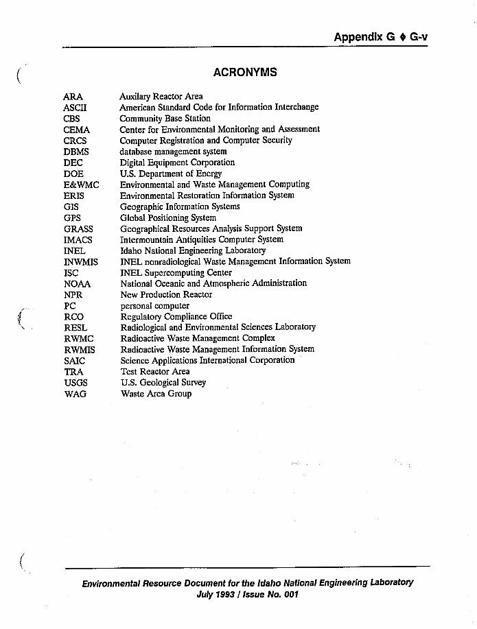
Appendix G 0 G-v
ACRONYMS
ARAASCIICBSCEMACRCSDBMSDECDOEE&WMCERISGISGPSGRASSIMACSINELINWMISISCNOAANPRPCRCORESLRWMCRWMISSAICTRAUSGSWAG
Auxilary Reactor AreaAmerican Standard Code for Information Interchange
Community Base Station
Center for Environmental Monitoring and Assessment
Computer Registration and Computer Security
database management system
Digital Equipment Corporation
U.S. Department of EnergyEnvironmental and Waste Management Computing
Environmental Restoration Information System
Geographic Information Systems
Global Positioning System
Geographical Resources Analysis Support System
Intermountain Antiquities Computer System
Idaho National Engineering Laboratory
INEL nonradiological Waste Management Information System
INEL Supercomputing CenterNational Oceanic and Atmospheric Administration
New Production Reactorpersonal computer
Regulatory Compliance OfficeRadiological and Environmental Sciences Laboratory
Radioactive Waste Management Complex
Radioactive Waste Management Information System
Science Applications International Corporation
Test Reactor AreaU.S. Geological Survey
Waste Area Group
Environmental Resource Document for the Idaho National Engineering Laboratory
July 1993 / Issue No. 001
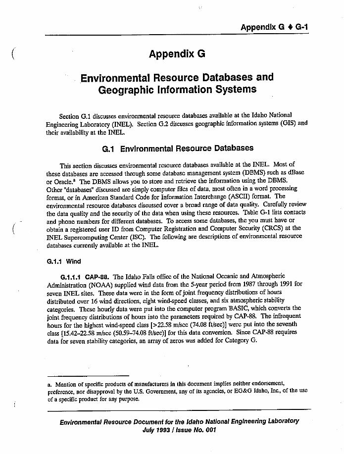
Appendix 6 4 6-1
Appendix G
Environmental Resource Databases andGeographic Information Systems
Section G.1 discusses environmental resource databases available at the Idaho National
Engineering Laboratory (INEL). Section G.2 discusses geographic information systems (GIS) and
their availability at the INEL.
6.1 Environmental Resource Databases
This section discusses environmental resource databases available at the INEL. Most of
these databases are accessed through some database management system (DBMS) such as dBase
or Oracle.'he DBMS allows you to store and retrieve the information using the DBMS.
Other "databases" discussed are simply computer files of data, most often in a word processing
format, or in American Standard Code for Information Interchange (ASCII) format. The
environmental resource databases discussed cover a broad range of data quality. Carefully review
the data quality and the security of the data when using these resources. Table G-1 lists contacts
and phone numbers for different databases. To access some databases, the you must have or
obtain a registered user ID from Computer Registration and Computer Security (CRCS) at the
INEL Supercomputing Center (ISC). The following are descriptions of environmental resource
databases currently available at the INEL.
G.1.1 Wind
G.1.1.1 CAP-88. The Idaho Falls office of the National Oceanic and Atmospheric
Administration (NOAA) supplied wind data from the 5-year period from 1987 through 1991 for
seven INEL sites. These data were in the form of joint frequency distributions of hours
distributed over 16 wind directions, eight wind-speed classes, and six atmospheric stability
categories. These hourly data were put into the computer program BASIC, which converts the
joint frequency distributions of hours into the parameters required by CAP-88. The infrequent
hours for the highest wind-speed class [>22.58 m/sec (74.08 ft/sec)] were put into the seventh
class [15.42-22.58m/sec (50.59-74.08 ft/sec)] for this data conversion. Since CAP-88 requires
data for seven stability categories, an array of zeros was added for Category G.
a. Mention of specific products of manufacturers in this document implies neither endorsement,
preference, nor disapproval by the U.S. Government, any of its agencies, or EG&G Idaho, Inc., of the use
of a speciTic product for any purpose.
Environmental Resource Document for the Idaho National Engineering Laboratory
July 1993 / Issue No. 001
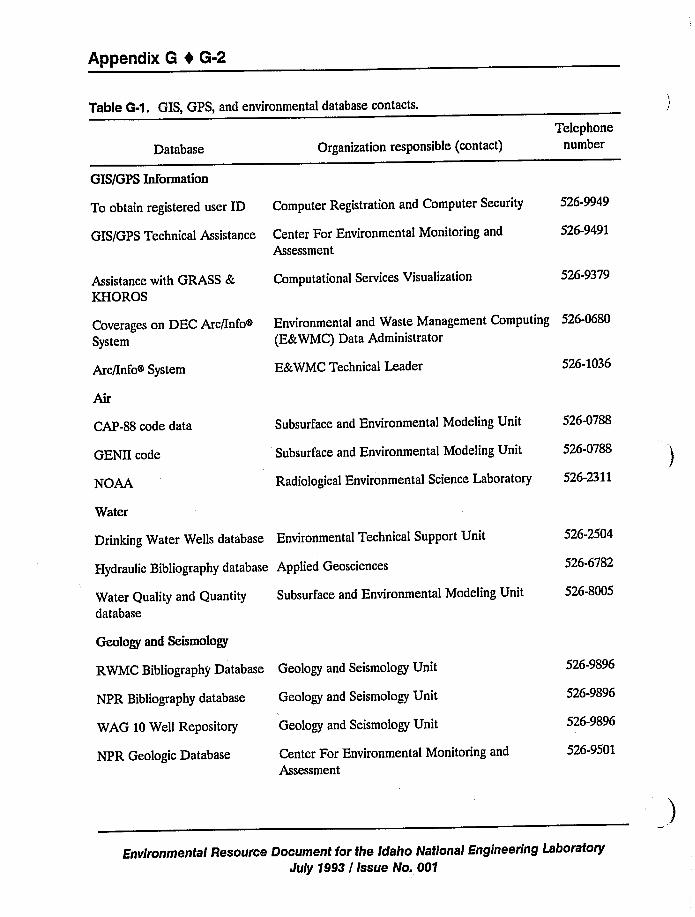
Appendix 6 4 6-2
Table G-1. GIS, GPS, and environmental database contacts.
Database Organization responsible (contact)Telephone
number
GIS/GPS Technical Assistance Center For Environmental Monitoring and
Assessment
GIS/GPS Information
To obtain registered user ID Computer Registration and Computer Security 526-9949
526-9491
Assistance with GRASS &KHOROS
Computational Services Visualization 526-9379
Coverages on DEC Arc/InfoSystem
Environmental and Waste Management Computing 526-0680
(E&WMC) Data Administrator
Arc/Info System E&WMC Technical Leader 526-1036
CAP-88 code data
GENII code
NOAA
Subsurface and Environmental Modeling Unit 526-0788
Subsurface and Environmental Modeling Unit 526-0788
Radiological Environmental Science Laboratory 526-2311
Water Quality and Quantitydatabase
Subsurface and Environmental Modeling Unit
Water
Drinking Water Wells database Environmental Technical Support Unit
Hydraulic Bibliography database Applied Geosciences
526-2504
526-6782
526-8005
NPR Bibliography database
WAG 10 Well Repository
NPR Geologic Database
Geology and Seismology Unit
Geology and Seismology Unit
Center For Environmental Monitoring and
Assessment
Geology and Seismology
RWMC Bibliography Database Geology and Seismology Unit 526-9896
526-9896
526-9896
526-9501
Environmental Resource Document for the Idaho National Engineering LaboratoryJuly 1998 / Issue No. 001
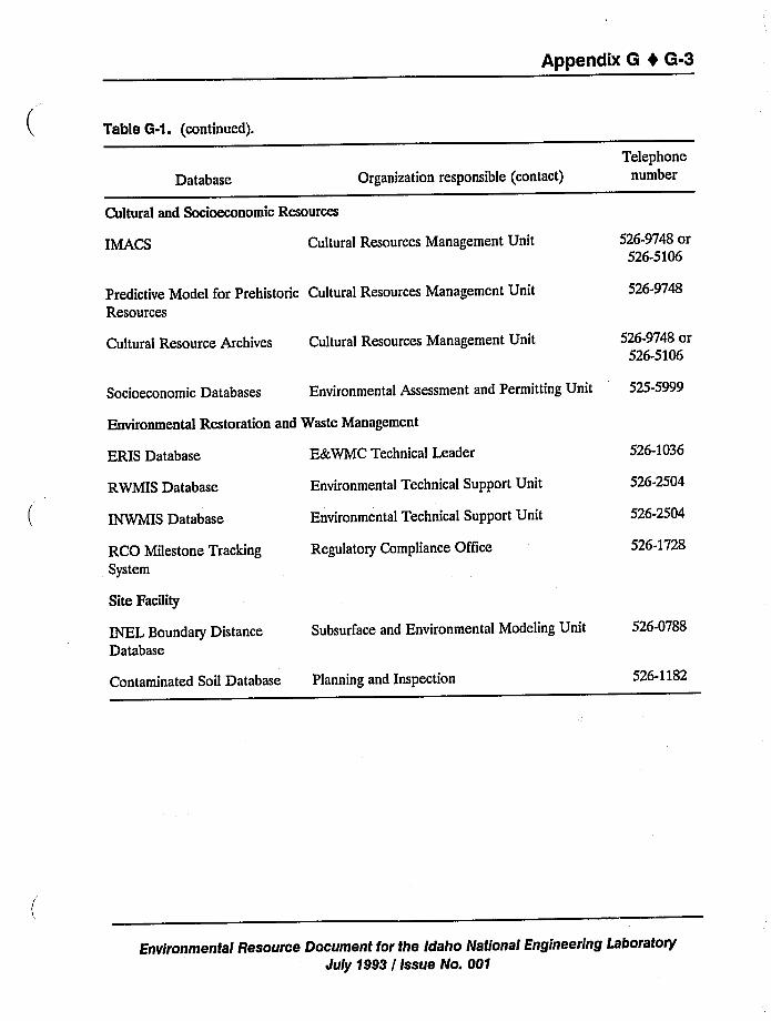
Appendix 6 4 6-3
Table 6-1. (continued).
Database Organization responsible (contact)Telephone
number
Cultural and Socioeconomic Resources
IMACS Cultural Resources Management Unit 526-9748 or526-5106
Predictive Model for Prehistoric Cultural Resources Management UnitResources
526-9748
Cultural Resource Archives Cultural Resources Management Unit 526-9748 or526-5106
Socioeconomic Databases Environmental Assessment and Permitting Unit 525-5999
Environmental Restoration and Waste Management
ERIS Database
RWMIS Database
INWMIS Database
RCO Milestone TrackingSystem
E8r,WMC Technical Leader
Environmental Technical Support Unit
Environmental Technical Support Unit
Regulatory Compliance Office
526-1036
526-2504
526-2504
526-1728
Site FaciTity
INEI. Boundary DistanceDatabase
Subsurface and Environmental Modeling Unit 526-0788
Contaminated Soil Database Planning and Inspection 526-1182
Environmental Resource Document for the Idaho National Engineering LaboratoryJuly 1993 / Issue No. 001
Appendix 8 4 6-4
Two sets of wind files were created, one set with the calm hours included in the input andanother set without the calm hours. When included, calm hours are incorporated into the firstwind-speed class for each stability category in the same proportion as the hours for each directionhave to the total hours in that first class. The resulting files were given characteristic names toidentify them. These files are now stored on the Cray supercomputer at ISC, and are available toCAP-88 users.
G.1.1.2 GENII. The NOAA wind data from the five-year period from 1987 through 1991for seven INEL sites were added to a spreadsheet. These data are distributed over 16 wind
directions with eight wind-speed classes and six atmospheric stability categories. The spreadsheetcalculates the fractions, in percent of total hours, represented by the number of hours the wind
blows in a given direction at a given velocity for a specific stability category. The resulting
computer files were given characteristic names to identify them.
G.1.1.3 NOAA. NOAA has weather data such as temperature, rainfall, and wind
speed/direction since the 1950s.
G.1.2 Water
G.1.2.1 Hydraulic Bibliography. The Hydraulic database contains an annotated
bibliography of reports and documents dealing with the hydrology at the INEL. Topics include
surface water, vadose zone, perched water zones, and the saturated zone (Snake River Plain
Aquifer). Some material is included as parts of other documents, such as site surveillance
information, of which water monitoring is one section. Information includes historical data
through current data. Besides the annotation, the data base includes the subject, keywords, and
physical location of the document.
G.1.2.2 Drinking Water Wells. The Drinking Water Wells database contains validatedwater quality data from drinking water wells controlled by EG8cG Idaho, Inc.
G.1.3 Geology, Seismology, and Volcanism
G.1.3.1 Radioactive Waste Management Complex {RWMC) Bibliography. TheRWMC bibliographic database is a PC system using the Pro-Cite DBMS. It contains a listing of183 references concerning geology, hydrology, and contaminant distribution at RWMC. Mostreferences are specific to RWMC, but some are concerned with the INEL as a whole and with
other INEL facilities.
G.1.3.2 New Production Reactor {NPR) Bibliography. The NPR bibliographic databaseis a WordPerfect-based PC system. It contains a bibliographic listing of several hundred
references concerning regional and local geologic, geophysical, seismic, and volcanic information
used for the NPR Safety Analysis Report.
Environmental Resource Document for the Idaho National Engineering LaboratoryJuly 1993 / Issue No. 001
Appendix 6 t 6-5
G.1.3.3 WAG 10 Well File Repository. The well repository for Waste Area Group(WAG) 10 is a PC-based Pro-Cite DBMS. It is a comprehensive collection of INEL well log and
geologic/hydrologic information designed to support the development of the comprehensiveremedial investigation/feasibility study for the INEL. This repository is in development and will
continue to grow.
G.1.3.4 NPR Geologic Database. The NPR Geologic Database runs on the IBMmainframe ADoCS software system. The database contains a bibliography, and some abstracts, ofnatural sciences, nuclear engineering, and waste management publications. ADoCS allows
keyword search, sorting, and printed output.
G.1.4 Ecology, Cultural, and Socioeconomic Resources
G.1.4.1 Radiological and Environmental Sciences Laboratory (RESL). RESLmaintains several data sets of ecological information collected at the INEL by them and othergovernment agencies. These data sets include:
Weather data (e.g., temperature, rainfall, wind speed/direction) since the 1950sAerial photographs of the INEL dating back to 1949Permanent stream streamflow data from six stations since 1965Intermittent stream streamflow data from four stations since 1986Vegetation transect data since 1950Winter raptor survey since about 1982Breeding-bird survey since about 1983Pronghorn antelope production-survey since about 1983Radionuclides in air, soil, water, and foodstuffs since 1966.
G.1.4.2 lntermountain Antiquities Computer System (IMACS). The IMACS provides astandardized regional format for the recording of cultural resources. Many state and Federalagencies, universities, and private individuals in the region of Idaho, Nevada, Wyoming, and Utahsubscribe to IMACS. In addition, the Idaho State Historic Preservation Office requires that all
cultural resource site registrations in southern Idaho be submitted in IMACS format. To facilitatethis process, the INEL Cultural Resource Management Office has set up ArcheoCompute, a com-mercial, PC-based database management program designed to accept and manipulate informationin IMACS format. Currently, the INEL IMACS database includes detailed administrative,
environmental, and descriptive information for over 500 cultural resources located on the INEL.
G.1.4.3 Predictive Model for Prehistoric Resources. Predictive modeling efforts on theINEL rely on two comparable databases. The first summarizes assemblage characteristics and
environmental features for more than 700 prehistoric archaeological components identified on theINEL. The second is an environmental control sample that consists of environmental featuresrecorded for 500 randomly-drawn points on the INEL. Variables measured for these databasesinclude two administrative categories, four measures of variability within the archaeologicalassemblages (not included in the environmental control sample), and 14 environmental
Environmentai Resource Document for the Idaho Nationai Engineering LaboratoryJuly 1993 / Issue No. 001
Appendix 0 4 6-6
characteristics including physiographic zone, aspect, elevation, three measures of local relief [100,250, and 500 m (328, 820, and 1,640 ft) radii], and eight measures of distance to local features
judged to have had some impact on prehistoric settlement choices (permanent water, intermittent
water, sinks, Pleistocene Lake Terreton, foothills, buttes, lava margins, and recent lava margins).
G.).4.4 Cultural Resource Archives. Results of all cultural resource inventories
conducted on the INEL are summarized in several databases. The INEL Cultural ResourceProject database includes the following: project identifiers, acreage, map location, number ofisolates, and number of sites for over 150 intensive survey projects conducted on the INELbetween 1980 and the present. It also includes bibliographic references for all projects completedon the INEL since the early 1950s. The INEL Site database includes project information and
limited descriptive data for all cultural resources formally recorded on the INEL since the early
1950s.
G.1.4.5 Socioeconomic Database for Southeastern Idaho. The Socioeconomicdatabase for Southeastern Idaho contains relevant socioeconomic data, and was developed toprovide (a) the statistical data necessary for socioeconomic impact analysis for activities at theINEL and (b) data for risk assessments according to the standards of the U.S. Nuclear RegulatoryCommission.
Data have been collected for two identifiable regions to satisfy these purposes. The first
region (or primary socioeconomic impact area) consists of Bannock, Bingham, Bonneville, Butte,Jefferson, and Madison counties in Idaho. This region includes most of the population and
economic activity expected to be affected by any INEL activity.
The second region, for Nuclear Regulatory Commission standards, encompasses a much
larger geographic area. The Nuclear Regulatory Commission requires that human population,animal population, and land use within 80 km (50 mi) of a reactor facility be identified. The areacovered by this 80-km (50-mi) radius includes part or all of the counties listed above and parts ofBlaine, Clark, Custer, Fremont, Lemhi, Lincoln, Minidoka, and Power counties. This region is
divided into concentric rings 16 km (10 mi) wide, and 16 22.5-degree sectors. The center of the80-km (50-mi) radius circle is placed on a facility and data are reported for each of the 80sections. Data in this format can be found in appropriate sections of the socioeconomic database.
The database consists primarily of 279 statistical tables with a little text and nine figures.The tables are organized into the following headings:
Economic conditions (including employment, income/wage, and employers)Tax structure, revenue, and expendituresHealth servicesPublic safetyPolitical and municipal systems
Public welfareHousing
Environmental Resource Document for the Idaho National Engineering Laboratory
July 1993 / Issue No. 001
Appendix G 0 G-7
Transportation systems
AgricultureTourism
UtilitiesWater supply and delivery systems
Demographics.
G.1.5 Environmental Restoration and Waste Management
G.1.5.1 Environmental Restoration Information System (ERIS). The ERIS, which is an
Oracle DBMS application, consists of several high-quality databases of environmentally related
information. ERIS is maintained by E&WMC for the Environmental Restoration and Waste
Management Department in support of the U.S. Department of Energy Idaho Operations Office.
All ERIS data sets reside in a controlled environment so that change is regulated and data quality
is maintained. The data are protected from inadvertent loss with comprehensive backup and
restore procedures and with a comprehensive security plan and procedures. The principal user ofERIS is the Environmental Restoration Program.
The main data set of interest is the Chemical Sampling database, which consists of about
300,000 records of chemical analytical samples collected during environmental remediation at the
INEL. The sample intent ranges from characterization of Environmentally Controlled Areas to
background sampling in noncontaminated areas. Almost all of the samples were collected and
analyzed using U.S. Environmental Protection Agency Certified Lab Program techniques and
procedures. A complete description of the related data structures can be found in the
Environmental Restoration Information System Chemical Relational Database Management System
Design Document (EGG-WM-ERIS-90-0005, June 1990).
The second most frequently used database within ERIS is the Comprehensive Wells
Database, which is a highly qualified collection of information describing the well construction,
stratigraphy, and geophysical log information for over 700 wells at the INEL. These data, which
are the best available well data for the INEL at this time, are presently being evaluated by a third
party for qualification by the Environmental Protection Agency. The third party will prepare a
report describing the current fitness of each well for use in monitoring and remediation sampling.
Results of this report are expected to become part of the Comprehensive Wells Database in the
third quarter of FY-93. Data from the Comprehensive Wells Database are also accompanied by a
PC-based set of tools for viewing well construction and geophysical log diagrams. Data structures
can be found in the ERIS Hydrology Database Management System Phase I Design Document
(EGG-WM-ERIS-90-004, May 1990).
Additional data sets available in ERIS include stratigraphy, lithology, and small rock property
databases developed by INEL geologists for specific areas at the INEL. As well, the U.S.
Geological Survey (USGS) Water Quality and Water Quantity data sets collected at the INEL
from 1949 to present have been checked against original data records before entry into ERIS.
These data consist of water-level measurements for a suite of ground-water and perched-water
Environmental Resource Document for the Idaho National Engineering Laboratory
July 1993 / Issue No. 001
Appendix 6 0 6-8
wells at the INEL and immediate vicinity, and general water quality measurements (e.g.,temperature, pH, dissolved oxygen) and chemical parameters (e.g., nitrate, chloride). The ERISdatabase system contains other data sets that are specific to particular projects or of limited
general use.
6.1.5.2 Radioactive Waste Management Information System (RWMIS). The RWMISserves as the official record for all radioactive effluent and solid radioactive waste at the INEL,with data from 1952 to present. Types of information include volume, radioactivity, isotopicidentity, origin, and decay status.
6.1.5.3 INEL Nonradiological Waste Management Information System (INWMIS).The INWMIS is a centralized database for managing nonradioactive waste discharge data. Datacan be segregated by the type of effluent released (i.e., liquid), and the database can be queried
by release point, release volume, and the weight and concentration of the released substances.
6.1.5.4 Regulatory Compliance Office (RCO) Milestone Tracking System. Within theEnvironmental Restoration and Waste Management Department, the RCO manages the RCOMilestone Tracking System. This system is used to ensure that all RCO milestones are completedon schedule. The database stores information that is necessary for the completion of RCOmilestones. Fields have been set up to include work package information, budget information,
date due, person performing the work, and any comments that could provide meaningful
information.
G.1.6 Site Facilities
6.1.6.1 INEL Boundary Distances. As input for various environmental computer models,
the locations of INEL facilities and the minimum distances from these facilities to the INEL site
boundary, in each of 16 compass directions, have been determined.
G.1.6.2 Contaminated Soils. The Planning and Inspection Unit in the Facility
Engineering Group is developing a database for contaminated soils. This development is
underway and scheduled for completion in July 1993. The database will map the boundaries ofknown locations of contaminated soils on the INEL. The database will provide general data onthe location and its contaminants and will give references to other data sources or published
documents where more specific information about the contamination is available. This
information will be used by the Planning and Inspection Unit for new project planning, siteanalysis and location studies, and facility modification and expansion projects.
Environmental Resource Document for the Idaho National Engineering Laboratory
July 1993 / Issue No. 001
Appendix 6 0 6-9
6.2 Geographic Information Systems
Geographic Information Systems (GISs) combine the data storage/retrieval capability of database technology with the spatial drawing capability of computer mapping, and have the added
capability to do spatial analyses of the data. Spatial data sets contain attribute data and provideknown geographic positions of features. An example of this would be the geographic datacoordinates of a well location associated with attribute data (e.g., name, date, depth, size). Thespatial features can have point, line, or area (polygon) characteristics. A GIS can store and
manipulate these types of spatial data, along with the associated attributes data. It is this spatial
analysis that sets GIS apart from previous Computer Aided Design and Computer Aided Mappingtechnologies.
There are two data structure technologies used to organize spatial data in a GIS: the rasterdata structure and the vector data structure. The raster data structure partitions the spatial areainto a set of grid cells (usually square) in rows and columns. Each cell is assigned a codedescribing the feature contained within the cell. The cell size is constant for all cells and is
usually a function of computer memory restrictions or of the resolution available or needed.Explicit (xy) coordinates are not given to each cell because the cell location is implicit in its row
and column location. Image processing systems, specifically those developed to manipulate
remotely sensed digital data from satellites (such as Landsat or SPOT), have many functions that
make them most suitable as raster systems. However, the cell-by-cell nature of the rasterstructure makes it difficult to retrieve information about linear features (such as the length of a
river or road) or to traverse a network (such as a train route or a watershed).
Vector data structures use a series of (xy) coordinates to describe point, line, and polygonfeatures. The vector data structure also allows for storage of data for multiple features for thecoordinates. In addition, the information about the connections and relationships among thefeatures (the topology) is calculated and stored with the coordinates. This allows the user toderive relationships such as adjacency and connectivity. Although vector data structures arecomputationally more demanding than raster, they are more widely'used because of the greaterinformation inherent in the data.
Each GIS data set is normally limited to one thematic topic or data, and is commonly called
a coverage or a layer. Examples of coverages are (a) well coverage (point) to define the locationand characteristics of a set of wells, (b) stream coverage (line) to describe the hydrology of an
area, and (c) soil coverage (polygon) to define the soil type map of an area.
The primary activity of a GIS is to apply spatial analysis tools to combinations of datacategories to model and reach conclusions about problems. These tools are part of the GISsoftware, and allow (a) the spatial combining of data sets (overlaying, intersecting, joining, etc.),(b) the creation of additional attributes based on logical and mathematical analyses ofcombinations of feature attributes, and (c) the calculation of distances, or areas, or volumes.
Examples of these analyses might include:
Environmental Resource Document for the Idaho National Engineering LaboratoryJuly 1993 / Issue No. 001
Appendix G 4 G-10
~ Create a composite map made by overlaying the vegetation coverage map and the soils
coverage map to study the relationship of vegetation to soil type
~ Overlay the U.S. Census Bureau's Topologically Integrated Geographic Encoding and
Referencing files containing census data with the map of the agricultural farmlands tocalculate the number of people affected directly by some agricultural practice
~ Study the location of a proposed new facility by overlaying its location onto maps forthe area's geology, hydrology and hydrography, local roads and highways, the electrical
power distribution system, and local wind directions and velocities
~ Compute the volume of a pit with known bottom contour.
Typically, a GIS has extensive output capabilities for the display of maps, charts, and graphsresulting from the analyses. However, the effective choice of color, pattern, shading, symbols, text
fonts, and placement of text in an uncluttered but accurate way is one of the classical challengesof cartography.
6.2.1 GIS at the INEL
To access some GIS systems at the INEL, you must have or obtain a registered user ID from
CRCS at the ISC.
The vector GIS most used at the INEL is Arc/Info, which is from the Environmental Systems
Research Institute in Redlands, California. EG&G Idaho owns two licenses for Arc/Info. TheComputational Services Unit in the Computer Operations and Data Processing Group within theAdministration Department has a three-user license for Arc/Info on the Sun workstation
environment. Their Arc/Info is used primarily for research and systems development. They alsohave the raster GIS ERDAS Imagine system, the vector Geographical Resources Analysis
Support System (GRASS), and the KHOROS public domain software that interfaces with GIS.
The Center for Environmental Monitoring and Assessment (CEMA) has Atlas GIS, which is
a vector PC GIS. In addition, CEMA has two raster GIS PC systems: MicroImage and IDRISI.CEMA can provide in-depth ecological and environmental analytical support to projects using
their data and the coverages and Arc/Info in the Digital Equipment Corporation (DEC)environment. Table G-2 lists coverages presently under development by CEMA.
The E&WMC Unit in the Information Systems Group within the Administration
Department administers a 10-user Arc/Info license for the DEC environment. They also have a
PC GIS called MapInfo. E&%MC's Spatial Analysis Laboratory provides GIS production
mapping support for the INEL. This DEC Arc/Info system is available for other INEL users, and
is accessible through Ethernet. Table G-3 lists the coverages presently available on the DECArc/Info system.
Environmental Resource Document for the Idaho National Engineering LaboratoryJuly 1993 / Issue No. 001
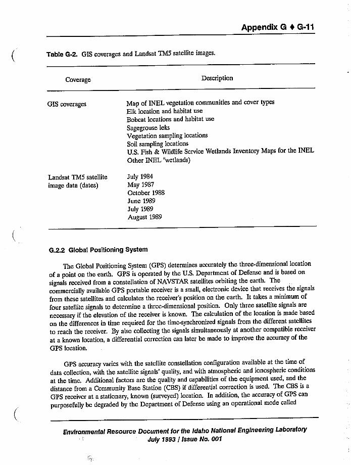
Appendix G 4 G-11
Table G-2. GIS coverages and Landsat TM5 satellite images.
Coverage Description
GIS coverages Map of INEL vegetation communities and cover typesElk location and habitat useBobcat locations and habitat use
Sagegrouse leks
Vegetation sampling locations
Soil sampling locations
U.S. Fish & Wildlife Service Wetlands Inventory Maps for the INELOther INEL "wetlands)
Landsat TMS satellite
image data (dates)July 1984May 1987October 1988June 1989July 1989August 1989
G.2.2 Global Positioning System
The Global Positioning System (GPS) determines accurately the three-dimensional locationof a point on the earth. GPS is operated by the U.S. Department of Defense and is based onsignals received from a constellation of NAVSTAR satellites orbiting the earth. Thecommercially available GPS portable receiver is a small, electronic device that receives the signals
from these satellites and calculates the receiver's position on the earth. It takes a minimum offour satellite signals to determine a three-dimensional position. Only three satellite signals arenecessary if the elevation of the receiver is known. The calculation of the location is made based
on the differences in time required for the time-synchronized signals from the different satellites
to reach the receiver. By also collecting the signals simultaneously at another compatible receiver
at a known location, a differential correction can later be made to improve the accuracy of theGPS location.
GPS accuracy varies with the satellite constellation configuration available at the time ofdata collection, with the satellite signals'uality, and with atmospheric and ionospheric conditions
at the time. Additional factors are the quality and capabilities of the equipment used, and thedistance from a Community Base Station (CBS) if differential correction is used. The CBS is aGPS receiver at a stationary, known (surveyed) location. In addition, the accuracy of GPS can
purposefully be degraded by the Department of Defense using an operational mode called
Environmental Resource Document for the Idaho National Engineering Laboratory
July 1993 / Issue No, 001
Appendix G 4 G-12
selective availability, which is designed to deny hostile forces the tactical advantage of GPS
positioning.
Manufacturers'pecifications for accuracy of the GPS instruments currently available at the
INEL range from ~30 m (98 ft) for uncorrected and nonaveraged positions to +2-5 m
(6.6-16.4ft) with differentially corrected and averaged positions. CEMA experience with GPS
technology at the INEL suggests that accuracies better than ~1 m (3.3 ft) can be obtained when
the system is operating optimally. Accuracies of ~3 m (9.8 ft) can be expected under normal
circumstances with position averaging and differential correction. Without differential corrections,
position inaccuracies may be recorded that are significantly greater than themanufacturers'pecifications.
Inaccuracies as high as 1,500 m (4,920 ft) have been observed. Typically, this is
due to the Department of Defense initiating a selective-availability mode of operation on the
satellite signals. Survey grade GPS receivers can attain accuracies better than + 1 cm (0.39 in.).
These systems are very expensive and currently unavailable at the INEL. The National Geodetic
Survey and other organizations can be contracted to conduct work using these systems.
Determination of the location of points, using GPS technology, provides the necessary input
data for detailed GIS mapping and analysis capabilities. By measuring the locations of multiple
points, the points can also be used to define lines and polygons. These points, lines, and polygons
can be used in a GIS for mapping points (well locations, sampling point locations, etc.), lines
(roads, rivers, pipelines, etc.), or polygons (buildings, disposal sites, remediation sites, vegetation
classifications, etc.).
CEMA maintains a CBS GPS receiver. The CBS antenna is located on the roof of the
INEL Research Center at a surveyed, known location. This CBS is used to differentially correct
field-collected GPS locations. CEMA also has a Trimble GPS Pathfinder Professional GPS
portable receiver, a Magellan NAV1000 GPS, and GeoLink software system from GeoResearch,
Inc. CEMA uses the GPS to obtain field location data for GIS applications. GeoLink allows for
online, real-time mapping of GPS data as they are collected in the field. GeoLink outputs a GIS
file.
E&WMC has a Trimble Pathfinder Basic Plus GPS portable receiver, and GeoLink.
E&WMC uses the Trimble GPS for field validation, verification, and correction of GIS data
points. Other organizations at the INEL have older Magellan GPS receivers. These receivers are
not as technologically advanced as the Trimble systems.
I/
Environmental Resource Document for the Idaho National Engineering Laboratory
July 1993 / Issue No. 001
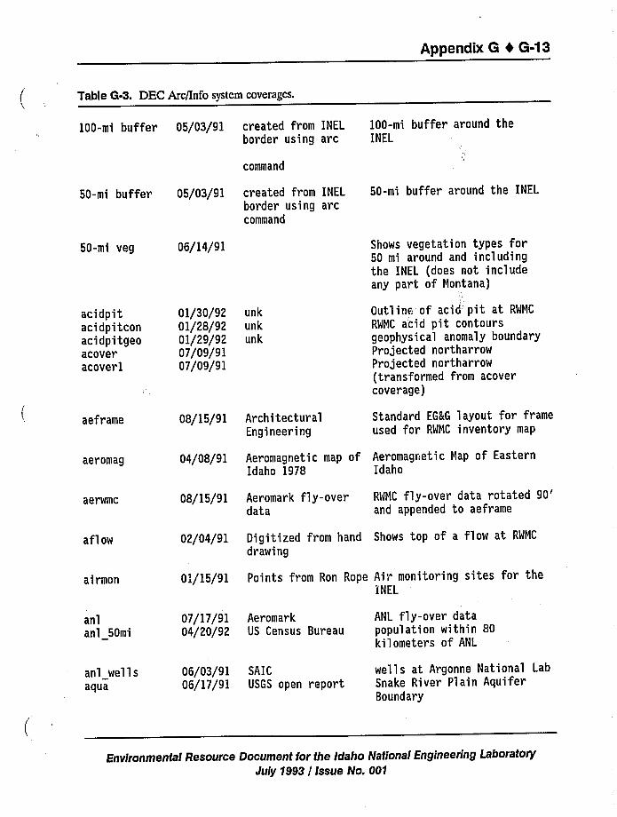
Appendix 6 4 6-13
Table G-3. DEC Arc/Info system coverages.
100-mi buffer
50-mi buffer
50-mi veg
acidpitacidpitconacidpitgeoacoveracoverl
05/03/91 created from INELborder using arc
command
05/03/91 created from INEL
border using arccommand
06/14/91
01/30/92 unk
01/28/92 unk
01/29/92 unk
07/09/9107/09/91
100-mi buffer around theINEL
50-mi buffer around the INEL
Shows vegetation types for50 mi around and includingthe INEL (does not includeany part of Montana)
Outlinr." of acid pit at RWMC
RWMC acid pit contoursgeophysical anomaly boundaryProjected northarrowProjected northarrow(transformed from acovercoverage)
aeframe 08/15/91 Architectur alEngineering
Standard EG&G layout for frameused for RWMC inventory map
aeromag 04/08/91 Aeromagnetic map of Aeromagnetic Map of EasternIdaho 1978 Idaho
aerwmc 08/15/91 Aeromark fly-overdata
RWMC fly-over data rotated90'nd
appended to aeframe
aflow 02/04/91 Digitized from hand Shows top of a flow at RWMC
drawing
airmon 01/15/91 Points from Ron Rope Air monitoring sites for theINEL
anlanl 50mi
anl wellsaqua
07/17/9104/20/92
06/03/9106/17/91
AeromarkUS Census Bureau
SAICUSGS open report
ANL fly-over datapopulation within 80kilometers of ANL
wells at Argonne National LabSnake River Plain AquiferBoundary
Environmental Resource Document for the Idaho National Engineering LaboratoryJuly 1993 / Issue No. 001
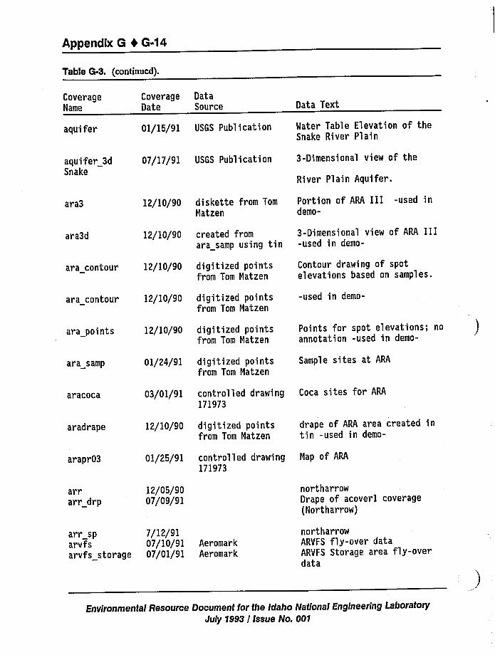
Appendix G 4 G-14
Table G-3. (continued).
CoverageName
aquifer
aquifer 3dSnake
CoverageDate
DataSource
07/17/91 USGS Publication
01/15/91 USGS Publication
Data Text
Water Table Elevation of theSnake River Plain
3-Dimensional view of the
River Plain Aquifer.
ara3
ara3d
ara contour
12/10/90
12/10/90
12/10/90
diskette from Tom
Matzen
created fromara samp using tin
digitized pointsfrom Tom Matzen
Portion of ARA III -used indemo-
3-Dimensional view of ARA III-used in demo-
Contour drawing of spote'levations based on samples.
ara contour
ara points
12/10/90
12/10/90
digitized pointsfrom Tom Matzen
digitized pointsfrom Tom Matzen
-used in demo-
Points for spot elevations; noannotation -used in demo-
ara samp 01/24/91 digitized pointsfrom Tom Matzen
Sample sites at ARA
aracoca 03/01/91 controlled drawing171973
Coca sites for ARA
aradrape 12/10/90 digitized pointsfrom Tom Matzen
drape of ARA area created intin -used in demo-
arapr03 01/25/91 controlled drawing171973
Map of ARA
arrarr drp
12/05/9007/09/91
northarrowDrape of acoverl coverage(Northarrow)
arr sp 7/12/91arvfs 07/10/91 Aer omar karvfs storage 07/01/91 Aeromar k
northarrowARVFS fly-over dataARVFS Storage area fly-overdata
Environmental Resource Document for the Idaho National Engineering LaboratoryJuly 1993 / Issue No. 001
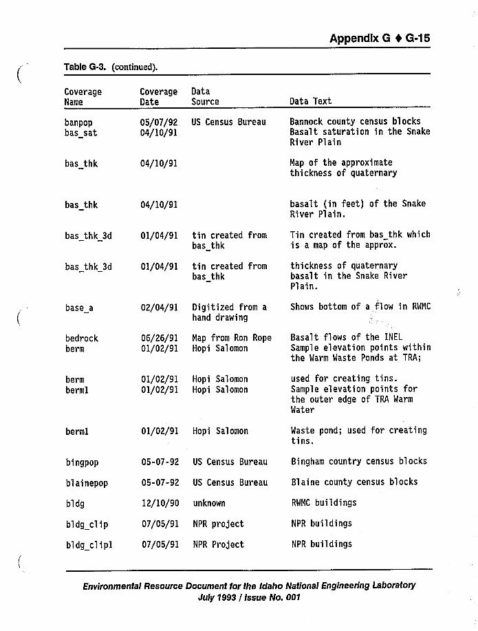
Appendix 6 t 6-15
Table G-3. (continued).
CoverageName
banpopbas sat
bas thk
Coverage DataDate Source
05/07/92 US Census Bureau04/10/91
04/10/91
Data Text
Bannock county census blocksBasalt saturation in the SnakeRiver Plain
Map of the approximatethickness of quaternary
bas thk
bas thk 3d
bas thk 3d
base a
bedrockberm
04/10/91
01/04/91
01/04/91
02/04/91
06/26/9101/02/91
tin created frombas thk
tin created frombas thk
Digitized from ahand drawing
Map from Ron RopeHopi Salomon
basalt (in feet) of the SnakeRiver Plain.
Tin created from bas thk whichis a map of the approx.
thickness of quaternarybasalt in the Snake RiverPlain.
Shows bottom of a flow in RWMC
Basalt flows of the INEL
Sample elevation points withinthe Warm Waste Ponds at TRA;
bermberml
berml
01/02/91 Hopi Salomon
01/02/91 Hopi Salomon
01/02/91 Hopi Salomon
used for creating tins.Sample elevation points forthe outer edge of TRA Warm
Water
Waste pond; used for creatingtins.
bingpop
blainepop
bldg
bldg clip
bldg clipl
05-07-92 US Census Bureau
05-07-92 US Census Bureau
12/10/90 unknown
07/05/91 NPR project
07/05/91 NPR Project
Bingham country census blocks
Blaine county census blocks
RWMC buildings
NPR buildings
NPR buildings
Environmental Resource Document for the Idaho National Engineering Laboratory
July 1993 / Issue No. 001
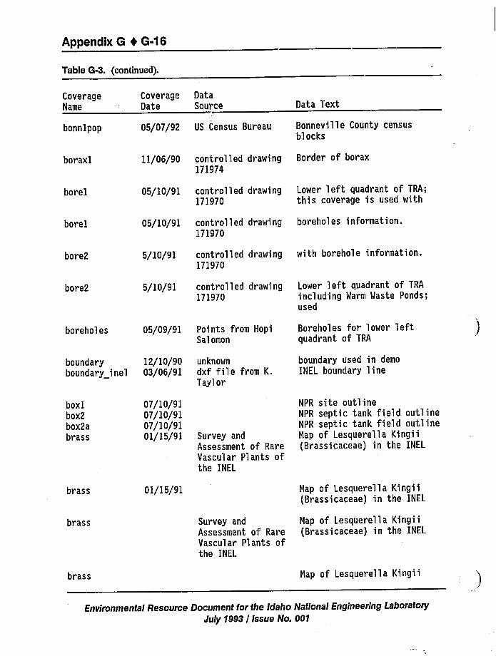
Appendix 8 0 6-16
Table G-3. (continued).
CoverageName
CoverageOate
OataSource Oata Text
bonnlpop 05/07/92 US Census Bureau Bonneville County censusblocks
boraxl
borel
borel
bore2
bore2
boreholes
boundaryboundary inel
11/06/90
05/10/91
05/10/91
5/10/91
5/10/91
05/09/91
12/10/9003/06/91
control 1 ed drawing171974
controlled drawing171970
controlled drawing171970
controlled drawing171970
controlled drawing171970
Points from HopiSalomon
unknown
dxf file from K.Taylor
Border of borax
Lower left quadrant of TRA;this coverage is used with
boreholes information.
with borehole information.
Lower left quadrant of TRA
including Warm Waste Ponds;used
Boreholes for lower leftquadrant of TRA
boundary used in demo
INEL boundary line
boxlbox2box2abrass
brass
07/10/9107/10/9107/10/9101/15/91 Survey and
Assessment of RareVascular Plants ofthe INEL
01/15/91
NPR site outlineNPR septic tank field outlineNPR septic tank field outlineMap of Lesquerella Kingii(Brassicaceae) in the INEL
Map of Lesquerella Kingii(Brassicaceae) in the INEL
brass Survey and Map of Lesquerella KingiiAssessment of Rare (Brassicaceae) in the INELVascular Plants ofthe INEL
brass Map of Lesquerella Kingii
Environmental Resource Document for the Idaho National Engineering LaboratoryJuly 1993 / Issue No. 001
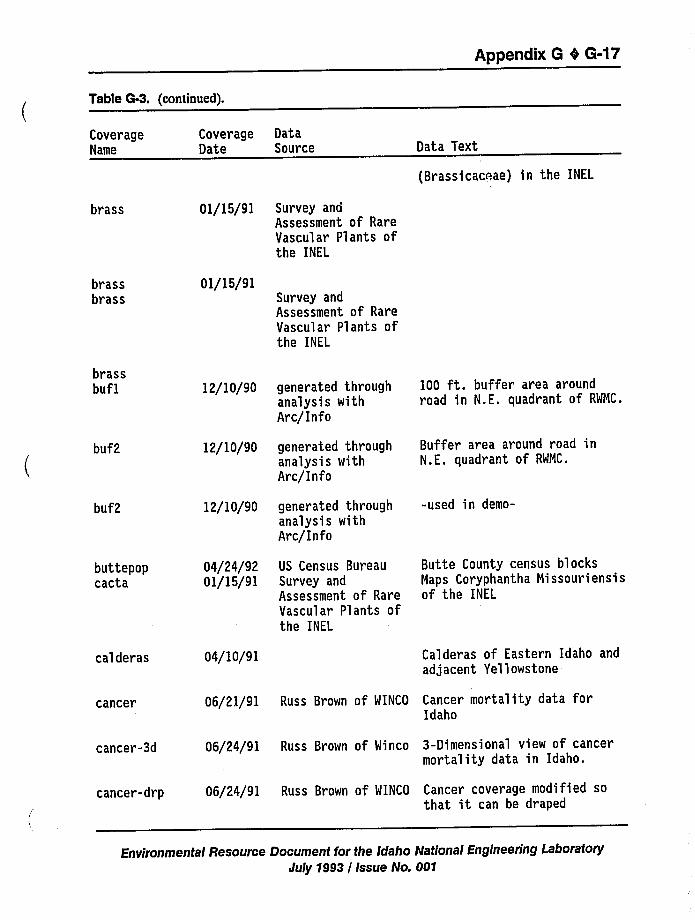
Appendix G 4 G-17
Table G-3. (continued).
CoverageName
Coverage DataDate Source Data Text
{Brassicaceae) in the INEL
brass 01/15/91 Survey andAssessment of RareVascular Plants ofthe INEL
brassbrass
01/15/91Survey andAssessment of RareVascular Plants ofthe INEL
brassbuf1 12/10/90 generated through
analysis withArc/Info
100 ft. buffer area aroundroad in N.E. quadrant of RWMC.
buf2
buf2
12/10/90
12/10/90
generated throughanalysis withArc/Info
generated throughanalysis withArc/Info
Buffer area around road inN.E. quadrant of RWMC.
-used in demo-
buttepopcacta
04/24/9201/15/91
US Census BureauSurvey andAssessment of RareVascular Plants ofthe INEL
Butte County census blocksMaps Coryphantha Missouriensisof the INEL
calderas 04/10/91 Calderas of Eastern Idaho andadjacent Yellowstone
cancer 06/21/91 Russ Brown of WINCO Cancer mortality data forIdaho
cancer-3d 06/24/91 Russ Brown of Winco 3-Dimensional view of cancermortality data in Idaho.
cancer-drp 06/24/91 Russ Brown of WINCO Cancer coverage modified sothat it can be draped
Environmental Resource Document for the Idaho National Engineering LaboratoryJuly 7993 / Issue No. 007
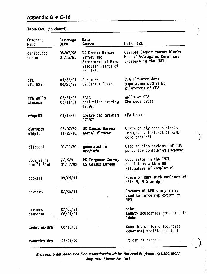
Appendix 8 I 6-18
Table G-3. (continued).
CoverageName
cariboupopceram
cfacfa 50mi
CoverageDate
05/07/9201/15/91
05/28/9104/20/92
DataSource
US Census BureauSurvey andAssessment of RareVascular Plants ofthe INEL
AeromarkUS Census Bureau
Data Text
Caribou County census blocksMap of Astragalus Ceramicuspresence in the INEL
CFA fly-over datapopulation within 80kilometers of CFA
cfa wellscfacoca
cfapr03
clarkpopcldpit
cl i ppond
coca signscomp21 50mi
cookall
corners
cornerscounties
08/21/9202/11/91
01/15/91
05/07/9211/27/91
04/11/91
7/15/9104/17/92
08/09/91
07/05/91
07/05/9106/21/91
SAICcontrolled drawing171971
controlled drawing171971
US Census Bureauaerial flyover
generated inarc/info
MK-Ferguson SurveyUS Census Bureau
wells at CFA
CFA coca sites
CFA border
Clark county census blockstopography features of RWMC
cold test pit
Used to clip portions of TRA
ponds for contouring purposes
Coca sites in the INEL
population within 80kilometers of complex 21
Piece of RWMC with outlines ofpits 8, 9 5 acidpit
Corners at NPR study area;used to force map extent atNPR
siteCounty boundaries and names inIdaho
counties-drp 06/18/91
counties-drp 06/18/91
Counties of Idaho (countiescoverage) modified so that
it can be draped.
Environmental Resource Document for the Idaho National Engineering LaboratoryJuly 1993 / Issue No. 001
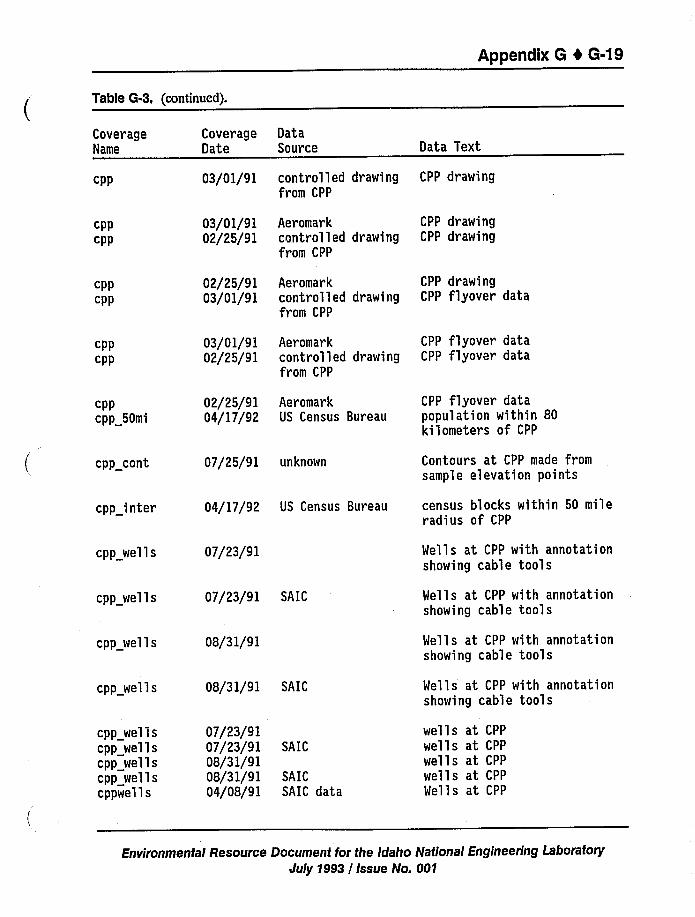
Appendix 6 4 6-19
Table G-3. (continued).
CoverageName
cpp
cppcpp
cppcpp
cppcpp
cppcpp 50mi
cpp cont
CoverageDate
03/01/91
03/01/9102/25/91
02/25/9103/01/91
03/01/9102/25/91
02/25/9104/17/92
07/25/91
DataSource
controlled drawingfrom CPP
Aeromarkcontrolled drawingfrom CPP
Aeromarkcontrolled drawingfrom CPP
Aeromarkcontrolled drawingfrom CPP
AeromarkUS Census Bureau
unknown
Data Text
CPP drawing
CPP drawingCPP drawing
CPP drawingCPP flyover data
CPP flyover dataCPP flyover data
CPP flyover datapopulation within 80kilometers of CPP
Contours at CPP made fromsample elevation points
cpp inter
cpp wells
04/17/92 US Census Bureau
07/23/91
census blocks within 50 mileradius of CPP
Wells at CPP with annotationshowing cable tools
cpp wells
cpp wells
cpp wells
cpp wellscpp wellscpp wellscpp wellscppwells
07/23/91
08/31/91
08/31/91
07/23/9107/23/9108/31/9108/31/9104/08/91
SAIC
SAIC
SAIC
SAICSAIC data
Wells at CPP with annotationshowing cable tools
Wells at CPP with annotationshowing cable tools
Wells at CPP with annotationshowing cable tools
wells at CPP
wells at CPP
wells at CPP
wells at CPP
Wells at CPP
Environmental Resource Document for the Idaho National Engineering Laboratory
July 1993 / Issue No. 001
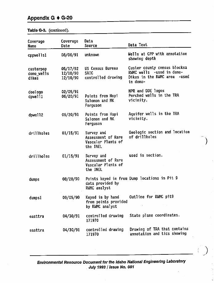
Appendix 8 4 8-20
Table G-3. (continued).
CoverageName
cppwellsl
custerpopdemo wellsdikes
CoverageDate
08/06/91
05/17/9212/10/9012/10/90
DataSource
unknown
US Census BureauSAICcontrolled drawing
Data Text
Wells at CPP with annotationshowing depth
Custer county census blocksaRWMC wells -used in demo-Di kes in the RWMC area -usedin demo-
doel ogodpwell1
dpwell2
drillholes
02/05/9106/20/91
06/20/91
01/15/91
Points from HopiSalomon and NK
Ferguson
Points from HopiSalomon and NK
Ferguson
Survey andAssessment of RareVascular Plants ofthe INEL
NPR and DOE logosPerched wells in the TRA
vicinity.
Aquifer wells in the TRA
vicinity.
Geologic section and locationof drillholes
drillholes 01/15/91 Survey andAssessment of RareVascular Plants ofthe INEL
used in section.
dumps
dumpsl
08/28/90
09/05/90
Points keyed in from Dump locations in Pit 9data provided byRWMC analyst
Keyed in by hand Outline for RWNC pit9from points providedby RWNC analyst
easttra
easttra
04/30/91
04/30/91
controlled drawing171970
controlled drawing171970
State plane coordinates.
Drawing of TRA that containsannotation and ties showing
Environmental Resource Document for the Idaho National Engineering LaboratoryJuly 1993 / Issue No. 001
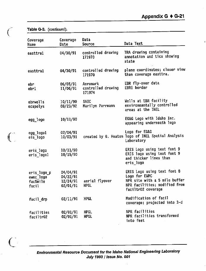
Appendix G 4 G-21
Table G-3. (continued).
CoverageName
easttral
easttral
ebrebrl
ebrwellsecapolys
egg logo
CoverageDate
04/30/91
04/30/91
06/05/9111/06/91
10/11/9008/23/92
10/11/90
DataSource
controlled drawing171970
controlled drawing171970
Aeromarkcontrolled drawing171974
SAICNarilyn Parrmann
Data Text
TRA drawing containingannotation and ties showingstate
plane coordinates; closer viewthan coverage easttra.
EBR fly-over dataEBR1 border
Wells at EBR facilityenvironmentally controlledareas at the INEL
EG&G Logo with Idaho Inc.appearing underneath logo
egg logoleis logo
eris logoeris logol
02/04/9110/03/91
10/11/9010/15/90
Logo for EG&G
created by G. Heaton logo of INEL Spatial AnalysisLaboratory
ERIS Logo using text font 9ERIS logo using text font 9and thicker lines thaneris logo
eris logo p 04/04/91ewmc logo 04/22/91fac5mile 12/24/91 aerial flyoverfacil 02/01/91 HPGL
ERIS Logo using text font 8Logo for EWNC
NPR site with a 5 mile bufferNPR facilities; modified fromfaciltr02 coverage
facil drp
fac i 1 i ti esfaci 1 tr02
02/11/91 HPGL
02/01/91 HPGL
02/01/91 HPGL
Nodification of facilcoverage; projected into 3-d
NPR facilitiesNPR facilities transformedinto feet
Environmental Resource Document for the Idaho National Engineering LaboratoryJuly 1993 / Issue No. 001
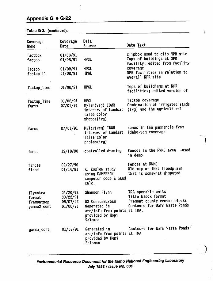
Appendix 6 I 6-22
Table G-3. (continued).
CoverageName
factboxfactop
faciopfactop ll
CoverageDate
01/08/9101/08/91
01/08/9101/08/91
DataSource
HPGL
HPGL
HPGL
Data Text
Clipbox used to clip NPR siteTops of buildings at NPR
facility; edited from facilitycoverageNPR facilities in relation tooverall NPR site
factop line 01/08/91 HPGL Tops of buildings at NPR
facilities; edited version of
factop linefarms
01/08/9107/01/91
HPGL
Mylar(veg) IDWR
interpr. of Landsatfalse colorphotos(irg)
factop coverageCombination of irrigated lands(irg) and the agricultural
farms 07/01/91 Mylar(veg) IDWR zones in the panhandle frominterpr. of'andsat idaho-veg coveragefalse colorphotos(irg)
fence 12/10/90 controlled drawing Fences in the RWMC area -usedin demo-
fencesfl ood
09/27/9001/14/91
Fences at RWMC
K. Koslow study Old map of INEI. floodplainusing DAMBREAK that is somewhat disputedcomputer code 5 handcalc.
flynntraformatfremontpopgamma2 cont
04/20/9203/22/9105/07/9201/06/91
Shannon Flynn
US CensusBureauGenerated inarc/info from pointsprovided by HopiSalomon
TRA operable unitsTitle block formatFremont county census blocksContours for Warm Waste Pondsat TRA.
gamma cont 01/09/91 Generated in Contours f'r Warm Waste Pondsarc/info from points at TRA
provided by HopiSalomon
Environmental Resource Document for the Idaho National Engineering LaboratoryJuly 1993 / Issue No. 001
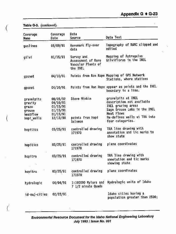
Appendix 8 I 6-23
Table G-3. (continued).
CoverageName
gaslines
gil vi
CoverageDate
08/09/91
01/15/91
DataSource
Aeromark fly-overdata
Survey andAssessment of RareVascular Plants ofthe INEL
Data Text
Topography of RWNC clipped andedited
Napping of AstragalusGilviflorus in the INEL
gpsnet
gpsnet
04/10/91 Points from Ron Rope Napping of GPS NetworkStations, where stations
04/10/91 Points from Ron Rope appear as points and the INEL
boundary is a line.
gravelpitsgravitygrazegrouseheatflowhopi wells
hopitics
hopi ties
hopitra
hopitra
08/05/9204/10/9101/15/9101/15/9101/15/9112/13/90
03/25/91
03/25/91
03/25/91
03/25/91
Steve Ninkin
points from HopiSalomon
controlled drawing171970
controlled drawing171970
controlled drawing171970
controlled drawing171970
gravelpits at INEL
description not availableINEL grazing areasSage Grouse Leks in the INEL
Heat FlowsRe-defines wells at TRA intofour categories.
TRA line drawing withannotation and tic marks toshow state
plane coordinates
TRA line drawing withannotation and tic marksshowing state
plane coordinates
hydrologic 04/04/91 1:100000 Nylars and Hydrologic units of Idaho7 1/2 minute quads
id-maj-cities 02/22/91 Idaho cities having apopulation greater than 2500;
Environmental Resource Document for the Idaho National Engineering LaboratoryJuly 1993 / Issue No. 001
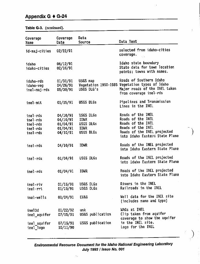
Appendix 6 4 6-24
Table G-3. (continued).
CoverageName
id-maj-cities
idahoidaho-cities
CoverageDate
02/22/91
06/12/9102/16/91
DataSource Data Text
selected from idaho-citiescoverage.
Idaho state boundaryState data for town locationpoints; towns with names.
idaho-rdsidaho-veginel-maj-rds
01/31/9104/26/9105/30/91
USGS map Roads of Southern IdahoVegetation 1950-1985 Vegetation types of IdahoUSGS DLG's Major roads of the INEL taken
from coverage inel-rds
inel-mtt
inel-rdsinel-rdsine'l-rdsinel-rdsinel-rds
inel-rds
inel-rds
inel-rds
inel-rivinel-rrt
inel-wells
inel3dinel aquifer
inel aquiferinel logo
01/15/91
04/10/9104/10/9101/04/9101/04/9104/10/91
04/10/91
01/04/91
01/04/91
01/15/9101/15/91
01/04/91
01/22/9207/15/91
07/15/9110/11/90
USGS DLGs
USGS DLGs
IDWR
USGS DLGs
IDWR
USGS DLGs
IDWR
USGS DLGs
IDWR
USGS DLGs
USGS DLGs
EGKG
unkUSGS publication
USGS publication
Pi pel ines and TransmissionLines in the INEL
Roads of the INEL
Roads of the INEL
Roads of the INEL
Roads of the INEL
Roads of the INEL projectedinto Idaho Easter~i State Plane
Roads of the INEL projectedinto Idaho Eastern State Plane
Roads of the INEL projectedinto Idaho Eastern State Plane
Roads of the INEL projectedinto Idaho Eastern State Plane
Rivers in the INEL
Railroads in the INEL
Well data for the INEL site(includes name and type)
WAGs at INEL
Clip taken from aquifercoverage to show the aquiferin the INEL site.Logo for the INEL
Environmental Resource Document for the Idaho National Engineering Laboratory
July 1993 / Issue No. 001
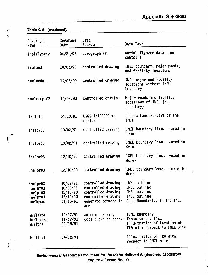
Appendix G t 6-25
Table G4. (continued).
CoverageName
inel flyover
ine'Imod
inelmod01
Coverage DataDate Source
04/21/92 aerographics
10/02/90 controlled drawing
10/03/90 controlled drawing
Data Text
aerial flyover data - nocontours
INEL boundary, major roads,and facility locations
INEL major and facilitylocations without INEL
boundary
inelmodpr03 10/02/90 controlled drawing major roads and facilitylocations of INEL (noboundary)
inelpls 04/10/91 USGS 1:100000 map
seriesPublic Land Surveys of theINEL
inelpr03
inelpr03
inelpr03
inelpr03
10/02/91 controlled drawing
10/02/91 controlled drawing
12/10/90 controlled drawing
12/10/90 controlled drawing
INEL boundary line. -used indemo-
INEL boundary line. -used indemo-
INEL boundary line. -used indemo-
INEL boundary line. -used indemo-
inelpr03inelpr03inelpr03inelpr03inelquad
10/02/9110/02/9112/10/9012/10/9001/15/91
controlled drawingcontrolled drawingcontrolled drawingcontrolled drawinggenerate command inarc
INEL outlineINEL outlineINEL outlineINEL outlineguad Boundaries in the INEL
inelsiteineltanksineltra
ineltral
12/17/9111/07/9104/18/91
04/18/91
autocad drawing IENL boundarydots drawn on paper Tanks in the INEL
Illustration of location ofTRA with respect to INEL site
Illustration of TRA withrespect to INEL site
Environmental Resource Document for fhe Idaho National Engineering LaboratoryJuly 1993 / Issue No. 001
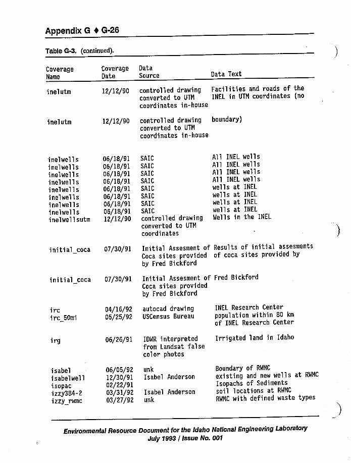
Appendix 8 4 6-26
Table 6-3. (continued).
CoverageName
CoverageDate
DataSource Data Text
inelutm
inelutm
12/12/90
12/12/90
controlled drawing Facilities and roads of theconverted to UTM INEL in UTM coordinates (nocoordinates in-house
controlled drawing boundary)converted to UTM
coordinates in-house
inelwellsinelwellsinelwellsinelwellsinelwellsinelwellsinelwellsinelwellsinelwellsutm
06/18/9106/18/9106/18/9106/18/9106/18/9106/18/9106/18/9106/18/9112/12/90
SAICSAICSAICSAICSAICSAICSAICSAICcontrolled drawingconverted to UTM
coordinates
All INEL
All INELA'll INELAll INEL
wells atwells atwells atwells atWells in
wellswellswellswellsINEL
INELINEL
INELthe INEL
initial coca 07/30/91
initial coca 07/30/91
Initial Assesment of Results of initial assesmentsCoca sites provided of coca sites provided byby Fred Bickford
Initial Assesment of Fred BickfordCoca sites providedby Fred Bickford
ircirc 50mi
irg
isabelisabelwellisopacizzy384-2izzy rwmc
04/16/9205/25/92
06/26/91
06/05/9212/30/9102/22/9103/31/9203/27/92
autocad drawingUSCensus Bureau
IDWR interpretedfrom Landsat falsecolor photos
unkIsabel Anderson
Isabel Andersonunk
INEL Research Centerpopulation within 80 km
of INEL Research Center
Irrigated land in Idaho
Boundary of RWMC
existing and new wells at RWMC
Isopachs of Sedimentssoil locations at RWMC
RWMC with defined waste types
Environmental Resource Document for the Idaho National Engineering LaboratoryJuly 1993 / Issue No. 001
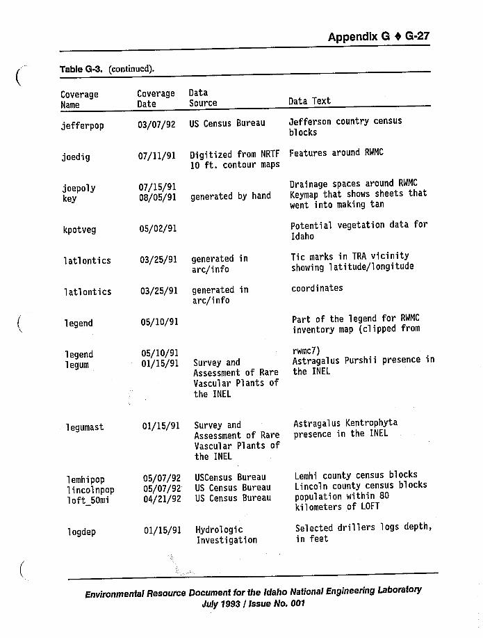
Appendix G 4 G-27
Table G-3. (continued).
CoverageName
Coverage DataDate Source Data Text
jefferpop
joedig
03/07/92 US Census Bureau Jefferson country censusblocks
07/11/91 Digitized from NRTF Features around RWMC
10 ft. contour maps
joepolykey
kpotveg
07/15/9108/05/91 generated by hand
05/02/91
Drainage spaces around RWMC
Keymap that shows sheets thatwent into making tan
Potential vegetation data forIdaho
latlontics
latlontics
legend
03/25/91 generated inarc/info
03/25/91 generated inarc/info
05/10/91
Tic marks in TRA vicinityshowing latitude/longitude
coordinates
Part of the legend for RWMC
inventory map (clipped from
legendlegum
05/10/91 rwmc7)01/15/91 Survey and Astragalus Purshii presence in
Assessment of Rare the INEL
Vascular Plants ofthe INEL
legumast
lemhipoplincolnpoploft 50mi
logdep
01/15/91 Survey andAssessment of RareVascular Plants ofthe INEL
05/07/92 USCensus Bureau05/07/92 US Census Bureau04/21/92 US Census Bureau
01/15/91 HydrologicInvestigation
Astragalus Kentrophytapresence in the INEL
Lemhi county census blocksLincoln county census blockspopulation within 80kilometers of LOFT
Selected dril'lers logs depth,in feet
Environmental Resource Document for the Iclaho National Engineering LaboratoryJuly 1993 / Issue No. 001
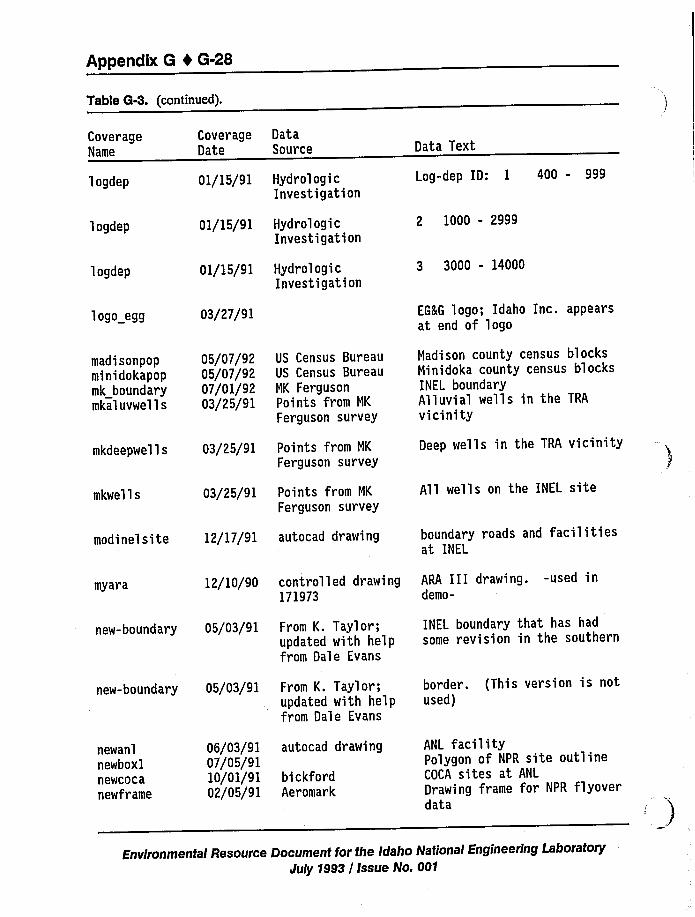
Appendix 8 0 8-28
Table 6-3. (continued).
CoverageName
logdep
logdep
logdep
logo egg
madisonpopminidokapopmk boundarymkaluvwells
mkdeepwells
mkwells
CoverageDate
01/15/91
01/15/91
01/15/91
03/27/91
05/07/9205/07/9207/01/9203/25/91
03/25/91
03/25/91
DataSource
HydrologicInvestigation
HydrologicInvestigation
HydrologicInvestigation
US Census BureauUS Census BureauNK FergusonPoints from NK
Ferguson survey
Points from NK
Ferguson survey
Points from NK
Ferguson survey
Data Text
Log-dep ID: 1 400 - 999
2 1000 - 2999
3 3000 - 14000
EGKG logo; Idaho Inc. appearsat end of logo
Nadison county census blocksNinidoka county census blocksINEL boundaryAlluvial wells in the TRA
vicinity
Deep wells in the TRA vicinity
All wells on the INEL site
modinelsite 12/17/91 autocad drawing boundary roads and facilitiesat INEL
myara 12/10/90 controlled drawing171973
ARA III drawing. -used indemo-
new-boundary 05/03/91 From K. Taylor;updated with he'lpfrom Dale Evans
INEL boundary that has hadsome revision in the southern
new-boundary 05/03/91 From K. Taylor;updated with helpfrom Dale Evans
border. (This version is notused)
newanlnewboxlnewcocanewframe
06/03/9107/05/9110/01/9102/05/91
autocad drawing
bickfordAeromark
ANL facilityPolygon of NPR site outlineCOCA sites at ANL
Drawing frame for NPR flyoverdata
Environmental Resource Document for the Idaho National Engineering LaboratoryJuly 1993 / Issue No. 001
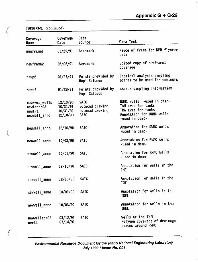
Appendix 6 1 6-29
Table 6-3. (continued).
CoverageName
newframel
Coverage DataDate Source
03/29/91 Aeromark
Data Text
Piece of frame for NPR flyoverdata
newframe2 05/06/91 Aeromark Edited copy of newfr amelcoverage
newp2
newp2
newrwmc wellsnewtanpr03newtranewwell anno
01/28/91
01/28/91
12/10/9010/31/9110/31/9212/10/90
Points provided byHopi Salomon
Points provided byHopi Salomon
SAICautocad drawingautocad drawingSAIC
Chemical analysis samplingpoints to be used for contours
and/or sampling information
RWMC wells -used in demo-TAN area for tanksTRA area for tanksAnnotation for RWMC wells-used in demo-
newwell anno 12/10/90 SAIC Annotation for RWMC wells-used in demo-
newwell anno 10/03/90 SAIC Annotation for RWMC wells-used in demo-
newwel l anno 10/03/90 SAIC Annotation for RWMC wells-used in demo-
newwel 1 anno 12/10/90 SAIC
newwell anno 12/10/90 SAIC
newwell anno 10/03/90 SAIC
Annotation for wells in theINEL
Annotation for wells in theINEL
Annotation for wells in theINEL
newwell anno 10/03/90 SAIC Annotation for wells in theINEL
newwel 1 spr02 03/12/91 SAICnorth 03/14/91
Wells at the INEL
Polygon coverage of drainagespaces around RWMC
Environmental Resource Document for the Idaho National Engineering LaboratoryJuly 1993 / Issue No. 001
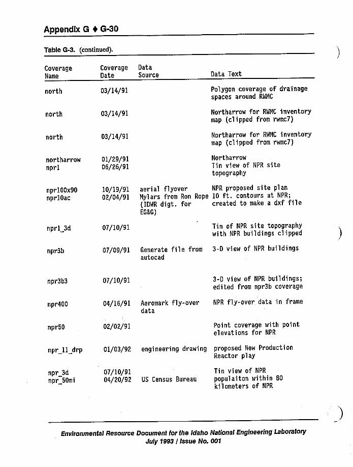
Appendix 6 0 6-30
Table G-3. (continued).
CoverageName
north
north
north
Coverage DataDate Source
03/14/91
03/14/91
03/14/91
Data Text
Polygon coverage of drainagespaces around RWMC
Northarrow for RWNC inventorymap (clipped from rwmc7)
Northarrow for RWMC inventorymap (clipped from rwmc7)
northarrow 01/29/91nprl 06/26/91
NortharrowTin view of NPR sitetopography
npr100x90nprlOac
10/19/91 aerial flyover NPR proposed site plan02/04/91 Mylars from Ron Rope 10 ft. contours at NPR;
(IDWR digt. for created to make a dxf fileEG&G)
nprl 3d 07/10/91 Tin of NPR site topographywith NPR buildings clipped
npr3b 07/09/91 Generate file from 3-D view of NPR buildingsautocad
npr3b3 07/10/91 3-D view of NPR buildings;edited from npr3b coverage
npr400 04/16/91 Aeromark fly-over NPR fly-over data in framedata
npr50 02/02/91 Point coverage with pointelevations for NPR
npr 11 drp
npr 3dnpr 50mi
01/03/92 engineering drawing proposed New ProductionReactor play
07/10/91 Tin view of NPR
04/20/92 US Census Bureau populaiton within 80kilometers of NPR
Environmental Resource Document for the Idaho National Engineering LaboratoryJuly 1993 / Issue No. 001
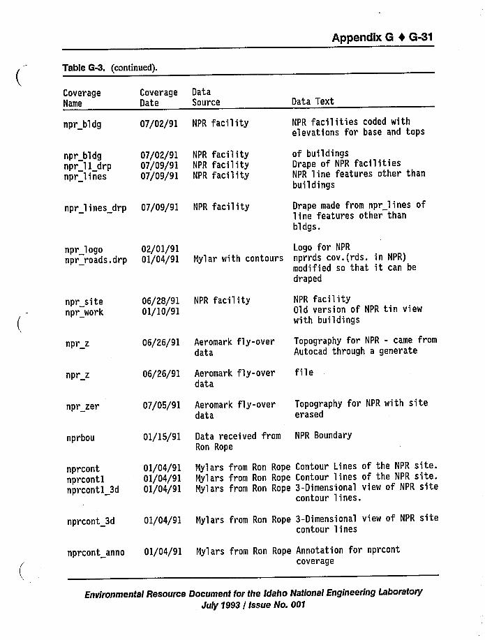
Appendix 6 0 6-31
Table G-3. (continued).
CoverageName
CoverageDate
DataSource Data Text
npr bldg
npr bldgnpr ll drpnpr lines
07/02/91 NPR facility
07/02/91 NPR facility07/09/91 NPR facility07/09/91 NPR facility
NPR facilities coded withelevations for base and tops
of buildingsDrape of NPR facilitiesNPR line features other thanbuildings
npr lines drp 07/09/91 NPR facility Drape made from npr lines ofline features other thanbldgs.
npr logonpr roads.drp
02/01/9101/04/91
Logo for NPR
Nylar with contours nprrds cov.(rds. in NPR)modified so that it can bedraped
npr sitenpr work
06/28/91 NPR facility01/10/91
NPR facilityOld version of NPR tin viewwith buildings
npr z
npr z
npr zer
nprbou
06/26/91
06/26/91
07/05/91
01/15/91
Aeromark fly-overdata
Aeromark fly-overdata
Aeromark fly-overdata
Data received fromRon Rope
Topography for NPR - came fromAutocad through a generate
file
Topography for NPR with siteerased
NPR Boundary
nprcontnprcontlnprcontl 3d
01/04/9101/04/9101/04/91
Nylars from Ron Rope Contour Lines of the NPR site.Nylars from Ron Rope Contour lines of the NPR site.Nylars from Ron Rope 3-Dimensional view of NPR site
contour lines.
nprcont 3d
nprcont anno
01/04/91 Nylars from Ron Rope 3-Dimensional view oF NPR sitecontour lines
01/04/91 Nylars from Ron Rope Annotation for nprcontcoverage
Environmental Resource Document for the Idaho National Engineering LaboratoryJuly 1993 / Issue No. 001
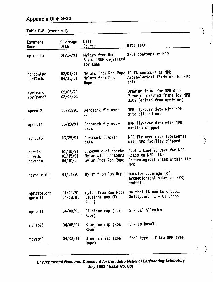
Appendix 8 I 6-32
Table G-3. (continued).
CoverageName
CoverageDate
DataSource Data Text
nprcontp
nprcontprnprfinds
nprframenprframel
01/14/91
02/04/9104/15/91
02/05/9102/07/91
Nylars from Ron 2-ft contours at NPR
Rope; IDWR digitizedfor EGKG
Mylars from Ron Rope 10-ft contours at NPR
Mylars from Ron Archeological finds at the NPR
Rope. site.
Drawing frame for NPR dataPiece of drawing frame for NPR
data (edited from nprframe)
nprout3
nprout4
nprout5
06/28/91
06/28/91
06/28/91
Aeromark fly-overdata
Aeromark fly-overdata
Aeromark flyoverdata
NPR fly-over data with NPR
site clipped out
NPR fly-over data with NPR
outline clipped
NPR fly-over data (contours)with NPR facility clipped
nprplsnprrdsnprsite
01/15/9101/15/9104/10/91
1:24000 quad sheets Public Land Surveys for NPR
Nylar with contours Roads on NPR sitemylar from Ron Rope Archeological Sites within the
NPR
nprsite.drp 01/04/91 mylar from Ron Rope npr site coverage (ofarcheological sites at NPR)modified
nprsite.drpnprsoil
01/04/9104/08/91
mylar from Ron Rope so that it can be draped.Blueline map (Ron Soiltypes: 1 = gl LoessRope)
nprsoil
nprs oil
nprsoil
04/08/91
04/08/91
04/08/91
Blueline map (RonRope)
Blueline map (RonRope)
Blueline map (RonRope)
2 = gal Alluvium
3 = gb Basalt
Soil types of the NPR site.
Environmental Resource Document for the Idaho National Engineering LaboratoryJuly 1993 / Issue No. 001
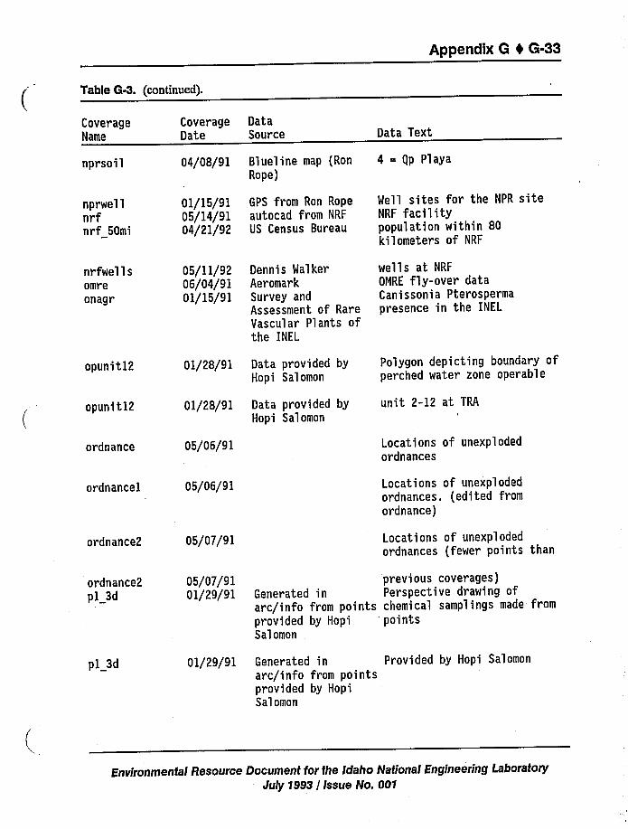
Appendix 0 4 6-33
Table 6-3. (continued).
CoverageName
nprsoil
nprwellnrfnrf 50mi
CoverageDate
04/08/91
01/15/9105/14/9104/21/92
DataSource
Blueline map (RonRope)
GPS from Ron Ropeautocad from NRF
US Census Bureau
Data Text
4 = gp Playa
Well sites for the NPR siteNRF facilitypopulation within 80kilometers of NRF
nrfwellsomreonagr
05/11/9206/04/910)/15/91
Dennis WalkerAeromarkSurvey andAssessment of RareVascular Plants ofthe INEL
wells at NRF
OGRE fly-over dataCanissonia Pterospermapresence in the INEL
opunit12 01/28/91 Data provided byHopi Salomon
Polygon depicting boundary ofperched water zone operable
opunit12
ordnance
01/28/91
05/06/91
Data provided byHopi Salomon
unit 2-12 at TRA
Locations of unexplodedordnances
ordnancel
ordnance2
05/06/91
05/07/91
Locations of unexplodedordnances. (edited fromordnance)
Locations of unexplodedordnances (fewer points than
ordnance2pl 3d
05/07/9101/29/91
previous coverages)Generated in Perspective drawing ofarc/info from points chemical samplings made fromprovided by Hopi 'ointsSalomon
pl 3d 01/29/91 Generated in Provided by Hopi Salomonarc/info from pointsprovided by HopiSalomon
Environmentai Resource Document for fhe Idaho National Engineering LaboratoryJuly 1993 / Issue No. 001
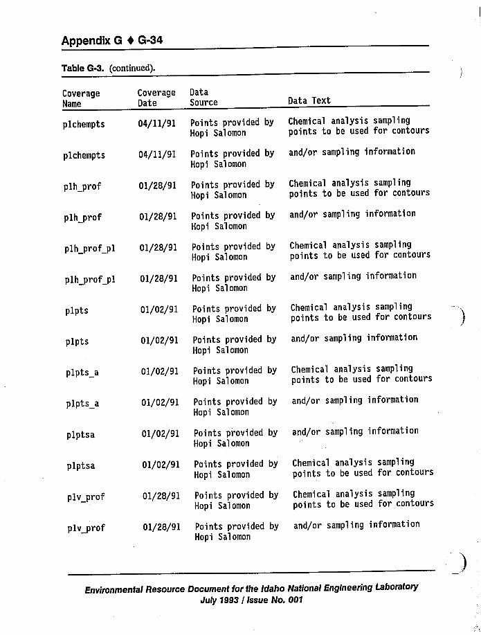
Appendix 6 4 6-34
Table G-3. (continued).
CoverageName
plchempts
plchempts
plh prof
plh prof
plh prof pl
plh prof pl
plpts
plpts
plpts a
plpts a
plptsa
plptsa
plv prof
plv prof
CoverageDate
04/11/91
04/ll/91
01/28/91
01/28/91
01/28/91
01/28/91
01/02/91
01/02/91
01/02/91
01/02/91
01/02/91
01/02/91
01/28/91
01/28/91
DataSource
Points provided byHopi Salomon
Points provided byHopi Salomon
Points provided byHopi Salomon
Points provided byHopi Salomon
Points provided byHopi Salomon
Points provided byHopi Salomon
Points provided byHopi Salomon
Points provided byHopi Salomon
Points provided byHopi Salomon
Points provided byHopi Salomon
Points provided byHopi Salomon
Points provided byHopi Salomon
Points provided byHopi Salomon
Points provided byHopi Salomon
Data Text
Chemical analysis samplingpoints to be used for contours
and/or sampling information
Chemical analysis samplingpoints to be used for contours
and/or sampling information
Chemical analysis samplingpoints to be used for contours
and/or sampling information
Chemical analysis samplingpoints to be used for contours
and/or sampling information
Chemical analysis samplingpoints to be used for contours
and/or sampling information
and/or sampling information
Chemical analysis samplingpoints to be used for contours
Chemical analysis samplingpoints to be used for contours
and/or sampling information
Environmental Resource Document for the Idaho National Engineering LaboratoryJuly 1993 / Issue No. 001
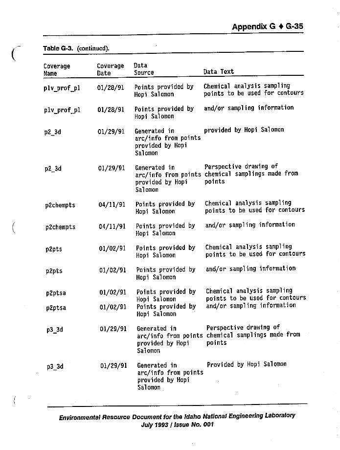
Appendix G 0 G-35
Table G-3. (continued).
CoverageName
plv prof pl
plv prof pl
CoverageDate
01/28/91
01/28/91
DataSource
Points provided byHopi Salomon
Points provided byHopi Salomon
Data Text
Chemical analysis samplingpoints to be used for contours
and/or sampling information
p2 3d 01/29/91 Generated in provided by Hopi Salomonarc/info from pointsprovided by HopiSalomon
p2 3d 01/29/91 Generated in Perspective drawing ofarc/info from points chemical samplings made fromprovided by Hopi pointsSalomon
p2chempts
p2chempts
p2pts
p2pts
p2ptsa
p2ptsa
04/11/91
04/11/91
01/02/91
01/02/91
01/02/91
01/02/91
Points provided byHopi Salomon
Points provided byHopi Salomon
Points provided byHopi Salomon
Points provided byHopi Salomon
Points provided byHopi SalomonPoints provided byHopi Salomon
Chemical analysis samplingpoints to be used for contours
and/or sampling information
Chemical analysis samplingpoints to be used for contours
and/or sampling information
Chemical analysis samplingpoints to be used for contoursand/or sampling information
p3 3d
p3 3d
01/29/91
01/29/91
Generated in Perspective drawing ofarc/info from points chemical samplings made fromprovided by Hopi pointsSalomon
Generated in Provided by Hopi Salomonarc/info from pointsprovided by HopiSalomon
Environmental Resource Document for the Idaho National Engineering LaboratoryJuly 1993 / Issue No. 001
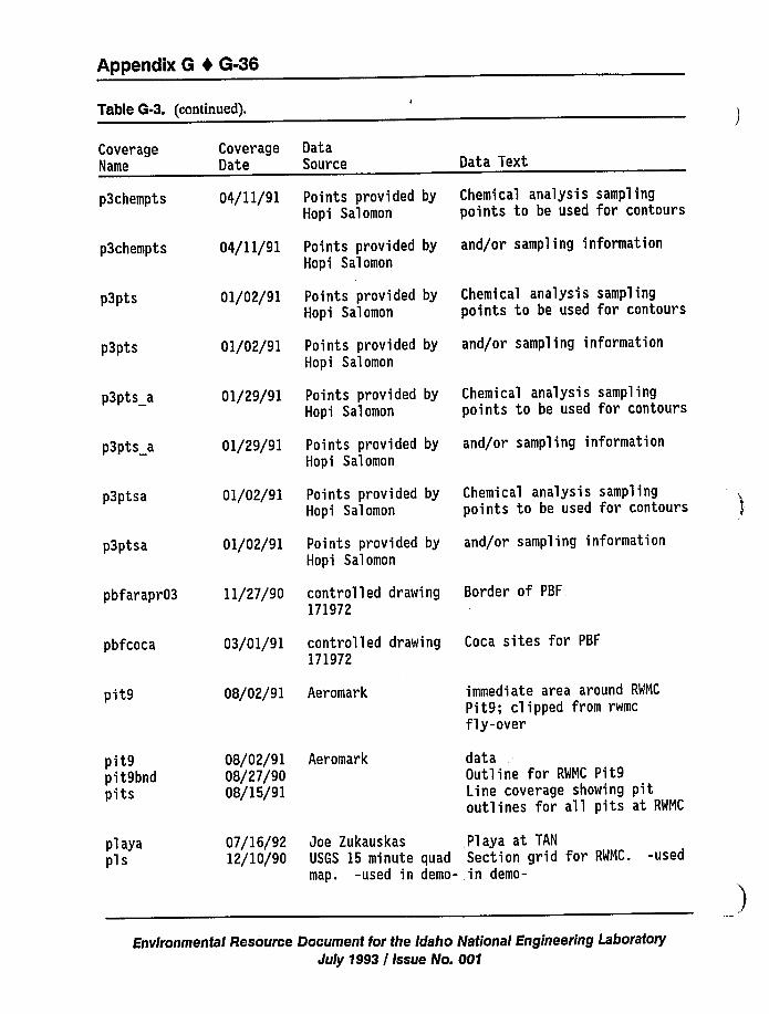
Appendix G 4 6-36
Table 6-3. (continued).
CoverageName
p3chempts
p3chempts
p3pts
p3p'ts
p3p'ts a
p3pts a
p3ptsa
p3p'tsa
pbfarapr03
pbfcoca
CoverageDate
04/11/91
04/11/91
01/02/91
01/02/91
01/29/91
01/29/91
01/02/91
01/02/91
11/27/90
03/01/91
DataSource
Points provided byHopi Salomon
Points provided byHopi Salomon
Points provided byHopi Salomon
Points provided byHopi Salomon
Points provided byHopi Salomon
Points provided byHopi Salomon
Points provided byHopi Salomon
Points provided byHopi Salomon
controlled drawing171972
controlled drawing171972
Data Text
Chemical analysis samplingpoints to be used for contours
and/or sampling information
Chemical analysis samplingpoints to be used for contours
and/or sampling information
Chemical analysis samplingpoints to be used for contours
and/or sampling information
Chemical analysis samplingpoints to be used for contours
and/or sampling information
Border of PBF
Coca sites for PBF
pit9 08/02/91 Aeromark immediate area around RWMC
Pit9; clipped from rwmc
fly-over
pit9pit9bndpits
08/02/9108/27/9008/15/91
Aeromark dataOutline for RWMC Pit9Line coverage showing pitoutlines for all pits at RWMC
playapls
07/16/9212/10/90
Joe Zukauskas Playa at TAN
USGS 15 minute quad Section grid for RWMC. -usedmap. -used in demo- in demo-
Environmental Resource Document for the Idaho National Engineering LaboratoryJuly 1993I Issue No. 00'I
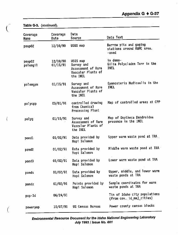
Appendix 6 4 G-37
Tabte 0-3. (continued).
CoverageName
poap02
CoverageDate
12/10/90
DataSource
USGS map
Data Text
Barrow pits and gagingstations around RWMC area.-used
poap02polemgil
polemgym
12/10/9001/15/91
01/15/91
USGS map
Survey andAssessment of RareVascular Plants ofthe INEL
Survey andAssessment of RareVascular Plants ofthe INEL
in demo-Gilia Polycladen Torr in theINEL
Gymnosteris Nudicaulis in theINEL
polycpp
polyg
pondl
pond2
pond3
ponds
pondz
pop-3d
03/01/91
01/15/91
01/02/91
01/02/91
01/02/91
01/02/91
01/02/91
06/24/91
controlled drawingfrom ChemicalProcessing Plant
Survey andAssessment of RareVascular Plants ofthe INEL
Data provided byHopi Salomon
Data provided byHopi Salomon
Data provided byHopi Salomon
Data provided byHopi Salomon
Points provided byHopi Salomon
Map of controlled areas at CPP
Map of Oxytheca Dendroideapresence in the INEL
Upper warm waste pond at TRA
Middle warm waste pond at TRA
Lower warm waste pond at TRA
Upper, middle, and lower warm
waste ponds at TRA
Sample coordinates for warm
waste ponds at TRA
Tin of Idaho city populations(from cov. id maj cities)
powerpop 10/07/91 US Census Bureau Power county census blocks
Environmental Resource Document for the idaho National Engineering LaboratoryJuly 1993 / Issue No. 001
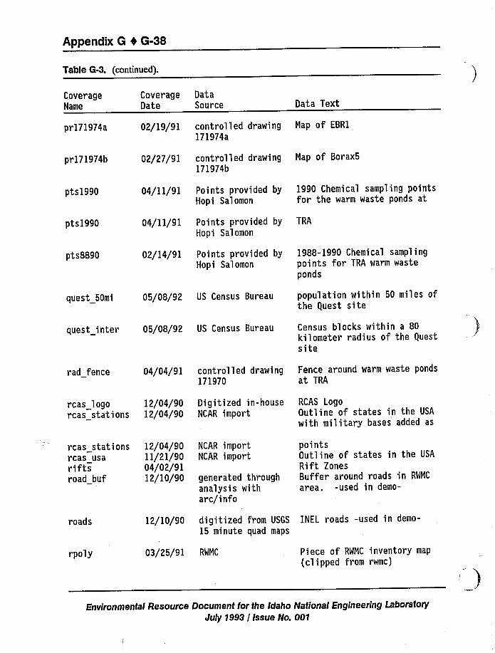
Appendix 6 4 6-38
Table 6-3. (continued).
CoverageName
pr171974a
pr171974b
CoverageDate
02/19/91
02/27/91
DataSource
controlled drawing171974a
controlled drawing171974b
Data Text
Map of EBR1
Map of Borax5
pts1990
pts1990
pts8890
04/11/91
04/11/91
02/14/91
Points provided byHopi Salomon
Points provided byHopi Salomon
Points provided byHopi Salomon
1990 Chemical sampling pointsfor the warm waste ponds at
TRA
1988-1990 Chemical samplingpoints for TRA warm wasteponds
quest 50mi
quest inter
05/08/92 US Census Bureau
05/08/92 US Census Bureau
population within 50 miles ofthe guest site
Census blocks within a 80kilometer radius of the guestsite
rad fence
rcas logorcas stations
rcas stationsrcas usariftsroad buf
04/04/91
12/04/9012/04/90
12/04/9011/21/9004/02/9112/10/90
controlled drawing171970
Digitized in-houseNCAR import
NCAR importNCAR import
generated throughanalysis witharc/info
Fence around warm waste pondsat TRA
RCAS LogoOutline of states in the USA
with military bases added as
pointsOutline of states in the USA
Rift ZonesBuffer around roads in RWMC
area. -used in demo-
roads 12/10/90 digitized from USGS INEL roads -used in demo-
15 minute quad maps
rpoly 03/25/91 RWMC Piece of RWMC inventory map
(clipped from rwmc)
Environmental Resource Document for the Idaho National Engineering LaboratoryJuly 1993 / Issue No. 001
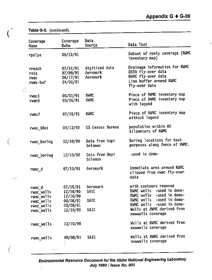
Appendix G t G-39
Table G-3. (continued).
CoverageName
CoverageDate
DataSource Data Text
rpolya
rr eachrstarwmc
rwmc-buf
rwmclrwmc5
rwmc7
rwmc 50mi
05/13/91
07/12/9107/09/9106/17/9104/30/91
05/31/9103/26/91
07/15/91
04/13/92
digitized dataAeromarkAeromark
RWNC
RWNC
RWNC
US Census Bureau
Subset of rpoly coverage (RWMC
inventory map)
Drainage information for RWMC
RSTA fly-over dataRWNC fly-over dataLine buffer around RWMC
fly-over data
Piece of RWMC inventory map
Piece of. RWMC inventory map
with legeiid
Piece of RWNC inventory map
without 'legend
population within 80kilometers of RWMC
rwmc boring
rwmc boring
rwmc d
12/10/90
12/10/90
07/15/91
Data from HopiSolomon
Data from HopiSolomon
Aeromark
Boring locations for testpurposes along fence of RWNC.
-used in demo-
Immediate area around RWMC
clipped from rwmc fly-overdata
rwmc d
rwmc wellsrwmc wellsrwmc wellsrwmc wellsrwmc wells
rwmc wells
rwmc wells
07/15/9112/10/9012/10/9008/08/9108/08/9112/10/90
12/10/90
08/08/91
AeromarkSAIC
SAIC
SAIC
SAIC
with contours removedRWNC wells -used in demo-RWMC wells -used in demo-RWNC wells -used in demo-RWMC wells -used in demo-
Wells at RWMC derived fromnewwe'lls coverage
Wells at RWNC derived fromnewwells coverage
Wells at RWMC derived fromnewwells coverage
Environmental Resource Document for the Idaho National Engineering LaboratoryJuly 1993 / Issue No. 001
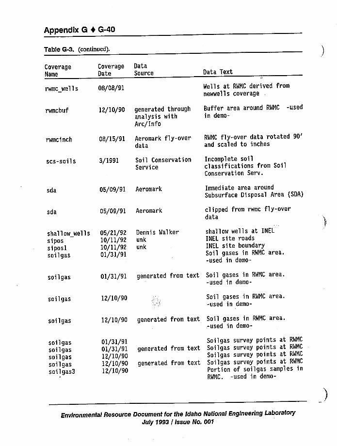
Appendix 6 4 G-40
Tab1e G-3. (continued).
CoverageName
Coverage DataDate Source Data Text
rwmc wells
rwmcbuf
08/08/91
12/10/90 generated throughanalysis withArc/Info
Wells at RWMC derived fromnewwells coverage
Buffer area around RWNC -usedin demo-
rwmcinch 08/15/91 Aeromark fly-overdata
RWNC fly-over data rotated90'nd
scaled to inches
scs-soils 3/1991 Soil ConservationService
Incomplete soilclassifications from SoilConservation Serv.
sda 05/09/91 Aeromark Immediate area aroundSubsurface Disposal Area (SDA)
sda 05/09/91 Aeromark clipped from rwmc fly-overdata
shallow wells 05/21/92 Dennis Walkersipos 10/11/92 unksiposl 10/11/92 unksoilgas 01/31/91
shallow wells at INEL
INEL site roadsINEL site boundarySoil gases in RWMC area.-used in demo-
soil gas 01/31/91 generated from text Soil gases in RWNC area.-used in demo-
sollgas 12/10/90 Soil gases in RWNC area.-used in demo-
soilgas 12/10/90 generated from text Soil gases in RWMC area..-used in demo-
soilgassoilgassollgassoil gassoilgas3
01/31/9101/31/9112/10/9012/10/9012/10/90
generated from text
generated from text
Soilgas survey points at RWMC
Soilgas survey points at RWNC
Soilgas survey points at RWNC
Soilgas survey points at RWNC
Portion of soilgas samples inRWNC. -used in demo-
Environmental Resource Document for the Idaho National Engineering LaboratoryJuly 1993 / Issue No. 001
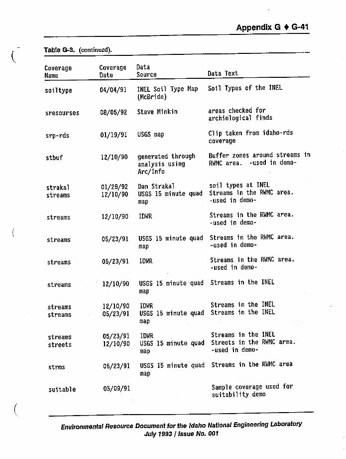
Appendix 6 4 6-41
Table G-3. (continued).
CoverageName
Coverage DataDate Source Data Text
soiltype 04/04/91 INEL Soil Type Map Soil Types of the INEL
(McBride)
sresourses
srp-rds
08/05/92 Steve Minkin
01/19/91 USGS map
areas checked forarchiological finds
Clip taken from idaho-rdscoverage
stbuf 12/10/90 generated throughanalysis usingArc/Info
Buffer zones around streams inRMMC area. -used in demo-
strakalstreams
01/28/9212/10/90
Dan Strakal soil types at INEL
USGS 15 minute quad Streams in the RWMC area.map -used in demo-
streams 12/10/90 IDWR Streams in the RWMC area.-used in demo-
streams 05/23/91 USGS 15 minute quadmap
Streams in the RWMC area.-used in demo-
streams 05/23/91 IDWR Streams in the RWMC area.-used in demo-
streams
streamsstreams
streamsstreets
strms
suitable
12/10/90
12/10/9005/23/91
05/23/9112/10/90
05/23/91
05/09/91
USGS 15 minute quad Streams in the INEL
map
IDWR Streams in the INELUSGS 15 minute quad Streams in the INEL
map
IDMR Streams in the INEL
USGS 15 minute quad Streets in the RMMC area.map -used in demo-
USGS 15 minute quad Streams in the RWMC areamap
Sample coverage used forsuitability demo
Environmental Resource Document for the idaho National Engineering LaboratoryJuly 1993 / issue No. 001
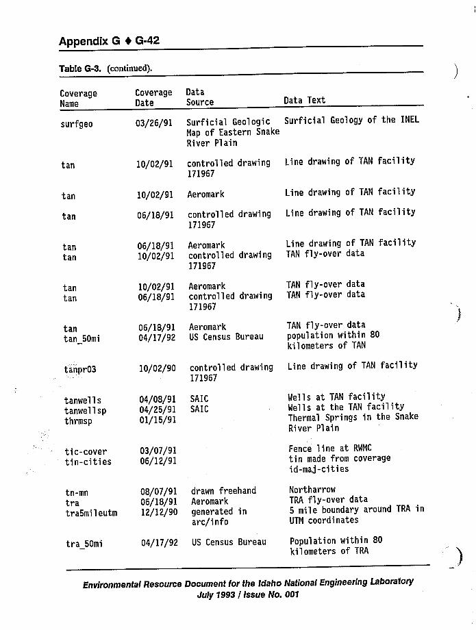
Appendix 6 4 6-42
Table 6-3. (continued).
CoverageName
CoverageDate
DataSource Data Text
surfgeo 03/26/91 Surficial Geologic Surficial Geology of the INEL
Nap of Eastern SnakeRiver Plain
tan 10/02/91 controlled drawing171967
Line drawing of TAN facility
tan
tan 06/18/91 controlled drawing171967
10/02/91 Aer omar k Line drawing of TAN facility
Line drawing of TAN facility
tantan
tantan
tantan 50mi
tanpr03
06/18/9110/02/91
10/02/9106/18/91
06/18/9104/17/92
10/02/90
Aeromarkcontrolled drawing171967
Aeromarkcontrolled drawing171967
AeromarkUS Census Bureau
controlled drawing171967
Line drawing of TAN facil ityTAN fly-over data
TAN fly-over dataTAN fly-over data
TAN fly-over datapopulation within 80kilometers of TAN
Line drawing of TAN facility
tanwellstanwellspthrmsp
tic-covertin-cities
04/08/9104/25/9101/15/91
03/07/9106/12/91
SAICSAIC
Wells at TAN facilityWells at the TAN facilityThermal Springs in the SnakeRiver Plain
Fence line at RWNC
tin made from coverageid-maj-cities
tn-mntratra5mileutm
tra 50mi
08/07/91 drawn freehand06/18/91 Aeromark12/12/90 generated in
arc/info
04/17/92 US Census Bureau
NortharrowTRA fly-over data5 mile boundary around TRA inUTM coordinates
Population within 80kilometers of TRA
Environmental Resource Document for the Idaho National Engineering LaboratoryJuly 1993 / Issue No. 001
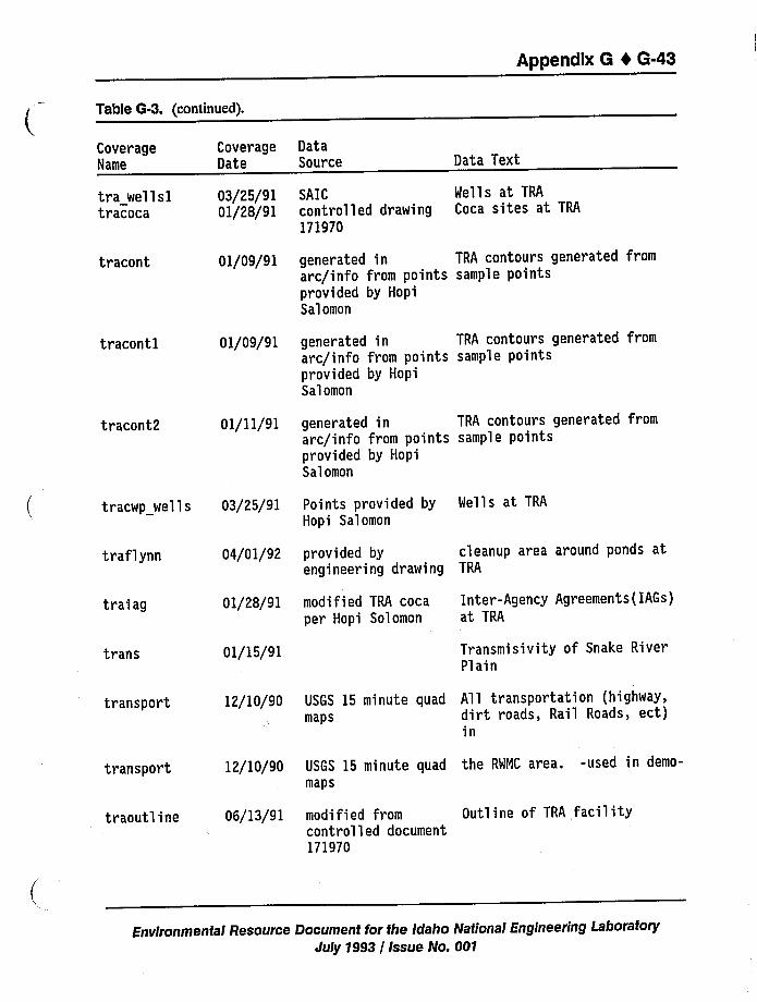
Appendix 6 1 6-43
Table G-3. (continued).
CoverageName
tra wellsltr'acoca
tracont
tracontl
tracont2
CoverageDate
03/25/9101/28/91
01/09/91
01/09/91
01/11/91
DataSource
SAICcontrolled drawing171970
Data Text
Wells at TRA
Coca sites at TRA
generated in TRA contours generated fromarc/info from points sample pointsprovided by HopiSalomon
generated in TRA contours generated fromarc/info from points sample pointsprovided by HopiSalomon
generated in TRA contours generated fromarc/info from points sample pointsprovided by HopiSalomon
tracwp wells 03/25/91 Points provided byHopi Salomon
Wells at TRA
traf lynn 04/01/92 provided by cleanup area around ponds atengineering drawing TRA
traiag
trans
01/28/91
01/15/91
modified TRA cocaper Hopi Solomon
Inter-Agency Agreements(IAGs)at TRA
Transmisivity of Snake RiverPlain
transport
transport
tr aoutline
12/10/90
12/10/90
06/13/91
USGS 15 minute quad All transportation (highway,maps dirt roads, Rail Roads, ect)
in
USGS 15 minute quad the RWMC area. -used in demo-maps
modified from Outline of TRA facilitycontrolled document171970
Environmental Resource Document for the Idaho National Engineering LaboratoryJuly 1993 / Issue No. 001
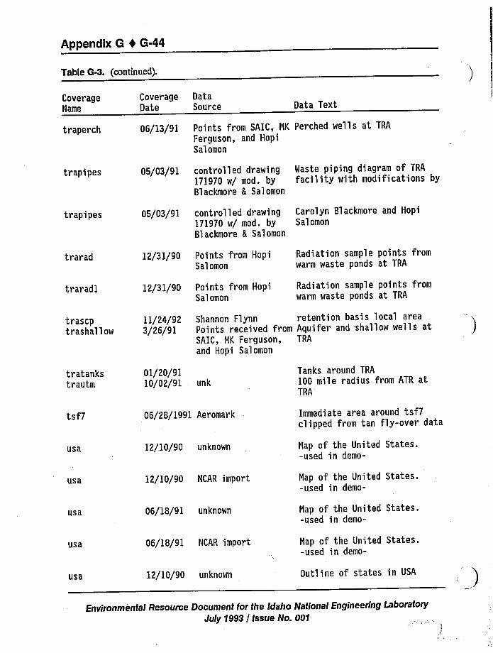
Appendtx 6 4 6-44
Table G-3. (continued).
CoverageName
CoverageDate
DataSource Data Text
traperch
trapipes
trapipes
06/13/91
05/03/91
05/03/91
Points from SAIC, NK Perched wells at TRA
Ferguson, and HopiSalomon
controlled drawing Waste piping diagram of TRA
171970 w/ mod. by facility with modifications byBlackmore & Salomon
controlled drawing Carolyn Blackmore and Hopi171970 w/ mod. by SalomonBlackmore & Salomon
trarad
traradl
12/31/90
12/31/90
Points from HopiSalomon
Points from HopiSalomon
Radiation sample points fromwarm waste ponds at TRA
Radiation sample points fromwarm waste ponds at TRA
trascptrashallow
11/24/923/26/91
Shannon Flynn retention basis local areaPoints received from Aquifer and shallow wells atSAIC, MK Ferguson, TRA
and Hopi Salomon
tratankstrautm
tsf7
usa
usa
usa
usa
usa
01/20/9110/02/91 unk
06/28/1991 Aeromark
12/10/90 unknown
12/10/90 NCAR import
06/18/91 unknown
06/18/91 NCAR import
12/10/90 unknown
Tanks around TRA
100 mile radius from ATR atTRA
Immediate area around tsf7clipped from tan fly-over data
Map of the United States.-used in demo-
Map of the United States.-used in demo-
Map of the United States.-used in demo-
Map of the United States.-used in demo-
Outline of states in USA
Environmental Resource Document for the Idaho National Engineering LaboratoryJuly 1993 / Issue No. 001
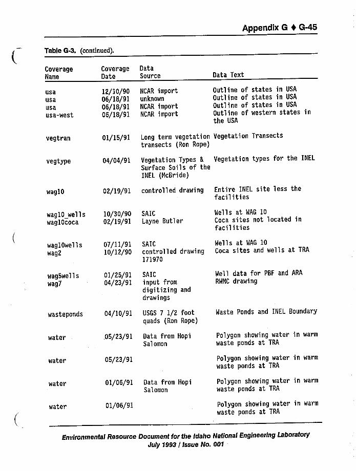
Appendix G I G-45
Table G-3. (continued).
CoverageName
CoverageDate
DataSource Data Text
usausausausa-west
12/10/9006/18/9106/18/9106/18/91
NCAR importunknown
NCAR importNCAR import
Outline of states in USA
Outline of states in USA
Outline of states in USA
Outline of western states inthe USA
vegtran
vegtype
Ol/15/91
04/04/91
Long term vegetation Vegetation Transectstransects (Ron Rope)
Vegetation Types h Vegetation types for the INEL
Surface Soils of theINEL (McBride)
waglO 02/19/91 controlled drawing Entire INEL site less thefacilities
wag10 wells 10/30/90wag10coca 02/19/91
SAICLayne Butler
Wells at WAG 10Coca sites not located infacilities
wag lOwel 1 swag2
wag5wellswag7
wasteponds
water
water
07/11/9110/12/90
01/25/9104/23/91
04/10/91
,05/23/91
05/23/91
SAICcontrolled drawing171970
SAICinput fromdigitizing anddrawings
USGS 7 1/2 footquads (Ron Rope)
Data from HopiSalomon
Wells at WAG 10Coca sites and wells at TRA
Well data for PBF and ARA
RWNC drawing
Waste Ponds and INEL Boundary
Polygon showing water in warm
waste ponds at TRA
Polygon showing water in warm
waste ponds at TRA
water
water
Ol/06/91 Data from HopiSalomon
01/06/91
Polygon showing water in warm
waste ponds ai TRA
Polygon showing water in warm
waste ponds at TRA
Environmental Resource Document for the Idaho National Engineering LaboratoryJuly 1993 / Issue No. 001
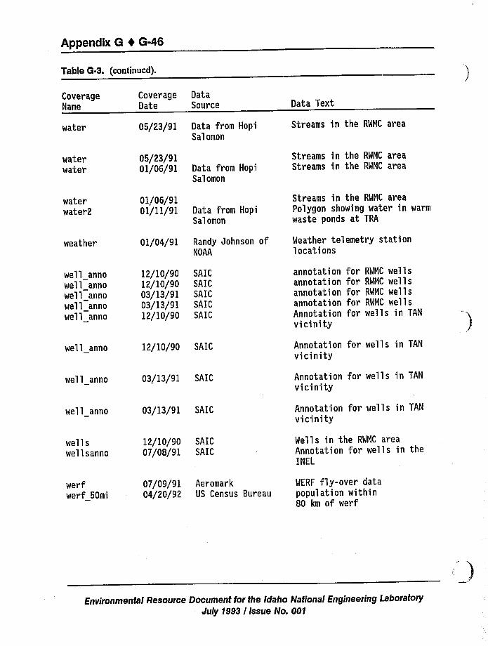
Appendix 6 4 6-46
Table G-3. (continued).
CoverageName
water
waterwater
Coverage DataDate Source
05/23/91 Data from HopiSalomon
05/23/9101/06/91 Data from Hopi
Salomon
Data Text
Streams in the RWMC area
Streams in the RWMC areaStreams in the RWMC area
waterwater2
weather
well annowell annowell annowell annowell anno
01/06/9101/11/91
01/04/91
12/10/9012/10/9003/13/9103/13/9112/10/90
Data from HopiSalomon
Randy Johnson ofNOAA
SAICSAICSAICSAICSAIC
Streams in the RWMC areaPolygon showing water in warm
waste ponds at TRA
Weather telemetry stationlocations
annotation for RWMC wel lsannotation for RWMC wellsannotation for RWMC wellsannotation for RWMC wellsAnnotation for wells in TAN
vicinity
well anno
well anno
well anno
wellswellsanno
12/10/90 SAIC
03/13/91 SAIC
03/13/91 SAIC
12/10/90 SAIC07/08/91 SAIC
Annotation for wells in TAN
vicinity
Annotation for wells in TAN
vicinity
Annotation for wells in TAN
vicinity
Wells in the RWMC areaAnnotation for wells in theINEL
werfwerf 50mi
07/09/9104/20/92
AeromarkUS Census Bureau
WERF fly-over datapopulation within80 km of werf
Environmental Resource Document for the Idaho National Engineering LaboratoryJuly 1993 / issue No. 001
Appendix H
Appendix H
Data Deficiencies and Needs
Albert L Bowman
John S. Inring
Environmental Resource Document for the Idaho National Engineering LaboratoryJuly 1993 / Issue No. 001
Appendix H 4 H-iii
CONTENTS
ACRONYMS
H.1 Data Deficiencies and Needs
H-iv
H-1
H.2 Proposals and Corresponding Categories and Priority Rankings H-10
TABLES
H-1. Land resources H-2
H-2. Water resources H-4
H-3. Ecological resources H-6
H-4. Socioeconomic resources, demography, and land use
H-5. Cultural resources
H-6. Air resources
H-7
H-8
H-9
H-7. Priority rankings H-11
Environmental Resource Document for the Idaho National Engineering LaboratoryJuly 1993 / Issue No. 001
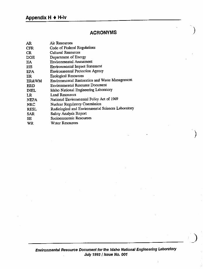
Appendix k 0 k-iv
ACRONYMS
ARCFRCRDOEEAEISEPAERER&WMERDINELLRNEPANRCRESLSARSEWR
Air ResourcesCode of Federal RegulationsCultural ResourcesDepartment of EnergyEnvironmental Assessment
Environmental Impact Statement
Environmental Protection AgencyEcological ResourcesEnvironmental Restoration and Waste Management
Environmental Resource DocumentIdaho National Engineering LaboratoryLand ResourcesNational Environmental Policy Act of 1969Nuclear Regulatory Commission
Radiological and Environmental Sciences LaboratorySafety Analysis ReportSocioeconomic ResourcesWater Resources
Environmenta/ Resource Document for the Idaho National Engineering LaboratoryJuly $993 / issue No. 001
Appendix H 4 H-1
Appendix H
Data Deficiencies and Needs
H.1 Data Deficiencies and Needs
The following tables have been prepared to provide a better understanding of the INELenvironmental resources data deficiencies. These data could be useful in addressing impacts
during environmental assessment on the INEL. Data needs have been identiTied using severalsources of information. Many of the needs are based on regulatory compliance (i.e., needed tocomply with Federal, state, or local laws and statues. Sources include:
~ Data Deficiencies Document
~ Review comments from Ecology and Environment, Inc. on the Data DeficienciesDocument
~ Review comments on the draft Environmental Resource Document
Rules and Regulations of the U.S. Department of Energy, the U.S. Environmental
Protection Agency, and the State of Idaho.
Each data deficiency has been numbered according to discipline (i.e., Land Resources, LR-1or Ecological Resources, ER-5). It is expected that this list will change as new needs areidentified and as data are gathered to satisfy identified needs. A computerized database will bekept current. Tables H-1 through H-6 describe the data deficiencies and needs and thejustification for each of the following: land resources; water resources; ecological resources;socioeconomic resources, demography, and land use; cultural resources; and air resources.
Environmental Resource Document for the Idaho National Engineering LaboratoryJuly 1993 / Issue No. 001
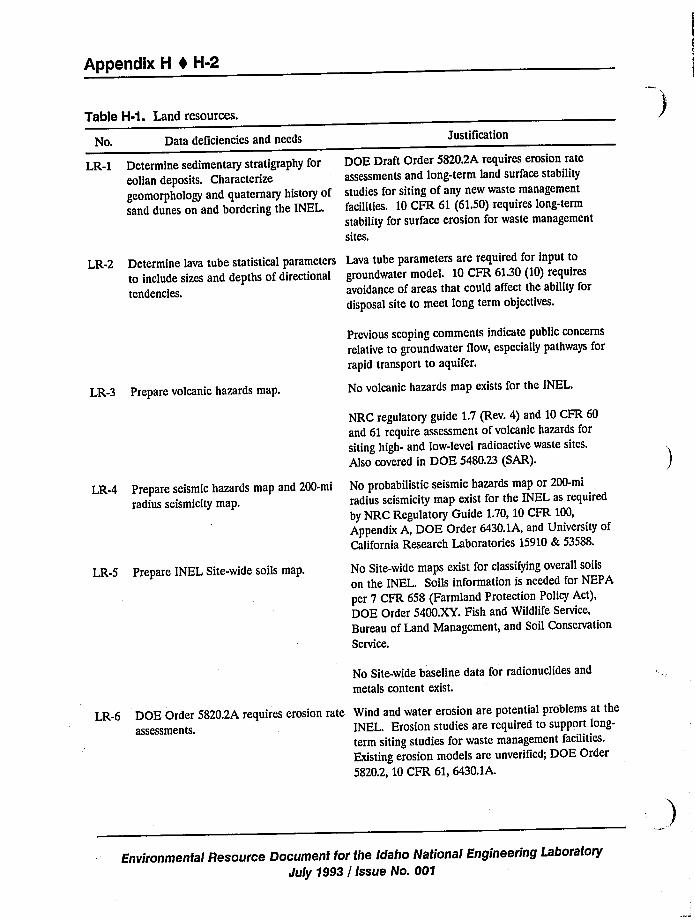
Appendix H 4 H-2
Table H-1. Land resources.
No. Data deficiencies and needs Justification
LR-1 Determine sedimentary stratigraphy foreolian deposits. Characterize
geomorphology and quaternary history ofsand dunes on and bordering the INEL.
DOE Draft Order 5820.2A requires erosion rateassessments and long-term land surface stability
studies for siting of any new waste management
facilities. 10 CFR 61 (61.50) requires long-term
stability for surface erosion for waste management
sites.
LR-2 Determine lava tube statistical parametersto include sizes and depths of directionaltendencies.
Lava tube parameters are required for input togroundwater model. 10 CFR 61.30(10) requiresavoidance of areas that could affect the ability fordisposal site to meet long term objectives.
LR-3 Prepare volcanic hazards map.
Previous scoping comments indicate public concernsrelative to groundwater flow, especially pathways forrapid transport to aquifer.
No volcanic hazards map exists for the INEL.
LR-4 Prepare seismic hazards map and 200-miradius seismicity map.
NRC regulatory guide 1.7 (Rev. 4) and 10 CFR 60and 61 require assessment of volcanic hazards forsiting high- and low-level radioactive waste sites,
Also covered in DOE 5480.23 (SAR).
No probabilistic seismic hazards map or 200-miradius seismicity map exist for the INEL as required
by NRC Regulatory Guide 1.70, 10 CFR 100,Appendix A, DOE Order 6430.1A, and University ofCalifornia Research Laboratories 15910& 53588.
LR-5 Prepare INEL Site-wide soils map. No Site-wide maps exist for classifying overall soils
on the INEL. Soils information is needed for NEPA
per 7 CFR 658 (Farmland Protection Policy Act),DOE Order 5400.XY. Fish and Wildlife Service,Bureau of Land Management, and Soil Conservation
Service.
No Site-wide baseline data for radionuclides and
metals content exist.
LR-6 DOE Order 5820.2A requires erosion rateassessments.
Wind and water erosion are potential problems at theINEL. Erosion studies are required to support long-
term siting studies for waste management facilities.
Existing erosion models are unverified; DOE Order
5820.2, 10 CFR 61, 6430.1A.
Environmental Resource Document for the Idaho National Engineering LaboratoryJuly 1993 / Issue No. 001
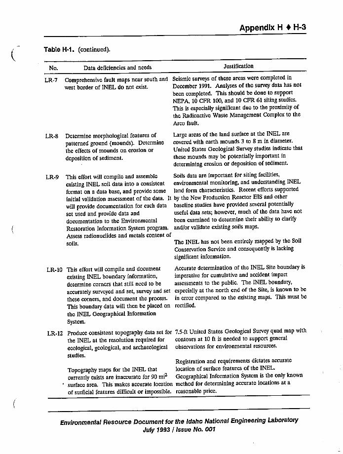
Appendix H 4 H-3
Table H-1. (continued).
No.
LR-7
LR-8
LR-9
LR-10
LR-12
Data deficiencies and needs
Comprehensive fault maps near south and
west border of INEL do not exist.
Determine morphological features ofpatterned ground (mounds). Determinethe effects of mounds on erosion ordeposition of sediment.
This effort will compile and assemble
existing INEL soil data into a consistent
format on a data base, and provide some
initial validation assessment of the data. Itwill provide documentation for each data
set used and provide data and
documentation to the Environmental
Restoration Information System program.Assess radionuclides and metals content ofsoils.
This effort will compile and document
existing INEL boundary information,
determine corners that still need to beaccurately surveyed and set, survey and set
these corners, and document the process.This boundary data will then be placed onthe INEL Geographical Information
System.
Produce consistent topography data set forthe INEL at the resolution required for
ecological, geological, and archaeologicalstudies.
Topography maps for the INEL that
currently exists are inaccurate for 90 mi2
surface area. This makes accurate locationof surficial features difficult or impossible.
Justification
Seismic surveys of these areas were completed in
December 1991. Analyses of the survey data has notbeen completed. This should be done to supportNEPA, 10 CFR 100, and 10 CFR 61 siting studies.
This is especially signiTicant due to the proximity ofthe Radioactive Waste Management Complex to the
Arco fault.
Large areas of the land surface at the INEL arecovered with earth mounds 3 to 8 m in diameter.
United States Geological Survey studies indicate that
these mounds may be potentially important in
determining erosion or deposition of sediment.
Soils data are important for siting facilities,
environmental monitoring, and understanding INELland form characteristics. Recent efforts supported
by the New Production Reactor EIS and otherbaseline studies have provided several potentially
useful data sets; however, much of the data have notbeen examined to determine their ability to clarify
and/or validate existing soiis maps.
The INEL has not been entirely mapped by the SoilConservation Service and consequently is lacking
significant information.
Accurate determination of the INEL Site boundary is
imperative for cumulative and accident impact
assessments to the public. The INEL boundary,
especially at the north end of the Site, is known to bein error compared to the existing maps. This must berectified.
7.5-ft United States Geological Survey quad map with
contours at 10 ft is needed to support general
observations for environmental resources.
Registration and requirements dictates accurate
location of surface features of the INEL.Geographical Information System is the only known
method for determining accurate locations at a
reasonable price.
Environmental Resource Document for the Idaho National Engineering LaboratoryJuly 1993 / Issue No. M1
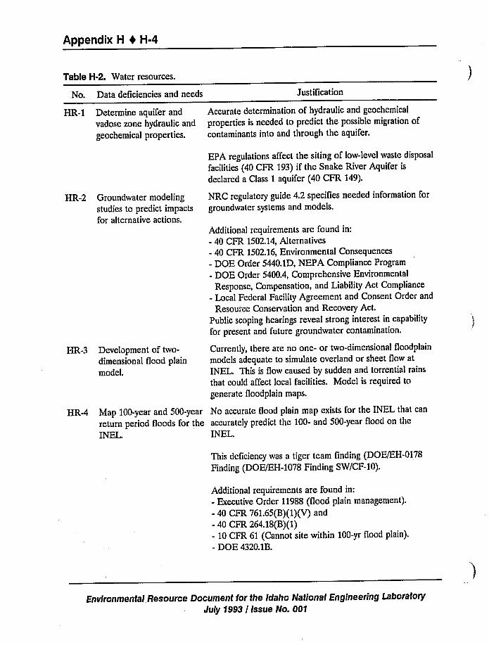
Appendix H 1 H-4
Table H-2. Water resources.
No. Data deficiencies and needs JustiTication
HR-1 Determine aquifer and
vadose zone hydraulic and
geochemical properties.
Accurate determination of hydraulic and geochemical
properties is needed to predict the possible migration ofcontaminants into and through the aquifer.
HR-2 Groundwater modelingstudies to predict impacts
for alternative actions.
HR-3 Development of two-
dimensional flood plainmodel.
EPA regulations affect the siting of low-level waste disposalfacilities (40 CFR 193) if the Snake River Aquifer is
declared a Class 1 aquifer (40 CFR 149).
NRC regulatory guide 4.2 speciTies needed information forgroundwater systems and models.
Additional requirements are found in:- 40 CFR 1502.14, Alternatives- 40 CFR 1502.16,Environmental Consequences- DOE Order 5440.1D, NEPA Compliance Program- DOE Order 5400.4, Comprehensive Environmental
Response, Compensation, and Liability Act Compliance- Local Federal Facility Agreement and Consent Order and
Resource Conservation and Recovery Act.Public scoping hearings reveal strong interest in capability
for present and future groundwater contamination.
Currently, there are no one- or two-dimensional floodplain
models adequate to simulate overland or sheet flow atINEL. This is flow caused by sudden and torrential rains
that could affect local facilities. Model is required togenerate floodplain maps.
HR-4 Map 100-year and 500-year No accurate flood plain map exists for the INEL that canreturn period floods for the accurately predict the 100- and 500-year flood on theINEL. INEL.
This deficiency was a tiger team finding (DOE/EH-0178Finding (DOE/EH-1078 Finding SW/CF-10).
Additional requirements are found in:- Executive Order 11988 (flood plain management).- 40 CFR 761.65(B)(1)(V)and- 40 CFR 264.18(B)(1)- 10 CFR 61 (Cannot site within 100-yr fiood plain).- DOE 4320.1B.
Environmental Resource Document for the Idaho National Engineering LaboratoryJuly 1993 / Issue No. 001
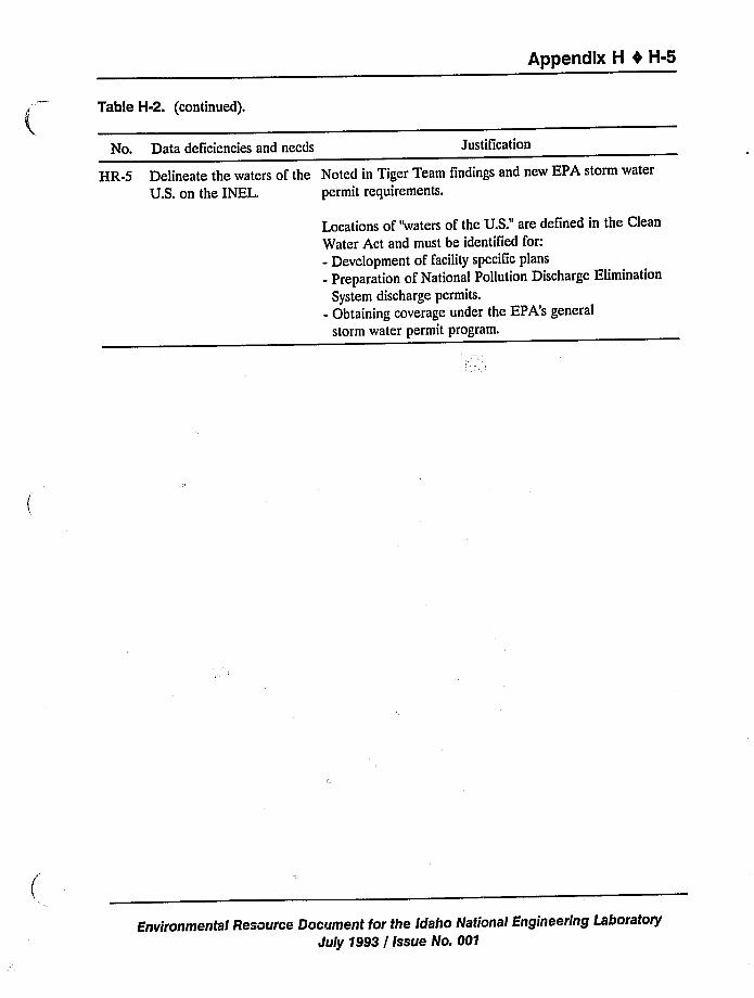
Appendix H 0 H-5
Table H-2. (continued).
No. Data deficiencies and needs Justification
HR-5 Delineate the waters of the Noted in Tiger Team findings and new EPA storm waterU.S. on the INEL. permit requirements.
Locations of "waters of the U.S."are defined in the CleanWater Act and must be identified for:- Development of facility specific plans- Preparation of National Pollution Discharge Elimination
System discharge permits.- Obtaining coverage under the EPA's general
storm water permit program.
Environmental Resource Document for the Idaho Nationa/ Engineering LatioratoryJuly 1993 / Issue No. 001
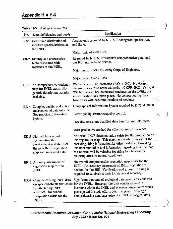
Appendix H I H-6
Table H-3. Ecological resources.
No. Data deficiencies and needs Justification
ER-1
ER-2
ER-3
ER-4
ER-5
ER-6
ER-7
Determine distribution ofsensitive species/habitats atthe INEL.
Identify and characterizebiota associated with
wetlands at the INEL.
No comprehensive wetlands
map for INEL exists. No
generic description material
available.
Compile, qualify, and enterenvironmental data into theGeographical Information
System.
This will be a reportdocumenting thedevelopment and status ofthe new INEL vegetation
map and associated data.
Accuracy assessment ofvegetation map for theINEL.
Compile existing INEL data
on species/habitats that could
be affected by INELactivities. No overall
compilation exists for theINEL.
Assessments required by NEPA, Endangered Species Act,and State.
Major topic of most EISs.
Required by NEPA, Presidents's comprehensive plan, and
the Fish and Wildlife Service.
Major concern for U.S. Army Corps of Engineers.
Major topic of most EISs.
Wetlands are to be protected (E.O. 11990). Nowaste'isposal
sites are to harm wetlands. 10 CFR 1022. '!sh .":;nd
Wildlife Service has delineated wetlands on the 'NEL; bnt
no verification has taken place. No comprehensive database exists with accurate locations of wetlands.
Geographical Information System required by DOE 4320.1B
Better quality assurance/quality control.
Provides consistent qualified data base for multiple users.
Most productive method for effective use of resources.
No formal DOE documentation exists for the production ofthis vegetation map. This map has already been useful forproviding siting information for other facilities. Providing
this documentation and information regarding how the mapcan be used will be valuable for siting facilities and/or
restoring areas to natural conditions.
No overall comprehensive vegetation map exists for theINEL. An accuracy assessment of INEL vegetation is
needed for the EIS. Verification and ground truthing is
required to establish a basis for statistical accuracy.
Significant amounts of ecological data have been collectedfor the INEL. However, the data resides at various
locations within the INEL and at several universities which
participated in study efforts over the years. No single
comprehensive data base exists for INEL ecological data.
Environmental Resource Document for the Idaho National Engineering LaboratoryJuly 1993 / Issue No. 001
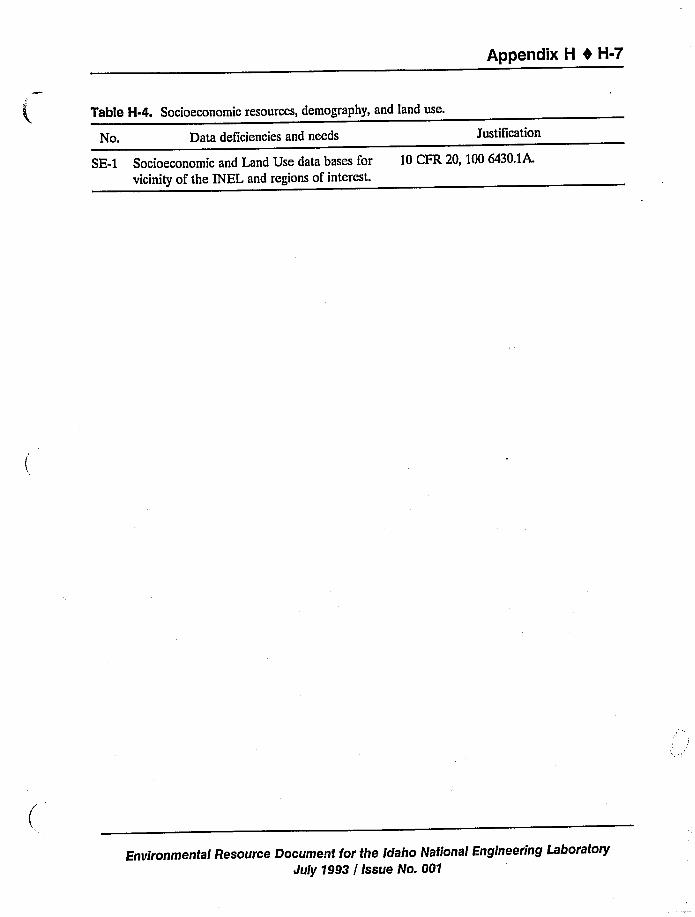
Appendix H 4 H-7
Table H-4. Socioeconomic resources, demography, and land use.
No. Data deficiencies and needs
SE-1 Socioeconomic and Land Use data bases forvicinity of the INEL and regions of interest.
Justification
10 CFR 20, 100 6430.1A.
Environmental Resource Document for the Idaho National Engineering LaboratoryJuly 1993 / Issue No. 001
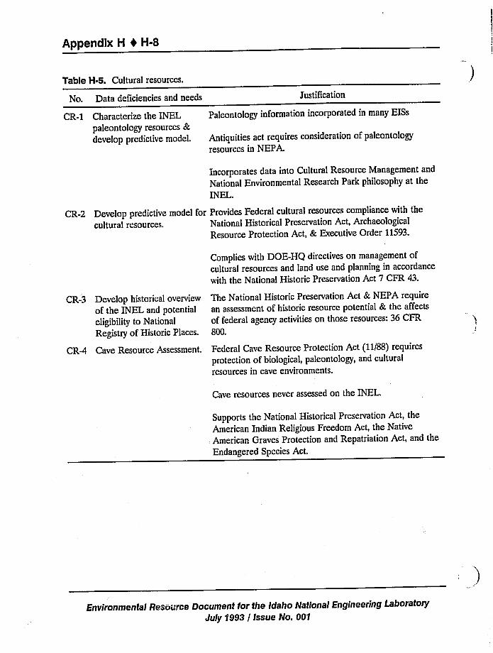
Appendix H b H-8
Table H-5. Cultural resources.
No. Data deficiencies and needs Justification
CR-1 Characterize the INELpaleontology resources &develop predictive model.
Paleontology information incorporated in many EISs
Antiquities act requires consideration of paleontologyresources in NEPA.
Incorporates data into Cultural Resource Management and
National Environmental Research Park philosophy at theINEL
CR-2 Develop predictive model for Provides Federal cultural resources compliance with thecultural resources. National Historical Preservation Act, Archaeological
Resource Protection Act, & Executive Order 11593.
CR-3 Develop historical overview
of the INEL and potential
eligibility to National
Registry of Historic Places.
CR-4 Cave Resource Assessment.
Complies with DOE-HQ directives on management ofcultural resources and land use and planning in accordancewith the National Historic Preservation Act 7 CFR 43.
The National Historic Preservation Act & NEPA requirean assessment of historic resource potential & the affectsof federal agency activities on those resources: 36 CFR800.
Federal Cave Resource Protection Act (11/88) requiresprotection of biological, paleontology, and culturalresources in cave environments.
Cave resources never assessed on the INEL.
Supports the National Historical Preservation Act, theAmerican Indian Religious Freedom Act, the NativeAmerican Graves Protection and Repatriation Act, and theEndangered Species Act.
Environmental Resource Document for the Idaho National Engineering LaboratoryJuly 1993 / Issue No. 001
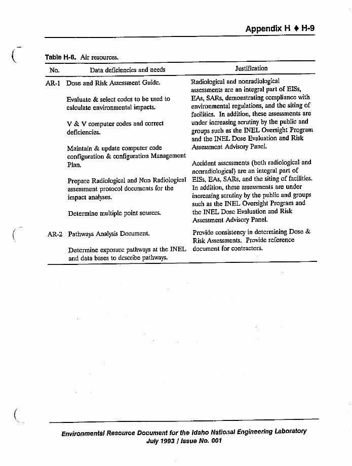
Appendix H 0 H-9
Table H-6. Air resources.
No. Data deficiencies and needs
AR-1 Dose and Risk Assessment Guide.
Evaluate & select codes to be used tocalculate environmental impacts.
V & V computer codes and correctdeficiencies.
Maintain & update computer codeconfiguration & configuration ManagementPlan.
Prepare Radiological and Non Radiologicalassessment protocol documents for theimpact analyses.
Determine multiple point sources.
AR-2 Pathways Analysis Document.
Determine exposure pathways at the INELand data bases to describe pathways.
Justification
Radiological and nonradiologicalassessments are an integral part of EISs,EAs, SARs, demonstrating compliance with
environmental regulations, and the siting offacilities. In addition, these assessments areunder increasing scrutiny by the public and
groups such as the INEL Oversight Programand the INEL Dose Evaluation and RiskAssessment Advisory Panel.
Accident assessments (both radiological and
nonradiological) are an integral part ofEISs, EAs, SARs, and the siting of facilities.In addition, these assessments are under
increasing scrutiny by the public and groupssuch as the INEL Oversight Program and
the INEL Dose Evaluation and RiskAssessment Advisory Panel.
Provide consistency in determining Dose &Risk Assessments. Provide referencedocument for contractors.
Environmental Resource Document for the Idaho National Engineering LaboratoryJuly 1993 / Issue No. 001
Appendix H 0 H-10
H.2 Proposals and Corresponding Categories and Priority Rankings
Proposals have been developed in response to the needs described in the previous tables
(Tables H-1 through H-6). These proposals address the short- and long-term needs of the INEL.Information from most of these proposals will be used to support the ER&WM EIS and otherNEPA-related documents, safety analysis reports, and site selection documents. All proposalsmeet a need described in Tables H-1 through H-6. Proposals have been categorized by thefollowing activities:
ER&WM EIS (short-term)ER&WM EIS (long-term)Other NEPA documents (EAs & EISs)Safety Analysis Reports (SARs)ComplianceSite selection documents
Environmental Resource Document (ERD).
Short-term proposals are considered important for the ER&WM EIS or for mitigative
measures associated with the EIS. These projects should be completed for inclusion in the draftER&WM EIS. Long-term proposals or those satisfying other activities (SARs, compliance, etc.)would provide additional environmental data bases and knowledge of the INEL Site. Proposals
may satisfy several activities (e.g., both ER&WM EIS and SARs). All proposals would provideinformation that could be included in the ERD.
Each proposal, and in some cases, phases of a proposal, have been ranked (la, ib, 1c, 2,or 3) in order of importance to the ER&WM EIS (Table H-7). A ranking of 1a means that theproposal can satisfy a direct need for the Draft ER&WM EIS. Proposals ranked 1a should begiven high priority when and if funds become available for additional INEL environmental
characterization. A ranking of 1b denotes a proposal of potential importance to the ER&WMEIS database, but not as critical. The tasks for 1b proposals could be performed to supportissuance of the Draft or Final EIS. Proposals ranked 1c are tasks that ideally would be performedto support the EIS, but they are not as important to its support as ia and 1b tasks. However, all
proposals ranked la, 1b, and ic should be undertaken in the near future, as soon as funds
become available. Other rankings (2 or 3) are of a long-term nature or of lessor importance.Proposals receiving rankings of 2 or 3 may still address needs that would help, but are not critical,in evaluating impacts in the EIS,
Environmental Resource Document for the Idaho National Engineering LaboratoryJuly 1993 / Issue No. 001
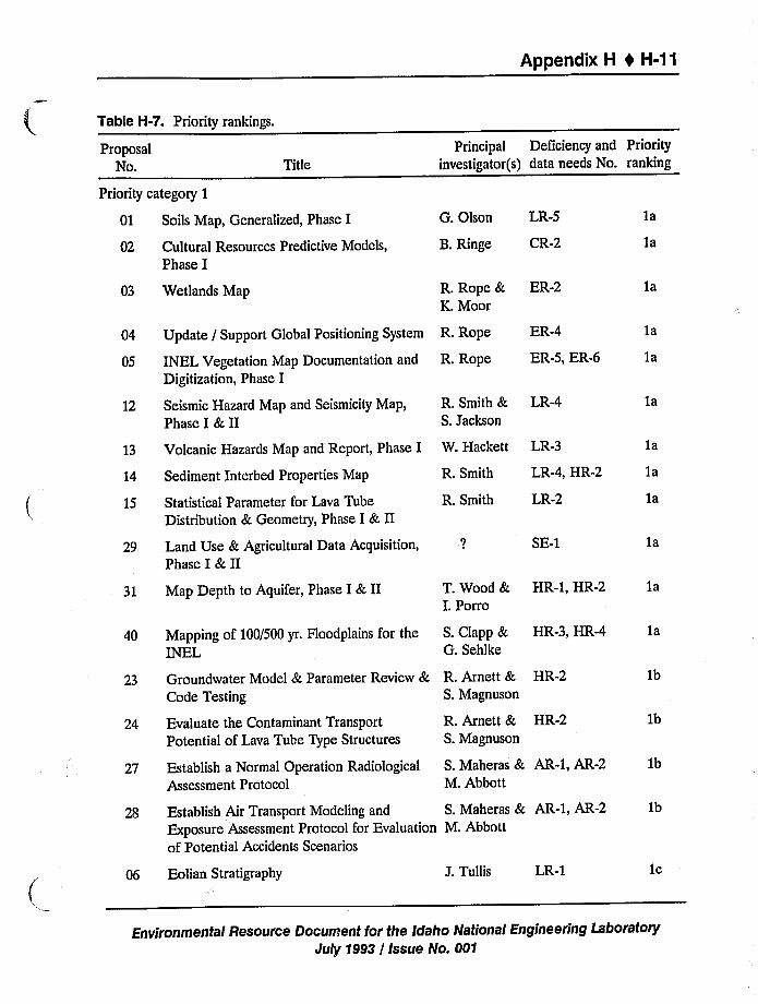
Appendix H 4 H-11
Table H-7. Priority rankings.
ProposalNo.
Priority category 1
TitlePrincipal Deficiency and Priority
investigator(s) data needs No. ranking
01
02
Soils Map, Generalized, Phase I
Cultural Resources Predictive Models,Phase I
G. Olson LR-5
B.Ringe CR-2
1a
ja
03
04
05
12
Wetlands Map
Update / Support Global Positioning System
INEL Vegetation Map Documentation and
Digitization, Phase I
Seismic Hazard Map and Seismicity Map,Phase I & II
R. Rope &K. Moor
R. Rope
R. Rope
R. Smith &S. Jackson
ER-2
ER-4
ER-5, ER-6
LR-4
1a
1a
ja
1a
13 Volcanic Hazards Map and Report, Phase I W. Hackett LR-3 1a
14
15
29
Sediment Interbed Properties Map
Statistical Parameter for Lava TubeDistribution & Geometry, Phase I & II
Land Use & Agricultural Data Acquisition,Phase I & II
R. Smith
R. Smith
LR-4, HR-2
LR-2
SE-1
ja
1a
1a
31
40
Map Depth to Aquifer, Phase I & II
Mapping of 100/500 yr. Floodplains for theINEL
T. Wood &I. Porro
S. Clapp &G. Sehlke
HR-1, HR-2 1a
HR-3, HR-4 1a
23
24
Groundwater Model & Parameter Review &Code Testing
Evaluate the Contaminant TransportPotential of Lava Tube Type Structures
R. Arnett & HR-2S. Magnuson
R. Arnett & HR-2S. Magnuson
1b
1b
27
28
Establish a Normal Operation RadiologicalAssessment Protocol
Establish Air Transport Modeling and
Exposure Assessment Protocol for Evaluationof Potential Accidents Scenarios
S. Maheras & AR-1, AR-2 1bM. Abbott
S. Maheras & AR-1, AR-2 1bM. Abbott
Eolian Stratigraphy J. Tullis LR-1 1c
Environmental Resource Document for the Idaho National Engineering LaboratoryJuly 1993 / Issue No. 001
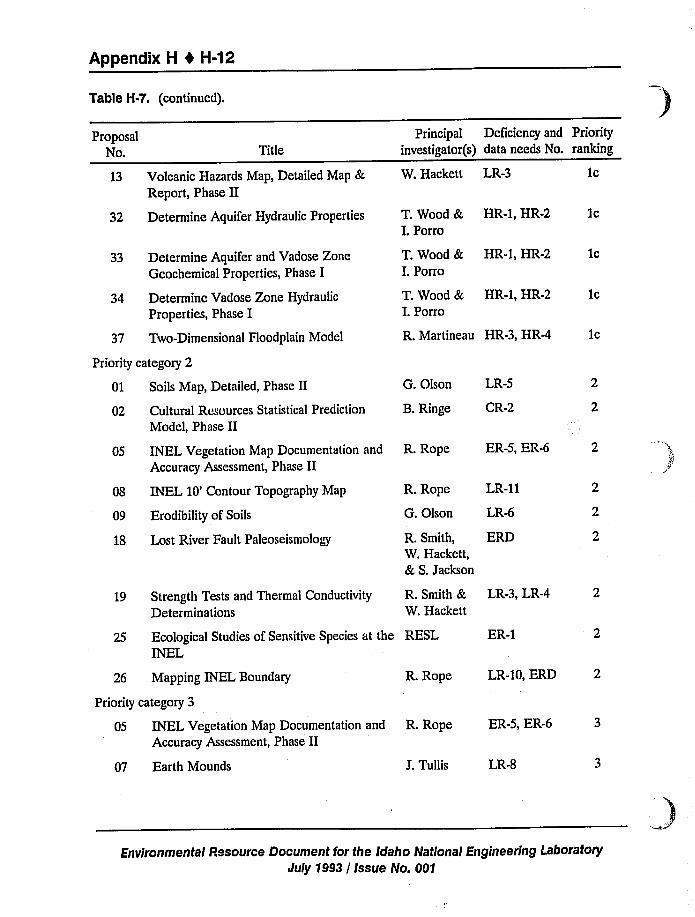
Appendix H 1 H-12
Table H-7. {continued).
ProposalNo. Title
Principal Deficiency and Priorityinvestigator(s) data needs No. ranking
13 Volcanic Hazards Map, Detailed Map &Report, Phase II
W. Hackett LR-3 1c
32 Determine Aquifer Hydraulic Properties
33 Determine Aquifer and Vadose ZoneGeochemical Properties, Phase I
34 Determine Vadose Zone Hydraulic
Properties, Phase I
T. Wood &I. Porro
T. Wood &I. Porro
T. Wood &I. Porro
HR-1, HR-2
HR-1, HR-2
HR-1, HR-2
1c
1c
1c
37 Two-Dimensional Hoodplain Model
Priority category 2
01 Soils Map, Detailed, Phase II
02 Cultural Resources Statistical PredictionModel, Phase II
R. Martineau HR-3, HR-4
G. Olson LR-5
B. Ringe CR-2
1c
05 INEL Vegetation Map Documentation and
Accuracy Assessment, Phase II
08 INEL 10'ontour Topography Map
09 Erodibility of Soils
18 Lost River Fault Paleoseismology
R. Rope
G. Olson
LR-11
LR-6
R. Smith, ERDW. Hackett,& S. Jackson
R. Rope ER-5, ER-6 2
19 Strength Tests and Thermal Conductivity
DeterminationsR. Smith &W. Hackett
LR-3, LR-4 2
25 Ecological Studies of Sensitive Species at the RESLINEL
ER-1
26 Mapping INEL Boundary
Priority category 3
R. Rope LR-IO, ERD 2
05 INEL Vegetation Map Documentation andAccuracy Assessment, Phase II
R. Rope ER-5, ER-6 3
07 Earth Mounds J. Tullis LR-8
Environmental Pesource Document for the Idaho Nationai Engineering Laborato<July 1993 / Issue No. 001
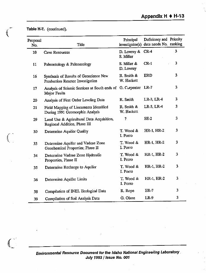
Appendix H 4 H-43
Table H-7.. (continued).
ProposalNo.
10 Cave Resources
Principal Deficiency and Priority
investigator(s) data needs No. ranking
D. Lowrey & CR-4S. Miller
11 Paleontology & Paleoecology
16 Synthesis of Results of Geoscience New
Production Reactor Investigation
S. Miller &D. Lowrey
R. Smith &W. Hackett
CR-1
ERD
17 Analysis of Seismic Sections at South ends of G. Carpenter LR-7Major Faults
20 Analysis of First Order Leveling Data
21 Field Mapping of Lineaments Identified
During 1991 Geomorphic Analysis
29 Land Use & Agricultural Data Acquisition,
Regional Addition, Phase III
30 Determine Aquifer Quality
33 Determine Aquifer and Vadose ZoneGeochemical Properties; Phase II
34 Determine Vadose Zone Hydraulic
Properties, Phase II
35 Determine Recharge to Aquifer
36 Determine Aquifer Limits
38 Compilation of INEL Ecological Data
39 Compilation of Soil Analysis Data
R. Smith
R. Smith &W. Hackett
T. Wood &I. Porro
T. Wood &I. Porro
T. Wood &I. Porro
T. Wood &I. Porro
T. Wood &I. Porro
R. Rope
G. Olson
LR-3, LR-4
LR-3, LR-4
SE-2
HR-1, HR-2
HR-1, HR-2
HR-1, HR-2
HR-1, HR-2
HR-1, HR-2
ER-7
LR-9
Environmental Resource Document for the Idaho National Engineering LaboratoryJuly 1993 / Issue No. 001
(I'U
ty
I I i
~
/
/
~. ~@~i)
Il
I
Ci 9
/
Related Documents