1 Unit - I Geography Our Environment

Welcome message from author
This document is posted to help you gain knowledge. Please leave a comment to let me know what you think about it! Share it to your friends and learn new things together.
Transcript
1
Unit - I Geography
Our Environment
2
Our Environment
In this part of the book, the study of environment on the whole i.e.
the natural and human environment has been included according to
the mental level of the students. Four spheres of environment
namely, Lithosphere, Hydrosphere, Atmosphere and Biosphere have
been discussed in this part.
Under the study of Lithosphere, the internal and external part of
the earth has been explained. While discussing the internal part of
the earth, internal layers and movement of the earth has been
discussed. The endogenic forces due to which earthquake and
tsunami occur, have also been discussed in brief. The external
forces pertaining to the changing face of the earth have also been
discussed. As a result of these, landforms like mountains, plateaus,
lakes and planes have been formed on the earth.
Study of Hydrosphere includes knowledge about the oceans of
the world and ocean currents with their effects. Similarly the study
of Atmosphere includes the knowledge about its layers and elements
of climate. It also includes the knowledge about different climatic
zones, which are the result of variation in elements of climate. The
environmental pollution problems have also been discussed so that
the students may get awakened accordingly.
While discussing fourth sphere, the Biosphere which is due to
the interaction of other three spheres, the study of different types of
vegetation and wild life of the world on the bases of land and climate
on the earth has been made. The students have been enlightened
about the need of conservation and preservation of wild life and
natural vegetation through this section.
The human environment includes the brief study of development
of human settlements, means of transport and communication in
India and the world as well.
A study of some of the natural regions which have been evolved
by the interaction of natural and human environment has also been
included.
Subject Expert (Geography)
3
Environment means the surroundings and the countless natural forces
causing a variety of phenomena on the earth surface, due to which there
is a variation in the environment of each place. Thus the relationship of
man with his surroundings is not the same everywhere. It is due to the
difference of relief, temperature and rainfall that there is difference in
vegetation and agriculture. All these factors affect human occupations.
The form of earth's surface determines human response. People living on
the main land pursue agriculture, grazing or lumbering while people living
near the sea and on island engage in fishing. On the basis of land, water
and climate, a particular type of living kingdom of fauna (living beings)
and flora takes shape. Like human beings, plants and animals are also
products of their surroundings. Whole of this specturum & process is
called Habitat.
Although the areas near the equator are known for their dense forests.
While there is only grass in the interiors of dry regions. The polar areas of
the earth which remain covered with snow throughout the year, are devoid
of population and forests. It is the land, water, air and solar energy that
help to grow a variety of living organisms. Life is possible only there,
where all these agents interact with each other. This interacting sphere
is known as ‘Biosphere’. The Biosphere and the physical surroundings
of the place collectively are called, 'Ecology'.
The Changing Environment
The environment has always been changing on the surface of the
Earth. Because of the change in the elements of environment, these
changes occur both slowly as well as suddenly. The slow changes occur
through degradation process of the earth i.e. through the erosional agents
lake, river, glacier, wind, ocean, weathering etc. The sudden or abrupt
Lesson
1 Environment

4
changes occur through the upheavel, result in folding and faulting of the
earth surface. Similarly the earth has also been changed from gaseous to
molten state. After cooling it has changed into solid form. This change
occured very slowly. The gaseous element formed as atmosphere, water
elements are denoted by oceans and solid element formed as Lithosphere.
Human beings have also brought a big change on the surface of the
earth by cutting trees and developing it for his own needs such as cities
etc. By mounding the rivers and digging the canals, water is being utilized
for irrigational purposes. In this way the deserts have been changed into
green lands. By doing so ecology of the place has been changed altogether.
Now, the Thar desert of India is no more a dry barren land. Same level of
change happened in the other river valleys of the world, like in Indus
Valley, Nile valley, Hwang-He-Valley and so on. Man has also brought
changes on the earth surface by exploiting minerals and developing
industries. It shows that there is great relation between physical and
human elements. The existing civilization is the result of systematic &
continuous co-ordination of the physical and human elements.
Elements of environment : To understand total environment, there
is need to have more knowledge about three spheres of the earth i.e.
Atmosphere, Lithosphere and Hydrosphere. We will study about these
three spheres in detail in further lessons of the book. You have already
studied in brief about these spheres in the previous class.
Major Spheres of the Environment
Atmosphere : The earth is enclosed (surrounded) by air and this airy
cover is called Atmosphere. Every planet except mercury and satellites of
the solar system, are enclosed by the cover of air. Although this air cover
extends upto 1600km around the earth still 99% of the air is upto 32 km
height only. On the earth’s surface air, land and water are collectively
responsible for creating and maintaining life of plants and animals. The
temperature, humidity atmospheric pressure and other components of
atmosphere affect the physical environment of the earth. Out of the
elements of environment, the atmosphere experiences maximum changes.
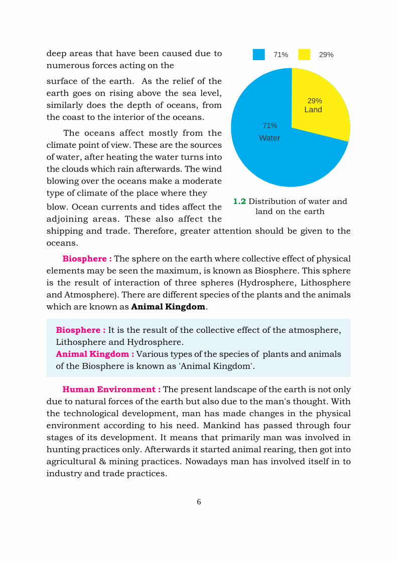
Lithosphere : The surface of the earth is covered both by water and
land. Water covers about 71% and land covers about 29% of the earth

5
surface. Two third of the total land area lies in Northern Hemisphere. The
Earth's exterior thickness is approximately 80-100 km. This solid thickness
of the earth’s crust is not uniform every where. It is more on the land
masses and less below the ocean beds. The crust of the earth is made up
of different types of rocks. The earth as a whole towards its interior consists
of three shells. Lithosphere, Mantle and the Core. The uppermost layer or
shell is called SIAL because it mainly consists of Silicon and Aluminium
and known as ; SIAL (SI+AL), where SI stands for Silicon and AL for
Aluminium, that is why it is called as SIAL. The second layer is called
SIMA, it consists of Silicon and Magnesium, SIMA (SI+MA), while SI for
Silicon and MA for Magnesium. The third and the inner most layer is
called NiFe, which consists of Nickel and Ferrous i.e. NiFe (Ni + Fe) where
Ni is for Nickel, Fe is for Ferrous (iron elements). This inner most layer is
in viscous form of the above metals.
Hydrosphere : The water covered region on the surface of earth is
called Hydrosphere. It covers vast areas in the form of oceans, bays,
gulfs and seas. The earth is called watery planet because 71% of the
earth is covered with water. There are water bodies i.e. five oceans,
numerous seas, rivers and lakes on the earth. The water areas are the
1.1 The spheres of environment
6
deep areas that have been caused due to
numerous forces acting on the
surface of the earth. As the relief of the
earth goes on rising above the sea level,
similarly does the depth of oceans, from
the coast to the interior of the oceans.
The oceans affect mostly from the
climate point of view. These are the sources
of water, after heating the water turns into
the clouds which rain afterwards. The wind
blowing over the oceans make a moderate
type of climate of the place where they
blow. Ocean currents and tides affect the
adjoining areas. These also affect the
shipping and trade. Therefore, greater attention should be given to the
oceans.
Biosphere : The sphere on the earth where collective effect of physical
elements may be seen the maximum, is known as Biosphere. This sphere
is the result of interaction of three spheres (Hydrosphere, Lithosphere
and Atmosphere). There are different species of the plants and the animals
which are known as Animal Kingdom.
Biosphere : It is the result of the collective effect of the atmosphere,
Lithosphere and Hydrosphere.
Animal Kingdom : Various types of the species of plants and animals
of the Biosphere is known as 'Animal Kingdom'.
Human Environment : The present landscape of the earth is not only
due to natural forces of the earth but also due to the man's thought. With
the technological development, man has made changes in the physical
environment according to his need. Mankind has passed through four
stages of its development. It means that primarily man was involved in
hunting practices only. Afterwards it started animal rearing, then got into
agricultural & mining practices. Nowadays man has involved itself in to
industry and trade practices.
1.2 Distribution of water and
land on the earth
71%
Water
Land
29%
71%
29%

7
By clearing the dense equitorial type of forest, man has planted rubber
producing trees, with the development of means of transportation,
agricultural products like Potato, Maize, Cotton, Sugarcane, Tea, Coffee
are being cultivated and traded even to far off areas. Now the world is
known as a 'Global Market'. It means if the production of any item is in
plenty at one place, the consumer market can be established at that place
easily. Similarly, with the import of good seeds and breeds, improvements
have been made in quality of various products.
Man had made tunnels across the mountains, shipping through man
made canals namely Panama & Suez, diverting the river water for
irrigational purposes, exploiting the minerals, and establishing the
industrial centres are examples which show that to some extent, man has
controlled the natural forces of the earth according to his own requirements.
Such attempts have made the world Global Village. It means, man has got
skills developed to use resources according to his needs.
Points to Remember
1. Environment means surroundings of the Earth which includes
constituents of relief and weather.
2. Costituents of Environment may be divided in four spheres i.e.
Atmosphere, Lithosphere, Hydrosphere and Biosphere.
3. The world is looked upon as ‘Global Village’ as man has collectively
moulded natural power to its service.
EXERCISE
I. Give answer to the following questions approximately in 1-15
words
1. What do you understand by environment ?
2. Which are the main spheres of environment ?
3. How do man affects environment ?
4. Write down the names of layers of the earth.

8
II. Fill in the blanks
i. Environment has been divided in ________ spheres.
ii. The SIAL layer of the earth is made up of the material which is
rich in _______ and _________.
iii. NiFe is made up of the material which is rich in _______ and
______ elements.
iv. The different types of species of animals is known as ________.
v. ________ portion of Earth has been covered by hydrosphere.
Activity
Make a list of factors which has effect over environment.
•••
9
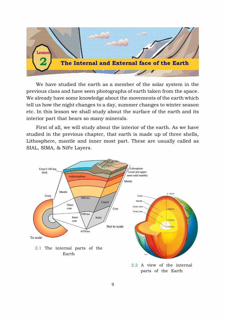
We have studied the earth as a member of the solar system in the
previous class and have seen photographs of earth taken from the space.
We already have some knowledge about the movements of the earth which
tell us how the night changes to a day, summer changes to winter season
etc. In this lesson we shall study about the surface of the earth and its
interior part that bears so many minerals.
First of all, we will study about the interior of the earth. As we have
studied in the previous chapter, that earth is made up of three shells,
Lithosphere, mantle and inner most part. These are usually called as
SIAL, SIMA, & NiFe Layers.
2.1 The internal parts of the
Earth
2.2 A view of the internal
parts of the Earth
Lesson
2 The Internal and External face of the Earth

10
Lithosphere : It is the rigid part of the earth’s crust that is called as
SIAL. The thickness of this part is about 100 km. This Layer contains
mainly the elements, like, Silicon and Aluminium. That is why this layer
is known as SIAL. SIAL means the synthesis of (SIAL) SI=Silicon, AL=
Aluminium. The thickness of the earth’s crust over ocean is 4 to 7 km.
On the continent part of the earth, thickness is 35 km while On the
mountains this layer is 70 kilometers thick. This is the upper most layer
of the earth and consists of rocks and soil.
Mantle : Below the upper layers of earth is Mantle. The average
thickness of this is 2900 km. It means it is 2900 km deep into the earth.
The thickness of this Layer is not the same at all the places. This is again
divided into two parts. The upper Mantle and the lower Mantle. The
upper Mantle is 100 km deep into the earth. The Mantle is also known as
SIMA. This layer of the earth is mainly made up of Silicon and Magnesium,
that is why it is called SIMA. For example, SIMA is synthesis of two words,
Silicon and Magnesium SIMA, where SI stands for Silicon while MA stands
for Magnesium. Therefore, SI+MA=SIMA.
The Core : The innermost part of the earth is called 'Core'. The
thickness of this part is approximately upto 3470 km. This is also divided
into two sub parts i.e. Outer core, and Inner core. The core known as
NiFe, mainly consists of two elements Nickel & Ferrous. As the NiFe is
the synthesis of two words, Nickle & Ferrous. While Ni stands for Nickle
and Fe stands for Ferrous. These elements are in molten and viscous
state.
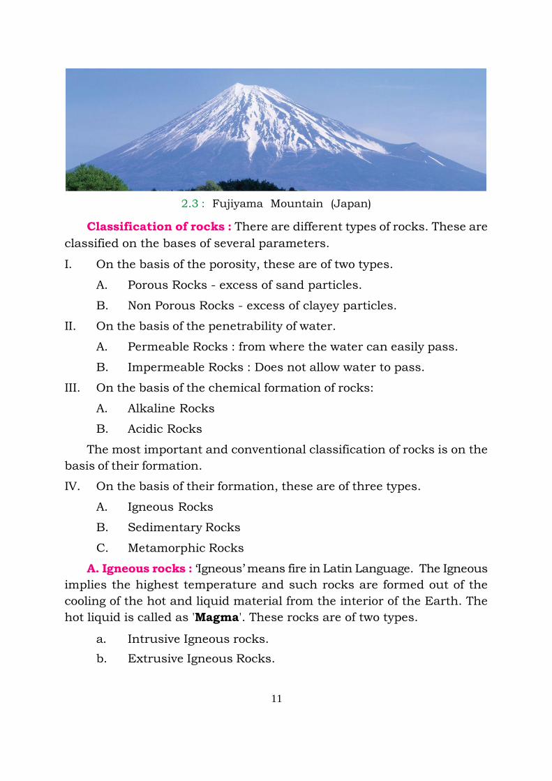
When we go deep into the Earth, the temperatures of the inner layers
more than upper layers. Due to this heat of the Earth’s surface earth
ruptures and rifts. Through this ruptured surface, the molten material
from the inner side of the earth, comes out in the form of lava. When this
happens on the ocean shelves, a new layer is formed after cooling. But
when it erupts on the surface of the earth it transforms into mountains.
Fujiyama mountains of Japan are the specific example of such volcanic
eruption.
The Earth’s crust is made up of different types of rocks and minerals :
Let us understand the rocks.
11
Classification of rocks : There are different types of rocks. These are
classified on the bases of several parameters.
I. On the basis of the porosity, these are of two types.
A. Porous Rocks - excess of sand particles.
B. Non Porous Rocks - excess of clayey particles.
II. On the basis of the penetrability of water.
A. Permeable Rocks : from where the water can easily pass.
B. Impermeable Rocks : Does not allow water to pass.
III. On the basis of the chemical formation of rocks:
A. Alkaline Rocks
B. Acidic Rocks
The most important and conventional classification of rocks is on the
basis of their formation.
IV. On the basis of their formation, these are of three types.
A. Igneous Rocks
B. Sedimentary Rocks
C. Metamorphic Rocks
A. Igneous rocks : ‘Igneous’ means fire in Latin Language. The Igneous
implies the highest temperature and such rocks are formed out of the
cooling of the hot and liquid material from the interior of the Earth. The
hot liquid is called as 'Magma'. These rocks are of two types.
a. Intrusive Igneous rocks.
b. Extrusive Igneous Rocks.
2.3 : Fujiyama Mountain (Japan)
12
a. Intrusive Igneous rocks. Rocks formed by the cooling of the Magma,
in the interior of the earth are called as Intrusive Rocks. Intrusive
Rocks are of two types:
i. Plutonic Igneous Rocks
ii. Hypabyssal Igneous Rocks
i. Plutonic Igneous Rocks : The igneous rocks formed due to cooling
of the hot magma into hard solid slowly in the deep interior of the
earth. Granite and Gabro are the specific examples of these rocks.
The plateau of Ranchi and rocks of Singhbhum are made up of
Granite rocks.
ii. Hypabyssal Igneous Rocks : Sometimes the internal magma does
not come out on the surface but solidify in the cracks only after
cooling. The rocks thus formed are known as Hypabyssal Igneous
Rocks. i.e. Dike, Silt, Dolerite.
b. Extrusive Igneous Rocks : Where there is large amount of internal
magma accumulated, it starts gushing out of the soft surface. This
magma starts cooling on the surface of the earth. The rocks formed
in such a way are called as Extrusive Igneous rocks. Deccan Plateau
is made out of these volcanic rocks.
All the igneous rocks are found in crystalline form and do not have
layers. These rocks are called primary because these are initial rocks
which formed the earth. Containing no remains of vegetation or living
organisms, these igneous rocks cover 2/3 part of the Earth's crust.
B. Sedimentary rocks : Sedimentary rocks are formed by the hardening
of the layers of the matter brought by agents of denudation (like water, air
and river etc.). This matter when deposited, in the low lands as sediments
turns into rocks. Such deposits occur at low level on the floor of the oceans,
lakes and rivers along the continents. The process of deposition continues
for millions of years to constitute into rocks. As a result of mechanical or
chemical action, it assumes the forms of sedimentary rocks.

13
c. Metamorphic Rocks : The word metamorphic is made up of the
greek rooted word 'Meta', meaning change and 'marph' meaning form.
Therefore this category of rocks include those rocks which have been
transformed. As consequence of the effect of temperature or pressure or
both the igneous rocks as well as sedimentary rocks undergo a change in
their form, structure, hardness and other traits. Rocks so transformed
are known as metamorphic rocks.
Some of the examples of metamorphic rocks are given below :
Original Igneous rock Metamorphic rock
1 Mica Schist
2 Granite Gneiss
3 Bituminous coal Anthracite coal
4 Gabbro Serpentine
Original Sedimentary Rocks Metamorphic Rocks
1 Sand Stone Quartzite
2 Lime stone Marble
3 Shale Slate
4 Slate Phylite
5 Peat Coal
Metamorphic rocks transformed from igneous rocks, have the
characteristics similar to those of igneous rocks and those transformed
from sedimentary rocks resemble the latter.
The upper most Layer of the earth’s surface is made up of the rock
material which is known as soil. Let us study soils.
Soil : Soil is a very important land resource, its significance lies in its
fertility. Infertile soil is not a much use while fertile soil has always been
more important, because of requirements met by it. Human beings have

14
always been keen to live in fertile plains, since their origin. Ancient
civilizations have also developed in fertile river valleys only. Can you name
some river valley related to such ancient civilization ? The fertile soils of
Indus, Nile, Tigris, Euphrates and Yangste, valleys led to the development
of the civilizations. Even today high density of population is found in
fertile river valleys and plains. It is because of its fertile soil that India
has been able to produce food for its huge population.
Formation of soil : According to its definition, soil is that upper part
of the surface which is formed as a result of the disintegeration of rocks.
Soil particles are fine, soft and disintegrated so that roots of the plants
could spread easily. Soil is formed by physical, chemical and organic
actions and changes. The soil formation process is slow and it may take
thousands of years to form a thick upper layer suitable for cultivation.
Besides rock material of the plants and animal wastes add to the fertility
of the soil. This soil consist of two types of matter - one mineral matter
and other is humus. Soil includes a number of minerals, which it obtains
from the parent rock. Decayed organic matter is called humus.
Types of Soils : A variety of soil types is found in the world. Types of
soil can be classified on a number of bases. Main classifications are made
on the bases of their origin, texture and climate. Actually these are the
elements that help in the formation of soil and its fertility. The parent
rock from which the soil has been formed, transfers its characteristics to
the soil.
Rivers, glaciers and winds also play an important role in the soil
formation. Rivers, besides being an important source of water, play an
important role in the soil formation also. World’s fertile alluvial soil is
found, in the rivers valleys and deltas of rivers which is a great resource
for any country. This soil provides food for the major part of the world
population.
You know with the change in climate, vegetation changes and
vegetation type also affect the type of soils. Variation of humus as a result
of change in climate is reflected in the texture of soil. On this basis main
soil types are Tundra Soil, which remains under snow for most of the
time. Podzol Soil of cold and humid area Chernozem or Black Soil of
temperate dry lands, Desert soil of dry Sandy areas, brown forest soil of

15
2.4 Soil in India
Alluvial soil
Red soil
Black soil
Laterite soil
Dry Sandy soil
Hilly soil
Index
Not to scale for Acadmic purposes only.
INDIASOIL
16
deciduous forest area, tropical red Soil etc. Black soil is very fertile. If
water is made available in the desert areas, soil proves quite fertile in
such areas. As a result of the provision of canal water in the Ganga Nagar
area of Rajasthan, this desert land has become one of the fertile tracts of
our country.
The land or soil has been an important source in Steppee of Eurasia,
Prairies of North America and Pampas of Argentina, since they adopted
mechanization of farming at a large scale. The vast grass lands are no
more far cattle grazing ground but nowadays food grain Bowl of the world.
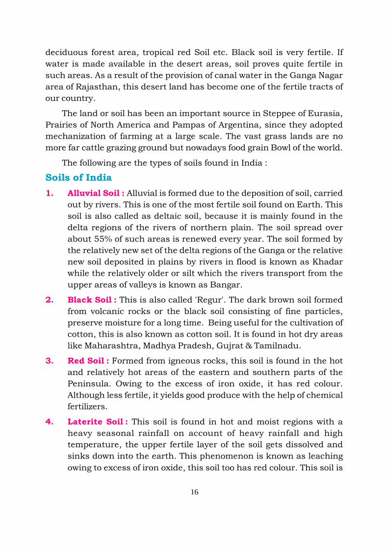
The following are the types of soils found in India :
Soils of India
1. Alluvial Soil : Alluvial is formed due to the deposition of soil, carried
out by rivers. This is one of the most fertile soil found on Earth. This
soil is also called as deltaic soil, because it is mainly found in the
delta regions of the rivers of northern plain. The soil spread over
about 55% of such areas is renewed every year. The soil formed by
the relatively new set of the delta regions of the Ganga or the relative
new soil deposited in plains by rivers in flood is known as Khadar
while the relatively older or silt which the rivers transport from the
upper areas of valleys is known as Bangar.
2. Black Soil : This is also called 'Regur'. The dark brown soil formed
from volcanic rocks or the black soil consisting of fine particles,
preserve moisture for a long time. Being useful for the cultivation of
cotton, this is also known as cotton soil. It is found in hot dry areas
like Maharashtra, Madhya Pradesh, Gujrat & Tamilnadu.
3. Red Soil : Formed from igneous rocks, this soil is found in the hot
and relatively hot areas of the eastern and southern parts of the
Peninsula. Owing to the excess of iron oxide, it has red colour.
Although less fertile, it yields good produce with the help of chemical
fertilizers.
4. Laterite Soil : This soil is found in hot and moist regions with a
heavy seasonal rainfall on account of heavy rainfall and high
temperature, the upper fertile layer of the soil gets dissolved and
sinks down into the earth. This phenomenon is known as leaching
owing to excess of iron oxide, this soil too has red colour. This soil is
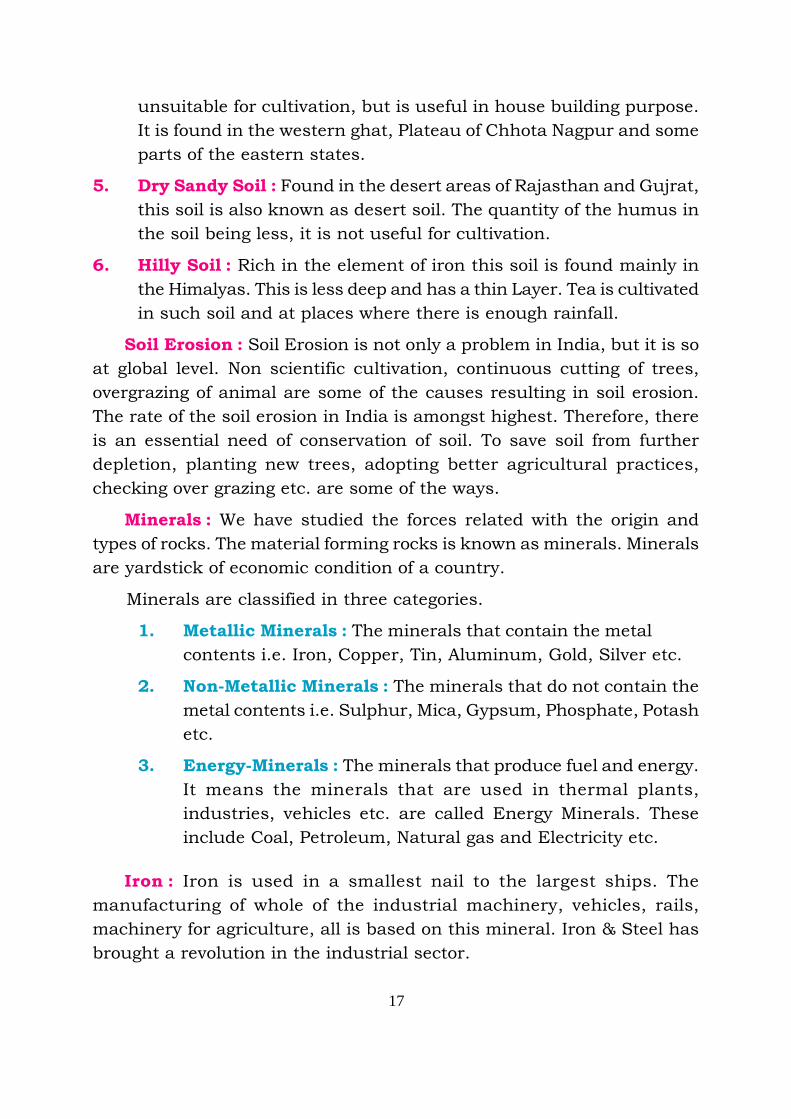
17
unsuitable for cultivation, but is useful in house building purpose.
It is found in the western ghat, Plateau of Chhota Nagpur and some
parts of the eastern states.
5. Dry Sandy Soil : Found in the desert areas of Rajasthan and Gujrat,
this soil is also known as desert soil. The quantity of the humus in
the soil being less, it is not useful for cultivation.
6. Hilly Soil : Rich in the element of iron this soil is found mainly in
the Himalyas. This is less deep and has a thin Layer. Tea is cultivated
in such soil and at places where there is enough rainfall.
Soil Erosion : Soil Erosion is not only a problem in India, but it is so
at global level. Non scientific cultivation, continuous cutting of trees,
overgrazing of animal are some of the causes resulting in soil erosion.
The rate of the soil erosion in India is amongst highest. Therefore, there
is an essential need of conservation of soil. To save soil from further
depletion, planting new trees, adopting better agricultural practices,
checking over grazing etc. are some of the ways.
Minerals : We have studied the forces related with the origin and
types of rocks. The material forming rocks is known as minerals. Minerals
are yardstick of economic condition of a country.
Minerals are classified in three categories.
1. Metallic Minerals : The minerals that contain the metal
contents i.e. Iron, Copper, Tin, Aluminum, Gold, Silver etc.
2. Non-Metallic Minerals : The minerals that do not contain the
metal contents i.e. Sulphur, Mica, Gypsum, Phosphate, Potash
etc.
3. Energy-Minerals : The minerals that produce fuel and energy.
It means the minerals that are used in thermal plants,
industries, vehicles etc. are called Energy Minerals. These
include Coal, Petroleum, Natural gas and Electricity etc.
Iron : Iron is used in a smallest nail to the largest ships. The
manufacturing of whole of the industrial machinery, vehicles, rails,
machinery for agriculture, all is based on this mineral. Iron & Steel has
brought a revolution in the industrial sector.
18
Iron deposits are found in approximately all the continents. In India
it is mainly found in Orissa, Bihar, Madhya Pradesh, Chhattisgarh,
Karnataka and Goa.
Copper : Copper is the first metal known in the human history. Copper
comes next to the iron from industrial point of view. The metal era started
with the use of copper, as utensils of different types are made out of
copper. The importance of copper has increased nowadays. Being good
conductor of heat, this is used in making electric appliances. Besides,
cable wires, it is used in telephone, railway engines, aeroplanes and
watches etc.
In Chile (South America) the production of copper is the highest in
the world and United States of America stands second. Many copper
producing regions lie in Africa while India, Japan, Australia also
produce copper. In India, the deposits of copper are found in the
states of Jharkhand, Madhya Pradesh, Andra Pradesh and Rajasthan.
Bauxite : Aluminium is extracted from bauxite. Aluminium is a light
weight metal which is mainly used in manufacturing of aeroplanes.
Besides, it is used in manufacturing rails, motors, buses, cars and making
electric wires. The goods made out of this metal are used for a long time
because it is a rust free metal. Utensils are also made of this metal.
The extraction of bauxite is highest in Australia in the world. In India,
bauxite is extracted in Maharashtra, Madhya Pradesh, Chhattisgarh
and Jharkhand.
Manganese : Manganese is also an important mineral. It is mainly
used in making steel from the iron ore. It is also used in making bleaching
powder, pesticides, paint and mirrors.
The manganese deposits are found in Kazakhastan, Russia, Ukraine
and Georgia. Besides these countries, South Africa, Brazil and India
are the main producers of the manganese. In India, Madhya Pradesh,
the production of manganese is highest. Manganese is found in the
states of Andhra Pradesh, Karnataka, Orissa and Jharkhand also.
19
Mica : Mica is a non-metallic mineral. It is also very useful mineral
that is why it is also of great importance. This mineral is used in making
electric goods. It is also used in making lamps, chimneys, paints, radars,
rubber, paper, aeroplanes, transparent sheets.
There are big deposits of fine mica in India. From this point of view
India stands first in the world.
The main regions producing mica in India are; Jharkhand, Bihar,
Andhra Pradesh, and Rajasthan. India exports mica in a large amount
and earns foreign exchange. Besides India, Russia, United States of
America, Brazil, Argentina, Canada are also mica producers.
Mineral fuel : Mineral fuels like, coal, mineral oil and natural gas, are
found in abundance in the interior of the earth. Now a days the importance
of mineral fuel has been increasing. Mineral fuel is used in almost every
industry. Besides this, it is also used in homes, hotels, shops and means
of transportation. The countries which have scarcity of this resource or
use this resource in small amount lag behind on the development front.
Coal : Coal is also a major mineral fuel. The coal is not directly in
much use now, and is rather being used for producing thermal electricity.
It is easy to transport electricity through wires from the place of production
to the other places. For the purpose of thermal power, Lignite and Peat
types of coal are used. The submergence of forests in deep layers of the
crust in the long past and a result of heat and pressure of the upper
layers has produced coal.
The coal reserves of world are mainly found in the areas between 350
to 650 latitudes. Around 90% of the coal of the world is explored in
China, United States of America, Russia and European countries.
Besides Southern America, Africa, North America and the continent
of Asia also have large reserves of coal. Coal is found in Japan and
Thailand also. India produces 5% of the coal of the world. Damoder
valley is a main coal producing area of India. Besides, West Bengal
and Madhya Pradesh states also have coal mines.

20
Mineral oil : It is known as Petroleum and also as mineral oil because
it is extracted from the Earth.
Locomotive Energy : The energy by which locomotives move.
For its use at large scale and importance, it is also known as liquid
Gold. Word petroleum is synthesis of two words 'Petro and Oleum'. In
latin language 'Petra' means rock and ‘Oleum’ means oil. Therefore the
literal meaning of oil extracted from rocks is petroleum. It is made out of
the vegetation and animals trapped between layers of sedimentary rocks.
The petrol or diesel is not obtained in the same form from the earth,
which we get from petrol pumps. It is obtained in an unrefined state.
known as crude oil. Crude oil is refined in the refineries and converted
into utility goods i.e. Petrol, diesel, kerosene oil, mobil oil, grease, wax,
vaseline etc.
The largest oil reserves of the world is in South West Asia. In this
area, include the Saudi Arabia, Iran, Iraq, Kuwait, UAE (United Arab
Emirates) in which seven emirates Abu Dhabi, Dubai, Sharjah, Ajmer,
Fuzera, Umar-Al-Quain and Russalkhema are included.
Points to Remember
1. Upper most layer of earth is known as crust which is made of
Aluminium and Silicon primarily.
2. Central layer of earth is made of Silicon and Magnesium while
inner most part is made of Nickel and iron particles.
3. Crust of the Earth consists of various rocks. Those rocks may be
metamorphic, sedimentry or igneous.
4. Weathering of rocks provides us soil. Soils may be categorised
according to their use and characteristics.
5. Minerals are wealth of any nation which are bases of development
of any nation.

21
EXERCISE
I. Give answer to the following questions approximately in 1-15
words.
i. How many shells of the earth are there ? Name them.
ii. How many types of Rocks are found on the earth.
iii. Write down about the Mantle part of the earth.
iv. By which name the inner most part of the earth called ? What
are the components of this part ?
v How can we avoid soil erosion ?
II. Give answer to the following questions approximately in 50-60
words.
i. What are igneous rocks ? How many types are there in these
rocks ? Write about the Intrusive rocks.
ii. What are the Sedimentary Rocks ? How many types are there
of these rocks ?
iii. Write about the Metamorphic Rocks, give specific example of
these rocks.
iv. What kind of mineral is Mica, for what purpose is it used ?
v. Which mineral is called as 'Liquid Gold'. Give brief introduction.
vi. Write down the importance of the soil on the Earth.
III. Write the answer to the following questions approximately in
125-130 words.
i. Write in detail about the rocks available on the earth.
ii. What are minerals ? Which minerals are available on the earth ?
Classify them and write about the metallic minerals.
22
iii. What are mineral fuels ? Give details of any mineral fuel.
iv. Write in detail about the soil available in India.
Activities
1. Make a model of the earth showing its layers.
2. Is soil erosion a serious problem ? Discuss it in your class.
•••

23
The existence of mankind and other living beings have only been
possible on the Earth because it is surrounded by a cover of air. This
cover is known as Atmosphere and it extends upto 1600 km. in height
while 99% of the air is found at height of upto 32 km only. This atmosphere
interacting with Lithosphere (Land) and Hydrosphere (Water) is responsible
for creating and maintaining of plants and animal life on the Earth. The
elements of atmosphere, temperature, humidity, atmospheric pressure
and winds affect the physical environment of the Earth. Out of all the
elements of the environment, atmosphere experiences maximum changes.
Elements (Spheres) of physical Environment : Lithosphere (Land),
Hydrosphere (Water) and Atmosphere (Air) are the main elements of
the physical environment.
Elements (Spheres) of Atmosphere : Air, Temperature, Humidity
(Water content in air), Atmospheric pressure (Weight of the air engulfing
the Earth) etc. are the elements of the Atmosphere.
Composition of Atmosphere: The atmosphere consists of gases, water
vapours and dust particles. Heavier components like dust particles and
water vapours are found only in the lower layers of the atmosphere. As
we go higher in the atmosphere the density of gases goes on decreasing.
Nitrogen, Oxygen and Carbondioxide constitute 99% of the atmosphere.
All other gases account for less than 1%. The contents of water vapours
and dust particles vary from place to place as determined by the degree
of temperature. A sample of pure dry air in the atmosphere contains
gases in the following proportion :
Lesson
3 Atmosphere and Temperature

24
Gas No of Quantity
Nitrogen 78.03%
Oxygen 20.99%
Argon 00.94%
Carbon dioxide 00.03%
Hydrogen 00.01%
Nitrogen mostly circulates in the lower layers of the atmosphere and
checks destruction of the plant life.
Oxygen is the second important gas that supports animal and human
life.
Carbon dioxide is the third important gas and is as essential for
plant life as oxygen is for animal life. It also acts as blanket and does not
allow the heat to escape.
Water Vapour : The water vapours also have an important place in
Atmosphere. They help in change of climate.
Convectional Current : As you know, by heating gas expands, the
density of air reduces and it starts rising upwards in its turn the cool
air due to high density comes in contact with earth surface. It means
when the heated air rise upward and is replaced by the cool air. Thus
the circulation of the air starts. This is the cycle of convection.
Pollution of Air : Every year millions of tons of substances are added
to the atmosphere which are not natural compenents. These foreign
substances in the atmosphere are called air pollutants. There are two
kinds of air pollutants-solid and gaseous. Volcanoes are most common
source of pollution in the atmosphere. Human activities also add large
amount to solid pollutants to the air, particularly in cities smoke from
the burning of fuels release carbon particles (Coal) and other solids into
the air. Industries release dust particles in the air on a large scale through
various operations. Asbestos is a dangerous form of solid pollution.
One of the most dangerous sources of gaseous pollution is exhaust
25
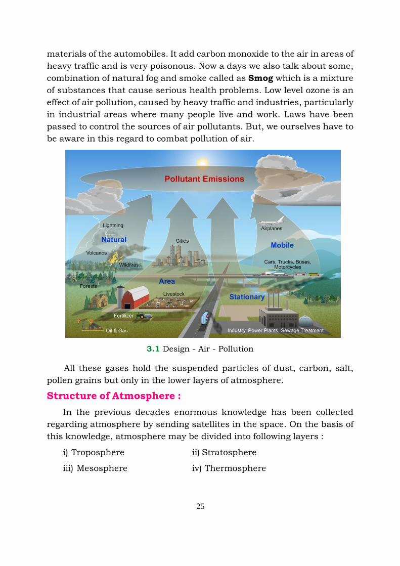
materials of the automobiles. It add carbon monoxide to the air in areas of
heavy traffic and is very poisonous. Now a days we also talk about some,
combination of natural fog and smoke called as Smog which is a mixture
of substances that cause serious health problems. Low level ozone is an
effect of air pollution, caused by heavy traffic and industries, particularly
in industrial areas where many people live and work. Laws have been
passed to control the sources of air pollutants. But, we ourselves have to
be aware in this regard to combat pollution of air.
3.1 Design - Air - Pollution
All these gases hold the suspended particles of dust, carbon, salt,
pollen grains but only in the lower layers of atmosphere.
Structure of Atmosphere :
In the previous decades enormous knowledge has been collected
regarding atmosphere by sending satellites in the space. On the basis of
this knowledge, atmosphere may be divided into following layers :
i) Troposphere ii) Stratosphere
iii) Mesosphere iv) Thermosphere
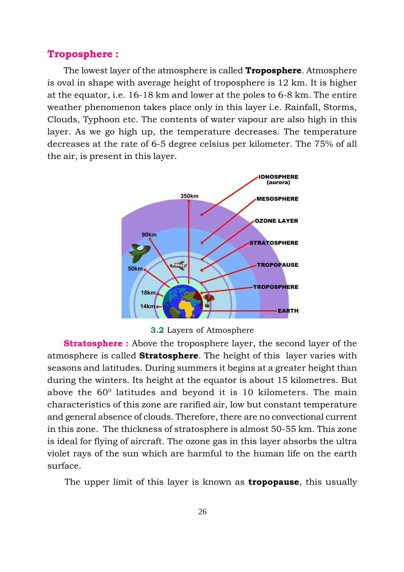
26
Troposphere :
The lowest layer of the atmosphere is called Troposphere. Atmosphere
is oval in shape with average height of troposphere is 12 km. It is higher
at the equator, i.e. 16-18 km and lower at the poles to 6-8 km. The entire
weather phenomenon takes place only in this layer i.e. Rainfall, Storms,
Clouds, Typhoon etc. The contents of water vapour are also high in this
layer. As we go high up, the temperature decreases. The temperature
decreases at the rate of 6-5 degree celsius per kilometer. The 75% of all
the air, is present in this layer.
3.2 Layers of Atmosphere
Stratosphere : Above the troposphere layer, the second layer of the
atmosphere is called Stratosphere. The height of this layer varies with
seasons and latitudes. During summers it begins at a greater height than
during the winters. Its height at the equator is about 15 kilometres. But
above the 600 latitudes and beyond it is 10 kilometers. The main
characteristics of this zone are rarified air, low but constant temperature
and general absence of clouds. Therefore, there are no convectional current
in this zone. The thickness of stratosphere is almost 50-55 km. This zone
is ideal for flying of aircraft. The ozone gas in this layer absorbs the ultra
violet rays of the sun which are harmful to the human life on the earth
surface.
The upper limit of this layer is known as tropopause, this usually

27
begins at 50 km height of the atmosphere. The temperature in the layer
neither increases nor decreases. It remains constant.
Mesosphere : The layer above the tropopause is mesosphere. This
layer extends upto 50 km. to 60 km. The temperature in this layer goes
on decreasing with the rise in height. The temperature at 80 km height is
-900 Celsius.
The upper layer of the mesosphere is called as Mesosphere limit.
Beyond this limit of atmosphere the temperature starts rising.
Thermosphere : Beyond the mesosphere, the layer of atmosphere is
called as thermosphere. Temperature starts rising as we go high. There
are much less contents of gases in this layer.
The lowest limit of thermosphere is known as Ionosphere which
extends upto 100 km.to 300 km. It contains electrically charged particles
which help in the reflection of radio waves back to the earth and are much
of value for wireless communication. The upper limit of this layer is called
exosphere. We do not have much knowledge
about this layer but it is considered to have the
gases with low density like Hydrogen & Helium.
Weather : By weather of a place is meant by
the condition of the temperature, atmospheric
pressure, rainfall, speed and direction of the wind
of a place for about 24 hours. These conditions
change from day to day.
Climate: It is the average of weather conditions
of a place over a long period generally of 30 to 35
years. It depends upon various factors, as the
latitudes, altitude, distance from the sea, prevailing
winds, ocean currents, cloudiness, rainfall and
slope of the land and other geographic conditions.
Temperature : The heat of the air is called
temperature. Similarly the internal heat of a good
or living being is also called temperature. The
temperature increases or decreases and same type 3.3 Dry & wet bulb
Thermometer

28
of variation in day and night temperature is also there. Similarly the
temperature varies with change of season. The temperature differs from
place to place hence the weather conditions of one place differ to that of
weather conditions of other place. Although there are so many factors that
affect the weather of a place but temperature of the air is one of the main
elements.
There are only two sources of temperature that heat the earth. Sun
and internal part of the earth. Out of these, the sun is more important.
The insolation (heat from the sun) primarily heat the surface of the earth
then heat the atmosphere. There are so many factors that affect the
insolation received at a place. Before knowing about the other factors, we
must know how to measure the temperature.
The temperature is measured by Thermometer. It is demarcated in
degrees. For measuring the temperature two units are used, one is Celsius
and the other is Fahrenheit. According to the Celsius unit of measurement,
water boils at 1000C & freezes at 00C and according to Fahrenheit
measurement water boils at 2120F and freezes at 320F.
Factors affecting the temperature: Following are factors that affect the
temperature of the earth.
a) Latitude : The temperature of a place depends upon how much
insolation it gets. The rays of the sun fall directly on the equator
therefore the temperature is high over there. But as we slip away
from the equator the temperature goes on decreasing because the
rays of sun fall slanting on the poles.
3.5 Inclination angle of sun rays
North Pole
Earth
South PoleSlanting rays
SunStraight rays
Atmosphere
29
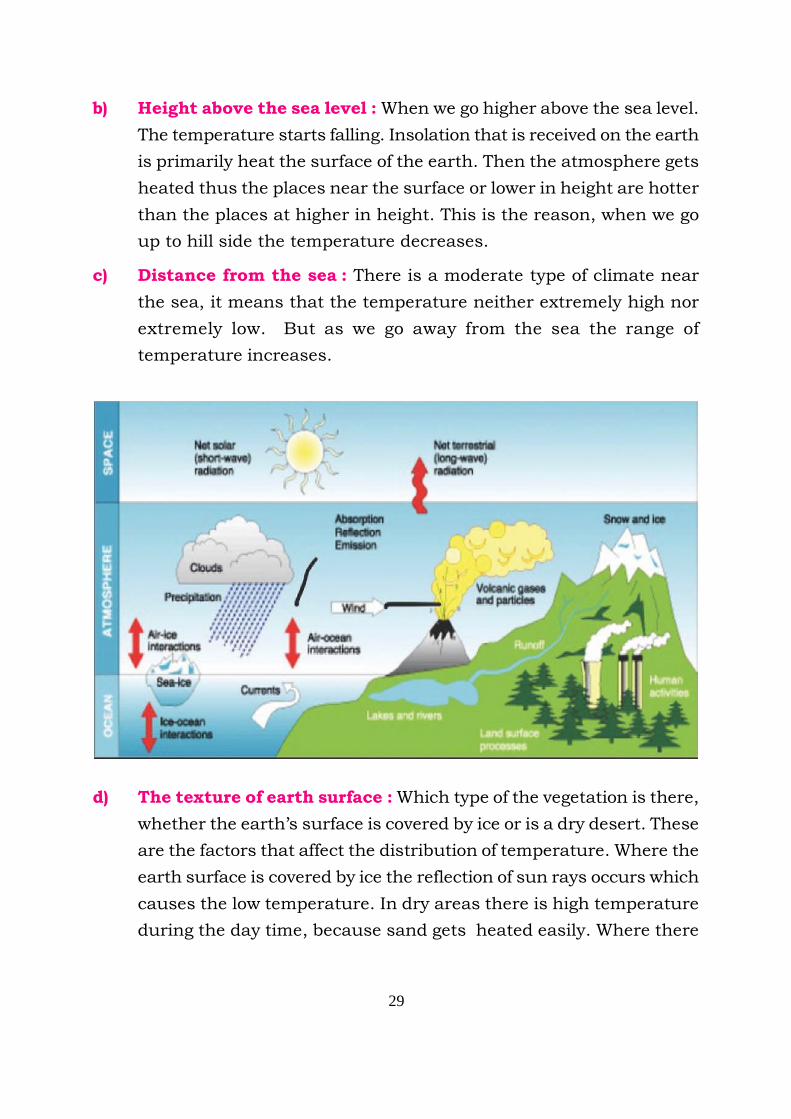
b) Height above the sea level : When we go higher above the sea level.
The temperature starts falling. Insolation that is received on the earth
is primarily heat the surface of the earth. Then the atmosphere gets
heated thus the places near the surface or lower in height are hotter
than the places at higher in height. This is the reason, when we go
up to hill side the temperature decreases.
c) Distance from the sea : There is a moderate type of climate near
the sea, it means that the temperature neither extremely high nor
extremely low. But as we go away from the sea the range of
temperature increases.
d) The texture of earth surface : Which type of the vegetation is there,
whether the earth’s surface is covered by ice or is a dry desert. These
are the factors that affect the distribution of temperature. Where the
earth surface is covered by ice the reflection of sun rays occurs which
causes the low temperature. In dry areas there is high temperature
during the day time, because sand gets heated easily. Where there
30
are dense forests, the temperature neither shoot up extremely high
up nor fall down extremely low but it remains the moderate.
e) Slope of the Land: Slopes facing the sun have higher temperature
as they get the sun rays for a longer duration than those facing away
from the sun. The sunny slopes have higher temperature.
f) Clouds and Rainfall: Places having cloudy skies and rainfall have
lower temperature than those without these. Clouds obstruct the
free fall of sun rays thus lower the temperature. After rainfall the
water vapours are present in the air. They absorb the heat of the air.
g) Ocean currents: The areas where the hot water ocean current passes,
that raises the temperature of the area. The temperature lowers down
where the cold water current passes, you will study in detail regarding
the oceans in the following chapter.
Something to Recall
1. There are three parts of natural environment namely; Hydrosphere,
Lithosphere and Atmosphere. Air, Temperature and Moisture are
parts of Atmosphere.
2. Principal gas in Atmopshere is Nitrogen constituting 7803% part
while Oxygen is 2099% and rest in the mixture of Orgon,
Carbondioxide and Hydrogen among others.
3. Lowest part of Atmosphere is Troposphere, preceded by
Stratosphere, Mesosphere and Exosphere the top.
4. Minimum and Maximum thermometer is used to measured
temperature while Dry and Wet bulb thermometer is used to
measure humidty in air.
5. Temperature of a place depends upon factors like height from sea
level, distance from sea, type of relief etc.
31
EXERCISE
I. Answer the following questions in about 1-15 words.
1. What do you understand by the Atmosphere ?
2. Why we study Atmosphere in Geography ?
3. Which is called Tropopause limit.
4. What do you understand by Exosphere ?
5. What are the elements other than the gases present in the
atmosphere.
6. What is air pollution ?
7. What is temperature and what are the unit of measuring the
temperature.
8. Why is the temperature very high on the equator ?
II. Give answers to the following question in about 50-60 words.
1. What are the main factors that cause air pollution.
2. What we call the lower layer of the atmosphere ?
3. Write the ratio of main gases in the air.
4. In which layer of the atmosphere the ozone gas exist. Why is it
so important.
III. Fill in the blanks.
1. As we go up to the hills the temperature _________.
2. The main sources of the temperature are _______ and _______.
3. The ozone gas absorbs ___________ rays.
4. The electrically charged particles are found in ________ layer.
5. The wireless communication system works under __________
waves.
6. _________ gas is found in maximum quantity in atmosphere.

32
Things to do
1. What rules should be followed to avoid air pollution, prepare a
chart and put it in your classroom.
2. Draw a diagram of Atmosphere showing different layers.
•••
33
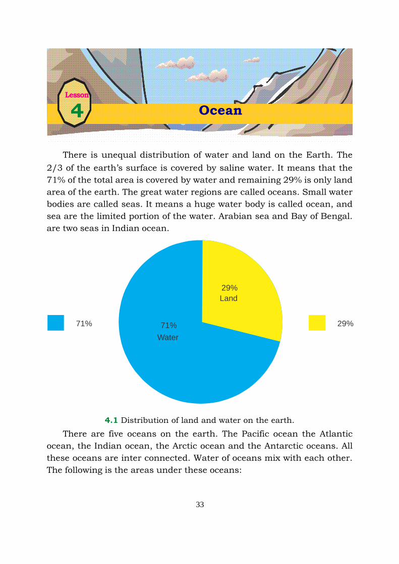
There is unequal distribution of water and land on the Earth. The
2/3 of the earth’s surface is covered by saline water. It means that the
71% of the total area is covered by water and remaining 29% is only land
area of the earth. The great water regions are called oceans. Small water
bodies are called seas. It means a huge water body is called ocean, and
sea are the limited portion of the water. Arabian sea and Bay of Bengal.
are two seas in Indian ocean.
Lesson
4 Ocean
4.1 Distribution of land and water on the earth.
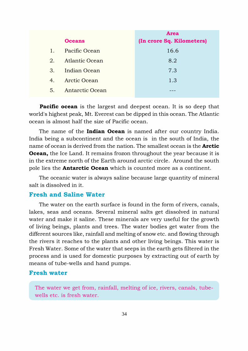
There are five oceans on the earth. The Pacific ocean the Atlantic
ocean, the Indian ocean, the Arctic ocean and the Antarctic oceans. All
these oceans are inter connected. Water of oceans mix with each other.
The following is the areas under these oceans:
71%
Water
Land
29%71%
29%
34
Area
Oceans (In crore Sq. Kilometers)
1. Pacific Ocean 16.6
2. Atlantic Ocean 8.2
3. Indian Ocean 7.3
4. Arctic Ocean 1.3
5. Antarctic Ocean ---
Pacific ocean is the largest and deepest ocean. It is so deep that
world's highest peak, Mt. Everest can be dipped in this ocean. The Atlantic
ocean is almost half the size of Pacific ocean.
The name of the Indian Ocean is named after our country India.
India being a subcontinent and the ocean is in the south of India, the
name of ocean is derived from the nation. The smallest ocean is the Arctic
Ocean, the Ice Land. It remains frozon throughout the year because it is
in the extreme north of the Earth around arctic circle. Around the south
pole lies the Antarctic Ocean which is counted more as a continent.
The oceanic water is always saline because large quantity of mineral
salt is dissolved in it.
Fresh and Saline Water
The water on the earth surface is found in the form of rivers, canals,
lakes, seas and oceans. Several mineral salts get dissolved in natural
water and make it saline. These minerals are very useful for the growth
of living beings, plants and trees. The water bodies get water from the
different sources like, rainfall and melting of snow etc. and flowing through
the rivers it reaches to the plants and other living beings. This water is
Fresh Water. Some of the water that seeps in the earth gets filtered in the
process and is used for domestic purposes by extracting out of earth by
means of tube-wells and hand pumps.
Fresh water
The water we get from, rainfall, melting of ice, rivers, canals, tube-
wells etc. is fresh water.
35
The water on the earth eveporates due to the heat of the sun. The
stagnant water of Lakes, land locked water bodies, seas and oceans gets
evaporated continuously and as a result, the amount of salt increase in
this water. This is the reason, the common salt making is quite popular
occupation along the banks of seas. The amount of salt remains more in
oceans because of the carbonate consumed by fish and Marine
Organism.
The Saline Water :
The water of lakes, land locked seas and open oceans is saline. The
highest salinity is in the Dead Sea. This sea is land locked. The seas
which have high rate of salinity do not let things and even human
beings. drown How wonderful it is !
By standing near the bank of the ocean we can observe that the water
in the oceans is always moving i.e. it is never calm and still. Its movement
is its life. Ocean waters move in the form of ripples, waves, tides and
Tsunami. By the wholesome movement of water, the waters of oceans mix
with each other. There are three types of movements of
water.
1) Waves 2) Ocean Currents 3) Tides
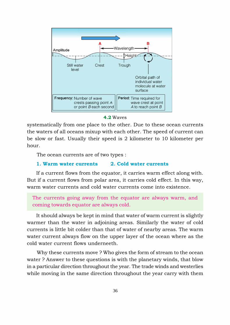
1) Waves : The water of oceans always ripples with the winds over the
ocean surface. According to the change in weather, these ripples are high
and sometimes these are low. At times the movement is faster and at
times it is comparatively slow depending upon the waves arise in the
ocean. The ripples or waves arise due to the speed of the wind blowing
over the surface of oceans. The water vapours run up & down with which
the water start rippling. As shown in design 6.2, upper surface of wave is
called crest and the lower surface of wave or when the water returns
almost to its original position is trough. When a cyclone occurs, these
ocean waves turn into horrible water splashes. Sometimes they even
destroy ships sailing in the oceans. The waves erode the coastal areas
and transport the rock material to the ocean floors.
2) Ocean Currents: When the ocean water moves in a particular
direction it is called ocean current. The water in the ocean moves very
36
systematically from one place to the other. Due to these ocean currents
the waters of all oceans mixup with each other. The speed of current can
be slow or fast. Usually their speed is 2 kilometer to 10 kilometer per
hour.
The ocean currents are of two types :
1. Warm water currents 2. Cold water currents
If a current flows from the equator, it carries warm effect along with.
But if a current flows from polar area, it carries cold effect. In this way,
warm water currents and cold water currents come into existence.
The currents going away from the equator are always warm, and
coming towards equator are always cold.
It should always be kept in mind that water of warm current is slightly
warmer than the water in adjoining areas. Similarly the water of cold
currents is little bit colder than that of water of nearby areas. The warm
water current always flow on the upper layer of the ocean where as the
cold water current flows underneeth.
Why these currents move ? Who gives the form of stream to the ocean
water ? Answer to these questions is with the planetary winds, that blow
in a particular direction throughout the year. The trade winds and westerlies
while moving in the same direction throughout the year carry with them
4.2 Waves
37
the ocean water along with. Therefore, ocean water also moves in the
direction of the planetary winds.
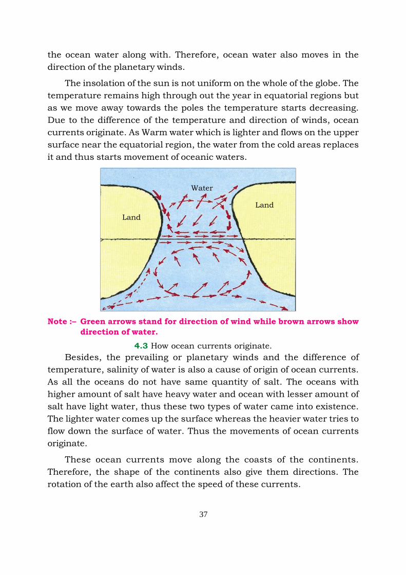
The insolation of the sun is not uniform on the whole of the globe. The
temperature remains high through out the year in equatorial regions but
as we move away towards the poles the temperature starts decreasing.
Due to the difference of the temperature and direction of winds, ocean
currents originate. As Warm water which is lighter and flows on the upper
surface near the equatorial region, the water from the cold areas replaces
it and thus starts movement of oceanic waters.
Land
Land
Water
Note :– Green arrows stand for direction of wind while brown arrows show
direction of water.
4.3 How ocean currents originate.
Besides, the prevailing or planetary winds and the difference of
temperature, salinity of water is also a cause of origin of ocean currents.
As all the oceans do not have same quantity of salt. The oceans with
higher amount of salt have heavy water and ocean with lesser amount of
salt have light water, thus these two types of water came into existence.
The lighter water comes up the surface whereas the heavier water tries to
flow down the surface of water. Thus the movements of ocean currents
originate.
These ocean currents move along the coasts of the continents.
Therefore, the shape of the continents also give them directions. The
rotation of the earth also affect the speed of these currents.
38
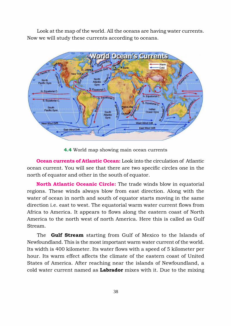
Look at the map of the world. All the oceans are having water currents.
Now we will study these currents according to oceans.
4.4 World map showing main ocean currents
Ocean currents of Atlantic Ocean: Look into the circulation of Atlantic
ocean current. You will see that there are two specific circles one in the
north of equator and other in the south of equator.
North Atlantic Oceanic Circle: The trade winds blow in equatorial
regions. These winds always blow from east direction. Along with the
water of ocean in north and south of equator starts moving in the same
direction i.e. east to west. The equatorial warm water current flows from
Africa to America. It appears to flows along the eastern coast of North
America to the north west of north America. Here this is called as Gulf
Stream.
The Gulf Stream starting from Gulf of Mexico to the Islands of
Newfoundland. This is the most important warm water current of the world.
Its width is 400 kilometer. Its water flows with a speed of 5 kilometer per
hour. Its warm effect affects the climate of the eastern coast of United
States of America. After reaching near the islands of Newfoundland, a
cold water current named as Labrador mixes with it. Due to the mixing
39
of warm & cold water current a dense fog is formed over there. The Glaciers
moving from the poles melt after reaching near the Gulf Stream. In this
way they do not create obstruction to ships after reaching down. A cold
water current form Greenland also mixes with it.
Now this current under the effect of westerlies moves eastward. Now
it is called by the name north Atlantic current. This warm water currents
while flowing across north west of Britain reaches the cold areas of Norway
and Sweden. Due to the warm effect of this current the fisherman of
Norways go away for fishing. It is also due to the warm effect of this
current the ports of European countries remain open even in winter
season. If this current does not flow to this area, the ports would have
been frozen. From the Europe, Canary current flows to the south-ward.
It is a cold water current which passes over the North-west coast of Africa.
This current by mixing with the equatorial current, completes the cycle.
In this way, this cycle is in a clock wise direction. The area enclosed by
this cycle is called as ‘Sargasso Sea’.
b) Southern Atlantic Cycle : A difinite cycle of ocean current similar
to northern cycle is also in this side. This cycle flows in an anticlockwise
direction. The Southern equatorial current when advances towards the
east to west then it strike against the elongated part of the north America
and is divided into two parts. One of the part joins with northern cycle
but the other part flowing along with the coast of America and advances
to the south. This is called as Brazillian current. A cold water current
from the south comes to mix up with it. This is called as Falkland current.
Now this current under the influence of westerlies. It is called westwind
drift. This is a cold water current, which circulates around the whole of
the Globe. The reason being from the south ward there is an open ocean
therefore there is no obstruction in between. A cold water current of
South Africa flows northwardly along the western coast this is called
Banguela current. In between the north equatorial ocean current and
southern equatorial there is a counter equatorial current that flows from
the west to the east.
Pacific ocean currents : These ocean currents also have two types of
cycles. The Northern Cycle and Southern Cycle.
40
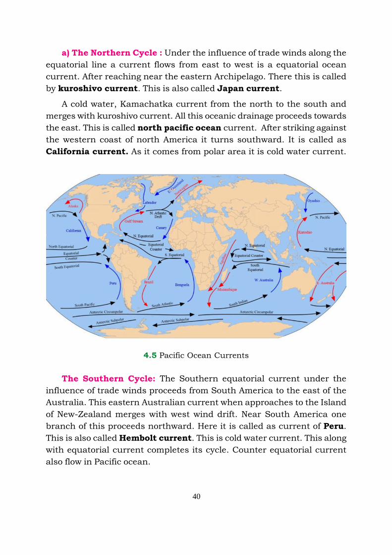
a) The Northern Cycle : Under the influence of trade winds along the
equatorial line a current flows from east to west is a equatorial ocean
current. After reaching near the eastern Archipelago. There this is called
by kuroshivo current. This is also called Japan current.
A cold water, Kamachatka current from the north to the south and
merges with kuroshivo current. All this oceanic drainage proceeds towards
the east. This is called north pacific ocean current. After striking against
the western coast of north America it turns southward. It is called as
California current. As it comes from polar area it is cold water current.
4.5 Pacific Ocean Currents
The Southern Cycle: The Southern equatorial current under the
influence of trade winds proceeds from South America to the east of the
Australia. This eastern Australian current when approaches to the Island
of New-Zealand merges with west wind drift. Near South America one
branch of this proceeds northward. Here it is called as current of Peru.
This is also called Hembolt current. This is cold water current. This along
with equatorial current completes its cycle. Counter equatorial current
also flow in Pacific ocean.

41
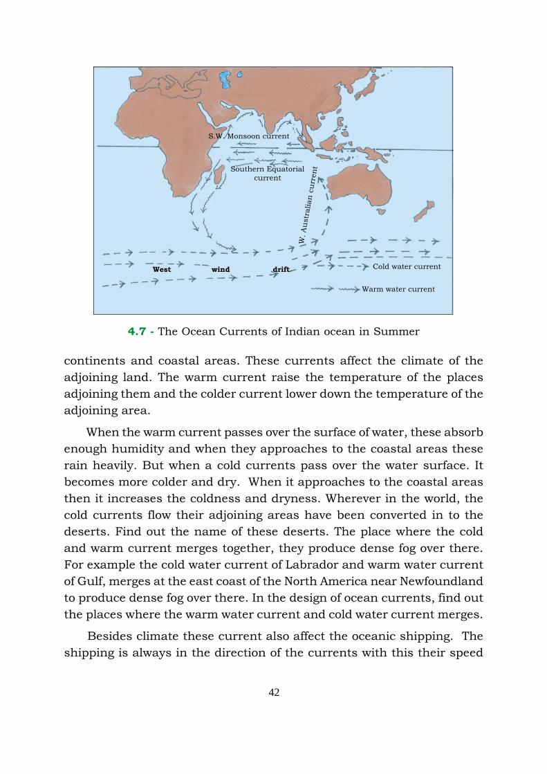
Currents of Indian ocean
The Indian ocean currents are not so systematic and permanent as
the Atlantic and Pacific ocean. The main reason of this is the seasonal
winds that flow in Indian Ocean. These winds blow south west direction
in summer season and north eastern direction in winter season. Due to
this change the ocean currents also change their direction. In this southern
hemisphere the currents are more permanent. The equatorial warm water
from the eastern archiplagoe proceeds towards the eastern coast of Africa.
West wind drift
Warm water current
Cold water current
W.A
ustr
alian
cu
rren
tSouthern Equatorial
current
Moz
am
biq
ue
curr
ent
N.E. Monsoon current
4.6 - The Ocean currents of Indian ocean in winters
Along this coast, this current goes to southward. Here it is called
Mozambique current. A branch of this flows from the east of Malagassi.
This is known as Agulahas current. These two current along with west
wind drift proceed toward the east from the west coast of Austrialia, the
western Australian cold current after proceeding northward merges
with equatorial currents.
Effects of Currents on Climate
You have studied that there are two types of Ocean currents. Warm
water currents and cold water currents. These currents flow along the
42
continents and coastal areas. These currents affect the climate of the
adjoining land. The warm current raise the temperature of the places
adjoining them and the colder current lower down the temperature of the
adjoining area.
When the warm current passes over the surface of water, these absorb
enough humidity and when they approaches to the coastal areas these
rain heavily. But when a cold currents pass over the water surface. It
becomes more colder and dry. When it approaches to the coastal areas
then it increases the coldness and dryness. Wherever in the world, the
cold currents flow their adjoining areas have been converted in to the
deserts. Find out the name of these deserts. The place where the cold
and warm current merges together, they produce dense fog over there.
For example the cold water current of Labrador and warm water current
of Gulf, merges at the east coast of the North America near Newfoundland
to produce dense fog over there. In the design of ocean currents, find out
the places where the warm water current and cold water current merges.
Besides climate these current also affect the oceanic shipping. The
shipping is always in the direction of the currents with this their speed
Cold water current
Warm water current
W.A
ustr
alian
cu
rren
t
West wind drift
Southern Equatorialcurrent
S.W. Monsoon current
4.7 - The Ocean Currents of Indian ocean in Summer
43
increase and thus less feul is consumed. The warm water currents melts
the glaciers in this way they do not create hindrance to ships.
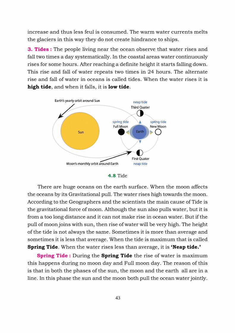
3. Tides : The people living near the ocean observe that water rises and
fall two times a day systematically. In the coastal areas water continuously
rises for some hours. After reaching a definite height it starts falling down.
This rise and fall of water repeats two times in 24 hours. The alternate
rise and fall of water in oceans is called tides. When the water rises it is
high tide, and when it falls, it is low tide.
4.8 Tide
Moon
There are huge oceans on the earth surface. When the moon affects
the oceans by its Gravitational pull. The water rises high towards the moon.
According to the Geographers and the scientists the main cause of Tide is
the gravitational force of moon. Although the sun also pulls water, but it is
from a too long distance and it can not make rise in ocean water. But if the
pull of moon joins with sun, then rise of water will be very high. The height
of the tide is not always the same. Sometimes it is more than average and
sometimes it is less that average. When the tide is maximum that is called
Spring Tide. When the water rises less than average, it is ‘Neap tide.’
Spring Tide : During the Spring Tide the rise of water is maximum
this happens during no moon day and Full moon day. The reason of this
is that in both the phases of the sun, the moon and the earth all are in a
line. In this phase the sun and the moon both pull the ocean water jointly.

44
Due to their joint pull, the rise of water is very high. Which is called as
Spring Tide.
Neap Tide : In the Neap Tide, the rise of water is lower than as usual.
It is on the 7th and 21st day or the first or the last quarter phase of the
moon. In this phase, the moon, earth and sun are right angles to that of
the moon. The sun pulls water to its side and the moon pulls towards
itself. Due to in nearness of the moon, the water rises towards moon
only. But it is not as high, because the pull of sun is working on the
opposite direction.
Man and Tide : Tides help us in many ways. Due to the tide the deposits
of soil and the debris against the mouth of the river, washed away. Thus
the soil do not get deposited on the harbours situated on the coastal
areas, and ships can sail up to a great distance inside.
The big ships standing in the deep distant seas, keep on waiting for
the high amplitude when there is rise in water, that sail into the harbours.
After down loading the ships, cargo again wait for the rise, so that they
move again to the seas.
4.9 Spring Tide

45
The port of Kolkata on the banks of Hugali river is away from Bay of
Bengal. If there were no tide in ocean, the ships could have not even
reached in Kolkata harbour. Similarly the port of London is situated at
the banks of Thames river. The ships also move in and out of the harbour
when tide rise in the ocean.
Now it has been planned to utilize the energy of Tides to fulfill the
over increasing demand of energy world over.
4. Tsunami : Tsunami is pronounced as soo-nah-mee. It is a Japanese
word, made up of two parts Tsu meaning coastal and Nami means a long
wave of water. The Tsunami means long waves of water striking to the
coastal areas. The long waves arise due to the earthquake on the ocean
floors. This is not only a single wave but a series of waves, better known
as wave train. It comes one after the other, sometimes these are so intense
that the water along the coast of ocean moves with a speed of 800 km per
hour. At some places the water rises upto 100 feet and flows with highest
speed. In coastal areas there is a great loss to man, animals and property,
as things are washed away with Tsunami.
4.10 Destruction due to Tsunami
46
Case Study of the Tsunami striked on 26th December 2004
On December 26, 2004, a most powerful Tsunami occurred on
the coast of Indian ocean. This deadly Tsunami was caused by a
severe earthquake of the of magnitude of 9.0 on the ritcher scale on
ocean floor. The epicentre was west coast of Indonesia and with in
hours the killer waves brought devastation in 11 countries falling in
and around Indian ocean. Due to Tsunami many people drowned,
washed away and many houses were illiminated. The beaches of Africa
to Thailand were heavily affected.
According to the estimate of the Government of India, the loss
due to this giant Tsunami was up to thousands of crores. Out of the
states of India Tamilnadu suffered the most, followed by Kerela,
Andhra Pradesh and Pudduchery. More than 200,000 (2 lakh) people
were killed and many more were rendered homeless.
EXERCISE
I. Answer the following question in approximately 1-15 words.
1. Why does the Ocean water salty?
2. Why there is a dense fog near Newfoundland?
3. Explain the route of Gulf Stream current.
4. Write down the main ocean currents of North Atlantic Oceans
cycle.
5. What do you understand by Tsunami ?
II. Answer the following question in approximately 50-60 words.
1. What is the difference between Spring Tide and Neap Tide ?
2. Differentiate between warm water ocean current and cold water
ocean current.
3. Why are the ocean currents of Indian ocean not so definite
and systematic ?
4. Tide is very useful for ships. How ?

47
5. Why a spring tide occurs in full moon and no moon days ?
6. How does the Gulf Stream affects the climate of Europe ?
7. What is the difference between the ocean waves and the ocean
currents.
8. Write down a case study of a place that is affected by Tsunami.
•••

48
The natural vegetation of a place are the plants, trees and herbs that
grow itself, without efforts of mankind. The natural vegetation shows the
total effect of topography, type of soil and climate of a place. The natural
vegetation is a most valuable resource, besides providing different types
of wood. We get bamboos, grass for paper making, gum, resin, turpentines
lac, bark for leather colouring, medicinal plants and bushes from woods.
A number of industries are based on forest wood, besides timber, it is
used for making furniture, sports goods, ships, railway coaches, paper,
plywood and boxes for packing purposes.
Forests are helpful to us indirectly also. Forests play a vital role in
processes of atmosphere. Trees absorb carbon dioxide and release oxygen
to the atmosphere. They help in occurance of rainfall thus check the
temperature rise, check floods and soil erosion and help in the seepage
of rainwater into the ground. Forests also check the spread of deserts
and provide habitat to birds and animals.
About 30 percent of land area of the world is under forests. Some
countries are quite rich in this resource and forests play a vital role in
their economy. North America, South America and Russia have vast areas
under forests whereas Europe, Asia and Africa have lesser forest cover.
Increasing population of the world is adversely affecting the forests.
Man has been cutting the forests to obtain land for cultivation since the
pre-historic era. As a result, area under forests is decreasing drastically.
If natural vegetation and forests are continuously destroyed with present
speed, time will come soon when the whole world would turn into desert.
It is therefore, urgent to conserve the forests and plan afforestation while
checking deforestation.
Lesson
5 Natural Vegetation and Wild Life
49
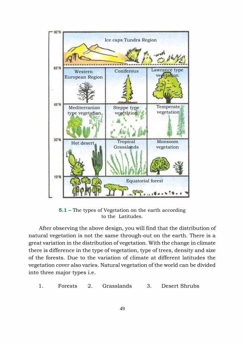
5.1 – The types of Vegetation on the earth according
to the Latitudes.
After observing the above design, you will find that the distribution of
natural vegetation is not the same through-out on the earth. There is a
great variation in the distribution of vegetation. With the change in climate
there is difference in the type of vegetation, type of trees, density and size
of the forests. Due to the variation of climate at different latitudes the
vegetation cover also varies. Natural vegetation of the world can be divided
into three major types i.e.
1. Forests 2. Grasslands 3. Desert Shrubs
Ice caps Tundra Region
WesternEuropean Region
Coniferous Lawrance typevegetation
Mediterraniantype vegetation
Steppe typevegetation
Temperatevegetation
Hot desert TropicalGrasslands
Monsoomvegetation
Equatorial forest

50
7.2 - World map showing natural vegetation
Forests
Amount of annual rainfall, its seasonal distribution and temperature
affect the types of forests. On the basis of the geographical conditions,
the forests are further divided into three types.
I. Equatorial type of forests II. Monsoon Type of forest III. The
Coniferous (conical) type of forests
1. Equatorial type of Forest
These forests cover approximately 100 north and 100 south of the
Equator and are known as evergreen forests. Due to the continuous high
temperature and rainfall, the dense forests grow in this area. The shoots
of the tree are so much intermingled with each other that they form a
canopy of trees which does not allow the sunlight to fall on the earth’s
surface. There are different types of trees in this region but these are not
useful from economic point of view. The main reason is that it is not easy
to pass through the forests and also they cannot be cut.

51
The large portion of South America, Central Africa, South East Asia,
Medagaskar are covered with this type of forests. Small areas of
Australia, Central America are covered under these forests. These
type of forests are called as ‘Selvas’ in the Amazon basin of Brazil in
South America.
Lately this type of forests are considered to be skyscrapers. The
uppermost layer of these forests comprise of 70 metres high trees. On this
layer of the trees both light and thin trees are available. Below this is
conopy type storey. Which is formed by the intermingling of shoots of trees
with each other. A small amount of sunlight is available in this layer of
forests, which is useful for fruits and flowers. Below this is a shadow area,
in this vines are clinging around the trees and also interwoven with each
other. The vines which cannot survive without sunlight grow high and
come out to have sunlight. On the lowermost layer of the forest there is
shadow area because sunlight does not reach the ground. Therefore the
ground floor is covered with decaying leaves, insects and worms and forests
are inaccessible. That is the reason that these forests are not economically
useful while government efforts are on to develop and these regions and
make use of forests.
II. Monsoon or Deciduous forests
These forests are found in sub-tropical latitudes where the rain is
mostly confined to one season. These forests have broad leaved trees
which grow at places where monsoon rainfall is sufficient. The season, in
which there is no rainfall, these trees shed their leaves. That is why these
forests are called Deciduous forests. Such forests are very useful
economically, but simultaneously the land under these forests is being
used for the cultivation of crops after clearing the forests. These forests
are less dense as compared to equatorial type of forests and are more
accessible also. We get timber from these forests for houses and for fuel.
III. The Coniferous type of forests
These forests are grown in temperate regions. The coniferous forests
are also called evergreen forests. In Eurasia the forests are known as
‘Taiga’. From utility point of view these are the most important and
precious trees. These forests includes soft wood of Chir, fir and spruce
trees, which is used for making paper.
52
2. Grasslands
There are two types of grasslands : Tropical grasslands and Temperate
grasslands.
i. Tropical grasslands
Tropical grasslands are found at 100-300 latitudes in Northern and
Southern hemisphere. These grasslands are also called as ‘Savanna’
grasslands. These are called by different names in different regions.
In Africa these are called Parkland. In Venezuela these are called
Llanos. In Brazil these are called Campos.
This grass grows upto 5 metre high and after drying, it turns quite
hard. There are also small sized trees scattered in these grasslands. Mostly
herbivorous and carnivorous animals are reared on these grasslands.
ii. Temperate grasslands
Such grasslands are found in temperate zone. Because of low rainfall
regions, the grass is not very high but it is soft and densely grown thus it
is useful for animal grazing. The grasslands are also known by different
names in different regions.
In Eurasia these are called as Steppes. In North America these are
called as Prairies. In South America these are called as Pampas. In
South Africa these are called as Veld. In Australia these are called
Downs.
Desert Vegetation
There are two types of deserts on the earth : Hot Desert and Cold
Desert.
i. Hot Deserts
Sahara and Kalahari in Africa, Arab Iran desert, Thar desert in Indo-
Pakistan, Atacama in Southern America, Southern California and
Mexico in North America, Eastern Australian desert in Australia are
the hot deserts of the world.
53
Due to high temperature and low rainfall, the vegetation is scanty.
Only thorny shrubs, cactus, small herbs and grass grow in such deserts.
The nature has made this vegetation to adapt to the hot and dry weather
of these areas. The roots of these plants are long and thick enough to
secure water from the deep. The bark of the plant is thick and the leaves
have thick foliage and are very smooth, so that minimum water may
escape during the transpiration.
ii. Cold desert
These deserts are located mostly in the northern most latitude of
Canada and Eurasia. (The combination of Europe and Asian
continents is known as Eurasia).
Most of the times during a year, these areas are covered with snow.
When the snow melts for a month or so colourful flowering plants grow.
In the northern areas small grass i.e. lican is grown. The desert type of
vegetation is not of great use ecnomically.
Conservation of forest
The forests are of great importance to us because they fulfill our
several needs. The great part of the timber from forests is used for fuel.
Out of total usable timber 50% is used as fuel and 33% is used for housing
purposes and rest of it is used for other purposes i.e. for making paper,
railway boggies, sleeper, rayon etc. With the increase in population, The
consumption of wood is also increasing, but on the other hand the area
under forest is decreasing. Therefore the stress should be laid on the
conservation of forests and planting new trees.
Sometimes fire causes great loss to forests. A specific attention should
be given regarding the forests. Uncautiousness and carelessness regarding
the forests should not be adopted. The cutting of trees should be
systematically and besides new trees should be planted simultaneously.
It should be kept in mind that the trees should not be destroyed due to
mites and diseases. Maximum trees should be planted on the vacant
space left along the footpaths, canals, rivers, roads and railway lines.
The consumption of timber as fuel should be decreased and alternate
54
sources of fuel should be adopted i.e. LPG cylinder chullas, solar energy
chullas, gobar gas etc. In housing alternate of wood should be encouraged.
Wild Life
With the destruction of forests the number of wild animals are also
decreasing at a great speed. The man has been hunting wild animals
along with cutting the forests. Man has been hunting animals for the
sake of meat, feathers and hides. As a result some of the species of wild
animals have gone extinct and some of these are endangered to be extinct.
To maintain the ecological balance the survival of these animals is
necessary. By clearing the forests and hunting of these animals, man
has brought imbalance to the ecological balance. The nature has created
biosphere in such a way that one animal depends upon the other, as
small animal is a food for the big animal and the carnivorous depend
upon herbivorous animals. In this way absence of even single particular
species will create disorder of physical environment. Think a while, if the
number of carnivorous animals like lion, leopard is more than the number
of herbivorous animals, do you know what will be the result ? There would
be an imbalance of ecological balance and the carnivorous would start
eating human beings. If the situation is reversed the number of lions and
leopards is less than the number of herbivorous animals. Due to over
grazing of grass, a time will come when a lush green grasslands will turn
into barren deserts. Therefore, soil erosion will be more, it means the
disorder of balance. To maintain the ecological balance, efforts should be
made.
Wild animals are also a wealth of a country. For this purpose, in
many countries hunting is prohibited. There should be strict law to check
hunting in India. It has been felt that it is very necessary to protect wild
animals. As many of the species have been extincted earlier and many of
the rest are endangered to be extincted.
The number of rhinoceros, leopard, lion etc. animals have been
decreased. The national parks have been etablished in the United States
of America, India and other countries. A natural environment has been
provided to protect these wild animals in these parks. There are 103
national parks in India in different parts of the country Jim Corbett,
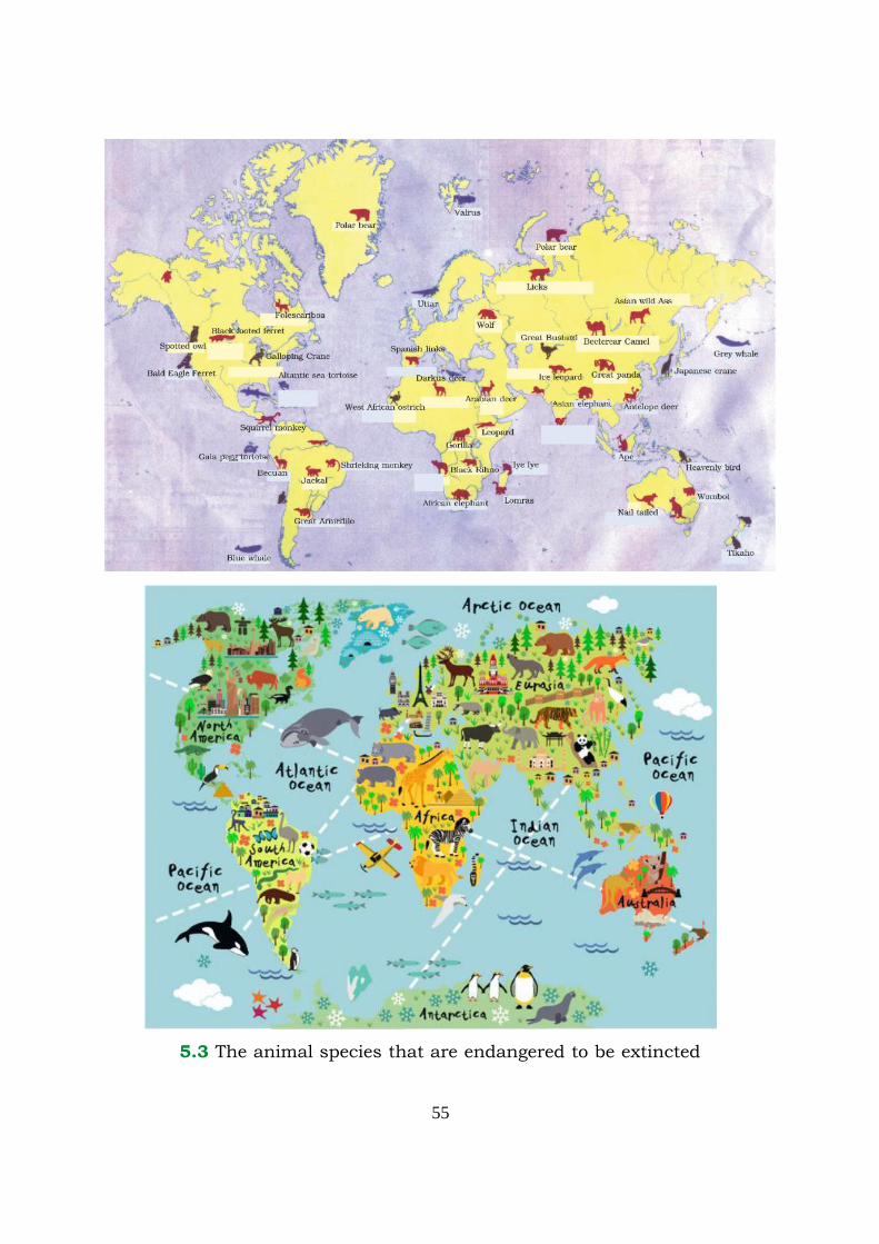
55
5.3 The animal species that are endangered to be extincted

56
Shivpuri, Cannari, Rajdevga, Gir etc. are some of the famous national
parks of India. Besides there are reserved centres for the animals and
birds. ‘Chhatbir’ is one of these centres in Punjab. The Savanna grasslands
in Africa is one of the largest home of wild animals. The tourists from
distant places in world come to visit these places. Zebra, giraffe, antelope,
stag, deer, lion, leapard, tiger, elephants, wild buffalo, rhinoceros and
different species of animals and insects are present in these regions.
EXERCISE
I. Give answer to these questions in approximately 1-15 words.
1. What do you understand by natural vegetation ?
2. In how many types natural vegetation can be divided ?
3. Which are the goods we get from forests ?
4. How do the forest help us indirectly ?
5. What will be the effect of the development of forests ?
6. How man is disturbing the ecological balance ?
II. Answer the following questions in about 50-60 words.
1. Which are the forests that are economically useful ? Explain.
2. Why are the monsoon forests called deciduous forests.
3. Write about the temperate grasslands.
4. Write about the hot desert vegetation.
5. Why is it necessary to conserve forests ?
Things to do
Prepare a list of various types of trees grown in your school
compound. Plant a few sapplings also, with help of your teacher.
•••
57
Human environment is an important component of the whole
environment. Only human beings have the quality to adapt according to
the environment. Due to this quality man has access to the inaccessible
places. During this, he has to pass through different stages. Previously
man was not stuck to only one place, but he wandered forest to forest in
search of fruits. That is why he did not have the permanent place to live.
The man was like a nomad at that time. Slowly he started settling down
on one place and started cultivating crops. He felt further need to settle
down permanently with the industrial revolution and people started living
at one place only. Man inculcated the habit of helping each other. In this
way man learnt how to lit fire, started clothing himself and made houses
to live in.
Previously man started living on the places where he could fulfill his
day to day needs easily. For example, man started living along the river
valley. There are many reasons, i.e. water for drinking is easily available
in these areas. Secondly, due to fertile soil cultivation was very easy, as
with a less effort one could have a good production. In this way man
started living in from the thatched roof huts to mud houses, from mud
houses to pucca houses. Multistoryed and sky scrapper have come in to
existence now-a-days.
With the development of professional activities, the man has been
shifting from river-valley side to industrial area where the facilities are
more. People are also shifting from rural to urban areas. The following
are the factors that affect the settlements.
1. Availability of water :- The people like to live on the places where
the water is easily available. This is the reason the most of the
civilizations developed along river-valley i.e. most of the people had
Lesson
6 Human Environment-Settlements, means of Transportand Communication
58
been living in Indus valley civilization. After escavation of some places,
evidence of the Kachcha/Pucca houses are found by the
archeologists.
2. Topography : Topography plays an important role in the
establishment of settlements. The area with plain topography always
act as a great facility of habilitation. In the rugged topography, there
are less number of settlements because of the lack of transport and
communication. It is difficult to cultivate crops in these areas. So
far it is difficult to construct houses in these areas. On the plain
area, it is easier to construct road and lay railway lines for
transportation. Secondly it is easy to cultivate crops and it is easier
to transport agricultural products to other places. This is the reason
that big cities, metropolitans and cosmopolitans developed usually
on plain areas. For example, many important cities developed in
the plains of northern India.
3. Natural beauty : Many cities have been developed due to their
natural beauty. These cities have been developed because of their
importance as tourism point of view. Because tourism industry is
one of the major industries now-a-days. Many people have been
employed in this industry. The people from all over the world come
to enjoy the beauty of the places like Kashmir, Goa etc. These are
the places that have been developed because of their natural beauty.
4. Means of Transportation and Communication : The means of
transportation and communication also plays an important role in
the development of a place. By the the development of means of
transportation and communication, it is easier to transport people
and goods. Economic as well as social development is also possible
due to efficient means of transport. Sometimes we feel, a product of
neighbourhood is required far away and more profit can be earned.
The areas which find more of such activities become major cultural
and commercial centres. Besides, the cities that are located along
the main roads, railway lines and ports also become important from
cultural and commercial point of view. Technical advancement in
means of transport and communication has also taken place. In
the previous years people used pet animals as means of transport.
59
With the technical advancement, the transportation has become more
technical and faster. The whole world has become a global village
while various means of transport play diverse roles in economic and
other types of development.
Road-ways : This facility has been provided from door to door. It is
easier and cheaper to construct road than to lay railway lines. As far
mountainous areas are concerned roads have also been constructed there
but it is difficult to lay out railway lines.
Railways : The important aspect of railways is that these carry a large
quantity of goods and large number of passengers. First of all, coal had
been used in steam engines to run trains. At present trains are run by
electric and diesel engines. The railway network is not only on the surface
of the earth but it has been developed underground also, parts of railway
network have been layed out over the bridges also. These are known as
metro and sub-way railway services. In Delhi and Mumbai it has become
popular recently.
In Europe and North America, railway network is widely spread. Now,
railways have been layed out along the coastal areas of the continents.
The railways of Soviet Union connect Leningrad to Valadivastic. This
railway line is called as Trans-Siberian Railway’. This is the longest railway
line in the world. There is great importance of rails in Japan, Maximum
number of passengers travel on Japanese rails. High speed rails have
been manufactured in Japan and France.
The bullet Train of Japan runs at the speed of 500 kilometer per
hour.
Water ways : As we already know that man started living along the
river side first of all. He got involved in fishing. Then he started travelling
from one corner of the river to the other with the help of boats. It means
he started transport practices through water. Now-a-days, the oceans,
seas, rivers, canals lakes etc. are used by means of transport. The ships,
steamer boats etc. are bowing through these and cargo and people are
shipped through these. The adventurous people have completed their
60
voyages through these means of transport. Now, ships are engaged in
large scale commercial activities.
Important water ways of the world :
(i) North Atlantic Ocean Water Way : This water way is bussiest one
which connects western Europe with United States of America and
Canada. The maximum trade is conducted through this water way.
Dream ship Titanic also used this water way but could not reach its
destination in 1912.
(ii) The Pacific Ocean Water Way : This water way connects north and
south America with Asia and Australia.
(iii) Cape – Water Way : This water way was discovered by Vascodigama
in 1498. This water way connects European countries and America
with southern Asia, Australia and New Zealand. With the
construction of Suez canal the importance of this water way in terms
of traffic, has been decreased.
(iv) Suez Canal Water Way : The suez canal connects mediterranean
ocean sea and red sea. This water way connects the European
countries with the countries of the southern Asia, Australia and
West Africa.
(v) Panama Canal : This canal has been constructed in Panama
Republic. This canal connects the Atlantic ocean and Pacific ocean.
This canal connects western Europe and Eastern United States of
America with western United States of America and Eastern Asia.
The important ports : The North Atlantic ocean water way is the
busiest waterway and constantly engaged in the shipping transportation.
The important ports of India are – Kolkata, Chennai, Kochin, Marmagaon
Kandla and Vishakhapatnam. These ports connect India with the rest of
the world. Thus, we can say these oceans do not separate the continents
from one another but actually these are the bridge between two continents
that connects one continent with the other.
The Internal water ways : The large rivers and lakes also act as
water ways. For example, Ganga-Brahmaputra river and lakes of Kerala
in India work as water ways. The water ways are also used in the other

61
countries of the world i.e. the Denub river of Europe – Connects the middle
and southern Europe to Black Sea. Yangtze Kiang river of China – connect
places internally, Amazon river of Southern America, five lakes of Northern
America that connects U.S.A. with Canada etc.
Airways : Aeroplanes are also an important means of transport. First
of all the Wright Brothers of America made a flying machine in 1903. At
last the Aeroplane came into existense.
Airways is the fastest means of transportation but costlier also. Now-
a-days approximately all of the countries of world are inter connected
through airways. Thus, world has become a ‘Global Village’. Travelling
through aeroplane saves a plenty of time. Therefore aeroplane have been
very popular now-a-days. There are largest airports all over the world.
London, Paris, Moscow, Tokio,Dubai etc. are the largest airports of the
world.
Airways plays an important role in India. Many of the cities of India
are inter-connected through Indian airlines. Vayudoot and some private
airways connect. The International flights like, Air India and Indian Airlines
of India are engaged in carrying passengers to the big cities of world,
Amritsar, Delhi, Kolkata and Chennai are important airports of India.
Pipelines/Electric Grid : Through the pipelines, oil and gas is being
transported and electricity is being transported through the electric Grid.
Means of Communication : Besides transportation communication
network also played an important role in increasing great link between
people. Through which a message of country can be conveyed to many
people and country and all over the world at one time. For example,
through internet we can be contacted to the world while sitting in one
corner of the world. This is also a cheapest communication means.
Through the Cyber network services, you can get knowledge about any
corner of the world and get guidelines regarding education and any
type of knowledge etc. Besides, postal services, telegram, telephone,
mobile phone, radio, magazine, newspapers are also best means of
communication.
62
EXERCISE
I. Write down the answers of the following questions in
approximately 1-15 words :
1. How does agriculture affect human settlement ?
2. Where did people live, first of all ?
3. How does a topography of a place affect the development of
human settlement of a place ?
4. How are roadways important ?
II. Write down the answers of the following questions in
approximately 50-60 words :
1. Write down the importance of railways while explaining them.
2. Write about the important waterways/ocean routes of the
world.
3. Write about the internal waterways ?
4. World has become a Global Village with the development of
Airways, illustrate the fact with example.
5. Which are the means of communication, what is the advantage
of their development.
6. Write in detaill about Suez Canal.
Activities
With the help of Atlas and their Teacher :
1. Show the Suez canal and Panama canal on the world map.
2. Show important airways on the world map.
•••

Related Documents