Article Volume 12, Number 6 24 June 2011 Q06014, doi:10.1029/2011GC003533 ISSN: 1525‐2027 Understanding sedimentation in the Song Hong –Yinggehai Basin, South China Sea Yi Yan Key Laboratory of Marginal Sea Geology, Guangzhou Institute of Geochemistry, Chinese Academy of Sciences, Guangzhou 510640, China ([email protected]) Andrew Carter Department of Earth and Planetary Sciences, Birkbeck College, University of London, Malet Street, London WC1E 7HX, UK Carl Palk Department of Earth Sciences and Engineering, Imperial College, Royal School of Mines, Prince Consort Road, London SW7 2BP, UK Stéphanie Brichau LMTG, Université Paul Sabatier, F‐31000 Toulouse, France Xiaoqiong Hu Key Laboratory of Marginal Sea Geology, Guangzhou Institute of Geochemistry, Chinese Academy of Sciences, Guangzhou 510640, China [1] The Cenozoic Song Hong–Yinggehai Basin in the South China Sea contains a large volume of sediment that has been used in previous studies, together with regional geomorphology, to argue for the existence of a large palaeodrainage system that connected eastern Tibet with the South China Sea. To test this and to understand the significance of sediment volumes deposited in the Song Hong–Yinggehai Basin, this study compared erosion histories of source regions with sediment volumes deposited during the two main stages in basin evolution spanning active rifting and subsidence (30–15.5 Ma) and postrift sedimentation (15.5 Ma to present). The study of basin provenance by detrital zircon U‐Pb dating revealed Hainan was an impor- tant and continuous source of sediment, and a bedrock thermochronological study quantified its overall contribution to basin sedimentation. Comparison between the accumulated mass of basin sediment and volumes of eroded bedrock, calculated from apatite thermochronometry across the modern Red River drainage in northern Vietnam as well as Hainan Island, accounted for the bulk of sediment deposited since 30 Ma. Consequently, if an expanded paleodrainage ever existed it must have predated the Oligocene. Components: 8700 words, 9 figures, 3 tables. Keywords: Hainan; Red River; South China; low‐temperature thermochronology; zircon U‐Pb. Index Terms: 1140 Geochronology: Thermochronology; 5475 Planetary Sciences: Solid Surface Planets: Tectonics (8149); 8175 Tectonophysics: Tectonics and landscape evolution. Received 28 January 2011; Revised 5 May 2011; Accepted 5 May 2011; Published 24 June 2011. Yan, Y., A. Carter, C. Palk, S. Brichau, and X. Hu (2011), Understanding sedimentation in the Song Hong–Yinggehai Basin, South China Sea, Geochem. Geophys. Geosyst., 12, Q06014, doi:10.1029/2011GC003533. Copyright 2011 by the American Geophysical Union 1 of 15

Welcome message from author
This document is posted to help you gain knowledge. Please leave a comment to let me know what you think about it! Share it to your friends and learn new things together.
Transcript

Article
Volume 12, Number 6
24 June 2011Q06014, doi:10.1029/2011GC003533
ISSN: 1525‐2027
Understanding sedimentation in the Song Hong–YinggehaiBasin, South China Sea
Yi YanKey Laboratory of Marginal Sea Geology, Guangzhou Institute of Geochemistry, Chinese Academy ofSciences, Guangzhou 510640, China ([email protected])
Andrew CarterDepartment of Earth and Planetary Sciences, Birkbeck College, University of London, Malet Street,London WC1E 7HX, UK
Carl PalkDepartment of Earth Sciences and Engineering, Imperial College, Royal School of Mines,Prince Consort Road, London SW7 2BP, UK
Stéphanie BrichauLMTG, Université Paul Sabatier, F‐31000 Toulouse, France
Xiaoqiong HuKey Laboratory of Marginal Sea Geology, Guangzhou Institute of Geochemistry, Chinese Academy ofSciences, Guangzhou 510640, China
[1] The Cenozoic Song Hong–Yinggehai Basin in the South China Sea contains a large volume of sedimentthat has been used in previous studies, together with regional geomorphology, to argue for the existence ofa large palaeodrainage system that connected eastern Tibet with the South China Sea. To test this and tounderstand the significance of sediment volumes deposited in the Song Hong–Yinggehai Basin, this studycompared erosion histories of source regions with sediment volumes deposited during the two main stagesin basin evolution spanning active rifting and subsidence (30–15.5 Ma) and postrift sedimentation (15.5 Mato present). The study of basin provenance by detrital zircon U‐Pb dating revealed Hainan was an impor-tant and continuous source of sediment, and a bedrock thermochronological study quantified its overallcontribution to basin sedimentation. Comparison between the accumulated mass of basin sediment andvolumes of eroded bedrock, calculated from apatite thermochronometry across the modern Red Riverdrainage in northern Vietnam as well as Hainan Island, accounted for the bulk of sediment deposited since30 Ma. Consequently, if an expanded paleodrainage ever existed it must have predated the Oligocene.
Components: 8700 words, 9 figures, 3 tables.
Keywords: Hainan; Red River; South China; low‐temperature thermochronology; zircon U‐Pb.
Index Terms: 1140 Geochronology: Thermochronology; 5475 Planetary Sciences: Solid Surface Planets: Tectonics (8149);8175 Tectonophysics: Tectonics and landscape evolution.
Received 28 January 2011; Revised 5 May 2011; Accepted 5 May 2011; Published 24 June 2011.
Yan, Y., A. Carter, C. Palk, S. Brichau, and X. Hu (2011), Understanding sedimentation in the Song Hong–Yinggehai Basin,South China Sea, Geochem. Geophys. Geosyst., 12, Q06014, doi:10.1029/2011GC003533.
Copyright 2011 by the American Geophysical Union 1 of 15

1. Introduction
[2] Sedimentary flux changes in offshore basinsrepresent a large and complicated system sensitiveto interplay between climate, tectonics and changesto regional drainage involving river capture ordiversion. A prime example of these interactionscan be found in the NW‐SE aligned Song Hong–Yinggehai Basin located in the Gulf of Tonkin,northwestern South China Sea (Figure 1), whichdeveloped in response to strike‐slip tectonicsassociated with the India‐Asia collision throughsoutheastward slip and clockwise rotation of theIndochina block along the Ailao Shan–Red RiverFault zone (RRFZ) and related structures. Thebasin contains large thicknesses of sedimentaryrocks, up to 16 km in the center (Figure 2), the bulkof which was deposited since 35 Ma [Gong and Li,1997, 2004; Hao et al., 1998; Xie et al., 2001; Cliftand Sun, 2006]. Studies of seismic reflection datashow basin sedimentation rates increased between29.5 and 21 Ma, fell between 21 and 15.5 Ma, androse once more between 15.5 and 10.5 Ma withpeak sedimentation rates in the Plio‐Pleistocene[Clift and Sun, 2006; Huang and Wang, 2006; vanHoang et al., 2010]. Most studies have sought toexplain these changes as responses to changes inintensity of the East Asian Monsoon or local tec-tonics based on temporal associations.
[3] Monsoon intensification has been suggestedfor the Middle to Late Miocene rises in sedimentflux, since this is a common feature across South,Southeast and East Asia [Clift, 2006] but beforethis local tectonics, related to continental extrusionof Southeast Asia may have been more important[Clift and Sun, 2006]. Climate proxy records for theEast Asian Monsoon based on chemical weatheringintensity from ODP cores in the tectonically stablePearl River Mouth Basin (ODP site 1148) [Li et al.,2003; Wan et al., 2007] show arrival of a strong(wet) summer monsoon took place between 22 and17 Ma [Clift et al., 2008a; van Hoang et al., 2010;Wei et al., 2006]. This would be expected to pro-duce a rise in sedimentation rates in the SongHong–Yinggehai Basin but the opposite has beenobserved.
[4] There is also the possibility that sediment fluxwas affected by changes in the size of the paleoriver system based on geomorphological studiesalong the margins of eastern Tibet which led to theproposal that the modern rivers draining the plateaumargin were once tributaries to a single, southward
flowing system that drained into the South ChinaSea [Clark et al., 2004] via the paleo Red River,with the Song Hong–Yinggehai Basin as the mainsediment depocenter. Disruption of the paleo-drainage by river capture and reversal prior to orcoeval with the initiation of surface uplift in easternTibet, possibly in the Miocene, then shrank thisdrainage and in the process less sediment wastransported to the marine basins (Figure 3). How-ever, timing of capture and scale of the originaldrainage are open to question. For example it hasbeen argued on the basis of thermochronometricdata that capture of the middle Yangtze by thelower Yangtze, beheading the Red River, tookplace in the Eocene [Richardson et al., 2010].Another study argued that drainage changes datedto the Oligocene, based on mass balance betweenestimated depths of erosion relative to a regionalplanation surface and deposited rock volumes inthe South China Sea basins [Clift et al., 2006].
[5] To unravel these different influences requiresdetailed understanding of both source and sink. Thelatter is reasonably well constrained and the mostrecent study calculated 385,000 km3 of clasticmaterial has been deposited in the Song Hong–Yinggehai Basin since 30 Ma [van Hoang et al.,2010]. Adjusted for loss by chemical weathering[e.g., Moon et al., 2007] this value is equivalent to504,350 km3 of eroded rock (Table 1) which if dis-tributed across a drainage area similar to the present‐day catchment of the Red River (∼143,000 km2)represents about 3.53 km of denudation since30 Ma, or less if the paleodrainage was once larger.Whether this estimate is realistic is unknown as nodirect evidence has yet been presented to constrainthe paleo river drainage area and define the mag-nitude of contributions from source areas. It is notknown if the drainage area of the paleo Red Riveror its equivalent was of similar size to the present ormuch larger. Furthermore, contributions from othersource areas such as Hainan Island and the Vietnammargin to the west remain unknown quantities.
[6] To understand the significance of sedimentvolumes deposited in the Song Hong–YinggehaiBasin this study compared erosion histories of thepotential source regions with sediment volumesdeposited during the two main stages in basin evo-lution spanning active basin rifting and subsidencecoupled with movement of the RRFZ (34–16 Ma)and postrift sedimentation (15.5 Ma to present)after extrusion had ended. To monitor sedimentprovenance we applied detrital zircon U‐Pb datingto core samples from the Song Hong–Yinggehai
GeochemistryGeophysicsGeosystems G3G3 YAN ET AL.: SEDIMENTATION IN THE YINGGEHAI BASIN 10.1029/2011GC003533
2 of 15

Basin and conducted a thermochronological studyof bedrock exhumation across Hainan to definethe contribution of this island to overall basinsedimentation.
2. Red River Fault Zone and BasinEvolution
[7] The Song Hong–Yinggehai Basin (Figure 2) isone of the largest pull‐apart basins in the world thatdeveloped in response to strike‐slip deformation asa result of the collision and indentation of India intoAsia [Molnar and Tapponnier, 1975; Tapponnieret al., 1986]. Indentation led to southeastwardslip and clockwise rotation of the Indochina blockalong NW‐SE striking faults, including the 1000 kmlong left‐lateral Ailao Shan–Red River fault thatruns from the southeastern corner of Tibet to theSouth China Sea. Deformation and extrusion tookplace in the Oligocene and Miocene [Tapponnieret al., 1986, 1990, 2001; Leloup et al., 1995, 2001;Wang and Burchfiel, 1997; Gilley et al., 2003] buthow the deformation was accommodated remainscontroversial [Searle, 2006; Searle et al., 2010].Views also differ as to how the Cenozoic defor-mation associated with strike‐slip tectonics affectedbasin development. Some regarded basin evolutionas tied to coupling between strike‐slip tectonics andthe rifting linked to opening of the South China Sea[Guo et al., 2001; Sun et al., 2003, 2004; Replumazand Tapponnier, 2003], while others consideredthat most of the extension that drove basin forma-tion was independent of the strike‐slip tectonicsand more closely associated with the opening of theSouth China Sea, especially during the Miocene,
driven by subduction forces to the south [e.g.,Morley, 2002; Clift et al., 2008b]. However, thereis general agreement on basin structure, stratigra-phy and subsidence history.
[8] Sedimentation in the Song Hong–YinggehaiBasin is normally divided into synrift and postriftsequences since extensional tectonics appears thedominant control on basin formation. Seismicreflection lines show a basin‐wide angular uncon-formity [Zhu et al., 2009] which separates faultedEocene to Early Miocene synrift sequences fromrelatively uniform postrift strata. Although base-ment subsidence began at or before 45 Ma the mainperiod of subsidence, associated with transtensionalfaulting, began around 35 Ma [Xie et al., 2001]coincident with initiation of movement on the RedRiver Fault Zone [Gilley et al., 2003]. The maindepocenters show a general migration to thesoutheast until interrupted by fault reversal at 16Ma,which led to basin inversion, formation of anangular unconformity and migration of depocentersback to the northwest. Slowdown of dextral move-ment and high rates of sediment supply led tooverspill to the east into the Qiongdongnan basin[Clift and Sun, 2006; Xie et al., 2008], and soonafter depocenter migration returned to a southwarddrift [Zhu et al., 2009]. A prevailing southerly
Figure 1. The Red River drainage and location of theSong Hong–Yinggehai Basin.
Figure 2. Location of studied well samples from theSong Hong–Yinggehai Basin in the South China Sea.Sediment isopachs after Zhu et al. [2009].
GeochemistryGeophysicsGeosystems G3G3 YAN ET AL.: SEDIMENTATION IN THE YINGGEHAI BASIN 10.1029/2011GC003533
3 of 15

migration in sedimentation seen in the Song Hong–Yinggehai Basin appears consistent with the RedRiver as the primary source of sediment, however,in the Pliocene there is clear evidence for erosion ofHainan Island recorded by Pliocene foresets thatmostly prograde W to NW and SW away fromHainan Island [van Hoang et al., 2010].
3. Approach and Methods
[9] Low temperature chronometry data are ideal forquantifying long‐term (106–108 yr) depths of ero-sion to compare source region erosion with basindeposition volumes. Published apatite fission track(AFT) data sets exist for northern Vietnam [Maluskiet al., 2001; Viola and Anczkiewicz, 2008], centralVietnam [Carter et al., 2001] and the adjacentSouth China margin [X. Li et al., 2005; Yan et al.,2009] but little is known about the exhumationhistory of Hainan Island hence to plug this gap
samples were collected for AFT and apatite U‐Th‐He chronometry. The outcrop geology shows thewestern half of Hainan Island, closest to the SongHong–Yinggehai Basin and the QiongdongnanBasin further south, has experienced most ero-sion with exposure of bedrock that range fromPalaeozoic basement to Cenozoic sedimentary rocksequences, although most outcrop comprises Tri-assic and Jurassic granitoids. The northern andeastern parts of the island are covered by LateCenozoic volcanic rocks hence erosion in this areahas since been low. A NE‐SW oriented sampletransect from the coast to the centrally locatedWuzhishan Mountain (marked A‐B in Figure 4)thus captures regional trends in exhumation rele-vant to sediment delivery to the marine basinslocated to the west and south of the island.
[10] U‐Pb dating of detrital zircon from marinecore samples were also used to directly constrainbasin sediment provenance. Sampled wells, were
Figure 3. Cartoon after Clark et al. [2004] (modified by permission of American Geophysical Union) to showproposed changes to regional drainage associated with river capture and reversal connected to surface uplift of easternTibet. Effect of this process was to progressively shrink the drainage area leading to a catchment similar to that of themodern Red River.
GeochemistryGeophysicsGeosystems G3G3 YAN ET AL.: SEDIMENTATION IN THE YINGGEHAI BASIN 10.1029/2011GC003533
4 of 15

mainly from the eastern margin of the basin, dic-tated by availability of cored sandstones and drilleddepths. Although this spread cannot be used toimage provenance changes through time for theentire basin the samples from the eastern margin ofthe basin can be used to validate sources fromHainan. Sample depositional ages are from Yanet al. [2007]. Figure 5 summarizes the detritalzircon U‐Pb results and the raw data are providedin the auxiliary material.1
4. Results and Interpretation
4.1. Song Hong–Yinggehai BasinProvenance[11] Detrital zircons extracted from core samples inthe Song Hong–Yinggehai have depositional agesthat range from the Late Oligocene to Pleistocenespanning the period that geochemical and isotopicstudies show sediment sources switching fromyoung (Phanerozoic) granite‐dominated terrain toolder (Proterozoic or Archean) crustal rocks [Cliftet al., 2006; Yan et al., 2007]. The zircon U‐Pbresults (Figure 5) are dominated by zircons dated tobetween 90 and 110 Ma and 225–275 Ma. TheTriassic and Cretaceous aged zircons are predom-
inantly euhedral, which implies limited transportand local sources. None of the Mesozoic ages fitwith rocks from northern‐central Vietnam adjacentto the Red River Fault zone that are mainlyArchean and Proterozoic in age [Carter et al.,2001], and which dominate detrital zircon U‐Pbdata sets from the modern Red River and ittributaries [van Hoang et al., 2009].
4.2. Hainan[12] Zircon FT central ages from the Triassic andJurassic igneous rocks fall between 101 ± 4 Ma and108 ± 6 Ma and contrast with ages between 56 ±3 Ma and 77 ± 3 for the Cretaceous granites(Table 2). The c. 100 Ma ZFT ages are similar toother ZFT data collected from along the SouthChina margin [e.g., X. Li et al., 2005; Yan et al.,2009] and the emerging picture is that of a majorregional cooling and inversion event which affectedthe entire South China margin in the Lower Cre-taceous. Apatite FT central ages range from 49 ± 4to 23 ± 2 Ma with mean track length valuesbetween 12.02 mm and 14.68 mm. Apatite He agesshow a similar range of ages (Table 3) from 43 ±2 Ma to 17 ± 1 Ma. To understand the significanceof these ages in terms of sample cooling histories(where cooling is the result of erosion drivenexhumation) the FT and U‐Th‐He data were jointlymodeled.
Table 1. Comparison of Depths of Regional Erosion for Drainage Areas Similar in Scale to the Present‐Day Red River WithPaleodepths of Erosion Based on Thermal History Models of Apatite Fission Track and U‐Th‐He Dataa
Song Hong–Yinggehai
Basin, StratumAge (Ma)
Total SedimentRock Volume inBasinb (km3)
Total Eroded RockVolume (km3)Corrected forChemicalWeathering
Depth of ErosionRestricted to Paleodrainage
Comparable to theModern Red River(143,000 km2)
Maximum Depth ofErosion Indicated
by Cooling Historiesof Bedrock AFT Data
Vietnam(143,000 km2
(Equivalent toCorrected
Rock Volume))
Hainan(33,920 km2
(Equivalent toCorrected
Rock Volume))
0.0–2.0 32,000 41,9202.0–5.5 71,000 93,0105.5–10.5 40,000 52,40010.5–15.5 64,000 83,840Subtotal (0.0–15.5 Ma) 207,000 271,170 1.9 km 1.5 ± 0.3 km
(214,500)1.5 ± 0.3 km(50,880)
15.5–21.0 39,000 51,09021.0–29.5 139,000 182,090Subtotal (15.5–29.5 Ma) 178,000 233,180 1.6 km 1.3 ± 0.3 km
(185,900)1.0 ± 0.2 km(33,920)
Total depth of erosion 3.5 km 2.8 ± 0.6 km 2.5 ± 0.5 kmTotal volume 385,000 504,350 400,400 km3 84,800 km3
aMaluski et al., 2001; Viola and Anczkiewicz, 2008; this study. Sediment volumes for the Song Hong–Yinggehai Basin are from van Hoang et al.[2010].
bTo enable direct comparison with bedrock erosion volumes the basin volume data have also been adjusted for loss due to chemical weatheringbased on data from the Red River basin [Moon et al., 2007]. Present‐day Red River catchment area is 143,397 km2.
1Auxiliary materials are available in the HTML. doi:10.1029/2011GC003533.
GeochemistryGeophysicsGeosystems G3G3 YAN ET AL.: SEDIMENTATION IN THE YINGGEHAI BASIN 10.1029/2011GC003533
5 of 15

[13] Thermal history modeling often ignores thefact that there is no unique solution to any given setof data and therefore it is preferable to adopt amodeling approach that allows for nonuniquenessto be expressed (unlike forward models where thesolution is directed), and avoids adding over-complexity to the solutions (thermal history). Tomeet this requirement the thermal history modelingused a Bayesian, or probabilistic approach based oninversion using transdimensional Markov chainMonte Carlo (MCMC). The number of time tem-perature points, or the complexity of the thermalhistory solutions are inferred from the data ratherthan being specified in advance [Gallagher et al.,2005, 2009; Sambridge et al., 2006]. As a moregeneral introduction to MCMC modeling theBayesian approach allows for three different typesof thermal history model which are compared toidentify common features. The Maximum Likeli-hood Model is the best data fitting model, althoughthis model tends to produce over complexity with
features that are not justified from the data. TheMaximum Posterior Model has a posterior proba-bility that is proportional to the likelihood multipliedby the prior. For models of constant dimension(i.e., time‐temperature points) and for uniformprior distributions the maximum likelihood andposterior models will be the same. The ExpectedModel is the preferred model which in Bayesianformulations is effectively the mean model, usingall the samples from the posterior distribution.In terms of complexity this model will generallylie between the maximum likelihood model (morecomplex) and the maximum posterior model (lesscomplex).
[14] Figure 6 provides a summary of the modeledthermal histories representative of the data setand sampled locations across Hainan together withuncertainties. A key advantage of using the Bayesianapproach is that the expected model provides astatistical basis for calculating the uncertainty as
Figure 4. Geological map of Hainan showing sample locations and their fission track and U‐Th‐He ages.
GeochemistryGeophysicsGeosystems G3G3 YAN ET AL.: SEDIMENTATION IN THE YINGGEHAI BASIN 10.1029/2011GC003533
6 of 15

credible intervals (the Bayesian equivalent of con-fidence intervals). These intervals represent a 95%probability range so that 2.5% of the parametervalues lie below and above the limits defined by therange. A more complete thermal history that takesinto account earlier events not seen by the AFT datais shown in Figure 7. This includes a Cretaceouscooling event recorded by the ZFT data thatinvolved exhumation to surface (recorded by pat-ches of Cretaceous sedimentary cover on some ofthe sampled granites) after which reburial reset theAFT system. The AFT data record cooling from thismore recent reburial event. All samples exhibit asimilar form of cooling history although the timingof onset of cooling is not obvious from the AFTthermal history models other than it must coin-cide with, or predate the oldest preserved tracks(c. 60 Ma), and postdate granite exhumation in theLower Cretaceous (i.e., after 90 Ma) recorded by thezircon FT data. Final stage cooling rate is steady anduninterrupted apart from sample DF4 which has ahint of a small acceleration in cooling rate fromcirca 10–15 Ma. We converted the amounts ofCenozoic cooling recorded by the modeled data(including published data for Vietnam) for the timeintervals between 0 and 15 Ma and 15–30 Ma intodepths of erosion based on geothermal gradients forrelatively unthinned SouthChina crust of 35 ± 5°C/km
[Yuan et al., 2009]. Uncertainties for our erosionestimates take into account ±5°C for both the geo-thermal gradient and the thermal history cool-ing paths.
5. Discussion
[15] The Oligocene and Miocene core samplestaken from boreholes drilled along the easternmargin of the Song Hong–Yinggehai Basin aredominated by Mesozoic aged zircons. Many haveU‐Pb ages between 90 and 110 Ma and HainanIsland is an obvious source given the sample loca-tions (Figure 2) and the geology of Hainan whichincludes Cretaceous granitoids and volcanic rockswith similar ages to the dated detrital zircons [S. Liet al., 2005; Li et al., 2006; Xie et al., 2005]. Mostnoteworthy are the kilometer thick volcanicsequences found within faulted basins in thesoutheast of the island (Liuluocun, Tangtadalingand Lingkecun Formations) [Cai and Fu, 1997]which contain zircons with U‐Pb ages between 98and 123 Ma, including a thick unit at 107 Ma [Caiand Fu, 1997]. Sources from the South Chinamargin are considered unlikely given that mostexposed granitoid rocks have older ages [Li and Li,2007]. In addition the sediment routing would haveneeded to bypass the Beibu Basin (Figure 3).
[16] The detrital U‐Pb data show Hainan Islandwas an important local source of sedimentthroughout the Oligocene and Miocene but thiserosion would not have been distributed equallyacross the island due to Cenozoic volcanism andthe influence of the Hainan plume [Lei et al.,2009]. There were two main episodes of volca-nism: In the Pliocene associated with quartz andolivine tholeiites and in the Quaternary with erup-tion of alkali olivine basalts and olivine tholeiites[Ho et al., 2000]. Location of the volcanism appearsto be influenced by the major faults which arebroadly, E‐W and NW‐SE oriented. The E‐W ori-ented faults (Wangwu‐Wenjiao, Jianfeng‐Diaoluoand Jiusuo‐Lingshui faults) are significantly deeperand appear to cut through the Moho [Lei et al.,2009]. The Wangwu‐Wenjiao fault (Figure 4) isthe most notable as it serves as a boundary betweenthe volcanic areas to the northeast and the topo-graphically higher granitic terrain in the central andsouthern parts of the island. North of the fault thedepth to Moho is much shallower, crust is thinner(between 31 and 33 km), and heat flow higher, upto 87 mW/m2 [Lei et al., 2009]. These fundamentaldifferences, either side of the Wangwu‐Wenjiaofault, suggest a tilted plume, reinforced by a recent
Figure 5. Probability plots of the detrital zircon datafrom the Song Hong–Yinggehai Basin.
GeochemistryGeophysicsGeosystems G3G3 YAN ET AL.: SEDIMENTATION IN THE YINGGEHAI BASIN 10.1029/2011GC003533
7 of 15

Tab
le2.
Fission
Track
DataFrom
Hainana
Sam
ple/
Mineral
Lith
olog
yElevatio
n(m
asl)
Position
Num
ber
ofCrystals
Dosim
eter
Spo
ntaneous
Indu
ced
Central
Age
(Ma)
Age
Dispersion
MeanTrack
Length(mm)
S.D.
(mm)
Num
ber
ofTracks
Latitu
de(N
)Lon
gitude
(E)
r dNd
r sNs
r iNi
±1s
RE%
Pc2
SY6‐Ap
Granite
481
1853′13
109°36′05
211.12
277
740.36
4935
72.37
223
0328
.7±1.7
0.1
90.2
13.33±0.21
1.54
54SY10‐A
pGrano
diorite
632
18°54′17
109°39′07
141.12
277
740.30
5430
72.49
725
2322
.9±1.7
14.5
14.2
13.65±0.23
1.55
44SY11‐A
pGranite
614
18°52′36
109°38′31
141.12
277
740.29
3735
42.33
528
2223
.2±1.7
15.8
8.1
Noleng
ths
SY11‐Z
r19
0.51
532
6117
.60
4176
5.41
712
5010
0.9±4.1
6.9
21.8
SY12‐Z
rGrano
diorite
239
18°55′54
109°27′15
110.51
3332
6116
.92
3039
6.58
211
2379
.8±3.9
8.3
12.4
SY13‐Z
rDiorite
203
18°55′36
109°28′30
200.51
2332
6115
.55
3118
4.64
991
810
2.3±4.3
0.3
83.1
SY14‐Z
rDiorite
431
18°52′29
109°30′39
200.51
0532
6110
.65
2162
3.00
161
610
7±5.5
5.2
31.2
SY15‐A
pDiorite
329
18°53′44
109°30′41
211.12
277
740.59
676
93.28
642
0034
.6±1.5
0.0
76.2
12.80±0.16
1.13
50SY15‐Z
r20
0.50
6932
6116
.59
3835
4.66
610
7010
7.4±4.4
1.8
39.7
SY16‐A
pGrano
diorite
240
19°03′39
109°50′18
201.12
277
740.85
4280
14.54
4202
35.2
±1.6
6.6
24.1
13.02±0.23
1.51
45SY17‐A
pGrano
diorite
250
19°02′30
109°48′08
191.12
277
740.30
9332
01.79
1842
32.7
±2.0
1.5
66.2
14.68±0.33
1.35
17SY17‐Z
r21
0.50
5132
619.04
2084
2.74
359
810
0.4±5.1
0.1
80.5
DF2‐Ap
Granite
164
18°14′38
109°18′31
181.11
334
260.49
717
31.19
370
845
.5±3.9
0.0
98.8
12.68±0.23
1.24
30DF2‐Zr
200.55
4438
4219
.52
3821
11.15
2210
56.2
±3.2
20.0
0.0
DF4‐Ap
Grano
diorite
150
18°14′47
109°18′52
221.35
137
460.58
0630
33.99
121
2232
.3±2.1
0.8
83.4
12.29±0.15
1.50
101
DF8‐Zr
Granite
235
260.55
4438
4221
.53
5413
6.69
016
6310
6.6±4.4
8.0
26.7
DF9‐Zr
Granite
279
140.55
4438
4215
.29
1939
1.52
958
910
7.5±5.8
7.6
21.62
DF11‐A
pGranite
9318
°08′10
109°28′32
211.35
137
460.16
764
0.80
830
946
.8±6.5
0.0
100
12.32±0.39
2.35
35DF14‐Z
rGranite
335
120.55
4438
4225
.16
2660
8.07
892
97.6
±4.1
0.0
97.27
DF16‐Z
rGranite
321
180.55
4438
4219
.72
3587
6.10
211
1010
5.7±4.1
2.6
60.6
DF17‐A
pGranite
364
18°21′47
109°38′52
201.35
137
460.45
729
22.36
515
1043
.7±2.9
0.2
75.11
12.52±0.15
1.36
87DF17‐Z
r22
0.55
4438
4214
.04
3080
4.60
010
0910
2.1±4.3
0.0
98.22
DF18‐A
pGranite
345
18°14′39
109°40′40
171.35
137
460.36
7519
01.74
487
948
.9±4.0
0.2
84.43
12.65±0.14
1.36
90DF20‐A
pGranite
320
18°21′45
109°43′38
211.11
334
260.48
619
32.23
390
139
.9±3.2
0.0
98.15
12.02±0.18
1.13
40DF20‐Z
r15
0.55
4438
4218
.81
2577
8.02
711
0176
.6±3.1
0.0
81.05
a Spo
ntaneous
tracks
inapatite
wererevealed
using5N
HNO3at20
°Cfor20
sandforzircon
aeutecticof
potassium
hydrox
ideandsodium
hydrox
ideat22
5°C.E
tchedgrainmou
ntswerepacked
with
mica
externaldetectorsandcorningglassdo
simeters(CN5andCN2)
andirradiated
intheFRM
11thermalneutronfacilityattheUniversity
ofMun
ich,
Germany.
Agesweredeterm
ined
usingthezetacalib
ratio
nmetho
dandIU
GSrecommendedagestandards[H
urford,19
90].Track
densities
are(×10
6trcm
−2);m
aslindicatesmetersabov
esealevel.
GeochemistryGeophysicsGeosystems G3G3 YAN ET AL.: SEDIMENTATION IN THE YINGGEHAI BASIN 10.1029/2011GC003533
8 of 15

high‐resolution tomographic model of the uppermantle that showed a low‐velocity anomaly tiltedto the southeast [Lei et al., 2009].
[17] A tilted plume and the strong fault controlexplain why there is a disconnect between topog-raphy and exhumation history across HainanIsland, and why the thermochronometry data showno evidence of heating associated with the volca-nism. Under normal conditions thermochronometrydata would be expected to record acceleratedcooling due to exhumation associated with plumeuplift but the cooling recorded by AFT and AHedata in this study significantly predates the volca-nism. Nevertheless, there is some independentevidence that erosion rates did increase from theLate Miocene. Seismic lines across the marginalareas of the Song Hong–Yinggehai Basin showprogradational slope clinoforms coming from Hainan,as early as the Late Miocene [Chen et al., 1993]and into the Pliocene [van Hoang et al., 2010].The thermochronometers are not sensitive to thisincrease in erosion because the magnitude of
exhumation has, so far, been too small to bring rockfrom the AFT and U‐Th‐He total reset zones to thesurface.
[18] Sediment isopach maps (Figure 8) constructedfor the Yinggehai Basin [Gong et al., 1997, 2004]show Hainan was clearly an important source ofsediment and the overall contribution to basinsedimentation can be gauged from the thermo-chronometry results which allow for a maximum2.5 km depth of denudation since ∼30 Ma. If thisdepth of erosion took place across the whole island(33,920 km2) 84,800, km3 of rock would have beenremoved (Table 1), which represents 17% of the504,350 km3 rock equivalent of sediment depositedin the Song Hong–Yinggehai Basin since ∼30 Ma.In reality Hainan would have supplied less than thisas the erosion history for some of the samplesextends beyond 30 Ma and land areas would havechanged through time as would sea level. Some ofthe eroded rock would also have been transportedto the north and deposited in the Beibu Basin, andto the south into the Qiongdongnan Basin hence
Table 3. Apatite (U‐Th)/He Data From Hainana
Sample Aliquot nHe
nmol/gU
(ppm)Th
(ppm) FTRaw Age(Ma)
He Age(Ma)
ErrorAbs S. D.
AFT Age(Ma)
SY15 A 2 0.042 1.0 1.0 0.92 31.7 34.3 2.4B 2 0.109 4.9 5.2 0.91 29.8 32.8 2.3C 2 0.023 1.6 2.6 0.90 24.4 27.2 1.9
Mean 0.058 2.5 2.9 0.9 28.6 31.5 1.3 3.7 35SY16 A 2 2.564 4.1 0.8 0.93 20.0 21.4 1.5
B 2 1.081 1.7 0.2 0.90 22.1 24.5 1.7Cb 2 0.865 0.0 0.0 0.93 102.4 110.3 7.7
Mean 1.822 2.9 0.5 0.9 21.0 23.0 1.1 2.2 35SY17 A 2 2.633 2.4 6.8 0.88 15.4 17.6 1.2
B 2 1.568 2.4 6.6 0.89 19.7 22.1 1.5C 2 3.937 2.9 8.1 0.87 19.6 22.4 1.6
Mean 2.713 2.6 7.2 0.9 18.3 20.7 0.8 2.7 33DF1 A 3 0.007 1.6 5.7 0.84 13.0 15.5 1.1
B 2 0.012 0.4 1.5 0.91 19.3 21.2 1.5C 3 0.013 1.3 4.3 0.88 13.4 15.2 1.1
Mean 0.011 1.1 3.8 0.9 15.2 17.3 0.7 3.4 No FT ageDF11 A 3 1.543 0.9 3.4 0.78 35.8 46.0 3.2
B 3 1.131 0.5 2.4 0.83 33.6 40.3 2.8Cb 3 0.892 1.1 4.9 0.79 81.7 103.5 7.2
Mean 1.337 0.7 2.9 0.8 34.7 43.1 2.1 4.0 47DF17 A 3 1.242 3.5 12.4 0.83 16.3 19.6 1.4
B 3 0.998 5.9 19.3 0.84 15.6 18.6 1.3C 2 2.714 4.2 14.0 0.83 12.4 14.9 1.0
Mean 1.652 4.5 15.2 0.8 14.8 17.7 0.7 2.5 44DF18 A 3 0.499 2.5 2.1 0.82 31.1 37.9 2.7
B 2 1.540 5.1 3.5 0.81 22.8 28.0 2.0C 3 3.786 2.8 3.4 0.81 31.2 38.5 2.7
Mean 1.942 3.5 3.0 0.8 28.4 34.8 1.4 5.9 49aOutgassing used an induction furnace at 950°C for 15 min. The 4He was measured relative to 3He spike on a Pfeiffer Prisma 200 quadrupole
mass spectrometer and U‐Th concentrations using an Agilent 7500a quadrupole mass spectrometer. Total uncertainty on sample age is based onreproducability of Durango apatite (6.7%) combined with the U‐Th and He analytical uncertainties. The standard deviation of the age replicates isused as the error when it is higher than the analytical uncertainty.
bInclusion.
GeochemistryGeophysicsGeosystems G3G3 YAN ET AL.: SEDIMENTATION IN THE YINGGEHAI BASIN 10.1029/2011GC003533
9 of 15

17% is an absolute upper limit, 5–10% would seemmore likely.
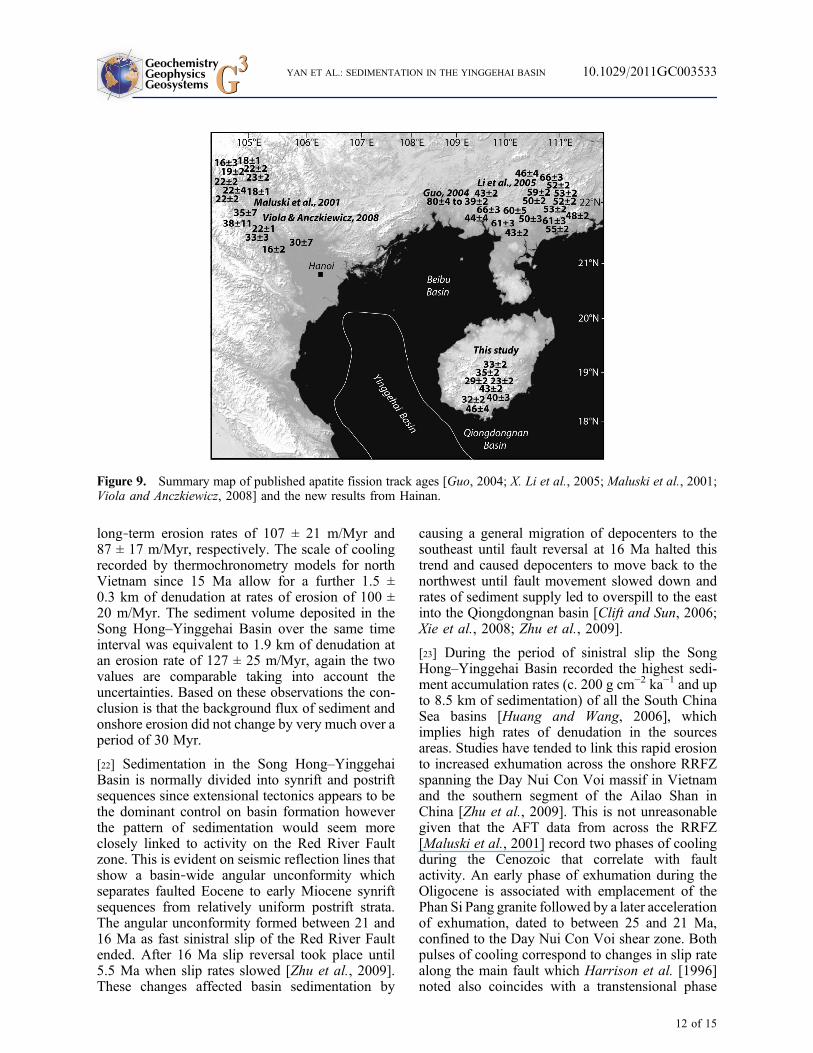
[19] A similar exercise can be used to assesswhether the paleodrainage area was comparable tothe modern Red River or if it once had a muchlarger catchment area that extended further northinto China and east Tibet as suggested by geomor-phic models [e.g., Clark et al., 2004] (Figure 3).The magnitude of cooling recorded by thermalhistory models of published apatite fission trackdata collected from bedrock across the widestparts of the modern Red River drainage in northVietnam (Figure 9) [Maluski et al., 2001], andsimilarity of AFT ages for unmodeled data [Violaand Anczkiewicz, 2008], were used to define anaverage depth of denudation across the region since30 Ma of 2.8 ± 0.6 km (Table 1). This depth oferosion, if confined to a drainage area similar tothat of the modern Red River, would account for80% of the sediment deposited in the Song Hong–Yinggehai Basin (Table 1).
[20] The missing 20% of sediment volume can beexplained by inputs from Hainan (5–17% of thebasin fill), as well as the eastern margins of Viet-nam. Modern sediment flux from the Vietnamesemargin outside the area of the Red River catchmentincludes the Da, Ma, Chu and smaller rivers.
Seismic surveys show such inputs clearly existed inthe past (Figure 8), for example the large clino-forms that prograde eastward away from the coastof Indochina during the Miocene [van Hoang et al.,2010; Yao et al., 2008]. In the northwestern part ofthe Song Hong–Yinggehai Basin there is a clearaxial trend to basin deposition consistent with thebulk of sediment coming from the Red Riverregion, i.e., northern Vietnam (Figures 8a and 8b).However, further south in the basin there is clear
Figure 6. Representative thermal history plots for samples from Hainan produced using the procedure of Gallagheret al. [2005, 2009] and Sambridge et al. [2006].
Figure 7. Summary of Hainan burial and exhumationhistory since the Cretaceous from ZFT, AFT, U‐Th‐Hethermal history modeling, and outcrop geology.
GeochemistryGeophysicsGeosystems G3G3 YAN ET AL.: SEDIMENTATION IN THE YINGGEHAI BASIN 10.1029/2011GC003533
10 of 15

evidence for other sources of sediment based oncontrasting sets of downlapping structures, one ofwhich is observed trending from west to east con-sistent with sources from onshore eastern Vietnam,the other set in the opposite direction from Hainanto the northeast [Xie et al., 2008] (Figure 8c).Unfortunately, lack of thermochronometric datafrom onshore eastern Vietnam means that the scaleof this contribution is currently unknown. Never-theless, it is hard to see how, based on the evidencediscussed above, that the paleodrainage of the RedRiver could have been much larger, if at all, thanthe modern catchment.
[21] Given that the Song Hong–Yinggehai Basinpaleodrainage would have been broadly similar in
area to the current Red River catchment the sedi-ment volumes can be converted to average long‐term rates of erosion based on a catchment ofsimilar size. This was done for the two key periods:(1) 30–15 Ma covering dextral motion on the RedRiver fault zone and opening of the South ChinaSea and (2) postrift from 15 Ma to present duringwhich shifts in monsoon climate are widelybelieved to have taken place [Wan et al., 2007; Weiet al., 2006]. Results show total mass accumulationin the basin between 15 and 30 Ma was equivalentto 1.6 km of denudation across the source areaswhich compares with an average 1.3 ± 0.3 km depthof erosion calculated from the bedrock fission trackdata (Table 1). These two values equate to similar
Figure 8. Sediment isopach maps for the Yinggehai Basin [Gong and Li, 1997, 2004] showing basin depocentertrends and the main source inputs for (a) upper Oligocene, (b) lower Miocene, (c) upper Miocene, and (d) Pliocene.Contour thicknesses are given in meters.
GeochemistryGeophysicsGeosystems G3G3 YAN ET AL.: SEDIMENTATION IN THE YINGGEHAI BASIN 10.1029/2011GC003533
11 of 15
long‐term erosion rates of 107 ± 21 m/Myr and87 ± 17 m/Myr, respectively. The scale of coolingrecorded by thermochronometry models for northVietnam since 15 Ma allow for a further 1.5 ±0.3 km of denudation at rates of erosion of 100 ±20 m/Myr. The sediment volume deposited in theSong Hong–Yinggehai Basin over the same timeinterval was equivalent to 1.9 km of denudation atan erosion rate of 127 ± 25 m/Myr, again the twovalues are comparable taking into account theuncertainties. Based on these observations the con-clusion is that the background flux of sediment andonshore erosion did not change by very much over aperiod of 30 Myr.
[22] Sedimentation in the Song Hong–YinggehaiBasin is normally divided into synrift and postriftsequences since extensional tectonics appears to bethe dominant control on basin formation howeverthe pattern of sedimentation would seem moreclosely linked to activity on the Red River Faultzone. This is evident on seismic reflection lines thatshow a basin‐wide angular unconformity whichseparates faulted Eocene to early Miocene synriftsequences from relatively uniform postrift strata.The angular unconformity formed between 21 and16 Ma as fast sinistral slip of the Red River Faultended. After 16 Ma slip reversal took place until5.5 Ma when slip rates slowed [Zhu et al., 2009].These changes affected basin sedimentation by
causing a general migration of depocenters to thesoutheast until fault reversal at 16 Ma halted thistrend and caused depocenters to move back to thenorthwest until fault movement slowed down andrates of sediment supply led to overspill to the eastinto the Qiongdongnan basin [Clift and Sun, 2006;Xie et al., 2008; Zhu et al., 2009].
[23] During the period of sinistral slip the SongHong–Yinggehai Basin recorded the highest sedi-ment accumulation rates (c. 200 g cm−2 ka−1 and upto 8.5 km of sedimentation) of all the South ChinaSea basins [Huang and Wang, 2006], whichimplies high rates of denudation in the sourcesareas. Studies have tended to link this rapid erosionto increased exhumation across the onshore RRFZspanning the Day Nui Con Voi massif in Vietnamand the southern segment of the Ailao Shan inChina [Zhu et al., 2009]. This is not unreasonablegiven that the AFT data from across the RRFZ[Maluski et al., 2001] record two phases of coolingduring the Cenozoic that correlate with faultactivity. An early phase of exhumation during theOligocene is associated with emplacement of thePhan Si Pang granite followed by a later accelerationof exhumation, dated to between 25 and 21 Ma,confined to the Day Nui Con Voi shear zone. Bothpulses of cooling correspond to changes in slip ratealong the main fault which Harrison et al. [1996]noted also coincides with a transtensional phase
Figure 9. Summary map of published apatite fission track ages [Guo, 2004; X. Li et al., 2005; Maluski et al., 2001;Viola and Anczkiewicz, 2008] and the new results from Hainan.
GeochemistryGeophysicsGeosystems G3G3 YAN ET AL.: SEDIMENTATION IN THE YINGGEHAI BASIN 10.1029/2011GC003533
12 of 15

and which later studies showed had a regionalNE‐SW oriented extension component [Viola andAnczkiewicz, 2008].
[24] Changes in Song Hong–Yinggehai Basin sed-iment flux since 16–15 Ma have also been majorpoints of discussion in previous studies, especiallythe apparent increase in sediment accumulationrates that took place between 15.5 and 10 Ma whena shift in monsoon intensity is thought to haveoccurred [Clift and Sun, 2006; van Hoang et al.,2010]. However, the long‐term erosion rates cal-culated by this study reveal no major changesbefore or after 15 Ma and this suggests that mon-soon forcing of erosion rates was not significantand that short‐term shifts in sediment flux likelyhave other more local causes. Reorganizations inthe paleodrainage system are ruled out due to themass balance between the onshore denudationrecords and basin sediment volumes. Sea levelforcing may have had an influence as there weresmall‐scale (<20 m) shifts in sea level between 15and 10 Ma, but depocenter adjustments related tochanges in motion along the offshore part of theRed River Fault zone were likely more important.
6. Conclusions
[25] Previous studies of sediment mass accumula-tion in the Song Hong–Yinggehai Basin havedrawn attention to short‐lived (few Myr) fluctua-tions in sediment flux, mostly in the middle Mio-cene, and have suggested that these changes mightbe related to monsoon intensity forcing the erosion.The large volume of sediment has also been con-sidered to be the product of a much larger paleoRed River that once connected drainage of theeastern margins of the Tibetan plateau to the SouthChina Sea. To test these interpretations we com-pared basin mass accumulation with erosion his-tories of source regions across northern Vietnamand Hainan Island. We found that depths of erosionsince 30 Ma in northern Vietnam, averaged over anarea similar to that of the modern Red Rivercatchment, can account for 80% of the sedimentdeposited in the Song Hong–Yinggehai Basin. Theresidual 20% can be explained by contributionsfrom Hainan Island and the eastern margin ofVietnam. Thus, if a significantly expanded paleo-drainage ever existed, it must have predated theOligocene. We also found similar average depthsof erosion (1.6 km and 1.3 km) across the modernRed River drainage area before rifting and activesinistral motion on the Red River fault zone (30–15.5 Ma) and after (15.5 Ma to present). This
finding suggests that any short‐lived shifts in mon-soon intensity or tectonics had no lasting impact onbackground long‐term erosion rates.
Acknowledgments
[26] This work was financially cosupported by the NationalNatural Science Foundation of China (Grant 40972130), MajorState Basic Research Program of the People’s Republic ofChina (2009CB219401), and NSFC‐UK Royal Society JointProject award (40811130248). This is contribution (GIGRC‐10‐01) IS‐1338 from GIGCAS.
References
Cai, D. G., and G. X. Fu (1997), Classification and correlationof Tong’anling Niulaling volcanic strata in southern Hainan,Geol. Bull. China, 16, 348–358.
Carter, A., D. Roques, P. Kinny, and C. S. Bristow (2001),Understanding Mesozoic accretion in Southeast Asia: Signif-icance of Triassic thermotectonism in Vietnam, Geology, 29,211–214, doi:10.1130/0091-7613(2001)029<0211:UMAISA>2.0.CO;2.
Chen, P. H., Z. Y. Chen, and Q. M. Zhang (1993), Sequencestratigraphy and continental margin development of thenorthwestern Shelf of the South China Sea, Am. Assoc.Pet. Geol. Bull., 77, 842–862.
Clark, M. K., L.M. Schoenbohm, L. H. Royden, K. X.Whipple,B. C. Burchfiel, X. Zhang, W. Tang, E. Wang, and L. Chen(2004), Surface uplift, tectonics, and erosion of eastern Tibetfrom large‐scale drainage patterns, Tectonics, 23, TC1006,doi:10.1029/2002TC001402.
Clift, P. D. (2006), Controls on the erosion of Cenozoic Asiaand the flux of clastic sediment to the ocean, Earth Planet.Sci. Lett., 241, 571–580, doi:10.1016/j.epsl.2005.11.028.
Clift, P. D., and Z. Sun (2006), The sedimentary and tectonicevolution of the Yinggehai–Song Hong basin and the south-ern Hainan margin, South China Sea: Implications forTibetan uplift and monsoon intensification, J. Geophys.Res., 111, B06405, doi:10.1029/2005JB004048.
Clift, P. D., J. Blusztajn, and A. D. Nguyen (2006), Large‐scaledrainage capture and surface uplift in eastern Tibet–SWChina before 24 Ma inferred from sediments of the HanoiBasin, Vietnam, Geophys. Res. Lett . , 33 , L19403,doi:10.1029/2006GL027772.
Clift, P. D., V. L. Hoang, R. Hinton, R. Ellam, R. Hannigan,M. T. Tan, and D. A. Nguyen (2008a), Evolving east Asianriver systems reconstructed by trace element and Pb and Ndisotope variations in modern and ancient Red River–SongHong sediments, Geochem. Geophys. Geosyst., 9, Q04039,doi:10.1029/2007GC001867.
Clift, P., G. H. Lee, N. Anh Duc, U. Barckhausen, H. VanLong, and S. Zhen (2008b), Seismic reflection evidencefor a Dangerous Grounds miniplate: No extrusion originfor the South China Sea , Tectonics , 27 , TC3008,doi:10.1029/2007TC002216.
Gallagher, K., J. Stephenson, R. Brown, C. Holmes, andP. Fitzgerald (2005), Low temperature thermochronologyand modeling strategies for multiple samples 1: Vertical pro-files, Earth Planet. Sci. Lett., 237, 193–208, doi:10.1016/j.epsl.2005.06.025.
GeochemistryGeophysicsGeosystems G3G3 YAN ET AL.: SEDIMENTATION IN THE YINGGEHAI BASIN 10.1029/2011GC003533
13 of 15

Gallagher, K., K. Charvin, S. Nielsen, M. Sambridge, andJ. Stephenson (2009), Markov chain Monte Carlo (MCMC)sampling methods to determine optimal models, modelresolution and model choice for Earth Science problems,J. Mar. Pet. Geol., 26, 525–535, doi:10.1016/j.marpetgeo.2009.01.003.
Gilley, L. D., T. M. Harrison, P. H. Leloup, F. J. Ryerson,O. M. Lovera, and J. H. Wang (2003), Direct dating of leftlateral deformation along the Red River shear zone, Chinaand Vietnam, J. Geophys. Res., 108(B2), 2127, doi:10.1029/2001JB001726.
Gong, Z., and S. Li (1997), Continental Margin Basin Analysisand Hydrocarbon Accumulation of the Northern South ChinaSea [in Chinese with English abstract], Science Press,Beijing, 510 pp.
Gong, Z., and S. Li (2004), Dynamic Research of Oil and GasAccumulation in Northern Marginal Basins of South ChinaSea [in Chinese with English abstract], Science Press,Beijing, 339 pp.
Guo, T. L. (2004), Meso‐Cenozoic tectono‐thermal history ofShiwandashan Basin, South China, Ph.D. thesis, School ofOcean and Earth Sci., Tongji Univ., Shanghai, China.
Guo, L., Z. Zhong, and L. Wang (2001), Regional tectonicevolution around Yinggehai basin of South China Sea,J. China Univ. Geol., 7, 1–12.
Hao, F., S. T. Li, Y. C. Sun, and Q. M. Zhang (1998), Geol-ogy, compositional heterogeneities, and geochemical originof the Yacheng gas field, Qiongdongnan basin, South ChinaSea, Am. Assoc. Pet. Geol. Bull., 82, 1372–1384.
Harrison, M. T., P. H. Leloup, F. J. Ryerson, P. Tapponnier,R. Lacassin, and C. Wenji (1996), Diachronous initiation oftranstension along the Ailao Shan–Red River shear zone,Yunnan and Vietnam, in The Tectonic Evolution of Asia,edited by A. Yin and T.M. Harrison, pp. 110–137, CambridgeUniv. Press, New York.
Ho, K., J. Chen, and W. Juang (2000), Geochronology andgeochemistry of late Cenozoic basalts from the Leiqiongarea, southern China, J. Asian Earth Sci., 18, 307–324,doi:10.1016/S1367-9120(99)00059-0.
Huang, W., and P. Wang (2006), Sediment mass and distribu-tion in the South China Sea since the Oligocene, Sci. China,Ser. D, Earth Sci., 49(11), 1147–1155.
Hurford, A. J. (1990), Standardization of fission track datingcalibration: Recommendation by the Fission Track WorkingGroup of the IUGS subcommission on geochronology,Chem. Geol., 80, 177–178.
Lei, J., D. Zhao, B. Steinberger, B. Wu, F. Shen, and Z. Li(2009), New seismic constraints on the upper mantle struc-ture of the Hainan plume, Phys. Earth Planet. Inter., 173,33–50, doi:10.1016/j.pepi.2008.10.013.
Leloup, P. H., R. Lacassin, P. Tapponnier, U. Schärer, Z. Dalai,L. Xiaohan, Z. Liangshang, J. Shaocheng, and P. T. Trinh(1995), The Ailao Shan‐Red River shear zone (Yunnan,China), Tertiary transform boundary of Indochina, Tectono-physics, 251, 3–84, doi:10.1016/0040-1951(95)00070-4.
Leloup, P. H., N. Arnaud, R. Lacassin, J. R. Kienast, T. M.Harrison, T. P. Trong, A. Replumaz, and P. Tapponnier(2001), New constraints on the structure, thermochronology,and timing of the Ailao Shan‐Red River shear zone, SEAsia, J. Geophys. Res., 106, 6683–6732, doi:10.1029/2000JB900322.
Li, S., Y. Yun, Y. Fan, and J. B. Zhou (2005), Zircon U‐Pbage and its geological significance for Qiongzhong plutonin Qiongzhong area, Hainan Island [in Chinese with Englishabstract], Geotectonica Metallogenia, 29(2), 227–233.
Li, X. H., G. J. Wei, L. Shao, Y. Liu, X. R. Liang, Z. M. Jian,M. Sun, and P. X. Wang (2003), Geochemical and Ndisotopic variations in sediments of the South China Sea: aresponse to Cenozoic tectonism in SE Asia, Earth Planet.Sci. Lett., 211, 207–220.
Li, X., Y. Wang, K. Tan, and T. Peng (2005), Meso‐Cenozoicuplifting and exhumation on Yunkaidashan: Evidence fromfission track thermochronology, Chin. Sci. Bull., 50(9),903–909, doi:10.1360/04wd0040.
Li, X.‐H., Z.‐X. Li, W.‐X. Li, and Y. Wang (2006), Initiationof the Indosinian Orogeny in South China: Evidence fora Permian magmatic arc in the Hainan Island, J. Geol.,114(3), 341–353, doi:10.1086/501222.
Li, Z.‐X., and X.‐H. Li (2007), Formation of the 1300‐km‐wide intracontinental orogen and postorogenic magmaticprovince in Mesozoic South China: A flat‐slab subductionmodel, Geology, 35, 179–182, doi:10.1130/G23193A.1.
Maluski, H., C. Lepvrier, L. Jolivet, A. Carter, D. Roques,O. Beyssac, T. T. Tang, N. D. Thang, and D. Avigad(2001), Ar‐Ar and fission‐track ages in the Song Chaymassif:Early Triassic and Cenozoic tectonics in northern Vietnam,J. Asian Earth Sci., 19, 233–248, doi:10.1016/S1367-9120(00)00038-9.
Molnar, P., and P. Tapponnier (1975), Cenozoic tectonics ofAsia: Effects of a continental collision, Science, 189(4201),419–426.
Moon, S., Y. Huh, J. Qin, and N. V. Pho (2007), Chemicalweathering in the Hong (Red) River basin: Rates of silicateweathering and their controlling factors, Geochim. Cosmo-chim. Acta, 71, 1411–1430, doi:10.1016/j.gca.2006.12.004.
Morley, C. K. (2002), A tectonic model for the Tertiary evolu-tion of strike‐slip faults and rift basins in SE Asia, Tecto-nophysics, 347, 189–215, doi:10.1016/S0040-1951(02)00061-6.
Replumaz, A., and P. Tapponnier (2003), Reconstruction ofthe deformed collision zone between India and Asia bybackward motion of lithospheric blocks, J. Geophys. Res.108(B6), 2285, doi:10.1029/2001JB000661.
Richardson, N. J., A. L. Densmore, D. Seward, M. Wipf, andY. Li (2010), Did incision of the Three Gorges begin in theEocene?, Geology, 38(6), 551–554, doi:10.1130/G30527.1.
Sambridge, M., K. Gallagher, A. Jackson, and P. Rickwood(2006), Trans‐dimensional inverse problems, model compar-ison and the evidence, Geophys. J. Int., 167, 528–542,doi:10.1111/j.1365-246X.2006.03155.x.
Searle, M. P. (2006), Role of the Red River shear zone,Yunnan and Vietnam, in the continental extrusion of SEAsia, J. Geol. Soc., 163, 1025–1036, doi:10.1144/0016-76492005-144.
Searle, M. P., M.‐W. Yeh, T.‐H. Lin, and S.‐L. Chung (2010),Structural constraints on the timing of left‐lateral shear alongthe Red River shear zone in the Ailao Shan and DiancangShan Ranges, Yunnan, SW China, Geosphere, 6, 316–338,doi:10.1130/GES00580.1.
Sun, Z., D. Zhou, Z. Zhong, Z. Zeng, and S. Wu (2003),Experimental evidence for the dynamics of the formationof the Yinggehai Basin, NW South China Sea, Tectonophysics,372, 41–58, doi:10.1016/S0040-1951(03)00230-0.
Sun, Z., Z. Zhong, D. Zhou, and Z. Zeng (2004), Continent‐ocean interactions along the Red River fault zone, SouthChina Sea, in Continent‐Ocean Interactions Within EastAsian Marginal Seas, Geophys. Monogr. Ser., vol. 149,edited by P. Clift et al., pp. 109–120, AGU, Washington,D. C.
GeochemistryGeophysicsGeosystems G3G3 YAN ET AL.: SEDIMENTATION IN THE YINGGEHAI BASIN 10.1029/2011GC003533
14 of 15

Tapponnier, P., G. Peltzer, and R. Armijo (1986), On themechanics of the collision between India and Asia, in Colli-sion Tectonics, edited by M. P. Coward and A. C. Ries,Geol. Soc. Spec. Publ., 19, 115–157.
Tapponnier, P., R. Lacassin, P. H. Leloup, U. Schärer, Z. Dalai,W. Haiwei, L. Xiaohan, J. Shaocheng, Z. Lianshang, andZ. Jiayou (1990), The Ailao Shan/Red River metamorphicbelt: Tertiary left‐lateral shear between Indochina and SouthChina, Nature, 343, 431–437, doi:10.1038/343431a0.
Tapponnier, P., Z. Xu, F. Roger, B. Meyer, N. Arnaud,G. Wittlinger, and J. Yang (2001), Oblique stepwise riseand growth of the Tibet Plateau, Science, 294, 1671–1677,doi:10.1126/science.105978.
van Hoang, L., F.‐Y. Wu, P. D. Clift, A. Wysocka, andA. Swierczewska (2009), Evaluating the evolution of theRed River system based on in situ U‐Pb dating and Hf iso-tope analysis of zircons, Geochem. Geophys. Geosyst., 10,Q11008, doi:10.1029/2009GC002819.
van Hoang, L., P. D. Clift, A. M. Schwab, M. Huuse, D. A.Nguyen, and Z. Sun (2010), Large‐scale erosional responseof SE Asia to monsoon evolution reconstructed from sedi-mentary records of the Song Hong–Yinggehai and Qiong-dongnan basins, South China Sea, in Monsoon Evolutionand Tectonic–Climate Linkage in Asia, edited by P. D. Clift,R. Tada, and H. Zheng, Geol. Soc. Spec. Publ, 342, 219–244.
Viola, G., and R. Anczkiewicz (2008), Exhumation history ofthe Red River shear zone in northern Vietnam: New insightsfrom zircon and apatite fission‐track analysis, J. Asian EarthSci., 33, 78–90, doi:10.1016/j.jseaes.2007.08.006.
Wan, S., A. Li, P. D. Clift, and J.‐B. W. Stuut (2007),Development of the East Asian Monsoon: Mineralogicaland sedimentologic records in the northern South ChinaSea since 20 Ma, Palaeogeogr. Palaeoclimatol. Palaeoecol.,254, 561–582, doi:10.1016/j.palaeo.2007.07.009.
Wang, E., and B. C. Burchfiel (1997), Interpretation of Ceno-zoic tectonics in the right lateral accommodation zonebetween the Ailao Shan Shear zone and the Eastern Himala-yan Syntaxis, Int. Geol. Rev., 39, 191–219, doi:10.1080/00206819709465267.
Wei, G., X. H. Li, Y. Liu, L. Shao, and X. Liang (2006),Geochemical record of chemical weathering and monsoon
climate change since the early Miocene in the South ChinaSea,Paleoceanography , 21 , PA4214, doi:10.1029/2006PA001300.
Xie, C. F., J. C. Zhu, Z. J. Zhao, S. J. Ding, T. A. Fu, Z. H. Li,Y. M. Zhang, and D. P. Yu (2005), Zircon SHRIMP U‐Pbage dating of garnet‐acmite syenite: Constraints on theHercynian‐Indosinian tectonic evolution of Hainan Island,J. China Univ. Geol., 11(1), 47–57.
Xie, X., S. Li, W. Dong, and Z. Hu (2001), Evidence for epi-sodic expulsion of hot fluids along faults near diapiric struc-ture of the Yinggehai basin, South China, Mar. Pet. Geol.,18, 715–728, doi:10.1016/S0264-8172(01)00024-1.
Xie, X., R. D. Muller, J. Ren, T. Jiang, and C. Zhang (2008),Stratigraphic architecture and evolution of the continentalslope system in offshore Hainan, northern South ChinaSea, Mar. Geol., 247, 129–144, doi:10.1016/j.margeo.2007.08.005.
Yan, Y., B. G. Xia, A. Lin, A. Carter, X. Hu, B. Liu, X. Cui,P. Yan, and Z. Song (2007), Geochemical and Nd isotopecompositions of detrital sediments on the north margin ofthe South China Sea: Provenance and tectonic implications,Sedimentology, 54, 1–17, doi:10.1111/j.1365-3091.2006.00816.x.
Yan, Y., A. Carter, L. Ge, S. Brichau, and H. Xiaoqiong(2009), Fission‐track and (U‐Th)/He thermochronometry ofonshore South China Sea: Implication to morphotectonicevolution and sediment contribution to the northern SouthChina Sea, Tectonophysics, 424, 584–594, doi:10.1016/j.tecto.2009.04.030.
Yao, G.‐S., S.‐Q. Yuan, S.‐U. Wu, and C. Zhong (2008), Dou-ble provenance depositional model and exploration prospectin deepwater area of Qiongdongnan Basin, Pet. Explor. Dev.,35, 685–691, doi:10.1016/S1876-3804(09)60101-4.
Yuan, Y., W. Zhu, L. Mi, G. Zhang, S. Hu, and L. He (2009),Uniform geothermal gradient and heat flow in the Qiong-dongnan and Pearl River Mouth Basins of the South ChinaSea Marine and Petroleum, Geology, 26, 1152–1162.
Zhu, M., S. Graham, and T. McHargue (2009), The Red RiverFault zone in the Yinggehai Basin, South China Sea, Tecto-nophysics, 476, 397–417, doi:10.1016/j.tecto.2009.06.015.
GeochemistryGeophysicsGeosystems G3G3 YAN ET AL.: SEDIMENTATION IN THE YINGGEHAI BASIN 10.1029/2011GC003533
15 of 15
Related Documents