Tsunami Hazard Mitigation and Preparedness A Perspective from State and Territory Tsunami Programs in the High Tsunami Risk Pacific Region By The Western States Seismic Policy Council 2011 WSSPC Report 2011-01 1946 1964 Today Tomorrow

Welcome message from author
This document is posted to help you gain knowledge. Please leave a comment to let me know what you think about it! Share it to your friends and learn new things together.
Transcript
Tsunami Hazard Mitigation and Preparedness
A Perspective from State and Territory Tsunami Programs in the High Tsunami Risk Pacific Region
By The Western States Seismic Policy Council
2011
WSSPC Report 2011-01
1946 1964 Today Tomorrow
2
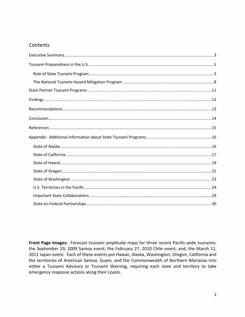
Contents
Executive Summary ....................................................................................................................................... 3
Tsunami Preparedness in the U.S. ................................................................................................................ 5
Role of State Tsunami Program ................................................................................................................ 5
The National Tsunami Hazard Mitigation Program .................................................................................. 8
State Partner Tsunami Programs ................................................................................................................ 11
Findings ....................................................................................................................................................... 12
Recommendations ...................................................................................................................................... 13
Conclusion ................................................................................................................................................... 14
References .................................................................................................................................................. 15
Appendix: Additional Information about State Tsunami Programs ........................................................... 16
State of Alaska......................................................................................................................................... 16
State of California ................................................................................................................................... 17
State of Hawaii ........................................................................................................................................ 19
State of Oregon ....................................................................................................................................... 21
State of Washington ............................................................................................................................... 23
U.S. Territories in the Pacific ................................................................................................................... 24
Important State Collaborations .............................................................................................................. 29
State-to-Federal Partnerships ................................................................................................................. 30
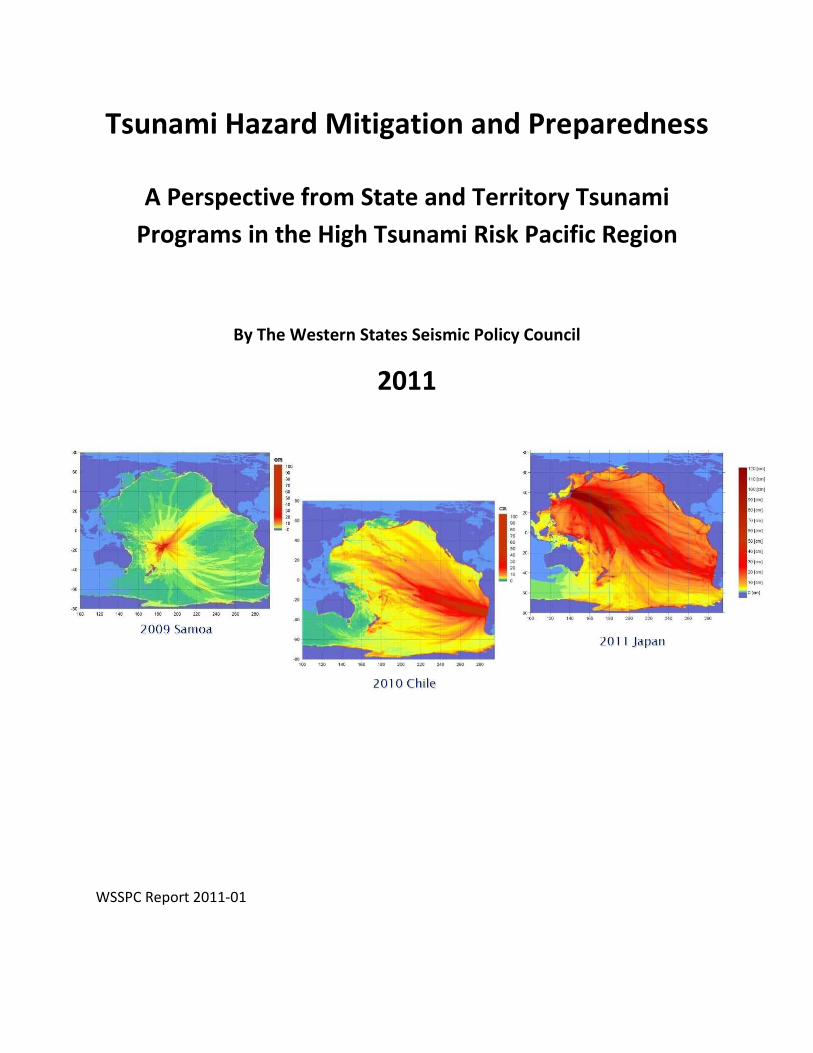
Front Page Images: Forecast tsunami amplitude maps for three recent Pacific-wide tsunamis: the September 29, 2009 Samoa event; the February 27, 2010 Chile event; and, the March 11, 2011 Japan event. Each of these events put Hawaii, Alaska, Washington, Oregon, California and the territories of American Samoa, Guam, and the Commonwealth of Northern Marianas into either a Tsunami Advisory or Tsunami Warning, requiring each state and territory to take emergency response actions along their coasts.
3
Executive Summary
The tsunami programs for the states of Alaska, California, Hawaii, Oregon, and Washington, and the U.S territories of American Samoa, Guam, and the Commonwealth of Northern Marianas (hereafter “state tsunami programs” will refer to both states and territories), work together through the Western States Seismic Policy Council and the National Tsunami Hazard Mitigation Program (NTHMP) to prepare our communities from damaging tsunamis. Coastal communities in these states and territories are at a high risk to tsunamis and have a documented history of tsunamis generated by large earthquakes along or near subduction zones around the Pacific Rim. The states and territories are important partners with the various federal agencies in the NTHMP. The NTHMP framework provides a stable, over-arching platform for collaboration among the state programs to implement robust, long-term education programs and tsunami preparedness plans at the most important place: the community level. Grass roots, community-level outreach and education is the only effective means of mitigating loss of life to locally generated tsunamis for which the only warning is the causative earthquake. The national tsunami warning system is ineffective for local tsunamis because the notification time is too short. Education and inundation mapping through the NTHMP is thus the only national effort to mitigate loss of life to large, locally generated tsunamis known to threaten the Pacific Northwest and Alaska. With funding from the NTHMP through the Tsunami Warning and Education Act, the following community-based tsunami mitigation and preparedness activities are being accomplished:
• Improved collaboration from the NHTMP Coordinating Committee and its subcommittees, as well as better coordination between Federal, State, and Local warning personnel and associated response actions which saved lives and property during recent tsunami events.
• Improved coordination between state tsunami programs and consistency in the products they produce.
• Expanded and improved tsunami inundation mapping by state programs, including: o Improved tsunami source evaluations and characterizations; o Creation of paleo-tsunami deposit databases for validating modeling and
mapping results; o Coordination and quality assurance with regard to mapping and modeling
methods; and, o Establishment of tsunami evacuation map guidelines.
• Expansion of tsunami mitigation beyond emergency response and evacuation planning, including:
o Developing tsunami current hazard maps and evacuation guidance for maritime communities; and,
o Developing maps and guidelines to improve land-use planning at a local level.
4
• Improved coastal emergency evacuation plans, including vertical evacuation and evacuation mapping guidelines.
• Increased options for public outreach, education resources and materials for school children, and internal training of government officials at the state and local level.
• Expanded tsunami hazard sign placement with state guidance and assistance. • Increased number of NOAA-recognized “TsunamiReady” communities; and, • Increased research capability to identify, understand, and share the best and most
recently available advances in scientific knowledge of the tsunami threat to the coast. Based on the experience of the state tsunami programs, four important findings are presented: 1) community-based tsunami planning requires strong state programs; 2) continuation of the strong relationship of the state programs with Federal agencies through the NTHMP is needed; 3) meeting long-term goals of tsunami mitigation and preparedness require maintaining partnerships and funding; and 4) working towards tsunami resiliency is desirable. Sustaining effective federal-to-state and state-to-local collaborations requires a continued unified effort through the NTHMP, as well as continued adequate funding of state tsunami programs for implementing future tsunami preparedness plans. For most states and territories, the NTHMP is the only source for funding state tsunami mitigation and preparedness activities. With the Tsunami Warning and Education Act scheduled to expire in September 2012, the state tsunami programs strongly recommend that the Act be reauthorized, and that the intended 27% state-specific funding level be sustained and reinforced in the language of the Act. This would allow the state tsunami programs to maintain their strong, community-based tsunami preparedness activities which are a requirement of the Act.
The state tsunami programs also recommend that NOAA carefully examine the cost benefit of: (1) the addition of a third tsunami warning center in the Caribbean, (2) any planned expansion to the deep-ocean buoy warning system, and (3) maintaining tsunami warning centers in both Hawaii and Alaska versus one collocated center. With limited funding available to the overall national tsunami program, the benefit of financing these endeavors should be weighed against the degree of improvement to the existing tsunami warning system, and the likely reduced funding and resources available to the higher-risk, Pacific Rim states. In addition, expansion of the existing warning system will not reduce loss of life to locally generated tsunamis, a situation that only a strong state and local education and preparedness effort can address.
5
Tsunami Preparedness in the U.S.
Over the past decade, tsunamis have killed more people than almost any other natural hazard, with the majority of the tsunamis originating along the Pacific Ocean’s “Ring of Fire” (Figure 1). For this reason, communities in low-lying coastal areas around the Pacific Rim are among the most at risk to tsunami damages generated from both local and distant sources. This includes coastal regions of the states of Alaska, California, Hawaii, Oregon, and Washington, as well as the U.S. territories of American Samoa, Guam, and Northern Marianas (hereinafter all referred to as “states” or “state tsunami programs”) – states which make up the membership of the Tsunami Hazard Mitigation Committee of the Western States Seismic Policy Council (WSSPC), the compiler of this report. Detailed information about these state tsunami programs are included in the appendix. The WSSPC Tsunami Hazard Mitigation Committee has also adopted several policy recommendations that support tsunami hazard mitigation and preparedness activities by its state and territorial partners (see http://www.wsspc.org/policy for more information).
Role of State Tsunami Program
The fundamental role of each state tsunami program is to identify, prepare for, and help mitigate the effects of tsunami hazards at the coastal community level. The Pacific states share a common concern that the tectonically active Pacific Rim can produce a community-destroying tsunami at any time. They also share a common goal to minimize the loss of life and property damage from tsunami events by communicating the risk of how best to prepare local communities for future tsunamis. For more than 50 years, social science researchers have been studying how various groups process and respond to hazard awareness and risk reduction information. These academic researchers have found time and again that consistency of messaging is critical to significantly improving education and outreach across the audience spectrum for all hazards, including tsunamis. The states are in the best position to create consistent products and provide services to their affected communities in an efficient and effective manner.
Since 1900, over 100 tsunamis have impacted the Pacific states. Table 1 shows the most significant tsunamis during this time and the damage and casualties associated with each event for all of the Pacific U.S. states and territories. These tsunami events have killed 392 people and caused over $1.6 billion in damages, and include five of the six largest earthquakes ever recorded. Future anticipated great earthquakes (Mw 8 to Mw 9 range) on either the eastern Aleutian Island Subduction Zone or the Cascadia Subduction Zone would put millions of coastal residents and visitors at risk in the coastal states (Dunbar and Weaver, 2008; Wilson et al., 2010a). The Cascadia Subduction Zone generated a calculated Mw 9 earthquake in the year 1700 that caused a tsunami estimated to be over 50 feet high along portions of the Washington, Oregon, and California coasts, tsunami heights very similar to the recent tsunami
6
that devastated portions of Japan on March 11, 2011. If a similar Cascadia or Aleutian Island megathrust event were to occur today, inhabitants of modern coastal communities would have only minutes to get to safe ground before their infrastructures were destroyed and lives lost.
Federal Tsunami Warning Centers cannot provide timely tsunami alert messages to communities located nearby subduction zones, like Cascadia and the Aleutians. Therefore, state tsunami programs must devote significant resources to evaluating these local earthquake and tsunami sources, and educating the public to recognize the “natural warning” of earthquake shaking and to respond by promptly evacuating. This was demonstrated by the September 29, 2009 tsunami which devastated low-lying coastal areas of American Samoa. According to local officials, although 34 people were killed, if it were not for tsunami education activities conducted by federal and territorial preparedness experts in the weeks and months prior to the tsunami, the casualties from this tsunami would have been ten times more. Support by the NTHMP and other agencies saved countless lives during this and other recent events.
7
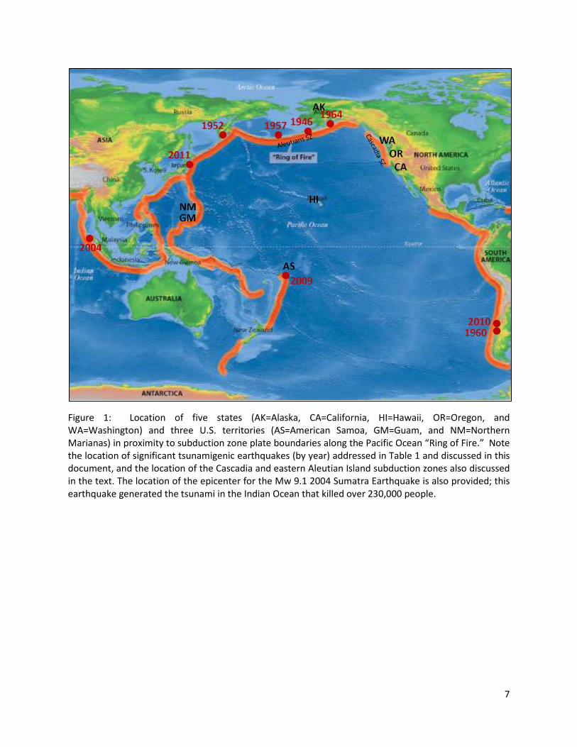
Figure 1: Location of five states (AK=Alaska, CA=California, HI=Hawaii, OR=Oregon, and WA=Washington) and three U.S. territories (AS=American Samoa, GM=Guam, and NM=Northern Marianas) in proximity to subduction zone plate boundaries along the Pacific Ocean “Ring of Fire.” Note the location of significant tsunamigenic earthquakes (by year) addressed in Table 1 and discussed in this document, and the location of the Cascadia and eastern Aleutian Island subduction zones also discussed in the text. The location of the epicenter for the Mw 9.1 2004 Sumatra Earthquake is also provided; this earthquake generated the tsunami in the Indian Ocean that killed over 230,000 people.
8
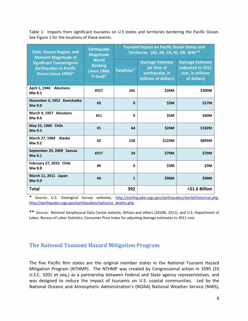
Table 1: Impacts from significant tsunamis on U.S states and territories bordering the Pacific Ocean. See Figure 1 for the locations of these events.
Date, Source Region, and Moment Magnitude of
Significant Tsunamigenic Earthquakes in Pacific Ocean (since 1900)*
Earthquake Magnitude
World Ranking
(since 1900; T=tied)*
Tsunami Impact on Pacific Ocean States and Territories (AS, AK, CA, HI, OR, WA)**
Fatalities*
Damage Estimate (at time of
earthquake, in millions of dollars)
Damage Estimate (adjusted to 2011 cost, in millions
of dollars)
April 1, 1946 Aleutians Mw 8.1 #31T 165 $26M $300M
November 4, 1952 Kamchatka Mw 9.0 #5 0 $2M $17M
March 9, 1957 Aleutians Mw 8.6 #11 0 $5M $40M
May 22, 1960 Chile Mw 9.5 #1 64 $24M $182M
March 27, 1964 Alaska Mw 9.2 #2 128 $123M $895M
September 29, 2009 Samoa Mw 8.1 #31T 34 $79M $79M
February 27, 2010 Chile Mw 8.8 #6 0 $3M $3M
March 11, 2011 Japan Mw 9.0 #4 1 $90M $90M
Total 392 +$1.6 Billion
* Source: U.S. Geological Survey websites, http://earthquake.usgs.gov/earthquakes/world/historical.php, http://earthquake.usgs.gov/earthquakes/states/us_deaths.php
** Source: National Geophysical Data Center website, Wilson and others (2010b; 2011), and U.S. Department of Labor, Bureau of Labor Statistics, Consumer Price Index for adjusting damage estimates to 2011 cost.
The National Tsunami Hazard Mitigation Program
The five Pacific Rim states are the original member states in the National Tsunami Hazard Mitigation Program (NTHMP). The NTHMP was created by Congressional action in 1995 (33 U.S.C. 3201 et seq.) as a partnership between Federal and State agency representatives, and was designed to reduce the impact of tsunamis on U.S. coastal communities. Led by the National Oceanic and Atmospheric Administration’s (NOAA) National Weather Service (NWS),
9
and including membership from the U.S. Geological Survey (USGS) and the Federal Emergency Management Agency (FEMA), the NTHMP is the nation’s community-focused program to improve tsunami mitigation and preparedness of at-risk areas within the U.S. and its territories.
Most states and territories receive little or no funding from their own governments for tsunami preparedness activities; the NTHMP grant funding to the states is all that is available to carry out tsunami hazard mitigation and preparedness activities. Despite its Congressional mandate, funding levels for the NTHMP have been inconsistent and at times insufficient since 1995. Prior to 2006, each state had been given an annual grant amount of between $150,000 and $250,000, funding levels that were inadequate to complete all the work needed to significantly improve community understanding of the tsunami threats they are facing and the appropriate life-safety actions necessary to respond.
Tsunami Warning and Education Act
In 2006, approximately two years after the devastating 2004 Indian Ocean tsunami which killed over 230,000 people, Congress passed the Tsunami Warning and Education Act (TWEA) to help reinvigorate the NHTMP and the work of its State Partners, and increased the number of member states to 29 from the original five. One of the intents of TWEA was to provide sustainable funding for the State Partners in the NTHMP by requiring that 27% of the TWEA funding, which was approximately $7M of the $25M total per year, go directly to the State Partners for tsunami hazard reduction work (TWEA, Section 8). However, between 2006 and 2008, despite the intent to provide an influx of funding, the State Partners each still received less than $250,000 per year, similar to the pre-2006 funding levels. Although increasing the number of states contributed to the lower amount per state, the most significant reason for the decreased state funding was that NOAA directed a majority of the TWEA funding, including a large part of the 27% allocated for state community programs, to expanding the DART warning buoy system. Although this effort improved the tsunami warning system for distantly generated tsunamis, the funding amount was insufficient to support state education and awareness activities provided to the local communities affected by a tsunami closer to shore, and to meet the fundamental expectations from coastal communities and the public to expand tsunami hazard preparedness activities following the 2004 tsunami.
In 2008, recognizing that the “community-based” intent of TWEA had been neglected, Congress recommended that NOAA increase funding to the state tsunami programs as Congress originally intended. Starting in 2009, after a change in NOAA leadership in the NTHMP, the appropriate levels of funding were made available to the State Partners from a different funding source (originating from the one-time sale of radio spectrum frequencies that were redirected to tsunami activities). Significant improvements were made to the NTHMP structure overall. The program published its first strategic plan and succeeded in achieving the annual milestones laid out in that plan.
Many of its strategic plan milestones were also NTHMP-related recommendations from the National Academies of Science (NAS) Report on NOAA’s Tsunami Program (National Research

10
Council, 2011). For example, some of the tsunami hazard mapping recommendations in the NAS Report (underlined below) are already being addressed in the following ways:
1. Completion of an initial national assessment of tsunami risk - The state tsunami programs have begun the process of assessing the tsunami risk by working on pilot probabilistic tsunami hazard analyses (PTHA) projects. This information will be useful to compare the tsunami hazard risk over time for different communities, and could help reduce the cost of a national risk assessment.
2. A consistent assessment of tsunami sources– The state programs work together through the NTHMP Mapping and Modeling Subcommittee (MMS) to evaluate the tsunami sources used by each state in their mapping projects. Individual states identify these sources, and this knowledge is shared and utilized among the state programs to help provide more consistent results.
3. Review of progress in hydrodynamic tsunami models – One of the NTHMP Strategic Plan elements is that all hydrodynamic models meet standards set by the MMS. In March 2011, the NTHMP MMS held a tsunami model validation workshop; the findings from this workshop and the validation results will be presented in a report to be completed in early 2012.
4. Conduct modeling efforts consistently across political boundaries – In 2010, the NTHMP MMS completed a guidance document for modeling and mapping projects. Interaction within the NTHMP MMS helps produce consistency and coordination between the state tsunami programs.
5. Develop guidelines on evacuation map production and an on-line repository for evacuation maps – In early 2011, the NTHMP Mitigation and Education Subcommittee completed guidelines for evacuation mapping. Each state makes their evacuation maps available online and through the NTHMP information repository.
National Program Summary
Clearly, the increased funding for the State Partners has led to improvements to both the NTHMP and tsunami preparedness efforts at the community level; this is recognized by the NAS report. In addition, many of the recommendations within the NAS report are already being accomplished by the NTHMP and its State Partners because of the funding from TWEA. However, TWEA is due to sunset in September of 2012 which, unless it is reauthorized, will negatively impact the ability of both the state and federal tsunami programs to continue to function at this high level.
11
State Partner Tsunami Programs
The NTHMP provides a perfect platform for states to share information with each other about new and ongoing tsunami preparedness projects. State tsunami programs work closely together and with social science experts to ensure that mitigation, awareness, and preparedness activities and messaging are done in a consistent manner within states and across state lines. These states also work through other organizations, like WSSPC, to better coordinate on interstate issues.
With increased funding from the Tsunami Warning and Education Act the state tsunami programs have improved the products and services they provide to coastal communities (National Research Council, 2011). The tsunami hazard mitigation and preparedness programs for the Pacific Rim states share some common functions and goals:
• Creation of tsunami inundation maps for emergency response planning that are tailored to each local coastal jurisdiction while remaining consistent with federal mapping guidelines. States make these tsunami inundation and evacuation maps readily available to the public through easy to understand, interactive web interfaces.
• Ensuring effective and consistent tsunami sign placement for identifying evacuation routes and inundation zones in all at-risk areas. This includes purchasing tsunami signs and providing guidance and assistance to coastal communities to ensure sign placement is appropriate and consistent between communities.
• Sustained emergency communication and response preparedness through annual reviews of response protocols and continuous exercises with local agencies. States provide resources and organize workshops for emergency managers to make certain uniform actions are taken based on messaging from the Warning Centers.
• Promote public awareness and education about tsunami hazards through workshops, training, and brochures regarding tsunami threats. States work with various civic organizations and the business and tourism industries to develop tsunami preparedness plans.
• Observation of an annual Tsunami Awareness and Preparedness Week, during which public preparedness and media outreach activities are conducted, websites promoted, and education materials widely distributed.
• Providing resources and being advocates for communities to become “TsunamiReady”, a NOAA National Weather Service designation for communities that have met a standard for tsunami preparedness.
In addition to these common goals, each state has developed a number of tsunami preparedness activities that are unique to their jurisdictions. Through individual state experiences and state-to-state interactions, these activities help provide the framework to initiate similar projects in other states. The appendix provides more information about specific
12
work being done by the state tsunami programs, and the collaborations between the states and with other federal agencies.
Findings All activities within partner state tsunami work plans relate to improving tsunami planning and preparedness at the most important “community level.” Although significant accomplishments have been made, additional work in hazard identification and community preparedness remains. Based on the experience of the state tsunami programs represented, and surmised from review of the National Research Council report (2011), four important findings encapsulate the effectiveness of community-based tsunami preparedness:
1. “Community-based” tsunami planning requires strong state programs. Leadership at the state level is essential to implement accurate and consistent tsunami preparedness activities. These activities include tsunami hazard identification, public outreach and education practices, and evacuation/response planning.
2. Continuation of the strong relationship with Federal agencies through the NTHMP is needed. The level of coordination between Federal and State Partners within the NTHMP has improved over the last several years. This affiliation has enhanced the ability of the states to implement Federal policies and projects at the most effective community level.
3. Meeting long-term goals require maintaining partnerships and funding. In order to implement multi-year plans, consistent funding must be available to the partner state tsunami programs. Re-authorization and continued funding at the 27 percent partner state share of the Tsunami Warning and Education Act is necessary to maintain the momentum the state programs have initiated. Without these partnerships and funding, the momentum of community-based tsunami preparedness activities will falter and vulnerability of coastal populations to tsunamis will significantly increase.
4. Working towards tsunami resiliency is desirable. The ultimate goal of the state tsunami programs is to initiate and maintain sustained tsunami preparedness programs at the local level. This involves not only reducing the impact of future tsunamis but also developing tsunami recovery plans that allow communities to be resilient.
13
Recommendations Sustaining the innovative work by the state tsunami programs is essential to saving lives and property from future devastating tsunamis. Based on the findings of this report, there are a number of recommendations the state programs have for sustaining this work and accomplishing their long-term goals of creating tsunami resilient communities:
• Reauthorization of the Tsunami Warning and Education Act - A majority of the funding for the state tsunami programs comes from the Tsunami Warning and Education Act (TWEA). With the sunset of the TWEA due in September 2012, it is unknown how effective the state programs and the NTHMP overall can be without this valuable funding source. For this reason, we strongly encourage the Federal government to not only reauthorize the Act but also amend the language so that it clearly affirms that the “State Partners” of the NTHMP receive the 27% of the funding provided under the Act; this was the initial intent of the TWEA when it was passed in 2006. This is the only way to ensure that the TWEA can be implemented at the community level.
• Continued confidence in the state tsunami programs to meet National “community” preparedness objectives – Although the National Academies of Science (NAS) report (National Research Council, 2011) indicates that stronger Federal programs may be desirable to address future concerns, the state tsunami programs clearly have demonstrated they are in the best position to implement national policies at a community level. Many of the recommendations made in the NAS report regarding community-level preparedness already are being addressed by the state tsunami programs through the NTHMP. Most of the effective and innovative work related to tsunami hazard identification and preparedness is being done at the state level; for this reason, Federal agencies should continue to coordinate all project work with the state tsunami programs.
• Monitor the expansion of the DART buoy system – At approximately $11 million per
year (2010 costs), the annual cost for maintenance of these buoys is more than the funding for all the NTHMP state tsunami programs combined. Following the 2004 Indian Ocean Tsunami, the number of buoys was increased from 6 to 39. Even with a number of the buoys out of service during the last several events, there was enough redundancy that the Warning Centers were able to provide accurate forecasts for their areas of operation. Expanding an already adequately redundant system with additional buoys may occur at the expense of funding to states for community-based preparedness activities. The state tsunami programs request that NOAA maintain a proper funding balance between the DART buoy warning system and the states’ tsunami program
14
needs as defined by the states. The DART buoy system does nothing to reduce losses to locally generated tsunamis, the largest threat to Alaska and the Pacific Northwest coast.
• A third tsunami warning center is unnecessary, and the two existing centers should consider consolidation – Recently, there has been discussion that a third tsunami warning center be established in the Caribbean, instituted and funded through the Tsunami Warning and Education Act. It has not been adequately demonstrated that a third warning center will greatly improve the overall tsunami warning system, especially for tsunamis generated by large local sources which can be the most dangerous because of a lack of time for an official warning. The concern is that funding of this additional warning center could come at the expense of funding to the state tsunami programs, programs most responsible for public/community preparedness for local tsunami events. It may also take vital resources away from the existing warning centers. In addition, the 2011 NAS report questioned the need for two tsunami warning centers in Alaska and Hawaii located far from collegial interaction with other scientists, and noted that a one-center system would help avoid inconsistencies in analysis and messaging (National Research Council. 2011). The NAS suggested that the current two-center system be reexamined and that co-location be considered. Obviously, a third warning center could exacerbate inconsistencies between multiple warning centers. Therefore, we recommend that the Federal government not authorize a third tsunami warning center and consider combining the two existing warning centers as mentioned in the 2011 NAS report.
Conclusion
The strong partnership in the NTHMP enables all levels of government to work toward the common goal of saving the lives of all people at risk to tsunamis along our nation’s coastlines, while also reducing the exposure and damage to property and the economy. This was demonstrated during the recent Pacific-wide tsunamis of 2009 (Samoa), 2010 (Chile), and 2011 (Japan), where these partnerships resulted in reducing the exposure of the public and damage to coastal infrastructure. Sustaining this relationship will only strengthen and improve tsunami preparedness in the U.S., and a sharp decline in funding will likely result in future generations that are unprepared to respond to tsunami hazards. If TWEA is not re-authorized, a substantial investment will be required to re-achieve the current level of awareness and preparedness that exists today, resulting in an increased potential for tsunami-related fatalities and damage in coastal states and territories. Without TWEA and the support from the NTHMP, there will be no national effort to reduce loss of life to one of the most devastating national disasters facing the U.S. -- a locally generated tsunami from great earthquakes in the Pacific Northwest and Alaska.
15
References
Dunbar, P.K. and Weaver, C.S., 2008, U.S. States and Territories National Tsunami Hazard Assessment: Historical record and sources for waves: National Tsunami Hazard Mitigation Program, National Oceanic and Atmospheric Administration, Silver Spring, Maryland, and U.S. Geological Survey, Reston, Virginia, 59 p.
Lander, J.F., and Whiteside, L.S., 2002, The Tsunami History of Guam, 1849–1993: Science of Tsunami Hazards, The International Journal of the Tsunami Society, v. 20, no. 3, pp. 158-174. http://library.lanl.gov/tsunami/ts203.pdf
National Research Council of the National Academies of Science (NAS), Committee on the Review of the Tsunami Warning and Forecast System and Overview of the Nation’s Tsunami Preparedness, 2011, Tsunami Warning and Preparedness: An Assessment of the U.S. Tsunami Program and the Nation’s Preparedness Efforts: The National Academies Press, Washington, D.C., 284 p.
Tsunami Warning and Education Act, 2006, Public Law 109-424, 33 U.S.C. 3201 et seq.
U.S. Department of Labor, Bureau of Labor Statistics, 2011, CPI Inflation Calculator, http://www.bls.gov/data/inflation_calculator.
U.S. Geological Survey, 2011, Historic World Earthquakes, http://earthquake.usgs.gov/earthquakes/world/historical.php
U.S. Geological Survey, 2011, Deaths From U.S. Earthquakes, http://earthquake.usgs.gov/earthquakes/states/us_deaths.php
Uslu, B., Titov, V., Eble, M., and Chamberlin, C., 2010, Tsunami Hazard Assessment for Guam: NOAA OAR Special Report, Tsunami Hazard Assessment Special Series, Vol. 1, 186 p.
Wilson, R.I., Barberopoulou, A., Miller, K.M., Goltz, J.D., and Synolakis, C.E., 2010a, New Maximum Tsunami Inundation Maps for use by Local Emergency Planners in the State of California, USA: in Lee, W.H.K., Kirby, S.H., and Diggles, M.F., compilers, 2010, Program and Abstracts of the Second Tsunami Source Workshop: July 19-20, 2010: U.S. Geological Survey Open-File Report 2010-1152, 33 p.
Wilson, R.I., Dengler, L.A., Legg, M.R., Long, K., and Miller, K.M., 2010b, The 2010 Chilean Tsunami on the California Coastline: Seismological Research Letters, 81(3), pp. 545-546.
Wilson, R., Dengler, L., Borrero, J., Synolakis, C., Jaffe, B., Barberopoulou, A., Ewing, L., Legg, M., Ritchie, A., Lynett, P., Admire, A., McCrink, T., Falls, J., Rosinski, A., Treiman, J., Manson, M., Silva, M., Davenport, C., Lancaster, J., Olson, B., Pridmore, C., Real, C., Miller, K., and Goltz, J., 2011, The Effects of the Tohoku Tsunami on the California Coast: 2011 Seismological Society of America Annual Meeting, Memphis, Tennessee, poster session.

16
Appendix: Additional Information about State Tsunami Programs
State of Alaska
The Alaska region has been the source for many destructive earthquakes and tsunamis. The largest was the 9.2 magnitude earthquake on March 27, 1964; that earthquake and tsunami killed 128 people in Alaska, Oregon, and California and damaged infrastructure in several nations (see Table 1 for more information). Dozens of Alaska communities – Anchorage, Seward, Valdez, Whittier, Cordova, and Kodiak among them – were heavily damaged from the ground shaking, subsidence, and the tsunami.
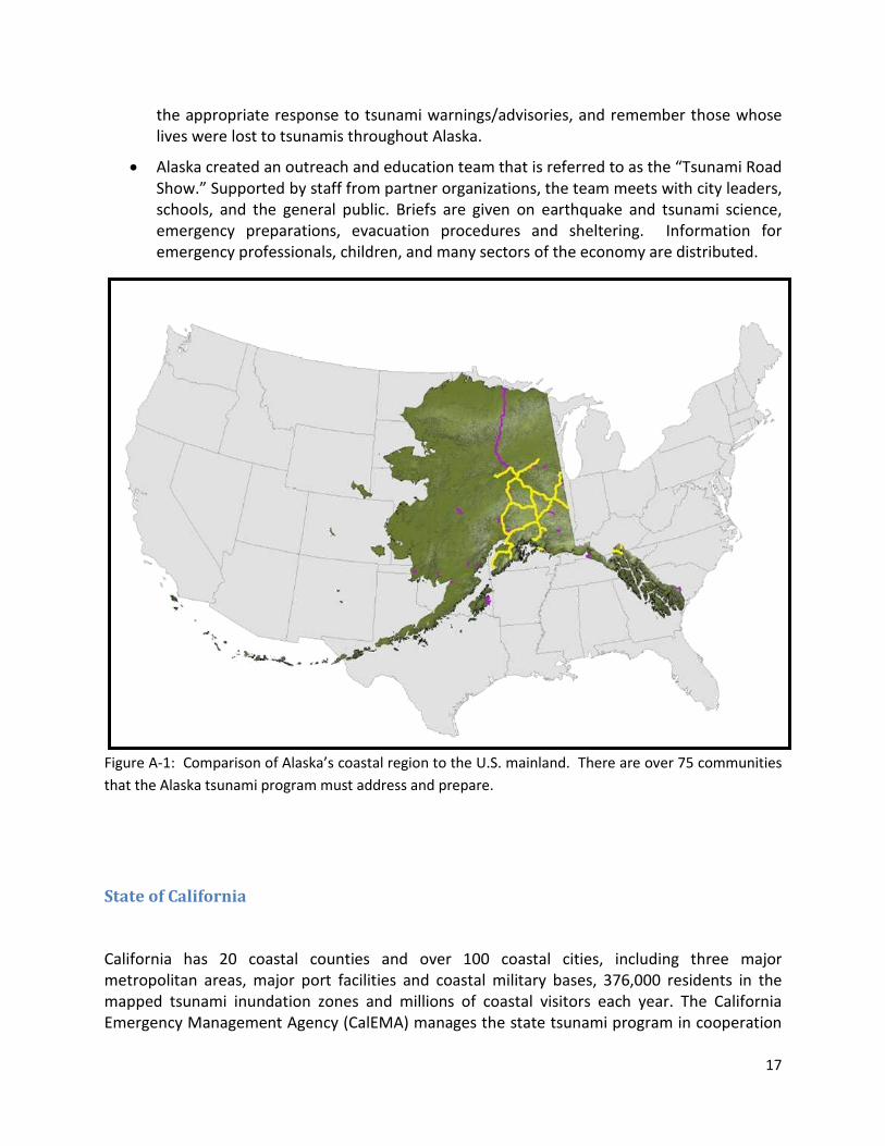
The enormous length of Alaska’s coastline and the isolated nature of many of its coastal communities make tsunami mitigation and preparedness a daunting task for the state tsunami program (Figure A-1). However, the collaboration between the Alaska Division of Homeland Security and Emergency Management (DHS&EM), the University of Alaska Fairbanks Geophysical Institute (UAF/GI), the Alaska Division of Geology and Geophysical Surveys (ADGGS), and the West Coast/Alaska Tsunami Warning Center provides a solid base for addressing tsunami-related issues with some unique activities:
• The Alaska Tsunami Mapping Team is comprised primarily of employees from the Alaska Earthquake Information Center (AEIC), the Alaska DHS&EM, the ADGGS, the NOAA National Geophysical Data Center (NGDC) and officials from the local communities. Together they have created a process of inundation mapping for the 75+ Alaskan communities at risk from tsunamis. This process includes determination of threat from local and distant sources (including landslides as well as earthquakes), evaluation of previous tsunami events, and close coordination with the local government and public. The maps and reports created are peer reviewed and published as part of the State of Alaska ADGGS professional publication series. Completed tsunami inundation maps to date include the communities of: Kodiak and Womens Bay; Homer, Seldovia, and Seward. Inundation mapping for Whittier is currently under final review.
• The last statewide exercise, Alaska Shield 2010, focused on widespread disruption from earthquakes and tsunamis. The communities of Valdez and Cordova exercised their entire tsunami response with real evacuations of large portions of their citizens, search and rescue operations on land and sea, mass casualty drills, and real world sheltering and feeding of large numbers.
• Alaska has conducted statewide “live-code” testing (using TSW code) of the Emergency Alert System for the past several years. The tests have identified areas of the system needing improvement.
• Tsunami Awareness Week (by Governor Proclamation) is observed each year to coincide with the Great 1964 Alaska Earthquake. Throughout the week all citizens and coastal communities are encouraged to prepare for tsunami hazards, educate themselves on
17
the appropriate response to tsunami warnings/advisories, and remember those whose lives were lost to tsunamis throughout Alaska.
• Alaska created an outreach and education team that is referred to as the “Tsunami Road Show.” Supported by staff from partner organizations, the team meets with city leaders, schools, and the general public. Briefs are given on earthquake and tsunami science, emergency preparations, evacuation procedures and sheltering. Information for emergency professionals, children, and many sectors of the economy are distributed.
Figure A-1: Comparison of Alaska’s coastal region to the U.S. mainland. There are over 75 communities that the Alaska tsunami program must address and prepare.
State of California
California has 20 coastal counties and over 100 coastal cities, including three major metropolitan areas, major port facilities and coastal military bases, 376,000 residents in the mapped tsunami inundation zones and millions of coastal visitors each year. The California Emergency Management Agency (CalEMA) manages the state tsunami program in cooperation
18
with the California Geological Survey (CGS), which coordinates the science-related activities. Other organizations, such as the Tsunami Research Center at the University of Southern California (TRC-USC) and the Redwood Coast Tsunami Work Group (RCTWG), also work with the state tsunami program on various activities to reduce tsunami hazards statewide. The state program coordinates with its partners through the California Tsunami Steering Committee, comprised of representatives from coastal jurisdictions, state and federal agencies and other stakeholders. California implements a comprehensive tsunami preparedness plan, with a significant number of accomplishments and on-going activities, including:
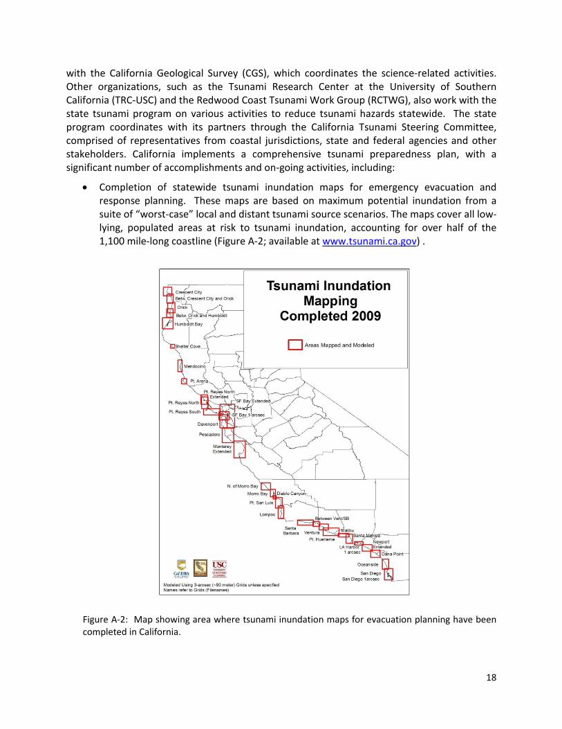
• Completion of statewide tsunami inundation maps for emergency evacuation and response planning. These maps are based on maximum potential inundation from a suite of “worst-case” local and distant tsunami source scenarios. The maps cover all low-lying, populated areas at risk to tsunami inundation, accounting for over half of the 1,100 mile-long coastline (Figure A-2; available at www.tsunami.ca.gov) .
Figure A-2: Map showing area where tsunami inundation maps for evacuation planning have been completed in California.
19
• Direct assistance to local communities and coastal State Parks, whose jurisdictional responsibility includes one-third of the state’s coastline, for emergency response planning, tsunami sign and siren placement, and achieving TsunamiReady status.
• Annual “live-code” testing of the Emergency Alert System in the northern part of the state, historically the area most prone to tsunami inundation and damage. In 2012, the state plans to extend this testing into central California.
• Promoting general statewide public education to its 37 million people by observing Tsunami Awareness and Preparedness Week on the fourth week of March each year with a wide distribution of educational brochures and through support of community-level activities designed to increase public safety.
• Working with the maritime community (harbor masters, Coast Guard, etc.) to develop products that help protect boats and harbor infrastructures from tsunami hazards, and identify offshore safe areas for ships/boats prior to a distantly generated tsunami. Preliminary offshore safety zone maps have been produced; these maps will be finalized and incorporated into harbor plans and nautical charts over the next several years. Through a cooperative agency agreement with FEMA, production of in-harbor tsunami hazard maps identifying areas of potentially high tsunami currents will also be initiated in 2011-12 with likely “pilot” locations in Santa Cruz, Humboldt Bay, and Crescent City harbors. Maritime planning guidance and a significant outreach and education effort will follow.
• Starting in 2012, tsunami hazard maps for the land-use planning community will be produced through the state Seismic Hazard Mapping Act. Implementation of these maps will greatly reduce the exposure of critical facilities and other coastal structures to “probabilistic” tsunami hazards.
State of Hawaii
On April 1, 1946, an Mw 8.1 earthquake off the coast of the Aleutian Islands in Alaska spawned a tsunami that killed 159 people in Hawaii and caused $26 million in damage — in 1946 dollars (see Table 1 for more information). This event reinforced the vulnerability of the coastal communities within Hawaii, and also led to the creation of the first Tsunami Warning Center.
The Hawaii tsunami program is managed by Hawaii State Civil Defense and consists of partnerships with the University of Hawaii Engineering Department and several Federal tsunami programs in Hawaii. Hawaii’s tsunami preparedness plan includes a number of innovative measures:
• Continue updating tsunami modeling and mapping techniques to improve tsunami inundation maps. The new mapping techniques use multiple numerical tsunami models
20
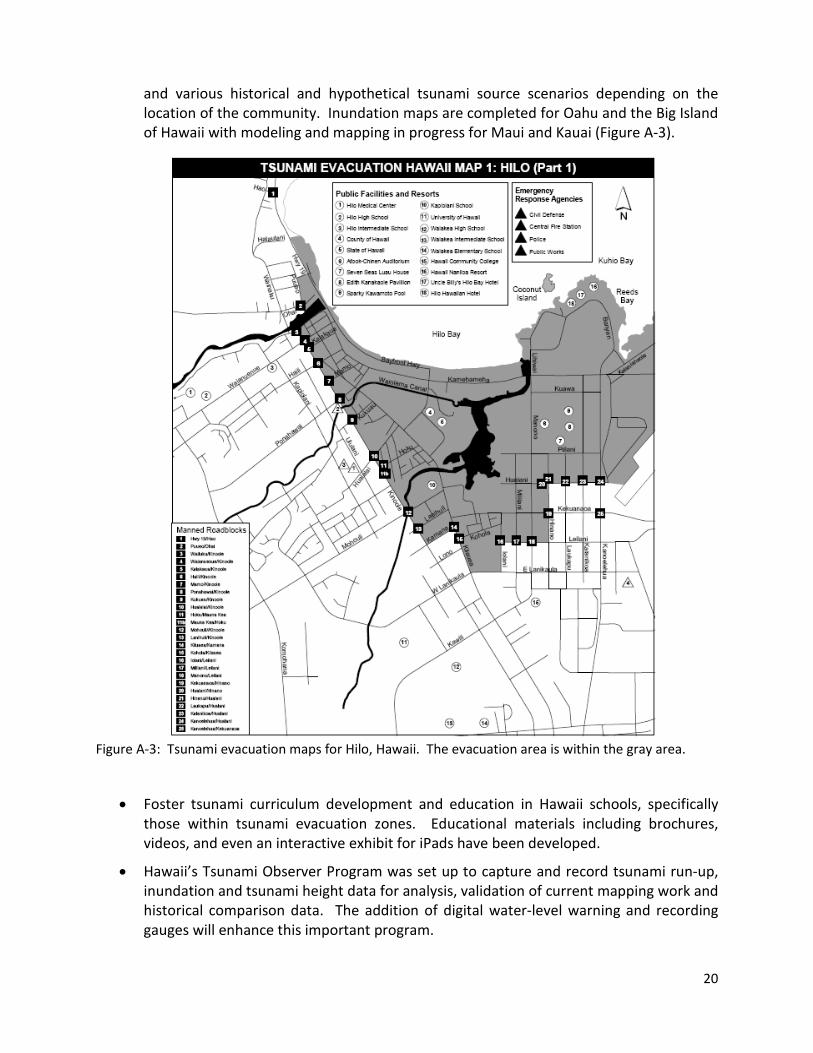
and various historical and hypothetical tsunami source scenarios depending on the location of the community. Inundation maps are completed for Oahu and the Big Island of Hawaii with modeling and mapping in progress for Maui and Kauai (Figure A-3).
Figure A-3: Tsunami evacuation maps for Hilo, Hawaii. The evacuation area is within the gray area.
• Foster tsunami curriculum development and education in Hawaii schools, specifically those within tsunami evacuation zones. Educational materials including brochures, videos, and even an interactive exhibit for iPads have been developed.
• Hawaii’s Tsunami Observer Program was set up to capture and record tsunami run-up, inundation and tsunami height data for analysis, validation of current mapping work and historical comparison data. The addition of digital water-level warning and recording gauges will enhance this important program.
21
• Hawaii has taken the lead on building a strong relationship with other U.S. Pacific island territories that are partners in the NTHMP. Through this relationship, Hawaii provides assistance in establishing a framework for tsunami mitigation and preparedness plans in these underserved tsunami programs.
• Develop a standardized tsunami loss estimation tool for emergency managers.
State of Oregon
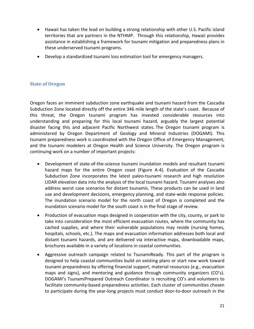
Oregon faces an imminent subduction zone earthquake and tsunami hazard from the Cascadia Subduction Zone located directly off the entire 346 mile length of the state’s coast. Because of this threat, the Oregon tsunami program has invested considerable resources into understanding and preparing for this local tsunami hazard, arguably the largest potential disaster facing this and adjacent Pacific Northwest states. The Oregon tsunami program is administered by Oregon Department of Geology and Mineral Industries (DOGAMI). This tsunami preparedness work is coordinated with the Oregon Office of Emergency Management, and the tsunami modelers at Oregon Health and Science University. The Oregon program is continuing work on a number of important projects:
• Development of state-of-the-science tsunami inundation models and resultant tsunami hazard maps for the entire Oregon coast (Figure A-4). Evaluation of the Cascadia Subduction Zone incorporates the latest paleo-tsunami research and high resolution LIDAR elevation data into the analysis of the local tsunami hazard. Tsunami analyses also address worst case scenarios for distant tsunamis. These products can be used in land use and development decisions, emergency planning, and state-wide response policies. The inundation scenario model for the north coast of Oregon is completed and the inundation scenario model for the south coast is in the final stage of review.
• Production of evacuation maps designed in cooperation with the city, county, or park to take into consideration the most efficient evacuation routes, where the community has cached supplies, and where their vulnerable populations may reside (nursing homes, hospitals, schools, etc.). The maps and evacuation information addresses both local and distant tsunami hazards, and are delivered via interactive maps, downloadable maps, brochures available in a variety of locations in coastal communities.
• Aggressive outreach campaign related to TsunamiReady. This part of the program is designed to help coastal communities build on existing plans or start new work toward tsunami preparedness by offering financial support, material resources (e.g., evacuation maps and signs), and mentoring and guidance through community organizers (CO’s). DOGAMI’s TsunamiPrepared Outreach Coordinator is recruiting CO’s and volunteers to facilitate community-based preparedness activities. Each cluster of communities chosen to participate during the year-long projects must conduct door-to-door outreach in the
22
evacuation zone, a demonstration evacuation drill, workshops, and before and after polls to measure performance. The program is in its third year, focusing on Tillamook Bay and Coos Bay. Outreach projects have already been completed for Warrenton, Manzanita-Nehalem, Rockaway Beach, Pacific City, Neskowin, Seal Rock, Waldport, Yachats, Bandon, Port Orford, and Gold Beach. The object of these activities is to build sustainable outreach programs that will result in communities with greatly increased resilience to tsunamis and other disasters.
Figure A-4: Map showing communities and regions of completed and planned tsunami inundation mapping in the State of Oregon.
23
State of Washington
With over 75 coastal communities, significant harbor and coastal infrastructure and a large at-risk population, Washington continues to make tsunami hazard reduction a high emergency management priority. The projects, programs, and initiatives undertaken by the Washington State tsunami program, comprised of Washington State Emergency Management and the Washington State Department of Natural Resources, are designed to achieve key goals related to tsunami hazard mitigation and preparedness. The state tsunami program also continually seeks ways to identify and leverage opportunities for partnerships with organizations such as the Cascadia Region Earthquake Workgroup (CREW), and other local agencies.
The following projects have been the focus of tsunami program in Washington State:
• The Washington State tsunami inundation modeling and evacuation mapping project has been an ongoing effort and, to date, 33 coastal communities have been modeled and 23 evacuation maps have been developed for those at-risk communities. Much of the original inundation mapping has been based on first-generation tsunami models and more advanced applications now exist that can provide additional resolution for planning, evacuation, and response activities.
• Project “Safe Haven” is aimed at developing viable, publically acceptable, and effective vertical evacuation strategies through a strongly inclusive ‘bottom up’ approach. The project team and coastal residents are currently looking at three basic types of vertical evacuation structures, which include earthen berms, evacuation towers, and large public elevated buildings such as parking structures. Locations are conceptual designs are based solely on community input. (www.facebook.com/projectsafehaven)
• In September 2008, Washington State launched the Tsunami Public Education Instructor: Train-the-Trainer (T3) Program to prepare a cadre of community volunteers that serve as educators at the community level. In addition to delivering quality training, graduates provide an additional resource for local emergency managers for the community in which they reside.
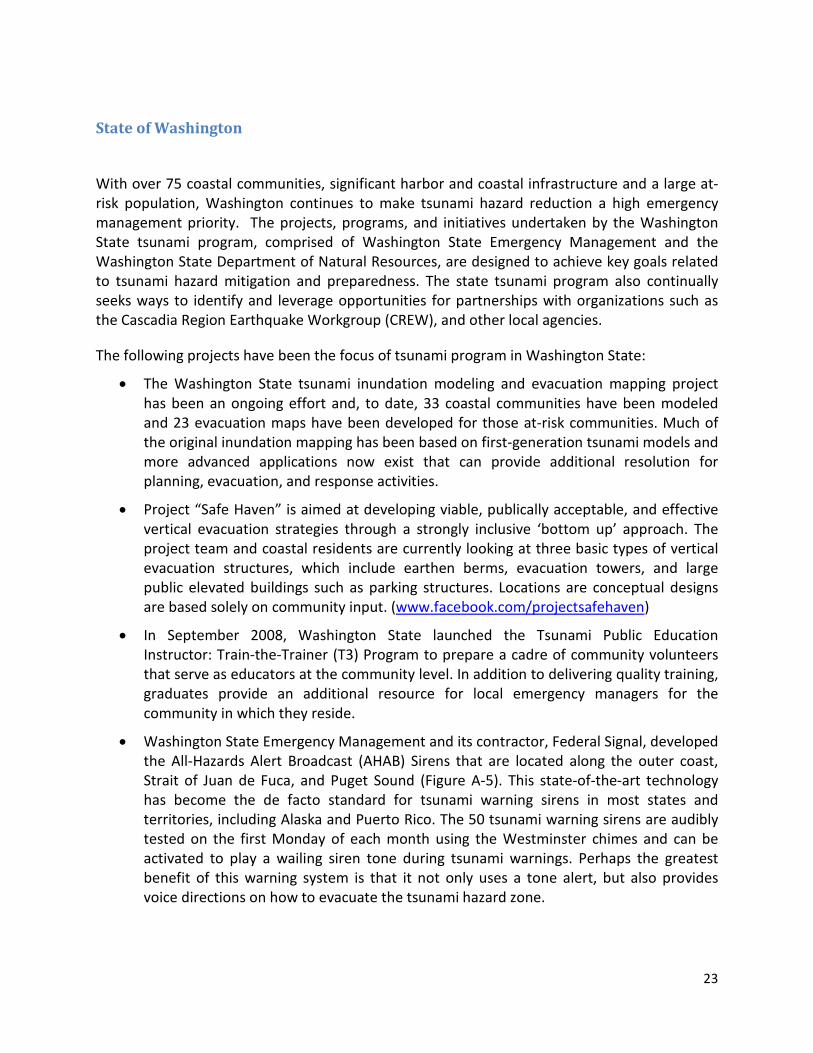
• Washington State Emergency Management and its contractor, Federal Signal, developed the All-Hazards Alert Broadcast (AHAB) Sirens that are located along the outer coast, Strait of Juan de Fuca, and Puget Sound (Figure A-5). This state-of-the-art technology has become the de facto standard for tsunami warning sirens in most states and territories, including Alaska and Puerto Rico. The 50 tsunami warning sirens are audibly tested on the first Monday of each month using the Westminster chimes and can be activated to play a wailing siren tone during tsunami warnings. Perhaps the greatest benefit of this warning system is that it not only uses a tone alert, but also provides voice directions on how to evacuate the tsunami hazard zone.
24
Figure A-5: Location of sirens capable of All-Hazard Alert Bulletins (AHAB) within the State of Washington.
U.S. Territories in the Pacific
Although the territories of American Samoa, Guam, and Northern Marianas are relatively new to the NTHMP, they have been active in their pursuit to improve the understanding of their tsunami hazard and prepare their communities accordingly. These territories have a strong sense of community, providing an avenue for public education and preparedness despite the lack of a well-developed communication network. Based on the recent experience of American Samoa during the devastating 2009 tsunami, a new awareness of tsunami hazards has been created in these territories, with many examples of how education and communication of the tsunami threat can help save lives. The hope is that with a continuation of funding through TWEA, these territories will improve their tsunami preparedness planning and reduce the exposure of their population which is focused along their coasts.
25
American Samoa
American Samoa lies just northeast of the Tongan Trench, which was the epicenter of the September 29, 2009 earthquake. This proximity places the Samoa islands highly vulnerable to tsunamis whenever there is seismic activity in the area. Because of American Samoa’s mountainous terrain, more than 75% of the islands’ villages and populated areas are located along the coastlines, including port and airport facilities, the center of government and the territory’s only fuel storage tank farm.
The 8.7 magnitude earthquake of 2009 generated a tsunami that hit the coastlines of American Samoa in about 17 minutes following the temblor, allowing almost no time at all for local emergency systems to warn the community to head to higher ground. The resulting aftermath left 35 fatalities and nearly $80 million in property damage. These numbers could have been ten times higher or more, if not for public awareness and outreach programs that had been conducted by the local government instructing everyone on what to do in case of an earthquake or a tsunami warning. People interviewed after the tsunami said they knew to head to higher ground from public outreach programs they heard or read about in the media.
The American Samoa tsunami program is managed by the Territorial Emergency Management Coordinating Office (TEMCO) under the auspices of the American Samoa Department of Homeland Security (ASDHS). Since joining the NTHMP and receiving federal funding to assist with its tsunami mitigation and preparedness programs, ASDHS and TEMCO have taken major strides toward making the territory “TsunamiReady.”
This progress includes:
• Working in partnership with NOAA, National Park Service, and local government agencies to develop a territory-wide tsunami evacuation route mapping system. These maps are now about 40% completed of all coastal areas and are being distributed to all schools, village mayors, churches, workplaces, community groups, hotels, public libraries and other gathering places. TEMCO is conducting workshops and exercises in conjunction with the distribution of these maps to educate the community on evacuation procedures in the event of an earthquake or tsunami warning.
• Developing tsunami modeling for the territory in conjunction with a number of government agencies, NOAA and the University of Hawaii.
• Erecting road signs designating tsunami hazard zones and safe zones, and identifying evacuation routes with appropriate signage pointing toward assembly areas in safe zones (Figure A-6). These signs are written in both English and the Samoan language.
• An ASDHS website is under construction that includes tsunami information on preparedness, with maps on evacuation routes, and tsunami hazard zones and safe zones.
26
• TEMCO continues to conduct regular workshops, exercises and drills with schools, villages and various organizations to promote awareness of disaster preparedness, with emphasis on tsunamis at coastal locations. Educational materials are also distributed including brochures, posters and maps.
• Public Service Announcements (PSA) focusing on earthquake/tsunami awareness are broadcasted through local radio stations in seven languages: English, Samoan, Fijian, Philippine, Chinese, Korean and Tongan.
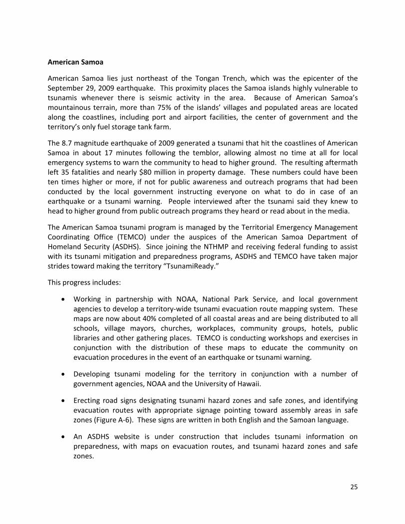
Figure A-6: Evacuation map of downtown Fagatogo area, American Samoa.
The NTHMP funding has been instrumental in developing many of the territory’s tsunami preparedness goals. In the ongoing effort to ensure that the general public understands and recognizes what actions should be taken to protect life and property with regards to tsunamis, the NTHMP has been a vital component in realizing those goals. While the current NTHMP funding for the territory covers a period of three (3) years, the potential loss of this funding source would most assuredly hinder the territory’s tsunami preparedness efforts. The projects under this funding are based on a phased in approach tying all initiatives, i.e. evacuation maps/routes, signage, Early Alert System (EAS) and siren activation at the third or final year of the NTHMP funding while at the same time achieving its “TsunamiReady” designation.
27
Guam
Guam is the largest and southernmost island in the volcanically formed Mariana Islands Archipelago and lies in close proximity to the seismically active region of the Mariana Trench. Earthquakes in 1849, 1892, 1990, and 1993 triggered tsunamis that caused damage to the Island of Guam (Lander and Whiteside, 2002). Common beliefs that tsunamis pose no real hazard to Guam due to the lack of a continental shelf, coral reef surroundings and protection from the Mariana Trench are misconceptions, based on a tsunami hazard assessment conducted for Guam.
Guam is at risk from tsunamis generated by earthquakes occurring in both near and far field due to Guam’s location relative to Pacific Basin subduction zones. Near-field earthquakes pose a time dependent problem for emergency managers due to Guam’s proximity to the seismic sources. The potential for local hazard from these sources with associated impact to population and marine structures is predicted to be significant (Uslu et al., 2010).
The Guam Tsunami Program is managed by Guam Homeland Security/Office of Civil Defense and relies on guidance from federal partners such as NOAA’s National Weather Service, Pacific Services Center and the International Tsunami Information Center. A Guam Tsunami Preparedness Working Group is comprised of local government stakeholders that provide recommendations for program enhancement and project development for the following tsunami preparedness activities:
• Development of tsunami inundation and evacuation maps based on a tsunami hazard assessment conducted for Guam by NOAA’s Pacific Marine Environmental Laboratory wherein five key locations on Guam were modeled using high-resolution grids. Evacuation maps will also be based on low-resolution models conducted by PMEL for gap areas on Guam and will reflect the adoption of the NTHMP Evacuation Mapping Guidelines. Final products will be used for emergency management planning and critical decision making.
• Public awareness campaign consisting of radio, television and print advertisements focused on basic tsunami awareness, preparedness and response tips and evacuation information. Distribution is ongoing for outreach products such as brochures, posters and Tsunami Wheels which contain hazard zones and basic tsunami information. In addition, Tsunami “Ready Cards” continue to be printed in a various languages and distributed to island residents and tourists.
• Continue to promote tsunami education in schools through presentations, school visits and mass distribution of outreach materials such as “What’s A Tsunami?” coloring books and localized tsunami posters.
• Development of Guam Tsunami Media Guidebook containing pertinent information necessary for media to provide clear, concise messages to the general public. The
28
guidebook was adapted from the NTHMP National Media Guidebook and localized through the inclusion of territorial and regional information and graphics.
• Tsunami Awareness workshops delivered throughout the year, and Tsunami Table-Top Exercise conducted every other year. In addition, Guam continues to participate in Exercise Pacific Wave, a Pacific-wide tsunami warning and communication exercise coordinated by the Intergovernmental Oceanographic Commission (IOC).
Commonwealth of the Northern Mariana Islands
The Commonwealth of the Northern Mariana Islands (CNMI) is part of the Mariana archipelago which extends north-to-south between 13N and 21N degrees in latitude and includes the islands of Rota and Guam (Figure A-7). The islands are located in an active tectonic region between a spreading center and a subduction zone capable of creating large local, damaging tsunamis. For this reason, the Commonwealth actively works with its coastal communities to prepare for tsunami hazards. For example, in August 20, 2007, Saipan was officially recognized as a TsunamiReady community by NOAA.
The Commonwealth participates in and interacts with the NTHMP, the Intergovernmental Oceanographic Commission, and the International Tsunami Information Center (ITIC). The CNMI Emergency Management Office (EMO), the department that manages the Territory Tsunami Program, coordinates and supports the Tsunami Program Strategy Development and Emergency Operational Plan of CNMI as well as the goals and objectives established by their TsunamiReady Advisory Board. The following activities are part of this tsunami plan:
• The EMO is working closely with the NOAA Pacific Marine Environmental Laboratory to finalize tsunami inundation modeling and evacuation mapping for Saipan, Tinian and Rota. The EMO will merge with the Office of Homeland Security in 2012 and will then finalize a website with the tsunami evacuation maps and plans.
• The EMO has been conducting community outreach and public education on disaster and tsunami awareness and preparedness throughout the public school system and to the general public. The EMO, volunteers, and a professional consultant conduct workshops, training and exercise for government, non-government sectors and the public on both the national and the territory tsunami programs. Resource support is provided to the villages, government agencies, businesses and private organizations in their Tsunami Program activities, training and exercise. The EMO travels off-island to the islands of Tinian and Rota throughout the year for outreach conferences and workshops.
• The EMO and TsunamiReady Advisory Board members obtained some of the signage for a Tsunami Evacuation Route and Assembly Area on the southern part of Saipan and are in the process of completing the installation from central to northern Saipan.
• The EMO and NOAA, which includes the Pacific Tsunami Warning Center, the ITIC, and the National Weather Service, Guam, conducted the first ever CNMI Tsunami Awareness Workshop Course in Saipan on July 13 and 14, 2010.
29
• Emergency Alert Systems will be purchased and fit into emergency response vehicles for the island of Saipan, which will be utilized during tsunami warnings as well as any other emergency events that require alerting all citizens of the CNMI.
Important State Collaborations
Through organizations such as WSSPC and the NTHMP, member states share project ideas and results that can be applied to the tsunami preparedness plans of State Partners. Here are a number of individual state projects that are beneficial to other state tsunami programs:
• Oregon is leading the way in research on tsunami source parameters for the Cascadia Subduction Zone. The database for onshore paleo-tsunami deposits combined with new information from offshore turbidite deposits will form the basis for California and Washington to improve their understanding of this dangerous local tsunami source.
• Hawaii’s Tsunami Observer Program has formed the template for other states to collect vital real-time information about tsunamis. For example, during the March 11, 2011 tsunami, California initiated a similar program that was able to collect and transfer tsunami information to a centralized clearinghouse for state emergency managers.
• Washington and Oregon have initiated plans to construct tsunami evacuation structures in high-risk areas along the coast. These plans can be used as guides by other states to get similar structures built.
• Alaska is one of the first states to fully analyze earthquake-induced landslides as a significant local source for a tsunami. Their anatomy of the landslide-generated tsunamis within Resurrection Bay (Seward) during the 1964 Great Alaska Earthquake will be the template for other states to analyze similar offshore conditions.
• California is developing tsunami hazard products and guidance for both the land-use and maritime planning communities. Requiring analyses different than those for the emergency preparedness communities, these projects will form the model for other states to develop similar products.
• Guam, Hawaii, American Samoa and the Commonwealth of the Northern Mariana Islands have formed a Pacific Region Tsunami Working Group to share best practices, identify common needs pertaining to hazard risk assessment, warning guidance and emergency response, and preparedness and mitigation of tsunamis and to identify (regional) solutions where appropriate.
30
State-to-Federal Partnerships In addition to the partnership in the NTHMP, the state tsunami programs work with other agencies within NOAA. The Warning Centers located in Hawaii and Alaska have forged strong partnerships with states within their areas of responsibility to improve the effectiveness of tsunami messaging during an emergency. States also work with the National Geophysical Data Center to improve cataloging historical tsunami data and creating digital elevation data to assist with tsunami hazard evaluations. Each state tsunami program coordinates community preparedness and TsunamiReady activities with the regional NWS Weather Forecast Offices. The state tsunami programs work in partnership with the USGS in a number of ways. Several State Partners are active participants in the USGS Tsunami Source Working Group, established to evaluate all tsunami sources that could impact U.S. territories. Other collaborations between the states and USGS include:
• Coordination on seismic monitoring networks that will help with immediate earthquake characterization following a potential tsunamigenic earthquake;
• Working together on paleo-tsunami deposit studies to better understand prehistoric tsunami inundation; and,
• Forming partnerships within USGS special projects like the Multi-Hazard Demonstration Project, to strengthen Federal/State/Local tsunami preparedness efforts.
Tsunami programs for the states of California, Oregon, and Washington are working with FEMA on the Cascadia Catastrophic Earthquake and Tsunami Planning Project, which will develop plans and protocols for response to a large earthquake and tsunami event along the Cascadia Subduction Zone. States have also entered into Co-Operative Technical Partnerships with FEMA to develop tsunami hazard maps to be integrated into the FEMA Risk Map platform. One of these projects has helped facilitate a pilot project for improved land-use planning in Crescent City, California, to compare probabilistic tsunami hazard analysis methodologies.
Related Documents