THE INTERNATIONAL WORKSHOP “TSUNAMI HAZARD MITIGATION AND RISK ASSESSMENT” Organised by IUGG Tsunami Commission (IUGG/TC) International Coordination Group for the Tsunami Warning System in the South Pacific (ICG/ITSU) NATIONAL EMERGENCY OFFICE - CHILE SANTIAGO, CHILE 29-30 th SEPTEMBER 2005 ____________________________ REVISION OF THE TSUNAMI SUPPORT PLAN FOR THE REPUBLIC OF FIJI By Lasarusa Vuetibau (Government of the Republic of Fiji, Ministry of Lands and Mineral Resources, Mineral Resources Department – Seismology Section, Suva, Fiji) Jack Rynn (Centre for Earthquake Research in Australia, Brisbane, Australia) Joeli Rokovada (Government of the Republic of Fiji, Ministry of Regional Development, National Disaster Management Office, Suva, Fiji) MRD-S/CERA/NDMO SEP 05

THE INTERNATIONAL WORKSHOP “TSUNAMI HAZARD MITIGATION AND RISK ASSESSMENT” Organised by IUGG Tsunami Commission (IUGG/TC) International Coordination Group.
Dec 17, 2015
Welcome message from author
This document is posted to help you gain knowledge. Please leave a comment to let me know what you think about it! Share it to your friends and learn new things together.
Transcript

THE INTERNATIONAL WORKSHOP
“TSUNAMI HAZARD MITIGATION AND RISK ASSESSMENT”
Organised by
IUGG Tsunami Commission (IUGG/TC)
International Coordination Group for the Tsunami Warning System in the South Pacific (ICG/ITSU)
NATIONAL EMERGENCY OFFICE - CHILE
SANTIAGO, CHILE29-30th SEPTEMBER 2005
____________________________
REVISION OF THE TSUNAMI SUPPORT PLANFOR THE REPUBLIC OF FIJI
By
Lasarusa Vuetibau (Government of the Republic of Fiji, Ministry of Lands and Mineral Resources, Mineral Resources Department – Seismology Section, Suva, Fiji)
Jack Rynn (Centre for Earthquake Research in Australia, Brisbane, Australia)
Joeli Rokovada (Government of the Republic of Fiji, Ministry of Regional Development, National Disaster Management Office, Suva, Fiji)
MRD-S/CERA/NDMO SEP 05

THE TSUNAMI HAZARD FOR FIJI
• Fiji’s location in the Pacific Basin makes it susceptible to both earthquake and tsunami.
• Fiji contains many small islands with coastal areas heavily populated by communities.
• Most major cities and towns are located on the shorelines.
• Ports of Entry – Suva, Lautoka, Labasa, Savu Savu
• Agricultural cropping and practices are done at low lying and flat areas close to shorelines – both subsistence farming and export.
• Hence, vulnerability to tsunami impact is high.• Historical record shows that several tsunamis
have impacted upon Fiji Islands.• Tsunamigenic sources – local, regional, distant• Most devastating 1953 Suva earthquake and
tsunami. Damage to Southeast Viti Levu – City of Suva and Environs
MRD-S/CERA/NDMO SEP 05
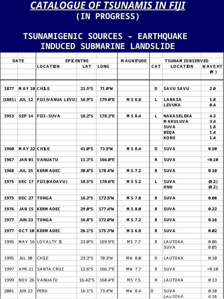
CATALOGUE OF TSUNAMIS IN FIJI(IN PROGRESS)
TSUNAMIGENIC SOURCES – EARTHQUAKE INDUCED SUBMARINE LANDSLIDE
DATE EPICENTRE MAGNITUDE TSUNAMI OBSERVEDLOCATION LAT LONG CAT LOCATION WAVE HT
(M)
1877 MAY 10 CHILE 21.5oS 71.0oW D SAVU SAVU 2.0
(1881) JUL 12 FIJI (VANUA LEVU) 16.9oS 179.0oE MS 6.8 L LABASA 1.8LEVUKA 0.4
1953 SEP 14 FIJI - SUVA 18.2oS 178.3oE MS 8.4 L NAKASELEKA 4.3MAKULUVA 3.4SUVA 1.8BEQA 1.4KORO 1.4
1960 MAY 22 CHILE 41.0oS 73.5oW MS 8.4 D SUVA 0.50
1967 JAN 01 VANUATU 11.3oS 166.0oE R SUVA <0.10
1968 JUL 25 KERMADEC 30.8oS 178.4oW MS 7.2 R SUVA 0.10
1975 DEC 17 FIJI (KADAVU) 18.5oS 178.6oE MS 5.2 L SUVA (0.2)ONO (0.2)
1975 DEC 27 TONGA 16.2oS 172.5oW MS 7.8 R SUVA 0.08
1976 JAN 15 KERMADEC 29.0oS 177.4oW MS 8.0 R SUVA 0.22
1977 JUN 23 TONGA 16.8oS 172.0oW MS 7.2 R SUVA 0.16
1977 OCT 10 KERMADEC 26.1oS 175.3oW MS 6.9 R SUVA 0.02
1995 MAY 16 LOYALTY IS 23.0oS 169.9oE MS 7.7 R LAUTOKA 0.06SUVA 0.05
1995 JUL 30 CHILE 23.3oS 70.3oW MW 8.0 D LAUTOKA 0.10
1997 APR 21 SANTA CRUZ 12.6oS 166.7oE MW 7.7 R SUVA <0.10
1999 NOV 26 VANUATU 16.42oS 168.4oE MS 7.5 R LAUTOKA 0.13
2001 JUN 23 PERU 16.1oS 73.4oW MW 8.4 D SUVA 0.10LAUTOKA 0.10MRD-S/CERA/NDMO SEP 05
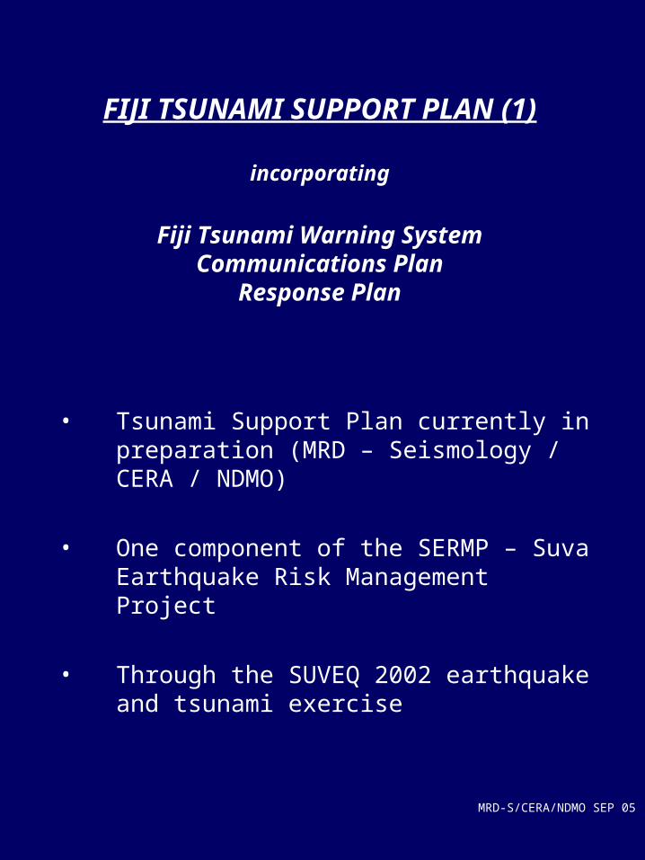
FIJI TSUNAMI SUPPORT PLAN (1)
incorporating
Fiji Tsunami Warning SystemCommunications Plan
Response Plan
• Tsunami Support Plan currently in preparation (MRD – Seismology / CERA / NDMO)
• One component of the SERMP – Suva Earthquake Risk Management Project
• Through the SUVEQ 2002 earthquake and tsunami exercise
MRD-S/CERA/NDMO SEP 05

FIJI TSUNAMI SUPPORT PLAN (2)• Being developed since 1994 under the SERMP• Initial Draft Plan proposed 1999-2000• Revised Draft Plan currently in preparation 2003• Impetus as a result of 1953 Suva earthquake and
tsunami and recent devastating tsunamis in other Pacific Island Countries.
• Fiji recognises the vulnerability of its islands to potential tsunami impact.
• Vulnerability of Suva – capital city, hub of national business and commerce, home of Diplomatic Corps, hub for other Pacific Island Countries
• Classifies LOCAL, REGIONAL, DISTANT tsunamis.
• Incorporates:– Fiji Tsunami Warning System
• Planned “TREMORS” system
– Communications Plan• Per NOAA Communications Plan 1996, 1999• Linking with PTWC• Internal Fiji communications
– Response Plan• Contacts for key agencies• Key agencies responses• Communities responses• Evacuation• Emergency relief assistance• International assistance
MRD-S/CERA/NDMO SEP 05
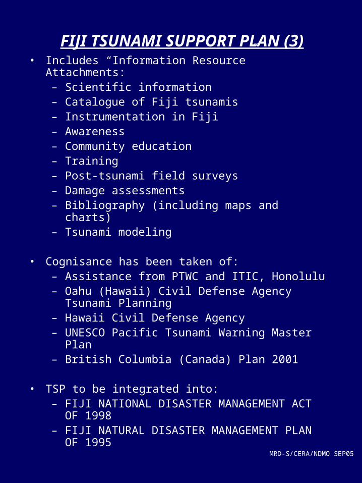
FIJI TSUNAMI SUPPORT PLAN (3)• Includes “Information Resource” Attachments:
– Scientific information– Catalogue of Fiji tsunamis– Instrumentation in Fiji– Awareness– Community education– Training– Post-tsunami field surveys– Damage assessments– Bibliography (including maps and charts)– Tsunami modeling
• Cognisance has been taken of:– Assistance from PTWC and ITIC, Honolulu– Oahu (Hawaii) Civil Defense Agency Tsunami
Planning – Hawaii Civil Defense Agency– UNESCO Pacific Tsunami Warning Master Plan– British Columbia (Canada) Plan 2001
• TSP to be integrated into:– FIJI NATIONAL DISASTER MANAGEMENT
ACT OF 1998– FIJI NATURAL DISASTER MANAGEMENT
PLAN OF 1995MRD-S/CERA/NDMO SEP05

1953 SUVA EARTHQUAKE AND TSUNAMI (1)
MAP OF TSUNAMI EFFECTS
MRD-S/CERA/NDMO SEP 05
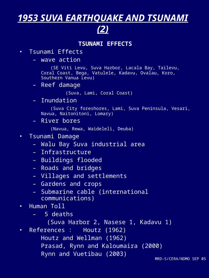
1953 SUVA EARTHQUAKE AND TSUNAMI (2)
TSUNAMI EFFECTS• Tsunami Effects
– wave action (SE Viti Levu, Suva Harbor, Lacala Bay, Tailevu, Coral Coast, Bega,
Vatulele, Kadavu, Ovalau, Koro, Southern Vanua Levu)
– Reef damage (Suva, Lami, Coral Coast)
– Inundation (Suva City foreshores, Lami, Suva Peninsula, Vesari, Navua,
Naitonitoni, Lomary)
– River bores (Navua, Rewa, Waideleli, Deuba)
• Tsunami Damage– Walu Bay Suva industrial area– Infrastructure– Buildings flooded– Roads and bridges– Villages and settlements– Gardens and crops– Submarine cable (international communications)
• Human Toll– 5 deaths (Suva Harbor 2, Nasese 1, Kadavu 1)
• References : Houtz (1962)Houtz and Wellman (1962)Prasad, Rynn and Kaloumaira
(2000)Rynn and Vuetibau (2003)
MRD-S/CERA/NDMO SEP 05
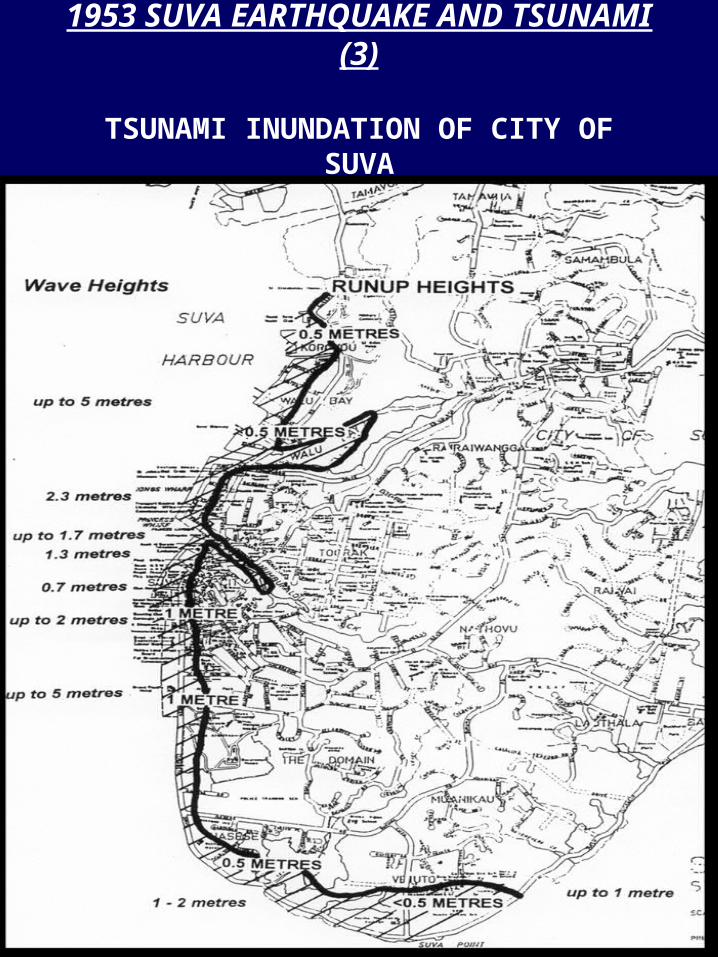
1953 SUVA EARTHQUAKE AND TSUNAMI (3)
TSUNAMI INUNDATION OF CITY OF SUVA
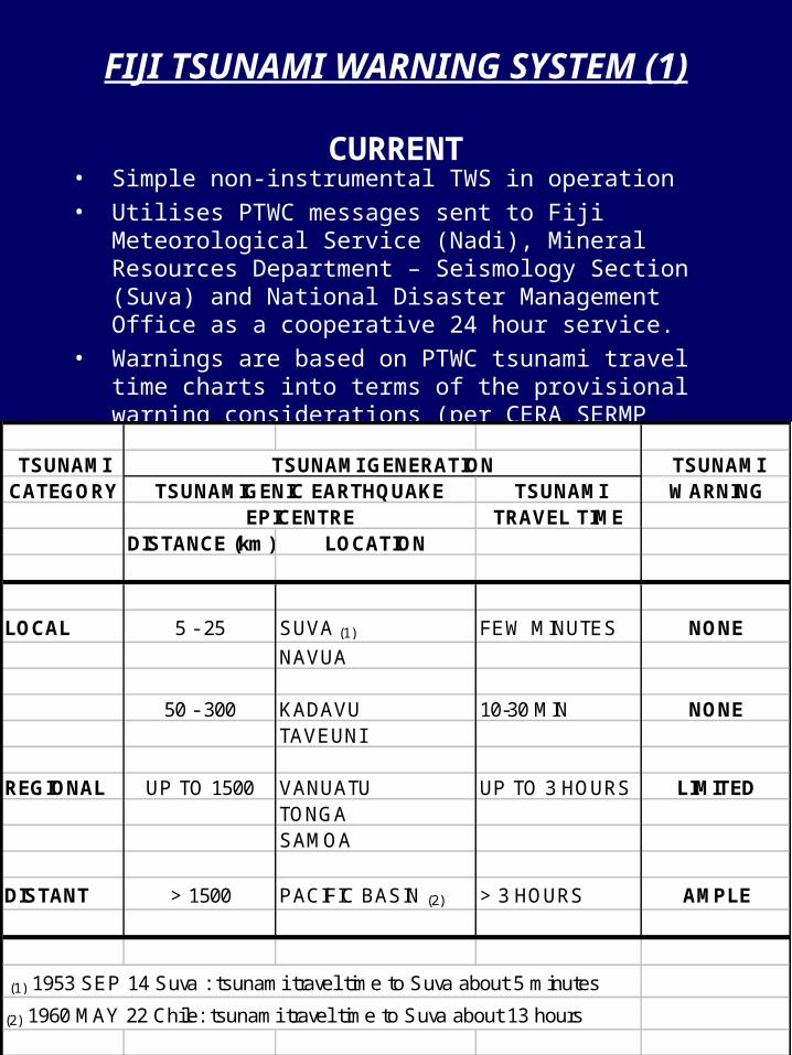
FIJI TSUNAMI WARNING SYSTEM (1)
CURRENT• Simple non-instrumental TWS in operation• Utilises PTWC messages sent to Fiji Meteorological
Service (Nadi), Mineral Resources Department – Seismology Section (Suva) and National Disaster Management Office as a cooperative 24 hour service.
• Warnings are based on PTWC tsunami travel time charts into terms of the provisional warning considerations (per CERA SERMP Report, 1997; Prasad et al, 2000):
TSUNAMI TSUNAMI GENERATION TSUNAMICATEGORY TSUNAMIGENIC EARTHQUAKE TSUNAMI WARNING
EPICENTRE TRAVEL TIMEDISTANCE (km) LOCATION
LOCAL 5 - 25 SUVA (1) FEW MINUTES NONE
NAVUA
50 - 300 KADAVU 10-30 MIN NONETAVEUNI
REGIONAL UP TO 1500 VANUATU UP TO 3 HOURS LIMITEDTONGASAMOA
DISTANT > 1500 PACIFIC BASIN (2) > 3 HOURS AMPLE
(1) 1953 SEP 14 Suva : tsunami travel time to Suva about 5 minutes
(2) 1960 MAY 22 Chile: tsunami travel time to Suva about 13 hours
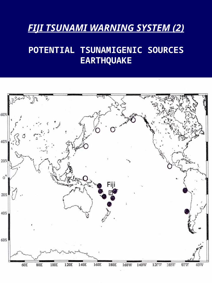
FIJI TSUNAMI WARNING SYSTEM (2)
POTENTIAL TSUNAMIGENIC SOURCESEARTHQUAKE
MRD-S/CERA/NDMO SEP 03

FIJI TSUNAMI WARNING SYSTEM
FUTURE
• Plan to develop the “TREMORS” (instrumental) tsunami warning system at MRD – Seismology Section (Suva)
• Proposal currently in preparation• To operate in cooperation with PTWC
messages• To operate on 24 hour basis
(Fiji Meteorological Service – MRD Seismology link)
• To link with the NDMO in accord with the Act of 1998 and Plan of 1995
MRD-S/CERA/NDMO SEP 05

Navua – Suva 3D image from
Swath Mapping
Suva Harbour

Impressions of submarine landslides
1953EarthquakeEpicenter
SUVA
Fan-shape of submarine
landslides
FaultLine trendingNorth east
Tsunami Attack!
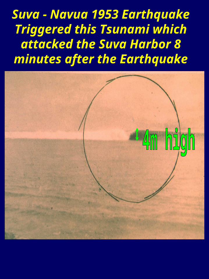
Suva - Navua 1953 Earthquake Triggered this Tsunami which
attacked the Suva Harbor 8 minutes after the Earthquake

DAMAGE TO THE SUVA WHARF CAUSED BY THE
TSUNAMI
This section collapsed

Suva Seawall damaged by the Tsunami (1953) Earthquake Ms 6.6

The last series of Tsunami Waves Suva 1953
Earthquake (Ms 6.6)
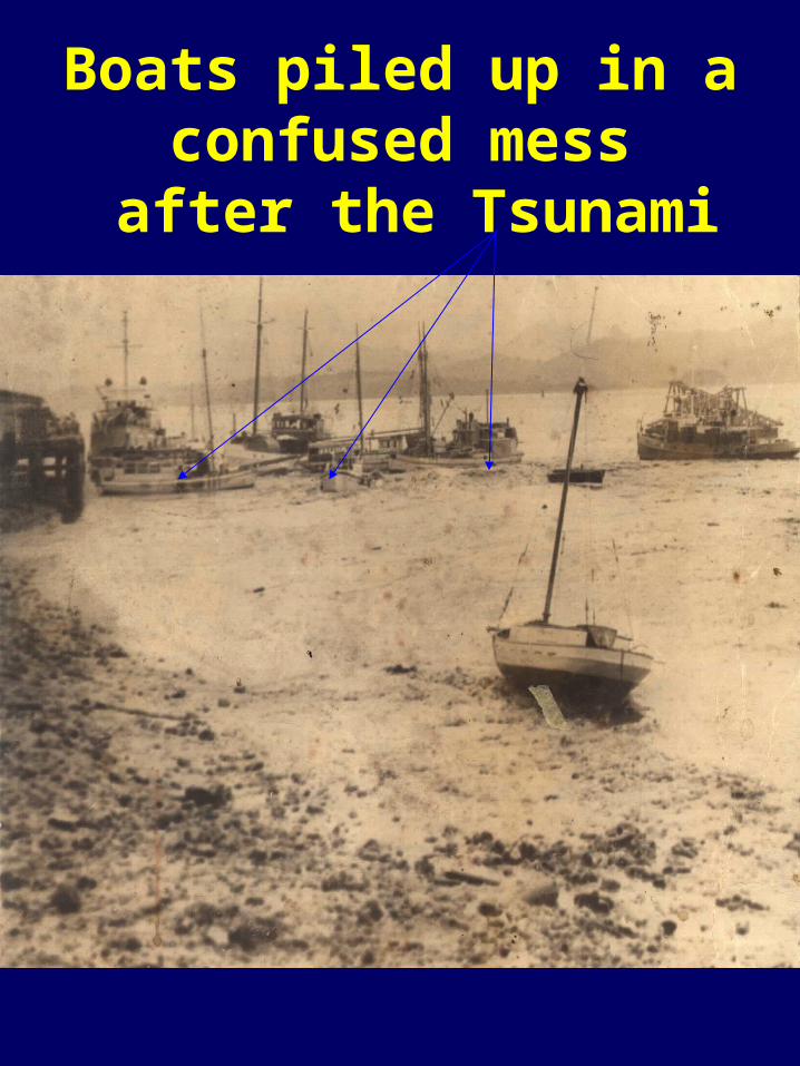
Boats piled up in a confused mess
after the Tsunami
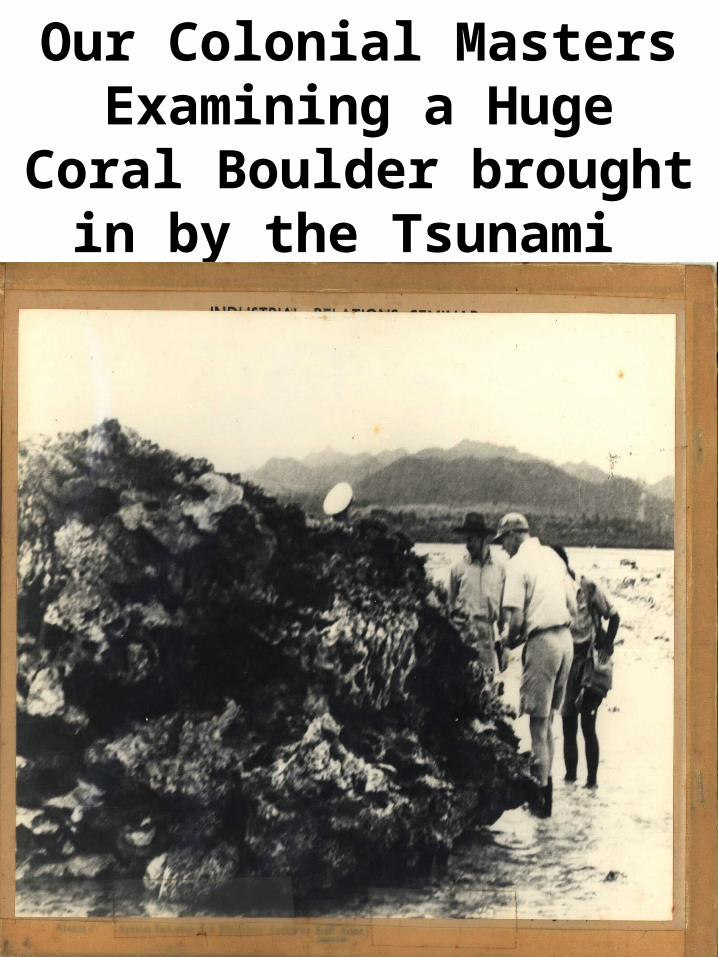
Our Colonial Masters Examining a Huge Coral Boulder brought in by the
Tsunami
Thank you for
Listening
Related Documents