Task Order Number 2014-REVA-2: Real Estate Advisory Services Contract No. P27818 TRANSIT-ORIENTED DEVELOPMENT: Lindbergh Center Station TOD Phase II Master Plan Technical Memorandum Prepared for: Metropolitan Atlanta Rapid Transit Authority Prepared by: AECOM Atlanta, GA With: Bleakly Advisory Group, Inc. Contente Consulting, Inc. October 2015

Welcome message from author
This document is posted to help you gain knowledge. Please leave a comment to let me know what you think about it! Share it to your friends and learn new things together.
Transcript

Task Order Number
2014-REVA-2: Real Estate Advisory Services
Contract No. P27818
TRANSIT-ORIENTED DEVELOPMENT:
Lindbergh Center Station
TOD Phase II Master Plan
Technical Memorandum
Prepared for:
Metropolitan Atlanta Rapid Transit Authority
Prepared by:
AECOM
Atlanta, GA
With:
Bleakly Advisory Group, Inc.
Contente Consulting, Inc.
October 2015
Lindbergh Center Station, Phase II TOD Master Plan
Lindbergh Center Station TOD i October 2015
Table of Contents
1.0 Introduction and Executive Summary ..................................................................................... 1-1
1.1 Introduction ............................................................................................................................ 1-1
1.1.1 Project Background .................................................................................................... 1-1
1.1.2 Project Description and Location ................................................................................ 1-1
1.1.3 Purpose of this Master Plan ....................................................................................... 1-3
1.2 Executive Summary ............................................................................................................... 1-5
2.0 Market Analysis .......................................................................................................................... 2-1
2.1 Introduction ............................................................................................................................ 2-1
2.2 Market Area Summary ........................................................................................................... 2-1
2.3 Future Real Estate Market Demand Analysis ....................................................................... 2-5
3.0 Parking Analysis ........................................................................................................................ 3-1
3.1 Introduction ............................................................................................................................ 3-1
3.2 Existing Conditions ................................................................................................................ 3-2
3.3 Potential Joint Development and Associated Parking .......................................................... 3-3
3.4 Reallocation of Surplus Office and Retail Spaces ................................................................. 3-5
3.5 MARTA’s Park-and-Ride Capacity ........................................................................................ 3-5
3.6 Conclusions ........................................................................................................................... 3-8
4.0 The North Block and Core Block.............................................................................................. 4-1
4.1 Introduction ............................................................................................................................ 4-1
4.2 The North Block ..................................................................................................................... 4-3
4.2.1 North Block Concept A ............................................................................................... 4-3
4.2.2 North Block Concept B ............................................................................................... 4-5
4.3 The Core Block ...................................................................................................................... 4-7
4.3.1 Core Block Concept A ................................................................................................ 4-8
4.3.2 Core Block Concept B .............................................................................................. 4-10
5.0 The Station Blocks and the MARTA Annex ............................................................................ 5-1
5.1 Introduction ............................................................................................................................ 5-1
5.2 The Station Blocks ................................................................................................................. 5-1
5.3 The MARTA Annex ................................................................................................................ 5-6
6.0 The Larger Context .................................................................................................................... 6-1
6.1 The Piedmont Road Corridor ................................................................................................. 6-1
6.2 The Extended Station Area ................................................................................................... 6-3
6.3 A One-Mile Radius ................................................................................................................. 6-5
7.0 Implementation Strategy ........................................................................................................... 7-1
7.1 Introduction ............................................................................................................................ 7-1
7.2 Parking ................................................................................................................................... 7-2
7.3 A Joint Development Strategy ............................................................................................... 7-3
7.4 Implementation Funding: Infrastructure and Affordable Housing ......................................... 7-8
Lindbergh Center Station, Phase II TOD Master Plan
Lindbergh Center Station TOD ii October 2015
List of Figures
Figure 1-1: The MARTA TOD Area .......................................................................................................... 1-2
Figure 1-2: Extended Station Area and One-Mile Radius ....................................................................... 1-3
Figure 1-3: North Block, Concept A .......................................................................................................... 1-7
Figure 1-4: North Block, Concept B .......................................................................................................... 1-8
Figure 1-5: Core Block, Concept A ........................................................................................................... 1-9
Figure 1-6: Core Block, Concept B .........................................................................................................1-10
Figure 1-7: Station Blocks, Concept A ...................................................................................................1-11
Figure 1-8: Station Blocks, Concept B ...................................................................................................1-12
Figure 1-9: Piedmont Road Corridor, Land Use and Intersections .......................................................1-13
Figure 1-10: Extended Station Area Land Use ......................................................................................1-14
Figure 2-1: Lindbergh Center Market Area .............................................................................................. 2-2
Figure 2-2: Employment by Sector (Bureau of Labor Statistics) ............................................................. 2-4
Figure 3-1: Lindbergh Center Parking Facilities ...................................................................................... 3-1
Figure 4-1: MARTA and Privately Owned Properties North of Morosgo Drive ...................................... 4-1
Figure 4-2: North Block Concept A ........................................................................................................... 4-4
Figure 4-3: North Block Concept B ........................................................................................................... 4-6
Figure 4-4: Core Block Concept A ............................................................................................................ 4-9
Figure 4-5: Core Block Concept B ..........................................................................................................4-11
Figure 5-1: Station Blocks and Adjacencies, Existing Conditions ........................................................... 5-2
Figure 5-2: Proposed Clifton Corridor Station .......................................................................................... 5-4
Figure 5-3: Station Blocks, Concept A ..................................................................................................... 5-5
Figure 5-4: Station Blocks, Concept B ..................................................................................................... 5-6
Figure 5-5: MARTA Annex Future Development Opportunity................................................................. 5-8
Figure 6-1: Piedmont Road Corridor, Land Use and Intersections ......................................................... 6-2
Figure 6-2: Extended Station Area Land Use .......................................................................................... 6-4
Figure 6-3: Lindbergh Center Station area, One-Mile Context ............................................................... 6-6
Figure 6-4: Clifton Corridor, Lindbergh Center Alignment ....................................................................... 6-7
Figure 6-5: Atlanta BeltLine, Potential Lindbergh Center Alignments .................................................... 6-8
Figure 6-6: Lindbergh Center Station, Transit and Trails Context ........................................................6-10
Figure 7-1: Potential Early Phases, North and Core Blocks ................................................................... 7-6
Figure 7-2: Station Blocks, Remaining Development Parcels ................................................................ 7-7
Figure 7-3: Atlanta BeltLine TAD Boundary, Northeast Segment ........................................................... 7-9
List of Tables
Table 2-1: Lindbergh Center Market Area Demographic Summary (Nielsen) ....................................... 2-3
Table 3-1: Parking Decks, Current Allocation per Parking and Easement Agreements ........................ 3-2
Table 3-2: MARTA Parking Capacity in Decks 2, 3, and 6 ..................................................................... 3-3
Table 3-3: Potential New Development and Parking Demand ............................................................... 3-3
Table 3-4: Summary of Park-and-Ride / Joint Development Comparison Model .................................. 3-6

Lindbergh Center Station, Phase II TOD Master Plan
Introduction and Executive Summary 1-1 October 2015
1.0 INTRODUCTION AND EXECUTIVE SUMMARY
1.1 Introduction
1.1.1 Project Background
In 2015, the Metropolitan Atlanta Rapid Transit Authority (MARTA) undertook this Transit-
Oriented Development (TOD) Phase II Master Plan for Lindbergh Center Station.
Lindbergh Center became MARTA’s first major TOD project, and one of the preeminent
first-generation TOD projects in the United States, through the 47-acre mixed-use project
undertaken by master developer Carter & Associates, beginning in 1998.
MARTA has determined that it is appropriate to view the Carter & Associates project as
Phase I of Lindberg Center Station’s development and to undertake this updated Master
Plan for Phase II.
1.1.2 Project Description and Location
Lindbergh Center is located at the juncture of MARTA’s Red (North Springs) and Gold
(Doraville) lines, and with some 23,000 average weekday boardings is MARTA’s second-
busiest rail station (surpassed only by the downtown inter-line transfer station at Five
Points).
Lindbergh Center is a significant intermodal transfer point, with five MARTA and Georgia
Regional Transit Authority (GRTA) bus routes feeding the MARTA rail system. Because
of its adjacency to the interchange of I-85 and GA-400, Lindbergh Center is also an
important park-and-ride access point, with some 1,100 weekday park-and-ride users.
The Master Plan relates to the Lindbergh Center Station area, which could be defined in
several ways—by distance from the station; by land ownership (MARTA versus non-
MARTA properties); or by perceived connection to the existing development surrounding
the station. For this Master Plan, the station area is defined as a series of figurative
“concentric circles”. The innermost, and the principal focus of this report, is the MARTA
TOD Area—some 62 acres of land located west of Piedmont Road and east of the Norfolk
Southern Railroad, within a quarter-mile walking distance of the station entrances.
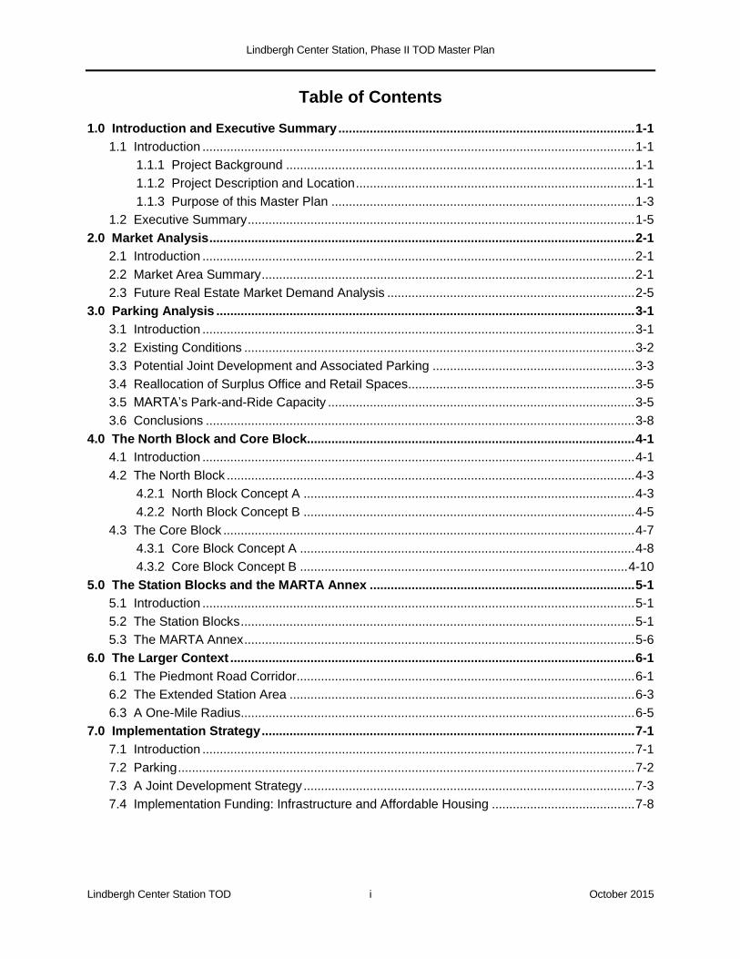
As shown in Figure 1-1, the MARTA TOD Area consists of four distinct subareas:
The North Block is an area of roughly 3.8 acres, in mixed ownership, located north of
Sidney Marcus Boulevard.
The Core Block is an area of approximately 15 acres located between Sidney Marcus
Boulevard and Morosgo Drive. About 7.1 acres are developable, and ownership is
mixed here as well.
The Station Blocks are the roughly 32-acre grid between Morosgo Drive and
Lindbergh Drive. Except for the private parcel at the southeast corner (inside the
“jughandle” roadway loop), the Station Blocks are owned or controlled by MARTA.1
They contain the two station entrances and most of the completed Phase I TOD.
1 This property is included for planning purposes only; MARTA does not contemplate any involvement in the ownership
or potential redevelopment of this site.
Lindbergh Center Station, Phase II TOD Master Plan
Introduction and Executive Summary 1-2 October 2015
The MARTA Annex is the 13-acre property (roughly 11 acres of it developable)
located south of Lindbergh Drive. The Annex is owned and actively used by MARTA.
Figure 1-1: The MARTA TOD Area
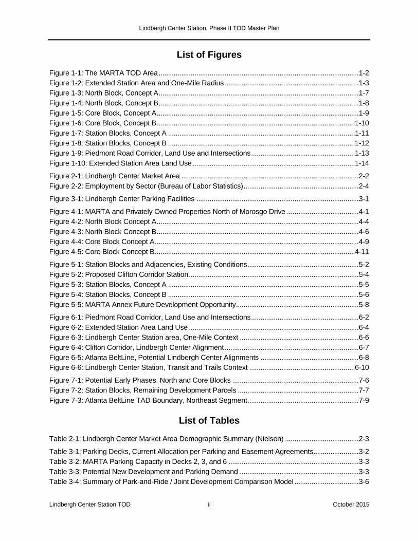
The MARTA TOD Area must be understood in the context of Lindbergh Center Station’s
larger zone of influence. As illustrated in Figure 1-2, this consists of two geographically
larger “concentric circles”:
An Extended Station Area of approximately 380 acres, bounded by the Norfolk
Southern Railroad on the west, the I-85 and GA-400 expressways on the east, and the
MARTA Rail Yard on the south. These are “hard” boundaries that visually separate the
station area from its wider environs and interrupt the local road network.
A one-mile radius, which captures important neighborhoods, transit and trail
connections, and other features that have current or potential impacts on the MARTA
TOD Area and the Extended Station Area.
Lindbergh Center Station, Phase II TOD Master Plan
Introduction and Executive Summary 1-3 October 2015
Figure 1-2: Extended Station Area and One-Mile Radius
1.1.3 Purpose of This Master Plan
MARTA considers an updated Lindbergh Center Station TOD Master Plan to be timely for
several reasons:
Nearly two decades have passed since the original Lindbergh Center project was
initiated, and a substantial volume of development was implemented as a result.
Undeveloped parcels remain, however, in the area south of Morosgo Drive, while the
area north of Morosgo Drive is largely a mix of undeveloped land and obsolete stand-
alone commercial uses.
TOD is an emerging market pattern in Metro Atlanta’s economic recovery, and MARTA
has undertaken an ambitious TOD program. It is guided by MARTA’s comprehensive
TOD Guidelines and Implementing Policies, adopted by MARTA’s Board of Directors in
2010.
The proposed introduction of the Atlanta BeltLine and Clifton Corridor transit services
to Lindbergh Center could expand the station’s TOD footprint, eventually including the
large MARTA Annex property south of Lindbergh Drive.
Lindbergh Center Station, Phase II TOD Master Plan
Introduction and Executive Summary 1-4 October 2015
Extensive development is occurring east of Piedmont Road, on land within easy
walking distance of Lindbergh Center Station but not yet drawn into its orbit due to lack
of visual and pedestrian connectivity.
The TOD Guidelines and Lindbergh. In November 2010, MARTA adopted its
comprehensive TOD Guidelines and Implementing Policies. The Guidelines use a seven-
category Station Typology to describe MARTA’s 38 rail stations. Lindbergh Center is
categorized as a “commuter town center station”—functioning both as regional-scale,
mixed-use TOD community and a significant node of “feeder” and park-and-ride access.
The TOD Guidelines and Implementing Policies envision two distinct roles which MARTA
may play in station-area development:
For joint development—that is, development built on, connected to, or otherwise using
MARTA property—MARTA is a TOD sponsor. The Carter & Associates master
developer initiative of 1998 is a large-scale example of joint development.
For all other station-area development, MARTA is a TOD stakeholder. It will participate
appropriately in zoning reviews, zoning changes, Development of Regional Impact
Reviews, Livable Centers Initiative (LCI) plans or plan updates, and other forums in
which stakeholders are invited to comment.
Both of these roles apply to the undeveloped lands around Lindbergh Center Station,
where MARTA is a principal property owner but several key parcels are owned by others.
In addressing Lindbergh’s future development, MARTA wishes to apply, in an appropriate
fashion, the four “foundational principles” of transit-oriented development set forth in the
TOD Guidelines:
1. Station-area development that is compact and dense relative to its surroundings.
Compared to the surrounding areas, TOD seeks greater density, so that more people
can live, work, shop, or go to school within walking distance of the station, driving
less, using less gasoline, and saving money.
2. A rich mix of land uses. The clustering of uses allows people to combine everyday
activities more conveniently and strengthens the link between transit and
development, as station communities become “24/7” places where people use transit
at night and on weekends. Mixed-use stations also allow the transit system to
function more cost-effectively, carrying rush-hour commuters in both directions and
serving more riders with the same fleet.
3. A great public realm. TOD is pedestrian-oriented development, especially within the
quarter- to half-mile radius that many people will walk to a transit stop as part of a
daily commute. In a TOD environment, a grid of human-scale blocks has sidewalks,
attractive amenities, lighting, and way-finding. The sidewalks, plazas, and stations
are safe, active, and accessible. There are no blank walls, and at street level shops,
restaurants, and other active uses bring the public realm indoors. Bicycling is
encouraged by the design of the street grid and by the provision of bicycle parking
and amenities.
4. A new approach to parking. Even with high transit utilization, many people will come
and go by automobile and need a place to park. But a defining characteristic of TOD
is that it requires less dedicated parking than similar development in non-transit
locations. Parking is shared as much as possible, taking advantage of dove-tailing
Lindbergh Center Station, Phase II TOD Master Plan
Introduction and Executive Summary 1-5 October 2015
uses and reducing further the actual number of spaces provided. And the parking that
is required is designed so as not to dominate the visual or pedestrian environment.
In MARTA’s judgment, Phase I of the Lindbergh Center TOD program achieved, in part,
the density and mixed-use goals of TOD. Greater density would be appropriate going
forward, and the planned Main Street retail environment has yet to materialize in a
commercially sustainable way. The public realm goals, as well, have been achieved only in
part. If designed today the blank garage walls and deep front setbacks of some buildings
would be avoided. It is in the area of parking that the Phase I results most plainly fall short
of the stated principle; a challenge and opportunity in Phase II will be to use the over-built
parking supply as a resource for new buildings and to mitigate the blank-wall character of
the existing decks.
1.2 Executive Summary
The remaining sections of this report may be summarized as follows:
Market Analysis (Section 2.0). A market analysis was conducted in early 2015 by consulting team member Bleakly Advisory Group. It encompasses the residential, office, retail, and hotel sectors in a Lindbergh Center submarket defined as the Extended Station Area. For the next several years, the study developed the following demand projections:
Rental apartments: 215-235 units annually.
For-sale new homes: 100-150 units, priced between $200,000 and $300,000,
absorbed at a rate of 40-45 annually.
Office: slightly over 120,000 square feet total.
Retail: modest shopping and restaurant demand, with a potential niche for a small
specialty grocery store and a small chain drug store.
Hotel: up to 400 rooms in the limited- or select-service product type, with room for two
or even three hotels at the 100-150 room scale.
The analysis suggests that the residential, office, and hotel markets may all gravitate to
Lindbergh Center as a mid-market location, with rental and sales prices below those of
Midtown and Buckhead and one-seat (no-transfer) MARTA access to those markets as
well as the airport.
Parking Analysis (Section 3.0). An integral aspect of the Phase II TOD strategy is to
understand how the station’s existing parking supply is used and the extent to which it
could be repositioned to support future development. To the extent that it can, MARTA’s
Lindbergh Center properties may gain a competitive advantage in both economic and
practical terms.
The built parking supply resulting from the Phase I Lindbergh Center development program
consists primarily of three shared-use parking decks owned by MARTA—the Garson, City
Center, and Sidney Marcus Decks, with a combined capacity of approximately 4,600
parking spaces.2 While MARTA allows park-and-ride in all three decks, and today’s
2 AT&T owns an additional deck (“Deck X”), in which MARTA has an allocation of spaces for staff and visitors. MARTA
also operates a 120-space employee surface lot.

Lindbergh Center Station, Phase II TOD Master Plan
Introduction and Executive Summary 1-6 October 2015
nominal park-and-ride capacity exceeds 2,000 spaces, average daily park-and-ride
patronage is about 1,100.
The decks contain, in the aggregate, more parking than MARTA, AT&T, the Phase I retail,
and the remaining Phase I development will need. Assuming all of the Phase I uses with
parking allocations are built and occupied, the surplus parking capacity could approach
1,000 spaces. Significant Phase II parking demand could be accommodated through any
or all of three strategies:
The allocation of Office and Retail Parking Spaces in the City Center and Garson
Decks could be revisited by MARTA, Carter & Associates, and the other Phase I
parties.
AT&T’s surplus capacity on the upper floors of the Sidney Marcus Deck could be made
available for new development through negotiations initiated by MARTA.
MARTA could determine, based on an evaluation of overall costs and benefits, that it
would be advantageous to shift some of its 1,100 occupied park-and-ride spaces to
joint development use. A spreadsheet model prepared by the consulting team
indicates that MARTA could realize a net gain in both ridership and revenue.
MARTA also has a potential interest in consolidating its park-and-ride operations into two
decks. This could be achieved if park-and-ride capacity were reduced to 800 or 900
spaces. If MARTA’s share of the Sidney Marcus Deck were freed up, a substantial portion
of the parking requirement for future development in the North Block and Core Block could
be addressed in this existing structure.
The North Block and the Core Block (Section 4.0). These two subareas constitute the
portion of the MARTA TOD Area north of Morosgo Drive. Between them, the North Block
and the Core Block contain about 10.9 acres of developable land, owned mostly by
MARTA but with five key parcels fronting on Piedmont Road owned by private parties.
One—the owner of the former Shoney restaurant site—has indicated a specific, near-term
interest in redevelopment. In addition to their developable acreage, the North Block and
Core Block have access to any surplus parking capacity that MARTA can make available
in the Sidney Marcus deck.
Detailed concepts were developed for both the North Block and the Core Block, with two
alternatives—Concept A and Concept B—shown for each. An improved public realm
template is common to both concepts, while the treatment of individual development sites
varies. Each concept is a composite of different development approaches that could be
“mixed and matched”; in general, the more conservative set of assumptions is represented
in Concept A, the more aggressive set in Concept B.
The Master Plan concepts are consistent with the MARTA TOD Guidelines and with the
anticipated rezoning of the entire North Block and Core Block as SPI-15.3 Proposed
building heights range from a baseline of six stories to a tower of eight to fifteen stories on
the “100% corner” of Piedmont Road and Morosgo Drive. The Floor Area Ratios (FARs)
implied by these concepts are compatible with SPI-15 limits.4 The concepts are also
3 Currently, the MARTA properties are zoned C-3, the private properties fronting on Piedmont SPI-15.
4 SPI-15 specifies FAR 4.2 for all-market residential projects; 8.2 for residential with at least 20% affordable units; 8.2 for
mixed-use (4.0 commercial plus 4.2 residential), and 12.2 for mixed-use with 20% affordable units.

Lindbergh Center Station, Phase II TOD Master Plan
Introduction and Executive Summary 1-7 October 2015
consistent with the market analysis presented in Section 2.0. Concepts A and B for the
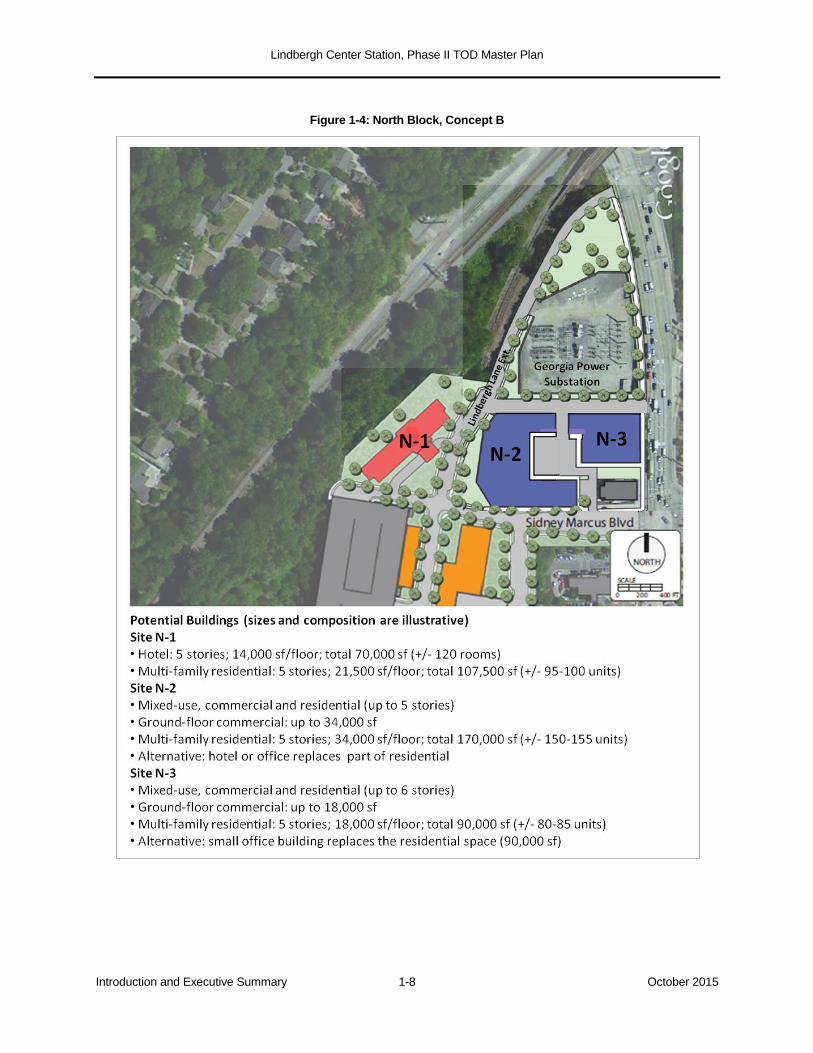
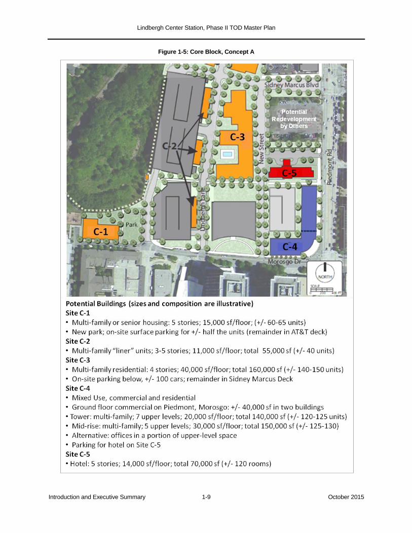
North Block are illustrated in Figures 1-3 and 1-4; Concepts A and B for the Core Block
are illustrated in Figures 1-5 and 1-6.
Figure 1-3: North Block, Concept A
Lindbergh Center Station, Phase II TOD Master Plan
Introduction and Executive Summary 1-8 October 2015
Figure 1-4: North Block, Concept B
Lindbergh Center Station, Phase II TOD Master Plan
Introduction and Executive Summary 1-9 October 2015
Figure 1-5: Core Block, Concept A
Lindbergh Center Station, Phase II TOD Master Plan
Introduction and Executive Summary 1-10 October 2015
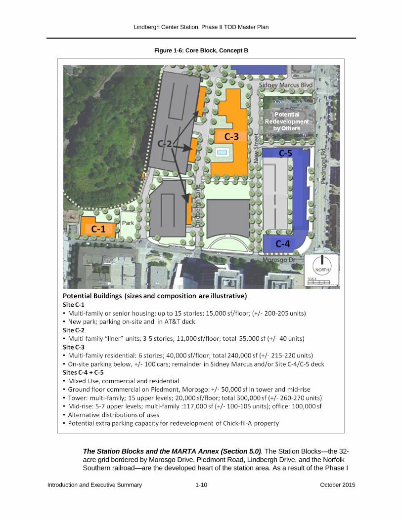
Figure 1-6: Core Block, Concept B
The Station Blocks and the MARTA Annex (Section 5.0). The Station Blocks—the 32-
acre grid bordered by Morosgo Drive, Piedmont Road, Lindbergh Drive, and the Norfolk
Southern railroad—are the developed heart of the station area. As a result of the Phase I

Lindbergh Center Station, Phase II TOD Master Plan
Introduction and Executive Summary 1-11 October 2015
TOD initiative, these blocks contain the AT&T office towers; an adjoining office and retail
building; the Eon and Uptown Square apartment complexes; Pike’s Nursery; the multi-use
City Center and Garson parking decks; the Main Street retail zone; and a trio of stand-
alone restaurants along Piedmont Road. Although mostly developed, the Station Blocks
are incomplete in two important ways:
The built environment is “one-sided”, gravitating northward toward the station entrance
on Morosgo Drive. Two parcels designated for development remain unbuilt: Parcel N
and the air rights above the City Center Deck. The view from south of the station is
dominated by the blank walls of the Garson and City Center Decks, undeveloped land
flanking the open “boat section” of the MARTA tracks, and the suburban configuration
of Lindbergh Drive with its “jughandle” intersection.
Except for the Eon/Uptown Square residential area, the pedestrian environment is
weak from a public realm, amenity, and connectivity perspective. It has yet to generate
a diverse, commercially sustainable retail environment, particularly on Main Street and
in the street frontage of the AT&T complex.
Figure 1-7: Station Blocks, Concept A
In the near term, MARTA will encourage the completion and enhancement of the Main
Street retail zone and the development of the two unbuilt parcels. It is recommended that
the allowed uses—retail on Parcel N, an office building on the parking deck air rights—be
expanded, to make development more feasible and to create retail clientele south of Main
Street sooner rather than later.
Lindbergh Center Station, Phase II TOD Master Plan
Introduction and Executive Summary 1-12 October 2015
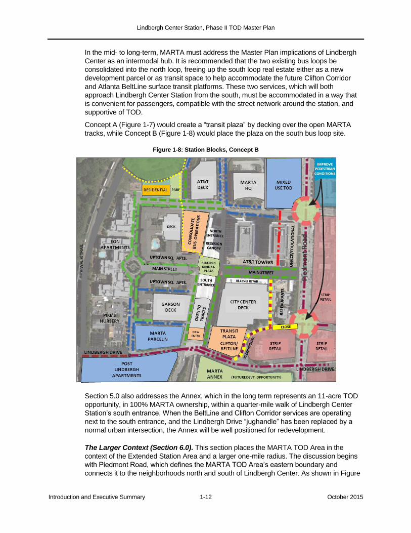
In the mid- to long-term, MARTA must address the Master Plan implications of Lindbergh
Center as an intermodal hub. It is recommended that the two existing bus loops be
consolidated into the north loop, freeing up the south loop real estate either as a new
development parcel or as transit space to help accommodate the future Clifton Corridor
and Atlanta BeltLine surface transit platforms. These two services, which will both
approach Lindbergh Center Station from the south, must be accommodated in a way that
is convenient for passengers, compatible with the street network around the station, and
supportive of TOD.
Concept A (Figure 1-7) would create a “transit plaza” by decking over the open MARTA
tracks, while Concept B (Figure 1-8) would place the plaza on the south bus loop site.
Figure 1-8: Station Blocks, Concept B
Section 5.0 also addresses the Annex, which in the long term represents an 11-acre TOD
opportunity, in 100% MARTA ownership, within a quarter-mile walk of Lindbergh Center
Station’s south entrance. When the BeltLine and Clifton Corridor services are operating
next to the south entrance, and the Lindbergh Drive “jughandle” has been replaced by a
normal urban intersection, the Annex will be well positioned for redevelopment.
The Larger Context (Section 6.0). This section places the MARTA TOD Area in the
context of the Extended Station Area and a larger one-mile radius. The discussion begins
with Piedmont Road, which defines the MARTA TOD Area’s eastern boundary and
connects it to the neighborhoods north and south of Lindbergh Center. As shown in Figure

Lindbergh Center Station, Phase II TOD Master Plan
Introduction and Executive Summary 1-13 October 2015
1-9, the privately owned land east of Piedmont Road, which lies entirely within a half-mile
walk of the station (most of it closer), is being densely developed with new multi-family and
senior housing that could support Lindbergh Center TOD. The Piedmont frontage,
however, remains mostly in strip retail and surface parking use.
Figure 1-9: Piedmont Road Corridor, Land Use and Intersections
MARTA will work with the City of Atlanta, the Georgia Department of Transportation, the
Buckhead Community Improvement District, and others to advance the recommendations
of the 2007 Piedmont Area Transportation Study, which include:
widening Piedmont Road and converting it to a raised-median boulevard, with more
ample sidewalks, amenities, and bicycle lanes;
redesigning the Sidney Marcus, Morosgo, and Lindbergh Drive intersections;
Lindbergh Center Station, Phase II TOD Master Plan
Introduction and Executive Summary 1-14 October 2015
eliminating the Lindbergh Drive “jughandle”, replacing the superfluous intersection with
a signalized turn and crossing at Main Street. The large private parcels inside the
jughandle loops could be redeveloped as part of a normal street network.
Piedmont Road is the spine of the 380-acre Extended Station Area. Figure 1-10 illustrates the
existing land use pattern, dominated by the multi-family residential developments built since
the 1990s (several of them under development at present).
Figure 1-10: Extended Station Area Land Use
The non-residential areas have long-term TOD implications:
The largely automobile-oriented commercial areas could be densified by consolidating
their parking into decks.
The strip commercial development fronting Piedmont Road could be redeveloped as
pedestrian-friendly TOD, in response to the Piedmont Road improvements and
MARTA’s own Phase II development.
Lindbergh Center Station, Phase II TOD Master Plan
Introduction and Executive Summary 1-15 October 2015
The aging industrial-commercial areas along Peachtree Creek could be redeveloped
over time, for both employment and mixed uses, as recommended in the BeltLine
Subarea 7 Master Plan.
Beyond the Extended Station Area, the one-mile circle around Lindbergh Center Station
contains residential neighborhoods with limited vehicular access to the station and the
MARTA TOD Area. Within that circle, however, are key mobility opportunities that can,
over time, connect Lindbergh Centerto surrounding areas. These include the planned
Clifton Corridor and Atlanta BeltLine transit services, and a trail system connecting
Lindbergh Center Station to the BeltLine, Peachtree Creek, the North and South Forks,
and PATH400.
Implementation Strategy (Section 7.0). The final section addresses the critical question
of how to plan, concretely yet flexibly, for the phased implementation of this Phase II
Master Plan. The key strategic points are as follows:
The plan was developed with implementation in mind. While still conceptual, individual
components are designed to be realistically achievable in the near, mid, or long term.
Equally important, the plan is structured such that all components are compatible and
mutually reinforcing, but to the greatest degree possible, components do not
sequentially depend on one other.
The aggregate development capacity of the parcels identified in the Master Plan
exceeds the more conservative projections of the market analysis. The difference is
intentional: the market analysis is focused on the next several years, while the strategic
opportunities outlined in this Master Plan represent a long-term exercise in city
building.
Successful implementation will demand that MARTA work closely and reciprocally with
other agencies and jurisdictions, including the City of Atlanta, Invest Atlanta, Atlanta
BeltLine, Inc., the Atlanta Regional Commission (ARC), the Georgia Department of
Transportation (GDOT), the Buckhead Community Improvement District (CID), and the
Georgia Regional Transportation Authority (GRTA).
With respect to zoning, MARTA has stated its intent to seek the rezoning of the entire
area east of the Norfolk Southern tracks as SPI-15 (a special district designed to
support TOD in and around Lindbergh Center), and in the process to explore whether
any modifications are worthwhile. It is important that the parking provisions reflect the
strategies outlined in this Master Plan.
It is a key premise of this Master Plan that surplus parking capacity in the existing
decks be utilized, to the degree practicable and feasible, to absorb the needs of future
TOD in the North Block, Core Block, and the remaining parcels in the Station Blocks.
This will avoid the land and dollar cost of building more new garage capacity than
today’s market requires. To the extent that new parking is required, MARTA will make
every effort to accommodate it in efficiently designed shared-use decks, rather than
encouraging individual projects to include their own dedicated parking structures.
A critical component of the implementation strategy is MARTA’s approach to procuring
joint development partners. The solicitation of a master developer could be advantageous
for a number of reasons. It is understood, however, that the redevelopment of the Shoney
site, in combination with one or conceivably two abutting MARTA properties, could precede
the engagement of a master developer, if the Shoney ownership is prepared to advance a
Lindbergh Center Station, Phase II TOD Master Plan
Introduction and Executive Summary 1-16 October 2015
project of the scale and quality that MARTA wishes to see at this “100% corner”. As an
alternative to a master developer, MARTA could select a development advisor.
Section 7.0 concludes by outlining potential funding and financing resources, which include
but are not limited to:
the Atlanta BeltLine Tax Allocation District (TAD), for affordable housing and transit
infrastructure;
a new Community Improvement District, similar to the nearby Buckhead CID, to
finance street, trail, and other district infrastructure improvements;
the Atlanta Regional Commission’s Livable Centers Initiative (LCI) program;
applicable federal surface transportation funding and financing programs, including the
expanded TIFIA loan mechanism.
Lindbergh Center Station, Phase II TOD Master Plan
Market Analysis 2-1 October 2015
2.0 MARKET ANALYSIS
2.1 Introduction
In order to establish reasonable density expectations and a projected timeframe for
absorption of future development in the Lindbergh Center Station area, the consulting team
completed a comprehensive TOD market analysis for Lindbergh Center and its real estate
submarket. The analysis included the retail, residential, hotel, and office markets.5
Through years of investments by MARTA and surrounding developers, a TOD district has
begun to emerge where none existed previously. The Lindbergh Center area has attracted
a mix of residents, employees and shoppers and is a key attractor in the city of Atlanta of a
younger professional and older student population seeking an urbane and active lifestyle.
Area residents are typically younger, more affluent, and more educated than residents
of the city of Atlanta as a whole.
Area employees typically earn somewhat higher salaries and commute farther
distances than the typical Atlanta employee.
The area has great appeal to price-conscious consumers seeking urban amenities but
unable (or unwilling) to afford Midtown or Buckhead.
Growth in the area has created potential demand for future retail offerings.
Market Perspective: Keys to Success. MARTA property is the prime real estate in the
entire Lindbergh Center market area. Other developments are finding success nearby, but
few have the highest-quality access to MARTA that residents, employees, and customers
desire.
An opportunity exists to enhance the Lindbergh Center area’s lifestyle and
attractiveness, through improvements to Main Street and through additional real estate
development.
The Lindbergh Center area found success prior to the Great Recession, leveled off
during the down-cycle, and with the economic recovery underway, the opportunity for
greater success is at hand. But the time is now, and the window for MARTA’s next
wave of development at Lindbergh Center is open.
Fixing the “front door” is essential. The blighted properties along Piedmont Road
prevent Lindbergh Center from reaching its full TOD potential. These parcels must be
developed in a way that enhances the urban experience developing nearby.
2.2 Market Area Summary
The market analysis is focused on the Extended Station Area (as defined in Section 1.1.2),
where the great majority of Lindbergh-related demand will occur. This area features mixed-
use commercial centers, a large number of multifamily residential units, and retail anchored
by “big box” tenants. As explained previously, its boundaries are the Norfolk Southern rail
corridor, the GA-400 and I-85 expressways, and the MARTA rail yard.
5 A detailed presentation of the market analysis is provided in Appendix A.
Lindbergh Center Station, Phase II TOD Master Plan
Market Analysis 2-2 October 2015
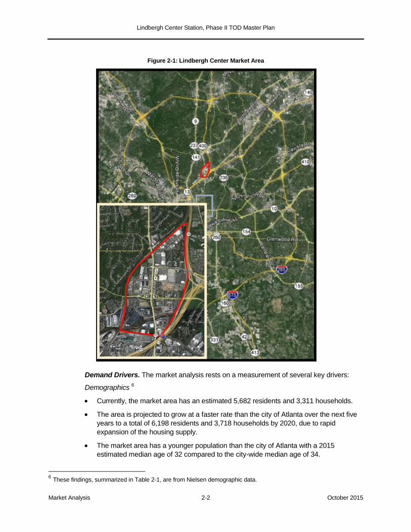
Figure 2-1: Lindbergh Center Market Area
Demand Drivers. The market analysis rests on a measurement of several key drivers:
Demographics 6
Currently, the market area has an estimated 5,682 residents and 3,311 households.
The area is projected to grow at a faster rate than the city of Atlanta over the next five
years to a total of 6,198 residents and 3,718 households by 2020, due to rapid
expansion of the housing supply.
The market area has a younger population than the city of Atlanta with a 2015
estimated median age of 32 compared to the city-wide median age of 34.
6 These findings, summarized in Table 2-1, are from Nielsen demographic data.
Lindbergh Center Station, Phase II TOD Master Plan
Market Analysis 2-3 October 2015
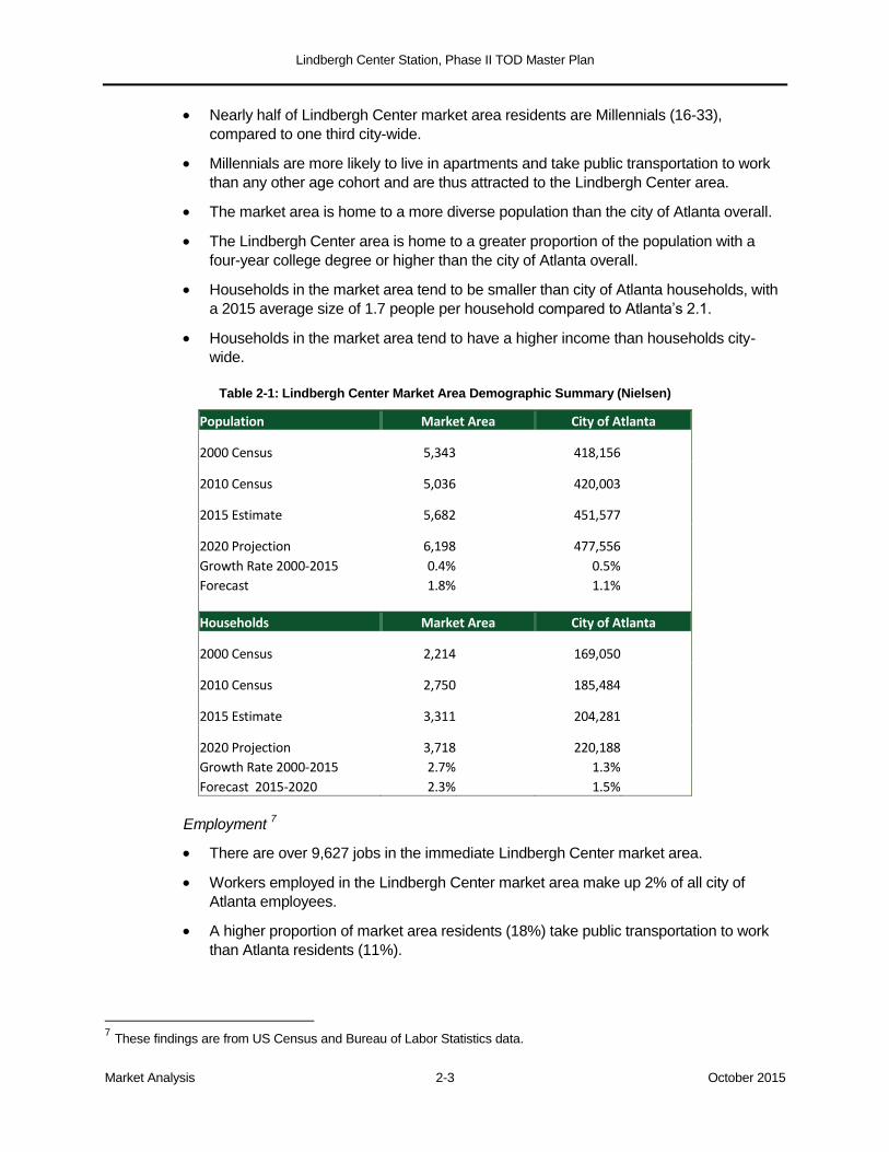
Nearly half of Lindbergh Center market area residents are Millennials (16-33),
compared to one third city-wide.
Millennials are more likely to live in apartments and take public transportation to work
than any other age cohort and are thus attracted to the Lindbergh Center area.
The market area is home to a more diverse population than the city of Atlanta overall.
The Lindbergh Center area is home to a greater proportion of the population with a
four-year college degree or higher than the city of Atlanta overall.
Households in the market area tend to be smaller than city of Atlanta households, with
a 2015 average size of 1.7 people per household compared to Atlanta’s 2.1.
Households in the market area tend to have a higher income than households city-
wide.
Table 2-1: Lindbergh Center Market Area Demographic Summary (Nielsen)
Population Market Area City of Atlanta
2000 Census 5,343 418,156
2010 Census 5,036 420,003
2015 Estimate 5,682 451,577
2020 Projection 6,198 477,556 Growth Rate 2000-2015 0.4%
0.5%
Forecast 1.8% 1.1%
Households Market Area City of Atlanta
2000 Census 2,214 169,050
2010 Census 2,750 185,484
2015 Estimate 3,311 204,281
2020 Projection 3,718 220,188 Growth Rate 2000-2015 2.7%
1.3%
Forecast 2015-2020 2.3% 1.5%
Employment 7
There are over 9,627 jobs in the immediate Lindbergh Center market area.
Workers employed in the Lindbergh Center market area make up 2% of all city of
Atlanta employees.
A higher proportion of market area residents (18%) take public transportation to work
than Atlanta residents (11%).
7 These findings are from US Census and Bureau of Labor Statistics data.
Lindbergh Center Station, Phase II TOD Master Plan
Market Analysis 2-4 October 2015
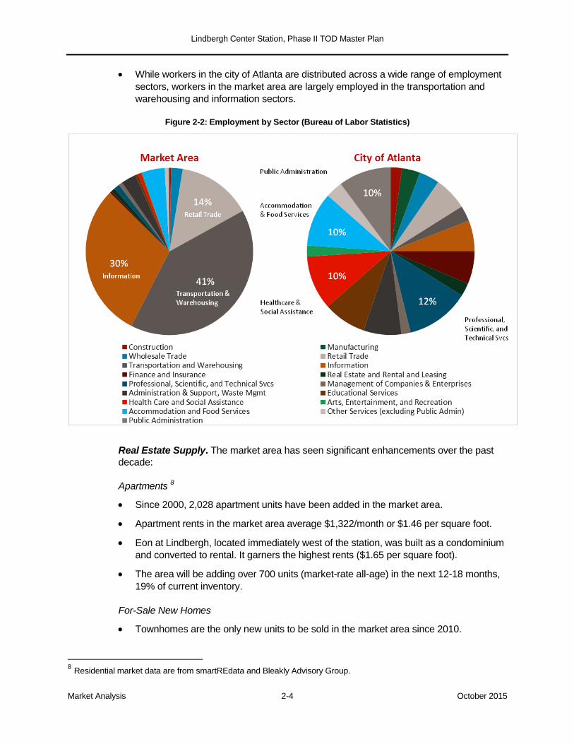
While workers in the city of Atlanta are distributed across a wide range of employment
sectors, workers in the market area are largely employed in the transportation and
warehousing and information sectors.
Figure 2-2: Employment by Sector (Bureau of Labor Statistics)
Real Estate Supply. The market area has seen significant enhancements over the past
decade:
Apartments 8
Since 2000, 2,028 apartment units have been added in the market area.
Apartment rents in the market area average $1,322/month or $1.46 per square foot.
Eon at Lindbergh, located immediately west of the station, was built as a condominium
and converted to rental. It garners the highest rents ($1.65 per square foot).
The area will be adding over 700 units (market-rate all-age) in the next 12-18 months,
19% of current inventory.
For-Sale New Homes
Townhomes are the only new units to be sold in the market area since 2010.
8 Residential market data are from smartREdata and Bleakly Advisory Group.
Lindbergh Center Station, Phase II TOD Master Plan
Market Analysis 2-5 October 2015
Fifty-three new townhome units have sold over the last five years at an average sale
price of $286,138.
The average townhome sale price has increased by 5% annually since 2010.
From 2008 to 2010. 137 new condo units were sold at an average sale price of
$186,000. No new condo units have been sold in the market area since 2010.
No new single-family homes have been sold in the market area in the last seven years.
Retail 9
The market area contains 1.5 million square feet of retail space and serves as a major
commercial center for area residents.
Over 500,000 square feet of retail was added from 2000 to 2007; since 2007 only
1,800 SF have been added.
102,447 square feet are currently vacant, resulting in a 6.8% vacancy rate.
The vacancy rate has decreased 58% from its peak of 16% in 2009.
Office
The market area contains 1.5 million square feet of office space in 12 buildings.
There are currently 28,700 square feet vacant, resulting in a 1.9% vacancy rate.
Vacancy rates have not exceeded 2% in the past 15 years, even at the height of the
Great Recession. However, “soft” vacancies are known to exist in some area office
spaces (that is, space that is still under contract but whose tenants have vacated).
Hotel
Market area hotel properties range in size from 75 rooms to 230, and in age from 10
years to 40+ years. Except for the nearby DoubleTree, all are limited- or select-service.
Occupancy ranges of the competitive set of hotels are between 70% and 82%, and
average daily rate (ADR) ranges between $94 and $127.
Holiday Inn Express and TownePlace Suites (located on Sidney Marcus Boulevard
east of Piedmont Road) report the lowest ADR (<$100).
Extended stay hotels report the strongest occupancy levels, due to the nature of the
guest and product design.
2.3 Future Real Estate Market Demand Analysis
The market analysis provided the following projections with respect to demand and
absorption over the next several years.10
9 Retail, office, and hotel market data are from CoStar and Bleakly Advisory Group.
10 Market projections were developed by Bleakly Advisory Group.
Lindbergh Center Station, Phase II TOD Master Plan
Market Analysis 2-6 October 2015
Apartments
Sufficient future demand exists to begin planning for new units at Lindbergh Center to
come on-line by 2017.
The potential demand for the Lindbergh Center area is estimated at: 215-235 units
annually. This represents 60% of recent peak absorption years and 140% of the recent
10-year average (which included the recession years).
Potential new units on MARTA property must heed the delivery timing of other local
new units in order to successfully meet market demand.
For-Sale New Homes
The potential will exist for a building of approximately 100-150 units, at prices ranging
up to approximately $300,000 and averaging approximately $200,000-$225,000.
These units will appeal to price-conscious buyers seeking urban amenities but unable
to afford new units in Midtown or Buckhead.
Based on a statistical demand analysis, such a building could absorb approximately
40-45 units annually.
This product could face competition from conversions of rental apartments to
condominiums that may begin to occur in the coming years.
Office
Statistical office demand analysis applies future employment projections for the
Lindbergh Center area to the actual ratio of office square feet per employee in the
area.
Assuming employment growth is sustained at 2002-2009 levels, demand exists for up
to 121,500 square feet of new office space through 2020.
This projection appears conservative, given that at 25,000 square feet of new office
space annually through 2020, the Lindbergh Center area would sustain its historical
fair share capture rate of office space in the City of Atlanta.
Retail
The existing retail space along Main Street at Lindbergh Center could be improved with
contemporary urban retailing strategies, including: higher-visibility signage and store
entrances; eliminating blank spaces that detract from the pedestrian experience; lively
programming and activities on the street to attract residential and transit patrons; a
tenant strategy that targets local brands, particularly restaurants that could attract
patrons from beyond the immediate area.
Given recent and anticipated residential growth in the Lindbergh Center area,
additional retail potential exists. This potential may be limited by recent and future
growth in big-box retailers, including the future new Kroger supermarket on the other
side of Piedmont Road.
Nevertheless, a smaller-scale specialty or discount grocer might be attracted by the
new rooftops in the area, if an appropriate site is available. This type of grocer could

Lindbergh Center Station, Phase II TOD Master Plan
Market Analysis 2-7 October 2015
serve as a retail anchor on the west side of Piedmont and could spawn additional
retailers nearby.
A chain drug store could also have potential in the area, although demand support
today is slightly below requisite levels.
Additional restaurants could find success in the area, assuming concepts and
execution that meet target market audience demand.
Demand potential could be enhanced by additional local-serving office space,
particularly medical clinics.
Hotel
There appears to be market support for 400+ rooms in the limited- or select-service
category.
Major brand availability in this market area, however, is constrained by territory or
impact clauses.
Some available sites are complicated by shared parking structures and by mixed-use
projects with high density requirements to support rising land and construction costs.

Lindbergh Center Station, Phase II TOD Master Plan
Parking Analysis 3-1 October 2015
3.0 PARKING ANALYSIS
3.1 Introduction
A critical aspect of the Phase II Lindbergh Center TOD strategy is to understand how the
station’s existing parking supply is used and the extent to which it could be applied to
future development. This is a key consideration, because structured parking is costly and
the surface parking alternative is too land-consumptive to be used extensively on a long-
term basis. To the extent that existing garage capacity can be used to support new
development, MARTA’s Lindbergh Center properties may gain a competitive advantage in
both economic and practical terms.
The built parking supply resulting from the Phase I Lindbergh Center development program
undertaken by MARTA, Carter & Associates, and BellSouth (now AT&T) consists of three
shared-use parking decks owned by MARTA: the Garson, City Center, and Sidney Marcus
Decks. The decks have a combined capacity of approximately 4,600 parking spaces.
MARTA has an allocation of spaces in each deck, and also maintains a 120-space
employee parking lot.11
Figure 3-1: Lindbergh Center Parking Facilities
11 The smaller “Deck X” is owned by AT&T, with 200 spaces allocated to MARTA staff and visitors. These spaces are
fully utilized and do not enter further into this analysis.
Lindbergh Center Station, Phase II TOD Master Plan
Parking Analysis 3-2 October 2015
Future development planning must take into account three factors with respect to parking
demand:
The nature of transit-oriented development, a foundational principle of which is that
parking ratios for development should be lower than in non-transit settings and that
physical spaces should be shared as much as possible. This principle is embodied in
MARTA’s TOD Guidelines.
The allocation of parking spaces between MARTA and other users in the agreements
governing the use of the three decks.
MARTA’s current park-and-ride utilization and its best judgment as to the optimal future
balance between park-and-ride and parking for TOD.
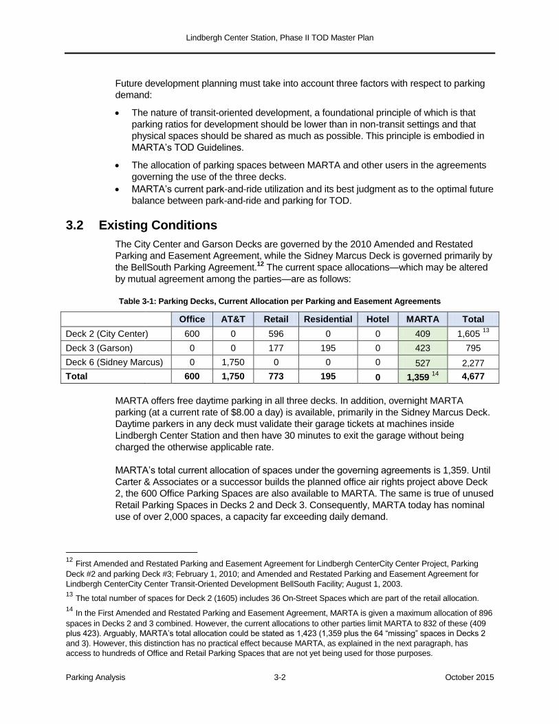
3.2 Existing Conditions
The City Center and Garson Decks are governed by the 2010 Amended and Restated
Parking and Easement Agreement, while the Sidney Marcus Deck is governed primarily by
the BellSouth Parking Agreement.12
The current space allocations—which may be altered
by mutual agreement among the parties—are as follows:
Table 3-1: Parking Decks, Current Allocation per Parking and Easement Agreements
Office AT&T Retail Residential Hotel MARTA Total
Deck 2 (City Center) 600 0 596 0 0 409 1,605 13
Deck 3 (Garson)
0 0 177 195 0 423 795
Deck 6 (Sidney Marcus) 0 1,750 0 0 0 527 2,277
Total 600 1,750 773 195 0 1,359 14
4,677
MARTA offers free daytime parking in all three decks. In addition, overnight MARTA
parking (at a current rate of $8.00 a day) is available, primarily in the Sidney Marcus Deck.
Daytime parkers in any deck must validate their garage tickets at machines inside
Lindbergh Center Station and then have 30 minutes to exit the garage without being
charged the otherwise applicable rate.
MARTA’s total current allocation of spaces under the governing agreements is 1,359. Until
Carter & Associates or a successor builds the planned office air rights project above Deck
2, the 600 Office Parking Spaces are also available to MARTA. The same is true of unused
Retail Parking Spaces in Decks 2 and Deck 3. Consequently, MARTA today has nominal
use of over 2,000 spaces, a capacity far exceeding daily demand.
12 First Amended and Restated Parking and Easement Agreement for Lindbergh CenterCity Center Project, Parking
Deck #2 and parking Deck #3; February 1, 2010; and Amended and Restated Parking and Easement Agreement for
Lindbergh CenterCity Center Transit-Oriented Development BellSouth Facility; August 1, 2003.
13 The total number of spaces for Deck 2 (1605) includes 36 On-Street Spaces which are part of the retail allocation.
14 In the First Amended and Restated Parking and Easement Agreement, MARTA is given a maximum allocation of 896
spaces in Decks 2 and 3 combined. However, the current allocations to other parties limit MARTA to 832 of these (409
plus 423). Arguably, MARTA’s total allocation could be stated as 1,423 (1,359 plus the 64 “missing” spaces in Decks 2
and 3). However, this distinction has no practical effect because MARTA, as explained in the next paragraph, has
access to hundreds of Office and Retail Parking Spaces that are not yet being used for those purposes.
Lindbergh Center Station, Phase II TOD Master Plan
Parking Analysis 3-3 October 2015
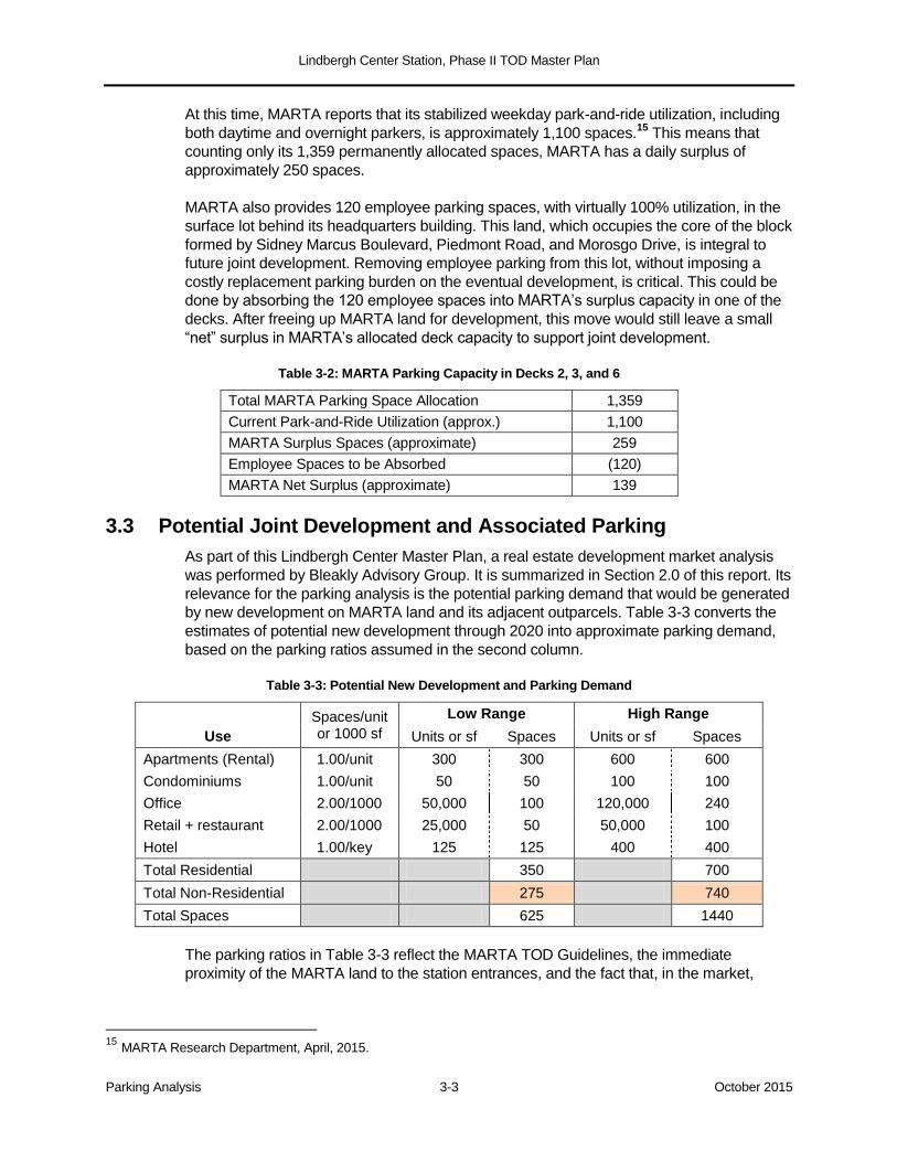
At this time, MARTA reports that its stabilized weekday park-and-ride utilization, including
both daytime and overnight parkers, is approximately 1,100 spaces.15
This means that
counting only its 1,359 permanently allocated spaces, MARTA has a daily surplus of
approximately 250 spaces.
MARTA also provides 120 employee parking spaces, with virtually 100% utilization, in the
surface lot behind its headquarters building. This land, which occupies the core of the block
formed by Sidney Marcus Boulevard, Piedmont Road, and Morosgo Drive, is integral to
future joint development. Removing employee parking from this lot, without imposing a
costly replacement parking burden on the eventual development, is critical. This could be
done by absorbing the 120 employee spaces into MARTA’s surplus capacity in one of the
decks. After freeing up MARTA land for development, this move would still leave a small
“net” surplus in MARTA’s allocated deck capacity to support joint development.
Table 3-2: MARTA Parking Capacity in Decks 2, 3, and 6
Total MARTA Parking Space Allocation 1,359
Current Park-and-Ride Utilization (approx.) 1,100
MARTA Surplus Spaces (approximate) 259
Employee Spaces to be Absorbed (120)
MARTA Net Surplus (approximate) 139
3.3 Potential Joint Development and Associated Parking
As part of this Lindbergh Center Master Plan, a real estate development market analysis
was performed by Bleakly Advisory Group. It is summarized in Section 2.0 of this report. Its
relevance for the parking analysis is the potential parking demand that would be generated
by new development on MARTA land and its adjacent outparcels. Table 3-3 converts the
estimates of potential new development through 2020 into approximate parking demand,
based on the parking ratios assumed in the second column.
Table 3-3: Potential New Development and Parking Demand
Spaces/unit or 1000 sf
Low Range High Range
Use Units or sf Spaces Units or sf Spaces
Apartments (Rental) 1.00/unit 300 300 600 600
Condominiums 1.00/unit 50 50 100 100
Office 2.00/1000 50,000 100 120,000 240
Retail + restaurant 2.00/1000 25,000 50 50,000 100
Hotel 1.00/key 125 125 400 400
Total Residential 350 700
Total Non-Residential 275 740
Total Spaces 625 1440
The parking ratios in Table 3-3 reflect the MARTA TOD Guidelines, the immediate
proximity of the MARTA land to the station entrances, and the fact that, in the market,
15 MARTA Research Department, April, 2015.
Lindbergh Center Station, Phase II TOD Master Plan
Parking Analysis 3-4 October 2015
Lindbergh Center enjoys easily understood, one-seat MARTA access to Buckhead,
Midtown, Downtown, and the Airport.
For apartments, condominiums, and offices, the suggested ratios are consistent with
the current parking provisions of the SPI-15 Zoning District, which MARTA and the City
of Atlanta propose to expand over the entire station area.16
For general retail and restaurants, the SPI-15 requirements are higher—3.7 spaces
and 10 spaces per 1,000 square feet, respectively. However, the SPI-15 language
encourages shared parking. The 2.00 spaces per 1,000 square feet assumed in the
table are directed at weekday 9-5 demand; both the MARTA Spaces and the Office
Spaces will be available to absorb the peak shopping and dining demand on evenings,
weekends, and holidays.
For hotels, which could be an important component of future Lindbergh Center
development, the SPI-15 zoning requires 1.0 space per guest room, .50 space per
employee, 3.00 spaces per 1,000 square feet of conference space, and the normal
restaurant ratio if applicable. These requirements appear somewhat high for a transit
setting, especially given the transit-accessible Buckhead/Midtown focus of Lindbergh
Center as a hotel market. Through shared parking, and perhaps through reducing this
requirement as part of rezoning, Table-3 assumes that the net requirement for hotel
use can be held to one space per “key”.
The table thus provides a rough estimate of the parking requirements associated with “low”
and “high” development scenarios that fall within the current market analysis. This estimate
helps frame the question to which this parking analysis is addressed: to what extent could
parking for new development be absorbed in the surplus capacity of the existing decks?
The new parking requirement is broken into residential and non-residential subtotals,
reflecting the likelihood that shared off-site parking for office, hotel, or retail use would be
an easier “sell” than for residential.
The modest MARTA surplus identified above (roughly 250 spaces, of which 130 would be
available after employee parking is consolidated) could accommodate a small portion of
the new demand. Significantly more of this demand could be accommodated through any
or all of three strategies, which are explored in the following sections:
The allocation of Office and Retail Parking Spaces in the City Center and Garson
Decks could be revisited by MARTA, Carter & Associates, and the other parties to the
Parking & Easement Agreement.
AT&T’s apparent surplus capacity on the upper floors of the Sidney Marcus Deck could
be made available for new development through negotiations initiated by MARTA.
MARTA could determine, based on an evaluation of overall costs and benefits, that it
would be advantageous to shift some of its utilized garage capacity from park-and-ride
to parking for joint development.
16 There are no minimum parking ratios for residential and office use in the SPI-15 district. There are maximums
instead: for residential, 1.0 space per bedroom up to two bedrooms and .5 spaces per bedroom thereafter; for office, 2.5
spaces per 1,000 square feet.
https://www.municode.com/library/ga/atlanta/codes/code_of_ordinances?nodeId=PTIIICOORANDECO_PT16ZO_CH18
OSP15LITRSTARSPPUINDIRE
Lindbergh Center Station, Phase II TOD Master Plan
Parking Analysis 3-5 October 2015
3.4 Reallocation of Surplus Office and Retail Spaces
The City Center and Garson Decks are visibly underutilized today, largely because the
uses that account for most of their parking space allocations are not operating. The office
building which Carter & Associates has the right to develop on the Deck 2 (City Center) air
rights has yet to materialize, and much of the retail space in the BellSouth tower podium is
vacant. The key question is this: if the office building were in place and the retail areas fully
leased, would their parking allocations be right-sized or excessive?
In the case of the office building, the maximum rentable square footage allowed under
the Office Facility Lease is 225,000. The maximum parking ratio for office space
allowed under the proposed SPI-15 zoning is 2.5 spaces per 1,000 square feet. If that
ratio were applied, a maximum of 563 spaces would be needed. If a ratio of 2.25
spaces per 1,000 square feet were used, the requirement would be 507 spaces. It is
thus likely that when the office building is eventually developed, and the Office Facility
Lease modified accordingly, at least a modest portion of its 600-space maximum
parking allocation could be redirected to other purposes.
The Retail Spaces are pegged to a parking ratio of 3.7 spaces per 1,000 square feet—
specifically, a maximum of 636 spaces for the roughly 175,000 square feet
contemplated in the Carter Retail Lease, and 137 for Wells REIT (which controls the
roughly 37,000 square feet in the two BellSouth towers).17
Even at full occupancy, it is
questionable that retail in this location would occupy 3.7 spaces per 1,000 square feet
on an exclusive dedicated basis Monday through Saturday from 6:00 AM to 6:00 PM
(the Exclusive Use Period provided in the Parking Agreement). In the likely event that a
lesser ratio would suffice during those hours on Monday through Friday, retail
customers would have access to the MARTA and Office spaces at night, on weekends,
and on holidays.
The 2,277-space Sidney Marcus deck has separate entrances for MARTA’s 527
spaces and AT&T’s 1,750. At this time, MARTA is informed that AT&T has 1,188
spaces assigned to employees.18
Even allowing for possible staffing growth and other
AT&T-related use, there is an apparent surplus of several hundred spaces. (It is clear
from repeated observation that the roof level, with approximately 240 spaces, is
normally empty.) A permanently unused surplus in this deck is costing AT&T money
every month.19
MARTA could initiate a discussion about whether, and on what terms, it
would be mutually beneficial for those spaces to be made available for joint
development on MARTA lands directly across Sidney Marcus Boulevard and
Lindbergh Lane.
3.5 MARTA’s Park-and-Ride Capacity
MARTA’s TOD Guidelines contemplate that as joint development opportunities arise at stations with significant park-and-ride capacity, the decision as to whether 100% of that capacity need be maintained will be decided case-by-case. The criterion is whether an
17 First Amended and Restated Parking and Easement Agreement for Lindbergh City Center Project, Parking Deck #2
and parking Deck #3; February 1, 2010; esp. Attachment C. Carter’s 636 spaces are reduced by the number of any
spaces they build outside the garage to serve these retail leases.
18 MARTA Research Department, April 2015.
19 AT&T is 100% responsible for O&M (other than security, which is a MARTA responsibility), and for the
preponderance of capital replacement costs.

Lindbergh Center Station, Phase II TOD Master Plan
Parking Analysis 3-6 October 2015
alternative scenario with less park-and-ride would generate at least as much ridership and revenue—taking into account park-and-ride passengers, joint development passengers, and ground lease proceeds—as a scenario with the original parking capacity.
20
A spreadsheet model has been developed which enables MARTA to compare its existing
park-and-ride utilization at Lindbergh Center with three alternative scenarios involving
different combinations of park-and-ride and joint development.21
In the analysis
summarized below, the upper part of the spreadsheet estimates the revenue which
MARTA can expect to receive in a horizon year (currently set at 2020) under existing
conditions—that is, if today’s park-and-ride utilization (roughly 1,100 spaces) is maintained.
The spreadsheet allows the user to input the percentage of spaces used for daily and
overnight parking, and the rate charged for each (currently zero for daily, $8.00 for
overnight).
Table 3-4: Summary of Park-and-Ride / Joint Development Comparison Model
STATUS QUO: CURRENT STABILIZED PARK-AND-RIDE USAGE
Total spaces controlled by MARTA 1359
Total spaces utilized for park-and-ride 1100
Annual MARTA trips from existing park-and-ride usage 505,484
Net operating income attributable to park-and-ride $1,703,395
ALTERNATIVE JOINT DEVELOPMENT SCENARIOS Scenario A Scenario B Scenario C
Park-and-Ride
Number of garage spaces 1100 900 700
Annual MARTA trips from park-and-ride 508,245 427,483 342,066
Net operating income attributable to park-and-ride $1,745,478 $1,453,210 $1,150,914
Joint Development
Residential (units) 350 350 700
Office (square feet) 50,000 50,000 120,000
Retail (square feet) 25,000 25,000 50,000
Hotel (rooms) 125 125 400
Total annual MARTA trips from joint development 272,777 272,777 608,403
Annual net farebox revenue from TOD $623,780 $623,780 $1,391,285
Total annual NOI from P&R + TOD $2,369,258 $2,076,990 $2,542,198
Development Lease Proceeds from Lot and Garage
Annualized lease proceeds $432,000 $847,500 $1,263,000
Bottom Line: Summary Comparison
A. Total Annualized Trips 781,021 700,259 950,469
B. Total Annualized Revenue (including land) $2,801,258 $2,924,490 $3,805,198
Compared to Status Quo:
A. Net New Annualized Trips 275,537 194,775 444,985
B. Net New Annualized Revenue (including lease) $1,097,862 $1,221,095 $2,101,803
20 MARTA TOD Guidelines (2010), Chapter 4; Policies For Implementing MARTA TOD Guidelines (2010), Policy 3.
21 The full spreadsheet model is provided in Appendix B.
Lindbergh Center Station, Phase II TOD Master Plan
Parking Analysis 3-7 October 2015
The model calculates:
the MARTA trips and associated farebox revenue generated by passengers who use
the park-and-ride spaces;
the revenue generated by MARTA’s park-and-ride fees;
the total revenue attributable to park-and-ride—that is, the combination of farebox and
parking revenues.
The spreadsheet allows MARTA’s operation and maintenance (O&M) cost per space to be
deducted from park-and-ride revenues; however, at present MARTA has no O&M funding
responsibility under the parking agreements governing the three decks.22
There is also a
line item for any ancillary revenue generated by retail and restaurant parking in the MARTA
spaces during non-commute hours; at present that value is set at zero, since the MARTA
spaces are segregated or separately accessed and there is already excess retail capacity.
The spreadsheet then allows the user to input key variables to create up to three
alternative scenarios. In each scenario, the user may vary:
The number of park-and-ride spaces to be retained by MARTA, and the daily and
overnight rates to be charged for each.
The number of residential units, square feet of offices, square feet of retail, and hotel
rooms in each scenario. In this case, the scenarios all “fit” within the higher
development scenario shown for Lindbergh Center in Table 3 above.
Both the park-and-ride spaces and the development are converted into MARTA trips and
associated farebox revenues, and the parking rates are converted to revenue as well, just
as in the existing conditions analysis. In the hypothetical scenarios shown in the
spreadsheet, daily park-and-ride is assumed to remain free of charge, but the model allows
any potential future rate to be input, as well as any future ancillary revenue from off-hours
retail use of MARTA spaces.
The model calculates estimated ground lease revenues from the development,
conservatively counting only the two sources directly attributable to the use of MARTA’s
excess garage spaces:
the ground lease proceeds for the MARTA employee lot, since this parcel is freed up
for development by transferring employee parking into surplus MARTA garage spaces;
the payments the developer would make for the number of garage spaces leased from
MARTA. While any lease terms are entirely hypothetical at this point, the model
assumes that the developer would pay a negotiated annualized share of the capital
cost per space (recovering a portion of MARTA’s original capital investment), and that
MARTA would retain a share of revenue collected from these spaces and/or charge
the developer a share of the annual O&M cost. From the developer’s perspective,
22 First Amended and Restated Parking and Easement Agreement for Lindbergh City Center Project, Parking Deck #2
and parking Deck #3; February 1, 2010; and Amended and Restated Parking and Easement Agreement for Lindbergh
City Center Transit-Oriented Development BellSouth Facility; August 1, 2003.
Lindbergh Center Station, Phase II TOD Master Plan
Parking Analysis 3-8 October 2015
paying only a fraction of the capital and operating cost of structured parking is a major
pro forma advantage.23
The bulk of any future ground lease revenues—the payments which the developer(s)
would make for the MARTA parcels other than the employee lot—are not counted in this
model, thus maintaining a conservative view of the development versus park-and-ride
comparison.
The hypothetical analysis shown here poses as its three scenarios:
A. Retaining 1,100 park-and-ride spaces and attaining the “low” development scenario
form Table 3-4.
B. Reducing park-and-ride to 900 spaces and attaining the “low” development scenario.
C. Reducing park-and-ride to 700 spaces and attaining the “high” development scenario.
At the bottom of the spreadsheet, the net new MARTA trips and net new MARTA revenues
are calculated for each scenario—that is, the trips and revenues compared to those
generated by today’s park-and-ride usage. While the scenarios are hypothetical and may
be varied in any number of ways, and some of the values in the spreadsheet are still
merely allowances or “plugs”, the overall result is clear:
The MARTA transit trips resulting from a substantial Phase II joint development
program would exceed those lost to a reduction in park-and-ride capacity.
The revenues from those trips, and from only those lease revenues most directly
associated with the shift of spaces from park-and-ride to joint development, would
significantly exceed the revenues lost to the park-and-ride reduction. In the three
hypothetical scenarios shown, the net new revenues to MARTA range from roughly $1
million to $2 million.
3.6 Conclusions
The summary conclusions of this parking analysis are two-fold:
1. The three shared-use Lindbergh Center decks contain more aggregate parking than
MARTA, AT&T, the Carter and BellSouth (Wells REIT) retail, and the future Carter air
rights office building will need. The excess parking, assuming the office building is
developed and all Carter and BellSouth retail is fully built out and leased, is in the
hundreds of spaces and may exceed one thousand.
2. MARTA has an allocation of 1,359 spaces in the City Center, Garson, and Sidney
Marcus Decks, of which approximately 1,100 are currently utilized for park-and-ride.
Some of this surplus can be used to absorb the employee parking that now occurs on
the future development parcel behind MARTA headquarters. Additionally, if MARTA
wishes to shift some of its spaces from park-and-ride use to joint development, it would
realize a net gain in both ridership and revenue.
MARTA could continue to set aside 1,100 spaces for park-and-ride and require its future
joint development designees to provide all of their own required parking in new garages.
23 While MARTA makes no O&M contribution, it is responsible for security in all three decks and for a pro rata share of
capital maintenance and replacement costs. It also funds its own revenue collection staffing and equipment in the
Sidney Marcus Deck. An O&M-related component of a developer lease would be appropriate.
Lindbergh Center Station, Phase II TOD Master Plan
Parking Analysis 3-9 October 2015
However, there are three reasons that MARTA should strive to absorb both residential and
non-residential parking from future joint development in the existing decks, to the greatest
degree possible.24
1. The significant cost to developers of building and maintaining new structured parking
would be reflected in lower ground lease payments to MARTA. To the extent that
developers can instead lease existing surplus spaces from MARTA (or from Carter and
AT&T through negotiations supported by MARTA), the avoided cost can be shared by
the developer and MARTA. Moreover, to the extent that development projects do not
require garage construction, the residential and commercial programs themselves
become simpler to design and build; this reduction in total development cost would
also be reflected in more favorable lease payments to MARTA.
2. The Lindbergh Center Station TOD has long been recognized (and criticized) as “over-
parked”. Building more decks rather than using surplus built capacity would be an
unfortunate planning outcome, either inviting excessive automobile traffic or
perpetuating the excess capacity problem.
3. It may be cost-advantageous to MARTA, all things considered, to consolidate its park-
and-ride operations from three decks into two. It appears that if designated park-and-
ride capacity were reduced to the 800-900 range, park-and-ride could be consolidated
into the City Center and Garson Decks, which enjoy superior access from Piedmont
Road and Lindbergh Drive. If MARTA could remove park-and-ride operations from the
Sidney Marcus Deck, the roughly 400 MARTA spaces left over once the employee
parking lot is absorbed there could all be dedicated to new joint development north of
Morosgo. If AT&T were also motivated to make some of its excess capacity available,
much of the new development program could be parked in this existing deck
.
24 Note that the Residential Parking Spaces in the shared-use Garson Deck serve the Uptown Square apartments
located next door. Residential development on the current MARTA employee lot or on the MARTA land immediately
across the street from the northern end of the Sidney Marcus Deck could conceivably have at least some of its parking
in that deck.
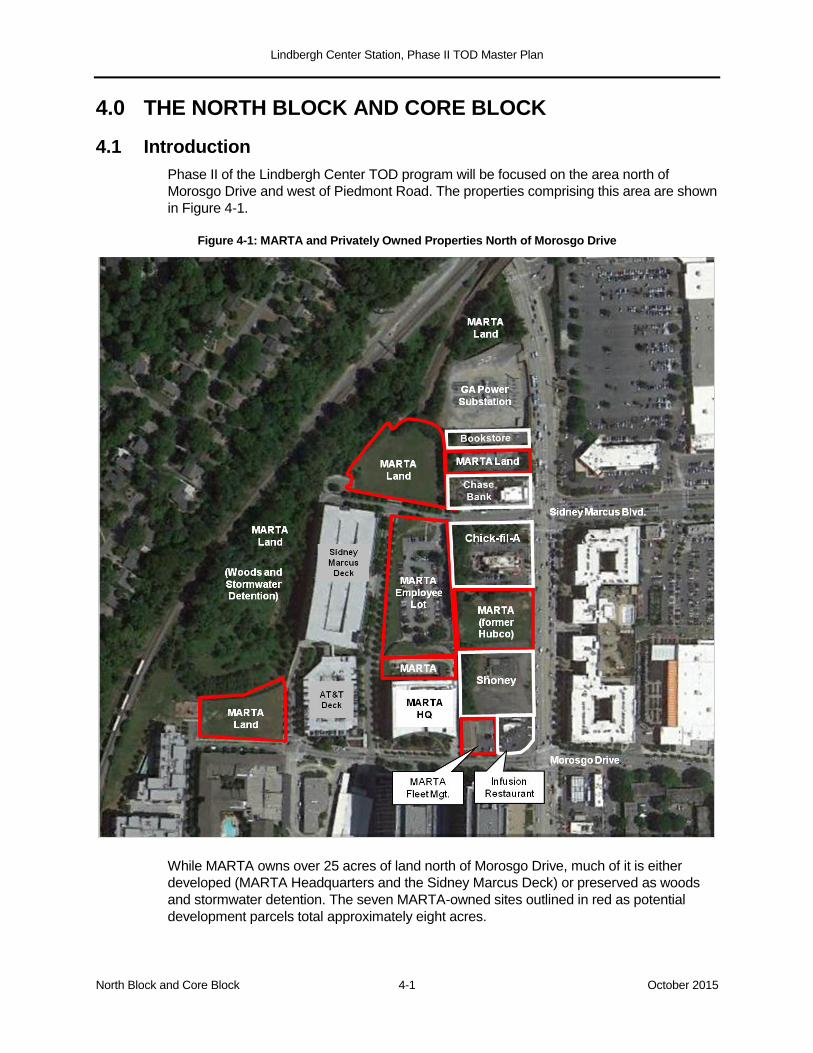
Lindbergh Center Station, Phase II TOD Master Plan
North Block and Core Block 4-1 October 2015
4.0 THE NORTH BLOCK AND CORE BLOCK
4.1 Introduction
Phase II of the Lindbergh Center TOD program will be focused on the area north of
Morosgo Drive and west of Piedmont Road. The properties comprising this area are shown
in Figure 4-1.
Figure 4-1: MARTA and Privately Owned Properties North of Morosgo Drive
While MARTA owns over 25 acres of land north of Morosgo Drive, much of it is either
developed (MARTA Headquarters and the Sidney Marcus Deck) or preserved as woods
and stormwater detention. The seven MARTA-owned sites outlined in red as potential
development parcels total approximately eight acres.
Lindbergh Center Station, Phase II TOD Master Plan
North Block and Core Block 4-2 October 2015
As explained in Section 1.1, the subarea north of Sidney Marcus Boulevard is designated
the North Block, and the subarea between Sidney Marcus Boulevard and Morosgo Drive
is designated the Core Block. In each case, the Master Plan consists of two elements:
the public realm template: the network of streets, sidewalks, and public spaces that
defines the planning area, breaks it into appropriately sized development sites, and
connects them to the station and the surrounding district;
the individual development sites defined by the template.
Detailed Master Plan concepts are presented for both the North Block and the Core Block,
with two alternatives—Concept A and Concept B—shown for each. The public realm
template is common to both concepts, while the treatment of individual development sites
varies between concepts. Each concept is a set of planning and development approaches
that could be “mixed and matched”; in general, the more conservative assumptions are
represented in Concept A, the more aggressive in Concept B.
The Master Plan concepts are consistent with the MARTA TOD Guidelines and the
anticipated rezoning of the entire North Block and Core Block as SPI-15.25
Proposed
building heights range from a baseline of six stories to a tower of eight to fifteen stories on
the “100% corner” of Piedmont Road and Morosgo Drive. The Floor Area Ratios (FARs)
implied by these concepts are compatible with SPI-15 limits.26
The concepts are also consistent with the market analysis performed for this Master Plan
(Section 2.0). That analysis suggests that, notwithstanding the large recent influx of
residential development east of Piedmont Road, there is potential Lindbergh Center market
area demand for about 200 units per year, starting as early as 2017. The market study also
supports Lindbergh Center as a niche hotel market easily reached on MARTA from
Midtown, Buckhead, and the airport; with discrete product types, two or conceivably three
hotels in the 100-125 “key” range might be achievable. Under current conditions and
trends, there are modest markets for retail and office space. All of these uses are
represented in the Master Plan concepts, in mid-range densities that would allow a near-
term market response. Building out all of the developable land in the North Block and Core
Block is not a single project but a multi-year, multi-project exercise in city building.
The uses and massing proposed for individual development sites are intended to be
illustrative and flexible. Sites fronting on Piedmont Road are described as mixed-use,
meaning that any combination of retail, residential, hotel, office, civic, or institutional use
would be appropriate. Other sites are designated as residential, because of their location
on interior streets rather than Piedmont Road. Specific hotel sites are identified, with the
understanding that hotels could instead be built as part of one or more mixed-use projects.
A over-arching planning consideration is the surplus supply of existing parking spaces and
the potential to concentrate much of this surplus in the Sidney Marcus Deck. (The parking
analysis is presented in Section 3.0.) This plan strives to accommodate the parking needs
of the North Block, and of the westerly residential buildings of the Core Block, in existing
garage space to the greatest extent feasible. This would reduce the cost of these
25 Currently, the MARTA properties are zoned C-3, the private properties fronting on Piedmont SPI-15.
26 SPI-15 specifies FAR 4.2 for all-market residential projects; 8.2 for residential with at least 20% affordable units; 8.2
for mixed-use (4.0 commercial plus 4.2 residential), and 12.2 for mixed-use with 20% affordable units.
Lindbergh Center Station, Phase II TOD Master Plan
North Block and Core Block 4-3 October 2015
developments, enable them to build more residential or commercial square footage in the
available envelope, and take strategic advantage of what is broadly recognized as an
excess of parking constructed as part of the original Lindbergh Center TOD. For the same
reason, to the extent that new parking deck capacity is needed, this plan seeks to develop
it in shared-use structures rather than individual structures for single parcels.
4.2 The North Block
The North Block is bounded by Sidney Marcus Boulevard on the south, Piedmont Road on
the east, the Georgia Power substation on the north, and the stream buffer along the
MARTA-owned wooded area on the west. The North Block has an approximate area of 3.8
acres, and includes:
the large, roughly triangular MARTA property on the west side of the block, at the head
of Lindbergh Lane (approximately 2.2 acres);
the rectangular MARTA lot containing the former Coverdale house and fronting on
Piedmont Road (.64 acres);
the recently constructed Chase Bank branch and its surface parking lot, at the corner
of Sidney Marcus and Piedmont (.65 acres);
the narrow rectangular parcel containing an adult bookstore (.32 acres).27
An obvious challenge in planning the development of the North Block is the fragmented
land ownership along Piedmont Road, resulting in MARTA's rectangular lot being
sandwiched between the bank and bookstore parcels. Master Plan Concepts A and B
differ primarily in how they respond to this property ownership constraint. Countervailing
the fragmented land ownership are two advantages:
the proximity of Lindbergh Center Station, less than a quarter-mile away with a direct
walking route on Lindbergh Lane;
the availability of surplus parking in the Sidney Marcus Deck, with the potential to
absorb much of the parking required by the North Block development.
Concepts A and B are shown in Figures 4-2 and 4-3, respectively. The key feature of the
public realm template is an extension of Lindbergh Lane across Sidney Marcus
Boulevard and into the North Block. In addition to breaking up the block and providing
interior access, “Lindbergh Lane Extension” protects MARTA's below-grade train tunnel
box. Because of the portal located immediately to the north, it is MARTA's intent to avoid
vertical construction above the tunnel box; hence its value as a midblock street.
4.2.1 North Block Concept A
In Concept A, the land ownership pattern along Piedmont Road is assumed to remain
generally as it is today, with the possible exception of MARTA’s designated developer
acquiring the narrow adult bookstore parcel; this would expand MARTA’s rectangular lot
from .64 acres to a full acre, facilitate access and circulation, and help buffer Site N-3 from
27 Land areas are from the Fulton County Property Records Parcel Map website
(http://qpublic9.qpublic.net/qpmap4/map.php?county=ga_fulton&layers=parcels+roads+lakes&mapmode). Acreage of
parcels that have defined boundaries within the developable area are taken from the individual property record;
estimated acreage for development sites that are part of larger legal parcels are estimated using the website’s area
measuring tool.

Lindbergh Center Station, Phase II TOD Master Plan
North Block and Core Block 4-4 October 2015
the electrical substation. Site N-3 could accommodate a hotel in the 100-120 key range, of
the product types identified in the market analysis. The hotel footprint, copied from a
similar-sized hotel in a nearby district, would fit on this site and enjoy a Piedmont Road
address. If the bookstore parcel cannot be secured, a hotel could be accommodated on
the MARTA property alone, with access from Lindbergh Lane Extension.
Figure 4-2: North Block Concept A
Lindbergh Center Station, Phase II TOD Master Plan
North Block and Core Block 4-5 October 2015
Lindbergh Lane Extension terminates at the northern edge of the development area. Multi-
family residential buildings are envisioned on either side of Lindbergh Lane Extension
(Sites N-1 and N-2), with sidewalk frontage on both Lindbergh Lane Extension and Sidney
Marcus. At five stories, a two-building development in the 170-180 unit range, depending
on unit mix and sizes, would fit the site comfortably, and residents could literally look down
Lindbergh Lane to the station.28
Aside from the small amount of surface parking that would fit on-site, it is proposed that
parking for this development occur in the Sidney Marcus Deck, where, as explained in
Section 3.0, MARTA can potentially assemble some 400 surplus spaces under its control,
and could explore whether AT&T is interested in making its surplus capacity available for
development. Applying the TOD parking ratios used in Section 3.0, the program envisioned
in Concept A would require about 320 spaces.29
This arrangement would likely require that
the residential spaces be physically dedicated within the northern portion of the garage and
that a secure on-foot entry be created at that end for residential users.
4.2.2 North Block Concept B
Concept B is illustrated in Figure 4-3. To the west of Lindbergh Lane Extension, Site N-1
could accommodate a hotel, as shown here, or a residential structure as shown in Concept
A. East of Lindbergh Lane Extension, Concept B assumes that MARTA’s designated
developer would be able to negotiate a more ambitious consolidation of property with the
abutting owners. In this scenario, not only the bookstore parcel but Chase Bank’s parking
lot would be combined with the MARTA property. This would enable the entire area east of
Lindbergh Lane Extension, except for the bank building itself and its pedestrian apron, to
be treated as a single development site of roughly 2.3 acres. This mixed-use site could
accommodate a market-driven combination of street-level retail, local services, and upper-
floor residential, office, or hotel. Figure 4-3 suggests how this larger, more flexible site
could be developed. Two buildings would provide frontage on both Piedmont and Sidney
Marcus, with surface parking shifted to the interior of the block. The building footprint on
Site N-2 could be configured to accommodate a small grocery store at street level.30
With 50,000 square feet of retail, 240 residential units, and a 120-room hotel, Concept B
would require about 460 parking spaces, plus the 18 surface spaces currently provided by
Chase Bank on its property. Surface parking for the bank and other drive-up retail would
be provided on-site and at curbside on the new roadway connecting Piedmont Road to
Lindbergh Lane Extension (buffering the development from the substation). The bulk of the
parking would be absorbed, as in Concept A, in the existing surplus capacity of the Sidney
Marcus Deck.
Concept B also contemplates that Lindbergh Lane Extension could be continued
northward beyond the development site, running between the MARTA tunnel portal and
28 The rough estimate of gross square footage, listed in the table below the drawing, is 195,000 square feet for the two
buildings. Assuming 90% efficiency, roughly 176,000 square feet would be available for net unit space. This plan will
assume, as a convention, 90% efficiency and a unit mix with an average per-unit net area of 1,000 square feet.
29 The parking ratios developed in Section 3.0, reflecting the MARTA TOD Guidelines and anticipated SPI-15 zoning,
are: residential, 1.00 spaces per unit; hotel, 1.00 space per guest room; office 2.00 spaces per 1,000 square feet; and
retail, 2.0 dedicated spaces per square feet (assuming evening and weekend availability of MARTA commuter spaces to
absorb additional peak retail and restaurant demand).
30 It the Chase Bank ownership were interested in redeveloping their entire site, a new branch office could be
incorporated into the street floor of a mixed-use building fronting directly on the corner.

Lindbergh Center Station, Phase II TOD Master Plan
North Block and Core Block 4-6 October 2015
the Georgia Power substation and intersecting Piedmont Road at its existing signalized
intersection with Miami Circle. This through-route would provide a vehicular and bicycle
connection from Miami Circle to the Lindbergh Center Station area, bypassing Piedmont
Road. Further study would be required to determine whether the modified Piedmont
intersection would have adequate sightlines from the north and whether MARTA owns
sufficient land (or can gain sufficient easement rights) to accommodate this alignment. An
alternative to a full street would be a pedestrian-bicycle route.
Figure 4-3: North Block Concept B
Lindbergh Center Station, Phase II TOD Master Plan
North Block and Core Block 4-7 October 2015
4.3 The Core Block
The Core Block is the area bounded by Sidney Marcus Boulevard on the north, Piedmont
Road on the east, Morosgo Drive on the south, and the large wooded area owned by
MARTA on the west. This land mass has an area of about 15.0 acres. However, half of this
acreage consists of MARTA Headquarters, the AT&T and Sidney Marcus parking decks,
and the existing right of way of Lindbergh Lane. The area available for development—
approximately 7.1 acres—consists of the following (see the map in Figure 4-1):
MARTA’s current employee parking lot (approximately 2.1 acres);
MARTA’s rectangular lot fronting on Piedmont Road (the former Hubco property,
approximately .87 acres);
MARTA’s vehicle management building, located next to MARTA Headquarters on
Morosgo Drive (approximately .34 acres);
the vacant lot owned by MARTA on the north side of Morosgo Drive, west of the AT&T
parking deck (approximately .87 acres); and three private properties:
the Chick-fil-A restaurant at the corner of Sidney Marcus and Piedmont (1.19 acres);
the Infusion restaurant and bar at the corner of Morosgo and Piedmont (.33 acres);
the vacant former Shoney restaurant site fronting on Piedmont (1.39 acres).
As in the case of the North Block, two Master Plan concepts have been developed for the
Core Block. Shown in Figures 4-4 and 4-5, they are composite and illustrative, with the
more conservative assumptions reflected in Concept A. Here again, fragmented property
ownership along Piedmont Road is an underlying challenge. Because of their differing
circumstances, the three privately owned parcels are treated in different ways:
The Chick-fil-A parcel is shown as unchanged, subject to “Potential Redevelopment by
Others”. The restaurant is actively in business, and its owners have not proposed any
redevelopment or change of use. That said, this Master Plan, by nature, would
encourage a denser, less automobile-oriented use of this highly visible corner property,
if market forces induce the owners to pursue redevelopment. At 1.19 acres, the parcel
is large enough to be redeveloped on its own if it can share parking with an adjacent
development. Alternatively, its owners could seek to combine their property with
adjacent MARTA land.
The former Shoney property, by contrast, is treated as a redevelopment site. This
reflects the fact that the restaurant is closed and the property owners have, since 2011,
repeatedly indicated to MARTA an interest in pursuing mixed-use redevelopment.
The small privately-owned parcel at the corner of Piedmont and Morosgo is assumed
to be included in the Shoney redevelopment. This parcel houses a one-story restaurant
and bar, with surface parking directly on the “100% corner” frontage. This use is
incompatible with the MARTA TOD Guidelines and non-conforming under the existing
SPI-15 zoning.
The proposed public realm template for the Core Block includes three new features, all
common to Concepts A and B:
Lindbergh Center Station, Phase II TOD Master Plan
North Block and Core Block 4-8 October 2015
A mid-block "New Street", running north-south parallel to Piedmont Road and
Lindbergh Lane. Counting sidewalks on either side, New Street is approximately 45
feet wide. It connects Sidney Marcus Boulevard and Morosgo Drive, provides
redundant north-south traffic circulation, and creates a small-block pedestrian grid
appropriate for TOD. New Street leaves development parcels in excess of 200 feet
deep along the entire 700-foot frontage of Piedmont Road.
A cross-block pedestrian-bicycle corridor, connecting Piedmont Road and Lindbergh
Lane. While the conceptual alignment of New Street is fixed, the ped-bike corridor can
slide north or south, accommodating the size of the development parcels. If
necessary, the ped-bike corridor could have a "jog" at New Street rather than a
continuous axis. At Lindbergh Lane, subject to negotiations with AT&T, it might be
possible to continue the ped-bike route westward, between the AT&T and Sidney
Marcus Decks and out to Sidney Marcus Extension, where it could connect to the park
and trail described next.
A new park on a portion of Site C-1, consisting of a green space fronting on Morosgo
Drive and accessing the MARTA-owned hiking trails in the wooded area west of the
parking decks . These trails are isolated and under-utilized today, but the introduction of
residential development at either end, their incorporation into a highly visible park on
Morosgo, and their potential connection to other trails converging on the station (see
Section 6.3) could make them a valued amenity. In the future, MARTA and other
stakeholders could explore more elaborate improvements to the trails, such as
overlooks, stairs leading down to the stream, and lighting along the Sidney Marcus
Deck retaining wall.
4.3.1 Core Block Concept A
Concept A is shown in Figure 4-4. It includes three development sites that are assumed,
because of their location on interior streets, to be most appropriate for residential use.
Site C-1, on Morosgo Drive west of the station entrance, combines the new park
described above and a small residential footprint of approximately 15,000 square feet.
This building could accommodate 60-65 units in five stories, and could satisfy half of its
parking need in surface spaces on-site if the existing playground were relocated. The
remaining parking could be provided in the allocation that MARTA controls in the
adjacent AT&T deck.
Site C-2 consists of three single-loaded “liner” structures on the Lindbergh Lane
façades of the Sidney Marcus and AT&T parking decks. The decks are set back
sufficiently from the sidewalk to accommodate this construction. In addition to adding
roughly 40 units, the liner buildings would improve the streetscape on Lindbergh Lane
and reflect the façade of the residential building on Site C-3 across the street.
Site C-3 is the current MARTA employee parking lot. As described in Section 3.0,
MARTA would free up this parcel by moving its 125 employee spaces into the Sidney
Marcus Deck. A built-in advantage, unique to this parcel, is its topography, which
declines significantly from north to south. The existing employee lot is several feet
below sidewalk grade on Sidney Marcus Boulevard and Lindbergh Lane, and a level of
parking holding about 100 cars could be inserted beneath the building with a minimum
of excavation and potentially without mechanical ventilation. A four-story project of
140-145 units, as envisioned, could thus provide most of its parking on-site, with the
remainder in the Sidney Marcus Deck directly across the street. This concept would
allow pedestrian-scale frontage on Lindbergh Lane and New Street.
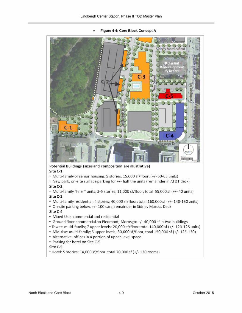
Lindbergh Center Station, Phase II TOD Master Plan
North Block and Core Block 4-9 October 2015
Figure 4-4: Core Block Concept A
Lindbergh Center Station, Phase II TOD Master Plan
North Block and Core Block 4-10 October 2015
The Core Block’s prime opportunity for dense, mixed-use development is the assemblage
of the 1.39-acre Shoney property and the smaller adjoining parcels: MARTA’s vehicle
management shop and the one-story restaurant and bar. This combined footprint (Site C-
4), comprising 2.06 acres at the “100% corner” of Piedmont Road and Morosgo Drive, is
next door to the six-story MARTA Headquarters and across Morosgo from the 10-story
AT&T towers—a target location for height, density, and visibility.
The build-out on this site will be driven by two factors: market conditions and parking
capacity. Unlike the residential buildings envisioned along Lindbergh Lane, this location,
because of its relative distance from the existing decks, is assumed to require its own
parking supply. The site’s depth will accommodate a two-bay park-on-ramp deck design
with ample “wrapping” along Piedmont; the key variable will be the length of the deck from
north to south.31
The deck can be accessed from New Street as well as via a right-in/right-
out driveway from Piedmont Road.32
At 2.06 acres, Site C-4 can accommodate a deck holding roughly 85 cars per level, or 420
cars on five levels—sufficient capacity to support the program envisioned in Concept A
(Figure 4-4): roughly 40,000 square feet of street-level commercial space (allowing for
lobbies serving the upper-level uses) and from 240 to 340 residential units.33
The project
could be phased, with the elements fronting on Morosgo and Piedmont built at different
times and with physical separation, if desired. The tower element at the corner should be at
least eight stories in height.
MARTA's Hubco parcel (Site C-5) could be developed separately as a hotel, with parking
provided in the Shoney deck. Alternatively, this parcel could be held back until such time
as the owners of the adjacent Chick-fil-A property are ready to explore redevelopment; if
combined with the Chick-fil-A property, Site C-5 would enable MARTA to participate in a
larger corner assemblage similar to that described here for the Shoney project.
4.3.2 Core Block Concept B
Concept B is shown in Figure 4-5. While generally retaining the public realm template and
street grid of Concept A, it accommodates greater height and density, both on the
residential side of the Core Block and on the mixed-use side along Piedmont Road. This is
achieved largely by providing additional parking (at the TOD ratios assumed throughout
this plan). It is unlikely that all of the denser building alternatives will materialize, for both
market and site capacity reasons. However, as in the case of the North Block, Concept B
provides a menu of higher, denser outcomes, which can be “mixed and matched” over time
with elements of Concept A.
31 The Lindbergh CenterVista Apartments directly across Piedmont Road have a similar configuration on a site of similar
depth.
32 This driveway must be designed as right-in/right-out, because a four-way signalized intersection would not be feasible
or desirable in between the signalized intersections at Sidney Marcus and Morosgo (themselves only 700 feet apart).
33 At 240 units, there would be about 100 parking spaces left over. These could be used to shift some of the upper-floor
space to office use (at the higher parking ratio of 2.0 per 1,000 square feet, compared to 1.0 space per residential unit),
or to provide parking for a hotel on Site C-5 (see next paragraph).
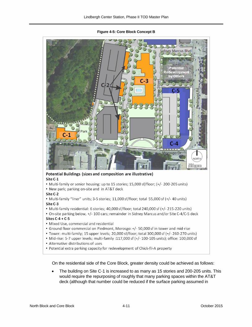
Lindbergh Center Station, Phase II TOD Master Plan
North Block and Core Block 4-11 October 2015
Figure 4-5: Core Block Concept B
On the residential side of the Core Block, greater density could be achieved as follows:
The building on Site C-1 is increased to as many as 15 stories and 200-205 units. This
would require the repurposing of roughly that many parking spaces within the AT&T
deck (although that number could be reduced if the surface parking assumed in
Lindbergh Center Station, Phase II TOD Master Plan
North Block and Core Block 4-12 October 2015
Concept A were retained, or if the target market for the building were seniors, enabling
a parking ratio of less than 1.0 space per unit).34
The multi-family building on Site C-3 (the MARTA employee lot) is increased to 215-
220 units by securing additional parking in the Sidney Marcus deck or in the extended
shared-use deck proposed for Sites C-4 and C-5 (see below). If it were feasible to add
a second below-grade layer of on-site parking, building C-3 could be even larger, but
that outcome is not assumed.
Concept B features a denser and more expansive version of the Shoney redevelopment
project—one in which MARTA's Hubco parcel (Site C-5) is added to the assemblage to
create a 2.93-acre development site. (In this assemblage, MARTA’s share of land
ownership exceeds Shoney’s.) The larger footprint can accommodate a two-bay parking
deck 360 feet long, creating a capacity of roughly 135 cars per level. If built to five levels,
this deck would hold about 675 cars, enough to support an illustrative mixed-use program
of 50,000 square feet of retail, 375 residential units, and 100,000 square feet of office
space, or an alternative mix with similar parking demand. The tower element at the corner
of Piedmont and Morosgo should be the tallest building in the station area, with a signature
element of at least 15 stories encouraged.35
If a sixth level were added to the deck, the capacity would be approximately 810. The
additional parking could support the redevelopment of the adjacent Chick-fil-A property,
enabling that site to be redeveloped when market conditions dictate. The Chick-fil-A
developer could fund its share of the parking or compensate MARTA for its use. This
concept would optimize the height and density of the Shoney project while preserving the
ability of the Chick-fil-A site—which also occupies a key corner—to redeveloped in a more
intense, transit-oriented fashion.
34 MARTA might be able to accommodate the full parking need for this building within its own allotment of spaces in the
AT&T deck; MARTA’s use of those spaces, however, would presumably shift to the Sidney Marcus deck, reducing
MARTA’s surplus capacity in that facility. As noted previously, AT&T has its own parking surplus in the Sidney Marcus
deck; if it were economically advantageous for AT&T to make those spaces commercially available to MARTA’s joint
development program, both the North and Core Blocks would benefit.
35 Assuming adoption of SPI-15 zoning (Subarea 3, Piedmont Commercial), the maximum height would be 225 feet and
the maximum mixed-use FAR 8.2. The residential-only maximum FAR is 4.2, and the non-residential only is 4.0. There
are also bonuses available for affordable housing, public space, and other public benefits. For the SPI-15 parking
provisions, see the Parking Analysis, Section 3.3.
https://www.municode.com/library/ga/atlanta/codes/code_of_ordinances?searchRequest=%7B%22searchText%22:%22
table%20of%20land%20use%20intensity%20ratios%22,%22pageNum%22:1,%22resultsPerPage%22:25,%22booleanS
earch%22:false,%22stemming%22:true,%22fuzzy%22:false,%22synonym%22:false,%22contentTypes%22:%5B%22C
ODES%22%5D,%22productIds%22:%5B%5D%7D&nodeId=PTIIICOORANDECO_PT16ZO_CH18OSP15LITRSTARS
PPUINDIRE_S16-18O.028SPRECOSU.
Lindbergh Center Station, Phase II TOD Master Plan
Station Blocks and MARTA Annex 5-1 October 2015
5.0 THE STATION BLOCKS AND THE MARTA ANNEX
5.1 Introduction
The Master Plan concepts for the area north of Morosgo Drive presented in Section 4.0
must be seen in the context of the full station area, starting with MARTA’s land holdings
south of Morosgo. Successful TOD in the Core Block and North Block will both influence,
and be influenced by, what happens in the Station Blocks and, in the future, the MARTA
Annex.
The Station Blocks, as defined in Section 1.1, are the territory between Morosgo and
Lindbergh Drives. This area includes the station itself and most of the joint
development that occurred under the Phase I Carter/BellSouth TOD initiative. As
described below, there remain two (and potentially three) undeveloped parcels in the
Station Blocks; an unfinished Main Street retail corridor; and future transit
improvements that would significantly impact the station area from a development
and connectivity standpoint. The Station Blocks are fully contained within the
station’s quarter-mile walkshed.
Also within that walkshed is the MARTA Annex property, the 11-acre former
Wachovia operations center which lies south of Lindbergh Drive and well below
street grade. While today the Annex is virtually invisible from the station, it represents
a significant, and potentially very valuable, long-term joint development opportunity
for MARTA.
5.2 The Station Blocks
Existing Conditions. The 32-acre grid bordered by Morosgo Drive, Piedmont Road,
Lindbergh Drive, and the Norfolk Southern railroad constitutes the developed center of the
station area. In addition to the MARTA rail station, these blocks contain MARTA’s north
and south bus loops; the BellSouth (now AT&T) office towers; an adjoining office and retail
building; the Eon and Uptown Square apartment complexes; Pike’s Nursery; the multi-use
City Center and Garson parking decks; the Main Street retail zone; and a trio of stand-
alone restaurants along Piedmont Road.36
Only two MARTA parcels currently designated
for development remain unbuilt: Parcel N, located between the Garson Deck and
Lindbergh Drive at the southern edge of the grid; and the air rights above the City Center
Deck. The Station Blocks are shown in Figure 5-1. Although mostly developed, they are
incomplete in two important ways:
The built environment and its daily activity gravitate northward toward the station
entrance on Morosgo Drive. The station entrance south of Main Street is little used by
comparison. The view from south of the station is dominated by the blank walls of the
Garson and City Center Decks, undeveloped land flanking the open “boat section” of
the tracks, and the suburban configuration of Lindbergh Drive with its one-way
“jughandle” intersection. This undeveloped Lindbergh Drive frontage constrains the
pedestrian and retail environment on Main Street, and its “back of the house” condition
is a potential barrier to the future redevelopment of the MARTA Annex.
36 The 32-acre area also contains the privately-owned night club parcel located within the Lindbergh Center“jughandle”
loop, at the southeast corner of the Station Blocks, This property is included for planning purposes only; MARTA does
not contemplate any involvement in the ownership or potential redevelopment of this site.
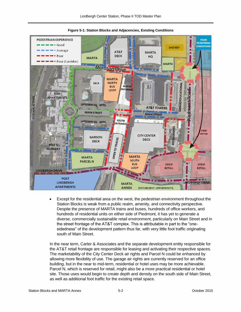
Lindbergh Center Station, Phase II TOD Master Plan
Station Blocks and MARTA Annex 5-2 October 2015
Figure 5-1: Station Blocks and Adjacencies, Existing Conditions
Except for the residential area on the west, the pedestrian environment throughout the
Station Blocks is weak from a public realm, amenity, and connectivity perspective.
Despite the presence of MARTA trains and buses, hundreds of office workers, and
hundreds of residential units on either side of Piedmont, it has yet to generate a
diverse, commercially sustainable retail environment, particularly on Main Street and in
the street frontage of the AT&T complex. This is attributable in part to the “one-
sidedness” of the development pattern thus far, with very little foot traffic originating
south of Main Street.
In the near term, Carter & Associates and the separate development entity responsible for
the AT&T retail frontage are responsible for leasing and activating their respective spaces.
The marketability of the City Center Deck air rights and Parcel N could be enhanced by
allowing more flexibility of use. The garage air rights are currently reserved for an office
building, but in the near to mid-term, residential or hotel uses may be more achievable.
Parcel N, which is reserved for retail, might also be a more practical residential or hotel
site. Those uses would begin to create depth and density on the south side of Main Street,
as well as additional foot traffic for the existing retail space.
Lindbergh Center Station, Phase II TOD Master Plan
Station Blocks and MARTA Annex 5-3 October 2015
In the mid to long term, the pedestrian network, retail environment, and future development
opportunities in the Station Blocks and MARTA’s adjacent properties to the north and
south are related to the station’s intermodal facilities. Currently, Lindbergh Center Station
has two bus loops, one of them barely used. The future integration of two proposed
surface rail projects—the Clifton Corridor and the Atlanta BeltLine—is in the early planning
stages.
Intermodal Planning. Lindbergh Center Station is currently served by five MARTA bus
routes and one GRTA express route. The north bus loop is located immediately next to
the station entrance on Morosgo Drive and handles virtually all existing bus operations.
The station's traction power equipment is housed in the one-story building in the center
of the loop; MARTA's police department also occupies a portion of this building. While
affording intermodal passengers a convenient transfer between bus and rail, this loop
impacts the pedestrian environment on Morosgo Drive.
The south bus loop is attached to the façade of the City Center Deck at the southern
edge of the Station Blocks . This loop is isolated and minimally used. Unless future
service planning dictates the need for two separate bus loops, MARTA should consider
consolidating operations into one location. This decision is related to the future
integration of the two surface rail projects.
The proposed Clifton Corridor line will have its western terminus at Lindbergh Center
Station. The alignment will approach Lindbergh Center from the south, running along the
east side of the MARTA tracks, crossing under Garson Drive, climbing to grade
alongside the MARTA Annex, and crossing Lindbergh Drive at a signalized grade
crossing to enter the Station Blocks.37
The Atlanta BeltLine does not yet have a firmly established Lindbergh Center alignment,
but based on current project documentation, the most probable routing would enter and
exit the station along Garson Drive and its continuation, Market Street, running along the
west side of the MARTA tracks and, like the Clifton Corridor, crossing Lindbergh Drive at
a signalized intersection.38
Absent an alternative, the two surface rail lines will locate their passenger platforms
alongside the open “boat section” of the MARTA tracks at the southern end of the
station. The Clifton Corridor platform (shown in Figure 5-2) is proposed for Lindbergh
Lane, in front of an entrance to the City Center Deck. If the BeltLine platform were
located on Market Street, on the opposite side of the boat section, it would be in front of
an entrance to the Garson Deck. The platforms would likely preclude garage access at
these points.
37 The Clifton alignment is illustrated in Section 6.3, Figures 6-3 and 6-4.
38 The BeltLine alignment is discussed in further detail in Section 6.3 and illustrated in Figures 6-3 and 6-5.
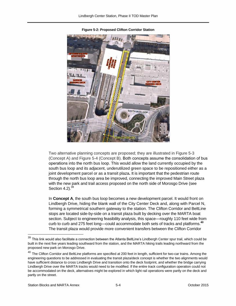
Lindbergh Center Station, Phase II TOD Master Plan
Station Blocks and MARTA Annex 5-4 October 2015
Figure 5-2: Proposed Clifton Corridor Station
Two alternative planning concepts are proposed; they are illustrated in Figure 5-3
(Concept A) and Figure 5-4 (Concept B). Both concepts assume the consolidation of bus
operations into the north bus loop. This would allow the land currently occupied by the
south bus loop and its adjacent, underutilized green space to be repositioned either as a
joint development parcel or as a transit plaza. It is important that the pedestrian route
through the north bus loop area be improved, connecting the improved Main Street plaza
with the new park and trail access proposed on the north side of Morosgo Drive (see
Section 4.2).39
In Concept A, the south bus loop becomes a new development parcel. It would front on
Lindbergh Drive, hiding the blank wall of the City Center Deck and, along with Parcel N,
forming a symmetrical southern gateway to the station. The Clifton Corridor and BeltLine
stops are located side-by-side on a transit plaza built by decking over the MARTA boat
section. Subject to engineering feasibility analysis, this space—roughly 110 feet wide from
curb to curb and 275 feet long—could accommodate both sets of tracks and platforms.40
The transit plaza would provide more convenient transfers between the Clifton Corridor
39 This link would also facilitate a connection between the Atlanta BeltLine’s Lindbergh Center spur trail, which could be
built in the next five years leading southward from the station, and the MARTA hiking trails leading northward from the
proposed new park on Morosgo Drive.
40 The Clifton Corridor and BeltLine platforms are specified at 200 feet in length, sufficient for two-car trains. Among the
engineering questions to be addressed in evaluating the transit plaza/deck concept is whether the two alignments would
have sufficient distance to cross Lindbergh Drive and transition onto the deck footprint, and whether the bridge carrying
Lindbergh Drive over the MARTA tracks would need to be modified. If the entire track configuration operation could not
be accommodated on the deck, alternatives might be explored in which light rail operations were partly on the deck and
partly on the street.
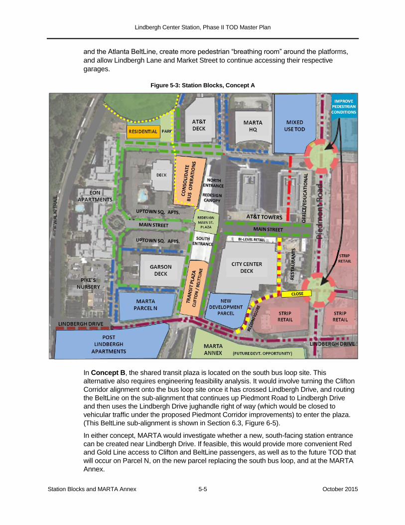
Lindbergh Center Station, Phase II TOD Master Plan
Station Blocks and MARTA Annex 5-5 October 2015
and the Atlanta BeltLine, create more pedestrian “breathing room” around the platforms,
and allow Lindbergh Lane and Market Street to continue accessing their respective
garages.
Figure 5-3: Station Blocks, Concept A
In Concept B, the shared transit plaza is located on the south bus loop site. This
alternative also requires engineering feasibility analysis. It would involve turning the Clifton
Corridor alignment onto the bus loop site once it has crossed Lindbergh Drive, and routing
the BeltLine on the sub-alignment that continues up Piedmont Road to Lindbergh Drive
and then uses the Lindbergh Drive jughandle right of way (which would be closed to
vehicular traffic under the proposed Piedmont Corridor improvements) to enter the plaza.
(This BeltLine sub-alignment is shown in Section 6.3, Figure 6-5).
In either concept, MARTA would investigate whether a new, south-facing station entrance
can be created near Lindbergh Drive. If feasible, this would provide more convenient Red
and Gold Line access to Clifton and BeltLine passengers, as well as to the future TOD that
will occur on Parcel N, on the new parcel replacing the south bus loop, and at the MARTA
Annex.

Lindbergh Center Station, Phase II TOD Master Plan
Station Blocks and MARTA Annex 5-6 October 2015
Figure 5-4: Station Blocks, Concept B
Lindbergh Drive. Common to both planning concepts is an expectation that the
“jughandle” intersection of Piedmont Road and Lindbergh Drive will be modified, so that
automobile traffic on Lindbergh Drive follows a normal east-west route. On MARTA’s side
of Piedmont Road, this would involve closing the jughandle leg connecting directly to
Piedmont. The leg that connects Lindbergh Drive to Magnolia Lane (the narrow street
accessing the City Center Deck and MARTA’s three tenant restaurants on Piedmont Road)
would remain open, so that Magnolia Lane could remain a through-street. This leg could
be reconfigured to accommodate the future redevelopment of the south bus loop site.
The introduction of at-grade light rail on the south side of the station and the
reconfiguration of the Lindbergh Drive intersection would serve three TOD purposes:
It would support development of Parcel N and, in Concept A, the south bus loop site.
Transit and development together would create foot traffic south of Main Street, ease
the perceived “one-sidedness” of the station area, and expand the market for retail on
Main Street and at the ground level of the AT&T complex.
Lindbergh Center Station, Phase II TOD Master Plan
Station Blocks and MARTA Annex 5-7 October 2015
The emergence of the area south of Main Street as an active transit and development
zone would, in time, create the conditions for extending TOD across Lindbergh Drive
and redeveloping MARTA’s Annex property.
5.3 The MARTA Annex
At 11 acres, the Annex property is by far MARTA’s largest contiguous holding at
Lindbergh.41
Despite its present isolation from the station and the existing TOD, the entire
Annex property is within a quarter-mile of the south entrance, and the walk from its
Lindbergh Drive frontage to the turnstiles ranges from 400 to 850 feet. Although almost
invisible from Piedmont Road in its current condition, the property has 500 feet of Piedmont
Road frontage and a Piedmont address. It also has a physical advantage, in that its setting
well below the grade of Lindbergh Drive would enable parking and loading to be built below
the ground floors of buildings, accessed from Garson Drive and Piedmont Road.
Redevelopment of the Annex is considered a long-term opportunity, for two reasons. In the
near to mid-term, the market is likely to be attracted to the more immediate and visible
opportunities in the Station Blocks, the Core Block, and the North Block. Second, MARTA’s
active use of the building’s 220,000 square feet of space will require time to plan
alternatives.
The intent of this Master Plan is to anticipate this opportunity and take steps in the near to mid-term to reinforce it. The planning concepts presented in the prior section, particularly with respect to future transit and development activity in the southern part of the Station Blocks, are meant to extend the station’s active footprint to the northern edge of Lindbergh Drive. The proposed removal of the jughandle and normalization of the traffic pattern would help make Lindbergh Drive an urban street—albeit a busy arterial one—that people can imagine crossing at signalized intersections.
Because the Annex property is nearly the size of the Core Block, it will need to be
developed in phases even when MARTA and the market are ready to proceed. The
division of the site into blocks and parcels is a future exercise, made more complex
because of the grade change and the lack of direct mid-block access on the west side
(bordering the MARTA rail alignment). However, it is important to understand that because
the physical building is set back 150-250 feet from Lindbergh Drive, and the site’s
Lindbergh Drive frontage is 600 feet long, there is sufficient depth to develop a substantial
initial phase while the Annex building is still in use.
Figure 5-5 assumes that a north-south mid-block street would extend the line of the
jughandle leg connected to Magnolia Lane, and that an east-west mid-block street would
be accessed by a right-in/right-out curb cut acceptably distant from the Lindbergh-
Piedmont intersection. The two conceptual development sites outlined in red would be
roughly 1.0 acre and 1.25 acres in size. These sites would front on Lindbergh Drive, relate
to the Station Block street grid, and enjoy close proximity to the south station entrance and
the future BeltLine and Clifton Corridor platforms.
41 MARTA’s full contiguous ownership, including its own operating right-of-way along the western edge of the property,
is 13.1 acres. Allowing for the Clifton Corridor tracks, the developable site is roughly 11 acres. Fulton County Board of
Assessors website
(http://qpublic9.qpublic.net/qpmap4/map.php?county=ga_fulton&layers=parcels+roads+lakes&mapmode)
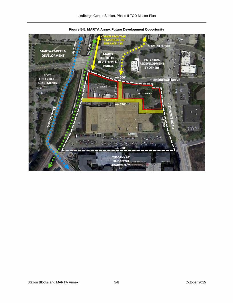
Lindbergh Center Station, Phase II TOD Master Plan
Station Blocks and MARTA Annex 5-8 October 2015
Figure 5-5: MARTA Annex Future Development Opportunity
Lindbergh Center Station, Phase II TOD Master Plan
The Larger Context 6-1 October 2015
6.0 THE LARGER CONTEXT
The MARTA TOD Area discussed in the preceding sections of this Master Plan—
consisting of the North Block, Core Block, Station Blocks, and Annex—lies within a
quarter-mile of Lindbergh Center Station. To fully understand the TOD opportunity, it is
essential to look at the larger context in which the station and its immediate surroundings
are embedded. This section examines three figurative concentric circles:
the Piedmont Road Corridor, which directly borders the MARTA TOD Area;
an Extended Station Area of 380 acres, defined by prominent transportation barriers;
a one-mile radius, containing outlying neighborhoods and important regional street,
transit, and trail connections.
6.1 The Piedmont Road Corridor
Piedmont Road forms the eastern edge of the MARTA TOD Area. The developing area
immediately east of Piedmont Road extends out to the I-85 and GA-400 expressways, a
half-mile from the station. Bringing this development into the pedestrian orbit of
Lindbergh Center Station, and creating a walkable TOD environment on both sides of
Piedmont Road, is critical not only for capturing ridership but for successfully developing
MARTA’s side of the street. Today, there are two realities.
The Piedmont Road corridor, from the Norfolk Southern and MARTA rail bridges near
Miami Circle to Peachtree Creek and beyond, is a high-volume, suburban-style, arterial
highway lined almost entirely with strip retail and other low-density, automobile-
oriented uses, creating a poor pedestrian environment. Figure 6-1 shows that of the
four components of the MARTA TOD Area, today only the Core Block looks across
Piedmont Road to contemporary, TOD-style development (the multi-story Lindbergh
Vista Apartments, which also include street-floor retail and services). The North Block,
Station Blocks, and Annex all look across Piedmont to traditional strip retail.
At the same time, in the blocks behind the Piedmont frontage hundreds of units of
multi-family and senior housing are recently built, under construction, or in the pipeline.
These new and recent developments extend out along Sidney Marcus, Morosgo,
Lindbergh Drive, and Adina Drive nearly to the station area’s “natural” boundary, the I-
85 and GA-400 expressways. This entire development area lies within a half-mile of
the station (most of it closer) and provides a reservoir of potential transit users, retail
customers, and office workers. But with the exception noted above, this development
does not show its face to Piedmont Road.
The challenge for the public stakeholders—GDOT, the City of Atlanta, MARTA, and
others—is to guide the evolution of Piedmont Road to become less of a visual and
pedestrian barrier between east and west, and to provide a more pedestrian- and bicycle-
friendly north-south route without exacerbating traffic congestion. The most detailed study
was the Piedmont Area Transportation Study, undertaken in 2007 by the Buckhead
Community Improvement District. For the segment in the Lindbergh Center Station area,
the study proposed several actions over time:

Lindbergh Center Station, Phase II TOD Master Plan
The Larger Context 6-2 October 2015
Figure 6-1: Piedmont Road Corridor, Land Use and Intersections
Between the Sidney Marcus and Lindbergh Drive intersections, widen Piedmont Road
(using donated right-of-way) to create a median-separated boulevard. The new pattern
would include a raised median, turning lanes, and 15-foot sidewalks with an additional
Lindbergh Center Station, Phase II TOD Master Plan
The Larger Context 6-3 October 2015
five-foot amenity zone. The roadway would provide sufficient width for five-foot bicycle
lanes in both directions; when the Norfolk-Southern Bridge near Miami Circle is
replaced, allowing that segment of Piedmont to be widened, the north-south bicycle
lanes would be captured by restriping.
Redesign pedestrian conditions at the Sidney Marcus, Morosgo, and Lindbergh Drive
signalized intersections.
Eliminate the “jughandle” traffic pattern at the Lindbergh Drive intersection, as
described previously. This would allow the land-locked private properties within the two
jughandle loops to become development parcels served by a normal street grid. It
would also allow the more northerly of the two Lindbergh Drive signals on Piedmont to
be eliminated and replaced with a signal at Main Street.42
This would support the effort
to inject more pedestrian traffic onto Main Street and enhance its retail character; it
would also support the transition of the strip retail on the east side of Piedmont, on axis
with Main Street, to a more pedestrian and TOD-friendly use.
These design improvements would help planners and developers tap into the arts and
design aesthetic that exists at Miami Circle, the Atlanta Decorative Arts Center, and other
nearby design businesses to create a theme or “brand” for the corridor.
6.2 The Extended Station Area
Lindbergh Center Station, the MARTA development areas, the Piedmont Road Corridor,
and the developed land east of Piedmont Road are hemmed in by man-made
transportation barriers. These include the Norfolk Southern railroad on the west, the I-85
and GA-400 expressways on the east, and the MARTA rail yard on the south. These
boundaries define a land area and local street network of approximately 380 acres, which
is defined as the Extended Station Area.
In Figure 6-2, the land uses in the Extended Station Area are color-coded. Notably, there is
no color for mixed-use development. Aside from the mutual proximity of the residential and
office components of MARTA’s Phase I TOD program, and the ground-floor retail on Main
Street and in the Lindbergh Vista Apartments, there is no existing mixed-use development.
The opportunity to create it lies on MARTA’s remaining developable land and on the
private lands along Piedmont Road. The existing land use categories are as follows:
Multi-family housing (shaded tan) occupies the most acreage. It includes four
developments on the west side of Piedmont, including two (Eon at Lindbergh and
Uptown Square) that were part of MARTA’s Phase I TOD program. There has been
extensive multi-family development east of Piedmont, some dating back to the 1990s
but much of it (indicated by the hatch marking) developed since 2008, including several
projects now in or awaiting construction. The senior housing market is just now
reaching the Lindbergh Center area.
Commercial development (shaded red) is generally automobile-oriented, including the
renovated Lindbergh Plaza shopping center. These commercial properties are served
by expanses of surface parking, fronting on Piedmont Road (directly opposite
MARTA’s North Block development area) and Sidney Marcus Boulevard. Over time, as
42 Piedmont Area Transportation Study, Final Report (2007), pp. 80ff.
Lindbergh Center Station, Phase II TOD Master Plan
The Larger Context 6-4 October 2015
station area land values appreciate, the market may elect to free up some of this land
for densification, by consolidating retail parking into private parking decks.
One key commercial concentration is the Miami Circle Design District. Although parts of
Miami Circle are nearly a mile from Lindbergh Center Station, its presence can reinforce
other station area development. There would be value in connecting Miami Circle more
effectively to MARTA’s Phase II TOD, including via the Lindbergh Lane Extension
described in Section 4.2 if that connection proves feasible.
Figure 6-2: Extended Station Area Land Use
The areas shaded yellow, at the southern end of the Extended Station Area, are in
mixed industrial-commercial use. These include the former Home Depot Expo building,
now used as a church, located between Garson Drive and Peachtree Creek, as well as
the industrial and automobile-oriented businesses on the south side of Peachtree
Creek, flanking Piedmont Road. In the BeltLine Sub-Area 7 Master Plan, these areas
are envisioned as redeveloped, over time, with dense multi-family development at the
Lindbergh Center Station, Phase II TOD Master Plan
The Larger Context 6-5 October 2015
Home Depot Expo site and multi-story mixed-use development (and some retained
industrial businesses) on the lands south of the Creek.43
These potential redevelopment areas are mostly within a half-mile walk of Lindbergh
Center Station’s south entrance, if the quality of that walk were sufficiently inviting. The
development would benefit from the amenity of Peachtree Creek and its planned trail
network, as well as from the Piedmont Road improvements described in Section 6.1.
Redevelopment would also be supported by the proposed Atlanta BeltLine and Clifton
Corridor connections described in below in Section 6.3.
For the reasons discussed in Section 6.1, the strip commercial frontage along
Piedmont Road has an outsized strategic importance. The properties shaded purple
are located on the east side of Piedmont, directly opposite MARTA’s Station Blocks
and Annex, and in the loops of the jughandle intersection at Lindbergh Drive. The
“hinge” position of these properties is obvious in this larger view, as is the potential
benefit that mixed-use, pedestrian-scale redevelopment would bring both to MARTA’s
TOD efforts and to the amenity value of the residential developments east of Piedmont.
6.3 A One-Mile Radius
The 360-degree, one-mile circle surrounding Lindbergh Center Station contains 2,010
acres of land. The 380-acre Extended Station Area just described represents just 19% of
that circle. The land in the remaining four-fifths of the circle has only limited roadway
connections to the station:
Piedmont Road provides connectivity to the Peachtree Park and Garden Hills
residential neighborhoods north of the station area, and the industrial-commercial area
to the south.
To the east, Lindbergh Drive and Sidney Marcus Boulevard cross beneath the
expressways, connecting to Pine Hills, Lindridge Manor, and other residential
neighborhoods. Sidney Marcus Boulevard also connects to Buford Highway and its
International District.
To the west, only one vehicular street, Lindbergh Drive, crosses the Norfolk Southern
rail line to reach the expansive residential areas of Peachtree Hills and Peachtree
Heights. These neighborhoods generate some MARTA ridership and potential clientele
for station area businesses, but they are plainly on the other side of a physical and
perceptual barrier.
This geographic reality raises the stakes on creating dense, mixed-use TOD within the
MARTA TOD Area and along Piedmont Road, and on connecting the station as effectively
as possible to other parts of the Extended Station Area—the new development east of
Piedmont, the future redevelopment areas along Peachtree Creek, and Miami Circle.
43 Atlanta BeltLine Master Plan, Sub-Area 7 (2009); pp. 2-34 ff.

Lindbergh Center Station, Phase II TOD Master Plan
The Larger Context 6-6 October 2015
Figure 6-3: Lindbergh Center Station area, One-Mile Context
Lindbergh Center Station, Phase II TOD Master Plan
The Larger Context 6-7 October 2015
Transit Connections. Lindbergh Center’s position as a transit and TOD location is defined
by MARTA’s Red and Gold Lines, which connect Lindbergh Center to the entire MARTA
rail system. Of particular importance are the one-seat ride connections to the airport,
downtown, Midtown, and Buckhead. In the future, the planned Clifton Corridor and Atlanta
BeltLine will connect Lindbergh Center, by high-capacity surface rail, to the entire northern
and eastern quadrants of the MARTA system.
Figure 6-4: Clifton Corridor, Lindbergh Center Alignment
The Clifton Corridor, whose alignment is shown in purple in Figure 6-3 and detailed in
Figure 6-4, will connect Lindbergh Center to Emory University, the Centers for Disease
Control, its associated medical complex, and adjoining neighborhoods. The station at
Cheshire Bridge Road is just a mile from Lindbergh Center Station, and the area it would
serve—a mixed industrial-commercial district where the BeltLine’s Sub-Area 6 Master Plan
envisions significant improvements—could provide a work commute destination for
Lindbergh Center residents.44
As noted previously in Section 5.2, the BeltLine does not yet have a firmly established
alignment in and around Lindbergh Center Station, but based on current project
documentation, the route shown in green in Figures 6-3 and 6-5 is believed to be the
most probable at this time.45
Approaching from the southeast, this alignment runs along
Piedmont Road and Garson Drive west of the MARTA tracks, crossing Lindbergh Drive
at-grade and entering the Station Blocks on Market Street. Departing toward the
44 The Clifton alignment is as shown in the Clifton Corridor Locally Preferred Alternative Report (MARTA, 2014). Its
platform and track configuration, and that of the BeltLine, are discussed in Section 5.2. 45 The green alignment was used to represent the BeltLine in the 2014 Urban Land Institute/Livable Centers Coalition
study of the Lindbergh Center Station area; it reflects the Preferred Alternatives in the 2009 Georgia Environmental
Protection Act Final Decision and the 2013 Federal Transit Administration Record of Decision. The sub-alignments
illustrated as dotted yellow segments were shown as alternatives in the Record of Decision.
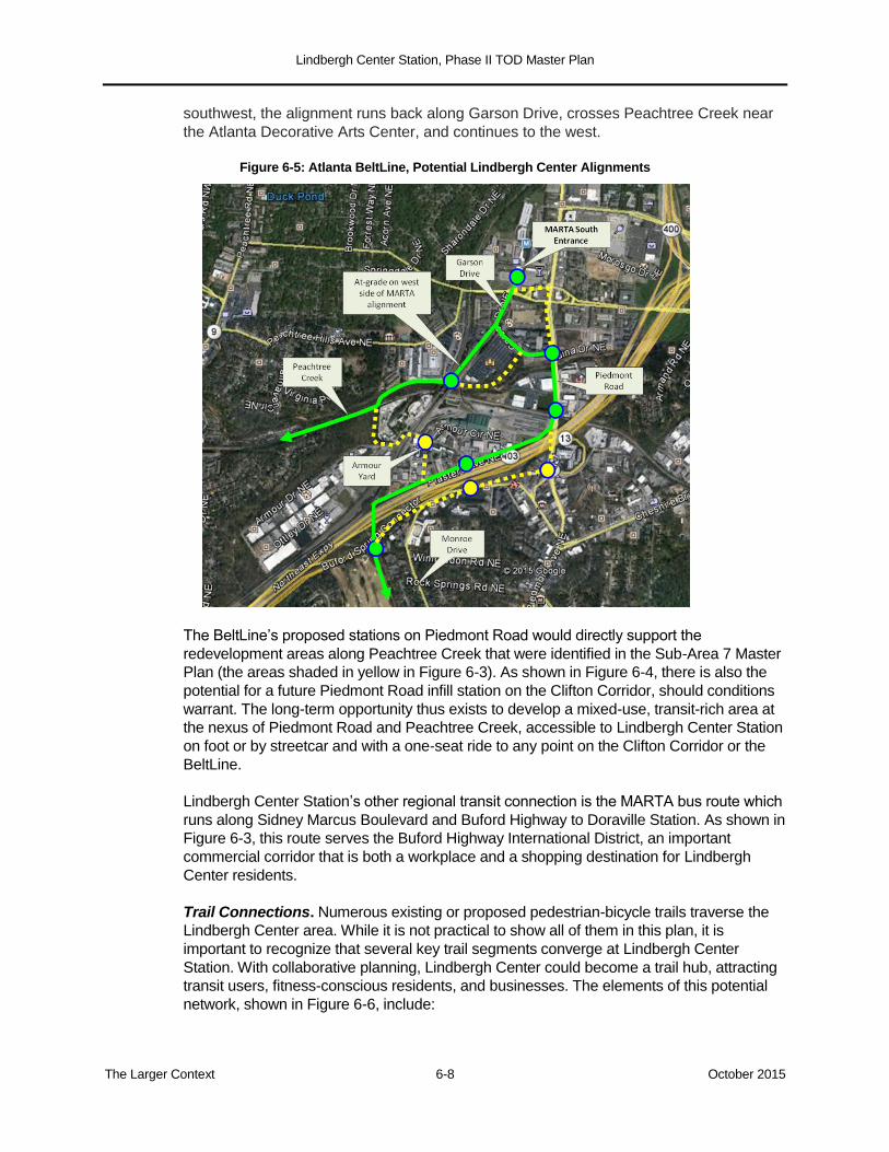
Lindbergh Center Station, Phase II TOD Master Plan
The Larger Context 6-8 October 2015
southwest, the alignment runs back along Garson Drive, crosses Peachtree Creek near
the Atlanta Decorative Arts Center, and continues to the west.
Figure 6-5: Atlanta BeltLine, Potential Lindbergh Center Alignments
The BeltLine’s proposed stations on Piedmont Road would directly support the
redevelopment areas along Peachtree Creek that were identified in the Sub-Area 7 Master
Plan (the areas shaded in yellow in Figure 6-3). As shown in Figure 6-4, there is also the
potential for a future Piedmont Road infill station on the Clifton Corridor, should conditions
warrant. The long-term opportunity thus exists to develop a mixed-use, transit-rich area at
the nexus of Piedmont Road and Peachtree Creek, accessible to Lindbergh Center Station
on foot or by streetcar and with a one-seat ride to any point on the Clifton Corridor or the
BeltLine.
Lindbergh Center Station’s other regional transit connection is the MARTA bus route which
runs along Sidney Marcus Boulevard and Buford Highway to Doraville Station. As shown in
Figure 6-3, this route serves the Buford Highway International District, an important
commercial corridor that is both a workplace and a shopping destination for Lindbergh
Center residents.
Trail Connections. Numerous existing or proposed pedestrian-bicycle trails traverse the
Lindbergh Center area. While it is not practical to show all of them in this plan, it is
important to recognize that several key trail segments converge at Lindbergh Center
Station. With collaborative planning, Lindbergh Center could become a trail hub, attracting
transit users, fitness-conscious residents, and businesses. The elements of this potential
network, shown in Figure 6-6, include:
Lindbergh Center Station, Phase II TOD Master Plan
The Larger Context 6-9 October 2015
MARTA’s existing Lindbergh Center trails, located to the west of the AT&T and Sidney
Marcus parking decks and accessible from both Morosgo Drive and Sidney Marcus
Boulevard. As discussed in Section 4.3, these trails represent an untapped amenity for
existing and future TOD and are woven into this Master Plan.
As suggested in Section 4.2, it would be desirable to extend Lindbergh Lane northward
to the intersection of Piedmont Road and Miami Circle—if not as a vehicular street, at
least as a ped-bike connection. This trail segment would connect at Miami Circle with
PATH400, the five-mile north-south trail system being developed in phases by the
Buckhead Community Improvement District, Livable Buckhead, and the Path
Foundation.46
PATH 400 will run east of the station, between and parallel to Piedmont
Road and the I-85/GA-400 viaducts. The Lindbergh Lane Extension would integrate
the station itself and the MARTA trails into this system.
To the south, the Atlanta BeltLine plans to bring a branch of its Peachtree Creek Spur
Trail up Garson Drive, alongside the planned BeltLine streetcar alignment, and into
Lindbergh Center Station. The northern end of the BeltLine trail and the southern end
of the MARTA trails would be separated only by Main Street, the north bus loop, and
Morosgo Drive. With proper way-finding, amenities, and lighting, this connection can
be easily made.47
There are long-term concepts to create continuous linear trail systems along both the
North and South Forks of Peachtree Creek, which meet just west of I-85.48
The
Cheshire Farm Trail, which is the initial segment along the South Fork at the I-85
crossing, opened in 2013. These future trails would converge with PATH400 and the
BeltLine’s Peachtree Creek Spur Trail.
46 http://www.buckheadcid.com/projects/path-400-greenway-trail/
47 Atlanta BeltLine Sub-Area 7 Master Plan, p. 24.
48 See, among many relevant sites: http://northforkconnectors.org/faq/; http://pathfoundation.org/trails/south-peachtree-
creek-trail/; and http://buckheadview.com/2014/07/08/cheshire-farm-trail-opens-along-peachtree-creek-south-fork-under-
i-85-flyover-ramp/.
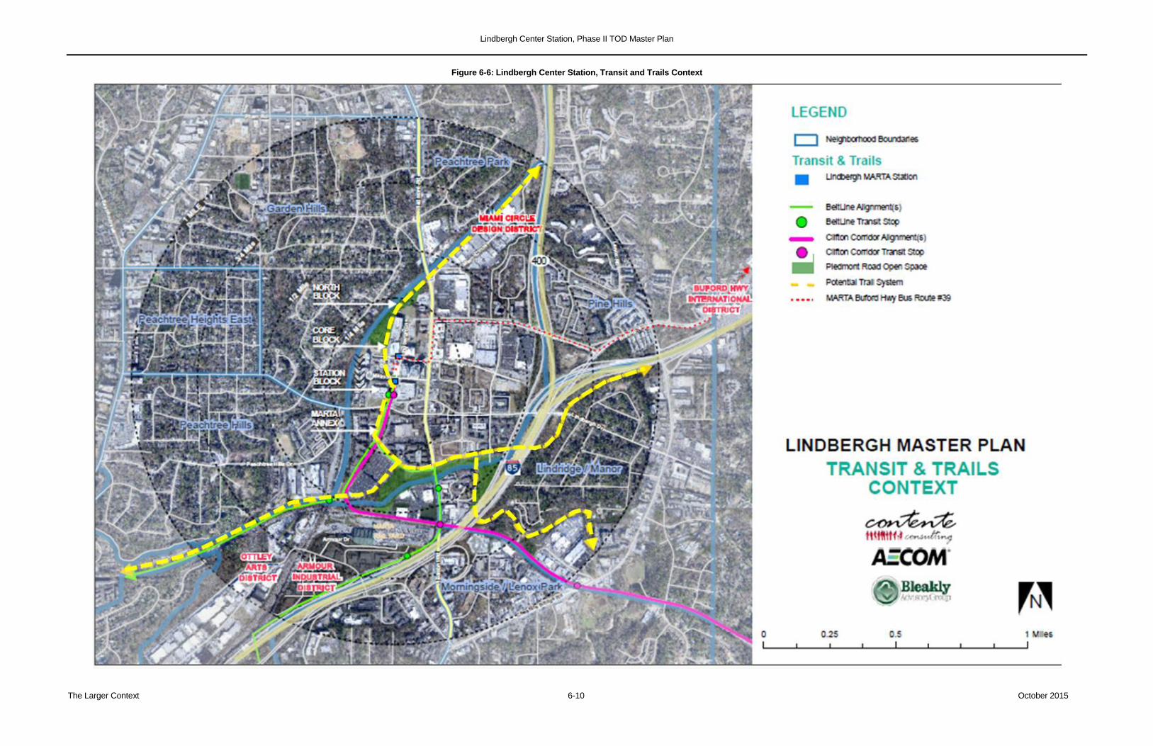
Lindbergh Center Station, Phase II TOD Master Plan
The Larger Context 6-10 October 2015
Figure 6-6: Lindbergh Center Station, Transit and Trails Context
Lindbergh Center Station, Phase II TOD Master Plan
Implementation Strategy 7-1 October 2015
7.0 IMPLEMENTATION STRATEGY
7.1 Introduction
The preceding sections of this Phase II TOD Master Plan provided the following
information:
a market analysis of the Lindbergh Center Station area and its real estate submarket,
covering the residential, retail, office, and hotel sectors;
a parking analysis, measuring the aggregate excess capacity that currently exists in
the City Center, Garson, Sidney Marcus, and AT&T decks;
detailed Master Plan studies, including a public realm template and alternative land
use concepts, for the largely undeveloped area west of Piedmont Road and north of
Morosgo Drive. This includes the “North Block” (north of Sidney Marcus Boulevard)
and the “Core Block” (between Sidney Marcus and Morosgo);
a conceptual plan for the area south of Morosgo Drive—including the “Station Blocks”
(focus of the original Phase I TOD initiative) and the MARTA Annex;
an examination of the 380-acre Extended Station Area, bounded by the Norfolk
Southern railroad, the MARTA rail yard, I-85, and GA-400, and of a larger context
extending a mile out from the station entrances.
This final section turns to the crucial topic of implementation. Several broad strategic
directions can be stated at the outset:
A. The Phase II TOD Master Plan has been developed with implementation in mind.
While still conceptual, individual components are designed to be realistically
achievable in the near, mid, or long term. Equally important, the plan is structured such
that all components are compatible and mutually reinforcing, but, to the greatest
degree possible, do not sequentially depend on one other.
B. There are four strategic TOD opportunities:
Near- to mid-term
Launching the development of the North Block and the Core Block.
Concluding the development of the Station Blocks and strengthening the retail
environment on Main Street.
Mid- to Long-Term
Transforming the south side of the Station Blocks through major public
investments: the Clifton Corridor and BeltLine passenger facilities and a
redesigned Lindbergh/Piedmont intersection.
Long-Term
The redevelopment of the MARTA Annex property.
C. The aggregate development capacity of the available parcels identified in the Master
Plan exceeds the somewhat conservative findings of the market analysis. This is true
of Concept A, the more conservative, lower-density approach to the North and Core
Blocks, and more true of Concept B, the more ambitious, higher-density approach. The
Lindbergh Center Station, Phase II TOD Master Plan
Implementation Strategy 7-2 October 2015
difference is intentional: the market analysis is focused on the next several years, while
the strategic opportunities outlined in this Master Plan represent a longer-term exercise
in city building.
D. Successful implementation will demand that MARTA work closely and reciprocally with
other agencies and jurisdictions. These include, but are not limited to:
the City of Atlanta for zoning and for coordination with surrounding neighbirhoods;
Invest Atlanta for economic development and affordable housing incentives;
Atlanta BeltLine, Inc., for the coordination of transit, trails, affordable housing, and
community development;
the Atlanta Regional Commission (ARC) for surface transportation and Livable
Centers Initiative funding;
the Georgia Department of Transportation (GDOT) for the redesign and
reconstruction of Piedmont Road;
the Buckhead Community Improvement District (CID) for the Piedmont Road
initiative and other potential CID involvement in transportation, trail, and
connectivity projects;
and the Georgia Regional Transportation Authority (GRTA) for the coordination of
bus services.
E. With respect to zoning, the station area east of the Norfolk Southern railroad corridor is
currently divided between the SPI-15 (Lindbergh Center Station area Special Public
Interest) and C-3 (Commercial-Residential) districts. Both are generally supportive of
dense, mixed-use TOD. MARTA has stated its intent to seek the rezoning of the entire
area east of the Norfolk Southern tracks as SPI-15, and in the process to explore
whether any modifications are worthwhile. It is important that the ultimate parking
provisions reflect the strategies outlined in this Master Plan.
F. It is a key remise of this Master Plan that surplus parking capacity in the existing decks
be utilized, to the degree practicable and feasible, to absorb the needs of future TOD in
the North Block, Core Block, and Station Blocks. This will avoid the land cost and the
dollar cost of building more new garage capacity than today’s market requires. It is not
suggested that all of the new joint development could be “parked” in the existing
surplus, but this approach should be a point of departure, especially for the early
parcels.
7.2 Parking
The parking analysis in Section 3.0 concludes that:
The Lindbergh Center decks contain, in the aggregate, more parking than MARTA,
AT&T, the Carter and AT&T retail areas, and the future City Center air rights office
building will need. The excess capacity, assuming the office building is developed and
all Carter and AT&T retail is fully built and leased, is in the hundreds of spaces and
may exceed one thousand. If, as suggested in Section 5.2, the air rights development
were converted to hotel or residential use, its parking requirement would fall well short
of the current 600-space allocation and the long-term excess capacity would increase.
Lindbergh Center Station, Phase II TOD Master Plan
Implementation Strategy 7-3 October 2015
MARTA has a park-and-ride allocation, across the three public decks, of 1,359 spaces,
of which about 1,100 are typically used. If MARTA chose to reduce its park-and-ride
supply to a still-substantial 700-900 spaces, it could increase the surplus capacity
available for joint development by 200-400 spaces and realize a net gain in both
ridership and revenue.
Based on the development approaches outlined in Sections 4.0 and 5.0, the following
parking strategies are contemplated:
To Free Up Core Block Site C-3 (the MARTA Employee Lot) for Development
Move MARTA’s employee parking from its current surface lot into available
capacity in the Sidney Marcus Deck.
To Create Additional Excess Garage Capacity
Consider reducing park-and-ride capacity over time to 700-900 spaces.
Explore AT&T’s interest in making its excess spaces in the AT&T Deck available,
on commercially reasonable terms, for joint development.
To convert Excess Garage Capacity to TOD Use
Strategy A: consolidate park-and-ride operations into the City Center and Garson
Decks, leaving about 400 MARTA-controlled spaces in the Sidney Marcus Deck to
accommodate North Block and Core Block development.
Strategy B: depending on the sequence of projects, retain park-and-ride in the
Sidney Marcus Deck, leaving capacity in the Garson Deck for the Parcel N
development and in the City Center Deck for the proposed south bus loop
development.
In addition to exploiting the existing surplus deck capacity, MARTA should make every
effort to accommodate any required new parking in efficiently designed shared-use
decks, rather than encouraging each individual project to include its own dedicated
parking structure.
7.3 A Joint Development Strategy
The North and Core Blocks contain roughly 10.9 acres of developable land (3.8 acres in
the North Block and 7.1 in the Core Block), a majority of it owned by MARTA. These
MARTA holdings are not subject to the Carter & Associates master lease structure. The
North and Core Blocks have Piedmont Road frontage and lie within a quarter-mile radius of
the Morosgo station entrance. The Station Blocks contain an additional 3.7 acres of
undeveloped land owned by MARTA and lying within a quarter-mile of the Main Street
station entrance.
MARTA’s TOD Guidelines and TOD Implementing Policies (adopted in 2010) define
development on MARTA land as joint development. MARTA’s process for soliciting
developers, responding to unsolicited proposals or requests from adjacent property
owners, and entering into joint development agreements is described in Policy 1 of the
TOD Implementing Policies. MARTA’s general intent with respect to parking, affordable
Lindbergh Center Station, Phase II TOD Master Plan
Implementation Strategy 7-4 October 2015
housing, and sustainable building practices in its joint development projects is set forth in
Policies 3, 4, and 5, respectively.49
A threshold decision for MARTA is how to package and manage the several development
parcels which it controls. One method would be to competitively procure a master
developer, who would be awarded control of the development rights for most or all of the
MARTA-owned parcels. A master developer typically manages the overall development
program, undertakes necessary site improvements, develops some of the parcels on its
own account, and procures development partners for others. In the case of Lindbergh
Center, a master developer might be expected to:
participate in the building, and ideally in the financing, of infrastructure and site work;
negotiate directly with the owners of the several “out-parcels” on MARTA’s side of
Piedmont Road as to whether and how their land might be combined with MARTA’s to
create the most attractive development sites;50
determine where in the portfolio of parcels one or more hotels could be successfully
located, as suggested in the market analysis;
work with MARTA to determine strategically which buildings can best take advantage
of existing surplus garage capacity;
bring a developer’s perspective to the intangibles of branding, identity, and market
niche.
In soliciting a master developer, MARTA should be clear that it intends to retain design
review of individual projects, as well as the right to review and approve development
partners which the master developer proposes to add to the overall structure or to specific
projects. It is also crucial that a master developer agreement anticipate the appreciation in
land values over time and allow MARTA to participate appropriately in that “upside”, if and
when it materializes.
For reasons discussed below, it is uncertain whether the Shoney redevelopment project or
the remaining development parcels in the Station Blocks would be included in a master
developer portfolio. It is also possible, depending on the duration of the current real estate
cycle, that MARTA might project a greater overall yield by waiting to procure developers for
the choicest parcels until they are ripe for dense development. In these circumstances,
MARTA might instead choose to solicit a development advisor, who would advise
MARTA on the timing and packaging of developer RFPs, manage the developer selection
and negotiation process at MARTA’s direction, and represent MARTA in the Shoney
redevelopment, should that be ready to advance.
The Shoney Site. The proposed redevelopment of the Shoney restaurant site would be
undertaken by the private owner's development team. As described in Section 4.3, the
Shoney redevelopment is an opportunity to anchor the Morosgo/Piedmont intersection with
49 The TOD Policies are found at:
http://itsmarta.com/uploadedFiles/About_MARTA/TOD/MARTA%20TOD%20Implementation%20Policies%20Adopted%
20Text%20November%202010(1).pdf.
50 Once a master developer had been selected through an open, competitive process and been awarded MARTA’s
development rights, it would have greater freedom to enter into such negotiations than MARTA would likely have on its
own account.
Lindbergh Center Station, Phase II TOD Master Plan
Implementation Strategy 7-5 October 2015
a robust mixed-use development project influenced by the height of the MARTA and AT&T
buildings; depending on site configuration and market conditions, the Shoney project could
be the tallest project, and the largest in gross floor area, in the North and Core Blocks.
It is MARTA's intent that the project extend to the corner, encompassing the current
MARTA fleet management parcel and the adjacent private restaurant and bar; the latter
could be acquired either by the Shoney team or by MARTA. As explained in Section 4.3, it
is also possible that MARTA would make its Hubco parcel (Site C-5) available to create a
larger footprint for the Shoney project; this expanded footprint would allow more parking,
which would in turn support greater density.
The inclusion of MARTA property in this privately-driven redevelopment project could occur
either through negotiations undertaken by MARTA’s master developer if that entity has
been selected, or through a separate Request for Proposals for the parcels in question, to
which the Shoney ownership could respond. The latter approach would make sense if the
Shoney group were prepared to advance a project of appropriate density and viability in
the near term. As part of the joint development agreement, MARTA would secure
appropriate site plan and design review of the development. The project would require
construction of the southern end of the new north-south midblock street.
As discussed in Section 4.3, the decision on whether to include the Hubco parcel in the
Shoney project could also influence the redevelopment of the Chick-fil-A property, in either
of two ways. If the Hubco parcel is included in the Shoney assemblage, the larger parking
deck that would result could be sized to accommodate the separate Chick-fil-A project.
Alternatively, MARTA could hold the Hubco parcel back, preserving the option for it to be
combined with the Chick-fil-A property in a future assemblage.
Strategic Phasing in the North and Core Blocks. The buildout of the North and Core
Blocks will unfold in phases, over a period of time to be determined by market conditions. A
key strategic choice will be to identify an early phase of development (aside from the
Shoney project) that would be impactful in its own right while setting the stage for
subsequent phases of greater density and higher land values.
One example of a strategic early-action phase is the proposed set of residential buildings
grouped around the Sidney Marcus Deck. These could include Sites N-1 and N-2 in the
North Block, and Sites C-1, C-2, and C-3 in the Core Block, as shown in the left panel of
Figure 7-1. Together, these buildings represent an undertaking of several hundred units
and several years’ absorption; the buildings would themselves have to be implemented in
phases. The developer would determine the optimal sequence of buildings, and, in
collaboration with MARTA, the extent to which they can be "parked" in the Sidney Marcus
Deck. In addition to the timely transfer of MARTA’s employee parking into the Sidney
Marcus Deck, this cluster of development would require construction of the new north-
south street, the cross-block ped-bikeway, and the new park on Site C-1.
An alternative early phase, shown in the right panel of Figure 7-1, could consist of the
entire North Block. This would make sense if discussions with the private parcel owners
indicated that Concept B—combining the private parcels with the larger MARTA holdings—
were viable. This cluster would require construction of the Lindbergh Lane Extension and
an outlet to Piedmont Road.
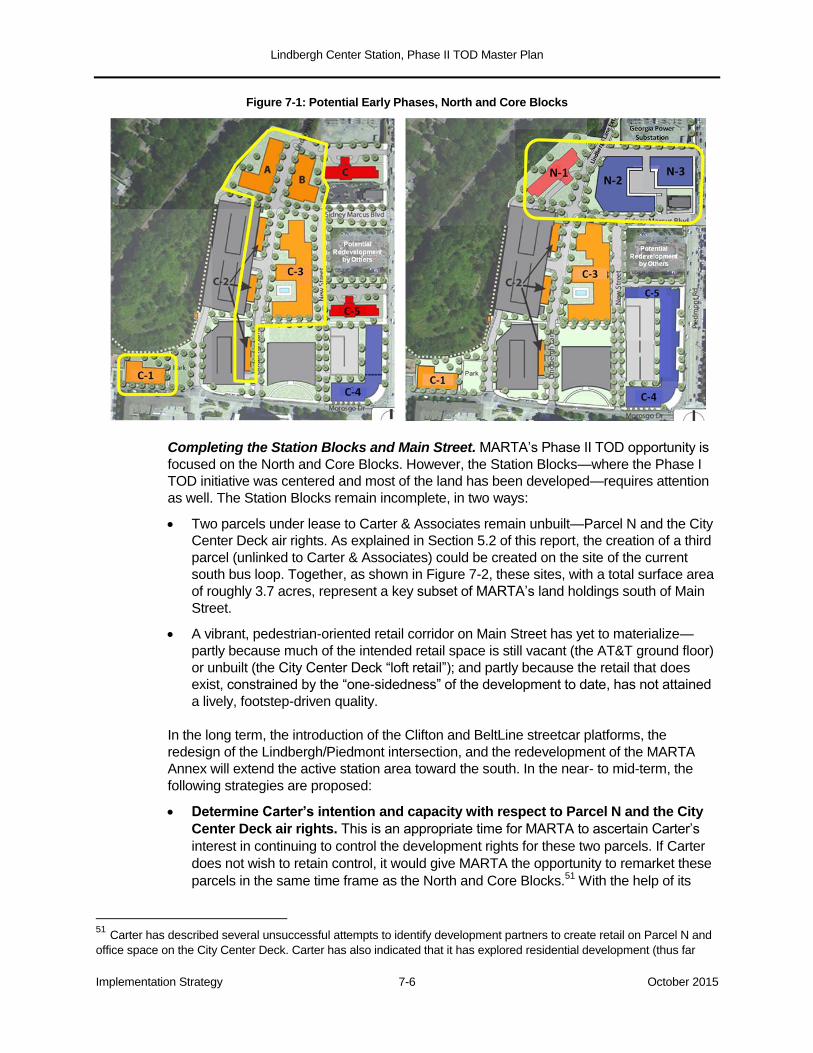
Lindbergh Center Station, Phase II TOD Master Plan
Implementation Strategy 7-6 October 2015
Figure 7-1: Potential Early Phases, North and Core Blocks
Completing the Station Blocks and Main Street. MARTA’s Phase II TOD opportunity is
focused on the North and Core Blocks. However, the Station Blocks—where the Phase I
TOD initiative was centered and most of the land has been developed—requires attention
as well. The Station Blocks remain incomplete, in two ways:
Two parcels under lease to Carter & Associates remain unbuilt—Parcel N and the City
Center Deck air rights. As explained in Section 5.2 of this report, the creation of a third
parcel (unlinked to Carter & Associates) could be created on the site of the current
south bus loop. Together, as shown in Figure 7-2, these sites, with a total surface area
of roughly 3.7 acres, represent a key subset of MARTA’s land holdings south of Main
Street.
A vibrant, pedestrian-oriented retail corridor on Main Street has yet to materialize—
partly because much of the intended retail space is still vacant (the AT&T ground floor)
or unbuilt (the City Center Deck “loft retail”); and partly because the retail that does
exist, constrained by the “one-sidedness” of the development to date, has not attained
a lively, footstep-driven quality.
In the long term, the introduction of the Clifton and BeltLine streetcar platforms, the
redesign of the Lindbergh/Piedmont intersection, and the redevelopment of the MARTA
Annex will extend the active station area toward the south. In the near- to mid-term, the
following strategies are proposed:
Determine Carter’s intention and capacity with respect to Parcel N and the City
Center Deck air rights. This is an appropriate time for MARTA to ascertain Carter’s
interest in continuing to control the development rights for these two parcels. If Carter
does not wish to retain control, it would give MARTA the opportunity to remarket these
parcels in the same time frame as the North and Core Blocks.51
With the help of its
51 Carter has described several unsuccessful attempts to identify development partners to create retail on Parcel N and
office space on the City Center Deck. Carter has also indicated that it has explored residential development (thus far
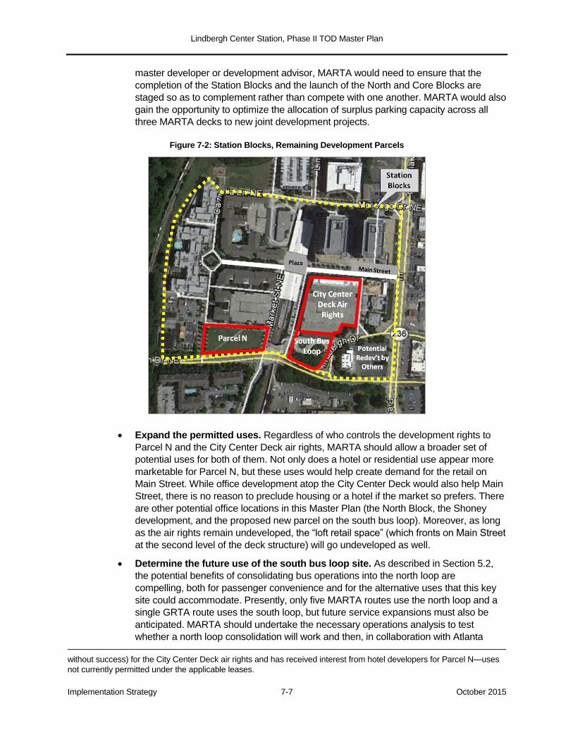
Lindbergh Center Station, Phase II TOD Master Plan
Implementation Strategy 7-7 October 2015
master developer or development advisor, MARTA would need to ensure that the
completion of the Station Blocks and the launch of the North and Core Blocks are
staged so as to complement rather than compete with one another. MARTA would also
gain the opportunity to optimize the allocation of surplus parking capacity across all
three MARTA decks to new joint development projects.
Figure 7-2: Station Blocks, Remaining Development Parcels
Expand the permitted uses. Regardless of who controls the development rights to
Parcel N and the City Center Deck air rights, MARTA should allow a broader set of
potential uses for both of them. Not only does a hotel or residential use appear more
marketable for Parcel N, but these uses would help create demand for the retail on
Main Street. While office development atop the City Center Deck would also help Main
Street, there is no reason to preclude housing or a hotel if the market so prefers. There
are other potential office locations in this Master Plan (the North Block, the Shoney
development, and the proposed new parcel on the south bus loop). Moreover, as long
as the air rights remain undeveloped, the “loft retail space” (which fronts on Main Street
at the second level of the deck structure) will go undeveloped as well.
Determine the future use of the south bus loop site. As described in Section 5.2,
the potential benefits of consolidating bus operations into the north loop are
compelling, both for passenger convenience and for the alternative uses that this key
site could accommodate. Presently, only five MARTA routes use the north loop and a
single GRTA route uses the south loop, but future service expansions must also be
anticipated. MARTA should undertake the necessary operations analysis to test
whether a north loop consolidation will work and then, in collaboration with Atlanta
without success) for the City Center Deck air rights and has received interest from hotel developers for Parcel N—uses
not currently permitted under the applicable leases.
Lindbergh Center Station, Phase II TOD Master Plan
Implementation Strategy 7-8 October 2015
BeltLine, Inc., determine whether or not the south bus loop site is likely to be needed
for the BeltLine/Clifton Corridor transit plaza. If not needed for transit purposes, the
south loop and the adjoining little-used green space should be designated a
development parcel.
Undertake near-term improvements on Main Street. The plaza where Main Street
crosses over the MARTA station should be redesigned to create a more attractive
pedestrian space, better integrated with the retail sidewalks to the east and the
residential sidewalks to the west. This plaza also connects pedestrians on Main Street
to the north bus loop and to the proposed new park site across Morosgo Drive, a
connection that is currently not well designed.
A second opportunity is transactional. In 2017, AT&T’s lease with the lessor/developer
of its ground-level retail space (Wells REIT) will be up for renewal. This space remains
largely vacant, deadening the north side of Main Street. MARTA should encourage
AT&T to enter into a more productive retail partnership.
7.4 Implementation Funding: Infrastructure and Affordable Housing
There are a number of funding and financing options that MARTA may consider in
implementing Phase II of the Lindbergh Center TOD.
The BeltLine TAD. The City of Atlanta created its largest-ever Tax Allocation District
(TAD) to support development of the Atlanta BeltLine, the innovative 22-mile ring of trails,
parks, housing, community development, and transit connecting over 45 of the city’s
neighborhoods. The TAD is Georgia’s form of tax increment financing. As new
development occurs around the BeltLine and property values increase, the property taxes
generated from incremental values (above the baseline established determined when the
district was formed in 2008) flow to a dedicated investment fund. TAD dollars are used for
infrastructure, land assembly, parks, trails, public art, and affordable housing. As shown In
Figure 7-3, much of the Lindbergh Center Station area—including the entirety of the North
Block, Core Block, Station Blocks, and Annex—is included in the BeltLine TAD, which is
shaded light blue.
Affordable Housing. The BeltLine has set aside 15% of its TAD funding to support
the creation and preservation of up to 5,600 affordable housing units. The BeltLine’s
affordable housing commitment could generate up to $40,000 per affordable unit
constructed. The BeltLine affordable housing policy is designed to encourage a
minimum of 20% affordable units in mixed use housing developments and can serve
as a supplement to the Low Income Housing Tax Credit (LIHTC) in financing projects
with a significant affordable component. The BeltLine has found it challenging, in high-
cost locations, to find developers interested in doing mixed market-rate and affordable
projects. The Lindbergh Center area, where market rents are at more modest levels,
could provide a significant opportunity to tap into the BeltLine Affordable Housing Trust
Fund. This could be a win-win-win opportunity for the BeltLine, for MARTA (whose joint
development policy contemplates at least 20% workforce or affordable units on
average), and mixed income housing advocates.
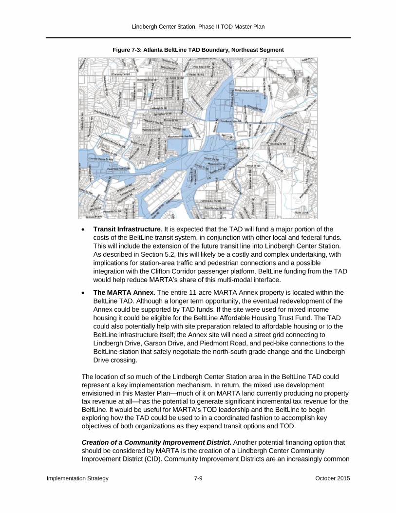
Lindbergh Center Station, Phase II TOD Master Plan
Implementation Strategy 7-9 October 2015
Figure 7-3: Atlanta BeltLine TAD Boundary, Northeast Segment
Transit Infrastructure. It is expected that the TAD will fund a major portion of the
costs of the BeltLine transit system, in conjunction with other local and federal funds.
This will include the extension of the future transit line into Lindbergh Center Station.
As described in Section 5.2, this will likely be a costly and complex undertaking, with
implications for station-area traffic and pedestrian connections and a possible
integration with the Clifton Corridor passenger platform. BeltLine funding from the TAD
would help reduce MARTA’s share of this multi-modal interface.
The MARTA Annex. The entire 11-acre MARTA Annex property is located within the
BeltLine TAD. Although a longer term opportunity, the eventual redevelopment of the
Annex could be supported by TAD funds. If the site were used for mixed income
housing it could be eligible for the BeltLine Affordable Housing Trust Fund. The TAD
could also potentially help with site preparation related to affordable housing or to the
BeltLine infrastructure itself; the Annex site will need a street grid connecting to
Lindbergh Drive, Garson Drive, and Piedmont Road, and ped-bike connections to the
BeltLine station that safely negotiate the north-south grade change and the Lindbergh
Drive crossing.
The location of so much of the Lindbergh Center Station area in the BeltLine TAD could
represent a key implementation mechanism. In return, the mixed use development
envisioned in this Master Plan—much of it on MARTA land currently producing no property
tax revenue at all—has the potential to generate significant incremental tax revenue for the
BeltLine. It would be useful for MARTA’s TOD leadership and the BeltLine to begin
exploring how the TAD could be used to in a coordinated fashion to accomplish key
objectives of both organizations as they expand transit options and TOD.
Creation of a Community Improvement District. Another potential financing option that
should be considered by MARTA is the creation of a Lindbergh Center Community
Improvement District (CID). Community Improvement Districts are an increasingly common
Lindbergh Center Station, Phase II TOD Master Plan
Implementation Strategy 7-10 October 2015
form of special purpose taxing district in Georgia, used to fund infrastructure and
community improvements in designated commercial areas. CIDs date back to the 1980s,
with the Cumberland CID in Cobb County and the Perimeter CID being two of the earliest
and best known examples. Today there are over 20 CIDs in the Atlanta region, addressing
a wide range of needs and projects. In the City of Atlanta there are three large CIDs—the
Downtown Improvement District, the Midtown Improvement District, and the Buckhead CID
CIDs are self-taxing districts established by a vote of the area’s commercial property
owners to impose additional property tax millage on such properties.52
The funds raised
are used to pay for infrastructure improvements, transportation projects, sidewalks,
streetscapes, beautification, and security. To establish a CID takes a positive vote of
owners representing 51% of the commercial properties and 75% of the commercial
property value in the proposed district. Once established, all commercial property owners
must pay the annual assessment. Every five years there is an election of the commercial
property owners to determine if they wish to continue the CID or sunset its operations.
The benefits to the Lindbergh Center area from creation of a CID could be significant. It
would provide a financing vehicle for making streetscape and transportation improvements
throughout the Master Plan area, and could be of particular importance in improving the
Piedmont Road corridor. It could also provide a source of funding for other improvements,
which would enhance the pedestrian experience throughout the station area. A great
advantage of a CID is its ability to generate matching funds for federal, state, and Atlanta
Regional Commission grants.
The creation of a Lindbergh Center CID would likely encompass the entire 380-acre
Extended Station Area, reaching eastward to GA-400 and I-85, northward to Miami Circle,
and southward to the MARTA rail yard. A CID would require MARTA’s support and
advocacy.53
The Atlanta Regional Commission Livable Cities Initiative. MARTA should also
consider asking the Atlanta Regional Commission to “grandfather” the updated Lindbergh
Center TOD Master Plan into the Livable Cities Initiative (LCI) program. The LCI has been
operational since 2000, and more than 100 locations throughout the region have been
designated. The benefits are two-fold. First, ARC provides planning funds to study the
potential of the area for TOD and smart growth; since MARTA has already undertaken this
updated Master Plan, LCI funding would not be applicable in the near term but might be
available for follow-on studies and plans. The second benefit is ARC’s provision of
significant capital funding for implementation of recommended infrastructure
improvements. Grandfathering the updated Master Plan would require the support of the
City of Atlanta, which administers the LCI program with the city limits.
Federal Transportation Programs. It is expected that in due course both the BeltLine
transit system and the Clifton Corridor will seek funding through the Federal Transit
Administration’s New Starts Capital Investment Grant program. Either pursuit, if successful,
would likely be limited to 50% of project costs, with the balance to be funded by MARTA,
52 Residential property can be included in the CID but no additional millage is paid by residential property owners, and
they have no say in the CID’s operations.
53 The alternative of adding the Extended Station Area to the existing Buckhead CID, whose boundary is to the north at
the intersection of Pharr and Piedmont Roads, does not appear feasible at this time.
Lindbergh Center Station, Phase II TOD Master Plan
Implementation Strategy 7-11 October 2015
TAD, CID, or other non-federal funds. The integration of the BeltLine and Clifton Corridor
tracks and platforms into the complex environment of Lindbergh Center Station, including
the possible creation of a shared transit plaza, would be part of this funding structure.
Several other federal programs could prove relevant to this Master Plan:
The Federal Highway Administration’s core programs. These include the National
Highway Performance Program, which could fund improvements to the eligible portion
of Piedmont Road, and the set of highly flexible programs allocated through
Metropolitan Planning Organizations like the ARC (Surface Transportation Program,
Congestion Mitigation and Air Quality, Highway Safety Improvement Program, and
Transportation Alternatives).54
These programs are already used, in part, to fund
ARC’s Livable Centers Initiative grants described previously.
The TIFIA program. TIFIA (Transportation Infrastructure Finance and Innovation Act)
is a federal loan mechanism which can be used to help finance virtually any surface
transportation project that would be eligible for federal highway or transit funding. TIFIA
loans provide below-market interest rates (at the Treasury’s cost of money),
amortization terms of up to 40 years, a five-year grace period, and several other
advantageous features. The dedicated stream of non-federal revenues required to
service a TIFIA loan may include, among other things, tax increment (TAD) or special
assessment (CID) proceeds. A TIFIA loan can finance up to 49% of project costs; the
minimum project size is $50 million, which would likely qualify the BeltLine and Clifton
Corridor-related improvements at Lindbergh Center Station.55
The TIGER program. TIGER (Transportation Investment Generating Economic
Recovery) is a discretionary and highly competitive grant program funded by Congress
since 2009 through annual appropriations. The seventh round of TIGER grants will be
awarded in 2015. These are generally in the $10-25 million range and can be used for
a wide variety of roadway, transit, and ped-bike projects. (Atlanta’s previous TIGER
grant was for the initial phase of the Atlanta Streetcar.) TIGER grants are well aligned
with the public infrastructure side of TOD initiatives, since the primary selection criteria
include livability, sustainability, and economic competitiveness. A package of
Lindbergh Center TOD infrastructure improvements would make a credible TIGER
application, assuming the program or a comparable successor continues to be funded.
54 A summary description of these programs is provided in Congressional Research Service, Surface Transportation
Funding and Programs under MAP-21: Moving Ahead for Progress in the 21st Century Act (P.L. 112-141), 2012. The segment of Piedmont Road from Morosgo southward is on the National Highway System and thus eligible for the National Highway Performance Program. 55 Ibid.
Related Documents