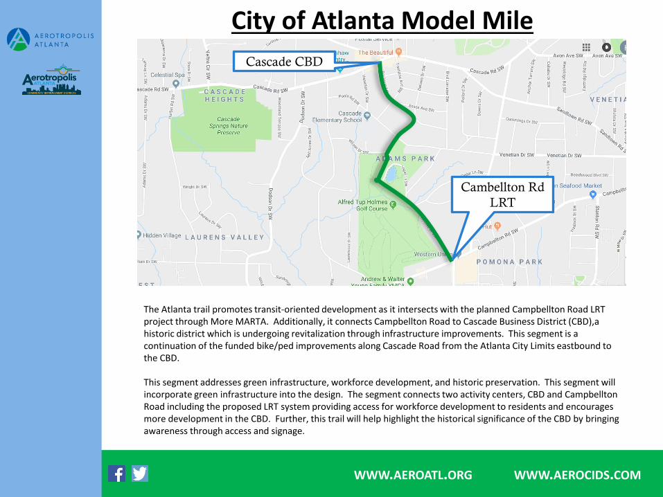
City of Atlanta Model Mile WWW .AEROATL.ORG WWW .AEROCIDS. COM Cascade CBD Cambellton Rd LRT The Atlanta trail promotes transit-oriented development as it intersects with the planned Campbellton Road LRT project through More MARTA. Additionally, it connects Campbellton Road to Cascade Business District (CBD),a historic district which is undergoing revitalization through infrastructure improvements. This segment is a continuation of the funded bike/ped improvements along Cascade Road from the Atlanta City Limits eastbound to the CBD. This segment addresses green infrastructure, workforce development, and historic preservation. This segment will incorporate green infrastructure into the design. The segment connects two activity centers, CBD and Campbellton Road including the proposed LRT system providing access for workforce development to residents and encourages more development in the CBD. Further, this trail will help highlight the historical significance of the CBD by bringing awareness through access and signage.

Welcome message from author
This document is posted to help you gain knowledge. Please leave a comment to let me know what you think about it! Share it to your friends and learn new things together.
Transcript
City of Atlanta Model Mile
WWW.AEROATL.ORG WWW.AEROCIDS.COM
Cascade CBD
Cambellton Rd
LRT
The Atlanta trail promotes transit-oriented development as it intersects with the planned Campbellton Road LRT project through More MARTA. Additionally, it connects Campbellton Road to Cascade Business District (CBD),a historic district which is undergoing revitalization through infrastructure improvements. This segment is a continuation of the funded bike/ped improvements along Cascade Road from the Atlanta City Limits eastbound to the CBD.
This segment addresses green infrastructure, workforce development, and historic preservation. This segment will incorporate green infrastructure into the design. The segment connects two activity centers, CBD and CampbelltonRoad including the proposed LRT system providing access for workforce development to residents and encourages more development in the CBD. Further, this trail will help highlight the historical significance of the CBD by bringing awareness through access and signage.

Clayton County Model Mile
Charles R.
Drew HS
WWW.AEROATL.ORG WWW.AEROCIDS.COM
Southern Regional
Medical Center
The Clayton County trail is an off-road segment along the Flint River connecting Charles W. Drew High School to Southern Regional Medical Center. The segment provides an opportunity for an outdoor classroom center for the high school as well as access to healthy lifestyles for patients at Southern Regional. The are numerous surrounding neighborhoods that would also have direct access to the trail segment and provide safe access to the school. This trail also brings awareness to the Flint River and will result in river restoration opportunities for the community to engage.
This segment addresses green infrastructure, workforce development, lifelong communities and creative placemaking. Green infrastructure design will be included as with the other segments. This segment will also provide an outdoor classroom for high school students, promoting STEM education for the future workforce. Further, this segment support lifelong communities and creative placemaking by giving outdoor recreation alternatives for Southern Regional Medical Center patients as well as surrounding residents.

East Point Model Mile
Tri-Cities HS
WWW.AEROATL.ORG WWW.AEROCIDS.COM
Existing
Pedestrian Bridge
The East Point trail promotes the creation of transit-oriented development around the existing MARTA rail station. The segment is within the East Point Main Street LCI boundary (2014) and connects Tri-Cities High School to the existing pedestrian bridge over the railroad and MARTA rail lines. This segment runs through private property adjacent to the rail lines. The property owner envisions this trail segment resulting in a development opportunity, such as a food hall and market, for the property that will benefit the community.
This segment tackles historic preservation, creative placemaking, green infrastructure and workforce development. The segment is located on the backside of the historic Buggy Works and Wagon Works buildings in downtown East Point. The owner of the property has indicated a desire to continue to develop these properties to adhear to the historical significance of the buildings. This type of development is creative placemaking and historic preservation by incorporating context sensitive design of the trail segment while also increasing development potential for new restaurant and retail opportunities, resulting in increased workforce. This segments will consider and incorporate green infrastructure.

Forest Park Model Mile
State Farmer’s
Market
Starr Park
WWW.AEROATL.ORG WWW.AEROCIDS.COM
The Forest Park trail supports the revitalization of the existing downtown district and Transit Oriented Development district. The trail segment provides a vital transportation connection for residents and employees. This segment is within the Forest Park LCI boundary (2001) and connects Starr Park in downtown Forest Park to the State Farmer’s Market. This is a priority action for Forest Park to connect several major activity centers. This segment will also support the revitalization of Starr Park, a potential MARTA Commuter Rail station and the State Farmer’s Market, which has redevelopment plans underway. Pedestrians and bicyclists are currently using this corridor with limited infrastructureand amenities, demonstrating an existing demand for improvements.
This segment supports housing affordability, green infrastructure, workforce development, and access to healthy food. Forest Park is also applying for a housing inventory as an effort to understand housing needs compared to demographics. This project will help support access to affordable housing in creating a comprehensive plan that connects low income and affordable housing communities to quality of life amenities and jobs. Green infrastructure will be incorporated into the design. This segment will connect downtown Forest Park to the commercialized corridor of Forest Parkway, providing better access to jobs and retail amenities. Further, the connection to the State Farmer’s Market gives the community needed access to healthy foods for families.
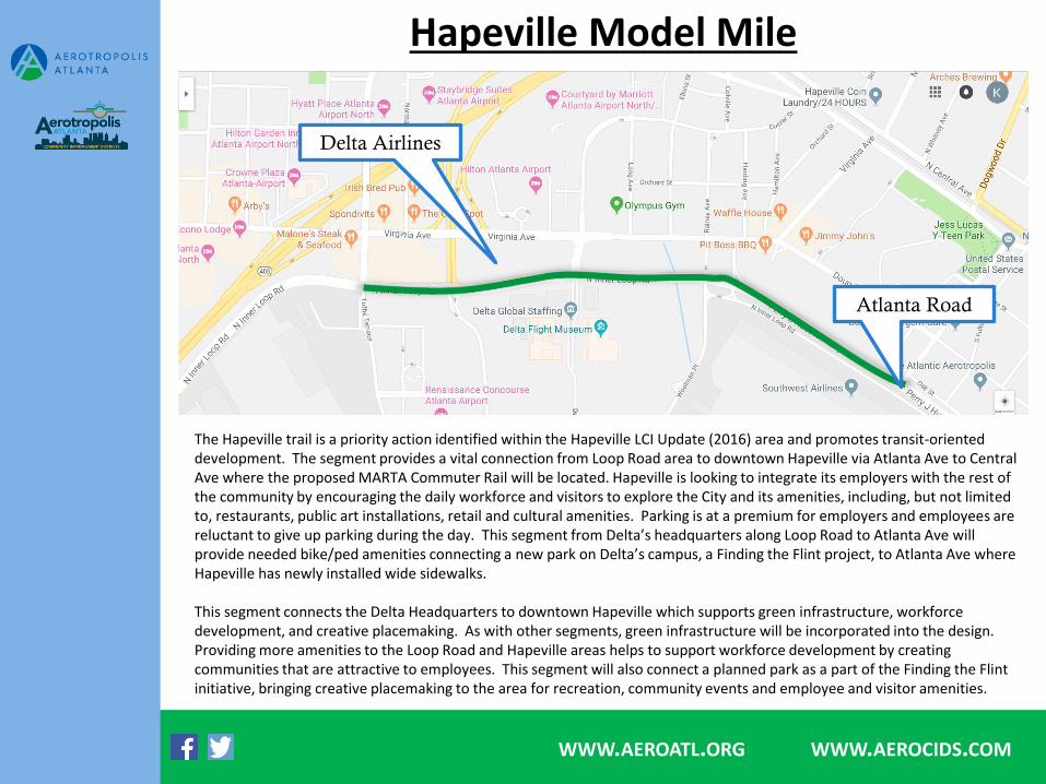
Hapeville Model Mile
Delta Airlines
Atlanta Road
WWW.AEROATL.ORG WWW.AEROCIDS.COM
The Hapeville trail is a priority action identified within the Hapeville LCI Update (2016) area and promotes transit-oriented development. The segment provides a vital connection from Loop Road area to downtown Hapeville via Atlanta Ave to Central Ave where the proposed MARTA Commuter Rail will be located. Hapeville is looking to integrate its employers with the rest of the community by encouraging the daily workforce and visitors to explore the City and its amenities, including, but not limited to, restaurants, public art installations, retail and cultural amenities. Parking is at a premium for employers and employees are reluctant to give up parking during the day. This segment from Delta’s headquarters along Loop Road to Atlanta Ave will provide needed bike/ped amenities connecting a new park on Delta’s campus, a Finding the Flint project, to Atlanta Ave where Hapeville has newly installed wide sidewalks.
This segment connects the Delta Headquarters to downtown Hapeville which supports green infrastructure, workforce development, and creative placemaking. As with other segments, green infrastructure will be incorporated into the design. Providing more amenities to the Loop Road and Hapeville areas helps to support workforce development by creating communities that are attractive to employees. This segment will also connect a planned park as a part of the Finding the Flint initiative, bringing creative placemaking to the area for recreation, community events and employee and visitor amenities.

City of South Fulton Model Mile
WWW.AEROATL.ORG WWW.AEROCIDS.COM
Wolf Creek
Complex
Butner Rd
The South Fulton trail is an off-road facility along Camp Creek extending the existing Bill Edwards trail at Butner Road to Wolf Creek Amphitheatre, Library and Golf Course. The City of South Fulton is planning for a new City Center which may potentially be located at Wolf Creek, in which this trail would help promote City Center development. Further, it helps extend a transportation connection for South Fulton residents to activity centers on Butner Road and eventually to the Camp Creek Marketplace.
This segment addresses green infrastructure, workforce development, access to healthy food, lifelong communities and creative placemaking. Green infrastructure design will be incorporated. This segment will extend the connection from South Fulton to Camp Creek Marketplace providing better access to jobs for employees and providing better access to grocery stores and healthy food. Further, this is an element of a potential future City Center development and this segment design can help influence the creative design of the City Center, should the City elect to locate it at Wolf Creek.

Union City Model Mile
Flat Shoals
Buffington
WWW.AEROATL.ORG WWW.AEROCIDS.COM
Nature Trail
The Union City trail is along Royal South Parkway and is a continuation of funded pedestrian improvements along Buffington Road. This provides a connection for Hapeville Charter School, Banneker High School, Fulton College and Career Academy and Fulton County Library as well as various office and light industrial sights. There is an opportunity to create an outdoor education and recreation center adjacent to Royal South including nature trails. This will provide alternative transportation for students, employees in the area and surrounding residents to area amenities and activity centers at Flat Shoals and Buffington Road.
This segment promotes green infrastructure, workforce development, and creative placemaking. Green infrastructure will be included in the overall design. This segment connects schools, libraries, office and light industrial to residential areas providing safe access to jobs and education. Further, this segment provides an opportunity to utilize a natural area and open it up for outdoor education by creating a nature preserve adjacent to the trail.
Related Documents