RESEARCH ARTICLE 10.1002/2016JC012247 The role of the Agulhas in the Benguela Current system: A numerical modeling approach Jennifer A. Veitch 1,2 and Pierrick Penven 3 1 South African Environmental Observation Network, Egagasini Node, Private Bag X2, Roggebaai, South Africa, 2 Department of Oceanography, University of Cape Town, Cape Town, South Africa, 3 Laboratoire des Physique des Oceans (UMR 6523 CNRS, IFREMER, IRD, UBO), Brest, France Abstract A modeling approach is used to investigate the influence of the Agulhas on the southern Benguela system. Two climatological ROMS simulations are run that are identical except that in one of them the effect of the Agulhas is removed. Comparing their outputs allows for a clear indication of the role of the Agulhas on both the large-scale and shelf dynamics. About 15 Sv of the mean transport of the Benguela Current is shown to be contributed by Agulhas influx, with the most intense flow being associated with extreme turbulence and its meandering nature is a reflection of the passage of Agulhas Rings. The injection of warm water is particularly evident beyond the shelf-edge, producing a perennially intense cross-shelf density front that is enhanced during upwelling season. This gradient drives a jet that is fastest at the shelf-edge but that extends from the midshelf to at least 100 km beyond it and is associated with dynamic uplift via vortex squashing. Similarly generated is the Good Hope Jet that extends northwestward from the western Agulhas Bank. Turbulence associated with Agulhas leakage increases rapidly beyond the shelf-edge causing the upwelling front in the southern Benguela to be subject to intense mixing, leaving a relatively uniform front there. Locally generated regions of high turbulence exist in the vicinity of the shelf-edge jets as well as further north in association with the large filaments that originate from the perennial L€ uderitz upwelling cell, with or without the influence of the Agulhas. 1. Introduction The Benguela system is unique as one of the world’s four major eastern boundary upwelling systems due to its proximity to a western boundary current, namely the Agulhas Current. Rings, eddies, and filaments that spawn at the Agulhas retroflection therefore have a significant influence on the mean state and mesoscale variability of the Benguela system. The review chapter by Capet et al. [2008] on eddies in eastern boundary current systems (EBCS) provides an excellent impression of the present state of our understanding of the role of eddies in EBCSs and also points out the unusual nature of the Benguela Current system. In this work, the Benguela system refers to both the Benguela Current, which is the eastern limb of the south Atlantic subtropical gyre, and the nearshore Benguela upwelling regime and its associated dynamics. The transport of the Benguela Current across 308S has been estimated to be approximately 20–25 Sv [Peter- son and Stramma, 1991]. However, time series data obtained from the 1992–1993 BEST (Benguela Sources and Transport) monitoring campaign suggest that this is only the case when an Agulhas Ring is present [Garzoli et al., 1996] and that the annual mean transport is closer to 16 Sv. The large disparity in these trans- port estimates is evidence of the huge impact the Agulhas has on the Benguela Current. Agulhas leakage into the Atlantic ocean via the Benguela Current through the Agulhas eddy corridor [Garzoli and Gordon, 1996] is thought to be pivotal to Indian-Atlantic exchange of heat and salt, which is a key component of the global thermohaline circulation pattern [Gordon, 2003; Biastoch et al., 2008a]. Its global significance has thus led to much effort being placed on quantifying the so-called Agulhas ‘‘leakage’’ by identifying what portion of the Benguela Current transport originates from the Indian Ocean. Direct observations have estimated Agulhas leakage to be between 2 and 10 Sv [de Ruijter et al., 1999] and both Eulerian [Reason et al., 2003; Matano and Beier, 2003; van Sebille et al., 2010; Loveday et al., 2014, 2015] and Lagrangian [Doglioli et al., 2006; van Sebille et al., 2010; Biastoch et al., 2008b; Durgadoo et al., 2013] approaches have been used to esti- mate the leakage from models and tend to be in the 10–20 Sv range. Biastoch et al. [2008b] compared leak- age estimates from models with different horizontal resolutions and found that at lower resolutions Key Points: 15 Sv of the mean Benguela Current is of Agulhas origin and its meandering nature a result of the path of Agulhas Rings Shelf-edge jets are driven by intense density fronts and are enhanced by Agulhas influx and dynamic uplift via vortex squashing High turbulence is tied to shelf-edge jets and large filaments at the perennial Luderitz upwelling cell Correspondence to: J. A. Veitch, [email protected] Citation: Veitch, J. A., and P. Penven (2017), The role of the Agulhas in the Benguela Current system: A numerical modeling approach, J. Geophys. Res. Oceans, 122, 3375–3393, doi:10.1002/ 2016JC012247. Received 15 AUG 2016 Accepted 22 MAR 2017 Accepted article online 28 MAR 2017 Published online 26 APR 2017 V C 2017. American Geophysical Union. All Rights Reserved. VEITCH AND PENVEN THE ROLE OF THE AGULHAS IN THE BENGUELA 3375 Journal of Geophysical Research: Oceans PUBLICATIONS

Welcome message from author
This document is posted to help you gain knowledge. Please leave a comment to let me know what you think about it! Share it to your friends and learn new things together.
Transcript

RESEARCH ARTICLE10.1002/2016JC012247
The role of the Agulhas in the Benguela Current system:A numerical modeling approachJennifer A. Veitch1,2 and Pierrick Penven3
1South African Environmental Observation Network, Egagasini Node, Private Bag X2, Roggebaai, South Africa,2Department of Oceanography, University of Cape Town, Cape Town, South Africa, 3Laboratoire des Physique des Oceans(UMR 6523 CNRS, IFREMER, IRD, UBO), Brest, France
Abstract A modeling approach is used to investigate the influence of the Agulhas on the southernBenguela system. Two climatological ROMS simulations are run that are identical except that in one of themthe effect of the Agulhas is removed. Comparing their outputs allows for a clear indication of the role of theAgulhas on both the large-scale and shelf dynamics. About 15 Sv of the mean transport of the BenguelaCurrent is shown to be contributed by Agulhas influx, with the most intense flow being associated withextreme turbulence and its meandering nature is a reflection of the passage of Agulhas Rings. The injectionof warm water is particularly evident beyond the shelf-edge, producing a perennially intense cross-shelfdensity front that is enhanced during upwelling season. This gradient drives a jet that is fastest at theshelf-edge but that extends from the midshelf to at least 100 km beyond it and is associated with dynamicuplift via vortex squashing. Similarly generated is the Good Hope Jet that extends northwestward from thewestern Agulhas Bank. Turbulence associated with Agulhas leakage increases rapidly beyond the shelf-edgecausing the upwelling front in the southern Benguela to be subject to intense mixing, leaving a relativelyuniform front there. Locally generated regions of high turbulence exist in the vicinity of the shelf-edge jetsas well as further north in association with the large filaments that originate from the perennial L€uderitzupwelling cell, with or without the influence of the Agulhas.
1. Introduction
The Benguela system is unique as one of the world’s four major eastern boundary upwelling systems due toits proximity to a western boundary current, namely the Agulhas Current. Rings, eddies, and filaments thatspawn at the Agulhas retroflection therefore have a significant influence on the mean state and mesoscalevariability of the Benguela system. The review chapter by Capet et al. [2008] on eddies in eastern boundarycurrent systems (EBCS) provides an excellent impression of the present state of our understanding of therole of eddies in EBCSs and also points out the unusual nature of the Benguela Current system. In this work,the Benguela system refers to both the Benguela Current, which is the eastern limb of the south Atlanticsubtropical gyre, and the nearshore Benguela upwelling regime and its associated dynamics.
The transport of the Benguela Current across 308S has been estimated to be approximately 20–25 Sv [Peter-son and Stramma, 1991]. However, time series data obtained from the 1992–1993 BEST (Benguela Sourcesand Transport) monitoring campaign suggest that this is only the case when an Agulhas Ring is present[Garzoli et al., 1996] and that the annual mean transport is closer to 16 Sv. The large disparity in these trans-port estimates is evidence of the huge impact the Agulhas has on the Benguela Current. Agulhas leakageinto the Atlantic ocean via the Benguela Current through the Agulhas eddy corridor [Garzoli and Gordon,1996] is thought to be pivotal to Indian-Atlantic exchange of heat and salt, which is a key component of theglobal thermohaline circulation pattern [Gordon, 2003; Biastoch et al., 2008a]. Its global significance has thusled to much effort being placed on quantifying the so-called Agulhas ‘‘leakage’’ by identifying what portionof the Benguela Current transport originates from the Indian Ocean. Direct observations have estimatedAgulhas leakage to be between 2 and 10 Sv [de Ruijter et al., 1999] and both Eulerian [Reason et al., 2003;Matano and Beier, 2003; van Sebille et al., 2010; Loveday et al., 2014, 2015] and Lagrangian [Doglioli et al.,2006; van Sebille et al., 2010; Biastoch et al., 2008b; Durgadoo et al., 2013] approaches have been used to esti-mate the leakage from models and tend to be in the 10–20 Sv range. Biastoch et al. [2008b] compared leak-age estimates from models with different horizontal resolutions and found that at lower resolutions
Key Points:� �15 Sv of the mean Benguela
Current is of Agulhas origin and itsmeandering nature a result of thepath of Agulhas Rings� Shelf-edge jets are driven by intense
density fronts and are enhanced byAgulhas influx and dynamic uplift viavortex squashing� High turbulence is tied to shelf-edge
jets and large filaments at theperennial Luderitz upwelling cell
Correspondence to:J. A. Veitch,[email protected]
Citation:Veitch, J. A., and P. Penven (2017), Therole of the Agulhas in the BenguelaCurrent system: A numerical modelingapproach, J. Geophys. Res. Oceans, 122,3375–3393, doi:10.1002/2016JC012247.
Received 15 AUG 2016
Accepted 22 MAR 2017
Accepted article online 28 MAR 2017
Published online 26 APR 2017
VC 2017. American Geophysical Union.
All Rights Reserved.
VEITCH AND PENVEN THE ROLE OF THE AGULHAS IN THE BENGUELA 3375
Journal of Geophysical Research: Oceans
PUBLICATIONS
Agulhas leakage is overestimated by about a third, thus emphasizing the importance of resolving finer-scale dynamics. The relatively large range of Agulhas leakage estimates could be related to the high vari-ability of interocean exchanges that was identified by Reason et al. [2003] and the fact that large leakageestimates depend on the presence of an Agulhas ring that tends to be somewhat intermittent; from satellitesea surface height data, Schouten et al. [2000] counted about five rings per year that were irregularlyspawned between November 1992 and December 1996. Eulerian estimates of Agulhas leakage have the dif-ficulty of separating the contributions from Indian Ocean Central Water (IOCW) and South Atlantic CentralWater (SACW) due to their similar water mass characteristics. Although there is no general consensus of theexact contribution of the Agulhas to the Benguela Current, Garzoli and Gordon [1996] found that a correla-tion exists between the strength of the Benguela Current and the salinity of the thermocline layers, sugges-ting that variations in the transport of the Benguela Current are indeed related to the relatively salineAgulhas input.
The Benguela Current can thus be thought of as the vehicle for passage of Agulhas Rings and eddies intothe Atlantic Ocean and while there is no consensus on the exact volume of water of Indian Ocean originwithin the Benguela Current, the fact that it introduces an enormous pool of energy is unequivocal. Forexample, Matano and Beier [2003] found that the eddy fluxes of the Agulhas eddies supply most of theenergy of the Benguela Current and the southeastern portion of the Cape Basin has been dubbed the‘‘Cape Cauldron’’ by Boebel et al. [2003] due to its highly energetic nature as a result of the interaction ofAgulhas Rings, eddies, and filaments as well as mesoscale features associated with the shelf-edge andupwelling front. Cyclone/anticyclone interaction in the Cape Basin results in vigorous mixing at small scalesthat can impact productivity in the region by introducing extreme vertical velocities that can advectnutrients into or out of the euphotic zone. Gruber et al. [2011] have shown that contrary to what has beenfound for open-ocean regions, mesoscale and submesoscale eddies in coastal upwelling regions tend toreduce biological productivity by transporting nutrients offshore. Using FSLE (Finite Size Lyapunov Expo-nent) analysis, Rossi et al. [2008] quantified the inverse relationship of lateral mixing and chlorophyll in thesouthern Benguela region as suggested by the work of Gruber et al. [2011]. The highly turbulent regimeassociated with the passage of Agulhas Rings and eddies in the offshore region of the southern Benguelasystem therefore has the potential to indirectly impact the ecosystem.
More direct impacts of the Agulhas on productivity in the Benguela system are the interactions of AgulhasRings or leakage with the upwelling regime itself. The upwelling front defines the seaward boundary of theupwelling regime and mesoscale features and interactions associated with it are likely to have crucial impli-cations for cross-shelf exchanges and therefore productivity. South of L€uderitz, which is often consideredthe boundary between the northern and southern upwelling regimes, the upwelling front is well-definedand tends to follow the shelf-edge, while it is more diffuse in the north [Shannon and Nelson, 1996]. Theupwelling front is characterized by filaments that extend 100–500 km beyond the upwelling front [van Fore-est et al., 1984], but single filaments have been observed to extend considerable distances offshore (about1000 km) and are usually confined to the vicinity of L€uderitz [Lutjeharms et al., 1991]. The largest filamentsdevelop meanders of the order of 250 km in wavelength and 100 km in amplitude. According to Lutjeharmset al. [1991] and Duncombe-Rae et al. [1992], the meandering nature of the filaments implies the interactionbetween filaments at the front and the passage of Agulhas Rings. The significance of upwelling filaments isin their ability to advect upwelled water, rich in nutrients and biota, offshore. Large and persistent filamentscan therefore have severe ramifications for the productivity of the upwelling ecosystem. A filament investi-gated by Duncombe-Rae et al. [1992] extended some 450 km offshore and had become entrained in anAgulhas ring and could have resulted in an offshore volume transport of 1.5 Sv.
Lutjeharms and Stockton [1987] observed a large number of cyclonic eddies within the upwelling systemand noted that they were preferentially situated downstream and offshore of the major upwelling cells andthat they did not have a seasonal signal. Satellite images investigated by Strub et al. [1998] revealed theirformation within the cool upwelling regime, followed by their offshore advection. The formation of theseeddies is abundant off the Cape Peninsula and one such feature was studied by Lutjeharms and Mathyssen[1995] who found that they are not correlated with variations in the wind. Lutjeharms and Stockton [1987]suggested that filaments originating at the Agulhas retroflection could have a role to play in their initiation.A more recent study by Rubio et al. [2009] of satellite and model data showed that the cyclonic eddies aregenerated along the frontal region and have life spans of several months with typical diameters of about
Journal of Geophysical Research: Oceans 10.1002/2016JC012247
VEITCH AND PENVEN THE ROLE OF THE AGULHAS IN THE BENGUELA 3376

60 km in deeper regions of the continental slope (deeper than 2500 m) and about 20 km in the shallowerregions (500–2500 m). They are shown to be recurrent throughout the year and drift westward with vol-umes of 2–4.5 3 1012 m3, which is significant in terms of cross-shelf exchanges.
A dominant feature of shelf-circulation in the southern Benguela region is the Goodhope Jet, which wasanticipated (based on intense horizontal density gradients) and then observed and described by Bang and
Andrews [1974]. The jet is located over the steep shelf in this region and has been observed to be perma-nently present irrespective of wind conditions [Nelson and Hutchings, 1983]. The jet has characteristicspeeds of 50 cm s21 and a width of 20–30 km. From satellite altimetry, Strub et al. [1998] noted a seasonalstrengthening of the jet, which they associated with the injection of water with high steric heights, via Agul-has Current influx, on the offshore side of the jet and adjacent to the cold upwelled waters at the coast. Ithas been described by Shannon and Nelson [1996] as a convergent NW-oriented current system on thewestern Agulhas Bank that funnels into the west coast and bifurcates at Cape Columbine into an offshoreand alongshore component. The importance of the jet lies in the fact that it transports fish eggs and larvaefrom their spawning ground on the Agulhas Bank to their nursery area in St. Helena Bay [Shelton and Hutch-
ings, 1982].
The role of the Agulhas in the Benguela system via eddy fluxes, leakage, and the direct interaction of ringsand filaments is frequently suggested, but aside from measurements of its transport contribution to theBenguela Current, it is less often explicitly investigated with regard to its impact. While it is clear that theAgulhas has an enormous signal in the Benguela system, it is difficult to quantify its impact on local dynam-ics. In the work of Treguier et al. [2003] it was shown that the dominance of anticyclonic rings over cycloniceddies does not allow for the transient component of flow to be entirely removed from the mean state. Inaddition, Matano and Beier [2003] have shown that most of the energy of the Benguela Current is suppliedby eddy fluxes. In order to obtain more information on the role of the Agulhas in Benguela Current dynam-ics, we investigate a model experiment in which the direct impact of the Agulhas Current has beenremoved.
2. Methods
The modeling strategy of this work involves running two identical numerical simulations of the hydrody-namic regime of the Benguela system, one of which is not subject to the direct influence of the AgulhasCurrent. REF and NOA are used to denote the reference simulation and no Agulhas experiment,respectively.
2.1. ROMSThe Regional Ocean Modeling System (ROMS) is a split-explicit, free-surface, topography-following verti-cal coordinate model that is well suited for regional applications [Shchepetkin and McWilliams, 2005,2008]. It solves the incompressible primitive equations based on the Boussinesq and hydrostatic approxi-mations and is coupled to advection-diffusion schemes for potential temperature and salinity as well as anonlinear equation of state for density. The advection scheme is third-order upstream biased, whichreduces dispersion errors, essentially enhancing precision for a given grid resolution [Shchepetkin and
McWilliams, 1998]. The implementation of a higher-order advection-diffusion scheme has led to thedevelopment of spurious diapycnal mixing in sigma-coordinate models. A solution to this problem wasaddressed by Marchesiello et al. [2009] and involves the splitting of advection and diffusion, the latter ofwhich appears as a biharmonic operator. This solution was implemented in our configuration in order topreserve the low diffusion and dispersion benefits of the original scheme while maintaining water masscharacteristics. Explicit lateral viscosity is everywhere zero except in sponge layers at open boundaries,where it increases smoothly toward the edge of the domain. Open boundary conditions of the parentdomain are a combination of outward radiation and nudging toward prescribed external boundary con-ditions and are described by Marchesiello et al. [2001]. Subgrid-scale vertical mixing is introduced by thenonlocal K-profile parameterization (KPP) scheme [Large et al., 1994]. The bottom friction coefficient iscalculated through the use of a logarithmic boundary layer formulation with a bottom roughness of10 cm.
Journal of Geophysical Research: Oceans 10.1002/2016JC012247
VEITCH AND PENVEN THE ROLE OF THE AGULHAS IN THE BENGUELA 3377
2.2. Model ConfigurationIn order to maximize computing efficiency, the Adaptive Grid Refinement in Fortran (AGRIF) nesting capabil-ity [Debreu et al., 2008] of ROMS was employed. The nested approach has been evaluated by Penven et al.[2006a] and is designed such that the boundary conditions of a high-resolution ‘‘child’’ domain are providedby a lower-resolution ‘‘parent’’ domain within which the child is embedded. This allows for more consistentand better resolved boundary conditions for the child than can be obtained from in situ measurements orfrom low-resolution global models, respectively. Our simulations make use of the two-way nestingapproach, which also allows the child solution to update the parent solution [Debreu et al., 2012]. A majoradvantage of the two-way nesting approach is that the parent-child feedback allows for a more accuratepassage of features from the child to the parent than in the one-way nesting approach. The two-way nest-ing approach is therefore particularly beneficial for a child domain that includes the highly turbulent CapeBasin region, which is subject to the passage of large-scale (200–300 km in diameter) Agulhas Rings. Thetopography of the nested configuration is a bilinear interpolation of the 10 General Bathymetric Chart of theOceans (GEBCO; available online at http://www.gebco.net). In order to further avoid the problem of pressuregradient errors, the bathymetry is smoothed in order to maintain a slope parameter of less than 0.2 (for adescription of the method, refer to Penven et al. [2007]). The parent and child bathymetries are smoothlyconnected with a relation that uses an alpha parameter that is 1 (i.e., the bathymetry is coarse and is consis-tent with the low-resolution parent domain) at the parent-child boundary and 0 (i.e., the bathymetry istotally refined to the grid of the child) at 15 grid cells from the boundary. Both the parent and child domainshave 32 topography-following vertical levels that are stretched toward the surface, with a theta_s parame-ter of 6 [Haidvogel and Beckmann, 1999]. Because of the experimental approach of this study, the modelconfiguration was kept relatively simple by running it in climatological mode. A 0.58 QuikSCAT climatology,based on data spanning 2000–2007, was used for the wind forcing and surface heat and salt fluxes wereobtained from the Comprehensive Ocean-Atmosphere Data Set (COADS) climatologies [Da Silva et al.,1994]. Initialization was from a state of no-flow and mean January temperatures and salinities from theWorld Ocean Atlas 2005 (WOA) [Conkright et al., 2002]. ROMS addresses the lack of an atmosphere-oceanfeedback term by the parameterization of a linearized atmosphere-ocean feedback term for the surfaceheat flux. This SST ‘‘restoring’’ is done using the 9 km Pathfinder climatological SST product and a similarsurface salinity correction scheme is applied using the COADS climatological data due to the paucity ofevaporation-precipitation forcing data. The nested configuration is run for 10 years, of which the first twoare considered the spin-up period after which the model solution reaches statistical equilibrium when arobust seasonal signal approximately repeats itself and no temporal drift is evident (in energy, temperature,or salinity). Analyses for this paper are based on model output spanning years 3–10. The parent domain isknown as the Southern African Experiment (SAfE) and was designed by Penven et al. [2006b] to capturesalient southern African oceanographic features. The domain encompasses the region spanning 2.58W–54.758E and 46.758S–4.88S and has a horizontal resolution that ranges from 19 km in the south to 27.6 km inthe north, allowing for the resolution of Agulhas Rings, which have a length scale of about 300 km [Penvenet al., 2006b]. The boundary conditions for the parent domain are supplied by WOA 2005 [Da Silva et al.,1994] temperatures and salinities from which geostrophic velocities are calculated, together with theQuickSCAT climatological wind stresses for Ekman transports. The child domain encompasses the greaterBenguela system, inclusive of both the nearshore upwelling regime as well as the large-scale offshore cur-rent domain, spanning 3.98E–19.88E and 35.68S–12.18S and has a horizontal resolution that ranges from9 km in the north to 7.5 km in the south. Given that the first baroclinic Rossby radius within the childdomain ranges from �30 km in the south to �70 km in the north [Chelton et al., 1998], the child domaincaptures the mesoscale variability in the region, in agreement with Soufflet et al. [2016]. The parent-childconfiguration described above has been thoroughly evaluated with respect to the equilibrium dynamics ofthe Benguela system in Veitch et al. [2009, 2010].2.2.1. Removing the AgulhasThe model experiment in which the direct effect of the Agulhas is removed from the Benguela is based onthe same ROMS model configuration described in the previous section, except that the Agulhas Current isdiverted eastward before reaching the tip of Africa. This method takes advantage of the natural tendencyof the Agulhas Current to retroflect earlier than its usual location [van Aken et al., 2013] and is done byadapting the land mask so that a curved dam extends off the east coast of South Africa at 308S to about368E [Chang, 2009]. As an indication of the effect on the mean surface geostrophic flow by the diversion of
Journal of Geophysical Research: Oceans 10.1002/2016JC012247
VEITCH AND PENVEN THE ROLE OF THE AGULHAS IN THE BENGUELA 3378

the Agulhas Current in the NOA experiment, Figure 1 shows the annual mean sea surface height for boththe NOA and REF simulations. The retroflection of the Agulhas Current eastward before it reaches the tip ofAfrica prevents rings and eddies shed at its retroflection from entering the Benguela system. Since it exag-gerates a natural tendency of the Agulhas Current to retroflect early, the NOA model solution is still stableand physically meaningful. Nevertheless, the change in the mean state, surface manifestation of the Ben-guela Current is significant: the intense, meandering flow punctuated by cyclonic/anticyclonic featuresbecomes a weaker, more uniform north-westward flow.
3. Results
3.1. Thermohaline CharacteristicsAs a first approach at investigating the role of the Agulhas on the mean state of the Benguela Current sys-tem, Figure 2 shows the differences between the REF and NOA mean SSTs and seasonal standard deviations(STD). SSTs are up to 3.58C higher in the REF simulation with greatest differences occurring offshore of theshelf-edge and decreasing toward the north. The difference in SST increases rapidly at the shelf-edge, sug-gesting that the Agulhas has limited influence on the SSTs on the shelf and also that it has a significant roleto play in density-driven shelf-edge jets. The shelf area in the southern Benguela tends to be slightly warm-er (0–0.58C) in the REF simulation, with two exceptions where the water is slightly (<0.58C) cooler: a plumealong the coast that broadens northward from about 328S to just south of L€uderitz and two small tongueswithin St Helena Bay. These along-shelf variations in the SST difference between models imply the Agulhas’srole in upwelling front dynamics and cross-shelf exchanges in the southern Benguela.
The seasonal standard deviations of SST shown in Figures 2d and 2e reveal a stronger seasonal signal in thesouthern Benguela, particularly in the offshore region, in the NOA experiment. This finding is consistentwith the high level of mesoscale variability (and therefore high mixing and diffusion) that is observed in theCape Basin region as a result of Agulhas leakage in the form of rings, eddies, and filaments, which injectwarm water into the region throughout the year. In both the REF and NOA simulations, the seasonal stan-dard deviation increases offshore due to the ‘‘masking’’ of nearshore variability by the strong seasonalupwelling signal that brings cold water to the surface during summer, thus opposing the seasonal warmingand cooling.
The manifestation of the upwelling front in terms of SST provides an indication of nearshore-offshore inter-action processes. Figure 3 is 2 day averaged ‘‘snapshot’’ of SSTs derived from the REF and NOA simulationsduring the summer season and provides a clear impression of the impact that the Agulhas has on theupwelling front, particularly in the southern Benguela region. In the REF experiment we see an upwellingregime that is more constrained to the shelf-region and that is marked by a sharp front that tends to remaininshore of the shelf-edge. This distinct dichotomy between the warm offshore and cool nearshore waters as
0o 12oE 24oE 36oE 48oE
40oS
32oS
24oS
16oS
8oS
LDZ
CC
b) NOA SSH [c.i.= 5 cm]
0o 12oE 24oE 36oE 48oE
40oS
32oS
24oS
16oS
8oS
LDZ
CC
a) REF SSH [c.i. = 5cm]
Figure 1. Lines of constant sea surface height for the REF (a) and NOA (b) simulations, representative of surface geostrophic flow. LDZ isL€uderitz and CC is Cape Columbine. The contour interval is 5 cm.
Journal of Geophysical Research: Oceans 10.1002/2016JC012247
VEITCH AND PENVEN THE ROLE OF THE AGULHAS IN THE BENGUELA 3379
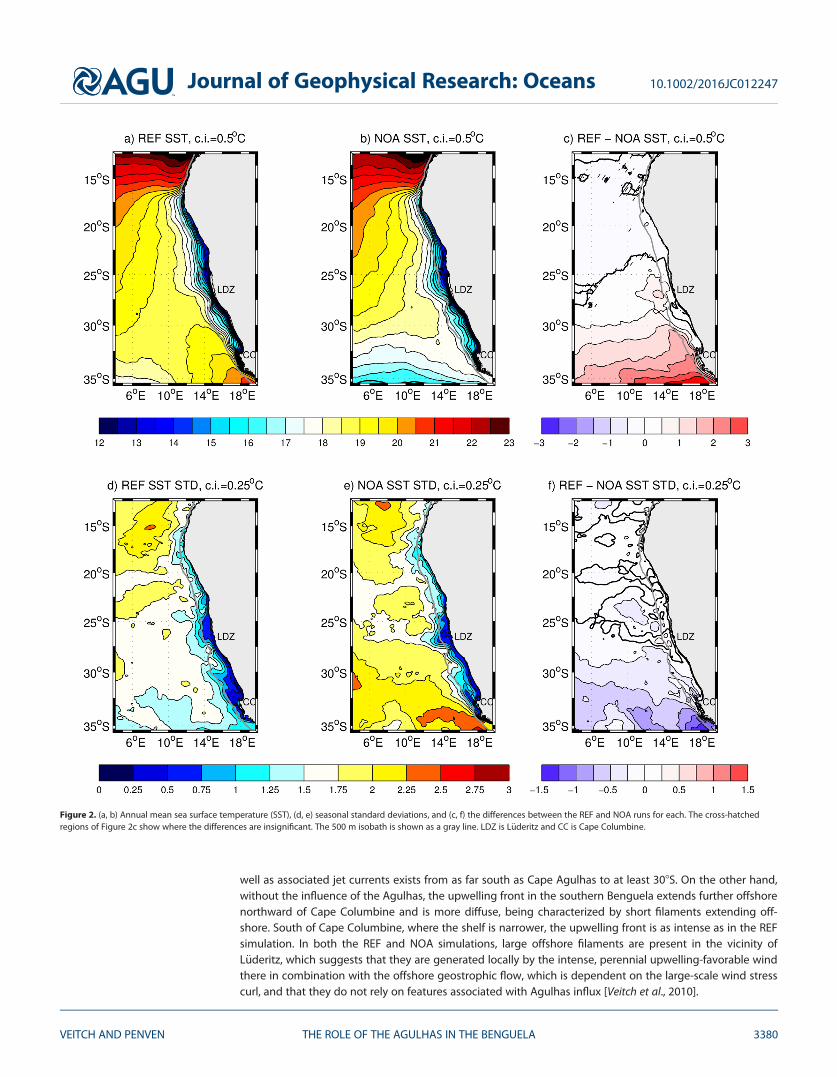
well as associated jet currents exists from as far south as Cape Agulhas to at least 308S. On the other hand,without the influence of the Agulhas, the upwelling front in the southern Benguela extends further offshorenorthward of Cape Columbine and is more diffuse, being characterized by short filaments extending off-shore. South of Cape Columbine, where the shelf is narrower, the upwelling front is as intense as in the REFsimulation. In both the REF and NOA simulations, large offshore filaments are present in the vicinity ofL€uderitz, which suggests that they are generated locally by the intense, perennial upwelling-favorable windthere in combination with the offshore geostrophic flow, which is dependent on the large-scale wind stresscurl, and that they do not rely on features associated with Agulhas influx [Veitch et al., 2010].
Figure 2. (a, b) Annual mean sea surface temperature (SST), (d, e) seasonal standard deviations, and (c, f) the differences between the REF and NOA runs for each. The cross-hatchedregions of Figure 2c show where the differences are insignificant. The 500 m isobath is shown as a gray line. LDZ is L€uderitz and CC is Cape Columbine.
Journal of Geophysical Research: Oceans 10.1002/2016JC012247
VEITCH AND PENVEN THE ROLE OF THE AGULHAS IN THE BENGUELA 3380

The mean position and intraseasonal variability of the summer upwelling front confirms the persistence ofthe features described above. After several attempts at formulating the best method of extracting the loca-tion of the upwelling front, the most accurate and consistent proved to be the simplest. At each latitudethe location of the main upwelling front is identified as follows:
Tfront50:25Tcoast10:75Toffshore; (1)
where Tfront is the temperature representative of the upwelling front, Tcoast is the average SST between thecoast and the location of the 80 m isobath and Toffshore is the average offshore SST, averaged between 500and 1000 km. While the model contains a surface SST restoring term (based on Pathfinder SSTs for both theREF and NOA simulations) in order to take into account the air-sea exchange feedback term, its effect con-tributes less than 15% to the total surface heat flux of the child domain, and therefore should not signifi-cantly influence our study.
Based on this method, the location of the summer mean upwelling front for the NOA and REF simulations isshown as a green line in Figure 4 while the black dots show the locations of the upwelling front, based oneach two-daily averaged summer SST (for clarity, only one out of twenty alongshore positions are shownper two-daily average) and reveals the intraseasonal variability resolved by the climatologically forced simu-lation. In both simulations the mean upwelling front extends further offshore in the northern Benguelawhere the shelf is narrower (see dashed red line) than in the southern Benguela and is consistent with thatresolved by satellite data in Lutjeharms and Stockton [1987]. The coherence between the location of theupwelling front and the shelf-edge is particularly distinct in the REF simulation: the seaward standard devia-tion line (yellow) follows the shelf-edge until 308S, while in the NOA experiment it lies beyond the shelf-edge (consistent with the filaments in Figure 3) and the mean position of the upwelling front (in green) fol-lows it only until about Cape Columbine (at 338S). Southward of Cape Columbine, where the shelf is narrow,in both simulations the upwelling front never extends far offshore suggesting an intense front and associat-ed jet in both which can be seen in the vectors in Figure 3.
Maximum offshore excursions of the front in both simulations correspond with the location of the most vig-orous and perennial upwelling cell in the Benguela system, L€uderitz, a distinct offshore surface geostrophic
6oE 9oE 12oE 15oE 18oE
32oS
28oS
24oS
20oS
16oS
LDZ
CC
b) NOA
6oE 9oE 12oE 15oE 18oE
32oS
28oS
24oS
20oS
16oS
LDZ
CC
a) REF
12 14 16 18 20 22 24
Figure 3. ‘‘Snapshot’’ of SST (units: 8C) and surface current vectors from model year 8, month 2 for the REF and NOA simulations (right andleft, respectively). The gray lines are the 200 and 500 m isobaths. LDZ is L€uderitz and CC is Cape Columbine.
Journal of Geophysical Research: Oceans 10.1002/2016JC012247
VEITCH AND PENVEN THE ROLE OF THE AGULHAS IN THE BENGUELA 3381

flow (see the streamlines in Figure 2), high surface EKEs (see Figure 8) and a sudden narrowing of the shelf.The maximum offshore extent of the upwelling front at L€uderitz for both is of the order of 600–700 km.
Figure 5 shows the alongshore averaged temperature and salinity sections for both simulations and theirdifferences in a representative section of the southern Benguela and give a better idea of the impact ofAgulhas influx on the water mass properties. Other than over the shelf, deepening from the surface at thecoast to about 100 m in the vicinity of the shelf-edge and at depths greater than 800 m, water in the south-ern Benguela is everywhere cooler in the NOA experiment. The warmer water in the NOA simulation overthe shelf appears to be related to an upward tilt of the isotherms in the REF simulation in this region as aresult of dynamic uplift as the warmer waters associated with Agulhas influx move past the shelf-edge. Thesalinity sections show that Antarctic Intermediate Water (AAIW), characterized by a salinity minimum, existsdeeper in the REF simulation than in the NOA simulation due to mixing with higher-salinity water of IndianOcean origin in the REF simulation. At depths of greater than about 100 m the NOA simulation has lowersalinities than the REF simulation, with the greatest differences occurring in the vicinity of the central watermass (200–500 m). It is noteworthy and somewhat unexpected that in the upper 100 m the NOA simulationhas higher salinities than the REF simulation. This could be partly due to the more extreme dynamic upliftin the REF simulation that brings fresher and colder water onto the shelf than in the NOA experiment. How-ever, the lower-salinity signal in the REF simulation extends further offshore than the lower-temperature sig-nal. The extended region of lower salinity in the REF simulation may be the result of the intense mesoscalevariability associated with Agulhas influx in the REF simulation providing the means for mixing with thefresher upwelled surface waters, while the lower-temperature signal does not extend as far offshore due tosurface heating.
The temperature-salinity (T-S) plots shown in Figure 6 provide a succinct summary of the thermohalineimpact of the Agulhas on the southern Benguela system. Three profiles for both the REF and NOA simula-tions are shown, representative of the shelf (100 km offshore), shelf-edge (200 km offshore), and offshore(500 km offshore) regions. The surface waters of the NOA experiment are more saline than the REF simula-tion, except for the upper 10 m on the shelf, which is a result of the offshore advection of fresher upwelledwater. Surface waters, as defined as the top ‘‘tail’’ in the T-S plots, are deeper in the REF simulation than inthe NOA experiment, particularly at the shelf-edge and offshore of it, by about 100 m. The surface water ofthe REF simulation is separated into two distinct masses: the fresher and warmer upper 10 m is likely to
10oE 12oE 14oE 16oE 18oE 34oS
32oS
30oS
28oS
26oS LDZ
CC
b) NOA: summer
TopoMean positionStd deviation
10oE 12oE 14oE 16oE 18oE 34oS
32oS
30oS
28oS
26oS LDZ
CC
a) REF: summer
Figure 4. Summer front statistics for the REF and NOA simulations (left and right, respectively). Red lines represent the 200, 500, and4000 m isobaths, the green line is the mean summer position of the front, the yellow lines show the standard deviation and black dotsshow the two-daily locations of the front. LDZ is L€uderitz and CC is Cape Columbine.
Journal of Geophysical Research: Oceans 10.1002/2016JC012247
VEITCH AND PENVEN THE ROLE OF THE AGULHAS IN THE BENGUELA 3382

originate from coastal upwelled waters, while the deeper surface waters may be associated with the shelf-edge, dynamic uplift as previously discussed. In all profiles, more so in the offshore profiles, the centralwater mass is fresher in the NOA experiment. At depths of greater than about 1000 m the water mass char-acteristics of the two simulations start to converge.
3.2. Large-Scale TransportThe contribution of the Agulhas to the Benguela Current transport values is known to be significant and issuggested in the surface geostrophic current patterns revealed by the lines of constant SSH for the REF andNOA simulations shown in Figure 1. Figure 7 shows the alongshore averaged transport (integrated to adepth of 1000 m) in the southern Benguela from both the REF and NOA simulations as well as the transportderived from a Sverdrup relation, assuming an active layer of 1000 m [Veitch et al., 2010]. The two distinct
−300 −200 −100 0−1000
−900
−800
−700
−600
−500
−400
−300
Dep
th (
m)
34.5
34.5
34.6
34.734.8
34.9−200
−100
0e) NOA salt
34 935
35.135.235.335.4
−300 −200 −100 0−1000
−900
−800
−700
−600
−500
−400
−300
Offshore distance (km)
34.5
34.634.734.8
34.935
35.1−200
−100
0d) REF salt
3535.1
35.235.3
−300 −200 −100 0−1000
−900
−800
−700
−600
−500
−400
−300
0.05
0.10.150.2
−200
−100
0f) REF−NOA salt
−0.1−0.0500
0.05
−300 −200 −100 0−1000
−900
−800
−700
−600
−500
−400
−300
Dep
th (
m)
4
6
8
−200
−100
0b) NOA temp
121416
−300 −200 −100 0−1000
−900
−800
−700
−600
−500
−400
−300
4
6
8
10
12
−200
−100
0a) REF temp
1416
18
−300 −200 −100 0−1000
−900
−800
−700
−600
−500
−400
−300
0
1
2
−200
−100
0c) REF−NOA temp
0
1
2
Figure 5. Annual mean temperature (top) and salinity (bottom) sections in the southern Benguela for the REF and NOA simulations andtheir difference (which is significant throughout the section at the 95% level).
Journal of Geophysical Research: Oceans 10.1002/2016JC012247
VEITCH AND PENVEN THE ROLE OF THE AGULHAS IN THE BENGUELA 3383

34.2 34.4 34.6 34.8 35 35.2 35.40
2
4
6
8
10
12
14
16
18
20
27.5
26.5
25.5
28
100km offshore
26
25
27
24.5
Pot
entia
l Tem
pera
ture
(°C
)
NOAREF
−200 −160 −120 −80 −40 0
34.2 34.4 34.6 34.8 35 35.2 35.40
2
4
6
8
10
12
14
16
18
20
26.5
27.5
25
28
200km offshore
Salinity (psu)
27
24.5
25.5
−800 −600 −400 −200 0
34.2 34.4 34.6 34.8 35 35.2 35.40
2
4
6
8
10
12
14
16
18
20
26
27
28
500km offshore
25.5
27.5
25
26.5
24.5
−4000 −3200 −2400 −1600 −800 0
Figure 6. T-S plot for the southern Benguela for the REF and NOA simulations with characteristic water mass properties for South Atlantic, Tropical Atlantic, and Agulhas waters shownin color.
−1000 −900 −800 −700 −600 −500 −400 −300 −200 −100 0−5
0
5
10
15
20
25
30
Vol
ume
tran
spor
t (S
v)
Alongshore averaged transport in the southern Benguela box
Offshore distance (km)
REFNOASverdrup
10 11 12 13 14 15 16 17 18
Longitude (oE)
Figure 7. Transport, integrated between 0 and 1000 m, across 308S for the REF and NOA simulations as well as derived from the Sverdruprelation.
Journal of Geophysical Research: Oceans 10.1002/2016JC012247
VEITCH AND PENVEN THE ROLE OF THE AGULHAS IN THE BENGUELA 3384
‘‘streams’’ of equatorward transport are evident in the REF simulation, one is the previously investigatedshelf-edge jet, which is approximately 200 km offshore and has a transport of about 5 Sv, and the other isthe mean manifestation of the Benguela Current, which has a transport of about 25 Sv and peaks some800 km offshore. The equatorward transports in the NOA experiment do not exhibit two distinct currents.Instead, the weaker equatorward current over the shelf (roughly 200 km from the coast) has a transport ofno more than 1 Sv, while the equatorward flow from the shelf-edge to 1000 km offshore has a transport ofabout 10 Sv. This suggests that in our model the Agulhas contributes about 15 Sv to the transport of theBenguela Current, which is the same as the Agulhas leakage estimate given in Richardson [2007]. Althoughshifted by about 5 Sv due to shelf processes, the equatorward transport follows a line parallel to the Sver-drup transport (the thin line in 7) offshore of 350 km from the coast, thus confirming that the large-scaleflow regime in the NOA experiment is consistent with Sverdrup dynamics. Closer inshore, the Sverdrup rela-tion predicts the existence of a net poleward flow associated with cyclonic wind stress curl between about100 and 400 km offshore; however, it does not appear in the depth-integrated transport plot for the REFand NOA simulations due to the more intense and shallower equatorward transports in each that are drivenby dynamic upwelling and intense upwelling fronts associated with the Cape Columbine upwelling plume,respectively.
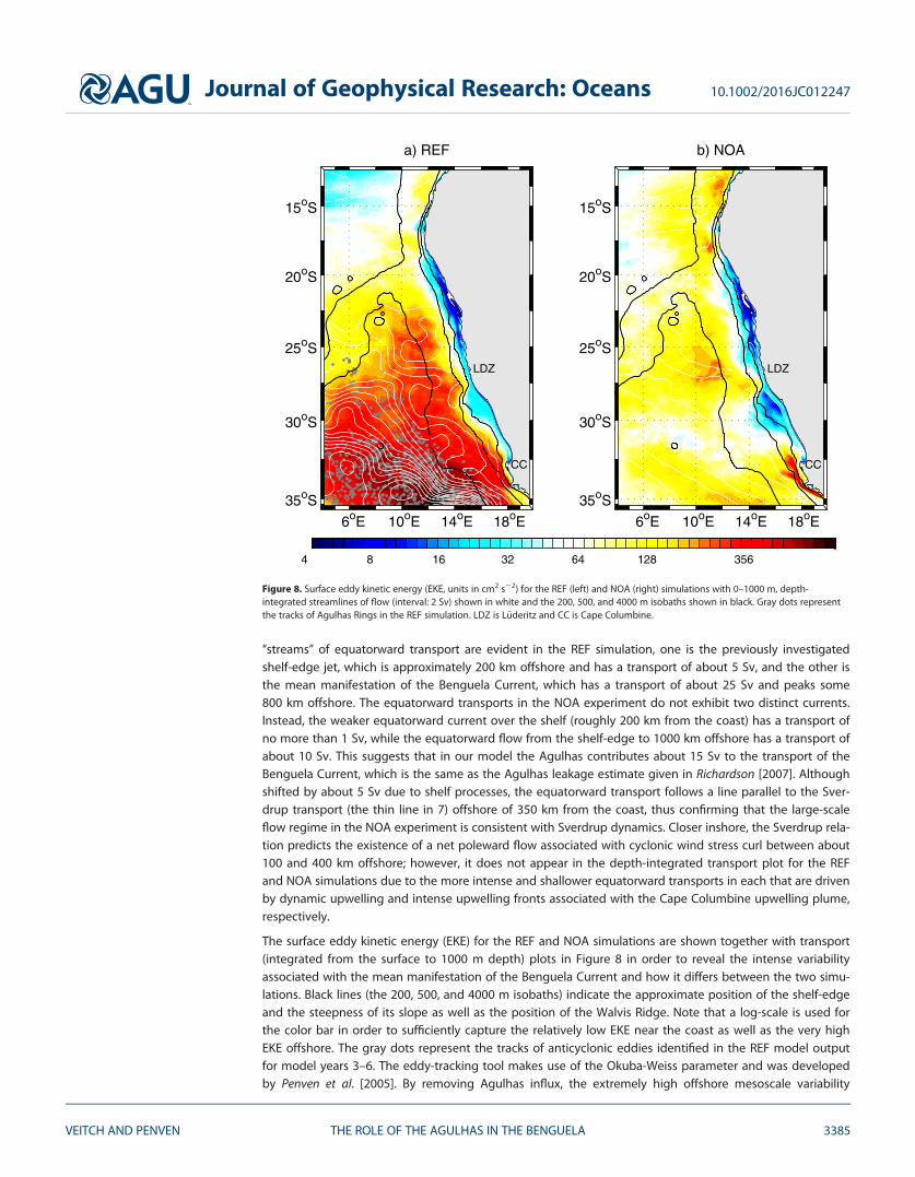
The surface eddy kinetic energy (EKE) for the REF and NOA simulations are shown together with transport(integrated from the surface to 1000 m depth) plots in Figure 8 in order to reveal the intense variabilityassociated with the mean manifestation of the Benguela Current and how it differs between the two simu-lations. Black lines (the 200, 500, and 4000 m isobaths) indicate the approximate position of the shelf-edgeand the steepness of its slope as well as the position of the Walvis Ridge. Note that a log-scale is used forthe color bar in order to sufficiently capture the relatively low EKE near the coast as well as the very highEKE offshore. The gray dots represent the tracks of anticyclonic eddies identified in the REF model outputfor model years 3–6. The eddy-tracking tool makes use of the Okuba-Weiss parameter and was developedby Penven et al. [2005]. By removing Agulhas influx, the extremely high offshore mesoscale variability
6oE 10oE 14oE 18oE
35oS
30oS
25oS
20oS
15oS
LDZ
CC
a) REF
6oE 10oE 14oE 18oE
35oS
30oS
25oS
20oS
15oS
LDZ
CC
b) NOA
4 8 16 32 64 128 356
Figure 8. Surface eddy kinetic energy (EKE, units in cm2 s22) for the REF (left) and NOA (right) simulations with 0–1000 m, depth-integrated streamlines of flow (interval: 2 Sv) shown in white and the 200, 500, and 4000 m isobaths shown in black. Gray dots representthe tracks of Agulhas Rings in the REF simulation. LDZ is L€uderitz and CC is Cape Columbine.
Journal of Geophysical Research: Oceans 10.1002/2016JC012247
VEITCH AND PENVEN THE ROLE OF THE AGULHAS IN THE BENGUELA 3385

characteristic of the southern Benguela disappears. The most intense mean flow in the REF simulation is ameandering flow in the offshore region that is superimposed on highest EKEs and is in the corridor of Agul-has Rings. This suggests that the intense mean Benguela Current is partly a manifestation of the passage oflarge-scale Agulhas Rings. While the REF simulation has a significantly stronger mean flow than the NOAexperiment, both simulations exhibit peak EKEs in regions of most intense flow (represented by the mostclosely spaced isolines): the intense shelf and shelf-edge jet feature in the NOA and REF simulations, respec-tively, and the offshore stream of the Benguela Current in both simulations. In the REF simulation the highEKEs associated with the mean manifestation of the Benguela Current are by far the most intense in thedomain. Removing the Agulhas shows the distinct offshore transport separating the northern and southernBenguela systems (258S–288S) is a source of locally generated mesoscale variability and is likely a result ofthe propensity for large upwelling filaments in this region [Lutjeharms et al., 1991; Shillington et al., 1990].The overlay of the position of the Walvis Ridge on the surface EKEs shows that mesoscale variability associ-ated with Agulhas leakage does not extend northward beyond it, illustrating a potential role of this topo-graphic barrier.
3.3. Currents on the Shelf and SlopeAnnual mean horizontal and vertical currents at the coast, over the shelf and within a few hundred kilo-meters of the shelf-edge for the REF and NOA simulations, shown in Figure 9, provide a clear indication ofthe dynamic differences that relate to the disparate thermohaline characteristics already mentioned. In theREF simulation two very distinct alongshore jets are evident, one within 50 km of the coast that forms partof the coastal upwelling system of currents (i.e., a clear ‘‘cell’’ of upward velocity and an offshore and com-pensatory onshore flow beneath it). The other jet is present over the shelf-edge and is tied to upward veloc-ities that are present from a depth of about 10 m to the approximate depth of the shelf-edge and are of theorder of the upwelling velocities at the coast. While the coastal upwelling system of currents is present inmuch the same combination and intensity in the NOA experiment, the shelf-edge feature is present but anorder of magnitude weaker than in the REF simulation and the intensified alongshore current exists overthe shelf, rather than at the shelf-edge. Terms of the momentum balance equations confirm that, awayfrom the surface and coastal boundaries, these equatorward jets in both simulations are geostrophic. Theshelf-edge upwelling feature, particularly intense in the REF simulation, can therefore be explained by thenecessary uplift of isopycnals (seen as an uplift of isotherms in Figure 5) in order to maintain the intensezonal pressure gradient required by the fast shelf-edge jet. On the other hand and given that the averagealongshore sections of currents, temperature, and salinity are taken just north of Cape Columbine, the shal-low alongshore current over the shelf particularly evident in the NOA experiment and perhaps masked bythe intense shelf-edge jet feature in the REF simulation could be related to the northward advection of theCape Columbine upwelling plume that can be seen both in the mean state SSTs (Figure 2) as well as in asnapshot of SSTs (Figure 3). The poleward undercurrent, forced by the cyclonic wind stress curl [see Veitchet al., 2009, Figure 2], is present in both simulations and is associated with downward velocity in order toconserve potential vorticity.3.3.1. The Good Hope JetShelf-edge jets, associated with an upward displacement of isopycnals [Shannon and Nelson, 1996], are rela-tively persistent in the southern Benguela. We focus here on the Good Hope Jet that exists southwest ofCape Town, extending northwestward from the western Agulhas Bank [Shannon and Nelson, 1996] and hasbeen identified as a key factor in transporting fish eggs and larvae from their spawning ground on the Agul-has Bank to their nursery area in St Helena Bay and in the high productivity of the southern Benguela region[Shelton and Hutchings, 1982]. The intense horizontal gradients observed by Bang and Andrews [1974] wasthe first evidence for its existence, and Strub et al. [1998] used satellite altimetry to investigate the seasonalsignal of its surface manifestation. They noted a seasonal intensification that they associated with the inter-play of the injection of high steric heights via Agulhas influx and the low steric heights associated with thecoastal upwelling regime. However, work carried out by Nelson [1985] during a slackening phase of theupwelling favorable wind suggested the permanence of the jet. The results of the NOA experiment allow usto reinforce current theories about the role of Agulhas influx on the jet in a more conclusive manner.
Figure 10 presents the summer and winter mean current field at the surface for both the NOA and REF sim-ulations and shows that in both cases an intense equatorward jet exists over the shelf-edge region (approxi-mately between the 200 and 500 m isobaths) off Cape Point. During summer months, the jet is far more
Journal of Geophysical Research: Oceans 10.1002/2016JC012247
VEITCH AND PENVEN THE ROLE OF THE AGULHAS IN THE BENGUELA 3386
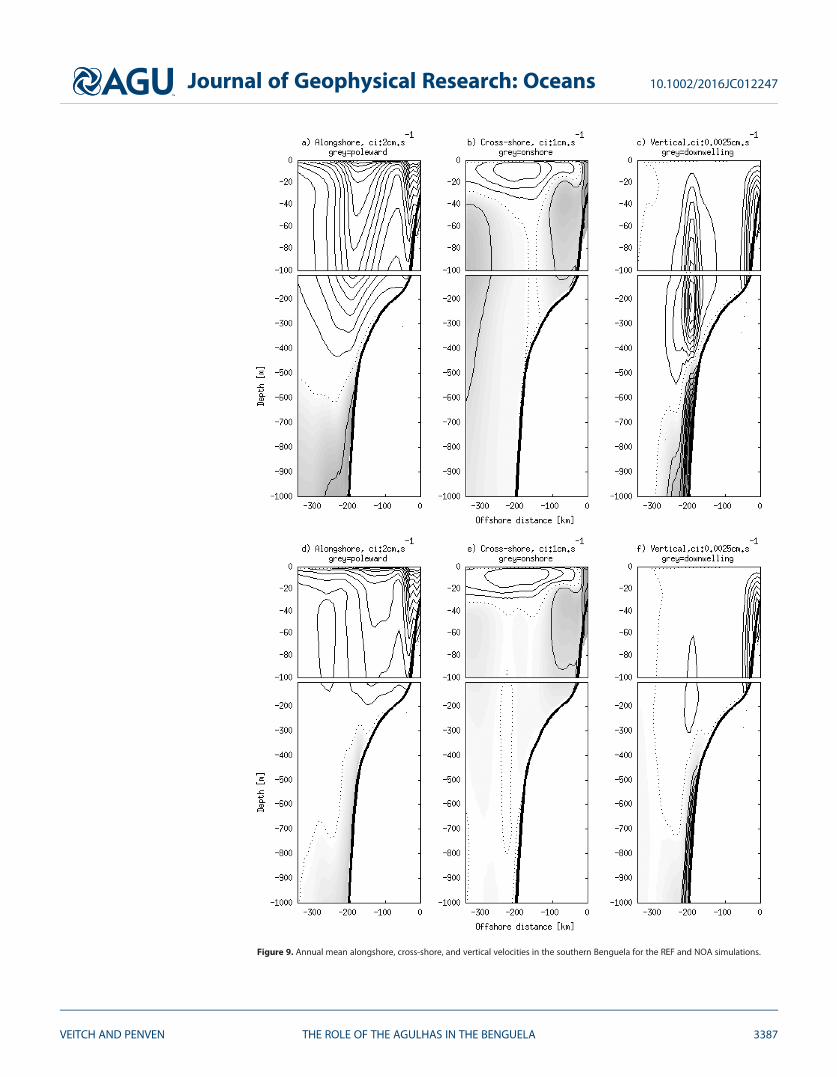
Figure 9. Annual mean alongshore, cross-shore, and vertical velocities in the southern Benguela for the REF and NOA simulations.
Journal of Geophysical Research: Oceans 10.1002/2016JC012247
VEITCH AND PENVEN THE ROLE OF THE AGULHAS IN THE BENGUELA 3387

intense and extensive, expanding as a continuous jet from Cape Agulhas, with speeds of greater than50 cm s21. The summer jet is a more coherent feature in the NOA experiment, distinct from the muchweaker currents that surround it, while in the REF simulation fast equatorward velocities persist beyond theshelf-edge. An explanation for the somewhat more intense and confined NOA jet could be the decay ofintense horizontal density gradients in the REF simulation associated with the high turbulence of Agulhasinflux. In contrast, the fact that fast currents exist beyond the shelf-edge in the REF simulation and not theNOA experiment is likely due to the injection of warm waters of high steric height in the offshore region inthe REF simulation. The winter jet in both simulations is very much reduced in extent, particularly in thecase of the NOA experiment, with velocities of greater than 50 cm s21 being limited to a small region justoffshore of the 200 m isobath, west of Cape Point. Northward of Cape Point, the jet appears to bifurcateinto two branches: eastward into Table Bay and northward, continuing along the shelf-edge. The eastwardbifurcation into Table Bay appears to be more intense during winter months for both simulations. Furthernorth, a slightly weaker winter and summer jet exists over the 200 m isobath off Cape Columbine, with verylittle variation in intensity between seasons.
The intense summer jet off the Cape Peninsula can be somewhat explained by the seasonal cycle of upwell-ing in this region (i.e., enhanced upwelling during summer results in intensified offshore density gradientsand in turn increased equatorward flow) for both the REF and NOA simulations. However, the polaritybetween the intense summer and weak winter jet is amplified in the NOA experiment due to the lack of theconstant source of warm water via Agulhas influx. In other words, the warm offshore water from the Agul-has influx intensifies and broadens both the summer and winter jet in the REF simulation. We therefore
16oE 17oE 18oE 19oE
35oS
34oS
33oS
32oS
CC
CP
c) NOA: Summer currents at the surface
16oE 17oE 18oE 19oE
35oS
34oS
33oS
32oS
CC
CP
a) REF: Summer currents at the surface
16oE 17oE 18oE 19oE
35oS
34oS
33oS
32oS
CC
CP
d) NOA: Winter currents at the surface
16oE 17oE 18oE 19oE
35oS
34oS
33oS
32oS
CC
CP
b) REF: Winter currents at the surface
−20 −10 0 10 20 30 40 50 60
Figure 10. Winter and summer (left and right, respectively) mean currents in the southern Benguela for the REF and NOA simulations (bot-tom and top, respectively). The dashed black lines are the 200 and 500 m isobaths, representative of the shelf-edge and the solid blackcontour is the 50 cm s21 isotach.
Journal of Geophysical Research: Oceans 10.1002/2016JC012247
VEITCH AND PENVEN THE ROLE OF THE AGULHAS IN THE BENGUELA 3388

hypothesize that the Good Hope Jet is driven by offshore density gradients that are set up by both upwell-ing dynamics and Agulhas influx, the latter masking the seasonal cycle. While the NOA jet seems then to beprimarily forced by upwelling dynamics, it remains present along the 200 m isobath during winter, whenthe dominant winds are not upwelling favorable.
3.4. Vorticity Budget AnalysisA vertically integrated vorticity balance is used to investigate the relative importance of terms driving themean flow structure in the upper 1000 m. Marchesiello et al. [2003] used the terms of the vorticity balanceequation to show that significant departures from the Sverdrup balance occur in the California Current sys-tem and are due to the nonlinear terms. Based on the surface EKE plots and the transports in Figure 8, weexpect that the nonlinear terms are significant in the southern Benguela system. We examine the terms ofthe vorticity equation in order to better understand eddy-mean flow interaction processes in the NOA andREF simulations.
A depth-integrated (from the free-surface to 1000 m) vorticity balance equation can be directly derivedfrom the terms of the momentum equation as follows:
ðg21000
@n@t
dz5
ðg21000
f@w@z
dz2bðg
21000
v
|fflfflfflfflfflfflfflfflfflfflfflfflfflfflfflfflfflffl{zfflfflfflfflfflfflfflfflfflfflfflfflfflfflfflfflfflffl}r3Coriolis
dz 2
ðg21000
~trndz
|fflfflfflfflfflfflfflfflfflfflffl{zfflfflfflfflfflfflfflfflfflfflffl}r3Advection
1r3~ssurf
q0|fflfflfflfflfflfflffl{zfflfflfflfflfflfflffl}r3Wind stress
; (2)
where n is the relative vorticity and g is the free surface. The Coriolis term has been separated into a vortex
stretching term (vstretch: f @w@z , where f is the Coriolis parameter and w is the vertical velocity) and a beta
term (beta: bv, where b5 @f@y and v is the meridional velocity component). ~ssurf is the time mean surface
wind stress vector (in N m22) and q0 is the reference density of sea water. The surface forcing term is thedominant forcing term and far exceeds the interior mixing term, which has therefore been neglected. Sincevorticity advection is dominated by the horizontal advection, it can equivalently be written as follows:~kr3½u @u
@x 1v @u@y ; v @v
@y 1u @v@x�, where u is the zonal velocity component. We separate the total horizontal
advection (tadv) into mean and eddy vorticity advection terms, based on a time-mean current. The mean(madv) and eddy (eadv) vorticity advection terms appear as follows:
MADV5
ðg
21000
~kr3@�u2
@x1@�u�v@y
;@�v 2
@y1@�u�v@x
� �dz; (3)
EADV5
ðg
21000
~kr3@u02@x
1@u0v0
@y;@v02@y
1@u0v0
@x
� �dz; (4)
where �u; �v½ � and u0v0½ � are the time-mean and transient, zonal and meridional velocity components,respectively.
Figure 11 shows the alongshore averaged dominant vorticity balance terms integrated from the surface to1000 m as well as the separation of the total horizontal advection term (TADV) into its mean (MADV) andeddy (EADV) components for both the REF and NOA simulations. Note that the scale of the y axes are differ-ent because the vorticity terms are so much smaller in the NOA experiment that in the REF simulation. Inthe NOA simulation the dominant balance for the large-scale offshore flow is between the wind stress curland beta effect, with undulating influences from the total advection and vortex stretching terms that areonly significant closer to the coast, within the vicinity of the shelf-edge and some 420 km offshore. Whilethe Sverdrup balance dominates the large-scale dynamics, in the region of the shelf-edge at about 220 kmoffshore, the vortex stretching and total advection terms are dominant and contribute negative and posi-tive vorticity to the vorticity budget, respectively. The total advection term is made up primarily of an eddyadvection component with a mean advection term that is not insignificant. These terms are related to thealong-shelf advection of cyclonic eddies (consistent with a negative vstretch term) that are generated atthe Cape Peninsula and Cape Columbine upwelling cells, a known-feature [Lutjeharms and Stockton, 1987]that is present in both the REF simulation and in the NOA experiment. Offshore propagation of featuresassociated with instabilities at the shelf-edge, including cyclonic eddies [Strub et al., 1998], leads to a posi-tive vorticity contribution by the vstretch term via the propagation into deeper water, thus enhancing the
Journal of Geophysical Research: Oceans 10.1002/2016JC012247
VEITCH AND PENVEN THE ROLE OF THE AGULHAS IN THE BENGUELA 3389

poleward transport at this location. The significant undulating tadv and vstretch terms between 420–440 km offshore in the NOA alongshore averaged vorticity budget are likely to be related to the alongshoreaveraged manifestation of the slight meandering nature of the Benguela Current: the positive contributionto vorticity by the tadv term drives a poleward transport component, which is consistent with the slightlyless negative beta term at this location.
In the REF simulation the wind stress curl, beta effect, vortex stretching, and total advection terms are allsignificant. The vstretch term becomes particularly important offshore of 400 km from the coast, which iscoincident with the second ‘‘stream’’ of the Benguela Current that is thought to be the mean manifestationof the preferential passage of Agulhas Rings. The large positive vstretch term in this region is connectedwith the anticyclonic Agulhas Rings and introduces a positive source of vorticity that is consistent with theequatorward advection of the rings (which is reflected in the large, negative beta term). The total advectionterm associated with the passage of Agulhas Rings is not dominated by the eddy component; rather overthe 400–550 km offshore region, the mean and eddy advection components undulate so that they aremore or less equal. This is consistent with the work of Treguier et al. [2003] who emphasized that the domi-nance of anticyclonic rings as opposed to cyclonic eddies does not allow for the transient component offlow to be entirely removed from the mean state. Closer inshore, from about 250 to 400 km, the eddy com-ponent of the total advection term dominates, suggesting the presence of small scale instabilities of fea-tures associated with the upwelling front and their interaction with mesoscale features Agulhas leakage. Inthe vicinity of the shelf-edge at about 220 km offshore, as in the NOA experiment, the vstretch and tadvterms dominate due to the alongshore advection of the cyclonic, shelf-edge eddies.
At the shelf-edge in both simulations, though much more intense in the REF simulation, is a positive spikein the vstretch term. This is consistent with vortex squashing and the upward vertical velocities seen in Fig-ure 9 as the equatorward current moves over the shelf-edge where its height is decreased.
−550 −500 −450 −400 −350 −300 −250 −200−1
−0.5
0
0.5
1
vort
icity
con
trib
utio
n (m
.s−
2 )
b) NOA vorticity balance. Units: m.s−2
betawindvstretchtadv
−550 −500 −450 −400 −350 −300 −250 −200−1
−0.5
0
0.5
1
Offshore distance (km)vo
rtic
ity c
ontr
ibut
ion
(m.s
−2 )
d) NOA MADV and EADV. Units: 10−9 m.s−2
madv eadv
−550 −500 −450 −400 −350 −300 −250 −200−2
−1
0
1
2
vort
icity
con
trib
utio
n (m
.s−
2 )
a) REF vorticity balance terms. Units: m.s−2
−550 −500 −450 −400 −350 −300 −250 −200−2
−1
0
1
2
Offshore distance (km)
vort
icity
con
trib
utio
n (m
.s−
2 )
c) REF MADV and EADV terms. Units: 10−9 m.s−2
Figure 11. Dominant vorticity balance terms (top) and the advection term separated into its mean and eddy components (bottom) for theREF (left) and NOA (right) simulations. Note the different scales on the y axis.
Journal of Geophysical Research: Oceans 10.1002/2016JC012247
VEITCH AND PENVEN THE ROLE OF THE AGULHAS IN THE BENGUELA 3390

4. Conclusions
The difficulty of removing the signal of the Agulhas from the Benguela is well known. Unequivocal conclu-sions on the role of the Agulhas in the Benguela system are therefore similarly difficult to achieve. The useof numerical models allows us to purposefully create unrealistic scenarios in order to investigate the domi-nant driving forces of particular features. By introducing a dam at �308S on the east coast in the model, wecause an early retroflection of the Agulhas Current such that its influence on the Benguela system is mini-mal. Comparisons of this simulation (NOA) with the realistic one (REF), which has the same configurationand forcing, has allowed for some conclusions to be made on the role of the Agulhas Current in the Ben-guela system.
The most distinctive and expected effect of the Agulhas on the southern Benguela system is the warmwater that it introduces. The fact that the warming effect is greatest in the offshore region and least on theshelf means that it has an intensifying effect on the thermal front across the shelf-edge in the southern Ben-guela and therefore also on the associated jet currents. The offshore extent and generation of filaments isfurther limited by the high level of turbulence introduced by Agulhas leakage causing intense mixing anddiffusion beyond the shelf-edge. The geostrophically adjusted equatorward current that is intensified byAgulhas influx in the vicinity of the shelf-edge in the southern Benguela results in dynamic uplift at theshelf-edge, which brings cooler and fresher water to the surface. North of about 308S the effect of the Agul-has on the upwelling front is less, but the large filaments at L€uderitz (about 288S) are present in both theREF and NOA simulations as is the associated region of high surface EKE linked with frontal instabilitiesthere. This suggests that the filaments are not dependent on interaction with Agulhas Rings for their hugeoffshore expanse but are rather a result of the perennial nature of the upwelling-favorable wind in conjunc-tion with the large-scale offshore geostrophic flow in the vicinity of L€uderitz.
Analysis of the large-scale transport of the region from both simulations reveals that while the Agulhas con-tributes about 15 Sv to the Benguela transport (which is consistent with other results [e.g., Reason et al.,2003; Matano and Beier, 2003; van Sebille et al., 2010; Doglioli et al., 2006; Biastoch et al., 2008b], a large por-tion of it is in the form of dominantly large anticyclonic (as opposed to cyclonic) eddies that are difficult toremove from the mean signal. This is suggested by the fact that the corridor of Agulhas Rings exists in theregion of greatest mean transport and highest surface EKE. The vorticity budget explicitly shows that with-out the influence of the extreme nonlinearities associated with Agulhas influx the Sverdrup balance holdsin the offshore domain. It also shows that while the eddy component of the total advection term dominateswithin about 200 km of the shelf-edge, presumably due to instabilities associated with the interaction ofAgulhas influx and shelf-edge features, beyond that it is more or less split between the eddy and meancomponents. The latter finding is consistent with the location of the corridor of large-scale eddies as well asthe idea that the signal of the large-scale eddies are difficult to separate from the mean state. The very highEKE introduced by Agulhas influx exists in the offshore domain of the southern Benguela, rapidly dissipatingin the vicinity of the shelf-edge, suggesting that high turbulence associated with the Agulhas does notdirectly influence the ecologically important southern Benguela shelf. However, there exists high variabilityon the narrow shelf and shelf-edge between Cape Point to just north of Cape Columbine in both REF andNOA simulations. This is associated with the intense temperature gradients, alongshore jet and associatedbaroclinic instabilities present with or without the Agulhas.
Over the shelf and shelf-edge region, the Agulhas has an important role to play in the generation of anintense geostrophic shelf-edge jet that produces dynamic uplift at the shelf-edge via vortex squashing.More specifically, it intensifies and broadens the Good Hope Jet by enhancing the cross-shelf steric-heightgradient via the injection of warm offshore waters. The Good Hope Jet exists in the NOA experiment via thedensity gradients introduced during active upwelling and is somewhat enhanced by the narrow shelf in theregion. However, it is a more strongly seasonal feature, rather than perennial, without the Agulhasinfluence.
While this numerical modeling experiment does not remove the effect of the Agulhas entirely (i.e., theboundary conditions and the surface restoring term both retain the signal of Agulhas waters), it has allowedus to make some inferences on the effect of Agulhas leakage on the mean state of the Benguela system. Ithas shown that the Agulhas not only significantly affects the large-scale flow regime but also impacts near-shore features which can have critical ramifications for the health of the southern Benguela ecosystem.
Journal of Geophysical Research: Oceans 10.1002/2016JC012247
VEITCH AND PENVEN THE ROLE OF THE AGULHAS IN THE BENGUELA 3391
ReferencesBang, N., and W. Andrews (1974), Direct current measurements of a shelf-edge frontal jet in the southern Benguela system, J. Mar. Res., 32,
405–417.Biastoch, A., C. Boning, and J. Lutjeharms (2008a), Agulhas leakage dynamics affects decadal variability in Atlantic overturning circulation,
Nature, 456(7221), 429–436.Biastoch, A., J. Lutjeharms, C. B€onning, and M. Scheinert (2008b), Mesoscale perturbations control inter-ocean exchange south of Africa,
Geophys. Res. Lett., 35, L20602, doi:10.1029/2008GL035132.Boebel, O., J. Lutjeharms, C. Schmid, W. Zenk, T. Rossby, and C. Barron (2003), The Cape Cauldron: A regime of turbulent inter-ocean
exchange, Deep Sea Res., Part II, 50, 57–86.Capet, X., F. Colas, P. Penven, P. Marchesiello, and J. McWilliams (2008), Eddies in eastern boundary subtropical upwelling systems, in Ocean
Modeling in an Eddying Regime, vol. 177, AGU, Washington, D. C.Chang, N. (2009), Numerical ocean model study of the Agulhas Bank and the Cool Ridge, PhD thesis, Univ. of Cape Town, Cape Town,
South Africa.Chelton, D., R. deSzoeke, and M. Schlax (1998), Geographical variability of the first Rossby radius of deformation, J. Phys. Oceanogr., 28,
433–460.Conkright, M., R. Locarnini, H. Garcia, T. O’Brien, T. Boyer, C. Stephens, and J. Antonov (2002), World Ocean Atlas 2001: Objective analyses,
data statistics and figures, CR-ROM documentation, Inter. Rep. 17, Natl. Oceanogr. Cent., Silver Spring, Md.Da Silva, A., C. Young, and S. Levitus (1994), Atlas of surface marine data 1994: Algorithms and procedures, technical report, vol. 1, Natl.
Oceanogr. and Atmos. Admin., Silver Spring, Md.Debreu, L., C. Voulard, and E. Blayo (2008), AGRIF: Adaptive grid refinement in fortran, Comput. Geosci., 34, 8–13.Debreu, L., P. Marchesiello, P. Penven, and G. Cambon (2012), Two-way nesting in split-explicit ocean models: Algorithms, implementation
and validation, Ocean Modell., 49–50, 1–21.de Ruijter, W., A. Biastoch, S. Drijfhout, J. Lutjeharms, R. Matano, T. Pichevin, P. van Leeuwen, and W. Weijer (1999), Indian-Atlantic inter-
ocean exchange: Dynamics, estimation and impact, J. Geophys. Res., 104(C9), 20,885–20,910.Doglioli, A., M. Veneziani, B. Blanke, S. Speich, and A. Griffa (2006), A Lagrangian analysis of the Indian-Atlantic interocean exchange in a
regional model, Geophys. Res. Lett., 33, L14611, doi:10.1029/2006JC003952.Duncombe-Rae, C., F. Shilington, J. Agenbag, J. Taunton-Clark, and M. Grundlingh (1992), An Agulhas ring in the south Atlantic ocean and
its interaction with the Benguela upwelling frontal system, Deep Sea Res., Part I, 39(11/12), 2009–2027.Durgadoo, J., B. Loveday, C. Reason, P. Penven, and A. Biastoch (2013), Agulhas leakage predominantly responds to the Southern Hemi-
sphere Westerlies, J. Phys. Oceanogr., 43, 2113–2131.Garzoli, S., and A. Gordon (1996), Origins and variability of the Benguela Current, J. Geophys. Res., 101(C1), 897–906.Garzoli, S., A. Gordon, V. Kamenkovich, D. Pillsbury, and C. Duncombe-Rae (1996), Variability and sources of the southeastern Atlantic circu-
lation, J. Mar. Res., 54, 1029–1071.Gordon, A. (2003), The brawniest retroflection, Nature, 421, 904–905.Gruber, N., Z. Lachkar, H. Frenzel, P. Marchesiello, M. M€unnich, J. McWilliams, T. Nagai, and G.-K. Plattner (2011), Eddy-induced reduction of
biological production in eastern boundary upwelling systems, Nat. Geosci., 4, 787–792.Haidvogel, D., and A. Beckmann (1999), Numerical Ocean Modeling, Environ. Sci. Manage., vol. 2, Imperial College Press, London.Large, W., J. McWilliams, and S. Doney (1994), Oceanic vertical mixing: A review and a model with a nonlocal boundary layer parameteriza-
tion, Rev. Geophys., 32(4), 363–403.Loveday, B., J. Durgadoo, C. Reason, A. Biastoch, and P. Penven (2014), Decoupling of the Agulhas leakage from the Agulhas Current,
J. Phys. Oceanogr., 44(7), 1776–1797.Loveday, B., P. Penven, and C. Reason (2015), Southern annular mode and westerly-wind driven changes in Indian-Atlantic exchange
mechanisms, Geophys. Res. Lett., 42, 4912–4921, doi:10.1002/2015GL064256.Lutjeharms, J., and C. Mathyssen (1995), A recurrent eddy in the upwelling front off Cape Town, S. Afr. J. Sci., 91(7), 355–357.Lutjeharms, J., and P. Stockton (1987), Kinematics of the upwelling front off Southern Africa, in The Benguela and Comparable Ecosystems,
edited by A. Payne, J. Gullard, and K. Brink, S. Afr. J. Mar. Sci, pp. 35–49.Lutjeharms, J., F. Shillington, and C. M. Rae (1991), Observations of extreme upwelling filaments in the southeast Atlantic Ocean, Science,
253, 774–776.Marchesiello, P., J. McWilliams, and A. Schepetkin (2001), Open boundary conditions for long-term integration of regional oceanic models,
Ocean Modell., 3, 1–20.Marchesiello, P., J. McWilliams, and A. Schepetkin (2003), Equilibrium structure and dynamics of the California Current system, J. Phys. Oce-
anogr., 33, 753–783.Marchesiello, P., L. Debreu, and X. Couvelard (2009), Spurious diapycnal mixing in terrain-following coordinate models: The problem and a
solution, Ocean Modell., 26(3–4), 156–169, doi:10.1016/j.ocemod.2008.09.004.Matano, R., and E. Beier (2003), A kinematic analysis of the Indian/Atlantic interocean exchange, Deep Sea Res., Part II, 50, 229–249.Nelson, G. (1985), Notes on the physical oceanography of the Cape Peninsula upwelling system, in South African Ocean Colour and Upwell-
ing Experiment, edited by L. V. Shannon, pp. 63–95, Sea Fisheries Research Institute, Cape Town.Nelson, G., and L. Hutchings (1983), The Benguela upwelling area, Prog. Oceanogr., 12(3), 333–356.Penven, P., V. Echevin, J. Pasapera, F. Colas, and J. Tam (2005), Average circulation, seasonal cycle, and mesoscale dynamics of the Peru
Current system: A modelling approach, J. Geophys. Res., 110, C10021, doi:10.1029/2005JC0029.Penven, P., L. Debreu, P. Marchesiello, and J. McWilliams (2006a), Evaluation and application of the ROMS 1-way embedding procedure to
the central California upwelling system, Ocean Modell., 12, 157–187.Penven, P., J. Lutjeharms, and P. Florenchie (2006b), Madagascar: A pacemaker for the Agulhas Current system?, Geophys. Res. Lett., 33,
L17609, doi:10.1029/2006GL026854.Penven, P., P. Marchesiello, L. Debreu, and J. Lefevre (2007), Software tools for pre- and post-processing of oceanic regional simulations,
Environ. Modell. Software, 23, 660–662, doi:10.1016/j.envsoft.2007.07.004.Peterson, R., and L. Stramma (1991), Upper-level circulation in the South Atlantic, Prog. Oceanogr., 26, 1–73.Reason, C., J. Lutjeharms, J. Hermes, A. Biastoch, and R. Roman (2003), Inter-ocean fluxes south of Africa in an eddy-permitting model,
Deep Sea Res., Part II, 50(2), 281–298.Richardson, P. (2007), Agulhas leakage into the Atlantic estimated with subsurface floats and surface drifters, Deep Sea Res., Part I, 54(8),
1361–1389.
AcknowledgmentsThe authors are grateful for the use ofthe high-performance computingfacility, Caparmor, at IFREMER, Brest aswell as the availability of the Center forHigh-Performance Computing (CHPC)in Rosebank, Cape Town. J.A.V.gratefully acknowledges funding fromthe National Research Foundation inSouth Africa and SAEON as well as aDSF bursary from the IRD. The authorsgratefully acknowledge the reviewerscomments that greatly improved thismanuscript. For access to the modelconfiguration, data and processedfields please contact thecorresponding author ([email protected]).
Journal of Geophysical Research: Oceans 10.1002/2016JC012247
VEITCH AND PENVEN THE ROLE OF THE AGULHAS IN THE BENGUELA 3392

Rossi, V., C. Lopez, J. Sudre, E. Henandez-Garcia, and V. Garcon (2008), Comparative study of mixing and biological activity of the Benguelaand Canary upwelling systems, Geophys. Res. Lett., 35, L11602, doi:10.1029/2008GL033610.
Rubio, A., B. Blanke, S. Speich, N. Grima, and C. Roy (2009), Mesoscale eddy activity in the southern Benguela upwelling system from satel-lite altimetry and model data, Prog. Oceanogr., 83, 288–295.
Schouten, M., W. de Ruijter, P. van Leeuwen, and J. Lutjeharms (2000), Translation, decay and splitting of Agulhas rings in the southeasternAtlantic Ocean, J. Geophys. Res., 105(C9), 21,913–21,925.
Shannon, L., and G. Nelson (1996), The Benguela: Large-scale features and processes and system variability, in The South Atlantic: Presentand Past Circulation, pp. 163–210, Springer, Berlin.
Shchepetkin, A., and J. McWilliams (2008), Computational kernel algorithms for fine-scale, multi-process, long-term oceanic simulations,Handb. Numer. Anal., 14, 119–181.
Shchepetkin, A., and J. McWilliams (1998), Quasi-monotone advection schemes based on explicit locally adaptive dissipation, Mon. WeatherRev., 126, 1541–1580.
Shchepetkin, A., and J. McWilliams (2005), The regional oceanic modeling system (ROMS): A split-explicit, free-surface, topography-following-coordinate oceanic model, Ocean Modell., 9, 347–404.
Shchepetkin, A., and J. McWilliams (2008), Computational kernel algorithms for fine-scale, multi-process, long-term oceanic simulations, inHandbook of Numerical Analysis: Computational Methods for the Ocean and Atmosphere, pp. 119–181, Elsevier Sci.
Shelton, P., and L. Hutchings (1982), Transport of anchovy, Engraulis capensis Gilchrist, eggs and early larvae by a frontal jet current, ICES J.Mar. Sci., 40, 185–198.
Shillington, F., W. Peterson, L. Hutchings, T. Probyn, H. Waldron, and J. Agenbag (1990), A cool upwelling filament off Namibia, southwestAfrica: Preliminary measurements of physical and biological features, Deep Sea Res., Part A, 37(11), 1753–1772.
Soufflet, Y., P. Marchesiello, F. Lemari, J. Jouanno, X. Capet, L. Debreu, and R. Benshila (2016), On effective resolution in ocean models,Ocean Modell., 98, 36–50, doi:10.1016/j.ocemod.2015.12.004.
Strub, P., F. Shillington, C. James, and S. Weeks (1998), Satellite comparison of the seasonal circulation in the Benguela and California Cur-rent systems, in Benguela Dynamics, vol. 19, edited by S. Pillar et al., S. Afr. J. Mar. Sci., pp. 99–112.
Treguier, A., O. Boebel, B. Barnier, and G. Madec (2003), Agulhas eddy fluxes in a 1/6 degree Atlantic model, Deep Sea Res., Part II, 50, 251–280.
van Aken, H. V., J. Lutjeharms, M. Rouault, C. Whittle, and W. de Ruijter (2013), Observations of an early Agulhas current retroflection eventin 2001: A temporary cessation of inter-ocean exchange south of Africa?, Deep Sea Res., Part I, 72, 1–8.
van Foreest, D., F. Shillington, and R. Legeckis (1984), Large scale, stationary, frontal features in the Benguela Current system, Cont. ShelfRes., 3(4), 465–474.
van Sebille, E., P. van Leeuwen, A. Biastoch, and W. de Ruitjer (2010), Flux comparison of Eulerian and Lagrangian estimates of Agulhasleakage: A case study using a numerical model, Deep Sea Res., Part I, 57, 319–327.
Veitch, J., P. Penven, and F. Shillington (2009), The Benguela: A laboratory for comparative studies, Prog. Oceanogr., 83, 296–302, doi:10.1016/j.pocean.2009.07.008.
Veitch, J., P. Penven, and F. Shillington (2010), Modeling equilibrium dynamics of the Benguela Current system, J. Phys. Oceanogr., 40,1942–1963.
Journal of Geophysical Research: Oceans 10.1002/2016JC012247
VEITCH AND PENVEN THE ROLE OF THE AGULHAS IN THE BENGUELA 3393
Related Documents