The Agulhas Current retroflection 6 The southern termination of the Agulhas Current is unique for a western boundary current in this respect that it takes place at the meridional extremity of the adjacent continent. This is unlike the continental con- straints to which the comparable Gulf Stream, the Kuroshio or the Brazil Currents are subject. Since the African continent separates the Atlantic and Indian basins, the Agulhas Current, at its termination, is also the only western boundary current that lies on the bor- der between two subtropical gyres. This creates unusual conditions for inter-ocean exchanges of water masses, energy and biota between these two gyres with a range of implications for the global oceanic circulation and for biogeographical patterns. Temporal changes in the magnitude of this exchange process may therefore have implications for global water circulation in the ocean and, if such changes are sufficiently large and of suffi- cient duration, may influence global climate. Furthermore, the nature of the termination of the Agulhas Current – described below – allows warm tropical and subtropical surface water to remain in the region for a considerably longer time than in compara- ble western boundary currents. The thus enhanced flux of heat 98,147 and moisture to the atmosphere has a marked effect on the overlying atmosphere 496 of the region. Not unexpectedly, statistical investigations 136,497 have demonstrated that this ocean region has a strong influence on rainfall patterns over southern Africa. Results from ocean–atmosphere models 139 are largely consistent with this view. However, there is consensus that it is the inter-ocean exchanges of water that have the most profound climatic consequences. The interchange processes that occur in the ocean regions south of Africa are therefore of considerable oceanographic interest and have wide implications. The behaviour of the Agulhas Current must naturally play an important role in these processes. The kinematic nature of the Agulhas Current, once it has passed the southern tip of the African continental shelf, is quite exceptional for a western boundary current. The current turns back on itself in a tight loop, called the Agulhas Current Retroflection, with most of its waters contained in this swift recurvature before they flow back into the South Indian Ocean. The nature and dynamics of this peculiar behaviour have received considerable research attention over the past three decades and are now fairly well understood. This growth in knowledge represents one of the major advances in global oceanography of this period. Upon closer examination, the scale and the dynam- ics of the processes in the Agulhas Current retroflection are seen to be of truly monumental proportions 813 . A water mass with an estimated flux of 12 000 cubic kilo- metre per day, i.e. about 1400 times that of the Ama- zon River, moving at a rate of 150 km/day, is turned around in a loop with a diameter of about only 400 km to flow directly in the opposite direction. As could be expected, this configuration is highly unstable and glo- bal observations of hydrographic, sea surface tempera- tures and sea surface height have demonstrated that this region is the most intensely variable to be found in the world ocean. The high contrasts in horizontal gradients for a number of ocean variables found here make this area eminently amenable to observation, but the rapid changes that occur severely limit the applicability of a number of standard hydrographic measurement tech- niques that cannot be used in a quasi-synoptic fashion. Notwithstanding these serious limitations to obser- vational strategies, brought about by the attributes of the current dynamics itself, much has been learnt about the nature of the Agulhas Current retroflection. The nature of the Agulhas retroflection No matter what oceanographic data with a global dis- tribution are used, the extremely high variability south of Africa is always apparent. This result, using modern satellite data 261 , has to some extent been adumbrated by analyses of the global 363 and regional 498 distribution of eddy kinetic energy from ships’ drift (Figure 4.1) as well as of hydrographic data 499 . Standard deviations of the detrended dynamic height relative to 1000 decibar

Welcome message from author
This document is posted to help you gain knowledge. Please leave a comment to let me know what you think about it! Share it to your friends and learn new things together.
Transcript
151
The Agulhas Current retroflection
6
The southern termination of the Agulhas Current isunique for a western boundary current in this respectthat it takes place at the meridional extremity of theadjacent continent. This is unlike the continental con-straints to which the comparable Gulf Stream, theKuroshio or the Brazil Currents are subject. Since theAfrican continent separates the Atlantic and Indianbasins, the Agulhas Current, at its termination, is alsothe only western boundary current that lies on the bor-der between two subtropical gyres. This creates unusualconditions for inter-ocean exchanges of water masses,energy and biota between these two gyres with a rangeof implications for the global oceanic circulation andfor biogeographical patterns. Temporal changes in themagnitude of this exchange process may therefore haveimplications for global water circulation in the oceanand, if such changes are sufficiently large and of suffi-cient duration, may influence global climate.
Furthermore, the nature of the termination of theAgulhas Current – described below – allows warmtropical and subtropical surface water to remain in theregion for a considerably longer time than in compara-ble western boundary currents. The thus enhanced fluxof heat98,147 and moisture to the atmosphere has amarked effect on the overlying atmosphere496 of theregion. Not unexpectedly, statistical investigations136,497
have demonstrated that this ocean region has a stronginfluence on rainfall patterns over southern Africa.Results from ocean–atmosphere models139 are largelyconsistent with this view. However, there is consensusthat it is the inter-ocean exchanges of water that havethe most profound climatic consequences.
The interchange processes that occur in the oceanregions south of Africa are therefore of considerableoceanographic interest and have wide implications. Thebehaviour of the Agulhas Current must naturally playan important role in these processes. The kinematicnature of the Agulhas Current, once it has passed thesouthern tip of the African continental shelf, is quiteexceptional for a western boundary current. The currentturns back on itself in a tight loop, called the Agulhas
Current Retroflection, with most of its waters containedin this swift recurvature before they flow back into theSouth Indian Ocean. The nature and dynamics of thispeculiar behaviour have received considerable researchattention over the past three decades and are now fairlywell understood. This growth in knowledge representsone of the major advances in global oceanography ofthis period.
Upon closer examination, the scale and the dynam-ics of the processes in the Agulhas Current retroflectionare seen to be of truly monumental proportions813. Awater mass with an estimated flux of 12 000 cubic kilo-metre per day, i.e. about 1400 times that of the Ama-zon River, moving at a rate of 150 km/day, is turnedaround in a loop with a diameter of about only 400 kmto flow directly in the opposite direction. As could beexpected, this configuration is highly unstable and glo-bal observations of hydrographic, sea surface tempera-tures and sea surface height have demonstrated that thisregion is the most intensely variable to be found in theworld ocean. The high contrasts in horizontal gradientsfor a number of ocean variables found here make thisarea eminently amenable to observation, but the rapidchanges that occur severely limit the applicability of anumber of standard hydrographic measurement tech-niques that cannot be used in a quasi-synoptic fashion.
Notwithstanding these serious limitations to obser-vational strategies, brought about by the attributes ofthe current dynamics itself, much has been learnt aboutthe nature of the Agulhas Current retroflection.
The nature of the Agulhas retroflection
No matter what oceanographic data with a global dis-tribution are used, the extremely high variability southof Africa is always apparent. This result, using modernsatellite data261, has to some extent been adumbrated byanalyses of the global363 and regional498 distribution ofeddy kinetic energy from ships’ drift (Figure 4.1) aswell as of hydrographic data499. Standard deviations ofthe detrended dynamic height relative to 1000 decibar

The Agulhas Current retroflection152
show that the region of the Agulhas retroflection has thehighest mesoscale variability of any region in theSouthern Ocean. A structure function analysis for theAgulhas Current system itself, based on a quasi-synoptic set of cruises414, has furthermore shown that,within this system, the retroflection component has byfar the most intense variability on all spatial scales. Atotally independent result could be produced by analys-ing the Lagrangian movements of surface drifters.
Four separate studies to determine the advectivesurface flow in the southern hemisphere, by using thetrajectories of the large number of satellite-reportingdrifters during the years 1978 to 1979 (see box), havebeen completed310–11,346. Up to 300 drifting buoys wereplaced south of 20° S and in the area of interest morethan 2000 hourly measurements were made. Only in theAgulhas retroflection region was a total kinetic energy
per unit mass exceeding 4000 cm2/s2 found310. Thisextreme is also found for the eddy kinetic energy, thevariations being most prominent for fluctuations withperiods of months.
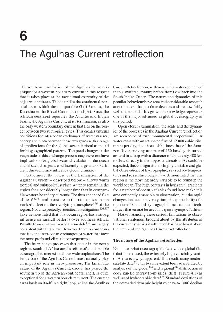
The distribution of higher-frequency eddy kineticenergy, i.e. with periods of days and weeks, also showan extreme south of Africa, but distributed in a zonaltongue, from the Agulhas retroflection eastwards310.This suggests a dynamical process with longer periodsconfined to the Agulhas retroflection region. Analysisof current meter records in the Agulhas retroflection bySchmitz and Luyten500 shows that the normalised fre-quency distributions of eddy kinetic energy in thisregion are comparatively depth-independent, peaked atthe mesoscale and are the most energetic found in theocean to date (Figure 6.1). This comparison includes theGulf Stream and Kuroshio systems. Records from
After the application of satellite remote sensing, the use ofsatellite telemetered, drifting buoys has probably contributedmost to the rapid increase in knowledge about the AgulhasCurrent system over the past two decades.
The deployment of drifters in the Agulhas Current waspioneered by Christo Stavropoulos of the CSIR (Council forScientific and Industrial Research) in Durban, South Africa,when a spar buoy with subsurface drogue was launched280 km south-east of Durban and tracked successfully by theFrench Eole satellite for 89 days in 1973411 (see Figure 7.2).A similar buoy was moored for 315 days on the Mozam-bique Plateau521 using the Nimbus VI satellite for position-ing and data relaying. With the assistance of the NationalAeronautical and Space Administration (NASA, USA) theCSIR subsequently constructed another nine buoys, placedin the Agulhas Current350,374 and followed over distances ofmore than 14 000 km. Having booked this substantial suc-cess, an additional eight buoys, from the CSIR, NOAA andthe National Centre of Atmospheric Research of the US,were then deployed from the South African Antarcticresearch vessel RSA to the south of Africa522. Apart fromgaining valuable new information on the Agulhas Currentsystem with these Lagrangian drifters that complementedexisting hydrographic concepts92,349, these experiments alsodemonstrated the longevity, robustness and positional accu-racy of these drifters, in particular in the extreme wave andweather conditions of the Southern Ocean.
This South African technical information was effectivelyused to persuade the international meteorological commu-nity and funding agencies that a major endeavour to coverthe ocean in the southern hemisphere with drifting meteoro-logical buoys, for a period of at least one year, was techni-cally feasible. It was hoped thus to provide a high-resolutionmeteorological data set that did not suffer from the largegaps in global coverage due to the small number of weatherstations, restricted to land, in the southern hemisphere523.
Using drifting buoys in the Agulhas CurrentThis experiment, the First Global GARP Experiment (FGGE,GARP: Global Atmospheric Research Programme), tookplace from October 1978 to July 1979 with 301 buoys beinglaunched524. Twenty-three South African buoys formed partof this international effort525. Since South Africa was consid-ered a political pariah at the time, South African participationwas not acknowledged in any official FGGE documents, theorigin of its buoys usually being designated as “Other”!
The use of the FGGE buoys in the Agulhas Currentregion has been scientifically very profitable. The role of theEast Madagascar Current80,308, topographic control on theAgulhas Current130 and the eddy kinetic energy over thewider system311,346 have all been addressed. Pioneering workin combining drifter tracks with contemporaneous satelliteimagery in the thermal infrared526 has established somewhatof a trend for subsequent investigations65,458.
The South African Weather Bureau has continued todeploy drifting weather buoys in the South Atlantic527 on anannual basis, but a substantial proportion of these have beenundrogued and are of less use for studying ocean currents.Some more sophisticated buoys have been deployed in theAgulhas Current itself366, but only on a limited, experimentalbasis.
The utility of drifters for studying the Agulhas Current iscontinuing. The possibility of placing subsurface floats tofollow specific water masses253–54 has been realised througha large international programme called KAPEX (Cape ofGood Hope Experiment) and has presented many importantnew results and concepts. The onset of Argo profilingfloats825 is revolutionising the manner in which deep hydro-graphic information is becoming available. By 2003 morethan 80 per cent of such data worldwide came from Argofloats and this percentage is bound to increase. This willmake an enormous difference to the study of the South WestIndian Ocean in future, but will probably not lessen the needfor dedicated research cruises.
153
current meter moorings in the Cape Basin and in theAgulhas Current retroflection in general give highervalues for the eddy kinetic energy, but with a similardepth distribution.
Sea surface temperatures
Variability in current behaviour can also be gauged fromshort-term variations in sea surface temperatures, par-
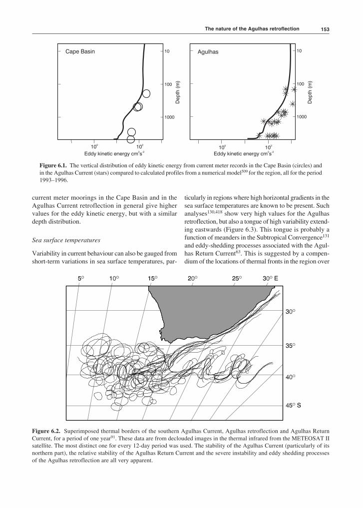
ticularly in regions where high horizontal gradients in thesea surface temperatures are known to be present. Suchanalyses130,418 show very high values for the Agulhasretroflection, but also a tongue of high variability extend-ing eastwards (Figure 6.3). This tongue is probably afunction of meanders in the Subtropical Convergence131
and eddy-shedding processes associated with the Agul-has Return Current63. This is suggested by a compen-dium of the locations of thermal fronts in the region over
Figure 6.1. The vertical distribution of eddy kinetic energy from current meter records in the Cape Basin (circles) andin the Agulhas Current (stars) compared to calculated profiles from a numerical model509 for the region, all for the period1993–1996.
Figure 6.2. Superimposed thermal borders of the southern Agulhas Current, Agulhas retroflection and Agulhas ReturnCurrent, for a period of one year91. These data are from declouded images in the thermal infrared from the METEOSAT IIsatellite. The most distinct one for every 12-day period was used. The stability of the Agulhas Current (particularly of itsnorthern part), the relative stability of the Agulhas Return Current and the severe instability and eddy shedding processesof the Agulhas retroflection are all very apparent.
The nature of the Agulhas retroflection
10
100
1000
Cape Basin
Dep
th(m
)
100
102
10
100
1000
Agulhas
Dep
th(m
)
Eddy kinetic energy cm s2 -2
Eddy kinetic energy cm s2 -2
100
102

The Agulhas Current retroflection154
10 Wº 0º 10º 20º 30º 40º 50º 60º 70º 80 Eº
10º
15º
20º
25º
30º
35º
40º
45º
50 Sº
a period of a full year (Figure 6.2). Eddies, and rings,are seen to be present predominantly around the retro-flection region while, downstream, movement in thelocation of the Subtropical Convergence is probablyresponsible for most variability there. General variabil-ity in sea surface temperatures presents instructive cir-cumstantial data but tells one little about the oceanprocesses responsible for the variability. Satellitealtimetry can potentially do this.
Preliminary analyses of altimetric data have sug-gested that the Agulhas retroflection is a region of veryhigh sea level variability305 with the presence of largevortices501. The first definitive study of global mesoscalevariability based on altimeter data from the SEASATsatellite, by Cheney et al.183, has confirmed all that hadbeen suggested before with perhaps less reliable data.Not only does the Agulhas Current retroflection repre-sent a large region of high mesoscale variability, in itscore the values are higher than anywhere else on theglobe. This is amply demonstrated in Figure 6.3.
Similar investigations using subsequent altimetricmeasurements by other satellites have substantiallyconfirmed these results501, although the area of highvariability and its intensity naturally differ slightlybetween different periods. At least one study269 has sug-gested that there is a seasonal cycle to the variability atthe Agulhas Retroflection and that this cycle extendsabout 30 per cent from the mean. It has a maximum inthe austral summer and a minimum during the australwinter, consistent with previous results that were based
on another satellite502. Based on only slightly more thanthree full years of data, these interesting results stillneed to be verified more robustly.
Modelling
Last but by no means least, global, eddy-resolvingcirculation models273,277 also successfully simulate thisregion of particularly high mesoscale variability. Whereeddy kinetic energy from the Geosat altimeter data ex-ceeds 1000 cm2/s2 in the Agulhas retroflection region,it has been found to be only larger than 500 cm2/s2 ina model503, although the present models do simulate thearea of higher variability adequately. Eddy kineticenergy has for instance been modelled762 with a fairdegree of success (Figure 6.1) in a primitive equationmodel with a 1/3° × 1/3° spatial resolution.
Modelling has also been used extensively in anattempt to understand why the Agulhas Current retro-flects and why it does so at this particular loca-tion469,580,583. It has been shown580 that the geographicdistribution of the wind stress curls is crucial to thebehaviour of the termination of the Agulhas Current.Since the line of zero wind stress curl lies well south ofthe poleward termination of the African continent, thecurrent is a free inertial jet beyond this point and in apurely barotropic model with realistic values for lateralfriction will move into the South Atlantic Ocean580.Otherwise, the increasing negative relative vorticity ofthe Agulhas Current overshoot will eventually lead to
Figure 6.3. Sea surface variability south of Africa for the period 1992–1998. The altimetric data were from the TOPEX/Poseidon satellite. High levels of variability associated with the Agulhas retroflection are particularly prominent. (Seealso Figure 3.14.)
0 9 18 27 36 45 cm

155
A review of the historical developmentof concepts on the circulation directlysouth of Africa14,285 shows that twoflow paradigms have been prominentsince the earliest times. The first holdsthat all of the Agulhas Current’s watersflows into the South Atlantic Ocean;the second the opposite, namely thatnone of it goes westward, but that all isreturned to the Indian Ocean. Over thepast 150 years these two concepts havebattled for supremacy.
It is instructive to note that a recur-vature of a major part of the AgulhasCurrent is inherent to the current por-trayal put forward by James Rennell asearly as 18327. Subsequent studies504
that made use of sea surface tempera-tures780 as well as ships’ drift, under-taken particularly in the Netherlands10,505 in the 1850s,strongly supported this concept. In fact, in some of theseDutch publications780 it is explicitly stated that the previousconcept of the Agulhas Current rounding the Cape of GoodHope and moving northward in the South Atlantic Ocean iswithout any doubt wrong. The major work on this subject byK.F.R. Andrau was subsequently seldom referred to directly,more-or-less lost to science, and portrayals of a bifurcationin the Agulhas Current – some water going east, some west– became more fashionable24,281,284 (Figure 3.1). The qual-ity, quantity and geographic distribution of the data availableat the time were such that both interpretations could logicallybe sustained simultaneously, even when combinations ofhydrographic data first allowed a portrayal of the wholewater column by Dietrich in 193540. Even he considered thecoastal upwelling system along the west coast of southern
Africa as representing an Atlantic branchof the Agulhas Current42. As late as 1972,Darbyshire506 still concluded, quite em-phatically, that no true return current ex-isted for the Agulhas for three of his foursurveys215.
A comprehensive, quasi-synoptic anddetailed set of cruises covering the fullAgulhas system92 was undertaken for thefirst time only in 1969. When the datafrom this project were being analysed byNils Bang90,444 in the early 1970s, he wasparticularly struck by the discontinuousnature of the flow, with a host of frontsand mesoscale features. Bang evidentlystruggled with the interpretation of thesedata, suggesting a number of alternativeexplanations for the current’s disposi-tion90. Searching for a suitably descrip-
tive term that would convey the impression of a dynamicflexing activity instead of a static, geometrically stableprocess, he came across the term “retroflect”, commonlyused to describe the turning back on itself of the mammaliangut14.
This excellent verbal portrayal of the flow regime, sug-gested by the new data, established a novel conceptualframework for all data gathered before and since. The catchydescriptive terminology aided the acceptance of the recur-vature concept by a wider community, particularly once itbecame clear that all succeeding information fitted it well.
The concept of the Agulhas’ retroflection, as well as thenew nomenclature, is now firmly entrenched, the termretroflection being widely employed in oceanography todescribe the behaviour of a number of other currents, suchas, for instance, the Brazil Current507,687.
Origin of the term and concept retroflection
Nils D. Bang
an eastward turning581 in both barotropic and baroclinicconfigurations. Retroflection can also be brought aboutby increasing the large horizontal friction582. Lesserhorizontal friction will lead to strongly variable flow.Some583 have tried to show that under certain circum-stances time-dependant phenomena, such as ring shed-ding, are essential to the existence of a retroflection. Tostudy the requirements for a steady retroflection regime,an investigation has been carried out778 by modifyingthe wind forcing, the bottom topography, the lateralfriction and the layer depth in a model with steadybarotropic flows. It has been found that steady retroflec-tion regimes can be created under a number of condi-tions, for instance with large friction or with dominantinertial effects when friction values are low. Instabili-ties in this barotropic steady flow741 may produce inter-monthly and inter-annual variability. Nevertheless, in
this barotropic model the frequency of ring formationis set by the physics of the large-scale instabilities andthe rectification processes due to these instabilitiesdecrease the degree of retroflection of the mean state.More about wind-driven and other modelling is to befound below under the rubric of the dynamics of theAgulhas retroflection.
Direct measurements
Although the nature of the variability in this retroflec-tion region, as well as its approximate geographicextent, may be estimated from the abovementioneddata, only few continuous measurements, such as cur-rent observations, have been made here to date. Onedeployment of current meter moorings, spaced over thefull southern Agulhas Current and Agulhas retroflection
The nature of the Agulhas retroflection

The Agulhas Current retroflection156
region508, has presented data that give some indicationsof the nature of the current variability. These resultsmay profitably be compared to those found in similarwestern boundary currents509 (Figure 6.4).
It shows that the kinetic energy distribution of thecurrents is very similar, so that in this respect theAgulhas Current is not exceptional. Differences inkinetic energy below 1000 m are mostly due to thedissimilar location of a current meter mooring relativeto the current system it was supposed to monitor.Differences between the western boundary currents areof the same order as the differences found between dif-ferent parts of the same current system (Figure 6.4).The spatial distribution of kinetic energy amongst thedifferent western boundary currents also is very simi-lar, peaking at the mesoscale509.
There is therefore abundant proof, from a number oftotally independent data sets, for the very high meso-scale variability of the Agulhas Current retroflection,implying some continuous process resulting in substan-tial changes in current structure and position of the mainflow elements.
Current predilection
The first description of the southern termination of theAgulhas Current that combined hydrographic data froma number of different deep-sea cruises has already beenpresented by Dietrich in 193540. It shows a substantialpart of the transport, but by no means all42, flowingback into the South Indian Ocean in a recurvature of thecurrent to the south-west of Cape Agulhas. An analy-
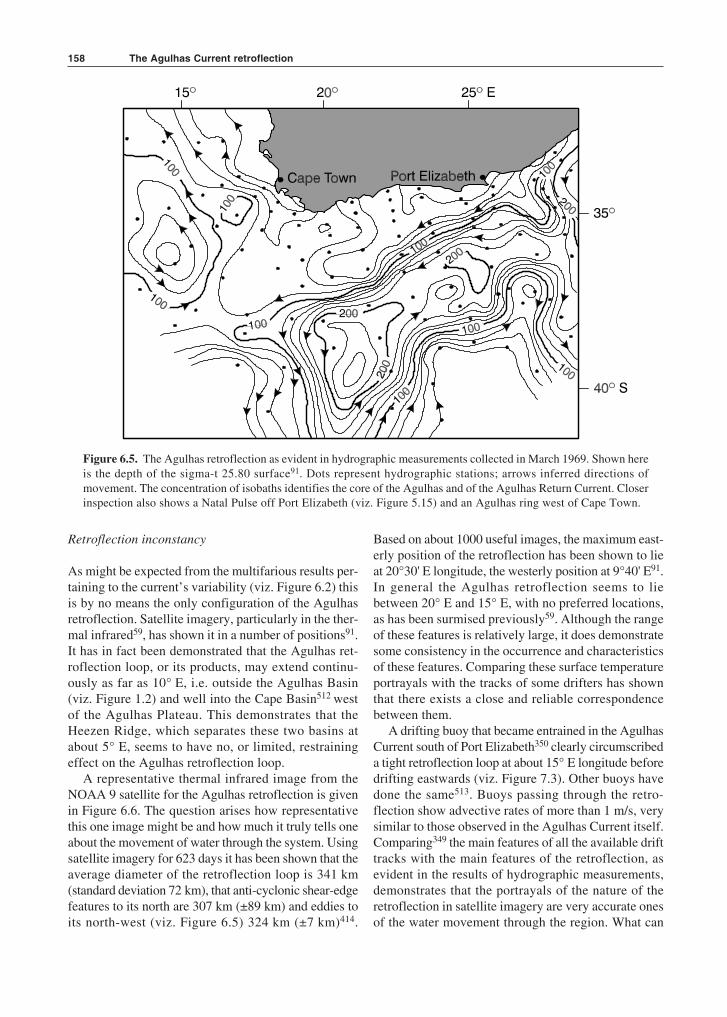
sis of widely spaced hydrographic stations in the regionin the early 1960s was the first to demonstrate un-equivocally the presence along the Subtropical Conver-gence of intense eddies511, and the analysis of thecombined data set collected for the International IndianOcean Expedition (see box) allowed for contouring thatalso showed some intense eddies here75. However, itwas only once a full oceanographic project, consistingof three simultaneous research cruises with closelyspaced stations over the full region, had been com-pleted that the true nature of the terminal region of thewestern-most extent of the Agulhas Current becameclear90,444 (Figure 6.5).
In Figure 6.5 the characteristic disposition of theAgulhas Current, based on these data, is demonstratedquite admirably. Having passed by the southern tip ofthe Agulhas Bank, at about 19° E, the current turnsabruptly south carrying its water as far as the 42° Sparallel before moving in a north-easterly direction.The neck of the retroflection proper was only about180 km wide. On this occasion the Agulhas Current,under the influence of a Natal Pulse, was even closer tothe Agulhas Return Current in the vicinity of Port Eliza-beth, but this is an unusual configuration. It is none-theless of considerable importance, since this closejuxtaposition of opposing currents may occasionallybring about an upstream retroflection here64,412. South-east of Cape Town (Figure 6.5) a large, anti-cycloniceddy is evident in the hydrographic data. The volumetransport in this feature relative to 1100 m has beenestimated92 to have been 15 × 106 m3/s, while that ofthe Agulhas Current itself was 40 × 106 m3/s.
200 600 1000 1400 1800
1
2
3
4
5
6
Dep
th(k
m)
Agulhas
Gulf Stream 3
Gulf Stream 2Agulhas
Gulf Stream 1Kuroshio
K (cm /s )E
2 2
Figure 6.4. The vertical distribution of the current kinetic energy for representative components of the Agulhas Currentretroflection509, a summary of the available data at 55° W longitude (east of the New England seamounts, GulfStream 1), a mooring located at 68° W (west of the New England seamounts, Gulf Stream 2), one placed at the NewEngland seamounts (Gulf Stream 3) and the Kuroshio510. The energy of the Agulhas Current is high, compared to theother western boundary currents, at all depths.
157
Studying the Agulhas system with large observational programmes
Progress in the understanding of the extended Agulhassystem has come about mainly in two ways: by localefforts with a limited geographical scale and by large,usually international, programmes on a much more ex-tensive scale. Investigations using the R.V. MeiringNaudé from the CSIR (Council for Scientific and Indus-trial Research, South Africa) in Durban317 formed a keycomponent of the former. This is described in an inset ofChapter 4. One of the most important international pro-grammes that stimulated oceanographic research in theregion for many years to come, was the InternationalIndian Ocean Expedition224 of the 1960s. Its effect isdescribed in an inset to Chapter 2. But there have been anumber of other sea-going programmes since that havehad a decisive influence on the development of ourunderstanding of this current system.
The ARC (Agulhas Retroflection Cruise) took placein 1983 from the US research vessel Knorr. Initiated byDr Arnold Gordon of the then Lamont-Doherty Geo-logical Observatory, it included a number of SouthAfrican and Dutch participants. It aimed at understand-
ing the inter-ocean exchangeof waters at the Agulhas ter-mination65 and consisted ofone of the most extensivecruises in this region up tothat time. Many of the resultsit achieved were seminal61,458.It was followed in 1987 by theSouth African SCARC787
(Subtropical Convergenceand Agulhas RetroflectionCruise) from the R.V. SAAgulhas. This multi-discipli-nary cruise was one of thefirst to use satellite remote
sensing to guide its sea-going programme456 and inves-tigated seven Agulhas rings and eddies. It successfullydocumented one of the most extensive leakages of Sub-antarctic water528 across the Subtropical Convergence.These single-cruise projects were followed by a numberof multi-cruise programmes.
The BEST (Benguela Sources and Transports) was acollaborative programme535 involving the Woods HoleOceanographic Institution, the National Oceanic andAtmospheric Administration of the US and the (then)South African Sea Fisheries Research Institute and tookplace from 1992 to 1993. Its prime aim was to establishthe flux of Agulhas water in the South East AtlanticOcean by the judicious combination of bottom mountedinstruments, hydrographic observations and satelliteremote sensing. It successfully established that most of
the flow in this region was due to Agulhas rings536 andnot the Benguela Current. The geographically largest andmost elaborate research programme in the Agulhas sys-tem to date has been the KAPEX (Cape of Good HopeExperiment)677,678,650 undertaken by a number ofGerman, US and South African organizations from 1997to 1999. It covered the Agulhas system from Durban onthe east coast of South Africa to beyond the Walvis Ridgein the South Atlantic Ocean. During the programme anumber of sound sources were placed in the region anda large number of RAFOS floats launched to pass throughthis international array. The results of this highly suc-cessful programme filled a special issue627 of the journalDeep-Sea Research II.
A subsequent multi-disciplinary, Dutch-SouthAfrican programme initi-ated by Professor Will deRuijter of Utrecht Univer-sity consisted of two obser-vational parts: the MARE(Mixing in Agulhas RingsExperiment)658 and theACSEX (Agulhas CurrentSources Experiment)650.The MARE was carried outover a period of one yearon three cruises at six-month intervals, starting in 1999.It aimed at studying the slow demise of one particularring over this period. The ACSEX was carried out dur-ing four cruises on the Dutch research vessel Pelagia inthe Mozambique Channel and in the region south ofMadagascar. It has shown that no coherent MozambiqueCurrent exists, but that the flow in the MozambiqueChannel is characterized by the regular formation ofeddies that subsequently drift poleward728. It has beencontinued by LOCO (Long Term Ocean Climate Obser-vations) in which a current mooring array continues tomonitor the flow through the narrows of the MozambiqueChannel.
In later years, the ACE (Agulhas Current Experi-ment)788 was funded by the UK to study the fluxes ofthe Agulhas Current by placing a number of currentmeter moorings across the current at Port Edward, offSouth Africa’s east coast. It has presented the mostaccurate estimate of this flux to date and in the processdiscovered an Agulhas undercurrent368. The ASTTEX(Agulhas–South Atlantic Thermohaline TransportExperiment) consists of a similar set of moorings in theSouth East Atlantic that builds on the results of BESTand will try to quantify the flux of Agulhas water in theCape Basin.
Arnold L. Gordon
Will P.M. de Ruijter
The nature of the Agulhas retroflection
The Agulhas Current retroflection158
Retroflection inconstancy
As might be expected from the multifarious results per-taining to the current’s variability (viz. Figure 6.2) thisis by no means the only configuration of the Agulhasretroflection. Satellite imagery, particularly in the ther-mal infrared59, has shown it in a number of positions91.It has in fact been demonstrated that the Agulhas ret-roflection loop, or its products, may extend continu-ously as far as 10° E, i.e. outside the Agulhas Basin(viz. Figure 1.2) and well into the Cape Basin512 westof the Agulhas Plateau. This demonstrates that theHeezen Ridge, which separates these two basins atabout 5° E, seems to have no, or limited, restrainingeffect on the Agulhas retroflection loop.
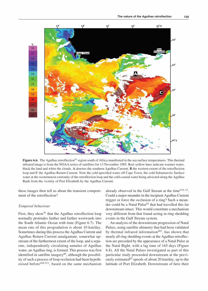
A representative thermal infrared image from theNOAA 9 satellite for the Agulhas retroflection is givenin Figure 6.6. The question arises how representativethis one image might be and how much it truly tells oneabout the movement of water through the system. Usingsatellite imagery for 623 days it has been shown that theaverage diameter of the retroflection loop is 341 km(standard deviation 72 km), that anti-cyclonic shear-edgefeatures to its north are 307 km (±89 km) and eddies toits north-west (viz. Figure 6.5) 324 km (±7 km)414.
Based on about 1000 useful images, the maximum east-erly position of the retroflection has been shown to lieat 20°30' E longitude, the westerly position at 9°40' E91.In general the Agulhas retroflection seems to liebetween 20° E and 15° E, with no preferred locations,as has been surmised previously59. Although the rangeof these features is relatively large, it does demonstratesome consistency in the occurrence and characteristicsof these features. Comparing these surface temperatureportrayals with the tracks of some drifters has shownthat there exists a close and reliable correspondencebetween them.
A drifting buoy that became entrained in the AgulhasCurrent south of Port Elizabeth350 clearly circumscribeda tight retroflection loop at about 15° E longitude beforedrifting eastwards (viz. Figure 7.3). Other buoys havedone the same513. Buoys passing through the retro-flection show advective rates of more than 1 m/s, verysimilar to those observed in the Agulhas Current itself.Comparing349 the main features of all the available drifttracks with the main features of the retroflection, asevident in the results of hydrographic measurements,demonstrates that the portrayals of the nature of theretroflection in satellite imagery are very accurate onesof the water movement through the region. What can
Figure 6.5. The Agulhas retroflection as evident in hydrographic measurements collected in March 1969. Shown hereis the depth of the sigma-t 25.80 surface91. Dots represent hydrographic stations; arrows inferred directions ofmovement. The concentration of isobaths identifies the core of the Agulhas and of the Agulhas Return Current. Closerinspection also shows a Natal Pulse off Port Elizabeth (viz. Figure 5.15) and an Agulhas ring west of Cape Town.
159
Figure 6.6. The Agulhas retroflection91 region south of Africa manifested in the sea surface temperatures. This thermalinfrared image is from the NOAA series of satellites for 13 November 1985. Red–yellow hues indicate warmer water,black the land and white the clouds. A denotes the southern Agulhas Current, B the western extent of the retroflectionloop and C the Agulhas Return Current. Note the cold upwelled water off Cape Town, the cold Subantarctic Surfacewater at the westernmost extremity of the retroflection loop and the cold coastal water being advected along the AgulhasBank from the vicinity of Port Elizabeth by the Agulhas Current.
these images then tell us about the transient comport-ment of the retroflection?
Temporal behaviour
First, they show91 that the Agulhas retroflection loopnormally protrudes farther and farther westwards intothe South Atlantic Ocean with time (Figure 6.7). Themean rate of this progradation is about 10 km/day.Sometimes during this process the Agulhas Current andAgulhas Return Current amalgamate, somewhat up-stream of the furthermost extent of the loop, and a sepa-rate, independently circulating annulus of Agulhaswater, an Agulhas ring, is formed. This process was firstidentified in satellite imagery60, although the possibil-ity of such a process of loop occlusion had been hypoth-esised before444,511, based on the same mechanism
already observed in the Gulf Stream at the time514–15.Could a major meander in the incipient Agulhas Currenttrigger or force the occlusion of a ring? Such a mean-der could be a Natal Pulse62 that had travelled this fardownstream intact. This would constitute a mechanismvery different from that found acting in ring sheddingevents in the Gulf Stream system.
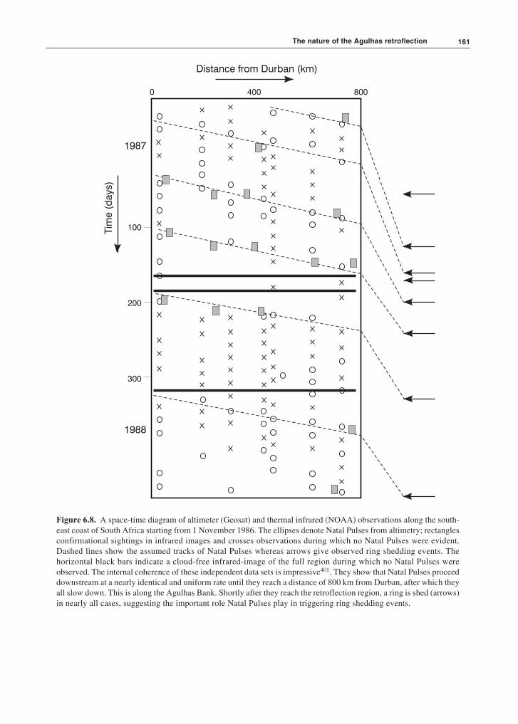
An analysis of the downstream progression of NatalPulses, using satellite altimetry that had been validatedby thermal infrared information401, has shown thatnearly all ring shedding events at the Agulhas retroflec-tion are preceded by the appearance of a Natal Pulse atthe Natal Bight, with a lag time of 165 days (Figure6.8). All the Natal Pulses investigated as part of thisparticular study proceeded downstream at the previ-ously estimated62 speeds of about 20 km/day, up to thelatitude of Port Elizabeth. Downstream of here their
The nature of the Agulhas retroflection

The Agulhas Current retroflection160
Figure 6.7. The zonal location of the westernmost limit of the Agulhas Current retroflection from thermal infrared im-agery from the METEOSAT satellite for 1978 and 197991. Peaks indicate the furthest extent of each progradation eventas the Agulhas retroflection loop has pushed into the South Atlantic Ocean. Dotted lines represent less reliable results.
progression slowed to about 5 km/day. This is indicatedby the increased slopes of their distance-made-goodlines in Figure 6.8 beyond a distance of 800 km fromDurban. On these Natal Pulses reaching the retroflec-tion region, a ring was shed in each case.
For this study, extending over more than a year, atleast one ring was formed without the intervention ofa Natal Pulse. It has therefore been assumed401,516 thatrings will form spontaneously when the retroflectionloop has been extended sufficiently, but that the inci-dence of a Natal Pulse will precipitate such an event.Thus ring shedding may be forced by the Natal Pulseitself or by it interacting with meanders on the AgulhasReturn Current401. Since the Natal Pulse itself may betriggered by eddies coming from elsewhere653 thismeans that the control for the frequency of ring shed-
ding may reside in other parts of the Indian Ocean. Ithas been shown that monsoonal winds in the IndianOcean create Kelvin waves that hit Indonesia, thenpropagates southward along the Indonesian coast andin turn trigger Rossby waves that propagate westwardacross the subtropics of the Indian Ocean. When theyreach Madagascar and the Mozambique Channel theygenerate eddies which in turn are responsible for theeventual shedding of Agulhas rings. Others652 haveshown that this whole process may be dependant onENSO cycles and the presence of the Indian Oceandipole. Inter-annual variability originating in climatemodes in the equatorial region of the Indian Ocean maytherefore affect the frequency of ring shedding at theAgulhas retroflection652.
161
Distance from Durban (km)
Tim
e(d
ays)
1987
1988
0 400 800
100
200
300
Figure 6.8. A space-time diagram of altimeter (Geosat) and thermal infrared (NOAA) observations along the south-east coast of South Africa starting from 1 November 1986. The ellipses denote Natal Pulses from altimetry; rectanglesconfirmational sightings in infrared images and crosses observations during which no Natal Pulses were evident.Dashed lines show the assumed tracks of Natal Pulses whereas arrows give observed ring shedding events. Thehorizontal black bars indicate a cloud-free infrared-image of the full region during which no Natal Pulses wereobserved. The internal coherence of these independent data sets is impressive401. They show that Natal Pulses proceeddownstream at a nearly identical and uniform rate until they reach a distance of 800 km from Durban, after which theyall slow down. This is along the Agulhas Bank. Shortly after they reach the retroflection region, a ring is shed (arrows)in nearly all cases, suggesting the important role Natal Pulses play in triggering ring shedding events.
The nature of the Agulhas retroflection

The Agulhas Current retroflection162
Spawning events
Normally, each of the progradation events of theAgulhas retroflection loop that terminates in the shed-ding of an Agulhas ring lasts about 40 days91. Withineach event, westward penetration of the retroflectionloop shows an increasing rate of progress until abruptring spawning occurs. This event duration may, how-ever, be quite variable. There seems to be no clearperiodicity and for long periods there may be no spawn-ing events at all517.
First results have suggested an annual production ofsix to nine rings. Other investigators have estimatedonly four to five ring shedding events per year74,464,518.Garzoli et al. have monitored the movement of Agulhasrings past a line of inverted echo-sounders placed along30° S latitude in the south-eastern Atlantic Ocean519
and have determined that a minimum of four to sixAgulhas rings per year entered this region during theperiod from 1992 to 1993520. In such an extremely vari-able system it would be highly unlikely that the fre-quency of shedding events would be identical for eachyear, although the probable average seems to be stable,about one every two months413. This may be com-pared755 to the shedding of rings from the southernBrazil Current that exhibits quasi-periodic ring forma-tion roughly every 150 days and the East AustralianCurrent with 130 days.
At least one of these events at the Agulhas retroflec-tion has been hydrographically observed and measuredat sea61. The newly formed ring essentially retains all
Figure 6.9. Northward penetration of cold Subantarctic Surface Water (blue-green) during the separation of an Agulhasring. These thermal data are from the NOAA 14 satellite and show the characteristic development of such an eventon 16 to 17 December 2000. A similar occurence may be seen in Figure 6.6.
the kinematic characteristics of its parental AgulhasCurrent, at least initially. It extends to the same depth,has the same velocity and temperature structure, butstarts cooling very rapidly at the sea surface262.
Accompanying flows
These ring-shedding events are accompanied by anumber of significant, secondary circulations. One ofthese is the equatorward penetration of a cold wedge ofSubantarctic Surface Water, between the newly formedring and the new retroflection loop (Figure 6.9). Thisseems to be an inherent part of the dynamics of the ring-shedding process. Usually the width of this throughflowremains relatively modest91 with the cold water spread-ing laterally only to the north of the gap between theretroflection loop and the newly spawned ring. How-ever, on occasion it has been observed to be wider than150 km512. Shannon et al.528 have described an event inwhich such cold water extended as far north as 33° Slatitude, a distance of 1000 km, and was observable atthe sea surface for a period of two months. This particu-lar intrusion covered an area of 734 × 103 km2, 5 stand-ard deviations greater than the mean area for suchintrusions established from an investigation extendingover nine years657.
On this occasion temperatures of the sea surfacewere below 17 °C here and salinities below 34.9, andthese anomalous water characteristics extended through-out the upper water column, suggesting that this repre-sents true advection of cold water and not only an out-

163
0
200
400
600
800
1 000
1 200
1 400
Dep
th(m
)
34.4
35.6
35.5
35.4
35.3
35.2
35.1
35.0
34.9
34.8
34.7
34.6
34.5
34.4
34.5
34.4
35.5
Stations15º 20º E
35º
40º S
20
17
16
20
18 19 20
191817
20
19
1819
19
2122
2324
1819202122
14 15
16
15
15
1
2
C
D
E
AB
34.6
Figure 6.10. An example in three dimensions of northward intru-sions of cold, Subantarctic water at the Agulhas retroflection duringOctober to December 1983657. The left-hand panel shows the surfaceisotherms with arrows indicating cold intrusions. The features iden-tified by letters are: A, the Agulhas Current retroflection; B, a newlyspawned Agulhas ring; C, an older Agulhas ring; D, a warm Agulhaseddy; and E, the Agulhas Return Current. Dots indicate hydrographicstations. The hydrographic section in the right-hand panel shows a vertical salinity section along line 2. This line isindicated in the left-hand panel. It intersects two Agulhas rings and the section shows the water with lower salinitybetween these as well as its low salinity surface expression (arrow). Lines on top of this panel show the location ofhydrographic stations.
30º
40º
50º S
40º E30º20º10º
Figure 6.11. The geographic orientation and lengthwise dimensions of Subantarctic water intrusions at the Agulhasretroflection for the period 1981–1990. This portrayal is based on thermal infrared observations from satellite657.
The nature of the Agulhas retroflection
The Agulhas Current retroflection164
cropping as suggested by some numerical529 models.Other studies657 have supported these conclusions anddemonstrated that these wedges of cold water foundbetween newly shed Agulhas rings and the Agulhasretroflection may extend deeper than 1500 m (Figure6.10). On this occasion two wedges were evident at thesame time. From the vertical sections across these fea-tures it is clear that these cold wedges are only weaksurface expressions of a much larger body at depth.
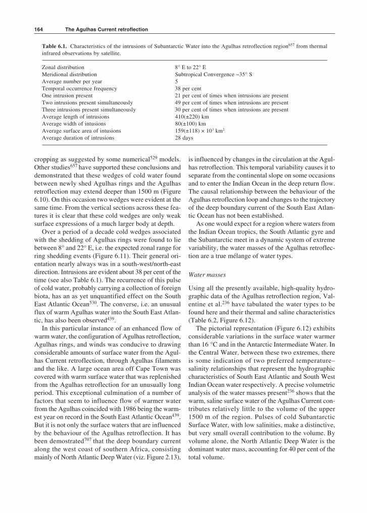
Over a period of a decade cold wedges associatedwith the shedding of Agulhas rings were found to liebetween 8° and 22° E, i.e. the expected zonal range forring shedding events (Figure 6.11). Their general ori-entation nearly always was in a south-west/north-eastdirection. Intrusions are evident about 38 per cent of thetime (see also Table 6.1). The recurrence of this pulseof cold water, probably carrying a collection of foreignbiota, has an as yet unquantified effect on the SouthEast Atlantic Ocean530. The converse, i.e. an unusualflux of warm Agulhas water into the South East Atlan-tic, has also been observed439.
In this particular instance of an enhanced flow ofwarm water, the configuration of Agulhas retroflection,Agulhas rings, and winds was conducive to drawingconsiderable amounts of surface water from the Agul-has Current retroflection, through Agulhas filamentsand the like. A large ocean area off Cape Town wascovered with warm surface water that was replenishedfrom the Agulhas retroflection for an unusually longperiod. This exceptional culmination of a number offactors that seem to influence flow of warmer waterfrom the Agulhas coincided with 1986 being the warm-est year on record in the South East Atlantic Ocean439.But it is not only the surface waters that are influencedby the behaviour of the Agulhas retroflection. It hasbeen demostrated707 that the deep boundary currentalong the west coast of southern Africa, consistingmainly of North Atlantic Deep Water (viz. Figure 2.13),
is influenced by changes in the circulation at the Agul-has retroflection. This temporal variability causes it toseparate from the continental slope on some occasionsand to enter the Indian Ocean in the deep return flow.The causal relationship between the behaviour of theAgulhas retroflection loop and changes to the trajectoryof the deep boundary current of the South East Atlan-tic Ocean has not been established.
As one would expect for a region where waters fromthe Indian Ocean tropics, the South Atlantic gyre andthe Subantarctic meet in a dynamic system of extremevariability, the water masses of the Agulhas retroflec-tion are a true mélange of water types.
Water masses
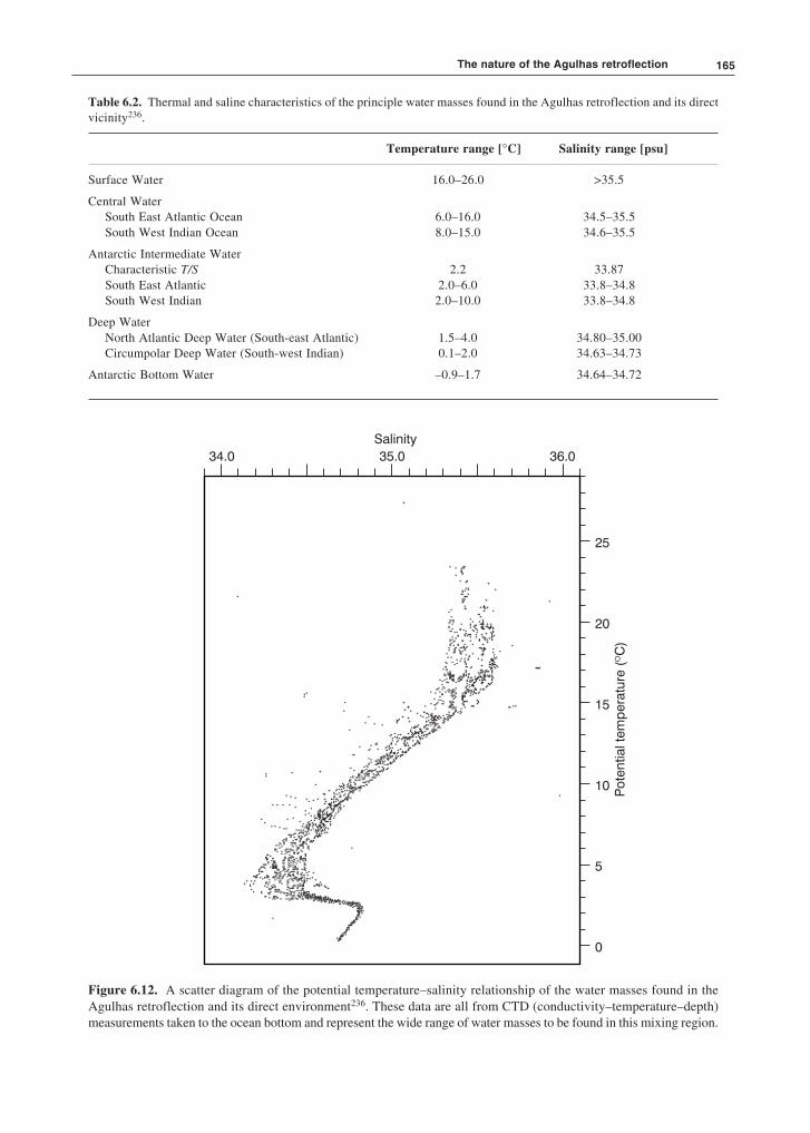
Using all the presently available, high-quality hydro-graphic data of the Agulhas retroflection region, Val-entine et al.236 have tabulated the water types to befound here and their thermal and saline characteristics(Table 6.2, Figure 6.12).
The pictorial representation (Figure 6.12) exhibitsconsiderable variations in the surface water warmerthan 16 °C and in the Antarctic Intermediate Water. Inthe Central Water, between these two extremes, thereis some indication of two preferred temperature–salinity relationships that represent the hydrographiccharacteristics of South East Atlantic and South WestIndian Ocean water respectively. A precise volumetricanalysis of the water masses present236 shows that thewarm, saline surface water of the Agulhas Current con-tributes relatively little to the volume of the upper1500 m of the region. Pulses of cold SubantarcticSurface Water, with low salinities, make a distinctive,but very small overall contribution to the volume. Byvolume alone, the North Atlantic Deep Water is thedominant water mass, accounting for 40 per cent of thetotal volume.
Table 6.1. Characteristics of the intrusions of Subantarctic Water into the Agulhas retroflection region657 from thermalinfrared observations by satellite.
Zonal distribution 8° E to 22° EMeridional distribution Subtropical Convergence ~35° SAverage number per year 5Temporal occurrence frequency 38 per centOne intrusion present 21 per cent of times when intrusions are presentTwo intrusions present simultaneously 49 per cent of times when intrusions are presentThree intrusions present simultaneously 30 per cent of times when intrusions are presentAverage length of intrusions 410(±220) kmAverage width of intusions 80(±100) kmAverage surface area of intusions 159(±118) × 103 km2
Average duration of intrusions 28 days
165
Table 6.2. Thermal and saline characteristics of the principle water masses found in the Agulhas retroflection and its directvicinity236.
Temperature range [°C] Salinity range [psu]
Surface Water 16.0–26.0 >35.5
Central WaterSouth East Atlantic Ocean 6.0–16.0 34.5–35.5South West Indian Ocean 8.0–15.0 34.6–35.5
Antarctic Intermediate WaterCharacteristic T/S 2.2 33.87South East Atlantic 2.0–6.0 33.8–34.8South West Indian 2.0–10.0 33.8–34.8
Deep WaterNorth Atlantic Deep Water (South-east Atlantic) 1.5–4.0 34.80–35.00Circumpolar Deep Water (South-west Indian) 0.1–2.0 34.63–34.73
Antarctic Bottom Water –0.9–1.7 34.64–34.72
Salinity
34.0 35.0 36.0
25
20
15
10
5
0
Po
ten
tialte
mp
era
ture
(C
)º
Figure 6.12. A scatter diagram of the potential temperature–salinity relationship of the water masses found in theAgulhas retroflection and its direct environment236. These data are all from CTD (conductivity–temperature–depth)measurements taken to the ocean bottom and represent the wide range of water masses to be found in this mixing region.
The nature of the Agulhas retroflection
The Agulhas Current retroflection166
Oxygen (ml/l)
0 1.0 2.0 3.0 4.0 5.0 6.0 7.0 8.0 9.0
28
24
20
16
12
8
4
0
Po
ten
tialte
mp
era
ture
(C
)º
Surface
WaterTropical
Thermocline
Water
SAMW
SIC
W
Red Sea
Water
UCDW NADW
AAIW
LCDW
AABW
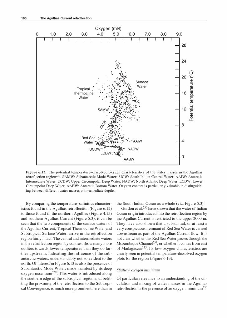
Figure 6.13. The potential temperature–dissolved oxygen characteristics of the water masses in the Agulhasretroflection region230. SAMW: Subantarctic Mode Water; SICW: South Indian Central Water; AAIW: AntarcticIntermediate Water; UCDW: Upper Circumpolar Deep Water; NADW: North Atlantic Deep Water; LCDW: LowerCircumpolar Deep Water; AABW: Antarctic Bottom Water. Oxygen content is particularly valuable in distinguish-ing between different water masses at intermediate depths.
By comparing the temperature–salinities character-istics found in the Agulhas retroflection (Figure 6.12)to those found in the northern Agulhas (Figure 4.15)and southern Agulhas Current (Figure 5.3), it can beseen that the two components of the surface waters ofthe Agulhas Current, Tropical Thermocline Water andSubtropical Surface Water, arrive in the retroflectionregion fairly intact. The central and intermediate watersin the retroflection region by contrast show many moreoutliers towards lower temperatures than they do far-ther upstream, indicating the influence of the sub-antarctic waters, understandably not so evident to thenorth. Of interest in Figure 6.13 is also the presence ofSubantarctic Mode Water, made manifest by its deepoxygen maximum258. This water is introduced alongthe southern edge of the subtropical region and, befit-ting the proximity of the retroflection to the Subtropi-cal Convergence, is much more prominent here than in
the South Indian Ocean as a whole (viz. Figure 5.3).Gordon et al.230 have shown that the water of Indian
Ocean origin introduced into the retroflection region bythe Agulhas Current is restricted to the upper 2000 m.They have also shown that a substantial, or at least avery conspicuous, remnant of Red Sea Water is carrieddownstream as part of the Agulhas Current flow. It isnot clear whether this Red Sea Water passes through theMozambique Channel234, or whether it comes from eastof Madagascar235. Its low-oxygen characteristics areclearly seen in potential temperature–dissolved oxygenplots for the region (Figure 6.13).
Shallow oxygen minimum
Of particular relevance to an understanding of the cir-culation and mixing of water masses in the Agulhasretroflection is the presence of an oxygen minimum230
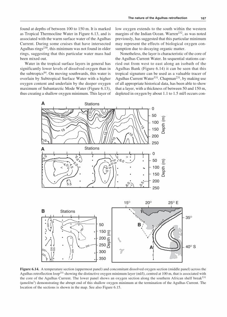
167
found at depths of between 100 to 150 m. It is markedas Tropical Thermocline Water in Figure 6.13, and isassociated with the warm surface water of the AgulhasCurrent. During some cruises that have intersectedAgulhas rings230, this minimum was not found in olderrings, suggesting that this particular water mass hadbeen mixed out.
Water in the tropical surface layers in general hassignificantly lower levels of dissolved oxygen than inthe subtropics84. On moving southwards, this water isoverlain by Subtropical Surface Water with a higheroxygen content and underlain by the deeper oxygenmaximum of Subantarctic Mode Water (Figure 6.13),thus creating a shallow oxygen minimum. This layer of
Stations
Stations
0
50
100
150
200
250
0
50
100
150
200
250
Dep
th(m
)
Dep
th(m
)
Dep
th(m
)
A
A
B Stations
50
150
200
250
300
350
5.5
5.04.54.0
5.5
5.5 5
.04.54
.0
6.0
6.0
5.5
5.5
20
15
10
10
15
15
1020
<
>
>
A
B
15º 20º 25 Eº
35º
40 Sº
225
220
180
200
22
522
52
20
220
Figure 6.14. A temperature section (uppermost panel) and concomitant dissolved oxygen section (middle panel) across theAgulhas retroflection loop231 showing the distinctive oxygen minimum layer (ml/l), centred at 100 m, that is associated withthe core of the Agulhas Current. The lower panel shows an oxygen section along the southern African shelf break531
(µmol/m3) demonstrating the abrupt end of this shallow oxygen minimum at the termination of the Agulhas Current. Thelocation of the sections is shown in the map. See also Figure 6.15.
low oxygen extends to the south within the westernmargins of the Indian Ocean. Warren232, as was notedpreviously, has suggested that this particular minimummay represent the effects of biological oxygen con-sumption due to decaying organic matter.
Nonetheless, the layer is characteristic of the core ofthe Agulhas Current Water. In sequential stations car-ried out from west to east along an isobath of theAgulhas Bank (Figure 6.14) it can be seen that thistropical signature can be used as a valuable tracer ofAgulhas Current Water531. Chapman231, by making useof all appropriate historical data, has been able to showthat a layer, with a thickness of between 50 and 150 m,depleted in oxygen by about 1.1 to 1.5 ml/l occurs con-
The nature of the Agulhas retroflection
The Agulhas Current retroflection168
sistently at the edge of the Agulhas Current, also alongits retroflection loop. It is so characteristic of AgulhasCurrent water that it may be used to trace water fromthe Agulhas Current retroflection as far north as 32° Sand 10° E in the South Atlantic Ocean231.
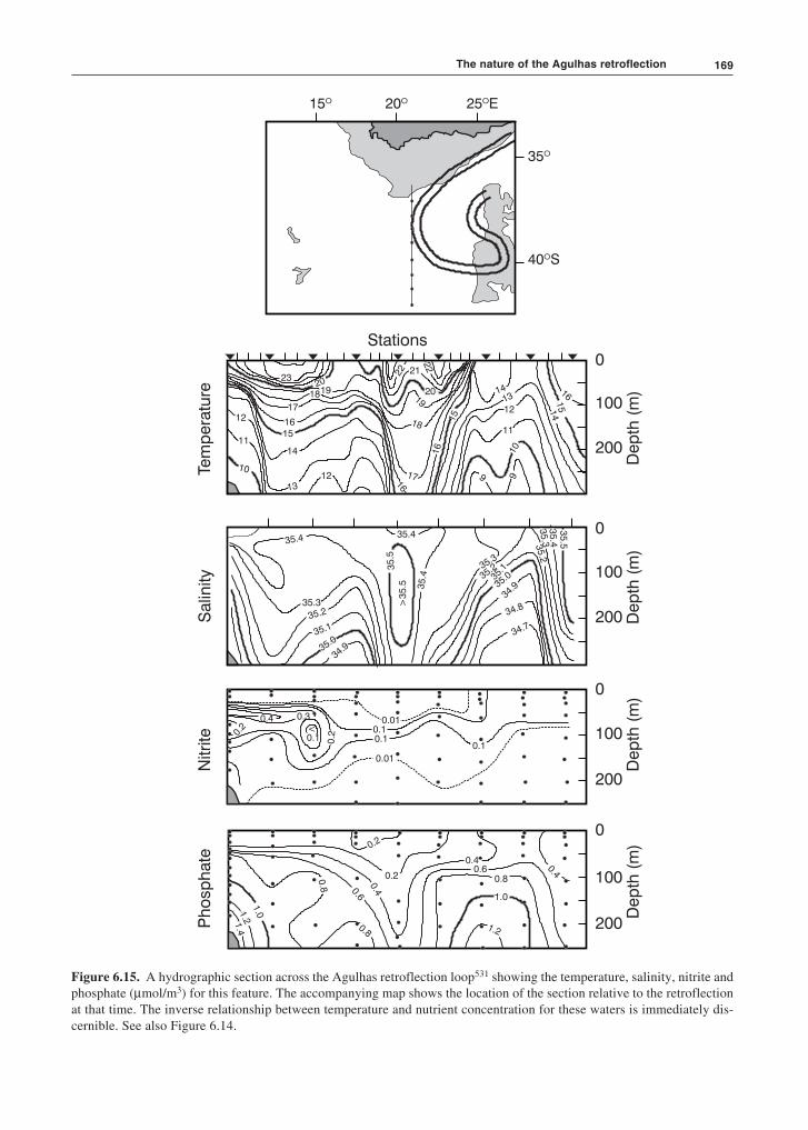
Agulhas retroflection nutrients
A hydrographic section across the Agulhas retroflectionloop (Figure 6.15) demonstrates that in this region thenutrient concentrations are usually inversely related totemperature. The lowest levels of phosphate and nitrateare thus seen to be associated with the outer rims of theloop, representing the Agulhas Current and the AgulhasReturn Current. All kinematic products of the Agulhasretroflection, such as Agulhas rings, eddies and fila-ments, carry this signature with them. At the Subtropi-cal Convergence the concentrations of these nutrientsare much higher (Figure 6.15), Subantarctic SurfaceWater being characteristically higher in all nutrientsexcept silicate. The outer edges of the Agulhas Bank arealso shown to have higher levels of nutrient concentra-tions, probably as the result of the inshore upwellingbetween the Agulhas Current and the shelf slope (viz.Figures 5.2, 5.4, 5.9).
Water mass modifications
An inspection of precise temperature and salinity datafrom the Agulhas Current retroflection (e.g. Figure6.12) show a number of significant outliers. Outliers inthe low-salinity direction are for the greater part due tothe effect of water from south of the Subtropical Con-vergence or from the South East Atlantic Ocean. Sub-antarctic water may make its presence felt by mixingprocesses along the lower limb of the Agulhas retroflec-tion loop, i.e. along the confluence of the AgulhasReturn Current and the Subtropical Convergence. Itsmajor influence on the temperature–salinity character-istics of the region is probably a result of the spasmodicoccurrence of wedges of subantarctic water movingnorthward into the region when an Agulhas ring isspawned (Figure 6.9). Within the thermocline of theAgulhas retroflection this subantarctic influence in-creases with depth230.
Since the high, and seasonally persistent, heat fluxesfrom the ocean to the atmosphere are well known forthis region121,147, the possibility exists that thermohalinealterations to water above the thermocline would beevident in the water masses found here. This is indeedthe case. Gordon et al.230, using a quasi-synoptic, high-quality hydrographic data set, have found that upperthermocline water in the Agulhas retroflection, upon
exposure to the colder overlying atmosphere, formswater that is anomalously salty to that of the AgulhasCurrent proper. Such modified water is found predomi-nantly as thermostads within the Agulhas retroflectionloop, but also in Agulhas rings230. Modifications ofwater masses in this region are particularly importantfor a number of reasons.
There is evidence that the Agulhas retroflection is asource region for Subtropical Mode Waters in thepotential temperature range 17.4 °C to 17.8 °C382 forthe South Indian Ocean and, in a more modified form,for the South Atlantic. This exceptionally cold Sub-tropical Mode Water is found extensively in the east-ern South Atlantic. The convective changes that bringabout these modifications have been considered to behighly episodic, while there may be longer periodswhere the active mixing is restricted to a near-surface,wind-mixed layer382. Nevertheless, the water that hasbeen cooled in the Agulhas retroflection is believed tobe principally responsible for cooling the near-surfacelayers in the Indian Ocean and for ventilating thermo-cline and intermediate waters of the South West IndianOcean532. Although it is considered difficult to usewater mass indicators to trace water of South Indianorigin in the South Atlantic, it appears possible thatwater altered at the Agulhas retroflection may play adetermining role in the nature of the South Atlanticthermocline.
Fluxes in the Agulhas retroflection
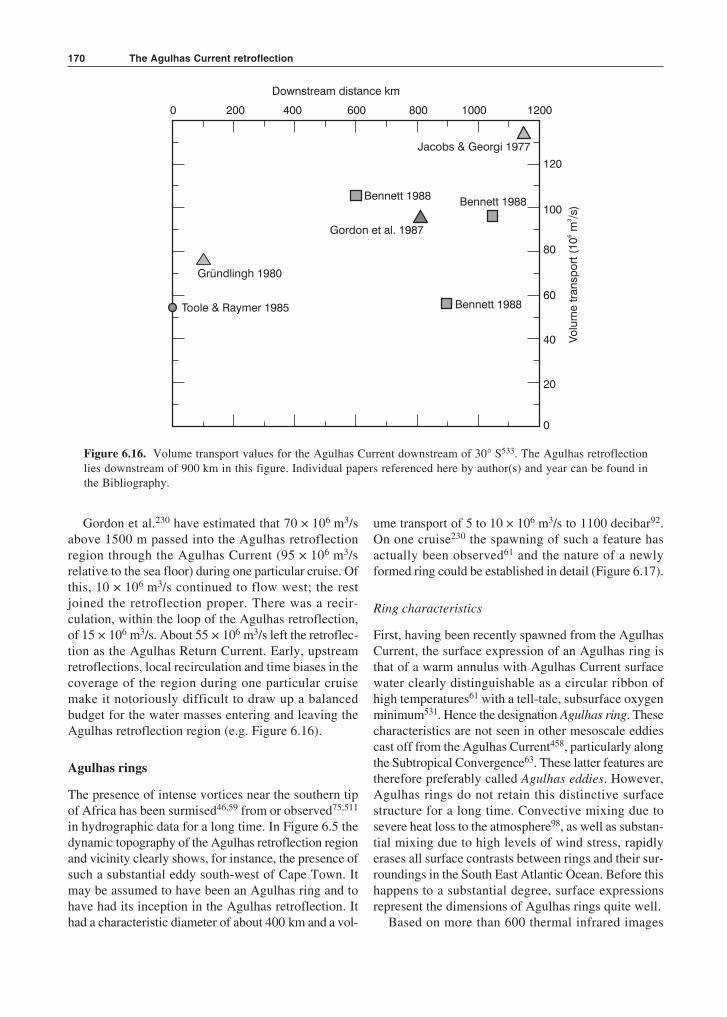
The transport values of the Agulhas Current areknown to increase downstream (Figure 6.16), but therates of increase that have been estimated to datediffer markedly, between 2.7 × 10⁶ m3/s per 100 km380
to 6 × 10⁶ m3/s per 100 km230. Calculations of what thisvolume transport increase should be, based on the zon-ally integrated interior transport of the South IndianOcean, driven by the known wind-stress curl, liebetween 9 × 10⁶ m3/s per 100 km at 25° S to zero at37° S534. With the adjustment of the wind stress valuesto more accurate ones, estimates of the volume flux ofthe Agulhas Current, based on the wind stress, at 37° Shave been adjusted downward from 72 × 106 m3/s534 toabout 55 × 106 m3/s187. This reduces the downstreamincrease to 2 × 10⁶ m3/s per 100 km. The observed fluxvalues as well as rates of downstream change are far inexcess of those predicted by purely linear, thermohalineand wind-driven dynamics533. This has to date not beenadequately explained.
The fluxes within the Agulhas retroflection itselfhave been calculated based on the hydrographic datacollected during only a few suitable cruises.
169
15º 20º 25 Eº
35º
40 Sº
Stations
Tem
pera
ture
Salin
ity
Nitri
teP
ho
sp
hate
0
100
200
0
100
200
0
100
200
0
100
200
Dep
th(m
)D
ep
th(m
)D
ep
th(m
)D
ep
th(m
)
23
191820
17
1615
14
13
12
11
1012
20
212219
18
17
16
16
15
1413
12
11
1099
14
15
16
22
>3
5.5
35.435.4
35.5
35.3
35.2
35.1
35.0
35.4
35.3
35.2
35.1
35.0
34.9
34.9
34.8
34.7
35.2
35.3
35.4
35
.5
<0.01
0.10.1
0.1
0.01
0.1
0.3
0.20.
2
0.4
0.2
0.40.6
0.8
0.8
1.01
.21.4
0.40.6
0.8
1.0
1.2
0.4
0.2
Figure 6.15. A hydrographic section across the Agulhas retroflection loop531 showing the temperature, salinity, nitrite andphosphate (µmol/m3) for this feature. The accompanying map shows the location of the section relative to the retroflectionat that time. The inverse relationship between temperature and nutrient concentration for these waters is immediately dis-cernible. See also Figure 6.14.
The nature of the Agulhas retroflection
The Agulhas Current retroflection170
Figure 6.16. Volume transport values for the Agulhas Current downstream of 30° S533. The Agulhas retroflectionlies downstream of 900 km in this figure. Individual papers referenced here by author(s) and year can be found inthe Bibliography.
Gordon et al.230 have estimated that 70 × 106 m3/sabove 1500 m passed into the Agulhas retroflectionregion through the Agulhas Current (95 × 106 m3/srelative to the sea floor) during one particular cruise. Ofthis, 10 × 106 m3/s continued to flow west; the restjoined the retroflection proper. There was a recir-culation, within the loop of the Agulhas retroflection,of 15 × 106 m3/s. About 55 × 106 m3/s left the retroflec-tion as the Agulhas Return Current. Early, upstreamretroflections, local recirculation and time biases in thecoverage of the region during one particular cruisemake it notoriously difficult to draw up a balancedbudget for the water masses entering and leaving theAgulhas retroflection region (e.g. Figure 6.16).
Agulhas rings
The presence of intense vortices near the southern tipof Africa has been surmised46,59 from or observed75,511
in hydrographic data for a long time. In Figure 6.5 thedynamic topography of the Agulhas retroflection regionand vicinity clearly shows, for instance, the presence ofsuch a substantial eddy south-west of Cape Town. Itmay be assumed to have been an Agulhas ring and tohave had its inception in the Agulhas retroflection. Ithad a characteristic diameter of about 400 km and a vol-
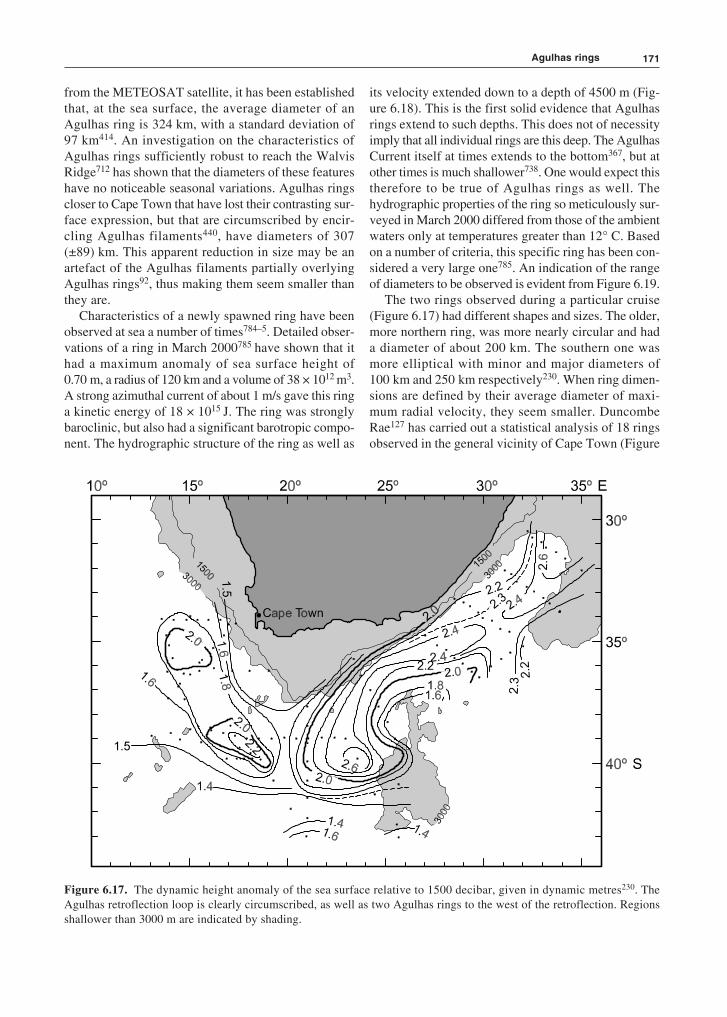
ume transport of 5 to 10 × 106 m3/s to 1100 decibar92.On one cruise230 the spawning of such a feature hasactually been observed61 and the nature of a newlyformed ring could be established in detail (Figure 6.17).
Ring characteristics
First, having been recently spawned from the AgulhasCurrent, the surface expression of an Agulhas ring isthat of a warm annulus with Agulhas Current surfacewater clearly distinguishable as a circular ribbon ofhigh temperatures61 with a tell-tale, subsurface oxygenminimum531. Hence the designation Agulhas ring. Thesecharacteristics are not seen in other mesoscale eddiescast off from the Agulhas Current458, particularly alongthe Subtropical Convergence63. These latter features aretherefore preferably called Agulhas eddies. However,Agulhas rings do not retain this distinctive surfacestructure for a long time. Convective mixing due tosevere heat loss to the atmosphere98, as well as substan-tial mixing due to high levels of wind stress, rapidlyerases all surface contrasts between rings and their sur-roundings in the South East Atlantic Ocean. Before thishappens to a substantial degree, surface expressionsrepresent the dimensions of Agulhas rings quite well.
Based on more than 600 thermal infrared images
120
100
80
60
40
20
0
200 400 600 800 1000 12000
Downstream distance km
Gründlingh 1980
Toole & Raymer 1985
Jacobs & Georgi 1977
Bennett 1988
Bennett 1988
Bennett 1988
Gordon et al. 1987
171
from the METEOSAT satellite, it has been establishedthat, at the sea surface, the average diameter of anAgulhas ring is 324 km, with a standard deviation of97 km414. An investigation on the characteristics ofAgulhas rings sufficiently robust to reach the WalvisRidge712 has shown that the diameters of these featureshave no noticeable seasonal variations. Agulhas ringscloser to Cape Town that have lost their contrasting sur-face expression, but that are circumscribed by encir-cling Agulhas filaments440, have diameters of 307(±89) km. This apparent reduction in size may be anartefact of the Agulhas filaments partially overlyingAgulhas rings92, thus making them seem smaller thanthey are.
Characteristics of a newly spawned ring have beenobserved at sea a number of times784–5. Detailed obser-vations of a ring in March 2000785 have shown that ithad a maximum anomaly of sea surface height of0.70 m, a radius of 120 km and a volume of 38 × 1012 m3.A strong azimuthal current of about 1 m/s gave this ringa kinetic energy of 18 × 1015 J. The ring was stronglybaroclinic, but also had a significant barotropic compo-nent. The hydrographic structure of the ring as well as
its velocity extended down to a depth of 4500 m (Fig-ure 6.18). This is the first solid evidence that Agulhasrings extend to such depths. This does not of necessityimply that all individual rings are this deep. The AgulhasCurrent itself at times extends to the bottom367, but atother times is much shallower738. One would expect thistherefore to be true of Agulhas rings as well. Thehydrographic properties of the ring so meticulously sur-veyed in March 2000 differed from those of the ambientwaters only at temperatures greater than 12° C. Basedon a number of criteria, this specific ring has been con-sidered a very large one785. An indication of the rangeof diameters to be observed is evident from Figure 6.19.
The two rings observed during a particular cruise(Figure 6.17) had different shapes and sizes. The older,more northern ring, was more nearly circular and hada diameter of about 200 km. The southern one wasmore elliptical with minor and major diameters of100 km and 250 km respectively230. When ring dimen-sions are defined by their average diameter of maxi-mum radial velocity, they seem smaller. DuncombeRae127 has carried out a statistical analysis of 18 ringsobserved in the general vicinity of Cape Town (Figure
Figure 6.17. The dynamic height anomaly of the sea surface relative to 1500 decibar, given in dynamic metres230. TheAgulhas retroflection loop is clearly circumscribed, as well as two Agulhas rings to the west of the retroflection. Regionsshallower than 3000 m are indicated by shading.
Agulhas rings

The Agulhas Current retroflection172
0
500
1 000
1 500
2 000
2 500
3 000
3 500
4 000
4 500
5 000
Stations
0 50 100 150 200 250 300
Distance km
Dep
th(m
)0.1
0.70.6
0.5
0.4
0.3
0.1
0.2 0.2
0.1
0.0
0.0
0.1
0.1
-0.1
0.0 -0
.1 -0.2
0.0 -0
.1
-0.2 -0
.3
-0.4
-0.5 -0.6 -0
.7-0
.8 -0.9-1.0
SE NW
Figure 6.18. The full velocity structure of a relatively young Agulhas ring in the Cape Basin785. The speeds are in m/s.The shaded region indicates movement to the north-east. Speeds of slightly less than 0.1 m/s were found right down to thesea floor on this occasion.
173
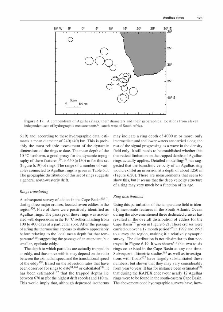
6.19) and, according to these hydrographic data, esti-mates a mean diameter of 240(±40) km. This is prob-ably the most reliable assessment of the dynamicdimensions of the rings to date. The mean depth of the10 °C isotherm, a good proxy for the dynamic topog-raphy of these features129, is 650 (±130) m for this set(Figure 6.19) of rings. The range of a number of vari-ables connected to Agulhas rings is given in Table 6.3.The geographic distribution of this set of rings suggestsa general north-westerly drift.
Rings translating
A subsequent survey of eddies in the Cape Basin535–7,during three major cruises, located seven eddies in theregion520. Five of these were positively identified asAgulhas rings. The passage of these rings was associ-ated with depressions in the 10 °C isotherm lasting from100 to 400 days at a particular spot. After the passageof a ring the thermocline appears to shallow appreciablybefore relaxing to the local mean depth for that tem-perature520, suggesting the passage of an attendant, butsmaller, cyclonic eddy.
The depth to which particles are actually trapped inan eddy, and thus move with it, may depend on the ratiobetween the azimuthal speed and the translational speedof the eddy538. Based on the advection rates that havebeen observed for rings to date94,464 or calculated539, ithas been estimated127 that the trapped depths liebetween 670 m (for the highest drift speeds) and 110 m.This would imply that, although depressed isotherms
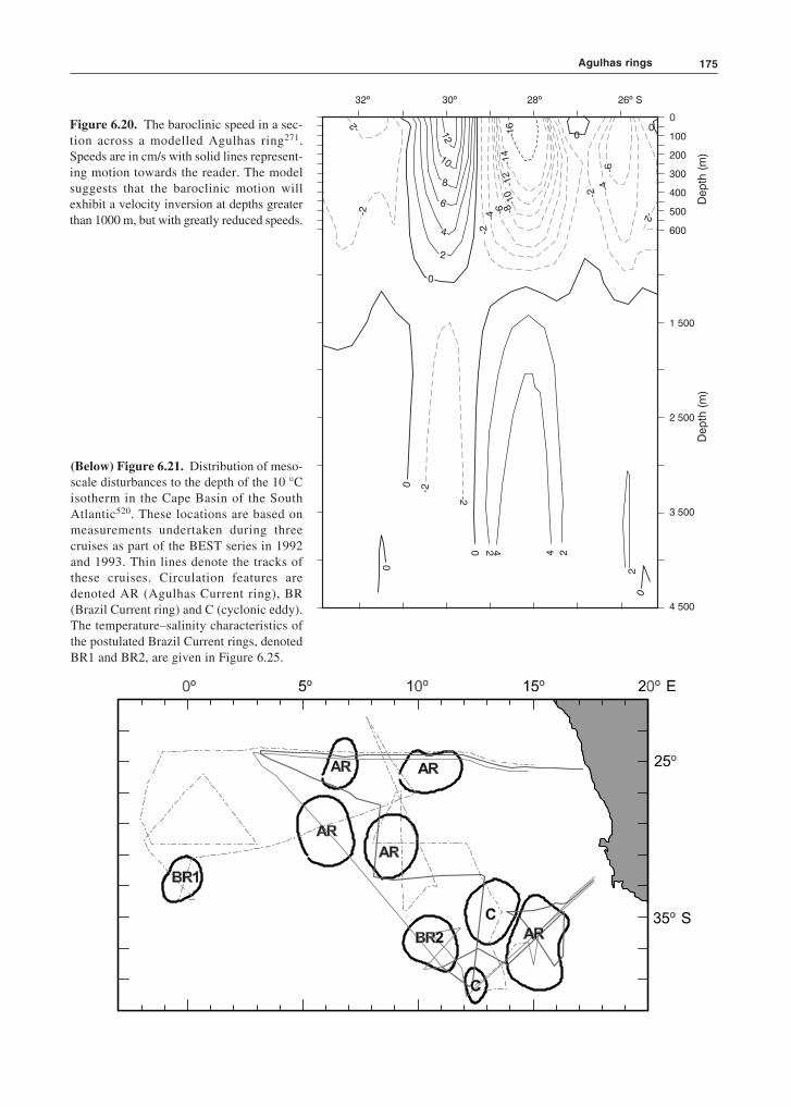
may indicate a ring depth of 4000 m or more, onlyintermediate and shallower waters are carried along, therest of the signal progressing as a wave in the densityfield only. It still needs to be established whether thistheoretical limitation on the trapped depths of Agulhasrings actually applies. Detailed modelling271 has sug-gested that the baroclinic velocity of an Agulhas ringwould exhibit an inversion at a depth of about 1250 m(Figure 6.20). There are measurements that seem toshow this, but it seems that the deep velocity structureof a ring may very much be a function of its age.
Ring distributions
Using this perturbation of the temperature field to iden-tify mesoscale features in the South Atlantic Oceanduring the abovementioned three dedicated cruises hasresulted in the overall distribution of eddies for theCape Basin520 given in Figure 6.21. These cruises werecarried out over a 17 month period535 in 1992 and 1993to survey the region, making it a relatively synopticsurvey. The distribution is not dissimilar to that por-trayed in Figure 6.19. It was shown517 that two to sixrings co-existed in the Cape Basin at any one time.Subsequent altimetric studies465 as well as investiga-tions with floats627 have largely substantiated thesenumbers, but shown that they may vary considerablyfrom year to year. It has for instance been estimated628
that during the KAPEX endeavour nearly 12 Agulhasrings were to be found in the south-eastern Cape Basin.The abovementioned hydrographic surveys have, how-
Figure 6.19. A compendium of Agulhas rings, their diameters and their geographical locations from elevenindependent sets of hydrographic measurements127 south-west of South Africa.
Agulhas rings
The Agulhas Current retroflection174
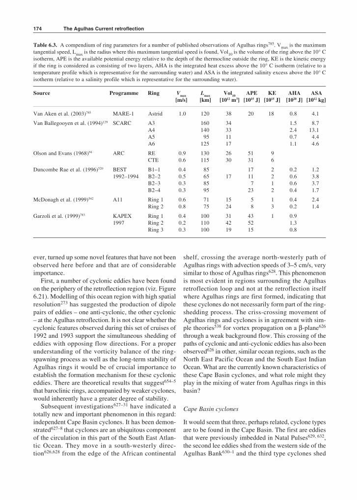
Table 6.3. A compendium of ring parameters for a number of published observations of Agulhas rings785. Vmax is the maximumtangential speed, Lmax is the radius where this maximum tangential speed is found, Vol10 is the volume of the ring above the 10° Cisotherm, APE is the available potential energy relative to the depth of the thermocline outside the ring, KE is the kinetic energyif the ring is considered as consisting of two layers, AHA is the integrated heat excess above the 10° C isotherm (relative to atemperature profile which is representative for the surrounding water) and ASA is the integrated salinity excess above the 10° Cisotherm (relative to a salinity profile which is representative for the surrounding water).
Source Programme Ring Vmax Lmax Vol10 APE KE AHA ASA[m/s] [km] [1012 m3] [1015 J] [1015 J] [1020 J] [1012 kg]
Van Aken et al. (2003)785 MARE-1 Astrid 1.0 120 38 20 18 0.8 4.1
Van Ballegooyen et al. (1994)129 SCARC A3 160 34 1.5 8.7A4 140 33 2.4 13.1A5 95 11 0.7 4.4A6 125 17 1.1 4.6
Olson and Evans (1968)94 ARC RE 0.9 130 26 51 9CTE 0.6 115 30 31 6
Duncombe Rae et al. (1996)520 BEST B1–1 0.4 85 17 2 0.2 1.21992–1994 B2–2 0.5 65 17 11 2 0.6 3.8
B2–3 0.3 85 7 1 0.6 3.7B2–4 0.3 95 23 2 0.4 1.7
McDonagh et al. (1999)542 A11 Ring 1 0.6 71 15 5 1 0.4 2.4Ring 2 0.8 75 24 8 3 0.2 1.4
Garzoli et al. (1999)783 KAPEX Ring 1 0.4 100 31 43 1 0.91997 Ring 2 0.2 110 42 52 1.3
Ring 3 0.3 100 19 15 0.8
ever, turned up some novel features that have not beenobserved here before and that are of considerableimportance.
First, a number of cyclonic eddies have been foundon the periphery of the retroflection region (viz. Figure6.21). Modelling of this ocean region with high spatialresolution273 has suggested the production of dipolepairs of eddies – one anti-cyclonic, the other cyclonic– at the Agulhas retroflection. It is not clear whether thecyclonic features observed during this set of cruises of1992 and 1993 support the simultaneous shedding ofeddies with opposing flow directions. For a properunderstanding of the vorticity balance of the ring-spawning process as well as the long-term stability ofAgulhas rings it would be of crucial importance toestablish the formation mechanism for these cycloniceddies. There are theoretical results that suggest654–5
that baroclinic rings, accompanied by weaker cyclones,would inherently have a greater degree of stability.
Subsequent investigations627–31 have indicated atotally new and important phenomenon in this regard:independent Cape Basin cyclones. It has been demon-strated627–8 that cyclones are an ubiquitous componentof the circulation in this part of the South East Atlan-tic Ocean. They move in a south-westerly direc-tion626,628 from the edge of the African continental
shelf, crossing the average north-westerly path ofAgulhas rings with advection speeds of 3–5 cm/s, verysimilar to those of Agulhas rings628. This phenomenonis most evident in regions surrounding the Agulhasretroflection loop and not at the retroflection itselfwhere Agulhas rings are first formed, indicating thatthese cyclones do not necessarily form part of the ring-shedding process. The criss-crossing movement ofAgulhas rings and cyclones is in agreement with sim-ple theories538 for vortex propagation on a β-plane626
through a weak background flow. This crossing of thepaths of cyclonic and anti-cyclonic eddies has also beenobserved626 in other, similar ocean regions, such as theNorth East Pacific Ocean and the South East IndianOcean. What are the currently known characteristics ofthese Cape Basin cyclones, and what role might theyplay in the mixing of water from Agulhas rings in thisbasin?
Cape Basin cyclones
It would seem that three, perhaps related, cyclone typesare to be found in the Cape Basin. The first are eddiesthat were previously imbedded in Natal Pulses629, 632,the second lee eddies shed from the western side of theAgulhas Bank630–1 and the third type cyclones shed
175
Figure 6.20. The baroclinic speed in a sec-tion across a modelled Agulhas ring271.Speeds are in cm/s with solid lines represent-ing motion towards the reader. The modelsuggests that the baroclinic motion willexhibit a velocity inversion at depths greaterthan 1000 m, but with greatly reduced speeds.
(Below) Figure 6.21. Distribution of meso-scale disturbances to the depth of the 10 °Cisotherm in the Cape Basin of the SouthAtlantic520. These locations are based onmeasurements undertaken during threecruises as part of the BEST series in 1992and 1993. Thin lines denote the tracks ofthese cruises. Circulation features aredenoted AR (Agulhas Current ring), BR(Brazil Current ring) and C (cyclonic eddy).The temperature–salinity characteristics ofthe postulated Brazil Current rings, denotedBR1 and BR2, are given in Figure 6.25.
Agulhas rings
32º 30º 28º 26º S
0
100
200
400
300
500
600
Dep
th(m
)D
ep
th(m
)
1 500
2 500
3 500
4 500
0
2
2
2
4
4
-2 -2
0
0
0
0
0
-2
-4-6
-2
-2-4-6 -8
-10
-12
-14
-16
0
2
4
6
8
10
12
-2-2

The Agulhas Current retroflection176
from the continental shelf edge of south-westernAfrica627–8.
The general behaviour of Natal Pulses has alwayssuggested62,399 that this special meander of the AgulhasCurrent has an embedded cyclone in its core (viz. Fig-ures 4.24 and 5.15). As mentioned before, it has evenbeen suggested that this particular cyclone originatesfrom the lee eddy often present off Durban315, 169 (viz.Figures 4.20 and 4.21), just south of the Natal Bight.More recent observations, including current meterrecords, float trajectories and satellite remote sensingproducts have demonstrated unequivocally632 that thecyclone in the loop of a Natal Pulse is persistent alongits trajectory and extends to the full depth of the Agul-has Current. What becomes of this well-developed cyc-lone once a Natal Pulse passes the tip of the AgulhasBank south of Africa?
Studies combining RAFOS floats and satellite obser-vations have shown629 that such cyclones are shed intothe South Atlantic Ocean and are sometimes instrumentalin triggering the occlusion of an Agulhas ring (Figure6.23). They may even move poleward through the gapbetween the newly shed Agulhas ring and the Agulhasretroflection loop. In many models763 the shedding ofAgulhas rings is accompanied by the formation of an ac-companying cyclone. Once in the Cape Basin cyclonesof this category seem to disintegrate rapidly. This behav-iour of cyclones in Natal Pulses is mirrored closely byshear edge features of the southern Agulhas Current629
when they move past the southern tip of the AgulhasBank. Both these sets of cyclones may have an effect onthe circulation on the western side of the Agulhas Bank.
It has been shown630 that cyclonic motion is a recur-rent, but not persistent, feature of the southern part of theshelf edge of the western Agulhas Bank. This motion inthe lee of the bank is driven by the passing Agulhas
Current and can be quite easily modelled630–1. In sucha model633 leakage of vorticity from shear edge – orborder – eddies along the eastern edge of the AgulhasBank (viz. Figures 5.7 and 5.8) feeds into the lee eddyat irregular intervals enhancing it spasmodically. Themodelled lee eddy bears a very strong resemblance tothose measured at sea (Figure 6.22). Both in the modeland in observations this lee eddy is eventually shed intothe Cape Basin where it may interact vigorously628 withAgulhas rings and with other cyclones. In a primitiveequation model761 with a spatial resolution of 1/6° × 1/6°,such cyclones are usually paired with Agulhas rings indipolar or even tripolar structures760. The influence ofborder eddies from the eastern side of the AgulhasBank on lee eddies as well as on the subsequent behav-iour of lee eddies is shown schematically in Figure 6.23.
This figure is based on sea-surface height anomaliesand on the simultaneous movement of RAFOS floatsplaced in two groups; the first at roughly 400 m depth,the others at an average of 800 m depth. The behaviourof both sets of floats was very similar in these cyclones,indicating their coherent depth structure. As can be seenfrom Figure 6.23 (first panel) floats on this occasionspent some time in border eddies on the eastern side ofthe Agulhas Bank. At some later stage they moveddownstream and were caught up in a vigorous lee eddy(Figure 6.23, third panel). On subsequently breakingaway from the shelf edge (Figure 6.23, last panel), thislee eddy crossed the Agulhas retroflection loop, cuttingoff an Agulhas ring in the process. The south-westwarddirection of drift of the lee eddy is entirely character-istic for such features; there is insufficient evidence towarrant its influence on ring shedding as equally dis-tinctive. Of importance here is to note that the mod-elled631 simulation, that shows vorticity being trans-ferred from border eddies on the eastern side of the
0
100
200
300
400
500
600
700
Dep
th(m
)
Temperature
( C)º
35º 36º 37º 38 Sº 35º 36º 37º 38 Sº
4
8
13
20
Figure 6.22. Vertical temperature sections across a characteristic eddy generated off the western side of the AgulhasBank, south-west of Cape Town. The left-hand panel represent actual hydrographic observations; the right-hand paneltemperature distributions simulated by a regional model630.
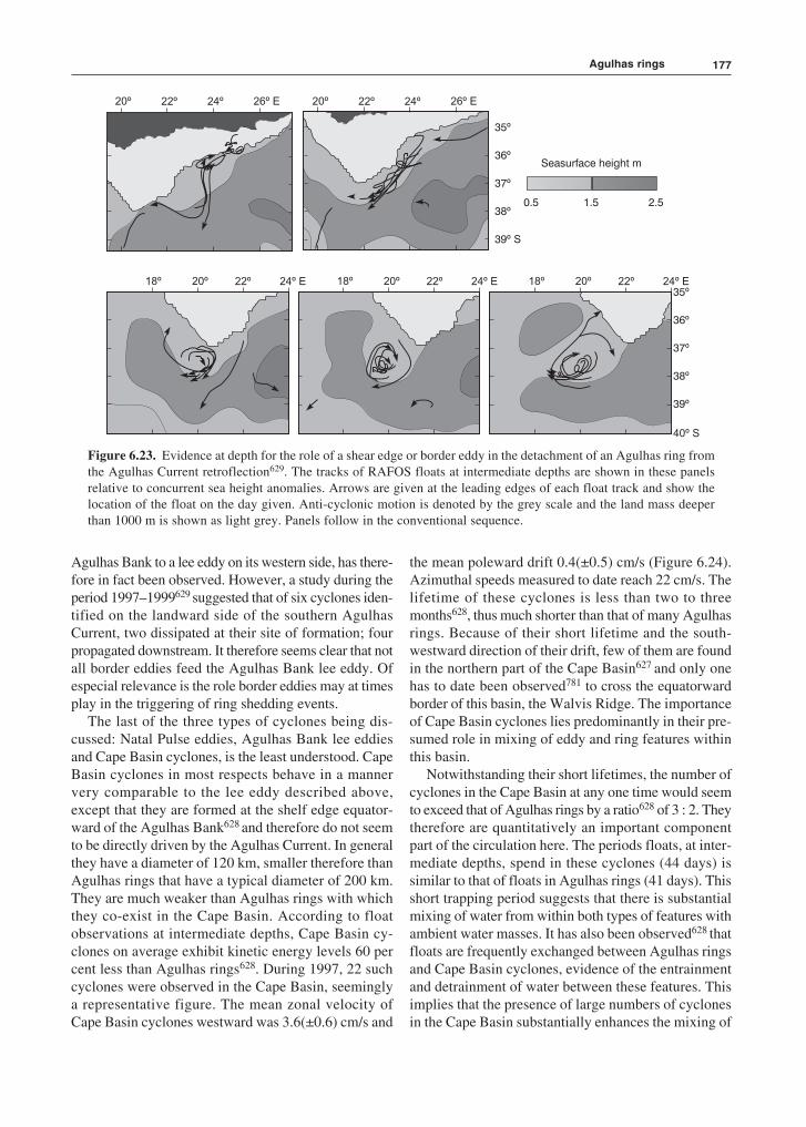
177
Agulhas Bank to a lee eddy on its western side, has there-fore in fact been observed. However, a study during theperiod 1997–1999629 suggested that of six cyclones iden-tified on the landward side of the southern AgulhasCurrent, two dissipated at their site of formation; fourpropagated downstream. It therefore seems clear that notall border eddies feed the Agulhas Bank lee eddy. Ofespecial relevance is the role border eddies may at timesplay in the triggering of ring shedding events.
The last of the three types of cyclones being dis-cussed: Natal Pulse eddies, Agulhas Bank lee eddiesand Cape Basin cyclones, is the least understood. CapeBasin cyclones in most respects behave in a mannervery comparable to the lee eddy described above,except that they are formed at the shelf edge equator-ward of the Agulhas Bank628 and therefore do not seemto be directly driven by the Agulhas Current. In generalthey have a diameter of 120 km, smaller therefore thanAgulhas rings that have a typical diameter of 200 km.They are much weaker than Agulhas rings with whichthey co-exist in the Cape Basin. According to floatobservations at intermediate depths, Cape Basin cy-clones on average exhibit kinetic energy levels 60 percent less than Agulhas rings628. During 1997, 22 suchcyclones were observed in the Cape Basin, seeminglya representative figure. The mean zonal velocity ofCape Basin cyclones westward was 3.6(±0.6) cm/s and
the mean poleward drift 0.4(±0.5) cm/s (Figure 6.24).Azimuthal speeds measured to date reach 22 cm/s. Thelifetime of these cyclones is less than two to threemonths628, thus much shorter than that of many Agulhasrings. Because of their short lifetime and the south-westward direction of their drift, few of them are foundin the northern part of the Cape Basin627 and only onehas to date been observed781 to cross the equatorwardborder of this basin, the Walvis Ridge. The importanceof Cape Basin cyclones lies predominantly in their pre-sumed role in mixing of eddy and ring features withinthis basin.
Notwithstanding their short lifetimes, the number ofcyclones in the Cape Basin at any one time would seemto exceed that of Agulhas rings by a ratio628 of 3 : 2. Theytherefore are quantitatively an important componentpart of the circulation here. The periods floats, at inter-mediate depths, spend in these cyclones (44 days) issimilar to that of floats in Agulhas rings (41 days). Thisshort trapping period suggests that there is substantialmixing of water from within both types of features withambient water masses. It has also been observed628 thatfloats are frequently exchanged between Agulhas ringsand Cape Basin cyclones, evidence of the entrainmentand detrainment of water between these features. Thisimplies that the presence of large numbers of cyclonesin the Cape Basin substantially enhances the mixing of
35º
35º
26º E24º22º20º
24º E22º20º18º 24º E22º20º18º 24º E22º20º18º
26º E24º22º20º
36º
36º
37º
37º
38º
38º
39º S
39º
40º S
Seasurface height m
0.5 1.5 2.5
Figure 6.23. Evidence at depth for the role of a shear edge or border eddy in the detachment of an Agulhas ring fromthe Agulhas Current retroflection629. The tracks of RAFOS floats at intermediate depths are shown in these panelsrelative to concurrent sea height anomalies. Arrows are given at the leading edges of each float track and show thelocation of the float on the day given. Anti-cyclonic motion is denoted by the grey scale and the land mass deeperthan 1000 m is shown as light grey. Panels follow in the conventional sequence.
Agulhas rings

The Agulhas Current retroflection178
water from Agulhas rings here, thus shortening theirlifetime in the south-eastern part of the basin. For thisreason it has whimsically been referred to by Boebel etal.628 as the Cape Cauldron.
Brazil rings?
The second set of unusual, and unexpected, mesoscalefeatures observed during cruises in the Cape Basin areeddies that have hydrographic characteristics somewhatdifferent from those expected of standard Agulhasrings540. It has been claimed that these anti-cyclonicfeatures have their origin at the confluence of the Bra-zil and Falkland Currents in the western Atlantic Oceanand are advected eastward with the high-latitude limbof the South Atlantic gyre until they reach the positionshown in Figure 6.21. This somewhat startling conclu-sion has been based on two sets of data.
First, the potential temperature–salinity characteris-tics of these two particular eddies below a depth of600 m, i.e. well away from possible atmospheric influ-ences, is more closely comparable to that of the BrazilCurrent than that of the Agulhas Current. This is shownin Figure 6.25. Secondly, comparing different CFCtracers, some of which have a declining concentration
in the atmosphere, some increasing, an age for water ina feature can be calculated. From such a comparison,the age of ring BR1 (Figure 6.21) has been estimatedat three years540. With a known eastward drift of 20 to30 km/day in the southern limb of the subtropical gyreof the South Atlantic, this could place this particularring at the Brazil Current retroflection when it wasformed. Others have come to different conclusions onthe origin of these unusual rings.
It has subsequently been shown that the ring that hasbeen claimed to have crossed the South Atlantic fromthe Brazil Current came from the Agulhas retroflectionwhere it had been spawned 16 months earlier541. Thisconclusion is supported by both altimetric and thermalinfrared data for the region for this period. The hydro-graphic and kinematic nature of this anomalous ringwas in all respects akin to that of neighbouring Agulhasrings, except for the higher oxygen and lower nutrientconcentrations in its core. Since these are consistentwith the characteristics of Subantarctic Mode Water,formed at the Subtropical Convergence in austral win-ter, it has been suggested542 that this front is the originof this water that may occasionally be found within theAgulhas Current. This suggestion has also been putforward by others783 who have investigated a number
Figure 6.24. The tracks of cyclones in the south-eastern Atlantic Ocean for the period 1997–1999628 as inferred fromsea surface height anomalies. Bottom topography is described by the 1000 m and 2000 m isobaths.
KEY
1997
1998
1999
0º 5º 10º 15º 20º 25º 30º E
26º
30º
34º
38º
42º S

179
of rings and found some with high saturations and con-centrations of oxygen in a thermostad at a depth between600 m and 1100 m. Their analysis has led to the tenta-tive conclusion that this particular ring had incorporateda lens of water from the Subtropical Convergence bycoalescing with another eddy. An entirely conclusiveanswer on whether Brazil rings can reach the south-eastern Atlantic has therefore not yet been given.
Nonetheless, the possibility of Brazil Current ringsremaining essentially intact for what must be a consid-erable period must be largely dependent on the rate of
mixing between the rings and the ambient watermasses. This rate of mixing is currently not known, butwill most likely be a function of the speed of rotationof these features. This argument will of course also holdfor Agulhas rings.
Ring kinematics
Maximum radial speeds of Agulhas rings lie between0.29 m/s and 0.90 m/s with an average127 of 0.56 m/s.The azimuthal velocity around a ring, as a function of
Eddy B2
Eddy B1
Brazil C
Agulhas C
35.0 35.2 35.4 35.6 35.8
20
18
16
14
12
27.0
26.5
26.0
25.5
25.0P
ote
ntialte
mp
era
ture
C)
(º
Salinity
Figure 6.25. Temperature–salinity characteristics of two eddies (B1 and B2) observed in the South East AtlanticOcean520 that were believed to have their origin as Brazil Current rings540. Their geographic locations are shown inFigure 6.21. These temperature–salinity characteristics are juxtapositional to those distinctive of the Agulhas Currentand the Brazil Current respectively.
Agulhas rings
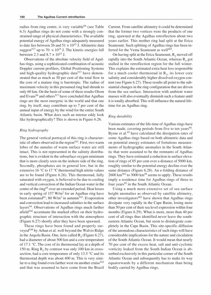
The Agulhas Current retroflection180
radius from ring centre, is very variable94 (see Table6.3) Agulhas rings do not come with a strongly con-strained range of physical characteristics. The availablepotential energy of Agulhas rings adequately measuredto date lies between 26 and 51 × 1015 J. Altimetric datasuggest517 up to 70 × 1015 J. The kinetic energies fallbetween 2.3 and 8.7 × 10¹⁵ J.
Observations of the absolute velocity field of Agul-has rings, using a sophisticated combination of acousticDoppler current profilers, Global Positioning Systemsand high-quality hydrographic data537 have demon-strated that as much as 50 per cent of the total flow inthe core of a mature ring is barotropic. The radius ofmaximum velocity in this presumed ring had shrunk toonly 60 km. On the basis of some of these results Olsonand Evans94 and others517 have concluded that Agulhasrings are the most energetic in the world and that onering, by itself, may contribute up to 7 per cent of theannual input of energy by the wind for the entire SouthAtlantic basin. What does such an intense eddy looklike hydrographically? This is shown in Figure 6.26.
Ring hydrography
The general vertical portrayal of this ring is character-istic of others observed in the region543. First, two warmlobes of the annulus of warm surface water are stillintact. This is not represented in the salinity distribu-tions, but is evident in the subsurface oxygen minimumthat is more clearly seen on the inshore side of the ring.Secondly, phosphates are in general low, but in theextensive 16 °C to 17 °C thermostad high nitrite valuesare to be found (Figure 6.26). This thermostad, fullysaturated with oxygen, is believed to be due to coolingand vertical convection of the Indian Ocean water in thecentre of the ring65 over an extended period. Heat lossesin early spring of 157 W/m2 for an Agulhas ring havebeen estimated61; 80 W/m2 in autumn543. Evaporationand convection lead to increased salinities in the surfacelayers94. Observations of Agulhas rings much fartherafield544 accentuate the marked effect on their hydro-graphic structure of interaction with the atmosphere(Figure 6.27) shortly after they have been spawned.
These rings have been found and properly sur-veyed544 by Arhan et al. well beyond the Walvis Ridgein the Angola Basin. One, here called R2 (Figure 6.27),had a diameter of about 500 km and a core temperatureof 17.1 °C. The core of its thermostad lay at a depth of150 m. Ring R3 by contrast was only 100 km in cross-section, had a core temperature of only 13.5 °C and itsthermostad depth was about 400 m. This is very simi-lar to a ring found even farther west on another cruise542
and that was assumed to have come from the Brazil
Current. From satellite altimetry it could be determinedthat the former two vortices were the products of onering, spawned at the Agulhas retroflection about twoyears earlier. This mother ring had split at the EricaSeamount. Such splitting of Agulhas rings has been in-ferred for the Vema Seamount as well465.
On having split at the Erica Seamount, R2 moved offrapidly into the South Atlantic Ocean, whereas R3 gotstalled in the retroflection region for the full winter.This explains the estimated extra heat loss responsiblefor a much cooler thermostad in R3, its lower coresalinity and considerably higher dissolved oxygen con-tent (see Figure 6.27). These results all point to the sub-stantial changes in the ring configuration that are drivenfrom the sea surface. Interaction with ambient watermasses will also eventually diminish such a feature untilit is totally absorbed. This will influence the natural life-time for an Agulhas ring.
Ring durability
Various estimates of the life-time of Agulhas rings havebeen made, covering periods from five to ten years94.Byrne et al.95 have calculated the dissipation rates ofsome Agulhas rings based on both altimetric data andon potential energy estimates of fortuitous measure-ments of hydrographic anomalies in the South Atlan-tic that were assumed to be the remnants of Agulhasrings. They have estimated a reduction in surface eleva-tion of rings of 85 per cent over a distance of 5000 km,roughly similar to the potential energy decline over thesame distance (Figure 6.28). An e-folding distance of2600 km362 to 3000 km95 seems to apply. These resultsimply a residence time for Agulhas rings of three tofour years95 in the South Atlantic Ocean.
Using a much more extensive set of sea surfaceheight anomalies as observed by satellite altimetry,other investigators465 have shown that Agulhas ringsdissipate very rapidly in the Cape Basin, losing morethan 50 per cent of their sea level expression within fourmonths (Figure 6.29). What is more, more than 40 percent of all rings thus identified never leave the south-eastern Atlantic Ocean, but seem to disintegrate com-pletely in the Cape Basin. This site-specific diffusionof the anomalous characteristics of such rings will haveconsiderable implications for the nature and circulationof the South Atlantic Ocean. It would mean that nearly70 per cent of the excess heat, salt and anti-cyclonicvorticity leaked from the South Indian Ocean is ab-sorbed exclusively in this particular corner of the SouthAtlantic Ocean and subsequently has to make its wayequatorwards by a different mechanism than beingbodily carried by Agulhas rings.
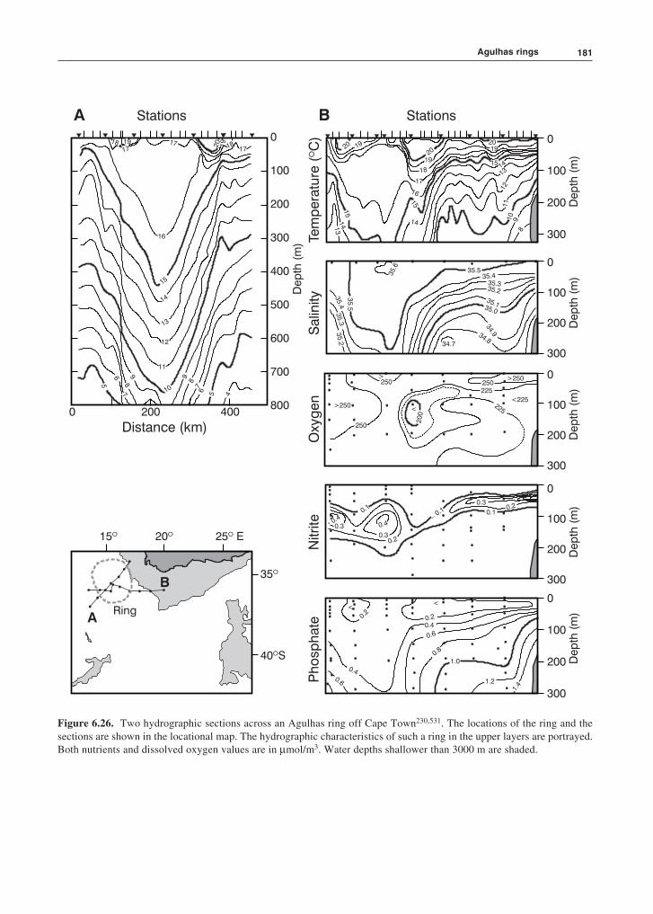
181
Stations Stations
Distance (km)
Dep
th(m
)D
ep
th(m
)
Dep
th(m
)
Dep
th(m
)D
ep
th(m
)D
ep
th(m
)
Ph
osp
hate
Nitri
teO
xyg
en
Salin
ity
Tem
pera
ture
(C
)º
0
100
200
300
0
100
200
300
0
100
200
300
0
100
200
300
0
100
200
300
15º 20º 25 Eº
35º
40 Sº
A
B
Ring
A B
0 200 400
200
100
0
300
400
500
600
700
800
18191817
17 20 19
17
16
15
14
13
12
11
10
98
7
6
5
98
76
5 4
20 19
20
19
18
17
16
15
14
15
141
3
2019
15 14
13
1211
10
98
35.6
35
.5
35.4
35.3
35.2
35.535.4
35.335.2
35.135.0
34.934.834.7
>250<
> >250
<225225
250200
250 250225
0.10.1
0.4
0.20.3
0.4
0.30.2
0.1
0.3
<<
0.2
0.20.4
0.6
0.8
1.0
1.2
1.4
0.40.6
Figure 6.26. Two hydrographic sections across an Agulhas ring off Cape Town230,531. The locations of the ring and thesections are shown in the locational map. The hydrographic characteristics of such a ring in the upper layers are portrayed.Both nutrients and dissolved oxygen values are in µmol/m3. Water depths shallower than 3000 m are shaded.
Agulhas rings

The Agulhas Current retroflection182
0
200
400
600
800
1000
0
200
400
600
800
1000
Dep
th(m
)D
ep
th(m
)
STC R2 R3
0
200
400
600
800
1000
Dep
th(m
) R2
R3
20 Wº 10º 0º 20 Eº
25º
35º
45 Sº
17
16
18
15
1413
1211
109876
5
4.543.5
4.54
1920
35.8
35.7
35.5
35.0
35.2
34.7
34.5
34.4
34.3
36.0
240
220
22
02
40 2
00
200
ºS 35 30 25
Walv
isR
idge
Figure 6.27. A hydrographic section across twoAgulhas rings, designated by R2 and R3, in early1995544. Ocean areas shallower than 2000 m are shaded.The locations of the two rings in the Angola Basin,beyond the Walvis Ridge, are shown in the right-handpanel. The panels on the left show – from the top – thetemperature, salinity and dissolved oxygen content(µmol/kg) measured on a meridional station line thatcrossed the rings. STC locates the Subtropical Conver-gence. Particularly noteworthy are the distinctly differ-ent hydrographical and morphological characteristics ofthese two rings.
Dissipation mechanisms at depth
An analysis focused on low frequency variability in thesouthern Agulhas Current system545 has found strongwestward radiation of Rossby waves around 32° S tothe west of South Africa. The energy for this radiationseems to come from Agulhas rings propagating in anorth-westward direction in the south-eastern AtlanticOcean. It has been claimed that there also is substantiallocal mixing through Stokes’ drift between the watermasses of the South Atlantic and the propagating dis-turbances545. These are but some of the mechanism thatmay be responsible for the local degeneration of Agul-has rings. Modelling Agulhas rings with a realistic two-layer representation suggests546 that the decay scale forrings that make it across the Walvis Ridge agreesroughly with this numerical simulation.
As will emerge below, rings may also split, althoughthis may not of necessity increase their rate of dissipa-tion770. It has been assumed for some time that anti-cyclones cannot split of their own accord786. Using anumerical, multilayer, primitive equation model it hasbeen shown768 that they can indeed not split by baro-tropic mechanisms alone. However, barotropic instabil-ity is a necessary ingredient for splitting to occur. Anextensive analysis of the linear stability of ocean rings767
has found that they are remarkably robust with respectto changes in ring parameters, like diameter, far fieldstratification and momentum balance. Nevertheless,realistic rings in theory should be quite unstable basedon a linear analysis whereas in reality they do survivefor long periods. Investigating the mixing of Agulhasrings using an isopycnals ocean model770 has shownthat the leakage of tracers placed within a simulated
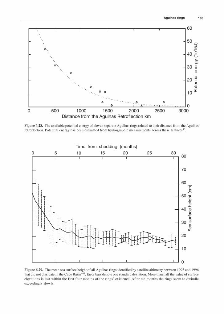
183
Figure 6.28. The available potential energy of eleven separate Agulhas rings related to their distance from the Agulhasretroflection. Potential energy has been estimated from hydrographic measurements across these features95.
Figure 6.29. The mean sea surface height of all Agulhas rings identified by satellite altimetry between 1993 and 1996that did not dissipate in the Cape Basin465. Error bars denote one standard deviation. More than half the value of surfaceelevations is lost within the first four months of the rings’ existence. After ten months the rings seem to dwindleexceedingly slowly.
Agulhas rings
60
50
40
30
20
10
0
Po
ten
tialen
erg
y(1
e1
5J)
0 500 1000 1500 2000 2500 3000
Distance from the Agulhas Retroflection km
0 5 10 15 20 25 3080
70
60
50
40
30
20
10
0
Sea
su
rface
heig
ht
(cm
)
Time from shedding (months)
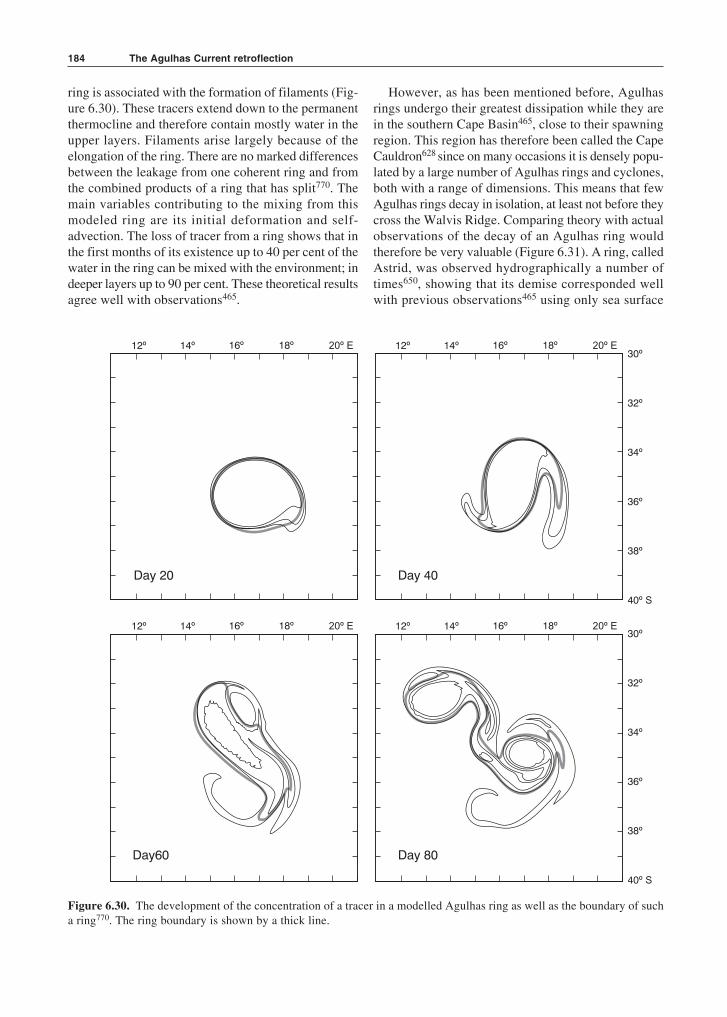
The Agulhas Current retroflection184
ring is associated with the formation of filaments (Fig-ure 6.30). These tracers extend down to the permanentthermocline and therefore contain mostly water in theupper layers. Filaments arise largely because of theelongation of the ring. There are no marked differencesbetween the leakage from one coherent ring and fromthe combined products of a ring that has split770. Themain variables contributing to the mixing from thismodeled ring are its initial deformation and self-advection. The loss of tracer from a ring shows that inthe first months of its existence up to 40 per cent of thewater in the ring can be mixed with the environment; indeeper layers up to 90 per cent. These theoretical resultsagree well with observations465.
However, as has been mentioned before, Agulhasrings undergo their greatest dissipation while they arein the southern Cape Basin465, close to their spawningregion. This region has therefore been called the CapeCauldron628 since on many occasions it is densely popu-lated by a large number of Agulhas rings and cyclones,both with a range of dimensions. This means that fewAgulhas rings decay in isolation, at least not before theycross the Walvis Ridge. Comparing theory with actualobservations of the decay of an Agulhas ring wouldtherefore be very valuable (Figure 6.31). A ring, calledAstrid, was observed hydrographically a number oftimes650, showing that its demise corresponded wellwith previous observations465 using only sea surface
Day 20
Day60
Day 40
Day 80
14º 16º 18º 20º E12º 14º 16º 18º 20º E12º
14º 16º 18º 20º E12º 14º 16º 18º 20º E12º
30º
32º
34º
36º
38º
40º S
30º
32º
34º
36º
38º
40º S
Figure 6.30. The development of the concentration of a tracer in a modelled Agulhas ring as well as the boundary of sucha ring770. The ring boundary is shown by a thick line.
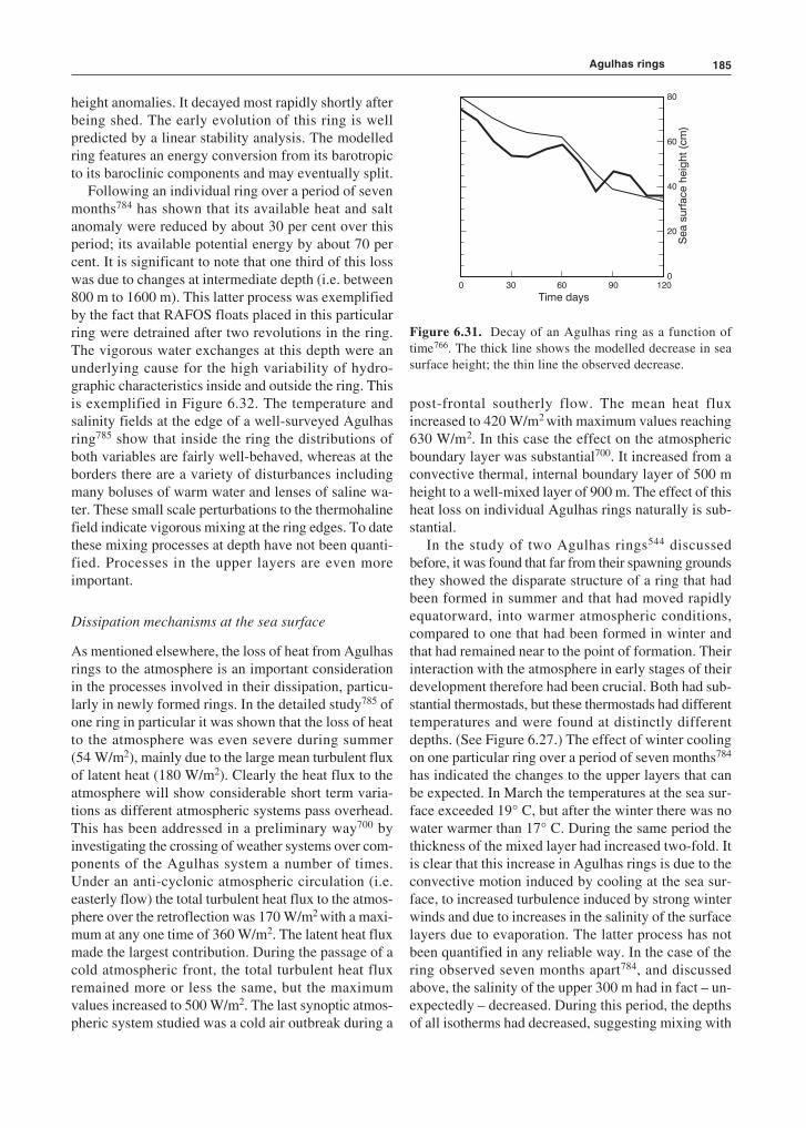
185
height anomalies. It decayed most rapidly shortly afterbeing shed. The early evolution of this ring is wellpredicted by a linear stability analysis. The modelledring features an energy conversion from its barotropicto its baroclinic components and may eventually split.
Following an individual ring over a period of sevenmonths784 has shown that its available heat and saltanomaly were reduced by about 30 per cent over thisperiod; its available potential energy by about 70 percent. It is significant to note that one third of this losswas due to changes at intermediate depth (i.e. between800 m to 1600 m). This latter process was exemplifiedby the fact that RAFOS floats placed in this particularring were detrained after two revolutions in the ring.The vigorous water exchanges at this depth were anunderlying cause for the high variability of hydro-graphic characteristics inside and outside the ring. Thisis exemplified in Figure 6.32. The temperature andsalinity fields at the edge of a well-surveyed Agulhasring785 show that inside the ring the distributions ofboth variables are fairly well-behaved, whereas at theborders there are a variety of disturbances includingmany boluses of warm water and lenses of saline wa-ter. These small scale perturbations to the thermohalinefield indicate vigorous mixing at the ring edges. To datethese mixing processes at depth have not been quanti-fied. Processes in the upper layers are even moreimportant.
Dissipation mechanisms at the sea surface
As mentioned elsewhere, the loss of heat from Agulhasrings to the atmosphere is an important considerationin the processes involved in their dissipation, particu-larly in newly formed rings. In the detailed study785 ofone ring in particular it was shown that the loss of heatto the atmosphere was even severe during summer(54 W/m2), mainly due to the large mean turbulent fluxof latent heat (180 W/m2). Clearly the heat flux to theatmosphere will show considerable short term varia-tions as different atmospheric systems pass overhead.This has been addressed in a preliminary way700 byinvestigating the crossing of weather systems over com-ponents of the Agulhas system a number of times.Under an anti-cyclonic atmospheric circulation (i.e.easterly flow) the total turbulent heat flux to the atmos-phere over the retroflection was 170 W/m2 with a maxi-mum at any one time of 360 W/m2. The latent heat fluxmade the largest contribution. During the passage of acold atmospheric front, the total turbulent heat fluxremained more or less the same, but the maximumvalues increased to 500 W/m2. The last synoptic atmos-pheric system studied was a cold air outbreak during a
80
60
40
20
00 30 60 90 120
Time days
Sea
su
rface
heig
ht
(cm
)
Figure 6.31. Decay of an Agulhas ring as a function oftime766. The thick line shows the modelled decrease in seasurface height; the thin line the observed decrease.
post-frontal southerly flow. The mean heat fluxincreased to 420 W/m2 with maximum values reaching630 W/m2. In this case the effect on the atmosphericboundary layer was substantial700. It increased from aconvective thermal, internal boundary layer of 500 mheight to a well-mixed layer of 900 m. The effect of thisheat loss on individual Agulhas rings naturally is sub-stantial.
In the study of two Agulhas rings544 discussedbefore, it was found that far from their spawning groundsthey showed the disparate structure of a ring that hadbeen formed in summer and that had moved rapidlyequatorward, into warmer atmospheric conditions,compared to one that had been formed in winter andthat had remained near to the point of formation. Theirinteraction with the atmosphere in early stages of theirdevelopment therefore had been crucial. Both had sub-stantial thermostads, but these thermostads had differenttemperatures and were found at distinctly differentdepths. (See Figure 6.27.) The effect of winter coolingon one particular ring over a period of seven months784
has indicated the changes to the upper layers that canbe expected. In March the temperatures at the sea sur-face exceeded 19° C, but after the winter there was nowater warmer than 17° C. During the same period thethickness of the mixed layer had increased two-fold. Itis clear that this increase in Agulhas rings is due to theconvective motion induced by cooling at the sea sur-face, to increased turbulence induced by strong winterwinds and due to increases in the salinity of the surfacelayers due to evaporation. The latter process has notbeen quantified in any reliable way. In the case of thering observed seven months apart784, and discussedabove, the salinity of the upper 300 m had in fact – un-expectedly – decreased. During this period, the depthsof all isotherms had decreased, suggesting mixing with
Agulhas rings

The Agulhas Current retroflection186
the surrounding waters. An attempt to model757 the im-pact of cooling on the water mass exchanges of Agulhasrings has produced some interesting results.
A bowl shaped ring was simulated with a diameterof 280 km. Below 800 m depth the Agulhas ring in thismodel rapidly loses its original water mass. This resultagrees substantially with that found by studying themotion of RAFOS floats placed in such rings625 and
with hydrographic observations785 in rings. In thismodel strong surface cooling generates a shallow over-turning cell with radially outward flow near the surfaceand a compensating flow at depth. As a result the sur-face water does not remain trapped in the core of thering, but exchanges water with the surrounding waters.The overturning cell amplifies this water mass exchangeby constantly bringing new water to the edge of the ringwhere it gets the opportunity to mix with ambient waters.
The question how rapidly rings undergoing all thesemixing processes will be absorbed by the ambient watermasses may to some extent depend on the trajectoriesthey follow.
Ring pathways
Drifting buoys have suggested an initial drift rate awayfrom the inception region of 5 to 8 km/day94. However,it is now clear that Agulhas rings may stall, changedirection, split or speed up during their progressionacross the South Atlantic Ocean, particularly in theCape Basin. Whatever the initial drift rate, it has beenobserved that a number of rings tend to remain close tothe retroflection for a considerable time. They have, forinstance, been observed to be quite persistent south-west of Cape Town444 (e.g. Figure 6.26). The presenceof Agulhas rings in this particular spot is of added im-portance because rings situated here will enhance theshelf-edge current as well as the rapid advection ofAgulhas filaments into the South Atlantic92.
In both satellite imagery61 as well as research cruises455
up to nine rings and eddies have been observed at thesame time clustered around the Agulhas retroflection.Hydrographic data show their further movements (Fig-ure 6.19), although to date only three rings has beenvisited more than once543,784–5. Other types of informa-tion therefore have to be employed to evaluate themovement of rings.
Satellite altimetry has proven to be an exceptionallyuseful tool70,354,543 to track Agulhas rings, particularlysince they have strong signals in sea level elevation95,464
and drift through a comparatively quiescent region498.Comparison between altimetric observations and themeasurements from moored current meters and in-verted echo sounders has shown that in the south-eastern Atlantic Ocean anomalies of the sea surface aresignificantly related to the thermocline depth and to thedynamic height of the sea surface547. Considerablework has been done to refine the analysis74 and inter-pretation of altimetric data in the region, including dataassimilation into quasi-geostrophic models548.
Initial investigations73 using altimetric data haveshown rates of translation of 4–8 cm/s, and even517 up
0 50 100 150
0 50 100 150
Distance (km)
Distance (km)
0
50
100
150
200
0
50
100
150
200
Pre
ssu
re(d
b)
Pre
ssu
re(d
b)
21
20
19
18
17
17
16
16
15
15
14
13
12
15
>35.625
35.6
35.6
35.5
35
.4
35.3
35.3
34.9
35.435.3
35.2
35.1
35.0
34
.9
Figure 6.32. Hydrographic disturbances along the edge ofa relatively new Agulhas ring785. These closely spacedobservations were made with a Scanfish undulator resolvingthe structure to a lateral accuracy of 1.8 km. The upper panelshows the thermal structure; the lower the salinity distribu-tion.

187
to 16 cm/s, in a general north-westerly direction for theanomalies assumed to be Agulhas rings. Other esti-mates362 are 3–7 cm/s. Propagations rates based onRAFOS floats783 give values of 5.5 to 6.5 cm/s. Mod-elling studies546 suggest a rate of about 9 km/day andshow that ring trajectories undergo a transition from aturbulent character in the Cape Basin to a much moresteady propagation in the rest of the South Atlantic760,but that this is due to ring decay and not to the topog-raphy being crossed. The propagation speeds of thoserings that are durable and those that eventually cross theWalvis Ridge show no systematic seasonal variations712
in their speed of translation. A detailed study of oneparticular ring784 for a period of seven months hasshown that its north-westerly progression variedbetween 3 km/day to 20 km/day, possible due to itsinteraction with other rings and cyclones along its path.
Further studies using altimetry have been able totrack anomalies of sea surface height over the greaterwidth of the South Atlantic and were able to positivelyidentify some of these anomalies as Agulhas rings atsea464,544. Van Ballegooyen et al.129 have, for instance,been able to establish a very close correspondencebetween the hydrographic observations of individualAgulhas rings and their altimetric signatures. Duringthe two-year period of their investigation ringsmigrated no farther than 1500 km from the Agulhasretroflection.
A similar study95, for a period of three years (Figure6.33), has shown inferred Agulhas rings to advectacross the South Atlantic Ocean slightly to the left ofthe mean flow. None crossed the South Atlantic Oceannorth of a latitude of 25° S. In a few instances Agulhasrings have been tracked all the way to the coast of Bra-zil; in one instance754 there is evidence that a ring wassubsequently carried poleward by the Brazil Currentover a distance of at least 10° of latitude. Rings prob-ably are advected with the ambient water movement807,but also exhibit a substantial degree of self-steering dueto their own internal dynamics. Calculations haveshown that only about 15 per cent of the observed driftof rings is self-induced; advection by the backgroundflow therefore dominating the rate at which they trans-late. Comparing the movement of floats placed inAgulhas rings, at intermediate depths, with those placedoutside rings and therefore in the Benguela Current,Richardson et al.781 have been able to establish the rateat which rings move through the background waters.The background speeds were about 2 km/day; those ofAgulhas rings roughly 6 km/day. This means that ringshave a self-induced movement at 750 m of about 4 km/day. The background speed may have its origin in theBenguela Current807.
Sea height anomalies south of 45° S in generalmigrate eastwards362. Anomalies that migrate eastwardsoriginate at 40° S as far west as 20° W longitude95. Inall probability these latter ones are not Agulhas rings,but mesoscale eddies shed at the Subtropical Conver-gence in the South Atlantic549, or by the South AtlanticCurrent83. The furthest westward Agulhas retroflectionobserved to date, or Agulhas ring at its inception, hasbeen at 8° E longitude512. The other mesoscale featuresfound in the Cape Basin, cyclones, have been shown tomigrate roughly at right angles to the mean trajectoryof Agulhas rings628, but since they seem to have a muchshorter lifetime have not been followed farther than theconfines of the Cape Basin. As mentioned in anothercontext, this cross-traffic of anti-cyclones and cyclonesseem to be a characteristic of a number of west coastsof continents, including North America and Aus-tralia780. In their subsequent journey across the south-ern Atlantic Ocean Agulhas rings have to cross anumber of bottom ridges. Since the rings extend togreat depths, it is valid to examine the influence of thesebathymetric obstacles on their behaviour.
Interaction with bottom ridges
The influence that distinctive features of the bottomtopography may have on the paths taken by Agulhasrings across the South Atlantic is not immediatelyobvious. In many models764,758 the effect of the bathym-etry is evident, but the magnitude of this effect differssubstantially between individual models763. One of themajor bottom features that rings will have to cross, inorder to follow the streamlines of the subtropical gyre,is the Walvis Ridge that lies from about 20° S latitudeat the west African coast in a south-westward direction(viz. Figure 6.27). It is interesting to note that of 30RAFOS floats placed781 at a depth of roughly 750 m inthe Cape Basin, virtually all that crossed the WalvisRidge did so associated with the passage of Agulhasrings or Cape Basin cyclones. The crossing of theWalvis Ridge by Agulhas rings has been shown tooccur irregulary and aperiodically712.There is evidencethat most rings slow down on traversing this feature95,but there are also some that show signs of drift accel-eration73. Initial translational speeds of 12 km/day havebeen observed to decrease to 6 to 7 km/day over theridge519.
Schouten et al.465 have demonstrated that onceAgulhas rings have been slowed down on crossing theWalvis Ridge, they never regain their previous propa-gational speed, but remain sluggish in their subsequentmovement. There also is greater directional uniformityamongst rings that have successfully crossed this
Agulhas rings
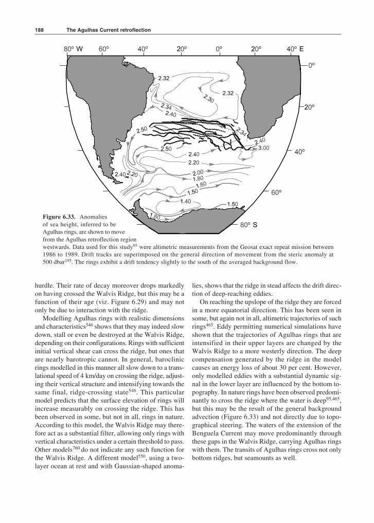
The Agulhas Current retroflection188
Figure 6.33. Anomaliesof sea height, inferred to beAgulhas rings, are shown to movefrom the Agulhas retroflection regionwestwards. Data used for this study95 were altimetric measurements from the Geosat exact repeat mission between1986 to 1989. Drift tracks are superimposed on the general direction of movement from the steric anomaly at500 dbar195. The rings exhibit a drift tendency slightly to the south of the averaged background flow.
hurdle. Their rate of decay moreover drops markedlyon having crossed the Walvis Ridge, but this may be afunction of their age (viz. Figure 6.29) and may notonly be due to interaction with the ridge.
Modelling Agulhas rings with realistic dimensionsand characteristics546 shows that they may indeed slowdown, stall or even be destroyed at the Walvis Ridge,depending on their configurations. Rings with sufficientinitial vertical shear can cross the ridge, but ones thatare nearly barotropic cannot. In general, baroclinicrings modelled in this manner all slow down to a trans-lational speed of 4 km/day on crossing the ridge, adjust-ing their vertical structure and intensifying towards thesame final, ridge-crossing state546. This particularmodel predicts that the surface elevation of rings willincrease measurably on crossing the ridge. This hasbeen observed in some, but not in all, rings in nature.According to this model, the Walvis Ridge may there-fore act as a substantial filter, allowing only rings withvertical characteristics under a certain threshold to pass.Other models760 do not indicate any such function forthe Walvis Ridge. A different model550, using a two-layer ocean at rest and with Gaussian-shaped anoma-
lies, shows that the ridge in stead affects the drift direc-tion of deep-reaching eddies.
On reaching the upslope of the ridge they are forcedin a more equatorial direction. This has been seen insome, but again not in all, altimetric trajectories of suchrings465. Eddy permitting numerical simulations haveshown that the trajectories of Agulhas rings that areintensified in their upper layers are changed by theWalvis Ridge to a more westerly direction. The deepcompensation generated by the ridge in the modelcauses an energy loss of about 30 per cent. However,only modelled eddies with a substantial dynamic sig-nal in the lower layer are influenced by the bottom to-pography. In nature rings have been observed predomi-nantly to cross the ridge where the water is deep95,465,but this may be the result of the general backgroundadvection (Figure 6.33) and not directly due to topo-graphical steering. The waters of the extension of theBenguela Current may move predominantly throughthese gaps in the Walvis Ridge, carrying Agulhas ringswith them. The transits of Agulhas rings cross not onlybottom ridges, but seamounts as well.
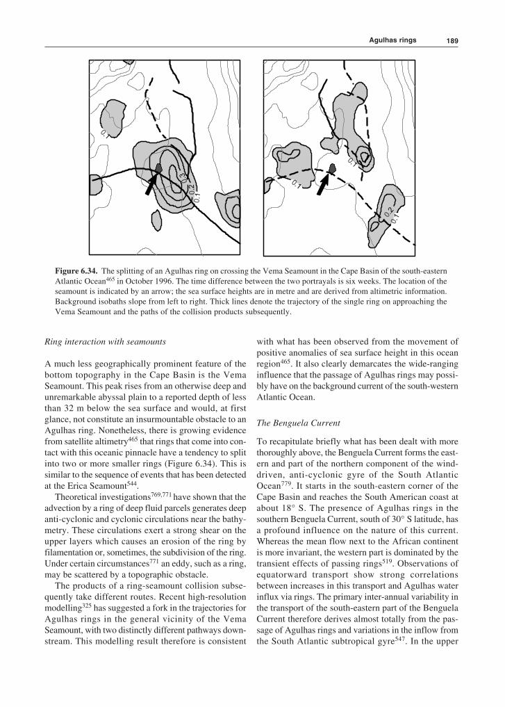
189
Ring interaction with seamounts
A much less geographically prominent feature of thebottom topography in the Cape Basin is the VemaSeamount. This peak rises from an otherwise deep andunremarkable abyssal plain to a reported depth of lessthan 32 m below the sea surface and would, at firstglance, not constitute an insurmountable obstacle to anAgulhas ring. Nonetheless, there is growing evidencefrom satellite altimetry465 that rings that come into con-tact with this oceanic pinnacle have a tendency to splitinto two or more smaller rings (Figure 6.34). This issimilar to the sequence of events that has been detectedat the Erica Seamount544.
Theoretical investigations769,771 have shown that theadvection by a ring of deep fluid parcels generates deepanti-cyclonic and cyclonic circulations near the bathy-metry. These circulations exert a strong shear on theupper layers which causes an erosion of the ring byfilamentation or, sometimes, the subdivision of the ring.Under certain circumstances771 an eddy, such as a ring,may be scattered by a topographic obstacle.
The products of a ring-seamount collision subse-quently take different routes. Recent high-resolutionmodelling325 has suggested a fork in the trajectories forAgulhas rings in the general vicinity of the VemaSeamount, with two distinctly different pathways down-stream. This modelling result therefore is consistent
with what has been observed from the movement ofpositive anomalies of sea surface height in this oceanregion465. It also clearly demarcates the wide-ranginginfluence that the passage of Agulhas rings may possi-bly have on the background current of the south-westernAtlantic Ocean.
The Benguela Current
To recapitulate briefly what has been dealt with morethoroughly above, the Benguela Current forms the east-ern and part of the northern component of the wind-driven, anti-cyclonic gyre of the South AtlanticOcean779. It starts in the south-eastern corner of theCape Basin and reaches the South American coast atabout 18° S. The presence of Agulhas rings in thesouthern Benguela Current, south of 30° S latitude, hasa profound influence on the nature of this current.Whereas the mean flow next to the African continentis more invariant, the western part is dominated by thetransient effects of passing rings519. Observations ofequatorward transport show strong correlationsbetween increases in this transport and Agulhas waterinflux via rings. The primary inter-annual variability inthe transport of the south-eastern part of the BenguelaCurrent therefore derives almost totally from the pas-sage of Agulhas rings and variations in the inflow fromthe South Atlantic subtropical gyre547. In the upper
Figure 6.34. The splitting of an Agulhas ring on crossing the Vema Seamount in the Cape Basin of the south-easternAtlantic Ocean465 in October 1996. The time difference between the two portrayals is six weeks. The location of theseamount is indicated by an arrow; the sea surface heights are in metre and are derived from altimetric information.Background isobaths slope from left to right. Thick lines denote the trajectory of the single ring on approaching theVema Seamount and the paths of the collision products subsequently.
Agulhas rings
The Agulhas Current retroflection190
1000 m the annual contribution to the volume flux ofthe Benguela by the Agulhas Current varies between 10per cent and 50 per cent. Over a period of five years782
the contribution from the South Atlantic Ocean to theBenguela is 58 per cent, that of the Indian Ocean about30 per cent. However, at intermediate depths the greaterpart of the waters in the Cape Basin is supplied from theIndian Ocean628 with minor direct inflow from theAtlantic Ocean. Red Sea Water contributes775 about 6per cent. More about this follows below.
An investigation772 combining sea surface heightand sea surface temperature measurements has sug-gested that a convoluted jet is found in the BenguelaCurrent, probably separating the coastal upwelled waterfrom the deep-sea waters. This jet shows seasonalbehaviour, being stronger in summer. This strengthen-ing is due to an increase in coastal upwelling, but alsodue to an increased injection of Agulhas ring water onthe offshore side of the jet. One should at this stage per-haps remind oneself that the movement of these Agul-has rings is of course highly unusual. No other productsof a western boundary current are known to move pastsuch a well-developed coastal upwelling regime551–3.
Agulhas rings and coastal upwelling
The Benguela upwelling system of the South EastAtlantic Ocean extends from about 15° S to 35° S lati-tude551. Its northern border is the Angola/Benguelafront554, while the wind-driven upwelling on the Agul-has Bank473 may be considered to be its southern ex-tremity. This upwelling system has a central pointwhere it is most intense and durable, at Lüderitz, andis otherwise concentrated in a number of relatively dis-tinct upwelling cells470. The frequency of upwelling atthese cells decreases both north- and southwards withdistance from Lüderitz, while the southernmost cells aretotally seasonally driven.
Notwithstanding this along-coast variability in up-welling intensity, the instantaneous upwelling expressionalong this coastline is one of a contiguous strip of coldwater at the sea surface that overlies the continental shelf,and a zone about twice as wide that is populated by arange of wisps of cold surface water, upwelling fila-ments, vortex dipoles555 and small eddies556–7. Some ofthese mesoscale frontal features seem to occur at randomwhile others557 seem to be locked to the morphology ofthe coastline. Some of the upwelling filaments can, prob-ably by a combination of extreme offshore berg windsand entrainment in offshore eddies, be made to extendto distances of 1000 km offshore558. This may bringthem into the path of passing Agulhas rings.
At least one such interaction between an Agulhasring and an upwelling filament has been investigated indetail559–60. A pioneering investigation of an upwellingfilament off the south-western coast of Africa byShillington et al.561 has suggested the presence of awarm eddy to the south of this particular filament at thetime, the former possibly of Agulhas origin. A subse-quent set of cruises, to follow an Agulhas ring in itsnorthward movement along the coastline543, haveestablished that on one occasion this particular ring wasencircled by a filament of cold surface water (e.g. Fig-ure 6.35). Temperature–salinity characteristics of thefilament showed it to be nearly pure upwelling water559.It was about 50 km wide, 100 m deep and, when en-trained around the full circumference of the ring, wouldhave had a length of 1000 km.
It has been suggested560 that removing this amountof water from the upwelling front could have a pro-found effect on the biota of the upwelling regime andcould, on this particular occasion, have been partiallyresponsible for depressing the anchovy year-class ofthat year and hence the recruit biomass available for thefollowing year. An eddy-permitting, large-scale modelof the whole upwelling system562 has simulated casesof filament-ring interaction, demonstrating that underthe appropriate conditions this may be an inherent partof the system. Subsequent hydrographic studies in theregion563 have produced circumstantial evidence thatAgulhas rings draw upwelled water as well as tropicalAtlantic Ocean water, found over the upper continen-tal slope, into the ocean interior. It has in fact been sug-gested that Agulhas rings are the primary removalmechanism for the low oxygen water found on theslope563. This process can probably only come about ifan Agulhas ring during its equatorward passage reachesthe upwelling front itself.
Filaments of water blown offshore by extreme windevents would be lost to the upwelling system irrespec-tive of whether they get entrained in Agulhas rings faroffshore558 or not. The frequency of Agulhas trajec-tories lying closer inshore would therefore be a primefactor in ascertaining how important Agulhas rings arein this exchange process compared to wind events.Altimetric studies of such trajectories95,362,465 to datesuggest that an Agulhas ring conjunction with the activeupwelling front may be a very rare event. These unu-sual incidents may nonetheless have a significant localeffect on a fragile fish recruitment process. The con-tinuous creation of warm Agulhas rings and their steadymovement into the South Atlantic, forming the basis ofthe inter-basin exchange of water south of Africa, has,by contrast, effects on a much larger scale.
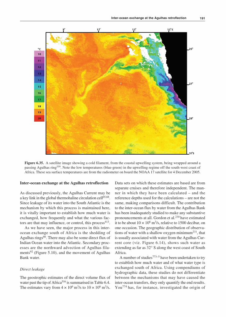
191
Inter-ocean exchange at the Agulhas retroflection
As discussed previously, the Agulhas Current may bea key link in the global thermohaline circulation cell65,68.Since leakage of its water into the South Atlantic is themechanism by which this process is maintained here,it is vitally important to establish how much water isexchanged, how frequently and what the various fac-tors are that may influence, or control, this process413.
As we have seen, the major process in this inter-ocean exchange south of Africa is the shedding ofAgulhas rings66. There may also be some direct flux ofIndian Ocean water into the Atlantic. Secondary proc-esses are the northward advection of Agulhas fila-ments92 (Figure 5.10), and the movement of AgulhasBank water.
Direct leakage
The geostrophic estimates of the direct volume flux ofwater past the tip of Africa516 is summarised in Table 6.4.The estimates vary from 4 × 10⁶ m3/s to 10 × 106 m3/s.
Data sets on which these estimates are based are fromseparate cruises and therefore independent. The man-ner in which they have been calculated – and thereference depths used for the calculations – are not thesame, making comparisons difficult. The contributionto the inter-ocean flux by water from the Agulhas Bankhas been inadequately studied to make any substantivepronouncements at all. Gordon et al.230 have estimatedit to be about 10 × 106 m3/s, relative to 1500 decibar, onone occasion. The geographic distribution of observa-tions of water with a shallow oxygen minimum231, thatis usually associated with water from the Agulhas Cur-rent core (viz. Figure 6.14), shows such water asextending as far as 32° S along the west coast of SouthAfrica.
A number of studies773–5 have been undertaken to tryto establish how much water and of what water type isexchanged south of Africa. Using compendiums ofhydrographic data, these studies do not differentiatebetween the mechanisms that may have caused theinter-ocean transfers, they only quantify the end results.You774 has, for instance, investigated the origin of
Figure 6.35. A satellite image showing a cold filament, from the coastal upwelling system, being wrapped around apassing Agulhas ring559. Note the low temperatures (blue-green) in the upwelling regime off the south-west coast ofAfrica. These sea surface temperatures are from the radiometer on board the NOAA 17 satellite for 4 December 2005.
Inter-ocean exchange at the Agulhas retroflection

The Agulhas Current retroflection192
Antarctic Intermediate Water in the South AtlanticOcean and come to the conclusion that of this type thewater originating from the Drake Passage is dominant.Antarctic Intermediate Water from the Indian Oceancomprises 30–60 per cent of that originating in theSouth Pacific Ocean in the subtropical latitudes of theSouth Atlantic Ocean. The meridional volume transportof Antarctic Intermediate Water in these subtropicallatitudes consists of 64 per cent water from the DrakePassage, 36 per cent from south of Africa. The formerextends to the south-western Indian Ocean in a continu-ous band775 whereas the Indian Ocean source watersspread to the southeastern South Atlantic mostly in apatchy distribution, perhaps indicating the intermit-tency of their generation. The volume transport of Ant-arctic Intermediate Water south of Africa consists ofwater from the Drake Passage (63 per cent), from theSouth Indian Ocean (16 per cent), from the IndonesianSeas (10 per cent) and from the Red Sea (12 per cent).Only a small proportion of Antarctic IntermediateWater from the Drake Passage that moves into theIndian Ocean is eventually returned westward775.
One known mechanism for interocean exchange southof Africa, albeit it not the major one, is the movementof filaments drawn from the core of the Agulhas Current.
Agulhas filaments
Agulhas filaments are advected past the western edgeof the Agulhas Bank (viz. Figure 5.10), carry onlysurface water from the upper 50 m of the Agulhas Cur-rent92 and are often entrained in the perimeter of pass-ing Agulhas rings. By being captured in the rim ofAgulhas rings they may be replenishing the rapidlycooling surface layers of such features, increasing theirsurface salinity and enhancing convective overturningin these ageing rings. Agulhas filaments presumablycarry little net heat into the South Atlantic Ocean, all
excess heat being rapidly lost to the colder overlyingatmosphere121. This may be surmised from the occa-sional presence of cumulus cloud bands above thesefilaments143, suggesting substantial fluxes of heat andmoisture to the atmosphere. Agulhas filaments are,nonetheless, estimated as contributing an annual net fluxof 3 to 9 × 10¹² kg salt, or 9 per cent of that due toAgulhas rings. The contribution to inter-ocean ex-change by Agulhas filaments is therefore small, but notentirely negligible. Such surface water exchange mayoccasionally increase substantially439 through inter-action with Agulhas rings and under wind conditionsconducive to northward advection564.
Leakage by Agulhas rings
Nevertheless, the major component of the inter-oceanexchange of heat and salt south of Africa, in the thermo-cline and surface waters, seems to be due to Agulhasrings413,516. Using a box model informed by measure-ments from an array of inverted echo sounders,Garzoli and Goñi782 have demonstrated the sources ofwater crossing the Cape Basin at 30° S. A total of12 × 106 m3/s water in the upper 1000 m moves acrossthis line. This is an average over five years. Of this6 × 106 m3/s comes from the South Atlantic, possiblylargely from the South Atlantic Current, 2 × 10⁶ m3/sdirectly from the South Indian Ocean and the rest(3 × 10⁶ m3/s) is a mixture of Agulhas water in fila-mentous form and tropical Atlantic water originatingfrom the north. The ratios are very variable. During1995 more than 50 per cent of the volume transportcame from the Indian Ocean; in 1996 it was barely 10per cent. This incorporation of water from the north hasalso been shown from the drift tracks of floats at inter-mediate depths781. Near 30° S floats placed east of theWalvis Ridge tended to move southward before turn-ing northwestward to join the Benguela Current.
Table 6.4. Geostrophic estimates of the direct flux, i.e. excluding Agulhas rings or filaments, of Indian Ocean water into the SouthAtlantic516 in 106 m3/s.
Authors Flux Reference Date
Harris and Van Foreest (1978)92 5 1100 db March 1969Gordon et al. (1987)230 10 1500 db November–December 1983Bennett (1988)533 6.3 T > 8 °C November–December 1983
2.8 T > 8 °C February–March 1985Stramma and Peterson (1990)83 8 1000 m November 1983Gordon et al. (1992)67 10 T > 9 °C December 1989–January 1990
15 1500 db December 1989–January 1990Garzoli et al. (1997)547 4 1000 db September 1992–December 1995
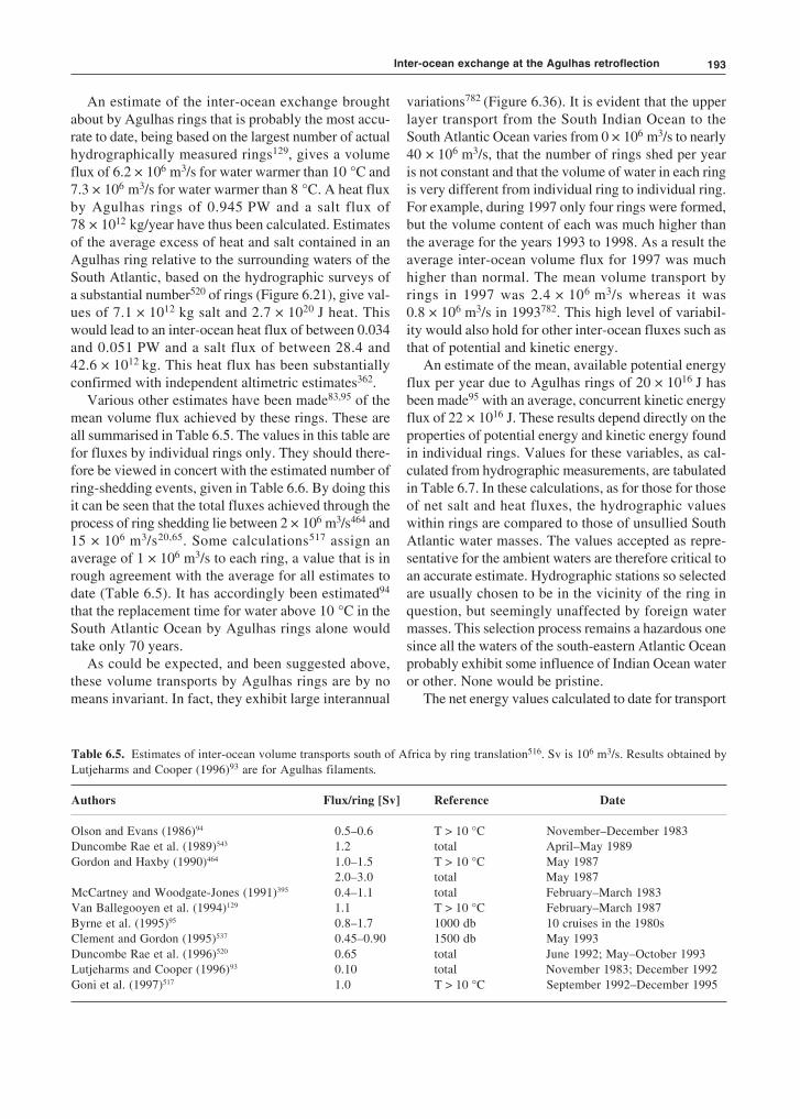
193
An estimate of the inter-ocean exchange broughtabout by Agulhas rings that is probably the most accu-rate to date, being based on the largest number of actualhydrographically measured rings129, gives a volumeflux of 6.2 × 10⁶ m3/s for water warmer than 10 °C and7.3 × 106 m3/s for water warmer than 8 °C. A heat fluxby Agulhas rings of 0.945 PW and a salt flux of78 × 1012 kg/year have thus been calculated. Estimatesof the average excess of heat and salt contained in anAgulhas ring relative to the surrounding waters of theSouth Atlantic, based on the hydrographic surveys ofa substantial number520 of rings (Figure 6.21), give val-ues of 7.1 × 10¹² kg salt and 2.7 × 10²⁰ J heat. Thiswould lead to an inter-ocean heat flux of between 0.034and 0.051 PW and a salt flux of between 28.4 and42.6 × 1012 kg. This heat flux has been substantiallyconfirmed with independent altimetric estimates362.
Various other estimates have been made83,95 of themean volume flux achieved by these rings. These areall summarised in Table 6.5. The values in this table arefor fluxes by individual rings only. They should there-fore be viewed in concert with the estimated number ofring-shedding events, given in Table 6.6. By doing thisit can be seen that the total fluxes achieved through theprocess of ring shedding lie between 2 × 10⁶ m3/s464 and15 × 106 m3/s20,65. Some calculations517 assign anaverage of 1 × 10⁶ m3/s to each ring, a value that is inrough agreement with the average for all estimates todate (Table 6.5). It has accordingly been estimated94
that the replacement time for water above 10 °C in theSouth Atlantic Ocean by Agulhas rings alone wouldtake only 70 years.
As could be expected, and been suggested above,these volume transports by Agulhas rings are by nomeans invariant. In fact, they exhibit large interannual
variations782 (Figure 6.36). It is evident that the upperlayer transport from the South Indian Ocean to theSouth Atlantic Ocean varies from 0 × 106 m3/s to nearly40 × 106 m3/s, that the number of rings shed per yearis not constant and that the volume of water in each ringis very different from individual ring to individual ring.For example, during 1997 only four rings were formed,but the volume content of each was much higher thanthe average for the years 1993 to 1998. As a result theaverage inter-ocean volume flux for 1997 was muchhigher than normal. The mean volume transport byrings in 1997 was 2.4 × 10⁶ m3/s whereas it was0.8 × 106 m3/s in 1993782. This high level of variabil-ity would also hold for other inter-ocean fluxes such asthat of potential and kinetic energy.
An estimate of the mean, available potential energyflux per year due to Agulhas rings of 20 × 1016 J hasbeen made95 with an average, concurrent kinetic energyflux of 22 × 1016 J. These results depend directly on theproperties of potential energy and kinetic energy foundin individual rings. Values for these variables, as cal-culated from hydrographic measurements, are tabulatedin Table 6.7. In these calculations, as for those for thoseof net salt and heat fluxes, the hydrographic valueswithin rings are compared to those of unsullied SouthAtlantic water masses. The values accepted as repre-sentative for the ambient waters are therefore critical toan accurate estimate. Hydrographic stations so selectedare usually chosen to be in the vicinity of the ring inquestion, but seemingly unaffected by foreign watermasses. This selection process remains a hazardous onesince all the waters of the south-eastern Atlantic Oceanprobably exhibit some influence of Indian Ocean wateror other. None would be pristine.
The net energy values calculated to date for transport
Table 6.5. Estimates of inter-ocean volume transports south of Africa by ring translation516. Sv is 106 m3/s. Results obtained byLutjeharms and Cooper (1996)93 are for Agulhas filaments.
Authors Flux/ring [Sv] Reference Date
Olson and Evans (1986)94 0.5–0.6 T > 10 °C November–December 1983Duncombe Rae et al. (1989)543 1.2 total April–May 1989Gordon and Haxby (1990)464 1.0–1.5 T > 10 °C May 1987
2.0–3.0 total May 1987McCartney and Woodgate-Jones (1991)395 0.4–1.1 total February–March 1983Van Ballegooyen et al. (1994)129 1.1 T > 10 °C February–March 1987Byrne et al. (1995)95 0.8–1.7 1000 db 10 cruises in the 1980sClement and Gordon (1995)537 0.45–0.90 1500 db May 1993Duncombe Rae et al. (1996)520 0.65 total June 1992; May–October 1993Lutjeharms and Cooper (1996)93 0.10 total November 1983; December 1992Goni et al. (1997)517 1.0 T > 10 °C September 1992–December 1995
Inter-ocean exchange at the Agulhas retroflection

The Agulhas Current retroflection194
by Agulhas rings therefore may differ by more than justthe variations in the characteristics of the rings them-selves (Table 6.7). The potential energy calculated forAgulhas rings in this way varies between 2.8 to51.4 × 1015 J; the kinetic energy lay between 2.01 to8.7 × 1015 J. Notwithstanding the inherent variability tobe expected in a collection of Agulhas rings, as well asthe variability introduced by the different selection cri-teria for reference stations used, the level of energy inthese features remains enormous. Olson and Evans94
have consequently judged these rings to be the mostenergetic in the world ocean. Studies of annual andinterannual variability in the South East AtlanticOcean572, using sea surface temperatures for the past80 years, show high correlations for the greater off-shore part of this region. Interannual changes in heatinput by Agulhas rings can therefore most probably notbe resolved in this way. This may be possible usingobservations of sea surface height.
A study712 of inter-annual variability754 of the circu-
lation in the South Atlantic using satellite altimetry fora period of four years has demonstrated that there canbe a transition from a state of high mean sea level to astate of lower sea level over a period of months (Fig-ure 6.37) with the commensurate increase and decreasein circulation intensity in the Agulhas retroflectionregion. This was due to a basin-scale mode consistingof a broad, flat gyre replaced by a more zonally com-pact gyre, the latter with a stronger western boundaryflow. The Agulhas ring corridor in the South AtlanticOcean also widened when the average sea level washigh and shrunk to a narrower one when the average sealevel was lower712, suggesting that the basin-scale modein the South Atlantic Ocean plays a role in the disper-sal of Agulhas rings. The dominant mode of basin-scale, zonal wind forcing in the South Atlantic was inphase with these inter-annual changes in the Agulhasretroflection region712. This may well imply that theleakage of heat and salt to the South Atlantic Ocean byAgulhas rings are partially controlled by inter-annual
Table 6.7. Physical properties of Agulhas rings as presented by different authors516. Heat flux (FQ), salt flux (FS), availablepotential energy (APE) and kinetic energy (KE) have all been calculated with respect to the properties of the ambient waters inwhich the rings were found. Results obtained by Lutjeharms and Cooper (1996)93 are for Agulhas filaments.
Authors FQ [10–3 PW] FS [105 kg/s] APE [1015 J] KE [1015 J]
Olson and Evans (1986)94 30.5 6.251.4 8.7
Duncombe Rae et al. (1989)543 25 6.3Duncombe Rae et al. (1992)559 38.8 2.3Van Ballegooyen et al. (1994)129 7.5 4.2Byrne et al. (1995)95 18 4.5Clement and Gordon (1995)537 7.0 7.0Duncombe Rae et al. (1996)520 1.74 1.1 11.3 2.01Lutjeharms and Cooper (1996)93 1.1 0.15–0.46Goni et al. (1997)517 24Garzoli et al. (1996)519 1.0–1.6 0.7–1.0 2.8–3.8
Table 6.6. The number of shedding events per annum for Agulhas rings as estimated by different authors516. Results obtainedby Lutjeharms and Cooper (1996)93 are for Agulhas filaments. Numbers in parentheses denote the average number of rings shedper year.
Authors Number per year Device Period
Lutjeharms and Van Ballegooyen (1988)91 6–12 (9) infrared 1978–1983Gordon and Haxby (1990)464 5 altimeter November 1986–November 1987Feron et al. (1992)74 4–8 (6) altimeter November 1986–September 1989Van Ballegooyen et al. (1994)129 6 altimeter December 1986–December 1988Byrne et al. (1995)95 6 altimeter November 1986–August 1989Duncombe Rae et al. (1996)520 4–6 echo sounder June 1992–October 1993Lutjeharms and Cooper (1996)93 6.5 infrared 1987–1991Goni et al. (1997)517 4–7 (6) altimeter September 1992–December 1995
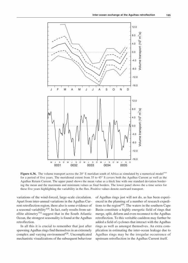
195
J F M A M J J A S O N D
12.0
8.0
4.0
0.0
-4.0
-8.0
-12.0
-16.0
12.0
8.0
4.0
0.0
-4.0
-8.0
-12.0
-16.0M J S D M J S D M J S D M J S D M J S D
0031 0032 0033 0034 0035
Figure 6.36. The volume transport across the 20° E meridian south of Africa as simulated by a numerical model777
for a period of five years. The meridional extent from 35 to 45° S covers both the Agulhas Current as well as theAgulhas Return Current. The upper panel shows the mean value as a thick line with one standard deviation border-ing the mean and the maximum and minimum values as final borders. The lower panel shows the a time series forthese five years highlighting the variability in the flux. Positive values denote eastward transport.
variations of the wind-forced, large-scale circulation.Apart from inter-annual variations in the Agulhas Cur-rent retroflection region, there also is some evidence ofa seasonal variability418. In fact, early results from sat-ellite altimetry752 suggest that in the South AtlanticOcean, the strongest seasonality is found at the Agulhasretroflection.
In all this it is crucial to remember that just afterspawning Agulhas rings find themselves in an extremelycomplex and varying environment628. Uncomplicatedmechanistic visualizations of the subsequent behaviour
of Agulhas rings just will not do, as has been experi-enced in the planning of a number of research expedi-tions to the region650. The waters in the southern CapeBasin constitute a highly energetic field of rings thatmerge, split, deform and even reconnect to the Agulhasretroflection. To this veritable cauldron may further beadded a field of cyclones that interact with the Agulhasrings as well as amongst themselves. An extra com-plication in estimating the inter-ocean leakage due toAgulhas rings may be the irregular occurrence ofupstream retroflection in the Agulhas Current itself.
Inter-ocean exchange at the Agulhas retroflection

The Agulhas Current retroflection196
Upstream retroflection
Whereas the normal location of the Agulhas retroflec-tion loop lies west of 20° E91, there have beeninstances64 in which the disposition of sea surface tem-peratures have suggested that part – if not all – of theAgulhas Current retroflected south of Port Elizabeth(viz. Figure 1.2). These suggestions of an upstreamretroflection have been supported by the tracks of drift-ers. Such early retroflection has been assumed64 tocome about when an exceptionally well-developedNatal Pulse forces the core of the Agulhas Current suf-ficiently far offshore so that it intersects the shallowbathymetry of the Agulhas Plateau to the south and isthus forced eastward. Few such upstream short circuitsin the normal trajectory of the current have been ob-served to date. On occasion a seemingly incompleteearly retroflection has been noticed in thermal infraredimagery412. It can be assumed that such short-livedevents do not contribute to a major change in the inter-ocean fluxes south of Africa. A long-lasting early retro-flection, over the full depth of the current, wouldnaturally have a substantial effect on the interchangesouth of Africa since Agulhas water would never reachthe normal retroflection region. It would therefore notbe available for inter-ocean exchange.
It has been assumed133 that augmentations in theincidence of large Natal Pulses and concurrentincreases in early retroflection events would be instru-mental in substantial changes in the global thermo-haline circulation. For this to be a robust mechanism,early retroflection events would have to be durable. Anevent lasting a number of months was observed fromsatellite remote sensing for the first time in 2000–2001670–1. This gives an indication of the limited fre-quency of these events that can be expected. One of the
main questions that remain would be the extent towhich early retroflections succeed in siphoning off thegreater part of the flux of the full Agulhas Current, i.e.how deep do they extend. During the 2000–2001 eventfortuitous hydrographic measurements could be made672
across the path of the current, proving that this particu-lar upstream retroflection involved the greater part of theAgulhas Current. The significance of this finding issubstantial.
Global significance
With the ever more accurate estimates of the inter-ocean exchanges by Agulhas rings, the role they playin the global thermohaline circulation cell would seemto be increasingly more reliably quantified. This is notyet the case. Nonetheless, establishing the effect ofAgulhas rings remains critical to an understanding ofthe role in global climate of the one major ocean basin– the Atlantic Ocean – in which there is a substantial netheat flow across the equator in a northward direction.This flow has been estimated753 to be about 0.29 PW.
Rintoul, using an inverse model, has concluded565
that no input of warm Indian Ocean is required toaccount for the net northward heat flux in the SouthAtlantic Ocean, the flow being totally determined bydifferences in the water masses entering via the DrakePassage and leaving the South Atlantic sector of theSouthern Ocean between Africa and Antarctica. Adifferent model, using as constraint the historicalhydrographic data, predicts that an inflow into theSouth Atlantic Ocean of 4 to 7 × 10⁶ m3/s can beaccommodated, but no larger values247. A strong cor-relation is found between the meridional heat transportin this latter model, the strength of the global thermo-haline cell and inflow from the Indian Ocean. Themodel has no Agulhas rings and may therefore bebiased.
On the other hand, use of a primitive equation modelof the southern hemisphere566 has suggested that 85 percent of the northward heat transport into the Atlanticoriginates in the Indian Ocean, only the remainder com-ing through the Drake Passage. Others67 have shownthat up to two-thirds of the Benguela Current of theSouth Atlantic, within and above the thermocline, hasits origin in the South Indian Ocean. The total transporthas been estimated759 at 28(±4) × 106 m3/s. Anotherpublished value779 is 25 × 106 m3/s. The results of allinversion studies to date that have estimated the heatflux across 30° S latitude in the South Atlantic are givenin Table 6.8; those for modelling studies in Table 6.9.From these tables it is clear that linkages of Atlantic andIndian Ocean waters continue into deep water and, as
1993 1994 1995 1996 19971992
EO
FN
o.
1
-60
-40
-20
0
20
40
60
Figure 6.37. The intra-annual variability for the Agulhasretroflection and the Cape Basin for a period of five years712
as expressed by a regional empirical orthogonal function.This mode 1 explains 45 per cent of the variance in theregion. The thick line is a nine-month running mean for theamplitude.

197
could be expected from the relative volumes of thewater types363, are greatest by volume in deep water.
The set of historical hydrographic data in the Agul-has retroflection and in the South Atlantic Oceanshow250 the progression of Antarctic IntermediateWater to mirror that of the Agulhas Current and Agulhasrings, but cannot resolve their influence directly.Agulhas rings do not seem to have an adequately dis-tinct hydrographic signal, or are not present in sufficientabundance, to leave behind a tell-tale record in thehydrographic data at depth to indicate their range ofinfluence or average path195. Nevertheless, estimates ofpotential vorticity on the 27.3 isopycnal575 shows clearevidence of leakage of Antarctic Intermediate Waterfrom the Indian to the Atlantic Ocean and its penetra-tion in a north-westerly direction across the SouthAtlantic Ocean.
Modelling of the impact of inter-ocean exchangeson the thermohaline overturning of the AtlanticOcean68,668–9 has been very suggestive. Weijer et al.68
have, as mentioned above, shown that the heat and salttransports by the South Atlantic subtropical gyre playan essential role in the heat and salt budgets of theAtlantic as a whole. It has been shown that in this modelthe exported North Atlantic Deep Water is fresher than
the return flows and that the overturning circulationthus exports freshwater from the Atlantic Ocean. Evensmall changes in the composition of the return trans-ports of the North Atlantic Deep Water may influencethe overturning circulation in this ocean considerably.The model furthermore shows68 that interocean fluxesof heat and salt are important for the strength andoperation of the overturning circulation. Comparing theroles of the inter-ocean exchanges between the Atlan-tic, the Pacific through the Drake Passage, the Pacificthrough the Bering Sea and the South Indian Ocean668
in a global circulation model, it can be shown that it isespecially the Indian–Atlantic transfers of heat and saltby leakage from the Agulhas Current that contributesto the strength and the stability of the northern sinkingcirculation. When the stabilizing effect of the leakagefrom the Agulhas Current disappears, the destabilizinginfluence on the overturning circulation by freshwaterfrom the Bering Strait becomes more effective. Of par-ticular importance in these model studies has been aninvestigation on the influence of water from the Agul-has Current on the Atlantic overturning as a whole669
(viz. Figure 6.38).From Figure 6.38 it is clear that the model’s over-
turning circulation is sensitive to changes in the inter-
Table 6.8. The heat fluxes (FQ) and the volume transports across 30° S latitude in the South Atlantic Ocean according to a numberof inversion studies516. Values are given in 106 m3/s; positive values denoting equatorward transport. Values are given for differentwater masses: SW representing Surface Water; AAIW, Antarctic Intermediate Water; NADW, North Atlantic Deep Water andAABW, Antarctic Bottom Water. Date refers to the date on which a hydrographic section was carried out along 30° S latitude.
Authors SW AAIW NADW AABW FQ [PW] Date
Fu (1981)567 15 10 –24 –2 0.85 July–August 1925 METEOR9 6 –20 1 0.88 April–June 1959 IGY
Rintoul (1991)565 8 5 –17 4 0.25 April–May 1959 IGYMacDonald (1993)568 6.1 7.9 –21.6 7.5 0.3 February 1988–February 1989Schlitzer (1993)569 2.2 10.0 –15.8 3.1 –0.05 historicalSchlitzer (1996)570 2.0 11.9 –18.7 4.2 0.3 historicalBoddem and Schlitzer (1995)247 –1.9 9.8 –8.9 1.1 0.04 historicalHolfort et al. (1998)571 0.26 January 1993 WOCE
Table 6.9. The heat fluxes (last column) and volume transports for different water masses across 30° S latitude in the South AtlanticOcean, according to a few modelling studies516. Volume fluxes are given in 106 m3/s. Water masses are: SW: Surface Water; AAIW:Antarctic Intermediate Water; NADW: North Atlantic Deep Water and AABW: Antarctic Bottom Water.
Authors SW AAIW NADW AABW F0 (PW)
FRAM Group (1991)272 11 8 –22 3.2 0.56Semtner and Chervin (1992)274 12 4.7 –18 1.3 0.60Matano and Philander (1993)573 6.8 1.6 –10.9 2.5 0.19Thompson et al. (1997)574 12.7 6.8 –20.9 1.4 0.56
Inter-ocean exchange at the Agulhas retroflection
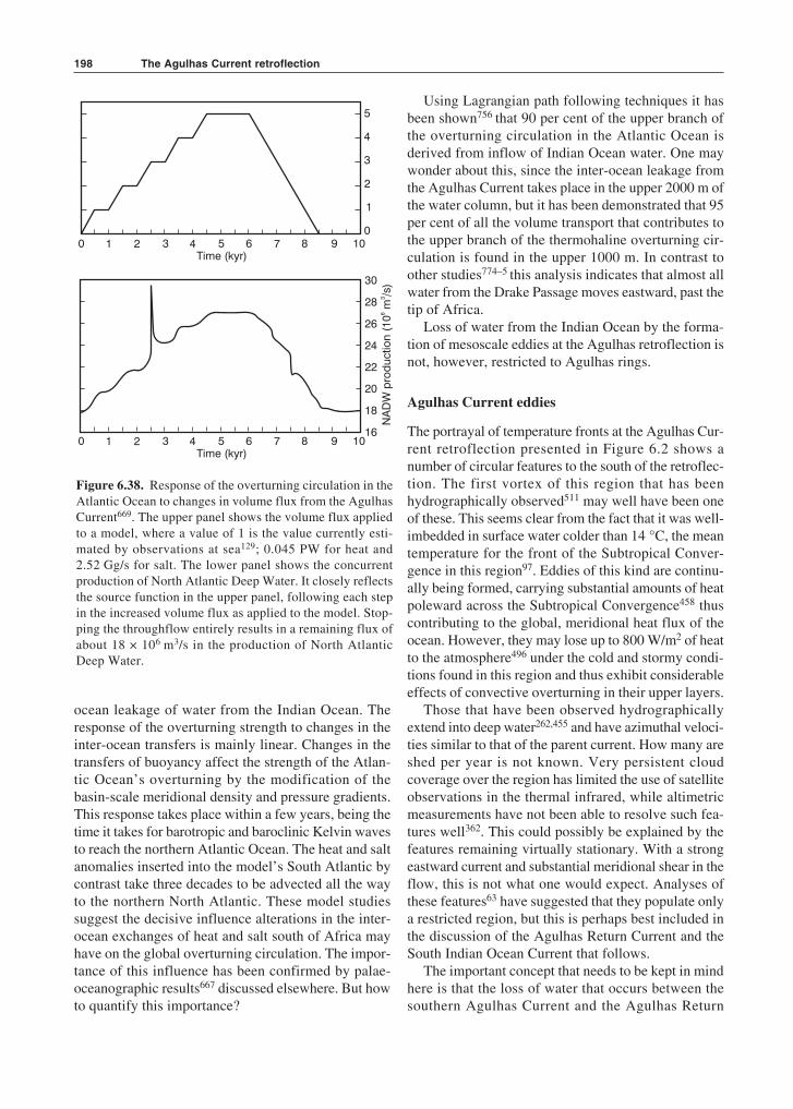
The Agulhas Current retroflection198
ocean leakage of water from the Indian Ocean. Theresponse of the overturning strength to changes in theinter-ocean transfers is mainly linear. Changes in thetransfers of buoyancy affect the strength of the Atlan-tic Ocean’s overturning by the modification of thebasin-scale meridional density and pressure gradients.This response takes place within a few years, being thetime it takes for barotropic and baroclinic Kelvin wavesto reach the northern Atlantic Ocean. The heat and saltanomalies inserted into the model’s South Atlantic bycontrast take three decades to be advected all the wayto the northern North Atlantic. These model studiessuggest the decisive influence alterations in the inter-ocean exchanges of heat and salt south of Africa mayhave on the global overturning circulation. The impor-tance of this influence has been confirmed by palae-oceanographic results667 discussed elsewhere. But howto quantify this importance?
Using Lagrangian path following techniques it hasbeen shown756 that 90 per cent of the upper branch ofthe overturning circulation in the Atlantic Ocean isderived from inflow of Indian Ocean water. One maywonder about this, since the inter-ocean leakage fromthe Agulhas Current takes place in the upper 2000 m ofthe water column, but it has been demonstrated that 95per cent of all the volume transport that contributes tothe upper branch of the thermohaline overturning cir-culation is found in the upper 1000 m. In contrast toother studies774–5 this analysis indicates that almost allwater from the Drake Passage moves eastward, past thetip of Africa.
Loss of water from the Indian Ocean by the forma-tion of mesoscale eddies at the Agulhas retroflection isnot, however, restricted to Agulhas rings.
Agulhas Current eddies
The portrayal of temperature fronts at the Agulhas Cur-rent retroflection presented in Figure 6.2 shows anumber of circular features to the south of the retroflec-tion. The first vortex of this region that has beenhydrographically observed511 may well have been oneof these. This seems clear from the fact that it was well-imbedded in surface water colder than 14 °C, the meantemperature for the front of the Subtropical Conver-gence in this region97. Eddies of this kind are continu-ally being formed, carrying substantial amounts of heatpoleward across the Subtropical Convergence458 thuscontributing to the global, meridional heat flux of theocean. However, they may lose up to 800 W/m2 of heatto the atmosphere496 under the cold and stormy condi-tions found in this region and thus exhibit considerableeffects of convective overturning in their upper layers.
Those that have been observed hydrographicallyextend into deep water262,455 and have azimuthal veloci-ties similar to that of the parent current. How many areshed per year is not known. Very persistent cloudcoverage over the region has limited the use of satelliteobservations in the thermal infrared, while altimetricmeasurements have not been able to resolve such fea-tures well362. This could possibly be explained by thefeatures remaining virtually stationary. With a strongeastward current and substantial meridional shear in theflow, this is not what one would expect. Analyses ofthese features63 have suggested that they populate onlya restricted region, but this is perhaps best included inthe discussion of the Agulhas Return Current and theSouth Indian Ocean Current that follows.
The important concept that needs to be kept in mindhere is that the loss of water that occurs between thesouthern Agulhas Current and the Agulhas Return
Figure 6.38. Response of the overturning circulation in theAtlantic Ocean to changes in volume flux from the AgulhasCurrent669. The upper panel shows the volume flux appliedto a model, where a value of 1 is the value currently esti-mated by observations at sea129; 0.045 PW for heat and2.52 Gg/s for salt. The lower panel shows the concurrentproduction of North Atlantic Deep Water. It closely reflectsthe source function in the upper panel, following each stepin the increased volume flux as applied to the model. Stop-ping the throughflow entirely results in a remaining flux ofabout 18 × 106 m3/s in the production of North AtlanticDeep Water.
5
4
3
2
1
00 1 2 3 4 5 6 7 8 9 10
Time (kyr)
0 1 2 3 4 5 6 7 8 9 10Time (kyr)
30
28
26
24
22
20
18
16
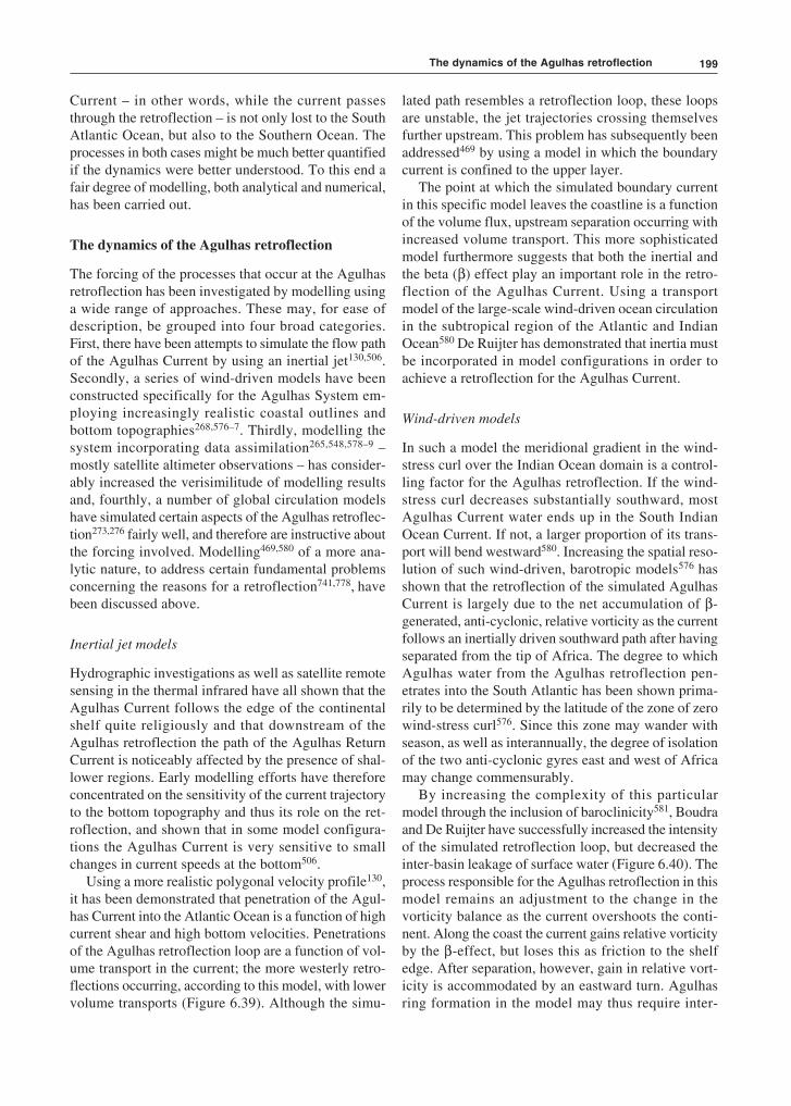
199
Current – in other words, while the current passesthrough the retroflection – is not only lost to the SouthAtlantic Ocean, but also to the Southern Ocean. Theprocesses in both cases might be much better quantifiedif the dynamics were better understood. To this end afair degree of modelling, both analytical and numerical,has been carried out.
The dynamics of the Agulhas retroflection
The forcing of the processes that occur at the Agulhasretroflection has been investigated by modelling usinga wide range of approaches. These may, for ease ofdescription, be grouped into four broad categories.First, there have been attempts to simulate the flow pathof the Agulhas Current by using an inertial jet130,506.Secondly, a series of wind-driven models have beenconstructed specifically for the Agulhas System em-ploying increasingly realistic coastal outlines andbottom topographies268,576–7. Thirdly, modelling thesystem incorporating data assimilation265,548,578–9 –mostly satellite altimeter observations – has consider-ably increased the verisimilitude of modelling resultsand, fourthly, a number of global circulation modelshave simulated certain aspects of the Agulhas retroflec-tion273,276 fairly well, and therefore are instructive aboutthe forcing involved. Modelling469,580 of a more ana-lytic nature, to address certain fundamental problemsconcerning the reasons for a retroflection741,778, havebeen discussed above.
Inertial jet models
Hydrographic investigations as well as satellite remotesensing in the thermal infrared have all shown that theAgulhas Current follows the edge of the continentalshelf quite religiously and that downstream of theAgulhas retroflection the path of the Agulhas ReturnCurrent is noticeably affected by the presence of shal-lower regions. Early modelling efforts have thereforeconcentrated on the sensitivity of the current trajectoryto the bottom topography and thus its role on the ret-roflection, and shown that in some model configura-tions the Agulhas Current is very sensitive to smallchanges in current speeds at the bottom506.
Using a more realistic polygonal velocity profile130,it has been demonstrated that penetration of the Agul-has Current into the Atlantic Ocean is a function of highcurrent shear and high bottom velocities. Penetrationsof the Agulhas retroflection loop are a function of vol-ume transport in the current; the more westerly retro-flections occurring, according to this model, with lowervolume transports (Figure 6.39). Although the simu-
lated path resembles a retroflection loop, these loopsare unstable, the jet trajectories crossing themselvesfurther upstream. This problem has subsequently beenaddressed469 by using a model in which the boundarycurrent is confined to the upper layer.
The point at which the simulated boundary currentin this specific model leaves the coastline is a functionof the volume flux, upstream separation occurring withincreased volume transport. This more sophisticatedmodel furthermore suggests that both the inertial andthe beta (β) effect play an important role in the retro-flection of the Agulhas Current. Using a transportmodel of the large-scale wind-driven ocean circulationin the subtropical region of the Atlantic and IndianOcean580 De Ruijter has demonstrated that inertia mustbe incorporated in model configurations in order toachieve a retroflection for the Agulhas Current.
Wind-driven models
In such a model the meridional gradient in the wind-stress curl over the Indian Ocean domain is a control-ling factor for the Agulhas retroflection. If the wind-stress curl decreases substantially southward, mostAgulhas Current water ends up in the South IndianOcean Current. If not, a larger proportion of its trans-port will bend westward580. Increasing the spatial reso-lution of such wind-driven, barotropic models576 hasshown that the retroflection of the simulated AgulhasCurrent is largely due to the net accumulation of β-generated, anti-cyclonic, relative vorticity as the currentfollows an inertially driven southward path after havingseparated from the tip of Africa. The degree to whichAgulhas water from the Agulhas retroflection pen-etrates into the South Atlantic has been shown prima-rily to be determined by the latitude of the zone of zerowind-stress curl576. Since this zone may wander withseason, as well as interannually, the degree of isolationof the two anti-cyclonic gyres east and west of Africamay change commensurably.
By increasing the complexity of this particularmodel through the inclusion of baroclinicity581, Boudraand De Ruijter have successfully increased the intensityof the simulated retroflection loop, but decreased theinter-basin leakage of surface water (Figure 6.40). Theprocess responsible for the Agulhas retroflection in thismodel remains an adjustment to the change in thevorticity balance as the current overshoots the conti-nent. Along the coast the current gains relative vorticityby the β-effect, but loses this as friction to the shelfedge. After separation, however, gain in relative vort-icity is accommodated by an eastward turn. Agulhasring formation in the model may thus require inter-
The dynamics of the Agulhas retroflection
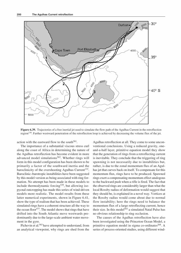
The Agulhas Current retroflection200
action with the eastward flow to the south581.The importance of a substantial viscous stress curl
along the coast of Africa in determining the nature ofthe Agulhas retroflection has become evident in moreadvanced model simulations582. Whether rings willform in this model configuration has been shown to beprimarily a factor of the southward inertia and thebaroclinicity of the overshooting Agulhas Current132.Baroclinic–barotropic instabilities have been suggestedby this model version as being associated with ring for-mation. No attempt has been made in these models toinclude thermodynamic forcing529, but allowing iso-pycnal outcropping has made this series of wind-drivenmodels more realistic. The model results from theselatter numerical experiments, shown in Figure 6.41,show the type of realism that has been achieved. Thesesimulated rings have a coherent structure all the way tothe ocean floor577. The model shows that rings that havedrifted into the South Atlantic move westwards pre-dominantly due to the large-scale ambient water move-ment in the gyre.
Pichevin et al.583 have attempted to understand, froman analytical viewpoint, why rings are shed from the
Agulhas retroflection at all. They come to some uncon-ventional conclusions. Using a reduced gravity, one-and-a-half layer, primitive equation model they showthat the generation of rings from a retroflecting currentis inevitable. They conclude that the triggering of ringspawning is not necessarily due to instabilities but,rather, is due to the zonal momentum flux of an Agul-has jet that curves back on itself. To compensate for thismomentum flux, rings have to be produced. Spawnedrings exert a compensating momentum effect analogousto the backward push when a rifle is fired. The fact thatthe observed rings are considerably larger than what thelocal Rossby radius of deformation would suggest thatthey should be, is explained in a novel way. Vortices atthe Rossby radius would come about due to normalflow instability; here the rings need to balance themomentum flux of a large retroflecting current, hencetheir size. In this model583 a simulated Natal Pulse hasno obvious relationship to ring occlusion.
The causes of the Agulhas retroflection have alsobeen investigated using the Princeton Ocean Model, aprimitive equation model in sigma co-ordinates268. Aseries of process-oriented studies, using different wind-
Figure 6.39. Trajectories of a free inertial jet used to simulate the flow path of the Agulhas Current in the retroflectionregion130. Farther westward penetration of the retroflection loop is achieved by decreasing the volume flux of the jet.
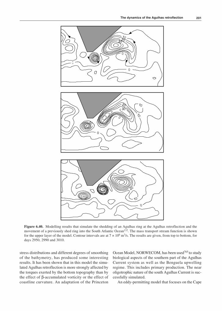
201
Figure 6.40. Modelling results that simulate the shedding of an Agulhas ring at the Agulhas retroflection and themovement of a previously shed ring into the South Atlantic Ocean132. The mass transport stream function is shownfor the upper layer of the model. Contour intervals are at 7 × 10⁶ m3/s. The results are given, from top to bottom, fordays 2950, 2990 and 3010.
stress distributions and different degrees of smoothingof the bathymetry, has produced some interestingresults. It has been shown that in this model the simu-lated Agulhas retroflection is more strongly affected bythe torques exerted by the bottom topography than bythe effect of β-accumulated vorticity or the effect ofcoastline curvature. An adaptation of the Princeton
Ocean Model, NORWECOM, has been used765 to studybiological aspects of the southern part of the AgulhasCurrent system as well as the Benguela upwellingregime. This includes primary production. The nearoligotrophic nature of the south Agulhas Current is suc-cessfully simulated.
An eddy-permitting model that focuses on the Cape
The dynamics of the Agulhas retroflection
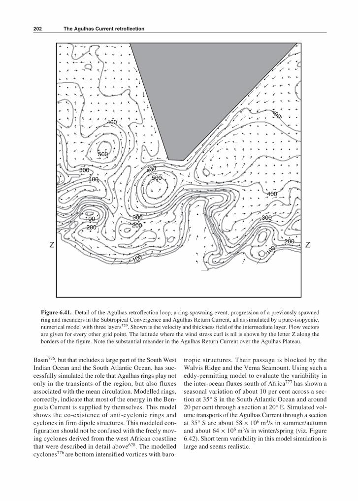
The Agulhas Current retroflection202
Basin776, but that includes a large part of the South WestIndian Ocean and the South Atlantic Ocean, has suc-cessfully simulated the role that Agulhas rings play notonly in the transients of the region, but also fluxesassociated with the mean circulation. Modelled rings,correctly, indicate that most of the energy in the Ben-guela Current is supplied by themselves. This modelshows the co-existence of anti-cyclonic rings andcyclones in firm dipole structures. This modeled con-figuration should not be confused with the freely mov-ing cyclones derived from the west African coastlinethat were described in detail above628. The modelledcyclones776 are bottom intensified vortices with baro-
tropic structures. Their passage is blocked by theWalvis Ridge and the Vema Seamount. Using such aeddy-permitting model to evaluate the variability inthe inter-ocean fluxes south of Africa777 has shown aseasonal variation of about 10 per cent across a sec-tion at 35° S in the South Atlantic Ocean and around20 per cent through a section at 20° E. Simulated vol-ume transports of the Agulhas Current through a sectionat 35° S are about 58 × 106 m3/s in summer/autumnand about 64 × 106 m3/s in winter/spring (viz. Figure6.42). Short term variability in this model simulation islarge and seems realistic.
Z Z
400
500
300
400
100
200 200
300
500400
400
400
300
200
100
100
Figure 6.41. Detail of the Agulhas retroflection loop, a ring-spawning event, progression of a previously spawnedring and meanders in the Subtropical Convergence and Agulhas Return Current, all as simulated by a pure-isopycnic,numerical model with three layers529. Shown is the velocity and thickness field of the intermediate layer. Flow vectorsare given for every other grid point. The latitude where the wind stress curl is nil is shown by the letter Z along theborders of the figure. Note the substantial meander in the Agulhas Return Current over the Agulhas Plateau.
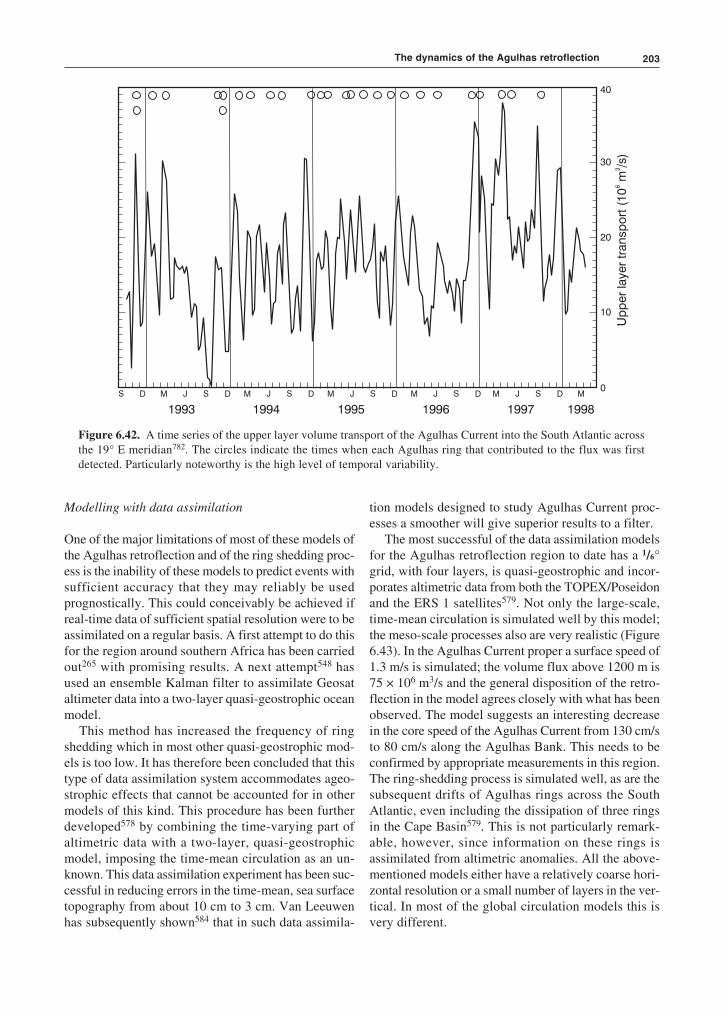
203
Modelling with data assimilation
One of the major limitations of most of these models ofthe Agulhas retroflection and of the ring shedding proc-ess is the inability of these models to predict events withsufficient accuracy that they may reliably be usedprognostically. This could conceivably be achieved ifreal-time data of sufficient spatial resolution were to beassimilated on a regular basis. A first attempt to do thisfor the region around southern Africa has been carriedout265 with promising results. A next attempt548 hasused an ensemble Kalman filter to assimilate Geosataltimeter data into a two-layer quasi-geostrophic oceanmodel.
This method has increased the frequency of ringshedding which in most other quasi-geostrophic mod-els is too low. It has therefore been concluded that thistype of data assimilation system accommodates ageo-strophic effects that cannot be accounted for in othermodels of this kind. This procedure has been furtherdeveloped578 by combining the time-varying part ofaltimetric data with a two-layer, quasi-geostrophicmodel, imposing the time-mean circulation as an un-known. This data assimilation experiment has been suc-cessful in reducing errors in the time-mean, sea surfacetopography from about 10 cm to 3 cm. Van Leeuwenhas subsequently shown584 that in such data assimila-
tion models designed to study Agulhas Current proc-esses a smoother will give superior results to a filter.
The most successful of the data assimilation modelsfor the Agulhas retroflection region to date has a 1/6°grid, with four layers, is quasi-geostrophic and incor-porates altimetric data from both the TOPEX/Poseidonand the ERS 1 satellites579. Not only the large-scale,time-mean circulation is simulated well by this model;the meso-scale processes also are very realistic (Figure6.43). In the Agulhas Current proper a surface speed of1.3 m/s is simulated; the volume flux above 1200 m is75 × 106 m3/s and the general disposition of the retro-flection in the model agrees closely with what has beenobserved. The model suggests an interesting decreasein the core speed of the Agulhas Current from 130 cm/sto 80 cm/s along the Agulhas Bank. This needs to beconfirmed by appropriate measurements in this region.The ring-shedding process is simulated well, as are thesubsequent drifts of Agulhas rings across the SouthAtlantic, even including the dissipation of three ringsin the Cape Basin579. This is not particularly remark-able, however, since information on these rings isassimilated from altimetric anomalies. All the above-mentioned models either have a relatively coarse hori-zontal resolution or a small number of layers in the ver-tical. In most of the global circulation models this isvery different.
D M J S D M J S D M J S D M J S D M J S D MS
1993 1994 1995 1996 1997 1998
40
30
20
10
0
Figure 6.42. A time series of the upper layer volume transport of the Agulhas Current into the South Atlantic acrossthe 19° E meridian782. The circles indicate the times when each Agulhas ring that contributed to the flux was firstdetected. Particularly noteworthy is the high level of temporal variability.
The dynamics of the Agulhas retroflection
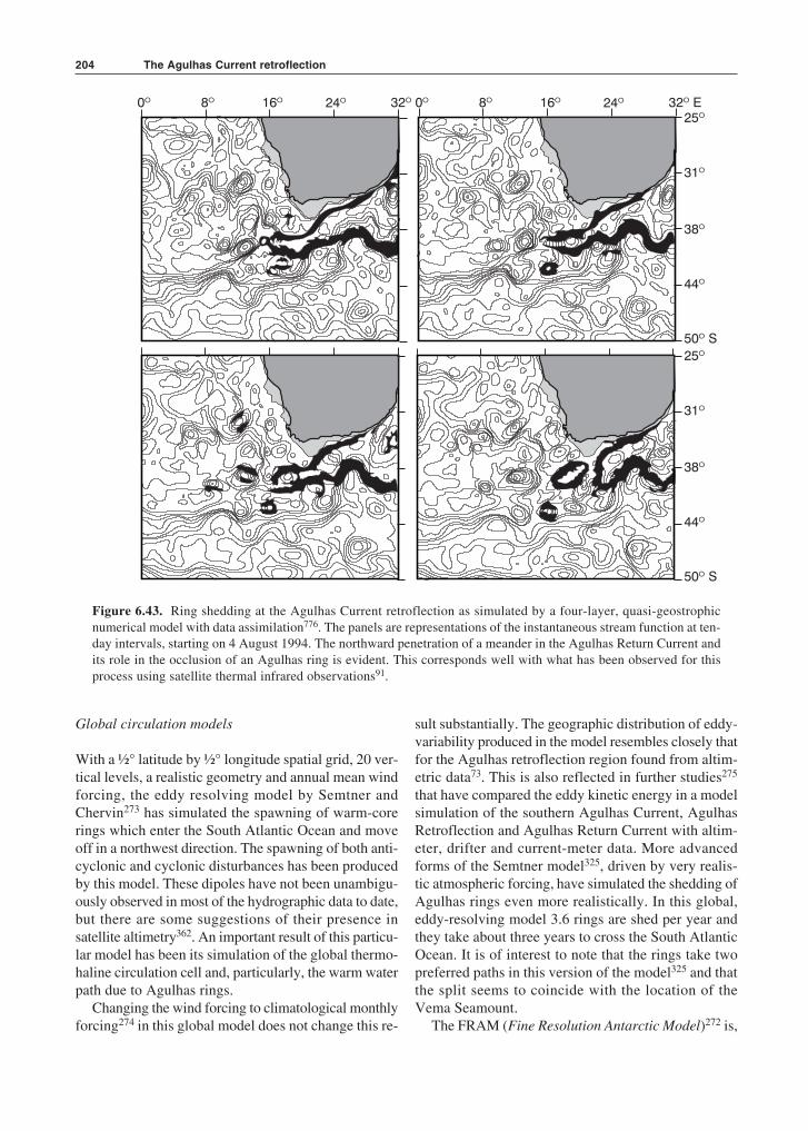
The Agulhas Current retroflection204
Global circulation models
With a ½° latitude by ½° longitude spatial grid, 20 ver-tical levels, a realistic geometry and annual mean windforcing, the eddy resolving model by Semtner andChervin273 has simulated the spawning of warm-corerings which enter the South Atlantic Ocean and moveoff in a northwest direction. The spawning of both anti-cyclonic and cyclonic disturbances has been producedby this model. These dipoles have not been unambigu-ously observed in most of the hydrographic data to date,but there are some suggestions of their presence insatellite altimetry362. An important result of this particu-lar model has been its simulation of the global thermo-haline circulation cell and, particularly, the warm waterpath due to Agulhas rings.
Changing the wind forcing to climatological monthlyforcing274 in this global model does not change this re-
sult substantially. The geographic distribution of eddy-variability produced in the model resembles closely thatfor the Agulhas retroflection region found from altim-etric data73. This is also reflected in further studies275
that have compared the eddy kinetic energy in a modelsimulation of the southern Agulhas Current, AgulhasRetroflection and Agulhas Return Current with altim-eter, drifter and current-meter data. More advancedforms of the Semtner model325, driven by very realis-tic atmospheric forcing, have simulated the shedding ofAgulhas rings even more realistically. In this global,eddy-resolving model 3.6 rings are shed per year andthey take about three years to cross the South AtlanticOcean. It is of interest to note that the rings take twopreferred paths in this version of the model325 and thatthe split seems to coincide with the location of theVema Seamount.
The FRAM (Fine Resolution Antarctic Model)272 is,
a
0º 8º 16º 24º 32º 0º 8º 16º 24º 32 Eº25º
31º
38º
44º
50 Sº
25º
31º
38º
44º
50 Sº
Figure 6.43. Ring shedding at the Agulhas Current retroflection as simulated by a four-layer, quasi-geostrophicnumerical model with data assimilation776. The panels are representations of the instantaneous stream function at ten-day intervals, starting on 4 August 1994. The northward penetration of a meander in the Agulhas Return Current andits role in the occlusion of an Agulhas ring is evident. This corresponds well with what has been observed for thisprocess using satellite thermal infrared observations91.
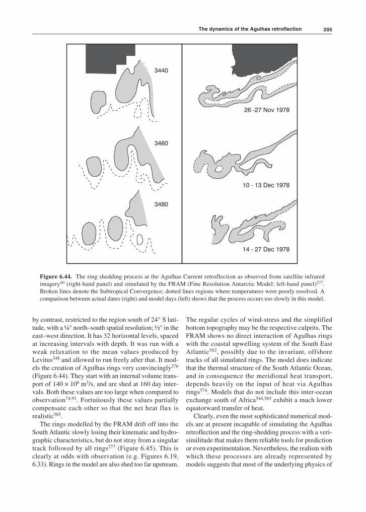
205
by contrast, restricted to the region south of 24° S lati-tude, with a ¼° north–south spatial resolution; ½° in theeast–west direction. It has 32 horizontal levels, spacedat increasing intervals with depth. It was run with aweak relaxation to the mean values produced byLevitus348 and allowed to run freely after that. It mod-els the creation of Agulhas rings very convincingly276
(Figure 6.44). They start with an internal volume trans-port of 140 × 106 m3/s, and are shed at 160 day inter-vals. Both these values are too large when compared toobservation74,91. Fortuitously these values partiallycompensate each other so that the net heat flux isrealistic585.
The rings modelled by the FRAM drift off into theSouth Atlantic slowly losing their kinematic and hydro-graphic characteristics, but do not stray from a singulartrack followed by all rings277 (Figure 6.45). This isclearly at odds with observation (e.g. Figures 6.19,6.33). Rings in the model are also shed too far upstream.
The regular cycles of wind-stress and the simplifiedbottom topography may be the respective culprits. TheFRAM shows no direct interaction of Agulhas ringswith the coastal upwelling system of the South EastAtlantic562, possibly due to the invariant, offshoretracks of all simulated rings. The model does indicatethat the thermal structure of the South Atlantic Ocean,and in consequence the meridional heat transport,depends heavily on the input of heat via Agulhasrings574. Models that do not include this inter-oceanexchange south of Africa544,565 exhibit a much lowerequatorward transfer of heat.
Clearly, even the most sophisticated numerical mod-els are at present incapable of simulating the Agulhasretroflection and the ring-shedding process with a veri-similitude that makes them reliable tools for predictionor even experimentation. Nevertheless, the realism withwhich these processes are already represented bymodels suggests that most of the underlying physics of
3440
3460
3480
26 -27 Nov 1978
10 - 13 Dec 1978
14 - 27 Dec 1978
Figure 6.44. The ring shedding process at the Agulhas Current retroflection as observed from satellite infraredimagery60 (right-hand panel) and simulated by the FRAM (Fine Resolution Antarctic Model; left-hand panel)277.Broken lines denote the Subtropical Convergence; dotted lines regions where temperatures were poorly resolved. Acomparison between actual dates (right) and model days (left) shows that the process occurs too slowly in this model.
The dynamics of the Agulhas retroflection
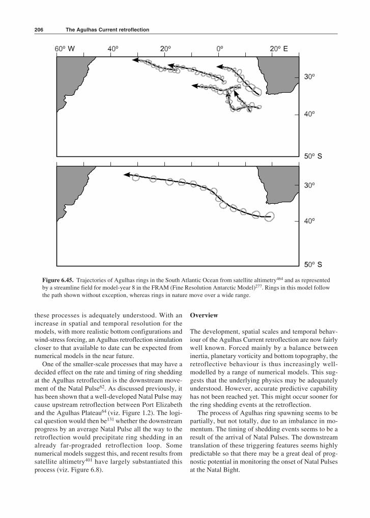
The Agulhas Current retroflection206
these processes is adequately understood. With anincrease in spatial and temporal resolution for themodels, with more realistic bottom configurations andwind-stress forcing, an Agulhas retroflection simulationcloser to that available to date can be expected fromnumerical models in the near future.
One of the smaller-scale processes that may have adecided effect on the rate and timing of ring sheddingat the Agulhas retroflection is the downstream move-ment of the Natal Pulse62. As discussed previously, ithas been shown that a well-developed Natal Pulse maycause upstream retroflection between Port Elizabethand the Agulhas Plateau64 (viz. Figure 1.2). The logi-cal question would then be131 whether the downstreamprogress by an average Natal Pulse all the way to theretroflection would precipitate ring shedding in analready far-prograded retroflection loop. Somenumerical models suggest this, and recent results fromsatellite altimetry401 have largely substantiated thisprocess (viz. Figure 6.8).
Figure 6.45. Trajectories of Agulhas rings in the South Atlantic Ocean from satellite altimetry464 and as representedby a streamline field for model-year 8 in the FRAM (Fine Resolution Antarctic Model)277. Rings in this model followthe path shown without exception, whereas rings in nature move over a wide range.
Overview
The development, spatial scales and temporal behav-iour of the Agulhas Current retroflection are now fairlywell known. Forced mainly by a balance betweeninertia, planetary vorticity and bottom topography, theretroflective behaviour is thus increasingly well-modelled by a range of numerical models. This sug-gests that the underlying physics may be adequatelyunderstood. However, accurate predictive capabilityhas not been reached yet. This might occur sooner forthe ring shedding events at the retroflection.
The process of Agulhas ring spawning seems to bepartially, but not totally, due to an imbalance in mo-mentum. The timing of shedding events seems to be aresult of the arrival of Natal Pulses. The downstreamtranslation of these triggering features seems highlypredictable so that there may be a great deal of prog-nostic potential in monitoring the onset of Natal Pulsesat the Natal Bight.
207
The behaviour of Agulhas rings subsequent tospawning has been intensively studied. Their observeddrift behaviour across the South Atlantic Ocean hasnonetheless raised a number of key questions. A largenumber seem totally to disintegrate in the Cape Basin.This raises questions about the mixing processesinvolved in their decay. A large observational pro-gramme has been undertaken to investigate these. Asubstantial number split into smaller eddies that may,conceivably, mix out faster. This splitting process maybe strongly influenced by the presence of seamounts.The physics of such processes needs to be investigated.There is no clear-cut indication of how rings areaffected by the Walvis Ridge. All disparate model pre-dictions are accommodated by the behaviour of at leastsome observed rings on crossing this ridge. On havingpassed this obstacle, the behaviour of the remainingrings seems more uniform, suggesting the filtering
behaviour of the Walvis Ridge. From the diversebehaviours of Agulhas rings in the Cape Basin it is clearthat there is a wide spectrum of natural histories forAgulhas rings once shed, substantially affecting theinterbasin exchanges south of Africa.
Models currently in use for studying the global ther-mohaline cell show the decisive influence of the leak-age of water from the South Indian Ocean into theSouth Atlantic Ocean on the overturning behaviour.The fluxes at depth are still poorly understood, but arebeing investigated. The fluxes in the upper layers aredominated by the shedding of the huge Agulhas rings.Direct exchanges and Agulhas filaments play minorroles. In this region of extreme mesoscale flow variabil-ity there is also a substantial exchange between the sub-tropics and the subantarctic, mostly by the shedding ofAgulhas eddies from the Agulhas Return Current.
Overview

The Agulhas Current retroflection208
Related Documents