THE PLAN FOR THE VALLEYS: ASSESSING IAN McHARG’S VISION 50 YEARS LATER George Hundt, Jr. Spring 2016 Thomas L. Daniels, University of Pennsylvania John C. Keene, University of Pennsylvania

Welcome message from author
This document is posted to help you gain knowledge. Please leave a comment to let me know what you think about it! Share it to your friends and learn new things together.
Transcript

THE PLAN FOR THE VALLEYS:
ASSESSING IAN McHARG’S VISION 50 YEARS LATER
George Hundt, Jr. Spring 2016
Thomas L. Daniels, University of Pennsylvania John C. Keene, University of Pennsylvania

I
ABSTRACT
THE PLAN FOR THE VALLEYS: ASSESSING IAN McHARG’S VISION 50 YEARS LATER
George Hundt, Jr.
Development pressures threatening northwestern Baltimore County, Maryland in the early 1960s led to the creation of a citizens group, the Valleys Planning Council (VPC), which in turn commissioned University of Pennsylvania Profes-sors David Wallace and Ian McHarg to produce a land-use study. The Plan for the Valleys (1964) positively influenced land preservation and planning in this ru-ral area and beyond. The PFV largely reflected McHarg’s philosophy regarding ecological determinism. The arc of his career is addressed in the context of The Plan. This Capstone examines the region’s vulnerabilities which necessitated The PFV, its visionary elements, and its long-term impacts. Focus is given to the political difficulties of implementation, and to the ancillary roles of an urban growth boundary, downzoning, and conservation easements. The partnership between the VPC and County planners was effective, but resists broader applica-tion at the same scale. The PFV, in fact, was only partially implemented. While it functioned as a catalyst for the extensive preservation of the countryside, sig-nificant design elements were omitted. The related failure to adopt a transfer of development rights program has contributed to a shortage of affordable housing in Baltimore County by limiting a differentiated built environment.

II
ACKNOWLEDGEMENTS
I would like to thank my readers, Thomas L. Daniels (primary) and John C.
Keene, who have played a prominent national role in land and resource preser-
vation. They have been exceptionally generous of their time and counsel. I am
also grateful to Calvin Schmidt, Warren Claytor, AIA, ASLA, and John Goodall for
encouraging me to attend Penn, and to Stan Laskowski for advising me these
past two years. George Strawbridge, Jr. gave me initial orientation. William Co-
hen provided insight regarding both McHarg’s career and the ecological curricu-
lum at Penn. A number of McHarg Award recipients from the Valleys Planning
Council in Baltimore County have consented to interviews, or otherwise provided
extensive insight. These include Jack Dillon, Edward Halle, Esq., Margaret
Worrall, and Phillip Worrall, AIA. Douglass Worrall, Esq. kindly explained to me
the intricacies of the transfer of development rights proposal in the Plan for the
Valleys that was the subject of his law school thesis. Charles Fenwick, Jr. and
Jack S. Griswold helped to set the record straight on a few complicated matters,
often while on horseback. Peter Fenwick, President of the Valleys Planning
Council, adumbrated his organization’s difficult mission. I would like to extend
special thanks to Dan and Julie Colhoun for inviting me into their home more
than once, and for entertaining numerous inquiries. Dan is also a McHarg Award
recipient, and was invaluable in explaining the lay of the land, both literally and
figuratively, in the Valleys region. Lastly, I would like to thank my basset hounds
Lewis, Clark, and Sirius for their thoughtful barks, as well as my wife, Alex, for
allowing me to go where the heart leads.
III
TABLE OF CONTENTS
ABSTRACT ........................................................................................................... I
ACKNOWLEDGEMENTS ..................................................................................... II
LIST OF FIGURES ............................................................................................... V
LIST OF APPENDICES ........................................................................................ V
1.0 INTRODUCTION ............................................................................................ 1
2.0 BALTIMORE COUNTY 1960 .......................................................................... 3
2.1 The Coming Tide ................................................................................. 3
2.2 The Valleys Planning Council .............................................................. 4
3.0 IAN McHARG AT THE UNIVERSITY OF PENNSYLVANIA ........................... 8
3.1 Early Career ......................................................................................... 8
3.2 Man and the Environment .................................................................. 12
3.3 Wallace-McHarg Associates .............................................................. 19
4.0 THE PLAN FOR THE VALLEYS (1964) ....................................................... 22
4.1 Authorship .......................................................................................... 22
4.2 The Proposition .................................................................................. 25
4.3 Genius Loci ........................................................................................ 26
4.4 Physiographic Determinism ............................................................... 27
4.5 Sewerage: The Loaded Revolver ...................................................... 28
4.6 The Specter of Uncontrollable Growth ............................................... 29
4.7 Optimum Development ...................................................................... 31
4.8 The Real Estate Syndicate ................................................................ 33

IV
5.0 THE PLAN REVERBERATES ...................................................................... 34
5.1 “I am sending my final copy” .............................................................. 34
5.2 The Brandywine Plan (1968) ............................................................. 38
5.3 Design with Nature............................................................................. 41
6.0 SLOW PATH TO IMPLEMENTATION .......................................................... 43
6.1 Urban-Rural Demarcation Line (1967) .......................................................... 43
6.2 County Politics ................................................................................... 46
6.3 Resource Conservation Zoning (1976) .............................................. 47
6.4 Growth Management in Maryland ...................................................... 53
7.0 THE PLAN 50 YEARS LATER ..................................................................... 57
7.1 The Proposition Revisited .................................................................. 57
7.2 The End of Wallace and McHarg ....................................................... 71
REFERENCES ................................................................................................... 74
APPENDIX ......................................................................................................... 82

V
LIST OF FIGURES
Figure 1 The Worthington Valley (I.L. McHarg Papers, 1964) ............................. VI
Figure 2 Baltimore County (Pierce/ USGS) .......................................................... 4
Figure 3 Bird's-eye view (William H. Roberts) ...................................................... 5
Figure 4 The Valleys region (McHarg, 1969) ........................................................ 6
Figure 5 Physiographic Determinants of Form (McHarg, 1969) ......................... 31
Figure 6 The Blob Diagram (McHarg (McHarg (McHarg (McHarg, 1969) ........... 32
Figure 7 Thomas Cole, The Oxbow (Metropolitan Museum of Art, 1836) ........... 61
Figure 8 The Western Run, Worthington Valley (VPC, 2016) ............................. 61
LIST OF APPENDICES
Appendix I The 1978 Maryland Hunt Cup (Winants, 2000) ................................ 82
Appendix II The Spectre of Uncontrollable Growth (McHarg, 1969) ................... 83
Appendix III Optimum Growth for the Valleys (McHarg, 1969) ........................... 84
Appendix IV Conserved Land in Baltimore County (Pash, 2015) ....................... 85
Appendix V Resource Conservation Zones in Baltimore County (OPZ, 2015) ... 86
Appendix VI Farmland Loss in Baltimore County (U.S.D.A) ............................... 87
Appendix VII I. L. McHarg (University of Pennsylvania) ..................................... 88

VI
Figure 1 The Worthington Valley (I.L. McHarg Papers, 1964)

1
1.0 INTRODUCTION
This Capstone offers a critical assessment of the Plan for the Valleys
(1964), a land-use study commissioned by residents of rural northwestern Balti-
more County, Maryland who were concerned about development pressures from
impending suburban sprawl. It tells the unlikely story of how a powerful citizens’
group, the Valley’s Planning Council (VPC), saw the need for a visionary plan,
whose implementation then suffered the vicissitudes of landowner reaction and
Baltimore County politics. A subplot involves the principal authors of The PFV:
David Wallace (1917-2004) and Ian McHarg (1920-2001), two University of
Pennsylvania professors who formed a business partnership as a result of the
commission. Wallace was an established planner and architect with professional
connections in Maryland. McHarg was a Scotsman who had created a unique
ecology-based curriculum at the University of Pennsylvania’s Department of
Landscape Architecture and Regional Planning in the late 1950s. The arc of his
remarkable career receives particular attention in this Capstone. The PFV would
play an important role in McHarg’s rise as an internationally-renowned environ-
mentalist, while Wallace retained doubts about it to his death. The ideas and
techniques used in The PFV would prove to be influential, yet its full scope was
never realized. The novel public-private collaboration between the VPC and
County planners has inspired substantial land preservation, but the VPC’s com-
missioning of a private plan is an unlikely model for other regions. Also, the fail-
ure of landowners to buy into a transfer of development rights program has partly
contributed to a shortage of affordable housing in Baltimore County.

2
I begin with a brief depiction of the conditions in Baltimore County in 1960
which prefaced the creation of the Valleys Planning Council. McHarg’s ascent at
the University of Pennsylvania is then examined through the development of his
course, Man and the Environment. David Wallace’s professional achievement,
by contrast, was instrumental in receiving the commission for The PFV and the
formation of Wallace-McHarg, later WMRT. These tenets of The PFV are adum-
brated: Physiographic determinism, growth projections, optimum development,
and the Real Estate Syndicate, a mechanism for transferring development rights.
The Plan has had broad influence, not the least of which can be seen in
McHarg’s Design with Nature (1969). It led to the Urban-Rural Demarcation Line
(1967), an urban growth boundary which limited water and sewer extension, and
also to Resource Conservation Zoning (1976). This was a drawn-out process,
however, whose iterations are chronicled at length. The PFV’s emphasis on land
preservation has also been aided by various Maryland funding initiatives for the
acquisition of conservation easements, as well as growth management. This
Capstone concludes with an assessment of The Proposition, a quasi-poetic de-
vice used early in The PFV to organize its goals and assertions.

3
2.0 BALTIMORE COUNTY 1960
2.1 The Coming Tide
As the decade began, John Kennedy’s election as President of the United
States held great promise ahead of the commitment of troops to the conflict in
Vietnam. Vestiges of the Cold War were evident in Project Chariot, an Atomic
Energy Commission program run by Edward Teller which proposed the “peace-
ful” use of nuclear explosives for a number of earth-moving projects, including a
harbor in Cape Thompson, Alaska (Goodchild, 2004, p. 290). In April the Navy
successfully launched Transit 1B, a navigational satellite which would lead to the
creation of today’s ubiquitous GPS technology (http://nssdc.gsfc.nasa.gov). The
Academy Awards were held in April then. Ben Hur, a period film noted for its
chariot race scenes, won 11 Academy awards. As for the focus of this Capstone,
tradition held on the last Saturday in April in the Worthington Valley with the 64th
running of the four-mile, twenty-two fence Maryland Hunt Cup, considered “one
of the two great steeplechases in the world”, along with the English Grand Na-
tional at Aintree (Thomas, 1978, p. 200).
The Hunt Cup, however, was a distinctly American race, for it was
run not over brush, but over solid timber fences, some approaching five feet (Ap-
pendix I). Despite its prestige, the race offered neither a purse, nor parimutuel
wagering. It was nevertheless the focal sporting and cultural event in the Val-
leys. The estimated 16,000 spectators (Lucas, 1960) who gathered in this bucolic
setting included the Duke and Duchess of Windsor, and Vice President Richard
Nixon (Carter, 1960). They watched Fluctuate, a 13-year-old brown gelding,

4
cross the finish line in record time (Rossell, 1975, p. 122). While this annual
event electrified the crowd, many attendees were focused on a looming threat to
their countryside and lifestyle. Within a year the northern stretch of the Baltimore
Beltway (I-695) would be completed (Outen, 2007, p. 12). The region comprising
the Worthington, Green Spring and Caves Valleys had virtually no protection
against development. Seven
years later, however, John
Schmidt would be able to write
in Baltimore Magazine that “la-
va-like advance of suburbia”
had been contained (1967).
2.2 The Valleys Planning Council
In his landmark essay,
Megalopolis or the Urbaniza-
tion of the Eastern Seaboard,
the geographer Jean Gott-
mann described sprawl as a
“continuous stretch of urban
and suburban areas” and as the “mushrooming of suburbs filling in the spaces
between the larger cities” (1957, pp. 189, 191). While Maryland is located in this
region, it also has traditionally relied on the contribution of agriculture to its econ-
omy. The focus of this Capstone is Baltimore County, a largely rural and agricul-
Figure 2 Baltimore County (Pierce/ USGS)

5
tural region, that surrounds Baltimore City like an open wrench (Figure 2). The
prominence of the equestrian industry in its northwestern region becomes quickly
evident outside of metropolitan Baltimore City. The County’s physiography rang-
es from a coastal region surrounding the Chesapeake Bay to its southeast, to a
piedmont region approaching Pennsylvania. This Capstone focuses on the Coun-
ty’s middle section, a ridge and valley region, which contains the three valleys
(Figure 3).
In 1960 Baltimore
City was in a state of “pre-
cipitous economic decline”
(Power, 2011, p. 1) with ur-
ban flight facilitated by the
construction of the Balti-
more beltway (I-695). A
particular threat to the resi-
dents in Worthington Valley
was the radial Jones Falls
Expressway, which ema-
nated from central Balti-
more City. Once it connected to the north-south Interstate I-83, it would place
the Valley within a 20 minute drive of the City (McHarg, 1996, p. 176). Residents
feared that sewers would be extended next (Horton, 1991). The east-west Green
Spring Valley—even closer to Baltimore City—had been named for having the
Figure 3 Bird's-eye view (William H. Roberts)
6
water of the “greatest purity” which had been marketed since the 1700s (Thom-
as, 1978, pp. 3, 55). Land grants had initially been bestowed in this area by Lord
Baltimore in the late 1600s (Barnes, 1978). Equestrian sport, such as foxhunt-
ing, was a common bond among many who moved to or who had second homes
here. Yet members of the Green Spring Valley Hunt Club felt encroachment
from development early on, and decided to move northward (for the third time) to
Worthington Valley in
1925 (Worrall, 1992, p.
39), with the Hunt Cup
having already moved
to its present location in
1922 (Rossell, 1975, p.
49).
The Green
Spring and Worthington
Valley (GSWV) Council
was founded in 1962 by
individuals who took an
enlightened self-interest in preserving the countryside. The GSWV has also
been referred to as “The Valleys Council” (Wallace) and “The Planning Council”
(McHarg), or “The Council” (Wallace & McDonnell). It was renamed the Valleys
Planning Council in the mid 1960s, and usually goes by “The VPC” today. The
VPC has not operated as a traditional land trust, for it does not hold conservation
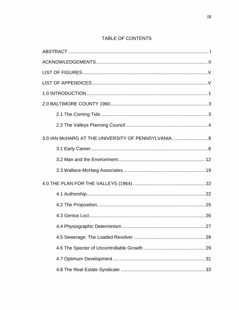
Figure 4 The Valleys region (McHarg, 1969)

7
easements, but rather has advocated for “a balanced and rational use of the
land” (www.thevpc.org). Its initial mission area was 79 square miles of north-
western Baltimore County (Figure 4). Its western edge paralleled the Reister-
stown Road, while its eastern edge ran along Interstate I-83, forming a squared
U (Horton, 1991).
The original 250 members consisted of some “wealthy landowners” (Avin,
2013, p. 22), “landed gentry” (Power, 2011, p. 18), and “leading citizens”
(McHarg, 1996, p. 176). They were also a mixed lot. Wallace and McDonnell de-
scribed their first meeting with VPC members in March 1963 as “an interesting
group with a few big landowners, but mostly people on three to ten acres who
liked to look at open land” (1979, p. 12). It cannot be said, however, that the
VPC was a grass-roots organization in the conventional sense, for certain mem-
bers clearly circulated within influential business and political orbits. Many
worked in Baltimore City, and a number were fox hunters, who were cognizant
that the area could not merely be made a hunting preserve (Schmidt, 1967).
Minutes from 1962 indicate the VPC’s desire for “orderly growth”, and the belief
that “its own ideas for development will be recognized and adopted by the Coun-
ty government” (MHS, MS 1889). To achieve this the VPC would need a plan.
The first VPC meeting was attended by Baltimore County Executive Spiro
“Ted” Agnew, who not only promised his personal support, but according to the
minutes said that he “would do everything in his power to see that all County
agencies involved cooperate to the fullest extent with the members of our Coun-
cil, as well as with our professional planners” (MHS, 1962, MS 1889). The fact

8
that the County Executive attended the first meeting attested to the clout of the
VPC’s founding members. Yet Agnew did harbor concerns. He had reservations
not only about a takings issue if the region were downzoned from 1-acre zoning,
but also “if we accept and back this plan, every Tom, Dick, and Harry who ever
took a course in drafting will be making plans across the County” (Wallace, 2004,
p. 94). Despite this equivocation, it was perceived that Agnew had “in principle”
supported the idea of a private plan, and therefore had also given his blessing to
cooperation between the VPC and County planners (Wallace & McDonnell, 1979,
p. 12). Tom Karsten, Chairman of the VPC’s Planning Committee, had initially
asked the Baltimore County Office of Planning and Zoning (OPZ) to design the
plan. However, he was advised that due to a lack of planning staff the VPC
would be better off hiring a consultant.
3.0 IAN McHARG AT THE UNIVERSITY OF PENNSYLVANIA
3.1 Early Career
In his autobiography, A Quest for Life (1996), Ian McHarg described his
ascent from a lower-middle class childhood in Glasgow to enlisting in the Second
World War as a private at eighteen, exiting as a Major, and following a circuitous
path to becoming a professor at the University of Pennsylvania and a renowned
environmentalist. He recollected that “outside Glasgow a beautiful and powerful
landscape contrasted with a mean ugly city, a testament to man’s inhumanity to
man” (p. 15), a sentiment that would be reflected throughout his work. A former
student wrote that McHarg viewed cities as “a Dante-esque form of earthly im-

9
prisonment” (Bunster-Ossa, 2014, p. 5). McHarg felt his calling early on, drop-
ping out of high school to apprentice with “perhaps the only landscape architect
in Scotland” who promised to teach him the profession (McHarg, 1996, p. 22).
An event that gave him great confidence was his first public speech in a
Presbyterian church on the life of a Japanese aristocrat missionary named Ka-
gawa (p. 23). Although McHarg does not make the connection, he comported
himself with a missionary zeal throughout his life. Stewart Udall wrote that
McHarg would “reproduce himself” (p. xii) through his many students and follow-
ers, while Cohen asserted that McHarg would “train and prepare an entire gener-
ation of planners” (2000, p. 5). Yet, In the summer of 1938, McHarg was just
coming into his own as “an apprentice landscape architect, incipient speaker and
writer, and professional liberal” when he volunteered to join the Army (p. 29).
Given his experience in landscape architecture, he was placed in the Royal En-
gineers.
McHarg was the youngest in the company, and ridiculed as “Art Student”
by the commanding officer (p. 63). One can imagine the difficulties he faced in
advancing himself from this station, yet rise he did, becoming a paratrooper in
the First Airborne Division. In 1943, he was placed in charge of rebuilding aque-
ducts that had been blown up by the Germans, and learned “advanced tech-
niques in bridge construction” (p. 47). After D-day, a night time parachute drop
during 45 knot winds went wrong when McHarg became entangled in his har-
ness: “I was dragged over the runway, across a minefield, through a barbed wire
fence, and up a hill, until finally, my anchor caught on some boulders” (p. 51).
10
These horrific wartime experiences were occasionally offset by moment of
repose in nature, however. McHarg recounted that after the earlier bloody siege
of Monte Cassino he was given a few days leave in Ravello, whose tranquility he
would never forget (p. 47). Despite having travelled throughout Europe and
North Africa, it appears to have been these contrasts—similar to that of the de-
pressed conditions in Glasgow to its nearby mountains—that resonated most
with McHarg. He summarized his time this way: “These experiences have gen-
erated and maintained my conviction of nature’s power; they have provided sub-
stance for a succession of sermons, generating principles for a sequence of pro-
jects” (p. 59). One pictures him going through the War with a pocket Words-
worth.
Although McHarg certainly gained a visual and pragmatic education, he
claimed that the greatest benefit was actually his growth in self-confidence (p.
64). He quickly put this to use, informing Harvard by telegram that he would at-
tend its graduate program in landscape architecture (p. 66). It worked, although
McHarg would spend five years satisfying the requirements to catch up to speed,
since he possessed neither a high school nor college degree. He would gradu-
ate with a Master in Landscape Architecture (1950) and a Master of City Plan-
ning (1951). His pursuit of joint degrees was a harbinger of the grander profes-
sorial and professional vision he would later embrace. While the two disciplines
share a linked heritage, Anne Whiston Spirn, McHarg’s successor at Penn, re-
marked that “the two ends of the spectrum—garden design and regional plan-
ning—have tended to attract individuals of dissimilar temperaments who borrow

11
methods and theories from disparate disciplines…” (p. 100). McHarg was, if any-
thing, a great synthesizer.
At Harvard “The Major” was quickly elected chairman of the Student
Council, which summarily issued a vote of no confidence in the department of
landscape architecture (p. 71). While McHarg unfortunately does not elaborate
on this bold stroke, he elsewhere bemoaned the ‘total absence of natural sci-
ence, the lack of integration of subject matter” in the curriculum (p. 81). He took
a course in agricultural economics that was largely taught by Kenneth Galbraith,
and received an A+ for a paper on soil stabilization (p. 75). In the summer of his
third year “the most profound event” (p. 78) of his first years in America occurred
when he was awarded a stipend which allowed him to tour the country with his
wife, Pauline. Their visits ranged from coal mines in Kentucky to the landscape
architect Thomas Church’s home in California.
One picaresque adventure occurred in Grand Junction, Colorado where
McHarg, in need of funds, contacted a Harvard colleague who advised him to
“dress in your best clothes. We will represent you as a distinguished British plan-
ner to the town manager” (p. 79). The town manager was duly-enough impressed
to offer a commission for a comprehensive plan, but due to obvious time con-
straints, they settled on a park instead. McHarg’s Harvard thesis—the first col-
laborative effort involving three of his colleagues—concerned a redevelopment
proposal for Providence, Rhode Island. It was well-received and included input
from “sociologists, economists, political scientists, city planners, architects, [and]
12
engineers” (p. 91), a multi-disciplinary approach that McHarg would become fa-
mous for adopting later with a different set of specialties.
He returned to Scotland only to experience a severe bout of tuberculosis
while working on a new affordable home program. He also had begun teaching
at the Glasgow College of Art (Spirn, 2000, p. 102) and at the University of Glas-
gow, but was not a practicing landscape architect (McHarg, 1996, p. 131). He
was then recruited to the Department of City and Regional Planning at the Uni-
versity of Pennsylvania in 1954 to create a curriculum in landscape architecture,
a challenge for which he described himself as “ludicrously unprepared (p. 121).
His charge was to “reestablish” the Department of Landscape Architecture (p.
135) a task for which he figured he had three years to accomplish, or it was “up
and out” (p. 129).
3.2 Man and the Environment
This innovative course, which was first offered at Penn in 1959, would not
only raise McHarg to national prominence, but also serve as a testing ground as
McHarg’s interests expanded. It began with 25 students, rising—according to
McHarg at least—to 250 at its peak (p. 158), becoming “the most popular course
on the Penn Campus” (Steiner, 2006, p. xiii). The course was divided into four
sections with 36 total lectures, of which McHarg would deliver only six (p. 157).
The four sections involved the scientific version of evolution, the perspective of
religion on nature, the “physiological and psychological relationships of man and
nature (McHarg, 1996, p. 157), and the ecological view, which he considered its

13
heart and soul. The course’s inclusion of environmental science appears to have
filled a vacuum McHarg first encountered at Harvard. Another novel feature was
the emphasis it placed on the inquiry into the attitudes of man towards the envi-
ronment. McHarg’s virulent viewpoint would be evident in a later speech, “Man:
Planetary Disease” (1971). He felt strongly that mankind was not only polluting
and destroying nature, but that the discipline of ecology had to incorporate an
understanding of soils, hydrology, geology, and meteorology.
McHarg credited an earlier commission, the Metropolitan Open Space
Study, for teaching him the primacy of ecology. This extensive study, begun in
1957, “had the largest effect, certainly on me, as a precursory ecological enter-
prise. It laid the foundation for the Plan for the Valleys…” (p. 152). It was here
that McHarg first employed an inventory of “rivers, streams, lakes, ponds, and
their flood plains, aquifers, aquifer recharge areas, steep slopes, forests, wood-
lands, and prime agricultural lands” (p. 142). A suitability analysis would then de-
termine where to allow development, constrain it, or forbid it. This was followed
by the Harvey Cedars commission on the Jersey shore, which McHarg described
as “the first university project to apply ecology to planning” (p. 176). It was de-
termined that the sand dunes were “ephemeral”, convincing McHarg that “this
ecology study revealed where building could safely occur, and where it could not”
(p. 169).
Man and the Environment was continuously evolving. In 1961, McHarg
joined a National Institute of Mental Health committee on environmental variables
which would lead to the eventual introduction of ethnography and anthropology.

14
He would also commence to bring in many notable hires with differing specialties.
The addition of Nicholas Muhlenberg to the faculty in 1962 appears to have been
crucial, for it “provided for the indispensible context in the curriculum” of “geogra-
phy, environmental science, and management” (Cohen, 2000, p. 213; McHarg,
1996, p. 172, Spirn, p. 104). By 1964 the entire department “had proclaimed
ecology as its fundamental discipline” (Cohen, 2000, p. 175). The pedagogical
underpinning would be based on notions of what McHarg termed “ecological de-
terminism” in a 1966 eponymous essay in which he refers to the Valleys
(McHarg, 2006, pp. 41-2).
In another article “Human Ecological Planning at Pennsylvania”, McHarg
posited two notions of fitness: One pertaining to conventional Darwinian adapta-
bility, other to the ability to “recover from insult or assault” which he otherwise
characterizes as “problem solving” (McHarg, 2006, p. 93). Ecological planning in
essence focused on the suitability of the physiographic region, especially as it
related to the river basin and biome.
It therefore was that approach whereby a region is understood as a biophysical and social process comprehensible through the opera-tion of laws and time. This can be reinterpreted as having explicit opportunities and constraints for any particular human use. A sur-vey will reveal the most fit locations and use.” (McHarg & Steiner, 1997, p. 95).
While ecology broadly speaking concerns the interaction of biology with
nature, human ecology would involve science, philosophy, and art (Cohen, 2000,
p. 23)—the latter field providing patterns that would be especially pertinent to
landscape architecture and planning.

15
The popularity of Man and the Environment served as a platform for a
number of self-reinforcing developments in McHarg’s career. The director of the
CBS affiliate in Philadelphia was familiar with the course and asked McHarg if he
were willing to do a TV Show entitled The House We Live In. McHarg of course
accepted. While he acceded that landscape architecture “does not engender
jealousy” (p. 162), he nevertheless was clearly skilled at leveraging his nascent
celebrity. The show on appeared CBS for 26 Sundays 1960-61, and then re-
played on PBS throughout the country for a decade (Ian L. McHarg Papers). The
interview subjects, many of them Nobel Laureates, were mostly scientists and
theologians. Topics ranged from plate tectonics to Islam. Most of the first sea-
son’s shows involved religion. McHarg was obsessed—there is no lesser word—
with his interpretation of the Christian sanction of man’s dominion of nature. He
himself had “embraced the heresy of pantheism” from an early age (McHarg,
1996, p. 18).
The House We Live In was an extension of his classroom, well before ca-
ble television. His interviewing technique mimicked a format he had originated in
the 1959 offering of Man and the Environment (Steiner, 2014, p. 142). McHarg
would give his guests extensive room to extemporize, yet he often interrupted
and prodded them. One fears that the astronomer Harlow Shapley may have
never recovered from this “exchange”:
[McHarg] Could I interject just a little? Would you excuse me? I have a macabre story. The cataclysm has occurred leaving all life extinct except algae in some deep pit, some silt with abundant lead and this algae has developed enormous resistance to radio-activity. One algae says to another algae, “Next time, no brains.”

16
[Sharpley] That’s a good one (McHarg, 1960, n.p.).
McHarg’s fevered intellect was difficult to repress. The topics did not in-
clude landscape architecture or regional planning per se, although the interview
with Lewis Mumford would have been illuminating in this regard (transcripts from
the second season are no longer extant). Perhaps McHarg’s primary subject
matter would have been too pedestrian for the medium of television in 1961.
Nevertheless, I would suggest that The House We Live In did influence McHarg’s
multi-disciplinary gospel of ecological planning, for many guests on the show
would in turn invite McHarg to lecture at their respective institutions (I.L. McHarg
Papers).
McHarg’s influences were on a continuum, a testament to his creativity
and foresight. I will by no means offer an exhaustive list here (see Cohen, 2000;
McHarg & Steiner, 1996). As for man’s treatment of nature, McHarg was influ-
enced by George Perkins March, Aldo Leopold, Ebenezer Howard, and Frederick
Law Olmsted among others (p. 162). Fellow Scotsman Patrick Geddes (1854-
1932) most likely was an influence, even though McHarg only briefly mentioned
that he found Geddes “fascinating but difficult to read” (McHarg, 1996, p. 122).
Geddes was a Scottish geographer and biologist who advocated for regional
planning, and was such an influence on Lewis Mumford, McHarg’s mentor and
friend, that Mumford named his son “Geddes” (Spirn, 2000, footnote 10).
Anne Spirn, who would succeed McHarg as head of the Department of
Landscape Architecture and Regional Planning, convincingly compared a valleys

17
section map (1911) by Geddes with a map (1969) by McHarg and wryly noted
that “the desire to be seen as original is typical of landscape architects, who fail
repeatedly to build upon prior efforts and often reiterate ideas without advancing
them significantly” (p. 102). Cohen corroborated the debt of McHarg’s empiri-
cism to Geddes, who insisted on “the systemic surveying of bioregions before
any planning would be undertaken (2003, p. 31). In his 1981 article on ecological
planning at Penn, McHarg did state that “while responding to universal laws,
each region is believed to comprise unique attributes of place-folk-work, as first
identified by Patrick Geddes, and these will determine the capabilities, opportuni-
ties, and constraints of the region and thus the potential of the hypothetical fu-
tures [italics mine] (McHarg, 2006, p. 95).
While McHarg perhaps should have admitted a greater debt to Geddes,
his papers at the Penn Architectural Archives reveal not only great humor, but a
willingness to praise others. A binder for Design with Nature (1969) contains a
scribbled out page with a typed cutout superimposed by yellowed tape which
reads in part, “I do know that the book contains no single original idea and so
surely any merit it does contain must redound to those who gave fabric to the
quilt” (I.L. McHarg Papers, H.B.1.4). This startling, barely legible passage did not
make it into the published work. McHarg’s willingness to praise also fell upon Sir
Peter Shepheard, Dean of the School from 1971 to 1979 whose “greatest distinc-
tion is his immoderate modesty, an attribute seldom found among architects”
(McHarg, 1996, p. 136).

18
It must be noted that McHarg was able to sustain a certain degree of cog-
nitive dissonance with respect to attribution. For instance, he acknowledged in
his autobiography that Charles Eliot, designer of the “Emerald Necklace” plan for
Boston, had developed ecological planning “half a century” before him (p. 82).
He later argued that Eliot’s figure should be cast in bronze and displayed at Har-
vard, while somewhat incredulously also declaring that “I had spent perhaps a
decade trying to develop ecological planning before I heard of Eliot” (p. 360). In a
subsequent 1997 essay, “Ecology and Design”, McHarg would again resort to his
previous refrain that “I invented ecologic planning during the 1960s” (McHarg,
2006, p. 122). While this inconsistency may shed some light on McHarg’s per-
sonality it has negligible bearing on The Plan for the Valleys, which would be
unique in many respects.
Lastly, I would suggest that the German scientist and adventurer Alexan-
der von Humboldt (1769-1859), was at the very least an antecedent kindred spirit
of McHarg’s. Aside from the cursory coincidence that both were incessant talk-
ers (Margulis et al, 2007, p. 10; Wulf, 2015, p. 102), they both were highly ob-
servant of man’s impact on the environment. Von Humboldt’s discovery of hu-
man-induced degradation around the shores of Lake Valencia, Venezuela (and
subsequent climate change) smacked of ecological determinism, especially in his
analysis of the biome’s web and its physiography (pp. 56-58). McHarg was an
admirer of the contemporary British scientist James Lovelock, acknowledging
that “the view of the Earth from the moon had a profound effect on me” (McHarg,
1996, p. 365). A version of this photograph would appear on the cover of Design

19
with Nature. Lovelock’s and Margulis’ Gaia theory, which post-dates much of
McHarg’s work, earned praise from him for how it imagined the Earth as an inter-
connected, self-regulating mechanism, and for “the conception of earth as a sin-
gular interacting superorganism that has been actively developing and maintain-
ing the environment” (1996, p. 1). Later in his career McHarg would set his
sights on a global inventory of the “world’s population and ecosystems—plant,
animal, and human” (p. 374).
3.3 Wallace-McHarg Associates
Like his partner, David Wallace also wrote an autobiography, Urban Plan-
ning/ My Way (2004), in which he recounted how he too was recruited to join
Penn, although in the broader field of urban design and planning in 1961 (p. ix).
These two autobiographies from the primary protagonists in the creation of The
PFV afford great insight into the thought processes and priorities behind it. Wal-
lace’s autobiography has a decidedly more somber tone, perhaps because it was
published later and also in the year of his death. He and McHarg were col-
leagues at Penn and at their eponymous firm, but McHarg’s shadow caused in-
evitable tension between the two.
McHarg would earn the lion’s share of the credit for The PFV, yet Wallace
was the one who actually received the commission. Their accounts of The PFV
are not so much contrapuntal as complementary, however. Surprisingly, Wal-
lace’s account is more replete with pragmatic details about the creation and im-
plementation of The PFV. The version of events in Wallace’s autobiography
largely paraphrased a previous, valuable article, The Diary of Plan (1979), which

20
he co-authored with William McDonnell, an employee of the firm and subsequent
director of the VPC. There is barely a mention of McHarg in this nuts and bolts
chronology.
Wallace was McHarg’s senior by three years, also served five years in
World War II, graduated from Harvard (although with a PhD), and then worked in
the public sector as executive Director of the Philadelphia Redevelopment Au-
thority. In 1955 the developer James Rouse founded the Greater Baltimore
Committee, a powerful business advocacy group to this day (www.gbc.org), and
brought in Wallace as Executive Director. He was placed in charge of the
Charles Center renewal project in downtown Baltimore City. Completed in 1957,
this extensive 22-acre redevelopment included a centerpiece building designed
by Mies van der Rohe, as well as plazas, elevated walkways, and underground
parking (Power, 2011, p. 7). Jane Jacobs wrote a favorable review in Architec-
tural Forum entitled “A New Heart for Downtown” (1958). Wallace’s career was
also on the ascendancy.
Wallace recalled receiving the phone call from Tom Karsten, who empha-
sized that the objective of the VPC was “not to oppose change but to prevent the
rape of the countryside that unplanned, disorderly development would surely en-
tail” (2004, p. 78). From its outset, the citizens group recognized the need for
planned growth that needed to accommodate some development. Wallace
brought in McHarg because he “felt his [McHarg’s] ecological approach would
compliment my own planning, design, and architectural skills” (Wallace, 2004, p.
10) or as McHarg put it, Wallace “required skills which were additional to those

21
he possessed (McHarg, 1996, p. 176). The fledging firm of Wallace-McHarg
would be paid $43,000 (Wallace, 2004, p. 108). Some clients thought that there
was a single principle named Mr. Wallace McHarg (p. 176). The two founding
partners, however, had considerably different personalities and roles. Wallace
was quieter, more pragmatic, and especially concerned about social justice. His
dissertation at Harvard, Residential Segregation of Negroes in Chicago (Power,
2011, p. 2), was described by McHarg had described as “remarkably prophetic”
(p. 176). McHarg was a showman, and often dogmatic in his adherence to eco-
logical determinism. Wallace conceded that McHarg “was not an easy man to be
a partner with, but he could charm an audience and write like a dream” (Wallace,
2004, p. xiii). The firm’s original office was in McHarg’s attic (p. xi).
After a second, brief incarnation as Wallace-McHarg Associates, William
Roberts and Thomas Todd became partners in 1964, forming Wallace, McHarg,
Roberts & Todd (WMRT). In a magnanimous moment, McHarg admitted that “at
WMRT, David Wallace, the founder, was the dominant and most distinguished of
the partners,” as well as “indisputably, the dominant city planner in the United
States” (1996, p. 213). Although WMRT would grow to over 150 employees at
the turn of this century (www.wrtdesign.com), Penn students initially served as an
indispensible farm system during its formative years. In discussing work he had
students prepare for the Potomac River basin (1965-66), McHarg proudly admit-
ted “a professional landscape architect or city planner is limited in the projects he
undertakes to problems presented by his clients. A professor, in contrast, suffers
no such constraints and is enabled to undertake projects he deems worthy of

22
study” (McHarg, 1996, p. 127). McHarg actually relied on this “wonderful reci-
procity” to improve his ecological methods (p. 173). According to Steiner, the
“blurred” boundary between the two actually created a “meaningful dialogue be-
tween the academy and professional practice” (2006, xii). Spirn corroborated
that “the ideas and methods of McHarg and his colleagues at Penn and WMRT
evolved in a dynamic dialogue between theory and practice” (Spirn, 2000, p.
103).
4.0 THE PLAN FOR THE VALLEYS (1964)
4.1 Authorship
There were actually two plans, or two versions of the same plan to be
more precise. In April 1964, 100 copies of Part II: Technical Report on the Plan
for the Valleys (The Technical Report) were delivered to John Spillman, III, Pres-
ident of the Green Spring and Worthington Valley Council, Inc. “in compliance
with our contract” to his office in Baltimore (Wallace-McHarg Associates, 1964b,
n.p). The Technical Report was completed before the more simplified version
known to a broader audience as the Plan for the Valleys, which was published
and distributed in June 1964.
McHarg was prone to send both copies for promotion and review. A letter
from Elkins Wetherill mirrors a similar response from Lewis Mumford; “Thank you
very much for your brochure of the planning study for the Green Spring and
Worthington Valleys. I agree with you that this is easier to read than the tech-
nical report, and also that it has relevance for Montgomery County [Pennsylva-

23
nia]” (Ian L. McHarg Papers, July 17, 1964, 109.IIE.2.3.3). While the Technical
Report has no illustrations or maps, it offers the advantage of paginated chapter
headings. Furthermore, the supplementary text and data it provides are quite
informative, and merit occasional citation here. The Technical Report explained
that its purpose was “to enable the reader to understand as completely as possi-
ble the reason for each conclusion, and the basis for each assumption, be it val-
ue judgment or fact. That is why the Report is so long” (Wallace-McHarg Asso-
ciates, 1964b, p. 3). If The PFV is the sonnet, The Technical Report is its exege-
sis.
Literature on The Plan often credits McHarg with sole authorship by ap-
parent default (Budensheim et al, 2014; Power, 2011; VPC, 2016). However,
this was not the case. Authorship of The PFV was shared between Wallace,
McHarg, William Roberts, and Thomas Todd under the rubric of Wallace-McHarg
Associates. William McDonnell also did significant groundwork out of the firm’s
office in Towson, Maryland (Wallace & McDonnell, 1979, p. 13). He is listed,
along with ten “temporary personnel,” some if not all of whom were associated
with Penn, mostly as students. Four Consultants are credited, including Ann
Strong, a lawyer and Penn professor. Wallace described the primary division of
labor with McHarg this way: McHarg would focus on the ecological inventory and
visual analysis, he would examine uncontrolled growth, and amid “shouting
matches” the two decided on alternate development (Wallace, 2004, p. 82).
McHarg’s charisma and celebrity—he did have his own television show,
after all—perhaps explains his somewhat overstated association with The PFV.

24
Furthermore, McHarg’s emphasis on ecological determinism has arguably been
the greatest influence of The PFV. Yet McHarg, while attributing some of Wal-
lace’s second-class status to the falling out of favor of city planning, did express
remorse. “I began to receive the bulk of public attention and approbation. This
was very unkind to Wallace who was a full-time partner, while I was a full-time
teacher and part-time partner” (McHarg, 1996, p. 217). For those seeking a
crash-course in the persona of McHarg, the film Multiply and Subdue the Earth
(1969) presented him standing by a fence overlooking the Maryland Hunt Cup
course whereupon he delivered this soliloquy:
Show me any civilization that believes that reality exists only be-cause man can perceive it, that the cosmos was erected to support man on his pinnacle, that man is exclusively divine, and then I will predict the nature of his cities and his landscapes, the hotdog stands, the neon shill, the ticky-tacky houses, the sterile core, the mined and ravaged countryside. This is the image of anthropocen-tric man. He seeks not unity with nature but conquest, yet unity he finds, when his arrogance and ignorance are stilled and he lies dead under the greensward (Hoyt, 5:48).
McHarg’s delivery is mesmerizing, if to the point of being rehearsed. He
clearly thought this passage was emblematic of his world view, for it is reprinted
on both the back jacket and inside page of Quest for Life.
This voice and these thoughts were evident five years earlier in The PFV’s
“Preamble”, which shared similar language, rhetoric, and cadence. The author of
the Preamble—who almost certainly was McHarg—referred to “low grade urban
tissue” and feared that “the urban expansion which menaces the Green Spring
and Worthington Valley is typical of a national problem” (W-M Assoc., 1964, p.

25
1). While The Plan targeted a specific physiographic region, McHarg envisioned
a broader purpose, a “large-scale demonstration” (p. 1) of how sound planning
could co-exist with a beautiful landscape.
4.2 The Proposition
McHarg’s distinctive voice is also evident in “The Proposition”, a section
which acts as an organizing principle to The PFV, since the individual lines
branch out into synopses and then section titles. The poetic nature of this stanza
appears to be vintage McHarg. The Proposition asserts that the problem and so-
lution involving the Valleys are in fact simple and best understood thus:
The area is beautiful and vulnerable; Development is inevitable and must be accommodated; Uncontrolled growth is inevitably destructive; Development must conform to regional goals; Observance of Conservation Principles Can Avert Destruction and Ensure Enhancement; The Area can Absorb all Prospective Growth without despoliation; Planned Growth is more desirable and as Profitable as Uncon-trolled Growth; Public and Private Powers can be Joined In Partnership in a Pro-cess to Realize the Plan
Wallace and McDonnell’s diary entry for August 1963 began “the nature of
the planning problem is now clear…” (1979, p. 14). The primary objective of The
PFV was to determine the optimum level of development that would retain the
amenity of the countryside, yet also be consistent with public policy. An “Action
Program” delineated private and public steps towards implementation. Coordina-
tion with the Baltimore County Office of Planning and Zoning (OPZ) would obvi-
26
ously be paramount in this respect. The PFV proposed a design process to
achieve this optimum, as well as a mechanism to distribute its benefits.
The methodological approach to the problem involved determining the
“essential landscape quality” (n.p.) of the Valleys and then posing various alter-
natives for preserving them. The approach would entail an analysis of the physi-
cal reality, present conditions (population and land use), a growth forecast, a
presentation of alternatives, and a discussion of issues relating to implementa-
tion. The power of The PFV emanated from commonsense observations about
the shape of the Valleys and underlying hydrology, or in McHargian terms, the
determinants of physiographic form. An almost giddy McHarg recollected, “The
problem was an inspired opportunity for a neophyte ecological planner and the
solution was plain” (1996, p. 177).
4.3 Genius Loci
The genius loci, or the “image of a place which remains long remembered
in the mind, its essential quality” was determined to reside—quite simply
enough—in the “great, broad, sweeping valleys and the wooded slopes which
confine them” (p. 8). The three valleys and their forested walls formed the
“Basic Amenity” of the region (p. 32). Other noteworthy features were farmland
patterns, the narrow scale of the roads, and even the post-and-rail fence lines. In
terms of land use, 15 percent of the Valleys was residential with an average lot
size of one and one-half acres, although 40 percent of lots were over five acres
(p. 9).

27
McHarg inimitably described the three social groups of residents as the
“very rich” with horse farms and Black Angus cattle on valley floors, upper middle
class on the forest slopes who “derived benefit from the beautiful valleys mani-
cured by the very rich”, and poor famers who worked the plateaus. (McHarg,
1996, p. 178). Wallace and McDonnell’s less physiographic version described
the “rich, social people” on gentleman farms, “newcomers” in expensive subdivi-
sions, and farmers and others on roadsides development (1979, p. 13). Another
two-thirds of the land area was agricultural, located in the central to northern
parts of the region (Wallace-McHarg Associates, 1964a, p. 9). Owner-operated
farms constituted three-quarters of the 1361 farms, of which 17 percent were
horse farms (p. 9). Commercial and industrial uses were de minimis, while 5.8
percent of the region was institutional (p. 10).
4.4 Physiographic Determinism
In his essay “The Morphology of Ecological Determinism” (1967), McHarg
would later recount how “the concept of ecological determinism was invoked” to
arrive at the optimal location for preservation and for development in the Valleys
(2006, p. 41). The PFV relied more specifically on “physiographic” determinism,
which included such factors as geology, hydrology, soils, and flood plains. Echo-
ing Von Humboldt, The PFV asserted that “each of these processes interacts
with the other; each has implications for development” (Wallace-McHarg Associ-
ates, 1964, p. 32). Surprisingly not mentioned in The PFV, the very topography
of the area was determined by Wissahickon schist on ridges and limestone on
valley floor, according to The Technical Report (1964b, 6-2). Subsurface geolo-

28
gy and the implications for the water supply played a prominent role in The PFV’s
analysis. It was determined that the limestone formation contained a vast aquifer
beneath the Valleys. This drinking water was not only vulnerable to failures from
on-site septic tanks, but also to potential sewer failures if lines were ever extend-
ed. While this feature alone compelled the firm to advise against any develop-
ment in the Valleys, the nature of the soils—silt loams with high permeability—
were themselves unsuitable for high intensity of septic use (p. 36). Lastly, these
soils tended to occur in proximity of flood plains. These basic physiographic ob-
servations, therefore, provided a tryptic of reasons for why development should
not occur in the Valleys.
4.5 Sewerage: The Loaded Revolver
Two key related themes become evident early in The PFV. The first was
that given the openness of the viewshed throughout the Valleys, complete
preservation of the Valleys floor was a necessity: “a small development of any
kind will be extraordinarily conspicuous and can effect a major transformation
and destruction” (p. 12) (See Figure 1). The second is introduced in a discussion
of the average value for unimproved land ($1600 per acre) which ranged to over
$7000 based on the expectation of sewer extension (p. 12). The vulnerability of
the Valley’s R-40 1-acre zoning became manifest by the extension of sewers:
“Should the Valleys be sewered, they will succumb to development and be
erased forever. Sewers are like a rifle aimed at the heart of the area” (p. 12).
Less than 2 percent of all dwellings in the region received any sort of public utili-

29
ties (p. 20). The PFV postulated that sewer leakage could be as high a 20 per-
cent (p. 34). McHarg later recollected that “sewers in a valley are only a more
technologically advanced method for polluting groundwater” (1996, p. 178).
While Wallace and McDonnell admitted they could not offer proof of pollution
risks, the discovery of the unconfined aquifer was paramount to The PFV: “The
full impact of the sewer issue now hit us” [June 1963 entry] (1979, p. 13).
4.6 The Specter of Uncontrollable Growth
The PFV projected population growth for the greater Baltimore region to
double by 1980, while the Baltimore County population was expected to rise a
lesser percentage from 500,000 to 800,000 (p. 14). Within the County, however,
the Valleys region was projected to grow over four-fold to 73,000 by 1980, and to
a range between 110,000 to 150,000 residents by 2000 (p. 14). If the higher end
were reached by the end of the 20th century, no open land would remain in the
Valleys (p. 22). These numbers did not assume imminent sewer extension, yet
allowed for up to 10 percent of the Valleys being developed in the next few years
(p. 20). The study explained that this alarmist growth would be due to continued
increased accessibility to the area, as well as the pull of its natural beauty. The
latter factor is of course one of many contradictory dynamics of sprawl, for those
moving to an area for its rural character are also destroying that very quality.
By “uncontrollable,” the study meant the “sequence or larger pattern, with-
out any comprehensive plan or process for creating coherent communities with
adequate open space” (p. 19). According to Wallace, modeling this change was
integral to the firm’s planning process. He wrote of The PFV’s forecast for “likely

30
despoliation” (p. 19), that “it literally scared the hell out of everyone” (Wallace,
2004, p. 85). McHarg separately wrote that “the inhabitants of the valleys lived in
terror” (1996, p. 177). The PFV described how a process of attrition would lead
to a “catastrophe” whereby future development would occur “over a considerably
larger area than it would actually need to encompass in order to satisfy housing
demand” (p. 25). This arguably was the driving force to direct density in a sys-
temic manner, for the model presumed that the Jones Falls interceptor would be
extended “well into the mouth of the Green Spring Valley” (p. 20). Technical Re-
port noted two-thirds of development in 12 years prior to publication of The PFV
had occurred primarily in Green Spring Valley (1964b, p. 14; table 21, A9).
The model produced a map that shares a title with this chapter (Appendix
II). It should be noted that colored maps in this Capstone are not cited from the
published plan. In a letter to Grady Clay, the editor of Landscape Architecture
Magazine, McHarg lamented the use of black and white illustrations since “the
Planning Council is too poor to pay for color” (Ian L. McHarg Papers, December
29, 1964, 109.IIE.2.3.3). It is difficult to say if McHarg is being ironic here, for the
use of color in printing at the time was expensive. The VPC did end up spending
$125,000 on the production and promotion of The PFV (Trimble, 2011), an ex-
traordinary sum for the day. Yet one senses some venom in McHarg’s remark—
he would exact comeuppance with the publication of Design with Nature.

31
4.7 Optimum Development
The prediction that the analysis produced was that the plateaus would be
most tolerant to development, the valleys the least. Other prohibited areas in-
cluded 50-year flood plains, areas within 200 feet of stream edges (p. 34), and
steep slopes over 25 percent (p. 36). The PFV used ecological information first
to interpret, and then to reshape, the Valleys’ topography. The forest cover, for
instance, was not only integral to the visual character of the Basic Amenity, but
also performed a number of ecosystem services, such as erosion control. Maxi-
mum density along the forested valley walls was proposed at 1 house per 3
acres, with all trees over a 4-inch caliper subject to a preservation evaluation (p.
38). Similarly, density on forested plateaus would be limited to 1 house per acre,
with the concentration of density reserved for the open plateaus (Figure 5). Here
gross density would average .6 dwelling units per acre, with open space along-
side cluster pods of 4 - 29 dwelling units per acre (p. 45). These areas required
central sewer service. While a number of alternate sewer layouts were consid-
ered (p. 31), the dictate was nevertheless the obverse than for the valley floors.
Figure 5 Physiographic Determinants of Form (McHarg, 1969)

32
Tower apartments of up to 100 units per acre would be located on promontory
sites (p 48). As depicted in the “blob dia-
gram” (Figure 6), a schematic of ideal de-
velopment, The PFV envisaged a con-
nected network of hamlets, villages and
towns. Location would actually allow for
“the enhancement of the landscape with-
out despoliation of the valleys” (p. 40),
with a range in population from 500 resi-
dents to 20,000. The variety of housing
types and of density concentrations was very important to the authors. They
considered affordable housing a “vital” issue in the event of uncontrolled growth
(p. 23), yet conversely they also intended that the “Valleys should not and cannot
be reserved for upper income housing” (p. 29) as the result of planned growth.
An admirable goal of The PFV was its willingness to assimilate the full projected
growth of 110,000 to 150,000 new residents, while also arguing for a rezoning to
one house per 25 acres in the Worthington Valley (p. 45).
The Action Program made a number of other recommendations such as
differential property tax assessment to protect open lands, as well as the creation
of “natural resource zoning” (p. 48), a phased urban growth boundary (UGB), and
also a special conservancy district with a self-assessment applicable for the pur-
chase of development rights (p. 51). Extensive attention was paid to the acquisi-
tion of conservation easements. As Daniels has noted, these “are most effective
Figure 6 The Blob Diagram
(McHarg (McHarg (McHarg (McHarg,
1969)

33
when they accompany a local comprehensive plan, restrictive agricultural zoning,
and growth boundaries” (2009, p. 40). The Action Program, which is much
clearer to read as presented in The Technical Report, called for the County to
adopt the PFV’s regulations into its Master Plan by 1966 (Wallace-McHarg Asso-
ciates, 1964b, 10-11), underscoring that The PFV was a private plan, but relied
on public implementation.
4.8 The Real Estate Syndicate
The PFV prefigured federal and state programs by envisioning the use of
public funds for less-than-fee acquisition, while on the private side it devised the
novel Real Estate Syndicate, or what today would be considered a transfer of
development rights (TDR) program. The Technical Report discussed at length
the taxation of capital on gains land transfers (7-21), and argued for the use of an
investment trust, which benefited from the avoidance of the double taxation of
income and dividend distribution (7-32). The Syndicate acted as a general part-
nership whose capitalization was in the form of debentures and stock that could
be exchanged for the relinquishment of development rights. The Syndicate was
commonsensical in its purport. “Those whose land will be worth more because
of the Plan, can share part of the additional gains with those who voluntarily give
up their right to development” (Wallace-McHarg Associates. 1964a, p. 52). Yet
its operation would be decidedly more complex.
The primary intent of the Syndicate was to limit the location and timing of
development on the valley floors and walls, and instead to direct it to the ridges

34
and plateaus through a pricing mechanism that would pay for itself. It would use
various means—fee purchase, conservation easement, life estate, right of first
refusal—to obtain the development rights. The monetized value of the preserved
views would in turn need to be purchased by the new developments. Land
deemed most susceptible to imminent development would be given priority. The
actual development right, however, was not specified despite being instrumental
to the feasibility of a TDR program (Daniels, 2007). The PFV contended that
property values would rise in the Valleys. Specifically, a difference in projected
value of $7 million between uncontrolled and optimum growth could be used to
purchase conservation easements (p. 42). This was quite important for convinc-
ing the community to buy into The PFV. Furthermore, The Technical Report pos-
tulated that that the argument for enhanced value would preempt a potential tak-
ings issue (Wallace-McHarg Assoc., 1964b, 7-5).
5.0 THE PLAN REVERBERATES
5.1 “I am sending my final copy”
The VPC’s concerted effort to sell the Plan to a variety of stakeholders—
the OPZ, residents, garden clubs, real estate professionals—led to a virtuous cy-
cle of benefit. The PFV received regional publicity (Schmidt, 1967) as well as
national coverage—Fortune’s Earth Day issue (1970, February) observed that
“one of the most fascinating innovations in protection of the environment,” oc-
curred in the Valleys (quoted in Horton, 1991). Wallace and McHarg wrote an
article for their peers in Landscape Architecture Magazine which summarized

35
The PFV, but was more notable for this trenchant, prefatory accolade from Lewis
Mumford:
The Plan for the Valleys, in both its method and approach and its human aims, should serve as a pattern for all future efforts to con-serve life values in a growing community, where uncontrolled and misguided developments may…obliterate the very natural ad-vantages that stimulated this growth” (1965, p. 178).
Businesses began to encourage their executives to join the PVC, in part
for its social standing (Wallace & McDonnell, 1979, p, 20). A number of land-
owners donated up to 10 percent of their property taxes as a type of insurance
against development augured by The PFV’s growth model (p. 21). Perhaps most
surprising, “speculative builders as well as investors in real estate were among
the most generous contributors” (Wallace, 2004, p. 100). The developer James
Rouse, was at times a competitor and advisor to the VPC (Wallace & McDonnell,
1979, p. 13). In 1965 the OPZ tacitly endorsed the Plan (p. 19).
As a result of The PFV, a number of proposed school sites and private
sewers were scotched. The VPC organized 250 members to show up at a Balti-
more County Council meeting to demonstrate for the re-location of a proposed
landfill on 200 acres in the Worthington Valley (Wallace, 2004, p. 101). A less
visible influence of The PFV occurred simultaneously with its preparation when a
significant portion of the Caves Valley was put into play for development in 1963.
The Report on the Caves Development (Wallace-McHarg Associates, 1964c)
was commissioned for $3500 by the Gorn brothers, who had an option to buy
1355 acres, and who had planned a golf course surrounded by 1000 houses (p.

36
8). In an unusual circumstance, the developer hired the firm that was in the
midst of a conservation plan for the larger region, perhaps as a genuflection to
the power wielded by the VPC. Wallace-McHarg Associates used this study both
to test and to affirm its parallel studies: “The principles outlined in the Plan for the
Valleys have particular relevance for the Caves” (p. 4). The bulk of the short (33
pages) and rare report was devoted to proving the financial infeasibility of the
Gorns’ plan.
While the report suggested a number of design alternatives, it held to the
physiographic imperative that no development could occur in the valley, which
overlaid the Cockeysville Aquifer. The study affirmed what Wallace and McDon-
nell termed “The Truth Map”, which was “a new kind of zoning based on envi-
ronmental determinism, rather than economics” (Wallace, 2004, p. 87). This so-
lidified the notion that the most suitable densities were one unit per three acres
on the wooded ridges, reduced to one acre on the wooded plateau, and subject
to market forces on the open plateau. The Gorn deal fell through, but the even-
tual formation of the Caves Valley Land Trust led to the best example of land
preservation throughout the valleys region, according to noted preservationist
Dan Colhoun (personal communication, January 16, 2016).
In a 1970 essay, “Open Space from Natural Processes”, ostensibly based
on metropolitan Philadelphia, McHarg mentions that he first tested his planning
application of ecological principles in The PFV (McHarg, 2006, p. 66). He raised
the primacy of ecology planning even further in the Potomac River Basin Study,
and fine-tuned some methods such as his use of the ecological inventory, or

37
what his students referred to as the “layer cake” of climate, geology, hydrology,
soils, vegetation, and wildlife (Spirn, 2000, p. 107). The overlay of magic marker
on mylar transparencies would serve as a checklist not only for the interrelation
of various systems, but also how the past created current conditions. Elements
of this method could be found in Von Humboldt’s Naturgemälde, a three- by two-
foot map with textual detail of Mount Chimborazo in Ecuador (Wulf, 2015, p. 88).
A credit to McHarg’s ingenuity is that he had devised a template for Global Infor-
mation Systems (GIS) from an ancillary technique (Carlsson, 2013).
A positive feedback loop developed between publicity and inquiry for
McHarg’s services. A letter from a member of the Zoning and Planning Com-
mission of West Lake Hills, Texas, requested a copy of The PFV, compared his
region to Baltimore County, and lastly inquired “if development was completed
according to plan, whether the landowner’s syndicate was formed and if not, how
open spaces were maintained, whether population projections were fulfilled, and
pretty much how things are in the area today” (I.L. McHarg Papers, October 28,
1969, 109.III.B.3). Perhaps this led to the Woodlands project in Texas, for
McHarg received a call from its developer almost a year to the day later (McHarg,
1996, p. 256). The project involved creating a town in a forest that had unsuita-
ble soil and drainage conditions. WMRT employed its comprehensive inventory
method to devise a natural drainage system, which may have prevented eventual
subsidence under Houston (Spirn, 2000, p. 108).
McHarg promoted The PFV with variations of a form letter in which he of-
ten highlighted four aspects of the plan: the growth model, physiographic analy-
38
sis and principles for development, means to implement the plan, and the “Real
Estate Syndicate”. He sent copies to private, public and academic figures, rang-
ing from Ada Huxtable of the New York Times, to Stewart Udall, Secretary of the
Interior (I.L. McHarg Papers, 109.III.B.3.). A letter to Grady Clay included a cus-
tomized 1500-word version—reduced from 80,000 words—of The PFV (Decem-
ber 29, 1964).
Requests poured in from universities domestic and abroad (Melbourne,
Oxford), the Long Island Builders Institute, the Department of Army, planning as-
sociations, and various journals. By 1965 he responded to a request, “I am
sending my final copy” (June 25), and was true to his word, for this led to a
somewhat comical situation whereby he kindly referred each subsequent request
to “William C. McDonnell, Director of Planning at the Green Spring and Worthing-
ton Valley”. A planner from Sonoma County, California wrote at the end of the
decade, “I’ve heard that your Plan for the Valleys is quite good and also scarce.
If you would loan us a copy for 3 (sic) weeks, I promise on my scout’s honor to
return it” (July 7, 1969).
5.2 The Brandywine Plan (1968)
The Brandywine Plan dealt with a similar situation as The PFV, and
shared some of the same methods and recommendations. This is not altogether
surprising, since Ann Strong from Penn was a contributor to The PFV, and then
one of the primary authors of The Brandywine Plan. The report was prepared for
a governmental agency, the Water Resources Authority of Chester County,

39
Pennsylvania. It addressed the Upper East Branch of the Brandywine Creek, a
watershed for the city of Wilmington, Delaware, which was vulnerable to devel-
opment. A brochure version was distributed to explain the plan to the area’s
4200 residents (Upper East Branch Brandywine Project, 1968, p. 6), while a
more expansive Plan and Program was similar in scope to, although involved a
far greater effort than, the PFV’s Technical Report. This report had a budget of
$500,000, and was considered “an innovative experiment in land use control”
(Strong, p. 5). Echoing elements of The PFV, Keene and Strong recollected that
the “demonstration project” had appeal because of the region’s “strategic location
on the fringe of a major metropolis, good stream quality, natural beauty, and an
apparent concern for sound growth on the part of the county’s public and private
leaders…” (1970, p. 51). Yet a significant difference was that the Brandywine
region was targeted by a consortium of the academy, government, and a NGO
(The Ford Foundation), whereas The PFV was generated organically by citizens
from within the Valleys.
The Plan and Program began with a thorough description of current condi-
tions in the form of scholarly articles with attribution. Topics ranged from hydrol-
ogy to land values. Employing multiple population projections, it was determined
that land use could accommodate a capacity of 38,000 residents by 2010
(Strong, Coughlin, Keene, Leopold, & Stevens, 1968, II-D-9). Conservation
easements would be the primary control to limit or exclude development from
critical areas such as flood plains, stream buffers, woods, and steep slopes. As
with The PFV, growth would be redirected to designated areas, with sewerage a

40
prime concern. Many of plan’s principles—protecting the water resource and
amenity of the area, allowing for growth, compensating for the restriction of de-
velopment, providing actual economic benefit—mirror those in The PFV. Strong
wrote in the introduction to the actual plan that, “The Plan differs from many
plans in that the translation of the principles for the basin into land use proposals
is accompanied by specific recommendations for an action program…” (III-A-1).
However, this “almost perfect plan” according to Thompson, “Treats skillfully eve-
ry technical aspect of the problem, but evidently something was missing in the
human dimension” (1969, p. 1180).
Although Daneke praised the plan as being “the most illustrious” of the
seminal water conservation plans, in part for its innovative attempts to raise pub-
lic awareness, he nevertheless concluded that “Brandywine is thus an example
both of failure to achieve participation by all affected segments of the public and
of failure to accommodate those segments of the public which did participate”
(1977, p. 18). Ann Strong described a confrontational meeting which occurred in
East Brandywine Township in which a small proportion of residents expressed
vociferous concern over numerous issues, especially the potential use of eminent
domain (Strong, 1975). The protest of this minority eventually led to the plan’s
defeat, even though the planners had engaged in extensive outreach to the
community. Why did The PFV not engender the same reaction? Although the
Plan and Program placed much less reliance on zoning than The PFV, the au-
thors of both plans would have agreed, “Limitations on development were too
stringent to impose through zoning alone (Strong & Keene, 1973, p. 9). The ex-

41
planation could lie in the contrast between the political structure of the two re-
gions. Whereas the Valleys benefited from a sophisticated public-private part-
nership, “politics in the Upper East Branch townships is primitive” (Keene &
Strong, 1970, p. 54). The city-county local government structure of Maryland re-
duced the likelihood of fragmentation among the citizenry. The Brandywine Plan,
by contrast, covered just eight townships (Strong et al, 1968, II.A.1).
5.3 Design with Nature
Coinciding with the publication of Design with Nature, interest in The PFV
resurfaced. The connection between the two works is evident in Quest for Life,
for McHarg’s chapter on Design with Nature began with an extensive account of
his work in the Valleys. McHarg wrote Design with Nature during a sabbatical
from 1966 to 1967. He expected a modest reception, but the book became a
phenomenal success, topping 350,000 in sales (p. 203). McHarg’s resolve was
in full throttle as he not only had to resort (briefly) to self-publishing and direct-
mail sale, but also had to figure out the color problem. He credited Gene Feld-
man, who taught printmaking at Penn, with discovering the most workable color
“signatures” and paper weight (p. 202). NASA agreed to the use of the image of
Earth on the cover.
In Multiply and Subdue the Earth—released the same year as Design with
Nature—McHarg spoke of subdividers in Baltimore County enviously eyeing the
Valleys “as if a Homestead Act was about to be signed and the whole bloody lot
of them were waiting for someone to fire the pistol” (34:57), a metaphor he also
used in his autobiography (p. 177). These two passages are brought together in

42
the chapter, “A Response to Values” in Design with Nature, in which McHarg re-
peats the pistol analogy, cites examples of “vulgarization,” and laments that the
Valleys were “totally unprotected from despoliation by the existing powers of zon-
ing and planning” (p. 79). This work confirmed McHarg’s standing as an envi-
ronmentalist, and can be read as a synthesis of his ecological planning at Penn
with methods originally employed in The PFV. McHarg had actually been reluc-
tant to write Design with Nature, claiming, “I am not an ecologist” (p. 200). How-
ever, one should not be lulled solely by the breadth of McHarg’s fugue-like mind,
because there was also a depth to his ecological thought which is beyond the
purview of this Capstone. In a short essay describing McHarg’s influence entitled
“Creativity permeates the evolution of matter and life,” James Corner wrote that
In drawing from concepts of environmental and organismal fitness-- including thermodynamics, feedback cycles, creative adaptation, and inter-relational systems—McHarg uses ecology to paint a vi-sion of the world that is more complex, more integrated, and more based on dynamic interaction and levels of dependency than previ-ous models…” (Margulis et al, eds, 2007, p. 97).
The reach of Design with Nature would extend from ecology to geography,
forestry, and soils. Its ethical sensibility would highlight the value of sustainability
and resilience. It created a template for environmental impact assessments,
which are so basic to planning today.
Design with Nature would be the apex of McHarg’s publishing career. He
would shortly move on to a host of other commissions and projects, including the
inaugural Earth Day in 1970, and landmark federal environmental legislation.
Fame would have its demands, however. A number of letters in the architectural

43
archives at Penn indicate that McHarg became unresponsive to certain speaking
requests. His renown was spreading. A precocious undergraduate student at
Brandeis wrote that she was “impressed” with Design with Nature, and that she
was preparing a land use paper for a policy course. She added a laundry list of
questions about the Plan for the Valleys, such as the viability of the Syndicate,
and this whopper, “Do you have, by any chance, a compilation of instances
where land has been developed in disregard of natural processes?” (I.L. McHarg
Papers, May 12, 1970, 109.II.B.1.4). McHarg’s reaction, priceless no doubt, was
fortunately undocumented.
6.0 SLOW PATH TO IMPLEMENTATION
6.1 Urban-Rural Demarcation Line (1967)
Of the two legislative legacies of The PFV, the urban growth boundary
was delineated rather quickly, but the full realization of Resource Conservation
Zoning would take almost 25 years.
Maryland established county zoning enabling legislation in 1933 (Frece,
2008, p. 169), yet a number of development regulations were left to the Maryland
Department of Health, which allowed for on-site septic systems—provided the
soil passed a relatively lax percolation test—on a lot as small as 25,000 square
feet (Outen, 2007, p. 6). During the 1950s almost one-quarter of new develop-
ment relied on on-site septic (Williams, 1959). The spread of suburbia during this
period—often enabled by federal policies such as tax expenditures and highway
projects—led to the inevitable conversion of farmland. In 1956, Maryland had the

44
foresight to implement the first legislation in the U.S. protecting farmland by ena-
bling differential assessment, which lowered the property tax on agricultural land
(Keene, 1977, p. 13). However, this alone has had limited success in slowing
farmland conversion.
During the nine years preceding the publication of The PFV in 1964, Mary-
land had lost 716,000 acres of farmland, or 11 percent of the state’s total acre-
age (Wallace, 1981, p. 15-4). This realization led to years of deliberation at the
state level regarding how to supplement property tax relief with other tools such
as the purchase of development rights (PDRs), the transfer of development rights
(TDRs), and the establishment of agricultural districts. The latter proved to be
particularly contentious, because “famers objected to the mandatory nature of the
various controls, fearing loss of equity in their land because of restrictions on de-
velopment” (p. 15-5).
The urban growth boundary (UGB), known as the Urban-Rural Demarca-
tion Line (URDL), grew out of these circumstances. The first urban growth
boundary in the U.S. was implemented in the thoroughbred region of Lexington-
Fayette County, Kentucky in 1958 (Pruetz, 2012, p. 91). Despite the equestrian
connection between Lexington-Fayette and Baltimore Counties, there is no evi-
dence of a strong link between the two UGBs. The URDL first appeared on an
OPZ map in June 1966, but was not promulgated until an amendment to Bill 40
required that gas stations outside of the line be located in a Commercial-Rural
overlay district (Outen, 2007, p. 10). The URDL was meant to optimize funds
spent on infrastructure within urban areas, while preserving agricultural and natu-

45
ral resources as open space (Budensheim et al, 2014, p. 12). Wells and septic
systems would be relied upon outside the line, while higher density zoning inside
of it would receive water and sewer services. The URDL roughly followed the
Metropolitan District line, which had been drawn up in 1924 to delineate the ex-
tent of public water and sewer service (Outen, 2007, p. 10). It also followed wa-
tershed boundaries, County boundaries, and attempted to take advantage of
gravity flow where possible.
The URDL was implemented at a propitious time. Although the Maryland
Department of Health had placed a moratorium on sewer extensions in 1963 due
to leaks (Wallace & McDonnel, 1979, p. 13), pressure was again mounting to ex-
tend the Jones Falls Interceptor into Green Spring Valley (Schmidt, 1967). The
URDL imposed a halt to this, but by 1970 both the State and County Health de-
partments were continuing to endorse sewer extensions to some restaurants
and to a State building with failed septic tanks, only one mile south of the Valleys
(p. 23). When the County Council rejected this, it was the first legislative victory
for The PFV, despite having been endorsed by the County years earlier. Yet the
URDL nevertheless has suffered from the same limitations as differential as-
sessment, as it was not enough in itself to reduce the prevailing rate of develop-
ment. Even Lexington-Fayette’s downzoning to 10-acre minimum lots outside it
UGB would result in a similar rate of development, except on larger lots (Pruetz,
2012, p. 93). The URDL has barely moved, however, in large part because it
was designated at a time of high population projections, and therefore held con-

46
siderable capacity for growth absorption. This would be very beneficial for cer-
tain elements of The PFV.
6.2 County Politics
In October 1973, United States Vice President Spiro Agnew, a vituperous
critic of the liberal establishment—yet defender of cronyism (Wills, 1969)—
defiantly resigned from office pleading nolo contendere to tax evasion (Naughton,
1973). While Agnew adamantly contended that he had received not bribes but
campaign donations (Agnew, 1980), his lawyer—once released from lawyer-
client privilege—testified that Agnew had admitted that bribery had been occur-
ring in Maryland politics “for a thousand years” (Clines, 1996). Richard Cohen,
who covered Maryland politics for the Washington Post, has referred to the
1970s in Maryland as “the golden age of corruption” (Holden & Messitte, 2006, p.
1). Cohen recounted that many individuals testified to having received kickbacks
while Agnew was Baltimore County Executive from 1962 to 1966 (p. 6). Hun-
dreds of thousands of dollars of bribes were supplied not only by developers, but
also by architects (Outen, 2007, p. 35). Before serving as Maryland Governor,
Agnew had been appointed to the Baltimore County Zoning Review Board (3
years), and then elected Baltimore County Executive (4 years) The plight of Ag-
new might not have been worth mentioning had not his successor as County Ex-
ecutive, Dale Anderson, himself been convicted of 32 Federal counts on kick-
back-related charges (UPI, 1974). Anderson would not be the last.

47
In this political milieu, two important events occurred. In 1974, Baltimore
County established a People’s Counsel (not to be confused with the utility-
monitoring Office of People’s Counsel). The Counsel is appointed by the County
Executive and serves as a citizens’ advocate in planning and zoning matters.
The Counsel defends the zoning map and master plan, reviews 600 to 700 Zon-
ing Commissioner cases a year, as well as numerous appeals (Outen, 2007, p.
36). A second unique element to Baltimore County planning is the Comprehen-
sive Zoning Map Process (CZMP), instituted in 1976. Every four years any
stakeholder—the OPZ, the VPC, landowners, County Council members, or any
citizen—can petition the County Council for zoning changes. The 2016 CZMP,
for instance, has an upzoning petition by a developer that is being contested by
the VPC (VPC, 2016). One would think that a requisite four-year re-assessment
of a vulnerable land preservation tool would be rife for abuse. As a practical mat-
ter, however, despite the fact that Councilmen receive the bulk of their campaign
funds from developers, many petitions are for downzoning (Phillip Worrall, Per-
sonal Communication, March 20, 2016).
6.3 Resource Conservation Zoning (1976)
It took until the mid-1970s for the novel partnership between the VPC and
the County envisaged in the final line of The Proposition to yield substantial re-
sults. During the 25-year period leading up to the legislation of RC Zoning in Bal-
timore County, land devoted to farming decreased by 56.3 percent, while the av-
erage size of a farm rose a similar percentage to 127 acres (Wallace, 1981, 15-

48
46). However, it was concerns about water quality in the County’s reservoirs that
began to galvanize citizens’ groups, the VPC, and the County Planning Board to
take action through rezoning. Since zoning in rural Baltimore County remained
at a maximum density of one lot per acre, development could still easily leapfrog
over the URDL and into the countryside. The result was that the use of septic
systems continued to spur rural residential development and the conversion of a
great deal of farmland and forests (Newburn & Ferris, 2016, p. 222). In fact, ac-
cording to those involved in the enactment of RC Zoning, prior to it “all of the
County’s zoning regulations promoted development” (Budensheim et al, 2015, p.
4).
Zoning in Baltimore County harkens back to 1955 when it changed to a
councilmanic governance structure—districts based on population, not geogra-
phy—consisting of a County Executive, Administrative Officer, and a Council rep-
resenting seven districts. Coincident with the charter change in the County, new
zoning maps and residential zones were established, ranging from R-6 (minimum
lot size of 6000 square feet) to R-40 (minimum lot size of 40,000 sq. ft., or almost
an acre). Zoning Districts were determined primarily by perk tests for septic sys-
tems, which meant that the de facto minimum lot size for zoning was roughly 1
acre (Budensheim et al, 2014, p. 8). No agricultural zoning existed in the rural
areas covering two-thirds of the County (Outen, 2007, p. 21). However, this was
not problematic for these areas until the mid-1960s, since most homes were built
around village centers (Wallace, 1981, 15-47).

49
The ensuing growth boom, combined with environmental concerns,
prompted the County legislature to curtail development (15-48). In 1970 Bill 100
changed the metric of these zones from minimum lot size to density in order to
produce better design, in part by segregating rural from urban areas (Budens-
heim et al, 2014, pp. 9-10). This “density zoning” was meant to allow for more
flexible clustering of dwelling units on a tract to accommodate environmental
constraints and irregular parcels (Outen, 2007, p. 21). The Bill changed R-6 to
DR 5.5, or 5.5 dwelling units per acre. R-40 became DR 1, or one unit per acre.
Two new zones, RAE 1 and RAE 2, allowed for significantly higher densities of
40 to 80 units per acre, respectively.
An atavistic feature of the new zones, however, included minimum lot siz-
es for Rural Deferred Planning (RDP – 10 acre minimum) and Rural Suburban
Conservation (RSC – 3 acres), the most pertinent to the Valleys region. The Bal-
timore County Council however, summarily lowered the minimum lot size for both
these zones to one acre, all but negating the difference between them (Budens-
heim et al, 2014, p. 10). Jack Dillon, who was on the County Planning staff at the
time, told me that developers and the real estate industry forced the zoning re-
duction (Personal Communication, January 26, 2016). Most of northern Baltimore
County was re-zoned as RDP, but this did little to hinder development—for all
practical purposes, the area had become a “rural residential development zoning
district” (p. 15). In five years leading to RC Zoning, one-acre rural zoning wit-
nessed 11,368 acres subdivided into 3781 lots (Wallace, 1981, 15-49). While
politics may have won out, necessity would soon be the mother of invention.

50
An important catalyst for change occurred when the Maryland Department
of Health recommended downzoning to three acres as a result of faulty septic
systems and possible water contamination (Outen, 2007, p. 21). This validated
the power of the URDL, as well as McHarg’s general concerns about unsuitable
septic locations. The planning staff then commenced a comprehensive effort
based primarily on tax maps to demonstrate that the pattern of development was
threatening the County’s agriculture industry, particularly as one subdivision
spread into another (Budensheim et al, 2014, p. 8). Many farmers wanted to re-
tain their development rights, and were of course compromised if adjacent
famers sold. The County planning staff organized the North County Advisory
Group, which was comprised of a wide array of stakeholders in the region. The
ensuing plan relied on five Resource Conservation zone classifications:
I. RC 1 – Flood plains
II. RC 2 – Agricultural
III. RC 3 – Deferred Planning Zone
IV. RC 4 – Watershed
V. RC 5 – Rural residential
RC-2 areas were based on prime soils, absence of subdivisions, and criti-
cal mass in terms of size and farming intensity. One development right was con-
ferred for the first 20 acres, with another right for each additional 20 acres. RC-3
applied to the outside edge of the URDL and was meant to discourage develop-
ment with a relatively low density facto of .3, but with clustering on one-acre lots.
RC-4 served as an overlay zone for all streams and reservoirs, and included a

51
prohibition on building steep slopes over 25 percent, echoing The PFV. RC-5
was proposed for development next to existing subdivisions and villages, with a
two-acre minimum lot size.
When Bill 98-1975 was vigorously debated before the Planning Commis-
sion and County Council, the minority of detractors were represented by the de-
velopment industry and certain large landowners, who were concerned that the
downzoning would drastically reduce the value of their property (Wallace, 1981,
15-49). A contemporaneous news account said that the bill “pitted farmer
against farmer, farmer against builder, and farmer against environmentalist” (Ja-
cobson, 1975). David Wallace described how the Falls Road Association—one of
35 in the region and comprised of farmers—considered the PFV “a conspiracy of
wealthy residents to secure the development value of the area for themselves”
(2004, p. 105). Yet none of these groups was as acrimonious or as concerted in
opposition to The PFV as the Chester County Freeholders’ Association was to
the subsequent Brandywine Plan (Keene & Strong, 1970, p. 52).
To assuage these interests, a special exemption for higher development
on non-productive land gained little traction (Wallace, 1981, 15-49). The final
bill—whose iterations included 19 amendments from one councilman, and 28
“technical” amendments—covered 56 percent of County land (Outen, 2007, p.
22). The County planning staff, which had good relations with the farming com-
munity, pressed the notion that land values would increase (Budensheim, 2014).
This key contention from The PFV would need more time to gain currency. Per-

52
haps Agnew’s initial guarded endorsement of The PFV had taken some of the
steam out of its legislative implementation.
The year 1976 would witness a confluence of important events. The ex-
tensive Resource Conservation rezoning was approved to coincide with the new
comprehensive zoning maps (CZMP) to be issued in 1976. In 1976, Wallace,
Roberts and Todd (WRT) was hired to produce the County’s “Growth Manage-
ment Plan” as its Master Plan was called, in which it applied the methods es-
poused in The PFV to the entire County (Wallace, 2004, p. 109). The Interim De-
velopment Control Act (IDCA) was imposed, restricting subdivision before the
new zoning was enacted. This was necessary and proved how prescient McHarg
(and Wallace) had been with the often used metaphor about developers waiting
for the pistol to be fired. In the four months since the bill had been passed, 221
tracts had been subdivided, totaling 1661 acres (Wallace, 1981, 15-50).
A new County Executive requested a reassessment of active farms which
resulted in a resuscitation of minimum lot sizes. Eventually, RC-2 was altered in
1979 so that any farm up to 100 acres could be subdivided once, and again for
each additional 50 acres. Many residents I interviewed in this region, however,
would add a caveat that, “We have 50-acre zoning, but not really.” This com-
promise with the farming community occurred because many farms are com-
prised of several separately deeded parcels. Since these parcels are subject to
one subdivision, there is a significant “hidden” density potential. This ostensibly
strengthened RC-2, therefore, had an inherent weakness which resulted in con-

53
tinued development. Once again, a growth management tool would prove to be
helpful, but not sufficient to stem the tide of development.
6.4 Growth Management in Maryland
Kathleen Wallace (no relation to David Wallace) wrote in the National Ag-
ricultural Land Study—echoing Gottmann— that “the enactment of such a restric-
tive agricultural zone on the heart of the northeastern Megalopolitan Corridor is
an unusual occurrence” (1981, p. 15-52). She ventured a number of factors
which explained the passage of RC Zoning, including a temporary slowdown in
the “growth boom”, the trust that farmers had in the County planning staff, and
the bill’s complexity, i.e. “many people did not even realize what was in the bill”
(p. 15-53). Maryland has in fact been at the forefront of growth management,
having sponsored a number of land preservation programs leading up to Smart
Growth legislation in 1997. Noteworthy programs have included the Maryland
Environmental Trust (1967), The Maryland Agricultural Land Preservation Foun-
dation (1977), and the Rural Legacy Program (1997).
The Maryland Environmental Trust (MET) was created as a state land
trust with a mostly private board of trustees, and acquired its first conservation
easement in 1972 (MET, 2016). It specializes in private donations, coordinating
deal, and can arrange for tax abatements. A more pertinent program for the Val-
leys area has been the Maryland Agricultural Land Preservation Foundation
(MALPF), which was established “for the purpose of acquiring easements on
farm and woodland by purchase or gift” (Wallace, K., 1981, 15-7). The primary
54
source of MALPF funding is meant to be a 17.05 percent share of the 0.5 percent
real estate transfer tax. Assessing its first year of operation in 1980, Wallace
noted, “The fact a preservation program exists at all is an indication that the prin-
ciple of preservation has been widely accepted” (15-30). Former MALPF Chair-
man, Dan Colhoun, told me, “The future of agriculture is in easements, because
the day will come when any land not in easement will be developed” (personal
communication, January 16, 2016). There has been a waiting list for MALPF
easements, partly because the state has redirected funding (MDA et al, 2015),
yet largely because “few farmers will resist a realistic alternative to development”
(Daniels & Bowers 1997, p. 19).
MALPF collaborates with a number of other agencies, especially the De-
partment of Natural Resources, which houses the complementary Rural Legacy
Program. Rural Legacy focuses on preserving parcels of fewer than 50 acres,
especially wetlands, streams, or forests which must be chosen from sponsored
areas. Prospective farms, if located in a RL territory, can have prime soils
(MALPF) eased separately from wetland or otherwise non-qualifying land in
smaller proportion (RL). MALPF engages in public-private partnership with MET,
and benefits from a state-county partnership in matching funds. Lastly, the fund-
ing mechanism through the real estate transfer tax makes eminent sense, since
a more active market leads to more funds for preservation. According to Jack
Dillon, MALPF’s first easement in 1980 “tied in perfectly with RC Zones” (person-
al communication, January 26, 2016). It also coincided with the influential Na-
tional Agricultural Lands Study, which addressed the self-reinforcing “imperma-

55
nence syndrome,” whereby increases in development and population create a
vicious cycle inducing farmers to sell their land (Coughlin & Keene, 1981). Dan-
iels has cited the four primary challenges facing farmers in the wake of sprawl as
profitability, resource stewardship, generational continuity, and pressure to sell
out to development (2001, p. 2).
The Supplement to the Plan for the Valleys (1989), although validating
The PFV, purported to assess new methods and information gleaned in the wake
of continuing development pressure. Prepared by Wallace, Roberts & Todd
(McHarg had long left the firm), The Supplement concluded in the same positive
tone as The PFV by confirming that future growth could be accommodated.
Population in the County had in fact only grown to 714,000 versus a 1980 projec-
tion 800,000, which allowed WRT to extend its initial projection 30 years to 2010
(1989, p. 2). Yet encroachment was evident in this section title, “Sprawl Has Oc-
curred Over the Past Decade in Spite of Country (sic) and Use Controls” (p. 2).
Especially problematic was that RC 4 was “encouraging an unintended channel-
ing of suburban density growth along streams” (p. 2), which had resulted in “dis-
continuities between boundary locations and the locations of resources meant to
be preserved “(p. 12).
The Supplement reasserted the use of planning and zoning to direct de-
velopment, and recommended a rezoning of RC 4. It also reaffirmed the use of a
TDR program with designated sending areas. While the importance of the water
quality resource for the Valleys was emphasized, The Supplement also priori-
tized agricultural, historical, cultural, and open space preservation. New recom-

56
mendations included a light rail system, the promotion of mixed uses, and a tax
abatement for redevelopment. Another noteworthy element to the Supplement
was its emphasis on traffic, validating the dictum that development is driven by
water supply, sewerage systems, and roads. As a sign of the times, the report
acknowledged a Roads Committee of nine members (p. 33). A general concern
related to pressure for the widening and straightening of roads through the Val-
leys, for as The Supplement asserted, “Bad roads are good roads for the Valleys”
(p. 16). A specific concern related to a proposed road linking Hunt Valley and
Owings Mills, MD. Wallace recollected that “such a connection would have been
a death knell for the valleys as open space” (2004, p. 112), and that furthermore,
it would “actually generate traffic demand that did not exist without the connec-
tion” (p. 111). McHarg would have reveled in this analysis, having studied the
impact of induced capacity on highways in Scotland (1996, p. 104). The Supple-
ment used extensive traffic analysis to argue for alternative routes on a more re-
gional level. The VPC eventually prevailed in this particular fight.
Traffic is an especially pernicious impact of sprawl (Downs, 2001; Knee-
bone, 2009). As the automobile facilitates urban flight, equity issues arise from
the prohibitively higher cost of living in the suburbs (Grad, ed., 2015, p. 98).
Coughlin and Keene have described sprawl, or “urban growth pressure”, as “a
great flood, moving out slowly into the countryside raising land values as it goes”
(1981, p. 16). Yet sprawl is not fiscally sustainable due to the extension of water
and sewer, among other municipal services (Daniels & Lapping 2005; Kelsey,
1996). Redirecting growth has been a staple of Maryland policy since the Smart

57
Growth legislation was enacted in 1997. Elements of this program have included
the preservation of the environment and open space, and incentivizing compact
development in Priority Growth Areas (PFAs) where the state focuses its infra-
structure investments.
Echoing The PFV, Downs has said, “A basic principle of smart growth
should be to accommodate future growth, not choke it off” (2001, p. 5). Downs
stressed the need for regional collaboration, and was concerned that efforts to
suppress sprawl in one location would exacerbate it elsewhere. Nevertheless,
the County downzoned 9000 acres from RC-4 to RC-2 as a result of not only
similarity between the zones, but also excessive development cited in The Sup-
plement (Outen, 2007, p. 23). Punctuating its unreceptiveness to growth, the
County enacted further downzonings in 1998, and created additional RC zones in
2000 (Appendix V).
7.0 THE PLAN 50 YEARS LATER
7.1 The Proposition Revisited
The area is beautiful and vulnerable;
The conclusion to this Capstone evaluates lines from The Proposition (the
order of which has been rearranged for clarity). An early section in The PFV—
“The Plan Realized”—imagined how a few elements of it would be manifested 20
years forward. Now a full 50 years removed from publication, we are afforded a
number of metrics for assessment. To what extent was The PFV implemented
and how successfully? The PFV imagined that the Green Spring Valley’s slopes

58
would have become more densely wooded, overhung by “silhouettes of apart-
ment buildings on the ridges” (p 5). Neither happened. The expectation for “the
serene sweep” of the Worthington Valley has held true to this day, however. The
view depicted in the 1964 photograph (Figure 1), for instance, is unchanged.
The Caves Valley has also matched predictions, although again with no apart-
ment buildings. While the Green Spring Valley—the most vulnerable—has lost it
genius loci, the Caves and Worthington Valleys have survived largely intact, in
part because of the willingness of the owners of hobby farms, working equestrian
farms, and agricultural farms to sell or donate conservation easements on their
land.
Through 2015, Baltimore County preserved 62,828 acres towards a goal
of 80,000 acres, primarily in the north and northwestern parts of the County
(Pash, 2015; Appendix IV). McHarg proudly wrote in 1996 that the Valleys “more
than 30 years later still retain their pastoral beauty” (p. 177). Wallace, however,
was not shy to express his disappointment in McHarg’s attitude towards The
PFV: “McHarg felt that his objectives of preventing despoliation of the natural
landscape had been realized, and I suppose my disappointment is irrelevant” (p.
77). Or, as he also wrote more pointedly, “The failure in implementation was ir-
relevant to him [McHarg]” (p. 108). McHarg was in fact quite candid that a num-
ber of his early plans would have “no effect” (p. 152), yet he saw value in the ide-
as they generated and the potential application to future projects. Perhaps
Spirn’s general remark applies to The PFV: “The conflict between preservation

59
and change is McHarg’s most persist inconsistency, and it highlights the contra-
dictory positions of landscape architecture as a profession” (2000, p. 102).
Uri Avin has contended that although The PFV earned an APA National
Planning Landmark Award in 2010, its reputation has been “obscured by legend,”
for the plan itself was only partially implemented (2013, p. 21). This is partially
true. None of the major design elements, such as the hamlets or villages, was
built. No real estate syndicate was created. This leads one to believe that The
PFV’s reach exceeded its grasp, or to borrow from Voltaire’s naïve optimist Dr.
Pangloss, that the plan attempted to be “the best of all possible worlds”. Tom
Karsten of the GSWV expressed contemporaneous concern that The PFV was
“completely unrealistic” and advised for a “drop back and punt” backup plan,
which was never adopted (Wallace & McDonnell, 1979, p. 19). In a letter to Lew-
is Mumford seeking endorsement for the Landscape Architecture article barely a
month after The PFV’s publication, McHarg regretted that “the probability of suc-
cess is quite small,” even though he espoused the methodology (I.L. McHarg
Papers, July 6, 1964, 109.III.B.3). None of this, however, is to say that McHarg
was preoccupied with the mere aesthetics of the The PFV, or of the Valleys
themselves.
Cohen has noted that McHarg appreciated “the beautiful, the sublime, and
the picturesque in nature,” and as a parallel, the picturesque form in art (Cohen,
2003, p. 12). McHarg likely was an admirer of the Hudson River School, whose
founding most observers credit to the émigré Englishman, Thomas Cole (1801-
48) (Harvey, 1998). McHarg and Cole would have been kindred spirits in their
60
views of man’s self-perceived dominion over nature. Cole’s series of paintings,
The Course of Empire (New York Historical Society, 1833-36), reflected his skep-
ticism towards the triumphalism of American manifest destiny. The final painting,
“Desolation”, is consonant with McHarg’s soliloquy from Multiply and Subdue the
Earth.
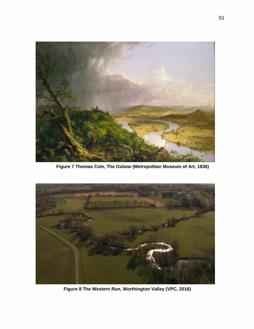
61
Figure 7 Thomas Cole, The Oxbow (Metropolitan Museum of Art, 1836)
Figure 8 The Western Run, Worthington Valley (VPC, 2016)

62
Of particular note for this paper is Cole’s masterwork, “The Oxbow” (Met-
ropolitan Museum of Art, 1836), in which a storm is depicted having passed over
a pastoral landscape (Figure 7). On a distant mountain appears the approxima-
tion of the Hebrew letters for “The Almighty” when read upside down from the
God’s-eye view—McHarg would have had a field day with this!—perhaps indicat-
ing the artist’s desire to return to less cultivated times (Howat, 1987, p. 127). The
Connecticut River is shaped like a question mark, and may be asking the viewer
to mediate the difference between the revealed cultivated landscape and the
rugged wilderness on the other side of the river. By sheer coincidence, the
VPC’s signature photograph on its website (Figure 8) also posits the Western
Run curling like a question mark in the midst of a beautiful, pastoral landscape.
The protection of the basic amenity in the Valleys has been indeed largely
achieved, yet questions remain in the landscape itself.
Development is inevitable and must be accommodated; Uncontrolled growth is inevitably destructive; The Area Can Absorb all Prospective Growth without despoliation; Planned Growth is more Desirable and as Profitable as Uncontrolled Growth;
The PFV’s most immediate regional impact was the URDL, which has
stood the test of time. The URDL has since been successful at directing growth:
90 percent of Baltimore County’s population lives within it, despite comprising on-
ly 33 percent of the County’s land area (Moore, 2010, p. 77). Since the boundary
allowed for ample accommodation, the specter of uncontrollable growth has not

63
materialized. A far-reaching influence of The PFV has been has been its em-
phasis on planning, and on the feasibility of both accommodating and redirecting
Technique Result
URDL Limit water and sewer services to urbanized areas
Contain growth within a higher density region
RC Zoning Restrict to one lot per 50 acres and to environmental designa-tions
Delayed development
Land Preservation Conservation easements, PDRs, TDRs, public and private subsidy
Perpetual preservation
growth within an open space amenity. The action steps for implementation cor-
rectly envisaged the utility of zoning and conservation easements as land use
controls, in addition to the complimentary role of governmental programs such as
such as MALPF, Rural Legacy, and Smart Growth. For example, the URDL
helped to delineate Priority Funding Areas in Baltimore County.
Nevertheless, a question mark remains over the failure of the Real Estate
Syndicate. Why would a TDR program work so well in nearby Montgomery
County, MD, but not in the Valleys region, despite demographic and develop-
mental profiles shared between the two? Why has the extinguishment of devel-
opment rights prevailed over their reallocation? McHarg himself lamented the
failure of the Syndicate. He also acknowledged that it might have been poorly
conceived, for despite representing a distinct physiographic unit, there was “not a
socially cohesive community” (1996, pp. 178-9). The authors of the Plan and
Program also recognized this: “A proposal such as the Brandywine Plan, which
seeks substantial changes in many areas of personal concern to residents, will

64
be implemented only if it responds to deeply felt needs and desires of the people
it will affect” (Keene & Strong, 1970, p. 58). The explanation for the lack of
community buy-in might lie in what I would term the spiritus loci of the Valleys.
Consider the amenity of the Valleys—its genius loci—as a commons, in
which it is in the rational self-interest of individual landowners who benefit from
the open space nevertheless to maximize the (development) value of their prop-
erty, even if that ultimately is self-defeating because doing so degrades the long
term interests of the community (Hardin, 1969). Discretely sewering the plateaus
seems in retrospect to have been a naïve proposal, and in conflict with the
preservation of the Basic Amenity, if one were to adopt a purist’s approach to the
landscape. Residents may have sensed a TDR program would be a Trojan
horse in the form of a sewer that over time could enable further, unplanned de-
velopment. “Timeo Danaos et dona ferentis” (Virgil, Austin, 1962, II. 49), or “I
fear the Greeks especially when bearing gifts,” may have resonated here (as it
did in the Brandywine Valley). The community—however disparate—seems to
have adopted an all-or-nothing approach towards the maintenance of open
space, and collectively overcame the paradox of the commons by consenting to
conservation easements and to downzoning. Otherwise, the inducement to sell
or donate development rights would have been significantly lower if the country-
side had become sprinkled with hamlets, villages, and even partially visible
apartment buildings. The design of differentiated housing types made eminent
sense from a planning perspective, yet a critical mass of residents resisted be-
fore the vicious circle of the impermanence syndrome could establish a toehold.

65
As The PFV itself noted, “To many of the resident owners of undeveloped land,
the character of the land represents a way of life” (Wallace-McHarg Associates,
1964a, p. 23).
Although Avin had doubts about the Syndicate, he has also criticized how
The PFV’s “fine-grained and highly differentiated pattern of dense and preserved
lands” has instead become occupied by scattered large-lot subdivisions (p. 21).
On the one hand this type of development has supported the PFV’s contention
that property values would be enhanced. Even in the more agricultural northern
area of the Valleys, for instance, Nickerson and Lynch observed no difference in
value between preserved and unpreserved farmland: “Contrary to our expecta-
tions, we find little statistical evidence that voluntary permanent preservation pro-
grams significantly decrease the price of farmland in MD” (2001, p 350). Lynch,
Gray, and Geohegan have also noted that when contiguity of parcels was includ-
ed in their model, the eventual effect of a conservation easement on market price
was negligible (2007, p. 508).
The downside to the success of preservation has been the high cost of
housing, however. The median cost of housing as a percentage of household in-
come for Baltimore County is high, as one-quarter of residents pay 35 percent or
more (Baltimore County, 2010). In the Valleys region, for which discrete data are
not available, there is ample anecdotal and proxy evidence that housing is even
less affordable. Although the County is a separate political jurisdiction, one can-
not ignore its bucolic juxtaposition to the urban decay of Baltimore CIty, recently
highlighted by riots in April 2015. The Valleys are linked to the urban core

66
through public water and sewer, but a sociological divide exits in addition to the
URDL. The City is otherwise landlocked, and therefore unable to expand
through annexation. Its population is now significantly less than that of Baltimore
County (U.S. Census, 2015). The County in fact recently settled a lawsuit re-
garding discriminatory housing practices (Donovan, 2016; see also Thompson v.
HUD, 1995). A telling trend has also occurred within Baltimore County itself, as
population has actually declined outside of Priority Funding Areas, indicating a
lack of affordable housing in rural areas such as the Valleys (Maryland Depart-
ment of Planning, 2016). Knaap and Frece have argued that Maryland Smart
Growth has lacked pragmatic balance, and encouraged anti-growth NIMBYism
(2006, p. 454).
Wallace actually held the dystopian view that the partially implemented
Plan for the Valleys was the result of an “elitist conspiracy among rich white
landowners and the government they controlled to provide de facto segregation”
(Wallace, p. 247). This is partially true, but only in a glass half-empty sense. Wal-
lace may have been prescient regarding County-wide housing issues, yet there is
no evidence of a “conspiracy” for intentional economic, class, or racial segrega-
tion of any sort in the Valleys. To contend such is tantamount to a blanket con-
demnation of Valleys residents. What Wallace appears not to have appreciated
is that the spectrum of stakeholders—including small- and large-lot landowners,
golfers, farmers, horse people—were primarily concerned with protecting the
Basic Amenity. The phenomenal extent of land preservation has not only been at
the expense of some of The PFV’s important design elements, but obversely a

67
result of their failure. Avin was concerned that The Syndicate would necessitate
“clear winners and losers” (2014, p. 22), although the absence of it has produced
the same result in a broader sense.
By way of analogy, in the late 1970s McHarg moved to Unionville, Penn-
sylvania, a Piedmont region 40 miles west of Philadelphia which was otherwise
quite similar to the Valleys—a beautiful rural area inhabited by farmers and horse
people. McHarg observed that the preservation of the King Ranch was the direct
result of the fox hunting fraternity, which he termed “a very effective planning de-
vice” (1996, p. 179). It should be noted that a character in Oscar Wilde’s A
Woman of No Importance famously described fox hunters as “the unspeakable in
pursuit of the uneatable” (1893, n.p.). One senses that Wallace would have
agreed with this assessment, even though the coalition of VPC members was a
broader demographic group. The fact remains that there is often a Reapolitik to
land preservation in a given area which involves landed or wealthy residents, and
the desire for contiguous land preservation may supplant planning efforts to in-
troduce higher-density housing.
Observance of Conservation Principles Can Avert Destruction and Ensure Enhancement;
One can appreciate how far the planning process has evolved since
McHarg asserted that before Design with Nature “there was no enabling legisla-
tion requiring ecological understanding and planning” (1996, p. 206). The im-
plementation of Resource Conservation Zoning in Baltimore County was a con-
tentious process, yet it has produced impressive results. Most of the County’s

68
watershed (92 percent) has been preserved, providing drinking water to 1.8 mil-
lion residents in the region (Outen, 2007, p. 22). Despite McHarg’s thumbprint
on this accomplishment, he seems to have had a momentary lapse of self-
promotion: “I believe it is fair to say that public planning, notably zoning, has pro-
tected very little; it is, at best, a delaying procedure” (McHarg, 1996, p. 178). Yet
RC Zoning has been a very effective delaying procedure, especially in the face of
the quadrennial CZMP. This is particularly impressive, since Daniels and Lap-
ping have noted that land use regulations are “notoriously impermanent, subject
to variances, special exceptions, and conditional uses” (2005, p. 318).
RC Zoning has coincided with a dramatic deceleration of farmland conver-
sion. This had been occurring at an unsustainable rate beginning in the early
1950s (Appendix VI). While agricultural census data are desultory due to sam-
pling changes, the overall trend reveals why residents of the Valleys were so
alarmed in 1960. Baltimore County lost 49,823 acres, or 31 percent of total
farmland, from 1954 to 1974 (Appendix VI). After the implementation of RC Zon-
ing, County farmland has dropped to 70,419 acres (2012), yet preservation pro-
grams such as MALPF have come close to matching the pace of development
despite funding pressures (MDA et al, 2015).
While downzoning has had obvious impact on the density of development,
however, it has exerted “little or no influence” on the rate or probability of devel-
opment (Newburn & Ferris, 2016, p. 235). Wallace and McDonnell have ques-
tioned elsewhere, forlornly, whether only through “the power of eminent domain
will suburban sprawl be averted?” (1979, p. 11). The extensive use of voluntary
69
conservation easements in the Valleys, however, seems to have contradicted
this somewhat defeatist notion. Either way, a recent Maryland septic bill (2012)
has both reinforced and supplanted RC Zoning. The Bill prohibits on-site septic
inside major subdivisions, whose definitional size varies by county. If the area is
categorized as Tier 4, an individual county may allow up to seven lots on a rural
property, and Tier 4 areas constitute 90 percent of the land outside the URDL in
Baltimore County (Newburn, 2014).
Development must conform to regional goals; Public and Private Powers can be Joined In Partnership in a Process to Realize the Plan
Wallace was somewhat dismissive of the initial impact of the plan, stating
that it initially had negligible impact on OPZ policy, even though County planners
benefited from the “wealth of technical information” provided by The PFV (Wal-
lace, 2004, p. 100). By 1969, Baltimore County “more or less” went with The
PFV in its Guideline, although its vision of 100,000-person metro centers and
greenbelts was abandoned in 1975 (Avin, 2014, p. 22). The regional vision of
Metrotowns (1962) for growth to 3.5 million by 2000 also fell far short, as did the
creation of a metropolitan planning agency (Outen, 2007, p. 7). Yet The PFV
clearly has played a role in the orientation of regional planning. As Theresa
Moore, former Executive Director of VPC wrote, the plan “galvanized the resi-
dents of northwestern Baltimore County, gained the respect of county agencies
and elected officials, and laid foundation for moving in the direction of smart
growth” (2010, p. 6). As a result, sprawl in the County has been projected to be

70
the lowest in the region for the first two decades of this century (p. 5;
www.friendsofmd.org).
The VPC’s territory has expanded to 135 square miles, and now includes
the Prettyboy and Loch Raven watersheds, whose reservoirs provide water to
Baltimore City and five adjacent counties (www.thevpc.org). The VPC’s commis-
sioning of the Plan for the Valleys was an unprecedented initiative, but would be
very difficult to emulate for most communities. The founding members had finan-
cial and political means to fill a vacuum in planning at the County level. Besides,
comprehensive plans are much more prevalent today, even at the township level.
In 1964 however, The PFV gave credibility to the process, and was ultimately
adopted by County planners. In a relatively sanguine moment, Wallace noted
that “If the goals had been set lower, the plan would not have attracted national
attention—attention that has kept the council [VPC] going, creating a climate of
credibility and hope” (2004, p. 107). The VPC has since waged numerous cam-
paigns with—and occasionally against—the County regarding land-use man-
agement. Daniels and Bowers have noted, “To succeed in the political aspects
of farmland and open space protection, it is important to form partnerships be-
tween local government, landowners and citizen organizations” (1997, p. 22; see
also Keene, 1979, p. 122). The initial partnership between the VPC and the Bal-
timore County OPZ can serve as a guiding example in this regard, although with-
out the necessity of a private plan.

71
7.2 The End of Wallace and McHarg
McHarg’s name is no longer attached to the firm he co-founded, although
Wallace, Roberts, and Todd (WRT) continues as a thriving firm today. The falling
out culminated in Brobdignagian fashion in 1979 when the Shah of Iran was de-
posed. In one of the more fantastical periods of McHarg’s career, WMRT had
done extensive work on Pardisan, a 700-acre garden near Tehran with a $1.8
billion budget (Power, 2011, p. 290). While innovative—the project was spon-
sored by the Iranian Department of Education to exhibit animals in their natural
habitat—it did seem to contradict the principles of ecological determinism by in-
troducing irrigation and air conditioning into an arid region. Despite this, the
commission had been sought largely at McHarg’s urging (McHarg, 1996, p. 295).
The other partners clearly had reservations, for the plan listed McHarg as the
sole author, and also cited him as “partner-in-charge” (WMRT, 1975, p. 91). Ac-
cording to McHarg, when Iran failed to pay accumulated fees, the partners con-
fiscated his share of the firm’s assets and locked him out of his office (1996, p.
96). Wallace claimed that McHarg had reneged on a promise to cover the loss in
the event of regime change (Wallace, 2004, p. 194). McHarg’s departure re-
moved an important platform for his work which he would not be able to replace.
As Anne Spirn noted, “When McHarg’s practice ended, his ideas and methods,
as he articulated them, ossified” (2000, p. 12).
His tenure at Penn also assumed a downward arc. As McHarg revealed
in his autobiographical section, “Assault and Injury”—a clever, if self-indulgent
borrowing from his notion of ecological fitness—under University of Pennsylvania

72
policy he was required to resign his administrative position at the age of 65. In
his dissertation, A critical assessment of Ian McHarg’s human ecological plan-
ning curriculum at the University of Pennsylvania (2003), William Cohen cited a
number of reasons for the program’s demise (pp. 214 - 247). These included the
loss of faculty, the loss of the field laboratory that was WMRT and other re-
sources, and a shift towards more of a design orientation. Student preferences
were changing too, along with employment opportunities within planning.
McHarg left his chairmanship during near the peak of enrollment in landscape
architecture, yet regional planning had fallen to fewer than 10 students (p. 220).
During McHarg’s final year of teaching Man and the Environment he simply re-
played episodes of The House We Live In (p. 194). He died in 2001, having re-
ceived may accolades during his lifetime, although he would never know of the
annual award posthumously given in his name by the VPC as an appreciation for
his work on the Plan for the Valleys. He would never realize his McHargian goal
of a global ecological inventory, alas, but fame would be his. Lynn Margulis
wrote that after Frederick Law Olmsted, McHarg was “the most influential land-
scape architect this country has ever seen” (Margulis et al eds., 2007, p. 16)
David Wallace had already assumed a lower profile at WRT by the time of
the publication of A Supplement to the Plan for the Valleys in 1989. While he
would perhaps be best known for the redevelopment of Baltimore’s Inner Harbor,
his remarkable career would earn him the APA’s Distinguished Leadership
Award in 2003 (www.planning.org). The profession recognized him for distin-
guished practice, teaching, and writing. To the end, Wallace remained disap-

73
pointed in The PFV; “Unfortunately the Valleys cannot be considered, as has
been touted, to be the first successful large-scale example of humane develop-
ment and conservation of the countryside by citizen action” (2004, p. 78). He
conceded that the landowners were nevertheless pleased by the end result, es-
pecially since many had not bought into the entire plan. As for his former, ebul-
lient partner, Wallace also conceded, “He [McHarg] says in his autobiography
that I envied him and perhaps I did. Our different objectives drove us apart, but
how the man could talk and write!” (p. 196). Wallace died from a mutual suicide
with his wife in 2004. Each was terminally ill.

74
REFERENCES
Avin, U. (2013, October). The Plan for the Valleys: Legend and Legacy. Plan-ning.
Agnew, S. (1980). Go Quietly… or Else. New York: Morrow. Baltimore Office of Planning (2006, January). A Citizen’s Guide to Planning and
Zoning in Baltimore County. Retrieved from http://savefallsroad.org/wp-content/uploads/2012/05/citizensguide.pdf.
Baltimore County. (1963). Progress and Program: Baltimore County Planning.
Towson, MD: Office of Planning and Zoning. Baltimore County (2010, November 15). Master Plan 2020. Baltimore Regional Planning Council (1959). Water Supply and Sewerage. Bal-
timore, MD: Maryland State Planning Commission. (Technical Report No. 4).
Barnes, R. (1978). The Green Spring Valley: Its History and Heritage [Volume II]. Baltimore: Maryland Historical Society.
Budensheim, P., Solomon, P. & Dillon, J. (2014). A Historical Review of the
Planning and Zoning of Rural Baltimore County, Maryland: 1945 through 2014. The Valleys Planning Council.
Bunster-Ossa, I. (2014). Reconsidering Ian McHarg: The Future of Urban Ecolo-
gy. Chicago: Planners Press. Burchell, R. W., and Listokin, D. (1995). Land, infrastructure, housing costs and
fiscal impacts associated with growth: The literature on the impacts of sprawl versus managed growth. National Academies of Science.
Carlsson, M. K. (2013). Stratified, destratified, and hybrid GIS: organizing a
cross-disciplinary territory for design (Doctoral dissertation, Massachusetts Institute of Technology).
Carson, L. & Dang, D. (1996, July 28). Anderson, ex-County Executive, Dead at
79: Politician was Convicted of Federal Charges. The Baltimore Sun. Carter, S. (1960, May 1). Fluctuate Favored in 64th Maryland to Hunt Cup Today.
The Sun. Clines, D. (1996, September 19). Spiro T. Agnew, Point Man for Nixon Who Re-
signed Vice Presidency, Dies at 77. The New York Times.

75
Cohen, W. J. (2003, January 1). A critical assessment of Ian McHarg’s human
ecological planning curriculum at the University of Pennsylvania. Universi-ty of Pennsylvania.
Coughlin, R. E., & Keene, J.C. (1981). The protection of farmland: an analysis of
various state and local approaches. Land Use Law & Zoning Digest, 33(6), 5-11.
Coughlin, R. E. & Keene, J. C. (1981). National Agricultural Lands Study: The
Protection of Farmland: A Reference Guidebook for State and Local Gov-ernments. Washington, D.C.: United States Department of Agriculture Soil Conservation Service.
Daneke, G. (1977). Public Involvement in Natural Resource Development: a Re-
view of Water Resource Planning. Environmental Affairs. Daniels, T. L. (1999). When City and Country Collide: Managing growth in the
metropolitan fringe. Island Press. Daniels, T. L. (2001). Smart growth: A new American approach to regional plan-
ning. Planning practice and research, 16(3-4), 271-279. Daniels, T. L. (2007, December). Zoning for Successful Transfer of Development
Rights. Zoning Practice. Daniels, T. L. & Bowers, D. (1997). Holding our ground: Protecting America's
farms and farmland. Island Press. Daniels, T. L. & Lapping, M. (2005). Land preservation: An essential ingredient in
smart growth. Journal of planning literature, 19(3), 316-329. Donovan, G. (2016, April 5). Baltimore County to Curb Housing Segregation.
The Baltimore Sun. Retrieved from http://www.baltimoresun.com/news/maryland/baltimore-county/bs-md-hud-county-deal-20160315-story.html.
Downs, A. (2001). What Does' Smart Growth' Really Mean?. Planning, 67(4), 20-
25. Frece, J. W. (2008). Sprawl & Politics: The Inside Story of Smart Growth in Mar-
yland. Albany, NY: State University of New York Press. Geoghegan, J., Lynch, L., & Bucholtz, S. (2003). Capitalization of open spaces
into housing values and the residential property tax revenue impacts of

76
agricultural easement programs. Agricultural and Resource Economics Review, 32(1), 33-45.
Goodchild, P. (2004). Edward Teller: The Real Dr. Strangelove. London:
Wiedenfeld & Nicolson. Gottmann, J. (1957). Megalopolis or the Urbanization of the Northeastern Sea-
board. Economic geography, 189-200. Grad, Frank, ed. (2015). Treatise on Environmental Law. Mathew Bender & Co. Harvey, E. (1998). The Painted Sketch: American Impressions from Nature.
New York: Harvey N. Abrams, Inc. Holden, C. & Messite, Z. (2006). Spiro Agnew and the Golden Age of Corruption
in Maryland Politics”. The Center for the Study of Democracy. Horton, T. (1991, November 24). Planning with “The genius of the landscape”.
The Sun. Howat, J. (1987). American Paradise: The World of the Hudson River School.
New York: The Metropolitan Museum of Art. Hoyt, A. (Director) (1969). Multiply and Subdue the Earth [Motion Picture]. Ian L. McHarg Papers, The Architectural Archives, University of Pennsylvania. Jacobson, J. (1975, November 3). Farmers pitted against builders, environmen-
talists in County. Evening Sun. Keene, J. C. (1977, January). Differential Assessment and the Preservation of
Open Space. Urban Law Journal, 14(11), 11-56. Keene, J. C. (1979a). Agricultural Land Preservation: Legal and Constitutional
Issues. Gonz. L. Rev., 15, 621. Keene, J. C. (1979b). Review of Governmental Policies and Techniques for
Keeping Farmers Farming, A. Nat. Resources J., 19, 119. Keene, J. C., & Strong, A. L. (1970). The Brandywine Plan. Journal of the Ameri-
can Institute of Planners, 36(1), 50-58. Kelsey, T. W. (1996). The fiscal impacts of alternative land uses: What do cost of
community service studies really tell us?. Community Development, 27(1), 78-89.

77
Knaap, G. J., & Frece, J. W. (2006). Smart growth in Maryland: Looking forward and looking back. Idaho L. Rev., 43, 445.
Kneebone, E. (2009). Job sprawl revisited: The changing geography of metro-
politan employment. Metropolitan Policy Program, Brookings Institution. Lucas, J. (1960, May 1). Some See Hunt Cup; More See Crowd-Style Pageant.
The Sun. Margulis, L., Corner, J., Hawthorne, B. eds. (2007). Ian McHarg: Conversations
with Students. New York: Princeton Architectural Press. Maryland Departments of Agriculture, Budget and Management, Natural Re-
sources, & Planning (2015, December 1). The Report on the Fiscal 2016 State Operating Budget (HB 70) and the State Capital Budget (HB 71) and Related Recommendations by the Chairmen of the Senate Budget and Taxation Committee and House Appropriations Committee. Retrieved from http://dnr2.maryland.gov/land/Documents/LPRP/land_pres_programs.pdf.
Maryland Department of Agriculture (2015). Maryland Department of Agriculture
2014 Annual Report. Maryland Department of Agriculture. Retrieved from http://mda.maryland.gov/Documents/14mda_ar.pdf.
Maryland Department of Planning (2016). Priority Funding Areas. Retrieved
from http://planning.maryland.gov/msdc/PFA/2000-2010Census/baco_1.pdf.
Maryland Environmental Trust (2016). Maryland Environmental Trust. Maryland
Department of Natural Resources. Retrieved from http://dnr2.maryland.gov/met
Maryland Historical Society (n.d.). Green Spring and Worthington Valley Plan-
ning Council, Inc., Papers, 1956-1971, MS 1889. Maryland Agricultural Land Preservation Foundation (2016). Maryland Agricul-
tural Land Preservation Foundation FY 2015 Annual Report. Maryland Department of Agriculture. Retrieved from http://mda.maryland.gov/malpf/Documents/AR2015.pdf.
McHarg, I. L. & Wallace, D. (1965, April). The Plan for the Valleys vs. the Spec-
tre of Uncontrolled Growth. Landscape Architecture Magazine. McHarg, I. L. (1969). Design with Nature. Garden City, NY: Doubleday & Com-
pany, Inc.

78
McHarg, I. L. (2006). The Essential Ian McHarg: Writings on Design and Nature.
F. Steiner (Ed.). Washington, D.C.: Island Press. McHarg, I. L. (1960). The House we live in. A transcript of the program[s] broad-
cast on WCAU-TV, Channel 10, Philadelphia. Retrieved form the Univer-sity of Pennsylvania, Fisher Fine Arts Library.
McHarg, I. L. (1996). A Quest for Life: An Autobiography. New York: John
Wiley & Sons. McHarg, I. L., & Steiner, F. R. (1998). To heal the earth: selected writings of Ian
L. McHarg. Washington, D.C.: Island Press. Moore, T. (2010). Valleys Planning Council: Using Smart Growth, Ecology-
Based Planning and Community Advocacy to Preserve a Treasured Land-scape in Baltimore County, Maryland. The Conservation Fund.
Naughton, J. (1973, October 11). Judge Orders Fine, 3 Years' Probation; Tells
Court Income Was Taxable, Agnew Resigns the Vice Presidency and Admits He Evaded Taxes on 1967 Income U.S. Judge Imposes Fine, Or-ders 3-Year Probation Said to Have Accepted Reluctantly, Justice De-partment Is Assailed, Feared Effort Would Take Years, One Associate Is 'Flabbergasted', Speculation About Successor. The New York Times.
Newburn, D. (2014, September 17). Modeling the Effect of Downzoning on Spa-
tial Residential Development Patterns in Baltimore County. Webinar presentation at the University of Maryland, College Park. Retrieved from http://smartgrowth.umd.edu/ancNewburn.
Newburn, D. & Ferris, J. (2016). The Effect of Downzoning for Managing Resi-
dential Development and Density. Land Economics. Nickerson, C. J., & Lynch, L. (2001). The effect of farmland preservation pro-
grams on farmland prices. American Journal of Agricultural Economics, 83(2), 341-351.
Outen, D. C. (2007). Pioneer on the frontier of smart growth: the Baltimore Coun-
ty, MD experience. Smart growth, 10. Pash, B. (2015, December 7). Baltimore County land preservation advocates
pursue support, funding. Towson Times.

79
Pierce, E. (2010). The Historic Roots of Green Urban Policy in Baltimore County, Maryland. (Electronic Thesis or Dissertation). Retrieved from https://etd.ohiolink.edu/
Pruetz, R. (2012). Lasting Value: Open space planning and preservation suc-
cesses. Chicago: Planners Press. Porter, I., Saffron, I., Cusick, J. (2004, July 20). Eminent architect dies in double
suicide David Wallace, 86, and wife Joan, 83, were found in their Chestnut Hill home. The Philadelphia Inquirer.
Power, G. (2011). Wallace McHarg's Plans for Greater Baltimore. U of Maryland
Legal Studies Research Paper, (2011-23). Rossell, J. (1975). The Maryland Hunt Cup: Past and Present. The Sporting
Press: Baltimore. Rouse, D. & McElvaney, S. (March/April 2016) PAS Memo, Comprehensive
Planning and Geodesign, Chicago: American Planning Association. Schmidt, J. (1967, May 1). The Valleys – Still Green. Baltimore Magazine. Spirn, A. W. (2000). Ian McHarg, Landscape Architecture, and Environmental-
ism: Ideas and Methods in Context. Environmentalism in Landscape Ar-chitecture, Michael Conan, ed. Washington, D.C.: Dumbarton Oaks.
Steiner, F. (2004). Commentary: Healing the earth: the relevance of Ian McHarg's work for the future. Philosophy & Geography, 7(1), 141-149.
Strong, A. L. (1975). Private property and the public interest: the Brandywine ex-
perience. Baltimore: Johns Hopkins University Press. Strong, A. L., Coughlin, R. E., Keene, J. C., Leopold, L. B., & Stevens, B. H.
(1968, October). The Plan and Program for the Brandywine. University of Pennsylvania Institute for Environmental Studies, Regional Science Re-search Institute, & Chester County Water Resources Authority.
Strong, A. L., & Keene, J. C. (1973). Environmental Protection through Public
and Private Development Controls. United States Environmental Protec-tion Agency Office of Research and Monitoring.
Thomas, D. (1978). The Green Spring Valley: Its History and Heritage [Volume
I]. Baltimore: Maryland Historical Society. Thompson, P. (1969). Brandywine Basin: defeat of an almost perfect plan. Sci-
ence, 163(3872), 1180-1183.

80
Trimble, W. (2011, February 6). The Early Days of the VPC. The Baltimore Sun. Upper East Branch Brandywine Project (1968, April). The Brandywine Plan.
West Chester, PA: Chester County Water Resources Authority. UPI (1975, March 18). Dale Anderson Conviction is Upheld. The Baltimore Afro-
American. U.S. Dept. of Agriculture. Agricultural Census, various years. Washington, DC:
USDA. Valleys Planning Council (2016, February). The Valley Conservationist. Re-
trieved from www.thevpc.org. Virgil, P.M., Austin, R.G. (1964). Aeneidos: Liber Secondus. Thetford, Norfolk:
Lowe & Brydone Printers, Ltd. Wallace, D. (2004). Urban Planning/ My Way. Chicago: Planners Press. Wallace, K. (1981). National Agricultural Land Study: Case Studies on State and
Local Programs to Protect Farmland. Washington, D.C.: United States Department of Agriculture Soil Conservation Service.
Wallace-McHarg Associates (1964a). The Plan for the Valleys. Wallace-McHarg Associates (1964b). Part II: Technical Report on The Plan for
the Valleys. Wallace-McHarg Associates (1964c). Report on the Caves Development. Wallace, D. A., & McDonnell, W. C. (1971). Diary of a Plan. Journal of the Ameri-
can Institute of Planners, 37(1), 11-25. Wallace, McHarg, Roberts, & Todd (1975). Pardisan: Plan for an Environmental
Park in Tehran. Winchell Press. Wallace, Roberts & Todd (1989). A Supplement to the Plan for the Valleys. Williams, C. E. (1958, November 30). Problem of Keeping Pace with Water,
Sewage costs. The Sunday Sun. Wilde, O. (1893). A Woman of No Importance. London: Methuen & CO. Wills, G. (1969). Nixon Agonistes. Boston: Houghton Mifflin Company.

81
Winants, P. (2000). Steeplechasing: A complete history of the sport in North
America. Lanham, MD: Derrydale Press. Wood, P. (2015, November 8). Congregation, community square off over church
plans in Hunt Valley. Baltimore Sun. Worrall, M (1992). The History of the Green Spring Valley Hunt Club. Green
Spring Valley Hunt Club.

82
APPENDIX
Appendix I The 1978 Maryland Hunt Cup (Winants, 2000)

83
Appendix II The Spectre of Uncontrollable Growth (McHarg, 1969)

84
Appendix III Optimum Growth for the Valleys (McHarg, 1969)
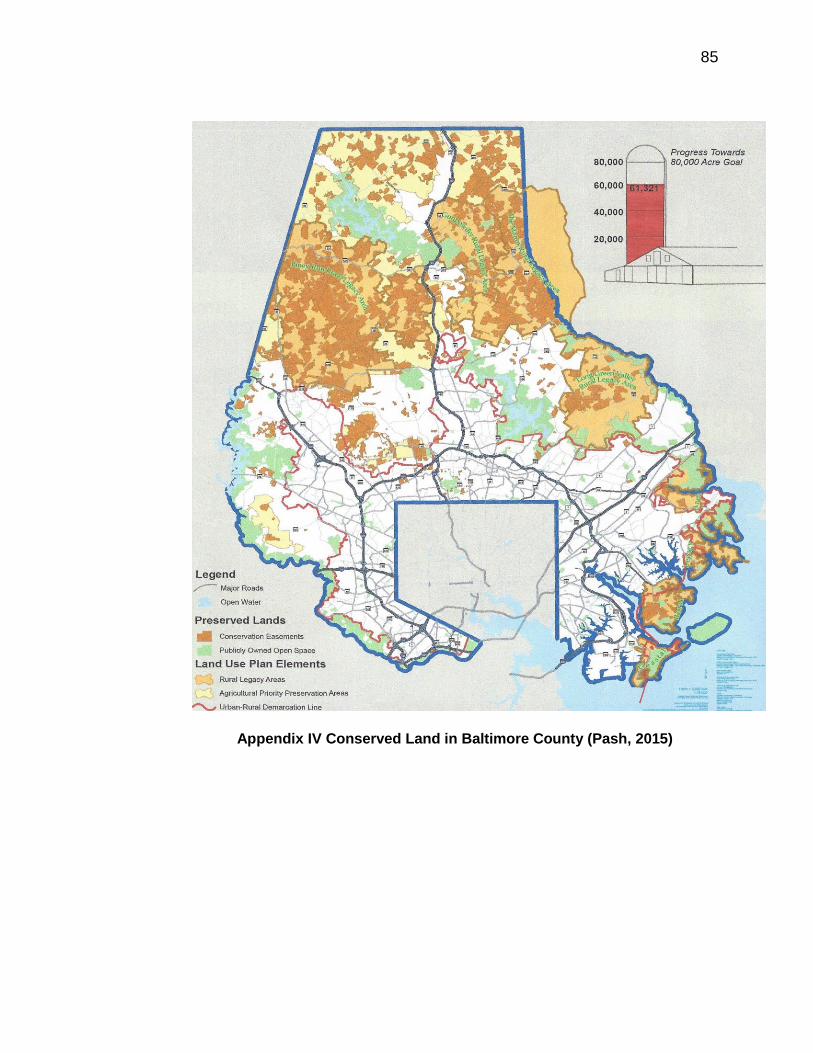
85
Appendix IV Conserved Land in Baltimore County (Pash, 2015)

86
Appendix V Resource Conservation Zones in Baltimore County (OPZ, 2015)

87
Land%(acres) Change Farms Change
1954 162,345 2331
1959 133,198 29147 1361 970
1964 149,856 16658 1143 218
1969 117,723 32133 996 147
1974 112,522 5201 886 110
1978 113,195 673 898 12
1982 99,016 14179 1006 108
1987 92,806 6210 917 89
1992 83,232 9574 840 77
1997 75,795 7437 781 59
2002 71,227 4568 784 3
2007 78,282 7055 751 33
2012 70,419 7863 640 111
Appendix VI Farmland Loss in Baltimore County (U.S.D.A)

88
Appendix VI I. L. McHarg (University of Pennsylvania)
Related Documents