THE PINSON OBSERVATORY Charles H. McNutt Pinson Mounds in west Tennessee and nearby Middle Woodland centers in north Mississippi have potential astronomical alignments. These alignments are discussed and used to support theidea thatthese large moundsiteswere corporate-ceremonial centers forpeople living in small, multi- household settlements, whose subsistenceincluded plants of the Eastern AgriculturalComplex. I amanxious tohave this mound examined as from its position. I am of the opinion it was built for the king'sobservatory whence to overlook his vast city. E. H. Rändle, 1875. (In Mainfort 1986:8) These words were penned by E. H. Rändle, president of McKenzie Male and Female College, who visited PinsonMounds (40MD1) in 1875 and was financed by an indulgent grant of $25 from the Smithsonian Institution. The mound to which he refers is the great SaulsMound(Mound 9) in Pinson Mounds State Park, located in Madisonand Chester Counties in western Tennessee. Ata minimum height of22.26 m (72.16 ft), it is arguably thesecond tallest mound north of Mexico, surpassed only by Monk's Moundat Cahokia. Inthis exploratory paper, I propose to(1) establish the possible existence of components ofan "Inner Citadel" constructed about Sauls Mound; (2) comment on previously recognized astronomical aspects of the Pinson site;(3) describe the apparent construction of the InnerCitadel for astronomical observations; (4) provide notes on other, roughly contemporaneous sites; and (5) discussthe possibility thatPinsonand these nearby sites were corporate-ceremonial centersfor societies practicing theEastern Agricultural Complex. The reader should be forewarned that, becausethis is an exploratory effort, I will "push the envelope" in several instances. Any discussion of astronomical phenomena is de- pendent on site location, elevation ofthelocal horizon, and chronology. Very slight errors are not critical, but accuracy is nonetheless desirable. The Pinson Mounds site (Figure 1) is here regarded as a point locatedat 88°52'20" W longitude and 35°30'00" N latitude. Site elevation is taken at400ft msl; the astronomical horizon is used. Although somedatesat Pinson extend into the B.C. range (Mainfort and McNutt 2004), the average (but not necessarily initial) dates for early features, such as Mounds 5, 6, and 12, lie between A.D. 100and 200 (Mainfort and McNutt 2004:Figure 4). Certain astro- nomical observations postulated below could most reasonably be made during the early stages of the construction ofSaulsMound. It seems reasonable, then, to assumethat thesitewas being laid out during the first century A.D.; a dateofA.D. 50 is adopted here. Astronomical calculations were made using the Scien- tific Astronomer module ofMathematica 5. Earthworks, Mounds, and the Inner Citadel The Pinson Mounds Archaeological Area lies in Madisonand Chester Counties, about16 kmsouth of Jackson, Tennessee. The siteis on a loess bluff on the north (right) sideof the westward-flowing South Fork of the Forked Deer River. A Middle Woodland mound complex, it covers an area of some 160 ha. With the exception of theNewark Earthworks, it is larger than other Ohio Hopewell sitesand larger even thanthe greatMississippian ceremonial center at Moundville. There is a fair amount ofliterature on the site, butthe major report is by Robert Mainfort (1986). The early history of the Pinsonsite has been sum- marized by Mainfort (1986:8-9) anddiscussed in greater detail by Kwas (1996).The documents cited by Kwas have been examined at Pinson; hercitations are com- plete, accurate, and germane to the subject at hand. Rather thancitethese original documents, whichare not readily available, I willrefer to Kwas' s publication. Recent history and research have been summarized by a number of scholars, most extensively by Robert Mainfort (Mainfort 1986; Mainfort and McNutt 2004, and references therein). The Pinson mounds were first reported by land surveyors in 1820. A small mound, probably of the Johnston group (40MD3; cf. Kwas and Mainfort 1986), was named "Mount Pinson" inhonor of oneof the crew members (Joel Pinson). The name was transferred by local people tothe much larger Sauls Mound, inwhat is now PinsonMounds StatePark.References to Sauls Moundand associated earthworks continued through- out the nineteenth century (see Kwas 1996), but no survey of themounds took place until late August or early September 1917.At this time, E. G. Buck, a civil engineer, conducted a survey at thebehest ofWilliam E. Myer, an archaeological enthusiast and "special archaeologist" of the Smithsonian Institution. This map (Myer 1922; Figure 2), titled "The City of Cisco," has been reproduced numerous times and is usually referred to as "Myer's map." 142 This content downloaded from 141.225.218.75 on Mon, 06 Jul 2015 22:33:54 UTC All use subject to JSTOR Terms and Conditions

Welcome message from author
This document is posted to help you gain knowledge. Please leave a comment to let me know what you think about it! Share it to your friends and learn new things together.
Transcript
THE PINSON OBSERVATORY
Charles H. McNutt
Pinson Mounds in west Tennessee and nearby Middle Woodland centers in north Mississippi have potential astronomical alignments. These alignments are discussed and used to support the idea that these large mound sites were
corporate-ceremonial centers for people living in small, multi- household settlements, whose subsistence included plants of the Eastern Agricultural Complex.
I am anxious to have this mound examined as from its position. I am of the opinion it was built for the king's observatory whence to overlook his vast city. E. H. Rändle, 1875. (In Mainfort 1986:8)
These words were penned by E. H. Rändle, president of McKenzie Male and Female College, who visited Pinson Mounds (40MD1) in 1875 and was financed by an indulgent grant of $25 from the Smithsonian Institution. The mound to which he refers is the great Sauls Mound (Mound 9) in Pinson Mounds State Park, located in Madison and Chester Counties in western Tennessee. At a minimum height of 22.26 m (72.16 ft), it is arguably the second tallest mound north of Mexico, surpassed only by Monk's Mound at Cahokia.
In this exploratory paper, I propose to (1) establish the possible existence of components of an "Inner Citadel" constructed about Sauls Mound; (2) comment on previously recognized astronomical aspects of the Pinson site; (3) describe the apparent construction of the Inner Citadel for astronomical observations; (4) provide notes on other, roughly contemporaneous sites; and (5) discuss the possibility that Pinson and these nearby sites were corporate-ceremonial centers for societies practicing the Eastern Agricultural Complex. The reader should be forewarned that, because this is an exploratory effort, I will "push the envelope" in several instances.
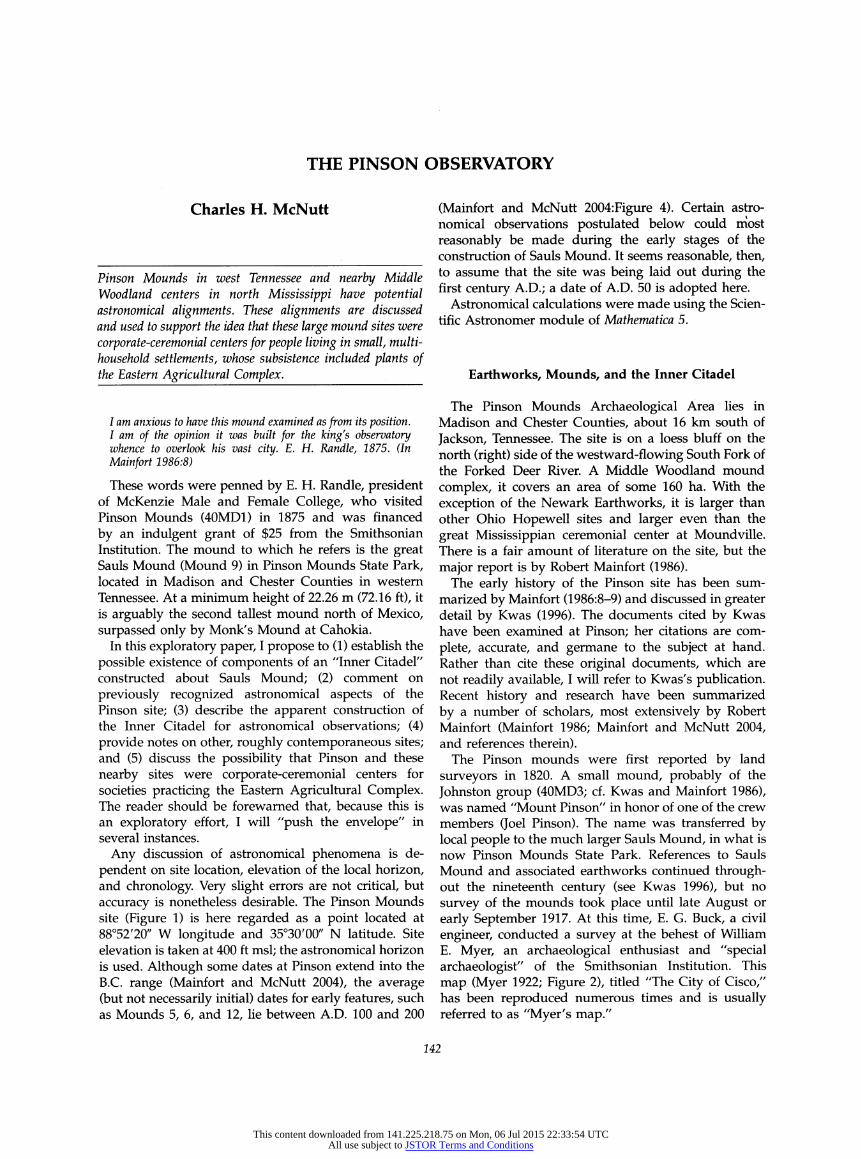
Any discussion of astronomical phenomena is de- pendent on site location, elevation of the local horizon, and chronology. Very slight errors are not critical, but accuracy is nonetheless desirable. The Pinson Mounds site (Figure 1) is here regarded as a point located at 88°52'20" W longitude and 35°30'00" N latitude. Site elevation is taken at 400 ft msl; the astronomical horizon is used. Although some dates at Pinson extend into the B.C. range (Mainfort and McNutt 2004), the average (but not necessarily initial) dates for early features, such as Mounds 5, 6, and 12, lie between A.D. 100 and 200
(Mainfort and McNutt 2004:Figure 4). Certain astro- nomical observations postulated below could most reasonably be made during the early stages of the construction of Sauls Mound. It seems reasonable, then, to assume that the site was being laid out during the first century A.D.; a date of A.D. 50 is adopted here.
Astronomical calculations were made using the Scien- tific Astronomer module of Mathematica 5.
Earthworks, Mounds, and the Inner Citadel
The Pinson Mounds Archaeological Area lies in Madison and Chester Counties, about 16 km south of Jackson, Tennessee. The site is on a loess bluff on the north (right) side of the westward-flowing South Fork of the Forked Deer River. A Middle Woodland mound complex, it covers an area of some 160 ha. With the exception of the Newark Earthworks, it is larger than other Ohio Hopewell sites and larger even than the great Mississippian ceremonial center at Moundville. There is a fair amount of literature on the site, but the major report is by Robert Mainfort (1986).
The early history of the Pinson site has been sum- marized by Mainfort (1986:8-9) and discussed in greater detail by Kwas (1996). The documents cited by Kwas have been examined at Pinson; her citations are com- plete, accurate, and germane to the subject at hand. Rather than cite these original documents, which are not readily available, I will refer to Kwas' s publication. Recent history and research have been summarized by a number of scholars, most extensively by Robert Mainfort (Mainfort 1986; Mainfort and McNutt 2004, and references therein).
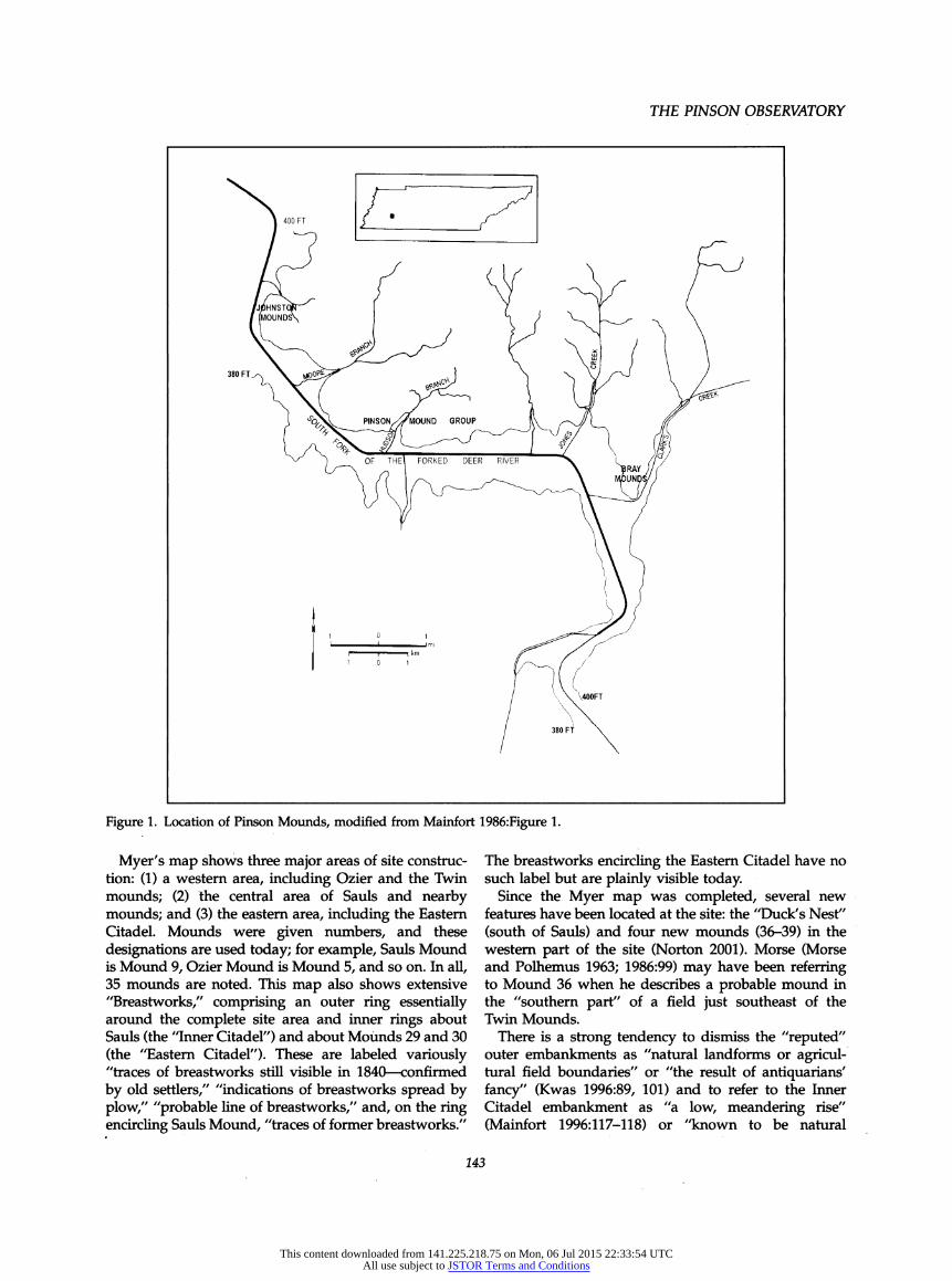
The Pinson mounds were first reported by land surveyors in 1820. A small mound, probably of the Johnston group (40MD3; cf. Kwas and Mainfort 1986), was named "Mount Pinson" in honor of one of the crew members (Joel Pinson). The name was transferred by local people to the much larger Sauls Mound, in what is now Pinson Mounds State Park. References to Sauls Mound and associated earthworks continued through- out the nineteenth century (see Kwas 1996), but no survey of the mounds took place until late August or early September 1917. At this time, E. G. Buck, a civil engineer, conducted a survey at the behest of William E. Myer, an archaeological enthusiast and "special archaeologist" of the Smithsonian Institution. This map (Myer 1922; Figure 2), titled "The City of Cisco," has been reproduced numerous times and is usually referred to as "Myer's map."
142
This content downloaded from 141.225.218.75 on Mon, 06 Jul 2015 22:33:54 UTCAll use subject to JSTOR Terms and Conditions
THE PINSON OBSERVATORY
' 400 FT f " -T
{ ^^^^_ PINSONXÄOUND GROUP 8' /^'-/l_ ¡ft
^^ ) OF THE' FORKED DEER RIVER ^' L // /
/ ' 'A4OOFT
/ 380 FT 'v
Figure 1. Location of Pinson Mounds, modified from Mainfort 1986:Figure 1.
Myer's map shows three major areas of site construc- tion: (1) a western area, including Ozier and the Twin mounds; (2) the central area of Sauls and nearby mounds; and (3) the eastern area, including the Eastern Citadel. Mounds were given numbers, and these designations are used today; for example, Sauls Mound is Mound 9, Ozier Mound is Mound 5, and so on. In all, 35 mounds are noted. This map also shows extensive "Breastworks," comprising an outer ring essentially around the complete site area and inner rings about Sauls (the "Inner Citadel") and about Mounds 29 and 30 (the "Eastern Citadel"). These are labeled variously "traces of breastworks still visible in 1840 - confirmed by old settlers," "indications of breastworks spread by plow," "probable line of breastworks," and, on the ring encircling Sauls Mound, "traces of former breastworks."
The breastworks encircling the Eastern Citadel have no such label but are plainly visible today.
Since the Myer map was completed, several new features have been located at the site: the "Duck's Nest" (south of Sauls) and four new mounds (36-39) in the western part of the site (Norton 2001). Morse (Morse and Polhemus 1963; 1986:99) may have been referring to Mound 36 when he describes a probable mound in the "southern part" of a field just southeast of the Twin Mounds.
There is a strong tendency to dismiss the "reputed" outer embankments as "natural landforms or agricul- tural field boundaries" or "the result of antiquarians' fancy" (Kwas 1996:89, 101) and to refer to the Inner Citadel embankment as "a low, meandering rise" (Mainfort 1996:117-118) or "known to be natural
143
This content downloaded from 141.225.218.75 on Mon, 06 Jul 2015 22:33:54 UTCAll use subject to JSTOR Terms and Conditions
SOUTHEASTERN ARCHAEOLOGY 24(2) WINTER 2005
Figure 2. Myer's map (1922) of Pinson Mounds site.
features" (Morse 1986:99 [citing Mainfort 1980]), and so on. In the following paragraphs, however, I present a case for reconsideration of these interpretations, particularly the latter. The possible existence of an embankment surrounding Sauls will not be germane to mound alignments, of course, but it would bolster the case for the Inner Citadel on Myer's map.
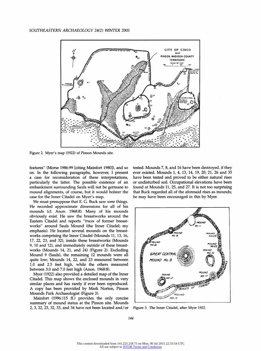
We must presuppose that E. G. Buck saw some things. He recorded approximate dimensions for all of his mounds (cf. Anon. 1968:8). Many of his mounds obviously exist. He saw the breastworks around the Eastern Citadel and reports "traces of former breast- works" around Sauls Mound (the Inner Citadel; my emphasis). He located several mounds on the breast- works comprising the Inner Citadel (Mounds 11, 13, 16, 17, 22, 23, and 32), inside these breastworks (Mounds 9, 10 and 12), and immediately outside of these breast- works (Mounds 14, 21, and 24) (Figure 2). Excluding Mound 9 (Sauls), the remaining 12 mounds were all quite low; Mounds 14, 22, and 23 measured between 1.0 and 2.5 feet high, while the others measured between 3.0 and 7.0 feet high (Anon. 1968:8).
My er (1922) also provided a detailed map of the Inner Citadel. This map shows the enclosed mounds in very similar places and has rarely if ever been reproduced. A copy has been provided by Mark Norton, Pinson Mounds Park Archaeologist (Figure 3).
Mainfort (1996:115 ff.) provides the only concise summary of mound status at the Pinson site. Mounds 2, 3, 22, 23, 32, 33, and 34 have not been located and/or
tested. Mounds 7, 8, and 16 have been destroyed, if they ever existed. Mounds 1, 4, 13, 14, 19, 20, 21, 26 and 35 have been tested and proved to be either natural rises or undisturbed soil. Occupational elevations have been found at Mounds 11, 25, and 27. It is not too surprising that Buck regarded all of the aforesaid rises as mounds; he may have been encouraged in this by Myer.
Figure 3. The Inner Citadel, after Myer 1922.
144
This content downloaded from 141.225.218.75 on Mon, 06 Jul 2015 22:33:54 UTCAll use subject to JSTOR Terms and Conditions
THE PINSON OBSERVATORY
This leaves 14 definite mounds (5, 6, 9, 10, 12, 15, 28, 29, 30, 31, 36, 37, 38, and 39) and three possible/probable mounds (17, 18, 24). Mainforf s discussion of Mound 17 is relevant: "Largely destroyed for use as fill in the 1960s, a profile exposed circa 1974 was interpreted as exhibit- ing indications of basketloading (Mainfort 1980). Addi- tional very limited testing in the 1980s failed to confirm this observation. A minor concentration of prehistoric ceramics and lithics is present at this locality" (Mainfort 1996:117). The 1980 reference indicates that "the entire center" of the mound had been removed by looters, but "the profile did reveal evidence of basket loading which established this feature as part of the Middle Woodland mound group at Pinson" (1980:37).
Regarding the Inner Citadel as such, Mainfort states that "no evidence of this enclosure is visible today; a natural rise that meanders roughly northward from Mound 17 probably represents a section of putative embankment. Testing at the Mound 11 and Mound 13 localities, both of which were "connected" to this system of embankments, argues against the existence of such a prehistoric earthwork, but Broster's testing of Mound 24 raises the possibility of some prehistoric construction" (Mainfort 1996:119).
Of the mounds within and immediately adjacent to Myer's Inner Citadel, Mounds 9, 10, 11, 12, 24, and possibly 17 have exhibited evidence of mound construc- tion, basket loading, or occupational features; Mounds 16, 22, and 23 have never been tested; either Mound 32 or Mound 16 may be represented by a low rise in the vicinity of some sewer lines; Mound 14 is a low sandy knoll, "very unlikely to be a prehistoric earthwork"; and Mound 13 has been examined on several occasions and seems most unlikely to be a mound.
A recent, detailed contour map indicates that the low rise by the sewer lines does indeed mark Mound 16. The stated locus of Mound 32, now a drainage, was once marked by a small mound according to a grounds- keeper, although according tò Robert Mainfort (personal communication 2004), John Sauls doubted this. Mound 13 is indeed a slight rise. Hence, it would seem that of the twelve mounds listed above, only one (Mound 13) has been tested and disproved as a real or potential mound, and another (Mound 14) is judged "very unlikely." In short, the great majority of mounds on Myer's map of the Inner Citadel are not antiquarian figments; many are/were very real elevations.
It is appropriate to consider briefly the embankments, particularly those ascribed to the Inner Citadel. Was the latter drawn based on "traces of former breast- works" as indicated or is it simply a meandering rise as suggested by Mainfort above. Kwas, in her article on antiquarian perspectives on the site, provides the earliest published reference to Pinson Mounds, by John Haywood in 1823:
[There is] the appearance of what the people there call an ancient fortification. It is 250 yards square. The wall is made of clay, and is now 8 feet above the common surface There is no appearance of any intrenchment [sic]. Within this wall is an ancient mound, 87 feet high by actual measurement - This mound is on the area within the wall, near the south side. Other small mounds of different sizes and descriptions are also within the enclosure (Kwas 1996:86).
Kwas (1996:88) subsequently quotes Gerard Troost, M.D., who described Mount Pinson in 1845 as
the highest that I have seen, (perhaps ninety or one hundred feet), of a conical shape, terminating in a small level about twenty feet in diameter, and is surrounded by circumvallations
More than two decades later, in 1874, J. B. Killebrew describes the mounds near Pinson's Station, and notes,
Around these is a semi-circular enclosure made of throwing up earth, as in building fortifications. This enclosure, if completed would form a circle not less than 600 feet in diameter (Kwas 1996:89).
Two years later, E. H. Rändle visited the site and listed, inter alia, "one 90 ft high 60 ft sqr on top covering about 3/4 of an acre well fortified about with fortified way to the creek" in a letter to Joseph Henry of the Smithsonian Institution. Less than three weeks later, he published a letter in a local paper, referring to the mounds as
scattered over about ten square miles and mostly enclosed by an outer wall of earth works, difficult now to judge how high it was at first; perhaps five or six feet but now not more than two or three and in some places scarcely visible.
Referring specifically to Sauls Mound, he states that it
was anciently surrounded by earthworks, running somewhat after the manner of earthworks of modern warfare, at a distance varying from 100 to 1000 yards, and a fortified way to a small creek.
By 1879, the enthusiastic J. G. Cisco had moved to Jackson, joined the American Academy for the Advance- ment of Science and the Tennessee Historical Society, and published his first reference to Pinson Mounds. He noted:
The mounds are connected, or rather surrounded, by a line of earthworks or embankments about two miles long. Most of the mounds have been plowed over for years, and consequently are much smaller than when first seen by the white settlers.
Quite some time later (1902), he wrote,
Col. Jones, one of the early settlers of this county, told me that when he was a boy he rode a horse for a distance of six miles on a line of earthworks that connected, and partially surrounded these mounds. Traces of these works are still tobe seen outside the plowed fields (Kwas 1996:94-96).
Warren K. Moorehead visited Pinson Mounds with Myer in January 1919. Appended to his typewritten report, entries continue "in script believed to be the handwriting of Myer" (Kwas 1996:102). Jones's trip is
145
This content downloaded from 141.225.218.75 on Mon, 06 Jul 2015 22:33:54 UTCAll use subject to JSTOR Terms and Conditions

SOUTHEASTERN ARCHAEOLOGY 24(2) WINTER 2005
once again described, but this time given a date of 1840. It is also reported that "in 1877 Cisco saw remains of the breastworks or walls in Ozier's fields, is not certain about seeing them in Watlington's fields/' It was Cisco who contacted^ William Myer, hence indirectly contrib- uting to the existence of Myer's map (thus, in his honor, 'The City of Cisco"). In sum, earthworks are seen or reported by Haywood
in 1823, seen by Troost in 1845, seen or reported by Killebrew in 1874, seen by Cisco in 1879, 1902, and possibly in 1877, recalled from and followed in 1840 by Colonel Jones, and possibly seen by Buck in 1917. The early references seem quite definite and consistent. The later ones, like those of Rändle and Cisco, refer increasingly to the damage to both earthworks and mounds by agricultural activities. These reports are quite in keeping with the documented history of agricultural damage to mound sites throughout the Southeast. Oral history is notoriously untrustworthy, but the large number of references to the same phenom- enon argues in favor of the earthworks.
Does it seem likely that what all these people saw or reported did not really exist, that none of these people saw what they said they saw, that none of them could distinguish meandering rises, natural land forms or agricultural field boundaries from earthworks, simply because we cannot see them today? Kwas (1996:89) observes, "Based on these early accounts, there may have been additional embankments surrounding Sauls Mound," but she retains disbelief in the outer earth- works. Certainly, I would not suggest the existence of the entire breastworks system around the site shown on Myer's map.
In passing, it should be noted that Mainfort (1986:8) feels the enclosure measuring 250 yards square to which Haywood referred in 1823 is "almost certainly a reference to the geometric embankment on the eastern edge of the site, which is approximately 275 yards in diameter." This observation may be correct; Mound 29 in the Eastern Citadel is located in the eastern (but not southern) section of its enclosure, while Sauls is shown as rather centrally located in its enclosure on the Myer map. The dimensions given by both Haywood and Killebrew are mòre appropriate to the area of the Eastern Citadel. On the other hand, Haywood observes,
Within this wall is an ancient mound, 87 feet high by actual measurement This mound is on the area within the wall, near the south side. Other small mounds of different sizes and descriptions are also within the enclosure (Kwas 1996:86).
This description, with its obvious reference to Sauls Mound, seems much more appropriate to the Inner Citadel with its other, smaller mounds.
Other Maps
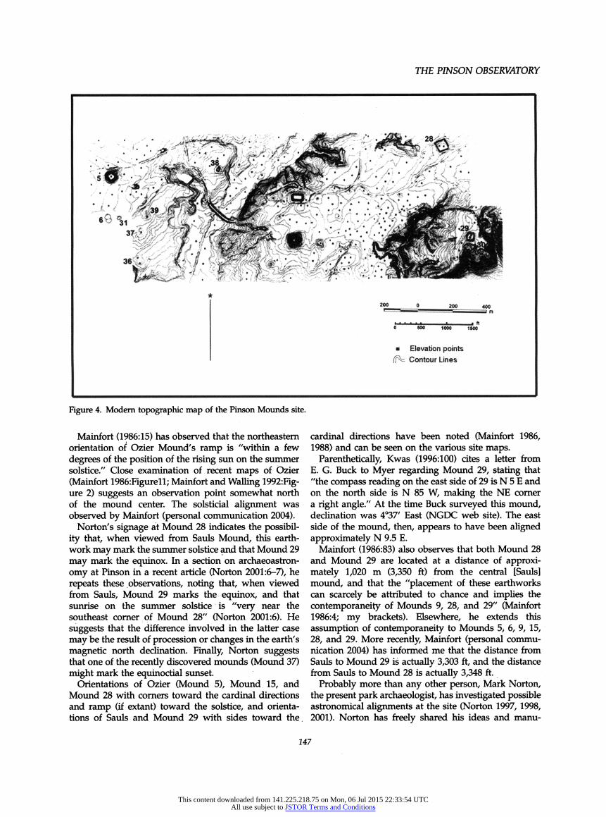
There are several more recent maps of the Pinson site: a map prepared for the Tennessee Department Master Plan (Anon. 1968) (the "Nash map"), a large map prepared by the State Planning Office for Morse and Polhemus's (1963) survey report (the "Morse map"), a large photogrametric map prepared by Tennessee Department of Transportation in the 1980s (the "wall map") (the most accurate map, but unfortunately incomplete), the site map presented by Mainfort in his 1986 report (the "Mainfort map," based on the wall map), and a recent detailed contour map, produced at Middle Tennessee State University by digitizing the wall map (the "Norton map"). Although none of the post- 1960 maps agree precisely in all particulars, they do not differ by truly significant amounts. The most recent one (Norton) is relied on considerably herein (Figure 4). While I am aware of the inherent dangers of using site
maps for drawing astronomical conclusions, in an area as large as the Pinson site maps are useful exploratory tools. Field checking, wherever possible, is most desir- able of course. In the case of the putative Inner Citadel encircling Sauls, the Myer map is all we have.
It may be noted that attempts were made to impose features from the Myer map onto the Nash map and subsequently (apparently) to copy them onto the Morse map. Neither of these is particularly successful; both show loci for Mound 17 and Mound 11 in the Inner Citadel, but neither suggests locations for, or existence of, Mound 22 or Mound 23. The shapes of the citadel breastworks are somewhat askew, and the angle between Mounds 32 and 12 with vertex at Sauls is 67° on these later maps, while it is 72° on the Myer map - a considerable difference in so small an area.
The considerations in the previous section led to a reinstatement of the Inner Citadel onto the Norton map. Appropriate enlargements were made and a trans- parency was carefully grafted onto the modern map (Figure 5). (This crime against nature may be called the "McNutt map.") I find the results particularly interest- ing. It can be seen immediately that the purported Inner Citadel mounds and embankment are congruent with the contours of the modern Norton map and that the Inner Citadel features do very little violence to existing contours. (See also detail, Figure 6.)
Previous Astronomical Observations
There has long been recognition that the location of certain mounds at Pinson may well have astronomical significance. All previous observations, as well as my own which follow, assume that the site area had been cleared (i.e., that the various mounds could be seen from the postulated viewpoint).
146
This content downloaded from 141.225.218.75 on Mon, 06 Jul 2015 22:33:54 UTCAll use subject to JSTOR Terms and Conditions
THE PINSON OBSERVATORY
Figure 4. Modern topographic map of the Pinson Mounds site.
Mainfort (1986:15) has observed that the northeastern orientation of Ozier Mound's ramp is "within a few degrees of the position of the rising sun on the summer solstice." Close examination of recent maps of Ozier (Mainfort 1986:Figurell; Mainfort and Walling 1992:Fig- ure 2) suggests an observation point somewhat north of the mound center. The solsticial alignment was observed by Mainfort (personal communication 2004).
Norton's signage at Mound 28 indicates the possibil- ity that, when viewed from Sauls Mound, this earth- work may mark the summer solstice and that Mound 29 may mark the equinox. In a section on archaeoastron- omy at Pinson in a recent article (Norton 2001:6-7), he repeats these observations, noting that, when viewed from Sauls, Mound 29 marks the equinox, and that sunrise on the summer solstice is "very near the southeast corner of Mound 28" (Norton 2001:6). He suggests that the difference involved in the latter case may be the result of procession or changes in the earth's magnetic north declination. Finally, Norton suggests that one of the recently discovered mounds (Mound 37) might mark the equinoctial sunset.
Orientations of Ozier (Mound 5), Mound 15, and Mound 28 with corners toward the cardinal directions and ramp (if extant) toward the solstice, and orienta- tions of Sauls and Mound 29 with sides toward the .
cardinal directions have been noted (Mainfort 1986, 1988) and can be seen on the various site maps.
Parenthetically, Kwas (1996:100) cites a letter from E. G. Buck to Myer regarding Mound 29, stating that "the compass reading on the east side of 29 is N 5 E and on the north side is N 85 W, making the NE corner a right angle." At the time Buck surveyed this mound, declination was 4°37' East (NGDC web site). The east side of the mound, then, appears to have been aligned approximately N 9.5 E.
Mainfort (1986:83) also observes that both Mound 28 and Mound 29 are located at a distance of approxi- mately 1,020 m (3,350 ft) from the central [Sauls] mound, and that the "placement of these earthworks can scarcely be attributed to chance and implies the contemporaneity of Mounds 9, 28, and 29" (Mainfort 1986:4; my brackets). Elsewhere, he extends this assumption of contemporaneity to Mounds 5> 6, 9, 15, 28, and 29. More recently, Mainfort (personal commu- nication 2004) has informed me that the distance from Sauls to Mound 29 is actually 3,303 ft, and the distance from Sauls to Mound 28 is actually 3,348 ft.
Probably more than any other person, Mark Norton, the present park archaeologist, has investigated possible astronomical alignments at the site (Norton 1997, 1998, 2001). Norton has freely shared his ideas and manu-
247
This content downloaded from 141.225.218.75 on Mon, 06 Jul 2015 22:33:54 UTCAll use subject to JSTOR Terms and Conditions

SOUTHEASTERN ARCHAEOLOGY 24(2) WINTER 2005
Figure 5. Myer's Inner Citadel superimposed on modern topographic map.
script data, bullied me into actually viewing the summer solstice and vernal equinox from atop Sauls, and has consistently encouraged and assisted my efforts in preparing this document. His interest in astronomical alignments at Pinson are evident in several museum displays at the park.
Other Potential Alignments
In addition to the obvious solar alignments (solstice, equinox), other kinds of astronomical alignments exist. Lunar standstills have been suggested as targets for astronomical orientation in Ohio Hopewell sites (Ro- main 2000, and references therein; see also Aveni 2003 for excellent discussion). Lunar cycles are characterized by sequent rises that move consistently in one direc- tion, either north or south depending on the part of the cycle being observed. Rising in the eastern sky, ex- treme northeastern and extreme southeastern points will eventually be reached, at which point the risings will gradually reverse their course. These slow turn- arounds are called "lunar standstills." There is a maxi- mum northerly moonrise standstill and a maximum southerly moonrise standstill in the eastern sky (54°27'
and 125°33', respectively, at Pinson). There are also maximum northerly moonset standstills and maximum southerly moonset standstills in the western sky (305°33' and 234°27', respectively, at Pinson).
I have used the terms "maximum" northerly moon- rise standstill and so forth because of the unfortunate fact that sequent lunar cycles do not return to the same northerly standstill or southerly standstill. Some north- erly moonrise standstills are more northerly than others. The northerly moonrise standstills will, however, be confined to a fairly narrow band of the sky. Given this fact, one can determine the "maximum" northerly moonrise standstill (above) and the "minimum" north- erly moonrise standstill (67°47' at Pinson). Comparable situations exist for all moonrise and moonset stand- stills - they each have maxima and minima. An attempt is made to clarify this discussion in Figure 7.
Venus is frequently mentioned, particularly as the "morning star" and "evening star." At the latitude of Pinson, its maximum and minimum rising points are between approximately 58° and 122°, and its setting maximum and minimum are 302° and 238°.
Stellar rises and sets comprise still a third possible source of alignments (Table 1). Stellar rising azimuths are concentrated within three bands, bounded by
148
This content downloaded from 141.225.218.75 on Mon, 06 Jul 2015 22:33:54 UTCAll use subject to JSTOR Terms and Conditions
THE PINSON OBSERVATORY
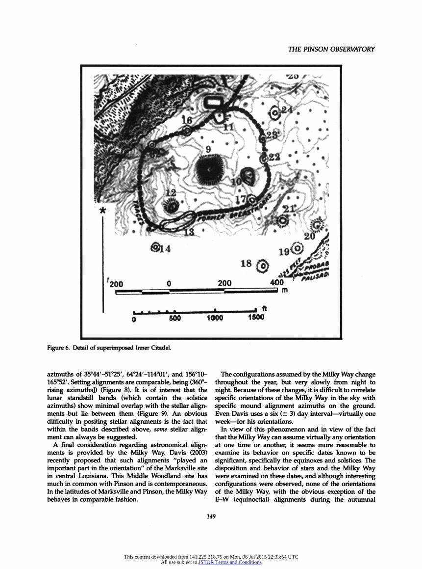
Figure 6. Detail of superimposed Inner Citadel.
azimuths of 35°44'-51°25', 64°24'-114o01'/ and 156°10- 165°52'. Setting alignments are comparable, being (360°- rising azimuths]) (Figure 8). It is of interest that the lunar standstill bands (which contain the solstice azimuths) show minimal overlap with the stellar align- ments but lie between them (Figure 9). An obvious difficulty in positing stellar alignments is the fact that within the bands described above, some stellar align- ment can always be suggested.
A final consideration regarding astronomical align- ments is provided by the Milky Way. Davis (2003) recently proposed that such alignments "played an important part in the orientation" of the Marksville site in central Louisiana. This Middle Woodland site has much in common with Pinson and is contemporaneous. In the latitudes of Marksville and Pinson, the Milky Way behaves in comparable fashion.
The configurations assumed by the Milky Way change throughout the year, but very slowly from night to night. Because of these changes, it is difficult to correlate specific orientations of the Milky Way in the sky with specific mound alignment azimuths on the ground. Even Davis uses a six (± 3) day interval - virtually one week - for his orientations.
In view of this phenomenon and in view of the fact that the Milky Way can assume virtually any orientation at one time or another, it seems more reasonable to examine its behavior on specific dates known to be significant, specifically the equinoxes and solstices. The disposition and behavior of stars and the Milky Way were examined on these dates, and although interesting configurations were observed, none of the orientations of the Milky Way, with the obvious exception of the E-W (equinoctial) alignments during the autumnal
149
This content downloaded from 141.225.218.75 on Mon, 06 Jul 2015 22:33:54 UTCAll use subject to JSTOR Terms and Conditions
SOUTHEASTERN ARCHAEOLOGY 24(2) WINTER 2005
Figure 7. Minimum and maximum lunar standstills, Pinson Mounds, A.D. 50.
equinox and winter solstice, seem to be reflected by mound alignments from Sauls.
This observation is not meant to say, of course, that the behavior of the Milky Way was of no interest to the inhabitants of Pinson. It probably was, but this is strictly a matter of speculation. My point here is that no such interest is apparent in the disposition of site features as viewed from Sauls Mound.
Alignments at Pinson: Sauls Mound
Most alignments discussed in this paper are based on observations made from Sauls Mound. Others may well
Table 1. Rise-Set Data for Major Stars at Pinson, A.D. 50.
rise set
deg. min. deg. min.
Capella 35 44 324 16 Deneb 38 9 321 52 Vega 39 32 320 29 Castor 46 57 313 3 Arcturus 50 55 309 6 Pollux 51 25 308 36 Regulus 64 24 295 37 Pleiades3 69 51 290 9 Áldebaran 76 59 283 . 2 Procyon 79 42 280 19 Altair 82 34 277 26 Betelgeuse 83 58 276 3 Spica 89 50 270 11 Epsilon Orionis 95 26 264 35 Rigel 105 8 254 53 Sirius 109 21 250 39 Antares 114 1 245 59 Fomalhaut 140 2 219 58 BetaCrucis 156 10 203 50 BetaCentauri 158 28 201 33 Alpha Centauri 162 16 197 44 Alpha Crucis 164 4 195 56 Canopus 165 52 194 8
a eta Taurus Source: Adapted from Averti and Linsey 1972.
Star Rises and Sals, 35*30 N, A.D.50, horte. - 0
data from Aveni 1972
RISE SET
180 -i 1 180 CANOPUS
a. crucis ▲ a. CENTAURI A ♦ -A-
1 60 b. CENTAURI «-^ w A 200 -A-
b. crucis ♦ w
140 Wlhaut - 220
120 - 240 ♦ antares
* SIRIUS
»100 ^ 260 £ ♦ e.ORiONis
| ♦SPICA
'Ñ ♦ ♦BETELGEUSE 'Ñ £ 80- ■--♦-^ALTAIR
♦ 280 ♦ PROCYON ALDEBARAN
•pléiades ♦ REGULUS _ _ _
60 300 _ _ _
A ♦POLLUX ▲ ARCTURUS ^CASTOR
40 ^♦VEGA- - - 320 ♦ DENEB CAPELLA
20 -L J 340
Figure 8. Stellar rises and sets, Pinson Mounds, A.D. 50.
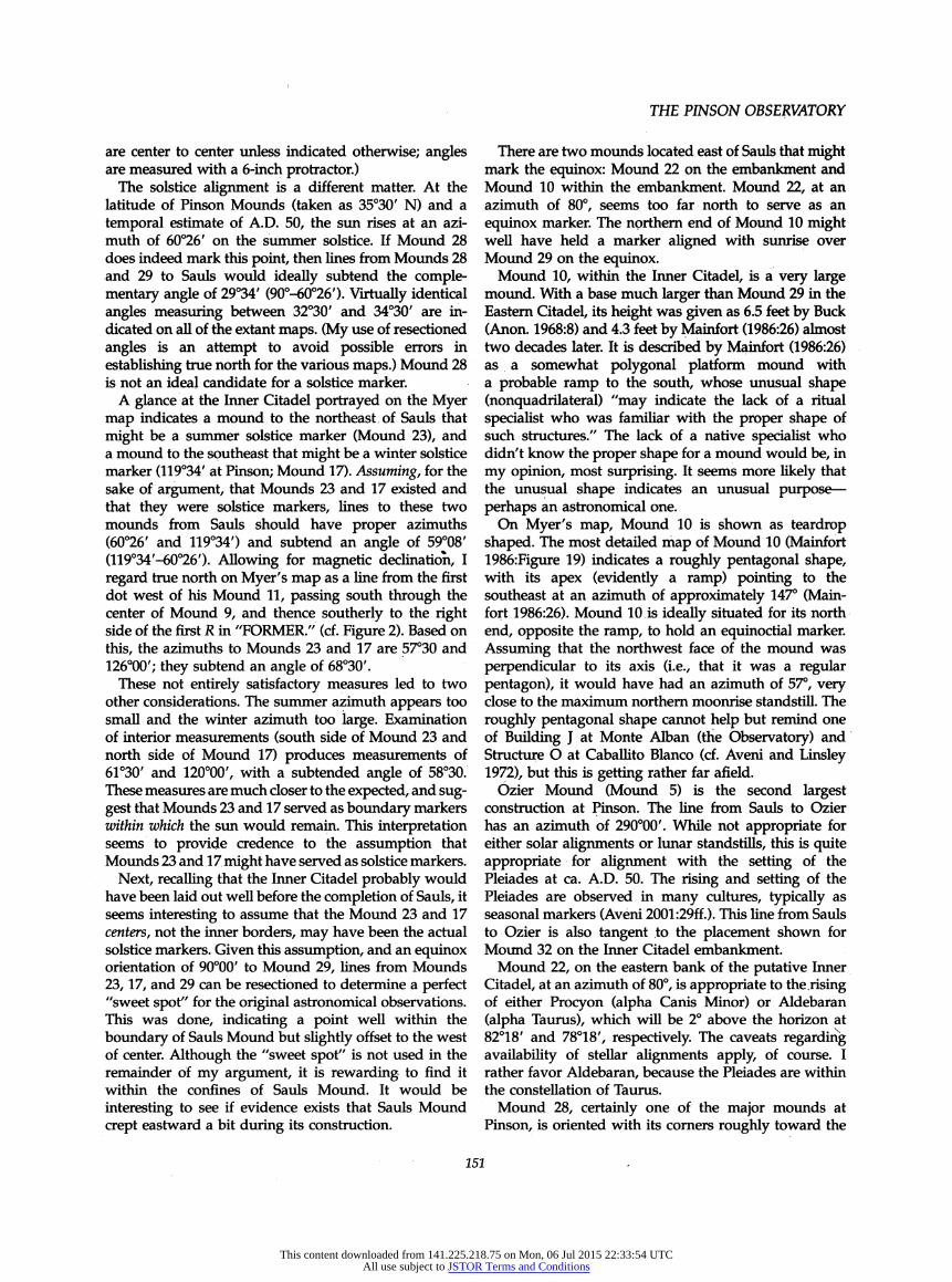
have existed, particularly in the Eastern Citadel (below). Of immediate interest are the alignments of Sauls with Mounds 28 and 29. As noted, site signage indicates the possibility that, when viewed from Sauls, Mound 28 may mark the summer solstice and Mound 29 may mark the equinox. The actual view from Sauls across Mound 29 does indeed indicate that the latter marks the equinox. The azimuth of the Sauls Mound-Mound 29 line approx- imates 90 degrees on all maps and is precisely 90 degrees on the Mainfort and Norton maps. This alignment has been field checked on numerous occasions. (Alignments
Figure 9. The "astronomical sweep/' Pinson Mounds, A.D. 50.
150
This content downloaded from 141.225.218.75 on Mon, 06 Jul 2015 22:33:54 UTCAll use subject to JSTOR Terms and Conditions
THE PINSON OBSERVATORY
are center to center unless indicated otherwise; angles are measured with a 6-inch protractor.)
The solstice alignment is a different matter. At the latitude of Pinson Mounds (taken as 35°30' N) and a temporal estimate of A.D. 50, the sun rises at an azi- muth of 60°26' on the summer solstice. If Mound 28 does indeed mark this point, then lines from Mounds 28 and 29 to Sauls would ideally subtend the comple- mentary angle of 29°34' (90°-60°26'). Virtually identical angles measuring between 32°30' and 34°30' are in- dicated on all of the extant maps. (My use of resectioned angles is an attempt to avoid possible errors in establishing true north for the various maps.) Mound 28 is not an ideal candidate for a solstice marker.
A glance at the Inner Citadel portrayed on the Myer map indicates a mound to the northeast of Sauls that might be a summer solstice marker (Mound 23), and a mound to the southeast that might be a winter solstice marker (119°34' at Pinson; Mound 17). Assuming, for the sake of argument, that Mounds 23 and 17 existed and that they were solstice markers, lines to these two mounds from Sauls should have proper azimuths (60°26' and 119°34') and subtend an angle of 59°08' (119°34'-60°26'). Allowing for magnetic declination, I regard true north on Myer's map as a line from the first dot west of his Mound 11, passing south through the center of Mound 9, and thence southerly to the right side of the first R in "FORMER." (cf. Figure 2). Based on this, the azimuths to Mounds 23 and 17 are 57°30 and 126°00'; they subtend an angle of 68°30'.
These not entirely satisfactory measures led to two other considerations. The summer azimuth appears too small and the winter azimuth too large. Examination of interior measurements (south side of Mound 23 and north side of Mound 17) produces measurements of 61°30' and 120°00', with a subtended angle of 58°30. These measures are much closer to the expected, and sug- gest that Mounds 23 and 17 served as boundary markers within which the sun would remain. This interpretation seems to provide credence to the assumption that Mounds 23 and 17 might have served as solstice markers.
Next, recalling that the Inner Citadel probably would have been laid out well before the completion of Sauls, it seems interesting to assume that the Mound 23 and 17 centers, not the inner borders, may have been the actual solstice markers. Given this assumption, and an equinox orientation of 90°00' to Mound 29, lines from Mounds 23, 17, and 29 can be resectioned to determine a perfect "sweet spot" for the original astronomical observations. This was done, indicating a point well within the boundary of Sauls Mound but slightly offset to the west of center. Although the "sweet spot" is not used in the remainder of my argument, it is rewarding to find it within the confines of Sauls Mound. It would be interesting to see if evidence exists that Sauls Mound crept eastward a bit during its construction.
There are two mounds located east of Sauls that might mark the equinox: Mound 22 on the embankment and Mound 10 within the embankment. Mound 22, at an azimuth of 80°, seems too far north to serve as an equinox marker. The northern end of Mound 10 might well have held a marker aligned with sunrise over Mound 29 on the equinox.
Mound 10, within the Inner Citadel, is a very large mound. With a base much larger than Mound 29 in the Eastern Citadel, its height was given as 6.5 feet by Buck (Anon. 1968:8) and 4.3 feet by Mainfort (1986:26) almost two decades later. It is described by Mainfort (1986:26) as a somewhat polygonal platform mound with a probable ramp to the south, whose unusual shape (nonquadrilateral) "may indicate the lack of a ritual specialist who was familiar with the proper shape of such structures." The lack of a native specialist who didn't know the proper shape for a mound would be, in my opinion, most surprising. It seems more likely that the unusual shape indicates an unusual purpose -
perhaps an astronomical one. On Myer's map, Mound 10 is shown as teardrop
shaped. The most detailed map of Mound 10 (Mainfort 1986:Figure 19) indicates a roughly pentagonal shape, with its apex (evidently a ramp) pointing to the southeast at an azimuth of approximately 147° (Main- fort 1986:26). Mound 10 is ideally situated for its north end, opposite the ramp, to hold an equinoctial marker. Assuming that the northwest face of the mound was perpendicular to its axis (i.e., that it was a regular pentagon), it would have had an azimuth of 57°, very close to the maximum northern moonrise standstill. The roughly pentagonal shape cannot help but remind one of Building J at Monte Alban (the Observatory) and Structure O at Caballito Blanco (cf. Aveni and Linsley 1972), but this is getting rather far afield.
Ózier Mound (Mound 5) is the second largest construction at Pinson. The line from Sauls to Ozier has an azimuth of 290°00' While not appropriate for either solar alignments or limar standstills, this is quite appropriate for alignment with the setting of the Pleiades at ca. A.D. 50. The rising and setting of the Pleiades are observed in many cultures, typically as seasonal markers (Aveni 2001:29ff.). This line from Sauls to Ozier is also tangent to the placement shown for Mound 32 on the Inner Citadel embankment.
Mound 22, on the eastern bank of the putative Inner Citadel, at an azimuth of 80°, is appropriate to the. rising of either Procyon (alpha Canis Minor) or Aldebaran (alpha Taurus), which will be 2° above the horizon at 82°18' and 78°18', respectively. The caveats regarding availability of stellar alignments apply, of course. I rather favor Aldebaran, because the Pleiades are within the constellation of Taurus.
Mound 28, certainly one of the major mounds at Pinson, is oriented with its corners roughly toward the
151
This content downloaded from 141.225.218.75 on Mon, 06 Jul 2015 22:33:54 UTCAll use subject to JSTOR Terms and Conditions

SOUTHEASTERN ARCHAEOLOGY 24(2) WINTER 2005
Figure 10. Potential astronomical alignments from Sauls Mound, A.D. 50.
cardinal directions. It lies at an azimuth of 56° from Sauls. This marks the maximum northerly moonrise standstill; viewed from Sauls, the moon will never rise to the north of Mound 28. In this capacity, Mound 28 serves as a lunar analog to Mound 23, which constrains the summer solstice.
Mound 24 is at an azimuth of 48° from Sauls. This is appropriate to the rising of Gemini, with Castor 2° above the horizon at 49° and Pollux slightly to the south. I can suggest no alignment for Mound 16, lying at an azimuth of 330° from Sauls. The alignments suggested in this section are summarized above (Figure 10).
Alignments at Pinson: The Eastern Citadel
Although the major astronomical alignments at Pinson appear to be based on Sauls Mound, there are certain suggestive aspects of the Eastern Citadel that deserve comment. The Eastern Citadel is a roughly circular feature, described as having an approximate diameter of 363 m (1190') (Mainfòrt 1986:4). A modern contour map of this feature (Figure Ila; from Mainfort 1986:Figure 4) is closely comparable to its depiction on the Myer map (Figure lib), but both suggest a diameter closer to 300-325 m (984-1066 ft). Assuming that the
southern portion of the citadel was indeed adequately preserved for Buck to map it and to document two "gates" ("b" and "c") in this portion of the ring, a tremendous amount of recent erosion is visible on the modern map. In the eastern portion of the Myer map, Buck shows several breaks in the ring below gate "d." Remnants of the breaks are still visible on the modern map (see also Morse 1986:Figure 99). Mainfort (1986:4) observes that "it is not known whether these represent construction features or recent erosion."
In Figure lie, the Myer map has been lightened (except for the gate labels) and the modern contour map is superimposed. Azimuths appropriate to moonrise standstill maxima, the solstices, Aldebaran rising, and the equinox are also shown. The origin point shown is not marked by any known feature; it was determined as an ideal spot by resectioning. It is, however, quite close to what is designated as the "radial center" of the Eastern Citadel on Figure Ila, and even closer (ca. 15 m south) to the true (gravitational) center of the feature, marked by the small block in Figure lie. These regions should be tested.
The limar maxima are not convincing in this scenario. The solstice alignments (through an opening in the north and across Mound 30 in the south) appear reasonable, as do the alignments to Aldebaran (80°,
152
This content downloaded from 141.225.218.75 on Mon, 06 Jul 2015 22:33:54 UTCAll use subject to JSTOR Terms and Conditions

THE PINSON OBSERVATORY
Figure 11. The Eastern Citadel: (a) after Mainfort 1986:Figure 4; (b) after Myer 1922; (c) Myer map superimposed on Mainforfs map.
through a second opening) and the equinoxes (across Mound 29 and through gate "a" to Sauls).
If this interpretation has any merit, the astronomical significance of the other gates (b, c, and d) is unknown.
I am unable to suggest any other point of origin from which astronomical alignments through these latter gates might be significant, with the possible exception of the view from gate "a" through gates "c" and "d." to
153
This content downloaded from 141.225.218.75 on Mon, 06 Jul 2015 22:33:54 UTCAll use subject to JSTOR Terms and Conditions
SOUTHEASTERN ARCHAEOLOGY 24(2) WINTER 2005
mark the solstices. As Mainfort observes, however, the origin of these various gates is not as clear as we would like.
Mound Placement at Pinson
Aveni (2003) has commented on the need for statistical analyses of expected and actual astronomical align- ments in a given space. If most of the mounds at Pinson were astronomically laid out with respect to Sauls, then we would expect a nonrandom placement, with concen- trations within the solar-lunar-stellar rise-set limits shown in Figure 9. Essentially, the rise limits comprise the regions between 36°44' to 125°33' and 156°10' to 165°52', or a total of 98°31'. The setting limits are comparable, making the total rise-set coverage (here- after the "sweep") approximately 197°, or 200°. The area beyond these limits is 160°, and if mounds were placed randomly, one would expect ratios of 200:160, or 5:4 mounds within and beyond the rise-set sweep defined about Sauls.
In assessing the placement of mounds at Pinson, a word about the accuracy of the Myer map is in order. Mainfort (1986:9) observes that,
published in 1922 by Myer, Buck's map is generally quite accurate (as are his measurements of the individual mounds) although Ozier Mound (Mound 5) is placed about 100 m too far to the east.
Actually, Ozier and Twin Mounds, on the western edge of the Myer map, are in proper relationship to each other, but from the standpoint of Sauls Mound are placed approximately 50 m too far to the east and about 100 m too far to the north. On the eastern edge of the Myer map, Mounds 28, 29, and 30 have roughly the proper relationship to each other, but from the standpoint of Sauls, Mound 29 is placed about 60 m too far to the west (i.e., too close) and a bit to the north. All of which indicates that long distances are under- estimated and improperly aligned a bit on the Myer map.
Distances and alignments at close range, and specifi- cally within the Inner Citadel, are another matter however, as can be seen on Figure 6. These seem to be accurate - again distances may be very slightly under- estimated, but angular alignments appear fairly accurate.
In evaluating simple alignments of various mounds from Sauls, distance errors will be of no consequence but angular measures will be. Hence, while the Myer map can be used to ascertain alignments between Sauls and other features within and adjacent to the Inner Citadel area, it cannot be used to evaluate alignments of distant mounds. Fortunately, azimuths to the major distant mounds can be determined from the contempo- rary (Norton) map.
In examining the location of mounds with respect to the rise-set sweep of solar-lunar-stellar alignments, the location of a total of 32 features can be examined; Mounds 1, 2, 3, 4, and 35 are not located on present maps, and Mounds 13 and 14 have been discounted. With Sauls as the point of origin, the "expected" ratio of five mounds within the sweep to four mounds beyond it suggests expecteds of 17.8 to 14.2, respectively, or roughly 18 to 14 mounds, respectively.
Five features are definitely beyond the sweep (Mounds 11, 15, 33, and 34 to the north and the Duck's Nest to the south). Two of these, Mound 33 (only on the Myer map) and Mound 11, may represent polar align- ments. One additional mound (Mound 19) is either aligned with Fomalhaut (alpha Piscinus Austrinus) or should (probably) be counted as beyond the sweep. Four mounds appear tangent to the sweep limits (Mounds 12, 16, 17, and 21) and 18 mounds (Mounds 5, 6, 7, 8, 10, 18, 20, 22 through 32, and 36 through 39) lie within the sweep.
Hence, six features (including Mound 19) should probably be counted as beyond the sweep of probable alignments, four may be regarded as undecided, and 22 are within the sweep - a bit more than expected. If all , four of the "tangent^ mounds are regarded "beyond," there are still four less mounds (10) beyond the sweep than expected. If these four mounds were divided equally, 24 mounds, rather than the expected 17.8, would lie within the rise-set sweep and eight mounds would lie beyond the sweep. These differences are statistically significant at the .05 level (X2 = 4.91, df = 1).
A final observation can be made. If astronomical alignments were of interest to the people who con- structed Pinson Mounds, potential and actual align- ments to the east of Sauls would indicate a concern with solar-lunar-stellar risings; potential and actual align- ments to the west would indicate an interest in astronomical settings. A glance at the site maps indicates strong emphasis on real and potential easterly (rising) alignments.
Comparative Notes
In the notes that follow I will be interested in emphasizing other potential astronomical alignments, particularly those pertaining to solar phenomena. The reader is reminded that this is an exploratory paper, dependent largely on published site maps and seeking to justify further testing in situ by those familiar with the individual locales. Toward this end, I am, again, unabashedly pushing the envelope.
Several other contemporaneous and culturally com- parable (Middle Woodland) sites exhibit probable concern with astronomical phenomena. This has been documented in some detail for the Ohio Hopewell sites
154
This content downloaded from 141.225.218.75 on Mon, 06 Jul 2015 22:33:54 UTCAll use subject to JSTOR Terms and Conditions

THE PINSON OBSERVATORY
(e.g., Aveni 2003; Hively and Horn 1982, 1984; Romain 2000). In passing, it can be observed that Romain postu- lates alignments with the minimum (inner) moon-set standstill (292.7° or 292°42') in charnel houses at Liberty Earthworks and Mound City (2000:Figures 5.7, 5.9). The association of death with the moon seems reason- able, but Aveni (2003:5) has questioned the logic of alignments with minimum or inner lunar standstills. It is of interest, then, to note that using Romain's date of A.D. 250 and latitude 39°15' N, the Pleiades, of pos- sible interest at Pinson, set at an azimuth of 292°23' at Liberty Earthworks.
Davis' s recent work at Marksville has been cited. Equinox alignments exist at Marksville and are dis- cussed. Solstice alignments are mentioned in his summary but are not discussed in the text. At Marks- ville, an excellent case can be made for solstice risings over Mounds X (summer) and Mound 2 (winter) when viewed from Mound 4, or for being constrained between Mound X and Mound 2 when viewed from Mound 5, comparable to the situation at Pinson. Davis also presents brief discussions of other Louisiana sites.
Parenthetically, the solstice sunsets at Poverty Point subtend an angle of approximately 56° and fit quite nicely with the aisles on the recent site map by T. R. Kidder (2002) locating the "site center" at 5167 m northing and 5160 m easting. This observation is very close to the suggestions made earlier by Brecher and Haag (1980, 1983, contra Purrington 1983). Of course, looking eastward down the aisles to a stake at the "site center" would provide a means of marking solstice sun rises, which for some ethnocentric reason I find more appealing.
Closer to home, at the Old Stone Fort site (Faulkner 1968) the elaborate entrance into the rather featureless fort is aligned with the summer solstice (Pearsall and Malone 1991; Faulkner 1996). The date of this feature is problematic, but it appears to have been initiated in the first century A.D. (Faulkner 1968:85; 1996:8). Construc- tion of the fort's walls evidently continued until at least the mid-400s (Faulkner 1996). These dates are compat- ible with major activity at Pinson.
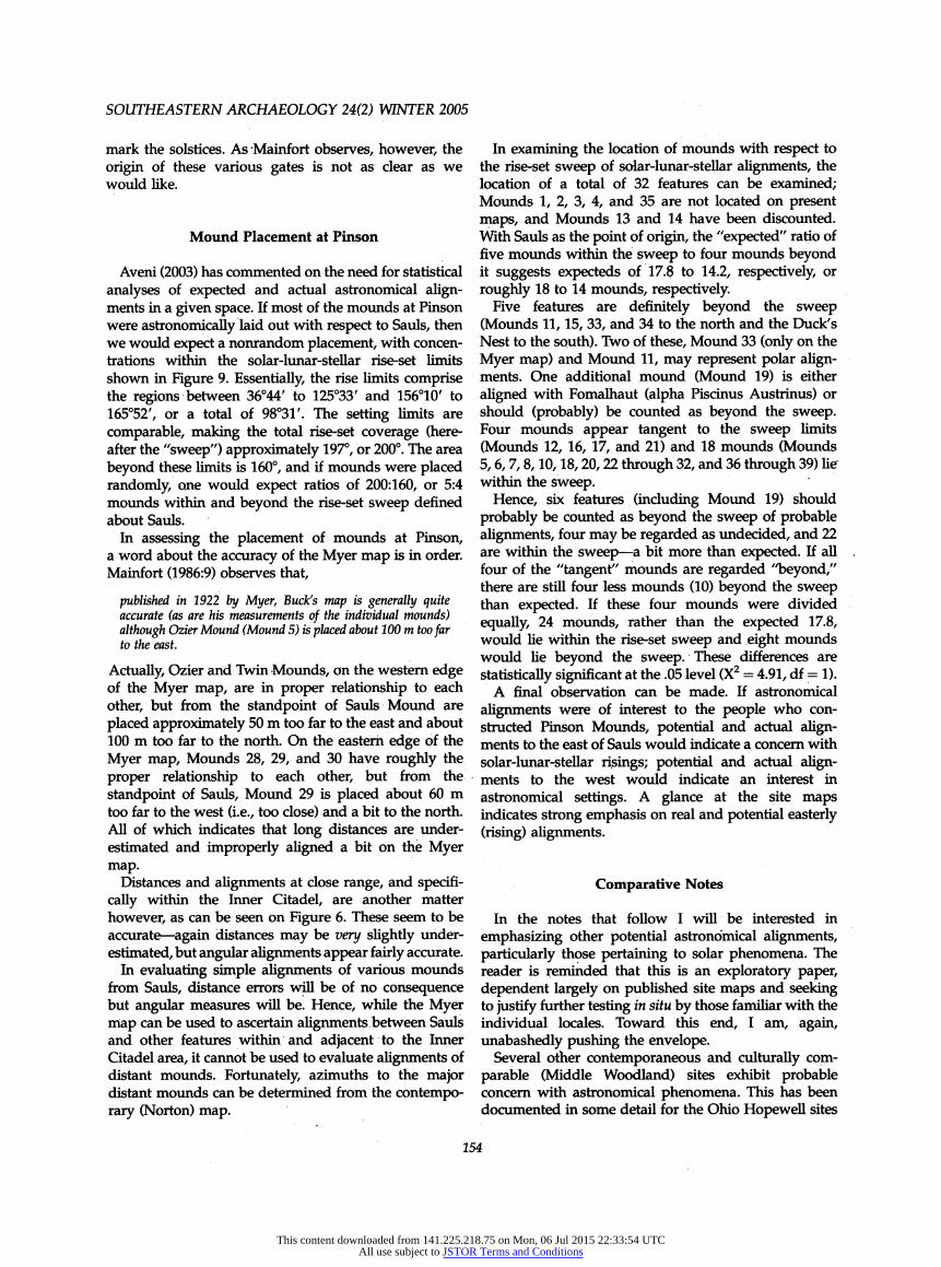
The Johnston site (Kwas and Mainfort 1986) is even closer to Pinson, lying about 4 km to the northwest (Figure 1). Its physiographic setting, on the bluffs along the right side of the South Fork of the Forked Deer River, is virtually identical to that of Pinson. Kwas and Mainfort (1986:38-39) feel that Johnston is a closely related precursor of Pinson.
Descriptions of the site from the early nineteenth century report the existence of mounds, long earth walls, and streets; these are shown on Myer's map of the site (doubtlessly made by Buck). This map, published by Kwas and Mainfort (1986:Figure 2), has been modified slightly (text enhanced and true north arrow added) and is reproduced here as Figure 12.
In 1823, the walls were described as "18 inches or two feet high and 10 in width," and the right-angled break above Mound 3 leading to the spring is described in considerable detail (Kwas and Mainfort 1986:31-32). Myer reports seeing the remains of these walls, tracing missing parts with the help of old settlers, and describes ten mounds - three with heights between 7.5 and 20.0 ft (2.3-6.1 m) and seven ranging from 2.5 to 1.5 ft (0.8- 0.5 m) (Kwas and Mainfort 1986:34). Only the former (Mounds 1, 4, and 5) are visible today. Kwas and Mainfort (1986:35), with characteristic caution and alluding to their doubts about some of Myer's mounds at Pinson, observe that "there is good reason to question the existence of some of the alleged earthworks at the Johnston site Nonetheless, it is possible that the parallel embankments shown between Mounds 1 and 4 were of aboriginal construction." They also note that Mound 4 is aligned some 5 degrees east of magnetic north, as was the somewhat smaller Mound 29 in the Eastern Citadel at Pinson. (This is also the alignment of the walls between Mound 4 and Mound 1, of course.)
Potential astronomical alignments exist from Mound 7, described by Myer as "half oval" with a height of 2.5 ft (0.8 m). Lines from Mound 7 through Mounds 6 and 9 correspond closely to the solstices; the line from Mound 7 across the front of Mound 5 marks the equinox. Other possible alignments would include lines through Mound 8 (maximum southern moonrise standstill) and Mound 10 (Fomalhaut rising).
There are certainly troubles with using this site map to establish astronomical alignments. In view of the apparent existence of solstice and equinoctial align- ments at the closely related Pinson site, and the corre- spondence in mound alignments mentioned above, comparable alignments at Johnston, however tenuous, at least deserve mention. A striking difference between Johnston and Pinson is that alignments at the former site are from a minor mound, while those from Pinson are from the major mound.
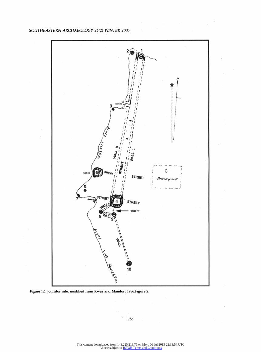
The Pharr site is a multimound Middle Woodland center located on the Natchez Trace in northeast Mississippi, straddling the line between Prentiss and Itawamba Counties. Excavated by Bohannon in 1966, the site is described as having eight dome-shaped mounds (Bohannon 1972). Contemporary with early activity at Pinson, Pharr has been placed in regional chronological context by Walling, Mainfort, and Atkinson (1991) and Mainfort and McNutt (2004). Bohannon's (1972:78) original age estimate of A.D. 1- 200 appears accurate for the site.
The Pharr site shows evidence of astronomical align- ments. The original site map (Bohannon 1972:Figure 2) modified by text enhancement and addition of a true north arrow is shown here, with Figure 13a indicating potential astronomical alignments and Figure 13b
155
This content downloaded from 141.225.218.75 on Mon, 06 Jul 2015 22:33:54 UTCAll use subject to JSTOR Terms and Conditions
SOUTHEASTERN ARCHAEOLOGY 24(2) WINTER 2005
Figure 12. Johnston site, modified from Kwas and Mainfort 1986:Figure 2.
156
This content downloaded from 141.225.218.75 on Mon, 06 Jul 2015 22:33:54 UTCAll use subject to JSTOR Terms and Conditions
THE PINSON OBSERVATORY
Figure 13. Pharr site, modified from Bohannon 1972:Figure 2: (a) potential astronomical alignments; (b) ihtermound distances.
showing what appears to be very interesting duplica- tions of intermound distances.
Three potential equinoctial alignments exist at Pharr, between Mounds A and B, Mounds H and C, and Mounds G and F. Solstice alignments exist through Mounds G, E, and C. Because Mound E is the major mound at the site, the view southwestward may mark sunset on the winter solstice, the view northeastward to the base of Mound C constraining sunrise on the summer solstice, in the manner postulated for the Inner Citadel at Pinson. A maximum northern limar standstill may be indicated by the alignment of Mound E with the base of Mound D and/or the apex of Mound C. Possible stellar alignments to Castor and Pollux (setting) and Vega (rising) also exist (Figure 13a).
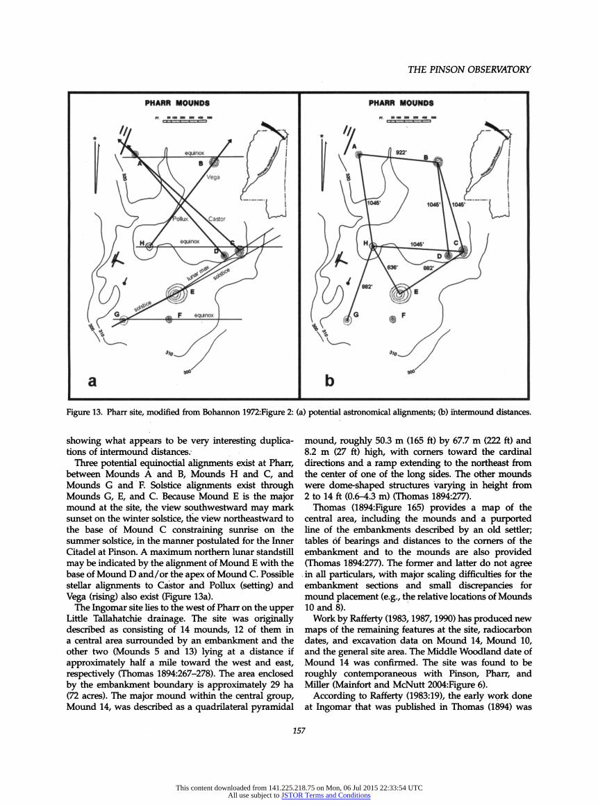
The Ingomar site lies to the west of Pharr on the upper Little Tallahatchie drainage. The site was originally described as consisting of 14 mounds, 12 of them in a central area surrounded by an embankment and the other two (Mounds 5 and 13) lying at a distance if approximately half a mile toward the west and east, respectively (Thomas 1894:267-278). The area enclosed by the embankment boundary is approximately 29 ha (72 acres). The major mound within the central group, Mound 14, was described as a quadrilateral pyramidal
mound, roughly 50.3 m (165 ft) by 67.7 m (222 ft) and 8.2 m (27 ft) high, with corners toward the cardinal directions and a ramp extending to the northeast from the center of one of the long sides. The other mounds were dome-shaped structures varying in height from 2 to 14 ft (0.6-4.3 m) (Thomas 1894:277).
Thomas (1894:Figure 165) provides a map of the central area, including the mounds and a purported line of the embankments described by an old settler; tables of bearings and distances to the corners of the embankment and to the mounds are also provided (Thomas 1894:277). The former and latter do not agree in all particulars, with major scaling difficulties for the embankment sections and small discrepancies for mound placement (e.g., the relative locations of Mounds 10 and 8).
Work by Rafferty (1983, 1987, 1990) has produced new maps of the remaining features at the site, radiocarbon dates, and excavation data on Mound 14, Mound 10, and the general site area. The Middle Woodland date of Mound 14 was confirmed. The site was found to be roughly contemporaneous with Pinson, Pharr, and Miller (Mainfort and McNutt 2004:Figure 6).
According to Rafferty (1983:19), the early work done at Ingomar that was published in Thomas (1894) was
157
This content downloaded from 141.225.218.75 on Mon, 06 Jul 2015 22:33:54 UTCAll use subject to JSTOR Terms and Conditions

SOUTHEASTERN ARCHAEOLOGY 24(2) WINTER 2005
conducted by Charles Smith (a.k.a. Gerard Fowke) and the site report was based very closely on Smith's words. This early work involved trenching Mounds 1-8 and testing the embankment.
Thomas (1894:267) states:
Before the soil had been cultivated an embankment could be traced about the twelve central mounds which was about 2 feet high and 10 feet across at the base, with a ditch on the outside entirely around. The ditch was mostly and in some places entirely filled up. At present no trace of it remains and the embankment can be seen only for a few rods on the west and north sides, where it has not been plowed over. It was cut through in several places and showed no trace of wood. This, however, is not positive evidence that no palisades existed, for it may have been washed down farther than the posts would have been sunk, the area being much worn by drains. The earth forming it is the same as the surrounding soil, and was probably thrown inward from the ditch.
Subsequently, it is observed that Mr. Parks's (the old settler) placement of the embankment "may not be correct, especially on the southern line" (Thomas 1894:268-269), and alternatives are suggested.
As Rafferty observes, Mounds 4 and 6, on the embankment, were tested. According to Thomas (1894:276):
Mound 6, like Mound 4, was on the supposed line of the embankment. No trace of wood or of a ditch outside could be seen. It was formed of dirt gathered close around. Probably mounds 4 and 6 were at a break in the embankment forming a passageway through it.
The quotes above would indicate little doubt in the existence of the embankment. It is only the "placement" and "supposed line" of Mr. Parks that is being ques- tioned. After all, the embankment could be seen for "a few rods on the west and north sides." In view of the fact that a rod is equivalent to 16.5 ft, the "few rods" might well indicate lengths of 50 or more ft (15 or more m).
These comments are difficult to reconcile with Raffert/s (1983:19) statement:
As to the enclosure, in 1885 it was visible for only a short distance on the north side, along a fence row (Thomas 1984:267). [There is no mention of a "fence row" in Rafferty' s citation and no mention of the western section of the embankment in this present quotation.] The remainder of it was traced following the description of a local inhabitant who was an early settler in the area. In a letter from the field, Smith expressed some doubt that an embankment ever existed, saying, "No trace of it now remains save on one side where a few rods have been preserved by having a fence on it - at least said old settler claims it to be such, and his word must be taken, though I have seen any number of old fence rows just like it" (Charles M. Smith to Cyrus Thomas, February 26, 1885).
The letter to Cyrus Thomas certainly suggests that Smith had reservations about the existence of the enclosure. (Rafferty's discussion, quoted above, is obviously based on this letter.)
Rafferty has kindly provided me with copies of all of Smith's correspondence to Thomas. In addition to the above statement. Smith also observes that the "enclo- sure was traced out by a pioneer, who remembered the west side because it corresponded almost exactly with a section line. On the north some traces of it are visible, but no sign of it exists on either the south or east" (Charles M. Smith to Cyrus Thomas, March 15, 1885). There is no mention in Smith's correspondence of preservation of the embankment on the west side. I find no reference to the height and width of the embankment, or of the exterior ditch, described in Thomas (1894:267). These may have been described in some other document or estimated by Thomas based on the dimensions of Mound 4, which was in the line of the embankment. They may also indicate a keen imagina- tion. In any event, the Ingomar embankment appears attested to by only a single individual, as opposed to several at Pinson.
The map of Ingomar published in Thomas (1894:Fig- ure 163) is reproduced here with slight revisions as Figure 14. Magnetic declination at the time the map was drawn must have been approximately 4°30' E. I do not have specific figures for 1894, but it was 4°38' E in 1900, 4°40' E in 1910, and 4°45' E in 1920 (NGDC web site). I have rotated Thomas's map accordingly, added a true north arrow, and revised the map borders.
Equinoctial alignments are suggested looking from Mound 1 (the second largest mound at the site) across Mound 14 (sunrise) and from Mound 14 to the south edge of Mound 1 (sunset). A recent map by Rafferty (1987:Figure 3) is even more convincing of the equinoc- tial alignment of these two mounds. A winter solstice sunrise alignment (121°39') is seen from Mound 14 across Mound 7. The sunset alignment for the summer solstice (238°21 ') is very close to the line from Mound 14 to Mound 6. The summer solstice sunrise alignment may be indicated by the placement of "station 2" on the map, but this is tentative because of the inconsistencies regarding the purported embankment line. Of course, the sun would rise over Mound 14 on the winter solstice when viewed from Mound 6, but this observation is not offered with great enthusiasm.
The Thomas map suggests that the alignment of the northeast ramp of Mound 14 is toward the summer solstice (58°22'), and that the combination of sun across the ramp and shadow on the northern side would mark the solstice. Rafferty (1983:Figure 3; 1990:Figure 1) has provided, inter alia, new contour maps of Mound 14. Examination of these maps indicates that the suggested alignment on the Thomas map is probably fortuitous. Rafferty's maps also indicate that Mound 14 is re- markably similar in shape and orientation to Ozier Mound (Mound 5) at Pinson (Rafferty 2002:Figure 10.9), although the former is somewhat smaller. It would be most unusual if these similarities were coincidental.
158
This content downloaded from 141.225.218.75 on Mon, 06 Jul 2015 22:33:54 UTCAll use subject to JSTOR Terms and Conditions
THE PINSON OBSERVATORY
Figure 14. Ingomar site, modified from Thomas 1894:Figure 163.
Bynum Mounds are about three miles east of Houston in Chickasaw County, Mississippl. Approximately 220 km (138 miles) south of Pinson, they are the most distant of the Middle Woodland sites to be considered here. They may also be the oldest (Mainfort and McNutt 2004; Walling, Mainfort, Atkinson 1991). The site comprises six mounds and a village area, containing the remains of several large (>12 m) circular structures, burials, and cultural debris. Excavations were conducted in the late 1940s in connection with construction of Natchez Trace Parkway (Cotter and Corbett 1951).
A triumvirate of circular features (Mound A, Mound B, and Feature 24), more or less centrally located in the site, provides a number of probable astronomical alignments. These features all have about the same diameters: Mound A, 16.8 m (55 ft); Mound B, 18.9 m (62 ft); and Feature 24, three superimposed rings of posts between 17.4 and 18.6m (57-61 ft) in diameter.
A slightly revised site map (Cotter and Corbett 1951:Figure 1) is given here (Figure 15). A true north arrow has been added (declination 5°07' E in 1950, NGDC
web site), labels of the three features of concern have been amplified, and potential solar alignments are indi- cated. (Azimuths have been rounded to nearest degree.) In general, alignments appear to be between the center of one feature and the edge of another. This same phenom- enon has been postulated for Pinson and other sites.
Discussion
It seems apparent that Middle Woodland people in the mid-South were interested in astronomical phenomena that marked the seasons. This interest is not surprising, inasmuch as comparable interests are manifest during the Middle Woodland period to the north in the Ohio Valley and to the south in the lower Mississippi Valley. At several sites - Pinson, Johnston, Old Stone Fort, Pharr, Ingomar, and Bynum- - this interest appears expressed in the placement of mounds. There are suggestions of con- cern with limar and stellar phenomena as well, but these are not as widespread or as consistent. The possible inter-
159
This content downloaded from 141.225.218.75 on Mon, 06 Jul 2015 22:33:54 UTCAll use subject to JSTOR Terms and Conditions

SOUTHEASTERN ARCHAEOLOGY 24(2) WINTER 2005
^^ y equinox '
* equmoxx ° 8YNUM MOUNDS '
ARCHAEOLOGICAL SITE - ^2¿ '^
I
Figure 15. Bynum Mounds site, modified from Cotter and Corbett 1951:Figure 1.
est in the Pleiades, found only at Pinson and perhaps in the Scioto area, is intriguing as another seasonal marker.
Certain geometric proprieties can be observed at most of the sites discussed. Mounds are aligned with either sides or (more often?) corners to the cardinal directions. The former may actually indicate an interest in aligning mound corners with the intercardinal directions. One suspects that the basic orientations of. rectangular mounds are to the east and west (equinoctial), and that the north-south aspects result simply from a mound's shape. Neither the north nor the south was well marked during Middle Woodland times, although ß Ursa Minor (not Polaris) marked the north celestial pole and was visible to the naked eye. The geometric similarities of major mounds at Pinson and Ingomar have been noted. These various shared geometric concepts may indicate shared beliefs in "what was right," although the intensity and significance of these beliefs is obscure.
A considerable space has been devoted to discussion of real and imagined embankments. There seems to be
a conservative tendency to doubt reconstructions based on early settlers' memories in cases where the purported embankments no longer exist. In none of the questioned cases - Pinson, Johnston, and, marginally, Ingomar - were these embankments said to be very high. The effect of agriculture on prehistoric features does not require documentation, but it should be recalled that this deleterious effect on the embankments was commented on at all three sites in question. The more substantial stone-core walls at Old Stone Fort were originally only 1.2-1.8 m in height (Faulkner 1996:7), and the preserved walls in the Eastern Citadel at Pinson average about 2 m in height (Mainfort 1986:4). There is no indication that these embankments ever supported wooden palisades. I suggest that there is adequate evidence, although not testable at present, that low, one to two meter embank- ments may well have been a part of the Middle Woodland architectural repertoire in the mid-South. Whereas caution is admirable in many cases, it should be exercised with caution.
160
This content downloaded from 141.225.218.75 on Mon, 06 Jul 2015 22:33:54 UTCAll use subject to JSTOR Terms and Conditions
THE PINSON OBSERVATORY
Rafferty (1987:148,157) has observed that Ingomar and Pinson lie close to the watersheds between major river systems. The Johnston site, of course, is a neighbor of Pinson. A corollary to this observation is that the sites are on high ground, specifically, the Pontotoc Ridge and the northward extension into the West Tennessee Uplands. The Bynum Mounds site also lies on the Pontotoc Ridge> although it is not between major watersheds. Pharr is to the east, located on a terrace overlooking marshy creek bottomlands (Bohannon 1972:1).
Most of the sites mentioned above are quite large, particularly Pinson, Pharr, and Ingomar. It is difficult to associate the existence of these sites, obviously embody- ing considerable planning and organized construction, as activities of simple hunters and gatherers. The con- temporary developments in the Scioto region, which have some obvious but vaguely defined relationship to those in the mid-South, are even more difficult to ascribe to such societies.
It is inescapable to consider the widespread Eastern Agricultural Complex (EAC) (Crites 1991; Ford 1985; Fritz 1990; Lopinot 2000; Smith 1985, 1986, 1989, 1992). Although hunters and gatherers obviously have an interest in the seasons, I suspect that the interest in sea- sons shown at these Middle Woodland sites was that of agriculturalists, continuing a process of cultivation and domestication that had been developing for at least 1,000 years (Fritz 1990:424; Smith 1992:206).
Smith (1992:201-248) has presented convincing evi- dence for Middle Woodland farming communities relying variously on squash (Cucurbita pepo ssp. ovifera), marshelder (Iva annua ssp. macrocarpa), goosefoot (Chenopodium berlandieri ssp. jonesianum), sunflower (Helianthus annuus ssp. macrocarpus), knotweed (Polyg- onum erectum), maygrass (Phalaris caroliniana), and little barley (Hordeum pusillum). Areas studied include Old Stone Fort and environs in central Tennessee (McFar- land phase) (1992:215-224). Here, and in subsequent sections, Smith observes an interesting dichotomy between small (one to three households) dispersed agricultural settlements and associated large corporate centers producing little if any evidence for habitation or agricultural activity.
After considering the lower Illinois Valley, American Bottom, and the central Ohio Valley "heartland," Smith (1992:242-243) concludes that, for the period A.D. 0-200, "small farming settlements of one to three households were likely distributed along valleys of smaller tributary streams, while loose spatial concen- trations of such settlements were located in the richer habitat zones of main river valleys, in the general proximity of corporate-ceremonial centers."
Food producing economies, based on the seven plants listed above, were established in a midlatitude belt between 34 and 40 degrees north latitude (Smith 1992:Figure 11.1, 273). The major sites discussed in this
paper lie in the southern half of this belt (Bynum is actually at 33.9°).
Smith's (1992) southern limit of 34° for the EAC corresponds neatly with Binford's (2001:Figure 8.04) "storage threshold" of 35°N (or S), above which use of storage by hunters and gatherers increases dramatically. Binford (2001:256-257) regards hunters and gatherers who practice some agriculture as "intensified" and points out that storage is a correlate and result of intensification, not its cause. Intensification, in turn, is closely allied with the concept of "packing," defined as "the patterned reduction in subsistence range arising from a regional increase in population" (Binford 2001:442). In short, a combination of circumscription and population increase, or a patterned increase in population density.
Gremillion (2002:484) discusses the distribution of agricultural systems in the southeastern United States, and observes, "Agricultural systems based on native seed crops appear to be limited to the area north on the Lower Mississippi Valley and central Alabama and west of eastern Tennessee." A tabulation of seed crops by locality (Gremillion 2002:Table 22.1) indicates a good showing of native crops during the Early Woodland in the Green River of west-central Kentucky and on the Little Tennessee River, and good Middle Woodland samples from central Tennessee (Duck and Elk Rivers).
The distribution of pre-maize agriculture is presented in three zones (Gremillion 2002:Figure 22.3): "Devel- oped pre-maize agriculture," "Limited pre-maize agri- culture," and "No pre-maize agriculture," from north to south. Although Gremillion (2002) does not provide a specific statement regarding the northern limit of the lower Mississippi Valley, the line dividing areas of developed and limited pre-maize agriculture extends west from the southernmost reaches of the Tennessee River, at a north latitude of approximately 34.5°. Pinson and Johnston are north of this line, Ingomar and Pharr are essentially on this line, and Bynum is just a bit south of north latitude 34°.
Given the small number of samples available, Gremillion's (2002:488) dividing lines between zones are obviously approximations. The line dividing de- veloped and limited pre-maize agriculture is extended westward to accommodate the Ozark material in Arkansas and Missouri. The correspondence of this division to Smith's southern limit of 34° for the EAC and Binford's (2001) storage threshold of 35° may be significant.
The major study of settlement patterning in the area of concern is that by Rafferty (2002) for northeast Mississippl. Her study is based on analysis of surface collections from several hundred (generally unexca- vated) sites. If I interpret her maps correctly, a clustering of sites can be seen about the Ingomar and Bynum sites. The area surrounding Pharr is not included. The "in-
161
This content downloaded from 141.225.218.75 on Mon, 06 Jul 2015 22:33:54 UTCAll use subject to JSTOR Terms and Conditions

SOUTHEASTERN ARCHAEOLOGY 24(2) WINTER 2005
filling" (Rafferty 2002:17) indicated during the Middle Woodland (Miller I and II) period(s) (Figures 10.4, 10.5) may attest to Binford's (2001) "packing" process. Smith (1992:229) indicates that numerous small and as yet unexcavated Middle Woodland sites exist in the drain- ages surrounding Pinson (and Johnston), "suggesting a pattern of dispersed single household farming settle- ments similar to that documented for the Upper Duck River drainage." Ongoing analysis of botanical remains from the Pinson site has provided little if any evidence of the EAC at that center (Monte Abbott, personal communication 2004).
It seems reasonable to regard the large Middle Woodland sites discussed in this paper as "corporate- ceremonial," non-agricultural centers supported by small (one to three households) settlements practicing the Eastern Agricultural Complex. This cultural phe- nomenon is the result of continued development of agricultural practices that had been in place for 1,000 years, combined with a permissive climate and advan- ces in technology, including ceramics. Should these sites comprise a cluster of Middle Woodland settlements in the upland mid-South supported by the EAC, they may have relevance to refining Griffin's (1967:Figure 3; 186) "Miller Hopewellian" concept, assuming such refine- ment appears useful.
This hypothesis is all the more reasonable when we recall the demonstrable ability of the EAC to support such developments as the astronomically astute Plum Bayou culture in Arkansas (Rolingson 1990; Sherrod and Rolingson 1987) and, somewhat later, the large Peabody phase village (Gary I, 22LF551) near Green- wood, Mississippi (Lopinot and Powell 2003; McNutt 2003). It must be admitted that Gremillion has no samples from northern Mississippi and Rafferty (2002:225-226)- has observed that there is no evidence for high use levels of native cultigens in the northern Gulf Coastal Plain.
Conclusions
The consistency of historical information suggests that the putative Inner Citadel at Pinson actually existed. It may have been constructed to facilitate astronomical observations. Potential alignments to solar, limar, and stellar have been discussed. Additional possible align- ments exist for Ozier Mound and the Eastern Citadel.
Examination of other, contemporary sites indicates that people in the Middle Woodland mid-South, like their neighbors to the north and south, had an interest in astronomical alignments. In particular, solar phenomena such as the equinoxes and both solstices appear to have been marked by placement of mounds and other features at Pinson, Johnston, Old Stone Fort, Pharr,
Ingomar, and Bynum. These placements probably indi- cate a concern with seasonally.
Mounds were frequently aligned with the cardinal directions, another indication of appreciation of the seasons. Lunar phenomena (maximum northerly and southerly moonrise standstills) and various stellar alignments may have also existed, but, unlike the solar phenomena, these are not consistent from site to site and should probably be discounted. Shared geometric concepts also exist at the sites studied, as evidenced not only by astronomical alignments but also in mound shape and orientation (striking at Pinson and Ingomar).
The use of low, nondefensive embankments may have been part of the local Middle Woodland center architectural tradition. If the sites have been subjected to extensive agriculture, the embankments can be expected to have vanished. Perhaps tests can be devised in the future to search for physical traces of their presence.
The strong astronomical concern with seasonal markers at large Middle Woodland sites in the upland mid-South is appropriate to people dependent on the Eastern Agricultural Complex. Smith's (1992) pattern of non-agricultural corporate-ceremonial centers sup- ported by small and dispersed agricultural settlements appears quite applicable. The centers are on relatively high ground while the farming households are to be found in adjacent drainages. This suggestion is amena- ble to testing and refinement, and it is hoped that appropriate efforts will be undertaken toward this end in the near future.
Notes
Acknowledgments. Primary assistance and encouragement has been provided by Mark Norton, Pinson Mounds State Park. Anthony Aveni has provided valuable comments and permis- sion to cite his unpublished commentary on Hopewell astronomy. I am particularly indebted to Robert Mainfort, who has offered detailed and constructive comments that have improved this paper substantially. I would also like to express my deepest gratitude to many other colleagues who have contributed materially to my efforts: Monte Abbott, Gayle Fritz, Neal Lopinot, Christina Miller, Janet Rafferty, and Wendell Simpson.
References Cited
Anonymous 1968 Report on the Master Plan, Pinson Indian Mounds State
Park, by Hansen, Schneeman, & Associates. Tennessee Department of Conservation, Division of Developmental Planning, Nashville.
Aveni, Anthony F. 2001 Skywatchers. University of Texas Press, Austin. 2003 An Assessment of Studies in Hopewell Astronomy;
revised draft. Paper delivered at the Ohio Archaeological Society Meeting, Columbus, OH, March 2002.
162
This content downloaded from 141.225.218.75 on Mon, 06 Jul 2015 22:33:54 UTCAll use subject to JSTOR Terms and Conditions
THE PINSON OBSERVATORY
Aveni, Anthony F., and Robert M. Linsey 1972 Mound J. Monte Alban: Possible Astronomical Orienta-
tion. American Antiquity 37(4)528-531. Binford, Lewis R. 2001 Constructing Frames of Reference. University of California
Press, Berkeley. Bohannon, Charles F. 1972 Excavations at the Pharr Mounds, Prentiss and Itawamba
Counties, Mississippi and excavations at the Bear Creek Site, Tishomingo County, Mississippl. U.S. Department of the Interior, National Park Service, Washington, D.C.
Brecher, Kenneth, and William G. Haag 1980 The Poverty Point Octagon: World's Largest Prehistoric
Solstice Marker? Bulletin of the American Astronomical Society 12:886.
1983 Astronomical Alignments at Poverty Point. American Antiquity 48:161-163.
Cotter, John L., and John M. Corbett 1951 Archaeology of the Bynum Mounds, Mississippl. Archaeo-
logical Research Series Number One. National Park Service, U.S. Department of the Interior, Washington D.C.
Crites, Gary D. 1991 Investigations into Early Plant Domesticates and
Food Production in Middle Tennessee: A Status Report. Tennessee Anthropologist 16:69-87.
Davis, Norman L. 2003 Celestial Alignments at the Marksville Site. Paper
delivered at the William G. (Bill) Haag Honorary Symposium, Louisiana State University, Baton Rouge.
Faulkner, Charles 1968 The Old Stone Fort: Exploring an Archaeological Mystery.
University of Tennessee Press, Knoxville. 1996 The Old Stone Fort Revisited: New Clues to an Old
Mystery. In Mounds, Embankments, and Ceremonialism in the Midsouth, edited by Robert C. Mainfort and Richard Walling, pp. 7-11. Arkansas Archeological Survey Re- search Series, No. 46. Fayetteville.
Ford, Richard I. (editor) 1985 Prehistoric Food Production in North America. University
of Michigan Museum of Anthropology, Anthropological Papers No. 75. Ann Arbor.
Fritz, Gayle J. 1990 Multiple Pathways to Farming in Prehistoric North
America. Journal of World Prehistory 4:387-435: Gremillion, Kristen J. 2002 The Development and Dispersal of Agricultural Sys-
tems in the Woodland Period Southeast. In The Woodland Period Southeast, ed. R. Mäinfort and D. Anderson, pp. 483-501. University of Alabama Press, Tuscaloosa.
Griffin, James B. 1967 Eastern North American Archaeology: A Summary.
Science 156(3772):! 75-191. Hively, Ray, and Robert Horn 1982 Geometry and Astronomy in Prehistoric Ohio. Archaeo-
astronomy 4:S1-S2O. Supplement to the Journal for the History of Astronomy, vol. 13.
1984 Hopewellian Geometry and Astronomy at High Bank. Archaeoastronomy 7:S85-S100. Supplement to the Journal for the History of Astronomy, vol. 15.
Kidder, Tristram R. 2002 Mapping Poverty Point. American Antiquity 67:89-101.
Kwas, Mary L. 1996 Antiquarians' Perspectives on Pinson Mounds. Tennes-
see Anthropologist 21:83-123. Knoxville. Kwas, Mary L., and Robert C. Mainfort, Jr. 1986 The Johnston Site: Precursor to Pinson Mounds?
Tennessee Anthropologist 11:30-41. Knoxville. Lopinot, Neal 2000 Late Archaic and Woodland Archaeobotany in South-
east Missouri and Northeast Arkansas: Status, Trends, and Problems. Paper presented at 57th Annual Meeting of Southeastern Archaeological Conference, Maçon, GA.
Lopinot, Neal, and Gena Powell 20Û3 Appendix: Ethnobotanical Analysis. In Phase II Archae-
ological Testing at Sites 22Lfi51 and 22Lß52, LeFlore County, Mississippi, by Charles H. McNutt, Jr., pp. 161-176. Report submitted to USACE, Vicksburg District by PanAmerican Consultants.
Mainfort, Robert C, Jr. 1986 Pinson Mounds: A Middle Woodland Ceremonial Center.
Tennessee Department of Conservation, Division of Archaeology, Research Series, No. 7. Nashville.
1988 Middle Woodland Ceremonialism at Pinson Mounds, Tennessee. American Antiquity 53(1):158-173.
1996 Appendix: Summary of Investigation of Mounds and Embankments Identified at the Pinson Mounds Site by William Myer. In Antiquarians' Perspectives on Pinson Mounds, by Mary L. Kwas, pp. 115-119. Tennessee Anthropologist 21:83-123. Knoxville.
Mainfort, Robert C, Jr., editor 1980 Archaeological Investigations at Pinson Mounds State
Archaeological Area: 1974, 1975, and 1978 Field Seasons. Tennessee Department of Conservation, Division of Archaeol- ogy, Research Series 1. Nashville.
Mainfort, Robert C, Jr., and Charles H. McNutt 2004 Calibrated Radiocarbon Chronology for Pinson Mounds
and Middle Woodland in the Midsouth. Southeastern Archaeology 23:12-24.
Mainfort, Robert C, Jr., and Richard Walling 1992 Excavations at Pinson Mounds: Ozier Mound. Midcon-
tinental Journal of Archaeology 17(1):112-136. McNutt, Charles H., Jr. 2003 Phase II Archaeological Testing at Sites 22Lf551 and
22Lf552, LeFlore County, Mississippl. Report submitted to USACE, Vicksburg District by PanAmerican Consultants.
Morse, Dan F. 1986 Appendix 3: Preliminary Investigation of the Pinson
Mounds Site; 1963 Field Season. In Pinson Mounds: a Middle Woodland Ceremonial Center, by Robert C. Mainfort, Jr., pp. 97-119. Tennessee Department of Conservation, Division of Archaeology, Research Series, No. 7. Nashville.
Morse, Dan F., and James H. Polhemus III 1963 Preliminary Investigations of the Pinson Mounds Site
Near Jackson, Tennessee. Report submitted to the U. S. National Park Service.
Myer, William E. 1922 Recent Archaeological Discoveries in Tennessee. Art and
Archaeology 14:140-150. National Geophysical Data Center (NGDC) 2004 Geomagnetism. Electronic document, http:www.
ngdc.noaa.gov* Accessed August 2, 2004.
163
This content downloaded from 141.225.218.75 on Mon, 06 Jul 2015 22:33:54 UTCAll use subject to JSTOR Terms and Conditions
SOUTHEASTERN ARCHAEOLOGY 24(2) WINTER 2005
Norton, Mark R. 1997 Pinson Mounds: New Pieces of the Puzzle. Paper
presented at the 54th Annual Meeting of the Southeastern Archaeological Conference, Baton Rouge, LA,.
1998 Recent Excavations at Pinson Mounds. Paper presented at meeting of Current Research in Tennessee Archaeology, Nashville.
2001 The Pinson Mounds Complex. West Tennessee Historical Society Pavers 55. Williams Publishing, Nashville.
Pearsall, James E., and Clyde D. Malone 1991 A Middle Woodland Solstice Alignment at Old Stone
Fort? Tennessee Anthropologist 16:20-28. Knoxville. Purrington, Robert D. 1983 Supposed Solar Alignments at Poverty Point. American
Antiquity 48:157-161. Rafferty, Janet 1983 A New Map of the Ingomar Mounds Site, 22-Un-500.
Mississippi Archaeology 18:18-30. 1987 The Ingomar Mounds Site: Internal Structure and
Chronology. Midcontinental Journal of Archaeology 12: 147-173.
1990 Test Excavations at Ingomar Mounds, Mississippl. Southeastern Archaeology 9:93-102.
2002 Woodland Period Settlement Patterning in the Northern Gulf Coastal Plain of Alabama, Mississippi, and Tennes- see. In The Woodland Southeast, edited by David G. Ander- son and Robert C. Mainfort, Jr., 204r-27. The University of Alabama Press, Tuscaloosa.
Rolingson, Martha Ann 1990 The Toltec Mounds Site: A Ceremonial Center in the
Arkansas River Lowland. In The Mississippian Emergence,
edited by Bruce D. Smith, pp. 27-50. Smithsonian In- stitution Press, Washington, D.C.
Romain, William F. 2000 Mysteries of the Hopewell: Astronomers, Geometers, and
Magicians of the Eastern Woodlands. University of Akron Press, Akron, OH.
Sherrod, P. Clay, and Martha Ann Rolingson 1987 Surveyors of the Ancient Mississippi Valley. Arkansas
Archeological Survey Research Series, No. 28. Fayetteville. Smith, Bruce D 1985 The Role of Chenopodium as a Domesticate in Pre-
Maize Garden Systems in the Eastern United States. Southeastern Archaeology 4:107-133.
1986 The Archaeology of the Southeastern United States: From Dalton to DeSoto, 10^000-500 B.P. Advances in World Archaeology 5.
1989 Origins of Agriculture in Eastern North America. Science 246:1566-1571.
1992 Rivers of Change: Essays on Early Agriculture in Eastern North America. Smithsonian Institution Press, Washington, D.C.
Thomas, Cyrus 1894 Report on the Mound Explorations of the Bureau of
Ethnology. Annual Report of the Bureau of Ethnology, vol. 12. Smithsonian Institution, Washington, D.C.
Walling, Richard, Robert C. Mainfort, Jr., and James R. Atkinson 1991 Radiocarbon Dates for the Bynum, Pharr, and Miller
Sites, Northeast Mississippl. Southeastern Archaeology 10:54-62.
164
This content downloaded from 141.225.218.75 on Mon, 06 Jul 2015 22:33:54 UTCAll use subject to JSTOR Terms and Conditions
Related Documents