The International Journal of Nautical Archaeology (2009) 38.2: 221–253 doi: 10.1111/j.1095-9270.2009.00224.x © 2009 The Authors. Journal Compilation © 2009 The Nautical Archaeology Society. Published by Blackwell Publishing Ltd. 9600 Garsington Road, Oxford OX4 2DQ, UK and 350 Main Street, Malden, MA 02148, USA. Blackwell Publishing Ltd NAUTICAL ARCHAEOLOGY S. WACHSMANN ET AL.: PALAEO-ENVIRONMENTAL CONTEXTS OF PHOENICIAN ANCHORAGES, PORTUGAL The Palaeo-Environmental Contexts of Three Possible Phoenician Anchorages in Portugal Shelley Wachsmann Institute of Nautical Archaeology, Texas A&M University, PO Drawer HG, College Station, TX, 77841–5137, USA, [email protected] Richard K. Dunn Department of Geology and Environmental Science, 158 Harmon Drive, Norwich University, Northfield, VT 05663, USA, [email protected] John R. Hale College of Arts and Sciences, University of Louisville, Louisville, KY 40292, USA, [email protected] Robert L. Hohlfelder Department of History, Box 234, University of Colorado, Boulder, CO 80309–0234, USA, [email protected] Lawrence B. Conyers Department of Anthropology, University of Denver, 132 Sturm Hall, Denver, CO 80208, USA, [email protected] Eileen G. Ernenwein Center for Advanced Spatial Technologies, University of Arkansas, Fayetteville, AR 72701, USA, [email protected] Payson Sheets Anthropology Building, 350 Hale, University of Colorado, Boulder, CO 80309–0233, USA, [email protected] Maria Luisa Pienheiro Blot Centro Nacional de Arqueologia Náutica e Subaquática, Avenida da India–136, Lisbon 136–1350, Portugal, [email protected] Filipe Castro Institute of Nautical Archaeology, Texas A&M University, PO Drawer HG, College Station, TX, 77841–5137, USA, [email protected] Dan Davis Institute of Classical Archaeology, University of Texas at Austin, MCC Building 3925 West Braker Lane, Austin, TX 78759, USA, [email protected]

Welcome message from author
This document is posted to help you gain knowledge. Please leave a comment to let me know what you think about it! Share it to your friends and learn new things together.
Transcript
The International Journal of Nautical Archaeology
(2009)
38
.2: 221–253doi: 10.1111/j.1095-9270.2009.00224.x
© 2009 The Authors. Journal Compilation © 2009 The Nautical Archaeology Society.
Published by Blackwell Publishing Ltd. 9600 Garsington Road, Oxford OX4 2DQ, UK and 350 Main Street, Malden, MA 02148, USA.
Blackwell Publishing LtdNAUTICAL ARCHAEOLOGY
S. WACHSMANN
ET AL.
: PALAEO-ENVIRONMENTAL CONTEXTS OF PHOENICIAN ANCHORAGES, PORTUGAL
The Palaeo-Environmental Contexts of Three Possible Phoenician Anchorages in Portugal
Shelley Wachsmann
Institute of Nautical Archaeology, Texas A&M University, PO Drawer HG, College Station, TX, 77841–5137, USA, [email protected]
Richard K. Dunn
Department of Geology and Environmental Science, 158 Harmon Drive, Norwich University, Northfield, VT 05663, USA, [email protected]
John R. Hale
College of Arts and Sciences, University of Louisville, Louisville, KY 40292, USA, [email protected]
Robert L. Hohlfelder
Department of History, Box 234, University of Colorado, Boulder, CO 80309–0234, USA, [email protected]
Lawrence B. Conyers
Department of Anthropology, University of Denver, 132 Sturm Hall, Denver, CO 80208, USA, [email protected]
Eileen G. Ernenwein
Center for Advanced Spatial Technologies, University of Arkansas, Fayetteville, AR 72701, USA, [email protected]
Payson Sheets
Anthropology Building, 350 Hale, University of Colorado, Boulder, CO 80309–0233, USA, [email protected]
Maria Luisa Pienheiro Blot
Centro Nacional de Arqueologia Náutica e Subaquática, Avenida da India–136, Lisbon 136–1350, Portugal, [email protected]
Filipe Castro
Institute of Nautical Archaeology, Texas A&M University, PO Drawer HG, College Station, TX, 77841–5137, USA, [email protected]
Dan Davis
Institute of Classical Archaeology, University of Texas at Austin, MCC Building 3925 West Braker Lane, Austin, TX 78759, USA, [email protected]
NAUTICAL ARCHAEOLOGY,
38
.2
222 © 2009 The Authors. Journal Compilation © 2009 The Nautical Archaeology Society
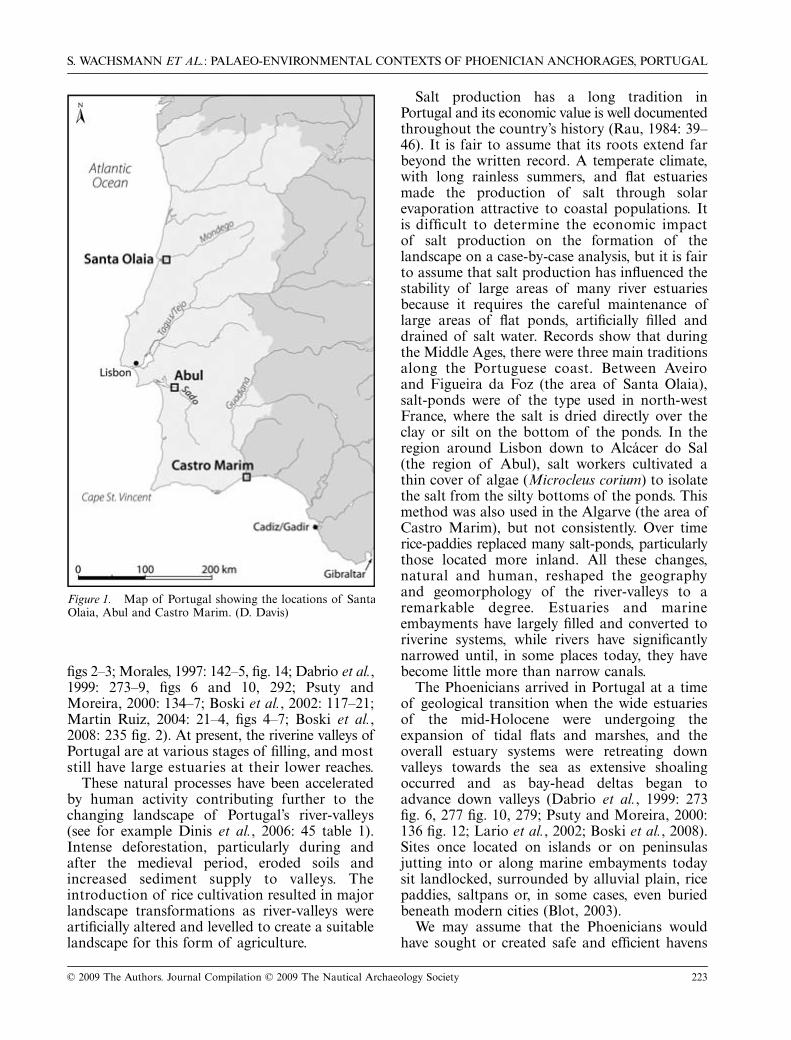
The 2002 Joint Expedition of the Institute of Nautical Archaeology and the Centro Nacional de Arqueologia Náutica e Sub-aquática examined Phoenician maritime involvement in Portugal, combining archaeological, geological and geophysical sur-veys of former coastal sites—Santa Olaia, Abul and Castro Marim—where previous excavations have uncovered Phoenicianremains. Significant geomorphic evolution of bay-head delta and estuarine settings masks the fact that Phoenician sites weresituated at the head of marine embayments or on estuary margins, had easy access to the sea, and immediate access to atleast one natural anchorage. All sites exhibited topographical criteria familiar from Phoenician trading-stations and merchantoutposts in the Mediterranean.
© 2009 The Authors
Key words:
bay-head delta, estuary, harbours, paleogeography, Phoenicians, Portugal.
I
n their homeland, the Phoenicians favouredlocating their harbours in the lee of anisland, as at Tyre, or in the lee of a coastal
promontory with extra protection from anoffshore bedrock ridge, as at Sidon (Carmona
Gonzalez, 2003; Marriner
et al.
, 2005; Marriner
et al.
, 2006a; Marriner
et al.
, 2006b; Marriner andMorhange, 2007: 152–3, 156 fig. 17; Carmona andRuiz, 2008). Expanding westwards across theMediterranean, the Phoenicians continued tofavour sites with specific natural features whichsupplied protected anchorages for their ships.Their settlements in Spain, for example, werelocated in three types of settings: on islands(Gadir/Cadiz), inside estuaries (Castillo de DoñaBlanca) or, most frequently, on elevations at themouths of rivers (Cerro del Prado, Cerro delVillar, Málaga, Toscanos, Morro de Mezquitilla,Chorreras, Almuñécar and Adra) (Aubet, 2001:
257–90, 305–46).
1
Phoenicians, apparently from the Guadalaquivirenclaves, eventually created additional coloniesand trading stations along the Atlantic coasts ofAfrica and Europe. Ancient authors report the
establishment of numerous Phoenician settlements
on the Atlantic coast of Morocco, butarchaeologically-documented sites remain rare(López Pardo, 1996: 251–64; Neville, 2007: 43 fig.1.20 and n.170, 44 n.178).
2
In later times theCarthaginians also attempted the colonization ofthe African Atlantic coast (Oikonomides, 1977;López Pardo, 1991; Markoe, 2000: 189; Aubet,2001: 192; López Pardo and Suárez Padilla, 2002:116). Notwithstanding literary claims to northAtlantic voyaging by the Phoenicians, their
northernmost archaeologically documented
settlement
is located in Portugal.
3
Generally, thesites which have revealed abundant Phoenicianremains are located, as is Castillo de Doña
Blanca, on the estuaries or alluvial plains ofmajor rivers, which include from north to souththe Mondego, Tagus (Tejo), Sado and Guadiana(Fig. 1) (Arruda, 2000; Aubet Semmler, 2002:104, 105 fig. 2; Neville, 2007: 35–42).
Understanding these sites is complicated bydramatic geological changes that significantlyaltered Portugal’s landscape in the HoloceneEpoch (last 10,000 years). During the peak of thelast glacial period,
c.
18,000 BP, global sea-level
was about 120 m below present sea-level (Lambeck,1995: 1027 fig. 3b). At that time, Portugal’s river-valleys extended across the now-submergedcontinental shelf. As the glacial ice-caps melted,sea-level initially rose rapidly and approachedpresent level
c.
6000 BP both globally and in theMediterranean basin (Lambeck 1995: 1026–34).Various studies in south-western Iberia reveallocal relative sea-level approaching present sea-level
c.
6500–5000 BP (Goy
et al.
, 1996: 776–9,figs 2–3, and additional bibliography there;Granja and De Groot, 1996: 162; Dabrio
et al.
,2000: 388 fig. 4, 389 fig. 5, 397; Dias
et al.
, 2000:178 fig. 1, 181). The early-mid Holocene rapidsea-level rise flooded or drowned river-valleys,producing large marine embayments that wereestuarine in character and extended manykilometres inland. These marine embaymentswere at maximum expansion from
c.
6500 BPuntil the last two to three millennia, whensedimentary filling began significantly to decreasetheir width and length. Sediment was depositedin three ways: in bay-head deltas that advanceddown the valleys, creating alluvial plains in up-valley localities; in sub-tidal and tidal settings asestuaries began to fill with tidal flats and tidalmarshes; and in shallow lagoons coupled to thegrowth of sand-spits and barriers whichrestricted marine inflow (Goy
et al.
, 1996: 776–9,
S. WACHSMANN
ET AL.
: PALAEO-ENVIRONMENTAL CONTEXTS OF PHOENICIAN ANCHORAGES, PORTUGAL
© 2009 The Authors. Journal Compilation © 2009 The Nautical Archaeology Society 223
figs 2–3; Morales, 1997: 142–5, fig. 14; Dabrio
et al.
,1999: 273–9, figs 6 and 10, 292; Psuty andMoreira, 2000: 134–7; Boski
et al.
, 2002: 117–21;Martin Ruiz, 2004: 21–4, figs 4–7; Boski
et al.
,2008: 235 fig. 2). At present, the riverine valleys ofPortugal are at various stages of filling, and moststill have large estuaries at their lower reaches.
These natural processes have been acceleratedby human activity contributing further to thechanging landscape of Portugal’s river-valleys(see for example Dinis
et al.
, 2006: 45 table 1).Intense deforestation, particularly during andafter the medieval period, eroded soils andincreased sediment supply to valleys. Theintroduction of rice cultivation resulted in majorlandscape transformations as river-valleys wereartificially altered and levelled to create a suitablelandscape for this form of agriculture.
Salt production has a long tradition inPortugal and its economic value is well documentedthroughout the country’s history (Rau, 1984: 39–46). It is fair to assume that its roots extend farbeyond the written record. A temperate climate,with long rainless summers, and flat estuariesmade the production of salt through solarevaporation attractive to coastal populations. Itis difficult to determine the economic impactof salt production on the formation of thelandscape on a case-by-case analysis, but it is fairto assume that salt production has influenced thestability of large areas of many river estuariesbecause it requires the careful maintenance oflarge areas of flat ponds, artificially filled anddrained of salt water. Records show that duringthe Middle Ages, there were three main traditionsalong the Portuguese coast. Between Aveiroand Figueira da Foz (the area of Santa Olaia),salt-ponds were of the type used in north-westFrance, where the salt is dried directly over theclay or silt on the bottom of the ponds. In theregion around Lisbon down to Alcácer do Sal(the region of Abul), salt workers cultivated athin cover of algae (
Microcleus corium
) to isolatethe salt from the silty bottoms of the ponds. Thismethod was also used in the Algarve (the area ofCastro Marim), but not consistently. Over timerice-paddies replaced many salt-ponds, particularlythose located more inland. All these changes,natural and human, reshaped the geographyand geomorphology of the river-valleys to aremarkable degree. Estuaries and marineembayments have largely filled and converted toriverine systems, while rivers have significantlynarrowed until, in some places today, they havebecome little more than narrow canals.
The Phoenicians arrived in Portugal at a timeof geological transition when the wide estuariesof the mid-Holocene were undergoing theexpansion of tidal flats and marshes, and theoverall estuary systems were retreating downvalleys towards the sea as extensive shoalingoccurred and as bay-head deltas began toadvance down valleys (Dabrio
et al.
, 1999: 273fig. 6, 277 fig. 10, 279; Psuty and Moreira, 2000:136 fig. 12; Lario
et al.
, 2002; Boski
et al.
, 2008).Sites once located on islands or on peninsulasjutting into or along marine embayments todaysit landlocked, surrounded by alluvial plain, ricepaddies, saltpans or, in some cases, even buriedbeneath modern cities (Blot, 2003).
We may assume that the Phoenicians wouldhave sought or created safe and efficient havens
Figure 1. Map of Portugal showing the locations of SantaOlaia, Abul and Castro Marim. (D. Davis)

NAUTICAL ARCHAEOLOGY,
38
.2
224 © 2009 The Authors. Journal Compilation © 2009 The Nautical Archaeology Society
for their ships wherever trading activities tookthem. We are familiar with Phoenician harboursat Mediterranean sites (Frost, 1963: 63–114;
Frost, 1995; Marriner
et al.
, 2005; Marriner
et al.
,2006a; Marriner
et al.
, 2006b; Marriner andMorhange, 2007). But virtually nothing is knownabout their solutions for mooring in estuarinesettings. Furthermore, the Phoenicians had todeal with tides along the Atlantic coast—aphenomenon virtually unknown in theMediterranean, where tidal variations are generallyless than 0.5 m.
The geographical situation raises severalarchaeological questions. How did the Phoeniciansselect, and possibly enhance, their mooring sitesadjacent to Portuguese sites? Where did theysituate anchorages in relation to the settlementsthemselves? At the outset, we postulated that thelocations under consideration had beenaccessible by ship in Phoenician times and wouldhave required some form of mooring facilities.
Archaeological work at Portuguese terrestrialsites has revealed rich evidence of Phoenicianinvolvement. To put this into perspective, it isworth noting that the excavator of Almaraz, LuísBarros, reports finding over a million Phoeniciansherds at this settlement alone (pers. comm.; seealso Barros
et al.
, 1993; Barros, 1998; Arruda,2000: 102–11; Aubet, 2001: 296–7). Despite itsdistance from the familiar Mediterranean Sea,clearly Portugal was no backwater to the
Phoenicians (Arruda, 2000; Neville, 2007: 35–6,42).
Placing coastal archaeological sites in theirproper palaeo-environmental context requiresreconstructing the sedimentary and geomorphicevolution of their dynamic coastal systems.Numerous sites of various ages, including specificallyPhoenician sites, have been investigated acrossthe Mediterranean and beyond.
4
In the late1990s, a French and Portuguese archaeologicalteam working at the Phoenician site of Abul onthe Rio Sado carried out a geological study ofthe narrow coastal plain around the site, which isnow surrounded by rice paddies (Guy
et al.
,2000). They concluded that at the time ofPhoenician settlement it did not lie on a hill setback from a muddy riverbank, as it does today,but instead formed the end of a promontoryprojecting into the estuary, surrounded on thenorth, west and south by sheltered embaymentsof tidal waters. Some of the presumed locationsof anchorages adjacent to other such sites—suchas those at Almaraz, at Lisbon’s Sé site and at
Alcácer do Sal—are today densely built-up,making fieldwork there virtually impossible,unless carried out during urban renewal (Almaraz,see above; the Sé (Amaro, 1993; Cardoso, 1996;Arruda, 2000: 113–30); Alcácer do Sal (Arruda,2000: 64–86)).
In 2001 members of our team met many ofthe Portuguese archaeologists excavating sitesproducing Phoenician or Punic material, thanksto the efforts of Director Francisco Alves, MariaLuisa Blot and their colleagues at the CentroNacional de Arquelogia Náutica e Subaquatica(CNANS)—the Portuguese governmentalorganization responsible for maritime archaeology.In 2002, our interdisciplinary team, led byShelley Wachsmann, surveyed the surroundingsof Abul and two other Portuguese settlementswith Phoenician material—Santa Olaia on theRio Mondego, and Castro Marim near themouth of the Rio Guadiana (Fig. 1). We wishedto examine the hypothesis that the regionsimmediately surrounding these sites, all three ofwhich remain
relatively
unburdened by modernconstruction, may represent a rich, and so faruntapped, source of information regarding theirancient maritime activity (Arruda
et al.
, 2007:462). We designed a methodology to address thegeomorphological and sedimentary environmentalchanges as well as to study how the Phoeniciansexploited local conditions to meet maritimerequirements.
During the ensuing field survey, the teamconducted geological and remote-sensing studiesemploying coring, ground-penetrating radar(GPR) and electro-magnetism. Our results enabledus to map the original position of the ancientshorelines, including embayments, and thus totentatively locate likely Phoenician anchorages/moorings.
Methods
Geology and geophysics
Our team decided upon a field methodologywhich could be used to explore and map buriedcoastlines and potential anchorages in the areaspresumed to be former marine embayments orestuarine margins. The first goal was to test theassumption that open-water conditions hadexisted, and if so, when, as well as to identifypotential sites for survey. We assumed thesewould be buried in or near former sandy or siltyshorelines, bounded on the landward side byterrestrial sediments or bedrock and on the
S. WACHSMANN
ET AL.
: PALAEO-ENVIRONMENTAL CONTEXTS OF PHOENICIAN ANCHORAGES, PORTUGAL
© 2009 The Authors. Journal Compilation © 2009 The Nautical Archaeology Society 225
seaward side by shallow marine or estuarine sandand mud. We used geological cores to test forformer open-water conditions while employinggeological and geophysical approaches to identifysubsurface targets. The methods were refined andmodified for the various environmental conditionsthat we encountered. For the most part weworked in wetlands, tidal flats, rice paddies andunpaved urban settings.
Geologist Richard Dunn collected hand-poweredEijkelkamp brand push-auger cores of thesediments near the sites in an effort to understandthe degree and nature of geomorphologicalchange in the landscape, and the chronology ofthat change. Geological coring provides thestratigraphy and relative chronology of sedimentaryenvironmental changes. To determine the absolutechronology of these changes, organic materialsrecovered from the geological cores underwentradiocarbon analysis (see Appendix). Dunnexamined and described all cores in the field.Data recorded included grain size, Munsell®colour, moisture content, fossil material, charcoalabundance, ceramic abundance and type (ifidentifiable), and unit thicknesses. Representativesediment samples were removed and analyzed inthe laboratory for grain-size distribution, plantremains, as well as macro- and microfossil content.Samples saved for later radiocarbon analyses weresealed in aluminium foil and kept refrigerated toinhibit bacterial growth. Data obtained fromcoring was combined in cross-section illustrationsof the subsurface to demonstrate the verticaland lateral variation in sedimentary deposits.Radiocarbon dates provide chronological controlon vertical change and enable us to reconstructthe sedimentation history in the areas studied.Deeply-buried archaeological remains such asthose along Portugal’s rivers typically have littleor no surface expression, and are only discoveredby chance or through random digging or probing.Geophysical methods, however, have beensuccessfully employed to map buried landscapesusing electronic tools to ‘see’ into the ground.The most common geophysical methods employedin archaeological settings are magnetometry,electrical resistivity, ground-penetrating radar(GPR) and electromagnetic induction (EM)(Gaffney and Gater, 2003; Conyers, 2004).
While GPR could be used in relatively-dryurban settings, such as at Castro Marim, re-creating the sedimentary palaeo-environments ofPortugal’s estuaries through the use of shallowgeophysical techniques generally presented
significant difficulties. Our targeted ancientshorelines, often at depths of greater than 2 mbelow present surfaces, consist almost entirely ofsubtle variations in sediment type and contentsuch as changes from sandy and shell-rich mud,to mud that has little sand in it. The slightchanges within these sediments are too deeplyburied for traditional magnetic methods, whichcan at most map changes to a few metres depth.Also, the slightly brackish water-saturatedmedium is too electrically conductive for GPRbecause radar energy attenuates in the water-column and in the saturated mud close to thesurface. Therefore, for wet environments such asSanta Olaia and Abul, EM was the only methodwe considered, as electromagnetic fields can betransmitted in wet mud and might penetrate deepenough to detect the target features.
Lawrence Conyers and Eileen Ernenweinselected the highly-mobile EM-38, manufacturedby Geonics Ltd, which can be used effectively inrice paddies. This device does not require directcontact with the water or sediment surface, as isnecessary for electrical-resistivity data collection.The EM induction method operates by inducingan electromagnetic field into the ground, whichgenerates a secondary electromagnetic field whenit encounters electrically-conductive materials.Minor changes in the chemical and physicalprofiles of the underlying sediments affect thesecondary EM field differently, and these changesare both measured and mapped spatially within agrid. In electrically-conductive sediments, such asthose encountered at the Portuguese sites, theinduced field is spread out over a broad area,propagating the electromagnetic energy from 1–3.5 m into the ground. Measurements ofsubsurface changes were taken about every 10 cmalong transects of 30 m or longer, within gridsconsisting of up to 50 transects spaced 1 m apart.The EM readings were digitized and stored on asmall hand–held computer that also saved eachreading’s location within the grid.
Our first attempts at EM data collection inPortugal necessitated wading across flooded ricefields, moving the EM instrument just above thewater surface, and collecting individual readingsevery metre next to a nylon measuring tape. Foreach successive transect the tape was repositionedand data collection proceeded at a slow andlaborious pace. To facilitate these measurements,our team developed an innovative survey methodin which we pulled the EM system and thedigitizing computer across the rice paddies inside

NAUTICAL ARCHAEOLOGY,
38
.2
226 © 2009 The Authors. Journal Compilation © 2009 The Nautical Archaeology Society
an inflatable kayak. This moved easily over thegrowing rice stalks, greatly improving data-collection efficiency while reducing crop damage.
We programmed the data-logger to collect dataevery 0.4 seconds during each passage across thefield, with location control-marks manuallyplaced at the beginning, the centre and the end ofeach line. Each transect was processed individuallyby stretching or squeezing all readings betweenthe marks so that they were evenly distributedbetween known surface locations. Density ofdata-collection from each line was a function ofthe kayak’s speed: an even spatial distributionof data required that the team members pullingthe rope move the vessel at a steady pace. Thismethod was efficient and allowed for the rapidcompletion of the survey-lines with a largercollection of data-points per transect.
Conyers and Ernenwein generated visual mapsof the distribution of the differences in sedimentconductivity by plotting the readings, interpolatingbetween them and displaying them spatially.Changes in the underlying bedrock and sedimentresulted in dramatic ranges in conductivitymeasurements within the test grids. Surfacesediments consist of estuarine organic-rich sandand mud along with fill imported to level theground during the creation of the rice fields. Theresults of many years of mechanized planting andharvesting have almost completely homogenizedthese fill sediments, and therefore they contributealmost nothing to the variation in the con-ductivity readings. Changes in conductivity recordedby the EM device, therefore, are apparentlyalmost entirely the result of the spatial distributionof changes in the underlying bedrock and ancientestuarine sediments. Simply put, the conductivitymaps effectively illustrate the geological variationsthat occur between 2–3.5 m in depth, reflectingconditions that existed prior to the completesilting-up of the estuaries and later rice cultivation.
Aerial photography
In preparation for the project, we considered thepossibility that aerial photography might beuseful provided the depth of geological layers wasonly moderate. If plant roots in the rice paddiesthat surrounded Santa Olaia and Abul reachedbelow the plough zone and into sediments thatwere reasonably undisturbed by moderndevelopment, the vegetative contrast might indicatethe presence of buried relevant archaeologicalfeatures. With this in mind, we acquired allavailable sets of aerial photographs of the sites.
5
During the spring and summer of 2002,
Payson Sheets examined 9
×
9 inch (
c
.23
×
23 cm)sets of overlapping contact prints of the sites witha Fairchild stereo air-photo viewer to determinewhich of them to enlarge. We then orderedenlargements based on proximity to the sites. Allthe enlargements were to a scale of 1:3400, withthe exception of one of Castro Marim at 1:8000.The aerial photographs were used to map andinterpret the geomorphology, but ultimately thedepth of sedimentation proved too great foraerial photography to be used to identify buriedtargets.
Palaeo-geographic reconstruction
Geological cores, sometimes complemented bygeophysical investigation, provide a record ofsedimentary environmental evolution. This evolutionis a function of estuary and coastal dynamicswhich are in part controlled by relative sea-levelchange, which includes the combination of globalsea-level change, local tectonics, and localsediment supply. Because we know the generalhistory of marine embayment evolution thatcorresponds to decelerating sea-level rise andsediment infilling, from Portuguese as well asworld-wide examples, and we have modernanalogues of coastal-alluvial settings from whichwe can examine the distribution of sedimentaryenvironments, we can reconstruct the evolutionof any coastal system if we have subsurface data(coring and geophysics), geomorphological dataand chronological control. The sea-level recordprovides a general age-versus-depth frameworkwithin which we must work. Geochronometrictechniques, as well as archaeological remains,provide chronological control.
We base the palaeo-geographic maps presentedhere on our analysis of sedimentary environ-mental evolution coupled with radiocarbondating. The maps show the geomorphology orlandscapes of a given time, and although theymay not be exact in their location of all features,they represent the best geographic distributionbased on the geological, geophysical,archaeological and chronological data available,and on the application of modern analogues.Our radiocarbon samples consist of shell,wood or plant remains and were analyzed usingthe Accelerator Mass Spectrometer (AMS)radiocarbon technique. The two-sigma standarddeviation is on the order of a few decades for allsamples, which are discussed in calibrated years(Appendix).

S. WACHSMANN
ET AL.
: PALAEO-ENVIRONMENTAL CONTEXTS OF PHOENICIAN ANCHORAGES, PORTUGAL
© 2009 The Authors. Journal Compilation © 2009 The Nautical Archaeology Society 227
The sites
Santa Olaia
Located on the Rio Mondego east of Figueira daFoz, Santa Olaia was the first Portuguese site to
reveal Phoenician remains (Fig. 2) (Rocha, 1908;Pereira, 1993; Pereira, 1996; Pereira, 1997; Pereira
et al.
, 1998; Arruda, 2000: 227–40; Aubet, 2001:297; Neville, 2007: 41–2). Summarizing Phoenicianinvolvement at the site, its excavator sees
Figure 2. Rocha’s discoveries of Phoenician pottery and other cultural materials at Santa Olaia in 1902 were the firstevidence of Phoenician penetration into Portugal. (from Rocha, 1908: pl. 30)
NAUTICAL ARCHAEOLOGY,
38
.2
228 © 2009 The Authors. Journal Compilation © 2009 The Nautical Archaeology Society
exploratory contacts beginning in the 9th century,the construction of a trading-post towards the endof the 8th century or the beginning of the 7thcentury, with a heyday in the 7th–6th centuries(Pereira, 1996: 63; Pereira, 1997: 231; Neville,2007: 42). Although later Punic remains havebeen reported further north along the IberianAtlantic coast (da Silva, 1995: 71–3; da Silva,2000: 95–9; González-Ruibal, 2004; González-Ruibal, 2006; Neville, 2007: 42), after a centuryof research Santa Olaia remains the northernmostcoherent Phoenician settlement along theAtlantic seaboard at which Phoenician artefactshave actually been recorded (Neville, 2007: 41–2).The limits of Phoenician north-Atlanticexpansion may have resulted from a lack ofappropriate local trading partners. González-Ruibal (2004: 292) notes:
To put it simply, the Mediterranean sailors mightnot have been able to find indigenous polities able
to engage in profitable and lasting relationships,
which would make founding factories in the Galicianor north Portuguese coast worthwhile. The Baiões-Santa Luzia aristocracies had probably collapsed
shortly before their arrival, and those once-wealthy and powerful communities were beingsuperseded in their power by groups inhabitingthe lower Mondego basin, precisely where the
Phoenician settlement of Santa Olalla [Santa Olaia]was founded.
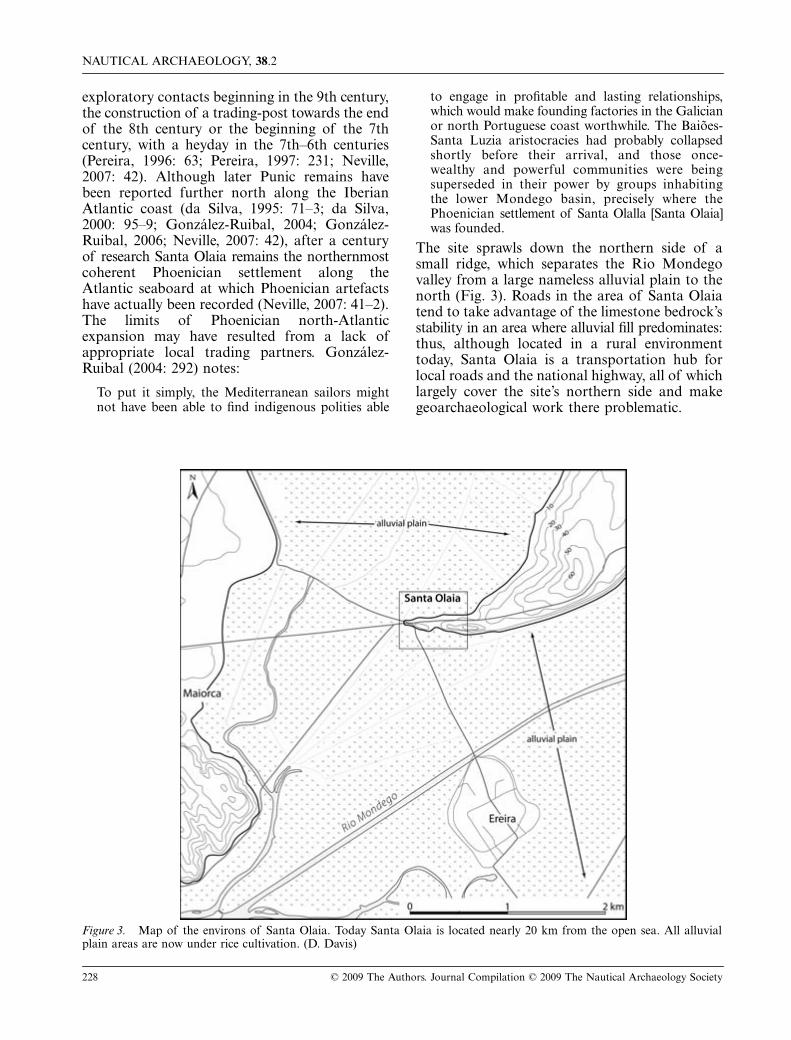
The site sprawls down the northern side of asmall ridge, which separates the Rio Mondegovalley from a large nameless alluvial plain to thenorth (Fig. 3). Roads in the area of Santa Olaiatend to take advantage of the limestone bedrock’sstability in an area where alluvial fill predominates:thus, although located in a rural environmenttoday, Santa Olaia is a transportation hub forlocal roads and the national highway, all of whichlargely cover the site’s northern side and makegeoarchaeological work there problematic.
Figure 3. Map of the environs of Santa Olaia. Today Santa Olaia is located nearly 20 km from the open sea. All alluvialplain areas are now under rice cultivation. (D. Davis)

S. WACHSMANN
ET AL.
: PALAEO-ENVIRONMENTAL CONTEXTS OF PHOENICIAN ANCHORAGES, PORTUGAL
© 2009 The Authors. Journal Compilation © 2009 The Nautical Archaeology Society 229
The degree of landscape change here is dramatic.Today Santa Olaia is almost entirely surroundedby rice paddies. The Rio Mondego is soconstrained here that it is little more than anirrigation canal. Given the regional sea-level history,albeit poorly defined in this area, and ourunderstanding of the natural process of HoloceneEpoch estuarine evolution, we postulated that inthe Phoenician era Santa Olaia was accessible byship from the sea via a wide estuary.
Cores taken in the fields surrounding the siterevealed that both the Rio Mondego valley andthe northern tributary valley consisted ofshallow, open-water conditions at least as early as
4800 BP (Fig. 4). Sediments in the base of thecores here consisted of shelly coarse sand withabundant sub-tidal open-water molluscan faunawhich were often preserved in life position,
indicating a local fauna buried
in situ
ratherthan having been transported there by currents(Figs 4–6).
Deep geotechnical borings taken in the middleand north parts of the excavated site revealed athick sequence of deltaic sandy mud that musthave been deposited right to the edge of a steepnorth slope of the bedrock ridge (Mota & Co.,nd). We can approximate the Phoenician levelsin our cores because they are bracketed by
Figure 4. Locations of cores taken at Santa Olaia showing the resultant paleogeography of Santa Olaia at 2600 BP. Geolog-ical cross-sections, shown as lines through cores, to the south and north of the site are presented in Figs 5 and 6 respectively.Deltas are migrating down-valley but have yet to reach the Santa Olaia bedrock promontory. Water depths around the sitewere of the order of 1–3 m and a wide sandy beach existed on the north side of the site. The delta fronts would have beenlow-lying sand and mud areas, possibly with extensive wetlands. (data: R. Dunn; artwork: D. Davis)

NAUTICAL ARCHAEOLOGY,
38
.2
230 © 2009 The Authors. Journal Compilation © 2009 The Nautical Archaeology Society
radiocarbon-dated levels and would be atapproximately 2–3 m depth (see especially Fig. 5:Core SO-02). From the core data and radiocarbonages we conclude that the shallow-water environ-ment existed prior to Phoenician involvement atthe site.
These deposits indicate that in the vicinity ofmid-Holocene Santa Olaia, the lower Mondegowas a wide estuary which extended beyond thesite, that currents deposited clean sands, andcirculation with marine waters was strong. These
conditions prevailed until
c.
4200 BP, when theregion began to be dominated by the depositionof brown, slightly-sandy mica-rich silt that isoften laminated and contains abundant fine-grained organic matter, charcoal, seeds andbedding concentrations of shell hash, as well asarticulated bivalves (Fig. 6, see radiocarbon datefrom Core SO-04). We interpret this sediment torepresent deposits of a prodelta setting, wheresedimentation occurred in the distal, submergedportion of the delta system. The presence of
Figure 5. Geological cross-section based on Santa Olaia cores SO-2, SO-3 and backhoe trench SO-1. ‘MSL’ here representsapproximate mean sea-level. (data: R. Dunn; artwork: D. Davis)
Figure 6. Geological cross-section based on Santa Olaia cores SO-4 and SO-6. ‘MSL’ here represents approximate mean sea-level. For legend see Fig. 5. (data: R. Dunn; artwork: D. Davis)

S. WACHSMANN
ET AL.
: PALAEO-ENVIRONMENTAL CONTEXTS OF PHOENICIAN ANCHORAGES, PORTUGAL
© 2009 The Authors. Journal Compilation © 2009 The Nautical Archaeology Society 231
charcoal, seeds and mica in particular reveal thatmuch sediment derived from land. These depositsare representative of bay-head deltas advancingdown the valleys. For the next two millennia thesub-tidal deposition of this sandy silt continuedas the bay-head delta system moved down thevalley and toward Santa Olaia.
By the Phoenician era, large deltas hadadvanced down the two valleys, largely fillingareas up-river of the Santa Olaia bedrock ridgeand creating shallow-water conditions (~1–2 m)along the coastal zone of the site. Thus, the ridgeon which Santa Olaia sits would have beenideally located at the head of an extensive marineembayment almost certainly with a wide fetch forsailing. Our palaeo-geographical reconstructionreveals that the Phoenicians would have hadopen-water access ~20 km up the Rio Mondegoestuary at least as far as Santa Olaia, whichwould have given them access deep into thePortuguese hinterland. There are no mineralsources near the site, but there are large tindeposits up-river (Map, 1960): Santa Olaia wouldhave served as an ideal processing and tranship-ment centre from metal-ore-bearing locationsfurther inland along the Rio Mondego(Edmondson, 1987: 34 fig. 3.5, 242–3; Pereira,1997: 218). Cargo—primarily consisting ofmineral resources—could have been refined andloaded at Santa Olaia onto Phoenician vesselsfor transhipment to other settlements along
the Iberian Peninsula or into the Mediterraneanworld.
Pereira initiated excavations on the northernside of Santa Olaia due to the construction of thenational highway (IP3) from Figueira da Fozto Coimbra. The work revealed an industrialinstallation complete with a variety of furnacesaligned on terraces and protected by a wall(Pereira, 1993: 289–95; Pereira, 1997: 215–19,fig. 100). Correia (1995: 241 n.2; see also Neville,2007: 41) identifies a mole here and, because ofthis, considers Santa Olaia a port. Our coresbeyond this area encountered gravelly sand atPhoenician levels, suggesting a wide and sandybeach existed there at that time where shipscould have been beached safely when tides andwinds permitted (Fig. 6: Core SO-06 at a depthof 2–3 m).
At the site’s south-eastern side we excavated abackhoe trench. Here, beneath some modern filland a thin layer of tidal-flat mud, we located theancient estuary shoreline comprising medium-coarse sand. Cores in the field on this side of thesite reveal the same stratigraphic sequence and,therefore, geological history, as on the north side(Fig. 5). Our EM survey on the south-easternside of the site, within the adjacent rice field,revealed a feature of low conductivity projectingsouthward that provided a signature opposite toone derived from the clay-rich mud buried inthe shallow subsurface (Fig. 7). Shallow cores
Figure 7. Santa Olaia. EM visual map of sediment conductivity showing a north and south-trending feature of low conduc-tivity in the rice fields south-east of the site. (data: L. Conyers and E. Ernenwein; artwork: D. Davis)

NAUTICAL ARCHAEOLOGY,
38
.2
232 © 2009 The Authors. Journal Compilation © 2009 The Nautical Archaeology Society
encountered sand and rock fragments whichcovered the anomaly’s surface. Although this maybe interpreted as a small bedrock spur, in fact thetrend of the anomaly is perpendicular to thetrend of the bedrock. For this reason, wetentatively suggest that this may be a stoneman-made breakwater or similar feature. TheEM survey also confirmed that the shoreline ofthe palaeo-estuary, consisting of low-conductivitysediment (sands), extended along the bedrockridge, thus corroborating data from the backhoetrench and cores SO 07–09.
We also conducted coring and trenchingaround the small bedrock hill of Ereira, locatedsouth of Santa Olaia in the middle of the alluvialplain (Fig. 3). We excavated three backhoetrenches on the north side of Ereira near thecontact between the hill and the modern alluvialplain and in each we encountered Jurassic blackshale within 1.5–3 m of the surface. Above theshale were various sand and gravelly-sanddeposits which probably represent the shorelinealong a tidal river before the rivers wereartificially canalized. The shallow nature of thebedrock, and the close proximity of the modernMondego channel, suggest that river migrationmay have removed any Phoenician-era depositson the immediate northern side of the Ereira hill.A core approximately 50 m north-east of Ereiraand two cores from the fields on the south side ofEreira, approximately 70 m from the hill itself,recovered sediments and stratigraphy very similarto that in the cores at Santa Olaia. The basalmaterial was characterized by sand, which mayhave been open-estuarine sand like that seen nearSanta Olaia. A radiocarbon sample from wood inthis sand, at about 4 m depth, gave a correctedage of 4430 BP, revealing that it is of the same ageas the shelly sand from the bottom of the SantaOlaia cores. Therefore, in the mid-Holocene,~6000–4200 BP (sample Rd-Er03, Appendix),fairly open-water conditions existed across thewidth of the Mondego valley and someconsiderable distance up-valley from Santa Olaiaand Ereira. Brown, laminated organic-rich slightly-sandy silt with abundant charcoal and mica abovethe basal sand at Ereira represents theprogradation of a bay-head delta in the area.This is the same delta that approached the southside of Santa Olaia: the timing of delta pro-gradation down the wide Mondego valley, and itstributary valley, is corroborated by the Ereiradata and is coincident with similar bay-head deltaadvance of estuaries along the south-western
Iberian coast (Dabrio
et al.
, 1999: 273 fig. 6, 277fig. 10; Dabrio
et al.
, 2000: 394–5 figs 6–7).The deltaic sediments in all of the cores are
overlain by olive-grey mud and organic-rich mudof tidal-river, tidal-flat and marsh origin, with a2330 BP date at the level of this shift insedimentary environments (Figs 4–5, uppermostunits with date in SO-02). This shift byapproximately 2300 BP—somewhat after the7th–6th century BC Phoenician heyday at SantaOlaia—reveals that in the Santa Olaia and Ereiraarea the wide estuary was largely filled by theprograding deltas, and shallow tidal and riverineconditions prevailed. In other words, the deltashad migrated down the valleys of the Rio Mondegoand its northern tributary and coalesced oncethey passed west of the Santa Olaia bedrockpeninsula. Deltaic wetlands, tidal creeks andshallow tidal basins now surrounded Santa Olaiaand Ereira. The main river may have been nearby,but we do not have the data to establish theposition of the primary channel(s) at that time.
Continued sediment deposition across thewidth of the valley would eventually build up thesurface to the point that tidal influence becamerestricted to channels and an alluvial plaindeveloped. Studies in the region reveal that it isvery likely that the lower Rio Mondego estuaryremained much more extensive than today andmay have largely filled with inter-tidal andalluvial sediment only in the last half millennium(Dinis
et al.
, 2006). The narrow neck of the SantaOlaia peninsula would have provided twoprotected moorings, on the north and southsides, but the environmental change at
c.
2300 BPwould have left the site virtually inaccessible byship. Whether the site was ultimately abandonedas a result of the delta bypass remains unclear,as we do not have good chronological controlregarding its advance in later times.
The excavated archaeological site is located ona low bedrock surface on the north-western sideof the Santa Olaia promontory. The anchorageor loading-point to the north side of the siteseems to have been immediately offshore fromthe excavated factory area, and possibly slightlyto its east, where the narrowest point of thepromontory is found. On the south-western endof the promontory the bedrock forms a cliff atthe foot of which are rice paddies which almostcertainly overlie beach sand, as we found on itsnorth-eastern and south-eastern sides. Mostprobably an anchorage on the south side wouldhave been in the area where the ridge is at its

S. WACHSMANN
ET AL.
: PALAEO-ENVIRONMENTAL CONTEXTS OF PHOENICIAN ANCHORAGES, PORTUGAL
© 2009 The Authors. Journal Compilation © 2009 The Nautical Archaeology Society 233
narrowest, which coincides with the location ofthe hypothesized man-made structure that weidentified in the EM survey (Fig. 7).
At the narrowest point of the peninsula, east ofthe excavated site, there is a low north-southbreak in the bedrock which may have separatedthe peninsula from the main ridge. The vegetativeovergrowth at the south end, however, madeinvestigation of this area all but impossible, whilethe construction of the national highway hasobliterated the north end of the break, if itexisted there (Fig. 3). We attempted to core in thebreak to test if this had been open in antiquity,but our results were inconclusive. We recoveredmodern fill overlying coarse broken rock with siltbelow (Fig. 4: Core SO-10). We also placed threecores at the edge of the field on the south end ofthe break and found well-rounded fine-to-medium-grained sand of beach origin in all three,below an organic-rich mud of wetland origin(Cores SO-7–9). This suggests that the beach wascontinuous across the break. At 2 m below thesurface, in the sand, we recovered weatheredceramic fragments of indefinable age and severallarge angular fragments of
Ostrea sp.
(oyster) andalthough the depth suggests that these materialscould be quite old, their age is unknown. Ourdata are inconclusive regarding the origin andage of the break, it may represent a historic cutthrough the bedrock to channel water from fieldsnorth of the bedrock promontory to fields on thesouth side, with road construction or lack of useleading to filling and loss of this connection.
Abul
Phoenician Abul A consists of a square buildinglocated atop a topographic rise, surrounded todayon the north and south by rice paddies, to the westby tidal flats and to the east by a sandstone bedrockspur (Fig. 8) (Mayet and Tavares da Silva, 1993;Mayet and Tavares da Silva, 1996; Mayet
et al.
,1997; Arruda, 2000: 86–91; Mayet and Tavaresda Silva, 2000; Aubet, 2001: 297; Neville, 2007:39–41). The structure was active from the firsthalf of the 7th to the early 6th centuries BC(Neville, 2007: 39). At present, Abul remains theonly uniquely Phoenician site in Portugal, withno later levels covering the Phoenician remains.During the Roman period, however, an amphorafactory was constructed on tidal-flat or marshsediment and fill at the southern base of the hill:it consists of five kilns and other outbuildings(Mayet
et al.
, 1996: 51–63).Abul’s location in the region of several other
indigenous sites containing Phoenician materials—Setubal and Alcácer do Sal—along with itsstructure and its small size, raise the possibilitythat Abul might have served as a sanctuary forthe surrounding area and, in this respect, bearscomparison with the Spanish Iron Age cult siteof Cancho Roana (Arruda, 2000: 91; Mayet andTavares da Silva, 2000: 161–3; Celestino andLópez-Ruiz, 2002; Celestino and López-Ruiz,2003).
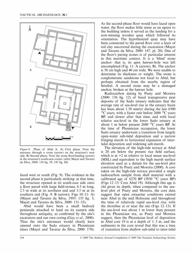
Excavations at Abul revealed that thePhoenician structure underwent two distinct phases.During both periods the building’s entrances
Figure 8. Map of the environs of Abul in the Rio Sado estuary. (D. Davis)
NAUTICAL ARCHAEOLOGY, 38.2
234 © 2009 The Authors. Journal Compilation © 2009 The Nautical Archaeology Society
faced west or south (Fig. 9). The evidence in thesecond phase is particularly striking: at that time,the structure opened at its south-east side ontoa floor paved with large field-stones, 6.5 m long,2.5 m wide at its northern end and 3.5 m at itssouthern end (Fig. 9: B (arrow); Figs 10–11: A)(Mayet and Tavares da Silva, 1993: 135 fig. 5;Mayet and Tavares da Silva, 2000: 131–53).
Abul would have been a small bedrockpeninsula attached to land on its eastern sidethroughout antiquity, as confirmed by the site’sexcavators and our own coring (Guy et al., 2000).Thus the site’s entrances would clearly haveopened onto the Sado estuary in Phoeniciantimes (Mayet and Tavares da Silva, 2000: 170).
As the second-phase floor would have faced openwater, the floor makes little sense as an egress tothe building unless it served as the landing for anow-missing wooden quay which followed itsorientation. The hypothesized quay may havebeen connected to the paved floor over a layer ofred clay uncovered during the excavation (Mayetand Tavares da Silva, 2000: 147, pl. 20). One ofthe floor’s paving stones is of particular interestin this maritime context. It is a ‘blind’ stoneanchor: that is, its apex hawser-hole was leftuncompleted (Fig. 11: A (arrow), B). The anchoris 58 cm high and 40 cm wide. We were unable todetermine its thickness or weight. The stone isconglomeratic sandstone not local to Abul, butperhaps obtained from the nearby region ofSetubal. A second stone may be a damagedanchor, broken at the hawser hole.
Radiocarbon dating by Psuty and Moreira(2000: 136 fig. 12) of basal transgressive peatdeposits of the Sado estuary indicates that theaverage rate of sea-level rise in the estuary basinhas been about 1.58 mm/yr during the last 650014C years, with a faster rate before 2600 14C yearsBP, and slower after that time, and with localrelative sea-level in the lower Sado estuary atabout 1 m below present 2600 14C years BP. Atthe time of Phoenician occupation, the lowerSado estuary underwent a transition from largelyopen-water sub-tidal deposition and a narrowfringing marsh to horizontal expansion of inter-tidal deposition and widening salt-marsh.
The elevation of the high-tide terrace at Abulis 20 cm below the present rice field surface,which is at +2 m relative to local mean sea-level(MSL) and equivalent to the high marsh surfaceelevation used as a datum for the sea-level plotconstructed by Psuty and Moreira (2000). A coretaken on the high-tide terrace provided a singleradiocarbon sample from shell material with acalibrated age of 6270 BP (5850 14C years BP)(Figs 12–13: Core Abul 19). Although this age isold given its depth, when compared to the sea-level plot of Psuty and Moreira, the core datasuggest that open estuarine conditions existednear Abul in the mid Holocene and throughoutthe time of relatively rapid sea-level rise, withthe shoreline at or near the site (Figs 12–13). Ifthe sea-level was about 1 m lower than presentin the Phoenician era, as Psuty and Moreirasuggest, then the Phoenician level of depositionin Abul core 19 is at a depth of 1–3 m, and thesediments in the core reveal that this was a timeof transition from shallow sub-tidal to inter-tidal
Figure 9. Plans of Abul A. A) First phase. Note theentrance through a room (arrow) on the structure’s westside. B) Second phase. Note the stone floor/landing (arrow)at the structure’s south-east corner. (after Mayet and Tavaresda Silva, 2000: 134 fig. 59, 143 fig. 60)

S. WACHSMANN ET AL.: PALAEO-ENVIRONMENTAL CONTEXTS OF PHOENICIAN ANCHORAGES, PORTUGAL
© 2009 The Authors. Journal Compilation © 2009 The Nautical Archaeology Society 235
deposition, much like Psuty and Moreira (2000)envisage for the entire lower estuary. Oursediment cores in the rice fields adjacent tothe site also contain estuarine mud as well astidal-flat or beach sand at the Phoenician level(Fig. 14). This reveals that in Phoenician timesestuarine sediments were being deposited next tothe site and the area immediately surroundingAbul was a shallow-water environment with ashoreline about 75 m landward of its presentposition on the north-western side and 150 mlandward on the south-eastern side and less soeven into the Roman period (Fig. 12).
In summary, in Phoenician times Abul lay onthe margin of a wide estuary, and would havebeen the terminus of a peninsula surrounded byshallow water, 1–2 m deep and subject to tidalvariation, and the coastline adjacent to the sitewould have consisted of local wetlands, tidal flatsand sandy beaches. Abul’s location would haveafforded an excellent mooring on the south side,and possibly a less-protected one on the north side.
Electromagnetic induction surveys in theneighbouring rice fields verified the extent of
subsurface estuarine and tidal-flat mud. Coringand geophysical surveys also revealed that, in thearea of the hypothesized southern anchorage, thebottom topography slopes gently south towardswhat would have been the open bay. The coretaken at the modern shoreline revealed a thicksection of estuary or bay fill, and suggests thatvery shallow sub-tidal to inter-tidal conditionsprevailed immediately offshore from Abul duringPhoenician times (Fig. 13: Core 19). As noted,Psuty and Moreira (2000: 136) suggest that theSado estuary underwent rapid horizontalexpansion of tidal flats and salt-marsh beginningc.2600 14C years BP. Our cores also reveal that bythe Roman period, when the base of the riseof Abul served as a kiln site for amphorasmanufactured to transport salt fish and garum,much of Abul’s former open-water area hadbecome extremely shallow tidal flats and tidalwetlands. In the area of the buildings associatedwith the kilns, our cores encountered artificial fillover tidal-flat deposits (Fig. 14). Interestingly, theRomans used artificial fill derived from the localsandstone in order to build out across the muddy
Figure 10. Abul, the second-phase Phoenician stone floor or landing (arrow), with the Roman-period amphora kilns visibleat a lower level on either side of it. (S. Wachsmann)

NAUTICAL ARCHAEOLOGY, 38.2
236 © 2009 The Authors. Journal Compilation © 2009 The Nautical Archaeology Society
areas and to connect the shoreline with theamphora workshop. Apparently the location ofAbul remained important, despite the fact thattidal flats largely encompassed the site.Presumably clay from the tidal flats was aprimary source for the making of amphoras(Mayet et al., 1996: 121–65).
Our EM mapping at Abul enabled us to extendthe outline of the edge of the estuary beyond thecore data. Lower conductivity measurementsindicating areas of sand represent the shorelineor beaches on the edge of the ancient embayment(Fig. 15), whereas areas representing deeperwater contained mostly clay-rich mud and,therefore, had higher conductivity. A modernrice-field berm appears as a linear feature of lowconductivity in the figure because it is composedof coarser-grained fill that was not watersaturated. In our reconstruction of the palaeo-
coastline of Abul, it is evident that amplelocations could have existed for mooring orbeaching ships with minimal or no modifications(Fig. 12). Wooden piers built in continuation ofthe structure’s entrances would have providedinexpensive, yet efficient, installations to combatthe tidal variations of the Rio Sado by affordingdocking opportunities regardless of water-level.
Castro MarimThe Iron Age site of Castro Marim, ancientBaesuris, from which Phoenician material hasbeen recovered, is located within the medievalcastle, surrounded today by the modern settlement(Arruda, 1996; Arruda, 1997; Arruda, 2000: 36–53, Arruda et al., 2007). Despite Castro Marimhaving the most urban-developed landscape inwhich the team worked, open areas remainedavailable for examination. Castro Marim was
Figure 11. (A) Abul, view looking south following the line of the second-phase stone floor or landing. Note the blind anchor(arrow) embedded in it and the modern wooden quay in the distance. (B) The blind anchor. (S. Wachsmann)

S. WACHSMANN ET AL.: PALAEO-ENVIRONMENTAL CONTEXTS OF PHOENICIAN ANCHORAGES, PORTUGAL
© 2009 The Authors. Journal Compilation © 2009 The Nautical Archaeology Society 237
apparently an indigenous Tartessian settlement,but it was clearly in contact with Phoeniciantraders beginning in the latter half of the 7thcentury BC (Arruda, 2000: 52). The site sits atop
a small north-projecting promontory at theeastern end of a bedrock ridge that is surroundedto the north, east and south by saltpans, tidalflats, tidal wetlands and low-lying areas ofartificial fill. It is in the valley of the RioGuadiana, a long and wide tidal river whichmarks the border between southern Portugal andSpain. Phoenician interest in Castro Marimpresumably resulted from the mineral resourceslocated farther north along the Rio Guadiana(Map, 1960; Edmondson, 1987: 32 fig. 3.3: 20–29, 212–14; Custódio, 1996a; Custódio, 1996b;Rego, 1996).
The archaeological site of Castro Marim islocated over 5 km upstream from the presentmouth of the Rio Guadiana and today isseparated from the river by about 2 km of tidalflats and tidal wetlands interspersed with saltpans(Fig. 16). The topography and the geologicalrecord of Guadiana estuary evolution indicatethat the estuary was probably of maximum widthfollowing rapid marine transgression andsubsequent deceleration of sea-level rise at 6500–5000 BP (Morales, 1997; Boski et al., 2002; Loboet al., 2003: 982–3 and table 1; Boski et al., 2008).Although sedimentary filling must have beenoccurring in parts of the lower estuary, wesuspected that in Phoenician times the bedrockridge formed a peninsula that extended into alarge marine embayment and that suitableanchorages might have been located in the areasto the north-west and the south-east of thebedrock ridge. Cores in the unpaved area nearCastro Marim’s municipal parking lot, west ofthe Iron Age site, revealed at least 10 m ofsedimentary fill (Figs 17–18).
Figure 12. Locations of cores and EM survey taken atAbul showing the resultant paleogeography of the site in the7th–6th centuries BC. Geological cross-sections, shown aslines through cores, which are perpendicular and parallel tothe shore, are presented in Figs 13 and 14 respectively. (data:R. Dunn; artwork: D. Davis)
Figure 13. Geological cross-section based on cores Abul 19–20. ‘MSL’ here represents approximate mean sea-level. Forlegend see Fig. 5. (data: R. Dunn; artwork: D. Davis)
NAUTICAL ARCHAEOLOGY, 38.2
238 © 2009 The Authors. Journal Compilation © 2009 The Nautical Archaeology Society
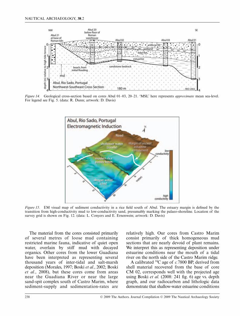
The material from the cores consisted primarilyof several metres of loose mud containingrestricted marine fauna, indicative of quiet openwater, overlain by stiff mud with decayedorganics. Other cores from the lower Guadianahave been interpreted as representing severalthousand years of inter-tidal and salt-marshdeposition (Morales, 1997; Boski et al., 2002; Boskiet al., 2008), but these cores come from areasnear the Guadiana River or near the largesand-spit complex south of Castro Marim, wheresediment-supply and sedimentation-rates are
relatively high. Our cores from Castro Marimconsist primarily of thick homogeneous mudsections that are nearly devoid of plant remains.We interpret this as representing deposition underestuarine conditions near the mouth of a tidalriver on the north side of the Castro Marim ridge.
A calibrated 14C age of c.7800 BP, derived fromshell material recovered from the base of coreCM 02, corresponds well with the projected ageusing Boski et al. (2008: 241 fig. 6) age vs. depthgraph, and our radiocarbon and lithologic datademonstrate that shallow-water estuarine conditions
Figure 14. Geological cross-section based on cores Abul 01–03, 20–21. ‘MSL’ here represents approximate mean sea-level.For legend see Fig. 5. (data: R. Dunn; artwork: D. Davis)
Figure 15. EM visual map of sediment conductivity in a rice field south of Abul. The estuary margin is defined by thetransition from high-conductivity mud to low-conductivity sand, presumably marking the palaeo-shoreline. Location of thesurvey grid is shown on Fig. 12. (data: L. Conyers and E. Ernenwein; artwork: D. Davis)

S. WACHSMANN ET AL.: PALAEO-ENVIRONMENTAL CONTEXTS OF PHOENICIAN ANCHORAGES, PORTUGAL
© 2009 The Authors. Journal Compilation © 2009 The Nautical Archaeology Society 239
predominated in the area west of Castro Marimfor several millennia (Figs 17–18). To determinethe depth in the core that represents depositionduring the Phoenician period we used thesedimentation rate from Boski and colleagues toplace the Phoenician level at an approximatedepth of 5 m in core CM 02. This indicates thatthe Phoenician period is represented in the coreby estuarine mud and, therefore, in Phoeniciantimes this area almost certainly consisted of amuddy-bottom shallow estuarine setting, possiblyat the mouth of a tidal river with local tidal flatsand, based upon modern analogues, a sandyshoreline. This suggests the availability of naturally-protected moorings when the Phoenicians firstbegan using the site.
Reconstructions of the palaeo-geographies ofother estuaries along the coast of the Gulf ofCadiz indicate that several large embaymentswould have presented themselves to Phoenician
ships sailing west from the Straights of Gibraltar(Dabrio et al., 1999: 273 fig. 6, 277 fig. 10; Dabrioet al., 2000: 394–5 figs 6–7). Our local palaeo-geographic reconstruction can be placed into thecontext of the evolution of the lower Guadianaas a whole (Morales, 1997; Boski et al., 2002;Boski et al., 2008) to show that it is likely that asPhoenician vessels approached the Rio Guadiana,they would have sailed into a large, wide bay witha prominent peninsula that projected into the bayfrom the west (Figs 17 and 19).
The Iron Age site is located on the smallnorth-projecting promontory at the terminus ofthe Castro Marim ridge, and in the lee of thispromontory our coring revealed that in thePhoenician period there existed water deep enoughto accommodate their ships. This, along with anaturally-protected roadstead, would have madeCastro Marim an excellent anchorage forPhoenician seafaring merchants. We collectedGPR data along a line that extends from bedrockexposed in the town, west of the Iron Age site, tothe north and through the area of coring. Thegeological cores coupled with the GPR resultsrevealed a now-buried shallow bedrock platformwith an abrupt deepening to the north (Figs 17–18). This bedrock platform is probably aPleistocene or early mid-Holocene wave-cut terrace.We suggest it would have served as an excellentwaterfront for ships.
Stiff, organic-rich mud in the upper parts ofCastro Marim cores reveal that at some pointafter Phoenician times, tidal flats and local salt-marshes developed which produced shoaling inthis area. A core from a similarly-restrictedestuary-margin environment reveals that salt-marshes began to develop in some parts of thelower estuary as early as c.3500 BP (Boski et al.,2008: 235 fig. 2). However, the presence of asmall tidal river near Castro Marim may haveinhibited salt-marsh development until muchlater. Our core lithology appears to comparefavourably with cores from the western estuarymargin in which organic-rich mud of tidal-flatand wetland origin represents only a thin cap onthick estuarine mud (Morales, 1997: 145 fig. 14).As our cores did not contain material in theupper part of the sediment section forradiocarbon analysis, and as Morales does nothave chronological control in his cores, we areunable to date this event. However, the thinnature of these tidal-flat and salt-marsh depositsin our cores suggests quite recent filling of theformer open area.
Figure 16. Map of the modern environs of Castro Marimand the Rio Guadiana estuary. (D. Davis)

NAUTICAL ARCHAEOLOGY, 38.2
240 © 2009 The Authors. Journal Compilation © 2009 The Nautical Archaeology Society
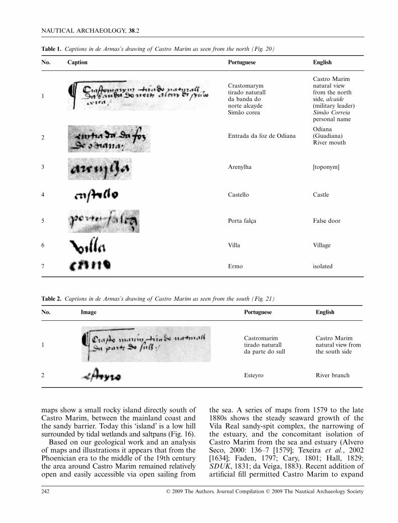
This conclusion finds support in drawings andmaps of Castro Marim and its surroundingsdating from the early-16th to the 19th centuries.Two remarkably-detailed drawings by Duarte deArmas dating to c.1508–10 show Castro Marim
situated on the open coast with tidal rivers oneither side of the peninsula (de Armas, 1997: 15;Arruda, 2000: 36). In his view drawn from thenorth de Armas includes two ships sailing in theopen sea, which nearly abuts the citadel (Fig. 20).
Figure 17. Modern map of the region of Castro Marim showing the locations of the cores and GPR line west of the castle,and the reconstructed Iron Age shoreline. (data: R. Dunn; artwork: D. Davis)
Figure 18. Castro Marim. North-south geological cross-section combining core CM 02 and GPR lines 02 & 002. For legendsee Fig. 5. (data: R. Dunn and L. Conyers; section: R. Dunn; artwork: D. Davis)
S. WACHSMANN ET AL.: PALAEO-ENVIRONMENTAL CONTEXTS OF PHOENICIAN ANCHORAGES, PORTUGAL
© 2009 The Authors. Journal Compilation © 2009 The Nautical Archaeology Society 241
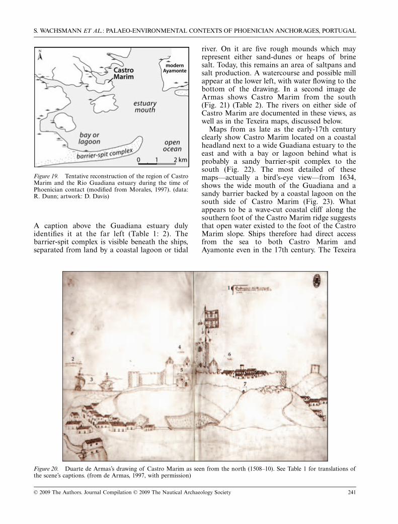
A caption above the Guadiana estuary dulyidentifies it at the far left (Table 1: 2). Thebarrier-spit complex is visible beneath the ships,separated from land by a coastal lagoon or tidal
river. On it are five rough mounds which mayrepresent either sand-dunes or heaps of brinesalt. Today, this remains an area of saltpans andsalt production. A watercourse and possible millappear at the lower left, with water flowing to thebottom of the drawing. In a second image deArmas shows Castro Marim from the south(Fig. 21) (Table 2). The rivers on either side ofCastro Marim are documented in these views, aswell as in the Texeira maps, discussed below.
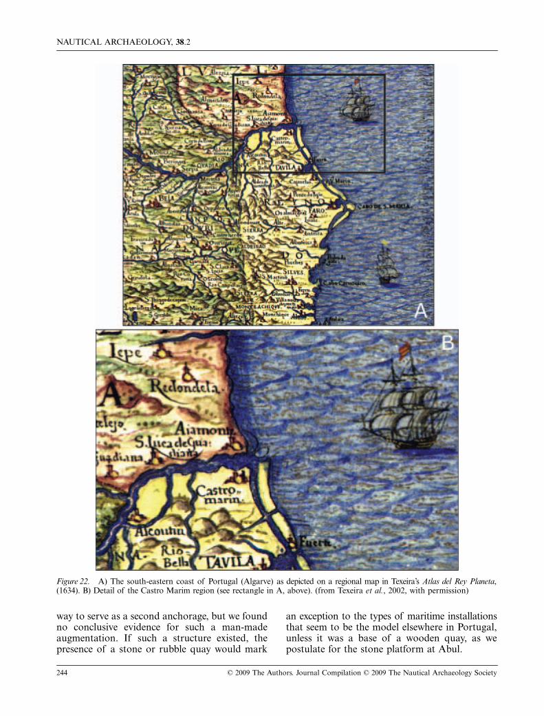
Maps from as late as the early-17th centuryclearly show Castro Marim located on a coastalheadland next to a wide Guadiana estuary to theeast and with a bay or lagoon behind what isprobably a sandy barrier-spit complex to thesouth (Fig. 22). The most detailed of thesemaps—actually a bird’s-eye view—from 1634,shows the wide mouth of the Guadiana and asandy barrier backed by a coastal lagoon on thesouth side of Castro Marim (Fig. 23). Whatappears to be a wave-cut coastal cliff along thesouthern foot of the Castro Marim ridge suggeststhat open water existed to the foot of the CastroMarim slope. Ships therefore had direct accessfrom the sea to both Castro Marim andAyamonte even in the 17th century. The Texeira
Figure 19. Tentative reconstruction of the region of CastroMarim and the Rio Guadiana estuary during the time ofPhoenician contact (modified from Morales, 1997). (data:R. Dunn; artwork: D. Davis)
Figure 20. Duarte de Armas’s drawing of Castro Marim as seen from the north (1508–10). See Table 1 for translations ofthe scene’s captions. (from de Armas, 1997, with permission)
NAUTICAL ARCHAEOLOGY, 38.2
242 © 2009 The Authors. Journal Compilation © 2009 The Nautical Archaeology Society
maps show a small rocky island directly south ofCastro Marim, between the mainland coast andthe sandy barrier. Today this ‘island’ is a low hillsurrounded by tidal wetlands and saltpans (Fig. 16).
Based on our geological work and an analysisof maps and illustrations it appears that from thePhoenician era to the middle of the 19th centurythe area around Castro Marim remained relativelyopen and easily accessible via open sailing from
the sea. A series of maps from 1579 to the late1880s shows the steady seaward growth of theVila Real sandy-spit complex, the narrowing ofthe estuary, and the concomitant isolation ofCastro Marim from the sea and estuary (AlveroSeco, 2000: 136–7 [1579]; Texeira et al., 2002[1634]; Faden, 1797; Cary, 1801; Hall, 1829;SDUK, 1831; da Veiga, 1883). Recent addition ofartificial fill permitted Castro Marim to expand
Table 1. Captions in de Armas’s drawing of Castro Marim as seen from the north (Fig. 20)
No. Caption Portuguese English
1
Crastomarym tirado naturall da banda do norte alcayde Simão corea
Castro Marim natural view from the north side, alcaide (military leader) Simão Correia personal name
2 Entrada da foz de OdianaOdiana (Guadiana) River mouth
3 Arenylha [toponym]
4 Castello Castle
5 Porta falça False door
6 Villa Village
7 Ermo isolated
Table 2. Captions in de Armas’s drawing of Castro Marim as seen from the south (Fig. 21)
No. Image Portuguese English
1Castromarim tirado naturall da parte do sull
Castro Marim natural view from the south side
2 Esteyro River branch

S. WACHSMANN ET AL.: PALAEO-ENVIRONMENTAL CONTEXTS OF PHOENICIAN ANCHORAGES, PORTUGAL
© 2009 The Authors. Journal Compilation © 2009 The Nautical Archaeology Society 243
and create a modern parking area and soccerfield. Townspeople we interviewed recalled tidalflats and a sandy beach in the area of the parkinglot within the last few decades.
Although we did not core to the south orsouth-east of Castro Marim, GPR investigationin this area revealed that it is unlikely that theflank of the bedrock ridge could have providedan advantageous anchorage. The maps indicatethat the marine shoreline ran at, or near, thesouth and south-eastern sides of the Castro Marimbedrock ridge in the 16th to 17th centuries, withsome protection afforded by the sandy barrier-spit which eventually became the large Vila Realspit-complex. It seems likely, therefore, that inPhoenician times this side of Castro Marim wasdirectly connected to the sea, possibly with someshelter provided by sandy barrier islands orshoals.
ConclusionsAs the Phoenicians expanded into the westernMediterranean, they sailed with a rich traditionof working with nature to provide secure anchorages
for their ships in the simplest and most expedientmanner. When they voyaged beyond the Pillars ofHeracles and coasted along the section of theIberian Peninsula that is now Portugal, theyfound superb geographical features in the form ofbroad estuaries ideal for their maritime-basedcommercial purposes. They had little need toemploy, or improve on, their accumulatedharbour technology in a region so fortuitouslyendowed with waterways which penetrated theIberian heartland.
Nature offered model settings to Phoenicianseafarers at Santa Olaia, Abul and Castro Marim.At the time of the Phoenician activity, all threelocations afforded elevated peninsulas juttinginto, or at the mouth of, extensive estuaries. Eachof the sites would have offered good mooringsand shelter. Our survey at Santa Olaia identifieda low-conductivity anomaly as probably comprisingstone. It trends perpendicular to the bedrock andhad been exposed at, or near, the ancientshoreline before it had been buried by the silt andmud that choked the estuary. This stone spur onthe site’s south-eastern side could have beeneither artificial, or natural but enhanced in some
Figure 21. Duarte de Armas’s drawing of Castro Marim as seen from the south (1508–10). See Table 2 for translations ofthe scene’s captions. (from de Armas, 1997, with permission)
NAUTICAL ARCHAEOLOGY, 38.2
244 © 2009 The Authors. Journal Compilation © 2009 The Nautical Archaeology Society
way to serve as a second anchorage, but we foundno conclusive evidence for such a man-madeaugmentation. If such a structure existed, thepresence of a stone or rubble quay would mark
an exception to the types of maritime installationsthat seem to be the model elsewhere in Portugal,unless it was a base of a wooden quay, as wepostulate for the stone platform at Abul.
Figure 22. A) The south-eastern coast of Portugal (Algarve) as depicted on a regional map in Texeira’s Atlas del Rey Planeta,(1634). B) Detail of the Castro Marim region (see rectangle in A, above). (from Texeira et al., 2002, with permission)

S. WACHSMANN ET AL.: PALAEO-ENVIRONMENTAL CONTEXTS OF PHOENICIAN ANCHORAGES, PORTUGAL
© 2009 The Authors. Journal Compilation © 2009 The Nautical Archaeology Society 245
Sandy beaches, or bedrock platforms, probablywith a sand veneer, may have been sufficient touse as docking facilities in some cases. In others,timber quays built far enough from the shorelineto accommodate the full range of tides wouldhave provided access for trading activitiesregardless of the water-level of the estuary. Suchquays were easy to build, repair or expand, andwere conveniently expendable if new sources ofminerals or changing local conditions requiredshifting the location of entrepôts. Deceleratingsea-level rise and subsequent filling of the
marine embayments by estuarine and deltaicsediments has taken place since c.6500–5000 BP.With human land-use also contributing tolandscape evolution, changes in Phoeniciantimes would have been swift. We are unable toconfirm whether this rapid geomorphictransformation led to abandonment of the sitesthat we studied.
The combination of geological coring andgeophysical survey, coupled with 14C dating, hasproven to be a useful method for attempting toreconstruct the amount, nature and general timing
Figure 23. Bird’s-eye view of Castro Marim and the Rio Guadiana estuary, facing north. Atlas del Rey Planeta (1634). (fromTexeira et al., 2002, with permission)
NAUTICAL ARCHAEOLOGY, 38.2
246 © 2009 The Authors. Journal Compilation © 2009 The Nautical Archaeology Society
of geomorphological changes at the sites studied.Each of the three sites can now be viewed inthe context of its coast-to-offshore palaeo-environment. Our cores identified the sedimentsand supplied a palaeo-environmental interpreta-tion, while the geophysics enabled us to expandthat knowledge across space. We developeddata-collection techniques which allowed us tofloat the geophysical instruments across floodedrice-fields with minimum disturbances to thegrowing crops, while collecting a dense grid ofmeasurements. Ideally, any future expeditionscould collect EM data in rice-growing areas likeSanta Olaia and Abul more quickly andefficiently during the spring, when the rice-fieldsare normally drained and therefore dry. The EMtools could then be walked across the fieldsquickly, and much larger areas could be mapped.In Portugal we found this combined geological-geophysical survey method rapidly providedvaluable subsurface data. This enabled us tocreate maps of the buried marine, coastal, andalluvial environments while still in the field,and suggests that this might be an inexpensiveand non-invasive method of choice in other areasof the world with similar attributes.
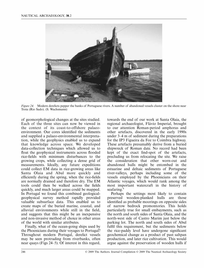
Finally, what of the ocean-going ships used bythe Phoenicians during their voyages to Portugal?Throughout modern Portugal, derelict vesselsmay be seen protruding from riverbanks, oftennear quays (Figs 24–5). Of interest in this regard,
towards the end of our work at Santa Olaia, theregional archaeologist, Flávio Imperial, broughtto our attention Roman-period amphoras andother artefacts, discovered in the early 1990sunder 3–4 m of sediment during the preparationsfor the IP3 Figueira da Foz to Coimbra highway.These artefacts presumably derive from a buriedshipwreck of Roman date. No record had beenkept of the exact find-spot of the artefacts,precluding us from relocating the site. We raisethe consideration that other worn-out andabandoned hulls might be entombed in theestuarine and deltaic sediments of Portugueseriver-valleys, perhaps including some of thevessels employed by the Phoenicians on theirAtlantic voyages, which would rank among themost important watercraft in the history ofseafaring.6
Perhaps the settings most likely to containpreserved wooden-planked hulls are thoseidentified as probable moorings on opposite sidesof narrow bedrock promontories. This holdsparticularly true for small embayments, such asthe north and south sides of Santa Olaia, and thenorth-west side of Castro Marim just below theparking lot. The north and south sides of Abulfulfil this requirement, but the sediments belowthe rice-paddy level have undergone significantgeochemical change as a product of past saltpanproduction, and later rice cultivation. This wouldargue against the preservation of wooden hulls if
Figure 24. Modern derelicts pepper the banks of Portuguese rivers. A number of abandoned vessels cluster on the shore nearTroia (Rio Sado). (S. Wachsmann)

S. WACHSMANN ET AL.: PALAEO-ENVIRONMENTAL CONTEXTS OF PHOENICIAN ANCHORAGES, PORTUGAL
© 2009 The Authors. Journal Compilation © 2009 The Nautical Archaeology Society 247
such had been deposited there in antiquity. Thearea to the southwest of Abul, however, betweenthe site and the modern low-tide shoreline,contains a thicker sedimentary section that hasnot undergone significant geochemical alterations:this area has the highest potential for preservingorganic remains and contains the areaimmediately offshore from the large paved flooror landing which appears to have served as awaterfront access at Abul. In general, we believethat the preservation potential for the survival of
wooden hulls in the environments of theselocations is moderate to high, as the muds tendto retard geochemical alteration and we regularlyencountered wood fragments in our cores. Wesuggest that in addition to the possibility ofancient hulls buried in the sediment in theanchorage west of the Iron Age site of CastroMarim, hulls might very well exist within thesand of the Vila Real barrier-spit complex and inthe organic-rich sandy mud of the back-barrierlagoon or estuary that existed south of Castro
Figure 25. Vessels often sink, or are abandoned adjacent to wooden quays as, for example, those seen here, at A) Almoral(Rio Tagus) and, (B) these two hulls (arrows) at Villa Real de Santo Antonio (Rio Guadiana). (S. Wachsmann)
NAUTICAL ARCHAEOLOGY, 38.2
248 © 2009 The Authors. Journal Compilation © 2009 The Nautical Archaeology Society
Marim (Figs 16–17). This area remains unexploredand may hold surprises for future investigators.The ancient waterfronts of some modern cities,
such as Lisbon and Almaraz, should also beconsidered in this regard, when urban renewalpermits examination (Blot, 2003).
AcknowledgementsWe thank Bruce and Elizabeth Dunlevie, the L. J. Skaggs and Mary C. Skaggs Foundation, the College of Liberal Arts, TexasA&M University, the Meadows Foundation, and the Office of the Provost, Norwich University, for their support. We aregrateful to the Archaeological Institute of America’s Portugal Fund, which underwrote our 14C tests. We recognize ourPortuguese colleagues for their support: João Zilhão, Francisco Alves and his CNANS staff, Ana Margarita Arruda, IsabelPereira, Carlos Tavares da Silva, João Senna Martinez, António Dias Diogo, Flávio Imperial, Alexandre Monteiro andRicardo Rodrigo. Students are the lifeblood of research projects: we are grateful to (now Dr) Ralph Pedersen, AnthonyRandolph and Daniel Byrne. Heather Hatch helped considerably with the editing of this manuscript. We also thank theanonymous IJNA reviewer for his/her constructive comments.
Notes1. The bibliography on Phoenician/Punic settlement in Spain is voluminous. See, for example, Carpenter 1958: 49–51; Moscati
1968: 230–42; Aubet Semmler, 1988; Blázquez, 1992; Aubet, 1995: 51–9; Torres, 1995: 36–57, 73–95; Blázquez et al., 1999;González Prats, 1999; Markoe, 2000: 182–6; Aubet, 2001: 257–91; Cunliffe, 2001: 265–75; Bierling and Gitin, 2002;González-Ruibal, 2004; Martín Ruiz, 2004; González-Ruibal, 2006; Neville, 2007.
2. Lixus on the Loukkos River today lies ~4 km from the sea (López Pardo, 1996: 254–6, 259 fig. 3, 275, 283; Lopez Pardo,2000; Markoe, 2000: 187–8; Aubet, 2001: 156, 161–3, 174,191–2, 297, 300–01, 304, 330; López Pardo and Suárez Padilla,2002: 120; López Pardo and Cabrero, 2005; Neville, 2007: 44–5, 84, 86, 99, 104, 108, 116, 130). Mogador, possibly ancientCerne, is at present the southernmost Phoenician enclave on the Moroccan coast confirmed by archaeology (López Pardo,1991: 62–63; López Pardo, 1996: 260, 262, 263 fig. 5, 276; Markoe, 2000: 188; Aubet, 2001: 191, 301–04, 313–14, 343–4;López Pardo and Suárez Padilla, 2002: 116, 120 n.8; Neville, 2007: 46, 86 n.31, 99 n.127, 166, 108 n.18). This site is locatedon a small island in a bay opposite a minor river.
3. Various definitions exist for the terms Phoenician, Punic, Phoenicio-Punic or Orientalizing: regarding the lack ofstandardization in these terms, see Aubet, 2001: 1, 12–13; Prag, 2006. On literary and other claims regarding Phoenicianseafaring, see Aristotle, Minor Works, On Marvellous Things Heard 84; Diodorus Siculus 5: 19–20; Strabo 3:5:11; Avienus(Murphy, 1977) 8–9 lines 114–19, 53; Carpenter, 1958: 51–2; Carpenter, 1966: 199–214; Gordon, 1971; Moscati, 1988; Bikaiand Bikai, 1990; Casson, 1990; Wachsmann, 1990: 77–8, 80; Casson, 1991: 65–6, 74–5; Cunliffe, 2001: 261–310; Roller,2006: 22–50.
4. Analysis of coastal evolution is a powerful tool employed at a number of Mediterranean and African Atlantic sites, whichinclude Alexandria (Stanley and Bernasconi, 2006; Stanley et al., 2007); Ephesus (Kraft et al., 2000, Kraft et al., 2007);Troy (Kraft et al., 1980; Kraft et al., 2003); Thermopylae and the Gulf of Malia (Kraft et al., 1987); Lechaion, the harbourof Corinth (Stiros et al., 1996); and Nikopolis on the Ambracian Gulf (Jing and Rapp, 2003). Similar work at Phoeniciansites includes reconstructions at Tyre and Sidon (Carmona Gonzalez, 2003; Marriner et al., 2005; Marriner et al., 2006a;Marriner et al., 2006b; Marriner and Morhange, 2007: 152; Carmona and Ruiz, 2008); Kition Bamboula (Morhange et al.,2000); Lixus (Carmona Gonzalez, 2003: 23–8); the Odiel and Tinto estuaries (Dabrio et al., 1999; Dabrio et al., 2000);Cerro del Villar on the Guadalhorce estuary (summarized in Carmona Gonzalez, 2003: 19–23; Neville, 2007); Cadiz andother sites in Spanish Andalusia (as discussed in Aubet, 2001: 262–73; Martin Ruiz, 2004: 21–4; Neville, 2007: 88–90, 107–08); and sites in Portugal (synthesized in Neville, 2007: 35–42).
5. The dates and scales of the aerial photographs were as follows: Santa Olaia: A) 1958: 1:26,000; B) 1965: 1:15,000; C) 1980:1:30,000; D) 1983: 1:15,000. Abul: A) 1958: 1:26,000; B) 1949: 1:7500. Castro Marim: A) 1958: 1:26,000; B) 1972: 1:8000;C) 1978: 1:30,000.
6. Mediterranean Phoenician wrecks have been found off the Spanish coast at Mazarrón (La Playa de la Isla) and at Bajo dela Campana, and in deep water off the Egyptian coast—Mazarrón (Roldán Bernal et al., 1994; Negueruela et al., 1995;Aizpurua and Méndez, 1996; Negueruela et al., 2000; Neville, 2007: 32, 121 n.132); Bajo de la Campana (Mas, 1985;Roldán Bernal et al., 1991; Roldán Bernal et al., 1995; Aubet, 2001, 341; Neville, 2007: 31–2, 46; Polzer, 2007); EgyptianCoast (Ballard et al., 2002; Stager, 2003). At present the earliest nautical artefacts found in Portuguese waters date to theRoman period (Alves et al., 1989). The following wrecks have been found in Portugal: two log boats found in the Rio Lima,3rd century BC (Belo, 2003); Corpo Santo, late-14th/early-15th centuries (Alves et al., 2001); Aveiro A, mid-15th century(Alves and Reith, 2001); Arade 1, late-15th century (Alves, 1999; Castro, 2006); Cais do Sodré, 16th century (Alves et al.,2001); Nossa Senhora dos Mártires, 1606 (Alves et al., 1998; Castro, 2003); Ponta do Altar B, early-17th century (Alves,1992); Océan, 1759 (Alves, 1984; Alves, 1989); San Pedro de Alcantara, 1786 (Blot and Pinheiro Blot, 1991; Blot, 1998);shipwrecks in the Azores include Angra B, 16th century (Crisman and Jordan, 1999a); Angra C and D, 17th century(Garcia et al., 1999; Monteiro, 1999); Angra A, 18th century (Crisman and Jordan, 1999b).

S. WACHSMANN ET AL.: PALAEO-ENVIRONMENTAL CONTEXTS OF PHOENICIAN ANCHORAGES, PORTUGAL
© 2009 The Authors. Journal Compilation © 2009 The Nautical Archaeology Society 249
Appendix: Radiocarbon test results
Table 3. Results are presented for the radiocarbon analysis of 19 samples from the sites in the study. Beta Analytic Inc analyzedthe samples and all radiocarbon ages have been calibrated using Intcal98 from Stuiver et al. (1998). The 2 Sigma StandardDeviation has a 95% confidence level
Sample Data and Calibrated AgeDepth (m) below surface
14C age (BP)
13c/12c Ratio (o/oo)
Conventional 14C age (BP)
Rd-Abul19 (Beta–174226): Shell, 2 Sigma Calibration: Cal BC 4370–4240 (Cal BP 6320–6190)
5.4–5.6 5450 +/− 40 −0.5 5850 +/− 40
Rd-Asl04a∞ (Beta–174227+): Shell, 2 Sigma Calibration: Cal BC 2470–2270 (Cal BP 4420–4220) and Cal BC 2260–2220 (Cal BP 4210–4170)
2.95–3.05 3650 +/− 40 −10.4 3890 +/− 40
Rd-Asl04b∞ (Beta–174228+): Organic Sediment2 Sigma Calibration: Cal BC 1060–880 (Cal BP 3000–2840)
3.15 2820 +/− 40 −25.0 2820 +/− 40
Rd-Asl04c∞ (Beta–174229+): Shell, 2 Sigma Calibration: Cal BC 1400–1140 (Cal BP 3350–3090)
2.50 2790 +/− 40 −10.4 3030 +/− 40
Rd-Cm02* (Beta–174230): Shell, 2 Sigma Calibration: Cal BC 5960–5780 (Cal BP 7910–7730)
9.5–10.0 6980 +/− 40 −1.8 7360 +/− 40
Rd-So02b† (Beta–174231+): Wood, 2 Sigma Calibration: Cal BC 400–350 (Cal BP 2350–2300) and Cal BC 300–220 (Cal BP 2250–2170)
1.75–2.0 2280 +/− 40 −24.5 2290 +/− 40
Rd-So02dy (Beta–174232+): Wood, 2 Sigma Calibration: Cal BC 880–780 (Cal BP 2840–2730)
2.45 2700 +/− 50 −28.8 2640 +/− 50
Rd-So02e (Beta–174233+): Wood, 2 Sigma Calibration: Cal BC 840–790 (Cal BP 2790–2740)
2.7–2.9 2670 +/− 40 −26.9 2640 +/− 40
Rd-So02f (Beta–174234+): Shell, 2 Sigma Calibration: Cal BC 1940–1650 (Cal BP 3900–3600)
3.5 3160 +/− 60 −5.5 3480 +/− 60
Rd-So02h (Beta–174235+): Shell, 2 Sigma Calibration: Cal BC 2880–2470 (Cal BP 4830–4420)
4.5–5.0 3760 +/− 70 −4.7 4090 +/− 70
Rd-So02ix (Beta–174236): Shell, 2 Sigma Calibration: Cal BC 2760–2540 (Cal BP 4710–4490)
6.10–6.25 4060 +/− 40 −2.4 4430 +/− 40
Rd-So02iy (Beta–174237): Shell, 2 Sigma Calibration: Cal BC 2460–2260 (Cal BP 4410–4210)
6.25–6.40 3800 +/− 40 +0.4 4220 +/− 40
Rd-So04a (Beta–174238): Shell, 2 Sigma Calibration: Cal BC 1220–990 (Cal BP 3170–2940)
3.7 2870 +/− 40 −2.6 3240 +/− 40
Rd-So04b (Beta–174239+): Shell, 2 Sigma Calibration: Cal BC 1650–1450 (Cal BP 3600–3400)
3.9–4.0 2920 +/− 40 −3.3 3280 +/− 40
Rd-So04c (Beta–174240): Shell, 2 Sigma Calibration: Cal BC 1400–1090 (Cal BP 3350–3040)
4.75–4.85 2970 +/− 60 −1.7 3350 +/− 60
Rd-So04d (Beta–174241): Shell, 2 Sigma Calibration: Cal BC 2340–2130 (Cal BP 4300–4080)
6.2–6.3 3730 +/− 40 −0.9 4130 +/− 40
Rd-So06a (Beta–174242): Shell, 2 Sigma Calibration: Cal BC 1490–1320 (Cal BP 3440–3270)
4.3 3090 +/− 40 −1.0 3480 +/− 40
Rd-So06b (Beta–174243): Shell, 2 Sigma Calibration: Cal BC 2900–2660 (Cal BP 4840–4610)
8.0 4140 +/− 50 0.0 4550 +/− 50
Rd-Er03 (Beta–174244+): Wood, 2 Sigma Calibration: Cal BC 2850–2820 (Cal BP 4800–4770) and Cal BC 2680–2280 (Cal BP 4630–4230)
3.9 4030 +/− 80 −28.3 3980 +/− 80
∞ These three results come from a backhoe trench at the Rio Sado site of Alcácer do Sal but no detailed investigation was carried out. Further information is available upon request.* Cm = Castro Marim† So = Santa Olaia+ = Local reservoir correction applied

NAUTICAL ARCHAEOLOGY, 38.2
250 © 2009 The Authors. Journal Compilation © 2009 The Nautical Archaeology Society
ReferencesAizpurua, C. and Méndez, J., 1996, Extracción y tratamientos del barco Fenicio (Barco I) de la Playa de la Isla (Puerto de
Mazarrón, Mazarrón), Cuadernos de Arqueología Maritíma 4, 217–25. Cartagena.Alvero Secco, V., 2000, Protugallia et Algarbia queae olim Lusitania [map], 1:1,200,000, in J. Blau (ed.), Gran Atlas Siglio
XVII. San Rafael.Alves, F. J. S., 1984, Océan ’84. A primeira campanha de escavações arqueológicas subaquáticas realizadas em Portugal.
Notícia preliminar, Informação Arqueológica 6, 5–10.Alves, F. J. S., 1989, O itinerário arqueológico subquático Océan, Arqueólogo Português 4, 455–67.Alves, F. J. S., 1992, Ponta do Altar B—Arqueologia de um naufrágio no Algarve nos alvores do século XVII, Arqueólogo
Português 4, 357–424.Alves, F. J. S., 1999, Acerca dos destroços de dois navios descobertos durante as dragagens de 1970 na foz do Rio Arade
(Ferragudo, Lagoa), in Anon. (ed.), As rotas oceânicas, Sécs. XV–XVII, 29–92. Lisbon.Alves, F. and Reith, E., 2001, Ria de Aveiro A—destroços de um navio do século XV em Portugal. Notícia preliminary, in F.
J. S. Alves (ed.), Proceedings of the International Symposium Archaeology of Medieval and Modern Ships of Iberian-AtlanticTradition, 317–45. Lisbon.
Alves, F., Castro, F., Rodrigues, P., Garcia, C., and Aleluia, M., 1998, Archaeology of a shipwreck, in S. L. Afonso (ed.),Nossa Senhora dos Mártires: The Last Voyage, 183–215. Lisbon.
Alves, F., Reiner, F., Almeida, M., and Verissimo, L., 1989, Os cepos de âncora em chumbo descobertos em águas portugue-sas—contribuição para uma reflexão sobre a navegação ao longo da costa atlântica da Península Ibérica na Antiguidade,Arqueólogo Português 6–7, 109–85.
Alves, F., Rodrigues, P. and Reith, E., 2001, The remains of a 14th century shipwreck at Corpo Santo, and of a shipyard atPraça do Município, Lisbon, Portugal, in F. J. S. Alves (ed.), Proceedings of the International Symposium Archaeology ofMedieval and Modern Ships of Iberian-Atlantic Tradition, 405–26. Lisbon.
Amaro, C., 1993, Vestígios materiais orientalizantes do claustro da Sé de Lisboa, in A. A. Tavares (ed.), Os Fenícios noTerritório Português, 183–92. Lisbon.
Arruda, A. M., 1996, O castelo de Castro Marim, in J. de Alarcão (ed.), De Ulisses a Viriato: O primeiro milénio a.C., 95–100. Lisbon.
Arruda, A. M., 1997, As cerâmicas áticas do Castelo de Castro Marim. Lisbon.Arruda, A. M., 2000, Los Fenicios en Portugal: Fenicios y mundo indígena en el centro y sur de Portugal (siglos VIII–VI a.C.).
Cuadernos de Arqueología Mediterránea 5–6 Barcelona.Arruda, A., Texeira de Freitas, V., and Oliveira, C., 2007, Os Fenicios e a urbanizaçaono Extremo Occidente: o caso de Castro
Marim, in J. L. López Castro (ed.), Las ciudades fenicio-púnicas en el Mediterráneo occidental, 459–82. Almería.Aubet, M. E., 1995, From trading post to town in the Phoenician-Punic world, in B. Cunliffe and S. Keay (eds), Social
Complexity and the Development of Towns in Iberia: From the Copper Age to the Second Century AD, 47–65. Oxford.Aubet, M. E., 2001 (2nd edn, trans. M. Turton), The Phoenicians and the West: Politics, Colonies and Trade. Cambridge.Aubet Semmler, M. E., 1988, Spain, in S. Moscati (ed.), The Phoenicians, 279–304. New York.Aubet Semmler, M. E., 2002, Phoenician trade in the west: balance and perspectives, in M. R. Bierling and S. Gitin (eds),
The Phoenicians in Spain, 97–112. Winona Lake.Ballard, R., Stager, L., Master, D., Yoerger, D., Mindell, D., Whitcomb, L., Singh, H., and Piechota, D., 2002, Iron Age
shipwrecks in deep water off Ashkelon, Israel, American Journal of Archaeology 106, 151–68.Barros, L., 1998, Introdução à Pré Proto-História de Almada. Almada.Barros, L., Cardosa, J., and Sabrosa, A., 1993, Fenícios na margem sul do Tejo—Economia e integração cultural no povoado
do Almaraz-Almada, in A. A. Tavares (ed.), Os Fenícios no Território Português, 143–81. Lisbon.Belo, M., 2003, Águas passadas, Grande Reportagem 14.152, 78–82.Bierling, M. and Gitin, S. (eds), 2002, The Phoenicians in Spain. Winona Lake.Bikai, P. and Bikai, P., 1990, A Phoenician fable, Archaeology 43.1, 20, 22–3, 84.Blázquez, J. M., 1992, Fenicios, griegos y cartagineses en Occidente. Madrid.Blázquez, J., Alvar, J., and Wagner, C., 1999, Fenicios y cartagineses en el Mediterráneo. Madrid.Blot, J-Y., 1998, From Peru to Europe (1784–1786): field and model analysis of a ship overload, Bulletin of the Australian
Institute for Maritime Archaeology 22, 21–34.Blot, J-Y. and Pinheiro Blot, M., 1991, Le naufrage du San Pedro de Alcantara, La Recherche 230, 334–42.Blot, M. L., 2003, Os portos na origem dos centros urbanos. Contributo para a arquelogia das cidades marítimas e fluvio-
marítimas em Portugal. Lisbon.Boski, T., Camacho, S., Moura, D., Fletcher, W., Wilamowski, A., Veiga-Pires, C., Correira, V., Loureiro, C., and Santana,
P., 2008, Chronology of the sedimentary processes during the post glacial sea-level rise in two estuaries of the Algarve coast,Southern Portugal, Estuarine, Coastal and Shelf Science 77, 230–44.
Boski, T., Moura, D., Veiga-Pires, C., Camacho, S., Duarte, D., Scott, D., and Fernandes, S., 2002, Postglacial sea-level riseand sedimentary response in the Guadiana estuary, Portugal/Spain border, Sedimentary Geology 150, 103–22.
Cardoso, J. L., 1996, O povoamento no Bronze Final e na Idade do Ferro na região de Lisboa, in J. de Alaracão (ed.), DeUlisses a Viriato: O primeiro milénio a.C., 73–81. Lisbon.
Carmona González, P., 2003, El tómbolo de Tiro, el delta del Guadalhorce y la bahía de Lixus: geomorfología y geoarque-ología de litorales fenicios, in C. Gómez Bellard (ed.), Ecohistoria del paisaje agrario. La agricultura fenicio-púnica en elMediterráneo, 11–32. Valencia.

S. WACHSMANN ET AL.: PALAEO-ENVIRONMENTAL CONTEXTS OF PHOENICIAN ANCHORAGES, PORTUGAL
© 2009 The Authors. Journal Compilation © 2009 The Nautical Archaeology Society 251
Carmona, P. and Ruiz, J., 2008, Geoarchaeological Study of the Phoenician Cemetery of Tyre-Al Bass (Lebanon) andGeomorphological Evolution of a Tombolo, Geoarchaeology 23, 334–50.
Carpenter, R., 1958, Phoenicians in the west, American Journal of Archaeology 62, 35–53.Carpenter, R., 1966, Beyond the Pillars of Hercules. New York.Cary, J., 2003, A new map of the Kingdom of Portugal, divided into its provinces, from the latest authorities [map]. 1801.
1:1,400,000. ‘Historic Maps.’ The David Rumsey Collection. http://www.davidrumsey.com/detail?id=1–1–21514–630122&name=Portugal.
Casson, L., 1990, Setting the stage for Columbus. Archaeology 43.3, 50–55.Casson, L., 1991 (2nd edn), The Ancient Mariners. Princeton.Castro, F., 2003, The Pepper Wreck, IJNA 32, 6–23.Castro, F., 2006, The Arade 1 shipwreck. A small ship at the mouth of the Arade River, Portugal, in L. Blue, F. Hocker and
A. Englert (eds), Connected by the Sea. Proceedings of the 10th International Symposium on Boat and Ship Archaeology,300–305. Oxford.
Celestino, S. and López-Ruiz, C., 2002, The palace-sanctuary of Cancho Roano and the Phoenician impact on the indigeouspopulations of the Iberian Peninsula, in Archaeological Institute of America, 104th Annual Meeting Abstracts, 21–2. Boston.
Celestino, S. and López-Ruiz, C., 2003, Sacred precincts: A Tartessian sanctuary in ancient Spain, Archaeology Odyssey 6.6,20–29.
Conyers, L. B., 2004, Ground-Penetrating Radar for Archaeology. Walnut Creek.Correia, V. H., 1995, The Iron Age in south and central Portugal and the emergence of urban centres, in B. Cunliffe and S.
Keay (eds), Social Complexity and the Development of Towns in Iberia: From the Copper Age to the Second Century AD,237–62. Oxford.
Crisman, K. and Jordan, B., 1999a, Angra B: The lead sheathed wreck at Porto Novo (Angra do Heroísmo, Terceira Island,Azores-Portugal), Revista Portuguesa de Arqueologia 2, 255–62.
Crisman, K. and Jordan, B., 1999b, Angra A: The copper fastened wreck at Porto Novo (Angra do Heroísmo, Terceira Island,Azores-Portugal), Revista Portuguesa de Arqueologia 2, 249–54.
Cunliffe, B., 2001, Facing the Ocean: The Atlantic and Its Peoples. New York.Custódio, J., 1996a, Aspectos de epigrafia contemporânea: Inscrições do Cemitério Inglês e da Mina de S. Domingos (1860–
1910), in M. Rego (ed.), Mineração no Baixo Alentejo, 186–97. Castro Verde.Custódio, J., 1996b, Sistemas de lavra na Mina de S. Domingos (1854–1966), in M. Rego (ed.), Mineração no Baixo Alentejo,
174–85. Castro Verde.da Silva, A. C., 1995, Origens do Porto, in L. A. d. O. Ramos (ed.), História do Porto, 44–117. Porto.da Silva, A. C., 2000, Proto-História e romanização do Porto, Al-madan. Almada II, Série 9, 94–103.da Veiga, E., 1883, Carta arqueológica do Algarve [map]. 1:200,000. ‘Mapas antigos do Algarve e de Portugal.’ Arkeotavira.
http://www.arkeotavira.com/Mapas/Estacio/CA-Estacio-1883-web.jpg.Dabrio, C., Zazo, C., Lario, J., Goy, J., Sierro, F., Francisco, B., Gonzalez, J., and Flores, J., 1999, Sequence
stratigraphy of Holocene incised-valley fills and coastal evolution in the Gulf of Cádiz (southern Spain), Geologie enMijnbouw 77, 263–81.
Dabrio, C., Zazo, C., Goy, J., Sierro, F., Borja, F., Lario, J., Gonzalez, J., and Flores, J., 2000, Depositional history ofestuarine infill during the last postglacial transgression (Gulf of Cádiz, southern Spain), Marine Geology 162, 381–404.
de Armas, D., 1997 (2nd edn), Livro das fortalezas: fac-simile do ms. 159 da Casa Forte do Arquivo Nacional da Torre doTombo. Lisboa.
Dias, J., Boski, T., Rodrigues, A., and Magalhaes, F., 2000, Coast line evolution in Portugal since the last glacial maximumuntil present—A synthesis, Marine Geology 170, 177–86.
Dinis, J., Henriques, V., Freitas, M., Andrade, C., and Costa, P., 2006, Natural to anthropogenic forcing in the Holoceneevolution of three coastal lagoons (Caldas da Rainha valley, western Portugal), Quaternary International 150, 41–51.
Edmondson, J. C., 1987, Two Industries in Roman Lusitania: Mining and Garum Production. BAR Int. Ser. 362, Oxford.Faden, W., 1797, Chorographical map of the Kingdom of Portugal divided into its grand provinces [map]. 1:900,000. ‘Historic
Maps.’ The David Rumsey Collection. http://www.davidrumsey.com/detail?id=1–1–24824–960032&name=Portugal (2003).Frost, H., 1963, Under the Mediterranean. Englewood Cliffs.Frost, H., 1995, Harbours and proto-harbours: early Levantine engineering, in V. Karageorghis and D. Michaelides (eds),
Cyprus and the Sea, 1–21. Nicosia.Gaffney, C. and Gater, J., 2003, Revealing the Buried Past: Geophysics for Archaeologists. Stroud.Garcia, C., Monteiro, P., and Phaneuf, E., 1999, Os destroços dos navios Angra C e D descobertos durante a intervenção
arqueológica subaquática realizados no quadro do projecto de construção de uma marina na Baia de Angra do Heroísmo(Terceira, Açores). Discussão preliminary, Revista Portuguesa de Arqueologia 2, 211–33.
González Prats, A. (ed.), 1999, La cerámica Fenicia en Occidente: Centros de producción y áreas de comercio: Actas del 1Seminario Internacional sobre Temas Fenicios, Guardamar del Segura. Valencia.
González-Ruibal, A., 2004, Facing two seas: Mediterranean and Atlantic contacts in the NW of Iberia, Oxford Journal ofArchaeology 23, 287–317.
González-Ruibal, A., 2006, Past the last outpost: Punic merchants in the Atlantic Ocean (5th–1st centuries BC), Journal ofMediterranean Archaeology 19, 121–50.
Gordon, D. H., 1971, Before Columbus: Links Between the Old World and Ancient America. New York.Goy, J., Zazo, C., Dabrio, C., Lario, J., Borja, F., Sierro, F., and Flores, J., 1996, Global and regional factors controlling
changes of coastlines in southern Iberia (Spain) during the Holocene, Quaternary Science Reviews 15, 773–80.

NAUTICAL ARCHAEOLOGY, 38.2
252 © 2009 The Authors. Journal Compilation © 2009 The Nautical Archaeology Society
Granja, H. and De Groot, T., 1996, Sea-level rise and neotectonism in a Holocene coastal environment at Cortegaca Beach(NW Portugal): a case study, Journal of Coastal Research 12, 160–70.
Guy, M., Guy, J., and Delézir, J., 2000, Appendice I: L’environment de site d’Abul, Sondages et télédetection, in F. Mayetand C. Tavares da Silva (eds), Le site phénicien d’Abul (Portugal): Comptoir et sanctuaire, 245–59, pls. 3–37. Paris.
Hall, S., 1829, Portugal [map]. 1:1,300,000. ‘Historic Maps.’ The David Rumsey Collection. http://www.davidrumsey.com/detail?id=1–1–21800–670033&name=Portugal (2003).
Jing, Z. and Rapp, G., 2003, The coastal evolution of the Ambracian embayment and its relationship to archaeologicalsettings, Hesperia Supplements 32, 157–98.
Kraft, J., Bruckner, H., Kayan, I., and Engelmann, H., 2007, The Geographies of ancient Ephesus and the Artemision inAnatolia, Geoarchaeology 22, 121–49.
Kraft, J., Kayan, I., and Erol, O., 1980, Geomorphic reconstructions in the environs of ancient Troy, Science 209, 776–82.Kraft, J., Kayan, I., Bruckner, H., and Rapp, G., 2000, A geological analysis of ancient landscapes and the harbors of Ephesus
and the Artemesion in Anatolia, Jahreshefte Des Osterreichischen Archaologischen Institutes in Wien 69, 175–233.Kraft, J., Rapp, G., Kayan, I., and Luce, J., 2003, Harbor areas at ancient Troy: sedimentology and geomorphology comple-
ment Homer’s Iliad, Geology 31, 163–6.Kraft, J., Rapp, G., Szemler, J., Tziavos, C., and Kase, E., 1987, The pass at Thermopylae, Greece, Journal of Field Archae-
ology 14, 181–98.Lambeck, K., 1995, Late Pleistocene and Holocene sea-level change in Greece and south-western Turkey: a separation of
eustatic, isostatic and tectonic contributions, Geophysical Journal International 122, 1022–44.Lario, J., Zazo, C., Goy, J., Dabrio, C., Borja, F., Silva, P., Sierro, F., González, A., Soler, V., and Yll, E., 2002, Changes in
sedimentation trends in SW Iberia Holocene estuaries (Spain), Quaternary International 93–4, 171–6.Lobo, F., Dias, J., Gonzalez, R., Hernandez-Molina, F., Morales, J., and Diaz Del Rio, V., 2003, High-resolution seismic
stratigraphy of a narrow, bedrock-controlled estuary: the Guadiana estuarine system, SW Iberia, Journal of SedimentaryResearch 73, 973–86.
López Pardo, F., 1991, El Periplo de Hannón y la expansión cartaginesa en el Africa Occidental, in La caída de Tiro y el augede Cartago (V Jornadas de arqueología fenicio púnica, Ibiza 1990). Trabajos del museo arqueológico de Ibiza, vol. 25, 59–70.Ibiza.
López Pardo, F., 1996, Los enclaves fenicios en el África noroccidental: del modelo de las escalas náuticas al de colonizacióncon implicaciones productivas, Gerión 14, 251–88.
López Pardo, F., 2000, La fundación de Lixus, in M. E. Aubet and M. Barthélemy (eds), IV Congreso Internacional deEstudios Fenicios y Púnicos, 819–26. Cádiz.
López Pardo, F. and Cabrero, L., 2005, Inscripción fenicia arcaica de Lixus, Madrider Mitteilungen 46, 46–60.López Pardo, F. and Suárez Padilla, J., 2002, Traslados de población entre el Norte de África y el sur de la Península Ibérica
en los contextos coloniales fenicio y púnico, Gerión 20, 113–52.Map, 1960, Carta Mineira de Portugal. Prepared by the Direcção-Geral de Minas e Serviços Geológicos.Markoe, G., 2000, Phoenicians (Peoples of the Past). London.Marriner, N. and Morhange, C., 2007, Geoscience of ancient Mediterranean harbours, Earth-Science Reviews 80, 137–94.Marriner, N., Morhange, C., Boudagher-Fadel, M., Boucier, M., and Carbonel, P., 2005, Geoarchaeology of Tyre’s ancient
northern harbour, Phoenicia, Journal of Archaeological Science 32, 1302–27.Marriner, N., Morhange, C., and Doumet-Serhal, C., 2006a, Geoarchaeology of Sidon’s Ancient Harbours, Phoenicia, Journal
of Archaeological Science 33, 1514–35.Marriner, N., Morhange, C., Doumet-Serhal, C., and Carbonel, P., 2006b, Geoscience rediscovers Phoenicia’s buried harbors,
Geology 34, 1–4.Martín Ruiz, J. A., 2004, Los fenicios en Andalucía. Sevilla.Mas, J., 1985, El Polígono Submarino de Cabo de Palos. Sus aportaciones al estudio del tráfico marítimo antiguo, in Museo
y Centro Nacionales de Investigaciones Arqueológicas Submarinas (ed.), Arqueología Submarina: VI Congreso Internacionalde Arqueología Submarina, 153–71. Madrid.
Mayet, F. and Tavares da Silva, C., 1993, A presença fenícia no Baixo Sado, in A. A. Tavares (ed.), Os Fenícios no TerritórioPortuguês, 127–42. Lisbon.
Mayet, F. and Tavares da Silva, C., 1996, Abul: um estabelecimento fenício no Baixo Sado, in J. de Alarcão (ed.), De Ulissesa Viriato: O primeiro milénio a.C., 52–9. Lisbon.
Mayet, F. and Tavares da Silva, C. (eds), 2000, Le site phénicien d’Abul (Portugal): Comptoir et sanctuaire. Paris.Mayet, F., Schmitt, A., and Tavares da Silva, C. (eds), 1996, Les amphores du Sado (Portugal). Paris.Mayet, F., Tavares da Silva, C., and Makaroun, Y., 1997, L’établissement phénicien d’Abul, in R. Étienne and F. Mayet (eds),
Itinéraires Lusitaniens: Trente années collaboration archéologique luso-française, 255–73. Paris.Monteiro, P., 1999, Os destroços dos navios Angra C e D descobertos durante a intervenção arqueológica subaquática
realizados no quadro do projecto de construção de uma marina na Baia de Angra do Heroísmo (Terceira, Açores).Discussão preliminary, Revista Portuguesa de Arqueologia 2, 233–61.
Morales, J. A., 1997, Evolution and facies architecture of the mesotidal Guadiana River delta (S.W. Spain-Portugal), MarineGeology 138, 127–48.
Morhange, C., Goiran, J-P., Bourcier, M., Carbonel, P., Le Campion, J., Rouchy, J-M., and Yon, M., 2000, Recent Holocenepaleo-environmental evolution and coastline changes of Kition, Larnaca, Cyprus, Mediterranean Sea, Marine Geology 170,205–30.
Moscati, S., 1968, The World of the Phoenicians (trans. A. Hamilton). New York.

S. WACHSMANN ET AL.: PALAEO-ENVIRONMENTAL CONTEXTS OF PHOENICIAN ANCHORAGES, PORTUGAL
© 2009 The Authors. Journal Compilation © 2009 The Nautical Archaeology Society 253
Moscati, S., 1988, Fenicio o punico o Cartaginese, Rivista di Studi Fenici 16, 3–13.Mota & Company, nd, IP3–Sta Eulalai/Figueira da Foz–Estacaco arqueological de Sta Olaia, unpublished report, Amarante,
8pp. with appendices.Murphy, J. P. (ed.), 1977, Rufus Festus Avienus: Ora Maritima or Description of the Seacoast [from Brittany Round to
Massilia]. Chicago.Negueruela, I., Pinedo, J., Gömez, M., Miñano, A., Arellano, I., and Barba, J., 1995, Seventh-century BC Phoenician vessel
discovered at Playa de la Isla, Mazarron, Spain, IJNA 24.3, 189–97.Negueruela, I., Pinedo, J., Gómez, M., Miñano, A., Arellano, I., and Barba, J., 2000, Descubrimiento de dos barcos fenicios
en Mazarrón (Murcia), in M. E. Aubet and M. Barthélemy (eds), Congresso internazionale di studi fenici e punici. (2000).Actas del IV Congreso Internacional de Estudios Fenicios y Púnicos, 1671–9. Cádiz.
Neville, A., 2007, Mountains of Silver and Rivers of Gold: The Phoenicians in Iberia. Oxford.Oikonomides, A. N., 1977, Hanno the Carthaginian: Periplus or Circumnavigation [of Africa], Chicago.Pereira, I., 1993, Figueira da Foz. Santa Olaia, in A. A. Tavares (ed.), Os Fenícios no Território Português, 285–304. Lisbon.Pereira, I., 1996, Santa Olaia, in J. de Alarcão (ed.), De Ulisses a Viriato: O primeiro milénio a.C., 60–65. Lisbon.Pereira, I., 1997, Santa Olaia et le commerce atlantique, in R. Étienne and F. Mayet (eds), Itinéraires Lusitaniens: Trente
années collaboration archéologique luso-française, 209–53. Paris.Pereira, I., Corte Real e Rui Santos, A., Ferreira e Rui Santos, A., and Madeira, J., 1998, Intervenção Arqueológica de
Emergência em Santa Olaia Ferrestelo (Figueira da Foz). Vols. I (Texto), II (Fotografia) and III (Estampas). (Unpublishedsite report.) Figueira da Foz.
Polzer, M. E., 2007, INA Fieldwork in Spain, INA Quarterly 34.3, 13.Prag, J. R. W., 2006, Poenus plane est—but who were the ‘Punickes’? Papers of the British School at Rome 74, 1–37.Psuty, N. and Moreira, M., 2000, Holocene sedimentation and sea-level rise in the Sado estuary, Portugal, Journal of Coastal
Research 16, 125–38.Rau, V., 1984, Estudos sobre a história do sal português. Lisbon.Rego, M. (ed.), 1996, Mineração no Baixo Alentejo. Castro Verde.Rocha, A. S., 1908, Estações pré-romanas da Idade do Ferro nas vizinhanças da Figueira, Portugália 2.1–4, 301–59.Roldán Bernal, B., Frutos, B., Pinedo Reyes, J., Perera Rodríguez, J., and Santos Yanguas, J., 1994, El fondeadero de la Playa
de la Isla: avance preliminar, in A. González Blanco, J-L. Cunchillos, and M. Molina Martos (eds), El mundo púnico:historia, sociedad y cultura (Biblioteca básica murciana 4), 503–16. Murcia.
Roldán Bernal, B., Martín Camino, M., and Pérez Bonet, A., 1995, El yacimiento submarino del Bajo de la Campana(Cartagena, Murcia): catálogo y estudio de los materiales arqueológicos, Cuadernos de arqueología marítima 3, 11–61.
Roldán Bernal, B., Miñano Domínguez, A., and Martín Camino, M., 1991, El yacimiento arqueológico subacuático de ‘ElBajo de la Campana’, Congreso Nacional de Arqueología 21, 965–74.
Roller, D. W., 2006, Through the Pillars of Herakles: Greco-Roman Exploration of the Atlantic. New York.SDUK = Society for the Distribution of Useful Knowledge, 1831. Portugal [map]. 1:1,800,000. The David Rumsey Collection.
http://www.davidrumsey.com/detail?id=1–1–20888–520081&name=Portugal (2003).Stager, L. E., 2003, Phoenician Shipwrecks in the Deep Sea, in N. C. Stampolidis and V. Karageorghis (eds), PLOES ... Sea
Routes ... Interconnections in the Mediterranean 16th–6th c. BC, 233–47. Athens.Stanley, J-D. and Bernasconi, M., 2006, Holocene depositional patterns and evolution in Alexandria’s eastern harbor, Egypt,
Journal of Coastal Research 22, 283–97.Stanley, J-D., Carlson, R., Van Beek, G., Jorstad, T., and Landau, E., 2007, Alexandria, Egypt, before Alexander the Great:
a multidisciplinary approach yields rich discoveries. GSA Today 17, 4–10.Stiros, S., Pirazzoli, P., Rothaus, R., Papageorgiou, S., Laborel, J., and Arnold, M., 1996, On the date of construction of
Lechaion, western harbor of Ancient Corinth, Greece, Geoarchaeology 11, 251–63.Stuiver, M., Reimer, P., Bard, E., Beck, J., Burr, G., Hughen, K., Kromer, B., McCormac, G., van der Plicht, J., and Spurk,
M., 1998, INTCAL98 radiocarbon age calibration, 24,000–0 Cal BP, Radiocarbon 40, 1041–83. Not referred to in text.Texeira, P., Pereda, F., and Marías, F., 2002, El atlas del rey planeta La ‘descripción de España y de las costas y puertos de sus
reinos’ de Pedro Texeira (1634). Madrid.Torres, J. R., 1995, Las ánforas fenicio-púnicas del Mediterráneo central y occidental. Barcelona.Wachsmann, S., 1990, Ships of Tarshish to the Land of Ophir: seafaring in biblical times, Oceanus 33.1, 70–82.
Related Documents