THE HISTORY OF SURVEYING

Welcome message from author
This document is posted to help you gain knowledge. Please leave a comment to let me know what you think about it! Share it to your friends and learn new things together.
Transcript

THE HISTORY OF SURVEYING

Archaeological records show the use of length standards earlier than 2000 BC. An Egyptian wall painting (c. 1400 BC) depicts
workmen measuring with a knotted line similar to a modern surveyor’s chain.

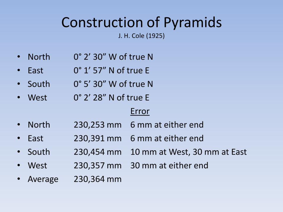
Construction of PyramidsJ. H. Cole (1925)
• North 0° 2’ 30” W of true N
• East 0° 1’ 57” N of true E
• South 0° 5’ 30” W of true N
• West 0° 2’ 28” N of true E
Error
• North 230,253 mm 6 mm at either end
• East 230,391 mm 6 mm at either end
• South 230,454 mm 10 mm at West, 30 mm at East
• West 230,357 mm 30 mm at either end
• Average 230,364 mm

DEFINITION OF SURVEYING
Surveying has been traditionally defined as the science and
art of determining the relative positions of points above, on, or beneath the surface of the earth, or establishing such points.

THE VERY EARLY DAYS OF SURVEYING
• 1400 B.C.
The Egyptians first used surveying to accurately divide land into plots for the purpose of taxation.
• 120 B.C.
Greeks developed the science of geometry and were using it for precise land division.
Greeks standardized procedures for conducting surveys.
Greeks developed the first piece of surveying equipment (Diopter).

THE EARLY DAYS OF SURVEYING
• 1800 A.D. Beginning of the industrial revolution.
The importance of "exact boundaries" and the demand for public improvements (i.e. railroads, canals, roads) brought surveying into a prominent position.
Science of Geodetic and Plane surveying were developed.
More accurate instruments were developed.
Compass: Capable or determining directions and rudimentary angles.
Transit: Capable of turning both horizontal and vertical angles and directions precisely.
Chain: Capable of measuring precise distances .


SURVEYING TODAY
• Today surveying affects most everything in our daily lives. A few of the areas where surveying is being used are:
• To map the earth above and below the sea.
• Prepare navigational maps (land, air, sea).
• Establish boundaries of public and private lands.
• Develop data bases for natural resource management.
• Development of engineering data for :
Bridge constructionRoadsBuildingsLand development

SURVEYING TODAY
• Equipment have become substantially more precise.• Total Station
Can measure angles to 1 second and distances to 3 mm + 3ppm
• GPS Receivers
Determine 3 dimensional positions to under 1 centimeter
• Laser Scanner
Can collect tens of thousands of positions to in fraction of time compared to traditional surveying methods with no reduction in accuracy.


THE TWO MAJOR METHODS OF SURVEYING
• GEODETIC SURVEYING
Takes into account the theoretical shape of the earth.Generally high in accuracy, and cover large areas.(greater than 300 sq. mi.).
• PLANE SURVEYING
Assumes that the survey area is a flat plane.Generally covers small areas (less than 300 sq. mi.).Most common method used.
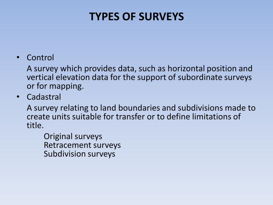
TYPES OF SURVEYS
• Control A survey which provides data, such as horizontal position and vertical elevation data for the support of subordinate surveys or for mapping.
• Cadastral A survey relating to land boundaries and subdivisions made to create units suitable for transfer or to define limitations of title.
Original surveysRetracement surveysSubdivision surveys

TYPES OF SURVEYS
• RouteA survey for the reconnaissance or to select the most feasible route for a highway, railroad, transmission line, or types of corridor facilities.
• ConstructionSurvey made to control the horizontal and vertical positions, dimensions, and configuration of a design.
• Topographic A survey which has for its major purpose the determination of the configuration of the surface of the earth and the location of natural and artificial objects thereon. (also an existing conditions survey)

DEFINITION OF SURVEYING
From MGL Chapter 112, Section 81D(Massachusetts Registration Laws):
"Practice of land surveying'', any service or work, the adequate performance
of which involves the application of special knowledge of the principles
of mathematics, the related physical and applied sciences, and the relevant
requirements of law for adequate evidence to the act of measuring and
locating lines, angles, elevations, natural and manmade features in the
air, on the surface of the earth, within underground workings, and on
the beds of bodies of water for the purpose of determining areas and
volumes, for the monumenting of property boundaries, for locating or
relocating any of the fixed works embraced within the practice of civil
engineering, and for the platting, and layout of lands and subdivisions
thereof, including the topography, alignment and grades of streets, and for
the preparation and perpetuation of maps, record plats, field note records
and property descriptions that represent these surveys.

MASSACHUSETTS GENERAL LAWSPertinent to Land Surveying
• Chapter 13 Division and Boards of Registration• Chapter 30a State Administrative Procedures• Chapter 40a Zoning• Chapter 42 Boundaries of Cities and Towns• Chapter 81 State Highways• Chapter 82 Public Ways• Chapter 91 Waterways• Chapter 97 Surveying of Land• Chapter 112 Registration of Certain Occupations • Chapter 183a Condominiums• Chapter 183:S58 Real Estate abutting a Monument• Chapter 185 Land Court• Chapter 266:S120C Entry upon adjoining lands*
* Private SurveyorsCounty Chapter 82 Section 11AState Chapter 81 Section 7F

MASSACHUSETTS BOARD OF REGISTRATION OF PROFESSIONAL ENGINEERS AND
LAND SURVEYOR• 250 CMR
• Advisory Rulings
Twenty year Candidate Policy
Unlicensed Practice
Subdivisions
Direct Charge and Supervision
Reinstatement Policy
Direct Charge and Supervision – Clarification
Multipage Documents
• Board Policies
Examination Failures
ABET Engineering Program Criteria

250 CMR 3.05
• (10) Land surveying work may be performed only by or under the direct supervision of a registered Land Surveyor qualified by the laws of the Commonwealth of Massachusetts to so practice except that a Professional Engineer registered as a Civil Engineer may perform land surveying incidental to engineering work excluding property line determination. Any plan which requires the location of a structure in relation to a real property boundary involves property line determination and must be performed by a Land Surveyor.

250 CMR 6.00Procedural and Technical Standards for the
Practice of Land Surveying
• 250 CMR 6.01 Cadastral, Original and Retracement Surveys
• 250 CMR 6.02 Data Accumulation Surveys
• 250 CMR 6.03 Construction Layout Services
• 250 CMR 6.04 Title Insurance Surveys
• 250 CMR 6.05 Mortgage Loan Inspections

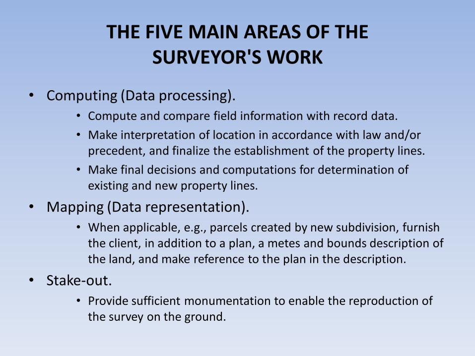
THE FIVE MAIN AREAS OF THE SURVEYOR'S WORK
• Research, analysis, and decision making. Research
• Obtain a legal description of property to be surveyed as well as a legal description of abutting properties.
• Obtain copies of recorded documents affecting the survey.
Analysis
• Examine thoroughly and analyze data.
• Test consistency of data by plotting and compiling available record information.
• Form preliminary conclusions as to the completeness of data and reconcile any inconsistencies in the record information.
Decision making
• Compute and compare field information with record data.
• Make interpretation of location in accordance with law and/or precedent, and finalize the establishment of the property lines.
• Make final decisions and computations for determination of existing and new property lines.

THE FIVE MAIN AREAS OF THE SURVEYOR'S WORK
• Field work (Data acquisition). • Search for physical monuments and weigh their reliability.
• Search for and locate monuments and area evidence which affect the survey.
• Investigate possible parole (oral) and written evidence supporting positions of obliterated control monuments and have affidavits taken if necessary.
• Make measurements to correlate all found evidence.
• Locate physical occupation lines (e.g., fences, hedges, walls, etc.) between adjoiners; make comments on possible age of possession; verify age by parole and written evidence.
THE FIVE MAIN AREAS OF THE SURVEYOR'S WORK
• Computing (Data processing). • Compute and compare field information with record data.
• Make interpretation of location in accordance with law and/or precedent, and finalize the establishment of the property lines.
• Make final decisions and computations for determination of existing and new property lines.
• Mapping (Data representation).• When applicable, e.g., parcels created by new subdivision, furnish
the client, in addition to a plan, a metes and bounds description of the land, and make reference to the plan in the description.
• Stake-out.• Provide sufficient monumentation to enable the reproduction of
the survey on the ground.

• Version of Software: Towns that do not keep current with software releases. Current Autodesk software is incompatible with “save as” to older versions of software. Contour and point objects especially.
• LandXML?
• What’s wrong with an ascii file of x-y
point,Northing,Easting,elev,desc,Attribute1,
Attribute2,Attribute3,Attribute4,Attribute5,
Attribute6,Attribute7,Attribute8,Attribute9,
Attribute10

• What is NAD83?
I can configure my dual frequency receiver three ways to receive NAD83.
Static Mode mm (0.001M) precision
CDMA Modem cm (0.01M) precision
Beacon Correction M (1 M) precision
• Which NAD83? What adjustment?
CORS
HARN
1996
1992
1983

• NAVD88? Leveled benchmark (benchmark derived through traditional leveling techniques)
GPS positioned (benchmark derived through GPS observation and the application of a gravity model (geoid)

• Setting Standard
What authority does a town have to set a survey standard that is in conflict with state regulations?
Requiring standards that conflict 250 CMR versus Land Court.
Connecting to control that is quickly disappearing.
Technical vs. Goal Standards
Professional should not be told how to do work
Goal allows for advances in technology
Goal allows for flexibility
Goal protects professional from liability
Related Documents