EASTERN AFRICA Les poissons sont abondants et le stock d'espèces est très proche de celui du lac Abaya. Les espèces dominantes sont Lates niloticus et Bagrus docmac. Les crocodiles sont très nombreux, les hippopotames plus rares. Actuellement, l'exploitation du lac se limite à la pêche artisanale de la Perche du Nil. La productivité du lac en poissons n'a pas été estimée mais il est probable qu'elle est suffisamment élevée pour que la pêche commercialisée soit envisageable. 6.2 THE GREGORY RIFT by Mary J. SURGIS and K.K. KAVUTI The eastern branch of the Great Rift Valley continues South through Kenya and Tanzania as the Gregory Rift. In contrast to the Western Rift, whose lakes drain either to the Nile or to the Zaïre, the lakes of the Gregory Rift are almost all endorheic and many of them are highly saline. Apart from Lake Turkana, which is not considered here, the most intensively studied are the freshwater Lake Naivasha and the saline L. Nakuru: they are treated separately. Information available on the other major lakes is swmiarised in section 6.2.c. and Geography: The formation of the Rift Valleys and the history of the present lake basins is thought to have started towards the end of the Kiocene, some twenty million years ago. The Rift Valleys eut through the crystalline Precambrian rocks of the central African tableland which, over rnuch of the region, are overlain by shallow Cenozoic volcanics and other sedimentary deposits. The escarpments are sti 11 very obvious and the Valley floor lies Up to 500m belOW the general level Of the plateaux on either si de. In places the elevation of the escarpments is increased by the associated mountain ranges such as the Aberdares in Kenya and the Crater Highlands of Tanzania. There is much evidence of past volcanic activity: numerous extinct volcanoes are evident both in and along the edges of the Rift Valley while many of the lakes receive water from hot soda springs. 6. 2 • a. L.llE NAIVASHA Lake Naivasha <Fig. 6.6) is unusual among the lakes of the Gregory Rift in that, despite the fact that it lies in a closed basin, its water is fresh. It bas been intensively studied over the years by a number of limnologists and the information presented here cornes primarily from Li tterick et al <1979) summarises information from an extensive li terature but particularly from Kelack <1976, 1979) and the papers of Gaudet Ceg. 1977, 1978b), Gaudet and Kelack (1981), Mavuti and Litterick (1981) and Mavuti (1983). 1. Geography and Morphology Location: In the Central Rift Valley Province of Kenya c80krn by road from Nairobi; 0°4S'N, 36°20'E. Alt!._tude: 1889m asl; lake level variable± O.Sm annually. 331

Welcome message from author
This document is posted to help you gain knowledge. Please leave a comment to let me know what you think about it! Share it to your friends and learn new things together.
Transcript

EASTERN AFRICA
Les poissons sont abondants et le stock d'espèces est très proche de celui du lac Abaya. Les espèces dominantes sont Lates niloticus et Bagrus docmac.
Les crocodiles sont très nombreux, les hippopotames plus rares. Actuellement, l'exploitation du lac se limite à la pêche artisanale de la Perche du Nil. La productivité du lac en poissons n'a pas été estimée mais il est probable qu'elle est suffisamment élevée pour que la pêche commercialisée soit envisageable.
6.2 THE GREGORY RIFT
by Mary J. SURGIS and K.K. KAVUTI
The eastern branch of the Great Rift Valley continues South through Kenya and Tanzania as the Gregory Rift. In contrast to the Western Rift, whose lakes drain either to the Nile or to the Zaïre, the lakes of the Gregory Rift are almost all endorheic and many of them are highly saline. Apart from Lake Turkana, which is not considered here, the most intensively studied are the freshwater Lake Naivasha and the saline L. Nakuru: they are treated separately. Information available on the other major lakes is swmiarised in section 6.2.c.
Geolo~y and Geography: The formation of the Rift Valleys and the history of the present lake basins is thought to have started towards the end of the Kiocene, some twenty million years ago. The Rift Valleys eut through the crystalline Precambrian rocks of the central African tableland which, over rnuch of the region, are overlain by shallow Cenozoic volcanics and other sedimentary deposits. The escarpments are sti 11 very obvious and the Valley floor lies Up to 500m belOW the general level Of the plateaux on either si de. In places the elevation of the escarpments is increased by the associated mountain ranges such as the Aberdares in Kenya and the Crater Highlands of Tanzania. There is much evidence of past volcanic activity: numerous extinct volcanoes are evident both in and along the edges of the Rift Valley while many of the lakes receive water from hot soda springs.
6. 2 • a. L.llE NAIVASHA
Lake Naivasha <Fig. 6.6) is unusual among the lakes of the Gregory Rift in that, despite the fact that it lies in a closed basin, its water is fresh. It bas been intensively studied over the years by a number of limnologists and the information presented here cornes primarily from Li tterick et al <1979) whic~ summarises information from an extensive li terature but particularly from Kelack <1976, 1979) and the papers of Gaudet Ceg. 1977, 1978b), Gaudet and Kelack (1981), Mavuti and Litterick (1981) and Mavuti (1983).
1. Geography and Morphology
Location: In the Central Rift Valley Province of Kenya c80krn by road from Nairobi; 0°4S'N, 36°20'E.
Alt!._tude: 1889m asl; lake level variable± O.Sm annually.
331

AFRIQUE ORIENTALE
0'15'
0
0'30'
332
36' 15' 36' 30'
N
\ 2840m coniour
Bathymetflc contour (metresi
kilometres 20
36'1 s· 36•30'
Fig. 6.6 Map of Lake Naivasha and its catchment area <redrawn after Gaudet and Melack 1981).
0'30'
3908m
(F45·
EASTERN AFRICA
Landscapes: To the E. the Aberdare Range and the Kinangop Plateau; to the W. the Mau Escarpment; the Eburu Hills to the N. partially separate Naivasha from the Nakuru and Elmenteita basins. The Rift Valley floor in this region is still volcanically active and Mount Longonot, with several smaller volcanoes, forms a partial barrier to the S. which is breached by the Njorowa Gorge.
Morphometry: The Naivasha basin contains four morphometrically distinct water bodies: the main lake comprises >90~ of the total, Cresent Island Crater C the rim of an extinct volcano> and Oloidien Lake are contiguous with the main lake but the distinctiveness of the latter depends on the level of the main lake. Lake Sonachi is a small, isolated crater lake close to the western shore of the main lake.
Area of the drainage basin 2378 km2 Area of the system C including Oloidien and Cresent Island craters> cl50km2 but very variable as shown in the table.
Area km2 1973 1979
open water Haivasha Cmain lake) 115 150 Cresent Is. Crater 2.1 2.1 Oloidien 5.5 5.6
Maximum depth 1973 1979
7.3 10.0 17 17 8.4 9.0
m Mean depth m 1973 1979
4.6 6.5 11.1 11.0
4.8 5.6
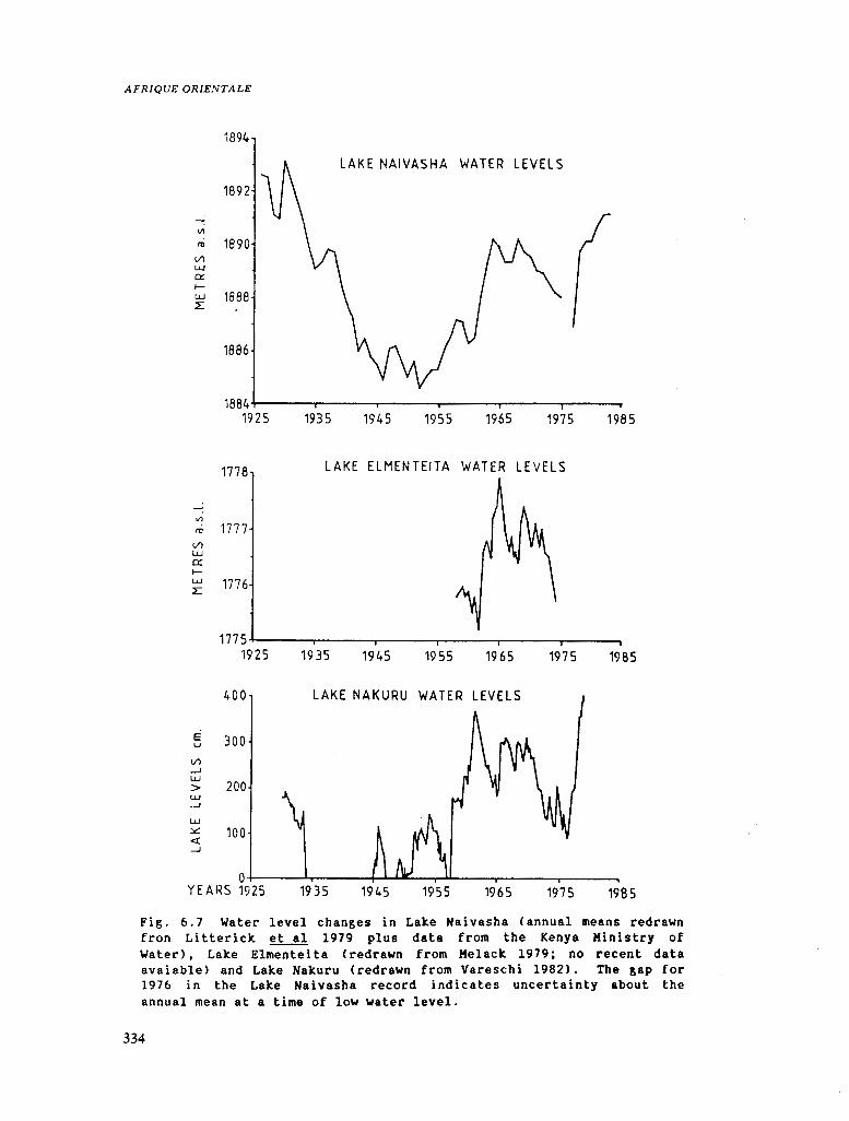
Depth: The depth is also very variable and undergoes seasonal fluctuations of c+-0.Sm and much longer term fluctuations of up to Sm CFig.6.7>. The lake is thought to have dried up completely at least once in the last 300 years.
2. Geology
The geological history of the L. Naivasha basin has been discussed by Richardson and Richardson (1972). Lakes Naivasha, Elmenteita and Nakuru were all once part of a much larger lake which, from about 12,800 BP to 5,700 BP filled the basin and overflowed via Njorowa Gorge. After this the lake levels fell abruptly and about 4,200 BP reached their present levels. Before this there was at least one totally dry period of about 100 years and the lake may now be at its highest level for the last 3000 years.
3. Climate
~ Bsfb Koppen
Total solar radiation: Monthly means varied from 568.5 x 10⁴Jtm2/d to 2608.3 x 104J/m2/d with the maximum in January - February and minimum in July - August.
Wind: Light breezes in the morning CS. 5km/h at 0900h); stronger in the afternoon; 11 -15km/h typical; not much seasonal variation; prevailing direction usually South.
~ainfall: The pattern climatic diagram CFig.
of rainfall at Naivasha is shown in the 6. 8 >. There are two wet and two dry seasons
333
AFRIQUE ORIENTALE
1894
LAKE NAIVASHA WATER LEVELS
1892
<Il
l'tl 1890 Vl LU 0:: f-LU 1888 :L
1886
1884+-~~-..-~~-.-~~--..--~~-.--~~--~~-
Vl LW 0:: 1-1.!.J
L:
192 5
1778
1777
1776
1935 1945 1955 1965 1975 1985
LAKE ELMENTEITA WATER LEVELS
1775.,_~~~~~-.-~~-.-~~--r~~---,.--~--.
1925 19 35 1945 1955 19 65
400 LAKE NAKURU WATER LEVELS
E u
Vl -' LW
300
> 200 LU _J
LU
::.::: 100 <( _,J
1935 1945 1955 1965
1975 1985
1975 1985
Fig. 6.7 Water level changes in Lake Naivasba (annual means redrawn fron Litterick et al 1979 plus data from the Kenya Hinistry of Water), Lake Elmenteita <redrawn from Melack 1979; no recent data avaiable> and Lake Nakuru <redrawn from Vareschi 1982). The gap for 1976 in the Lake Naivasha record indicates uncertainty about the annual mean at a time of low water level.
334

so· NAIVASHA (1900m) m: [18.31.J 17.4' 588
40'
30' -155'
[ 100mm
80mm
GO mm
20. h1111lœ!Illl1fJlllJJlllh,l".""""'-flllW1U.llliJJllilll 40mm
10• 20mm
11.4' 2.r0' J A s 0 N 0 J F M A M J Omm
50' AGADI SODA CO. [1,47)
376' 40'
30' •11.9"
20'
100mm
eomm
60mm
40mm
10•
20.3'
· 20mm
o•== ........ ~~~~~~~~.J.
30' -124'
20·
10'
17.1'
Omm
200mm
100mm
80mm
60mm
4Qmm
20mm
14.2 O' J F M A M J J A S 0 N D Omm
60' 33 9• 29 2'
50'
40'
30' -16 3'
20'
10'
8.8'
NAKU~U 11836 "') 181' 877 l 14,37)
1
1 :1 li
33P' J A S 0 N D J F M A
KISUMU (1149ml 233' l 71
50' 369' 31.1'
40'
30'
-122·
20'
10'
161'
12.4' 0 ' J A S 0 N D J F M AM
"T'"" !1313 m) 2\0' 10% m: [14,0)
50'
40'
30'
EASTERN AFRICA
200mm
80mm
60mm
40mm
20mm
Omm
200mm
100mm
80mm
60mm
/ 40mm
,__ ........ ~~~~~~~~_,__Jf :::m A S 0 N D J F M A M J
KASESE, UGANDA 23 3'998 60' [4,4) :91S5ml
36 o· 28 9' w l
lDOmm
100mm .
40' ~80mm
30' f GO mm -l 3 s· 1--f-llJJ.UJ.:J.lJ.lUW.ilillJ.JjllllliJUJllillillillLr
20* · J..:)rnm
1 se· ! 1w o· .!FMt.~-MJJ A.~s··oN-oorr·m
Fig. 6.8 Climatic diagrams for representative stations in Kenya, Uganda and Rwanda. Redrawn after Walter and Lieth Cl960 - 67) with the exception of those for Magadi and Kasese which have been constructed from records of the East African Meteorological Department in the library of the U.K. Meteorological Office
335

AFRIQUE ORIENTALE
per year with maximum rainfall usually in April and minimum in January. The mean annual total is higher in the catchment than on the lake eg. 693-836mm (1973-75) in the Kalewa watershed.
Evaporation: monthly means of relative humidity at lSOOh range from 22~ in January to 107~ in April.
Air temperature: Monthly means vary from 15.9 - 18.5°C (Fig. 6.8); July bas the coolest means and the least range; January and February have the warmest means but the greatest range of temperatures. Daytime temperatures can reach 30°C.
4. Hydrograpby and Hydrology
The Malewa River with a catchment area of 1730 km2 provides 9~ of the inflow; the Gilgil Ccatchment area 420 km2) is frequently dry before reaching the lake its flow having been diverted for irrigation etc. Both these rivers enter the lake tbrough the North Swamp. Flow in the Karati only reaches the lake during December to February.
Groundwater seepage along the NE and NW shores provided 13 - 16~ of the inflow in 1973 - 75.
Water balance for Naivasha main lake from Gaudet and Melack Cl981)
m3 X 106 1973 1974 1975
Surface run-off 0.6 o. 7 0." River discharge 90.8 204.0 260.5 Rainfall 106.l 114.2 77 .l See page in 37.0 42.3 50.8
Total input 234.5 361. 2 388.8
Evapotranspiration 14.3 13.2 13.3 Lake evaporation 309.5 276.0 278.2 Seepage out 17.6 36.6 78.3 Irrigation off-take 348.4 339.8 384.8
Change in storage -113.9 +21." +4 .o <calculated by balance> Change in storage -113. 9 +21.4 +4.0 Ccalculated from level change>
The lake bas no surface outflow. A subterranean outflow bas been suspected for a longtime <Beadle 1932) but to date it bas never been confirmed.
S. Pbysico-chemlcal cbaracteristlcs of the water
336
Temperature: surface annual range 18 - 26.5°C Bottom annual range 19 - 21.5°C
The highest temperatures recorded by Melaclc. <1979) during bis study

EASTERN AFRICA
were, Oloidien 26.7°C, Naivasha 23.3°C and Cresent Island Crater 23.3°C; these were taken during the mornings and may have been exceeded la ter in the day. In 1978-79 temperatures of 24 - 2S. s0 c were recorded in some early afternoons c.1300h.
Transparency: secchi dise values Melack 1979 Mavuti 1978-80
E!!_:
Cresent Is Crater Naivasha Main Lake Oloidien
3.7 - S.7m 1.0 - 1. Sm O.S - 1.0m
O. S - 2. Sm
Naivasha main lake Oloidien
mean 8.S mean 9.2 mean 8.4
max. 9.1 min. 8.4
Cresent Is Crater
Conductivity: Naivasha 311 - 3S3.10-6s.cm-l 389 - 438 Cresent Is Crater
Oloidien 768 -- 892
Total dissolved solids/ salinity: range 229 - 7SO mg/l from 1919 -1974 CMelack 1979)
Alkalinity: 126 - 194 mg caco311itre
Major ions: as recorded for the main lake: Author Kilham and Hecky C1973) Gaudet and Melack (1981)
Date of sampleCs> July 1969 n = 21 1973-7S
Na K Ca Mg HC03 C03 S04 Cl F Si02
mg/l mg/l 24. 2 40 12. 3 20 16. 2 21
S.3 6.4
S.2 6.9 0.9S
24.6
192 10.6 6.2
14 1. s
34
Phosphorous: surface samples Po4-P 10-6g/l: Naivasha Cresent Is Oloidien
<7 - 10 60 - 100 13 - 70
Oxygen: 6-9mg/l in the mainlake. Lowest oxygen concentrations recorded by Kelack C1979) between Karch 1973 and February 1974 Cn=ll) were near the bottom of the water column and ranged from 79 - 99~ saturation between 10.00 - 13.00h. In Cresent Island Crater as low as S~ was recorded and in Oloidien the concentration reached 14~ at Sm depth in December 1973; this is lmg/l. Kixing regime: the lake is holo-polymictic; however stratification occurs in all three water masses on most days during mid-morning but only persists for a few hours. Slightly more prolonged Ca few days at most> stratification may occur in calm periods, particularly in the deeper water of Cresent Island Crater. Normally, however, the main lake is well mixed throughout and well oxygenated even in Cresent Island Crater, which is the deepest and most sheltered part of the lake.
337
AFRIQUE ORIENTALE
6. !!acropbytes
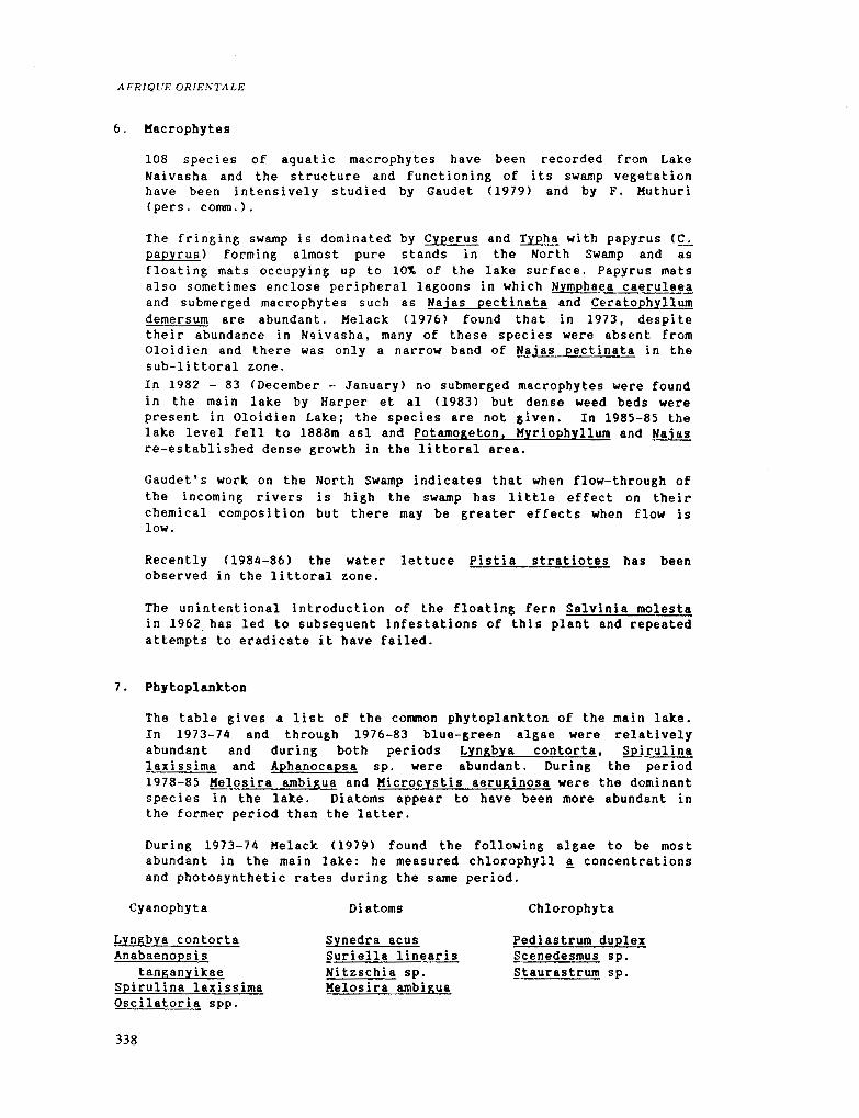
108 species of aquatic macrophytes have been recorded from Lake Naivasha and the structure and functioning of its swamp vegetation have been intensively studied by Gaudet (1979) and by 1''. Muthuri (pers. comm.).
The fringing swa.mp is dominated by Cyperus and Typha with papyrus (~ papyrus) forming almost pure stands in the North swa.mp and as floating mats occupying up to 10~ of the lake surface. Papyrus mats also sometimes enclose peripheral lagoons in which Nymphaea caerulaea and submerged macrophytes such as Najas pectinata and Ceratophyllum demersum are abundant. Melack (1976) found that in 1973, despite their abundance in N'livasha, many of these species were absent from Oloidien and there was only a narrow band of Najas pectinata in the sub-littoral zone. In 1982 - 83 <December - January> no submerged macrophytes were found in the main lake by Harper et al Cl983) but dense weed beds were present in Oloidien Lake; the species are not given. In 1985-85 the lake level fell to 1888m asl and Potamogeton, Myriophyllum and Najas re-established dense growth in the littoral area.
Gaudet's work on the North Swa.mp indicates that when flow-through of the incoming rivers is high the swamp bas little effect on their chemical composition but there may be greater effects when flow is low.
Recently (1984-86) the water lettuce Pistia stratiotes bas been observed in the littoral zone.
The unintentional introduction of the floating fern Salvinia molesta in 1962. has led to subsequent infestations of this plant and repeated attempts to eradicate it have failed.
7. Phytoplankton
The table gives a list of the common phytoplankton of the main lake. In 1973-74 and through 1976-83 blue-green algae were relatively abundant and during both periods Lyngbya contorta, Spirulina laxissima and Aphanocapsa sp. were abundant. During the period 1978-85 Melosira ambigua and Microcystis aeruginosa were the dominant species in the lake. Diatoms appear to have been more abundant in the former period than the latter.
During 1973-74 Helack (1979) found the following algae to be most abundant in the main lake: be measured chlorophyll ~ concentrations and photosynthetic rates during the same period.
Cyanophyta Dia toms Chlorophyta
Lyngbya contorta Anabaenopsis
tanganyikae Spirulina laxissima Oscilatoria spp.
338
synedra acus Suriella linearis Nitzschia sp. Melosira ambigua
Pediastrum duplex §cenedesmus sp. Staurastrum sp.

Kicrocystis sp. Aphanocapsa delicatissima Kerismopedia sp Chroococcus sp.
EASTERN AFRICA
Chlorophyll a 20cm below the surface rng/m3 n
Naivasha main lake 10 - 17 4 Oloidien 42 - 53 2 Cresent Is. Crater 2 5 2
Photosynthes i s: photosyntheti c rates were at thei r maximum j ust below the surface.
Amax total A daily A n mgo21m3 .h mgo21m2.h mgo21m2 .day
Naivasha main lake 11 150 - 240 340 570 3.7 - 6.2 Oloidien 10 260 750 390 -1120 4.2 -12.l Cresent Is. Crater 5 50 - 180 280 - 780 3.0 - 8.4
Bacteria: In January 1980 Kilham (1981) found 3.7 +-0.4 x10⁶ bacteria/ml at lm in Lake Naivasba water, which is a similar order of magnitude to concentrations found in freshwater lakes in other parts of the world. This is a lower concentration than he found in two saline lakes of the Rift Valley.
8. Invertebrates
During 1978-80 the limnetic zooplankton of the main lake was dominated by 4 species Thermocyclops (schurmannae) oblongatus, Diaph.anosoma exci sum, Brachionus caudatus and B. calyciflorus. Twenty-one other species were recorded of which Kesocyclops equatorialis (leuckarti> occurred throughout the year in low numbers and Simocephalus vetulus and Daphnia laevis occurred occasionally in large numbers. Pejler (1974) lists 11 species of Rotifera from L. Haivasha during 1967 -68 including B. caudatus and B. calyciflorus. More recently, Kavuti (1983> lists 3 species of Copeopoda, 11 species of Cladocera and 13 species of Rotifera. Daphnia pulex was introduced înto the lake in May 1981 in the hope of providing additional food for tilipia juveniles in the littoral area.
Beth numbers and biomass bave two peaks during the rainy seasons. Annual mean biomass for 1978-79 was 220 mg(dw}m3 <Havuti and Litterick 1981) and 435 mg Cdw)/m3 for 1979-80 <Mavuti 1983). There is some evidence of seasonal succession among the Cladocera as recorded by Havuti (1983).
Other invertebrates include the introduced North American crayfish ?rocambarus clarkii which bas successfully adapted to its new environment and now forms the basis of a commercial enterprise but has al so caused cons i derable damage to the fi sh i ng indus try. The ecology of this crayfish has been studied by Oluoch Cl983). Little is known about the benthos of L. Naivasha.
9. Fisb
The only species of fish indigenous to L. Naivasha is
339

AFRIQUE ORJEXTAJ,E
Aplocheilichthys antinori i which bas not been recorded for a number of years. Sarotherodon <=Tilapia) nigra was introduced in 1925 and bas since formed a hybrid with the accidentally introduced ~ leucosticta, which has displaced it as the main component of the commercial fishery. S. nigra has not been recorded since 1971.
was introduced in 1956 and has survived but T. nilotica only survived from 1965 69. The American large-mouthed bass CKicropterus salmoides) was introduced in 1929 and again in 1951 as a sport fish and bas thdved in the lake. At present this species forms 20'1. of the catch in the lake fishery whose mainstay is tilapia.
10. Other vertebrates
The introductions of fish have encouraged fish-eating birds. Of the 350 bird species recorded in the catchment area about 60 -80 are primarily aquatic at some time of the year <Lincer et al 1981). The dominant fish-eating birds are the white necked cormorant Phalacrocorax carbo, the great whi.te pelican Pelecanus onocrotalus, the malachite kingfisher Corythornis cristata and the fish eagle Haliaeetus vocifer. There are a number of hippopotamus CHippopotamus amphibius) in the lake and some unconfirmed reports of crocodiles CCrocodylus niloticus>.
11. Hwnan activities and management
The town of Naivasha is only l-2km from the lake and the lake itself is a popular tourist area with a number of hotels on the eastern shore. Much of the drainage basin is used as ranchland but close to the ~ake the growi ng of vegetables and flowers i s very important. Lucerne is irrigated to give ten crops per year as the basis of an intensive dairy industry. In recent years (1980-85) irrigated agricultural activities have more than doubled.
Commercial fishing started in 1959 and was initially based on Sarotherodon nigra but by 1962 this species had been replaced by ~ leucostictus and the hybrid mentioned above, which now forms more than 57~ of the catch. Sport fishing is popular and boats are available from the tourist hotels.
The introduced crayfish has been exploited since 1975 and today it forms a lucrative foreign exchange earner from exports to Europe.
6.2.b LAKE NAKURU
This is the most intensively studied of the alkaline lakes in the Gregory Rift and, except where indicated, the information that follows has been taken from the papers of Vareschi (1978, 1979, 1982), Vareschi and Jacobs (1984), and Vareschi and Vareschi (1984). The lake water is too alkaline for most aquatic organisms and therefore contains only a few species but many of these occur in great numbers.
1. Geology
The present lake basin is thought to be about 3000 years old
340
EASTERN AFRICA
(Richardson and Richardson 1972) and the remnant of a much larger lake of the Upper Pleistocene. The floor of the Rift Valley around Lake Nakuru is a Tertiary-Quarternary volcanic suite with associated alkaline sediments CMcCall 1967).
2. CliJnate
Type BSfa (Koppen>: see Fig. 6.8 for Nakuru.
Total solar radiation: in 1973 2148 +-380 J/cm2/d CMelack 1976): month of maximum January <550), month of minimum November (455) and April (458).
Wind: strength 0 6 mis; monthly means (1934-55) 3.7 - 5.5 km/h at 0900h, 11 20.4 km/h at 1500h: strongest in late afternoon; seasonally strongest December February; lowest June July; prevailing direction from N except May - August, SE.
Rainfall: Mean annual total 876 +-143 sd mm/y 0947-77); month of maximum April Cl28.2mm) and August Cll4.9mm); month of minimum January <24.Smm); two wet and two dry seasons per year.
Evaporation: about 1800mm/y
Air temperature: annual mean 18.18 +-0.8 sd °C 0931-55); March has the highest rnonthly mean 09.S"C) and the highest maximum (33.8°C); February the highest mean maximum C29.4°C). July and August have the lowest monthly means 07 .3°C) but January the lowest rnean minimum (8.7°C> and the lowest absolute minimum C3.3°C).
3. Geograpby and Horpbology (Fig. 6.9)
Location: In the Rift Valley Province of Kenya: 0°22•s; 36"05'E:
Altitude: 1759m asl: the level of the lake fluctuates.
Landscapes: The town of Nakuru lies immediately to the NW of the lake but is screened from the lake by dense Accacia woodland. Similar woodland alternates with grassland and alkaline mud-flats around most of the shoreline and extends away into the southern extension of the National Park. To the East and SW rocky hills corne close to the lake.
Area: of the drainage basin cl800km2 including the lake; the percentage occupied by open water is very variable c4xl07m2. Sorne data on the lakes morphometry at different water levels is shown in the table (from Vareschi 1982 Table 1) and illustrated in Fig.6.9:
Date
16 12 79 16 01 69 07 01 67 07 01 61
Level m
4.05 3.03 2.3 0.11
Max. Mean depth depth m m
4.50 3.58 3 .48 2.84 2.75 2.24 o. 56 0.36
surface volume shore are a li ne m2 .107 m3 107 m.104
4.9 17. s 3.25 4.5 12.8 3.14 4.3 9.6 2.88 3.6 1.2 2. 79
341

AFRIQUE ORIENTALE
0 2 km
From Varesch1119821
Fig. 6.9 Lake Nakuru, sbowing some recent examples of extreme water levels <redrawn from Varescbi 1982>. The boundary of the National Park is shown as a thick solid line; the stippling indicates rocky bills close to the lakeshore.
342
300 g(dw)/m3
If) If)
<{ 200 ~ .. . .i'\ . ., /' ~ 0 •• ·-.·. Ill)..
en ... ,_ "·\ '
.....J 100 j\;;1 !i \ 1\ • \ <{
(.'.)
' ' .....J <{
0 72 73 74 75 76
If) 30 E .... \ >- .:"'·-'\ I '. 1- , .
> I \ .. / •,. ! . -· ..
~ 20 u / \/ ~ / 0 z \/ 0 u 10
72 73 74 75 76
400 ml n/10 HCl/100 ml
>-1- 300 z .....J <{ ~
;i_ 20 0
100
i'/
·---· 72 73
::1 I .. ··- ........ a.
1
72 73
;\
!~ 1\ / ·1 / .' .. / ·'
/ \/ \ / _ _,,," . ../
74 75 76
. ....... ..... · ...... ····
1 1 1
74 75 76 YEARS 1972 - 78
77
77
77
1
77
EASTERN AFRICA
78 79
78 79
78 79
1 ' 78 79
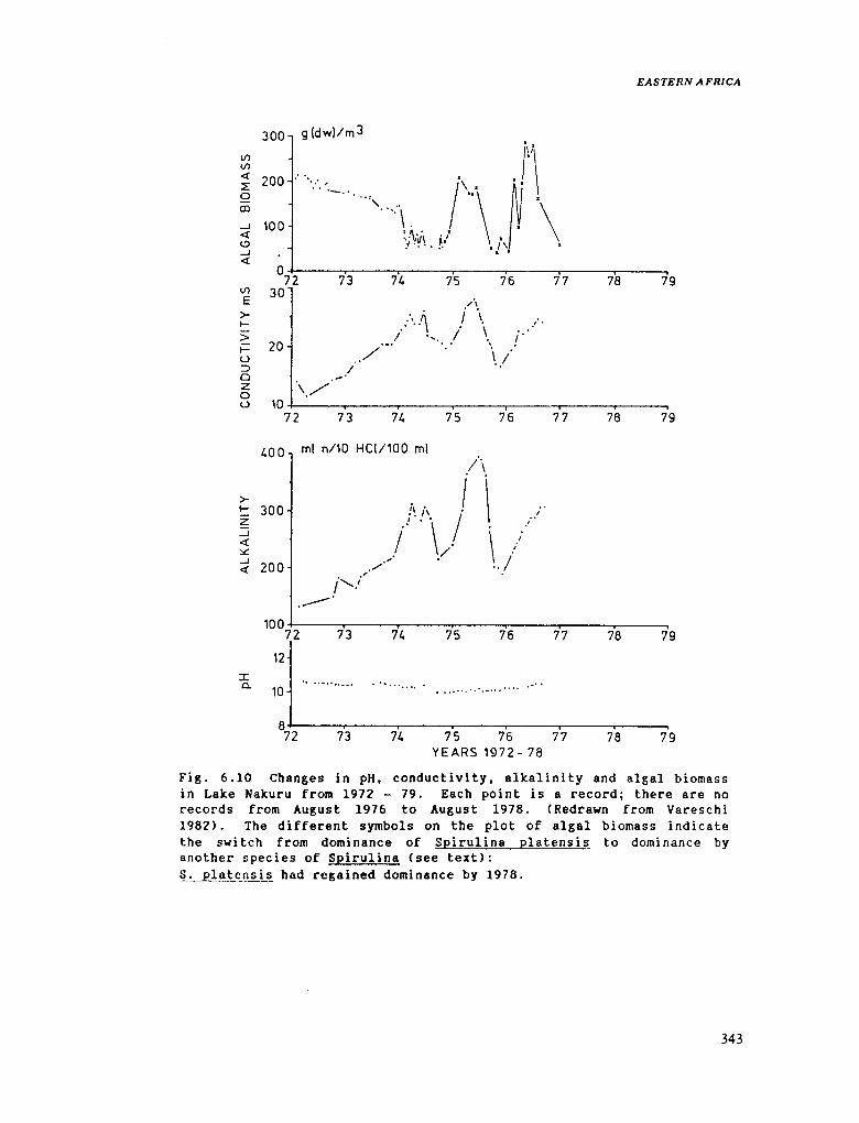
Fig. 6.10 Changes in pH, conductivity, alkalinity and algal biomass in Lake Nakuru from 1972 - 79. Each point is a record; there are no records from August 1976 to August 1978. CRedrawn from Vareschi 1982). The different symbols on the plot of algal biomass indicate the swi tch from dominance of Spi ru li na platens i s to dominance by another species of Spirulina Csee text>: S. platensis had regained dominance by 1978.
343

AFRIQUE ORJE,\'TALE
4. Hydrography and Hydrology
Inflows: The Njoro and Nderit Rivers are always perrenial; the Makalia is perrenial in most years and there are two other intermittant inflows. During the rains there is shoreline seepage and there are alkaline springs on the N, NE and E shores.
Outflow: none
Water balance: rain, plus inflowing rivers and springs versus evaporation: monthly rainfall minus evaporation agrees fai rly well with lake level changes with approximately three months time lag.
5. Physico-chemical characteristics of the water
Temperature: Surface maxima usually 25-27°C but occasionally 30-38°C; bottom temperature c20-21°C.
Transparency: Extinction coefficients Cin ln ml: max. 17.0, min. 12.1; mean 14.5 (1972-73>; 5.7, 3.8, 4.6 (1974).
fll!: cl0.5, no variation. Conductivity: extremely variable eg. 165,000 x lo-6s1cm <February 1961), 9,500 x10-6s1cm CDecember 1976).
Alkalinity: also very variable: 5,000 - 90,000 mg/l. For variation in pH, conductivity and alkalinity between 1969 & 1978 see Fig.6.10.
Major ions: <see Table 6.9) The chemical composition is homogeneous throughout the lake and the percentage composition did not change with change in conductivity: Na 96.4'1., K 3.51. of cations; Hco3 + co3 8~'1., Cl 11.6,.. of the anions.
Phosphorous: soluble ortho-phosphate ranged from 149 + - 53s. e. to 202 + - 35xlo-6g!l Cn = 19 stations) during 1972-3. Total phosphorous 9850 + - 1100 x io-6g/l <see Vareschi 1982 for discussion). During pelican breeding on Lake Elmentieta cl~ of total P is exported from Lake Nakuru where they feed, but this is not a regular event.
Oxy~en: During 1972-73 oxygen concentrations near the sediments were <lg/m3 for at least 6h each day. ·
Hixing regime: Daily circulation except in calm weather; usually weakly stratified during the night and mixed in early morning due to nocturnal cooling. on average well stratified for only about 3h in the afternoon; thermocline usually between 50-lOOcm.
6. !facropbytes
344
There are no aquatic macrophytes in the lake. cxperus laevigatus occurs at the edge and ~ sp by the freshwatel:' inflows. Kutilek <1974>, in a survey of the surrounding vegetation prior to the 1973

EASTERN AFRJCA
extension of the National Park, recognised six major vegetation types: alakline flats which are seasonally flooded, marsh which is flooded except in very long dry periods, grassland, rocky slopes, grass-shrub and Acacia woodland.
7. Pbytoplankton
In general dominated by Cyanobacteria: in 1970-71 and 1972-3 Spirulina platensis formed up to 98.5'1. of the population. It was usually homogeneous throughout the water column. Annual mean biomass may range f•om 58 0978-mean depth 253cm> to 194 0972-mean depth 310cm) g(dw>lm3; the maximum reco•ded was 215 g(dw)/m3. The annual mean for Chlorophyll ! ranged from 155 0978> to 1160 0972) mg/m3.
Occasionally diatoms and green algae form a substantial proportion of the biomass. Early in 1974 Cmean depth 162cm> the•e was a ma•ked change in species composi tien and decrease in the biomass of the phytoplankton <Fig. 6.10> coïncident with other. major changes in the communi ty st•uctu•e of the lake. At the end of 1976 the communi ty began to revert to its former condition.
Gross prima•y production of around 16g(dw)/m2.day was measured during the period of Spirulina dominance.
8. Invertebrates
The zooplankton is dominated by the calanoid copepod Lovenula C=Paradiaptomus) af•icana whose total mean biomass during 1972-73 was 1.5 gCdw)/m3. This species was absent from the lake from March 1974 to August 1976 Cexcept January to July 1976) when the conductivity presumably exceeded its limit of tolerance Csee Vareschi and Vareschi 1984 for discussion>. The population then started to recover but during 1978 the number of adults was only one tenth of that in 1972.
Five species of Rotifera were recorded during thi s period but the spec1es of Brachionus far outnumbered the others; B. dimidiatus occurred alongside Lovenula and B. plicatilis during the period of very high conductivity, when it was the dominant species in the zooplankton. Although the biomass of rotifers was very much lower than that of the copepods Cduring 1972-73) their production and consumption exceeded that of the copepods (see table below>.
Four species of aguatic Heteroptera (one notonectid and th•ee corixids) also occur in the lake but were absent during the period 1974-76. The benthic fauna consists of two species of chironomid larvae of which Leptochironomus de•ibae is the dominant.
Va•eschi and Vareschi (1984) and Vareschi and Jacobs (1984> provide a very detailed analysis and discussion of the numbers, biomass, growth and production of all these species and their roles in the Lake Nakuru ecosystem. Sorne indication of their •elative importance can be seen in the table below.
345

AFRIQUE ORIENTALE
Estimates of the biomass, production and consumption of the principal consumers in Lake Nakuru Cmeans for 1972-73); from Vareschi and Jacobs <1984).
Les sec- fish copepods ch ir'onomi ds pelicans rot if ers flamingos
Biomass kJ/m3 128 51 32 9 4
Pc-oduction kJ/m2/d <0.01 0.4 1. 5 0.7 0.03 1.]
Consumption kJlm3td 12.6 3.4 6.5 3.4 0.4 12.0
9. Fish:
There were no fish in Lake Nakuc-u until the Sac-otherodon alcalicus t!"._tihami <=Tilapia grahami) endemic to Lake Magadi was introduced in 1953 and 1959, and again in 1962 after the lake had dried up and reformed <Trevawas 1983). This species is tolerant of very high temperatures and salinity. It has established vec-y sucessfully in Lake Nakuru whec-e it grows up to 20cm Clargec- than in L. Magadi) and in 1972 and 1973 had an estimated biomass of 90 - 400 t(dw) respectively. It is a herbivore when adult, feeding on Spirulina pla ten sis in L. Nakuru, although the j uven iles are probably cai:-nivorous. It pt"ovides food for large numbers and vadety of fish eating birds whîch were unable to feed at L. Nakuru before the introduction. See Vareschi (1979) and Vareschi and Jacobs (1984) for extensive analysis of the biomass, distribution, consumption and role in the ecosystem of this species.
10. Other vertebrates
346
Lake Nakuru i s world famous for the spectacular concentrations of flamingos that gather to feed there, but they are only two of 433 bird species recorded in the vicinity of the lake, 119 of which depend on the lake itself or its inflows for their food.
The herbivorous lesser flamingo Phoeniconaias minor is more numerous than the greater flamingo Phoenicopterus ruber (the latter 1-ST. of the former). The numbers of lesser flamingo vary widely but have reached l. 5 million. They are the most important consumer on the lake, filterlng algae, primarily Spirulina platensis from the water. They also feed on other alkaline lakes in the Rift Valley and their only known, regular breeding ground in East Africa is Lake Natron. The last report of breeding at Nakuru was in 1915.
The greater flamingo feeds primarily on copepods and chironomid larvae sieved from the bottom mud and water immediately overlying it.
Fot'ty species of fish-eating birds have taken advantage of the introduction of fish to Lake Nakuru. Of these the great white pelican Pelecanus onocrotalus roseus, whose numbers ranged from 10,000 -

EASTERN AFRICA
35,000 in 1967-69 and from 1730 to >20,000 in 1972-74, contribute >901. of the biomass. They breed at Lake Elmenteita (see p.318). The white-necked cormorant (Phalacrocorax carbo) is second in biomass of the fish-eating birds and nests regularly at the mouth of the Njoro River.
There were about 15 hippopotamus (Hippopotamus amphibius> in the lake during 1972-74. They feed on the surrounding vegetation during the night and defaecate into the water during the day thus providing a nutrient input to the lake but this is unlikely to be significant compared with other sources, although the high fibre content of their faeces may locally influence the nature of the substrate.
The lake is the central feature of the Nakuru National Park but the surrounding terrestrial habitats contain a wide variety of large mammals. Recently the diversity of large mammals has been much reduced; Kutilek 0974) estimates that at least seven species of large herbivore Cincluding Masai giraffe, Giraffa c~~elopardilis,
eland Taurotragus oryx and zebra, Equus burchelli), and four species of carnivore Cincluding lion, Panthera leo, cheetah Acinonyx jubatus, and spotted hyaena, Crocuta crocuta) have been largely or completely eliminated from the area since the turn of the century. During a study done before the extension of the National Park in 1973 Kutilek 0974) showed that those which remain reach their greatest concentration in the grassland-woodland area to the South of the lake. In 1970-1 20 species were recorded of which sixteen were sufficiently frequent to be included in a calculation of total biomass. The mean density was 64.2 +-8.86sd per km2 and the biomass of the six major species Cwhich made up 923 of the total numbers> was 6298 +-801 kg/km2. These six included hippo, H. amphibius, and buffalo, Syncerus caffer, but Defassa waterbuck, Kobus defassa, accounted for 76~ of the biomass density; reedbuck, Redunca redunca, were also common.
11. ffuman activities and management
ffuman population: The township of Nakuru Cc60,000 people> and its expanding industrial area, corne within two kilometres of the lake. Towns occupy 53 of the catchment area, 353 is forest/bush and the rest· is used for agriculture evenly divided between cultivation and rangeland.
Development: The town is the main development in the area. Its domestic and industrial effluents are processed by two sewage works, one near the North shore of the lake and the other on the Njoro River.
~loitation: The lake and its National Park are a major attraction to tourists: vehicle tracks encircle the lake, there are two hotels overlooking the lake from the higher ground to the East and a campground near the Park HQ on the NW shore.
Disease and pest control: The fish were originally introduced to Lake Nakuru for mosquito control. Insecticides are extensively used for a variety of purposes within the catchment area but a survey by Lincer ~t al <1981) showed that although ODE residues tend to be higher in
347

AFRIQUE ORIENTALE
organisms at the top of the food chains, on the whole the levels found then were low in comparison with some published analyses from other parts of Africa.
Legislation/designation: Part of the lake bas been within a National Park since 1961 and the whole lake was included in 1964. In 1973 the Park area was increased to its present size (160km2) which is four times the area of the lake.
6.2.c. OIHER LAKES OF THE GREGORY RIFT, AND LAKE RUKWA
Except for Lakes Baringo, Naivasha and Kitangiri, all the lak.es on the floor of the Gregory Rift are highly alakline. Only Lakes Naivasha and Nakuru have been studied in great detail for an extended period, from a variety of aspects, so they have been treated separately (6.Z.a and b). Where possible the data that is available for the other lakes has been tabulated in a comparative manner to illustrate their similari ties and differences; only a brief account of the local geography and other features follow these tables. Lake Rukwa is included here because, although it lies in a separate rift, it bas many characteristics in common with the other lakes of the Gregory Rift.
1. Climate
348
Most of the se lakes are in areas of very arid cl imate such as that illustrated for Lake Kagadi (Fig. 6.8). There do not seem to be any recording stations on the floor of the Rift although there are a number in the adjacent highlands which have a rather less severe climate.
~: Afw4a Koppen
Rainfall: is very variable throughout the Rift Valley and from year to year. The mean annual total at 14 stations around Lake Rukwa from 1920-75 was c930mm per year CRogers 1982).

EASTERN AFRICA
2. Geography a.nd Morpbology
Table 6.6 Location and physical characteristics of some lakes in the Gregory Rift.
Lake Latitude Longitude Altitude Are a Max. depth C-Author> m asl lcm2 m
Baringo o• 37'N 36• 05'E 985 130 c7.5 Bogorla o· 16'N 36° 09'E 975 33 8.5
<Tuite '81) Nakuru o• 22'S 36° OS'E 1759 36-49 0.56-4.S
<Vareschi> Elmenteita o• 27'S 36° OS'E 1776 18 1. 9
<Melack & Kilha.m '74) Magadi l" 54'S 36° 16'E 579 95 0.6
CTuite '81> Natron 2" 39'S 36° OO'E 610 900 0.5
fTuite '81) Kanyara 3° 35'S 35° 50'E 960 413 3.7
<Melack & Kilham '74) Eyasi 3• 35'S 35• OO'E 1030 1000 usually
dry Kihngiri 4• 40'S 34° 15'E 800 105 <3
Chentongo '72) Rukwa -
s lake 8° oo•s 32" 30'E 820 756 2. 5-6.0
N lake 2300 <Richardson '68 Banister & Clarke '80)
3. Physico-chemical characteristics of the water
Except where indicated otherwise the following tables are compiled from Hecky and Kilham (1973), Kilham <1971 >, LeBarbara and Kilham (1974), Kelack (1976), Melack and Kilham C1974> and Talling and Talling <1965) as denoted by their initials.
Table 6. 7 Transparency of the water in some lakes of the Gregory Rift and Lake Rukuwa.
Baringo Elmenteit.a
Bogor la
Kan y ara Rukwa
Secchi dise m
<0.07 0.17
Wavelength nm date 650 545 495
vertical extinction coefficients in ln units per m
1976--77 7 9 30 030271
0.12-cl.O 070774 0.28 3173 0.43 8173
16 100 80 080869 0.06
author
Kallqvist 80 K & K M
M M M & K Richardson 68
349

AFRIQUE ORIENTALE
Table 6.8 Conductivity and pH of the water in sorne lakes of the Gregory Rift
lo-6s.cm-1 pH Dates AuthOI'." ----
Baringo 416 8.2-9.0 T & T Bogoria 72 ,000 3173 & 8173 H
35,700-80,000 9.8-10.3 Tuite 81 Nakuru 10,010 9.8 14/07/69 H & K Elmente-ita 43,800 24/02161 T & T
11, 700 9.4 23/07/69 M & K 15,000 03/02171 K 15,000-40,200 2172-8174 H
Magadi 27,900 160,000 2161 T & T
Many ara 8,610 9.2 M & K 94,000 T &. T
Eyasi 23,500 08/08/69 LeB & K 9.5 Hecky &
Kilham 73 Kitangiri 785 Welcomme 71 Rukwa-S lake 8.5-9.2 Banister and
Clarke 80 -N lake 5,120 1961 T & T
Table 6.9 The concentration of some major ions in some shallow lakes of the Gregory Rift Cmg/l except where indicated, gaps indicate no data given)
Lake Na K Ca Mg Si S04 Cl Alk Author
Baringo 126 15 22 2 15.8 110 36 336 Be ad le CHC03) Livingr;tone 63
Bogoria 14360 304 26 + 2011 31150 35,300 Beadle 32 <HC03}
Nakuru 3300 237 0.9 208 62 1020 121 ff & K meq/l
Elmenteita 3795 274 0 0 177 38 1982 107
K & K meq/l Kagadi 38000 537 <10 <30 250 2400 22600 1180
T & T meq/l Natron 3800 + + 850 3100 65000 2600
Gu est & Stevens in T & T meq/l Kanyal'."a 2507 0 1.4 0.9 8.6 230 1168 78
M & K meq/l Eyasi 6900 9.3 3.0 1. 9 18 830 6620 116
H & K Stoffers 75 66000 121 5 7 6612 58350 10129
Kitangiri 155 4.8 24.l 6.7 34.5 34 64 6.6 T & T meq/l
Rukwa-N lake 1140 85 <l <l 115 165 383 53.5 T & T
350

EASTERN AFRICA
Table 6.10 Sorne data for phospborus concentrations in some lakes of the Gregory Rift and Lake Rukwa
po4_p total P author
Baringo 0.96 mg/l Be ad le 1932 Elmenteita 3.0 mg/l H & K Hagadi 11,000 mg/l T & T Natron 290,000 mg/l Guest & Stevens
in T & T Many ara 6.5 mg/l M & K Kitangiri T & T Eyasi 86 mg/l Hecky & Kilham 73 Rukwa-N lake 4, 500 mg/l T & T
Bacteria: In January 1980 Kilham (1981) found very high concentrations of bacteria in the waters of Lakes Elmentei ta and Bogoria. In the latter, at lm depth they numbered 3.5 x 10⁷ bacteria per ml and in Elmenteita from 0 -1.S m they ranged from 3.5 - 3.6 x 10⁸ bacteria per ml.
Lake Baringo
1. GeographJ and Morphology
Lake· Baringo lies on the valley floor in the Rift Valley Province of Kenya, about 2Skm north of Lake Bogoria. The surrounding country is dry thorn bush and much of the SW and SE shores at"e rock.y and unvegetated. There is a large swamp at the southern end of the lake, dominated by cyperus papyrus accompanied by Pistia stratiotes and water lilies. There ls one large island, 01 Kokwa, and a nurnber of islets in the lake.
2. ffydrograpbJ and ffydrology
The Molo Ri ver and 01 Arabel enter the lake from the S and the Tangulbei River from the E. On 01 Kokwa there are a number of hot mineral springs which drain into the lake <Copley 1948).
3. Flora and Fauna
Cyanobacteria dominate the phytoplankton, particularly Kicrocystis !.!F.Uginosa and Anabaena circinalis CKallgvist 1980). Kallqvist also gives a photosynthetic rate of 0.3-1.0g o21m2/day.
Pejler (1974> recorded seven species of Rotifera from a visit in 1968; these included Brachionus calyciflorus and Keratella tropica. Lowndes <1936) records five species of Cladocera and three of Copepoda from samples taken by the Cambridge Expedition in 1931.
351

AFRIQUE ORIENTALE
According to Lincer et al ( 1981 > the dominant species of fisn are Labeo cylindl'."icus, Ch.rias mossambicus, Bal."bus grego!:'Î a.nd Sarotherodon niloticus.
About 300 species of birds have been recorded in the lake basin, including 35 breeding pairs of fish eagles <Haliaeetus vocifer). The most common fish eating birds are darters <Anhinga ruf~) and herons, including the goliath heron (Ardea goliath> and the nlght heron (Nvcticorax nvcticorax).
4. Hwnan activities and management
About 101. of the catchment area is cultivated, 60'1 is rangeland and 303 forest/bush: there are no towns. "Excessive erosion in the catchment over the last half-century has resulted in serious siltation, affecting the penetration of light, the quality of the lake bottom, and conseguently the aguatic plant life." <Lincer et al 1981). îhese authors found relatively low organochlorine residues in the material (vegetation, zooplank.ton, fish, fish-eating birds, Amphibia and a hippo> that they sampled from Lake Baringo.
The fishery on Lake Baringo is of increasing importance and is being developed. In 1965 the total annual catch was about 600 t <Welcome 1971> and W'elcomme gives an estimated maximum sustainable yield of 1500tly. In the 1970s yields were much lower but have recently increased (see table):
Annual fish catch by species ft'om Lake Badngo, 1976-81 (metric tonnes) CMavuti pers. comm.>
Year Sarotherodon Bat'bus Clal"i as Local Total consumption
1976 221 22 15 7 265 1977 223 9 13 37 282 1978 295 8 12 315 1979 296 18 12 11 337
1981 203 133 40 376 1982 401
There is a fish .<tilapia) filleting factory on the southern part of the lake. Lake Baringo is now on one of the regular tourist circuits: there is an hotel on the western shore catering for more than 50 tourists daily.
Lake Bogoria Cformet'ly L. Hannington>
1. Geography and Morphology
352
An area of 9.S x 108/m2 drains into this closed basin. The area of the la.ke and the depth of its water vary greatly. The length of the shoreline is approximately 3. 7 x 10⁴m. A slow flowing stream

EASTERN AFRJCA
enters the lake at the N. end. The water has a temperature of about 24°C and there are hot springs, geysers and fumaroles along the lakesbore.
2. Pbytoplankton
Melack (1976> visited the lake in March and August 1973. On the first occasion the phytoplankton was an almost unialgal bloom of Spirulina platensis but in August nannoplankton species dominated and no h platensis was found. Cblorophyll !. concenti:-ation had decreased but the conductivity Csee table below) and photosynthetic rates were similar: the ranges given for the latter in the table below are for incubations at different depths.
Date
3173 8/73
Chlorphyll !. mg/m3
c.800 150
There are no fish in L. Bogoria.
3. Birds
640 - 1550 650 1650
280 - 840 430 - 780
In 1953 Brown estimated 2 million flamingos feeding in the lake but these numbers fluctuate as the birds move between the numerous alkaline lakes of the Rift Valley <Tuite 1979).
La.Jte Elmenteita
1. Geography and Morphology
Lake. Elmentei ta is in the Rift Valley Province of Kenya between L. Nakuru, to the North and L. Naivasha, to the South. All three were once part of a much larger lake. Like Nakuru, Elmenteita is now highly alkaline but is much more isolated from development and tourist pressure than Lake Nakuru.
The area of i ts drainage basin bas been estimated as 390 km2 by Vareschi <1978) and as 590 km2 by Lincer et al 0981). It bas a shoreline of about 28km and is surrounded by range land, mostly used for cattle grazing.
Its only inflows are the Mereroni River and the Kekopey hot spring; it bas not outflow.
2. Temperature
At 0800h and 20cm depth ranged from 16.6 21.l on 13 dates in 1973-4 CMelack 1976>; the mean for 24h was 19.2°C.
3. Macropbytes
The adjacent grasslands are dominated by the alkali tolerant Sporobolus spicatus <Lincer et al 1981).
353

AFRIQUE ORIENTALE
4. Pbytoplanktoo
Melack (1976) identified and counted 3 Cyanophyte and 36 diatom taxa. As in L. Nakuru the community was dominated by Spirulin~latensis for more than three years until a sudden decline when benthic algae became important. At least through 1975 the phytoplankton remained sparse but by 1976 S. platensis was dominant once again (Melack 1979). Melack suggests, therefore, that there is more than one stable state, if stable is taken to mean persists for more than ten generations.
The photosynthetic rate declined 1973 (1.2 go21m2/h) to c.0.4 go21m2/h). In the same period the declined from c 310 to clS mg/m3.
from c4.7 go21m3/h in February go21m3/h in May 1974 (0.2 concentration of chlorophyll ~
5. Invertebrates
Lovenula (=Paradiaptomus> africanus is the only ~opepod in L. Elmenteita and was abundant in February and March 1973. It then disappeared and had not reappeared by August 1974 CMelack 1976). The anostracan Branchinella spinosa, never previously recorded, appeared in the lake in January 1974 and was present until the end of Melack's study {August 1974). The hemipterans Micronecta spp. were similarly common in February - March 1973 but were rarely seen after May 1973. Chi ronomid larvae were present throughout. The se changes coincided with shrinkage of the lake volume Csee Fig. 6.7) and increase in the conductivity of the water, and with similar changes <Fig. 6.10) in L. Nakuru <Vareschi 1982).
6. Vertebrates
There are no fish in the lake. Lesser flamingos feed here in numbers which have been estimated to range from 500 (April 1957) to 100,000 (1954). They almost disappeared when the phytoplankton declined in 1973. They returned as the benthic algae increased and the population contained a higher proportion of greater flamingos than previously CMelack 1976). The lake provides undisturbed nesting sites for birds, including at least some of the great white pelicans which feed at L. Nakuru, on rocky islets created by recent lava flows on the west side of the lake.
Lake Mage.di
Lake Magadi only contains water after heavy rain and its alkaline sediments are commercially exploited for soda ash. It is the second largest expanse of solid trona {sodium carbonates and derivatives) in the world <Brown 1971). It has almost no input of freshwater and is fed primarily by "boiling hot soda springs" which "gush in at the South end" (Copely 1948). It has no outlet.
Pejler Cl974l found no living organisms in his samples on a visit to L. Magadi in 1967. The endemic cichlid Tilapia grahami (Coe 1966) is confined to hot springs at the lake margins where they tolerate temperatures up to 40°C, salinities around 30°/oo and pH of 10.5. They grow up to lOcm, mature at 25mm (females) and 35mm Cmales).
354

EASTERN AFRICA
Flamingos feed on L. Magadi in fluctuating numbers. In an unusual attempt at nesting on Lake Magadi during 1962 m~ny flamingo chicks died as soda anklets formed around their legs when the water evaporated.
Laite Natron
Lake Natron is larger than L. Magadi but has less crystalline trona. It has one large river, the Southern lJaso Nyiro flowing into it but no outflow. Here too Pejler (1974) found nothing in his samples of 1967 but this lake, like Magadi, has an endemic species of fish Tilapia alcalica (Coe 1969) which is found in the peripheral springs. It is also one of the only two known sites where lesser flamingo breed regularly Cthe other is Etosha pan in Namibia). They need suitable ground conditions for the construction of their mud nests, undisturbed breeding areas and a food concentration Cof algae> >250 mgCdw)/l CBartholomew and Pennicuick 1973). Vareschi (1978) suggests that lOOmg may be the lowest critical value.
Lake Manyara
Lake Manyara lies close to the western escarpment of the Rift which here ri ses to 1219 --1829m asl, 200-900m above the lake. About 48km to the NW the Crater Highlands rise up to 3658m, and many perennial streams flow from here, and the plateau, into the lake. Fans of alluvium from the Rift wall spread out across the bed of the lake at their mouths. The water of L. Manyara is much less concentrated than that of Magadi and Natron but in dry periods the lake contracts and large expanses of alkaline mud-flats fringe its shores.
1. Macrophytes
Greenway and Vesey-Fi tzgerald (1969) surveyed the vegetation of the L. Many ara National Park which lies along the NW shore of the lake. The vegetation in the valley as a whole is ground-water Acacia woodland with gallery forest along the drainage lines and particularly associated with the western escarpment of the rift. Grassland is characteristic of the low-lying alkaline flats and is zoned around the lake shore. These grasslands are very important for the game animals of the park. Sporobolus spicatus is characteristic of the lake bed flats, Odyssea jaegeri where they are shallowly flooded and Cvperus laevigatus where the ground is boggy, particularly around alkaline springs. Where the Simba River enters the N end of the lake the swamp herbage is zoned in relation to the depth and duration of flooding, and the extent of the intrusion of alkaline lake water. Typha angustifolia is dominant in the swamp at the N end of the lake but elsewhere around the perimeter of the lake Cyperacea predominate. Wherever land drainage flows into the lake the alkaline vegetation is interrupted and woodland, Cynodon sward or swamp vegetation extend towards the lake.
2. Fish
Tilapia amphimelas lives in springs bordering the lake: this is its type locality but it also occurs in other lakes in this part of the Rift Valley (Trevawas 1983).
355

AFRIQUE ORIENTALE
3. Other vertebrates
Aerial and ground censuses of seven species of large mammal carried out in October 1975 <Mwalyosi 1977) included hippopotamuses whose numbers showed a large increase over previous counts. This may have been aesociated with increased habitat due to flooding of the lake or to immigration from outside the park area. The lake level rose between 1968 70 r-educing the grassland areas and grazing for some species such as zebra, but as the lake level fell areas of inundated woodland turned to grassland and species such as the buffalo are thought to have benefitted and increased up to 1975.
4. Hu.man activities and management
In the catchment area of L. Manyara the human population is densest around the town of Arusha where Greenway and Fitzgerald quote a figure of 150/Jan2 in their 1969 paper; it is likely to have increased greatly since then. îhere is a settlement close to the N shore of the lake just outside the park boundar-y.
In Hasailand the population i s much more sparse although Mwalyosi remarks <1977) on the increasing cultivation at the northern and southern ends of the park and the Douglas-Hamiltons <1975) describe increasing settlement and cultivation on the plateau above the escarpment. Part of the western lake shore is within the Lake Manyara National Park which also includes the northern two-thirds of the lake itself.
Lake Eyasi
Since L. Eyasi is dry practically the whole time (Brown 1971> it is perhaps hardly surpr1sing that there is almost no limnological information beyond the chemical analysis given in Table 6.9. The river connection from Lake Kitangiri only feeds Lake Eyasi in exceptionally wet years. Oreochromis amphimelas is probably native to the springs a.round Lake Eyasi <Trevawas 1983).
Lake Kitangirl
Lake Kitangiri has both inflows, the Wembere and Manoga Rivers, and an outflow, the Sibiti, which sometimes drains as far as Lake Eyasi. Its water is therefore much less saline than most of the Rift Valley hkes and supports a fîshery whose total catch was estimated as 600 t/y by UFFRO (1975) and 4113 tty by Welconune (1971>. There were 500 fishermen on the lake at that period. Oreochromis amphimelas occurs here and a hybrid has formed between it and O. esculentus which was accidentally introduced to the lake with Tilapia rendalli from Lake Victoria (Trevawas 1983).
Lake Rukwa
1. Geograpby and morphology
356
Lake Rukwa lies on the floor of a flat, elongated trough which is isolated from both the Gregory and Western Rifts but is a northern

EASTERN AFRICA
extension of the Malawi rift. The S. end of the Rulc.wa basin is separated from that of L. Malawi by the Rungwe volcano complex.
The lake itself is in two sections; the north basin is the shallowest and sometimes dries out completely. The south basin is nowhere more than 6.5m deep and even when the water is high there is less than lm depth over the bar between the two basins. The lake level has a cyclical periodicity of about 30 years and reached all time highs in 1973-76. In 1980 the lake was approximately 150km long and 15km wide CBanister and Clarke 1980). It receives drainage from an area of 85,000km2 which includes an active volcanic region, the Rungwe Mountains, that i s probably a ri ch source of the sodium and carbonate which dominate the lake's chemistry <Richardson 1968>. The valley floor slopes down to the E. so the lake is directly against the eastern escarpment which in places i s a sheer rock wall up to 60m high. Alluvial plains 8 - 38km wide lie between the lake and the western escarpment CRiccardo 1936).
2. ffydrography and ffydrology
The main inflows are the Sira and Songwe in the S., the Homba in the W. and the Kavu in the N. The se are probably the only perenn i al inflows <Riccardo 1936). There is no outflow.
When Riccardo visited the lake its total length was about 144km. The S. basin was 48 x 24km with a maximum depth of 3.5m at the end of the dry season c. 3.5km from the E. shore. The N. basin was about 96 x 38km and shallower still. The bottom was covered with fine grey mud. Richardson (1968) found the water of the S. basin very turbid, probably due to stirring of the bottom by strong and freguent winds.
3. Macrophytes
The floodplain grasslands adjacent to the lake are dominated by Sporobolus spicatus and Diplachne fusca. The vegetation in the inundation zone is of great importance to the well-being of the large mammals and because it is a major breeding area of the red locust Nomadacris septemfasciata the structure of the plant communities have been studied in great detail CBlacklund 1956).
4. Phytoplankton
It is evident from the list given by Van Meel (1954) that diatoms domina te the phytoplankton of Lake Rukwa: 87. 3'1. of the 87 species recorded. Richardson <1968) examined the present diatom flora from the top of a sed imen t core talc.en c 8000m from the shore of the S. basin in water depth of 2.5m in 1960. He found predominantly planktonic species of which the most abundant genera were Coscinodiscus (39.7'1.> and Nitzschia C37.2'1.>. He estimated photosynthesis CAmax> at c 6.2 mg02/l/day.
5. Invertebrates
Riccardo (1936) reported a calanoid, a cyclopoid, Hyalodaphnia sp. <Cladocera> and rotifers in the lake and only chironomid larvae in the bottom rnud.
357

AFRIQUE ORIENTALE
6. Fisb
Riccardo (1936) recorded 24 species of fish of which the most abundant were Alestes imberi, a zooplankton feeder and prey of carnivorous species, <none of which were seen in the N. basin> such as Hydrocyon lineatus, Schilbe mystus, and Clat'ias mossambicus; also îilapia rukwaensis which was "enormously abundant". This last species is endemic to L. Rukwa and at that time was the only species fished commercially on the lake, by locals with scoop nets. A "Europen;1 fishery" was started in 1931 but failed and was C'CStarted in 1936 using seine nets. The fi sh were sun-dded in the dry season and smoked in the wet season. Fishing at that time was confined to a few parts of the inshore areas of the lake and Riccardo recommenJed the extension of the fishery to include other species.
Dur-ing a suC"vey of the fish in October 1975 Okaronen (1975) found that the catch was still dominated by T.rukwaensis in the R. Songwe, at Ntunje and in the shallow i nshore are as of the lake. In the relatively deep off-shore waters Schilbe mystus was dominant. He also caught T.vat"iabilis, Clat"ias mossambicus, Alestes imberi, Lates fullebot"ni, Bat"bus spp., Gnathonemus macrolepidotus, Haplochromis bloyeti, Mormyrus longirostris and Synodontis sp.; Hydrocyon was reported by the local people.
7. Other vertebrates
Riccardo (1936) recorded both hippopotamus <Hîppopotamus amphibius) and ct"ocodiles CCrocodylus niloticus> in the lake.
Populations of large rnammals C in total c24 species) associated with the alkaline short grasslands include common zebra CEguus burchelli>. topi (Damaliscus korriguml and puku <Kobus vardoni> which are afffected by fluctuations in the lake level; they dccline during high lake level periods and increase during low lake levels. These fluctuations are discussed by Rogers (1982).
There are also large populations of birds associated with the lake. Great white pelicans COnocrotalus pelicanus roseus > nest with variable success Cwhich seems to be related to the level of the lake) on grasslands to the north of the lake CStroh 1959).
8. Human activities and management
358
Human settlement is increasing CRogers 1982). The fishery uses dug-out and relat i vely un stable canoes in shallow water (Okaronen 1975) and small mesh (51-64mm) nets. In 1975 a Tanz.anian company, Chakula Barafu, was planning a commercial exploitation of the lake. During the l960s a game cropping scheme was started &nd continued for two months every dry season until 1970 when it was discontinued due to flooding. The Rukwa valley was gazetted as a game controlled area in 1932 but this allowed settlement. The Uwanda Game Reserve C700km2) from which the local population was removed in 1969, covers the west and central grasslands while the N. Rukwa Game Controlled At"ea lies to the N. and adjoins the Katavi National Park which was gazetted in 1974. The grasslands adjacent to Lake Rukwa are one of the world' s largest breeding areas of the red locust Nomadacris septemfasciata.
2
3
4
5
6
7
8
9
34
Coastal North Africa Afrique du Nord côtière
Sahara Sahara
West Africa Afrique occidentale
Chad Basin Bassin du Tchad
Southern Sudan Soudan du Sud
Eastern Africa A fr i que orient a 1 e
Zaire Basin Bassin du Zaïre
Southern Africa Afrique australe
Madagascar
. 4G
---\-\\" - 40°
--· _J__ 30.
10
-Capricorn
Regions of Africa treated in this Directory Régions d'Afrique traitées dans le présent répertoire
DIRECTORYREPERTOIRE
M.j. SURGISJ. J. SYMOENS
African wetlandsand shallow water bQdies
Zones humideset lacs peu profonds
dAfrique
Édlllons de l'ORS10MINSTITUT FRANÇAIS DE RE~.I:lERCHE SCIENTIFIQUE POUR LE DÉVELOPPEMENT EN COOPÉRATION

African wetlands and shallow water bodies
Zones humides et lacs peu profonds dJ\frique
DIRECTORY REPERTOIRE
Edited by / Publié par IPs soins de
M.J. BURGIS J. J. SYMOENS
ÉdlUons de l'ORSTOM INSTITUT FRANÇAIS DE RECHERCHE SCIENTIFIQUE POUR LE DÉVELOPPEMENT EN COOPÉRATION
Coilect1on TRAVAUX et DOCUMENTS n° 211 PARIS 1987

This work was completed with financial assistance of: Ce travail a pu être réalisé grâce au support financier de
Council for Scientific and lndustrial Research (South Afrka)
Fonds de la Recherche Fondamentale Collective (Belgique) Ministère de l'Environnemcnt (France)
Royal SQciety (Great Britain J
IUCN and WWF
Funds and facilities for the preparation of camera ready text were made available by IUCN and WW F
L'UICN et le WWF ont procuré les fonds et les facilités pour la préparation des
manuscrits définitifs
L'ORSTOM en a assuré la publication
La loi du 11 mars 1957 n'autorisant, aux termes des alinéas 2 et 3 de l'article 41, d'une part, que les «copies ou reproductions strictement réservées à l'usage privé du copiste et non destinées à une utilisation collective» et, d'autre part, que les analyses et les courtes citations dans un but d'exemple et d'illustration. «toute représentation ou reproduction intégrale, ou partielle, faite sans le consentement de l'auteur ou de ses ayants droit ou ayants cause. est illicite» (alinéa 1'" de l'article 40).
Cette représentation ou reproduction, par quelque procédé que ce soit, constituerait doncune contrefaçon sanctionnée par les articles 425 et suivants du Code Pénal.
ISSN : 0371-6023 ISBN: 2-7099-0881-6 (i:dition complète) ISBN: 2-7099-0882-4
©ORSTOM 1987
Related Documents


