1 American Scientific Research Journal for Engineering, Technology, and Sciences (ASRJETS) ISSN (Print) 2313-4410, ISSN (Online) 2313-4402 © Global Society of Scientific Research and Researchers http://asrjetsjournal.org/ Rift Volcanism and Rift Basin in Central Myanmar Basin Hla Hla Aung * Myanmar Earthquake Committee Federation of Myanmar Engineering Societies MES Building, Hlaing University Campus, Yangon, Myanmar Email: [email protected] Abstract The Central Myanmar Basin is made up of Tertiary sedimentary rocks between the Rakhine Western Ranges in the west and Shan Plateau to the east. The basin consists of six sub-basins: Putao, Hukawng, Chindwin, Salin, Pyay and Ayeyawady Delta basin. This 1000 km× 200km tectonic strip in NNW-direction in Central Myanmar Basin is characterized by the presence of numerous ENE to northeast and east-west trending normal faults and north-south to NW-SE and NNW-SSE trending folds and thrusts. This arrangement of structures is indicative of an extensional stress in NNW-SSE direction and a compressional stress in ENE-WSW direction. Tensor solution of earthquakes which occurred in Central Myanmar Basin also indicates a dominant extensional stress direction oriented NNW-SSE. This NNW-SSE extensional direction appears to have favored the formation of rifts in ENE-WSW, NE-SW and E-W direction which were later emplaced with volcanic rocks. These volcanic rocks were derived from mantle material which risen into the several segments of rifts from underneath of the crust during rifting. Majority of these volcanic rocks are different types of basalt, andesite, dolerite, volcanic tuff, volcanic ash, lava flow and rhyolites. The studies of associated sedimentary rocks with the volcanic rocks indicate that extension and volcanic activity began in the north in Early Tertiary and migrated to the south from the Miocene to Quaternary. The Central Myanmar Basin and Central Andaman Basin record an active extensional process that varies laterally from continental rifting in the north in Central Myanmar Basin and sea- floor spreading in the south in Central Andaman Basin. The objective of this paper is to define regional volcanic differentiation pattern and their linear emplacement which are in accordance with regional tectonic stress field and to interpret them in term of tectonic deformation. Bimodal basalt-rhyolite suite with the presence of intermediate composition and compositional variations of volcanic rocks indicate that the volcanic rocks are formed by assimilation, fractional crystallization and the crustal components and magma mixing. Geochemical analyses of these volcanic rocks reveal that they are also enriched in the alkalis, high level of barium and strontium and light rare earth elements. ------------------------------------------------------------------------ * Corresponding author.

Welcome message from author
This document is posted to help you gain knowledge. Please leave a comment to let me know what you think about it! Share it to your friends and learn new things together.
Transcript
1
American Scientific Research Journal for Engineering, Technology, and Sciences (ASRJETS)
ISSN (Print) 2313-4410, ISSN (Online) 2313-4402
© Global Society of Scientific Research and Researchers
http://asrjetsjournal.org/
Rift Volcanism and Rift Basin in Central Myanmar Basin
Hla Hla Aung*
Myanmar Earthquake Committee Federation of Myanmar Engineering Societies
MES Building, Hlaing University Campus, Yangon, Myanmar
Email: [email protected]
Abstract
The Central Myanmar Basin is made up of Tertiary sedimentary rocks between the Rakhine Western Ranges in
the west and Shan Plateau to the east. The basin consists of six sub-basins: Putao, Hukawng, Chindwin, Salin,
Pyay and Ayeyawady Delta basin. This 1000 km× 200km tectonic strip in NNW-direction in Central Myanmar
Basin is characterized by the presence of numerous ENE to northeast and east-west trending normal faults and
north-south to NW-SE and NNW-SSE trending folds and thrusts. This arrangement of structures is indicative of
an extensional stress in NNW-SSE direction and a compressional stress in ENE-WSW direction. Tensor
solution of earthquakes which occurred in Central Myanmar Basin also indicates a dominant extensional stress
direction oriented NNW-SSE. This NNW-SSE extensional direction appears to have favored the formation of
rifts in ENE-WSW, NE-SW and E-W direction which were later emplaced with volcanic rocks. These volcanic
rocks were derived from mantle material which risen into the several segments of rifts from underneath of the
crust during rifting. Majority of these volcanic rocks are different types of basalt, andesite, dolerite, volcanic
tuff, volcanic ash, lava flow and rhyolites. The studies of associated sedimentary rocks with the volcanic rocks
indicate that extension and volcanic activity began in the north in Early Tertiary and migrated to the south from
the Miocene to Quaternary. The Central Myanmar Basin and Central Andaman Basin record an active
extensional process that varies laterally from continental rifting in the north in Central Myanmar Basin and sea-
floor spreading in the south in Central Andaman Basin. The objective of this paper is to define regional volcanic
differentiation pattern and their linear emplacement which are in accordance with regional tectonic stress field
and to interpret them in term of tectonic deformation. Bimodal basalt-rhyolite suite with the presence of
intermediate composition and compositional variations of volcanic rocks indicate that the volcanic rocks are
formed by assimilation, fractional crystallization and the crustal components and magma mixing. Geochemical
analyses of these volcanic rocks reveal that they are also enriched in the alkalis, high level of barium and
strontium and light rare earth elements.
------------------------------------------------------------------------
* Corresponding author.
American Scientific Research Journal for Engineering, Technology, and Sciences (ASRJETS) (2020) Volume 67, No 1, pp 1-10
2
Associated host rocks of the volcanic material are sedimentary rocks of the Peguan Group (Oligocene-Miocene)
and Irrawaddian Group (Pliocene-Pleistocene).
Keyword: volcanic; fault, extension; basalt; sedimentary; differentiation; emplacement; assimilation.
1. A Brief Account of Plate Tectonic History of Myanmar Region
The tectonic history of Myanmar region is related to regional geodynamics and plate motions between the India,
Burma, Indochina and Eurasia plate. A new paleomagnetic study on the Permian and Middle Triassic limestone
from Shan State of eastern Myanmar implies that the Sibumasu terrane was located at a paleolatitude of
±18.3°N during the Middle Triassic [24:1-15]. The site of final closure of Paleo-Tethys Ocean during the
Triassic-Jurassic was marked by the collisional event between the Shan Massif and Indochina plate in eastern
Myanmar [2:1-3]. During Indocinian orogeny at Early Triassic ( 240Ma) Indochina and Sibumasu (Shan
Massif) amalgamated along Loi-se-Loi-len fault forming Paleo-Tethys suture zone in easternmost Myanmar,
causing closure of Paleo-tethys Ocean. Uplift of South China, Indochina and Shan Massif followed the
conclusion of Indocinian orogeny in Cretaceous[8:145-167]. Indochina and Shan Massif uplifted in Cretaceous
[23].
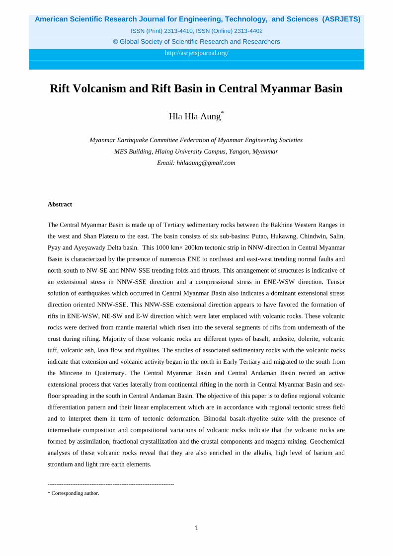
Figure 1: Paleogeography of the India, Burma, Indochina plates in Late-Cretaceous Period. The orientation of
Burma plate is NW-SE direction during accretion to Indochina plate.
The Burma plate rifted and drifted from the neighbors of Gondwana in Middle Jurassic [11]. Burma plate
accreted to the Indochina plate in Late Cretaceous-Early Eocene [4]. The tin-tungsten-bearing igneous belt was
formed between the two plates resulted from partial melting of Carboniferous-Permian aged marginal basin
metasedimentry rocks of Mergui-Lebyin-Taungnyo Series during a long period of Eocene-Oligocene-Miocene.
Accretion of the Burma plate to Indochina caused the clockwise rotation of the Indochina plate in Eocene
(50Ma) (Fig.1).
American Scientific Research Journal for Engineering, Technology, and Sciences (ASRJETS) (2020) Volume 67, No 1, pp 1-10
3
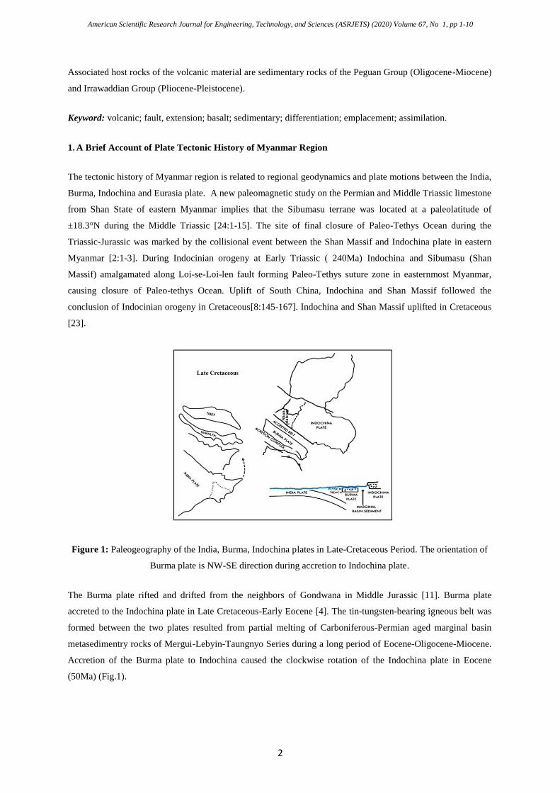
Figure 2: A mosaic of maps show successive motion of the Burma plate during Tertiary period after accretion
to the Indochina plate. Change of plate motion due to clock-wise rotation of Indochina plate throughout
Tertiary.
A series of basins formed in Central Myanmar Basin in response to the clockwise rotation of Indochina plate
and north-eastward oblique convergence of India plate to the Sunda trench [13] due to regional extensional
deformation. Formation and evolution of basins is related to the interaction of lithospheric plates and deep-
seated geodynamic processes. The closure and accretion of the Burma to the Indochina plate in Late
Cretaceous-Early Eocene, crustal rotation of Indochina plate, southeastward extrusion of Indochina plate, the
closure of Neo-Tethys sea and collision of the India plate with the Burma plate in Miocene, northeastward
motion of the India plate and oblique subduction of India beneath Burma plate dominated asthenospheric
upwelling and lithospheric stretching, rifting, volcanism and magmatism during different rifting stages in
Central Myanmar Basin (Fig.2).
2. Tectonic Setting
The 2000 km long, and approximately 200 km wide elongated tectonic zone, which includes the Central
Myanmar Basin and Central Andaman Basin, has been wedged between the northward moving India plate on
the west and southeasterly extruding Indochina plate on the east.
American Scientific Research Journal for Engineering, Technology, and Sciences (ASRJETS) (2020) Volume 67, No 1, pp 1-10
4
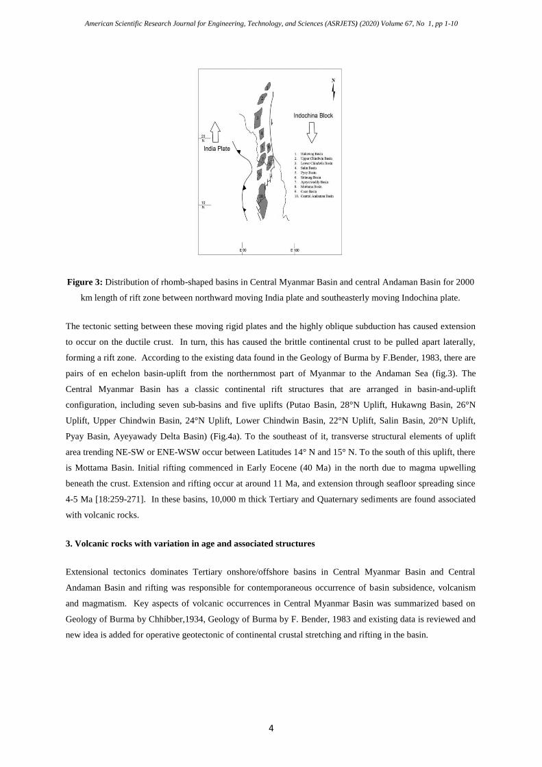
Figure 3: Distribution of rhomb-shaped basins in Central Myanmar Basin and central Andaman Basin for 2000
km length of rift zone between northward moving India plate and southeasterly moving Indochina plate.
The tectonic setting between these moving rigid plates and the highly oblique subduction has caused extension
to occur on the ductile crust. In turn, this has caused the brittle continental crust to be pulled apart laterally,
forming a rift zone. According to the existing data found in the Geology of Burma by F.Bender, 1983, there are
pairs of en echelon basin-uplift from the northernmost part of Myanmar to the Andaman Sea (fig.3). The
Central Myanmar Basin has a classic continental rift structures that are arranged in basin-and-uplift
configuration, including seven sub-basins and five uplifts (Putao Basin, 28°N Uplift, Hukawng Basin, 26°N
Uplift, Upper Chindwin Basin, 24°N Uplift, Lower Chindwin Basin, 22°N Uplift, Salin Basin, 20°N Uplift,
Pyay Basin, Ayeyawady Delta Basin) (Fig.4a). To the southeast of it, transverse structural elements of uplift
area trending NE-SW or ENE-WSW occur between Latitudes 14° N and 15° N. To the south of this uplift, there
is Mottama Basin. Initial rifting commenced in Early Eocene (40 Ma) in the north due to magma upwelling
beneath the crust. Extension and rifting occur at around 11 Ma, and extension through seafloor spreading since
4-5 Ma [18:259-271]. In these basins, 10,000 m thick Tertiary and Quaternary sediments are found associated
with volcanic rocks.
3. Volcanic rocks with variation in age and associated structures
Extensional tectonics dominates Tertiary onshore/offshore basins in Central Myanmar Basin and Central
Andaman Basin and rifting was responsible for contemporaneous occurrence of basin subsidence, volcanism
and magmatism. Key aspects of volcanic occurrences in Central Myanmar Basin was summarized based on
Geology of Burma by Chhibber,1934, Geology of Burma by F. Bender, 1983 and existing data is reviewed and
new idea is added for operative geotectonic of continental crustal stretching and rifting in the basin.
American Scientific Research Journal for Engineering, Technology, and Sciences (ASRJETS) (2020) Volume 67, No 1, pp 1-10
5
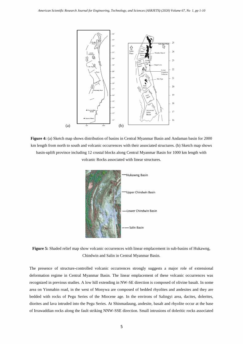
(a) (b)
Figure 4: (a) Sketch map shows distribution of basins in Central Myanmar Basin and Andaman basin for 2000
km length from north to south and volcanic occurrences with their associated structures. (b) Sketch map shows
basin-uplift province including 12 crustal blocks along Central Myanmar Basin for 1000 km length with
volcanic Rocks associated with linear structures.
Figure 5: Shaded relief map show volcanic occurrences with linear emplacement in sub-basins of Hukawng,
Chindwin and Salin in Central Myanmar Basin.
The presence of structure-controlled volcanic occurrences strongly suggests a major role of extensional
deformation regime in Central Myanmar Basin. The linear emplacement of these volcanic occurrences was
recognized in previous studies. A low hill extending in NW-SE direction is composed of olivine basalt. In some
area on Yinmabin road, in the west of Monywa are composed of bedded rhyolites and andesites and they are
bedded with rocks of Pegu Series of the Miocene age. In the environs of Salingyi area, dacites, dolerites,
diorites and lava intruded into the Pegu Series. At Shinmadaung, andesite, basalt and rhyolite occur at the base
of Irrawaddian rocks along the fault striking NNW-SSE direction. Small intrusions of doleritic rocks associated
American Scientific Research Journal for Engineering, Technology, and Sciences (ASRJETS) (2020) Volume 67, No 1, pp 1-10
6
with rocks of Pondaung Age (Eocene) occur along the fault. A sheet of basaltic lava called Silaung sheet occur
along the fault. Kyaukadaung hill in the east of Monywa is composed of olivine basalt, surrounded with Peguan
rocks occurring along the fault. Hill 779, northeast of Kyaukadaung Hill is composed of olivine basalt for 7
miles along NNW-SSE direction. At Thazi Hill , picrite basalt occur along the fault on the edge of the Pegu
Series. At Inde Hill, northernmost of the group of olivine basalt occur with volcanic ash along the fault resting
on Irrawaddian rocks. At Nayintaung , olivine basalt mass is found along N-S direction resting on Irrawaddian
sands. Mojority of volcanic occurrences in Monywa area are occurring along the fault in Lower Chindwin
basin. Mugearite basalts are found as horizontal sheet resting on folded Irrawaddian bed, located 40 kilometers
north of Mandalay at latitude 22° 44’ and further south to Singu for 24 square miles. These volcanic
occurrences associated with faults are observed on the right bank of the Chindwin River (Fig.4b). Recent study
using satellite image interpretation also reveals the relationship between geological structures and distribution
of volcanic occurrence in shaded relief map (Fig.5)
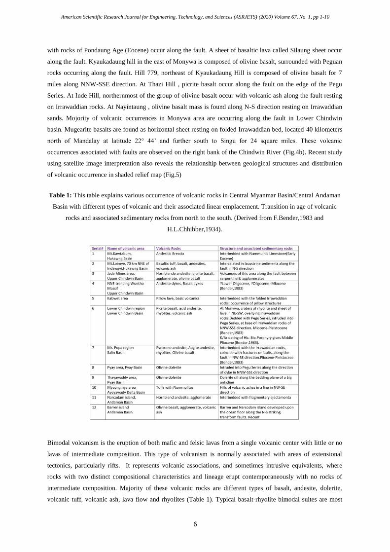
Table 1: This table explains various occurrence of volcanic rocks in Central Myanmar Basin/Central Andaman
Basin with different types of volcanic and their associated linear emplacement. Transition in age of volcanic
rocks and associated sedimentary rocks from north to the south. (Derived from F.Bender,1983 and
H.L.Chhibber,1934).
Bimodal volcanism is the eruption of both mafic and felsic lavas from a single volcanic center with little or no
lavas of intermediate composition. This type of volcanism is normally associated with areas of extensional
tectonics, particularly rifts. It represents volcanic associations, and sometimes intrusive equivalents, where
rocks with two distinct compositional characteristics and lineage erupt contemporaneously with no rocks of
intermediate composition. Majority of these volcanic rocks are different types of basalt, andesite, dolerite,
volcanic tuff, volcanic ash, lava flow and rhyolites (Table 1). Typical basalt-rhyolite bimodal suites are most
American Scientific Research Journal for Engineering, Technology, and Sciences (ASRJETS) (2020) Volume 67, No 1, pp 1-10
7
commonly observed in rift tectonic environments. In seismic reflections of the Gulf of Mottama and
Ayeyawady Delta Basin, the associated basic tuffs, volcanic rocks and agglomerates are visible together with
Tertiary sediments [3].
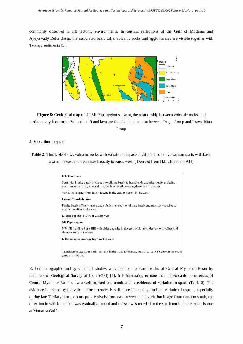
Figure 6: Geological map of the Mt.Popa region showing the relationship between volcanic rocks and
sedimentary host rocks. Volcanic tuff and lava are found at the junction between Pegu Group and Irrawaddian
Group.
4. Variation in space
Table 2: This table shows volcanic rocks with variation in space at different basin. volcanism starts with basic
lava in the east and decreases basicity towards west. ( Derived from H.L.Chhibber,1934).
Earlier petrographic and geochemical studies were done on volcanic rocks of Central Myanmar Basin by
members of Geological Survey of India (GSI) [4]. It is interesting to note that the volcanic occurrences of
Central Myanmar Basin show a well-marked and unmistakable evidence of variation in space (Table 2). The
evidence indicated by the volcanic occurrences is still more interesting, and the variation in space, especially
during late Tertiary times, occurs progressively from east to west and a variation in age from north to south, the
direction in which the land was gradually formed and the sea was receded to the south until the present offshore
at Mottama Gulf.
American Scientific Research Journal for Engineering, Technology, and Sciences (ASRJETS) (2020) Volume 67, No 1, pp 1-10
8
5. Variation in composition
The variation diagram obtained from plots of SiO2 vs K2O, Na2O, CaO, TiO2 reveals significant results of the
major element distinctions of volcanic rocks and the evidence of genetic linkages [4]. Variation curve in
alkalies is higher conforming to the high K-field. The volcanic rocks from the continental areas are rich in K2O
and CaO but in respect of soda, no distinctive between the two series of continent and oceanic. Generally it can
be concluded that the different types of volcanic rocks found in Central Myanmar Basin of continental areas are
rift volcanic. The basalt isotope composition of Mt.Popa [19] and the basalt andesite of Twin Taung [3] show
Ba level (Ba 1517ppm, Ba1069ppm) and Sr level (Sr 1567ppm, Sr 1050ppm) are within the known range of
intraplate basalt, indicating higher contents of Large Ion Lithospheric Element (LILE) and Light Rare Earth
Element (LREE). It suggests that the parent magma is modified by fractional crystallization. Composition
variability also reflects the assimilation of crustal components and magma mixing (Fig.6). The bimodal basalt-
rhyolite occurrences are thought to reflect combination of mantle and silica rich crustal melt. It appears that
with a few exceptions, the igneous occurrences of the Central Myanmar Basin show differentiation in space
from east to west. It reflects assimilation, fractional crystallization and crustal material and magma mixing
before emplacement at the surface. During early stage of volcanic activity, basic magma may have risen through
the fault tract or fissures fairly slowly allowing time for assimilation, fractional crystallization and crustal
contamination (AFC ) to modify the magma to produce basalt-andesite-rhyolite composition or the volcanic
rocks of Central Myanmar Basin may have originated with two primary magma: sublithospheric mantle and
subcontinental lithosphere which on differentiation, many volcanic rocks with high alkalies are formed by
assimilation of limestone from Pegu Series with basaltic magma at depth and crustal contamination with sands
of Pegu or Irrawaddian Group. The presence of the intermediate lava may be derivatives of parental mafic
magma via fractional processes [1:1-10]. In rift setting, mafic magma is possibly derived from at least two
magma sources: sublithospheric origin or Oceanic Island Basalt (OIB) and rift basalt within subcontinental
lithosphere with distinctive REE. Basaltic magma generated in continental rift are similar to those of Oceanic
Island Basalt, derived from a mantle source enriched in trace elements LILE, high Sr. The geochemistry of
mafic volcanic rocks extruded at continental rifts provides information on the sources and mechanism of
magma generation during rifting. Rift basalt typically are enriched in alkalies (Na2O3, K2O, Cao), LILE as K,
Ba, Rb, Sr; LREE, volatiles as halogens. Tholiietic basalts are also common and may be associated with silica
lavas including rhyolites. There are three ways of mechanism to produce basaltic magma beneath rift. Melting
may be accomplished by transfer of heat from deep mantle plumes or reducing in ambient pressure by the rise
of mantle plume or the effect of lowering of solidus temperature by addition of volatiles. All three of the
mechanisms probably contribute to generation of basaltic melts beneath continental rift. Once mafic magma
was formed, the magmatic differentiation can occur by partial melting or by fractionation or by assimilation and
crustal melting to produce the bimodal basalt-rhyolite eruption at continental rift [9].
6. Conclusion
The 2000 x 200 km span of crust which includes the Central Myanmar Basin and Central Andaman Basin has
been undergoing two tectonic deformations. The first deformation is a NNW-SSE oriented extensional scheme,
American Scientific Research Journal for Engineering, Technology, and Sciences (ASRJETS) (2020) Volume 67, No 1, pp 1-10
9
which commenced in Early Eocene and occurred primarily during the Miocene epoch. The second deformation
is a compression regime during the Pliocene-Pleistocene time. Along this N-S strip of the tectonic zone,
volcanic activity show variation in age started in the north in Early Tertiary and migrated to the south during the
Miocene and Pliocene-Pleistocene to the Recent in the Andaman basin. In this case the most important point to
be noticed is that the land along the Central Myanmar Basin was gradually rifted from the north to the south.
Their style of emplacements are also controlled by lines of major faulting and folding of N-S or NW-SE or NE-
SW or NNW-SSE direction along which most of the volcanic occurrences are found. These structures are
developed in the rift system of Central Myanmar Basin by the extensional deformation from Eocene to mainly
the Miocene to Recent. In most cases, volcanic rocks are associated with sedimentary rocks from Pegu Series of
the Oligocene-Miocene and the Irrawaddian rocks of the Pliocene-Pleistocene. The linear emplacement of
volcanic occurrences in Central Myanmar Basin can be interpreted as basin-and-uplift type, extensional setting
and rift volcanism, where extension leads to generation of magma from the subcontinental lithospheric mantle
which is enriched in the alkalies. In these volcanic occurrences, fragmental erupted products are scare and it
support that these volcanic rocks are rift-related volcanic rocks.
7. Discussion and Recommendations
The structural signature of basin-uplift zone in the Central Myanmar Basin between the Rakhine Western
Ranges to the west and the Shan Plateau to the east is dominated by NE-to ENE-WSW trending faults. This
1000-km-long, 200-km-wide elongated tectonic zone is bounded to the west by the Kabaw Fault and to the east
by the Sagaing Fault. The detailed studies of sedimentary rocks associated with the volcanic rocks and linear
emplacement of volcanic occurrences indicated strong conformity with the regional structural direction. The
existence of volcanic rocks within the tectonic strip implies an intimate relationship between extensional
deformation and volcanic occurrence. Results of this study have the important implication for tectonic regime
and their associations with the distribution of volcanic rocks. Some large copper deposits are found within the
Upper Tertiary volcanic rocks in Lower Chindwin Basin.
References
[1]. Aung,H.H., 2010.The Volcanic Occurrences in Relation to Tectonic, Myanmar, Abstract Volume,
pp308 http://www.asiaoceania.org/aogs2012/public.asp?page=home.htm
DOI:10.13146/R.G.2.1.3634.6401
[2]. Aung,H.H., 2009, Recognition of Paleo-Tethys suture zone in Eastern Myanmar, Acta Geoscientific
Sinica, vol.30 supplement,pp 1-3, Sept.2009 www.cagsbulletin.com
[3]. Bender, F., 1983. Geology of Burma, Gebruder,Borntraeger, Berlin, Stuttgart.
[4]. Chhibber,H.L., The Geology of Burma , Macmillan and Co.Limited, St. Martin’s Street, London(1934)
[5]. Curray, J.R., et al.2005, Tectonics and history of the Andaman Sea region,J.Asia Earth Science XX1-
42
[6]. Coffin,M.,and L. Lawver 1998, Atlas of paleogeographic reconstructions:The Plates Project progress
Report 215 0798,University of Texas at Austin, 75p.
[7]. Crowell J.C. ,1984. The Recognition of Transform Terrane Dispersion within Mobile Belts, Principles
American Scientific Research Journal for Engineering, Technology, and Sciences (ASRJETS) (2020) Volume 67, No 1, pp 1-10
10
Appl. Terrane Anal. pp 51 to 61.
[8]. Golonka,J., Slaczka,A.,& Picha, F.,2003c. Geodynamic evolution of the orogeny: the West
Carpaythians and Ouachitas case studies. Annales Societatis Geologorum Poponiae, 73:145-167.
[9]. Kearey,P.; K.A.Klepeis and F.J.Vine, Global Tectonic(3rd
Edition), Wiley-Blackwell, A John Wiley &
Sons Ltd. Publcation. 2009
[10]. Khan P.K. & Chakraborty P.P.,2005. Two-phase opening of Andaman Sea:A new
seismotectonic insight . Earth and Planetry Sc ience letters 229,259-71
[11]. Lawver,L.A.et al.(2003), The Plates 2003 Atlas of Plate Reconstruction (750Ma to Present Day).Plates
progress report No.280-0713. University of Texas Institute for Geophysical Report N.190.University
of Texas Press, Houston, Texas
[12]. Le Dain A.Y., P. Tapponeir and P.Molnar, 1984. Active faulting and Tectonics of Burma and Surround
regions.J.Geophys.Res.89(13)453-472
[13]. Michael C.D. et al.,1991: Cenozoic Plate tectonics and basin evolution in Indonesia. Marine and
Petroleum Geology, vol.8, February 1991.
[14]. Nguyen Hoang et al., Geochemistry and Sr-Nd-Pb Isotopic Study of Late Neogene Volcanic rocks
from the Arita-Imari Area(SW Japan): Evidence for co-existing OIB-like and subduction-related
mantle Sources.AdvGeo.vol.13 Solid Earth(2007) pp31-55
[15]. Nielsen, C., N. Chamot-Rooke, and C. Ranginthe ANDAMAN Cruise Team (2004). From partial to
full strain partitioning along the Indo-Burmese hyper-oblique subduction, Mar. Geol. 209, 303-327
[16]. Pivnik, D.A., et al. Poliphase deformation in fore-arc/back-arc basin, Salin subbasin.Myanmar
(Burma).AAPG Bull.82(10) 1837-1878,1999.
[17]. Raju et al., 2004. New insights into the tectonic evolution of the Andaman basin, northeast Indian
Ocean. Earth and Planetary Science letters 7024 1-18.2004
[18]. Socquet, A., C. Vigny, N. Chamot-Rooke, W. Simons, C. Rangin, and B. Ambrosius (2006). India
and Sunda plates motion and deformation along their boundary in Myanmar determined by GPS, J.
Geophys. Res. 111, B05406, doi 10.1029/2005JB003877.
[19]. Stephenson.D & T.R.Marshall ,The Petrology and mineralogy of Mt. Popa Volcano and the nature of
the late-Cenozoic Burma Volcanic Arc. J.geol.Soc.London, vol.141,pp 74-762,1984.
[20]. Talwani, M.& Pitman, W.C., 1992, III(eds),Island Arcs, Deep Sea and Backarc basins, pp.99-114.
American Geophysical Union, Washington.DC.
[21]. Talat Ahmad et al.: Petrogenesis and tectonic setting of bimodal volcanism in the Sakoli Mobile Belt,
Central Indian shield, Island Arc 18,155-174, 2009.
[22]. Tozer,E.T.,1982. Marine Triassic faunas of North America:Their significance for assessing plate and
terrane movement;Geogische Rundschau,v.71 p.1077-1104.
[23]. Tran Van Tri (Editor in Chief) et al., 1979. (1977 in Vietnamese) Geology of Vietnam, (the north part).
Explanatory note to the geological map 1: 1,000,000 scale. Hanoi, Sci. and Techn.Publ.House,354
pp.(in Vietnamese) 77 pp.(in English)
[24]. Zhao J., Huang B., Yan Y., et al. A Paleomagnetic Study of the Middle Permian and Middle Triassic
limestones from Shan State, Myanmar. Implications of Collision of the Sibumasu terrane and
Indochina terrane. Geological Journal, 2019 1-17.https://doi.org/10.1002/gi 3482
Related Documents