The Coast Track (Otford to Bundeena) The Coast Track (Otford to Bundeena) Following the coast through the Royal National Park with its magnificent coastal views, this walk is truly amazing. Although walked traditionally from Bundeena, this direction makes for a shorter first day. There are coastal and cliff views along much of this walk. There are also a small house communities early in the walk. Stay overnight at North Era Campsite. Water is very limited it is best to carry all the water you need. Royal National Park Length: Time: Climb: Style: Rating: Where: Transport: 27.4 km 2 Days 1244 m One way Track: Hard 0.8 km NE of Otford train car ferry Visit www.wildwalks.com for more info Side trips and Alternate routes mentioned in these notes are not included in the tracks overall rating, distance or time estimate. The notes only describe the side trips and Alternate routes in one direction. Allow extra time for resting and exploring areas of interest. Please ensure you and your group are well prepared and equipped for all possible hazards and delays. The authors, staff and owners of wildwalks take care in preparing these notes but will not accept responsibility for any inconvenience, loss or injury sustained by using these notes or maps. Please take care and share your experience through the website. Check park closures just before leaving for your walk. Assume walks are closed on a Total Fire Ban day unless the park manager says otherwise. GPS for start the start of this walk:-34.2108,151.0056 & for the end:-34.0827,151.1511 Wildwalks Download the free Bushwalk Australia eMag The eMagazine is produces by the community at bushwalk.com and the Wildwalks team Bushwalk.com Australia's most active bushwalking forum - Check it out. Happy Reading. Matt :) Otford Train Station to Otford Lookout 0.8km 20 mins (From S) From the top of Otford Station, this walk follows the signs to 'Royal National Park' up some stairs. Once at the top of the stairs, the walk turns left and climbs up the steep concrete path for approximately 50m to the top, where it comes to the intersection marked as 'Station Rd'. This walk turns left and follows the flat dirt road, passing an intersection with another road on the left. The walk continues along to the next intersection, where it turns right onto Fanshawe Rd. This walk follows Fanshawe Rd up the long hill until coming to an intersection with an asphalt road signposted as 'Lady Wakehurst Drive'. At the intersection, this walk turns left and crosses the road, continuing for approximately 25m until coming to a car park and the entry into Royal National Park. There is a large green sign here saying 'Otford Lookout'. Otford Lookout to The Squeeze Way and Burning Palms Tracks 1.9km 40 mins (From 0.8 km) Veer right: From Otford Lookout, the walk heads up the stairs on the seaward side of the car park, winding up the hill and along the fenced of cliffs, keeping the ocean to the right as it steadily climbs up the hill. After a while, the track breaks away from the cliff and continues along the bush track, climbing up the hill until coming to an intersection marked with a signpost saying 'Werrong Beach'. Continue straight: From the intersection, this walk follows the Coast Track along the bush track, winding up the long hill the the top, where it flattens out and continues along a well-managed bush track through a rather beautiful section of ferns. After quite a while, the track joins onto a flat service trail which it follows, undulating gently until it comes to the signposted intersection of the North Era bush track. The Squeeze Way and Burning Palms Tracks to Burning Palms Beach (southern end) 3km 1 Hrs 20 mins (From 2.69 km) Turn right: From the intersection, the walk follows the 'North Era' arrow along the bush track, winding through the thick bushland and down a long hill for several hundred metres, gradually steepening before sharply turning left. After the change in direction, the track heads through the 'Palm Jungle' along the narrow bush track. At this point, the track is largely clear but in some places there are obstacles like fallen trees and branches. The track continues in this manner for some time before emerging into grasslands. Continue straight: From the end of the palm jungle and the start of the grasslands, the walk heads through the grasslands and along the coast for a while before winding down to the signposted intersection with the Burning Palms track, near the rangers' hut. Burning Palms Beach (southern end) to Figure 8 Pools 0.9km 15 mins Optional Side Trip: (From 5.68 km) Turn right: (only to be attempted at low tide and low swell) From the beach, this walk follows the rocky passage beneath the rocky headland (keeping the headland to the right). The walk rounds the first prominent headland to a creek that drops off the cliffs above. This walk heads out onto a second prominent headland to the Figure 8 Pools. There are a number of Figure 8-shaped pools, but one main one. The pools are towards the sea, in line with the gully. (Retrace your steps back to the main track, then veer right to continue along this walk.) Page 1/11 PDF generated on 20 Oct 2013

Welcome message from author
This document is posted to help you gain knowledge. Please leave a comment to let me know what you think about it! Share it to your friends and learn new things together.
Transcript
The Coast Track (Otford to Bundeena)The Coast Track (Otford to Bundeena)
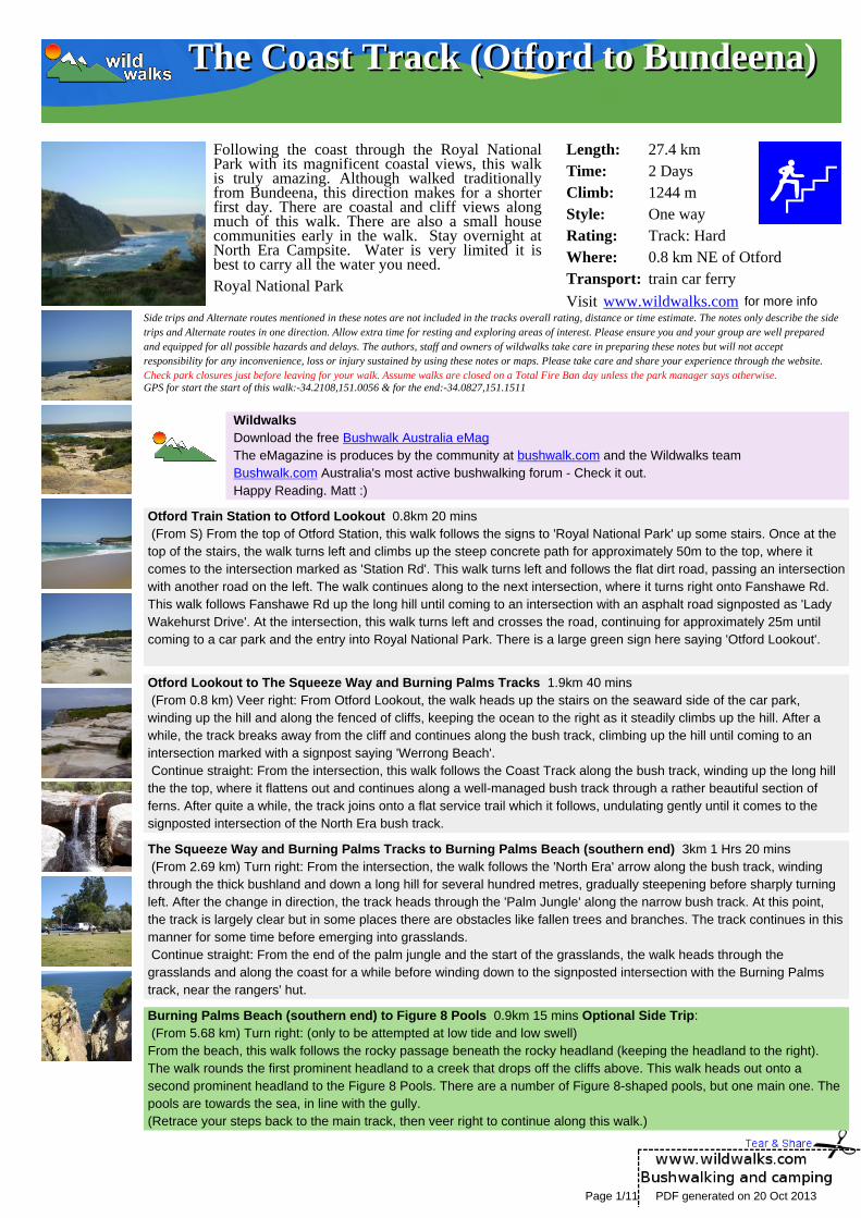
Following the coast through the Royal NationalPark with its magnificent coastal views, this walkis truly amazing. Although walked traditionallyfrom Bundeena, this direction makes for a shorterfirst day. There are coastal and cliff views alongmuch of this walk. There are also a small housecommunities early in the walk. Stay overnight atNorth Era Campsite. Water is very limited it isbest to carry all the water you need.Royal National Park
Length:Time:Climb:Style:Rating:Where:Transport:
27.4 km2 Days1244 mOne wayTrack: Hard0.8 km NE of Otfordtrain car ferry
Visit www.wildwalks.com for more infoSide trips and Alternate routes mentioned in these notes are not included in the tracks overall rating, distance or time estimate. The notes only describe the sidetrips and Alternate routes in one direction. Allow extra time for resting and exploring areas of interest. Please ensure you and your group are well preparedand equipped for all possible hazards and delays. The authors, staff and owners of wildwalks take care in preparing these notes but will not acceptresponsibility for any inconvenience, loss or injury sustained by using these notes or maps. Please take care and share your experience through the website.Check park closures just before leaving for your walk. Assume walks are closed on a Total Fire Ban day unless the park manager says otherwise.GPS for start the start of this walk:-34.2108,151.0056 & for the end:-34.0827,151.1511
Wildwalks Download the free Bushwalk Australia eMag The eMagazine is produces by the community at bushwalk.com and the Wildwalks team Bushwalk.com Australia's most active bushwalking forum - Check it out. Happy Reading. Matt :)
Otford Train Station to Otford Lookout 0.8km 20 mins (From S) From the top of Otford Station, this walk follows the signs to 'Royal National Park' up some stairs. Once at thetop of the stairs, the walk turns left and climbs up the steep concrete path for approximately 50m to the top, where itcomes to the intersection marked as 'Station Rd'. This walk turns left and follows the flat dirt road, passing an intersectionwith another road on the left. The walk continues along to the next intersection, where it turns right onto Fanshawe Rd.This walk follows Fanshawe Rd up the long hill until coming to an intersection with an asphalt road signposted as 'LadyWakehurst Drive'. At the intersection, this walk turns left and crosses the road, continuing for approximately 25m untilcoming to a car park and the entry into Royal National Park. There is a large green sign here saying 'Otford Lookout'.
Otford Lookout to The Squeeze Way and Burning Palms Tracks 1.9km 40 mins (From 0.8 km) Veer right: From Otford Lookout, the walk heads up the stairs on the seaward side of the car park,winding up the hill and along the fenced of cliffs, keeping the ocean to the right as it steadily climbs up the hill. After awhile, the track breaks away from the cliff and continues along the bush track, climbing up the hill until coming to anintersection marked with a signpost saying 'Werrong Beach'. Continue straight: From the intersection, this walk follows the Coast Track along the bush track, winding up the long hillthe the top, where it flattens out and continues along a well-managed bush track through a rather beautiful section offerns. After quite a while, the track joins onto a flat service trail which it follows, undulating gently until it comes to thesignposted intersection of the North Era bush track.
The Squeeze Way and Burning Palms Tracks to Burning Palms Beach (southern end) 3km 1 Hrs 20 mins (From 2.69 km) Turn right: From the intersection, the walk follows the 'North Era' arrow along the bush track, windingthrough the thick bushland and down a long hill for several hundred metres, gradually steepening before sharply turningleft. After the change in direction, the track heads through the 'Palm Jungle' along the narrow bush track. At this point,the track is largely clear but in some places there are obstacles like fallen trees and branches. The track continues in thismanner for some time before emerging into grasslands. Continue straight: From the end of the palm jungle and the start of the grasslands, the walk heads through thegrasslands and along the coast for a while before winding down to the signposted intersection with the Burning Palmstrack, near the rangers' hut.
Burning Palms Beach (southern end) to Figure 8 Pools 0.9km 15 mins Optional Side Trip: (From 5.68 km) Turn right: (only to be attempted at low tide and low swell)From the beach, this walk follows the rocky passage beneath the rocky headland (keeping the headland to the right).The walk rounds the first prominent headland to a creek that drops off the cliffs above. This walk heads out onto asecond prominent headland to the Figure 8 Pools. There are a number of Figure 8-shaped pools, but one main one. Thepools are towards the sea, in line with the gully.(Retrace your steps back to the main track, then veer right to continue along this walk.)
Page 1/11 PDF generated on 20 Oct 2013
The Coast Track (Otford to Bundeena)The Coast Track (Otford to Bundeena)
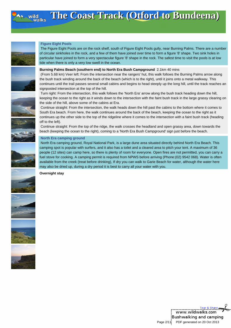
Figure Eight Pools The Figure Eight Pools are on the rock shelf, south of Figure Eight Pools gully, near Burning Palms. There are a numberof circular sinkholes in the rock, and a few of them have joined over time to form a figure '8' shape. Two sink holes inparticular have joined to form a very spectacular figure '8' shape in the rock. The safest time to visit the pools is at lowtide when there is only a very low swell in the ocean.
Burning Palms Beach (southern end) to North Era Bush Campground 2.1km 40 mins (From 5.68 km) Veer left: From the intersection near the rangers' hut, this walk follows the Burning Palms arrow alongthe bush track winding around the back of the beach (which is to the right), until it joins onto a metal walkway. Thiscontinues until the trail passes several small cabins and begins to head steeply up the long hill, until the track reaches ansignposted intersection at the top of the hill. Turn right: From the intersection, this walk follows the 'North Era' arrow along the bush track heading down the hill,keeping the ocean to the right as it winds down to the intersection with the faint bush track in the large grassy clearing onthe side of the hill, above some of the cabins at Era. Continue straight: From the intersection, the walk heads down the hill past the cabins to the bottom where it comes toSouth Era beach. From here, the walk continues around the back of the beach, keeping the ocean to the right as itcontinues up the other side to the top of the ridgeline where it comes to the intersection with a faint bush track (headingoff to the left). Continue straight: From the top of the ridge, the walk crosses the headland and open grassy area, down towards thebeach (keeping the ocean to the right), coming to a 'North Era Bush Campground' sign just before the beach.
North Era camping ground North Era camping ground, Royal National Park, is a large dune area situated directly behind North Era Beach. Thiscamping spot is popular with surfers, and it also has a toilet and a cleared area to pitch your tent. A maximum of 36people (12 sites) can camp here, so there is plenty of room for everyone. Open fires are not permitted, you can carry afuel stove for cooking. A camping permit is required from NPWS before arriving (Phone:(02) 9542 068). Water is oftenavailable from the creek (treat before drinking), If dry you can walk to Garie Beach for water, although the water heremay also be dried up, during a dry period it is best to carry all your water with you.
Overnight stay
Page 2/11 PDF generated on 20 Oct 2013

The Coast Track (Otford to Bundeena)The Coast Track (Otford to Bundeena)
Day 2 North Era Bush Campground to Little Garie 0.8km 20 mins (From 7.75 km) Continue straight: Keeping the ocean and the coast to the right, the walk heads north across the NorthEra Bush Campground to the base of the large grassy hill, which it climbs steeply to the top. Upon reaching the top, thewalk continues down the other side of the hill, winding down the bush track and wooden steps, until reaching the LittleGarie Community Hall at the base of the hill.
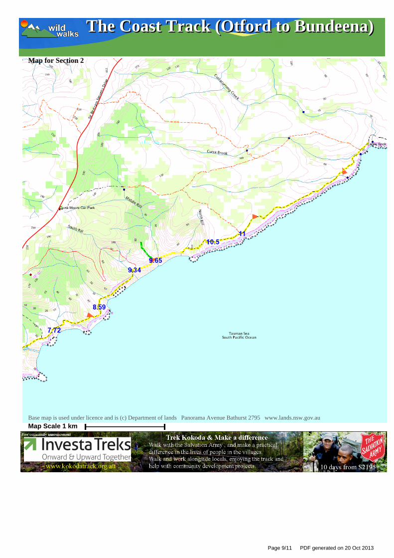
Little Garie to Garie Beach Car Park 0.8km 20 mins (From 8.59 km) Continue straight: From the Little Garie Community Hall, the walk heads down the hill, keeping the seato the right of the track as it leads into the gully. The walk passes several old cabins as it approaches the bottom, wherethe track passes a 'Coast Walk' sign, providing information on erosion issues in this area. From here, the walk headsbetween the ocean on the right and the base of the large grassy hill on the left as the track narrows. This continues untilarriving in the Garie Beach car park.
Garie Beach Garie Beach, Royal National Park, is a large, south-east facing, yellow sand beach. The beach is backed by steepheadlands and gullies. There is a large car park at the end of Garie Rd for access to the beach. Garie Beach is popularfor surfing, patrolled 9am-5pm from December to January. Facilities include toilets, kiosk, picnic tables, cold showers andSurf Life Saving Club. The water from the shower should be treated before drinking, this water comes from a tank andmay be unavailable during dry periods. More info
Garie Beach Car Park to Int. Garie Beach YHA Trk 0.3km 5 mins (From 9.34 km) Turn right: From the car park, the walk heads approximately 200m along the beach, keeping the oceanto your right, to the intersection below the stairs (leading up the hill on the left).
Int. Garie Beach YHA Trk to Garie Beach YHA 0.3km 10 mins Optional Side Trip: (From 9.66 km) Turn left: From the intersection, this walk follows the stairs away from the ocean. The track winds up thehill steeply then continues for approximately 350m along the hillside, in and out of a gully, to rise up to the cabinsignposted as 'YHA Garie Beach'.(Retrace your steps back to the main track, then veer left to continue along this walk.)
YHA Garie Beach - Destroyed **On 02/12/2010 this hut was completely destroyed by fire and plans for the future are not yet decided . Accommodationno longer availableGarie Beach YHA Youth Hostel, in Royal National Park, is a basic but comfortable cabin. The unstaffed and locked cabinis situated north of Garie Beach car park, high on the hill behind the next gully.The cabin contains solar lighting, water, gas kitchen, a 'loo with a view' and the capacity to sleep twelve people. Youneed to provide your own bed sheets and toilet paper. The cabin costs $17.50/adult per night, with the potential to rentthe youth hostel out for a week. The key must be picked up from YHA Kent St, Sydney, prior to arrival at the YHA. Thekey has a $50.00 deposit. To make a booking phone 9261 1111. More info
Int. Garie Beach YHA Trk to Garie Beach Lookout 0.9km 15 mins (From 9.66 km) Veer right: Keeping the ocean to the right, this walk follows the beach to the northern end, to the base ofa bush track which heads up the hill. Continue straight: From the end of Garie Beach, this walk heads up the short hill and through the grassy clearing to thebase of the large hill. The walk continues up the steep bush track, winding up the steep rock and wooden steps as itclimbs to the top of the hill.
Garie Beach Lookout to Int of North Rill and Coastal Track 0.4km 5 mins (From 10.54 km) Continue straight: From the clearing at the top of the large hill, this walk follows the bush track headingaway from Garie Beach and through the high scrub, continuing along for a while before coming to the signpostedintersection of the 'Curra Moors car park' track.
Int of North Rill and Coastal Track to Eagles Rock Lookout 2.2km 45 mins (From 10.98 km) Continue straight: From the intersection, this walk heads along the narrow trail through the scrub,keeping the ocean on the right of the track. In various sections, metal walkways have been built to stabilise theenvironment in the area. The walk continues like this, occasionally breaking out onto the rockshelf of the cliffs, untilreaching a signposted intersection, marked 'Wattamolla 2.9km'. Continue straight: Keeping the ocean to the right the track follows the bushtrack through the scrub and along the coastfor a short while before coming to the information signpost with views of Eagle Rock.
Page 3/11 PDF generated on 20 Oct 2013

The Coast Track (Otford to Bundeena)The Coast Track (Otford to Bundeena)
Eagle Rock Lookout Eagle Rock lookout is an informal lookout marked by an information sign on the Coast track in the Royal National Park.The lookout is about halfway between Garie Beach and Wattamolla. Eagle rock is a piece of the cliff line that looksamazingly like the head of an eagle, with the eye and all. The lookout is about 150m west of the Eagle Rock on the otherside of Carracurrong Creek. Eagle Rock is often used as an icon for the Royal National Park. Carracurrong Creek alsoforms a waterfall into the ocean nearby.
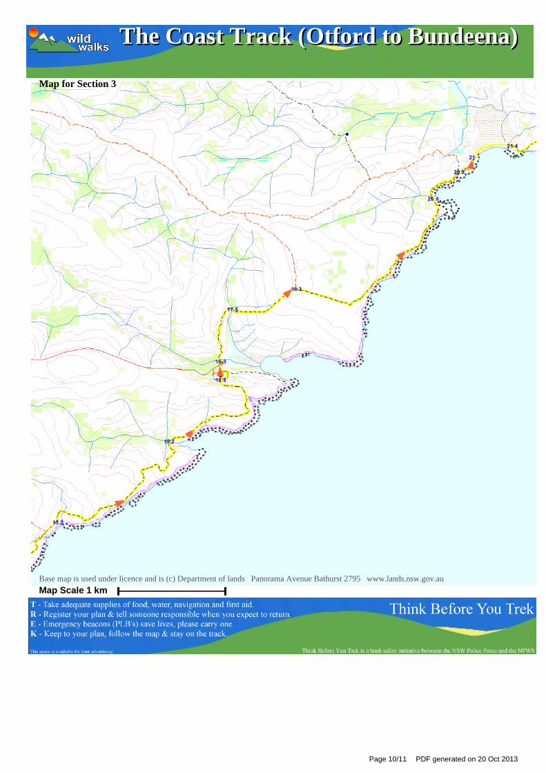
Eagles Rock Lookout to Curracurrang Cove 1.9km 40 mins (From 13.21 km) Continue straight: Keeping the ocean to the right the track follows the bushtrack winding through thescrub for a short while before it drops down a small hill to Curracurang Creek. From here the track crosses the creek andcontinues up through the heavy scrub, steadily climbing up a long hill until it reaches the top and continues down theother side following the small arrows and markers. The track continues to winds steadily down the long hill until it opensout at Curracurang Cove.
Curracurrang Cove Curracurrang Cove is a small cove about 1km SW of Wattamolla, on the coast of the Royal National Park. The covefaces east and is where Curracurrang Creek meets the ocean. The creek, the cove and the surrounding rocks providegreat scenery, making this a relaxing place to stop and enjoy. There is evidence that Aboriginal people lived in this cove.There are a few middens in the area, some rock shelters and Curracurrang creek provides a near-permanent watersupply. The cove was first occupied 7500 years ago and was used as a regular campsite by the Dharawal people. Moreinfo
Curracurrang Cove to Overflow Carpark 1.4km 25 mins (From 15.16 km) Turn right: Keeping the ocean to the right, this walk heads up the hill along the bush track following thecoastline, running close to the cliffs, until coming to a sign saying 'Curracurrang'. At this point, the track widens to amanagement trail and heads away from the cliffs. Passing two large water towers, the trail heads down the long andgentle hill to an intersection at a large car park, marked by a signpost saying 'Garrie 5.8km'.
Overflow Carpark to Northern End Wattamolla Picnic Ground 0.3km 5 mins (From 16.57 km) Turn right: From the intersection, this walk heads through the car park to the toilet block at the top ofthe pathway on the other side. Turn left: From the toilet block, this walk follows the path down the hill and through the car park to the northern end ofthe picnic area, near the creek crossing.
Wattamolla Picnic Area Wattamolla Picnic Area is found at the end of Wattamolla Road, about halfway along the coastline of Royal NationalPark. The area is blessed with a great beach, a lagoon and some wonderful creeks and rocks to explore. The smallbeach faces west and is tucked away in a deep bay. The lagoon sits behind the beach and is lined with sand on oneside, and cliffs and rocks on the other shore. The picnic area has large open grassy areas, with some shade provided bytrees and some picnic shelters. There is a small kiosk (often open weekends), toilets, electric BBQs and two car parks.There is water here, but needs to be treated before drinking. There is a gate on the road that is locked at night, the gateis open from 7am to 8:30pm.
Wattamolla Kiosk The Wattamolla Kiosk in the Wattamolla Picnic Area provides basic supplies for day visitors. The kiosk does not keepstrict hours and opens depending on weather and demand. It usually opens on weekends at around 10:30am and closesbetween 4 and 6pm. You can buy ice-creams, drinks and some hot food. For more information, call Audley Kiosk on (02)9521 2240.
Northern End Wattamolla Picnic Ground to Wattamolla Dam 0.7km 10 mins (From 16.91 km) Continue straight: From the northern end of Wattamolla Picnic Ground, this track crosses the wide,shallow creek (keeping the ocean to the right). The walk then follows the track marker along the bush track, winding upthe other and gradually climbing up a long hill through high scrub to Wattamolla Creek, where there is a small damcreating a swimming hole in the creek. This creek may become impassable after heavy or prolonged rain.
Wattamolla Dam Wattamolla pool (or dam), Royal National Park, is a small water hole on Wattamolla Creek, above the lagoon. The poolis on the Coast Track near Wattamolla picnic area and offers a quiet spot for a dip and a rest. The pool is formed by asmall, constructed sandstone dam and fed by a small waterfall above.
Page 4/11 PDF generated on 20 Oct 2013
The Coast Track (Otford to Bundeena)The Coast Track (Otford to Bundeena)
Wattamolla Dam to Int. Coastal Trk NE of Wattamolla Ck 0.7km 10 mins (From 17.56 km) Continue straight: From the swimming hole, this walk follows the bush track (with the swimming hole tothe right) up the hill (east) and through the high scrub, as it winds up through some rocks, and up a long hill, to theintersection of the Marley service trail and the Coast Track.
Int. Coastal Trk NE of Wattamolla Ck to Little Marley Beach 2.1km 50 mins (From 18.28 km) Veer right: From the intersection, this walk follows the 'Coast Track' arrow along the sandy bush track,which winds out to the coast, then turns left and follows the coast line. In large sections of this track, the trail goes alongmetal footbridges as it continues through the heavy scrub vegetation, until the track heads down off the clifftop along awell-signposted bush track to the end of Little Marley Beach.
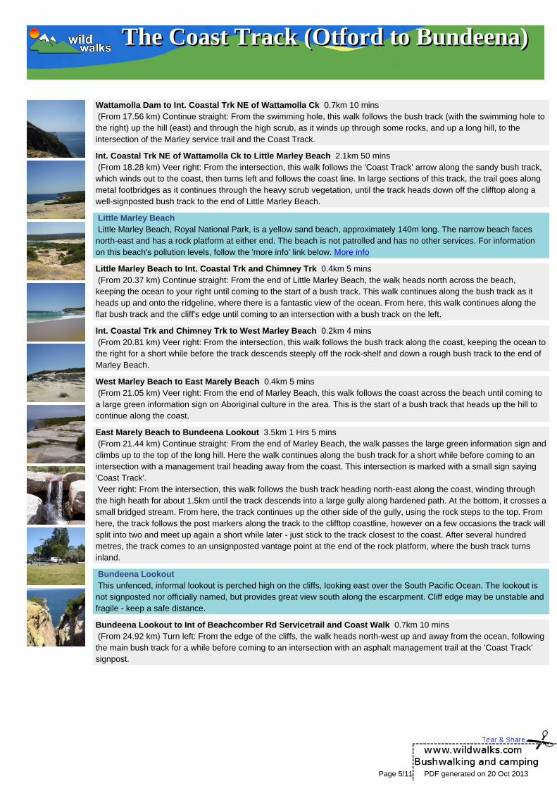
Little Marley Beach Little Marley Beach, Royal National Park, is a yellow sand beach, approximately 140m long. The narrow beach facesnorth-east and has a rock platform at either end. The beach is not patrolled and has no other services. For informationon this beach's pollution levels, follow the 'more info' link below. More info
Little Marley Beach to Int. Coastal Trk and Chimney Trk 0.4km 5 mins (From 20.37 km) Continue straight: From the end of Little Marley Beach, the walk heads north across the beach,keeping the ocean to your right until coming to the start of a bush track. This walk continues along the bush track as itheads up and onto the ridgeline, where there is a fantastic view of the ocean. From here, this walk continues along theflat bush track and the cliff's edge until coming to an intersection with a bush track on the left.
Int. Coastal Trk and Chimney Trk to West Marley Beach 0.2km 4 mins (From 20.81 km) Veer right: From the intersection, this walk follows the bush track along the coast, keeping the ocean tothe right for a short while before the track descends steeply off the rock-shelf and down a rough bush track to the end ofMarley Beach.
West Marley Beach to East Marely Beach 0.4km 5 mins (From 21.05 km) Veer right: From the end of Marley Beach, this walk follows the coast across the beach until coming toa large green information sign on Aboriginal culture in the area. This is the start of a bush track that heads up the hill tocontinue along the coast.
East Marely Beach to Bundeena Lookout 3.5km 1 Hrs 5 mins (From 21.44 km) Continue straight: From the end of Marley Beach, the walk passes the large green information sign andclimbs up to the top of the long hill. Here the walk continues along the bush track for a short while before coming to anintersection with a management trail heading away from the coast. This intersection is marked with a small sign saying'Coast Track'. Veer right: From the intersection, this walk follows the bush track heading north-east along the coast, winding throughthe high heath for about 1.5km until the track descends into a large gully along hardened path. At the bottom, it crosses asmall bridged stream. From here, the track continues up the other side of the gully, using the rock steps to the top. Fromhere, the track follows the post markers along the track to the clifftop coastline, however on a few occasions the track willsplit into two and meet up again a short while later - just stick to the track closest to the coast. After several hundredmetres, the track comes to an unsignposted vantage point at the end of the rock platform, where the bush track turnsinland.
Bundeena Lookout This unfenced, informal lookout is perched high on the cliffs, looking east over the South Pacific Ocean. The lookout isnot signposted nor officially named, but provides great view south along the escarpment. Cliff edge may be unstable andfragile - keep a safe distance.
Bundeena Lookout to Int of Beachcomber Rd Servicetrail and Coast Walk 0.7km 10 mins (From 24.92 km) Turn left: From the edge of the cliffs, the walk heads north-west up and away from the ocean, followingthe main bush track for a while before coming to an intersection with an asphalt management trail at the 'Coast Track'signpost.
Page 5/11 PDF generated on 20 Oct 2013

The Coast Track (Otford to Bundeena)The Coast Track (Otford to Bundeena)
Int of Beachcomber Rd Service Trail and Coast Walk to Bundeena Ferry Wharf 1.8km 30 mins (From 25.61 km) Turn right: From the intersection, this walk follows the asphalt management trail north past the 'nobicycles' sign to the nearby intersection with the sandy management trail. Continue straight: From the intersection, this walk heads north around a sweeping left-hand bend along the sealedmanagement trail. Soon, the trail leads past a track (on the right) then passes around a locked gate at the end of ofBeachcomber Ave and a 'Coast Walk' information sign. Continue straight: From the end of Beachcomber Ave, this walk heads along Beachcomber Ave north-west andgradually around to the north, until turning left into Scarbourough St. The first right is taken into Bournemouth St, then leftinto Loftus St. The walk continues along this road until turning right into Brighton Rd. Bundeena Ferry is located at theend of Brighton St.
Bundeena Bundeena is a small township at the northern end of Royal National Park and the southern side of the entrance to PortHacking. The town can be accessed by car or ferry. There are a few B&B's and other accommodation options and anumber of cafes to choose from. Bundeena has a mixed atmosphere, partly a beach holiday community but also home tosome permanent residents. There are two main beaches - Hordens Beach to the west and Jibbon Beach to the east.Both are nice beaches inside Port Hacking. More info
A list of paper topographical maps that cover this walkOtford 1:25 000 Map Series Port Hacking 1:25 000 Map Series Port Hacking 1:100 000 Map Series
Nearby outdoor and camping storesEngadine Disposal & Outdoor Centre Pty Ltd 1042 Old Princes Hwy Engadine (02) 9520 3367Paddy Pallin Adventure Equipment 587 Kingsway Miranda (02) 9525 6829Onrope 11 Nelson Ave Padstow (02) 9709 6299Boots Great Outdoors 23 Koonya Cct Caringbah (02) 9542 8988Korries Solar 90 Gipps St Wollongong (02) 4226 4632
Page 6/11 PDF generated on 20 Oct 2013
The Coast Track (Otford to Bundeena)The Coast Track (Otford to Bundeena)
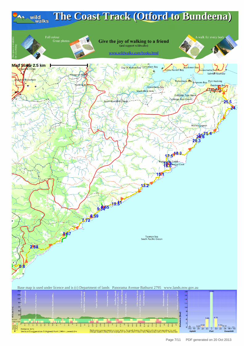
Map Scale 2.5 km
Base map is used under licence and is (c) Department of lands Panorama Avenue Bathurst 2795 www.lands.nsw.gov.au
Page 7/11 PDF generated on 20 Oct 2013

The Coast Track (Otford to Bundeena)The Coast Track (Otford to Bundeena)
Map for Section 1
Base map is used under licence and is (c) Department of lands Panorama Avenue Bathurst 2795 www.lands.nsw.gov.au
Map Scale 1 km
Page 8/11 PDF generated on 20 Oct 2013
The Coast Track (Otford to Bundeena)The Coast Track (Otford to Bundeena)
Map for Section 2
Base map is used under licence and is (c) Department of lands Panorama Avenue Bathurst 2795 www.lands.nsw.gov.au
Map Scale 1 km
Page 9/11 PDF generated on 20 Oct 2013
The Coast Track (Otford to Bundeena)The Coast Track (Otford to Bundeena)
Map for Section 3
Base map is used under licence and is (c) Department of lands Panorama Avenue Bathurst 2795 www.lands.nsw.gov.au
Map Scale 1 km
Page 10/11 PDF generated on 20 Oct 2013
The Coast Track (Otford to Bundeena)The Coast Track (Otford to Bundeena)
Map for Section 4
Base map is used under licence and is (c) Department of lands Panorama Avenue Bathurst 2795 www.lands.nsw.gov.au
Map Scale 1 km
Page 11/11 PDF generated on 20 Oct 2013
Related Documents