Holistic Approach for Assessing Tropical Cyclone Damage on Rice Crop: The Case of Cyclone Titli in Srikakulam District, Andhra Pradesh, India Emma D. Quicho International Rice Research Institute

Welcome message from author
This document is posted to help you gain knowledge. Please leave a comment to let me know what you think about it! Share it to your friends and learn new things together.
Transcript
Holistic Approach for Assessing Tropical Cyclone Damage on Rice Crop: The Case of Cyclone Titliin Srikakulam District, Andhra Pradesh, India
Emma D. QuichoInternational Rice Research Institute

Andhra Pradesh is one of the largest crop producing state in India, with almost 60% of its population depending on agriculture.
Rice is the main food crop and staple food. In 2018 Kharif season, around 1.4 M ha was planted to rice (DoA)
However, because of its coastal location (927 km. long) is prone to cyclones/tropical storms/sea level rise/tsunami, etc.
Introduction
Srikakulam district is one of the 9 coastal districts of Andhra Pradesh – located in Northeastern portion of the state.
In the flood damage assessment, SAR data along with ground data observation, interview with farmers and key local staff in the district.

Satellite based Rice Monitoring System for Andhra Pradesh (AP-SRMS) is a collaborative project among International Rice Research Institute (IRRI), Acharya N. G. Ranga Agricultural University (ANGRAU), Government of Andhra Pradesh, and sarmap
3- years project (Feb 2017 – Jan 2020); started with 2 districts in 2016/17 Rabi season; since 2018 Kharif season whole state of AP is
covered
Objective: support capacity development by establishing and maintaining rice monitoring system that provides regular cropcondition updates and rapid damage assessment in the event of extremeclimate conditions
Introduction
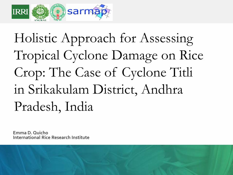
Rice crop damage post cyclone Titli in Pundi, Santabommali, Srikakulam, 16 Oct 2018
Rice crop damage post cyclone Titli in Dasupuram, Pathapatnam, Srikakulam, 18 Oct 2018
Rice area affected by cycloneTitli, 16-18 Oct 2018
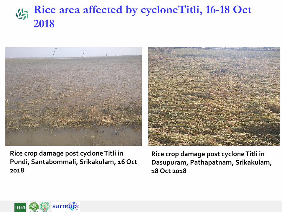
MethodologyRice area and yield estimation using MAPscape-Riceand Rice-YES
Bouman, B. A. M.et al. 2001.ORYZA2000: Modeling Lowland Rice. Los Baños, Philippines: International Rice Research Institute and Wageningen. Netherlands: Wageningen University and Research Centre.
A. Nelson, T. Setiyono. A. B. Rala, E.D. Quicho , et al. (2014) Towards An Operational SAR-Based Rice Monitoring System in Asia: Examples from 13 Demonstration Sites across Asiain the RIICE Project. Remote Sens., 6, pp. 10773-10812.
T.D. Setiyono, E.D. Quicho, et al. (2018). Rice yield estimation using synthetic aperture radar (SAR) and the ORYZA crop growth model: development and application of thesystem in South and South-east Asian countries. International Journal of Remote Sensing. https://doi.org/10.1080/01431161.2018.1547457
SAR-based area and yield estimation system (MAPscape-RICE® , ORYZA, and Rice-YES)
MAPscape-RICE® converts multi-temporal SAR data into terrain-geocoded images to generate maps of rice area, start of season (SoS), and leaf area index (LAI).
ORYZA crop growth model estimates yield using processed-based approach accounting for G x E x N
Rice-YES assimilates SAR products, particularly LAI (converted into relative leaf growth rate, RGRL) into yield estimation by ORYZA

MethodologyRule based classification for flood damage assessment
Pre-&Post Flood Map: C-band Sentinel-1 VV-pol data of 5th October 2018 for pre-cyclone inundation map.
X-band TerraSAR-X HH-pol data of 13th October 2018 for post-cyclone inundation map.
GT for Flooded & non-Flooded 16-18 October 2018: validation of inundation map.
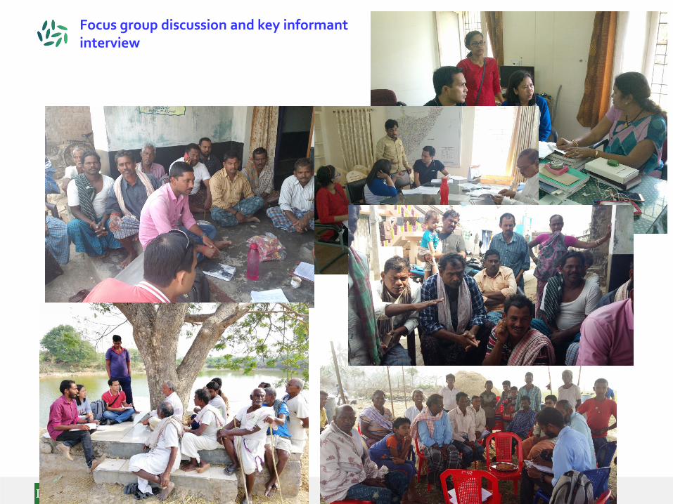
Focus group discussion and key informant interview
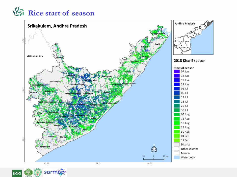
Rice start of season

District level accuracy
Rice area estimates

Rice yield estimates (mid-season)

Inundation map affecting rice areas, 13 Oct 2018
SAR-based ricemonitoring systemestimated rice areaprior to the cycloneevent in Srikakulam district at 205,174 ha
Inundation assessmentwith SAR data on 13 Oct 2018 indicated53,312 0r 26% of estimated rice area of were affected

Inundation map affecting rice areas, 13 Oct 2018
Validation
Points
Average Accuracy
(%)
Average Reliability
(%)
Overall Accuracy
(%)
Kappa Index
69 81.2 81.2 85.0 0.70
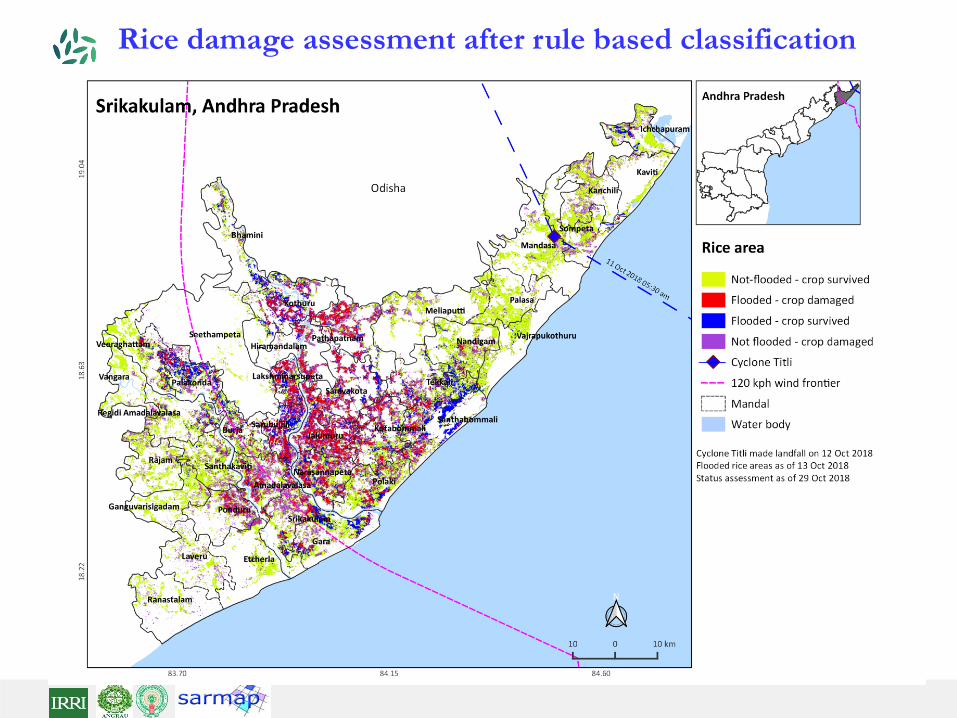
Rice damage assessment after rule based classification
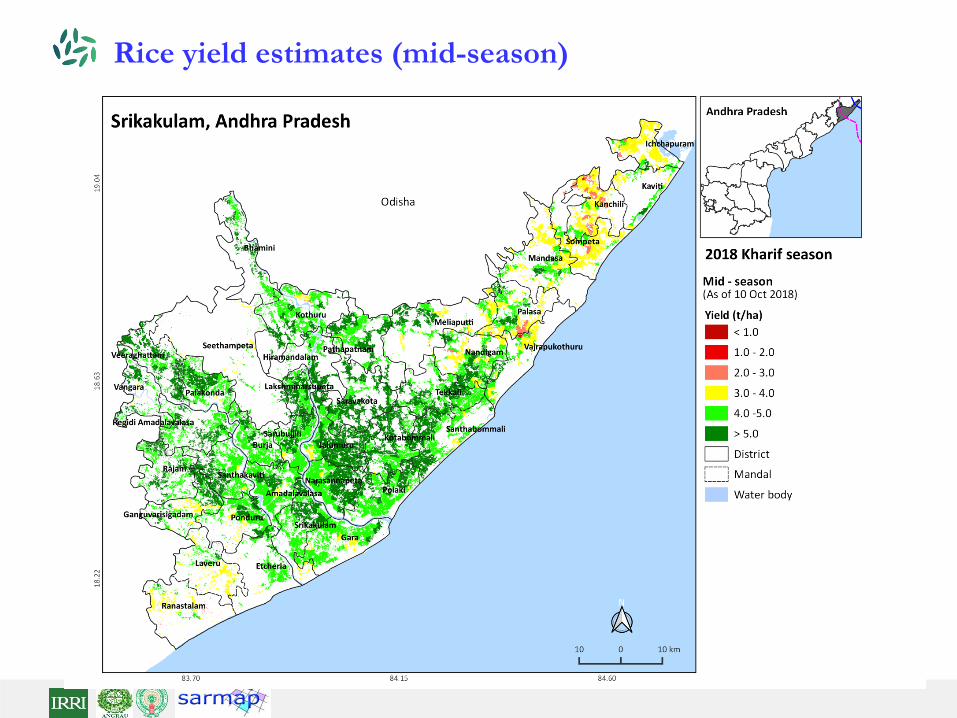
Rice yield estimates (mid-season)
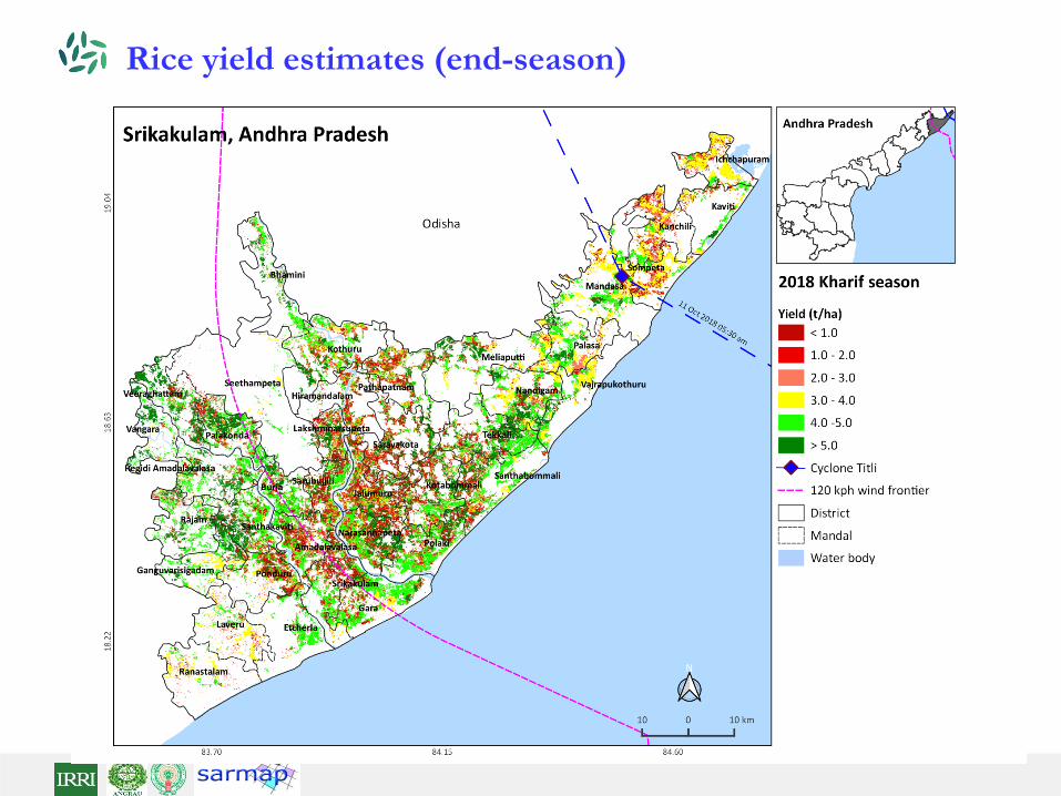
Rice yield estimates (end-season)
Related Documents