For many operators in the Gulf Coast area, produced water is discharged directly to adjacent water bodies. Fields in this region have an average water/oil ratio of from 4:1 to 6:1. The Louisiana Department of Environmental Quality (DEQ) is now requiring that operators apply for permits for these discharges. At this writing, the Louisiana DEQ had received permit applications for approximately 750 to 800 discharge points. Results of field work done by the Louisiana DEQ, the Louisiana Geological Survey, and the Louisiana University Marine Consortium show that roughly 1.8 to 2.0 million barrels of produced water are discharged daily in this area. According to the Louisiana Geological Survey, many receiving water bodies contain fresh water, with some receiving water bodies 70 times fresher than the oil field discharges. The U.S. Fish and Wildlife Service has stated that it will aggressively oppose any permits for produced water discharges in the Louisiana wetlands of the Gulf Coast. The average depth of a new well drilled in northern Louisiana in 1985 was 2,713 feet; alon9 the Gulf Coast it was 10.150 feet. In the northern part of the State, 244 exploratory wells were drilled and 4.033 production'wells were completed. In the southern part of the State. 215 exploratory wells were drilled and 1,414 production wells were completed. Types of Operators In Arkansas, operators are generally small to mid-sized independents, including some established operators and others new to the industry. Because production comes mostly from stripper wells, operators tend to be vulnerable to market fluctuations. Northern Louisiana's operators, like those in Arkansas, tend to be small to mid·sized independents. They share the same economic vulnerabilities with their neighbors in Arkansas. In addition, however, IV-28

Welcome message from author
This document is posted to help you gain knowledge. Please leave a comment to let me know what you think about it! Share it to your friends and learn new things together.
Transcript
For many operators in the Gulf Coast area, produced water isdischarged directly to adjacent water bodies. Fields in this region havean average water/oil ratio of from 4:1 to 6:1. The Louisiana Departmentof Environmental Quality (DEQ) is now requiring that operators apply forpermits for these discharges. At this writing, the Louisiana DEQ hadreceived permit applications for approximately 750 to 800 discharge
points. Results of field work done by the Louisiana DEQ, the Louisiana
Geological Survey, and the Louisiana University Marine Consortium showthat roughly 1.8 to 2.0 million barrels of produced water are discharged
daily in this area. According to the Louisiana Geological Survey, manyreceiving water bodies contain fresh water, with some receiving waterbodies 70 times fresher than the oil field discharges. The U.S. Fish andWildlife Service has stated that it will aggressively oppose any permitsfor produced water discharges in the Louisiana wetlands of the Gulf Coast.
The average depth of a new well drilled in northern Louisiana in 1985
was 2,713 feet; alon9 the Gulf Coast it was 10.150 feet. In the northern
part of the State, 244 exploratory wells were drilled and 4.033production'wells were completed. In the southern part of the State. 215
exploratory wells were drilled and 1,414 production wells werecompleted.
Types of Operators
In Arkansas, operators are generally small to mid-sized independents,including some established operators and others new to the industry.Because production comes mostly from stripper wells, operators tend to bevulnerable to market fluctuations.
Northern Louisiana's operators, like those in Arkansas, tend to besmall to mid·sized independents. They share the same economic
vulnerabilities with their neighbors in Arkansas. In addition, however,
IV-28
louisiana's more marginal operations may be particularly stressed by the
new Rule 29B. which requires the closing out and elimination of allcurrent and future onsite produced water disposal pits by 1989.
Estimated closing costs per pit are $20,000.
Operators in southern louisiana tend to be major companies and largeindependents. They are less susceptible to fluctuating market conditions
in the short term. Projects in the south tend to be larger than those in
the north and are located in more environmentally sensitive areas.
Hajor Issues
Ground-Water Contamination from Unlined Produced Water Disposal Pits andReserve Pits
Unlined produced water disposal pits have been used in louisiana for
many years and are only now being phased out under Rule 29B. Past
practice has, however, resulted in damages to gro~nd water and danger to
human health.
In 19BZ. SUit _JS brought on behdlf of Dudley Romero et al. agaInst operators of an 01 Iwaste commerCial olsposal facilIty. PAS 011 Co. The plalntlffs stdteO that t~elr
domestic water wells were contaminated by wastes dumped Into open pIts In the PAS Oil Co.facl1lty whIch were alleged to have migrated Into the ground water, renderIng the waterwells unusable. Oil field wastes are dumped lntO the waste Plts for s~Imming andseparation of Oil. The pits are unlined. The PAB facility ...as operating prIor tolOuiSlana's first commerCial OIl field waste facility regulatIons. After promulgation ofnew regulatIons. the facility continued to operate for Z years in violation of the neregulatIons. after whIch tlV~ the State shut down the facilIty.
The pl<!lintlH's w<!lter wells are do...ngradient of the facility. drilled to depths of 300to 500 feet. Problems with water wells date from 1979. ExtenSIve analysis was performedby Soil Tesllng Engineers, Inc .. and U.S. EPA, on the plaintiff's ....ater wells adjacent tothe site to detennlne the probabillty of the well contamination co-ing from the PAB OilCo. site. Tnere was also analysis on surface soil contamination. Soil Testing
IV-29
•
EngIneers, Inc., dett>rmlned tnat it ..as possible for tne ..astes in the PAB Ojl Co. pits
to reach lInd contamInate tne Romeros' water wells. Surface sampllng "round the perlmeterof tne PA6 all Co. Slte found hlgn concentratIons of metals. Reslstl~lty testing snowed
trl4~ plumes of chlorloe contdmln<ltlon In the "<Iter table leild from the pits to the "<Iter..ells. 6orln9S :n.!! determIned toe substr<ltd m.Jkeup SU91i1ested th<lt It would be possible
for ..astes to cont<l~lna!e the Romero ground ..ater wltnln the tlme that the faCIlIty had
been ln Ooer",! Ion If the IntegrIty of the clay cap in the pit had been lost (as by deep
e",cavatlon somewhere Ioolthln It). The pIt ..JS 12 feet oeep and wlthln range to perco1<1te
mto the .. ater-be"r ing S<lndy SOIl.
The plalntlffs ccm;:I1<1lned of Slckness, nausea, ano dIZZiness, and a less of cattle. The
case was settled out of court. Tne plalrll Iffs recelyed S140.000 fr~ PAS 01 I Co.(lA 67)24
Unlined commercial disposal pits are now illegal in Louisiana.
The ground in this area is highly permeable, allowing pit contents to
leach into soil and ground water, Waste constituents potentially
leaching into ground water from unlined pits include arsenic, cadmium,
chromium, copper, lead, nickel, zinc, and chlorides. There have been
incidents illustrating the permeability of subsurface formations in this
area. 25
Allowable Discharge of Dril'ling Mud into Gulf Coast Estuaries
Under existing louisiana regulations, drilling muds from onshore
operations may be discharged into estuaries of the Gulf of Mexico. TheState issues permits for this practice on a case-by-case basis, These
24 References for case cited: Soil Testing Engineers. Inc., BrIne Study. ROIllero. et al.,
AbbeVille. lOUISIana, 10/19/82. U,S. EPA lab analYSIS of pHs and wells. 10/22/81. Dateline,lOUISIana: righting Chemical Dumping. by Jason Berry, MJy-June. 1983.
2S A gas ..ell operated by Conoco, whiCh had been plugged and abandoned, blew out belo.. the
surface from December 11, 1985, to January 9, 1986. The blowout sent gas tnrough fault lanes andpermeable fonmatlons to the land surf<lce owned by Claude H. Gooch. The gas could be Ignited by a
~tch held to the ground. The gas was also detenmlned to be a potential hazard to drinkIng waterwells ln the llillll'dlate area.
IV-3D
estuaries are often valuable commercial fishing grounds, Since the muds
can contain high levels of toxic metals, the possibility of
bioaccumulation of these metals in shellfish or finfish is of concern to
EPA.
In 190~, the Glendale Orlliing C~., under ccntract to Woods Petroleum. was drIlling from abarge at the IntersectIon of Ta) lor's Bayou and Cross Bayou. The operation ~as discharging drIllcuttIngs and mud Into the bayou withIn 1,300 feet of an actIve oyster harvest1ng area and Stateoyster seedIng area. At the tIme of dIscharge, oyster harvests were In progress. (It IS StatepOllCy in louiSIana not to grant permIts for the discharge of drIll cuttIngs wIthIn 1.300 feetof an act Ive oyster harvestIng area. The louIsIana Department of Environmental Qua11ty does notallow discharge of whole mud Into estuaries.)
A State Water Pollut Icn Control DIVISIon inspector noted that there were two separate dischargesOccurrlng from the barge and a lo~ mound of mud was protruding from the surface of the waterbeneath one of the dIscharges. Woods Petroleum had a letter from the LOUISIana Department ofEnVIronmental Quality authorl~lng them to discharge the drill cutt Ings and associated mud, butthIS perm1t would presUmdbly not have been Issued If It had been known that the drilling wouldoccur near an oyster harvest1ng area. While no damage was noted at time of Inspection, therewas great concern expressed by the LOUISIana Oyster Growers ASsoclat10n, the lOUISIanaDepartment of WIldlIfe and ~Isheries. Seafood DIVISIon, and some parts of the Department ofWater Pollution Control DiviSIon of the Department of EnVIronmental Quality. The concern ofthese groups stemmed fr~ the posslbilit~ that the discharge of muds and cuttIngs wIth hIghcontent of metals ~y have long-term Impact ·on the adjacent commerCial oyster fIelds and theSLate oyster seed fields In ~earby Junop 8ay. In such a siLuatlon, metals can preCipitate fromthe dISCharge, sett lIng In progresSively higher concentrations In the bayou sediments where theoysters mature. The bioaccumulat ion of these metals by the oysters can have an adverse impacton toe oyster populatlon and could also lead to human health problems If contamInated oystersare consumed.
The Department of EnVironmental QualIty deCIded in this case to direct the oil company to stopthe dlscharge of drIll cutt Ings and muds Into the bayou. In thIS Instance. the Department ofEnvironmental Quality ordered that a drIll cuttIng barge be used to contain the remdinder of thedrill cutt Ings. The company was not ordered to clean up the mound of drill cuttings that ithad already depOSIted 1n the bayou. (LA ZOjZ6
Activities in this case, though allowed by the State, are illegal
according to State law.
26 References for case cited: louisiana Department of Env1ronmental Quality, WaterPollution Control Div1Slon. Office of Water Resources, Internal memorandum, 6/3/85.
IV-31
-
Illegal Disposal of Oil Field Waste in the Louisiana Gulf Coast Area
The majority of damage cases collected in Louisiana involve illegal
disposal or inadequate facilities for containment of wastes generated by
operations on the Gulf Coast. For example:
Two loulsi~na Waler PollutIon Control Inspectors surveyed a s~amp adJacent to a ~EOCO
011 Co. facl11t)' to assess flora damage recorded on a Nonce of Vlol,Uian Issued to "Eoeoon 3/13/B1. The Notlce of VIolation dIscussed produced ~ater dls~harges into an adJacentcanal that ~Ptled Into a cypress swamp from a pipe protrudIng from the pIt levee.AnalysIs of a sample collected by a Hr. Hart In, the complaInant, wno expressed concernover tne h19h·chlorlo~ prOduced water discharge Into the canal he used to obtain waterfor hiS cra~flsh pond. sho~ed salinity levels of 3Z.000 ppm (seawater IS 35.000 ppm}.
On Aprll IS, 1981. the ...."ter Pollution Control inspectors made an effort to measure theextent of ~mage to the trees in the cypress swamp. After surveying the size of theswamp. they randoml} selected a cornpass bearing and surveyed a transect medSUrlng ZOOfeet by ZO feet tnrough the swa~p. They counted and then classlfl~d all trees In thearea accordlng to the degree of damage they had sustained. Inspectors found that ... anapproximate total area of 4,088 acres of s~amp was severely damaged." .... ithln therandomly selected transect, they classlfled all trees accordlng to the degree of damage.Out of a total of 105 trees, 13 percent were dead. 18 percent were stressed, and 9percent were normal. The lnspeCtors' rpport noted that although the transect ran througha heaVily dd~ged' area. there were other areas much more severely Impacted. Tneytherefore concluded, based upon data collected and flrstha.nd observatIOn. th,H thepercentages of damaged trees recorded ..... are a representative, If not conserv"tlVe,estllTlat! of damage over the I!'ntlre affected ai-ea." In the opinion of the Inspectors.the dlsch"rge of producea w"ter had been occurring for some time. Judglng by the amountof damage sust"lned by the trees. ~[OCO was flned 19.500 by the State of lOUISiana andpald $4,SOO In damages to the o.ner of the affected crawflsh farm. (LA 451 Z1
This discharge was in violation of Louisiana regulations.
Z7 References for case cltej; lOUISiana Cepartment of Natural Resources .....ater PollutionControl 01\11S10n. lnternal tnelfW:I, Cormier and St. Pe to Givens. concernIng damage evaluatIon of swampnellr the I;[OCO 011 Co. facility 6/24/81. Notice of Violation, \iater Pollution Control log'Z-8-8l-Z1.
IV-32
Most of the damage cases collected involved small operations run by
independent companies. Some incidents, however, involved major oilcompanies:
Sun OIl Co. operates a site locatea In the Ch4cahoula FIeld. A Department of NaturelResources Inspector noted a site conflguratlon durIng an Inspection (6/25/62) of a t~nl batterysurrounded by a pit levee and a pIt (30 yards by 50 y.ards). The pit ...as dlsch4rglng produced....ater Into the .adJacent s...amp in two places. over a low part In the levee and from a pIpe th4thad been put through the rIng l~vee drainIng dIrectly Into the swamp. Produced water. all. andgrease ...ere beIng dIscharged into the swamp. Chloride concentratJons fr~ samples taken by theinspectors ranged from 2.948 to 4.8~8 ppm, and oil and grease concentratIons measured 12.6 to26.7 ppm. Tne Inspector noted that the dlsch4rge lntO the swamp was the means by ...nlch thecompany draIns the tank battery rIng levee area. A notIce of violation W<JS issued to Sun Oil bythe Department of Natural Resources. (LA 15)28
This discharge was in violation of louisiana regulations.
Some documented cases noted damage to agricultural crops:
Dr. ~ilma Subr<J documented damaye to D. T. Caffery's sugar c<Jne fIelds adJ<Jcent to a prOCuct ionsite: ...hlch included.a salt ....ater dlspos.al ...ell. in.S!. H<Jry ParIsh .. The operator was Sun Oil.The documen~<Jtlon "'<JS collected between July of 1985 and Hovember of 1986.and Included reportsof salt concentratIons HI SOli ,n varIOuS locations In·tne sugar cane fIelds, along ... \thdescriptions of accompanyIng damage. Dr. Subra noted th4t the sugar cane fIelds had var,ousare<Js that ...ere barren and contaIned what appeared to be sludge. The product Ion facility isupgrajlent from the sugar cane fIelds, and Dr. Subra surmIsed that produced water was dIschargedonto the so,l surface from the facilIty and tnat a plume of salt contaminatIon spreaddowngradlent, thereby affect lng 1.3 acres of sugar cane fields, over a period of a year and aha If.
In July 1985, Dr. Subra noted that the cane field, though in bad condit lon, was predominant lycovered with sug<Jr cane. There were, however, weeds or barren soil coverIng a portion of theslte. The patch of weeds and barren soil matched the area of highest salt concentration. In thearea where the topography suggested that brIne concentratlons would be lowest, the sugar c<Jneappeared healthy. Subsequent fleld Investlgat ion and 5011 samplIng conducted by Dr. 5ubra InHovember of 1986 found the field to be nearly barren, with practically no sugar c<Jne growing.
28 References for case Cited: lOUISiana Department of Hatur<Jl Resources, ~ater PollutionControl DivlSlon, lnternal IIIeI!lO from CormIer to Givens, 8/16/82, concerning Sun Oil to. brinedischarge, th4cahollla Field. log n-8-81-122. Lab analysis, 7/2182.
IV-33
-
Or, 5ubra measured concentratIons of salts In the soil rangIng from a 10'" of 1,403 pp:n to35.l65 ppm al the edge of the field adjacent to the oil operatIon. Sun has undertaken areelamation prOjeet to restore the land. It 15 estimated that the prOjeet .... ill take l to 3years to complete. In tne Interlln, Sun 011 to. 01111 pay the sugar cane fanner for loss ofcrops.l9 (LA 63)30
The State of Louisiana has not taken any enforcement action in thiscasej it is unclear whether any State regulations were violated.
Most damage associated with illegal disposal involves disposal ofproduced. water containing high levels of chloride (brine). Illegaldisposal of other types of oil field waste also result in environmentaldamage:
Chevco-~engo Servlce~. Inc. operates a centralIzed disposal facility near Abbevllle,Louisiana. Produced water and other Wllstes are trClnsported from surrounding productIon fieldsby vacuum truck to the facll11y. Ccmpl'l1nts ..ere f'lea by prIvate C1llzens allegIng thatdIscharges frOlf' the facIlIty wcre dam.sg\ng crops of rice and crawfish, and tnat the hc1l1lY~epresented a threat .to the health of nearby residents. An Inspection of the site by the WaterPollution Cor-trol DIVISIon of the Department of N.stural Resources found that a truck washout Pitwas ~~tylng 011 fleld ",astes Into a roadslde ditch flOWing Into nearby coulees.
CIVIl suit ..as br~u9ht by private citl!ens /I~ainst Chevco-~engo Services, Inc., /lsklng for atotal of 54 mIllIon In property damage~. 03st and future crop loss, and e~emplary damages. LabanalySIS perfonned by the Department of Natural Resources of ",aste samples IndIcated nigh metalscontent of the wa~tes, espeCially In samples taken from the area near t~ faCIlIty and In theadjacent rlCC fIelds, indlcatlng that the discharge of wastes fran the facility was the sourceof damage to the surrounding land. The case is in lit Igat Ion. 31 tLA9D1J<:'
The State did not issue a notice of violation in this case. However,this type of discharge is illegal.
29 API states that an accioental release occurred in thIS case. CPA records show thiSrelease lasted 2 yedrs.
30 References for case cited: Documentation from Or_ WIlma Subra. mcludlng a series ofmaps documentlng changes ln the sugar cane over a period of tIme, 12/86. Haps showlng location ofsampling and salt concentrations.
31 API states that these discharges were accidental.
3Z References for case CIted: louiSIana Department of Natural Resources, Water PollutionControl Division, Internal memo. lab analysis. and photograpns. 812S/83. Letter from Westland 011Development Corp. to LouiSiana Department of Natural Resources, 4/1S/83.
IV-34
Illegal Oisposal of Oil Field Waste in Arkansas
The majority of damage cases found in Arkansas relate to illegaldumping of produced water and oily waste from production units. Damages
typically include pollution of surface streams and contamination of soilwith high levels of chlorides and oil, documented or potential
contamination of ground water with elevated levels of chlorides, and
damage to vegetation (especially forest and timberland), from exposure to
high levels of chlorides.
An 011 prod~ctlon unit operated by Mr. J. C. langley ~as dlscharglng 011 and produced _ater In
large quantities onto the property of Hr. Helvln Dunn and Hr. W. C Sha~. The 011 and produced
~ater dlschuge allegedly caused severe damage to the property. Interfered "nth livestock on the
property. anj delayed constructlOn of a planned la~e. Hr. Dunn had spo~en repeatedly ... lth a
company representat ,ye operating the facl Iity concerning the Oil and produced ~ater discharge.but no changes occurred In the operation of the faCility. A complaint ...as made to Arkansas
Department of Pollution Control and Ecology (ADPCE). the operator was Informed of the situation.
and the faCility ~as brought lnto compll~nce. Hr. Dunn then hired a private attorney In order
that remedial actlon be ta~en. It IS not knQ ...n whether the operator cleaned up the damaged~3 34
property." (AR 07)
This discharge was in violation of Arkansas regulations.
On September 20, 1984. an anon)'1TlOus complaint was filed with AOPCE concerning the discharge of
011 and produced water In and near Smackover Creek from production units operated by J. S. Beebe011 Account. Upon Investigation by ADPCE. It was found that salt ...ater was leakll\9 from a salt
~ater disposal well located on the sIte. Hr. Beebe wrote a letter statlng hiS ~ll11ngness to
correct the situatl0n. On November 16, 1984. the site was again Investigated by ADPCE, and It
was found that pits on location ...ere being used as the primary dlsposal hcillty and ...ere
33 API states that thiS inCident constItuted a spill and is therefore a non·RCRA issue.
34 References for case cited: Arkansas Department of Pollution Control and Ecology (ADPCE)
Complalnt form. In 1721. 5/l.u8~. Letter from Mlchael landers. attorney to Hr. Dunn. requesting
Investlgatlon frem Wayne Thomas concernIng langley violations. Letter from J. C. Langley to Wayne
T~s. ADPCE. denying responsibility for damages of Dunn and 5haw property, 6/5/84. Certified
letter from Wayne Thomas to J. C. langley discussing violations of facility and required remedial
actions. 5/30/87. Hap of violation arell, 5/29/84. ADPCE oil field ~aste survey documenting
unreported 011 spill on langley loin 11 , 5/25/84. letter from Hlchael landers. attorney to ADPCE,
diSCUSSing damage to property of Dunn and Sha.... 5/11/84.
IV-35
-
-
overflowIng ~nd lNlI.lng Into Sm.lckover Creek. The ADPCE Issued ~ Notice of VIolatIon (LIS84-066) and noted tnat the p'ts .ere beloK the cree, level and overfle-ed Into the creek. whenheavy raIns occ~rred. One pIt was being SIphoned over the pIt wall, while ~aste from ~ncther
plt was flow,ng onto the ground through an open pIpe. The floors and walls of the pits were'saturated. allow10; seepage of waste from the pits. ADPCE ordered Mr. 6eebe to shut downproduct Ion and clean up the sIte and fIned hIm SlO.SDO. (AR 10)3S
These discharges were occurring in violation of Arkansas regulations.
The State of Arkansas has limited resources for inspecting disposal
facilities associated with oil and gas production. (See Table VII-7.)
Furthermore, the two State agencies responsible for regulating oil and
gas operations (the Arkansas Oil and Gas Commission (OGC) and the
Arkansas Oepartment of Pollution Control and Ecology (ADPCE)) haveoverlapping jurisdictions. In the next case, the Jandowner is the
Arkansas Game and Fish Commission. which attempted to enforce a permit it
issued to the operator for drilling act~vity on the Commission's land.As of summer I987, no permit had been 'issued by either the OGC or the
ADPCE.
In 19~3 and agaIn In 1ge5. James M. Roberson, an 01 I and gas operator. was gIven surfaceacc~ss by the Ar~ansas Game and Fish Commlss10n for drIllIng in areas 11"1 the Sulphur RiverWildlife Management Area (SRWMA). but was not 1ssued a drilling permit by either of the StateagenCIes tna! share JurIsdictIon over Oil and gas operatIons. Surface rights· are owned by theArk.ansas Game and F,Sh Commlss10n. Ihe Commission attempted to wr1te ltS own permlts for thISoperation to protect the ~i1d1,fe ~nagement area resources. Mr. Rcberson repeatedly Violatedthe requIrements contained in these surface. use permIts. and the CommISSIon also determined thatI'll' was in VIolatIon of general State and Federal regulations applicable to his operatlon in theabsence of OGC or ADPC[ permlts. Il'le'se violations led to release of oil and hIgh-Chlorideproduced _ater Into the wet land areas of t~e Su1p~r R1Ver and Mercer Bayou from a leakIngsaltwater dIsposal well and Illegal produced water disposal PitS ~Intalned by the operator.
3S References for case cited: ADPCE complaInt fOrm ,El 179Z. 9/Z0/8~. and 8/23/84. ADPCEinspection report. 9/5/84. letter from AOpeE to J. S. 8eebe outlining first run of violatIons.9/6/84. letter stating .-il1lngness to cooperate from Beebe to AOP'CE. 9/14/84. AQPCE complaint form,El 1789, 9/19/84. AOPCE inspect Ion report. 9/Z5 and 9/Z6/84. AOPCE complaint fonm IEl 182Z.11/16/84. ACPCE Nollce of Violation. Findings of Fact. Proposed Order and Civil Penalty Assessment.lIIlI/B4. Map of area. MIscellaneous letters.
IV-36
Oil and saltwater damage to the area was documented in a study conducted by Hugh A. Johnson.Pn.D., a professor of biology at Southern Ar~ansas University. His study mapped chloride levelsaround each well site and calculated the affected area. Tne highest chlorlde level recorded inthe wetland was 9,000 ppm (native vegetat Ion begins to be stressed from exposure to 250 ppmchlorides). He found that SIgnIfIcant areas around each well sIte had dead or stressed
•vegetation related to excessIve chlorIde exposure. The Game and F1Sh CommISSiOn fears tnatcontInued dlscnarges of produced water and oil in tnis area '1111 tnreaten the last remainIngforest land In tne Red River bottoms. 36 (AR 0~)37
These discharges were in violation of State and Federal regulations.
Jurisdiction in the above case is unclear. Under a 1981 amendment to
the State Oil and Gas Act. OGC was granted formal permit authority over
oil and gas operations, but this authority is to be shared in certain
situations with the AOPCE. Jurisdiction is to be shared where Underground
Injection Control (UIC) wells are concerned. but is not clearly definedwit.h respect to construction or management of reserve pits or disposal of
drilling wastes. ADPCE has made attempts to clarify the situation by
issuing informal letters of authorization to operators,' but these are not
universally. r.ecognized throughout the State. (A full discussion of this
issue can be found in Chapter VII and in AppendiX A.)
36 API states that tne Ar~ansas Water and AIr Pollut ion Act gives authorIty at severallevels to require cleanup of these illegal activities and to prevent further occurrences. EPAbelieves that even tnou9h State and Feoeral Laws exist which proniblt this type of act ivity, nomecnanlsm for enforcement is in place.
37 References for case cited: Letter from Steve Forsythe. Department of the lnterior(001). to Pat Stevens. Army Corps of Englneers (ACE). stating that activities of Mr. Roberson haveresulted in signIfIcant adverse envIronmental Impacts and disruptions and that 001 recommendsremedial action be taken. Cnloride Analysis of Soil and \Jater Samples of Selected Sites in MillerCounty, Arkansas, by Hugh A. Johnson, Ph.D., 10/22/85. Letter to Pat Stevens, ACE. from Dick\Jhittington, EPA. dlscuSSlng damages caused by Jimmy Roberson in Sulpnur River Wildlife ManagementArea (SR~MA) and recommending remedial action and denial of new permit application. Oil and Gaswell drilling permits dated 1983 and 1985 for Roberson actiVItIes. A number of letters andcomplalnts addressing problems in SR\JMA resultin9 from actiVIties of James Roberson. Photograpns.Maps.
IV·3)
Improperly Operated Injection Wells
Improper operation of injection wells raises the potential for
long-term damage to ground-water supplies, as the following case from
Arkansas illustrates.On Septemoer 19. 198~. Mr. James Trlcole ~dce a complaint to tne Ark~nsas Department of
Pollution Control and [co logy con:ernlng salt water tMt ..as comIng u, out of tne ground In h,S
yard, 11\1111ng hIS grass anc threatening h,S water well, there are many 011 wells In the area.
anj waler floodIng \s a cOllTllOn ennan:ed reco~ery met nOd at these sites. Upon InspectIon of the
wells ne"rest to hiS residen:i!. It ... .1S dlsco~ered thJt the operator. J. C. Mclaln, ...as inJecting
salt water l:ltO an un~enr.ltted well. The salt water was be]r:g InJected into the C/lSlng. or.
annulus. not 1nto tubing. InJection 1nto the unsound casing allegedly allowed mlgrdtlOn lntO
tne fresn...~ter lone. A proouced ..!ter Pit at tne same slte ..as near o~erflOWlng. StateInspectors laler noted In a followup In~pectlon that the ~Iolatlons Md been correctea. No fine
was le~ led. (All 12) 38
Operation of this well would now be in violation of UIC requirements.
MIDWEST
The Midwest zone includes the States of Michigan, Iowa, Indiana,
Wisconsin, Illinois, and Missouri. Damage cases were collected inMichigan.
Operations
Michigan produces both oil and gas from limestone reef formations atsites scattered throughout the State at a depth of 4.000 to 6,000 feet.
38 References for case CIted: AOPCE Complaint form. lEt 1790. 9/19/8~. AOPCE inspection
report. 9/Z0/84. Letter from AQPCE to Mr, J. C. McLain describing vlol/ltlons /lnd requiredcorrective action, 9/Z1/8~. ADPC[ reinspect ion report. 10/11/84.
IV-38
Oil and gas development is relatively new in this area. and mostproduction is primary (that is, as yet it involves no enhanced or
secondary recovery methods, such as water flooding). Exploration inMichigan is possibly the most intense currently under way anywhere in the
country. The average depth of new wells drilled in 1985 was 4,799 feet.
In that year 863 wells were completed, of which 441 were explorationwells.
Types of Operators
Operators in Michigan include everything from small independent
companies to the major oil companies.
Major ]ssues
Ground-Water Contamination in Michigan
All the damage cases gathered in Michigan are based on case studies
written by the Michigan Geological Survey, which regulat~s oil and gas
operations in the State. All of these cases deal with ground water
contamination with chlorides. While the State has documented that
damages have occurred in all cases, sources of damages are not alwaysevident. Usually, several potential sources of contamination are listed
for each case, and the plume of contamination is defined by using
monitoring wells. Most of the cases involve disposal of produced waters.
In June 1983. a water well owned by ~rs. Geneva Srown was tested after sne had filed acompl,int to tne Hlcnlg.n Geological Survey. After responding. tne Hlcnlg,n Geologlcal Surveyfound a cnlorlde concentration of 490 ppm In tne water. Subsequent sampling from the water wellof a neignbor. Mrs. Oodder. showed that ner _ell measured 760 ppm cnloride in August. There area total of 15 oil and gas wells in the area surrounding the conta~lnated water wells. Only fiveof the wells are still producing. recovering a combination of oil and produced water. Tnesource of the pollution was evident Iy the H. [, Trope. Inc,. crude oil separating facilltles andbrine storage tanks located upgradient from tne contaminated water wells. Honltorlng wells wereinstalled to confirm the source of the contamination. Stiff diagrams were used to confirm tnesimi larlty of the constItuents of tne formation brine and tne chloride contamination of tne
IV-39
affected ~ater wells. Sample results located two plumes of chloride contamInation ranging inconc~ntration from 550 to 1,800 PPfTI thot are travelIng in a southe4st~rly dir~ction down;jroJdientfrom the prOOuced woJter storage tan~s and crude oIl separator facIlIties owned by H.[. trope.(HI 05)39
Produced water spills from production facilities are covered by
Michigan regulations.
Ground-water contamination in the State has also been caused by
injection wells. as illustrated by the following case:
In April 1980. reSloents of Green Rloge SubdhiSlon. located In SectIon 15. la~eton Townsl'np.Huskegon County, complaIned of bad-tastlllg ..ater from theIr domestIC water wells. Some wellssampled by tne local health department revealed elevated chloride concentrat Ions. Because of theprOlo:1mlty of the ldll.eton all Fleld, an IIlvest 19at Ion W<\S started by the Micl'l1gan Geological5urve)'. toe laketon 011 FIeld conSIsts of ::Iry holes, prodUCIng 011 wells, and a produced waterdIsposal ....ell. tne HarrIS all Corp. lapp:> II. a,l ....ells produce a mature of 011 and producedwater. The produced water IS separated and dIsposed of by graVIty In the proJ~ced water dIsposalwell and IS tnl:n placed back, In tne prodUCIng fOrrn.ltion. After reviewIng monItorIng well andelectrical reSI~tlvlly survey data, tne MichIgan Geological Surve)' concluded that Ihe source of tnecontamlnatio~ ....as the HarrIS a,l Corp. lappo .1 produced water disposal well, whIch was beingoperated III ViolatIon of olC regulatIons. (HI 06)40
This 'disposal well 'was being operated in violation of State
regulations.
Damage to ground water under a drill site can occur even whereoperators take special precautions for drilling near residential areas.
An example follows:
39 References for case cited: Open fIle report. Hichlgan Department of Natural Resources,lnvestigation of Salt-Contaminated Groundwater in Cat Creek Oil Field, Hersey Township, conducted byD. ~. Forstat. 1984. AppendIX includes correspondence relating to investigation, ared water welldrilling logs. Stiff diagrams and _ater ar'ldlysls. site IllOnltor _ell drIlling logs. and water sampleanalysis for samples used in the lnvest igat lon_
40 References for case cited: Open file report, MIchigan Department of Natural Resources,Investigation of Salt-Contaminated Groundwater in Green Ridge Subdivision, laketon Township.conducted by B. P. Shirey. 19BO. Appendi~ includes correspondence relating to investigation, areawater well dril1lng logs, Stiff dIagrams and water analysis. Site monitor well dnllJng logs. and_ater sample analYSIS for sam?les used In the investigation.
IV-40
Dr 11 ling O;Jerallcns at the Bur~e Un It 1 I c"useD the temporary eh lor IDe contaminat Ion of twO
demeStlC wa,er "'ells ane longer lelstlng cnlorlde COnt/llf;lniitlOn of el thirD well closer to the drillsite. Tne operation ..as carried out In accorcance with Stelle regul,;t1ons and special site
reStr1CtlOnS reQu1red for uroan areas, uSing rig engines eql.nppeo .,lth mufflers, steel l!14ld tanks
for cont"Hlment of drilling ...astes, lining for earttlen pitS thal miiy contliln soilt .,liter, and tne
placement of a conductor caSlng to a depth of 120 feet to isolate the well from the freshwater zonebeneiith the rig.
Tht: drl1llng location 1S underlain by permeelble surface sand, with bedrock at a depth of less
thdn SO feet. (ontelmlnatlon of the ground Welter mdy have occurred when materIal flushed from the
mud tanks remained In the linea pit for 13 oays before removal. (The lIIater1al contained high
levels of cnlorldes, and liners can ll!al.) According to the State report. thiS ...ould have allowed
for sufficient t Hlie for contaminants to migrate Into the freshwollter elQUlfer. A leollk from the
produced ..ater storage tank Wi:S also reported ~y the operator to have occurred before the
contamlnation was detected 1n the water wells. One shallow well was less than 100 feet directly
east of the drill pit area and 100 to ISO feet southeast of the produced water leak site. Chloride
concentrations In thiS well me6sured by the Michigan Geological Survey were found to range from 750
(9/5/75) to 1.325 15/23/75) ppllL By late Au;ust. two of the ...elJs had returned to normal, whde
the third well still measured 28 tlllles ItS Original baclground concentratlon of cnloride. (HI04)':1
In this case, damages resulted from practices that are not in violation
of State regulations.
PLAINS
The Plains zone includes North Dakota, South Dakota, Nebraska, andKansas. All of these States have oil and gas prOduction, but for this
study, Kansas was the only State visited for damage case collection.
Discussion 1S limited to that State.
41 References for case CIted: Open file report, Kichigan Department of Natural Resources,
Report on Ground-~ater Contamination. SullIvan and Company, J.D. Bur~e No.1. Pennfleld Township,
conducted by J. R. 8yerlay, 1976. AppendiX includes correspondence relating to Invest1gat10n, areaw.Her well drilling logs, Stiff didgrams and Welter analYSIS, site mon1l0r well drilling 109S, and
water sample analysis for sdmples used in the investigation.
IV-4J
Operations
Oil and gas production in Kansas encompasses a wide geographical area
and ranges from marginal oil production in the central and eastern portions
of the State to significant gas production in the western portion of the
State. Kansas is the home of one of the largest gas fields in the world.
the Giant Hugoton field. Other major areas of oil production in Kansas
include the Central Kansas Uplift area, better known as the "Kansas Oil
Patch," the El Dorado Field in the east and south, and the Eastern Kansas
Shoestring sandstone area. The Eastern Kansas Shoestring sandstoneproduction area is composed mainly of marginal stripper operations. The
overall ratio of produced water to oil in Kansas is about 40:1, but the
ratio varies depending on economic conditions, which may force the higher
water·to·oil ratio wells (i.e., those in the Mississippian and Arbuckle
producing formations) to shut down.
The average depth of a new well drilled in Kansas in 1985 was 3,770feet. In that year 6,025 new wells were completed. Of those, 1,694 were
exploratory.
Types of Operators
Operators in Kansas include the full range from majors to small
independents. The Hugoton area is dominated by majors and mid-sized to
1arge independents. Spotty oil production in the northern half of eastern
Kansas is dominated by small independent producers. and oil production isdensely developed in the southern half.
IV-42
Major Issues
Poor Lease Maintenance
There are documented cases in Kansas of damage associated withinadequate lease maintenance and illegal operation of pits. These cases
commonly result in contamination of soil and surface water with high levels
of chlorides as well as long~term chloride contamination of ground water.
Temple OIl Company and WaySIde ProductIon Company operated a number of OIl productIon leasesIn Montgomery County. Ihe leases were operated ... Ith Illegally maIntaIned saltwater contalnmentponds. Improperly abandoned reserve elts. unappro~ed emergency sdltwdler pItS. and improperlyabanooned salt~ater PltS. Nyrnerous 011 and salt~ater spIlls ~ere recorded during operatIon ofthe sItes. Documental Ion of these lnClcents stdrted In 1977 when adJacent lando~ners began tocomplain about soll pollUtlon. vegetatlon "l1h. flSll In lis. and pollutIon of freshwater streamscue to 011 and s.. 1t ...ater runoff from these sites. Tho! le<lses also cont<lin <I l'lrge number ofabdndoned. unplugged wells. whicn may pose <I threat to ground water.~2 Complaints werereceIVed by the Conser~iHlon DIVISIon. I'.ansas Department of Health and the En~lrOnment (KOHE).Montgomery County SherIff, <lnd (ansas FIsh and Game Commlsslon. A total of 39 VIolations onthese leases were doc~nted between 1983 and 1954.
A sample taken by ~OHE fr~ a 4 I/Z-foot test hole between a freshwater pond and a creek on onelease show~d chlorIde concentr<ltlons of 6~.500 ppm. Water sa~~les taken from PitS on otherleases showed chlorIde concentratlons ranglng from ~,OOO to 8Z.000 ppm.
The J.:ansas Corp:lration CommlSSlon (I:CC) Issued an admlnlstratlve order In 19~4. fining Templeand Wayslde a total of sao.ooo. Inlt lally. SZ~.OOO was collected. and the operators couldr(,<lpply for lIcenses to operate In I'.ansas In 36 months If they Initiated adequate correctIvemeasures. The case IS currently In private lItIgation. The KCC found that no progress hadbeen made towards bringIng the leases into compliance and. therefore. reassessed the outstandIngS5~.000 penalty. The ~CC has SInce sought judlcal enforcement of that penalty in the QlstrlctCourt. and a Journal entry hds been Signed and was revlefted by the KCC and is now ready to be
filed ln District Court. Addltlonally. in', separate lawsuit between the landowners. thelessors. ,nd the Temples regarding operation of the leases. the landowners ~ere soJccessful andthe leases have reverted back to the landowners. The new operators are prevented from operatingwithout KCC authority. {KS 01)43
4Z Comments In the Doc~et by the Kansas Corporation CommIssion (BeatrIce 5tong) pertain toKS 01. With regard to the abandoned wells. Kansas CorporatIon CommIssion states that tllese ~ells
are " ... cemented from top to bottom ... •·. they have llmlted resource energy ... - iSOd the staticflUId level these reserVOlrs could susttlin are ell below the locatlon of any drInking or usablewater."
43 References for case CIted: The ~ansas Corporation CommlSSlon Court Order describing theeVidence and charges agaInst ttle Temple 011 Co., ~1l7la4.
IV-43
This case represents habitual violation of Kansas regulations.
On Janl"ar~ 31. 1986. the Kansas Oep,Htment of Health and the Environment (KOHE) Inspe.:ted theReItz lease In ~on,;orr.ery (ounty, operated tly ManHl H.;rr of E1 Doraao, Ar~ansas. The leaseIncluded an unpenmltted emergency pond contaln1ng water that had 56.500 ppm chlorIdes. A largeseepl~g are3 was observed by KOHE 1ns~ectors on the soutn side of the DOnd. allowIng the flow ofsalt water down the slope for aoout 30 feet. The compJny .as notIfied and .as asled to applyfor a permIt and Install a lIner because the pond was constructed of sandy cla~ and sandstone.The operator was directed to ImmedIately empty the pond and backfIll it If a lIner was notinstalled On rebruary 2:. tne lease was reInspected by ~DHE and the emergency pond was st illfull and "ctIVely seeping. It "ppe"reo that the le"se h"d been snut down by the oper"tor. J..
"pond oroer" _as Issued by I::DhE requiring the camp"ny to dra1n and backflil toe panel. On Aprll29. the pond was st III full and seeping.
~ater samples talen from the pIt by I::Dt~ sho_ed chlorIde concentratIons of from 30.500 ppm(4/29/66) to 56.500 ppm (1/31/861. Seepage from tl'le pit showed chlorlOi' concentrations of 17.500ppm (21l4/86). The I::ansas Department of Health and the EnVironment state::! that ..... the use ofthe pond ... has caused or IS likely to cause pollut1on to tne SOIl and the waters of the State."An aomlnlstratlve penalty of 1500 waS assessed agJlnst the operator. and It was ordered that the.,pond be draIned and bacU 11 led. 11::$ 06)"
This activity is in violation of current Kansas regulations.
Such incidents are a recognized problem in ·Kansas. On May 13 .. 1987.the Kansas Corporation (KCC) added new lease maintenance rules to their
oil and gas regulations. These new rules require permits for all pits.
drilling and producing. and require emptying of emergency pits within 48
hours. Spills must now be reported in 24 hours. The question of concern
is how stringently these rules can be enforced, in the light of the
evident reluctance of some operators to comply. (See Table VII-7.)
44 Refereoces for case Cited: ~ansas Department of Health and En~ironment Order aSSeSSlngc1v11 penalty. in the matter of Marvin Harr, Case No. 86-E~77, &/10/86. Pond Order Issued byI::ansas Department of Health and EnVIronment, in the matter of MarVin Harr. Case Ho. 86·PD-008.3121/8&.
IV-44
Unlined Reserve Pits
Problems with unlined reserve pits are illustrated in the followingcases.
between February 9 and 21. 1986. the Elliott '1 was drilled on the property of Hr, la",renee
~cehllng_ Tne hutchInson Salt merno~r. an unoerground formatIon, was penetrated DurIng the
drill;ng of Elhott'1. The drilling process dIssolved between 100 and lOO cubic feet of salt.
"hlCh was dlsposed of In the unl1ne::l reserve pn. The reserve pI[ lIes ZOO feet away from d
_ell used by Mr. ~oenlln9 for nls rancnlng operatlons. WIthin a fe~ weeks of the drIlling of
the EllIott '1. ~r. Koenllng's nearpy well began to pump water cont.,nln9 a salt~ater drIllIngflu Id.
Ground water on the ~~ehllng rar,ch OdS been eontamlnated ,,'th high levels of chlorIdes allegedly
bee_use of leaChln!ij of the reserve pit flUIds Into the ground _ater. "ater samples uken from
the ~oehl1ng Ilvestocl ~dter well by the ~CC Conservation DIVISIon sho"ed a chlorIde
ccncentr3tlOn of 1650 llllJ/l Background coneentrat 10ns of chlOrides were In the range of 100 to
150 ppm. It IS st,ned In a t-..CC report, dated fjovemoer 1986, that fun her movement of the
saltwater plume can be antIcIpated. thuS pollutIng the ,",oeh}lng donest IC "ater well and the
water well used by a hnnstead Over I mile dO>onstream from tne ;"oehl,ng ranen. It is also
stated In thIS lee report that otht:r ...-ells drilled 10 the area uSIng unl10ed reserve pits would
have s Iml1arly affected the groun:J_ater.
The ~ec pow believes the source of ground·"Jter contamInation IS not the reser,e pIt from the
Ell,ott,1. The lCe hils dnlled two monItoring wells, one 10 feet from the edge of t~ reser"e
pn loc"oon and tl'le other wnhlo 400 feet of the affected water well. between the affected well
and the "reserve pit. The manltonng well drilled 10 feet from the reserve pit site tested 60
ppm chlorIdes. (EPA notes thdt it ;s not lno..n if tnlS monitorIng well was loc"ted upgr"dlent
from the reserve pH.) The monitoring well drliled between the afiec:ed well and the reserve
Pit tested 150 ppm chlorides. (EPA notes that the level of chlorides In thIS /lk)nltorlOg well 1$
more than tWICe tl'le level of chlorIdes allowed under the EPA drmllOg water standards). The
case ;s st I 11 open. pending further invest igatlon. EPA believes that the evidence presented to
date does not refute the earlier ~CC report. which CIted the reserve pIt as the source of
ground'wat~r contamInation. Since the recent (CC report does not suggest "n alternative source
of cont"/IIInat Ion. ("5 051 45
Unpermitted reserve pits are in violation of current Kansas
regulations.
45 References (or case ClIed: 5Ul1fMr)' Report. ~oehhng W"ter Well Pollution. 22-10-15\1.
t;,CC. Conser~atlon 0'V1Sl0n, JIm Schoof, Ch,e( [nglneer, 11/66.
IV-45
Io!r. leslie, a prlva.te lancowner in (ansas, suspected that chloride contilmina.tion of a natural
sprIng oc~urreo as a result of the presence of an abandoned reserve Pit used w~en Western
DrillIng Inc. orllled a ..ell (leslie II) a.t the leslle F"I'1Il. Drl1hng In thiS a.rea requlfed
penetratIon of the Hutchlnson Salt member, durIng whICh lOO to 400 cublC feet of rocl salt ..~sdissolved and dlscnarged Into the reserve pIt. The ground In the area conSIsts of hIghly
unconsoll0ated SOIls, Wh1Ch 'oooul.:l al10.. for mlgrat10n of pollutants Into the ground water,
Water at the top of the leslie,1 haa a conductl"ny of :',0:'0 umnos. Conductl"Ity of tne spring
".liter equaled 7,l50 umhcs. As noted t:y the t:.CC. "yery 5"llne ".liter" was coming out of thesprIngs Conductivny of l,OOO UlTofIOs will dJllUge soil, precludIng growtn of yegetatlon. Ho
fInes were leVIed in tnlS case as there ..ere no vlolatlons of State rules and regulations, Tne
les11es flIed SUlt In CIVIl court an.::! won theIr Celse for el tot"l of SIJ,OOO from the 011 and gelSoperator. 46 (KS 03)47
Current Kansas regulations call for a site-by-site evaluation todetermine if liners for reserve pits are appropriate.
Problems with Injection Wells
Problems with injection wells can occur as a result of inadequatemaintenance, as illustrated by the following case,
On July ll, 1981. the Kansu Oepelrtment of Health elnd the EnYlrorrr.ent (KOHE) recen'ed el
cemp lellnt from Albert Rlcnne ler, a lanoo..ner operat Ing eln Irr 19at Ion we 11 In the South' So lemon
RIVer valley. "'15 Irrlgdtl0n well had encountered s,alt)' ... ,ater. An lrrtgatlOn ...ell belongln9 to
an adJacent bndowner, l. H. Pal(son, had become sa.lty In the fJ,1l of 1980. 011 h,as been
produced In tne area sInce 19:'2. and Since 1962 secondary recovery by water floodIng has been
used. Upon Inyestlgdtlon by tne KDHE, It was discovered that the Cduse of the pollutIon was elsaltwdter InJectIon ..ell nearby, operated by Petro-lewiS. A casIng profile calIper log ..as run
by an operator-contractor under the dlreC!IOn of KDHE stdff. whIch revealed numerous holes In
the Celsing of the Injection well. The producing formatIon, the t:.dnsas Clty'lansing, requires as
much elS 800 psi at the ...el1hedd whIle inJectIng flUId to create a prof1table enhanced 011
recovery prOJect. To remedlale the contdmlnatlon. the allUVIal aqUIfer was pumped. and the
inltlal chlorIde concentratlon of 6,000 mg/l was lowered to 600 to 700 mg/l In a year's tllne.
Chloride COntamInatIon ln some areas _elS lowered from 10.000 mg/l to near background levels.
Howeyer, el contamlneltlon problem continues in the PaKson well, whICh shows chlorIdes in tne
range of I, ICO mg/l even though KDHE, through pumpIng. has trIed to reduce the
46 APl states thelt t.:OH( had authorIty oyer pIts at this time. The t:.CC now requires permits
for such pItS.
41 Reference for case CIted: Final Report. Gdr)' leslie Saltwater Pollution Proble.,
KIngman County, ~CC Conservation DiyiSlon, JIm Schoof. Chief Engineer, 9/B6. ContellnS letters,memos, and analYS1S perUinlng to the case.
IV-46
concentration. After attempts at repa.r, Petro-lewis dec.ded to plug the InJectionwell 40 (~~ Opl~9
Operation of such a well would violate current Kansas and UICregulations.
TEXAS/OKLAHOMA
The Texas/Oklahoma zone includes these two States, both of which are
large producers of oil and gas. As of December 1986, Texas ranked as the
number one producer in the U.S. among all oil-producing States. Because
of scheduling constraints. research on this zone concentrated on Texas,and most of the damage cases collected come from that State.
Operations
Oil and gas operations in Texas and Oklahoma began in the 1860s andare among the most mature and extensively developed in the U.S. These
two States include virtually ~ll type~ of operations. from large-scaleexploratory projects and enhanced recovery projects to marginal
small-scale stripper operations. In fact, the Texas/Oklahoma zone
includes most of the country's stripper well production. Because of
their maturity. many operations in the area generate significant
quantities of associated produced water.
48 Comments 1n the Docket by the KCC ta,ll Bryson) pertain to KS 06. KCC states that ofthe affected lrrigat10n wells. one is ..... back in service and the second is approaching near nor~l
levels as It continues to be pumped." API states that Kansas received prImacy for the UIC programin 1984.
49 References for case cited: Rlchmeier Pollution Study. Kansas Department of Health andEnv.ronment. b. Blackburn and w. R. Bryson, 1983.
IV-47
Development of oil and gas reserves remains active. In 1985, some
9,176 new wells were completed in Oklahoma, 385 of which were explorationwells. In Texas in the same year, 25,721 wells were completed on shore,3,973 of which were exploration wells. The average depth of wells in the
two areas is comparable: Oklahoma, 4,752 feet; Texas, 4,877 feet.Because the scale and character of operations varies so widely, cases of
environmental damage from this zone are also varied and are not limited
to any particular type of operation.
Types of Operators
Major operators are the principal players in exploration and
development of deep frontiers and capital-inteQsive secondary and
tertiary recovery projects. As elsewhere, the major companies have the
best record of compliance with envi~onmental requirements of all types;
they are least likely to cut corners on operations, tend to use
high-quality materials and methods when drilling, and are generally
responsible in handling well aba~donment obligat~ons.
Smaller independent operators in the zone are more susceptible to
fluctuating market conditions. They may lack sufficient capital to
purchase first-quality materials and employ best available operating
methods.
Major Issues
Discharge of Produced Water and Drilling Muds into Bays and Estuaries ofthe Texas Gulf Coast
Texas allows the discharge of produced water into tidally affected
IV-48
estuaries and bays of the Gulf Coast from nearby onshore development.Cases in which permitted discharges have created damage include:
In le~as, OIl and gas prod~cers oper~tlny near the Gulf Coast are permitt~d to dIscharge
produced water Into surface str~ams If they are found to be I Id~lly affected. Along wIth the
produced water, reSIdual production cneml:als and organic constItuents may be discharged,
Inc ludlng lead, llnc, Chr-omlUill, bar lum, ind watH-so lu~ le po lyc)'c llc aromat lC hydro:arbons
(PAHs). PAHs are known to accumulate In sediment, prodJClng lIver and IIp tumors In catflsh and
aff~(tlng mued functIon o~ldase systern~ of ffiilrlfMls, rendering a reduced l'llllunc respon~e. In1984, d study. conducted by the U.S. tlsn and ""l1dllf~ Service of sedIment In iabb's Bily, which
receIves dIscharged produced water as well as discharges fr-~~ upstream Industry (l.e.,
dIscharges from ships In the Houston ShIp Channell, InOlcates severe degradatIon of lIleenvlronm~nt ~y PAH contamInation. Sediment was collect~d fr~~ withIn 100 yards of se~eral t 10al
dIscharge pOInts of 011 fIeld produced water. Analytical results of these sedim.?nts indIcated
severe degradat lon of the envIronment by P;'H contamlOat Ion. The study noted that sedIments
contaln~d no benthIC f~una, and because of wave act lon, the contamInants were cont Inuously
resu~pend~O, allo""ng chronIC e.posur~ of cont<lllllnants to the water column. [t IS concluded bytne U,S. tlsn an:! \Jlldlife Service that shrImp, crab~, oysters, fish. and flsh-e3tlng birds in
thIS locatIon have the potentIal te be heaVIly cont"mlnated WIth PAHs. Io'hlle these dIscharges
have to be WithIn leaas Io'~ter Quality Standards, these standards are for conventIonal oollutants
and do not conSIder the ~at~r solu~le c~ponents of 011 that are In produced water sucn asPAHS. 50 {TX 5S)5l
50 NPD(S permits hdve been applied for, but EP.c.. has not issued permits for these dischorges
on tne Gulf Coast. The Texas Railroad C:xrrnlSSlon (lRC) issues permits for'these dIscharges. The
TRe dlsagrees wltn the source of Odmdge In thiS case.
51 Refer~nces for case cited: letter from U.S, Department of the Interior, tish and
Io'ildlife Ser"'lCe, SIgned by H. Dale Hall, to Railroad Coamission of lexas, discussing degradation of
Tabb's Bay beca..se of dIScharge of produced wiler In upstream E'stuarles: includes lab analYSIS for
polyc)'cllc aromatIC hydrocarbons 10 Tabb's Bay sedl/roent salllpies. TeKas Railroad ComlllSSlon Propoul
for DeCISion on Petronilla Creek case documentIng that something other than produced water iskilling aquatic or-ganisms In the creek. (Roy Spears. Teltas Parks ilnd 'Wildlife, did LC50 study on
sunfish and sheepshead minnows using produced ..ater ,nd ArJnssas Bay ...ster. Produced water diluted
to proper salinIty caused mortality of 50 percent. (Sea~ater contaIns 19,000 ppm chlorl~s.l
IV-49
These discharges are not in violation of existing regulations.
Prod",c~d water dlscl'larc;;es contaln a high ratlO of calcium Ions to magn~slum Ions. This high'ratio of Ca1C1Ull".:0 magnesium has been found b) Tel(u Park.s and 'WIldlife offiCials to be 1~tha1
to common At1ant1c croaker, e~en woen total salinity levels are Within tolerable limits. In ab10assay st~dy cond~cted by Tel(as Parks and Wildlife. thiS fish was exposed 10 various ratios ofcalclum to magnesium. ar.O It was found that in 96-hour lCSO studies, mortality was SO percentwhen exposed to calc1um-magneslum ratIos of 6:1. the natural ratio being 1:3. Nearly all of 011field produced water dlscharges on file With the Anny Corps of Engineers In Galveston containratios el(ceedlng the 6:1 ratiO, k.nown to cause moru1ay In AtlantiC croak.er as established bythe Le50 test. 52 (TX 31)53
These discharges are not in violation of current regulations.
Until very recently, the Texas Railroad Commission (TRC) allowed
discharge of produced water into Petronilla Creek, parts of which are 20
miles inland and not tidally affected.
for over 50 years, Oil operators (includIng Tel(aco and Amoco) have been allowed to dlscharg~
produced water Into Petronilla Creek. a supposedly tidally Influenced creek. Oischarge areaswere as I:IUch as 20 miles ,nland and contained fresh ..,Her. In 1981. the pollullon of PetronillaCreek. from dlscl~rge of prOduced ..ater became an ISSue ~hen studIes done by the Texas Parks and\/11d1lfe and Texas Department of Water Resources docu~~nted the severe degradatlon of the waterand damage to native fish ~nd vegetation. All freshwater species of fiSh and vegetat Ion weredead because of exposure to tOXIC cor.st Ituents in discharge liquid. Portions ofthe creek were black or br1!lIht orange 111 color. Heavy oil slicks and oily sll1ne ..ereobservao1e along discharge areas.
Impa..:ts were ooserved In Baffin Bay. Into whiCh the creek. empt1es. Petronilla Creel.. IS theonly freShwater source for Baffin Bay, whiCh IS a nursery for mdny fIsh and shellfiSh In theGulf of Mexico. Sedlments;n 8affin Bay show elevated levels of tOX1C constituents found inPetronilla Creek. for 5 years. the Texas Department of 'Water Resources and Texas Park.s and\llldhfl!', along .. ah environmental groups,.work.ed to have the discharges stopped. In 19BI. ahearing was' held by the Texas Railroad COlITlIlSSlon (TRC). The conclUSIOn of the hearing ....as thatdischarge of the produced water plus disposal of other trash by the publi.c was degradingPetronilla Creel... The TRC initiated a joint committee (Texas Department of Water Resources,Texas Parl..s and 'Wildlife Department, and TRC) to establish the source of the traSh, clean up
52 API CO/lTflents In tt",e Docket pertain to TX 31.mhing in Bay waters results in no pollution to Bayca lc ium-magnes ium rat io."
API states that models ShOW tllat " ... rapldwaters as a whole from calCium ions or from th,
53 References for case cited:Inyestlgatlon of One Component ofund3ted.
Toxic Effects of CalCium on the Atlantic Croak.er: An011 field Brine. by ~~nneth H. ~nudson ana Charles E.
IV-50
6elalre,
trash from the creek. and conc~ct aadlt1~nal studIes. After this work was completed. a secondhearulg ...as held 1n 198~. The cree" was shown to contain high levels of chromlUm. bar1Um. oil.gredse. "nd EPA priority polh.nnts naphtnalene and benzene. OIl oper",tors stated that a noaU~~lng order would put them out of bUS1ness because oIl production in th1s area IS marginal.In 1906. toe TRe ordered a ~lt to discharge of procu:ed water Into nontldal portIons ofPetronIlla Cree... (Ix l~J50~
Although discharges are now prohibited in this creek, they areallowed in other tidally affected areas.
Long·term environmental impacts associated with this type of
discharge are unknown, because of limited documentation and analysis.
Bioaccumulation of heavy metals in the food chain of estuaries could
potentially affect human health through consumption of crabs, clams, and
other foods harvested off the Texas Gulf Coast.
Alternatives to coastal discharge do exist. They include undergroundinjection of produced water and use of produced water tanks. While the
Texas Railroad Commission has not stopped the practice of coa~tal
discharge, it is currently .evaluating the need to preclude this ~ype of
discharge by collecting data from new applications, and it is seeking
delegation of the NPDES program under the Federal Clean Water Act. TheTRe currently asks applicants for tidal discharge permits to analyze the
produced water to be discharged for approximately 20 to 25 constituents.
504 References for case cited: The Effects of BrIne ~ater Discharges on Petronilla Creek.Texas Parks and ~11dl1fe Department, 1981. Texas Department of ~dter Resources interofficememorandum documenting spills in Petronilla Creek from 1980 to 1983. The Influence of Oilfield8rlne ~ater Discharges on Chemical and Biological Conditions in Petronilla Creek. by Frank Shipley.Texas Department of ~ater Resources, 1984. letter from Dick \lhitt1ngton, EPA, to RIChard lowerre.documenting absence of HPOES permits for dlscl'ldrge to Petron11la Creek. Final Order of iRC. banningdIscharge of prodlJced water to Petronilla Cree~, 6/23/86. Humerous letters, articles, legaldOClJments, on PetronIlla Creek case.
IV-51
Leaching of Reserve Pit Constituents into Ground Water
Leaching of reserve pit constituents into ground water and soil is aproblem in the Texas/Oklahoma zone. Reserve pit liners are generally notrequired in Texas and Oklahoma. When pits are constructed in permeable
soil without liners, a higher potential exists for migration of reservepit constituents into ground water and soil. Although pollutantmigration may not always occur during the active life of the reserve pit,problems can occur after closure when dewatered drilling mud begins toleach into the surrounding soil, Pollutants may include chlorides,sodium, barium, chromium, and arsenic.
On November 20. 1981, the MichI9an· .... ISconsln Pipe Line Company began dr1l1\ng an oil and gaswell on the property of Ralph and Judy ....alker. Drilling was completed on March 27, 1982.UnlIned reserve pits were used at the drl11 site. After 2 months of drIllIng, the water wellused by the ....alkers became pollutea WIth elevated levels of chlor1de and barIum (683 ppm and1,750 ppb, respect ivelyl. lhe Wallers were forced to haul fresh water from Elk CIty forhousehold use. The ....alkers filed a complaint wltl'1 tl'1e Ok1al'101Tlil Corporation Commission 10CC}, andan Investigation was conducted. Tl'1e Mlchlgan· .... lsconsln Plpe Line Co. was ordered to remove alld~ 11 ling mud f re-n t I'll'. reserve pit,
In tl'1e end. the ....alkers reta1ned a private attorney a~d sued Hicl'1igan-WisconS1n for damagessustaIned because of m1gratlon of reserve Plt fluids into the freshwater aquifer from WhlCh theydrew their domestic water supp'ly. The ....allers won their case and receIVed an award ofS50,000.55 (OK 08)56
Constructing a reserve pit over a fractured Shale, as in this case,is a violation of DCC rules.
In 1973, Horizon 011 and Gas drilled an 011 well on the property of Dorothy Hoore. As was theCOlTl1lOn practice, the reserve pit was de"3tered, and the remalnlng mud was burled on site. In1985-85, problems from the buried reserve pit waste began to appear. The reserve pIt contents
S5 API states that the Oklahoma Corporat ion Commission is in the process of developingregulations to prevent leaching of salt muds into ground water.
55 References for case cited: Pretr1al Order, Ralph Gail Walker and Judy ....alker vs,Mlchlgan-wiscons;n P1pe line Company and 819 Chief Drilling Company, U.S. District Court, WesternDistrict of Oklahoma, 'C)V·82-17Z5-R. Olrect Examination of Stephen G, Mclin, Ph, D. DirectExamInation of Ro~ert Hall. Direct ExamInation of l3urence Alatshuler. H. O. lab results fromWalker water well.
IV-52
were seeping Into a nearby creek and pond. Tne surroundIng sOil nad very high chloridecontent as esu~l1shed by Dr. Billy Tucker, an agronomist and sOIl SCientist. ExtenSive erOSIon
around tne reserve pit became eVident, a COlT1'llOn problem with hlgo-sallnity soil. Oil slIcks
were visible In toe aOJ~cent creek and pond. An IrrigatIon well on the property was tested byDr, Tucker and w~s found to have 3000 ppm chlorides; however, no monItoring wells had been
drilled 1:0 test the ground water prior to toe drilling of the 011 well, and b~ckground levels of
chlorloes were not est~ollsheo. Dorothy Hoore has filed CIVI I SUit agaInst the operator ford~mages sustalned during the 011 and ga~ drll11ng actlvlty. The case is pending, 57(0" 02)58
Oklahoma performance standards prohibit leakage of reserve pits into
ground water,
Chloride Contamination of Ground Water from Operation of Injection Wells
The Texas/Oklahoma zone contains a large number of injection wells
used both for disposal of produced water and for enhanced or tertiaryrecovery projects, This large number of injection wells increases the
potential for injection well casing leaks and the possibility of ground
water contamination.
Tne Oevore'l, a saltwater injection well located on the property of Verl and VirginiaHentges. was drIlled In 1947 as an exploratory well. Shortly afte~ards. It was permItted by
the Oklahoma Corporation Conrnlsslon (OCC) ~s a saltwater lOJectl0n well. The Injectionformat lon, the layton, was known to be c~patle of accept Ing SO barrels per hour at ISO psi. In
19d4, George Kahn acquired the well and the oce granted an exception to Rule 3-305. Operating
Requirements for Enhanced Recovery InjectIon and Olsposa1 ~el1s, and permItted the well to
Inject 2,000 barrels per day at 400 pSI. later In IgS4. It appeared that there was saltwatermlgrat ion from the intended InjectIon lone of the Devore '1 to the surface, 59 The
Hentges alleged that the migratIng salt water had polluted the ground water used on their
ranch.
57 API cooments in the Docket pertain to OK 02. API states that " ... there is no evidence
tNlt there has been any seepage whatsoever into surface water." API states that there are noIrrigation wells on Hrs. H.oore's farm. Further, It states that erOSion has been occurring for years
and IS the " ... result of natural conditions coupled WIth the failure of Mrs. H.oore to repair
terraces to prevent or limit SUCh erOSIon, API has not provided supportIng documentation.
58 References for case cited: Extensive soil and water analysis results collected and
Interpreted by Or. 8illy Tucker, agronornist and so11 SCIentist, St1l1water, Okla. Correspondence
and con~ersation with Randall ~ood, private attorney, Stack and Barnes, Oklahoma City, Okla.
59 Comllents by "PI In the Docket pertain to Ol 06. API states that ..... tests on the wellpressure test and tracer logs IndIcate the Injection well is not a source of salt water.'· API has
not provided documentdtion WIth this statement.
IV-53
-
In addition. they alleged tnat the migrating salt water was finding its way to the surface andpollut Ing Warren Cree~, a freshwater stream used by downstream residents for domestic water,Salt water dls=~arged to the surface had contamInated tne soil and ~ad caused vegetation kills.A report by the OCC: concluded that ..... the Devore'l salt water daposal well operatlons are'responslbll!' for the con:a:nlnant plume In the 4dJacent alluvium and streams:' The OCC requiredthat a wor1l.o ...er be done on the well. The workover was completed, and the operator continued todispose of S4lt water in the well. Thl!' Hentges then sought private legal assistance and flleo alawsuit 4galnst George Kahn. the operator, for $300,000 In actual damages and $3.000,000 1npunitive damages. The h.wsult 1S pending, scheduled for trial 1n October 1987. 60
10K DB} 61
Although at the time, the OCC permitted injection into the well at
pressures that may have polluted the ground water, Oklahoma prohibits anycontamination of drinking·water aquifers.
Illegal Disposal of Oil and Gas Wastes
Illegal disposal of oil and gas exploration and production wastes is
a common problem in the Texas/Oklahoma zone. Illegal disposal can takemany forms, including breaching of reserve pits, emptying of vacuum
trucks into fields and ditches, and draining of produced water onto theland surface. Damage to surface soil, vegetation, and surface water may
result as illustrated by the examples below.
On Kay 16. 1984. Esenjay Petroleum Co. had completed the L.W. 81ng '1 well at a depth of 9,900feet and nad hued al lease Service to clean up the drill site. DUring cleanup. the reservepit, containing high-chromium dril11ng mud. was breached by T!oL Lease Service. allOWing drillingmud to flow Into a tributary of Hardy Sandy Creek. The drilling mud was up to 24 inches deepalong the north bank of Hardy Sandy. DrillIng mud had been pushed into the trees and brUShadjacent to the drill site. The spill was reported to the operator and the leKas RailroadCOfmllSSlon (iRC). The IRC ordered clunllp, which began on Hay 20.
60 API states that the operator now believes old abandoned saltwater pits to be thl!' sourceof contamination as the well now passes UIC tests.
61 References for casl!' cited; RemedIal Action Plan for Aquifer Restoration Within Section'2. Township 21 Horth. Range 2 West. Noble County. Oklahoma. by Stephen 6. HeLin, Ph. D. SurfacePollution at the DeVore '1 Saltwater Disposal SIte, Oklahoma Corporation Commission. 1986.District Court of Hoble County, Amended Petition. Vl!'rl E. Hentges and Virginia l. Hentges vs. GeorgeKahn, 'C-84·1I0, 7/2S/85. Lab analysis records of De Vore well from Oklahoma Corporation COII'ITIissionand Southwell Labs. Communication w1th Alan DeVore. plaintiffs' attorney.
IV- 54
Betause of high le~els of chromium contained In tne drilling mud, warnings were issued by thelavdca-Havioad River A~tnorlty to reSidents and lanoowners downstream of tne spill as itrepresented a possible health hazard to cattle waterlng from the affected streams. The RiverAuthorlty also acvlsed against eating the fish from tne affected waters Decause of the hlghchrO:lllum levels In the arllling mud. (TX 21)62
This discharge was a violation of State and Federal regulations.
On September 15. 1983. no ProductIOn Company began dri11ing ItS Dunn lease 'oIell No. 82 inlive Oak County. On October S. 1983. employees of TXO bro~e the reserve Plt levee and beganspreading dflliing m~d downhlll from the Site, towards the fence line of property owned by theDunns. 8y OCtober 9. the mud hJd entered the draw that flows Into two stock tanls on the Dunnproperty. On No~e~oer 24 and 25, dead fIsh were obser~ed in the stock tank. On December 17,lexas Parks and IJIldllfe documented o~er 700 fish killed ln the stock tanl<.s on the Dunnproperty. Despite repeated requests by the Ounns, TXO did not clean up the drilling mud andpolluted water from the Dunn property_
lab results from lRC and Texas Department of Health Indlcated that the spIlled drilling mud washlgn In le ...els of arsenIC, bdrlUm, chronllum, lead, sulf<ltes, other metals, and ehlondes. InFebru"ry 198-1. tile HIC stated thdt the Stoc'" tanks cont"ined unacceptable levels of nitrogen.barlUJII. chromlln. and iron, and th"t the chenllcals present were detnmental to both fish andlivestock. (The Dunns water their cows at thiS same stock tank.) After further analysis. theTRC Issuea a ~morandum stating that the fish had died because of a c~ld front mOVing throughthe area, in spite of the fact that the soil, sedIment, and water in and around the stock pond
. contaIned harmful substances. Ultiw~tely, TlO was fined $1.000 by the TRC. and TXO P61d theDunns a cash settl~nt for ~~ges s~stalned.63 (TX 22)64
This activity was in violation of Texas regulations.
62 References for Cdse CIted; Memorand~m from lavaca-Navidad River Authority documentlngevents of EsenJay reserve pit discharge, 6/27/84, SIgned by J. Henry Ne"son. letter to TRC fromlavaca-Piavldad Rlver Authority tl1drn..lng the TRC for uk,mg actlon on the EsenJay case, "Thank.s toyour enforcement actions, we are slo-Iy educatlng the operators in this area on how to work Withinthe law." Agreed Order, Texas Railroad CommisSIon, '2*83,043, 11/12184, fining Esenjay SIO,OOO fordeliber3te dlScharge of drilling muds. letter from U.S. EPA to TRC in... it1ng TRC to attend meetingWIth Esenjay Petroleum to dISCUSS discharge of reserve pit into Hardy Sandy Creek, 6/1/8~, Signed byThomas G. Glesberg. Texas Railroad CommiSSiOn spill report on Esenj"y operations. S/18/84.
63 API states that the fish died from oxygen depletion of the water. The Texas RaIlroadCommISSiOn believes that the fish dIed from exposure to cold weather.
64 References for case cited: Texas Railroad Commission Hot ion to Expand Scope of Hearing,12-82.919. 6/29/84. Texas Railroad C~lssion Agreed Order, 12-82.919, 12/17/84. Analysis by TexasVeterInary MedIcal Dlagnostle laboratory System on dead fish in Dunn stock tank. IJater and SOl Isample analysis from the Texas Rai lroad CommIssIon. Water and soi I samples from the TexasDepartment of Health. letter from 'oIendell Taylor, IRC. to Jerry Mulllcan. TRC. stating th3t thefIsh kill was the result of cold weather. ]/13/84. MIscellaneous letters and memos.
IV'55
NORTHERN MOUNTAIN
The Northern zone includes Idaho. Montana, and Wyoming. Idaho has· no
commercial production of oil or gas. Montana has moderate oil and gas
production. Wyoming has substantial oil and gas production and accountsfor all the damage cases discussed in this section.
Operations
Significant volumes of both oil and gas are produced in Wyoming.
Activities range from small, marginal operations to major capital- and
energy-intensive projects. Oil production comes both from mature fields
producing high volumes of produced water and from newly discoveredfields, where oil/water ratios are still relatively low. Gas production
comes from mature fields as well as from very large new discoveries.
Although the average new well drilled in Wyoming in 1985 was about
7,150 feet, exploration in the State can be into strata as deep as 25,000
feet. In 1985, 1,332 new wells were completed in Wyoming, of which 541were exploratory.
Types of Operators
Because of the capital-intensive nature of secondary and tertiary
recovery projects and large-scale drilling projects, many operations in
the State are conducted by the major oil companies. These companies are
likely to implement environmental controls properly during drilling and
complet.ion and are generally responsible in carrying out their wellabandonment obligations. Independents also operate in Wyoming, producing
IV-56
a significant amount of oil and gas in the State. Independent operatorsmay be more vulnerable to fluctuating market conditions and may be more
likely to maintain profitability at the expense of environmentalprotection.
Major Issues
Illegal Disposal of Oil and Gas Wastes
Wyoming Department of Environmental Quality officials believe that
illegal disposal of wastes is the most pervasive environmental problemassociated with oil and gas operations in Wyoming. Enforcement of State
regulations is made difficult as resources are scarce and areas to be
patrolled are large and remote. (See Table VII-7.)
AlteK 011 Company and 1tS predecessors ~ave operated an 01\ productIon fIeld for severaldecades sout~ of R02et. ~yomlng. (AlteK p~rc~ased t~e property In 1984. ) An access road runst~rou9h the area, w~lch. accordIng to ~yomlng Department of ·Env Ironmenta I QualIty (WCEQ). forye~rs was useq as a oraln~ge for produced water from the oil field operations.
In August of 1985. an off1clal WIth ~OEQ collected soil samples from the road dItCh to ascertaInc~loride levels because It had been observed that trees and vegetatIon along the road were deador dying. WOEQ analYSiS of the samples showed chloride levels as hIgh as 130,000 ppm. The roadwas chaIned off In October of 1985 to preclude any further illegal dIsposal of producedwater. 65 {WT 03)66
In early Octoher 1985, Cltles 5ervice OIl Company had completed drilling at a slte northeastof Cheyenne on HIghway 85. The drilling contractor, Z&S 011 Construction Company, was suspectedof illegally dlspOSlng of drIllIng flu1ds at a sIte over a mile away on the Pole Creek Ranch.An employee of Z&S had gIven an anon)mo~s tIp to a County detectIve. A stale-out of the
65 Comments In the Doclet from the Wyomlng Oil and Gas Conservation Commission (WOGCC) (Hr.Don Gasko) pertain to WY 03. WOGCC states that ·· ... net all water from Altex Oil producing wells ..caused the contamination prcble!ll.H Further, wOGce states tl\at "Il1egal dl,lllping. as well as a flow1,ne breal the prevIous WInter, had caused a hIgh level of chlorIde in the SOIl whIch probablycontributed to the sJgebrush and cottonwood trees dying."
66 References for case cited: Analysis of site by the Wyoming Department of EnvironmentalOuallty hIDEQ). Quality Dlv1sion laboratory. File 'eJSl179. 1216/85. Photographs of dedd aod dyingcottonwood trees dod sagebrush In and around sIte. Con~ersation .ltn WOEQ offICIals.
IV-57
==
illegdl cperdtlon ~dS rndde with ldw enforcement dnd ~DEQ personnel. 5ta~e'out personnel too~
sdmples dnd photos of the reserve pH and the dlJlllP site. During tne stake-out. vacuum truckswere witnessed draining reserve pIt contents down a slope ana Into a ~ll pond on the PoleCree~ Rdnch. After sufflclent eYlaence h<!O been gathered, arrests were made by ~yomlng law'enforcement personnel. and the truc~s were Impounded. ine State sued Z&S and won a total of110.000. (WY 01)67
This activity was in violation of Wyoming regulations.
During the ..eeO;. of Aprll 6. 1985, fle1d personnel at tne 8yroniGdr1dnd field operated byM~rdthon all Comp~ny were cleaning up a stor~ge ydrd used to store drums of 01 I fieldchemicals. Drums containing discarded production chemlcals were punctured by the fieldemployees and allo.ed to draIn lnto a dItch adJacent to the yard. Approximately ZOO drumscont.lnlng ~ZO gallons of flUid .ere drained Into the trenCh. ihe chemicals were demulsiflers.reverse demulslflers. sc~le .ana corrosion Inhibitors, .and surlactants. Broken transformerscontaining PCBs were leaking lnto SOil in d nearby area. Upon discovery of the condltion of theyard. Wyomlng Department of Enyironmental OUd1ity (wDEO) ordered MdrathOn to begin cleanupprocedures. rit the reQuest of the wDEQ. ground-water monItors were InstJlled. and manltorlng ofnearby Arnoldus lake ..as oegun. 1he State fIled a cIYl1 SUIt against Har.thon and won a $5000fine and S3006 in expenses for lao work_ 6B (WY OS,69
This activity was in direct violation of Wyoming regulations.
Reclamation Problems
Although Wyoming's mining industry has rules governing reclamation ofsites, no such rules exist covering oil and gas operations. As a result,reclamation on privately owned land is often inadequate or entirely
lacking, according to WDEQ officials. By contrast, reclamation onFederal lands is believed to be consistently more thorough, since Federal
67 References for case cited: ~DEO memorandum documentlng Chronology of events leading toarrest of 1&5 employees and owners. lab analysis of reserve pit mud and effluent, and mud andeffluent found at dump site. Consent decree from District Court of first Judicial Oistrlct, laramieCounty. Wyoming. docket '10B-493. The People of the State of ~yoming ys. 1&5 Construction Comp.ny.Photographs of vacuum trucks dumping at Pole Creek Ranch.
68 API states that the operator, thin~ing the d~ums had to be empty before transportoffsite, turned the drums upside down and drained 4Z0 gallons of Chemicals into the trenCh.
69 References for case clted: 5unnlry of Byron-Garland case by Marathon employee J. C.fowler. list of drums, contents. and field uses. Cross·section of disposal trench area. Seyeralsets of lab an. lyses. Map of Garland field disposal yard. Newspaper artIcles on incident.District court consent decree, the People of the )tate of Wyoming ys. Marathon Oil Company,'108-87.
IV-58
leases specify reclamation procedures to be used on specific sites. WDEQofficials state that this will be of growing concern as the State
continues to be opened up to oil and gas development. 1o
WOEQ officials have photographs and letters from concerned
landowners, regarding reclamation problems, but no developed cases. The
Wyoming Oil and Gas Conservation Commission submitted photographs
documenting comparable reclamation on both Federal and private lands.
The issue is at least partially related to drilling waste management,
since improper reclamation of sites often involves inadequate dewateringof reserve pits before closure. As a result of this inadequate
dewatering, reserve pit constituents, usually chlorides, are alleged to
migrate up and out of the pit, making revegetation difficult. The
potential also exists for migration of reserve pit constituents into
ground water.
Discharge of Produced Water into Surface Streams
Because much of the produced water in Wyoming is relatively low in
chlorides, several operations under the beneficial use provision of the
Federal NPOES permit program are allowed to discharge produced water
directly into dry stream beds or live streams. The practice of chronic
discharge of low· level pollutants may be harmful to aquatic communitiesin these streams, since residual hydrocarbons contained in produced water
appear to suppress species diversity in live streams.
A study was undertak~n by the Col~mbia Nat ional F\sheri~s Res~arch laboratory of the U. $.Fish and Wildlife $~rvlce to Oet~rmln~ the effect of Cont1nuOUS discharge of low· level oileffluent Into a stream and tne resulting effect on the aquat1c community 1n t~ stream. ThedIscharges to the stream contained 5.6 mgJt total hydrocarbons. Total hydrocarbons in thereceiving sediment were 979 mgJt to 2.515 mgJt. During the study, samples were ta~en upstream
10 waGCC d1sagrees with WOEO on thiS statement.
IV-59
and do"nstr~,m fro~, the dlSCh,rge. SpecIes dl~erSlty ,nd co~unlty structure were studIed.W'ter an"ysls w,s done on upstreJrn and dOwns~re,m samples. ihe study found a decrease Inspecies diverSIty of the macrcbenthos community (fish) cownstream from (he dlscharge. furthercnaraCterlzec by tetal e11rnlnatlon of s~~ specIes and drastIc alteratlon of communItystructure. ,he study found that the downStream communIty was characterIzed b) only one domInantspecles. wnl Ie t~e upstream communIty was domInated by three specIes. Tot,l hydrocarbonconcentrations In water and sedlme~t Increased 40 to 5S fold downstream from the dIscharge ofproduced water. The autnors of the study stated tnat " ... based on our flnclngs, the fIsherIesand aQuatIc resources wo~ld be protected If dIscharge of OIl Into fresh .ater were regu1ateo toprevent concentrations In receIVIng streams wJter and sedl~nt that would alter structure ofm,crober.thos communItIes." (WY 07)71
These discharges are permitted under NPDES.
SOUTHERN MOUNTAIN
The Southern Mountain zone includes the States of Nevada, Utah,
Arizona. Colorado, and New Mexico. All flve States have some oil and gasproduction, but New Mexico's is the most significant. The discussionbelow is limited to New Mexico.
Operations
Although hydrocarbon production is scattered throughout New Mexico,most comes from two distinct areas within the State: the Permian Basin in
the southeast corner and the San Juan Basin in the northwest corner.
Permian Basin production is primarily oil, and it is derived fromseveral major fields. Numerous large capital- and energy-intensiveenhanced recovery projects within the basin make extensive use of CO2flooding. The area also contains some small fields in which production
71 References for case cited: Petroleum Hydrocarbon Concentratlons In a Salmonid StreamContaminated by Oil Field Discharge Water and Effects on the Macrobenthos C~nunity, by D.F.Woodward and R.G. Riley, U.S. Depdrtmeht of the Interior, Fish and Wildlife Service, ColumbiaNational Fisherles Research laboratory. Jackson. ~yomlng, 1980; submitted to Transactions of theAmerIcan Fisherles SocIety.
IV-50
is derived from marginal stripper operations. This;s a mature
production area that ;s unlikely to see extensive exploration in the
future. The Tucumcari Basin to the north of the Permian may, however,experience extensive future exploration if economic conditions are
favorable.
The San Juan Basin is, for the most part, a large, mature field that
produces primarily gas. Significant gas finds are still made, including
many on Indian Reservation lands. As Indian lands are gradually opened
to oil and gas development, exploration and development of the basin as awhole will continue and possibly increase.
Much of the State has yet to be explored for oil and gas. The
average depth of new wells drilled in 1985 was 6,026 feet. The number
of new wells drilled in 1985 was 1,734, of which 281 were exploratory.
Types of Operators
The capital~ and energy· intensive enhanced recovery projects in the
Permian Basin, as well as the exploratory activities under way around the
State, are conducted by the major oil companies. Overall. however, the
most numerous operators are small and medium·sized independents. Smallindependents dominate marginal stripper production in the Permian Basin.
Production in the San Juan Basin is dominated by midsize independent
operators.
Major Issues
Produced Water Pit and Oil Field Waste Pit Contents leaching into Ground
Water
New Mexico, unlike most other States, still permits the use of
unlined pits for disposal of produced water. This practice has the
potential for contamination of ground water.
IV-61
In July 1~85. a study .as undertaken in the Duncan Oil FIeld in the San Juan Basin by facultymembers In the Department of ChemIstry at Hew HexlCC State UnlverSlt), to analyze the potent lalfor un I!ned prOduced water pit contents. Inc ludlng hydrocarbons and arOllldt IC hydrocarbons, tomlgr"te Into the ground ... ter. The oIl fIeld IS sltudted In a flood plaIn of the San JUdnRiver. Tne site chosel'l for il'lvestigatl01'1 by the study group ",as similar to at le"st 1.500 othernearby production sltes In the flood plaIn. Tne stud) group oug test P1t5 around the disposalPlt on the chosen slte. Toese test pIts .ere placed abovegrad1ent and do.ngradlent of thedisposal pit, at 25· and 50·meter intervals. A tot,,1 of 9 test pitS ....ere dug to a depth of 2meters, and soil and ground- ....ater samples were obtaIned from eacn test PIt. Upon analySIS. thestudy group found vo1atjle arorr.atic hydrocarbons were present ln botl'l tl'le soil and ....ater samplesof test PltS downgraolent, demonstratlng mlgrdtlon of unlIned produced water pIt contents Intotl'le ground ~3ter.
EnVIronmental Impact ....as summar1zed by the study group as contamlnat Ion of shallow grouno waterWIth produced water pIt contents cue to leachlng from an unlIned produced water dIsposal PIt.Benzene ....as found In concentratIons of 0.10 ppb. He.... He~lco ~ater Ou"lity Control CommIssionstandard IS ]0 ppb. Concentratlons of ethylbenzene. xylenes, and larger hydrocarbon molecules....ere found. No contamination ....as found 1n test pltS placed abovegradlent from the dIsposalPIt. PnySlcal Signs of contamInatIon ..ere also present. do....ngradlent from the dIsposal PIt,includIng blac\:., 011y staInIng of sands above the ..ater table and blac\:., Oily film on the wateritself. Hydrocarbon odor was also present. (HH 021 12
It is now illegal to dispose of more than five barrels per day ofproduced water. into ~nlined pits in this part of New Mexico.
As a result of this study, the use of unlined .produced water pits waslimited by the State to wells producing no more than five barrels per dayof produced water. While this is a more stringent requirement than theprevious rule, the potential for contamination of ground water withhydrocarbons and chlorides still exists. It is estimated by individualsfamiliar with the industry in the State that 20,000 unlined emergency
12 References for case cited: Hydrocarbons and Aromatic Hydrocarbons in Ground....aterSurroundlng an Earthen ~aste Oisposal Pit for Produced ~ater in the Duncan Oil FIeld of Hew MeXICO,b)' G.A. Eiceman. J.T. McConnon, Masud Zaman. ChrIS Snuey. and Douglas Earp. 9/16/85. PolycyclicAromGtlC Hydrocarbons in Soil at Groundwater level Hear an Earthen Pit for Produced ~ater in theDuncan 011 FIeld. by B. Oavanl. K. Lindley, and G.A. Eiceman, J966. New Mexico 011 ConservationCommission hearing to define vulnerable aquifers, comments on the hearing record by Intervenor ChrisShuey, Case No. 8224.
IV-62
(
produced water disposal pits are still in existence in the San Juan Basinarea of New Mexico. 73
New Mexico has experienced problems that may be due to centralized
oil field waste disposal facilities:
lee Acres ··rr.odifled" landfill (meaning refuse IS covered weeldy Instead of daily as is done ina "sanItary" lanofdl) IS located ':.5 miles E-5E of FarmIngton, Hew Mexico. It 15 owneo by tl'leU.S. Bureau of lano Management (BU,n, The landfIll IS approxImately 60 acres In sIze andIncludes four unlIned lIqUId-waste lagoons or pits. three of whIch were actIvely used. Since19S1. a varlety of lIquid wastes associated with the oil /lnd gas Industry have been disposed ofIn the lago~ns_ The predomInant portIon of lIqUId wastes dIsposed of In the lagoons wasprOduced water. whICh IS known to contaIn ar~tlc volatIle organIC compounds (VOCsl. AccordIngto tl'le He.. MeXICO Department of Health anc Environment, EnVIronmental Improvement DIVISIon, 75to 90 percent of the produced water disposed of In the lagoons originateC from Federal andIndl/ln 011 and gas leases managed by BlH. Water produced on these leases was hauled from as faraway as NageeZI. whIch IS 40 mIles from the lee Acres sIte. DIsposal of produced water In tl'leseunlined PItS ",as. accordIng to New MeXICO ~tate offICIals. In direct violat Ion of BlH's ruleNll·ZS. whIch prohIbItS. WIthout prIor a~proval. disposal of produced waters into unlIned pits.orlglnatlng on federally owned leases. The Department of the Interlor states that dIsposal Inthe lagoons was ..... speclflcally authorIzed by the State of New MexICO for dIsposal of producedwater.'" The Sute of New He~lco states thllt "There is no truth whatsoever to the assertIOn thatthe landfIll lagoons were soeclflcally authorized by the State of Hew Hexlco for dIsposal ofproduced water."' Use of the pHS ceased on 4/19/85;· S,SOO cubIC yards of waste were dlsposed.ofpr~or to closure.
New MexlCo's EnVIronmental Improvement Division (NMEIC) asserts that leachate frOm the unlinedwaste lagoons that contain oil and gas wastes has contributed to the contaminatIon of se~eral
water wells In the lee Acres hOUSIng subdIVISIon located downgradlent from the lagoons ar.d down·gradIent from a refInery operated by GIant. located nearby. HMEID",,-s on fde a soil gas surveyt",,-t documents extensive contaminatIon with Chlorinated VOCs at the landfIll sIte. HIgh levelsof sodium. chlorIdes, lead, chromIum, benzene. toluene, ~ylenes. chloroethane. andtrichloroethylene were found in the waste lagoons. An electromagnetlc terraIn survey of the leeAcres landfill sIte and surroundIng area, conducted by NMEID. located a plume of contamInatedground water extendIng from the landfill. 1his plume runs Into a plume of contamInation kno.~ toeXIst. emanatIng from the refInery. The plumes have become ~Ixed and are the source of
73 Governor Carruthers refutes thIS and states t",,-t "Uolmed pits in fre5h water areas inSoutheast New MexICO were banned begInnIng In 1956. with a general prohibition adopted in 1967.EPA notes that hew Mexico still permIts unlined pIts to be used for disposal of produced water ifthe pit does not receive more than five barrels of produced water per day.
IV-63
contamln~tion of the ground water ~ervlng the lee Acres houSIng subdlvislOn. 74 OnedomestIc well was sampled extensively by NMEIO and was found to contain e.tremely high levels ofchlorIdes and elevated levels of chlorInated VOCs, IncludIng trlchloroethane. (Department oftne InterIor (DOl) states that lt is un~kare of any vlolatlons of Hew MeXICO ground·waterstand~rdS lnvolved In thIs case. New MeXICO states that S:ate ground·water standards for
chlorIde, total dlssohoed solids. ben~ene.•ylenes, l.l-dlchloroetnane. and ethylene dlcnlorldehave been VIolated as a result of the plume of contamin~t\on. In addition, the EPA SafeDrln~ln9 Wa:er Standard for trIChloroethylene has been vIolated.) New Mexlco State offICIalsstate that "The landflll appears to be the prlnClpal source of chlonde, total dIssolved solidsand most chlorinated VOCs .•hlle the reilnery appears to be the prIncIpal source of aromatlcVOCs and ethylene dIchloride."
DurIng the perIod after dIsposal ope rat Ions ceased dnd before the sile .dS closed. access tothe lagoons.as essentially unrestrIcted. WhIle NHEIO belIeves that it IS possible that non·Olland gas wastes illegally dIsposed of durlng thIS perIod may have contrIbuted to tile documentedcontamInatIon, the prImary source of grOund-.ater contamInatIon appears to be from 011 and gas.astes.
The State has ordered BLM to provlde publIC water to reSIdents affected by tne contarnlnat ion,deve lop a ground-.ater mon Itor Ing system, and lnvest Igate the types of dr 1111ng. dr 111109procedures. and well constructIon methods that generated the wdste accepted by tne landfIll.BlH submItted a'mot lon-to-stay the order so as to Include GIant RefIning Company and El PasoNatural Gas HI cleanup operatIons. The motion was denied, The case went Into litlgatlon.Accordlng to Stdte OfflCldls, "The State of New MeXIcO agreed to dIsmiSS its ldwsuit only dfterthe Bureau of Ldnd Hondgement dgreed to conduct J somewhat detal led hydrogeologIc InvestIgatIonin a reasonably expeOlt IOUS perIod of time. Tne lawsuit was not dismissed because of lack ofeVIdence of contamlnatlpn emanatIng from the landfIll." The reflnery company has completed an
" In a letter dated B/20/B7, GIant RefIning Company states that "Ben!ene, toluene and~ylenes are n~turally occurrIng compounos In crude OIl, and are consequently In high concentrationsin the produced water aSSOCiated WIth thott crude OIl. The only gdSoline additive used by Giant thathas been found in the water of a residentl,]l well is OCA (ethylene diChloride) whIch has also beenfound ln tile landfill plume. ulant also notes that the refinery leaks 10 the last 2 years resultedln less than 30,000 gallons of dIesel being released ratner tnan the 100,000 gallons stated by theDep,Jrtment of Interior In a letter to EPA of B/ll/87.
IV-64
Current New Mexico regulations prohibit use of unlined commercialdisposal pits.
Damage to Ground Water from Inadequately Maintained Injection Wells
As in other States, New Mexico has experienced problems withinjection wens,
A SlIltwatfr InJection well, the 60-), operated by Tellaco. IS used for prcduced wllter dlSposlIlfor the Mo~re-Devonlan OIl fIeld In southeastern New MexIco. InJectIon occurs at IIDout 10,000ft. the Oga11/11/l /lquder. overlYing the 011 productIon forllldtion. IS the sole source of potableground water In muCh of southeastern New Me~lco. Or. Daniel B. Stephens, Associate Professor ofHydrology lit the New Mellico lnstltute of Mining and Technology, concluded that InJect ion well60·) has contrIbuted to II salt"ater plume oi contamination In the OgJllala aquifer. The plumeIS nearly I mile long and cont/llns chlorIde concentratIons of up to l6,OOO ppm. '
A local rancher sust/llned d/lmoge to crops after Irrlglltlng With water contamlnllted by thiSsaltwater plume. In 1973. /In IrrIgation well was completed sat ISf/l(IOrI1y on the ranch of Hr.P/lul Hamilton, /lnd, in 1917, the well began prodUCing w/ller With Chlorides of l,lOO ~pm. Hr.HalTl1lton's crops were severely d/lmJged, result ing HI hea\ly economic losses. /lnd .his farmprOptrty was foreclosed on. There IS no eVIdence of crop damage from 1rr1g/ltlon prior to 1977,Hr. HamIlton In it I/lted a private law SUit /lg/llnst tellllCo for d/lmages sust/llned to hiS ranch.Tell"'co argued tn"t the SIl1[w",ter plume was the result of leach"'te of brines from UnllOed brllledisposal Pits, now banned In the area. Dr. Stephens proved thilt if old pits in the vlCln11y,
7S Comments in the Docket from 6LM and the State of New Mex1co pert",in to NM OS. 6lM statesthat the refinery upgradlent from the subdiVIsion IS responsible for the cont/lmlnlltlon because oftheir ..... extremely sloppy housekeepIng practIces ..... which resulted In the loss of ..... hundreds ofthousands of 9/11 Ions of refln~d product through le/lks in their underground pIpIng system. w TheDepllrtment of tne InterIor states that "There is, in fact, llIOunting eVIdence that the lIlndfill andl/lgoons mdy have contrIbuted l1tt le to the residentl/11 well contamlo",tlon In the subdiVIsions." 001states ", .. we strongly recOlITlIend that this case be deleted from the Damage Cases (Report toCongress]." "New He~ico states that "[10 (EnVlronment/ll Improvement Division] strongly believesth/lt the lee Acres Landfill has caused serious ground water contamination and is well worthInclUSIon in the OIl /lnd Gas Oamage Cases chapter of your (EPA) Report to Congress on Oil, Gas andGeotherma I \j",stes.-
76 References for case cited: State of Hew Mexico Administr/ltlve Order No. 10DS; containswater analySIS for open pits, monltor wells. and Impacted domeStIC wells. Hotion-to-stay Order No.laOS. Denl/ll of mot10n to stay. kewspaper articles. Southwest Rese/lrch /lnd Infonmation Center,Response to He/lring before lJater Quality Control CO/mIiss\on. 11I1I86. letter to Dan Der~ics, EPA,from Department of the Interior, refuting Lee Acres damage case, 6/11/87. Letter to Dan Der~ics.
EPA, from NHEID, refutIng Depntment of the InterIor letter of 8/11187, dated 8118/87. letter toO/ln DerkICS, EPA, from GIant Refining Comp/lny, 81l0/S7.
IV-65
pre~lously used for saltwater disposal, had caused the contamination. high chloride levels..ouh:l have teen detected 1n tne 1rrl9lltl:m well prior to 1977. Or. Stephens also demonstratedth15t the 80-3 InJection ..ell had leaked some 20 million gallons of brine Into the fresh grOl.lndwater. cauSing chloride contamination of tne Ogallala IlGu1fer from which Mr. Hamilton drew h!SIrrlgat Ion .ater Baseo on thiS eVlcence a Jury awarded Mr. Hamilton a cash selt lement fromTexaco for da~~ges sustalnec ootn oy tne lea,lng InJeCtion ~ell and by the abanooned dIsposalpits. Tne ..ell has had ~orkovers and adcltlonal pressure tests Since 1978. Tile well IS stlllIn operation, In compliance .. lth UIC regulatlol1~. (riM 01)77
Current UIC regulations require mechanical integrity testing every 5years for all Class II wells.
The well in the above case was tested for mechanical integrityseveral times during the course of the trial. during which theplaintiff's hydrologist. after contacting the Texas Railroad Commission,discovered that this injection well would have been classed as a failedwell using criteria established by the State of Texas for such tests.However, at the time, the well did not fail the test using criteriaestablished by the State of New Mexico. Both States have primacy underthe UIC program.
WEST COAST
The West Coast zone includes Washington, Oregon, and California. Ofthe three states, California has the most significant hydrocarbonproduction; Washington and Oregon have only minor oil and gas activity.Damage cases were collected only in California.
Operations
California has a diverse oil and gas industry. ranging from stripperproduction in very mature fields to deep exploration and large enhancedrecovery operations. Southern California and the San Joaquin Valley aredominated by large capita1- and energy-intensive enhanced recovery
]] References for case Cited: Oil-Field Brine Contamination - A Case Study. lea Co, HewMexico. from Selected Papers on ~ater Ouallty and Pollution 1n New Mexico· 1984; proceedIngs of asympOSium, New Hex1co 8ureal.l of Mines and Resources.
IV-66

projects, while the coastal fields are experiencing active exploration.California's most mature production areas are in the lower San Joaquin
Valley and the Sacramento Basin. The San Joaquin produces both oil andgas. The Sacramento Valley produces mostly gas.
The average depth of new wells drilled in California in 1985 was
4,176 feet. Some 3,413 new wells were completed in 1985, 166 of whichwere exploratory.
Types of Operators
Operators in California range from small independents to major
producers. The majors dominate capital- and energy-intensive projects,
such as coastal development and large enhanced recovery projects.
Independents tend to operate in the mature production areas dominated bystripper production.
Major Issues
Discharq~ of Prodllced Water and Oily Wastes to Ephemeral Streams
In the San Joaquin Valley, the State has long allowed discharge of
oily high-chloride produced water to ephemeral streams. After discharge
to ephemeral streams, the produced water is diverted into central sumpsfor disposal through evaporation and percolation. Infiltration of
produced water into aquifers is assumed to occur, but official opinion on
its potential for damage is divided. Some officials take the position
that the aquifers are naturally brackish and thus have no beneficial usefor agriculture or human consumption. A report by the Water Resources
Control Board, however, suggests that produced water may percolate into
useable ground-water structures.
IV-67
For the purposes of this study conducted by Bean/log~n Consulting Geologists. ground water Inthe study area ~as categorlzec accoroln; to geotype and compared to produced water ln sumps thatcame from product Ion :ones. Research was conducted on sumps in CymrIC Valley. HC~lttrick
Valley. Hld~ay Valley. Elk Hl1h. 6uena ViSta HIlls. and Buena Vista Valley proauction fields.wnlle th1S re:ent research was not Investlgatlng ground-water damages per se. the study su99~sts
obvious potent 1~1 for damages relat ing to the 9ro~nd water, The hydrogeologiC analySIS preparedfor the Ca11fornla State Water Resources Control Board concludes that about 570,000 tons of saltfrom produ;ed ~ater were ae~osltej In 1981 and that a total of 1~.8 mll110n tons have beendeposlted Since 1900. ine Callfornla Water Resources Scara suspe:ls that a port Ion of the salthas percolated lnto the ground water and has degraded it. In addltion to suspected degradatlonof ground ~ater. offlcers of the CalifornIa Oepartment of Fish and Game often find blrds andanImals entrapped In the ally depOSIts In the affected e~hemeral streams. Exposure to the ally
. 7d 79deposlts often proves to be ratal to these birds and animals. ICA 21)
This is a permitted practice under current California regulations,
Aside from concerns over chronic degradation of ground water, this
practice of discharge to ephemel"al streams can cause damage to wildlife,
The volume of wastes mixed with natural runoff sometimes exceeds the
holding capacity of the ephemeral streams. The combined volume may then
overflow the diversions to the sump areas and continue downstream,
contaminating soil and endangering sensitive wildlife habitat. The oiland gas industry contends that it is rare for any wastes ,to pass the
diversions set up to channel flow to the sumps, but the California
Department of Fish and Game believes that it is a common occurrence.
PrOduced water from the Crocler Canyon area flows downstream to where It IS diverted lntoValley Waste Olsposal's large un11nea evaporation/percolatIon sumps for oil recoveryIcooperatlve1y operated by local OIl producers). In one instance. dIscovery b)' Callfornia Fishand Game offICIals of a significant spIll was made over a month after it occurred. According tothe California State Water Quality Board, the InCldent was prObably caused by heavy rainfall, asa consequence of which the volume of rain and waste exceeded the contaInment capacIty of thedisposal facility. The sumps became ero~d. allowing oily waste to flow down the valley andInto a wildlife habItat occupled.by several endangered specles lncludlng blunt-nosed leopardlIzards, San JoaquIn klt foxes. and gIant kangaroo rats.
78 API states that the CalIfornia Regional Water Qua1lt)' Board and EPA are present 1y decldingwhether to promulgJte additIonal permit requirements under the Clean Water Act and NPOES.
79 References for case Cited: lower WestSide Water Quality InvestIgation Kern County, andlower Westside Water Quality InvestIgation Kern County: Supplementary Report. Bean/logan ConsultingGeologiSts. 11/83; prepared for California State Water Resources Control Board. WestSideGrounc!ltater Study. MIChael R. Rector. Inc .. 11/83; prepared for Western Oil and Gas ASSOClatlon.
IV-68
Accoroing to tne Stdte's report. there ~ere 116 kno~n ~Ildlife losses including 11 gldnt
kdngaroo rdtS. Tne count of aead anImals was estimated dt only ZO percent of the actual numberof anllMls .:::estroyed because of the delay 1n fIndIng toe spill. a11ol",ng poIsoned anImals to
lea~~ the drea before dying. VegetatIon was covered ~Ith ~aste throughout the spill area. The
Cdllfornld Department of flsn dnd Gdme rioes not believe thiS to be an lSolued inCIdent. ·TneCdllforna Water Resources Control 60aro. ounng ItS InvestlgatlOn of the InC1dent. noted
•• ... depOSltS of oloer accumulated 011. thereby IndICating that the sal:\e chdnnel had been usedfor waste~ater disposal conveyance in the pJst prIor to the recent discharge. Cleanuo
actlvitles conducted later revealed that bUIldUP of older OIl was signIficant The companles
ImplIcated In tn1S inCloent were f1ned $100,000 and were reQUIred to clean up the area. The
companIes Clenled responSIbIlity for the dIscharge. (CA 08)80
This release was in violation of California regulations.
ALASKA
The Alaska zone includes Alaska and Hawaii. Hawaii has no oil or gasproduction. Alaska is second only to Texas in oil production. ..
Operations
Alaska's oil operations are divided into two entirely separate areas,
the Kenai Peninsula (including the western shore of Cook Inlet) and the
North Slope. Because of th~ areas' remoteness and harsh climate,
operations in both areas are highly capital- and energy· intensive. Forthe purposes of damage case development, and indeed for most other types
of analysis, operations in these two areas are distinct. Types of damages
identified in the two areas have little in common.
80 References for case clled: Report of 011 Spill in Buena Vista Valley. by Hike Glinzak,
CalIfornia DIVISIon of 01 I and Gas (DOG), 3/6/86; map of s1te and photos accompany the report.
letters to Sun Exploration and Production Co. from DOG. 3/IZ dnd 3/31/B6. Newspilper articles in
Bakersfield Californian. 3/6/85. 3/11/85. and undated. California Water Quality Control Board.
AlJrllnlStratlve CIVil lIabIlity Complaint ,ACl-OI5. B/B/85. Cdllfornla Water Quality Control Board.
Internal memorand~. S~lth to PfIster concerning cleanup of sIte. 5/21/B5; Smith to NeVInsconcerning description of ddlll3ge and investigation, Including map. B/IU85. California Department of
rlsh and Game, Dead Endangered Species in a California Oil Spill. by Capt. E.A Simon~ and It. H.
Akin, undilted. Fact Sheets; Buena Vista Creek OIl Spill. Kern County, 311/B6. and HanmalsOccurring on Elk HIlls and Buenil Vista Hills. undated. letter from lL Akln to EPA contrilctor.
Zn4/Bl.
IV-69
Activities on the Kenai Peninsula have been in progress since thelate 1950s, and gas is the primary product. Production levels are modestas compared to those on the North Slope.
North Slope operations occur primarily in the Prudhoe Bay area, withsome smaller fields located nearby. Oil is the primary product.Production has been under way since the trans-Alaska pipeline wascompleted in the mid 1970s. Much of the oil recovery in this area is nowin the secondary phase, and enhanced recovery through water flooding ison the increase.
There were 100 wells drilled in the State in 1985. all of them on theNorth Slope. In 1985, one exploratory well was drilled in the NationalPetroleum Reserve - Alaska (NPRA) and two development wells were drilledon the Kenai Peninsula.
Types of Operators
There are no small, independent oil or gas operators in Alaskabecause of the high capital requirements-for all activities in theregion. Operators in the Kenai Peninsula include Union Oil of Californiaand other major companies. Major producers on the North Slope are AReaand Standard Alaska Production Company.
Major Issues
Reserve Pits, North Slope
Reserve pits on the North Slope are usually unlined and made ofpermeable native sands and gravels. Very large amounts of water flow inthis area during breakup each spring in the phenomenon known as "sheetflow." Some of this water may unavoidably flow into and out of thereserve pits; however, the pits are designed to keep wastes in and keep
IV-70
surface waters out. Discharge of excess liquids from the pits directly
onto the tundra is permitted under regulations of the Alaska Department
of Environmental Conservation (ADEC) if discharge standards are met. (Seesummary on State rules and regulations.)
Through the processes of breakup and discharge, ADEC estimates that100 million gallons of supernatant are pumped onto the tundra and
roadways each year,S1 potentially carrying with it reserve pit
constituents such as chromium, barium, chlorides, and oil. Scientists
who have studied the area believe this has the potential to lead 'to
bioaccumulation of heavy metals and other contaminants in local wildlife,
thus affecting the food chain. However, no published studies thatdemonstrate this possibility exist. Results from preliminary studies
suggest that the possibility exists for adverse impact to Arctic wildlife
because of discharge of reserve pit supernatant to the tundra:
In 19b3. 6 study of the effects of reserve Pit dlsc~rges ~n w6ter QU6llty and the'""c ro 1I,ycrtcbrate Ctr.mun It y of t undr6 pond:r. was undert ",ken by the U. S. FIsh and lJ, ld j IfeSeryu;e In the Prudhoe aay 011 ~roductlon .Ired of th@ North Slope. Olscl'iarge to tnetundrJ ponds is a common disposal method for reserve Pit fluId In thIs ared. The studyshows a clear dIfference In water Quality and blologlcal ~easures among reserve pItS.ponds reccHlng discharges from rt!serve pIts (recelvln9 ponds). dlstJnt ponds <lfit!cted bydischarges through surface .<lter flOw. and control ponds not affected by discharges.Ponds dlre:tly recelYlng discharges hao slgnlflcantly greater concentrat Ions of chromIum.arsenIC. ca~nlum. nlc~el. ano barium than did control ponds. and dlstGnt ponos showedSl9nlflCant Iy hlgher levels of chr~lum than dId control pon~s. Chroml~ levels Inreserve pits and in ponds adjacent to drill sItes may have exceeded EPA chronic toxiCItycriteria for protection of aqu<ltic life. (AK 06)82
These discharges were permitted by the State of Alaska. No NPDES
permits have been issued for these discharges. Hew Alaska regulations
have more stringent effluent limits.
81 Statement by Larry DIetrick to Carla Greathouse.
82 References for case CIted. The Effects of Prudhoe Bay Reserve Pit Fluids on the lJilterQuality and KacroinvertebrJtes of Tundra Ponds. Dy Robin L. West and ElaIne Snyder-Conn. FaIrbanksFIsh and lJl1dllfe Enhancement Office. U.S. F1Sh and lJildllfe SerY1Ce. FaIrbanks. Alaska. 9/81.
IV·]1
In the sUlmler of 1985. a fIeld methoa was developed by the U. 5. Fish and \llldllfe Service toevaluate tOXICIty of reserve plt fluIds dIscharged Into tundra wet lands at Prudnoe Bay. Alaska.Results of Ihe study do~umerl1 acute to~icily effects of reserve pIt fluids on DaphnIa. AcutetOXIcity III Daennla was ooservea after 96 hours of exoosure to 11QUld in five reserve pits.Dapnola e~posed t:l lIQU1(! In receiving pones also had s1gnlf1cant ly hIgher death/lnmoblllutlonthan dId Oaphn,a exoosed to liqUId In C:lntrol pones after 96 hours. At Drill Site 1. after 96hours. 10il cercent of tt-.e Oa;m1114 Introduced to the reserve pit had b..en IIm\Ool11Zed or weredud. as COlI'.pareo to a control pond whIch st-,o..ed less tnan S percent 1Il'inoblllzed or deao after!l6 hours. At Drill SIte 12. 60 percent of the DaphnIa el(posed to the reserve pn lIQUId weredead or ImmobilIzed after ~6 hours and less than 1 percent of Daphnia exp:lsed to the controlpond were dead or IIrmobi Hzed. 53 (Ak 07)tI..:
In June 1~e5. fIve drIll sItes and three control sItes were chosen for studyIng the effects ofdr,lllng flUIds and theIr dIscharge on fISh and oIJterfooll nabltat on the North Slope of Alaska.Bloaccumulat Ion analysis was done on fish tissue uSIng water samples collected from the reservepits. FecundIty /lnd growth were reduced In daphnids exposed for 42 days to liquid composed of2.5 percent and 25 percent orl 111n9 flUId from the selected drill sites. Bloaccurnulatlon ofbarlL6ll. tHanlum. Iron. cepper. iIond molybdenum was documented in fish exposed to dr111ing flUIdsfor as little <lS 96 hours. (A" Odl 8S
Erosion of reserve pits and subsequent discharge of reserve pitcontents to the tundra constitute another potential environmental problem
on the North Slope. If exploration drilling pits are not closed out at
the end of a drill ing seas~n. they may breach during "breakup." Reserve
pit contaminants are then released directly to the tundra. (As described
in Chapter III, production reserve pits are different from .explorationreserve pits. Production reserve pits are designed to last" for as long
as 20 years.) A reserve pit wall may be poorly constructed or suffer
structural damage during use; the wall may be breached by the hydrostatic
head on the walls due to accumulation of precipitation and produced
fluids. New exploration reserve pits are generally constructed
below-grade. Flow of gravel during a pit breach can choke or cut off
tundra streams. severely damaging or eliminating aquatic habitat.
83 API comments 1n the Docket pert~in to ~ 07. API discusses the relevance of the Daphn1dstudy to the damage cases.
84 References for case CIted: An In SItu Acute Toxicity Test with Daphnia: A PromISIngScreenIng Tool for Field 8iologlsts: by Elaine Snyder-Conn, U.S. Fish and ~Ildllfe Service, FiShand Wi JdHfe Enhancement, Fairbanks, AliloSka, 1985.
es References for case cited: Effects of Oil Drilling FlUIds and Their Discharge on Fishand Waterfowl Habitat In Alaska, U.S. FIsh and WildlIfe Serv1ce. Colu~b1a National fIshery ResearchLaboratory. Jackson F1eld Stat10n, Jackson. WyomIng. Februilory 1966.
IV-72
Tne Awunll Test 'Jell No. I. which IS 11.200 feet deep, IS in the Natlon,11 Petroleum Reserve in~las~lI jnPRA) and was a site selected for cleanup of the NPRA by the U.S. Geological Survey(USGS} In 198-\. The sHe is 10 the northern foothills of the Brooks Range. The well was spudon FeDruar)' 29. 1980, and operations were completed on April 20,1981. A side of the reserve Pitbe~ wllsned out Into the tundra during spring breakup, 1I110wing reserve pit flUid to flow ontothe tunara. As d~cumented by the USGS cleanup team, high levels of chrQmlum. oil, lind grellsehave leached Into the SOil downgrllc1ent from the Pit. ChromIum ~as found at 2.2 to 3.0 mg/kgdry weight. The nlgn leve.1s of 011 and grease may be frem the use of Arctic Pack (85 percentdIesel fuel) at tne well over the winter of 1980. the cleanup team noted that the downslopesoils were dIscolored and putrefied. particularly in t~e upper layers. The pad is located In arunoff lIrea 1I110wing for erOSlon of plld and pit lnlO surround1ng tundra. ~ vegetation k111 areacaused by re~erve Pit flUid exposure IS lIpproxlmdtely equal to half an acre. Areas of the dr.llplld may remain barren for ~~ny years beclluse of contamination of SOil With salt andhydrocarbons. Tne well sHe IS lO a caribou cdlving arell. 86 (Al;: 1~167
This type of reserve pit construction is no longer permitted under
current Alaska regulations.
Waste Disposal on the North Slope
Inspection of oil and gas activities and enforcement of State
regulations on the North Slope ;s difficult, as illustrated by thefo 11 owi ng case;
North Slope Salvage. Inc. (N~SI) operated a salvage bUSiness In Prudhoe Bay dUfln9 1982 lind1983. During th1S tune, NSSI accepted delivery of VllrlOUS dlscarded mateflllls from 0\1productlOO companies on the North Slope. Includ1ng more than 1<1.000 flftrflve 911110n drums. 900of whiCh were full or hela more than resldual amounts of oils lind chem1cals used in thedevelopment and recovery of 0;1. The drums were stockpiled lind Aldnaged by NSSI 1n 1I manner thatlIl10wed the dIscharge of hazardous substances. Vh;le the NSSI sIte may hllve stored chemicalslind wastes from other operatIons that supported 01 I and gas exploratlon and production (e.g.vehicle llldlOtenance mater ia 1s), such storage would have const ituted a very sma 11 percentage ofNSSI's tota 1 inventory.
86 API stlltes that exploratory reserve pits must now be closed 1 yellr after cessation ofdr\111ng operatIons. EPA notes that it IS Important to dIstingUIsh between exploratory andproduction reserve pItS. Production reserve pits are penmanent structures that remain open as longas the well or group of wells is producing. This may be as long as 20 years.
87 References for case cited: Flnal ~ellsite Cleanup on NatIonal Petroleum ReserveAlaska. USGS, July 1986.
IV-73
•
The sitl,latlon was discoverej by the Alaska Department of EnvIronmental Conservation (ADEC) InJune 1983. At thlS tune, the State of Alasl::./1 requested Federal enforcement, but Federal action"as never ta'en. An Inadequate cleanup effort was mounted by NSS! after confrontation by AOEC.To preclude furth~r dIscharges of hazardous substances, ARCO and Sonlo paId for the cleanupbecause they were tne prImary contrlDutors to the slte. Cleanup .as completed on August 5,1983. after 58.000 gallons of chemIcals and water were recovered. It IS unknown how mucn of thehazardol,ls sl,l~stances ..as carrIed Into the tl,lnora. The dIscharge consisted of oil and a varIetyof organIC substances I::.nown to be toxic, carclnog~nlC, mutagenic. or suspected of beingcarcinogenic or ~utagenlc,8B (A~ 10)89
Disposal of Drilling Wastes! Kenai Peninsula
Disposal of drilling wastes is the principal practice leading topotential environmental degradation on the Kenai Peninsula. Thefollowing cases involve centralized facilities, both commercial andprivately run, for disposal of drilling wastes:
Operators of the Sterlln9 SpeCial ~aste Site have nad a long history of substandardmonItoring, navlng failed during 1977 and 1978 to carry out any "ell samplIng and Otherw1sehaVing perfonned only Irregl,llar sampling. ThiS was in violatIon of AOEC permit requirements toperform quarterly reports of water quality samples from the monitoring wells. An internal AOEememo IL.G. Uphlc to R.T. ~1111ams. l/2S/761 noted •· ... we must not forget ... that this is theState's first sanctioned hazardous waste slte and as sue" must receive close ODservatlon durlngItS InH1al operating per1od.,·90
A permit for ,the site was reissued by MEC In \979 desplte knowledge by AOEC of lack ofeffectIve ground-water monItoring. In July of 1980, ADEC EngIneer R. WillIams VISited the siteand filed a report noting that the ..... operatlon appears cCl'llpletely out of control," Monitoringwell samples were analyzed by ADEC at thiS time and were found to be In excess of drinking waterstandards for Iron. lead. caamlUm, copper. llnc, arsen1C, phenol. and 011 and grease. Oneprivate water well In the vaClnlty showed 0.4 ppb I.I,I-trlchloroethane. The SterlIng Schoolwell showed 2.1 g/l mercury, (Subsequent tests show mercury concentration below detectionlimlts--O.OOI mg/kg.) Both contamInation ,nCldents are alleged to be caused by the Sterling
88 Alaska Department of Environmental Conservation lADEC) states that this case .....n ane~ample of how the Oil industry inapproprlately conSidered the lImits of the exemption [under RCRASect Ion 3001). M
89 References for case c1ted: Report en the Occurrence. Discovery, and Cleanup of an Oiland Hazardous Substances DIscharge at lease Tract 57, Prudnoe Bay, Alaska, by Jeff Hach - AOEC,1984, letter to Dan Oerkics, EPA, frCl'll Stan Hungerford, AOrC, 8/4/87.
90 The term "11a.tardous waste site" as used in thIS metOO does not refer to a "RCRA Subtitle Cha!ardous waste site."
IV-74
SpecIal Waste Site. AllegatIons are unconfirmed by the ACEC. (Ak 03)91
Practices at the Sterling site were in violation of the permit.
This case ln~ol~es a 4S·acre gravel Pit on Poppy lane on the (enal Penlnsula used since tne1970s for disposal of ~astes associated ... Ith gas development. The gravel pit contains barrelsof unloentlfled ~astes. drillIng muds. gas concensate, gas condensate·contamlnated peat,abandoned equipment, anc sOil contallllnated ~lth diesel and cher-llcals. The property belongs toUnion 011 Co.. whiCh bought it around 1958. OUllltllng of wastes In thiS area IS· Illegal; reportsof la~t observed oumping ~ere in October 1985, as wltnessed by reSloents in the ~rea.
In thiS case. there hds been demonstrated contamination of adjacent water wells ... Ith organiccompounds related to gas condensate (ACEC laboratory reports from October 1986 and earllerl.Alleged health effects on reSidents of neighboring propert les lnclude nausea. diarrhea, rashes.and ele~ated levels of metals (chromium. copper) In blood In two reSidents. Property valueshave been effectlyely reduced to zero for reSident 10111 resale. A flre on the Site on July 8.1981. was attributed to comoustlon of petroleum-related products. ane the flre department wasunable to exllngu1sn It. The fIre was allegedly set by people Illegally dispOSIng of wastes 1nthe Pit. Fumes from organiC liquids are noticeable In the breathing zone onSlte. UNOeAL hasbeen dlre:ted on several occasions to re~~ye gas condensate in wastes from the site. Since June'l9. 1972. disposal of wastes regulated as solid ~aste5 has been illegal at this SHe. The case
. ,.hds been actlyely under reVlew by the State SlOce 1981. (AI( OJ)
91 References for case Cited: Dames and Moore well monltorlng report, shoWing elevatedmetals referenced above. OCtooer 1976. Dowling Rice & ASSOCiates monitoring results. 1/15/80. andHar Enterprises monitoring result~, September 1930. prOVided by Wdlt Pederson. showing elevated-levels of metals, 011, and grea~e in ground water. Detailed letter from [ric Heyers tp Glen Aikens,Deputy COrmliSSIoner, AOrC. recounting permlt hIstory of sHe and failure to conduct propermonltOrlng, 112Z1CiZ. Testimony dnd transcripts from 'Ja1t Pederson on publIC .forums complalnlOgabout damage to drinking water and mlsmanag~nt of site. Transcripts of ~aste logs of site from9/1/79 to 8/20/84, lndicat Ing only 2~,436 bbl of muds received. during a period that should havegenerated IIllch more w.sste. Letter from Ho>oard (euer to Union Oil, 12/7/81, Indicating thatM ••• dr11llOg IlYJd 's being dIsposed of by metnods other than.st the Ster1,n9 SpeciallJaste Site andby methods that could posslbly cause contamination of the ground water."
92 References for case cited: Photos showing illegal dumping in progress. Fieldinvest IglIt ions. Sute of Alaska IndiVidual Fire Report on "petroleum dump," 7/12/81. File~ onsite yiSlt by Howard (eiser, AOEC Enyironmental Fleld Officer, In response to a complaint by StateForestry Officer, 7/21/81. Hemo from Howard Keiser to Bob HartIn on hiS objections to granting apennit to Union OIl for use of site as duposal site on basis of lmpainrent of wildlife resources,7/28/83. Letter, AOEC to Union OIl, objecting to lack of cleanup of s1te despite notifIcation byAOEC on 10/3/84. Analytical reports by AOEC indicating 9aS condensate contaminatIon on site,8/14/84. EPA Potenti.sl Hazardous Waste Site Identification, indicating continued dumping as of8/10/85. Citizens' compl.sint records. 8100d test indicatlng elevated chromium for neighboringreSIdent Jessica Black, 1/16/B5. Letter to Hike lucky of AOEC from Union 0\1 confirming cleanupsteps, 2/12/85. Hemo by Carl Reller, ACEC ecologist, Indicating presence of slgniflcant to:llCS onsite, 8/14/85. Minutes of lJaste Disposal CommlSSlon meet lng, 2/10/85. AOEC analytic reportsindicating g45 condensate at site, 10/10/85. letters from four different ·real estate finns in areaconflrllllng Inabl1lty to sell reSidential property in Poppy lane area. Letter from Sill lamoreaux,AOEe, to J. Slack and R. Sizemore referencing high selenium/chromium in the ground water in thearea. Hiscellaneous technical documents. EPA Potential Hazardous 'Jaste Site PrelIminaryAssessment, 2/12/87.
IV-75
These activities are illegal under current Alaska regulations.
MISCELLANEOUS ISSUES
Improperly Abandoned and Improperly Plugged Wells
Degradation of ground water from improperly plugged and unpluggedwells is known to occur in Kansas, Texas, and Louisiana. Improperly
plugged and unplugged wells enable native brine to migrate up thewellbore and into freshwater aquifers. The damage sustained can be
extensive.
Problems also occur when unidentified improperly plugged wells are
present in areas being developed as secondary recovery projects. After
the formation has been pressurized for secondary recovery, native brine
can migrate uP. unplugged o·r improperly plugged wells, potentially causingextensive ground-water contamination with chlorides.
In 1961. Gulf and Its predecessors beg~n secondary reco~ery operations In the East Gladys UnItIn Sedg.. lclo. County, K,,,ns,,s. During sec~nd"ry recovery, .."ter ;s pumped Into a t"rget fOnr..,tlonott t'llgh pressure. enhanCing 011 proouctl0n. ThlS pUlllplng of .."ter pressurizes the fOl'llldllon,..hich can al tlmes result In brines belng forced up to the surface through unplugged orImproperly plugged abandoned ..ells. When Gulf began their secondary recover)' in this are". it.."s .. lth the Io.nawledge that a number of ab"ndoned .ells eXisted "nd could le"d to escape of saltwater Into fresh ground water.
Gerald Blood "lleged th"t three improperly plugged wells in proximity to the Gladys unit ..erethe source of fresh ground-w"ter contamination on hIS property. Hr. Blood runs a peach orchardin the area. Apparent ly native brine had ~igr"led from the ne"rby ab"ndoned wells into thefresh ground water from Whlcn Hr. Blood dr"wS water for domestic and irrigation purposes.Contamination of Irrlg"tl0n wells was first noted by /'Ir. Blood when, in 1970. one of nis truck.gardens ...as Io.lll~d b)' IrrIgation with s"lt)' w"ter. Brine migrat Ion cont"mln"ted two moreirrigation ..ells In the mid-1970s. By 1980. brine hotd contdlllinated the irrigatIon wells used toirrigate a whole section of Hr. Blood's land. By this time, adjacent l"ndowners also hadcont"mlnated wells. Hr. Blood lost a number of peach trees as a result of the contamination ofhiS irrlgatlon ",ell; he also lost the use of h15 domestic well.
IV-76
The Bloods sued Gulf Oil in cIvil court for damages sustained by their farm from chloridecontamlnat ion of their irrIgation and residential wells, The Bloods won their case and wereawarded an undIsclosed amount of money.93 (KS 14}94
Current VIC regulations prohibit contamination of groundwater.
The potential for environmental damage through ground·waterdegradation is high, given the thousands of wells abandoned throughoutthe country prior to any State regulatory plugging requirements.
In liest Texas, thousands of oil and gas wells have been drl1led over the last severaldecades. many of which were never properly plugged. There eXIsts 1n the subsurface ofthis area a geologIc formatlon known as the Coleman JunctIon, WhlCh contains extremelysalty natIve brine and possesses natural artesian properties. Slnce this formation ISrelatively shallow. most oil and gas wells penetrate this formation. If an abandonedwell IS not properly plugged. the brIne contaIned in the Coleman JunctIon is under enoughnatural pressure to rIse through the improperly plugged well and to the surface,
Accordlng to sCIent ific data developed over several years. and presented by Mr. RalphHoelscher. the ground water In and around San Angelo. Texas. has been severely degradedDy this seepage of natIve brIne, and much of the agricultural land has absorbed enoughsalt as to be nonproductIve. ThIS situation has created a hard~hip for farmers 1n thearea. The Texas Railroad Comnission states that soil and ground water are contaminatedwIth cnlorldes because of terracing and fertil1z1ng of the land. According to Mr.Hoelscher. a long-tIme farmer in the ared, little or no fertilizer IS used in localagrIculture. (1X Il)g:>
Improper abandonment of oil and gas wells is prohibited in the State
of Texas.
93 API states that damage in thIS case was brought about by "old Injection practices."
94 References for case cited: U.S. District Court for the dIstrict of Kdnsas, Memorandumand Order, Blood vs. Gulf; Response to Defendants' Statement of Uncontroverted Facts; and Memorandumin Oppositlon to Motion for SUllTl1ary Judgment, Means laboratories, Inc .. water sample results.Department of Health, District Office 114, water samples results. Extensive miscellaneousmemordnda, letters. analysis.
9S References for case cited: Water analysis of Ralph Hoelscher's domestic well. SoilSalinity AnalySIS, Texas AgrlCUltural Extension ServIce - The Texas A&M UnIversity System. SoilTestIng laboratory, lubbock. Texas 79401. Photographs. Conversation with Wayne Farrell, San AngeloHealth Department. ConverS.'It ion with Ralph Hoelscher, resident and farmer.
IV-77
-
CHAPTER V
RISK MODELING
INTRODUCTION
This chapter summarizes the methods and results of a risk dnalysis of
certain wastes associilted \'1ith the onshore exploration, development. and
production of crude oil and natural gas. The risk analysis relies
heavily on the information developed by EPA on the types. amounts, and
characteristics of wastes generated (summarized in Chapter II) and on'r13ste management practices (summarized in Chapter Ill). In addition,
this quantitative modeling analysis was intended to complement EPA's
damage case assessment (Chapter IV). Because the scope of the model
effort was limited, some of the types of damage cases reported inChapter IV are not addressed here. On the other hand, the risk modeling
of ground-water pathways covers ·the potential for certain more subtle or
long· term risks that might not be evidenced in the contemporary damage
case files. The methods and results of the risk analysis are documented
in detail in a supporting EPA technical report (USEPA 1987a).
EPA's risk modeling study estimated releases of contaminants from
selected oil and gas wastes into ground and surface waters, modeled fate
and transport of these contaminants, and estimated potential exposures.
health risks, and environmental impacts over a 200-year modeling period.The study was not designed to estimate absolute levels of national or
regional risks, but rather to investigate and compare potential risks
under a wide variety of conditions.
Objecti yes
The main objectives of the risk. analysis "",'ere to (l) characterize andclassify the majur risk· influencing factors (e.g .• waste type:s, Haste
olanagement practices, environmental settings) associated with currentoperations at oil and gas facilities;l (2) estinlate distributions
of major risk-influencing factors aCI~oss the population of oil and. gas
facilities within val"ious geographic zones; (3) evaluate these factors in
terms of their relative effect on risks; and (4) develop, for different
geographic zones of the U.S., initial quantitative estimates of the
possible range of baseline health and environmental risks for the variety
of existing conditions.
Scope and Limitations
The major portion of this risk study involved a predictive
quantitative modeling analysis focusing on large-volume exempt wastes
managed according to generally prevailing industry practices. EPA also
examined (but did not attempt quantitative assessment of) the potentialeffects of oil and gas wastes on the North Slope of.A~Qska, and reviewed
the locations of oil and gas activities relative to tert~in environments
of special interest, including endangered species habitats, wetlands, and
public lands.
Specifically, the quantitative risk modeling analysis estimated
long-term human health and environmental risks associated with thedisposal of dl"illing wastes in onsite reserve pits, the deep well
injection of produced water, and the direct discharge of produced waterfrom stripper wells to surface waters. These wastes and WJste management
practices encompass the major waste 5t}~eams and the most common management
practices within the scope of this report, but they are not necessarily
those giving rise to the most severe or largest number of damage cases of
the types presented in Chapter IV. For risk modeling purposes, EPAgenerally assumed full compliance with applicable current State and
References In this chapter to oil and gas facillties. sites, or activities refer to
explorat lon, d~velo~nent. and production OperatlonS.
V-2
Federal regulations for the practices studied. Risks were not modeledfor a wide variety of conditions or situations, either permitted or·illegal, that could give rise to damage incidents, such as waste spills,
land application of pit or water wastes, discharge of produced salt water
to evaporation/percolation pits, or migration of injected wastes throughunplugged boreholes.
In this study, EPA analyzed the possible effects of selected wastestreams and management practices by estimating risks for model
scenarios. Model scenarios are defined as hypothetical (but realistic)
coolbinations of variables representing waste streams, management
practices, and environmental settings at oil and gas facilities. The
scenarios used in this study were, to the extent possible, based on the
range of conditions that exist at actual sites across the U.S. EPA
developed and analyzed more than 3,000 model scenarios as part of thisanalysis.
EPA also estimated the geographic and waste practice frequencies of
occurrence of the model scenarios to account for how well they representactual industry conditions and to account for important variations in oil
and gas operations across different geographic zones of the U.S. z These
frequencies were used to weight the model results, that is, to account
for the fact that some scenarios represent more sites than others.
How£::ver, even the weighted risk estimates should not be interpreted as
absolute l"isks for real facilities because certain major risk-influencingfactors were not modeled as variables and because the frequency of
occurrence of failure/release modes and concentrations of toxic
constituents were not available.
Z The IZ lones used in tne risk assessment are Identical to the lones used as part of EPA'swdste sdmpling dnd dnalys;s study (see Chdpter II), With one ekception: lone 11 {Alas~al was dlYlded,nto lone 11A representing the horth Slope dnd lone liB representing the (oOk lnlet-~endl ?eninsulaarea.
V-3
A principal limitation of the risk analysis is that EPA had only arelatively small sample set of waste constituent concentration data for
the waste streams under study. As a result, the Agency was unable to
construct regional estimates of toxic constituent concentrations or anational frequency distribution of concentrations that could be directly
related to other key geophys;tal or waste management variables in the
study. Partly because of this data 1;[nitation, a'1 model scenarios
defined for this study were analyzed under two different sets of
assumptions: a "best-estimate"] set of assumptions and a "conse,"vative"set of assumptions. The best-estimate and conservative sets of assumptions
are distinguished by different waste constituent concentrations, different
timing for releases of drilling waste and produced water, and, in somecases, different release rates (see the later sections on model scenarios
and model procedures for more detail). The best-estimate assumptions
represent a set of conditions which, in EPA's judgment, best characterize
the industry as a whole, while the conservative assumptions define
higher-risk (but not worst-case) conditions. It is important to clarifythat the best-estimate and conservative assumptions are not necessarily
based on a comprehensive statistical analysis of the frequency of
occurrence or absolute range of conditions that exist across the industry;instead, they reflect EPA's best judgment of a reasonable range of
conditions based on available data analyzed for this study.
Another major limitation of the study is the general absence of
empirical informat~on on the frequency. extent, and duration of waste
releases from the oil and gas field management practices under
consideration. As described below, this study used available engineering
judgments regarding the nature of a variety of failure/release mechanismsfor waste pits and injection wells, but no assumptions were made
3 As useo here. the term best estimate is different from the statistical concept ef ma~lmum
lH.. e1lhood (i.e .. best) estimate.
V-4
regarding the relative frequency or probability of occun"ence of suchfa il ures.
Although EPA believes that the scenarios analyzed are realistic and
representative, the risk modeling for both sets of scenarios incorporatedcertain a~suw.ptions that tend to overestimate risk values. For example,
for the heal tIl risk estimates it was assumed that individuals ingest
untreated contaminated w~ter over a lifetime, even if contaminant
concentrations were to exceed concentrations at which an odor or taste isdetectab1e. In addition, ingested concentrations were assumed to equal
the estimated center line (i.e., highest) concentration in the
cont~nlinant plume.
Other features of the study tend to result in underestimation of
risk. For exarllple, the analysis focuses on risks associated with
drill ing or production at single oil or gas wells, rather than on ther;"sks associated with multip1e wells clu~tered in a field, which could
result in greater risks and impact~ because of overlapping effects.
Also, the analysis does not account for natural or other source
background levels of chemical constituents which, when combin~d with the
contamination levels from oil and gas activities, could result in
increased risk levels.
QUANTITATIVE RISK ASSESSMENT-METHODOLOGY
EPA conducted ttle quantitative risk assessment through a four-step
process (see Figure V-JJ_ The first three steps--collection of input
data, specification of model scenarios, and development of modeling
procedures--are described in the following subsections. The last step,estirnation of effects, is described in subsequent sections of this
chapter that address the quantitative modeling results.
V-5
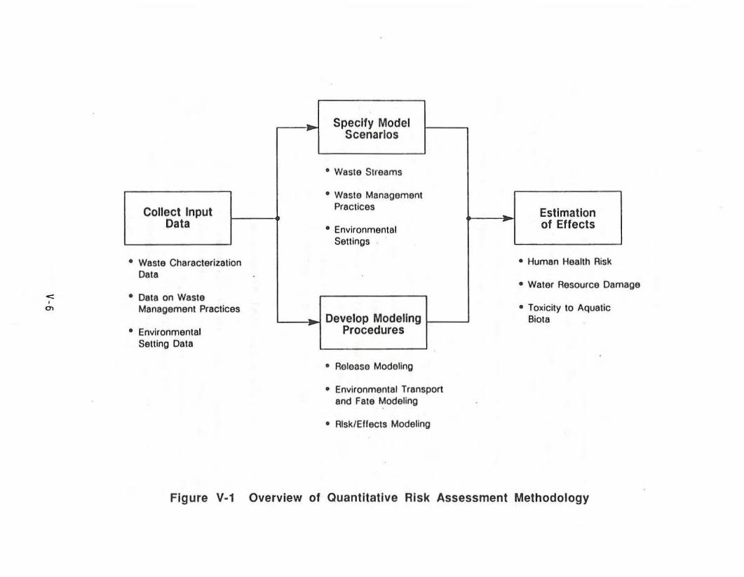
"'"'"
Specify ModelScenarios
• Waste Streams
• Wasle Management
Collect Input Practices EstimationData • Environmental 01 Effects
Settings
• Wasle Characterization • Human Health Risk
Data• Waler Resource Darr
• Dat8 on WasteManagement Practices • Toxicity to Aquatic
Develop Modeling Biota• Environmental Procedures
Setting Data
• Release Modeling
• Environmental Transportand Fate Modeling
• Risk/Effects Modeling
Figure V-1 Overview 01 Quantitative Risk Assessment Methodology
age
Input Data
EPA collected three main categories of input data for the
quantitative modeling: data on waste volumes and constituents, waste
management practices, and environmental settings. Data on waste volumeswere obtained from EPA's own research on sources and volumes of wastes,
supplemented by the results of a sut"vey of o.il and gas facil ities
conducted by the American Petroleum Institute (API) (see Chapter II).Data on waste constituents were obtained from EPA's waste stream chemical
analysis study. The results of EPA's research on current waste
management pract ices, supp1emonted by API's stud ies (see Chapter I I I) ,were the basis for defining necessary input parameters concerning waste
management practl ces. Data needed to character; ze env j ronmenta 1 sett i ngs
were obtained from an analysis of conditions at 266 actual drilling andproduction locations sampled from areas with high levels of oil and gas
activity (see USEPA 1987a, Chapter 3, for more detail on the sampleselection and analytical methods).
Model Sc~narios
The model scenarios in this analysis are unique combinations of the
variables used to define waste streams, waste management practices, and
environmental settings at oil and 9as facilities. Althou9h the modelscenarios are hypothetical, they w~re designed to be:
• Representative of actual industry conditions (they weredeveloped using actual industry data, to the extent available);
• Broad in scope, covering prevalent industry characteristics butnot necessarily all sets of conditions that occur in the industry;and
• Sensitive to major differences in environmental conditions (suchas rainfall, depth to ground water, and ground-water flow rate)across various geographic zones of the U.S.
V-7
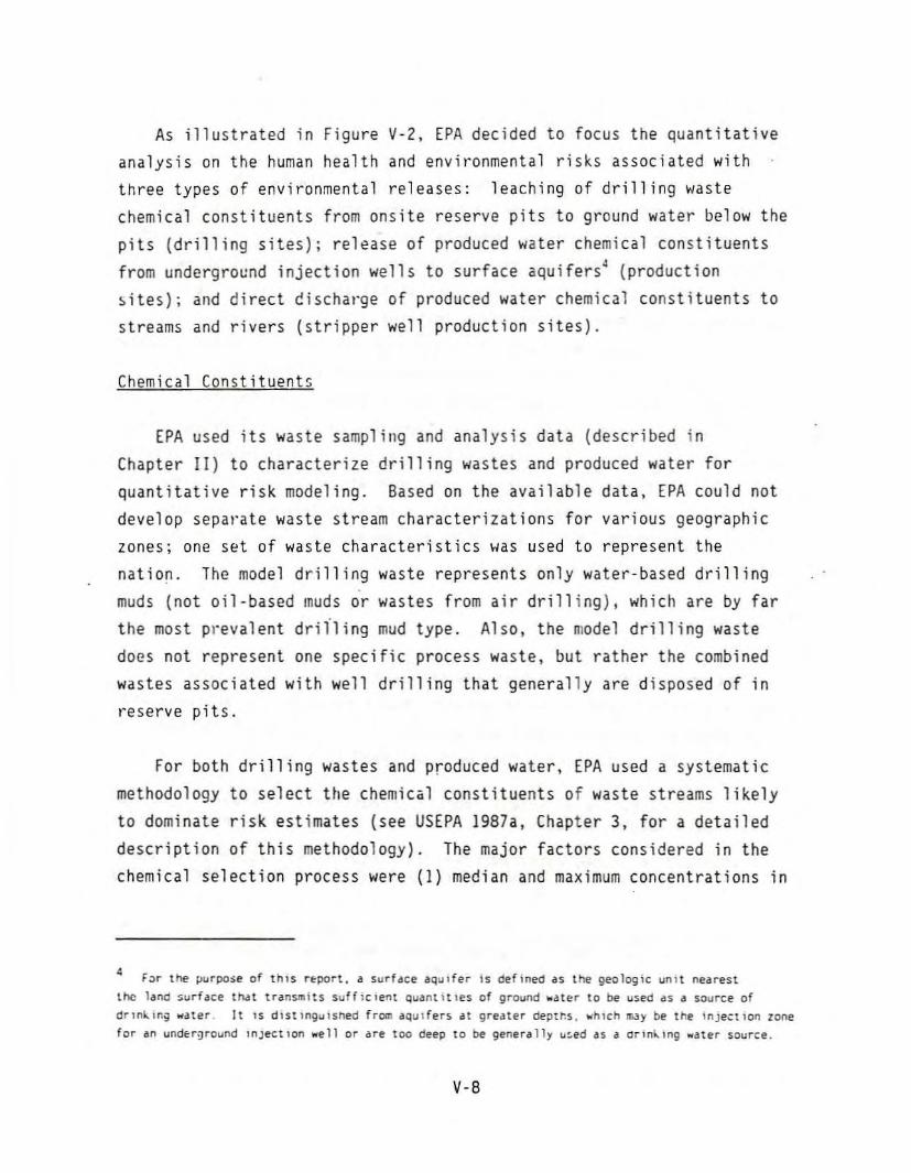
As illustrated in Figure V-Z, EPA decided to focus the quantitativeanalysis on the human health and environmental risks associated with
three types of environmental releases: leaching of drilling waste
chemical constituents from onsite reserve pits to ground water below the
pits (drilling sites)i release of produced water chemical constituents
from underground injection wells to surface aquifers4 (production
~ites); and direct c!ischat'ge of produced water chemical constituents to
streams and rivers (stripper well production sites).
Chemical Constituent5
EPA used its waste sampling and analysis data (described in
Chapter II) to characterize drilling wastes and produced water for
quantitative risk modeling. Based on the available data, EPA could not
develop sepal"ate waste stream characterizations for various geographiczoneSi one set of waste characteristics was used to represent the
nation. The model drilling waste represents only water-based drilling
muds (not oi1·based muds or wastes from air drillingL which are by far
the most prevalent drn'l ing mud type. Also, the model drilling waste
does not represent one specific process waste. but rather the combined
wastes associated with well drilling that generally are disposed of int'eserve pits.
For both drilling wastes and produced water, EPA used a systematic
methodology to select the chemiCal constituents of waste streams likely
to dominate risk estimates (see USEPA 1987a, Chapter 3, for a detailed
description of this methodology). The major factors considered in the
chemical selection process were (1) median and maximum concentrations in
• F~r the purpo~e of thIS r~port. a surface aqUIfer is defined as the geologic unIt nearestthe land surface that transmits suffiCIent quant Itles of ground .at~r to be used as a source ofdrln~ln~ water, It IS dlstlngulsned fr~ aquIfers at greater dept~s. ~hlCh ~y be the Inject Ion lonefor an und~r9round lnJectlon well or are too deep to be generally u~ed as a arln~lng water source.
V-8
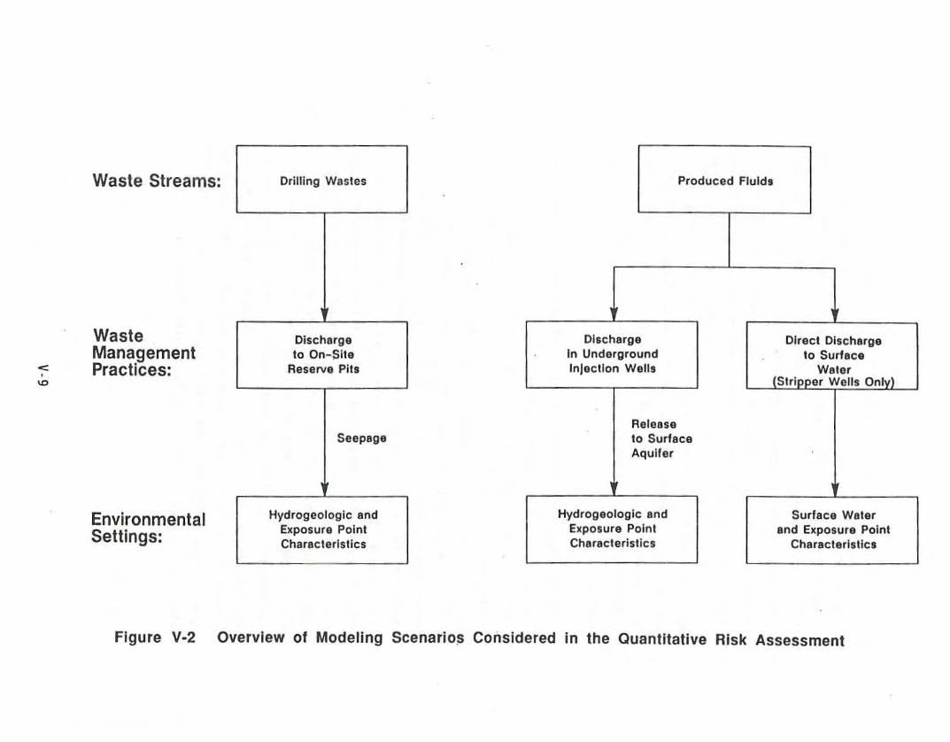
Waste Streams:
WasteManagement
-:= Practices:'"
EnvironmentalSettings:
Drilling Wastes
Dischargeto On-Site
Reserve Pit,
Seepage
Hydrogeologic andExposure PointCharacteristics
Produced Fluids
Discharge Direct DischargeIn Underground to SurfaceInjectIon Wells (: Wate,
Stripper Wells Onlv)
Releaseto SurfaceAquifer
Hydrogeologic and Surface WalerExposure Point and Exposure PointCharacteristics Characteristics
Figure V·2 Overview of Modeling Scenario~ Considered in the Quanlllalive Risk Assessment
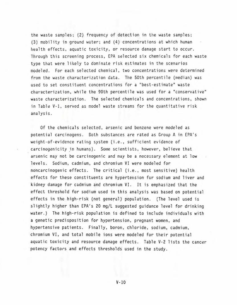
the waste samples; (2) frequency of detection in ttle waste samples;(3) mobility in ground wiiter; and (4) concentrations at which human
health effects. aquatic toxicity, or resource damage start to occur.
Through this screening process, EPA s~lected six chemicals for each waste
type that wel-e likely to dominate risk estimates in the scenal-ios
modeled. For each selected chemical, two concentrations were determinedfrom the waste characterization data. Tile 50th percentile (median) was
used to set constituent concentrations for a "best-estimate" waste
clla"acterization, while the 90th percentile was used for a "conse,'vative"
was te characteri zat i on. The se 1ected chemi ca 1sand concentl·at ions, shown
in Table V-I, served as model waste st,'eams fOl' the quantitative risk
analysis.
Of the chemicals selected, arsenic and benzene were modeled aspotential carcinogens. Goth substances are rated as Gt"OUP A in EPA's
weight-of-evidence rating system (i.e., sufficient evidence of
carcinogenicity .in human$). SOIne scientists, however, believe thatarsenic may not be carcinogenic and may be a necessary element at low
levels. Sodium, cadmium, and chromium VI were modeled for
noncarcinogenic effects. The critical (i.e., most sensitive) health
effects for these constituents are hypertension for sodium and liver and
kidney damage for cadmium and chromium VI. It is emphasized that the
effect threshold for sodium used in this analysis was based on potential
effects in the high-risk (not general) population. (The level used isslightly higher than EPA's 20 mg/L suggested gUidance level for drinking
water.) The high-risk population is defined to include individuals with
a genetic predisposition for hypertension, pregnant women, and
hypel·tensive patients. Finally, boron, chloride, sodium, cadmium,
chromium VI, and total mobile ions were modeled for their potential
aquatic toxicity and resource damage effects. Table V-2 lists the cancerpotency factors and effects thresholds used in the study.
V-10
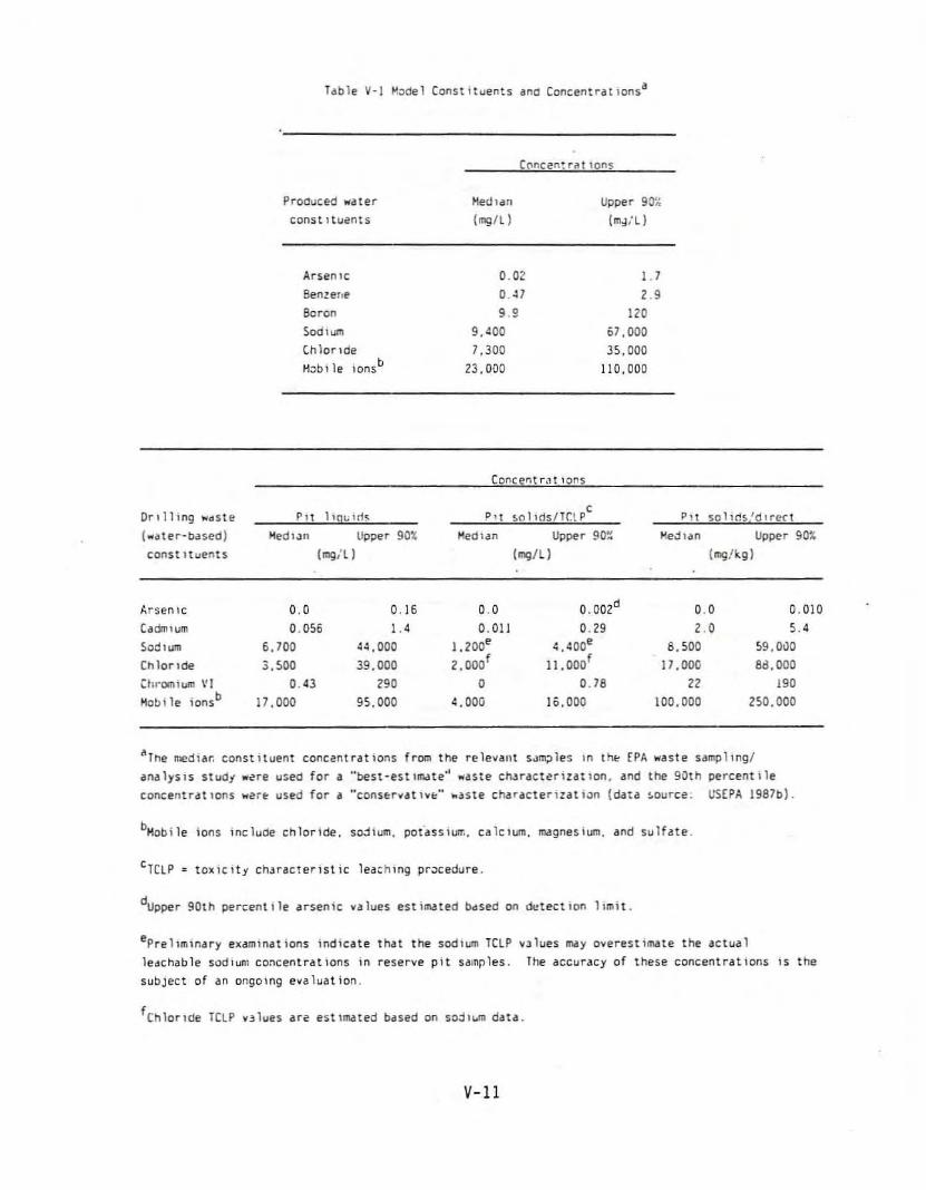
Tdble V-I ~~del Constituents dne Concentrdtionsa
Proaucecd "'dtercanst ltuents
ArseniC
gen!elle
Beron
Sodium
C.hlorlde
Hoblle IOns b
Hedldn
(mg/l)
0.020. .119 ,
9.':00
7.30023,000
COl'lcel'lt r.ll 10l'lS
Upper 9(r,;
(m,j,'l)
1.71.9
11.61,000
35.000
lIO.OOO
Drilling "'etste(",.. ter-based)
const ltuents
HedlJn Upper 90t;
(mg/ll
P'l !>nlHlslTClpc
Medl<ln Upper 90%
(mg/l)
P,t SOlllh,'d'rect
~e,jlan Upper 90t
(mg/kg)
J..rsen Ie 0.0 0.16 0.0 0.002d 0.0 0.010
Cadrrllum 0.056 I.' o. all 0.29 1.0 ,.Sodium 6.700 4.1,000 1,200e ':.400e 8.500 S9,OiJO
Chloride 3.500 39.000 2,OOOf 11.000f 17,000 8d,OOO
Chr'ClBIUft\ \'1 0.43 190 0 0.78 11 190
Mobi Ie lonsb i7,OOO 95.000 4. 000 16.000 100,000 2500.000
"'Tne medlar, constituent concentrations from the relevant SJm;:J1es In tht; EPA ",aste sampling!
<lMlyS1S studt ",,,,re usee for a "best-estlm.lte" ",aste chJractu1zatlon, and the gOth percentile
concentr4t Ions "'Ut'" used for a "conSE:rv4t 1VI:=" -'Jste ch4r4ctetlzat ",n (d4ta !.ource. USEPA 1987b).
bMobile ions IOcluce chloride, sodium, pot"assiull'o, calCium, m.lgnesium. 4nd sulhte.
CTClP ~ toxlcitj chJracterlstic leaching procedure.
dUpper 90th percentile <Irsenic values estim3ted b4sed on ~tect ion limit.
eprellminary examinations indicate that the Sodium TClP vJlues may overestimate the actual
leete-hable sodhln1 CO:lcentrat10ns in reserve pit samples. The accurJCY of these concentrations IS the
subject of an ongOing evaluation.
fChlorlde TelP v,lues are est1mated based on soj,wm data.
V-ll

Tacle V-2 TO~IClty Parameters and Effects Tnresnoldsa
Can::er tluman ncncan.:erMooe I potency £octor thresnold Aquat1c tO~lcity Resource damage. ,
(m9/~g-d) thresholo (mg/l) threshold (mgil)constituent (mg!kd-d) •
Bell!",ne o 052 HA NAb HA
Arsen1C II HA HA HA
Sud lum NA o. " 83.• NA
Cacilliu:lI HA' 0.00029 0.00055 HA
Cnroll'llu,'l1 " HAC 0.005 0.011 HA
Ch lor lde HA HA IlA 110
•Boron NA /lA NA
Totalll"oODlle10nsd HA " HA :nSe
SOOf
aSee US(PA 1987a for oetalled descrIptIon and docu~entatlon.
°HA'" not applic6b1e; IndIcates lnal 6n effect type was not modeled for a specIfIC Che!nICdl.
CNot considered CdrClnogenlC by the ordl e~posure route.
dRepresents totdl Jl\iiSS of ions mcbile in ground loa1er.
eFor surfdce _ater only (dSSumeS d bdclground level of 55 mg/l dnd a threshold lImit of 400mg/ll.
f ror ground water only.
V-12
The chemicals selected for risk modeling differ from the constituentsof potential concern identified in Chapter II for at least three
important reasons. First, the analysis in Chapter II considers the
hazards of the waste stream itself but, unlike the selection process usedfor this risk analysis. does not consider the potential for waste
constituerlts to migrate throllgh gl"OU11d water and result in exposures at
distant locations. Second, certain constituents were selected based on
their potential to cause a.dverse environmental (as opposed to human
health) effects, while the analysis In Chapter II considers only human
health effects. Third, frequency of detection \las considered in
selecting constituents for the risk modeling but was not considered inthe Chapter II analysis.
Waste Management Practices
Three general waste management practices were considered in this
study: onsite·res~rve pits for drilling waste; underground injectfon
w~lls for produced ·water; and direct discharge of produced water torivers and streams (for stripper wells only).5 EPA considered the
underground injecticn of produced water in disposal wells andwaterflooding wells. 6 The design characteristics and parameter values
modeled for the different waste management practices aloe presented in
Tables V-3 and V·4. These values were developed from an evaluation of
EPA's and API's waste volume data .(see Chapter II) and waste management
practice survey results (see Chapter Ill) for the nation as a whole.
5 At present. t~l'e are no Federal effluent gUldp.'lOcS for stnpocr welh (1.e., t.ll loIel1sproducing less than ten barrels of cruce oil per day), aml, under Fed~ral law. these ..ells /Ire allowedto dlScharge directly to surface Io"aters subJt:ct to certaw restrictions. Most other onshore oil andgas facll,tles are sU~Ject to t~ r~dcr4l zero'Jlscharge requirement.
6 ~JterflooJing is a secon~jry re~overy mett~d in whIch treated fre~h water, seJwat~r, orprod~:ed wdter is Inje:ted into <l petroleum-t>uring fonn.Hion to help maIntaIn pressurE: and 10 displacea portIon of the r~lnlr.g crude 011 toward prOduC~lOn wells. lnJe~tlOn w~lls use~ for w~terfloodlng
m3y have dlfferenl designs. ooeratl~g practices. and economIC conslderatlons than those of disposalwel I~, which are USl~ si~ly to dispos~ of unwanted fluid underground.
V-13
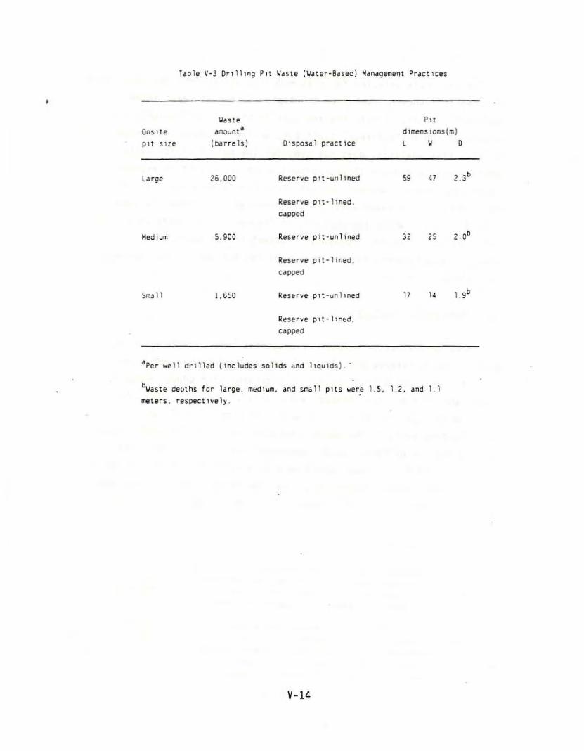
Table V-J Drll1lng Pit ~aste (~ater-BdSed) ~ana9ement Practlces
•'Jaste Pn
Onstle aillOunt a dlmenslonsjm)
pn size (barrels) DIsposal practice l " 0
large 26,000 Reserve plt-unllned 59 "1 .b.,
Reserve plt-hned.
capped
Medium !l, gOO Il.eser·~e pit-unlined J1 15 2 _Ob
Reserve pit·llr,ed,
clipped
5mJ 11 J. 6~O Il.enrve pit-unlined 17 14 1. gb
Rt:SlOr"e plt-lln{'d,
capped
IIper well r!rll1ed jlncludes solids dod llQUHJs).
b'JIIste delilhs for ldrge, lIll.'diurn, and srn"ll pits wefe 1.5.1.2, and 1.1
meters, respect ''Ie 1)'.
V-14
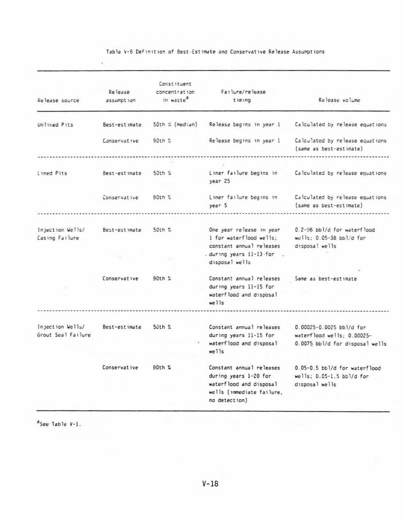
T~bli! ~-6 Ceflnlt Ion of Best Est lmdte ana Conseryat lye Release A~su.llpt IonS
Cor,s: Huentlie ledSe concentrat lOr. f a I lure/ re "..ase
lie le<lse sOurce <Issumpt lOll HI ,,<IS tea t Iml1l9
Ulllmed PitS Best-est IlIl(Ile !>Otl'l 1- (med:dll) 'Ie lease! begins '" year
C,Jnservatlve gOt" t Release begllls III ye<lr
Release vo1 ..me
Calculated by reledse e~uJtiolls
(same as best-estl~~te)
LwedPil$ Best-est I~~te 50th ~ Liller f.lllure beSIns ;" Calculated by rele<lse eqUJt lOllSfear 25
':or,servJt I~e 90th . Liller faIlure beginS '" C~lculdted by release equatIons.year !> (same as best-estimate)
InJ!:!ct ion We IislCaSlng f,"lure
InJect 1011 'oil' 11~1
Grout Seal failure
Be:.t-est llnate
(onser~lIt lye
Conservative
50th t
90th :.:
50th t
90tl'l %
One year re lease HI yearI for waterfl00d wells:constant annual releases_dunng years 11-13·fordlsposdl welh
Constant annual releasesduring years II-I!> forwaterflooj and dispOsalwe lis
Constant annual releasesduring years 11-15 for..aterflood and disposalwe 11s
Constant annual releasesduring years 1-20 forwaterflood <lnd dlsposalwells (Immediate fJilure,no detection)
V-18
0.2-!16 bbl/d for waterfloodw~lls: 0 0!>-38 bbl!d fordl:iposal wells
Same as best-est I~te
0.00025-0.0025 bbl/d forwdterflood ..ells; 0.00025O.007~ bbl/d for disposal wells
0.05-0.5 bbl/d for ..aterflood..ells; 0.05-1.5 bbl/d fordl!;posal wells
the same layers considered during the active period. For unlined pits,release was assumed to begin immediately at the start of the modeling
period. For lined pHs, failure (i.e., increase in hydraulic
conductivity of the liner) was assumed to occur either 5 or 25 years
after the start of the modeling period. It was assumed that any liquidsremaining irl unlined reserve pits at the time of closure would be land
applied adjacent to the pit. Liquids remai~ing in lined pits wereassumed to be disposed offsite.
For modeling releases to sut"face aquifers from Class II injection
wells. a 20-year injection well operating period was assumed, and twofailure mechanisms were studied: (1) failure of the well casing (e.g., a
corrosion hole) and (2) failure of the grout seal separating the injection
zone f'"om the surface aquifer. At this tinle, the Agency lacks the data
necessary to estimate the probability of casing or grout seal failures
occurring. A well casing failure assumes that injected fluids al"e exiting
the wel~ through a hole in the casing protecting the surface aquifer. In
most cases. at least two strings of casing protect the surface aquiferand, in those cases, a t"elease to this aquifer would be highly unlikely.
The Agency has made exhaustive investigations of Class I well.(i.e.,hazardous waste disposal \o/el1) failures and has found no evidence of
release of injected fluids through two strings of casing. However, the
Agency is aware that some Class II wells were constructed with only one
string of casing; therefore, the scenarios modeled fall within the realmof possible failures. Since integrity of the casing must be tested every
S years under current EPA gUidelines (more frequently by some States),EPA assumed for the conservative scenarios that a release would begin onthe first dey after the test and would last until the next test (i.e.,S years). For the best-estimate scenarios, EPA assumed that the releaselasted 1 year (the minimum feasible modeling period) in the case ofwaterflood wells and 3 years in the case of disposal wells, on the
supposition that shorter release durations would be more likely for
V-J9
waterfloodin\} where injection .flow rates and volumes are important
economic considerations for the operation. EPA also assumed here that
the release flow from a failed well would remain constant over theduration of the failure. This simplifying assumption is more likely to,
hold in low-pressure wells than in the high-pressure wells more typical
of waterflooding operations. In high-pressure wells the high flow rate
wou1d likely enlarge the casing holes more rapidly, resulting in more
injection fluid escaping into the wrong horizon and a noticeable drop of
pressure in the reservoir.
For the grout seal type of failure, EPA estimated for conservative
modeling purposes that the failure could last for 20 years (i.e., as long
as the well operates). This is not an unreasonable worst-case assumption~~cause the current regulations allow the use of cementing records to
determine adequacy of the cement job, rather than actual testing through
the use of logs. If the cementing records were flawed at the outset, acementing fallure might remain undetecte~. As part of .its t'eview of the
Underg,'ound Injection Control (UrC) regulations, the P.gency is considering
requiring more reliable testing of the cementing of wells, ",'hich would
considerably lessen the likelihood of such scenarios. For an alternative
best-estimate scenario, the Agency assumed a 5-year duration of failure
as a mOt"e typical possibility,
BeCause of a lack of both data, and adequate modeling methods, otherpotentially important migration pathways by which underground injection
of waste could contaminate surface aquifers (e,g., up'i'/ard contaminant
migration from the injection zone through fractures/faults in confining
layers or abandoned boreholes) were not modeled.
Chemical transport was modeled for ground water and surface water
(rivers). Ground-water flow and mass transport were modeled using EPA's
liner location Risk and Cost Analysis Model (llM) (USEPA 1986), The llM
V-20
uses a series of predetermined flow field types to define ground-water
conditions (see Table V-7); a transiellt-source, one-dimensional,wetting-frollt model to assess unsaturated zone transport; and a modified
version of the Random Walk Solute Transport Model (Prickett et a1. 1981)
to predict ground-water flow and chemical transport in the saturated
zone. All ground··water exposure and risk estimates presented ill thisreport are for the downgradient center 1ine plume concentration.
Chemical transport in rivers was modeled using equations adapted from EPA(USEPA 1984a); these equations can aCCOllnt for dilution, dispersion,
particlllale adsorption, sedimentation, degradation (photolysis,
hydrolysis, and biodegradation), and volatilization.
EPA used the llM risk subll10del to estimate cancer and chronic
noncancel~ risks from the ingestion of contaminated ground and sUI~face
water. The m2asure used fur cancer risk was the maximum (over the
200~year mod..:ling period) lifetime excess 7 individual risk, assuming an
i~dividuQl ingesteo contaminated ground or surface water over an entirelifetime (assumed to be 70 years). Th~se risk numbers represent the
estimated probability of occurrence of callcer in an exposed individual.
For example, a cancer risk estimate of 1 x 10- 6 indicates that the
chance of an individual getting cancer is approximate1y one in a millionover a 70-year lifetime. The measure used for noncancer risk was the
maximum (over the 200-year modeling period) ralio of the estimatedchemical dose to the dose of the chemical at which health effects begin
to occur (i .e., the threshold dose). Ratios exceeding 1.0 indicate the
potential for adverse effects in some exposed individuals; ratios less
than 1.0 indicate a very low likelihood of effect (assuming thatbackground exposure is zero, as is done in this study). Although these
ratios are not probabilities, higher ratios in general are cause for
greater concern.
7 Llo.CeSS reii!rs to the rlSk increlllent attributable only to e>;ppsure resultlng froOl the
releases ..:or,Sldere<J In thIs In.JlySIS. 8.Jclground e~po:;ure$ ...,re clssumed to be zero.
V-2!
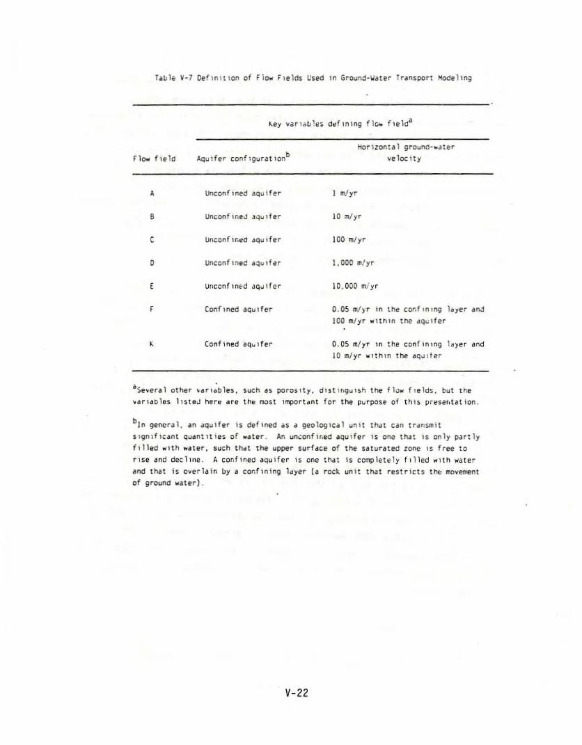
flo.. field
A
8
c
o
,F
,
Unccnflned aquIfer
Unccnfl~ed aquifer
Unccnflnec aquifer
Unccnflnfd JQ~,fcr
Confined a~ulfer
Ccnfined aquifer
horizontal ground-.ater
Vt' lac Ity
I m/yr
10 :n/yr
100 m/yr
1,000 m/yr
10,000 miyr
0.05 ~rr in the co~flnlng loyer aoJ
100 ~/yr within the aquifer
0.05 m/yr In the confinIng l~~er and
10 m/yr "'ilthln the aq.l1ter
aSelteral other Itarlables. such as porosIty, dlstu,gul$h the fl<:l\ll ftelds, but the
Itarl,loles llsteJ her~ ,He th~ most imporUnt for the purpost' of thIs I.l'l'sar,tation.
bin gener,)l. an "qulfer is defined as a geologIcal unit th.:lt e"n lrallsmlt
slgnlflc"nt quantities of .ater. An un\:onfir,~d "quI fer is onc th.!t IS only p"rtlyfilled \IIlth ."ter, such thot the upper surface of the saturated zone IS free to
rIse and deelme. A confined aquifer is onl! that is completely filled wltn water
and that is overlain by a co~flning l<tyer (" rock unit that restricts thl: movement
of ground water).
V-22
As a means of assessing potential effects on aquatic organisms, EPAestimated, for each model scenario involving surface water, the volumecontaminated above an aquatic effects threshold. EPA also estimated the
volumes of ground and surface water contaminated above various resource
damage thresholds (e.g., the secondary drinking water standard forchloride).
QUANTITATIVE RISK MODELING RESULTS: HUMAN HEALTH
This section summarizes the health risk modeling results for onsitereserve pits (drill ing wastes), underground injection wells (produced
water), and direct discharges to surface water (produced water, stl-ippel"
well scenarios only). Cancer risk estimates are presented separately
from noncancer risk estimates throughout. This section also summarizesEPA's preliminary estimates of the size of populJtions that could
possibly be exposed through drinking water.
Onsitc R~serve Pits--Drilling Wastes
Cancer and noncancer health risks were analyzed under both
best-estimate and conservative modeling assumptions for 1,134 model
scenarios8 of onsite reserve pits. Arsenic was the only potential
carcinogen among the constituents modeled for onsite reserve pits. Of
the noncarcinogens, only sodium ex.ceeded its effect threshold; neithercadmium nor chromit:m VI exceeded their thresholds in any model scenarios
(in its highest ,-isk scenario, cadmium was at 15 percent of threshold;
chromium VI, less than 1 percent).
8 J.J3~ & 9 infjltration/uns~turated zone types x 7 ground·wdter flow fIeld tYPeS x 3e~~osure dIstances ~ 3 Size cate;orles x Z llner types.
V-23
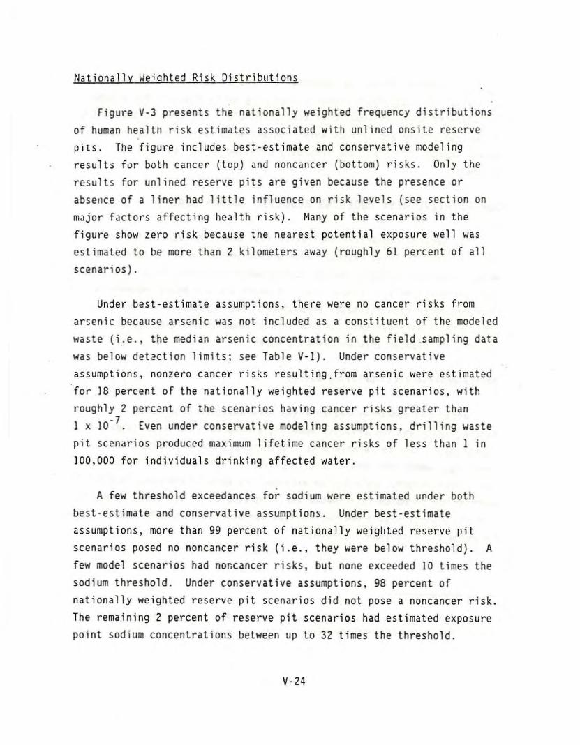
Nationally Weighted Risk Oistriblltions
Figure V-3 presents the nationally weighted frequency distributions
of human heal tIl risk estimates associated with unlined onsite reserve
pits. The figure includes best-estimate and conservative modelingresult. for botl, cancer (top) and noncancer (bottom) risks. Only the
results for unlined reserve pits are given because the presence or
abserlce of a liner had little influence on risk levels (see section on
major factors affecting Ilealth risk). Many of tile scenarios in thefigure show zero risk because the nearest potential exposure well was
estimated to be more than 2 kilometers away (roughly 61 percent of all
scenarios).
Under best-estimate assumptions, there were no cancer risks from
ar~enic because arsenic was not included as a constituent of the modeled
waste (i .. e., the median arsenic concentration in Ule field .sampling data
was below detaction limitsj see Table V-I). Under conservative
assumptions, nonzero cancer risks resulting,from arsenic were estimated
for 18 percent of the nationally weighted reserve pit scenarios, with
roughly 2 percent of the scenarios having cancer risks greater than1 x 10- 7. Even under conservative modeling assumptions, drilling waste
pit scenarios produced maximum lifetime cancer risks of less than 1 in
100,000 for individuals drinking affected water.
A few threshold exceedances for sodium were estimated under both
best·estimate and conservative assumptions. Under best·estimate
assumptions, more than 99 percent of nationally weighted reserve pit
scenarios posed no non cancer risk (i.e., they were below threshold). A
few model scenarios had nor.cancer risks. but none exceeded 10 times the
sodium threshold. Under conservative assumptions, 98 percent of
nationally weighted reserve pit scenarios did not pose a non cancer risk.The remaining 2 percent of reserve pit scenarios had estimated exposure
point sodium concentrations between up to 32 times the threshold.
V-24
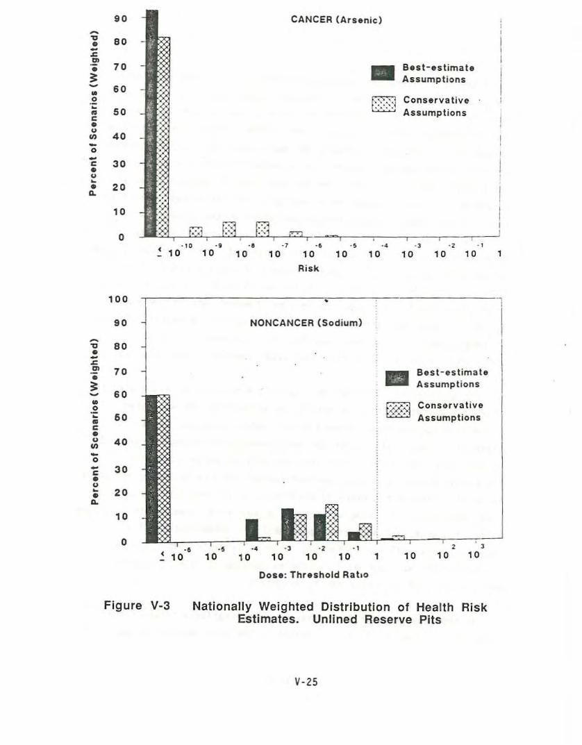
ConservativeAssumptions
Best-estimateAssumptions•
CANCER (Arsenic)
--=,." ., ., ., ., ., ., ., ., .,
< 10 10 10 10 '0 10 '0 10 10 10 ,.Risk
90~... 80..-~.,.. 70;:~ 60w0~
50mc..u
40Ul-0-c 30..u~.. 200.
10
0
NONCANCER (Sodium)
~---------"""--~-------l
, ,10 '0
ConservativeAssumptions
101
Best-estimateAssumptions
·2 . I
10 10( -6 'S ·4 -3.10101010
100
90
~... 80..-~.,70..
;:60~
w0~ 60..c..u 40Ul-0- 30c..u~ 20..0.
10
0
Dose: Threshold Rallo
Figure V-3 Nationally Weighted Distribution of Health RiskEstimates. Unlined Reserve Pits
V-25
Based on a 1iterature review conducted as part of the development of
the Liner Location Model data base (USEPA 1986), chloride is the only
mod~l ,drilling waste constituent for which either a taste or odorthreshold concentration Is known. EPA (1984b) reports that the taste
threshold for chloride is roughly 250 mg/L (i.e., this is the minimum
chloride concentration in water that a person may be able to taste). For
thi highest cancer t"isk case, the maxinlum chloride concentration at the
exposure well was estimated to be 400 mg/L; for the highest noncancerrisk case. the maximum chloride concentration at the exposure well was
estimated to be approximately 5.000 mg/L. Therefore. it appears that, if
water contained a high enough arsenic concentration to pose cancer risks
on the order of 1 x 10- 5 or sodium concentrations 100 times the effect
threshold, people may be able to taste the chloride that would also
likely be present. The question remains, however, whether people would
actually discontinue drinking water containing these elevated chloride
concentrations. EPA (1984b) cautions that consumers may becomeaccustomed to the taste of chloride levels somewhat higher than 250 mg/L.
For purposes of illustration, Figure V-4 provides an example of tIle
effect of weighting the risk results to account for the estimated
national frequency of occurrence of the model scenarios. Essentially,
weighting allows risk results for more commonly occurring scenarios to
"count" more than results from less commonly occurring scenarios.
Weighting factors were developed a~d applied for the following variables,based ~n estimated frequency of occurrence at oil and gas sites: pit
size, distance to drinking water well, ground-water type, depth to ground
water, recharge, and subsurface permeability. Other potentially
important risk-influencing factors, especially waste composition and
strength, were not modeled as variables because of lack of information
and thus are not accounted for by weighting.
In the example shown in Figure V-4 (conservative-estimate cancer
risks for unlined onsite pits), weighting the risk results decreases the
V-26
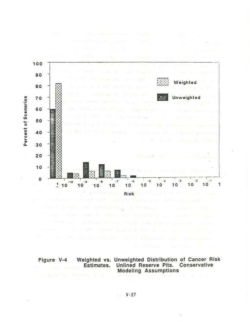
Unweighted
f~::::j Weighted
100
90
80
.. 700~..I: 60..UIII
50-0-I: 40..u~.."- 30
20
10
0c • 10_ 10
.,10
:Q.WII=.,.--'----;--~~.8 ·7 ·6 .!1 -4 ·3
10 10 10 10 10 10
Risk
-~---r--.
·2 . ,
10 10 1
Figure V-4 Weighted vs.Estimates.
Unweighted Distribution of Cancer RiskUnlined Reserve Pits. ConservativeModeling Assumptions
V·2]
Related Documents


