The Anadarko Basin: Oil and Gas Exploration – Past, Present and Future John Mitchell, Senior Geologist SM Energy Co. Tulsa, Oklahoma March 2012 Email: [email protected]

Welcome message from author
This document is posted to help you gain knowledge. Please leave a comment to let me know what you think about it! Share it to your friends and learn new things together.
Transcript

The Anadarko Basin: Oil and Gas Exploration – Past, Present and Future
John Mitchell, Senior Geologist SM Energy Co.
Tulsa, Oklahoma March 2012
Email: [email protected]

Regional Location Map
Ardmore-Marietta Basin
Rascoe & Hyne, 1988

• Located in western Oklahoma, southeastern Colorado, western Kansas and the northeastern portion of the Texas Panhandle
• Approximately 70,000 square miles in size
• Sedimentary column approaches 40,000 feet in thickness in deepest portion of basin
• Production comes from Cambro-Ordovician through Permian strata
• Estimated cumulative production of more than 125 trillion cubic feet of gas and 5.4 billion barrels of oil

• Bounded tectonically on the southern and eastern sides by major fault zones and/or uplifts
• Four major horizontal drilling plays in progress in oil and gas bearing horizons in (1) the Cleveland Ss., (2) the Granite Wash of Pennsylvanian age, (3) the Mississippian limestones, and (4) the Upper Devonian Woodford Shale
• Over four thousand horizontals completed in basin to date at vertical depths as great as 15,000 feet.
• Significant future horizontal development may await in Pennsylvanian sandstones and shales as well as in older carbonates in the Mississippian through Ordovician.

Regional Structure Map Structure Map: Datum top of the Arbuckle Group (Cambro-Ordovician). Contour Interval = 1000 feet or 5000 feet in deeper part of basin. Basin reaches maximum depths in Beckham, Washita and Caddo Cos., OK Grey shaded area is greater Anadarko Basin. Red lines are faults, tic on downthrown side. Structural relief on south side of basin in excess of 35,000 feet vertically and horizontally.
Map Adapted from H.G. Davis, 1988
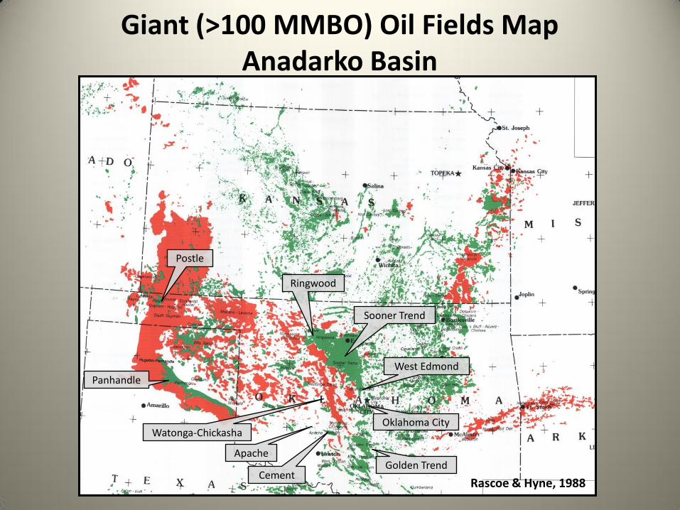
Giant (>100 MMBO) Oil Fields Map Anadarko Basin
Oklahoma City
West Edmond
Sooner Trend
Postle
Panhandle
Ringwood
Watonga-Chickasha
Cement
Apache Golden Trend
Rascoe & Hyne, 1988

Significant (>1,000 BCF) Gas Fields Map
Hugoton-Panhandle
Panoma
Hugoton-Panhandle
Mocane-Laverne
Watonga-Chickasha
Hemphill
Buffalo Wallow
Sooner Trend
Elk City
Cement
Hansford
Putnam
Strong City
Eakley-Weatherford Golden Trend
Rascoe & Hyne, 1988

Distribution of Gas Production by Reservoir Age
54.6
6.6 4.1 13
1.7
25.4
8.3
3.2 0.14
4.8
1.7 PERMIAN
VIRGILIAN
MISSOURIAN
DESMOINESIAN
ATOKAN
MORROWAN
CHESTERAN-SPRINGERAN
MISSISSIPPIAN
WOODFORD
HUNTON
ORDOVICIAN
Cumulative Gas Production in TCF by Geologic System or Series In the Anadarko Basin
Geologic System or Series
>123.5 TCF Total Gas in IHS Production Data Files for Anadarko Basin of Oklahoma, Texas Panhandle, Western Kansas and Southeastern
Colorado

Distribution of Gas Production by Reservoir Age
44%
5% 3% 11%
1%
21%
7%
3% 0%
4%
1% PERMIAN
VIRGILIAN
MISSOURIAN
DESMOINESIAN
ATOKAN
MORROWAN
CHESTERAN-SPRINGERAN
MISSISSIPPIAN
WOODFORD
HUNTON
ORDOVICIAN
Percentage of Cumulative Gas Production by Geologic System or Series In the Anadarko Basin
Geologic System or Series
>123.5 TCF Total Gas in IHS Production Data Files for Anadarko Basin of Oklahoma, Texas Panhandle, Western Kansas and Southeastern
Colorado

Distribution of Oil Production by Reservoir Age
>5,694 MMBO Total Oil in IHS Production Data Files for Anadarko Basin of Oklahoma, Texas Panhandle, Western Kansas and
Southeastern Colorado

27%
3% 10%
13%
1%
17%
4%
6%
0%
4% 15%
PERMIAN
VIRGILIAN
MISSOURIAN
DESMOINESIAN
ATOKAN
MORROWAN
CHESTERAN-SPRINGERAN
MISSISSIPPIAN
WOODFORD
HUNTON
ORDOVICIAN
Percentage of Cumulative Oil Production by Geologic System or Series in the Anadarko Basin
Geologic System or Series
>5,694 MMBO Total Oil in IHS Production Data Files for Anadarko Basin of Oklahoma, Texas Panhandle, Western Kansas and
Southeastern Colorado
Distribution of Oil Production by Reservoir Age
0
200
400
600
800
1000
1200
1400
836
133
1280
1026
91 42 12
372 357
78 10
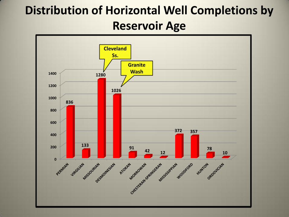
Distribution of Horizontal Well Completions by Reservoir Age
Cleveland Ss.
Granite Wash

0%
5%
10%
15%
20%
25%
30%
35%
20%
3%
30%
24%
2% 1%
0%
9% 8%
2% 0%
Distribution of Horizontal Well Completions by Reservoir Age
Cleveland Ss.
Granite Wash

Regional Structural Features-Horizontal Wells
Structure Map from H.G. Davis, 1988
4,237 Horizontal Completions Thru Feb. 2012

• Permian Carbonates and Granite Wash
• Pennsylvanian Fluvio-deltaic Sandstone, Marine Sandstone and Limestone
• Mississippian Carbonate and Upper Devonian Shale and Chert
• Siluro-Devonian Carbonate (Hunton Group)
• Middle/Upper Ordovician Sandstone & Limestone (Simpson & Viola Groups)
• Cambro-Ordovician Carbonate (Arbuckle Group)

• Woodford formation (Upper Devonian) in Anadarko, Arkoma and Ardmore-Marietta Basins
• Pennsylvanian marine shales (Virgilian, Missourian, Desmoinesian, Atokan, Morrow-Springer)
• Mississippian Caney/Goddard Shale
• Ordovician Carbonates (Viola Group)
• Ordovician Shales (Simpson Group)

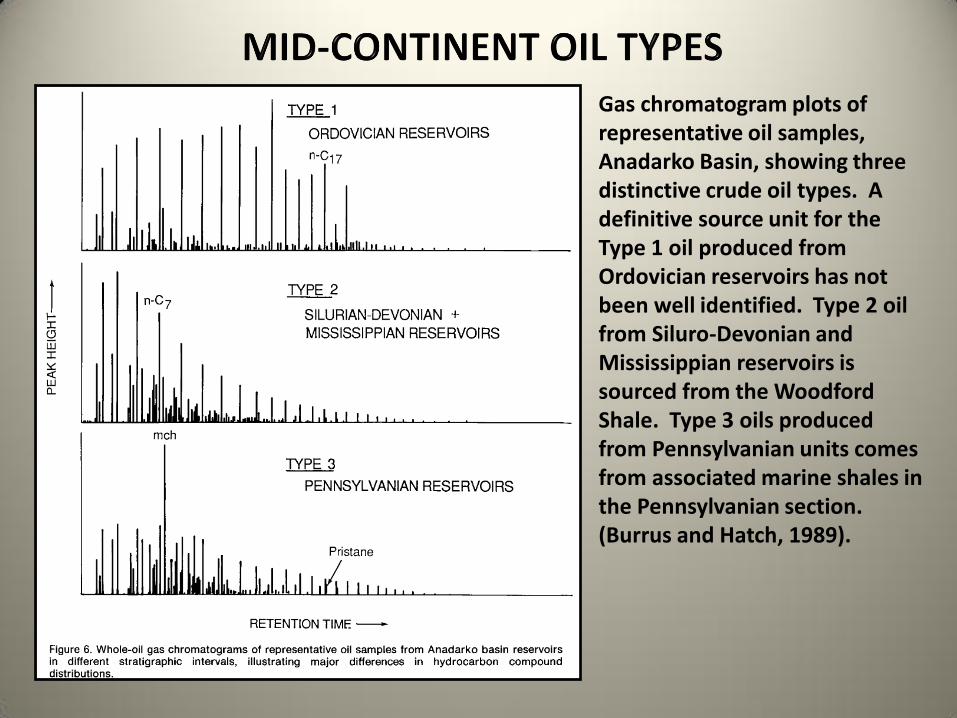
Gas chromatogram plots of representative oil samples, Anadarko Basin, showing three distinctive crude oil types. A definitive source unit for the Type 1 oil produced from Ordovician reservoirs has not been well identified. Type 2 oil from Siluro-Devonian and Mississippian reservoirs is sourced from the Woodford Shale. Type 3 oils produced from Pennsylvanian units comes from associated marine shales in the Pennsylvanian section. (Burrus and Hatch, 1989).
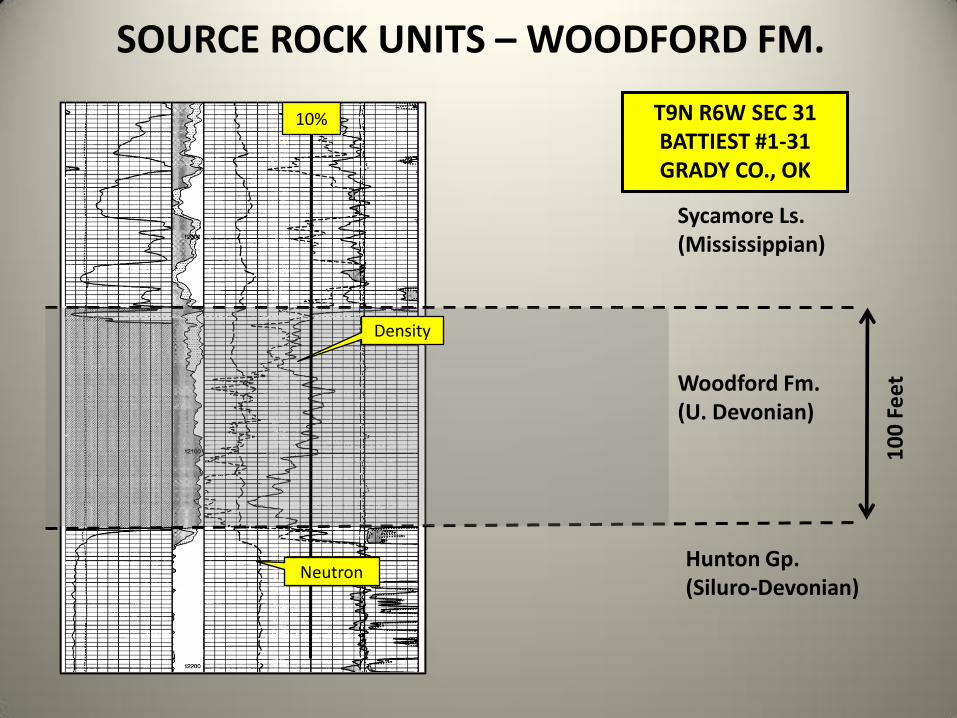
Woodford Fm. (U. Devonian)
Sycamore Ls. (Mississippian)
Hunton Gp. (Siluro-Devonian)
10
0 F
eet
SOURCE ROCK UNITS – WOODFORD FM.
T9N R6W SEC 31 BATTIEST #1-31 GRADY CO., OK
Density
10%
Neutron

SOURCE ROCK UNITS – MISSOURIAN SHALES
The thin radioactive shales in the Missourian section have 2-6% TOC (SM Energy data) in Beckham Co., Oklahoma and are well into the oil window.

SOURCE ROCK UNITS – HOGSHOOTER FM. SM ENERGY #1-26H BECK
SEC. 26, T11N R23W, BECKHAM COUNTY, OK
Hogshooter Fm. (M. Pennsylvanian)
11
4 F
eet
The thin radioactive shales in the Missourian section have 2-6% TOC (SM Energy data) and are well into the oil window. This log shows the Upper and Lower Hogshooter Wash sandstones that have been completed in recent horizontal wells for as much as 2000 BOPD + 4 MMCFGPD.

Regional Isopach, Production and Horizontal Activity Maps by Geologic System or Series

Regional Stratigraphic Column: Lower Paleozoic
A total of 6.5 TCF of gas (5% of Mid-Continent total) has been produced from the Siluro-Devonian and Cambro-Ordovician reservoirs. Total oil production of 1,029 MMBO (19%) has come from these reservoirs. The Hunton carbonate interval has made the majority of the gas while the sandstones in the Ordovician Simpson Group have made most of the oil, primarily from Oklahoma City field. Only eighty-eight horizontal wells (3% of basin total) have been completed these reservoirs in the Anadarko Basin.
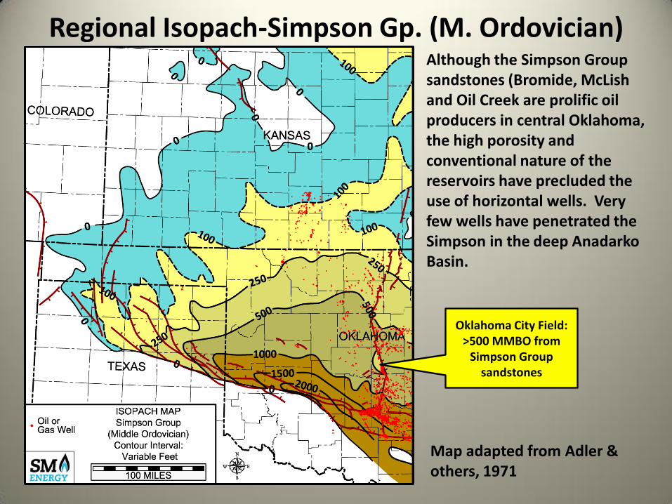
Regional Isopach-Simpson Gp. (M. Ordovician) Although the Simpson Group sandstones (Bromide, McLish and Oil Creek are prolific oil producers in central Oklahoma, the high porosity and conventional nature of the reservoirs have precluded the use of horizontal wells. Very few wells have penetrated the Simpson in the deep Anadarko Basin.
Map adapted from Adler & others, 1971
Oklahoma City Field: >500 MMBO from
Simpson Group sandstones

Regional Isopach-Viola Group Widespread oil production has been obtained from thick (>100 ft) low porosity limestone in the Viola Group in the southeastern portion of the basin. Production is from mainly fractured reservoirs and is highly variable. Only a few horizontals have been placed in the Viola in Oklahoma. Very few vertical wells have penetrated the Viola in the deep Anadarko Basin.
Map adapted from Adler & others, 1971

Regional Isopach-Hunton Gp. (Siluro-Devonian) The Hunton Group is truncated by pre-Woodford and pre-Pennsylvanian erosion surfaces on the north, west and east sides of the basin. Porous dolomite reservoirs in the Frisco, Bois d’Arc and Chimneyhill members of the Hunton are present along the northern and eastern portions of the play.
Map adapted from Adler & others, 1971; Mitchell, 2012
West Edmond Field: >150 MMBO from Hunton in major stratigraphic trap
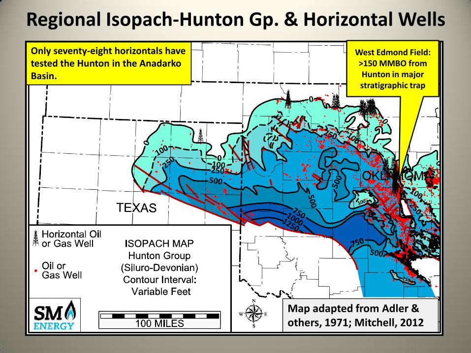
Regional Isopach-Hunton Gp. & Horizontal Wells
Map adapted from Adler & others, 1971; Mitchell, 2012
Only seventy-eight horizontals have tested the Hunton in the Anadarko Basin.
West Edmond Field: >150 MMBO from Hunton in major stratigraphic trap
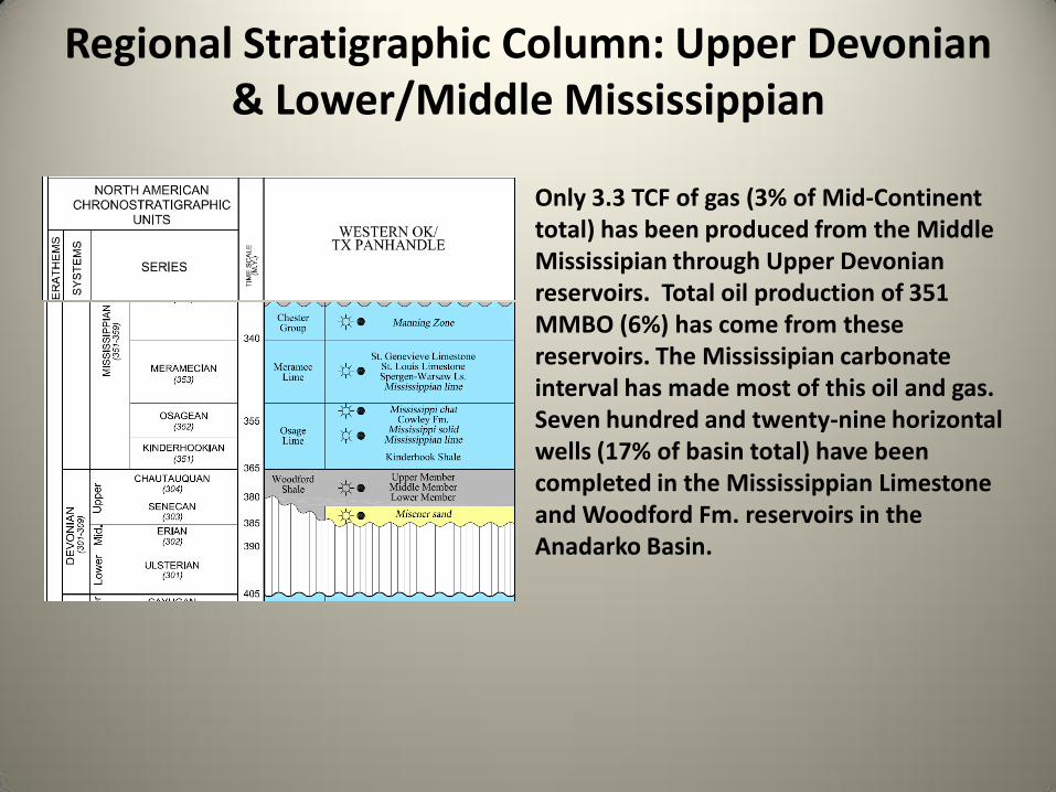
Regional Stratigraphic Column: Upper Devonian & Lower/Middle Mississippian
Only 3.3 TCF of gas (3% of Mid-Continent total) has been produced from the Middle Mississipian through Upper Devonian reservoirs. Total oil production of 351 MMBO (6%) has come from these reservoirs. The Mississipian carbonate interval has made most of this oil and gas. Seven hundred and twenty-nine horizontal wells (17% of basin total) have been completed in the Mississippian Limestone and Woodford Fm. reservoirs in the Anadarko Basin.

Regional Isopach-Woodford Fm. (U. Devonian) The organic rich siliceous shales in the Woodford Fm. are well developed in the southeastern portion of the basin. The Woodford thickens rapidly to the southeast and exceeds 600 feet in thickness in southern Oklahoma. Note the vitrinite reflectance contours in green on the map. They show a wide range of maturities with portions of the deep basin being thermally overmature and through the gas window. Large areas of Oklahoma are underlain by significant thicknesses of Woodford shale that is well into the oil window. It is the primary source for oil and gas in Mississippian, Siluro-Devonian and Ordovician units.
Map adapted from Adler & others, 1971; Amsden, 1975; Cardott, 1988

Regional Isopach-Woodford Fm. & Producing Wells In Canadian and Dewey Counties, Oklahoma over three hundred and fifty horizontal completions have been made in the Woodford. This area is known as the Cana (Canadian County!) play and the production is primarily gas with significant amounts of condensate and natural gas liquids. Depths range from 10,000 to 15,000 feet to the Woodford.
Cana Play Area
Map adapted from Adler & others, 1971; Amsden, 1975; Cardott, 1988

Regional Isopach-Mississippian(Pre-Chesteran) Widespread oil accumulations are present in low porosity limestones across multiple counties in Oklahoma and Kansas. This is north of and updip to the Mississippian oil and gas production in the enormous Sooner Trend in Kingfisher, Major and Garfield Counties, OK. Large areas of the deeper portions of the basin in Oklahoma are lightly tested in the Mississppian section.
Sooner Trend
Map adapted from Adler & others, 1971; H. G. Davis, 1989

Regional Isopach-Mississippian & Producing Wells In the northeastern portion of the basin there is an active oil horizontal drilling play targeting siliceous limestones in the lower and middle Mississippian strata. Operators are pushing northward into Kansas in 2012.
Map adapted from Adler & others, 1971; H. G. Davis, 1989

Regional Stratigraphic Column: Upper Mississippian & Lower Pennsylvanian
35.4 TCF of gas (29% of Mid-Continent total) has been produced from the Atokan through Chesteran series of the Upper Mississippian and Lower Pennsylvanian. Total oil production of 1,171 MMBO (22%) has come from these reservoirs. The Morrowan series has made the majority of this oil and gas. Only one hundred and forty-five horizontal wells (3% of basin total) have been completed in these reservoirs in the greater Anadarko Basin. The Morrow and Springer sandstones have had outstanding individual well performances in overpressured conventional deep gas reservoirs in the basin.

Regional Isopach-Chesteran & Springer Series The late Mississippian Chesteran and Springeran series sandstones and limestones were deposited along the eastern portion of the basin prior to the initiation of profound structural movement in the Morrowan series. The Springer Ss. is a prolific gas producer in Caddo and Grady Counties, Oklahoma. Here the overpressured Springer sands were deposited in northwest trending marine sand bars capping coarsening upward cycles. The Chesteran reservoirs are primarily limestones forming traps beneath the pre-Penn unconformity.
Map adapted from Adler & others, 1971
Northern Limit of Springer Fm.

Regional Isopach-Morrowan Series The sandstones of the Morrowan series form some of the best oil and gas reservoirs in the basin. Morrowan rocks have produced 25 TCF (21%) of the natural gas and 908 MMBO (17%) of the oil in the basin. The great majority of production has come from stratigraphic traps. As of 2012 the Morrowan rocks have not really been tested horizontally along the 300 mile long fairway from southeastern Colorado to western Oklahoma.
Map adapted from Adler & others, 1971

Morrowan Series-Deposition Three distinctive play types are present along the length of the Morrow fairway. They are (A) the Upper Morrow fluvio-deltaic play in SE Colorado, SW Kansas and the Panhandles of Oklahoma and Texas. At depths of 4,500 to 10,000 feet this is where the bulk of the Morrowan oil is produced. Play area (B) is along the basin axis in front of the Amarillo-Wichita Uplift. Here the Upper Morrowan sandstones are productive at depths from 14,000 to 18,000 feet and are overpressured at a gradient as high as 1.0 PSI/foot. The Lower Morrowan marine sandstones (C) are widespread producers along to the northeast.
(C) Lower Morrow Marine
Sand Play
(B) Upper Morrow Chert Conglomerates
(A) Upper Morrow Fluvio-Deltaic
Sandstone Play
Map adapted from Adler & others, 1971; Swanson, 1979

Regional Stratigraphic Column: Middle/Upper Pennsylvanian
23.7 TCF of gas (19% of Mid-Continent total) has been produced from the Virgilian through Desmoinesian series of the Pennsylvanian. Total oil production of 1,416 MMBO (26%) has come from these reservoirs. The Desmoinesian and Missourian series have made most of this oil and gas. Two thousand four hundred and thirty-nine (2,439) horizontal wells (57% of basin total) have been completed in the Middle and Upper Pennsylvanian reservoirs in the greater Anadarko Basin.
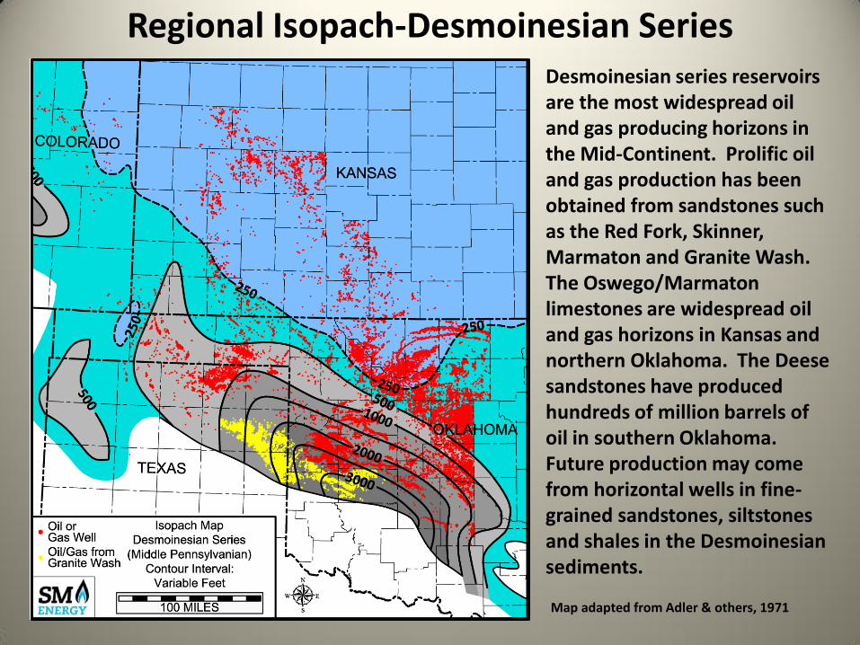
Desmoinesian series reservoirs are the most widespread oil and gas producing horizons in the Mid-Continent. Prolific oil and gas production has been obtained from sandstones such as the Red Fork, Skinner, Marmaton and Granite Wash. The Oswego/Marmaton limestones are widespread oil and gas horizons in Kansas and northern Oklahoma. The Deese sandstones have produced hundreds of million barrels of oil in southern Oklahoma. Future production may come from horizontal wells in fine-grained sandstones, siltstones and shales in the Desmoinesian sediments.
Regional Isopach-Desmoinesian Series
Map adapted from Adler & others, 1971
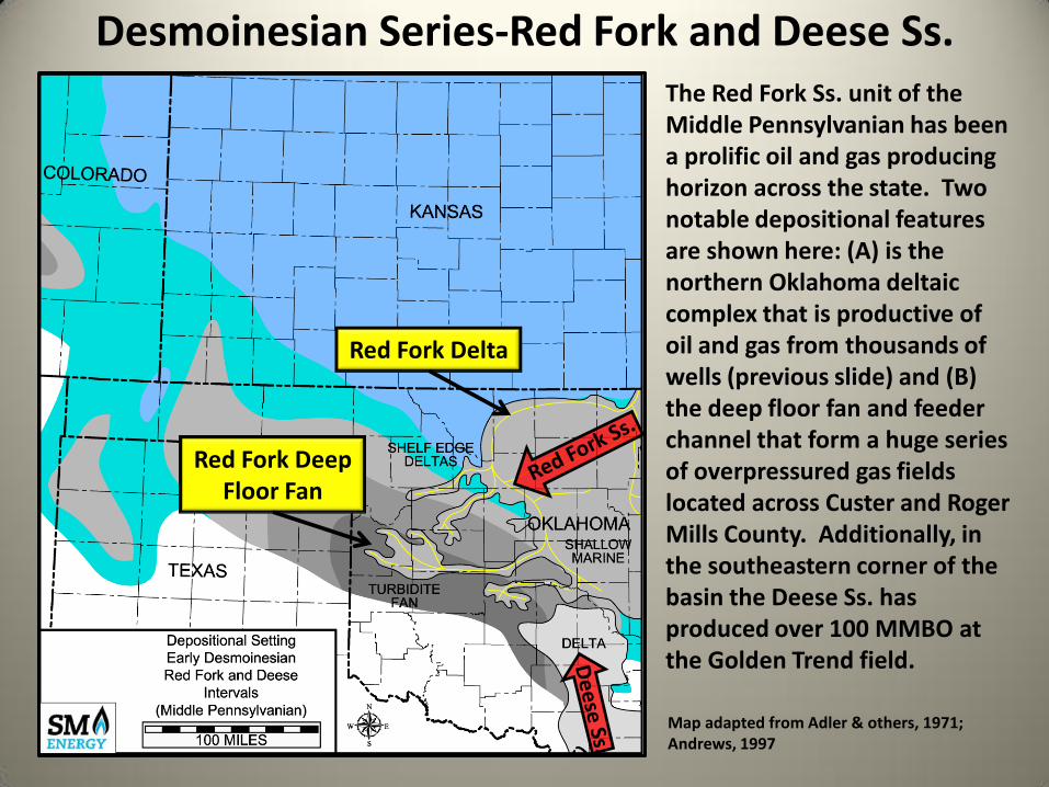
The Red Fork Ss. unit of the Middle Pennsylvanian has been a prolific oil and gas producing horizon across the state. Two notable depositional features are shown here: (A) is the northern Oklahoma deltaic complex that is productive of oil and gas from thousands of wells (previous slide) and (B) the deep floor fan and feeder channel that form a huge series of overpressured gas fields located across Custer and Roger Mills County. Additionally, in the southeastern corner of the basin the Deese Ss. has produced over 100 MMBO at the Golden Trend field.
Desmoinesian Series-Red Fork and Deese Ss.
Red Fork Delta
Red Fork Deep Floor Fan
Map adapted from Adler & others, 1971; Andrews, 1997
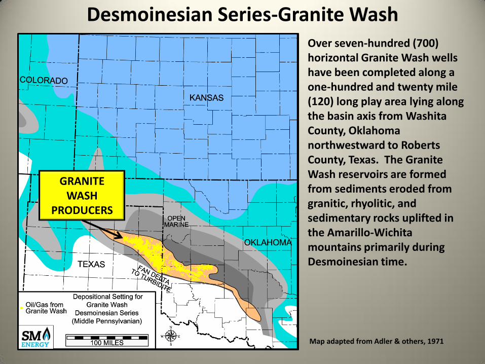
Over seven-hundred (700) horizontal Granite Wash wells have been completed along a one-hundred and twenty mile (120) long play area lying along the basin axis from Washita County, Oklahoma northwestward to Roberts County, Texas. The Granite Wash reservoirs are formed from sediments eroded from granitic, rhyolitic, and sedimentary rocks uplifted in the Amarillo-Wichita mountains primarily during Desmoinesian time.
Desmoinesian Series-Granite Wash
GRANITE WASH
PRODUCERS
Map adapted from Adler & others, 1971

Over seven-hundred horizontal Granite Wash wells have been completed along a one-hundred and twenty mile (120) long play area lying along the basin axis from Washita County, Oklahoma northwestward to Roberts County, Texas. Additional horizontals have been drilled in Desmoinesian sandstones in the Oklahoma Panhandle.
Regional Isopach-Desmoinesian Series
GRANITE WASH
HORIZONTALS
Map adapted from Adler & others, 1971
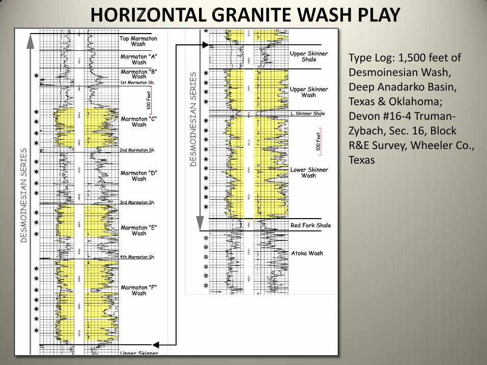
Type Log: 1,500 feet of Desmoinesian Wash, Deep Anadarko Basin, Texas & Oklahoma; Devon #16-4 Truman-Zybach, Sec. 16, Block R&E Survey, Wheeler Co., Texas

Regional Structure Map – Marmaton Wash
Contour Interval = 500 Feet
Basin Axis
Basin Axis
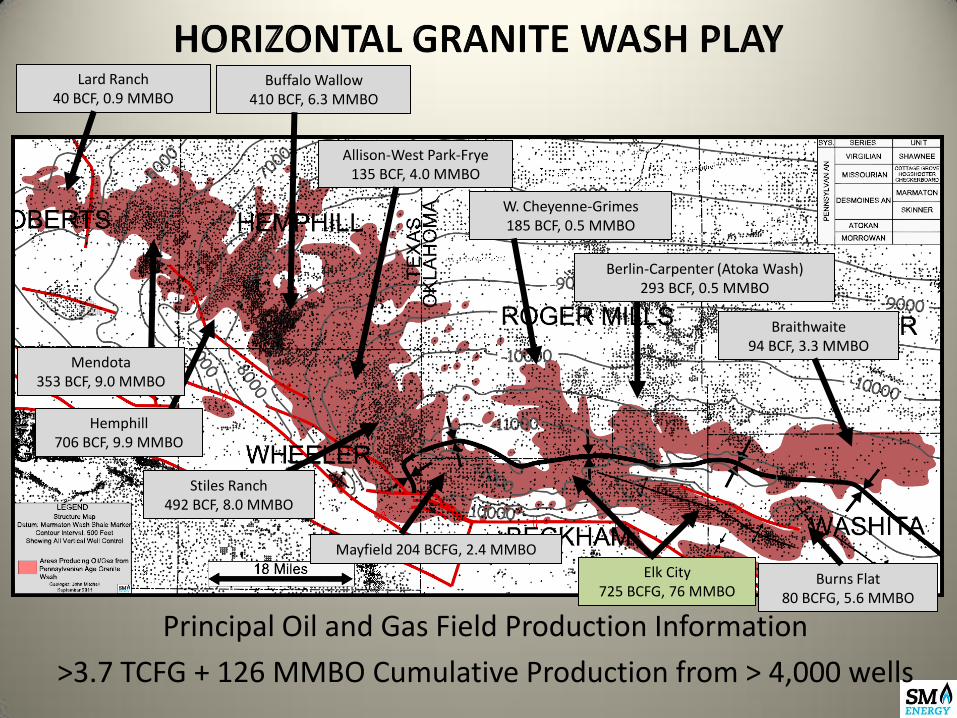
Principal Oil and Gas Field Production Information
>3.7 TCFG + 126 MMBO Cumulative Production from > 4,000 wells
W. Cheyenne-Grimes 185 BCF, 0.5 MMBO
Berlin-Carpenter (Atoka Wash) 293 BCF, 0.5 MMBO
Braithwaite 94 BCF, 3.3 MMBO
Burns Flat 80 BCFG, 5.6 MMBO
Mayfield 204 BCFG, 2.4 MMBO
Stiles Ranch 492 BCF, 8.0 MMBO
Allison-West Park-Frye 135 BCF, 4.0 MMBO
Elk City 725 BCFG, 76 MMBO
Buffalo Wallow 410 BCF, 6.3 MMBO
Hemphill 706 BCF, 9.9 MMBO
Mendota 353 BCF, 9.0 MMBO
Lard Ranch 40 BCF, 0.9 MMBO

1,206 Horizontal Granite Wash Wells
Spud Through September 2011
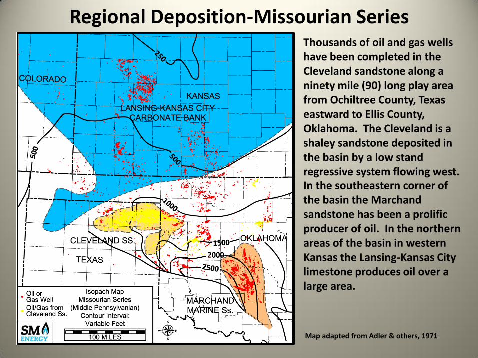
Regional Deposition-Missourian Series Thousands of oil and gas wells have been completed in the Cleveland sandstone along a ninety mile (90) long play area from Ochiltree County, Texas eastward to Ellis County, Oklahoma. The Cleveland is a shaley sandstone deposited in the basin by a low stand regressive system flowing west. In the southeastern corner of the basin the Marchand sandstone has been a prolific producer of oil. In the northern areas of the basin in western Kansas the Lansing-Kansas City limestone produces oil over a large area.
Map adapted from Adler & others, 1971

Missourian Series-Horizontal Drilling One thousand and sixty-five horizontal (1,065) oil and gas wells have been completed in Ochiltree and Lipscomb Counties, Texas eastward to Ellis County, Oklahoma. This area is the most active horizontal drilling area in the Anadarko Basin to date.
CLEVELAND Ss. HORIZONTALS
Map adapted from Adler & others, 1971

Missourian Series-Horizontal Drilling New high volume oil wells from Hogshooter and Cottage Grove Washes
MISSOURIAN WASH
HORIZONTALS Map adapted from Adler & others, 1971

Type Log Missourian Wash, Deep Anadarko Basin, Texas & Oklahoma; Chesapeake #1-28 Mary K well, Sec. 28, T11N R23W, Beckham Co., Oklahoma

Horizontal Granite Wash Play Missourian Wash Activity Areas
Twelve Miles
Cottage Grove Wash Mills Ranch Field

Porosity isolith map of the Upper Cottage Grove Wash with density porosity >10% on 2.71 gm/cc matrix; Contour interval = 10 feet ; Mills Ranch and Stiles Ranch fields, Wheeler Co., TX
Calculated 130 MMBO of Original Oil in Place
Cum. Production Vertical Wells: 750,000 BO / 19 Wells
One Mile

Pay Zone
PHID
PHIN
50
FT
10%
Type porosity log, Upper Cottage Grove Wash pay zone, SM Energy #2-60H Ruth pilot hole; NW NW NW Sec. 60, Block A-7, Stiles Ranch field, Wheeler Co., TX; porosity on lime matrix
2nd Cottage Grove Sh.
Upper Cottage Grove Wash

Structure map of the Upper Cottage Grove Wash; Contour interval = 100 feet Mills Ranch and Stiles Ranch fields, Wheeler Co., TX
One Mile
SM Energy #4-60H Ruth Horizontal Cottage Grove Wash Completed: May 2011 IPF: 1,255 BOPD; 1,583 MCFGD
Sanguine #4-21H Ledbetter Horizontal Cottage Grove Wash Completed: March 2011 IPF: 1,011 BOPD; 1,000 MCFGD
Sanguine #7-59H Bass Horizontal Cottage Grove Wash Completed: September 2010 IPF: 912 BOPD; 1,127 MCFGD
Chesapeake #7-59H Bass Horizontal Cottage Grove Wash Completed: March 2011 IPF: 996 BOPD; 1,126 MCFGD

Twelve Miles
Hogshooter Wash (Missourian)
Horizontal Granite Wash North Canute to Elk City Area

Horizontal Granite Wash - North Canute Area
Structure map of the 1st Hogshooter shale; Contour interval = 100 feet ; Canute field, T11N R20W, Washita Co., OK; star indicates location of type log well

Type porosity log, Hogshooter Wash pay zone, Apache #1-5H McRee pilot hole; NW NW NE Sec. 5, T11N R20W, Canute field, Washita Co., OK; porosity on lime matrix; porosity exhibits gas effect (red shading) on log and is target zone for horizontals
2nd Hogshooter Sh.
Upper Hogshooter Wash
1st Hogshooter Sh.
Lower Hogshooter Wash

Horizontal Granite Wash - North Canute Area
1 Mile
Cimarex #1-4H Kephart Horizontal Hogshooter Completed: April 2011 IPF: 654 BOPD, 1692 MCFGD, 332 BWPD
Chesapeake #1-6H McConnell Horizontal Hogshooter Completed: March 2011 IPF: 544 BOPD, 843 MCFGD, 272 BWPD
Apache #1-5H Gregory Properties Horizontal Hogshooter Completed: April 2011 IPF: 1,750 BOPD, ? MCFGD, ? BWPD
Apache #1-32H McRee Horizontal Hogshooter Completed: February 2011 IPF: 729 BOPD, 1,547 MCFGD, 1,740 BWPD
Apache #3-8H Shelton Horizontal Hogshooter Completed: April 2011 IPF: 1,291 BOPD, 1,812 MCFGD, 501 BWPD
Apache #1-5H Edler Horizontal Hogshooter Completed: August 2010 IPF: 1,588 BOPD, 3,019 MCFGD, 802 BWPD
Isolith map - L. Hogshooter Wash, Density Porosity >4% w/ gas effect; Contour interval = 20 feet; Canute field, T11N R20W, Washita Co., OK

Regional Stratigraphic Column: Permian
At least 54.6 TCF of gas (44% of Anadarko Basin total) has been produced from the Wolfcampian (Lower Permian) carbonates and sandstones at shallow depths in the Hugoton-Panhandle field and adjunct fields. Additionally, the Hugoton-Panhandle field has produced 1,443 MMBO, mainly in the Texas Panhandle. This oil comprises 27% of the basin total. As of March 2012, 836 horizontal wells have been completed in the Permian reservoirs in the greater Anadarko Basin, all of them in the Panhandle-Hugoton field. The oil and gas in the shallow Permian reservoirs is believed to have migrated long distances from deeper portions of the basin into the Permian units (Rice et al, 1989).

• Four major horizontal drilling plays in progress in oil and gas bearing horizons in the Cleveland Ss. and Granite Wash of Pennsylvanian age, the Mississippian limestones, and the Upper Devonian Woodford Shale
• Over four thousand horizontals completed in basin to date at vertical depths as great as 15,000 feet.
• Significant future horizontal development may await in Pennsylvanian sandstones and shales as well as in older carbonates in the Mississippian through Ordovician.
Conclusions

• Petroleum Geology of the Mid-Continent, Tulsa Geological Society Special Publication #3, 1988
• Future Petroleum Provinces of the Mid-Continent, AAPG Memoir 15, V. 2, 1971 • Atlas of Major Midcontinent Gas Reservoirs, Gas Research Institute, 1993 • Atlas of Major Texas Gas Reservoirs, Gas Research Institute, 1989 • Trek of the Oil Finders: A History of Exploration for Petroleum, AAPG Memoir #6,
1975, p.545-588 • Bibliography of Oklahoma Anadarko Basin, Brian J. Cardott, Oklahoma Geological
Survey • The greater Anadarko Basin: an overview of petroleum exploration and
development; Davis, H.G., and R.A. Northcutt, 1989, in K.S. Johnson, ed., Anadarko Basin symposium, 1988: OGS Circular 90, p. 13-24.
• Geochemistry of oils and hydrocarbon source rocks, greater Anadarko Basin: evidence for multiple sources of oils and long-distance oil migration; Burruss, R.C., and J.R. Hatch, 1989 in K.S. Johnson, ed., Anadarko Basin symposium, 1988: OGS Circular 90, p. 53-64
• Oklahoma Geological Survey Circulars and Special Publications, available on the OGS website
• Oklahoma City Geological Society Shale Shaker Publications, also available on the Oklahoma Geological Survey website
• IHS Energy

Thanks!
• Many thanks to Carol Mitchell, my patient spouse and partner for thirty-six years.
• Also to Will Downs, Exploration Manager with SM Energy, Tulsa for permission and support in making this presentation.
Related Documents