DEPARTMENT OF THE INTERIOR U.S. GEOLOGICAL SURVEY Petroleum Geology of the Anadarko Basin Region, Province (115), Kansas, Oklahoma, and Texas by Mahlon M. Ball*/ Mitchell E. Henry*, and Sherwood E. Frezon* Open-File Report 88-450W This report is preliminary and has not been reviewed for conformity with U.S. Geological Survey editorial standards and stratigraphic nomenclature. 1 U.S. Geological Survey, Denver Federal Center, Box 25046, Denver, CO 80225 1991

Welcome message from author
This document is posted to help you gain knowledge. Please leave a comment to let me know what you think about it! Share it to your friends and learn new things together.
Transcript
DEPARTMENT OF THE INTERIOR U.S. GEOLOGICAL SURVEY
Petroleum Geology of the Anadarko Basin Region, Province (115), Kansas, Oklahoma, and Texas
by Mahlon M. Ball*/ Mitchell E. Henry*, and Sherwood E. Frezon*
Open-File Report 88-450W
This report is preliminary and has not been reviewed for conformity with U.S. Geological Survey editorial standards and stratigraphic nomenclature.
1U.S. Geological Survey, Denver Federal Center, Box 25046, Denver, CO 80225
1991
CONTENTS
PageIntroduction 1Structure 1Reservoirs and seals 7Hydrocarbons 13Exploration history 17Play description 18References 33
ILLUSTRATIONS
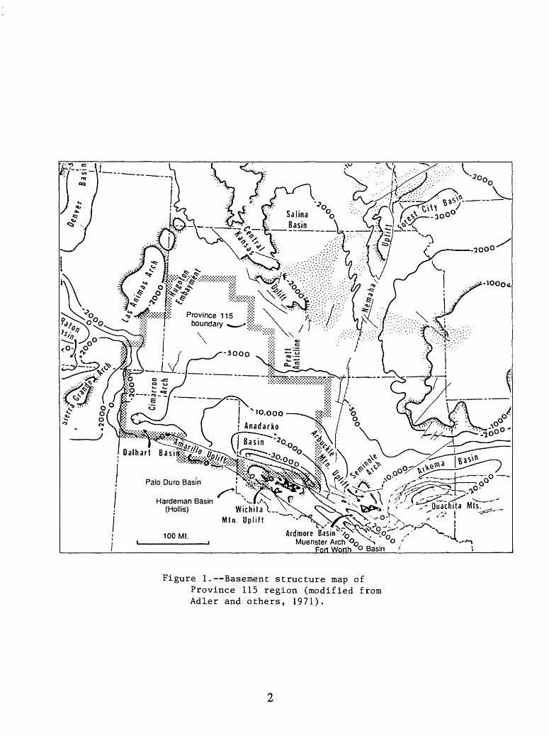
Figure 1. Basement structure map of Province 115 region(modified from Adler and others, 1971) 2
2. Province 115 county names 33. Major structural features in southwestern Oklahoma
(modified from Luza, 1988) 64. Diagrammatic north-south cross section through the
deep Anadarko basin (modified from Hugman and Vidas, 1987) 85. Stratigraphic nomenclature for Province 115 96. Play 1. Pennsylvanian limestone play 197. Play 2. Mississippian carbonate play 218. Play 3. Springer-Morrow sandstone play 239. Play 4. Post-Morrow Pennsylvanian sandstone play 25
10. Play 5. Frontal Wichita-post Morrow sandstone play 2711. Play 6. Deep structural play 2912. Play 7. Lower Paleozoic paleotopographic play 31
INTRODUCTION
The purpose of this report is to present an analysis of the petroleum geology of Province 115, the Anadarko basin region (figs. 1 and 2) as a basis for the U.S. Geological Survey's 1987 National Assessment of undiscovered oil and gas in that province. This province includes 25 counties in southwestern Kansas, 23 counties in northwestern Oklahoma, 13 counties in the northernmost part of the Texas Panhandle and 2 counties in southeastern Colorado. The total area of the province is about 58,000 square miles; it's maximum dimensions are about 350 miles north to south and 340 miles east to west From a broad shelf to the north and northwest (Hugoton embayment), the rocks thicken southward into a northwest trending depocenter where they are locally more than 40,000 ft thick. Immediately south of the depocenter the symmetry of the syncluie is abruptly terminated against the uplifted basement block of the Amarillo-Wichita uplift.
The report is organized to emphasize attributes of oil and gas accumulations. The initial section describes structure including regional tectonic setting and local structural styles that determine configurations of hydrocarbon traps. The second section covers reservoirs and seals in the context of regional stratigraphy, depositional environments, sediment body geometry, composition, texture, diagenesis, porosity, and permeability. The third section treats the source, maturation, and migration of hydrocarbons. The fourth section deals with exploration history. The final section describes and analyzes oil and gas plays including factors bearing on estimates of undiscovered recoverable hydrocarbons.
STRUCTURE
The Anadarko basin (fig. 1) is one of the deepest (40,000 ft of sedimentary rock) and most prolific hydrocarbon producers (5.1 billion bbls of liquids and 135 trillion cubic feet, total gas, ultimately recoverable) in the continental United States (Hugman and Vidas, 1987; Johnson, 1988). The basin is bounded on the east by the Nemaha uplift; on the southeast by the Arbuckle Mountains and Ardmore basin; and on the south by the Wichita Mountains and Amarillo uplift. To the west and north, the basin shoals onto a broad shelf with subsurface basement depths of less than 5,000 ft.
The Anadarko basin was a subsiding tectonic feature throughout the Paleozoic Era. However, faulting associated with the uplift of the Amarillo-Wichita-Arbuckle Mountains, that partially defines the present basin's shape, peaked in activity in Early Pennsylvania time and had largely died out by the end of the Permian. The erogenic event during which the faulting and uplift occurred is referred to as the Wichita Orogeny. Many of the major structural elements of the Mid- continent (fig. 1) attained their present configuration during this tectonic event.
The regional Bouguer gravity map of Oklahoma (Woollard and Rose, 1963) shows good correlation with the major structural elements bounding and including the Anadarko basin. The basin axis and its southeastward continuation into the Ardmore basin coincide with a negative gravity anomaly lineament with a -60 mgal closure to the northwest over the deep Anadarko basin and a -40 mgal closure in the southeast over the Ardmore basin. A large positive anomaly with two +20 mgal closures agrees in position with the Arbuckle Mountains. A linear positive anomaly matches the Wichita Mountains. A huge negative closure of -80 mgal marks the location of the Ouachita Mountain fold-thrust belt which overrides the southern flank of the Arkoma basin in southeastern Oklahoma. This relationship may indicate that the Arkoma basin, which until the Wichita Orogeny may have been continuous with the Anadarko basin on the west and the Fort Worth basin (fig. 1) to the south, may contain the thickest sediment section of the region hidden beneath the Ouachita thrust sheets.
Hardeman Basin(Hollis) Wichita
Mtn
Figure 1. Basement structure map ofProvince 115 region (modified from Adler and others, 1971).
1_-39 1
J WALLACE
1
; CIEF.I L£TI HA»n.-
FKCMrtfrS j TO*
STA«Uj TO*
BACAI MOt. 1 TOW
+ LOGAB
trrCH-ITA
>- z c < utX
crArr
Sicr.CMS
COVE
SCCTT
Flf«
1MASK-
ELL
S£W**0
LANE
«EY
C.XAY
»» ADl
KESS
HOOGE- MAM
FORD
E CtARK-
H
COLOR/
1(~
Ii
«
EDWARDi
K10WA
COWAN. ' CMC
1
1
£O!__.__
TEXAS
L_
LKANSAS
OKLAHOMAi
N_J
C1MARRON- TEXAS BEAVER
1j DALLAM
fj HARTLEY
SHER-MAN
MOORE
-
KANS-
FORD
HUTCH-
IHSOH
CA»SON
OCHIL-
TREE
*OBE»T;
GRAY
LIPS- !COMB!
HEMP. ]
HILL 1
WHEELER
1-35'
101 99
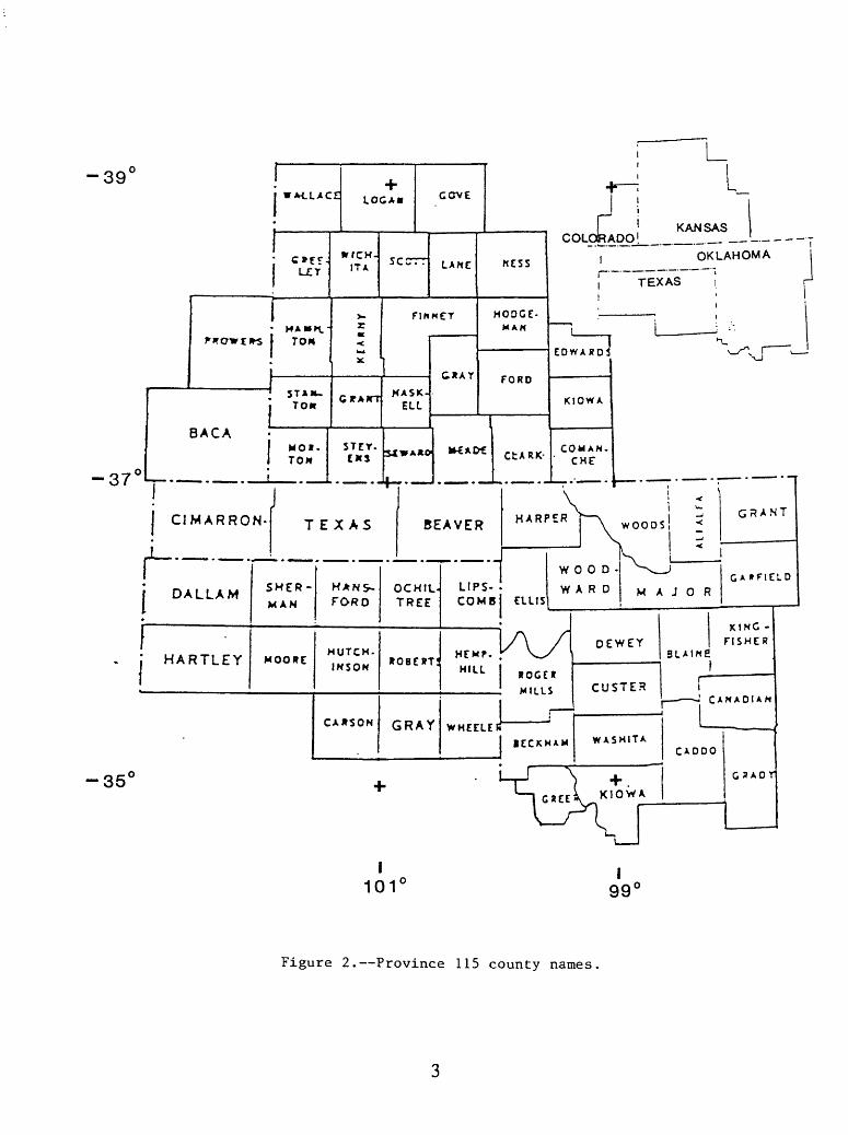
Figure 2. Province 115 county names.
Exposed basement uplifts and subsurface studies provide insight regarding the structural styles extant in the Anadarko basin and adjacent areas. From outcrop studies, it is apparent that the northwest structural grain of the southern Oklahoma region dates from at least mid-Proterozoic1.3-1.4 x 10⁹ Y.B.P. (Perry, 1990). According to Perry, thick Proterozoic sediments of the Hardeman basin underlying the Paleozoic Hollis basin in southwestern Oklahoma are the earliest known indication of extension and subsidence in the area. Related basic and acidic igneous rocksdating 1.2 x 10⁹ Y.B.P. suggest to Perry the existence of an aulacogen or failed spreading center extending from a plate margin into, and dying out in, the continental craton.
A more completely documented aulacogen related to the opening of the ancestral Atlantic was initiated in latest Precambrian to earliest Cambrian time. This rift extended northwestward into the craton from a reentrant of the plate margin. The early history of this feature, known as the southern Oklahoma aulacogen, was marked by intrusion and extrusion of basic and acidic igneous rocks. Cooling and subsidence resulted in formation of a broader superimposed basin, the southern Oklahoma trough, that was the locus of deposition of a thickened lower Paleozoic, predominantly carbonate section. The rate of thermal isostatic subsidence decreased from Cambrian to Early Mississippian time (Feinstein, 1981).
Wroblewski (1967) reported that the largest early Paleozoic structural features identified in the Anadarko basin are the northwest-southeast-trending Fort Cobb, Cordell, Sayre, and Mobeetie anticlinal trends. These features were definitely in existence prior to the pre-Woodford unconformity, that is, Late Devonian time because upper Hunton (Silurian-Devonian) is absent on their crests as a result of some combination of erosion or nondeposition. Wroblewski feels indirect evidence indicates these older structures may have been in existence since the Precambrian.
Chenoweth (1984) attributes the ancient anticlinal trends and many other arches and domes of the Mid-continent region to epeirogenic activity in the early Paleozoic North American Plate interior related to erogenic activity along the eastern plate margin during the Devonian, Acadian orogeny. Thinning of the Silurian section and evidence of erosion and non-deposition are documented by Chenoweth on smaller pre-Late Devonian anticlines in the Texas panhandle portion of the Anadarko basin.
The effects of closure of the Proto-Atlantic were first seen in latest Mississippian time. The full collision of Paleozoic North American and Gondwana gave rise to the Ouachita and Wichita orogenies in Early Pennsylvanian to Permian times. Texas moved northward against the Mid- continent The Wichita Mountains and Amarillo arch were uplif ted and thrust over the southern margins of the southern Oklahoma aulacogen and its superimposed basin, the Oklahoma trough. Loading caused by the uplifted and overriding north-bound thrust sheets caused renewed subsidence and the Anadarko basin was formed. According to Perry, compositions of Cambrian igneous rocks in the Wichita Mountains indicate that the mountains are the site of the structurally inverted aulacogen core. Thickness variations in lower Paleozoic rocks seem to place the axis of the lower Paleozoic Oklahoma trough just south of the Wichita- Amarillo front so the late Paleozoic deep Anadarko basin overlies only the margin of the southern Oklahoma trough and its related Southern Oklahoma aulacogen.
At present, there is general agreement that the Ouachita and Wichita orogenies resulted from a late Paleozoic collision of crustal plates. Disagreements still abound concerning the importance of strike-slip faulting in this erogenic activity. Perry acknowledges the evidence of some left- lateral displacement associated with thrusting but feels the thrusting, which proceeded from southwest to northeast during the Pennsylvanian, was most important in developing the area's en echelon folds and further that strike-slip faulting was relatively minor and late with much of its activity occurring during the Permian.
The preponderance of en-echelon faults and thrusted folds intermixed with normal fault- bounded horsts and grabens, faults along which throws switch from downthrown-to-upthrown on the same side of the fault, etc., is very suggestive of a strike-slip regime. This structural style persists southward through the southern Oklahoma fold belt at least to the Muenster arch of north- central Texas and continues westward into the Palo Duro basin of the Texas panhandle (fig. 1).
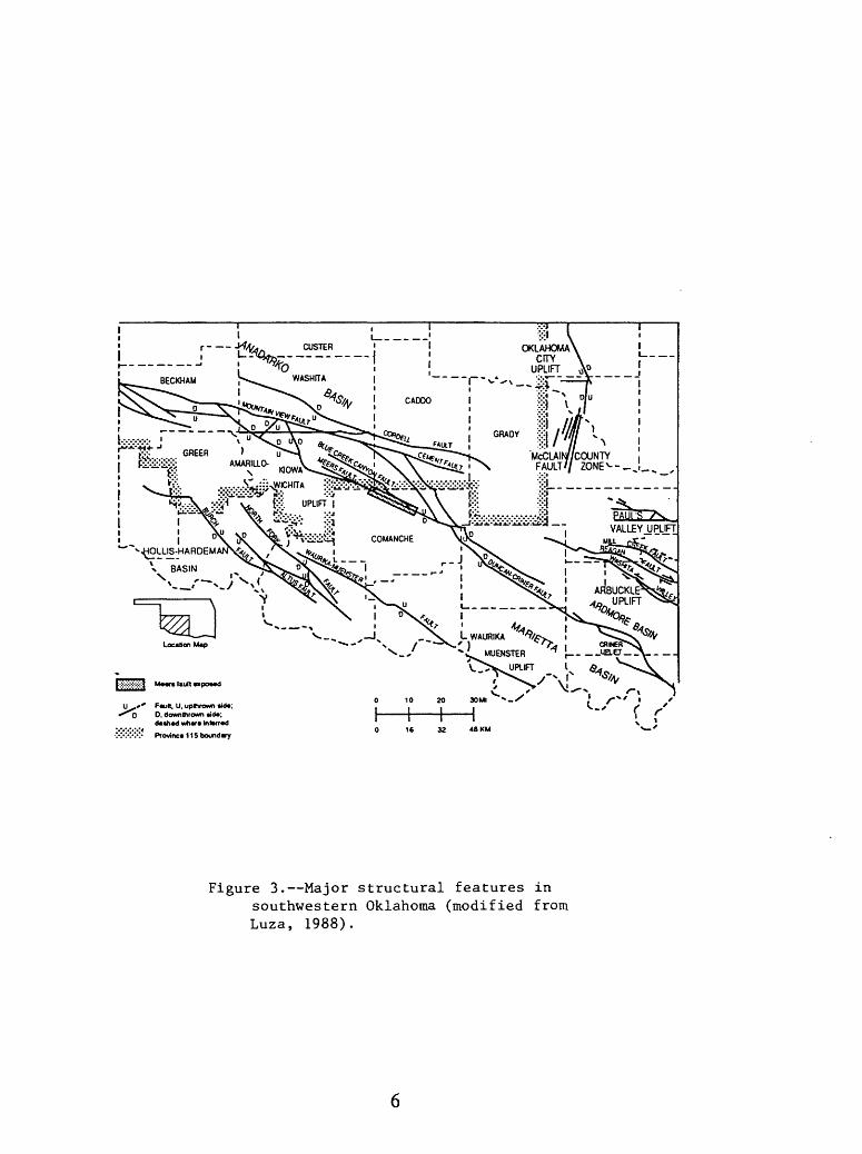
Tanner's (1967) adaptation of the geologic map of the Arbuckle Mountains (Ham and others, 1954) provides one example of this structural style. The fault that cuts the Colbert Porphyry on the crest of this structure has an apparent left-lateral offset of about 3 miles. Smaller left and right-lateral offsets on the structure's south flank have indicated offsets of a quarter of a mile or so. These smaller strike-slip faults are oriented in a manner that suggests they are second- order shears (Moody and Hill, 1964) to the crestal left-lateral fault which is perhaps, in turn, second-order to the first order Washita Valley fault (fig. 3) that bounds the Arbuckle anticline on the north. Tanner (1967) believed he could substantiate 40 miles of left-lateral offset on the Washita Valley fault. This faulting died out upward in Virgilian Vanoss sands and shales that onlap the anticlines. The basis for Tanner's estimate of strike-slip displacement was a comparison of facies in the Ordovician, Simpson Group on opposite sides of the fault. Tanner's argument on this basis is not entirely convincing.
McConnell (1988) arrived at maximum and minimum estimates of left-slip on the Mountain View fault (fig. 3) of 21 and 9.5 mi. These estimates are an order of magnitude smaller than those of some earlier workers.
Producing structures in the Anadarko basin region are results of a range of combinations of tectonic activities with erosional and depositional structural development The more complex combinations are represented by lower Paleozoic paleo-highs, owing some of their geometry to tectonic uplift and erosion during the middle Paleozoic, Acadian orogeny, that have been reactivated during the upper Paleozoic Ouachita-Wichita orogeny and subjected to folding and thrusting with renewed erosion to obtain their present configuration. The simplest combinations are represented by upper Paleozoic blankets of porous quartz elastics or carbonates, subjected to homoclinal dip, mat wedge out updip as a result of some blend of erosion and facies change, to form stratigraphic traps. In some instances, upper Paleozoic sediment body geometry, or depositional structure, including fluvial and deltaic distributary channels, delta fringe and shoreline sand bodies contribute to the development of structure and increase the level of complexity. The range of structural complexity in the Anadarko basin region is a continuum from the most complex to the simplest of hydrocarbon trapping configurations.
From a practical, petroleum-geologic standpoint, the recognition of the existence of left- lateral strike-slip faulting interspersed with folding and thrusting during the Late Paleozoic Wichita orogeny is of primary importance. Hugman and Vidas (1987) draw on the works of a number of geologists to emphasize the elements of predictability associated with the identification of the left- lateral, strike-slip faulting in the southern Anadarko basin. Zones between left-lateral faults that step left or along the bends of left-lateral faults that bend left are zones of extension (Rodgers, 1980) and are characterized by blocks bounded by normal faults. Right-stepping, or bending, left- lateral faults create zones of compression characterized by thrust faults and folds. Many of the oil- producing structures in the southern Anadarko basin appear to be folds of this type.
Critical questions are, how far does this structural style extend into the deeper, relatively unexplored Anadarko basin and can a combination of subsurface and seismic data facilitate better mapping of structure based on recognition of the influence of left-lateral wrench faulting as an important factor in structural style in this region? Campbell and others (1988) suggest the possibility that this structural style is extant across the deep basin to the slope of the northern shelf that acted as a buttress against thrusting during the Pennsylvanian Wichita orogeny. It is
C rProvince 115 boundary
Figure 3. Major structural features insouthwestern Oklahoma (modified from Luza, 1988).
interesting to note that this northwest, fold trend matches the axial trend of the Arbuckle Uplift (fig. 3) and the trend of producing folds throughout the southeastern Anadarko basin and southern Oklahoma folded belt
In summary, the northwest-trending grain of tectonic features seen in the Anadarko regionis at least as old as the middle Proterozoic (1.3-1.4 x 10⁹ Y.B.P). The northwest-trending highs- Mobeetie, Sayre, Ft Cobb, and Cordell anticlines are older than the Late Devonian, pre- Woodford unconformity. The younger thrust-fault system associated with these regional anticlines has some component of left-lateral, right-stepping or bending, strike-slip displacement. This system was active in latest Mississippian through Permian time and uplifted the Amarillo-Wichita and Arbuckle Mountains giving rise to the Anadarko basin as it is known today. Major, northeast- directed thrusting with maximum vertical displacement of 40,000 ft on the Wichita Mountains- Anadarko basin boundary has been established Minor, left-lateral, strike-slip displacements (three miles) have been documented in the fault system. It has been impossible to convincingly prove large strike-slip displacements on individual faults. However, the en echelon nature of associated and often oil and gas producing thrusted folds argues for the importance of strike-slip faulting in this regime whatever the magnitude of strike-slip displacement. Establishment of displacement on strike-slip faults is often difficult Furthermore, where reactivation of older structures is characteristic, as is the case in the Anadarko region, discerning the age of initiation or cessation of a given structural activity is also not easy.
RESERVOIRS AND SEALS
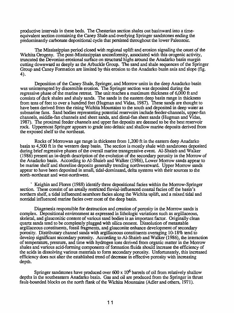
This section describes reservoirs and seals of the Anadarko basin area in the context of regional stratigraphy. In general, the sedimentary rocks in the Anadarko basin consist of lower Paleozoic carbonates and upper Paleozoic terrigenous elastics. Significant exceptions to this statement are the Middle Ordovician Simpson Group quartz sands and the dolomites of the Wolfcampian Chase Group. The rocks are shown in a schematic cross-section (fig. 4) and local stratigraphic nomenclature is presented in figure 5.
At the base of the sedimentary sequence, the Upper Cambrian Reagan Sandstone unconformably overlies an acidic igneous rock basement Although the Reagan produces in the Oklahoma City field, it is rarely tested.
The Cambro-Ordovician Arbuckle Group overlies the Reagan. This unit ranges in thickness from about 400 to 8,000 feet. The Arbuckle is a highly variable platform interior, fossiliferous carbonate mudstone containing some tidal-flat deposits that may have been dolomitized early in the rock's history. It is an important reservoir rock in the Anadarko region. Typically, production occurs in porous dolomite zones that have been exposed to erosion on the crests of basement highs. Not infrequently, the productive zones are overlain unconformably by Pennsylvanian sands and shales that serve as additional reservoirs and seals. Erosion of the Arbuckle appears to enhance its porosity and permeability thus increasing its reservoir quality. Fracture networks related to structure often facilitate production from the Arbuckle and may have played roles in enhancing karstification to produce porosity and in providing avenues for hydrocarbons to migrate into reservoir rock.
Conventional wisdom is to treat the entire Arbuckle as a single, common reservoir with the result that few wells continue any appreciable distance below the top of this unit Another accepted generalization is that porous dolomite in the Arbuckle is most common in the western Anadarko basin while a tight fades is more common in the east Porosity and permeability measurements available for the Arbuckle in the Anadarko basin are too limited to have much significance. Harrison and Routh (1981) report single measurements for porosity of 5.4% and permeability of
SouthTEXAS
OKLAHOMA (panhandle)
NorthKANSAS
TERTIARYCRETACEOUSPERMIAN
10.000' -
15.000' -
20,000--
Granite wash
Carbonate
(; ' y.| Sandstone + shale
Fault
DIAGRAMMATIC NORTH-SOUTH CROSS SECTION
THROUGH THE DEEP ANADARKO BASIN
DEEP BASIN PROVINCE
Figure 4. Diagrammatic north-south crosssection through the deep Anadarko basin (modified from Hugman and Vidas, 1987)
SYSTEM |
PERMIAN
PENNSYLVANIAN
SSIPPIAN
c/>2
5
UJ O
ii
o
Qo cc o
crCD
o
to C.NEB
CC CJW.II
UJto
<Uj TAUX S% DAY CM
O
i MFfBV
UJ
iia. ** -JS OOUNCI
AMI
I
0) 3 I1SO f
(0
s| '
1i KEAW
<r
| CHES
a ST5
| | KIN
<r
d> uiSd
ii
LOWER
U&'ES.
UOOLE
<r ui
i§ s """
C UJ
S ARBU 2 G
CLUa3 REAG,
L
PR6CAMBHIAN IGN AND METASEOIMEN
ROCKS
RASKA TEXAS 1 » OKLAHOMA ANSAS PAM4ANOES
c.tw.OKLAHOMA
STRATIGRAPHCUNITOUAHTEH-
**"* MA«TBI EBCDOL M.3WCM MMmOflKOP.
HiAW. jOMETAH. EMV. OCAWOKW.
tar.**** MMOOL.
K«.
WABAUNSEEGP. SHAWNEEGP. DOUGLAS GP.
LANSING GP. CANSASCTTYGP. lEASANTONGP.
MARMATONGP. CHEROKEEGP.
OUAHTEB- MASTER
M. OOUOCHIEFfM MHfTEHOmEOP
B.N9OV.HBMEBSEYSK WRlNOTONfU
CHASE V. COUNCLOftOVE
OP.ADUKtf.
OCHELETAGP. SKIATOOKGP.
BX3LS. OS WE GO LS.
13 FINGER LS.
<YFU LM^RROW
"in iininiin
TER CHESTER
E.GENEVIEVELS. ST. LOUSLS. SPERGENLS. WARSAW LS.
«AGE UNDIF.
DERHOOKUNDIF.
MORROW GP.
FORMATION
GOOOAROSR
MISS. LS.
UNOIF.
WOODFORO (CHATTANOOGA) SK
i«m«u(w
!| |l |||S«^*nu.
SYLVAN SH
VIOLA LS.
MPSON UNDIF.
ARBUCKLE CKLE GP. '- (ELLEN-
BURGER)
AN SS. REAGAN SS.
FRBCOFU BOStTAflC
? HARAGAN£ tCMn^UKM
' UllD"CMIMEY HU.
CV
SYLVAN SH
VIOLA LS.
BROMIDE j TULIP- 5 CREEK £ MCUSH 2 OIL CREEK
JOINS
ARBUCKLE GP.
REAGAN SS.
IGNEOUS AND METASEDIMENTARY
ROCKSEOUS rTARY
Nui ofti
1*T %
3
2
7
6
Numbered arrows show stratigraphic ranges of the seven province 115 plays.
Figure S.-Stratigraphic nomenclature for province 115
149 md at a depth of 3,500 ft The Nehring file (NRG Associates, 1986) lists porosity values of 12.5%, 7%, and 6.2% at depths of 6,000 ft, 7,664 ft, and 18,240 ft, respectively, and a single permeability measurement of 1.1 md for the 7,664-ft depth sample.
The Middle Ordovician Simpson Group unconformably overlies the Arbuckle. This unitcontains sandstones, limestones, and shales. Simpson sandstones have produced nearly 2 x 10⁹ barrels of oil principally from structures along the Nemaha ridge and on the Seminole arch on the eastern border of the Aiiadarko basin. On the Nemaha ridge, production occurs from erosionally truncated sandstones sealed by overlying Pennsylvanian shales on the flanks of highs. The Simpson consists of a transgressive unit, 2,300 ft thick (on the south flank of the Arbuckle Mountains), onlapping the eroded Arbuckle surface (Adler and others, 1971). Porosity for producing sands of the Simpson varies between 10% and 18% with an average of 15% over a depth range of 3,500 to 11,000 ft Permeabilities vary between 15 and 300 md with an average of 120 md over the same depth range (Harrison and Routh, 1981.
The Simpson is in turn overlain by the upper Middle Ordovician Viola Limestone. From a relative point of view, in the context of the Anadarko basin region, the Upper Ordovician Viola Limestone is not a significant reservoir. The formation is typically a dense, tight limestone. Production occurs from locally dolomitized sections on structures tested for Simpson and Arbuckle production (Adler and others, 1971).
Silurian-Devonian carbonates of the Hunton Group overlie the Ordovician formations. The Hunton Group is a significant oil reservoir on the northern Anadarko basin margin (Adler and others, 1971), and a major gas producer in the deep (greater than 15,000 ft) Anadarko basin (Hugman and Vidas, 1987). The upper surface of the Hunton is sculpted by the regional pre- Woodford unconformity. Erosional structure associated with this unconformity shapes the traps on the basin margin. Fracturing and dolomitization are important factors in porosity development within this unit Dolomitization is restricted to the northwestern reaches of the basin (Amsden, 1988). Basement highs rather than erosional topography form traps for reservoirs in the deep basin. The Hunton thickens from a wedge edge on the basin shelf, near the Kansas-Oklahoma border, to more than 1,600 ft in Washita and Beckham Counties, Oklahoma, in the deepest part of the western Anadarko basin. According to NRG Associates, Inc. (1985 and 1986), porosity in Hunton reservoirs varies from 3 to 12% with an average value of 8.6% over a depth range of 9,000 to 19,500 ft. Three permeability measurements suggest a value of 20 md at a depth of 19,000 ft. The overlying Devonian-Mississippian, dark, cherty, organic-rich Woodford Shale is both a source and a seal for the Hunton Group carbonates. The Meisner Sandstone, an unconformity sandstone at the base of the Woodford Shale, is a secondary reservoir objective and producer.
The Woodford is, in turn, overlain by carbonates of the Kinderhook, Osage, and Meramac Series of Mississippian age. These pre-Chesterian limestones produce from fractures in a belt known as the Sooner Trend along the northeast margin of the Anadarko basin shelf (Adler and others, 1971). Reserves vary in direct proportion to fracture density (Ward, 1965). According to Ward (1965), whole core measurements indicate an average fracture porosity of 2%. Where fracture density is high, permeabilities can be astronomically high (Ward, 1965). Drilling density would seem to rule out the likelihood of discovering a similar fracture trend elsewhere in the Anadarko basin.
Chesterian limestones produce gas in northern and eastern parts of the Anadarko basin (Adler, 1971). According to Adler and others (1971), these limestones tend to be oolitic and interbedded with shale. The Nehring file indicates an average porosity of 11% (8 measurements) and an average permeability of 5 md (3 measurements) over a depth range of 6,000-8,000 ft for
10
productive intervals in these beds. The Chesterian section shales out basinward into a time- equivalent section containing the Caney Shale and overlying Springer sandstones ending the predominantly carbonate depositional cycle that persisted throughout the lower Paleozoic.
The Mississippian period closed with regional uplift and erosion signaling the onset of the Wichita Orogeny. The post-Mississippian unconformity, associated with this erogenic activity, truncated the Devonian erosional surface on structural highs around the Anadarko basin margin cutting downward as deeply as the Arbuckle Group. The sand and shale sequences of the Springer Group and Caney Formation are limited by this erosion to the Anadarko basin axis and slope (fig. 4).
Deposition of the Caney Shale, Springer, and Morrow units in the deep Anadarko basin was uninterrupted by discernible erosion. The Springer section was deposited during the regressive phase of the marine retreat The unit reaches a maximum thickness of 6,000 ft and consists of dark shales and shaly sands. The sands in the eastern deep basin range in thickness from tens of feet to over a hundred feet (Hugman and Vidas, 1987). These sands are thought to have been derived from the rising Wichita Mountains to the south and deposited in deep water as submarine fans. Sand bodies representing potential reservoirs include feeder-channels, upper-fan channels, middle-fan channels and sheet sands, and distal-fan sheet sands (Hugman and Vidas, 1987). The proximal feeder channels and upper fan deposits are deemed to be the best reservoir rock. Uppermost Springer appears to grade into deltaic and shallow marine deposits derived from the exposed shelf to the northeast
Rocks of Morrowan age range in thickness from 1,200 ft in the eastern deep Anadarko basin to 4,500 ft in the western deep basin. The section is mostly shale with sandstones deposited during brief regressive phases of the overall marine transgressive event Al-Shaieb and Walker (1986) present an in-depth description of the evolution of the secondary porosity in the Morrow of the Anadarko basin. According to Al-Shaieb and Walker (1986), Lower Morrow sands appear to be marine shelf and shoreline deposits generally trending northwestward. Upper Morrow sands appear to have been deposited in small, tidal-dominated, delta systems with their sources to the north-northeast and west-northwest
Keighin and Flores (1988) identify three depositional fades within the Morrow-Springer section. These consist of an areally restricted fluvial-influenced coastal fades off the basin's northern shelf, a tidal influenced nearshore fades along the Wichita uplift, and a mixed tidal and nontidal influenced marine facies over most of the deep basin.
Diagenesis responsible for destruction and creation of porosity in the Morrow sands is complex. Depositional environment as expressed in lithologic variations such as argillaceous, skeletal, and glauconitic content of various sand bodies is an important factor. Originally clean quartz sands tend to be completely plugged with silica cement. Dissolution of metastable argillaceous constituents, fossil fragments, and glauconite enhance development of secondary porosity. Distributary channel sands with argillaceous constituents averaging 10-18% tend to develop significant secondary porosity. According to Al-Shaieb and Walker (1986), the interaction of temperature, pressure, and time with hydrogen ions derived from organic matter in the Morrow shales and various acid-forming components of formation fluids should increase the efficiency of the acids in dissolving various materials to form secondary porosity. Unfortunately, this increased efficiency does not alter the established trend of decrease in effective porosity with increasing depth.
Springer sandstones have produced over 600 x 106 barrels of oil from relatively shallow depths in the southeastern Anadarko basin. Gas and oil are produced from the Springer in thrust fault-bounded blocks on the north flank of the Wichita Mountains (Adler and others, 1971).
11
During Pennsylvanian, Morrowan time, a marine transgression ended the period of regional erosion. Shallow oil production, in Morrow sandstones, occurs on the Seminole Arch and gas production is established on the northern shelf of the Anadarko basin. No unconformity between the Springer and Morrow is recognizable in the deep (below 15,000 ft) Anadarko basin (Hugman and Vidas, 1987) and the boundary between the Springer and Morrow is impossible to recognize in this setting. The felsic quartz sands of these units are sparsely drilled at depth and are considered by many to represent the most promising play for production of gas in the deep Anadarko basin.
A relatively large amount of porosity and permeability information is available for the Springer-Morrow sands. Because these units are lumped in a single play in the relatively unexplored deep basin, the porosity and permeability figures are merged here and reorganized according to depth ranges. Most information above 7,000 ft, from older fields on the Anadarko shelf, came from Harrison and Routh (1981). The Nehring file is the source of most of the data from the basin slope and deep Anadarko basin. Above 5,000 to 6,000 ft, porosity in these units averages a uniform 18 to 19% and permeabilities are measured in the high tens to low hundreds of millidarcies. From 6,000 to 12,000 ft, average porosities for 1,000-ft intervals decrease from 16 to 13% and average permeabilities measure in the low tens of millidarcies. From 12,000 to 15,000 ft, measurements are sparse. Four porosity measurements average 13% and three permeabilities are measured in the low tens of millidarcies. In the deep basin, below 15,000 ft, Hugman and Vidas (1987) report porosities in the Springer ranging from 6 to 10%. Permeability in the Britt sand of the Upper Springer measures in tenths of millidarcies while permeabilities in the Lower Springer, Goddard sand ranges between 0.1 md and 0.01 md. Clearly these data indicate a steady deterioration of both porosity and permeability with increasing depth.
The climax of the Wichita Orogeny occurred during Atokan time and was accompanied by uplift of the Amarillo-Wichita Mountains by tens of thousands of feet relative to Anadarko basin axis on the north. Erosion of the mountains supplied a conglomeratic wash of granitic sand into the basin deep. The wash grades northward into and interfingers with felsic sands and shales. Faulting and uplift began to die out in late Pennsylvania^ Desmoinesian time but the mountains, marking the south boundary of the Anadarko basin, continued to supply granite wash and quartz sands to the basin throughout the remainder of the Pennsylvania Period and into Wolfcampian, Permian time (fig. 4). The transition from granite wash to felsic quartz sands extended some thirty miles northward from the mountain front during the Atokan. This transition position migrated southward toward the mountain front with time so that the extent of the granite wash toward the north was reduced to less than 10 miles during the early Permian, Wolfcampian epoch.
To the north, a major facies change occurred, during the Upper Pennsylvanian, indicative of the waning of Wichita orogenic activity in the Mid-continent region. Quartz sandstones and shales of the Anadarko basin and slope interfinger with and grade into Upper Pennsylvanian shelf carbonates. This transition was completed in Desmoinesian and Missourian time at the position of the present Oklahoma-Kansas boundary and occurred some twenty or so miles farther north in Virgilian time (fig. 4).
The Early Permian, Wolfcampian, Chase Group caps the Pennsylvanian System of the Anadarko basin, Amarillo uplift, and Hugoton embayment (fig. 1). The Chase Group consists of alternating limestones, dolomitic limestones, dolomites, red shales, and siltstones. The carbonates often contain inclusions of anhydrite. The section's thickness averages about 200 ft and individual units lose their identity to the north and west where red shale becomes the uniform lithology.
Harrison and Routh (1981) reported a considerable number of porosity and permeability measurements on Upper Pennsylvanian and Wolfcampian quartz sands. Desmoinesian sands, over a depth range of 1,000-8,000 ft, undergo a more-or-less steady porosity loss from 19% to 13%. The permeability decrease over the same depth range is from a few hundred to a few tens of
12
millidarcies. Missourian and Virgilian quartz sands, over a somewhat shallower depth range of from less than 1,000 to 6,000 ft, appear to be somewhat cleaner, with porosities decreasing from 24 to 17% and permeabilities dropping from a few hundreds to a few tens of milladarcies. Based on a few measurements, lower Permian, Wolfcampian sandstones have an average porosity of 20% and an average permeability of 65 md. The Nehring file contains a very few porosity and permeability measurements for Upper Pennsylvanian carbonates. Carbonate porosities range from 8 to 14% and their permeabilities vary from a few tenths to tens of millidarcies over a depth range of 6,000 to 10,000 ft
Lower Permian, Wolfcampian carbonates of the Chase Group and Permian granite wash are reservoir rocks in the structurally controlled drape of units over the shallow granitic basement of the Amarillo uplift The uplift trends WNW, from Wheeler to Hartley Counties, Texas, beneath the southern limb of the 10,000 mi^ expanse of the combined Panhandle-Hugoton field (Pippin, 1970). The field lies on the western margin of the Anadarko region.
A structurally controlled accumulation constitutes the Panhandle portion of the Panhandle- Hugoton field. The carbonate reservoirs consist of porous dolomites, dolomitic limestones and limestones sealed by anhydrite and salt in the overlying Leonard Sumner Group. According toGalloway and others (1983), the field produced 1.3 x 10⁹ BO through 1979 from carbonates onlapping and interfingering with granite-wash fanglomerate beds. These units act as a single reservoir with wash prevalent at the base atop the underlying granite. Porosity and permeability in the overall section average 13 percent and 25 md at a subsurface depth of 2,850 ft (Galloway and others, 1983).
The north-northeastward continuation of the gas cap of this vast field stretching from Sherman County, Texas to Finney County, Kansas, consists of a stratigraphic trap confined to the Wolfcampian dolomites and dolomitic limestones. These exclusively gas-bearing carbonates shale out into a red-bed facies updip, to the north and west The top seal for the gas accumulation continues to be anhydrite and salt in the overlying Sumner Group of the Leonardian Series. The basal seal appears to be hydrodynamic (Hubbert, 1953) as the gas-water contact dips to the east in the direction of ground water flow in the reservoir section. Furbush (1959) reports porosities ranging from 13 to 19% and permeabilities between 0.8 and 4 md. Ultimate gas reserves of the combined Panhandle-Hugoton field are estimated to be about 80 TCF (Tiratsoo, 1979).
HYDROCARBONS
In the Anadarko basin, hundreds of fields produce from reservoirs contained in virtually every system and series of the Paleozoic Era. This close, areal packing and broad stratigraphic range of production led Hill and Clark (1980) to choose this area as a model for their concept of "regional petroleum accumulations." In such a setting, one might well ask "why worry about the hydrocarbon source?" The best answer to this question is that source studies in the Anadarko region provide some answers and ideas that may have exploration applications elsewhere.
It is extremely difficult to explain major hydrocarbon accumulations bordering the Anadarko basin in shelf settings, with thin sedimentary sections lacking evidence for mature source rocks, by any mechanism other than long-range migration out of the deep Anadarko basin where rich mature source beds have been identified. Examples of such accumulations on the margins of the Anadarko basin are the Panhandle-Hugoton field (Rice and others, 1988) and the major oil accumulations of the Central Kansas uplift.
Schmoker (1986) analyzed surface temperatures, geothermal gradients, and burial depth histories of the Paleozoic sedimentary rocks of the Anadarko basin. Conclusions based on this
13
careful and detailed study are that hydrocarbons have been generated in the Anadarko basin formore than 300 x 106 yrs. and that this long, continuous history of generation going back at least into Pennsylvanian time has contributed to the outstanding productivity of this petroleum province.
Schmoker's (1986) estimates of the onset of oil generation in the deep Anadarko basin are conservative on two counts. As pointed out by Perry (1990), the axis of the southern Oklahoma aulacogen, in which the Lower Paleozoic carbonates and black shales were deposited, lies south of the present south boundary of the Anadarko basin. It follows that the thickest, hottest, and most deeply buried lower Paleozoic section is probably hidden beneath the north-bound thrust plates of the Wichita Mountains. The degree of maturation and onset of oil generation in this section must exceed and have been earlier than anything seen by Schmoker (1986) in the Anadarko basin to the north.
As pointed out by Schmoker (1986), Cardott and Lambert (1985) report two occurrences of the Devonian-Mississippian Woodford Shale with vitrinite reflectances exceeding 4 percent, 12 miles apart, in the deep Anadarko basin at depths of 22,500 and 25,000 ft, respectively. These samples would have had to have been buried to almost twice their present depth in order to have achieved their observed state of maturation with the current geothermal gradient of 1.3°F/100 ft (Cardott and Lambert, 1985). If crustal thinning is invoked to explain increased subsidence rate during the Late Paleozoic, the Anadarko region could have been subjected to a period of high heat flow during that time (Schmoker, 1986; Garner and Turcotte, 1984). According to the model of Garner and Turcotte (1984), a peak gradient of 4°F/100 ft would have been achieved in the Late Mississippian. Judging from geothermal gradients called for by Garner and Turcotte and the thicknesses seen in the post-Woodford through the Morrowan section of the deep Anadarko basin, the entire early Paleozoic section including the Woodford Shale, of the southern Oklahoma aulacogen should have been to or through the oil generating state of maturation by the end of Morrowan time.
Webb (1976) reports asphaltic clasts at the base of the Desmoinesian section forming the seal above the post-Springeran, pre-Morrowan unconformity cutting into the Arbuckle Group at the Oklahoma City field on the Nemaha ridge near its southern terminus. Simpson sands truncated by thi.s unconformity contain asphalt and are oil wet implying exposure and loss of oil that had accumulated prior to deposition of the Desmoinesian. Clearly, Schmoker's (1986) upper limit of300 x 106 years (early Desmoinesian) for initiation of oil generation in the Anadarko region is a certainty.
Burruss and Hatch (1988) presented an in-depth study of oil geochemistry and hydrocarbon source rocks of the Anadarko basin. Three potential sources are designated. These include shale of the middle Ordovician Simpson Group, the late Devonian-early Mississippian, Woodford Shale and Pennsylvanian shales.
The Simpson Group reaches a maximum thickness of 2,300 ft of which about 50% is shale (Schramm, 1964). Sparse sampling on the shelf indicates that as much as 14% of these shales may be of good source rock quality, that is containing more than 1% total organic carbon (Hatch and others, 1987) although Simpson shales on the shelf are only marginally mature. If similar percentages are characteristic of the basin setting one might expect maximum, cumulative, high quality, source rock thicknesses in this unit of around 150 ft. The organic material of these Ordovician shales is algal, lacking any admixture of terrigenous plant material. This kerogen is believed to be an excellent oil source. Gas chromatograms of extracts from Ordovician source rocks have a strong odd-carbon predominance. The total organic carbon content of samples reported for Simpson shales by Burruss and Hatch (1988) are relatively low. It follows that as source rocks their quality is moderate in the deep basin where they have reached maturity.
14
The Woodford Shale's maximum observed thickness is 900 ft in the deep basin and almost the entire Woodford section is of good source rock quality (Sullivan, 1985). The type n kerogen of this formation is a mixture of marine planktonic material and plant debris that is considered to be an excellent source for both oil and gas. Woodford Shale in shelf settings to the north and in thrust sheets in the Wichita Mountains is only marginally mature.
Hester and others (1990) document the source rock characteristics of the Woodford Shale in the Anadarko basin on a regional scale. They relate TOC (wt %) to formation density determined from density logs based on a crossplot of 148 pairs of laboratory determinations of TOC wt. % and log-derived formation densities. Their study incorporates logs from 99 wells, including many used by Cardott and Lambert (1985) in their maturation studies. Hester and others (1990) subdivide the Woodford into three units based on log character and arrive at several important generalizations and conclusions. The middle Woodford, which is the most radioactive (highest gamma-ray log response) and most resistive, has the highest TOC (wt %) averaging 5.5. The upper and lower units TOC wt. %s are 2.7 and 3.2, respectively. The conclusion reached from this is that the log characteristics that were the basis for the formation subdivision are probably controlled directly by variations in organic richness. When TOC wt. % is considered together with maturation data, for all three units, the values of TOC are consistently lower for the mature section in the deeper basin in the southwest part of the study area than for the marginally mature section on the adjacent shelf to the northeast This is attributed to depletion of organic carbon by expulsion of oil and gas from the mature section in the southwest Furthermore, the variations in the means for the three units in the two different areas are deemed to be significant Variation between the mature and immature areas for the rich middle unit is from 4.1 to 6.7 TOC wt. %, while for the upper unit, the variation is 2.4 to 3.0 TOC wt. % and 2.8 to 3.8 TOC wt. % for the lower unit This indicates that the middle, richest unit is more efficient in expulsion of hydrocarbons. Assuming initial areal uniformity of organic richness for each of the three units and no hydrocarbon expulsion by the marginally mature units on the shelf, the expulsion efficiencies indicated are 39% for the richest middle unit, 26% for the next richest lower unit and 20% for the leanest upper unit. These percentages agree favorably with the range of 33-27% expulsion efficiency calculated by Comer and Hinch (1987).
The explanation for this increased efficiency may lie in the fact that the more oil prone kerogen present in a source rock, the more volume of relatively large pore size available to fill with oil as maturation proceeds (Momper, 1978). Kerogen in source rocks is concentrated on bedding planes. Pressure increase, attending generation, is believed to cause microfractures along bedding planes enabling the oil to move through the source rock to its contact with a carrier bed. Continued pressure increase eventually breaches the permeability barrier and oil is expelled into the carrier bed. In connection with this description of the initial expulsion of hydrocarbons from kerogen and thence their escape from the source rock into a carrier bed, Momper (1978) points out that most geochemists credit Ronov (1958) with establishing the acceptable minimum of 0.5 wt % organic matter or an approximate 0.4 wt % TOC. In fact, what Ronov actually said is that clays from non-petroliferous provinces on average contain 0.42% TOC while clays from petroliferous provinces contain on average 1.37 wt % TOC. Ronov (1958) went on to say that the critical minimum level lies in the range of 1.4 to 0.4 wt % and is probably closer to the first of these two figures (Momper, 1978). It should be further emphasized that Ronov's numbers were based on 25,742 samples in 1105 composites of three basic lithologies: clays (shales), sands and carbonates. The implication is that his averages represent measurements of all the shales of petroliferous versus non-petroliferous basins rather than specifically black, radioactive, resistive shale units identified as source rocks. It follows that the widely accepted figure of 0.5 TOC wt. % has little basis in fact
The Pennsylvanian source rock picture is unclear. On the one hand, the lower Pennsylvanian Morrow Series is confined to the deep basin, is predominantly shale and lumped with the similar underlying and more-or-less indistinguishable Springer Group of Chesterian age.
15
These formations attain maximum thicknesses of 4,500 and 6,000 ft respectively and are composed of 70 to 80% shale. There has been no systematic sampling of these sections for source rock. The preponderance of dry nonassociated gas (gases unassociated with oil) produced from the Springer and Morrow of the deep Anadarko basin argues for type El, humic, gas-prone, kerogen as the predominant organic matter in these beds. The stratigraphic nature of most of those deep basin accumulations indicates local source.
Upper Pennsylvanian black phosphatic shales in shelf settings north of the Anadarko basin contain mixtures of marine and terrigenous organic matter (Wenger and Baker, 1986). This facies makes up 3 to 8% of the Desmoinesian, Missourian and Virgilian section which is predominantly carbonate on the shelf (Buzzalini, 1984). The black shales of the shelf are only marginally mature. If they persist into the basin their type H kerogen would undoubtedly be a good source for both oil and gas. Systematic regional studies of these units are lacking.
Rice and others (1988) studied the natural gases in the Anadarko region. They found that the nonassociated gases produced from Springer and Morrow sandstones of the deep central basin tended to be isotopically heavy and chemically dry (rich in methane relative to ethane and higher hydrocarbons). Shales interbedded with these sandstones, containing land-plant-derived kerogen, are thought to be the gas source (Rice and others, 1988). In the Sooner trend, on the basin's eastern margin, associated gas produced from lower Paleozoic carbonates is isotopically light and wet The oU associated with these gases tends to correlate with extracts from the Woodford Shale which contains kerogen derived from marine-planktonic organic material. This material is probably the source for both the gas and oil. In the giant Panhandle-Hugoton field, on the west and southwestern margins of the basin, gas very similar to that of the Sooner Trend is produced from Permian dolomitic carbonates. It is logical to infer that this associated gas was derived from Woodford Shale and remigrated from a trap or traps opened or flushed after the Wichita orogeny.
In summary, maturation of lower Paleozoic source rock, including the Woodford Shale, in the deepest part of the southern Oklahoma aulacogen (southern Oklahoma trough of Perry, 1990) was initiated prior to the Wichita orogeny which uplifted the Wichita Mountains and formed the Anadarko basin as it is known today. Expulsion from source rocks is thought to be dependent on pressures generated in the maturation process. If follows that oil movement within source rocks to points' of contact with carrier beds, expulsion into carrier beds and migration to reservoirs closely followed maturation. Significant oil migration from the Lower Paleozoic source rocks thus also probably predates the uplift of the Wichita Mountains. All Woodford and older source rocks at subsurface depths of greater than 15,000 feet (the deep Anadarko basin) are spent relative to oil and condensate generation. However, as evidenced by surface seeps, Woodford oil migration and remigration continues to the present day. Significant post-Leonard migration or remigration of "Woodford oil" is evidenced by the accumulation, in the Panhandle-Hugoton field, contained in Wolfcampian reservoirs and sealed by Leonard evaporites. One can envision traps of all sizes beginning with the smallest positive closure on the upper surface of a carrier bed spilling fluids updip with the last delivered fluid from the source rock, dry gas, tending to displace the earlier delivered oil and condensate. The predominately shale section of the Pennsylvanian Morrow and Chesterian Springer of the deep Anadarko basin appears to be gas prone both because of its kerogen's humic nature and advanced maturation state of all sediments buried below 15,000 ft in the Anadarko basin. Pennsylvanian black shales at shallower depths, in the basin and on its slope, may contribute both oil and gas. All Paleozoic shales on shelves surrounding the Anadarko basin are at best marginally mature and in a relative sense are quantitatively unimportant to the vast hydrocarbon resources of this region.
16
EXPLORATION HISTORY
Oil production was established in 1860 in the Midcontinent region at a depth of 100 ft in the Forest City basin nearPaola, Kansas. During the late 1800's and early 1900's, this shallow Kansas play was extended southward into the Cherokee basin of southeastern Kansas and northeastern Oklahoma, westward onto the Nemaha uplift and ultimately across the Nemaha ridge into the Anadarko basin. The first production in the basin was established in 1901 in Permian red beds at a depth of 168 ft near Granite in the Wichita Mountains of Greer County, Oklahoma (Hutchison, 1911). Gotebo field in adjacent Kiowa County produced limited amounts of oil and gas from depths of 300 to 400 ft during the early 1900's. Commercial oil fields were discovered just to the southeast in the Ardmore basin of Comanche, Stevens, and Carter Counties during this same period. The Lawton field of the Ardmore basin was extended from Comanche County toward the northwest into Kiowa County. This constituted the first significant production in the Anadarko basin, as defined by the U.S. Geological Survey. Oil was discovered, to the west, in Wheeler County, Texas in 1910. During the late teens and 1920's, this area of production was extended farther westward into Gray, Hutchison, Moore, and Potter Counties and came to be known as the Panhandle oil field. During the late 1920*s and early 1930's, it was realized that the Panhandle-Hugoton field was a single giant gas and oil accumulation.
Through 1983, two billion barrels of oil, 89 trillion cubic ft of gas, and three billion barrels of natural gas liquids had been produced, in the Anadarko basin, (NRG Associates, 1986). The most important single accumulation is the Panhandle-Hugoton field of Kansas, Oklahoma, and Texas which has produced 1.3 billion barrels of oil through 1979 (Galloway and others, 1983) and 60 trillion cubic feet of gas through 1977 from Permian granite wash, dolomite, and limestone reservoirs.
There are 18 other giant fields containing more than 100 x 10^ barrels of oil equivalent Of these, only three have estimated ultimate recoverable oil of more than 100 million barrels. The Sooner Trend discovered in 1942, produces from pre-Chesterian, Mississippian fractured limestones along the northeast margin of the Anadarko basin shelf. This trend has produced 250 x106 bbls and has an ultimate recoverable estimate of 320 x 106 bbls. Cement field, discovered in 1917, in Caddo and Grady Counties, Oklahoma in the southeastern Anadarko basin produces fromquartz sandstones of Missourian age. The field has produced 150 x 106 bbls and has an estimated 275 x 106 bbls of ultimately recoverable oil. The other giant oil field is Postle, discovered in 1961 in Texas County in the center of the Oklahoma panhandle. This field has produced 90 x 10^ bbl from Morrowan quartz sandstones. Its estimated ultimate recoverable oil is 105 x 106 bbl.
Of the remaining 15 giant fields, 10 have ultimate recoverable gas estimates exceeding 1 TCP. Mocane-Laverne, discovered in 1954, at the east end of the Oklahoma panhandle in Beaver, Ellis, and Harper Counties produces from Pennsylvanian quartz sandstones and Chesterian limestones. ITie field has cumulative production of 4 TCP through 1983 and ultimate recoverable gas of 5 TCP. The Watonga-Chickasha Trend was discovered in 1965 and extends 90 miles north-northeast to south-southwest, from Major County to Grady County, Oklahoma. This trend produces from Morrowan and Chesterian (Springeran) quartz sandstones and has a cumulative production of 2 TCP and an ultimate recoverable estimate of 4 TCP.
A total of 693 fields in the Anadarko basin region exceed 1 x 10^ BOE. Of these, there are 107 oil fields, 194 gas fields, and 392 fields classified as "neither", that is, they contain less than1 x 106 bbl of oil and less than 6 x 10⁹ cfg, but their combined oil and gas exceeds 1 x 10⁶ BOE.
17
In 1988, drilling in the Anadarko basin began to rebound from the precipitous slide that followed the peak activity in 1982. The Anadarko shelf of the Hugoton gas area of Kansas saw considerable activity (Paul and others, 1989). Fifteen of the state'as 23 most significant discoveries occurred on the Anadarko basin shelf and 10 of these were the result of drilling beneath the Permian production zone in the Hugoton gas area. The early Pennsylvanian Morrow formation was most prolific target and most wells bottomed in the Pre-Chesterian Mississippian System (Paul and others, 1989).
According to Fryklund (1989), 44 tests on the Anadarko shelf (Sedgwick shelf) in Oklahoma resulted in 5 new-field discoveries, 11 new reservoir discoveries, and 7 field extensions in primarily pre-Pennsylvanian rocks. In the Anadarko basin proper, during 1988, three significant discoveries were made in Oklahoma and three in Texas in formations ranging from Middle Ordovician Simpson quartz sands to Permian granite wash (Fryklund, 1989). The most potentially important exploration information involving the deep Anadarko basin has been the spudding in of two 28,500 ft Arbuckle tests by Exxon and Unocal in Beckham County, Oklahoma.
PLAY DESCRIPTION
General
The plays assessed in this province are: 1) Pennsylvanian Limestone Play, 2) Mississippian Carbonate Play, 3) Springer-Morrow Sandstone Play, 4) Post-Morrow Pennsylvanian Sandstone Play, 5) Frontal Wichita, Post Morrow Sandstone Play, 6) Deep Structural Play, and 7) Lower Paleozoic Paleotopographic Play. The stratigraphic intervals involved in each of these plays are shown on the section (fig. 5) by the play numbers listed above.
Data used in this section of the report include information for oil fields with estimated ultimate recoveries of greater than 1 million barrels of oil and gas fields with estimated ultimate recoveries of greater than 6 billion cubic feet of gas (NRG Associates, 1985) and for individual wells (Petroleum Information, 1986a and 1986b). Our estimates of undiscovered recoverable hydrocarbon were made for fields with the above minimum estimated ultimate recoveries.
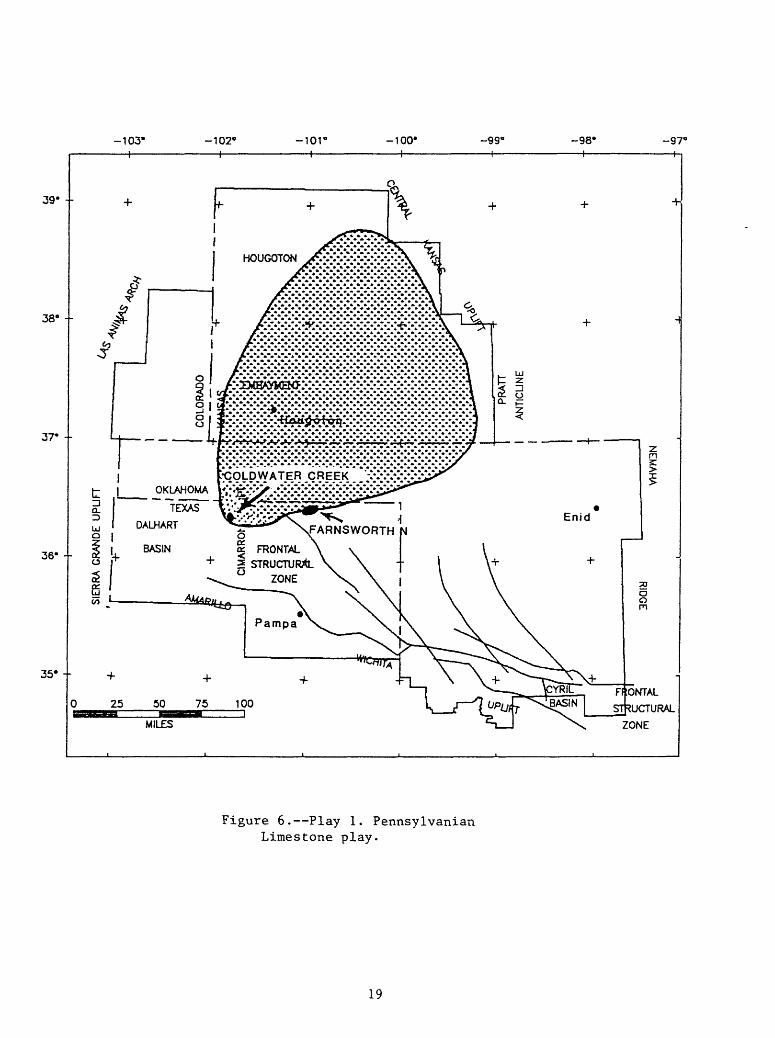
Playl. PENNSYLVANIAN LIMESTONE PLAY
The play produces oil and non-associated gas from limestones of post-Morrow age (figs. 5 and 6). The limestones were deposited in the northern shelf of the basin in northern Oklahoma and in the Hugoton embayment as parts of cyclic depositional sequences. Their southern limit is determined by the position of the basin slope. The producing limestones are primarily Desmoinesian and Missourian in age and are generally less than 150 ft thick; after acid treatment and fracturing, they make good reservoirs. The traps are formed by intracrystalline, vuggy, and fracture porosity. Seals are provided by overlying shales. Depths to the top of reservoirs are generally in the 2,000 to 5,000 foot depth range.
The source beds for this play are the shales within the Pennsylvanian section. In the Hugoton embayment and across northernmost Oklahoma these source bed probably never subsided into the oil window. To the south, however, rocks of Desmoinesian age were completely within the oil window by the end of Permian time and the overlying rocks of Missourian age were within the oil window by the end of Triassic time. Hydrocarbons migrating updip filled available limestone reservoirs.
18
103'-H
-102' I
-ior i
-100- -99' -98-
H
-97'
39" --
38° --
37" --
36- --
35° --
o| FRONTAL 3 STRUCTURAL ° ZONE
STRUCTURAL
ZONE
Figure 6. Play 1. Pennsylvanian Limestone play.
19
During the 21 year data period used for this play, 7 oil fields having a total estimated ultimate recovery of 23.2 million barrels of oil (MMBO), and 4 gas fields having a total estimated ultimate recovery of 60.4 billion cubic ft (BCF) of gas were discovered The largest oil field (Farnsworth, North) with an 8 MMBO ultmate recovery was discovered in 1965 and the largest gas field (Coldwater Creek) with a 26.8 BCF ultimate recovery was discovered in 1975. The size distribution of oil fields in increasing order of MMBO ultimate recovery is as follows: 1-2,3 fields; >2-3,1 field; >4-5,2 fields and 8,1 field. The distribution for gas fields in BCF is 6-10,1 field; >10-20,2 fields; and >20-30,1 field.
The play has produced a relatively small amount of oil and non-associated gas during the 21 year data period despite active exploration for deeper targets. This appears to be the future of the play, few fields and low resource potential.
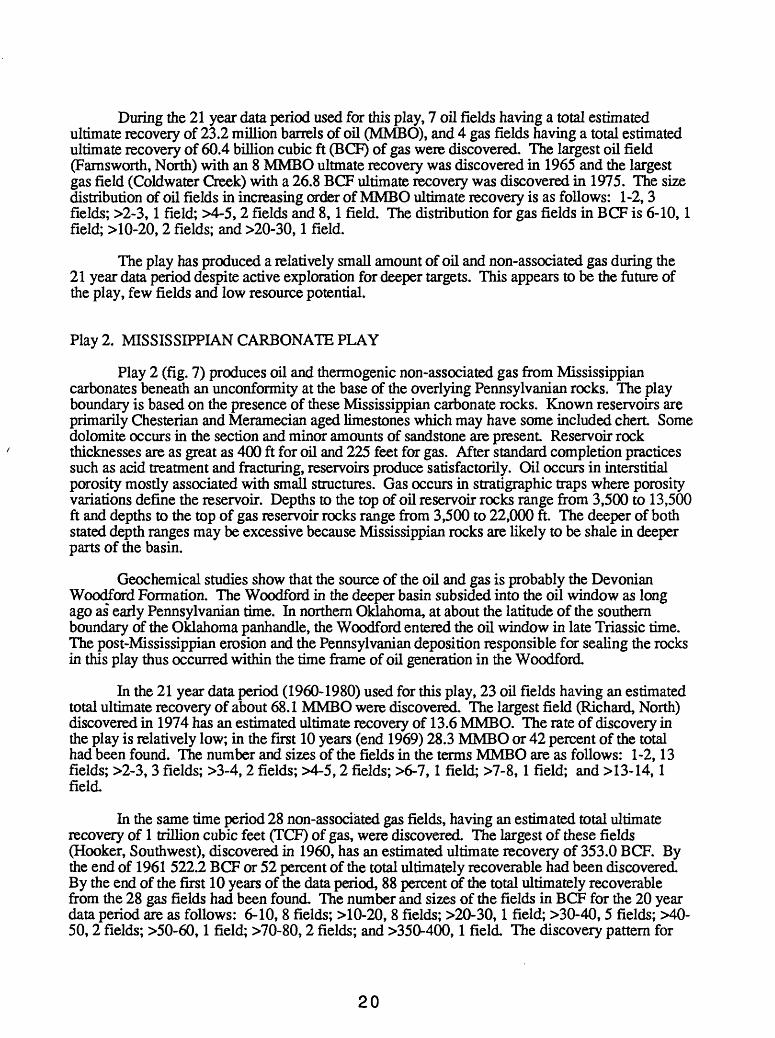
Play 2. MISSISSIPPIAN CARBONATE PLAY
Play 2 (fig. 7) produces oil and thermogenic non-associated gas from Mississippian carbonates beneath an unconformity at the base of the overlying Pennsylvanian rocks. The play boundary is based on the presence of these Mississippian carbonate rocks. Known reservoirs are primarily Chesterian and Meramecian aged limestones which may have some included chert. Some dolomite occurs in the section and minor amounts of sandstone are present Reservoir rock thicknesses are as great as 400 ft for oil and 225 feet for gas. After standard completion practices such as acid treatment and fracturing, reservoirs produce satisfactorily. Oil occurs in interstitial porosity mostly associated with small structures. Gas occurs in stratigraphic traps where porosity variations define the reservoir. Depths to the top of oil reservoir rocks range from 3,500 to 13,500 ft and depths to the top of gas reservoir rocks range from 3,500 to 22,000 ft. The deeper of both stated depth ranges may be excessive because Mississippian rocks are likely to be shale in deeper parts of the basin.
Geochemical studies show that the source of the oil and gas is probably the Devonian Woodford Formation. The Woodford in the deeper basin subsided into the oil window as long ago as early Pennsylvanian time. In northern Oklahoma, at about the latitude of the southern boundary of the Oklahoma panhandle, the Woodford entered the oil window in late Triassic time. The post-Mississippian erosion and the Pennsylvanian deposition responsible for sealing the rocks in this play thus occurred within the time frame of oil generation in the Woodford.
In the 21 year data period (1960-1980) used for this play, 23 oil fields having an estimated total ultimate recovery of about 68.1 MMBO were discovered. The largest field (Richard, North) discovered in 1974 has an estimated ultimate recovery of 13.6 MMBO. The rate of discovery in the play is relatively low; in the first 10 years (end 1969) 28.3 MMBO or 42 percent of the total had been found. The number and sizes of the fields in die terms MMBO are as follows: 1-2,13 fields; >2-3,3 fields; >3-4,2 fields; >4-5,2 fields; >6-7,1 field; >7-8,1 field; and >13-14,1 field.
In the same time period 28 non-associated gas fields, having an estimated total ultimate recovery of 1 trillion cubic feet (TCP) of gas, were discovered. The largest of these fields (Hooker, Southwest), discovered in 1960, has an estimated ultimate recovery of 353.0 BCF. By the end of 1961 522.2 BCF or 52 percent of the total ultimately recoverable had been discovered By the end of the first 10 years of the data period, 88 percent of the total ultimately recoverable from the 28 gas fields had been found The number and sizes of the fields in BCF for the 20 year data period are as follows: 6-10, 8 fields; >10-20, 8 fields; >20-30,1 field; >30-40,5 fields; MO- 50, 2 fields; >50-60,1 field; >70-80,2 fields; and >350-400,1 field The discovery pattern for
20
103' I
-102- i
-ior i
-100' I
99« I
-98' I
-97"
39"
38* -
37* -
36" --
35' -
STRUCTURAL
ZONE
Figure 7. Play 2. Mississippian carbonate play.
21
undiscovered resources of both oil and gas is not expected to dramatically change with future exploration efforts.
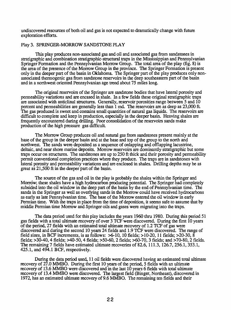
Play 3. SPRINGER-MORROW SANDSTONE PLAY
This play produces non-associated gas and oil and associated gas from sandstones in stratigraphic and combination stratigraphic-structural traps in the Mississippian and Pennsylvanian Springer Formation and the Pennsylvanian Morrow Group. The total area of the play (fig. 8) is the area of the presence of the Morrow Group in the province. The Springer Formation is present only in the deeper part of the basin in Oklahoma. The Springer part of the play produces only non- associated thermogenic gas from sandstone reservoirs in the deep southeastern part of the basin and in a northwest oriented Pennsylvanian age trend about 75 miles long.
The original reservoirs of the Springer are sandstone bodies that have lateral porosity and permeability variations and are encased in shale. In a few fields these original stratigraphic traps are associated with anticlinal structures. Generally, reservoir porosities range between 5 and 10 percent and permeabilities are generally less than 1 md. The reservoirs are as deep as 23,000 ft The gas produced is sweet and contains small quantities of natural gas liquids. The reservoirs are difficult to complete and keep in production, especially in the deeper basin. Heaving shales are frequently encountered during drilling. Poor consolidation of the reservoirs sands make production of the high pressure gas difficult
The Morrow Group produces oil and natural gas from sandstones present mainly at the base of the group in the deeper basin and at the base and top of the group to the north and northwest. The sands were deposited as a sequence of onlapping and offlapping lacustrine, deltaic, and near shore marine deposits. Morrow reservoirs are dominantly stratigraphic but some traps occur on structures. The sandstones are up to 250 ft thick and their porosity and permeability permit conventional completion practices where they produce. The traps are in sandstones with lateral porosity and permeability variations and are enclosed in shales. Drilling depths may be as great as 21,500 ft in the deeper part of the basin.
The source of the gas and oil in the play is probably the shales within the Springer and Morrow; these shales have a high hydrocarbon producing potential. The Springer had completely subsided into the oil window in the deep part of the basin by the end of Pennsylvanian time. The sands in the Springer as well as overlying sands in the Morrow could have received hydrocarbons as early as late Pennsylvanian time. The base of the Morrow entered the oil window in early Permian time. With the traps in place from the time of deposition, it seems safe to assume that by middle Permian time Morrow and Springer oils and gases were migrating into the traps.
The data period used for this play includes the years 1960 thru 1980. During this period 51 gas fields with a total ultimate recovery of over 3 TCF were discovered. During the first 10 years of the period, 27 fields with an estimated total ultimate recovery of 1.2 TCF of gas were discovered and during the second 10 years 24 fields and 1.9 TCF were discovered. The range of field sizes, in BCF increments, is as follows: >6-10, 10 fields; >10-20, 11 fields; >20-30, 8 fields; >30-40,4 fields; >40-50,4 fields; >50-60, 2 fields; >60-70, 3 fields; and >70-80,2 fields. The remaining 7 fields have estimated ultimate recoveries of 82.6,111.3,126.7, 256.1, 353.1, 425.1, and 494.1 BCF, respectively.
During the data period used, 11 oil fields were discovered having an estimated total ultimate recovery of 27.0 MMBO. During the first 10 years of the period, 5 fields with an ultimate recovery of 13.6 MMBO were discovered and in the last 10 years 6 fields with total ultimate recovery of 13.4 MMBO were discovered. The largest field (Binger, Northeast), discovered in 1972, has an estimated ultimate recovery of 9.6 MMBO. The remaining ten fields and their
22
-103' I
-102' I
-101" I
-100- I
99«h-
-98" -97'
39" -
38° --
37- --
36' --
35° +
************£»**.**,***»****** *** * * ******** ******** * WB^^
STRUCTURAL
ZONE
Figure 8. Play 3. Springer-Morrow sandstone play.
23
ultimate recoveries are as follows: 1-2 MMBO, 8 fields; >2-3 MMBO; 2 fields. All oil production is from rocks of Morrowan age.
Many early estimates of the potential for Springer wells were as high as 20 to 100 BCF estimated ultimate recoveries per well. These estimates have since been reduced to 5-10 BCF per well, and many wells have not reached this expectation. There is no indication that Springer production makes an excessive contribution to the ultimate recovery of any field. Where production data are available it appears that in most instances the ultimate recovery for Springer wells appears to be less than that for Morrow wells. We believe the potential of mis play is far less than the magnitude of estimates based on the original estimated recovery figures presented above.
Play 4. POST-MORROW PENNSYLVANIAN SANDSTONE PLAY
This play produces oil and non-associated gas from sandstones of post-Morrowan Pennsylvanian age and the boundary follows their presence in the province (fig. 9). These sandstones have both southern and northern sources. The southern sourced sands are distal, fined-grained rocks. They are derived from uplifted crystalline rocks of the Amarillo-Wichita uplift. Northern sourced sands were transported south across the northern shelf and deposited basinward of the shelf. Some of the sands were deposited as lacustrine and shelf sands.
The reservoirs are quartz sandstones and most are Missourian and Desmoinesian in age, some Atokan reservoirs are also productive. Reservoir rocks are as much as 400 ft thick and wells are readily completed to make producing wells. The traps are primarily stratigraphic, composed of sand bodies with lateral and vertical porosity variations and shale seals. Depths to the reservoirs range from 2,000 to 14,000 ft.
The source of the hydrocarbons are the shale beds within the Pennsylvanian section. In the shallower parts of the basin to the north, it is probable that hydrocarbons migrated from the south to fill the reservoirs.
In the complete exploration history of the basin, this play is larger than any other play in terms* of ultimately recoverable oil and non-associated gas and in the number of fields producing these commodities. This is also true for the 22 year data period for oil in this play which includes the years 1959-1980. During this period 29 fields having an estimated total ultimate recovery of 133.0 million barrels of oil (MMBO) were discovered. The largest oil field (Chickasha, Northwest), with an estimated ultimate recovery of 58.9 MMBO, was discovered in 1969. In the first half of the data period ending in 1969,109 MMBO, about 82% of the total estimated ultimate recoverable oil had been found. In addition to the largest field discussed above the size of the other 28 fields, in one MMBO increments, is as follows: 1-2,14 fields; >2.-3, 8 fields; >3-4, 3 fields;>4-5,1 field; >5-6,1 field; and >12-13,1 field.
The 22 year data period for non-associated gas in this play includes the years 1960-1981 during which time 89 fields with an estimated total ultimate recovery of 3.8 TCP of gas were discovered. The largest field, which was discovered in 1962, has an estimated ultimate recovery of 249.3 BCF. By 1971 half of the estimated ultimate recovery had been discovered. In this period the number of fields discovered in each year ranged from 1 to 11. This distribution of discovery rates is also applicable to the second half of the data period. The number of gas fields is as follows: 6-10,21 fields; >10-20, 15 fields; >20-30,12 fields; >30-40,10 fields; >40-50,7 fields; >50-60,9 fields; >60-70,1 field; >70-80,1 field; >80-90,1 field; >90-100,2 fields; MOO- 110, 1 field; >110-120,2 fields; >120-130,1 field; >140-150,1 field; and >160-170,1 field. The remaining 2 fields have estimated ultimate recoveries of 233 and 249 BCF. We believe that both the number of accumulations and the quantity of each commodity will exceed those discovered during the data period discussed above.
24
103' I
102' -ior i
-100* -99" -98* H
-97* h
39° --
38' --
37* -
36" --
35" -
^^^^* ********ft***.A***********»*»*.>**************% **4>***»***********4>
o« FRONTAL
ONTAL
STRUCTURAL
ZONE
Figure 9. Play 4. Post-Morrow Pennsylvanian sandstone play.
25
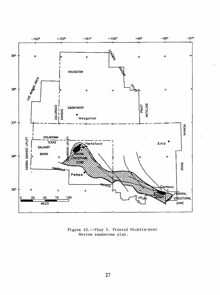
Play 5. FRONTAL WICHTTA - POST MORROW SANDSTONE PLAY
This play produces from conglomerates on and immediately north of the Amarillo-Wichita Uplift along the southern part of the province (fig. 10). The southern boundary of this play is formed by the Amarillo-Wichita uplift, the northern boundary is formed by the absence of these rocks, the western boundary generally coincides with the Cimarron uplift and the eastern boundary generally coincides with the province boundary. The uplift was the source of the conglomerates that were deposited as fanglomerates onshore and deltas and laterally distributed clastic sediments offshore. One the north side of the uplift the conglomerates occur as a more or less continuous body but northward they tongue-out into finer grained rocks. They represent a broad span of time, the oldest are Upper Morrowan and youngest are Wolfcampian (Lower Permian) in age. These conglomerates are generally referred to as "washes".
There are 3 types of washes and they represent 3 stages of erosion on the uplift The oldest, the chert and limestone washes were derived from eroded Mississippian rocks and are generally regarded as late Morrowan in age. They are overlain by the dolomite washes which were derived from the older Paleozoic dolomites of the Arbuckle Group and are thought to be of early Atokan age. The youngest, the granite washes, which range from boulder conglomerates to arkosic sandstone, derived from pre-Arbuckle igneous and metamoiphic rocks, are satisfactory reservoir rocks and in many instances have produced as "a bailout zone" when deeper exploration targets have been unproductive. The traps are defined as primarily stratigraphic (depositional facies) but many are associated with anticlines or anticlinal noses. This is especially true for the oil fields where 5 of the 6 fields are combination traps. Oil reservoirs are up to 100 ft thick and depths to reservoir tops range from about 1,000 to about 16,000 ft. Gas reservoirs are up to 700 ft thick and depths to the top of reservoir rocks also range from about 1,000 to 16,000 ft. These washes make high quality reservoirs.
The source rocks for these reservoirs are probably the Pennsylvania shales in the deep basin immediately to the north and the underlying Pennsylvania^ Springer and Mississippian shales. The Woodford shale may have been the source for some hydrocarbons but the younger shales^ seem a more likely source because of their proximity to the reservoirs rock. The reservoir rocks were present when the source rocks subsided into the oil window.
The data used for the play includes oil and gas fields discovered before 1981. Six oil fields having an ultimate recovery of 202 MMBO have been discovered in the play; the largest field (Cement) was discovered in 1917, and has an estimated ultimate recovery of 114.5 MMBO. This represents 57% of the discovered ultimately recoverable oil in the play. The other 43% of the discovered oil is found in 5 fields which have ultimate recoveries of 45.2, 23.4,10.6, 7.3 and 1.1 million barrels.
The first non-associated gas field found in the play was discovered in 1952 and only 12 additional fields were discovered in the following 28 years of the data period. The ultimate recovery of gas in the 13 fields of the play is 863 BCF. By the end of 1953, the year after the initial discovery, the largest field, with an ultimate recovery of 504 BCF (nearly 60 percent of the total for the play), was discovered. The number and field sizes in BCF of the remaining 12 fields is: 6-10,4 fields; >10-20, 1 field; >20-30,1 field; >40-50,3 fields; and >50-60, 3 fields.
The most promising potential of this play is in non-associated gas; we do not predict any substantial discoveries for oil because of the strong affinity for oil to occur in structural settings. At this stage of exploration most structures are known and have been tested The outlook for gas discoveries is better because of tendency of gas to occur more often stratigraphic traps.
26
to
H-
OQ i-<S
n>
o .-« H-
>-<
o
o
en rt
Ln
O
D n>
TI
i-<T
) O
M
3ft)
rt
VJ
ft) H-
O pr H-
ft
(U "d
o
en
Play 6. DEEP STRUCTURAL PLAY
The deep structural play produces gas from anticlines and faulted anticlines at depths greater than 15,000 ft This play includes dolomite reservoirs in the Hunton and Arbuckle Groups situated on anticlines. The current production in the play comes from that area where both groups are dolomitic. The play is mainly confined by the 15,000 ft depth contour which lies on the northern slope in the northern part of the play and to the south it is bounded by the Amarillo- Wichita uplift (fig. 11). Although the structures involve all rocks of pre-Woodford age, rocks of Hunton and Arbuckle age are the chief targets.
Reservoirs rocks in this play consist primarily of dolomites in the Hunton and Arbuckle Groups; the Ordovician Simpson Group has some minor production. Structures are the result of orogeny and uplift that occurred at the end of Hunton time and before the deposition of the Woodford. The dolomites are the product of diagenetic alteration of shelf deposited limestone but the dolomization process was not pervasive, either areally or vertically, in the two groups. Limestones are not productive in the play and are not considered to be future reservoirs. In the deepest part of the basin the Hunton is more than 750 ft thick, and the Arbuckle is more than 6,500 ft thick; in this area both the Arbuckle and Hunton are dominately limestone. The intracrystalline dolomite and the fracture porosities form reservoirs that are readily producible.
In the Arbuckle and Hunton Groups, traps are formed by lateral and vertical porosity variations in the dolomite and all gas accumulations apparently have a down-dip gas-water contact in the structure. Where production occurs at and near the surface of the Arbuckle, the overlying Simpson forms the seal; in similar situations on the Hunton surface the Woodford forms the seal. Drilling depths of the play will range from about 15,000 to 27,000 ft
There are probably two main sources of hydrocarbons in the play. Gas in the Arbuckle is probably sourced from the Ordovician part of the section from the shales within the Simpson Group, the Sylvan Shale, and possibly the more organic-rich portions of limestones in the Arbuckles. Gas in the Hunton may have some of its source in the underlying Sylvan Shale and most certainly much of its source in the overlying Woodford Formation. Geochemical studies show that Ordovician rocks are generally low (<1%) in total organic carbon content and that the Woodford is consistently richer (>2%) in total organic carbon. The structures of the play were formed before the start of Woodford deposition and were in place when the source rocks described above subsided into the zone of thermal maturation in the deep part of the basin.
The northern half of the Carter-Knox gas field extends into the extreme southeastern part of this province, and this field should properly be credited as the initial deep basin discovery. In 1956, it initially produced gas from Simpson rocks at depths slightly more than 15,000 ft.
During the 20 year period encompassing the data used in this report, 16 gas fields having a total estimated ultimate recover of 2.56 TCP were discovered in the play. All of these fields were discovered between 1964 and 1975 most are located in Texas and Oklahoma. The largest field, Buffalo Wallow, was discovered in 1968 and has an estimated ultimate recovery of more than 450 BCF. The size range of the remaining 15 fields, in BCF is as follows: 6->50,4 fields; >50-100, 3 fields; >101-150,1 field; >150-200,3 fields; >250-300,2 fields; >301-350,1 field; and>351- >400,1 field. The three factors discussed above, structures, dolomite, and depth are important constraints for the potential of the play.
The deepest commercially drilled well in the world (Lone Star No. 1 Bertha Rogers) is located in the western part of the province. At a total depth of 31,441 ft, about 200 ft below the top of the Arbuckle, the drill encountered molten sulfur, bottom hole temperature was estimated to be about 500°F. The sulfur was probably derived from the original sediments of the Arbuckle; there is nothing in either the sedimentary or subsequent geologic history that would suggest that it
28
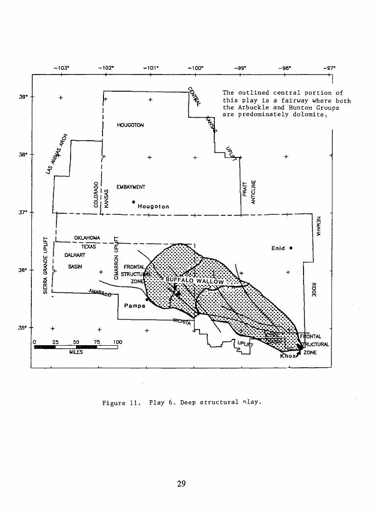
103"-H
102--H
-10V I
-100' I
-99' h-
-98*H
-97« H
39'--
38 --
37* --
36' --
35' -
The outlined central portion of this play is a fairway where both the Arbuckle and Hunton Groups are predominately dolomite.
RAL
Figure 11. Play 6. Deep structural nlay.
29
has an outside source. Sulfur and methane arc not compatible in a high-temperature-carbonate reservoir, their reaction with water produces hydrogen sulfide and carbon dioxide. For this reason we, and others, believe that a geochemical floor probably exists for commercial deposits of methane in the play. We have estimated the floor at 27,500 ft; deeper than the world's deepest natural gas production in this basin (26,500 ft) and shallower than the total depth of the Rogers well.
Play 7. LOWER PALEOZOIC PALEOTOPOGRAPfflC PLAY
This play includes those fields that produce oil and gas from Hunton Group rocks in stratigraphic traps. The post-Hunton, pre-Woodford orogeny that produced the structures of play6 culminated with a broad uplift of the province; this uplift resulted in erosion and the development of topographic features on the exposed Hunton surface and porosity enhancement beneath the erosional surface. The boundary of the play is shown on (fig. 12). the northern boundary of the play is the erosional edge of the Hunton and the southern limit is an arc where we believe depth of burial attends destruction of porosity and permeability.
The reservoirs of the play are limestones and dolomites in the Hunton Group. Hunton rocks thicken southward from the erosional edge and are more than 900 ft thick in the deepest part of the basin. Individual gas reservoirs range in thickness from about 5 ft up to 300 ft and oil reservoirs range from 5 ft up to 40 ft All reservoirs produce efficiently after using standard completion practices for carbonates.
The Woodford Formation is probably the source of hydrocarbons in the Hunton. It immediately overlies the Hunton and is known to be a high quality, prolific source for oil and associated/dissolved gas. The thermal maturity of the Woodford varies widely; it is overmature in the deepest parts of the play and immature on the shelf to the north. Between these two extremes, the formation is generating oil today in some parts of the basin.
Because the source beds for the play overlie and seal the reservoirs there is little problem related to hydrocarbon migration. Although original porosity of the Hunton may have been diagenetically changed when covered by the Woodford, the remaining porosity was available for charging by hydrocarbons as they were generated.
The traps in the play are stratigraphic traps; lateral and vertical reservoir limits within the carbonates are controlled by porosity and permeability decreases in limestones and dolomites at the top of and within the Hunton. Traps at the top of the Hunton erosion surface are sealed by shales of the Woodford Formation. Drilling depths range from about 5,500 ft down to possibly 27,500 ft.
During the data period used (1960-1980) 12 gas fields were discovered with an estimated total ultimate recovery of 254 BCF. The largest field, Vici, West was discovered in 1970 and has an estimated ultimate recovery of 46 BCF. During the first half of the data period, 5 fields with an estimated total ultimate recovery of 77.0 BCF were discovered and in the second half of the period,7 fields were discovered with an estimated ultimate recovery of more than 178 BCF. The field size distribution in BCF is as follows: 6-10, 3 fields; >10-20,3 fields; >20-30,4 fields; >30-40,1 field; and >40-50,1 field
During the same period, 6 oil fields with an estimated ultimate recovery of 19 (MMBO) were discovered. The largest of these fields, Yukon, Northwest, was discovered in 1974 and has an estimated ultimate discovery of 8.2 MMBO. All 6 fields were discovered during the second half of the period The size distribution of the fields in MMBO is as follows: 1-2,3 fields; >2-3,1 field; >3-4,1 field; and >8-9,1 field
30
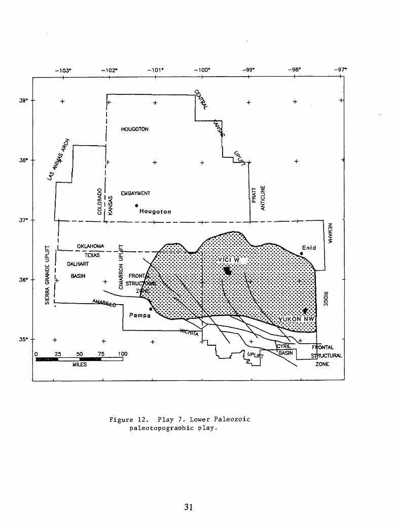
Un
H-
OP c ^
-O
(D
03 M
h-«
(D
NJ
O
rt
O -O
^
O
MOQ
ft)
t-l
^
03

We estimate that this play is still in an early stage of exploration. The distribution of discovery dates indicates that with increased exploration based on sound geology many more discoveries will be made. The down-dip extent of the play will be determined by porosity and permeability limits that are functions of depth of burial. Probably the greater number of discoveries will be made above 18,000 ft, although the play could exist down to our estimated floor of hydrocarbon occurrence (27,500 ft; see discussion of play 6).
32
REFERENCES
Adler, F.J., and others, 1971, Future petroleum provinces of the Mid-continent, Region 7, in Cram, I.H., ed., Future petroleum provinces of the United States-Their geology and potential: American Association of Petroleum Geologists Memoir 15, p. 985-1120.
Al-Shaieb, Z., and Walker, P., 1986, Evolution of secondary porosity in Pennsylvanian Morrow sandstones, Anadarko basin, Oklahoma, in Spencer, C.W., and Mast, R.F., eds., 1986, Geology of tight gas reservoirs: American Association of Petroleum Geologists Studies in Geology, no. 24, p. 45-67.
Amsden, T.W., 1988, Depositional and post-depositional history of Middle Paleozoic (LateOrdovician through Early Devonian) strata in the ancestral Anadarko Basin; in Anadarko Basin Symposium, 1988; Johnson, K.S., ed: Oklahoma Geological Survey Circular 90, p. 143-146.
Burruss, R.C. and Hatch, J.R., 1988, Geochemistry of Oils and Hydrocarbon Source Rocks, Greater Anadarko Basin: Evidence for Multiple Sources of Oils and Long-Distance Oil Migration; in Anadarko Basin Symposium, 1988; Johnson, K.S., ed., Oklahoma Geological Survey Circular 90, p. 53-64.
Buzzalini, A.D., 1984, Upper Pennsylvanian Source Beds of Northeastern Oklahoma and Adjacent Kansas: Tulsa Geological Society Field Trip, May 4-5, 1984, p. 1-58.
Campbell, J.A., Mclntire, H., and Haines, R.A., 1988, Structural anomalies in the Deep Anadarko Basin, Caddo and Canadian Counties, Oklahoma; in Anadarko Basin Symposium, 1988; Johnson, K.S., ed.: Oklahoma Geological Survey Circular 90, p. 239-244.
Cardott, B.J., and Lambert, M.W., 1985, Thermal maturities by vitrinite reflectance of WoodfordShale, Anadarko basin, Oklahoma: American Association of Petroleum Geologists
Bulletin, v. 69, p. 1982-1998.
Chenoweth, P.A., 1984, Southern Mid-continent responses to Acadian orogeny, in Hyne, W.J., ed., Limestones of the Mid-continent, 1984: Tulsa Geological Society, p. 247-257.
Comer, J.B., and Hinch, H.H., 1987, Recognizing and quantifying expulsion of oil from the Woodford Formation and age-equivalent rocks in Oklahoma and Arkansas: American Association of Petroleum Geology Bulletin, v. 71, p. 844-858.
Feinstein, S., 1981, Subsidence and thermal history of Southern Oklahoma aulacogen-Implications for petroleum exploration: American Association of Petroleum Geologists Bulletin, v. 65, p. 2531-2533.
Fryklund, R.E., 1989, Oil and gas developments in Oklahoma and panhandle of Texas: American Association of Petroleum Geologists Bulletin, v. 73, p. 130-135.
Furbush, M.A., 1959, Hugoton field, Kansas, in Kansas Oil and Gas Fields, Vol. n, Western Kansas: Kansas Geological Society, Wichita, Kansas, p. 55-64.
Galloway, W.E., Ewing, T.E., Garrett, CM., Tyler, N., and Bebout, D.G., 1983, Panhandle granite wash/dolomite, in Adas of major Texas oil reservoirs: Bureau of Economic Geology, University of Texas, Austin, p. 135-136.
33
Garner, D.L., and Turcotte, D.L., 1984, The thermal and mechanical evolution of the Anadarko basin: Tectonophysics, v. 107, p. 1-24.
Ham, W.E., and McKinley, M.E., 1954, Geologic map and section of the Arbuckle Mountains, Oklahoma: Oklahoma Geological Survey.
Hanison, W.E., and Routh, DJL., 1981, Reservoir and fluid characteristics of selected oil fields in Oklahoma: Oklahoma Geological Survey Special Publication 81-1, p. 1-317.
Hatch, J.R., Jacobson, S.R., Witzke, B.J., Risatti, J.B., Anders, D.E., Watney, W.L., Newell, KJD. and Vuletich, A.K., 1987, Possible Late Middle Ordovician Carbon Isotope Excursion: Evidence from Ordovician Oils and Hydrocarbon Source Rocks Mid-Continent and East-Central United States: American Association of Petroleum Geologists Bulletin, v.71, p. 1342-1354.
Hester, T.C., Schmoker, J.W., and Sahl, H.L., 1990, Log-derived regional source-rockcharacteristics of the Woodford Shale, Anadarko Basin, Oklahoma: U.S. Geological Survey Bulletin 1866-D, p. 1-38.
Hill, G.W., Jr., and Clark, R.H., 1980, The Anadarko basin A regional petroleumaccumulation A model for future exploration and development: Shale Shaker, Journal of Oklahoma City Geological Society, v. 31, no. 3, p. 36-47.
Hubbert, M.K., 1953, Entrapment of Petroleum under Hydrodynamic Conditions: American Association of Petroleum Geologists Bulletin, v. 37, p. 1954-2026.
Hugman, R.H., and Vidas, F.H., 1987, Oil and gas resources of the Mid-continent region: Energy and Environmental Analysis, Incorporated, Arlington, VA, p. 140.
Hutchison, L.L., 1911, Preliminary report on the rock asphalt, asphaltite, petroleum and natural gas in Oklahoma: Oklahoma Geological Survey, Bulletin no. 2, p. 1-256.
Johnson, K.S., 1988, Geologic evolution of the Anadarko Basin; in Anadarko Basin Symposium, 1988; Johnson, K.S., ed.: Oklahoma Geological Survey Circular 90, p. 3-12.
Keighin, C.W., and Flores, R.M., 1988, Depositional facies, petrofacies, and diagenesis ofMorrow and Springer rocks, Anadarko Basin, Oklahoma; in Anadarko Basin Symposium, 1988; Johnson, K.S., ed.: Oklahoma Geological Survey Circular 90, p. 147-161.
Luza, K.V., 1988, Neotectonics and seismicity of the Anadarko Basin; in Anadarko Basin Symposium, 1988; Johnson, K.S., ed.: Oklahoma Geological Survey Circular 90, p. 121-132.
McConnell, D.A., 1988, Constraints on magnitude and sense of slip across the northern margin of the Wichita Uplift, southwest Oklahoma; in Anadarko Basin Symposium, 1988; Johnson, K.S., ed.: Oklahoma Geological Ssurvey Circular 90, p. 85-96.
Momper, J.A., 1978, Oil migration limitations suggested by geological and geochemicalconsiderations: American Association of Petroleum Geologists Continuing Education Course Note Series #8, p. Bl-60.
Moody, J.D., and Hill, M.J., 1964, Moody and Hill system of wrench fault tectonics~a reply: American Association of Petroleum Geologists Bulletin, v. 48, p. 112-122.
34
NRG Associates, Inc., 1985, Significant Oil and Gas Fields of the United States: Thefield/reservoir clusters of the United States: Available from Nehring Associates, Inc., P.O. Box 1655, Colorado Springs, CO 80901.
NRG Associates, 1986, Significant oil and gas fields of the United States; base users guide: Colorado Springs, Colorado, 105 p. and data tape.
Paul, S.E., Netzler, B.W., Woltz, David, Coubrough, Robin, Peters, Roger, Gprdan, D.L., and Mossier, J.H., 1989, Oil and gas developments in North Mid-Continent in 1988: American Association of Petroleum Geologists Bulletin, v. 73, p. 109-117.
Petroleum Information Corporation, 1986a, Petroleum Data System (through 1985): Available from Petroleum Information Corporation, 4100 East Dry Creek Road, Littleton, CO 80122.
___1986b, Well History Control System (through December 1985): Available from Petroleum Information Corporation, 4100 East Dry Creek Road, Littleton, CO 80122.
Perry, W.J., Jr., 1990, Tectonic evolution of the Anadarko basin region, Oklahoma: U.S. Geological Survey Bulletin, v. 1866-A, 19 p.
Pippin, L., 1970, Panhandle-Hugoton field, Texas-Oklahoma-Kansas, the first fifty years, in Halbouty, M.T., ed., 1970 Geology of giant petroleum fields: American Association of Petroleum Geologists Memoir 14, p. 204-222.
Rice, D.D., Threlkeld, C.N., and Vuletich, A.K., 1988, Character, origin, and occurrence of natural gases in the Anadarko basin, southeastern Kansas, southwestern Oklahoma, and Texas Panhandle, U.S.A.: Chemical Geology, v. 71, p. 149-157.
Rodgers, D.A., 1980, Analysis of pull-apart basin development by an echelon strike-slip faults: Special Publication of the International Association of Sedimentologists, no. 4, p. 27-41.
Ronov, A.B., 1958, Organic carbon in sedimentary rocks (in relation to the presence of petroleum): Geochemistry, No. 5, p. 510-536.
Schmoker, J.W., 1986, Oil generation in the Anadarko basin, Oklahoma and Texas-Modeling using Lopatin's method: Oklahoma Geological Survey Special Publication 86-3,40 p.
Schramm, M.W., 1964, Paleogeologic and Quantitative Lithofacies Analysis, Simpson Group, Oklahoma: American Association of Petroleum Geologists Bulletin, v. 48, p. 1164-1195.
Sullivan, K.L., 1985, Organic Facies Variation of the Woodford Shale in western Oklahoma: Shale Shaker, v. 35, p. 76-89.
Tanner, J.H., 1967, Wrench fault movements along Washita Valley fault, Arbuckle Mountain area, Oklahoma: American Association of Petroleum Geologists Bulletin, v. 51, p. 126- 141.
Tiratsoo, E.N., 1979, Natural gas, 3rd edition: Houston, Texas, Gulf Publishing Co., 360 p.
Ward, L.O., 1965, Mississippian Osage, northwest Oklahoma platform: American Association of Petroleum Geologists Bulletin, v. 49, p. 1562.
35
Webb, G.W., 1976, Oklahoma City oil: second crop from preserved subunconformity source rocks: American Association of Petroleum Geologists Bulletin, v. 60, p. 115-122.
Wenger, L.M. and Baker, D.R., 1986, Variations in organic geochemistry of anoxic-oxic black shale - carbonate sequences in the Pennsylvanian of the Midcontinent U.S.A.: Organic Geochemistry, vol. 10, p. 85-92.
Woollard, G.P., and Rose, J.C, 1963, International gravity measurements: Menasha, Wisconsin, George Banks and Co., Publishers.
Wroblewsld, E.F., 1967, Exploration problems in the "deep" Anadarko basin: Shale Shaker, Oklahoma City Geological Society, v. 17, p. 131-136.
36
Related Documents


![Geology Hydrocarb Habitat Arab Basin[1]](https://static.cupdf.com/doc/110x72/54120bd77bef0ab5058b4621/geology-hydrocarb-habitat-arab-basin1.jpg)
