© 2013 TGS-NOPEC GEOPHYSICAL COMPANY ASA. ALL RIGHTS RESERVED. © 2013 TGS-NOPEC GEOPHYSICAL COMPANY ASA. ALL RIGHTS RESERVED. WWW.TGS.COM WWW.TGS.COM TGS | EASTERN INDONESIA FEBRUARY 2013 TGS | EASTERN INDONESIA FEBRUARY 2013 EASTERN INDONESIA MULTI-CLIENT 2D SEISMIC LIBRARY AUS Tel: +61 8 9480 0000 Email: [email protected] For more information, contact TGS at: The eastern margin of Indonesia is a geologically complex area which has required high quality geophysical data to assist in its interpretation. TGS has the most extensive geophysical library in the region. It includes 39,500 km of 2D seismic and 311,000 km 2 of multibeam data over the areas from East Sulawasi, around the Banda Arc and down through the Abadi field and to the west of Roti Island. The Cenderawasih Basin to the east of the Birdshead of West Papua has also been extensively covered with both 2D seismic and multibeam data. Gravity, magnetics, geochemical and heat flow data products are available with the multibeam data and include 2,204 geochemical samples and 42 heat flow results. North Banda Basin Weber Basin Celebes Basin Sahul Banks New Guinea Trench Makassar Strait Gulf of Tomini Molucca Sea Banda Sea Timor Sea Savu Sea Arafura Sea Sulawesi New Guinea Indonesia Indonesia Papua Papua New New Guinea Guinea E. Timor E. Timor Indonesia Indonesia Australia Australia Legend TGS MC2D Seismic TGS Multibeam Survey ¯ Location Diagram 0 200 400 600 800 Kilometres

Welcome message from author
This document is posted to help you gain knowledge. Please leave a comment to let me know what you think about it! Share it to your friends and learn new things together.
Transcript
© 2013 TGS-NOPEC GEOPHYSICAL COMPANY ASA. ALL RIGHTS RESERVED. © 2013 TGS-NOPEC GEOPHYSICAL COMPANY ASA. ALL RIGHTS RESERVED.WWW.TGS.COM WWW.TGS.COM
TGS | EASTERN INDONESIA FEBRUARY 2013 TGS | EASTERN INDONESIA FEBRUARY 2013
EASTERN INDONESIAMULTI-CLIENT 2D SEISMIC LIBRARY
AUS Tel: +61 8 9480 0000Email: [email protected]
For more information, contact TGS at:
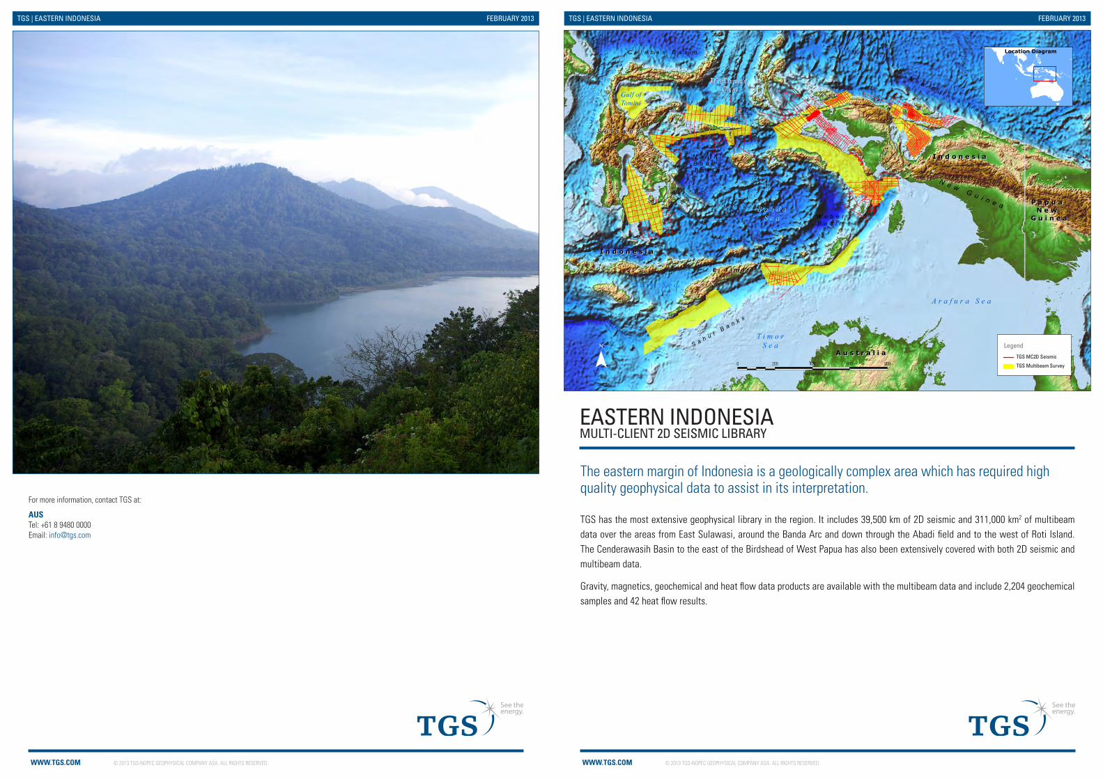
The eastern margin of Indonesia is a geologically complex area which has required high quality geophysical data to assist in its interpretation.
TGS has the most extensive geophysical library in the region. It includes 39,500 km of 2D seismic and 311,000 km2 of multibeam data over the areas from East Sulawasi, around the Banda Arc and down through the Abadi field and to the west of Roti Island. The Cenderawasih Basin to the east of the Birdshead of West Papua has also been extensively covered with both 2D seismic and multibeam data.
Gravity, magnetics, geochemical and heat flow data products are available with the multibeam data and include 2,204 geochemical samples and 42 heat flow results.
N o r t h B a n d aB a s i n
W e b e rB a s i n
C e l e b e s B a s i n
S a h u l B a n k s
N e w G u i n e a T r e n c h
Ma
ka
s sa
r S
t ra
i t
Gulf ofTomini
M o l u c c aS e a
B a n d aS e a
T i m o rS e a
S a v u S e a
A r a f u r a S e a
S u l a w e s i
N e w G u i n e a
I n d o n e s i aI n d o n e s i a
P a p u a P a p u a N e w N e w
G u i n e aG u i n e a
E . T i m o rE . T i m o r
I n d o n e s i aI n d o n e s i a
A u s t r a l i aA u s t r a l i aLegend
TGS MC2D Seismic
TGS Multibeam Survey¯Last Modified 11/02/2013 at 12:56 PM by mariroslW:\NEW_GIS\WORKSPACE\Asia_Pacific\2013_02_07_MARKET_Promotional_Maps_2013_MB\TGS_MARKET_A4_East_INDO_Brochure_V1_MR_20130211.mxd
Location Diagram
0 200 400 600 800
Kilometres
© 2013 TGS-NOPEC GEOPHYSICAL COMPANY ASA. ALL RIGHTS RESERVED.WWW.TGS.COM
TGS | EASTERN INDONESIA FEBRUARY 2013
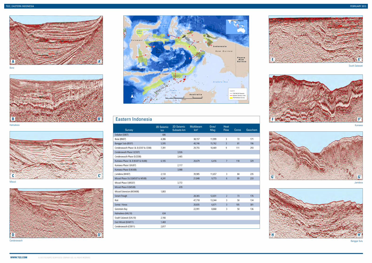
Bone
Halmahera
Misool
Cenderawasih Banggai Sulu
Kumawa
Jamdena
South Salawati
Sebakor (SB07) 686
Bone (BN07) 4,386 38,157 11,999 3 72 171
Banggai Sula (BS07) 5,595 40,746 15,762 3 81 196
Cenderawasih Phase I & II (CE07 & CE08) 7,391 29,755 10,469 9 111 293
Cenderawaih Phase I (CE07) 3,926
Cenderawasih Phase II (CE08) 3,465
Kumawa Phase I & II (KU07 & KU08) 6,105 20,679 6,416 7 118 329
Kumawa Phase I (KU07) 2,117
Kumawa Phase II (KU08) 3,988
Jamdena (MH07) 2,133 39,985 11,657 3 84 235
Misool Phase I & II (MS07 & MS08) 4,241 21,848 9,773 6 89 233
Misool Phase I (MS07) 3,772
Misool Phase II (MS08) 470
Misool Extension (MSM08) 1,803
Seram Trough 28,365 12,031 2 73 176
Roti 47,718 13,344 3 50 134
Semai / Keras 20,835 6,671 3 105 301
Gorontalo Bay 22,991 8,868 3 50 136
Halmahera (HAL10) 634
South Salawati (SAL10) 2,166
East Misool (EAM11) 1,469
Cenderawasih (CEB11) 2,817
Eastern Indonesia2D Seismic
km2D Seismic Subsets km
Multibeam km2
Grav/Mag
HeatFlow CoresSurvey Geochem
A
B
C
D H
G’
F
EA’
B’
C’
D’ H’
G’
F’
E’A'
A
N o r t h B a n d aB a s i n
W e b e rB a s i n
C e l e b e s B a s i n
S a h u l B a n k s
N e w G u i n e a T r e n c h
Ma
ka
s sa
r S
t ra
i t
Gulf ofTomini
M o l u c c aS e a
B a n d aS e a
T i m o rS e a
S a v u S e a
A r a f u r a S e a
S u l a w e s i
N e w G u i n e a
I n d o n e s i aI n d o n e s i a
P a p u a P a p u a N e w N e w
G u i n e aG u i n e a
E . T i m o rE . T i m o r
B a l i B a s i n I n d o n e s i aI n d o n e s i a
A u s t r a l i aA u s t r a l i a
H H'
B'B
C
C'
D'DE
E'
F'
F
G'
G
Legend
TGS MC2D Seismic Seismic Section LinesTGS Multibeam Survey¯
Last Modified 25/02/2013 at 04:24 PM by mariroslE:\NEW_GIS\WORKSPACE\Asia_Pacific\2013_02_07_MARKET_Promotional_Maps_2013_MB\TGS_MARKET_A4_East_INDO_Inside_Brochure_V2_MR_20130225.mxd
Location Diagram
0 200 400 600 800
Kilometres
Related Documents