1 | Page Terrain Traversability Analysis for off - road robots using Time- Of - Flight 3D Sensing Haris Balta 1 , Geert De Cubber 1 , Daniela Doroftei 1 , Yvan Baudoin 1 , Hichem Sahli 2 1 Royal Military Academy of Belgium (RMA) Department of Mechanical Engineering (MECA) Av. de la Renaissance 30, 1000 Brussels-Belgium [email protected]; [email protected]; [email protected]; [email protected] 2 Vrije Universiteit Brussel (VUB) Department of Electronics and Informatics (ETRO) Pleinlaan 2, 1050 Brussel-Belgium [email protected] KEYWORDS: Terrain Traversability Analysis, Time-of-flight camera, Outdoor Mobile Robot 1. INTRODUCTION One of the key challenges for outdoor mobile robots is to navigate autonomously in an unstructured and dynamic environment. When autonomous robotic systems leave the protected lab environment and operate in unstructured outdoor environments, they need to estimate the traversability of the terrain in order to navigate safely. Traversability estimation is a challenging problem, as in a non-structured environment one should consider both the terrain characteristics, such as slopes, vegetation, rocks, soils, etc. and the robot mobility characteristics, i.e. locomotion method, wheels, etc [9,10]. It is thus required to analyse, in real-time, the 3D characteristics of the terrain and pair this data to the robot capabilities. Traditionally, stereo cameras or 3D laser range finders are used as input devices for traversability analysis. However, both sensing modalities have important disadvantages. Stereo requires processing-intensive feature- matching processes, which fail on unstructured terrain, whereas 3D laser range finders are very expensive and limit the movement speed of the robot. To avoid these problems, we present in this paper a methodology toward terrain traversability analysis methodology using as input a time-of-flight (TOF) camera. The presented terrain traversability analysis methodology classifies all image pixels in the TOF image as traversable or not, by estimating for each pixel a traversability score which is based upon the analysis of the 3D (depth data) and 2D (IR data) content of the TOF camera data. This classification result is then used for the (semi) – autonomous navigation of two robotic systems, operating in extreme environments: a search and rescue robot and a humanitarian demining robot. Integrated in autonomous robot control architecture, terrain traversability classification increases the environmental situational awareness and enables a mobile robot to navigate (semi) – autonomously in an unstructured dynamical outdoor environment.

Welcome message from author
This document is posted to help you gain knowledge. Please leave a comment to let me know what you think about it! Share it to your friends and learn new things together.
Transcript
1 | P a g e
Terrain Traversability Analysis for off-road robots
using Time-Of-Flight 3D Sensing
Haris Balta1, Geert De Cubber
1, Daniela Doroftei
1, Yvan Baudoin
1, Hichem Sahli
2
1Royal Military Academy of Belgium (RMA)
Department of Mechanical Engineering (MECA)
Av. de la Renaissance 30, 1000 Brussels-Belgium [email protected]; [email protected]; [email protected]; [email protected]
2Vrije Universiteit Brussel (VUB)
Department of Electronics and Informatics (ETRO)
Pleinlaan 2, 1050 Brussel-Belgium [email protected]
KEYWORDS: Terrain Traversability Analysis, Time-of-flight camera, Outdoor Mobile Robot
1. INTRODUCTION
One of the key challenges for outdoor mobile robots is to navigate autonomously in an unstructured and
dynamic environment. When autonomous robotic systems leave the protected lab environment and operate in
unstructured outdoor environments, they need to estimate the traversability of the terrain in order to navigate
safely.
Traversability estimation is a challenging problem, as in a non-structured environment one should consider
both the terrain characteristics, such as slopes, vegetation, rocks, soils, etc. and the robot mobility
characteristics, i.e. locomotion method, wheels, etc [9,10]. It is thus required to analyse, in real-time, the 3D
characteristics of the terrain and pair this data to the robot capabilities.
Traditionally, stereo cameras or 3D laser range finders are used as input devices for traversability analysis.
However, both sensing modalities have important disadvantages. Stereo requires processing-intensive feature-
matching processes, which fail on unstructured terrain, whereas 3D laser range finders are very expensive and
limit the movement speed of the robot. To avoid these problems, we present in this paper a methodology
toward terrain traversability analysis methodology using as input a time-of-flight (TOF) camera.
The presented terrain traversability analysis methodology classifies all image pixels in the TOF image as
traversable or not, by estimating for each pixel a traversability score which is based upon the analysis of the
3D (depth data) and 2D (IR data) content of the TOF camera data. This classification result is then used for the
(semi) – autonomous navigation of two robotic systems, operating in extreme environments: a search and
rescue robot and a humanitarian demining robot. Integrated in autonomous robot control architecture, terrain
traversability classification increases the environmental situational awareness and enables a mobile robot to
navigate (semi) – autonomously in an unstructured dynamical outdoor environment.
2 | P a g e
2. SYSTEM SETUP
2.1. Vehicle description
The platform used as a test bed for the terrain traversability analysis is shown in Figure 1. The base vehicle of
this unmanned platform consists of an Explosive Ordnance Disposal (EOD) robot tEODor, a heavy outdoor
robot. We chose to use a standard EOD robot platform for several reasons:
As a platform, it has proven its usefulness in dealing with rough terrain with excellent
manoeuvrability and good off-road performance.
With a payload of around 350 kg, it makes it possible to carry multiple sensors and on-board
processing equipment.
The rugged design of the platform makes it capable of handling unfriendly environmental conditions.
Recycling a standardized platform is a good means of saving costs and avoiding buying expensive
dedicated platforms.
An important drawback of the standard tEODor platform is that it does not feature any autonomous
capabilities. To overcome such a constrain and be able to execute (semi) - autonomous tasks the platform was
upgraded with the necessary electronics, sensors, computing power, motor control units and power sources
[1].
In order to provide required data input to the terrain traversability analysis and path negotiation algorithm, an
active depth sensing system was integrated on the platform. This 3D sensing system consists of a PMD
CamCube 3.0 time-of-flight sensor mounted on a pan-tilt unit. The time-of-flight camera is in a tilted angle to
avoid typical signal modulation problems. Additionally, we have considered using a small quad-rotor based
unmanned aerial vehicle (UAV) for assistive collaborative mapping. The idea of using this UAV is to pair the
advantage of a UAV (possibility to obtain a good overview of the environment from above) with the
advantages of a UGV (possibility of interacting on the terrain).
2.2. Depth Sensing
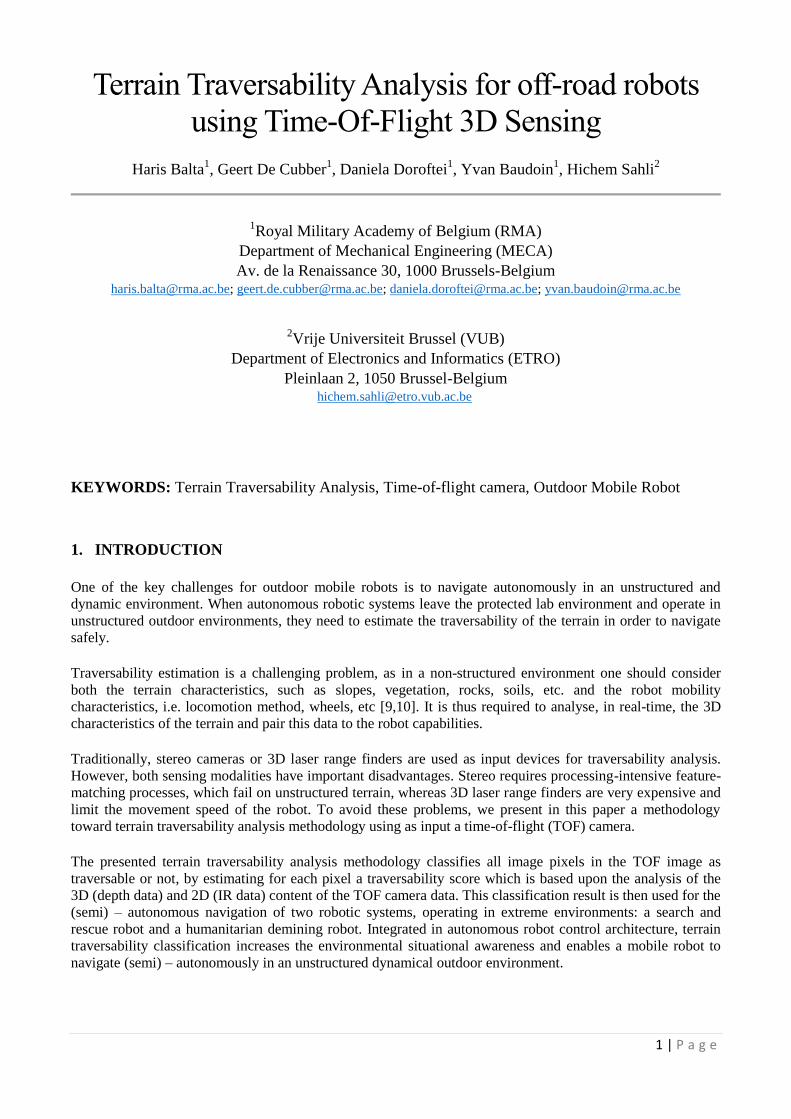
In the last few years, a new type of Range Imaging cameras has been developed, so called Time-of-Flight
(ToF) cameras. It is an active camera sensor which provides dense depth maps in real time; allows acquiring
3D point clouds without any scanning mechanism and from just one point of view at video frame rates.
Figure 2 shows the working principle of ToF which is based on the measurement of an emitted signal by the
camera towards the object to be observed, calculating the distance toward the object by means of direct or
indirect evaluation of the time since light is emitted by the system until it is received from the scene [2, 3].
Figure 1: The system setup, consisting of the UGV tEODor base, UAV and an
integrated active Time-Of-Flight Depth sensing system
3 | P a g e
Each pixel of the ToF detects both the intensity and the distance, thus provides an intensity, amplitude and
range image. The accuracy of the distance for each pixel depends on external interfering factors (i.e. sunlight,
extreme climate conditions) and scene properties, i.e., distances, surface orientations, object reflectivity,
colour and multiple light reflections. These fluctuations cause noise, but the amplitude image denotes the
quality of the 3D measurements; a high amplitude value of a pixel means that its corresponding distance value
is more reliable. Therefore, for minimizing noise in a range image acquired in an outdoor environment, the
standard filtering is based on the usage of amplitude values, removing pixels with low amplitudes, and the
addition of a median filter [4].
One of the advantages of using ToF camera is to simultaneously measure the distance information for each
pixel of the ToF. Based on that, some limitations of standard computer vision methods can be overcome, such
as the complexity to compute a robust disparity map of stereo cameras, dealing with illumination changes and
relative low speed of laser scanning systems. Due to advantages of ToF cameras, they have been used in a
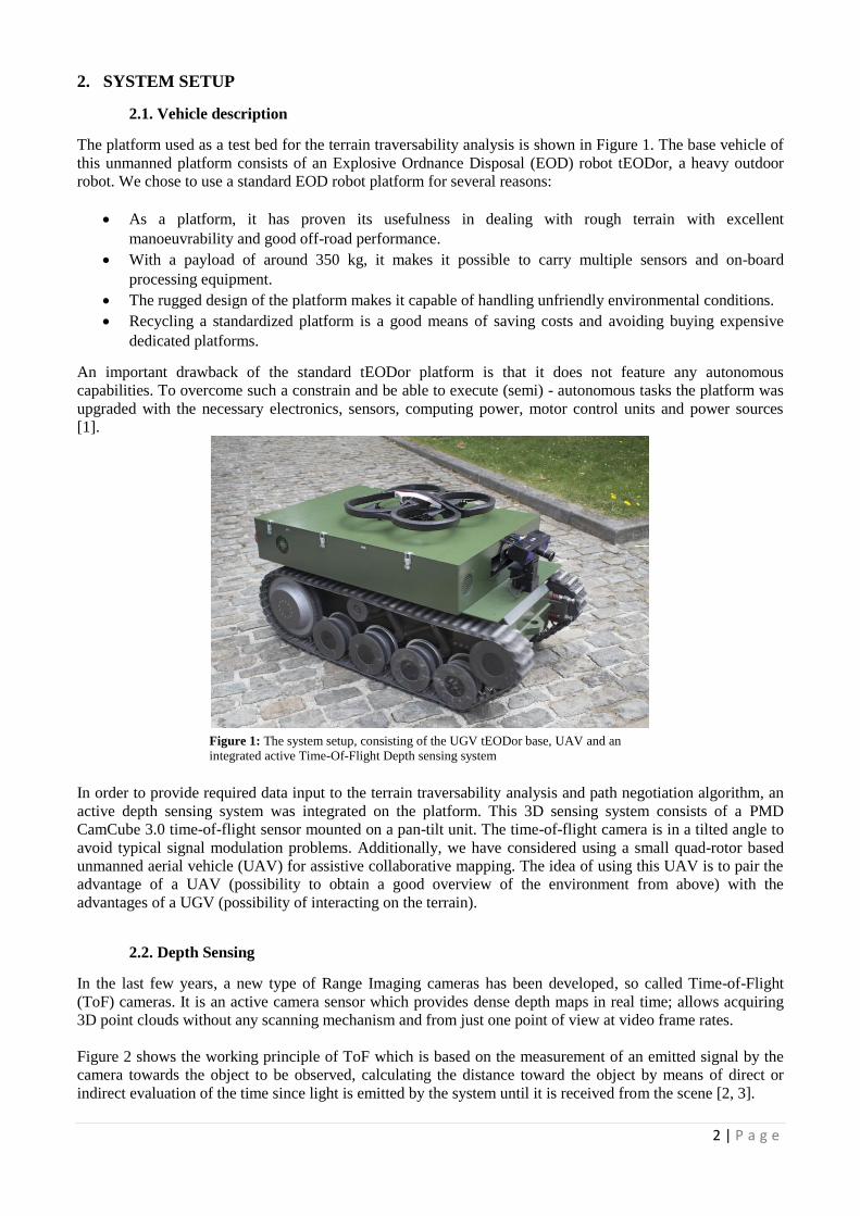
wide range of real-time applications with suitability in outdoor scenarios. For this work a PMD CamCube 3.0
camera has been chosen. This model is more robust to sunlight than other ToF cameras [4]. Main drawbacks
of the PMD CamCube 3.0 camera are the low 200x200 pixels resolution and noisy depth measurements due to
systematic and non-systematic errors. Figure 3 shows the output images provided by the PMD CamCube 3.0
camera in a single shot: 3D information (intensity and range) of the illuminated scene and amplitudes of the
returned signal.
Figure 3: Visualization of data acquired with the PMD CamCube 3.0 camera. On the left
side, en example RGB image of an obstacle is shown. The following images, above from
left to right, show 3D depth point cloud, depth, below images from left to right, show
amplitude and intensity from the observed obstacle scene.
Figure 2: left: setup comprising of a ToF PMD CamCube 3.0 camera on a pan-tilt unit;
right: working principle of the PMD CamCube 3.0 camera
NIR-illumination source
Depth image
Smart pixel
Different type of terrains (objects)
NIR-illumination source
Camera Unit PMDTEC 41K-S2 Sensor
4 | P a g e
ToF Depth Map
Input for path negotiation algorithms
Terrain Traversability Estimation
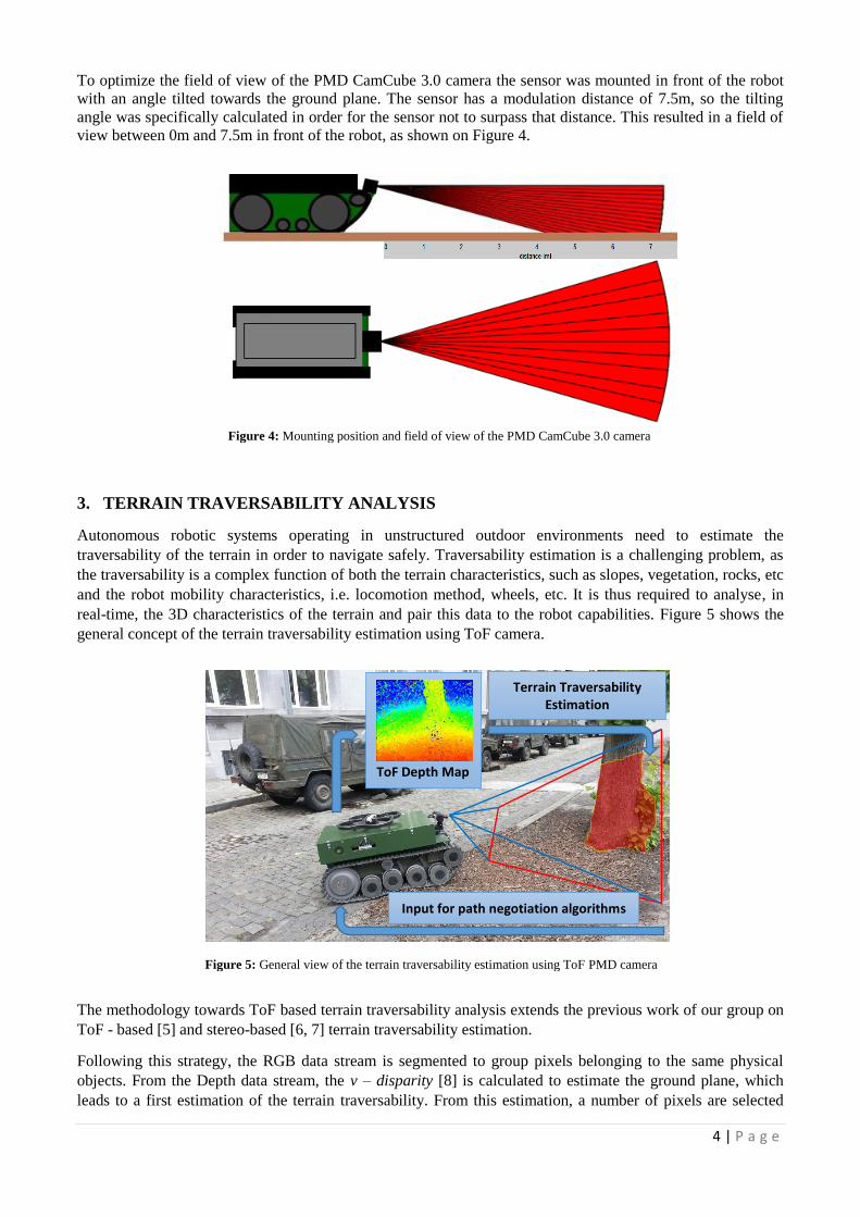
To optimize the field of view of the PMD CamCube 3.0 camera the sensor was mounted in front of the robot
with an angle tilted towards the ground plane. The sensor has a modulation distance of 7.5m, so the tilting
angle was specifically calculated in order for the sensor not to surpass that distance. This resulted in a field of
view between 0m and 7.5m in front of the robot, as shown on Figure 4.
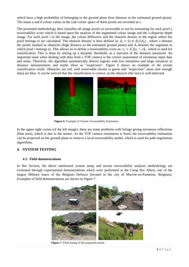
3. TERRAIN TRAVERSABILITY ANALYSIS
Autonomous robotic systems operating in unstructured outdoor environments need to estimate the
traversability of the terrain in order to navigate safely. Traversability estimation is a challenging problem, as
the traversability is a complex function of both the terrain characteristics, such as slopes, vegetation, rocks, etc
and the robot mobility characteristics, i.e. locomotion method, wheels, etc. It is thus required to analyse, in
real-time, the 3D characteristics of the terrain and pair this data to the robot capabilities. Figure 5 shows the
general concept of the terrain traversability estimation using ToF camera.
The methodology towards ToF based terrain traversability analysis extends the previous work of our group on
ToF - based [5] and stereo-based [6, 7] terrain traversability estimation.
Following this strategy, the RGB data stream is segmented to group pixels belonging to the same physical
objects. From the Depth data stream, the v – disparity [8] is calculated to estimate the ground plane, which
leads to a first estimation of the terrain traversability. From this estimation, a number of pixels are selected
Figure 4: Mounting position and field of view of the PMD CamCube 3.0 camera
Figure 5: General view of the terrain traversability estimation using ToF PMD camera
5 | P a g e
which have a high probability of belonging to the ground plane (low distance to the estimated ground plane).
The mean a and b colour values in the Lab colour space of these pixels are recorded as c.
The presented methodology then classifies all image pixels as traversable or not by estimating for each pixel a
traversability score which is based upon the analysis of the segmented colour image and the v-disparity depth
image. For each pixel i in the image, the colour difference and the obstacle density in the region where the
pixel belongs to are calculated. The obstacle density is here defined as: ⟨ ⟩ ⟨ ⟩ , where o denotes
the pixels marked as obstacles (high distance to the estimated ground plane) and Ai denotes the segments to
which pixel i belongs to. This allows us to define a traversability score as: ‖ ‖ , which is used for
classification. This is done by setting up a dynamic threshold, as a function of the distance measured. An
important issue when dealing with data from a TOF camera is the correct assessment of erroneous input data
and noise. Therefore, the algorithm automatically detects regions with low intensities and large variances in
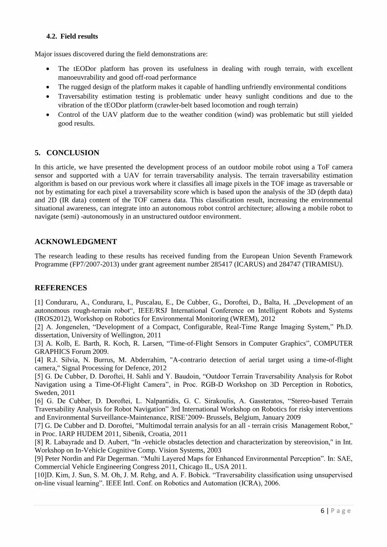
distance measurements and marks these as "suspicious". Figure 6 shows an example of the terrain
classification result. Obstacles are red, well traversable terrain is green and "suspicious" areas (not enough
data) are blue. It can be noticed that the classification is correct, as the obstacle (the tree) is well-detected.
In the upper right corner (of the left image), there are some problems with foliage giving erroneous reflections
(blue area), which is due to the sensor. As the TOF camera orientation is fixed, the traversability estimation
can be projected on the ground plane to retrieve a local traversability model, which is used for path negotiation
algorithms.
4. SYSTEM TESTING
4.1. Field demonstrations
In this Section, the above mentioned system setup and terrain traversability analysis methodology are
evaluated through experimental demonstrations which were performed at the Camp Roi Albert, one of the
largest Military bases of the Belgium Defence (located in the city of Marche-en-Famenne, Belgium).
Examples of field demonstrations are shown in Figure 7.
Figure 6: Example of Terrain Traversability Estimation
Figure 7: Field testing of the proposed system
6 | P a g e
4.2. Field results
Major issues discovered during the field demonstrations are:
The tEODor platform has proven its usefulness in dealing with rough terrain, with excellent
manoeuvrability and good off-road performance
The rugged design of the platform makes it capable of handling unfriendly environmental conditions
Traversability estimation testing is problematic under heavy sunlight conditions and due to the
vibration of the tEODor platform (crawler-belt based locomotion and rough terrain)
Control of the UAV platform due to the weather condition (wind) was problematic but still yielded
good results.
5. CONCLUSION
In this article, we have presented the development process of an outdoor mobile robot using a ToF camera
sensor and supported with a UAV for terrain traversability analysis. The terrain traversability estimation
algorithm is based on our previous work where it classifies all image pixels in the TOF image as traversable or
not by estimating for each pixel a traversability score which is based upon the analysis of the 3D (depth data)
and 2D (IR data) content of the TOF camera data. This classification result, increasing the environmental
situational awareness, can integrate into an autonomous robot control architecture; allowing a mobile robot to
navigate (semi) -autonomously in an unstructured outdoor environment.
ACKNOWLEDGMENT
The research leading to these results has received funding from the European Union Seventh Framework
Programme (FP7/2007-2013) under grant agreement number 285417 (ICARUS) and 284747 (TIRAMISU).
REFERENCES
[1] Conduraru, A., Conduraru, I., Puscalau, E., De Cubber, G., Doroftei, D., Balta, H. „Development of an
autonomous rough-terrain robot“, IEEE/RSJ International Conference on Intelligent Robots and Systems
(IROS2012), Workshop on Robotics for Environmental Monitoring (WREM), 2012
[2] A. Jongenelen, “Development of a Compact, Configurable, Real-Time Range Imaging System,” Ph.D.
dissertation, University of Wellington, 2011
[3] A. Kolb, E. Barth, R. Koch, R. Larsen, “Time-of-Flight Sensors in Computer Graphics”, COMPUTER
GRAPHICS Forum 2009.
[4] R.J. Silvia, N. Burrus, M. Abderrahim, "A-contrario detection of aerial target using a time-of-flight
camera," Signal Processing for Defence, 2012
[5] G. De Cubber, D. Doroftei, H. Sahli and Y. Baudoin, “Outdoor Terrain Traversability Analysis for Robot
Navigation using a Time-Of-Flight Camera”, in Proc. RGB-D Workshop on 3D Perception in Robotics,
Sweden, 2011
[6] G. De Cubber, D. Doroftei, L. Nalpantidis, G. C. Sirakoulis, A. Gassteratos, “Stereo-based Terrain
Traversability Analysis for Robot Navigation” 3rd International Workshop on Robotics for risky interventions
and Environmental Surveillance-Maintenance, RISE’2009- Brussels, Belgium, January 2009
[7] G. De Cubber and D. Doroftei, "Multimodal terrain analysis for an all - terrain crisis Management Robot,"
in Proc. IARP HUDEM 2011, Sibenik, Croatia, 2011
[8] R. Labayrade and D. Aubert, “In -vehicle obstacles detection and characterization by stereovision," in Int.
Workshop on In-Vehicle Cognitive Comp. Vision Systems, 2003
[9] Peter Nordin and Pär Degerman. “Multi Layered Maps for Enhanced Environmental Perception”. In: SAE,
Commercial Vehicle Engineering Congress 2011, Chicago IL, USA 2011.
[10]D. Kim, J. Sun, S. M. Oh, J. M. Rehg, and A. F. Bobick. “Traversability classification using unsupervised
on-line visual learning”. IEEE Intl. Conf. on Robotics and Automation (ICRA), 2006.
Related Documents