Tectonic evolution of the Marmara Sea and its surroundings Cenk Yalt|rak a;b; a Istanbul Technical University, Faculty of Mines, 80626 Maslak, Istanbul, Turkey b Istanbul Technical University, Institute of Eurasian Earth Sciences, 80626 Maslak, Istanbul, Turkey Received 1 May 2001; accepted 19 February 2002 Abstract The basins in the Marmara Sea are the products of a superimposed evolutionary history defined by two different- aged fault systems : the early Miocene^early Pliocene Thrace^Eskis Ŷehir Fault Zone and its branches, and the late Pliocene^Recent North Anatolian Fault and its branches. The Thrace^Eskis Ŷehir fault and its westward branching secondary fault systems define the early neotectonic signature in the region. The late neotectonic period started at the end of the early Pliocene when the North Anatolian Fault divided the Thrace^Eskis Ŷehir fault into four parts. During the late neotectonic period, the North Anatolian Fault extended westward as a number of splays by joining with the Ganos, Band|rma^Behramkale and Manyas^Edremit Fault Zones. The branches of the North Anatolian Fault Zone (NAFZ) caused the evolution of a number of basins, which differ in character depending on the trend and past characteristics of the older branches that became connected. Since the northern branch of the North Anatolian Fault is connected to the N80‡E-trending Ganos Fault Zone (GFZ) in the west, a single buried fault has developed in the Marmara Sea, causing the well-known troughs and ridges, superimposed onto the negative flower structure formed by the GFZ in the early neotectonic period. The middle strand, which extends from Iznik Lake to Band|rma, is oriented east^west up to the N60‡E-trending Band|rma^Behramkale Fault Zone, then turns southward in the vicinity of Band|rma, forming a region dominated by compressional tectonics. This bending caused N30‡E-trending tension in addition to the strike-slip motion between the eastern part of Gemlik Bay and Band|rma Bay. The southern branch of the NAFZ, on the other hand, produced three pull-apart basins with different characteristics along the Yenis Ŷehir, Bursa and Manyas segments. The southern branch of the NAFZ connected to the Manyas^Edremit Fault Zone, which is oriented N45‡E to the south of Manyas, and the associated bending and rotation caused a N15‡E-trending extension in addition to the strike-slip regime between Manyas and Uluabat. The branches of North Anatolian Fault cut through the Thrace^Eskis Ŷehir fault at three places: the East Marmara Sea region, in Gemlik Bay, and to the east of Bursa, giving lateral offsets of 58^59, 7^8 and 10^11 km, respectively. The cumulative motion is 75^78 km, corresponding to the total lateral offset of the North Anatolian Fault in the region. The correlation of these offsets with Global Positioning System slip vectors and with stratigraphic results implies that the North Anatolian Fault reached into the Marmara Sea region about 3.5 million yr ago. Tectonic processes forming the Marmara Sea and its environs were initiated by the Thrace^Eskis Ŷehir fault and its splays have been most recently controlled by the North Anatolian Fault and its splays during the last 3.5 million yr. ȣ 2002 Elsevier Science B.V. All rights reserved. Keywords: Marmara Sea; North Anatolian Fault; Thrace^Eskis Ŷehir fault; superimposed tectonics; sub-basin; neotectonics 0025-3227 / 02 / $ ^ see front matter ȣ 2002 Elsevier Science B.V. All rights reserved. PII:S0025-3227(02)00360-2 * Fax: +90-0-212-2856210. E-mail address: [email protected] (C. Yalt|rak). MARGO 3175 3-10-02 Marine Geology 190 (2002) 493^529 www.elsevier.com/locate/margeo

Welcome message from author
This document is posted to help you gain knowledge. Please leave a comment to let me know what you think about it! Share it to your friends and learn new things together.
Transcript
Tectonic evolution of the Marmara Sea and its surroundings
Cenk Yalt|rak a;b;�
a Istanbul Technical University, Faculty of Mines, 80626 Maslak, Istanbul, Turkeyb Istanbul Technical University, Institute of Eurasian Earth Sciences, 80626 Maslak, Istanbul, Turkey
Received 1 May 2001; accepted 19 February 2002
Abstract
The basins in the Marmara Sea are the products of a superimposed evolutionary history defined by two different-aged fault systems: the early Miocene^early Pliocene Thrace^Eskis)ehir Fault Zone and its branches, and the latePliocene^Recent North Anatolian Fault and its branches. The Thrace^Eskis)ehir fault and its westward branchingsecondary fault systems define the early neotectonic signature in the region. The late neotectonic period started at theend of the early Pliocene when the North Anatolian Fault divided the Thrace^Eskis)ehir fault into four parts. Duringthe late neotectonic period, the North Anatolian Fault extended westward as a number of splays by joining with theGanos, Band|rma^Behramkale and Manyas^Edremit Fault Zones. The branches of the North Anatolian Fault Zone(NAFZ) caused the evolution of a number of basins, which differ in character depending on the trend and pastcharacteristics of the older branches that became connected. Since the northern branch of the North Anatolian Faultis connected to the N80‡E-trending Ganos Fault Zone (GFZ) in the west, a single buried fault has developed in theMarmara Sea, causing the well-known troughs and ridges, superimposed onto the negative flower structure formed bythe GFZ in the early neotectonic period. The middle strand, which extends from Iznik Lake to Band|rma, is orientedeast^west up to the N60‡E-trending Band|rma^Behramkale Fault Zone, then turns southward in the vicinity ofBand|rma, forming a region dominated by compressional tectonics. This bending caused N30‡E-trending tension inaddition to the strike-slip motion between the eastern part of Gemlik Bay and Band|rma Bay. The southern branch ofthe NAFZ, on the other hand, produced three pull-apart basins with different characteristics along the Yenis)ehir,Bursa and Manyas segments. The southern branch of the NAFZ connected to the Manyas^Edremit Fault Zone,which is oriented N45‡E to the south of Manyas, and the associated bending and rotation caused a N15‡E-trendingextension in addition to the strike-slip regime between Manyas and Uluabat. The branches of North Anatolian Faultcut through the Thrace^Eskis)ehir fault at three places: the East Marmara Sea region, in Gemlik Bay, and to the eastof Bursa, giving lateral offsets of 58^59, 7^8 and 10^11 km, respectively. The cumulative motion is 75^78 km,corresponding to the total lateral offset of the North Anatolian Fault in the region. The correlation of these offsetswith Global Positioning System slip vectors and with stratigraphic results implies that the North Anatolian Faultreached into the Marmara Sea region about 3.5 million yr ago. Tectonic processes forming the Marmara Sea and itsenvirons were initiated by the Thrace^Eskis)ehir fault and its splays have been most recently controlled by the NorthAnatolian Fault and its splays during the last 3.5 million yr.A 2002 Elsevier Science B.V. All rights reserved.
Keywords: Marmara Sea; North Anatolian Fault; Thrace^Eskis)ehir fault; superimposed tectonics; sub-basin; neotectonics
0025-3227 / 02 / $ ^ see front matter A 2002 Elsevier Science B.V. All rights reserved.PII: S 0 0 2 5 - 3 2 2 7 ( 0 2 ) 0 0 3 6 0 - 2
* Fax: +90-0-212-2856210.E-mail address: [email protected] (C. Yalt|rak).
MARGO 3175 3-10-02
Marine Geology 190 (2002) 493^529
www.elsevier.com/locate/margeo
1. Introduction
The 1500-km-long North Anatolian Fault Zone(NAFZ) bifurcates into three branches to the eastof the Marmara Sea (Fig. 1A). These branchesterminate where the westward escape of the Ana-tolian Block turns into anticlockwise rotationalopening in the northern Aegean Sea and EdremitBay (Fig. 1B). These three branches demonstratedi¡erent kinematic and seismic appearances in theMarmara region. First, the NAFZ bifurcates westof V30.5‡E latitude into two branches (Fig. 1).The northern strand of the North Anatolian Fault(NAFNS) extends from Bolu to Izmit (S)engo«r,1979; Bozkurt, 2001), while the second branchextends southward from Bolu and bifurcatesonce more in the Pamukova Plain at V30‡E lat-itude (Koc)yigflit, 1988) (Fig. 1B). The northern ofthese latter branches is the middle strand of theNorth Anatolian Fault (NAFMS), which extendsalmost east^west along Iznik Lake, Gemlik Bayand Band|rma Bay. It changes direction aroundthe western part of Band|rma Bay and turnssouthwestward into a fault zone formed ofmany faults (Fig. 1B). The southern branch ofthe North Anatolian Fault (NAFSS) is a north-east^southwest-trending fault extending from Pa-mukova. The NAFSS creates the Yenis)ehir pull-apart basin together with another fault to thenorth (Fig. 1B). It extends from Bursa to Manyas,bending southwest from the southern part of theUluabat Lake, then extends in a WNW^ESE di-rection until the southern part of Manyas Lake(Fig. 1B). To the southwest of Manyas Lake, thefault changes its direction to S45‡W, then extendsfrom Manyas to Edremit, turning into a set ofdiscontinuous short fault segments.There are di¡erent views concerning the posi-
tion and character of the NAFZ both on land andat sea. The most important debates revolvearound the Marmara Sea problem (Crampinand Evans, 1986; Barka and Kadinky-Cade,1988; Ergu«n and Oº zel, 1995; Wong et al., 1995;Okay et al., 1999, 2000; Parke et al., 1999; LePichon et al., 1999; Aksu et al., 2000; Siyako etal., 2000; Imren et al., 2001). These recent studiescan be classi¢ed into three groups: (1) pull-apartand combined models (Barka and Kadinky-Cade,
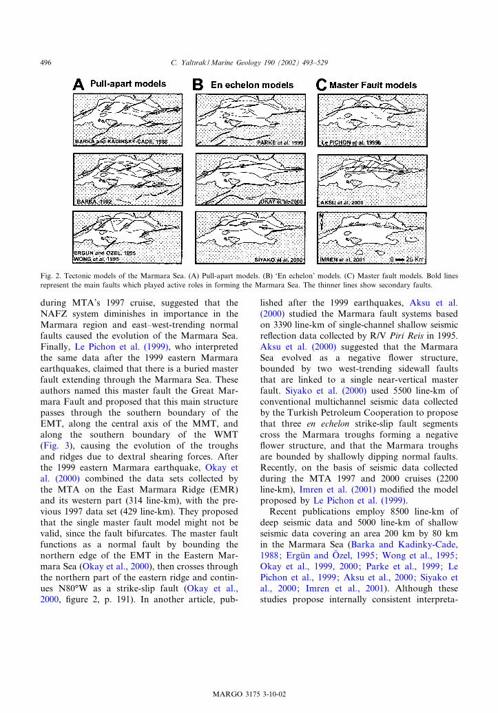
1988; Wong et al., 1995; Ergu«n and Oº zel, 1995;Barka, 1992); (2) models incorporating en echelonfault segments (Parke et al., 1999; Siyako et al.,2000; Okay et al., 2000); and (3) models with asingle master fault beneath the Marmara Sea(Fig. 2; Le Pichon et al., 1999; Aksu et al.,2000; Imren et al., 2001). The most distinctivestructure in the Marmara Sea is a series of east^west-trending troughs separated by NNE^SSW-trending ridges. Here, these are called the WestMarmara Trough (WMT; the Tekirdagfl Troughof Okay et al., 1999), Middle Marmara Trough(MMT), and East Marmara Trough (EMT;C)|narc|k Trough of Okay et al., 2000) (Fig. 3).Although the initial models for the evolution of
the Marmara Sea date from the 1930s, the ¢rstmodern study concerning sea£oor topographyand seismic sections is the pull-apart model ofBarka and Kadinky-Cade (1988). Subsequently,on the basis of 1670 line-km of shallow seismicre£ection data collected in 1987, this pull-apartmodel was modi¢ed to include compressionaland tensional rhombohedral blocks to explainthe three deep basins (‘troughs’) in the MarmaraSea (Ergu«n and Oº zel, 1995; Wong et al., 1995).During the same period, based on shallow andconventional seismic data gathered on the south-ern shelf, Smith et al. (1995) identi¢ed east^west-trending normal faults and proposed that thesouthern part of the Marmara Basin was a half-graben. About 1500 line-km of conventional seis-mic data were collected by R/V Sismik-1 of theMineral Research and Exploration Institute ofTurkey (MTA)in 1997. Three di¡erent workinggroups interpreted these data, reaching di¡erentconclusions. Okay et al. (1999) proposed that aso-called master fault, which borders the southernpart of the western Marmara Sea and then arriveson land, is a northeast^southwest thrust fault tothe east of the WMT. They also proposed a nor-mal fault in the middle of the trough and a north-thrusting dextral fault to the west of the troughnearest land. Okay et al. (1999) proposed thatGanos Mountain, 10 km wide, 30 km long, and900 m high in 28-km-thick crust (Aygu« l and Genc),1999), formed because of elastic bending associ-ated with this thrust fault geometry. Parke et al.(1999), who interpreted all of the data collected
MARGO 3175 3-10-02
C. Yalt|rak /Marine Geology 190 (2002) 493^529494
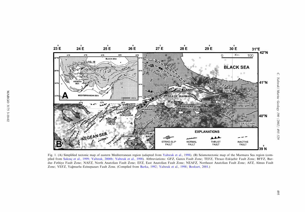
Fig. 1. (A) Simpli¢ed tectonic map of eastern Mediterranean region (adapted from Yalt|rak et al., 1998). (B) Seismotectonic map of the Marmara Sea region (com-piled from Sak|nc) et al., 1999; Yalt|rak, 2000b; Yalt|rak et al., 1998). Abbreviations: GFZ, Ganos Fault Zone; TEFZ, Thrace^Eskis)ehir Fault Zone; BFFZ, Bur-dur^Fethiye Fault Zone; NAFZ, North Anatolian Fault Zone; EFZ, East Anatolian Fault Zone; NEAFZ, Northeast Anatolian Fault Zone; AFZ, Almus FaultZone; YEFZ, Yagflmurlu^Ezinepazar| Fault Zone. (Compiled from Barka, 1992; Yalt|rak et al., 1998; Bozkurt, 2001.)
MARGO
31753-10-02
C.Yalt|rak
/Marine
Geology
190(2002)
493^529495
during MTA’s 1997 cruise, suggested that theNAFZ system diminishes in importance in theMarmara region and east^west-trending normalfaults caused the evolution of the Marmara Sea.Finally, Le Pichon et al. (1999), who interpretedthe same data after the 1999 eastern Marmaraearthquakes, claimed that there is a buried masterfault extending through the Marmara Sea. Theseauthors named this master fault the Great Mar-mara Fault and proposed that this main structurepasses through the southern boundary of theEMT, along the central axis of the MMT, andalong the southern boundary of the WMT(Fig. 3), causing the evolution of the troughsand ridges due to dextral shearing forces. Afterthe 1999 eastern Marmara earthquake, Okay etal. (2000) combined the data sets collected bythe MTA on the East Marmara Ridge (EMR)and its western part (314 line-km), with the pre-vious 1997 data set (429 line-km). They proposedthat the single master fault model might not bevalid, since the fault bifurcates. The master faultfunctions as a normal fault by bounding thenorthern edge of the EMT in the Eastern Mar-mara Sea (Okay et al., 2000), then crosses throughthe northern part of the eastern ridge and contin-ues N80‡W as a strike-slip fault (Okay et al.,2000, ¢gure 2, p. 191). In another article, pub-
lished after the 1999 earthquakes, Aksu et al.(2000) studied the Marmara fault systems basedon 3390 line-km of single-channel shallow seismicre£ection data collected by R/V Piri Reis in 1995.Aksu et al. (2000) suggested that the MarmaraSea evolved as a negative £ower structure,bounded by two west-trending sidewall faultsthat are linked to a single near-vertical masterfault. Siyako et al. (2000) used 5500 line-km ofconventional multichannel seismic data collectedby the Turkish Petroleum Cooperation to proposethat three en echelon strike-slip fault segmentscross the Marmara troughs forming a negative£ower structure, and that the Marmara troughsare bounded by shallowly dipping normal faults.Recently, on the basis of seismic data collectedduring the MTA 1997 and 2000 cruises (2200line-km), Imren et al. (2001) modi¢ed the modelproposed by Le Pichon et al. (1999).Recent publications employ 8500 line-km of
deep seismic data and 5000 line-km of shallowseismic data covering an area 200 km by 80 kmin the Marmara Sea (Barka and Kadinky-Cade,1988; Ergu«n and Oº zel, 1995; Wong et al., 1995;Okay et al., 1999, 2000; Parke et al., 1999; LePichon et al., 1999; Aksu et al., 2000; Siyako etal., 2000; Imren et al., 2001). Although thesestudies propose internally consistent interpreta-
Fig. 2. Tectonic models of the Marmara Sea. (A) Pull-apart models. (B) ‘En echelon’ models. (C) Master fault models. Bold linesrepresent the main faults which played active roles in forming the Marmara Sea. The thinner lines show secondary faults.
MARGO 3175 3-10-02
C. Yalt|rak /Marine Geology 190 (2002) 493^529496
tions, none of them forms a synthesis combiningstudies on land geology, land tectonics, gravity,magnetics, topography and bathymetry, GlobalPositioning System (GPS), stratigraphy, basincharacteristics, and seismotectonics. In this paper,the full set of available data will be considered,not only for the Marmara Sea but also its envi-rons; all of the geological and geophysical dataused in previous works will be reviewed and in-terpreted in the light of detailed land observa-tions. Using all these of data, the evolution ofthe faults and basins will be discussed.
2. Data and methods
Two data sets are utilised in this study. The ¢rstincludes structural and geological maps whichwere produced from detailed geologic surveys onland. Geological mapping was initiated in 1995 inEastern Thrace and the Gelibolu Peninsula.Faults were observed from satellite images (Yal-t|rak, 1996), de¢ned by land seismicity (Perinc)ek,1991), and mapped precisely based on ¢eld obser-vations (Sak|nc) et al., 1999). In the southern Mar-mara region, the disposition of the Thrace^Es-kis)ehir fault (Sak|nc) et al., 1999) was determinedusing satellite images and digital topographicmaps prepared from SAR interferometry, andwas then plotted on the geological maps basedon the control of ¢eld observations (Yalt|rak,2000a). The gravity and magnetic maps of (Akdo-gflan, 2000) and digital topography maps were con-sulted to corroborate fault placement. The depo-sitional units de¢ned during the ¢eld observations
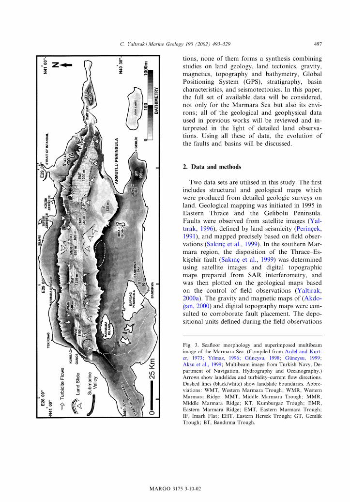
Fig. 3. Sea£oor morphology and superimposed multibeamimage of the Marmara Sea. (Compiled from Ardel and Kurt-er, 1973; Y|lmaz, 1996; Gu«neysu, 1998; Gu«neysu, 1999;Aksu et al., 1999; Multibeam image from Turkish Navy, De-partment of Navigation, Hydrography and Oceanography.)Arrows show landslides and turbidity^current £ow directions.Dashed lines (black/white) show landslide boundaries. Abbre-viations: WMT, Western Marmara Trough; WMR, WesternMarmara Ridge; MMT, Middle Marmara Trough; MMR,Middle Marmara Ridge; KT, Kumburgaz Trough; EMR,Eastern Marmara Ridge; EMT, Eastern Marmara Trough;IF, Imarl| Flat; EHT, Eastern Hersek Trough; GT, GemlikTrough; BT, Band|rma Trough.
MARGO 3175 3-10-02
C. Yalt|rak /Marine Geology 190 (2002) 493^529 497
at di¡erent localities were compared in a strati-graphic manner. The formations were dated andthe depositional environments compared (Yal-t|rak et al., 1998; Sak|nc) et al., 1999; Yalt|raket al., 2000a).The second data set consists of marine seismic
pro¢les. Multichannel conventional seismic sec-tions of Okay et al. (1999), Okay et al. (2000),Siyako et al. (2000), and Imren et al. (2001),and shallow seismic sections of Ergu«n and Oº zel(1995), Wong et al. (1995), Smith et al. (1995),and Aksu et al. (2000) were combined and re-in-terpreted. This re-interpretation has resulted in anew structural map. A bathymetric map was alsodrawn for this study. The navigation charts of theTurkish Navy and the Department of Navigation,Hydrography and Oceanography were used with5-m accuracy for shelf areas (Ardel and Kurter,1973; Y|lmaz, 1996; Gu«neysu, 1998, 1999). Fordeeper areas below 100-m water depth, bathymet-ric contours with 50-m depth contours of Aksu etal. (1999) were utilised. These data were combinedwith the multibeam swath data (20-m grid size)collected by the Department of Navigation, Hy-drography and Oceanography along the troughsof the Marmara Sea (Fig. 3). On this bathymetricmap, the deep Marmara troughs, which areknown since Andrussov (1890), are clearly de-¢ned.The faults traced on the seismic sections were
plotted and a simpli¢ed structural map was com-posed for the main faults at sea. From the combi-nation of marine and land data, the fault-bounded structural blocks in the Marmara Seawere de¢ned. The characteristics of these bound-ary faults are known from fault plane solutions.Finally, palinspastic tectonical evolution mapswere drawn for every 500 000 yr using the strati-graphic age determinations in the marine and landareas, GPS slip vectors, and kinematic features ofthe fault planes.
3. Sea£oor morphology of the Marmara Sea
3.1. Shelf areas
The shelf areas can be classi¢ed into four re-
gions: Tekirdagfl, Silivri, C)ekmece, and Adalar.Many canyons cut the shelf edge and continentalslopes (Fig. 3). The shelf in the Tekirdagfl regionnarrows between Kumbagfl and Marmara Eregfllisi.The arc-shaped Silivri region between MarmaraEregfllisi and Bu«yu«k C)ekmece has the widest shelfarea on the northern side of the Marmara Sea.The shelf of the Ku«c)u«k C)ekmece region becomesnarrower toward the Strait of Istanbul, where theshelf edge approaches the coast. The Adalar re-gion is separated from the western shelf area bythe Marmara canyon of the Strait of Istanbul(Fig. 3).On the southern shelf, there are two di¡erent
areas. To the north of the Armutlu Peninsula, theshelf is narrow (6 1 km). Between Armutlu Is-land and Marmara Island, the widest underwaterplain of the Marmara Sea is found (Fig. 3). Thisplain is between the Kap|dagfl Peninsula, Imral|Island and Marmara Island, and extends intoGemlik and Band|rma bays. Its slope is 1^2‡.The most interesting features are the islands andsmall troughs on the sea£oor (Fig. 3). The secondshelf area occurs to the east of the Strait ofC)anakkale, where an underwater valley extendsfrom the strait into the WMT. This valley is con-nected with two others running southwest of theKap|dagfl Peninsula and Marmara Island (Fig. 3).
3.1.1. Shelf troughsGemlik Trough: the deepest point of Gemlik
Bay is 110 m deep, 50 m below the elevation ofthe southern shelf (Fig. 3). Band|rma Trough(BT): this is a triangular-shaped trough separatedfrom the 60^70-m-deep shelf area in Band|rmaBay by a 30 m-deep sill. The trough becomesdeeper towards the city of Band|rma. To theeast of this trough, on the narrow area betweenthe Kap|dagfl Peninsula and Band|rma, a rockyshoal extends between the western part of theshelf and the BT (Fig. 3). East Hersek Trough(EHT): this trough is situated in Izmit Bay. It isa rather narrow trough and its deepest part ex-ceeds 200 m. It is separated from the MarmaraSea by a ridge formed by the sediments of HersekDelta. The slope of its southern margin is 15‡,while gradients are 8^10‡ along the northern slope(Fig. 3).
MARGO 3175 3-10-02
C. Yalt|rak /Marine Geology 190 (2002) 493^529498
3.1.2. Underwater valleysC)anakkale underwater valley: this is the east-
ward elongation of the strait. It is more than50 km in length and terminates at the WMT.Another valley, coming from the western part ofthe Biga Peninsula, is connected to this valley(Fig. 3). These valleys are shallow, open,‘V-shaped’ features connected with other minorvalleys. They link to master valley branches onland.Istanbul underwater canyon: this feature is the
north^south-trending extension of the combinedsystem of the Strait of Istanbul and GoldenHorn into the EMT. It is a 7-km-long valley deep-ening towards the trough. There is a dextralstrike-slip o¡set of V1^2 km between the land-ward end of this canyon and its southern end(Fig. 3).
3.2. Troughs, slopes and ridges
3.2.1. West Marmara TroughThe WMT is a rhombohedral feature with its
long axis trending northeast^southwest (Fig. 3).Its maximum depth is 1190 m, with an averageof 1100 m. To the north, along an arc-shapedarea, there are canyons and gullies perpendicularto the shore that cut across the continental slopefrom the 100-m contour down to 1100 m depth asslopes change from 18 to 30‡ (Fig. 3). To thenorthwest of the WMT, a wide underwater debrisfan progrades to the south. This feature is 10 kmlong and 8 km wide (Fig. 3). To the south of theWMT, the gradient of the continental slope is 14^24‡. Two canyons o¡ Marmara Island extend tothe southwest of this trough. There are two moreprominent canyons: one is the eastward extensionof the Strait of C)anakkale and the other one co-incides with the Ganos Fault Zone (GFZ) (Fig. 3).Between these, southeast of the town of Ganos,there is another underwater landslide fan(12U8 km size) that extends from 100 m waterdepth down to the bottom of the trough (Fig. 3).The surface of this fan, with a slope of about 10‡,has a step-like morphology. Bathymetric andswath data suggest that this fan was caused byunderwater failures.
3.2.2. West Marmara RidgeThe WMR is located to the east of the WMT.
It is 440 m deep and bounded by 840-m-deepvalleys at its two sides (Fig. 3). The valley tothe north is the boundary between the WMRand the 100-m-deep shelf (Fig. 3). To the south,a fault step in front of Marmara Island, whichbelongs to the NAFZ, forms the southern bound-ary of the WMR. There is a valley here betweenthe shelf and the WMR that almost coincides withthe NAFNS and extends to the MMT.
3.2.3. Middle Marmara TroughTheMMT contains the deepest point (V1250 m)
in the Marmara Sea (Fig. 3). Many canyons per-pendicular to the shelf edge enter the MMT fromthe northern continental shelf. These canyonsterminate near the edge of the basin £oor atV1200 m depth. To the south, canyons startingnear the shelf edge extend in a NNW^SSE direc-tion towards the western side of the MMT (Fig. 3).In the south^central part of the MMT, an under-water fan with a gentle slope covers a large area.
3.2.4. Middle Marmara RidgeThe Middle Marmara Ridge (MMR) is situated
to the east of the MMT (Fig. 3). The MMR isuplifted above the troughs to the east and west.An east^west-trending valley cuts through its cen-tral part, so that the centre of the ridge is itsdeepest part (V650 m). Convex bulges in theslopes north and south of the central basinalarea form the ends of the MMR (Fig. 3).
3.2.5. Kumburgaz TroughThe Kumburgaz Trough (KT) is an 820-m-deep
trough located to the east of the convex centralvalley traversing the MMR (Fig. 3). It has theshape of an ellipse extending ENE^WSW and ap-pears to have formed by partial ¢lling of a valleyduring uplift of the MMR (Fig. 3).
3.2.6. East Marmara RidgeThe EMR is situated to the west of the KT
(Fig. 3). It is a 640-m-deep rise trending in aneast^west direction for about 24 km, located be-tween the KT and the EMT. There is a 400-melevation di¡erence between the western and east-
MARGO 3175 3-10-02
C. Yalt|rak /Marine Geology 190 (2002) 493^529 499
ern edges of the EMR, the west side being shal-lower. Relative to its height, this is a rather wideridge (Fig. 3).
3.2.7. East Marmara TroughThe easternmost depression in the Marmara
Sea is the triangular-shaped EMT (Fig. 3). Thewidest part (10 km) of this 1200-m-deep troughis located to the west. The EMT becomes nar-rower eastward as it approaches the westernpart of Izmit Bay (Fig. 3). In the Adalar region(Prince Islands), many canyons extend down tothe bottom in a north^south direction. In its west-ern part, to the south of the Strait of Istanbul,large underwater fans supplied by slope failuresare evident in front of these canyons (Alpar andYalt|rak, 2000). O¡shore Tuzla, ridges betweenthe canyons are eroded in the shape of concave-northwards arcs (Fig. 3). To the south of theEMT, there are also many canyons extendingdownslope from the Armutlu Peninsula (Fig. 3).The convex anomaly, 20 km long and 1 km wide,extending into the trough at V29‡E latitude is anunderwater landslide (Alpar and Yalt|rak, 2000).Along the southwestern part of the EMT, theslopes are rather smooth. To the west of thissmooth slope, two canyons extend from the vicin-ity of Imral| Island toward the trough (Fig. 3).
3.2.8. Imral| FlatThe Imral| Flat (IF), which is situated in the
area between Imral| Island and the southwestedge of the EMT, has a di¡erent morphologythan either the shelves and the troughs. The deep-est point on this plain is at V3420 m. It becomesshallower (to V300 m) towards the northeast.The IF has a rhombohedral shape (20U16 km).There are no deep or apparent canyons along thesouthern slopes (Fig. 3).
4. Regional geology and basins
There are two main sedimentary successions inthe Marmara region, with di¡erent stratigraphicfeatures. These formed during the early Miocene^early Pliocene and late Pliocene^Recent. Thesesequences developed during the activation of
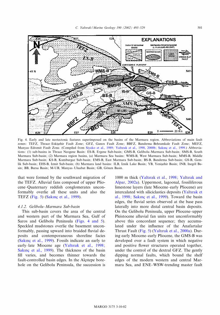
two di¡erent fault systems: the Thrace^Eskis)ehirFault Zone (TEFZ), and extensions of the NAFZ(Fig. 1). The Thrace Neogene Basin developedunder the control of the GFZ, the Band|rma^Beh-ramkale Fault Zone (BBFZ) and the Manyas^Edremit Fault Zone (MEFZ), the TEFZ itselfand its splays. The basins of the Marmara Sea,Saros, Manyas^Ulubat, Bursa, Yenis)ehir, Iznikand Go«nen developed under the control of theMarmara strands of the NAFZ (Fig. 4).
4.1. Thrace Neogene Basin (early Miocene^early Pliocene)
The Thrace Neogene Basin can be divided intothree early Miocene^early Pliocene sub-basins,mutually related laterally and covering the mod-ern basins of Southern Marmara, the MarmaraSea and Eastern Thrace (Fig. 4). The northern-most one is the Ergene Sub-basin (ES-B) devel-oped under the control of the TEFZ (Fig. 4). Tothe south, the Gelibolu^Marmara Sub-basin is lo-cated on the GFZ where it was inverted from theTEFZ (see Fig. 4; GMS-B). The other basin is theSouthern Marmara Sub-basin, which covers thesouthern shelf of the Marmara Sea and adjacentland area. It is situated above the BBFZ and theMEFZ that were inverted from the TEFZ (Figs. 4and 5).
4.1.1. Ergene Sub-basinThe central part of the East Thrace Peninsula is
underlain by sediments deposited in the earlyMiocene^early Pliocene ES-B (Figs. 4 and 5).The ES-B rests unconformably on upper Oligo-cene lacustrine units at its base and conglomeratestoward the basin edges. The fossils found at thebase of the basin ¢ll indicate an age of early^mid-dle Miocene (Sak|nc) et al., 1999). The sequencepasses upward into braided river deposits. Ande-sitic and shoshonitic volcanic rocks are interca-lated with these sediments, and intrusive equiva-lents cut these units locally along the TEFZ.These volcanics give radiometric ages of 21^15Ma and basic volcanic rocks give 15^5 Ma(Y|lmaz and Polat, 1998). In the ES-B, the young-est units are lacustrine limestones and intercalatedsandstones deposited in a zone of normal faults
MARGO 3175 3-10-02
C. Yalt|rak /Marine Geology 190 (2002) 493^529500
that were formed by the southward migration ofthe TEFZ. Alluvial fans composed of upper Plio-cene^Quaternary reddish conglomerates uncon-formably overlie all these units and also theTEFZ (Fig. 5) (Sak|nc) et al., 1999).
4.1.2. Gelibolu^Marmara Sub-basinThis sub-basin covers the area of the central
and western part of the Marmara Sea, Gulf ofSaros and Gelibolu Peninsula (Figs. 4 and 5).Speckled mudstones overlie the basement uncon-formably, passing upward into braided £uvial de-posits and contemporaneous shoreline facies(Sak|nc) et al., 1999). Fossils indicate an early toearly^late Miocene age (Yalt|rak et al., 1998;Sak|nc) et al., 1999). The thickness of the basin¢ll varies, and becomes thinner towards thefault-controlled basin edges. In the Alc)|tepe bore-hole on the Gelibolu Peninsula, the succession is
1000 m thick (Yalt|rak et al., 1998; Yalt|rak andAlpar, 2002a). Uppermost, lagoonal, fossiliferouslimestone layers (late Miocene^early Pliocene) areintercalated with siliciclastics deposits (Yalt|rak etal., 1998; Sak|nc) et al., 1999). Toward the basinedges, the £uvial series observed at the base passlaterally into more distal central basin deposits.On the Gelibolu Peninsula, upper Pliocene^upperPleistocene alluvial fan units rest unconformablyabove this concordant sequence; they accumu-lated under the in£uence of the AnafartalarThrust Fault (Fig. 5) (Yalt|rak et al., 2000a). Dur-ing early Miocene^early Pliocene, the GMS-B wasdeveloped over a fault system in which negativeand positive £ower structures operated together,under the control of the dextral GFZ. The gentlydipping normal faults, which bound the shelfedges of the modern western and central Mar-mara Sea, and ENE^WSW-trending master fault
Fig. 4. Early and late neotectonic features superimposed on the basins of the Marmara region. Abbreviations of main faultzones: TEFZ, Thrace^Eskis)ehir Fault Zone; GFZ, Ganos Fault Zone; BBFZ, Band|rma^Behramkale Fault Zone; MEFZ,Manyas^Edremit Fault Zone. (Compiled from Siyako et al., 1989; Yalt|rak et al., 1998, 2000b; Sak|nc) et al., 1999.) Abbrevia-tions: (1) sub-basins in Thrace Neogene Basin: ES-B, Ergene Sub-basin; GMS-B, Gelibolu^Marmara Sub-basin; SMS-B, SouthMarmara Sub-basin; (2) Marmara region basins, (a) Marmara Sea basins: WMS-B, West Marmara Sub-basin; MMS-B, MiddleMarmara Sub-basin; KS-B, Kumburgaz Sub-basin; EMS-B, East Marmara Sub-basin; BS-B, Band|rma Sub-basin; GS-B, Gem-lik Sub-basin; EHS-B, Izmit Sub-basin; (b) Marmara land basins: ILB, Iznik Lake Basin; YB, Yenis)ehir Basin; INB, Inego« l Ba-sin; BB, Bursa Basin; M-UB, Manyas^Uluabat Basin; GB, Go«nen Basin.
MARGO 3175 3-10-02
C. Yalt|rak /Marine Geology 190 (2002) 493^529 501
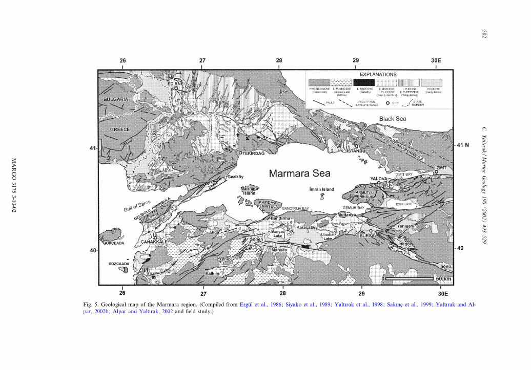
Fig. 5. Geological map of the Marmara region. (Compiled from Ergu« l et al., 1986; Siyako et al., 1989; Yalt|rak et al., 1998; Sak|nc) et al., 1999; Yalt|rak and Al-par, 2002b; Alpar and Yalt|rak, 2002 and ¢eld study.)
MARGO
31753-10-02
C.Yalt|rak
/Marine
Geology
190(2002)
493^529502
controlled the GMS-B. In the area placed betweenthese faults, the sediments, which become as thickas 1000 m towards Gelibolu, were deposited onthe basinal axis.
4.1.3. South Marmara Sub-basinThe Neogene series penetrated by boreholes on
the southern Marmara shelf are made up of lacus-trine units intercalated with volcanic rocks at thebase (Marathon Petroleum, 1976). Upward, theseunits gradually pass into strata equivalent to themulticoloured terrestrial series observed at thebase of the GMS-B (Marathon Petroleum,1976). These units seem to be the lateral continu-ation of the area between Gelibolu and Gaziko«yon the southern Marmara shelf (Figs. 4 and 5).The South Marmara Sub-basin (SMS-B), which issituated between Gemlik and Band|rma and splitinto two by the Mudanya^Band|rma uplift underthe e¡ect of the NAFZ at present, contains a ¢llof conglomerates and sandstones around Bursa,Manyas, Uluabat and northward. To the south,the dominant units are sandstones intercalatedwith volcanic ash and occasional coal layers.The thickness of these units is rather variable (Er-gu« l et al., 1986). The sandstone units are locallyfolded and overturned, showing local internal un-conformities. Their ages cover a period betweenthe middle Miocene and early Pliocene (Ergu«l etal., 1986; Emre et al., 1998; Yalt|rak, 2000a). Thefaults controlling the SMS-B are those extendingwestward from the TEFZ, with similar character-istics to those of the GFZ (Figs. 4 and 5). Theseare the BBFZ to the north and the MEFZ to thesouth (Figs. 4 and 5).
4.2. Marmara region basins (late Pliocene^Recent)
The Marmara basins are superimposed, underthe control of the NAFZ, on the component sub-basins of the Thrace Neogene Basin (Fig. 4). Thesediments were deposited in the late Pliocene andlater, unconformably above the Thrace Basin(Figs. 4 and 5) (Sak|nc) et al., 1999). Middle Mio-cene^lower Pliocene units on the Istanbul, Kocae-li and Armutlu Peninsulas represent low-energydepositional environments (Sak|nc) et al., 1999;
Alpar and Yalt|rak, 2002). These units are over-lain by small-scale basins re£ecting the e¡ects ofthe NAFZ (Figs. 4 and 5).
4.2.1. Marmara Sea BasinSediments in the Marmara Sea Basin (i.e. the
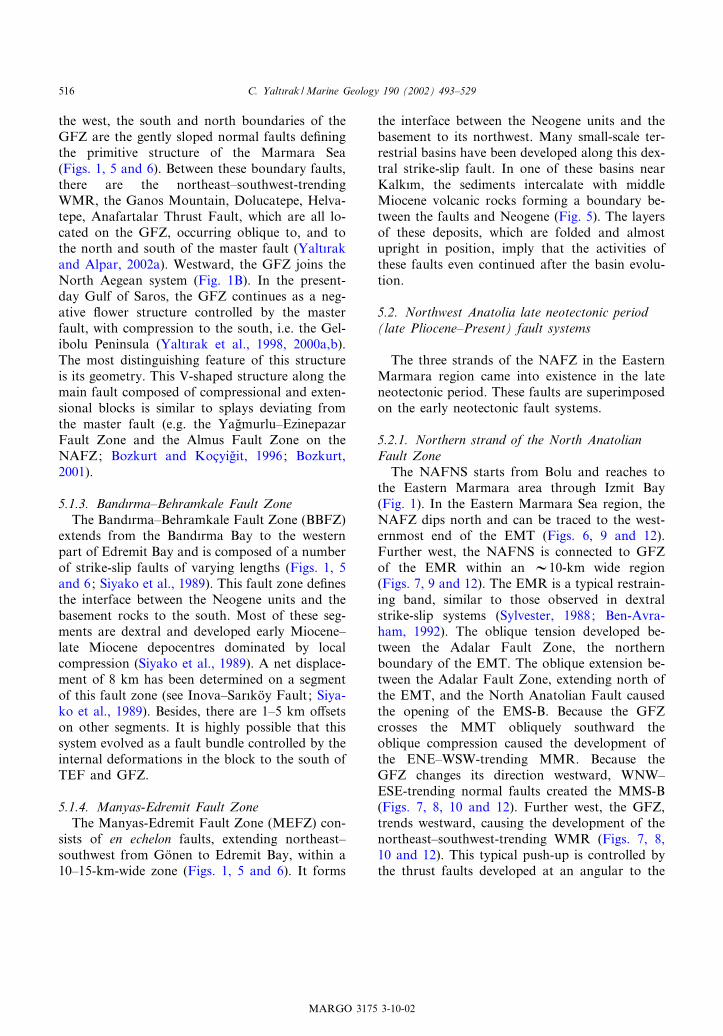
modern Marmara Sea) unconformably overlie avariety of older rocks. This depression started itsevolution in the late Pliocene, superimposed onunits of early Miocene^early Pliocene age belong-ing to the basins of Marmara^Gelibolu and SouthMarmara (Fig. 4) (Yalt|rak, 1996; Yalt|rak et al.,2000a). On the northern shelf, the Neogene unitshave been completely eroded except in the areaaround and to the south of Istanbul. The thick-ness of the Neogene series is about 1000 m in theDoluca and Is)|klar boreholes drilled on the southand west Marmara shelves (Marathon Petroleum,1976; Yalt|rak et al., 1998; Yalt|rak and Alpar,2002a). The Marmara Sea Basin can be dividedinto eight sub-basins that can be de¢ned bytroughs and ridges of di¡erent depths and sizes(Figs. 4 and 5). Five of them are on the northernstrand of the NAFZ. Three of them are di¡erentfrom the rest in terms of their depths and sizes.Twenty-six published multichannel seismic pro-¢les (Okay et al., 1999; Okay et al., 2000; Siyakoet al., 2000; Imren et al., 2001), cutting acrossthese sub-basins, were reinterpreted and sixteenof these, together with 3390 line-km of high res-olution seismic data (49 lines) have been used inthis study (Fig. 6).The Marmara Sea Basin, which is de¢ned by
the present coastline, is made up of deep troughsand bounding shelf areas. These deep troughseach have di¡erent basinal characteristics andwe denote them as sub-basins in this study, in-stead of using the term ‘trough’, which is a mor-phological term. For example, the Imral| Trough(Okay et al., 2000) has no characteristics of amorphological trough. On the contrary, the areanortheast of Imral| Island is a step-shaped plat-form (Fig. 3), 400 m below present sea level. It islocated below a shelf in the shape of a isoscelestriangle, with two sides of 25 km and a base lineof 30 km, to the west of the Armutlu Peninsula.This implies that this platform is not a trough,and should be termed the Imral| Sub-basin due
MARGO 3175 3-10-02
C. Yalt|rak /Marine Geology 190 (2002) 493^529 503
to its depositional characteristics and boundingfaults. Similarly, the troughs in the central Mar-mara Sea must be considered neighbouring sub-basins separated by saddles. Underwater failures,turbidite fans, abyssal plain deposits, deformedridges and basin-controlling faults serve to de¢nethese sub-basins. In conclusion, we prefer usingthe term ‘sub-basin’, rather than ‘trough’, in orderto emphasise both the sedimentary units andfaults.
4.2.1.1. West Marmara Sub-basinThe maximum depth of this sub-basin is 1190
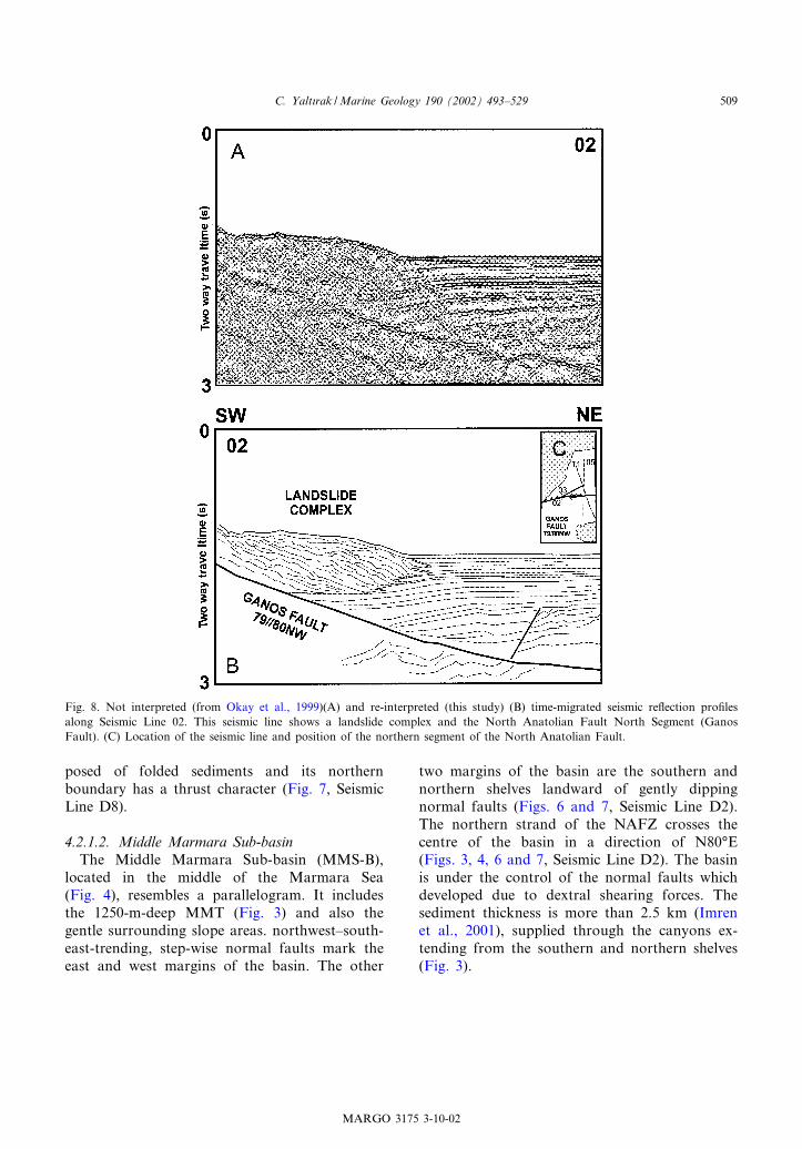
m. Except along its eastern side (640 m), it isbounded by shelf areas (100 m). This rhomboidalsub-basin covers the area of the WMT and itsenvirons (Figs. 3 and 4). The deposits in theWest Marmara Sub-basin (WMS-B) are thickerthan 2000 m (Okay et al., 1999). The WMS-B isinterpreted as a negative £ower structure whichformed under the control of the northern strandof the North Anatolian Fault, which passes to thesouth. The block to the south of this fault con-tains folded sediments (Fig. 7, Seismic Lines 05and 06). In this part of the WMS-B, depositsnorth of the fault are horizontal (Fig. 7, SeismicLines 05 and 06). Due to the releasing bend na-
ture of the main fault, normal faults can be seenin the seismic pro¢les. The folding to the south, incontrast, is caused by dextral shearing of thesouthern block. To the southwest of the sub-ba-sin, imbricated landslides have prograded north-ward by overlapping horizontal deposits of thebasin £oor (Figs. 3 and 8, Seismic Line 03). Theimbricated geometry of these landslide packages(Fig. 8) has been interpreted as a thrust fault byOkay et al. (1999), who believed that the complexdeposits overlying the horizontally bedded sedi-ments were in the hanging wall of the thrust.However, this complex structure corresponds toa typical landslide complex; its lineated surfaceis evident on the multibeam bathymetry map(Fig. 3).To the northwest, a low-angle normal fault
bounds this sub-basin (Fig. 7, Seismic Line 05).Young deposits overlap this fault. In this area,there are no landslides similar to those observedsouth. Instead, wide submarine fans spread basin-ward in front of many small canyons (Fig. 3). Tothe east of the WMS-B, the WMR has been up-lifted under the control of a northeast^southwest-trending thrust fault leading to folding of the east-ern part of the ¢ll of the sub-basin (Fig. 7, SeismicLines 01 and D8). The WMR is completely com-
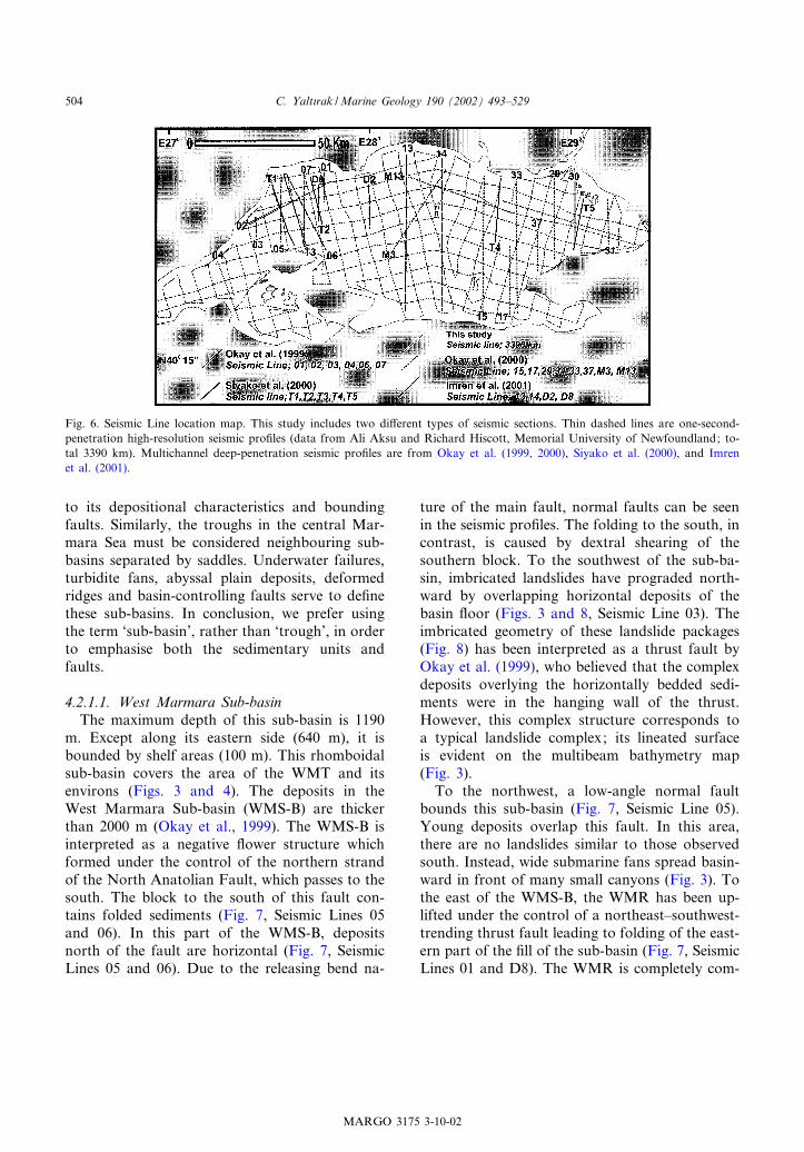
Fig. 6. Seismic Line location map. This study includes two di¡erent types of seismic sections. Thin dashed lines are one-second-penetration high-resolution seismic pro¢les (data from Ali Aksu and Richard Hiscott, Memorial University of Newfoundland; to-tal 3390 km). Multichannel deep-penetration seismic pro¢les are from Okay et al. (1999, 2000), Siyako et al. (2000), and Imrenet al. (2001).
MARGO 3175 3-10-02
C. Yalt|rak /Marine Geology 190 (2002) 493^529504
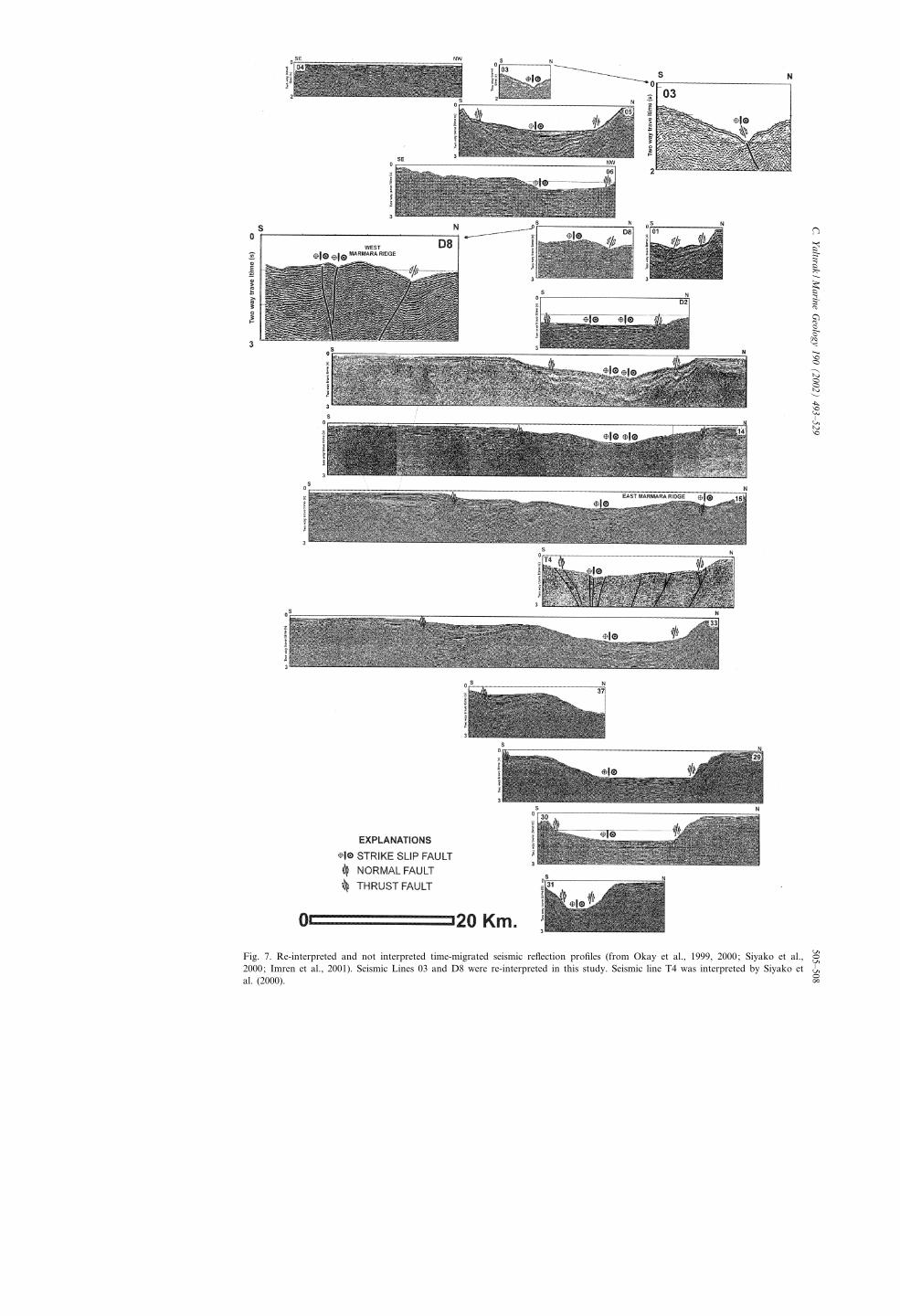
Fig. 7. Re-interpreted and not interpreted time-migrated seismic re£ection pro¢les (from Okay et al., 1999, 2000; Siyako et al.,2000; Imren et al., 2001). Seismic Lines 03 and D8 were re-interpreted in this study. Seismic line T4 was interpreted by Siyako etal. (2000).
MA
RG
O3175
11-10-02
C.Yalt|rak
/Marine
Geology
190(2002)
493^529505^508
posed of folded sediments and its northernboundary has a thrust character (Fig. 7, SeismicLine D8).
4.2.1.2. Middle Marmara Sub-basinThe Middle Marmara Sub-basin (MMS-B),
located in the middle of the Marmara Sea(Fig. 4), resembles a parallelogram. It includesthe 1250-m-deep MMT (Fig. 3) and also thegentle surrounding slope areas. northwest^south-east-trending, step-wise normal faults mark theeast and west margins of the basin. The other
two margins of the basin are the southern andnorthern shelves landward of gently dippingnormal faults (Figs. 6 and 7, Seismic Line D2).The northern strand of the NAFZ crosses thecentre of the basin in a direction of N80‡E(Figs. 3, 4, 6 and 7, Seismic Line D2). The basinis under the control of the normal faults whichdeveloped due to dextral shearing forces. Thesediment thickness is more than 2.5 km (Imrenet al., 2001), supplied through the canyons ex-tending from the southern and northern shelves(Fig. 3).
Fig. 8. Not interpreted (from Okay et al., 1999)(A) and re-interpreted (this study) (B) time-migrated seismic re£ection pro¢lesalong Seismic Line 02. This seismic line shows a landslide complex and the North Anatolian Fault North Segment (GanosFault). (C) Location of the seismic line and position of the northern segment of the North Anatolian Fault.
MARGO 3175 3-10-02
C. Yalt|rak /Marine Geology 190 (2002) 493^529 509
4.2.1.3. Kumburgaz Sub-basinTo the northeast of the MMR, the northeast^
southwest-elongated Kumburgaz Sub-basin (KS-B) is 800 m deep (Figs. 6 and 7, Seismic Line14). Along its northern side, the KS-B is con-trolled by a strike-slip fault, almost vertical butdipping southward and with a normal componentof motion. There is also a thrust fault boundingthe northwest edge of the EMR (Figs. 3, 4, 6 and7, Seismic Line 15). Younger sediments are £atlying but older layers become progressively morefolded.
4.2.1.4. East Marmara Sub-basinThe East Marmara Sub-basin (EMS-B) has the
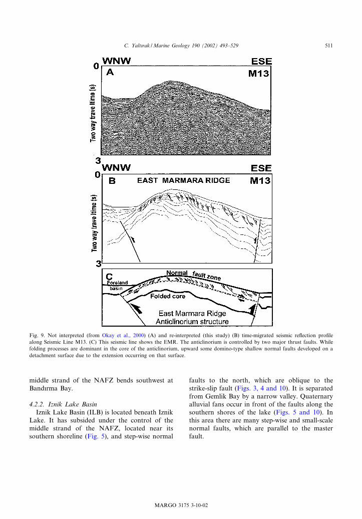
shape of an acute triangle between the Kocaeliand Armutlu Peninsulas. It includes the eastern£anks of the EMT and EMR (Figs. 3 and 4).The northern edge of this sub-basin is outlinedby normal faults, which are almost vertical tothe east, while dipping southward to the west(Figs. 6 and 7, Seismic Lines T4, 33, 29, 30).The southern edge of this sub-basin, on the otherhand, is outlined by the eastern segment of thenorthern strand of the NAFZ, which is dextralstrike-slip fault trending east^west and dippingnorthward (Figs. 6 and 7, Seismic Lines 29, 30,37, 33). To the west of the sub-basin, the meansea bottom slope is about 8‡ between a 12-km-wide area forming the deepest part of the basin(1200 m) and the top of the EMR (500 m).Young deposits in the western part of the basinare folded and even imbricated due to dextralshearing; this shearing has also caused the east-ern £ank of the EMR to be folded and uplifted(Figs. 6, 7 and 9A,B, Seismic Lines 15, M13). TheEMR is an anticline formed by compression, butthe near-surface faults record shallow gravity-driven extension along the anticline axis andgive a wavy appearance to the surface of thisridge (Fig. 9B,C). These structures were inter-preted as mega-ripples by Imren et al. (2001)and as folds by Okay et al. (2000). Similar struc-tures elsewhere in the Eastern Mediterranean re-gion were considered as mega-ripples by Ediger etal. (2000). However, these other structures arealso clearly shallow normal faults (A.E. Aksu,
pers. commun., 2001) like those on the EMR(Fig. 9C).
4.2.1.5. East Hersek Sub-basinThe East Hersek Sub-basin (EHS-B) covers a
portion of Izmit Bay east of the Hersek Delta. Itsdeepest point is 204 m in the EHT (Fig. 3). Thissub-basin is developing on the releasing bend ofthe northern strand of the NAFZ, caused bysmall jumps between related fault segments wherethe NAFZ enters the Marmara Sea. In the easternparts of this rather young sub-basin, the Holocenedeposits unconformably overlie acoustic basement(Alpar and Yalt|rak, 2002).
4.2.1.6. Imral| Sub-basinThis sub-basin lies below the 300^400 m-deep
IF (Fig. 3), located between the EMT and thesouthern Marmara shelf o¡ the Armutlu Peninsu-la. The IF becomes shallower northwestward andforms the centre of this sub-basin (Fig. 3). Con-sistent with the dextral movement of the Imral|Fault Zone (IFZ) and the NAFNS, but also re-£ecting the normal component of motion on theIFZ, this sub-basin has developed due to tilting ofthe hanging-wall block (Figs. 3, 4, 6, 7, SeismicLines 15, 33). Dextral faults extending along thenorthwest coast of the Armutlu Peninsula accom-modate the subsidence of the basin £oor (Fig. 7,Seismic Line, and Fig. 10).
4.2.1.7. Band|rma and Gemlik Sub-BasinsThe Band|rma Sub-Basin (BS-B) and the Gem-
lik Sub-basin (GS-B) are situated on the middlestrand of the NAFZ near the south coast of theMarmara Sea (Figs. 1 and 10). They are locatedin Band|rma and Gemlik Bays. The GS-B is situ-ated at a water depth of 110 m and has the shapeof an ellipse with a northwest^southeast majoraxis. It is a pull-apart basin caused by the inter-section of the middle strand of the NAFZ with anolder northwest^southeast-oriented fault system(Yalt|rak and Alpar, 2002b). The BS-B coversan area which is separated from the rest of theMarmara Sea by a 60^70 m-deep sill east of thetriangular BT (Fig. 3). It has developed above asmall-scale releasing bend where the west-trending
MARGO 3175 3-10-02
C. Yalt|rak /Marine Geology 190 (2002) 493^529510
middle strand of the NAFZ bends southwest atBand|rma Bay.
4.2.2. Iznik Lake BasinIznik Lake Basin (ILB) is located beneath Iznik
Lake. It has subsided under the control of themiddle strand of the NAFZ, located near itssouthern shoreline (Fig. 5), and step-wise normal
faults to the north, which are oblique to thestrike-slip fault (Figs. 3, 4 and 10). It is separatedfrom Gemlik Bay by a narrow valley. Quaternaryalluvial fans occur in front of the faults along thesouthern shores of the lake (Figs. 5 and 10). Inthis area there are many step-wise and small-scalenormal faults, which are parallel to the masterfault.
Fig. 9. Not interpreted (from Okay et al., 2000) (A) and re-interpreted (this study) (B) time-migrated seismic re£ection pro¢lealong Seismic Line M13. (C) This seismic line shows the EMR. The anticlinorium is controlled by two major thrust faults. Whilefolding processes are dominant in the core of the anticlinorium, upward some domino-type shallow normal faults developed on adetachment surface due to the extension occurring on that surface.
MARGO 3175 3-10-02
C. Yalt|rak /Marine Geology 190 (2002) 493^529 511
MARGO 3175 3-10-02
C. Yalt|rak /Marine Geology 190 (2002) 493^529512
4.2.3. Yenis)ehir BasinThe Yenis)ehir Basin (YB) is located on land
atop the southern branch of the NAFZ (Figs. 5and 10). It is a pull-apart basin developed due tojumping of the southern branch of the NAFZ toanother nearby dextral segment. The basin startedto develop in the late Pliocene. The rhombohedralYenis)ehir Plain forms the centre of this basin(Figs. 5 and 10). Strike-slip faults bound the basinedges and largely encompass the Pliocene basin¢ll (Yalt|rak, 2000a). For example, the thicknessof young alluvial deposits is 1^2 m beyond thesouthwestern edge of the basin, thickening to80 m just northeast of the basin-bounding fault(Yalt|rak, 2000a).
4.2.4. Inego«l basinThe Inego«l Basin (IB) initially developed on the
Thrace^Eskis)ehir Fault. It was uplifted and par-tially eroded during the Miocene under the con-trol of strike-slip tectonics (Kaymakc)|, 1991)(Figs. 5 and 10). More recently, these strike-slipfaults were reactivated as normal faults by move-ment on the southern strand of the NAFZ, caus-ing subsidence of the Inego«l Plain and IB to re-commence.
4.2.5. Bursa BasinThe Bursa Basin (BB) overlies the Neogene
Southern Marmara Basin (Figs. 4, 5 and 10).The dextral strike-slip fault outlining the northernboundary of the Yenis)ehir Basin crosses thesouthern part of the Bursa Plain (Figs. 5 and10; Yalt|rak, 2000a). The town of Bursa, MountUludagfl and its slopes are situated on the alluvialfans developed in front of the normal faultsparallel to this fault. Some normal faults, re-activated by the intersection of the southern
strand of the NAFZ with the northwest^south-east-trending TEFZ, outline the eastern borderof the triangular-shaped Bursa Plain (Figs. 5and 10).
4.2.6. Manyas^Uluabat BasinThe Manyas^Uluabat Basin (M-UB) is super-
imposed on the Southern Marmara Basin and hasdeveloped under the control of the NAFZ (Fig. 4).The southern strands of the NAFZ to the southof the basin control modern sedimentation. Thisfault is made up of three segments. Its westernand eastern segments exhibit strike-slip while thecentral part is a normal-oblique fault on whichthe Manyas and Uluabat Lakes have developed(Figs. 4, 5 and 10). Holocene alluvial depositsoverlie Pliocene conglomerates at the margins ofthis wide plain with angular unconformity. To thenorth of the basin, between Karacabey andBand|rma, the boundary between the alluvialand Neogene deposits forms a distinct morpho-logical step. Rivers that extend southward acrossthis step have carved deep trenches. The M-UBhas opened along normal faults with a dextraloblique component. These faults are located tothe north and south of the basin.
4.2.7. Go«nen BasinThe Go«nen Basin (GB) developed where the
middle and southern strands of the NAFZ be-came closest to each other (Figs. 4 and 10). Qua-ternary alluvium ¢lls this fault-bounded basin, un-conformably overlying folded Neogene rocks ofthe Southern Marmara Sub-basin. The basin de-veloped here because of opening between the ‘el-bows’ of the various fault strands, caused bysouthwestward bending of the southern strandof the NAFZ.
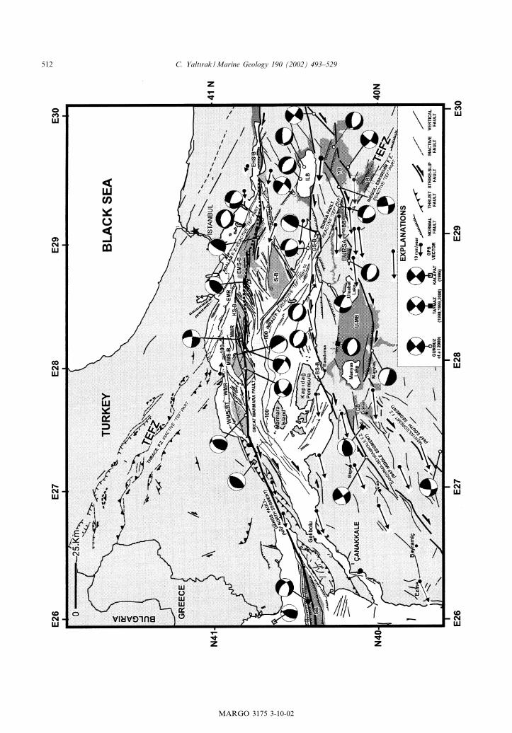
Fig. 10. Tectonic map of Marmara region (land area compiled from Ergu«l et al., 1986; Siyako et al., 1989; Yalt|rak et al., 1998;Sak|nc) et al., 1999; Yalt|rak and Alpar, 2002b; Alpar and Yalt|rak, 2002 and ¢eld study). Faults on the map were identi¢ed onLANDSAT 5TM images and through ¢eld observations. Marine faults were mainly mapped using the shallow-penetration seismiclines of the Memorial University of Newfoundland. Not interpreted deep lines are from Okay et al. (1999, 2000); Siyako et al.(2000); Imren et al. (2001). Fault plane solutions are from Taymaz, (1990, 1999, 2000); Kalafat (1995), and Gu«rbu«z et al. (2000).GPS vectors are plotted with respect to a ¢xed station at Istanbul (black star) (from Straub et al., 1997). Abbreviations: TEFZ,Thrace^Eskis)ehir Fault Zone; WMS-B, West Marmara Sub-basin; MMS-B, Middle Marmara Sub-basin; KS-B, KumburgazSub-basin; EMS-B, Eastern Marmara Sub-basin; BS-B, Band|rma Sub-basin; GS-B, Gemlik Sub-basin; EHS-B, Eastern HersekSub-basin; ILB, Iznik Lake Basin; YB, Yenis)ehir Basin; INB, Inego«l Basin; BB, Bursa Basin; M-UB, Manyas^Uluabat Basin;GB, Go«nen Basin.
MARGO 3175 3-10-02
C. Yalt|rak /Marine Geology 190 (2002) 493^529 513
5. Tectonic setting
As there are no detailed structural maps for theMarmara region, the exact location of the strandsof the NAFZ on the land are not well established.The structural architecture of the region is com-piled using existing 1:250 000 ¢eld maps,1:500 000 satellite imagery, and digital topogra-phy maps (Figs. 5 and 10). This compilation re-vealed the presence of two di¡erent-aged systemsin the Marmara Sea region, which intersect eachother. The peculiar geometrical shapes of theMarmara Sea and the faults extending aroundits surroundings have clear di¡erences in their ori-entation. The most important is the N45‡W-trending TEFZ (Figs. 5 and 10). Others are theN80‡E-oriented GFZ, the N45‡E-oriented BBFZand, parallel to this, the MEFZ (Figs. 5 and 10).With the exception of the TEFZ, these faults con-tinue their activity controlled by the activity in theNAFZ. The splays of the TEFZ, which stay with-in the in£uence area of the NAFZ, play an activerole in the evolution of the present geometry ofthe Marmara Sea.
5.1. Northwest Anatolia early neotectonic period(early Miocene^early Pliocene) fault systems
Early Miocene^early Pliocene faults in North-west Anatolia include the dextral strike-slipTEFZ, which was active prior to the NAFZ,and its westward de£ections, the GFZ, BBFZand Edremit-Go«nen Fault Zone (Figs. 5 and 10).
5.1.1. Thrace Eskis)ehir Fault ZoneAt present, the TEFZ is dissected by the strands
of the NAFZ and divided into four segments(Figs. 5, 9 and 11). Studies on the TEFZ inEskis)ehir^Ino«nu« (Go«zler et al., 1985; Bozkurt,2001), Inego«l (Kaymakc)|, 1991), Bursa^Mudanya(Yalt|rak, 2000a), and Thrace (Perinc)ek, 1991) de-¢ne a major dextral strike-slip system which wasactive during the early Miocene^early Pliocene.
5.1.1.1. Eskis)ehir^Inego«l SegmentThis segment of the TEFZ occurs between Bur-
sa and Tuzgo«lu« and is known under di¡erentnames. Kaymakc)| (1991) called the Inego«l Seg-
ment the ‘Inego«l Fault Zone’. Altunel and Barka(1998) de¢ned the Eskis)ehir Segment of the TEFZas a normal fault. Bozkurt (2001) proposed thatthe TEFZ is a dextral normal fault developedduring the Plio^Quaternary period. The Es-kis)ehir^Inego«l segment is the longest segment(400 km) of the TEFZ, extending between thewestern part of the Tuzgo«lu« and Bursa throughEskis)ehir (Fig. 11A,B). In many localities to thesouth, this fault segment is buried beneath Plio-cene and Quaternary units. Around Tuzgo«lu« , Es-kis)ehir, Ino«nu« , and Inego«l (Fig. 1A), Miocenedextral strike-slip faults later reactivated as nor-mal faults creating Quaternary basins. This is alsoclearly visible on the Bouguer and magnetic mapsprepared by MTA as well as on digital SAR in-terferometry topography maps (Fig. 11C,D).
5.1.1.2. Bursa^Mudanya SegmentThis segment is V48 km long and occurs be-
tween Bursa and Mudanya (Yalt|rak and Alpar,2002b). It exhibits characteristics of a normalfault and plays an important role throughoutthe evolution of the Bursa Plain (Figs. 5 and 10).
5.1.1.3. Imral| SegmentThe Imral| segment is a V62 km long, north-
west^southeast-trending fault which occurs be-tween Gemlik Bay and the Imral| Sub-basin. InGemlik Bay, and between the eastern part of theImral| Island and the MMS-B it displays charac-teristics of a normal fault (Figs. 5 and 10).
5.1.1.4. Adalar^Thrace SegmentThis segment starts from Tuzla and extends to
Thrace. It is the extension of the Imral| segment,which was o¡set by the northern strand of theNAFZ. It outlines the northern boundary of theEMS-B, where it displays normal sense separa-tions (Figs. 6 and 10). Farther west, it loses itsnormal character and extends toward Thracealong the northern edge of the Central MarmaraTrough, in the form of three parallel strike-slipzones (Figs. 5 and 10). The dextral strike-slip faultzone de¢ned by a horsetail structure has initiallybeen mapped by Perinc)ek (1991). At present, thisstructure, which is V220 km long in East Thrace,and the northwest^southeast-trending zone is cov-
MARGO 3175 3-10-02
C. Yalt|rak /Marine Geology 190 (2002) 493^529514
ered by Plio^Quaternary deposits (Figs. 5 and 10).This fault zone continues northward into Bulga-ria, and one strand of it bends southward con-necting with the Xanti^Kavala Fault in Greece(Tap|rdamaz and Yalt|rak, 1997).
5.1.2. Ganos Fault ZoneThe GFZ starts from the KS-B and is com-
posed of southward bending faults of the TEFZ(Figs. 5 and 10). It continues towards the NorthAegean Trough. The GFZ is V700 km long. To
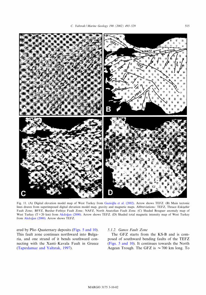
Fig. 11. (A) Digital elevation model map of West Turkey from Gaziogfllu et al. (2002). Arrow shows TEFZ. (B) Main tectoniclines drawn from superimposed digital elevation model map, gravity and magnetic maps. Abbreviations: TEFZ, Thrace^Eskis)ehirFault Zone; BFFZ, Burdur^Fethiye Fault Zone; NAFZ, North Anatolian Fault Zone. (C) Shaded Bouguer anomaly map ofWest Turkey (T=20 km) from Akdogflan (2000). Arrow shows TEFZ. (D) Shaded total magnetic intensity map of West Turkeyfrom Akdogflan (2000). Arrow shows TEFZ.
MARGO 3175 3-10-02
C. Yalt|rak /Marine Geology 190 (2002) 493^529 515
the west, the south and north boundaries of theGFZ are the gently sloped normal faults de¢ningthe primitive structure of the Marmara Sea(Figs. 1, 5 and 6). Between these boundary faults,there are the northeast^southwest-trendingWMR, the Ganos Mountain, Dolucatepe, Helva-tepe, Anafartalar Thrust Fault, which are all lo-cated on the GFZ, occurring oblique to, and tothe north and south of the master fault (Yalt|rakand Alpar, 2002a). Westward, the GFZ joins theNorth Aegean system (Fig. 1B). In the present-day Gulf of Saros, the GFZ continues as a neg-ative £ower structure controlled by the masterfault, with compression to the south, i.e. the Gel-ibolu Peninsula (Yalt|rak et al., 1998, 2000a,b).The most distinguishing feature of this structureis its geometry. This V-shaped structure along themain fault composed of compressional and exten-sional blocks is similar to splays deviating fromthe master fault (e.g. the Yagflmurlu^EzinepazarFault Zone and the Almus Fault Zone on theNAFZ; Bozkurt and Koc)yigflit, 1996; Bozkurt,2001).
5.1.3. Band|rma^Behramkale Fault ZoneThe Band|rma^Behramkale Fault Zone (BBFZ)
extends from the Band|rma Bay to the westernpart of Edremit Bay and is composed of a numberof strike-slip faults of varying lengths (Figs. 1, 5and 6; Siyako et al., 1989). This fault zone de¢nesthe interface between the Neogene units and thebasement rocks to the south. Most of these seg-ments are dextral and developed early Miocene^late Miocene depocentres dominated by localcompression (Siyako et al., 1989). A net displace-ment of 8 km has been determined on a segmentof this fault zone (see Inova^Sar|ko«y Fault ; Siya-ko et al., 1989). Besides, there are 1^5 km o¡setson other segments. It is highly possible that thissystem evolved as a fault bundle controlled by theinternal deformations in the block to the south ofTEF and GFZ.
5.1.4. Manyas-Edremit Fault ZoneThe Manyas-Edremit Fault Zone (MEFZ) con-
sists of en echelon faults, extending northeast^southwest from Go«nen to Edremit Bay, within a10^15-km-wide zone (Figs. 1, 5 and 6). It forms
the interface between the Neogene units and thebasement to its northwest. Many small-scale ter-restrial basins have been developed along this dex-tral strike-slip fault. In one of these basins nearKalk|m, the sediments intercalate with middleMiocene volcanic rocks forming a boundary be-tween the faults and Neogene (Fig. 5). The layersof these deposits, which are folded and almostupright in position, imply that the activities ofthese faults even continued after the basin evolu-tion.
5.2. Northwest Anatolia late neotectonic period(late Pliocene^Present) fault systems
The three strands of the NAFZ in the EasternMarmara region came into existence in the lateneotectonic period. These faults are superimposedon the early neotectonic fault systems.
5.2.1. Northern strand of the North AnatolianFault ZoneThe NAFNS starts from Bolu and reaches to
the Eastern Marmara area through Izmit Bay(Fig. 1). In the Eastern Marmara Sea region, theNAFZ dips north and can be traced to the west-ernmost end of the EMT (Figs. 6, 9 and 12).Further west, the NAFNS is connected to GFZof the EMR within an V10-km wide region(Figs. 7, 9 and 12). The EMR is a typical restrain-ing band, similar to those observed in dextralstrike-slip systems (Sylvester, 1988; Ben-Avra-ham, 1992). The oblique tension developed be-tween the Adalar Fault Zone, the northernboundary of the EMT. The oblique extension be-tween the Adalar Fault Zone, extending north ofthe EMT, and the North Anatolian Fault causedthe opening of the EMS-B. Because the GFZcrosses the MMT obliquely southward theoblique compression caused the development ofthe ENE^WSW-trending MMR. Because theGFZ changes its direction westward, WNW^ESE-trending normal faults created the MMS-B(Figs. 7, 8, 10 and 12). Further west, the GFZ,trends westward, causing the development of thenortheast^southwest-trending WMR (Figs. 7, 8,10 and 12). This typical push-up is controlled bythe thrust faults developed at an angular to the
MARGO 3175 3-10-02
C. Yalt|rak /Marine Geology 190 (2002) 493^529516
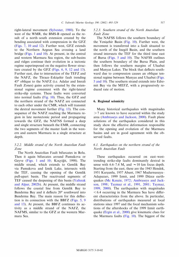
right-lateral movement (Sylvester, 1988). To thewest of the WMR, the BMS-B opened as the re-sult of a north^south extension created by thebending associated with compression in the GFZ(Figs. 7, 10 and 12). Further west, GFZ extendsto the Northern Aegean Sea crossing a landbridge (Figs. 1 and 10). At present, in the centraland western Marmara Sea region, the sub-basinsand ridges continue their evolution in a tectonicregime superimposed on the negative £ower struc-ture created by the GFZ (Figs. 6, 9, 12 and 13).Further east, due to intersection of the TEFZ andthe NAFZ, the Thrace^Eskis)ehir fault trending45‡ oblique to the NAFZ (i.e. Adalar and ImraliFault Zones) gains activity created by the exten-sional regime consistent with the right-lateralstrike-slip systems. These faults were convertedinto normal faults (Fig. 10). Thus, the GFZ andthe northern strand of the NAFZ are connectedto each other under the CMR, which will transmitthe dextral movement further (Fig. 13). The con-sequence of the NAFZ reaching the Marmara re-gion in late neotectonic period and propagatingtowards the GFZ, the NAFNS formed a deepand single structure beneath the EMR, connectingthe two segments of the master fault in the west-ern and eastern Marmara in a single structure atdepth.
5.2.2. Middle strand of the North Anatolian FaultZoneThe North Anatolian Fault bifurcates in Bolu.
Then it again bifurcates around Pamukova orGeyve (Figs. 1 and 10; Koc)yigflit, 1998). Themiddle strand, which extends to Gemlik Bayvia Pamukova and Iznik Lake, intersects withthe TEF, causing the opening of the Gemlikpull-apart basin. The reactivated segments ofTEF caused the deepening of this basin (Yalt|rakand Alpar, 2002b). At present, the middle strandfollows the coastal line from Gemlik Bay toBand|rma Bay and it de£ects 20‡ southward intoBand|rma Bay. The main reason for this de£ec-tion is its connection with the BBFZ (Figs. 5, 9and 13). At present, the BBFZ continues its ac-tivity as a middle strand of the NAFZ, theNAFMS, similar to the GFZ at the western Mar-mara Sea.
5.2.3. Southern strand of the North AnatolianFault ZoneThe NAFSS follows the southern boundary of
the Yenis)ehir Basin (Fig. 10). Further west, themovement is transferred into a fault situated tothe north of the Inego«l Basin, and the southernstrand intersects the TEF for the third time eastof Bursa (Figs. 5 and 10). The NAFSS outlinesthe southern boundary of the Bursa Plain, andthen follows the southern margins of Uluabatand Manyas Lakes. The block that de£ects south-ward due to compression causes an oblique ten-sional regime between Manyas and Uluabat (Figs.5 and 10). The southern strand extends into Edre-mit Bay via the MEFZ, with a progressively re-duced rate of motion.
6. Regional seismicity
Many historical earthquakes with magnitudess 7 are known to have occurred within the studyarea (Ambraseys and Jackson, 2000). Fault planesolutions of the earthquakes considered in thisstudy show the e¡ective deformation responsiblefor the opening and evolution of the Marmarabasins and are in good agreement with the ob-served faults.
6.1. Earthquakes on the northern strand of theNorth Anatolian Fault
These earthquakes occurred on east^west-trending strike-slip faults dominantly dextral insense with 6.6^7.4 Ms and V10 km focus depth.Starting from the east, these are the 1943 Hendek,1951 Kurs)unlu, 1957 Abant, 1967 Mudurnusuyu^Adapazar|, 1999 Izmit, and 1999 Du«zce earth-quakes (Mc Kenzie, 1972; Ambraseys and Jack-son, 1998; Taymaz et al., 1991, 2001; Taymaz,1999, 2000). The earthquakes with magnitudes6 6.4 occurring in the Marmara Sea have di¡er-ent characteristics from the above. In particular,distributions of earthquakes measured at localstations since 1997 and the focal mechanism solu-tions of the aftershocks of the 1999 Izmit earth-quake (Ergin et al., 2000) give kinematic clues forthe Marmara faults (Fig. 10). The biggest of the
MARGO 3175 3-10-02
C. Yalt|rak /Marine Geology 190 (2002) 493^529 517
Fig. 12. Structural block diagram of the Marmara Sea composed from seismic lines re-interpreted in this paper (Fig. 6).
MARGO 3175 3-10-02
C. Yalt|rak /Marine Geology 190 (2002) 493^529518
earthquakes in the Marmara region occurred inthe Adalar Fault Zone in 1963. Its fault planesolution indicates a northwest^southeast-trendingextension along normal faults (Taymaz, 1990,2000). Here, the northwest^southeast-trendingnormal faults form the northern boundary ofthe EMT (Fig. 10). It is important to note thatthe aftershocks of the 1999 earthquakes (Ergin etal., 2000) are stacked along the margins of theEMT, possibly caused by the splitting of the faultinto two branches. Comparison of the aftershockdistribution with the fault map of Ergin et al.(2000), Alpar and Yalt|rak (2002) have suggestedthat the trends in the aftershocks are a productionof deformation scattered at the end of the fault ofthe 1999 Izmit earthquake, which terminatedaround the eastern end of the EMT. The tectonicsetting proposed by Alpar and Yalt|rak (2002)and fault plane solutions re£ect the character ofa dextral strike-slip deformation at the margins ofthe EMS-B. The results of a seismographs net-
work operated before the 1999 earthquakes obvi-ously indicate a series of earthquakes also corre-sponding with the deep Marmara troughs (Fig. 10;Gu«rbu«z et al., 2000). On this line, there are twoearthquakes focused to the south of the EMT.The eastern earthquake revealed a northwest^southeast-oriented normal right-lateral obliquesolutions, while the second earthquake, which islocated to the central west of the EMT, gave anortheast^southwest minor compression (Fig. 10).The fault plane solution of another earthquake onthe EMR also indicated compression with a mi-nor right-lateral component. This fault, alongwhich these three earthquakes are aligned, extendsfrom the Izmit Bay to the EMR and dips north-ward (Figs. 9, 12 and 13).Fault plane solutions for earthquakes along the
fault extending between the KT and the MMTgive northeast^southwest-oriented strike-slip withvarying extension as well as northwest^southeast-directed extension that can be correlated with nor-
Fig. 13. Structural model block diagram of the Marmara region faults. This ¢gure shows the linkages between the Thrace^Eskise-hir Fault parts and the North Anatolian Fault segments. Abbreviations: TEFZ, Thrace^Eskis)ehir Fault Zone; NAFNS, NorthAnatolian Fault North Segment, i.e. ‘Great Marmara Fault’ of Le Pichon et al. (1999); NAFMS, North Anatolian Fault MiddleSegment; NAFSS, North Anatolian Fault South Segment.
MARGO 3175 3-10-02
C. Yalt|rak /Marine Geology 190 (2002) 493^529 519
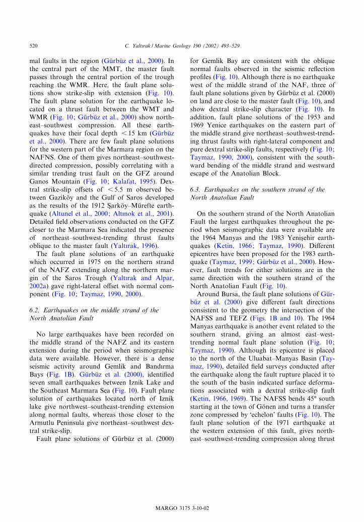
mal faults in the region (Gu«rbu«z et al., 2000). Inthe central part of the MMT, the master faultpasses through the central portion of the troughreaching the WMR. Here, the fault plane solu-tions show strike-slip with extension (Fig. 10).The fault plane solution for the earthquake lo-cated on a thrust fault between the WMT andWMR (Fig. 10; Gu«rbu«z et al., 2000) show north-east^southwest compression. All these earth-quakes have their focal depth 6 15 km (Gu«rbu«zet al., 2000). There are few fault plane solutionsfor the western part of the Marmara region on theNAFNS. One of them gives northeast^southwest-directed compression, possibly correlating with asimilar trending trust fault on the GFZ aroundGanos Mountain (Fig. 10; Kalafat, 1995). Dex-tral strike-slip o¡sets of 6 5.5 m observed be-tween Gaziko«y and the Gulf of Saros developedas the results of the 1912 S)arko«y^Mu«refte earth-quake (Altunel et al., 2000; Alt|nok et al., 2001).Detailed ¢eld observations conducted on the GFZcloser to the Marmara Sea indicated the presenceof northeast^southwest-trending thrust faultsoblique to the master fault (Yalt|rak, 1996).The fault plane solutions of an earthquake
which occurred in 1975 on the northern strandof the NAFZ extending along the northern mar-gin of the Saros Trough (Yalt|rak and Alpar,2002a) gave right-lateral o¡set with normal com-ponent (Fig. 10; Taymaz, 1990, 2000).
6.2. Earthquakes on the middle strand of theNorth Anatolian Fault
No large earthquakes have been recorded onthe middle strand of the NAFZ and its easternextension during the period when seismographicdata were available. However, there is a denseseismic activity around Gemlik and Band|rmaBays (Fig. 1B). Gu«rbu«z et al. (2000), identi¢edseven small earthquakes between Iznik Lake andthe Southeast Marmara Sea (Fig. 10). Fault planesolution of earthquakes located north of Izniklake give northwest^southeast-trending extensionalong normal faults, whereas those closer to theArmutlu Peninsula give northeast^southwest dex-tral strike-slip.Fault plane solutions of Gu«rbu«z et al. (2000)
for Gemlik Bay are consistent with the obliquenormal faults observed in the seismic re£ectionpro¢les (Fig. 10). Although there is no earthquakewest of the middle strand of the NAF, three offault plane solutions given by Gu«rbu«z et al. (2000)on land are close to the master fault (Fig. 10), andshow dextral strike-slip character (Fig. 10). Inaddition, fault plane solutions of the 1953 and1969 Yenice earthquakes on the eastern part ofthe middle strand give northeast^southwest-trend-ing thrust faults with right-lateral component andpure dextral strike-slip faults, respectively (Fig. 10;Taymaz, 1990, 2000), consistent with the south-ward bending of the middle strand and westwardescape of the Anatolian Block.
6.3. Earthquakes on the southern strand of theNorth Anatolian Fault
On the southern strand of the North AnatolianFault the largest earthquakes throughout the pe-riod when seismographic data were available arethe 1964 Manyas and the 1983 Yenis)ehir earth-quakes (Ketin, 1966; Taymaz, 1990). Di¡erentepicentres have been proposed for the 1983 earth-quake (Taymaz, 1999; Gu«rbu«z et al., 2000). How-ever, fault trends for either solutions are in thesame direction with the southern strand of theNorth Anatolian Fault (Fig. 10).Around Bursa, the fault plane solutions of Gu«r-
bu«z et al. (2000) give di¡erent fault directionsconsistent to the geometry the intersection of theNAFSS and TEFZ (Figs. 1B and 10). The 1964Manyas earthquake is another event related to thesouthern strand, giving an almost east^west-trending normal fault plane solution (Fig. 10;Taymaz, 1990). Although its epicentre is placedto the north of the Uluabat^Manyas Basin (Tay-maz, 1990), detailed ¢eld surveys conducted afterthe earthquake along the fault rupture placed it tothe south of the basin indicated surface deforma-tions associated with a dextral strike-slip fault(Ketin, 1966, 1969). The NAFSS bends 45‡ southstarting at the town of Go«nen and turns a transferzone compressed by ‘echelon’ faults (Fig. 10). Thefault plane solution of the 1971 earthquake atthe western extension of this fault, gives north-east^southwest-trending compression along thrust
MARGO 3175 3-10-02
C. Yalt|rak /Marine Geology 190 (2002) 493^529520
faults, oriented dominated by the right-lateralstrike-slip component (Fig. 10; Gu«rbu«z et al.,2000).
7. O¡sets of the strands of the North AnatolianFault in the Eastern Marmara region
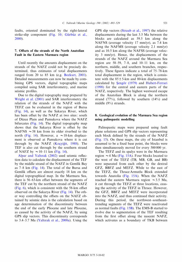
Until recently the amounts displacement on thestrands of the NAFZ could not be precisely de-termined, thus estimates of total displacementsranged from 20 to 85 km (e.g. Bozkurt, 2001).Detailed measurements can now be made by com-bining GPS vectors, digital topographic mapscompiled using SAR interferometry, and marineseismic pro¢les.Due to the digital topography map prepared by
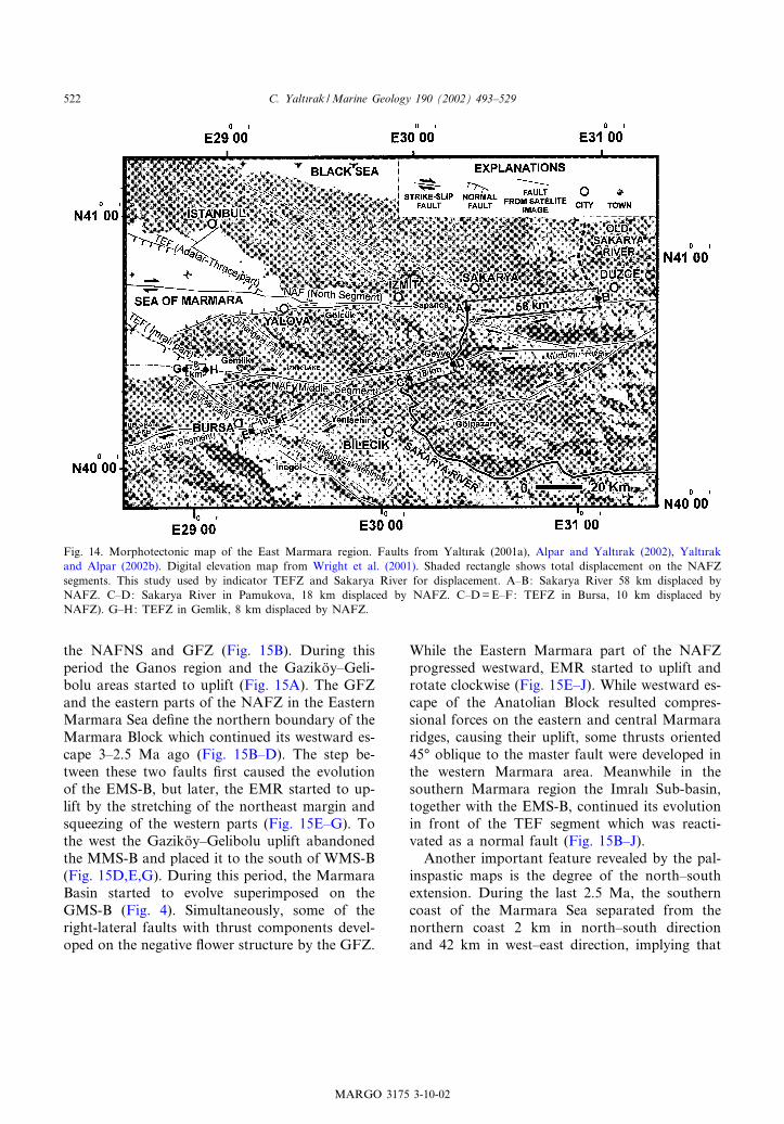
Wright et al. (2001) and SAR interferometry therelation of the strands of the NAFZ with theTEFZ can be evaluated in the region of Bursa(Fig. 14), as well as the Sakarya River, whichhas been o¡set by the NAFZ at two sites : southof Du«zce Plain and Pamukova where the NAFZbifurcates (Fig. 14). The digital topography mapshows that the Sakarya River is o¡set by theNAFNS V58 km from its older riverbed to thenorth (Fig. 14). However, a V18-km displace-ment is observed at Pamukova where it is cutthrough by the NAFZ (Koc)yigflit, 1988). TheTEF is also cut through by the southern strandof NAFZ by V10^11 km (Fig. 14).Alpar and Yalt|rak (2002) used seismic re£ec-
tion data to calculate the displacement of the TEFby the middle strand of the NAFZ in Gemlik Bayas 7^8 km (Fig. 14). The total of the Bursa andGemlik o¡sets are almost exactly 18 km on thedigital topographical map. In the Marmara Sea,there is 56^63-km o¡set between the segments ofthe TEF cut by the northern strand of the NAFZ(Fig. 6), which is consistent with the 58-km o¡setobserved on the Sakarya River (Fig. 14). The oth-er way controlling the o¡sets on the NAFZ ob-tained by seismic data is the calculation based onage determination of the discontinuity betweenthe end of the early Pliocene and late Pliocene,as caused by the activity of the NAFZ, by usingGPS slip vectors. This discontinuity correspondsto 3.4^3.7 Ma (Yalt|rak et al., 2000a). Using the
GPS slip vectors (Straub et al., 1997) the relativedisplacements during the last 3.5 Ma between theblocks are calculated as 59.5 km along theNAFNS (average velocity 17 mm/yr), as 7.4 kmalong the NAFMS (average velocity 2.1 mm/yr)and as 10.5 km along the NAFSS (average veloc-ity 3 mm/yr). Hence, the displacements of thestrands of the NAFZ around the Marmara Searegion are 58^59, 7^8, and 10^11 km, on thenorthern, middle, and southern branches, respec-tively. These ¢gures indicate a total of 75^78-kmtotal displacement in the region, which is consis-tent with the 85Y 5-km and 80-km displacementscalculated by S)engo«r (1979) and Hubert-Ferrari(1998) for the central and eastern parts of theNAFZ, respectively. The highest westward escapeof the Anatolian Block is along the northernstrand (77%), followed by southern (14%) andmiddle (9%) strands.
8. Geological evolution of the Marmara Sea regionusing palinspastic modelling
Palinspastic maps were prepared using faultplane solutions and GPS slip vectors representingeach block de¢ned by the strands of the NAFZ(Fig. 15). On these maps, the city of Istanbul isassumed to be a ¢xed base point, the blocks werethen simultaneously moved for every 500 000 yr.The TEFZ and its spalys were in the Marmara
region V4 Ma (Fig. 15A). Four blocks located tothe west of the TEFZ (TB, MB, GB, and BB)were separated from each other by the dextralGFZ, BBFZ and MEFZ. While to the east ofthe TEFZ, the ThraceArmutlu Block extendedtowards Anatolia (Fig. 15A). When the NAFZreached the eastern Marmara region V3.5 Ma,it cut through the TEFZ at three locations, ceas-ing the activity of the TEFZ in Thrace. However,the GFZ, BBFZ and MEFZ were incorporatedinto the NAFZ, and thus continued their activity.During this period, the northwest^southeast-trending segments of the TEFZ were reactivatedas normal faults (Fig. 15B). The EMS-B started toevolve due to segmentation of the TEF resultingfrom the ¢rst o¡set along the nascent NAFZ,which activates as a boundary of TKB between
MARGO 3175 3-10-02
C. Yalt|rak /Marine Geology 190 (2002) 493^529 521
the NAFNS and GFZ (Fig. 15B). During thisperiod the Ganos region and the Gaziko«y^Geli-bolu areas started to uplift (Fig. 15A). The GFZand the eastern parts of the NAFZ in the EasternMarmara Sea de¢ne the northern boundary of theMarmara Block which continued its westward es-cape 3^2.5 Ma ago (Fig. 15B^D). The step be-tween these two faults ¢rst caused the evolutionof the EMS-B, but later, the EMR started to up-lift by the stretching of the northeast margin andsqueezing of the western parts (Fig. 15E^G). Tothe west the Gaziko«y^Gelibolu uplift abandonedthe MMS-B and placed it to the south of WMS-B(Fig. 15D,E,G). During this period, the MarmaraBasin started to evolve superimposed on theGMS-B (Fig. 4). Simultaneously, some of theright-lateral faults with thrust components devel-oped on the negative £ower structure by the GFZ.
While the Eastern Marmara part of the NAFZprogressed westward, EMR started to uplift androtate clockwise (Fig. 15E^J). While westward es-cape of the Anatolian Block resulted compres-sional forces on the eastern and central Marmararidges, causing their uplift, some thrusts oriented45‡ oblique to the master fault were developed inthe western Marmara area. Meanwhile in thesouthern Marmara region the Imral| Sub-basin,together with the EMS-B, continued its evolutionin front of the TEF segment which was reacti-vated as a normal fault (Fig. 15B^J).Another important feature revealed by the pal-
inspastic maps is the degree of the north^southextension. During the last 2.5 Ma, the southerncoast of the Marmara Sea separated from thenorthern coast 2 km in north^south directionand 42 km in west^east direction, implying that
Fig. 14. Morphotectonic map of the East Marmara region. Faults from Yalt|rak (2001a), Alpar and Yalt|rak (2002), Yalt|rakand Alpar (2002b). Digital elevation map from Wright et al. (2001). Shaded rectangle shows total displacement on the NAFZsegments. This study used by indicator TEFZ and Sakarya River for displacement. A^B: Sakarya River 58 km displaced byNAFZ. C^D: Sakarya River in Pamukova, 18 km displaced by NAFZ. C^D=E^F: TEFZ in Bursa, 10 km displaced byNAFZ). G^H: TEFZ in Gemlik, 8 km displaced by NAFZ.
MARGO 3175 3-10-02
C. Yalt|rak /Marine Geology 190 (2002) 493^529522
the dominant movement responsible for the evo-lution of the Marmara Sea is strike-slip.
9. Discussion
All models proposed for the evolution of theMarmara Sea are largely based on marine seismicpro¢les, with limited land data (Barka and Ka-dinky-Cade, 1988; Wong et al., 1995; Ergu«nand Oº zel, 1995; Barka, 1992; Parke et al., 1999;Siyako et al., 2000; Okay et al., 2000; Le Pichonet al., 1999; Aksu et al., 2000; Imren et al., 2001).Thus, these studies failed to provide a comprehen-sive tectonic model for the evolution of the Mar-mara region. The common point of these studiesis the assumption that the NAFZ is an uniqueelement responsible for the development of struc-tures in the Marmara region. Yalt|rak (2000b)showed that faults on land that are older thanNAFZ, such as the TEFZ, GFZ, BBFZ, andMEFZ, were active in the western Marmaraarea as early as the early Miocene, and that basinsformed in relationship to these faults shaped thearea before the NAFZ, or the ‘neotectonic period’as de¢ned by S)engo«r (1980). This early neotecton-ic period includes the evolution of the TEFZ andits splays and the development of Northwest Ana-tolia in early Miocene^early Pliocene to Recenttimes. The suggestion of Perinc)ek (1991) thatthe TEFZ was the continuation of the NAFZrequires an impossible kinematic model, requiringthe 45‡ clockwise rotation of the Anatolian Blockto trend northward. Paleomagnetic data onThrace giving counterclockwise rotations do notsupport this interpretation (Tap|rdamaz and Yal-t|rak, 1997). Similarly, the TTT-triple junctionmodel proposed by Okay et al. (2000), correlatingthe evolution of the northwest^southeast-trendinginactive strike-slip faults on the Thrace with theNAFZ, also poses a kinematic impossibility. Herethe central block in the Marmara Sea is proposedto escape westward. The westward escape of theAnatolian Block does not require the north andsouth branches of the NAFZ, particularly in thepresence of the GFZ. If this model were true, annortheast^southwest extension would be neededon the Thrace^Eskis)ehir Fault Zone, which
should also display as much o¡set as that ob-served on the NAFZ. However, seismic re£ectionpro¢les from Thrace does not show the presenceof a deep graben structure ¢lled with young sedi-ments (Perinc)ek, 1991), thus does not corroboratewith this interpretation. The gravity, magneticand seismic data as well as detailed ¢eld studiesclearly document that the Thrace^Eskis)ehir FaultZone in Thrace and Anatolia is a a huge structurethat was not created by the NAFZ.The age of the North Anatolian Fault has been
discussed by many researchers (Ketin, 1948, 1969;McKenzie, 1972; S)engo«r, 1979; Barka, 1992;Barka et al., 2000; Barka and Kadinky-Cade,1988; Koc)yigflit, 1988, 1989, 1991; S)arogfllu,1988; Toprak, 1988; Barka and Gu«len, 1989;Bozkurt and Koc)yigflit, 1996; Yalt|rak, 1996;Okay et al., 1999, 2000; Tu«ysu«z et al., 1998; Yal-t|rak et al., 2000a,b, 1998). Some of the recentstudies proposed that it has been active for thelast 5 Ma (Koc)yigflit, 1988, 1989, 1991; S)arogfllu,1988; Toprak, 1988; Bozkurt and Koc)yigflit, 1996;Yalt|rak, 1996; Tu«ysu«z et al., 1998). Howeverstratigraphic studies around the Marmara Sea re-gion suggest an age of 3.5 Ma (Yalt|rak et al.,1998; 2000a,b; Sak|nc) et al., 1999; Alpar andYalt|rak, 2002; Yalt|rak and Alpar, 2002a,b).This younger age is corroborated by the argu-ments put forward in this study; e.g. the relationbetween the TEFZ and NAFZ, regional stratigra-phy, palinspastic maps reconstructed from devel-opment history of the sub-basins. The initiationof the NAFZ is ultimately related to the near-constant opening of the Red Sea and the Gulfof Aden during the last 4 Ma (Chu and Gordon,1998; Dauteuil et al., 2000). In addition, the stud-ies on the Dead Sea Fault in Syria indicated thatthe Ghab Basin started its evolution in Early Plio-cene (4.5 Ma) (Brew et al., 2001). The V4-Maage is probably the maximum age for the NAFZat its easternmost termination: we expect that it isyounger in western Anatolia. For example, Uº nayet al. (2001) obtained an age of late Pliocene(2 Ma) from deposits in front of a normal faultwith dextral oblique component placed betweenthe two strands of the North Anatolian Fault(see also Fig. 14; the northwest^southeast-ori-ented fault between Sapanca and Mudurnu).
MARGO 3175 3-10-02
C. Yalt|rak /Marine Geology 190 (2002) 493^529 523
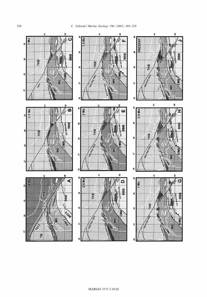
MARGO 3175 3-10-02
C. Yalt|rak /Marine Geology 190 (2002) 493^529524
This late Pliocene age implies that the faultsoblique to the North Anatolian Fault are youngerthan the main system and the basins along theNorth Anatolian Fault and its surrounding arealso younger than 3.5 Ma.During the last 3.5 Ma the NAFZ reactivated
some of the northwest^southeast-trending olderfaults associated with TEFZ in Northwest Anato-lia, by inverting them as normal faults, causingthe development of several basins. Several youngbasins developed associated with the NAFZ be-came superimposed with these older basins. Thestructures observed on the marine seismic dataillustrate this superimposed geological history.It is necessary to distinguish the structures west
and east of the EMR. The western and centralMarmara regions are characterised by a negative£ower structure. The EMR was formed as thenorthern strand of the NAFZ crossed the south-ern boundary of the EMT to the GFZ to thenorth. It is believed that faults interpreted astwo separate segments by Okay et al. (2000) andSiyako et al. (2000) south and north of the EMRmust be connected by a master at depth. Becausethe focal depths of the earthquakes along theNAFZ occur at V10^20 km, the deep faults in-terpreted as separate segments by Okay et al.(2000) and Siyako et al. (2000) south and northof the EMR probably correspond to a singleburied master fault. Although in principle the sin-gle fault models proposed by Le Pichon et al.(1999), Aksu et al. (2000), and Imren et al.(2001) are correct, but incomplete because theydo not take into account the structures associatedwith the early and late neotectonic periods. In theen echelon fault models Parke et al. (1999), Okayet al. (2000) and Siyako et al. (2000) explain thekinematic evolution of the region by a series ofseparate fault segments. But, they ignore that nar-rowing amount between the segments would be
much higher in case the fault activates in seg-ments.The lateral o¡set along the North Anatolian
Fault varies between 20 and 85 km (e.g. Ketin,1948, 1969; S)engo«r, 1979; S)engo«r et al., 1985;Armijo et al., 1999; Bozkurt, 2001). In this study,the o¡set along the North Anatolian Fault is cal-culated as 75^78 km.
10. Conclusion
The Marmara region is a superimposed struc-ture, which was formed by two di¡erent fault sys-tems during two di¡erent periods. These struc-tures are the TEFZ and its splays in the earlyneotectonic period and the NAFZ and its strandsin the late neotectonic period. The total o¡set ofthe NAFZ in the Marmara Sea is V75^78 km.During its westward escape at 22 mm per yr,
the Anatolian Block causes 59, 7^8, and 10^11 kmlateral o¡sets on the northern, middle, and south-ern strands of the NAFZ, respectively. The ratiosof the westward escape of the Anatolian Block are77, 9, and 14% along the northern strand, middle,and southern branches, respectively. The NAFNSis an almost east^west-trending arc-shaped faultwhich is buried only under the EMR. Westward,it reaches to the Gulf of Saros via the GFZ. Themiddle strand changes its westward trend bybending southward at Band|rma. On these areas,it has thrust component and right-lateral charac-ter. The M-UB developed on the extensional re-gion caused by the southward bending of thesouthern strand at Manyas. While the Yenis)ehirBasin opens as a typical pull-apart basin due tonortheast^southwest extensional regime, the M-UB opens due to the north^south extensional re-gime, because the Bal|kesir^Bursa Block to itssouth escapes southward. The fault plane solu-
Fig. 15. Palinspastic palaeogeographic reconstruction maps showing Plio^Quaternary tectonic evolution of the Marmara region.The palinspastic maps have been prepared for every 500 000 yr on the basis of regional GPS vectors given by Straub et al.(1997). (Fig. 10 shows GPS vector.) The city of Istanbul was held constant and each block was reconstructed backward on thebasis of the boundary faults and GPS vectors. Abbreviations: IKB, Istanbul^Kocaeli Block; TB, Thrace Block; TKB, Thrace^Kocaeli Block; MB, Marmara Block; EMB, Edremit^Manyas Block; BBB, Bursa^Bal|kesir Block; TEFZ, Thrace^Eskis)ehirFault Zone; GFZ, Ganos Fault Zone; BBFZ, Band|rma^Behramkale Fault Zone; MEFZ, Manyas^Edremit Fault Zone; NAF,North Anatolian Faults
MARGO 3175 3-10-02
C. Yalt|rak /Marine Geology 190 (2002) 493^529 525
tions obtained in the Marmara Sea region are ingood agreement with the faults proposed in thisstudy.All of the basins in the Marmara region opened
by the NAFZ have the features of the early neo-tectonic period. Therefore, even while each ofthese basins opened due to di¡erent tectonic pro-cesses, they are consistent with each other withinthe frame of the regional tectonic picture. Thepull-apart geometry of the Gemlik and Yenis)ehirBasins show di¡erent features. It is not possible tosuggest that a north^south extensional regime ex-isted in the Marmara region just looking to thefeatures of the Uluabat^Manyas Basin. In addi-tion, one can not interpret NE-SW trendingstrike-slip faults similarly just looking to the fea-tures of the Yenis)ehir Basin or one cannot claimcompression just looking to the compressionalareas where the middle and southern strands ofthe NAFZ bend southward.The shaping of the Marmara Sea is still con-
tinuing under the compressional forces in theWestern Marmara (Gelibolu^Biga Peninsula)caused by to northwest^southeast right-lateralshearing mechanism and the north^south exten-sional forces between Band|rma and Bursa. Theridges and compressional troughs in the centralMarmara Sea developed due to the jumps be-tween the fault segments. The normal faultsbounding the Marmara shelves, which startedtheir activities in the early neotectonic periodand are also known as the northern and southernboundary faults, can be still active as normalfaults due to existing rotational extensions (1^2 km) between the blocks.It is impossible to relate all of the structures
in the Marmara Sea region to the NAFZ genet-ically and to assume that the North AnatolianFault created everything. As a result, the pro-posed evolution models are forced to de¢ne theevolution of the region by the same tectonic re-gime. The main result of this study is a new syn-thesis based on the combination of data presentedin previous works. Therefore, this synthesis con-¢rms all of the data presented in previous works,but it does not con¢rm all of the previous tectonicmodels proposed for the evolution of the Mar-mara Sea.
Acknowledgements
This paper was written when the author was avisiting scientist at the Memorial University ofNewfoundland. Research funds are acknowledgedfrom the Natural Sciences and Engineering Re-search Council of Canada (Marmara Sea Gate-way Project). Thanks are due to Aksu, Hiscottand Calon for the shallow Seismic Lines. The au-thor is also indebted to Mehmet Sak|nc), Fazl| Y.Oktay and Cengiz Tap|rdamaz, who have accom-panied his studies in the Marmara Sea regionsince 1990 and contributed to the results pre-sented here. Further thanks are due to Bedri Al-par, who was the ¢rst researcher suggesting theauthor to combine marine geological and geo-physical data with those observed on land andhis immense data sets of shallow seismic data col-lected mainly after the 1999 earthquake. Thanksare due also to the Marine Geology reviewersJeremy Hall and Erdin Bozkurt for their helpfulsuggestions and to Aral Okay who was the ¢rst topropose the study on the GFZ, leading to thispaper, and provided conventional seismic sectionscollected by the MTA. Finally, the author likes tothank his wife Kezban Saki-Yalt|rak, who is re-sponsible for the C.E.P. Foundation, which spon-sored all his investigations.
References
Akdogflan, N., 2000. Tu«rkiye magnetik-gravimetrikc)izgisellikleriyle neotetis paleotektonik u«niteleric)izgiselliklerinin korelasyonu ve bazi sonuc)lar. Cumhuriyetin75. Yildonumu Yerbilimleri ve Madencilik Kongresi MTA,Ankara, pp. 331^345.
Aksu, A.E., Hiscott, R.N., Yas)ar, D., 1999. Oscillating Qua-ternary water levels of the Marmara Sea and vigorous out-£ow into the Aegean Sea from the Marmara Sea-Black Seadrainage corridor. Mar. Geol. 153, 275^302.
Aksu, A.E., Calon, T.J., Hiscott, R.N., Yas)ar, D., 2000. Anat-omy of the North Anatolian fault zone in the Marmara Sea.Western Turkey: Extensional basins above a continentaltransform. GSA Today 10, 1^2.
Alpar, B., Yalt|rak, C., 2000. C)|narc|k C)ukuru ve c)evresininmorfotektonigfli. In: Uysal, Z., Salihogfllu, I. (Eds.), 1. UlusalDeniz Bilimleri Konferans|, 30 May|s^2 Haziran 2000,ODTUº , Erdemli Deniz Bilimleri Enstitu«su« ve TUº BITAK,Bildiri ve Poster Oº zetleri. ODTUº , Ankara, pp. 189^194.
Alpar, B., Yalt|rak, C., 2002. Characteristic features of the
MARGO 3175 3-10-02
C. Yalt|rak /Marine Geology 190 (2002) 493^529526
North Anatolian Fault in the Eastern Marmara region andits tectonic evolution. Mar. Geol. 190, S0025-3227(02)00353-5.
Alt|nok, Y., Alpar, B. Yalt|rak, C., 2001. Tsunami of the 1912Earthquake (Ms=7.4), extension of the associated faultingin the Marmara Sea. NATO Advanced Research WorkshopOn ‘Underwater Ground Failures on Tsunami Generation,Modeling, Risk and Mitigation’, May 23^25, 2001, Istanbul.
Altunel, E., Barka, A.A., 1998. Neotectonic activity of Es-kis)ehir fault zone between Ino«nu« and Sultandere. Geol.Bull. Turk. 41, 41^52.
Altunel, E., Barka, A.A., Akyu«z, H.S., 2000. Slip distributionalong the 1912 Murefte-S)arko«y earthquake, North Anatoli-an Fault, Western Turkey. In: Barka, A.A., Kozac|, Oº .,Akyu«z, S.H., Altunel, E. (Eds.), 1999 Izmit-Du«zce Earth-quakes: Preliminary Results. Istanbul Technical UniversityPubl., pp. 341^349.
Ambraseys, N.N., Jackson, J.A.., 1998. Faulting associatedwith historical and recent earthquakes in the Eastern Med-iterranean region. Geophys. J. Int. 133, 340^406.
Ambraseys, N.N., Jackson, J.A., 2000. Seismicity of the Sea ofMarmara (Turkey) since 1500. Geophys. J. Int. 141, F1^F6.
Andrussov, N., 1890. Die Schichten von Cap Tschauda. Ann.der K.K. Naturhistor. Hofmuseums, Wien 5, 66^76.
Ardel, A., Kurter, A., 1973. Marmara Denizi. I. Uº . Cogflraf.Derg. 18^19, 57^75.
Armijo, R., Meyer, B., Barka, A.A., Hubert, A., 1999. Prop-agation of the North Anatolian fault into the Northern Ae-gean: timing and kinematics. Geology 27, 267^270.
Aygu« l, H., Genc), T., 1999. Marmara bo«lgesi ve civar|n|n izos-tasi durumunun gravite, topografya ve batimetri verileri kul-lan|larak incelenmesi. In: Barka, A., Akyu«z, S., Altunel, E.,C)ak|r, Z., (Eds.), Aktif Tektonik II, Tu«rkiye Deprem Vakf|,pp. 121^129.
Barka, A.A., 1992. The North Anatolian Fault Zone. Ann.Tecton. 6, 164^195.
Barka, A.A., Kadinky-Cade, K., 1988. Strike^slip fault geom-etry in Turkey and its in£uence on earthquake activity. Tec-tonics 7, 663^684.
Barka, A.A., Gu«len, L., 1989. New constraints on the age andtotal o¡set of the North Anatolian Fault Zone: implicationsfor tectonics of the Eastern Mediterranean region. MiddleEast Tech. Univ. J. Pure Appl. Sci. 21, 39^63.
Barka, A.A., Akyu«z, S.H., Cohen, H.A., Watchorn, F., 2000.Tectonic evolution of the Niksar and Tasova-Erbaa pull-apart basins, North Anatolian Fault Zone: their signi¢cancefor the motion of the Anatolian block. Tectonophysics 322,243^264.
Ben-Avraham, Z., 1992. Development asymmetric basinsalong continental transform faults. Tectonophysics 215,209^220.
Bozkurt, E., 2001. Neotectonics of Turkey ^ a synthesis. Geo-din. Acta 14, 3^30.
Bozkurt, E., Koc)yigflit, A., 1996. The Kazova basin: an activenegative £ower structure on the Almus Fault Zone, a splayfault system of the North Anatolian Fault Zone, Turkey.Tectonophysics 265, 239^254.
Brew, G., Lupa, J., Barazangi, M., Sawaf, T., Al-Imam, A.,Zaza, T., 2001. Structure and tectonic development of theGhab basin and the Dead Sea fault system Syria. Journal ofGeological Society, London 158, 665^674.
Chu, D., Gordon, R.G., 1998. Current plate motions acrossthe Red Sea. Geophys. J. Int. 135, 313^328.
Crampin, S., Evans, R., 1986. Neotectonics of the MarmaraSea region of Turkey. J. Geol. Soc. London 143, 343^346.
Dauteuil, O., Huchon, P., Quemeneur, F., Souriot, T., 2000.Propagation of an oblique spreading centre: the westernGulf of Aden. Tectonophysics 332, 423^442.
Ediger, V., Velegrakis, A.F., Evans, G., 2000. Uº st K|ta Ya-mac| Sediman Dalgalanmalar|, Kilikya Havzas|. In: Uysal,Z. (Ed.), Kuzeydogflu Akdeniz. 1. Deniz Bilimleri Konferans|Bildiri Oº zetleri Kitapc)|gfl|, 30 May|s^2 Haziran 2000. Ku«ltu«rve Kongre Merkezi ODTUº , Ankara, 63 pp.
Emre, Oº ., Erkal, T., Tchepalyga, A., Kazanc|, N., Kec)er, M.,Uº nay, E., 1998. Neogene^Quaternary evolution of the East-ern Marmara Region, Northwest Turkey. Bull. Miner. Res.Explor. Inst. Turk. 120, 119^145.
Ergin, M., Oº zalaybey, M.T., Aktar, M.T., Tap|rdamaz, C.,Yo«ru«k, A., Bic)men, F., 2000. Aftershock analysis of theAugust 17, 1999, Izmit, Turkey, earthquake. In: Barka,A., Kozac|, Oº ., Akyu«z, S., Altunel, E. (Eds.) The 1999 Izmitand Du«zce Earthquakes: Preliminary Results. IstanbulTechnical University Press, Istanbul, pp. 171^178.
Ergu«l, E., Go«zler, Z., Akc)ago«ren, F., Oº ztu«rk, Z., 1986. Geol-ogy map of Turkey, Bandirma E6 section, Scale 1:10 000.Mineral Research and Exploration of Turkey, Ankara, 10pp.
Ergu«n, M., Oº zel, E., 1995. Structural relationship between thesea of Marmara basin and the North Anatolian Fault. TerraNova 7, 278^288.
Gaziogfllu, C., Go«kas)an, E., Algan, O., Yu«cel, Z.Y., Tok, B.,Dogflan, E., 2002. Morphologic features of the Marmara Seafrom multibeam data. Mar. Geol. 190, S0025-3227(02)00356-0.
Go«zler, Z., Cevher, F., Ku«c)u«kayman, A., 1985. Eskis)ehir civ-ar|n|n jeolojisi ve s|cak su kaynaklar|. Bull. Miner. Res. Ex-plor. Turk. 104, 40^54.
Gu«neysu, A.C., 1999. Bathymetry map of the Izmit Bay. Turk.J. Mar. Sci. 5, 167^170.
Gu«neysu, C., 1998. Submarine and coastal geomorphology ofthe Southern Marmara Sea. In: Progress in Marine Geo-logical Studies in Turkey, Tu«bitak University-MTA, Nation-al Marine Geology Programme, Workshop IV, 14^15 May1998, Istanbul, pp. 166^171.
Gu«rbu«z, C., Aktar, M., Eyidogflan, H., Cisternas, A., Haessler,H., Barka, A., Ergin, M., Tu«rkelli, N., Polat, A., Uº c)er, S.B.,Kuleli, S., Bar|s), S., Kaypak, B., Bekler, T., Zor, E., Bic)men,F., Yo«ru«k, A., 2000. The seismotectonics of the Marmararegion (Turkey): results from a microseismic experiment.Tectonophysics 316, 1^17.
Hubert-Ferrari, A., 1998. La Faille Nord-Anatolienne (Cine¤-matique, Morphologie, Localisation, Vitesse et De¤calage To-tal) et Modelisations Utilisant la Contrainte de Coulomb sur
MARGO 3175 3-10-02
C. Yalt|rak /Marine Geology 190 (2002) 493^529 527
Di¡e¤rentes Echelles de Temps. Ph.D. Thesis. University ofParis VII Denis Diderot, Paris.
Imren, C., Le Pichon, X., Rangin, C., Demirbagfl, E., Ecevito-gfllu, B., Go«ru«r, N., 2001. The North Anatolian fault withinthe Sea of Marmara: a new interpretation based on multi-channel seismic and multi-beam bathymetry data. EarthPlanet. Sci. Lett. 186, 143^158.
Kalafat, D., 1995. Anadolu’nun Tektonik Yap|lar|n|n depremMekanizmalar| Ac)|s|ndan Irdelenmesi (in Turkish with Eng-lish abstract). Unpubl. Ph.D. Thesis. Institute of MarineSciences and Management, Istanbul University, 217 pp.
Kaymakc)|, N., 1991. Neotectonic Evolution of the Inego« l(Bursa) Basin. Unpubl. M.Sc. Thesis. Middle East TechnicalUniversity, Ankara, 73 pp.
Ketin, I., 1948. Uº ber die tektonisch-mechanischen Folgerun-gen aus den grossen Anatolischen Erdbeben des letzten De-zenniums. Geol. Rundsch. 36, 77^83.
Ketin, I., 1966. 6 Ekim 1964 Manyas depremi esnas|nda ze-minde meydana gelen tansiyon c)atlaklar|. Tu«rk. Jeol. Kur-umu Bu«l. 10, 1^2.
Ketin, I., 1969. Kuzey Anadolu Fay| Hakk|nda. Bull. Miner.Res. Explor. Inst. Turk. 76, 1^25.
Koc)yigflit, A., 1988. Tectonic setting of the Geyve basin: ageand total displacement of Geyve fault zone. METU PureAppl. Sci. 21, 81^104.
Koc)yigflit, A., 1989. Sus)ehri basin: an active fault-wedge basinon the North Anatolian Fault Zone, Turkey. Tectonophys-ics 167, 13^29.
Koc)yigflit, A., 1991. Neotectonic structures and related land-forms expressing the contractional and extensional strainsalong the North Anatolian Fault at the northwestern marginof the Erzincan Basin, NE Turkey. Bull. Tech. Univ. Istan-bul 44, 455^473.
Le Pichon, X., Taymaz, T., S)engo«r, A.M.C., 1999. The Mar-mara Fault and the future Istanbul Earthquake. Proc. ITU-IAHS International Conference on the Kocaeli Earthquake,Istanbul, pp. 41^54.
Marathon Petroleum, 1976. Marmara-1 well. Final Report, 26pp.
McKenzie, D., 1972. Active tectonics of the Mediterraneanregion. Geophys. J. R. Astron. Soc. 30, 109^185.
Okay, A., Demirbagfl, E., Kurt, H., Okay, N., Kus)c)u, I., 1999.An active, deep marine strike^slip basin along the NorthAnatolian fault in Turkey. Tectonics 18, 129^147.
Okay, A., Kas)l|lar-Oº zcan, A., Imren, C., Boztepe-Gu«ney, A.,Demirbagfl, E., Kus)c)u, I., 2000. Active faults and evolvingstrike^slip basins in the Marmara Sea, northwest Turkey: amultichannel seismic re£ection study. Tectonophysics 321,189^218.
Parke, J.R., Minshull, T.A., Anderson, G., White, R.S.,McKenzie, D., Kus)c)u, I., Bull, J.M., Go«ru«r, N., S)engo«r,C., 1999. Active faults in the Sea of Marmara, WesternTurkey, imaged by seismic re£ection pro¢les. Terra Nova11, 223^227.
Perinc)ek, D., 1991. Possible strand of the North AnatolianFault in the Thrace Basin, Turkey: an interpretation. Am.Assoc. Pet. Geol. Bull. 75, 241^257.
Sak|nc), M., Yalt|rak, C., Oktay, F.Y., 1999. Palaeogeograph-ical evolution of the Thrace Neogene Basin and the Tethian-Paratethian relations at northwest Turkey (Thrace). Palaeo-geogr. Palaeoclimatol. Palaeoecol. 153, 17^40.
S)arogfllu, F., 1988. The age and o¡set on the North AnatolianFault. Middle East Tech. Univ. J. Pure Appl. Sci. 21, 65^79.
S)engo«r, A.M.C., 1979. The North Anatolian Transform Fault:its age, o¡set and tectonic signi¢cance. J. Geol. Soc. London136, 269^282.
S)engo«r, A.M.C., 1980. Tu«rkiye’nin Neotektonigflinin Esaslar|‘Principles of the Neotectonism of Turkey’. Tu«rkiye JeolojiKurumu, Ankara, 40 pp.
S)engo«r, A.M.C., Go«ru«r, N., S)arogfllu, F., 1985. Strike^slipfaulting and related basin formation in zones of tectonicescape: Turkey as a case study. In: Biddle, K.T., Christie-Blick, N. (Eds.), Strike^slip Faulting and Basin Formation.Soc. Econ. Paleontol. Mineral. Spec. Publ. 37, 227^264.
Sylvester, A.G., 1988. Strike^slip faults. Geol. Soc. Am. Bull.100, 1666^1703.
Siyako, M., Bu«rkan, K.A., Okay, A.I., 1989. Biga ve Geliboluyar|madalar|n|n Tersiyer jeolojisi ve hidrokarbon olanaklar|.Bull. Turk. Assoc. Pet. Geol. 1, 183^199.
Siyako, M., Tan|s), T., S)arogfllu, F., 2000. Marmara Denizi aktiffay geometrisi. TUº BITAK Bilim Tek. Derg. 388, 66^71.
Smith, A.D., Taymaz, T., Oktay, F.Y., Yu«ce, H., Alpar, B.,Bas)aran, H., Jackson, J.A., Kara, S., S)ims)ek, M., 1995.High-resolution seismic pro¢ling in the Sea of Marmara(northwest Turkey): late Quaternary sedimentation andsea-level changes. Geol. Soc. Am. Bull. 107, 923^936.
Straub, C., Kahle, H.G., Schindler, C., 1997. GPS and geo-logic estimates of the tectonic activity in the Marmara Searegion, NW Anatolia. J. Geophys. Res. Solid Earth B12,27587^27601.
Tap|rdamaz, C., Yalt|rak, C., 1997. Trakya’da Senozoyik vol-kaniklerinin paleomanyetik o«zellikleri ve bo«lgenin tektonikevrimi. Bull. Min. Res. Explor. Turk. 119, 27^42.
Taymaz, T., 1990. Earthquake Source Parameters in the East-ern Mediterranean Region. Ph.D. Thesis. Cambridge Uni-versity, Cambridge, 244 pp.
Taymaz, T., 1999. Seismotectonics of the Marmara region:Source characteristics of 1999 Go«lcu«k-Sapanca-Du«zce earth-quakes. Proc. ITU-IAHS, International Conference on theKocaeli Earthquake 17 August 1999, Istanbul, pp. 55^78.
Taymaz, T., 2000. Seismotectonics of the Marmara region:source characteristics of 1999 Go«lcu«k-Sapanca-Du«zce earth-quakes. In: Barka, A.A., Kozac|, Oº ., Akyu«z, S.H., Altunel,E. (Eds), 1999 Izmit-Du«zce Earthquakes: Preliminary Re-sults. Istanbul Technical University Publ., Istanbul, pp.79^97.
Taymaz, T., Jackson, J., McKenzie, D.P., 1991. Active tecton-ics of the North and Central Aegean Sea. Geophys. J. Inter.106, 433^490.
Taymaz, T., Kasahara, J., Hirn, A., Sato, T., 2001. Investiga-tions of microearthquake activitiy within the Sea of Mar-mara and surrounding regions by using ocean bottom seis-mometers (OBS) and land seismographs: Initial results. In:Taymaz, T. (Ed.), Symposia on Seismotectonics of the
MARGO 3175 3-10-02
C. Yalt|rak /Marine Geology 190 (2002) 493^529528
North-Western Anatolia-Aegean and Recent Turkish Earth-quakes. Scienti¢c Activities 2001, May 8, 2001. Facultyof Mines, Istanbul Technical University, Istanbul, pp. 42^51.
Toprak, V., 1988. Neotectonic characteristics of the NorthAnatolian fault zone between Koyulhisar and Sus)ehri (NETurkey). Middle East Tech. Univ. J. Pure Appl. Sci. 21,155^168.
Tu«ysu«z, O., Barka, A.A., Yigflitbas), E., 1998. Geology of theSaros Graben: its implications on the evolution of the NorthAnatolian Fault in the Ganos-Saros region, NW Turkey.Tectonophysics 293, 105^126.
Uº nay, E., Emre, Oº ., Erkal, T., Kec)er, M., 2001. The rodentfauna from the Adapazar| pull-apart basin (NW Anatolia):its bearings on the age of the North Anatolian Fault. Geo-din. Acta 14, 169^175.
Wong, H.K., Ludmann, T., Ulugfl, A., Go«ru«r, N., 1995. TheSea of Marmara, a plate boundary sea in escape tectonicregime. Tectonophysics 244, 231^250.
Wright, T., Parsons, B., Fielding, E., 2001. The 1999 Turkishearthquakes: source paramaters from InSAR and observa-tions of triggered slip. In: Taymaz, T. (Ed.), Symposia onSeismotectonics of the North-Western Anatolia-Aegean andRecent Turkish Earthquakes. Scienti¢c Activities 2001, May8, 2001. Faculty of Mines, Istanbul Technical University,Istanbul, pp. 54^71.
Yalt|rak, C., 1996. Tectonic history of the Ganos Fault system(in Turkish with English abstract). Bull. Turk. Assoc. Pet.Geol. 8, 137^156.
Yalt|rak, C., 2000a. Kuzey Anadolu fay|n|n Marmara kollar|ve bo« lgenin tektonik yap|s| (in Turkish). Guney Marmara
Depremleri ve Jeo¢zik Toplant|s|, TMMOB Jeo¢zik Mu«hen-disleri Odasi, 22 September 2000, Bursa, pp. 44^48.
Yalt|rak, C., 2000b. Problem of Marmara (in Turkish withEnglish abstract). In: Uysal, Z., Salihogfllu, I. (Eds.), 1st Na-tional Marine Science Conferences, May 30^June 2, 2000.Middle East Technical University, Ankara, pp. 202^207.
Yalt|rak, C., Alpar, B., 2002a. Kinematics and evolution of theNorthern Branch of the North Anatolian Fault (GanosFault) between the Sea of Marmara and the Gulf of Saros.Mar. Geol. 190, S0025-3227(02)00354-7.
Yalt|rak, C., Alpar, B., 2002b. Evolution of the middle strandof North Anatolian Fault and shallow seismic investigationof the Southeastern Marmara Sea (Gemlik Bay). Mar.Geol., this volume.
Yalt|rak, C., Alpar, B., Yu«ce, H., 1998. Tectonic elementscontrolling the evolution of the Gulf of Saros (NortheasternAegean Sea). Tectonophysics 300, 227^248.
Yalt|rak, C., Sak|nc), M., Oktay, F.Y., 2000a. Westward prop-agation of the North Anatolian fault into the northern Ae-gean: timing and kinematics, Comment. Geology 28, 187^188.
Yalt|rak, C., Alpar, B., Sak|nc), M., Yu«ce, H., 2000. Origin ofthe Strait of C)anakkale (Dardanelles) : regional tectonicsand the Mediterranean ^ Marmara incursion. Mar. Geol.164, 139^156, with erratum 167, 189^190.
Y|lmaz, B., 1996. Marmara Denizinde Bu«yu«kc)ekmece (Istan-bul) Marmara Eregfllisi (Tekirdagfl) k|y| kesimini jeolojisi (inTurkish with English summary). Unpublished M.Sc. Thesis.Istanbul Technical University, 61 pp.
Y|lmaz, Y., Polat, A., 1998. Geology and Evolution of theThrace volcanism, Turkey. Acta Vulcanol. 10, 293^303.
MARGO 3175 3-10-02
C. Yalt|rak /Marine Geology 190 (2002) 493^529 529
Related Documents


