Resolution No. R3-2013-0032 ATTACHMENT 2 TECHNICAL SUPPORT DOCUMENT FOR POST-CONSTRUCTION STORMWATER MANAGEMENT REQUIREMENTS FOR DEVELOPMENT PROJECTS IN THE CENTRAL COAST REGION July 12, 2013 CALIFORNIA REGIONAL WATER QUALITY CONTROL BOARD CENTRAL COAST REGION 895 Aerovista Place, Suite 101, San Luis Obispo, California 93401 Phone (805) 549-3147 http://www.waterboards.ca.gov/centralcoast/ To request copies of this report please contact Dominic Roques at (805) 542-4780, or by email at: [email protected] Documents also are available at: http://www.waterboards.ca.gov/centralcoast/water_issues/programs/stormwater/docs/lid/lid_hyd romod_charette_index.shtml

Welcome message from author
This document is posted to help you gain knowledge. Please leave a comment to let me know what you think about it! Share it to your friends and learn new things together.
Transcript
Resolution No. R3-2013-0032 ATTACHMENT 2
TECHNICAL SUPPORT DOCUMENT
FOR
POST-CONSTRUCTION STORMWATER MANAGEMENT REQUIREMENTS FOR DEVELOPMENT PROJECTS IN THE
CENTRAL COAST REGION
July 12, 2013
CALIFORNIA REGIONAL WATER QUALITY CONTROL BOARD CENTRAL COAST REGION
895 Aerovista Place, Suite 101, San Luis Obispo, California 93401 Phone � (805) 549-3147
http://www.waterboards.ca.gov/centralcoast/
To request copies of this report please contact Dominic Roques at (805) 542-4780, or by email at:
[email protected] Documents also are available at: http://www.waterboards.ca.gov/centralcoast/water_issues/programs/stormwater/docs/lid/lid_hydromod_charette_index.shtml
Resolution No. R3-2013-0032 ATTACHMENT 2
Table of Contents
I. Introduction ...................................................................................................................... 1 II. Regulatory Context ........................................................................................................... 2 III.Watershed Management Zones ....................................................................................... 3
1) Watershed Processes.................................................................................................. 4 2) Landscape Assessment as Basis of Watershed Management Zones .......................... 6
IV. Management Strategies for Watershed Management Zones .........................................16 1) Flow Control .................................................................................................................17 2) Water Quality Treatment ..............................................................................................17 3) Preserve Delivery of Sediment and Organics ...............................................................17 4) Maintain Soil and Vegetation Regime ...........................................................................17 5) Land Preservation ........................................................................................................17
V. Post-Construction Performance Requirements ..............................................................18 1) Regulated Projects ......................................................................................................18 2) Performance Requirement No. 1: Site Design and Runoff Reduction ...........................19 3) Performance Requirement No. 2: Water Quality Treatment ..........................................19 4) Performance Requirement No. 3: Runoff Retention .....................................................22 5) Performance Requirement No. 4: Peak Management ..................................................27 6) Performance Requirement No. 5: Special Circumstances ............................................29
VI. Alternative Compliance (Off-Site Compliance) ...............................................................30 VII. Reporting ......................................................................................................................33
1) Project Applicant Reporting to Permittee ......................................................................33 2) Permittee Reporting to the Central Coast Water Board ................................................33
VIII. References ..................................................................................................................33 ATTACHMENT A: Watershed Management Zones ATTACHMENT B: Designated Groundwater Basins ATTACHMENT C: Flow Chart to Determine Performance Requirements ATTACHMENT D: Case Study of the Hydrologic Benefits of On-Site Retention ATTACHMENT E: Methods and Findings of the Joint Effort for Hydromodification Control ATTACHMENT F: Calculating Off-Site Retention Requirements ATTACHMENT G: Stormwater Control Measure Sizing: Evaluation of Attachment D to the
Central Coast Post-Construction Requirements ATTACHMENT H: Development and Implementation of Hydromodification Control
Methodology: Support for Selection of Criteria
Resolution No. R3-2013-0032 ATTACHMENT 2 -1-
I. Introduction The management of stormwater runoff from sites after the construction phase is vital to controlling the impacts of development on water quality. The increase in impervious surfaces such as rooftops, roads, parking lots, and sidewalks due to land development can have a detrimental effect on aquatic systems post construction. Runoff from impervious areas can contain a variety of pollutants that are detrimental to water quality, including sediment, nutrients, heavy metals, pathogenic bacteria, and petroleum hydrocarbons. High levels of impervious cover can result in stream warming and loss of aquatic biodiversity in urban areas. Imperviousness limits both shallow groundwater movement and recharge of underlying groundwater basins. Impervious surfaces also reduce the supply of natural, beneficial sediment and organic matter to receiving waters. The main goal of post-construction stormwater management is to prevent or limit these effects. This goal is best pursued by setting performance standards for new and redevelopment projects to ensure the projects integrate measures into their design and construction that protect, or to the extent feasible restore, the natural processes that support healthy aquatic systems. Over time, parcel-based requirements reduce the cumulative impacts of development at the watershed scale. These Post-Construction Stormwater Management Requirements for Development Projects in the Central Coast Region (Post-Construction Requirements) establish the specific performance criteria and related implementation measures that municipalities will use to implement post-construction stormwater management actions. As with many other aspects of urban stormwater management (e.g., illicit discharge detection and elimination, construction management, public education and outreach), municipalities possess the authority to implement post-construction stormwater management actions to prevent impacts from urban runoff. Through implementation of these Post-Construction Requirements, municipalities will ensure that the new and redevelopment projects they approve integrate measures into their design and construction to protect, or to the extent feasible restore, the processes supporting healthy aquatic systems throughout the life of the project. Contents of this Technical Support Document This Technical Support Document is intended to provide background, explanation and justification for the Post-Construction Requirements. The background discussion includes the regulatory context in which the Post-Construction Requirements were developed. It continues with a presentation of the analytical basis for developing the Watershed Management Zones that determine which Post-Construction Requirements are applied on a given development site in the Central Coast Region. Management Strategies are then discussed as the foundation of the specific Performance Requirements. In Section V. each Performance Requirement is discussed in detail as are key aspects of applicability, including exempt projects. The Technical Support Document then describes Alternative Compliance approaches that allow for off-site compliance with Performance Requirements. Additional details are also provided on reporting, including a discussion of the Stormwater Control Plan and the central role it is expected to play in achieving implementation of Low Impact Development (LID). For each of these items, the Technical Support Document includes explanation and justification as necessary.
Resolution No. R3-2013-0032 ATTACHMENT 2 -2-
II. Regulatory Context
On April 30, 2003, the State Water Resources Control Board adopted the National Pollutant Discharge Elimination System (NPDES) General Permit for the Discharge of Storm Water from Small Municipal Separate Storm Sewer Systems (MS4s), Order No. 2003-0005-DWQ (Phase II Municipal General Permit). On February 15, 2008, the Central Coast Water Board Executive Officer notified un-enrolled traditional, small MS4 stormwater dischargers and two un-enrolled non-traditional, small MS4 stormwater dischargers (University of California at Santa Barbara and Santa Cruz) of the process the Central Coast Water Board would follow for enrolling the MS4s under the Phase II Municipal General Permit. The Executive Officer also included in this notification interim hydromodification control criteria and the expectation that dischargers’ Stormwater Management Programs (SWMPs) present a schedule for development and adoption of long-term hydromodification control standards.
On August 4, 2009 and October 20, 2009, the Central Coast Water Board Executive Officer notified dischargers of the option to pursue and participate in a “Joint Effort” for developing hydromodification control criteria, in compliance with the Phase II Municipal General Permit. All traditional, small MS4 stormwater dischargers in the Central Coast, as well as two non-traditional, small MS4s, the University of California at Santa Barbara and Santa Cruz, agreed to participate in the Joint Effort by submitting a written declaration of their intent to meet the terms of participation. Each discharger also amended their SWMP to include Best Management Practices (BMPs) to codify the steps of participation in the Joint Effort.
On September 2, 2010 the Central Coast Water Board hired contractors to assist in the development of hydromodification control criteria and on September 28, 2010, Central Coast Water Board staff notified traditional, small MS4 stormwater dischargers of the commencement of the Joint Effort.
The Phase II Municipal General Permit requires small MS4s to develop and implement a SWMP that describes BMPs, measurable goals, and timetables for implementation, designed to reduce the discharge of pollutants to the maximum extent practicable (MEP) and to protect water quality. The General Permit requires regulated small MS4s to require long-term post-construction BMPs that protect water quality and control runoff flow, to be incorporated into development and redevelopment projects. The General Permit further requires the Permittee to incorporate changes required by or acceptable to the Water Board Executive Officer into the Permittee’s SWMP and to adhere to its implementation.
These Post-Construction Requirements fulfill the Joint Effort BMPs and are the minimum post-construction criteria that Central Coast traditional, small MS4 stormwater dischargers must apply to applicable new development and redevelopment projects in order to comply with the MEP standard. The Central Coast Water Board approved Post-Construction Stormwater Management Requirements for Development Projects in the Central Coast (Post-Construction Requirements) on September 6, 2012 through adoption of Resolution R3-2012-0025. Resolution R3-2012-0025 made findings that Central Coast municipalities must implement the Post-Construction Requirements to comply with the Phase II Municipal General Permit, Order No. 2003-0005-DWQ in effect at the time. At the time of adoption of Resolution R3-2012-0025 by the Central Coast Water Board, State Water Board staff was preparing to reissue the Phase II Municipal General Permit. The State Water Board reissued the permit on February 5, 2013. Per section E.12.k of the re-issued Phase II Municipal General Permit, Traditional MS4s in the Central
Resolution No. R3-2013-0032 ATTACHMENT 2 -3-
Coast Region must comply with post-construction stormwater management requirements based on a watershed-process based approach developed by the Central Coast Water Board. The Central Coast Water Board’s September 6, 2012 Resolution R3-2012-0025, which approved the Post-Construction Requirements, must be re-adopted by the Central Coast Water Board for consistency with the reissued Phase II Municipal General Permit. The language of the Central Coast Water Board’s September 6, 2012 Resolution R3-2012-0025, refers to the former Phase II Municipal General Permit, Order No. 2003-0005-DWQ instead of the current Phase II Municipal General Permit, Order No. 2013-0001-DWQ, cites the section numbers for post construction requirements as per Order No. 2003-0005-DWQ instead of the reissued Phase II Municipal General Permit section numbers, and describes implementation via SWMPs as in Order No. 2003-0005-DWQ instead of through Guidance Documents as required in the reissued Phase II Municipal General Permit.
Central Coast Water Board staff included specific language on what is required and how to demonstrate implementation of the Post-Construction Requirements. This specific language describing what to do and what to report will greatly assist Central Coast Water Board staff in determining compliance with the Post-Construction Requirements and attainment of the MEP standard. III. Watershed Management Zones
The urbanized portions of the Central Coast Region are categorized into 10 Watershed Management Zones (WMZs), based on common key watershed processes and receiving water type (creek, ocean, lake, etc). Maps in Attachment A illustrate the WMZs for the Central Coast Region’s urbanized areas. Designated Groundwater Basins of the Central Coast Region (Attachment B) underlie some but not all WMZs in urbanized portions of the Central Coast Region. Each WMZ and, where present, Groundwater Basin, is aligned with specific Post-Construction Stormwater Management Requirements (Post-Construction Requirements) to address the impacts of development on watershed processes and beneficial uses. These Post-Construction Requirements require the Permittee to have the ability to determine the WMZ in which development projects are proposed, throughout the urbanized portions of their jurisdiction corresponding with the Phase II Municipal Stormwater Permit boundary. The Permittee must also have the ability to determine whether development projects are proposed in areas overlying designated Groundwater Basins. The maps in Attachment A illustrate the WMZs in all the urbanized areas of the Central Coast. However, to implement these Post-Construction Requirements, Permittees may require access to spatial data files of WMZs and Groundwater Basins which they can download for their own use. These files are available for download at the following website: http://www.waterboards.ca.gov/centralcoast/water_issues/programs/stormwater/docs/lid/lid_hydromod_charette_index.shtml Permittees may also elect to identify WMZs for areas within their jurisdiction, but not depicted as urbanized areas on the maps in Attachment A. The spatial data available at the above website provide the necessary information to designate WMZs in these areas. The Watershed Management Zones are the basis for post-construction requirements appropriate to the physical context in which development occurs. A key principle underpinning the WMZs is that every location on the landscape does not require the same set of stormwater
Resolution No. R3-2013-0032 ATTACHMENT 2 -4-
mitigation measures, because of intrinsic differences in the key watershed processes at each location and the sensitivity to those processes of the downstream receiving water(s). The Joint Effort contractors completed technical tasks to develop and implement a methodology to identify Post-Construction Requirements consistent with this principle.1, 2, 3, 4, 5, 6, 7 The following describes two critical steps conducted by the Joint Effort contractors to support the development of Post-Construction Requirements: (1) identify watershed processes that are integral to receiving water health in the Central Coast Region, and (2) conduct a landscape assessment to identify the basis for defining Watershed Management Zones. 1) Watershed Processes Watershed processes of interest in the context of stormwater management are those that have their ultimate expression in receiving waters, including groundwater. Watershed processes across the landscape of the Central Coast Region are similar to those found in temperate latitudes throughout the world. Field observations, conducted across the entire geographic extent of the Central Coast, confirmed that conditions and processes in the intact watersheds of the Central Coast were overall consistent with prior assessments of watershed processes.8 The focus on intact watersheds provided a basis for describing what are effectively predevelopment conditions. Only a few systematic and readily recognized differences distinguished different suites of processes in different areas. Broadly, all but the steepest mountain ridges and the driest hillslopes are well-vegetated, whether by chaparral, coastal scrub, grasslands, oak woodlands, or evergreen forest. Most hillslopes are relatively ungullied, expressing a predominance of the hydrologic processes of infiltration and subsurface movement of water after precipitation first falls on the ground surface. These hydrologic processes, in turn, largely control the movement of sediment and plant detrital material. Sediment movement is driven by gravity and so is negligible on flat ground regardless of the geologic material. On slopes, surface erosion (rilling, gullying) occurs only in the presence of surface flow, and its expression is rare (in undisturbed areas) except in a few very weak rock types. Landslides (and other forms of mass wasting) are more dependent on rock strength, for which the Central Coast has excellent examples at both the weak (Franciscan mélange) and strong (crystalline rocks) ends of the spectrum. In addition to the watershed processes of infiltration and subsurface movement of water, whose activity and influence were observed or inferred from observation, four other processes long-recognized from prior watershed studies were included in the subsequent application of this analysis to determine effective stormwater management strategies and support these Post-Construction Requirements. They include evapotranspiration, delivery of sediment and organic matter to receiving waters, and chemical and biological transformations. Watershed Processes Identified in the Central Coast Region:9
1 Helmle & Booth, 2011a.
2 Helmle & Booth, 2011b.
3 Helmle & Booth, 2011c.
4 Booth, et al, 2011a.
5 Booth, et al, 2011b.
6 Booth, et al, 2012.
7 Helmle, C., 2012.
8 Helmle & Booth, 2011b. p. 3.
9 Booth, et al, 2011b. p. 31.
Resolution No. R3-2013-0032 ATTACHMENT 2 -5-
Overland Flow: Precipitation reaching the ground surface that does not immediately soak in must run over the land surface (thus, “overland” flow). Most un-compacted, vegetated soils have infiltration capacities of one to several inches per hour at the ground surface, which exceeds the rainfall intensity of even unusually intense storms of the Central Coast and so confirms the field observations of little to no overland flow in undisturbed watersheds. In contrast, pavement and hard surfaces reduce the effective infiltration capacity of the ground surface to zero, ensuring overland flow regardless of the meteorological attributes of a storm, together with a much faster rate of runoff relative to vegetated surfaces. Groundwater Recharge and Infiltration: These closely linked hydrologic processes are dominant across most intact landscapes of the Central Coast Region. They can be thought of as the inverse of overland flow; precipitation that reaches the ground surface and does not immediately run off has most likely infiltrated. Their widespread occurrence is expressed by the common absence of surface-water channels on even steep (undisturbed) hillslopes. Thus, on virtually any geologic material on all but the steepest slopes (or bare rock), infiltration of rainfall into the soil is inferred to be widespread, if not ubiquitous. With urbanization, changes to the process of infiltration are also quite simple to characterize: some (typically large) fraction of that once-infiltrating water is now converted to overland flow. Interflow: Interflow takes place following storm events as shallow subsurface flow (usually within 3 to 6 feet of the surface) occurring in a more permeable soil layer above a less permeable substrate. In the storm response of a stream, interflow provides a transition between the rapid response from surface runoff and much slower stream discharge from deeper groundwater. In some geologic settings, the distinction between “interflow” and “deep groundwater” is artificial and largely meaningless; in others, however, there is a strong physical discrimination between “shallow” and “deep” groundwater movement. Development reduces infiltration and thus interflow as discussed previously, as well as reducing the footprint of the area supporting interflow volume. Evapotranspiration: In undisturbed humid-region watersheds, the process of returning water to the atmosphere by direct evaporation from soil and vegetation surfaces, and by the active transpiration by plants, can account for nearly one-half of the total annual water balance; in more arid regions, this fraction can be even higher. Development covers soils with impervious surfaces and usually results in the compaction of soils when grading occurs. Native plants are often replaced with turf, which typically has lower rates of evapotranspiration unless irrigated throughout the summer months. Delivery of Sediment to Receiving Waters: Sediment delivery into the channel network is a critical process for the maintenance of various habitat features in fluvial systems (although excessive sediment loading from watershed disturbance can instead be a significant source of degradation). Quantifying this rate can be difficult and discriminating the relative contribution from different geologic materials even more so; however, the overriding determinism of hillslope gradient is widely documented. In the post-construction period, maintenance of sediment delivery is essential to the health of certain receiving-water types (as is organic matter delivery), and it is this (long-term) process that is being addressed here. Development commonly covers surfaces, and non-native vegetation may also prevent the natural supply of sediment from reaching the stream. Delivery of Organic Matter to Receiving Waters: The delivery of organic matter is critical to receiving water health as it forms the basis for the aquatic food web. Delivery of organic matter
Resolution No. R3-2013-0032 ATTACHMENT 2 -6-
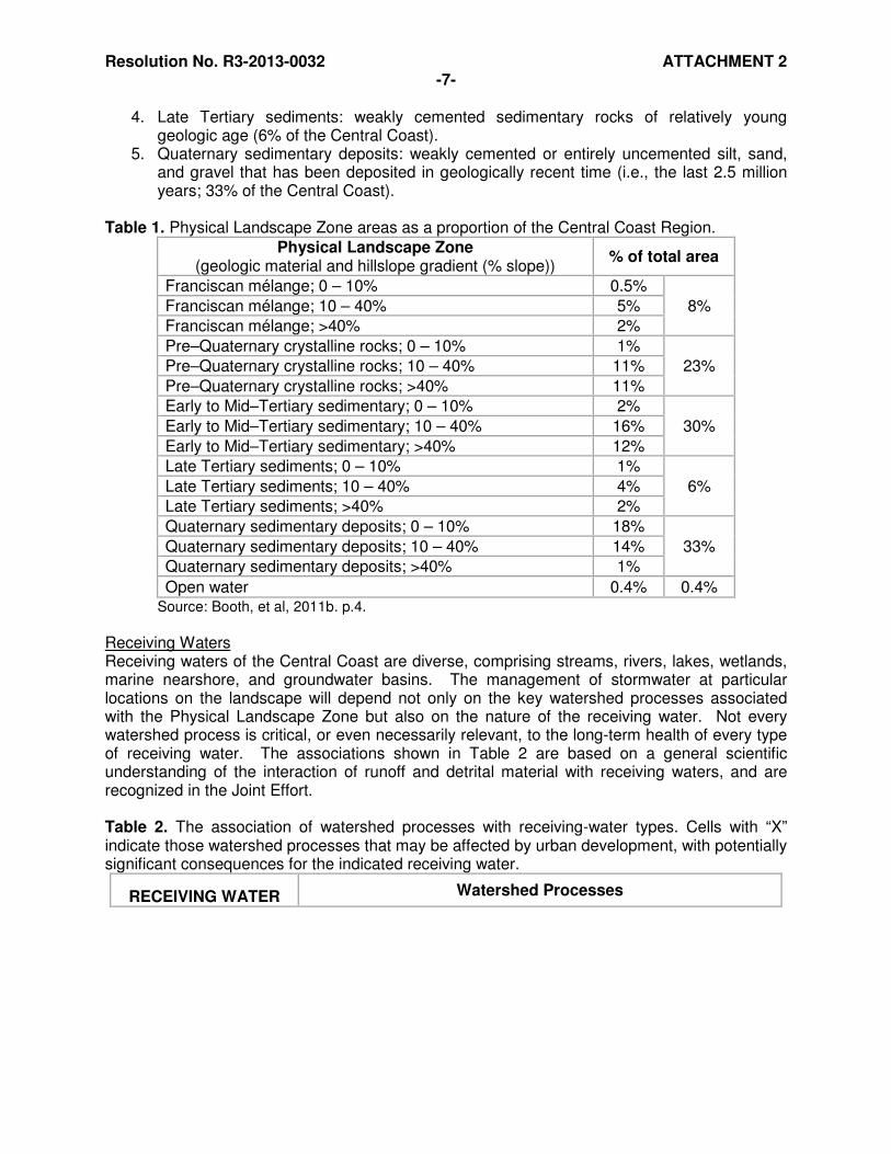
follows similar pathways as inorganic matter (e.g., sediment). However, the dominant amount and timing of delivery is often associated with the presence, width, and composition of the vegetative riparian zone. Chemical and Biological Transformations: This encompasses the suite of watershed processes that alter the chemical composition of water as it passes through the soil column on its path to (and after entry into) a receiving water. The conversion of subsurface flow to overland flow in a developed landscape eliminates much of the opportunity for attenuation and transformations within the soil column, and this is commonly expressed through degraded water quality. The dependency of these processes on watershed conditions is complex in detail, but in general a greater residence time in the soil should be correlated with greater activity for this group of processes. Since residence time is inversely proportional to the rate of movement, the relative importance of this process is anticipated to be inversely proportional to slope. 2) Landscape Assessment as Basis of Watershed Management Zones Physical Landscape Zones Determinants of the primary watershed processes have been cataloged by many prior studies. Commonly recognized attributes include the material being eroded (i.e., geologic material), a measure of topographic gradient (hillslopes, basin slope), climate (mean annual temperature, mean annual precipitation, climate zone, latitude), land cover (vegetation, constructed cover and imperviousness), and episodic disturbance (e.g., fire, large storms). Reid and Dunne (1996) noted that every study area requires simplification and stratification, with topography and geology as the primary determinants with land cover as a “treatment” variable within each topography–geology class. This perspective is consistent with the underlying purpose for defining Physical Landscape Zones, namely to identify and stratify watershed conditions and processes across the undisturbed landscape of the Central Coast. Thus, geologic material and hillslope gradient were the two landscape attributes judged to be the major determinants of watershed processes and characterized for this step.10 Thus, 15 Physical Landscape Zones can be identified across the Central Coast Region, each with a set of properties that are well-correlated with their key watershed processes in an undisturbed landscape. Other factors of potential relevance, particularly the spatial variability of precipitation and the influence of different vegetation types in undisturbed watersheds (e.g., trees vs. shrubs vs. grasslands) were explored but were found to have at most a secondary influence on the dominance of particular watershed processes across the Central Coast as a whole.11 The fifteen final landscape categories (plus “open water”) of the Central Coast Region are identified in Table 1, and consist of five geologic material types each divided into three hillslope gradient categories:
1. Franciscan mélange: a heterogeneous collection of resistant rocks within a matrix of weaker material that has filled the spaces between the resistant clasts (exposed over 8% of the land area of the Central Coast).
2. Pre–Quaternary crystalline rocks: a group of geologically old and generally quite resistant rocks (23% of the Central Coast).
3. Early to Mid–Tertiary sedimentary rocks: primarily resistant sandstones but also some weaker shales and siltstones (30% of the Central Coast).
10 Booth, et al, 2011b. p. ii. 11 Ibid. p. 4.
Resolution No. R3-2013-0032 ATTACHMENT 2 -7-
4. Late Tertiary sediments: weakly cemented sedimentary rocks of relatively young geologic age (6% of the Central Coast).
5. Quaternary sedimentary deposits: weakly cemented or entirely uncemented silt, sand, and gravel that has been deposited in geologically recent time (i.e., the last 2.5 million years; 33% of the Central Coast).
Table 1. Physical Landscape Zone areas as a proportion of the Central Coast Region.
Physical Landscape Zone (geologic material and hillslope gradient (% slope))
% of total area
Franciscan mélange; 0 – 10% 0.5%
8% Franciscan mélange; 10 – 40% 5%
Franciscan mélange; >40% 2%
Pre–Quaternary crystalline rocks; 0 – 10% 1%
23% Pre–Quaternary crystalline rocks; 10 – 40% 11%
Pre–Quaternary crystalline rocks; >40% 11%
Early to Mid–Tertiary sedimentary; 0 – 10% 2%
30% Early to Mid–Tertiary sedimentary; 10 – 40% 16%
Early to Mid–Tertiary sedimentary; >40% 12%
Late Tertiary sediments; 0 – 10% 1%
6% Late Tertiary sediments; 10 – 40% 4%
Late Tertiary sediments; >40% 2%
Quaternary sedimentary deposits; 0 – 10% 18%
33% Quaternary sedimentary deposits; 10 – 40% 14%
Quaternary sedimentary deposits; >40% 1%
Open water 0.4% 0.4% Source: Booth, et al, 2011b. p.4.
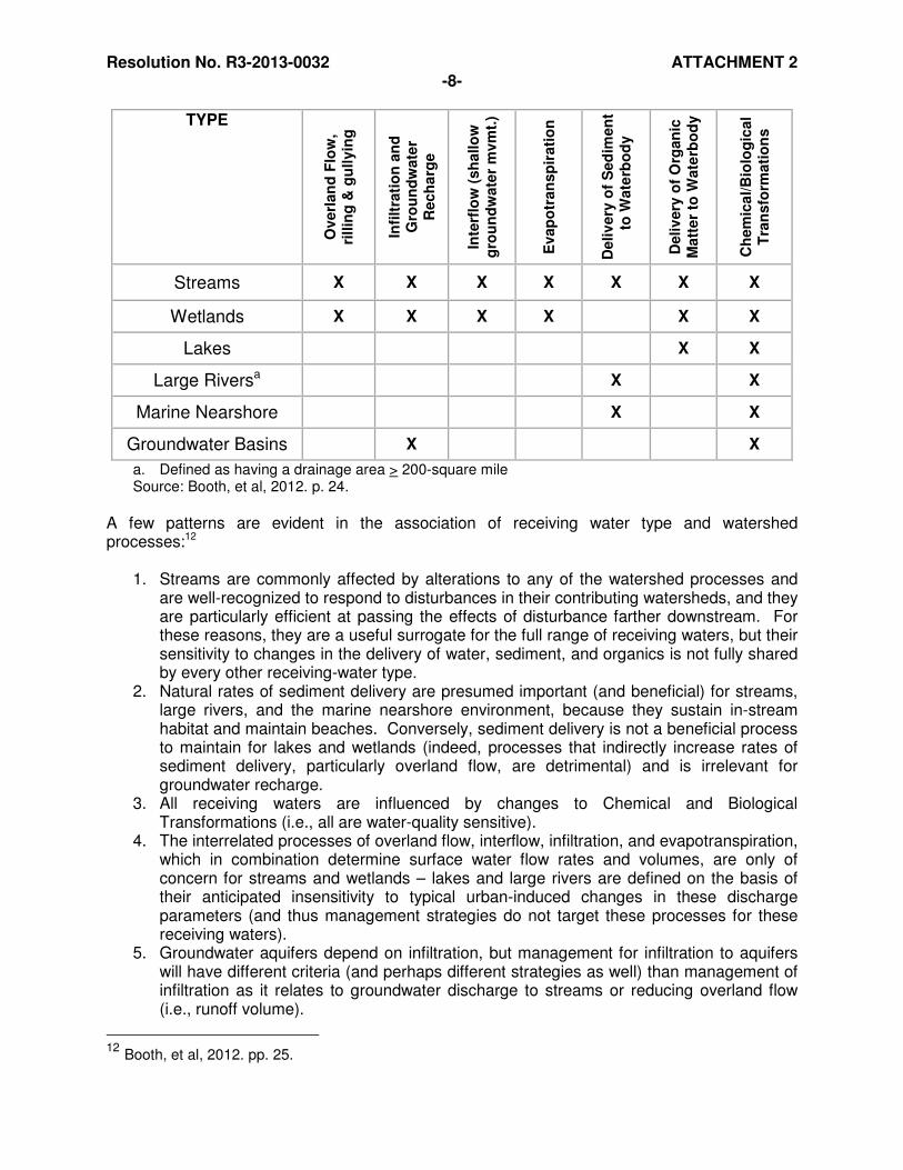
Receiving Waters Receiving waters of the Central Coast are diverse, comprising streams, rivers, lakes, wetlands, marine nearshore, and groundwater basins. The management of stormwater at particular locations on the landscape will depend not only on the key watershed processes associated with the Physical Landscape Zone but also on the nature of the receiving water. Not every watershed process is critical, or even necessarily relevant, to the long-term health of every type of receiving water. The associations shown in Table 2 are based on a general scientific understanding of the interaction of runoff and detrital material with receiving waters, and are recognized in the Joint Effort. Table 2. The association of watershed processes with receiving-water types. Cells with “X” indicate those watershed processes that may be affected by urban development, with potentially significant consequences for the indicated receiving water.
RECEIVING WATER Watershed Processes
Resolution No. R3-2013-0032 ATTACHMENT 2 -8-
TYPE
Overl
an
d F
low
,
rillin
g &
gu
llyin
g
Infi
ltra
tio
n a
nd
G
rou
nd
wate
r R
ech
arg
e
Inte
rflo
w (
sh
allo
w
gro
un
dw
ate
r m
vm
t.)
Evap
otr
an
sp
irati
on
Deliv
ery
of
Sed
imen
t to
Wate
rbo
dy
Deliv
ery
of
Org
an
ic
Matt
er
to W
ate
rbo
dy
Ch
em
ica
l/B
iolo
gic
al
Tra
nsfo
rmati
on
s
Streams X X X X X X X
Wetlands X X X X X X
Lakes X X
Large Riversa X X
Marine Nearshore X X
Groundwater Basins X X
a. Defined as having a drainage area > 200-square mile Source: Booth, et al, 2012. p. 24.
A few patterns are evident in the association of receiving water type and watershed processes:12
1. Streams are commonly affected by alterations to any of the watershed processes and are well-recognized to respond to disturbances in their contributing watersheds, and they are particularly efficient at passing the effects of disturbance farther downstream. For these reasons, they are a useful surrogate for the full range of receiving waters, but their sensitivity to changes in the delivery of water, sediment, and organics is not fully shared by every other receiving-water type.
2. Natural rates of sediment delivery are presumed important (and beneficial) for streams, large rivers, and the marine nearshore environment, because they sustain in-stream habitat and maintain beaches. Conversely, sediment delivery is not a beneficial process to maintain for lakes and wetlands (indeed, processes that indirectly increase rates of sediment delivery, particularly overland flow, are detrimental) and is irrelevant for groundwater recharge.
3. All receiving waters are influenced by changes to Chemical and Biological Transformations (i.e., all are water-quality sensitive).
4. The interrelated processes of overland flow, interflow, infiltration, and evapotranspiration, which in combination determine surface water flow rates and volumes, are only of concern for streams and wetlands – lakes and large rivers are defined on the basis of their anticipated insensitivity to typical urban-induced changes in these discharge parameters (and thus management strategies do not target these processes for these receiving waters).
5. Groundwater aquifers depend on infiltration, but management for infiltration to aquifers will have different criteria (and perhaps different strategies as well) than management of infiltration as it relates to groundwater discharge to streams or reducing overland flow (i.e., runoff volume).
12 Booth, et al, 2012. pp. 25.
Resolution No. R3-2013-0032 ATTACHMENT 2 -9-
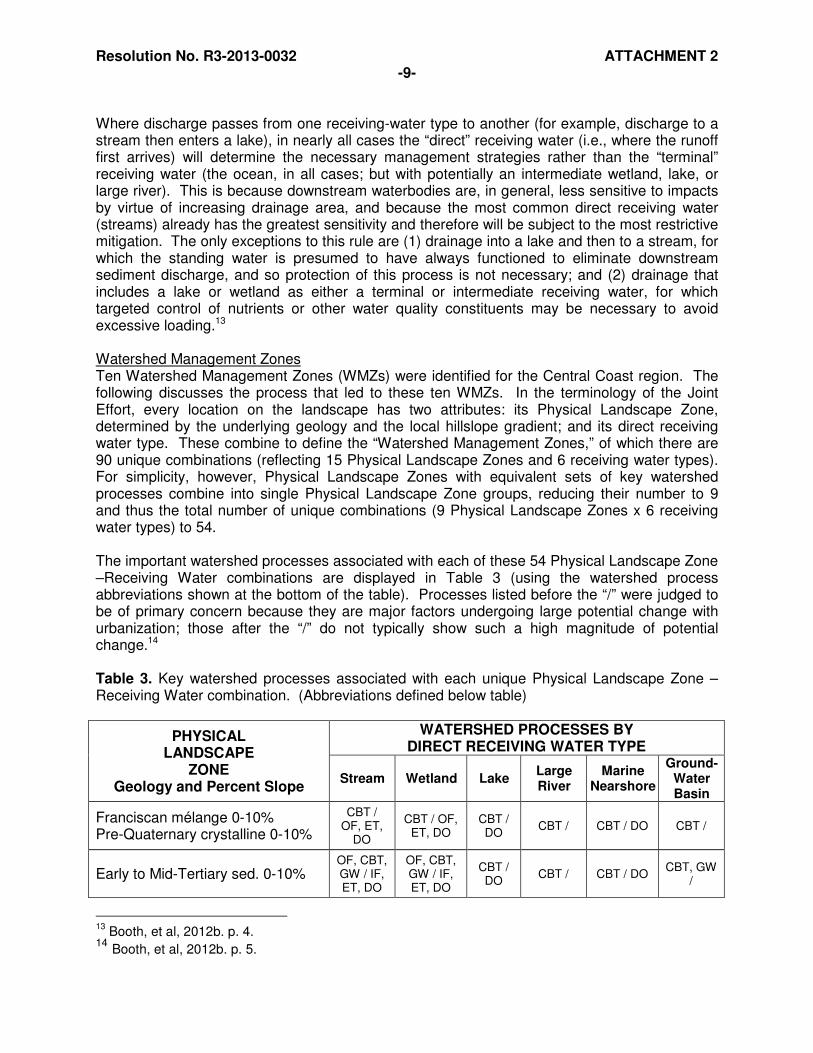
Where discharge passes from one receiving-water type to another (for example, discharge to a stream then enters a lake), in nearly all cases the “direct” receiving water (i.e., where the runoff first arrives) will determine the necessary management strategies rather than the “terminal” receiving water (the ocean, in all cases; but with potentially an intermediate wetland, lake, or large river). This is because downstream waterbodies are, in general, less sensitive to impacts by virtue of increasing drainage area, and because the most common direct receiving water (streams) already has the greatest sensitivity and therefore will be subject to the most restrictive mitigation. The only exceptions to this rule are (1) drainage into a lake and then to a stream, for which the standing water is presumed to have always functioned to eliminate downstream sediment discharge, and so protection of this process is not necessary; and (2) drainage that includes a lake or wetland as either a terminal or intermediate receiving water, for which targeted control of nutrients or other water quality constituents may be necessary to avoid excessive loading.13 Watershed Management Zones Ten Watershed Management Zones (WMZs) were identified for the Central Coast region. The following discusses the process that led to these ten WMZs. In the terminology of the Joint Effort, every location on the landscape has two attributes: its Physical Landscape Zone, determined by the underlying geology and the local hillslope gradient; and its direct receiving water type. These combine to define the “Watershed Management Zones,” of which there are 90 unique combinations (reflecting 15 Physical Landscape Zones and 6 receiving water types). For simplicity, however, Physical Landscape Zones with equivalent sets of key watershed processes combine into single Physical Landscape Zone groups, reducing their number to 9 and thus the total number of unique combinations (9 Physical Landscape Zones x 6 receiving water types) to 54. The important watershed processes associated with each of these 54 Physical Landscape Zone –Receiving Water combinations are displayed in Table 3 (using the watershed process abbreviations shown at the bottom of the table). Processes listed before the “/” were judged to be of primary concern because they are major factors undergoing large potential change with urbanization; those after the “/” do not typically show such a high magnitude of potential change.14 Table 3. Key watershed processes associated with each unique Physical Landscape Zone –Receiving Water combination. (Abbreviations defined below table)
PHYSICAL LANDSCAPE
ZONE Geology and Percent Slope
WATERSHED PROCESSES BY DIRECT RECEIVING WATER TYPE
Stream Wetland Lake Large River
Marine Nearshore
Ground-Water Basin
Franciscan mélange 0-10% Pre-Quaternary crystalline 0-10%
CBT / OF, ET,
DO
CBT / OF, ET, DO
CBT / DO
CBT / CBT / DO CBT /
Early to Mid-Tertiary sed. 0-10% OF, CBT, GW / IF, ET, DO
OF, CBT, GW / IF, ET, DO
CBT / DO
CBT / CBT / DO CBT, GW
/
13
Booth, et al, 2012b. p. 4. 14 Booth, et al, 2012b. p. 5.

Resolution No. R3-2013-0032 ATTACHMENT 2 -10-
Late Tertiary sediments 0-10% Quaternary deposits 0-10%
OF, CBT, GW / IF, ET, DO
OF, CBT, GW / IF, ET, DO
CBT / DO
CBT / CBT / DO CBT, GW
/
Franciscan mélange 10-40% Pre-Quaternary crystalline 10-40%
/ OF, ET, DO, CBT
/ OF, ET, DO, CBT
/ DO, CBT
/ CBT / DO, CBT / CBT
Early to Mid-Tertiary sed. 10-40%
OF / GW, IF, ET,
DS, DO, CBT
OF / GW, IF, ET,
DO, CBT
/ DO, CBT
/ DS, CBT
/ DS, DO, CBT
/ GW,CBT
Late Tertiary sediments 10-40% Quaternary deposits 10-40%
OF, GW / IF, ET,
DS, DO, CBT
OF, GW / IF, ET,
DO, CBT
/ DO, CBT
/ DS, CBT
/ DS, DO, CBT
GW / CBT
Franciscan mélange >40% Pre-Quaternary crystalline >40%
DS / OF, ET, DO
/ OF, ET, DO
/ DO DS / DS / DO /
Early to Mid-Tertiary sed. >40% DS / OF, GW, IF, ET, DO
/ OF, GW, IF, ET, DO
/ DO DS / DS / DO / GW
Late Tertiary sediments >40% Quaternary deposits >40%
DS / GW, IF, ET,
DO
/ GW, IF, ET, DO
/ DO DS / DS / DO / GW
Source: Booth, et al, 2012b. pp. 5, 6.
Watershed Process Abbreviations:
OF = OVERLAND FLOW GW = GROUNDWATER RECHARGE IF = INTERFLOW ET = EVAPOTRANSPIRATION CBT = CHEMICAL AND BIOLOGICAL TRANSFORMATIONS DS = DELIVERY OF SEDIMENT DO = DELIVERY OF ORGANICS
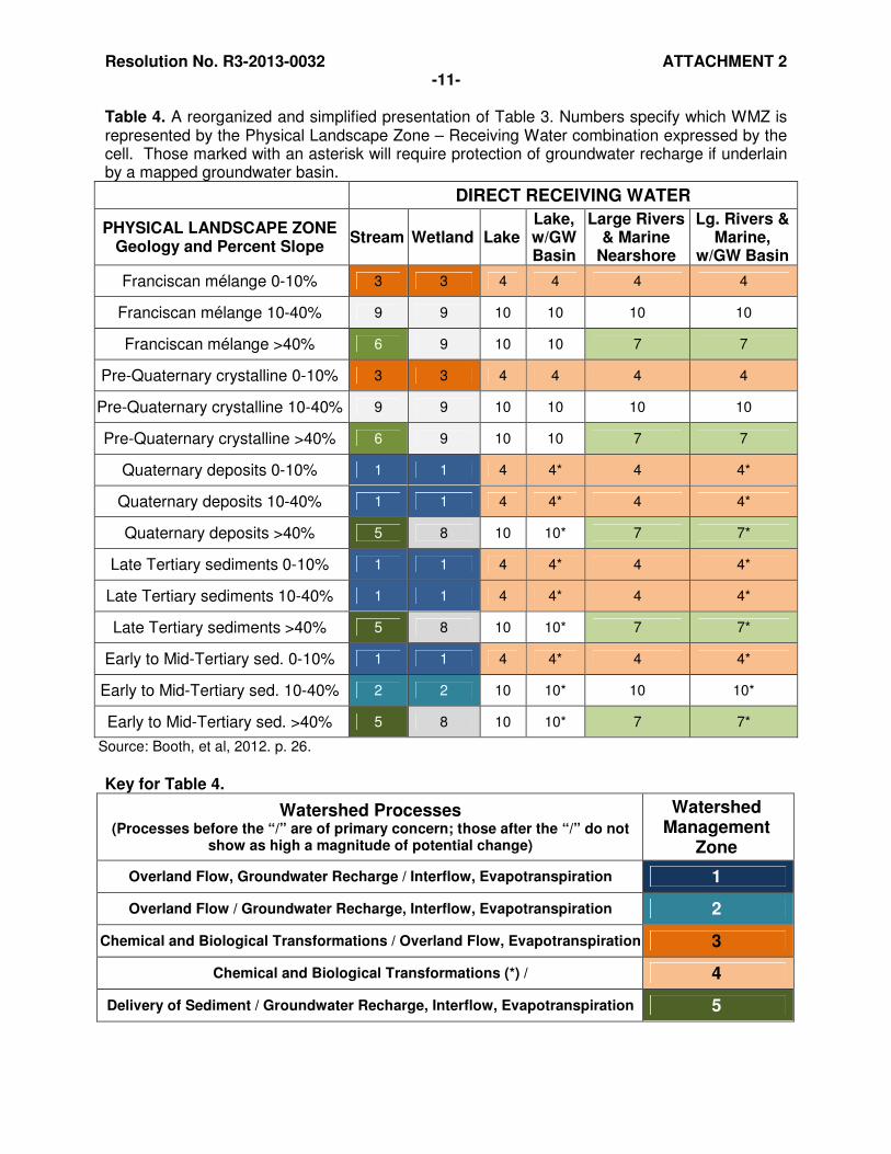
The watershed processes identified in each cell of Table 3 form the basis for determining the necessary elements of stormwater mitigation for each WMZ. Stormwater mitigation is presumed to always include the following additional treatments:
• All stormwater mitigation includes receiving water buffers or waterbody set-backs where applicable, resulting in mitigation of “DO” and “DS” at a low level of change (e.g., combinations “CBT/DO” and “CBT/DS” can be truncated to “CBT/”).
• All stormwater mitigation includes some basic level of water quality treatment, and thus “CBT” at a low level of change will always be mitigated (e.g., combinations “/DO, CBT” can be expressed simply as “/DO”).
• If a high level of GW change/concern is indicated, a high level of CBT mitigation will occur because of the infiltration required for recharge of groundwater aquifers (e.g., the combination “GW, CBT/” becomes “GW/”).
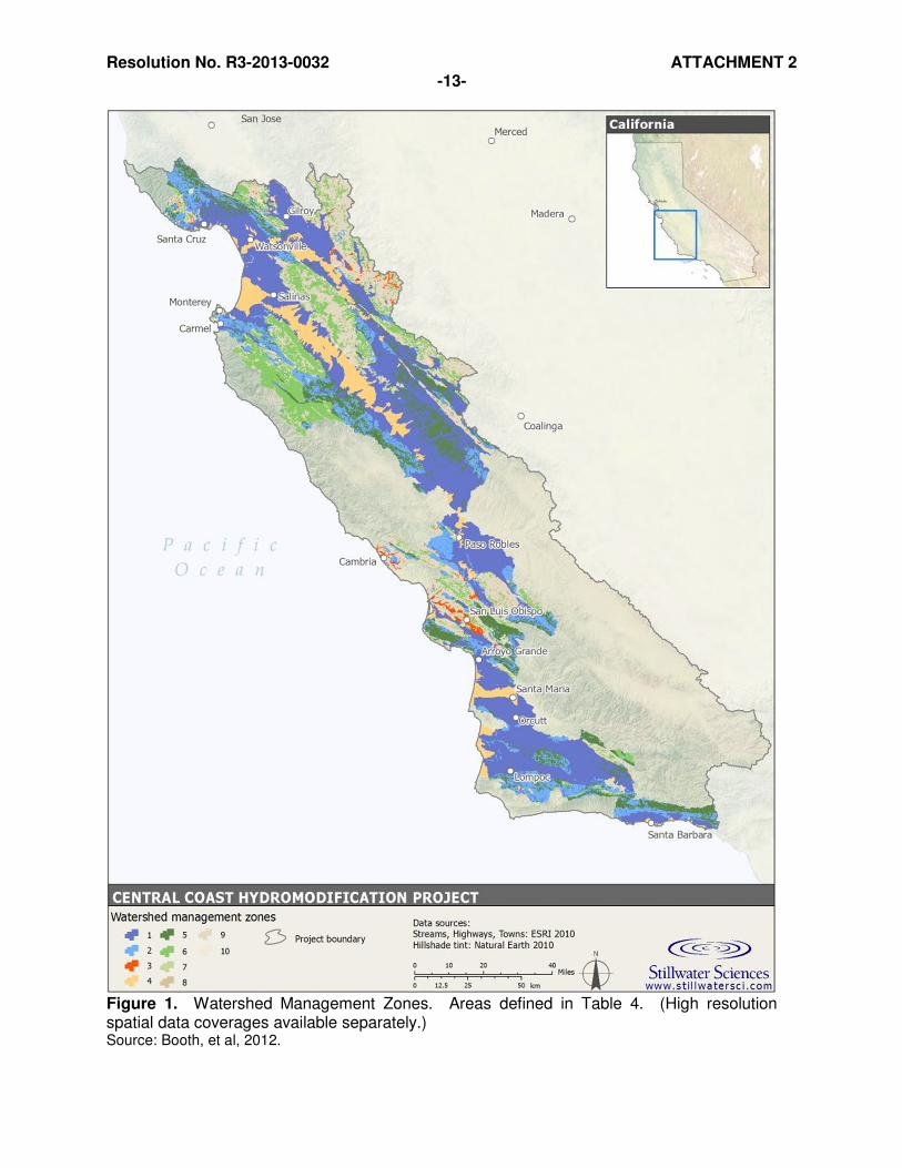
These conditions and principles result in a simplified presentation (Table 4), whose colors are keyed to geographic locations on the associated map of Watershed Management Zones (Figure 1). The presence or absence of an underlying groundwater basin is similarly determined from the mapping available to Permittees (see Section III).
Resolution No. R3-2013-0032 ATTACHMENT 2 -11-
Table 4. A reorganized and simplified presentation of Table 3. Numbers specify which WMZ is represented by the Physical Landscape Zone – Receiving Water combination expressed by the cell. Those marked with an asterisk will require protection of groundwater recharge if underlain by a mapped groundwater basin.
DIRECT RECEIVING WATER
PHYSICAL LANDSCAPE ZONE Geology and Percent Slope
Stream Wetland Lake Lake, w/GW Basin
Large Rivers & Marine
Nearshore
Lg. Rivers & Marine,
w/GW Basin
Franciscan mélange 0-10% 3 3 4 4 4 4
Franciscan mélange 10-40% 9 9 10 10 10 10
Franciscan mélange >40% 6 9 10 10 7 7
Pre-Quaternary crystalline 0-10% 3 3 4 4 4 4
Pre-Quaternary crystalline 10-40% 9 9 10 10 10 10
Pre-Quaternary crystalline >40% 6 9 10 10 7 7
Quaternary deposits 0-10% 1 1 4 4* 4 4*
Quaternary deposits 10-40% 1 1 4 4* 4 4*
Quaternary deposits >40% 5 8 10 10* 7 7*
Late Tertiary sediments 0-10% 1 1 4 4* 4 4*
Late Tertiary sediments 10-40% 1 1 4 4* 4 4*
Late Tertiary sediments >40% 5 8 10 10* 7 7*
Early to Mid-Tertiary sed. 0-10% 1 1 4 4* 4 4*
Early to Mid-Tertiary sed. 10-40% 2 2 10 10* 10 10*
Early to Mid-Tertiary sed. >40% 5 8 10 10* 7 7*
Source: Booth, et al, 2012. p. 26.
Key for Table 4.
Watershed Processes (Processes before the “/” are of primary concern; those after the “/” do not
show as high a magnitude of potential change)
Watershed Management
Zone
Overland Flow, Groundwater Recharge / Interflow, Evapotranspiration 1
Overland Flow / Groundwater Recharge, Interflow, Evapotranspiration 2
Chemical and Biological Transformations / Overland Flow, Evapotranspiration 3
Chemical and Biological Transformations (*) / 4
Delivery of Sediment / Groundwater Recharge, Interflow, Evapotranspiration 5
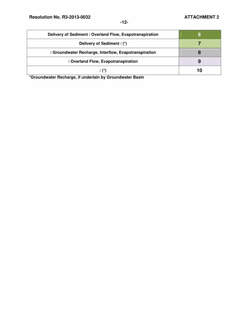
Resolution No. R3-2013-0032 ATTACHMENT 2 -12-
Delivery of Sediment / Overland Flow, Evapotranspiration 6
Delivery of Sediment / (*) 7
/ Groundwater Recharge, Interflow, Evapotranspiration 8
/ Overland Flow, Evapotranspiration 9
/ (*) 10
*Groundwater Recharge, if underlain by Groundwater Basin
Resolution No. R3-2013-0032 ATTACHMENT 2 -13-
Figure 1. Watershed Management Zones. Areas defined in Table 4. (High resolution spatial data coverages available separately.) Source: Booth, et al, 2012.
Resolution No. R3-2013-0032 ATTACHMENT 2 -14-
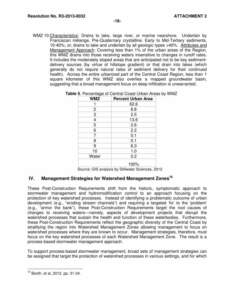
Summary Characteristics of the Watershed Management Zones15 The following summarizes each WMZ’s characteristics and the management approaches needed to protect the key watershed processes for that WMZ. Table 5 indicates the distribution of the WMZs within the Central Coast Region’s urban areas. Attachment A includes maps of the WMZs in the Central Coast Region’s urban areas. Spatial data files are available electronically (See Section III.).
WMZ 1: Characteristics: Drains to stream or to wetland. Underlain by: Quaternary and Late Tertiary deposits, 0-40%; Early to Mid-Tertiary sediments, 0-10%. Attributes and Management Approach: This single WMZ includes almost two-thirds of the urban area of the Central Coast Region (Table 5); it is defined by low-gradient deposits (Quaternary and Tertiary in age) together with the moderately sloped areas of these younger deposits that drain to a stream or wetland. The dominant watershed processes in this setting are infiltration into shallow and deeper soil layers; conversely, overland flow is localized and rare. Management strategies should minimize overland flow and promote infiltration, particularly into deeper aquifers if overlying a groundwater basin in its recharge area.
WMZ 2: Characteristics: Drains to stream or to wetland. Underlain by Early to Mid-Tertiary
sediments, 10-40%. Attributes and Management Approach: This WMZ is similar to WMZ 1 in both materials and watershed processes, but groundwater recharge is anticipated to be a less critical watershed process in most areas. While almost 9% of the urban areas of the Central Coast Region are in this WMZ (Table 5), only 1% overlies a groundwater basin; thus, whereas management strategies need to minimize overland flow as with WMZ 1, they need not emphasize groundwater recharge as the chosen approach to the same degree.
WMZ 3: Characteristics: Drains to stream or to wetland. Underlain by Franciscan mélange
and Pre-Quaternary crystalline, 0-10%. Attributes and Management Approach: This WMZ includes those few flat areas of the Central Coast Region underlain by old, generally impervious rocks with minimal deep infiltration (and intersecting with no mapped groundwater basins). Overland flow is still uncommon over the surface soil; and chemical and biological remediation of runoff, reflecting the slow movement of infiltrated water within the flat soil layer, are the dominant watershed processes. Management strategies should promote treatment of runoff through infiltration, filtration, and by minimizing overland flow.
WMZ 4: Characteristics: Drains to lake, large river, or marine nearshore. Underlain by all
geologic types, 0–10%, and Quaternary and Late Tertiary deposits, 10-40%. Attributes and Management Approach: This WMZ covers those areas geologically equivalent to WMZ’s 1 and 3, but draining to one of the receiving water types that are not sensitive to changes in flow rates. The dominant watershed processes in this low-gradient terrain are those providing chemical and biological remediation of runoff, but a specific focus on infiltration management strategies is only necessary for those parts of this WMZ that overlie a groundwater basin. This WMZ covers 13.6% of Central Coast Region’s urban areas (Table 5); almost 11% of the region’s urban areas are in this WMZ and overlie a groundwater basin.
15
Booth, et al, pp. 13, 14.
Resolution No. R3-2013-0032 ATTACHMENT 2 -15-
WMZ 5: Characteristics: Drains to stream. Underlain by Quaternary deposits, Late Tertiary
deposits, and Early to Mid-Tertiary sediments, >40%. Attributes and Management Approach: These steep, geologically young, and generally infiltrative deposits are critical to the natural delivery of sediment into the drainage system; management strategies should also maintain the relatively high degree of shallow (and locally deeper) infiltration that reflects the relatively permeable nature of these deposits. Because this WMZ only covers steeply sloping areas, however, it is relatively uncommon in urban areas (<3%).
WMZ 6: Characteristics: Drains to stream. Underlain by Franciscan mélange and Pre-
Quaternary crystalline, >40%. Attributes and Management Approach: The steeply sloping geologic deposits not in WMZ 5 are included here; they are similarly important to the natural delivery of sediment into the drainage system but have little opportunity for deep infiltration, owing to the physical properties of the underlying rock. Management strategies should maintain natural rates of sediment delivery into natural watercourses but avoid any increase in overland flow beyond natural rates, which are low where undisturbed even in this steep terrain.
WMZ 7: Characteristics: Drains to large river or marine nearshore. Underlain by all geologic
types, >40%. Attributes and Management Approach: This WMZ is very rare in the urban parts of the Central Coast Region (0.1% total) because such terrain provides little space or opportunity for urban development. The receiving waters that characterize this WMZ are insensitive to changes in runoff rates but still depend on natural sediment delivery processes for their continued health; thus, management strategies need to focus on maintaining the delivery of sediment in the few areas that the WMZ is found.
WMZ 8: Characteristics: Drains to wetland. Underlain by Quaternary deposits, Late Tertiary
deposits, and Early to Mid-Tertiary sediments >40%. Attributes and Management Approach: Equivalent to WMZ 5 but with a different receiving-water type, these steep and generally infiltrative deposits should be managed to maintain the relatively high degree of shallow (and locally deeper) infiltration that reflects the relatively permeable nature of these deposits. Delivery of sediment, however, is unlikely to be important to downstream receiving water (i.e., wetland) health. Even more so than with the other steep WMZs, this type is extremely uncommon in the Central Coast Region’s urban areas (0.1%).
WMZ 9: Characteristics: Drains to wetland. Underlain by Franciscan mélange and Pre-
Quaternary crystalline, >10%; or drains to stream or wetland, and underlain by Franciscan mélange and Pre-Quaternary crystalline, 10–40%. Attributes and Management Approach: These moderately sloping, older rocks that drain to either a stream or wetland are neither extremely sensitive to changes in infiltrative processes (because the underlying rock types are typically impervious), nor key sources of sediment delivery (because slopes are only moderate in gradient). Overland flow is still uncommon over the surface soil, and so management strategies should apply reasonable care to avoid gross changes in the distribution of runoff between surface and subsurface flow paths. About 6% of the urban parts of the Central Coast Region are found on this WMZ (Table 5); none include an underlying groundwater basin, emphasizing the relative unimportance of maintaining deep infiltration.
Resolution No. R3-2013-0032 ATTACHMENT 2 -16-
WMZ 10: Characteristics: Drains to lake, large river, or marine nearshore. Underlain by
Franciscan mélange, Pre-Quaternary crystalline, Early to Mid-Tertiary sediments, 10-40%; or, drains to lake and underlain by all geologic types >40%. Attributes and Management Approach: Covering less than 1% of the urban areas of the Region, this WMZ drains into those receiving waters insensitive to changes in runoff rates. It includes the moderately sloped areas that are anticipated not to be key sediment-delivery sources (by virtue of hillslope gradient) or that drain into lakes (which generally do not require natural rates of sediment delivery for their continued health). Across the entire urbanized part of the Central Coast Region, less than 1 square kilometer of this WMZ also overlies a mapped groundwater basin, suggesting that a broad management focus on deep infiltration is unwarranted.
Table 5. Percentage of Central Coast Urban Areas by WMZ
WMZ Percent Urban Area
1 62.6
2 8.8
3 2.5
4 13.6
5 2.6
6 2.2
7 0.1
8 0.1
9 6.3
10 1.0
Water 0.2
100%
Source: GIS analysis by Stillwater Sciences, 2012
IV. Management Strategies for Watershed Management Zones16 These Post-Construction Requirements shift from the historic, symptomatic approach to stormwater management and hydromodification control to an approach focusing on the protection of key watershed processes. Instead of identifying a problematic outcome of urban development (e.g., “eroding stream channels”) and requiring a targeted ‘fix’ to the ‘problem’ (e.g., “armor the bank”), these Post-Construction Requirements target the root causes of changes to receiving waters—namely, aspects of development projects that disrupt the watershed processes that sustain the health and function of these waterbodies. Furthermore, these Post-Construction Requirements reflect the geographic diversity of the Central Coast by stratifying the region into Watershed Management Zones allowing management to focus on watershed processes where they are known to occur. Management strategies, therefore, must focus on the key watershed processes of each Watershed Management Zone. The result is a process-based stormwater management approach. To support process-based stormwater management, broad sets of management strategies can be assigned that target the protection of watershed processes in various settings, and for which
16
Booth, et al, 2012. pp. 31-34.

Resolution No. R3-2013-0032 ATTACHMENT 2 -17-
numeric performance requirements are provided. Although there is no formally accepted “list” of such strategies, the following set offers a useful organizational framework: 1) Flow Control Flow Control encompasses a broad range of stormwater criteria for addressing hydraulic and hydrologic goals. This includes regulations that typically mandate that (1) post-development peak flows are less than or equal to pre-development peak flows for a series of intermediate and/or large design storm events (i.e., “storm event peak flow” control); (2) runoff from flows with the highest risk potential for channel erosion, and by extension damage to aquatic habitat, are not increased in duration (“flow-duration control”); and (3) runoff is infiltrated or retained onsite, without specific reference to the range of stream-channel flows that are affected, to maintain groundwater flow or reduce overall runoff volume (“retain volume”). 2) Water Quality Treatment Water Quality Treatment includes a suite of Stormwater Control Measures (SCMs) that address the major link between urbanization and water quality impairment, which is caused by the increased runoff from impervious surfaces and soil compaction of pervious areas, and the delivery of urban sources of pollutants such as nutrients from fertilizer, metals from brake pads, and sediment from exposed soil surfaces. 3) Preserve Delivery of Sediment and Organics Preserve Delivery of Sediment and Organics into the channel network is critical for the maintenance of various habitat features and aquatic ecosystems in the fluvial setting. While preservation of these functions is not a goal found in most stormwater regulations, it is often discussed qualitatively as a goal in establishing or justifying riparian buffer requirements. 4) Maintain Soil and Vegetation Regime Maintain Soil and Vegetation Regime is a valuable and highly effective alternative to water-quality treatment, because much impairment is due to the isolation of soil and vegetation from the path of urban stormwater runoff, which in turn eliminates the processes of filtration, adsorption, biological uptake, oxidation, and microbial breakdown (collectively termed the watershed process of “Chemical and Biological Transformations” by the Joint Effort). Note that this management strategy overlaps with several others: not only can it accomplish water-quality treatment, but also it can constitute stormwater volume-based flow control and preserve the delivery of sediment and organics to waterbodies if located adjacent to waterbodies. Moreover, it is a (typically intentional) byproduct of any application of land-preservation strategies as well. 5) Land Preservation Land Preservation includes open space requirements and minimization of effective impervious area. Both have the goal of avoiding or directing runoff from impervious surfaces to pervious areas, rather than routing it directly to the storm drainage system. Within each broad category of management strategies, multiple SCMs are available for direct application to meet performance criteria. Similarly, a single SCM may reflect multiple management strategies and address more than one watershed process, which provides the reminder that well-chosen SCMs can accomplish multiple objectives within a relatively simple mitigation approach. In addition, some SCMs are traditional facilities (‘structural’ SCMs), whereas others may affect overall site design, choice of construction materials and approaches, or may invoke programmatic strategies administered over a larger area (e.g., rain barrel incentive program). This great variety of available measures means the designer will likely need to make use of a suite of SCMs that, in combination, can meet the performance requirements

Resolution No. R3-2013-0032 ATTACHMENT 2 -18-
required for the protection of watershed processes at the site. The designer’s task is to optimize the choice of SCMs to achieve the desired net benefits with a desired level of simplicity and necessary degree of reliability.
V. Post-Construction Performance Requirements The core of these Post-Construction Requirements is a group of Performance Requirements for new and redevelopment projects that invoke the management strategies discussed above. The following discusses each Performance Requirement and related implementation requirements, including the types of projects subject to the Performance Requirements and the necessary analytical methods required to meet compliance. Flow charts to assist in determining which Performance Requirements apply are provided in Attachment C. The Performance Requirements rely on four important strategies that are critical to recognize for a full understanding of how the requirements, taken together, will result in protection of watershed processes and the beneficial uses they support: 1) a reliance on LID to the extent feasible to achieve protection of the broadest suite of watershed processes not effectively targeted by structural controls; 2) the use of Stormwater Control Plans to ensure project applicants have followed due diligence in selecting SCMs and have optimized LID; 3) the combination of retention and peak management requirements on larger sites to achieve a broad spectrum of watershed process protection while also protecting stream channels from hydromodification impacts; and 4) the additive application of Performance Requirements as projects trigger each size threshold (e.g., the largest sites must meet Performance Requirements applying to smaller sites). Elements of these strategies are integrated into the Performance Requirements to support successful implementation. 1) Regulated Projects Development projects subject to these requirements are a subset of the diverse spectrum of development projects Permittees approve. The Post-Construction Requirements specify several exemptions, including, for example, road maintenance projects and trail projects that direct runoff to adjacent vegetated areas. Following a convention used throughout the United States, these Post-Construction Requirements use the amount of impervious surface as the parameter of interest in determining applicability. Thus, only projects that create and/or replace impervious surface are potentially subject to regulation of post-construction requirements. Central Coast Water Board staff recognizes that a development project’s impervious surface is an imperfect proxy for all potential post-construction impacts of the project. For example, land disturbance that does not lead to the placement of impervious surfaces (e.g., construction of a gravel road) may still result in impacts to watershed processes by potentially compacting infiltrative soils, removing vegetation, or permanently altering drainage patterns. These Post-Construction Requirements compensate for this imperfection by applying Performance Requirements, in some cases, to the entire site area, not just the impervious surface area. For example, Performance Requirement No. 1 applies to the entire site area, while Performance Requirement No.s 2-4 apply only to the site’s Equivalent Impervious Surface Area (see Post-Construction Requirements Attachment E).
Resolution No. R3-2013-0032 ATTACHMENT 2 -19-
2) Performance Requirement No. 1: Site Design and Runoff Reduction This requirement applies to projects that create and/or replace > 2,500 square feet of impervious surface and requires projects to utilize site design and runoff reduction measures, where feasible. The site design measures are the first and best opportunity to invoke management strategies for land preservation, and maintenance of soil and vegetation regime, which in turn support other strategies for flow control, water quality treatment, and preserving delivery sediment and organic matter to receiving waters. For example, minimizing impervious surfaces and minimizing compaction of native soils in site design preserves land area available to support these watershed processes, and retains the soils’ capacity to infiltrate water, reducing runoff that requires treatment and flow controls. Performance Requirement No.1 invokes the LID design concept of mimicking predevelopment hydrology to the extent feasible. Projects creating and/or replacing 2,500 square feet of impervious surface are too small to justify numeric requirements that would require hydrologic or engineering analysis. However, they are large enough to generate impacts to watershed processes, both individually and cumulatively, over time in a watershed. Permittees must apply this requirement by informing project applicants that the specific measures must be pursued on the project site where feasible, and requiring the applicant, through application/approval documents, to indicate which measures are being implemented on their project. Performance Requirement No.1 is required on all Regulated Projects in all WMZs. 3) Performance Requirement No. 2: Water Quality Treatment The Water Quality Treatment Performance Requirement in these Post-Construction Requirements applies to Regulated Projects that create and/or replace > 5,000 square feet of Net Impervious Area, and to detached single-family residences that create and/or replace > 15,000 square feet of Net Impervious Area. Net Impervious Area, or, the sum of new and reconstructed impervious areas, minus any reduction in total site imperviousness, between pre- and post-project conditions, is used to determine applicability of the Water Quality Treatment Performance Requirement. The Net calculation is intended to provide a possible exemption for projects that would be subject to Water Quality Treatment Performance Requirements when their new and replaced impervious surfaces exceed 5,000 square feet, even when the project results in lower total imperviousness. While expected to occur in a limited number of cases, the Net calculation may provide applicants an incentive to reduce the total amount of imperviousness in some smaller Regulated Projects. Performance Requirement No. 2 applies to all projects in all Watershed Management Zones and is applied ‘cumulatively’ (i.e., it applies to all projects larger than 15,000 square feet). A National Urban Runoff Program (NURP) study showed that heavy metals, organics, coliform bacteria, nutrients, oxygen demanding substances (e.g., decaying vegetation), and total suspended solids are found at relatively high levels in stormwater and non-stormwater discharges.17 It also found that MS4 discharges draining residential, commercial, and light industrial areas contain significant loadings of total suspended solids and other pollutants. In addition, the State Water Board Urban Runoff Technical Advisory Committee (TAC) finds that urban runoff pollutants include sediments, nutrients, oxygen-demanding substances, heavy metals, petroleum hydrocarbons, pathogenic bacteria, viruses, and pesticides.18 Runoff that
17
State Water Resources Control Board. Order WQ 2001-15, In the Matter of Petitions of Building
Industry Association of San Diego County and Western States Petroleum Association, 15 November
2001. Web. 11 August 2011. 18
State Water Resources Control Board. Nonpoint Source Pollution Control Program. Urban Runoff Technical Advisory Committee Report, November 1994. Web. 11 August 2011.
Resolution No. R3-2013-0032 ATTACHMENT 2 -20-
flows over streets, parking lots, construction sites, and industrial, commercial, residential, and municipal areas carries these untreated pollutants through MS4s directly to receiving waters. The Natural Resources Defense Council (NRDC) 1999 Report, “Stormwater Strategies, Community Responses to Runoff Pollution” identifies concentration of pollutants in runoff to be one of the main causes of the stormwater pollution problem in developed areas. The report states that certain industrial, commercial, residential and construction activities are large contributors of pollutant concentrations in stormwater runoff. As human population density increases, it brings with it proportionately higher levels of car emissions, car maintenance wastes, municipal sewage, pesticides, household hazardous wastes, pet wastes, and trash. Studies show that the level of imperviousness in an area strongly correlates with the quality of nearby receiving waters.19 One comprehensive study, which looked at numerous areas, variables, and methods, revealed that stream degradation occurs at levels of imperviousness as low as 10 – 20 percent.20 Stream degradation is a decline in the biological integrity and physical habitat conditions that are necessary to support natural biological diversity. For instance, few urban streams can support diverse benthic communities with imperviousness greater than or equal to 25 percent.21 To provide some perspective, a medium density, single-family residential area can be from 25 percent to 60 percent impervious (variation due to street and parking design).22 More recently, a report on the effects of imperviousness in southern California streams found that local ephemeral and intermittent streams are more sensitive to such effects than streams in other parts of the country. This study, by the Southern California Coastal Water Research Program, estimated a threshold of response at a two to three percent change in percent of impervious cover in a watershed. 23, 24 According to the Center for Watershed Protection, urbanization strongly shapes the quality of both surface and groundwater in arid and semi-arid regions of the southwest. Since rain events are so rare, pollutants have more time to build up on impervious surfaces compared to humid regions. Therefore, pollutant concentrations in stormwater runoff from arid watersheds tend to be higher than that of humid watersheds.25 The effect of antecedent rainfall events is demonstrated in a recent report from the California Department of Transportation (Caltrans) that found the concept of a seasonal first flush is applicable to the southern California climate.26 The Water Quality Treatment Performance Requirement addresses post-construction pollutant loading through treatment measures that emphasize LID (harvesting and re-use, infiltration, and evapotranspiration) and biofiltration over conventional non-retention based or flow-based treatment approaches. All SCMs are to be designed for 85th percentile rainfall events as specified. Flow-through treatment methods are generally recognized as achieving less than 100 percent pollutant removal from runoff leaving the site. By comparison, retention would result in 100 percent removal by virtue of preventing the discharge of runoff from the specified design storm.
19
Federal Register, 1999. 20
Ibid. 21
Ibid. 22
Schueler, et al, 2000a. 23
Coleman, et al, 2011. p. iv. 24
Helmle and Booth, 2011a, p. 10. 25
Schueler, et al, 2000b. 26
Stenstrom, et al, 2011.
Resolution No. R3-2013-0032 ATTACHMENT 2 -21-
However, in these Post-Construction Requirements the allowance of flow-based treatment for projects up to 15,000 square feet is provided in recognition of several factors: 1) total pollutant generation and associated water quality impacts from smaller projects are anticipated to be less than those of larger (>15,000 square feet) projects; 2) greater technical challenges due to space constraints of achieving retention on smaller sites relative to larger sites; and 3) higher costs, relative to total project value, for smaller projects to achieve retention. Furthermore, the retention requirement imposed for projects larger than 15,000 square feet requires that the project applicant demonstrate technical infeasibility before rejecting retention-based SCMs and selecting flow-through measures (unless the project is in an Urban Sustainability Area, wherein the requirement to demonstrate technical infeasibility is waived). While the option of flow-through treatment is available for projects <15,000, the project applicant must submit a Stormwater Control Plan demonstrating why LID and biofiltration treatment systems could not be implemented. Permittees are required to review the Stormwater Control Plan and confirm that the feasibility of LID and biofiltration treatment system implementation has been considered before approving non-retention based treatment systems. Central Coast Water Board staff places biofiltration treatment before non-retention based treatment systems in the order of preference because of the potential for the biofiltration system to achieve infiltration/retention and to replicate watershed processes (evapotranspiration, chemical and biological transformations) to a greater degree than other flow-through (non-retention) measures. The biofiltration treatment system can provide infiltration to the extent site soils allow it (e.g., in sites with highly infiltrative soils, the system would be expected to infiltrate, thus, retain a greater proportion of runoff directed to it, whereas a site with lower permeable soils would release more treated runoff to the storm drain system or receiving water.) While additional information is needed to ascertain more precise understanding of the pollutant removal efficiency of these systems, Central Coast Water Board staff supports their use because of the multiple benefits they offer over non-retention based treatment systems. The option of providing treatment with biofiltration treatment systems is stipulated by the requirement that the system used be as effective as a biofiltration treatment system with the design parameters specified in the Post-Construction Requirements. Central Coast Water Board staff recommends that the minimum specifications for biofiltration systems in the Post-Construction Requirements be used in conjunction with additional guidance and specifications to ensure proper functioning of biofiltration systems. Central Coast Water Board staff modified the specification of minimum planting depth in biofiltration systems from that specified in designs used commonly in parts of the San Francisco Bay Area. A 24-inch minimum planting medium depth, as opposed to the 18-inch minimum depth indicated in the Bay Area specifications, is required because of current uncertainty of performance for bioretention systems with under-drains.27 Questions remain about the functional roles of plants and specified soils mixes in California's arid climate, and providing greater soil media depth can provide improved performance in the interim period, as California research is carried out and regional guidelines are developed. Technical guidance for designing bioretention facilities is available from the Central Coast LID Initiative. The guidance includes specification and plant lists selected for the Central Coast climate. (http://www.centralcoastlidi.org/Central_Coast_LIDI/LID_Structural_BMPs.html)
27
Hunt, et al, 2012. pp. 6, 8, 10.
Resolution No. R3-2013-0032 ATTACHMENT 2 -22-
4) Performance Requirement No. 3: Runoff Retention All Regulated Projects that create and/or replace ≥15,000 square feet of impervious surface in all WMZs except WMZ 3, which is underlain by generally impervious rocks, and WMZs 4, 7, and 10 where not underlain by groundwater basins, must retain stormwater runoff to protect watershed processes so that beneficial uses of receiving waters are maintained and, where applicable, restored. Where technically feasible, the goal of the retention requirement is that 100 percent of the volume of water from storms less than or equal to the indicated percentile event (85th or 95th), over the footprint of the project, will not discharge to surface waters. This Performance Requirement indicates compliance can be achieved through infiltration in some WMZs, and through non-infiltrative (storage, use, etc.) methods in others. The Post-Construction Requirements include hydrologic analysis and sizing methods to calculate runoff volumes and size SCMs. These methods provide an event-based hydrologic analysis approach (see Post-Construction Requirements Attachment D). Calculations are conservative to acknowledge the limitations of event-based approaches while avoiding the necessity of calibrated, continuous simulation modeling. The sizing approach outlined in Attachment D of the Post-Construction Requirements was developed by a team of stakeholders including municipal stormwater agency representatives, practicing professional engineers, and Central Coast Water Board staff. Attachment G of this Technical Support Document describes the analysis conducted to arrive at the sizing approach. Attachment D describes facility sizing by one of two methods: Simple Method, and Routing Method. The Simple Method is a direct calculation of facility size based on the runoff volume generated by a single 85th or 95th percentile 24-hr rainfall event, whichever applies. The calculated runoff volume is the resulting facility design volume, or, Stormwater Control Measure Capture Volume of the facility. The Routing Method uses hydrograph analysis to determine the Stormwater Control Measure Capture Volume needed to retain the runoff generated by the 85th or 95th percentile 24-hr rainfall event, whichever applies. In this method, the Stormwater Control Measure Capture Volume is based on both the rate of flow from tributary areas into the Stormwater Control Measure, and the rate of flow out of the Stormwater Control Measure through infiltration into soils during the rainfall event. The Stormwater Control Measure must be designed such that a single 95th or 85th percentile 24-hr rainfall event will not overflow the Stormwater Control Measure. Application of the Routing Method results in stormwater retention facilities that are smaller than those sized using the Simple Method. As an alternative to the sizing method provided in Attachment D, the Permittee can allow project applicants to use a locally/regionally calibrated continuous simulation-based model to improve hydrologic analysis and SCM sizing, or Central Coast Water Board Executive Officer approved hydrologic analysis and sizing methods as effective in optimizing on-site retention as the sizing methods outlined in Attachment D. Where technical infeasibility limits on-site compliance, the Post-Construction Requirements specify a 10 percent limit on what portion of a site’s Equivalent Impervious Surface Area must be dedicated to retention-based structural Stormwater Control Measures (see Post-Construction Requirements Section B.4.e.). If technical infeasibility can be demonstrated, and a project meets the 10 percent limit, no off-site mitigation is required for any remaining volume per the Runoff Retention Performance Requirement. By establishing an upper boundary on site area dedicated to stormwater controls, this adjustment provides a clear point of compliance that corresponds well with landscape dedications already required by many municipalities. The
Resolution No. R3-2013-0032 ATTACHMENT 2 -23-
upper limit is particularly important for projects in areas of high rainfall depths and tight, clayey soils, though this combination of conditions affect only a fraction of all urbanized portions of the Central Coast Region. Sites with these conditions will be held to the runoff retention that is possible within the 10 percent area and no more. Where off-site mitigation is required (e.g., where less than 10 percent of the Equivalent Impervious Surface Area is allocated to retention-based SCMs and there is remaining runoff volume), the volume to be mitigated is determined by the project site’s characteristics, not the off-site project site’s characteristics. The calculation of the volume to be mitigated is thus equivalent to the amount of retention that would have occurred on the project site, had the full 10 percent of Equivalent Impervious Surface Area been allocated. Attachment F provides examples for Calculating Off-Site Retention Requirements.
The Basis for Requiring Runoff Retention For the purposes of these Post-Construction Requirements, retaining runoff from all rain storms up to and including the 85th or 95th percentile storm is analogous to maintaining or restoring the pre-development hydrology with respect to the volume, flow rate, duration and temperature of the runoff for most sites. Retention of runoff up to these percentile storms is indicated because this storm size represents the volume that appears to best represent the volume that is fully infiltrated in a natural condition and thus should be managed onsite to maintain this pre-development hydrology for duration, rate and volume of stormwater flows. Maintaining pre-development runoff duration, rate, and volume provides broad support to watershed processes, including, reduced overland flow, infiltration, interflow, and groundwater recharge, and achieves reductions in urban pollutant loading of receiving waters that are non-existent under natural conditions. In general, only large storms generate significant runoff under pre-development conditions. The Joint Effort landscape analysis confirmed that this holds true for most of the Central Coast Region and the designated WMZs reflect this.28 The relative rarity of overland flow in undisturbed conditions is not unique to the Central Coast however. It is in fact the basis for federal stormwater control standards promulgated by the Energy Independence and Security Act of 200729 (EISA) and applied throughout the United States. The EISA standard includes a 95th percentile retention requirement for federal facilities creating or replacing > 5,000 square feet. Rain storms smaller than the 95th percentile storm are considered small storms. The EISA Technical Guidance states:
“The runoff produced by these small storms and the initial portion of larger storms has a strong negative cumulative impact on receiving water hydrology and water quality. In areas that have been developed, runoff is generated from almost all storms, both small and large, due to the impervious surfaces associated with development and the loss of soils and vegetation. In contrast, natural or undeveloped areas discharge little or no runoff from small storms because the rain is absorbed by the landscape and vegetation. Studies have shown that increases in runoff event frequency, volume and rate can be diminished or eliminated through the use of Green Infrastructure/LID designs and practices, which infiltrate, evapotranspire, and capture and use stormwater.”30
28
Booth, et al, 2011b. p. vi. 29
USEPA, 2009. http://www.epa.gov/owow/NPS/lid/section438/pdf/final_sec438_eisa.pdf 30
Ibid. p. 13.
Resolution No. R3-2013-0032 ATTACHMENT 2 -24-
Retaining 100 percent of all rainfall events equal to or less than the 95th percentile rainfall event approach was selected because “it employs natural treatment and flow attenuation methods that are presumed to have existed on the site before construction of infrastructure (e.g., building, roads, parking lots, driveways) and is intended to infiltrate or evapotranspirate the full volume of the 95th percentile storm.”31 The United States Environmental Protection Agency’s 2010 MS4 Permit Improvement Guide provides the 95th percentile criterion as an example for communities to adopt. In that guidance document, one of the examples of site performance standards states, “Design, construct, and maintain stormwater management practices that manage rainfall onsite, and prevent the offsite discharge of the precipitation from all rainfall events less than or equal to [insert standards, such as ‘the 95th percentile rainfall event’].” 32 Runoff retention requirements achieve water quality treatment objectives as well. For the purposes of these Post-Construction Requirements, achieving compliance with Performance Requirement No. 3 equates with compliance with Performance Requirement No. 2, Water Quality Treatment, since runoff retention effectively eliminates pollutant loading of receiving waters from rain events up to the 85th or 95th Percentile event. Retention Requirements Keyed to WMZs In WMZ 1 and, where overlying Groundwater Basins, in WMZs 4, 7 and 10, Performance Requirement No. 3 is to retain the 95th Percentile via infiltration. The conclusion of the Joint Effort landscape analysis33 is that the dominant watershed process throughout these WMZs is infiltration into shallow and deeper soil layers and that overland flow is localized and rare (see Table 4 Key). The imperative for infiltration to support recharge of known groundwater basins is self-evident in a region as heavily reliant on groundwater as the Central Coast. In WMZ 2 Performance Requirement No. 3 is to retain the 95th Percentile event via storage, rainwater harvesting, infiltration, and/or evapotranspiration. Infiltration is not essential in this WMZ (only 1% of the Central Coast Region’s urban area in this WMZ overlies a groundwater basin). Nevertheless, overland flow is still rare due to subsurface flow, so the retention requirement prevents discharges below a threshold presumed to replicate pre-development hydrology. Where non-infiltrative methods are allowed, runoff can be harvested and used and ultimately may be discharged via a sanitary treatment system. For example, if runoff is captured for non-potable uses such as toilet flushing or other uses that are not irrigation related, these waters potentially could be discharged into the sanitary sewer system. Performance Requirement No.3 for WMZs 5, 6, 8, and 9 is to retain the 85th Percentile Rainfall Event. The dominant watershed processes in these WMZs, as determined by receiving water type, geologic material and slope, indicate a threshold for retention lower than the 95th percentile required for WMZs 1 and 2, and WMZs 4, 7, and 10 where they overly groundwater basins. Watershed processes in WMZs 5, 6, 8, and 9 also include groundwater recharge, interflow, and overland flow (see Table 4 Key), and these processes are effectively managed by retention of small storms on site. However, the processes are less critical or less responsive to disturbance than in the WMZs where 95th percentile retention is required.
31
Ibid, pp. 12, 13. 32
Ibid, p. 52. 33
Booth, et al, 2011b. p. vi.
Resolution No. R3-2013-0032 ATTACHMENT 2 -25-
In WMZs 5 and 8, compliance must be achieved via infiltration. These steep, geologically young, and generally infiltrative deposits require management strategies to maintain the relatively high degree of shallow (and locally deeper) infiltration that reflects the relatively permeable nature of these deposits. However slopes greater than 40% indicate a low potential for overland flow under undisturbed conditions. WMZs 6 and 9 allow retention of the 85th Percentile Rainfall event through storage, rainwater harvesting, infiltration, and/or evapotranspiration, where feasible. WMZ 6 includes steeply sloping areas that provide little opportunity for deep infiltration, owing to the physical properties of the underlying rock. Management strategies should avoid any increase in overland flow beyond natural rates, which are low where undisturbed even in this steep terrain. WMZ 9 includes moderately sloped, older rocks that drain to either a stream or wetland that are not extremely sensitive to changes in infiltrative processes (because the underlying rock types are typically impervious). Overland flow is still uncommon over the surface soil, however retention is required to avoid gross changes in the distribution of runoff between surface and subsurface flow paths. Deep infiltration is unnecessary in the absence of an underlying groundwater basin. Feasibility of Achieving Retention
These Post-Construction Requirements require all applicable Regulated Projects to meet the Runoff Retention Performance Requirements using LID Development Standards, which include: site assessment measures; site design measures; site runoff reduction measures; and structural SCMs that optimize protection and restoration of watershed processes, such as bioretention and other small-scale, decentralized, LID measures. The applicant must demonstrate through submittal of the Stormwater Control Plan that each of these elements has been achieved to the extent feasible before selecting more conventional structural SCMs. Where LID SCMs and/or BMPs are not feasible, the Permittee may allow Regulated Projects to use conventional designs (wet ponds, dry wells, infiltration basins) to meet the Runoff Retention Performance Requirement. The site assessment and site design measures are the first and best opportunity to invoke the entire suite of management strategies that protect watershed processes, including: land preservation, maintenance of soil and vegetation regime, flow control, water quality, and the delivery sediment and organic matter to receiving waters. The runoff reduction measures are intended to further reduce the total volumes of runoff that must be retained through structural measures by directing runoff to undisturbed or natural landscaped areas that the applicant can demonstrate infiltrate runoff. The applicant should quantify the portion of the total Performance Requirement retention volume addressed through these measures and then address any remaining volume using structural SCMs. Structural SCMs consistent with LID principles of retention and/or treatment via infiltration, evapotranspiration, filtration, or capture and reuse are to be prioritized in addressing the remaining volume. The LID Development Standard ensures that the project applicants avail themselves of the great variety of available measures that, in combination, can meet the performance requirements required for the protection of watershed processes at the site. The applicant’s task is to optimize the choice of SCMs to achieve the desired net benefits with a desired level of simplicity and necessary degree of reliability. LID Stormwater Control Measure/Best Management Practice selection and design guidance is available from the following resources: 1) Southern California LID BMP Manual,34 2) Contra Costa C.3 Manual,35 and 3) City of Santa
34
LID Manual for Southern California: Technical Guidance and Site Planning Strategies. (http://www.casqa.org/LID/tabid/240/Default.aspx)
Resolution No. R3-2013-0032 ATTACHMENT 2 -26-
Barbara LID BMP Manual.36 Guidance specific to LID structural BMPs is also available through the Central Coast LID Initiative.37 Studies Evaluating Feasibility of Retaining the 95th Percentile Rain Event While there is substantial information available offering broad justification for retention requirements, there is an increasing number of studies evaluating the feasibility of actually achieving retention requirements in development projects. Two studies are discussed here: Horner and Gretz, 2011: This study investigated the degree to which low-impact development methods or green infrastructure, can meet retention standards.38 The study assessed five urban land use scenarios (three residential, one retail commercial, and one infill redevelopment); each placed in four climate regions in the continental United States on regionally common soil types (Hydrologic Soil Group (HSG) B, C, D). For the 95th percentile retention standard, the investigators found that infiltration/bioretention methods could retain all post-development runoff and pre-existing groundwater recharge, as well as attenuate all pollutant transport, in three residential land use development types on HSG B soils, in all cases, in all regions, taking a fraction of the available pervious area to do so. For the more highly impervious commercial retail and redevelopment cases, bioretention would retain about 45 percent of the runoff and pollutants generated and save about 40 percent of the pre-development recharge. Applying roof runoff management measures in these cases approximately doubled retention and pollutant reduction for the retail commercial land use and raised it to 100 percent for the redevelopment scenario. These measures include harvesting, temporarily storing, and applying roof runoff to use in the building or, efficiently directing roof runoff into the soil through downspout dispersion systems. Results were generally similar with HSG C soils, although more of the pervious portion of sites was required to equal the retention seen on B soils. For development on the D soils in all climate regions, use of roof runoff management techniques was estimated to increase runoff retention and pollutant reduction from zero to approximately one-third to two-thirds of the post-development runoff generated, depending on the land use case.39. Using the LID methods considered, projects on HSG B and C soils were projected to meet the 95th percentile retention standard in all but 12 of 125 evaluations. On HSG D soils, all hypothetical projects were able to retain greater than 50 percent of the runoff volume associated with the 85th percentile, 24-hour precipitation event and the authors noted that opportunities to use practices or site design principles not modeled in their analysis could potentially further increase the runoff retention volume.40 The distribution of soil types within the urban areas of the Central Coast indicate that approximately half of the region has high to moderately infiltrative soils, A and B, and half has slow to very slow infiltrative soils, C and D (Table 6). The soil groups, based on estimates of
35
Contra Costa Glean Water Program, C.3 Guidebook (http://www.cccleanwater.org/c3-guidebook.html) 36
City of Santa Barbara Storm Water Best Management Practices (BMP) Guidance Manual (http://www.santabarbaraca.gov/Resident/Community/Creeks/Storm_Water_Management_Program.htm)
37 LIDI Structural BMPs. http://www.centralcoastlidi.org/Central_Coast_LIDI/LID_Structural_BMPs.html
38 Horner and Gretz, 2011.
39 Ibid, p. i.
40 Ibid, p. 42.
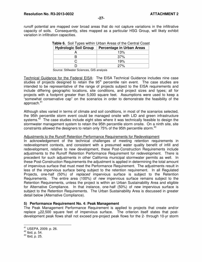
Resolution No. R3-2013-0032 ATTACHMENT 2 -27-
runoff potential are mapped over broad areas that do not capture variations in the infiltrative capacity of soils. Consequently, sites mapped as a particular HSG Group, will likely exhibit variation in infiltration capacities.
Table 6. Soil Types within Urban Areas of the Central Coast
Hydrologic Soil Group Percentage in Urban Areas
A 13%
B 37%
C 19%
D 27% Source: Stillwater Sciences, GIS analysis
Technical Guidance for the Federal EISA: The EISA Technical Guidance includes nine case studies of projects designed to retain the 95th percentile rain event. The case studies are intended to be representative of the range of projects subject to the EISA requirements and include differing geographic locations, site conditions, and project sizes and types; all for projects with a footprint greater than 5,000 square feet. Assumptions were used to keep a “somewhat conservative cap” on the scenarios in order to demonstrate the feasibility of the approach.41 Although sites varied in terms of climate and soil conditions, in most of the scenarios selected, the 95th percentile storm event could be managed onsite with LID and green infrastructure systems.42 The case studies include eight sites where it was technically feasible to design the stormwater management system to retain the 95th percentile storm onsite. On a ninth site, site constraints allowed the designers to retain only 75% of the 95th percentile storm.43 Adjustments to the Runoff Retention Performance Requirements for Redevelopment In acknowledgement of the technical challenges of meeting retention requirements in redevelopment contexts, and consistent with a presumed water quality benefit of infill and redevelopment, relative to new development, these Post-Construction Requirements include adjustments to the Runoff Retention Performance Requirement for redevelopment. There is precedent for such adjustments in other California municipal stormwater permits as well. In these Post-Construction Requirements the adjustment is applied in determining the total amount of impervious surface that must meet the Performance Requirement. The adjustments result in less of the impervious surface being subject to the retention requirement. In all Regulated Projects, one-half (50%) of replaced impervious surface is subject to the Retention Requirements. The entire area (100%) of new impervious surface remains subject to the Retention Requirements, unless the project is within an Urban Sustainability Area and eligible for Alternative Compliance. In that instance, one-half (50%) of new impervious surface is subject to the Retention Requirements. The Urban Sustainability Area is discussed in greater detail below (Alternative Compliance). 5) Performance Requirement No. 4: Peak Management The Peak Management Performance Requirement is applied to projects that create and/or replace >22,500 square feet of impervious surface. The criterion itself states that post-development peak flows shall not exceed pre-project peak flows for the 2- through 10-yr storm
41
USEPA, 2009. p. 26. 42
Ibid, p. 54. 43
Ibid, p. 25.
Resolution No. R3-2013-0032 ATTACHMENT 2 -28-
events. Peak management is required only in Watershed Management Zones where receiving waters (streams) are potentially impacted by hydromodification effects resulting from alterations to runoff duration, rate, and volume. These include WMZs 1, 2, 3, 6, and 9. Central Coast Water Board staff recognizes that peak management alone is not sufficient to protect downstream receiving waters due to the extended flow durations that can still cause adverse impacts. However, Central Coast Water Board staff anticipates that the Peak Management criterion, when used in combination with the Runoff Retention requirement, will achieve a broad spectrum of watershed process protection while also protecting stream channels from hydromodification impacts. Central Coast Water Board staff’s judgment is based on the fact that the retention requirement is expected to avoid gross changes in the distribution of runoff between surface and subsurface flow paths for smaller events, and that peak management is expected to provide critical stream protection from the larger events, starting conservatively at the 2-year storm event. Relationship of Retention/Peak Management to Flow Duration Management Retaining both the runoff produced by small storms and the first part of larger storms can reduce the cumulative impacts of altered flow regimes on receiving water hydrology, including channel degradation and diminished baseflow. For example, the EISA Technical Guidance states, “for the purposes of this guidance, retaining all storms up to and including the 95th percentile storm event is analogous to maintaining or restoring the pre-development hydrology with respect to the volume, flow rate, duration and temperature of the runoff for most sites.”44 Using retention to maintain flow duration in particular addresses a well-recognized cause of impacts to stream stability. Many current municipal stormwater permits require flow duration control to protect streams from the effects of flow regimes altered by urban development. The use of flow-duration matching in pre- and post-development conditions to maintain channel stability was first suggested in 1989 in watershed plans being developed for the greater Seattle area. The range of urban-influenced flows requiring control was initially established as one-half of the two-year recurrence (0.5Q2) through the 100-year flow (Q100).45 Flow-duration management typically relies on structural solutions including detention systems with orifice sizing to maintain release rates below the specified critical flow (e.g., 0.5Q2). The current stormwater control manual for western Washington State regulations includes the requirement for flow-duration control from one-half of the two-year recurrence (0.5Q2) through the 50-year flow (Q50) and includes an exemption for channels draining long-urbanized watersheds (and thus presumably re-stabilized). At the same time, the manual explicitly recognizes the fundamental limitation of flow control: “The engineered stormwater conveyance, treatment, and detention systems advocated by this and other stormwater manuals can reduce the impacts of development to water quality and hydrology. But they cannot replicate the natural hydrologic functions of the natural watershed that existed before development, nor can they remove sufficient pollutants to replicate the water quality of pre-development conditions.”46 While the western Washington State flow-duration requirements remain in place, a recent ruling by the Washington State Pollution Control Hearings Board overturned the narrow regulatory focus on flow-duration standards. The ruling “require[s] non-structural preventive actions and source reduction approaches, including Low Impact Development Techniques (LID), to minimize
44
USEPA, 2009. 45
Helmle and. Booth, 2011a. p. 4. 46
Ibid, p. 4.
Resolution No. R3-2013-0032 ATTACHMENT 2 -29-
the creation of impervious surfaces, and measures to minimize the disturbance of soils and vegetation where feasible.”47 The ruling represents an acknowledgement that flow-duration standards alone are not sufficient to protect or restore receiving waters and that requirements associated with on-site retention such as those represented by LID principles, in combination with flow-duration management of larger storms are more protective. In California, hydromodification control standards for post-construction new and redevelopment established in the Bay Area municipal permits generally require that post-project runoff shall not exceed pre-project rates or durations over a range of storm event sizes from one-tenth of the 2-year recurrence flow (0.1Q2) up to the 10-year flow (Q10).48 Meanwhile, in Southern California, authors citing several studies that relate storm event discharge to sediment transport, noted that any attempt to match pre-development flow duration across the entire spectrum of discharges would be problematic, since development leads to an increase in the total runoff volume and so some flows must increase in their total duration to account for the extra total discharge.49 An evaluation of candidate numeric criteria to protect watershed processes conducted for the Joint Effort found that overall; while providing stream channel stability, flow duration management narrowly targets the full spectrum of watershed processes.50 Recognizing the flow duration control inherent in the Runoff Retention Performance Requirement as well as the limitation of flow duration matching requirements found in other California stormwater permits, Central Coast Water Board staff selected not to include specific criteria for matching flow duration in these Post-Construction Requirements. 6) Performance Requirement No. 5: Special Circumstances The Joint Effort landscape analysis supporting the designation of WMZs was completed at a scale appropriate to a regional scope and scale of the overall Joint Effort. In any broad-scale characterization of a landscape, general patterns will tend to overwhelm minor variations within broad categories, and ignore uncommon exceptions or outright contradictions. The application of regional-scale data to specific localities always includes potential errors, either with imprecise geographic placement or the loss of detail that may be “insignificant” at a regional scale but quite relevant on a particular location of interest.51 These Post-Construction Requirements allow the Permittee to designate Regulated Projects as subject to ‘Special Circumstances’ based on certain site and/or receiving water conditions that were not captured at the regional scale of analysis. The Special Circumstances designations effectively exempt Regulated Projects from Retention and/or Peak Management Performance Requirements where those Performance Requirements would be ineffective or inappropriate to maintaining or restoring beneficial uses of receiving waters. Water Quality Treatment Performance Requirements are not affected by Special Circumstance designations (i.e., no exemptions are available for Performance Requirement 2). Historic Lake and Wetland Special Circumstance Over time, California has lost many receiving waters such as lakes, and wetlands, to human land use activities (e.g. reclamation, fill, rerouting of water, etc.). These historic environments had intrinsic value and also provided water quality and hydrologic benefit to downstream waterbodies (e.g., streams). The Joint Effort analysis was conducted at a scale that did not
47
Ibid, p. 4 48
Ibid, p. 13 49
Ibid, p. 7 50
Helmle. C., 2012. 51
Booth, et al, 2011b. p. 23.
Resolution No. R3-2013-0032 ATTACHMENT 2 -30-
account for these historic hydrologic features and the resulting WMZs do not address the special circumstance of their occurrence. Consequently, the infiltration requirements indicated for the WMZs may not be appropriate for a development project located where there was once a historic hydrologic feature such as a lake or wetland. In these situations, pre-development hydrologic processes did not include significant infiltration of rainwater but did include filtration, storage, and ponding; resulting in the feature functioning as a detention facility. When the largest rainfall events filled these features, their overflow and release of runoff into downstream receiving waters was attenuated by their storage capacity. Where the Permittee can provide reasonable documentation of the occurrence and location of historic lakes and wetlands, it may designate projects within such areas as a Special Circumstance for Historic Lake and Wetland. Such projects are then subject to detention and/or peak management Performance Requirements more suited to the historic conditions and sensitivity to downstream receiving waters. The Permittee may select to undertake the analysis to support the designation of the Special Circumstance for Historic Lake and Wetland on a case-by-case basis as projects are proposed in areas potentially qualifying for the designation. Alternately, the Permittee may pursue an area-wide assessment that supports subsequent project designations. In either case, the Permittee shall submit a proposal to the Water Board Executive Officer for review and shall not grant the Special Circumstance designation until the Water Board Executive Officer has granted approval. Highly Altered Channel Special Circumstance The Permittee may designate Regulated Projects as subject to Special Circumstances for Highly Altered Channels when project runoff discharges into concrete-lined or otherwise continuously armored stream channels, or are contained by a continuous underground storm drain system, from the discharge point to the channel’s confluence with a lake, large river (>200-square mile drainage area), or ocean. Intermediate Flow Control Facility Special Circumstance The Permittee may designate Regulated Projects as subject to this Special Circumstance where Project runoff discharges to an existing flow control facility that regulates flow volumes and durations to levels that have been demonstrated to be protective of beneficial uses of the receiving water downstream of the facility. The flow control facility must have the capacity to accept the Regulated Project’s runoff. Projects in the Highly Altered Channel and Intermediate Flow Control Facility Special Circumstances are considered to present no risk of hydromodification to the streams they drain to. Consequently, the peak management requirements that would otherwise apply are waived. However, depending on the WMZ and identified watershed processes, runoff retention may still be required, and in all WMZs, Water Quality Treatment Requirements still apply.
VI. Alternative Compliance (Off-Site Compliance) Alternative Compliance refers to achieving Performance Requirements off-site through mechanisms such as developer fee-in-lieu arrangements and/or use of regional facilities. Alternative Compliance is allowed for several circumstances including technical infeasibility, an

Resolution No. R3-2013-0032 ATTACHMENT 2 -31-
approved Watershed or Regional Plan, or an approved Urban Sustainability Area. The Water Board Executive Officer may also approve Alternative Compliance in situations other than these. Technical infeasibility constrains what can be done on some sites to manage stormwater and an alternative is necessary to allow for compliance to be achieved off-site. The site conditions that generally cause or contribute to technical infeasibility in these Post-Construction Requirements are consistent with those indicated municipal stormwater permits throughout California. For Alternative Compliance options to be allowed solely for technical infeasibility, project applicants must submit information demonstrating that meeting the Performance Requirements is technically infeasible. However, projects allowed Alternative Compliance under Watershed or Regional Plans and Urban Sustainability Areas are not required to demonstrate technical infeasibility for Runoff Retention and Peak Management, thus affording these projects an advantage over projects not covered by those overarching assessments. The Watershed or Regional Plans and Urban Sustainability Areas are programmatic approaches that may be undertaken by Permittees to increase their flexibility in the implementation of Post-Construction Requirements. Central Coast Water Board staff recognizes the multiple priorities confronting municipalities as they manage the growth occurring within their boundaries. These programmatic approaches require planning and assessment work on the part of the Permittee that can balance water quality protection goals with the needs for adequate housing, population growth, public transportation and management, land recycling, and urban revitalization. “Stormwater cannot be adequately managed on a piecemeal basis due to the complexity of both the hydrologic and pollutant processes and their effect on habitat and stream quality.” 52 With this statement and many that follow, a recent report on managing stormwater in the United States prepared by the National Research Council (NRC) for the United States Environmental Protection Agency (USEPA), argues for a comprehensive strategy to address stormwater impacts at a variety of scales and to curb the development patterns that create excess imperviousness and other anthropogenic disturbances to watershed processes. Beyond the site-level, stormwater impacts are linked to the overall pattern of development in a watershed, including its location and form. The NRC report promotes a watershed-based approach to stormwater management to move beyond the piecemeal approach and address both site and watershed scales. In an effort to invoke such an approach, these Post-Construction Requirements provide Permittees with the option of developing Watershed or Regional Plans. This Alternative Compliance provision is intended to provide Permittees with an opportunity to identify off-site mitigation projects that address the full suite of watershed processes more effectively than could be done on-site. The Plans would identify off-site SCMs that, when implemented, would be at least as effective in maintaining watershed processes as on-site implementation of the applicable Post-Construction Stormwater Requirements. Watershed and Regional Plans developed per these Post-Construction Requirements will take into consideration the long-term cumulative impacts of urbanization including existing and future development and include. Requirements for Projects Covered by a Watershed or Regional Plan
52
National Research Council, National Academies Press, 2008. p. 8.
Resolution No. R3-2013-0032 ATTACHMENT 2 -32-
No adjustments are made to the Performance Requirements for projects in a Watershed Plan or Regional Plan (i.e., off-site compliance must meet the same requirements as if met on-site). The primary relief for the project applicant provided by this Alternative Compliance is the permission to go off-site, and the waiving of the requirement to demonstrate technical infeasibility of achieving the Performance Requirements on-site. Requirements for Projects Covered by an Urban Sustainability Area The adjustment to Performance Requirements for projects located within an approved Urban Sustainability Area is a reduction in the amount impervious surface subject to the Runoff Retention Performance Requirement. Qualifying projects can multiply their total new and replaced impervious surface by 0.5 when calculating the volume of runoff to be retained on-site, or off-site. The Urban Sustainability Area developed per these Post-Construction Requirements should encompass redevelopment, high density, and transit-oriented development projects that are intended to promote infill of existing urban areas and reduce urban sprawl. The Urban Sustainability Areas are intended to support the Permittee’s efforts to balance water quality protection with the needs for adequate housing, population growth, public transportation and management, land recycling, and urban revitalization. Central Coast Water Board staff acknowledges multiple environmental benefits of infill and redevelopment as compared to greenfield development. While these benefits surely include water quality benefits, they are challenging to quantify in any meaningful sense. Nevertheless, we can presume a nexus to water quality and watershed health from focusing development in the urban core. This ‘infill’ development typically requires less supporting infrastructure (e.g., roads, utilities) and occurs in areas that are already disturbed, as compared to greenfield development, which creates new impacts and expands the urban footprint. In recognition of the presumed water quality benefit of infill and redevelopment, and to be consistent with post-development requirements in other current municipal stormwater permits in California, Central Coast Water Board staff includes in these Post-Construction Requirements adjustments to Performance Requirements for all redevelopment sites and further adjustments for Alternative Compliance projects in an approved Urban Sustainability Area. (See Section V.I.) Central Coast Water Board staff is not basing these adjustments to the Performance Requirements on any assumption that equivalent requirements for infill and greenfield projects results in fewer infill projects being pursued. Central Coast Water Board staff cannot predict whether the adjustments, which result in less stringent requirements for redevelopment projects, will address any perceived or real aversion to such projects by the development community. Central Coast Water Board staff has no information beyond anecdotal information to support any assumption about greenfield projects being preferred to infill or redevelopment projects because of the challenges of meeting stormwater requirements in infill or redevelopment sites. The limited information Central Coast Water Board staff has reviewed does not support the contention that stormwater regulations are a critical factor in determining the location of development. The Smart Growth Association, American Rivers, Center for Neighborhood Technology, River Network, and the National Resources Defense Council, asked ECONorthwest to investigate whether stormwater regulations that require or encourage LID, applied uniformly to greenfield development and redevelopment, would impact developers’ decisions about where and how to build. The study, based on case studies of multiple
Resolution No. R3-2013-0032 ATTACHMENT 2 -33-
municipalities, indicated that implementing LID in redevelopment situations tended to be more challenging than on greenfield developments, because LID techniques are usually more site-specific and custom. However, developers were not choosing to invest in greenfield developments over redevelopment because of LID standards. The study indicated that developers’ decision-making process for projects incorporates a wide range of economic factors, including various construction costs, current and future market conditions, regulatory incentives and disincentives, and uncertainty and risk. Many developers interviewed for the study described the cost of implementing stormwater controls as minor compared to other economic factors they considered in deciding whether or not to pursue a project, especially in the context of complex redevelopment projects and green building infill projects. The study points out that the demand for green buildings and sustainable stormwater practices has been increasing in response to the rapid growth in the global green building industry, which will likely play an important role in developers’ decisions for how and where to build.53
VII. Reporting
1) Project Applicant Reporting to Permittee The Post-Construction Requirements require all applicants for projects > 5,000 square feet to submit a Stormwater Control Plan. As additional Performance Requirements apply with increasing project size, the information required to be included in the Stormwater Control Plan also adjusts accordingly. The Post-Construction Requirements identify specific contents associated with each Performance Requirement. Stormwater Control Plans provide the Permittee information to support review of project SCMs and are often required in California municipal stormwater permits to improve implementation of post-construction requirements. They address a common difficulty encountered when project applicants and municipal staff evaluating projects lack experience with identification and implementation of LID stormwater management strategies. This can lead to a reliance on conventional stormwater management strategies when alternatives that provide greater protection of watershed processes are available and feasible. Stormwater Control Plans serve to focus project review on key steps of the LID design process that are inherently difficult to evaluate, including: site assessment, site design, and runoff reduction measures. They also provide the framework for the applicant to submit the necessary technical information to indicate the infeasibility of meeting Performance Requirements on-site. 2) Permittee Reporting to the Central Coast Water Board The reporting requirements include items that the Permittee must submit to the Water Board through Stormwater Program Annual Reporting. The information is necessary for the Water Board to evaluate compliance with these Post-Construction Requirements. The requirements are scalable to the size of the municipality in that smaller municipalities with less development activity will have less to report than larger municipalities with more development activity. VIII. References Booth, Derek B., E.A. Gilliam, S. Araya, C. Helmle, and J. Riverson, 2011a. Watershed Characterization Part 2: Watershed Management Zones and Receiving-Water Conditions.
53
ECONorthwest, 2011
Resolution No. R3-2013-0032 ATTACHMENT 2 -34-
Report by Stillwater Sciences and TetraTech, Santa Barbara, CA, for Central Coast Regional Water Quality Control Board Joint Effort for Hydromodification Control and LID, 52 pp. Booth, Derek B., E.A. Gilliam, S. Araya, and C. Helmle, 2011b. The Linkage Analysis: Landscape Characterization, Receiving-Water Conditions, Watershed Processes, and Human Disturbance. Report by Stillwater Sciences and TetraTech, Santa Barbara, CA, for Central Coast Regional Water Quality Control Board Joint Effort for Hydromodification Control and LID, 62 pp. Booth, Derek B., C. Helmle, E.A. Gilliam, and S. Araya, 2012. Methods and Findings of the Joint Effort for Hydromodification Control in the Central Coast Region of California. Report by Stillwater Sciences and TetraTech, Santa Barbara, CA, for Central Coast Regional Water Quality Control Board Joint Effort for Hydromodification Control and LID, 50 pp. Booth, Derek B., 2012b. Summary of Findings for Joint Effort for Hydromodification Control in the Central Coast Region of California. Report by Stillwater Sciences, Santa Barbara, CA, for Central Coast Regional Water Quality Control Board Joint Effort for Hydromodification Control and LID. Coleman, Derrick, Craig MacRae, and Eric D. Stein, 2011. Effect of Increases in Peak Flows and Imperviousness on the Morphology of Southern California Streams. Technical Report No. 450. Southern California Coastal Water Research Project, April 2005. ECONorthwest, 2011. Managing Stormwater in Redevelopment and Greenfield Development Projects Using Green Infrastructure: Economic Factors that Influence Developers’ Decision. June. Federal Register 64, 8 December 1999: National Pollutant Discharge Elimination System – Regulations for Revision of the Water Pollution Control Program Addressing Storm Water Discharges, Final Rule. Web accessed August 10, 2011.
Helmle, Chad, D.B. Booth, 2011a. Development and Implementation of Hydromodification Control Methodology: Literature Review. Report by TetraTech and Stillwater Sciences, Santa Barbara, CA, for Central Coast Regional Water Quality Control Board Joint Effort for Hydromodification Control and LID. January. Helmle, C., D.B. Booth, 2011b. Development and Implementation of Hydromodification Control Methodology: Review of Existing Data. Report by TetraTech and Stillwater Sciences, Santa Barbara, CA, for Central Coast Regional Water Quality Control Board Joint Effort for Hydromodification Control and LID. May. Helmle, C., D.B. Booth, 2011c. Watershed Characterization Part 1: Precipitation and Landscape. Draft Report by TetraTech and Stillwater Sciences, Santa Barbara, CA, for Central Coast Regional Water Quality Control Board Joint Effort for Hydromodification Control and LID. July 7, 2011. Helmle, C., 2012. Support for Selection of Criteria. Report by TetraTech, Santa Barbara, CA, for Central Coast Regional Water Quality Control Board Joint Effort for Hydromodification Control and LID. May. pp. 18.
Resolution No. R3-2013-0032 ATTACHMENT 2 -35-
Horner, R. R., J. Gretz, 2011. Investigation of the Feasibility and Benefits of Low-Impact Site Design Practices Applied to Meet Various Potential Stormwater Runoff Regulatory Standards. Report to U.S. Environmental Protection Agency from Natural Resources Defense Council. December. Hunt, William F., A. Davis, and R. Traver. Meeting Hydrologic and Water Quality Goals through Targeted Bioretention Design. Journal of Environmental Engineering, Submitted March 7, 2011; accepted October 6, 2011; posted ahead of print October 8, 2011. Copyright 2011 by the American Society of Civil Engineers, 15 pp. National Research Council, National Academies Press, 2008. Urban Stormwater Management in the United States. Washington, D.C.: Web. 16 August 2011. <www.epa.gov/npdes/pubs/nrc_stormwaterreport.pdf>. Reid, L. M., Thomas Dunne, 1996. Rapid Evaluation of Sediment Budgets. Catena Verlag GmbH, Germany, 164 pp. (Secondary reference quoted by Booth, et al, 2011b.)
Schueler, T.R., and Heather K. Holland, eds. , 2000a. The Importance of Imperviousness (Article 1).” Watershed Protection Techniques. Ellicott City, MD: Center for Watershed Protection.
Schueler, T.R., and Heather K. Holland, eds., 2000b. Storm Water Strategies for Arid and Semi-Arid Watersheds (Article 66).” Watershed Protection Techniques. Ellicott City, MD: Center for Watershed Protection.
Stenstrom, Michael K. and Masoud Kayhanian, 2011. First Flush Phenomenon Characterization, Report No. CTSW-RT-05-073-02.6. California Department of Transportation, August 2005. Web. 11 August. <http://www.dot.ca.gov/hq/env/stormwater/special/newsetup/>. USEPA, 2009. Technical Guidance on Implementing the Stormwater Runoff Requirements for Federal Projects under Section 438 of the Energy Independence and Security Act. December. EPA 841-B-09-001. USEPA, 2010. MS4 Permit Improvement Guide. April. EPA 833-R-10-001.

Resolution No. R3-2013-0032 ATTACHMENT 2 -36-
ATTACHMENT A: Watershed Management Zones Available electronically at: http://www.waterboards.ca.gov/centralcoast/water_issues/programs/stormwater/docs/lid/lid_hydromod_charette_index.shtml
Resolution No. R3-2013-0032 ATTACHMENT 2 -37-
ATTACHMENT B: Designated Groundwater Basins Groundwater basin areas are defined by the California Department of Water Resources (CDWR)54 and used in the Central Coast Water Board Joint Effort for Hydromodification Control to identify groundwater receiving-water issues and areas where recharge is a key watershed process. CDWR based identification of the groundwater basins on the presence and areal extent of unconsolidated alluvial soils identified on a 1:250,000 scale from geologic maps provided by the California Department of Conservation, Division of Mines and Geology. CDWR then further evaluated identified groundwater basin areas through review of relevant geologic and hydrogeologic reports, well completion reports, court-determined adjudicated basin boundaries, and contact with local agencies to refine the basin boundaries. Designated Groundwater Basins include those identified in the CDWR Groundwater Basins Map. Numbers correspond to Groundwater Basins in Table 1.
54
California Department of Water Resources. 2004. Groundwater basin map. <http://www.water.ca.gov/groundwater/bulletin118/gwbasin_maps_descriptions.cfm>. Accessed September 15, 2006.
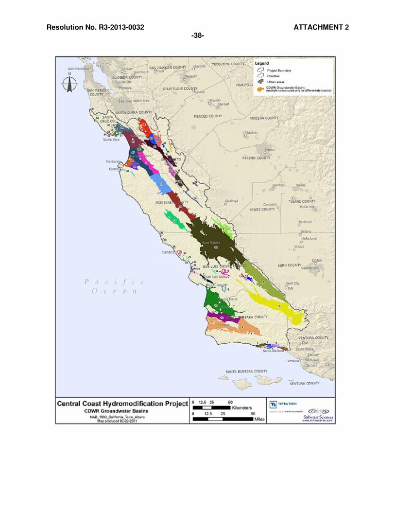
Resolution No. R3-2013-0032 ATTACHMENT 2 -38-

Resolution No. R3-2013-0032 ATTACHMENT 2 -39-
Table 1: Groundwater Basins in the Central Coast Region by GIS Basin Number GIS BASIN NUMBER
GROUNDWATER BASIN NAME GIS BASIN NUMBER
GROUNDWATER BASIN NAME
1 Carpinteria 35 Peach Tree valley
2 Santa Barbara 36 Hernandez valley
3 Montecito 37 Salinas valley
4 Foothill 38 Bitter Water valley
5 Goleta 39 Dry Lake valley
6 Santa Ynez River valley 40 Carmel valley
7 Santa Ynez River valley 41 Salinas valley
8 Lockwood valley 42 San Benito river valley
9 Mil Potrero area 43 Salinas valley
10 San Antonio Creek valley 44 Tres Pinos valley
11 Huasna valley 45 Salinas valley
12 Santa Maria 46 Upper Santa Ana valley
13 Cuyama valley 47 Salinas valley
14 Big Spring area 48 Salinas valley
15 Rafael valley 49 Santa Ana valley
16 San Luis Obispo valley 50 Quien Sabe valley
17 Los Osos valley 51 Gilroy-Hollister valley
18 Rinconada valley 52 Needle Rock point
19 Pozo valley 53 Gilroy-Hollister valley
20 Chorro valley 54 West Santa Cruz terrace
21 Morro valley 55 West Santa Cruz terrace
22 Toro valley 56 Majors creek
23 Carrizo Plain 57 Soquel valley
24 Cayucos valley 58 West Santa Cruz terrace
25 Old valley 59 West Santa Cruz terrace
26 Villa valley 60 Gilroy-Hollister valley
27 Santa Rosa valley 61 Pajaro valley
28 San Simeon valley 62 Scotts valley
29 Arroyo de la Cruz valley 63 Felton area
30 San Carpoforo valley 64 Santa Cruz Purisima formation
31 Cholame valley 65 Ano Nuevo area
32 Salinas valley 66 Gilroy-Hollister valley
33 Lockwood valley 67 Pescadero valley
34 Salinas valley 68 Santa Clara valley
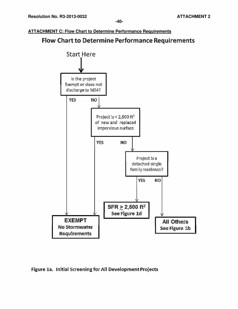
Resolution No. R3-2013-0032 ATTACHMENT 2 -40-
ATTACHMENT C: Flow Chart to Determine Performance Requirements
Resolution No. R3-2013-0032 ATTACHMENT 2
Projects ≥ 2,500 ft2
Project is > 2,500
ft2 new and
replaced impervious surface but
< 5,000 ft2 of Net
Impervious Area
Performance Requirement #1
(Site Design)
Project is >
5,000 ft2 Net
Impervious Area
but < 15,000 ft2
of new and replaced
impervious surface
Performance Requirements #1 (Site Design) and
#2 (WQ Treatment)
Project is >15,000
ft2 of new and replaced
impervious
See Figure 1c
Figure 1b. Requirements for Small to Moderate Development Projects
Resolution No. R3-2013-0032 ATTACHMENT 2 -42-
Resolution No. R3-2013-0032 ATTACHMENT 2 -43-
Detached Single Family Residential Projects
Performance Requirement
#1
Project is
> 2,500 ft2 new
and replaced impervious
surface but
< 15,000 ft2
Net Impervious Area
Project is
> 15,000 ft2
Net Impervious Area
but
< 22,500 ft2
new and replaced
impervious surface
Performance Requirement #s
1, 2, and 3
Project is
> 22,500 ft2
new and replaced
impervious surface
Performance Requirement #s
1, 2, 3, and 4
Figure 1d. Requirements for Single Family Residential projects

Resolution No. R3-2013-0032 ATTACHMENT 2 -44-
ATTACHMENT D: Case Study of the Hydrologic Benefits of On-Site Retention in the Central Coast Region Available electronically at: http://www.waterboards.ca.gov/centralcoast/water_issues/programs/stormwater/docs/lid/lid_hydromod_charette_index.shtml

Resolution No. R3-2013-0032 ATTACHMENT 2 -45-
ATTACHMENT E: Methods and Findings of the Joint Effort for Hydromodification Control in the Central Coast Region of California Available electronically at: http://www.waterboards.ca.gov/centralcoast/water_issues/programs/stormwater/docs/lid/lid_hydromod_charette_index.shtml
Resolution No. R3-2013-0032 ATTACHMENT 2 -46-
ATTACHMENT F: Calculating Off-Site Retention Requirements When Less Than 10 Percent of the Project Site Equivalent Impervious Surface Area is Allocated to Retention-Based Structural Stormwater Control Measures The following instructions demonstrate how to determine the Off-Site Retention Requirements when a Regulated Project subject to the Runoff Retention Performance Requirement, cannot allocate the full 10% of the project site’s Equivalent Impervious Surface Area55 to retention-based Stormwater Control Measures (SCMs). STEP A. Potential Off-Site Mitigation Retention Volume First calculate the Potential Off-Site Mitigation Retention Volume, which represents the additional volume of runoff that would have been retained on-site, had the full 10% of Equivalent Impervious Surface Area been dedicated to retention-based SCMs. Equation A: Potential Off-Site Mitigation Retention Volume = (the portion of the 10% Equivalent Impervious Area not allocated on-site) X (the On-Site Retention Feasibility Factor)
Where: � The portion of the 10% Equivalent Impervious Surface Area not allocated on-site is that
portion not allocated to on-site structural retention-based SCMs. For example, if 10% of Equivalent Impervious Surface Area is 1,000 ft2 and only 8% (800 ft2) is allocated to retention-based SCMs, the remaining 2% (200 ft2) is the value inserted in the equation.
� The On-Site Retention Feasibility Factor is the ratio of Design Retention Volume56 managed on-site (ft3), to actual area (ft2) allocated to structural SCMs. This establishes the site’s retained volume:area ratio, expressed as cubic feet of retained runoff volume per square foot of area. For example, if a project is able to infiltrate 3,500 ft3 of runoff over an 800-ft2 area, this ratio of 3,500:800, or 4.38, is the On-Site Retention Feasibility Factor.
STEP B. Actual Off-Site Mitigation Retention Volume Next, determine the Actual Off-Site Mitigation Retention Volume, which may be less than the Potential Off-Site Mitigation Retention Volume. The Actual Off-Site Mitigation Volume is the lesser of the volume calculated in Equation A, and the remaining portion of the Design Retention Volume, calculated per Post-Construction Requirements Attachment D, not controlled on-site. There are two possible outcomes when the Runoff Retention Performance Requirement is not met on-site and less than 10% of the site’s Equivalent Impervious Surface Area is allocated to retention-based SCMs: � Potential Off-Site Mitigation Retention Volume is the Actual Off-Site Mitigation Retention
Volume � Remaining Design Retention Volume represents Actual Off-Site Design Retention Volume
55
Calculate Equivalent Impervious Surface Area using guidance in Post-Construction Requirements Attachment E
56 Calculate Design Retention Volume using guidance in Post-Construction Requirements Attachment D,
or equivalent method. Final Design Retention Volumes should reflect the applicant’s demonstrated effort to use non-structural design measures to reduce the amount of runoff (e.g., reduction of impervious surfaces) as required by the Post-Construction Requirements’ LID Development Standards (Post-Construction Requirements Section B.4.d).
Resolution No. R3-2013-0032 ATTACHMENT 2 -47-
The following examples illustrate different compliance scenarios related to the Runoff Retention Performance Requirement. The values used in the examples are for illustration only; for actual projects, these values are calculated by the project applicant using guidance provided in Post-Construction Requirements, Attachments D, E, and F.
Example 1: On-site Compliance, No Off-Site Mitigation Necessary Where: � <10% of Equivalent Impervious Surface Area is allocated to retention-based SCMs � Water Quality Treatment and Runoff Retention Performance Requirements are achieved
on-site Site details:
1. 10% of Equivalent Impervious Surface Area 3,000 ft2 2. Actual area dedicated to retention-based SCMs (9.4%) 2,800 ft2 3. Design Retention Volume 4,500 ft3 4. Volume managed by directing runoff to landscaped areas57 500 ft3 5. Remaining volume that must be retained using structural SCMs 4,000 ft3 6. Actual volume retained on-site with structural SCMs 4,000ft3
In this example, the applicant is able to propose a design that uses less than the 10% of the Equivalent Impervious Surface Area to retain the necessary retention volume. Since the entire Design Retention Volume is infiltrated on-site, both the Water Quality Treatment and Runoff Retention Performance Requirements are achieved and off-site mitigation is not required. Example 2: On-site Compliance, No Off-Site Mitigation Necessary Where: � 10% of Equivalent Impervious Surface Area is allocated to retention-based SCMs � Only a portion of the Runoff Retention Requirement is achieved on-site
Site details:
1. 10% of Equivalent Impervious Surface Area 3,000 ft2 2. Actual area dedicated to retention-based SCMs (10%) 3,000 ft2 3. Design Retention Volume 4,500 ft3 4. Volume managed by directing runoff to landscaped areas 500 ft3 5. Remaining volume that must be retained using structural SCMs 4,000 ft3 6. Actual runoff volume retained on-site via structural SCMs 3,800 ft3
In this example, the applicant proposes a design in which only a portion of the Design Retention Volume can be retained using pervious pavements that comprise 10% of the Equivalent Impervious Surface Area. The applicant is able to document that poorly infiltrative soils limit infiltration. The final design achieves the Water Quality Treatment Performance Requirement, but only a portion of the Runoff Retention Requirement. Because the applicant dedicated the full 10% Equivalent Impervious Surface Area to retention-based SCMs, and can substantiate
57
See Post-Construction Requirements’ LID Development Standards (Post-Construction Requirements Section B.4.d) for runoff reduction measures.
Resolution No. R3-2013-0032 ATTACHMENT 2 -48-
technical infeasibility constraints (i.e. poor soils), on-site compliance with the Post-Construction Requirements are met and off-site mitigation is not required. Example 3: On-site Compliance Not Achieved, Off-Site Volume Mitigation Required Where: � An area less than 10% of Equivalent Impervious Surface Area is allocated to retention-
based SCMs � Site soils limit infiltration
Site details:
1. 10% of Equivalent Impervious Surface Area 3,000 ft2 2. Actual area dedicated to structural SCMs (7%) 2,100 ft2 3. Design Retention Volume 4,500 ft3 4. Volume managed by directing runoff to landscaped areas 500 ft3 5. Remaining volume that must be retained using structural SCMs 4,000 ft3 6. Actual runoff volume retained on-site via structural SCMs 1,000 ft3
In this example, the applicant proposes a design in which only a portion of the Design Volume can be infiltrated on-site. The applicant has allocated 7% rather than 10% of the Equivalent Impervious Surface Area to retention-based SCMs. The applicant is able to document that poorly infiltrative soils limit infiltration. The final design achieves the Water Quality Treatment Performance Requirement but only a portion of the Runoff Retention Requirement. Because the applicant did not allocate the full 10% of the Equivalent Impervious Surface Area, and there is remaining Design Retention Volume, off-site mitigation is required and is calculated using Steps A and B, above. This calculation takes into account the poorly infiltrative soils of the project site so that undue off-site retention requirements are avoided. Step A: Solving for Equation A:
Potential Off-Site Mitigation Retention Volume = Portion of 10% Equivalent Impervious Area not allocated on-site: 3,000 ft2 - 2,100 ft2 = 900 ft2
X Onsite Retention Feasibility Factor: 1,000 ft3 ÷ 2,100 ft2 = 0.476 ft
= 429 ft3
Step B: The Actual Off-Site Mitigation Retention Volume is 429 ft3, because it is the lesser of the Potential Off-Site Mitigation Retention Volume (429 ft3) and the remaining portion of the Design Retention Volume not retained on-site (4,000 ft3 - 1,000 ft3 = 3,000 ft3). The Actual Off-Site Mitigation Retention Volume accounts for the poorly infiltrative soils of the project site.
Example 4: Off-Site Volume Mitigation Required Where: � An area less than the 10% of Equivalent Impervious Surface Area is allocated to retention-
based SCMs � Infiltration potential of soils not a significant constraint
Resolution No. R3-2013-0032 ATTACHMENT 2 -49-
Site details: 1. 10% of Equivalent Impervious Surface Area 3,000 ft2 2. Actual area dedicated to structural SCMs (7%) 2,100 ft2 3. Design Retention Volume 4,500 ft3 4. Volume managed by directing runoff to landscaped areas 500 ft3 5. Remaining volume that must be retained using structural SCMs 4,000 ft3 6. Actual runoff volume retained on-site via structural SCMs 3,400 ft3
The applicant proposes a design in which only a portion of the Design Retention Volume can be infiltrated. The applicant has allocated 7% rather than 10% of Equivalent Impervious Surface Area to retention-based SCMs. The final design achieves the Water Quality Treatment Performance Requirement but only a portion of the Runoff Retention Performance Requirement. Because the applicant did not allocate the full 10% of Equivalent Impervious Surface Area, and there is remaining Design Retention Volume, off-site mitigation is required and is calculated using Steps A and B, above. Step A: Solving for Equation A:
Potential Off-Site Mitigation Retention Volume = Portion of 10% Equivalent Impervious Area not allocated on-site: 3,000 ft2 - 2,100 ft2 = 900 ft2
X Onsite Retention Feasibility Factor: 3,400 ft3 ÷ 2,100 ft2 = 1.62 ft
= 1,457 ft3
Step B: The Actual Off-Site Mitigation Retention Volume is 600 ft3, because it is the lesser of the Potential Off-Site Mitigation Retention Volume (1,457 ft3) and the remaining portion of the Design Retention Volume not retained on-site (4,000 ft3 – 3,400 ft3 = 600 ft3).

Resolution No. R3-2013-0032 ATTACHMENT 2 -50-
ATTACHMENT G: Stormwater Control Measure Sizing: Evaluation of Attachment D to the Central Coast Post-Construction Requirements Available electronically at: http://www.waterboards.ca.gov/centralcoast/water_issues/programs/stormwater/docs/lid/lid_hydromod_charette_index.shtml

Resolution No. R3-2013-0032 ATTACHMENT 2 -51-
ATTACHMENT H: Development and Implementation of Hydromodification Control Methodology: Support for Selection of Criteria Available electronically at: http://www.waterboards.ca.gov/centralcoast/water_issues/programs/stormwater/docs/lid/lid_hydromod_charette_index.shtml
Related Documents