STORMWATER MONITORING GUIDANCE MANUAL For Construction Activities ARIZONA DEPARTMENT OF TRANSPORTATION September 2009

Welcome message from author
This document is posted to help you gain knowledge. Please leave a comment to let me know what you think about it! Share it to your friends and learn new things together.
Transcript
STORMWATERMONITORING
GUIDANCEMANUAL
ForConstruction
Activities
ARIZONA DEPARTMENT OF TRANSPORTATION
September 2009
Disclaimer
The manual may contain references to equipment, materials, or patented processes by manufacturer, trade name, make, or catalog number. Such references shall be regarded
as establishing a standard of quality, finish, appearance, performance, or as indicating a selection based upon compatibility with existing equipment or materials and shall not be
construed as limiting selection to a specific item or source.
Page i of iiiSTORMWATER MONITORING GUIDANCE MANUAL for Construction Activities
ARIZONA DEPARTMENT OF TRANSPORTATION September 2009
TAbLE OF CONTENTS
1.0 INTRODUCTION..............................................................................................................11.1 Why Am I Getting This Document? .....................................................................11.2 Purpose of this Document .....................................................................................11.3 Permit Requirements .............................................................................................1
1.3.1 Unique or Impaired Waters ......................................................................21.3.2 Sensitive Projects........................................................................................21.3.3 Total Maximum Daily Loads ....................................................................2
1.4 Exemptions from the Construction General Permit and Monitoring ...............21.5 Purpose of the Stormwater Monitoring Plan ......................................................31.6 Sampling Waivers ..................................................................................................3
1.6.1 Adverse Weather Conditions ....................................................................3
2.0 WhERE TO MONITOR ...................................................................................................42.1 Visual Monitoring .................................................................................................42.2 Analytical Monitoring Points ...............................................................................4
3.0 WhEN TO MONITOR .....................................................................................................73.1 Visual Monitoring ..................................................................................................73.2 Analytical Monitoring ...........................................................................................73.3 Monitoring at Asphalt Facilities and Concrete batch Plants .............................8
4.0 WhAT TO MONITOR ......................................................................................................94.1 Visual Monitoring ..................................................................................................94.2 Photo Documentation ..........................................................................................104.3 Analytical Monitoring .........................................................................................104.4 Special Monitoring Requirements for Concrete batch Plants and Asphalt Facilities ..................................................................................................144.5 Special Monitoring Requirements for TMDLs .................................................14
5.0 hOW TO MONITOR ......................................................................................................155.1 Visual Monitoring ................................................................................................15
5.1.1 Visual Monitoring Equipment and Supplies .........................................155.1.2 Visual Monitoring Procedures ................................................................15
5.2 Photo Documentation ..........................................................................................165.2.1 Photo Documentation Equipment and Supplies ...................................165.2.2 Photo Documentation Procedure ............................................................16
5.3 Analytical Monitoring .........................................................................................175.4 Special Requirements for TMDLs ......................................................................17
6.0 QUALITy ASSURANCE AND QUALITy CONTROL .............................................186.1 Quality Assurance Manual ..................................................................................18
7.0 STORMWATER MONITORING PLANS ....................................................................19
8.0 PREPARATION AND TRAINING REQUIREMENTS ..............................................208.1 Preparation ..........................................................................................................20
8.1.1 health and Safety ....................................................................................208.1.2 Weather Tracking.....................................................................................20
Page ii of iiiSTORMWATER MONITORING GUIDANCE MANUAL for Construction Activities
ARIZONA DEPARTMENT OF TRANSPORTATION September 2009
8.1.3 Communications ......................................................................................218.1.4 Equipment Preparation ...........................................................................228.1.5 Transportation ..........................................................................................22
8.2 Training ................................................................................................................22
9.0 RECORD-kEEPING REQUIREMENTS.....................................................................239.1 Stormwater Monitoring Plan ..............................................................................239.2 Calibration and Maintenance Records ..............................................................239.3 Construction Monitoring Reports ......................................................................239.4 Laboratory Records .............................................................................................239.5 Discharge Monitoring Reports ...........................................................................249.6 Photographs ..........................................................................................................24
9.6.1 Print Film ..................................................................................................249.6.2 Digital Photos ...........................................................................................24
10.0 DATA MANAGEMENT REQUIREMENTS ................................................................2510.1 Water Quality Data ..............................................................................................25
11.0 ASSESSING ThE MONITORING DATA ....................................................................2611.1 Run-off Monitoring Points ..................................................................................2611.2 Contributions from Off-Site Sources .................................................................27
12.0 IMPLEMENTING CORRECTIVE MEASURES........................................................28
13.0 REPORTING REQUIREMENTS ..................................................................................2913.1 Visual Examination Reporting Requirements...................................................2913.2 Analytical Monitoring Reporting Requirements ..............................................2913.3 Reporting Non-Compliance ................................................................................30
14.0 REFERENCES .................................................................................................................31
15.0 GLOSSARy ......................................................................................................................32
Page iii of iiiSTORMWATER MONITORING GUIDANCE MANUAL for Construction Activities
ARIZONA DEPARTMENT OF TRANSPORTATION September 2009
APPENDICES
Construction Monitoring Report FormsA. Discharge Monitoring Report FormsB. Example Stormwater Monitoring Plan for a Unique WaterC. Example Stormwater Monitoring Plan for an Impaired WaterD.
LIST OF FIGURES
Figure 1. General Layout of Typical Construction Site Monitoring Points .............................5Figure 2. Example Telephone Tree .............................................................................................21
LIST OF TAbLES
Table 1. Common Impairment Parameters for Impaired Waters in Arizona ........................12Table 2. Arizona Impairment Parameters Commonly Associated with Construction
Sites ........................................................................................................................................13Table 3. Concrete Plant Discharge Monitoring and Limits .....................................................14Table 4. Asphalt Plant Discharge Monitoring and Limits .......................................................14

Page 1 of 39STORMWATER MONITORING GUIDANCE MANUAL for Construction Activities
ARIZONA DEPARTMENT OF TRANSPORTATION September 2009
1.0 INTRODUCTION
1.1 Why Am I Getting This Document?
The Arizona Department of Transportation (ADOT) has determined that stormwater runoff from your construction activities has the potential to threaten the water quality in a nearby surface receiving water. You are required to monitor the stormwater runoff from your construction site to determine whether your best management practices (BMPs) and controls are effectively protecting the water quality of the nearby surface receiving water. The ADOT Resident Engineer overseeing your project will also have a copy of this document and will work with you to develop and implement a plan to monitor the stormwater runoff from your construction site.
1.2 Purpose of this Document
Under the ADOT Permit, ADOT is responsible for complying with construction stormwater discharge statewide whether activities are performed directly by ADOT staff or by contractors on behalf of ADOT. This manual presents guidance for ADOT staff to use in preparing contract documents for construction activities permitted under the ADOT Permit as well as the Construction General Permit (CGP). Contractors will use this manual in the planning, implementation, and evaluation of stormwater monitoring programs for permitted construction activities. ADOT construction activities that are not contracted out will also use this manual in the planning, implementation, and evaluation of stormwater monitoring programs for construction activities permitted under the ADOT Permit. The guidance provided in this manual will apply to all permitted construction activities that are within ¼ mile of a unique or impaired water, or any sensitive project as deemed necessary by ADOT.
The main objective of this manual is to provide consistency in monitoring methods among ADOT construction sites, as well as consistency in monitoring protocols over time. Such consistency is essential to provide for data comparability, accuracy, and precision between ADOT construction site monitoring programs. This manual features specific procedural information for monitoring at ADOT construction sites. The ADOT Quality Assurance Manual (QAM) features detailed information on quality assurance and quality control procedures.
Please consult the ADOT Permit or the CGP for sites permitted under a separate permit, for official requirements. Further references to stormwater monitoring protocols and instructions will be available in the ADOT QAM. For further guidance and/or direction about what must be accomplished to comply with the ADOT Permit, the ADOT Water Quality Group can be contacted.
1.3 Permit Requirements
On February 29, 2008, the Arizona Department of Environmental Quality (ADEQ) issued the following five-year term Arizona CGP, which replaced ADEQ CGP No. AZG2003-001 issued in February 2003.

Page 2 of 39STORMWATER MONITORING GUIDANCE MANUAL for Construction Activities
ARIZONA DEPARTMENT OF TRANSPORTATION September 2009
Arizona Pollutant Discharge Elimination System General Permit for Discharge from •Construction Activities to Waters of the United States, Permit No. AZG2008-001, ADEQ 2008, herein called the CGP.
On August 15, 2008, ADEQ issued the following five-year term individual stormwater permit to ADOT to cover all stormwater discharges associated with municipal, construction, and industrial activities under ADOT’s control.
Arizona Department of Transportation Statewide Permit for Discharge to Waters of the •United States under the Arizona Pollutant Discharge Elimination System Program, Permit No. AZS000018-2008, ADEQ 2008, herein called the ADOT Permit.
The ADOT Permit (revised June 22, 2009) supersedes ADOT’s previous coverage under the CGP and authorizes discharge from construction activities statewide, including support activities used exclusively for ADOT projects. ADOT’s contractors, however, are still required to obtain coverage under and comply with the CGP. ADOT will have contractors working on their projects comply with the ADOT permit through conditions contained in projects specifications and contract documents.
Construction activities (clearing, grading, excavating, or stockpiling of fill material) that disturb 1 acre or more (or smaller sites that are part of a larger common plan of development that ultimately disturbs 1 or more acres) are regulated under the CGP. Operators of regulated construction sites are required to develop and implement Stormwater Pollution Prevention Plans (SWPPPs) and to obtain permit coverage from ADEQ for construction activities in Arizona. If the activity is on Indian Country within Arizona, permit coverage must be obtained from the U.S. Environmental Protection Agency (USEPA).
Under the ADOT Permit and the CGP, construction activities within ¼ mile of surface •waterbodies classified by ADEQ as either “unique” or “impaired” require submittal to ADEQ of a SWPPP that includes a monitoring program to determine whether BMPs are effective (refer to Sections 1.3.1 and 1.3.2 for additional information on unique and impaired waters, respectively).
Since contractors working on ADOT projects will be required to meet the conditions of the ADOT Permit (through contract documents), this manual is written to comply with the ADOT permit.
1.3.1 Unique or Impaired Waters
A unique water is a surface waterbody that is classified as an outstanding state resource water by ADEQ and stormwater discharges from ADOT construction sites shall not degrade unique waters. Certain surface waterbodies have been determined by ADEQ to be impaired or not attaining and are placed on ADEQ’s 303(d) list. Water quality conditions in an impaired water shall not be further degraded by stormwater discharges from ADOT construction sites.
ADEQ’s 303(d) is subject to change every three years. Therefore, a list or map of Arizona’s unique or impaired waters has not been included in this document. For a list and map of the state’s current
Page 3 of 39STORMWATER MONITORING GUIDANCE MANUAL for Construction Activities
ARIZONA DEPARTMENT OF TRANSPORTATION September 2009
unique and impaired waters and the impairment parameters, go to http://www.azdeq.gov/environ/water/assessment/assess.html.
It should be noted that ADEQ is replacing the term “Unique Water” with “outstanding Arizona water” (OAW) in the impending revision to the Arizona Water Quality Standards (Arizona Administrative Code [A.A.C.] R18-11). This manual will continue to use the term “Unique Water” until the new Arizona Water Quality Standards are approved and published.
Additionally, the water quality standards for discharges from construction sites under the ADOT Permit are tied to Arizona’s current surface water quality standards (SWQS) (A.A.C. Title 18, Chapter 11, Article 1). Some individual parameters may change following the approval of ADEQ’s amended state SWQS. Refer to the ADEQ website for the most current information (http://azdeq.gov/environ/water/standards/index.html).
Unique Waters Several surface waterbodies in Arizona have characteristics that allow them to be classified as being an outstanding state resource or “unique waters” (A.A.C. R18-11-112). Unique waters are free-flowing perennial waters that have good water quality and may provide exceptional recreational value or be associated with threatened or endangered species. Water quality conditions in a unique water shall be maintained and protected and may not be degraded by stormwater discharges from ADOT construction sites.
Impaired Waters ADEQ has established “designated uses” for most surface waterbodies in Arizona that are not located on Indian Country. These uses apply to human health, agriculture, and aquatic and wildlife uses. Designated uses are specific uses that are assigned by ADEQ to a surface water based on historical and anticipated use of the waterbody. The designated uses in Arizona are as follows:
Aquatic and Wildlife•
Fish Consumption•
Full Body Contact•
Partial Body Contact•
Domestic Water Source•
Agricultural Irrigation•
Agricultural Livestock Watering•
Not-Attaining WatersNot-attaining waters are impaired surface waters that are not placed on the 303(d) list but have been determined by ADEQ to be not attaining the designated uses for which they are protected. Water quality conditions in not-attaining waters shall not be further degraded by stormwater discharges from ADOT construction sites.

Page 4 of 39STORMWATER MONITORING GUIDANCE MANUAL for Construction Activities
ARIZONA DEPARTMENT OF TRANSPORTATION September 2009
1.3.2 Sensitive Projects
Sensitive projects will be designated by ADOT based on several criteria. To be deemed “sensitive,” a project must include at least 20 acres of ground disturbance AND must discharge into the waters of the U.S. (WUS) AND must meet at least one of the following conditions:
The project requires an Environmental Impact Statement•
The project is primarily on federal lands•
The project construction has significant work that requires an individual 404 permit from •the U.S. Army Corps of Engineers, or individual 401 water quality certification from the ADEQ
The project requires Section 7 consultation with the U.S. Fish and Wildlife Service for •potential impacts to aquatic endangered species
1.3.3 Total Maximum Daily Loads
Total Maximum Daily LoadsA Total Maximum Daily Load (TMDL) is a set of calculations performed by ADEQ or USEPA that determine the maximum amount of a pollutant that a surface waterbody can receive, on a daily basis, and still meet SWQS. A TMDL allocates pollutant loadings between point and nonpoint pollutant sources. TMDL calculations are required for all surface waters listed as impaired on ADEQ’s 303(d) list. If TMDL calculations have been performed on an impaired water within ¼ mile of the construction site or ADOT exclusive support site, monitoring is required to determine whether construction site BMPs and controls are effective at keeping stormwater discharges from construction activities below the maximum allowable limits established by the TMDL.
ADEQ’s TMDL schedule is subject to change every year and has not been included in this document. ADEQ’s current TMDL schedule may be found on the ADEQ website at http://www.azdeq.gov/environ/water/assessment/status.html.
1.4 Exemptions from the Construction General Permit and Monitoring
ADOT may determine that certain construction activities are exempt from the CGP and may not require monitoring. These include activities that meet any of the following criteria:
Construction activities that disturb less than 1 acre and are not a part of a larger common •plan of development or sale
Construction activities that are located wholly on Indian Country, the permit must be •obtained through the USEPA
The ADOT Permit does not allow ADOT or its contractors to apply for permit waivers for small construction projects as allowed under the CGP. All ADOT projects over 1 acre are still required to follow the requirements of the CGP and the ADOT Permit.
A specification will be written into the construction contact for any construction activities that are exempt from the CGP and monitoring.
Page 5 of 39STORMWATER MONITORING GUIDANCE MANUAL for Construction Activities
ARIZONA DEPARTMENT OF TRANSPORTATION September 2009
1.5 Purpose of the Stormwater Monitoring Plan
Routine visual inspections are required at all construction sites and are discussed in the site-specific SWPPP. In addition to the visual inspections, analytical and visual monitoring is required for construction sites located within ¼ mile of unique or impaired waters and is described in detail in the required site-specific Stormwater Monitoring Plan (Monitoring Plan).
A monitoring plan is required to be included in the SWPPP for all construction activity within ¼ mile of a unique or impaired water. It is the responsibility of each construction site Resident Engineer and the contractor’s Erosion Control Coordinator (ECC) to evaluate their construction project and develop a site-specific Monitoring Plan in compliance with the ADOT Permit, CGP, and SWPPP requirements. When advertising construction projects for competitive bidding, ADOT will provide specifications necessary for the development of the monitoring plan (i.e., the number of monitoring points and monitoring parameters to be used). Once awarded the contract, the contractor is required to design and obtain ADEQ’s approval for the Monitoring Plan and then implement the Monitoring Plan to evaluate stormwater runoff from the construction site. ADOT shall ensure that all applicable provisions of the CGP and the ADOT Permit are implemented.
Data generated under the Monitoring Plan will be used to determine whether the BMPs and controls employed at the construction site are effective in controlling construction activity pollutants from leaving the site and entering surface receiving water. Should the data determine that the water quality in the surface receiving water is threatened or impaired by stormwater runoff from the construction site, BMPs shall be immediately inspected and corrective measures taken. ADOT shall provide, in their Annual Report to ADEQ, a list and description of all violations and corrective measures taken and any enforcement actions taken against its contractors.
1.6 Sampling Waivers
The ADOT Permit allows for waivers from analytical monitoring requirements for construction sites under one circumstance: adverse weather conditions.
1.6.1 Adverse Weather Conditions
When a construction site is unable to collect samples as a result of adverse climatic conditions, the reason for not performing the visual or analytical monitoring must be documented and retained on-site with the SWPPP. Adverse weather conditions that may prohibit the collection of samples include weather conditions that create dangerous conditions for personnel (such as local flooding, high winds, hurricanes, tornadoes, electrical storms, etc.) or otherwise make the collection of a sample impracticable (drought, extended frozen conditions, etc.).
Page 6 of 39STORMWATER MONITORING GUIDANCE MANUAL for Construction Activities
ARIZONA DEPARTMENT OF TRANSPORTATION September 2009
2.0 WhERE TO MONITOR
The single most important component of any monitoring program is the selection of monitoring points. Properly located monitoring points will yield data that are accurate and useful. Conversely, improperly located monitoring points will provide misleading data. Select monitoring points carefully and thoughtfully because once they are established, they should not be moved.
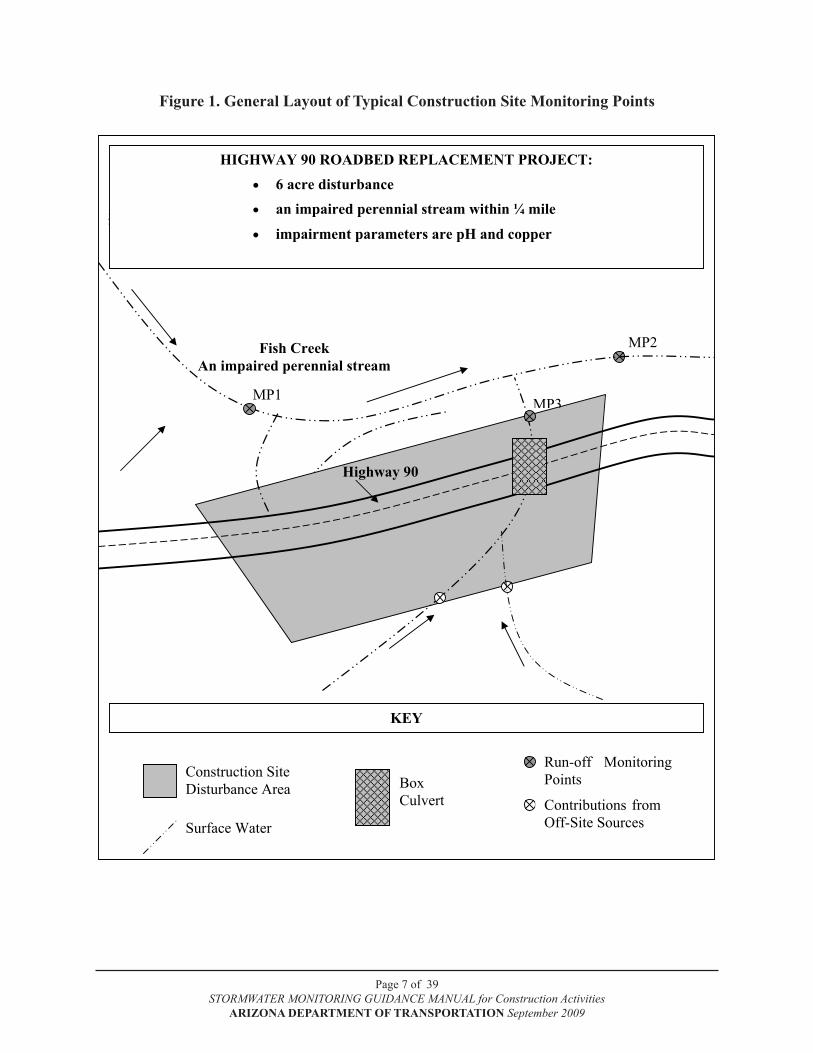
ADOT will specify in the contractor’s bid package the number of monitoring points recommended for the construction project. All monitoring points will be monitored during each stormwater monitoring event as described in Section 3.0 of this manual. Each monitoring point must be uniquely identified in the Monitoring Plan with a unique monitoring identification (ID) number or name and must also be located and identified on a map of the construction site. Figure 1 contains a general layout of typical construction site monitoring points. The monitoring point’s ID should be used for each consecutive monitoring event. For example, monitoring occurring at monitoring point two in Figure 1, the first stormwater sampling event occurring on June 18, 2009, would be named as follows: MP2-061809.
2.1 Visual Monitoring
Routine inspections of BMPs at construction sites is required to ensure that BMPs are functional and effectively protecting the water quality of the nearby surface receiving water. Visual monitoring shall include weekly inspection of BMPs for both stormwater and non-stormwater discharges. Non-stormwater discharges are those discharges that are not a direct result of a rainfall event; below are two examples of non-stormwater discharges.
Only those non-stormwater discharges authorized in Section 1.3 of the ADOT Permit or covered under a separate Arizona Pollutant Discharge Elimination System (AZPDES) permit are allowed; all others are prohibited and shall be eliminated or reduced to the extent practicable. Appropriate BMPs to minimize pollutants in allowable non-stormwater discharges will be implemented and monitored.
2.2 Analytical Monitoring Points
Analytical monitoring points shall be located as follows:one monitoring point shall be located upstream of all water quality impacts from the •construction siteone monitoring point shall be located downstream of all water quality impacts from the •construction siteat least one monitoring point shall be at the discharge point(s) of the construction site •
EXAMPLE #2:A water truck parked near the surface receiving water has a sprung a leak and is discharging its contents onto the ground and, ultimately, into the surface receiving water.
EXAMPLE #1:A poorly designed equipment washing area has breached its berms and now discharges into the surface receiving water.
Page 7 of 39STORMWATER MONITORING GUIDANCE MANUAL for Construction Activities
ARIZONA DEPARTMENT OF TRANSPORTATION September 2009
Figure 1. General Layout of Typical Construction Site Monitoring Points
Page 14 of 47
STORMWATER MONITORING GUIDANCE MANUAL for Construction Activities ARIZONA DEPARTMENT OF TRANSPORTATION September 2009
Figure 1. General Layout of Typical Construction Site Monitoring Points
Upstream Monitoring Point
hIGhWAy 90 ROADbED REPLACEMENT PROJECT: • 6 acre disturbance • an impaired perennial stream within ¼ mile
• impairment parameters are ph and copper
Construction Site Disturbance Area
Run-off Monitoring Points
Contributions from Off-Site Sources
kEy
highway 90
BoxCulvert
Surface Water
Fish Creek An impaired perennial stream
MP1
MP2
MP3
Page 8 of 39STORMWATER MONITORING GUIDANCE MANUAL for Construction Activities
ARIZONA DEPARTMENT OF TRANSPORTATION September 2009
It may be helpful to design the construction site BMPs and controls so that run-off monitoring points can be located in existing drainage features (washes, gullies, etc.) or at the outlets of pipes that carry the stormwater discharges off-site. Information collected at outfall monitoring points will be used to assess the potential impact a stormwater discharge may have to the surface receiving water.
Other monitoring points may be established, at the discretion of ADOT or the monitoring personnel, or at the request of ADEQ. In cases where ADOT considers other monitoring strategies would be more effective due to site-specific conditions, ADOT may submit an alternative monitoring plan to the Surface Water Section of ADEQ for approval at least 90 days prior to commencement of construction activities.
Page 9 of 39STORMWATER MONITORING GUIDANCE MANUAL for Construction Activities
ARIZONA DEPARTMENT OF TRANSPORTATION September 2009
3.0 WhEN TO MONITOR
Below is the schedule for both visual and analytical monitoring as required by the ADOT Permit and the CGP. Information on any conditions that prevented sampling shall be reported to ADOT and included in the project SWPPP.
3.1 Visual Monitoring
Visual observations are to be made during daylight hours; sunrise to sunset. A schedule for visual monitoring of BMPs at all construction sites shall be specified in the site-specific SWPPP based on the following:
The site will be inspected at least once every 14 calendar days, and within 24 hours of the •end of each storm event of 0.5 inch or greater
Visual monitoring at construction sites within ¼ mile of a unique or impaired water shall be conducted at least once every seven calendar days.
3.2 Analytical Monitoring
Analytical monitoring shall occur whenever stormwater is discharged from established monitoring points at any construction site within ¼ mile of a unique or impaired water. Analytical monitoring shall not be limited by season but shall be performed whenever stormwater is discharged from the site or enters a WUS, unless adverse conditions make sampling impracticable.
Keeping up with the weather forecast and planning so that visual and analytical monitoring can be carried out on short notice are the keys to successful sampling. Local forecasts, including televised satellite and radar images, can give an indication of the expected intensity of coming storms. The National Weather Service is an excellent source of information on upcoming storms. It also includes local current radar and satellite images. Their website is http://www.wrhnoaa.gov. A number of commercial websites, such as http://www.weather.com and http://www.yahoo.com, also provide weather information and forecasts.
When evaluating a weather forecast, consider indications of expected rainfall amounts. For example, “90% chance” rather than “50% chance” and “rain” rather than “showers.” Over the telephone, National Weather Service personnel can often provide estimates of anticipated rainfall amounts. In addition, consider the predicted duration of the storm. It will be helpful to spend time observing rainfall events at the ADOT construction site with close attention to how different rainfall depths relate to stormwater discharges from the site before sampling.
Once the decision has been made to attempt to sample a rainfall event, the monitoring personnel should be notified and they should prepare to sample. If it does rain, personnel should be at the monitoring points before stormwater begins discharging so they can document the time of discharge and be ready to perform visual and analytical monitoring.
Page 10 of 39STORMWATER MONITORING GUIDANCE MANUAL for Construction Activities
ARIZONA DEPARTMENT OF TRANSPORTATION September 2009
Every ADOT construction site is required to maintain a rain gauge on-site. The ECC will be responsible for maintaining the rain gauge; preparing the gauge for rainfall events, recording rainfall amounts, and cleaning the gauge after rainfall events.
3.3 Monitoring at Asphalt Facilities and Concrete batch Plants
Monitoring is required at asphalt facilities or concrete batch plants that are used exclusively by or for ADOT projects and located within ¼ mile of a unique or impaired water. Monitoring shall occur at these facilities for each storm event that has at least 0.1 inch of precipitation. A minimum of one grab sample shall be collected from the resulting discharge.
Analytical monitoring samples must be taken in the first 30 minutes of the discharge produced by a qualifying rainfall event. If the collection of a grab sample during the first 30 minutes is impracticable, a sample can be taken when practicable, as long as an explanation of why a grab sample during the first 30 minutes was impracticable is thoroughly documented.
Page 11 of 39STORMWATER MONITORING GUIDANCE MANUAL for Construction Activities
ARIZONA DEPARTMENT OF TRANSPORTATION September 2009
4.0 WhAT TO MONITOR
All surface waterbodies in Arizona that have been classified as unique (A.A.C. R18-11-112) or impaired waters are protected from activities that may degrade existing water quality in the unique water (A.A.C. R18-11-107). The ADOT Permit and the CGP requires construction activities within ¼ mile of a unique or impaired water to be monitored to determine whether construction site BMPs and controls are effective at protecting water quality in the surface receiving water.
ADOT, or ADOT contractors operating under a separate CGP, will monitor stormwater runoff from construction activities that are located within ¼ mile of a unique or impaired water for:
Visual monitoring:• the observation of water quality characteristics based on visual examination and turbidity measurements at established monitoring points (Section 4.1)
Photo documentation:• the visual documentation of construction site activity and water quality characteristics at established monitoring points (Section 4.2).
Analytical monitoring:• turbidity and additional pollutants for which the water is impaired or any additional parameters required by ADEQ and clearly specified in the ADOT contract (Section 4.3).
4.1 Visual Monitoring
Visual monitoring requires the observation and documentation of visual characteristics that can be used to immediately assess the effectiveness of construction site BMPs and controls. Visual characteristics shall be observed at established monitoring points and recorded on a Construction Monitoring Report (CMR), which may be found in Appendix A. At a minimum, visual monitoring activities for projects near impaired or unique waters shall consist of weekly site inspections and photo documentation of the effectiveness of BMPs at reducing pollutants to the waterbody.
Monitoring points shall be observed and documented on a regular basis for six visual characteristics:
Color 1. Clarity2. Odor 3. Oily Sheen 4. Solids 5. Foam6.
Color – Water that is colorless lacks pollutants that affect water color. Water that is slightly milky or light brown in color usually indicates the presence of suspended sediment. Suspended sediment will impart the same color to water as the surrounding soil (the Red Rock area of Sedona may have
NOTE: If the impaired or not attaining water is also listed by rule as a unique water (A.A.C. R18-11-112), continue to follow the monitoring requirements for impaired and not attaining waters in this section of the manual.
Page 12 of 39STORMWATER MONITORING GUIDANCE MANUAL for Construction Activities
ARIZONA DEPARTMENT OF TRANSPORTATION September 2009
red stormwater runoff). The presence of a color that is different from the surrounding soil color may indicate the presence of a chemical pollutant.
Clarity – Clarity refers to the amount of suspended material present that causes the water to be opaque and limits the amount of light that can pass through the water (this is known as turbidity). The more turbid the water is, the more likely it is to contain sediment and pollutants. Clarity may also be measured on-site with a field turbidity meter that reads and assigns an accurate numerical value for water clarity.
Odor – Most water is either odorless or has a slight “earthy” odor. Odors such as gasoline fumes, solvents, sulfur or rotten eggs, sewage, or a sour smell may be indicative of chemical pollutants.
Oily Sheen – An oily sheen is present if a film of iridescent color is observed on the water surface. Look for a rainbow effect, which can appear to be floating on the surface of the water. Usually an oily sheen indicates the presence of oil or grease. On rare occasions, and usually in the fall, an oily sheen can be the result of the decomposition of fallen leaves. To determine whether an oily sheen is natural, touch the sheen with your finger. If the oily sheen is disrupted and breaks into floating pieces that do not immediately swirl and come back together, it is probably natural in origin (e.g., decomposing organic matter). An oily sheen that immediately comes back together is probably from an unnatural source, such as a petroleum product.
Solids – Solids may float, remain in suspension, or settle to the bottom, so it is necessary to observe the entire water column when looking for solids. It may be necessary to collect some of the solids in a jar in order to further describe them.
Foam – The presence of foam on the water surface may indicate the presence of industrial foaming agents or surfactants. Smell the foam; the odor may provide a clue to its source.
4.2 Photo Documentation
Activities at a construction site must be thoroughly documented with photos. Photographs shall be taken of the monitoring points when recording visual monitoring observations such as sediment, erosion, and waste control BMPs. A photographic log should be maintained that contains the date, time, and location of each photo taken. Photo documentation is described in more detail in Section 5.0 of this manual.
4.3 Analytical Monitoring
Analytical monitoring is a quantitative measurement that is designed to provide an additional assessment of the effectiveness of construction site BMPs and controls. Most often, analytical monitoring will require the collection of additional field measurements and/or water quality samples for laboratory analysis. When the water quality samples are sent to an off-site laboratory for analysis, analytical monitoring does not serve as an immediate assessment tool. However, like visual monitoring, analytical monitoring can be used to evaluate the effectiveness of the construction site SWPPP when conducted on a regular basis.

Page 13 of 39STORMWATER MONITORING GUIDANCE MANUAL for Construction Activities
ARIZONA DEPARTMENT OF TRANSPORTATION September 2009
Analytical monitoring requires field measurements and may require the collection of water samples for one or more parameters for which the surface receiving water is impaired and that are likely to be present in stormwater runoff from the construction site (see example scenarios below).
ADOT, and ADOT contractors operating under a separate CGP, must monitor construction sites for turbidity as an indicator of possible BMP ineffectiveness or inadequacy. The turbidity values shall be compared from the two instream locations. If there is a 25% increase at the downstream monitoring location, turbidity of the stormwater discharge(s) from the construction site shall be measured to determine the site’s contribution. BMPs shall be evaluated; the BMPs shall be replaced or maintained, or additional BMPs shall be installed as necessary, if indications are that the site may be contributing to the turbidity load. Water quality parameters for pollutants causing impairment in impaired waters shall be monitored and/or sampled.
ADOT will specify in the contract if analytical monitoring is required. ADOT will provide the contractor with the impairment parameter(s) that will be monitored. For construction projects covered under a separate CGP, the contractor may consult the ADEQ website for the most current list of impairment parameters for the impaired or not-attaining water of concern prior to preparing the Monitoring Plan to verify the impairment parameters (http://www.azdeq.gov/environ/water/assessment/assess.html).
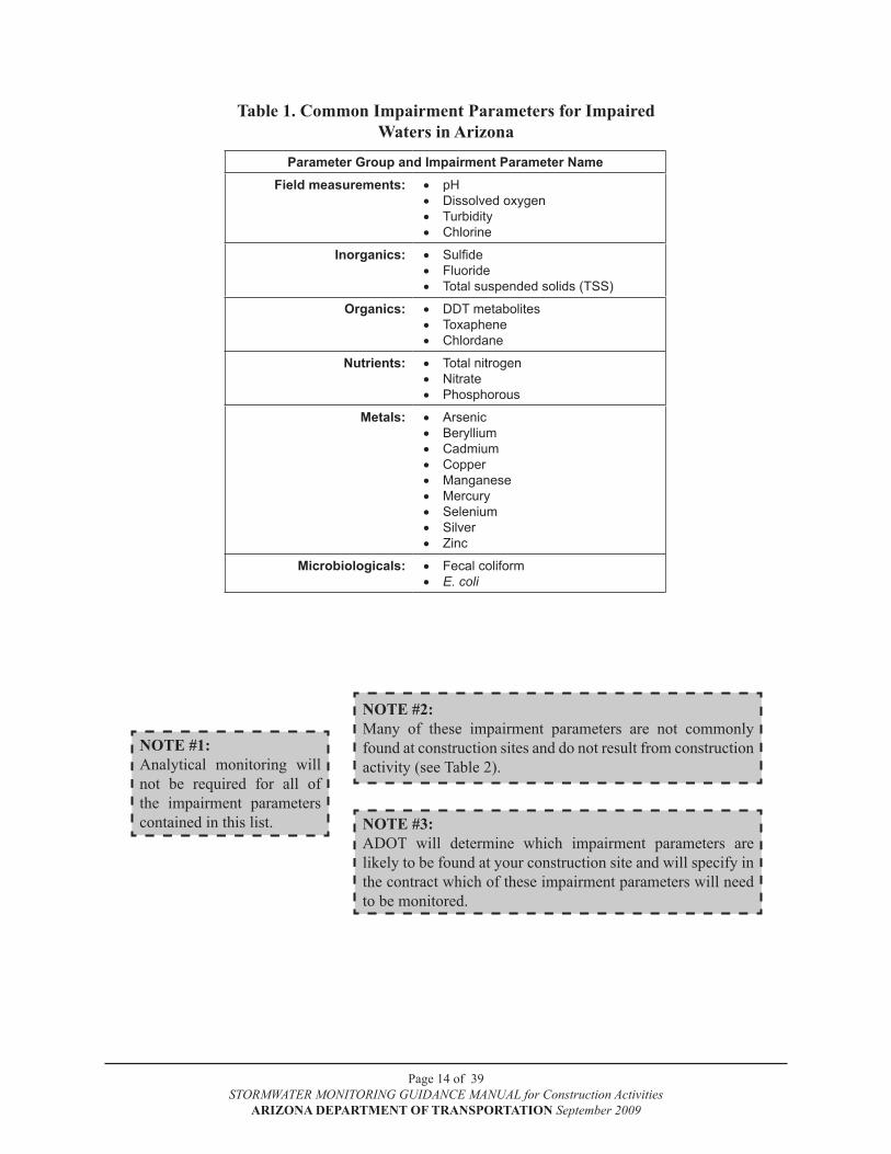
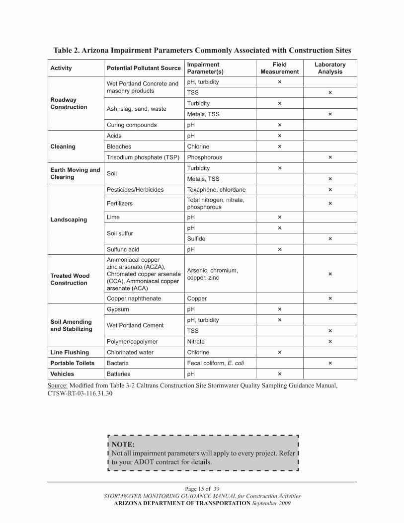
Table 1 contains a list of common impairment parameters for unique and impaired waters in Arizona. Table 2 contains a list of impairment parameters in Arizona and their likely association with construction site activities and materials.
EXAMPLE #1:An ADOT roadway realignment project runs parallel to and within ¼ mile of Sycamore Creek, which is impaired for total nitrogen. The contractor will be spray applying a liquid fertilizer that contains nitrogen to new plants in an area along the west bank of Sycamore Creek. This activity could potentially introduce nitrogen into Sycamore Creek; so, ADOT has determined that analytical monitoring during fertilizer application is required and should be documented in the Monitoring Plan.
EXAMPLE #2:An ADOT bridge project spans Alder Creek, which is impaired for silver and zinc, which originated from some nearby abandoned mine tailings. The bridge project will not be using any chemicals or fill material that contain silver or zinc; so, the stormwater runoff from the bridge project is not likely to contain silver or zinc. Therefore, monitoring for silver and zinc is not necessary and should be stated as such in the Monitoring Plan.
Page 14 of 39STORMWATER MONITORING GUIDANCE MANUAL for Construction Activities
ARIZONA DEPARTMENT OF TRANSPORTATION September 2009
Table 1. Common Impairment Parameters for Impaired Waters in Arizona
Parameter Group and Impairment Parameter NameField measurements: pH•
Dissolved oxygen•Turbidity•Chlorine•
Inorganics: Sulfide•Fluoride•Total suspended solids (TSS)•
Organics: DDT metabolites•Toxaphene•Chlordane•
Nutrients: Total nitrogen•Nitrate•Phosphorous•
Metals: Arsenic•Beryllium•Cadmium•Copper•Manganese•Mercury•Selenium•Silver•Zinc•
Microbiologicals: Fecal coliform•E. coli•
NOTE #2:Many of these impairment parameters are not commonly found at construction sites and do not result from construction activity (see Table 2).
NOTE #3:ADOT will determine which impairment parameters are likely to be found at your construction site and will specify in the contract which of these impairment parameters will need to be monitored.
NOTE #1:Analytical monitoring will not be required for all of the impairment parameters contained in this list.
Page 15 of 39STORMWATER MONITORING GUIDANCE MANUAL for Construction Activities
ARIZONA DEPARTMENT OF TRANSPORTATION September 2009
Table 2. Arizona Impairment Parameters Commonly Associated with Construction Sites
Activity Potential Pollutant Source Impairment Parameter(s)
Field Measurement
Laboratory Analysis
Roadway Construction
Wet Portland Concrete and masonry products
pH, turbidity × TSS ×
Ash, slag, sand, wasteTurbidity ×Metals, TSS ×
Curing compounds pH ×
Cleaning
Acids pH ×Bleaches Chlorine ×Trisodium phosphate (TSP) Phosphorous ×
Earth Moving and Clearing Soil
Turbidity ×Metals, TSS ×
Landscaping
Pesticides/Herbicides Toxaphene, chlordane ×
Fertilizers Total nitrogen, nitrate, phosphorous ×
Lime pH ×
Soil sulfurpH ×Sulfide ×
Sulfuric acid pH ×
Treated Wood Construction
Ammoniacal copper zinc arsenate (ACZA), Chromated copper arsenate (CCA), Ammoniacal copper arsenate (ACA)
Arsenic, chromium, copper, zinc ×
Copper naphthenate Copper ×
Soil Amending and Stabilizing
Gypsum pH ×
Wet Portland CementpH, turbidity × TSS ×
Polymer/copolymer Nitrate ×Line Flushing Chlorinated water Chlorine ×Portable Toilets Bacteria Fecal coliform, E. coli ×Vehicles Batteries pH ×
Source: Modified from Table 3-2 Caltrans Construction Site Stormwater Quality Sampling Guidance Manual, CTSW-RT-03-116.31.30
NOTE:Not all impairment parameters will apply to every project. Refer to your ADOT contract for details.
Page 16 of 39STORMWATER MONITORING GUIDANCE MANUAL for Construction Activities
ARIZONA DEPARTMENT OF TRANSPORTATION September 2009
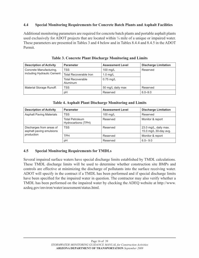
4.4 Special Monitoring Requirements for Concrete batch Plants and Asphalt Facilities
Additional monitoring parameters are required for concrete batch plants and portable asphalt plants used exclusively for ADOT projects that are located within ¼ mile of a unique or impaired water. These parameters are presented in Tables 3 and 4 below and in Tables 8.4.4 and 8.4.5 in the ADOT Permit.
Table 3. Concrete Plant Discharge Monitoring and Limits
Description of Activity Parameter Assessment Level Discharge LimitationConcrete Manufacturing, including Hydraulic Cement
TSS 100 mg/L ReservedTotal Recoverable Iron 1.0 mg/LTotal RecoverableAluminum
0.75 mg/L
Material Storage Runoff: TSS 50 mg/L daily max ReservedpH Reserved 6.0–9.0
Table 4. Asphalt Plant Discharge Monitoring and Limits
Description of Activity Parameter Assessment Level Discharge LimitationAsphalt Paving Materials TSS 100 mg/L Reserved
Total PetroleumHydrocarbons (TPH)
Reserved Monitor & report
Discharges from areas of asphalt paving emulsions production
TSS Reserved 23.0 mg/L, daily max.15.0 mg/L 30-day avg.
TPH Reserved Monitor & reportpH Reserved 6.0– 9.0
4.5 Special Monitoring Requirements for TMDLs
Several impaired surface waters have special discharge limits established by TMDL calculations. These TMDL discharge limits will be used to determine whether construction site BMPs and controls are effective at minimizing the discharge of pollutants into the surface receiving water. ADOT will specify in the contract if a TMDL has been performed and if special discharge limits have been specified for the impaired water in question. The contractor may also verify whether a TMDL has been performed on the impaired water by checking the ADEQ website at http://www.azdeq.gov/environ/water/assessment/status.html.

Page 17 of 39STORMWATER MONITORING GUIDANCE MANUAL for Construction Activities
ARIZONA DEPARTMENT OF TRANSPORTATION September 2009
5.0 hOW TO MONITOR
5.1 Visual Monitoring
Visual monitoring requires the observation and documentation of visual characteristics that can be used to immediately assess the effectiveness of construction site BMPs and controls. Visual characteristics shall be observed at established monitoring points and recorded on a CMR for Visual Monitoring, which may be found in Appendix A. A separate CMR shall be completed for each monitoring point and event and shall include photo documentation, as described in Section 5.2.
At a minimum, visual monitoring activities for projects near unique or impaired waters shall consist of weekly site inspections of the effectiveness of BMPs at reducing pollutants to the waterbody.
5.1.1 Visual Monitoring Equipment and Supplies
Visual monitoring requires the following equipment and supplies:
Clean glass jar (for collecting visual samples)•
CMR for Visual Monitoring•
Field turbidity meter •
5.1.2 Visual Monitoring Procedures
Visual monitoring documents what is observed at each monitoring point for the six visual characteristics (color, clarity, odor, oily sheen, solids, and foam). Observations at each monitoring point are recorded on a CMR (see Appendix A) for Visual Monitoring. A separate CMR shall be completed for each monitoring event as follows:
Complete header information at the top of the CMR, including the “Monitoring Start 1. Time.”
List each monitoring point identifier under “Monitoring Point – ID.”2.
Circle the appropriate response under each of the six “Visual Observations” and describe 3. the observation(s) if applicable.
Prepare the turbidity meter for measurements according to manufacturer’s instructions.4.
Measure average turbidity in NTUs (nephelometric turbidity units) with the turbidity meter 5. set on signal averaging and record the reading in NTUs under “Visual Observations – Clar-ity.”
Upon completion of all monitoring for this event, fill in the “Monitoring End Time” in the 6. header section of the CMR.
Make any detailed notes in the area at the bottom of the CMR.7.
Page 18 of 39STORMWATER MONITORING GUIDANCE MANUAL for Construction Activities
ARIZONA DEPARTMENT OF TRANSPORTATION September 2009
5.2 Photo Documentation
The primary consideration in photo documentation is an objective. Ask these questions when framing a shot: What am I trying to show with this photo? Why is this photo important? Does it capture a representative view of the subject?
Based on the desired objectives, the photo should provide a representative view of that monitoring point. The minimum number of photos is two: looking upstream from below the monitoring point and looking downstream from above the monitoring point. However, the taking of additional photos is encouraged. Document the monitoring event and any changes from the last visit, for example, channel obstructions, flood debris, trash, sediment deposition, erosion, etc. The objective is to fully document the condition of the monitoring points. The following photos are ideal for this purpose:
Run-off monitoring points•
Surface receiving water and tributaries•
Storm sewer outfalls•
Runoff contributions from off-site sources•
Some construction site activities that will also be photo documented are:
On-site BMPs and controls•
Storm events•
Construction site perimeter•
On-site problems•
Off-site activities that may be problematic•
Corrective actions•
5.2.1 Photo Documentation Equipment and Supplies
Either a digital camera or a 35 mm single lens reflex camera with color print film•
CMR for Visual Monitoring•
5.2.2 Photo Documentation Procedure
Activities at a construction site will be thoroughly documented with photos. Photo documentation is required for all ADOT construction projects that require monitoring and is recommended for all ADOT construction sites. Photos must be taken during each visit to all monitoring points.
At first visit to a construction site, establish permanent photo points for the before and after 1. photos. The preferred type of photo point is a distinctive landmark such as a large tree, boulder, right-of-way marker, bridge abutment, etc. If such landmarks are unavailable at a given construction site, photo points should be marked in an unobtrusive manner (e.g., small pieces of flagging or rock cairn). Photo points should be described in detail on the CMR at the first visit to the construction site.
Page 19 of 39STORMWATER MONITORING GUIDANCE MANUAL for Construction Activities
ARIZONA DEPARTMENT OF TRANSPORTATION September 2009
Photos should be taken to include the monitoring point with a person or other recognizable 2. object framed within the photo to show scale. The person or object should be located off to the side of the monitoring point to avoid blocking the view of the subject.
If the monitoring point has changed significantly since the last site visit, additional pho-3. tos should be taken. Changes may include recent flood evidence, channel scour, sediment deposition, construction alterations, or other biological or ecological changes that warrant documentation.
All photos taken at a monitoring point should have identifying information such as photo 4. number recorded on the CMR.
Any photos taken at a construction site, whether print film or digital media, should imme-5. diately be printed and labeled upon return to the office. See Section 9.6 of this manual for more information on photo management.
5.3 Analytical Monitoring
The impairment parameter(s) specified by ADOT in the contract will determine what field measurements and/or water samples are to be collected. The field measurements and water samples will be collected at the same monitoring points where visual monitoring is conducted and will be recorded on a CMR for Analytical Monitoring, which may be found in Appendix A. The water samples will be taken to a laboratory for analysis. The results will be used to assess the effectiveness of construction site BMPs and controls.
A separate CMR shall be completed for each monitoring event. All analytical work shall be performed as described in 40 CFR 136 in accordance with ADOT quality control standards. Proper collection and analyses procedures for all ADOT monitoring will be presented in the ADOT QAM. The QAM will describe sample collection procedures, approved analytical methods to be used, and the data review process.
Laboratory data is to be recorded on discharge monitoring reports (DMRs). A separate DMR is to be completed per monitoring point for each storm event sampled. Appendix B contains a blank DMR form that may be photocopied. Fillable forms are also available at the ADOT Water Quality Website (http://azdot.gov/Highways/OES/Water_Quality/index.asp).
5.4 Special Requirements for TMDLs
ADOT will specify in the contract whether there is a TMDL for a particular waterbody and whether special discharge limits have been specified for the impaired receiving water in question. TMDL monitoring may require the contractor to measure streamflow in conjunction with the collection of impairment parameter information. Refer to the U.S. Geological Survey document titled Measurement and Computation of Streamflow by Rantz and others, 1982, for standardized procedures on measuring streamflow. Any special monitoring required for a TMDL will be performed at the same monitoring points where analytical monitoring is conducted and will be recorded on the CMR.
Page 20 of 39STORMWATER MONITORING GUIDANCE MANUAL for Construction Activities
ARIZONA DEPARTMENT OF TRANSPORTATION September 2009
6.0 QUALITy ASSURANCE AND QUALITy CONTROL
6.1 Quality Assurance Manual
A cornerstone of an effective monitoring program is the Quality Assurance and Quality Control (QA/QC) processes that apply to the sample collection, analyses, and review of analytical results. The ADOT Permit requires ADOT to develop and retain a QAM that documents ADOT policies and procedures and ensures adequate QA/QC for stormwater monitoring. The policies and procedures described in the QAM are intended to ensure that monitoring analytical data meet the requirements of the permit. The QAM shall be followed for all ADOT sites that require monitoring. The QAM shall be kept at the offices of the District Environmental Coordinators.
Sample collection protocol to be used is detailed in the ADOT QAM. Proper procedures, such as collection methods, QA/QC samples, preservative to use, and holding times for the samples, will be outlined in the ADOT QAM. All samples taken to meet the monitoring requirements in this permit shall conform to these procedures, whether collection and handling is performed directly by ADOT or contracted to a third party.
Page 21 of 39STORMWATER MONITORING GUIDANCE MANUAL for Construction Activities
ARIZONA DEPARTMENT OF TRANSPORTATION September 2009
7.0 STORMWATER MONITORING PLANS
The contractor is required by the CGP to design, implement, and evaluate a Monitoring Plan for stormwater runoff from their construction activity when located within ¼ mile of a unique or impaired water. The Monitoring Plan must be site specific and will be submitted to ADEQ as an appendix to the SWPPP. A copy of the SWPPP and the Monitoring Plan shall be kept on-site at all times. Additional copies of the Monitoring Plan should be made available to all personnel who anticipate participating in stormwater monitoring activities.
The following information will serve as a template outline to guide the contractor through the task of writing a Monitoring Plan. The information necessary to complete most of the elements may be found throughout this manual. Should the contractor have any questions regarding the preparation of the Monitoring Plan, they may contact either ADOT Water Quality or ADOT Roadside Development personnel.
Monitoring Plans will contain the following elements:
Locations of sampling points•
Water quality parameters/pollutants to be sampled•
The name and title of the person who will be conducting the sampling•
A paragraph describing the pollutant(s) of concern at the receiving water based on the most •recent 303(b)/303(d) list or other information available to ADOT
A description of potential source(s) of this pollutant(s) from the project•
A map showing the segments of the receiving water that are most likely to be impacted by •the discharge of pollutants
Visual observation locations, visual observation procedures, and visual observation follow-•up and tracking procedures
The citation and description of the sampling protocols to be used•
Identification of the analytical methods and related method detection limits (if applicable) •for each parameter required; maximum detection levels (MDLs) shall be below applicable surface water quality standards when possible
Additionally, for sites within ¼ mile of an impaired water, the monitoring program shall •include:
An identification of the pollutant(s) of concern based on the most recent 305(b)/303(d) • list or other information available and
A description of potential source(s) of this pollutant(s) from the project, if any•
Example Monitoring Plans for unique and impaired waters can be found in Appendices C and D, respectively.
Page 22 of 39STORMWATER MONITORING GUIDANCE MANUAL for Construction Activities
ARIZONA DEPARTMENT OF TRANSPORTATION September 2009
8.0 PREPARATION AND TRAINING REQUIREMENTS
Adequate pre-monitoring preparations are essential for successful monitoring. Prior to deployment of monitoring personnel to the construction site, it is imperative that weather systems be adequately tracked, all necessary equipment checked, and monitoring personnel adequately prepared for conducting stormwater monitoring in inclement weather conditions.
8.1 Preparation
Pre-monitoring preparation should include the following elements:
Health and safety•
Weather tracking•
Communications•
Equipment preparation•
Transportation•
These elements are discussed in more detail below.
8.1.1 health and Safety
Safety should be the primary consideration in monitoring. Monitoring should never be conducted in a way that compromises the safety of monitoring personnel. In cases where there are hazards associated with unstable footing, deep water or swift currents, monitoring personnel should work in pairs. Disposable gloves provide protection from chemicals and waterborne pathogens. Care must be exercised to avoid lightening strikes during thunderstorms, dehydration during hot weather, and frostbite during cold weather. Never put yourself in a position that you consider unsafe.
8.1.2 Weather Tracking
Weather tracking is an important element so both the construction site and the monitoring personnel can prepare prior to the arrival of rain and the ensuing stormwater runoff. During construction, the resident engineer and the contractor’s ECC or other assigned contractor personnel will need to be assigned to track weather conditions and potential storms.
The frequency of weather tracking increases as incoming storms are identified as candidates for impacting the construction site and monitoring may be required. Weather can be tracked using a number of sources, including local newspapers, local television news, the Weather Channel (www.weather.com), the National Weather Service (www.nws.noaa.gov), and other Internet sites for radar imagery.
A rain gauge should be installed at the construction site to accurately measure and record rainfall during the wet season.

Page 23 of 39STORMWATER MONITORING GUIDANCE MANUAL for Construction Activities
ARIZONA DEPARTMENT OF TRANSPORTATION September 2009
8.1.3 Communications
A telephone tree should be developed to clearly define lines of communication and notification responsibilities. The telephone tree is used for monitoring preparation activities, personnel notification of forecasted events, communications during monitoring, and coordinating BMP evaluations following a monitoring event. The telephone tree graphically shows the notification sequence from the ADOT District Engineer and Contractor’s Operations Manager down to the monitoring personnel. When conducting analytical monitoring, the telephone tree should also list laboratory personnel and their telephone numbers for the purpose of coordinating sample delivery. The telephone tree should include office, pager, cellular, home, and any other pertinent telephone numbers for each person involved. It is essential that each person listed on the telephone tree have access to a copy of the telephone tree at all times. Emergency information should also be made available to monitoring personnel, including the address and telephone number for the hospital nearest to the construction site. An example of a telephone tree is presented in Figure 2.
Figure 2. Example Telephone Tree
Page 31 of 47
STORMWATER MONITORING GUIDANCE MANUAL for Construction Activities ARIZONA DEPARTMENT OF TRANSPORTATION September 2009
8.1.3 Communications
A telephone tree should be developed to clearly define lines of communication and notification responsibilities. The telephone tree is used for monitoring preparation activities, personnel notification of forecasted events, communications during monitoring, and coordinating BMP evaluations following a monitoring event. The telephone tree graphically shows the notification sequence from the ADOT District Engineer and Contractor’s Operations Manager down to the monitoring personnel. When conducting analytical monitoring, the telephone tree should also list laboratory personnel and their telephone numbers for the purpose of coordinating sample delivery. The telephone tree should include office, pager, cellular, home, and any other pertinent telephone numbers for each person involved. It is essential that each person listed on the telephone tree have access to a copy of the telephone tree at all times. Emergency information should also be made available to monitoring personnel, including the address and telephone number for the hospital nearest to the construction site. An example of a telephone tree is presented in Figure 2.
Figure 2. Example Telephone Tree
Contractor’s Operations Manager
Name: Phone:
ADOT District Engineer
Name: Phone:
ADEQ
Water Quality ComplianceName: Phone:
Contractor’s Project Manager
Name: Phone:
ADOT Resident Engineer
Name: Phone:
Contractor’s
Erosion Control CoordinatorName: Phone:
Weather ForecastersWeather Channel National Weather Service Television News Newspapers
Monitoring PersonnelName: Phone:Name: Phone:
Laboratory Courier Service
Name: Phone:

Page 24 of 39STORMWATER MONITORING GUIDANCE MANUAL for Construction Activities
ARIZONA DEPARTMENT OF TRANSPORTATION September 2009
8.1.4 Equipment Preparation
Prior to each monitoring event, monitoring personnel will test the camera and all field equipment and perform any necessary maintenance and calibration. Immediately after each monitored event, monitoring personnel will download or process the photos. All field meters and test kits will be cleaned and serviced as necessary according to manufacturer’s instructions (if applicable). Turbidity meters require calibration on a quarterly basis with USEPA-approved calibration standards. Calibration records should be maintained for all field meters in accordance with Section 9.2 of this manual. Monitoring equipment should be kept in one location that is used as a staging area to expedite mobilization to the construction site for a monitoring event.
8.1.5 Transportation
Consider weather conditions when arranging transportation to the construction site for a monitoring event; road conditions may necessitate the use of a four-wheel-drive or all-terrain vehicle. Using a dedicated vehicle for monitoring purposes will alleviate scrambling to locate transportation on short notice and can also serve as a repository for monitoring equipment and records for the duration of the construction project.
8.2 Training
Familiarity with the requirements of the Monitoring Plan and competence in the protocols specified in the Monitoring Plan are essential for the collection of accurate information in a manner that protects the safety of the monitoring personnel and yields credible data. To maximize consistency between CMRs, the responsibility for conducting monitoring should be limited to one or two trained persons per construction site. However, everyone who anticipates participation in conducting monitoring is required to receive appropriate training.
Stormwater monitoring training should include the following steps:
Review the Monitoring Plan 1.
Review health and safety issues2.
Review record-keeping requirements3.
Review QA/QC requirements4.
Practice performing visual monitoring5.
Practice completing the CMR(s)6.
Practice using the field meters and test kits (if applicable)7.
Practice collecting grab water samples (if applicable)8.
Perform a monitoring dry run9.
Review and organize data from the dry run10.
Evaluate the data from the dry run11.
Recommend corrective measures if necessary (using the dry run data) 12.

Page 25 of 39STORMWATER MONITORING GUIDANCE MANUAL for Construction Activities
ARIZONA DEPARTMENT OF TRANSPORTATION September 2009
9.0 RECORD-kEEPING REQUIREMENTS
The contractor is required to keep thorough documentation of all monitoring activities. At the completion of the project, the SWPPP (including inspection forms and monitoring data) shall be provided to the Department. All documentation will be retained for a period of three years from the date the notice of termination (NOT) is filed, as outlined in the CGP; or from the date that responsibility is transferred to ADOT for completion, as defined in Section 5.3.1.1 in the ADOT Permit. ADEQ may extend the retention period upon request by notifying the contractor in writing. Documentation for construction site monitoring includes:
As a requirement of the ADOT Permit, monitoring records are to be submitted to ADOT, where they will be retained for a period of five years following the end of their permit.
Monitoring Plan •
Calibration and maintenance records •(for field meters)CMRs•
Laboratory records•
DMRs•
Photographs•
These elements are discussed in more detail below.
9.1 Stormwater Monitoring Plan
A copy of the SWPPP with the Monitoring Plan should be kept on-site at all times. Additional copies should be made available to all personnel who anticipate participation in monitoring activities. Detailed information on preparing Monitoring Plans may be found in Section 7.0 of this manual.
9.2 Calibration and Maintenance Records
All field meters and test kits will be cleaned, calibrated, and serviced as necessary according to manufacturer’s recommendations. Calibration and maintenance records shall be maintained in a calibration logbook (a designated field logbook for meter calibration and maintenance notes).
9.3 Construction Monitoring Reports
The CMRs (see Appendix A) will be filled out in indelible ink — never in pencil! Mistakes must be crossed out with a single line and initialed (single line MKL); they are never erased or whited out. Copies of all previously completed CMRs should be kept on-site so that results from the current monitored event can be compared with the results from previously monitored events.
9.4 Laboratory Records
Copies of chain of custody (COC) will be provided by the lab and the forms must be kept with the completed CMRs. COC forms must be checked to be sure all analyses specified in the Monitoring Plan are included. The contractor shall retain copies of all monitoring data for a period of three years from the date the NOT is filed, as defined in the CGP and in Section 5.3.1.1 in the ADOT

Page 26 of 39STORMWATER MONITORING GUIDANCE MANUAL for Construction Activities
ARIZONA DEPARTMENT OF TRANSPORTATION September 2009
Permit. ADOT must retain the SWPPP and all associated monitoring documents for a period of five years after then end of the ADOT Individual Permit (until 2018). ADEQ may extend the retention period by notifying the contractor in writing.
9.5 Discharge Monitoring Reports
DMRs (see Appendix B) are only required when analytical monitoring is performed (check the ADOT contract or ADOT Permit for specifics on reporting requirements). DMRs are used to summarize the results of monthly analytical monitoring for submittal to ADEQ. Completed DMRs are jointly reviewed by the contractor’s representative and the ADOT Resident Engineer prior to submittal to ADEQ, if required by the contract documents. DMRs are submitted to ADEQ even if there has not been a monitored event during the time period (June 1 and October 31 or November 1 and May 31). A separate DMR is completed for each monitoring point that has been identified in the Monitoring Plan. ADOT will submit DMRs consistent with Section 8.3.4.1 of their permit. Additional information on DMRs may be found in Section 13.2 of this manual.
9.6 Photographs
Photographs may be taken in either print film or digital format. All photos for each monitored event should be attached to the CMR and filed in the respective file. Any photos taken at a site, whether print film or digital media, should immediately be printed and labeled upon your return to the office.
9.6.1 Print Film
On the back of each photograph, the scene should be fully identified with the monitoring point ID, the date the photo was taken, and photo description (e.g., looking downstream, no discharge), and any applicable notes. Photos should be put into an 8½” by 11” vinyl chloride slide sleeve and placed into the respective file with the CMR.
9.6.2 Digital Photos
Digital photos should be printed on non-acidic picture quality paper. Color prints are preferable. It is suggested that the photos be inserted into a Word or WordPerfect document. Underneath each photo, print the monitoring point ID, photo description, date, and time of photograph. The file name attached to each digital photo should include the monitoring point ID, photo description, time, and date and placed into the respective file with the CMR. Each data file should contain a CD or disk that holds all relevant digital photographs associated with the monitoring point.
The suggested format for a digital photo file name is:
MP-1_dsview_1400hrs_10 May 09.JPG
(Monitoring point MP-1, downstream view, taken at 1400 hrs on May 10, 2009)

Page 27 of 39STORMWATER MONITORING GUIDANCE MANUAL for Construction Activities
ARIZONA DEPARTMENT OF TRANSPORTATION September 2009
10.0 DATA MANAGEMENT REQUIREMENTS
To facilitate data management, analysis, and comparison of results, a standard system for data management should be developed for construction site monitoring data. The ADOT QAM discusses data management and assessment in detail. The ADOT QAM shall be followed for all sites permitted under the ADOT Permit. For all sites covered under a separate CGP, the ADOT QAM serves as a valuable reference source for processes and procedures on organizing water quality data, site photos, and assessment of monitoring data as well as contributions from off-site sources.
To keep the data organized, all data collected at each monitoring point must have the monitoring point ID associated with it (i.e., MP1, MP2, MP3, etc.). Data may be stored in electronic and/or hardcopy files. Remember to back up electronic data on a regular basis to prevent losses.
The contractor shall retain copies of all monitoring data for a period of three years from the date of final stabilization of the site as defined in the CGP. ADEQ may extend the retention period by notifying the contractor in writing.
10.1 Water Quality Data
Unless the contractor has a preferred data management system, water quality data may be organized in the following ways:
monitoring point files•
ormonitoring event files•
Monitoring point files contain data relating to a specific monitoring point. A separate file is established for each monitoring point.
Monitoring event files contain data from all of the monitoring points that were sampled for a specific monitoring event. A separate file is established for each monitoring event.
Whatever system is chosen, the data files should be readily accessible for review, assessment, and reporting purposes.

Page 28 of 39STORMWATER MONITORING GUIDANCE MANUAL for Construction Activities
ARIZONA DEPARTMENT OF TRANSPORTATION September 2009
11.0 ASSESSING ThE MONITORING DATA
Monitoring data will be assessed to identify potential impacts on the surface receiving water from stormwater discharges from the construction site. Through visual monitoring, water quality impacts can be identified on-site within a matter of minutes in order for corrective measures to be taken at the construction site to protect water quality in the surface receiving water. Analytical monitoring does not serve as an immediate assessment tool, since the water quality samples are sent to an off-site laboratory for analysis, which can take up to 30 days. However, like visual monitoring, analytical monitoring can also be used to identify water quality impacts and take corrective measures to protect water quality in the surface receiving water.
11.1 Run-off Monitoring Points
Since these monitoring points are located between the construction site discharge points and the surface receiving water, data collected here are used to identify the potential impact to the surface receiving water from stormwater discharges from the construction site. An effective way to assess monitoring data at run-off monitoring points is to compare the observations at each monitoring point over several stormwater runoff events. Any deviation from the “normal observation” at each monitoring point should be investigated. For example, a run-off monitoring point that has flowed clear, colorless, and odorless, with no oily sheen, solids, or foam for the past three storm events, but that has suddenly started flowing brown and is highly turbid and foamy likely indicates a breached construction site BMP that needs to be repaired.
Corrective Measures – Whenever data indicate that there is a potential impact to the surface receiving water from a construction site stormwater discharge, a construction site inspection must be done immediately to identify the source of the problem and implement corrective measures. The following list of conditions and activities may be contributing factors:
Exposed soil areas with inadequate erosion control•
Active grading areas•
Poorly stabilized slopes•
Lack of perimeter sediment controls•
Areas of concentrated flow on unprotected soils•
Poorly maintained erosion and sediment control BMP•
Unprotected soil stockpiles•
Failure of an erosion or sediment control BMP•
Poor chemical handling, application, or containment•
Inadequate or faulty sanitary facilities•
BMP overloading by off-site discharges•
Page 29 of 39STORMWATER MONITORING GUIDANCE MANUAL for Construction Activities
ARIZONA DEPARTMENT OF TRANSPORTATION September 2009
11.2 Contributions from Off-Site Sources
There may be instances when undesirable stormwater discharges originating from off-site sources enter the construction site. The presence of these nuisance contributions from off-site sources could overburden and diminish the effectiveness of the construction site BMPs and controls. Data collected from these off-site sources may provide evidentiary information on off-site contributions that may degrade water quality of the surface receiving water that are not ADOT’s responsibility but that may be inaccurately attributed to ADOT construction projects. Every effort should be made to prevent off-site stormwater discharges from entering the construction site.
Corrective Measures – Whenever data indicate that stormwater discharges originating from off-site are threatening the effectiveness of construction site BMPs and controls, an inspection must be done to identify the source of the problem. Once the source is identified, it should be well documented. The contractor’s representative should consult with the ADOT Resident Engineer about instituting additional BMPs and controls to minimize the impact of discharges from off-site sources.

Page 30 of 39STORMWATER MONITORING GUIDANCE MANUAL for Construction Activities
ARIZONA DEPARTMENT OF TRANSPORTATION September 2009
12.0 IMPLEMENTING CORRECTIVE MEASURES
Once water quality impacts have been identified and the need for corrective measures has been determined, the following steps should be taken as soon as possible:
Repair or replace any BMP that has failed1.
Improve/schedule maintenance for BMPs that failed after a period of effective operation2.
Implement additional BMPs in areas as necessary3.
Modify the configuration of BMPs to maximize efficiency4.
Minimize the amount of stormwater discharges originating from off-site entering the con-5. struction site
Implement additional BMPs in areas of stormwater discharges originating from off-site 6.
Page 31 of 39STORMWATER MONITORING GUIDANCE MANUAL for Construction Activities
ARIZONA DEPARTMENT OF TRANSPORTATION September 2009
13.0 REPORTING REQUIREMENTS
Reporting requirements are somewhat different for those construction sites that are operating under the ADOT Permit and those operating under a separate CGP. Below are details of reporting requirements for both.
Construction Sites operating under the ADOT Permit These facilities are required to record sampling results from the field sampling data forms (CMRs) and the laboratory data on DMR forms. Forms should be submitted to the ADOT Water Quality Group as they are completed. The compilation and submittal of the Annual Report is the responsibility of the ADOT Water Quality Group. The Water Quality Group will compare the analytical results with the applicable SWQS for the receiving water or to facility-specific Assessment Levels (ALs) as identified in the Permit.
Contractors operating under a separate CGP These construction sites are required to document all stormwater monitoring on DMRs and submit the findings to ADEQ twice a year (see Part V.F of CGP). Monitoring records for June 1 through October 31 shall be submitted to ADEQ by November 30 of each year or at the time of NOT submittal, whichever is sooner. Monitoring records for November 1 through May 31 shall be submitted to ADEQ by June 30 of each year or at the time of NOT submittal, whichever is sooner.
13.1 Visual Examination Reporting Requirements
Neither the ADOT Permit nor the CGP requires submittal of a facility’s visual monitoring results unless requested to do so by ADEQ or the ADOT Water Quality Group. However, results from all visual monitoring must be documented and kept with the construction site’s SWPPP. A summary and status of corrective actions taken and SWPPP revisions as a result of the visual monitoring shall be prepared and kept in the SWPPP.
13.2 Analytical Monitoring Reporting Requirements
Construction Sites operating under the ADOT Permit CMRs are saved and all results are reported on a DMR and submitted to the ADOT Water Quality Group no later than July 1 of each year. A separate DMR is to be completed per monitoring location for each storm event sampled. Appendix B contains a blank DMR form that may be photocopied. Fillable forms are also available at the ADOT Water Quality Website (http://azdot.gov/Highways/OES/Water_Quality/index.asp). A copy of the completed DMR is also kept on-site with the SWPPP. The CMRs, DMRs, and analytical data package shall be reviewed as soon as it is received by the ADOT Water Quality Group for unacceptable procedures in the field or laboratory. Analytical data shall be reviewed as soon as they are received from the laboratory.
Page 32 of 39STORMWATER MONITORING GUIDANCE MANUAL for Construction Activities
ARIZONA DEPARTMENT OF TRANSPORTATION September 2009
Documents shall be submitted to ADOT Water Quality Group at the following address:ADOT Office of Environmental ServicesWater Quality Group1611 W. Jackson Street, MD EM02Phoenix, AZ 85007
Construction Sites operating under a separate CGPCompleted DMRs are jointly reviewed by the contractor’s representative and the ADOT Resident Engineer prior to submittal to ADEQ. DMRs are submitted to ADEQ even if there has not been a monitored event during the reporting time period. A separate DMR is completed for each monitoring point that has been identified in the Monitoring Plan. DMR submittals to ADEQ will be included in ADOT’s annual report.
DMRs shall be submitted to ADEQ at this address:
Arizona Department of Environmental QualitySurface Water SectionStormwater and General Permits Unit/NOI (5415A-1)1110 W. Washington StreetPhoenix, AZ 85007
13.3 Reporting Non-Compliance
Any non-compliance should be reported to the project Resident Engineer immediately upon discovery, who will then report it to the ADOT Water Quality Group.
Under the CGP, the contractor shall report to ADEQ any permit noncompliance that may endanger human health or the environment. The contractor shall orally notify the office listed below within 24 hours:
Arizona Department of Environmental Quality1110 W. Washington, Mail Code 5515-B1Phoenix, AZ 85007Office: 602-771-2330; Fax 602-771-4505
A written submission shall also be provided to ADEQ office identified above within five days of the time at which the contractor becomes aware of the circumstances. The written submission shall contain a description of the noncompliance and its cause; the period of noncompliance, including exact dates and times, and the anticipated time it is expected to continue; and steps taken or planned to reduce, eliminate, and prevent recurrence of the noncompliance.
When the contractor becomes aware that there is a failure to submit any relevant facts in any report to ADEQ, the contractor shall promptly submit the facts or information to the Water Permits Section of ADEQ and to the project Resident Engineer.

Page 33 of 39STORMWATER MONITORING GUIDANCE MANUAL for Construction Activities
ARIZONA DEPARTMENT OF TRANSPORTATION September 2009
14.0 REFERENCES
American Public Health Association, American Water Works Association, and Water Pollution Control Federation (APHA, AWWA, and WPCF). 1998. Standard Methods for the Examination of Water and Wastewater. 20th ed. Washington, D.C.
Aquatic Consulting and Testing, Inc. 2003. Quality Assurance Plan: Aquatic Consulting and Test-ing, Inc., Tempe, Arizona.
Arizona Administrative Code (A.A.C.). 2008. Title 18, Chapter 11, Article 1, Water Quality Standards for Surface Waters, adopted March 31, 2003.
Arizona Department of Environmental Quality. 2008. Arizona Pollutant Discharge Elimination System General Permit for Discharge from Construction Activities to Waters of the United States, Permit No. AZG2008-001. Phoenix, Arizona.
Arizona Department of Transportation. 2005. ADOT Erosion & Pollution Control Manual. ADOT Roadside Development, Phoenix, Arizona.
Caltrans. 2003. Construction Site Storm Water Quality Sampling Guidance Manual. California Department of Transportation, California.
Del Mar Analytical. 2003. Quality Assurance Program Manual. Del Mar Analytical, Inc., Phoe-nix, Arizona.
Hall, F. 2001. Photo Point Monitoring Handbook: Part A – Field Procedures. General Technical Report PNW-GTR-526. U.S. Department of Agriculture, Forest Service, Pacific Northwest Research Station, Portland, Oregon.
Rantz, S.E., and others. 1982. Measurement and Computation of Streamflow. U.S. Geological Sur-vey Water Supply Paper 2175. volume 2.
U.S. Environmental Protection Agency. 2000. Table II – Required Containers, Preservation Tech-niques, and Holding Times: U.S. Code of Federal Regulations, Title 40, Chapter 1, §136.3. Washington, D.C.
Page 34 of 39STORMWATER MONITORING GUIDANCE MANUAL for Construction Activities
ARIZONA DEPARTMENT OF TRANSPORTATION September 2009
15.0 GLOSSARy
303(d) List – The 303(d) list is a list of waterbodies that have a beneficial use that is impaired by one or more pollutants. The 303(d) list is required by Section 303(d) of the federal Clean Water Act (CWA). Waterbodies included on this list are referred to as “impaired waters.” The state must take appropriate action to improve impaired waterbodies by establishing TMDLs and reducing/eliminating pollutant discharges.
A.A.C. – Arizona Administrative Code
ADEQ – Arizona Department of Environmental Quality
ADOT – Arizona Department of Transportation: the permittee on the ADOT Permit, owner/operator and project manager of all its contractors and sub-contractors.
Assessment Level (AL) – A numeric value, expressed as a concentration or a physical or chemical property of a pollutant, that when exceeded may indicate a potential defect in the SWPPP or BMPs. Monitoring results that exceed ALs are not permit violations but require the permittee to re-evaluate the SWPPP or BMP effectiveness and access the potential for improvements to reduce pollutants.
AZPDES – Arizona Pollutant Discharge Elimination System
best Management Practices (bMPs) – Schedules of activities, prohibitions of practices, operation and maintenance procedures, and other management practices used to prevent or reduce pollution to waters of the U.S. BMPs also include treatment requirements, operating procedures, and practices to control plant site runoff, spillage or leaks, sludge or waste disposal, or drainage from raw material storage.
CFR – Code of Federal Regulations
CGP – Construction General Permit; Arizona Pollutant Discharge Elimination System General Permit for Discharge From Construction Activities Permit to Waters of the United States No. AZG2008-001.
CMR – Construction Monitoring Report
COC – Chain of Custody
Contractor – Party responsible for carrying out the contract per plans and specifications. The Standard Specifications and Special Provisions contain stormwater protection requirements which the contractor must address.
Construction Activity – Clearing, grading, excavating, or stockpiling of fill that results in a disturbance of 1 or more acres of land, or that will disturb less than 1 acre but is part of a larger common plan of development or project that will ultimately be 1 or more acres. Construction activity does not include routine maintenance that disturbs less than 5 acres if it is performed
Page 35 of 39STORMWATER MONITORING GUIDANCE MANUAL for Construction Activities
ARIZONA DEPARTMENT OF TRANSPORTATION September 2009
to maintain the original line and grade, hydraulic capacity, or original purpose of the facility. Construction activity does include routine maintenance that disturbs 5 acres or more or routine maintenance that disturbs more than 1 acre but is within ¼ mile of a unique or impaired water. Construction activity also includes any support activity (batch plant, staging areas, borrow areas, storage areas, access roads) for the project.
CWA – Clean Water Act; the federal water pollution control act amendments of 1972 (Public Law 92-500;86Stat.816;33 United States Code [U.S.C.] Section 1251 through 1376), as amended (Arizona Revised Statutes [A.R.S.] §49-201[6]).
Designated uses – Those water uses specified in 18 A.A.C. 11, Article 1 for each surface water or segment whether or not they are attaining (A.A.C. R18-11-601[5]).
Discharge – Any release, spill, leak, pump, flow, escape, dumping, or disposal of any liquid, semisolid or solid substance. Also means any addition of any pollutant to waters of the United States from any point source (A.R.S. 49-255[2]).
DMR – Discharge Monitoring Report
Downstream – In the direction of the current of a stream. Also refers to “below” a construction site.
Erosion Control Coordinator (ECC) – qualified person selected by the contractor and who is knowledgeable in the principles and practices of erosion and sediment control and has successfully completed the ECC course.
Ephemeral flow – Surface water that has a channel that is at all times above the water table, that flows only in direct response to precipitation, and that does not support a self-sustaining fish population (A.A.C. R18-11-101).
Grab sample – An individual sample collected from a single location or over a period of time that does not exceed 15 minutes. Analysis of a grab sample characterizes the quality of a discharge at a given time of the discharge.
holding time – The maximum amount of time a sample may be stored before analysis; this includes time transporting a sample to the laboratory for analysis plus the time for the laboratory to begin sample evaluation.
Impaired water – A surface water that has been assessed by ADEQ or USEPA under Section 303(d) of the CWA as not attaining a water quality standard for at least one designated use and is listed in Arizona’s 303(d) and Other Impaired Waters List.
Intermittent surface water – A stream or reach of a stream that flows continuously only at certain times of the year (i.e., seasonal) when receiving water from springs or from some surface source such as melting snow in mountainous areas (A.A.C. R18-11-101[30]).
L – Liter; equal to 1,000 milliliters.
Page 36 of 39STORMWATER MONITORING GUIDANCE MANUAL for Construction Activities
ARIZONA DEPARTMENT OF TRANSPORTATION September 2009
mg – Milligram; equal to 0.001 gram.
mg/L – Milligram per liter; roughly equivalent to one part per million.
Monitoring – Refers to a variety of activities and processes through which ADOT will obtain information relevant to its implementation of the stormwater quality management program so that the need for and/or opportunities for revising or refining its program can be identified.
Nonpoint source – These sources of pollutants come from nondiscrete discharges such as atmospheric deposition, contaminated sediment, and land uses that generate polluted runoff like agriculture, urban land development, forestry, construction, and on-site sewage disposal systems. Nonpoint source pollution also encompasses activities that either change the natural flow regime of a stream or wetland or result in habitat disturbance.
NOT – Notice of termination
Not attaining – Surface water is not attaining its uses, but a TMDL does not need to be completed because: 1) A TMDL has been approved and is being implemented, 2) Another action is occurring so that the surface water is expected to attain its uses before the next assessment, or 3) The impairment is due to pollution where a pollutant loading cannot be calculated (e.g., hydromodification).
NPDES – National Pollutant Discharge Elimination System; the point source discharge permit program established by §402 of the CWA (A.A.C. R18-11-101[32]).
NTU – Nephelometric turbidity unit
OAW – Outstanding Arizona Water
Outfall – A point source as defined by 40 CFR 122.2 at the point where an Construction discharges to waters of the U.S. and does not include open conveyances connecting two municipal separate storm sewers or pipes, tunnels, or other conveyances which conduct segments of the same stream or other waters of the U.S. and are sued to convey waters of the U.S. (40 CFR 122.26[b][9]). Outfalls do not include crossdrain structures or culverts installed under a road that function only to maintain the natural flow of surface waters and drainage. However, a structure that collects or diverts drainage that has contacted the road surface for discharge into a waterbody is considered an outfall under the ADOT Permit.
Parameter – A variable, measurable property whose value is a determinant of the characteristics of a system; for example, temperature, pH, and turbidity are parameters of water.
Perennial flow – Surface water that flows continuously throughout the year (A.A.C. R18-11-101[38]).
ph – Analytical measurement of the acidic, neutral, or basic properties of a water sample which is determined by the amount of hydrogen ion activity present.

Page 37 of 39STORMWATER MONITORING GUIDANCE MANUAL for Construction Activities
ARIZONA DEPARTMENT OF TRANSPORTATION September 2009
Point source – Any discernible, confined, and discrete conveyance or collection system (e.g., pipe, channel, culvert, etc.) by which pollutants are or may be discharged.
Pollutant – Fluids, contaminants, toxic wastes, toxic pollutants, dredged spoil, solid waste, substances and chemicals, pesticides, herbicides, fertilizers and other agricultural chemicals, incinerator residue, sewage, garbage, sewage sludge, munitions, petroleum products, chemical wastes, biological materials, radioactive materials, heat, wrecked or discarded equipment, rock, sand, cellar dirt and mining, industrial, municipal and agricultural wastes or any other liquid, solid, gaseous, or hazardous substances (A.R.S. 49-201[29]).
QAM – Quality Assurance Manual
QA/QC – Quality Assurance and Quality Control; a system of procedures, checks, audits, and corrective actions to ensure that all environmental monitoring and sampling, and other technical and reporting activities, are of the highest achievable quality.
Quality control – Individual procedures, checks, audits, and corrective actions taken to ensure that all environmental monitoring and sampling, and other technical and reporting activities, are of the highest achievable quality.
Run-off – That part of precipitation, snow melt, or irrigation water that runs off the land (e.g., a construction site) into streams or other surface water. It can carry pollutants from the air and land into receiving waters.
Sample – A small amount of water collected from a larger portion intended to show the nature and quality of the rest.
Sampling – The act of collecting samples.
Sediment – Organic or inorganic material that is carried by or is suspended in water and that settles out to form deposits in the storm drain system or receiving waters.
Stormwater – Includes stormwater runoff, snow melt runoff, and surface runoff and drainage (A.A.C. R18-9-A901[36]).
Sensitive project – An ADOT project designation. To be deemed “sensitive,” a project must include at least 20 acres of ground disturbance AND must discharge into the WUS AND must meet at least one of the following conditions:
The project requires an Environmental Impact Statement.•
The project is primarily on federal lands.•
The project construction has significant work that requires an individual 404 permit from •the U.S. Army Corps of Engineers, or individual 401 water quality certification from the ADEQ.
The project requires Section 7 consultation with the U.S. Fish and Wildlife Service for •potential impacts to aquatic endangered species.
Page 38 of 39STORMWATER MONITORING GUIDANCE MANUAL for Construction Activities
ARIZONA DEPARTMENT OF TRANSPORTATION September 2009
Stream flow – The water flowing in a stream channel.
Surface receiving water – A surface water that has a stormwater discharge flowing into it.
Surface water – A water of the U.S. that includes the following:
A water that is currently used, was used in the past, or may be susceptible to use in interstate •or foreign commerce;
An interstate water, including an interstate wetland;•
All other waters, such as in intrastate lake, reservoir, natural pond, river, stream (including •an intermittent or ephemeral stream), creek, wash, draw, mudflat, sandflat, wetland, slough, backwater, prairie pothole, wet meadow, or playa lake, the use, degradation, or destruction of which would affect or could affect interstate or foreign commerce including any such water:
That is or could be used by interstate or foreign travelers for recreational or 1. other purposes;
From which fish or shellfish are or could be taken and sold in interstate or 2. foreign commerce; or
That is used or could be used for industrial purposes by industries in interstate 3. or foreign commerce;
An impoundment of a surface water as defined by this definition;•
A tributary of a surface water identified in subsections (1) through (4) of this definition; •and
A wetland adjacent to a surface water identified in subsections (1) through (5) of this •definition (A.A.C. R18-11-101[43]).
SWPPP – Stormwater Pollution Prevention Plan
SWQS – Arizona Surface Water Quality Standards as provided in A.A.C. Title 18, Chapter 11, Article 1.
TMDL – Total Maximum Daily Load; the maximum loading on a pollutant basis that a surface water can assimilate and still attain and maintain a specific water quality standard during all conditions. The TMDL allocates the loading capacity of the surface water to point sources and nonpoint sources identified in the watershed, accounting for natural background levels and seasonal variation, with an allocation set aside as a margin of safety.
TPh – Total Petroleum Hydrocarbons
Tributary – A stream flowing into a larger stream or other body of water.
TSS – Total suspended solids
Turbidity – A cloudy condition in water resulting from suspended silt or organic matter.
Page 39 of 39STORMWATER MONITORING GUIDANCE MANUAL for Construction Activities
ARIZONA DEPARTMENT OF TRANSPORTATION September 2009
Unique water – A surface water that is classified as an outstanding state resource water by ADEQ under A.A.C. R18-11-112 (A.A.C. R18-11-101[47]). ADEQ anticipates that the term ‘unique water’ will be replaced with ‘outstanding Arizona water’ within the permit term.
Upstream – Toward the source or upper part of a stream (from a construction site); against the current.
USEPA – U.S. Environmental Protection Agency
Water column – The area of a water sample that lies between the bottom of the jar and the water surface.
Water quality standards – State-adopted and USEPA-approved ambient standards for waterbodies. The standards prescribe the use of the waterbody and establish the water quality criteria that must be met to protect designated uses.
Waters of the U.S. – Are as follows:
a. All waters that are currently used, were used in the past, or may be susceptible to use in interstate or foreign commerce, including all waters that are subject to the ebb and flow of the tide;
b. All interstate waters, including interstate “wetlands;”
c. All other waters, such as intrastate lakes, rivers, streams (including intermittent streams), mudflats, sandflats, “wetlands,” sloughs, prairie potholes, wet meadows, playa lakes, or natural ponds, the use, degradation, or destruction of which would affect or could affect interstate or foreign commerce, including any such waters:
(1) That are or could be used by interstate or foreign travelers for recreational or other purposes;
(2) From which fish or shellfish are or could be taken and sold in interstate or foreign commerce; or
(3) That are used or could be used for industrial purposes by industries in interstate commerce;
d. All impoundments of waters otherwise defined as waters of the U.S. under this definition;
e. Tributaries of waters identified in paragraphs (a) through (d) of this definition;
f. The territorial sea; and
g. “Wetlands” adjacent to waters (other than waters that are themselves wetlands) identified in paragraphs (a) through (f) of this definition.
Page A-1 of A-5
STORMWATER MONITORING GUIDANCE MANUAL for Construction Activities
ARIZONA DEPARTMENT OF TRANSPORTATION September 2009
Appendix A
Construction Monitoring Report Forms
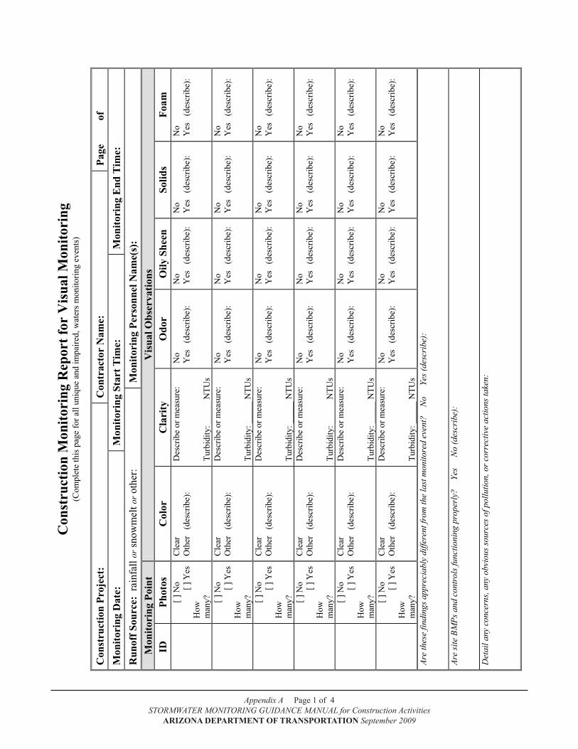
Appendix A Page 1 of 4STORMWATER MONITORING GUIDANCE MANUAL for Construction Activities
ARIZONA DEPARTMENT OF TRANSPORTATION September 2009
Con
stru
ctio
n M
onito
ring
Rep
ort f
or V
isua
l Mon
itori
ng
(Com
plet
e th
is p
age
for a
ll un
ique
and
impa
ired,
wat
ers m
onito
ring
even
ts)
Con
stru
ctio
n Pr
ojec
t:
Con
trac
tor
Nam
e:
Page
of
M
onito
ring
Dat
e:
Mon
itori
ng S
tart
Tim
e:
Mon
itori
ng E
nd T
ime:
R
unof
f Sou
rce:
rai
nfal
l or s
now
mel
t or o
ther
: M
onito
ring
Per
sonn
el N
ame(
s):
Mon
itori
ng P
oint
V
isua
l Obs
erva
tions
ID
Ph
otos
C
olor
C
lari
ty
Odo
r O
ily S
heen
So
lids
Foam
[ ] N
o
[ ] Y
es
How
m
any?
Cle
ar
Oth
er
(des
crib
e):
Des
crib
e or
mea
sure
: Tu
rbid
ity: _
____
NTU
s
No
Y
es
(des
crib
e):
No
Y
es
(des
crib
e):
No
Y
es
(des
crib
e):
No
Y
es
(des
crib
e):
[ ]
No
[ ]
Yes
H
ow
man
y?
Cle
ar
Oth
er
(des
crib
e):
Des
crib
e or
mea
sure
: Tu
rbid
ity: _
____
NTU
s
No
Y
es
(des
crib
e):
No
Y
es
(des
crib
e):
No
Y
es
(des
crib
e):
No
Y
es
(des
crib
e):
[ ]
No
[ ]
Yes
H
ow
man
y?
Cle
ar
Oth
er
(des
crib
e):
Des
crib
e or
mea
sure
: Tu
rbid
ity: _
____
NTU
s
No
Y
es
(des
crib
e):
No
Y
es
(des
crib
e):
No
Y
es
(des
crib
e):
No
Y
es
(des
crib
e):
[ ]
No
[ ]
Yes
H
ow
man
y?
Cle
ar
Oth
er
(des
crib
e):
Des
crib
e or
mea
sure
: Tu
rbid
ity: _
____
NTU
s
No
Y
es
(des
crib
e):
No
Y
es
(des
crib
e):
No
Y
es
(des
crib
e):
No
Y
es
(des
crib
e):
[ ]
No
[ ]
Yes
H
ow
man
y?
Cle
ar
Oth
er
(des
crib
e):
Des
crib
e or
mea
sure
: Tu
rbid
ity: _
____
NTU
s
No
Y
es
(des
crib
e):
No
Y
es
(des
crib
e):
No
Y
es
(des
crib
e):
No
Y
es
(des
crib
e):
[ ]
No
[ ]
Yes
H
ow
man
y?
Cle
ar
Oth
er
(des
crib
e):
Des
crib
e or
mea
sure
: Tu
rbid
ity: _
____
NTU
s
No
Y
es
(des
crib
e):
No
Y
es
(des
crib
e):
No
Y
es
(des
crib
e):
No
Y
es
(des
crib
e):
Are
thes
e fin
ding
s app
reci
ably
diff
eren
t fro
m th
e la
st m
onito
red
even
t?
No
Y
es (d
escr
ibe)
: Ar
e si
te B
MPs
and
con
trol
s fun
ctio
ning
pro
perl
y?
Yes
N
o (d
escr
ibe)
: D
etai
l any
con
cern
s, an
y ob
viou
s sou
rces
of p
ollu
tion,
or c
orre
ctiv
e ac
tions
take
n:
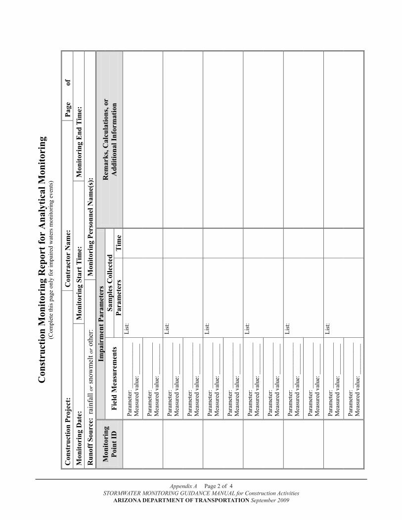
Appendix A Page 2 of 4STORMWATER MONITORING GUIDANCE MANUAL for Construction Activities
ARIZONA DEPARTMENT OF TRANSPORTATION September 2009
Con
stru
ctio
n M
onito
ring
Rep
ort f
or A
naly
tical
Mon
itori
ng
(Com
plet
e th
is p
age
only
for i
mpa
ired
wat
ers m
onito
ring
even
ts)
Con
stru
ctio
n Pr
ojec
t:
Con
trac
tor
Nam
e:
Page
of
M
onito
ring
Dat
e:
Mon
itori
ng S
tart
Tim
e:
Mon
itori
ng E
nd T
ime:
R
unof
f Sou
rce:
rai
nfal
l or s
now
mel
t or o
ther
: M
onito
ring
Per
sonn
el N
ame(
s):
Mon
itori
ng
Poin
t ID
Impa
irm
ent P
aram
eter
s R
emar
ks, C
alcu
latio
ns, o
r A
dditi
onal
Info
rmat
ion
Fiel
d M
easu
rem
ents
Sa
mpl
es C
olle
cted
Pa
ram
eter
s T
ime
Pa
ram
eter
: ___
____
____
____
M
easu
red
valu
e: _
____
____
_ Li
st:
Para
met
er: _
____
____
____
__
Mea
sure
d va
lue:
___
____
___
Pa
ram
eter
: ___
____
____
____
M
easu
red
valu
e: _
____
____
_ Li
st:
Para
met
er: _
____
____
____
__
Mea
sure
d va
lue:
___
____
___
Pa
ram
eter
: ___
____
____
____
M
easu
red
valu
e: _
____
____
_ Li
st:
Para
met
er: _
____
____
____
__
Mea
sure
d va
lue:
___
____
___
Pa
ram
eter
: ___
____
____
____
M
easu
red
valu
e: _
____
____
_ Li
st:
Para
met
er: _
____
____
____
__
Mea
sure
d va
lue:
___
____
___
Pa
ram
eter
: ___
____
____
____
M
easu
red
valu
e: _
____
____
_ Li
st:
Para
met
er: _
____
____
____
__
Mea
sure
d va
lue:
___
____
___
Pa
ram
eter
: ___
____
____
____
M
easu
red
valu
e: _
____
____
_ Li
st:
Para
met
er: _
____
____
____
__
Mea
sure
d va
lue:
___
____
___
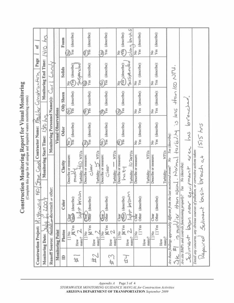
Appendix A Page 3 of 4STORMWATER MONITORING GUIDANCE MANUAL for Construction Activities
ARIZONA DEPARTMENT OF TRANSPORTATION September 2009

Appendix A Page 4 of 4STORMWATER MONITORING GUIDANCE MANUAL for Construction Activities
ARIZONA DEPARTMENT OF TRANSPORTATION September 2009
Page B-1 of B-3
STORMWATER MONITORING GUIDANCE MANUAL for Construction Activities
ARIZONA DEPARTMENT OF TRANSPORTATION September 2009
Appendix b
Discharge Monitoring Report Forms

Appendix B Page 1 of 6STORMWATER MONITORING GUIDANCE MANUAL for Construction Activities
ARIZONA DEPARTMENT OF TRANSPORTATION September 2009
Page B-2 of B-3
STORMWATER MONITORING GUIDANCE MANUAL for Construction Activities
ARIZONA DEPARTMENT OF TRANSPORTATION September 2009
ARIZONA DEPARTMENT OF TRANSPORTATION
[ ] NO DISChARGE ThIS MONTh Monthly Discharge Monitoring Report (DMR) Form
for the ADOT Statewide Permit #AZS000018-2008
AZS000018-2008 PERMIT NUMBER MONITORING POINT ID MONTH YEAR
PARAMETERS TURBIDITY Streamflow ANALYSIS TYPE: (Field, Lab, Calculation*) Field Field Calc.*
UNITS NTUs ft3/sec kg/day
PERMIT LIMITS
Min. TMDL Info Only
Mean Max.
DA
Y O
F T
HE
MO
NTH
1 2 3 4 5 6 7 8 9
10 11 12 13 14 15 16 17 18 19 20 21 22 23 24 25 26 27 28 29 30 31
Monthly Mean Highest Value
PROJECT NAME AND ADDRESS: COMPLETE AND SUBMIT ONE COPY PER MONITORING POINT
Mail to: ADOT Office of Environmental Services Water Quality Group 1611 W Jackson Street, MD EM02 Phoenix, AZ 85007
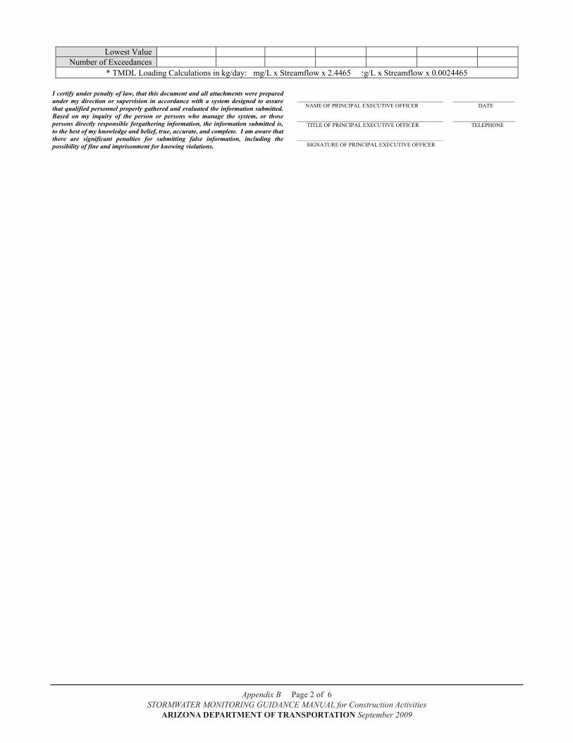
Appendix B Page 2 of 6STORMWATER MONITORING GUIDANCE MANUAL for Construction Activities
ARIZONA DEPARTMENT OF TRANSPORTATION September 2009
Page B-3 of B-3
STORMWATER MONITORING GUIDANCE MANUAL for Construction Activities
ARIZONA DEPARTMENT OF TRANSPORTATION September 2009
Lowest Value Number of Exceedances
* TMDL Loading Calculations in kg/day: mg/L x Streamflow x 2.4465 g/L x Streamflow x 0.0024465
I certify under penalty of law, that this document and all attachments were prepared under my direction or supervision in accordance with a system designed to assure that qualified personnel properly gathered and evaluated the information submitted. Based on my inquiry of the person or persons who manage the system, or those persons directly responsible forgathering information, the information submitted is, to the best of my knowledge and belief, true, accurate, and complete. I am aware that there are significant penalties for submitting false information, including the possibility of fine and imprisonment for knowing violations.
____________________________________________________ ______________________ NAME OF PRINCIPAL EXECUTIVE OFFICER DATE ____________________________________________________ ______________________ TITLE OF PRINCIPAL EXECUTIVE OFFICER TELEPHONE ____________________________________________________ SIGNATURE OF PRINCIPAL EXECUTIVE OFFICER
Appendix B Page 3 of 6STORMWATER MONITORING GUIDANCE MANUAL for Construction Activities
ARIZONA DEPARTMENT OF TRANSPORTATION September 2009

Appendix B Page 4 of 6STORMWATER MONITORING GUIDANCE MANUAL for Construction Activities
ARIZONA DEPARTMENT OF TRANSPORTATION September 2009

Appendix B Page 5 of 6STORMWATER MONITORING GUIDANCE MANUAL for Construction Activities
ARIZONA DEPARTMENT OF TRANSPORTATION September 2009
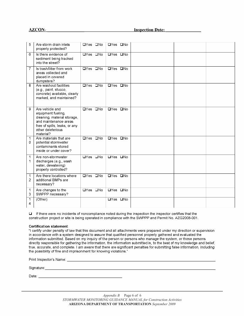
Appendix B Page 6 of 6STORMWATER MONITORING GUIDANCE MANUAL for Construction Activities
ARIZONA DEPARTMENT OF TRANSPORTATION September 2009
Page C-1 of C-9
STORMWATER MONITORING GUIDANCE MANUAL for Construction Activities ARIZONA DEPARTMENT OF TRANSPORTATION September 10, 2009
Appendix C
Example Stormwater Monitoring Plan
for a Unique Water

Appendix C Page 1 of 7STORMWATER MONITORING GUIDANCE MANUAL for Construction Activities
ARIZONA DEPARTMENT OF TRANSPORTATION September 2009
Page C-2 of C-9
STORMWATER MONITORING GUIDANCE MANUAL for Construction Activities ARIZONA DEPARTMENT OF TRANSPORTATION September 10, 2009
Monitoring Plan
ADOT
Cienega Creek/I-10 Bridge
Replacement Project
Prepared by Dusty Walker Country Roads Construction, Inc.
Tucson, Arizona
March 2009
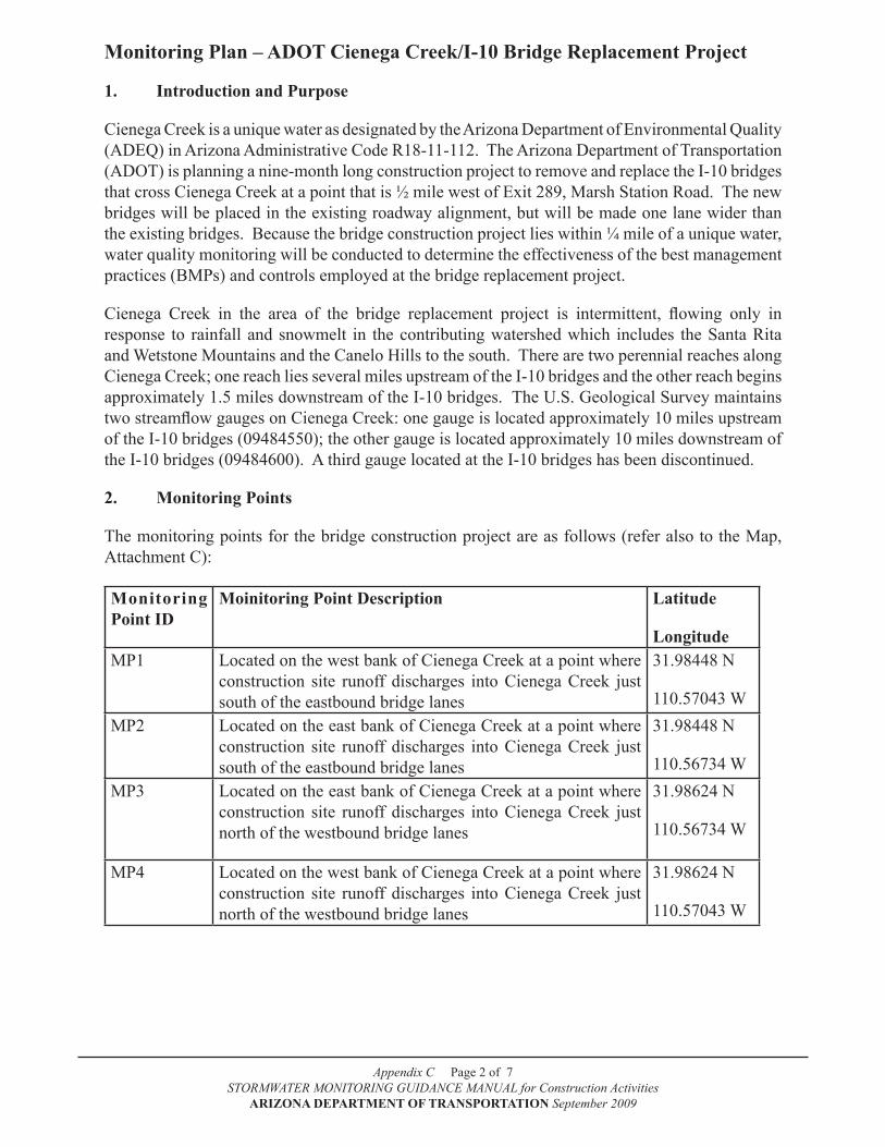
Appendix C Page 2 of 7STORMWATER MONITORING GUIDANCE MANUAL for Construction Activities
ARIZONA DEPARTMENT OF TRANSPORTATION September 2009
Monitoring Plan – ADOT Cienega Creek/I-10 bridge Replacement Project
1. Introduction and Purpose
Cienega Creek is a unique water as designated by the Arizona Department of Environmental Quality (ADEQ) in Arizona Administrative Code R18-11-112. The Arizona Department of Transportation (ADOT) is planning a nine-month long construction project to remove and replace the I-10 bridges that cross Cienega Creek at a point that is ½ mile west of Exit 289, Marsh Station Road. The new bridges will be placed in the existing roadway alignment, but will be made one lane wider than the existing bridges. Because the bridge construction project lies within ¼ mile of a unique water, water quality monitoring will be conducted to determine the effectiveness of the best management practices (BMPs) and controls employed at the bridge replacement project.
Cienega Creek in the area of the bridge replacement project is intermittent, flowing only in response to rainfall and snowmelt in the contributing watershed which includes the Santa Rita and Wetstone Mountains and the Canelo Hills to the south. There are two perennial reaches along Cienega Creek; one reach lies several miles upstream of the I-10 bridges and the other reach begins approximately 1.5 miles downstream of the I-10 bridges. The U.S. Geological Survey maintains two streamflow gauges on Cienega Creek: one gauge is located approximately 10 miles upstream of the I-10 bridges (09484550); the other gauge is located approximately 10 miles downstream of the I-10 bridges (09484600). A third gauge located at the I-10 bridges has been discontinued.
2. Monitoring Points
The monitoring points for the bridge construction project are as follows (refer also to the Map, Attachment C):
Monitoring Point ID
Moinitoring Point Description Latitude
LongitudeMP1 Located on the west bank of Cienega Creek at a point where
construction site runoff discharges into Cienega Creek just south of the eastbound bridge lanes
31.98448 N
110.57043 WMP2 Located on the east bank of Cienega Creek at a point where
construction site runoff discharges into Cienega Creek just south of the eastbound bridge lanes
31.98448 N
110.56734 WMP3 Located on the east bank of Cienega Creek at a point where
construction site runoff discharges into Cienega Creek just north of the westbound bridge lanes
31.98624 N
110.56734 W
MP4 Located on the west bank of Cienega Creek at a point where construction site runoff discharges into Cienega Creek just north of the westbound bridge lanes
31.98624 N
110.57043 W
Appendix C Page 3 of 7STORMWATER MONITORING GUIDANCE MANUAL for Construction Activities
ARIZONA DEPARTMENT OF TRANSPORTATION September 2009
3. Monitoring Frequency
Once construction begins in March, monitoring will be conducted on a storm-by-storm basis . The anticipated construction completion date is November 30. Samples will be collected anytime there is runoff from the project site.
4. Preparation and Training
Prior to the commencement of monitoring, all personnel that will be involved in the monitoring will be trained in the proper use of the digital cameras and how to conduct visual monitoring. Monitoring personnel will also make a monitoring “dry run” to ensure that all protocols are in place and ready to go. Monitoring personnel are certified in OSHA awareness training, basic first aid training, and CPR training. A telephone tree has been prepared and distributed to monitoring personnel and construction site management to communicate problems and issues up the chain of command (see Attachment A).
5. Field Observations and Measurements
Cienega Creek will be monitored for six visual water quality characteristics (color, clarity, odor, oily sheen, solids, and foam). Photo documentation will be conducted at the same time.
6. Record keeping Requirements
Each monitoring event will be recorded on an ADOT Construction Monitoring Report for Visual Monitoring (CMR) (Attachment B). Photo documentation information will be labeled, printed, filed with the CMR, and stored on a disk or CD.
7. Quality Assurance and Quality Control
Monitoring personnel will be fully trained in, and will follow, the standard operating procedures for visual monitoring and photo documentation as described in the most current revision of the ADOT STORMWATER MONITORING GUIDANCE MANUAL for Construction Activities.
8. Maps and Photos
The map in Attachment C illustrates the bridge construction site and surrounding area.
9. Data Management
Completed CMRs and photo documentation will be kept in chronological order in a file system. A separate file will be created for each calendar month for reporting purposes. The files will be made available to all monitoring personnel for use in assessing the data.
Appendix C Page 4 of 7STORMWATER MONITORING GUIDANCE MANUAL for Construction Activities
ARIZONA DEPARTMENT OF TRANSPORTATION September 2009
10. Data Assessment
The monitoring points will determine if stormwater flows that originate from the construction site may cause water quality problems in Cienega Creek. Construction site BMPs are designed to minimize pollutants in stormwater discharges that leave the construction site. If the BMPs are functioning properly, visual observations at the monitoring points should be: clear; odor, foam, and sheen free; and are not expected to have excessive turbidity or solids. Any observed deviation from what is considered the “normal observation” at each monitoring site may indicate a BMP problem.
11. Corrective Action Plan
Whenever a potential BMP problem has been identified, an inspection will be conducted immediately to determine the source. Once a water quality impact has been identified, corrective actions to correct the deficiency(ies) will be taken immediately. All corrective actions will be fully documented with photos and a written description of the corrective action(s) taken.
12. Reporting Requirements
At this time, ADEQ is not requiring submittal of any monitoring documentation. The contractor is responsible for maintaining all monitoring documentation in anticipation that ADEQ may request it at a later date.
If requested by ADEQ, monitoring documentation will be submitted to ADEQ at the following address:
Arizona Department of Environmental QualitySurface water Section, Stormwater and General Permits Unit/NOI1110 W. Washington, (5415A-1)Phoenix, AZ 85007
The contractor shall refer to the ADOT Section 104 Standard Specifications for a review of the non-compliance procedures and protocols if any compliance deficiencies are noted. Under the CGP, the contractor shall report to ADEQ any noncompliance which may endanger human health or the environment. The contractor shall orally notify the office listed below within 24 hours:
Arizona Department of Environmental Quality1110 W. Washington, Mail Code 5515B-1Phoenix, AZ 85007Office: 602-771-2330; Fax 602-771-4505
A written submission shall also be provided to the office identified above within five days of the time the contractor becomes aware of the circumstances. The written submission shall contain a description of the noncompliance and its cause; the period of noncompliance, including exact dates and times, and if the noncompliance has not been corrected, the anticipated time it is expected to continue; and steps taken or planned to reduce, eliminate, and prevent recurrence of the noncompliance.
When the contractor becomes aware that he or she failed to submit any relevant facts in any report to the ADEQ, the contractor shall promptly submit the facts or information to the Water Permits Section of ADEQ.
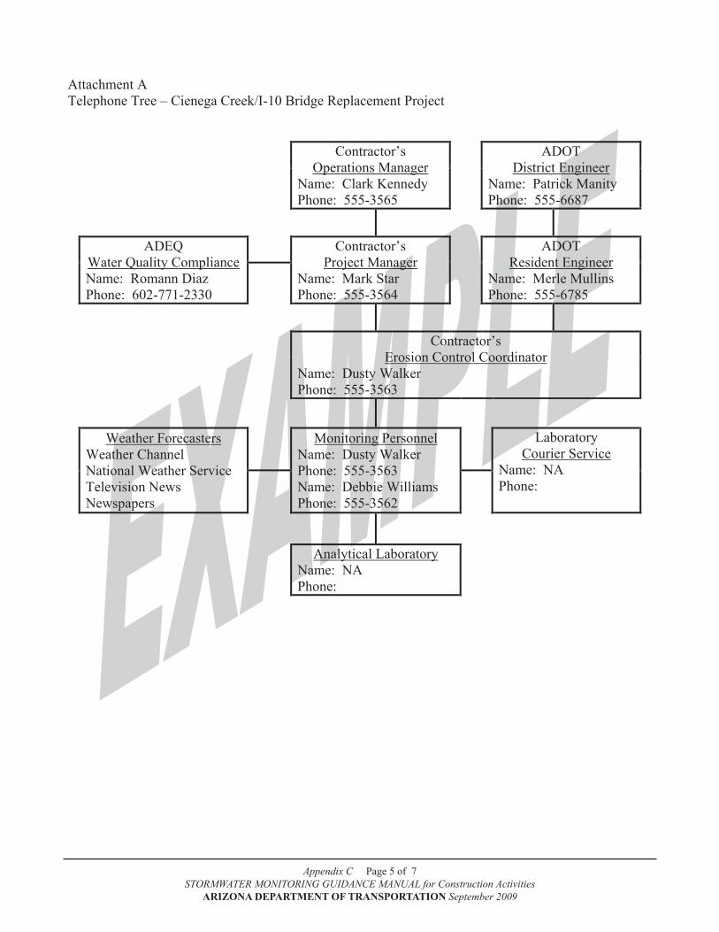
Appendix C Page 5 of 7STORMWATER MONITORING GUIDANCE MANUAL for Construction Activities
ARIZONA DEPARTMENT OF TRANSPORTATION September 2009
Page C-7 of C-9
STORMWATER MONITORING GUIDANCE MANUAL for Construction Activities ARIZONA DEPARTMENT OF TRANSPORTATION September 10, 2009
Attachment A Telephone Tree – Cienega Creek/I-10 Bridge Replacement Project
Contractor’s Operations Manager
Name: Clark Kennedy Phone: 555-3565
ADOT District Engineer
Name: Patrick Manity Phone: 555-6687
ADEQ
Water Quality Compliance Name: Romann Diaz Phone: 602-771-2330
Contractor’s Project Manager
Name: Mark Star Phone: 555-3564
ADOT Resident Engineer
Name: Merle Mullins Phone: 555-6785
Contractor’s
Erosion Control Coordinator Name: Dusty Walker Phone: 555-3563
Weather Forecasters Weather Channel National Weather Service Television News Newspapers
Monitoring Personnel
Name: Dusty Walker Phone: 555-3563 Name: Debbie Williams Phone: 555-3562
Laboratory
Courier Service Name: NA Phone:
Analytical Laboratory
Name: NA Phone:

Appendix C Page 6 of 7STORMWATER MONITORING GUIDANCE MANUAL for Construction Activities
ARIZONA DEPARTMENT OF TRANSPORTATION September 2009
Page C-8 of C-9
STORMWATER MONITORING GUIDANCE MANUAL for Construction Activities ARIZONA DEPARTMENT OF TRANSPORTATION September 10, 2009
Attachment B ADOT Construction Monitoring Report for Visual Monitoring
Con
stru
ctio
n M
onito
ring
Rep
ort f
or V
isua
l Mon
itori
ng
(Com
plet
e th
is p
age
for a
ll un
ique
and
impa
ired,
wat
ers m
onito
ring
even
ts)
Con
stru
ctio
n Pr
ojec
t:
Con
trac
tor
Nam
e:
Page
of
M
onito
ring
Dat
e:
Mon
itori
ng S
tart
Tim
e:
Mon
itori
ng E
nd T
ime:
R
unof
f Sou
rce:
rai
nfal
l or s
now
mel
t or o
ther
: M
onito
ring
Per
sonn
el N
ame(
s):
Mon
itori
ng P
oint
V
isua
l Obs
erva
tions
ID
Ph
otos
C
olor
C
lari
ty
Odo
r O
ily S
heen
So
lids
Foam
[ ] N
o
[ ] Y
es
How
m
any?
Cle
ar
Oth
er
(des
crib
e):
Des
crib
e or
mea
sure
: Tu
rbid
ity: _
____
NTU
s
No
Y
es
(des
crib
e):
No
Y
es
(des
crib
e):
No
Y
es
(des
crib
e):
No
Y
es
(des
crib
e):
[ ]
No
[ ]
Yes
H
ow
man
y?
Cle
ar
Oth
er
(des
crib
e):
Des
crib
e or
mea
sure
: Tu
rbid
ity: _
____
NTU
s
No
Y
es
(des
crib
e):
No
Y
es
(des
crib
e):
No
Y
es
(des
crib
e):
No
Y
es
(des
crib
e):
[ ]
No
[ ]
Yes
H
ow
man
y?
Cle
ar
Oth
er
(des
crib
e):
Des
crib
e or
mea
sure
: Tu
rbid
ity: _
____
NTU
s
No
Y
es
(des
crib
e):
No
Y
es
(des
crib
e):
No
Y
es
(des
crib
e):
No
Y
es
(des
crib
e):
[ ]
No
[ ]
Yes
H
ow
man
y?
Cle
ar
Oth
er
(des
crib
e):
Des
crib
e or
mea
sure
: Tu
rbid
ity: _
____
NTU
s
No
Y
es
(des
crib
e):
No
Y
es
(des
crib
e):
No
Y
es
(des
crib
e):
No
Y
es
(des
crib
e):
[ ]
No
[ ]
Yes
H
ow
man
y?
Cle
ar
Oth
er
(des
crib
e):
Des
crib
e or
mea
sure
: Tu
rbid
ity: _
____
NTU
s
No
Y
es
(des
crib
e):
No
Y
es
(des
crib
e):
No
Y
es
(des
crib
e):
No
Y
es
(des
crib
e):
[ ]
No
[ ]
Yes
H
ow
man
y?
Cle
ar
Oth
er
(des
crib
e):
Des
crib
e or
mea
sure
: Tu
rbid
ity: _
____
NTU
s
No
Y
es
(des
crib
e):
No
Y
es
(des
crib
e):
No
Y
es
(des
crib
e):
No
Y
es
(des
crib
e):
Are
thes
e fin
ding
s app
reci
ably
diff
eren
t fro
m th
e la
st m
onito
red
even
t?
No
Y
es (d
escr
ibe)
: Ar
e si
te B
MPs
and
con
trol
s fun
ctio
ning
pro
perl
y?
Yes
N
o (d
escr
ibe)
: D
etai
l any
con
cern
s, an
y ob
viou
s sou
rces
of p
ollu
tion,
or c
orre
ctiv
e ac
tions
take
n:
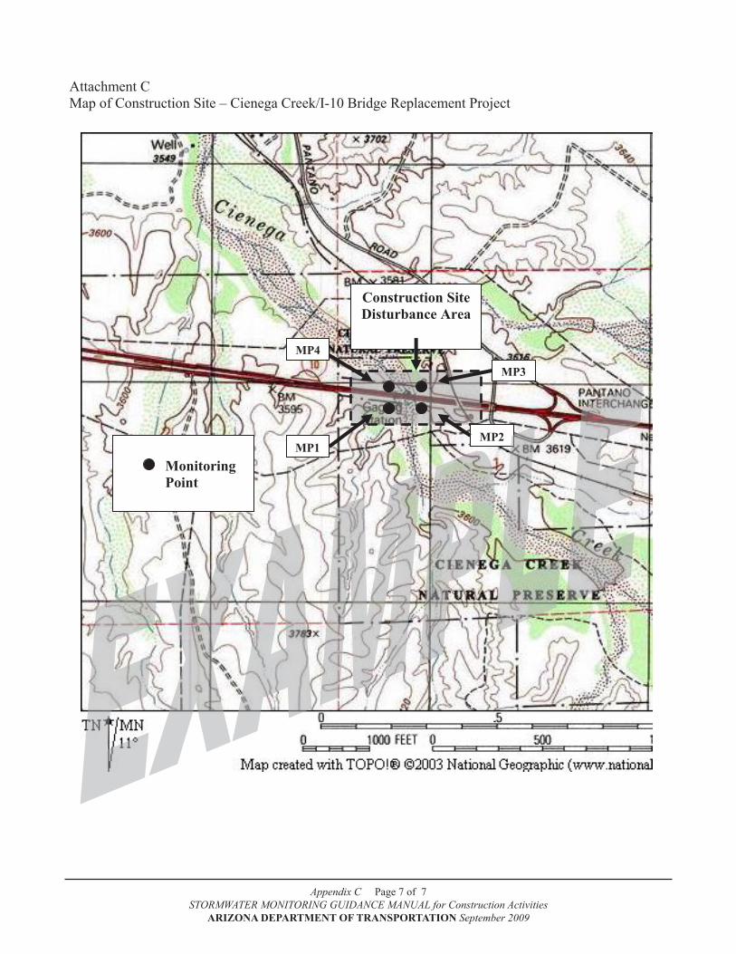
Appendix C Page 7 of 7STORMWATER MONITORING GUIDANCE MANUAL for Construction Activities
ARIZONA DEPARTMENT OF TRANSPORTATION September 2009
Page C-9 of C-9
STORMWATER MONITORING GUIDANCE MANUAL for Construction Activities ARIZONA DEPARTMENT OF TRANSPORTATION September 10, 2009
Attachment C Map of Construction Site – Cienega Creek/I-10 Bridge Replacement Project
Construction Site Disturbance Area
MP1 MP2
MP3
MP4
Monitoring
Point
Page D-1 of D-13
STORMWATER MONITORING GUIDANCE MANUAL for Construction Activities
ARIZONA DEPARTMENT OF TRANSPORTATION September 2009
Appendix D
Example Stormwater Monitoring Plan
for an Impaired Water

Appendix D Page 1 of 11STORMWATER MONITORING GUIDANCE MANUAL for Construction Activities
ARIZONA DEPARTMENT OF TRANSPORTATION September 2009
Page D-2 of D-13
STORMWATER MONITORING GUIDANCE MANUAL for Construction Activities
ARIZONA DEPARTMENT OF TRANSPORTATION September 2009
Monitoring Plan
ADOT
Highway 180/Stone Creek Road
Reconstruction Project
Prepared by Dusty Walker Country Roads Construction, Inc.
Tucson, Arizona
March 2009

Appendix D Page 2 of 11STORMWATER MONITORING GUIDANCE MANUAL for Construction Activities
ARIZONA DEPARTMENT OF TRANSPORTATION September 2009
Monitoring Plan – ADOT highway 180/Stone Creek Road Reconstruction Project
1. Introduction and Purpose
Nutrioso Creek is a Category 4 not attaining impaired water as designated by the Arizona Depart-ment of Environmental Quality (ADEQ) in the 2004 303(d) List of Impaired Waters. The Ari-zona Department of Transportation (ADOT) is planning a nine-month long construction project to reconstruct the intersection of Highway 180 and Stone Creek Road near milepost 87. Nutrioso Creek lies immediately to the west of Highway 180 within ¼ mile of the proposed construction project. Nelson Reservoir lies 1¼ mile downstream of the construction project. The reconstruc-tion will occur within the existing roadway right-of-way, but Highway 180 will be widened to accommodate a new left-turn lane. Because the intersection reconstruction project lies within ¼ mile of an impaired water, Nutrioso Creek, water quality monitoring will be conducted to deter-mine the effectiveness of the best management practices (BMPs) and controls employed at the bridge construction project.
After the TMDL was approved by the U.S. Environmental Protection Agency in 2000, biomoni-toring and Stream Ecosystem Monitoring data have also been collected to further characterize water quality and watershed conditions for Nutrioso Creek. In addition to general chemistry and inorganics, trace metals, nutrients, bacteria, and streamflow information, ADEQ collected data on aquatic insects, stream geomorphology, riparian inventory, and floodprone areas.
2. Impairment Parameters and bMP Implementation
ADEQ has identified Nutrioso Creek as impaired for turbidity and suspended sediment concen-tration. Construction site BMPs will focus on minimizing the amount of erosion on the construc-tion site and keeping any eroded sediment from migrating off site and into Nutrioso Creek or its tributaries.
Two small creeks, Davis Creek and Cinder Pit Creek, flow through the construction site and into Nutrioso Creek. BMPs will be used to protect these two creeks from receiving any stormwater discharges from the construction site. For more details on the specific BMPs to be implemented and their locations, refer to the SWPPP.
3. bMP Inspection Frequency
The following table discusses the BMP inspection frequency:
bMP Inspection
Period
Regular Inspection Frequency
Special Inspection Frequency
Additional Requirement
Duration of the project
Weekly Within 24 hours after 0.5 inch or more of
rain
Photo documentation collected during every inspection

Appendix D Page 3 of 11STORMWATER MONITORING GUIDANCE MANUAL for Construction Activities
ARIZONA DEPARTMENT OF TRANSPORTATION September 2009
4. Monitoring Points
The monitoring points for the bridge construction project are as follows (refer also to the Map, Attachment D):
Monitoring Point ID
Monitoring Point Description Latitude
Longitude
MP1 Located at the western construction site boundary upstream of the confluence of Davis Creek and Nutrioso Creek at a point where stormwater discharges from the southern third of the construction site are contained in a settling basin.
34˚ 01’ 35”
109˚ 11’ 01”
MP2 Located at the western construction site boundary upstream of the confluence of Cinder Pit Creek and Nutrioso Creek at a point where stormwater discharges from the central third of the construction site are contained in a settling basin.
34˚ 01’ 36”
109˚ 11’ 01”
MP3 Located at the northwestern corner of the construction site boundary at a point where stormwater discharges from the northern third of the construction site are contained in a series of three settling basins.
34˚ 01’ 45”
109˚ 11’ 03”
5. Monitoring Frequency
Once construction begins in March, monitoring will be conducted on a storm-by-storm basis . The anticipated construction completion date is November 30. All monitoring point should be sampled during any runoff from the construction site during daylight hours and at least 72 hours from the previous sample.
6. Preparation and Training
Prior to the commencement of monitoring, all personnel that will be involved in the monitoring will be trained in the proper use of field meters and cameras, and how to conduct visual monitor-ing. Monitoring personnel will also make a monitoring “dry run” to ensure that all protocols are in place and ready to go. Monitoring personnel are certified in OSHA awareness training, basic first aid training, and CPR training. A telephone tree has been prepared and distributed to moni-toring personnel and construction site management to communicate problems and issues up the chain of command (see Attachment A).
7. Field Observations and Measurements
Nutrioso Creek will be monitored for six visual water quality characteristics (color, clarity, odor, oily sheen, solids, and foam). Field turbidity measurements and photo documentation will be conducted at the same time.

Appendix D Page 4 of 11STORMWATER MONITORING GUIDANCE MANUAL for Construction Activities
ARIZONA DEPARTMENT OF TRANSPORTATION September 2009
8. Laboratory Analyses
Total suspended solids will be analyzed by Alpha Beta Analytical Laboratory, Inc. in Mesa. The following table discusses the analytical requirements
Parameter Method(s) Reporting LimitTotal Suspended Solids SM 2540D 0.5 mg/L
9. Sample Collection and handling
Alpha Beta Analytical Laboratory, Inc. will provide sample bottles, ice chests, and chain-of-cus-tody forms. Grab samples for total suspended solids will be collected, placed on ice immediately, and delivered to Alpha Beta Analytical Laboratory, Inc. in Mesa within 48 hours of collection. Chain-of-custody protocols will be followed.
10. Record keeping Requirements
Each monitoring event will be recorded on ADOT Construction Monitoring Reports (CMR) (At-tachments B and C). Turbidity meter calibration and maintenance information will be recorded in a calibration logbook. Photo documentation information will be labeled, printed, filed with the CMR, and stored on a disk or CD.
11. Quality Assurance and Quality Control
Monitoring personnel will be fully trained in, and will follow, the standard operating procedures for visual monitoring, turbidity measurement, and photo documentation as described in the most current revision of the ADOT STORMWATER MONITORING GUIDANCE MANUAL for Con-struction Activities.
When making turbidity measurements, the 10-second signal averaging feature will be enabled. Turbidity meter will be calibrated every 3 months per manufacturer’s recommendations.The turbidity meter meets the following minimum criteria as specified by ADOT:
Meter Type Hand-held field nephelometer; non-probe typeAnalytical Method USEPA 180.1/SM 2130BRange 0.1 - 400 NTU or greaterResolution 0.1 NTU below 100 NTUAccuracy 1 NTU above 100 NTURepeatability +/- 5% or +/- 0.1 NTU(whichever is greater)Power Source Battery operatedOperating Temperature Range 0 - 50°CSpecial Feature Signal averaging or measurement averaging

Appendix D Page 5 of 11STORMWATER MONITORING GUIDANCE MANUAL for Construction Activities
ARIZONA DEPARTMENT OF TRANSPORTATION September 2009
Alpha Beta Analytical Laboratory, Inc. is certified by the Arizona Department of Health Services for environmental testing and is in good standing (ADHS certification # 96-451223).
12. Maps and Photos
The map in Attachment D illustrates the intersection reconstruction project and surrounding area.
13. Data Management
Completed CMRs and photo documentation will be kept in chronological order in a file system. A separate file will be created for each calendar month for reporting purposes. The files will be kept on site and made available to all monitoring personnel for use in assessing the data.
14. Data Assessment
The monitoring points will determine if stormwater flows that originate from the construction site may cause water quality problems in Nutrioso Creek. Construction site BMPs are designed to minimize pollutants in stormwater discharges that leave the construction site. If the BMPs are functioning properly, visual observations at the monitoring points should be: clear; odor, foam, and sheen free; and are not expected to have excessive turbidity or solids. Any observed devia-tion from what is considered the “normal observation” at each monitoring site may indicate a BMP problem.
Monitoring points #1 and #2 are located on small creeks that may contain streamflow from their contributing watersheds on an intermittent basis. These creeks may also contain nuisance flows from off-site sources originating in the Golden Acres residential neighborhood.
15. Corrective Action Plan
Whenever a potential BMP problem has been identified, an inspection is conducted immediately to determine the source. Once a water quality impact has been identified, corrective actions to correct the deficiency (ies) will be taken immediately. All corrective actions will be fully docu-mented with photos and a written description of the corrective action(s) taken.
16. Reporting Requirements
Per the ADOT contract, analytical monitoring information will be summarized and sent to ADEQ by the last day of every month for the previous calendar month on an ADOT Discharge Monitor-ing Report (DMR: see Attachment E). Completed DMRs are jointly reviewed by the contractor’s representative and the ADOT Resident Engineer prior to submittal to ADEQ. DMRs are submit-ted to ADEQ on a monthly basis even if there has not been a monitored event during the month. A separate DMR is completed for each monitoring point that has been identified in the Monitor-ing Plan. If requested by ADEQ, photo documentation will be submitted along with the monthly DMRs.
Appendix D Page 6 of 11STORMWATER MONITORING GUIDANCE MANUAL for Construction Activities
ARIZONA DEPARTMENT OF TRANSPORTATION September 2009
DMRs shall be submitted to ADEQ at the following address:
Surface Water Section Permits Unit/NOI 5415A-1Arizona Department of Environmental Quality1110 W. WashingtonPhoenix, AZ 85007
The contractor shall refer to the ADOT Section 104 Standard Specifications for a review of the non-compliance procedures and protocols if any compliance deficiencies are noted. Under the CGP, the contractor shall report to ADEQ any noncompliance which may endanger human health or the environment. The contractor shall orally notify the office listed below within 24 hours:
Arizona Department of Environmental Quality1110 W. Washington, Mail Code 5515B-1Phoenix, AZ 85007Office: 602-771-2330; Fax 602-771-4505
A written submission shall also be provided to the office identified above within five days of the time the contractor becomes aware of the circumstances. The written submission shall contain a description of the noncompliance and its cause; the period of noncompliance, including exact dates and times, and if the noncompliance has not been corrected, the anticipated time it is ex-pected to continue; and steps taken or planned to reduce, eliminate, and prevent recurrence of the noncompliance.
When the contractor becomes aware that he or she failed to submit any relevant facts in any report to the ADEQ, the contractor shall promptly submit the facts or information to the Water Permits Section of ADEQ.

Appendix D Page 7 of 11STORMWATER MONITORING GUIDANCE MANUAL for Construction Activities
ARIZONA DEPARTMENT OF TRANSPORTATION September 2009
Page D-9 of D-13
STORMWATER MONITORING GUIDANCE MANUAL for Construction Activities
ARIZONA DEPARTMENT OF TRANSPORTATION September 2009
Attachment A Telephone Tree
Contractor’s Operations Manager
Name: Clark Kennedy Phone: 555-3565
ADOT District Engineer
Name: Patrick Manity Phone: 555-6687
ADEQ
Water Quality Compliance Name: Matthew Hodge Phone: 602-771-4513
Contractor’s Project Manager
Name: Mark Star Phone: 555-3564
ADOT Resident Engineer
Name: Merle Mullins Phone: 555-6785
Contractor’s
Erosion Control Coordinator Name: Dusty Walker Phone: 555-3563
Weather Forecasters Weather Channel National Weather Service Television News Newspapers
Monitoring Personnel
Name: Dusty Walker Phone: 555-3563 Name: Debbie Williams Phone: 555-3562
Laboratory
Courier Service Name: Alpha Beta Phone: 555-2222
Analytical Laboratory
Name: Alpha Beta Labs Phone: 555-2222
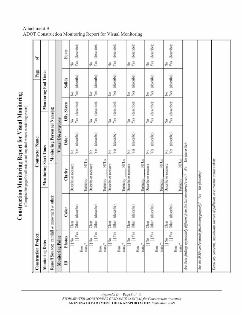
Appendix D Page 8 of 11STORMWATER MONITORING GUIDANCE MANUAL for Construction Activities
ARIZONA DEPARTMENT OF TRANSPORTATION September 2009
Page D-10 of D-13
STORMWATER MONITORING GUIDANCE MANUAL for Construction Activities
ARIZONA DEPARTMENT OF TRANSPORTATION September 2009
Attachment B ADOT Construction Monitoring Report for Visual Monitoring
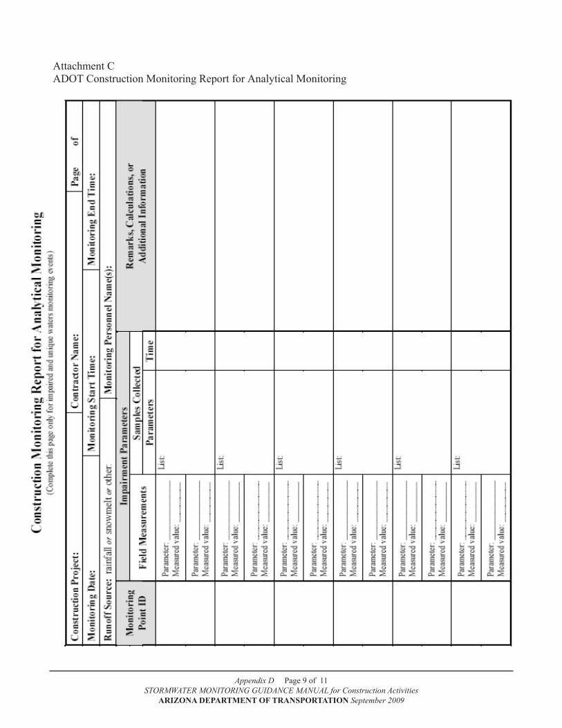
Appendix D Page 9 of 11STORMWATER MONITORING GUIDANCE MANUAL for Construction Activities
ARIZONA DEPARTMENT OF TRANSPORTATION September 2009
Page D-11 of D-13
STORMWATER MONITORING GUIDANCE MANUAL for Construction Activities
ARIZONA DEPARTMENT OF TRANSPORTATION September 2009
Attachment C ADOT Construction Monitoring Report for Analytical Monitoring
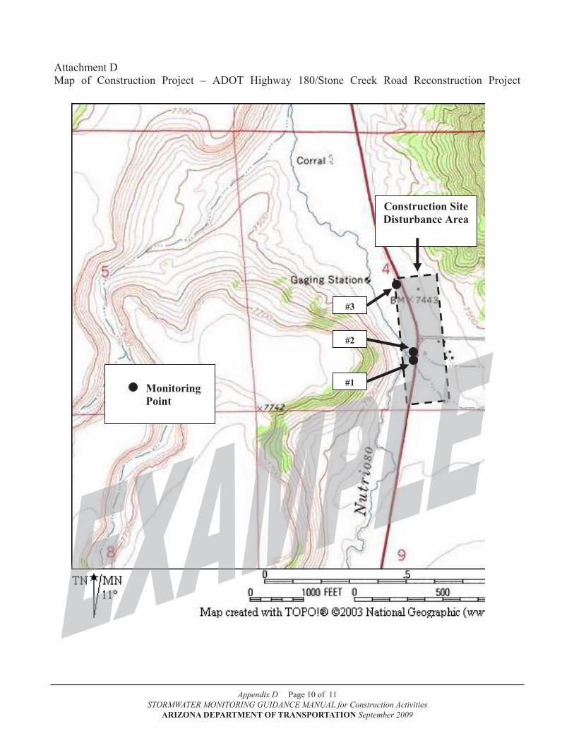
Appendix D Page 10 of 11STORMWATER MONITORING GUIDANCE MANUAL for Construction Activities
ARIZONA DEPARTMENT OF TRANSPORTATION September 2009
Page D-12 of D-13
STORMWATER MONITORING GUIDANCE MANUAL for Construction Activities
ARIZONA DEPARTMENT OF TRANSPORTATION September 2009
Attachment D Map of Construction Project – ADOT Highway 180/Stone Creek Road Reconstruction Project
Construction Site Disturbance Area
#1
#2
#3
Monitoring
Point

Appendix D Page 11 of 11STORMWATER MONITORING GUIDANCE MANUAL for Construction Activities
ARIZONA DEPARTMENT OF TRANSPORTATION September 2009
Page D-13 of D-13
STORMWATER MONITORING GUIDANCE MANUAL for Construction Activities
ARIZONA DEPARTMENT OF TRANSPORTATION September 2009
Attachment E ADOT Discharge Monitoring Report for Analytical Monitoring
ARIZONA DEPARTMENT OF TRANSPORTATION
[ ] NO DISChARGE ThIS MONTh Monthly Discharge Monitoring Report (DMR) Form
for the ADOT Statewide Permit #AZS000018-2008
AZS000018-2008 PERMIT NUMBER MONITORING POINT ID MONTH YEAR
PARAMETERS TURBIDITY Streamflow ANALYSIS TYPE: (Field, Lab, Calculation*) Field Field Calc.*
UNITS NTUs ft3/sec kg/day
PERMIT LIMITS
Min. TMDL Info Only
Mean Max.
DA
Y O
F T
HE
MO
NTH
1 2 3 4 5 6 7 8 9
10 11 12 13 14 15 16 17 18 19 20 21 22 23 24 25 26 27 28 29 30 31
Monthly Mean Highest Value Lowest Value
Number of Exceedances * TMDL Loading Calculations in kg/day: mg/L x Streamflow x 2.4465 g/L x Streamflow x 0.0024465
PROJECT NAME AND ADDRESS: COMPLETE AND SUBMIT ONE COPY PER MONITORING POINT
Mail to: ADOT Office of Environmental Services Water Quality Group 1611 W. Jackson Street, MD EM02 Phoenix, AZ 85007
I certify under penalty of law, that this document and all attachments were prepared under my direction or supervision in accordance with a system designed to assure that qualified personnel properly gathered and evaluated the information submitted. Based on my inquiry of the person or persons who manage the system, or those persons directly responsible forgathering information, the information submitted is, to the best of my knowledge and belief, true, accurate, and complete. I am aware that there are significant penalties for submitting false information, including the possibility of fine and imprisonment for knowing violations.
____________________________________________________ ______________________ NAME OF PRINCIPAL EXECUTIVE OFFICER DATE ____________________________________________________ ______________________ TITLE OF PRINCIPAL EXECUTIVE OFFICER TELEPHONE ____________________________________________________ SIGNATURE OF PRINCIPAL EXECUTIVE OFFICER
Related Documents