Geosphere doi: 10.1130/GES00862.1 published online 13 September 2013; Geosphere Bryan P. Murray, Cathy J. Busby, Luca Ferrari and Luigi A. Solari Mining District region, western Chihuahua the northern Sierra Madre Occidental, Mexico: Evidence from the Guazapares Synvolcanic crustal extension during the mid-Cenozoic ignimbrite flare-up in Email alerting services articles cite this article to receive free e-mail alerts when new www.gsapubs.org/cgi/alerts click Subscribe to subscribe to Geosphere www.gsapubs.org/subscriptions/ click Permission request to contact GSA http://www.geosociety.org/pubs/copyrt.htm#gsa click official positions of the Society. citizenship, gender, religion, or political viewpoint. Opinions presented in this publication do not reflect presentation of diverse opinions and positions by scientists worldwide, regardless of their race, includes a reference to the article's full citation. GSA provides this and other forums for the the abstracts only of their articles on their own or their organization's Web site providing the posting to further education and science. This file may not be posted to any Web site, but authors may post works and to make unlimited copies of items in GSA's journals for noncommercial use in classrooms requests to GSA, to use a single figure, a single table, and/or a brief paragraph of text in subsequent their employment. Individual scientists are hereby granted permission, without fees or further Copyright not claimed on content prepared wholly by U.S. government employees within scope of Notes articles must include the digital object identifier (DOIs) and date of initial publication. priority; they are indexed by GeoRef from initial publication. Citations to Advance online prior to final publication). Advance online articles are citable and establish publication yet appeared in the paper journal (edited, typeset versions may be posted when available Advance online articles have been peer reviewed and accepted for publication but have not © Geological Society of America as doi:10.1130/GES00862.1 Geosphere, published online on 13 September 2013

Welcome message from author
This document is posted to help you gain knowledge. Please leave a comment to let me know what you think about it! Share it to your friends and learn new things together.
Transcript
Geosphere
doi: 10.1130/GES00862.1 published online 13 September 2013;Geosphere
Bryan P. Murray, Cathy J. Busby, Luca Ferrari and Luigi A. Solari Mining District region, western Chihuahuathe northern Sierra Madre Occidental, Mexico: Evidence from the Guazapares Synvolcanic crustal extension during the mid-Cenozoic ignimbrite flare-up in
Email alerting servicesarticles cite this article
to receive free e-mail alerts when newwww.gsapubs.org/cgi/alertsclick
Subscribe to subscribe to Geospherewww.gsapubs.org/subscriptions/click
Permission request to contact GSAhttp://www.geosociety.org/pubs/copyrt.htm#gsaclick
official positions of the Society.citizenship, gender, religion, or political viewpoint. Opinions presented in this publication do not reflectpresentation of diverse opinions and positions by scientists worldwide, regardless of their race, includes a reference to the article's full citation. GSA provides this and other forums for thethe abstracts only of their articles on their own or their organization's Web site providing the posting to further education and science. This file may not be posted to any Web site, but authors may postworks and to make unlimited copies of items in GSA's journals for noncommercial use in classrooms requests to GSA, to use a single figure, a single table, and/or a brief paragraph of text in subsequenttheir employment. Individual scientists are hereby granted permission, without fees or further Copyright not claimed on content prepared wholly by U.S. government employees within scope of
Notes
articles must include the digital object identifier (DOIs) and date of initial publication. priority; they are indexed by GeoRef from initial publication. Citations to Advance online prior to final publication). Advance online articles are citable and establish publicationyet appeared in the paper journal (edited, typeset versions may be posted when available Advance online articles have been peer reviewed and accepted for publication but have not
© Geological Society of America
as doi:10.1130/GES00862.1Geosphere, published online on 13 September 2013

Synvolcanic crustal extension during the mid-Cenozoic ignimbrite fl are-up in the northern Sierra Madre Occidental, Mexico: Evidence
from the Guazapares Mining District region, western Chihuahua
Bryan P. Murray1, Cathy J. Busby1, Luca Ferrari2, and Luigi A. Solari2
1Department of Earth Science, University of California, Santa Barbara, Webb Hall, Santa Barbara, California 93106-9630, USA2Centro de Geociencias, Universidad Nacional Autónoma de México, Boulevard Juriquilla 3001, Querétaro, 76230, México
ABSTRACT
The timing and spatial extent of mid-Ceno-zoic ignimbrite fl are-up volcanism of the Sierra Madre Occidental silicic large igneous prov-ince of Mexico in relation to crustal extension is relatively unknown. Extension in the Sierra Madre Occidental has been variably inter-preted to have preceded, postdated, or begun during Early Oligocene fl are-up vol canism of the silicic large igneous province. New geologic mapping, zircon U-Pb laser ablation–induc-tively coupled plasma–mass spectrometry dating, modal analysis, and geochemical data from the Guazapares Mining District region along the western edge of the northern Sierra Madre Occidental silicic large igneous prov-ince have identifi ed three informal syn exten-sional formations. The ca. 27.5 Ma Parajes formation is an ~1-km-thick succession com-posed primarily of welded to nonwelded silicic outfl ow ignimbrite sheets erupted from distant sources. The 27–24.5 Ma Témoris for-mation is interpreted as an ande sitic volcanic center composed of locally erupted mafi c to intermediate composition lavas and associated intrusions, with interbedded andesite-clast fl uvial and debris fl ow deposits, and an upper section of thin distal silicic outfl ow ignim-brites. The 24.5–23 Ma Sierra Guaza pares formation is composed of silicic vent facies ignimbrites to proximal ignimbrites, lavas, plugs, dome-collapse deposits, and fl uvially or debris fl ow–reworked equivalents. These three formations record (1) the accumula-tion of outfl ow ignimbrite sheets, presumably erupted from cal deras mapped ~50–100 km east of the study area that were active during the Early Oligocene pulse of the mid-Cenozoic ignimbrite fl are-up; (2) development of an andesitic volcanic fi eld in the study area, likely related to rocks of the Southern Cordillera
basaltic andesite province that were intermit-tently erupted across all of the northern Sierra Madre Occidental toward the end of and fol-lowing the Early Oligocene ignimbrite pulse; and (3) the initiation of explosive and effusive silicic fi ssure magmatism in the study area during the Early Miocene pulse of the mid-Cenozoic ignimbrite fl are-up.
The main geologic structures identifi ed in the Guazapares Mining District region are NNW–trending normal faults, with an estimated minimum of 20% total horizontal extension. Normal faults were active during deposition of all three formations (Parajes, Témoris, and Sierra Guazapares), and bound half-graben basins that show evidence of syn-volcanic extension (e.g., growth strata) dur-ing deposition. Normal faulting began by ca. 27.5 Ma during deposition of the youngest ignimbrites of the Parajes formation, concur-rent with the end of the Early Oligocene silicic ignimbrite pulse to the east and before mag-matism began in the study area. In addition, preexisting normal faults localized andesitic volcanic vents of the Témoris formation and silicic vents of the Sierra Guazapares forma-tion, and some faults were reactivated during, as well as after, deposition of these formations.
We interpret extensional faulting and mag-matism in the Guazapares Mining District region to be part of a regional-scale Middle Eocene to Early Miocene southwestward migration of active volcanism and crustal extension in the northern Sierra Madre Occi-dental. We show that extension accompanied silicic volcanism in the Guazapares region, and overlapped with the peak of mid-Ceno-zoic ignimbrite fl are-up in the Sierra Madre Occidental; this supports the interpretation that there is a relationship between litho-spheric extension and silicic large igneous province magmatism.
INTRODUCTION
Silicic large igneous provinces are signifi -cant in the geologic record due to their unusu-ally extensive areal coverage (>100,000 km2), large volumes (>250,000 km3), and potential to induce environmental change (e.g., Bryan, 2007; Cather et al., 2009; Jicha et al., 2009; Bryan and Ferrari, 2013). Compositions within silicic large igneous provinces range from basalt to high-silica rhyolite, but are volumetrically dominated (>80%) by dacite-rhyolite compositions, with >75% of the total magmatic volume emplaced during short duration (~1–5 Myr) pulses over a maximum province lifespan of ~50 Myr (Bryan, 2007; Bryan and Ernst, 2008). Previous studies suggest that silicic large igneous provinces may be characteristic of continental regions undergo-ing broad lithospheric extension and typically initiate as prerifting magmatic events (Bryan et al., 2002; Bryan, 2007; Best et al., 2013; Bryan and Ferrari, 2013). Therefore, determin-ing the timing of extensional deformation in relation to magmatism is an important consider-ation toward understanding silicic large igneous province processes, as crustal extension is sug-gested as one mechanism that favors the genera-tion of large silicic magma volumes (Hildreth , 1981; Wark, 1991; Hanson and Glazner, 1995) as well as very large magnitude explosive silicic eruptions (Aguirre-Díaz and Labarthe-Hernández , 2003; Costa et al., 2011).
The Sierra Madre Occidental of western Mexico is the third largest silicic large igneous province of the Phanerozoic and is the largest and best-preserved of the Cenozoic (Fig. 1; Bryan, 2007; Ferrari et al., 2007). It extends for ~1200 km south from the U.S.-Mexico bor-der to the Trans-Mexican Volcanic Belt, form-ing a high plateau with an average elevation >2000 m, consisting primarily of Oligocene to Early Miocene ignimbrites that cover an
For permission to copy, contact [email protected]© 2013 Geological Society of America
1
Geosphere; October 2013; v. 9; no. 5; p. 1–35; doi:10.1130/GES00862.1; 15 fi gures; 3 tables; 5 supplemental fi les.Received 21 August 2012 ♦ Revision received 19 June 2013 ♦ Accepted 14 August 2013 ♦ Published online 12 September 2013
Origin and Evolution of the Sierra Nevada and Walker Lane themed issue as doi:10.1130/GES00862.1Geosphere, published online on 13 September 2013
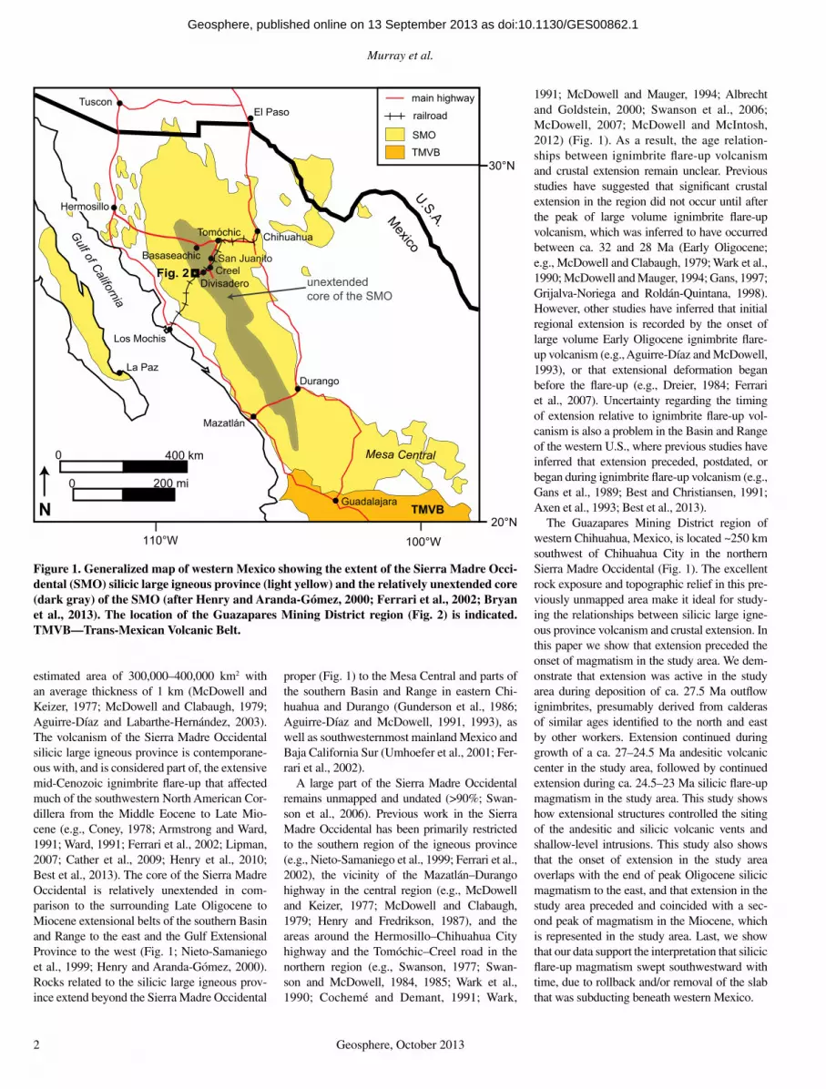
Murray et al.
2 Geosphere, October 2013
estimated area of 300,000–400,000 km2 with an average thickness of 1 km (McDowell and Keizer, 1977; McDowell and Clabaugh, 1979; Aguirre-Díaz and Labarthe-Hernández, 2003). The volcanism of the Sierra Madre Occidental silicic large igneous province is contemporane-ous with, and is considered part of, the extensive mid-Cenozoic ignimbrite fl are-up that affected much of the southwestern North American Cor-dillera from the Middle Eocene to Late Mio-cene (e.g., Coney, 1978; Armstrong and Ward, 1991; Ward, 1991; Ferrari et al., 2002; Lipman, 2007; Cather et al., 2009; Henry et al., 2010; Best et al., 2013). The core of the Sierra Madre Occidental is relatively unextended in com-parison to the surrounding Late Oligocene to Miocene extensional belts of the southern Basin and Range to the east and the Gulf Extensional Province to the west (Fig. 1; Nieto-Samaniego et al., 1999; Henry and Aranda-Gómez, 2000). Rocks related to the silicic large igneous prov-ince extend beyond the Sierra Madre Occidental
proper (Fig. 1) to the Mesa Central and parts of the southern Basin and Range in eastern Chi-huahua and Durango (Gunderson et al., 1986; Aguirre-Díaz and McDowell, 1991, 1993), as well as southwesternmost mainland Mexico and Baja California Sur (Umhoefer et al., 2001; Fer-rari et al., 2002).
A large part of the Sierra Madre Occidental remains unmapped and undated (>90%; Swan-son et al., 2006). Previous work in the Sierra Madre Occidental has been primarily restricted to the southern region of the igneous province (e.g., Nieto-Samaniego et al., 1999; Ferrari et al., 2002), the vicinity of the Mazatlán–Durango highway in the central region (e.g., McDowell and Keizer, 1977; McDowell and Clabaugh, 1979; Henry and Fredrikson, 1987), and the areas around the Hermosillo–Chihuahua City highway and the Tomóchic–Creel road in the northern region (e.g., Swanson, 1977; Swan-son and McDowell, 1984, 1985; Wark et al., 1990; Cochemé and Demant , 1991; Wark,
1991; McDowell and Mauger, 1994; Albrecht and Goldstein, 2000; Swanson et al., 2006; McDowell , 2007; McDowell and McIntosh, 2012) (Fig. 1). As a result, the age relation-ships between ignimbrite fl are-up volcanism and crustal extension remain unclear. Previous studies have suggested that signifi cant crustal extension in the region did not occur until after the peak of large volume ignimbrite fl are-up volcanism, which was inferred to have occurred between ca. 32 and 28 Ma (Early Oligocene; e.g., McDowell and Clabaugh , 1979; Wark et al., 1990; McDowell and Mauger, 1994; Gans, 1997; Grijalva-Noriega and Roldán-Quintana, 1998). However, other studies have inferred that initial regional extension is recorded by the onset of large volume Early Oligocene ignimbrite fl are-up volcanism (e.g., Aguirre-Díaz and McDowell , 1993), or that extensional deformation began before the fl are-up (e.g., Dreier, 1984; Ferrari et al., 2007). Uncertainty regarding the timing of extension relative to ignimbrite fl are-up vol-canism is also a problem in the Basin and Range of the western U.S., where previous studies have inferred that extension preceded, postdated, or began during ignimbrite fl are-up volcanism (e.g., Gans et al., 1989; Best and Christiansen, 1991; Axen et al., 1993; Best et al., 2013).
The Guazapares Mining District region of western Chihuahua, Mexico, is located ~250 km southwest of Chihuahua City in the northern Sierra Madre Occidental (Fig. 1). The excellent rock exposure and topographic relief in this pre-viously unmapped area make it ideal for study-ing the relationships between silicic large igne-ous province volcanism and crustal extension. In this paper we show that extension preceded the onset of magmatism in the study area. We dem-onstrate that extension was active in the study area during deposition of ca. 27.5 Ma outfl ow ignimbrites, presumably derived from calderas of similar ages identifi ed to the north and east by other workers. Extension continued during growth of a ca. 27–24.5 Ma andesitic volcanic center in the study area, followed by continued extension during ca. 24.5–23 Ma silicic fl are-up magmatism in the study area. This study shows how extensional structures controlled the siting of the andesitic and silicic volcanic vents and shallow-level intrusions. This study also shows that the onset of extension in the study area overlaps with the end of peak Oligocene silicic magmatism to the east, and that extension in the study area preceded and coincided with a sec-ond peak of magmatism in the Miocene, which is represented in the study area. Last, we show that our data support the interpretation that silicic fl are-up magmatism swept southwestward with time, due to rollback and/or removal of the slab that was subducting beneath western Mexico.
U.S.A. Mexico
100°W
La Paz
110°W
TMVB
Fig. 2
Mazatlán
TusconEl Paso
Durango
Guadalajara
unextendedcore of the SMO
0 400 km
0 200 mi
30°N
20°NN
Mesa Central
Los Mochis
Creel
Hermosillo
Gulf of California
main highway
railroad
SMO
TMVB
ChihuahuaTomóchic
Divisadero
Basaseachic San Juanito
Figure 1. Generalized map of western Mexico showing the extent of the Sierra Madre Occi-dental (SMO) silicic large igneous province (light yellow) and the relatively unextended core (dark gray) of the SMO (after Henry and Aranda-Gómez, 2000; Ferrari et al., 2002; Bryan et al., 2013). The location of the Guazapares Mining District region (Fig. 2) is indicated. TMVB—Trans-Mexican Volcanic Belt.
as doi:10.1130/GES00862.1Geosphere, published online on 13 September 2013
Synvolcanic extension during the mid-Cenozoic ignimbrite fl are-up in the northern Sierra Madre Occidental
Geosphere, October 2013 3
GEOLOGIC SETTING
Previous regional-scale studies in the Sierra Madre Occidental subdivided volcanic rocks into: (1) the Late Cretaceous to Eocene Lower Volcanic Complex of dominantly andesitic com-position; (2) the Eocene to Early Miocene Upper Volcanic Supergroup of dominantly silicic com-position; and (3) the Early Oligocene to Early Miocene basaltic andesite volcanic rocks of the Southern Cordillera basaltic andesite province (McDowell and Keizer, 1977; Cameron et al., 1989; Ferrari et al., 2007). The Lower Volcanic Complex is believed to underlie most of the Upper Volcanic Supergroup ( Aguirre-Díaz and McDowell, 1991; Ferrari et al., 2007), although the thick ignimbrite cover of the Upper Vol canic Supergroup obscures much of the geologic relationships between these two subdivisions in most areas. The volcanic rocks of the Lower Volcanic Complex generally consist of interme-diate composition lavas and lesser silicic tuffs, and are interpreted as the products of normal steady-state (i.e., non–fl are-up-style) conti-nental subduction-related magmatism broadly contemporaneous with the Laramide orogeny in western North America (McDowell and Keizer, 1977; McDowell et al., 2001).
The ~1-km-thick Upper Volcanic Supergroup broadly refers to the products of large-volume fl are-up–style (i.e., high output rate and large eruptive volumes) silicic magmatism, also known as the mid-Cenozoic ignimbrite fl are-up, and defi nes the extent of the Sierra Madre Occi-dental silicic large igneous province (McDowell and Keizer, 1977; Bryan, 2007; Ferrari et al., 2007). The Upper Volcanic Supergroup is com-posed of Eocene to Early Miocene silicic ignim-brites, lavas, and intrusions, and lesser intermedi-ate to mafi c lavas (McDowell and Keizer, 1977; McDowell and Clabaugh, 1979; Aguirre-Díaz and McDowell, 1991, 1993; Ferrari et al., 2002, 2007; McDowell, 2007). The large volume of silicic ignimbrites and high output rate suggest multiple caldera and fi ssure sources for these volcanic deposits (e.g., Swanson and McDowell, 1984; Aguirre-Díaz and Labarthe-Hernández, 2003; Swanson et al., 2006; McDowell, 2007). Ferrari et al. (2002, 2007) proposed that there were at least two main pulses of large volume silicic ignimbrite fl are-up volcanism in the Sierra Madre Occidental during the mid-Cenozoic, one during the Early Oligocene (ca. 32–28 Ma) and another during the Early Miocene (ca. 24–20 Ma). The Early Oligocene ignimbrite pulse is inferred to have occurred throughout the Sierra Madre Occidental, while the Early Miocene ignimbrite pulse was inferred to be volumetrically more signifi cant in the southern Sierra Madre Occidental and less abundant, with
more mafi c compositions, in the north (Ferrari et al., 2002, 2007; Bryan et al., 2013). The Early Oligocene pulse is estimated to have contributed at least half to three-quarters (>200,000 km3) of the erupted volume of the Upper Volcanic Super-group, but at least 50,000–100,000 km3 was erupted during the Early Miocene pulse (Cather et al., 2009; Bryan et al., 2013). McDowell and McIntosh (2012) suggested that most ignim-brites in the northern and central Sierra Madre Occidental were erupted during discrete time intervals (36–33.5 Ma and 31.5–28 Ma). In addi-tion, an older Eocene pulse of ignimbrite erup-tions between 46 and 42 Ma is only recognized along the eastern margin of the Sierra Madre Occidental, and an interval of ca. 24 Ma ignim-brite eruptions that coincides with the Early Miocene pulse of Ferrari et al. (2002, 2007) is observed in the western regions of the igneous province (McDowell and McIntosh, 2012), west of our study area.
During the fi nal stages of and after each silicic ignimbrite pulse of the Upper Volcanic Super-group, basaltic andesite lavas were intermittently erupted across all of the northern Sierra Madre Occidental (Ferrari et al., 2007). In the northern part of the Sierra Madre Occidental these rocks were generally considered part of the Southern Cordillera basaltic andesite province (Cam-eron et al., 1989) with ages ranging from 33 to 17.6 Ma, although they mostly are Oligocene (Cameron et al., 1989, and references therein; Ferrari et al., 2007). The rocks of the Southern Cordillera basaltic andesite province have been interpreted as magmatism recording the initia-tion of crustal extension across the region (e.g., Cameron et al., 1989; Cochemé and Demant , 1991; Gans, 1997; McDowell et al., 1997; González León et al., 2000; Ferrari et al., 2007).
Several prior studies recognized signifi cant crustal extension in the Sierra Madre Occiden-tal immediately following the Early Oligocene ignimbrite pulse of the Upper Volcanic Super-group (e.g., McDowell and Clabaugh, 1979; Wark et al., 1990; McDowell and Mauger, 1994; Gans, 1997; Grijalva-Noriega and Roldán-Quin-tana, 1998). The earliest evidence of extensional faulting in the northern Sierra Madre Occiden-tal is found in central Chihuahua (younger than 29 Ma), immediately following the Early Oligo-cene ignimbrite pulse (McDowell and Mauger, 1994). In east-central Sonora, the earliest age of crustal extension is possibly as old as 27 Ma and synvolcanic deposition in many normal-fault basins was active by 24 Ma, following the peak of Early Oligocene ignimbrite fl are-up vol canism (Gans, 1997; McDowell et al., 1997; Gans et al., 2003). However, extension in the Sierra Madre Occidental may have begun as early as the Eocene, prior to the eruption of the Early
Oligo cene ignimbrite pulse, based on the orienta-tion and age of epithermal vein deposits (Dreier, 1984) and a moderate angular unconformity between the Lower Volcanic Complex and Upper Volcanic Supergroup (e.g., Ferrari et al., 2007). Direct evidence of Early Eocene (pre–Upper Volcanic Supergroup) extensional faulting is observed in the Mesa Central region to the east of the core of the southern Sierra Madre Occidental and includes a moderate angular unconformity within continental clastic and andesitic volcanic sequences and subvolcanic intrusions along nor-mal faults (Aranda-Gó mez and McDowell, 1998; Aguillón-Robles et al., 2009; Tristán-González et al., 2009), as well as ca. 32 Ma synvolcanic normal faults that were active until ca. 24 Ma (Aguirre-Díaz and McDowell, 1993; Luhr et al., 2001). However, Eocene-age extensional fault-ing has not been documented in the Sierra Madre Occidental proper.
The Guazapares Mining District of western Chihuahua is located at the western edge of the relatively unextended core of the northern Sierra Madre Occidental, at the boundary with the highly extended Gulf Extensional Prov-ince (Fig. 1). Previous geologic studies in this ~300 km2 region were restricted to regional 1:50,000 and 1:250,000 geologic mapping by the Mexican Geological Survey (Minjárez Sosa et al., 2002; Ramírez Tello and Garcia Peralta, 2004) and mining company reports (e.g., Roy et al., 2008; Wood and Durgin, 2009; Gustin , 2011, 2012). On these maps and reports, Paleocene–Eocene Lower Volcanic Complex andesitic rocks were inferred to underlie the Oligocene Upper Volcanic Supergroup silicic ignimbrites, but we show here that these rocks (which we informally refer to as the Témoris formation) are both underlain and overlain by silicic ignimbrites, and therefore cannot be assigned to the Lower Volcanic Complex. Prior to this study there were no geochronologi-cal data from the Guazapares Mining District region and the closest reported dates were from Upper Volcanic Supergroup ignimbrites ~50 km to the northeast near Divisadero (ca. 30 Ma; Swanson et al., 2006).
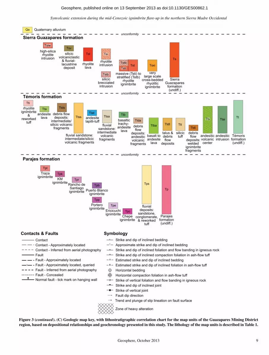
LITHOLOGY AND STRATIGRAPHY
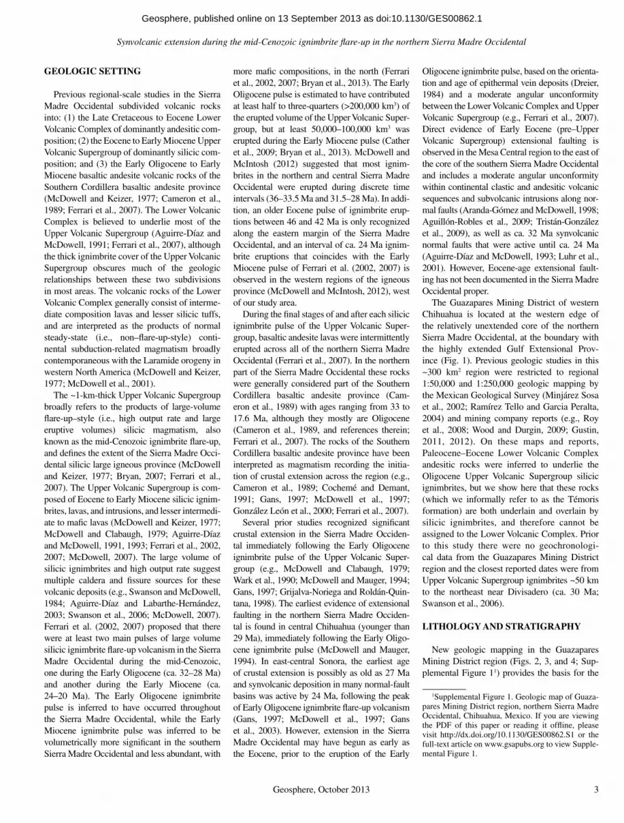
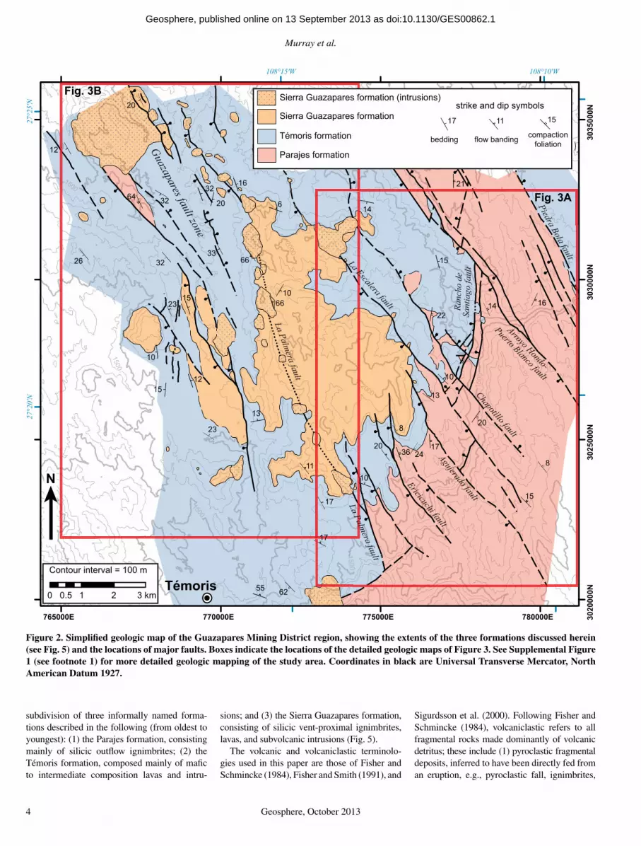
New geologic mapping in the Guazapares Mining District region (Figs. 2, 3, and 4; Sup-plemental Figure 11) provides the basis for the
1Supplemental Figure 1. Geologic map of Guaza-pares Mining District region, northern Sierra Madre Occidental, Chihuahua, Mexico. If you are viewing the PDF of this paper or reading it offl ine, please visit http://dx.doi.org/10.1130/GES00862.S1 or the full-text article on www.gsapubs.org to view Supple-mental Figure 1.
as doi:10.1130/GES00862.1Geosphere, published online on 13 September 2013
Murray et al.
4 Geosphere, October 2013
subdivision of three informally named forma-tions described in the following (from oldest to youngest): (1) the Parajes formation, consisting mainly of silicic outfl ow ignimbrites; (2) the Témoris formation, composed mainly of mafi c to intermediate composition lavas and intru-
sions; and (3) the Sierra Guazapares formation, consisting of silicic vent-proximal ignimbrites, lavas, and subvolcanic intrusions (Fig. 5).
The volcanic and volcaniclastic terminolo-gies used in this paper are those of Fisher and Schmincke (1984), Fisher and Smith (1991), and
Sigurdsson et al. (2000). Following Fisher and Schmincke (1984), volcaniclastic refers to all fragmental rocks made dominantly of volcanic detritus; these include (1) pyroclastic fragmental deposits, inferred to have been directly fed from an eruption, e.g., pyroclastic fall, ignimbrites,
765000E 770000E 775000E 780000E 3020
000N
3025
000N
3030
000N
3035
000N
108°10'W108°15'W
27°2
5'N
27°2
0'N
0 1 2 3 km0.5
1500
1500
1500
1500
1500
1500
1500
2000
2000
Fig. 3A
Témoris
Fig. 3B
Guazapares fault zone
8
6
8
15
14
20
17
66
20
26
23 1610
66
23
13
21
15
17
32
32
22
10
13
243620
11
17
14
10
64
20
10
33
3216
12
15
12
15
Sierra Guazapares formation
Témoris formation
Parajes formation
Sierra Guazapares formation (intrusions)strike and dip symbols
17 11 15
bedding flow banding compactionfoliation
55 62
Contour interval = 100 m
N
La Palmera fault
La Palmera fault
Ericicuchi faultAgujerado fault
La Escalera fault
Chapotillo fault
Ranc
ho d
eSa
ntia
go fa
ult
Arroyo Hondo-
Puerto Blanco faultPiedra Bola fault
Figure 2. Simplifi ed geologic map of the Guazapares Mining District region, showing the extents of the three formations discussed herein (see Fig. 5) and the locations of major faults. Boxes indicate the locations of the detailed geologic maps of Figure 3. See Supplemental Figure 1 (see footnote 1) for more detailed geologic mapping of the study area. Coordinates in black are Universal Transverse Mercator, North American Datum 1927.
as doi:10.1130/GES00862.1Geosphere, published online on 13 September 2013

Synvolcanic extension during the mid-Cenozoic ignimbrite fl are-up in the northern Sierra Madre Occidental
Geosphere, October 2013 5
C
C′′
B′
Ts
Tp
Tt
Tpr
Ttba
Tt
Tpr
Tt
Tp
Tpk
Tpk
Ttss
Ttba
Tpb
Ttss
Tsi
Tpk
Tpb
Ttb
Tpr
Ttdt
Ttss
Tpb
Tps
Tpr
Tpr
Tsti
Tpe
Tpt
Ttss
Ttba
Tpr Ttba
Tpp
Tsl Tp
b
Tpb
Tst
Tpb
Tpr
Tpr
Ttba
Ttss
Tpr
Tst
Ttt
Ttda
TtdaTtss
Ttba
Ttb
Ttba
Ttda
T
Tpr
Ttss
Tst
Ttdt
Ttai
Ttss
Ttss
Tpr
Ttdi
Ttba
Ttss
Ttba
Tpr
Tsti
Ttai
Ttss
Tsti
Ttba
Ttda
Tst
Ttss
Tst
Ttda
Ttda
5
9
9
4
5
2167
28
43431034
2256
20
161550 55
14
5255
5657
29 43
31
60
60 64
67 72
4143
43 75 65
67
12
39
69
14
171620
25
15
16
11
1410
24
24
15
66
14
10
2622
2520
23
25
14
10
60
18
19
11
13
13
Tst
64
17
Tpb
Tpr
Tpr
Tpb
Tpr
Ttba
Ttba
Arroyo
Hon
do-P
uerto
Blanco
fault
La Escalera fault
Chapotillo fa
ult
Rancho de Santiago fault
Ranc
ho
de S
antia
go
20
30
24
r62
3715
01
23
0.5
km
Con
tour
inte
rval
= 2
0 m
M
ap d
atum
: N
AD
27 U
TM z
one
12
Figu
re 3
A
108°
14′W
108°
12′W
108°
10'W
27°22′N
3028000N3030000N3032000N
Fig
ure
3 (o
n th
is a
nd fo
llow
ing
four
pag
es).
Geo
logi
c m
aps
of p
ortio
ns o
f the
Gua
zapa
res
Min
ing
Dis
tric
t reg
ion.
Top
ogra
phic
bas
e m
ap is
from
Ins
titut
o N
acio
nal d
e E
stad
ístic
a, G
eo-
graf
ía e
Inf
orm
átic
a (I
NE
GI)
; or
igin
al 1
:50,
000
scal
e IT
RF
92 (
Inte
rnat
iona
l Ter
rest
rial
Ref
eren
ce F
ram
e 19
92)
datu
m p
roje
cted
to
NA
D27
UT
M (
Uni
vers
al T
rans
vers
e M
erca
tor,
N
orth
Am
eric
an D
atum
192
7) z
one
12. T
he e
ntir
e ge
olog
ic m
ap fo
r th
e st
udy
area
is p
rese
nted
in S
uppl
emen
tal F
igur
e 1
(see
foot
note
1).
(A) G
eolo
gic
map
of t
he s
outh
east
ern
port
ion
of th
e G
uaza
pare
s M
inin
g D
istr
ict r
egio
n be
twee
n P
uert
o L
a C
ruz
and
Ran
cho
de S
antia
go, e
ast o
f Tém
oris
. The
loca
tions
of c
ross
-sec
tions
A–A
′, B
–B′,
and
C–C
′ (F
ig. 4
) are
indi
cate
d.
as doi:10.1130/GES00862.1Geosphere, published online on 13 September 2013

Murray et al.
6 Geosphere, October 2013
A
A′′
B
Tp
Tp
Tpc
Tsi
Tpp
Tpp
Tpp
Tsl
Tpe
Tt
Tstb
Tpe
Tpr
Ttda
Tpe
Ttba
Tta
Tpp
TtTs
ti
Tpe
Tsi
Tsxi
Ttss
Ttss
Ttds
Ttba
Ttds
Tpp
Ts
Tsi Tt
a
Tsti
Tta
Ttba
Ttda
Tst
Tsti
Ttss
Ttda
Ttds
Tta
Ttda
Ttba
Ttba
Ttss
TsxiTt
a
Ttss
9
8
98
3
7
15
5760
20
12
17
10
1520
1717
24
1613
16
36
26
1317
14
10
52
20
25
8075
Tpc
Ts
Ttv
Ttba
Tp
Tpp
Tpp
Tti
Ttda
Tpe
Tpe
Tpe
La Palmera fault
Agujerado fault
La Escalera fa
ult
Chapotillo fault
Ericicuchi fault
Puer
to
La C
ruz
17
11
28
814
23
1520
70
3627
1924
25
139
22
Tsl
Tps
Tpk
27°20′N 27°18′N
7740
00E
7760
00E
7780
00E
7800
00E
3022000N3024000N3026000N
Fig
ure
3A (
cont
inue
d).
as doi:10.1130/GES00862.1Geosphere, published online on 13 September 2013

Synvolcanic extension during the mid-Cenozoic ignimbrite fl are-up in the northern Sierra Madre Occidental
Geosphere, October 2013 7
@
@@
@
@
@
@
@
Tt
Tt
Tsiw
Tst
Ttba
Tt
Ttsa
Tp
Tt
Tst
Ttss
Ttba
Tp
Ttss
Tsxi
Ttba
Ttba
Tsi
Ttb
Tst
Ttb
Tt
Tsl
Tta
Ttsa
Ttba
Tsi
Ttsa
Ttss
Tsi
Ttb
Ttt
Ttba
Tsxi
Ttsa
Tsv
Ttba
Tta
Ttss
Tti
Tta
Tsl
Qa
Tsi
Tsiw
Tta
Ttba
Tsi
Ttb
Ttba
Tsi
Ts
Tsi
Ttba
Tst
Tst
Tsiw
Tsl
Ttsa
Tsi
Ttss
Ts
TsTt
da
Ttss
Tta
Ttb
Tsiw
Tsi
Tsti
Tta
Tst
Tst
Ttds
TsTs
v
Tti
Tta
Ttss
Tsxi
Tta
Ttat
Ttba
Tsi
Tsl
Ttss
Tsv
Tsiw
Tsi
Ttat
Tsi
Tsxi
Ttss
Tsl
Tst
Tsxi
Tsi
Tsiw
8
6
60
22
10
17
35
2520 32
18
34
6380
28
27
11
20
26
26
25
16
16
2460
24
24
66
60
74
46
66
27
20
12
65
64
1324
19
25
25
3216
11
13
15
28
12
35
Tst
Tta
Tt
Ttss
Ttba
Ttsa
Ttsa
Ttsa
Tsxi
La Escalera fault
Chapotillo fault
Sangre de Cristo fa
ult
Taho
nitas
fault
Mon
teCr
isto
17
414
24
24
66
47
60Tti
2324
2812
66
51
729
15
2933
3066
6
Tsiw
79
23
Guazapares fault zone
6732
Gua
zapa
resTtsa
3
Tt
San
Anto
nio
Batosegachi fault
La Palmera fault
27°22′N27°24′N
108°
18′W
108°
16′W
108°
14′W
3030000N3032000N3034000N3036000N
Fig
ure
3 (c
ontin
ued)
. (B
) Geo
logi
c m
ap o
f the
Gua
zapa
res
faul
t zon
e be
twee
n T
émor
is a
nd M
onte
Cri
sto.
as doi:10.1130/GES00862.1Geosphere, published online on 13 September 2013
Murray et al.
8 Geosphere, October 2013
@ @ @ @
@
@
Tt
Ts
Ttba
Tsl
Tt
Tsl
TtTstb
Tsl
Ttda
Tsxi
Ts
Ttss
Tti
Tta
Tsti
Tsi
Tst
Tt
Tta
Tst
Tta
Tta
TsiTs
xi
Tst
Tst
Tsi
Tt
Tsl
Tti
Ttds
Tsxi
Tsi
Ttds
Tsi
Ttds
Tsxi
Ttss
Ts
Tsi
Ttds
Tt
Tst
Tsi
Tsl
Tsi
Tsib
Tsl
Tsti
Tsl
Ttss
Tst
Tta
Tsxi
Tsxi
Tta
Ttds
Ttss
Tsxi
Ttds
Ttss
Ttda
Tst
Tta
Tsl
Ttss
Tst
93
8
6
24
15
2223
1813
18
17
20
10
1758
26
25
18
2311 22
1317
14
3513
11
14
3510
15
52
20
25
25
14
51
35
15
13
Tst
Tst
Tst
Tst
Tt
Tsl
Tta
Ts
Ttda
TtbaTt
i
La Palmera fault
Guazapares fault z
one
Puer
to
La C
ruz
70 5019
12
755
17
16
35Ttat
11
21
10
17
137
5
17
11
La Palmera fault
01
23
0.5
km
Con
tour
inte
rval
= 2
0 m
Map
dat
um:
NA
D27
UTM
zon
e 12
Figu
re 3
B
27°20′N 27°18′N
3022000N3024000N3026000N3028000N
7660
00E
7680
00E
7700
00E
7720
00E
7740
00E
Fig
ure
3B (
cont
inue
d).
as doi:10.1130/GES00862.1Geosphere, published online on 13 September 2013
Synvolcanic extension during the mid-Cenozoic ignimbrite fl are-up in the northern Sierra Madre Occidental
Geosphere, October 2013 9
Qa
Parajes formation
Témoris formation
Sierra Guazapares formation
Quaternary alluvium
Tsv
Ts
silicic volcaniclastic
& fluvial-lacustrine deposit
high-silica rhyolite
intrusionTsl
rhyolite lava
rhyolite intrusion
silicic brecciated intrusion
massive (Tsti) to stratified (Tstb)
rhyolite ignimbrite
Tst Tsxi
verylarge scale
cross-bedded rhyolitic
ignimbrite
SierraGuazapares
formation(undiff.)
Tti
rhyolite ignimbrite
&reworked
tuffTt
Témoris formation (undiff.)
Tta
andesite lava
Ttds
debris flow deposits:
intermediate/ silicic volcanic
fragments
Ttss
fluvial sandstone: intermediate/silicic volcanic fragments
Ttatandesite lapilli-tuff
Ttsa
fluvial sandstone:
intermediate volcanic
fragments
Ttda
debris flow
deposits: andesitic volcanic
fragments
Ttb
basaltic trachy-andesite
lavaTtba
basalt to andesite
lava
andesiticvolcanic center
TttTtdt
talus & debris flow
deposits
silicic tuff
Ttdi
debris flow
deposits: welded
ignimbrite fragments
Ttai
andesitic intrusion
Tpt
Tpk
TpsTpr
Tpb
Tpp
Tpe
Tpc
Traza ignimbrite KM
ignimbrite Rancho de Santiago ignimbrite
fluvial deposits:
sandstone, conglomerate,
& reworked tuff
Puerto Blanco ignimbrite
Portero ignimbrite Ericicuchi
ignimbrite Chepe ignimbrite
Parajesformation(undiff.)
Tp
Tsiw
Tsib
Tsi
Tstb
Tsti
Ttv
unconformity
unconformity
unconformity
Contacts & FaultsContactContact - Approximately locatedContact - Inferred from aerial photographyFault
Normal fault - tick mark on hanging wall
Fault - Approximately locatedFault - Approximately located, queriedFault - Inferred from aerial photographyFault - Concealed
SymbologyStrike and dip of inclined beddingApproximate strike and dip of inclined beddingStrike and dip of inclined foliation and flow banding in igneous rockStrike and dip of inclined compaction foliation in ash-flow tuffEstimated strike and dip of inclined beddingEstimated strike and dip of inclined foliation in ash-flow tuffHorizontal beddingHorizontal compaction foliation in ash-flow tuffStrike of vertical foliation and flow banding in igneous rockStrike and dip of inclined jointStrike of vertical jointFault dip directionTrend and plunge of slip lineation on fault surface
Zone of heavy alteration
Figure 3 (continued). (C) Geologic map key, with lithostratigraphic correlation chart for the map units of the Guazapares Mining District region, based on depositional relationships and geochronology presented in this study. The lithology of the map units is described in Table 1.
as doi:10.1130/GES00862.1Geosphere, published online on 13 September 2013
Murray et al.
10 Geosphere, October 2013
autoclastic fl ow breccias; (2) reworked fragmen-tal deposits, inferred to result from downslope reworking of unconsolidated eruption-fed fragmental deposits, e.g., block-and-ash-fl ow deposits commonly pass downslope into debris fl ow and fl uvial deposits; and (3) epiclastic deposits, made of volcanic fragments inferred to have been derived from erosion of preexisting rock. When the distinctions cannot be made, the general term volcaniclastic is applied. Delicate pyroclastic detritus such as pumice, shards, or euhedral crystals cannot be derived from ero-sion of preexisting rock, so their presence in fl uvial or debris fl ow deposits indicates that at least some of the deposit consists of reworked pyroclastic material, indicating broadly coeval explosive volcanism. Similarly, if a debris fl ow deposit is dominated by one volcanic clast type, it can be inferred to record reworking of a block-and-ash-fl ow deposit or fl ow breccia. However, the presence of a broad range of vol-canic clast types is not proof of an epiclastic origin, because a wide variety of volcanic clast types can become incorporated into an eruption-triggered debris fl ow; in that case, a distinction between reworked and epiclastic cannot be made, and the deposit is simply a volcaniclastic debris fl ow deposit. Debris-fl ow deposits with blocks of welded ignimbrite, however, cannot be derived by any downslope reworking process known in outfl ow ignimbrite fi elds, and instead likely record erosion of preexisting rocks, so those can be classifi ed as epiclastic (note that intracaldera ignimbrites commonly have blocks of welded ignimbrite cannibalized from the cal-dera wall during ongoing collapse; see discus-sion in Schermer and Busby, 1994).
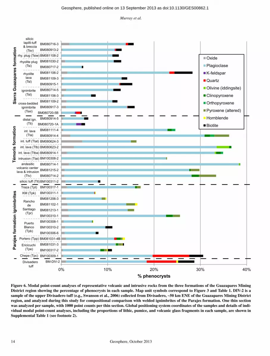
The three formations in the Guazapares Min-ing District region are subdivided into 30 distinct lithologic units by outcrop and thin section char-acteristics, mineralogy, chemical composition, and inferred volcanic or sedimentary processes (Fig. 3C; Table 1). These lithologic units include volcanic rocks (e.g., lavas, ignimbrites), vol-cani clastic rocks (e.g., sandstone, conglomerate, breccia), and hypabyssal intrusions (e.g., plugs, dikes). Modal point-count analyses were carried out for 39 samples, chosen to represent most of the volcanic and hypabyssal map units (Fig. 6). Reconnaissance whole-rock geochemical analy-ses were performed on 15 relatively unaltered samples of volcanic rock and hypabyssal intru-sions from the Témoris and Sierra Guazapares formations (Fig. 7; Table 2).
Parajes Formation
The Parajes formation is primarily exposed in the eastern part of the study area; continuous stratigraphic sequences are found in the vicinity
elevation (m)
Ttba
Ttba
Ttba
Ttba
Tpp
Tpp?
Tpp
Ttv
Tta
Tta
Ttda
Ttda
Ttds
Ttss
Tst
Tsl
Tst
Tsxi
Tti
Ttda
1600
1800
1400
1200
AA
′
TtTp
p
Tpe
Tpc
Tpe
Tpe
Tpp
Ttss
Ttss
Tta
Tta
Ttds
Ttds
Ttda
Tsti
Tsti
Tsti
Tstb
TsTs
Ts
Ttba
Ttss
Tpp
Tpp
Tpe
Tpb
Tpr
Tps
Tpk
1600
1800
2000
1400
1600
1800
2000
1400
BB
′
1200
1200
Ttds
Tsti
Ts
Tpp
Tpe
Ttss
Tsti
Ts
Tpc
Tsti
Ttss
Tpe
Ttss
Ttba
Tpr
Tst
Ttba
Ttss
Ttdt
Tpr
Tpb
Tpr
TpsTp
k
Tpb
Tpb
Tpk
Tpr
Tpt
TpbTp
rTpkTp
t
TpbTp
rTp
r
TpbTt
ba
Ttt Tt
ssTtba
TprTp
k?
Tpb
Ttba
Tpt
Tpb
Tpb
2000
1600
elevation (m) 1800
1400
1200
2000
1600
1800
1400
1200
CC
′Ts
La P
alm
era
faul
t
Eric
icuc
hi
faul
tAg
ujer
ado
faul
tLa
Esc
aler
a fa
ult
Cha
potil
lo
faul
t
Aguj
erad
o fa
ult
La E
scal
era
faul
tC
hapo
tillo
fa
ult
Ranc
ho d
e Sa
ntia
go (W
) fa
ult
Ranc
ho d
e Sa
ntia
go (E
) fa
ult
Arro
yo
Hon
do-P
uert
o Bl
anco
faul
tPi
edra
Bol
a fa
ult
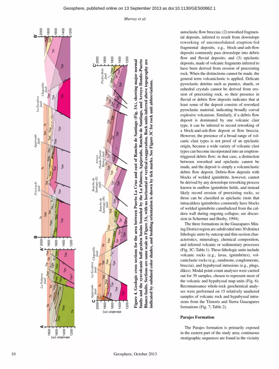
Fig
ure
4. G
eolo
gic
cros
s se
ctio
ns f
or t
he a
rea
betw
een
Pue
rto
La
Cru
z an
d ea
st o
f R
anch
o de
San
tiag
o (F
ig. 3
A),
sho
win
g m
ajor
nor
mal
fa
ults
and
the
syn
volc
anic
hal
f-gr
aben
bas
ins
boun
ded
by t
he L
a P
alm
era,
Agu
jera
do,
Ran
cho
de S
anti
ago,
and
Arr
oyo
Hon
do–P
uert
o B
lanc
o fa
ults
. Sec
tion
s ar
e sa
me
scal
e as
Fig
ure
3A, w
ith
no h
oriz
onta
l or
vert
ical
exa
gger
atio
n. R
ock
unit
s in
ferr
ed a
bove
top
ogra
phy
are
indi
cate
d by
sub
dued
col
or s
hade
s, a
nd b
eddi
ng o
rien
tati
on is
sho
wn
by t
ick
mar
ks. S
ee F
igur
e 3C
for
roc
k un
it a
bbre
viat
ions
.
as doi:10.1130/GES00862.1Geosphere, published online on 13 September 2013
Synvolcanic extension during the mid-Cenozoic ignimbrite fl are-up in the northern Sierra Madre Occidental
Geosphere, October 2013 11
of Rancho de Santiago (Fig. 3A). The base of this formation is not exposed in the study area. The formation is composed of seven lithologi-cally distinct silicic ignimbrites, with lesser locally interbedded sandstone, conglomerate, and reworked tuff (Figs. 6 and 8; Table 1). Indi-vidual ignimbrites are informally named in this study, and are distinguished based on pheno-cryst assemblages and outcrop characteristics such as degree of welding, weathering style, color, and percentage and type of pumice and/or fi amme and lithic fragments (Fig. 6; Table 1).
DescriptionEach ignimbrite of the Parajes formation has
a densely welded to partially welded lower part that passes upward into a less welded to non-welded top (Fig. 8A), forming a single cooling unit, as well as a single fl ow unit with normal coarse-tail grading of lithic fragments and inverse coarse-tail grading of pumice. Where the bases of ignimbrites are exposed, 0.5–2-m-thick basal vitrophyres are present. The ignimbrites are generally crystal poor to crystal moderate (<20%), with a dacitic phenocryst assemblage
(no chemical analyses were done) consisting primarily of plagioclase and pyroxene pheno-crysts, with minor amounts of hornblende, bio-tite, and quartz in some ignimbrites; sanidine is lacking in all of the ignimbrites of the Parajes formation (Fig. 6). The thickness of individual ignimbrites range from ~20 to ~210 m; the total thickness of the Parajes formation is ~1 km (Table 1). Some ignimbrites appear to thicken due to ponding in paleotopographic lows (e.g., Rancho de Santiago [Tpr] and KM [Tpk] ignim-brites); ponded thicknesses are 2.5 times greater than nonponded parts of the same ignimbrite (Figs. 3A and 4; Table 1).
Each ignimbrite of the Parajes formation has distinguishing outcrop and/or compositional characteristics, described in ascending strati-graphic order (Fig. 6; Table 1). The Chepe, Ericicuchi, and Portero ignimbrites form the oldest continuous stratigraphic sequence, which is only found on the southwest (footwall) side of the Chapotillo fault in the Guazapares Mining District region (Fig. 3A). The Chepe ignimbrite (Tpc) is the only crystal-rich (~30%) ignimbrite in the study area, with embayed quartz and bio-
tite phenocrysts to 2 mm in diameter. The Erici-cuchi ignimbrite (Tpe) has dark gray fi amme to 1 cm in length, typically with orange rims, and it has a mafi c phenocryst assemblage that includes pyroxene, hornblende, and biotite. The Portero ignimbrite (Tpp) is characterized by a pink groundmass with eutaxitic texture in the densely welded lower portion, dark reddish-gray fi amme to 30 cm in length, and trace quartz phenocrysts.
The Puerto Blanco, Rancho de Santiago, KM, and Traza ignimbrites form a second, younger continuous stratigraphic sequence that is only found on the northeast (hanging wall) side of the Chapotillo fault (Fig. 3A); the depositional relationship between the two strati-graphic sequences on either side of the fault is not known, but is considered younger than the previously described sequence on the footwall based on the sense of fault offset (Fig. 4) and inferred regional correlations (described in the Discussion following). The base of the Puerto Blanco ignimbrite (Tpb) is not exposed; how-ever, the exposed portion of its lower part, as well as its upper part, are nonwelded, with a welded middle. The Puerto Blanco ignimbrite (Tpb) has the greatest amount and size of lithic fragments (10%–40%, to 5 cm) compared to the other ignimbrites of the Parajes formation, with normal coarse-tail grading and upsec-tion decrease in lithic fragments (from ~40% to 10%); it also shows an upsection increase in phenocrysts (from <5% to 20%) and an upsec-tion increase in fi amme, which are distinctively yellow. The Rancho de Santiago ignimbrite (Tpr) is similar in appearance and composition to the Portero ignimbrite (Tpp) described above, but has gray fi amme with dark gray rims (Fig. 8B); these are generally 3 cm (to 1 m) in length. It has a 2-m-thick basal vitrophyre at the con-tact with the underlying Puerto Blanco ignim-brite. The KM ignimbrite (Tpk) is similar to the underlying Rancho de Santiago ignimbrite (Tpr), but is distinguished by the presence of a brownish-red, ~10-m-thick, crystal-poor (<5%) lower welded section and an overall lower lithic fragment content (5%–10%). The youngest unit of the Parajes formation is the Traza ignimbrite (Tpt), which is similar in appearance to both the Chepe and Puerto Blanco ignimbrites, but is dis-tinguished by having gray fi amme and a moder-ate crystal content (20%) with trace quartz and no biotite.
Sedimentary rocks occur locally between ignimbrite units. An ~150-m-thick sequence of reworked tuff and cross-bedded sandstone with fragments of tuff and pumice (Tps) is between the Rancho de Santiago ignimbrite (Tpr) and KM ignimbrite (Tpk) southwest of the Arroyo Hondo–Puerto Blanco fault (Figs. 3A and 4).
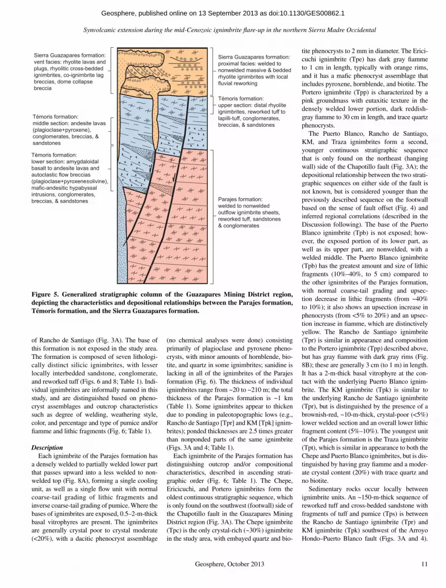
Sierra Guazapares formation:vent facies: rhyolite lavas and plugs, rhyolitic cross-bedded ignimbrites, co-ignimbrite lag breccias, dome collapse breccia
Témoris formation:lower section: amygdaloidal basalt to andesite lavas and autoclastic flow breccias(plagioclase+pyroxene±olivine), mafic-andesitic hypabyssal intrusions, conglomerates, breccias, & sandstones
Sierra Guazapares formation:proximal facies: welded to nonwelded massive & bedded rhyolite ignimbrites with local fluvial reworking
Témoris formation:middle section: andesite lavas (plagioclase+pyroxene), conglomerates, breccias, & sandstones
Témoris formation:upper section: distal rhyolite ignimbrites, reworked tuff to lapilli-tuff, conglomerates, breccias, & sandstones
Parajes formation:welded to nonwelded outflow ignimbrite sheets, reworked tuff, sandstones & conglomerates
Figure 5. Generalized stratigraphic column of the Guazapares Mining District region, depicting the characteristics and depositional relationships between the Parajes formation, Témoris formation, and the Sierra Guazapares formation.
as doi:10.1130/GES00862.1Geosphere, published online on 13 September 2013

Murray et al.
12 Geosphere, October 2013
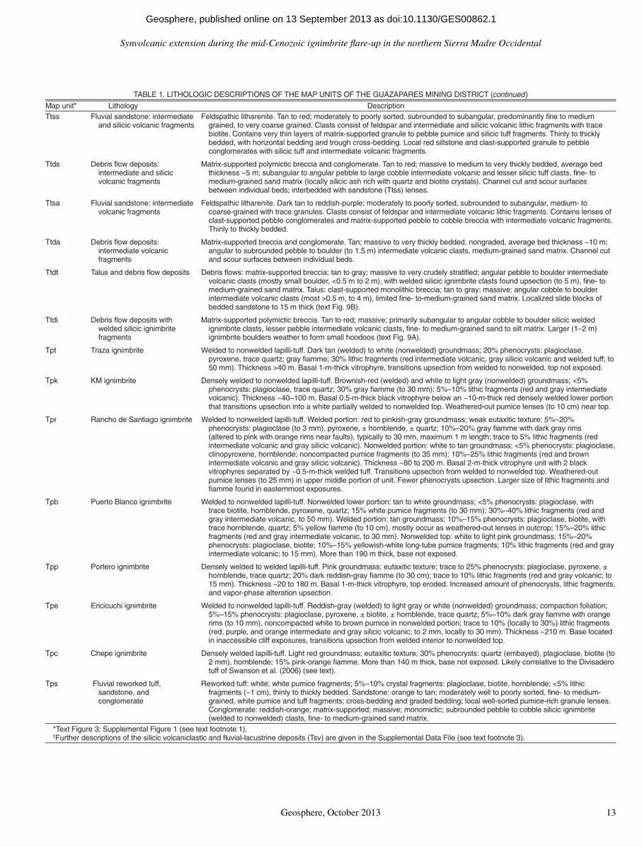
TABLE 1. LITHOLOGIC DESCRIPTIONS OF THE MAP UNITS OF THE GUAZAPARES MINING DISTRICT
noitpircseDygolohtiL*tinupaMflsirbeddetrosylroopyrevdetadilosnocnUmuivullAaQ ow deposits. Gray to light gray; boulders to 5 m. Derived primarily from the Sierra
Guazapares formation.
Tsiw High-silica rhyolite intrusion Hypabyssal intrusions (dikes and plugs). White to light pink; aphyric to 10% phenocrysts (to 1 mm): plagioclase, biotite, trace quartz. Subvertical fl ow banding. In Monte Cristo region (text Fig. 3B), intruded into gray andesitic feldspar porphyry (likely part of Témoris formation). Similar in appearance to rhyolitic dome collapse breccia (Tsv).
Tsv Silicic volcaniclastic and fl uvial-lacustrine deposits†
Volcaniclastic lithofacies (too small to show at map scale of text Fig. 3; Supplemental Fig. 1 [see text footnote 1]).Rhyolitic dome-collapse breccia: clast-supported rhyolitic block to lapilli breccia; white to light orange; primarily monomictic;
angular lapilli to blocks (>2 m) with some fl ow banding. Aphyric to trace quartz and plagioclase phenocrysts. Contains zones of as much as to 20% andesitic blocks that are as large as 1.5 m. Block breccia transitions laterally into lapilli breccia, with the block fragment size decreasing northeastward away from the Sangre de Cristo fault (text Fig. 3B) from >2 m blocks to lapilli-sized fragments supported in an ash matrix of same composition.
Massive to bedded silicic lapilli-tuff: nonwelded lapilli-tuff, light red to gray; <5% phenocrysts; plagioclase, biotite; trace to 20% lithic fragments (intermediate volcanic). Slight fl uvial reworking (planar lamination, sorting, cut-and-fi ll structures), bedding to 5 m thick. Local white reworked ash layers and red very fi ne grained thinly bedded sandstone.
Lacustrine deposits: fi ne- to medium-grained sandstone with graded bedding (Bouma Sequences A, B) and small-scale basal scouring; mudstone with planar lamination to very thinly bedded; water-lain ash layers. Tan to white. Soft sediment slumping and folding.
Fluvial sandstone: medium- to coarse-grained sandstone; white to light gray; moderate to poor sorting; subangular silicic volcanic lithic fragments; massive with faint laminations, cut-and-fi ll and trough cross-bedding structures. Minor clast-supported breccia with subangular cobble to boulder silicic lapilli-tuff fragments interpreted as hyperconcentrated debris fl ows of reworked silicic volcanic material.
Tsi Rhyolite intrusion Hypabyssal intrusions (plugs and dikes). Light red to pink, typically with light pink subvertical fl ow banding; aphanitic groundmass with 5%–20% phenocrysts: plagioclase (to 3 mm), biotite (1 mm), trace quartz. Likely source for rhyolite lavas (Tsl).
Tsib Silicic brecciated intrusion Hypabyssal intrusion. White to light gray; silicic blocks (to 20 cm) supported in crystal-rich aphanitic groundmass with 40% phenocrysts: plagioclase, hornblende, quartz; locally massive and nonbrecciated.
Tsl Rhyolite lava Lava fl ows. Light gray to reddish-gray, with light pink banding; 5%–20% phenocrysts: plagioclase (to 4 mm), biotite (to 2 mm), quartz. Lavas consist of a 3–15-m-thick autoclastic breccia base of fl ow-banded blocks, a coherent middle portion (at least 30 m thick) with well-developed to minor fl ow banding, and a fl ow-top autoclastic breccia with fl ow-banded blocks and sediment infi lling the spaces between blocks. Spherulites and quartz-fi lled vugs are common, and thundereggs are typically found within the top portion of a lava. An ~4-m-thick, basal block and ash fl ow is locally observed. Rhyolite hypabyssal intrusions (Tsi) are likely the source for these lavas.
Tst Massive to stratifi ed rhyolite ignimbrite
Nonwelded to partially welded tuff to lapilli tuff. Light pink, tan, or white groundmass; 5%–25% phenocrysts (to 2 mm): plagioclase, biotite; trace to 25% (locally 40%–50%) yellow-white long-tube pumice fragments (to 15 mm); <5%–40% lithic fragments (red, orange, gray intermediate volcanic, trace white silicic volcanic; to 20 mm). Crudely to well stratifi ed; thickly to very thickly bedded (<1 m to ~10 m thick); mild to intense fl uvial reworking locally observed (clast rounding, sorting, cross-bedding, and cut-and-fi ll structures). Tstb: more fl uvially reworked and more thinly bedded than Tsti. Tsti: primary silicic nonwelded ignimbrite with thicker massive bedding and less intense reworked sections.
Tsxi Very large scale cross-bedded rhyolitic ignimbrite
Nonwelded lapilli-tuff to tuff-breccia. Light pink, tan, or white groundmass; 5%–10% phenocrysts (<1 mm): plagioclase, biotite, quartz; 5%–10% (locally to 50%) tan to white long-tube pumice fragments (to 20 mm); alternating lithic-rich (>50%) and lithic-poor (<30%) stratifi cation with ~0.5–50 cm lithic fragments (gray and red intermediate volcanic and white silicic volcanic). Cross-bedding with ~5-m-thick sets (to ~20 m thick).
Tti Rhyolite ignimbrite and reworked tuff
Nonwelded to partially welded lapilli-tuff and fluvially reworked tuff/lapilli-tuff. Light pink to white groundmass; 5%–10% phenocrysts: plagioclase, biotite (to 2 mm), trace quartz, trace K-feldspar; <5-50% white and tan long-tube pumice fragments (5–10 mm); 5%–30% lithic fragments (gray and red intermediate volcanic; <5 mm to 30 mm). Individual ignimbrites are generally 5–10 m thick with compaction foliation. Reworked tuffs and lapilli-tuffs are well to crudely stratified, very thin to medium bedded; contain well to very poorly sorted, subangular to subrounded intermediate and silicic volcanic clasts.
Tta Andesite lava Nonvesicular lava fl ows. Gray; 5%–10% phenocrysts (typically weathered out): plagioclase, clinopyroxene. Average lava fl ow thickness ~15 m; lavas generally have fl ow-top and bottom autoclastic breccias and resistant fl ow-banded coherent interior.
Ttat Andesite lapilli-tuff Lapilli-tuff. Gray groundmass; trace phenocrysts: plagioclase; 15%–30% intermediate volcanic and silicic tuff lithic fragments (to 4 mm).
Ttb Basaltic trachyandesite lava Amygdaloidal lava fl ows. Dark gray to brick red; 5%–20% phenocrysts: plagioclase (some fl ow-alignment of laths), olivine (altered to iddingsite), clinopyroxene; zeolite amygdules. Average lava fl ow thickness ~2 m, lavas have vesicular top and bottom, locally with coherent fl ow interior. Local multilobed fl ows with blocky autoclastic fl ow breccia (text Fig. 9D).
Ttba Basalt to andesite lava Predominantly amygdaloidal lava fl ows. Gray to dark gray with local red hematitic and green propylitic alteration; 5%–25% phenocrysts: plagioclase (some fl ow alignment of laths), clinopyroxene; zeolite amygdules. Average lava fl ow thickness ~5 m, lavas are typically brecciated and vesicular with secondary zeolite infi lling vesicles and autoclastic fl ow breccia interstices fragments, with lesser fl ow-banded and nonvesicular lavas with fl ow-top and bottom autoclastic breccias.
Ttv Andesitic volcanic center (lavas, dikes, hypabyssal intrusions)
Complexly intruded hematite-stained basalt to andesite lavas (Ttba, Tta), andesitic block and ash fl ows, aphyric basaltic andesite hypabyssal intrusions with quartz veinlets, and andesitic dikes or intrusions with subvertical fl ow banding and to 10% phenocrysts (plagioclase, clinopyroxene). Dark gray to reddish-gray.
Ttai Andesitic intrusions Hypabyssal intrusions (dikes and sills). Dark gray with local red hematitic and green propylitic alteration; aphanitic groundmass with 5%–10% phenocrysts: plagioclase, clinopyroxene.
esalcoigalp:)mm1<(stsyrconehp%01otecart;ssamdnuorgnatthgilotetihW.ffutdedlewyllaitrapotdedlewnoNffutciciliSttT , biotite, ± hornblende, ± quartz; trace to 25% lapilli-sized lithic fragments (red intermediate volcanic).
(continued)
as doi:10.1130/GES00862.1Geosphere, published online on 13 September 2013
Synvolcanic extension during the mid-Cenozoic ignimbrite fl are-up in the northern Sierra Madre Occidental
Geosphere, October 2013 13
TABLE 1. LITHOLOGIC DESCRIPTIONS OF THE MAP UNITS OF THE GUAZAPARES MINING DISTRICT (continued)
noitpircseDygolohtiL*tinupaMTtss Fluvial sandstone: intermediate
and silicic volcanic fragmentsFeldspathic litharenite. Tan to red; moderately to poorly sorted, subrounded to subangular, predominantly fi ne to medium
grained, to very coarse grained. Clasts consist of feldspar and intermediate and silicic volcanic lithic fragments with trace biotite. Contains very thin layers of matrix-supported granule to pebble pumice and silicic tuff fragments. Thinly to thickly bedded, with horizontal bedding and trough cross-bedding. Local red siltstone and clast-supported granule to pebble conglomerates with silicic tuff and intermediate volcanic fragments.
Ttds Debris fl ow deposits: intermediate and silicic volcanic fragments
Matrix-supported polymictic breccia and conglomerate. Tan to red; massive to medium to very thickly bedded, average bed thickness ~5 m; subangular to angular pebble to large cobble intermediate volcanic and lesser silicic tuff clasts, fi ne- to medium-grained sand matrix (locally silicic ash rich with quartz and biotite crystals). Channel cut and scour surfaces between individual beds; interbedded with sandstone (Ttss) lenses.
Ttsa Fluvial sandstone: intermediate volcanic fragments
Feldspathic litharenite. Dark tan to reddish-purple; moderately to poorly sorted, subrounded to subangular, medium- to coarse-grained with trace granules. Clasts consist of feldspar and intermediate volcanic lithic fragments. Contains lenses of clast-supported pebble conglomerates and matrix-supported pebble to cobble breccia with intermediate volcanic fragments. Thinly to thickly bedded.
Ttda Debris fl ow deposits: intermediate volcanic fragments
Matrix-supported breccia and conglomerate. Tan; massive to very thickly bedded, nongraded, average bed thickness ~10 m; angular to subrounded pebble to boulder (to 1.5 m) intermediate volcanic clasts, medium-grained sand matrix. Channel cut and scour surfaces between individual beds.
Ttdt Talus and debris fl ow deposits Debris fl ows: matrix-supported breccia; tan to gray; massive to very crudely stratifi ed; angular pebble to boulder intermediate volcanic clasts (mostly small boulder, <0.5 m to 2 m), with welded silicic ignimbrite clasts found upsection (to 5 m), fi ne- to medium-grained sand matrix. Talus: clast-supported monolithic breccia; tan to gray; massive; angular cobble to boulder intermediate volcanic clasts (most >0.5 m, to 4 m), limited fi ne- to-medium-grained sand matrix. Localized slide blocks of bedded sandstone to 15 m thick (text Fig. 9B).
Ttdi Debris fl ow deposits with welded silicic ignimbrite fragments
Matrix-supported polymictic breccia. Tan to red; massive; primarily subangular to angular cobble to boulder silicic welded ignimbrite clasts, lesser pebble intermediate volcanic clasts, fi ne- to medium-grained sand to silt matrix. Larger (1–2 m) ignimbrite boulders weather to form small hoodoos (text Fig. 9A).
Tpt Traza ignimbrite Welded to nonwelded lapilli-tuff. Dark tan (welded) to white (nonwelded) groundmass; 20% phenocrysts: plagioclase, pyroxene, trace quartz; gray fi amme; 30% lithic fragments (red intermediate volcanic, gray silicic volcanic and welded tuff; to 50 mm). Thickness >40 m. Basal 1-m-thick vitrophyre, transitions upsection from welded to nonwelded, top not exposed.
Tpk KM ignimbrite Densely welded to nonwelded lapilli-tuff. Brownish-red (welded) and white to light gray (nonwelded) groundmass; <5% phenocrysts: plagioclase, trace quartz; 30% gray fi amme (to 30 mm); 5%–10% lithic fragments (red and gray intermediate volcanic). Thickness ~40–100 m. Basal 0.5-m-thick black vitrophyre below an ~10-m-thick red densely welded lower portion that transitions upsection into a white partially welded to nonwelded top. Weathered-out pumice lenses (to 10 cm) near top.
Tpr Rancho de Santiago ignimbrite Welded to nonwelded lapilli-tuff. Welded portion: red to pinkish-gray groundmass; weak eutaxitic texture; 5%–20% phenocrysts: plagioclase (to 3 mm), pyroxene, ± hornblende, ± quartz; 10%–20% gray fi amme with dark gray rims (altered to pink with orange rims near faults), typically to 30 mm, maximum 1 m length; trace to 5% lithic fragments (red intermediate volcanic and gray silicic volcanic). Nonwelded portion: white to tan groundmass; <5% phenocrysts: plagioclase, clinopyroxene, hornblende; noncompacted pumice fragments (to 35 mm); 10%–25% lithic fragments (red and brown intermediate volcanic and gray silicic volcanic). Thickness ~80 to 200 m. Basal 2-m-thick vitrophyre unit with 2 black vitrophyres separated by ~0.5-m-thick welded tuff. Transitions upsection from welded to nonwelded top. Weathered-out pumice lenses (to 25 mm) in upper middle portion of unit. Fewer phenocrysts upsection. Larger size of lithic fragments and fi amme found in easternmost exposures.
Tpb Puerto Blanco ignimbrite Welded to nonwelded lapilli-tuff. Nonwelded lower portion: tan to white groundmass; <5% phenocrysts: plagioclase, with trace biotite, hornblende, pyroxene, quartz; 15% white pumice fragments (to 30 mm); 30%–40% lithic fragments (red and gray intermediate volcanic, to 50 mm). Welded portion: tan groundmass; 10%–15% phenocrysts: plagioclase, biotite, with trace hornblende, quartz; 5% yellow fi amme (to 10 cm), mostly occur as weathered-out lenses in outcrop; 15%–20% lithic fragments (red and gray intermediate volcanic, to 30 mm). Nonwelded top: white to light pink groundmass; 15%–20% phenocrysts: plagioclase, biotite; 10%–15% yellowish-white long-tube pumice fragments; 10% lithic fragments (red and gray intermediate volcanic; to 15 mm). More than 190 m thick, base not exposed.
Tpp Portero ignimbrite Densely welded to welded lapilli-tuff. Pink groundmass; eutaxitic texture; trace to 25% phenocrysts: plagioclase, pyroxene, ± hornblende, trace quartz; 20% dark reddish-gray fi amme (to 30 cm); trace to 10% lithic fragments (red and gray volcanic; to 15 mm). Thickness ~20 to 180 m. Basal 1-m-thick vitrophyre, top eroded. Increased amount of phenocrysts, lithic fragments, and vapor-phase alteration upsection.
Tpe Ericicuchi ignimbrite Welded to nonwelded lapilli-tuff. Reddish-gray (welded) to light gray or white (nonwelded) groundmass; compaction foliation; 5%–15% phenocrysts: plagioclase, pyroxene, ± biotite, ± hornblende, trace quartz; 5%–10% dark gray fi amme with orange rims (to 10 mm), noncompacted white to brown pumice in nonwelded portion; trace to 10% (locally to 30%) lithic fragments (red, purple, and orange intermediate and gray silicic volcanic; to 2 mm, locally to 30 mm). Thickness ~210 m. Base located in inaccessible cliff exposures, transitions upsection from welded interior to nonwelded top.
Tpc Chepe ignimbrite Densely welded lapilli-tuff. Light red groundmass; eutaxitic texture; 30% phenocrysts: quartz (embayed), plagioclase, biotite (to 2 mm), hornblende; 15% pink-orange fi amme. More than 140 m thick, base not exposed. Likely correlative to the Divisadero tuff of Swanson et al. (2006) (see text).
Tps Fluvial reworked tuff, sandstone, and conglomerate
Reworked tuff: white; white pumice fragments; 5%–10% crystal fragments: plagioclase, biotite, hornblende; <5% lithic fragments (~1 cm), thinly to thickly bedded. Sandstone: orange to tan; moderately well to poorly sorted, fi ne- to medium-grained, white pumice and tuff fragments; cross-bedding and graded bedding; local well-sorted pumice-rich granule lenses. Conglomerate: reddish-orange; matrix-supported; massive; monomictic; subrounded pebble to cobble silicic ignimbrite (welded to nonwelded) clasts, fi ne- to medium-grained sand matrix.
*Text Figure 3; Supplemental Figure 1 (see text footnote 1).†Further descriptions of the silicic volcaniclastic and fl uvial-lacustrine deposits (Tsv) are given in the Supplemental Data File (see text footnote 3).
as doi:10.1130/GES00862.1Geosphere, published online on 13 September 2013
Murray et al.
14 Geosphere, October 2013
0% 10% 20% 30% 40%
BM-DIV-2
BM100309-1
BM100317-2
BM081031-3
BM081031-4B
BM100306-6
BM100310-2
BM100308-1
BM100310-1
BM081213-1
BM081102-1
BM081206-3
BM100311-1
BM100317-1
BM100311-2
BM080714-2
BM081215-2
BM080714-1
BM080914-1
BM080623-2
BM080624-3
BM080914-4
BM081111-4
BM080720-1A
BM080914-5
BM080720-5B
BM080917-3
BM081109-2
BM081106-3
BM080714-5
BM080915-1
BM081109-3
BM081106-2
BM080717-2
BM081030-2
BM081108-2
BM080913-2
BM080716-3
BM100308-2
% phenocrysts
Oxide
Plagioclase
K-feldspar
Quartz
Olivine (iddingsite)
Clinopyroxene
Orthopyroxene
Pyroxene (altered)
Hornblende
Biotite
Divisaderotuff
Sier
ra G
uaza
pare
s fo
rmat
ion
Para
jes
form
atio
n ig
nim
brite
sTé
mor
is fo
rmat
ion
Ericicuchi (Tpe)
Chepe (Tpc)
Portero (Tpp)
PuertoBlanco(Tpb)
Ranchode
Santiago(Tpr)
KM (Tpk)
Traza (Tpt)
silicic tuff (Ttt)
andesiticvolcanic center lava & intrusion
(Ttv)
int. lava (Ttba)
int. lava (Ttb)
int. lava(Tta)
int. tuff (Ttat)
distal ign.(Tti)
cross-bedded ignimbrite
(Tsxi)
ignimbrite(Tst)
rhyolitelava(Tsl)
rhyolite plug(Tsi)
rhy. plug (Tsiw)
silicic lapilli-tuff& breccia
(Tsv)
intrusion (Ttai)
Figure 6. Modal point-count analyses of representative volcanic and intrusive rocks from the three formations of the Guazapares Mining District region showing the percentage of phenocrysts in each sample. Map unit symbols correspond to Figure 3 and Table 1. DIV-2 is a sample of the upper Divisadero tuff (e.g., Swanson et al., 2006) collected from Divisadero, ~50 km ENE of the Guazapares Mining District region, and analyzed during this study for compositional comparison with welded ignimbrites of the Parajes formation. One thin section was analyzed per sample, with 1000 point counts per thin section. Global positioning system coordinates of the samples and details of indi-vidual modal point-count analyses, including the proportions of lithic, pumice, and volcanic glass fragments in each sample, are shown in Supplemental Table 1 (see footnote 2).
as doi:10.1130/GES00862.1Geosphere, published online on 13 September 2013

Synvolcanic extension during the mid-Cenozoic ignimbrite fl are-up in the northern Sierra Madre Occidental
Geosphere, October 2013 15
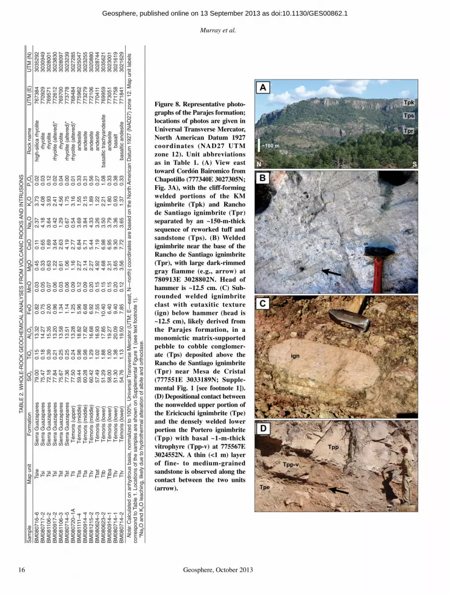
Also present at this stratigraphic interval in the Mesa de Cristal area east of Rancho de Santi-ago (Supplemental Fig. 1 [see footnote 1]) is a monomictic matrix-supported pebble to cobble conglomerate with welded ignimbrite clasts similar in appearance to ignimbrites of the Parajes formation (Fig. 8C). In addition, a thin (<1 m) layer of fi ne- to medium-grained sand-stone is present along the contact between the Ericicuchi ignimbrite (Tpe) and Portero ignim-brites (Tpp) (Fig. 8D).
InterpretationThe Parajes formation represents medial
facies of silicic outfl ow ignimbrite sheets, based on the sheet-like geometry of the fl ow units, the moderate thicknesses of fl ow units (each <~200 m thick, locally thicker where ponded by paleotopography), the presence of welding tex-tures and vitrophyres, and the lack of associated lithic lag breccias. No caldera or vent-proximal
lithofacies have been identifi ed for these outfl ow ignimbrites, so the locations of their sources are not known. However, lithic fragments and fi amme within in the Rancho de Santiago ignim-brite (Tpr) increase in size eastward, suggesting that the source for this ignimbrite is located toward this direction. Based on fl ow thicknesses and degree of welding relative to distance from the source recorded in large-volume silicic ignimbrites in the western U.S. (e.g., Smith, 1960; Lipman, 2007), the ignimbrites of the Parajes formation were likely erupted from cal-deras located within 50–100 km. The large size and concentration of lithic fragments within the Puerto Blanco ignimbrite (Tpb) are suggestive of a somewhat closer source.
Sedimentary rocks (Tps) interbedded with the ignimbrites of the Parajes formation record both erosion of welded units and reworking of unconsolidated pyroclastic debris, with deposi-tion by fl uvial and debris fl ow processes (Figs.
8C, 8D). The debris fl ow deposits are massive, poorly sorted matrix-supported conglomerates, while fl uvial sandstones and fl uvially reworked tuffs have trough cross-bedding, normal grad-ing, and well-sorted granule conglomerate lenses. The clasts in these sedimentary rocks are predominantly silicic volcanic fragments, including welded and nonwelded tuff and pum-ice (e.g., Fig. 8C); there are no andesitic vol canic fragments in these rocks. This suggests that the Parajes formation ignimbrites were uplifted and partly eroded prior to deposition of overlying andesitic rocks of the Témoris formation.
Témoris Formation
The Témoris formation overlies the Parajes formation in angular unconformity, and is best exposed in the central and western portions of the study area in the vicinity of Puerto La Cruz and Guazapares (Fig. 3). This formation
BM080714-5
BM080716-6
BM080717-2
BM080720-1A
BM080917-2
BM081106-2
BM081106-3
0
2
4
6
8
10
12
14
45 50 55 60 65 70 75 80
Na 2
O +
K2O
(w
t %
)
S iO2 (w t %)
Rhyolite
Trachyte
Andesite
Dacite
Basalt
Trachy-andesite
Basaltic andesite
Basaltictrachyandesite
Trachydacite
Trachy-basalt
BM080714-1
BM080623-2
BM080714-2BM080624-3
BM081111-4BM080914-1
BM080914-4
BM081215-2
Sierra Guazapares formation
Témoris formation (upper)
Témoris formation (middle)
Témoris formation (lower)
Figure 7. Total alkali-silica classifi cation diagram (after Le Bas et al., 1986) for selected volcanic rocks of the Guazapares Mining District region. The boundary between the alkaline and subalkaline fi elds (thicker line) is after Irvine and Baragar (1971). Samples were analyzed from the Témoris formation and the Sierra Guazapares formation. Details of each analysis and global positioning system coordinates of samples are given in Table 2 and sample locations are plotted in Supplemental Figure 1 (see footnote 1). The fi eld of the Southern Cordillera basaltic andesites, based on Figure 5 of McDowell et al. (1997), is included here for comparison (dashed line).
as doi:10.1130/GES00862.1Geosphere, published online on 13 September 2013
Murray et al.
16 Geosphere, October 2013
A
B
C
D
Tpp
Tpe
Tpr
Tps
Tpk
ign
~100 m
N S
Tpp-v
Figure 8. Representative photo-graphs of the Parajes formation; locations of photos are given in Universal Transverse Mercator , North American Datum 1927 coordinates (NAD27 UTM zone 12). Unit abbreviations as in Table 1. (A) View east toward Cordón Bairomico from Chapotillo (777340E 3027305N; Fig. 3A), with the cliff-forming welded portions of the KM ignimbrite (Tpk) and Rancho de Santiago ignimbrite (Tpr) separated by an ~150-m-thick sequence of reworked tuff and sandstone (Tps). (B) Welded ignimbrite near the base of the Rancho de Santiago ignimbrite (Tpr), with large dark-rimmed gray fiamme (e.g., arrow) at 780913E 3028802N. Head of hammer is ~12.5 cm. (C) Sub-rounded welded ignimbrite clast with eutaxitic texture (ign) below hammer (head is ~12.5 cm), likely derived from the Parajes formation, in a monomictic matrix-supported pebble to cobble conglomer-ate (Tps) deposited above the Rancho de Santiago ignimbrite (Tpr) near Mesa de Cristal (777551E 3033189N; Supple-mental Fig. 1 [see footnote 1]). (D) Depositional contact between the nonwelded upper portion of the Ericicuchi ignimbrite (Tpe) and the densely welded lower portion the Portero ignimbrite (Tpp) with basal ~1-m-thick vitrophyre (Tpp-v) at 775567E 3024552N. A thin (<1 m) layer of fine- to medium-grained sandstone is observed along the contact between the two units (arrow).
TAB
LE 2
. WH
OLE
-RO
CK
GE
OC
HE
MIC
AL
AN
ALY
SE
S F
RO
M V
OLC
AN
IC R
OC
KS
AN
D IN
TR
US
ION
S
Sam
ple
Map
uni
tF
orm
atio
nS
iO2
TiO
2A
l 2O3
FeO
MnO
MgO
CaO
Na 2
OK
2O
P2O
5R
ock
nam
eU
TM
(E
)U
TM
(N
)B
M08
0716
–6Ts
iwS
ierr
a G
uaza
pare
s79
.00
0.15
13.3
2 0
.82
0.03
0.45
0.11
2.37
3.73
0.02
high
-sili
ca r
hyol
ite76
7384
3035
292
BM
0807
17–2
Tsi
Sie
rra
Gua
zapa
res
75.4
70.
1814
.27
0.7
50.
050.
330.
654.
184.
080.
03rh
yolit
e77
0929
3030
949
BM
0811
06–2
Tsl
Sie
rra
Gua
zapa
res
72.1
80.
3915
.35
2.0
00.
070.
631.
693.
643.
930.
12rh
yolit
e76
9571
3028
001
BM
0809
17–2
Tsl
Sie
rra
Gua
zapa
res
77.8
40.
2113
.20
0.9
60.
061.
223.
640.
422.
410.
02rh
yolit
e (a
ltere
d)*
7726
1230
2383
0B
M08
1106
–3Ts
tS
ierr
a G
uaza
pare
s75
.67
0.25
13.5
8 1
.34
0.03
0.61
2.63
1.29
4.56
0.04
rhyo
lite
7697
0030
2809
7B
M08
0714
–5Ts
tS
ierr
a G
uaza
pare
s77
.36
0.25
13.5
1 1
.14
0.06
1.06
4.19
0.67
1.75
0.00
rhyo
lite
(alte
red)
*77
3778
3023
239
BM
0807
20–1
AT
tiT
émor
is (
uppe
r)77
.50
0.24
13.2
8 1
.25
0.09
1.16
2.77
0.54
3.16
0.01
rhyo
lite
(alte
red)
*76
8484
3027
285
BM
0811
11–4
Tta
Tém
oris
(m
iddl
e)59
.44
0.98
18.8
2 5
.96
0.12
2.27
6.84
3.69
1.55
0.33
ande
site
7759
6230
2504
7B
M08
0914
–4T
taT
émor
is (
mid
dle)
60.2
80.
9817
.82
6.6
80.
092.
145.
713.
842.
150.
31an
desi
te77
3279
3023
255
BM
0812
15–2
Ttv
Tém
oris
(m
iddl
e)60
.42
1.29
16.6
8 6
.92
0.20
2.27
5.44
4.33
1.89
0.56
ande
site
7721
0630
2088
0B
M08
0624
–3T
tat
Tém
oris
(lo
wer
)57
.49
1.02
16.9
3 7
.55
0.15
4.92
7.19
3.26
1.22
0.27
ande
site
7704
1130
2874
4B
M08
0623
–2T
tbT
émor
is (
low
er)
51.2
91.
8817
.85
10.4
00.
154.
686.
983.
502.
211.
08ba
salti
c tr
achy
ande
site
7699
5930
3562
1B
M08
0914
–1T
tba
Tém
oris
(lo
wer
)58
.00
1.00
19.2
7 6
.40
0.15
2.31
6.95
3.79
1.80
0.33
ande
site
7730
5130
2300
1B
M08
0714
–1T
tvT
émor
is (
low
er)
51.3
01.
3820
.09
9.4
00.
203.
659.
303.
360.
930.
38ba
salt
7717
5830
2161
9B
M08
0714
–2T
tvT
émor
is (
low
er)
54.7
61.
1319
.50
7.8
50.
123.
567.
723.
651.
370.
33ba
salti
c an
desi
te77
1841
3021
629
Not
e: C
alcu
late
d on
anh
ydro
us b
asis
, nor
mal
ized
to 1
00%
. Uni
vers
al T
rans
vers
e M
erca
tor
(UT
M; E
—ea
st, N
—no
rth)
coo
rdin
ates
are
bas
ed o
n th
e N
orth
Am
eric
an D
atum
192
7 (N
AD
27)
zone
12.
Map
uni
t lab
els
corr
espo
nd to
Tab
le 1
. Loc
atio
ns o
f the
sam
ples
are
sho
wn
on S
uppl
emen
tal F
igur
e 1
(see
text
foot
note
1).
*Na 2
O a
nd K
2O
leac
hing
, lik
ely
due
to h
ydro
ther
mal
alte
ratio
n of
alb
ite a
nd o
rtho
clas
e.
as doi:10.1130/GES00862.1Geosphere, published online on 13 September 2013

Synvolcanic extension during the mid-Cenozoic ignimbrite fl are-up in the northern Sierra Madre Occidental
Geosphere, October 2013 17
is primarily composed of mafi c to intermediate composition lavas (fl ow-banded and/or vesicu-lar) and hypabyssal intrusions, intercalated conglomerates, breccias, and sandstones domi-nated by mafi c to intermediate volcanic lithic fragments, and lesser thin silicic nonwelded ignimbrites and reworked silicic tuff (Figs. 6, 7, and 9; Tables 1 and 2). This formation has undergone mild hematitic and propylitic altera-tion, with infi lling of vesicles and autoclastic fl ow breccia interstices with zeolite minerals; the most intense alteration is in the rocks within the Guazapares fault zone (Fig. 3B).
DescriptionThe basal deposits of the Témoris formation
consist of sandstones with silicic tuff fragments (Ttss), matrix- to clast-supported breccias with welded silicic ignimbrite boulders (Ttdi, Ttdt; Figs. 9A, 9B), and lesser interbedded silicic tuffs (Ttt). The welded ignimbrite clasts were derived from the underlying Parajes formation, indicating continued erosion of this forma-tion. One ignimbrite of the Parajes formation (Portero ignimbrite, Tpp), located east of Erici-cuchi near 12R 775504E 3024974N (Univer-sal Transverse Mercator coordinates, North American Datum 1927; Fig. 3A), contains clas-tic dikes directly below the Parajes–Témoris formation contact. These dikes are composed of overlying Témoris formation sandstone that infi lls fi ssures formed in the top of the Portero ignimbrite.
The Témoris formation is subdivided into three sections based on volcanic rock compo-sitions and types (Figs. 6, 7, and 10; Tables 1 and 2; Supplemental Table 12). These subdivi-sions have gradational contacts and consist of (1) a lower section of pyroxene-plagioclase ± olivine-bearing amygdaloidal basalt, basaltic andesite, and andesite lavas and autoclastic fl ow breccias (Ttba, Ttb; Figs. 9C, 9D); (2) a middle section of pyroxene-plagioclase–bearing fl ow-banded andesite lavas (Tta; Fig. 9E); and (3) an upper section of several thin (<5-m-thick) primary and reworked rhyolite ignimbrites (Tti; Figs. 9F, 9G); this upper section is only locally preserved beneath the angular unconformity with the over-lying Sierra Guazapares formation. Conglomer-ates, breccias, and sandstones with well-sorted gravel lenses and trough cross-bedding are interbedded with and laterally interfi nger with all of the volcanic rocks listed above (Figs. 9B, 9F–9K, and 10; Table 1). These volcani clastic
deposits contain detritus similar in composi-tion to the interstratifi ed lavas and ignimbrites: amygdaloidal and fl ow-banded basaltic andesite to andesite clasts dominate the lower and middle sections of the Témoris formation (Ttda, Ttsa, Ttdt), while the upper section of the Témoris for-mation has mixed mafi c-intermediate and silicic volcanic clasts, including pumice fragments in tuffaceous sandstones and tuffaceous conglom-erates (Ttss, Ttds, Tti). Lavas and autoclastic fl ow breccias locally infi ll channels incised into the underlying sedimentary rock (Fig. 9E), and wet sediment-magma interactions (peperitic) are locally observed where lavas were apparently emplaced over wet sand (Fig. 9L).
In the area around Témoris, the Témoris for-mation thickens from ~100–400 m to >700 m (Fig. 3; Supplemental Fig. 1 [see footnote 1]). There, basalt to andesite lavas of the lower and middle sections of the Témoris formation are
heavily hematite stained and are complexly intruded by numerous andesitic dikes and aphyric hypabyssal rocks (Ttv; Table 1).
InterpretationThe rocks of the Témoris formation are
interpreted as the products of vent to proximal mafi c to intermediate composition magmatism and distal silicic ignimbrite volcanism. Depo-sition in a terrestrial environment, likely part of alluvial fan systems (e.g., Kelly and Olsen, 1993; Blair and McPherson, 1994; Hamp-ton and Horton, 2007; Murray et al., 2010), is indicated by interstratifi ed matrix-supported debris fl ow breccias and conglomerates (Ttda, Ttds, Ttdi), clast-supported avalanche and/or talus breccias (Ttdt), well-sorted stratifi ed and cross-bedded fl uvial sandstones and conglomer-ates (Ttas, Ttss), and some lavas infi lling fl uvial channels and forming peperites within them
Figure 9 (on following two pages). Representative photographs of the Témoris formation; locations of photos are given in Universal Transverse Mercator, North American Datum 1927 coordinates (NAD27 UTM zone 12). Unit abbreviations as in Table 1. (A) Matrix-supported polymictic breccia with cobble- to boulder-sized welded silicic ignimbrite clasts (ign) and lesser pebble-sized mafi c to intermediate volcanic clasts (below ign boulder) from the basal section of the Témoris formation (Ttdi), weathering to form a small hoodoo in the Rancho de Santiago area (776990E 3031055N). The large (1–2 m) welded ignimbrite boulders (ign) were likely derived from the Parajes formation. (B) Clast-supported monolithic breccia of angu-lar intermediate volcanic cobble- to boulder-sized clasts (Ttdt), which includes a 15-m-thick slide block of bedded sandstone (ss), in the Rancho de Santiago half-graben basin adjacent to the Rancho de Santiago fault (777781E 3028522N; Fig. 3A). (C) Autoclastic fl ow breccia on top of andesitic lava (Ttba) at 769403E 3032339N. (D) Blocky autoclastic fl ow breccia in basaltic trachyandesite lavas (Ttb) at 771976E 3032195N. (E) Andesite lava (Tta) with basal autoclastic fl ow breccia infi lling a channel (arrow) incised into underlying reddish orange sandstone (Ttsa) and debris fl ow deposits (Ttda) in the middle section of the Témoris for-mation in the Puerto La Cruz area (773685E 3022996N). (F) Lithic-rich 2–3-m-thick ignim-brite deposit (Tti), with ~30% mafi c-intermediate and silicic volcanic lithic fragments to 3 cm, deposited over medium-bedded sandstone (Ttss) at 768484E 3027278N. (G) Medium-bedded matrix-supported tuffaceous conglomerate (reworked tuff) from the upper section of the Témoris formation (Ttds), with subangular to subrounded mafi c-intermediate and silicic volcanic clasts. Located in the Puerto La Cruz measured section (~25 m; Fig. 10D) at 773391E 3023300N. Head of hammer is ~12.5 cm. (H) Sandstone (Ttsa) fi lling in depres-sion on top of amygdaloidal basalt lava (Ttba) at 771675E 3021604N. (I) Matrix-supported polymictic conglomerate with subangular to subrounded mafi c-intermediate and silicic vol-canic clasts (Ttds), interbedded fi ne- to medium-grained sandstone (Ttss), located in the half-graben basin adjacent to the Agujerado fault (776328E 3025345N; Fig. 3A). A white pumice-rich lens (wht) is located near base of the 33-cm-long hammer, and a thin (~1 cm) siltstone layer is located directly above the head of hammer (arrow). (J) Matrix-supported polymictic breccia from the upper section of the Témoris formation (775590E 3025137N), with subangular to subrounded mafi c-intermediate volcanic and silicic ignimbrite clasts (Ttds). Breccia grades upsection into sandstone with a thin white pumice-rich lens located below the head of the 38-cm-long hammer (arrow). (K) Downdip view of sandstone from the upper section of the Témoris formation (Ttss), with trough cross-bedding (e.g., arrow) and lenses of white pumice and tuff fragments at 767952E 3027759N. Hammer in photo is 38 cm long. (L) Wet sediment–lava intermixing (peperitic) along the depositional contact between orange-tan sandstone (Ttss) and reddish-gray basaltic andesite (Ttba) at 776571E 3032292N. Hammer in photo is 38 cm long.
2Supplemental Table 1. Modal point-count analy-ses. If you are viewing the PDF of this paper or read-ing it offl ine, please visit http://dx.doi.org/10.1130/GES00862.S2 or the full-text article on www.gsapubs.org to view Supplemental Table 1.
as doi:10.1130/GES00862.1Geosphere, published online on 13 September 2013

Murray et al.
18 Geosphere, October 2013
Aign
B
ss
C
D
ETta
Ttsa
Ttda
F
Tti
Ttss
Figure 9.
as doi:10.1130/GES00862.1Geosphere, published online on 13 September 2013
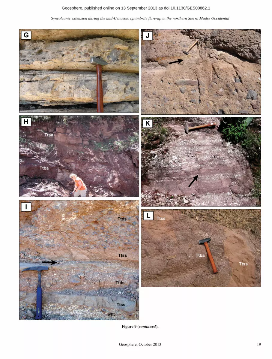
Synvolcanic extension during the mid-Cenozoic ignimbrite fl are-up in the northern Sierra Madre Occidental
Geosphere, October 2013 19
G
Ttsa
Ttba
H
ITtds
Ttss
Ttds
Ttss
wht
J
K
L
Ttss
Ttba
Ttss
Figure 9 (continued).
as doi:10.1130/GES00862.1Geosphere, published online on 13 September 2013

Murray et al.
20 Geosphere, October 2013
40 30 20 10 0
?
40 30 20 10 060 50
40 30 20 10 060 5090 80 70120
110
100
BM
0809
14-4
BM
0809
15-1
,B
M10
0305
-223
.92
± 0.
29 M
a
BM
1003
05-1
24.1
4 ±
0.25
Ma
cls
vff
mc
vcg
pcb
bL
cls
vff
mc
vcg
pcb
bL
40 30 20 10 060 5090 80 70
Rew
orke
d rh
yolit
e ig
nim
brite
s (T
ti)
Mat
rix s
uppo
rted
brec
cia
with
and
esite
and
sili
cic
volc
anic
cla
sts
(Ttd
s)
No
expo
sure
/cov
ered
Mas
sive
san
dsto
ne (T
tss
& T
tsa)
Rhy
olite
lava
flow
(Tsl
)
And
esite
lava
flow
/dik
e (T
ta)
Bas
altic
to a
ndes
itic
lava
flow
s (T
tba)
Rhy
olite
igni
mbr
ites
(Tti)
EX
PLA
NAT
ION
cls
vff
mc
vcg
pcb
b
GR
AIN
SIZ
Ecl
- cl
ays
- silt
L - l
ava
vf -
very
fine
f - fi
nem
- m
ediu
mc
- coa
rse
vc -
very
coa
rse
g - g
ranu
le/la
pilli
p - p
ebbl
e/la
pilli
cb -
cobb
le/b
lock
b - b
ould
er/b
lock
0
Verti
cal s
cale
in m
eter
s
LITH
OLO
GY
(TA
BLE
1)
Mat
rix s
uppo
rted
brec
cia
with
and
esite
cla
sts
(Ttd
a)
Vesi
cula
r/sm
all a
myg
dule
s
Flow
ban
ding
Aut
ocla
stic
flow
bre
ccia
Am
ygda
loid
al
STR
UC
TUR
ES
Verti
cally
stre
tche
d am
ygdu
les
A
B
C
D
Rhy
olite
igni
mbr
ite (T
st)
Tém
oris
form
atio
n(lo
wer
)
BM
0809
14-1
Lsa
nd/
ash
cls
vff
mc
vcg
pcb
bL
cls
vff
mc
vcg
pcb
bL
Sie
rra
Gua
zapa
res
form
atio
n
m
sam
ple
loca
tion
Tém
oris
form
atio
n(lo
wer
)
Tém
oris
form
atio
n(m
iddl
e)
Tém
oris
form
atio
n(m
iddl
e)
Tém
oris
form
atio
n(m
iddl
e)
Tém
oris
form
atio
n(u
pper
)
Fig
ure
10. F
our
cont
inuo
us m
easu
red
stra
tigr
aphi
c se
ctio
ns (
A–D
) of
the
Tém
oris
for
mat
ion
to S
ierr
a G
uaza
pare
s fo
rmat
ion
in t
he P
uert
o L
a C
ruz
area
, eas
t of
Tém
oris
(se
e F
ig. 3
A),
wit
h lit
holo
gies
, dep
osit
iona
l str
uctu
res,
and
str
atig
raph
ic p
osit
ions
of
anal
yzed
sam
ples
(F
igs.
6 a
nd 1
3; T
able
s 2
and
3; S
uppl
emen
tal
Tabl
e 2
[see
foot
note
4])
. The
thre
e su
bdiv
isio
ns o
f the
Tém
oris
form
atio
n an
d th
e bo
unda
ry b
etw
een
the
Tém
oris
and
Sie
rra
Gua
zapa
res
form
atio
ns a
re in
dica
ted.
as doi:10.1130/GES00862.1Geosphere, published online on 13 September 2013
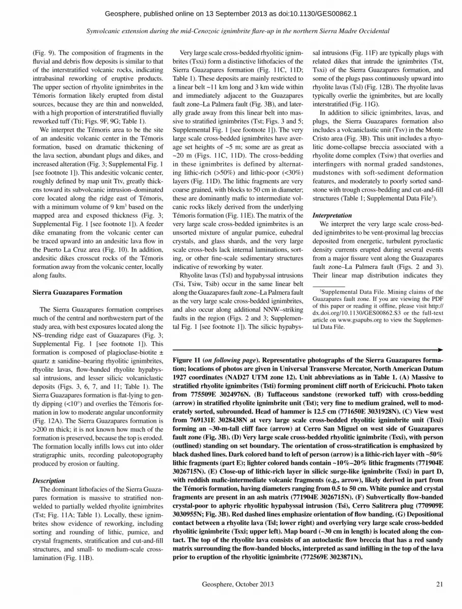
Synvolcanic extension during the mid-Cenozoic ignimbrite fl are-up in the northern Sierra Madre Occidental
Geosphere, October 2013 21
(Fig. 9). The composition of fragments in the fl uvial and debris fl ow deposits is similar to that of the interstratifi ed volcanic rocks, indicating intrabasinal reworking of eruptive products. The upper section of rhyolite ignimbrites in the Témoris formation likely erupted from distal sources, because they are thin and nonwelded, with a high proportion of interstratifi ed fl uvially reworked tuff (Tti; Figs. 9F, 9G; Table 1).
We interpret the Témoris area to be the site of an andesitic volcanic center in the Témoris formation, based on dramatic thickening of the lava section, abundant plugs and dikes, and increased alteration (Fig. 3; Supplemental Fig. 1 [see footnote 1]). This andesitic volcanic center, roughly defi ned by map unit Ttv, greatly thick-ens toward its subvolcanic intrusion–dominated core located along the ridge east of Témoris, with a minimum volume of 9 km3 based on the mapped area and exposed thickness (Fig. 3; Supplemental Fig. 1 [see footnote 1]). A feeder dike emanating from the volcanic center can be traced upward into an andesitic lava fl ow in the Puerto La Cruz area (Fig. 10). In addition, andesitic dikes crosscut rocks of the Témoris formation away from the volcanic center, locally along faults.
Sierra Guazapares Formation
The Sierra Guazapares formation comprises much of the central and northwestern part of the study area, with best exposures located along the NS–trending ridge east of Guazapares (Fig. 3; Supplemental Fig. 1 [see footnote 1]). This formation is composed of plagioclase-biotite ± quartz ± sanidine–bearing rhyolitic ignimbrites, rhyolite lavas, fl ow-banded rhyolite hypabys-sal intrusions, and lesser silicic volcaniclastic deposits (Figs. 3, 6, 7, and 11; Table 1). The Sierra Guazapares formation is fl at-lying to gen-tly dipping (<10°) and overlies the Témoris for-mation in low to moderate angular uncon formity (Fig. 12A). The Sierra Guazapares formation is >200 m thick; it is not known how much of the formation is preserved, because the top is eroded. The formation locally infi lls lows cut into older stratigraphic units, recording paleo topography produced by erosion or faulting.
DescriptionThe dominant lithofacies of the Sierra Guaza-
pares formation is massive to stratifi ed non-welded to partially welded rhyolite ignimbrites (Tst; Fig. 11A; Table 1). Locally, these ignim-brites show evidence of reworking, including sorting and rounding of lithic, pumice, and crystal fragments, stratifi cation and cut-and-fi ll structures, and small- to medium-scale cross-lamination (Fig. 11B).
Very large scale cross-bedded rhyolitic ignim-brites (Tsxi) form a distinctive lithofacies of the Sierra Guazapares formation (Fig. 11C, 11D; Table 1). These deposits are mainly restricted to a linear belt ~11 km long and 3 km wide within and immediately adjacent to the Guazapares fault zone–La Palmera fault (Fig. 3B), and later-ally grade away from this linear belt into mas-sive to stratifi ed ignimbrites (Tst; Figs. 3 and 5; Supplemental Fig. 1 [see footnote 1]). The very large scale cross-bedded ignimbrites have aver-age set heights of ~5 m; some are as great as ~20 m (Figs. 11C, 11D). The cross-bedding in these ignimbrites is defined by alternat-ing lithic-rich (>50%) and lithic-poor (<30%) layers (Fig. 11D). The lithic fragments are very coarse grained, with blocks to 50 cm in diameter; these are dominantly mafi c to intermediate vol-canic rocks likely derived from the underlying Témoris formation (Fig. 11E). The matrix of the very large scale cross-bedded ignimbrites is an unsorted mixture of angular pumice, euhedral crystals, and glass shards, and the very large scale cross-beds lack internal laminations, sort-ing, or other fi ne-scale sedimentary structures indicative of reworking by water.
Rhyolite lavas (Tsl) and hypabyssal intrusions (Tsi, Tsiw, Tsib) occur in the same linear belt along the Guazapares fault zone–La Palmera fault as the very large scale cross-bedded ignimbrites, and also occur along additional NNW–striking faults in the region (Figs. 2 and 3; Supplemen-tal Fig. 1 [see footnote 1]). The silicic hypabys-
sal intrusions (Fig. 11F) are typically plugs with related dikes that intrude the ignimbrites (Tst, Tsxi) of the Sierra Guazapares formation, and some of the plugs pass continuously upward into rhyolite lavas (Tsl) (Fig. 12B). The rhyolite lavas typically overlie the ignimbrites, but are locally interstratifi ed (Fig. 11G).
In addition to silicic ignimbrites, lavas, and plugs, the Sierra Guazapares formation also includes a volcaniclastic unit (Tsv) in the Monte Cristo area (Fig. 3B). This unit includes a rhyo-litic dome-collapse breccia associated with a rhyolite dome complex (Tsiw) that overlies and interfi ngers with normal graded sandstones, mudstones with soft-sediment deformation features, and moderately to poorly sorted sand-stone with trough cross-bedding and cut-and-fi ll structures (Table 1; Supplemental Data File3).
InterpretationWe interpret the very large scale cross-bed-
ded ignimbrites to be vent-proximal lag breccias deposited from energetic, turbulent pyroclastic density currents erupted during several events from a major fi ssure vent along the Guaza pares fault zone–La Palmera fault (Figs. 2 and 3). Their linear map distribution indicates they
Figure 11 (on following page). Representative photographs of the Sierra Guazapares forma-tion; locations of photos are given in Universal Transverse Mercator, North American Datum 1927 coordinates (NAD27 UTM zone 12). Unit abbreviations as in Table 1. (A) Massive to stratifi ed rhyolite ignimbrites (Tsti) forming prominent cliff north of Ericicuchi. Photo taken from 775509E 3024976N. (B) Tuffaceous sandstone (reworked tuff) with cross-bedding (arrow) in stratifi ed rhyolite ignimbrite unit (Tst); very fi ne to medium grained, well to mod-erately sorted, subrounded. Head of hammer is 12.5 cm (771650E 3031928N). (C) View west from 769131E 3028438N at very large scale cross-bedded rhyolitic ignimbrite unit (Tsxi) forming an ~30-m-tall cliff face (arrow) at Cerro San Miguel on west side of Guazapares fault zone (Fig. 3B). (D) Very large scale cross-bedded rhyolitic ignimbrite (Tsxi), with person (outlined) standing on set boundary. The orientation of cross-stratifi cation is emphasized by black dashed lines. Dark colored band to left of person (arrow) is a lithic-rich layer with ~50% lithic fragments (part E); lighter colored bands contain ~10%–20% lithic fragments (771904E 3026715N). (E) Close-up of lithic-rich layer in silicic surge-like ignimbrite (Tsxi) in part D, with reddish mafi c-intermediate volcanic fragments (e.g., arrow), likely derived in part from the Témoris formation, having diameters ranging from 0.5 to 50 cm. White pumice and crystal fragments are present in an ash matrix (771904E 3026715N). (F) Subvertically fl ow-banded crystal-poor to aphyric rhyolitic hypabyssal intrusion (Tsi), Cerro Salitrera plug (770909E 3030955N; Fig. 3B). Red dashed lines emphasize orientation of fl ow banding. (G) Depositional contact between a rhyolite lava (Tsl; lower right) and overlying very large scale cross-bedded rhyolitic ignimbrite (Tsxi; upper left). Map board (~30 cm in length) is located along the con-tact. The top of the rhyolite lava consists of an autoclastic fl ow breccia that has a red sandy matrix surrounding the fl ow-banded blocks, interpreted as sand infi lling in the top of the lava prior to eruption of the rhyolitic ignimbrite (772569E 3023871N).
3Supplemental Data File. Mining claims of the Guazapares fault zone. If you are viewing the PDF of this paper or reading it offl ine, please visit http://dx.doi.org/10.1130/GES00862.S3 or the full-text arti cle on www.gsapubs.org to view the Supplemen-tal Data File.
as doi:10.1130/GES00862.1Geosphere, published online on 13 September 2013
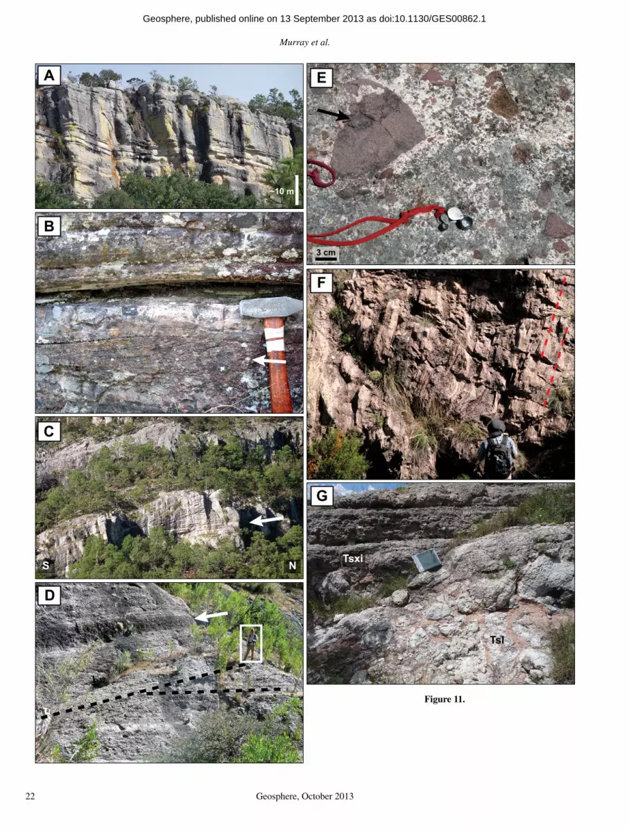
Murray et al.
22 Geosphere, October 2013
A
B
C
D
E
~10 m
F
G
S N
3 cm
Tsl
Tsxi
Figure 11.
as doi:10.1130/GES00862.1Geosphere, published online on 13 September 2013

Synvolcanic extension during the mid-Cenozoic ignimbrite fl are-up in the northern Sierra Madre Occidental
Geosphere, October 2013 23
were erupted from fi ssure vents, rather than a central vent, and likely formed coarse-grained ramparts. Interstratifi ed silicic lavas and plugs are concentrated along either side of the same fault zone, in the same linear map distribution, supporting the interpretation that the Guaza-
pares fault zone–La Palmera fault controlled the siting of an 11-km-long silicic fi ssure vent.
The very large scale cross-bedded ignim-brites (Tsxi) represent a gradation between the pyroclastic surge and pyroclastic fl ow end members of pyroclastic density current clas-
sifi cation (e.g., Fisher and Schmincke, 1984; Branney and Kokelaar, 2002). The abundant very coarse-grained lithic layers in these cross-bedded ignimbrites are similar to lithic lag breccias described from other vent to proximal ignimbrites (e.g., Fisher and Schmincke, 1984; Carey, 1991; Freundt et al., 2000; Branney and Kokelaar, 2002). The angularity of the lithic components and their derivation from the under-lying Témoris formation suggests that they were fragmented and incorporated into the pumice-rich pyroclastic material as it ascended through the vent. However, the very large scale cross-stratifi cation is unusual for ignimbrite lithic lag breccias. Very large scale cross-bedding has been described in vent to proximal ignimbrites in other localities, including Mount St. Helens (e.g., Rowley et al., 1985), Tenerife (e.g., Brown and Branney, 2004), Santorini (e.g., Gertisser et al., 2009), and Volcán Villarrica, Chile (e.g., Silva Parejas et al., 2010); however, these cross-bedded ignimbrites are generally dominated by ash- to lapilli-sized material and do not con-tain the large lithic blocks such as in the very large scale cross-bedded ignimbrite (Tsxi) described here.
Given their coarse-grained nature and large-scale cross-stratifi cation, the very large scale cross-bedded ignimbrites (Tsxi) suggest depo-sition from highly energetic low-concentration pyroclastic fl ows in a vent to proximal setting, due to the high amount of turbulent energy required to produce these very large bedforms while transporting the large lithic fragments (e.g., Wright et al., 1981; Carey, 1991; Bran-ney and Kokelaar, 2002). The gradational lateral transition from very large scale cross-bedded ignimbrites (Tsxi) into massive to stratifi ed ignimbrites (Tst) within 1–2 km of the Guaza-pares fault zone–La Palmera fault (Fig. 3; Supplemental Fig. 1 [see footnote 1]) suggests decreased turbulence and an increased pyroclas-tic sedimentation rate farther from the vent.
Lithostratigraphic Summary
The three informal formations defi ned in the Guazapares Mining District region represent three distinct volcanic episodes:
1. The Parajes formation consists of welded to nonwelded silicic outfl ow ignimbrite sheets that were erupted from caldera sources within 50–100 km of the study area, with intercalated volcaniclastic rocks derived from erosion of these ignimbrites.
2. The lower and middle Témoris formation consists dominantly of locally erupted mafi c to intermediate composition lavas and associ-ated subvolcanic intrusions, including an ande-sitic center in the area around Témoris, as well
A
B
W E
NW SE
Tsi
Tsl
TtTt
Tst
Tst5°
20°
~25 m
Tta
Ttda
Ttba
unconformity
unconformity
~100 m
Figure 12. Interpreted photographs of depositional relationships between the Témoris for-mation and the Sierra Guazapares formation; locations of photos are given in Universal Transverse Mercator, North American Datum 1927 coordinates (NAD27 UTM zone 12). Unit abbreviations as in Table 1. (A) Angular unconformity between gently dipping (~5° ° NE) massive and stratifi ed rhyolite ignimbrites of the Sierra Guazapares formation (Tst) and the underlying moderately dipping (~20° E) lavas (Ttba, Tta) and debris fl ow deposits (Ttda) of the Témoris formation. View is north toward Cerro Cuadro Blanco (Fig. 3B) from 772093E 3022247N. (B) View northeast from 772915E 3021769N toward silicic plug (Tsi) that intrudes the La Palmera fault and is the source for the silicic lava (Tsl) that fl owed to the northwest over silicic ignimbrites of the Sierra Guazapares formation (Tst) and tilted rocks of the Témoris formation (Tt). The dip of fl ow banding (thin red lines) in the lava increases in proximity to the plug, where the fl ow banding is subvertical.
as doi:10.1130/GES00862.1Geosphere, published online on 13 September 2013

Murray et al.
24 Geosphere, October 2013
as fault-controlled dikes that likely fed fl ows outside the main center. The lower and middle Témoris formation also contains interstratifi ed volcaniclastic fl uvial and debris fl ow deposits. Detritus at the base of the formation that was derived from the underlying Parajes formation silicic ignimbrites records erosion of that forma-tion, perhaps along fault scarps. In contrast, the ande sitic detritus that dominates higher in the section could record resedimentation of primary eruptive products, such as the collapsing fronts of lavas, or block-and-ash fl ows or tephras , although erosion of constructional volcanic features or fault scarps is also probable, par-ticularly for polymictic deposits. The distal thin nonwelded silicic ignimbrites and sedimentary rocks of the upper section of the Témoris forma-tion record waning of local mafi c to intermedi-ate volcanism prior to the onset of local silicic volcanism, and indicate continuing or recurring silicic ignimbrite-forming eruptions from dis-tant sources.
3. The Sierra Guazapares formation records the local eruption of silicic volcanic rocks within the Guazapares Mining District region. These include ignimbrites with vent facies lithic lag breccias that formed very large scale cross-beds along either side of an 11-km-long fault-controlled fi ssure, which also controlled the emplacement of silicic plugs and eruption of silicic lavas. The Sierra Guazapares forma-tion also includes silicic dome-collapse breccias and interstratifi ed silicic lavas and volcaniclas-tic rocks that interfi nger with lacustrine deposits preserved in a half-graben basin.
GEOLOGIC STRUCTURES AND BASIN DEVELOPMENT
The main geologic structures in the Guaza-pares Mining District region are primarily NNW–trending normal faults, including the Guazapares fault zone and faults to the north-east of Témoris (Figs. 2, 3, and 4; Supplemen-tal Fig. 1 [see footnote 1]). The Guazapares fault zone extends from Témoris northward to the Monte Cristo mining claim, and is a com-plex system of NNW–striking normal faults with numerous splays that dip both east and west, with several changes of fault dip polar-ity along strike (Fig. 3B; Supplemental Fig. 1 [see footnote 1]; Supplemental Data File [see footnote 3]). This fault zone hosts the major-ity of mineralization within the mining district (e.g., Gustin, 2012). The normal faults located northeast of Témoris have signifi cant vertical offset and bound half-graben basins (Figs. 3A and 4). Although many of the half graben faults die out upsection, making them relatively easy to recognize, faults of the Guazapares fault
zone were reactivated many times, and cut all formations (Figs. 2 and 5), making their earlier history more diffi cult to document.
Synvolcanic Half-Graben Basins
Several normal faults bound half-graben basins in the Guazapares Mining District region, including the NNW–striking, west-dipping Arroyo Hondo–Puerto Blanco, La Palmera, and Agujerado faults; the NNE–striking, west-dip-ping Rancho de Santiago fault; and the NNW–striking, east-dipping Sangre de Cristo fault (Figs. 3 and 4). In general, these half-graben basins contain sedimentary and volcanic depos-its that thicken and/or coarsen toward basin-bounding normal faults, which either terminate at the fault or thin onto the footwall, indicating synextensional deposition (Fig. 4). Angular unconformities occur between each of the for-mations, and fanning dips (e.g., Fig. 12A) indi-cate synextensional deposition, with the Parajes and Témoris formations dipping more steeply than the gently dipping to fl at-lying Sierra Guazapares formation.
The upper part of the Parajes formation (younger than the Puerto Blanco ignimbrite [Tpb]) was likely deposited into synvolcanic extensional basins, based on the variable thick-nesses of individual outfl ow ignimbrite sheets and distribution of interbedded sedimentary rocks across faults. Evidence for synexten-sional deposition includes (1) the presence of reworked tuff, sandstone, and conglomerate (Tps) above the Rancho de Santiago ignimbrite (Tpr) within the half-graben basin adjacent to Arroyo Hondo–Puerto Blanco fault and in the Mesa de Cristal area, which thicken toward and terminate at faults and are not present on the footwall blocks, and (2) thickening of the Rancho de Santiago ignimbrite (Tpr) within the half-graben basin bounded by the Arroyo Hondo–Puerto Blanco fault (~200 m thick), relative to the ~80 m thickness on the footwall block (Figs. 3A, 4, and 8C; Supplemental Fig. 1 [see footnote 1]).
Synextensional deposition of the Témoris formation is evident in the three half-graben basins bounded by the La Palmera, Agujerado, and Rancho de Santiago–Arroyo Hondo–Puerto Blanco faults (Figs. 3A and 4). In these basins, the Témoris formation is deposited in angu-lar unconformity on the more steeply dipping Parajes formation, and the thickness and aver-age grain size of sedimentary deposits increases dramatically eastward toward each of the basin-bounding normal faults (Fig. 4). In the half-graben bounded by the Agujerado fault, a coarse-grained debris fl ow (Ttds) deposited proximal to the basin-bounding fault inter-
fi ngers basinward with fi ner grained sandstone and siltstone (Ttss; Figs. 3A and 4B).
The largest of the three synvolcanic half-grabens of the Témoris formation is the Rancho de Santiago basin, which is unique in that it developed as a half-graben bounded by two west-dipping normal faults on the eastern side of the basin; the southernmost fault is the NNE–striking Rancho de Santiago fault, which is crosscut on the north end by the NNW–striking Arroyo Hondo–Puerto Blanco fault (Fig. 3A). In this basin, a clast-supported breccia (Ttdt) con-taining large (to 4 m) intermediate volcanic and lesser silicic ignimbrite rock fragments, as well as slide blocks of fractured but intact sedimen-tary strata to 15 m thick and 20 m long, is adja-cent to the Rancho de Santiago fault (Figs. 3A, 4C, and 9B; Table 1). This breccia is interpreted as talus and avalanche deposits that were shed from the uplifted footwall fault scarps directly into the half-graben basin to the west.
Synvolcanic extension during emplacement of the Sierra Guazapares formation is recorded by silicic dome-collapse deposits, reworked tuffs, and fl uvial-lacustrine deposits (Tsv) pre-served within the half-graben basin bounded by the Sangre de Cristo fault in the Monte Cristo mining claim at the northern mapped end of the Guazapares fault zone (Fig. 3B; Table 1; Supple-mental Data File [see footnote 3]). In this basin, a rhyolitic breccia thickens and coarsens toward the Sangre de Cristo fault and inter fi ngers basin-ward with basal lacustrine sedimentary rocks. Additional evidence of synvolcanic extension in this basin includes the development of a normal fault within the hanging-wall block of the Sangre de Cristo fault that provided a con-duit for a small silicic plug and coulee (Tsl) to intrude and fl ow over the actively depositing volcaniclastic unit (Tsv; Fig. 3B; Supplemental Data File [see footnote 3]).
Relative Timing and Amount of Extensional Deformation
Extensional deformation in the Guazapares Mining District region was concurrent with deposition of at least the upper part of the Parajes formation, the Témoris formation, and the Sierra Guazapares formation, with contin-ued extension following deposition of the Sierra Guazapares formation. Pre–Sierra Guazapares formation extension is suggested by the low to moderate angular unconformities between the Témoris formation and the underlying Parajes formation and the overlying Sierra Guaza pares formation (Fig. 12A). Older normal faults that offset the Parajes and Témoris formations local-ized the vents and silicic plugs of the Sierra Guazapares formation, which utilized these
as doi:10.1130/GES00862.1Geosphere, published online on 13 September 2013
Synvolcanic extension during the mid-Cenozoic ignimbrite fl are-up in the northern Sierra Madre Occidental
Geosphere, October 2013 25
preexisting structures as pathways for magma accent (e.g., La Palmera and La Escalera faults, Guazapares fault zone; Figs. 2, 3, and 12B; Supplemental Fig. 1 [see footnote 1]). In addi-tion, unfaulted Sierra Guazapares formation lavas bury some faults that offset the Parajes and Témoris formations (Figs. 2 and 3).
Further evidence of pre–Sierra Guazapares formation extension includes greater fault off-sets of the older formations compared to offset of the Sierra Guazapares formation (Figs. 3A and 4). The minimum vertical displacement of the base of the Témoris formation across the Ericicuchi fault is >300 m, ~110 m across the Agujerado fault, and >450 m across the La Palmera fault (Fig. 4). In comparison, these faults offset the Sierra Guazapares formation to a lesser degree: the base of the Sierra Guaza-pares formation is only offset ~60 m across the Ericicuchi fault, ~30 m across the Agujerado fault, and ~100 m across the La Palmera fault (Fig. 4). This shows that a signifi cant amount of extensional deformation (at least 350 m vertical displacement) occurred prior to the eruption of the Sierra Guazapares formation.
A minimum of 20% total horizontal exten-sion is estimated in the Guazapares Mining District region (for the area shown in Fig. 4), based on the vertical displacement of strati-graphic units across normal faults. This amount of extension is signifi cantly lower than that of the Gulf Extensional Province to the west in Sonora, where ~90% extension is estimated to have occurred (Gans, 1997). The structural style also differs between these two areas; high-angle normal faults are found in the Guazapares Min-ing District region, while highly extended core complexes are located in Sonora (e.g., Gans, 1997; Wong et al., 2010).
Although not directly quantifi able, several faults within the Guazapares Mining District region appear to accommodate considerable amounts of deformation based solely on the jux-taposition of stratigraphic units. The La Palmera fault has signifi cant vertical offset (over 450 m) based on the offset of the Parajes–Témoris for-mation contact; the Parajes formation is exposed on the footwall, but is not exposed in the hang-ing wall, which suggests that it is deeply buried beneath Témoris formation deposits there (Figs. 2 and 4). A distinct lithologic boundary in the Parajes formation occurs across the Chapotillo fault, as the younger outfl ow ignimbrite sheets in the hanging wall of this fault are not exposed on the footwall to the southwest (Fig. 3A). Post-depositional drag folding related to normal fault deformation is observed in the Témoris forma-tion adjacent to many of the NNW–striking faults with signifi cant offset (e.g., La Palmera, Agujerado, and La Escalera faults; Figs. 3A
and 4); the underlying Parajes formation has small-scale normal faulting to accommodate this deformation.
AGE CONSTRAINTS
Methodology
We report new U-Pb zircon ages from each of the three informally defi ned formations, pro-viding constraints on the age of the previously undated volcanic rocks of the Guazapares Min-ing District region. Laser ablation–inductively coupled plasma–mass spectrometry (LA–ICP-MS) U-Pb analyses were performed at the Laboratorio de Estudios Isotópicos, Centro de Geociencias, Universidad Nacional Autónoma de México on zircons separated from 13 silicic rock samples (Fig. 13; Table 3; Supplemen-tal Table 24). The zircons were hand-picked under binocular microscope, mounted in an epoxy cast, polished, and imaged by cathodo-luminescence (CL). The zircons selected for U-Pb geochronology were analyzed following the procedure reported by Solari et al. (2010), employing a Resonetics M050 excimer laser ablation workstation coupled to a Thermo XSeries II ICP-MS. Based on CL imaging, one ablation site was selected on each zircon ana-lyzed, located either in the middle, near rim, or core of the crystal (Supplemental Fig. 25). The Plešovice standard zircon (ca. 337 Ma; Sláma
et al., 2008) was used as a bracketing standard, interdispersed and measured after every fi ve unknown zircons. The observed uncertainties of the 206Pb/238U, 207Pb/206Pb, and 208Pb/232Th ratios, during the different sessions in which the cur-rent samples were analyzed, as measured on the Plešovice standard zircon, were 0.65%, 1.0%, and 1.1%, respectively. These values are qua-dratically propagated to the quoted uncertainties of the unknown zircons, to take into account the heterogeneities of the natural standard zircon. A second standard (NIST 610) is used to recal-culate the elemental concentrations for each zircon, measured together with the isotopes of interest for U-Pb geochronology. The common Pb correction cannot be performed measuring the 204Pb isotope with the current setup; com-mon Pb is evaluated using the 207Pb/206Pb ratio, graphing the results using Tera-Wasserburg dia-grams (Tera and Wasserburg, 1972). If a correc-tion is needed, the algebraic method of Andersen (2002) is used. Filters are then applied to reduce outliers: largely discordant analyses (e.g., >50% discordant) and those with >4% 1σ error on the corrected 206Pb/238U ratio are eliminated. A fur-ther screening is applied to check for possible microscopic inclusions of minerals other than zircons that could have been inadvertently hit during the analysis. This screening is performed during data reduction, employing a script writ-ten in R (UPb.age; Solari and Tanner, 2011). Additional screenings are performed, checking for analyses with high P and light rare earth elements, which could be indicative of apatite inclusions, and those few analyses that pres-ent high concentrations of U and Th (generally >1000 ppm), which could yield to a Pb loss and a consequent discordant or, in any case, younger and geologically meaningless ages.
Concordia plots, probability density distribu-tion and histogram plots, mean age, and age-error calculations were performed using Isoplot v. 3.70 (Ludwig, 2008). The mean 206Pb/238U age is especially useful for the Tertiary ages
Figure 13 (on following two pages). Summary of zircon U-Pb laser ablation–inductively coupled plasma–mass spectrometry analyses for samples listed in Table 3; mean 206Pb/238U ages of the youngest zircon population (interpreted emplacement age) for each sample is listed. Tera-Wasserburg concordia plots with inset probability density distribution plots are arranged by major stratigraphic division and lithologic unit. MSWD—mean square of weighted deviates. (A, B) Ericicuchi ignimbrite (Tpe), Parajes formation. (C) Puerto Blanco ignimbrite (Tpb), Parajes formation. (D) Silicic tuff interbedded in sandstone from the basal deposits of the Témoris formation. (E, F) Silicic ignimbrites (Tti) from near the top of the Témoris formation. (G) Very large scale cross-bedded rhyolitic ignimbrite (Tsxi), Sierra Guazapares formation. (H–J) Rhyolitic lavas (Tsl), Sierra Guazapares formation. (K, L) Rhyolitic plugs (Tsi), Sierra Guazapares formation. (M) Rhyolitic dome-collapse breccia from the Monte Cristo mining claim, Sierra Guazapares formation. Details on the experi-ments and mean age plots are given in Supplemental Table 2 (see footnote 4).
4Supplemental Table 2. Zircon U-Pb laser abla-tion–inductively coupled plasma–mass spectrometry analytical results. If you are viewing the PDF of this paper or reading it offl ine, please visit http://dx.doi.org/10.1130/GES00862.S4 or the full-text article on www.gsapubs.org to view Supplemental Table 2.
5Supplemental Figure 2. Cathodoluminescence images of zircons from U-Pb laser ablation–induc-tively coupled plasma–mass spectrometry analyses. If you are viewing the PDF of this paper or read-ing it offl ine, please visit http://dx.doi.org/10.1130/GES00862.S5 or the full-text article on www.gsapubs.org to view Supplemental Figure 2.
as doi:10.1130/GES00862.1Geosphere, published online on 13 September 2013

Murray et al.
26 Geosphere, October 2013
40 206080
0.04
0.06
0.08
0.10
0.12
80 120 160 200 240 280
207 P
b/20
6 Pb
238U/206Pb
BM100306-1 Mean 206Pb/238U age
27.55 ± 0.33 Ma MSWD = 1.04
data-point error ellipses are 2
data-point error ellipses are 2
data-point error ellipses are 2
data-point error ellipses are 2 data-point error ellipses are 2
data-point error ellipses are 2
data-point error ellipses are 2
60100
0.04
0.06
0.08
0.10
0.12
0.14
0.16
40 80 120 160 200 240 280 320
207 P
b/20
6 Pb
238U/206Pb
BM100306-3Mean 206Pb/238U age
27.04 ± 0.74 Ma MSWD = 1.6
263034
0.04
0.06
0.08
0.10
0.12
0.14
170 190 210 230 250 270
207 P
b/20
6 Pb
238U/206Pb
BM100306-6Mean 206Pb/238U age
27.58 ± 0.26 MaMSWD = 2.6
242628303234360.04
0.06
0.08
0.10
0.12
0.14
170 190 210 230 250 270
207 P
b/20
6 Pb
238U/206Pb
BM100305-4Mean 206Pb/238U age
27.27 ± 0.33 Ma MSWD = 1.7
26300.04
0.06
0.08
0.10
0.12
190 210 230 250 270 290
207 P
b/20
6 Pb
238U/206Pb
BM100304-5Mean 206Pb/238U age
24.58 ± 0.19 Ma MSWD = 0.96
202428
0.03
0.05
0.07
0.09
0.11
0.13
0.15
210 230 250 270 290 310 330
207 P
b/20
6 Pb
238U/206Pb
2224262830
0.04
0.06
0.08
0.10
210 230 250 270 290
207 P
b/20
6 Pb
238U/206Pb
BM100304-4Mean 206Pb/238U age
24.66 ± 0.24 Ma MSWD = 1.3
A B
E F
D
G
C
4032 24
0.00
0.02
0.04
0.06
0.08
0.10
0.12
0.14
0.16
0.18
0.20
160 200 240 280 320
BM100307-123.72 ± 0.22 Ma
MSWD = 0.42
Hdata-point error ellipses are 2
207 P
b/20
6 Pb
238U/206Pb
BM100305-1Mean 206Pb/238U age
24.14 ± 0.25 Ma MSWD = 0.49
Mean 206Pb/238U age
0
5
10
15
20
25 35 45 55 65
Relative probability
Num
ber
M a
2
6
10
14
20 30 40 50 60 70 80 90
Relative probability
Num
ber
M a
0
2
4
6
8
25 27 29 31 33 35 37
Relative probability
Num
ber
M a
0246810
24 26 28 30 32 34 36
Relative probability
Num
ber
M a
2
6
10
14
22 24 26 28 30 32 34
Relative probability
Num
ber
M a
0246810
20 22 24 26 28 30
Relative probability
Num
ber
M a
2468
10
21 23 25 27 29 31 33
Relative probability
Num
ber
M a0
2
4
6
8
19 21 23 25 27 29 31 33 35
Relative probability
Num
ber
M a
Figure 13.
as doi:10.1130/GES00862.1Geosphere, published online on 13 September 2013

Synvolcanic extension during the mid-Cenozoic ignimbrite fl are-up in the northern Sierra Madre Occidental
Geosphere, October 2013 27
presented here, because the 207Pb measurement is problematic in these young zircons and the consequent uncertainty on the 207Pb/206Pb ratio is not a good indicator of geologically mean-ingful discordance. In Tertiary zircons, it is also common to observe scattering of the mean 206Pb/238U ages that yields MSWD (mean square of weighted deviates) values that are largely >1, an indication that a mixed age population possibly exists. An example of this scenario was presented by Bryan et al. (2008). In order
to recognize possible different age components in samples that showed an initial MSWD of >3, the deconvolution method, based on the mixture modeling method of Sambridge and Compston (1994), was implemented in Isoplot.
When two mixture components are recog-nized, their respective mean 206Pb/238U ages are plotted together with errors and recalculated MSWD. The mean 206Pb/238U age of the older mixture component in a sample represents the crystallization age of inherited zircons within
the host magma, while the younger mean 206Pb/238U age population represents the pheno-cryst crystallization age of the sample. This youngest age population of each sample is inter-preted as the preferred eruption or emplacement age of the rock, as it is consistent (within error) with stratigraphic relationships in the study area. Age results are presented in the follow-ing and summarized in Figure 13 and Table 3; detailed analytical data are given in Supplemen-tal Table 2 (see footnote 4).
242832
0.02
0.04
0.06
0.08
0.10
0.12
0.14
0.16
0.18
0.20
190 210 230 250 270 290 310
BM100304-1
BM100304-2
Mean 206Pb/238U age
Mean 206Pb/238U age
22.94 ± 0.25 Ma
24.17 ± 0.17 Ma
MSWD = 0.18
MSWD = 1.6
32 28 240.04
0.06
0.08
0.10
0.12
0.14
0.16
0.18
180 200 220 240 260 280 300
BM080717-3Mean 206Pb/238U age
25.03 ± 0.31 MaMSWD= 1.7
22242628
0.04
0.06
0.08
0.10
0.12
0.14
0.16
220 240 260 280 300
242832
0.02
0.04
0.06
0.08
0.10
0.12
0.14
0.16
0.18
190 210 230 250 270 290 310
BM100305-3Mean 206Pb/238U age
24.61 ± 0.22 MaMSWD= 1.5
J
L
M
data-point error ellipses are 2
data-point error ellipses are 2
data-point error ellipses are 2data-point error ellipses are 2
207 P
b/20
6 Pb
238U/206Pb
207 P
b/20
6 Pb
238U/206Pb
207 P
b/20
6 Pb
238U/206Pb
207 P
b/20
6 Pb
238U/206Pb
K
36 28 200.04
0.06
0.08
0.10
0.12
0.14
0.16
0.18
160 200 240 280 320238 U/ 206 Pb
207 Pb
/206 Pb
data-point error ellipses are 2σ
BM100305-2Mean 206Pb/238U age
23.92 ± 0.29 MaMSWD = 0.94
I
0
2
4
6
8
10
20 22 24 26 28 30 32 34
Relative probability
Num
ber
M a
2
6
10
14
21 23 25 27 29 31 33
Relative probability
Num
ber
M a
2
6
10
14
22 24 26 28 30 32 34
Relative probability
Num
ber
M a
2
4
6
8
10
20 22 24 26 28 30 32 34
Relative probability
Num
ber
M a
0246810
23 .5 25 .5 27 .5
Relative probability
Num
ber
M a
Figure 13 (continued).
as doi:10.1130/GES00862.1Geosphere, published online on 13 September 2013
Murray et al.
28 Geosphere, October 2013
Parajes FormationThree samples were dated from the Parajes
formation (Figs. 13A–13C; Table 1), includ-ing two samples from the Ericicuchi ignimbrite (Tpe) and one sample from the Puerto Blanco ignimbrite (Tpb). Sample BM100306–1 is Erici-cuchi ignimbrite (Tpe), which has separated zircons that are bipyramidal to short and stubby, and to 220 µm in length. Under CL, the zircons show uniform areas with limited luminescence; in a few cases, oscillatory zoning is present around possible inherited cores. The U-Pb geo-chronological analysis, as well as the screening and fi ltering, shows the presence of inherited cores that are slightly discordant but older than 40 Ma. Most of the analyzed, nearly concordant crystals range from ca. 26 Ma to 31 Ma (Fig. 13A). Two zircon age populations can be distin-guished: the oldest population has a mean age of 29.59 ± 0.33 Ma (n = 22, MSWD = 1.6), whereas the youngest has a mean age of 27.55 ± 0.33 Ma (n = 6, MSWD = 1.04). A second sample from the Ericicuchi ignimbrite (sample BM100306–3; Fig. 13B) yielded fewer and smaller zircon crys-tals (to 180 µm in length) that are euhedral to subhedral with a prevalence of stubby morphol-ogies with short pyramidal terminations. These zircons show bright CL zoning around darker cores. The U-Pb geochronology for this sample also revealed the presence of inherited cores of ca. 76, 50, and 38 Ma and two main zircon age populations consisting of an older grouping having a mean age of 29.01 ± 0.32 Ma (n = 16,
MSWD = 1.6) and a younger grouping with a mean age of 27.04 ± 0.74 Ma (n = 6, MSWD = 2.5). The third sample of the Parajes forma-tion is from the Puerto Blanco ignimbrite (Tpb; sample BM100306–6; Fig. 13C). The zircons in this sample are larger (to 260 µm in length) with elongated shapes that are mostly prismatic with well-developed pyramids. Under CL they show evident bright rims developed outside darker zones. The dated zircons defi ne a homogeneous group with few outliers and have a mean age of 27.58 ± 0.26 Ma (n = 31, MSWD = 2.6).
Témoris FormationThree samples of silicic tuffs from basal
and upper sections of the Témoris formation were dated (Figs. 13D–13F; Table 3). Sample BM100305–4 was collected from the basal sec-tion of the Témoris formation (Fig. 13D) and has zircons to 300 µm in length that are pris-matic and elongated. Under CL, the zircons are characterized by darker cores surrounded by bright zones. Despite similar crystal morpholo-gies, two zircon age populations are identifi ed; the oldest group has a mean age of 29.73 ± 0.70 Ma (n = 11, MSWD = 2.1), whereas the youngest mean age is 27.27 ± 0.33 Ma (n = 18, MSWD = 1.7). Sample BM100304–5 was col-lected from the upper section of the Témoris for-mation (Tti; Fig. 13E) and has zircons that are indistinguishable in size, morphology, and CL imaging from those of the previous sample. Two well-constrained zircon age populations are also
defi ned; the oldest has a mean age of 26.07 ± 0.25 Ma (n = 20, MSWD = 1.5), whereas the youngest mean age is 24.58 ± 0.19 Ma (n = 12, MSWD = 0.96). Sample BM100305–1 is from the uppermost section of the Témoris formation (Tti), ~35 m below the Sierra Guazapares for-mation contact (Figs. 10 and 13F). Its zircons are also prismatic and very elongated, although they are somewhat smaller (to 200 µm in length) in this sample. Under CL, the zircons are also characterized by darker cores surrounded by bright zones. U-Pb analyses identifi ed two zir-con age populations in this sample; the oldest group yields a mean age of 25.58 ± 0.29 Ma (n = 17, MSWD = 1.6), whereas the youngest group yields a mean age of 24.14 ± 0.25 Ma (n = 10, MSWD = 0.49).
Sierra Guazapares FormationSeven samples from the various lithologies
of the Sierra Guazapares formation were cho-sen for U-Pb geochronology (Figs. 13G–13M; Table 3). Sample BM100304–4 was collected from the very large scale cross-bedded ignim-brite unit (Tsxi; Fig. 13G). It has somewhat small (to 150 µm) euhedral zircons that range in shape from prismatic to stubby and bipyramidal morphologies. CL imaging is not different from the previously described samples, although cores are not as evident as in other samples. The dated zircons defi ne only one coherent group, in which the mean age is 24.66 ± 0.24 Ma (n = 19, MSWD = 1.3).
Three rhyolite lava (Tsl) samples were ana-lyzed. Sample BM100307–1 (Fig. 13H) is characterized by prismatic euhedral zircons (to 300 µm in length) with the same CL char-acteristics as those previously described. Two zircon age groups are also defi ned; the oldest group yields a mean age of 25.78 ± 0.27 Ma (n = 17, MSWD = 1.7), whereas the mean age of the youngest group is 23.72 ± 0.22 Ma (n = 5, MSWD = 0.42). Sample BM100305–2 (Fig. 13I) also has prismatic zircons (to 200 µm in length) with most showing oscillatory zoning. U-Pb zircon dating of this sample defi nes two age populations; the oldest group with a mean age of 25.69 ± 0.32 Ma (n = 23, MSWD = 1.5) and the youngest group with a mean age of 23.92 ± 0.29 Ma (n = 8, MSWD = 0.94). Sample BM100304–1 (Fig. 13J) was collected from a small lava in the Monte Cristo area (Fig. 3B). It also has prismatic zircons (to 180 µm in length), although in this sample they are somewhat more needle shaped. Two age populations are identi-fi ed in this sample; the oldest has a mean age of 25.07 ± 0.24 Ma (n = 22, MSWD = 1.5), whereas a few grains defi ne the youngest group with a mean age of 22.94 ± 0.25 Ma (n = 3, MSWD = 0.18).
TABLE 3. SUMMARY OF ZIRCON U-Pb LA-ICP-MS RESULTS
Sample Map unit Lithology
Age*(Ma)
±2σ(Ma) n MSWD
UTM (E)
UTM (N)
BM100304–2 Tsv rhyolite breccia 24.17 0.17 24 1.6 767557 303542125.76 0.45 9 1.9
BM100305–3 Tsi rhyolite plug 24.61 0.22 23 1.5 774042 3023376BM080717–3 Tsi rhyolite plug 25.03 0.31 18 1.7 770970 3030952BM100304–1 Tsl rhyolitic lava fl ow 22.94 0.25 3 0.18 767453 3035862
25.07 0.24 22 1.5BM100305–2 Tsl rhyolite lava fl ow 23.92 0.29 8 0.94 773462 3023389
25.69 0.32 23 1.5BM100307–1 Tsl rhyolite lava fl ow 23.72 0.22 5 0.97 771277 3030018
25.78 0.27 17 1.7BM100304–4 Tsxi cross-bedded ignimbrite 24.66 0.24 19 1.3 767878 3027817BM100305–1 Tti rhyolite lapilli tuff 24.14 0.25 10 0.49 773365 3023281
25.58 0.29 17 1.6BM100304–5 Tti rhyolite lapilli tuff 24.58 0.19 12 0.96 768511 3027340
26.07 0.25 20 1.5BM100305–4 Ttss silicic tuff 27.27 0.33 18 1.7 776588 3031515
29.73 0.70 11 2.1BM100306–6 Tpb nonwelded silicic ignimbrite 27.58 0.26 31 2.6 778205 3029101BM100306–3 Tpe nonwelded silicic ignimbrite 27.04 0.74 6 2.5 776541 3026289
29.01 0.32 16 1.6BM100306–1 Tpe nonwelded silicic ignimbrite 27.55 0.33 6 1.04 775513 3024576
29.59 0.33 22 1.6Note: LA-ICP-MS—laser ablation–inductively coupled plasma–mass spectrometry. Ages in italics represent
the zircon antecryst (proposed by Charlier et al., 2004; crystals that predate crystallization and eruption of a host magma, but formed during an earlier phase of related magmatism) age population in a given sample. The youngest age population of each sample is interpreted as the preferred eruption or emplacement age. n—number; MSWD—mean square of weighted deviates. Universal Transverse Mercator (UTM; E—east, N—north) coordinates are based on the North American Datum 1927 (NAD27) zone 12. Map unit labels correspond to Table 1. Details of each analysis are given in Supplemental Table 1 (see text footnote 2).
*Mean 206Pb/238U age.
as doi:10.1130/GES00862.1Geosphere, published online on 13 September 2013
Synvolcanic extension during the mid-Cenozoic ignimbrite fl are-up in the northern Sierra Madre Occidental
Geosphere, October 2013 29
Two samples collected from rhyolite plugs (Tsi) were analyzed. Sample BM080717–3 (Fig. 13K) is characterized by stubby to bi pyra-midal zircons (to 150 µm in length) that are sector zoned under CL. Its U-Pb dating yields only one age group, with a mean age of 25.03 ± 0.31 Ma (n = 18, MSWD = 1.7). The zircons belonging to the sample BM100305–3 (Fig. 13L) are prismatic and large (to 340 µm in length). The U-Pb dating yields a homogeneous age group, with a mean age of 24.61 ± 0.22 Ma (n = 23, MSWD = 1.5).
Sample BM100304–2 was collected from a rhyolitic breccia locally exposed in the Monte Cristo area (Tsv; Figs. 3B and 13M). Its zircons are prismatic and large (to 250 µm in length). Two age populations are recognized; the oldest group has a mean age of 25.76 ± 0.45 Ma (n = 9, MSWD = 1.9), whereas the youngest group has a mean age of 24.17 ± 0.17 Ma (n = 24, MSWD = 1.6).
Age Interpretations
Previous dating of silicic volcanic rocks in the Sierra Madre Occidental using zircon U-Pb LA-ICP-MS showed that zircon ages are occasion-ally older (to 1–4 Myr) than the ages obtained from the same rocks using K/Ar and 40Ar/39Ar dating methods (Bryan et al., 2008). The older zircon ages in their study are attributed to the presence of antecrysts, a term proposed by Charlier et al. (2004) to describe crystals that predate the crystallization and eruption of a host magma, but formed during an earlier phase of related magmatism. In a region of long-lived magmatism like the Sierra Madre Occidental, the antecryst ages could predate the phenocryst age by more than 10 Myr, making it diffi cult to distinguish antecrysts from xenocrysts (Bryan et al., 2008). In addition, the occurrence of ante-crysts tends to be greater in the younger silicic volcanic rocks of a sequence, when the proba-bility of remelting partially molten or solidifi ed upper crustal rocks formed during a preceding magmatic phase is higher (Bryan et al., 2008).
The presence of antecrysts in a zircon popu-lation for a sample will tend to produce initial MSWD values much greater than unity and probability density function curves of zircon ages that are positively skewed and asymmetric, and/or have broad, bimodal, or polymodal peaks. In comparison, a well-defi ned unimodal peak likely indicates the crystallization age of pheno-crysts with limited antecrysts, which is a close approximation to the eruption age of the host magma (Charlier et al., 2004; Bryan et al., 2008).
The ages obtained for most of the samples dated for this study in the Guazapares Mining District region suggest the presence of antecrysts
in the zircon population. The probability density function curves tend to be positively skewed and asymmetric, and several have broad or bimodal peaks (Fig. 13; Supplemental Table 2 [see foot-note 4]). The oldest zircon population in a sample represents the crystallization age of antecrysts, which generally correspond to zircons with crys-tal core to middle ablation sites. In comparison, the youngest zircon population indicates the age of phenocryst crystallization and typically repre-sents the zircons with middle to near-rim abla-tion sites. The antecryst age populations in these samples tend to be ~1.5–2 Myr older than the phenocryst age populations (Table 3); antecryst ages tend to cluster around 29.5 Ma for samples from the Parajes formation and 25.5 Ma for samples from the overlying Témoris and Sierra Guazapares formations.
DISCUSSION
Volcanic and Tectonic Evolution
The new geologic mapping and geochronol-ogy presented in this study show that the three informal formations in the Guazapares Mining District region (Fig. 5) record Late Oligocene to Early Miocene synextensional volcanic activity during the mid-Cenozoic ignimbrite fl are-up in the northern Sierra Madre Occidental: (1) the synextensional deposition of outfl ow ignimbrite sheets (Parajes formation) ca. 27.5 Ma, which were likely erupted from calderas ~50–100 km from the study area; these overlap in time with the end of peak ignimbrite fl are-up volcanism to the east; (2) synextensional growth of an andesitic volcanic center (Témoris formation) between ca. 27 Ma and ca. 24.5 Ma; and (3) syn-extensional silicic fi ssure magmatism (Sierra Guazapares formation), including vent facies ignimbrites, lavas, and intrusions, between ca. 24.5 and ca. 23 Ma (Fig. 14).
Stratigraphic and structural evidence show that the outfl ow ignimbrite sheets of the Parajes formation younger than the 27.58 ± 0.26 Ma Puerto Blanco ignimbrite (Tpb) were depos-ited in a developing half-graben basin (Fig. 14A). It is uncertain whether the older outfl ow ignimbrite sheets in the formation (older than 27.5 Ma) were deposited in half-graben basins. The Parajes formation was tilted by extension and partly eroded from normal fault footwalls prior to and during deposition of the overlying Témoris formation (Figs. 4, 8C, and 9A).
The ca. 27–24.5 Ma Témoris formation records the onset of magmatism in the area, which was primarily andesitic, with composi-tions ranging from basalt to andesite (Fig. 7). Like the Parajes formation, the Témoris forma-tion was deposited in synvolcanic half-graben
basins (Fig. 14B). Fluvial and debris flow processes developed alluvial fan systems that prograded into the half-grabens to become inter-bedded with andesitic lavas. At least some of these alluvial deposits were likely eroded from andesitic lavas exposed in uplifted normal fault footwall blocks, although some of the detritus could also have been reworked from uncon-solidated primary volcanic fragmental eruptive products (Fig. 14B). Normal faults in the study area control the siting of some vents of the Témoris formation, including andesitic feeder dikes along normal faults and the andesitic vol-canic center (Ttv) in the area around Témoris, which is located at the southern projection of the Guazapares fault zone (Figs. 2 and 3; Supple-mental Fig. 1 [see footnote 1]). The presence of distal silicic ignimbrites (Tti) in the uppermost part of the mafi c to andesitic Témoris forma-tion, below the silicic ignimbrite-dominated Sierra Guazapares formation (Figs. 5, 10, and 12A) records a hiatus between local andesitic and silicic magmatism in the region, modifi ed by extension, tilting, and erosion, to produce an angular unconformity.
The ca. 24.5–23 Ma Sierra Guazapares for-mation records the onset of silicic magmatism within the Guazapares Mining District region. Based on composition and geochronology (Figs. 6, 7, and 13; Table 3), the vent to proxi-mal facies along the Guazapares fault zone–La Palmera fault records several eruption events of high-energy explosive volcanism that resulted in deposition of very large scale cross-bedded ignimbrites with lag breccias (Tsxi) in a wedge that defi nes a linear, fault-controlled fi ssure-type vent system (Figs. 3 and 14C). The erup-tive style of each event of the Sierra Guaza pares formation likely transitioned into effusive vol-canism, with the emplacement of rhyolite plugs along the fi ssures and the deposition of related rhyolite lavas over the ignimbrites (e.g., Fig. 12B). This sequence of fi ssure-fed ignim-brites and effusive lava and plugs is similar to the fi ssure ignimbrite eruption model proposed by Aguirre-Díaz and Labarthe-Hernández (2003) to explain the origin of large volume silicic ignimbrites and related effusive volcanic deposits in other extended regions of the Sierra Madre Occidental. Their model suggests that during crustal extension, a volatile-rich silicic magma chamber reaches high crustal levels and encounters preexisting normal faults that provide a conduit for magma ascent. Magma decompression follows, resulting in an explo-sive eruption event with deposition of proximal pyroclastic volcanic facies adjacent to the fault-controlled vents; silicic lava domes and dikes follow the pyroclastic rocks and close the vents as the magma becomes depleted of volatiles
as doi:10.1130/GES00862.1Geosphere, published online on 13 September 2013

Murray et al.
30 Geosphere, October 2013
?
?
?
??
LVC?
LVC?
Outflow ignimbrite sheets
Conglomerate, sandstone,& reworked tuff
A Parajes formation (ca. 27.5 Ma)
?
LVC?
?
Andesiticvolcanic center
Alluvial fan deposits(debris flows, sandstones)
Talus/avalanche &debris flow deposits
Guazaparesfault zone
Andesiticvolcanic vents
B Témoris formation (ca. 27–24.5 Ma)
C Sierra Guazapares formation (ca. 24.5–23 Ma)
LVC?
?
Rhyoliteplug
Rhyolitelava flowVery large scale
cross-beddedignimbrites
Massive/stratifiedignimbrites
Guazaparesfault zone
Rhyoliticdome collapse
breccia
La Palmerafault
distalignimbrites
Figure 14. Schematic block diagrams illus-trating the tectonic and volcanic evolution of the three formations in Guazapares Mining District region during the Late Oligocene to Early Miocene. The colors correspond to the geologic map units in Figure 3C. (A) By ca. 27.5 Ma, outfl ow ignimbrite sheets of the Parajes formation were erupted from medial sources during the end of the Early Oligocene pulse of the mid-Cenozoic ignim-brite fl are-up in northern Mexico. The base of this stratigraphic division is not exposed in the fi eld area; it is inferred that the Parajes formation is deposited over the pre-Oligocene Lower Volcanic Complex (LVC), based on regional studies (e.g., Ferrari et al., 2007). At least the upper part of the Parajes formation was deposited during crustal extension, indicated by reworked tuffs, cross-bedded sandstones, and pebble to cobble conglomerates with Parajes forma-tion ignimbrite clasts interbedded between outfl ow ignimbrite sheets and thinning of ignimbrites on normal fault footwall blocks. Continued uplift and partial erosion of the formation occurred prior to eruption of the Témoris formation. (B) Between ca. 27 and 24.5 Ma, the Témoris formation was erupted from an andesitic volcanic center sited along the Guazapares fault zone and from smaller vents located along normal faults in the region. Primary volcanic rocks and vol-cani clastic rocks derived from intrabasinal reworking of eruptive products were depos-ited into alluvial fan systems in synvolcanic half-graben basins. (C) Following a period of waning locally erupted mafi c to interme-diate volcanism in the region marked by an increase in distal ignimbrite deposition in the upper section of the Témoris forma-tion, the Sierra Guazapares formation was erupted during the Early Miocene ignim-brite pulse of the mid-Cenozoic ignimbrite fl are-up, ca. 24.5–23 Ma. Fissure vents are located along preexisting normal faults in the Guazapares Mining District region; there is a lateral volcanic facies transition away from the faults, from vent (very large scale cross-bedded ignimbrites, lavas, plugs) to proximal with slight fl uvial reworking (massive to stratifi ed ignimbrites). Rhyo-litic plugs intrude normal faults and are the source for many of the rhyolitic lavas.
as doi:10.1130/GES00862.1Geosphere, published online on 13 September 2013
Synvolcanic extension during the mid-Cenozoic ignimbrite fl are-up in the northern Sierra Madre Occidental
Geosphere, October 2013 31
(e.g., Aguirre-Díaz and Labarthe-Hernández, 2003). Each explosive and effusive volcanic event of the Sierra Guazapares formation may have progressed in a fashion similar to this fi s-sure ignimbrite eruption model proposed by Aguirre-Díaz and Labarthe-Hernández (2003), with several silicic magma chambers interacting at high crustal levels with the Guazapares fault zone–La Palmera fault to develop a fi ssure-vent system. Further mapping is needed in the region to determine whether the fi ssure continues to the south of Témoris, where resistant silicic intrusions are obvious from a distance (Fig. 2; Supplemental Fig. 1 [see footnote 1]).
Regional Correlations
New stratigraphic and geochronologic data presented in this study indicate that mafi c to intermediate volcanic rocks in the study area are not related to the Lower Volcanic Complex as proposed by previous workers (e.g., Ramírez Tello and Garcia Peralta, 2004; Roy et al., 2008; Wood and Durgin, 2009; Gustin, 2011, 2012). The Témoris formation instead represents a period of mafi c to intermediate volcanism that occurred between two ignimbrite pulses of the mid-Cenozoic ignimbrite fl are-up in the north-ern Sierra Madre Occidental and preceded local silicic ignimbrite fl are-up magmatism in the study area.
The ca. 27.5 Ma Parajes formation is inter-preted as medial welded to nonwelded silicic outfl ow ignimbrite sheets erupted at the end of the Early Oligocene pulse of the mid-Cenozoic ignimbrite fl are-up in the Sierra Madre Occi-dental (ca. 36–27 Ma; Ferrari et al., 2007; Cather et al., 2009; McDowell and McIntosh, 2012), based on the similar eruption ages and physical characteristics to ignimbrite sequences described elsewhere in the region (e.g., Swan-son et al., 2006; McDowell, 2007, and refer-ences therein). Possible sources for the outfl ow ignimbrites of the Parajes formation include (1) vent to proximal volcanic facies of simi-lar ages previously identifi ed ~100 km toward the north and northeast near Basaseachic and Tomóchic (e.g., McDowell, 2007, and refer-ences therein; McDowell and McIntosh, 2012), and (2) several calderas identifi ed <50 km to the north, south, and east of the Guazapares Min-ing District region (e.g., Ferrari et al., 2007, and references therein) (Fig. 15).
Based on phenocryst assemblages and an eruption age older than 27.5 Ma, the oldest fl ow unit of the Parajes formation, the Chepe ignim-brite (Tpc; Table 1), is tentatively correlated with the regionally extensive Divisadero tuff of Swanson et al. (2006). The Divisadero tuff is distinctive for its crystal-rich nature (to ~40%
phenocrysts) of mostly large (to 4 mm) grains of plagioclase and deeply embayed quartz. It is highly variable in thickness (~10–300 m) and has multiple cooling units with densely welded red-brown interiors that grade upward to poorly welded white tops (Swanson et al., 2006). We sampled the upper Divisadero tuff near Divisadero, southwest of Creel (sample DIV-2; Fig. 6), to compare it with the Chepe ignimbrite (Tpc) of this study. Both have a very similar crystal-rich nature with large plagio-clase, biotite, and embayed quartz pheno crysts, and the Chepe ignimbrite, like the Divisadero tuff, is densely welded. However, further inves-tigation is needed to confi rm this regional cor-relation, such as pumice and zircon geochem-istry, and U-Pb zircon geochronology on the Divisadero tuff, which was previously dated by Swanson et al. (2006) using the K-Ar method as 29.9 ± 0.7 and 29.8 ± 0.5 Ma (±1σ errors). The Divisadero tuff extends from San Juanito to Divisadero for a length of ~60 km (Swanson et al., 2006); our tentative correlation would expand the extent of the Divisadero tuff an additional ~75 km southwest, to a total length of ~135 km (Fig. 1).
In several localities in the northern Sierra Madre Occidental, mafi c to intermediate com-position volcanism followed the large-volume eruptions of the Early Oligocene ignimbrite pulse (the Southern Cordillera basaltic andesite province); the Témoris formation in the Guaza-pares Mining District region may be related to this period of mafi c to intermediate composition volcanism. The mafi c to intermediate composi-tion volcanic rocks in other parts of the Sierra Madre Occidental are roughly coeval with or slightly younger than the ca. 27–24.5 Ma Témoris formation. In addition, the composition of Témoris formation rocks is similar to those of the Southern Cordillera basaltic andesite prov-ince (Fig. 7).
The age of the ca. 24.5–23 Ma Sierra Guaza-pares formation generally coincides with the onset of the regional Early Miocene (ca. 24–20 Ma) ignimbrite pulse of the mid-Ceno-zoic ignimbrite fl are-up (e.g., Ferrari et al., 2002, 2007; McDowell and McIntosh, 2012; Bryan et al., 2013). Although the Early Miocene ignim-brite pulse is volumetrically signifi cant in the southern Sierra Madre Occidental (Ferrari et al., 2002, 2007), in the northern and central Sierra Madre Occidental this ignimbrite pulse was pre-viously thought to be less abundant and restricted to the westernmost part of the silicic large igne-ous province (Ferrari et al., 2007; McDowell and McIntosh, 2012; Bryan et al., 2013). The Sierra Guazapares formation thus represents a previ-ously unrecognized part of the Early Miocene ignimbrite pulse that may have been more wide-
spread, east of the area where rocks erupted dur-ing this pulse were previously recognized in the northern Sierra Madre Occidental.
Regional Timing of Volcanism and Extension
Previous studies have interpreted that a transition from andesitic arc magmatism in a compressional (Laramide) stress regime accompanying rapid plate convergence (Lower Volcanic Complex) to silicic ignimbrite fl are-up magmatism in an extensional stress regime (Upper Vol canic Supergroup) was the result of decreased convergence between the Farallon and North American plates beginning in the Late Eocene ca. 40 Ma (Wark et al., 1990; Aguirre-Díaz and McDowell , 1991; Ward, 1991; Wark, 1991; Grijalva-Noriega and Roldán-Quintana, 1998; Ferrari et al., 2007). After the end of the Laramide orogeny in Mexico (Late Eocene), the Farallon plate was removed from the base of the North American plate by either steepening (slab rollback) and possible detachment of the deeper part of the subducted slab (e.g., Ferrari et al., 2007; Henry et al., 2010; Best et al., 2013; Busby, 2013), or through the development of a slab window (e.g., Wong et al., 2010). Based on the available age distribution of volcanic rocks in the southwestern U.S. and the Sierra Madre Occidental, the locus of magmatism is inferred to have migrated eastward (inboard) from the trench in Cretaceous to Eocene time, followed by a general southwestward migration of the arc-front magmatism toward the trench commenc-ing by ca. 40 Ma in response to these Farallon–North American plate interactions (e.g., Coney and Reynolds, 1977; Damon et al., 1981; Fer-rari et al., 1999; Gans et al., 2003; Ferrari et al., 2007; Henry et al., 2010; Wong et al., 2010; McDowell and McIntosh, 2012; Bryan et al., 2013; Busby, 2013). This plate tectonic inter-pretation is similar to space-time models of mid-Cenozoic volcanism proposed in the western U.S. (e.g., Coney and Reynolds, 1977; Damon et al., 1981; Gans et al., 1989; Best and Chris-tiansen, 1991; Christiansen and Yates, 1992; Axen et al., 1993; Humphreys, 1995; Dickinson, 2002, 2006; Henry et al., 2010; Best et al., 2013; Busby, 2013). However, at a more detailed level this age trend shows greater complexity, as the Early Oligocene pulse of the ignimbrite fl are-up occurred in a wide belt throughout the entire Sierra Madre Occidental at essentially the same age without internal migration patterns, and volcanism reappears in the rear-arc east of the arc front in the Middle to Late Miocene (Ferrari et al., 2007; Bryan et al., 2013).
The timing of the onset of extension rela-tive to southwestward-migrating volcanism in
as doi:10.1130/GES00862.1Geosphere, published online on 13 September 2013

Murray et al.
32 Geosphere, October 2013
the Sierra Madre Occidental has been poorly constrained, due at least in part to sparse map data. At the regional scale, the onset of exten-sion possibly migrated episodically from east to west along the entire Sierra Madre Occidental, roughly corresponding to the southwestward migration of the arc front toward the trench; however, in detail volcanism in a given area may be preextensional, synextensional, or postexten-sional (Ferrari et al., 2007). Although no direct evidence has been found for Eocene extension in the eastern Sierra Madre Occidental proper, there is evidence of an initial episode of exten-sional faulting during the Early Eocene in the Mesa Central region to the east of the southern Sierra Madre Occidental (Aranda-Gó mez and
McDowell, 1998; Aguillón-Robles et al., 2009; Tristán-González et al., 2009) and at its eastern-most boundary east of Durango during the Early Oligocene (32.3–30.6 Ma; Luhr et al., 2001), east of the unextended core. The earliest initiation of upper crustal extension that developed regionally is inferred to have occurred ca. 30 Ma, marked by the widespread eruption of the Southern Cor di-llera basaltic andesite province (Cameron et al., 1989). The timing of this event immediately fol-lowed the peak of ignimbrite fl are-up volcanism of the Early Oligocene pulse and coincided with a decline in silicic explosive volcanism (Bryan and Ferrari, 2013). Following this regional event, extensional deformation generally became focused in the Gulf Extensional Province to the
west of the unextended core of the Sierra Madre Occidental and the timing of initial extensional deformation appears to have migrated westward with time in this region (Fig. 15; Gans, 1997; Gans et al., 2003).
Our new geologic mapping and geochrono-logical data from the Guazapares Mining Dis-trict region is broadly consistent with the inter-pretations that the inception of volcanism and extension generally migrated southwestward with time across the Sierra Madre Occidental. The Late Oligocene age (ca. 27 Ma) of initial local volcanism in the study area is younger than Late Eocene to Early Eocene volcanism to the northeast, and older than to coeval with Late Oligocene to Early Miocene volcanism to
Tecoripa
Guaymas
Cd. Obregón
CHIHUAHUA
HERMOSILLO
28° N
29° N
30° N
109° W110° W111° W 107° W
Rio Yaqui27–20 Ma
27.5–20 Ma
S. Mazatán25–16 Ma
S. Aconchi25–17 Ma
Lista Blanca24–12 Ma
24 Ma; 12.5–9 Ma
Coastal Sonora>12 Ma
23.5 Ma; 19–8.5 Ma
Yécora22–16 Ma
22.5–14.5 Ma
Chihuahua<29 Ma (<37 Ma)
46–27 MaW Chihuahua
<29 Ma
Santa Rosa26–17 Ma27–17 Ma
Yecora
Accommodationzone with tilt inversion
Main normalfault
Main roadNormal faultCaldera
G u l f o f C a l i f o r n i a
W
W
WW
W
Zone of ENE tilting
Zone of WSW tilting
E
E
EE
E
E
EE
E
Core complex with direction of tectonic transport
Creel-Batopilas36.5–30 Ma; 24–20.5 Ma
0 50 100
km
Extension direction from brittle fault data
CHIHUAHUA
SONORA
CH
IHU
AH
UA
SO
NO
RA
Tómochic>38–30 Ma;28.5–25 Ma
Basaseachic32–26.5 Ma
Guazapares27.5–<23 Ma
27–23 Ma
Black: extension agesRed: volcanism ages
W
N
Arizpe27–23 Ma27- 21 Ma
Figure 15. Map of the northern Sierra Madre Occidental showing the timing of extensional deformation and post–Lower Volcanic Complex locally derived volcanism (e.g., intracaldera facies, lavas) in the region relative to Guazapares (this study; black box in fi gure). Known and inferred calderas in the region are indicated, as well as main Tertiary faults and the direction of crustal extension (modifi ed from Ferrari et al., 2007). Generally, the age of the volcanism is increasingly younger toward the southwest, and although the timing of extension is less constrained, there also appears to be an increasingly younger trend toward the southwest of the study area in the Gulf Extensional Prov-ince of Sonora. Ages of extension and volcanism are from Bagby (1979), Cameron et al. (1989), Wark et al. (1990), Swanson et al. (2006), González León et al. (2000), McDowell (2007), Ferrari et al. (2007, and references therein), Wong et al. (2010), McDowell and McIntosh (2012), Bryan et al. (2013), and this study. ENE—east-northeast; WSW—west-southwest.
as doi:10.1130/GES00862.1Geosphere, published online on 13 September 2013

Synvolcanic extension during the mid-Cenozoic ignimbrite fl are-up in the northern Sierra Madre Occidental
Geosphere, October 2013 33
the west (Fig. 15). Our data clearly show that extension in the study area not only preceded local mafi c to intermediate volcanism ca. 27 Ma and local silicic ignimbrite fl are-up magmatism during the Early Miocene pulse ca. 24.5 Ma, but also overlapped in time with the end of the Early Oligocene pulse of the ignimbrite fl are-up in the northern Sierra Madre Occidental, which occurred ~50–150 km to the north and east ca. 32–28 Ma (Fig. 15). The Late Oligocene age (ca. 27.5 to after 23 Ma) of extension in the Guazapa-res Mining District region is slightly older than to roughly coeval with the onset of extension farther west in Sonora (Fig. 15), where sedimen-tation in fault-bound grabens and rapid footwall cooling of core complexes also began at the end of the Oligocene to Early Miocene (Gans, 1997; McDowell et al., 1997; Wong et al., 2010).
Extensional Effects on Volcanism
Although much more mapping and dat-ing are needed, we suggest that widespread crustal extension in northwestern Mexico may have played an important role in the later stages of magmatic development of the Sierra Madre Occidental silicic large igneous prov-ince. As magmatism migrated southwestward during the Late Oligocene to Miocene toward the Gulf of California, previously extended or currently extending crust likely infl uenced the composition of melts and promoted the local-ization of volcanic vents along favorable struc-tures. Extension has been inferred to favor the generation and storage of melt (e.g., Hildreth, 1981; McKenzie and Bickle, 1988; White and McKenzie , 1989; Wark, 1991; Hanson and Glazner, 1995), and crustal thinning and active normal faulting is inferred to promote the ascent of basaltic magma, which results in crustal melt-ing and the formation of silicic magma compo-sitions (e.g., Johnson and Grunder, 2000; Ferrari et al., 2010). Although much of the pre–30 Ma volcanic and structural relationships are unclear, the inferred relationship between lithospheric extension and magmatism is supported by the synextensional nature of the of the Late Oligo-cene to Early Miocene mid-Cenozoic ignim-brite fl are-up in the Sierra Madre Occidental silicic large igneous province, as observed in the Guazapares Mining District region.
CONCLUSIONS
New geologic mapping and zircon U-Pb LA-ICP-MS ages indicate that the Late Oligocene to Early Miocene rocks of the Guazapares Mining District region record synextensional volcanism in the northern Sierra Madre Occidental. Three informal formations are recognized: (1) the
Parajes formation, consisting of silicic outfl ow ignimbrite sheets erupted from distant sources by ca. 27.5 Ma, during the end of the Early Oligo cene pulse of the mid-Cenozoic ignimbrite fl are-up; (2) the ca. 27–24.5 Ma Témoris forma-tion, comprising locally erupted mafi c to inter-mediate composition volcanic rocks, including an andesitic volcanic center; and (3) the ca. 24.5–23 Ma Sierra Guazapares formation, con-sisting of vent to proximal silicic ignimbrites, lavas, and plugs erupted by fi ssure magmatism during the onset of the Early Miocene pulse of the mid-Cenozoic ignimbrite fl are-up.
The main geologic structures in the Guaza-pares Mining District region are NNW–trending normal faults, several of which bound synvol-canic half-graben basins that began to form by the time of deposition of the upper part of the Parajes formation, and continued to develop during deposition of the Témoris and Sierra Guazapares formations. Much of the crustal extension occurred prior to the eruption of the Sierra Guazapares formation, with the earliest evidence of crustal extension by ca. 27.5 Ma. A minimum of 20% total horizontal extension is estimated in the Guazapares Mining District region. Preexisting extensional structures con-trolled the localization of andesitic and silicic volcanic vents and shallow level intrusions of the Témoris and Sierra Guazapares formations. The age of volcanism and extensional faulting in the Guazapares Mining District region gen-erally corresponds to regional models inferring a post-Eocene southwestward migration of vol-canism and crustal extension in the northern Sierra Madre Occidental.
In summary, this study presents direct evi-dence that crustal extension occurred in the western part of the northern Sierra Madre Occi-dental during the end of the Early Oligocene pulse of the ignimbrite fl are-up. Extension in the Guazapares Mining District region preceded and continued during the onset of local magma-tism, consisting fi rst of mafi c to andesitic mag-matism, followed by silicic magmatism related to the Early Miocene pulse of the ignimbrite fl are-up. Regional crustal extension in north-western Mexico may have played an important role in the magmatic development of the Sierra Madre Occidental silicic large igneous province during the mid-Cenozoic ignimbrite fl are-up, promoting the generation of silicic and interme-diate magmas and the localization of volcanic eruptions along favorable preexisting geologic structures.
ACKNOWLEDGMENTS
We thank Paramount Gold & Silver Corp., Larry Segerstrom, Danny Sims, and Dana Durgin for fi nan-cial, logistical, and intellectual contributions, and
Denis Norton for arranging this support. Additional fi nancial support was provided by a UC Mexus (Uni-versity of California Institute for Mexico and the United States) grant (2009-2010) to Busby and Elena Centeno-García, National Science Foundation grant EAR-1019559 to Busby, and a Geological Society of America student research grant to Murray. Dana Roeber Murray, Jordan Lewis, Adrienne Kentner, and Angeles Verde-Ramírez assisted in the fi eld. Carlos Ortega-Obregón and Ofelia Pérez-Arvizu (Universi-dad Nacional Autónoma de México, UNAM) assisted with laser ablation–inductively coupled plasma–mass spectrometry analyses. Rufi no Lozano Santa Cruz (UNAM) assisted with whole-rock geochemical analyses. We thank Graham Andrews for a detailed informal review. Constructive formal reviews by Scott Bryan and an anonymous reviewer and comments by Carol Frost and Keith Putirka helped improve the manuscript.
REFERENCES CITED
Aguillón-Robles, A., Tristán-González, M., Aguirre-Díaz, G.J., and Bellon, H., 2009, Syn-extensional intra-plate trachydacite-rhyolitic dome volcanism of the Mesa Cen-tral, southern Sierra Madre Occidental volcanic prov-ince, Mexico: Journal of Volcanology and Geothermal Research, v. 187, p. 33–52, doi:10.1016/j.jvolgeores.2009.08.021.
Aguirre-Díaz, G.J., and Labarthe-Hernández, G., 2003, Fis-sure ignimbrites: Fissure-source origin for voluminous ignimbrites of the Sierra Madre Occidental and its rela-tionship with Basin and Range faulting: Geology, v. 31, p. 773–776, doi:10.1130/G19665.1.
Aguirre-Díaz, G.J., and McDowell, F.W., 1991, The volcanic section at Nazas, Durango, Mexico, and the possibil-ity of widespread Eocene volcanism within the Sierra Madre Occidental: Journal of Geophysical Research, v. 96, no. B8, p. 13373–13388, doi:10.1029/91JB00245.
Aguirre-Díaz, G.J., and McDowell, F.W., 1993, Nature and timing of faulting and synextensional magma-tism in the southern Basin and Range, central-eastern Durango, Mexico: Geological Society of America Bulletin, v. 105, p. 1435–1444, doi:10.1130/0016-7606(1993)105<1435:NATOFA>2.3.CO;2.
Albrecht, A., and Goldstein, S.L., 2000, Effects of base-ment composition and age on silicic magmas across an accreted terrane-Precambrian crust boundary, Sierra Madre Occidental, Mexico: Journal of South American Earth Sciences, v. 13, p. 255–273, doi:10.1016/S0895-9811(00)00014-6.
Andersen, T., 2002, Correction of common lead in U-Pb analy ses that do not report 204Pb: Chemical Geology, v. 192, p. 59–79, doi:10.1016/S0009-2541(02)00195-X.
Aranda-Gómez, J.J., and McDowell, F.W., 1998, Paleo-gene extension in the southern basin and range prov-ince of Mexico: Syndepositional tilting of Eocene red beds and Oligocene volcanic rocks in the Guanajuato Mining District: International Geology Review, v. 40, p. 116–134, doi:10.1080/00206819809465201.
Armstrong, R.L., and Ward, P.L., 1991, Evolving geographic patterns of Cenozoic magmatism in the North Ameri-can Cordillera: The temporal and spatial association of magmatism and metamorphic core complexes: Journal of Geophysical Research, v. 96, no. B8, p. 13201–13224, doi:10.1029/91JB00412.
Axen, G.J., Taylor, W.J., and Bartley, J.M., 1993, Space-time patterns and tectonic controls of Tertiary extension and magmatism in the Great Basin of the western United States: Geological Society of America Bulletin, v. 105, p. 56–76, doi:10.1130/0016-7606(1993)105<0056:STPATC>2.3.CO;2.
Bagby, W.C., 1979, Geology, geochemistry, and geochronol-ogy of the Batopilas quadrangle, Sierra Madre Occi-dental, Chihuahua, Mexico [Ph.D. thesis]: Santa Cruz, University of California, 271 p.
Best, M.G., and Christiansen, E.H., 1991, Limited extension during peak Tertiary volcanism, Great Basin of Nevada and Utah: Journal of Geophysical Research, v. 96, p. 13509–13528, doi:10.1029/91JB00244.
as doi:10.1130/GES00862.1Geosphere, published online on 13 September 2013

Murray et al.
34 Geosphere, October 2013
Best, M.G., Christiansen, E.H., and Gromme, S., 2013, The 36–18 Ma southern Great Basin, USA, ignimbrite province and fl areup: Swarms of subduction-related supervolcanoes: Geosphere, v. 9, p. 260–274, doi:10.1130/GES00870.1.
Blair, T.C., and McPherson, J.G., 1994, Alluvial fans and their natural distinction from rivers based on morphol-ogy, hydraulic processes, sedimentary processes, and facies assemblages: Journal of Sedimentary Research, v. A64, no. 3, p. 450–489, doi:10.1306/D4267DDE-2B26-11D7-8648000102C1865D.
Branney, M.J., and Kokelaar, P., 2002, Pyroclastic density currents and the sedimentation of ignimbrites: Geo-logical Society of London Memoir 27, 150 p.
Brown, R.J., and Branney, M.J., 2004, Bypassing and diach-ronous deposition from density currents: Evidence from a giant regressive bed form in the Poris ignim-brite, Tenerife, Canary Islands: Geology, v. 32, p. 445–448, doi:10.1130/G20188.1.
Bryan, S., 2007, Silicic large igneous provinces: Episodes, v. 30, no. 1, p. 1–12.
Bryan, S.E., and Ernst, R.E., 2008, Revised definition of large igneous provinces (LIPs): Earth-Science Reviews, v. 86, p. 175–202, doi:10.1016/j.earscirev.2007.08.008.
Bryan, S.E., and Ferrari, L., 2013, Large igneous provinces and silicic large igneous provinces: Progress in our understanding over the last 25 yr: Geological Society of America Bulletin, doi:10.1130/B30820.1.
Bryan, S.E., Riley, T.R., Jerram, D.A., Stephens, C.J., and Leat, P.T., 2002, Silicic volcanism: An undervalued component of large igneous provinces and volcanic rifted margins, in Menzies, M.A., et al., eds., Volcanic rifted margins: Geological Society of America Special Paper 362, p. 97–118, doi:10.1130/0-8137-2362-0.97.
Bryan, S.E., Ferrari, L., Reiners, P.W., Allen, C.M., Petrone, C.M., Ramos-Rosique, A., and Campbell, I.H., 2008, New insights into crustal contributions to large-volume rhyolite generation in the mid-Tertiary Sierra Madre Occidental Province, Mexico, revealed by U-Pb geo-chronology: Journal of Petrology, v. 49, p. 47–77, doi:10.1093/petrology/egm070.
Bryan, S.E., Orozco-Esquivel, T., Ferrari, L., and López-Martínez, M., 2013, Pulling apart the mid to late Ceno-zoic magmatic record of the Gulf of California: Is there a Comondú arc?, in Gomez-Tuena, A., et al., eds., Oro-genic andesites and crustal growth: Geological Soci-ety of London Special Publication 385, doi:10.1144/SP385 (in press).
Busby, C.J., 2013, Birth of a plate boundary ca. 12 Ma in the ancestral Cascades arc, Walker Lane belt of California and Nevada: Geosphere, doi:10.1130/GES00928.1.
Cameron, K.L., Nimz, G.J., Niemeyer, S., and Gunn, S., 1989, Southern Cordilleran basaltic andesite suite, southern Chihuahua, Mexico: A link between Tertiary continental arc and fl ood basalt magmatism in North America: Journal of Geophysical Research, v. 94, no. B6, p. 7817–7840, doi:10.1029/JB094iB06p07817.
Carey, S.N., 1991, Transport and deposition of tephra by pyroclastic fl ows and surges, in Fisher, R.V., and Smith, G.A., eds., Sedimentation in volcanic settings: SEPM (Society for Sedimentary Geology) Special Publication 45, p. 39–57, doi:10.2110/pec.91.45.0039.
Cather, S.M., Dunbar, N.W., McDowell, F.W., McIntosh, W.C., and Scholle, P.A., 2009, Climate forcing by iron fertilization from repeated ignimbrite eruptions: The icehouse–silicic large igneous province (SLIP) hypothesis: Geosphere, v. 5, p. 315–324, doi:10.1130/GES00188.1.
Charlier, B.L.A., Wilson, C.J.N., Lowenstern, J.B., Blake, S., Van Calsteren, P.W., and Davidson, J.P., 2004, Magma generation at a large, hyperactive silicic volcano (Taupo, New Zealand) revealed by U-Th and U-Pb sys-tematics in zircons: Journal of Petrology, v. 46, p. 3–32, doi:10.1093/petrology/egh060.
Christiansen, R.L., and Yates, R.S., 1992, Post-Laramide geology of the western U.S. Cordillera, in Burchfi el, B.C., et al., eds., The Cordilleran orogen: Conterminous U.S.: Boulder, Colorado, Geological Society of Amer-ica, Geology of North America, v. G-3, p. 261–406.
Cochemé, J.J., and Demant, A., 1991, Geology of the Yécora area, northern Sierra Madre Occidental,
Mexico, in Pérez-Segura, E., and Jacques-Ayala, C., eds., Studies in Sonoran geology: Geological Society of America Special Paper 254, p. 81–94, doi:10.1130/SPE254-p81.
Coney, P.J., 1978, Mesozoic–Cenozoic Cordilleran plate tec-tonics, in Smith, R.B., and Eaton, G.P., eds., Cenozoic tectonics and regional geophysics of the Western Cor-dillera: Geological Society of America Memoir 152, p. 33–50, doi:10.1130/MEM152-p33.
Coney, P.J., and Reynolds, S.J., 1977, Cordilleran Benioff zones: Nature, v. 270, p. 403–406, doi:10.1038/270403a0.
Costa, A., Gottsmann, J., Melnik, O., and Sparks, R.S.J., 2011, A stress-controlled mechanism for the intensity of very large magnitude explosive eruptions: Earth and Planetary Science Letters, v. 310, p. 161–166, doi:10.1016/j.epsl.2011.07.024.
Damon, P.E., Shafi qullah, M., and Clark, K.F., 1981, Age trends of igneous activity in relation to metallogenesis in the southern Cordillera: Arizona Geological Society Digest, v. 14, p. 137–154.
Dickinson, W.R., 2002, The Basin and Range Province as a composite extensional domain: International Geology Review, v. 44, p. 1–38, doi:10.2747/0020-6814.44.1.1.
Dickinson, W.R., 2006, Geotectonic evolution of the Great Basin: Geosphere, v. 2, p. 353–368, doi:10.1130/GES00054.1.
Dreier, J., 1984, Regional tectonic control of epithermal veins in the western United States and Mexico, in Wilkins, J., ed., Gold and silver deposits of the Basin and Range Province, western U.S.A.: Arizona Geological Society Digest, v. 15, p. 28–50.
Ferrari, L., López-Martinez, M., Aguirre-Díaz, G., and Carrasco-Núñez, G., 1999, Space-time patterns of Cenozoic arc volcanism in central Mexico: From the Sierra Madre Occidental to the Mexican Volcanic Belt: Geology, v. 27, p. 303–306, doi:10.1130/0091-7613(1999)027<0303:STPOCA>2.3.CO;2.
Ferrari, L., López-Martínez, M., and Rosas-Elguera, J., 2002, Ignimbrite fl are-up and deformation in the south-ern Sierra Madre Occidental, western Mexico: Impli-cations for the late subduction history of the Farallon plate: Tectonics, v. 21, p. 17-1–17-24, doi:10.1029/2001TC001302.
Ferrari, L., Valencia-Moreno, M., and Bryan, S., 2007, Mag-matism and tectonics of the Sierra Madre Occiden-tal and its relation with the evolution of the western margin of North America, in Alaniz-Álvarez, S.A., and Nieto-Samaniego, Á.F., eds., Geology of México: Celebrating the centenary of the Geological Society of México: Geological Society of America Special Paper 422, p. 1–39, doi:10.1130/2007.2422(01).
Ferrari, L., Bryan, S., Rosique, A.R., Allen, C., Lopez, M., and Rankin, A., 2010, Relationships between rates of silicic magma generation, eruption and extensional tectonics: Insights from the Bolanos Graben, south-ern Sierra Madre Occidental, Mexico: Geophysical Research Abstracts, v. 12, EGU2010–3825–1.
Fisher, R.V., and Schmincke, H.U., 1984, Pyroclastic rocks: Berlin, Springer Verlag, 472 p.
Fisher, R.V., and Smith, G.A., eds., 1991, Sedimentation in volcanic settings: SEPM (Society for Sedimentary Geology) Special Publication 45, 257 p., doi:10.2110/pec.91.45.
Freundt, A., Wilson, C.J.N., and Carey, S.N., 2000, Ignim-brites and block-and-ash fl ow deposits, in Sigurdsson, H., et al., eds., Encyclopedia of volcanoes: San Diego, California, Academic Press, p. 581–600.
Gans, P.B., 1997, Large-magnitude Oligo-Miocene extension in southern Sonora: Implications for the tectonic evolu-tion of northwest Mexico: Tectonics, v. 16, p. 388–408, doi:10.1029/97TC00496.
Gans, P.B., Mahood, G.A., and Schermer, E.R., 1989, Syn-extensional magmatism in the Basin and Range Prov-ince: A case study from the eastern Great Basin: Geo-logical Society of America Special Paper 233, 53 p., doi:10.1130/SPE233-p1.
Gans, P.B., Blair, K.D., MacMillan, I., Wong, M.S., and Roldán-Quintana, J., 2003, Structural and magmatic evolution of the Sonoran rifted margin: A preliminary report: Geological Society of America Abstracts with Programs, v. 35, no. 4, p. 21.
Gertisser, R., Preece, K., and Keller, J., 2009, The Plinian Lower Pumice 2 eruption, Santorini, Greece: Magma evolution and volatile behaviour: Journal of Volcanol-ogy and Geothermal Research, v. 186, p. 387–406, doi:10.1016/j.jvolgeores.2009.07.015.
González León, C.M., McIntosh, W.C., Lozano-Santacruz, R., Valencia-Moreno, M., Amaya-Martínez, R., and Rodríguez-Castañeda, J.L., 2000, Cretaceous and Ter-tiary sedimentary, magmatic, and tectonic evolution of north-central Sonora (Arizpe and Bacanuchi quadran-gles), northwest Mexico: Geological Society of Amer-ica Bulletin, v. 112, p. 600–610, doi:10.1130/0016-7606(2000)112<600:CATSMA>2.0.CO;2.
Grijalva-Noriega, F.J., and Roldán-Quintana, J., 1998, An overview of the Cenozoic tectonic and magmatic evo-lution of Sonora, northwestern Mexico: Revista Mexi-cana de Ciencias, v. 15, no. 2, p. 145–156.
Gunderson, R., Cameron, K.L., and Cameron, M., 1986, Mid-Cenozoic high-K calc-alkalic volcanism in east-ern Chihuahua, Mexico: Geology and geochemistry of the Benevides-Pozos area: Geological Society of America Bulletin, v. 97, p. 737–753, doi:10.1130/0016-7606(1986)97<737:MHCAAV>2.0.CO;2.
Gustin, M.M., 2011, Technical report on the San Miguel project, Guazapares Mining District, Chihuahua, Mex-ico, prepared for Paramount Gold and Silver Corp.: Reno, Nevada, Mine Development Associates, 149 p.
Gustin, M.M., 2012, Updated technical report on the San Miguel project gold and silver resources, Guazapares Mining District, Chihuahua, Mexico, prepared for Para-mount Gold and Silver Corp.: Reno, Nevada, Mine Development Associates, 176 p.
Hampton, B.A., and Horton, B.K., 2007, Sheetfl ow fl uvial processes in a rapidly subsiding basin, Altiplano pla-teau, Bolivia: Sedimentology, v. 54, p. 1121–1148, doi:10.1111/j.1365-3091.2007.00875.x.
Hanson, R.B., and Glazner, A.F., 1995, Thermal requirements for extensional emplacement of granitoids: Geology, v. 23, p. 213–216, doi:10.1130/0091-7613(1995)023<0213:TRFEEO>2.3.CO;2.
Henry, C., and Aranda-Gómez, J.J., 2000, Plate interactions control middle-late Miocene, proto-Gulf and Basin and Range extension in the southern Basin and Range: Tectonophysics, v. 318, p. 1–26, doi:10.1016/S0040-1951(99)00304-2.
Henry, C.D., and Fredrikson, G., 1987, Geology of part of southern Sinaloa, Mexico, adjacent to the Gulf of Cali-fornia: Geological Society of America Map and Chart Series MCH067, scale 1:250,000, 14 p.
Henry, C.D., McIntosh, W., McDowell, F.W., Lipman, P.W., Chapin, C.E., and Richardson, M.T., 2010, Distribu-tion, timing, and controls of the mid-Cenozoic ignim-brite fl areup in western North America: Geological Society of America Abstracts with Programs, v. 42, no. 5, p. 144.
Hildreth, W., 1981, Gradients in silicic magma chambers: Implications for lithospheric magmatism: Journal of Geophysical Research, v. 86, no. B11, p. 10153–10192, doi:10.1029/JB086iB11p10153.
Humphreys, E.D., 1995, Post-Laramide removal of the Farallon Slab, western United States: Geology, v. 23, p. 987–990, doi:10.1130/0091-7613(1995)023<0987:PLROTF>2.3.CO;2.
Irvine, T.N., and Baragar, W.R.A., 1971, A guide of the chem-ical classifi cation of common volcanic rocks: Cana-dian Journal of Earth Sciences, v. 8, p. 523–548, doi:10.1139/e71-055.
Jicha, B.R., Scholl, D.W., and Rea, D.K., 2009, Circum-Pacific arc flare-ups and global cooling near the Eocene-Oligocene boundary: Geology, v. 37, p. 303–306, doi:10.1130/G25392A.1.
Johnson, J.A., and Grunder, A.L., 2000, The making of inter-mediate composition magma in a bimodal suite: Duck Butte Eruptive Center, Oregon, USA: Journal of Vol-canology and Geothermal Research, v. 95, p. 175–195, doi:10.1016/S0377-0273(99)00125-0.
Kelly, S.B., and Olsen, H., 1993, Terminal fans—A review with reference to Devonian examples: Sedimentary Geology, v. 85, p. 339–374, doi:10.1016/0037-0738(93)90092-J.
Le Bas, M.J., Le Maitre, R.W., Streckeisen, A., and Zanettin, B., 1986, A chemical classifi cation of volcanic rocks
as doi:10.1130/GES00862.1Geosphere, published online on 13 September 2013
Synvolcanic extension during the mid-Cenozoic ignimbrite fl are-up in the northern Sierra Madre Occidental
Geosphere, October 2013 35
based on the total alkali–silica diagram: Journal of Petrology, v. 27, p. 745–750, doi:10.1093/petrology/27.3.745.
Lipman, P.W., 2007, Incremental assembly and prolonged consolidation of Cordilleran magma chambers: Evidence from the Southern Rocky Mountain vol-canic fi eld: Geosphere, v. 3, p. 42–70, doi:10.1130/GES00061.1.
Ludwig, K. L., 2008, Isoplot 3.70. A geochronological tool-kit for Microsoft Excel: Berkeley Geochronology Cen-ter Special Publication 4, p. 1–77.
Luhr, J.F., Henry, C.D., Housh, T.B., Aranda-Gómez, J.J., and McIntosh, W.C., 2001, Early extension and associ-ated mafi c alkalic volcanism from the southern Basin and Range Province: Geology and petrology of the Rodeo and Nazas volcanic fi elds, Durango (Mexico): Geological Society of America Bulletin, v. 113, p. 760–773, doi:10.1130/0016-7606(2001)113<0760:EEAAMA>2.0.CO;2.
McDowell, F.W., 2007, Geologic transect across the north-ern Sierra Madre Occidental volcanic fi eld, Chihuahua and Sonora, Mexico: Geological Society of America Digital Map and Chart Series 6, 70 p.
McDowell, F.W., and Clabaugh, S.E., 1979, Ignimbrites of the Sierra Madre Occidental and their relation to the tectonic history of western Mexico, in Chapin, C.E., and Elston, W.E., eds., Ash-fl ow tuffs: Geological Society of America Special Paper 180, p. 113–124, doi:10.1130/SPE180-p113.
McDowell, F.W., and Keizer, R.P., 1977, Timing of mid-Ter-tiary volcanism in the Sierra Madre Occidental between Durango City and Mazatlan, Mexico: Geological Society of America Bulletin, v. 88, p. 1479–1487, doi:10.1130/0016-7606(1977)88<1479:TOMVIT>2.0.CO;2.
McDowell, F.W., and Mauger, R.L., 1994, K-Ar and U-Pb zircon chronology of Late Cretaceous and Tertiary magmatism in central Chihuahua State, Mexico: Geo-logical Society of America Bulletin, v. 106, p. 118–132, doi:10.1130/0016-7606(1994)106<0118:KAAUPZ>2.3.CO;2.
McDowell, F.W., and McIntosh, W.C., 2012, Timing of intense magmatic episodes in the northern and central Sierra Madre Occidental, western Mexico: Geosphere, v. 8, p. 1505–1526, doi:10.1130/GES00792.1.
McDowell, F.W., Roldán-Quintana, J., and Amaya-Martínez , R., 1997, Interrelationship of sedimentary and vol-canic deposits associated with Tertiary extension in Sonora, Mexico: Geological Society of America Bul-letin, v. 109, p. 1349–1360, doi:10.1130/0016-7606(1997)109<1349:IOSAVD>2.3.CO;2.
McDowell, F.W., Roldán-Quintana, J., and Connelly, J.N., 2001, Duration of Late Cretaceous–early Tertiary mag-matism in east-central Sonora, Mexico: Geological Soci-ety of America Bulletin, v. 113, p. 521–531, doi:10.1130/0016-7606(2001)113<0521:DOLCET>2.0.CO;2.
McKenzie, D., and Bickle, M.J., 1988, The volume and com-position of melt generated by extension of the litho-sphere: Journal of Petrology, v. 29, p. 625–679, doi:10.1093/petrology/29.3.625.
Minjárez Sosa, I., Montaño Jiménez, T.R., Ochoa Granillo, J.A., Grijalva Noriega, F.J., Ochoa Landín, L.H., Her-rera Urbina, S., Guzmán Espinosa, J.B., and Mancilla Gutiérrez, A.A., 2002, Carta Geológico-Minera Ciu-dad Obregón G12–3 Sonora, Chihuahua y Sinaloa: Servicio Geológico Mexicano, scale 1:250,000.
Murray, B.P., Horton, B.K., Matos, R., and Heizler, M.T., 2010, Oligocene–Miocene basin evolution in the north-ern Altiplano, Bolivia: Implications for evolution of the central Andean backthrust belt and high plateau: Geo-logical Society of America Bulletin, v. 122, p. 1443–1462, doi:10.1130/B30129.1.
Nieto-Samaniego, Á.F., Ferrari, L., Alaniz-Álvarez, S.A., Labarthe-Hernández, G., and Rosas-Elguera, J., 1999, Variation of Cenozoic extension and volcanism across the southern Sierra Madre Occidental vol canic prov-ince, Mexico: Geological Society of America Bul-letin, v. 111, p. 347–363, doi:10.1130/0016-7606(1999)111<0347:VOCEAV>2.3.CO;2.
Ramírez Tello, E., and Garcia Peralta, Á.A., 2004, Carta Geológico-Minera Témoris G12–B39 Chihuahua: Ser-vicio Geológico Mexicano, scale 1:50,000.
Rowley, P.D., MacLeod, N.S., Kuntz, M.A., and Kaplan, A.M., 1985, Proximal bedded deposits related to pyroclastic fl ows of May 18, 1980, Mount St. Helens, Washington: Geological Society of America Bul-letin, v. 96, p. 1373–1383, doi:10.1130/0016-7606(1985)96<1373:PBDRTP>2.0.CO;2.
Roy, D., Trinder, I.D., and Lustig, G., 2008, Report on the San Miguel project, Guazapares Mining District, Chi-huahua, Mexico for Paramount Gold and Silver Corp.: Toronto, Ontario, A.C.A. Howe International Limited, 205 p.
Sambridge, M.S., and Compston, W., 1994, Mixture model-ing of multi-component data sets with application to ion-probe zircon ages: Earth and Planetary Science Letters, v. 128, p. 373–390, doi:10.1016/0012-821X(94)90157-0.
Schermer, E.R., and Busby, C.J., 1994, Jurassic magmatism in the central Mojave Desert: Implications for pres-ervation of continental arc volcanic sequences: Geo-logical Society of America Bulletin, v. 106, p. 767–790, doi:10.1130/0016-7606(1994)106<0767:JMITCM>2.3.CO;2.
Sigurdsson, H., Houghton, B.F., McNutt, S.R., Rymer, H., and Stix, J., 2000, Encyclopedia of volcanoes: San Diego, California, Academic Press, 1471 p.
Silva Parejas, C., Druitt, T.H., Robin, C., Moreno, H., and Naranjo, J.-A., 2010, The Holocene Pucón eruption of Volcán Villarrica, Chile: Deposit architecture and eruption chronology: Bulletin of Volcanology, v. 72, p. 677–692, doi:10.1007/s00445-010-0348-9.
Sláma, J., and 13 others, 2008, Plešovice zircon—A new natural reference material for U-Pb and Hf isotopic microanalysis: Chemical Geology, v. 249, p. 1–35, doi:10.1016/j.chemgeo.2007.11.005.
Smith, R.L., 1960, Zones and zonal variations in welded ash fl ows: U.S. Geological Survey Professional Paper 354-F, p. 149–159.
Solari, L.A., and Tanner, M., 2011, UPb.age, a fast data reduction script for LA-ICP-MS U-Pb geochronology: Revista Mexicana de Ciencias Geológicas, v. 28, no. 1, p. 83–91.
Solari, L.A., Gómez-Tuena, A., Bernal, J.P., Pérez-Arvizu, O., and Tanner, M., 2010, U-Pb zircon geochronology by an integrated LA-ICPMS microanalytical work-station: Achievements in precision and accuracy: Geo-standards and Geoanalytical Research, v. 34, p. 5–18, doi:10.1111/j.1751-908X.2009.00027.x.
Swanson, E.R., 1977, Reconnaissance geology of the Tomochic-Ocampo area, Sierra Madre Occidental,
Chihuahua, Mexico [Ph.D. thesis]: Austin, University of Texas, 123 p.
Swanson, E.R., and McDowell, F.W., 1984, Calderas of the Sierra Madre Occidental volcanic fi eld, western Mex-ico: Journal of Geophysical Research, v. 89, p. 8787–8799, doi:10.1029/JB089iB10p08787.
Swanson, E.R., and McDowell, F.W., 1985, Geology and geochronology of the Tomochic caldera, Chihuahua, Mexico: Geological Society of America Bulletin, v. 96, p. 1477–1482, doi:10.1130/0016-7606(1985)96<1477:GAGOTT>2.0.CO;2.
Swanson, E.R., Kempter, K.A., McDowell, F.W., and McIntosh , W.C., 2006, Major ignimbrites and vol canic centers of the Copper Canyon area: A view into the core of Mexico’s Sierra Madre Occidental: Geosphere, v. 2, p. 125–141, doi:10.1130/GES00042.1.
Tera, F., and Wasserburg, G., 1972, U-Th-Pb systematics in three Apollo 14 basalts and the problem of initial Pb in lunar rocks: Earth and Planetary Science Letters, v. 14, p. 281–304, doi:10.1016/0012-821X(72)90128-8.
Tristán-González, M., Aguirre-Díaz, G.J., Labarthe-Hernán-dez, G., Torres-Hernández, J., and Bellon, H., 2009, Post-Laramide and pre-Basin and Range deformation and implications for Paleogene (55–25 Ma) volcanism in central Mexico: A geological basis for a volcano-tec-tonic stress model: Tectonophysics, v. 471, p. 136–152, doi:10.1016/j.tecto.2008.12.021.
Umhoefer, P.J., Dorsey, R., Willsey, S., Mayer, L., and Renne, P., 2001, Stratigraphy and geochronology of the Comondú Group near Loreto, Baja California Sur, Mexico: Sedimentary Geology, v. 144, p. 125–147, doi:10.1016/S0037-0738(01)00138-5.
Ward, P.L., 1991, On plate tectonics and the geologic evolu-tion of southwestern North America: Journal of Geo-physical Research, v. 96, no. B7, p. 12,479–12,496, doi:10.1029/91JB00606.
Wark, D.A., 1991, Oligocene ash fl ow volcanism, northern Sierra Madre Occidental: Role of mafi c and interme-diate-composition magmas in rhyolite genesis: Journal of Geophysical Research, v. 96, no. B8, p. 13,389–13,411, doi:10.1029/90JB02666.
Wark, D.A., Kempter, K.A., and McDowell, F.W., 1990, Evolution of waning subduction-related magmatism, northern Sierra Madre Occidental, Mexico: Geological Society of America Bulletin, v. 102, p. 1555–1564, doi:10.1130/0016-7606(1990)102<1555:EOWSRM>2.3.CO;2.
White, R.S., and McKenzie, D.P., 1989, Magmatism at rift zones: The generation of volcanic continental margins and fl ood basalts: Journal of Geophysical Research, v. 94, p. 7685–7729, doi:10.1029/JB094iB06p07685.
Wong, M.S., Gans, P.B., and Scheier, J., 2010, The 40Ar/39Ar thermochronology of core complexes and other base-ment rocks in Sonora, Mexico: Implications for Cenozoic tectonic evolution of northwestern Mexico: Journal of Geophysical Research, v. 115, B07414, doi:10.1029/2009JB007032.
Wood, D.R., and Durgin, D.C., 2009, Technical report proj-ect update: San Miguel project, Chihuahua, Mexico, prepared for Paramount Gold and Silver Corp.: Sparks, Nevada, Delve Consultants, L.L.C., 86 p.
Wright, J.V., Self, S., and Fisher, R.V., 1981, Towards a facies model for ignimbrite-forming eruptions, in Self, S., and Sparks, R.S., eds., Tephra studies: Dordrecht, Netherlands, D. Reidel, p. 433–439.
as doi:10.1130/GES00862.1Geosphere, published online on 13 September 2013
Related Documents