SURFACE WATER, RIVERS and RUNOFF What is surface water? How is surface water used? Where does surface water come from? Runoff Rivers Erosion Waterfalls Lakes

SURFACE WATER, RIVERS and RUNOFF What is surface water? How is surface water used? Where does surface water come from? Runoff Rivers Erosion Waterfalls.
Dec 17, 2015
Welcome message from author
This document is posted to help you gain knowledge. Please leave a comment to let me know what you think about it! Share it to your friends and learn new things together.
Transcript

SURFACE WATER, RIVERS and RUNOFF
What is surface water?
How is surface water used?
Where does surface water come from?
Runoff
Rivers
Erosion
Waterfalls
Lakes
Floods

SURFACE WATERWhat is Surface Water?
Surface water is fresh water on the Earth's surface, such as in a creek, stream, river, lake, swamp, pond or reservoir. This is runoff water, that did not infiltrate and become groundwater.

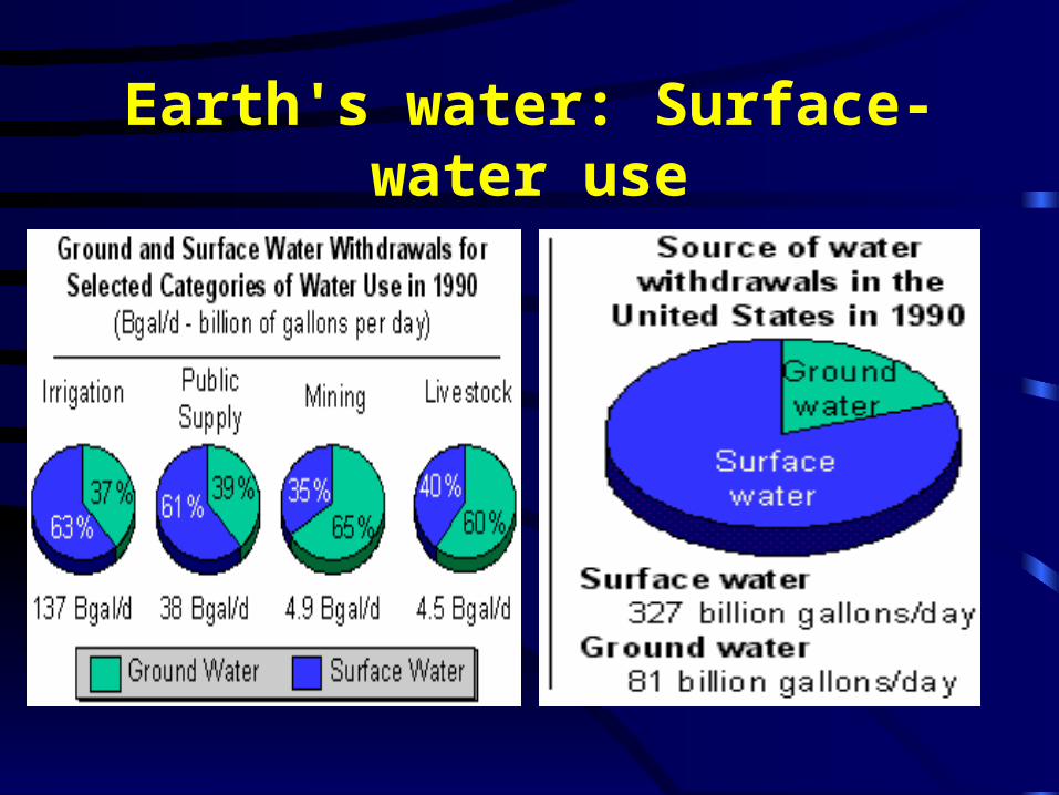
Earth's water: Surface-water use
• When we talk in terms of the source of the water we use everyday, we consider if the water comes from a surface-water source (river, lake, etc.) or from a ground-water source (from a well or spring).
• The bar chart shows the Nation's use of surface- and ground-water for the years 1950-1990, and the pie chart shows the source of our water in 1990. In 1990, about 80 percent of our water withdrawals were from surface- water sources, and about 20 percent was ground water.
Earth's water: Surface-water use

Where does the water come from?• The water in a river doesn't all come
from surface runoff. Rain falling on the land also seeps into the earth to form groundwater. At a certain depth below the land surface, called the water table, the ground becomes saturated with water. If a river bank happens to cut into this saturated layer, as most rivers do, then water will seep out of the ground into the river.

GroundwaterLook at the diagram. The earth below the water table, the aquifer (the purple area), is saturated, whereas the earth above (the pink area) is not. The top layer (unsaturated soil/rock material) is usually wet, but not totally saturated. Saturated, water-bearing materials often exist in horizontal layers beneath the land surface. Since rivers, in time, may cut vertically into the ground as they flow (as the river cuts into the purple section in the diagram), the water-bearing layers of rock can become exposed on the river banks. Thus, some of the water in rivers is attributed to flow coming out of the banks. This is why even during droughts there is usually some water in streams.

Earth's water: Runoff• When rain or snow falls onto the earth, it just doesn't sit
there -- it starts moving according to the laws of gravity. A portion of the precipitation seeps into the ground to replenish earth’s groundwater. Most of it flows downhill as runoff. Runoff is extremely important in that not only does it keep rivers and lakes full of water, but it also changes the landscape by the action of erosion. Flowing water has tremendous power -- it can move boulders and carve out canyons (check out the Grand Canyon!).

Meteorological factors affecting runoff:
• Type of precipitation (rain, snow, sleet, etc.)
• Rainfall intensity
• Rainfall amount
• Rainfall duration
• Distribution of rainfall over the drainage basin
• Direction of storm movement
• Antecedent precipitation and resulting soil moisture
• Other meteorological and climatic conditions that affect evapotranspiration, such as temperature, wind, relative humidity, and season.

Physical characteristics affecting runoff:
• Land use
• Vegetation
• Soil type
• Drainage area
• Basin shape
• Elevation
• Slope
• Topography
• Direction of orientation
• Drainage network patterns
• Ponds, lakes, reservoirs, sinks, etc. in the basin, which prevent or alter runoff from continuing downstream
Earth's water: Rivers and streams
A river is nothing more than surface water finding its way over land from a higher altitude to a lower altitude, all due to gravity. When rain falls on the land, it either seeps into the ground or becomes runoff, which flows downhill into rivers and lakes, on its journey towards the seas. In most landscapes the land is not perfectly flat -- it slopes downhill in some direction. Flowing water finds its way downhill initially as small creeks. As small creeks flow downhill they merge to form larger streams and rivers. Rivers eventually end up flowing into the oceans. If water flows to a place that is surrounded by higher land on all sides, a lake will form. If man has built a dam to hinder a river's flow, the lake that forms is a reservoir.
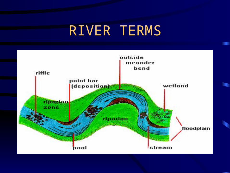
RIVER TERMS
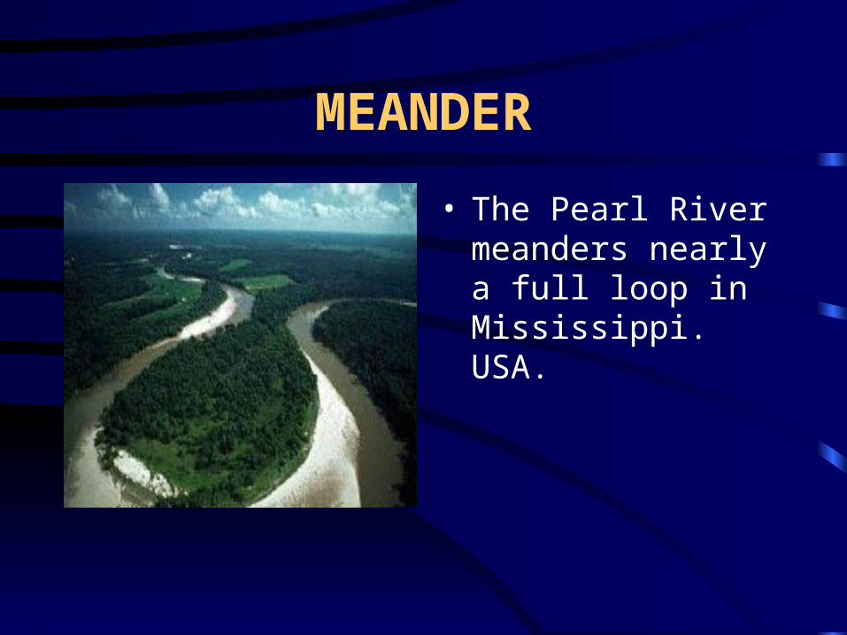
MEANDER
• The Pearl River meanders nearly a full loop in Mississippi. USA.
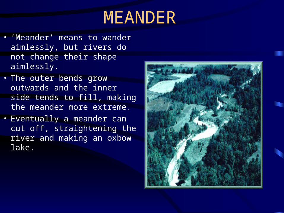
MEANDER• ‘Meander’ means to wander
aimlessly, but rivers do not change their shape aimlessly.
• The outer bends grow outwards and the inner side tends to fill, making the meander more extreme.
• Eventually a meander can cut off, straightening the river and making an oxbow lake.

MEANDER MAKING OXBOW
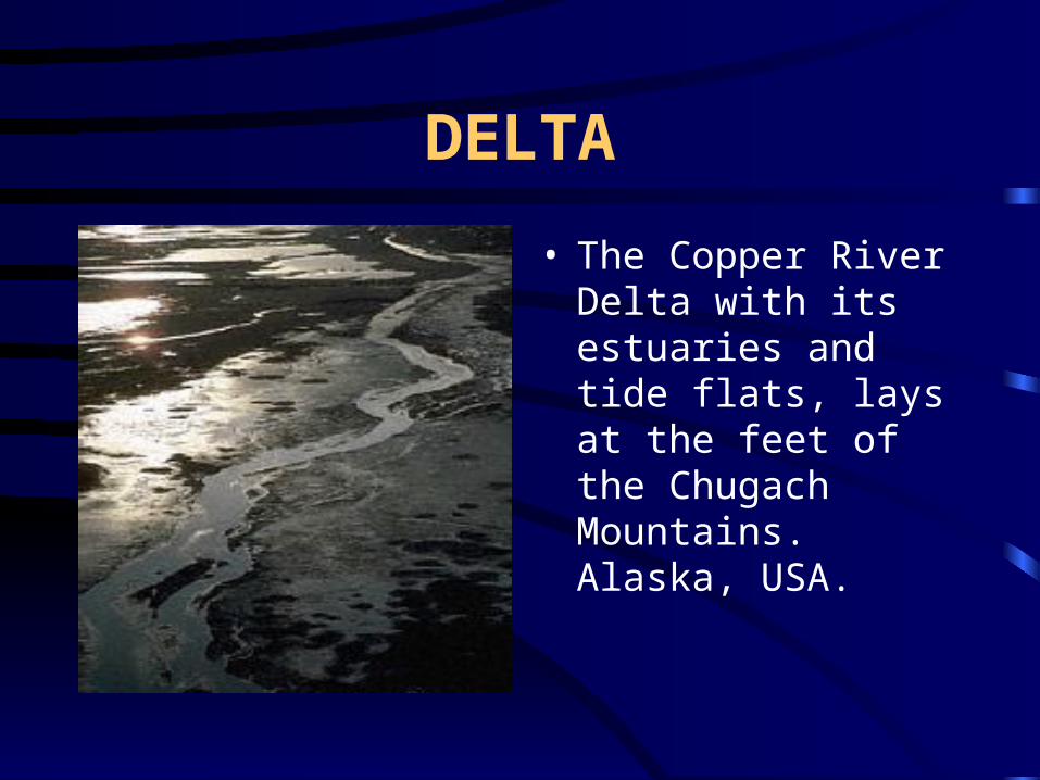
DELTA
• The Copper River Delta with its estuaries and tide flats, lays at the feet of the Chugach Mountains. Alaska, USA.
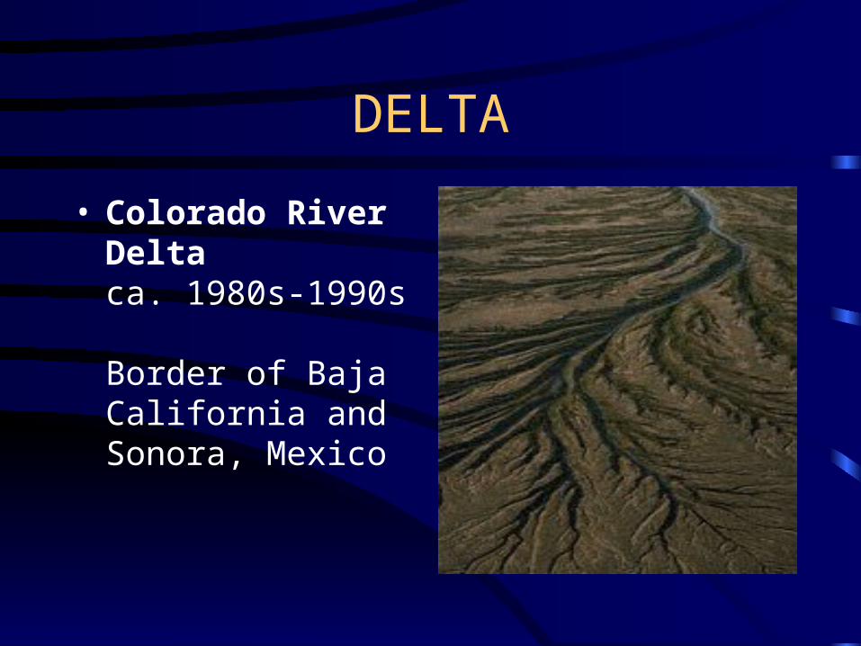
DELTA
• Colorado River Delta
ca. 1980s-1990s Border of Baja California and Sonora, Mexico
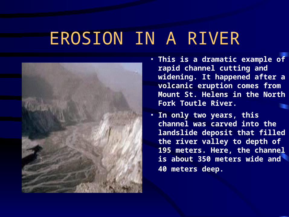
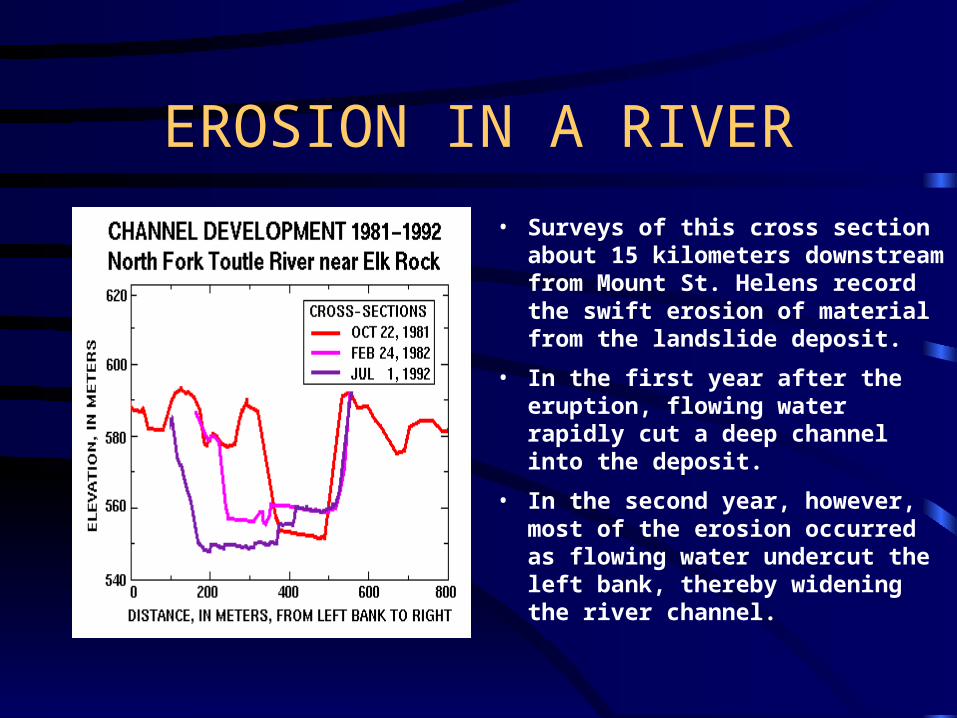
EROSION IN A RIVER• This is a dramatic example of
rapid channel cutting and widening. It happened after a volcanic eruption comes from Mount St. Helens in the North Fork Toutle River.
• In only two years, this channel was carved into the landslide deposit that filled the river valley to depth of 195 meters. Here, the channel is about 350 meters wide and 40 meters deep.
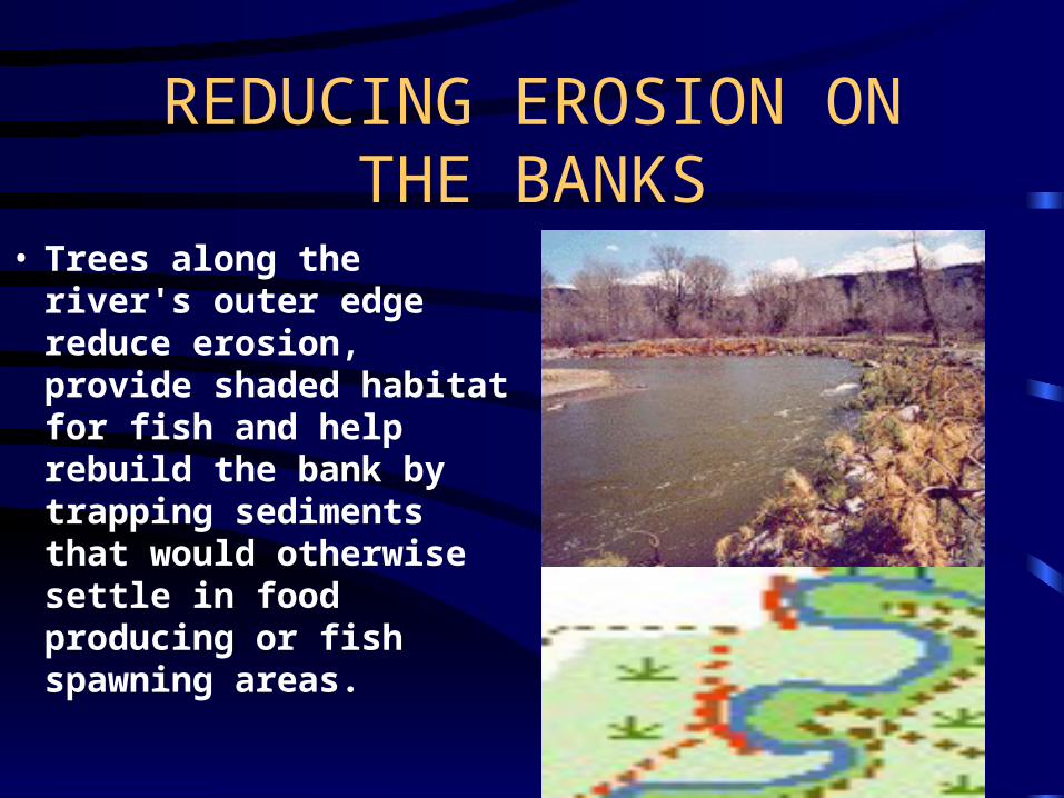
REDUCING EROSION ON THE BANKS
• Trees along the river's outer edge reduce erosion, provide shaded habitat for fish and help rebuild the bank by trapping sediments that would otherwise settle in food producing or fish spawning areas.
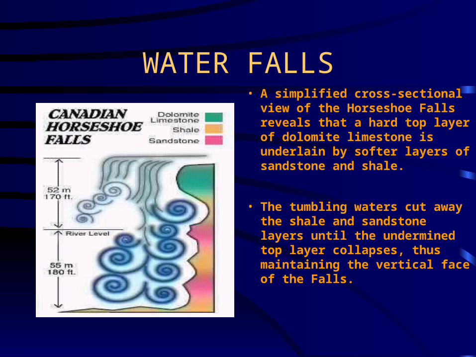
WATER FALLS• A simplified cross-sectional
view of the Horseshoe Falls reveals that a hard top layer of dolomite limestone is underlain by softer layers of sandstone and shale.
• The tumbling waters cut away the shale and sandstone layers until the undermined top layer collapses, thus maintaining the vertical face of the Falls.

EROSION AT NIAGARA FALLS
• About 12,000 years ago, Niagara Falls was 11 kilometres (7 miles) downstream from its present position. Until the early 1950's the Falls eroded at the average rate of 1 metre (3 feet) per year.
• Since then major water diversions combined with the construction of the International Control Works (1954-1963) have slowed the rate of erosion. It is suggested that the rate of erosion could now be as low as 30 centimetres (1 foot) in ten years.
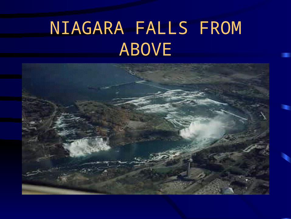
NIAGARA FALLS FROM ABOVE

EROSION IN A RIVER
• Peering into a deep canyon carved by water, a scientist uses surveying instruments to accurately measure the river channel's cross section.
• The person at bottom of channel is holding a surveying rod and moves across the channel to mark sites to be surveyed. Benchmarks are placed high on the river banks or valley walls so that the cross section can be surveyed again in exactly the same spot.
EROSION IN A RIVER
• Surveys of this cross section about 15 kilometers downstream from Mount St. Helens record the swift erosion of material from the landslide deposit.
• In the first year after the eruption, flowing water rapidly cut a deep channel into the deposit.
• In the second year, however, most of the erosion occurred as flowing water undercut the left bank, thereby widening the river channel.
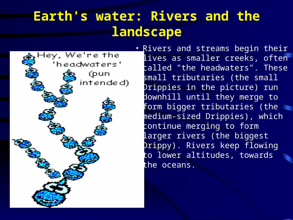
Earth's water: Rivers and the landscape
• Rivers and streams begin their lives as smaller creeks, often called "the headwaters". These small tributaries (the small Drippies in the picture) run downhill until they merge to form bigger tributaries (the medium-sized Drippies), which continue merging to form larger rivers (the biggest Drippy). Rivers keep flowing to lower altitudes, towards the oceans.
WATERSHED
• All rivers are surrounded by a certain amount of land that is higher in altitude (upgradient) than the actual river. Precipitation that falls in this area eventually flows downhill towards the river. At any particular point on a river, the land upgradient of the point is the river's drainage basin (often known as the watershed).
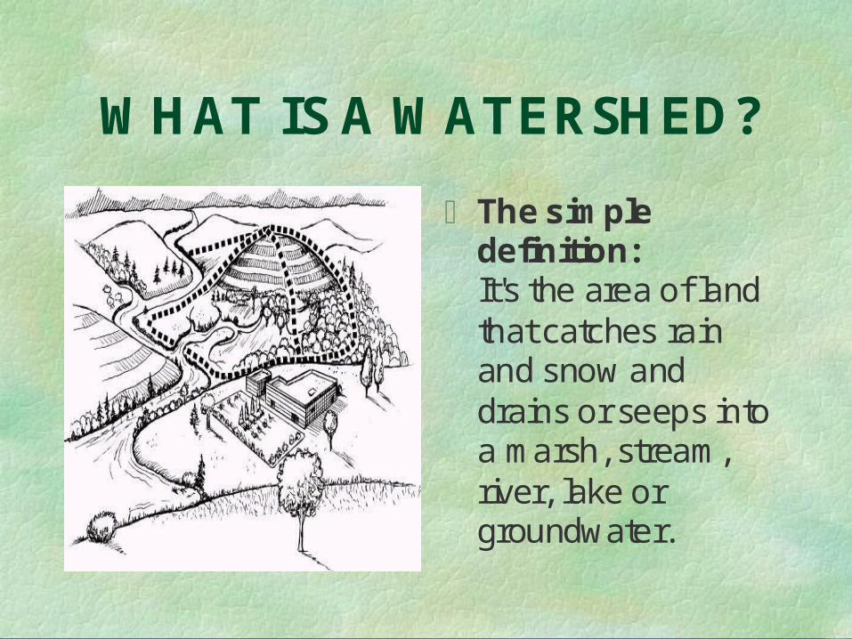
WHAT IS A WATERSHED?
The simpledefinition:It's the area of landthat catches rainand snow anddrains or seeps intoa marsh, stream,river, lake orgroundwater.
DIVIDES AND DRAINAGE BASINS
• What separates two drainage basins from each other are ridges of higher land. You might have heard of the Continental Divide, which runs along the highest ridges of the Rocky Mountains. Precipitation falling on the western side of the Divide will flow towards the Pacific Ocean and precipitation falling on the eastern slopes will flow towards the Atlantic Ocean, via the Gulf of Mexico.
• The United States has many drainage basins of many sizes, and many, many ridges that define these drainage basins.
• In Atlanta, Ga, the main street through the city is Peachtree Street. It is actually built on top of a ridge that is a drainage-basin divide. Rain falling on the eastern side of Peachtree Street will flow towards the Atlantic Ocean, while runoff on the western side heads to the Gulf of Mexico.
Earth's Water:Lakes and reservoirs
• A lake really is just another component of Earth's surface water. A lake is where surface-water runoff (and maybe some ground-water seepage) have accumulated in a low spot, relative to the surrounding countryside. It's not that the water that forms lakes get trapped, but that the water entering a lake comes in faster than it can escape, either via outflow in a river, seepage into the ground, or by evaporation.
• A reservoir is the same thing as a lake in many peoples' minds. But, in fact, a reservoir is a manmade lake that is created when a dam is built on a river. River water backs up behind the dam creating a reservoir.

LAKES
• The Earth has a tremendous variety of freshwater lakes, from fishing ponds to Lake Superior (the world's largest), to many reservoirs. Most lakes contain fresh water, but some, especially those where water cannot escape via a river, can be salty. In fact, some lakes, such as the Great Salt Lake, are saltier than the oceans. Most lakes support a lot of aquatic life, but the Dead Sea isn't called "Dead" for nothing -- it is too salty for aquatic life! Lakes formed by the erosive force of ancient glaciers, such as the Great Lakes, can be thousands of feet deep. Some very large lakes may be only a few dozen feet deep -- Lake Pontchartrain in Louisiana has a maximum depth of only about 15 feet.
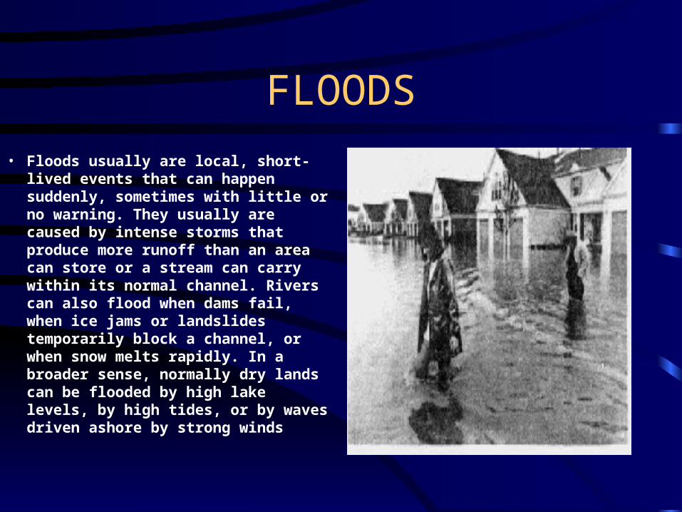
FLOODS
• Floods usually are local, short-lived events that can happen suddenly, sometimes with little or no warning. They usually are caused by intense storms that produce more runoff than an area can store or a stream can carry within its normal channel. Rivers can also flood when dams fail, when ice jams or landslides temporarily block a channel, or when snow melts rapidly. In a broader sense, normally dry lands can be flooded by high lake levels, by high tides, or by waves driven ashore by strong winds

Weather patterns can determine when floods occur
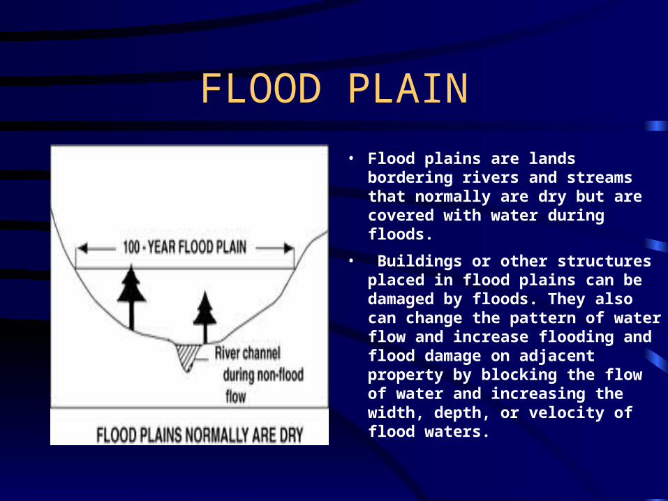
FLOOD PLAIN
• Flood plains are lands bordering rivers and streams that normally are dry but are covered with water during floods.
• Buildings or other structures placed in flood plains can be damaged by floods. They also can change the pattern of water flow and increase flooding and flood damage on adjacent property by blocking the flow of water and increasing the width, depth, or velocity of flood waters.

FLOOD PLAIN
• Flood-plain zoning, which places restrictions on the use of land on flood plains, can reduce the cost of flood damage. Local governments may pass laws that prevent uncontrolled building or development on flood plains to limit flood risks and to protect nearby property. Landowners in areas that adopt local ordinances or laws to limit development on flood plains can purchase flood insurance to help cover the cost of damage from floods.
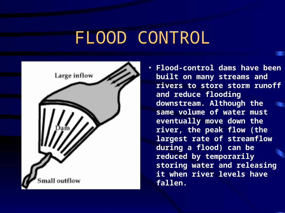
FLOOD CONTROL
• Flood-control dams have been built on many streams and rivers to store storm runoff and reduce flooding downstream. Although the same volume of water must eventually move down the river, the peak flow (the largest rate of streamflow during a flood) can be reduced by temporarily storing water and releasing it when river levels have fallen.

LEVEES
• Levees are artificial river banks built to control the spread of flood waters and to limit the amount of land covered by floods. Levees provide protection from some floods but can be over-topped or eroded away by large floods. For example, levees failed to protect vast areas in the Mississippi and Missouri River valleys during the record-setting floods that occurred in 1993.
Related Documents