Open Source 1 Franz‐Josef Behr, Hochschule für Technik Stuttgart 23.11.2018, 12. Vermessungsingenieurtag Quelloffene Softwarekomponenten im Bereich der raumbezogenen Datenverarbeitung: Eine Übersicht By Hochschule für Technik Stuttgart [CC BY‐SA 3.0 (http://creativecommons.org/licenses/by‐sa/3.0)], via Wikimedia Commons The content is licensed under a Creative Commons-Lizenz CC BY-NC-SA.

Welcome message from author
This document is posted to help you gain knowledge. Please leave a comment to let me know what you think about it! Share it to your friends and learn new things together.
Transcript

Ope
n Source
1
Franz‐Josef Behr, Hochschule für Technik Stuttgart
23.11.2018, 12. Vermessungsingenieurtag
Quelloffene Softwarekomponenten im Bereich derraumbezogenen Datenverarbeitung:
Eine Übersicht
ByHo
chschu
le fü
r Techn
ik Stuttgart [C
C BY
‐SA 3.0
(http://creativ
ecom
mon
s.org/licen
ses/by‐sa/3.0)], via Wikim
edia Com
mon
s
The content is licensed under a Creative Commons-Lizenz CC BY-NC-SA.
Que
lloffe
ne S
oftw
arek
ompo
nent
en
2
Gliederung
Vier‐Schichten‐Architektur von Client‐Server‐Anwendungen
Softwarelösungen für jede der Schichten
Werkzeuge, Versuche zur Beurteilung der Marktbedeutung
Zusammenfassung

3
Inte
rope
rabi
lity,
OG
C W
eb S
ervi
ces
and
Stan
dard
s
Vier‐Schichten‐Modell

4
Inte
rope
rabi
lity,
OG
C W
eb S
ervi
ces
and
Stan
dard
s
Architektur
InternetHTTP
HTTP Server
HTTP
CGI protocol
Document rootStaticresources
Apps
Client"User Agent"
PNG, JPG, …XML / SVG
DBMSServer
Datensammlung, Aufbereitung, Analyse
SQL
Präsentationsschicht
Datenschicht
KommunikationsschichtWeb Tier
App Tier,Geschäftslogik-Schicht
ApplicationServer
IP address / Server Name / Host nameIP address
DNS Server
80
HTTP‐ClientHTTP‐ClientHTTP‐Client
Local System(GIS)
80

5
Inte
rope
rabi
lity,
OG
C W
eb S
ervi
ces
and
Stan
dard
s
Präsentationsschicht

6
Inte
rope
rabi
lity,
OG
C W
eb S
ervi
ces
and
Stan
dard
s
Desktop GIS
• https://gisgeography.com/qgis‐arcgis‐differences/
https://trends.google.com/trends/explore?q=ArcGIS,QGIS [2018‐11‐22]

7
Inte
rope
rabi
lity,
OG
C W
eb S
ervi
ces
and
Stan
dard
s
JavaScript‐Bibliotheken
https://www.similartech.com/compare/leaflet‐vs‐openlayers [2018‐11‐23]
8
Inte
rope
rabi
lity,
OG
C W
eb S
ervi
ces
and
Stan
dard
s
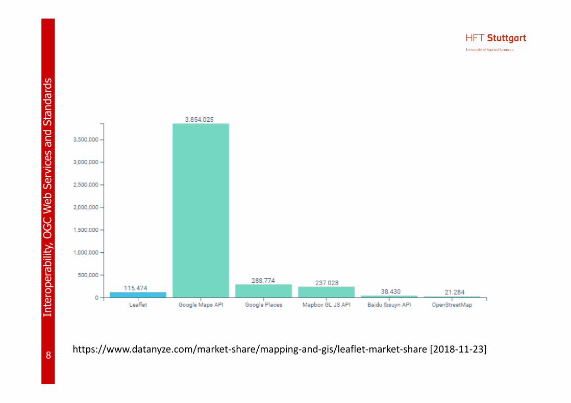
https://www.datanyze.com/market‐share/mapping‐and‐gis/leaflet‐market‐share [2018‐11‐23]

9
Inte
rope
rabi
lity,
OG
C W
eb S
ervi
ces
and
Stan
dard
s
Allgemeine Client‐Programme• HTTP clients
– Google Chrome– Firefox– Edge/Internet
Explorer– Opera– Safari
• FTP clients– Filezilla
• Mail Clients– Thunderbird– Outlook
http
://w
ww
.w3s
choo
ls.c
om/b
row
sers
/bro
wse
rs_s
tats
.asp
[]20
18-1
1-22
http
://w
ww
.ups
dell.
com
/Bro
wse
rNew
s/st
at.h
tm [2
018-
11-2
2]
http
://gs
.sta
tcou
nter
.com
/bro
wse
r-m
arke
t-sha
re [2
018-
11-2
2]

10
Inte
rope
rabi
lity,
OG
C W
eb S
ervi
ces
and
Stan
dard
s
Operating System Market Share Worldwide
http://gs.statcounter.com/os‐market‐share [2018‐11‐23]
11
Inte
rope
rabi
lity,
OG
C W
eb S
ervi
ces
and
Stan
dard
s
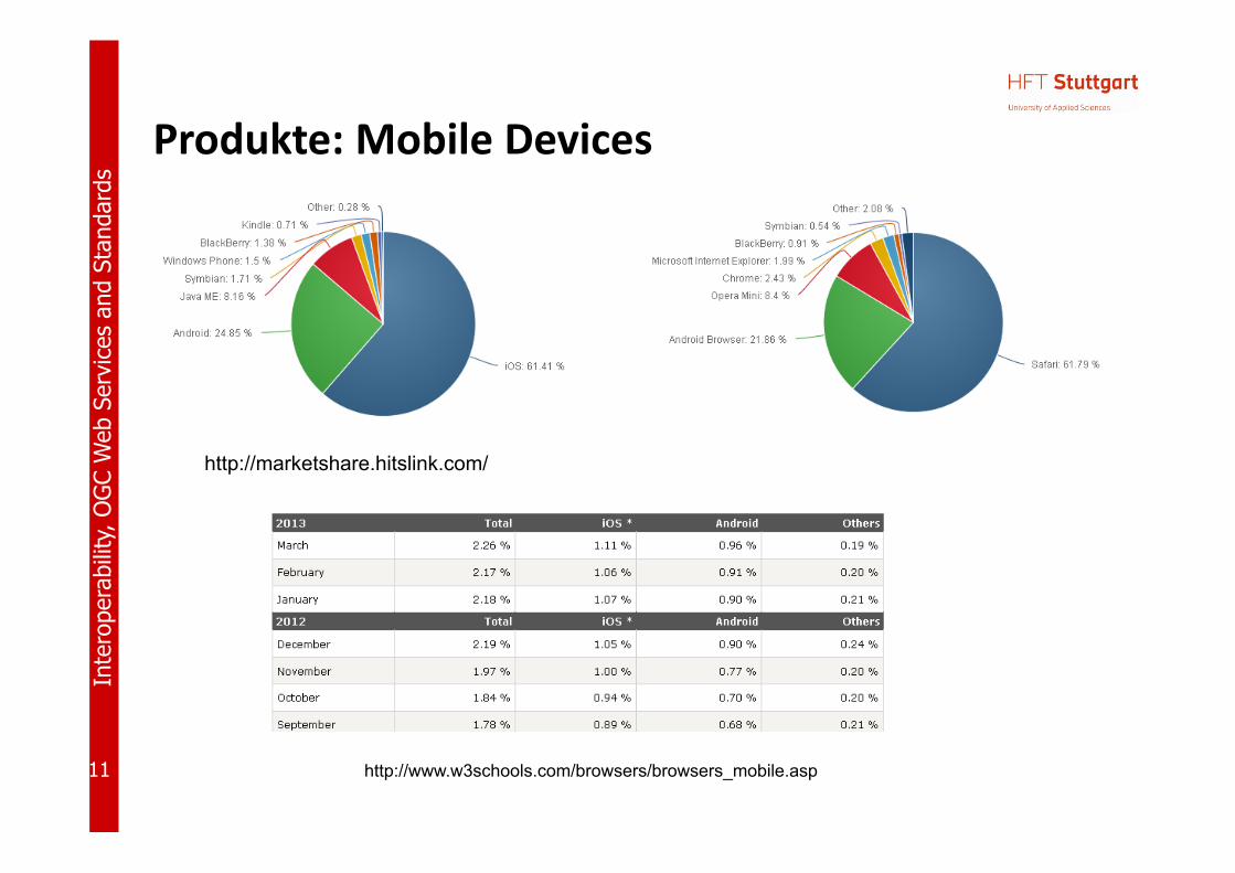
Produkte: Mobile Devices
http://www.w3schools.com/browsers/browsers_mobile.asp
http://marketshare.hitslink.com/

12
Inte
rope
rabi
lity,
OG
C W
eb S
ervi
ces
and
Stan
dard
s
Kommunikationsschicht

13
Inte
rope
rabi
lity,
OG
C W
eb S
ervi
ces
and
Stan
dard
s
Produkte und Werkzeuge
• HTTP Servers– Apache HTTP Server (open source)– Nginx (open source)– Internet Information Server® (Microsoft)
http://news.netcraft.com/archives/category/web‐server‐survey/, based on > 1,673,535,333 sites
https://w3techs.com
/techn
ologies/overview
/web
_server/all [20
18‐11‐22
]

14
Inte
rope
rabi
lity,
OG
C W
eb S
ervi
ces
and
Stan
dard
s
FTP
• Tools for FTP based transfer– FileZilla (Client and Server, open source)– …

15
Inte
rope
rabi
lity,
OG
C W
eb S
ervi
ces
and
Stan
dard
s
Applikationsschicht

16
Inte
rope
rabi
lity,
OG
C W
eb S
ervi
ces
and
Stan
dard
s
Applikationsserver
• In Geo‐IT: Applikationsservers implementieren Dienste entsprechend den Empfehlungen des Open Geospatial Consortium (OGC) (Vortrag heute Nachmittag), wie
– Web Map Service– Web Feature Service– Web Coverage Service– Catalogue Services
Open Source SolutionsClosed Source Solutions
Geo-Applikationsserver
https://trends.google.com/trends/explore?q=ArcGIS,GeoServer

17
Inte
rope
rabi
lity,
OG
C W
eb S
ervi
ces
and
Stan
dard
s
Applikationsserver: Open Source
• GeoServer– „an open source software server written in Java that allows users to share and edit
geospatial data. Designed for interoperability, it publishes data from any majorspatial data source using open standards.“ (http://geoserver.org/display/GEOS/Welcome)
• MapServer (formerly called UMN MapServer, http://www.osgeo.org/mapserver)– Written in C, with PHP wrapper– WMS, WFS, Strong support of Shape files– Somehow old‐fashioned, configuration by text file („map file“)
• Deegree Server– „deegree is a comprehensive geospatial software package with implementations of
OGC Web Services like WMS and WFS, a geoportal, a desktop application, securitymechanisms, and various tools for geospatial data processing and management. Itis open source (LGPL), Java, standards‐compliant (OGC, ISO) and an OSGeo project.“ (http://www.deegree.org/)
– Needs Java, and some time for configuration• QGIS Server• MapGuide Open Source
– „enables users to develop and deploy web mapping applications and geospatial web services.“(http://www.osgeo.org/mapguide)
18
Inte
rope
rabi
lity,
OG
C W
eb S
ervi
ces
and
Stan
dard
s
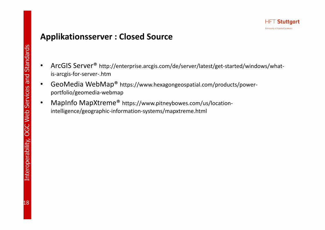
Applikationsserver : Closed Source
• ArcGIS Server® http://enterprise.arcgis.com/de/server/latest/get‐started/windows/what‐is‐arcgis‐for‐server‐.htm
• GeoMedia WebMap® https://www.hexagongeospatial.com/products/power‐portfolio/geomedia‐webmap
• MapInfo MapXtreme® https://www.pitneybowes.com/us/location‐intelligence/geographic‐information‐systems/mapxtreme.html

19
Inte
rope
rabi
lity,
OG
C W
eb S
ervi
ces
and
Stan
dard
s
Applikationsserver: Portal Server
• Geonetwork OpenSource: a widelyused catalog application to manage spatially referenced resources
• Geonode: for developing geospatial information systems (GIS) and for deploying spatial data infrastructures (SDI).
• pycsw
https://geonetwork‐opensource.org/
https://geonode.org/

20
Inte
rope
rabi
lity,
OG
C W
eb S
ervi
ces
and
Stan
dard
s
Bibliotheken: Software using GDAL

21
Inte
rope
rabi
lity,
OG
C W
eb S
ervi
ces
and
Stan
dard
s
GDAL: Supported Vector formats

22
Inte
rope
rabi
lity,
OG
C W
eb S
ervi
ces
and
Stan
dard
s
Datenhaltungsschicht

23
Inte
rope
rabi
lity,
OG
C W
eb S
ervi
ces
and
Stan
dard
s
Related Products and Tools: (O)RDBMS
• (O)(R)DBMS: (Object) (Relational) Database Management System– commercial products
• Oracle, • SQLServer (Microsoft), • Informix, DB2 (IBM),• …
– free• PostGreSQL (PostGIS), fully conformant to OGC‘s Simple Feature Specification – highly recommended
• MySQL• SpatialLite

24
Inte
rope
rabi
lity,
OG
C W
eb S
ervi
ces
and
Stan
dard
s
Market share
http://blog.jelastic.com/2012/02/23/open-source-database-market-share-within-jelastic-february-2012/
http://www.mysql.com/why-mysql/marketshare/ [2008, no more available]
2008 (Closed Source)
2012 (FOSS)

25
Inte
rope
rabi
lity,
OG
C W
eb S
ervi
ces
and
Stan
dard
s
Trend of Relational DBMS Popularity
https://www.forbes.com/sites/benkerschberg/2016/03/08/how‐postgres‐and‐open‐source‐are‐disrupting‐the‐market‐for‐database‐management‐systems/#141b42e820a3

26
Inte
rope
rabi
lity,
OG
C W
eb S
ervi
ces
and
Stan
dard
s
Trend of Relational DBMS Popularity
http://db-engines.com/en/ranking_trend/relational+dbms [2018-02-26]
https://www.forbes.com/sites/benkerschberg/2016/03/08/how‐postgres‐and‐open‐source‐are‐disrupting‐the‐market‐for‐database‐management‐systems/#141b42e820a3
27
Inte
rope
rabi
lity,
OG
C W
eb S
ervi
ces
and
Stan
dard
s
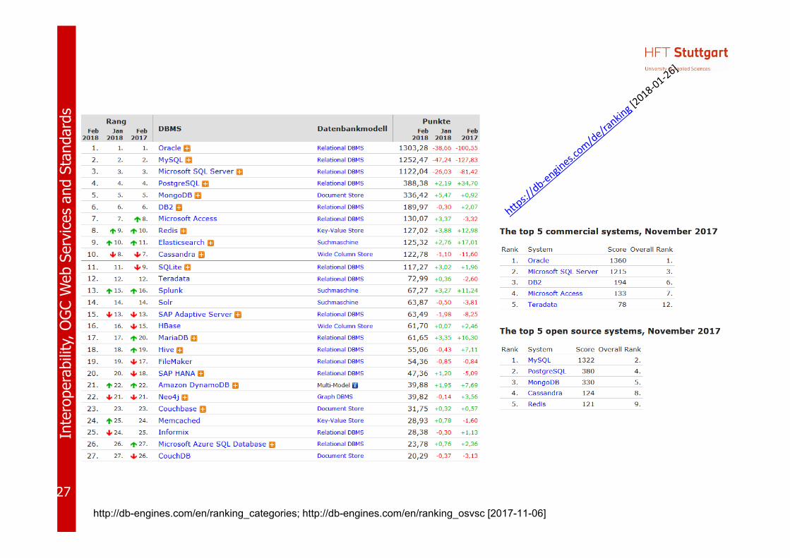
http://db-engines.com/en/ranking_categories; http://db-engines.com/en/ranking_osvsc [2017-11-06]

28
Inte
rope
rabi
lity,
OG
C W
eb S
ervi
ces
and
Stan
dard
s
Popularity
http://db‐engines.com/en/ranking_osvsc [2018‐11‐23]
29
Inte
rope
rabi
lity,
OG
C W
eb S
ervi
ces
and
Stan
dard
s

30
Inte
rope
rabi
lity,
OG
C W
eb S
ervi
ces
and
Stan
dard
s
Zusammenfassung

31
Inte
rope
rabi
lity,
OG
C W
eb S
ervi
ces
and
Stan
dard
s
• Vier‐Schichten• Für Erfüllung Ihrer Aufgaben stehen für jede Schicht eine Vielzahl von
quelloffenen und Closed‐Source‐Lösungen zur Verfügung.• Kommunkationsschicht: i. d. R. Open Source‐Lösungen
• Beurteilung der Alternativen entsprechend – den Anforderungen der jeweiligen Institution sowie – in Bezug auf Unterstützung offener, anerkannter Standards
• Tendenz zu quelloffenen Lösungen, insbesondere in der öffentlichen Verwaltung
• Gesamtlösung: Software + Services

32
Inte
rope
rabi
lity,
OG
C W
eb S
ervi
ces
and
Stan
dard
s
Literatur
• S. Steiniger and A.J.S. Hunter (2012): The 2012 Free and Open Source GIS Software Map – A Guide to facilitate Research, Development and Adoption. http://www.geo.uzh.ch/~sstein/manuscripts/fosgismap_sstein_v9_web.pdf
• Tim Sutton (2018): Deciding Between FOSSGIS and Proprietary Software in the Enterprise. In: Understanding the GIS Industry in 2018. https://www.gis‐professional.com/magazines/gis‐professional‐february‐2018.pdf
• The Top 19 GIS Software. https://www.g2crowd.com/categories/gis#highest_rated [2018‐11‐22]
• Comparison of geographic information systems software. https://en.wikipedia.org/wiki/Comparison_of_geographic_information_systems_software [2018‐11‐22]

33
Inte
rope
rabi
lity,
OG
C W
eb S
ervi
ces
and
Stan
dard
s
http://georeferenced.files.wordpress.com/2014/03/openclose_flickr_leo_reynolds_cc.jpg
Prof. Dr. Franz‐Josef BehrHochschule für Technik Stuttgart Stuttgart University of Applied Sciences
franz‐josef.behr@hft‐stuttgart.de
Related Documents