Coast Guard Rescue Sunshine Coast | 1 This issue ... SAREX | Weather Forecast Changes | Towing Whales Navigating the Wide Bay Bar | Survival Training Caloundra Tides | Irish Coast Guard | Almost a Mayday Radar | Shipwreck Tales | QF4 News Spring 2013 | QF4 Caloundra Edition

Squadron Mag Spring 2013 QF4 Caloundra - Colour Electronic.pdf
Oct 26, 2015
A quarterly publication featuring the work carried out by the Australian Volunteer Coast Guard Caloudra Flottila
Welcome message from author
This document is posted to help you gain knowledge. Please leave a comment to let me know what you think about it! Share it to your friends and learn new things together.
Transcript
Coast Guard Rescue Sunshine Coast | 1
This issue ...SAREX | Weather Forecast Changes | Towing Whales
Navigating the Wide Bay Bar | Survival Training Caloundra Tides | Irish Coast Guard | Almost a Mayday
Radar | Shipwreck Tales | QF4 News
Spring 2013 | QF4 Caloundra Edition

2 | Coast Guard Rescue Sunshine Coast

Coast Guard Rescue Sunshine Coast | 3
04 EDITOR’S CORNER
05 SQUADRON NEWS
10 SAREX Join QF5 on a SAREX
13 A WHALE OF A TOW QF4 are tasked on a tow of a different kind
14 QLD WEATHER SERVICES An update on the latest changes to local weather forecasts and the BOM website
17 SURVIVAL TRAINING Join QF4’s new recruits as they’re put through their paces in emergency situation management
18 SHOUT THE BAR Crossing the Wide Bay Bar: How hard can it be?
22 CALOUNDRA TIDES
24 IRISH COAST GUARD We visit the Irish Coast Guard
27 HM COAST GUARD A look inside the UK’s HM Coast Guard
28 RADAR: PART 2 Microwaves
30 NAUTICAL TERMINOLOGY Where do those old sayings come from?
31 ALMOST A MAYDAY QF5 report on a call for assistance that could have ended very differently
32 SHIPWRECK TALES QF21 reports on a call for assistance that didn’t have a happy ending
34 FLOTILLA NEWS Latest news from QF4
41 THE LIGHTER SIDE OF LIFE
42 SQUADRON CONTACTS
IBC QF4 CONTACTS
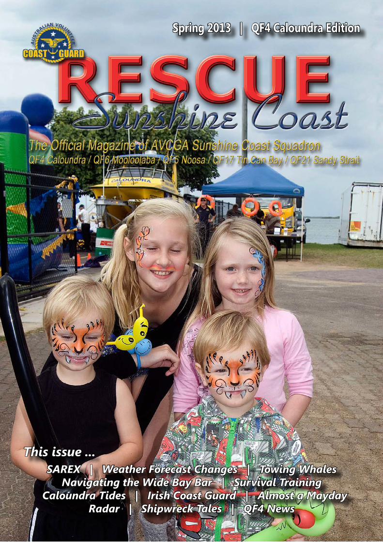
This issue’s Cover ... John Gasparotto captured these happy kids enjoying Coast Guard Caloundra’s recent Open Day.
CONTENTSThe Official Magazine of AVCGA Sunshine Coast Squadron
05 10 13 14
17 18 24 27
28 30 32 34
SPRING 2013 | ISSUE 3QF4 Caloundra Edition
4 | Coast Guard Rescue Sunshine Coast
PUBLISHING INFORMATIONCoast Guard Rescue Sunshine Coast is published quarterly by AVCGA Sunshine Coast Squadron.Copies are available from QF4 Caloundra, QF6 Mooloolaba, QF5 Noosa, QF17 Tin Can Bay and QF21 Sandy Straits. Please contact the Flotilla.Coast Guard Rescue Sunshine Coast is available via email. To join the emailing list, please contact the flotilla representative for your area.Coast Guard Rescue Sunshine Coast is also available via download. Visit the flotilla’s page on the Coast Guard website at www.coastguard.com.au. For advertising enquiries, please contact the flotilla representative for your area.
EDITOR: Vice Captain Julie HartwigPh: 07 5486 4014M: 0498 377 402E: [email protected]: 2A Bass St, Tin Can Bay, Qld 4580
Sub-Editors:QF4 Caloundra: John GasparottoE: [email protected] Noosa: Christian DearnaleyE: [email protected] Mooloolaba: Wendy WilsonE: [email protected] Tin Can Bay: Julie HartwigE: [email protected] Sandy Strait: Kate HouleyE: [email protected]
Disclaimer: Whilst every care is taken by the Editor to minimise errors, no responsibility is accepted for the accuracy or otherwise of contributions made by AVCGA members, and the information, images, illustrations and advertisements contained herein. Opinions expressed in articles in this publication are those of the authors. All content in this publications is published with the consent and approval of the Sunshine Coast Squadron Board.
© Copyright AVCGA Sunshine Coast Squadron, 2013
Visit Coast Guard on the web:www.coastguard.com.au
Welcome to the Spring edition of Coast Guard Rescue Sunshine Coast. It’s been a busy few months for our flotillas and as we move into the busy summer and holiday months, the workload
on our volunteers will only increase as boaties get out in their boats to enjoy themselves.
It’s therefore timely to remind all boaties of the need for thorough trip preparation before setting out, otherwise you could end your day on the end of a Coast Guard tow line! If that worst case scenario eventuates, it’s also important for boaties to remember the effort made by the volunteers who come to assist you. All Coast Guard flotillas continue to work hard with our fundraising projects to keep our rescue vessels on the water, ready to respond when the need arises. So if you do have to call Coast Guard for assistance, consider our costs in assisting you and please make a worthy donation to support us. We need your support today; you may need ours tomorrow!
We’ve got another terrific selection of stories in this issue, starting with QF5’s participation in a major SAREX held off Mooloolaba. We get the lowdown on changes to local weather forecasts and feature a story to help demystify why the Wide Bay Bar has such a notorious reputation and how to help you safely navigate across it. We catch up with our “cousins” in the Irish and UK Coast Guards, plus we’ve got the usual collection of assist stories and Coast Guard goings-on across the Squadron.
On the technical side, we have the second in the series of articles on Radar and QF4 tell us how they are training their new members in emergency situations. In addition, there’s all the latest news from your local flotilla and much more.
The team here at CGRSC invite Coast Guard members, supporters and boaties to share your boating experiences and knowledge with readers. Contact your local flotilla (details at left) and they’ll assist you with your contribution.
In the meantime, stay safe on the water and enjoy the read!
Julie HartwigEditorVice Captain PublicationsSunshine Coast Squadron
A Message to Our Readers ... Please Support our AdvertisersThe Australian Volunteer Coast Guard Association is a volunteer marine rescue organisation committed to saving lives at sea. AVCGA flotillas in the Sunshine Coast region receive minimal government funding and must engage in constant fundraising activities to keep our rescue vessels on the water, train our volunteer personnel and operate our rescue bases.
The support of local and regional businesses is an essential part of our fundraising activities. When you shop at any of our advertisers, please tell them you saw their advertisement in Coast Guard Rescue Sunshine Coast. Please support our advertisers because their support ensures the continuation of AVCGA’s rescue services to boating communities on the Sunshine, Cooloola and Fraser Coasts.
Editor’s Corner
Coast Guard Rescue Sunshine Coast | 5
QF6 BUILDING EXTENSIONS: EIGHT YEAR PROJECT NEARS COMPLETIONOn Saturday 21st of September 2013, an army of volunteers from QF6 Mooloolaba and the Rotary Clubs of Mooloolaba and Alexander Headlands demolished the final layer of bricks forming the inner walls of the original base Headquarters of Coast Guard Mooloolaba. They then carefully removed bricks to open up the new extended building through into the three newly expanded spaces.
This will permit the desperately needed office space downstairs and a dedicated training room to be provided in the upstairs space, with the ability to open interior bi-fold doors and provide a much larger area to cope with our increased membership attending meetings and events.
The last three months has vividly demonstrated the extent and depth of the cooperation between QF6 and the two Rotary Clubs, along with many volunteers, organisations and businesses all contributing to this Joint Community Project.
This project has not been without its problems, and while the end is in sight, it has been an ongoing battle. First conceived some 8 years ago, the building project had to contend with opposition from the then State Government and complications of the Spit Futures Study, which was further compounded by local council amalgamation.
This was all eventually resolved with the election of the present State Government and relentless support from the Speaker of the House, The Honourable Fiona Simpson, negotiating all required State Government approvals. Planning approval was then efficiently provided by SCDC planning and so detailed design work began.
This highlighted the requirements to make the building ‘Person With a Disability’ compliant and the extent of modification needed, including wheelchair access to the washroom and also relocating our Radio Room downstairs for easy public access.
The addition also had to be designed to blend in well with the existing building style, including the exterior bricking to match the original and present a harmonious overall appearance. Once construction commenced, there was of course the inevitable problem of maintaining a fully operational Coast Guard service from within the existing building and minimising disruption to traffic flow around the site.
Nevertheless, the whole project has moved ahead quickly under the expert guidance and control of Roger Wright (Wright Developments). Roger’s contribution to the project has been simply outstanding and the quality of all workmanship is absolutely second to none!
The reasons for our great success are very clear, when outstanding organisations like Coast Guard QF6 Mooloolaba, Rotary Club of Mooloolaba and Rotary Club of Alex Headland all combine in a common goal, you have a huge pool of organisational savvy and construction expertise all committed to excellence.
Coast Guard volunteer Robert Bohn (an experienced and skilled builder in his own right) has guided the day-to-day the construction operation on site and has also personally completed a large proportion of the tasks involved. Robert manages the project for Coast Guard and is there every day assisting Roger in keeping progress with the construction moving smoothly. Along with an army of volunteers and apprentices, we have enjoyed great community support from local firms and suppliers, with costs being minimised and construction moving at a rapid pace.
As well as Roger Wright and Rotary’s contribution, materials have been provided in many areas such as concrete, steel, masonry, doors, fittings and electrical. Services provided include safety fencing, excavation, concrete pumping, block laying, scaffolding, carpentry, masonry and plastering to name just a few, and for all of this we owe an enormous debt of gratitude to those involved.
And for keeping everyone’s energy up, last but not least we owe an enormous vote of thanks to the constant supply of delicious food by a dedicated crew of our enthusiastic ‘catering corps’ ladies, Trish, Charmaine, Denise and Raewyn! Wendy Wilson, QF6
Squadron News

6 | Coast Guard Rescue Sunshine Coast
Top: QF5 Commander John Milland accepts the sponsorship cheque from Tess Alexandroff, President of the Rotary Club of Noosa.
QF5 RENAMES VESSEL IN NEW SPONSORSHIP DEALOn September 22nd, members from QF5 Noosa joined members from the Rotary Club of Noosa, the Honourable Member for Aboriginal & Torres Strait Islander and Multi-Cultural Affairs Glen Elmes as well as National Training Commodore and Sunshine Coast Squadron Commodore Robin Hood in the renaming of its main river vessel, formally the Bartender Patrol. All in attendance celebrated as the newly named Rotary Rescue was christened by Rotary Club of Noosa President Tess Alexandroff, and blessed by Squadron Chaplin Neville Geddes.
The renaming is part of a new sponsorship agreement that will see the Rotary Club of Noosa make substantial financial contributions to QF5 each year to allow it to continue its invaluable work in the Noosa region. In return, QF5 renamed the vessel Bartender Patrol, to Rotary Rescue, and will also provide volunteers for events held by or manned by the Rotary Club of Noosa, acting as marshals or officials.
This new-found sponsorship originated from an unlikely event, in the form of sabotage on QF5’s secondary rescue vessel Davo’s Rescue, back in May 2013. Between May 19th and 25th, Davo’s Rescue had its fuel lines cut on two separate occasions, posing a serious threat to the safety of the crews, but also to the wider boating community.
With the likelihood of damage continuing, QF5 had no choice but to install an expensive CCTV surveillance system, to ensure the safety of its vessels. However, in the most disheartening of times, QF5 was offered generous support from the Noosa Community. The Tewantin-Noosa and Noosa Heads Lions Clubs open-handedly donated $2200 to QF5 to help pay for the new security system. In addition the Rotary Club of Noosa donated $800 but there was certainly more to come.
After seeing the work of the Noosa Coast Guard up close, club president Tess Alexandroff decided, along with her fellow Rotarians, that QF5 could benefit from some extra support in their role as guardians of the Noosa marine region.
QF5 was presented with a big cheque (both in size and value) at the ceremony, which will certainly be a big boost to the flotilla. Hopefully this new partnership will continue for many years.
Christian Dearnaley, QF5
Squadron News

Coast Guard Rescue Sunshine Coast | 7
OPEN DAY AT COAST GUARD CALOUNDRACoast Guard Caloundra held a successful Family Open Day at its headquarters in Tripcony Lane, Caloundra on Sunday July 28. The event provided an opportunity for the general public to come and chat about boating with not only our skippers, but also representatives from Queensland Water Police, State Fisheries and Maritime Safety Queensland, and to have a look around our facilities and our vessels.
The all-day event attracted a good turnout with both the local residents and Coast Guard members attending despite overcast conditions. The event not only catered for boaties but families as well. There was a jumping castle, balloons, and face painting for the kids, while a sausage sizzle and tea and coffee kept the hunger pains at bay.
A collection of historic navigational equipment, provided by a member, attracted widespread interest as did our primary rescue vessel. A number of membership applications were received on the day.
The overall aim of the day was to show the general public what Coast Guard does – some of our longer serving volunteers enjoyed talking about their experiences over the years, enthralling both young and old.
Commander Tony Barker said, “I was most impressed with the turnout, both by the locals and our members. We also received many applications for Associate Membership and many enquiries from locals wishing to become members. I would like to thank all those involved in making this event such a success.”
Story & Photos by John Gasparotto, QF4Top right: Purser Verity Hingston’s supply of spices attracted interest from the ladies.Centre right: Kids enjoyed the jumping castle.Right: Face painting was one of the highlights of the day for young visitors.Below: The sausage sizzle team kept the hordes fed throughout the day.Centre: Alan Hingston could not resist knowing what he would look like with a tattoo. He would make a smashing pirate don’t you think?Below right: This collection of historic navigational equipment kept our crew members enthralled.Bottom: Panoramic shot of the Open Day scene at QF4.
Squadron News
8 | Coast Guard Rescue Sunshine Coast
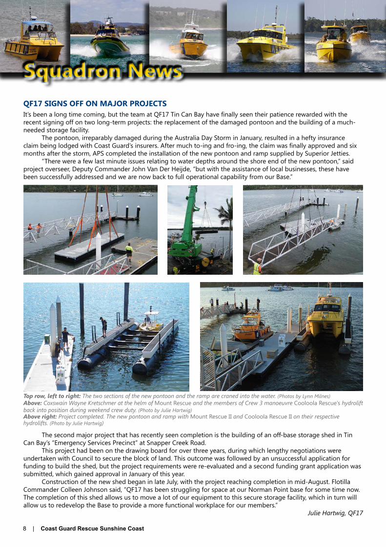
QF17 SIGNS OFF ON MAJOR PROJECTSIt’s been a long time coming, but the team at QF17 Tin Can Bay have finally seen their patience rewarded with the recent signing off on two long-term projects: the replacement of the damaged pontoon and the building of a much-needed storage facility.
The pontoon, irreparably damaged during the Australia Day Storm in January, resulted in a hefty insurance claim being lodged with Coast Guard’s insurers. After much to-ing and fro-ing, the claim was finally approved and six months after the storm, APS completed the installation of the new pontoon and ramp supplied by Superior Jetties.
“There were a few last minute issues relating to water depths around the shore end of the new pontoon,” said project overseer, Deputy Commander John Van Der Heijde, “but with the assistance of local businesses, these have been successfully addressed and we are now back to full operational capability from our Base.”
The second major project that has recently seen completion is the building of an off-base storage shed in Tin Can Bay’s “Emergency Services Precinct” at Snapper Creek Road.
This project had been on the drawing board for over three years, during which lengthy negotiations were undertaken with Council to secure the block of land. This outcome was followed by an unsuccessful application for funding to build the shed, but the project requirements were re-evaluated and a second funding grant application was submitted, which gained approval in January of this year.
Construction of the new shed began in late July, with the project reaching completion in mid-August. Flotilla Commander Colleen Johnson said, “QF17 has been struggling for space at our Norman Point base for some time now. The completion of this shed allows us to move a lot of our equipment to this secure storage facility, which in turn will allow us to redevelop the Base to provide a more functional workplace for our members.”
Julie Hartwig, QF17
Top row, left to right: The two sections of the new pontoon and the ramp are craned into the water. (Photos by Lynn Milnes)Above: Coxswain Wayne Kretschmer at the helm of Mount Rescue and the members of Crew 3 manoeuvre Cooloola Rescue’s hydrolift back into position during weekend crew duty. (Photo by Julie Hartwig)Above right: Project completed. The new pontoon and ramp with Mount Rescue II and Cooloola Rescue II on their respective hydrolifts. (Photo by Julie Hartwig)
Squadron News

Coast Guard Rescue Sunshine Coast | 9
QF5 RADIO ROOM REFURBISHMENT ALMOST FINISHEDThe refurbishment of the Radio Room at QF5 is almost completed, with nearly all structural work completed and just the installation of the new electronic logging system to go as well as a few other small items to make things run like clockwork.
QF5 Radio Officer Rob Deavin has put in much hard work, assisted by his right hand men, John Spinaze, David McKelvey, Chas Olsen and Andrew Clarke. The designing process of the new radio room has taken plenty of time and careful consideration into the specifics of every detail to ensure that everything will work smoothly.
Many thanks must also be extended to the Tewantin Community Bendigo Bank and the Sunshine Coast Council for their financial support. Together, $25,000 was donated to QF5 to be spent on the new radio room. Without this help the flotilla would have incurred a hefty total outlay sum, meaning yet more fundraising work for the volunteers on top of their usual fundraising duties.
Above: Wayne Hoens, Cr. Russell Green and Commander John Milland inspect Coast Guard Noosa’s newly refurbished radio room at the Munna Point base.
QF21 VESSELS TO BE NAMEDThrough the tireless liaison of the QF21 Executive with the Queensland Emergency Service, a former SES vessel has been reallocated to Coast Guard Sandy Straits. Just over 5m with a 50hp Honda motor, it will add to the ability of QF21 to provide assistance in the Straits.
It will be necessary to carry out some repairs and maintenance on this vessel prior to her going into service for Coast Guard, but after completion the vessel will undergo a naming ceremony. Since the Maryborough RSL is a major supporter of QF21, it is planned to call this vessel Maryborough RSL Rescue. Details of the location and timing of this ceremony will be announced closer to the event.
Our training vessel, now referred to as TV3, is also to be named in the near future. With due respect and after consultation with the Aboriginal people who have called the Sandy Straits home for many thousands of years, this vessel is to be named Bandjala. Again, details of this event will be advertised as soon as a date is set.
Top and centre: QF21’s ex-SES flood boat will soon be named Maryborough RSL Rescue.Above: TV3 soon to be renamed Bandjala.
Squadron News

10 | Coast Guard Rescue Sunshine Coast
In Late August, QF5 sent a group of coxswains and upcoming skippers to a SAREX (Search And Rescue Exercise) that was being held just north of Mooloolaba. The event, organised primarily by the Water Police, involved all levels and types of emergency services including the Volunteer Surf Lifesavers, Aviation Rescue, VMR and us, the brave,
magnificent, majestic and incredible Coast Guard ... OK, maybe we’ll just stick to ‘The Coast Guard’.The event was due to kick off at 0800hrs, but arriving at 0730 would leave us some time to make sure we had
everything figured out and to sneak in a second coffee for the morning at the QF6 Mooloolaba headquarters.Our crew of seven crossed the Noosa Bar at 0630hrs in the John Waddams to begin the hour-long trip down to
Mooloolaba. It turned out to be a very pleasant journey with glassy conditions, a beautiful sunrise and plenty of whale sightings along the way.
We arrived at Mooloolaba on time and after docking the Waddams, we headed up to the QF6 headquarters to get a detailed schedule for the event. The morning session would see all organisations present work together to respond to a mock emergency, in the form of an aviation disaster at sea.
After some discussion with the organisers, it became apparent that there would be two places available on board the Water Police vessel, which would be at the site, pretending to be the wreckage, right in the middle of all the action. Gary Piper and myself were lucky enough to snare these two positions, even though it meant leaving our boat and its role in the exercise. Although participating in a search under Police command would have been a valuable experience, the morning’s events on board the Police vessel turned out to be very insightful and, well ... very, very impressive.
Gary and I made our way from the QF6 headquarters down to the Water Police dock in the Mooloolaba harbour and were treated with quite a sight. A 22m, aluminium power catamaran named Brett T Handran, in honour of the fallen plain clothes constable, sat at the end of the dock, dwarfing all other boats nearby.
We were welcomed at the bottom of the jetty by a senior constable who showed us to the boarding platform at the stern of the vessel. From there it was up a few stairs to the open section of the main deck, where a 5m RIB sat suspended in mid-air by a complex winch and hydraulic system, ready to be lowered into the water behind the vessel at a moment’s notice.
We were then shown inside the cabin area on the main deck, which was even more impressive than the RIB setup we had just seen. A decent-sized galley was situated on the starboard side as we entered the cabin, with tables and bench seats to port. At the forward end of the cabin, which must have extended for at least 10m, was a host of computer screens, radios, desks, charts, whiteboards and everything else you would want to run a Search and Rescue operation. In between the galley area and the ops area were two small but steep flights of stairs that lead below deck to the personnel berths. Although they weren’t the largest of rooms, the bunks were full sized and were by no means uncomfortable.
Back at the entrance to the main cabin area, there was another set of stairs that spiraled up to the bridge on the deck above. The bridge was in a large cabin that had a chart table at the rear and the main controls forward up against the large wrap around windows.
SAREXby Christian DearnaleyEditor, QF5
Above: The impressive QWPS vessel, Brett T Handran.Right: The bridge.
Coast Guard Rescue Sunshine Coast | 11
At this point, it was fair to say we were more than impressed. A large comfortable-looking chair, complete with suspension, sat in front of a multitude of equipment from S and X band radar to direct communication with Police Coms and access to the Internet. The vessel could either be controlled by the joy-stick on the arm of the helm chair, the wheel and throttle controls at the control panel or any of the three control points situated on the open balcony area around the upper deck. After our comprehensive tour of this magnificent vessel, it was time to see it in action and get the SAREX underway!
We left Mooloolaba harbour and once past the break water, headed north to the exercise area. We quickly reached a cruising speed of 20-22knots but despite the speed increase, the feel and behaviour of the vessel hardly changed from when it was moving through the harbour at 6 knots. We very quickly realised that this vessel, which could sleep 8-10 crew for up to 8 days, was very well thought out and suited its role of patrolling Queensland’s East Coast immensely.
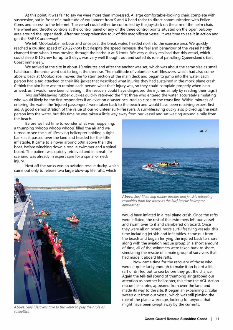
We arrived at the site in about 10 minutes and after the anchor was set, which was about the same size as small hatchback, the order went out to begin the exercise. The multitude of volunteer surf-lifesavers, which had also come aboard back at Mooloolaba, moved the to stern section of the main deck and began to jump into the water. Each person had a tag attached to their life-jacket that described what injuries they had sustained in the mock plane crash. (I think the aim here was to remind each person what their injury was, so they could complain properly when help arrived, as it would have been cheating if the rescuers could have diagnosed the injuries simply by reading their tags!)
Two surf-lifesaving rubber duckies quickly retrieved the first three who entered the water, accurately simulating who would likely be the first responders if an aviation disaster occurred so close to the coast line. Within minutes of entering the water, the ‘injured passengers’ were taken back to the beach and would have been receiving expert first aid. A good demonstration of the value of our volunteer surf-lifesavers. A surf-lifesaving ducky also picked up the next person into the water, but this time he was taken a little way away from our vessel and sat waiting around a mile from the beach.
Before we had time to wonder what was happening, a thumping ‘whoop whoop whoop’ filled the air and we turned to see the surf-lifesaving helicopter holding a tight bank as it passed over the land and headed for the little inflatable. It came to a hover around 50m above the little boat, before winching down a rescue swimmer and a spinal board. The patient was quickly retrieved and in a real-life scenario was already in expert care for a spinal or neck injury.
Next off the ranks was an aviation rescue ducky, which came out only to release two large blow-up life rafts, which
would have inflated in a real plane crash. Once the rafts were inflated, the rest of the swimmers left our vessel and swam over to it and clambered on board. Once they were all on board, more surf-lifesaving vessels, this time including jet skis and inflatables, came out from the beach and began ferrying the injured back to shore along with the aviation rescue group. In a short amount of time, all of the swimmers were taken back to shore, simulating the rescue of a main group of survivors that had made it aboard life rafts.
Now came time for the recovery of those who weren’t quite lucky enough to make it on board a life raft or drifted out to sea before they got the chance. Again the tell-tail sound of thumping air grabbed our attention as another helicopter, this time the AGL Action rescue helicopter, appeared from over the land and made its way to the site. It began an expanding circular sweep out from our vessel, which was still playing the role of the plane wreckage, looking for anyone that might have been swept away by the currents.
Above: Surf-lifesavers take to the water to play their role as casualties.
Above: Surf-lifesaving rubber duckies and jet skis retrieving casualties from the water as the Surf Rescue helicopter approaches.

12 | Coast Guard Rescue Sunshine Coast
After three or four sweeps, it came to a stop and hovered over a spot around 700m to our north where just a few minutes ago, a surf-lifesaving ducky had dropped a rescue dummy. Again the helicopter dropped to around 50m above sea level and winched down a rescue swimmer, who once in the water attached a harness to the dummy before being winched back to safety. Another life successfully saved.
It was now time for the Coast Guard’s role in the exercise. QF5 Noosa was to join QF6 Mooloolaba, QF4 Caloundra, VMR Bribie Island and another Water Police vessel, the George Doyle, in a coordinated search looking for any other survivors that may have drifted away from the wreckage or anyone that was not so lucky to survive the impact.
Our role, on board the Brett T Handran, was to take a rescue dummy around 3 miles out to sea from the site using the vessel’s tender. The 5m RIB was dropped into the water and we boarded it along with one of the Senior Constables from the main vessel. The 140HP outboard had us flying along and in what felt like no time at all were given the order to drop the dummy overboard.
After putting in a waypoint on the vessel’s chart plotter, for the unlikely circumstance that it couldn’t found by almost the entire Sunshine Coast Guard Squadron, we headed back to the main vessel. The RIB was expertly driven back onto its berth at the stern of the vessel and again hoisted into the air.
The Coast Guard vessels took formation, along with the other Water Police vessel that was organising the search pattern, and began steaming up and down the coastline, gradually moving out to sea. After about 5 minutes of searching, we heard a familiar voice over the radio coming from the John Waddams reporting that it had seen something in the water. After being given permission to break formation and investigate, the Waddams screamed up onto the plane and headed over to the position where we had dropped the dummy. A quick but delicate recovery and the dummy was safely on board. Well done QF5 – another life saved!
The activities for the morning were now over and so up came the car-sized anchor and off we went. On the way back to Mooloolaba harbour, we got to try out some of the equipment the Police had on board. The helmsman took a line that had us running around 600m off the beaches around Mooloolaba where we were able to try out their electronically stabilised, zoomable binoculars. Apart from searching for bodies at sea, these also allow for terrific inspection of everyone on the beach and we got the feeling that this was a regular activity for the Policemen on board. I suppose it’s part of their job to check that there are no good looking females in trouble on the beach.
After docking back at Mooloolaba we thanked all on board for having us along with them and for the fantastic morning we had experienced. There were still the activities of the afternoon to come, which would include more search and rescue exercises involving the congregated Coast Guard flotillas, but it is fair to say that the real experience was on board the Brett T Handran as we experienced what a true Search and Rescue event would feel like and saw first hand how it might unfold.
Many thanks to the QWPS for having us on board, letting us experience the SAREX in an unforgettable way and for letting us use their electronically stabilised, zoomable binoculars!
Coast Guard Rescue Sunshine Coast | 13
Story and Photos by John GasparottoCrew Member, QF4
A Whaleof a Tow
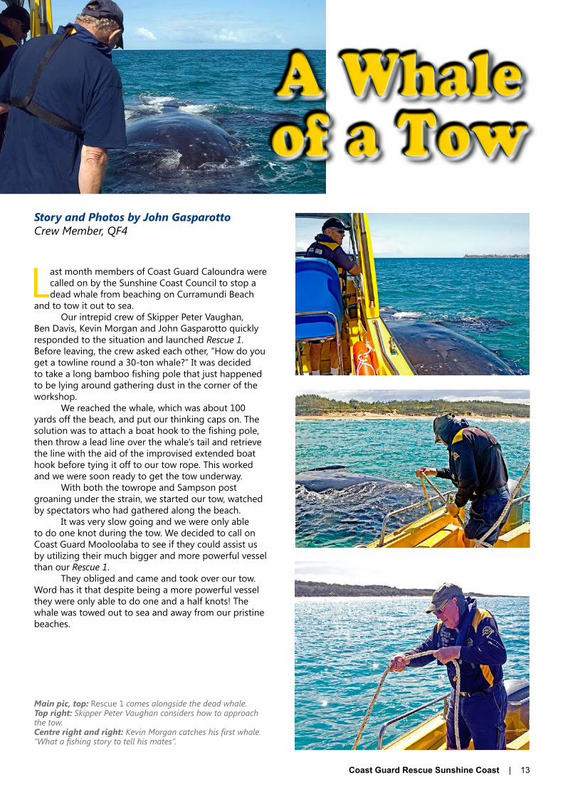
Last month members of Coast Guard Caloundra were called on by the Sunshine Coast Council to stop a dead whale from beaching on Curramundi Beach
and to tow it out to sea.Our intrepid crew of Skipper Peter Vaughan,
Ben Davis, Kevin Morgan and John Gasparotto quickly responded to the situation and launched Rescue 1. Before leaving, the crew asked each other, “How do you get a towline round a 30-ton whale?” It was decided to take a long bamboo fishing pole that just happened to be lying around gathering dust in the corner of the workshop.
We reached the whale, which was about 100 yards off the beach, and put our thinking caps on. The solution was to attach a boat hook to the fishing pole, then throw a lead line over the whale’s tail and retrieve the line with the aid of the improvised extended boat hook before tying it off to our tow rope. This worked and we were soon ready to get the tow underway.
With both the towrope and Sampson post groaning under the strain, we started our tow, watched by spectators who had gathered along the beach.
It was very slow going and we were only able to do one knot during the tow. We decided to call on Coast Guard Mooloolaba to see if they could assist us by utilizing their much bigger and more powerful vessel than our Rescue 1.
They obliged and came and took over our tow. Word has it that despite being a more powerful vessel they were only able to do one and a half knots! The whale was towed out to sea and away from our pristine beaches.
Main pic, top: Rescue 1 comes alongside the dead whale.Top right: Skipper Peter Vaughan considers how to approach the tow.Centre right and right: Kevin Morgan catches his first whale. “What a fishing story to tell his mates”.

14 | Coast Guard Rescue Sunshine Coast
BOM Improves Queensland Weather ServicesCompiled by Julie HartwigRadio Operator, QF17
The upgrade to BOM services in Queensland will see a total of 67 locations across the state getting 7-day weather forecasts. These forecasts will be presented as a combination of text and graphics. More importantly, regional Queensland will now have access to the type of detailed forecasts previously provided to only four of the
Southeast Coast district locations.Furthermore, during 2014, services will expand further to include map-based graphical forecasts and the
capability to generate a forecast for any location, including the coastal waters zones. The recently launched MetEye will be a doorway to maps of temperature, rainfall, winds and weather, all of which are designed to make weather-based decision-making easier. In addition, rainfall information, including forecast probabilities of rain and average rainfall amounts, will be issued for major centres across Queensland.BOM website upgradeThe national BOM website has recently undergone a major face-lift, with the new home page now featuring a less cluttered look and more quick links to state content. However, be aware that selecting QLD from the various links on the Home page does not give access to marine weather forecasts, which can only be accessed by clicking on the Marine and Ocean link further down on the home page.Marine and Ocean Home pageThe Marine and Ocean Home page is full of information useful to boaties, whether you are planning a day trip to your favourite fishing spot or passage planning for a long cruise. Many features beneficial to mariners such as the rain radar, interactive wind/wave charts, wind charts, satellite imagery and observations remain unchanged and can be accessed through quick links. In addition, the Marine and Ocean Home page also includes a “Check the weather before you go out on the water” quick link where
From early October 2013, the Bureau of Meteorology (BOM) is upgrading its forecasts and warnings services in Queensland. Read on to find out what’s new …
Above: BOM’s new Home page. Above: The Marine and Ocean Home page.

Coast Guard Rescue Sunshine Coast | 15
all marine weather forecasts can be accessed. It should be noted that access to forecast zones other than those listed should be done via the clickable map to select your coast waters zone.Changes to Public Weather Forecast ServicesThe new Queensland public weather forecast product suite will include:• State forecast: will continue to be provided for 4 days
plus an outlook for the next 3 days.• District forecast: the 4-day district forecast for the 15
districts will contain detailed information on weather, temperature and winds. The wind speeds will be given with actual values in km/h instead of categories (light, moderate, strong) and fire dangers and UV alerts will be included for the current day.
• Metro forecast: 7 day fully-worded forecasts will be provided for Brisbane, Sunshine and Gold Coasts. In addition, rainfall probability and rainfall amount will be included for the current day and the next day for Brisbane, Maroochydore and Surfers Paradise. Some suburbs in Brisbane, Sunshine and Gold Coasts will also receive their own 7-day forecast summaries.
• Town forecast: 7 day fully worded forecasts will be provided twice a day for 23 major towns across the state. In the Sunshine Coast/Fraser Coast regions, these towns include, Sunshine Coast, Gympie, Maryborough, Hervey Bay and Bundaberg. Wind speed and wind variations will be described in more detail in km/h, along with maximum and minimum temperature ranges which will be particularly beneficial for the fire authorities for controlled burning and for farming communities engaged in aerial crop spraying.
• Precis forecast: an extra 44 locations across the state will receive 7-day precis forecasts and a 4-day worded forecast for their regional area.
For more information on the changes to the above forecasts, visit http://www.bom.gov.au/NexGenFWS/.Changes to Marine Weather ServicesThe number of coastal waters forecast zones will increase from 11 to 14, allowing for more specific forecasts for each of the zones.
The improved coastal waters forecasts will continue to provide 4-day forecast information on seas and swells as well as hazardous marine weather such as thunderstorms, fog and heavy rain. However, the forecast now has an improved layout for easier reading, with the forecast elements – winds, seas, swell and weather – displayed on separate lines for each day of the forecast. This feature will be particularly beneficial for those organisations that broadcast marine weather forecasts by VHF radio as it is much easier to follow and read on the screen.
Marine Wind Warnings for the current day and the next day will now be incorporated into the coastal waters forecast via a quick link on the forecast page. This facility will assist with longer-term planning and eliminate the need to access warning information through a separate product.New forecast zones for Sunshine CoastOf particular interest to boaties on the Sunshine and Fraser coast areas is a change to the coastal forecast zones in these areas. The former Fraser Island Offshore Waters – Sandy Cape to Double Island Point forecast zone has been renamed the Fraser Island Coast zone, though it still covers the same area from Sandy Cape to Double Island Point. The Southeast Coast Waters – Double Island Point to Point Danger has been split into two zones: Sunshine Coast Waters, which extends south from Double Island Point to Cape Moreton, and Gold Coast Waters, which extends south from Cape Moreton to Point Danger.
In addition, the issue times for marine weather forecasts have changed, with the morning forecast being issued at 4.45am (previously 4.06am) and the afternoon forecast being issued at 3.50pm (previously 3.06pm). These changes may affect the accuracy of weather forecasts broadcast by Coast Guard Base Radio Stations, especially those stations which will now be broadcasting their scheduled weather broadcast before the 3.50pm forecast has been issued. Those flotillas so affected will have to closely monitor updated forecasts to acquire the latest weather information for their scheduled broadcasts.
More information about the changes to Coastal Waters Forecasts can be found at http://www.bom.gov.au/NexGenFWS/qld/coastal-water.shtml.MetEyeMetEye is BOM’s new interactive weather forecasting tool that will allow users to explore local weather in detail by obtaining local area forecasts at the click of a button. These facilities will enable better planning, whether it’s a day out boating on the bay or bush walking in the hills. MetEye will allow users to:
Above: The new-look Fraser Island Coast forecast. It includes the Warnings quick link bar, the clickable map used to access marine forecasts for other areas and quick links to VHF broadcast information, coastal observations and tide information for primary ports. Readers should note that the tide information accessed through this link is not corrected for secondary ports and that correction factors for time and height must still be applied.

16 | Coast Guard Rescue Sunshine Coast
Above: The text view of the forecast for Sydney showing the detailed 3-hourly forecast that includes rainfall predictions and actual rainfall, temperatures, significant weather information, wind information, rain radar and satellite imagery. By clicking on the bars at the bottom you can access the same information for the next seven days.
Above: The MetEye Home page.
• search for local weather data• save favourite locations• pan and zoom to any area in Australia• combine the latest weather and forecast information on
one map (e.g., rain radar, clouds, temperature, rainfall, wind, waves, etc)
• Display more detail for each day of the week in tabular displays.
Local area weather will be available as an overview, on one page, for any place. Along with the map views, detailed forecast data will be available as a text view in MetEye for any place. From this text view, there will be links to even more detail, giving an overview of local weather for your location, letting you see current conditions, forecasts and warnings summarised on one page. In addition, if you require even more detail, there are links to detailed 3-hourly forecasts for the next week, extended 7-day forecasts for a longer description of forecast weather conditions for your location; a radar link to your nearest radar and satellite pictures showing the clouds in your area.
BOM claim MetEye will be a whole new way for Queenslanders to view their local weather when it comes on line in Queensland early in 2014. To see how MetEye works in other states, visit www.bom.gov.au/australia/meteye.All information and images courtesy of the Australian Bureau of Meteorology. For more information visit http://www.bom.gov.au.

Coast Guard Rescue Sunshine Coast | 17
Story & Photos by John GasparottoEditor, QF4
The Caloundra Aquatic Lifestyle Centre again provided the ideal location for Caloundra Coast Guard to train its volunteers in their practical Abandon Ship training session.
All trainees of Coast Guard who want to work on its vessels are required to undertake training on how to survive at sea in case they to have to abandon the vessel in an emergency. This training program is conducted every year and for the last two years, the Caloundra Aquatic Lifestyle Centre has provided the ideal location for this training program.
This year, seven new members of the Caloundra Coast Guard took part in this important training. Under the watchful eyes of Graeme McKenzie, Caloundra Coast Guard’s Training Officer, and Don Wilkie, the training assistant, Lee Bond, Ron Busy, Chris Herrmann, Steve Jodrell, Danielle Kneller, and the husband and wife team of Chris and Sharon Longford took part in the training exercise.
It involved donning life jackets, leaping into the water and swimming out to an overturned life raft, righting it and then boarding it safely
Pool manager Chris Bray has offered Coast Guard the use of one of its pools for the last two years at no coast.Chris said he was more than happy to provide Coast Guard with a safe and suitable location for them to
undertake this important training that might just save their lives in case they have to abandon their vessel.“After all, we both promote water safety as a major issue, be it in the pool or out at sea,” Mr. Bray said.Graeme said, “Caloundra Coast Guard is very grateful to Chris Bray for providing the facilities free of charge to
enable us to train our volunteers in shipboard safety.” He added that all seven members had passed their practical assessment and will now continue training to become fully-fledged crew members.
After surviving the morning activities at the pool, the group returned to Headquarters to join other members in partaking in fire fighting training provided by Queensland Fire and Rescue firefighters from Caloundra.
This was followed by a hands-on demonstration by Assistant Training Officer Don Wilkie on the types and uses of flares.
Survival Training
Above: Sharon Longford trains in the use of fire extinguishers.Centre: Danielle Kneller, Chris and Sharon Longford (front row) and Steve Jodrell, Chris Herrmann, Ron Busby and Lee Bond try out their life jackets before taking part in Coast Guard Caloundra’s training session at the Caloundra Aquatic Lifestyle Centre.Right: Don Wilkie demonstrates the correct way to use flares.
18 | Coast Guard Rescue Sunshine Coast
Shout the Bar
Compiled by Julie HartwigRadio Operator, QF17
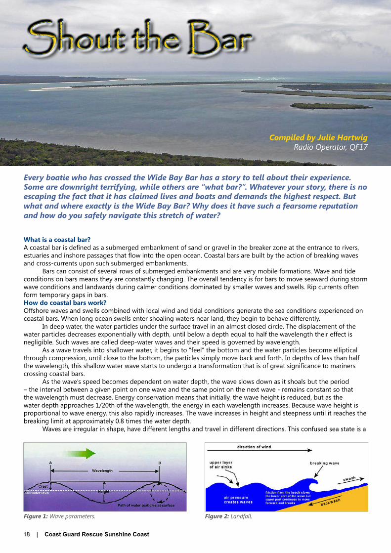
Every boatie who has crossed the Wide Bay Bar has a story to tell about their experience. Some are downright terrifying, while others are “what bar?”. Whatever your story, there is no escaping the fact that it has claimed lives and boats and demands the highest respect. But what and where exactly is the Wide Bay Bar? Why does it have such a fearsome reputation and how do you safely navigate this stretch of water?
What is a coastal bar?A coastal bar is defined as a submerged embankment of sand or gravel in the breaker zone at the entrance to rivers, estuaries and inshore passages that flow into the open ocean. Coastal bars are built by the action of breaking waves and cross-currents upon such submerged embankments.
Bars can consist of several rows of submerged embankments and are very mobile formations. Wave and tide conditions on bars means they are constantly changing. The overall tendency is for bars to move seaward during storm wave conditions and landwards during calmer conditions dominated by smaller waves and swells. Rip currents often form temporary gaps in bars.How do coastal bars work?Offshore waves and swells combined with local wind and tidal conditions generate the sea conditions experienced on coastal bars. When long ocean swells enter shoaling waters near land, they begin to behave differently.
In deep water, the water particles under the surface travel in an almost closed circle. The displacement of the water particles decreases exponentially with depth, until below a depth equal to half the wavelength their effect is negligible. Such waves are called deep-water waves and their speed is governed by wavelength.
As a wave travels into shallower water, it begins to “feel” the bottom and the water particles become elliptical through compression, until close to the bottom, the particles simply move back and forth. In depths of less than half the wavelength, this shallow water wave starts to undergo a transformation that is of great significance to mariners crossing coastal bars.
As the wave‘s speed becomes dependent on water depth, the wave slows down as it shoals but the period – the interval between a given point on one wave and the same point on the next wave - remains constant so that the wavelength must decrease. Energy conservation means that initially, the wave height is reduced, but as the water depth approaches 1/20th of the wavelength, the energy in each wavelength increases. Because wave height is proportional to wave energy, this also rapidly increases. The wave increases in height and steepness until it reaches the breaking limit at approximately 0.8 times the water depth.
Waves are irregular in shape, have different lengths and travel in different directions. This confused sea state is a
Figure 1: Wave parameters. Figure 2: Landfall.

Coast Guard Rescue Sunshine Coast | 19
combination of an infinite number of sinusoidal waves and when encountered on a coastal bar, creates what is known as a “washing machine” effect.Geography of the Wide Bay BarThe Wide Bay Bar is located in Wide Bay at the entrance to Wide Bay Harbour, between Inskip Point on the mainland and Hook Point on the southern tip of Fraser Island.
However, the actual Wide Bay Bar does not lie straight across the entrance to the harbour, but lies some three miles offshore.
The route in from or out to the bar takes the form of a dog-leg, travelling between two sand spits that extend seaward in a north-easterly direction from the points – North Spit on the Hook Point/Fraser Island side and South Spit on the Inskip Point/mainland side - creating a channel of navigable water. At a point clear of the north end of the South Spit, the channel turns to the east south east and crosses the bar‘s Outer Bank into the deep water of Wide Bay.
There is much confusion about the exact location of the bar. While the whole area between Hook and Inskip Points is generally called the Wide Bay Bar, it is in the small stretch of water across the Outer Bank between Waypoints 1 and 2 that the shallowest depths of water - around 4.5 metres above LAT - are found and this is the actual Wide Bay Bar.
Arguably, the most uncomfortable part of the crossing is between Waypoint 2 and 3 where the route runs beside often breaking South Spit. Aptly known as the Mad Mile, this area is greatly affected by the confused washing machine-like seas generated by the backwash coming off the South Spit. The bigger the swells and waves that roll onto the South Spit, the greater the backwash, white water and breaking waves seen in this area.
While Pacific Ocean swells and waves and local tidal conditions are the primary factors governing conditions on the bar, local wind conditions also have a marked effect. Southeast winds generally get the bar “working”, especially when weather systems generate strong southeast winds along the east Australian coast. Conversely, land breezes tend to flatten sea conditions on the bar and it is often when winds with a westerly component are blowing that the bar is at its most workable. Winds with a northerly component have a similar effect, in that they tend to flatten the south flowing East Australian offshore current, reducing the size of swell and waves that affect the bar‘s banks.Navigating the BarAccurate and safe navigation of the bar involves utilising three sets of GPS coordinates (waypoints), compass bearings and land-based navigation beacons. Familiarity with the area on a paper chart is valuable as this provides the mariner with a visual image of the bar‘s configuration in the mind. If GPS navigation is available, program the waypoints into the GPS. It is not advisable to use publications such as Beacon to Beacon for crossing the Wide Bay Bar as GPS data provided is not accurate and the published position for Waypoint 1 differs from that published on marine chart GSS-1.
It’s worth nothing here that this year, Coast Guard Tin Can Bay received numerous reports from mariners transiting the Wide Bay Bar that they were in “white water” in the vicinity of Waypoint 2 and have questioned the accuracy of the coordinates for this waypoint.
In response to these reports, QF17 Leading Coxswain Ian Sutton conducted an extensive survey of the bar coordinates which confirmed that the coordinates are correct.
A probable cause for mariners reporting white water in a navigable channel is not that the waypoint is incorrect, but that local conditions have caused a more vigorous than normal backwash to roll off the northern edge of the South Spit. Mariners are advised that there is sufficient sea room to the north of Waypoint 2 to transit the area in a slightly wider arc. In fact, other QF17 coxswains transiting the bar in such conditions report finding noticeably calmer
Below, Figure 3: The geography of the Wide Bay Bar.Right: An aerial view of the entrance to Wide Bay Harbour from seaward. Note the breakers on the South Spit at left and the darker water of a deeper channel in the centre.
Above: Waves observed breaking on the South Spit on the approach to Waypoint 2.Below: The washing-machine-like sea conditions in the “Mad Mile” between Waypoints 2 and 3.

20 | Coast Guard Rescue Sunshine Coast
Left: The yacht Belle launches off the back of a large wave on the outer edge of the Wide Bay Bar. Belle made the crossing - against advice - two hours before low tide with a 5-10 knot headwind and 3m seas - a combination that delivers the worst wave conditions on the bar.(Photo by Dan Jenner)
Figure 4: An excerpt from marine chart GSS-1 showing the track across the Wide Bay Bar. Note that while True compass bearings are noted on the chart, the bar coordinates are not.
water 50 to 100 metres to the north. If in doubt about the accuracy of GPS coordinates for crossing the Wide Bay Bar, contact Coast Guard Tin Can Bay.
Purists will argue that it is possible to navigate the bar using only a paper chart, a compass and the navigation beacons, but however you choose to do it, a chart – whether paper or electronic – is essential.
For the record, a crossing in a sailing vessel under auxiliary power should take approximately 45 minutes, while a crossing in a power boat should take approximately 20 minutes. These times may vary according to the engine power of your vessel and its ability to manage the sea conditions encountered on the bar.Inbound crossingWaypoint 1, the seaward coordinate, is located at 25° 47.6718S and 153° 08.3782E. It is approximately 3.15nm from the Hook Point light in clear water with depths of around 20 metres. For an inbound crossing, the compass bearing from WP1 to the Hook Point light is 281°T, with Double Island Point bearing 161°T astern. Once at WP1 a white directional light isophase 4 seconds (by day) should be visible on Hook Point. DO NOT proceed if the white light has not been positively identified.
It should be noted here that in recent times, Coast Guard Tin Can Bay have received numerous reports from mariners transiting the Wide Bay Bar that the light is not operating. Mariners should note that the white light has a very narrow angle of view - approximately 3 degrees - and at certain times of the day - notably late afternoon when the sun is setting in the west - the light can be difficult to identify. At times such as this, having the compass bearing for the light is extremely beneficial.
Once the light has been positively identified, proceed along bearing 281°T to Waypoint 2. It is on this leg of the crossing that the outer edge of the bar is crossed. This is the area where mariners are most likely to encounter large breaking waves. Extreme caution is advised.
Waypoint 2, the central or turning coordinate, is located at 25° 47.3648S and 153° 06.6306E. It is approximately 1.7nm from Hook Point light, with depths of around 6.5 metres. At this point, the Inskip Point leads should be visible and “closed up” on a bearing of 243°T.
Keeping the Inskip leads “closed”, proceed along bearing 243°T to Waypoint 3. This leg of the crossing is known locally as the “Mad Mile” and as mentioned previously, mariners will often encounter confused seas resulting from the backwash off the South Spit which can generate uncomfortable conditions on board.
Waypoint 3, located at 25° 48.2057S and 153° 04.8066E, is in the centre of the channel with Inskip Peninsula on the port bow and the southern tip of Fraser Island to starboard. Depths in the channel should be in excess of 20 metres and the entrance to Wide Bay Harbour should be fully open ahead.
To enter the harbour, steer 270°T towards the T1 green beacon located very fine on the port bow. As the harbour opens to port and starboard, mariners can bear away to port to proceed south down Tin Can Inlet or turn to starboard to proceed north through the Great Sandy Strait.Outbound crossingProceed on an outbound crossing using the same waypoints and reciprocal bearings. With the T1 green beacon bearing dead astern, steer down the centre of Wide Bay Harbour on a course of 090°T until the Inskip Point leads align astern at Waypoint 3. Alter course to 063°T and proceed to WP2, keeping the leads aligned astern until the white light on Hook Point is observed (WP2). Alter course to steer 101°T and keeping the Hook Point white dead astern, proceed to Waypoint 1. When depths exceed 17 metres, you are in clear water and have completed the outbound crossing.Best time to crossRegardless of the time of day, it is generally considered that the best time to cross the bar is in the last hour of the incoming tide. During this time, tidal conditions have the least affect on the incoming waves and swells, the depth of water over the bar is greatest and the seas should be calmer.
The next best preference is other states of an incoming tide, though vessels with drafts of 1.5 metres or greater should exercise extreme caution if crossing in the bottom half of an incoming tide.
Whilst crossing with outgoing tides is not impossible, it is not advisable. Outgoing tides combined with incoming waves and swells have a tendency to create seas that “stand up”, giving the skipper and crew a nasty surprise when the boat falls into the “hole” that is often found behind these backless waves. For this reason, crossing on an outgoing tide should only be attempted in calm conditions.

Coast Guard Rescue Sunshine Coast | 21
The yacht Amity surfing a wave on the Outer Bank. Cooloola Rescue provided a much-appreciated bar escort.
A power cat running the “Mad Mile” during an inbound crossing in 25-knot SE winds.
The sailing catamaran Blue Magic disappears in a trough near Waypoint 2.
A number of other factors should also be taken into consideration when contemplating when to cross the bar. Some skippers report that in full light in the morning, the Hook Point isophase white light can be hard to see, while afternoon crossings often have the mariner looking directly into the western sun.
Night crossings are not discouraged. Some skippers advocate that night crossings are easier. By night, the Hook Point light becomes a sectored flashing red, white and green light and the Inskip Point leads display highly visible blue lights – flashing isophase 2 seconds on the rear lead and quick flashing 1 second on the front lead. The Double Island Point lighthouse displays a highly visible flashing white light every 7.5 seconds. It should be noted here that there are no other navigation beacons marking the channel.
The worst conditions for crossing the bar are generally considered to be in the last 2 hours of the out-going tide with east to south-east winds. When these conditions combine with spring low tides, it is possible to see depths of less than 4 metres on the shallowest parts of the bar.
In severe weather conditions, exercise extreme caution if considering crossing the Wide Bay Bar. After a tough passage, it is tempting to take risks simply because the safety of smoother waters once inside the bar is so enticing. However, it may well be prudent to stand off in deeper water until conditions improve, or to seek alternative shelter (if possible) until the conditions moderate.
Whatever time a crossing is made, skippers are advised to check bar conditions with Coast Guard Tin Can Bay, to log on before commencing the crossing and to advise when the crossing has been completed. Reporting the conditions experienced on the bar is also greatly appreciated, for without a “visual” on the bar, Coast Guard Tin Can Bay relies on the information provided by boats that have made the crossing.Safety tips for crossing coastal barsThe skipper of a vessel assumes all responsibility for a safe crossing and it is up to him or her to ensure that the vessel is appropriately equipped and maintained. Engine failure or malfunction in the middle of a bar crossing can have disastrous consequences.
In accordance with maritime laws, appropriate Personal Flotation Devices (PFDs or life jackets) must be worn by everyone on board an open boat under 4.8 metres in length that is crossing a designated coastal bar. However, due to the unpredictable nature of the Wide Bay Bar, it is highly recommended that all persons on board vessels of any size or type should wear PFDs when undertaking a bar crossing.
Before commencing a crossing, check the expected weather and tide conditions. Do not attempt a crossing in strong winds. Tell someone of your plans and log on with Coast Guard. Ensure all hatches, windows, doors and washboards are secured and that all loose equipment and ropes are securely stowed.
Allow plenty of time to assess the bar before commencing the crossing. The skill of crossing a bar lies in judging where the calmest water lies and manoeuvring the boat around breaking waves. Observe the wave pattern (e.g., the number of waves in a set) and note where waves break the least. This indicates where the deeper water and the best route lies. Wearing polarised sunglasses can help, as can watching where other boats make successful crossings.
Watch the sets of swells before choosing the best time to go and once committed, keep going. Do not attempt to turn around in front of an oncoming wave and do not hit waves at high speed. The boat‘s speed should match the speed of approaching waves. Head up into waves and bear away quickly on their backs, creating a zig-zag course.
When crossing bars inbound, skippers of powerboats should aim to ride on the back of waves, adjusting the boat‘s speed to match that of the wave while staying ahead of the waves breaking behind the boat. Again, watch for wave patterns and areas of deeper, calmer water before commencing the crossing. Slower displacement boats should travel at a speed that allows the skipper to maintain manoeuvring control of the vessel. Do not allow the boat to turn beam on to the following waves.ConclusionsWhile bar crossings can be intimidating, careful preparation and sensible seamanship will ensure a safe crossing. Never underestimate coastal bars. Waves behave differently in a bar situation and even small waves can capsize or swamp and sink a small boat. If you are inexperienced, wait until the conditions improve to provide a safe crossing that you can handle. For the experienced skipper, if it appears too rough to fish, it‘ll be too rough to cross the bar, so if in doubt, don‘t go out.Note: All compass bearings are True bearings. All depths are above LAT. For more information about coastal bars, visit the Maritime Safety Queensland website at www.msq.qld.gov.au.
22 | Coast Guard Rescue Sunshine Coast
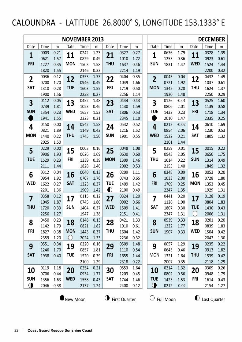
CALOUNDRA - LATITUDE 26.8000° S, LONGITUDE 153.1333° E
NOVEMBER 2013 DECEMBER Date Time m Date Time m Date Time m Date Time m Date Time m
1 FRI
0003 0.21 11 MON
0242 1.23 21 THU
0327 0.27 1 SUN
0636 1.79 11 WED
0328 1.39 0621 1.57 0829 0.49 1010 1.72 1253 0.36 0923 0.61 1227 0.35 1503 1.58 1637 0.46 1831 1.47 1524 1.44 1820 1.55 2146 0.33 2214 1.19 2200 0.32
2 SAT
0036 0.12 12 TUE
0353 1.33 22 FRI
0404 0.35 2 MON
0043 0.04 12 THU
0432 1.49 0700 1.70 0946 0.49 1049 1.66 0721 1.92 1037 0.61 1310 0.28 1603 1.55 1719 0.50 1342 0.28 1624 1.37 1900 1.56 2238 0.27 2256 1.14 1920 1.48 2250 0.29
3 SUN
0112 0.05 13 WED
0452 1.48 23 SAT
0444 0.43 3 TUE
0126 -0.01 13 FRI
0525 1.60 0739 1.81 1053 0.46 1130 1.59 0806 2.01 1139 0.58 1354 0.23 1657 1.52 1806 0.53 1432 0.23 1718 1.34 1941 1.55 2323 0.21 2345 1.10 2010 1.47 2335 0.25
4 MON
0150 0.00 14 THU
0542 1.58 24 SUN
0532 0.52 4 WED
0212 -0.02 14 SAT
0610 1.69 0821 1.89 1149 0.42 1216 1.52 0854 2.06 1230 0.53 1440 0.22 1745 1.50 1901 0.55 1522 0.21 1805 1.32 2025 1.50 2101 1.44
5 TUE
0229 0.00 15 FRI
0003 0.16 25 MON
0048 1.08 5 THU
0259 0.01 15 SUN
0015 0.22 0906 1.93 0626 1.69 0630 0.60 0943 2.05 0650 1.75 1529 0.23 1239 0.39 1309 1.46 1614 0.22 1314 0.49 2111 1.44 1828 1.46 2002 0.53 2153 1.40 1849 1.32
6 WED
0312 0.04 16 SAT
0040 0.13 26 TUE
0209 1.11 6 FRI
0348 0.09 16 MON
0053 0.20 0954 1.92 0707 1.76 0743 0.65 1033 2.00 0728 1.80 1622 0.27 1323 0.37 1409 1.42 1709 0.25 1353 0.45 2201 1.36 1909 1.42 2100 0.49 2247 1.35 1929 1.31
7 THU
0358 0.12 17 SUN
0115 0.12 27 WED
0324 1.20 7 SAT
0441 0.20 17 TUE
0128 0.19 1045 1.87 0745 1.80 0902 0.66 1126 1.90 0804 1.83 1720 0.33 1404 0.37 1509 1.41 1807 0.30 1430 0.43 2256 1.27 1947 1.38 2151 0.41 2347 1.31 2006 1.31
8 FRI
0450 0.23 18 MON
0148 0.13 28 THU
0421 1.33 8 SUN
0539 0.33 18 WED
0201 0.20 1142 1.79 0821 1.82 1010 0.61 1222 1.77 0839 1.83 1827 0.38 1443 0.37 1604 1.42 1907 0.33 1504 0.42 2359 1.20 2024 1.33 2236 0.32 2042 1.30
9 SAT
0551 0.34 19 TUE
0220 0.16 29 FRI
0509 1.48 9 MON
0057 1.29 19 THU
0235 0.22 1246 1.70 0857 1.81 1110 0.54 0645 0.46 0913 1.82 1938 0.40 1520 0.39 1655 1.44 1321 1.64 1539 0.42
2100 1.29 2318 0.22 2007 0.35 2118 1.29
10 SUN
0119 1.18 20 WED
0254 0.21 30 SAT
0553 1.64 10 TUE
0214 1.32 20 FRI
0309 0.26 0706 0.44 0934 1.77 1203 0.45 0802 0.56 0948 1.79 1356 1.63 1558 0.43 1744 1.46 1423 1.53 1614 0.43 2046 0.38 2137 1.24 2400 0.12 0212 -0.02 2154 1.27
New Moon First Quarter Full Moon Last Quarter

Coast Guard Rescue Sunshine Coast | 23
TIDE TIMES DECEMBER 2013 – FEBRUARY 2014 2014 JANUARY 2014 Date Time m Date Time m Date Time m Date Time m
21 SAT
0343 0.32 1 WED
0112 0.02 11 SAT
0504 1.57 21 TUE
0440 0.45 1023 1.74 0754 2.09 1128 0.70 1104 1.67 1650 0.45 1422 0.24 1654 1.24 1726 0.42 2232 1.25 1959 1.50 2309 0.38 2330 1.37
22 SUN
0421 0.39 2 THU
0201 -0.02 12 SUN
0552 1.65 22 WED
0523 0.55 1059 1.68 0842 2.14 1220 0.63 1141 1.58 1727 0.47 1510 0.19 1748 1.26 1806 0.44 2315 1.22 2050 1.52 2356 0.34
23 MON
0502 0.48 3 FRI
0250 0.00 13 MON
0634 1.72 23 THU
0021 1.36 1137 1.61 0929 2.14 1302 0.57 0615 0.64 1809 0.48 1558 0.18 1834 1.29 1224 1.48
2141 1.52 1853 0.45
24 TUE
0004 1.21 4 SAT
0339 0.06 14 TUE
0036 0.30 24 FRI
0126 1.37 0550 0.57 1017 2.07 0711 1.78 0722 0.72 1220 1.54 1647 0.21 1338 0.51 1318 1.39 1856 0.48 2233 1.50 1914 1.32 1950 0.45
25 WED
0106 1.21 5 SUN
0428 0.18 15 WED
0114 0.26 25 SAT
0246 1.43 0650 0.65 1104 1.95 0746 1.82 0849 0.74 1309 1.46 1737 0.25 1412 0.47 1427 1.32 1949 0.47 2327 1.47 1952 1.35 2055 0.42
26 THU
0222 1.26 6 MON
0521 0.34 16 THU
0147 0.24 26 SUN
0402 1.55 0803 0.70 1152 1.79 0820 1.84 1019 0.69 1407 1.40 1827 0.31 1444 0.43 1546 1.31 2046 0.43 2025 1.38 2204 0.36
27 FRI
0334 1.36 7 TUE
0026 1.43 17 FRI
0220 0.24 27 MON
0505 1.70 0924 0.70 0620 0.50 0852 1.85 1132 0.58 1511 1.37 1242 1.61 1515 0.41 1657 1.34 2142 0.36 1920 0.37 2059 1.39 2309 0.26
28 SAT
0434 1.51 8 WED
0136 1.41 18 SAT
0254 0.26 28 TUE
0600 1.86 1040 0.64 0731 0.64 0925 1.83 1229 0.45 1614 1.36 1337 1.46 1546 0.40 1800 1.41 2237 0.27 2016 0.41 2134 1.40
29 SUN
0527 1.67 9 THU
0254 1.43 19 SUN
0327 0.31 29 WED
0009 0.15 1144 0.54 0855 0.72 0957 1.80 1651 2.01 1714 1.38 1441 1.33 1618 0.40 1319 0.32 2330 0.17 2115 0.42 2209 1.40 1856 1.50
30 MON
0617 1.84 10 FRI
0405 1.49 20 MON
0402 0.37 30 THU
0102 0.06 1241 0.42 1020 0.74 1030 1.74 0740 2.11 1811 1.42 1550 1.26 1651 0.41 1406 0.22
2214 0.41 2247 1.39 1948 1.58
31 TUE
0022 0.08 31 FRI
0152 0.01 0705 1.98 0826 2.15 1333 0.32 1451 0.16 1906 1.46 2037 1.64
New Moon First Quarter Full Moon Last Quarter

24 | Coast Guard Rescue Sunshine Coast
The Irish Coast Guard (Garda Cósta na hÉireann) is part of the Department of Transport. The Irish Search and Rescue Region, which includes most of the Republic of Ireland and parts of Northern Ireland is the area over which the coast guard has authority. This area is bounded by the UK Search and Rescue Region.
Status and roleUnlike the model in some other countries, the coast guard in Ireland does not form part of the Irish Defence Forces. Rather, it operates as a Division of the Department of Transport under the Maritime Safety Directorate. Together with the Mercantile Marine Office, the Maritime Safety Directorate comprises two main sections: the Maritime Safety and Marine Environment Division (MSED) and the Marine Survey Office (MSO):• The Maritime Safety and Marine Environment Division is responsible for maritime safety, security policy and
legislation (including leisure safety), aids to navigation, corporate governance of the Commissioners of Irish Lights and marine environment protection issues.
• The Marine Survey Office deals with the inspection, survey, certification and licensing of vessels and vessels’ radio equipment; the examination and certification of seafarers’ competencies; enforcement of standards by way of audits of organisations and facilities and prosecutions for breaches of regulations. The Marine Survey Office also includes the Marine Radio Affairs Unit (MRAU).
While in some jurisdictions they are the responsibility of the Coast Guard, in Ireland, fisheries patrols are carried out by the Irish Naval Service, while drug smuggling patrols are carried out by the Customs and the Naval Service. However, all the above government services can at any time request assistance from each other when needed.
The coast guard is, however, responsible for:• Search and Rescue• Marine communications network• Marine safety awareness• Pollution and salvage response in the marine environment (the Marine Rescue Co-ordination Centre (MRCC) in
Dublin coordinates all pollution and salvage control in the Irish Exclusive Economic Zone (EEZ).)Note that not all Irish coast guards have enforcement powers - only some officers under warrant.
HistoryThe coast guard was first formed in Ireland in 1822, while the island was a constituent part of the United Kingdom. During this period, it played revenue protection and coastal defence roles, as well as forming part of the naval reserve. In 1923, following the formation of the Irish Free State, the Coast Lifesaving Service (CLSS) was established. This was
The Irish Coast GuardCompiled by John GasparottoEditor, QF4
Above: Offshore lifeboat operating in rough seas; Centre: D-Class inshore lifeboat (RIB); Right: Cliff rescue team in action.

Coast Guard Rescue Sunshine Coast | 25
later renamed the Coast and Cliff Rescue Service (CCRS), before becoming known as the Irish Marine Emergency Service (IMES) in 1991, and finally being renamed as the Irish Coast Guard (IRCG) in 2000.Search and RescueThe IRCG, having been delegated the responsibility to provide search and rescue and preventative services for the Ireland internationally assigned search and rescue region, the littoral area, rivers, lakes, waterways, mountains, caves and offshore islands use search and rescue units and other available facilities for providing assistance to persons who are, or appear to be, in distress.
The IRCG coordinates Search and Rescue (SAR) through its Maritime Rescue Co-Ordination Centre (MRCC) in Dublin and Maritime Rescue Sub-Centres (MRSC) at Malin Head, County Donegal and Valentia Island, County. Kerry. Each MRCC or MRSC is responsible for SAR operations and the day to day running of its allocated Division.
The IRCG, within in its area of responsibility and accountability, administers a search and rescue, medical advice and evacuation system which ensures efficient and effective mobilisation, availability and appropriate use of declared facilities and facilities of opportunity.
Within each Coast Guard Division there are many declared SAR resources such as:• Coast Guard Volunteer Coastal Units (CGVCU’s) capable of search, cliff and coastal rescue• Lifeboats provided by the Royal National Lifeboat Institution (RNLI) and Community Inshore Rescue Organisations• Three Search and Rescue helicopters under contract to the IRCG (Dublin, Shannon and Waterford) and one based
in Sligo provided by the Aer CorpsThe coast guard is one of the state’s four emergency service organisations in Ireland (excluding specialist
organisations such as Mountain and Cave Rescue etc). The other services being An Garda Siochana, the Fire Service and the Ambulance Service.
There are also other “additional” resources which, although are not declared for SAR purposes, may be available to assist in any search and/or rescue as required. Examples of “additional” resources include vessels in the vicinity of a distress, the Naval Service, etc.
IRCG ensures that assistance is provided to any persons in distress within in its area of responsibility and accountability. They do so regardless of the nationality or status of such persons or the circumstances in which those persons are found.Marine EnvironmentIRCG is responsible for developing and co-coordinating an effective regime for:• preparedness and response to spills of oil and other hazardous substances within the Irish Pollution Responsibility
Zone;• providing an effective response to marine casualty
incidents; and• to monitor/intervene in marine salvage operations.
It provides and maintains 24-hour marine pollution notification centres at three marine rescue centres; develops approved pollution response plans in all harbours and ports, oil handling facilities, marine local authorities and offshore installations; provides and maintains a national stockpile of pollution equipment; and exercises and tests of national and local pollution response plans on an ongoing basis.
Above and centre: Helicopter rescue. Top and centre right: Communications centres; Above: E-Class inshore lifeboat (RIB).

26 | Coast Guard Rescue Sunshine Coast
Right, top to bottom: Salvage response to a ship wreck; Volunteers on the job, promoting the Irish Coast Guard; Crew of a D-Class inshore lifeboat retrieve a person from the water.
IRCG is the representative of the wider public interest in the protection of the environment following a marine incident where there is pollution or a significant threat of pollution.
IRCG’s customers are the commercial and recreational users of the sea, harbours and local authorities whose livelihood, property and amenities might be damaged in a pollution incident and/or their lives put at risk.SAR OpsSAR Ops Division is responsible for the operation of current search and rescue (SAR) operations, the Marine Rescue Centres at Dublin, Malin and Valentia, marine safety information, promotion of marine safety awareness, national SAR displays, maritime counties committees, the Irish Maritime SAR Committee (IMSARC), maritime gallantry and meritorious awards and for liaison with external agencies.Voluntary Services and TrainingVS&T Division is responsible for the management of all IRCG Coastal Units, Community Inshore Rescue Service Units, other voluntary SAR organisations, mountain and cave rescue, logistics (stores, equipment, buildings, vehicles, etc.) and training of IRCG full-time and voluntary staff.
The 54 coast guard units are crewed by 950 volunteers working out of their coast guard units and their station houses (sometimes known locally as ‘The Rocket House’ from using the old Breeches Buoy rescue rockets) which are positioned at strategic locations around Ireland. These units are equipped with initial action fast response equipment with adequate geographical range. This kit includes radio communications systems, cliff rescue gear, rescue, patrol, transport and search boats, response vehicles, line throwing apparatus, first aid equipment, personal protective equipment, uniforms, portable generators and lights, and day and night search gear.
All units are operated totally by local crews who live within 10 minutes of the station house and who freely give their valuable time and effort to the Coast Guard, local community, and ‘those in peril on the sea’, cliffs and coasts of Ireland. Training is provided for the volunteers, who are on-call, 24 hours a day, 365 days a year. A building programme to upgrade the units’ station houses is on going.
Coast Guard Rescue Sunshine Coast | 27
What was probably the first organized marine rescue service, known as the Preventive Water Guard, was established in 1809 with the primary objective of preventing smuggling, but it was given also the responsibility of giving assistance to shipwrecks.
Each station was issued with a ‘Manby’s Mortar’, which was invented by Captain George William Manby. The mortar fired a shot, with a line attached, from the shore to the wrecked ship and was used for many years. One can be seen at Flagstaff Hill Museum in Warrnambool Victoria.
In 1822, it was recommended that the responsibility for the Preventative Water Guard be transferred to the Board of Customs and combined with a number of other services. This organisation was named Coastguard.
In 1829, the first Coastguard instructions were published and dealt with discipline and directions for carrying out preventative duties. They also stipulated that when a wreck took place the Coastguard was responsible for taking all possible action to save lives, to take charge of the vessel and to protect property.
The Marine and Coastguard Agency (MCA) is the UK’s equivalent of our MSQ (Marine Safety Queensland) except that the MCA covers the whole of the UK, while MSQ is simply state-wide in Queensland.
The emergencies to which HM Coastguard respond include:• Sailboarders too exhausted to reach shore• Walkers and animals who slip from cliff paths• Boats losing rudder control• Crew stranded aboard a container ship battered by
freak waves• Medical emergencies• Incidents involving oil rigs (such as fire)• Suicide victims that have flung themselves from
cliffs or bridges• Missing adults and children around cliffs and beach
areas.Of course these duties are over and above the normal
responsibilities of all civilian-run maritime Search and Rescue (SAR) operations.
I hope you found this interesting!
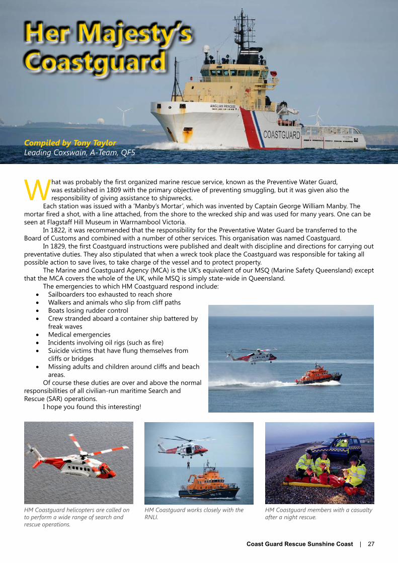
Her Majesty’sCoastguard
HM Coastguard helicopters are called on to perform a wide range of search and rescue operations.
HM Coastguard works closely with the RNLI.
HM Coastguard members with a casualty after a night rescue.
Compiled by Tony TaylorLeading Coxswain, A-Team, QF5

28 | Coast Guard Rescue Sunshine Coast
by Gary PiperQF5
RadarPart 2: Microwaves
In the Winter issue, Part 1 of this series gave us a brief history of the development of Radar. In this article, we move on to explore the science behind the technology and learn the key terms we use when operating Radar ...
“Ye canna change the laws of physics.”Star Trek - Scotty
This famous quote is particularly true in relation to Radar. Radar basically operates by transmitting an electromagnetic wave (microwave) and then listening for the return signal that has reflected off the target. The distance to that target is calculated using the standard Distance, Time and Speed formula; the same formula we
use for navigation.This article seeks to provide a basic understanding of the science behind key terms used in radar every day. If
you can face reading on, you will gain an understanding of what a wave, wave length, frequency, wave energy, the electromagnetic spectrum, microwaves and the speed of light actually are, and how they can be bought together to measure distance using radar.WavesIn physics, a wave is defined as a disturbance, oscillation or vibration that travels through space and matter from one location to another accompanied by a transfer of energy often with no permanent displacement of the particles of the medium the wave travelled through.
Waves can also have a number of forms: Sine, Square, Sawtooth etc… We will only be focusing on the simple Sine wave form.
A Sine wave is characterised by the repeating oscillation of the wave.
A practical example of a Sine wave is the Mexican Wave often seen at sporting events. The wave is the “disturbance” (people standing up and sitting down) that travels around the stadium. But none of the people actually travel with the wave as it travels around the stadium.
In nautical terms, the ocean waves are seen as the swell moving towards the beach with the energy being transferred to the beach and being absorbed by the shoreline. However, like all the individual water molecules, a stationary vessel only moves up and down on the wave and does not get propelled by the wave. Only the vessels engine, gravity, currents and wind affect the vessel’s movement.Properties of a waveElectromagnetic waves can be described using the physical properties Wavelength and Frequency, both of which are important to the fundamentals of radar.Wave Length“Wave-Length” is defined as the distance between repeating units of a wave pattern. Wavelength is typically measured in metres.
Above: Mexican Wave.
Sine
Figure 1: Simple Sine wave form

Coast Guard Rescue Sunshine Coast | 29
Antennas are generally tuned to the wavelength of the wave or ½ or ¼ of the wavelength hence the term ¼ wave antennas. Marine VHF radio operates in the 2-metre band so most marine antennas are 2 metres in length.FrequencyThe frequency of a wave is the defined as the number of oscillations or wave crests that pass a given point per second. Frequency is measured in Hertz (Hz). Does the name Hertz sound familiar? 1 hertz = 1 cycle per second
Our standard 240v electricity has a frequency of 50 Hz (50 cycles a second). Ever had an electric shock where you feel the very fast multiple thumps of the waves hitting you at a rate of 50 per second? (From experience it’s about 4 hits before the RCD trips!)
When we talk about microwave “X” band (standard Radar) we are operating in the 10GHz (Giga Hertz) range; that’s 10,000,000,000 cycles per second.
1,000 cycles per second = 1 KHz (Kilo Hertz)1,000,000 cycles per second = 1 MHz (Mega Hertz)1,000,000,000 cycles per second = 1 GHz (Giga Hertz)
“S” band radar, which is a requirement on all ships greater than 300 gross tonnes, operates on the 3 GHz range (we will cover the difference between “X” and “S” band radar in a later article).Wavelength and frequencyFor our purposes, a wave is be defined by both its wavelength and frequency. Both are explicitly linked by the following formula (in a vacuum).
Frequency = Speed of light / Wave length
So, as wavelength decreases, frequency increases. We will use this formula later in the article.The Electromagnetic SpectrumThe electromagnetic spectrum is defined as the range of all possible frequencies of electromagnetic radiation.
So for context:Marine VHF channel 16 has a frequency of 156.800 MHz
and a wave length of 1.91 metres (requires a 2 metre antenna)
Marine HF 4125 KHz has a wave length of 72.78 metres (needs quite a large antenna)
X band radar is in the 10 GHz range with a wave length of 3 centimetres
Speed of LightRadar calculates the distance to a target based in the time taken for the transmitted microwave to reach the target and return to the radar receiver.
Distance = Speed X (Time/2)Time is divided by two, as the microwave has to travel to the target and back.
Fortunately for us, speed in this equation is a constant – the speed of light.The speed of light is 299,792,458 metres per second or 299,792 kilometres / second. For simplicity, we will set
the speed of light at 300,000,000 m/sec, sometimes written as 3 X 10⁸ m/sec.If we were in CGRV Davo’s Rescue outside the Noosa Bar, it will take our radar signal 0.0003457 seconds (0.346
milliseconds) to travel from our vessel to Double Island Point 28 nautical miles away and back. So unless CRV Davo’s Rescue is travelling at several thousand knots, the speed of our vessel does not significantly affect the radar’s ability to accurately determine distance.
So that’s it as far as the science behind key radar terms is concerned. Aren’t we all glad that is over! You can mop your brows now as we move on and have some fun with the science …Microwave ovens - an accidental discoveryIt was during 1945 when Percy Spencer, while working on an active radar set at Raytheon, discovered that the bar of chocolate he had in his pocket had started to melt. (Hmmm … All that high-energy microwave radiation hitting his body around the trouser pocket area!). He later built on that discovery and fed microwaves into a metal box using his newly modified magnetron (compliments of the British Government) and cooked popcorn and eggs (the egg exploded as they do now if you put them in your microwave).
Figure 2: Wave length.
Figure 3: Electromagnetic Spectrum. Source: http://9-4fordham.wikispaces.com/Electro Magnetic Spectrum and light.

30 | Coast Guard Rescue Sunshine Coast
½ Wavelength approx. 6 cm
Ever wondered why or where a saying came from? This issue, QF6 have submitted the first in a series of articles that looks at some of the nautical terms that are used (some not as much) in our everyday speech and within the boating fraternity.Bamboozle: Used by many people today when you intentionally deceive someone, usually as a joke, you are said to have bamboozled them. The word was used in the days of sail, also, but the intent was not hilarity. Bamboozle meant to deceive a passing vessel as to your ship’s origin or nationality by flying an ensign other than your own - a common practice of pirates.Boot Camp: During the Spanish-American War, sailors wore leggings called boots, which came to mean a Navy (or Marine) recruit. These recruits trained in boot camps.
Bitter End: As any able-bodied seaman can tell you, a turn of a line around a bitt, those wooden or iron posts sticking through a ship’s deck, is called a bitter. Thus, the last of the line secured to the bitts is known as the bitter end. Nautical usage has somewhat expanded the original definition in that today the end of any line, secured to bitts or not, is called a bitter end. The landlubbing phrases “stick to the bitter end” and “faithful to the bitter end” are derivations of the nautical term and refer to anyone who insists on adhering to a course of action without regard to consequences.
Bokoo: Often, an old salt will boast that he has had bokoo this or has done something bokoo times during his seafaring years. The picturesque sound of the word bokoo may cause one to wonder how it came to mean “many” or “a lot.” Actually, bokoo is a legitimate French word, beaucoup, meaning “very many.” Americanisation changed the spelling and pronunciation, but the meaning remains unchanged. Like many foreign terms that have crept into our nautical lingo, bokoo is the inevitable product of generations of American seamen meeting peoples of other nations and adopting bokoo phrases from their languages for everyday shipboard use.Carry On: In the days of sail, the officer of the deck kept a weather eye constantly on the slightest change in wind so sail could be reefed or added as necessary to ensure the fastest headway. Whenever a good breeze came along, the order to carry on would be given. It meant to hoist every bit of canvas the yards could carry. Pity the poor sailor whose weather eye failed him and the ship was caught partially reefed when a good breeze arrived. Through the centuries, the term’s connotation has changed somewhat. Today, carry on is used in some areas as an order to resume work; work not so gruelling as two centuries ago.
Origins of Nautical Terminology ... Part 1
How to calculate the speed of light at home using your microwaveAll you need is a household microwave, one dinner plate, one large bar of chocolate, a ruler and a calculator, and you get to eat the chocolate after the experiment.Firstly remove the revolving carousel from the microwavePlace an up turned dinner plate over the carousel’s rotating mechanism.Place a large bar of chocolate on the upturned dinner plateTurn on the microwave for about 20 seconds.
What you are looking for are melted patches on the chocolate. Warning: The chocolate will be very hot in patches and will burn. The melted patches are points where the curve of the sine wave passes through the chocolate. The distance between the centres of two of the melted patches is equivalent to half the wavelength of the microwave. It should measure something like 6 cm. Multiply this value by two (2) to get the wavelength of the microwave (example 12 cm). On the back of the microwave you will find an information plate which will give you the frequency of the microwave generator in your microwave oven, something like 2450 MHz.
Now using some simple maths …Speed = (Frequency) x (Wavelength)Speed = (2450 MHz) X (12 cm)Convert frequency to Hertz and wavelength to metresSpeed = (2,450,000,000 Hz) X (0.12 metres)Speed = 294,000,000 meters per second.
The answer you will get will be very close to the actual speed of light …
Of course there will be some inaccuracy given you are using a ruler to measure the wavelength.Next Issue: Part 3 of Radar.

Coast Guard Rescue Sunshine Coast | 31
Almost aMayday
by Alan HallQF5
It had been a quiet day for the QF5 radio operator as strong winds and big seas had kept all the boats in harbour. Or so we thought.
At 1230hrs a call was received from a vessel in serious trouble. She had no engine power, was taking on water at a great rate and was drifting towards the shore. This is about as close as you can get to a MAYDAY, almost certainly a PAN PAN, although the skipper declared neither, preferring to emphasise the urgency of the situation by radio. Realising immediate action was required, the radio operator called in the duty skipper and three experienced crew. At 1248hrs, rescue vessel the John Waddams was on its way.
The stricken vessel, Shoalwater Bay, on route from Southport to Bundaberg, overnighted at Mooloolaba before setting off at 0630hrs for the trip to Tin Can Bay where it proposed to stay overnight before taking the inside passage behind Fraser Island. The two crewmen were experienced sailors and the skipper had owned the vessel for 9 years. His experience was to prove vital in keeping the vessel safe until we could get to them.
The Shoalwater Bay was destined to be a tourist boat up north and was terrifically suited to the job at 37 foot in length and in very good condition. The skipper and owner had already sold her and at the time, was making the delivery trip. Before setting out from Southport, he had the vessel checked over and the engine serviced, but it would have been difficult to foresee the water intake busting off while underway.
At 1030hrs, the cooling water intake parted company, filling the engine room with water and stopping the cooling system for the engine. The engine immediately filled the cabin with thick smoke before it overheated and stopped. With alarms going off everywhere, water pouring in and thick, choking smoke these guys were in serious trouble. The skipper didn’t panic (well, not much), but realised the number one thing was to stop the flow of water pouring into the bilge. Stuffing the hole with a blanket and ramming it home, he managed to stop the flow of water and left the bilge pump to take care of the water.
So, here’s the scenario: they have no engine power as the engines are overheated and probably seized; without engines they cannot charge their batteries, and if the plug doesn’t hold, the bilge pump will quickly run down the batteries leaving them with no marine radio or any other electronics. Setting their anchor would stop their drift to shore, but if the batteries failed they wouldn’t be able to recover it due to its size and large amount of chain, so they decided to hold off using it as they didn’t know how long it would take for help to arrive.
Sea conditions were pretty ordinary; 25 knots of S/E wind, a 1.7m S/E sea on a 2.5-3m E swell, so things were really quite uncomfortable. The Shoalwater Bay rocked and rolled, which made any movement inside the cabin difficult and we can only imagine how these guys must have felt when they saw a yacht less than ¾ of a mile away, but despite radio calls, the sounding of the horn, waving of arms and the letting off of flares, the yacht did not see or take any notice of them.
Meanwhile, the John Waddams powered on in atrocious conditions averaging 18 knots, which believe me is absolutely motoring in those conditions, although at no time was it deemed dangerous. The information provided by the distressed vessel about their position was spot on and the vessel was spotted at 1350hrs. The skipper had been instructed by QF5 to drop his anchor, and once he was happy help was on the way, he did so.
After arriving on scene it was decided to have a Coast Guard crew member board the vessel to assess the situation and after getting permission from the skipper he was placed on board. “Boy are we pleased to see you,” the skipper said. The leak was still under control and she was not taking on any further water, but the engine was unusable so it was decided to tow the vessel to a safe anchorage north of Double Island Point and have QF17 complete the tow across the Wide Bay Bar to a repair yard the following morning.
All went well with the tow, although it was very slow until we rounded Double Island Point and the tow rope broke. It certainly was not the best place for that to happen as it was a bit like being in a washing machine. However, the tow was quickly re-established and we continued on, finally anchoring the Shoalwater Bay at 1630hrs. The owner, Alan Cross, was very grateful and made a substantial donation to QF5, which would easily pay for the fuel we used and then some. This was something we really appreciated, as not everyone we assist is so thoughtful especially considering his bad luck. The John Waddams headed home, punching its way through large seas and finally arrived at 2045hrs. We later learned that the Shoalwater Bay had been successfully towed into a safe anchorage by QF17 the next morning.
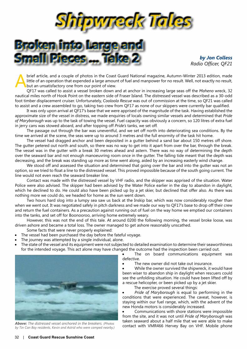
32 | Coast Guard Rescue Sunshine Coast
Broken into Large and Small Pieces ... Take 2 by Jon Colless
Radio Officer, QF21
Shipwreck Tales
A brief article, and a couple of photos in the Coast Guard National magazine, Autumn-Winter 2013 edition, made little of an operation that expended a large amount of fuel and manpower for no result. Well, not exactly no result, but an unsatisfactory one from our point of view.QF17 was called to assist a vessel broken down and at anchor in increasing large seas off the Maheno wreck, 32
nautical miles north of Hook Point on the eastern side of Fraser Island. The distressed vessel was described as a 30-odd foot timber displacement cruiser. Unfortunately, Cooloola Rescue was out of commission at the time, so QF21 was called to assist and a crew assembled to go, taking two crew from QF17 as none of our skippers were currently bar qualified.
It was only upon arrival at QF17’s base that we were apprised of the magnitude of the task. Having established the approximate size of the vessel in distress, we made enquiries of locals owning similar vessels and determined that Pride of Maryborough was up to the task of towing the vessel. Fuel capacity was obviously a concern, so 120 litres of extra fuel in jerry cans was stowed aboard, and after topping off Pride’s tanks, we set off.
The passage out through the bar was uneventful, and we set off north into deteriorating sea conditions. By the time we arrived at the scene, the seas were up to around 3 metres and the full enormity of the task hit home.
The vessel had dragged anchor and been deposited in a gutter behind a sand bar about 150 metres off shore. The gutter petered out north and south, so there was no way to get into it apart from over the bar, through the break. The vessel was in the gutter with a break 30 metres ahead and astern. There was no way of determining the depth over the seaward bar and not enough manoeuvring room once in the gutter. The falling tide meant that the depth was decreasing, and the break was standing up more as time went along, aided by an increasing easterly wind change.
We stood off and assessed the situation and determined that going over the bar and into the gutter was not an option, so we tried to float a line to the distressed vessel. This proved impossible because of the south going current. The line would not even reach the seaward breaker line.
Contact was made with the distressed vessel by VHF radio, and the skipper was apprised of the situation. Water Police were also advised. The skipper had been advised by the Water Police earlier in the day to abandon in daylight, which he declined to do. He could also have been picked up by a jet skier, but declined that offer also. As there was nothing more we could do, we headed for home as the sun went down.
Two hours hard slog into a lumpy sea saw us back at the Inskip bar, which was now considerably rougher than when we went out. It was negotiated safely in pitch darkness and we made our way to QF17’s base to drop off their crew and return the fuel containers. As a precaution against running out of fuel on the way home we emptied our containers into the tanks, and set off for Boonooroo, arriving home extremely weary.
However, this was not the end of this tale. At around 0200 the following morning, the vessel broke loose, was driven ashore and became a total loss. The owner managed to get ashore reasonably unscathed.
Some facts that were never properly explained:• The vessel had been purchased the day before the fateful voyage.• The journey was attempted by a single individual, alone.• The state of the vessel and its equipment were not subjected to detailed examination to determine their seaworthiness
for the intended voyage. This act alone may have changed the outcome had the inspection been carried out.• The on board communications equipment was defective.• The new owner did not take out insurance.• While the owner survived the shipwreck, it would have been wiser to abandon ship in daylight when rescuers could see the unfolding situation. He could have been lifted off by a rescue helicopter, or been picked up by a jet skier.
The exercise proved several things:• Pride of Maryborough is equal to performing in the conditions that were experienced. The caveat, however, is staying within our fuel range, which, with the advent of the new Honda motors is considerably increased.• Communications with shore stations were impossible from the site, and it was not until Pride of Maryborough was taken seaward about a half mile that we were able to make contact with VMR466 Hervey Bay on VHF. Mobile phone Above: The distressed vessel anchored in the breakers. (Photos
by Tin Can Bay residents, Kevin and Astrid who were camped nearby.)

Coast Guard Rescue Sunshine Coast | 33
coverage was equally affected.• Radio communications to our base were also ineffective until we were off Hook Point, when we were able to access
the channel 82 repeater.• The communications problem has been addressed by application for grants for the purchase of satellite phones,
which should effectively remove any limitation of communications in our area of operation and beyond.
Editor’s Note: The communications difficulties experienced by Pride of Maryborough on this assist have been an issue for QF17 Tin Can Bay for some time. The difficulties began when MSQ transferred monitoring control of the VHF channel 16/67 outlet on Fraser Island from QF17 to VMR466 Hervey Bay. Since then, QF17 have had to contend with greatly reduced communications in the majority of their offshore operational area.
QF17 advise that while MSQ have provided monitoring control of VHF channel 16/67 through the Mt Boulder site, it has reduced their capacity to cover the offshore waters of Fraser Island north of the Wide Bay Bar. Mariners navigating these waters are currently advised to contact VMR466 when ten nautical miles north of the Wide Bay Bar.
Considering that QF17’s operational area extends north to Indian Head, a distance of over fifty nautical miles north of the Wide Bay Bar, and fifty nautical miles to seaward, this loss of coverage has had a major impact on QF17’s communications when operating in these offshore waters.
Like QF21, QF17 have been forced to resort to satellite phone communications or using VMR466 as a relay station to communicate with their Tin Can Bay base. The use of TrackPlus also provides monitoring when the flotilla’s rescue vessels are operating in this area.
Above and right: Broken into large and small pieces that were spread along the beach the next morning, not much remained of the timber vessel. (Photos by Tin Can Bay residents, Kevin and Astrid who were camped nearby.)

34 | Coast Guard Rescue Sunshine Coast
Quarterdeck NewsCOAST GUARD CALOOUNDRA PARTICIPATES IN SAREXIn August, Coast Guard Caloundra participated in a joint SAREX with the Water Police, Coast Guard vessels from Noosa and Mooloolaba, Volunteer Marine Rescue Bribie Island, Surf Life Saving including their helicopter and the Fire Services from Sunshine Coast Airport.
The exercise scenario involved a Dash 8 aircraft that had crashed into the ocean while trying to land at the Sunshine Coast Airport. There were some 30 people in the sea that had to be rescued.
After the exercise was over, QF6 Mooloolaba ran their own SAREX with all but the Water Police, Life Savers and the Sunshine Coast Airport Fire Services vessel participating.
Coast Guard Caloundra took both Rescue 1 and Rescue 2 vessels by sea to Mooloolaba and had to be there by 0800 hours which meant an early start for our two crews. The opportunity to participate as crew was given to our advanced crew and restricted coxswains as many of them had not taken part in a multi-vessel SAREX.
Both our vessels and crew performed very well with Rescue 2 sighting and recovering several of the targets in the water before anyone else. After the exercise had finished, both vessels returned to QF4 by sea and were entertained by some playful whales on the way.
Story and Pictures by John Gasparotto
Above, from the top: Volunteer Marine Rescue Bribie Island RV Energex Bribie One searching for a target at speed; QF6 RV Rhondda Rescue participating in the exercise; Coast Guard Caloundra’s Rescue 2 sighted and retrieved several targets during the exercise.Above: Returning to Mooloolaba after the first exercise.
Phone: 5492 1444
Woorim Park (o� Churchill Street)The Esplanade, Golden Beach
QUARTERDECK RESTAURANT
Lunch – Monday to Sunday 12pm – 2pm
Dinner – Sunday to Thursday 5.30pm – 8pm
Dinner – Friday & Saturday 5.30pm – 8.30pm www.caloundrapowerboat.com.au

Coast Guard Rescue Sunshine Coast | 35
Quarterdeck NewsARMY INVADES THE PASSAGECoast Guard Caloundra was asked recently if it could provide the Australian Army with some assistance. We received a phone call from an officer in the Australian Army asking us if we could provide them with all day radio coverage for four days for a group training exercise involving a number of sea kayakers – a request we were only too happy to assist with.
The scuttlebutt around the radio room was electric. Was this the SAS or Commandoes training? But alas no, it turned out to be a group of Army cadets.
Over four days, three groups of 10 kayakers were exercising off our coast, in Pumicestone Passage, and coming in across the Caloundra Bar. Luckily, there was no need of the emergency crew we had on standby and the message “we are safely back at the boat ramp” let us know we had done our job well.
Top: Alan Hingston, one of a number of BROs who gave up their time for the exercise, keeps a close watch on the kayakers from the radio room.Centre: Army cadets enjoy the beauty of Pumicestone Passage. Bottom: A safe arrival back at the boat ramp.
ELDERLY RESIDENTS VISIT QF4A group of elderly residents recently visited the Coast Guard Caloundra .The visit was arranged by Blue Care who wanted to show the group what the Coast Guard does.
Deputy Commander Peter Vaughan and a number of members showed the group over Caloundra Rescue 1 and let them sit at the helm while the vessel was moored on the pontoon.
As a special treat, the crew provided the visitors with morning tea.
Blue Care staff, who attended, said the group had been looking forward to visiting the Coast Guard all week and enjoyed the day.
Above: Visitors were assisted by crew to safely board Rescue 1.
Left: Sitting at the helm was a treat for the elderly group.
Below: Morning tea was provided and appreciated by the visitors.

36 | Coast Guard Rescue Sunshine Coast
Commander’s DispatchesThe feedback I have received about the quality and content of this publication is all good – in its new form it makes interesting reading while giving advertisers wider circulation and opportunity.New Rescue VesselQF4’s new vessel is under construction by Yamba Welding and Engineering (YWE) in Yamba NSW with delivery expected late this year. The photographs below show the commencement of the project. Photos of the vessel’s construction will be posted progressively on QF4’s Facebook page – look for them on Facebook at: www.facebook/caloundra volunteer coast guard – qf4.
The Flotilla Boat Committee has visited YWE to oversee the commencement of the project and will see considerable progress when they visit again in early October. The second progress payment will be made at that time.
Coast Guard Caloundra Coxswains are gaining experience with jet boats courtesy QF5 Noosa, and finding the experience very different! QF5’s assistance is invaluable and is greatly appreciated.
Planning has commenced for the vessel’s commissioning early next year, to be held in conjunction with an Open Day. More on that soon.Associate Membership ChangesIt is intended to introduce some changes to the Flotilla’s Associate Membership coverage from 1st January 2013. Membership will cover the vessels – boat or personal watercraft – owned and nominated by the member when they join. Currently, each membership covers one nominated vessel. We will contact current members to obtain the information needed to update Flotilla records. It is intended also to insert the prefix CAL before the membership number to assist Base Radio Operators to identify those calling more quickly when members log on. Associate Membership fees will rise to $60.00 per annum from 1st January 2014. This will be the first fee increase for Associate Membership in 5 years, and offers good value to members and their families.Log On and Be SafeOnce again QF4 members plead with boaties to ‘be safe’ – radio or phone in to QF4 when you launch, whether going across the bar or boating in the Passage. Repeat this when back at the ramp or pontoon. If you transit across QF4’s opening times we will log you on to Mooloolaba, who will listen out for you. QF4 monitors VHF and 27MHz radio channels and phone 54913533.FundraisingQF4 members are working hard on fundraising, though with an increasing number gaining work or changing work arrangements, coverage is sometimes difficult. The small group committed to Bunnings is achieving excellent results and public response to them and their sausages is really good. We look forward to a long and productive relationship with Bunnings.
The boat raffle is going well. The calendar will be ready for sale in about a week – thank you to those businesses that took advertising space and support this venture. The Caloundra Power Boat Club remains a strong and major supporter of QF4 and that support is most welcome. Public support for the Flotilla’s fundraising efforts is appreciated greatly, as is the diligence of members in meeting their roster commitments.
The festive season is almost upon us again - where did the year go? Between now and Christmas, the Flotilla will take delivery of its new vessel, planning for the Open Day and vessel commissioning will be largely completed and the day-to-day business of providing the boating public with our commitment to their safety at sea will continue.
Until next time, safe boating.Tony BarkerCommander, QF4
Top left: Hull jig. Top right: Hull plating. Above left: Hull. Above: Cabin.

Coast Guard Rescue Sunshine Coast | 37
Training Officer’s ReportOn Sunday 29th September, survival and fire fighting training was conducted. The survival training was again held in the Caloundra Aquatic Centre pool and the local Fire Station personnel conducted the fire fighting training at QF4 HQ. In all, a total of 11 candidates were in attendance and all completed their practical assessments.
The date for the next AFA/CPR course is Sunday 27th October. All members are urged to review a spread sheet which lists the dates of members’ last AFA and CPR training, together with the dates when they are due for revalidation. The spreadsheet is available from me. Members intending to attend are requested to place their names on the white board in the meeting room at HQ. If you are unable to get to HQ before the session please arrange for someone else to place your name on the board.
Planning for the next round of ESS and Competent Crew theory training is in progress and will be advised late October.
The MROCP course on September 21/22 was attended by 6 trainees and exam was held on Saturday 5th October. Exam papers were forwarded to Australian Maritime College in Tasmania for assessment.
The jet drive familiarisation training sessions on the John Waddams at QF5 Noosa have continued and further sessions are being negotiated with QF5.
Regards for now,Graeme McKenzieFlotilla Training Officer, QF4
38 | Coast Guard Rescue Sunshine Coast
Radio MessagesCoast Guard Caloundra’s Base Station Radio operates from 0530 to 1200 Monday to Friday and from 0530 – 1700 weekends and public holidays. We monitor VHF channels 16 and 73 and scan a number of others operated by marine rescue organisations in our near vicinity. On 27MHz, we monitor 27.88 and 27.91. We also have a UHF station for liaison with Surf Lifesavers in the area should the need arise. Our radio operators, as well as being on hand for our own boats, monitor crossings of the Caloundra Bar and provide weather, tide and bar condition information for the local boating public if requested. We have a camera attached to our building which gives us a great bird’s eye view of the bar from the radio room.
Our Radio Room is getting busier with more boats on Seawatch and this is great news for us. We still need to get the message across to more boaties, especially our Associate Members, that we are there to provide peace of mind to you and your families and we can’t do our job properly unless you log on when you go out on the water. So, come on boaties, make us work harder please.
Coast Guard Caloundra’s Radio Room has been abuzz these last few days. When we received a phone call from some Australian Army Sea Kayakers asking for full day coverage while they exercised around the Caloundra area, we were only too happy to help. Over four days, we had 3 groups of 10 Kayakers exercising off the coast, in Pumicestone Passage or coming in across the Caloundra Bar. Luckily there was no need of the emergency crew we had on standby and the message “we are safely back at the boat ramp” let us know we had done our job.
We now have three operators in training and we hope this number will increase in the next month. We have had a lean couple of months with some operators having to undertake more shifts than normal as two of our operators have been on overseas trips for a couple of months (how dare they enjoy themselves and leave us to do the work!!) and another operator taking a couple of weeks leave to visit his family. The more operators we can train and make operational the better coverage we can provide to the boating public of Caloundra so, if you are interested, call me on 0488 913 522 and talk to me about what is involved. It is very satisfying to know that your contribution could maybe one day save someone’s life.
Safe boating,Christine CarterRadio Section Leader, QF4
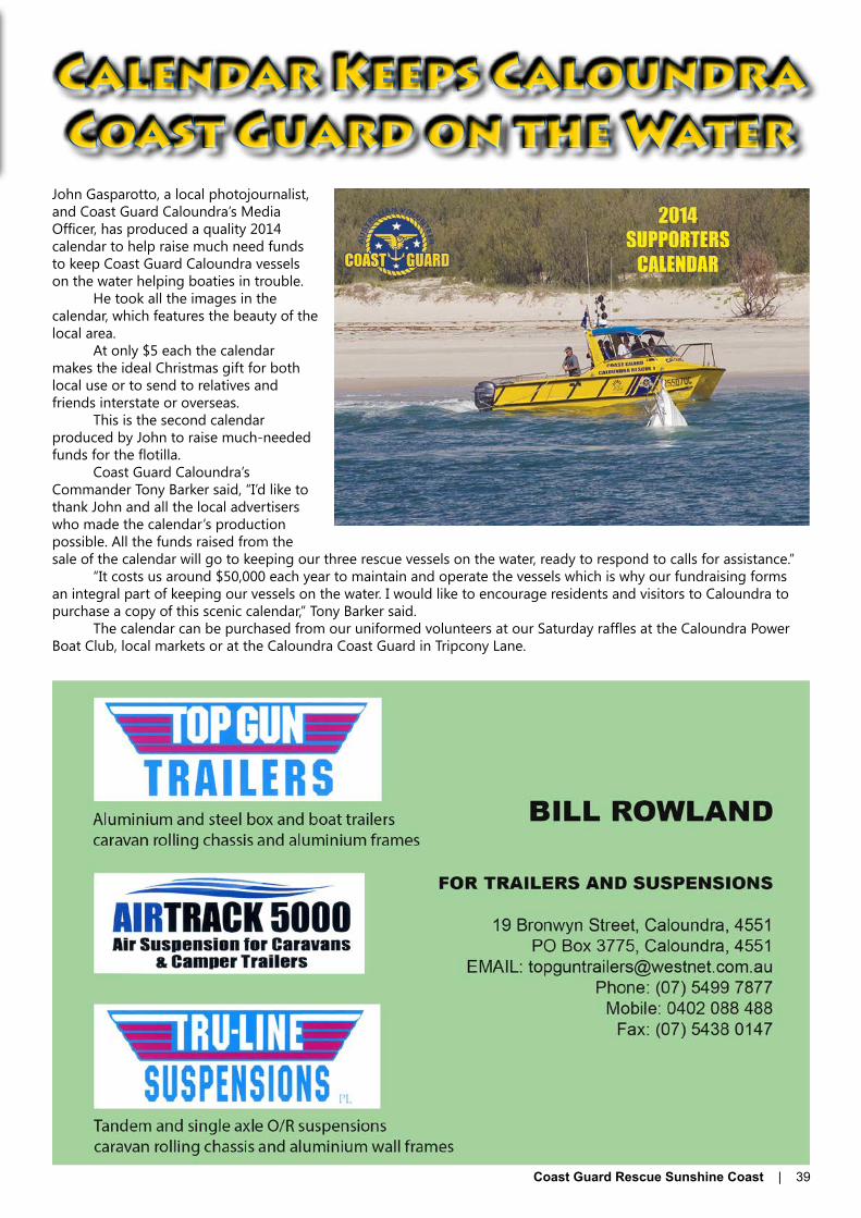
Coast Guard Rescue Sunshine Coast | 39
John Gasparotto, a local photojournalist, and Coast Guard Caloundra’s Media Officer, has produced a quality 2014 calendar to help raise much need funds to keep Coast Guard Caloundra vessels on the water helping boaties in trouble.
He took all the images in the calendar, which features the beauty of the local area.
At only $5 each the calendar makes the ideal Christmas gift for both local use or to send to relatives and friends interstate or overseas.
This is the second calendar produced by John to raise much-needed funds for the flotilla.
Coast Guard Caloundra’s Commander Tony Barker said, “I’d like to thank John and all the local advertisers who made the calendar’s production possible. All the funds raised from the sale of the calendar will go to keeping our three rescue vessels on the water, ready to respond to calls for assistance.”
“It costs us around $50,000 each year to maintain and operate the vessels which is why our fundraising forms an integral part of keeping our vessels on the water. I would like to encourage residents and visitors to Caloundra to purchase a copy of this scenic calendar,” Tony Barker said.
The calendar can be purchased from our uniformed volunteers at our Saturday raffles at the Caloundra Power Boat Club, local markets or at the Caloundra Coast Guard in Tripcony Lane.
Calendar Keeps Caloundra Coast Guard on the Water

40 | Coast Guard Rescue Sunshine Coast
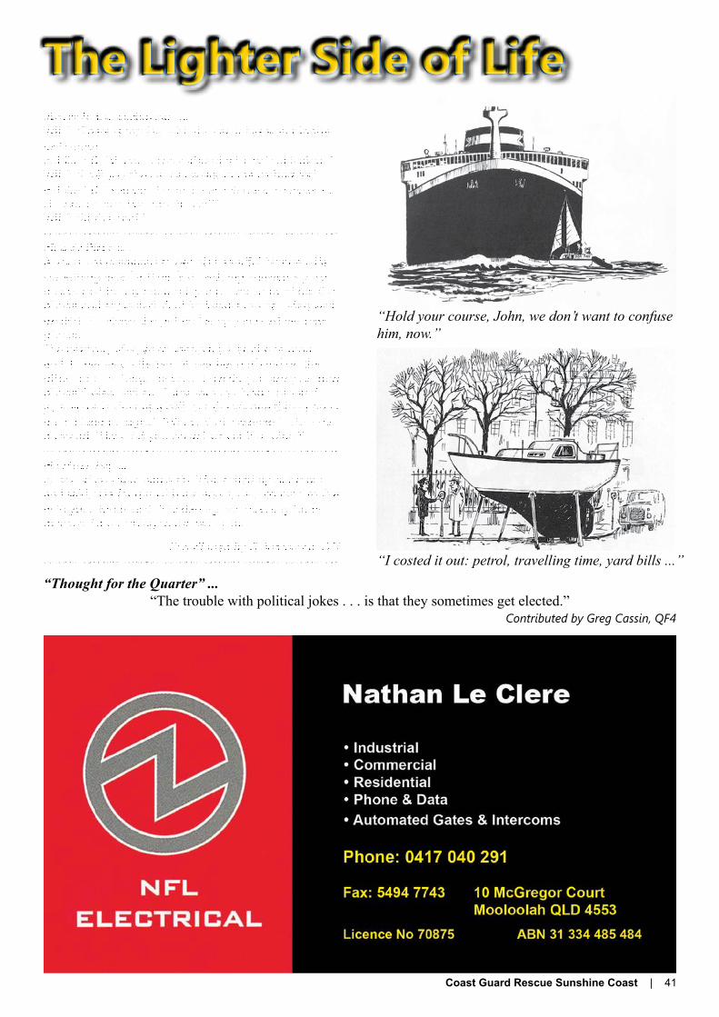
Coast Guard Rescue Sunshine Coast | 41
The Lighter Side of LifeWater in the carburetor ...WIFE: “There is trouble with the car. It has water in the carburetor.”HUSBAND: “Water in the carburetor? That’s ridiculous.“WIFE: “I tell you the car has water in the carburetor.”HUSBAND: “You don’t even know what a carburetor is. I’ll check it out. Where’s the car?”WIFE: “In the pool.”-------------------------------------------------------------Mobile Phones ...A young man wanted to get his beautiful blonde wife something nice for their first wedding anniversary. So he decided to buy her a cell phone. He showed her the phone and explained all of its features to her. Meg was excited to receive the gift and simply adored her new phone.The next day Meg went shopping. Her phone rang and, to her astonishment, it was her husband on the other end. “Hi Meg,” he said, “how do you like your new phone?” Meg replied, “I just love it! It’s so small and your voice is clear as a bell, but there’s one thing I don’t understand though...” “What’s that, sweetie?” asked her husband. “How did you know I was at Wal-Mart?”-------------------------------------------------------------He Must Pay ...Husband and wife had a tiff. Wife called up her mom and said, “He fought with me again, I am coming to live with you.” Mom said, “No darling, he must pay for his mistake. I am coming to live with you.”
Contributed by G Boardman, QF6-------------------------------------------------------------
“Hold your course, John, we don’t want to confuse him, now.”
“I costed it out: petrol, travelling time, yard bills ...”“Thought for the Quarter” ...
“The trouble with political jokes . . . is that they sometimes get elected.”Contributed by Greg Cassin, QF4

42 | Coast Guard Rescue Sunshine Coast
QF21 SANDY STRAIT•
QF17 TIN CAN BAY•
QF5 NOOSA •
QF6 MOOLOOLABA •
QF4 CALOUNDRA •
QF4 CALOUNDRACommander: Tony Barker - 0439 913 533Deputy Commander: Peter Vaughn - 0439 913 522Base: Phone 07 5491 3533 | Fax 07 5491 7516Email: [email protected]: PO Box 150, Caloundra, QLD 4551Location: Tripcony Lane, Caloundra off Maloja AvenueHours of Operation: Weekdays 0530 - 1200 | Weekends/Public Holidays 0530 - 1700Radio Call Sign: VMR404 or Coast Guard CaloundraRadio Frequencies Monitored: VHF 16, 73 | 27MHz 88, 91Area of Operation: Offshore waters north to Point Cartwright, south to approximately halfway down Bribie Island and 40nm to seaward
QF5 NOOSACommander: John Milland - 0403 339 050Deputy Commander: Alan Hall - 0416 046 790Base: Phone - 07 5474 3695 | Emergencies - 07 5449 7670Email: [email protected]: PO Box 274, Tewantin, QLD 4565 Location: Russell St, Munna Point in the Noosa River Caravan ParkHours of Operation: 24/7 | 365 daysRadio Call Sign: VMR405 or Coast Guard NoosaRadio Frequencies Monitored: VHF 16, 22, 80 | 27MHz 88, 91Area of Operation: The entire Noosa River and its lakes; Offshore waters north to Double Island Point, south to Point Arkwright and 50nm to seaward.QF6 MOOLOOLABACommander: John Annabell - 0412 545 600Deputy Commander: Ian Hunt - 0411 351 001Base: Phone - 07 5444 3222 | Email: [email protected]: 65 Parkyn Parade, Mooloolaba, QLD 4557Location: In the boat ramp carpark, Parkyn Parade at 26° 41.1’ S / 153° 07.6’ EHours of Operation: 365 days 0600 - 2200 | 2200 - 0600 Night watch (CH 16)Administration Hours: Monday, Wednesday, Friday 0800 - 1200Radio Call Sign: VMR406 or Coast Guard MooloolabaFrequencies Monitored: VHF 16, 67, 73, 80 | 27MHz 88, 90 | MF/HF 2182Area of Operation: North to Point Arkwright, south to Point Cartwright and 50nm to seaward
QF17 TIN CAN BAYCommander: Colleen Johnson - 0402 037 319Deputy Commander: John Van Der Heijde - 0447 166 906Base: Phone - 07 5486 4290 | Fax - 07 5486 4568 | Mob - 0419 798 651Email: [email protected]: PO Box 35, Tin Can Bay, QLD 4580Location: In the boat ramp carpark, Norman Point at 25° 54’ S / 153° 00’ EHours of Operation: 0600 - 1800 dailyRadio Call Sign: VMR417 or Coast Guard Tin Can BayFrequencies Monitored: VHF 16, 67, 80, 82 | 27MHz 88, 90Area of Operation: Tin Can Inlet & adjacent creeks; Great Sandy Strait north to S38; Offshore waters north to Indian Head, south to Double Island Point & 50nm to seaward
QF21 SANDY STRAITCommander: Jukka Manttari - 0417 199 070Deputy Commander: Don Archer - (07) 4129 8803Base: Phone 07 4129 8141 | Fax 07 4129 8907Email: [email protected] | Operations - [email protected]: PO Box 341, Maryborough, QLD 4650Location: 126 Eckert Rd, BoonoorooHours of Operation: 0700 - 1800 daily | 1800 - 0700 Duty Skipper on callRadio Call Sign: VMR421 or Coast Guard Sandy StraitRadio Frequencies Monitored: VHF 16, 80, 82 | 27MHz 88, 90Area of Operation: Great Sandy Strait south to Kauri Creek and north to McKenzie’s Jetty; Mary River up to the Barrage
Squadron Contacts
Coast Guard Rescue Sunshine Coast | 43
Coast Guard Caloundra Contact List Headquarters 5491 3533 For Boating Assistance 0429 913 533 Fax 5491 7516 Postal Address PO Box 150 Caloundra 4551 E-Mail (General enquiries) [email protected] National Web Site www.coastguard.com.au Facebook www.facebook.com/caloundravolunteer coast guard-QF4
Executive Commander Tony Barker
[email protected] 0439 913 533
Deputy Commander Peter Vaughan [email protected] 0439 913 522
Training Officer Graeme McKenzie [email protected] 0458 913 522
Administrative Officer Christine Carter [email protected] 0488 913522
Purser Verity Hingston [email protected] 0429 999 620
Section Leaders Associate Membership Anne Hawkins 0418 180 439 Assistant to FTO Don Wilkie 0404 511 283 Flotilla Operations Manager Alan Hingston 5491 3533 Boat Maintenance Ben Davis 0412 111 145 Building Maintenance Worric Smith 0419 700 994 Counter Disaster Liaison Graeme Sloan 0417 791 147 First Aid Alan Drabble 0409 678 036 Fund Raising Coordinator Chris Easy 0429 998016 Grants Rod Adams 5491 3533 Workplace Harassment F Anne Hawkins 0429 998016 Workplace Harassment M Rod Adams 5491 3533
IT Maintenance Daniel Mullins [email protected] 0413 552 575
Regular Membership Ross Johnstone 0407 576 237 Memorial Wall Christopher Mullins 0439 913 333 Media Liaison/ Rescue Magazine QF4 Editor John Gasparotto 0439 913 501
Rescue Magazine QF4 Advertising Greg Cassin 0408 759 421
Radio Section Leader Christine Carter 0488 913 522 Stores Tom Harrison 0429 998 016 WH&Safety Christopher Mullins 0439 913 333
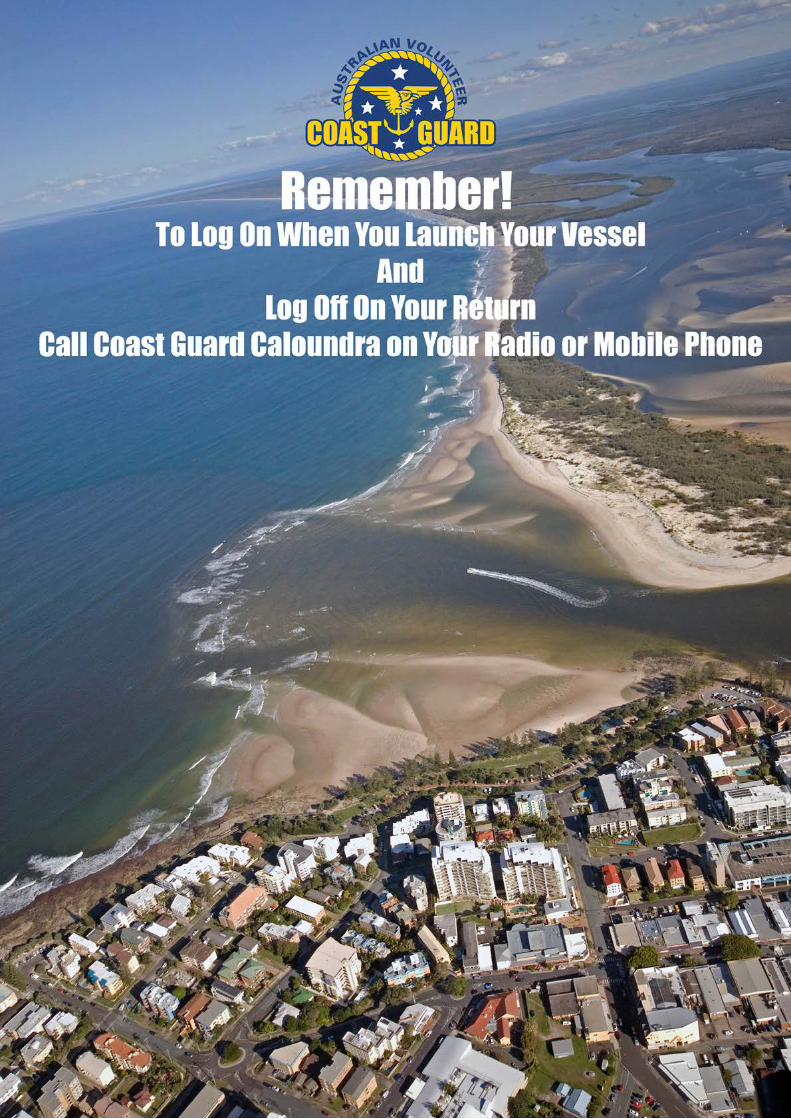
44 | Coast Guard Rescue Sunshine Coast
Related Documents