SOCIAL AND SPATIAL CHARACTERISTICS OF COMMUNITY GARDEN PLACEMENT IN MADISON, WISCONSIN by Robert Greene A thesis submitted in partial fulfillment of the requirements for the degree of Master of Science in Landscape Architecture College of Agricultural and Life Sciences at the UNIVERSITY OF WISCONSIN-MADISON 2012

Welcome message from author
This document is posted to help you gain knowledge. Please leave a comment to let me know what you think about it! Share it to your friends and learn new things together.
Transcript
SOCIAL AND SPATIAL CHARACTERISTICS OF COMMUNITY
GARDEN PLACEMENT IN MADISON, WISCONSIN
by
Robert Greene
A thesis submitted in partial fulfillment of the requirements for the degree of
Master of Science
in
Landscape Architecture College of Agricultural and Life Sciences
at the
UNIVERSITY OF WISCONSIN-MADISON
2012

Thesis approved by:
______________________________
Janet Silbernagel Date
Major Professor

i
TABLE OF CONTENTS TABLE OF CONTENTS ........................................................................................................................ i
LIST OF FIGURES ............................................................................................................................... iii
LIST OF PHOTOGRAPHS ................................................................................................................... v
LIST OF APPENDICES ....................................................................................................................... vi
ACKNOWLEDGEMENTS ................................................................................................................. vii
ABSTRACT ........................................................................................................................................ viii
1. Introduction and Background ..................................................................................................... 1
1.1 Urban Agriculture .................................................................................................................. 2
1.2 Community Gardens ............................................................................................................... 5
1.3 Madison Area Community Gardens ....................................................................................... 6
2. Research Questions and Approach ............................................................................................. 9
2.1 Questions ................................................................................................................................ 9
2.2 Study Approach and Scope ................................................................................................... 11
2.2.1 Geographic Analysis Framework ................................................................................. 11
2.2.2 Site Suitability Framework ........................................................................................... 12
2.3 Organization of Study ........................................................................................................... 15
3. Methods and Results .................................................................................................................. 17
3.1 Participatory Study: McCormick Community Garden ......................................................... 20
3.1.1 Results and Discussion ................................................................................................. 28
3.2 Neighborhood Surveys.......................................................................................................... 36
3.2.1 Results and Discussion ................................................................................................. 40
3.3 Citizen Surveys at the Dane County Farmer’s Market ......................................................... 43
3.3.1 Results and Discussion ................................................................................................. 45
3.4 Analysis of City of Madison Plans and Documents .............................................................. 48
3.4.1 Results and Discussion ................................................................................................. 51
3.5 Archival Research at the Community Action Coalition ........................................................ 65
3.5.1 Results and Discussion ................................................................................................. 67
ii
3.6 Interviews ............................................................................................................................. 75
3.6.1 Results and Discussion ................................................................................................. 76
3.7 Spatial Analysis using GIS ................................................................................................... 95
3.7.1 Results and Discussion ............................................................................................... 101
4. Summary of Results and Findings .......................................................................................... 117
4.1 Assumptions and Limitations .............................................................................................. 123
5. Conclusion ................................................................................................................................. 127
5.1 Guidelines for Community Garden Placement and Implementation .................................. 127
5.2 Future Directions ............................................................................................................... 132
References .......................................................................................................................................... 135
iii
LIST OF FIGURES
Figure 1 - Study Area ................................................................................................................ 7
Figure 2 - Madison Urban Area and Community Gardens ....................................................... 7
Figure 3 - Spatial Optimization and Community Gardens ..................................................... 14
Figure 4 - Data synthesis and application to research questions ............................................ 20
Figure 5- McCormick Garden and Eken Park Neighborhood ................................................ 21
Figure 6 - McCormick Garden site and road plans ................................................................. 22
Figure 7 - McCormick Garden site, canopy cover and stream bank ...................................... 24
Figure 8 - Solar evaluation of McCormick Garden site .......................................................... 29
Figure 9 - Soils analysis, McCormick Garden site ................................................................. 31
Figure 10 - McCormick Garden survey responses ................................................................. 34
Figure 11 - Map of gardens with neighborhood surveys ........................................................ 37
Figure 12 - Allied Drive Gardens site sketch, New Garden Fund Application ...................... 38
Figure 13 - Eastmorland Garden site sketch, New Garden Fund application ......................... 39
Figure 14 - Neighborhood survey results................................................................................ 40
Figure 15 - Downtown Community Gardens Group focus area ............................................. 43
Figure 16 - Relative locations of Reynolds and Eagle Heights Gardens ................................ 46
Figure 17 - Park hierarchy and service area, 1977 .................................................................. 52
Figure 18 - Garden placement factors in 1999 community gardens action plan .................... 56
Figure 19 - New Garden Fund application scores .................................................................. 68
Figure 20 - Ranked New Garden Fund decision model .......................................................... 71
Figure 21 - Reindahl Garden and median household income ................................................. 73
Figure 22 - Interview themes and key terms ........................................................................... 76
iv
Figure 23 - Map of Sheboygan Garden and relocation narrative ............................................ 83
Figure 24 - Map of model placement gardens ........................................................................ 86
Figure 25 - Cluster of community gardens along railroad tracks and open space corridors .. 90
Figure 26 - Quann Garden and cluster of gardens in an area of low income ......................... 93
Figure 27 - Canopy density at 24 garden sites ........................................................................ 98
Figure 28 - Community gardens and public transit .............................................................. 102
Figure 29 - Community gardens and bicycle/pedestrian corridors ....................................... 103
Figure 30 - Proposed urban agriculture corridor and pedestrian connectivity ...................... 104
Figure 31 - Community gardens and weighted overlay of social factors ............................. 106
Figure 32 - Results of weighted overlay ............................................................................... 106
Figure 33 - South side garden cluster and weighted overlay ................................................ 107
Figure 34 - Results of south side cluster overlay .................................................................. 107
Figure 35 - Community garden plots and population density............................................... 109
Figure 36 - Individuals on the 2010 waiting list for Atwood Garden ................................... 110
Figure 37 - Persisting community gardens created from 1950-1998 .................................... 112
Figure 38 - Graph of garden plot creation over time ............................................................ 113
Figure 39 - Persisting community gardens created from 1950-2005 .................................... 114
Figure 40 - Persisting community gardens created from 1950-2010 .................................... 115
Figure 41 - Final set of placement factors ............................................................................ 119
Figure 42 - Community garden placement factors and relevance to scale ........................... 122

v
LIST OF PHOTOGRAPHS
Photo 1 - McCormick Garden and pavement removal ........................................................... 23
Photo 2 - Solar Pathfinder ....................................................................................................... 26
Photo 3 - McCormick Avenue filled with soil ........................................................................ 32
Photo 4 - Eastmorland Community Garden ............................................................................ 39
Photo 5 - Atwood Community Garden and bike path............................................................. 87
Photo 6 - Eastmorland Community Garden and stormwater drainage ................................... 88
Photo 7 - Aerial view of Quann garden site situation ............................................................. 91

vi
LIST OF APPENDICES
Appendix A - Community Gardening Project Survey .......................................................... 140
Appendix B - Neighborhood Survey Responses .................................................................. 141
Appendix C - Downtown Community Gardens Survey Form.............................................. 142
Appendix D - New Garden Fund Application ...................................................................... 143
Appendix E - Criteria Evaluation of New Garden Fund Applications (New Gardens)........ 150
Appendix F - Criteria Evaluation of New Garden Fund Applications (New and Expanded
Gardens) ................................................................................................................................ 151
Appendix G - 2005 New Garden Fund Application Summaries and Notes ......................... 152
Appendix H - Participant Description and Consent Form .................................................... 153
Appendix I - Community Garden Database.......................................................................... 155
Appendix J - Reclassification Table for Weighted Overlay of Social Factors ..................... 159
vii
ACKNOWLEDGEMENTS
This research process was a complex and, at times, challenging endeavor. Yet it
remained consistently fascinating and, with the help of many individuals and organizations,
evolved into a unique study. For this, I am forever grateful to my advisor, Janet Silbernagel,
whose counsel, flexibility, and enthusiasm provided a reliable source of inspired guidance. I
am also incredibly appreciative of the assistance and creative thinking that my committee
members, Sam F. Dennis and Alfonso Morales were able to offer me. Their conceptual
contributions to this study were significant. David Hart was incredibly gracious in filling in
as a committee member when the need arose, and was a great mentor throughout the study.
Vincent Smith was also a wonderful mentor, and I was amazed by his insatiable curiosity and
devotion to his work. I feel truly fortunate to have collaborated with him. Beyond the
confines of campus, my family and friends were an unbelievable source of support to me,
and were instrumental in pushing me through long winters and distracting summers.
I am also greatly in debt to the Community Action Coalition of South Central
Wisconsin, and in particular Joe Mathers, for the incredible insight, decades of experience,
and captivating narrative that they were able to provide. Likewise, I am thankful for the
Madison Downtown Community Gardens Group for allowing me to participate in their work.
Their persistence and determination was moving. I also thank all of my interview
participants and community garden registrars for their contributions.
Finally, I’d like to thank all of the community gardeners and garden organizers in the
Madison Area for working toward a dynamic, healthy landscape and providing such an
intriguing research topic!

viii
ABSTRACT
Over the past decade communities throughout the U.S. have demonstrated growing
interest in urban and peri-urban agriculture. Community gardens comprise a significant
component of this phenomenon, and are often cited as a catalyst for environmental health,
community food security, neighborhood beautification and social justice. Despite
widespread investment in community gardens, there are very few communities that have
developed and adopted an organized framework for the selection or allocation of land for
community gardening. The purpose of my study is to identify the issues and embedded
factors that might influence such a framework in the context of Madison, Wisconsin.
I use grounded theory and a mixed-methods approach to investigate issues that are
considered in planning for new community gardens. An iterative research process consisting
of interviews, surveys, participation, and archival research is employed to delineate the most
influential factors in the placement of community gardens in the social and physical
landscape. These factors are then represented spatially using a geographic information
system, and analyses are performed comparing placement factors to the locations and spaces
occupied by existing community gardens.
Results suggest a broad set of factors influencing the selection of land for community
gardens. The increasing scarcity of vacant land and underutilized open spaces in the Madison
Urban Area has fostered the development of community garden sites that do not necessarily
correspond with optimal social and physical conditions. This complex, changing landscape
created a research environment rich with multiple perspectives and narratives, and thus
provided for a deepened perspective into the relationships between community garden sites
and the issues that influence their placement.

1
1. Introduction and Background
It is estimated that almost eighty percent of the United States’ population resides in
urban areas1(U.S. Census Bureau, 2000). This population places immense pressures on the
ecological, social and economic systems that support it. For the last century, cities of various
sizes and the neighborhoods embedded within them have dealt with these pressures through
the development of a vast array of planning schemes, policies, and community organizing
initiatives. Because these strategies must address a wide range of concerns over
environmental health, social justice and economic equity, it is reasonable to suggest that
holistic approaches to problem solving and policy making can provide an avenue to
synthesize these issues. Due to their range of impacts on social, economic and environmental
qualities, our urban food systems offer an opportunity to explore such holistic approaches.
The ways in which we produce, distribute, access and consume food can be examined
from multiple social and environmental perspectives. Therefore food systems provide a
logical occasion to address a spectrum of issues in a more comprehensive manner. In
particular, the related ideas of community food security and food citizenship present many
questions concerning the environmental and socio-economic resiliency of urban
communities. Community food security (CFS) and food citizenship conceptualize
communities in which all persons have local access to nutritionally adequate, culturally
appropriate food, and engage in the discourse concerning that access (Anderson and Cook,
1999; Wilkins, 2005;Winne, Joseph and Fisher, 1998). Accomplishing the goals identified in
1Urban areas include all urbanized areas (over 50,000 population) and Urban Clusters (2,500 to 49,999 population) as defined by the U.S. Census Bureau in the 2000 Decennial Census.
2
these movements in the context of urban communities requires holistic strategies that are able
to address the problems of food production, access and consumption. One such strategy is
the cultivation of food in urban areas.
1.1 Urban Agriculture
Food production within urbanized areas is commonly referred to as urban and peri-
urban agriculture (UPA). Although there are many definitions of UPA, perhaps the most
authoritative definition has been set by the Community Food Security Coalition (CFSC), a
North American coalition of close to 300 organizations committed to various initiatives
focusing on CFS. The CFSC’s urban agriculture committee has adopted the following
definition, proposed by Bailkey and Nasr (1999): “Urban agriculture is the growing,
processing, and distributing of food and other products through intensive plant cultivation
and animal husbandry in and around cities” (p. 6).While this broad definition encompasses
activities that urban populations have engaged in for centuries, there has been an increase in
the visibility of UPA in the U.S. over the past two decades (Mougeot, 2006), much of which
can be tied to the benefits often attributed to UPA initiatives.
Perhaps the most obvious benefits of UPA are related to the actual food that is
produced. UPA has been cited as a significant source of fresh produce in areas with poor
access to fresh food (Allen, 1999; Altieri et al., 1999; Dubbeling and Zeeuw, 2011). Where
significant quantities of food are produced, UPA may also involve commercial distribution
through community supported agriculture (CSA) shares, or at farmer’s markets, thus
providing economic benefits (Kaufman and Bailkey, 2000). UPA has also been linked to the
growth of community organization and empowerment (Baker, 2004; Brown and Jameton,
3
2000), and environmental remediation in degraded areas (Brown and Jameton, 2000; Hough,
2004).
Urban planners, designers and researchers have responded to these positive impacts
by attempting to facilitate UPA. Some have devised physical design scenarios to incorporate
food production into the urban fabric. Ebenezer Howard’s Garden Cities of Tomorrow
(1902) offers an idealist vision of the city in which senses of both town and country co-exist
through a self-contained balance of land uses, including green “belts” intended for
agriculture. A similar conceptual design is presented by Viljoen (2005), in which UPA can be
implemented in green space corridors that transect entire cities, creating a continuous,
productive urban landscape.
For the most part these schemes have not proliferated, largely because the policies
and structure of urban plans have not reached maturity in their accommodation of food
production (Lovell, 2010; Voigt, 2011).Therefore it is reasonable to suggest that support
through municipal policy and planning practice are necessary to facilitate the integration of
UPA into urban landscapes. However, with the exception of the last decade, food production
has not been widely recognized as a prominent component of urban systems in the United
States. Kameshwari and Kaufman (1999) point to a fundamental reason for this lack of
recognition in the perceived contrast between urban and rural environs, the latter being
traditionally associated with agriculture. This distinction then led to the identification of
certain issues as “quintessentially urban” (Kameshwari and Kaufman, 1999. p. 214). Food
production was not one of those issues.
The rift between urban and rural partially explains why those individuals and
agencies that arrange the landscape upon which UPA occurs did not incorporate UPA into

4
formal practice and policy until about a decade ago. In response to inquiries posed by
Kameshwari and Kaufman (2000) about this absence, planners alluded to the idea that food
systems are not a traditional planning sector, and therefore present problems when introduced
into planning practice.
It is precisely these problems, and the efforts of researchers and planners to resolve
them, which have resulted in the formation of policies that attempt to facilitate UPA. Such
policy relies heavily on the availability of land for such purposes. Winne (2008) stresses the
importance of the allocation of land for UPA, and the procurement of tenure agreements (68).
Hough (2004) also suggests that a healthy local food system requires that food
production at various levels becomes “an integral part of the city’s open space and park
functions” (pg. 169), and that the structures of food production spaces, both physical and
social, need to adapt as their productive value is recognized.
Recently the facilitation of UPA has been manifest in pre-emptive measures to avoid
the barriers that land scarcity poses. Cohen (2007) notes the creation of a pre-set agricultural
role for developments, where land is allocated for food production prior to development.
While there have been numerous broad recommendations put forth to facilitate UPA,
policies and plans that emerge from such broad proposals remain ambiguous in relation to the
wide range of UPA activities that occur. The definition of urban agriculture offered by the
CFSC included such forms of UPA as animal husbandry, which may be considered noxious
compared to other UPA activities such as gardening. For effective integration into urban
planning and community design, a more nuanced understanding of particular forms of UPA
is necessary.

5
1.2 Community Gardens
One of these forms is that of the community garden. The community garden (CG) is a
particularly interesting type of UPA as it is a multi-functional phenomenon: each CG varies
in form and purpose across communities (Lawson, 2005; Spirn, 1990).CGs are also
significant as a topic in food systems research as they have a rich and diverse history
contributing to CFS and multiple other food system initiatives in the United States (Lawson,
2005).
Like UPA in general, CGs have been linked with a wide range of benefits to
individuals, communities and the environment. Benefits include therapeutic value (Hale et
al., 2011), improvements in nutrition (Alaimo, et al., 2008), multi-cultural interaction (Baker,
2004), improved access to food (Wakefield, Yeudall, Taron, Reynolds and Skinner 2007),
and neighborhood revitalization (Voicu and Been, 2008).Such variation in the roles that CGs
may play results in the constant cultivation of social, intellectual, economic and political
values within the garden sites, and the subsequent attachment of multiple meanings to those
spaces (Feenstra, 2002).CGs exist in almost every American city, and yet are so embedded in
the values and motivations of those that participate in them that each CG maintains a unique
form and function (Lawson, 2005).
The cumulative effect of all these various functions and qualities makes the
classification of CGs into discrete categories a particularly difficult task. The same
difficulties apply to attempts to achieve an authoritative definition of a CG. In light of this,
perhaps the most appropriate definition of a CG is one that is sufficiently broad to act as a
container for the myriad types of CGs. In her thorough analysis of community landscape
improvements in West Philadelphia, Spirn (1991) offers such a definition: “A community

6
garden is where a group of people garden together on commonly occupied land, dividing
responsibility for maintenance of common areas” (p. 17). In discussion of my study area I
narrow this definition to several forms of community gardening: public community gardens,
food pantry gardens and school gardens.
Because delineating what a CG is, much less what it does, actually proves to be quite
complicated, their incorporation into urban planning and policy is problematic.
Understandings of CGs are bounded by the context of their surrounding social, economic and
political structures, thus it is more manageable to study such phenomenon within the extent
of a particular community.
1.3 Madison Area Community Gardens
Madison, Wisconsin is a fitting example of the UPA movements that I have discussed
so far. A robust network of community groups, non-profit organizations and administrative
committees has formed in the past decade to promote local food systems, CFS, and UPA.
Community gardening is one of the most prolific UPA activities in the Madison area. My
study focuses on fifty community gardens in the Madison Urban Area (MUA), as defined by
the U.S. Census Bureau.

7
Figure 1 - Study Area
Figure 2 - Madison Urban Area and Community Gardens

8
I define CGs in the Madison area as publicly accessible, communally gardened land,
which may be arranged in the form of individual or family plot assignments, children’s
gardens, educational gardens, and food pantry gardens. These forms are not mutually
exclusive, and are commonly combined on individual parcels of land to enhance
functionality and diversity. While individuals from the surrounding community may tend to
individual garden plots, a CG may also include growing spaces devoted to food pantry
contributions or educational growing plots for children’s programs. The intended programs
and functions of a CG in its formative period can have a significant connection to the demand
and support for the creation of a garden.
As these programs and functions for CGs in Madison have expanded over the past
decade, establishment of sites for CGs has grown exponentially. I define a CG site as the land
occupied by CG plots, and any surrounding spaces that are used by gardeners to access plots
or for community functions such as gathering spaces or tool sheds. An increase in the
quantity and space of these sites is particularly evident in the past five years, as more
collaborative and creative processes for identification of CG sites and their development have
been explored. As of 2010, there were fifty-five CGs recognized by a regional non-profit
organization and recognized authority on CGs, the Community Action Coalition of South
Central Wisconsin (CAC). Depending on what criteria are used to distinguish a CG from
other forms of UPA, that number is likely much larger. Numerous communal gardens have
sprouted in vacant spaces adjacent to housing complexes, schools, churches, and
underutilized city land in recent years, and many of these gardens have not been documented
or recognized by municipalities and organizations involved with CGs.
9
Despite this expansion in CG space, demand for CG plots remains high as
neighborhoods and institutions continue to recognize the impacts that CGs can have. While I
have discussed the body of research documenting those impacts of CGs on community, far
less attention has been paid to the reverse: how communities and individuals impact CGs. Of
particular interest is the influence that the decision-making process of CG participants and
advocates has on the placement of CG sites. The quantity and quality of land available for
UPA tends to be in a state of flux, and systems for identification of that land are not fully
developed. In light of this, I have explored where CGs have been placed on the landscape,
and through a deeper analysis, identified the most influential issues guiding their placement.
2. Research Questions and Approach
While my study touches on many aspects of community gardens, I focus my inquiry
on their placement and formation. The research proposal that initially guided my study
sought to identify a narrow set of environmental factors that invariably determined the
placement of CG sites. The primary research question was very strongly worded, and
ultimately flawed. Some background research quickly demonstrated that the diverse
placement of CGs on the landscape did not lend itself to a single explanation; in this case, a
fixed set of determinants. Thus a carefully worded revision was necessary. The following
questions are more considerate of the contextual nature of CGs, and serve as the main queries
for my research.
2.1 Questions
Primary Question: What are the most significant social and physical factors that
influence the placement of community gardens in the Madison Urban Area?
10
This question is intentionally broad to accommodate three significant issues. First,
placement of CGs can be influenced by both material features of the landscape and societal
attributes, and these factors are not mutually exclusive. Therefore the question presumes that
both deserve investigation.
Second, potential influences such as “accessibility” or “aesthetics” are not necessarily
confined to physical boundaries on the landscape. In light of this, the question makes no
distinction between factors of individual community garden sites and those of the sites’
surrounding neighborhoods.
Finally, social factors can include concepts that span a spectrum of tangibility, from
measurable attributes of a community’s population to more abstract notions such as a
community’s motivations to garden. Accordingly, the broad term “social” is used in favor of
more limiting terms such as “demographic profile”.
To achieve greater precision in answering a question of such breadth, I ask the
following sub-questions.
Sub-question 1: What criteria are used in evaluating the proposed formation and placement
of a community garden?
Sub-question 2: What are the spatial attributes of current community gardens with respect to
placement criteria?
Sub-question 3: How do the criteria used in evaluating proposed community garden sites
compare with the attributes of current community gardens?
Because my primary question is concerned with identifying the most significant
factors influencing CG placement, as opposed to any and all factors, I use spatial evaluation
11
to triangulate the criteria that weigh heaviest in the CG placement process. This approach is
detailed in the following section.
2.2 Study Approach and Scope
The MUA is characterized by a patchwork of jurisdictional units, land uses, and a
diverse socio-economic landscape. Therefore the composition and configuration of CG sites,
and the physical and social landscapes they occupy, are heterogeneous. The resulting
complexity warrants a study that acknowledges both social and spatial dimensions of CG
sites. Two concepts are useful in understanding the inquiries and approach of my research:
geographic analysis and site suitability.
2.2.1 Geographic Analysis Framework
Questions of placement in the landscape are, by nature, geographic inquiries. Spatial
patterns in UPA provide insight into reoccurring features and attributes that define the
character of food production activities within a certain area. While I utilize a unique spatial
approach in my research, it should be noted that studies of the spatial dimensions of UPA
have already been conducted in a variety of ways.
Smit et al. (2001) suggested four zones of land that urban agriculture can occur on
based on the attributes of the land with respect to population density, existing land use, and
biophysical character. Geospatial analysis has also been applied to the study of temporal and
spatial variation in local food access (Ostry and Morrison, 2008), food consumption (Ostry,
et al., 2011), mapping of potential foodsheds (Peters, et al., 2009), and the modeling of land
requirements for diet-specific food production (Peters, et al., 2007). Vitiello and Nairn
(2009) utilized GIS to map garden sites in Philadelphia with respect to the socioeconomic
characteristics of the neighborhoods those CGs occurred in.

12
This attention to geographic pattern and the use of spatial analysis in food systems
research is increasing (Kremer and DeLiberty, 2011), yet many of these studies tend to focus
on large spatial extents, and are not fully considerate of the qualitative variables that
influence local food production or the character of individual sites. I intend to advance the
latter research topic in my study. One means of capturing this qualitative information through
a geographic perspective is to pair narratives concerning individual gardens or concentrations
of gardens with maps. This allows for an illustration of both garden placement on the
landscape and the issues that influenced that placement. Another method of examining the
spatial characteristics of CGs is to conduct analysis at the individual parcel level. The notion
of site suitability provides an appropriate lens for such an analysis.
2.2.2 Site Suitability Framework
In Closing the Food Gap: Resetting the Table in the Land of Plenty (2008), Mark
Winne asserts that “cities must make a serious commitment to providing land that is suitable
for gardening” (p. 68). This assertion is troubling in that it assumes that cities, and in
particular planners and policy makers, have a clear definition of what is “suitable”. In the
case of UPA, and CGs in particular, such a definition does not exist.
Site suitability is a concept that suggests that certain spaces have a set of conditions
or variables that are more appropriate for a particular use than another space’s set of
variables. Through this framework, suitability is largely determined by the layering of
variables or conditions over a particular space. Where variables exist in an optimum
condition for a particular use, that space is deemed most suitable. This is a practice that has
been institutionalized in landscape design and planning since Ian McHarg (1969)
championed the approach in Design with Nature. While it seems reasonable to apply the

13
concept of site suitability to potential CG spaces, such application has been largely absent in
scholarly research.
A noteworthy attempt was made by graduate students in Portland State University’s
School of Urban Studies and Planning. The students completed a project titled The Diggable
City (Balmer et al. 2005), which produced a robust inventory of land in Portland that might
be used for expanding the City’s community gardens program, or developing other types of
UPA. Along with this inventory was a report on criteria that could be used in the assessment
of a site’s suitability for UPA. The study was not exclusive to CGs, but open to many forms
of UPA.
In my research I borrow from the notions of both site suitability and geographic
analysis to help organize and frame the data I collect. It is helpful to think of this
combination through the framework of spatial optimization, whereby CGs are addressed in
terms of both optimal location and optimal allocation. In the case of my study, spatial
optimization translates into a problem that concentrates mutually on site suitability of a
parcel or space for a CG and geographic analysis of the CG site’s surrounding neighborhood.
Geographic analysis might examine a variety of land uses and social factors in a
neighborhood, and concentrate on allocation of land for gardening, while an assessment of
site suitability focuses on optimizing a garden location within a site.

14
Figure 3 - Spatial Optimization and Community Gardens
In this manner I am able to study the placement of a CG on multiple scales. At the
parcel level, I examine site attributes, while on neighborhood and regional scales I am able to
examine a broader patchwork of social conditions and community infrastructure.
In his discussion of spatial optimization problems in landscape planning and design,
Goodchild (2010) describes two key features of such problems that further explain this
approach. The first is that the problem has a “solution space that is defined by the solution
variables” (p. 10). The solution space here would be the MUA, as defined by the solution
variables of social and physical placement factors on the landscape. The second feature is
that of the problem’s resolution, where “the final design will occupy one point in the solution
space.” (p. 11). Prior to this research, spatial relationships concerning CGs in the MUA had
not been thoroughly analyzed. Due to the dynamic and contextual nature of CGs in the
MUA, I do not attempt to locate specific “points in the solution space” for proposed CGs to
occupy. Instead, I seek to identify the most significant “solution variables” that would lead

15
to identification of such points. In the context of Goodchild’s discussion of optimization
problems, my study seeks to better explain how various placement factors, or variables, are
configured in the solution space. By focusing my research on this objective, I contribute to a
foundation for further development of CG optimization problems and solutions.
To do this, I conduct my analysis at multiple levels to gain a more nuanced
understanding of CG placement. By supplementing spatial queries at neighborhood and
regional scales with detailed, parcel-level data, my study allows for extrapolation from
observations of individual CGs to generalization at a landscape scale.
2.3 Organization of Study
The approach I have discussed so far utilizes conceptual frameworks that are familiar
to the fields of landscape architecture, landscape ecology and urban planning. I adopted this
interdisciplinary lens to accommodate two key issues. First, there is growing interest in food
systems research among multiple academic fields, and a study that is applicable to multiple
disciplines may generate a novel discussion. Second, community gardens embody a wide
range of meanings, and are simultaneously an ecological and social phenomenon. An
interdisciplinary research affords the opportunity to study such multifunctional subjects.
To attain a well-formed understanding of these multiple meanings, I apply grounded
theory and constructivism to my research. Much of the data I collected is rooted in the views
and perceptions of individuals with varying backgrounds and experience. This means that the
results and subsequent generalizations I have arrived at are situated in a particular time and
space, and are, in some cases, based on subjective interpretations of individuals. This is
crucial to acknowledge when studying an evolving phenomenon that is also of interest to

16
practitioners. In my research I attempt to be sensitive to the changing nature of CGs;
however, it is also important to arrive at meaningful and useful conclusions.
To achieve this balance, I organized my study around a mixed-methods approach that
focuses on qualitative inquiry and spatial evaluation. Qualitative inquiry, in the form of
interviews, archival research and surveys was used to inform spatial analyses. As preliminary
data was collected, new inquiries arose, and research was modified through continuous
feedback. This created an iterative process that led to a large quantity of data, and ultimately
a distillation of that information into results and broad conclusions.
In the following chapters, individual methods are discussed, and paired with their
respective data. These data are then interpreted for results specific to individual methods,
and results are subsequently synthesized into a broader discussion answering my primary and
sub-questions. I conclude by highlighting the implications that this type of research can have
on community design and the implementation of UPA on the landscape, and offer
suggestions as to how planners and policy makers can better accommodate CGs in urban
areas.

17
3. Methods and Results
Research on community gardens in the MUA has been largely comprised of records
collection by local organizations that are involved in food systems, as well as surveys and
studies initiated by the City’s CGC. Furthermore, scholarly research on CGs within the
MUA is lacking, thus there is little precedent for research approaches to specific questions
about CG sites in my study area. Leedy and Ormrod (2005) have suggested that delineation
of research approaches require a concrete understanding of what the researcher intends to do
and what the researcher will not do. In some ways, a solid understanding of the latter was not
possible at the outset of this study. I had no basis for comparing the effectiveness of various
research methodologies in the context of CGs in the MUA.
While my research was bounded by a particular theoretical approach and thought
paradigm, there was some uncertainty in my initial methodological choices. This uncertainty
was exacerbated by a research environment that is in a state of constant change. Community
gardening projects are increasing in quantity in the MUA, and these activities are
characterized by significant social and spatial complexity.
Individuals and groups engage in communal gardening activities on multiple scales in
terms of geographic context and administrative structure. For example, an individual
community garden can be studied within the setting of a particular parcel of land, and its
successful establishment and active plots could be interpreted as a sign of effective CG
placement. However, the individuals that established a CG on that parcel may have
perceptions of the CG and its placement that differ from the surrounding neighbors, and city
agencies might feel that other locations in close proximity would be more favorable for a
garden. On a larger geo-political scale, city agencies might perceive the lease of that land as
18
part of a much broader land management scheme that involves regional decision making.
From an economic development perspective, CGs might not even be a priority land use in
that part of the community.
Due to this variation in experience, multiple perspectives arise on the appropriate
placement of CGs, each no more or less valid than another. A research approach that
concentrates on only one scale or social entity would not be sufficient to answer my primary
question and sub-questions.
This type of research environment complicates the acquisition, selection and
processing of data. Thus, unlike some of the research approaches to UPA I have discussed
that focus solely on spatial pattern or acute qualitative inquiry; my study necessitated a
stratified and at times complicated methodology. This was manifest through an iterative
approach in which the initial results of my methods informed the identification of additional,
necessary data collection.
I utilized seven discrete forms of data collection and analysis in my study:
1. Participation in the placement of a new community garden, including site analysis
and leasing negotiations.
2. Participation in a door-to-door neighborhood survey and evaluation of survey
results in other neighborhoods
3. Open-ended interviews conducted at the Dane County Farmer’s Market
4. A review of the City of Madison’s plans and documents pertaining to the
facilitation of community gardening
5. Archival research of Community Action Coalition records on community garden
establishment, loss and relocation

19
6. Semi-structured interviews with various individuals involved in the decision-
making process for community garden placement.
7. Spatial analysis using geographic information systems (GIS)
I did not collect data in a linear thread of procedures, but rather, used feedback loops
to triangulate meaningful information. For example, semi-structured interviews continually
influenced what information I found to be most useful in archival research. In turn, data
collected from archival research was used to guide ongoing spatial analyses. Thus data
collected from individual methods are best understood in conjunction. In order to represent
the relational nature of my methodology, this chapter illustrates the research process by first
pairing specific methods with their associated data, and then demonstrating how the various
data can be synthesized into results relevant to my research questions.

20
Figure 4 - Data synthesis and application to research questions
The initial step in the research process was a case study that involved participatory
research as a means of immersion in the local community gardening network. My
participation included aiding in the placement of a community garden site, while engaging in
the collaborative process used to secure both the property and neighborhood approval.
3.1 Participatory Study: McCormick Community Garden
From July-October, 2009, the Eken Park Neighborhood Association in the City of
Madison organized a collaborative team around the establishment of a new CG in their
neighborhood. The proposed garden site was located on the east side of the City of Madison.
It occupies a strip of green space on the margin of a neighborhood recreation area,

21
Washington Manor Park. The site is separated from the park by Starkweather Creek, a small
tributary of the Yahara Riverway.
Figure 5- McCormick Garden and Eken Park Neighborhood
Prior to the procurement of a lease and the development of the garden, the property
had a unique combination of land classification and public uses. The strip of green space was
classified as City of Madison Engineering Stormwater Utility (Property #533). This open
space was narrow, and was confined by Starkweather Creek to the west and McCormick
Avenue to the east. However, the city planned to remove pavement from a portion of the
street that connected to Aberg Avenue, and turn the remaining dead end street into a cul-de-
sac.
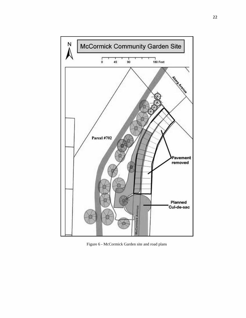
22
Figure 6 - McCormick Garden site and road plans
23
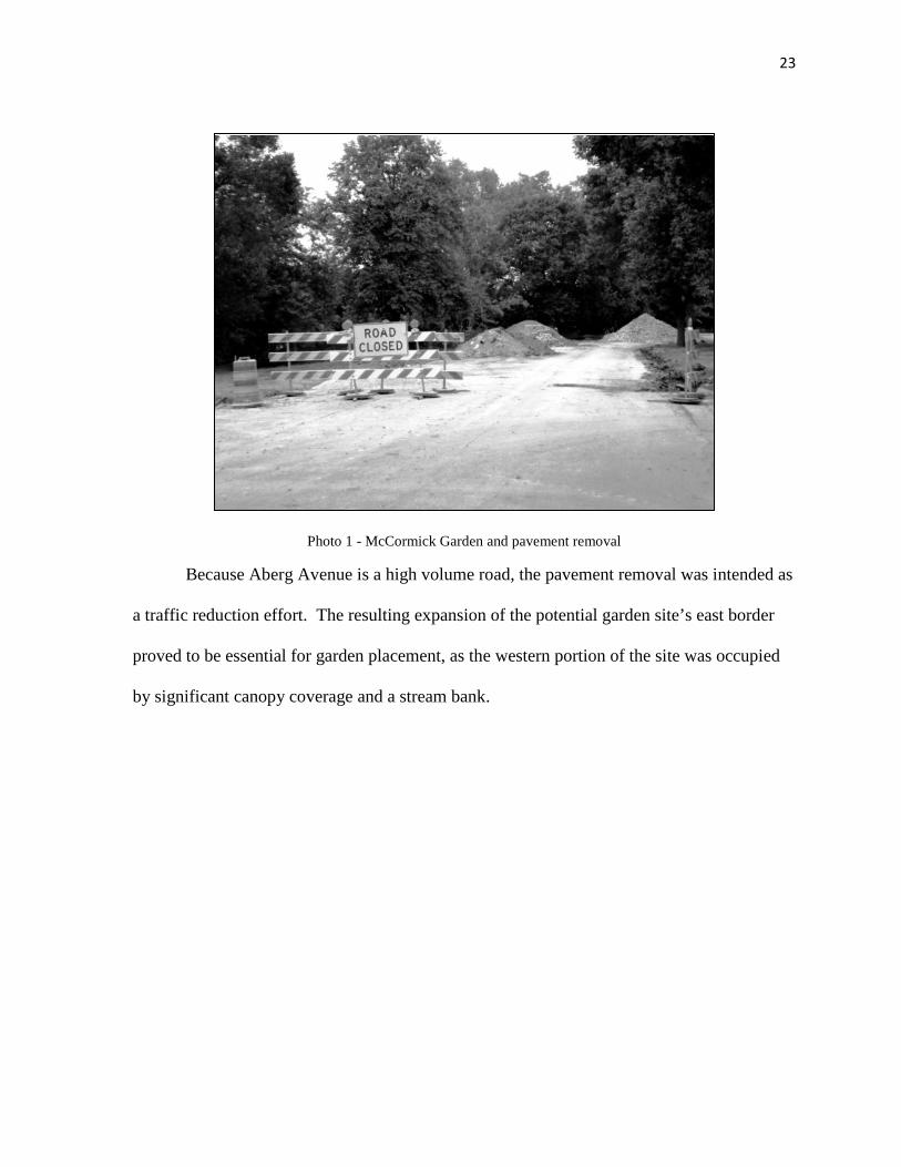
Photo 1 - McCormick Garden and pavement removal
Because Aberg Avenue is a high volume road, the pavement removal was intended as
a traffic reduction effort. The resulting expansion of the potential garden site’s east border
proved to be essential for garden placement, as the western portion of the site was occupied
by significant canopy coverage and a stream bank.

24
Figure 7 - McCormick Garden site, canopy cover and stream bank
The site for McCormick Garden is also situated within a neighborhood with a unique,
and as it turned out, significant demographic and socio-economic character. According to the
2000 U.S. Census, the surrounding block group had a median household income of $36,862

25
(USD), which was below the 2000 average for Dane County, but above the 2000 U.S.
poverty threshold. Within this block group, however, there are pockets of owner-occupied
households adjacent to pockets of renter-occupied, high density housing. Across McCormick
Avenue from the garden site is an apartment complex characterized by diverse
demographics, where tenants span a wide range of ages, and speak a variety of languages.
To better understand how this unique situation related to the garden placement and
formation process, I engaged in participatory research. The research involved collaboration
with the Eken Park Neighborhood Association, the City of Madison Engineering Division,
City of Madison Parks Division, and the Community Gardens Division of the CAC. I
participated by helping the neighborhood association and CAC community gardens
specialists to conduct a social and physical site analysis, organize lease agreement materials,
prepare garden funding application material, and conduct door-to-door surveys of
neighborhood residents.
The social and biophysical site analyses were conducted in July and August of 2009
to assess the opportunities for, and barriers to a CG on both the existing green space, and the
planned expansion of open space post-pavement removal. The analysis consisted of an
assessment of property type classification, assessment of current use and possible use
conflicts, potential garden user profiles, and measurements of the site’s biological and
physical properties.
Members of the neighborhood association and CAC personnel used the Solar
Pathfinder™ instrument from Civic Solar, Inc. to measure the duration of direct sunlight for
nine locations distributed around the site during the month of August.

26
Photo 2 - Solar Pathfinder
To conduct the solar shade analysis, the user looks down onto the instrument’s dome
to see a reflection of a panoramic view of the site. In the case of the McCormick garden site,
all of the obstacles to sunlight at the nine locations were seen in this reflection. A sun-path
diagram showing the sun's route through the sky for every month of the year and every hour
of the day at locations between 43° and 49° north latitudes was placed underneath the dome.
The outline of the reflected obstacles was then traced onto the diagram. In this way, the trees
on the site and their canopy could be assessed for their impact in nine different spots that had
potential for garden plots.
Because the initial garden plans included use of the soil that existed on-site, the soil
had to be tested for toxicity and pollutants. CAC personnel submitted soil samples from the
site on August 24th to the University of Wisconsin-Madison Soil and Plant Analysis Lab for
content assessment in parts per million (ppm) of twelve elements. Due to the site’s proximity
to Starkweather Creek, which is downstream from the Dane County Airport, there were also
27
concerns about potential pollutants in storm water runoff that would not appear in a heavy
metals test. Members of the neighborhood association contacted airport officials to discuss
the possible impacts of runoff containing de-icing fluid, which is used routinely on aircraft
and runways during winter months.
For the duration of the biological and physical site analysis process in August and
September, as well as during the lease procurement process in the months following,
discussion and collaboration with the City of Madison Engineering Department and the City
of Madison Parks Division was necessary to ensure approval of the garden proposal. I drafted
initial site plans and dimensions of potential plot spaces for review by the City of Madison
Engineering Division (Figures 6 and 7), and participated in a variety of meetings with
various city departments, CAC personnel and the neighborhood association to discuss
potential use-conflicts with other forms of recreation on or near the site. During this time I
helped facilitate communication between the neighborhood association and the city through
collaborative site plan revisions.
As site plans were approved and the information necessary for a lease agreement was
gathered, a final measure was necessary to gauge the neighborhood’s disposition toward a
CG. This was not an evaluation required by the City of Madison, but rather a step encouraged
by the CAC as a means of gaining a stronger vision of who would be using the garden, and
how much support there was for it. The assessment was a door-to-door survey that is also a
mandatory component of an application for funding from the New Garden Fund (NGF) grant,
which is a grant that garden organizers can apply for on a yearly basis to create and expand
CG projects. I discuss the NGF grant, its application, and the decision making process for
grant awards in greater detail in the section Archival Research at the Community Action
28
Coalition. To conduct the door-to-door surveys, the CAC provided a printed questionnaire
that inquired about neighborhood residents’ interest in a plot, and if they had any concerns or
comments about the proposed CG (Appendix A – Community Gardening Project Survey).
I assisted members of the neighborhood association and CAC personnel in surveying
51 residents living in the apartment complex and houses adjacent to the garden site. In groups
of two, we knocked on each door of two neighboring apartment buildings and three houses,
occupied by the original owners. We described the CG proposal to a household member
from each residence, and that member was provided with the survey questionnaire to fill out,
if they were willing. Due to the absence of some residents during our initial survey, two
additional afternoons of surveying were required. I then analyzed the completed surveys by
coding answers and comments into positive, negative and neutral responses. If a resident
expressed interest in having a garden plot I automatically interpreted that as a positive
response, regardless of whether or not they added further comments. If a resident did not
express interest in a plot, and had no comments, or had a comment that showed no signs of
support or opposition, I interpreted that as a neutral response. If a resident did not express
interest in a plot, and showed opposition or had concerns about potential impacts of the
garden, I interpreted that as a negative response. While I utilize the survey information as a
form of research data, it should be noted that it is also used by the CAC and the NGF panel to
gauge neighborhood disposition, demand for plots, and any major concerns that could serve
as obstacles in the garden formation process.
3.1.1 Results and Discussion
The results of this participatory research provide a wealth of information that helped
explain the current criteria that are used in placing a CG in the MUA. Our site analysis of

29
biological and physical conditions suggested that certain environmental factors were crucial,
in the initial selection of a site. In some ways, it appeared as though biological and physical
aspects had to be satisfied before further criteria in the placement of the garden could be
considered. The definition of “satisfactory”, however, has some flexibility.
The solar analysis of nine on-site locations demonstrated that certain parts of the site
did not receive much sunlight, even in the summer months. In fact, the mean duration of
direct sunlight for the site based on those nine locations was 4.83 hours.
Figure 8 - Solar evaluation of McCormick Garden site
In its description of site attributes for the location of CGs, The City of Madison
Advisory Committee on Community Gardens (1999) note that in northern climates, it is

30
crucial for CGs to have “an open south face to maximize the access of plants to sunlight”,
and that “vegetables need at least eight hours of sunlight a day” (p. 24) . While the
McCormick Site does have an open south face, it receives only a bit more than fifty percent
of recommended sunlight.
This result did not appear to worry the Eken Park Neighborhood Association or CAC
personnel. Instead, it spurred discussion of shade-tolerant plants, and potential actions that
could be taken in the garden design to maximize sunlight exposure. As it turned out, a large
tree at the southern end of the site was an unhealthy looking Ash (genus Fraxinus), and was a
potential target for the invasive beetle, the Emerald Ash Borer (Agrilusmarcopoli). The tree
would be removed, and consequently enhance solar exposure for the garden.
The combined solution to a lack of sunlight on the site provided initial evidence to a
preliminary finding of the study: CGs are placed in an opportunistic and adapted manner.
That is, conditions that enable the formation of a CG are often unique in their circumstance,
and garden sites can be designed to adapt to existing conditions.
The second factor of the physical environment that was tested, the site’s soil, had
satisfactory results. Out of twelve elements tested for in the soil samples, all were found to
have content within or below the common range in ppm.

31
Figure 9 - Soils analysis, McCormick Garden site
In addition, a member of the Eken Park Neighborhood Association was informed by
airport officials that the de-icing fluids that may pass by the site in Starkweather Creek are
not highly toxic, and trace amounts that might end up in the creek were negligible.
Had these results demonstrated toxic levels of certain elements, it is uncertain if the
neighborhood association of CAC would have pursued the garden creation process further.
McCormick Garden was in fact a second attempt at placing a CG in the neighborhood. The
group had previously attempted to site a CG in a large park at the western edge of the
neighborhood in 2008, but soil sample results on that site showed high levels of lead (Pb).
Abandonment of that proposal suggests that environmental factors such as soil quality, which

32
are so vital to the fundamentals of plant growth, might have a strong influence in the process
of CG placement.
However, placed in the context of adaptive site design, which was well-illustrated in
the case of McCormick Garden’s lack of sunlight, it is interesting to contemplate ways in
which the garden site might accommodate poor soil quality had it existed. Other CGs
throughout highly urbanized areas with industrial legacies in the United States have been
placed on sites with toxic soil, or in some scenarios, no soil at all. Healthy soil has been
imported onto sites, and experimentation in phytoremediation of soil through the use of
various plant species has also been explored (Hathaway and Langley, 2006; Heiger-Bernays,
et al., 2009).
Photo 3 - McCormick Avenue filled with soil

33
While the McCormick Garden site did not require phytoremediation, it did utilize
some adaptive site design strategies to satisfy physical criteria. Because the garden was
slated to occupy an area that was at one point pavement, replacement soil was necessary in
those spaces. The City of Madison agreed to bring in replacement soil for those spaces.
Had this opportunistic scenario not have existed, would further measures have been applied
to the McCormick site in order to accommodate a garden?
With the satisfactory results of this biophysical site analysis, new questions arose
from the City of Madison’s Parks Division that concerned social scenarios and issues with
spatial dimensions. Because the proposed garden site was located at the margin of an active
recreation area, the potential for conflicting use values on the land arose. Washington Manor
Park, on the other side of Starkweather Creek, offered far more open space with excellent
solar exposure, and this area had a planned pedestrian path that would link the park to the rest
of the City of Madison. Not only would such a garden site allow for additional garden plots
and sunlight, but it would enhance pedestrian access as well.
In addition, the southern extent of the proposed garden site was used by residents at
the time as a recreational space for their dogs. It appeared as though the garden would be
better suited for placement on opposite side of the creek, in Washington Manor Park. The
City of Madison Parks Division, however, noted that the park was heavily utilized for
activities that the parks division classifies as “active recreation”, whereas CGs are classified
as “passive recreation”. While one type of recreation does not necessarily take precedence
over the other, the park was already programmed for sports, which require large amounts of
space. The parks division noted a deficit in certain types of active recreation spaces in this

34
part of Madison, and Washington Manor Park was one of the few areas that could help
address that deficit.
This led to another preliminary finding. This was that biological and physical factors
are by no means more influential in the placement of a CG site than social considerations.
Due to the adaptability of CG site design and the importance of social factors, a marginal
area with existing biophysical conditions that were less-than-ideal was chosen over a site
with more favorable biophysical conditions that had a potential social conflict.
The door-to-door surveys I helped conduct provide further evidence that the garden
site represents a social phenomenon, and the set of criteria that were considered in its
placement included far more than biological or physical attributes. Out of 51 residents
surveyed, 41 responded positively, 3 responded negatively, and seven were neutral.
Figure 10 - McCormick Garden survey responses
After reviewing the 39 comments left by residents that had positive or negative
responses, I identified several issues that were predominant among respondents. Some
residents seemed to be most concerned with the issue of garden access and associated
potential for traffic, and were worried that “strangers” would be occupying the area. Some

35
residents felt that vandalism would be an issue, or that the garden itself would be messy and
untidy.
The overwhelming support for the garden, however, seemed to stem from the idea
that a CG was just what the neighborhood needed. Some thought that the appearance of the
site would be improved by the garden, and that it would foster community-building. Many
residents, particularly those that rented apartment spaces and had no yard, were excited by
the possibility of having their own garden plot. Only three respondents mentioned the notion
of “food”.
The results of the McCormick Garden case study in CG placement led to some
important preliminary findings in answer to the first sub-question of my research: What
criteria are used in evaluating the proposed formation and placement of a community garden?
First, biological and physical attributes of a proposed site seem to be inherent criteria as they
relate directly to plant growth and therefore the feasibility of a garden. These factors can
have a large influence on whether or not a CG is placed on a particular site, especially in
extreme cases of soil toxicity or shading. However, the influences these factors have are
dependent on the adaptability of the garden design, and the resources available to the group
that is leading the effort.
Second, social issues can have a significant impact on the placement of a garden, and
in some scenarios, may outweigh the biological or physical conditions. Competing land uses
are certainly a factor in CG placement, and in this case, played a major role in garden’s final
location. What is not directly evident from this case study is the importance of neighborhood
support. Certainly the CAC and City of Madison preferred to have neighborhood support as
a means of ensuring the garden’s utilization and stewardship. However, the door-to-door

36
surveys were overwhelmingly positive, and thus it was not possible to ascertain the impact of
neighborhood opposition.
As a result of the efforts of the Eken Park Neighborhood Association, the CAC, and
in a much smaller capacity, myself, a five year lease was signed, and McCormick
Community Garden was a fully functioning garden by the summer of 2010. While not all
plots were filled at the start of the gardening season, McCormick Garden is part of a cluster
of CGs on the east side of Madison that are becoming a focal point in community
development plans. The garden’s significance, therefore, seems to transcend both its role as
a place for gardening and the neighborhood boundaries it was initially intended to serve.
3.2 Neighborhood Surveys
To better understand the social implications of CGs, and particularly the factors
involved in neighborhood support, I combined the results of the door-to-door surveys taken
for the McCormick Garden site analysis with four other CG proposal surveys that had been
conducted by other neighborhood associations during the previous three years. Like the
McCormick Garden survey, these surveys were part of the grant application process for the
NGF. I discuss and analyze the NGF grants and applications in much greater detail in the
section Archival Research at the Community Action Coalition.
The four additional surveys and NGF applications include responses from households
in residential areas directly adjacent to Darbo Garden (2009), Meadowood Garden (2008),
Allied Container Gardens (2010) and Eastmorland Garden (2007). These surveys brought the
total number of respondents to 117.
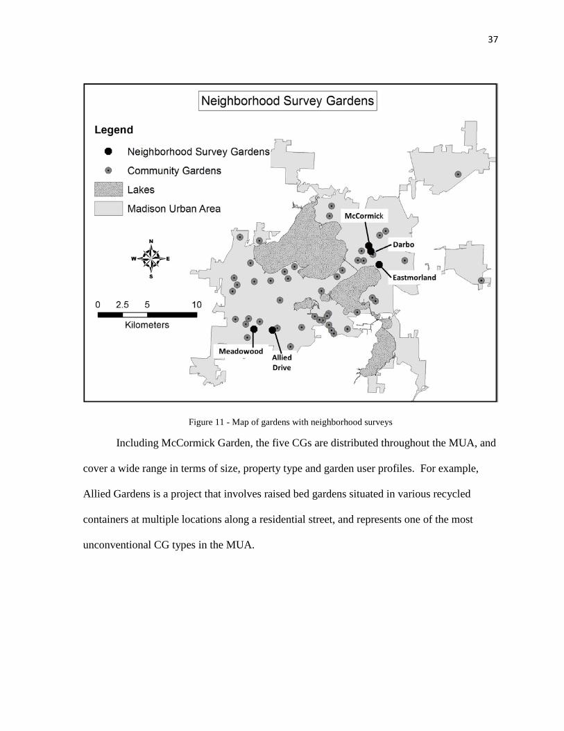
37
Figure 11 - Map of gardens with neighborhood surveys
Including McCormick Garden, the five CGs are distributed throughout the MUA, and
cover a wide range in terms of size, property type and garden user profiles. For example,
Allied Gardens is a project that involves raised bed gardens situated in various recycled
containers at multiple locations along a residential street, and represents one of the most
unconventional CG types in the MUA.

38
Figure 12 - Allied Drive Gardens site sketch, New Garden Fund Application
At the other end of the spectrum, Eastmorland Garden occupies a single rectangular
strip of city-owned green space, and has a more traditional plot arrangement.

39
Figure 13 - Eastmorland Garden site sketch, New Garden Fund application
Photo 4 - Eastmorland Community Garden
40
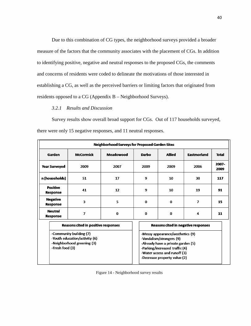
Due to this combination of CG types, the neighborhood surveys provided a broader
measure of the factors that the community associates with the placement of CGs. In addition
to identifying positive, negative and neutral responses to the proposed CGs, the comments
and concerns of residents were coded to delineate the motivations of those interested in
establishing a CG, as well as the perceived barriers or limiting factors that originated from
residents opposed to a CG (Appendix B – Neighborhood Surveys).
3.2.1 Results and Discussion
Survey results show overall broad support for CGs. Out of 117 households surveyed,
there were only 15 negative responses, and 11 neutral responses.
Figure 14 - Neighborhood survey results

41
In the case of Darbo and Allied gardens, all responses were positive. This may be the
result of the motivations of the garden supporters, and the origins of the CG proposal. In
both cases, garden organizers were explicit in stating the purpose of the project, and had a
well-defined target audience and outcomes for the gardens. Darbo Garden was proposed
primarily as a food pantry garden to help contribute to community food security, and was
placed on land owned by, and directly adjacent to The Salvation Army. The Allied
Container Gardens were proposed largely as a community building and beautification effort,
and the members of the neighborhood closest to the garden locations were embedded in the
proposal process. Thus it is not surprising that the surveys demonstrate unanimous support in
these cases.
In instances where survey respondents were strongly in support of a garden, their
comments commonly referred to themes of community building, youth involvement and
neighborhood greening. The role of community involvement as a factor in CG placement is
evident here.
Negative survey responses, on the other hand, referred to messy appearances,
vandalism, strangers, and increased traffic as reasons for CG opposition. It is interesting to
note that the rationale behind negative responses often involves predictions of future
conditions that are the direct opposite of those conditions that motivate a positive response.
The congregation of a variety of community members may be perceived as community
building by one respondent, while another views the attraction of a variety of people as an
invitation to strangers. The presence of a variety of gardening styles and preferences might
be seen as beautification by one individual or as messy by another.

42
What seems to differentiate these opposing viewpoints is whether or not the
individual intends to be involved, or feels that a CG fits with their sense of community. In
light of this, an important social factor influencing the placement of CGs emerges. The
degree to which the neighborhood is involved in the origins of a CG proposal has a direct
impact on neighborhood perception of the CG. This seems to be a self-evident concept, yet
when placed in the context of site selection for a garden, the surrounding neighborhood
composition takes on more significance. For example, if a CG is proposed in an area of open
space bounded by residential units that already contain yards with gardening space, there is a
greater chance that surveys of adjacent households will have little interest in having a CG
plot. When this occurred in the five neighborhood surveys, the result was often a negative or
neutral response.
It is also apparent that the type of property a proposed CG will occupy serves as a
factor in determining support. The social factor of competing use values that I first noted in
the McCormick Garden study was also evident in the neighborhood surveys, where negative
responses occasionally asserted a preference for the existing use on the proposed site. In
some cases this “existing use” was simply the opportunity to walk through an area, or the
aesthetic value of open lawn.
While neighborhood surveys were useful in identifying some of the factors associated
with placement of CGs in the context of their respective neighborhoods, those surveys do not
fully explain the general disposition of people toward CGs across the MUA. Perhaps most
importantly, the negative responses in the surveys very rarely include suggestions of more
favorable locations where CGs could be placed. To address this issue of “best placement”, I

43
engaged in participatory action research with a group of individuals concerned with
identifying new CG locations across a large area of the city.
3.3 Citizen Surveys at the Dane County Farmer’s Market
In 2008 a group of citizens living in some of the most densely populated parts of
Madison formed the Downtown Community Gardens Group (DCG). The DCG asserts that
the lack of CGs on the City’s isthmus and downtown areas constitutes a major weakness to
the MUA’s otherwise flourishing CG movement. For the purposes of this group, the
“downtown area” is bounded by the Yahara Canal on the east side of the isthmus, Breese
Terrace on the west side, Lake Mendota on the north side, and Lake Monona on the south
side.
Figure 15 - Downtown Community Gardens Group focus area
44
The main goal of the group is to establish CGs in the downtown area so that
gardeners living in this area do not have to wait on lists to get plots in CGs on the fringes of
town.
Embedded in this goal is an objective that is directly relevant to my study. In order to
facilitate CG creation, the group must identify potential CG sites with the appropriate
conditions to facilitate a successful CG placement. To do this, however, the group must first
identify what the most important factors are in the successful placement of a CG. While the
group does not make this objective explicit in their promotional literature, it is inherent in
their goal. In light of this connection, I joined the group and initiated participatory research
as a member whose primary role was to assist in promotional efforts and to collaborate at
meetings.
The group was interested in potential CG sites that were on land owned by the City of
Madison. In order to demonstrate support for CGs downtown to the City of Madison, the
group drafted petitions to submit to city agencies. The petitions included a survey that asked
the petition signer if they would like a CG plot in the downtown area, where they live, and
whether they would like to participate in the DCG group meetings and efforts. The group
then acquired a table at the Dane County Farmers’ Market in downtown Madison, and
distributed surveys on Saturdays from May until November during the market seasons of
2009 and 2010. I assisted in the petition efforts on Saturdays during the 2009 farmers’
market season.
I engaged in brief, informal, open-ended interviews with willing individuals signing
the petition at the Market during the 2009 season. Topics we discussed included the nature of
the individual’s involvement in community gardening in the MUA, the locations of CGs

45
where individuals currently gardened, where the individual lives in relation to their CG, and
what (if any) spaces in the downtown area seemed appropriate for a CG. If a site was
suggested, the subject was asked why they had chosen that site.
3.3.1 Results and Discussion
Many of the petition signers I spoke with did not actually participate in community
gardening activities. Instead, many had space in their yards for their own garden. They did,
however, support the idea of having CGs in the downtown area, and cited community
greening and support of sustainable initiatives as reasons for signing the petition. This is
relevant to the matter of CG placement as it introduces the notion that CGs can represent a
community or institution’s commitment to values held by its members. The petitions
ultimately demonstrated mass demand for CG plots in the downtown area. However, even if
a large number of petitions were signed by individuals outside of the downtown area, broad
support suggests that a CG placed in the downtown area would still reflect well on that part
of the community.
Because I have established from my research with the McCormick Garden and
neighborhood surveys that community support or opposition can be a factor in the placement
of CGs, a new question arises: Does support for a CG require a demand for plots? My
research with the DCG group suggests the answer is “no”. Community members might not
be opposed to a CG, and might be in favor of a CG replacing an empty space, but that
doesn’t translate into their desire to participate in a CG. This raises questions about whether
or not proximity of a CG to its gardeners is an important factor in its placement.
For those that do garden, when asked about the distance they traveled to their CG
plot, many individuals did not live within walking distance. Walking distance, in the context

46
of the farmers’ market interviews, was simply a qualitative measure. However, it was also
evident that the long distances traveled to CG plots were the result of an inability to acquire a
plot at CGs closer to their place of residence. The most common example of this occurred
where an individual lived downtown, and the closest CG to their home was Reynolds
Garden. Reynolds Garden has six plots, and is located in one of the most densely populated
neighborhoods in Madison. In such densely inhabited neighborhoods, residents often do not
have yards to garden in. Individuals that could not get one of the six plots at Reynolds
Garden often resorted to gardening at Eagle Heights Gardens on the University of
Wisconsin-Madison Campus, which has 535 plots. The Eagle Heights CG plots are over five
kilometers away from the Reynolds plots (Figure 16).
Figure 16 - Relative locations of Reynolds and Eagle Heights Gardens

47
The same individuals that travelled long distances to a CG often had
recommendations as to where CGs could be placed to help resolve the lack of plots in
downtown Madison. Among the suggestions were four different parks, an empty lot in the
heart of downtown where a structure had burned and been removed, a seldom-used concrete
plaza, and the top levels of parking garages. Only one of these locations, Brittingham Park,
had been proposed as a CG site to the City of Madison before, and this proposal was
unsuccessful due largely to pre-existing, competing uses in the park.
The remaining suggested locations faced two significant obstacles. First, the sites
with favorable soils and solar exposure were also heavily used for a variety of passive and
active recreational activities. Second, the sites that did not have competing uses were also
located over concrete or other impervious surfaces, and would therefore require the
development of raised beds, new water access and import of soil.
While the individuals I spoke to provided several locations that could have some
potential for CGs in the future (assuming they also had significant development resources),
the DCG group was primarily interested in placing a CG on the roof top of the Madison
Public Library, which was the subject of a planning process for renovations at the time. In
order to do this, the DCG group would have to convince the City of Madison Budget Hearing
Committee to allocate significant financial resources to rooftop alterations in the library
renovation plan. This turned out to be a highly politicized effort, and added a new dimension
to my research.
The collaborative process of CG site establishment on property owned and managed
by various city agencies is characterized by very complex social and political relations. This
is especially true where open space is very limited, and a multitude of interests compete for
48
available land. While my research with community groups and garden organizers that sought
space to place a CG allowed me to gather a plethora of information, this information was
lacking in the perspective of the agencies and organizations that own and manage land.
Because political relationships had emerged as a factor in some, albeit not all, CG placement
scenarios, an analysis of documents related to CG placement from the City of Madison’s
perspective was necessary.
3.4 Analysis of City of Madison Plans and Documents
My research thus far has shown that the placement and formation of CGs involves
input and decision-making at both a grass-roots level and at more structured levels. In the
case of the MUA, the City of Madison and the procedures its agencies use to deal with CGs
constitute the upper end of structured decision making. Noting collaboration at multiple
levels, it seems as though CG placement requires a mix of bottom-up and top-down
approaches. The DCG group and Eken Park Neighborhood Association played a bottom-up
role by initiating collaboration with the city via site proposals. This type of grass-roots
organizing is conducted in a variety of ways by groups interested in starting a CG, and thus
the bottom-up approach is best understood on a case-by-case basis.
The City of Madison’s decision making process for CG facilitation, on the other
hand, is characterized by a more consistent procedure. This portion of the collaborative CG
placement process was studied by acquiring and analyzing city documents and plans
pertaining to CGs, including Parks and Open Space Plans, reports compiled by the City
Committee on Community Gardens (CCG) including annual updates on CG development
and action plans to facilitate CGs, and drafts from the City of Madison Zoning Re-Write
49
Commission. This evaluation was followed by interviews with personnel from the City of
Madison Parks Division, which I discuss further in Semi-structured interviews (Appendix H).
All information and planning principles relevant to CGs in Parks and Open Space
Plans from 1971, 1977, 1984 and 1991 were identified, and analyzed for their relationship to
CG placement criteria. This review of Parks and Open Space plans was later used in
combination with interviews of City of Madison Parks Division personnel to triangulate the
rules guiding that agency’s decisions about allocation of areas in parks and open spaces for
CGs, and how these have shifted over time.
The Parks Division also provides input and guidance for the CCG. The CCG meets
on a monthly basis (except in the summer) to discuss a range of issues related to CG
monitoring and development. The committee is made up of CG leaders, CAC staff, personnel
from the City of Madison Parks Division, and panel members of the Community
Development Block Grant (CDBG), and thus provides stratified insight into the decision
making process of garden placement. Minutes from the committee’s meetings include
discussion of CG preservation and creation, input on the role of CGs in the city’s
comprehensive planning process, and appropriation of funding for CG expansion. The
minutes from these meetings often reference information and strategies that are more fully
detailed in periodic reports and recommendations that the CCG publishes. I focused on two
reports that provide a comprehensive review of CG status and facilitation strategies at two
particularly influential points in time: Growing a Stronger Community with Community
Gardens: An Action Plan for Madison (City of Madison Advisory Committee on Community
Gardens, 1999), and Committee on Community Gardens Report: 2008-2011 (City of
Madison Advisory Committee on Community Gardens, 2011).

50
The action plan (1999) was published during the advent of CGs on the city’s political
scene in the late 1990s, and was spearheaded by the newly established ad hoc Community
Gardens Advisory Committee (1997). Both the ad hoc committee and the action plan were a
response to the loss of CGs in the 1980s and 1990s, as well as a politically visible CG
proposal at the Reynolds Homestead site (currently Reynolds Community Garden). Because
the city plays such an important role in the placement of CGs that are proposed on city land, I
targeted the 1999 action plan as documentation of the initial integration of CGs into city
policy. The 2008-2011 report is significant as a data source that demonstrates some of the
changes that have occurred in the CG landscape of Madison over the decade since the action
plan was published.
These reports helped in further delineating the factors that the CCG and city agencies
consider most influential in CG placement. The reports also allowed for a better
understanding of the interactions between City agencies, community organizers, and
facilitating organizations such as the CAC. Understanding these interactions provided
guidance in identifying additional sources of relevant information, such as drafts produced
during the city’s zoning rewrite process.
In December of 2007 the City of Madison began this zoning rewrite process to update
the existing zoning ordinances in the city. The new zoning code was adopted in March of
2011; however the boundaries of new zoning districts and associated maps were not yet
complete. The text of the new zoning code established urban agriculture as a special use, and
included specific language concerning community gardens. Because zoning codes have a
direct impact on the placement of land uses on the landscape, an assessment of relevant
sections was necessary. I reviewed the adopted zoning code (Chapter 28) in the City of
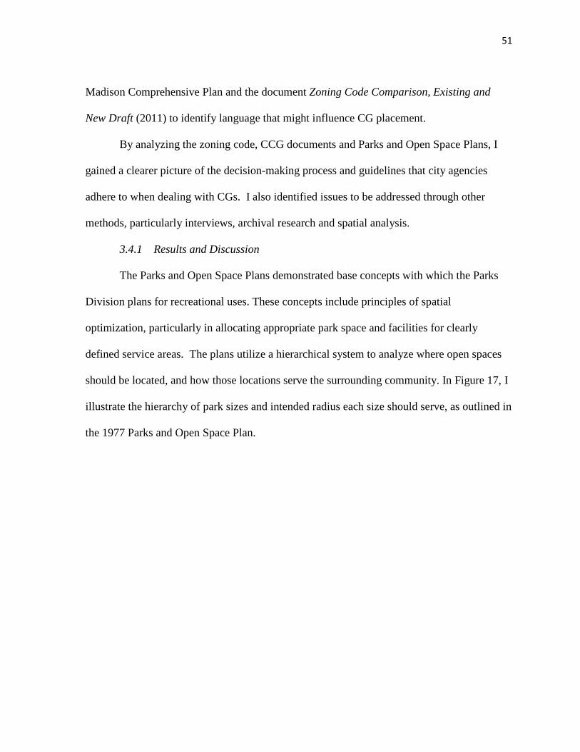
51
Madison Comprehensive Plan and the document Zoning Code Comparison, Existing and
New Draft (2011) to identify language that might influence CG placement.
By analyzing the zoning code, CCG documents and Parks and Open Space Plans, I
gained a clearer picture of the decision-making process and guidelines that city agencies
adhere to when dealing with CGs. I also identified issues to be addressed through other
methods, particularly interviews, archival research and spatial analysis.
3.4.1 Results and Discussion
The Parks and Open Space Plans demonstrated base concepts with which the Parks
Division plans for recreational uses. These concepts include principles of spatial
optimization, particularly in allocating appropriate park space and facilities for clearly
defined service areas. The plans utilize a hierarchical system to analyze where open spaces
should be located, and how those locations serve the surrounding community. In Figure 17, I
illustrate the hierarchy of park sizes and intended radius each size should serve, as outlined in
the 1977 Parks and Open Space Plan.

52
Figure 17 - Park hierarchy and service area, 1977
Throughout the plans significant attention is paid to the composition and spatial
configuration of parks and open spaces, and how this configuration serves the community.
The 1971 plan states that “the type of park and open space facilities must be scaled to the
needs of the area and population served both present and future” (pg. 7). Not only should a
neighborhood park provide 10-20 acres of recreational space, it should sufficiently serve the
community within a half mile of it, and take into consideration potential community growth.
Through the use of park inventories and spatial analysis of park sizes and service areas, the
plans demonstrate where recreational deficiencies occur, and identify focal areas for future
park development and green space preservation. In addressing deficiencies, the plans are
attentive to opportunities to convert existing space into parks or green space corridors, as
well as preserve green space where future commercial or residential development is
forecasted.

53
This use of spatial optimization and reasoning in park and open space planning is
directly relevant to CGs. From the perspective of the Parks Division, CGs (when they occur
on city land) are a form of passive recreation, and therefore constitute a park feature with a
service area. Thus a potential factor in CG development and placement is its service potential
in terms of its size and location relative to CG deficient areas. The degree of influence this
factor has on CG placement is uncertain, as data from other methods I have used suggest that
community gardeners will travel quite a distance to find available plots.
It is interesting to note that the Parks Division does recommend an adaptive approach
to park and open space development in the more densely occupied areas of the city. The
1984 plan suggests that park and open space enhancement in such areas “will likely have to
involve unique solutions, separate from any standards” (p. 89). This notion of unique
solutions seems applicable in the placement of CGs as well. In neighborhoods that have
limited green space or parks, gardens often occupy marginal areas of open space or
awkwardly shaped pieces of city-owned land. Both McCormick and Atwood Gardens, which
are located along a bike path in an area of Madison targeted for green space development,
utilize strips of open space as a unique solution. In a similar line of thought, the plan
recommends studying the recreational potential of all rail corridors in the city (1984, p. 69).
Two CGs on Madison’s near east side, Saint Paul and East Main, are located directly
adjacent to rail corridors, and constitute an excellent example of utilizing unique solutions. In
the case of Reynolds Garden, the CG site and size could not be scaled to the potential
population that might be served by the garden, thus illustrating a necessary abandonment of
standards. The projected shape, and size of a CG does not seem to be a highly influential
54
factor in the placement of a CG, particularly where demand for a garden is high and space is
limited.
This idea is complicated further in the 1991 Parks and Open Space Plan, in which a
section dealing exclusively with CG placement asserts that “where location is a key element,
well-located ‘temporary’ gardens may still be preferable to permanent gardens at less
desirable locations” (p. 34). In this sense, the ability to retain tenure at a given location is not
as important a factor in CG placement as is the ability of a certain location to serve a
population. The plan goes on to state that selecting “specific locations for garden sites
depends upon the type of gardening intended” (1991, p.34). In some ways the placement of a
park or park feature is entirely dependent on the motivations and desires of a particular
population.
What can be gathered from this assessment of Parks Division plans is that the level of
demand for a park service or land use, whether it be active or passive recreation, can
introduce flexibility into the adherence to placement criteria. This is evident in terms of the
two placement criteria: the amount of space available to accommodate users, and the long-
term availability of a site. Operating under this premise, high pressure and demand from a
neighborhood association or community group to create a CG in an area could result in the
placement of a garden on an undesirable small piece of land that could conceivably be
developed in the future.
The CCG reports provide further insight into the relationship between CGs and city
policies. In the 1999 CCG action plan, the mission statement includes the “creation of new
gardens at appropriate locations around the city” (pg. 5). The term “appropriate” may be a
response to the loss of eleven CGs to development pressures between 1983 and 1993, and

55
thus a desire to establish CGs in locations that are secure and allow for long-term occupation.
The issue of long-term availability of land is consistently present throughout CCG
documents, but identifying what makes a CG secure is not a simple matter. For example, the
action plan includes a photograph of Badger Community Garden, and cites that particular
garden as an example of a location that cannot be developed for other uses. Five years after
the plan was published that garden was relocated due, in part, to development. While this
might be considered an unfortunate coincidence, it demonstrates the uncertainty of CG land
tenure in the absence of property purchase or long-term leases. It is also interesting to note
that the reason Badger Garden was used as an example of undevelopable land was due to the
site’s awkward shape and unique location in between a highway, gas station and church.
While this parcel was not developable for commercial or residential purposes, the
development of a highway exit ramp eventually forced relocation.
In the context of my research questions, the most useful and profound section of the
action plan is chapter five: Location of Community Gardens (1999, p. 19-26). This chapter
discusses two focal points in the placement of CGs. The first is the character of the
neighborhood. The plan suggests that appropriate neighborhood characteristics “support the
successful introduction of a community garden or create demand” (p. 21). The second focal
point is that of site attributes. The plan proposes that these two focal points are significant
not only in assessing where CGs should be placed, but also in planning for CGs in new
neighborhoods. Chapter five describes eight neighborhood characteristics and eight site
attributes that should be considered in CG placement (Figure 18).

56
Figure 18 - Garden placement factors in 1999 community gardens action plan
Five of the neighborhood characteristics are concerned specifically with the people
that live in the neighborhood. Factors such as income, age and ethnicity essentially define a
profile for the types of demographics that should be served by a CG. While the plan does
note that CGs have been successful in neighborhoods that vary greatly in terms of
demographic profile, it does propose that certain social conditions can give rise to demand
for garden plots, and CGs can be planned for areas that may have those particular social
conditions in the future.
As I conducted my research, the factor of income arose repeatedly. In the action plan,
the income factor is framed in a manner that is somewhat inconsistent with some results. The
plan advocates for CGs in low-income areas as a means of alleviating stresses on household
food budgets. This is a direct appeal to CFS, however, neighborhood surveys did not always
reveal an association between CGs and food production. More often the surveys
57
demonstrated an association between CGs and community building, which might also be an
important reason to place CGs in a low-income area.
In addition, the plan utilizes the census tract as the geographic unit of analysis in
identifying a low-income population. Census tracts often include several neighborhoods, and
sometimes variability is present in the demographic profile of census block groups within
tracts, and even blocks within block groups. While the action plan is clear in defining the
socio-economic conditions that are important in CG placement, it is not clear as to what scale
an assessment of these conditions should be conducted at. The terms “neighborhood” and
“census tract” are used interchangeably, but the definition of the former is more flexible than
that of the latter. I discuss this variability in units of analysis and its impact on my methods
further in Spatial Analysis (Chapter 3.7, pg. 99).
The three neighborhood characteristics in the action plan that address the physical
landscape instead of the people are inadequate open space, large parks and absence of
existing CG plots. Both inadequate open space and large parks are elements that should be
considered at the outset of CG placement. One component of the landscape that is not
flexible or cannot be altered to accommodate a CG is the amount of physical space in a
certain area. If a neighborhood has been developed with buildings to a maximum density
(i.e. there is no open space), the only potential space for a CG may be on a public roof top.
This was a scenario encountered by the DCG group, and imposed very severe limitations on
CG placement. While the action plan suggests that large parks should be explored as a
means of accommodation for CGs, and as a way of introducing multiple recreational
functions into and adjacent to the garden, parks cannot be relied upon for CG placement. As I
found in other results, competing uses in parks and open spaces can prohibit the placement of

58
a CG, even if there is physical space available for it. In addition, access to the park system in
the MUA is not evenly distributed, and as was noted in the parks and open space plans,
deficiencies in park space do exist in various areas.
In the event that no large parks or open spaces are available for CG placement, the
action plan suggests that small lots and interior locations be explored for plot space. This is
recommended “even when those lots might not meet current Parks Division threshold
standards” (1999, p. 22). Two concepts are important in this neighborhood characteristic.
First, CGs are seen as a means of increasing open space and recreational opportunities in
areas that are open space deficient. Perhaps this could be seen as a form of community
building and neighborhood transformation, which was a common topic among neighborhood
surveys. In this sense, inadequate open space could be viewed as a fairly important
placement factor.
The use of inadequate open space as a placement factor also brings up the concept of
identifying adaptive solutions for CG placement, which is a theme that continually emerges
in my research. In the context of placement factors, I would re-word this neighborhood
characteristic from “inadequate open space” to “potential to increase open space”. In this
way, a neighborhood with small, awkwardly shaped lots or spaces would be targeted for CG
placement over a neighborhood with absolutely no open space for CGs.
The third physical neighborhood characteristic mentioned in the action plan, presence
or absence of existing plots, can be interpreted as a measure of demand. According to this
simple measure, if a neighborhood has no access to any CG space, there is greater demand
than if the neighborhood already has a few CGs. Demand is a theme that continually
surfaces in my study, and is certainly a very weighty factor in placing a CG. If an organizing

59
group demonstrates enough demand for a CG, through petitions or proposals, other
placement factors such as soil suitability and adequate available space can be worked around.
However, if the intention is to plan for CGs, then interaction with a particular garden
organizing group and its show of demand cannot be predicted, and measuring devices such as
the presence or absence of CG plots must be used. In the context of my research questions, it
is reasonable to suggest that demand is perhaps an overriding influence on CG placement. In
acknowledging this, indicators of demand can be considered as placement factors. For
example, the absence of CG plots in a certain area where there are many interested gardeners
would constitute a priority area for CG planning and placement. The presence or absence of
plots is but one placement factor related to demand; I will discuss alternative indicators in
other sections.
Among the eight site attributes listed in the action plan, I have already proposed that
three of these are conditions that can be overcome with the use of adaptive site design and
opportunism. Suitable soils, adequate sunlight and distance from major streets are issues that
ultimately did not dictate the placement of McCormick Garden. Their influence as
placement factors is questionable, and is explored further in my other results.
Another site attribute that might be brought into question is that of visibility from
neighboring residences. The action plan proposes that this attribute dissuades crime and
vandalism, but this also assumes that neighbors are in favor of a CG. One issue that arose in
neighborhood surveys from negative responses was that of messy aesthetics. Some
neighbors were opposed to CGs as they felt the plots, tools and occasional lack of cohesive
garden design led to eyesores on the landscape. In the context of garden placement, the
factor of visibility might have some influence, but without a prior survey of neighbors

60
adjacent to potential garden sites, it is difficult to tell if visibility would encourage or
discourage placement of a CG.
Other site attributes included site configuration and accessibility for the disabled and
elderly. These site attributes were listed as a means of enhancing social infrastructure at a
given site, but the importance of these attributes is dependent on the demographic profile of
the surrounding neighborhood. Adaptive design also allows for the enhancement of these
attributes where in situ site conditions may not be favorable for accessibility. If a CG is
placed in an area with young families, accessibility may not be a significant consideration.
This example could be interpreted as evidence of the significance of neighborhood
characteristics over site attributes. My results would suggest that neighborhood factors are
more influential than existing site features.
It is important to note that both the neighborhood characteristics and the site attributes
mentioned here were listed in the action plan with the intention of planning for CG
expansion. This is an example of the more structured approach to CG placement that I have
discussed, in which locations for CGs are identified prior to a proposal. As I have illustrated
through my work with the McCormick Garden and the similar site proposal processes that
other CGs went through, CG locations are not necessarily identified a priori by an
institutional or municipal body in such a structured manner, but are instead proposed by a
particular group. Thus, in order to accurately answer my research questions, it is important
to compare CG placement factors suggested as guiding principles by a variety of
authoritative bodies. I develop my comparison of placement factors further in the following
section, Archival Research at the CAC.

61
The CCG report on CGs from 2008 to 2011 illustrates the progress that the city and
facilitating groups have made since the advisory committee was first established and the
1999 action plan was published. Where CGs have been threatened by development,
relocations have been sought, as opposed to allowing a garden to be lost. One of the largest
and most ethnically diverse CGs, Quann, was established as an alternative to the nearby
Nygard Community Garden, which was lost to development. Coordinated efforts between the
City Parks Division, CAC and community members facilitated this successful relocation.
Currently Sheboygan Garden on Madison’s near west-side is facing threats from
development, and a similar collaborative solution is being sought. If Sheboygan Garden is
forced to relocate, it will be particularly interesting to see where it is placed. Due to this
interest, I made the potential Sheboygan relocation a prime topic in my interviews with the
City Parks Division.
The CCG and community members have also been instrumental in embedding a CG
into the designs of a new city park on the city’s densely developed isthmus. This part of the
city has a general deficit in parks and open spaces, so a number of competing uses are
planned for the area. If the surrounding neighborhood was saturated by other CGs with
plenty of plots, it is not certain that a CG would make it into the final park design plans, but
demand has been clearly demonstrated to the design committee. Those advocating for a CG
in the park design demonstrated demand using two measures. The first was a general absence
of plots in the neighborhood, which is a placement factor that I noted in the 1999 action plan.
The second measure was the robust waiting lists for plots at nearby CGs. The length of a
waiting list is another indicator of demand for CGs in an area, and can therefore also be seen
as a placement factor when the location of that waiting list is considered.

62
CG development was also greatly enhanced in 2005 by the establishment of the New
Garden Fund (NGF), and the continued financial support of the Community Development
Block Grant (CDBG). These funds are awarded based on the decisions of a funding panel
composed largely of CAC staff, with oversight from the CCG. The continued refinement of
the collaborative CG development process between city agencies, CAC, garden organizers
and community members created a dynamic decision-making structure that involves both
grass-roots and government perspectives. This mixed collaboration is especially evident in
the NGF panel decisions, which are the subject of the following section (Archival Research).
The dynamic collaboration was also palpable during the zoning re-write process, in which the
CCG joined with an urban agriculture ordinance work group to provide input and critique on
the planned creation of a special zoning district for urban agriculture in Madison. An
important result of this collaboration was the establishment of community gardening in
zoning language for the City of Madison (City of Madison Comprehensive Plan, 2011).
It should be noted that the idea of including community gardening in zoning had been
on the agenda of the CCG for over a decade. The 1999 action plan included a short section
on zoning, and the potential for zoning ordinances to facilitate placement of CGs. In this
section, it suggested that a zoning ordinance that recognizes community gardening would
“allow local governments to earmark land for community gardens” (1999, p. 26). The City
of Madison zoning re-write process that began in 2007 took an initial step in this facilitation.
With respect to facilitation, perhaps the most significant aspect of the revised zoning
ordinance is simply that it includes specific language and parameters for CGs, including an
official definition:

63
“Community Garden - An area of land managed and maintained by a group of
individuals to grow and harvest food crops and/or non-food, ornamental crops,
such as flowers, for personal or group use, consumption or donation.
Community gardens may be divided into separate plots for cultivation by one
or more individuals or may be farmed collectively by members of the group
and may include common areas maintained and used by group members.”
(Zoning Re-Write Committee, 2011, p. 19)
This definition legitimizes CGs as a land use in the city, but does little in the
way of “earmarking land” for CGs, as suggested in the 1999 action plan. This is not
to say that revised zoning maps or future general plan drafts won’t include such
earmarks. However, the new zoning ordinance allows CGs as a permitted use in all
districts, so the allocation of particularly suitable locations for CGs by the city does
not seem likely. The zoning ordinance does not propose where CGs are allowed, but
rather that they are allowed. Again, the burden of identification of sites for
placement is not placed solely in the hands of one organization such as the city, but in
the collaborating hands of garden organizers, facilitating organizations like the CAC,
and in some scenarios the city.
Still, some language in the zoning ordinance does suggest guidelines for
placement. This language is in reference to “urban agriculture” in general, which
could include such forms as animal husbandry and market gardens, but is applicable
to CGs in some scenarios as well. The following quote might have greater
significance to someone interested in beekeeping or aquaculture, but it does have a
64
bearing on CGs, especially as many CGs are showing interest in incorporating
multiple urban agriculture components such as food processing and chicken coops.
“Because urban agriculture will typically exist in close proximity to
residential and other uses, concern will be given to ensuring compatibility
between uses”
(City of Madison Comprehensive Plan, 2011. Chapter 28, p. 80)
In reviewing the inclusion of urban agriculture and CGs in the zoning code, it is
apparent that intended functions and programs of a CG have an influence on its compatibility
with adjacent uses. This is a significant concept to consider when identifying placement
factors for CGs. The purpose and programming of a CG may have an impact on which
placement factors have the most influence. If a proposed CG intends to include a youth
program, and that youth program involves tending to a chicken coop, then placement factors
beyond the age and family profiles of nearby households deserve attention. Perhaps there is
a dog park near that potential youth garden and chicken coop site that would introduce a use
conflict.
The CAC works extensively with garden organizing groups to help them identify
envision their CG programming and functions. Therefore both the CAC staff and the
organization’s documentation of CG facilitation hold a wealth of information related to how
the influence of CG placement factors can vary. To better understand this variability and
further distill garden placement factors, I immersed myself in the document archives at CAC
headquarters.

65
3.5 Archival Research at the Community Action Coalition
The CAC’s Community Gardens Division plays a significant role in my study due to
over thirty years of staff expertise in CG facilitation and record keeping of CG loss, creation
and relocation. Taken in combination, these two resources constitute the most robust body of
data on CGs available in the MUA. However, due to the adaptive practices with which CAC
goes about aiding CG organizers, a systematic documentation of interactions and garden
placement processes does not exist, and most of the organization’s records are not digital. I
logged multiple visits to CAC headquarters, and digitized a variety of documents including
annual updates on gardens created, expanded or lost, NGF awards, and the status of CG
tenure arrangements. These updates, when compared over several years, illustrated some
common issues pertaining to the appropriate placement of CGs, and how that placement may
impact a CG’s ability to retain tenure at a particular property.
In addition, the CAC has some CG proposals from various neighborhood groups on
file. Prior to 2005, there was no standardized garden site proposal form or process. Proposals
came in the format of letters to the CAC or the city, or even in phone calls or informal notes
from individuals or neighborhood associations. Records of these proposals are incomplete,
but CAC staff has, in some cases, kept a list of sites that were proposed in certain years along
with brief descriptions of the sites. I compared these proposals with the current inventory of
CGs in the MUA to determine which garden groups were successful in their selection and
establishment of a CG site. After conducting archival research, I interviewed key CAC staff
to learn more about the reasons why certain CG proposals were successful while others
failed.

66
While filtering through informal CG proposals, and tracking CG losses and
relocations was useful in gaining a sense of how CG configuration in the MUA has changed
over time, this informal documentation did not lend itself to any organized analysis,
especially with respect to identifying CG placement factors. However, due to its
participation with the NGF panel and award process, the CAC did have copies of all the NGF
applications. As a result of their standardized format, the NGF applications facilitated a more
systematic analysis. Fifteen applications were on file ranging from 2005, when the NGF was
established, to 2010.
Applications are submitted to the NGF panel by CG organizers who are interested in
either creating a new CG or enhancing an existing garden, and therefore contain a wealth of
information about CG programming, functions and location. Each application includes a site
analysis of biological and physical conditions, descriptions of the demographic groups that
will use the garden and how they will use it, descriptions of the garden site’s situation within
a neighborhood, and surveys of all households that have a direct view of the garden, or that
may be impacted by gardeners accessing the site (Appendix D – New Garden Fund
application).
A large portion of the site analysis and social descriptions in the application are
formatted as a checklist. Eighteen criteria related to the physical site attributes, social
characteristics of the surrounding neighborhood, and intended programming of the garden are
listed (see Appendix D). Applicants can check these items off, and include additional
information about various attributes and characteristics if deemed necessary. Ostensibly these
criteria serve as a base measure of a CG proposal’s qualifications for a NGF award. I

67
evaluated the eighteen criteria in all applications for CG creation and expansion from 2005 to
2010.
I scored each application on a scale of 0-18. Scores were then compared against the
success of their respective applications (success being whether or not funds were awarded)
(Appendix E & F). If an application had a high score but was not awarded any financial
assistance, or an application had a low score but was still awarded funds, these discrepancies
were recorded and investigated further. It should be noted that the NGF awards are largely
based on the need of the applicant. A CG proposal might include an appropriately placed
garden site, but if the CG organizers can fund their start-up costs, they might not be awarded
financial assistance. While a NGF award does not necessarily translate into a confirmation
of appropriate CG placement, it is telling of the NGF panel’s confidence in the success of a
CG proposal at a particular location. In light of the cumulative expertise and authority
represented by the NGF panel, CAC and CCG, the NGF application served as a valid source
of placement factors.
3.5.1 Results and Discussion
Out of eighteen applications, thirteen resulted in NGF assistance.

68
Figure 19 - New Garden Fund application scores
The mean score for successful applications was 14, and the mean score for
unsuccessful applications was 13. Upon first glance this result might bring into question the
validity and usefulness of this data. If the cumulative scores derived from the checklist do
not have an influence on the NGF panel’s decisions, then how influential can the items on the
checklist be? In fact, this result is extremely useful because it suggests an interesting
scenario. It is possible that particular items on the checklist have a greater influence or
weight on the NGF panel’s confidence in a CG than other items. To filter the NGF
applications and identify which factors had the most impact on placement and successful
establishment, I analyzed the unsuccessful applications for CGs in neighborhoods with low-

69
income and no institutional support (e.g. Church or school funding). By choosing to
investigate these applications, I eliminated the award bias based on financial need.
Both Brittingham Garden and Demetral Garden were unsuccessful in securing NGF
awards and failed to create a CG, despite being located near neighborhoods with low-income.
In the case of Demetral, it was a physical factor that determined the garden’s fate. The site’s
previous use was industrial, and left a toxic legacy in the soils. The only other application
that was unable to check “non-industrial use” on the checklist was McCormick Garden, but
as I demonstrated, that particular garden proposal benefited from an opportunistic solution
and assistance from the City Engineering Division.
The Brittingham application was unsuccessful for more nuanced reasons. One of the
primary explanations offered was that the Bayview Garden was located directly across the
street from the proposed site. According to this rationale, the demand for plots in this
particular neighborhood had been satisfied. Another reason for the failure was the presence
of competing recreational uses. The proposed site was in an active city park, and the City
Parks Division had expressed concern about both use compatibility and soils. As a
consequence, the garden organizers did not secure permission to use the site prior to
submitting the application. The influence of a property owner’s disposition can be very
important in the placement of a CG. Four other applicants did not secure permission to use
the land prior to submitting their NGF materials, and only one of these groups was successful
in placing and creating their garden.
The Brittingham Garden site was also proposed near a busy road, which, according to
both CCG recommendations and the NGF application, is an undesirable site attribute.
However, five other NGF applications included garden site proposals adjacent to busy roads,

70
and only one of these gardens was not created. That garden was Demetral, which failed due
to soil toxicity. While concerns over both air pollution and child safety provide justification
for placing a CG away from busy roads, my results have suggested that this is not a highly
influential factor in the placement of CGs.
It is also important to note that the responses and descriptions contained in the NGF
applications are those of the applicants, and therefore were subject to a heavy bias. This is
particularly true for checklist items that concern the social functions of the CG. For example,
all applicants claimed that their CG would be serving low-income households; however, only
six of the CGs were located in census block groups where the median household income was
below 75% of Dane County’s median household income in 2000. Only two of these CGs
were in block groups below the 2000 poverty threshold. Discrepancies such as this are not
necessarily the product of dishonesty, but rather they result from the use of terms like “low-
income” without defining what “low” is. It is also possible that small pockets of low-income
housing might be located near a CG, but are not extensive enough to impact the median
household income of that census block group. The same principle applies to items such as
“including youth” and “including elderly”.
To better understand some of the ambiguities present in the NGF applications, I
conducted follow-up interviews with CAC staff, and checked the information from these
interviews with the site descriptions and CAC notes on the applications. This allowed for
triangulation of the most influential factors in the NGF applications. After identifying these
factors, I revised a ranked NGF decision-making model, placing the issues the panel takes
into consideration into three tiers of importance (Figure 20).

71
Figure 20 - Ranked New Garden Fund decision model
Following interviews with two key CAC staff, it was apparent that the issues of
demand, financial need and land availability were the most significant in the NGF decision-
making process. The panel prioritizes CG proposals in areas that have available garden
space, a scarcity of available plots, and will serve low-income or disadvantaged populations.
These three issues are consistent with the placement factors I have identified as influential in
my research thus far, especially that of demand and presence of available and unique spaces.
The prioritizing of low-income and disadvantaged populations, however, is a factor
that seems to have influence on CG placement only when the organizing group makes an

72
explicit effort to have their garden serve such a targeted population. Thus the programming
of CGs has an impact on placement factor influences. Because the NGF makes an overt
effort to support disadvantaged populations, I ranked that issue in the top tier of
considerations; however, this may not be a universal placement factor for CGs around the
MUA.
I placed the issue of neighborhood support in the second tier, but this could have far
more influence than other factors if neighbors have a particularly strong opposition to CGs.
In the neighborhood surveys I participated in and analyzed, opposition stemmed from fears
of vandalism, presence of strangers and messy aesthetics. If these feelings are pervasive in a
neighborhood survey, it may be important to place greater importance on the issue of
neighborhood support in the placement of the associated garden. In Reindahl Park, a NGF
award to expand existing plots was awarded but not distributed in large part due to
opposition from the neighborhood association. What is particularly interesting in this case is
that some of the neighborhood opposition stemmed from the proximity of low-income and
disadvantaged populations and the attraction of non-residents to the garden. Reindahl
Garden was located at the border of two neighborhoods with a disparity in median household
income (Figure 21).

73
Figure 21 - Reindahl Garden and median household income
The low-income neighborhoods in close proximity were served by a small CG with
less than 50 plots. These plots were filled by residents of adjacent Community Development
Authority (CDA) housing. Reindahl, on the other hand, had over 200 plots, and thus
attracted gardeners from a larger service area. The NGF applicants were fourteen Hmong
families from outside the neighborhood that wanted to expand the existing garden by one
acre. Had this scenario been identified prior to establishment of Reindahl Garden in its
current location, both socio-economic characteristics and neighborhood support could be
considered influential placement factors.
74
Most of the remaining considerations in the second and third tiers of the NGF model
concern the intentions of the NGF applicants and garden organizers, and what their vision is
for the CG. According to a CAC staff member, these issues are primarily “thought pieces to
get the organizers thinking about their approach, and what they want their garden to do”
(9/28/10).In this sense, the idea of having a children’s garden or contributing to a food pantry
does not translate into a placement factor in itself, but it does set the programming and
trajectory of a CG. It is these trajectories that have an impact on what factors are most
important in CG placement. A CG with a youth program might prioritize an area of a
neighborhood with lots of families, or seek garden space in close proximity to schools. This
idea of assessing placement factors with respect to a CGs vision and purpose adds additional
complexity to any attempt to plan a priori for CGs.
Through the identification of the most influential issues in the NGF applications, a
refined understanding of CG placement factors was possible. However, these factors and
their level of influence were based on CGs with the purpose and programming to benefit
low-income areas and disadvantaged populations.
In order to achieve a more comprehensive analysis of CG placement for a variety of
programming and trajectories, and ultimately generalize, additional methods of analysis were
necessary. Both interviews and spatial analysis provided valuable insight on the influence
that placement factors identified in NGF applications and CG proposals have, and allowed
for a broader perspective on the different trajectories CGs can take.
75
3.6 Interviews
Following the investigation of CCG, CAC and NGF materials, a broader
understanding of CG placement factors was achieved; however, the impact that various
factors had relative to CG programs and trajectories was still vague. I conducted in depth,
semi-structured interviews with ten key subjects who are deeply involved in either City
policy concerning CGs, scholarly food systems research, grassroots CG movements, CG
funding evaluation, or a combination of these roles. I identified these subjects as key
informants through their consistent contributions to food system documents and studies in the
MUA, multiple references to their names in interviews, and through their participation in the
collaborative process of CG placement and establishment.
I guided my interviews using questions concerning the extent of the subject’s
experience with CGs in the MUA, their familiarity with CG placement guidelines, and their
perceptions concerning the influence these guidelines have on appropriate garden placement.
To provide reference to my study area and also “jog some memories”, I provided subjects
with copies of maps of CGs in the MUA.
Subjects often shifted into anecdotal responses to demonstrate their initial answers.
This often led to an evolution from semi-structured inquiry into open-ended conversations.
The latter proved especially useful in gathering a cohesive form of data, perhaps best
described as place-based narratives. In these narratives subjects would describe in great detail
the history, qualities and issues pertaining to the placement of one garden or a cluster of
gardens. One particularly apt and recurring example of this resulted from situations in which
I asked subjects if they could think of instances or cases of very appropriate placement of
CGs in the MUA, and if they thought of any particular CG as a “model for placement”.

76
I transcribed and coded interviews in a simple hierarchical scheme that included five
broad themes, and several key terms that were associated with those themes (Figure 22).
Key terms were identified based on frequency of occurrence in interviews, and the broader
themes were extracted from sections of interviews where similar key terms were clustered
together.
3.6.1 Results and Discussion
Figure 22 - Interview themes and key terms
I began my interviews by asking the general question: What makes a CG site
suitable? Key informants took this question in a number of different directions, but much of
77
the initial discussion concerned the types of property that CGs have occupied over the last
several decades.
Property
Parks and open spaces were referenced as an integral part of CG facilitation, but
reliance on the City Parks Division is not a viable solution to CG placement. Competing
recreational uses that are already programmed into parks limit land that would otherwise be
available for garden space. As a result, many parks are simply not large enough to
accommodate many CG plots. In the late 1990s there was a shift in approach to identifying
land for CGs. A Parks Division official noted that during a tour of CGs in Milwaukee, they
observed successful CG placement without an emphasis on use of park space.
“We were seeing a lot of the churches with a large land base
surrounding them, with the potential for school playing fields or a parking lot
expansion that would never be realized, and they were using those as
community garden spaces. So we came back and said ‘Okay, this is what we
need to look at. It’s not always going to be in a park, and we need to look at
opportunities with businesses, churches and other institutions with a large land
base’.” (8/9/10)
In recent years, as the amount of available open space in densely developed parts of
the MUA has dwindled, churches, schools and other institutions have become an excellent
source of gardening space. A member of the Dane County Food Policy Council noted the
idea of affordable housing providers or organizations like the YMCA or Boys and Girls
clubs, and other institutions with a little bit of land incorporating gardens and food
production into their programs (5/5/10). This concept was mentioned by almost every
78
interview subject. The idea that the tenure and success of a CG is directly related to the
property owner and its mission or programs was pervasive.
It is apparent that the values embodied by property managers or owners can impact
not just the placement and amount of space allocated to plots, but also the willingness to
sustain a garden program. Churches, in particular, can provide an excellent location for
placement as the congregation is often committed to a CG as part of its mission. Instances
where CGs have been placed on private land with permission, but no long term lease, have
sometimes resulted in a loss to development, often under the property owner’s discretion.
Thus the idea of “threat” to a CG’s tenure is largely a function of property type and the
amount of development pressures in a given area.
Site Optimization
Tenure was one of many concepts used to describe suitable placement of CGs in my
interviews. Numerous other terms were used to describe not only site features, but also the
garden site’s location relative to the surrounding neighborhood. Issues of CG location and
service allocation were discussed, bringing to mind the notion of site optimization, which I
have noted as a central concept in my research.
Accessibility, socio-economic status, available spaces, and density of both the built
environment and population were among the most common topics that arose in regard to
suitable placement. The issue of density is quite interesting because it seems that both high
and low density areas are of interest in CG placement. In scenarios where subjects
mentioned high population density as a placement factor, they generally addressed the rift
between high demand and low plot availability. In such instances CGs are prioritized in

79
areas with little access to gardening space. In some ways this is a reactive measure in which
high density and demand are first identified, and then CG spaces are sought.
On the other hand, interviews also suggested that CG placement could focus on areas
of the urban fringe where there is available garden space and projected population growth
and development. In this instance, CG spaces are first identified and planned for with the
assumptions that open spaces will diminish with projected growth and demand for plots will
exist. A sustainability plan produced for neighborhoods and projected growth areas in the
southwest MUA (City of Madison, 2008) was referenced by a CAC staff member as an
excellent example of such an approach. In that case CGs “sort of got injected into the
planning process” (9/28/10).
This integration of CGs into the planning process for neighborhoods in the southwest
MUA was partially a response to a demographic shift in that area. Socio-economic factors
were therefore a consideration in the placement of CGs. Every individual I interviewed
mentioned a relationship between income and CGs, but this connection was most prolific
during interviews with CAC staff and a City Parks Division official. Along with income, the
interviews revealed other social placement factors such as the presence of families, ethnic
diversity, and a high ratio of renter to owner occupied housing. These factors agree with
those identified in CAC documents and NGF applications.
One placement factor that emerged in interviews that was not prominent in my other
results is access to CGs. Access, in the context of interview responses, is the ability of
gardeners to travel to garden plots. Access can involve multiple forms of transportation,
including personal automobile, public transit, bicycle or by foot. The ability to engage in
recreation and enter open spaces has been the subject of research in urban design and social

80
justice, thus it seems reasonable that access would also play a major role in the placement of
CGs.
However, in the results I have discussed prior to these interviews, accessibility was a
marginal factor. In the McCormick Garden site analysis process, some consideration was
given to potential parking conflicts in the cul-de-sac, and the pedestrian path that was
planned adjacent to the site was perceived as a benefit to access. Neighborhood surveys
revealed some concerns from neighbors about parking conflicts and the prospect of
“strangers” accessing a proposed site, but these concerns were outweighed by others. My
interactions with individuals at the Dane County Farmers Market even suggested that high
demand for CGs will overcome barriers of access, and gardeners will travel outside of their
neighborhood to find plots.
Yet access was mentioned multiple times in interviews. A Parks Division official
noted that the city had offered a few spaces for CGs on the east side of Madison in 2009 and
2010, but garden organizers and groups had not taken the offer. After hearing that access
was a major issue for the garden organizers, the official commented:
“The key issue that seems to be holding some of the people back from
these other places is that the (offered CG Spaces) aren’t on a bus line. I keep
kind of shaking my head, or wondering ‘Is that really the deciding factor?’”
(8/9/10)
There was lengthy discussion of historical and planned garden relocations, and the
significance of ensuring proximity of a relocated garden to the original CG was always
emphasized.
References to site suitability and spatial optimization suggested a greater significance
for the placement factor of access than other data I collected. Discussion also confirmed

81
many of the other placement factors I have discussed in my results. These factors were
consistently mentioned in the context of a particular scenario or garden narrative, and thus
were tied to the intentions of the garden organizers. Again, the idea that the influence of
different placement factors is dependent on a CG’s programming and goals is presented.
Exploring the origins and trajectories of CGs sheds further light on this.
Garden Origins
Many of the interviews shifted from dialogue about site suitability and placement
factors to a broader conversation about CG management and grass roots organization. I have
proposed that different CG placement strategies focus on where CGs are needed (e.g. low-
income areas), but this need is influenced by who is participating in the placement. Church
groups and schools offer a very simple model for this idea. Placement in close proximity to
food pantries and other church activities or concentrations of children allows a church or
school to better engage a targeted population.
This idea became a bit more complicated when interview dialogue focused on garden
organization through neighborhood associations or an assorted collection of residents.
Perhaps one of the most simple, yet profound statements came from a member of the CCG:
“People garden for so many different reasons, so trying to extrapolate just opens a huge can
of worms” (5/14/10). CAC staff reiterated this idea. One strategy that was noted as an aid in
clarifying the intended goals of a CG is the process of visioning. In some ways the NGF
applications served as a visioning guide, in which garden organizers can identify their
objectives through responses to NGF criteria. It is possible to translate these objectives into
placement factors if garden organizers’ goals are to contribute to food security or “green” a
neglected space in a neighborhood. Specific locations such as a vacant lot or food desert

82
might be identified for placement. Translation of a vision into placement factors is not as
intuitive where broader goals are intended for a CG.
One of the most vague and multifarious functions that garden organizers may intend
for a CG is “community building”. This is a function and benefit commonly associated with
CGs in literature and letters of support for CGs, but interviews suggest that it is not
something that can be planned for. Rather, community building is an organic growth that
comes with garden development. Acknowledging this, I guided some interview dialogue with
prompts about community interaction at CG sites. Both Quann Garden and Sheboygan
Garden were referenced as CGs with strong community building functions.
Community Building
In discussing Quann, interview subjects associated multi-cultural interaction with a
sense of community. It seems that Quann’s placement in its current location provides for
more security and protection from development than its predecessors, and this allows for a
sense of place to continually develop. According to interview subjects, Sheboygan Garden
also has a strong sense of place, but its current location is insecure due to the property
owner’s redevelopment plans. This insecurity that accompanies the potential for garden loss
or relocation may threaten the sense of community the garden has built.
The Sheboygan relocation was a constant topic of discussion, and it is evident that the
strong community building function of the garden compounds efforts to relocate. In
particular, the notion of downsizing the garden space and splitting plots between two
different locations, or abandoning any of the land at all poses a threat to the gardeners’ ties to
that specific piece of land and the garden’s trajectory. This threat to a sense of community

83
makes the idea of splitting plots up between different locations particularly undesirable.
Figure 23 demonstrates some of the conflicts present in discussion of the relocation.
Figure 23 - Map of Sheboygan Garden and relocation narrative
Certainly ties to a specific piece of land would deter relocation to a distant location. It
was evident in interviews that if any location-based factor could be connected to the goal of
community building, it would be the physical centrality of a particular garden site to its
gardeners, and the potential of that space to resist or avoid threats from development.
Utilization of school or church grounds, unique spaces that are unsuitable for development,
and margins of city land that have no competing uses are potential solutions.

84
Conversations about CG placement, and particularly property ownership and
development pressures have a tendency to direct dialogue toward political aspects of land
use. This was often the case during my interviews.
Politics
A gardener at Troy Gardens prefaced a response to one of my interview questions
about CG placement in relation to development pressures with the following statement: “I’m
worried this is going to become a discussion of politics more than anything else. It’s hard to
avoid.” (5/14/10). My research was timely in that it coincided with the formal integration of
CGs and UPA into zoning and the City Comprehensive Plan. Interview subjects cited this as
a step forward in legitimizing and supporting CGs, but a well-defined support system for
placing and supporting CGs has not been adopted. Thus the political impact of a CG zoning
ordinance might only be evident where the city becomes engaged in discourse over a
contentious garden placement. Interview subjects noted that inclusion of a land use in zoning
doesn’t necessarily have an impact on implementation of that land use. Rather, it accepts its
implementation.
It was also noted that this acceptance in policy has little bearing on the values held by
property owners, which tend to be static. If the potential for long-term gardening on a
particular piece of land is imperative to its appropriate placement, then the values of land
owners should be considered a very influential placement factor. However, it is not feasible
to plan for a CG based on this placement factor without a survey of property owner
commitment to the values embodied by a CG. While some interviews suggested
generalizations about the relationship between property types and owner values, I chose to
omit such categorization from my overall analysis. It may be more feasible to assess

85
property owner commitment to CGs on a case-by-case basis, and perhaps generalize where a
consistent track record of CG support is available. The City Parks Division and City
Engineering Division show some evidence of such a record, but the same cannot be said for
myriad private entities.
The overall consensus among those interviewed was that the impact the zoning
revision will have on the landscape is uncertain. It is also not intended for municipalities
outside the City of Madison. On Madison’s south side, a highly political case exists with
Drumlin Garden, which was referenced by interview subjects quite frequently. There, a shift
in boundaries between the Town of Madison and City of Fitchburg has left the fate of the
Drumlin land in a state of uncertainty with a complicated dialog between Fitchburg officials,
gardeners and developers. In fact, Drumlin had served as a CG and community farm for
decades, and occupied a unique piece of land that was not slated for development. As with
Sheboygan, a strong sense of place and community developed, but the space did not have the
security of a long-term lease or purchase. Years of negotiations over the Drumlin property
have left a tangled discourse between different stakeholders, and while groups have
coalesced around the idea of purchasing the property via land trust, the conflict that can be
attached to establishing a CG on insecure land should be avoided. I offer recommendations
to avoid such scenarios in my conclusion.
Throughout interviews, several CG sites were cited as particularly appropriate or
suitable, and some gardens were simply offered as models of success. Much in the way of
answers to my research questions could be gleaned from these examples.
Model Placement Gardens
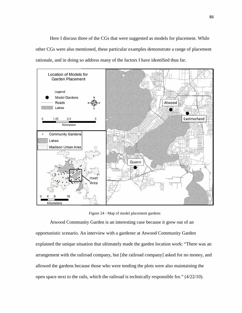
86
Here I discuss three of the CGs that were suggested as models for placement. While
other CGs were also mentioned, these particular examples demonstrate a range of placement
rationale, and in doing so address many of the factors I have identified thus far.
Figure 24 - Map of model placement gardens
Atwood Community Garden is an interesting case because it grew out of an
opportunistic scenario. An interview with a gardener at Atwood Community Garden
explained the unique situation that ultimately made the garden location work: “There was an
arrangement with the railroad company, but [the railroad company] asked for no money, and
allowed the gardens because those who were tending the plots were also maintaining the
open space next to the rails, which the railroad is technically responsible for.” (4/22/10).
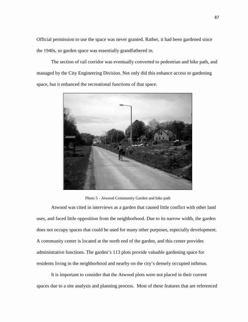
87
Official permission to use the space was never granted. Rather, it had been gardened since
the 1940s, so garden space was essentially grandfathered in.
The section of rail corridor was eventually converted to pedestrian and bike path, and
managed by the City Engineering Division. Not only did this enhance access to gardening
space, but it enhanced the recreational functions of that space.
Photo 5 - Atwood Community Garden and bike path
Atwood was cited in interviews as a garden that caused little conflict with other land
uses, and faced little opposition from the neighborhood. Due to its narrow width, the garden
does not occupy spaces that could be used for many other purposes, especially development.
A community center is located at the north end of the garden, and this center provides
administrative functions. The garden’s 113 plots provide valuable gardening space for
residents living in the neighborhood and nearby on the city’s densely occupied isthmus.
It is important to consider that the Atwood plots were not placed in their current
spaces due to a site analysis and planning process. Most of these features that are referenced
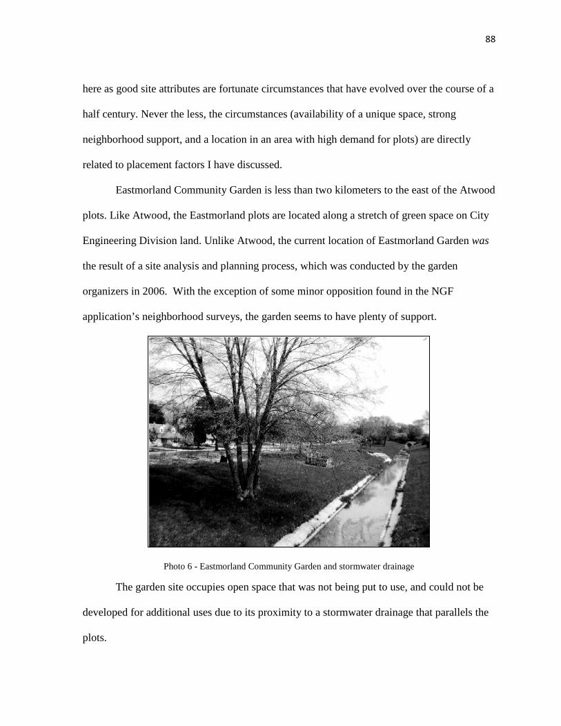
88
here as good site attributes are fortunate circumstances that have evolved over the course of a
half century. Never the less, the circumstances (availability of a unique space, strong
neighborhood support, and a location in an area with high demand for plots) are directly
related to placement factors I have discussed.
Eastmorland Community Garden is less than two kilometers to the east of the Atwood
plots. Like Atwood, the Eastmorland plots are located along a stretch of green space on City
Engineering Division land. Unlike Atwood, the current location of Eastmorland Garden was
the result of a site analysis and planning process, which was conducted by the garden
organizers in 2006. With the exception of some minor opposition found in the NGF
application’s neighborhood surveys, the garden seems to have plenty of support.
Photo 6 - Eastmorland Community Garden and stormwater drainage
The garden site occupies open space that was not being put to use, and could not be
developed for additional uses due to its proximity to a stormwater drainage that parallels the
plots.
89
Eastmorland is also situated in a recreational corridor that includes the Capital City
Bicycle Path, Olbrich Botanical Gardens, and the recreational facilities and fields of Olbrich
Park. While discussing the topic of appropriately placed CGs, a member of the Dane County
Food Policy Council commented on Eastmorland: “I look at that (Eastmorland Garden site)
and it just makes sense; it’s just this big hunk of land along the railroad tracks” (5/5/10). The
key point in this statement is not that there is a large amount of space. There are large pieces
of land scattered throughout the MUA. The fact that this land is adjacent to railroad tracks,
however, is an important point. On the near eastside of Madison, the railroad corridors are
just wide enough to allow for conversion to open spaces with limited recreational
opportunity, but not wide enough to accommodate buildings, large playgrounds or sports
fields. Figure 25 illustrates a cluster of five CGs on railroad and/or open space corridors:
Eastmorland, Saint Paul, Atwood, East Main, and McCormick. East Main is a unique case in
that it is located adjacent to active railroad tracks that have not been converted to bike or
pedestrian pathway. It also has not secured permission from the railroad.
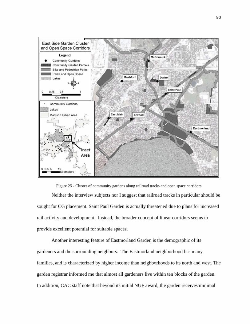
90
Figure 25 - Cluster of community gardens along railroad tracks and open space corridors
Neither the interview subjects nor I suggest that railroad tracks in particular should be
sought for CG placement. Saint Paul Garden is actually threatened due to plans for increased
rail activity and development. Instead, the broader concept of linear corridors seems to
provide excellent potential for suitable spaces.
Another interesting feature of Eastmorland Garden is the demographic of its
gardeners and the surrounding neighbors. The Eastmorland neighborhood has many
families, and is characterized by higher income than neighborhoods to its north and west. The
garden registrar informed me that almost all gardeners live within ten blocks of the garden.
In addition, CAC staff note that beyond its initial NGF award, the garden receives minimal

91
assistance. This type of scenario allows for the gardeners themselves to manage most of the
resources necessary to maintain garden activity and correspondence with city engineers. This
situation, in which the gardeners and surrounding neighborhood can provide for financial
self-sufficiency is quite different from another CG cited as a great model: Quann Community
Garden.
Quann Community Garden is located at the southern edge of Olin Park, a large,
multifunctional open space that is connected with fair grounds and sites for large events. The
garden site was placed over a landfill that capped the southern end of the site. This was an
area originally planned for a soccer field, but soil conditions were not suitable for such active
recreation.
Photo 7 - Aerial view of Quann garden site situation
Garden Site

92
This location also happens to be directly adjacent to a bike and pedestrian path, and
has a parking lot right in front of the garden entrance. While the physical space the garden
was placed in can certainly be interpreted as appropriate placement, it is the social factors
that were most often cited as the garden’s greatest qualities. In response to my question about
good CG models, a CAC staff member offered this explanation: “I’d say Quann. It has a
wonderful combination of community and thriving, multicultural experience. People learn
how to engage with others, and it’s been tremendous to see that happen.” (9/28/10). This is a
reference to on-site interaction, but the garden’s placement within the surrounding area
makes it central to multicultural residents. It is also in close proximity to previous garden
sites that served many of the same gardeners since the 1980s. Quann is part of a cluster of
CGs that have been placed in a manner that helps those gardens address food insecurity and
community building.

93
Figure 26 - Quann Garden and cluster of gardens in an area of low income
Interviews provided for a more nuanced discussion of CG placement factors, and
allowed for further iteration in data collection. In particular, my concurrent archival research
at the CAC was enhanced by a focused approach where I filtered NGF application data for
themes and placement considerations that arose during interviews. When key terms from
interviews were compared with NGF criteria, some conceptual similarities were identified.
For example, CGs that are planned with the intention of addressing food security and social
justice issues require particular attentiveness to socio-economic placement factors. In other
instances, CGs that are planned with a primary focus on alleviating deficiencies in plot
availability may emphasize spatial optimization for service areas and demand. Identification

94
of potential CG sites in densely developed areas may require utilization of uniquely situated
parcels. The results I have discussed so far have provided a more cohesive set of placement
factors that are attentive to garden organizers’ goals and CG trajectories. These factors
include:
- Accessibility
o Proximity to public transportation
o Proximity to bike or pedestrian corridors
- Property type
o Potential for development
o Existing land uses
o Availability of unique spaces
- Social characteristics of surrounding neighborhoods
o Ethnicity and cultural diversity
o Home ownership
o Income
- Indicators of demand for community gardens
o Waiting lists for plots
o Population density
o Areas without plots available
- Biological and physical site conditions
o Soil
o Canopy coverage

95
By identifying these factors, a solid groundwork has been laid for spatial analysis of
CGs in relation to those issues that influence their placement.
3.7 Spatial Analysis using GIS
I employed numerous data collection methods to better understand various social and
physical dimensions of CG placement, and through these methods I acquired information
relevant to multiple spatial scales. Discussion based on NGF applications, surveys and the
McCormick Garden analysis accumulated information on a case by case basis, often at a
parcel level. My review of city documents, interactions at the Dane County Farmer’s
Market, and various interviews resulted in data that had great variation in scale. Information
ranged from detailed narratives about individual CGs to broad discussion of policy
implementation and regional politics. In order to tie data associated with individual sites,
neighborhoods and the MUA as a whole together, I used spatial analysis and qualitative
mapping techniques. These methods allowed for investigation of the configuration of CGs
across the landscape.
This spatial inquiry provides crucial insight into my research questions, particularly
sub-questions 2 and 3. The resulting maps and query reports permit for observations about
patterns in CG placement. These observations then allow for comparison against placement
issues identified in other results.
Prior to running spatial queries and analysis, it was necessary to establish a sufficient
sample population of CGs in the MUA, and geographically reference these gardens. I
acquired a list of 55 CGs in Dane County as of 2010 from the CAC. This was the most
appropriate sample source for two reasons. First, the CAC is one of the most heavily

96
involved organizations in CG initiatives throughout the MUA, and is reliable as a monitor of
CG activity. Second, much of my data from other methods was extracted from CAC
materials, and spatial analysis of gardens associated with the CAC would allow for a
consistent basis for comparison.
The CAC list included addresses of each CG and contact information for the garden
registrar. I created a database in Microsoft Excel to arrange additional data gathered for each
CG, and removed five CGs that were outside of the MUA and thus beyond the scope of my
research. Because my research is concerned with the placement of CGs not only within
neighborhoods, but within individual parcels of land as well, simply geo-coding addresses of
CG locations was not sufficient for analysis. I used aerial and satellite imagery in Google
Earth to identify the location of the garden plots at each CG address, and added the
geographic coordinates for the center of each CG site to the garden Excel database. The
database was brought into a geographic information system (GIS) using Environmental
Systems Research Institute’s (ESRI) ArcGIS Desktop software. Geographic coordinates
were used to create a point shapefile of the CGs. From this point on, the geographic database
file and CG attribute table were used as the principle organizational tool to store data on
characteristics of each CG site.
The CG points were matched to shapefiles of U.S. Census block groups and Dane
County parcels. I populated 31 fields of attributes for each CG using data in the block group
and parcel shapefiles, as well as CAC reports. This included information on CG plot
numbers, households served, demographic data by block group, property type and owner,
municipality, and the year the garden was started (Appendix I – Community Garden

97
Database). The CG shapefile and its database were then used as a basis for mapping CGs and
their attributes against features pertaining to placement factors.
My analysis is organized around three placement themes: accessibility, neighborhood
characteristics, and demand. I have omitted two themes and subsequent placement factors
that I identified in previous sections: biological and physical characteristics and property
type. The absence of these two themes in the following mapping and analysis deserves some
brief discussion.
In regard to biological and physical characteristics, it was possible to analyze spatial
distribution of soil types, slope and canopy coverage, but these data layers make assumptions
about factors that are most influential at a sub-parcel level. At a coarse resolution, the
majority of soil in the MUA appears favorable for agriculture, and would therefore be
favorable for CG placement. However, investigation into historical site uses may reveal
concerns about soil toxicity in particular sections of the site (e.g. where railroad ties
previously existed).
Data for canopy coverage was available at a much finer resolution (3.5 meter) for an
area that included twenty-four CGs. Unlike soil coverage, the canopy coverage layer
constitutes data at a sub-parcel scale; however, a quick comparison of canopy density values
at the center of each CG to canopy density across the entire area of analysis simply suggests
that canopy density is low. The mean coverage for the center of CG sites was 5%, while the
mean coverage for the entire area of analysis was 8%.

98
Figure 27 - Canopy density at 24 garden sites
In lieu of making large assumptions through a coarse or inconclusive spatial
evaluation, the factors of canopy, soils and slope would be better suited for studies of
individual sites. In the case of these particular factors, materials that were attached to NGF
applications had greater precision and finer resolution. Test results from soil samples, and
hand drawn diagrams of sites (which included potential barriers to sunlight or flat surfaces)
provided more nuanced detail than a GIS layer of canopy density for the urban area, or soil
surveys from the USDA.
I have also noted that in scenarios where pre-existing soil conditions are not optimal
for gardening, imported soil, compost, and raised beds can be utilized. In CGs such as Eagle

99
Heights or Saint Stephen’s Church, rows of plots have been terraced to accommodate minor
slopes. Similar flexibility and adaptive techniques are evident in scenarios where canopy
coverage may not allow for a full eight hours of direct sunlight. This includes shifting plot
locations to maximize exposure and utilization of shade-tolerant plant species. With this in
mind, I have omitted a detailed GIS analysis of soils, slope and canopy, and refer back to
site-specific materials and interviews instead.
Placement factors that relate to the theme of property type were also not conducive to
spatial analysis. Identification of property owner political values and disposition toward CGs
requires alternative, qualitative techniques. Likewise, the presence of a unique open space on
an individual parcel that might accommodate a CG is a scenario requiring an individual site
analysis to assess. Identification of the presence or absence of competing recreational uses
and the spaces they occupy is limited in a similar manner. Thus I focused my primary
analysis of these property considerations on interviews and site-specific materials.
Although spatial analysis was not conducive to the study of some factors, it did allow
for an assessment of change in CG placement over time. Throughout my research I have
noted various policies that have potential impacts on CG placement. Because of these
potential impacts, I also include a brief evaluation of how CG attributes have changed over
time, with an emphasis on time periods that correspond with policy or plan implementation.
In part, this evaluation is intended as a measure of planning effectiveness, and provides a
more informed basis for suggestions pertaining to future policies. I discuss some of these
suggestions in my conclusion.
The following spatial analyses focus on two spatial extents. Initially, all fifty CGs are
studied at a regional extent, across the entire MUA. However, because my initial findings
100
suggest that the influence of placement factors depends on the goals and trajectory of a CG, I
also identify and investigate specific clusters of CGs that exemplify the importance of certain
factors.
My selection of units for analysis was based on studies of green space access,
walkability, and some of my initial results. In my assessment of access factors, I utilize a
quarter mile standard for “reasonable walking distance”. This is a commonly utilized
standard in research or planning documents that must make assumptions about walkability
(Althaus, et. al., 2010; Wolch, et. al 2002), but it would be absurd to suggest that an accurate,
universal standard can actually be defined. This is true at multiple scales. Many social and
physical factors impact the distance and route that an individual might walk to any given
feature or service. Reasonable walking distance can depend on age, health factors, physical
barriers, safety considerations and the attractiveness of the destination (Van Herzele and
Weideman, 2003). The complexity of defining variable walking distances was beyond the
scope of my study. I discuss the potential for research concerning CG access metrics in
greater detail in my conclusion.
For my analysis of neighborhood characteristics I used data derived from U.S. Census
block groups. In most cases, block groups are the best standardized representation of a CG’s
service area. Block groups generally contain between 600 and 3,000 people, with an
optimum size of 1,500 people. While no CG in the MUA has 1,500 plots, it is likely that a
fair percentage of a given CG’s participants would be concentrated within a surrounding
population of 1,500. A larger unit of analysis, such as a census tract, might encompass an
entire CG’s participant base, but would not capture the demographic variation that exists in
smaller pockets of neighborhoods.

101
In my analysis and discussion of demand I utilize two measurements to gage service
and garden deficient areas. To provide a basic measure of CG service area, I created a buffer
around all CGs, with a variable buffer distance that is dependent on the amount of plots in the
CG. I divided CGs into two categories: Those with less than fifty plots and those with over
fifty plots. I applied a quarter mile buffer to CGs with less than fifty plots, and a half mile
buffer to CGs with over fifty plots. Based on interviews and selected waiting lists for CGs
that I analyzed, it is apparent that some of the larger CGs draw participants from a greater
distance than do small CGs. I cover this issue further in my discussion of Demand.
3.7.1 Results and Discussion
Accessibility
My primary focus in analyzing accessibility to CGs is on the proximity of garden
sites to potential modes of transportation that do not require access to a personal vehicle. I
have focused on access via public transit and bike/pedestrian corridors, and omitted analysis
of access via personal vehicle for several reasons. While the results of neighborhood surveys
and informal discussions with gardeners suggest that some gardeners do access CG sites via
personal vehicle, and that parking can be a concern for neighbors directly adjacent to
gardens, these concerns did not emerge as significant factors in garden placement.
Furthermore, universal standards for reasonable driving distance do not exist, and extreme
variability among individuals’ perceptions of reasonable driving distance would make
defining and analyzing such a standard impractical.
Both interviews and discussion with garden registrars did, however, suggest that
many gardeners access their sites from within a reasonable walking distance, and access via

102
public transit was emphasized during interviews. These modes of access are facilitated by
availability of gardening equipment and toolsheds on most CG sites. I suggest further
methods of inquiry for CG access in my conclusion (Ch. 5, pg. 134).
I applied a distance query to examine how many CGs are within a quarter mile of
public transit stops and bicycle/pedestrian corridors. I then analyzed attributes of CGs that
are within reasonable walking distance and those that are not to identify potential patterns of
garden placement with respect to access.
Figure 28 - Community gardens and public transit

103
Figure 29 - Community gardens and bicycle/pedestrian corridors
The results of this simple spatial query are, for the most part, unremarkable. 42 out of
50 CGs are within a quarter mile of a public transit stop, and 33 out of 50 CGs are within a
quarter mile of a bike or pedestrian pathway. While these results illustrate that most CGs are
located in reasonable walking distance of access features, it does not provide strong evidence
that CGs are intentionally placed near transit stops and bicycle or pedestrian corridors. It is
more likely that a strong connection exists between the availability of open space for
recreation and the types of properties that CGs are located on. Out of the 17 CGs that were
not within a quarter mile of a bike or pedestrian path, only three were designated parks or
open spaces. The other 14 CGs were located on school, church or private property. The latter

104
property types are commonly accessed for other purposes, often via private vehicle, and can
accommodate parking. Again, this may not be a sign of intentional placement, but rather an
interesting product of the spaces used for gardening.
The positive relationship between pedestrian access and utilization of parks and open
spaces for CGs has had some impact on placement. In the summer of 2011, a meeting was
held on the east side of Madison’s isthmus, to discuss the potential of creating an “urban
agriculture corridor”. The concept was to create an interconnected network of recreational
spaces used for gardening and food production, and connect these spaces with modes of
active transportation. Bike routes and pedestrian pathways provided the primary means for
connectivity and access.
Figure 30 - Proposed urban agriculture corridor and pedestrian connectivity

105
Thus access should not be discounted as a factor in CG placement. It may have
significant influence in certain situations. As UPA in the MUA continues to expand and
diversify, growth of the concept of urban agriculture corridors could strengthen the
significance of access to placement. Such concepts might foster a more cohesive sense of
community in particular neighborhoods, and allow for conversion of isolated, vacant spaces
into part of a productive vision. The rejuvenation of community space can be a particularly
significant goal in neighborhoods with disadvantaged populations.
Neighborhood Social Characteristics
My initial findings suggested that neighborhood social characteristics most often
considered in CG placement are household income, ethnic diversity and home ownership. Of
these three factors, income was weighted most heavily. Home ownership was also
emphasized, but to a lesser degree than income. To analyze these factors spatially, I created
a weighted overlay of three demographic layers, and analyzed the weighted score of CGs
resulting from that overlay. Census block group shapefiles showing median household
income, number of Asian and Hispanic households, and percent home ownership were each
separated into five classes using a natural breaks (Jenks) method. This classification attempts
to minimize variance within classes while making the classes as different as possible; an
effort that is helpful in visualizing demographic data that varies greatly across an area.
These three classified files were then reclassified so that the five classes were
represented by a scoring scale of 1-5 (Appendix J). The reclassified files were combined in a
weighted overlay. I assigned weights to each layer based on the emphasis that was placed on
those factors in the results of other methods. Median household income was weighted at
50%, percent household ownership at 30%, and number of ethnic households at 20%.
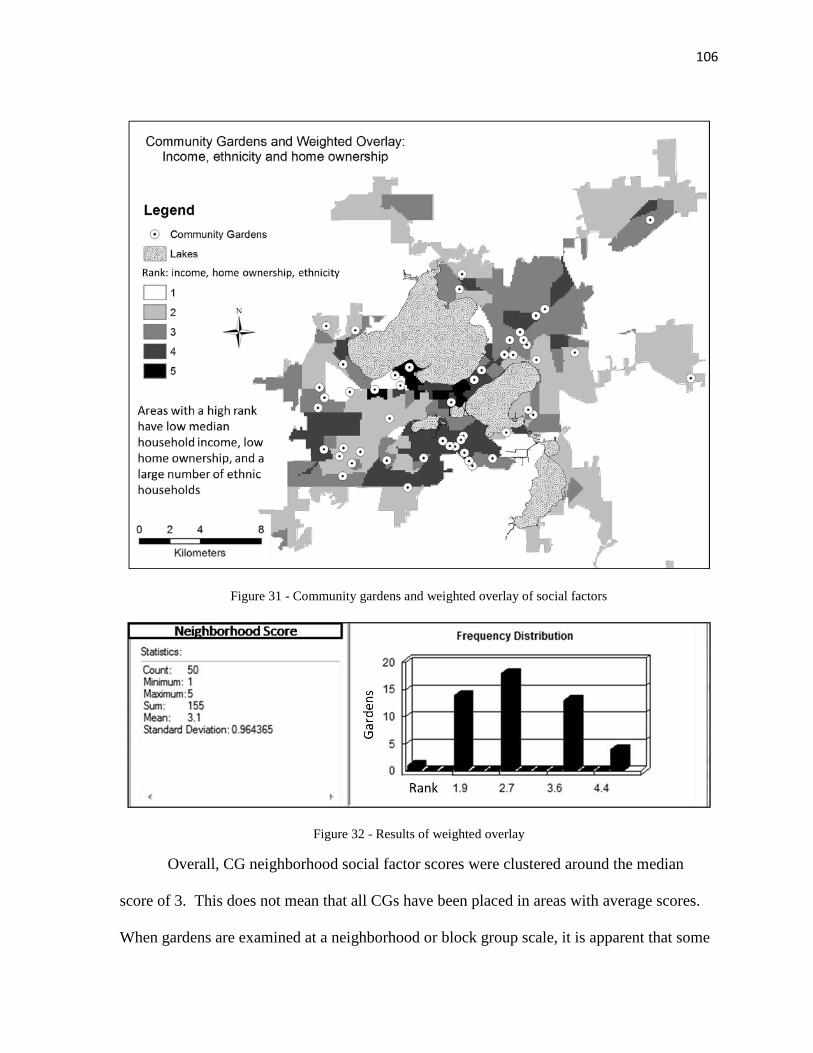
106
Figure 31 - Community gardens and weighted overlay of social factors
Figure 32 - Results of weighted overlay
Overall, CG neighborhood social factor scores were clustered around the median
score of 3. This does not mean that all CGs have been placed in areas with average scores.
When gardens are examined at a neighborhood or block group scale, it is apparent that some
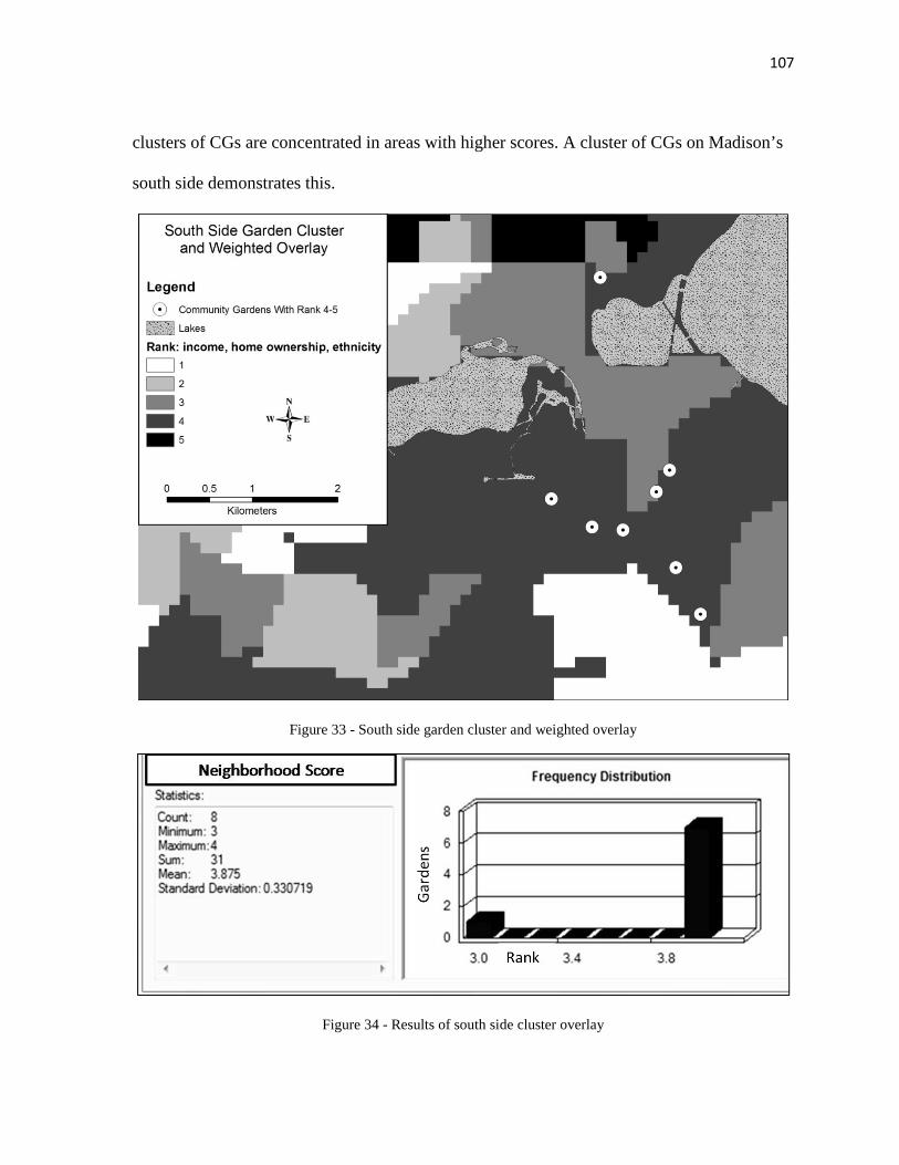
107
clusters of CGs are concentrated in areas with higher scores. A cluster of CGs on Madison’s
south side demonstrates this.
Figure 33 - South side garden cluster and weighted overlay
Figure 34 - Results of south side cluster overlay

108
Several gardens in this cluster have received funding awards, CAC assistance, or
were cited in interviews as examples of “good” placement. Good, in the context of the
neighborhood score, means that the values of socio-economic factors in this area provide
potential to help disadvantaged populations, address food insecurity, and facilitate
community building and empowerment.
CG placement in other areas may not be influenced by these social factors at all. The
CG plots in Shorewood Hills received the lowest neighborhood score out of all CGs (1), but
the location was chosen by residents because it is one of the only areas in the neighborhood
without significant canopy coverage. The Shorewood garden is also directly adjacent to a
center of community recreational activity, and was the site of a farm in the early to mid-20th
century. This CG is a very unique case in that biological and physical factors (fertile soils
and minimal canopy cover) did have a large influence on CG placement.
In this scenario, there was a high rate of home ownership, and almost all residential
parcels in the neighborhood had yards, yet canopy cover inhibited personal gardens and
therefore created demand. It would be erroneous to assume that canopy cover is a universal
indicator of demand for CGs, but it is certainly a factor in scenarios where two conditions are
both met: most yards of neighborhood residents do not receive sufficient sunlight for
gardening and those same residents have an interest in gardening. Measuring demand based
on the combination of these two conditions would require extensive surveying in
neighborhoods with high canopy coverage, but other measures of demand are simpler to
analyze.
Factors contributing to demand

109
The main factors of interest in mapping areas of demand for CGs were population
density and availability of plots. I also mapped the locations of individuals on the waiting
list for the 2010 gardening season at Atwood Gardens. While my results thus far have
suggested that areas with plot deficiencies and high population density should be prioritized
for CG placement, a quick glance at the spatial distribution of these factors illustrates that
CGs have not been placed in those areas.
Figure 35 - Community garden plots and population density
This disparity between where CGs are placed and where they should be placed is not
the result of inefficient planning, but rather, a lack of available open space and low
prioritization for CGs in open space programming near the urban core. There is, in fact,

110
plenty of demand originating in the plot-deficient isthmus and downtown areas. The
following figure illustrates how individuals that cannot find garden plots in their immediate
neighborhood will travel to a CG that has available plots.
Figure 36 - Individuals on the 2010 waiting list for Atwood Garden
The Atwood waiting list indicates two conditions. First, gardens placed within areas
of high demand may not serve the surrounding population as well as a CG that is placed on a
larger space nearby (but not in) the area of demand. Here, over one hundred plots at Atwood
serve the isthmus better than a scattering of plots would in the center of the isthmus. Based
on the extent of the waiting list, one might conclude that the notion of a “reasonable
distance” to travel to a CG is dependent on the service that a particular CG can provide. In
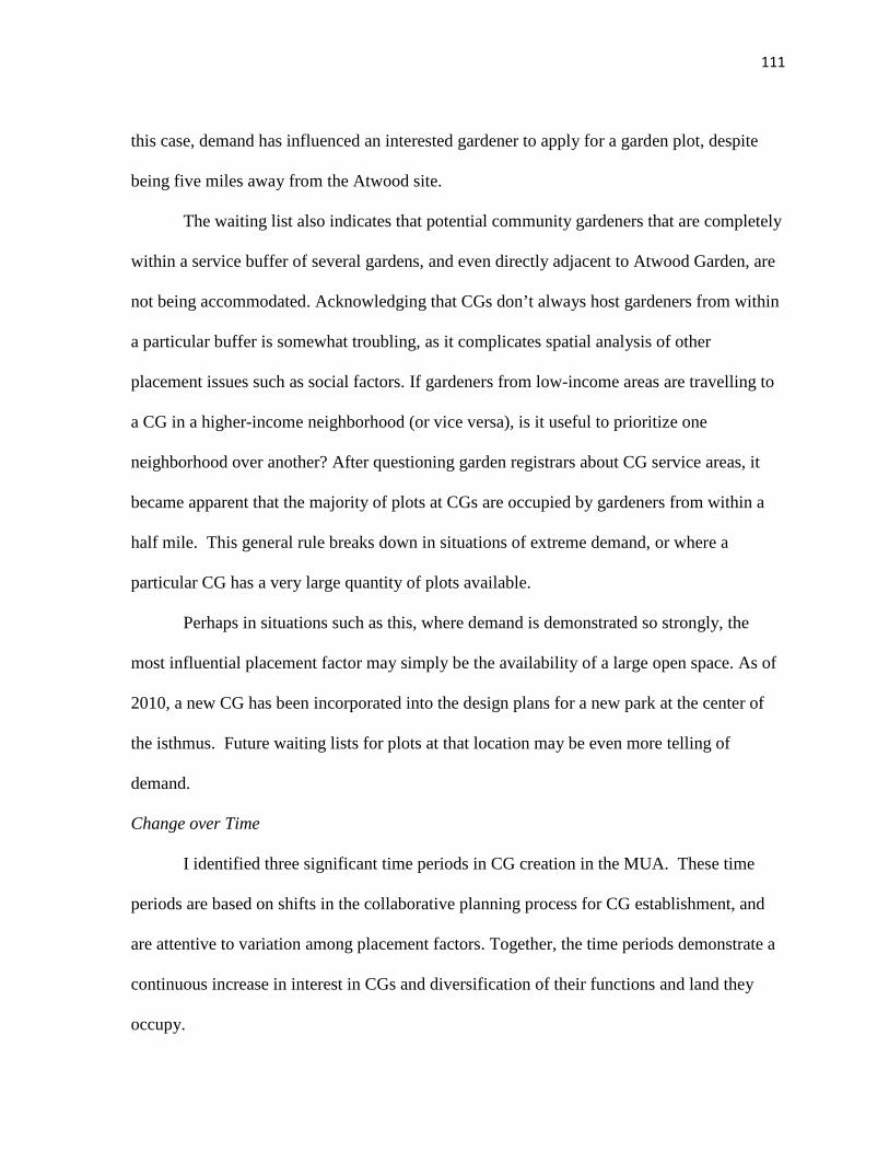
111
this case, demand has influenced an interested gardener to apply for a garden plot, despite
being five miles away from the Atwood site.
The waiting list also indicates that potential community gardeners that are completely
within a service buffer of several gardens, and even directly adjacent to Atwood Garden, are
not being accommodated. Acknowledging that CGs don’t always host gardeners from within
a particular buffer is somewhat troubling, as it complicates spatial analysis of other
placement issues such as social factors. If gardeners from low-income areas are travelling to
a CG in a higher-income neighborhood (or vice versa), is it useful to prioritize one
neighborhood over another? After questioning garden registrars about CG service areas, it
became apparent that the majority of plots at CGs are occupied by gardeners from within a
half mile. This general rule breaks down in situations of extreme demand, or where a
particular CG has a very large quantity of plots available.
Perhaps in situations such as this, where demand is demonstrated so strongly, the
most influential placement factor may simply be the availability of a large open space. As of
2010, a new CG has been incorporated into the design plans for a new park at the center of
the isthmus. Future waiting lists for plots at that location may be even more telling of
demand.
Change over Time
I identified three significant time periods in CG creation in the MUA. These time
periods are based on shifts in the collaborative planning process for CG establishment, and
are attentive to variation among placement factors. Together, the time periods demonstrate a
continuous increase in interest in CGs and diversification of their functions and land they
occupy.
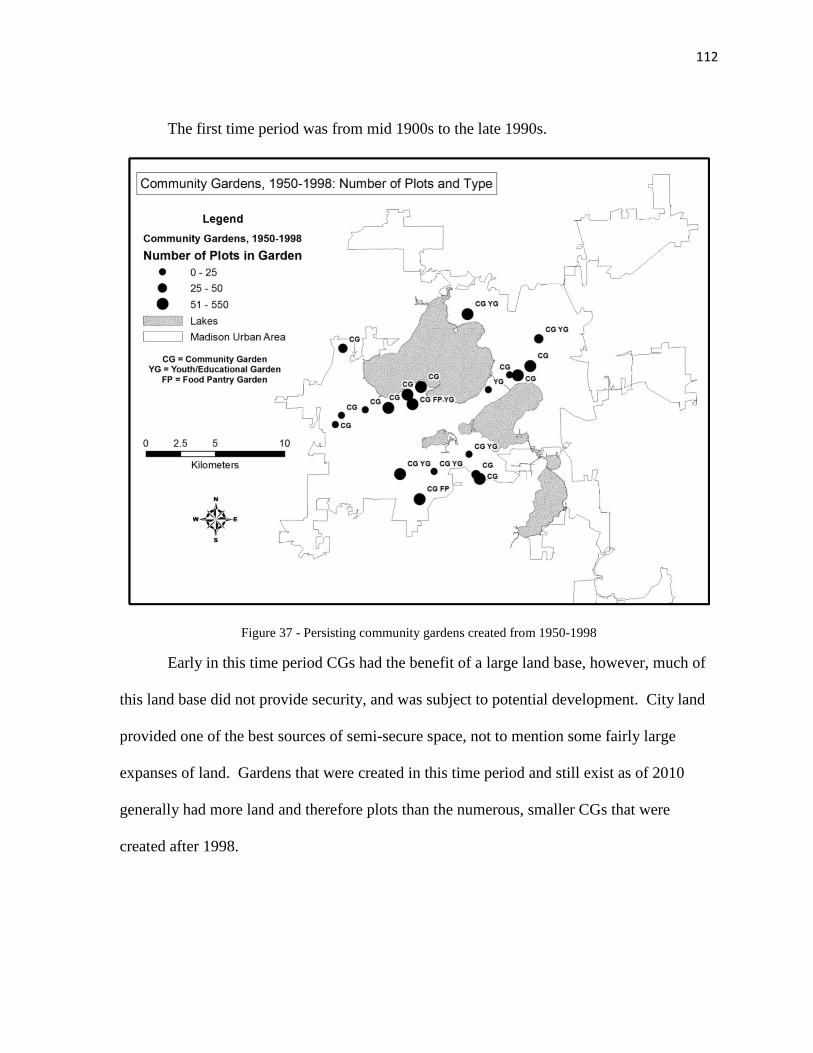
112
The first time period was from mid 1900s to the late 1990s.
Figure 37 - Persisting community gardens created from 1950-1998
Early in this time period CGs had the benefit of a large land base, however, much of
this land base did not provide security, and was subject to potential development. City land
provided one of the best sources of semi-secure space, not to mention some fairly large
expanses of land. Gardens that were created in this time period and still exist as of 2010
generally had more land and therefore plots than the numerous, smaller CGs that were
created after 1998.
113
Figure 38 - Graph of garden plot creation over time
CGs were also less diverse in their programs and functions than the current array.
Some youth gardens and a community farm existed, but the diversity of features and
programs present at some gardens in 2010 is the result of significant community investment
and resource allocation that did not exist in the 1980s. Susceptibility and a lack of
institutional support led to a number of garden losses and relocations.
The second time period is from 1999 to 2005. This span of time marks a transitional
period from the politicization of CGs to the establishment of better defined, collaborative
garden creation processes. In particular, the establishment of the CCG and creation of
Reynolds Garden in downtown Madison served as significant steps in enhancing community
dialogue around CGs.
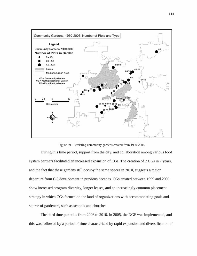
114
Figure 39 - Persisting community gardens created from 1950-2005
During this time period, support from the city, and collaboration among various food
system partners facilitated an increased expansion of CGs. The creation of 7 CGs in 7 years,
and the fact that these gardens still occupy the same spaces in 2010, suggests a major
departure from CG development in previous decades. CGs created between 1999 and 2005
show increased program diversity, longer leases, and an increasingly common placement
strategy in which CGs formed on the land of organizations with accommodating goals and
source of gardeners, such as schools and churches.
The third time period is from 2006 to 2010. In 2005, the NGF was implemented, and
this was followed by a period of time characterized by rapid expansion and diversification of
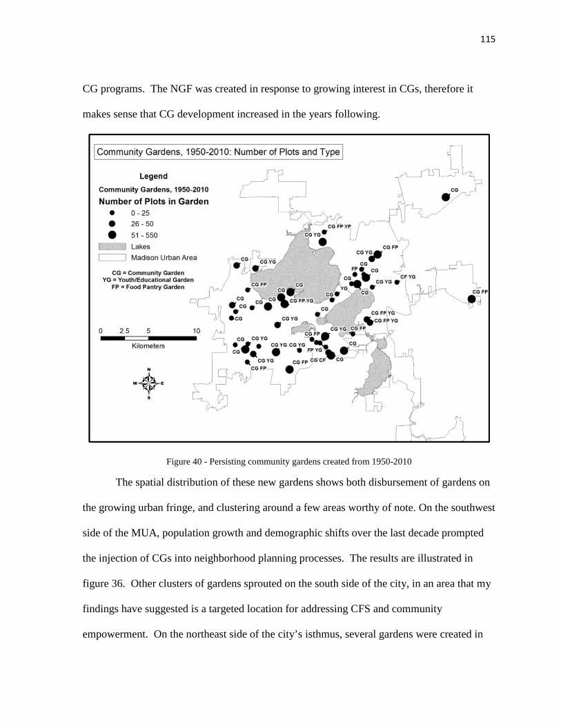
115
CG programs. The NGF was created in response to growing interest in CGs, therefore it
makes sense that CG development increased in the years following.
Figure 40 - Persisting community gardens created from 1950-2010
The spatial distribution of these new gardens shows both disbursement of gardens on
the growing urban fringe, and clustering around a few areas worthy of note. On the southwest
side of the MUA, population growth and demographic shifts over the last decade prompted
the injection of CGs into neighborhood planning processes. The results are illustrated in
figure 36. Other clusters of gardens sprouted on the south side of the city, in an area that my
findings have suggested is a targeted location for addressing CFS and community
empowerment. On the northeast side of the city’s isthmus, several gardens were created in
116
an area proposed as an urban agriculture corridor. CGs have also formed in neighborhoods
far from the urban core. In these areas, there may be a high percentage of owner occupied
households with space for private gardens, but CGs might still be desirable as a catalyst for
social interaction, public recreation, or education. Recognizing a growth of interest in CGs
in conjunction with a widening array of meanings attached to them is crucial to an
assessment of garden placement factors. If gardens are created for different reasons, then
placement factors play different roles. This partially explains why CGs are widely dispersed,
as opposed to being concentrated in a specific neighborhood. While I have noted various
clusters of gardens in certain areas of the MUA, CGs are distributed broadly when analyzed
on a regional scale.
Observing this distributed expansion in CG development over time, and an associated
expansion of CG presence in neighborhood planning and political process, it is apparent that
CG formation has been facilitated. It is not evident, however, whether CG expansion would
have occurred at such a rapid rate even without the support of policy and planning.
Regardless, a demonstrated interest in CGs and consequent integration of UPA into the
normative dialogue of city agencies and the public has certainly generated notable support
for garden development. Questions concerning effective CG placement are perhaps more
relevant to planning in this period of rapid CG formation than any other time period.

117
4. Summary of Results and Findings
Sub-question 1 Findings: What criteria are used in evaluating the proposed
formation and placement of a community garden?
A wide range of criteria are used in evaluating CG proposals, and numerous factors
can be considered to guide placement of a CG. The notion of demand and the motivation of
garden organizers are significant components in CG placement, but these concepts are not
discrete factors. Indicators of demand, including population density and availability of
garden plots, can be considered factors in CG placement. Neighborhood social
characteristics, including the presence or absence of diverse and disadvantaged populations,
are also commonly utilized factors. The political values and support of neighborhoods and
property owners constitute a significant factor; however, these values are difficult to measure
as criteria in planning for garden placement. Political values are best measured through
surveys of neighborhood support or opposition to CGs. The concept of support and
opposition has demonstrated its influence in a number of scenarios. Access to CGs,
particularly through public transit or non-motorized transportation can be a factor in CG
placement, but this is subject to question and deserves further investigation. The type of
property and spaces available for a CG can also influence placement. Factors related to
property and type of space include the values of property owners and their support for CGs,
the presence of marginal or uniquely situated space that is unsuitable for development, and
the presence or absence of competing land uses. Biological and physical factors also
influence CG placement. Canopy coverage and soil quality are the most commonly cited
criteria in placement.

118
Sub-question 2 Findings: What are the spatial attributes of current community
gardens with respect to placement criteria?
Current CGs are distributed widely across the MUA and, as a whole, exhibit little in
the way of pattern or trends. This broad distribution applies to the absolute location of CGs,
but some trends are evident when the distributions of particular attributes of CGs are
examined, such as service area, property type and demographic variables. Some clusters of
CGs exist that demonstrate consistent placement within neighborhoods with certain
demographic profiles.
A broad trend of outward expansion from the urban core is evident in CG placement
over time, while CG development has been minimal within more densely populated areas.
Some reliance on the availability of city-owned open space is evident in the use of parks and
green space corridors, but this reliance has decreased over time.
Sub-question 3 Findings: How do the criteria used in evaluating proposed community
garden sites compare with the attributes of current community gardens?
Significant findings in spatial evaluation are largely limited to assessments at sub-
regional scales, primarily focusing on CG clusters. Overall, CGs do not exhibit high
adherence to placement guidelines that emphasize neighborhood social factors, such as low-
income households and low home ownership. However, there are exceptions in clusters of
CGs close to the urban core. CGs have also not been placed in locations where indicators of
demand are high. This may be a function of availability of open space. Some CGs have been
placed in response to projected areas of demand. CG placement has also taken advantage of
parks and open space acquisitions on the urban fringe, while relying on institutions and
organizations such as schools, churches and non-profits for space where city open space is

119
limited. Most CGs are placed in close proximity to access factors. Exceptions to this are
located mainly on the urban fringe, where there is potential for future enhancement of access
factors. Spatial analysis at a regional scale reveals little about the significance of biological
and physical factors, which are more appropriate for analysis at the parcel and sub-parcel
level.
Primary Question Findings: What are the most significant social and physical factors
that influence the placement of community gardens in the Madison Urban Area?
A universal framework for CG placement does not exist, but a specific set of
placement factors is consistently present, albeit with varying influence on placement (Figure
41).
Figure 41 - Final set of placement factors

120
Social factors and issues relating to support or opposition, including neighborhood
support, indicators of disadvantaged populations, particularly income and home ownership,
and politics are highly influential. Throughout the research process these factors regularly
emerged as dominant variables in placement considerations. In some scenarios, where CGs
were established with a set of specific goals, social factors were particularly dominant.
Because many CGs formed over the past five years were created with some form of vision or
purpose, the degree of influence that particular social factors have is dependent on the
intended goals and programming of a CG. If garden organizers or individuals planning for
CG placement envision a trajectory that helps build multicultural interaction or serve
disadvantaged populations over time, social factors are highly influential. The support of a
neighborhood and political values attributed to CGs by various groups can also influence
placement. In particular, opposition by neighborhood residents or groups can deter
placement where all other placement factors are in a favorable condition. Thus neighborhood
support and politics are strongly influential factors.
Demand for CGs, indicated by deficiencies in plot availability, home ownership and
population density, can be an influential consideration in planning for CG placement, but my
study suggests that there are barriers to this in practice. It is evident that availability of
undevelopable or preserved open space is a crucial aspect that impacts the ability to consider
demand factors in CG placement. Even in areas where there are severe deficiencies in garden
plots and residents have voiced strong support for CGs, such as the city’s isthmus, this
demand cannot influence placement as there is very little open space that isn’t devoted to
other recreational uses. Thus the influence of demand factors such as population density,

121
home ownership and availability of plots, is dependent on the availability of unique spaces or
property owners that facilitate CG development.
Biological and physical conditions have a varying level of influence on CG
placement. If the soil or canopy cover at a particular site is in a condition that completely
inhibits gardening in situ, then it is possible that a CG will not be placed there. However, CG
organizers have demonstrated significant resourcefulness, and if there are few other options
for CG sites, a CG can be adapted to adverse biophysical site conditions. Because the impact
of those factors is dependent on the resourcefulness of garden organizers and adaptive garden
design, biological and physical factors do not have as much influence as neighborhood
support or location of plot deficiencies.
The spatial extent and scale that CG placement takes place on also impacts the
relevance and associated influence of different placement factors. My research examined
CGs on regional, neighborhood and parcel levels, and analysis at each emphasized unique
placement considerations. At the regional level, where a city agency or non-profit may be
planning for CG development, factors of demand, including population density, availability
of plots, and in some cases social factors, are considered in placement. If however, a
neighborhood association or group of garden organizers has identified a particular area
within a region for CG placement, consideration of social factors and demand may be
supplemented by an analysis of neighborhood support or accessibility features. If specific
parcels have been proposed for a CG, then a different set of factors may be taken under
consideration. The individual properties might be explored for competing land uses,
availability of undevelopable spaces, biophysical constraints and the normative values of the
property owner.

122
The following figure illustrates my findings concerning influential CG placement
factors and the scale on which certain factors are most relevant.
Figure 42 - Community garden placement factors and relevance to scale
This configuration of placement factors within the context of scale is directly relevant
to the development of spatial optimization problems for CGs. In Figure 42, I advance the
identification and delineation of a CG solution space in detail by placing variables in a
framework of scales. In this manner, an optimization problem can be more appropriately
defined based on the extent that CG placement takes place within. CG placement across the
MUA might have a solution space defined by variables such as social factors and potential
indicators of demand, while a CG that is being planned for a housing complex might have a
solution space defined by variables such as competing land uses or biophysical conditions.
123
A final aspect of my findings that warrants discussion is the relational nature of
placement factors. The degree of influence that one placement factor has can depend on its
relationship to another placement factor. In addition, the factors being considered in a given
CG placement may depend on those individuals or groups that are guiding the placement
process. A neighborhood association might not plan for a CG in the same manner that a city
agency would.
These dependencies are complex; the influence of various placement factors is
manifest uniquely in each scenario. Therefore any effort to generalize about CG placement
or further develop CG optimization problems requires explicit consideration of community
context and scale.
4.1 Assumptions and Limitations
Anne Spirn has suggested that gardens can function much like towns, and contain
immense complexity in their meanings, site designs, and social interactions (1990). As with
any research that attempts to draw broad conclusions and make generalizations about such
contextual subject matter, my study makes a number of assumptions, and has its limitations.
Information grounded in the views and experiences of people
My study and findings are based on information that is grounded in the perspectives
and experiences of a range of individuals and organizations, and therefore has an inherent
bias. The result of interviewing key informants was often a broad, lengthy discussion that
extended far beyond the scope of CGs and into the larger context of Madison’s food system
and politics. Several key informants had been involved in Madison’s food system for over
thirty years, and held a wealth of knowledge that could not be elicited by more structured
questions. While the individuals I selected for interviews were intentionally stratified based

124
on their roles in food systems research and CG placement in the MUA, the nature of the
interviews allowed for conversations to stray from structured topics to the personal
viewpoints and perspectives of the individual. The summation of conversations was often
characterized by a discussion of discourse and normative values. Had I interpreted or coded
interviews in isolation, a severe bias would be embedded in my results and conclusions. This
is not the case, however, as a constructive approach was taken in triangulating and building
common themes and comparing responses.
While subjectivity and bias is present in the study’s results, I acknowledge this as an
important, if not necessary aspect of the study. Subjectivity does not necessarily constitute a
limitation or weakness because the placement strategies and factors I identified were often
extracted from a subjective placement system. CAC materials introduced a bias into my data,
but the organization was transparent about this bias, and this was taken under consideration
in my analysis. In this way, recognition of bias allowed for a more nuanced understanding of
CG placement and planning.
Community gardens have varying levels of complexity
A nuanced understanding of CG placement was, however, ultimately limited by the
varying complexity and social contexts of individual gardens. The McCormick Garden case
study demonstrated a high level of specificity and distinctiveness in the ways that placement
factors can influence CG formation. There are placement considerations unique to every CG
situation, so generalization about unique scenarios can be a risky endeavor. Nevertheless,
community interest in facilitating and planning for UPA, whether it originates in
neighborhood groups, non-profit organizations or city agencies, necessitates broader
understandings of UPA components. Ideally, a thorough analysis of CG placement in the

125
MUA would result from in-depth analysis and case studies of a comprehensive sample of
gardens. Time and resources inhibit such an undertaking.
Community gardens form, expand and relocate on an annual basis
My study also faced temporal limitations in that the area of interest is a changing
urban landscape. Populations, administrative boundaries and areas of development shift, and
CGs are impacted by such shifts. I have noted certain common themes in the locations where
CGs have been placed, but this was often based on a snapshot in time. Annual tracking and
monitoring of CG loss, relocation, and formation over many decades reveals shifts in policy
and implementation. As a result, not only is my research subject to assumptions about past
strategies in CG placement, but it may also not be accurate in the future. The methodology
can be replicated, but the results will vary. I have discussed the limitations of my study
resulting from temporal issues, as well as bias originating with information sources. This
research is also limited in its application beyond the area of analysis.
Extrapolation beyond Madison
Due to the explicit boundaries drawn around this study, it is not possible to make
strong arguments about CG placement beyond the Madison Urban Area. Policies,
administrative frameworks, social context and land use differ widely between urban areas.
This is especially true of cities with varying sizes, histories and social configurations. A
significant dissimilarity exists between Madison and larger cities with industrial legacies in
that the type of vacant land available for gardening is subject to influences of different past
uses and different future development pressures. To suggest that normative values of a city
agency in one city are shared by an agency in a different city would be erroneous. This
assumption is applicable on the neighborhood scale as well. A key informant noted a
126
difference in community strategies: “You go to different cities and you see this; it’s locally
appropriate.” (9/28/10)
In consideration of these limitations, it would be erroneous to propose a universal CG
optimization model or framework for placement of CGs. Not only would a common model
suffer from making assumptions across multiple communities, it would also neglect the
varying goals and trajectories of CGs across the MUA. The degree to which certain factors
influence garden placement derives not from static land attributes, but from dynamic socio-
political processes and gardener motivations. In reference to the use of strict formulas and
models to optimize design and location of a land use, Goodchild (2010) states that “it may
simply be naïve to believe that human rationality, in the form of rigorously formulated
optimization problems, can ever replace the messy nature of politics” (p. 11). This statement
is especially applicable to CG placement.
Still, it is possible to examine placement factors with attentiveness to the social
processes and normative motivations of garden organizers, and offer broad, adaptive
frameworks for CG placement.
127
5. Conclusion
5.1 Guidelines for Community Garden Placement and Implementation
City policies and zoning for community gardens
In my discussion of study results I have made explicit mention of city zoning and
land use policy. I did not included zoning, per se, as a placement factor. Instead, I suggested
that political and normative values throughout the community can play a significant role in
shaping CG configuration on the landscape. However, the marked increase in food systems
interest among cities, and planners in particular, over the past decade has been evident in the
integration of UPA into policy. Due to the potential impacts of this integration, the manner in
which CGs are dealt with in planning should be given due attention. As a member of the
Dane County Food Policy Council bluntly stated: “I think community gardens and urban
agriculture are these funny entities that those people that write comprehensive plans and
zoning ordinances don’t really know how to deal with” (5/5/10).
As of 2011, CGs are a permitted use in all areas of Madison. Permission, however, is
dependent on the type of UPA activities that a CG plans to implement. In some ways, this is
an excellent way of accommodating the uniqueness of CGs, and avoiding over-simplification
of a complex phenomenon. Explicit language in official policy and plans is an important step
in recognizing CGs as a land use, but a lack of clarification on what differentiates specific
types of UPA from a “community garden” has the potential to create conflict. The
distinction of “for market” purposes is one way this has been done, but as I have noted, CGs
have diversified in form and function over time; some CGs have a multifunctional design that
combines plots used for individual purposes with a more unified vision such as community
supported agriculture. Increasing the specificity of language in plans may enhance the

128
visibility and legitimacy of CGs. However, legitimizing a land use in a plan does not
necessarily facilitate its implementation, nor does it make it a priority.
Community garden tenure and insecurity
Often CGs cannot compete with other land uses and pressures, and are therefore
insecure in their placement. Balmori and Morton (1993) suggest that all gardens are
transitory, and that they serve as an illusion of permanence. This, however, was a reference
to CGs in large cities that did not secure approval for use of a site. The statement was also
based on research conducted in the late 1980s and early 1990s. If one were to conduct
research on CGs in Madison during that time frame, they might reach the same conclusion.
There were many garden relocations and losses in that time period. Garden tenure and
security in the MUA since that time has been improved by two main factors: diversification
of the land base and property types that CGs occupy, and enhanced collaboration among
community members, city agencies and non-profit organizations in CG placement. The latter
has resulted in an emphasis on five year leases on CG sites and more structured exploration
of potential sites. Diversification of the land base, especially through use of spaces owned by
community organizations, educational institutions and churches, has allowed for synergy
between the property owner’s normative values and the presence of a CG.
In light of this, CG placement on an increasingly diverse land base may facilitate
garden tenure. An annual survey of institutions with large amounts of land available could
enhance this. In areas that have little institutional land available, but have higher population
densities and plot deficiencies, city agencies could make a concerted effort to facilitate longer
leases. Plans might also integrate CGs as a standardized recreation asset in open spaces other
than parks (i.e. ROW corridors and stormwater utilities). In these spaces, other forms of

129
recreation may not be feasible. Of course, these recommendations are dependent on the
presence of demand for CGs.
Demand for new or expanded community gardens
As with many urban areas, Madison has a very small land base for open and green
space near its core. This area faces some obvious physical limitations, and the immediate
downtown area, the isthmus, and areas adjacent to the University of Wisconsin have the
largest plot deficiencies in relation to population density. It seems intuitive that demand for
CGs would be highest in this area, and therefore placement would be prioritized. Waiting
lists of nearby gardens and public interest in the form of petitions and input on park design
proposals is evidence of this, but indications of demand outside of this area are less obvious.
Madison does not have any formal device to measure demand for CGs. The most
commonly cited method for measurement is the use of waiting lists at various gardens. Due
to the variability of locations in which gardeners travel from, a CG’s waiting list should not
be considered a completely accurate indicator of spatially concentrated demand. Many
gardeners interviewed at the Dane Co. Farmer’s Market had traveled across town to find
open plots. The bustle of activity in the Eagle Heights gardens every summer does not
necessarily mean that every student at the University of Wisconsin is in search of gardening
space. Organizations such as the CAC are also able to subjectively gauge demand by
assessing the location of garden organizers and site proposals, but this is certainly not a
comprehensive survey of demand.
As CGs and other types of UPA rapidly develop in the MUA, it may be to the benefit
of neighborhoods, facilitating organizations and municipalities to establish an ongoing metric
for demand, and therefore prioritization in planning. This could be done by creating a

130
common forum or survey where interested individuals or neighborhoods could express both
level of interest and area of interest. If this measure was standardized, it would be a metric
that allows for assessment of demand by location. Of course, the dynamics of politics and
social processes might complicate planned CG placement according to this measure. Those
individuals or groups not interested in a CG have a significant influence.
Neighborhood disposition toward community gardens
Disposition and attitude is a crucial factor in placement; neighborhood opposition has
demonstrated its ability to bring a halt to CG projects in the past. Thus it would be extremely
useful if residential attitude toward gardens could be measured across the entire study area.
This would allow for spatial representation of CG “friendly” areas. In my discussion of scale
and neighborhood surveys, however, I have acknowledged that the attitudes of residents are
most influential in close proximity to CG sites. Currently there is little way of assessing
attitude toward a CG until that CG has been proposed at a particular site. Thus the factor of
neighborhood opposition is, in some ways fixed at a particular point in the placement
process. Any efforts or strategy that investigates this factor earlier in the placement process
may help ensure an appropriate site is chosen. While it might not be feasible to suggest that
neighborhood residents express their concerns about CGs without the motivation of an
impending CG proposal, it might be possible to assess the “visibility” of a potential CG to
neighbors. If garden organizers have concerns that a CG will face opposition in a
neighborhood, exploration of less visible sites might be advantageous.
Decreasing visibility of CGs seems contrary to the wide body of literature and
research that illustrate the positive meanings and benefits associated with gardens. However,
if the interested gardeners are simply searching for a place to engage in personal recreation or

131
grow food, the promotion of a CG as a central community asset may not be necessary. Thus
I return to a recurring finding: the goals and intended trajectory of a CG influence its
placement.
Addressing Community Gardens through multiple trajectories
Lawson (2000) and Hough (2004) suggest that those community gardens that
originate at a grass-roots level, and are grounded in the context of garden organizers in the
surrounding neighborhood are often the most resilient gardens. Perhaps this resiliency is a
function of a unified vision and commitment to goals that are directly relevant to the
gardeners. Winne (2008) adds to this notion, asserting that if a non-profit or municipal
agency conducts all of the administrative work, site design and resource allocation for a CG,
that garden is likely to ultimately fail (pg. 66, 67). I have made some recommendations for
CG placement strategies that involve non-profit facilitators or municipal agencies, but an
effective CG placement and implementation program would be equally considerate of the
path and intended impacts of proposed CGs. At a grass-roots level, a thorough visioning
process should be used early in the planning and placement process.
I have suggested a number of ways to enhance CG placement in the MUA. However,
just as my research is forced to make assumptions about diverse subject matter, so too are
plans and policies concerning CGs forced to make assumptions about the diverse social and
political processes that shape CG placement. Care should be taken to allow for community-
based solutions in policy. Goldstein, et al. (2001) suggest that approaches to redevelopment
and revitalization initiated by community-based organizations are often site-specific, and
may not be easily reproduced in broad policies (p. 21). They do note, however, that the need
to involve such organizations in planning processes can be reproduced in policy (p.22). In

132
considering this concept, perhaps the most useful strategy for CG placement in the MUA is
to further strengthen the collaborative decision-making frameworks that are being built
between individual gardeners, community organizations and government. The CCG is an
excellent step in this direction. Just as various CG placement factors have variable
significance at different scales, the various individuals and groups involved in placing CGs
have variable relevance and input at different scales.
5.2 Future Directions
Monitoring and Census
Community gardens are not the easiest phenomenon to monitor and track, especially
when there is a large quantity of gardens administered by a diversity of groups or
organizations. While a neighborhood association may have a very accurate picture of how a
particular CG has expanded or evolved, other organizations such as the CAC or city agencies
may not have the resources to devote to a regular and comprehensive census of CGs. Yet
this type of census is a crucial form of data that can inform and guide CG development. Both
strengths and weaknesses in CG placement strategies are evident in the study of garden
relocations, losses and expansions, and comprehensive knowledge of who is participating in
CGs will allow for more effective guidance. Thus a more complete process for gathering
data on CGs as a whole, and on the composition of individual gardens should be explored.
Tracking and documentation of CGs also provides a basis for understanding the
effectiveness and impacts of policies and plans pertaining to CGs. Comparing changes in
CG development to changes in parks and open space acquisitions or implementation of
neighborhood plans may lead to insight as to how decision-making is transcribed on the UPA

133
landscape. While this type of monitoring would be useful for planners and practitioners, it
also provides further opportunity for research.
Future topics for study
In addition to research concerning the impacts of policies and plans, all of the
individual CG placement factors I have discussed offer potential for useful research. I have
noted the complexity involved in identifying demand and interest in CGs. This topic
deserves explicit attention and thorough research, especially with respect to areas of
projected growth and forecasting.
The issue of access is also worthy of study. While I had few significant findings in
terms of access, this may be a result of not having enough data on CG access. In depth
investigation into the modes of access to CGs, identification of reasonable walking distances,
and perceived barriers in the landscape may provide valuable insight for future placement of
CGs.
Future research might also concentrate on the relationship between socio-economic
factors and the placement of CGs. In finding slight discrepancies between where CGs are
placed and where organizations and individuals suggest they should be placed, new questions
arise. To what degree do CGs alleviate food insecurity? Is the answer dependent on their
placement within the social landscape?
Provided with further research concerning individual placement factors it may be
possible to apply refined data to the questions I have posed in this study. Future findings
might diverge from those I have presented here, but that is the nature of studying diverse and
adaptive social processes. While my research does not offer a definitive model to solve a
complex issue, it does provide enriched insight into a phenomenon that communities have

134
demonstrated a surge of interest in. It is my hope that deepened perspectives, such as those
that I have offered, will both inform practice and spur further exploration.

135
References
Alaimo, Katherine, Elizabeth Packnett, Richard A. Miles and Daniel J. Kruger. 2008. Fruit
and Vegetable Intake among Urban Community Gardeners. Journal of Nutrition
Education and Behavior. 40(2): 94-101.
Allen, Patricia. 1999. Reweaving the Food Security Safety Net: Mediating Entitlement and
Entrepreneurship. Agriculture and Human Values. 16: 117-129.
Althaus, Michelle M., Juliana A. Maantay, Kristen Grady, Nério Cardoso, andNilceNazareno
da Fonte. 2010. Community Gardens: An Exploration of Urban Agriculture in the
Bronx, New York City. Cities Environ. 3(1).
Altieri, Miguel, Nelso Companioni, Kristina Canizares, Catherine Murphy, Peter Rosset,
Martin Borque and Clara Nicholls. 1999. The Greening of the “Barrios”: Urban
agriculture for food security in Cuba. Agriculture and Human Values. 16: 131-140.
Anderson, Molly D. and John T. Cook. 1999. Community Food Security: Practice in Need of
Theory? Agriculture and Human Values. 16: 141-150.
Bailkey, Martin and Joe Nasr. 1999. From Brownfields to Greenfields: Producing Food in
North American Cities. Community Food Security News. Fall, 1999.
Baker, Lauren E. 2004. Tending Cultural Landscapes and Food Citizenship in Toronto’s
Community Gardens. The Geographical Review. 94(3):305-325. The American
Geographical Society of New York.
Balmer, Kevin, James Gill, Heather Kaplinger, Joe Miller, Melissa Peterson, Amanda
Rhoads, Paul Rosenbloom and Teak Wall. 2005. The Diggable City: Making Urban
Agriculture a Planning Priority. School of Urban Studies and Planning, Portland State
University.
Balmori, Diana and Margaret Morton. 1993. Transitory Gardens, Uprooted Lives. Yale
University Press: New Haven.
Brown, Kate H. and Andrew L. Jameton. 2000. Public Health Implications of Urban
Agriculture. Journal of Public Health Policy. 21(1): 20-39.
City of Madison Advisory Committee on Community Gardens. 1999. Growing a Stronger
Community with Community Gardens: An Action Plan for Madison. City of Madison.

136
City of Madison Advisory Committee on Community Gardens. 2011. Committee on
Community Gardens Report: 2008-2011.City of Madison.
City of Madison Comprehensive Plan. 2011. Chapter 28: Zoning Code. City of Madison.
City of Madison Parks Division. 1971. Parks and Open Space Plan.
City of Madison Parks Division. 1977. Parks and Open Space Plan.
City of Madison Parks Division. 1984. Parks and Open Space Plan.
City of Madison Parks Division. 1991. Parks and Open Space Plan.
City of Madison & Southwest Neighborhood Steering Committee. 2008. Southwest
Neighborhood Plan.
City of Madison Zoning Re-Write Committee. 2011. Zoning Code Comparison, Existing and
New Draft. City of Madison.
Cohen, Nevin. 2007. The Suburban Farm: An Innovative Model for Civic Agriculture. Urban
Agriculture Magazine.55 (8).
Dubbeling, Marielle and Henk de Zeeuw. 2011. Urban Agriculture and Climate Change
Adaptation: Ensuring Food Security through Adaptation. Local Sustainability. 1(5):
441-449.
Feenstra, Gail. 2002. Creating Space for Sustainable Food Systems: Lessons from the field.
Agriculture and Human Values. 19: 99-106.
Goldstein, James, Michael Jensen, and Edward Reiskin. 2001. Urban Vacant Land
Redevelopment: Challenges and Progress. Lincoln Institute of Land Policy Working
Paper.
Goodchild, Michael F. 2010. Towards Geodesign: Repurposing Cartography and GIS.
Cartographic Perspectives. 66: 7-21.
Hale, James, Corrine Knapp, Lisa Bardwell, Michael Buchenau, Julie Marshall, Fahriye
Sancar and Jull S. Litt. 2011. Connecting Food Environments and Health through the
Relational Nature of Aesthetics: Gaining insight through the community gardening
experience. Social Science and Medicine. 72(11): 1853-1863.
Hathaway, Lucas and Samantha Langley. 2006. Phytoremediation of a Lead Contaminated
Urban Community Garden. Presented at the International Meetings of the American

137
Society of Agronomy, Crop Science Society of America, and Soil Science Society of
America. November 12-16, Indianapolis.
Heiger-Bernays, Wendy J., Alicia Fraser, Valerie Burns, Kerry Diskin, Diedre Pierotti, Kian
Merchant-Borna, Michael McClean, Daniel Brabander, and Patricia Hynes. 2009.
Characterization and Low-Cost Remediation of Soils Contaminated by Timbers in
Community Gardens. International Journal of Soil, Sediment and Water. 2:3, Article
5.
Hough, Michael. 2004. Chapter 5: City Farming. In Cities and Natural Process: A Basis for
Sustainability. London, U.K.: Routledge. Pp. 160-188.
Howard, Ebenezer. 1902. Garden Cities of Tomorrow. London: S. Sonnenschein & Co., Ltd.
Kameshwari, Pothukuchi and Jerome Kaufman. 1999. Placing the food system on the urban
agenda: The role of municipal institutions in food systems planning. Agriculture and
Human Values. 16: 213-224.
Kameshwari, Pothukuchi and Jerome Kaufman. 2000. The Food System: A Stranger to the
Planning Field. Journal of the American Planning Association. 66 (2): 113-124.
Kaufman, Jerome and Martin Bailkey. 2000. Farming Inside Cities: Entrepreneurial Urban
Agriculture in the United States. Lincoln Institute of Land Policy Working Paper.
Kremer, Peleg and Tracy DeLiberty. 2011. Local Food Practice and Growing Potential:
Mapping the Case of Philadelphia. Applied Geography. 31(4): 1252-1261.
Kurtz, Hilda. 2001. Differentiating Multiple Meanings of Garden and Community. Urban
Geography. 22(7): 656-670.
Lawson, Laura J. 2005. City Bountiful: A Century of Community Gardening in America.
Berkeley: University of California Press.
Leedy, Paul and Jeanne Ormrod. 2005. Practical Research: Planning and Design.
Columbus: Pearson Merill Prentice Hall.
Lovell, Sarah Taylor. 2010. Multifunctional Urban Agriculture for Sustainable Land Use
Planning in the United States. Sustainability. 2(8): 2499-2522.
McHarg, Ian L. 1969. Design with Nature. New York: Garden City Press.
Mougeot, Luc J.A. 2006. Growing Better Cities: Urban agriculture for sustainable
development. Ottawa: International Development Research Centre.

138
Ostry, Aleck and Kathryn Morrison. 2008. Developing and Utilizing a Database for Mapping
the Temporal and Spatial Variation in the Availability of “Local Foods” in British
Columbia. Environments. 36(1): 19-31.
Ostry, Aleck, Kathryn Morrison and Trisalyn Nelson. 2011. Mapping Spatial Variation in
Food Consumption. Applied Geography. 31(4): 1262-1267.
Peters, Christian J., Jennifer L. Wilkins and Gary W. Flick. 2007. Testing a Complete-Diet
Model for Estimating the Land Resource Requirements of Food Consumption and
Agricultural Carrying Capacity: The New York State Example. Renewable
Agriculture and Food Systems. 22: 145-153.
Peters, Christian J., Nelson L. Bills, Arthur J. Lembo, Jennifer L. Wilkins and Gary W. Flick.
2009. Mapping Potential Foodsheds in New York State: A spatial model for
evaluating the capacity to localize food production. Renewable Agriculture and Food
Systems. 24: 72-84.
Smit, Jac, Joe Nasr and Annu Ratta. 2001. Chapter 4: Where is Farming Found in the City?
In Urban Agriculture: Food, Jobs, and Sustainable Cities. Published by The Urban
Agriculture Network, Inc. with permission from the United Nations Development
Programme.
Spirn, Anne Whinston. 1990. This Garden is a Town. A Publication of the West Philadelphia
Landscape Plan. Department of Landscape Architecture and Regional Planning,
University of Pennsylvania.
Spirn, Anne Whinston. 1991. Models of Success: Landscape Improvements and Community
Development. A Publication of the West Philadelphia Landscape Plan. Department of
Landscape Architecture and Regional Planning, University of Pennsylvania.
U.S. Census Bureau, 2000. Urban and Rural Population by State: 1990 and 2000. Population
and Housing Unit Counts PHC-3.
http://www.census.gov/compendia/statab/2011/tables/11s0029.pdf .
Van Herzele, A., and Weidemann, T. 2003. A Monitoring Tool for the Provision of
Accessible and Attractive Green Spaces. Landscape and Urban Planning. 63: 109-
126.

139
Viljoen, Andre (Ed.). 2005. Continuous Productive Urban Landscapes: Designing Urban
Agriculture for Sustainable Cities. Architectural Press: Oxford.
Vitiello, Domenic and Michael Nairn. 2009. Community Gardening in Philadelphia: 2008
Harvest Report. Published by Philadelphia University of Pennsylvania.
Voicu, Ioan and Vicki Been. 2008. The Effect of Community Gardens on Neighboring
Property Values. Real Estate Economics. 36(2): 241-283.
Voigt, Kate A. 2011. Pigs in the Backyard or the Barnyard: Removing Zoning Impediments
to Urban Agriculture. Boston College Environmental Affairs Law Review. 38(2): 537-
566.
Wakefield, Sarah, Fiona Yeudall, Carolin Taron, Jennifer Reynolds and Ana Skinner. 2007.
Growing Urban Health: Community Gardening in South-East Toronto. Health
Promotion International. 22(2): 92-101.
Wilkins, Jennifer L. 2005. Eating Right Here: Moving From Consumer to Food Citizen.
Agriculture and Human Values.22: 269-273.
Winne, Mark, Hugh Joseph and Andy Fisher. 1998. Community Food Security: A Guide to
Concept, Design, and Implementation. Venice, California: Community Food Security
Coalition.
Winne, Mark. 2008. Closing the Food Gap: Resetting the Table in the Land of Plenty.
Beacon Press: Boston.
Wolch, Jennifer, Wilson, J., and Fehrenbach, J. 2002. Parks and Park Funding in Los
Angeles: An Equity Mapping Analysis. University of Southern California Sustainable
Cities Program. Retrieved from
http://dornsife.usc.edu/geography/ESPE/documents/publications_parks.pdf

140
Appendix A - Community Gardening Project Survey
COMMUNITY GARDENING PROJECT SURVEY We, ___________________________________, are starting a community garden at ___________________ ______________________________________ with help from the Madison New Garden Fund. As a neighbor we would like you to know about this project and we welcome your feedback and/or participation. It is also a part of the application process to show that we have spoken with our neighbors. The following questions are to help you and us think about adding this to our neighborhood.
1) Please give us your name and address. (These will not be shared outside of this application process.)
___________________________________________________________________________ 2) Would you be interested in having a garden plot? Please circle: Yes
No If yes, please give us your phone or email address where you can be reached. ______________________________________________________________________
3) Would you have any concerns or suggestions regarding a community garden at
this site?
____________________________________________________________________________________________________________________________________________________________________________________________________________________________________________________________________________________________________________________________________________________________________________________________________________________________________________________________________________________________________ If you have any questions please contact __________________________________________ at __________________. We would appreciate getting this form back from you by __________________. Thank you for taking the time to communicate with us about this project and we look forward to a productive and successful community garden. Sincerely, The Garden Committee
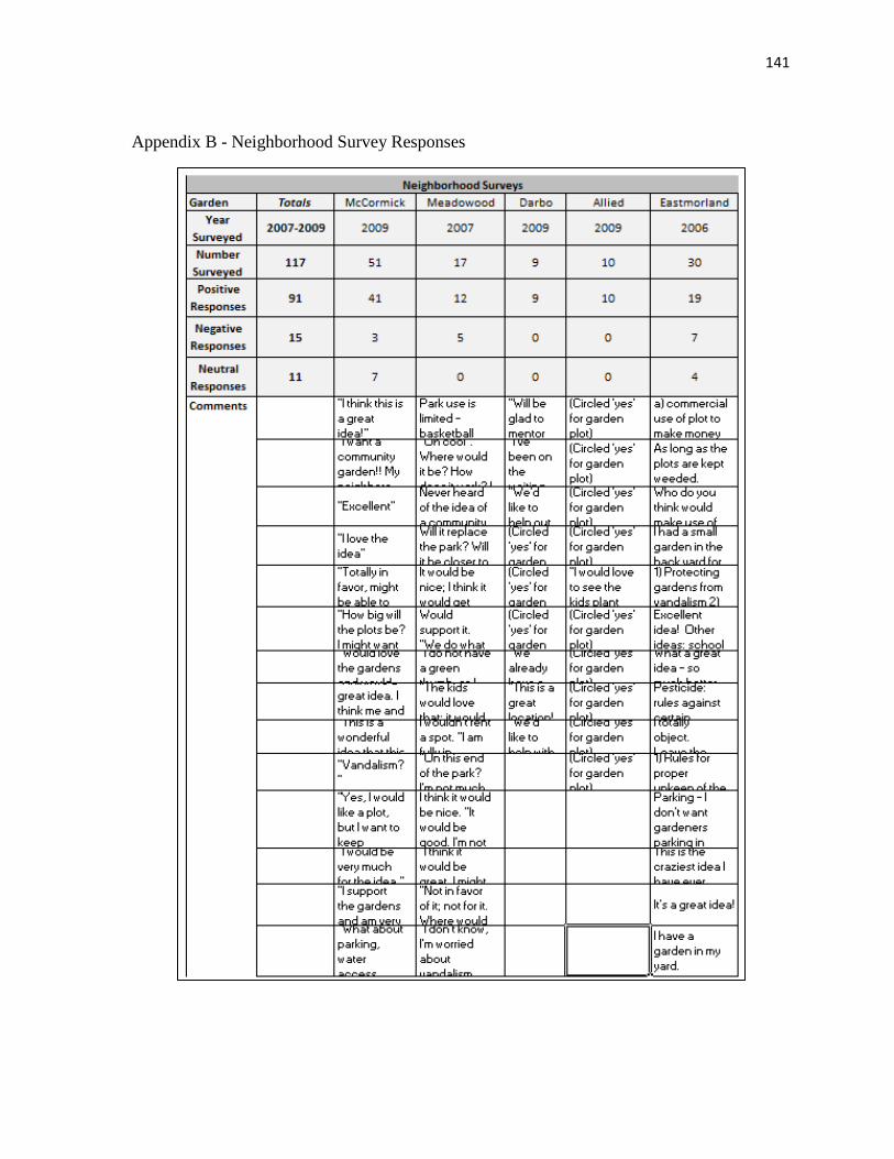
141
Appendix B - Neighborhood Survey Responses

142
Appendix C - Downtown Community Gardens Survey Form
PETITION OF SUPPORT FOR DOWNTOWN COMMUNITY GARDENS
I live in Madison and I support the idea of Downtown Community Gardens.
Date Print Name & Address Phone &
Your alder? Want a
Plot?
Volun-
teer?
Comm. Gardens
on Library
Rooftop?

143
Appendix D - New Garden Fund Application

144
Appendix D – New Garden Fund Application

145
Appendix D – New Garden Fund Application

146
Appendix D – New Garden Fund Application

147
Appendix D – New Garden Fund Application

148
Appendix D – New Garden Fund Application

149
Appendix D – New Garden Fund Application

150
Appendix E - Criteria Evaluation of New Garden Fund Applications (New Gardens)
Garden Application
Year Applied
Score
Funds Awarded
Secured Site Permission
Include Low-Income
Include Non-English Speakers
Include Youth
Include Elderly
Include Special Needs
Include Families
Include Social Groups
Picnics and Parties
Growing Food
Childrens Program
Food Pantry
Healthy Soil
Flat Surface
At Least 8 hours of sunlight
Free of Debris
Away from Busy Street
Previous Use Non-Industrial
Midvale 1
200516
**
**
**
**
**
**
**
**
Midvale 2
200616
**
**
**
**
**
**
**
**
Baxter Park2005
13*
**
**
**
**
**
**
*
Lake Point2005
14*
**
**
**
**
**
**
*
Northport/Packers
200512
**
**
**
**
**
**
*
Bayview2005
17*
**
**
**
**
**
**
**
**
*
Burr Oaks
200613
**
**
**
**
**
**
**
Eastmorland
200712
**
**
**
**
**
**
*
Prairie Hills2007
15*
**
**
**
**
**
**
**
*
Demetral
200810
**
**
**
**
**
Meadow
ood2008
14*
**
**
**
**
**
**
**
Allied Containers2010
12*
**
**
**
**
**
**
Brittingham2010
11*
**
**
**
**
**
Darbo2010
17*
**
**
**
**
**
**
**
**
*
McCorm
ick2010
8*
**
**
**
**
New
Garden Fund Application Criteria (New
Gardens)Physical Criteria
Social Criteria
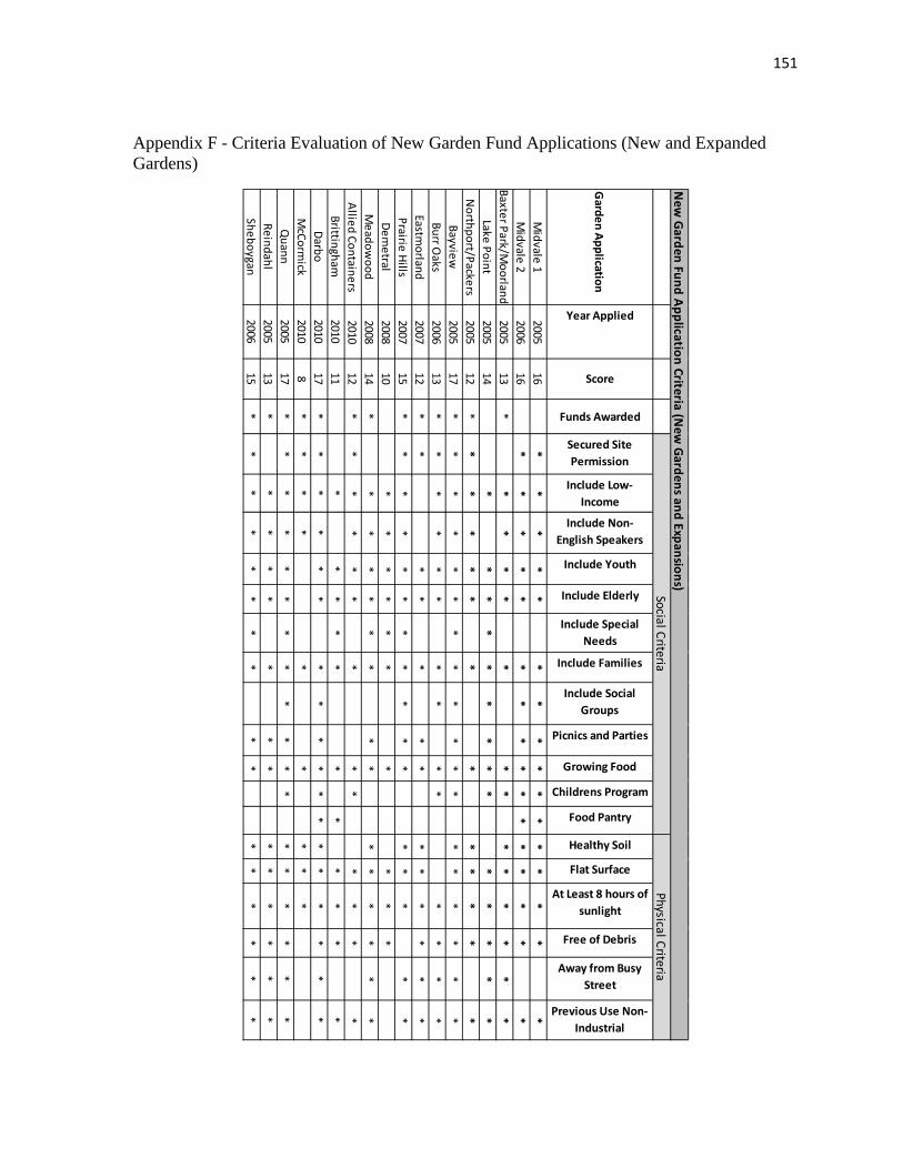
151
Appendix F - Criteria Evaluation of New Garden Fund Applications (New and Expanded Gardens)
Garden Application
Year Applied
Score
Funds Awarded
Secured Site Permission
Include Low-Income
Include Non-English Speakers
Include Youth
Include Elderly
Include Special Needs
Include Families
Include Social Groups
Picnics and Parties
Growing Food
Childrens Program
Food Pantry
Healthy Soil
Flat Surface
At Least 8 hours of sunlight
Free of Debris
Away from Busy Street
Previous Use Non-Industrial
Midvale 1
200516
**
**
**
**
**
**
**
**
Midvale 2
200616
**
**
**
**
**
**
**
**
Baxter Park/Moorland
200513
**
**
**
**
**
**
**
Lake Point2005
14*
**
**
**
**
**
**
*N
orthport/Packers2005
12*
**
**
**
**
**
**
Bayview2005
17*
**
**
**
**
**
**
**
**
*Burr O
aks2006
13*
**
**
**
**
**
**
*Eastm
orland2007
12*
**
**
**
**
**
**
Prairie Hills2007
15*
**
**
**
**
**
**
**
*Dem
etral2008
10*
**
**
**
**
*M
eadowood
200814
**
**
**
**
**
**
**
*Allied Containers
201012
**
**
**
**
**
**
*Brittingham
201011
**
**
**
**
**
*Darbo
201017
**
**
**
**
**
**
**
**
**
McCorm
ick2010
8*
**
**
**
**
Quann
200517
**
**
**
**
**
**
**
**
**
Reindahl2005
13*
**
**
**
**
**
**
*Sheboygan
200615
**
**
**
**
**
**
**
**
New
Garden Fund Application Criteria (New
Gardens and Expansions)Physical Criteria
Social Criteria

152
Appendix G - 2005 New Garden Fund Application Summaries and Notes
Garden Nam
eApplication Purpose
Applicants and Population ServedLocation of Garden
Result of Appliction
Baxter ParkA new
comm
unity garden13 Hm
ong neighbrohood residents and several other neighbors.
A small City park south of the
Beltline.
$1077 was aw
arded, but park could not be created in Baxter Park, so it w
as relocated to M
etro Sewer land (M
oorland) in 2006.
BayviewM
any new plots scattered through the
housing complex
Comm
unity center staff and 69 residents.
Bayview, a low
-income housing
complex in the Triangle
neighborhood downtow
n.
No money w
as awarded.
Garden was started in 2005
anyway.
Lake Point
A new garden for people w
ho can't care for a w
hole plot themselves, including
youth, elderly, and people with
disabilities.
Comm
unity center staff and 24 neighborhood residents.
In south Madison near the
South Town M
all.
No Money w
as awarded.
Garden was not started. It
would serve as a supplem
ent to an existing garden just dow
n the street in Lake Point (W
aunona, 2000).
Midvale
Elementary
A new garden on schools grounds for
use by students and neighbors.9 neighborhood residents and 2 school staff.
On the w
est side, at the elem
entary school.
Money w
as not awarded in
2005. Reapplied in 2006 with a
much m
ore elaborate vision. M
oney was not aw
arded. Project started in 2006 anyw
ay.
Packers Relocation
Restart garden that was lost in 2004
season to development. Restart on
nearby farmland that's available for 2+
years.
Comm
unity center staff and 20 neighborhood fam
ilies.
Near Packers Apts, a low
income com
plex on the north side.
$750 was aw
arded and the garden w
as created. It has been lost to developm
ent since.
Quann
Expansion/Nygard
Relocation
Develop 42 new plots to expand an
existing garden and make space for
families that are losing their plots at
Nygard (due to development.
A comm
ittee of gardeners representing the 82 current gardeners and m
any new fam
ilies.
City park off Park Street in South M
adison.$1000 w
as awarded. 50 new
plots w
ere added.
Reindahl Park Expansion
Develop one acre of additional park space to expand the existing garden.
A group of 14 Homong fam
ilies, not from
the neighborhood, with
support from the leader of the
existing garden that has 31 fam
ilies.
City park off E. Washington on
far east side.
$925 was aw
arded, but not given. The expansion w
as halted by the neighborhood association and Parks Division.
New
Garden Fund Applications: 2005

153
Appendix H - Participant Description and Consent Form
UNIVERSITY OF WISCONSIN-MADISON Research Participant Information and Consent Form
Title of the Study: Community Gardens Research
Principal Investigator: Janet Silbernagel (608-516-7273)
Student Researcher: Robert Greene (phone: 217-413-1623)
DESCRIPTION OF THE RESEARCH
You are invited to participate in a research study about the creation of community gardens in the city of Madison, Wisconsin.
You have been asked to participate because you are involved in community garden activities, or planning for community gardens.
The purpose of the research is to identify the major factors that influence garden site selection.
This study will include subjects that are involved with any part of the process of community garden establishment, including garden leaders, neighborhood leaders, and city personnel.
Research will be conducted wherever the subject feels most comfortable or convenient.
Audio tapes will be made of your participation. The Principal Investigator and Key Personnel will be the only individuals that listen to the tapes. Tapes will be retained until the study is completed (approximately one year) before they are destroyed.
WHAT WILL MY PARTICIPATION INVOLVE?
If you decide to participate in this research you will be asked to participate in an open-ended interview.
Your participation will last approximately 20 - 60 min. per session and will require 1 session, which will require 20 - 60 min. in total.
ARE THERE ANY RISKS TO ME?
We don't anticipate any risks to you from participation in this study.
ARE THERE ANY BENEFITS TO ME?

154
We don't expect any direct benefits to you from participation in this study.
HOW WILL MY CONFIDENTIALITY BE PROTECTED?
While there will probably be publications as a result of this study, your name will not be used. Only group characteristics will be published.
If you participate in this study, we would like to be able to quote you directly without using your name. If you agree to allow us to quote you in publications, please initial the statement at the bottom of this form.
WHOM SHOULD I CONTACT IF I HAVE QUESTIONS?
You may ask any questions about the research at any time. If you have questions about the research after you leave today you should contact the student researcher, Robert Greene at 217-413-1623, or the Principal Investigator, Janet Silbernagel at 608-516-7273
If you are not satisfied with response of research team, have more questions, or want to talk with someone about your rights as a research participant, you should contact the Education Research and Social & Behavioral Science IRB Office at 608-263-2320.
Your participation is completely voluntary. If you decide not to participate or to withdraw from the study it will have no effect on any services or treatment you are currently receiving.
Your signature indicates that you have read this consent form, had an opportunity to ask any questions about your participation in this research and voluntarily consent to participate. You will receive a copy of this form for your records.
Name of Participant (please print):______________________________
_______________________________________
______________
Signature
Date
_________
I give my permission to be quoted directly in publications without using my name.

155
Appendix I - Community Garden Database
Garden Y X Contact Phone Address PropertyAll Saints 43.015033 -89.43449 All Saints Lutheran Chu608-276-7729 2951 Chapel Valley Road ChurchMeadowood Baptist 43.0221 -89.4883 Meadowood Baptist C Meadowood Baptist 2817 Prairie Road ChurchRimrock 43.027879 -89.381219 Joe Mathers 608-246-4730 ext. 21300 block of Englehart Drive Center for Resilie Meadowood 43.029758 -89.480493 Leslie Stephany 608-288-8144 Balsam, Leland, Thrush Rds. (in a small paParkDrumlin 43.03075 -89.38412 Sandy 2849 Oregon Road DeveloperMarlborough Park 43.031457 -89.451634 Julia Baumgartner 262-442-4127 Between Seminole Hgwy and Allied DriveParkMoorland 43.032324 -89.364631 Larry Jacobson 608-223-1365 1133 Moorland Road (behind Water Utilit ROWArbor/McDivitt 43.032754 -89.421342 Jim Stehley 608-838-9849 2509 McDivitt Road (Arbor Covenant ChurChurchPrairie Hills 43.034179 -89.490775 Karen Deaton 608-278-8480 Lucy-Lincoln Heistand Park (North of Raym ParkSouthdale 43.0357 -89.3876 Gary Davis CAC Southdale Park, Country Rose Court ParkOrchard Ridge 43.036825 -89.47342 LuAnn Greiner Lgreiner@uwhealth 1501 Gilbert Road ChurchWisconsin Youth Company 43.038346 -89.503695 Mariah Miller smiller@wisconsiny1201 McKenna Blvd. Non-ProfitHammersley 43.039163 -89.487363 Larry Luther 608-271-8787 6120 Hammersley Road ParkCentro Hispano 43.0397 -89.3952 CAC CAC 825 Hughes Place Police Station/Cit Burr Oaks 43.040043 -89.399623 Yee Ythao 608-770-1073 Magnolia Circle and Hackberry Lane SchoolFraust Park 43.043051 -89.405432 Gary Davis [email protected] Fish Hatchery Rd. and Martin Street ParkQuann 43.045995 -89.388417 Cheryl Dewelt Robinso608-258-8398 Intersection of Bram and Kostler Streets ParkBaird 43.046084 -89.38846 Joe Mathers 608-246-4730 ext. 212200 Block of Baird Street HousingWaunona 43.0479 -89.353 CAC CAC 5000 Block of Raywood Rd. in Waunona PaParkMidvale Elementary 43.056877 -89.449232 Nancy Letcher 608-233-9120 502 Caromar Drive SchoolSaint Stephens 43.0585 -89.330714 Molly Crossen 608-225-6088 5700 Pheasant Hill Rd. ChurchMonona Methodist 43.061555 -89.334815 Anna Deem Deem_anna@hotma606 Nichols Road, Monona ChurchTamarack Trails 43.0636 -89.5082 CAC CAC SW of Tree Lane and Westfield Rd. NeighborhoodBayview 43.0664 -89.3982 CAC CAC End of Braxton Place, off Park St. HousingGammon 43.069609 -89.502912 Katie Place 608-274-1227 110 N. Gammon Road ChurchJoyce 43.0731 -89.4818 CAC CAC Cedar Place, at the end of the cul-de-sac PrivateSheboygan 43.074341 -89.461385 Lauren Nagle 4800 block of Sheboygan Ave. DOTOld Sauk 43.075923 -89.506969 Gray Williams 608-233-4731 East of 700 block of N. Westfield Rd. ChurchShorewood Hills 43.07667 -89.440051 Terence Gilles 608-267-2680 Off Shorewood Blvd., behind the pool an Village PropertyReynolds 43.07985 -89.379223 Kjersti Knox 608-251-6567 634 East Mifflin Street Homestead LotCottage Grove 43.0798 -89.2004 Bryn Mawr Presb. Chu Bryn Mawr Presb. Ch229 N. Main St., Cottage Grove ChurchUniversity Housing 43.082896 -89.444514 (See Eagle Heights Gar(See Eagle Heights GNE of Shady Lane and NW of Bowdoin Rd.UniversityLapham Elementary 43.085609 -89.372935 Ken Swift 608-204-4178 1045 East Dayton Street SchoolEagle Heights 43.087688 -89.432577 Eagle Heights Commun Eagle Heights Comm Intersection of Eagle Heights Drive and La UniversitySt. Dustan's Episcopal 43.0898 -89.4872 CAC CAC 6205 University Ave. ChurchEastmorland 43.091559 -89.327642 Johna Roth 608-663-0858 3501 Hargrove Street ROWAtwood 43.094834 -89.346808 Larry Weber 608-241-0494 North of Atwood Ave, along bike path ROWEast Main 43.095012 -89.35418 RR Property/Neighbor Adjacent Neighbors 2000 - 2100 blocks of E. Main Street (along RREast High Youth Farm 43.096 -89.296 CAC CAC or Megan Cain Corner of Sudbury Way and Coach House ParkSaint Paul 43.100746 -89.335646 Andrea Nelson 608-242-9808 3000-3200 blocks of St. Paul Ave. RRDarbo 43.10364 -89.338243 CAC CAC 3030 Darbo Drive Non-ProfitBashford 43.103783 -89.349741 CAC CAC 329 North St., south of Church ChurchMcCormick 43.1085 -89.3411 CAC CAC 702 McCormick Avenue ROWBock 43.1103 -89.477 Patty Zehl CAC Highland Way and Cedar Ridge Rd. ParkMiddleton Hills 43.113084 -89.501102 Ron Biendseil 608-836-1920 High Road and Apprentice Place Private Neighbor Truax 43.118438 -89.327846 Lee Brueggemann 608-316-5219 NW of Intersection Straubel St. and Rowla HousingReindahl 43.122396 -89.320454 Virginia Oliver 608-249-4652 1818 Portage Road ParkTroy Gardens 43.134671 -89.390829 Christie Ralston 608-240-0409 North of 500 block of Troy Drive TrustLindbergh Elementary 43.1438 -89.3886 Lindbergh School Lindbergh School 4500 Kennedy Road SchoolSun Prairie 43.175758 -89.232617 CAC CAC Linnerud Drive, between library and aqua Sun Prairie Parks/

156
Appendix I – Community Garden Database
Neighborhd Year_Start Time_Perio NewSnc2004 Househlds Type MedHhldInc CGqrtBuff OwnerFitchburg 1997 1 N 50-100 CG FP 75619 N All Saints ChurchCity of Madison 2010 3 Y <50 CG FP 51105 N Meadowood Baptist ChurchFitchburg 1983 1 N >100 CG 43819 Y Urban Open Space FoundationMeadowood 2008 3 Y <50 CG YG 48533 N City of Madison ParksFitchburg 1995 1 Y <50 CG CF 23591 Y Alexander CompanyDunn's Marsh 1972 1 N >100 CG YG 41011 N City of Madison ParksCity of Madison 2006 3 Y >100 CG 43819 N Madison Metro Sewerage DistrCity of Madison 1992 1 N <50 CG YG 41136 N Arbor Covenant ChurchCity of Madison 2007 3 Y <50 CG 59559 Y City of Madison ParksTown of Madison 2010 3 Y <50 CG YG 23591 Y Town of MadisonCity of Madison 2009 3 Y <50 CG FP YG 62954 N United Church of ChristCity of Madison 2009 3 Y <50 CG 45933 N City of Madison ParksCity of Madison 2009 3 Y <50 CG YG 71626 Y City of Madison ParksCity of Madison 2010 3 Y <50 FP YG 22820 Y City of Madison PoliceBurr Oaks 2006 3 Y <50 CG YG 28024 Y Madison Metro School District Town of Madison 2009 3 Y <50 CG FP 33777 Y Town of MadisonCity of Madison 2002 2 N >100 CG YG 26495 N City of Madison ParksCity of Madison 1985 1 N <50 CG YG 26495 N City of Madison CDAMonona 2000 2 N <50 CG FP 46197 N City of Madison ParksWestmorland 2006 3 Y <50 CG YG 61538 N Madison Metro School District Monona 2008 3 Y <50 CG FP YG 40213 Y St. Stephens ChurchMonona 2009 3 Y <50 CG FP YG 40213 Y Monona Methodist ChurchTamarack Trails 1975 1 N <50 CG 49514 Y Tamarack Trails Community SeBayview 2005 3 Y <50 CG 13348 N Bayview FoundationCity of Madison 1987 1 N <50 CG 55000 Y Lutheran Church of the Living CCrestwood 1975 1 N <50 CG 61190 N Wisconsin Cooperative Housin City of Madison 1981 1 N 50-100 CG 28697 N State of Wisconsin Building Co City of Madison 2006 3 Y 50-100 CG 71261 Y Madison Christian CommunityShorewood Hills 1975 1 N 50-100 CG FP YG 118145 Y Village of Shorewood Hills City of Madison 1999 2 N <50 CG 29562 N City of Madison CEDU Action CoCottage Grove 2010 3 Y <50 CG FP 68309 N Bryn Mawr Presbyterian ChurchUniversity 1962 1 N 50-100 CG 23040 Y University Building CorporationTenney-Lapham 1996 1 N <50 YG 31131 N Madison Metro School District University 1962 1 N >100 CG 23040 N University Building CorporationMiddleton 2009 3 Y <50 CG FP 38701 N Saint Dunstans ParishCity of Madison 2007 3 Y <50 CG YG 42541 N City of Madison Engineer Storm Atwood 1960 1 N >100 CG 41182 Y City of Madison Engineer Walk City of Madison 1983 1 N <50 CG 32390 Y Wisconsin Central Railroad, LTDCity of Madison 2005 3 Y <50 CF YG 71082 N City of Madison ParksCity of Madison 1981 1 N 50-100 CG 37569 Y Southern Wisconsin and South Worthington - Dar 2009 3 Y <50 CG FP YG 37569 Y Salvation ArmyCity of Madison 2010 3 Y <50 FP 33288 N Bashford United Methodist ChuEken Park 2010 3 Y <50 CG 36862 Y City of Madison Engineer Storm Middleton 2010 3 Y <50 CG YG 65413 N City of MiddletonMiddleton Hills 1997 1 Y <50 CG 65413 N Middleton Hills Neighborhood Truax 1975 1 N <50 CG YG 34432 Y City of Madison CDACity of Madison 2001 2 N >100 CG FP 45775 Y City of Madison ParksCity of Madison 1980 1 N >100 CG YG 54799 N MACLT Conservancy ParcelCity of Madison 2010 3 Y <50 CG FP YP 56657 N Madison Metro School District Sun Prairie 1999 2 N <50 CG 51126 N City of Sun Prairie
157
Appendix I – Community Garden Database
LowIncQrt PopBlwPvty NmbrPlts NmbrHhlds hhblckgrp2 pop2000 popdensity renthhY 27 55 54 1590 4337 2840.5 350N 256 9 7 1993 4607 5919.200195 1257Y 265 110 14 1285 2930 3363.699951 408N 208 32 36 415 981 5530.299804 224Y 689 30 15 627 1487 4678.700195 544Y 75 166 110 547 1251 3516.800048 234Y 265 152 85 1285 2930 3363.699951 408Y 102 14 14 419 1020 4251.100097 236N 43 70 45 591 1547 6827.899902 284Y 689 22 30 627 1487 4678.700195 544N 32 13 16 822 1891 3301.699951 221N 384 0 0 2680 5380 1839.199951 1919N 9 20 18 540 1535 3495.399902 64Y 369 0 0 641 1747 4969.600097 386Y 369 25 16 641 1747 4969.600097 386Y 184 4 9 691 1461 684.099975 522Y 494 144 90 968 2214 2203.399902 739Y 297 12 7 356 1057 9962.90039 257Y 114 23 30 336 833 3245.399902 105N 33 29 29 932 2058 4451 113Y 22 29 25 563 1240 4140.299804 275Y 22 29 19 563 1240 4140.299804 275N 193 15 15 1855 3546 5096.899902 1043Y 465 0 0 703 1397 8908.90039 656N 289 25 15 610 1597 4978.600097 189N 50 15 15 412 952 3076.899902 99Y 547 60 87 1984 3028 8477.299804 1873N 25 50 54 1176 2818 4119.899902 367N 4 82 60 307 786 3132.699951 7Y 221 6 6 643 1332 11793.90039 579N 34 64 30 2149 6200 692.200012 487Y 60 95 17 1063 2923 3172.5 1030Y 192 5 0 768 1461 7831.399902 532Y 60 535 184 1063 2923 3172.5 1030Y 51 6 5 1058 2123 4653.299804 803N 17 19 26 553 1156 1981.699951 89Y 159 113 109 951 1839 6759.299804 335Y 193 25 20 637 1176 7820.899902 434N 176 7 7 400 1166 3602.199951 16Y 106 82 73 545 1334 5846.600097 305Y 106 10 10 545 1334 5846.600097 305Y 155 0 0 652 1175 8261.90039 396Y 106 20 21 716 1542 3411.300048 298N 179 48 48 1642 3907 883.099975 466N 179 31 31 1642 3907 883.099975 466Y 45 31 25 540 1208 1197.099975 373Y 257 260 94 530 1355 926.299987 244Y 87 329 200 557 1822 1385.699951 274Y 15 20 20 386 1005 4675.799804 38N 17 148 111 790 2083 2982.199951 333

158
Appendix I – Community Garden Database
speakasian speakeurpo speakspan PrctHHrent PrctOthrLa AvgHHsz NeighScore28 84 86 22.012578 4.565367 2.69 258 100 86 63.070747 5.296288 2.309999 341 35 273 31.750972 11.911262 2.279999 333 5 33 53.975903 7.237512 2.359999 3
0 0 549 86.76236 36.919973 2.369999 40 9 121 42.778793 10.391686 2.279999 3
41 35 273 31.750972 11.911262 2.279999 326 9 62 56.324582 9.509803 2.39 359 7 32 48.054145 6.334841 2.619999 2
0 0 549 86.76236 36.919973 2.369999 40 62 50 26.885644 5.922792 2.279999 2
347 215 433 71.604477 18.494423 2 494 40 0 11.851851 8.729641 2.839999 2
456 25 145 60.218408 35.832856 2.73 4456 25 145 60.218408 35.832856 2.73 4
0 58 175 75.542691 15.94798 2.109999 4153 100 410 76.342975 29.945799 2.039999 4
42 0 95 72.191011 12.96121 2.9 422 22 23 31.25 8.043217 2.46 260 135 86 12.124463 13.654033 2.21 2
0 16 145 48.84547 12.98387 2.2 30 16 145 48.84547 12.98387 2.2 3
88 210 154 56.226415 12.746756 1.909999 3335 18 82 93.314366 31.138153 1.86 5154 21 89 30.983606 16.530995 2.579999 3
49 62 16 24.029126 13.340336 2.309999 2561 239 54 94.405241 28.203434 1.5 5
80 129 67 31.207482 9.79418 2.39 29 36 21 2.28013 8.396946 2.549999 1
18 62 20 90.046656 7.507507 1.96 447 130 70 22.661703 3.98387 2.869999 2
1212 291 207 96.895578 58.501539 2.66 519 68 57 69.270833 9.856262 1.889999 4
1212 291 207 96.895578 58.501539 2.66 514 51 163 75.89792 10.739519 2.009999 4
0 11 14 16.094032 2.162629 2.089999 214 71 163 35.226077 13.485589 1.929999 3
0 12 36 68.131868 4.081632 1.83 424 0 6 4 2.572898 2.92 261 149 59 55.963302 20.164917 2.45 361 149 59 55.963302 20.164917 2.45 310 32 111 60.736196 13.021276 1.799999 3
0 29 104 41.620111 8.625162 2.089999 332 90 123 28.380024 6.270796 2.369999 232 90 123 28.380024 6.270796 2.369999 271 3 38 69.074074 9.271523 2.24 4
0 13 49 46.037735 4.575645 2.559999 317 8 26 49.1921 2.799121 2.079999 339 19 11 9.844559 6.865671 2.599999 2
9 10 205 42.151898 10.75372 2.609999 3

159
Appendix J - Reclassification Table for Weighted Overlay of Social Factors
Median Household Income FROM TO CLASS Weight - 50% 0 17944 5
17944 41754 4
41754 58099 3
58099 88579 2
88579 129779 1
Percent Owner Occupied Housing FROM TO CLASS
Weight - 30% 0 14 5
14 38 4
38 60 3
60 80 2
80 100 1
Number of Ethnic Households FROM TO Class Weight - 20% 3 35 1
35 94 2
94 190 3
190 378 4
378 673 5
Related Documents