Article Short-term beach rotation, wave climate and the North Atlantic Oscillation (NAO) T. Thomas Carmarthenshire County Council, UK M.R. Phillips Swansea Metropolitan University, UK A.T. Williams Swansea Metropolitan University, UK R.E. Jenkins Swansea Metropolitan University, UK Abstract Beach profile surveys, offshore wave climate and variations in atmospheric conditions have been utilized to assess a short-term beach rotation phenomenon in a headland embayment Tenby, West Wales. Beach rota- tion, expressed by subaerial volumetric change, was shown by a negative phase relationship between beach extremities (r ¼ –0.67), while cross-correlation at a one-month timelag increased statistical significance (r ¼ 0.84). Due to beach aspect, gale wave heights decreased as wave direction rotated to the south (R 2 ¼ 0.4) and west (R 2 ¼ 0.65), while offshore wave direction influenced change at the southern and north- ern extremities (R 2 ¼ 0.52 and 0.34, respectively). Shelter from offshore islands and Giltar Headland contri- butes via wave diffraction to accretive, erosive and rotational patterns, and these are sensitive to variations around the predominant wave direction (229 ). A southerly shift induces north/south sediment movement, as waves diffract around the offshore islands, while a westerly change results in south/north sediment move- ment (i.e. beach rotation), as diffracted wave domination transfers to the headland. A general gale wave height reduction occurred when the North Atlantic Oscillation (NAO) was weak or in a transitional phase between positive or negative phases (R 2 ¼ 0.69 and R 2 ¼ 0.72, respectively). Morphological change was also attuned to atmospheric variation where a reversal in beach rotation was influenced by variations in positive and negative NAO/volume correlations and longshore profile location (R 2 ¼ 0.54 and 0.69, respectively). The results of this study have wider implications for coastal management; it is suggested that models developed in similar systems elsewhere will form the basis of human intervention or no active intervention strategies. Keywords conceptual models, embayment, morphological change, offshore island, sediment transport I Introduction Fifty-one percent of the world’s coastlines are representative of headland bay morphology (Short and Masselink, 1999), and headlands have Corresponding author: T. Thomas, Technical Services Department, Carmarthenshire County Council, Cillefwr SA31 3QZ, Wales, UK. Email: [email protected] Progress in Physical Geography 35(3) 333–352 ª The Author(s) 2011 Reprints and permission: sagepub.co.uk/journalsPermissions.nav DOI: 10.1177/0309133310397415 ppg.sagepub.com

Welcome message from author
This document is posted to help you gain knowledge. Please leave a comment to let me know what you think about it! Share it to your friends and learn new things together.
Transcript

Article
Short-term beach rotation,wave climate and the NorthAtlantic Oscillation (NAO)
T. ThomasCarmarthenshire County Council, UK
M.R. PhillipsSwansea Metropolitan University, UK
A.T. WilliamsSwansea Metropolitan University, UK
R.E. JenkinsSwansea Metropolitan University, UK
AbstractBeach profile surveys, offshore wave climate and variations in atmospheric conditions have been utilized toassess a short-term beach rotation phenomenon in a headland embayment Tenby, West Wales. Beach rota-tion, expressed by subaerial volumetric change, was shown by a negative phase relationship between beachextremities (r ¼ –0.67), while cross-correlation at a one-month timelag increased statistical significance(r ¼ 0.84). Due to beach aspect, gale wave heights decreased as wave direction rotated to the south(R2¼ 0.4) and west (R2¼ 0.65), while offshore wave direction influenced change at the southern and north-ern extremities (R2¼ 0.52 and 0.34, respectively). Shelter from offshore islands and Giltar Headland contri-butes via wave diffraction to accretive, erosive and rotational patterns, and these are sensitive to variationsaround the predominant wave direction (229�). A southerly shift induces north/south sediment movement,as waves diffract around the offshore islands, while a westerly change results in south/north sediment move-ment (i.e. beach rotation), as diffracted wave domination transfers to the headland. A general gale wave heightreduction occurred when the North Atlantic Oscillation (NAO) was weak or in a transitional phase betweenpositive or negative phases (R2¼ 0.69 and R2¼ 0.72, respectively). Morphological change was also attuned toatmospheric variation where a reversal in beach rotation was influenced by variations in positive and negativeNAO/volume correlations and longshore profile location (R2 ¼ 0.54 and 0.69, respectively). The results ofthis study have wider implications for coastal management; it is suggested that models developed in similarsystems elsewhere will form the basis of human intervention or no active intervention strategies.
Keywordsconceptual models, embayment, morphological change, offshore island, sediment transport
I Introduction
Fifty-one percent of the world’s coastlines are
representative of headland bay morphology
(Short and Masselink, 1999), and headlands have
Corresponding author:T. Thomas, Technical Services Department,Carmarthenshire County Council, Cillefwr SA31 3QZ,Wales, UK.Email: [email protected]
Progress in Physical Geography35(3) 333–352
ª The Author(s) 2011Reprints and permission:
sagepub.co.uk/journalsPermissions.navDOI: 10.1177/0309133310397415
ppg.sagepub.com

a significant influence on planform, sediment
transport and morphodynamics of embayed bea-
ches (Carter, 1988; Short and Masselink, 1999).
Owing to the complexity of headland impact in
altering beach morphodynamic behaviour,
embayed beaches receive less attention than
unconstrained beaches. Therefore, little research
has been undertaken in this important environ-
ment (Klein et al., 2002). Most studies tradition-
ally concentrated on small groups of embayed
beaches, and almost all have been conducted in
locations with microtidal/mesotidal ranges (e.g.
Anthony and Dolique, 2004; Dehouck et al.,
2009; Dolique and Anthony, 2005; Jacob et al.,
2009; Klein et al., 2002; Loureiro et al., 2009;
Ojeda and Guillen, 2008; Ranasinghe et al.,
2004; Sedrati and Anthony, 2007).
On a regional basis, Klein and Menezes (2001)
used several parameters (i.e. wave and sedimen-
tary statistics, fall velocity) in conjunction with
beach profiling and plan view characteristics to
typify 17 differently exposed pocket beaches in
Brazil. Bowman et al. (2009) carried out the larg-
est detailed study along the Catalan coast, studying
72 pocket beaches to determine plan view indexes
based on standard planform parameters. Beach
rotation is a phenomenon in embayed beaches that
are exposed to variable directional wave climate
and short-term beach rotation is sometimes caused
by shoreline realignment in response to a shift in
incident wave direction (Klein et al., 2002). These
shifts are commonly associated with changing
climatic conditions (e.g. Ranasinghe et al., 2004;
Short and Trembanis, 2004). However, other vari-
ables influence rotation, as shown by Anthony
et al. (2002) at Montjoly beach, Cayenne, French
Guiana, where patterns of nearshore mudbank
migration induced rotation.
Rotation manifests itself at various temporal
scales and the majority of research has been
focused at the decadal level. In this environment,
detailed studies have been made by Anthony and
Dolique (2004), Dolique and Anthony (2005),
Ojeda and Guillen (2008), Pinto et al. (2009),
Ranasinghe et al. (2004), Short and Trembanis
(2004) and Short et al. (2000). Studies of
short-term morphological response to dynamic
forcing are limited, particularly when applied
to macrotidal beach environments (Poate et al.,
2009). Patterns of shoreline change have been
linked to major atmospheric variations by,
among others, Ranasinghe et al. (2004), Rooney
and Fletcher (2005), Short and Trembanis
(2004), Short et al. (2000), Thomas et al. (2010)
and Vespremeanu-Stroe et al. (2007). Longer-
term beach rotation phenomena in the Southern
Hemisphere have been linked to changes in
the Southern Oscillation Indices (SOI) by, for
example, Ranasinghe et al. (2004), Short and
Trembanis (2004) and Short et al. (2000). Simi-
larly, Thomas et al. (2010) demonstrated links
between the North Atlantic Oscillation (NAO)
and beach rotation.
Few comparative studies have been carried out
detailing short-term rotational processes applied
to a single embayed beach set in a macrotidal
environment. This study assesses local shoreline
evolutionary patterns between November 2008
and April 2010, for one such embayed beach in
South Pembrokeshire West Wales (GR 212200,
198599; Figure 1). Several forcing variables
related to wind and wave regimes, together with
major climatic variations expressed by the NAO
Index, are utilized to evaluate processes govern-
ing short-term beach rotation phenomena. Signif-
icant research findings are assessed with
relevance to other coastal locations worldwide.
II Physical and geologicalbackground
In England and Wales, Shoreline Management
Plans set out strategic policies that assist coastal
defence decision-making processes. Here, natural
process behaviour determines sediment cell
coastal boundaries. The south and southwest
Wales coastline is designated cell 8 (Figure 1b)
and is subdivided into four subcells that are
assigned coastal engineering groups, made up
of a number of statutory bodies and stakeholders.
334 Progress in Physical Geography 35(3)

South Sands, Tenby, South Wales (UK National
Grid Reference SN 212200, 198599; Figure 1c),
falls within Carmarthen Bay Coastal Engineering
Group sub cell 8c which is bounded by Saint
Anne’s Head to the west, and Worm’s Head to
the east, and is referenced as management unit
2/1 (PCC, 2006; Figure 1c).
The landscape of Tenby and its environs was
formed by intense folding during the Variscan
Orogeny (Hunter and Easterbrook, 2004) which
resulted in the formation of the Ritec fault
(Toghill, 2000), part of which lies along the
line of the River Ritec, near Tenby town (Posford
Duvivier, 1998; Toghill, 2000). The Ritec estuary
was closed to tidal influence c. 1855, following
construction of a railway embankment. The study
area is developed between two headlands of
Carboniferous Limestone, Giltar Headland to
the south and Tenby to the north (Hillier and
Williams, 2006; Owen, 1973). It is a classic
embayment (Posford Duvivier, 1998) and,
similar to that described by Brown et al. (1999),
has a shallow concave profile, wide sandy interti-
dal zone, and a ridge and runnel structure. This
Figure 1. Locality of the study area. (a) United Kingdom; (b) southwest Wales; (c) study area; (d) representativeprofile locations T1 and T2 (south); T3 and T4 (central); T5 and T6 (north).
Thomas et al. 335

zone gives way to a limestone shingle backshore
overlain by a dune system (PCC, 2006), with
shingle being periodically exposed during
storms and high spring tides (Gibbard, 2005).
The distance between the headlands is approxi-
mately 2 km, and the tides are semi-diurnal and
macrotidal, with a mean spring tidal range of
7.5 m. Depth of closure is estimated to be between
5.6 m (using a limited set of beach profiles) and
13.1 m when tidal range is taken into consider-
ation (Thomas, 2007). This littoral zone presents
different levels of human occupation. Tenby to
the north is a heavily urbanized coastal area,
used mainly for tourism, and is important to
the regional economy. Conversely, the dunes,
marshes and headland promontory to the south
are ecologically important conservation areas.
The subtidal area is characterized by a centrally
positioned ‘shore-attached’ sandbank, known
locally as the ‘White Bank’, which is exposed
during the highest spring tides. Incident waves
usually approach from southerly to westerly
directions with an average wave height recorded
from an offshore position of c. 1.2 m, with associ-
ated mean periods of 5.2 s; however, storm waves
of 5.5 m and periods of 8.2 s are not uncommon
(Thomas et al., 2010). Longshore sediment
movement from south to north is influenced by
heavily refracted Atlantic swell waves, which
undergo diffraction as they encounter the south
Pembrokeshire coast and offshore Caldey and
St Margaret’s Islands. Winds predominate from
the south and southwest (alongshore and offshore),
where Giltar Headland and offshore islands
give shelter. Caldey Sound is approximately
1 km wide, its depth below the lowest astro-
nomical tide is 16 m, and it has spring tidal cur-
rents of 1.3 ms�1 (west to east) during flood and
1.1 ms�1 (east to west) during ebb tides.
III Methodology
To analyse beach rotation, six profiles were
surveyed monthly between November 2008 and
April 2010 inclusive (Figure 1d). These profiles
were representative of the southern (T1 and T2),
centre (T3 and T4) and northern beach areas (T5
and T6; Figure 1d). RTK network GPS (Leica
1200þ) was utilized for survey work and
data were recorded to an accuracy of 5 mm +0.5 mm. RTK network GPS is a one-man-
operated surveying system that consists of a rover
unit, controller, communication link, antenna and
poles while permanent base stations throughout
the UK stream corrections via a central correction
service linked directly to a rover (see, for example,
Euler et al., 2002; Leica, 2008a, 2008b; Weber
et al., 2005). Sectional volumes, i.e. the morpholo-
gical variables, were computed directly from the
Regional Morphology Analysis Package (RMAP),
where volume is determined by extrapolating the
area under the curve for one unit length (m3m�1)
of shoreline (Morang et al., 2009). The subaerial
beach volume was used to characterize beach rota-
tion, using the landward fixed benchmark and
mean high water level (Klein et al., 2002; Figure 2).
In order to assess short-term longshore varia-
tion in subaerial volume, it was necessary to
remove high-frequency cut and fill (cross-shore)
noise. A method similar to that developed by
Short and Trembanis (2004) was implemented.
(1) The volume record was transformed into
the standard normal form (Davis, 2002),
using:
z ¼ x� x�=s ð1Þ
where z¼ normalized value, x¼ data vol-
ume record for each profile, x� ¼ average
value for that profile, s ¼ standard
deviation.
(2) Temporal mean survey volumes were
spatially averaged along the beach (repre-
senting the cut and fill behaviour common
to all profiles).
(3) Spatial average values (b) were subtracted
from the local normalized volume (a) to
reveal a time series where high-frequency
behaviour has been removed.
336 Progress in Physical Geography 35(3)

(4) Residual volumes were converted into
dimensional units using:
x ¼ zsð Þ þ x� ð2Þ
Direct comparisons were made with environ-
mental forcing agents (wind and wave climate),
captured at a point located 9 km southeast of the
study site (latitude 51.6�; longitude –4.58�)derived from archive wave model hind-casts
produced by the Met Office. The virtual model
point, located at a depth of 28 m, records significant
wave conditions at three-hourly intervals, while
wind speed was recorded at 20 m above mean sea
level. The numerical model calculates significant
(H1/3) conditions as a resultant of wind-sea and
swell combined using the expression:
Resultant ¼ ðwind � sea2þswell2Þ1=2
ðUKMO; 2009Þ
Breaking wave heights (hb) were obtained
by applying the Komar and Gaughan (1972)
expression:
Hb¼ 0:39g1=5ðTpH20Þ
2=5
where Ho ¼ offshore wave height and Tp ¼associated period. In this study, storm conditions
were characterized by wind speeds >17 ms�1,
while gale conditions were defined as wind
speeds >11 ms�1 that continued through a mini-
mum of one tidal cycle (12-hr period).
IV Results
1 Storm climate
Throughout the 17-month monitoring period,
storm winds > 17 ms�1 were recorded on six
occasions. On 12 December 2008, during a 12-hr
period that showed average wind speeds of
14.9 ms�1, a wind speed of 17.23 ms�1 emanating
from 191� true, was recorded. This generated
combined offshore and breaking wave heights
and wave periods of 2.7 m, 2.8 m and 6.4 s,
respectively. During a four-day period of strong
winds averaging 11.74 ms�1, wind speeds of
22 ms�1 emanating from 207� true were recorded
(17 January 2009), which generated combined
offshore and breaking wave heights and periods
of 3.8 m, 4.1 m and 7.9 s, respectively. A 27-hour
period between 25 and 26 April 2009 recorded
average wind speeds of 12.35 ms�1 with a maxi-
mum of 17.06 ms�1 emanating from 158� true.
This generated a combined offshore wave,
breaking wave height and period of 2.1 m,
2.2 m and 5.2 s, respectively. November 2009
Figure 2. Sketch showing the subaerial morphological zone from which comparative beach volumes werecomputed and from which rotation has been analysed (shaded grey)
Thomas et al. 337

was the most tempestuous month, dominated
by southwesterly winds (average 213� true),
and when wind speeds dipped below 11 ms�1
on only two occasions. Eight storm days were
recorded where maximum wind speeds ranged
from 17.02 ms�1 to 21.36 ms�1. These winds
generated offshore wave heights of between
2.12 m and 5.5 m, breaking waves heights
of between 2.17 m and 6.17 m, and respective
periods of 8.06 s to 14.73 s. A wind speed
of 17.67 ms�1 emanating from 188� true was
recorded on 7 December 2009. This occurred
during a three-day period of strong winds aver-
aging 13.7 ms�1 that generated offshore and
breaking wave heights and periods of 3.98 m,
4.58 m and 10.94 s, respectively. Finally, a wind
speed of 17.78 ms�1 emanating from 122� true
occurred on 12 January 2010. This happened
over a two-day period averaging wind speeds
of 14.82 ms�1, and generating offshore wave,
breaking wave and associated periods of 2.23 m,
2.28 m and 5.31 s, respectively.
2 Gale climate
A gale was defined as a period where wind
speeds >11 ms�1 occurred over a tidal cycle –
minimum 12-hr period (strong wind 22 knots).
Gale events represent 9% of the wave record and
75% of all gale force winds emanated either from
alongshore (south to southwesterly) or offshore
(southwest to west). In the former conditions, the
islands of Caldey and St Margaret’s give shelter
while, in the latter, Giltar promontory gives shel-
ter. Table 1 shows the intersurvey gale record
between November 2008 and April 2010, when
43 gale events lasting a total of 1422 hr took
place. Most notable was the period between
October and December 2009, when 513 gale hrs
in nine separate events were recorded. Average
wind speed and direction were 14 ms�1 and
227�, respectively, which generated offshore and
breaking wave heights and associated periods of
2.7 m, 3.1 m and 7.95 s, respectively. Onshore
winds dominated over three periods between
January and February 2009 and January and
March 2010 (six gale events). They generated
relatively small offshore waves (1.3–1.8 m),
breaking waves (1.4–2.1 m) and associated peri-
ods (5–6.5 s), influenced by a limited fetch dis-
tance. In addition to October and December
2009, three other periods experienced >100 gale
hours (Table 1). Between November and Decem-
ber 2008 (102 hr), recorded offshore and break-
ing wave heights and associated periods were
1.7 m, 1.9 m and 5.8 s, respectively, while
between April and May 2009 (111 hr), these were
2.7 m, 3.0 m and 7.6 s, respectively. Finally,
between December 2009 and January 2010
(117 hr), offshore and breaking wave height and
periods of 2.4 m, 2.9 m and 7.9 s, respectively,
were generated. Each event emanated from a
south to westerly direction (188–274� true).
3 Average wind/wave climate
Table 1 shows the intersurvey averaged wind/
wave climate between November 2008 and
April 2010. Overall average wind speed (8 ms�1,
s ¼ 47) generated offshore and breaking
waves and associated periods of 0.98+1.1 m,
1.26+1.35 m, and 6.39+1.3 s, respectively.
Intersurvey wind direction fluctuated throughout
the monitoring period averaging 190+70� true.
Wind speeds in excess of 10 ms�1 occurred on
two occasions throughout the monitoring period.
The first, between January and February 2009,
from a southerly direction (191� true) generated
offshore and breaking wave heights and associ-
ated periods of 1.5 m, 1.8 m and 6.6 s, respec-
tively. The second, from a south-southeasterly
direction (146� true), generated offshore and
breaking wave heights and associated periods of
1.3 m, 1.7 m and 6.7 s, respectively.
4 Wave climate and subaerial volumechange
Table 2 shows subaerial volume changes
between November 2008 and April 2010 and
338 Progress in Physical Geography 35(3)

these are represented by Figure 3. This shows a
time series of intersurvey subaerial volume
change (T1 and T6), together with daily aver-
aged breaking wave heights and directions based
on wind speeds >11 ms�1, transposed for direct
comparison using equation 1.
Both southern and northern sectors exhibit
patterns of accretion and erosion throughout,
highlighting reversals in trend between beach
extremities. Initially, between December 2008
and February 2009, the highest waves occurred
when wave direction impact was directly behind
the offshore islands (229� true). A reversal
in morphological trend is triggered by a change
in wave direction (south toward east), which
also resulted in a reduction of general wave
heights. Variable, albeit small, changes took
place during spring/summer 2009, except
between April and May. Here a change in wave
direction appears to trigger an increased
pattern of erosive behaviour in the southern
sector. However, recovery had taken place by
the following month. Between October 2009
and January 2010 increasing wave heights
and directional variations associated with
a prolonged period of gales triggered two
reversals in erosive/accretive patterns. The first
was triggered by a negative change in wave
direction (south toward east) that occurred
during early October and the second, a positive
change in late November, was south toward
west.
5 Subaerial volume and beach rotation
Table 3, produced from Table 2, shows a cross-
correlation (r) matrix computed at zero lag.
The high correlation between T1 and T2
(r¼ 0.69) indicates that any variations in volume
at profile T1 also occur at profile T2. Similarly,
Table 1. Intersurvey wind and wave climates for the period between November 2008 and April 2010.Wspd ¼ wind speed; Wdir ¼ wind direction; Hs ¼ significant wave height; Hb ¼ breaking wave height;Tp ¼ wave period.
Date Average climate Gale climate
On OffWspd(m/s)
Wdir(deg)
Hs(m)
Hb(m)
Tp(s)
Events(no)
Totalduration
(hr)
Galedays(no)
Wspd(m/s)
Wdir(deg)
Hs(m)
Hb(m)
Tp(s)
Nov08 Dec08 8.2 253 1 1.2 5.4 4 102 12 12.7 274 1.7 1.9 5.8Dec08 Jan09 7.3 126 0.9 1.2 6.9 2 60 7 13.1 230 2.5 2.7 6.9Jan09 Feb09 10.4 146 1.3 1.7 6.7 2 93 18 12.4 143 1.3 1.4 5Feb09 Mar09 5.8 269 0.8 1.1 7.2 2 69 6 13.1 245 2.3 2.6 7.1Mar09 Apr09 7.3 229 0.8 1 5.5 3 42 6 12.7 286 1.6 1.8 5.2Apr09 May09 7.4 177 1 1.2 5.9 3 111 11 12.9 236 2.7 3 7.6May09 Jun09 6.8 166 0.7 0.9 5.9 1 30 2 12 251 1.8 2 5.5Jun09 Jul09 7.8 243 0.9 1.2 5.4 2 36 3 12.4 273 1.3 1.4 4.7Jul09 Aug09 7.3 224 1 1.2 5.2 2 39 6 12.3 214 2.1 2.3 6.1Aug09 Sep09 7.6 124 0.8 1 5.8 4 81 12 12.1 261 1.8 2 5.8Sep09 Oct09 7 233 0.8 1 6.2 1 21 10 12.7 142 2.4 2.8 7.4Oct09 Dec09 10.5 191 1.5 1.8 6.6 9 513 35 14 227 2.7 3.1 7.9Dec09 Jan10 8.3 141 1 1.5 7.8 3 117 10 13.1 188 2.4 2.9 7.9Jan10 Feb10 8.8 153 1.1 1.4 7 3 66 9 13.8 151 1.8 2.1 6.1Feb10 Mar10 7.5 185 1.1 1.5 7.7 1 12 4 12.4 178 1.7 2 6.5Mar10 Apr10 7.3 177 0.9 1.2 7 1 30 3 13.8 280 2 2.2 6.4
Thomas et al. 339

Figure 3. Comparison of normalized (equation 1) breaking wave heights (dashed line), wave direction(solid line) and subaerial volume change; south ¼ light grey, north ¼ dark grey, for the period betweenNovember 2008 and April 2010
Table 2. Profile volume change (m3 m�1) from the fixed benchmark to mean high water level (subaerialzone), together with intersurvey averaged NAO Index values, for the period between November 2008and April 2010
Date on Date off NAO T1 T2 T3 T4 T5 6
Nov08 Dec08 –0.37 51.2 44.9 78 52.8 54.2 67.7Dec08 Jan09 –0.34 49.6 43.9 71.2 51.2 57.7 66.4Jan09 Feb09 0.25 47.5 42.2 70.5 52.4 59.6 68.7Feb09 Mar09 0.39 48 41.6 72.2 54.2 58 74.4Mar09 Apr09 0.01 49.5 42.7 74.2 56.2 59.6 72.2Apr09 May09 0.64 48.2 42.4 75 56.3 64 71.6May09 Jun09 –0.42 45.9 39.9 74.9 53.2 63.4 72.7Jun09 Jul09 –0.94 48.1 39.6 70.8 51.8 61.7 72.8Jul09 Aug09 –0.41 49.2 42.7 67.5 53.1 61.7 72.8Aug09 Sep09 0.27 49.7 45.4 70.8 54.7 59.9 72Sep09 Oct09 –0.06 46.8 46.1 73.5 56.7 60 74.5Oct09 Dec09 –0.05 50.1 43.3 79.1 54.1 57.8 65.9Dec09 Jan10 –1.29 46.2 43 77.8 53 56.1 71.9Jan10 Feb10 –0.62 45.1 42.6 68.7 50.9 62.4 74.6Feb10 Mar10 –0.84 47.3 41 70.4 48.6 65.7 75.1Mar10 Apr10 –0.3 48.6 42.4 71.2 50.6 62.6 72.6
340 Progress in Physical Geography 35(3)

the high positive correlation between T5 and
T6 (r ¼ 0.58) also indicates that any variation
in T5 profile volume also occurs at profile T6.
However, it is the high negative correlation
(r¼ –0.67) between profiles T1 (extreme south)
and T6 (extreme north) that is of most interest, as
this indicates a negative phase relationship
between accretion/erosion patterns between
southern and northern ends of the beach
(i.e. beach rotation). The change from positive
to negative correlations between profiles T3 and
T4 indicate that the centre of the beach acts as
the axis of rotation, and correlates with long-
term rotation patterns demonstrated by Thomas
et al. (2010). The values of Table 2, normalized
using equation 1, and Figure 4a, produced from
transposed data, show a time series of normal-
ized volumes comparing south with north extre-
mities. Four periods of rotation throughout
the monitoring period existed, not necessarily
linked to seasonal change but demonstrating
cyclic sediment exchanges between headlands.
To investigate stronger potential correlations
between south and north beach extremities,
timelagged cross-correlations of volume changes
between profiles T1 and T6 (Table 3) were calcu-
lated and represented graphically (Figure 4b).
Results show improved correlation (r ¼ –0.84)
at a one-month lag, which indicates that
southern volume variations lag behind northern
variations by one month. When a reversal in trend
occurs, northern variations lag behind southern
change by two months.
6 Climatic variation and beach rotation
NAO is dominant in variations of North Atlantic
winter climate from central North America to
Europe, including Northern Asia, and is the
Table 3. Pearson correlation coefficients set at azero timelag compare longshore volumetric varia-tion (Table 2). The levels of statistical significance areindicated in brackets; italic bold numbers¼ p < 0.05.
T2 0.69(0.00)
T3 0.25 0.20(0.18) (0.23)
T4 0.46 0.41 0.40(0.04) (0.06) (0.06)
T5 –0.43 –0.53 –0.53 –0.25(0.05) (0.02) (0.02) (0.18)
T6 –0.67 –0.60 –0.47 –0.31 0.58(0.00) (0.01) (0.03) (0.12) (0.01)
T1 T2 T3 T4 T5
−2
−1.5
−1
−0.5
0
0.5
1
1.5
2
Sep-08 Dec-08 Mar-09 Jul-09 Oct-09 Jan-10 May-10Duration (months)
Nor
mal
ized
val
ues
T1 T6
(a)
−1−0.8−0.6−0.4−0.2
00.20.40.60.8
−6 −4 −2 0 2 4 6
Lag (months)
Cor
rela
tion
(b)
Toward north Toward south
Figure 4. A comparison of profile volume variation between north and south beach extremities for theperiod November 2008 to April 2010, graphically represented by (a) time series and (b) cross-correlationset at five-month timelags
Thomas et al. 341

greatest source of interannual variability in wave
climate variation across UK shores (Bell and
Visbeck, 2009; Woolf and Coll, 2006; Woolf
et al., 2002). Here, irregular oscillations through-
out the instrumental record were observed, with
an unusually large trend of increase in the NAO
Index in the later 20th century (Woolf et al.,
2002). Therefore, to understand changes in wind
and wave regimes, Bacon and Carter (1993)
suggested consideration be given to atmo-
spheric pressure gradients. Phillips and Crisp
(2010) showed that higher numerical NAO
Index values result in larger tidal ranges, irre-
spective of phase. It is reasonable to deduce
that sediment exchange and, therefore, beach
rotation phenomena should also be linked to
separate positive/negative values.
In order to test this assumption, Table 2 was
utilized to produce a cross-correlation (r) matrix
computed at zero lag (Table 4), which compares
NAO Index (with outlier removed) with subaerial
volumes. Variable statistically insignificant
correlation ( p > 0.05) is shown between NAO
Index and all profiles with the exception of T4
(r ¼ 0.72). In contrast, a statistically significant
correlation ( p < 0.05) exists when negative
NAO Index values were considered (r ¼0.60, 0.72, 0.70 and –0.75, respectively), with
the exception of profiles T3 and T5 (r ¼0.53 and –0.53, respectively); nevertheless,
both results fall within a 90% confidence level
( p < 0.1). Positive correlations at the southern
end (T1 and T2) indicate that accretion is
expected during a negative index phase,
whereas erosion is expected at the northern end
(T5 and T6), as demonstrated by negative cor-
relations (r ¼ –0.52 and –0.75, respectively).
Statistically insignificant correlations existed
when positive NAO Index values were consid-
ered (r ¼ –0.46, –0.19, 0.27, 0.13 and 0.11,
respectively), with the exception of profile T5 (r
¼ 0.64). Negative correlations at the southern
end (T1 and T2) indicate erosion during a pos-
itive index phase, whereas accretion is
expected at the northern end (T5 and T6) demon-
strated by positive correlations. These results find
agreement with Thomas et al. (2010) who identi-
fied long-term southern end erosion during peri-
ods that were dominated by positive index values.
It is unrealistic to expect immediate beach
response to changes in NAO Index. Therefore,
correlations between subaerial volumes and
NAO Index values were computed to investigate
the existence of stronger cross-correlations at a
timelag between both south and north beach
extremities. Figures 5a and 5b, produced from
Table 2, compare NAO Index values, with
profile volumes T1 and T6, respectively. Lags
associated with peak values indicated that varia-
tions in beach volume to the south lag behind
NAO variation by one month with statistically
significant correlation (r ¼ 0.57, p < 0.05).
A similar scenario exists at the northern end;
however, statistically, the correlation is insignif-
icant (r ¼ –0.33, p >0.05). Both results showed
improved correlation in relation to previous
results (Table 4). Figures 5c and 5d, produced
from Table 2, compare negative NAO Index
Table 4. Pearson correlation coefficients set at a zero timelag compare NAO and volumetric change(Table 2). The levels of statistical significance are indicated in brackets; italic bold numbers ¼ p < 0.05.
NAO 0.24 0.36 0.28 0.72 –0.24 –0.22(0.19) (0.09) (0.15) (0.00) (0.20) (0.22)
Negative NAO 0.60 0.72 0.53 0.70 –0.52 –0.75(0.03) (0.01) (0.06) (0.01) (0.06) (0.01)
Positive NAO –0.46 –0.19 0.27 0.13 0.64 0.11(0.22) (0.38) (0.33) (0.42) (0.12) (0.43)
T1 T2 T3 T4 T5 T6
342 Progress in Physical Geography 35(3)

values with profile volumes T1 and T6,
respectively. Lags associated with peak values
indicate that variations in beach volume at
the southern end again lag behind negative
NAO variation by one month, and improve the
already statistically significant results presented
above (r ¼ 0.84, p < 0.01). In contrast, the peak
value associated with the northern end suggests
that there is little or no timelag between negative
NAO and volume change, possibly influenced
by the strong, statistically significant negative
correlation shown in previous results (r ¼ –
0.75, p < 0.01; Table 4). Figures 5e and 5f, again
produced from Table 2, compare positive NAO
values with profile volumes T1 and T6, respec-
tively. Lags associated with peak values indi-
cate that variations in the southern and
northern ends lag behind NAO variation by one
−0.8
−0.6
−0.4
−0.2
0
0.2
0.4
0.6
0.8
−6 −4 −2 0 2 4 6
Lag
Cor
rela
tion
(a)
−0.4
−0.2
0
0.2
0.4
0.6
0.8
Lag (months)
Cor
rela
tion
(b)
−1−0.8−0.6−0.4−0.2
00.20.40.60.8
1
Lag (months)
Cor
rela
tion
(c)
−1−0.8−0.6−0.4−0.2
00.20.40.60.8
1
Lag (months)
Cor
rela
tion
(d)
−0.6
−0.4
−0.2
0
0.2
0.4
0.6
0.8
1
1.2
Lag (months)
Cor
rela
tion
(e)
−0.4
−0.2
0
0.2
0.4
0.6
0.8
Lag (months)
Cor
rela
tion
(f)
−6 −4 −2 0 2 4 6
−6 −4 −2 0 2 4 6 −6 −4 −2 0 2 4 6
−6 −4 −2 0 2 4 6 −6 −4 −2 0 2 4 6
Figure 5. Cross-correlation analyses for the period November 2008 to April 2010 comparing: NAO Indexand beach volume variation, (a) south (T2), and (b) north (T12); negative NAO Index and volume variation,(c) south and (d) north; positive NAO Index and volume variation, (e) south and (f) north
Thomas et al. 343

month. The lag associated with the southern end
highlights a change from the negative correlation
of previous results (Table 4) to a positive correla-
tion, whereas an improved, albeit statistically
insignificant, correlation is shown to the north
(r¼ –0.33, p > 0.05).
7 Wave climate and beach rotation
Notwithstanding the aforementioned qualitative
observations (Figure 3, Table 1), no significant
correlations were found between subaerial
volume variation, wind speed, and wave height
climates throughout the 17-month monitoring
period. However, other research has suggested
that rotational response is often caused by shifts
in incident wave direction (Klein et al., 2002;
Ojeda and Guillen, 2008; Short and Masselink,
1999). Consequently, subaerial volume and
offshore wave directional components were
transposed for direct comparison using equation
1 and to produce Table 5.
Between November 2008 and April 2010,
the offshore average wave directional
component emanated from the south-southwest
with relative consistency throughout (229�+20�
true; s ¼ 11�), ranging between 209� and 249�
true. Similarly, gale waves also emanated from
the south-southwest (229�+53�; s¼ 26�), with
far more variability ranging from 177� to 283�.Figure 6a, produced from Table 5, shows time
series normalized variations in beach volume,
together with average wave directions and a
pattern of change emerges, even though wave
direction only fluctuates by a few degrees.
As the wave direction rotates through zero
(i.e. 229�), rotational changes also take place. In
contrast, Figure 6b, produced from Table 5, con-
cerning gale wave direction, shows no obvious
patterns. With the exception of July 2009, when
the wave direction was at its most westerly, and
January 2010 when it was southerly, both condi-
tions prompted a reversal in volumetric
distribution.
The beach extremities showed varying sta-
tistical results. Pearson correlation coefficients
set at zero lag between southern end volumes
Table 5. Normalized intersurvey volumes based on the mean high water and wave directional componentsfor the period between November 2008 and April 2010
Date Normalized values
On Off Average wave dir Gale wave dir T1 T6 Average wave dir Gale wave dir
Nov08 Dec08 255 253 1.5 –1.1 2.3 0.9Dec08 Jan09 214 231 0.6 –1.5 –1.5 0Jan09 Feb09 220 208 –0.6 –0.8 –1 –0.9Feb09 Mar09 243 243 –0.3 1.1 1.2 0.5Mar09 Apr09 237 264 0.6 0.4 0.6 1.3Apr09 May09 224 223 –0.1 0.2 –0.5 –0.3May09 Jun09 225 237 –1.4 0.5 –0.5 0.3Jun09 Jul09 234 285 –0.2 0.5 0.3 2.1Jul09 Aug09 235 221 0.4 0.5 0.4 –0.4Aug09 Sep09 240 236 0.7 0.3 –1.1 0.2Sep09 Oct09 241 227 1.7 –1.5 1 –0.1Oct09 Dec09 226 228 0.9 –1.7 –0.4 –0.1Dec09 Jan10 218 208 –1.2 0.3 –1.2 –0.9Jan10 Feb10 225 178 –1.9 1.1 –0.5 –2Feb10 Mar10 230 199 –0.7 1.3 0 –1.2Mar10 Apr10 223 246 0.1 0.5 –0.7 0.6
344 Progress in Physical Geography 35(3)

and average and gale wave direction correlate
significantly (r ¼ 0.45 and 0.47, respectively;
p < 0.05). In contrast, the north showed insigni-
ficant correlations (r ¼ –0.02 and –0.11,
respectively; p > 0.05). To investigate stronger
cross-correlations, timelags between average
and gale wave directions and south/north beach
extremity responses were computed. Figures
6c and 6d refer to average wave conditions.
Timelags associated with peak values indicate
that volume variation in the southern end (Figure
6c) lags behind wave directional change by
approximately one week (by interpolation), with
only a slight increase in significance. However,
Figure 6. Normalized time series for the period November 2008 and April 2010 showing: beach volumechange (T1 and T6) and (a) average wave direction, (b) gale wave direction; cross-correlations between aver-age wave direction and (c) southern end volume and (d) northern end volume; cross-correlations betweengale wave direction and (e) southern end volume and (f) northern end volume
Thomas et al. 345

the northern end (Figure 6d) lags behind by one
month, and shows a much improved correlation
(–0.35; p < 0.1), albeit statistically insignificant
at the 95% confidence level. Figures 6e and 6f
refer to gale wave conditions. The timelag asso-
ciated with peak values show a similar scenario
to previous results, a southerly one-week lag and
a northerly one-month lag, together with similar
improvements in correlation.
V Discussion
On sandy coastlines, the understanding of storm/
gale effects on beach morphodynamics is crucial
for beach management (Jacob et al., 2009).
Based on results, the most common regional
storm and gale occurrences have varying effects
on South Sands morphology. Nine percent of the
wind/wave record represents gale/storm condi-
tions, which have no seasonality (i.e. summer
fair weather swell dominated/winter steep storm
wave dominated). South to westerly directional
winds dominated (75%; Table 1) and all offshore
gale waves emanated from south to west,
irrespective of wind direction (Table 5). This is
particularly noteworthy in January 2009, where
wind direction emanated from 143� true, yet
resultant waves emanate from 208� true.
This shows that approaching waves generated
in the Bristol Channel are heavily refracted prior
to reaching the offshore Islands, Caldey and St
Margaret’s. The sheltering and shadowing
effects given by these islands, along with Giltar
Headland itself protect South Sands. Such pro-
tection decreases as wave direction rotates about
a point directly behind the Islands, an area
open to North Atlantic swell waves (229� true);
coincidently, the highest waves throughout the
studied period also emanate from this direction
and decrease in height with directional rotation
irrespective of direction.
The statistical significance of these effects is
shown by comparing wave direction (Table 5)
and offshore gale wave heights (Table 1).
Southern rotation (229� toward 180� true) given
by yghs ¼ 0.018xwadir – 1.862 (R2 ¼ 0.40) and
is a function of limited fetch within the
Bristol Channel. Western rotation, as a result
of increased shelter from the Pembrokeshire
coastline (229� toward 270� true) is given by
yghs ¼ –0.017xwadir þ 6.194 (R2 ¼ 0.63), where
yghs¼ wave height and xwadir¼ wave direction.
From data presented here, it is reasonable to
deduce that wave diffraction has a considerable
influence on behavioural patterns as wave
direction rotates. Moreover, southerly shifts
(from 229� true) give rise to dominant diffrac-
tion around the easternmost point of Caldey
Island; in contrast, westerly shifts give rise to
dominant diffraction around Giltar Headland.
This change is important for beach rotation as
shown by Gibbard (2005), who assessed beach
behaviour using the numerical model SWAN
(Simulating WAves Nearshore) to simulate
transformation of selected offshore wave condi-
tions (1:1 mo, 1:1 yr and 1:50 yr). Results
showed that southeasterly waves under both
1:1 mo and 1:1 yr simulations cause drift direc-
tions to the south albeit weakly at the southerly
end, and that under the 1:50 yr simulation a drift
convergence is likely near the central sector.
Under southwesterly waves, drift is generally
to the north under all conditions; however, under
the 1:50 yr simulation erosion is likely to extend
to the central sector. With waves from a south-
erly direction, erosion is likely within the central
sector, but under the 1:50 yr simulation this is
likely to extend farther south.
Beach rotation expressed as changes in
volume show that four reversals in trend took
place during the monitoring period, with no sea-
sonal or cyclic occurrence (Figure 7a). A negative
phase relationship was established between south
and north sectors (beach rotation) (r ¼ –0.67,
p < 0.05; Table 3). A significant correlation
between T1 and T2 (southern) showed that when
changes took place in one profile similar changes
were likely in the adjacent profile (r ¼ 0.69,
p < 0.05; Table 3). A similar scenario existed
between northern profiles (r ¼ 0.58, p < 0.05;
346 Progress in Physical Geography 35(3)

Figure 7. (a) Comparison of wave direction and volume change, applied beach extremities. (b) Morphologicalmodel showing the general trend of sediment erosion/accretion, through rotation of wave direction. (c) Con-ceptual model of expected sediment movement, based on wave direction 180–235�. (d) Conceptual model ofexpected sediment movement, based on wave direction 235–260�(grey arrows indicate lowering lowering sub-aerial volume, white arrows increasing subaerial volume). Approximate wave alignments taken from Gibbard(2005) based on the SWAN model. (e) Comparison of negative/positive NAO/beach volume correlation coef-ficients, with profile location alongshore. (f) Conceptual morphological modal of beach response to variationsin NAO Index.
Thomas et al. 347
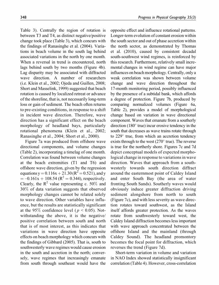
Table 3). Centrally the region of rotation is
between T3 and T4, as distinct negative/positive
change took place (Table 3), which concurs with
the findings of Ranasinghe et al. (2004). Varia-
tions in beach volume in the south lag behind
associated variations in the north by one month.
When a reversal in trend is encountered, north
lags behind south by two months (Figure 4b).
Lag disparity may be associated with diffracted
wave direction. A number of researchers
(i.e. Klein et al., 2002; Ojeda and Guillen, 2008;
Short and Masselink, 1999) suggested that beach
rotation is caused by localized retreat or advance
of the shoreline, that is, not necessarily long-term
loss or gain of sediment. The beach often returns
to pre-existing conditions, in response to a shift
in incident wave direction. Therefore, wave
direction has a significant effect on the beach
morphology of headland bays, particularly
rotational phenomena (Klein et al., 2002;
Ranasinghe et al., 2004; Short et al., 2000).
Figure 7a was produced from offshore wave
directional components, and volume changes
(Table 2), incorporating a timelag of one month.
Correlation was found between volume changes
at the beach extremities (T1 and T6) and
offshore wave direction, given by the regression
equations y¼ 0.116xþ 21.30 (R2¼ 0.521), and y
¼ –0.161x þ 108.54 (R2 ¼ 0.344), respectively.
Clearly, the R2 value representing c. 50% and
30% of data variation suggests that observed
morphology changes cannot be related solely
to wave direction. Other variables have influ-
ence, but the results are statistically significant
at the 95% confidence level ( p < 0.05). Not-
withstanding the above, it is the negative/
positive correlation between south and north
that is of most interest, as this indicates that
variations in wave direction have opposite
effects on beach morphology which concurs with
the findings of Gibbard (2005). That is, south to
southwesterly wave regimes would cause erosion
in the south and accretion in the north; conver-
sely, wave regimes that increasingly emanate
from south through southeast would have the
opposite effect and influence rotational patterns.
Longer-term evolution of constant erosion within
the south sector and out of phase accretion within
the north sector, as demonstrated by Thomas
et al. (2010), caused by consistent decadal
south-southwest wind regimes, is reinforced by
this research. Furthermore, relatively small incre-
mental changes in wind regime can have major
influences on beach morphology. Centrally, only a
weak correlation was shown between volume
change and wave direction throughout the
17-month monitoring period, possibly influenced
by the presence of a subtidal bank, which affords
a degree of protection. Figure 7b, produced by
comparing normalized volumes (Figure 6a,
Table 2), provides a model of morphological
change based on variation in wave directional
component. Waves that emanate from a southerly
direction (180� true) incur erosive tendency in the
south that decreases as wave trains rotate through
to 229� true, from which an accretion tendency
exists through to the west (270� true). The reverse
is true for the northerly shore. Figures 7c and 7d
depict conceptual models of expected morpho-
logical change in response to variations in wave
direction. Waves that approach from a south-
westerly towards south direction diffract
around the easternmost point of Caldey Island
and enter South Bay (the area of water
fronting South Sands). Southerly waves would
obviously induce greater diffraction driving
sediment alongshore from north to south
(Figure 7c), and with less severity as wave direc-
tion rotates toward southwest, as the Island
itself affords greater protection. As the waves
rotate from southwesterly toward west, the
Caldey Island diffraction becomes less important
with wave approach concentrated between the
offshore Island and the mainland (through
Caldey Sound). The headland promontory
becomes the focal point for diffraction, which
reverses the trend (Figure 7d).
Short-term variation in volume and variation
in NAO Index showed statistically insignificant
correlation (Table 4). However, cross-correlation
348 Progress in Physical Geography 35(3)
improvements (Figures 5a and 5b) at a one-month
timelag do highlight an inverse relationship of
rising volumes in the south (r ¼ 0.57, p < 0.05;
Figure 5b), and lowering volumes in the north
(r ¼ –0.33, p > 0.05; Figure 5a). Comparison
of gale wave heights (Table 1) and NAO Index
values (Table 2), highlight a toning down of
gale wave height when the NAO is weak, or
in transitional stage between positive and
negative phases. This is given by the regression
equations yghs¼ 2.05xPNAOþ 1.301 (R2¼ 0.69)
and yghs ¼ 1.24xNNAO þ 2.541 (R2 ¼ 0.72),
respectively, where yhs ¼ gale wave height,
xNNAO ¼ negative NAO Index values and
xPNAO ¼ positive NAO Index values. Results
agree with both Woolf et al.’s (2002) findings
regarding the influence of waves and NAO
variation, and Phillips and Crisp’s (2010) work
on sea-level variations with NAO Index and
phase. Figure 7e, produced from Table 4, depicts
Pearson correlation values at zero lag by pro-
file, for both negative and positive NAO values.
Positive correlation is shown when considering
positive NAO values. In contrast, a negative
correlation is shown when negative values are
considered given by the regression equations
yPNAO ¼ 0.148xPr – 0.436 (R2 ¼ 0.538) and
yNNAO ¼ –0.294xPr þ 1.243 (R2 ¼ 0.686),
respectively, where yPNAO ¼ positive NAO
Index values, yNNAO ¼ negative NAO Index
values and xPr ¼ profile location alongshore.
These results are of most interest as they
indicate that lowering volumes are expected
in the south and rising volumes in the north
during positive NAO phases. Conversely,
rising volumes are expected in the south and
lowering volumes in the north during negative
NAO phases, and these are depicted by a mor-
phological model in Figure 7f. Conceptually,
during positive NAO, sediment movement
would be similar to that shown in Figure 7d and
during negative NAO to that in Figure 7c.
The relative importance of cross-shore pro-
cesses can also translate into short-term profile
realignment, where onshore/offshore movement
could also result in subaerial volume adjustments,
i.e. non-rotational responses. The cut and fill
behaviour was subsequently removed to better
reflect subaerial volumes associated purely with
longshore rotation. However, the hiatus of the
tide across the entire intertidal zone (i.e. shoal-
ing), surf and swash zones are important, and are
subject to ongoing research in this embayment.
Short-term morphological change was dependent
on incident wave direction and diffraction, which
promotes longshore transport and an apparent
rotational response. Furthermore, the two pro-
montories acted independently to promote trend
reversals, i.e. beach rotation. Climatic variability
also plays an important role, especially with
reductions in incident wave height caused by
NAO Index changes. It is likely that similar
cycles of beach erosion/accretion and rotation are
a widespread phenomenon on headland beaches,
in response to changing atmospheric conditions
that influence wave height and direction.
VI Conclusions
Increasing physical, environmental and socio-
economic pressures are being placed upon the
world’s coastlines and, therefore, a compre-
hensive understanding of coastal processes
is important. Based on the results presented
in the above analysis of beach data from
South Sands, Tenby, large-scale atmospheric
pressure gradients should also be considered
in the development of new beach manage-
ment responses, particularly in the context
of timelag influences. These provide associ-
ated linkages with changes in wind/wave pat-
terns and subsequent shoreline morphological
change. Analyses resulted in the establishment
of timelag-associated links between morphologi-
cal change, climatic variation, and beach rota-
tion. Variations in incident wave direction,
and NAO were established as key drivers that
control short-term morphological change. This
knowledge enabled two models of short-term
beach rotation to be proposed. The first
Thomas et al. 349

considered incident wave direction, the second
climatic variability.
Notwithstanding the above, it is accepted that
further analyses are required to separate cut
and fill behaviour across the whole macrotidal
profile. Findings presented here form part of
continuous ongoing research into evolutionary
patterns of this headland embayment. However,
it is likely that similar geomorphologic settings
exist, where cycles of beach erosion/accretion
associated with beach rotation phenomena are
influenced by the presence of offshore islands,
in conjunction with more typical headland pro-
montories. The assessment of short-term
responses to changing atmospheric conditions
that influence wave height and their respective
directional components have implications for
coastal zone management, and careful analysis
is required of these phenomena over both short
and longer timescales. This is particularly
important at locations where coastal engineers
and planners consider hard engineering solu-
tions. The assessments and developed concep-
tual models are therefore important and should
be repeated on a wider scale, especially where
coastal areas are deemed to be at risk, so that
suitable coastal management policies can be
developed. These would underpin intervention
or no active intervention decisions, thereby
enabling more effective use of limited resources.
References
Anthony EJ and Dolique F (2004) The influence of
Amazon-derived mud banks on the morphology
of sandy headland-bound beach in Cayenne, French
Guiana: A short to long-term perspective. Marine
Geology 208: 249–264.
Anthony EJ, Gardel A, Dolique F, and Guiral D (2002)
Short-term changes in the plan shape of a sandy beach
in response to sheltering by a nearshore mud bank,
Cayenne, French Guiana. Earth Surface Processes and
Landforms 27: 857–866.
Bacon S and Carter DJT (1993) A connection between
mean wave height and atmospheric pressure gradient
in the North Atlantic. International Journal of Clima-
tology 13: 423–436.
Bell I and Visbeck M (2009) North Atlantic Oscillation.
Available at: www.ldeo.columbia.edu/res/pi/NAO.
Bowman D, Guillan J, Lopez L and Pellegrino V (2009)
Planview geometry and morphological characteristics
of pocket beaches on the Catalan coast (Spain).
Geomorphology 108: 191–199.
Brown E, Colling A, Park D, Phillips J, Rothery D,
and Wright J (1999) Waves, Tides and Shallow-Water
Processes. Oxford: Butterworth Heinemann.
Carter RWG (1988) Coastal Environments: An Introduc-
tion to the Physical Ecological and Cultural Systems
of Coastlines. London: Academic Press.
Davis JC (2002) Statistics and Data Analysis in Geology.
Chichester: Wiley.
Dehouck A, Dupuis H, and Senechal N (2009) Pocket
beach hydrodynamics: The example of four macrotidal
beaches, Brittany, France. Marine Geology 266: 1–17.
Dolique F and Anthony EJ (2005) Short-term profile
changes of sandy pocket beaches affected by amazon-
derived mud, Cayenne, French Guiana. Journal of
Coastal Research 21(6): 1195–1202.
Euler HJ, Zebhauser BE, Townsend BR, and Wuebbena
G (2002) Comparison of different proposals for refer-
ence station network information distribution formats.
In: Proceedings of the 15th International Technical
Meeting of the Satellite Division of the Institute of
Navigation, 24–27 September, Portland, Oregon,
2349–2359.
Gibbard B (2005) Tenby South Beach Erosion: Review of
Wind/Wave Data, Beach Monitoring and Modeling.
Peterborough: Royal Haskoning.
Hillier RD and Williams BPJ (2006) The alluvial Old Red
Sandstone: Fluvial basins. In: Brenchley PJ and
Rawson PF (eds) The Geology of England and Wales.
London: The Geological Society, 155–172.
Hunter A and Easterbrook G (2004) The Geological
History of the British Isles. Oxford: The Alden Group.
Jacob J, Gama C, Salgado R, Liu JT, and Silva A (2009)
Shadowing effects on beach morpholodynamics during
storm events on Troia-Sines embayed coast, southwest
Portugal. Journal of Coastal Research Special Issue 56:
72–77.
Klein AH and Menezes JT (2001) Beach morphodynamics
and profile sequence for a headland bay coast. Journal
of Coastal Research 17: 812–835.
Klein AHF, Benedet Filho L, and Schumacher DH
(2002) Short-term beach rotation processes in distinct
350 Progress in Physical Geography 35(3)

headland bay systems. Journal of Coastal Research
18: 442–458.
Komar P and Gaughan MK (1972) Airy wave theory and
breaker height prediction. In: Proceedings of the 13th
Conference on Coastal Engineering, ASCE, 405–418.
Leica (2008a) System 1200 Newsletter 52, RTK Networks,
an introduction. Leica Geosystems. Available at:
http://smartnet.leica-geosystems.co.uk/SpiderWeb/
SmartNet/2f2RTKNetworksAnIntroduction.html.
Leica (2008b) System 1200 Newsletter 5, RTK Networks –
different methods. Leica Geosystems. Available at:
http://smartnet.leica-geosystems.co.uk/SpiderWeb/
SmartNet/2f2DiffMethods1.html.
Loureiro C, Ferreira O, and Cooper JAG (2009) Contrast-
ing morphological behaviour at embayed beaches in
southern Portugal. Journal of Coastal Research Special
Issue 56: 83–87.
Morang A, Batten BK, Connell KJ, Tanner W, Larson M,
and Kraus NC (2009) Regional Morphology Analysis
Package (RMAP), version 3: User’s guide and tutorial.
Coastal and Hydraulics Engineering Technical Note
ERDC/CHL CHETN-XIV-9. Vicksburg: US Army
Research and Development Center. Available at: http://
chl.erdc.usace.army.mil/chetn.
Ojeda E and Guillen J (2008) Shoreline dynamics and
beach rotation of artificial embayed beaches. Marine
Geology 253: 51–62.
Owen TR (1973) Geology Explained in South Wales.
Ross-on-Wye: Fineleaf Editions.
Pembrokeshire County Council (PCC) (2006) Shoreline
management plan (sub cell 8C). Available at: http://
www.pembrokeshire.gov.uk/content.asp?id¼6555&
parent_directory_id¼100&textonly¼true.
Phillips MR and Crisp S (2010) Sea level trends and NAO
influences: The Bristol Channel/Severn Estuary.
Global and Planetary Change 73: 211–218.
Pinto CA, Tabord R, Andrade C, and Teixeira SB (2009)
Seasonal and mesoscale variations at an embayed
beach (Armacao De Pera, Portugal). Journal of Coastal
Research Special Issue 56: 118–122.
Poate T, Kingston K, Masselink G, and Russell P (2009)
Response of high-energy, macrotidal beaches to seaso-
nal changes in wave conditions: Examples from north
Cornwall, UK. Journal of Coastal Research Special
Issue 56: 747–751.
Posford Duvivier (1998) South Beach, Tenby. Peterborough:
Posford Duvivier.
Ranasinghe R, McLoughlin R, Short AD, and Symonds
G (2004) The Southern Oscillation Index, wave
climate, and beach rotation. Marine Geology 204:
273–287.
Rooney JJB and Fletcher CH (2005) Shoreline change and
Pacific climate oscillations in Kihei, Maui, Hawaii.
Journal of Coastal Research 21: 535–547.
Sedrati M and Anthony EJ (2007) A brief overview of
plan-shape disequilibrium in embayed beaches:
Tangier Bay (Morocco). Mediterranee 108. Available
at: http://mediterranee.revues.org/index190.html?file¼1.
Short AD and Masselink G (1999) Embayed and
structurally controlled beaches. In: Short AD (ed.)
Handbook of Beach and Shoreface Morphodynamics.
Chichester: Wiley, 230–250.
Short AD and Trembanis AC (2004) Decadal scale
patterns of beach oscillation, and rotation: Narabeen
Beach, Australia: Time series PCA and wavelet analysis.
Journal of Coastal Research 20(2): 523–532.
Short AD, Trembanis AC, and Turner I (2000) Beach
oscillation, rotation and the Southern Oscillation,
Narrabeen Beach, Australia. In: Proceedings of the
27th International Coastal Engineering Conference,
ASCE, Sydney, 2439–2452.
Thomas T (2007) Coastal processes influencing the
evolution of a headland bay beach: The South Beach,
Tenby, Pembrokeshire. Unpublished MSc dissertation,
Swansea Institute of Higher Education.
Thomas T, Phillips MR, and Williams AT (2010)
Mesoscale evolution of a headland bay: Beach rotation
process. Geomorphology 123: 29–41.
Toghill P (2000) The Geology of Britain: An Introduction.
Marlborough: Crowood Press.
United Kingdom Meteorological Office (UKMO) (2009)
Seasonal forecasting research and development, North
Atlantic Oscillation. Available at: http://www.metoffice.
gov.uk/science/creating/monthsahead/seasonal/research.
html.
Vespremeanu-Stroe A, Constantinescu S, Tatui F, and
Giosan L (2007) Multi-decadal evolution and North
Atlantic Oscillation influences on the dynamics of the
Danube delta shoreline. Journal of Coastal Research
Special Issue 50: 157–162.
Weber G, Dettmering D, Gebhard H, and Kalafus R
(2005) Networked transport of RTCM via internet
protocol (Ntrip) – IP-streaming for real time
GNSS applications. In: Proceedings of the Institute of
Navigation GNSS 18th International Technical Meeting
Thomas et al. 351

of the Satellite Division, 13–16 September, Long Beach,
CA, 2243–2247.
Woolf DK, Challenor PG, and Cotton PD (2002) Variability
and predictability of the North Atlantic wave climate.
Journal of Geophysical Research 107: 31–45.
Woolf D and Coll J (2006) Impacts of climate change on
storms and waves. In: Marine Climate Change Impacts
Annual Report Card 2006. Available at: http://www.
mccip.org.uk/annual-report-card/2006.aspx.
352 Progress in Physical Geography 35(3)
Related Documents


