KITSAULT MINE PROJECT ENVIRONMENTAL ASSESSMENT VE51988 Section 6.2 Atmospheric Environment - Air Quality and Climate

Welcome message from author
This document is posted to help you gain knowledge. Please leave a comment to let me know what you think about it! Share it to your friends and learn new things together.
Transcript

KITSAULT MINE PROJECT ENVIRONMENTAL ASSESSMENT
VE51988
Section 6.2 Atmospheric Environment - Air Quality
and Climate


KITSAULT MINE PROJECT
ENVIRONMENTAL ASSESSMENTATMOSPHERIC ENVIRONMENT – AIR QUALITY AND CLIMATE
Version 1.0
TOC 6.2-iVE51988 – Section 6.2 December 2011
TABLE OF CONTENTS
6.2 Atmospheric Environment - Air Quality and Climate .............................................. 6.2-1 6.2.1 Valued Components Scoping and Rationale ............................................ 6.2-1
6.2.1.1 Valued Component / Issues Confirmation ............................ 6.2-7 6.2.2 VC #1: Air Quality ................................................................................... 6.2-11
6.2.2.1 Introduction ......................................................................... 6.2-11 6.2.2.1.1 Relevant Legislation and Legal Framework ..... 6.2-12 6.2.2.1.2 Spatial Boundaries ........................................... 6.2-13 6.2.2.1.3 Temporal Boundaries ....................................... 6.2-14
6.2.2.2 Information Source and Methods ....................................... 6.2-14 6.2.2.3 Detailed Baseline Description for Air Quality ...................... 6.2-16 6.2.2.4 Cultural, Ecological, or Community Knowledge ................. 6.2-18 6.2.2.5 Past, Present or Future Projects / Activities ....................... 6.2-18 6.2.2.6 Potential Effects of the Proposed Project and Proposed
Mitigation ............................................................................ 6.2-19 6.2.2.6.1 Identification and Analysis of Potential
Project Effects .................................................. 6.2-22 6.2.2.6.2 Mitigation Measures ......................................... 6.2-26
6.2.2.7 Potential Residual Effects and Their Significance .............. 6.2-27 6.2.2.7.1 Potential Residual Effects After Mitigation ....... 6.2-27 6.2.2.7.2 Significance of Potential Residual Effects ........ 6.2-28
6.2.2.8 Potential Cumulative Effects ............................................... 6.2-28 6.2.2.8.1 Identification and Analysis of Potential
Project Cumulative Effects ............................... 6.2-28 6.2.2.9 Conclusion .......................................................................... 6.2-29
6.2.3 VC #2: Climate ....................................................................................... 6.2-29 6.2.3.1 Introduction ......................................................................... 6.2-29
6.2.3.1.1 Relevant Legislation and Legal Framework ..... 6.2-31 6.2.3.1.2 Spatial Boundaries ........................................... 6.2-32 6.2.3.1.3 Temporal Boundaries ....................................... 6.2-34
6.2.3.2 Information Source and Methods ....................................... 6.2-34 6.2.3.3 Detailed Baseline Description for Climate .......................... 6.2-35 6.2.3.4 Cultural, Ecological, or Community Knowledge ................. 6.2-36 6.2.3.5 Past, Present or Future Projects / Activities ....................... 6.2-36 6.2.3.6 Potential Effects of the Proposed Project and
Proposed Mitigation ............................................................ 6.2-36 6.2.3.6.1 Identification and Analysis of Potential
Project Effects .................................................. 6.2-37 6.2.3.6.2 Mitigation Measures ......................................... 6.2-38
6.2.3.7 Potential Residual Effects and Their Significance .............. 6.2-39 6.2.3.7.1 Potential Residual Effects After Mitigation ....... 6.2-39
6.2.3.8 Potential Cumulative Effects ............................................... 6.2-39 6.2.3.8.1 Identification and Analysis of Potential
Project Cumulative Effects ............................... 6.2-39 6.2.3.9 Conclusion .......................................................................... 6.2-39

KITSAULT MINE PROJECT
ENVIRONMENTAL ASSESSMENTATMOSPHERIC ENVIRONMENT – AIR QUALITY AND CLIMATE
Version 1.0
TOC 6.2-iiVE51988 – Section 6.2 December 2011
List of Tables
Table 6.2.1-1: Valued Component / Issue Interaction Matrix for Atmospheric Environment ........ 6.2-2 Table 6.2.1-2: Potential Issues by Project Component and Valued Component -
Construction Phase ................................................................................................ 6.2-4 Table 6.2.1-3: Potential Issues by Project Component and Valued Component -
Operations Phase .................................................................................................. 6.2-5 Table 6.2.1-4: Potential Issues by Project Component and Valued Component -
Closure and Decommissioning Phase ................................................................... 6.2-6 Table 6.2.1-5: Potential Issues by Project Component and Valued Component -
Post-Closure .......................................................................................................... 6.2-7 Table 6.2.1-6: Atmospheric Environment Valued Component Selection Rationale ...................... 6.2-9 Table 6.2.2-1: BC and Canadian Ambient Air Quality Guidelines and Objectives in µg/m3 ....... 6.2-12 Table 6.2.2-2: Summarised Annual Production in Year 2 of Operations .................................... 6.2-14 Table 6.2.2-3: Expected Background Concentration of Gaseous Pollutant in the
Project Area ......................................................................................................... 6.2-17 Table 6.2.2-4: Historical Land Use Activities in Biophysical Cumulative Effects
Assessment Study Area ....................................................................................... 6.2-18 Table 6.2.2-5: General Land Use Activities in Biophysical Cumulative Effects
Assessment Study Area ....................................................................................... 6.2-19 Table 6.2.2-6: Reasonably Foreseeable Projects in Biophysical Cumulative Effects
Assessment Study Area ....................................................................................... 6.2-19 Table 6.2.2-7: Summary of Dispersion Modelling Results .......................................................... 6.2-20 Table 6.2.2-8: Potential Direct Project Effects on Air Quality ...................................................... 6.2-23 Table 6.2.2-9: Potential Indirect Project Effects on Other Valued Components ......................... 6.2-23 Table 6.2.2-10: Summary of Potential Interaction Between Project Direct Effects on
Other Valued Components and Air Quality .......................................................... 6.2-25 Table 6.2.2-11: Potential Combined Project Effects by Project Phase on Air Quality .................. 6.2-26 Table 6.2.2-12: Summary of Potential Project Effects to be Carried Forward into the
Assessment for Air Quality ................................................................................... 6.2-26 Table 6.2.2-13: Potential Project Effect by Project Phase on Air Quality
and Mitigation Measures ...................................................................................... 6.2-27 Table 6.2.2-14: Summary of Residual Effects for Air Quality ........................................................ 6.2-28 Table 6.2.2-15: Residual Effects Assessment by Project Development Phase for Air Quality ..... 6.2-28 Table 6.2.2-16: Project Related Residual Effects - Rationale for Carrying Forward
into the CEA ......................................................................................................... 6.2-29 Table 6.2.3-1: Potential Indirect Project Effects on Other Valued Components ......................... 6.2-38 Table 6.2.3-2: Potential Project Effect by Project Phase on Climate and Mitigation
Measures ............................................................................................................. 6.2-38
List of Figures
Figure 6.2.2-1: Local and Regional Study Areas for Air Quality ................................................... 6.2-15 Figure 6.2.3-1: Study Areas for Social and Economic Conditions Adopted as Climate
Study Area ........................................................................................................... 6.2-33

KITSAULT MINE PROJECT
ENVIRONMENTAL ASSESSMENTATMOSPHERIC ENVIRONMENT – AIR QUALITY AND CLIMATE
Version 1.0
TOC 6.2-iiiVE51988 – Section 6.2 December 2011
List of Appendices
Appendix 6.2-A: Atmospheric Environment Baseline Report Appendix 6.2-B: Supporting Data Used in Suspended Particulate Matter Emission Calculations Appendix 6.2-C: Emission Sources and Air Quality Modelling Appendix 6.2-D: Surface and Upper Air MET Data for AERMOD / AERMET Appendix 6.2-E: Detailed Baseline Climate Data 1971-2000

KITSAULT MINE PROJECT
ENVIRONMENTAL ASSESSMENTATMOSPHERIC ENVIRONMENT – AIR QUALITY AND CLIMATE
Version 1.0
Page 6.2-1VE51988 – Section 6.2 December 2011
6.2 Atmospheric Environment - Air Quality and Climate
This section of the Application presents an assessment of potential effects on the atmospheric environment from activities related to the Kitsault Mine Project (proposed Project) along with potential cumulative effects.
The atmospheric environment has two Valued Components (VCs): air quality and climate change. Adhering to the methodology outlined in Section 5.0, the following sections describe the scoping and rationale for the selection of VCs, spatial and temporal boundaries, descriptions of VCs, assessment of potential effects and mitigation measures, assessment of residual effects, potential cumulative effects considerations and associated limitations. The atmospheric environment assessment section is concluded with a summary of the significance of identified residual and cumulative effects for each VC.
6.2.1 Valued Components Scoping and Rationale
The purpose of scoping is to focus the assessment on key issues related to atmospheric environment, which was determined by the physical project, the natural environmental setting, and by the social and cultural backdrop of the proposed Project. In practical terms, the selection of VCs was based on outcomes from consultation with stakeholders and British Columbia Environmental Assessment Office (BC EAO) Working Group deliberations, which included the Nisga’a Nation and Aboriginal Groups’ interests, concerns raised by the general public and Avanti Kitsault Mine Ltd. (the proponent) as well as scientific and regulatory considerations.
The scoping process was carried out in the following steps:
Identification of key issues listed in the consultation database, which captured results from the pre-Application stage issue scoping process with the Nisga’a Nation and Aboriginal Groups, the public, other tenure holders and government agencies (see Section 4.0 for database information);
Identification of issues based on experience with similar projects and professional judgement;
Identification of VCs specific to the atmospheric environment that interact with Project components; and
Confirmation of identified VCs and summarisation of rationale for VC selection.
The scoping process recognised three key issues associated with atmospheric environment: diesel engines exhaust emissions; particulate matter (PM) in the air; and climate change. These issues are related to the proposed Project activities which will take place during construction, operations, and closure of a mine.
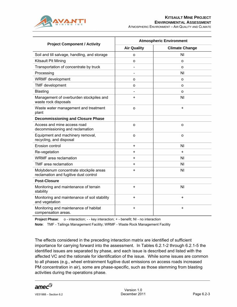
The following tables show details of the VC scoping and rationale which include key issues related to atmospheric environment. Table 6.2.1-1 is an interaction matrix, which is used as a tool for detecting valid connections among potential impacts between proposed Project components and atmospheric environment VCs. The table provides a visual summary of

KITSAULT MINE PROJECT
ENVIRONMENTAL ASSESSMENTATMOSPHERIC ENVIRONMENT – AIR QUALITY AND CLIMATE
Version 1.0
Page 6.2-2VE51988 – Section 6.2 December 2011
interactions that enables identifying and narrowing the scope of issues to be carried forward into the assessment. Potential effects are considered for each phase of the proposed Project. Effects, in the context of this Environmental Assessment (EA), are any actions resulting from the proposed Project development that cause a positive or negative change to a receptor (e.g., a change in concentration of particulate matter in air due to fugitive emissions from equipment operation). An effect is either a positive or negative response of the receptor. For example, reclamation of the Tailings Management Facility (TMF) area will have positive effect on air quality due to assimilation of atmospheric carbon dioxide by reclaimed vegetation. Only components or issues with the potential to cause effects are of concern. The type of interactions expected between the proposed Project component and VCs are denoted using the following symbols:
‘o’ indicate that there is an interaction;
‘-’ indicate a key interaction; and
‘+’ indicate a benefit.
Table 6.2.1-1: Valued Component / Issue Interaction Matrix for Atmospheric Environment
Project Component / Activity Atmospheric Environment
Air Quality Climate Change
Construction Phase
Existing access road - o
Equipment and machinery transportation to site including anticipated changes to traffic (e.g., type and volume) on public roads
- o
Fugitive emissions from equipment operation o NI
Land clearing o o
Excavating o o
Grading o o
Soil and till salvage, handling, and storage - NI
Mine infrastructure installations - o
Kitsault Pit development - -
Process plant and ancillary facilities - -
Development of borrow sources o NI
Expansion of exploration camp to create construction and permanent camps
o o
WRMF development o o
TMF development o o
Blasting - o
Operations Phase
Existing access road o o
Erosion control + NI
KITSAULT MINE PROJECT
ENVIRONMENTAL ASSESSMENTATMOSPHERIC ENVIRONMENT – AIR QUALITY AND CLIMATE
Version 1.0
Page 6.2-3VE51988 – Section 6.2 December 2011
Project Component / Activity Atmospheric Environment
Air Quality Climate Change
Soil and till salvage, handling, and storage o NI
Kitsault Pit Mining o o
Transportation of concentrate by truck - o
Processing - NI
WRMF development o o
TMF development o o
Blasting - o
Management of overburden stockpiles and waste rock disposals
+ NI
Waste water management and treatment plant
o +
Decommissioning and Closure Phase
Access and mine access road decommissioning and reclamation
o o
Equipment and machinery removal, recycling, and disposal
o o
Erosion control + NI
Re-vegetation + +
WRMF area reclamation + NI
TMF area reclamation + NI
Molybdenum concentrate stockpile areas reclamation and fugitive dust control
+ NI
Post-Closure
Monitoring and maintenance of terrain stability
+ NI
Monitoring and maintenance of soil stability and vegetation
+ +
Monitoring and maintenance of habitat compensation areas.
+ +
Project Phase: o - interaction; - - key interaction; + - benefit; NI - no interaction
Note: TMF - Tailings Management Facility; WRMF - Waste Rock Management Facility
The effects considered in the preceding interaction matrix are identified of sufficient importance for carrying forward into the assessment. In Tables 6.2.1-2 through 6.2.1-5 the identified issues are separated by phase, and each issue is described and listed with the affected VC and the rationale for identification of the issue. While some issues are common to all phases (e.g., wheel entrainment fugitive dust emissions on access roads increased PM concentration in air), some are phase-specific, such as those stemming from blasting activities during the operations phase.

KITSAULT MINE PROJECT
ENVIRONMENTAL ASSESSMENTATMOSPHERIC ENVIRONMENT – AIR QUALITY AND CLIMATE
Version 1.0
Page 6.2-4VE51988 – Section 6.2 December 2011
Prominent construction-related impacts on atmospheric environment are related to fugitive emissions from equipment operation and development of the Waste Rock Management Facility (WRMF) and TMF. Assembly of a Process Plant and ancillary facilities will be of low importance due to absence of major emission sources. Potential issues by project component associated with construction of the proposed mine are listed in Table 6.2.1-2.
Table 6.2.1-2: Potential Issues by Project Component and Valued Component - Construction Phase
Project Component Relevant Key Issues Project Setting
Component Rationale
Existing access road Vehicle emissions Air quality, climate change
Regulatory requirements, public health
Equipment and machinery transportation to site, including anticipated changes to traffic (e.g., type and volume) on public roads
Vehicle emissions Air quality, climate change
Regulatory requirements, public health
Fugitive emissions from equipment operation
Increase concentration of criteria air pollutants
Air quality, dust deposition, acid deposition, climate change
Regulatory requirements, occupational health and safety, codes of good practice, surface water quality
Land clearing Fugitive dust, reduced visibility
Air quality, dust deposition
Occupational health and safety; regulatory requirements
Excavating Equipment emissions, fugitive dust
Air quality Regulatory requirements
Grading Equipment emissions, fugitive dust
Air quality Regulatory requirements
Soil and till salvage, handling and storage
Equipment emissions, fugitive dust
Air quality Regulatory requirements
Mine infrastructure installations
Equipment emissions Air quality Regulatory requirements
Kitsault pit development
Equipment emissions, fugitive dust
Air quality Regulatory requirements
Process plant and ancillary facilities
Equipment and plant emissions, fugitive dust
Air quality, climate change
Regulatory requirements
Development of borrow sources
Equipment emissions, fugitive dust
Air quality, dust Regulatory requirement, impact on surrounding vegetation
KITSAULT MINE PROJECT
ENVIRONMENTAL ASSESSMENTATMOSPHERIC ENVIRONMENT – AIR QUALITY AND CLIMATE
Version 1.0
Page 6.2-5VE51988 – Section 6.2 December 2011
Project Component Relevant Key Issues Project Setting
Component Rationale
Expansion of exploration camp to create construction and permanent camps
Equipment emissions, fugitive dust
Air quality Regulatory requirements
WRMF development Exhaust gas emissions of construction equipment
Air quality Regulatory requirements
TMF development No air quality issues n/a n/a
Blasting Dust, products of ANFO combustion
Air quality Interaction with wildlife, blasting regulations
Note: Regulatory Requirements - Defined in sections Relevant Legislation and Legal Framework; TMF - Tailings Management Facility; WRMF - Waste Rock Management Facility; n/a – not applicable
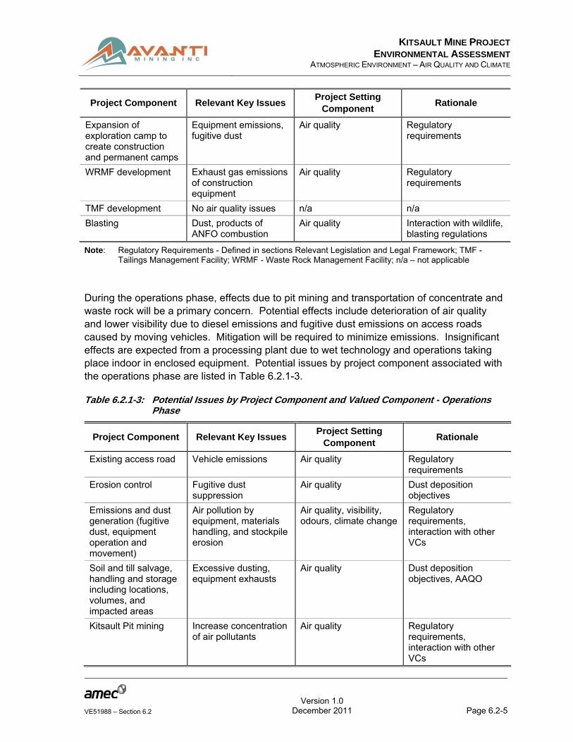
During the operations phase, effects due to pit mining and transportation of concentrate and waste rock will be a primary concern. Potential effects include deterioration of air quality and lower visibility due to diesel emissions and fugitive dust emissions on access roads caused by moving vehicles. Mitigation will be required to minimize emissions. Insignificant effects are expected from a processing plant due to wet technology and operations taking place indoor in enclosed equipment. Potential issues by project component associated with the operations phase are listed in Table 6.2.1-3.
Table 6.2.1-3: Potential Issues by Project Component and Valued Component - Operations Phase
Project Component Relevant Key Issues Project Setting
Component Rationale
Existing access road Vehicle emissions Air quality Regulatory requirements
Erosion control Fugitive dust suppression
Air quality Dust deposition objectives
Emissions and dust generation (fugitive dust, equipment operation and movement)
Air pollution by equipment, materials handling, and stockpile erosion
Air quality, visibility, odours, climate change
Regulatory requirements, interaction with other VCs
Soil and till salvage, handling and storage including locations, volumes, and impacted areas
Excessive dusting, equipment exhausts
Air quality Dust deposition objectives, AAQO
Kitsault Pit mining Increase concentration of air pollutants
Air quality Regulatory requirements, interaction with other VCs
KITSAULT MINE PROJECT
ENVIRONMENTAL ASSESSMENTATMOSPHERIC ENVIRONMENT – AIR QUALITY AND CLIMATE
Version 1.0
Page 6.2-6VE51988 – Section 6.2 December 2011
Project Component Relevant Key Issues Project Setting
Component Rationale
Transportation of concentrate by truck
Fugitive dust, diesel exhausts
Air quality Regulatory requirement
Processing Dust Air quality and climate change
AAQO
WRMF operation Exhaust gas emissions of compacting and stacking equipment
Air quality Regulatory requirements
TMF operation Fugitive dust Air quality AAQO
Blasting Dust Air quality Interaction with wildlife, blasting regulations
Management of overburden stockpiles and waste rock dumps supported by relevant geotechnical data and stability analysis
Equipment emissions and fugitive dust
Air quality AAQO
Waste water management and treatment plant
Odours Organoleptic impacts Perception of low-quality air
Note: AAQO - Ambient Air Quality Objectives; Regulatory Requirements - Defined in Section 6.2.2.1.1 Relevant Legislation and Legal Framework; TMF - Tailings Management Facility; VC - Valued Component; WRMF - Waste Rock Management Facility
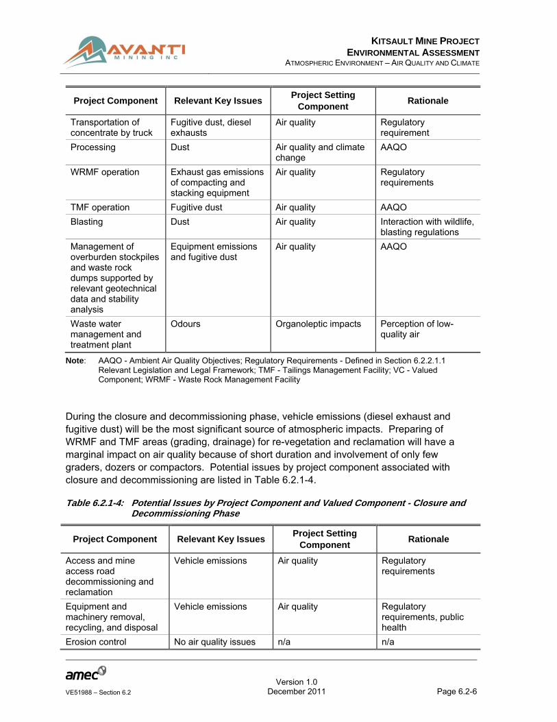
During the closure and decommissioning phase, vehicle emissions (diesel exhaust and fugitive dust) will be the most significant source of atmospheric impacts. Preparing of WRMF and TMF areas (grading, drainage) for re-vegetation and reclamation will have a marginal impact on air quality because of short duration and involvement of only few graders, dozers or compactors. Potential issues by project component associated with closure and decommissioning are listed in Table 6.2.1-4.
Table 6.2.1-4: Potential Issues by Project Component and Valued Component - Closure and Decommissioning Phase
Project Component Relevant Key Issues Project Setting
Component Rationale
Access and mine access road decommissioning and reclamation
Vehicle emissions Air quality Regulatory requirements
Equipment and machinery removal, recycling, and disposal
Vehicle emissions Air quality Regulatory requirements, public health
Erosion control No air quality issues n/a n/a

KITSAULT MINE PROJECT
ENVIRONMENTAL ASSESSMENTATMOSPHERIC ENVIRONMENT – AIR QUALITY AND CLIMATE
Version 1.0
Page 6.2-7VE51988 – Section 6.2 December 2011
Project Component Relevant Key Issues Project Setting
Component Rationale
Emissions and dust generation (equipment operation and movement)
No equipment in operation
n/a n/a
Re-vegetation No atmospheric environment issues
n/a n/a
WRMF area reclamation
Equipment emissions and dust generation
Air quality AAQO
TMF area reclamation No air quality issues n/a n/a
Molybdenum concentrate stockpile areas reclamation and fugitive dust control
Equipment emissions and dust generation
Air quality and fugitive dust
AAQO, dust precipitation objectives
Note: AAQO - Ambient Air Quality Objectives; Regulatory Requirements - Defined in sections Relevant Legislation and Legal Framework; n/a - not applicable, TMF - Tailings Management Facility; WRMF - Waste Rock Management Facility
No issues pertaining to atmospheric environment are expected for the post-closure phase of the proposed Project.
Table 6.2.1-5: Potential Issues by Project Component and Valued Component - Post-Closure
Project Component Relevant Key Issues Project Setting
Component Rationale
Monitoring and maintenance of terrain stability
No atmospheric environment issues
n/a n/a
Monitoring and maintenance of soil stability and vegetation
No atmospheric environment issues
n/a n/a
Monitoring and maintenance of habitat compensation areas
No atmospheric environment issues
n/a n/a
Note: n/a – not applicable
6.2.1.1 Valued Component / Issues Confirmation
The VCs selected for the atmospheric environment discipline have the potential to be directly affected by the proposed Project as follows:
Air Quality: diesel engine emissions, fugitive dust, and aggregate ore and waste handling activities may reduce air quality to unacceptable level; Potential air quality effects act as pathways to other terrestrial disciplines; and

KITSAULT MINE PROJECT
ENVIRONMENTAL ASSESSMENTATMOSPHERIC ENVIRONMENT – AIR QUALITY AND CLIMATE
Version 1.0
Page 6.2-8VE51988 – Section 6.2 December 2011
Climate change: emission of greenhouse gasses (GHG) by internal combustion engine and deforestation has the potential to contribute to global warming.
Table 6.2.1-6 presents the confirmation table for VC inclusion for the atmospheric environment discipline.
KITSAULT MINE PROJECT
ENVIRONMENTAL ASSESSMENTATMOSPHERIC ENVIRONMENT – AIR QUALITY AND CLIMATE
Version 1.0
Page 6.2-9VE51988 – Section 6.2 December 2011
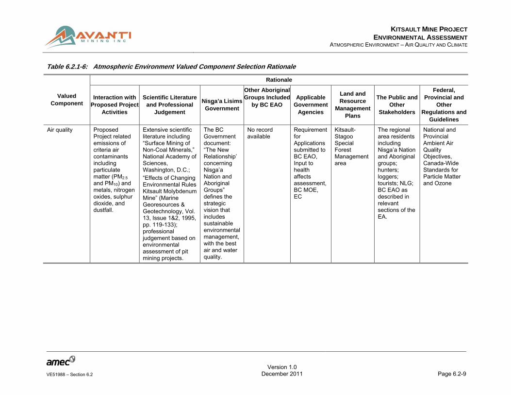
Table 6.2.1-6: Atmospheric Environment Valued Component Selection Rationale
Valued Component
Rationale
Interaction with Proposed Project
Activities
Scientific Literature and Professional
Judgement
Nisga’a Lisims Government
Other Aboriginal Groups Included
by BC EAO Applicable
Government Agencies
Land and Resource
Management Plans
The Public and Other
Stakeholders
Federal, Provincial and
Other Regulations and
Guidelines
Air quality Proposed Project related emissions of criteria air contaminants including particulate matter (PM2.5
and PM10) and metals, nitrogen oxides, sulphur dioxide, and dustfall.
Extensive scientific literature including “Surface Mining of Non-Coal Minerals,” National Academy of Sciences, Washington, D.C.; “Effects of Changing Environmental Rules Kitsault Molybdenum Mine” (Marine Georesources & Geotechnology, Vol. 13, Issue 1&2, 1995, pp. 119-133); professional judgement based on environmental assessment of pit mining projects.
The BC Government document: “The New Relationship’ concerning Nisga’a Nation and Aboriginal Groups” defines the strategic vision that includes sustainable environmental management, with the best air and water quality.
No record available
Requirement for Applications submitted to BC EAO, Input to health affects assessment, BC MOE, EC
Kitsault-Stagoo Special Forest Management area
The regional area residents including Nisga’a Nation and Aboriginal groups; hunters; loggers; tourists; NLG; BC EAO as described in relevant sections of the EA.
National and Provincial Ambient Air Quality Objectives, Canada-Wide Standards for Particle Matter and Ozone
KITSAULT MINE PROJECT
ENVIRONMENTAL ASSESSMENTATMOSPHERIC ENVIRONMENT – AIR QUALITY AND CLIMATE
Version 1.0
Page 6.2-10VE51988 – Section 6.2 December 2011
Valued Component
Rationale
Interaction with Proposed Project
Activities
Scientific Literature and Professional
Judgement
Nisga’a Lisims Government
Other Aboriginal Groups Included
by BC EAO Applicable
Government Agencies
Land and Resource
Management Plans
The Public and Other
Stakeholders
Federal, Provincial and
Other Regulations and
Guidelines
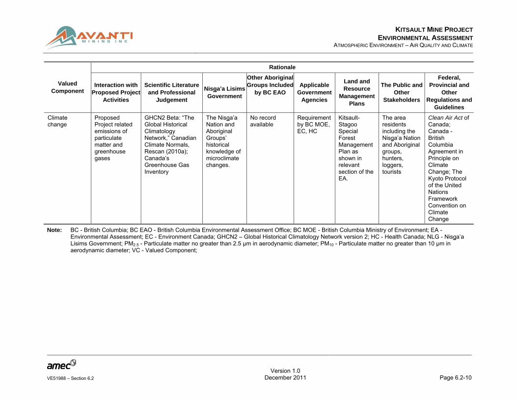
Climate change
Proposed Project related emissions of particulate matter and greenhouse gases
GHCN2 Beta: “The Global Historical Climatology Network,” Canadian Climate Normals, Rescan (2010a); Canada’s Greenhouse Gas Inventory
The Nisga’a Nation and Aboriginal Groups’ historical knowledge of microclimate changes.
No record available
Requirement by BC MOE, EC, HC
Kitsault-Stagoo Special Forest Management Plan as shown in relevant section of the EA.
The area residents including the Nisga’a Nation and Aboriginal groups, hunters, loggers, tourists
Clean Air Act of Canada; Canada - British Columbia Agreement in Principle on Climate Change; The Kyoto Protocol of the United Nations Framework Convention on Climate Change
Note: BC - British Columbia; BC EAO - British Columbia Environmental Assessment Office; BC MOE - British Columbia Ministry of Environment; EA - Environmental Assessment; EC - Environment Canada; GHCN2 – Global Historical Climatology Network version 2; HC - Health Canada; NLG - Nisga’a Lisims Government; PM2.5 - Particulate matter no greater than 2.5 μm in aerodynamic diameter; PM10 - Particulate matter no greater than 10 μm in aerodynamic diameter; VC - Valued Component;

KITSAULT MINE PROJECT
ENVIRONMENTAL ASSESSMENTATMOSPHERIC ENVIRONMENT – AIR QUALITY AND CLIMATE
Version 1.0
Page 6.2-11VE51988 – Section 6.2 December 2011
6.2.2 VC #1: Air Quality
6.2.2.1 Introduction
The objective of the air quality assessment is to determine air quality changes due to the operation of the proposed Project in consideration of the baseline air quality data.
Mining would be carried out using a conventional open pit, truck, and shovel operation. The equipment potentially responsible for air pollution include drills, shovels, loader, haul trucks, large bulldozers, graders, and other support equipment. The plant area accommodates buildings and production infrastructure such as a crusher, ore stockpile, mill, shops and warehouse buildings, and utilities.
A limited number of emission sources would be present at the mine. The most significant are various mining equipment and hauling trucks powered by diesel engines. Their exhausts contain air pollutants such as nitrogen oxides (NOx), Volatile Organic Compounds (VOC), PM (mainly small sizes, PM no greater than 10 µm in aerodynamic diameter (PM10) and PM no greater than 2.5 µm in aerodynamic diameter (PM2.5)), carbon monoxide (CO), and carbon dioxide (CO2).
Mining activities and molybdenum ore processing facilities would generate dust. The dust arises predominantly from inert soil, ore materials, and tailings. The main potential sources of dust would include the Process Plant, WRMF, low-grade (ore) stockpile (LGS), ore and waste hauling trucks, tailings and waste rock disposal, soil stripping, and overburden storage. These are generally dispersed-area sources rather than specific point sources. Plant-located dust emission sources would include the crusher, mill, and vents. Drilling and blasting would also contribute to air pollution. Supporting data used in suspended PM emission calculations are presented in Appendix 6.2-B.
Potential air quality issues need to be evaluated in the context of the regulatory framework. They include: (a) internal combustion engine sources producing sulphur dioxide (SO2), NOx, CO, PM, metals, and possibly VOC emissions; (b) non-combustion sources such as stockpiles and wind-eroded tailings producing fugitive dust containing PM2.5 and PM10, which are of interest relative to health impacts; and (c) traffic and fugitive road dust emissions. Fugitive dust emissions are especially high during the times of high winds and dry weather.
In order to assess the maximum ground-level concentrations of gaseous contaminants, PM2.5, PM10, and suspended particulates (SP), air dispersion modelling was performed with the current version of the air quality dispersion model used for predicting maximum ground level contaminants released from a source (AERMOD). Three cases of air quality assessment were considered:
The ‘Baseline Case,’ which considers existing conditions including concentrations detailed in the Atmospheric Environment Baseline Report (Appendix 6.2-A);
The ‘Project Case,’ which considers the baseline with the addition of the proposed Project; and

KITSAULT MINE PROJECT
ENVIRONMENTAL ASSESSMENTATMOSPHERIC ENVIRONMENT – AIR QUALITY AND CLIMATE
Version 1.0
Page 6.2-12VE51988 – Section 6.2 December 2011
The ‘Cumulative Case,’ considering the Project case with the addition of all reasonably foreseeable emission sources in the proposed Project study area.
6.2.2.1.1 Relevant Legislation and Legal Framework
The emissions of air contaminants can have direct and indirect effects on humans, animals, vegetation, soil, and water. For this reason, environmental regulatory agencies have established ambient air quality criteria known as Ambient Air Quality Objectives (AAQO).
British Columbia (BC) and Canada have the following air quality related regulations:
BC Environmental Management Act (BC EMA), (Government of BC 2004); and
Canadian Environmental Protection Act (CEPA), 1999 (Government of Canada 1999).
Ambient air quality in BC is regulated by the provincial government (BC Ministry of Environment (BC MOE) 2004). The federal government has also set objectives for air quality (Canadian Council of Ministers of the Environment (CCME) 2003), which are taken into account by federal agencies in a project review. The compounds identified as the most significant for this proposed Project subjected to quantitative evaluation of ground level concentrations include SO2, nitrogen dioxide (NO2), CO, and SP (PM2.5, PM10 and total suspended particulates (TSP)). These objectives are shown in Table 6.2.2-1.
Table 6.2.2-1: BC and Canadian Ambient Air Quality Guidelines and Objectives in µg/m3
Pollutant Averaging
Period
BC Guidelines / Objectives Canadian Objectives
Level A Level B Level C Maximum Desirable
Maximum Acceptable
Maximum Tolerable
SO2 Annual 25 50 80 30 60
24-hour 160 260 360 150 300 800
1-hour 450 900 900-1,300
450 900
NO2 Annual 60 100
24-hour 200 300
1-hour 400 1,000
CO 8-hour 5500 11,000 14,300 6,000 15,000 20,000
1-hour 14300 28,000 35,000 15,000 35,000
TSP Annual 60 70 75 60 70
24-hour 150 200 260 120 400
PM10 Annual
Interim 24-hour 50

KITSAULT MINE PROJECT
ENVIRONMENTAL ASSESSMENTATMOSPHERIC ENVIRONMENT – AIR QUALITY AND CLIMATE
Version 1.0
Page 6.2-13VE51988 – Section 6.2 December 2011
Pollutant Averaging
Period
BC Guidelines / Objectives Canadian Objectives
Level A Level B Level C Maximum Desirable
Maximum Acceptable
Maximum Tolerable
PM2.5 Annual 8
24-hour 25
Note: CO - carbon monoxide; µg/m3 - micrograms per cubic metre; NO2 - nitrogen dioxide; PM2.5 - particulate matter no greater than 2.5 μm in aerodynamic diameter; PM10 - particulate matter no greater than 10 μm in aerodynamic diameter; SO2 - sulphur dioxide; TSP - total suspended particulates
For National Ambient Air Quality Objectives (NAAQOs), three levels of concentration have been defined:
1. Maximum Desirable Level (Level A) defines the long-term goal for air quality and provides a basis for an anti-degradation policy for unpolluted parts of the country and for the continuing development of control technology.
2. The Maximum Acceptable Level (Level B) is intended to provide adequate protection against adverse effects on soil, water, vegetation, animals, visibility, personal comfort, and well-being.
3. The Maximum Tolerable Level (Level C) denotes the concentration of an air contaminant that requires abatement without delay to avoid further deterioration to air quality that would endanger the prevailing Canadian life-style or, ultimately, to air quality that would pose a substantial risk to public health.
6.2.2.1.2 Spatial Boundaries
Spatial boundaries for the Air Quality VC are limited to the geographic areas for which there is a reasonable expectation of direct effect of the proposed Project. For cumulative effects assessments (CEAs), boundaries are selected by working outward from the zone of influence for the effects specific to the proposed Project. If the zone of influence of the proposed Project overlaps with that of another project or human activity, the study area boundary for cumulative environmental effects (CEE) is expanded to encompass this additional zone.
For air quality assessment, three spatial boundaries are defined: the Local Study Area (LSA); the Regional Study Area (RSA); and the Cumulative Effects Study Area (CESA).
A LSA is a band 2 kilometre (km) wide surrounding the proposed Project footprint. It covers the area where concentrations caused by the proposed Project emissions could exceed some thresholds (e.g., AAQO) and where most of the airborne dust would fall to the ground. The proposed size of the LSA is based on experience from similar projects involving mineral open pit mines and on likely characteristics of emissions and their dispersion in the atmosphere such as near-ground-level releases, low emission rates, and dispersion mitigation by surrounding hills and forests.

KITSAULT MINE PROJECT
ENVIRONMENTAL ASSESSMENTATMOSPHERIC ENVIRONMENT – AIR QUALITY AND CLIMATE
Version 1.0
Page 6.2-14VE51988 – Section 6.2 December 2011
A RSA extends by 2.5 km beyond the LSA and 4.5 km off the proposed Project footprint. In this area, predicted concentrations are expected to be quantifiable, but lower than the AAQO and deposition criteria. This area can provide air quality data and information for assessing environmental effects resulting from activities of the proposed Project on airshed, watershed, and ecological components. The Kitsault Townsite, which falls within the RSA, is included in the CEA for air contaminants showing noticeable concentrations as predicted by the dispersion model.
A CESA overlaps the RSA and includes past, present, and reasonably foreseeable future human activities likely to result in residual effects or impacts on air quality. Only those human activities that have residual effects which have a temporal and spatial overlap with the proposed Project’s residual effects are considered. The study areas are shown in Figure 6.2.2-1.
6.2.2.1.3 Temporal Boundaries
Temporal boundaries include the following phases: construction; commissioning / operations; and decommissioning and closure. The air quality assessment is based on the worst-case scenario when air quality impacts would be the greatest throughout the life of the proposed Project. This is predicted to occur in Year 2 of operations when the ore mining rate and the materials handling quantities would be at the highest rates. Materials inventory in Year 2 in each category is summarised in Table 6.2.2-2.
Table 6.2.2-2: Summarised Annual Production in Year 2 of Operations
Mine Production
(kt)
Low Grade Stockpile
(kt)
Waste Rock(kt)
Total Mined(kt)
Snow(kt)
Mill Production
(kt)
Grade (% Mo)
14,600 4,126 22,940 41,666 112 14,600 0.100
Note: kt - kilotonne; % - percent; Mo - Molybdenum
6.2.2.2 Information Source and Methods
Information on background concentrations of particulates was obtained by on-site monitoring of dustfall over a long-term survey and the 24-hour spot surveys for SP at several locations within the mine site area. Information sources for the background concentration of gaseous pollutants unique to the proposed Project include various Environment Canada (EC) and the private sector reports described in the subsequent section.

CLARYLAKE
AVANTI C REEK
LIME CREEK
KITSAULTTOWNSITE
CL ARY CREEK
KILLAMLAKE
ALICEARM
Patsy
Creek
LAKE#493
LAKE#901
KITSAULT FSR (ALICE ARM ROAD)
ALICE ARM
PATSY LAKE
KSI GWINHAT'AL
ILL IANCE RIVER
LIME C
REEK
ROUNDY CREEK
FALLS CREEK
HO A N CREEK
FOXY C
REEK
W ILAUKS CREEK
KITSA UL
T RIV
E R
MORLEY C
REEK
DAK RIVER
THEO
PHILUS C
REEK
466000
466000
468000
468000
470000
470000
472000
472000
474000
474000
476000
476000
478000
478000
480000
480000
482000
482000
484000
484000
6136
000
6136
000
6138
000
6138
000
6140
000
6140
000
6142
000
6142
000
6144
000
6144
000
6146
000
6146
000
6148
000
6148
000
6150
000
6150
000
Reference
November 2011
VE51988
UTM Zone 9
DATE:
JOB No:
PROJECTION:
ANALYST: FigureMYPDF FILE:04-50-001_study_area.pdf
GIS FILE:04-50-001.mxd
NAD83DATUM:
Local and Regional Study Areasfor Air Quality
PROJECT:
Kitsault Mine Project
QA/QC:TT
CLIENT:
Avanti Kitsault Mine Ltd.
Y:\GI
S\Pr
ojects
\VE\VE
5198
8_Kit
sault
\Map
ping\0
4_air
-quali
ty\Ba
selin
e\04-5
0-001
.mxd
LegendAccess RoadMine Site RoadTransmission LineStreamWaterbodyPipeline - FreshwaterDiversion DitchClary Lake Freshwater IntakeProcess PlantOpen PitOre StockpileTopsoil StockpilesWaste Rock Management FacilityTailings BeachTailings Management Facility (TMF) Supernatant PondLocal Study AreaRegional Study Area
0 1 20.5Kilometres
1:60,000Scale:
KEY MAP
UNITED STATES
ALASKA
UNITED STATES
BRITISH COLUMBIA ALBERTA
YUKON NORTHWEST TERRITORIES
Calgary
Kelowna
Kitimat
Stewart
Edmonton
Victoria
Kamloops
Vancouver
Fort Nelson
Prince George
Fort St. John
Juneau
Project Location
1. Base Data Geobase 1:20,000 (TRIM) Land and Resource Data Warehouse 1:20,000 (TRIM)Image: Orthophoto 40cm2. Project InfrastructureSupplied by AMEC and Knight Piesold on March 2011
hansi.liuatkinson
Typewritten Text
6.2.2-1

KITSAULT MINE PROJECT
ENVIRONMENTAL ASSESSMENTATMOSPHERIC ENVIRONMENT – AIR QUALITY AND CLIMATE
Version 1.0
Page 6.2-16VE51988 – Section 6.2 December 2011
6.2.2.3 Detailed Baseline Description for Air Quality
Real time monitoring of the background dust deposition and concentration of suspended PM was completed by Rescan Environmental Services Ltd. (Rescan) and AMEC Earth and Environmental (AMEC) (Appendix 6.2-A) at several sampling locations within the proposed Project area. The objective of collecting ambient aerosol concentration data was to identify background particulate concentration levels that would be used to evaluate the magnitude of anthropogenic particulate concentrations throughout the proposed Project duration with reference to AAQO. Also, knowing the background concentration of PM is critical in assessing overall (cumulative) impacts of air quality on critical receptors and potential indirect effects to soil and vegetation from air contaminants.
The study completed by Rescan involved continuous measurement of dustfall at five monitoring stations during four monthly periods, from June 2009 to September 2009. The monitoring results show the overall average daily dustfall rate of 0.21 milligrams per decimetre square per day (mg/dm2-day). The highest dustfall was 0.46 mg/dm2-day in July 2009. Analyses of the deposited dust for acid compounds and metals revealed very low concentrations, within the range of the analytical instrument’s detection limit. Cumulative dustfall is calculated by adding the baseline daily dustfall to the dustfall predicted by a dispersion model for the proposed Project dust emissions.
Baseline concentrations of TSP, inhalable particles of 10 micrometres (μm) or less in diameter and respirable particles of 2.5 μm or less in diameter were measured continuously by AMEC from 8 October 2010 to 12 October 2010 at five locations within the proposed Project area. The overall average concentrations were 3.5 micrograms per cubic metre (µg/m3) TSP, 2.5 µg/m3 PM10 and 2.3 µg/m3 PM2.5. These baseline concentrations are added to the proposed Project-generated concentrations predicted by dispersion modelling for the CEA to evaluate compliance with relevant ambient air quality objectives.
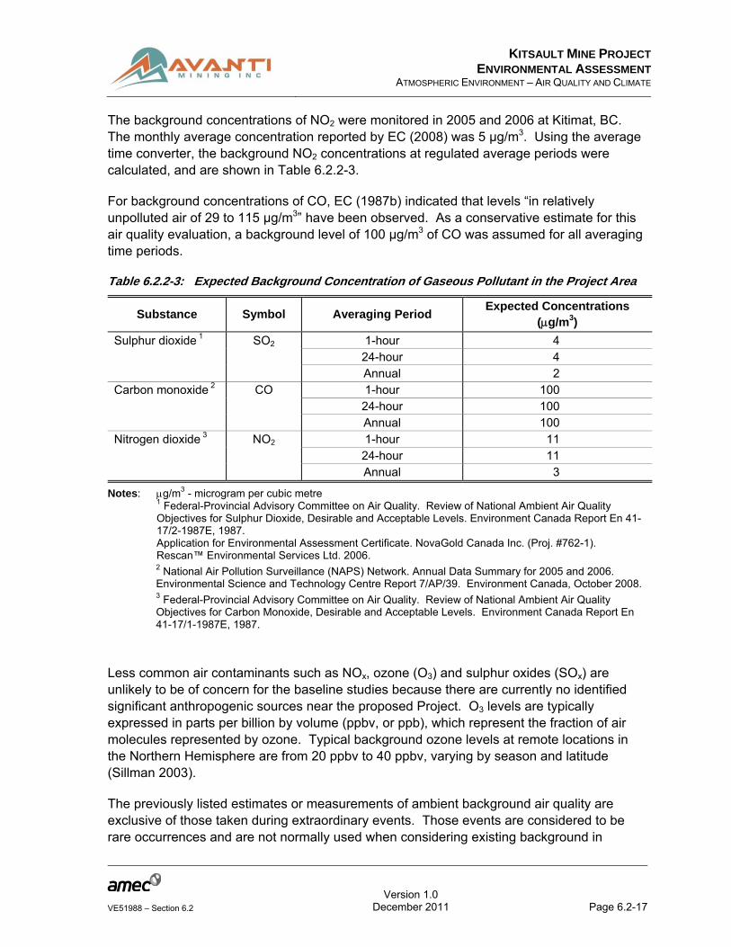
In absence of anthropogenic emission sources in the area, baseline ambient monitoring has not been conducted for gaseous compounds at the mine site. Instead, background concentrations have been conservatively estimated using assumptions and other surveys. Background SO2, NO2, and CO concentrations for the mine site were expected to be similar to those from a relatively uncontaminated and remote undisturbed location in northern Canada. A description of those expected background concentrations is presented in the following paragraphs while a tabular summary of those background values is listed in Table 6.2.2-3.
The background concentration of SO2 is expected to be minimal because there are no significant nearby local or regional emissions. Based on the following reports, “Review of National Ambient Air Quality Objectives for Sulphur Dioxide, Desirable and Acceptable Levels” (EC 1987a) and “Application for Environmental Assessment Certificate” (Rescan 2006) for the proposed Galore Creek project by NovaGold Canada Inc., the background SO2 concentrations are assumed to be 4.0 µg/m3 (1-hour and 24-hour averages) and 2.0 µg/m3 (annual average), respectively.
KITSAULT MINE PROJECT
ENVIRONMENTAL ASSESSMENTATMOSPHERIC ENVIRONMENT – AIR QUALITY AND CLIMATE
Version 1.0
Page 6.2-17VE51988 – Section 6.2 December 2011
The background concentrations of NO2 were monitored in 2005 and 2006 at Kitimat, BC. The monthly average concentration reported by EC (2008) was 5 µg/m3. Using the average time converter, the background NO2 concentrations at regulated average periods were calculated, and are shown in Table 6.2.2-3.
For background concentrations of CO, EC (1987b) indicated that levels “in relatively unpolluted air of 29 to 115 µg/m3” have been observed. As a conservative estimate for this air quality evaluation, a background level of 100 µg/m3 of CO was assumed for all averaging time periods.
Table 6.2.2-3: Expected Background Concentration of Gaseous Pollutant in the Project Area
Substance Symbol Averaging Period Expected Concentrations
(g/m3)
Sulphur dioxide 1 SO2 1-hour 4 24-hour 4 Annual 2
Carbon monoxide 2 CO 1-hour 100 24-hour 100 Annual 100
Nitrogen dioxide 3 NO2 1-hour 11 24-hour 11 Annual 3
Notes: g/m3 - microgram per cubic metre 1 Federal-Provincial Advisory Committee on Air Quality. Review of National Ambient Air Quality Objectives for Sulphur Dioxide, Desirable and Acceptable Levels. Environment Canada Report En 41-17/2-1987E, 1987. Application for Environmental Assessment Certificate. NovaGold Canada Inc. (Proj. #762-1). Rescan™ Environmental Services Ltd. 2006. 2 National Air Pollution Surveillance (NAPS) Network. Annual Data Summary for 2005 and 2006. Environmental Science and Technology Centre Report 7/AP/39. Environment Canada, October 2008. 3 Federal-Provincial Advisory Committee on Air Quality. Review of National Ambient Air Quality Objectives for Carbon Monoxide, Desirable and Acceptable Levels. Environment Canada Report En 41-17/1-1987E, 1987.
Less common air contaminants such as NOx, ozone (O3) and sulphur oxides (SOx) are unlikely to be of concern for the baseline studies because there are currently no identified significant anthropogenic sources near the proposed Project. O3 levels are typically expressed in parts per billion by volume (ppbv, or ppb), which represent the fraction of air molecules represented by ozone. Typical background ozone levels at remote locations in the Northern Hemisphere are from 20 ppbv to 40 ppbv, varying by season and latitude (Sillman 2003).
The previously listed estimates or measurements of ambient background air quality are exclusive of those taken during extraordinary events. Those events are considered to be rare occurrences and are not normally used when considering existing background in
KITSAULT MINE PROJECT
ENVIRONMENTAL ASSESSMENTATMOSPHERIC ENVIRONMENT – AIR QUALITY AND CLIMATE
Version 1.0
Page 6.2-18VE51988 – Section 6.2 December 2011
relation to cumulative effects from a proposed project and other sources for an air quality evaluation. These extraordinary events include, but are not limited to, forest fires, weather-related stratospheric ozone intrusion, and volcanic emissions (United States Environmental Protection Agency (US EPA) 1986).
6.2.2.4 Cultural, Ecological, or Community Knowledge
Desk-based research was conducted to identify Nisga’a Nation and Aboriginal groups’ rights, interests, and values related to air quality; however, none was available from public, secondary sources. Ongoing future consultation and engagement activities and data collection efforts in collaboration with the Nisga’a Nation may result in additional information and understanding during the Application review period.
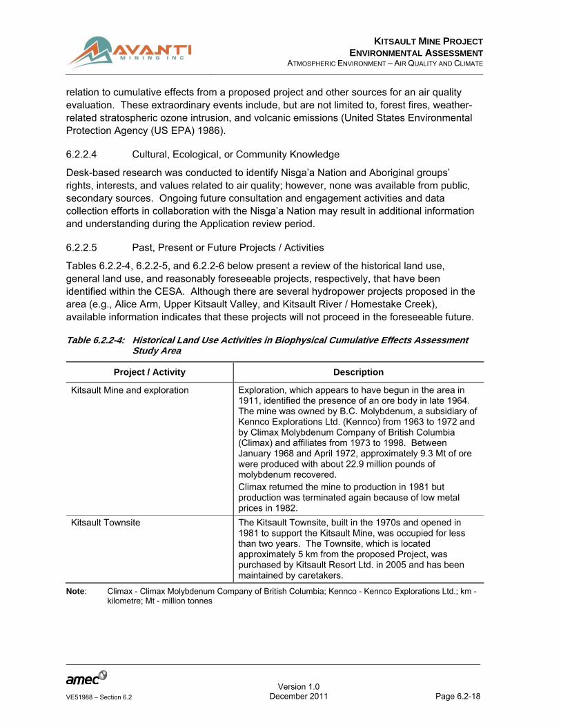
6.2.2.5 Past, Present or Future Projects / Activities
Tables 6.2.2-4, 6.2.2-5, and 6.2.2-6 below present a review of the historical land use, general land use, and reasonably foreseeable projects, respectively, that have been identified within the CESA. Although there are several hydropower projects proposed in the area (e.g., Alice Arm, Upper Kitsault Valley, and Kitsault River / Homestake Creek), available information indicates that these projects will not proceed in the foreseeable future.
Table 6.2.2-4: Historical Land Use Activities in Biophysical Cumulative Effects Assessment Study Area
Project / Activity Description
Kitsault Mine and exploration Exploration, which appears to have begun in the area in 1911, identified the presence of an ore body in late 1964. The mine was owned by B.C. Molybdenum, a subsidiary of Kennco Explorations Ltd. (Kennco) from 1963 to 1972 and by Climax Molybdenum Company of British Columbia (Climax) and affiliates from 1973 to 1998. Between January 1968 and April 1972, approximately 9.3 Mt of ore were produced with about 22.9 million pounds of molybdenum recovered. Climax returned the mine to production in 1981 but production was terminated again because of low metal prices in 1982.
Kitsault Townsite The Kitsault Townsite, built in the 1970s and opened in 1981 to support the Kitsault Mine, was occupied for less than two years. The Townsite, which is located approximately 5 km from the proposed Project, was purchased by Kitsault Resort Ltd. in 2005 and has been maintained by caretakers.
Note: Climax - Climax Molybdenum Company of British Columbia; Kennco - Kennco Explorations Ltd.; km - kilometre; Mt - million tonnes

KITSAULT MINE PROJECT
ENVIRONMENTAL ASSESSMENTATMOSPHERIC ENVIRONMENT – AIR QUALITY AND CLIMATE
Version 1.0
Page 6.2-19VE51988 – Section 6.2 December 2011
Table 6.2.2-5: General Land Use Activities in Biophysical Cumulative Effects Assessment Study Area
Project / Activity Description
Transportation and access Within the CESA, Hwy 37 is used by local residents and tourists as well as commercial / industrial traffic associated with activities such as exploration.
Mining exploration Mining exploration activities are ongoing in the CESA. A number of private claims are surrounded by the proposed Project’s mineral tenure area.
Trapping and guide outfitting The proposed Project footprint falls within one trap line tenure area that is routinely used in the winter. The eastern section of the road leading from Hwy 37 falls within another trap line tenure area. The Land Use RSA (and Wildlife RSA) falls within the boundaries of one Guide Outfitter.
Marine boat traffic (Alice Arm Lodge water taxi and recreational users)
Mining exploration companies working in the area often stay at the Alice Arm Lodge, which offers a water taxi service from Prince Rupert. Marine vessels are known to use Alice Arm to deliver supplies (for example to the Alice Arm Lodge). Recreational boaters have been observed anchored in Alice Arm and rowing to shore for a short period of time.
Fishing Recreational fishing in Alice Arm.
Note: CESA - Cumulative Effects Study Area; Hwy - Highway; RSA - Regional Study Area
Table 6.2.2-6: Reasonably Foreseeable Projects in Biophysical Cumulative Effects Assessment Study Area
Project / Activity Construction Operations Area and Rationale
Northwest Transmission Line Project
Spring 2011 – 2013 Unknown – with routine maintenance it would operate into the foreseeable future
The Northwest Transmission Line is a 287 kV 335 km transmission line between the Skeena substation (near Terrace) and Bob Quinn Lake.
Note: BC - British Columbia; kV - kilovolt; km - kilometre
6.2.2.6 Potential Effects of the Proposed Project and Proposed Mitigation
Assessment of potential effects of the proposed Project involves the following steps:
Identification of main emission sources including PM, NOx, SO2, and CO;
Calculation of emission rates; and
Dispersion modelling and analysis of model predictions.
The above assessment components are described in detail in Appendix 6.2-C.

KITSAULT MINE PROJECT
ENVIRONMENTAL ASSESSMENTATMOSPHERIC ENVIRONMENT – AIR QUALITY AND CLIMATE
Version 1.0
Page 6.2-20VE51988 – Section 6.2 April 2012
The AERMOD model was used for dispersion modelling because of its capability of addressing the potential air quality for the proposed mine and ore processing facility, as well as addressing all nearby terrain locations, simultaneously. The BC MOE lists the AERMOD model as a refined core model for assessments in BC in their “Guidelines for Air Quality Modelling in British Columbia” (BC MOE 2008). The AERMOD model was discussed with BC MOE meteorologist staff as an acceptable model in this particular Application (a copy of the e-mail is available upon request). The BC modelling guideline was used as the basis for modelling procedures related to this air quality evaluation. The MM5 meteorological data for surface and upper air was used in the modelling process and is described in Appendix 6.2-D.
The predicted hourly, daily, and annual maximum ground level concentrations (GLC) for each of the modelled contaminants (model prediction plus baseline) and the percentage of compliance with AAQO are summarised in Table 6.2.2-7.
Table 6.2.2-7: Summary of Dispersion Modelling Results
Air Contaminant Averaging
Period AAQO (µg/m3)
Maximum GLC (µg/m3) % AAQO Model Background Total
TSP 24 hour 120 122 4 126 101
Annual 70 23 n/a 23 33
Inhalable Particulate (PM10)
24 hour 50 46 3 49 98
Fine particulate (PM2.5) 24 hour 25 23 2 25 100
Annual 8 1 1 2 25
NO2 1 hour 400 523 11 534 133
1 hour 400 362 1 11 373 1 93 1
24 hour 200 46 11 57 29
Annual 100 4 3 7 7
SO2 1 hour 450 2 4 6 1
24 hour 150 0.2 4 4.2 3
Annual 30 0 2 2 7
CO 1 hour 15000 1 100 101 1
8 hour 6000 0 100 100 1
Note: AAQO - Ambient Air Quality Objectives; NO2 - nitrogen dioxide; PM2.5 - particulate matter no greater than 2.5 µm in aerodynamic diameter; PM10 - particulate matter no greater than 10 µm in aerodynamic diameter; SO2 - sulphur dioxide; TSP - total suspended particulates; CO - carbon monoxide; µg/m3 –
microgram per cubic metre 1 Max GLC 99.95th percentile
The dispersion model predictions indicate that in general the proposed Project would comply with AAQO. However, the one-hour maximum NO2 concentrations in the immediate vicinity of the proposed Project’s western fence line could experience elevated GLC, approximately

KITSAULT MINE PROJECT
ENVIRONMENTAL ASSESSMENTATMOSPHERIC ENVIRONMENT – AIR QUALITY AND CLIMATE
Version 1.0
Page 6.2-21VE51988 – Section 6.2 December 2011
33% over the acceptable AAQO. This maximum concentration is only 53% of the maximum tolerable national objective, which is 1,000 µg/m3. Dispersion modelling of NO2 1-hour average 99.95th percentile, the fifth highest prediction, revealed maximum GLC equal to 362 µg/m3 which is 7% less than the maximum GLC. The 24-hour and annual maximum GLC of NO2 are well below the respective AAQO.
Concentrations of SO2 are predicted to be very low for all averaged times as a new low-sulphur diesel regulations have been enforced recently. CO would be at the background concentration levels due to atmospheric dispersion and low concentrations in diesel exhaust. Concentrations of PM (TSP, PM10 and PM2.5) are predicted around the maximum permissible values at 24-hour average time. This can be expected, considering the large amount of aggregate material being mined, handled, and processed.
Dustfall is associated with emissions and drift of fugitive dust. The drift distance is governed by the initial injection height of the particles, the terminal settling velocity of the particle, and the degree of atmospheric turbulence. Theoretical drift distance, as a function of particle diameter and mean wind speed, has been computed for fugitive dust emissions. Results indicate that, for a typical mean wind speed of 16 kilometres per hour (km/h), particles larger than about 100 µm are likely to settle out within 6 to 9 metres (m) from the edge of the road or other point of emission. Particles that are 30 to 100 µm in diameter are likely to undergo impeded settling. These particles, depending upon the extent of atmospheric turbulence, are likely to settle within tens to a couple of hundred metres from the road, pit or solid waste disposal area within the Project property line (US EPA 1995).
The emissions inventory for the Proposed Project shows that approximately 95% of crustal particulate matter emissions originate from haul truck wheel entrainment (75%) and from material deposited by the conveyor (25%, see air quality model description in Appendix 6.2-C). As described above, the greatest fugitive dust deposition rates are expected to occur close to haul and access roads and adjacent to ore stockpiles. The ore stockpiles for the proposed Project will be located well within the foot-print of the proposed mine site. Therefore, assessment of potential effects of fugitive dust deposition will focus on areas adjacent to haul roads.
Rates of dustfall can be conservatively estimated based on the predicted maximum annual mean TSP concentration along with an estimate of the average deposition velocity of the emitted dust. In addition, field measurements and modelling of dust deposition have demonstrated that dust deposition rates decrease exponentially with distance from a haul road (Etyemezian 2003a; Etyemezian 2003b; Brown 2009; US EPA AP-42).
Table 6.2.2-7 shows that the model prediction for maximum annual mean ambient TSP concentration beyond the fenceline is 23 µg/m3. Deposition velocities for particulate matter greater than 10 µm in areas with tall vegetation typically range between 1 and 10 centimetres per second (cm/s). Assuming an average deposition velocity of 5 cm/s, the estimated dust deposition rate at the location of maximum TSP concentration is 3.0 grams per metre square per month (g/m2/month). Using a deposition decay correlation from an

KITSAULT MINE PROJECT
ENVIRONMENTAL ASSESSMENTATMOSPHERIC ENVIRONMENT – AIR QUALITY AND CLIMATE
Version 1.0
Page 6.2-22VE51988 – Section 6.2 December 2011
unpaved road in a similar setting (-0.065 m-1, Brown 2009) the predicted dust deposition rate will be approximately:
2.1 g/m2/month 5 m from the road;
1.5 g/m2/month 10 m from the road;
0.8 g/m2/month 20 m from the road;
0.41 g/m2/month 30 m from the road;
0.11 g/m2/month 50 m from the road;
0.004 g/m2/month 100 m from the road; and
6*10-6 g/m2/month 200 m from the road
The dustfall rates discussed above refer to crustal particulates emitted from peripheral haul roads. The aggregate material on those haul roads can be assumed to be similar to aggregate or surface material on existing roads. Therefore, the composition of the dust (metal and acid concentrations) can be assumed to be similar to the composition of dust collected during baseline studies (Appendix 6.2-A).
BC monthly dustfall objective is 8.7 g/m2 (BC MOE 1979), which is approximately four times that of predicted dustfall within 5 m of the haul roads.
O3 concentrations were not measured in the proposed Project airshed and they were not modelled for the proposed Project emission sources. It is unlikely that the insignificant project emissions of NO2 (1,293 tonnes per year (t/y)) and VOCs (approximately 0.58 t/y based on diesel engines emission factors) would contribute significantly to additional increment in ground-level O3 concentrations (see Appendix 6.2-C). Likewise, concentrations of other air contaminants, including VOCs, other hydrocarbons or metals associated with diesel or particulate emissions are not expected to affect ambient air quality outside the fence line of the proposed project to the extent that the AAQO would be exceeded. This assessment is based on a preliminary assessment of emissions, professional judgement and experience from developments of similar projects. These air contaminants were also not identified as constituents of concern by the BC MOE in the review of the air quality modelling plan prepared for the Project.
6.2.2.6.1 Identification and Analysis of Potential Project Effects
Potential direct Project effects on air quality and other VCs are presented in Tables 6.2.2-8 and 6.2.2-9.

KITSAULT MINE PROJECT
ENVIRONMENTAL ASSESSMENTATMOSPHERIC ENVIRONMENT – AIR QUALITY AND CLIMATE
Version 1.0
Page 6.2-23VE51988 – Section 6.2 December 2011
Table 6.2.2-8: Potential Direct Project Effects on Air Quality
Project Component
Project Phase Potential Direct Project Effect Likelihood of Occurrence
Traffic on service and haul roads
C, O, D/C, PC Dust deposition Likely
Diesel engine emission
C, O, D/C, PC Increase in concentration of air contaminants Likely
Land clearing C Increase in concentration of air contaminants Likely
Excavating C Increase in concentration of air contaminants Likely
Grading C Increase in concentration of air contaminants Likely
Mine infrastructure installations
C, D/C Increase in concentration of air contaminants Likely
Kitsault Pit Development
C, O, D/C, PC Increase in concentration of air contaminants Likely
WRMF development
C, O, D/C, PC Increase in concentration of air contaminants Likely
TMF development
C Increase in concentration of air contaminants Likely
Surface water mgt and ground water mgt
C, O, D/C, PC No direct effect Unlikely
Re-vegetation D/C Decrease Project emissions Likely
Project phase: C - construction; D/C - decommissioning and closure; O - operations; PC - post-closure
Note: TMF - Tailings Management Facility; WRMP - Waste Rock Management Facility
Table 6.2.2-9: Potential Indirect Project Effects on Other Valued Components
Direct Project Effect (Adverse
or Positive)
Project Phase
Potential Indirect Project Effect
Carry Forward
(yes / no) Rationale
Dust deposition C, O, D/C, PC
Intake of dust components by plants
Yes Molybdenum ore and mineral waste dust contains inorganic compounds which could be taken up by leaves and roots
C, O, D/C, PC
Contamination of surface water
Yes Molybdenum ore and mineral waste dust contains inorganic compounds slightly soluble in water
C, O, D/C Visibility No Limited local visibility

KITSAULT MINE PROJECT
ENVIRONMENTAL ASSESSMENTATMOSPHERIC ENVIRONMENT – AIR QUALITY AND CLIMATE
Version 1.0
Page 6.2-24VE51988 – Section 6.2 December 2011
Direct Project Effect (Adverse
or Positive)
Project Phase
Potential Indirect Project Effect
Carry Forward
(yes / no) Rationale
caused by fugitive dust during dry weather
Increase in concentration of air contaminants
C, O, D/C, PC
Human and wildlife health effects, Change in soil and surface water
Yes Poor air quality may affect employees and any long-term residents located at the affected area
C, O, D/C, PC
Climate change Yes Climate alteration caused by emission of GHG
Project phase: C - construction; D/C - decommissioning and closure; O - operations; PC - post-closure
Note: GHG - greenhouse gases
A potential interaction between direct effects of the proposed Project on other VCs and air quality is summarised in Table 6.2.2-10. The direct and indirect Project effects on air quality are summarised in Tables 6.2.2-11 and 6.2.2-12.

KITSAULT MINE PROJECT
ENVIRONMENTAL ASSESSMENTATMOSPHERIC ENVIRONMENT – AIR QUALITY AND CLIMATE
Version 1.0
Page 6.2-25VE51988 – Section 6.2 December 2011
Table 6.2.2-10: Summary of Potential Interaction Between Project Direct Effects on Other Valued Components and Air Quality
Direct or Indirect Project Effect
Air
Qu
alit
y an
d C
limat
e C
han
ge
No
ise
An
d V
ibra
tio
n
Hyd
rog
eolo
gy
Gro
un
dw
ater
Qu
alit
y
Fre
shw
ater
an
d
Sed
imen
t Q
ual
ity
Su
rfac
e H
ydro
log
y
Fre
shw
ater
Fis
her
ies
Mar
ines
Wat
er Q
ual
ity
Mar
ine
Bio
ta
Ter
rest
rial
E
nvi
ron
men
t
Wild
life
and
Th
eir
Hab
itat
En
viro
nm
enta
l Hea
lth
Eco
no
mic
So
cial
Her
itag
e
Hea
lth
Nis
ga’
a N
atio
n L
and
U
se
Ab
ori
gin
al G
rou
ps
Lan
d U
se
Dust deposition
- NI NI NI o NI o NI n/a o o o NI NI NI o o o
Concentration of air contaminants
- NI NI NI o NI o NI n/a - o - NI NI NI - o o
Interaction definitions: Interaction definitions: o - interaction; - - key interaction; + - benefit; NI - no interaction; n/a - not applicable
KITSAULT MINE PROJECT
ENVIRONMENTAL ASSESSMENTATMOSPHERIC ENVIRONMENT – AIR QUALITY AND CLIMATE
Version 1.0
Page 6.2-26VE51988 – Section 6.2 December 2011
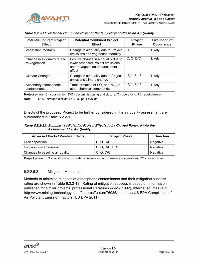
Table 6.2.2-11: Potential Combined Project Effects by Project Phase on Air Quality
Potential Indirect Project Effect
Potential Combined Project Effect
Project Phase
Likelihood of Occurrence
Vegetation mortality Change in air quality due to Project emissions and vegetation mortality
C Likely
Change in air quality due to re-vegetation
Positive change in air quality due to lower proposed Project emissions and re-vegetation enhancement effect
C, O, D/C Likely
Climate Change Change in air quality due to Project emissions climate change
C, O, D/C Likely
Secondary atmospheric contaminants
Transformation of SO2 and NO2 to other chemical compounds
C, O, D/C Likely
Project phase: C - construction; D/C - decommissioning and closure; O - operations; PC - post-closure
Note: NO2 - nitrogen dioxide; SO2 - sulphur dioxide
Effects of the proposed Project to be further considered in the air quality assessment are summarised in Table 6.2.2-12.
Table 6.2.2-12: Summary of Potential Project Effects to be Carried Forward into the Assessment for Air Quality
Adverse Effects / Positive Effects Project Phase Direction
Dust deposition C, O, D/C Negative
Fugitive dust emissions C, O, D/C, PC Negative
Changes to baseline air quality C, O, D/C Negative
Project phase: C - construction; D/C - decommissioning and closure; O - operations; PC - post-closure
6.2.2.6.2 Mitigation Measures
Methods to minimise releases of atmospheric contaminants and their mitigation success rating are shown in Table 6.2.2-13. Rating of mitigation success is based on information published for similar projects, professional literature (AWMA 1992), Internet sources (e.g., http://www.mining-technology.com/features/feature76035/), and the US EPA Compilation of Air Pollutant Emission Factors (US EPA 2011).

KITSAULT MINE PROJECT
ENVIRONMENTAL ASSESSMENTATMOSPHERIC ENVIRONMENT – AIR QUALITY AND CLIMATE
Version 1.0
Page 6.2-27VE51988 – Section 6.2 December 2011
Table 6.2.2-13: Potential Project Effect by Project Phase on Air Quality and Mitigation Measures
Project Effect Project Phase
Mitigation / Enhancement Measure
Mitigation Success Rating
Deterioration of air quality and emissions of GHG
C, O Using modern construction / mining equipment that meets latest applicable Canadian emissions standards
High prevention / reduction
C, O Ensuring proper equipment maintenance
Medium prevention / reduction
C Limiting vehicle and construction equipment idling
High prevention / reduction
C, O Conserving energy by reducing unnecessary lighting, heating, and air conditioning; proper building and facilities insulation
Medium prevention / reduction
C, O Minimising land disturbance Medium to high prevention / reduction
C, O, D/C, PC
Establishing speed limits on unpaved surfaces
Medium to high prevention / reduction
C Minimising clearing and grubbing areas
High prevention / reduction
C, O Optimising vehicle movement Low prevention / reduction
C, O Using dust suppression measures (refer to Section 11.2.5, Dust Management Plan)
Medium to high prevention / reduction
Project phase: C - construction; D/C - decommissioning and closure; O - operations; PC - post-closure
Note: GHG - greenhouse gas
6.2.2.7 Potential Residual Effects and Their Significance
6.2.2.7.1 Potential Residual Effects After Mitigation
A residual effect is any measurable or demonstrable environmental effect remaining after mitigation. From an air quality perspective, if the level of a residual effect is less than the AAQO, it is not significant.
In this proposed Project, the maximum predicted ambient concentrations of TSP, PM10, PM2.5 SO2 and CO concentrations comply with the appropriate air quality criteria. Only concentrations of NO2 one-hour average are likely to have any residual air quality effects (Table 6.2.2-14). The affected area is small and is adjacent to the proposed Project fence line on the west side (see Figure 6.2.2.6-1 in Appendix 6.2-C). NO2 concentration at longer averaging times are predicted to meet the relevant air quality objectives.

KITSAULT MINE PROJECT
ENVIRONMENTAL ASSESSMENTATMOSPHERIC ENVIRONMENT – AIR QUALITY AND CLIMATE
Version 1.0
Page 6.2-28VE51988 – Section 6.2 December 2011
An assessment of residual effects of GHG emissions is carried out in section VC #2: Climate.
Table 6.2.2-14: Summary of Residual Effects for Air Quality
Project Phase Residual Effect Direction
O Deterioration of air quality and emissions of GHG Negative
Project phase: O – operations
Note: GHG - greenhouse gas
6.2.2.7.2 Significance of Potential Residual Effects
The residual effect on air quality was subjected to nine rating criteria to determine significance (Table 6.2.2-15); these criteria are described in Section 5.0: Assessment Methodology.
Table 6.2.2-15: Residual Effects Assessment by Project Development Phase for Air Quality
Parameter Stage of Development / Rating
Stage of project development Operations
Residual effect Deterioration of air quality and emissions of GHG
Effect attribute
Magnitude Low
Spatial scale Local
Duration Long-term
Frequency Intermittent
Reversibility Yes
Ecological context Low
Direction Negative
Certainty Medium
Residual effect significance Not significant (Minor)
Level of confidence Medium
Note: GHG - greenhouse gas
6.2.2.8 Potential Cumulative Effects
6.2.2.8.1 Identification and Analysis of Potential Project Cumulative Effects
The CEA includes all of the existing, approved, and planned projects and activities associated with atmospheric emissions which could negatively affect air quality in the region. Projects are typically some form of commercial or industrial development that is planned, constructed, and operated – a refinery development or resource access road, for
KITSAULT MINE PROJECT
ENVIRONMENTAL ASSESSMENTATMOSPHERIC ENVIRONMENT – AIR QUALITY AND CLIMATE
Version 1.0
Page 6.2-29VE51988 – Section 6.2 December 2011
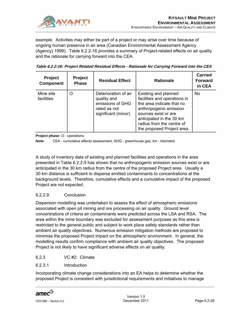
example. Activities may either be part of a project or may arise over time because of ongoing human presence in an area (Canadian Environmental Assessment Agency (Agency) 1999). Table 6.2.2-16 provides a summary of Project-related effects on air quality and the rationale for carrying forward into the CEA.
Table 6.2.2-16: Project Related Residual Effects - Rationale for Carrying Forward into the CEA
Project Component
Project Phase
Residual Effect Rationale Carried Forward in CEA
Mine site facilities
O Deterioration of air quality and emissions of GHG rated as not significant (minor)
Existing and planned facilities and operations in the area indicate that no anthropogenic emission sources exist or are anticipated in the 30 km radius from the centre of the proposed Project area.
No
Project phase: O - operations
Note: CEA - cumulative effects assessment; GHG - greenhouse gas; km - kilometre
A study of inventory data of existing and planned facilities and operations in the area presented in Table 6.2.2-5 has shown that no anthropogenic emission sources exist or are anticipated in the 30 km radius from the centre of the proposed Project area. Usually a 30 km distance is sufficient to disperse emitted contaminants to concentrations at the background levels. Therefore, cumulative effects and a cumulative impact of the proposed Project are not expected.
6.2.2.9 Conclusion
Dispersion modelling was undertaken to assess the effect of atmospheric emissions associated with open pit mining and ore processing on air quality. Ground level concentrations of criteria air contaminants were predicted across the LSA and RSA. The area within the mine boundary was excluded for assessment purposes as this area is restricted to the general public and subject to work place safety standards rather than ambient air quality objectives. Numerous emission mitigation methods are proposed to minimise the proposed Project impact on the atmospheric environment. In general, the modelling results confirm compliance with ambient air quality objectives. The proposed Project is not likely to have significant adverse effects on air quality.
6.2.3 VC #2: Climate
6.2.3.1 Introduction
Incorporating climate change considerations into an EA helps to determine whether the proposed Project is consistent with jurisdictional requirements and initiatives to manage
KITSAULT MINE PROJECT
ENVIRONMENTAL ASSESSMENTATMOSPHERIC ENVIRONMENT – AIR QUALITY AND CLIMATE
Version 1.0
Page 6.2-30VE51988 – Section 6.2 December 2011
emissions. It also assists the proponent in using best practices that adapt to possible climate change impacts, such as changes in the frequency or intensity of extreme weather events, or increases in mean temperatures or altered precipitation patterns and amounts. In the EA process, the proponent determines and documents whether climate change is a potential consideration, and also declares all information sources used (Agency 2003).
Climate change has emerged as a long-term environmental challenge of global significance. The Intergovernmental Panel on Climate Change (IPCC), established under the auspices of the United Nations, notes a high probability of continuing global climatic change if GHG emissions continue to increase (IPCC 2001). Based on current levels of GHG in the atmosphere, even immediate reductions in emissions would not be rapid enough to reverse the observed changes in climate in the short term (Burton and van Aalst 1999).
The climate in the proposed Project area is classed as ‘temperate coastal’, characterised by high precipitation, and verging on a rain forest environment. Cloudy and foggy conditions are typical in summer months, with high precipitation in winter (Knight Piésold Consulting Ltd. (Knight Piésold) 2011). The climate in the area is controlled by four major factors:
Westerly winds cause atmospheric disturbances to cross the area from west to east;
Proximity to the Pacific Ocean results in moderate temperatures and an abundant moisture supply;
The North Pacific semi-permanent high-pressure cell controls the seasonal distribution of precipitation by forcing the major storm tracts to migrate over the area, moving south during October and north during March; and
The rugged topography creates distinct radiation balances and wind circulations (Amax 1976).
As climate change affects large territorial areas and is caused by numerous natural and anthropogenic factors, assessment of VCs associated with climate within an atmospheric environment area of assessment is addressed only in general terms. No detailed prediction of the proposed Project impacts on climate has been attempted.
It is important to understand the difference between climate and weather. Climate is a description of the long-term (usually more than 30 years) pattern of weather over a large area, using meteorological parameters which are continuously monitored. In addition to long-term climate change, there are shorter-term climate variations. This so-called climate variability could be represented by periodic or intermittent changes related to El Niño, La Niña, volcanic eruptions, or other changes in the Earth’s systems. Studying climate and climate change is important because changes would affect people around the world. Rising global temperatures are expected to raise sea levels, and change precipitation and other local climate conditions. Changing regional climate could alter forests, crop yields, and water supplies. It could also affect human health, animals, and many types of ecosystems.

KITSAULT MINE PROJECT
ENVIRONMENTAL ASSESSMENTATMOSPHERIC ENVIRONMENT – AIR QUALITY AND CLIMATE
Version 1.0
Page 6.2-31VE51988 – Section 6.2 December 2011
Weather is the day-to-day state of the atmosphere, and its short-term (minutes to weeks) variation. It is the set of meteorological elements in a given atmosphere at a given time. Elements of weather usually include:
Air temperature;
Relative humidity;
Precipitation;
Snow depth;
Solar radiation;
Atmospheric pressure; and
Wind speed and direction.
All of the above weather elements have been recorded by Rescan at the proposed Project area during the period from 15 November 2008 to 18 November 2010. A full discussion of weather at the mine site is presented in the Atmospheric Environment Baseline Report (Appendix 6.2-A and Rescan 2010).
6.2.3.1.1 Relevant Legislation and Legal Framework
Climate change legislation and legal agreements include the following:
The Convention on Climate Change (UNFCCC 1992);
The Kyoto Protocol (Kyoto 1997);
The Montreal Protocol (Montreal Protocol 1987); and
BC Greenhouse Gas Reduction Targets Act (Bill-44 2007).
The Convention on Climate Change entered into force on 21 March 1994. Over 190 countries, including Canada, have ratified the accord. It sets the over-arching framework for efforts to meet the challenge posed by climate change, requiring governments to: gather and share information on GHG emissions, national policies, and best practices; develop national strategies for addressing GHG emissions and adapting to expected impacts; provide financial and technological support from developed nations to developing countries; and otherwise co-operate in preparing for adaptation to climate change and its effects on the environment.
The Kyoto Protocol is an international agreement linked to the United Nations Framework Convention on Climate Change. The major feature of the Kyoto Protocol is that it sets binding targets for 37 industrialised countries and the European community for reducing GHG emissions. These binding targets amount to an average of 5% cut in GHG emissions from 1990 levels in the five-year commitment period from 2008 to 2012.

KITSAULT MINE PROJECT
ENVIRONMENTAL ASSESSMENTATMOSPHERIC ENVIRONMENT – AIR QUALITY AND CLIMATE
Version 1.0
Page 6.2-32VE51988 – Section 6.2 December 2011
The major distinction between the Protocol and the Convention is that while the Convention encourages industrialised countries to stabilise GHG emissions, the Protocol commits them to do so.
The “Montreal Protocol on Substances that Deplete the Ozone Layer” (a protocol to the Vienna Convention for the Protection of the Ozone Layer) is an international treaty designed to protect the O3 layer by phasing out the production of numerous substances believed to be responsible for O3 depletion. Most of these substances are also GHGs. Concentration of O3 in the atmospheric air has a strong connection with climate change. The Protocol was negotiated and signed by Canada along with 23 other countries in 1987.
Greenhouse Gas Reduction Targets Act (Government of BC 2007) puts into law BC’s target of reducing GHG by at least 33% below 2007 levels by 2020. It also required that realistic, economically viable interim targets for 2012 and 2016 be set by the end of 2008, and further establishes an emission reduction target of 80% below 2007 levels by 2050. The government is also required to publish a report every two years outlining the progress made towards reaching the emissions reduction targets. Specific policy measures have been applied to reduce emissions in each major economic sector, including development of key legislation to introduce a revenue-neutral carbon tax, enabling BC to join a regional cap and trade system, imposing emissions standards on vehicles, regulating landfill gas emissions, imposing a low-carbon fuel standard, and encouraging green community development.
6.2.3.1.2 Spatial Boundaries
As climate change may have long-term economic, social, and human health consequences, spatial boundaries for economic and social VCs are adopted for the climate. The boundaries are defined in Section 7.0 and Section 8.0 and are shown in Figure 6.2.3-1.


Kitsault Mine Project
Kitsault Townsite
Nass Wildlife Area
Alice Arm
113
37
UNITED STATES
CANADA
16
1616
37
Dixon Entrance
16
37113
25
26
Peace River B
Kitimat-Stikine A
Stikine Region
Kitimat-Stikine D
Bulkley-Nechako C
Bulkley-Nechako G
Skeena-Queen Charlotte D
Kitimat-Stikine B
Kitimat-Stikine C (Part 1)
Bulkley-Nechako E
Nisga'a
Skeena-Queen Charlotte C
Kitimat-Stikine C (Part 2)
Bulkley-Nechako B
Bulkley-Nechako A
Skeena-Queen Charlotte A
Stewart
Bulkley-Nechako DKitimat
Port Edward
Granisle
Houston
Lax Kw'alaams 1
Prince Rupert
Masset
Terrace
Laxgalts'ap
New Hazelton
Smithers
Gitwangak 1
S1/2 Tsimpsean 2
Kispiox 1
Kitimat-Stikine E
Gitsegukla 1
Dolphin Island 1
Telkwa
Aiyansh (Kitladamas) 1
Port Clements
Burns Lake
Fort Ware 1
Moricetown 1
Gitanyow 1
Ingenika Point
Dzitline Lee 9
Nedoats 11
Masset 1
Kitsumkaylum 1
Kuz Che 5
Cheslatta 1
Babine 6
Tadinlay 15
Ye Koo Che 3
North Tacla Lake 7
Jean Baptiste 28
Babine 17
Francois Lake 7
Babine 25
Tatla't East 2 Skins Lake 16B
Fraser Lake
Maxan Lake 4
Bihl' k'a 18
Tacla Lake (Ferry Landing) 9
Poison Creek 17A
9
8
7
6
5
43
21
28
27
25
24
23
22
21
20
18
17
16
15
14
13
1211
10
Stewart
Nass Camp
Meziadin Junction
Cranberry Junction
Kitwanga
30
29
19
ReferenceBase Data Geobase 1:20,000 (TRIM) Land and Resource Data Warehouse 1:20,000 (TRIM)Atlas of Canada scale 1:1,000,000.
November 2011
VE51988
UTM Zone 9
DATE:
JOB No:
PROJECTION:
ANALYST: FigureMYPDF FILE:14-50-002_v5_study_areas.pdf
GIS FILE:14-50-002_v5.mxd
NAD83DATUM:
Study Areas For Social And Economic Conditions -
Adopted As Climate Study Area
PROJECT:
Kitsault Mine Project
QA/QC:TT
CLIENT:
Avanti Kitsault Mine Ltd.
Y:\GI
S\Pr
ojects
\VE\VE
5198
8_Kit
sault
\Map
ping\1
4_so
cio-ec
onom
ics\B
aseli
ne\14
-50-00
2_v5
.mxd
50 0 5025Kilometres
1:1,800,000Scale:
LegendPopulated PlaceKitsault Mine ProjectRoadHighwayInternational / Provincial BorderStreamWaterbodyNisga'a NationNass Wildlife Area
Major ProjectsMinesHydro PowerOther DevelopmentLinear DevelopmentCensus SubdivisionLocal Study AreaRegional Study Area
ID P ro ject N ame1 Galore Creek Gold/Silver/Copper M ine2 M ount Klappan Coal Pro ject3 Schaft Creek Porphyry Copper-Gold M ine4 Kerr -Sulphurets - M itchell (KSM ) Gold Copper M ine5 Bear River Aggregate Pro ject6 Red Chris Porphyry Copper/Gold Pro ject7 M ount Klappen Coal Slurry P ipeline8 Sustut Gold and Copper Pro ject9 Davidson M olydbdenum M ine
10 Swamp point Aggregate11 Bronson Slope Hydropower12 Forest Kerr Hydroelectric13 Jade Lake Power Pro ject14 Kinskuch Hydro Pro ject15 Long Lake Power Pro ject16 GJ Kinaskan Lake Copper-Gold Pro ject17 M clymont Creek Hydroelectric Pro ject18 M ore Creek Hydroelectric Pro ject19 Kitsault River and Homestake Creek Hydro Pro ject20 Dasque-M iddle Hydro Pro ject21 Snowfield Gold Pro ject22 Hudson Bay M ountain Development23 Upper Kitsault Valley Hydropower Pro jects24 Alice Arm Hydropower Pro jects25 Northwest Transmission Line26 Stewart Omineca Resource Road27 Northwest Community College28 Bronson Slope Gold and Copper M ine29 Biocoal Pellet Production Plant30 Suskwa Biomass Power Pro ject
KEY MAP
BRITISH COLUMBIA
UNITED STATES
ALASKA
UNITED STATES
BRITISH COLUMBIA ALBERTA
YUKON NORTHWEST TERRITORIES
Calgary
Kelowna
Kitimat
Stewart
Edmonton
Victoria
Kamloops
Vancouver
Fort Nelson
Prince George
Fort St. John
Juneau
Project Location
37
hansi.liuatkinson
Typewritten Text
6.2.3-1


KITSAULT MINE PROJECT
ENVIRONMENTAL ASSESSMENTATMOSPHERIC ENVIRONMENT – AIR QUALITY AND CLIMATE
Version 1.0
Page 6.2-34VE51988 – Section 6.2 December 2011
6.2.3.1.3 Temporal Boundaries
Climate is commonly defined as the weather averaged over a long period of time. For the IPCC (2001), climate in a narrow sense is usually defined as the “average weather”, or more rigorously as the statistical description in terms of the mean and variability of relevant measurements over a period of time ranging from months to thousands or millions of years. The standardised period is 30 years, as established by the World Meteorological Organization (WMO), but other periods may be used depending on the purpose. These measurements are most often surface weather variables such as temperature, precipitation, and wind. The standardised 30-year period is accepted for the proposed Project to accommodate periods of site preparation, construction of the production plant and camp, road construction, 16 years of operations, decommissioning, and post closure.
6.2.3.2 Information Source and Methods
Several climate stations are located in the general proposed Project region. Regional stations include multiple stations operated by the Meteorological Service of Canada (MSC), as well as two stations located in Alaska and operated by the Alaska Climate Research Center (ACRC). Many of the stations in the region have been deactivated, and thus do not have data that are concurrent with the recent site data collection.
The website for the Weather Office of EC, located at http://climate.weatheroffice.gc.ca/climate_normals/index_e.html, provides climate normals for the period of 30 years (1971-2000) for the nearest stations at:
Prince Rupert (Lat.: 54o 17’ N; Long.: 130o 27’ W; Elev.: 35.4 m);
Germansen Landing (Lat.; 55° 47' N; Long.: 124° 42' W; Elev.: 766.0 m);
Fort St. James (Lat.: 54° 27' N; Long.: 124° 15' W; Elev.: 685.8 m); and
Babine Lake – Pinkut Creek (Lat.; 54° 27' N; Long.: 125° 27' W; Elev.: 713.2 m).
The data from these stations offers detailed statistics from which overall regional trends can be derived. A station at Kalder Lake about 20 km southwest of the mine site collected temperature and precipitation data but stopped collecting data in 1988. Given that this station has not been active for almost 20 years, this data was not considered current from a climate perspective.
At present, no specific method has been designed to address quantitative climate change issues through the Application of the EA Certificate. Several evaluation tools have been developed to examine the overall effectiveness of EA (Sadler 1996; Wood 1999; Agency 2003; ClimAdapt 2003); however, an evaluation tool to examine how well EA processes have been designed to address climate change issues is nonexistent. Some studies have suggested that mitigation and / or adaptation to climate change should focus on a broad range of issues such as political commitment, policy, regulation, institutional roles and responsibility, stakeholder capacity, guidelines, enforcement, incentive schema, and data management (Adger et al. 200; Smith et al. 2003).
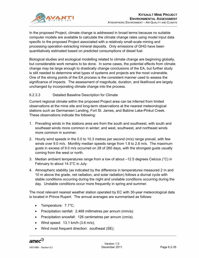
KITSAULT MINE PROJECT
ENVIRONMENTAL ASSESSMENTATMOSPHERIC ENVIRONMENT – AIR QUALITY AND CLIMATE
Version 1.0
Page 6.2-35VE51988 – Section 6.2 December 2011
In the proposed Project, climate change is addressed in broad terms because no suitable computer models are available to calculate the climate change rates using model input data specific to the proposed Project associated with a relatively small-scale mining and processing operation extracting mineral deposits. Only emissions of GHG have been quantitatively estimated based on predicted consumptions of diesel fuel.
Biological studies and ecological modelling related to climate change are beginning globally, but considerable work remains to be done. In some cases, the potential effects from climate change may be large enough to drastically change conclusions of the EA, but further study is still needed to determine what types of systems and projects are the most vulnerable. One of the strong points of the EA process is the consistent manner used to assess the significance of impacts. The assessment of magnitude, duration, and likelihood are largely unchanged by incorporating climate change into the process.
6.2.3.3 Detailed Baseline Description for Climate
Current regional climate within the proposed Project area can be inferred from limited observations at the mine site and long-term observations at the nearest meteorological stations such as Germansen Landing, Fort St. James, and Babine Lake-Pinkut Creek. These observations indicate the following:
1. Prevailing winds in the stations area are from the south and southwest, with south and southeast winds more common in winter; and west, southwest, and northeast winds more common in summer.
2. Hourly wind speeds in the 0.0 to 10.3 metres per second (m/s) range prevail, with few winds over 9.0 m/s. Monthly median speeds range from 1.8 to 2.6 m/s. The maximum gusts in excess of 9.0 m/s occurred on 28 of 260 days, with the strongest gusts usually coming from the west or north.
3. Median ambient temperatures range from a low of about –12.5 degrees Celcius (°C) in February to about 14.3°C in July.
4. Atmospheric stability (as indicated by the difference in temperatures measured 2 m and 10 m above the grade, net radiation, and solar radiation) follows a diurnal cycle with stable conditions occurring during the night and unstable conditions occurring during the day. Unstable conditions occur more frequently in spring and summer.
The most relevant nearest weather station operated by EC with 30-year meteorological data is located in Prince Rupert. The annual averages are summarised as follows:
Temperature: 7.1oC;
Precipitation rainfall: 2,468 millimetres per annum (mm/a);
Precipitation snowfall: 126 centimetres per annum (cm/a);
Wind speed: 13.1 km/h (3.6 m/s);
Wind most frequent direction: southeast (SE);

KITSAULT MINE PROJECT
ENVIRONMENTAL ASSESSMENTATMOSPHERIC ENVIRONMENT – AIR QUALITY AND CLIMATE
Version 1.0
Page 6.2-36VE51988 – Section 6.2 December 2011
Percent of possible daylight hours: 25.8;
Relative humidity 0600 LST: 88.6%;
Relative humidity 1500 LST: 75.3%; and
Sea-level pressure: 101.3 kilopascals (kPa).
The comprehensive monitoring results collected at that station from 1971 to 2000 is shown in Appendix 6.2-E.
A short-term (2009-2010) monitoring of weather elements by the Kitsault climate station reveals the following key findings:
The mean annual temperature is estimated to be 3.2 °C, with minimum and maximum mean monthly temperatures of -6.0 °C and 11.6 °C occurring in January and July respectively;
The mean annual wind speed is approximately 1.9 m/s;
The mean annual relative humidity is approximately 81%;
The mean annual lake evaporation (potential evapotranspiration) is estimated to be 450 millimetres (mm); and
The mean annual precipitation is estimated to be 2000 mm, with 45% falling as rain and 55% falling as snow.
6.2.3.4 Cultural, Ecological, or Community Knowledge
Desk-based research was conducted to identify the Nisga’a Nation’s and Aboriginal groups’ rights, interests, and values related to climate; however, none was available from public, secondary sources. Ongoing future consultation and engagement activities and data collection efforts in collaboration with the Nisga’a Nation may result in additional information and understanding during the Application review period.
6.2.3.5 Past, Present or Future Projects / Activities
Tables 6.2.2-3, 6.2.2-4, and 6.2.2-5 present a review of the historical land use, general land use and reasonably foreseeable projects, respectively that have been identified within the CESA. Although there are several hydropower projects proposed in the area (e.g., Alice Arm, Upper Kitsault Valley, and Kitsault River / Homestake Creek), available information indicates that these projects will not proceed in the foreseeable future.
6.2.3.6 Potential Effects of the Proposed Project and Proposed Mitigation
The following general guidelines addressing climate change associated with GHG emissions and global warming have been collected and are presented below:
“Practitioner’s Guide to Incorporating Climate Change into the Environmental Impact Assessment Process” (ClimAdapt 2003);
“Climate Change Considerations in Environmental Assessment” (Agency 2003);

KITSAULT MINE PROJECT
ENVIRONMENTAL ASSESSMENTATMOSPHERIC ENVIRONMENT – AIR QUALITY AND CLIMATE
Version 1.0
Page 6.2-37VE51988 – Section 6.2 December 2011
“The World Bank Handbook on Greenhouse Gas Assessment for assessing the project-level greenhouse gas emissions in World Bank funded projects” (World Bank 1998); and
“Towards Sustainable Mining: Energy Use and GHG Emissions Management Assessment Protocol” (Mining Association of Canada (MAC) 2010).
6.2.3.6.1 Identification and Analysis of Potential Project Effects
Potential directly measurable effects of the proposed Project on climate change are unlikely. To find the Kitsault climate trends, a long-term monitoring of weather parameters is required. The monitoring of meteorology data by the Kitsault Meteorology Station would continue throughout the proposed Project lifetime and the post-closure period. This monitoring would include five monthly snow course surveys as necessary at the height of the snowpack to characterise site conditions for an EA Application.
As shown in Section 6.2.2, predicted proposed Project emissions would be low due to the absence of major emission sources. It is therefore unlikely that predicted proposed Project emissions would cause measurable changes to the climate, even within the Alice Arm / Kitsault airshed area. However, the proposed Project would contribute to the GHG inventory for the Province of BC and Canada contributing to global warming.
Based on diesel fuel consumption by the proposed Project equipment, the emission rates of GHG (methane / carbon dioxide (CH4 / CO2) and NO2) have been calculated and analysed with reference to provincial and Canadian inventories and Canada’s international obligations. As detailed in Section 6.2.2, the total annual GHG emissions resulting from the combustion of diesel fuel would be 35.845 kilotonnes (kt) of CO2 equivalent. Under the Greenhouse Gas Reductions Target Act, the BC government made a legally binding commitment to reduce GHG emissions by at least 33% by 2020 and 80% by 2050 below the 2007 level (BC MOE 2010). Total Provincial GHG emissions in 2008 were 68.7 million tonnes (Mt) and in Canada they were 263 Mt. Predicted Project annual contribution to the BC inventory will be 0.0522% and 0.0136% of Canadian GHG emissions.
GHG emissions from the proposed Project sources would contribute to CO2 assimilation through plants and to global warming, which are both identified as indirect Project effects. This contribution is shown in Table 6.2.3-1.

KITSAULT MINE PROJECT
ENVIRONMENTAL ASSESSMENTATMOSPHERIC ENVIRONMENT – AIR QUALITY AND CLIMATE
Version 1.0
Page 6.2-38VE51988 – Section 6.2 December 2011
Table 6.2.3-1: Potential Indirect Project Effects on Other Valued Components
Direct Project Effect (Adverse or
Positive)
Project Phase
Potential Indirect Project Effect
Carry Forward
(yes / no) Rationale
Climate Change C, O, D/C, PC CO2 assimilation in plants Yes Plant metabolism
Global warming Yes Scientific evidence of global warming
Project phase: C - construction; O - operations; D/C - decommissioning and closure; PC - post-closure
Note: CO2 - carbon dioxide
A potential interaction between direct measurable effects of the proposed Project on other VCs and climate change is unlikely.
6.2.3.6.2 Mitigation Measures
In general, air quality and climate change are treated as separate issues in national and international policies, even though most practices and technologies that would reduce GHG emissions would also cause a net reduction of emissions of air pollutants. However, air pollutant reduction measures do not always reduce GHG emissions, as many require the use of additional energy (State and Territorial Air Pollution Program Administrators / Association of Local Air Pollution Control Officials (STAPPA / ALAPCO) 1999).
Potential methods to minimise climate change are shown in Table 6.2.3-2.
Table 6.2.3-2: Potential Project Effect by Project Phase on Climate and Mitigation Measures
Project Effect Project Phase
Mitigation / Enhancement Measure Mitigation Success
Rating
Climate change from GHG emissions and energy demand
C, O Using modern construction / mining equipment that meets latest applicable Canadian emissions standards
Medium prevention / reduction
C, O Ensuring proper equipment maintenance Medium prevention / reduction
C, O Limiting vehicle and construction equipment idling and optimise vehicle movement
Low prevention / reduction
C, O Implement 3Rs (reduce, reuse, recycle) Low prevention
C Construct energy-efficient buildings - may reduce energy consumption by 25%
High reduction
O, D/C, PC Re-vegetating the parts of the mine site that will not be disturbed in the future
Medium to high prevention / reduction
C, D/C, PC Avoid de-forestation and re-establish lost forest at the Project footprint area
Medium to high prevention / reduction
Project phase: C - construction; D/C - decommissioning and closure; O - operations; PC - post-closure

KITSAULT MINE PROJECT
ENVIRONMENTAL ASSESSMENTATMOSPHERIC ENVIRONMENT – AIR QUALITY AND CLIMATE
Version 1.0
Page 6.2-39VE51988 – Section 6.2 December 2011
6.2.3.7 Potential Residual Effects and Their Significance
6.2.3.7.1 Potential Residual Effects After Mitigation
A residual effect is any measurable or demonstrable environmental effect remaining after mitigation. Taking into account the vast size of the atmosphere in the climate study area as compared to predicted size of CO2 emissions from the proposed Project sources, it can be expected that residual effects of climate change would neither be measurable nor demonstrable. No measurable residual effects are anticipated.
6.2.3.8 Potential Cumulative Effects
6.2.3.8.1 Identification and Analysis of Potential Project Cumulative Effects
The CEA includes all of the existing, approved, and planned projects and activities in the region. At this time, existing and anticipated projects include small-scale developments such as mining, transmission line, hydroelectric plant, and numerous explorations. It is unlikely that these projects would emit large quantities of greenhouse gases; therefore, their residual effects, combined with residual effect of the proposed Project, are not carried forward into the CEA.
6.2.3.9 Conclusion
Current regional climate within the proposed Project area can be inferred from limited observations at the mine site and long-term observations at nearest meteorological stations such as Germansen Landing, Fort St. James, Mackenzie, and Babine Lake / Pinkut Creek. A comprehensive 30-year climate data report, collected by EC is available for Prince Rupert, which is the nearest location, approximately 140 km south-southwest of the proposed Project, where long-term meteorological observations have been recorded.
GHG from mobile and stationary diesel-powered equipment serving the Project contribute to the global greenhouse effect with the annual GHG estimated at 35.845 kt of CO2 equivalent.
Long-term monitoring of meteorological parameters during the lifetime of the proposed Project and beyond at the proposed Project site and the nearest EC weather stations would be carried out to assess trends in climate change.
Related Documents