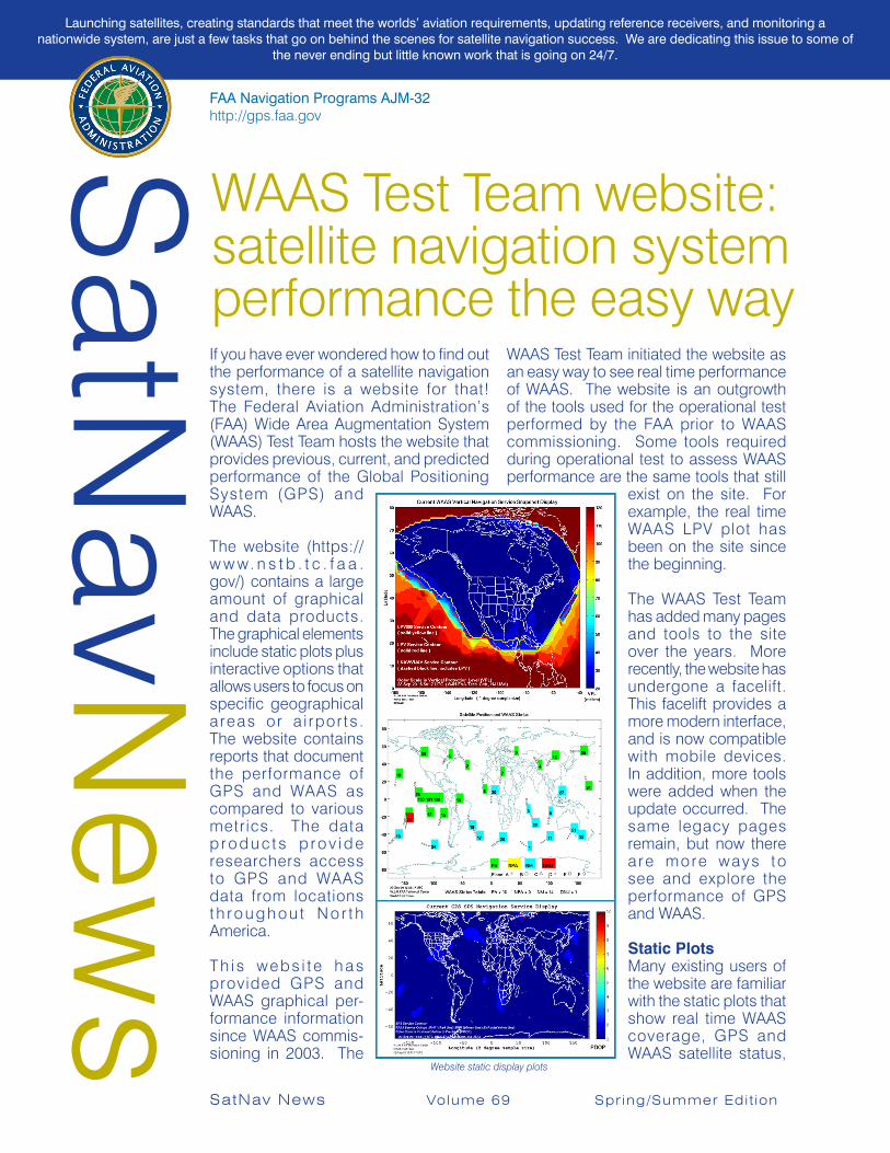
FAA Navigation Programs AJM-32 http://gps.faa.gov SatNav News WAAS Test Team website: satellite navigation system performance the easy way If you have ever wondered how to find out the performance of a satellite navigation system, there is a website for that! The Federal Aviation Administration’s (FAA) Wide Area Augmentation System (WAAS) Test Team hosts the website that provides previous, current, and predicted performance of the Global Positioning System (GPS) and WAAS. The website (https:// www.nstb.tc.faa. gov/) contains a large amount of graphical and data products. The graphical elements include static plots plus interactive options that allows users to focus on specific geographical areas or airports. The website contains reports that document the performance of GPS and WAAS as compared to various metrics. The data products provide researchers access to GPS and WAAS data from locations throughout North America. This website has provided GPS and WAAS graphical per- formance information since WAAS commis- sioning in 2003. The WAAS Test Team initiated the website as an easy way to see real time performance of WAAS. The website is an outgrowth of the tools used for the operational test performed by the FAA prior to WAAS commissioning. Some tools required during operational test to assess WAAS performance are the same tools that still exist on the site. For example, the real time WAAS LPV plot has been on the site since the beginning. The WAAS Test Team has added many pages and tools to the site over the years. More recently, the website has undergone a facelift. This facelift provides a more modern interface, and is now compatible with mobile devices. In addition, more tools were added when the update occurred. The same legacy pages remain, but now there are more ways to see and explore the performance of GPS and WAAS. Static Plots Many existing users of the website are familiar with the static plots that show real time WAAS coverage, GPS and WAAS satellite status, SatNav News Volume 69 Spring/Summer Edition Website static display plots Launching satellites, creating standards that meet the worlds’ aviation requirements, updating reference receivers, and monitoring a nationwide system, are just a few tasks that go on behind the scenes for satellite navigation success. We are dedicating this issue to some of the never ending but little known work that is going on 24/7.

Welcome message from author
This document is posted to help you gain knowledge. Please leave a comment to let me know what you think about it! Share it to your friends and learn new things together.
Transcript
FAA Navigation Programs AJM-32 http://gps.faa.govSatN
avNew
s
WAAS Test Team website: satellite navigation system performance the easy wayIf you have ever wondered how to find out the performance of a satellite navigation system, there is a website for that! The Federal Aviation Administration’s (FAA) Wide Area Augmentation System (WAAS) Test Team hosts the website that provides previous, current, and predicted performance of the Global Positioning System (GPS) and WAAS.
The website (https://w w w. n s t b . t c . f a a .gov/) contains a large amount of graphical and data products. The graphical elements include static plots plus interactive options that allows users to focus on specific geographical areas or a i rpor ts . The website contains reports that document the performance of GPS and WAAS as compared to various metrics. The data p r o d u c t s p r o v i d e researchers access to GPS and WAAS data from locations t h roughou t No r th America.
Th i s webs i t e has provided GPS and WAAS graphical per-formance information since WAAS commis-sioning in 2003. The
WAAS Test Team initiated the website as an easy way to see real time performance of WAAS. The website is an outgrowth of the tools used for the operational test performed by the FAA prior to WAAS commissioning. Some tools required during operational test to assess WAAS performance are the same tools that still
exist on the site. For example, the real time WAAS LPV plot has been on the site since the beginning.
The WAAS Test Team has added many pages and tools to the site over the years. More recently, the website has undergone a facelift. This facelift provides a more modern interface, and is now compatible with mobile devices. In addition, more tools were added when the update occurred. The same legacy pages remain, but now there a re more ways to see and explore the performance of GPS and WAAS.
Static PlotsMany existing users of the website are familiar with the static plots that show real time WAAS coverage, GPS and WAAS satellite status,
SatNav News Volume 69 Spr ing/Summer Edit ion
Website static display plots
Launching satellites, creating standards that meet the worlds’ aviation requirements, updating reference receivers, and monitoring a nationwide system, are just a few tasks that go on behind the scenes for satellite navigation success. We are dedicating this issue to some of
the never ending but little known work that is going on 24/7.

2 SatNav News Volume 69 Spr ing/Summer Edit ion
GPS PDOP, and other performance parameters.The WAAS coverage page shows the current Vertical Protection Limit (VPL). The aviation user calculates the VPL as a measure of availability of the WAAS at the receiver’s location. The VPL defines the integrity limit of a user’s vertical positioning error. That is, as long as the user’s vertical position error is less than the calculated VPL, then the user is safe. The VPL is also an indicator of where WAAS service is available and can easily be seen in the VPL plot.
The satellite position chart shows on a map where each GPS and WAAS Geostationary satellite are currently located. The satellites are identified by their unique pseudo random noise (PRN) designation, which is a number from 1 to 32, the WAAS GEO satellites can have a PRN number from 120 to 138. Additionally, the website shows the satellites’ status as determined by WAAS. Satellites with a green color means that an aviation user’s receiver would include that satellite in their position determination while on a precision approach. A WAAS aviation user, while conducting a precision approach, can’t use the yellow satellites in position determination. If the satellite is cyan, WAAS is not monitoring that satellite. Normally, WAAS does not monitor a satellite if it is out a view from WAAS reference stations, though there
are other conditions in which WAAS would determine a satellite to be ‘Not Monitored’. Finally, the red colored satellites are marked as “DNU”, or Do Not Use. There is truth in advertising with this designation. Certified aviation receivers applying WAAS corrections do not use satellites with a DNU label. An important distinction with the WAAS satellite identifiers is that they relate to certified WAAS avionics. Other WAAS receivers might or might not use the WAAS designations to determine whether to use that satellite in the position computation.
The GPS Position Dilution of Precision (PDOP) plot shows the value of the current PDOP on a world map. PDOP is a measure of the strength of the GPS satellite geometry. The lower the DOP the better position accuracy a user expects to achieve. The PDOP plot on the website samples a two degree by two degree latitude and longitude grid and calculates the PDOP at each grid point. The plot shows the interpolated PDOP between grid points.
Interactive ToolsThe static displays offer a quick look at the status of GPS and WAAS. However, to get a more interactive experience, there are other tools available. A recently added tool, the GNSS Performance Analysis Tool (GPAT), employs the familiar Google Earth
GPAT offers many options to evaluate SBAS serviced
3SatNav News Volume 69 Spr ing/Summer Edit ion
interface to allow the user the see GPS and WAAS performance for a specific geographic location or even for a specific airport.
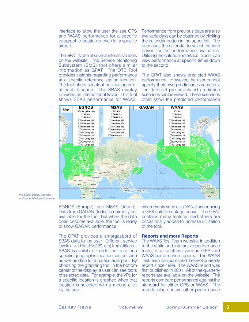
The GPAT is one of several interactive tools on the website. The Service Monitoring Subsystem (SMS) tool offers similar information as GPAT. The OTE Tool provides insights regarding performance at a specific reference station location. The tool offers a look at positioning error at each location. The SBAS display provides an international flavor. This tool shows SBAS performance for WAAS,
EGNOS (Europe), and MSAS (Japan). Data from GAGAN (India) is currently not available for the tool, but when the data does become available, the tool is ready to show GAGAN performance.
The GPAT provides a smorgasbord of SBAS data to the user. Different service levels (i.e. LPV, LPV-220, etc) from different SBAS’ is available. In addition, data for a specific geographic location can be seen as well as data for a particular airport. By choosing the graphing tool in the bottom center of the display, a user can see plots of selected data. For example, the VPL for a specific location is graphed when that location is selected with a mouse click by the user.
Performance from previous days are also available days can be obtained by clicking the calendar button in the upper left. The user uses the calendar to select the time period for the performance evaluation. Utilizing the calendar interface, a user can view performance at specific times down to the second.
The GPAT also shows predicted WAAS performance. However, the user cannot specify their own prediction parameters. Ten different pre-populated prediction scenarios can be viewed. These scenarios often show the predicted performance
when events such as a NANU announcing a GPS satellite outage occur. The GPAT contains many features and others are occasionally added to increase utilization of the tool.
Reports and more ReportsThe WAAS Test Team website, in addition to the static and interactive performance tools, also contains various GPS and WAAS performance reports. The WAAS Test Team has published the GPS quarterly report since 1999. The WAAS report was first published in 2001. All of the quarterly reports are available on the website. The reports compare performance against the standard for either GPS or WAAS. The reports also contain other performance
The SBAS display provides worldwide SBAS performance

4
Launch:GEO 7
YourWAASStory
SatNav News Volume 69 Spr ing/Summer Edit ion
information that is not specifically called out in the specifications.
Each month the GPS Scorecard is added to the website. The scorecard shows the GPS performance against various metrics. Trending for the performance metrics shows how GPS is performing month over month.
When notable GPS or WAAS events occur the WAAS Test Team writes a Discrepancy Report. The DR details the incident and the effect on performance. The reports date back to 2005 and are useful in diagnosing new issues when similar anomalies occur.
Another feature of the website is the availability of raw GPS measurement data from reference stations throughout North America. The data rate is once per second and provides a way for researchers and other users to work with data as they see fit. In addition to the raw GPS data, the WAAS correction message from each WAAS GEO is available. All the data is in binary format and that format is described in a document located on the website.
The WAAS Test Team website provides an abundance of information related to the performance of GPS and WAAS. New tools and capabilities are added to the website as they are developed. Future capabilities will include displays and reports of Galileo (the European GNSS, similar to GPS) performance. Also planned are evaluation reports of Advanced Receiver Autonomous Integrity Monitoring (ARAIM). ARAIM intends to provide accurate and reliable navigation for aviation users by employing both GPS and Galileo in the user solution and taking advantage of two separate signals from those systems.
Since there are so many capabilities users may have questions regarding the different tools on the website, or questions about what different WAAS performance parameters signify. For many tools there is user guide provided. For those tools without a user guide, expect one to be published. Regardless, if a user does have a question there is a “Contact WAAS Team” link where those questions can be asked.- Bill Wanner, FAA ANG/WJHTC

5
GPS ALONE is not enough to safely navigate civil aircraft. It simply doesn’t provide sufficient accuracy or the integri tynecessary for al l aviat ion operations, which is why the FAA developed the Wide Area Augmentation System (WAAS) back in the mid-1990s.
As a safety-of-life augmentation of GPS, WAAS improves position accuracy and integrity for aviation, said Brian Jackson, the FAA’s systems engineer lead for satellite navigation, spacebased augmentation systems (SBAS). The service offers an extra layer of safety that allows aircraft to make use of GPS, providing warnings when errors are detected in the GPS or WAAS network.
Thousands of airport runways in North America rely on WAAS because it providesInstrument Landing System (ILS) level of service performance without the need to install additional radio equipment at the runways. Jackson described the system as an “integral component” of the FAA’s National Airspace System (NAS).
“WAAS augments GPS by improving accuracy, integrity and availability,” said Neil Paskiw, chief engineer, aerospace at Hexagon|NovAtel. “WAAS was developed so aircraft could use GPS during all phases of flight
including precision approaches. WAAS provides vertical navigation information during approach, similar to existing instrumentation and systems, but at a much lower cost.
NovAtel’s Critical RoleNovAtel has delivered key technology into WAAS from the beginning, providing three generations of reference receivers. The most recent WAAS G-III Ground Reference Receiver and two generations of GUS Signal Generators were placed into operational service in 2015, with fielding at all sites completed in 2016.
WAAS:Improving Safety for Civil Aircraft
As published in Inside GNSS, November/December 2020
SatNav News Volume 69 Spr ing/Summer Edit ion
The United States Federal Aviation Administration’s (FAA) Wide Area Augmentation System (WAAS) uses Hexagon|NovAtel technologies including reference receivers and signal generators, to provide the accuracy and integrity necessary to safely operate civil aircraft. Here’s a look at the updated technologies and how they enable GPS as a safety of life service for aviation.
“WAAS providesvertical navigation
informationduring approach,similar to existing
instrumentation andsystems, but at amuch lower cost.
Neil Paskiw,chief engineer, aerospace,Hexagon|NovAtel.
”

6
Late last year, NovAtel delivered the next-generation of Ground Uplink Station (GUS) Signal Generators to the FAA in support of WAAS modernization. The new GUS Signal Generator, or SIGGEN, replaces the legacy signal generator, which has operated successfully for more than 15 years. The original SIGGENs offered “very good performance,” Jackson said.
“The new Signal Generators carry forward the same functionality as the current unit’s, but with expanded capability to allow for a wider range of frequency offsets and output power levels,” Jackson said. “The GUS Signal Generator is separate from the G-III receiver. Ultimately, the G-III receives the WAAS waveform generated after transmission from the GEO (geostationary) satellite.”
Other uses for WAASWAAS is also used in other applications, said Brian Jackson, the FAA’s systems engineer lead for saellite navigation, space-based augmentation systems (SBAS), including the Automatic Depen-dent Surveillance-Broadcast ADS-B sys-tem as a positioning source.
How WAAS WorksWAAS provides navigation services across the entire NAS to improve accuracyand position integrity estimates. Through the service, 38 precisely surveyed reference stations, or Wide Area Reference Stations (WRS), spaced out across North America receive GPS signals, Jackson said. The receivers then process these signals and transmit them to WAAS Master Stations (WMS).
Once received, the WMS processes the GPS signals and formulates correction messages. These messages are sent to uplink stations and then transmitted to nav igat ion pay loads on GEO communications satellites. The navigationpayloads broadcast the messages via aGPS-like signal across the NAS.
The WMS generates a message every second, enabling the receivers to remove errors in the GPS signal for improved
location accuracy and in tegr i t y. Users a re notified within six seconds of any information that could lead to an error in the position estimate.
“The WAAS message,” Jackson said, “improves the accuracy, availability and integrity of GPS-derived position information.”
A Closer Look at the GUS Signal GeneratorsNovAtel’s SIGGEN was developed in 2003. SIGGEN has performed well over the years and has proven to be very reliable. The newly developed units will offer the same reliability and benefits along with new capabilities to support WAAS long term objectives, Paskiw said.
Why is the SIGGEN so critical? SIGGEN must handle all messages created by a site’s Master Station and accurately transform each message into a signal that is suitable for up-link to a Geostationary satellite, Paskiw said.
“SIGGEN processes correction messagesfrom the ground master station so it can be up-linked back into space and re-broadcast alongside the GPS signals.
SatNav News Volume 69 Spr ing/Summer Edit ion
“The WAAS message improvesthe accuracy, availability and
integrity of GPS-derivedposition information.
”Brian Jacksonsystems engineer lead
for satellite navigation, space-basedaugmentation systems (SBAS), FAA
An overview of how Satellite Based Augmentation Systems (SBAS) like WAAS work.
7SatNav News Volume 69 Spr ing/Summer Edit ion
Being satellite based and using signals similar to GPS, WAAS is able to efficiently distribute corrections to end users without the need for extensive ground infrastructure or specialized equipment at the receiving end,” Paskiw said.
The new SIGGEN was designed to maintain the same functionality found in the legacy product and be backwards compatible with existing installations, thereby reducing the effort to deploy, Paskiw said. New features include more flexibility in configuration of the output signals, higher data throughput and multiple RF monitor frequencies for L1 and L5 signals. The L1 RF signal is available at L2 or at L1 and the L5 RF signal is available at L5 or L2. Data can now be sent over both I and Q channels, rather than I only.
The Evolution of ReceiversAll three generations of WAAS reference receivers have been designed to take advantage of NovAtel’s latest GNSS signal processing Application-Specific Integrated Circuit (ASIC).Each new generation of ASIC offers support for more GNSS signals and constellations, additional processing capabilities and better interference rejection, Paskiw said.
“NovAtel has been uniquely positioned to provide leading edge technology into our Ground Reference Receivers
by leveraging ASICs developed for our commercial products, which typically havequicker development cycles than an aviation product like the WAAS G-III,” Paskiw said. “Our newer generation ASICs have specialized signal processing circuitry for the signal quality monitoring features that are critical to WAAS.”
The first WAAS receiver, developed in the 1990s, was actually three independent receivers within the same chassis, Jackson said, with the key differentiators being L1 Course/ Acquisition (C/A) multipath mitigation provided by the Multipath-Estimating- Delay-Lock-Loop and P-Code delayed correlation technology for semi-codeless L2 tracking.
The G-II receiver had the same core L1 C/A and semi-codeless L2 tracking as the original, but added other features such as L1 C/A correlator outputs for signal quality monitoring, improved RF interference rejection, and an expandable architectureso the receiver could be upgraded for GPS L2 C/A and L5 signal processing. The fielding for the second-generation receiver began in 2005 and was an integral part of WAAS through 2016. That’s when the most current version, the G-III, came on-scene.
The G-III was developed to incorporate additional signal processing needed
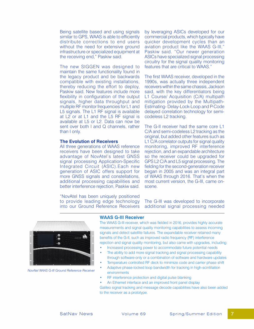
WAAS G-III ReceiverThe WAAS G-III receiver, which was fielded in 2016, provides highly accurate measurements and signal quality monitoring capabilities to assess incoming signals and detect satellite failures. The expandable receiver retained many benefits of the G-II, such as improved radio frequency (RF) interference rejection and signal quality monitoring, but also came with upgrades, including:• Increased processing power to accommodate future potential needs• The ability to add more signal tracking and signal processing capability
through software-only or a combination of software and hardware updates• Temperature controlled RF deck to minimize code and carrier phase shift• Adaptive phase-locked loop bandwidth for tracking in high-scintillation
environments• RF interference protection and digital pulse blanking• An Ethernet interface and an improved front panel displayGalileo signal tracking and message decode capabilities have also been added to the receiver as a prototype.
NovAtel WAAS G-III Ground Reference Receiver

8 SatNav News Volume 69 Spr ing/Summer Edit ion
for WAAS dual frequency operations, Jackson said. The receiver checks that box and also meets RTCA DO-178B Level D software certification guidelines, which is the software standard for safety of life applications in aviation.
What exactly does the G-III offer? The channel capacity to track 18 GPS satellites, their associated L1 C/A, L1C, L2C, L2P(Y) and L5 signals, and eight GEO satellites producing L1 C/A and L5 signals. It provides highly accurate range measurements and signal quality monitoring capabilities to assess the incoming signal and to detect satellite failures. The receiver is also designed to be expandable, meaning additional signaltracking and processing capability can be added through software alone or a combination of software and hardware.
NovAtel is currently in the process of qualifying new software that will enable Galileo E1/E5a signal tracking, all with no change to the G-III hardware, Paskiw said. Other potential changes that require support of signals from different parts of the spectrum can be accommodated as well with limited hardware changes. The ASIC’s extensive GNSS signal tracking capabilities and the WAAS G-III’s modular architecture make this possible.
“The WAAS G-III was designed from the beginning to be expandable to support a very long service life,” Paskiw said. “The WAAS G-III can be expanded to track new signals, even those the hardware does not support through the use of additional RFmodules.”
Setting the StandardAs the first SBAS, and through continued investment by the FAA, WAAS continues to lead the way in terms of technology modernization and capability development.
“We have a longstanding relationship with the FAA, collaborating on a number of projects since the 1990s,” Paskiw said. “Products we’ve developed for the FAA have become the defacto standard.”
Nearly 200,000 WAAS-enabled aviation receivers have been sold within the United States, Jackson said, filling the accuracy and integrity gaps left by GPS.
“The WAAS service coupled with WAAS-enabled avionics affords ILS-like
landings at thousands of runway ends across North America,” he said, “improving safety and flight operations.”
The Ground Uplink Station (GUS) Signal Generators (SIGGENs)The FAA awarded NovAtel the contract to refresh theGUS SIGGENs in 2018. Features include:• Backwards compatibility with existing installations, reducing the effort to
deploy• More flexibility in configuration of the output signals• Multiple RF monitor frequency capability for L1 and L5• The ability to independently transmit on both L1 and L5 frequencies.
This is a requirement of future Dual Frequency Multi-Constellation (DFMC), which will bring enhanced accuracy and availability to WAAS.
• The L1 RF signal is available at L2, the default, or at L1, the alternate• The L5 RF signal is available at L5, the default, or at L2, the alternate• Higher data throughput with the addition of data on both I and Q channels
“We have a longstandingrelationship with the FAA,collaborating on a number
of projects since the 1990s.Products we’ve developed
for the FAA have become thedefacto standard.
”Neil Paskiwchief engineer, aerospace, Hexagon|NovAtel
NovAtel WAAS GUSSignal Generator (SIGGEN)
9
The ICAO Navigation Systems Panel participants in the two-week long virtual Joint Working Groups 6 (JWGs6) meeting in June prepared the updated core constellation and the Dual Frequency Multiple Constellation (DFMC) Satellite Based Augmentation System (SBAS) Standards and Recommended Practices (SARPs) package for formal submission to the Navigation Systems Panel (NSP) in November. The core constellation packages include the GPS L5 update and introduce GLONASS Code Division Multiple Access, Galileo, and BeiDou signals. NSP 6 will consider these packages for acceptance in November, in another virtual meeting. This represents
a big step towards getting the additional frequencies and constellations and associated SBAS standards into the SARPs. With more than 90% validation of these changes, there is some work remaining to complete before the November meeting. Once the NSP approves the package, ICAO will be able to begin the formal State letter approval process. While the State letter approval process is normally two years, ICAO will need to provide an updated timeline to account for difficulties in processing this large package during the global health crisis.- Joseph Dennis, FAA AJM-32/NAVTAC
Joint Working Groups 6 (JWGs6) Update
SatNav News Volume 69 Spr ing/Summer Edit ion
Since our last publication, the US Space Force has continued with the development and launch of the next generation of satellites. Below are a few of
the latest achievements with the GPS Space segment. For details on theseand more on the constellation, go to WWW.GPS.GOV
April 2020The United States Space Force’s Space and Missile Systems Center’s Global Positioning
System (GPS) III program reached a major milestone with the successful core mate ofGPS III Space Vehicle 08 at Lockheed Martin’s GPS III Processing Facility in Waterton, Colorado, April 15. With core mate complete, the space vehicle was named in honor
of a NASA trailblazer, Katherine Johnson.
The first update since 2008, the fifth Edition of GPS Standard Positioning Service (SPS) Performance Standard was released mid-April 2020. This document defines the levels of
performance the U.S. Government makes available to users of the GPS SPS.
May 2020 The 2nd Space Operations Squadron performed the first station keeping maneuver ona GPS III satellite to Satellite Vehicle Number 75 at Schriever Air Force Base, Colorado,
May 14.
June 2020The U.S. Space Force and its mission partners successfully launched the third Global Positioning Systems (GPS) III satellite at 4:10 p.m. EDT, June 30 from Space Launch
Complex - 40 at Cape Canaveral Air Force Station, Florida.
GPS Updates

10 SatNav News Volume 69 Spr ing/Summer Edit ion
Did You Know . . .You might be surprised to see a new and (we think) improved WAAS Procedures page on the FAA’s public website. We thought we would take this space to show our readers around the new page. The URL is the same: https://www.faa.gov/about/office_org/headquarters_offices/ato/service_units/techops/navservices/gnss/approaches/. Yes, a little long to type in but you can go to gps.faa.gov and under “quick links” find GPS/WAAS Approaches.
Here you will see the newly designed page with the same information as before but with the top numbers, most are interested in, right as you open the page.
Scroll down a little further and you will find links to four different spreadsheets, and two links to other international LP/LPV counts.
If you are interested in getting an LP/LPV at your airport, there is a link to the Instrument Flight Procedures Information Gateway to start the Instrument Flight Procedure (IFP) request process. If you are always wondering, “when will new procedures be published?” You can get the schedule in a pdf on the web site. This will give projected dates to expect any new procedures or changes to be published through the year 2044. Finally, we have added a resources box in the in the upper right hand corner with links to various excel spread sheets, fact sheets and additional FAA web sites that might be of interest.
We hope you like theredesigned web site!
- The FAA WAAS team -
1
2
3
4
5
2
1
3
4
5
11SatNav News Volume 69 Spr ing/Summer Edit ion
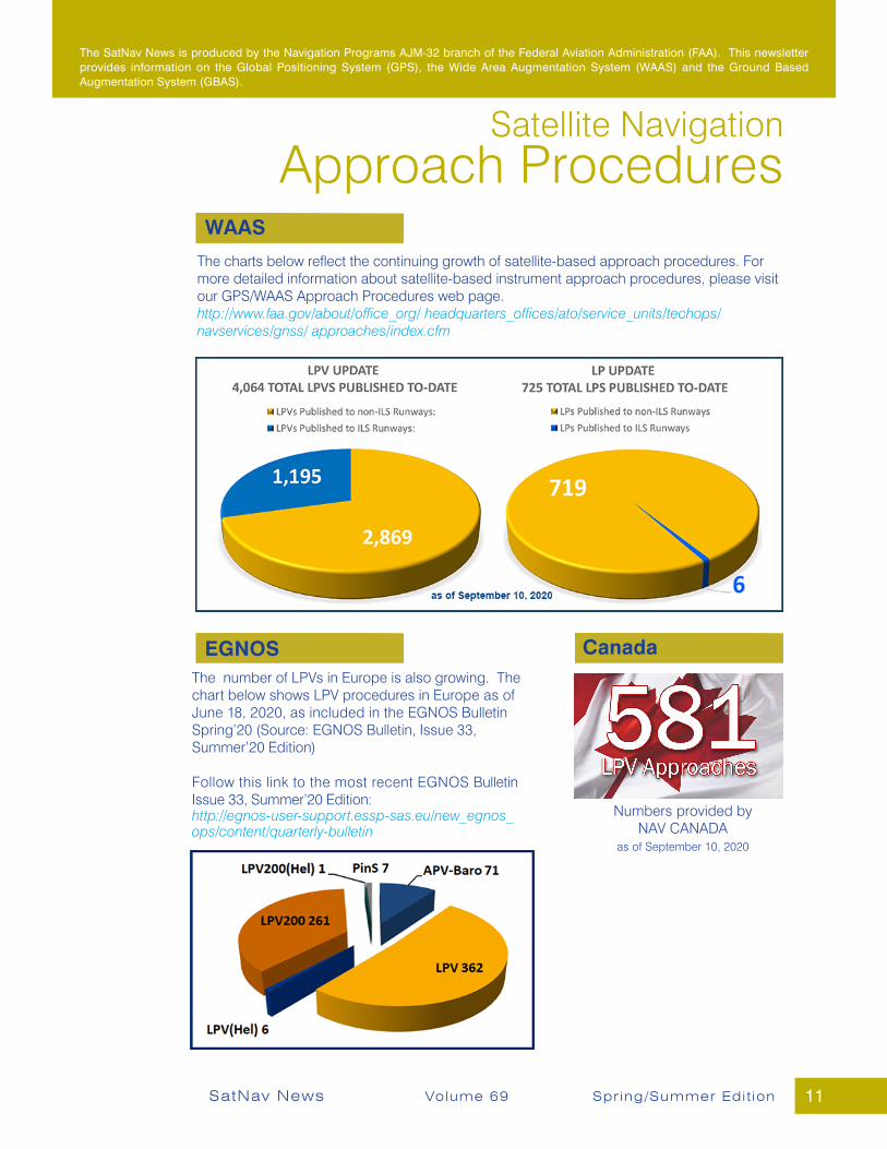
Satellite NavigationApproach Procedures
The charts below reflect the continuing growth of satellite-based approach procedures. For more detailed information about satellite-based instrument approach procedures, please visit our GPS/WAAS Approach Procedures web page. http://www.faa.gov/about/office_org/ headquarters_offices/ato/service_units/techops/navservices/gnss/ approaches/index.cfm
The SatNav News is produced by the Navigation Programs AJM-32 branch of the Federal Aviation Administration (FAA). This newsletter provides information on the Global Positioning System (GPS), the Wide Area Augmentation System (WAAS) and the Ground Based Augmentation System (GBAS).
The number of LPVs in Europe is also growing. The chart below shows LPV procedures in Europe as of June 18, 2020, as included in the EGNOS Bulletin Spring’20 (Source: EGNOS Bulletin, Issue 33, Summer’20 Edition)
Follow this link to the most recent EGNOS Bulletin Issue 33, Summer’20 Edition: http://egnos-user-support.essp-sas.eu/new_egnos_ops/content/quarterly-bulletin
Numbers provided byNAV CANADA
as of September 10, 2020
CanadaEGNOS
WAAS
Related Documents


![Honda Civic 2006+ SatNaV Manual [ENGLISH] · Title: Honda Civic 2006+ SatNaV Manual [ENGLISH] Author: AJS007 Subject: SatNaV Manual Keywords: Created for the members of](https://static.cupdf.com/doc/110x72/5b1b4ae37f8b9a1e258e8dc6/honda-civic-2006-satnav-manual-english-title-honda-civic-2006-satnav-manual.jpg)