Scott Air Force Base Bicycle & Pedestrian Commuter Plan 2013 Produced For By With Funding Support From

Safb planfinal web (1)
Mar 20, 2016
Scott Air Force Base Bicycle and Pedestrian Commuter Plan 2013
Welcome message from author
This document is posted to help you gain knowledge. Please leave a comment to let me know what you think about it! Share it to your friends and learn new things together.
Transcript

Scott Air Force Base Bicycle & Pedestrian Commuter Plan 2013
Produced For
By
With Funding Support From

Introduction & Existing Conditions................................................................5PurposePhysical FitnessData CollectionOpen House #1Stakeholder MeetingsOpen House #2Existing Conditions Map
Plan Principles.............................................................................................17Complete StreetsRecommended Facility TypesFacility Type Construction Estimates Potential Funding SourcesPedal Past the Pump: Shift Your CommutePlan Map
Implementation...........................................................................................29PrioritizationIntersections & Design GuidelinesEducationEnforcementEncouragementRoute Signs & WayfindingMarketing & Recognition
Appendix.....................................................................................................46
Table of Contents
This plan was produced by HeartLands Conservancy with the financial assistance of the Illinois Department of Transportation through the State Research & Planning Grants program and the cities of Mascoutah, O’Fallon, and Shiloh. Assistance also provided by Trailnet and James Pona of James Pona & Associates. The content and completion of this plan would not have been possible without the support and assistance of the following:The staff and elected officials of Scott Air Force Base, the Cities of O’Fallon, Mascoutah, and the Village of Shiloh :
• Daniel Schloesser, Planner 375 CES/CEAO • Todd Bjerkaas, O’Fallon Senior City Planner• Elliot Liebson, Mascoutah Economic Development• Norm Etling, Village of Shiloh Engineer
Citizen Advisory CommitteeHorner & Shifrin, Inc. EngineersThe “Shift Your Commute” Logo and Website are the Property of Trailnet
Acknowledgments

Disclaimer: The work that provided the basis of this publication was supported by funding under an award with the U.S. Department of Housing and Urban Development through East-West Gateway Council of Governments. The substance and findings of the work are dedicated to the public. The author and publisher are solely responsible for the accuracy of the statements and interpretations contained in this publication. Such interpretations do not necessarily reflect the views of the Government or East-West Gateway.
This document represents the Shift Your Commute: Scott Air Force Base Bicycle & Pedestrian Commuter Study. The objective of this plan is to provide a conceptual framework guiding future on- and off-street bicycle and pedestrian facilities along major corridors to Scott AFB, with the overarching goal to transform SAFB and the surrounding communities of Mascoutah, O’Fallon, & Shiloh into more bicycle-commuter and pedestrian-commuter friendly communities.
This planning process began in Fall 2012 and included two rounds of public open houses, or a total of six open houses. Multiple surveys were completed by SAFB employees, residents, and residents of the surrounding communities and comments were solicited and received at every juncture. The vast majority of residents who participated in the survey and open houses were in favor of helping create more bicycle and pedestrian routes to and from Scott AFB. There is a core group of citizens already commuting by bike or foot and more who would be interested in leaving the car at home if the routes to the base were made more safe for all forms of travel. While this is a long-term plan meant to take up to 20 years to implement, it provides the blueprint, in the form of phases, for constant progress. As more phases of this plan are implemented, the more positive impacts will be realized.
It is our hope that this plan, once implemented, will enable commuters of all skills, interests and needs to get to Scott Air Force Base from the surrounding communities.
Executive Summary

Introduction &Existing Conditions

6
Intr
oduc
tion
& E
xist
ing
Cond
itio
ns
PurposeScott Air Force Base, in partnership with the Cities of O’Fallon, Mascoutah and Shiloh commissioned this study to investigate and determine the most suitable and appropriate routes for employees of the air force base to commute to work via bicycle or foot. The base is anticipating a growing demand for parking from commuting employees and is interested in promoting alternative methods of transportation to and from the base. As the largest employer in Illinois, south of Springfield, the surrounding communities of O’Fallon, Mascoutah and Shiloh are invested in the success of the base, the long-term viability of the regional transportation infrastructure, and the health and livability options for their residents.
External to the specific needs of the base, there are factors inspiring people to think outside the car for their transportation needs, such as personal health and rising fuel costs. There are currently a number of active bicycle commuters who work at the base and this plan aims to increase the safety of the roadways they currently use, as well as to inspire and encourage additional alternative transportation commuters. The successful implementation of this plan will involve both “brick and mortar” changes to the surrounding roadway and trail system and a comprehensive education and encouragement campaign on base.
The Shift Your Commute (SYC) Scott Air Force Base (SAFB) Plan is a comprehensive, long-range analysis that outlines a blueprint for a connected system of facilities, including a phased implementation strategy based on citizen- and data-driven priorities. The piece-by-piece approach to the construction of this network will enable each City and the base to be proactive in searching for grant funding, along with leveraging available resources.
About Scott Air Force BaseLocated in St. Clair County, Illinois, approximately 20 miles east of the City of St. Louis, Missouri, ScottAFB remains one of the oldest, continuous service U.S. Air Force installations. Occupying approximately3,000 acres, Scott AFB is home to the United States Transportation Command (USTRANSCOM), AirMobility Command (AMC), Military Surface Deployment and Distribution Command (SDDC), and provides Headquarters for the 18th Air Force, the 932nd Air Force Reserve Command and the 126th AirRefueling Wing of the Illinois National Guard. The 375th Air Mobility Wing is the host unit at Scott AFB.
Since 1917 Scott Field, re-designated Scott Air Forces Base in 1948, has had many assignments including; medical airlift, technical training, lighter-than-air balloon/airship development, General Headquarters, Radio School, Air Mobility Command, air refueling, and others. Along with each major assignment came additions and renovations to buildings, roads, airfields, and railroads. Development on the base expanded more than four times and now encompasses more than 3,500 acres.
The base is named after Corporal Frank S. Scott, the first enlisted person to be killed in an aviation crash. Its airfield is also used by civilian aircraft, with civilian operations at the base referring to the facility as MidAmerica St. Louis Airport. MidAmerica has operated as a Joint Use Airport since November 1997. The residential part of the base is a census-designated place; the population was 3,612 at the 2010 census.
Corporal Frank S. Scott

7
Introduction & Existing Conditions
Every United States military transportation operation is controlled and monitored at Scott AFB, from deploying troops and materials for national defense to transporting the President of the United States.
There are nearly 1,600 family homes, 396 dormitories, 350 visitor quarters, 10 DV quarters, and 55 temporary lodging facilities on base.
Scott AFB is also home to the eastern terminus of the St. Louis MetroLink light rail line - the Shiloh–Scott station links Scott Air Force Base with Lambert International Airport on MetroLink’s Red Line.
Access to the BaseAccess to the Air Force Base is strictly controlled and monitored. There are various gates, each location has regulated access times:• Belleville Gate (County Road 1845/Scott Drive): 4:30 a.m. - 11:30 p.m.; 7 days/week• MetroLink Pedestrian Gate: 6:30 a.m. - 4:30 p.m.• Shiloh Gate (Seibert Road): 24 hours, 7 days/week• Cardinal Creek Gate (Pryor Drive): 6 a.m. - 8 a.m. and 3 p.m. - 5 p.m.; Monday – Friday• Mascoutah Gate/Commercial Vehicle Inspection Station (Florida Street and Charles Lane): 6 a.m. - 4
p.m.; Monday – Friday• Scott School (K-5) Gate (Paul Revere Drive): (Active School Days Only) 6:30 a.m. - 8:30 a.m. and 2:30
p.m. - 4 p.m.; Monday, Thursday and Friday. 6:30 a.m. - 8:30 a.m. and 2:30 p.m. - 4:40 p.m.; Tuesday and Wednesday. Note: The Scott School Gate is only authorized for pass holding parents dropping off students at Scott Elementary or the Youth Center; all other traffic will be denied access.
• The gate to the school on Patriots Drive is open during school days only, from: 6:30 - 8:30 am and 2:30 - 4:00 pm Monday, Thursday, Friday, 2:30 - 4:40 pm Tuesday and Wednesday for Tutoring. The Pedestrian gate is open until 4:30 pm. Entry into Patriots Landing through the school access road (off Section Line Road) is not authorized at any time.
8
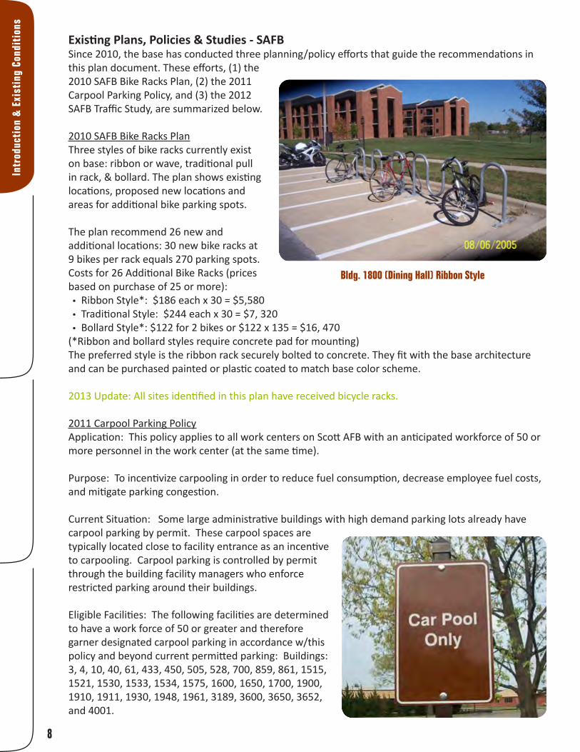
Existing Plans, Policies & Studies - SAFBSince 2010, the base has conducted three planning/policy efforts that guide the recommendations in this plan document. These efforts, (1) the 2010 SAFB Bike Racks Plan, (2) the 2011 Carpool Parking Policy, and (3) the 2012 SAFB Traffic Study, are summarized below.
2010 SAFB Bike Racks PlanThree styles of bike racks currently exist on base: ribbon or wave, traditional pull in rack, & bollard. The plan shows existing locations, proposed new locations and areas for additional bike parking spots.
The plan recommend 26 new and additional locations: 30 new bike racks at 9 bikes per rack equals 270 parking spots. Costs for 26 Additional Bike Racks (prices based on purchase of 25 or more):• Ribbon Style*: $186 each x 30 = $5,580• Traditional Style: $244 each x 30 = $7, 320• Bollard Style*: $122 for 2 bikes or $122 x 135 = $16, 470
(*Ribbon and bollard styles require concrete pad for mounting)The preferred style is the ribbon rack securely bolted to concrete. They fit with the base architecture and can be purchased painted or plastic coated to match base color scheme.
2013 Update: All sites identified in this plan have received bicycle racks.
2011 Carpool Parking PolicyApplication: This policy applies to all work centers on Scott AFB with an anticipated workforce of 50 or more personnel in the work center (at the same time).
Purpose: To incentivize carpooling in order to reduce fuel consumption, decrease employee fuel costs, and mitigate parking congestion.
Current Situation: Some large administrative buildings with high demand parking lots already have carpool parking by permit. These carpool spaces are typically located close to facility entrance as an incentive to carpooling. Carpool parking is controlled by permit through the building facility managers who enforce restricted parking around their buildings.
Eligible Facilities: The following facilities are determined to have a work force of 50 or greater and therefore garner designated carpool parking in accordance w/this policy and beyond current permitted parking: Buildings: 3, 4, 10, 40, 61, 433, 450, 505, 528, 700, 859, 861, 1515, 1521, 1530, 1533, 1534, 1575, 1600, 1650, 1700, 1900, 1910, 1911, 1930, 1948, 1961, 3189, 3600, 3650, 3652, and 4001.
Intr
oduc
tion
& E
xist
ing
Cond
itio
ns
Bldg. 1800 (Dining Hall) Ribbon Style

9
Introduction & Existing Conditions
Procedures for designating parking space: Facility managers for the buildings listed shall identify at least one parking space to designate as carpool parking. Carpool parking spaces shall be located as close as practical to the main entrance. Facility managers will submit a Civil Engineering Work Request (AF Form 332) including a simple map showing the location for the designated spot(s). The 375th Civil Engineer Squadron will validate the location and install signs. The parking sign will be a standard carpool sign. Facility managers may request more than one spot at any time if there is sufficient demand.
Regulation: To qualify for a carpool parking space a vehicle must be transporting 2 or more employees. To register the vehicle for a carpool parking space contact the facility manager. All parking is coordinated and enforced through the facility manager. Designated carpool parking spaces will be available on a first-come, first-serve basis. If vacated during the day (such as lunch time) another carpooling vehicle can use that space. In the event a carpool vehicle driver works at a facility with less than 50 employees, and parking at their facility is typically at maximum capacity. That driver may request a carpool space through their facility manager.
Carpool/Mass Transit References: Anyone interested in forming a carpool can contact Ride Finders, a web based service at [email protected] or phone number (800) 847-7433. RideFinders matches carpooling individuals with other interested individuals and even provides vans for “vanpooling”. Scott AFB also boasts an excellent mass transit system with the Metro Link train station located along the western perimeter of the base. Metro buses provide shuttle services to the East and West sides of the base. The Saint Clair County Transit District Metro Link schedule and other transportation related information can be found at: http://www.scctd.org
2013 Update: Feedback from the Citizen’s Advisory Committee (see page 11) reported the Carpool Policy to pertain ONLY to vehicles with three or more employees. This confusion should be clarified base-wide to encourage more carpooling. In addition, as opposed to special parking spaces, we recommend carpool cars be granted their own lane through the main gate of the base for “check-in” - feedback indicates this would be a better motivator for increasing the quantity and frequency of carpooling.
2012 SAFB Traffic StudyThe purpose of the study conducted in 2010 was to assess existing conditions and to identify short-term and long-term transportation needs to safely provide for existing and future transportation demands. Primary areas of focus include entry control facilities (ECFs), key intersections and pedestrian accommodations.
The study documents all transportation related issues on Scott Air Force Base, provides solutions, cost estimates and priority for an implementation schedule. The document focuses heavily on the specific designs of the entry gates so they may meet the Department of Defense engineering standards. The plan also addresses safe crosswalk design and indicates several places where upgrades and changes need to be made on base. The plan neglects to address pedestrian and/bicycle accommodations at the entry gates. The study also includes a survey in which 43% of people answered they regularly use the Shiloh gate, followed by 30.6% in the Belleville Gate. However, if the Cardinal Creek gate was improved use would increase from the current 22.2% to 30%.
“To qualify for a carpool
parking space a vehicle must be
transporting 2 or more employees.”
- SAFB Carpool Parking Policy (2011)

10
Physical FitnessIncreasing opportunities and options for active transportation creates healthier communities. According to the Centers for Disease Control, “People who are physically active live longer and have a lower risk for heart disease, stroke, type 2 diabetes, depression, and some cancers. Improving spaces and having safe places to walk can help more people become physically active.” Less than half of all adults get the recommended amount of physical activity, and walking requires no special equipment or training.
County Health RankingsThe University of Wisconsin’s Population Health Institute has analyzed a series of factors to produce a ranking for counties of Illinois in two categories: health outcomes (premature death, overall morbidity,etc.) and health factors (obesity, smoking, etc.). The analysis is intended to produce a picture of overall community health based on factors like quality of health care, individual behavior, education, employment and environmental factors. The goal is to capture a picture of both physical and mental health.
The results were published in the County Health Rankings: Mobilizing Action Toward Community Health – Illinois 2012 report (countyhealthrankings.org). St. Clair County is ranked 94 out of 102 counties (1 being the healthiest and 102 being the least healthy county in Illinois) for Health Outcomes and 100 out of 102 for Health Factors. These poor results indicate that citizens in this region would benefit greatly from access to a high-quality system for active transportation and recreation.
Air Force PolicyThe Air Force Fitness Program goal is to motivate Airmen to participate in a year-round physical conditioning program that emphasizes total fitness, to include proper aerobic conditioning, strength and flexibility training, and healthy eating. Health benefits from an active lifestyle will increase productivity, optimize health, and decrease absenteeism while maintaining a higher level of readiness. The new physical fitness standards, enacted by the Air Force in 2010, represent the most strenuous in over a decade. The changes were made to promote a fitness-based culture that enhances the mission readiness of Airmen.
Specifically at Scott AFB, The Health and Wellness Center (HAWC) is a place where the entire Scott AFB Community can come and find a highly qualified staff ready and willing to assist/support all personnel and beneficiaries in achieving healthier lifestyles. The HAWC supports the Commander in cultivating a fit and ready force, optimizing performance with an emphasis on prevention of illness and injury.
Intr
oduc
tion
& E
xist
ing
Cond
itio
ns
St. Clair County is
94th out of 102
Counties in Illinois

11
Bike Commuting Better Than The Gym? (peopleforbikes.org)Biking for transportation appears more helpful in losing weight and promoting health than working out at the gym. According to Australian epidemiologist Takemi Sugiyama, lead author of a recent study in the American Journal of Preventive Medicine, “Commuting is a relevant health behavior even for those who are sufficiently active in their leisure time.” Analyzing the research, The Health Behavior News Service notes, “It may be more realistic to accumulate physical activity through active transport than adding exercise to weekly leisure-time routines.”
The four-year study of 822 adults found that people commuting to work by car gained more weight on average, even if they engaged in regular exercise, than people who did not commute by car. The authors of the study recommend creating more opportunities for everyone to walk or bike to work.
An earlier study by researchers at the University of Sydney School of Public Health published in Obesity Reviews (the journal of the International Association for the Study of Obesity) supports the thesis that leisure-time exercise alone is not enough to prevent obesity. Sixty to 90 minutes of daily physical activity is recommended to curb obesity, which is more time than most people can fit into their busy schedules. That’s why the study’s authors recommend “active transport” like biking and walking for commuting.
Beyond fighting fat, biking and walking for transportation also boosts overall health. A 2007 paper in the European Journal of Epidemiology concludes: “Commuting physical activity, independent of leisure time physical activity, was associated with a healthier level of most of the cardiovascular risk factors.”
The key advantage of traveling by bike over working out at a fitness center is that most people find it easier to do. Instead of vying for scarce free time with many other fun and important things, exercise becomes something we do naturally as part of daily routine. As a study by Portland State University professor Jennifer Dill in the Journal of Public Health Policy shows, 60% of Portland cyclists ride for at least 150 minutes per week (the recommended exercise minimum for adults) and that “nearly all the bicycling was for utilitarian purposes, not exercise.” She adds “a disproportionate share of the bicycling occurred on streets with bicycle lanes, separate paths, or bicycle boulevards”—confirming the importance of bike infrastructure improvements to public health.
Data CollectionCitizen’s Advisory CommitteeData collection for the Shift Your Commute (SYC) commuter study began with the assembly of a Citizen’s Advisory Committee (CAC) comprised of community members employed at the base and other interested potential users. Soliciting CAC members from Mascoutah, O’Fallon, Shiloh and the Base, in addition to members added through primary CAC members’ personal contacts, 18 current and potential bicycle commuters helped shape the plan approach, goals, and recommendations. The CAC met three times and each member was instrumental in providing input, engaging the public, and assisting the planning team in prioritizing the plan recommendations.
“ ‘A disproportionate share of the bicycling
occurred on streets with bicycle lanes, separate paths, or
bicycle boulevards’—confirming the
importance of bike infrastructure
improvements to public health.”
- Jennifer Dill, Portland State University
Introduction & Existing Conditions
12
Intr
oduc
tion
& E
xist
ing
Cond
itio
ns
As the planning process concludes, CAC members will be asked to provide a letter of support for the final plan document, to be delivered to each of the surrounding communities. They will be encouraged to stay active and involved with future implementation efforts as citizen-driven initiatives can be immensely effective and successful.
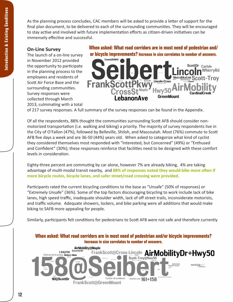
On-Line SurveyThe launch of a on-line survey in November 2012 provided the opportunity to participate in the planning process to the employees and residents of Scott Air Force Base and the surrounding communities. Survey responses were collected through March 2013, culminating with a total of 217 survey responses. A full summary of the survey responses can be found in the Appendix.
Of all the respondents, 88% thought the communities surrounding Scott AFB should consider non-motorized transportation (i.e. walking and biking) a priority. The majority of survey respondents live in the City of O’Fallon (47%), followed by Belleville, Shiloh, and Mascoutah. Most (76%) commute to Scott AFB five days a week and are 36-50 (44%) years old. When asked to categorize what kind of cyclist they considered themselves most responded with “Interested, but Concerned” (49%) or “Enthused and Confident” (30%); these responses reinforce that facilities need to be designed with these comfort levels in consideration.
Eighty-three percent are commuting by car alone, however 7% are already biking, 4% are taking advantage of multi-modal transit nearby, and 88% of responses noted they would bike more often if more bicycle routes, bicycle lanes, and safer street/road crossing were provided.
Participants rated the current bicycling conditions to the base as “Unsafe” (50% of responses) or “Extremely Unsafe” (36%). Some of the top factors discouraging bicycling to work include lack of bike lanes, high speed traffic, inadequate shoulder width, lack of off street trails, inconsiderate motorists, and traffic volume. Adequate showers, lockers, and bike parking were all additions that would make biking to SAFB more appealing for people.
Similarly, participants felt conditions for pedestrians to Scott AFB were not safe and therefore currently
When asked: What road corridors are in most need of pedestrian and/or bicycle improvements? Increase in size correlates to number of answers.
When asked: What road corridors are in most need of pedestrian and/or bicycle improvements? Increase in size correlates to number of answers.
13
Introduction & Existing Conditions
not a viable option. Fifty percent of the responses stated the current conditions for walking or running to the base are “Unsafe” (50%) or “Extremely Unsafe” (35%) but, 74% said they would walk/run more if conditions improved, such as the implementation of new sidewalks and trails, and safer street crossings.
Open House #1To begin community engagement and gain citizen input, an Open House was held in the communities of Mascoutah and O’Fallon. The first, in Mascoutah, was November 13, 2012 from 6:00 to 8:00 PM at the City Hall. There were five people in attendance. The next, in O’Fallon, was held November 15, 2012 from 6:00 - 8:00 PM at the City Hall. There were nine people in attendance. Each person had opportunities to outline their preferred route to Scott AFB by walking or biking and some barriers they would face along the way. They also expressed their ideal biking and walking conditions if they were current bike or pedestrian commuters or, if they did not currently walk or bike, they described the minimum facility improvements that would make them feel safe enough to leave their car at home.
Stakeholder MeetingsAside from engaging with the CAC and the general public, input from key stakeholders was also solicited. Three key groups were interviewed: the Ridge Prairie Trail head Initiative, the Metro East Parks & Recreation District (MEPRD) and the St. Clair County Transit District.
It is the mission of the Ridge Prairie Trail head Initiative to develop bicycle and pedestrian routes and trails that will establish Lebanon as a hub for regional biking, walking, and running enthusiasts. One of their planned routes, a trail using the abandoned streetcar line north of Hwy 50 has been incorporated into the final plan recommendations.
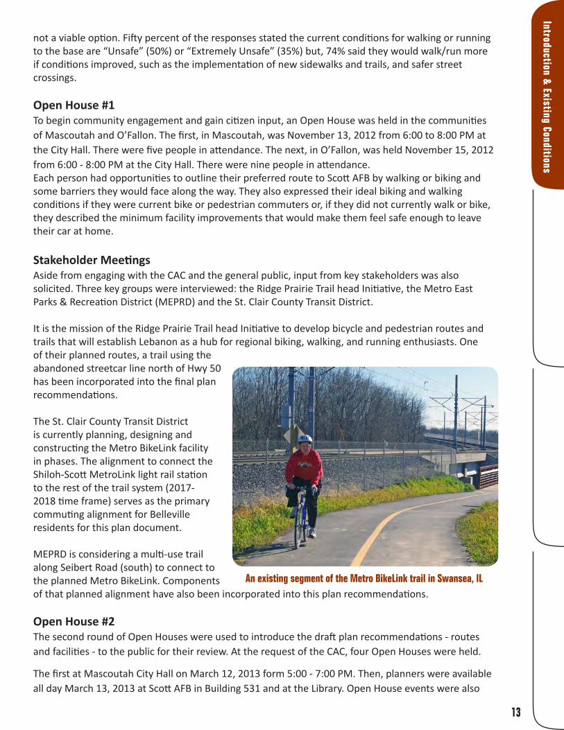
The St. Clair County Transit District is currently planning, designing and constructing the Metro BikeLink facility in phases. The alignment to connect the Shiloh-Scott MetroLink light rail station to the rest of the trail system (2017-2018 time frame) serves as the primary commuting alignment for Belleville residents for this plan document.
MEPRD is considering a multi-use trail along Seibert Road (south) to connect to the planned Metro BikeLink. Components of that planned alignment have also been incorporated into this plan recommendations.
Open House #2The second round of Open Houses were used to introduce the draft plan recommendations - routes and facilities - to the public for their review. At the request of the CAC, four Open Houses were held.
The first at Mascoutah City Hall on March 12, 2013 form 5:00 - 7:00 PM. Then, planners were available all day March 13, 2013 at Scott AFB in Building 531 and at the Library. Open House events were also
An existing segment of the Metro BikeLink trail in Swansea, IL

14
Intr
oduc
tion
& E
xist
ing
Cond
itio
ns
held at the Shiloh Senior Center from 4:30 to 6:00 PM and O’Fallon City Hall from 6:30 to 8:00 PM. There were 29 people in total who stopped by to review the plan recommendations.
The review period was extended through March 27, 2012. The Draft Plan was posted on-line and left at the base for people to submit comment forms (see an example below). Members of the planning team and City staff introduce the draft plan to citizens
at the second open house (photo: Robyn Kirsch)

khkhkh
khkh
khkhkh
kh
kh
khkh
kh
khkhkh
khkh
kh
kh
kh
khkh
kh
khkh
khkhkh
kh
li
li
kh khkh
no
S w a n s e aS w a n s e aS h i l o hS h i l o h
O ' F a l l o nO ' F a l l o n
M a s c o u t a hM a s c o u t a h
L e b a n o nL e b a n o n
F a i r v i e wF a i r v i e wH e i g h t sH e i g h t s
B e l l e v i l l eB e l l e v i l l e
S c o t tS c o t tA F BA F B
R e n t c h l e rR e n t c h l e r
High Mount School
Wolf BranchMiddle School
WhitesideElementary School
WhitesideMiddle School
Future MemorialHospital East
L ittle Canteen Creek
S h ale Creek
Hog R
iver
Ogles CreekEngle Creek
Little S
ilver Creek
SILVER CRDITCHAsh Creek
RICHLANDCR
Loop Creek
SILVER CR
I-64
I LL IN O IS R O U T E 1 3
NORTH BELT WEST
6 THST
BUNK E RH I LL DRIV E
A S T
W ES T H W Y 5 0
ST. LOUIS ST
W E S T S TAT E S T
ILL IN O IS H IG H W AY 1 5
NORT
H GRE
ENMO
UNT R
D
MAIN
M AS CO UTA H
AV E
W ES T M A IN ST
FR A N K S C O T T P K W Y E
E H W Y 5 0
S O U TH B E LT W ES T
CASEY V I LLER D
C A R LY L E R D
SO U T H B E LT EA ST
LEB A N O N AV E
LU D W IG D R
RU BYL A NE
L IN C O LN T R A ILMCALLISTER
FAUST RD
U N IT E D STAT E S H IG H W A
LO N D A C R E D R
D O U G LA S AV E
ILLIN
OISR
OUTE
4
SOUTH
MAIN ST
MASCOUTAH RDW ES T C L E V E LA N D
M A R K E T P L A C E
IL 161
28TH
E MAIN ST
SEVEN
HILLS
RD
ILL IN O IS R O U T E 1 6 1
C HAR
LESS
T
LINCOLN HWY
AIR M
OBILIT
Y DR
H E M LO C K D R
MAPLE STREET
CARLYLE AVE
COUN
TY RD
HART
MAN
LANE
SHERMAN ST
ELM
FULLERTON RD
SOUT
H GRE
ENMO
UNT R
D
11TH ST BREC
KENR
IDGE
HOLYO
KE
LOLA
OPTIMIST
HARMON
OSAGE
DUNB
ERRY
WASHINGTON
APPA
LOOS
ADR
AMY
MINE
RICHLAND BLVD
MORGAN ST.
E B STRD
KINGS
ROSS LA
OLD S
TATE R
TE 4
S U N D E W
DR
S E IB ER T
R D
THOUVENOUT LN
ILLINO
IS RO
UTE 1
58R E N T C H L E R STA R D
SCOTT
GILBERT ST
HARNETT ST
LIBER
TYRD
M CCLIN TO CKAV
ES 1 7TH
RUGBY
WALTE
R
EA ST "B " ST
E LINCOLN
VEILE DR
JARDIN
HANN
A
W LINCOLN
LAKE
BERN
ARD L
N
P R ESW YC KD R
CROS
SWIND
S
WI L LI A M
SB URG DR
MELISSA
Q UAI LP OINT
F R A N K S C O T T P KW Y W
E B ST
B OU L A V E
CA SEY V IL LEAVE
O L D V IN C E N N E S T R A IL
ANNE
MONR
OE
W ES LEY D R
HIGH
OLIVE
SY
DELLA
IVO
REISS
MONA
TAMPICO DR
VEACH
GERI-
LYN RD
SOUTH
JAMESMI
MOSA
CALISTAR ID G E
SCHEEL
LOSEY
E
SAGEBRUSHBE
NTLEY
KESW
ICK
DEERFIELD
W M O N R O E
CALYPSO
WIDG
EDON
TRUDY
CAROLINE
TAURUS
MICHIGAN
PAGE
N 1ST
FEHER
ANN
HIGH S
T
WOOD
LEAF
I L 1 3 -1 5
CONE
STOGA
JAY
GALWAY
DUNH
I LLD R
GEORGE PHILLIP
AUGU
STAC O R A L D R
C RO SS S T
BUX
PLUM
AARON
LINWOOD
KRISTINA
CARI
FREEB U RGAVE
OLD S
TATE R
OUTE
158
HARRIS
TA F T ST
G R IM IG R O A D
UNION
WOOD
27TH
G
WINTERS
NAVY
CORE
L
CIVIC
KLEE
SCOUT
MARI
HERM
AN
PENN
Y
PEAR
L
D A L E A L LE N
VICKSBURG
BOND
POTO
MAC
PASA
DENA
WILDWOOD
ARBO
R
BENTON
SCOTT
SCHO
OL RD
ASPE
N3 R D S T
PISTER RD
DEER
PASCA
L
18TH
BETZ
ENOS
BAYLO
R
WILCOX
MILLSTONE
LORENZ
INDEP
ENDE
NCE
SARA
H
BULL
RUN
LEGEND
RASP
LEBAN
ON
MEYE
R
CHERYL
PE BB LE BROO K
LORENE
BIRDIE
COMER
14TH
INDIANA
SHAWN
JOY
HILGA
RD
ALADAR
GASS
FINCH
LN
MARK
ET
APPLE
BERN
ARD
CHURCH
STONEBRIDGE
LEO
MILL-
SPRIN
GS RD
JADE
SEQUOIA
JOEL
PONDEROSA
TUPE
LO
POLO
BLANC-LEE
DEBR
A
JUSTUS
EMBASSY
5TH
BOUR
DELA
IS
FLORA
HEIDI
WESTWOOD
20TH
ANDREW
KANSAS
DARTMOUTH
IRIS
REDBUD
JULIA
15TH
JARVIS
HOLLIDAY
MARTIN
CROSS
PONT
IAC
LAURETTE
KATRINA
CA RT ROAD
SCHOOL
CARR
SECTIO
N LINE
RD
EAGL
E
HAYES
WOLF
LINCO
LN
SYCAMORE
SUNRISE
MORGAN
HELEN
ELLEN
ROSETTE
L AU R E N L A K E
I
BEEBEDE R E B ER E
ABBY
JUNIPER
LUCINDA
CHESH
IRE
ALEX
CHAR
LES DR
IVE
KEILSARPY
OVER
LOO K
DR
NATALIE
WESTFIELD
CORY
T W IN L A K E
ROGER
9TH
CLARA
CHATEAU DR
ENCLAVE
TERRY
PEACE
VALE
JARED
BERK
LEY
BLAIR
MAE
CATA
LINA
KNIPP
OAK
10TH
GARFIELD
WELLE
SLEY
HECKER
IRMA
AMHERST
CENTER
CAPRI
MEMO
RY
LOTU
S
VENU
S
EASTVIEW DR
12TH
TOBIAS
FRITZ
LASALLE
ADAMS
21ST
KIEFER
MERRILL
16TH
AMY LANE
MAPLE
RAILW
AY
BELLE
NORTH MAIN ST
STEVENS
FA IR W O O D H ILLS
TEAL
G LE N M O R
SHAMROCK
SALEM DR
PRAIR
E VIEW
P O LO R U N
OAKRIDGE
WATNEE
4TH
MYLAUN
REDCASTLE
LOCU
ST
BARCO
MEDDOWS
MAGNOLIA
TRIBE CT.
1ST
RIVIER
ALEG
ACY
SILVERLINK
SHEFFI
ELD
SPRU
CE
WILLARD
FAMOUS
BELLE CREST
EAST
KELLE
Y
BURM
A RD
PREM
IER
ARABELLE
RAVENEL
BEL AIRE
MULBERRYBELAIRLAKE FOREST
RAAB
LILAC
SUMMERS
CRESTVIEW
MARL
O
BYRON
CANT
Y
RYAN
SERVICE
WESTE
RN
KIMDAVID
RODIN
ANTIQUE
EMPIRE
THRUSH
DALE
CLAY
SURV
EY
FAIRWAY
13TH
YALE
DEAN AL
ICE
KIMBERLIN
MALINDA
FAIRFIELD
NORT
H
BUNSEN
BARON
STITES
LAKESHORE
RED PINE
ATLANTIC
JACKS
ON
POWE
LL
MARILYN
HARRISON
SHER
IDAN
FOX
MAPLE DR
HOLLY
DR
BELTBLUFF
NATH
AN
META
KOERNER
CATHERINE
NEWCASTL
E
J
CORA
L
OXFORD
PEAC
EFUL
M A RLA KAY
BUCHER
BIRCHARD
P ER R IN R D
IOWA
COUNTRY
TRAU
BEL
ILLINOIS ROUTE 177
LENOR
A
HUNT
ERS
STATE
DEWEY
MARSH
ORIOL
E
WH ITE
O AK
ILLINOIS
WESLEY
BO BBI ED R .
Q U A R R Y R O A D
LAWN
KASSING
LAURE
L
SUSA
N
RAMSFIELDVILLA
GE
CEDAR
D
QUAIL
COLLEEN
3 W OO D
KADLEC
GR EEN M O U N T
ELVIRA
ADAMBRIAN
ORLA
NDO
BRISTOWCATAWBA
SCHUETZ
TOULON
DUSTIN
DAWN
MC KINLEY
TIMBER
HARBOR WAY
19TH
TURNBRIDGE
TANB
ARK
G R EE N H AV E N
INDIAN
CREEK
SIMMO
NS RD
JEROM
E
BELPR
E
11TH
ROSE MARIE
WOODS
CHARLES
BRIDLE
LEIGHIGH
A
M IST Y VA L LEY
PIPER HILLS
PARK
SANDPIPER
LAKELAND
HAMP
TON
F
KINGSLEY
WILLOW
PERROTTET
ANNA
2ND
TWIN
OAKS
ROWE LN
VIRGINIA
B
EASTGATE
LYONSHALL
ARTHUR
BOOSTER
MUREN
TOWE
R
BRITTANY
COOL
VALLE
Y
SINN
CLEMSON
COYO
TE
W H IT E P IN E
PASTEUR
SCHEIBEL
B E L V ISTA
CHRIS
TINE
NIXON
H
COLUMIA
ELISA
BETH
BRITANNA
SIR LA
WREN
CE
BLUMBURG
R IO VERD E DR
SANDWEDGE
8TH
SOUTHERN
PATTERSON
UNION
HILL
H AV E R FO R D D R
BELLE
VALLE
Y
LIBERTY
JUDY
GRANT
K A N D K
WO OD
DU CK
BOBBIE
W O L F C R EE K
ALTON
E D E N PARK
ILLINI
PRAIRIE
LLEWELLYN
FUESSER RD
W B 64 TO 4
OULVE
Y
E B 64TO
4
DUBLIN
OLROYD
LIB ER T Y M IN E R D
L A K E LU C E R N E
MISSOURI
FOURNIE
CEDAR
WOOD
DOUGLAS
WESTHAVEN SCHOOL
FRONT
AGE
FARM TRACTOR
WHITEHALL
BAYB
ERRY
PA U L R E V E R E
AUGU
ST
B ST
N. RIEDER RD
EISENHOWER
EDGEWOOD
DONNA
LINDE
N
S T C L A IR
KILDEA LN
STAN
DREW
S
WILLMAN
B R O O K M E A D O W
AMANN
WEBE
R
B A C K D R
BETTY
FOREST
FOUR
TEEN
THFA
I RWAY
RAND
N B 158 TO E B 6 4
KOR TE S EW A L D
FRO N TA G ER D .
WINCHESTER
JOHNSON
SHILOH STA WEST
PLUM
HILL
RD
3RD
MUNIE RD
BEAUGON
TAMARACK
LOUELLA
C
PORTLAND
WALN
UT
HANGAR
S H ILO H S TAT IO N W ES T
OAK GROVE SCHOOL RD
FUESSER
MACH
INE SH
OP
P R O TO U R
S H IL O H S TAT IO N EA S T
B O R CH E R R D
HUNTWOOD
F O U N TA IN S P KW Y
PIERCE
COLLEGE
CENTRAL PARK
SME LTING
WO RK S
LINCO
LN ST
JEFFER
SON
6TH
ST. JO
HN DR
IVE
17 TH
AN DE RS ONLN .
CHRIS
T
S H A D Y LN
STAT
EST R
D
SU L L IV AND RI V E
WEST BLVD
WHERRY RD
O X E N C T
CHER
RYP O R T E R RD
JUBAKA
RENOIR
GARDEN
SCOTT
-TROY
RD
LO N D O N
LN.
INNSB
RUCK
EDNA
S T N IC H O L A S
CRYSTAL
JOHN
MARK
LUCIA
PINE
POLK
SHILOH VALLEY TWP LI
BARTON
7TH
NANCY
GREEN
RIEDE
R RD
EMILY
RED F
OX
BIVERTON
VENITA
DR
K
LEE
KORT
E SEW
ALD R
D
SMILE
Y
AGNES
PENNSYLVANIA
ORCHARD
LA KE LO R RA IN E
DUKE
SECTIONL IN E
RED FIELD
RUBY
MACH
INE SH
OP RD
PERR
IN
VINE
INNER
EDDING
LONG
CONC
ORD
PATRIOTS
FREY
JOSEP
H
DEPA
UL
KINSEL
LA
T IM B E R O A K
PINEDALE
MADISON
MATTHEW
O A K H IL L SC H O O L R O A D
MESSINGER
STRAC
K LN
ASHCREEK
PLAZA
REGE NC YPA RK
KECK
RD
WES
TW AT ER S ED G E
OUTER
WARD
SCHN
EIDER
RD
EIDMA
NN RD
.
RADIO
RANG
E RD
OLD
CASE
YVIL L
E
ERIN
AUTO
23RD
RANDLE
R E N TC H L E R S TA W E S TPOPLAR
SO U T H D R
SYMING
TON D
R
WARD
DR
EAST DR
S IEB ER T R D
SR4
W
LO S E Y S TG O LF C O U R S E R D
W WINTERS ST
ILLINOIS ST
SCOTT
DR
POLK ST
VO SLE RDR
IL-161
AIRPORT BLVD
SR 161
PA U L R E V E R E D R
IL-4
W C L AY ST
B O EIN G R D
IL-158
PAT R IO TS D R
")177
")159
")158
")161
")161
")177
")13
")15
")158
")177
")159
")4
")161
")158
£¤50
£¤50
§̈64
§̈64
§̈64
ShilohGate
CardinalCreek Gate
BellevilleGate
MascoutahGate
FUTURE LincolnLanding Gate
THREESPRINGS PARK
CARDINALCREEK GC
ROCKSPRINGS
PARK
CASEYVILLERIFLE &
PISTOL CLUB
ENGLEMANNFARM
CLINTONHILL GC
FAMILYSPORTS
PARK
LOCUSTHILLS GC
TAMARACK CC
Pontiac-W Holliday SD105
Pontiac Jr HighSchool
WilliamHolliday Elem
School
Lebanon CUSD 9
Lebanon High SchoolLebanon ElemSchool
O Fallon CCSD 90
Amelia V CarrielJr High
Estelle Kampmeyer ElemSchool
J Emmett Hinchcliffe SrElem Sch
Laverna EvansElem
School
MarieSchaefer Elem SchoolCentral
SD 104Joseph Arthur
MiddleSchool
CentralElemSchool
O FallonHigh School (Smiley)
ScottElem
School
Shiloh Village SD 85
ShilohMiddle School
Shiloh Elementary SchoolWolf BranchElem
School
Scott Air Force Base Existing Conditions
no Hospital
kh School
li University
r Scott AFB Gates
MetroLink Stations
ââ ââ ââ Metro LinesExisting On-Street AccommodationsExisting TrailPlanned Improved ShouldersTrails Planned by OthersPlanned On-Street Accomodations
Bodies of WaterStreamsRailroadSAFB BoundaryParks & Open SpaceMunicipal Boundaries
0 1 2½Miles

Plan Principles

18
Plan
Pri
ncip
les
Plan PrinciplesThe primary audience for this study is “Transportation Cyclists” as outlined below. It is anticipated that recreational cyclists and pedestrians will also utilize the facilities recommended in this plan, and should be encouraged to do so.
The City of Portland classified their transportation cyclists into four categories. While the percentage of types will differ between communities across the country, the principles remain the same. The
recommendations made herein provide benefits, safety improvements, and encouragements for all types of transportation cyclists, regardless of skill. However, it is
important to understand the distinctions between different types of users, as they will use the facilities in different ways.
“Strong and the Fearless” cyclists will ride regardless of roadway conditions. They are ‘bicyclists;’ riding is a strong part of their identity and they are generally undeterred by roadway conditions; however, facilities need to be made as safe as possible as they are not immune to interactions with auto traffic.
“Enthused and Confident” cyclists are comfortable sharing the roadway with automotive traffic, but they prefer to do so operating on separated facilities, such as bike lanes and improved shoulders. They are attracted to riding when the streets have been redesigned to make them work well for bicycling.
“Interested but Concerned” are probably the most common type of transportation cyclist. They are curious about bicycling. They are hearing messages from a wide variety of sources about how easy it is to ride a bicycle and about the need for people to lead more active lives. They like riding a bicycle, remembering back to their youths, or to the ride they took last summer on local trails. They would like to ride more, but are afraid to ride. They get nervous thinking about riding near speeding traffic. They currently rarely ride for transportation—perhaps they will ride through their neighborhoods to the local park or coffee shop, but they will not venture out onto the arterials to the major commercial and employment destinations they frequent. They would ride if they felt safer on the roadways.
“No Way, No How” ‘cyclists’ are currently not interested in bicycling at all, for reasons of topography, inability, or simply a complete and utter lack of interest.
The recommendations made in this plan should be used as a framework for developing more detailed design-engineering plans during subsequent implementation. The recommended routes and trails are consistent with the bicycle facility design material and typical sections in the Illinois Department of Transportation’s (IDOT’s) Bureau of Design and Engineering Manual (See Appendix). They also reflect the guidance presented in the American Association of State & Highway Transportation Official’s (AASHTO’s) Guide for the Development of Bicycle Facilities and the Manual on Uniform Traffic Control Devices (MUTCD) (See Appendix). These three documents are the current fundamental, acceptable reference information for developing bicycle facilities. [Note: The full documents should be consulted in the design-engineering/implementation phase of this plan.]

19
Plan Principles
Complete Streets: Illinois LawAccording to the American Planning Association (www.planning.org) complete streets accommodate pedestrians, bicyclists, transit, and cars, creating multi-modal transportation networks. In October of 2007, complete streets policy became law in Illinois. It mandates that the principles of complete streets must be incorporated into all new projects receiving state or federal monies and/or projects on state or federal roads and highways. Both requirements relate to projects in urbanized areas. On June 1, 2010, IDOT formally adopted a series of design policy changes to their Bureau of Design and Environment manual, Chapters 5 and 17, in response to the 2007 “Complete Streets” state law.
IDOT has jurisdiction on many of the roadways within the study area for this plan, such as Routes 161 and 158. However, the principles of complete streets have been applied to all plan recommendations, creating seamless integration of both pedestrian and bicycle accommodations in the implementation guidelines herein.
There are three categories of facility types recommended for the SAFB Shift Your Commute plan. They are as follows (definitions and photos of the facility types are shown on the following pages):
1. May-Use-Full-Lane Signs & Shared Lane Markings (Sharrows)2. Improved Shoulders3. Multi-Use Trails

20
• Sharrows & Signs: On-street pavement markings that designate Bicycle Routes along with the area of the traffic lane that is recommended for use by cyclists. “May Use Full Lane” Signs, for awareness, safety and wayfinding, are also used in this facility. The combination of signs and pavement markings (including through intersections) designates these roadways as the “preferred” locations for on-street cycling.
Plan
Pri
ncip
les

21
• Improved Shoulders: While the width of the shoulders on the roadways recommended for this facility are typically more than adequate, their surface materials are not. This recommendation includes replacing the current oil and chip surface with a standard asphalt surface - an extension of the surface used in the roadway. Further construction guidelines include painting these shoulders a bright green color and stenciling sharrows on them. Roadside signs are also recommended, such as “Bikes on Shoulder” for safety and wayfinding/route designation. The use of this facility eliminates the need for road-widening and related expenses to accommodate bicycle lanes.
Plan Principles
22
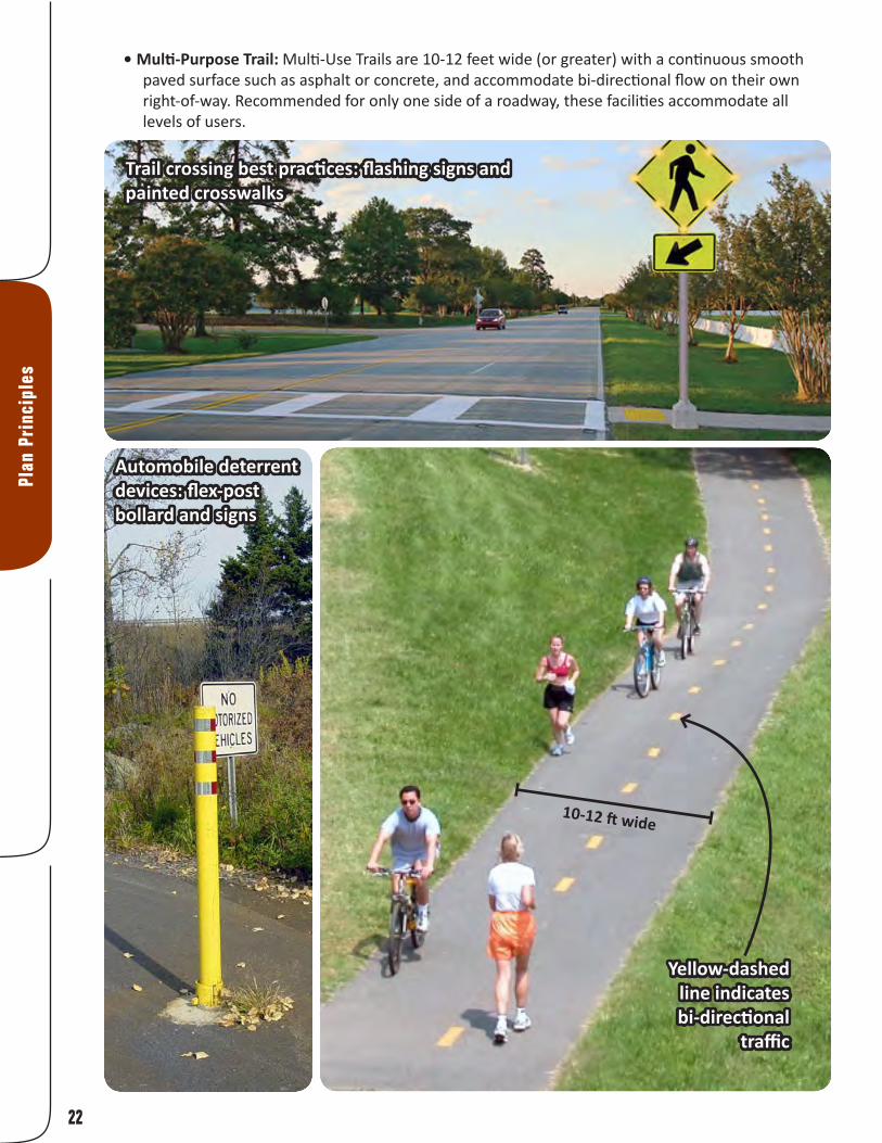
• Multi-Purpose Trail: Multi-Use Trails are 10-12 feet wide (or greater) with a continuous smooth paved surface such as asphalt or concrete, and accommodate bi-directional flow on their own right-of-way. Recommended for only one side of a roadway, these facilities accommodate all levels of users.
Plan
Pri
ncip
les
10-12 ft wide
Yellow-dashed line indicates bi-directional
traffic
Automobile deterrent devices: flex-post bollard and signs
Trail crossing best practices: flashing signs and painted crosswalks

23
Plan Principles
Estimated Preliminary ExpensesStreet Name/Label Recommended Facility Length (ft) Length (mi) Estimated Cost Cross Street Improved Shoulder 10,844 2.1 $1,496,464 Future Frank Scott Ext. Improved Shoulder 10,405 2.0 $1,435,881 Hwy 158 Improved Shoulder 9,922 1.9 $1,369,266 Hwy 50 Improved Shoulder 2,745 0.5 $378,806 Lebanon Improved Shoulder 12,767 2.4 $1,761,877 Maple Improved Shoulder 6,104 1.2 $842,358 North Main Improved Shoulder 10,837 2.1 $1,495,495 Old 158 Improved Shoulder 6,234 1.2 $860,358 Scott-Troy Road Improved Shoulder 5,141 1.0 $709,455 Wherry Improved Shoulder 9,816 1.9 $88,340 County Road Improved Shoulder & Sidewalks 7,101 1.3 $1,526,729 Frank Scott Pkwy Improved Shoulder & Sidewalks 23,367 4.4 $5,023,916 Belleville Street Shared Lane 7,299 1.4 $10,657 Chesapeake Jct Ln Shared Lane 2,509 0.5 $3,663 Lincoln Shared Lane 6,834 1.3 $9,978 Lincoln Landing Connector Shared Lane 3,915 0.7 $5,716 MetroLink Shared Lane 2,075 0.4 $3,030 Pierce Blvd Shared Lane 7,114 1.3 $10,386 Regency Park Shared Lane 4,722 0.9 $6,894 Regency Park Shared Lane 3,933 0.7 $5,742 Scott Drive Shared Lane 6,437 1.2 $9,398 Seibert Road Shared Lane 9,063 1.7 $13,232 Seibert-158 Intersection Shared Lane 325 0.1 $474 State Street Shared Lane 3,087 0.6 $4,507 Venita Dr Shared Lane 3,695 0.7 $5,395 County Road Shared Lane & Sidewalks 8,214 1.6 $644,484 Future Roadway Trail 8,040 1.5 $546,694 Lincoln Landing Connector Trail 1,814 0.3 $123,328 Metro BikeLink Connector Trail 23,207 4.4 $1,578,065 Old Collinsville Road Trail 7,841 1.5 $533,218 Old Collinsville Road Trail 6,790 1.3 $461,706 Old Vincennes Trail Trail 10,683 2.0 $726,477 Reider Road Trail 20,569 3.9 $1,398,724 Route 161 Trail 5,622 1.1 $382,301 Route 161 Trail 4,604 0.9 $313,038 Route 161 Boardwalk Trail 5,851 1.1 $2,632,859 Scott Drive Trail 3,846 0.7 $261,539 Scott Drive Trail 6,462 1.2 $439,437 Scott Drive-Metro Connector Trail 3,716 0.7 $252,694 Seibert Road Trail 5,719 1.1 $388,863 US 50 Bypass Trail 7,640 1.4 $519,549
Grand Totals: 306,910 58 $28,280,992
24
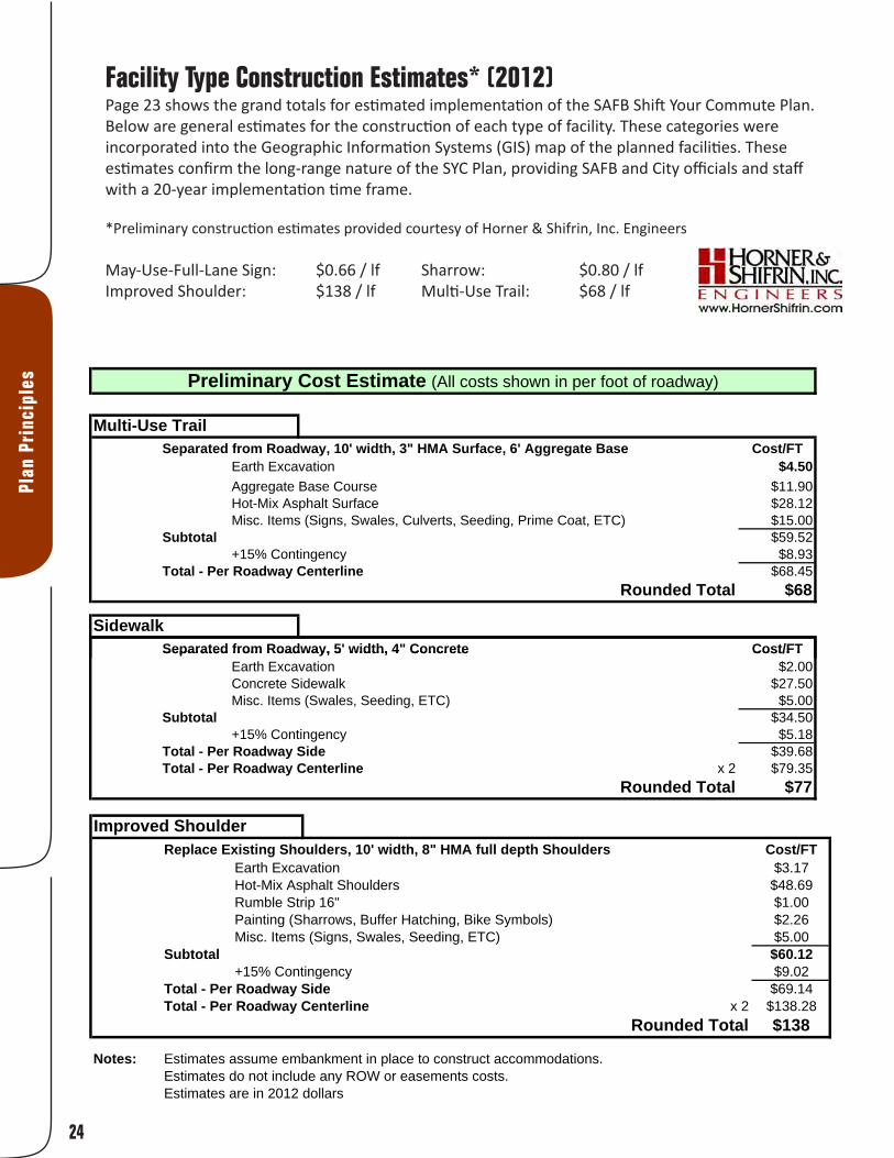
Facility Type Construction Estimates* (2012) Page 23 shows the grand totals for estimated implementation of the SAFB Shift Your Commute Plan. Below are general estimates for the construction of each type of facility. These categories were incorporated into the Geographic Information Systems (GIS) map of the planned facilities. These estimates confirm the long-range nature of the SYC Plan, providing SAFB and City officials and staff with a 20-year implementation time frame.
*Preliminary construction estimates provided courtesy of Horner & Shifrin, Inc. Engineers
May-Use-Full-Lane Sign: $0.66 / lf Sharrow: $0.80 / lf Improved Shoulder: $138 / lf Multi-Use Trail: $68 / lf
Multi-Use TrailSeparated from Roadway, 10' width, 3" HMA Surface, 6' Aggregate Base Cost/FT
Earth Excavation $4.50Aggregate Base Course $11.90Hot-Mix Asphalt Surface $28.12Misc. Items (Signs, Swales, Culverts, Seeding, Prime Coat, ETC) $15.00
Subtotal $59.52+15% Contingency $8.93
Total - Per Roadway Centerline $68.45Rounded Total $68
Pedestrian Path Separated from Roadway, 6' width, 3" HMA Surface, 6' Aggregate Base Cost/FT
Earth Excavation $2.70Aggregate Base Course $7.14Hot-Mix Asphalt Surface $16.87Misc. Items (Signs, Swales, Culverts, Seeding, Prime Coat, ETC) $15.00
Subtotal $41.71+15% Contingency $6.26
Total - Per Roadway Side $47.97Total - Per Roadway Centerline x 2 $95.93
Rounded Total $96
SidewalkSeparated from Roadway, 5' width, 4" Concrete Cost/FT
Preliminary Cost Estimate (All costs shown in per foot of roadway)
Separated from Roadway, 5 width, 4 Concrete Cost/FTEarth Excavation $2.00Concrete Sidewalk $27.50Misc. Items (Swales, Seeding, ETC) $5.00
Subtotal $34.50+15% Contingency $5.18
Total - Per Roadway Side $39.68Total - Per Roadway Centerline x 2 $79.35
Rounded Total $77
Improved ShoulderReplace Existing Shoulders, 10' width, 8" HMA full depth Shoulders Cost/FT
Earth Excavation $3.17Hot-Mix Asphalt Shoulders $48.69Rumble Strip 16" $1.00Painting (Sharrows, Buffer Hatching, Bike Symbols) $2.26Misc. Items (Signs, Swales, Seeding, ETC) $5.00
Subtotal $60.12+15% Contingency $9.02
Total - Per Roadway Side $69.14Total - Per Roadway Centerline x 2 $138.28
Rounded Total $138
Notes: Estimates assume embankment in place to construct accommodations.Estimates do not include any ROW or easements costs.Estimates are in 2012 dollars
Plan
Pri
ncip
les
Improved ShoulderReplace Existing Shoulders, 10' width, 8" HMA full depth Shoulders Cost/FT
Earth Excavation $3.17Hot-Mix Asphalt Shoulders $48.69Rumble Strip 16" $1.00Painting (Sharrows, Buffer Hatching, Bike Symbols) $2.26Misc. Items (Signs, Swales, Seeding, ETC) $5.00
Subtotal $60.12+15% Contingency $9.02
Total - Per Roadway Side $69.14Total - Per Roadway Centerline x 2 $138.28
Rounded Total $138
Notes: Estimates assume embankment in place to construct accommodations.Estimates do not include any ROW or easements costs.Estimates are in 2012 dollars
Multi-Use TrailSeparated from Roadway, 10' width, 3" HMA Surface, 6' Aggregate Base Cost/FT
Earth Excavation $4.50Aggregate Base Course $11.90Hot-Mix Asphalt Surface $28.12Misc. Items (Signs, Swales, Culverts, Seeding, Prime Coat, ETC) $15.00
Subtotal $59.52+15% Contingency $8.93
Total - Per Roadway Centerline $68.45Rounded Total $68
Pedestrian Path Separated from Roadway, 6' width, 3" HMA Surface, 6' Aggregate Base Cost/FT
Earth Excavation $2.70Aggregate Base Course $7.14Hot-Mix Asphalt Surface $16.87Misc. Items (Signs, Swales, Culverts, Seeding, Prime Coat, ETC) $15.00
Subtotal $41.71+15% Contingency $6.26
Total - Per Roadway Side $47.97Total - Per Roadway Centerline x 2 $95.93
Rounded Total $96
SidewalkSeparated from Roadway, 5' width, 4" Concrete Cost/FT
Preliminary Cost Estimate (All costs shown in per foot of roadway)
Separated from Roadway, 5 width, 4 Concrete Cost/FTEarth Excavation $2.00Concrete Sidewalk $27.50Misc. Items (Swales, Seeding, ETC) $5.00
Subtotal $34.50+15% Contingency $5.18
Total - Per Roadway Side $39.68Total - Per Roadway Centerline x 2 $79.35
Rounded Total $77
25
Plan Principles
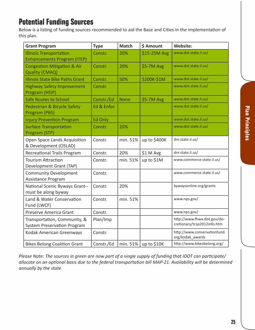
Potential Funding SourcesBelow is a listing of funding sources recommended to aid the Base and Cities in the implementation of this plan.
Grant Program Type Match $ Amount Website:Illinois Transportation Enhancements Program (ITEP)
Constr. 20% $15-25M Avg www.dot.state.il.us/
Congestion Mitigation & Air Quality (CMAQ)
Constr. 20% $5-7M Avg www.dot.state.il.us/
Illinois State Bike Paths Grant Constr. 50% $200K-$1M www.dot.state.il.us/
Highway Safety Improvement Program (HSIP)
Constr. www.dot.state.il.us/
Safe Routes to School Constr./Ed None $5-7M Avg www.dot.state.il.us/
Pedestrian & Bicycle Safety Program (PBS)
Ed & Enfor. www.dot.state.il.us/
Injury Prevention Program Ed Only www.dot.state.il.us/
Surface Transportation Program (STP)
Constr. 20% www.dot.state.il.us/
Open Space Lands Acquisition & Development (OSLAD)
Constr. min. 51% up to $400K dnr.state.il.us/
Recreational Trails Program Constr. 20% $1 M Avg dnr.state.il.us/
Tourism Attraction Development Grant (TAP)
Constr. min. 51% up to $1M www.commerce.state.il.us/
Community Development Assistance Program
Constr. www.commerce.state.il.us/
National Scenic Byways Grant--must be along byway
Constr. 20% bywaysonline.org/grants
Land & Water Conservation Fund (LWCF)
Constr. min. 51% www.nps.gov/
Preserve America Grant Constr. www.nps.gov/
Transportation, Community, & System Preservation Program
Plan/Imp http://www.fhwa.dot.gov/dis-cretionary/tcsp2012info.htm
Kodak American Greenways Constr. http://www.conservationfund.org/kodak_awards
Bikes Belong Coalition Grant Constr./Ed min. 51% up to $10K http://www.bikesbelong.org/
Please Note: The sources in green are now part of a single supply of funding that IDOT can participate/allocate on an optional basis due to the federal transportation bill MAP-21. Availability will be determined annually by the state.

26
Plan
Pri
ncip
les
Pedal Past the Pumps and TravelGreen!The TravelGreen program promotes commuter cycling and increases awareness of cycling safety in the St. Louis region. Trailnet works with local businesses, communities, and universities to address the built environment, policies, and social networks in order to promote bicycle commuting among individuals. The TravelGreen program identifies and engages a strong cycling contingent—those who are ready to change old behaviors and shift gears toward a healthier commute.
Why Shift Your Commute?Join Trailnet’s ongoing effort to encourage individuals to bicycle commute. Sign up as an individual to log the car-free miles you commute and in turn, learn how many carbon emissions you saved and calories you burned. Can’t do your whole commute by bike or walk? Combine the MetroBus or MetroLink with your commute (both equipped with bike racks) and expand the distance you can go car-free. There are so many reasons to shift your commute...What’s your reason?
• The average person loses 13 lbs their first year of commuting by bike.• Just three hours of bicycling per week can reduce your risk of heart disease and stroke by 50%.• The U.S. could save 462 million gallons of gasoline a year by increasing cycling from 1% to 1.5%
of all trips.• Each U.S. rush-hour auto commuter spends an average of 50 hours a year stuck in traffic.• In 2003, cars stalled in traffic wasted 5 billion gallons of fuel.• In 1964, 50% of kids rode to school and the obesity rate was 12%... In 2004, 3% rode to school
and the obesity rate was 45%.• 50% of the working population commutes five miles or less to work.
(Statistics retrieved from Trek Bicycle Corporation located at 1world2wheels.org)
2010 Results:
Riders: 10,372 Workplaces: 723 Teams: 1,677 Miles biked: 1,082,886
We’ve found a way to get to work that helps us save money, get some exercise and have more fun. Now’s the perfect time to join us!
WE KNOW A BETTER WAY
Meet other St. Louis bike commuters and sign-up to win prizes at
SHIFTYOURCOMMUTE.COM


Implementation

30
Impl
emen
tati
on
PrioritizationThere are 40 recommended facilities in the Scott AFB Shift Your Commute Plan. A combination of sources was utilized to create a “prioritization matrix” including on-line and paper survey responses, comments provided at the second open house, and estimated cost. The completed matrix was then analyzed for construction efficiency, and below is a summary of the results. This is the “order” recommended for implementation at the project area scale. Each jurisdiction and/or municipality should prioritize their facilities in whichever order makes the most sense for their own needs.
The table is also further categorized into “phases”. There are 16 phases based on project expense and geographic efficiency for construction (again, project area scale). Through inter-jurisdiction cooperation, the region can achieve the 20-year implementation time line. The phases are shown on four maps on the following pages.
Phase Street Name/Label Recommended Facility Feet Miles Est. Cost Juris.
1Route 161 Trail 10,226 2 $695,339 StateScott Drive (Belleville Gate) Trail 3,846 0.7 $261,539 County
2
Seibert Road Trail 5,719 1.1 $388,863 ShilohSeibert Road Shared Lane 9,063 1.7 $13,232 ShilohSeibert-158 Intersection Shared Lane 325 0.1 TBD StateScott Drive (Shiloh-Scott Gate) Shared Lane 6,437 1.2 $9,398 ShilohScott Drive (Shiloh-Scott Gate) Trail 6,462 1.2 $439,437 Shiloh
3 Route 161 Boardwalk Trail 5,851 1.1 $2,632,859 State4 Hwy 158/Air Mobility Improved Shoulder 9,922 1.9 $1,369,266 State
5Cross Street Improved Shoulder 10,844 2.1 $1,496,464 CountyLincoln Shared Lane 6,834 1.3 $9,978 O’Fallon
6 Frank Scott Pkwy Impr. Shoulder & Sidewalks 23,367 4.4 $5,023,916 County
7
Lincoln Landing Connector Shared Lane 3,915 0.7 $5,716 SAFBLincoln Landing Connector Trail 1,814 0.3 $123,328 SAFBScott-Troy Road Improved Shoulder 5,141 1.0 $709,455 CountyHwy 50 Improved Shoulder 2,745 0.5 $378,806 State
8Reider Road Trail 20,569 3.9 $1,398,724 CountyUS 50 Bypass Trail 7,640 1.4 $519,549 PrivateBelleville Street Shared Lane 7,299 1.4 $10,657 Lebanon
9Lebanon Improved Shoulder 12,767 2.4 $1,761,877 CountyNorth Main Improved Shoulder 10,837 2.1 $1,495,495 Shiloh
10Wherry Improved Shoulder 9,816 1.9 $88,340 MultipleMaple Improved Shoulder 6,104 1.2 $842,358 ShilohOld 158 Improved Shoulder 6,234 1.2 $860,358 Shiloh
11 Old Collinsville Road Trail 14,631 2.8 $994,924 Multiple
12County Road (177 to Fuesser) Shared Lane & Sidewalks 8,214 1.6 $644,484 MascoutahCounty Road (Fuesser to 161) Impr. Shoulder & Sidewalks 7,101 1.3 $1,526,729 Mascoutah
13Old Vincennes Trail Trail 10,683 2.0 $726,477 O’FallonState Street Shared Lane 3,087 0.6 $4,507 O’Fallon
14 Future Frank Scott Ext. Improved Shoulder 10,405 2.0 $1,435,881 County

31
Implem
entation
15MetroLink Shared Lane 2,075 0.4 $3,030 MultipleScott Drive-Metro Connector Trail 3,716 0.7 $252,694 Multiple
16
Chesapeake Jct Ln Shared Lane 2,509 0.5 $3,663 MultipleVenita Dr Shared Lane 3,695 0.7 $5,395 O’FallonRegency Park Shared Lane 3,933 0.7 $5,742 O’FallonRegency Park Shared Lane 4,722 0.9 $6,894 O’FallonPierce Blvd Shared Lane 7,114 1.3 $10,386 O’FallonFuture Roadway Trail 8,040 1.5 $546,694 Multiple
One key alignment has been left out of this table, but still warrants mention: the extension of the Metro BikeLink trail from SWIC to the Shiloh-Scott Station. As a planned facility under design with a scheduled completion date of 2018, its inclusion in the table is unnecessary. However, there was significant support for this trail from both the on-line survey and the public meetings and it would have ranked very high in the table if it had been included.
Facility Justification: Phases 1-4As this plan moves toward implementation, it may become necessary to understand why which facilities were chosen for which location - if the conditions under which selection took place change, then it may become necessary to reevaluate the facility selection.
Phase Street Name/Label Recommended Facility1 Route 161 Trail
Providing a facility along Route 161 for bicyclists and pedestrians was a popular request from citizens and base employees. The speed and volume of traffic deters potential commuters/users from this direct route to the base. While in some locations the narrow shoulder could be improved/widened, users repeatedly requested a separated facility. A trail will also facilitate usage by the residential areas along 161, such as Liberty Landing. From Scott Drive (Belleville Gate) to just east of Charles Lane (Mascoutah Gate), the combination of ROW and DOD property available along the north side of Route 161 will accommodate a 10-12 ft multi-use trail very well. The flat terrain is also an advantage.
1 Scott Drive (Belleville Gate) TrailAs opposed to forcing users of the Route 161 trail to merge with traffic at Scott Drive to enter the base through the Belleville Gate, property/ROW is available along the east side of Scott Drive to accommodate an extension of the trail. Bicycle and pedestrian traffic will be able to bypass waiting cars to enter the base, which may encourage increased commuting. If bicycle and pedestrian traffic increases enough, a separate lane at the gate could be provided to facilitate entry and eliminate conflict with automobile traffic.
See the inset on the map on page 32 for the facility justifications for Phase 2 (Seibert Road & Scott Drive)3 Route 161 Boardwalk Trail
For the same reasons outlined above in Phase 1, a separated facility is required for Route 161. However, from County Road to just east of Charles Drive, Route 161 passes over the expansive Silver Creek floodplain. A boardwalk not only resolves potential conflict with constantly-changing water levels, but it creates a high-quality experience for users to interact with one of our state’s most unique natural resources - the Bottomland Hardwood Forest Floodplain.
4 Hwy 158/Air Mobility Improved ShoulderThe shoulder along Air Mobility Drive is currently being used by numerous bicycle commuters. However, in order to facilitate consistent, even increased, use, this facility needs to be improved in three ways: the pavement needs to be promoted from oil/chip or gravel to the same as the driving surface of the primary highway lanes, the shoulders should be marked for visibility (painted green), and they should be maintained to remain free of debris. This not only accommodates users entering the base through the Shiloh-Scott gate, but through the MetroLink gate as well.

32
Impl
emen
tati
on

33
Implem
entation

34
Impl
emen
tati
on

35
Implem
entation
36
Impl
emen
tati
on
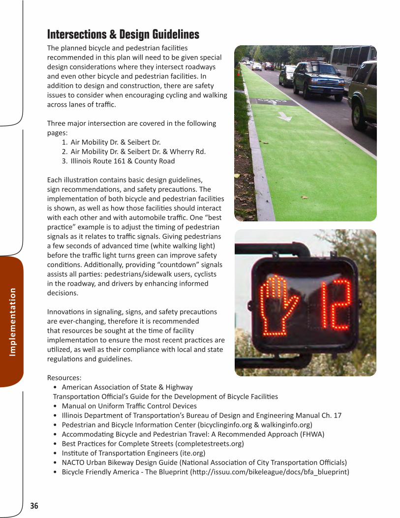
Intersections & Design GuidelinesThe planned bicycle and pedestrian facilities recommended in this plan will need to be given special design considerations where they intersect roadways and even other bicycle and pedestrian facilities. In addition to design and construction, there are safety issues to consider when encouraging cycling and walking across lanes of traffic.
Three major intersection are covered in the following pages:
1. Air Mobility Dr. & Seibert Dr. 2. Air Mobility Dr. & Seibert Dr. & Wherry Rd. 3. Illinois Route 161 & County Road
Each illustration contains basic design guidelines, sign recommendations, and safety precautions. The implementation of both bicycle and pedestrian facilities is shown, as well as how those facilities should interact with each other and with automobile traffic. One “best practice” example is to adjust the timing of pedestrian signals as it relates to traffic signals. Giving pedestrians a few seconds of advanced time (white walking light) before the traffic light turns green can improve safety conditions. Additionally, providing “countdown” signals assists all parties: pedestrians/sidewalk users, cyclists in the roadway, and drivers by enhancing informed decisions.
Innovations in signaling, signs, and safety precautions are ever-changing, therefore it is recommended that resources be sought at the time of facility implementation to ensure the most recent practices are utilized, as well as their compliance with local and state regulations and guidelines.
Resources:• American Association of State & Highway Transportation Official’s Guide for the Development of Bicycle Facilities• Manual on Uniform Traffic Control Devices• Illinois Department of Transportation’s Bureau of Design and Engineering Manual Ch. 17• Pedestrian and Bicycle Information Center (bicyclinginfo.org & walkinginfo.org)• Accommodating Bicycle and Pedestrian Travel: A Recommended Approach (FHWA)• Best Practices for Complete Streets (completestreets.org)• Institute of Transportation Engineers (ite.org)• NACTO Urban Bikeway Design Guide (National Association of City Transportation Officials)• Bicycle Friendly America - The Blueprint (http://issuu.com/bikeleague/docs/bfa_blueprint)

Sharrow lane markings with MAY USE FULL LANE signs let motorists and cyclists know the law and assist cyclists with lane
positioning.
At intersections with traffic signals push buttons with indicator light,
crossing countdown signal, and audible signal to indicate the WALK interval for those with vision impairments are recommended at each pedestrian crossing. A leading pedestrian interval (LPI) will allow pedestrians several seconds to start in the crosswalk where there is a concurrent signal, making them more visible to motorist. Wide, paved shoulders with
appropriate pavement markings provide a safe place for cyclist to ride alongside traffic.
Air M
obili
ty D
r. (IL
Rt 1
58)
Seibert Rd
Recommended Facilities
Air Mobility Dr: Improved shoulders; paved, painted, with markings and bike route signs. To make a left turn on to Seibert shared lanes the cyclist will have to merge into the turn lane and que with cars at the light.
Seibert Rd:Shared lane pavement markings and MAY USE FULL LANE signs on all of Seibert through Scott Main Gate.
Paved, bi-directional trail along the south side of the street and an at-grade, properly signaled, intersection crossing Air Mobility. East of the crossing, the trail fork continuing to the Main Gate and also south parallel to Air Mobility Dr.
N
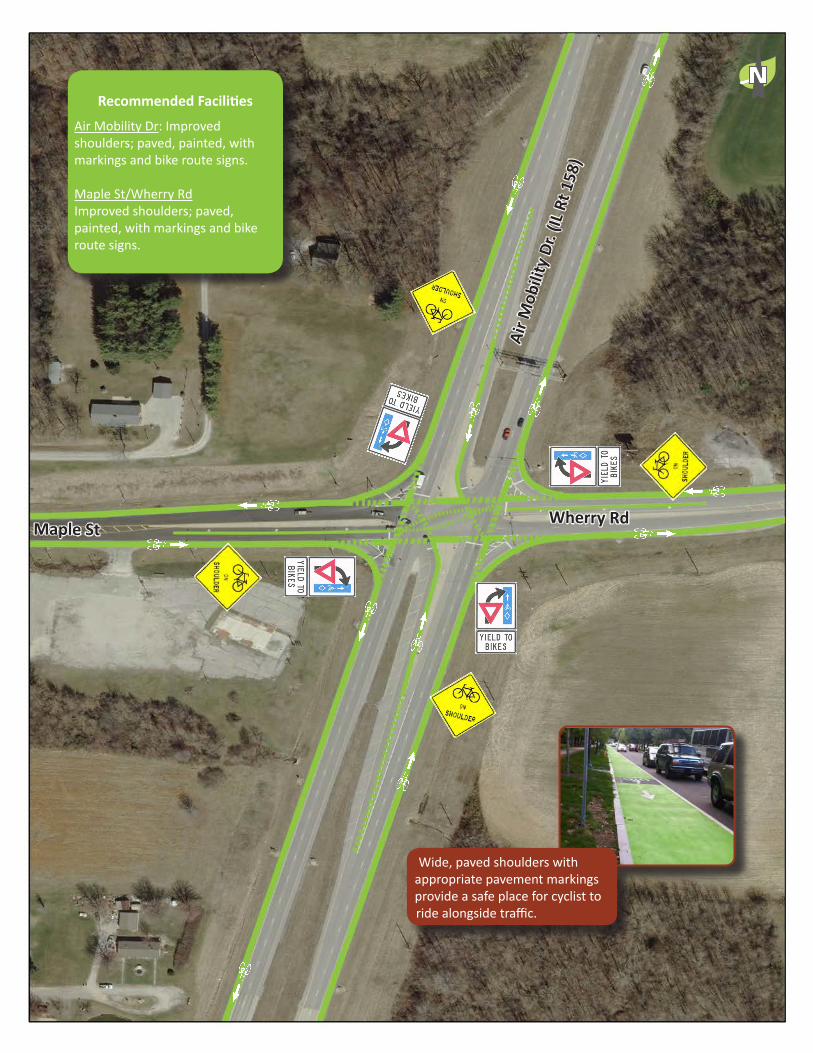
Wide, paved shoulders with appropriate pavement markings provide a safe place for cyclist to ride alongside traffic.
Wherry RdMaple StAi
r Mob
ility
Dr.
(IL R
t 158
)
Recommended Facilities
Air Mobility Dr: Improved shoulders; paved, painted, with markings and bike route signs.
Maple St/Wherry RdImproved shoulders; paved, painted, with markings and bike route signs.
N

Wide, paved shoulders with appropriate pavement markings provide a safe place for cyclist to ride alongside traffic.
Recommended Facilities
County Road: Sidewalks on each side of the road way for pedestrian travel. Paved and painted improved shoulders, with markings and bike route signs.
Illinois Route 161Multi-use trail, seperated from road edge.
N
At busy intersections where there is no light and cross traffic does not stop, a single highly visible crosswalk is recommended. Push buttons at crosswalks allow pedestrians to activate a flashing yield signs overhead making them more visible to cars while crossing the street.
Extend curbs to slow traffic and create a shorter, more visable crossing for pedestrians.
Multi-Use path, 10 - 12 feet wide, paved and striped for bi-directional use. Seprated from the road on the north side. Bridges or docks will be needed for crossing Silver Creek corridor.
40
EducationEducation is a major component of successful integration of pedestrians and cyclists into daily traffic. There are a number of resources that can aid the City in creating a welcome environment for walkers and bikers:
• League of American Bicyclists (bikeleague.org)• League of Illinois Bicyclists (bikelib.org)• CyclingSavvy (cyclingsavvy.org)• Trailnet (trailnet.org)• National Center for Bicycling & Walking (bikewalk.org)• National Center for Safe Routes to Schools (saferoutesinfo.org)• International Walk to School Day (iwalktoschool.org)• National Bike to School Day (walkbiketoschool.org)• Yield to Life Driver’s Education Program (yieldtolife.org)• Commute By Bike: Commuting 101 (http://www. commutebybike.com/cats/commuting-101/)
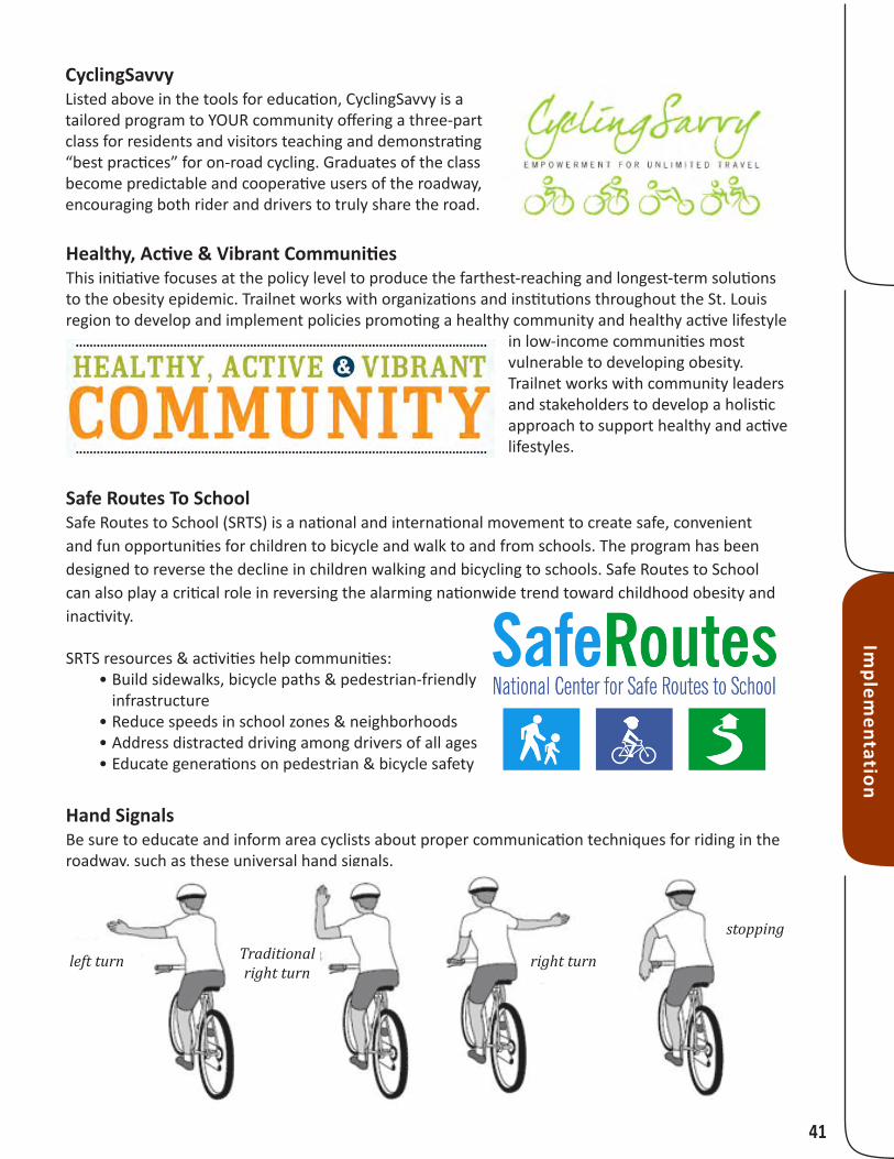
Utilize education campaigns like the League of American Bicyclists’ National Bike Month
Bike SmartTrailnet offers a 3- or 5-hour hands-on class on how to ride as visibly, predictably, and safely as possible. The classes also include some basic bike maintenance such as changing a flat tire, adjusting dérailleurs, and adjusting brakes. The classes are led by a League of American Bicyclists certified cycling instructor (www.bikeleague.org) and cover what to check on your bike before a ride, riding safely in traffic, common avoidance maneuvers, and much more.
Impl
emen
tati
on
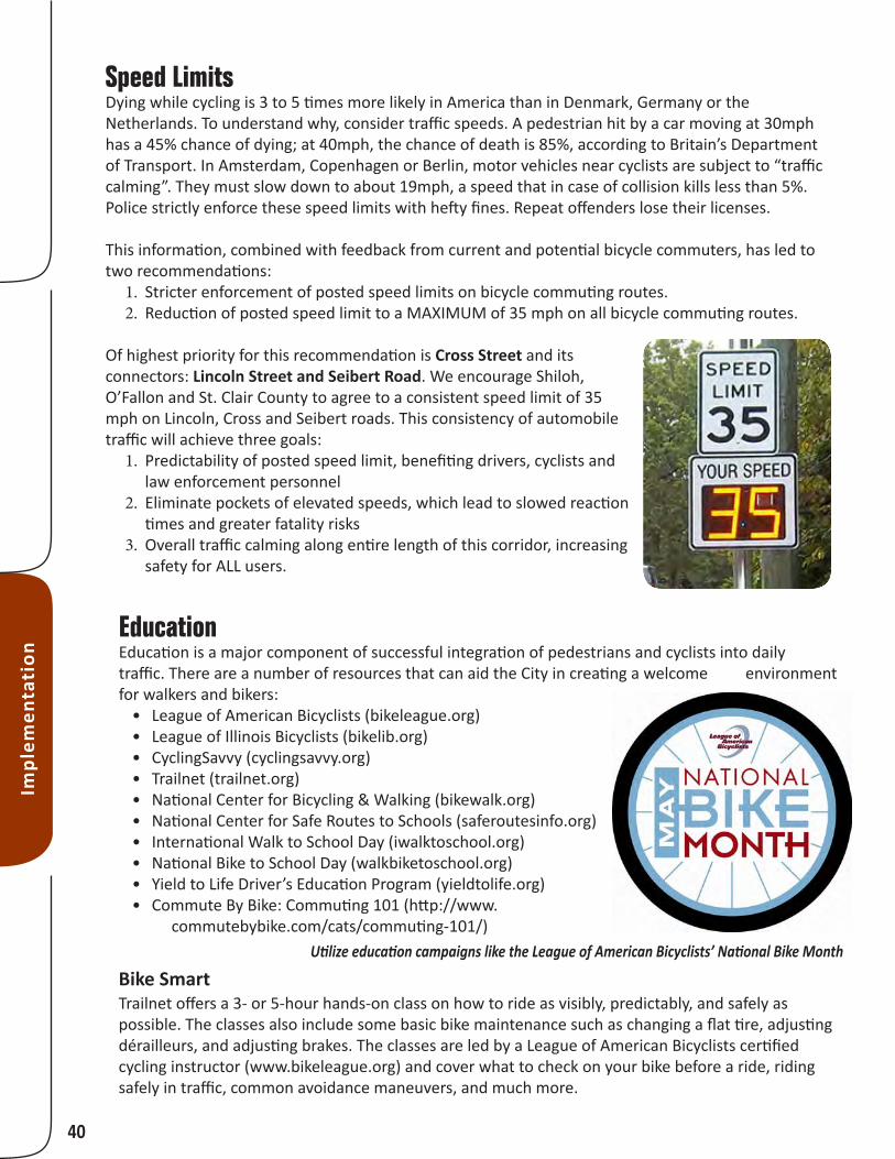
Speed LimitsDying while cycling is 3 to 5 times more likely in America than in Denmark, Germany or the Netherlands. To understand why, consider traffic speeds. A pedestrian hit by a car moving at 30mph has a 45% chance of dying; at 40mph, the chance of death is 85%, according to Britain’s Department of Transport. In Amsterdam, Copenhagen or Berlin, motor vehicles near cyclists are subject to “traffic calming”. They must slow down to about 19mph, a speed that in case of collision kills less than 5%. Police strictly enforce these speed limits with hefty fines. Repeat offenders lose their licenses.
This information, combined with feedback from current and potential bicycle commuters, has led to two recommendations:
1. Stricter enforcement of posted speed limits on bicycle commuting routes.2. Reduction of posted speed limit to a MAXIMUM of 35 mph on all bicycle commuting routes.
Of highest priority for this recommendation is Cross Street and its connectors: Lincoln Street and Seibert Road. We encourage Shiloh, O’Fallon and St. Clair County to agree to a consistent speed limit of 35 mph on Lincoln, Cross and Seibert roads. This consistency of automobile traffic will achieve three goals:
1. Predictability of posted speed limit, benefiting drivers, cyclists and law enforcement personnel
2. Eliminate pockets of elevated speeds, which lead to slowed reaction times and greater fatality risks
3. Overall traffic calming along entire length of this corridor, increasing safety for ALL users.
41
Implem
entation
CyclingSavvyListed above in the tools for education, CyclingSavvy is a tailored program to YOUR community offering a three-part class for residents and visitors teaching and demonstrating “best practices” for on-road cycling. Graduates of the class become predictable and cooperative users of the roadway, encouraging both rider and drivers to truly share the road.
Healthy, Active & Vibrant CommunitiesThis initiative focuses at the policy level to produce the farthest-reaching and longest-term solutions to the obesity epidemic. Trailnet works with organizations and institutions throughout the St. Louis region to develop and implement policies promoting a healthy community and healthy active lifestyle
in low-income communities most vulnerable to developing obesity. Trailnet works with community leaders and stakeholders to develop a holistic approach to support healthy and active lifestyles.
Hand SignalsBe sure to educate and inform area cyclists about proper communication techniques for riding in the roadway, such as these universal hand signals.
Safe Routes To SchoolSafe Routes to School (SRTS) is a national and international movement to create safe, convenient and fun opportunities for children to bicycle and walk to and from schools. The program has been designed to reverse the decline in children walking and bicycling to schools. Safe Routes to School can also play a critical role in reversing the alarming nationwide trend toward childhood obesity and inactivity.
SRTS resources & activities help communities:• Build sidewalks, bicycle paths & pedestrian-friendly
infrastructure• Reduce speeds in school zones & neighborhoods• Address distracted driving among drivers of all ages• Educate generations on pedestrian & bicycle safety
Traditionalright turn
left turn right turn
stopping

42
Impl
emen
tati
on
EnforcementKnowledge and enforcement of bicycling laws is crucial for increasing cycling in communities. Law enforcement officials should be knowledgeable on bike safety and bike relevant laws and issue tickets to both cyclists and motorist not adhering to these laws. Having a patrol officer on a bicycle can be a way to set a good example of how cyclist should behave and might even make timid riders feel more comfortable knowing there is an officer on a bike as well.
Enforcement can also be used as an opportunity to educate. When a rider or motorist is issued a warning or a ticket, the officer should educate them on what they did wrong and share a bicycle law card or pamphlet with them explaining the rules of the road. Enforcing the laws will raise awareness, increase knowledge, and reduce crashes.
It is recommended communities consider holding a training session for their law enforcement officials. Some examples of training session other communities have used including League of Illinois Bicyclists’ “Safe Roads for Bicycling” training resources, PedNet’s POST-Certified Law Enforcement Training in Bicycle Issues, or they may create their own.
EncouragementThere are several items Scott Air Force Base could address to make it more desirable and easier for people to cycle to work on a regular bases. When talking with current commuters, these where the areas where improvements could be made to encourage cycling to Scott.
BICYCLISTS MOTORISTS
Educate motorists & bicyclists: Use the traffic violation warning pamphlet*Enforce the law: Issue citations for serious infractions
NO
YES
LEFT
3 ft
STOP Run stop signs, red lights
Ride against traffic
Illegally block trafficon busy road
No headlight orreflector at night
Failure to signal
Fail to scan for bicyclistsat crosswalks, fail tostop at line
Fail to pass bicyclist withat least 3 feet of space
Open car door into traffic
Turn left in front ofbicyclist with right of way
Pass bicyclist, then turnright into path of bicyclist
KNOW THE DANGER ZONES
*Pamphlets, “Share the Road” video and other safety materials are available from the League of Illinois Bicyclists at
www.bikelib.org/enforcement or by calling 847-291-1213Certain illustrations copyrighted 2007 by Wordspace Press (www.wordspacepress.com) and used here under license.
Police Bike Poster2.qxd 9/17/07 4:29 PM Page 1

43
Implem
entation
Bicycle Commuting Facilities on SAFB
li Lockers
li Showers
li Bike Parking
Scott AFB Fence Line
0 ¼ ½Miles
Getting on and off base: There are currently several techniques for doing this including; Sitting bikes on end and taking it through the pedestrian turn-style at MetroLink, in the car lane, or even skipping up to the front of the car lane and cutting in line. A dedicated lane for cyclists may encourage more to ride. This could be achieved through a variety of ways, one being a lane at the Main Gate, or other gates, limited to only carpool and bike admittance.
Cleaning up: Most commuters would like to clean up before continuing to work. Having showers readily available and lockers available for extended use. This would allow people to store some clothes for the week and clean up a little so working the rest of the day will be more comfortable.
Where to park: Bike parking is something Scott AFB has addressed very well in the past few years by completing the bike study and installing more bike racks throughout the base.
This map was developed through current bike commuters and people interested in bike commuting identified the locations of showers, lockers and bike parking facilities they are currently utilizing. Filling in gaps and providing these facilities closer to work buildings could encourage more users. Simply publicizing shower and locker locations so cyclist are more aware of what facilities they can or can not use would be helpful.

44
Impl
emen
tati
on
Route Signs & WayfindingBranding the facilities will produce multiple benefits: recognition, awareness, wayfinding, and community identity are just a few. When signing the routes, personalized signs should be used both on the roadside signs and on the pavement markings. Pocket-sized maps should be produced showing the recommended routes along with popular destinations or stops along the way to increase ridership. Both Madison County Transit and Bike St. Louis utilize these techniques to great success. Pictured here are examples of their wayfinding strategies and their map products.

45
Why should my community apply? Bicycle Friendly Communities have a high quality of life that translates into sustainable development, tourism, business growth and even increased property values. Encouraging bicycling is an effective way to increase physi-cal activity, improve air quality, reduce traffic congestion and foreign oil dependence, and tackle climate change and obesity. Benefits for the 360 communities that have applied for BFC status include:
Inspiration to do more• Technical assistance and training• Grants and funding notification• Recognition and promotion •
What are the requirements?The Bicycle Friendly Community application is an audit of a community’s efforts to create a bicycling culture. The audit reviews engineering, education, encouragement, enforcement, and evaluation and planning efforts for bicycling. Who reviews applications?Each application is reviewed by national ex-perts and local cyclists to determine whether the community should get a BFC designation. Feedback from the reviewers creates a valuable roadmap for action.
What is a Bicycle Friendly Community?A Bicycle Friendly Community welcomes cyclists by
providing well-engineered bicycle facilities, creating
new places to ride, educating motorists and cyclists on
the rules of the road, and encouraging people to bike
for transportation and recreation.
How will my community be recognized?The League will recognize deserving com-munities at one of four award levels: bronze, silver, gold, or platinum. The League will issue a press release, and will present an award and two highway-quality road signs at a local ceremony or celebration. What if my community isn’t designated bicycle friendly?Get involved with your local bike club or advocacy organization, join your community’s bicycle advisory committee and work with your city staff. Use the BFC application and feedback as a task list to improve the state of cycling in your community — then apply again! Every applicant gets in-depth feedback, so applying is well worth your time.
Where can I get an application?The BFC application is available at www.bicyclefriendlycommunity.org. The site also provides resources and technical assistance to help you with the on-line application. Contact the League of American Bicyclists at 202-822-1333 or [email protected] to receive more information.
for more info, visit www.bicyclefriendlycommunity.org or call 202-822-1333
1
2
What are the next steps?
3
Access the application and resources at www.bicyclefriendlycommunity.org.
Create a partnership between local government and advocates to com-plete the application.
Submit a completed application at www.bicyclefriendlycommunity.org.
photo courtesy of Trek
Marketing & RecognitionOnce implementation is underway, recognition should be sought from regional and national organizations to raise awareness of Scott AFB’s and the surrounding communities’ efforts to become more bicycle and pedestrian friendly. Specifically, the League of American Bicyclists has a recognition program with levels: platinum, gold, silver and bronze, that once awarded will offer an excellent opportunity for recognition and a structure for future efforts.
Implem
entation

AppendixAll related documents are included on the attached CD along with electronic copies of this plan, map images and plan map data. Please reference this material for all future planning and
implementation efforts.
Our Mission is to provide leadership and solutions to sustain and enrich the diverse environmental resources of Southwestern Illinois
Our Vision is communities with healthy and sustainable air, land and water resources for current and future generations
406 East Main StreetMascoutah, Illinois 62258
www.HeartLandsConservancy.org
I n v e s t i n g I n T h e N a t u r e O f S o u t h w e s t e r n I l l i n o i sC O N S E R V A N C Y
Related Documents