ROMANIAN SECTION OF THE BRUA NATURAL GAS TRANSMISSION CORRIDOR PROJECT Non-Technical Summary JUNE 2017

Welcome message from author
This document is posted to help you gain knowledge. Please leave a comment to let me know what you think about it! Share it to your friends and learn new things together.
Transcript

ROMANIAN SECTION OF THE BRUA NATURAL GAS TRANSMISSION CORRIDOR PROJECT
Non-Technical Summary
JUNE 2017

1
CONTACTS
ROB EVANS
Project Director
Partner dd 44 (0) 20 7812 2000
m 44 (0) 79 6137 5617
2
Table of Contents 1 Introduction ............................................................................................................................... 3
1.1 Project Overview ................................................................................................................ 3
1.2 Need for the Project ........................................................................................................... 4
1.3 The Supplementary ESIA ................................................................................................... 4
1.3.1 Document Authors ...................................................................................................... 5
1.4 Report Limitations .............................................................................................................. 5
2 Project Description ................................................................................................................... 6
2.1 Overview ............................................................................................................................ 6
2.2 Construction Approach and Methodology ........................................................................... 7
3 Management of Environmental and Social Impacts and Mitigation ........................................... 9
3.1 Overview ............................................................................................................................ 9
3.2 Impact Identification and Mitigation Process ..................................................................... 11
3.3 Geology............................................................................................................................ 11
3.4 Soils ................................................................................................................................. 11
3.5 Surface Water Resources ................................................................................................ 11
3.6 Groundwater .................................................................................................................... 14
3.7 Ecology and Nature Conservation .................................................................................... 14
3.8 Air Quality and Greenhouse Gas Emissions ..................................................................... 16
3.9 Noise and Vibration .......................................................................................................... 17
3.10 Archaeology and Cultural Heritage ............................................................................... 17
3.11 Traffic and Transport .................................................................................................... 19
3.12 Social Benefits and Impacts .......................................................................................... 19
3.13 Land Acquisition & Livelihoods ..................................................................................... 19
3.14 Stakeholder engagement .............................................................................................. 20
Tables Table 3.1 Project CESMPs .................................................................................................................................. 9
Table 3.2 Crossings by horizontal drilling beneath watercourses ..................................................................... 12
Table 3.3 Key Ecological Sensitivities .............................................................................................................. 14
Table 3.4 Potential impacts to ecology and nature conservation ...................................................................... 15
Figures Figure 1.1 Proposed BRUA Project Route (Romania, Phases 1 and 2) ............................................................. 3
Figure 1.2 Continental Gas Supply ...................................................................................................................... 4
Figure 2.1 Arrangement of 21 m working strip .................................................................................................... 7
Figure 2.2 Illustration of a typical working strip. ................................................................................................... 8
Figure 3.1 CESMP Linkages ............................................................................................................................. 10
Figure 3.1 Photograph of Ulpia Traiana Sarmisegetuza ................................................................................... 18
3
Introduction 1
This document provides a Non-Technical Summary (NTS) of the Supplementary Environmental and Social Impact Assessment (Supplementary ESIA) undertaken for the Romanian section of the Bulgarian-Romanian- Hungarian-Austrian (BRUA) Natural Gas Transmission Corridor Project. It summarises the potential environmental and social impacts (positive and negative) associated with the construction and operation of the pipeline and outlines the proposed Project approach to avoid, minimise, manage or compensate negative impacts where practical. The document should be read alongside the NTS for the regulatory Environmental Impact Assessment (EIA) undertaken in 2016 as part the Romania permitting process and which this document supplements.
Project Overview 1.1
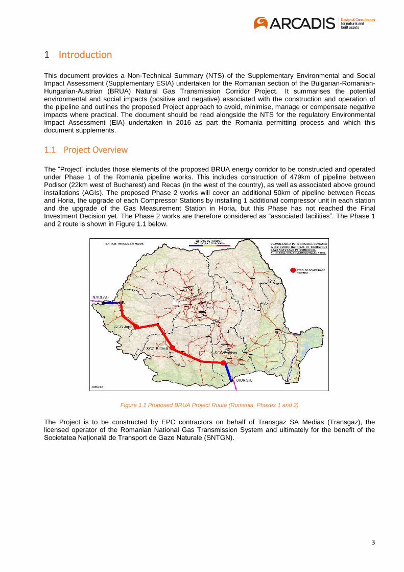
The “Project” includes those elements of the proposed BRUA energy corridor to be constructed and operated under Phase 1 of the Romania pipeline works. This includes construction of 479km of pipeline between Podisor (22km west of Bucharest) and Recas (in the west of the country), as well as associated above ground installations (AGIs). The proposed Phase 2 works will cover an additional 50km of pipeline between Recas and Horia, the upgrade of each Compressor Stations by installing 1 additional compressor unit in each station and the upgrade of the Gas Measurement Station in Horia, but this Phase has not reached the Final Investment Decision yet. The Phase 2 works are therefore considered as “associated facilities”. The Phase 1 and 2 route is shown in Figure 1.1 below.
Figure 1.1 Proposed BRUA Project Route (Romania, Phases 1 and 2)
The Project is to be constructed by EPC contractors on behalf of Transgaz SA Medias (Transgaz), the licensed operator of the Romanian National Gas Transmission System and ultimately for the benefit of the Societatea Națională de Transport de Gaze Naturale (SNTGN).

4
Need for the Project 1.2
The Project is of strategic importance at both a European and a national level. Regionally, BRUA forms part of a “Southern Gas Corridor”, intended to bring greater energy security across Europe by diversifying the regional gas supply from its current limited number of major pipelines. At a national level, the Project will also enable Romania to import additional gas when required as well as providing a mechanism by which gas from the proposed Black Sea fields can be exported when developed. The pipeline has therefore been designed to be able to provide reverse flow to both Bulgaria and Hungary as required by market demands. Phase 1 will enable a reverse flow of some 1.5 billion m3/year at the Bulgarian border and 1.75 billion m3/year at the Hungarian border by the end of 2019, whilst Phase 2 will increase this capacity to some 4.4 billion m3/year at the Hungarian border by late 2020. The project will therefore support both national and regional economic development objectives whilst also supporting the replacement of existing (carbon intensive) power sources with natural gas. As such it is considered a major priority for Transgaz, and is included within the organisation’s 10-year network development plan (TYNDP). Figure 1.2 below illustrates the proposed routing of the pipeline (and the proposed Black Sea pipeline) in a regional context.
Figure 1.2 Continental Gas Supply
The Supplementary ESIA 1.3
The Project received its national construction permit in February 2017 which addressed the requirements of relevant Romanian and EU legislation, (including the undertaking of Appropriate Assessments for areas where the pipeline will cross through “Natura 2000” sites of designated conservation value). The permits included a regulatory Environmental Agreement based upon potential impacts and mitigation identified in the 2016 Regulatory EIA. The Project is now, however, being considered for financing by the European Bank of Reconstruction and Development (EBRD), and a such is required to demonstrate that it will be constructed and operated in line with the EBRD’s Environmental and Social Policy (2014) and associated Environmental and Social Performance Requirements (PRs). This document therefore addresses several key issues where the requirements of the PRs differ from those of the national legislation and is intended to support the Project in meetings the Banks requirements for an appropriate Environmental and Social Impact Assessment (ESIA) to be disclosed for a minimum 120 days to the public for comment.
5
1.3.1 Document Authors
The Supplementary ESIA (and this associated NTS) has been developed by Arcadis, an international consulting firm, together with Green Partners (an international social consultancy based in Romania). It builds on the work undertaken by SC Unitatea de Suport pentru Integrare SRL (USI - a Romanian environmental consultancy) and as well as by Transgaz themselves.
Report Limitations 1.4
As the Project EPC contract had not been awarded at the time that the assessment was completed, some specific elements of detailed design and construction remain to be determined at that stage. As a result, these issues, as well as impacts associated with non-normal operating conditions and supply chain management (amongst others) will be dealt with through the Project Construction and Operational Environmental and Social Management plans (CESMPs and OESMPs), rather than this document, as detailed further in the Project Scoping Report.
6
Project Description 2
Overview 2.1
The 32” buried pipeline will cross some 79 administrative units (municipalities) and 10 counties, and will include new Gas Compressor Stations (GCS) at Podisor, Bibesti and Jupa. The route will mostly pass through arable land, orchards, meadows, forests, or unproductive land with over 70% of the route passing through agricultural areas and less than 10% in built up areas. Around two thirds of the route will also follow existing infrastructure, with the remainder following minor diversions primarily for environmental or social reasons. Existing land categories have been determined through soil surveys and the regulatory classification quality classes prepared by the relevant county Office of Soil Survey and Agrochemistry. This, together with details of land ownership, will be used to support the easement compensation process. Overall however, the Project is expected to result in the permanent loss of less than 20 hectares of land, required for the gas compressor stations, valve stations and access roads.
The pipeline itself has been designed to meet the requirements of Romanian ANRE Order no. 118/2013: “Technical regulations for design and execution of gas transmission pipelines" with a burial depth of 1.00m below ground level, increased to at least 1.50m at crossing points. It has also been designed in line with the Code for Seismic Design (P 100 - 1/2013) and will use a “SCADA“ electronic surveillance to monitor structural integrity. The Project Environmental Agreement defines a specific working strip width of 21m in agricultural land, pastures, hayfields, unproductive lands; 14m in vineyards, orchards, forests and “difficult areas”; and 10m in areas with high cross slopes terraces will be constructed.
A number of route options were reviewed to identify a route that was both as short as practical and followed as far as possible existing infrastructure. The crossing of the Carpathians Mountains (the most sensitive and technically challenging area of the route) was especially extensively assessed and the option with the least significant environmental footprint selected. Care was also taken to minimise construction works within Natura 2000 sites (see “ecology and nature conservation”). The route does however cross a number of linear features including communication routes (utilities, roads and railways), rivers and other water bodies, existing pipelines and communications networks, some of which will be crossed by horizontal directional drilling (see “water resources”).
Three gas compressor stations (GCS) will be built at Podișor, Bibesti and Jupa to provide additional pressure along the pipeline. Each GCS will contain eight main buildings and will have a total installed power of 10 MW (increasing to 15MW in Phase 2). Detailed technical specifications for the compressor groups are yet to be finalised although emissions limit levels have been set in line with regulatory requirements (see “Noise” and “Air Emissions”). Some 22 block valve stations (BVSs) will be constructed to support pipeline monitoring, each with less than 350m
2 in size. These will be remotely operated and fenced.
Construction of the Phase 1 Project is planned to run from Q3 2017 to Q4 2019, with commissioning planned for December 2019. The operational phase is expected to be at least 40 years without any requirement for major overhaul or maintenance works for BRUA.

7
Construction Approach and Methodology 2.2
The proposed approach to pipelaying will follow the processes outlined in the "Technical rules for design and execution of gas pipelines", as approved by A.N.R.E. Order no. 118/2013 and will be a sequential process with a number of distinct operations. Works will be broken down into manageable lengths called “spreads”, and each spread will typically consist of the five work teams listed above operating along a rolling work front approximately 25km in length. A number of spreads will operate simultaneously across the route. Whilst final techniques will be determined by the EPC contractor, and specialised techniques will be used to cross sensitive features such as roads and watercourses, the following represents a typical sequential approach to construction:
· Team 1: Route surveying, preparation of the working strip, top soil stripping and grading. · Team 2: Pipe stringing, bending and welding. · Team 3: Trench digging. · Team 4: Pipe laying, installation and backfilling. · Team 5: Site clean-up and restoration.
Overall construction is expected to take up to 31 months (including detailed engineering and pipelaying) and estimated pipeline laying rates will ranges from 72m per day in mountainous terrain to up to 600m per day in flat terrain. A detailed working schedule will be developed in line with the tendering procedure. Figure 2.1 shows the typical arrangements in a 21m working strip.
Figure 2.1 Arrangement of 21 m working strip
At the outset of construction, the pipeline route will be pegged out together with the working strip on both
sides. Biodiversity and archaeological specialists will undertake pre-clearance surveys of the route to identify,
map and mark any areas where local sensitivities require specific clearance / construction techniques to be
used. If required the biodiversity specialists will also relocate any sensitive species identified in line with the
commitments in the Environmental Agreement, Biodiversity CEMP and Biodiversity Action Plan. The Right of
Way (RoW) will then be cleared (involving removal of both structures and vegetation) and the topsoil stripped
and stockpiled in a continuous ridge along the edge of the strip. This will typically be no higher than 2m to
prevent degradation of the soil. The working strip will then be levelled and the trench excavated, usually
mechanically although this may be manually in areas with specific sensitivities or where there is no access for
machinery. Subsoil will be stockpiled in a second ridge as shown in Figure 2.2 below.

8
Figure 2.2 Illustration of a typical working strip.
Once excavated the pipeline will be laid in the trench (which will generally be around 2m deep) and the trench backfilled. A maximum period for leaving trenches open has been set at 30 days for the project. On completion of backfill, the top soil will be replaced and the original contours of the land restored as closely as possible. Land drainage infrastructure, access roads, other networks and facilities, and vegetation will be reinstated to their former state as far as possible. The technical restoration and habitat restoration will be monitored as outlined in the Reinstatement and Biodiversity Management Plans. Where required the pipeline will also be hydrotested to ensure integrity (see water resources).
Five main construction camps (works organisations) are planned along the proposed pipeline route at Caldararu (km 61); Guseoeni (km 150); Turciniesti (km 261); Bucova (Bautar) (km 368); and Pterovaselo (Recas) (km 470). All camps will meet EBRD/IFC Workers Accommodation Guidelines requirements and will occupy an area of about 10,000m
2, typically on agricultural land outside urban areas and near major
roadways to help with supply of materials, equipment, pipes and the flow of workers. Although the Contractor may add additional camps if required.10 pipe storages areas will also be located along the proposed BRUA route to ensure a continuous flow of materials required for site organisation, typically located between two construction camps.
The pipeline will generally be accessed via existing roads tracks, with a number requiring upgrade to allow passage of construction vehicles. The Project will also require a number of new roads to be constructed, for example to facilitate access to the HDD sites. Where such works are required the new roads will follow mainly existing tracks. All upgraded and new roads are expected to remain open for public use during the construction period.

9
Management of Environmental and Social Impacts and Mitigation 3
Overview 3.1
The Project is committed to minimising and managing potential environmental and social impacts in line with the requirements of the EBRD Performance Requirements and the internationally recognised mitigation hierarchy of avoid, minimise, mitigate and only finally compensate for residual impacts. To ensure this it is putting a project specific environmental and social management system in place, aligned with the Transgaz Integrated Management System. This includes a series of framework construction and operational environmental and social management plans (CESMPs and OESMP respectively) that outline the approaches to be adopted to meet national requirements, TG commitments, GIP and EBRD PRs. The Project Contractors are also required to develop their own detailed CESMPs to deliver the obligations outlined in the Transgaz documents. Transgaz will then monitor the Contractor performance against these commitments to ensure that appropriate environmental and social protection is in place at all times.
Table 3.1 Project CESMPs
Plan Name Document Reference
Contractors Management Plan 1062-TGN-MNG-PLN-PJM-22-00002
Reinstatement Management Plan 1062-TGN-MNG-PLN-PJM-22-00014
Pollution Prevention Management Plan 1062-TGN-MNG-PLN-PJM-22-00003
Waste Management Plan 1062-TGN-MNG-PLN-PJM-22-00005
Hazardous Materials Management Plan 1062-TGN-MNG-PLN-PJM-22-00004
Roads and Traffic Management Plan 1062-TGN-MNG-PLN-PJM-22-00012
Water Management Plan 1062-TGN-MNG-PLN-PJM-22-00007
Cultural Heritage Management and Monitoring Plan (includes Chance Finds Procedure)
1062-TGN-MNG-PLN-PJM-22-00013
Biodiversity Management Plan 1062-TGN-MNG-PLN-PJM-22-00006
River/Water Crossing Plan 1062-TGN-MNG-PLN-PJM-22-00008
Stakeholder Engagement Plan 1062-TGN-MNG-PLN-PJM-22-00016
HSSMS 1062-TGN-MNG-PLN-PJM-22-00009
Community Health, Safety and Security
Management Plan
1062-TGN-MNG-PLN-PJM-22-00011
Labour and Working Conditions1 1062-TGN-MNG-PLN-PJM-22-00010
1 Includes Worker code of conduct-included on Workers Accommodation and Occupational Health,Safety and Security Management
Plans

10
Plan Name Document Reference
Emergency Response Plan 1062-TGN-MNG-PLN-PJM-22-00015
The interaction between these plans is shown in Figure 3.1 below.
Figure 3.1 CESMP Linkages
11
Impact Identification and Mitigation Process 3.2
In order to ensure that potential project impacts have been appropriately identified and effective mitigation put in place to address them, and process of impact assessment has been undertaken involving identification of potentially sensitive receptors (human and environmental), analysis of potential effects on those receptors, developed of mitigation to reduce the severity of any potentially adverse effects identified and summary of residual effects. This has included a combination of field studies, literature reviews and stakeholder meetings and is summarised in more detail in the main Supplementary Environmental Assessment and Rapid Social Assessment documents. The reason for this is as detailed earlier in Section 1.3.
Geology 3.3
Geohazards such as seismic events, landslides and rockfalls can affect the project construction and operation, although the pipeline route has been designed to meet the national requirements regarding seismic risk and has also been routed to avoid known areas of geological hazards. The Project also has the potential to impact upon sites of geological interest and passes for some 50km through the “Dinosaur GeoPark”, a site that is globally recognised for the fossils of “dwarf dinosaurs” found here which date back to the Cretaceous Period, some 72-65 million years ago. A specific method statement will be put in place for this site. Given that the trench will only be excavated to a to a depth of about 2m no significant impacts to or from geology are expected across most of the route, and special techniques will be used in mountainous areas to minimise risks of rockfall and landslide.
Soils 3.4
Soil is considered a particularly sensitive resource in Romania and the preservation of soil quality is critical for the BRUA project. Nationally, soils are classified into 12 classes and 32 types, differentiated by structure and productive capacity, and soil samples have been taken along the route to help ensure that post construction restoration results in no long-term impacts. Along the majority of the route the soils are reported to be in relatively good condition with a stable soil structure and reduced risks of erosion, although a number of sections have been identified where the erosion risk is higher and specific mitigation measures are proposed to minimise impacts in such areas. For the rest of the route good international practice will be employed to manage soils including separate storage of fertile top soil, techniques to reduce subsoil compaction and general erosion protection. In addition to these the following will be applied:
· Identification and mapping of areas with soils of high sensitivity; · Where appropriate composting of stripped plant material to augment existing organic material. · Storage of topsoil for less than 30 days in stacks no higher than 2m. Specific ventilation of soil stacks if
longer is needed in particular areas. · Reuse of the entire volume of soil overburden during restoration. · Ecological restoration where appropriate once soil restoration is complete.
These are detailed further in the Reinstatement CESMP. In terms of soil contamination, soil pollution during the works will be avoided through the implementation of the pollution prevention management plan and the pipeline has also been routed to avoid known areas of significant soil contamination. Soil sampling has also sought to identify any areas of localised contamination, which will be addressed through the detailed design process. Overall therefore, and given that the soil restoration will be closely monitored by both Transgaz and the Regulatory Authorities, with the proposed mitigation in place, the project is only expected to result in minor long-term impacts to soils, primarily as a result of the permanent land take of the above-ground installations.
Surface Water Resources 3.5
The pipeline will run through 12 administrative hydrological catchment areas and will cross 7 main rivers (the Bega, Chizdia, Cotmeana Jiu, Mureș, Great River and Timiș), several twice, and some 246 minor watercourses, irrigation channels and drainage ditches. The water courses are of varying water quality but all are at least of “moderate’ water quality, and in the mountains are of ‘very good’ quality. Twelve of the major

12
rivers crossings will be achieved using horizontal directional drilling (HDD) under agreement with the National Waters Administration. These were selected based on the width and/or depth of the river channels, the presence of existing flood defence infrastructure or dams, as well as other technical considerations. The total length of the crossings that are selected so that the entry and exit points for drilling will be a considerable way away from the left and right river banks. Drilling depths will be determined by the curvature that is required to pass beneath the river at these distances.
Table 3.2 Crossings by horizontal drilling beneath watercourses
River Chainage
(km)
Length of
crossing
(total m)
Description
Cotmeana 84
416 The channel here is not very wide, around 5m and both banks are
heavily vegetated. The area immediately surrounding the river at
this point is a mixture of agricultural land and woodland.
Olt 120 475 The crossing is immediately downstream of a hydroelectric dam and
the acumularea Strejesti Reservoir. The channel here is
approximately 200m wide and the banks are re-inforced with
concrete.
Torrent (of
the River
Gilort)
225 455 The crossing is downstream of the town of Carbunesti. The river at
this point is approximately 60m wide and is surrounded by
agricultural land and woodland
Jiu 261 424 The river at this point is approximately 234m wide and is braided,
splitting into two main channels that flow around a central island and
other smaller islands within the channel. The river banks are
reinforced and sloping.
Râul Mare 339 457 This is around 250m downstream of a small hydroelectric dam,
where the river is raised upstream and culverted under a road proir
to passing through the turbines. The river banks are reinforced
concrete.
Timiș (at
Jupa)
406 867 The channel here is approximately 20m wide and the banks are
vegetated and sloping. The river at this point is surrounded by
agricultural land but there is an access road that runs down to the
left bank.
Spaia 429 323 This is around 1km upstream of its confluence with the River Timis.
The river banks have been reinforced with concrete. A minor road
runs adjacent to the left bank and there is main road bridge just
upstream of the pipeline crossing point. The surrounding area is
agricultrual land.
Timiș (at
Lugojel)
438 384 This is immediatlely upstream of the town of Lugojel. The channel is
approximately 70m wide at this point. An access road leads down to
the left bank but both banks are vegetated.
Glavița 456 326 This is a few km upstream of its confluence with the River Bega.
There is a clear river corridor that is vegetated, which is bordered by
worked agricultural land. The channel at this point is only a few m
wide.
Chizdia 459 325 This is just upstream of the confluence with the R. Bega. The river
here flows through agricultural land and is surrounded by fields.
There is dense vegetation on both the left and right banks.
Bega 461 375 The river at this point flows through agricultural land and is
surrounded by fields. Both banks are vegetated. The channel here
13
is approximately 15m wide.
Mureș 517 411 This is around 8 km east of SPA ROSPA0069. The River at this
point is approximately 140m wide with existing access roads on
each bank. The surrounding area is agricultural land.
In addition to the HDD crossings outlined above, the pipeline will cross some 115 rivers and 319 small channels using either wet or dry open-cut excavations. Of these the largest rivers will be crossed using coffer dams to divert the flow and create dry working conditions. Less than 15% of the remaining wet crossings will involve over 5 days of working within the river bed. Water crossings are planned to take place during periods of low flows, but even when coffer dams are in place some downstream flow will be maintained. Excavated material from the watercourse bed will be used to backfill the trench once the pipeline has been laid in pre-cast concrete blocks. Watercourse crossing works have the potential for temporary impacts on water quality (although many channels will have no flow at the time of the works) but care will be taken to avoid impacts to either downstream water users or areas of known ecological sensitivity through the use of appropriate silt fences, straw bales or other mitigation as outlined in the Water Crossings CESMP. Given the different sensitivities of the watercourses, the on-site Biodiversity Specialists (see ecology and nature conservation) will determine the ecological sensitivity of a watercourse and hence the need for any additional mitigation prior to works commencing. Where appropriate monitoring will also be undertaken both immediately upstream of the works (to establish natural baseline levels) and at intervals up to 2km downstream of the crossing point to determine the extent of any impacts and the need for any intervention (e.g. temporary cessation of works).
The project also has the potential to affect water resources in a limited number of other ways including:
· Management of effluent and run-off: On-site facilities will be provided for the collection, treatment and discharge of wastewater/rain water. At construction sites these will be tankered offsite for treatment whilst at the GCSs permanent facilities will be created for separation and treatment of effluent streams prior to discharge to surface waters in line with the requirements of the national water quality standards (NTPA001). Water for these GCS (including firewater) will be obtained from the municipal water network (Hurezani) or local boreholes (Jupa, Podisor).
· Hydrotesting: The pipeline will be pressure tested with water (hydro-testing) to confirm its structural integrity in built-up areas as required under the Romanian national pipeline design standards (Class 3). This water will be obtained in tankers from permitted suppliers and will not be abstracted directly from surface water courses or groundwater. The wastewater effluent following hydro-testing will also be removed from site in tankers to a waste water treatment plant operated by the relevant utility company that supplied the water and will not be discharged directly into local surface watercourses.
· Dust Suppression. Water will be used to damp down roads during construction for dust suppression purposes. It is estimated that some 30 litres of water will be needed for every 10m of road (some 8,300m3 of water in total). This is also intended to be supplied by municipal water companies and delivered by tanker to the locations where it is needed. Should Contractors need to abstract water from surface water courses for the purpose of dust suppression, the appropriate permits will be obtained from the relevant authorities prior to any abstraction taking place.
Overall, given the above approaches, and the application of the mitigation included in both the Water Crossings CESMP and the Pollution Prevention CESMP, no long-term significant residual impacts are expected to surface Water Resources from the project.

14
Groundwater 3.6
In general, given the shallow nature of the proposed pipeline, groundwater resources used for potable drinking are not expected to be adversely affected by the proposed pipeline construction or operation, with the exception of boreholes to be sunk to access such resources as described above. Whilst shallow groundwater could result in requirements for dewatering, hydrogeological surveys undertaken along the proposed route (involving drilling boreholes to 6m depth at 500m intervals) have also indicated that there will be no need for significant de-watering activities during pipeline construction. Should a contractor encounter shallow groundwater during excavations, any de-watering effluent will be disposed of in line with the Water Management Plan, either by discharge under permit and/or the landowners consent to the ground or, into a surface water course, or taken away by tanker for treatment. Overall the project is therefore not expected to have any adverse impacts on groundwaters.
Ecology and Nature Conservation 3.7
Almost half of Romania is formed of natural or semi-natural ecosystems, including one of the largest remaining areas of undisturbed forest within Europe. Within these forests there is a wide range of forest fauna, for example Romania supports 50% of Europe’s bears and 30% of its wolves. In addition to forests, Romania supports rare and notable grasslands including alpine habitats, caves and rivers. There are also a large number of protected sites within Romania, although the protection applied to these sites is variable and it has been reported that many could benefit from more proactive management. Table 3.3 identifies the key ecological sensitivities along the proposed pipeline route.
Table 3.3 Key Ecological Sensitivities
Receptor Presence within the Area of Influence
Designated sites
A total of 15 Natura 2000 sites, one Geopark and one National Park are potentially affected by
the BRUA construction and operation. Of the 15 Natura 2000 sites identified, seven are crossed
by BRUA, four are not crossed by BRUA but have the potential to be directly impacted by the
BRUA routing and four are considered to have the potential to be impacted by the routing
indirectly.
Biomes and Habitats
A total of 12 biomes (from 8 broad biomes) were identified within the BRUA route corridor and
were assessed for their value, where possible. In addition to these biomes, habitats listed within
the designations of the Natura 2000 sites were also assessed. In all, some 14 broad habitats
were identified from the EIA and AA with the potential to be impacted by the proposed works. Of
these, specific mitigation was deemed necessary for six different habitats / habitat groupings, with
impacts to all other habitats considered fully mitigated through standard Good Industry Practice
mitigation
Species
Approximately 400 species were identified as notable potential receptors which could be
impacted by the proposed works. Of these, six species were considered to be of very high or
international value, 22 were considered to be of high or national value and 136 were considered
to be of moderate or regional value. Of these species, specific mitigation was deemed necessary
for approximately 30 species or species groups - impacts to others are considered to be fully
mitigated through standard Good Industry Practice mitigation.
Much of the habitat within the pipeline route corridor is heavily modified although some areas of natural and semi-natural habitat are present, including natural forest, naturally regenerated areas of forest and scrub, riparian corridors as well as small areas of semi-natural grassland and exposed rocky outcrops. The route corridor also includes 121 natural water courses, with 12 major rivers and 265 manmade channels.

15
For much of the route, and almost all of the lowland areas, the 300m wide route corridor runs primarily through
agricultural lands, with almost 70% of the land within the corridor cropped – indeed this habitat represents
72% of the land that will be temporarily impacted during construction.
Areas of woodland (13%) and grassland (11%) are the next most abundant habitats within the route corridor
with 9% and 12% of direct impacts occurring within these areas. In the long term, woodland habitats will be
the only permanent habitat alterations once restoration is complete (due to the requirements for Rights of Way
Maintenance. Other remaining habitats only account for 7% of the land affected by the route corridor, and
include areas of introduced scrub (including invasive species), water courses and small areas of human
settlements.
Permits from Romanian government were received following an EIA and an Appropriate Assessment (in line
with the Habitats Directive 1992) produced by USI (2016) that demonstrated no significant effects on the
designated sites or protected species. However further mitigation and compensation for loss of habitats and
disturbance to species was required to meet EBRDs Performance 6 Standard requirements.
Within the SEIA habitats and species were evaluated with regards to their global, national and local
conservation status and potential construction impacts of the project were mitigated by a combination of Good
International Practice general mitigation and specific mitigation for more sensitive receptors (summarised in
Table 3.4).
Table 3.4 Potential impacts to ecology and nature conservation
Issue Potential Impacts
Habitat loss,
degradation and
simplification
Pre-works surveys will confirm the baseline conditions to which the site must be required
post construction.
The majority of habitats will be restored immediately following construction resulting in
effects of short term degradation and disturbance only. The only mid-term habitat loss will
be in those areas of woodland that will be fragmented, due to the time it will take until the
woodland matures, it is understood that there will be no vegetation clearance due to Rights
of Way maintenance.
Fragmentation; The fragmentation of habitats is largely temporary and unlikely to result in a significant
effect on populations. However, in areas of woodland where fragmentation is permanent it
will be small scale (2m wide) once the replacement trees have matured. Additional
mitigation will reduce the significance of fragmentation for species (such as proposed
dormouse bridges) and is not likely to be significant in the long term.
Changes in
water conditions
(hydrological
impacts);
The proposed pipeline route and above ground infrastructure locations have been selected
to avoid any major hydrological issues which were informed by hydrogeological surveys
involving drilling boreholes to 6m depth at 500m intervals along the pipeline route to
measure shallow groundwater levels.
Pre-clearance site surveys will map sensitive vegetation and apply additional mitigation
where required.
Habitat pollution;
including
deposition and
runoff;
GIP mitigation will ensure that there are no significant impacts from run off. Where there
are particularly sensitive watercourses bespoke mitigation and monitoring by the
biodiversity specialists will ensure no significant effects.
With regards to dust, for this site it is anticipated that PM10 in the absence of mitigation
would result in effects from dust being minor with and effect up to 50m from the
source. With the proposed mitigation, however this distance would be reduced to a likely
25m and is unlikely to be significant.
In sensitive areas deposit gauges will monitor the dust. The dust collected can also be
analysed to determine its composition to confirm our assessment with regards to dust.
Direct mortality: Locating construction camps away from sensitive areas and enforcing a hunting ban of
construction workers will help ensure that there are no significant adverse effects;
Speed limits on vehicles and restrictions to existing and/or dedicated haul routes will

16
prevent direct mortality and disturbance from vehicles;
In addition to a hunting ban, pre-clearance site surveys and the movement of animals out of
the working corridor by the biodiversity specialists, combined with timing of works in
sensitive areas will prevent direct mortality. There may be some low level unavoidable
direct mortality but this would not be significant in the short or long term.
Disturbance to
species
including visual
and noise
disturbance
Construction noise and visual disturbance will result in short term, localised effects,
although many animals will become habituated to the noise.
The nosiest activities associated with the development are those from static plant used to
excavate trenches, clear vegetation, lay pipes, hammering and compacting concrete. The
nose levels at the site are likely to be in excess of 80dB decreasing to 50 to 64dB at
300m. This is likely to result in abandonment of the areas closest to the construction sites
although there may be a degree of habituation.
This will result in a short term adverse effect, however the most sensitive habitats and
species, works will be confined to the least sensitive timeframes. Monitoring by Biodiversity
Specialists will also ensure that should valuable species be breeding in an area, works do
not take place during these sensitive times i.e. for birds that the young have successfully
fledged or that fish have successfully spawned.
Spread of non-
native or
invasive
species.
Pre-clearance surveys combined with the demarcation and treatment of non-native species
will prevent their spread. Monitoring post-construction will ensure that newly restored areas
are not inundated with non-native species from adjacent areas.
Specific mitigation proposed to avoid or minimise the impacts to acceptable levels were accompanied by compensation measures via an offsetting strategy included within the SEIA. The offsetting strategy included the restoration and creation of habitats both on and off-site along with Additional Conservation Actions (ACAs) which included contributions to conservation management funds to improve the condition of designated and valuable habitats. These mitigations and compensations will evolve throughout the project and following pre-construction surveys and monitoring. Further detail is provided in the Biodiversity CESMP and these surveys will further inform the longer-term mitigation and the monitoring required as stated in the Framework Biodiversity Action Plan (BAP) which will evolve into the Biodiversity Action Plan which will have appropriate targets for the key receptors for flora and fauna as required. After the implementation of the mitigation and compensation, the majority of residual effects are expected to be low and many will be significant in the short-term only. No net loss will be achieved for Priority Biodiversity Features and net gain will be achieved for Critical Habitats. This will be achieved in the mid-term for the majority of habitats and species, the longer term for forests. Compliance will be demonstrated as described in the CESMP and BAP thus fulfilling EBRD PR6 requirements.
Air Quality and Greenhouse Gas Emissions 3.8
The majority of the pipeline route is located within rural areas, and existing air quality is expected to be good (to be confirmed during project construction). The route does however pass through residential and agricultural areas that may be susceptible to air emissions, especially dust, with the areas of greatest focus being the GCS and temporary facility sites which, whilst located outside of the urban areas, will produce emissions for the longest time. The three main potential emissions to be managed by the project are considered to be dust (from stockpiled soils and general construction activities); exhaust gases emissions (from construction plant) and operational emissions (primarily from the GCS).
With regard to dust, levels will be visually monitored at all times and dust suppression mitigation will be employed to reduce levels near particularly sensitive receptors or in particularly dry conditions. These will include, damping down or covering of stockpiles and wheel washing of vehicles as well as other measures included in the Pollution Prevention CESMP. Exhaust emissions will also be managed as outlined in the Pollution Prevention CESMP and, given the rate of progression of the works, emissions are only expected to be of any significance near the temporary facilities, where they will last for a longer period (also the case with dust). At these facilities emissions will be monitored and additional approaches to emissions reduction

17
implemented if required. A grievance mechanism will also be put in place for the duration of the project so that should project stakeholders have any specific concerns they can be addressed in a timely manner.
During operation, the project (and particularly the CGSs) will also generate a limited number of air emissions. The GCS design includes requirements to reduce impacts to air quality and given the limited capacity of the equipment no significant impacts are expected, although emissions will be monitored to confirm this. At the GCS and along the pipeline, fugitive emissions during operations will be managed through the implementation of effective leak detection equipment, and no significant releases are expected. With regards to greenhouse gas emissions, the Phase 1 project is expected to emit some 30,0000 tonnes CO2e annually, which whilst not a significant adverse impact is about the EBRD 20,000 t reporting threshold and will therefore reported annually and a GHG management plan put in place. Overall, following implementation of proposed mitigation, and an appropriate monitoring program with actions to ensure that emissions are reduced should any thresholds be exceeded, the project is not expected to have any significant residual impact on air quality as a result of either construction or operations.
Noise and Vibration 3.9
The construction and operation of the project will result in noise and vibration that could impact upon nearby
workers, communities, cultural heritage and ecological receptors. Such impacts will mostly be short term
effects associated with the proposed construction works although longer term noise impacts will be associated
with temporary facilities such as worksites as well as the pipeline operations, in particular the operation of the
gas compressor stations (GCS). Given that these project elements will be mostly located in rural (rather than
urban) environments, where existing noise levels will be relatively low (agricultural activity, low traffic flows
and natural/animal sounds) and localised disturbance may be exacerbated, the numbers of people affected
are expected to be low. Especially noisy works will occur where construction requires excavations in hard rock
areas (e.g. in the Carpathian Mountains); horizontal drilling (e.g. to pass under roads and larger rivers) or
during GCS construction (e.g. compaction of concrete foundations and floor slabs).
To mitigate for these and other noise and vibration impacts, the contractors will be required to develop a
Construction Noise and Vibration Management Plan (CNVMP) which will include specific limits to minimise
impacts and which will be monitored by Transgaz. A detailed complaints procedure will also be established
as part of the Project Grievance Mechanism should this be required. During normal operation, noise and
vibration effects will be limited to the operation of the gas compression stations (GCS), and to a lesser degree
the block valve stations (BVS) but these have been specifically designed with appropriate acoustic enclosures
to ensure that limits remain below the regulatory limits outlined in the Environmental Agreement and no
impacts are expected beyond the facility boundaries. Overall therefore, with the application of the proposed
noise and vibration limits and associated emissions controls proposed, the construction and operational
phases of the Project are not expected to result in any significant long-term adverse impacts.
Archaeology and Cultural Heritage 3.10
Romania has a broad cultural heritage, and some of the oldest homo sapiens fossils were found in Transylvania, whilst the Dacia and Roman Dacia periods are some of the most important times in Romania’s history. As a result, the archaeological interest of the area is substantial and, although the pipeline follows existing infrastructure for much of the way, the likelihood of additional finds is considered high. The regulatory EIA identified a limited number of sites across the pipeline route of archaeological value, and recent engagement with the 11-county level archaeological authorities has helped further identify areas of potential archaeological interest located near the proposed pipeline route. As a result, a range of further archaeological investigation will be carried out along the route using preventative archaeological research to ensure they aren’t impacted upon through construction. Three sites of known archaeological importance are located along the route, namely: St. Demetrius Church, at Gorj Schela, the Tibiscum site near Jupa and Ulpia Traiana Sarmizegetusa the former capital of Roman Dacia. Whilst the Church is a discrete entity and no further finds are expected nearby, the other sides cover large areas and the potential for chance finds is considered high.
The Tibiscum site in particular covers an area of 27 hectares near the village of Jupa and was one of the most important cities of the ancient province of Dacia from the 3rd century AD. The site includes a complex of ruins,

18
consisting of the old city Tibiscum, a camp and a military Vicus. The Tibiscum Archaeological Reservation was established in 1977 on the left side of Timisoara and archaeological finds from the Roman era are displayed in the museum. The pipeline will go directly under the site using horizontal directional drilling, starting 300m to the west of the site and resurfacing 400m west, and approach approved and permitted by the director of Tibiscum for these works.
Ulpia Traiana Sarmizegetusa was the capital of Roman Dacia and covers an area spanning 30 hectares; once having a population estimated between 20,000 and 25,000. The site’s significance and population peaked in 2nd and 3rd century before being destroyed by the Goths. It was heavily fortified and today exhibits the ruins of a roman forum, an amphitheatre and several temples. The site also has an extremely close affiliation with Tibiscum. The current site boundaries are located some 400m from the pipeline route.
Figure 3.2 Photograph of Ulpia Traiana Sarmisegetuza
Impacts to archaeology and cultural heritage will be mitigated by using on-site archaeological expertise to implement an “adaptive” approach to impact mitigation, the undertaking of additional archaeological surveys and the adoption and uptake of a robust chance find procedure. As part of this the Project will employ a number of qualified archaeologists to identify and manage cultural heritage risks and help implement the chance finds procedure, including provision of regular watching briefs and management of contractor compliance for archaeological issues as well as ad hoc advice on intangible issues including access to historic sites.
One of the biggest risks to archaeological artefacts and structures is from the unearthing of unknown finds during construction. To address this a chance finds procedure has been established by Transgaz in line with EBRD PR8 requirements. This outlines the protocol that must be followed in the event of discovering any archaeological material and will help protect potentially significant cultural heritage materials by ensuring that archaeologists are given sufficient time for extraction and analysis of any new material. All staff members working in the construction process will be trained on how to implement the chance finds procedure and who to contact in the event of a find. In the event of such a find the team on site will have a “stop work” authority over construction works in the vicinity of the archaeological find. A number of additional archaeological studies are proposed for the Project as outlined above. Further details of this are included in the Cultural Heritage Management Plan which also outlined approaches to be taken to monitoring of excavation activities to detect the presence of unknown archaeology in line with the chance find procedure and monitoring of existing known archaeology for impacts arising from vibration or pollution during the construction and operation of the pipeline. With these approaches in place no long-term adverse impacts to archaeology or cultural heritage are expected.

19
Traffic and Transport 3.11
The construction of the proposed pipeline will require considerable transportation of workers, materials and plant, and will also affect existing roads and other transport links where they are crossed. Whilst full details of the transportation implications are to be developed by the contractors prior to construction, the Project will develop a detailed Construction Traffic Management Plan (CTMP) to minimise as far as possible project impacts on the highway and other transportation networks. It is, however, inevitable that some residual impacts and the CTMP will seek to proactively reduce risks to road and rail users, especially regarding the interface between heavy and potentially slow-moving construction traffic and the existing general traffic, public vehicles and pedestrians / cyclists. Such impacts on the local transport network will however be restricted to the construction phase of the project, and should be relatively short-term. On the basis that appropriate mitigation measures are implemented through the CTMP and that monitoring shows these to be effective, the overall residual impacts will be expected to be of minor significance.
Social Benefits and Impacts 3.12The following positive social impacts are expected as a result of the Project:
The Project will help bring positive changes in the community demographics via reduction of the
migration out-flow due to the exposure to new job opportunities in the construction period.
The local settlement and housing structure may improve due to the option of using the compensations
granted for land take and project employment in housing investments. The community will also benefit
from the rehabilitation, widening and/or construction of roads for access to construction camps and
sites. Part of the compensations granted for land take may also be invested in agricultural equipment
and improvements to the agricultural land, increasing future levels of productivity and efficiency.
The Project will contribute to the local economy considering that the construction and operation
activity need supporting activities such as catering, accommodation facilities, maintenance, health and
safety equipment suppliers, etc. These services may be supplied by local or regional businesses. The
level of consumption due to the presence of non-locals and compensations granted will also
contribute to the local economy.
The project will create new job opportunities during both construction and operation phase. Direct
employment as workforce and associated engineering jobs (e.g. supervision) and indirect employment
as services provided to the workers like catering, transport, etc. will be generated. This can help
reduce the unemployment rate at community level and may increase the level of disposable income
available at the level of individuals and households.
The taxes paid by the Project will have a potential benefit for investments in the improvement of social
services and community wellbeing.
Land Acquisition & Livelihoods 3.13The project may also have some adverse impacts during the construction phase, related mainly to land
acquisition. The BRHA Project is expected to cause minor adverse impacts on the livelihood of affected
persons due to the temporary nature of the land occupation concerning the majority of the properties. Most of
the impacts will be related to:
Possible loss of structures/assets (permanent or temporary) located on the pipeline corridor (either
authorized or illegal) and/or perceived decrease of property value due to, in rare instances, to
proximity of the pipeline to the houses (for the houses located in the AoI) or due to the restrictions
imposed by the Project for land plots situated in the build-up area crossed by the pipeline
Temporary/permanent loss of livelihood, income, land use rights for owners, users and workers due to
land-take by the project
Loss of crops and other land based assets owned by tenants (e.g. vines, trees etc).

20
Deforestation, for the purpose of route clearance (loss of current and future wood mass).
In order to mitigate these impacts, Transgaz has developed a Land Acquisition Framework document (LAF)
that defines the impacted persons and the entitlements for each type of impact. The LAF has been developed
in line with Romanian legal framework, Transgaz internal procedures and EBRD PR 5 requirements. The
document is setting the eligibility criteria for the entitled persons and defines the main categories of
entitlements that Transgaz will be offering to the affected persons. The entitlements are mainly defined as
cash compensation.
One of the main challenges in offering compensation is related to proving the fact that most of the land that is
required for the project is not properly registered in the Cadarter. Thus, Transgaz has signed a protocol with
the National Cadaster Agency for including the 79 AUs on a priority list for registration of land for free. This will
enable more owners to be able to access the compensations.
If not required or individuals are not able to prove ownership / usership prior to construction the compensation
values will be registered in an escrow account and will be made available for a period of 5 years. During this
period, all entitled persons can access them.
Based on the building permit procedure and in-the-field identification of land owners as well as the socio-
economic survey carried out by Transgaz in December 2016, the following categories of Economically
Displaced Persons (EDPs) have been defined for:
a. Long term land use or permanent acquisition of land for above-ground-installations (AGIs)
Agricultural land owners of land for AGIs
Agricultural Tenants and Users (either persons or businesses) of land for AGIs
b. Temporary occupation of land for pipeline construction works and Long-term easement
Agricultural land owners outside built-up area
Owners (formal or informal) of residential / non-residential structures (temporary or permanent)
situated in the working strip
Owners of orchards, vineyards and other
Owners of forest land (private owners or association of private owners) in the working strip
Owners of orchards, vineyards and other perennial crops in the working strip
Agricultural tenants / Land users (formal or informal) in the working strip
Local businesses
Land owners and users of land and assets neighbouring the working strip
Users of public lands (e.g. pastures).
The entitlements foreseen for all the above categories of EDPs are presented in the LAF and will be further
analysed and detailed in the land acquisition action plan.
Stakeholder engagement 3.14In order to be ensure that all communication and engagement with relevant stakeholders is done following a
timely, consistent, comprehensive, coordinated and culturally appropriate manner, a Stakeholder Engagement
Plan was developed by Transgaz.
The main purpose of SEP is the presentation of the principles and method used for information disclosure and
the engagement with stakeholders throughout the pre- construction, construction of the Project and during its
operation phase. The SEP is in line with Romanian legislation related to communication and stakeholder
engagement and PR 10 from EBRD Environmental and Social Policy 2014.

21
The SEP identifies all relevant project stakeholders, clusters them in categories in order to make the
engagement process more efficient, identifies the best method to engage with each category, describes how
the stakeholders have been engaged so far and defines the actions that needs to be done this year.
The stakeholder engagement plan is a living document and will be constantly updated. The current version
includes actions that will be performed by Transgaz related to:
Tendering process – engagement with the potential bidders, dealing with clarifications, grievances,
etc.
Permitting process – via official correspondence and direct meetings with relevant authorities
Land acquisition – dedicated actions are defined for ensuring that the land acquisition process is done
in line with LAF.
SLIP disclosure – dedicated actions such as publication of all SLIP document on Transgaz website
and make them available also in hard copies at local level, organising open-house events for
describing the SLIP documents
Grievance mechanism – a dedicated project grievance mechanism was developed and will be
implemented by Transgaz. Stakeholders will be able to submit a grievance in relation to the Project, at
any time and free of charge, by using one or several of the following ways:
o Contacting Transgaz’s Community Liaison Manager.
o Contacting Transgaz’s Local Community Liaison Officers (local CLOs). Their contact details
will be provided in a later stage, together with the following revision of this SEP.
o submitting a written grievance to the Mayoralty, with the aim to be forwarded to Transgaz
/local CLOs;
o submitting a verbal grievance in person to the Mayoralty or to the Local CLOs if a stakeholder
is not able to or comfortable submitting a grievance in writing;
o sending a grievance via fax or regular mail or email at the contact details below:
Mail: Address: Medias, Constantin I.Motas Square, No.1, the county of Sibiu, code
551130;
E-mail: [email protected]
Fax: 0040/269 839029
o Calling to the toll-free hotline TELVERDE: + 4 0800 872674;
o By filling in a Contact form available on Transgaz’s website at:
http://www.transgaz.ro/en/contact-form.
Further Information
The interested public may get additional information on the Project from the following contact:
Project information:
http://www.transgaz.ro/ro/content/consultare-publica-proiectul-brua-faza-1
Contact:
Address: S.N.T.G.N. TRANSGAZ S.A., No. 1 C.I. Motaş Square, Mediaş, Sibiu County. Phone: Operator -
0269 - 80.33.33 Fax: 004 0269-83.90.29 Email: [email protected]
Communication:

22
Cora Stăvărescu, Head of Institutional Communication Department, e-mail: [email protected],
Cornel Mihai
Head of Administrative and Corporate Activities Department,
e-mail: [email protected]

23
Arcadis Consulting (UK) Limited
Arcadis House
34 York Way
London N1 9AB
United Kingdom
T: +44 (0)20 7812 2000
arcadis.com
Related Documents