Welcome message from author
This document is posted to help you gain knowledge. Please leave a comment to let me know what you think about it! Share it to your friends and learn new things together.
Transcript


KŪLANIHĀKOʻI BRIDGE REPLACEMENT Project No. BR-3100 (015) District of Wailuku, Island of Maui, State of Hawaiʻi
REVISED FINAL ENVIRONMENTAL ASSESSMENT – FINDING OF NO SIGNIFICANT IMPACT
Prepared By:
March 2016
Prepared For:
COUNTY OF MAUI
DEPARTMENT OF PUBLIC WORKS

Revised Final Environmental Assessment - Finding of No Significant Impact
KŪLANIHĀKO‘I BRIDGE REPLACEMENT
Project No. BR-3100 (015) District of Wailuku, Island of Maui, State of Hawai‘i
Prepared for: County of Maui
Department of Public Works 200 South High Street, 4th Floor
Wailuku, Hawai‘i 96793
Prepared by: Wilson Okamoto Corporation
1907 South Beretania Street, Suite 400 Honolulu, Hawai‘i 96826 WOC Job No. 8256-01
March 2016

Kūlanihāko‘i Bridge Replacement Revised Final Environmental Assessment
i
TABLE OF CONTENTS Page
PREFACE ......................................................................................................................... P-1
SUMMARY ........................................................................................................................ S-1
1. INTRODUCTION ................................................................................................. 1-1 1.1 Project Location ......................................................................................... 1-1
1.1.1 Existing Uses .................................................................................. 1-1 1.1.2 Surrounding Uses ........................................................................... 1-1
2. PROJECT DESCRIPTION .................................................................................. 2-1 2.1 Project Purpose and Need ......................................................................... 2-1 2.2 Project Description ..................................................................................... 2-1 2.3 Project Cost and Schedule ....................................................................... 2-12
3. DESCRIPTION OF EXISTING ENVIRONMENT, IMPACTS, AND MITIGATION MEASURES ........................................................................................................ 3-1 3.1 Climate ....................................................................................................... 3-1 3.2 Physiography ............................................................................................. 3-1
3.2.1 Geology and Topography ............................................................... 3-1 3.2.2 Soils ................................................................................................ 3-2
3.3 Hydrology ................................................................................................... 3-6 3.3.1 Surface Water ................................................................................. 3-6 3.3.2 Wetlands......................................................................................... 3-8 3.3.3 Groundwater ................................................................................. 3-10 3.3.4 Coastal Waters ............................................................................. 3-10
3.4 Natural Hazards ....................................................................................... 3-12 3.4.1 Flood and Tsunami Hazard ........................................................... 3-12
3.5 Natural Environment ................................................................................. 3-12 3.5.1 Flora ............................................................................................. 3-12 3.5.2 Fauna ........................................................................................... 3-15
3.6 Historic and Archaeological Resources .................................................... 3-18 3.7 Air Quality ................................................................................................ 3-22 3.8 Noise ........................................................................................................ 3-23 3.9 Traffic ....................................................................................................... 3-24 3.10 Visual Resources ..................................................................................... 3-26 3.11 Socio-Economic Characteristics ............................................................... 3-27 3.12 Public Services and Facilities ................................................................... 3-29
3.12.1 Police and Fire Protection ............................................................. 3-29 3.12.2 Health Care Services .................................................................... 3-29 3.12.3 Education...................................................................................... 3-30 3.12.4 Recreational Facilities ................................................................... 3-30 3.12.5 Solid Waste Collection and Disposal ............................................. 3-31
3.13 Infrastructure and Utilities ......................................................................... 3-31 3.13.1 Water System ............................................................................... 3-31 3.13.2 Wastewater System ...................................................................... 3-32

Kūlanihāko‘i Bridge Replacement Revised Final Environmental Assessment
ii
TABLE OF CONTENTS (Continued) Page
3.13.3 Drainage System .......................................................................... 3-32 3.13.4 Electrical and Communications Systems ...................................... 3-33
4. RELATIONSHIP TO PLANS, POLICIES, AND CONTROLS .............................. 4-1
4.1 State Land Use Plans and Policies ............................................................. 4-1 4.1.1 Hawai‘i State Plan ........................................................................... 4-1 4.1.2 State Land Use District ................................................................... 4-3 4.1.3 Hawai‘i Coastal Zone Management Program .................................. 4-3 4.1.4 Complete Streets, Act 54 Session Laws of Hawai‘i 2009 .............. 4-16
4.2 County of Maui Land Use Plans and Policies ........................................... 4-17 4.2.1 County of Maui General Plan 2030 ............................................... 4-17
4.2.1.1 Countywide Policy Plan .................................................. 4-17 4.2.1.2 Maui Island Plan ............................................................. 4-19 4.2.1.3 Kīhei-Mākena Community Plan ...................................... 4-20
4.2.2 County of Maui Zoning .................................................................. 4-25 4.2.3 County of Maui Special Management Area ................................... 4-25
4.3 Permits and Approvals ............................................................................. 4-27 5. ALTERNATIVES ................................................................................................. 5-1
5.1 No Action Alternative .................................................................................. 5-1 5.2 Alternative 1: Construction of Four (4) 6-Feet Wide and 4-Feet High
Culverts ...................................................................................................... 5-1 5.3 Alternative 2: Construction of Eight (8) 6-Feet Wide and 4-Feet High
Culverts ...................................................................................................... 5-1 5.4 Alternative 3: Construction of Larger Culverts or Construction of a
Bridge over South Kīhei Road to Accommodate the 100-Year Storm ......... 5-2 5.5 Alternative 4: Increasing Drainage Channel Capacity ................................ 5-3 5.6 Alternative 5: Installation of Upstream Detention ....................................... 5-3 5.7 Alternative 6: Diversion of Upstream Flows to Another Drainage District ... 5-4
6. ANTICIPATED DETERMINATION OF FONSI .................................................... 6-1 7. CONSULTATION ................................................................................................ 7-1
7.1 Pre-Assessment Consultation .................................................................... 7-1 7.2 Draft Environmental Assessment Consultation ........................................... 7-2
8. REFERENCES .................................................................................................... 8-1

Kūlanihāko‘i Bridge Replacement Revised Final Environmental Assessment
iii
LIST OF FIGURES Page
Figure 1-1 Location Map .............................................................................................. 1-2 Figure 1-2 Tax Map Key 3-9-001: 015, 147, and 162 .................................................. 1-3 Figure 1-3 Existing South Kīhei Road Photos .............................................................. 1-5 Figure 1-4 Existing Kūlanihākoʻi Bridge Photos ........................................................... 1-6 Figure 1-5 Surrounding Land Use Map ........................................................................ 1-7 Figure 2-1 Demolition Plan .......................................................................................... 2-3 Figure 2-2 Box Culvert Plan and Profile ....................................................................... 2-5 Figure 2-3 Box Culvert Plan ........................................................................................ 2-7 Figure 2-4 Typical Sections ......................................................................................... 2-9 Figure 2-5 Bypass Road Plan and Profile .................................................................. 2-13 Figure 2-6 Bypass Road Plan and Longitudinal Section ............................................ 2-15 Figure 2-7 Temporary Bridge Cross Section View ..................................................... 2-17 Figure 3-1 Soil Survey Map ......................................................................................... 3-3 Figure 3-2 Dune Delineation Map ................................................................................ 3-5 Figure 3-3 Flood Insurance Rate Map ....................................................................... 3-13 Figure 3-4 Tsunami Evacuation Map ......................................................................... 3-14
Figure 4-1 State Land Use Districts Map ..................................................................... 4-4 Figure 4-2 Kīhei-Mākena Community Plan ................................................................ 4-21 Figure 4-3 Special Management Area Map ............................................................... 4-26
LIST OF TABLES Page
Table 3-1 Existing and Interim LOS Traffic Operating Conditions ............................. 3-25 Table 3-2 Existing and Year 2015 Traffic Operating Conditions ............................... 3-25 Table 3-3 Demographic Characteristics ................................................................... 3-28
Kūlanihāko‘i Bridge Replacement Revised Final Environmental Assessment
iv
LIST OF APPENDICES
Appendix A Dune Investigation, Kūlanihākoʻi Bridge. Sea Engineering, Inc. August 2012, Appendix B Water Quality and Biological Surveys for a Bridge Repair on Lower
Kūlanihākoʻi Gulch in Kīhei, Maui. AECOS, Inc. March 2013. Appendix C An Archaeological Literature Review and Field Inspection for Kūlanihākoʻi
Bridge Replacement Project, Kaʻonoʻulu Ahupuaʻa, Wailuku District, Maui Island, TMK: (2) 3-9-001: 999, 015, 147, 162 (pors). Cultural Surveys Hawaiʻi. October 2012.
Appendix D An Archaeological Inventory Survey for the Proposed Kūlanihāko‘i Bridge
Replacement Project. Ka‘ono‘ulu Ahupua‘a, Wailuku District, Maui Island, TMK: (2) 3-9-001:999, 162, 143 (pors). Cultural Surveys Hawai‘i, June 2013.
Letter from State Historic Preservation Division to Cultural Surveys Hawai‘i,
Inc., June 25, 2014. Appendix E Traffic Assessment Report for the Kūlanihākoʻi Bridge Replacement. Wilson
Okamoto Corporation. December 2012. Appendix F Drainage Report for Kūlanihākoʻi Bridge Replacement South Kīhei Road,
Kīhei, Maui, Hawaiʻi. Wilson Okamoto Corporation. March 2013. Appendix G Pre-Assessment Consultation Comment and Response Letters Appendix H Draft Environmental Assessment Comment and Response Letters Appendix I Additional Comment and Response Letters Included in Revised Final
Environmental Assessment

Kūlanihāko‘i Bridge Replacement Revised Final Environmental Assessment
P-1
PREFACE This Draft Revised Final Environmental Assessment (RFEA) / Anticipated Finding of No Significant Impact (FONSI) has been prepared pursuant to Chapter 343, Hawai‘i Revised Statutes (HRS), and Title 11, Chapter 200, Hawai‘i Administrative Rules (HAR), Department of Health, State of Hawai‘i. The County of Maui, Department of Public Works (DPW) is proposing to replace and upgrade the Kūlanihāko‘i Bridge in the Kīhei District of the Island of Maui. The project requires the use of County funds and lands, therefore, the project is subject to the State environmental review process. In addition to using County funds, Federal Highway Administration (FHWA) funds will also be used. Separate documentation will be prepared for the proposed project to satisfy the requirements of the National Environmental Policy Act (NEPA) of 1969, as amended. Although the Final Environmental Assessment/Finding of No Significant Impact (FEA-FONSI) was published in the December 8, 2015 edition of the Environmental Notice, the County of Maui DPW withdrew the FEA-FONSI to address two comment letters and applicable responses which were inadvertently omitted from the December 8, 2015 publication. In addition, an agency comment letter received after the filing of the FEA-FONSI is included in the RFEA-FONSI. The proposed action assessed herein is for the replacement of the Kūlanihāko‘i Bridge. The replacement bridge will be longer and wider than the existing bridge and will also involve several roadway improvements including installation of guardrails, and a dedicated paved walkway and bikeway on the mauka side of the roadway. Also associated with the project is a temporary bridge and bypass road that will be constructed on the mauka side of the Kūlanihākoʻi Bridge to accommodate traffic while the bridge is being replaced. It is anticipated that a This RFEA is proposing a Finding of No Significant Impact (FONSI) as no significant impacts are anticipated as a result of implementing the proposed project. will be issued and filed with the State Office of Environmental Quality Control (OEQC) by the approving agency following public review of the Draft EA.

Kūlanihāko‘i Bridge Replacement Revised Final Environmental Assessment
P-2
(This page intentionally left blank)
Kūlanihāko‘i Bridge Replacement Revised Final Environmental Assessment
S-1
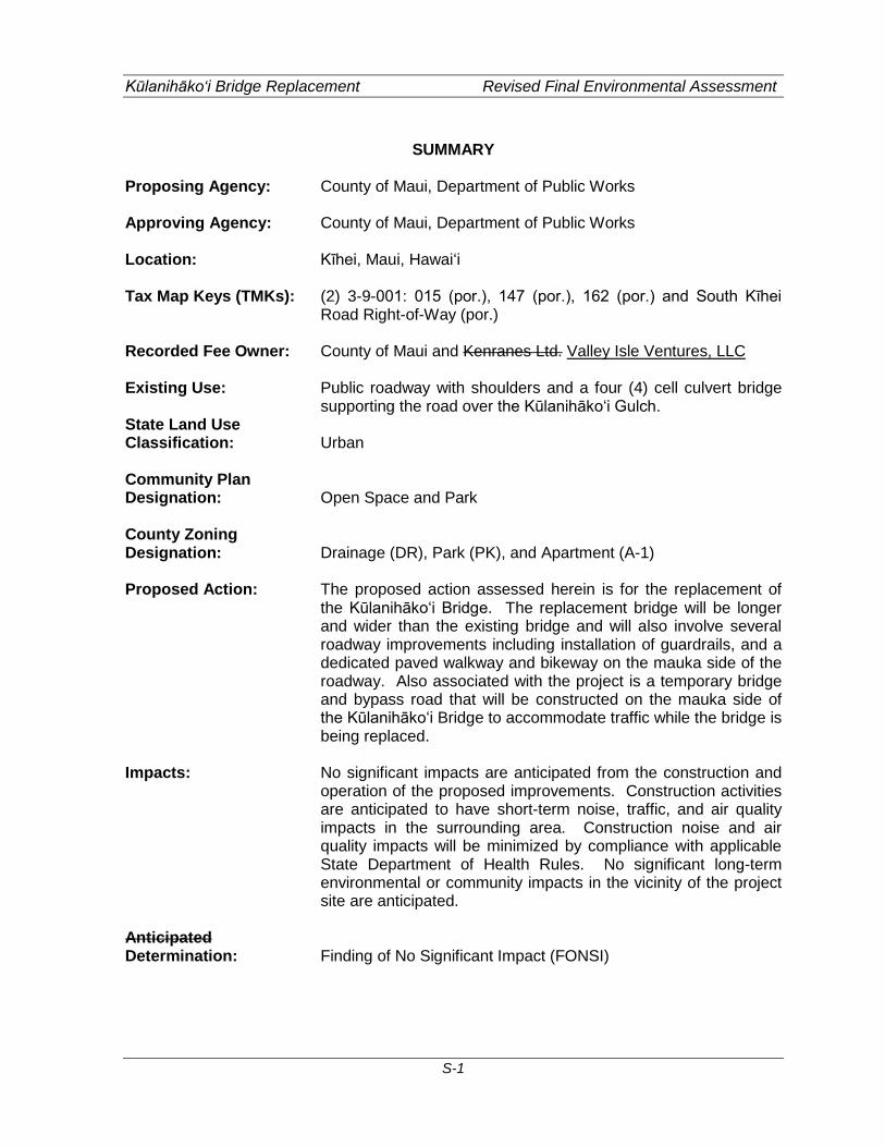
SUMMARY Proposing Agency: County of Maui, Department of Public Works Approving Agency: County of Maui, Department of Public Works Location: Kīhei, Maui, Hawaiʻi Tax Map Keys (TMKs): (2) 3-9-001: 015 (por.), 147 (por.), 162 (por.) and South Kīhei
Road Right-of-Way (por.) Recorded Fee Owner: County of Maui and Kenranes Ltd. Valley Isle Ventures, LLC Existing Use: Public roadway with shoulders and a four (4) cell culvert bridge
supporting the road over the Kūlanihāko‘i Gulch. State Land Use Classification: Urban Community Plan Designation: Open Space and Park County Zoning Designation: Drainage (DR), Park (PK), and Apartment (A-1) Proposed Action: The proposed action assessed herein is for the replacement of
the Kūlanihāko‘i Bridge. The replacement bridge will be longer and wider than the existing bridge and will also involve several roadway improvements including installation of guardrails, and a dedicated paved walkway and bikeway on the mauka side of the roadway. Also associated with the project is a temporary bridge and bypass road that will be constructed on the mauka side of the Kūlanihākoʻi Bridge to accommodate traffic while the bridge is being replaced.
Impacts: No significant impacts are anticipated from the construction and
operation of the proposed improvements. Construction activities are anticipated to have short-term noise, traffic, and air quality impacts in the surrounding area. Construction noise and air quality impacts will be minimized by compliance with applicable State Department of Health Rules. No significant long-term environmental or community impacts in the vicinity of the project site are anticipated.
Anticipated Determination: Finding of No Significant Impact (FONSI)
Kūlanihāko‘i Bridge Replacement Revised Final Environmental Assessment
S-2
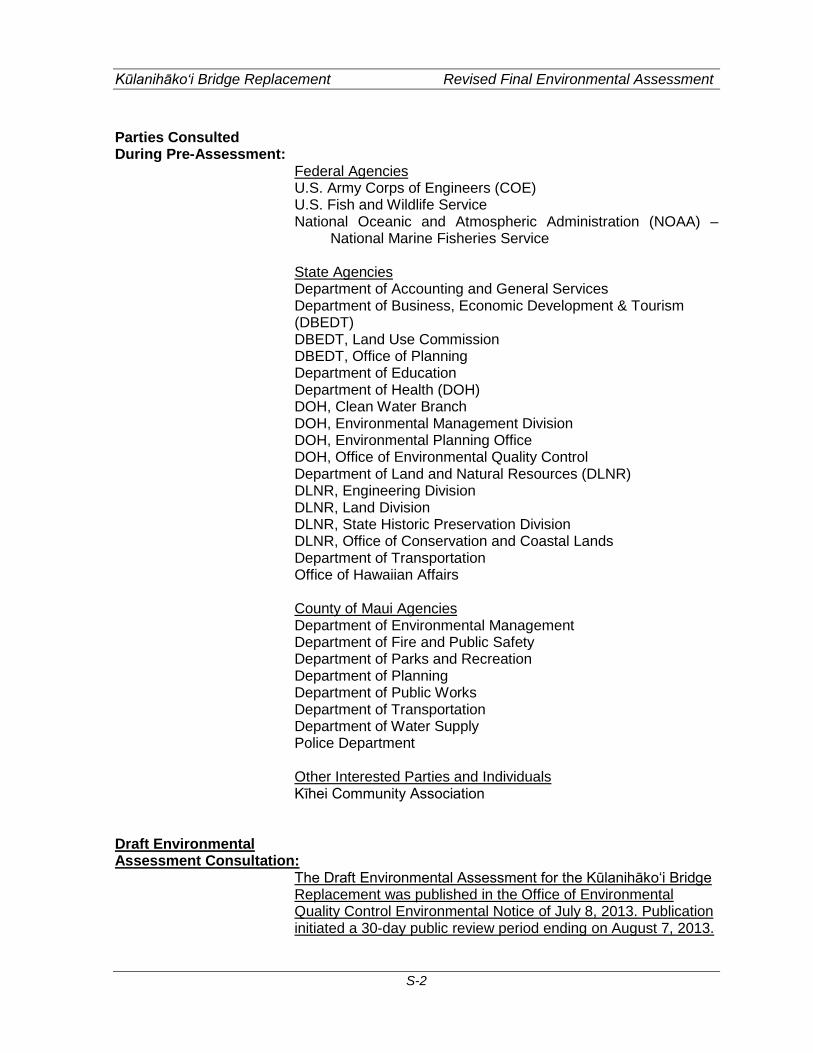
Parties Consulted During Pre-Assessment:
Federal Agencies U.S. Army Corps of Engineers (COE) U.S. Fish and Wildlife Service National Oceanic and Atmospheric Administration (NOAA) –
National Marine Fisheries Service State Agencies Department of Accounting and General Services Department of Business, Economic Development & Tourism (DBEDT) DBEDT, Land Use Commission DBEDT, Office of Planning Department of Education Department of Health (DOH) DOH, Clean Water Branch DOH, Environmental Management Division DOH, Environmental Planning Office DOH, Office of Environmental Quality Control Department of Land and Natural Resources (DLNR) DLNR, Engineering Division DLNR, Land Division DLNR, State Historic Preservation Division DLNR, Office of Conservation and Coastal Lands Department of Transportation Office of Hawaiian Affairs
County of Maui Agencies Department of Environmental Management Department of Fire and Public Safety Department of Parks and Recreation Department of Planning Department of Public Works Department of Transportation Department of Water Supply Police Department
Other Interested Parties and Individuals Kīhei Community Association
Draft Environmental Assessment Consultation:
The Draft Environmental Assessment for the Kūlanihāko‘i Bridge Replacement was published in the Office of Environmental Quality Control Environmental Notice of July 8, 2013. Publication initiated a 30-day public review period ending on August 7, 2013.

Kūlanihāko‘i Bridge Replacement Revised Final Environmental Assessment
S-3
The Draft Environmental Assessment was distributed to the following agencies, organizations and interested parties and individuals for review. Federal Agencies U.S. Army Corps of Engineers (COE)
COE, Civil Works Technical Branch COE, Regulatory Branch
U.S. Fish and Wildlife Service U.S. Geological Survey National Oceanic and Atmospheric Administration (NOAA), National Marine Fisheries Service
State Agencies Department of Business, Economic Development, and Tourism (DBEDT) DBEDT, Office of Planning Department of Health (DOH) DOH, Clean Water Branch DOH, Environmental Planning Office DOH, Office of Environmental Quality Control Department of Land and Natural Resources (DLNR) DLNR, Engineering Division DLNR, Land Division DLNR, Office of Conservation and Coastal Lands DLNR, State Historic Preservation Division Office of Hawaiian Affairs University of Hawaiʻi Environmental Center Department of Transportation
County of Maui Department of Environmental Management Department of Fire and Public Safety Department of Parks and Recreation Department of Planning Department of Public Works Department of Transportation Department of Water Supply Police Department
Utility Companies Maui Electric Company Oceanic Time Warner Cable Hawaiʻi Gas Hawaiian Telcom
Other Interested Parties and Individuals

Kūlanihāko‘i Bridge Replacement Revised Final Environmental Assessment
S-4
Kīhei Community Association Kenranes, Ltd.
Kūlanihāko‘i Bridge Replacement Revised Final Environmental Assessment
1-1
1. INTRODUCTION
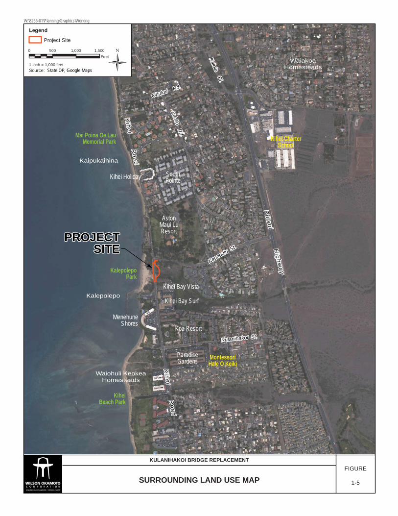
1.1 Project Location The County of Maui, Department of Public Works (DPW) proposes to replace and upgrade the Kūlanihāko‘i Bridge, which spans Kūlanihāko‘i Gulch, in Kīhei, Maui, Hawai‘i. Kūlanihāko‘i Bridge is located on South Kīhei Road approximately 200 feet south of the South Kīhei Road and Ka‘ono‘ulu Street intersection (see Figure 1-1). The project area is further identified as Tax Map Key (TMK) (2) 3-9-001:015 (por.), 147 (por.) and 162 (por.), and a portion of the South Kīhei Road right-of-way (see Figure 1-2). 1.1.1 Existing Uses South Kīhei Road, in the vicinity of Kūlanihāko‘i Bridge currently consists of two (2) 10-foot wide travel lanes (one lane in each direction) with shoulders ranging from 4.2 to 5.6 feet wide. Currently, there are temporary concrete barriers placed along both sides of the bridge (see Figure 1-3). The bridge is a four-cell concrete box culvert system and each cell is six (6) feet wide and four (4) feet high by 38-feet across South Kīhei Road. South Kīhei Road extends 27-feet and nine inches over the four cell box culvert. Since the box culverts span more than 20-feet, it is considered a “bridge” (see Figure 1-4). 1.1.2 Surrounding Uses The project site is bounded by Ka‘ono‘ulu Street to the north, Kīhei Bay Vista and the Hawaiian Islands Humpback Whale National Marine Sanctuary to the south, the Kūlanihāko‘i Gulch to the east, and Kalepoleopo Beach Park to the west (see Figure 1-5). In addition, there are various resorts and residential areas mauka of the project site, including the Aston Maui Lu Resort to the northeast, the Ka‘ono‘ulu Estates to the east, and the Kīhei Bay Vista and Kīhei Bay Surf to the southeast.

Legend
Project Site Ü0 1,000 2,000500
Feet
1 inch = 1,000 feet
ISLAND OF MAUI
¦
Source: U.S.G.S. Topo Map, State Offie of Planning
PROJECT SITEPROJECT SITEPROJECT SITE
PROJECTVICINITY
Pi i lani H
ighway
Kihei R
oad
Kaonoulu St.
Kulanihakoi St.
Keolio Rd.
Ohukai Rd.
Kaiola Pl.
LOCATION MAPFIGURE
1-1
KULANIHAKOI BRIDGE REPLACEMENT
W:\8256-01\Planning\Graphics\Working
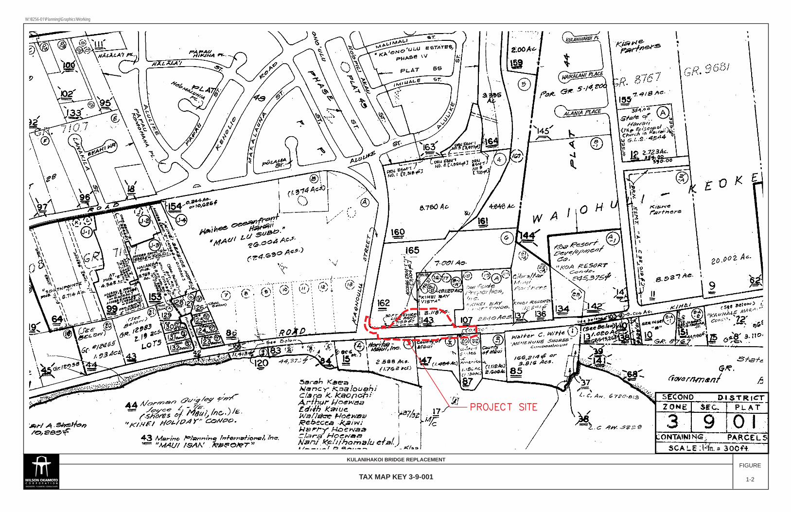
PROJECT SITEPROJECT SITE
TAX MAP KEY 3-9-001
KULANIHAKOI BRIDGE REPLACEMENTFIGURE
1-2
W:\8256-01\Planning\Graphics\Working

Kūlanihāko‘i Bridge Replacement Revised Final Environmental Assessment
1-4
(This page intentionally left blank)
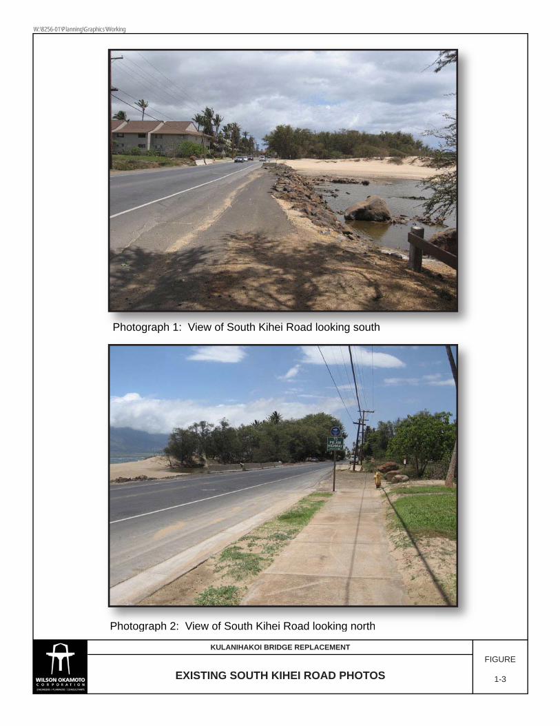
Photograph 1: View of South Kihei Road looking south
Photograph 2: View of South Kihei Road looking north
g p gg p g
Photograph 2: View of South Kihei Road looking north
EXISTING SOUTH KIHEI ROAD PHOTOSFIGURE
1-3
KULANIHAKOI BRIDGE REPLACEMENT
W:\8256-01\Planning\Graphics\Working
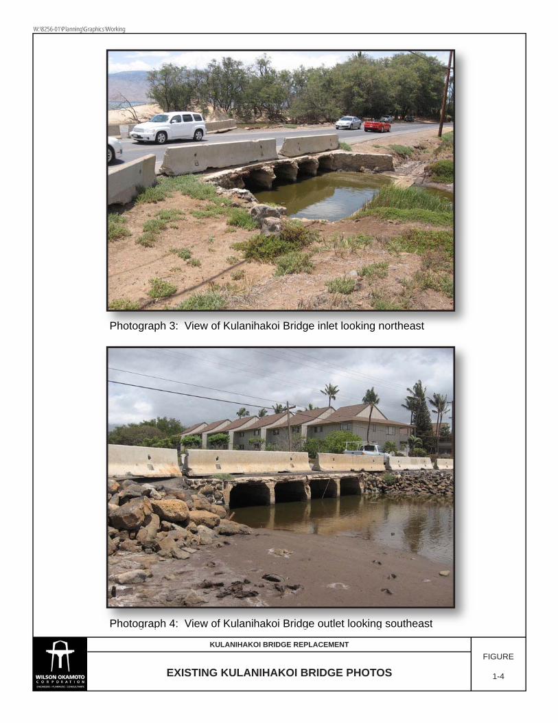
Photograph 3: View of Kulanihakoi Bridge inlet looking northeast
Photograph 4: View of Kulanihakoi Bridge outlet looking southeast
Photograph 3: View of Kulanihakoi Bridge inlet looking northeast
Photograph 4: View of Kulanihakoi Bridge outlet looking southeast
EXISTING KULANIHAKOI BRIDGE PHOTOSFIGURE
1-4
KULANIHAKOI BRIDGE REPLACEMENT
W:\8256-01\Planning\Graphics\Working
Legend
Project Site
Ü0 500 1,000 1,500
Feet
1 inch = 1,000 feetSource: State Offie of Planning
PROJECTPROJECTSITESITE
PROJECTSITE
Pi i lani H
ighway
Pi i lani H
ighway
Kihei R
oadK
ihei Road
Kaonoulu St.
Kaonoulu St.
Kulanihakoi St.Kulanihakoi St.
Keolio Rd.
Keolio Rd.
Ohukai Rd.
Ohukai Rd.
Kaiola Pl.
Kaiola Pl.
Pi i lani H
ighway
Kihei R
oad
Kaonoulu St.
Kulanihakoi St.
Keolio Rd.
Ohukai Rd.
Kaiola Pl.
Kihei R
oadK
ihei Road
Kihei R
oad
Kihei CharterSchool
MontessoriHale O Keiki
KalepolepoPark
KiheiBeach Park
Mai Poina Oe LauMemorial Park
Kaipukaihina
Kalepolepo
WaiakoaHomesteads
Waiohuli KeokeaHomesteads
Koa Resort
MenehuneShores
AstonMaui LuResort
ParadiseGardens
Kihei Bay Surf
Kihei Bay Vista
SouthPointeKihei Holiday
State OP, Google Maps
SURROUNDING LAND USE MAPFIGURE
1-5
KULANIHAKOI BRIDGE REPLACEMENT
W:\8256-01\Planning\Graphics\Working

Kūlanihāko‘i Bridge Replacement Revised Final Environmental Assessment
1-8
(This page intentionally left blank)

Kūlanihāko‘i Bridge Replacement Revised Final Environmental Assessment
2-1
2. PROJECT DESCRIPTION
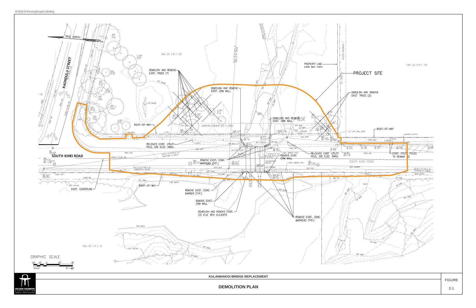
2.1 Project Purpose and Need The existing culverts are structurally deficient and in advanced stages of deterioration. The County of Maui bridge inspection report, dated January 2011, notes that the culverts and retaining walls are in critical condition. There are numerous delaminations, spalls with exposed rebar, and rebar that has been corroded away in the 4-cell reinforced concrete culvert. There are also major problems with embankment erosion and adequacy of opening. A more recent bridge inspection report, dated March 2012, notes that Kūlanihāko‘i Bridge is in a very deteriorated condition, with exposed reinforcement and crumbling concrete, severe spalling and advanced corrosion of the reinforcing of the top slab of the culvert. The report recommends that immediate repairs or shoring of the top slab be implemented. If left unrepaired there is a risk of possible collapse of the existing culverts due to vehicles traversing over it. Based on the results of the bridge inspection report, the sufficiency rating of the bridge is rated 2.0 on a scale of 0 to 100 with 100 representing a bridge fully meeting current design standards. The recommendation of the inspection report is to replace the bridge. In addition, the existing traffic safety features of the bridge do did not meet current standards. Currently, only Only temporary concrete barriers are were located along both sides of the bridge on South Kīhei Road. There are were no approach guardrails or transitions at either ends of the bridge. This results resulted in the ends of the portable bridge parapets to be exposed to traffic. Since the existing culverts are in very deteriorated condition, the County implemented an emergency temporary repair which involved construction of an emergency temporary steel bridge over the existing culverts to avoid the risk of possible collapse. Separate permits and approvals were obtained for the emergency repair. Roadway In the long-term, roadway improvements to South Kīhei Road are also necessary as there is a need for enhanced safety for vehicles, pedestrians and bicyclists. Currently Prior to the emergency repair, pedestrians and bicyclists share shared existing paved roadway shoulders on both sides of South Kīhei Road ranging in width from approximately 4.2 to 5.6 feet.
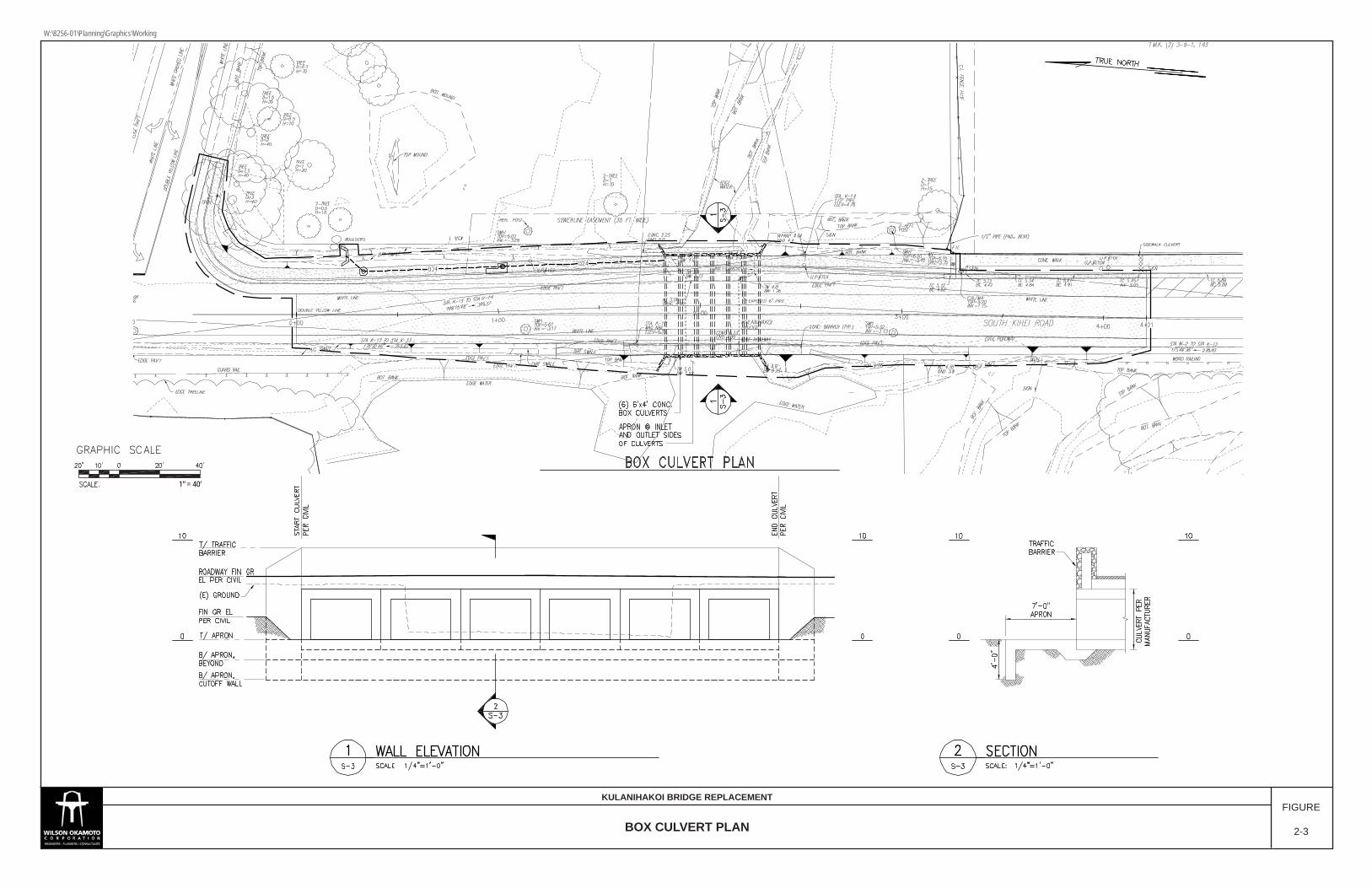
2.2 Project Description The proposed project involves the replacing the existing bridge as well as various roadway improvements. The proposed improvements are described below (see Figures 2-1 to 2-4): The existing Kūlanihāko‘i Bridge, which is comprised of four culverts, will be replaced with a longer and wider bridge consisting of six (6) culverts. Prior to construction of the new culverts, the existing emergency temporary bridge and guardrails will need to be removed. Then, the existing four (4) culverts will need to be demolished and removed along with the existing inlet and outlet headwalls and temporary concrete barriers. Once the existing four (4) culverts are removed, the foundation for the new culverts will need to be installed. The

Kūlanihāko‘i Bridge Replacement Revised Final Environmental Assessment
2-2
base would be excavated to accommodate an 8-inch thick gravel layer or similar structural fill. The replacement bridge will be constructed with six (6) new culverts; each approximately six (6) feet wide, four (4) feet high and 50 feet across South Kīhei Road. The pre-cast concrete culverts will be approximately one (1) foot thick. Thus, the new bridge will extend approximately 50-feet across South Kīhei Road. The six (6) culverts, placed side by side, would extend approximately 48-feet within the South Kīhei Road right-of-way. The culverts will be cast at an off-site location and then trucked to the project site where a crane will be used to lower the culverts into place. The invert of the culverts will sit at sea level. Inlet and outlet head walls will also be constructed. The inlet and outlet head walls will be one foot thick, constructed of concrete rubble masonry and will be cast-in-place. The roadway section over the replacement bridge will be widened from two (2), 10-foot travel lanes with paved shoulders to two (2) 12-foot travel lanes, one in each direction, a 5-foot wide bike lane, a 5-foot wide paved walkway, and a 2.5-foot wide curb and gutter separating the walkway from the roadway on both sides of the bridge. A 4-foot tall traffic rated bridge wall will be constructed on top of the culverts on each side as a traffic barrier for safety purposes. The bridge wall will be constructed of stone masonry and would be 1-foot thick. The temporary concrete barriers will be replaced with permanent Permanent guardrails and end connections, will also be installed and designed to comply with current standards. Roadway improvements to South Kīhei Road in the vicinity of the bridge include widening the roadway on the mauka side to accommodate a 5-foot wide bike lane and a 5-foot wide paved walkway with a 2.5-foot wide curb and gutter separating the walkway from the roadway. There is an existing paved walkway that terminates at the northern end of the Kīhei Bay Vista property approximately 100 feet south of the bridge. From this point, the project intends to extend the paved walkway over the new bridge until it reaches Ka‘ono‘ulu Street where it connects with an existing paved shoulder. The curb and gutter and the bike lane would follow the same route as the proposed walkway. From the bridge, the proposed improvements extend along the mauka side of the road, approximately 300 linear feet. The proposed improvements will include a 5-foot wide bike lane and a 5-foot wide paved walkway on the makai side of the bridge. Since there are no existing sidewalk connections on the makai side of the road in close proximity of the bridge, there are limited extensions, approximately 50 feet north and 100 feet south. If and when future improvements are pursued on the makai side of South Kīhei Road, further curb, gutter, sidewalk and bike lane improvements can be implemented. Due to the widening of the roadway, installation of a new 24-inch drain line on the mauka side of the roadway, north of the bridge, will be required to replace the existing dirt swale which currently collects runoff from the road. However, this swale would be paved over to accommodate the proposed widening. The proposed 24-inch drain line would collect the runoff from a headwall inlet that would be constructed on the mauka side of the roadway near the intersection of South Kīhei Road and Kaʻonoʻulu Street. From there it would connect to a manhole and then traverse beneath the roadway until it reaches the bridge where it would connect with the northern most culvert. There is also an existing 30-inch drain line on the mauka and south side of the bridge which collects road runoff from an area
PROJECT SITEPROJECT SITE
GRAPHIC SCALEGRAPHIC SCALE
1” = 40’
DEMOLITION PLAN
KULANIHAKOI BRIDGE REPLACEMENTFIGURE
2-1
W:\8256-01\Planning\Graphics\Working

Kūlanihāko‘i Bridge Replacement Revised Final Environmental Assessment
2-4
(This page intentionally left blank)
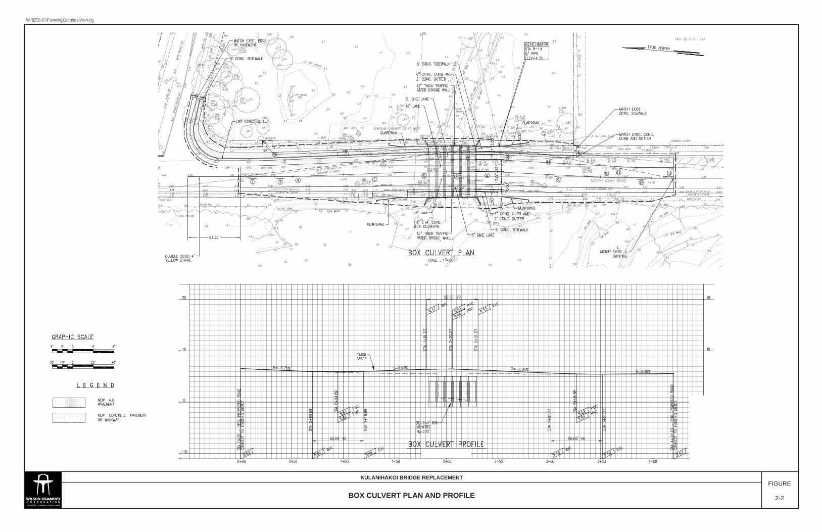
BOX CULVERT PLAN AND PROFILE
KULANIHAKOI BRIDGE REPLACEMENTFIGURE
2-2
W:\8256-01\Planning\Graphics\Working

Kūlanihāko‘i Bridge Replacement Revised Final Environmental Assessment
2-6
(This page intentionally left blank)
GRAPHIC SCALEGRAPHIC SCALE
1” = 40’
BOX CULVERT PLAN
KULANIHAKOI BRIDGE REPLACEMENTFIGURE
2-3
W:\8256-01\Planning\Graphics\Working

Kūlanihāko‘i Bridge Replacement Revised Final Environmental Assessment
2-8
(This page intentionally left blank)
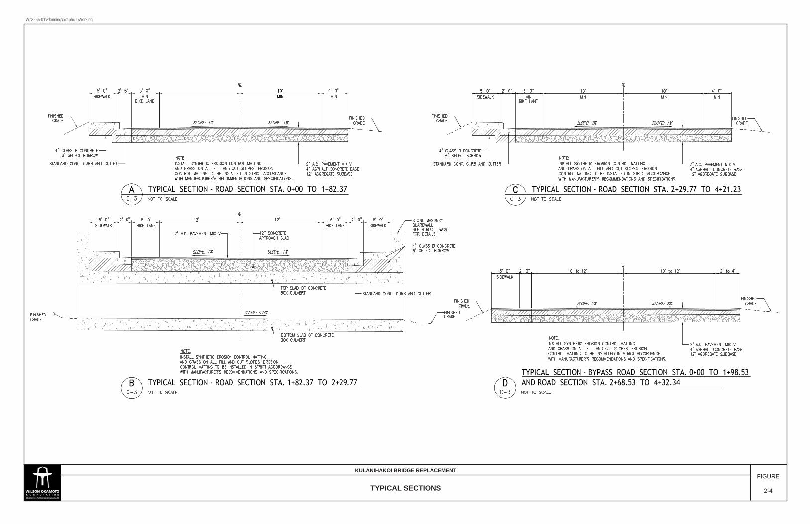
TYPICAL SECTIONS
KULANIHAKOI BRIDGE REPLACEMENTFIGURE
2-4
W:\8256-01\Planning\Graphics\Working

Kūlanihāko‘i Bridge Replacement Revised Final Environmental Assessment
2-10
(This page intentionally left blank)

Kūlanihāko‘i Bridge Replacement Revised Final Environmental Assessment
2-11
near Kīhei Bay Vista that will be left in place. However, a new outlet into the southernmost culvert will be needed. Widening of the roadway will also require the relocation of two (2) electrical utility poles as the poles are currently located in the area planned for the paved walkway. The poles will be relocated near their existing location, but closer to the mauka edge of the road right-of-way. The relocation of the electrical poles will be coordinated with the Maui Electric Company (MECO) prior to construction. In addition, as the new culverts extend farther across South Kīhei Road than the existing culverts, a portion of an existing 12-inch waterline located on the mauka side of the existing bridge will need to be relocated under the new culverts. The relocated waterline is proposed to be encased in a concrete jacket.
During construction of the replacement bridge, that portion of South Kīhei Road would not be usable. Thus, prior to the removal of the existing culverts and the construction of the replacement bridge, a temporary bridge and bypass road will need to be constructed on the mauka side of the existing bridge to accommodate traffic along South Kīhei Road during construction. Construction of the temporary bridge and bypass road is described below (see Figure 2-5 and Figure 2-6). The temporary steel panel bridge and bypass road will be constructed on the mauka side of the existing bridge. The temporary bridge will be approximately 31-feet wide and span approximately 70-feet over the drainageway. The steel panels on each side of the bridge are approximately 3.5-feet wide, leaving enough room to accommodate two, 12-foot travel lanes, one in each direction. The mauka side of the temporary bridge will include a 5-foot wide suspended walkway (see Figure 2-7). Prior to construction of the temporary steel bridge, an area on both sides of the temporary bridge will need to be cleared and excavated to construct the concrete footings that will support the temporary bridge. The area of the footings would not exceed 20-feet by 38-feet on each side of the bridge. The depth of excavation is expected to exceed 3.5-feet. The bridge will be assembled in sections off-site and trucked over to the project site for installation. Construction of the temporary bypass road on both sides of the temporary bridge will also include two, 12-foot travel lanes, one in each direction and a temporary 5-foot wide temporary sidewalk on the mauka side of the roadway (refer back to Figure 2-4). The route of the bypass road is currently undeveloped and covered with vegetation that would need to be removed prior to roadway construction (refer back to Figure 2-1). In addition, the slope of the ground in this area varies slightly and will require cut and fill activities to create a level area for the temporary road.
After completion of the permanent culvert improvements, the temporary bridge and bypass road would be removed. It should be noted that there is another set of emergency temporary bridge improvements being proposed were recently completed in January 2015 as an emergency temporary repair. This was prompted by the March 2012 County of Maui Bridge Inspection Report which showed accelerated deterioration of the existing culverts. The report recommends that

Kūlanihāko‘i Bridge Replacement Revised Final Environmental Assessment
2-12
immediate repairs or shoring of the top slab of the existing bridge be implemented to eliminate the risk of possible collapse of the existing culverts due to vehicles traversing over it. Therefore, in response to this recommendation, while waiting for the new bridge to be constructed, the DPW has decided to construct an emergency temporary steel bridge over the existing culverts to avoid such risk. This has been prompted by the accelerated deterioration of the existing bridge as well as the projection that design, permitting, and construction for the temporary bridge and bypass road mauka of the existing bridge is not expected to be completed until 2015 2019 assuming all applicable approvals are obtained. An emergency temporary bridge over the road is less complicated regarding permitting and can be constructed by 2013. Because of the need to expedite construction of the emergency temporary bridge over South Kīhei Road, a Special Management Area (SMA) Assessment has been was granted on March 4, 2013. However, since the construction of the replacement bridge will need sufficient space for the new culverts to be installed by crane, the temporary bridge and bypass road on the mauka side of the existing bridge would still be necessary. Once the temporary bridge and bypass road mauka of the existing bridge is constructed, the emergency temporary bridge over the existing culverts would be disassembled and removed. It is noted that the project involves the installation of six (6) new culverts rather than four (4) culverts as the six (6) culverts will provide an incremental increase in drainage capacity from approximately 204 cfs to 306 cfs (assuming the outlet is not blocked) while still remaining feasible. However, ocean wave action results in sand plugs of varying heights and sizes which blocks the ocean outlet. When substantial storm flows occur, this may be sufficient to open the plug. However, it is noted that the drainageway immediately mauka of the proposed project is relatively flat and undefined. Thus, substantial storm flows overtop the relatively flat drainageway and provides a limitation to provision of greater additional capacity. Moreover, the existing built environment provides limitations on increasing drainage volume horizontally and vertically under South Kīhei Road. While the proposed project does slightly increase drainage capacity and decrease flood risk, it is not intended to address flooding issues on a regional basis.
2.3 Project Cost and Schedule Construction of the proposed project is anticipated to commence by the first quarter of 2015 2019 with completion approximately nine (9) months later. The project cost is estimated at $3.6 million, which will be funded by the County and FHWA.

BYPASS ROAD PLAN AND PROFILE
KULANIHAKOI BRIDGE REPLACEMENTFIGURE
2-5
W:\8256-01\Planning\Graphics\Working

Kūlanihāko‘i Bridge Replacement Revised Final Environmental Assessment
2-14
(This page intentionally left blank)
BYPASS ROAD PLAN AND LONGITUDINAL SECTION
KULANIHAKOI BRIDGE REPLACEMENTFIGURE
2-6
W:\8256-01\Planning\Graphics\Working

Kūlanihāko‘i Bridge Replacement Revised Final Environmental Assessment
2-16
(This page intentionally left blank)
Source: Acrow Corporation of America
TEMPORARY BRIDGE REPRESENTATIONAL CROSS SECTION VIEW
KULANIHAKOI BRIDGE REPLACEMENTFIGURE
2-7
W:\8256-01\Planning\Graphics\Working

Kūlanihāko‘i Bridge Replacement Revised Final Environmental Assessment
2-18
(This page intentionally left blank)
Kūlanihāko‘i Bridge Replacement Revised Final Environmental Assessment
3-1
3. DESCRIPTION OF EXISTING ENVIRONMENT, IMPACTS, AND MITIGATION MEASURES
3.1 Climate Maui’s climate varies by terrain but is relatively uniform year round with mild temperatures, moderate humidity, and relatively consistent northeasterly trade winds. Regional topography and climatic conditions attribute to a variety of micro-climates found across the island. The project site is located in the semi-arid Kīhei-Mākena region. The mean annual temperature of the island of Maui, near sea level, is approximately 75 degrees Fahrenheit (°F). The Kīhei coast is known to be sunny, warm, and dry throughout the year. Annual temperatures for the Kīhei region average in the mid to high 70s. During the summer months and dry season, average daily temperatures in Kīhei range from 77.0°F to 77.6°F. Average rainfall distribution in the Kīhei-Mākena region varies from under 10 inches per year along the coastline to more than 20 inches per year in the higher elevations. Rainfall in the Kīhei-Mākena region is highly seasonal with most of the precipitation occurring during the winter months. Trade winds out of the northeast average 10 to 15 miles per hour (mph) in the Kīhei-Mākena region during the afternoon. Typically, lighter winds are felt during the morning and evening. Storms are infrequent and generally occur during the winter months in Hawai‘i, although tropical storms and hurricanes occasionally approach the island between June and November.
Impacts and Mitigation Measures No significant impacts on climate in the project area are anticipated. Construction and operation of the proposed project are not anticipated to affect temperatures, wind, or rainfall levels in the project area.
3.2 Physiography
3.2.1 Geology and Topography The Island of Maui was formed by the merging of two volcanoes, Haleakalā, and the West Maui Mountains. The merging of these volcanoes created the second largest island in the Hawaiian island chain. Dominating East Maui, Haleakalā is a dormant volcano rising 10,025 feet above sea level. The western and northern slopes are relatively smooth but are sloping to moderately steep. The land is rough and rocky near the summit of Haleakalā Crater and on the eastern and southwestern slopes. The West Maui Mountains are a deeply dissected volcano rising 5,788 feet. Canyons and steep ridges comprise the central area of West Maui making it not easily accessible. The project site is located near the makai terminus of Kūlanihāko‘i Gulch, a major geomorphic feature along the south slope of Haleakalā. The drainage watershed which feeds into Kūlanihāko‘i Gulch starts at the approximately 9,600 foot elevation near the summit of Haleakalā. The southwestern slope of Haleakalā is characterized by widely spaced erosional gullies. While slopes can be quite extreme at upper elevations, the project site is located within the relatively flat coastal plain. The elevation of South Kīhei Road at the project site is approximately 5.5 feet above sea level. The inverts of the existing culverts
Kūlanihāko‘i Bridge Replacement Revised Final Environmental Assessment
3-2
range from between sea level to 1 foot above sea level. Immediately upstream and downstream of the culverts, the invert of the drainageway usually holds standing water. The elevations of the swale in the immediate vicinity range from 0.5 to 1.6 feet above sea level. Downstream of the swale, a sand plug is formed by wave action. Elevations may range between 0.5 to 4.5 feet. This may be quite variable depending on wind and wave action.
Impacts and Mitigation Measures In the short- and long-term, no significant impacts on geology or topography are anticipated during construction or operation of the proposed project. Construction of the proposed project will require cut and fill activities for grading and excavations for the new culverts as well as the road widening. None of the proposed cuts involve further excavation into the dune system on the makai side of the bridge. Grading within the project site will slightly alter the existing topography, however, graded and excavated areas will be backfilled to restore the topography similar to existing conditions.
3.2.2 Soils According to the U.S. Department of Agriculture, Natural Resource Conservation Service, soils within the project site are classified as Dune Land (DL) and Keālia Silt Loam (KMW) (see Figure 3-1). Dune Land (DL) consists of hills and ridges of sand-size particles drifted and piled by wind. The hills and ridges are actively shifting or are so recently fixed or stabilized that no soil horizons have developed. The sand is dominantly coral and seashells with elevations ranging from seal level to 150 feet. Keālia Silt Loam (KMW) consists of deep, poorly drained soils that formed in alluvium. Keālia soils are on nearly level coastal flats that are affected by a fluctuating salt water table and can be found in elevations ranging from sea level to 10 feet. Ponding occurs in low areas after heavy rain and when the soil dries, salt crystals form on the surface. Slope of the soil varies between 0 to 1 percent. Permeability is moderately rapid. Hazard of water erosion is slight, but can be severe when dry and windy. A Dune Investigation Report was prepared by Sea Engineering, Inc. in August 2012 to determine the location of the coastal dune in relation to the project site to comply with the Maui County Grading Ordinance Section 20.08.035 (I) which prohibits the grading of coastal dunes. The report is included in Appendix A and is summarized below. The County ordinance defines a coastal dune as “one of possibly several continuous or nearly continuous mounds or ridges of unconsolidated sand contiguous and parallel to the beach, situated so that it may be accessible to storm waves and seasonal high waves for release to the beach or offshore waters.” Thus, there are three main criteria that are used to establish the presence or limits of a dune: unconsolidated sandy soil, a mound or ridge formation, and the possible reach of storm or seasonal high waves.

WID2
AaB
DL
BS
KMW
DL
Legend
Project SiteAaBBSDLKMWWID2
Ü0 250 500 750 1,000125Feet
1 inch = 750 feetSource: U.S.G.S. Topo Map, State Offie of Planning
PROJECT SITEPROJECT SITEPROJECT SITE
Pi i lani H
ighway
Pi i lani H
ighway
Kihei R
oadK
ihei Road
Kaonoulu St.Kaonoulu St.
Kulanihakoi St.Kulanihakoi St.
Keolio Rd.
Keolio Rd.
Ohukai Rd.Ohukai Rd.
Kaiola Pl.
Kaiola Pl.
Pi i lani H
ighway
Kihei R
oad
Kaonoulu St.
Kulanihakoi St.
Keolio Rd.
Ohukai Rd.
Kaiola Pl.
Kihei R
oad
Kihei R
oad
Kihei R
oad
Alae sandy loam, 3-7% slope,slow runoff
Beaches
Dune land
Kealia silt loam, 0-1% slope
Waikoa extremely stonysilty clay loam, 3-25% slope, erodedWID2
BS
SOIL SURVEY MAPFIGURE
3-1
KULANIHAKOI BRIDGE REPLACEMENT
W:\8256-01\Planning\Graphics\Working
Kūlanihāko‘i Bridge Replacement Revised Final Environmental Assessment
3-4
However, the limits of a coastal dune may not always be definitive. Sometimes there is no clearly defined break in slope, sometimes the terrain is obscured by heavy underbrush, or there may be several lines of dunes. In heavily used areas the coastal dune structure can be obscured by terrain alteration due to vehicle or foot traffic, or by previous grading and construction activities. Kūlanihāko‘i Gulch is an intermittently flowing stream channel, which during heavy rains erodes a stream channel through the beach and discharges runoff waters into the ocean. When the rain stops, and flow ceases, a beach berm reforms in front of the stream, and a muliwai typically forms. A muliwai is the Hawaiian word for brackish water pools near the mouths of streams created by seasonal barriers of sand or sediment. The muliwai and stream channel occupy the zone immediately seaward of the bridge and road for a distance of approximately 160 feet north and 130 feet south of the bridge. When the stream is not flowing, a visible low elevation swale is present in the beach and backshore marking the location of the channel. Seaward of Kūlanihāko‘i Bridge is Kalepolepo Beach, a sand beach approximately 750 feet long extending from the revetment fronting the Maui Lu Hotel in the north, to the Kalepolepo Fishpond in the south. Dune formation is active in this area as the prevailing tradewinds are modified by the local effects of Haleakalā and blow strongly from the northwest in the afternoons, transporting dry beach sand inland. Coastal dunes up to 16 feet high are present to the north and the south of the stream channel/swale. The north coastal dune lies seaward of the muliwai, and forms the north side of the stream channel. The landward limit of the north dune is located at the base of the slope along the seaward waterline of the muliwai. The south dune forms the south side of the stream channel. The landward limit of the south dune follows the south edge of the stream channel/swale, and then along the edge of South Kīhei Road to the south. The edges of the dunes are illustrated by the red lines in Figure 3-2. A beach berm lies between the dunes and stream channel, and the ocean.
Impacts and Mitigation Measures Construction activities will involve land-disturbing activities, such as grubbing, clearing, grading, and excavation that may result in some soil erosion and potential construction-related impacts to the quality of surface and coastal waters in the greater project vicinity. Various mitigative measures will be incorporated into the project’s construction plan to minimize soil disturbances and potential short-term erosion impacts during construction activities. Excavation and grading activities associated with construction of the proposed improvements will be regulated by the County’s grading ordinance. A DOA Nationwide Permit, pursuant to Section 404 of the Clean Water Act and a WQC, issued by the DOH, pursuant to Section 401 of the Clean Water Act will be required. In conjunction with the Section 401 and 404 permits, a BMP plan will be prepared for construction activities within the project site. Erosion and sediment control measures will be instituted in accordance with site specific assessments, incorporating appropriate structural and/or non-structural BMPs such as minimizing time of exposure between construction and landscaping, and implementing erosion

Edge of Dune
Edge of Dune
Topographic Map of the Project Site Showing Coastal Morphologies and the Edge of the Dunes.
PROJECT SITEPROJECT SITE
Edge of Dune
Project Site
Legend
DUNE DELINEATION MAP
KULANIHAKOI BRIDGE REPLACEMENTFIGURE
3-2
W:\8256-01\Planning\Graphics\Working
Kūlanihāko‘i Bridge Replacement Revised Final Environmental Assessment
3-6
control measures such as silt fences and filter berms. Specific BMPs may include, but may not be limited to the following:
1. Minimizing soil loss and erosion by revegetation and stabilization of slopes and
disturbed areas of soil, possibly using hydromulch, geotextiles, or other applicable alternatives, as soon as possible after working;
2. Minimizing time of exposure between construction and landscaping; 3. Application of protective covers to soil and material stockpiles; 4. Minimizing disturbance of soil during periods of heavy rain; 5. Implementing erosion control measures by emplacement of structural controls
such as silt fences, filter berms, gravel bags, fiber rolls, sandbag barriers and other barriers in order to retard and prevent the loss of sediment from the site;
6. Phasing of the project to disturb the minimum area of soil at a particular time; 7. Use of drip pans beneath vehicles not in use in order to trap vehicle fluids; 8. Routine maintenance of BMPs by adequately trained personnel; 9. Significant leaks or spills, if they occur, shall be properly cleaned up and disposed
of at an approved site. Following construction, exposed soils at the project site will have been built over, paved over, or re-vegetated to control erosion. Dewatering may be required for the proposed project. Should dewatering be deemed necessary, the contractor will be responsible to obtaining all applicable permits including, but not limited to, a National Pollutant Discharge Elimination System (NPDES) Permit for Dewatering Activities. The permit application will require a BMP plan, an erosion control plan, and a water quality monitoring plan. Water quality impacts associated with the disposal of dewatering effluent will also be addressed in the BMP plan, including appropriate characterization of any potential pollutants such as sediments and nutrients in the effluent. Based on the findings of the dune study, the proposed limits of construction of the project do not extend to the coastal sand dune, as defined by the County grading ordinance.
3.3 Hydrology
3.3.1 Surface Water The project site traverses near the Kūlanihāko‘i Gulch ocean outlet. The Kūlanihāko‘i Gulch originates at the 9,600 foot elevation contour near summit of Haleakalā, extending downslope and westward approximately 16-miles to its Pacific Ocean outlet adjacent to Kalepolepo Beach Park on Mā‘alaea Bay. At the project site, the gulch is a broad, flat open area with minimal relief and a substratum of dark sand. Surface water is present at the project site where the outlet is blocked by a deposit of sand (Kalepolepo Beach), forming a muliwai (brackish water pond or estuary) extending inland through the project site. For the majority of the time, this area of the gulch is permanently wet, estuarine, and tidal.

Kūlanihāko‘i Bridge Replacement Revised Final Environmental Assessment
3-7
A Water Quality and Biological Survey for the project site was prepared by AECOS Inc. in March 2013 and revised January 20, 2015. The survey extended from 115 feet upstream of South Kīhei Road to just offshore of Kalepolepo Beach. The revised Water Quality and Biological Survey is included as Appendix B and a summary of the water quality findings are summarized below. Based on the Water Quality Survey, it was determined that the brackish gulch waters near the project site were nutrient, sediment, and chlorophyll laden, relative to State of Hawai‘i water quality criteria for estuaries. The results indicate that generally poor water quality conditions were present during the survey, however, it is not an unusual situation for a muliwai. Kūlanihāko‘i Gulch appears on the DOH, 2012 list of impaired waters in Hawai‘i, prepared under the Clean Water Act. The listing indicates that the water body may not meet State of Hawai‘i water quality criteria for estuaries. The estuary is listed as impaired for total nitrogen, nitrate+nitrate, turbidity, and chlorophyll. It has been assigned a low priority for total Maximum Daily Load (TMDL) studies. The coastal waters fronting Kūlanihāko‘i Gulch may also be impaired. Nearshore marine waters fronting the gulch were nutrient, sediment and cholorophyll laden, well oxygenated, and had a pH near 8.10.
Impacts and Mitigation Measures In the short- and long-term, no significant impacts on surface waters in the project vicinity are anticipated during construction or operation of the proposed project as the proposed project is not anticipated to adversely affect the already poor water quality of the muliwai at the site. A DOA Nationwide Permit, pursuant to Section 404 of the Clean Water Act and a WQC, issued by the DOH, pursuant to Section 401 of the Clean Water Act will be required. In conjunction with the Section 401 and 404 permits, a BMP plan will be prepared for construction activities within the project site. Erosion and sediment control measures will be instituted in accordance with site specific assessments, incorporating appropriate structural and/or non-structural BMPs such as minimizing time of exposure between construction and landscaping, and implementing erosion control measures such as silt fences and filter berms. Specific BMPs may include, but may not be limited to the following:
1. Minimizing soil loss and erosion by revegetation and stabilization of slopes and
disturbed areas of soil, possibly using hydromulch, geotextiles, or other applicable alternatives, as soon as possible after working;
2. Minimizing time of exposure between construction and landscaping; 3. Application of protective covers to soil and material stockpiles; 4. Minimizing disturbance of soil during periods of heavy rain; 5. Implementing erosion control measures by emplacement of structural controls
such as silt fences, filter berms, gravel bags, fiber rolls, sandbag barriers and other barriers in order to retard and prevent the loss of sediment from the site;
6. Phasing of the project to disturb the minimum area of soil at a particular time; 7. Use of drip pans beneath vehicles not in use in order to trap vehicle fluids;

Kūlanihāko‘i Bridge Replacement Revised Final Environmental Assessment
3-8
8. Routine maintenance of BMPs by adequately trained personnel; 9. Significant leaks or spills, if they occur, shall be properly cleaned up and disposed
of at an approved site.
In addition, the proposed project will also require a DOA permit pursuant to Section 10 of the Rivers and Harbors Act of 1899, which regulates work within, over and beneath navigable waters of the U.S. Following construction, exposed soils at the project site will have been built over, paved over, or re-vegetated to control erosion. Dewatering may be required for the proposed project. Should dewatering be deemed necessary, the contractor will be responsible to obtaining all applicable permits including, but not limited to, an NPDES Permit for Dewatering Activities. The permit application will require a BMP plan, an erosion control plan, and a water quality monitoring plan. Water quality impacts associated with the disposal of dewatering effluent will also be addressed in the BMP plan, including appropriate characterization of any potential pollutants such as sediments and nutrients in the effluent.
3.3.2 Wetlands According to the Water Quality and Biological Study prepared by AECOS Inc. in March 2013 and revised in January 2015 (refer to Appendix B), the U.S. Fish and Wildlife Service (USFWS), National Wetland Inventory (NWI) ;”Wetlands Mapper” shows the area of the muliwai classified as PUBHh: diked or impounded, permanently flooded, freshwater wetland (palustrine) with unconsolidated (sand or mud) bottom; and a much larger area extending to the south thorough through several resort complexes as PEM1C: seasonally flooded freshwater wetland with persistent emergent vegetation. The AECOS study updates these findings. The AECOS study found that the muliwai should be classified as E1UB2: estuarine subtidal with sand bottom; as the area is not “dike” or unnaturally impounded. In addition, the wetland corresponding to the area in the NWI as PEM1C is no longer present as the area is now a fully developed landscape. The study also attempted to delineate the wetland boundary using soil sampling and certain species of vegetation as key indicators of a wetland environment. However, the vegetation in the project area is limited and its use as an indicator problematic because the area is a part of a native plant restoration project where the “natural” distribution of pickleweed (Batis maritima) has been removed and the native ʻākulikuli encouraged to thrive. ʻĀkulikuli is considered a facultative wetland species that is nearly always found around the margins of coastal wetlands in sand material. Consequently, the area surveyed, with the exception of the muliwai, is difficult to demarcate as a wetland. There are two possible wetland delineations for the project area. The first is based on the acceptance that the soils and plants found at the project site are generally indicative of a coastal wetland, and therefore the boundary of the ʻākulikuli demarcates the wetland area. The second is based on the acceptance that the soils and plants are not natural and have been affected by the native plant restoration efforts in the area, therefore they are not good
Kūlanihāko‘i Bridge Replacement Revised Final Environmental Assessment
3-9
indications of a wetland and thus the clearest boundary is that of the muliwai shore. While a wetland delineation is not official until accepted by the Corps of Engineers, it is believed that the historical distribution of the wetlands at the mouth of the gulch could be supported based upon the existing topography and distribution of the native coastal plant, ‘ākulikuli.
Impacts and Mitigation Measures In the long-term, no significant impacts to wetland resources associated with the project site are anticipated during construction or operation of the proposed project.
During construction, as it is difficult to demarcate the boundary of the wetland and jurisdictional waters are uncertain, the County will need to work with the applicable agencies to determine appropriate permitting requirements. the The area of the proposed bypass road based on the distribution of ‘ākulikuli through the two different wetland boundaries would be on the order of 600 square feet (muliwai only) to 4,600 square feet (dune sand dominated by ʻākulikuli). The existing culverts are located within the area designated as the muliwai. A DOA Nationwide Permit, pursuant to Section 404 of the Clean Water Act and a WQC, issued by the DOH, pursuant to Section 401 of the Clean Water Act will be required. In conjunction with the Section 401 and 404 permits, a BMP plan will be prepared for construction activities within the project site. Erosion and sediment control measures will be instituted in accordance with site specific assessments, incorporating appropriate structural and/or non-structural BMPs such as minimizing time of exposure between construction and landscaping, and implementing erosion control measures such as silt fences and filter berms. Specific BMPs may include, but may not be limited to the following:
1. Minimizing soil loss and erosion by revegetation and stabilization of slopes and
disturbed areas of soil, possibly using hydromulch, geotextiles, or other applicable alternatives, as soon as possible after working;
2. Minimizing time of exposure between construction and landscaping; 3. Application of protective covers to soil and material stockpiles; 4. Minimizing disturbance of soil during periods of heavy rain; 5. Implementing erosion control measures by emplacement of structural controls
such as silt fences, filter berms, gravel bags, fiber rolls, sandbag barriers and other barriers in order to retard and prevent the loss of sediment from the site;
6. Phasing of the project to disturb the minimum area of soil at a particular time; 7. Use of drip pans beneath vehicles not in use in order to trap vehicle fluids; 8. Routine maintenance of BMPs by adequately trained personnel; 9. Significant leaks or spills, if they occur, shall be properly cleaned up and disposed
of at an approved site. Dewatering may be required for the proposed project. Should dewatering be deemed necessary, the contractor will be responsible to obtaining all applicable permits including, but not limited to, an NPDES Permit for Dewatering Activities. The permit application will require a BMP plan, an erosion control plan, and a water quality monitoring plan. Water quality impacts associated with the disposal of dewatering
Kūlanihāko‘i Bridge Replacement Revised Final Environmental Assessment
3-10
effluent will also be addressed in the BMP plan, including appropriate characterization of any potential pollutants such as sediments and nutrients in the effluent. Following construction, the wetland area is areas affected by the temporary road and bridge are proposed to be restored to its existing conditions.
3.3.3 Groundwater The State Department of Land and Natural Resources (DLNR), Commission on Water Resource Management (CWRM) has established a groundwater hydrologic unit and coding system for groundwater resource management. The proposed project site is located within the Central Aquifer Sector Area which is comprised of four (4) Aquifer System Areas identified as Kahului, Pāʻia, Makawao, and Kamʻaole. The project site is located within the Kamaʻole Aquifer System (60304) area which is a regionally extensive brackish aquifer extending from North Kīhei to Mākena. The Kamaʻole Aquifer System yields 11 million gallons per day (mgd).
Impacts and Mitigation Measures In the short- or long-term, no significant impacts to groundwater resources associated with the project site are anticipated during construction or operation of the proposed project. Construction activities are not likely to introduce to, nor release from the soil any materials which could adversely affect groundwater. Construction material wastes will be appropriately disposed of to prevent leaching.
3.3.4 Coastal Waters The nearest coastal water offshore of the project site is Māʻalaea Bay, located approximately 0.05-miles west of the project site. Pursuant to Hawai‘i Administrative Rules (HAR) Title 11, Chapter 54, Water Quality Standards, the coastal waters in the vicinity of the project site are classified as Class A marine waters. Class A marine waters are recognized as waters to be used for “recreational purposes and aesthetic enjoyment to be protected. These waters shall not act as receiving waters for any discharge which has not received the best degree of treatment or control compatible with the criteria established for this class”. A Water Quality and Biological Survey report was prepared by AECOS Inc. in March 2013 (revised January 2015) for the proposed project site (refer to Appendix B). In addition to surveying the water quality of Kūlanihāko‘i Gulch, coastal waters directly offshore of Kalepolepo Beach were also surveyed. It was determined that the coastal waters fronting Kūlanihāko‘i Gulch may also be impaired. The water quality, as monitored by DOH Station Kalepolepo Beach (ID H1000141), just south of the gulch mouth is reported as impaired for total nitrogen, nitrate+nitrite, ammonia, turbidity, and chlorophyll. Water quality data from 2008 to present show that marine waters fronting the gulch were nutrient, sediment, and chlorophyll laden, well oxygenated and had a pH near 8.10.
Impacts and Mitigation Measures No short- or long-term significant impacts on coastal waters in the project vicinity are anticipated during construction or operation of the proposed project. Construction activities will involve land-disturbing activities, such as grubbing, clearing, grading, and excavation that may result in some soil erosion and potential

Kūlanihāko‘i Bridge Replacement Revised Final Environmental Assessment
3-11
construction-related impacts to the quality of surface and coastal waters in the greater project vicinity. Various mitigative measures will be incorporated into the project’s construction plan to minimize soil disturbances and potential short-term erosion impacts during construction activities. Excavation and grading activities associated with construction of the proposed improvements will be regulated by the County’s grading ordinance. A DOA Nationwide Permit, pursuant to Section 404 of the Clean Water Act and a WQC, issued by the DOH, pursuant to Section 401 of the Clean Water Act will be required. In conjunction with the Section 401 and 404 permits, a BMP plan will be prepared for construction activities within the project site. Erosion and sediment control measures will be instituted in accordance with site specific assessments, incorporating appropriate structural and/or non-structural BMPs such as minimizing time of exposure between construction and landscaping, and implementing erosion control measures such as silt fences and filter berms. Specific BMPs may include, but may not be limited to the following:
1. Minimizing soil loss and erosion by revegetation and stabilization of slopes and
disturbed areas of soil, possibly using hydromulch, geotextiles, or other applicable alternatives, as soon as possible after working;
2. Minimizing time of exposure between construction and landscaping; 3. Application of protective covers to soil and material stockpiles; 4. Minimizing disturbance of soil during periods of heavy rain; 5. Implementing erosion control measures by emplacement of structural controls
such as silt fences, filter berms, gravel bags, fiber rolls, sandbag barriers and other barriers in order to retard and prevent the loss of sediment from the site;
6. Phasing of the project to disturb the minimum area of soil at a particular time; 7. Use of drip pans beneath vehicles not in use in order to trap vehicle fluids; 8. Routine maintenance of BMPs by adequately trained personnel; 9. Significant leaks or spills, if they occur, shall be properly cleaned up and disposed
of at an approved site. Following construction, exposed soils at the project site will have been built over, paved over, or re-vegetated to control erosion. Dewatering may be required for the proposed project. Should dewatering be deemed necessary, the contractor will be responsible to obtaining all applicable permits including, but not limited to, an NPDES Permit for Dewatering Activities. The permit application will require a BMP plan, an erosion control plan, and a water quality monitoring plan. Water quality impacts associated with the disposal of dewatering effluent will also be addressed in the BMP plan, including appropriate characterization of any potential pollutants such as sediments and nutrients in the effluent. In the long-term, as the proposed culverts will be constructed at a 0.5% slope, the drainage capacity will increase slightly from essentially 204 cfs to 306 cfs. In the event of a 100-year storm, this increase in capacity will increase the likelihood of storm flows breaking through the sand plug. This could slightly relieve some of the upstream flooding, but may slightly increase flows past the sand plug.
Kūlanihāko‘i Bridge Replacement Revised Final Environmental Assessment
3-12
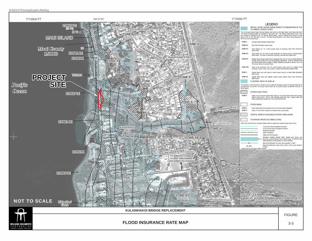
3.4 Natural Hazards
3.4.1 Flood and Tsunami Hazard According to the Flood Insurance Rate Map (FIRM) (Community Panel Numbers 1500030586F and 1500030567F, Effective Date: September 19, 2012) prepared by the Federal Emergency Management Agency (FEMA), the project site is designated Zone VE and Zone AE (see Figure 3-3). Zone VE includes areas with a 1% or greater chance of flooding and have an additional hazard associated with storm waves. In general, these areas have a 26% chance of flooding over the life of a 30-year mortgage. Zone AE is characterized as a “special flood hazard area subject to inundation by the 1% annual chance flood.” Zone AE is also a “floodway,” in which “the channel of the stream plus any adjacent floodplain areas that must be kept free of the encroachment so that the 1% annual chance flood can be carried without substantial increases in flood height.” The 1% annual flood is also commonly referred to as the 100-year flood or the base flood. According to the Tsunami Evacuation Zone maps for Maui, the project site lies entirely within the tsunami evacuation zone (see Figure 3-4).
Impacts and Mitigation Measures In the short- and long-term, no significant impacts on flood hazards in the project area are anticipated as the proposed improvements are not anticipated to increase flood risks or cause any adverse flood-related impacts at the project site or lower elevation properties. Construction activities within the respective flood hazard districts will be conducted in accordance with regulations set forth in Section 19.62.060, Maui County Code. Before construction of any development begins within any flood hazard area, flood-related erosion hazard area, or mudslide area, a special flood hazard area development permit shall be obtained from the Director of the Department of Planning. The project will also comply with the rules and regulations for the National Flood Insurance Program (NFIP) present in Title 44, of the Code of Federal Regulations (44CFR), as the project is within a Special Flood Hazard Area.
3.5 Natural Environment
3.5.1 Flora A Water Quality and Biological Survey for the project site was conducted by AECOS Inc. in March 2013 (revised January 2015) (refer to Appendix B). The findings of the botanical survey are summarized below. The botanical survey found that plant growth is sparse over much of the area, or otherwise consists of a ground cover of ʻākulikuli (Sesuvium portulacastrum) that is dense in some
Source: FEMA, FIRMSource: FEMA, FIRMPanel #s: 1500030586F and 1500030567FPanel #s: 1500030586F and 1500030567Fdated on Septembe 19, 2012dated on Septembe 19, 2012
Source: FEMA, FIRMPanel #s: 1500030586F and 1500030567Fdated on Septembe 19, 2012
PROJECTPROJECTSITESITE
PROJECTSITE
NOT TO SCALE
FLOOD INSURANCE RATE MAP
KULANIHAKOI BRIDGE REPLACEMENTFIGURE
3-3
W:\8256-01\Planning\Graphics\Working

Legend
Project SiteTsunami Evacuation Area
Ü0 375 750 1,125
Feet
1 inch = 750 feetSource: State Offie of Planning
KiheiBeach Park
Kalepolepo Park
Mai Poina Oe LauPark
PROJECTSITE
Pi i lani H
ighway
Pi i lani H
ighway
Kihei R
oadK
ihei Road
Kaonoulu St.
Kaonoulu St.
Kulanihakoi St.Kulanihakoi St.
Keolio Rd.
Keolio Rd.
Ohukai Rd.
Ohukai Rd.
Kaiola P
l.K
aiola Pl. Pi i lani H
ighway
Kihei R
oad
Kaonoulu St.
Kulanihakoi St.
Keolio Rd.
Ohukai Rd.
Kaiola P
l.
Kihei R
oadK
ihei Road
Kihei R
oad
TSUNAMI EVACUATION MAPFIGURE
3-4
KULANIHAKOI BRIDGE REPLACEMENT
W:\8256-01\Planning\Graphics\Working
Kūlanihāko‘i Bridge Replacement Revised Final Environmental Assessment
3-15
locations. Less prominent and mostly south of the muliwai, is an area with seaside heliotrope (Heliotropium curssavicum). A total of 15 plant species were identified in the project vicinity and all were identified as flowering plants. It is important to note that typically in most lowland areas on Maui, the native and Polynesian plant numbers are not more than 10 to 16 percent of the total species identified from a location. At the Kūlanihāko‘i Gulch mouth, 60 percent are native or early Polynesian introduced plants. While this situation is unusual, it is due to the area being maintained as a native plant restoration project. The area is served by a pipe irrigation system with sprinkler heads, suggesting some current or prior level of artificial watering. While native ʻākulikuli and ʻakiʻaki are plants associated with coastal dune and muliwai environments, it is unknown to what extent the vegetation patterns have been influenced to their present state by the native planting and maintenance activities. It would be expected that the estuarine area would be dominated by pickleweed (Batis maritimus), as this non-native species is found throughout the Kīhei area as coastal wetlands, however, it is noted as rare in the project area. The dune areas support ʻakiʻaki (Sporobolus virginicus), a native grass common to this habitat. Non-native species are uncommon or rare in the survey area except for a grove of kiawe (Prosopis pallida) located on the makai side of South Kīhei Road. The native ʻākia (Wikstroemia usa-urvi) has been planted on a low dune.
Impacts and Mitigation Measures No short- or long-term significant impacts on flora species are anticipated due to the construction and operation of the proposed project as there are no rare, threatened, or endangered flora species located within or adjacent to the project site. There are also no federally designated Critical Habitats within or adjacent to the project site. However, as the area is being cared for by a community group with a strong interest in preserving the native flora at this location, it is recommended that the bypass road area be restored back to the appropriate native plants once construction is completed and the temporary bypass road removed.
3.5.2 Fauna A Water Quality and Biological Survey for the project site was conducted by AECOS Inc. in March 2013 (revised January 2015) (refer to Appendix B). The findings of the biological survey are summarized below. Aquatic Resources: The aquatic biota observed during the September 2012 survey of Kūlanihāko‘i Gulch estuary included a mixture of native and naturalized (non-native) species. Native species observed included āholehole, ‘ama‘ama (Mugil cephalus), and ‘alamihi crab (Metopograspus thuhukar). Non-native species included mixed Mixed schools of Cuban mollies (Limia vittata) and hybrid mollies (Poecilia sp.), swim just beneath the water surface near the South Kīhei Road crossing. Blackchin tilapia (Sarotherodon melanotheron), and Mozambique tilapia (Oreochromis massambicus) and mullet (Mugil cephalus) are also present in schools throughout the muliwai. Shore crabs (Metopograpsus thuhukar) crawl among the ‘ākulikuli along the muliwai margins and on the culverts. All these species are common inhabitants of estuarine waters in the main Hawaiian Islands. Rambur's forktail (Ischnura ramburi), a naturalized damselfly typically common at low elevations, also utilizes the project area.

Kūlanihāko‘i Bridge Replacement Revised Final Environmental Assessment
3-16
Though the reach of the gulch typically containing water is short, it is possible that native ‘o‘opu ‘akupa (Eleotris sandwicensis) and ‘ōpaekala‘ole (Macrobrachium grandimanus) not observed during the survey may utilize the brackish environment near the project site. Any population present is likely limited in size by the continual blockage of the gulch mouth by deposited sand, as these diadromous species need passage to the open ocean as larva and passage upstream to brackish waters as post‐larva to carry out their life cycle. Avian Resources: The findings of the survey are consistent with the location of the property, and the habitats present on and adjacent to the site. A total of 23 individual six water obligate avian species, of six different species, representing six separate families, were recorded during the survey. All but one of the six water bird species detected are native species. One of these species, the Hawaiian Stilt (Himantopus mexicanus knudseni), is an endangered endemic sub‐species protected under both federal and state endangered species statutes. One stilt was recorded foraging in the muliwai approximately 30 feet makai of the culvert just behind the beach. Thirteen others were recorded flying over the site from north‐to‐south. Another of these species, the Black‐crowned Night‐Heron (Nycticoraxnycticorax hoactli), is a resident indigenous species found widespread across the islands that utilizes a wide range of waterside environments. The three others, the Pacific Golden‐Plover (Pluvialis fulva), the Ruddy Turnstone (Arenaria interpres) and the Wandering Tattler (Tringa incana) are indigenous migratory shorebird species that nest in the high Arctic during the late spring and summer months, returning to Hawai‘i and the Tropical Pacific to spend the fall and winter months each year. They usually leave Hawai‘i for the trip back to the Arctic in late April or the very early part of May each year. The remaining species, the Cattle Egret (Bubulcus ibis), is alien to the Hawaiian Islands. Although no seabirds were detected during this survey, it is probable that both endangered Hawaiian Petrel (Pterodroma sandwichensis) and threatened endemic sub‐species of Newell’s Shearwater (Puffinus auricularis newelli) overfly the project area between April and the middle of December each year. Both species have been recorded flying to and from their nesting colonies located in the mountains mauka of the project site. Both of these pelagic seabird species nest high in the mountains in burrows excavated under thick vegetation, especially uluhe (Dicranopteris linearis) fern. There is no suitable nesting habitat for either of these seabird species on or close to the project site. It is also probable that Wedge‐tailed Shearwaters (Puffinus pacificus) may occasional overfly the site during the breeding season as they nest in coastal areas in the general Kīhei area. Wedge‐tailed Shearwaters are not protected under the endangered species act, but are protected under the federal Migratory Bird Treaty Act as well as under the State of Hawai‘i Department of Land and Natural Resources (DLNR) Division of Forestry and Wildlife’s Administrative Rules Chapter 13, Section 124, which prohibits injuring or killing indigenous wildlife.
Kūlanihāko‘i Bridge Replacement Revised Final Environmental Assessment
3-17
Mammalian Resources: No mammalian species currently protected or proposed for protection under either the federal or State of Hawai‘i endangered species programs were detected during the course of the survey. The findings of the mammalian survey are consistent with the location of the property and the habitat currently present on the site. Although no rodents were recorded it is likely that some, if not all, of the four established alien muridae found on Maui, roof rat (Rattus r. rattus), Norway rat (Rattus norvegicus), and possibly Polynesian rats (Rattus exulans hawaiiensis) and European house mice (Mus musculus domesticus) use various resources found within the general project area on a seasonal basis. All of these introduced rodents are deleterious to native ecosystems and the native faunal species dependent on them. No Hawaiian hoary bats were detected during the course of this survey. Given the habitat present on the site, any usage of the area by this species would be of an incidental foraging nature as there are no suitable roosting trees for this species on or within the vicinity of the project site.
Impacts and Mitigation Measures No long-term impacts to fauna are anticipated as a result of the construction and operation of the proposed project. Aquatic Resources: No impacts on aquatic or marine biota are anticipated as a result of the construction and operation of the proposed project. No rare, threatened or endangered aquatic species are located within or adjacent to the project site. There are also no federally designated Critical Habitats within or adjacent to the project site. Avian Resources: Potential impacts to listed avian species include temporary disturbance by construction activity of individual birds that may be attracted to the area to forage, and although very unlikely, possibly nest. Nesting may occur in areas away from the construction footprint mauka of the culvert and may be disturbed by construction activities to the point of abandoning the nest which is considered harassment under the Endangered Species Act. The probability of this scenario can be lessened by constructing the bypass road outside of the nesting season, forcing discriminating reproductive pairs to locations upslope of the temporary road. The primary cause of mortality in the three aforementioned seabirds is thought to be predation by alien mammalian species at the nesting colonies. Collision with man‐made structures is considered to be a second significant cause of mortality of these seabird species in Hawai‘i. Nocturnally flying seabirds, especially fledglings on their way to sea in the summer and fall, can become disoriented by exterior lighting on the ground. When disoriented, these birds may collide with manmade structures, and if not killed outright, become injured and easy targets of opportunity for feral mammals. The two main areas that outdoor lighting could pose a threat to these nocturnally flying seabirds is if, 1) during construction it is deemed expedient, or necessary to conduct nighttime construction activities, 2) following build‐out, the potential operation of streetlights and security lighting during the seabird nesting season. As the proposed project does not involve the installation of any new street
Kūlanihāko‘i Bridge Replacement Revised Final Environmental Assessment
3-18
lighting nor is any night work anticipated during the construction of the project, no significant impacts to seabirds are anticipated as a result of the construction and operation of the proposed project. If night‐time construction activity or equipment maintenance is proposed during the construction phases of the project, all associated lights should be properly shielded, and when large flood/work lights are used, they should be placed on poles that are high enough to allow the lights to be pointed directly at the ground. Immediately prior to the initiation of construction a qualified biologist should survey the areas mauka of the project site to determine if any nesting stilt are present. If nesting stilt are found, the project will need to consult with the USFWS over appropriate measures and or conditions that may need to be met to ensure that construction activity does not harm or harass nesting stilts. Mammalian Resources: The principal potential impact that development activities pose to bats is during the clearing and grubbing phases of construction as vegetation is removed. The removal of vegetation within a construction project site may temporarily displace individual bats, which may use the vegetation as a roosting location. During the pupping season, females carrying their pups may be less able to rapidly vacate a roost site while the vegetation is being cleared. Additionally, adult female bats sometimes leave their pups in the roost tree when they forage. Very small pups may be unable to flee a tree that is being felled. Potential adverse effects from such disturbance can be avoided or minimized by not clearing woody vegetation taller than 4.6 meters (15‐feet), between June 15 and September 15, the period in which bats are potentially at risk from vegetation clearing. As there is no suitable bat roosting habitat within or close to the project site, it is not expected that the proposed project will result in impacts to this listed species.
3.6 Historic and Archaeological Resources An Archaeological Literature Review and Field Inspection for the project site was conducted by Cultural Surveys Hawai‘i, Inc. in October 2012 to evaluate the presence of significant historic properties within the project site. The archaeological literature review included studies of archival sources, historic maps, Land Commission Awards (LCA) and previous archaeological reports to construct a history of land use and to determine if archaeological resources have been recorded on or near the project site. A field inspection of the project area followed to identify any surface archaeological resources and to investigate and assess the potential for impact to such sites. The inspection also sought to identify any sensitive areas that may require further investigation or mitigation before the project proceeds. The Archaeological Literature Review and Field Inspection report is included in Appendix C and is summarized below. Archaeological projects in the vicinity of the project site identified both pre-Contact and post-Contact site types, many of which were associated with the sugar plantation era and plantation camps, ranching and World War II (WWII) periods in history. Pre-Contact archaeological sites associated with traditional Hawaiian agriculture have also been discovered in the vicinity surrounding the project site.

Kūlanihāko‘i Bridge Replacement Revised Final Environmental Assessment
3-19
Previous archaeological studies have led to archaeological interpretation based on the division of the settlement pattern for Maui into three zones: 1) coastal; 2) barren or transitional; and 3) inland. The coastal zone is an approximately one-fourth of a mile wide band running along the shoreline. The inland zone begins approximately five to seven miles from the shoreline and is characterized by larger rainfall accumulation and more lush vegetation. The transitional or barren zone is classified as the area between the edge of the coastal zone and the beginning of the inland zone and characterized by brush/scrub vegetation and low annual rainfall accumulation. Based on available archaeological evidence and interpretations, and as a result of the settlement pattern, site types expected for coastal zones, where temporary habitations related to marine exploration may be present, may include stacked-stone enclosures, and possibly smaller ceremonial structures, such as stacked-stone fishing shrines. It is possible that human burials would have been interred in the coastal sand dunes where present. The current project area has experienced ground disturbances as a result of construction of the South Kīhei Road and natural events associated with the surrounding stream and wetland environment, including periodic flooding. In particular, flooding events have caused repeated and extensive damage to the existing bridge over the years. As a result of these disturbances, the likelihood of locating intact cultural deposits or archeological remains would be low. Conversely, the project area borders Kalepolepo and may have been considered part of a village once located there. Kalepolepo village became a major hub of historic activity in the mid-1800’s. Several historically significant places, such as the Koa House, the David Malo Memorial Church, and the Kalepolepo fishpond were located there. Portions of the fishpond have recently been restored. Additionally, due to the coastal location and dune sand environment, human remains could be present in sandy deposits of the project area. Field inspections were conducted in August 2012. The area inspected included the immediate area of Kūlanihāko‘i Bridge located at the mouth of Kūlanihāko‘i Stream along South Kīhei Road as well as an area approximately 500 feet north and 500 feet south of the bridge along South Kīhei Road and approximately 574 feet upstream and 272 feet downstream from the bridge. The Kalepolepo fishpond is located directly south of the stream mouth in the near shore ocean waters. In recent history, the surrounding area has been transformed by the development of resorts and condominiums along the shoreline. During the field inspection, scattered remains of two domestic cows (Bos taurus) were observed in the flood plain, however, no historically significant cultural material was visible on the ground surface. Based on the background research and the results of the field inspection, it was concluded that the area has been heavily disturbed and modified by natural flooding events as well as historic and modern activities. During a field visit on December 13, 2012 with Theresa Donham (Archaeology Branch Chief), an archaeological inventory survey of the lands covering the extent of the APE of the proposed detour bridge was recommended. An archaeological inventory survey was
Kūlanihāko‘i Bridge Replacement Revised Final Environmental Assessment
3-20
conducted by Cultural Surveys Hawai‘i, Inc. dated June 2013. A copy is included as Appendix D. Findings are summarized below. The survey included shovel testing and pipe coring which enabled mapping a general stratigraphy of the project to a depth of approximately 10 feet below ground surface. Two soil samples were submitted for pollen analysis. One historic property within the project area is the Kūlanihāko‘i Bridge itself. The bridge has been given a site number (SIHP 50-50-10-7606). The bridge was constructed in 1911 and consisted of four individual reinforced concrete box culverts. The paving surface over the existing culverts was applied in the 1930’s. This included some shoring-up of the edge of the roadway using a historic construction style attributed to pre-1940’s plantation masons. The present day Kūlanihāko‘i Bridge appears to consist of two sections of prefabricated concrete culvert welded together to form the length of the existing bridge. A more modern construction style probably occurred because of the many repairs the bridge had undergone due to storm damage. Presently, the northern and southern wing walls have different construction styles. The northern wall is constructed of water rounded large basalt cobbles with a coarse concrete mortar typical of early 1900’s construction methods while the southern wall is a modern day rip-rap construction style where the basalt has been cut to form a level surface and modern concrete has replaced original material. Through shovel testing and pipe coring, a general stratigraphy of the project to a depth of 10 feet below ground surface was formulated. Pollen analysis of two samples collected from Stratum IV and VI in Pipe Core 1 provide a record of earlier vegetation. Poaceae pollen is dominant in both samples, accompanied by moderate quantities of various types of Asteraceae pollen indicating that the area may, indeed, be best described as having been a grassland that also supported many plants in the sunflower family (Asteraceae). Prosopis pollen was observed in both samples. Pollen representing other alien plants including Australian pine, filaree, and koa haole, was present only in stratum IV. The pollen record is one of vegetation typical in dry areas and may best be described as mixed grassland. The presence of Sporormiella dung fungal spores in Stratum IV reflects use of some of the land on the leeward slopes of Haleakalā for grazing. The Stratum VI sample contained Zea mays pollen which is evidence of the growth of corn in the Kula area of Maui. Corn was grown as a field crop for horses and cattle on Maui, particularly in the Kula District. Pests and mosaic disease, as well as the fact that corn was not well integrated into the local diet, eventually led to a reduction in acres devoted to this crop after 1928. Corn grown at higher elevations and then transported down the Kūlanihāko‘i Gulch with the sediment is probably responsible for recovery of this pollen. The study was able to establish that at least the first 10 feet of sediment can be attributed to historic alluvium from Kūlanihāko‘i Gulch. This is generally consistent with the information
Kūlanihāko‘i Bridge Replacement Revised Final Environmental Assessment
3-21
collected by Geolabs, the geotechnical engineer, for this project. They recorded a dark gray clay silt to a depth of 10 feet above the grayish tan coralline sand.
Impacts and Mitigation Measures Based on the field inspection findings and background research from the Archaeological Literature Review and Field Inspection Report, there is a low potential for the discovery of previously unidentified historic properties beyond the historic era itself. The area surrounding the bridge includes the Kūlanihāko‘i Stream mouth, a natural wetland and associated flood plain. While impacts by flooding episodes and modifications associated with road construction and maintenance have greatly altered sediments of the project areas, the possibility of encountering intact subsurface cultural deposits, including human burials, should not be underestimated. Therefore, archaeological monitoring is recommended for all ground disturbing activities during all phases of the temporary bridge and bypass road work and bridge replacement. It is also recommended that a monitoring report be generated after the construction of the temporary bridge and bypass road and the replacement bridge. A As noted earlier, a site inspection was conducted on December 13, 2012 by SHPD and Cultural Surveys Hawai‘i. Based on the site inspection, SHPD requested that an Archaeological Inventory Survey (AIS) be prepared for the project site. The AIS is currently pending and will be submitted to SHPD for approval when it has been completed. Subsequent consultation with SHPD, by letter dated February 1, 2013, indicated that they have concerns that the project area is located within a zone of beach sand dune and Aeolian sand deposits which are known to contain human burial features and historic habitation sites. It is therefore likely that historic properties, including human remains, may be present beneath the previously disturbed road grade and sub-grade or within previously unaffected areas of the right-of-way. SHPD requested that all project associated excavations be monitored by a qualified archaeologist in order to identify and mitigate any subsurface cultural features and deposits. They further recommend that an archaeological monitoring plan be submitted to their office for review and approval prior to initiation of this project. Should any significant archeological, cultural, or historic resources be found during construction activities, all work will cease in the vicinity of the find and SHPD will be notified immediately to determine appropriate mitigation measures.
With regard to the bridge itself, the structure was constructed in 1911 and is now 102 105 years old. It is therefore considered a historic property and recordation of the bridge would be required under Chapter 13-275, Hawai‘i Administrative Rules if deemed eligible based on SHPD’s evaluation of the bridge’s significance. Consultation with SHPD, by letter dated December 20, 2012, indicated that while the bridge is unique due to age and represents the first generation of concrete bridges in the islands, it is literally falling apart and has lost any distinguishing architectural characteristics. On this basis SHPD has determined that the bridge has lost its integrity and is not eligible to be recorded on the State Inventory of Historic Properties. Therefore, the proposed project will have no effect on historic property.

Kūlanihāko‘i Bridge Replacement Revised Final Environmental Assessment
3-22
The archaeological inventory survey noted that the Kūlanihāko‘i Bridge (SIHP 50-50-10-7606) has yielded information important to the understanding of the first generation of concrete bridges in the Hawaiian Islands. SIHP -7606 is thus considered significant under Criterion D. Sufficient information concerning SIHP -7606 was collected during the investigation. Based on the additional research, no further work is recommended for the bridge. The archaeological inventory survey also noted that while subsurface testing was not done beneath South Kīhei Road, boring logs from the Geolabs report recorded the presence of coralline sand around 12 feet below the surface of the road. The presence of this type of sediment deposit may present the potential for encountering sensitive cultural resources in a subsurface context. Monitoring of the culvert removal by a qualified archaeologist is thus recommended. By letter dated June 25, 2014, the SHPD noted that the archaeological inventory survey meets the requirements of Hawai‘i Administrative Rule Section 13-276 and is accepted as final. Refer to Appendix D.
3.7 Air Quality The State of Hawai‘i Department of Health (DOH), Clean Air Branch, monitors the ambient air in the State for various gaseous and particulate air pollutants. The U.S. Environmental Protection Agency (EPA) has set national ambient air quality standards (NAAQS) for six criteria pollutants: carbon monoxide, nitrogen dioxide, sulfur dioxide, lead, ozone, and particulate matter (PM10 and PM2). Hawai‘i has also established a state ambient air standard for hydrogen sulfide. The primary purpose of the statewide monitoring network is to measure ambient air concentrations of these pollutants and ensure that these air quality standards are met. Air pollution in Hawai‘i is caused by many different man-made and natural sources. There are industrial sources of pollution, such as power plants and petroleum refineries; mobile sources, such as cars, trucks and buses; agricultural sources, such as sugar cane burning, and natural sources, such as windblown dust and volcanic activity. The DOH Clean Air Branch is responsible for regulating and monitoring pollution sources to ensure that the levels of criteria pollutants remain well below the State and federal ambient air quality standards. The State maintains two air monitoring stations on the island of Maui, one in Kīhei and one in Pāʻia. Both stations monitor for particulate matter (PM2.5) less than or equal to 2.5 micrograms per cubic meter (µg/m3). Current readings from the Kīhei station indicate that the concentration of PM2.5 is well below Federal air quality standards. There are no State standards for PM2.5. Although there is very little information available, air quality at the project site is generally considered to be good due to the presence of abundant tradewinds throughout most of the year.
Impacts and Mitigation Measures In the short-term, during construction of the proposed project, two potential types of air pollution emissions will likely occur, resulting in air quality impacts: 1) airborne dust
Kūlanihāko‘i Bridge Replacement Revised Final Environmental Assessment
3-23
from construction activities such as grading and excavation within the project site; and 2) exhaust emissions from construction vehicles and equipment from the project site.
Potential air quality impacts during construction of the Preferred Alternative will be mitigated by complying with the State DOH Administrative Rules, Title 11, Chapter 60 “Air Pollution Control”. The construction contractor is responsible for complying with the State DOH regulations which prohibit visible dust emissions at property boundaries. Compliance with State regulations will require adequate measures to control airborne dust by methods such as water spraying and sprinkling of loose or exposed soil or ground surface areas and dust-generating equipment during construction. As may be deemed appropriate, planting of landscaping as soon as possible on completed areas will also help to control dust. Increased vehicular emissions due to disruption of traffic by construction equipment and/or commuting construction workers can be alleviated by moving the equipment and personnel to the site during off-peak hours. Exhaust emissions from construction vehicles are anticipated to have negligible impact on air quality in the project vicinity as the emissions would be relatively small and readily dissipated. In the long-term, operation of the project will have no significant long-term impact on ambient air quality in the project vicinity. Air quality levels would be most affected by vehicular emissions generated by project-related traffic, however, the elevated vehicular emission concentrations are anticipated to dissipate.
3.8 Noise Ambient noise in the project area is predominantly attributed to vehicular traffic traveling along South Kīhei Road and adjacent roadways. Also contributing to the acoustic environment is noise from low pitch sounds of waves along the coast, wind and birds.
Impacts and Mitigation Measures In the short-term, noise from construction activities such as excavation, grading, cutting, and paving will be unavoidable. The increase in noise level will vary according to the particular phase of construction. Noise may also increase as a result of operation of heavy vehicles and other power equipment during the construction period. Construction noise impacts will be mitigated by compliance with provisions of the State DOH Administrative Rules, Title 11, Chapter 46, “Community Noise Control” regulations. These rules require a noise permit if the noise levels from construction activities are expected to exceed the allowable levels stated in the DOH Administrative Rules. It shall be the contractor’s responsibility to minimize noise by properly maintaining noise mufflers and other noise-attenuating equipment, and to maintain noise levels within regulatory limits. Also, the guidelines for heavy equipment operation and noise curfew times, as set forth by the DOH noise control rules, will be adhered to; or if necessary, a noise permit shall be obtained. In the long-term, no significant noise impacts are anticipated once the construction of the proposed project has been completed. Since the project is not expected to

Kūlanihāko‘i Bridge Replacement Revised Final Environmental Assessment
3-24
increase roadway capacity or travel demand, ambient noise levels in the vicinity should not change significantly.
3.9 Traffic In the vicinity of the project site, South Kīhei Road is a predominantly two-lane, two-way roadway generally oriented in the north-south direction that provides access through Kīhei. A Traffic Assessment Report (TAR) was prepared for the proposed project by Wilson Okamoto Corporation in December 2012. The purpose of the TAR is to assess traffic operating conditions resulting from the proposed project, and to identify recommendations, if appropriate, that would mitigate the traffic impacts. The TAR is included in Appendix D and is summarized below. Field investigations were conducted in October 2012 and consisted of a 24-hour mechanical count survey near the existing Kūlanihāko‘i Bridge. The highway capacity analysis performed in this TAR is based on procedures presented in the “Highway Capacity Manual”, Transportation Research Board, 2010, and the “Highway Capacity Software”, developed by the Federal Highway Administration. The analysis is based on the concept of Level of Service (LOS), a quantitative and qualitative assessment of traffic operations. LOS are defined by LOS “A” through “F”, with LOS “A” representing ideal or free-flow traffic operating conditions and LOS “F” representing unacceptable or potentially congested traffic operating conditions. “Volume to Capacity” (v/c) ratio is another measure indicating the relative traffic demand to the road carrying capacity. A v/c ratio of one (1.00) indicates that the roadway is operating at near capacity. A v/c ratio greater than 1.00 indicated that the traffic demand exceeds the road’s carry capacity. In the vicinity of the project site, the morning peak hour of traffic generally occurs between 7:15 and 8:15 AM while the afternoon peak hour generally occurs between 4:30 and 5:30 PM. Near the existing Kūlanihāko‘i Bridge, South Kīhei Road carries 574 vehicles northbound and 443 vehicles southbound during the AM peak period. During the PM peak period, traffic volumes are higher with 657 vehicles traveling northbound and 581 vehicles traveling southbound. The northbound direction of traffic operates at LOS “D” during both peak periods with a v/c ratio of 0.37 and 0.40 during the AM and PM peak periods, respectively. The southbound direction of traffic operates at LOS “C” with a v/c ratio of 0.29 during the AM peak period and at a LOS “D” with a v/c ratio of 0.35 during the PM peak period.
Impacts and Mitigation Measures Traffic conditions were forecasted to year 2015, the anticipated completion date of the project. Prior to the removal of the existing bridge, a two-lane, two-way temporary bypass road and bridge will be constructed mauka of the existing bridge to accommodate traffic along South Kīhei Road during construction. The peak hour traffic conditions
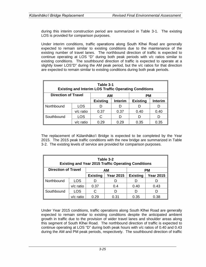
Kūlanihāko‘i Bridge Replacement Revised Final Environmental Assessment
3-25
during this interim construction period are summarized in Table 3-1. The existing LOS is provided for comparison purposes. Under interim conditions, traffic operations along South Kīhei Road are generally expected to remain similar to existing conditions due to the maintenance of the existing number of travel lanes. The northbound direction of traffic is expected to continue operating at LOS “D” during both peak periods with v/c ratios similar to existing conditions. The southbound direction of traffic is expected to operate at a slightly lower LOS”D” during the AM peak period, but the v/c ratios for that direction are expected to remain similar to existing conditions during both peak periods.
Table 3-1 Existing and Interim LOS Traffic Operating Conditions
Direction of Travel AM PM Existing Interim Existing Interim
Northbound LOS D D D D v/c ratio 0.37 0.37 0.40 0.40 Southbound LOS C D D D v/c ratio 0.29 0.29 0.35 0.35
The replacement of Kūlanihāko‘i Bridge is expected to be completed by the Year 2015. The 2015 peak traffic conditions with the new bridge are summarized in Table 3-2. The existing levels of service are provided for comparison purposes.
Table 3-2 Existing and Year 2015 Traffic Operating Conditions
Direction of Travel AM PM Existing Year 2015 Existing Year 2015
Northbound LOS D D D D v/c ratio 0.37 0.4 0.40 0.43 Southbound LOS C D D D v/c ratio 0.29 0.31 0.35 0.38
Under Year 2015 conditions, traffic operations along South Kīhei Road are generally expected to remain similar to existing conditions despite the anticipated ambient growth in traffic due to the provision of wider travel lanes and shoulder areas along this segment of South Kīhei Road. The northbound direction of traffic is expected to continue operating at LOS “D” during both peak hours with v/c ratios of 0.40 and 0.43 during the AM and PM peak periods, respectively. The southbound direction of traffic
Kūlanihāko‘i Bridge Replacement Revised Final Environmental Assessment
3-26
is also expected to operate at LOS “D” during both peak periods with v/c ratios of 0.31 and 0.38 during the AM and PM peak periods, respectively. Based on the analysis of the traffic data, the following recommendations should be implemented in conjunction with the proposed project:
1. Provide sufficient sight distances for motorists to safely navigate the proposed temporary bypass road and bridge.
2. Provide sufficient turning radii along the temporary bypass road and bridge to accommodate all anticipated vehicle types. If the provision of these radii is not technically feasible, consider restriction of larger vehicles along this segment of South Kīhei Road and the provision of a detour utilizing Piʻilani Highway.
3. Prepare a Construction Traffic Management Plan to minimize the impact of construction activities on the surrounding roadways.
Traffic operations during the interim construction period and once the project is complete in Year 2015 are anticipated to remain similar to existing conditions. As such, the proposed project is not expected to have a significant impact on traffic in the project vicinity. In addition, recommendations have been provided to ensure that the temporary detour road and bridge can safely accommodate existing traffic during construction and minimize the impact of construction activities on the surrounding roadways. The proposed temporary bridge and bypass road on the mauka side of South Kīhei Road has been designed to accommodate larger vehicles such as buses and fire trucks. However, there are limitations to semi-trailers which would need to be re-routed during construction of the replacement bridge. The replacement bridge will be designed to accommodate all vehicle types. During the construction of the tie-in between the temporary bypass road and the existing South Kīhei Road there will be a period of time (approximately two weeks) when South Kīhei Road will need to be closed. During this time, vehicles are planned to be detoured through Piʻilani Highway.
3.10 Visual Resources Hawai‘i’s visual resources are an important component of the state’s tourism industry and of the quality of life enjoyed by the state’s residents. The state’s visual resources include a broad range of natural and developed areas and a tremendous variety of land uses, water bodies, and vegetation types. The slopes of Haleakalā are visible from the project site, with the West Maui Mountains visible to the northwest. The County of Maui’s Maui Island Plan identifies South Kīhei Road in the vicinity of the project site as a “medium” scenic corridor.
Impacts and Mitigation Measures In the short-term, a temporary bypass road and bridge are being proposed on the mauka side of the existing roadway. This use will be generally similar in visual

Kūlanihāko‘i Bridge Replacement Revised Final Environmental Assessment
3-27
character to that of the emergency temporary bridge over the existing culverts. Compared to the existing culverts, the temporary bridge on the mauka side of South Kīhei Road would provide a higher view object (approximately 14 feet) for individuals utilizing South Kīhei Road or in close proximity to this portion of the road. However, the temporary bridge and bypass road are necessary in order to maintain usage of this portion of South Kīhei Road during construction of the replacement Kūlanihāko‘i Bridge. Once the new bridge is constructed, the temporary bypass road and bridge will be removed. In the long-term, the proposed replacement bridge is not anticipated to have significant impacts on notable view planes nor adversely affect important public viewing points or visual resources. As an already existing roadway and bridge, the project will not significantly change the scenic and visual character of the surrounding area.
3.11 Socio-Economic Characteristics The project site is located within the Kīhei Census Designated Place (CDP). Demographic and other information was reviewed from the U.S. Census 2010 for the Kīhei CDP and the County of Maui and is shown on Table 3-3. Based upon the data shown on the table, Kīhei CDP has a slightly younger population than the County of Maui. The median age of the population for Kīhei CDP was 38.4 versus 39.6 for the County. By racial mix, the Kīhei CDP has a higher percentage of Whites (50.7%) than the County (34.4%). Kīhei CDP also has a slightly lower percentage of Asians (21.7%) and those of two or more races (16.3%) than the County (28.8% and 23.5%, respectively). These three races (Whites, Asians and those with two or more races) make up the majority of the population. Native Hawaiian and other Pacific Islanders comprise a slightly lower proportion than the County as a whole, with 6.5% and 10.4%, respectively. According to the 2010 Census, Kīhei CDP has a slightly lower housing occupancy rate, 67.5%, than the County, 76.6%. Housing units in this region are evenly occupied by both renters (52.0%) and owners (48.0%). The County data differs slightly to that of the Kīhei CDP data in that the proportion of housing units are occupied more by owners than renters (55.8% and 44.2%, respectively).
Impacts and Mitigation Measures In the short- term, construction expenditures will provide positive benefits to the local economy. This would include creation of some construction and construction support jobs, and the purchase of materials from local suppliers, as well as indirect benefits to local retail businesses resulting from construction activities.
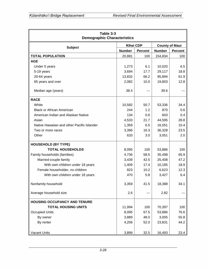
Kūlanihāko‘i Bridge Replacement Revised Final Environmental Assessment
3-28
Table 3-3 Demographic Characteristics
Subject Kīhei CDP County of Maui Number Percent Number Percent
TOTAL POPULATION 20,881 100 154,834 100 AGE
Under 5 years 1,273 6.1 10,020 6.5 5-19 years 3,694 17.7 29,117 18.8 20-64 years 13,832 66.2 95,894 61.9 65 years and over 2,082 10.0 19,803 12.8 Median age (years) 38.4 --- 39.6 ---
RACE
White 10,582 50.7 53,336 34.4 Black or African American 244 1.2 870 0.6 American Indian and Alaskan Native 134 0.6 603 0.4 Asian 4,533 21.7 44,595 28.8 Native Hawaiian and other Pacific Islander 1,359 6.5 16,051 10.4 Two or more races 3,396 16.3 36,328 23.5 Other 633 3.0 3,051 2.0
HOUSEHOLD (BY TYPE)
TOTAL HOUSEHOLDS 8,095 100 53,886 100 Family households (families) 4,736 58.5 35,498 65.9
Married-couple family 3,439 42.5 25,408 47.2 With own children under 18 years 1,409 17.4 10,185 18.9
Female householder, no children 823 10.2 6,623 12.3 With own children under 18 years 470 5.8 3,427 6.4
Nonfamily household 3,359 41.5 18,388 34.1
Average household size 2.6 --- 2.82 --- HOUSING OCCUPANCY AND TENURE
TOTAL HOUSING UNITS 11,994 100 70,397 100 Occupied Units 8,095 67.5 53,886 76.6
By owner 3,889 48.0 3,005 55.8 By renter 4,206 52.0 23,831 44.2
Vacant Units 3,899 32.5 16,493 23.4
Kūlanihāko‘i Bridge Replacement Revised Final Environmental Assessment
3-29
In the long-term, the proposed project will replace the existing deteriorating bridge, which will create safer access over Kūlanihāko‘i Bridge. In addition, the roadway improvements to South Kīhei Road will create safer pedestrian and bicycle access that will benefit the public who travel along this route.
3.12 Public Services and Facilities
3.12.1 Police and Fire Protection Police protection in the project area is provided by the County of Maui Police Department (MPD). The project area is a part of District VI, which covers the Kīhei-Mākena region and is was served by a substation located at the Kīhei Town Center, approximately 2.2 miles from the project site. In addition, MPD is currently located within the proposing a new Kīhei Police Station to be located mauka of Piʻilani Highway near its intersection with Kanani Road approximately 3.3 miles from the project site. Fire prevention, protection is provided by the County of Maui, Department of Fire and Public Safety. The project area is served by the Kīhei Fire Station located on South Kīhei Road near Kalama Park approximately 2.1 miles south of the project site. The Wailea Fire Station, located approximately 4.9 miles to the south of the project site, provides back up support for the Kīhei Station when required.
Impacts and Mitigation Measures In the short- and long-term, no significant impacts or increased demand on police and fire services resulting from the project are anticipated. The proposed project will replace the current, deteriorating bridge and enhance safety for motorists, bicyclists and pedestrians along this section of roadway. No additional vehicular lanes are proposed that could increase roadway capacity or traffic flow. Therefore, the project is not anticipated to induce population growth and associated demands on police and fire protection. During construction of the temporary bypass road and bridge and the new Kūlanihāko‘i Bridge, access through South Kīhei Road will be maintained at existing levels of service, therefore, the proposed project is not anticipated to have significant impacts on fire and police access through the project site.
3.12.2 Health Care Services The only major medical facility on the island is the Maui Memorial Medical Center, which is located in Wailuku, approximately 11.3 miles from the project site. The 231 bed facility provides general, acute, and emergency care services. Various clinics and physician’s offices are situated throughout the Kīhei and Wailea areas, however, these facilities provide medical services on a smaller scale. Clinics within the project vicinity include Kīhei Clinic and Wailea Medical Services, Kīhei Pediatric Clinic, Kīhei Physicians, Kīhei-Wailea Medical Center, Maui Medical Group, and Kaiser Permanente.

Kūlanihāko‘i Bridge Replacement Revised Final Environmental Assessment
3-30
Impacts and Mitigation Measures In the short- and long-term, no significant impacts or increased demand on medical services are anticipated. The proposed project will replace the current, deteriorating bridge and enhance safety for motorists, bicyclists and pedestrians along this section of roadway. No additional vehicular lanes are proposed that could increase roadway capacity or traffic flow. Therefore, the project is not anticipated to induce population growth and associated demands on medical facilities and services.
3.12.3 Education The project site is located within the State Department of Education’s (DOE) Baldwin-Kekaulike-Maui complex area which includes Kamali‘i Elementary School, Kīhei Elementary School, Lokelani Intermediate, and Kīhei Public Charter School. The closest education facility to the project site is Kīhei Public Charter School located 0.7 miles northeast from the project site. Kīhei Public Charter School serves children from kindergarten to 12th grade. The other schools within the project vicinity are all located over one mile away from the project site.
Impacts and Mitigation Measures In the short- and long-term, no significant impacts or increased demand on educational facilities are anticipated. The proposed project will replace the current, deteriorating bridge and enhance safety for motorists, bicyclists and pedestrians along this section of roadway. No additional vehicular lanes are proposed that could increase roadway capacity or traffic flow. Therefore, the project is not anticipated to induce population growth and associated demands on medical facilities and services. During construction of the temporary bypass road and bridge and the new Kūlanihāko‘i Bridge, access through South Kīhei Road will be maintained at existing levels of service, therefore, the proposed project is not anticipated to have significant impacts on students who travel along this route to and from school.
In the long-term, safer pedestrian and bicycle access over Kūlanihāko‘i Bridge will benefit students who travel along this route.
3.12.4 Recreational Facilities The County has several parks located in the project vicinity. The nearest County recreational facility to the project site is the 1.5 acre Kalepolepo Beach Park, located approximately 500 feet west of the project site along South Kīhei Road. Located approximately 0.25 miles north of the project site is the 5.3 acre Mai Poina Oʻe Iaʻu Beach Park. Amenities available at this park include parking, picnic areas, and restrooms. Further south of the project site is the 20.22 acre Kīhei Beach Reserve, also known as Waipu‘ilani Park located approximately 0.5 miles from the project site. Amenities available at this park include restrooms, a soccer field, and tennis courts. Other recreational facilities in the project vicinity include the Kīhei Community Center and Aquatic Center, as well as resort affiliated, world-class golf courses and tennis centers.

Kūlanihāko‘i Bridge Replacement Revised Final Environmental Assessment
3-31
Impacts and Mitigation Measures In the short- and long-term, no significant impacts or increased demand on recreational facilities in the project vicinity are anticipated. The proposed project will replace the current, deteriorating bridge and enhance safety for motorists, bicyclists and pedestrians along this section of roadway. No additional vehicular lanes are proposed that could increase roadway capacity or traffic flow. Therefore, the project is not anticipated to induce population growth and associated demands on recreational facilities and parks.
3.12.5 Solid Waste Collection and Disposal The County of Maui, Environmental Management Solid Waste Division Refuse Collection Program collects residential solid waste in the project vicinity. On an island-wide basis, solid waste from residential properties is disposed at three landfill locations: Central Maui Sanitary Landfill, Olowalu residential Recycling & Refuse Convenience Center, and Hāna Sanitary Landfill. Construction waste is disposed at Maui Construction & Demolition Landfill. Refuse collection for non-single family residential properties are provided by private refuse companies.
Impacts and Mitigation Measures In the short- and long-term, no significant impacts to municipal solid waste collection and disposal facilities are anticipated during the construction of the proposed project. Construction of the proposed project will generate solid waste typical of roadway construction related activities over the short-term. The contractor will be required to remove all debris from the site, and properly dispose of it at the Maui Construction and Demolition Landfill in conformance with County regulations.
3.13 Infrastructure and Utilities
3.13.1 Water System Water service in the Kīhei-Mākena area is provided by the County of Maui Department of Water Supply (DWS). The DWS serves five main sections within the County; Central Maui, Upcountry Maui, West Maui, East Maui, and Molokaʻi. The project area is a part of the Central Maui system which includes Wailuku, Pāʻia, Kahului, Puʻunēnē, and Kīhei. Within the project site, there is an existing 12-inch waterline located within the right-of-way of South Kīhei Road.
Impacts and Mitigation Measures In the short-term, as the new culverts extend further across South Kīhei Road than the existing culverts, a portion of the existing 12-inch waterline will need to be replaced under the new culverts. All relocation work will be coordinated with DWS prior to construction. In the long-term, the project is not anticipated to result in increased demand on the water system in the area. The proposed project will replace the current, deteriorating bridge and enhance safety for motorists, bicyclists and pedestrians along this section of roadway. No additional vehicular lanes are proposed that could increase roadway
Kūlanihāko‘i Bridge Replacement Revised Final Environmental Assessment
3-32
capacity or traffic flow. Therefore, the project is not anticipated to induce population growth and associated demand on water. The proposed project is not anticipated to require using water on a regular basis.
3.13.2 Wastewater System Wastewater service in the Kīhei area is provided by the County of Maui Department of Environmental Management. The Kīhei Wastewater Reclamation facility is responsible for handling all wastewater needs in the Kīhei area. Wastewater flows from the area are conveyed through a series of force mains, pump stations, and gravity lines to the reclamation facility for processing. Within the vicinity of the project site there is a 30-foot wide sewer line easement located adjacent to the South Kīhei Road right-of-way. Within the easement lies a 27-inch sewer pipeline.
Impacts and Mitigation Measures In the short- and long-term, the proposed project is not anticipated to result in increased demand on the wastewater system in the area. The proposed project will replace the current, deteriorating bridge and enhance safety for motorists, bicyclists and pedestrians along this section of roadway. No additional vehicular lanes are proposed that could increase roadway capacity or traffic flow. Therefore, the project is not anticipated to induce population growth and associated demand on the wastewater system. The proposed project will not generate any wastewater and the existing wastewater pipeline is not proposed to be altered. Construction plans for the project will be circulated to the Department of Environmental Management for review.
3.13.3 Drainage System According to the County of Maui’s Draft Report, Kīhei Drainage Master Plan Waiakoa Gulch to Kilohana Drive Existing Conditions, dated April 2009, there are eight different flood districts in the Kīhei region. The Kūlanihāko‘i Bridge is located in the Kūlanihāko‘i District, which is the largest district in the region that extends from an area adjacent to the summit of Haleakalā down to the ocean. For the Kūlanihāko‘i District, runoff flows from a 100-year storm event are contributed by six drainage areas; Piʻilani Basins 5, 6, 7, and 8 and Makai Basins Kula 2_1 and Kula 2_2. All runoff flows eventually discharge into Kūlanihāko‘i Gulch where they continue to flow toward South Kīhei Road and the existing four culverts. For a 100-year storm event, at the point where the flows reach the existing culverts, the total flow for the 100-year storm event is approximated at 14,148 cfs. In addition, sand dunes which accumulate downstream of the gulch cause flooding problems and backwater effects during heavy storm events. A Drainage Report for the project site was prepared by Wilson Okamoto Corporation in March 2013. The Drainage Report is included in Appendix E and is summarized below. For a 100-year storm event, calculations show that the downstream elevations of the existing culverts are slightly higher than the upstream elevations, which may be caused by the accumulating sand dunes which prevent runoff from flowing out to the ocean and causing backwater effects that flood neighboring properties. Results also show that the existing culverts are not capable of handling large volumes of runoff which leads to runoff overtopping
Kūlanihāko‘i Bridge Replacement Revised Final Environmental Assessment
3-33
the roadway. The existing culverts currently have no drainage capacity as they are essentially level with the surrounding area. This in turn, along with the presence of the sand plug, creates a pooling effect in which water rises and fills the area rather than allowing the water to flow.
Impacts and Mitigation Measures In the short- and long-term, no significant impacts are anticipated on the existing storm drainage system as a result of the construction and operation as the proposed project itself will not generate any additional runoff In the short-term, the temporary bridge on the mauka side of the existing bridge would have a drainage capacity of 705 cfs as the finished grade of the temporary bypass bridge would be approximately three feet above the top bank of the existing drainageway. Based on this runoff value, it was determined that the largest storm event that the temporary bypass bridge could handle would be a 1-year, 24 hour storm event. The location and the elevation of the temporary bridge is constrained due to the physical location of the project area, making it difficult to raise the bridge over the drainageway to accommodate a greater volume of flow. For a 100-year storm event, the temporary bridge is likely to be flooded due to large amounts of runoff flowing from upstream. In addition, the sand dunes would continue to impede the ability of the runoff to flow out to the ocean and continue to cause backwater effects that flood neighboring properties. For the temporary bridge to accommodate a 100-year storm event, the bridge would have to be raised. However, due to the physical constraints of the project site, raising the bridge would increase the slope of the bypass road, making it too steep for vehicles to travel on. In the long-term, as the project involves increasing the number of culverts from four to six culverts and constructing them at a 0.5% slope, the proposed replacement bridge will provide an incremental increase in drainage capacity from 204 cfs to 306 cfs. This increase in drainage capacity would not be enough to accommodate the 100-year storm event. The new culverts would still be incapable of handling large volumes of runoff from severe storm events. In addition, the sand dunes would continue to impede the ability of the runoff to flow out to the ocean. Though the proposed project does slightly increase drainage capacity, the purpose of the project is to replace the deteriorating culverts and is not intended to address flooding issues on a regional basis.
3.13.4 Electrical and Communications Systems Electrical power on the island of Maui is provided by Maui Electric Company (MECO), a subsidiary of Hawaiian Electric Company, Inc. The electrical source for the project area is the Māʻalaea Power Plant. Telephone service in the Kīhei area, like the rest of the State, is provided by Hawaiian Telcom. Oceanic Time Warner Cable of Hawai‘i is the local CATV provider in the region.
Kūlanihāko‘i Bridge Replacement Revised Final Environmental Assessment
3-34
Within the project site, two electrical overhead utility poles are located in the right-of-way on the mauka side of South Kīhei Road.
Impacts and Mitigation Measures In the short-term, the two electrical poles will need to be relocated as they are currently located where the paved walkway is being proposed. All relocation work will be coordinated with MECO prior to construction. In the long-term, the proposed project is not anticipated to significantly impact or increase demand on electrical and communication systems in the area. The proposed project will replace the current, deteriorating bridge and enhance safety for motorists, bicyclists and pedestrians along this section of roadway. No additional vehicular lanes are proposed that could increase roadway capacity or traffic flow. Therefore, the project is not anticipated to induce population growth and associated demand for electric and communication services. The proposed project is not anticipated to require electrical and communication services for its operation.

Kūlanihāko‘i Bridge Replacement Revised Final Environmental Assessment
3-35
(This page intentionally left blank)
Kūlanihāko‘i Bridge Replacement Revised Final Environmental Assessment
4-1
4. RELATIONSHIP TO PLANS, POLICIES, AND CONTROLS
This section discusses the State and County of Maui land use plans, policies and controls relating to the proposed project.
4.1 State Land Use Plans and Policies
4.1.1 Hawai‘i State Plan The Hawai‘i State Plan, Chapter 226, HRS, provides goals, objectives, policies, and priorities for the State. The Hawai‘i State Plan also provides a basis for determining priorities, allocating limited resources, and improving coordination of State and County Plans, policies, programs, projects, and regulatory activities. It establishes a set of themes, goals, objectives, and policies that are meant to guide the State’s long-range growth and development activities. The proposed project is consistent with the following applicable objectives and policies: Sec. 226-11 Objectives and policies for the physical environment – land-based, shoreline, and marine resources.
(a) Planning for the State’s physical environment with regard to land-based shoreline, and marine resources shall be directed towards achievement of the following objectives:
(1) Prudent use of Hawai‘i’s land-based, shoreline, and marine resources. (2) Effective protection of Hawai‘i’s unique and fragile environmental
resources. (b) To achieve the land-based, shoreline, and marine resources objectives, it shall be
the policy of this State to:
(3) Take into account the physical attributes of areas when planning and designing activities and facilities.
(4) Manage natural resources and environs to encourage their beneficial and
multiple use without generating costly or irreparable environmental damage.
(6) Encourage the protection of rare or endangered plant and animal species
and habitats native to Hawai‘i. (8) Pursue compatible relationships among activities, facilities, and natural
resources. Discussion: Construction activities will involve land-disturbing activities, such as grubbing, clearing, grading, and excavation that may result in some soil erosion and potential construction-related impacts to the quality of surface and coastal waters in the greater project vicinity. Various mitigative measures will be incorporated into the project’s construction plan
Kūlanihāko‘i Bridge Replacement Revised Final Environmental Assessment
4-2
to minimize soil disturbances and potential short-term erosion impacts during construction activities. Excavation and grading activities associated with construction of the proposed improvements will be regulated by the County’s grading ordinance. A DOA Nationwide Permit, pursuant to Section 404 of the Clean Water Act and a WQC, issued by the DOH, pursuant to Section 401 of the Clean Water Act will be required. In conjunction with the Section 401 and 404 permits, a BMP plan will be prepared for construction activities within the project site. Erosion and sediment control measures will be instituted in accordance with site specific assessments, incorporating appropriate structural and/or non-structural BMPs such as minimizing time of exposure between construction and landscaping, and implementing erosion control measures such as silt fences and filter berms. Specific BMPs may include, but may not be limited to the following:
1. Minimizing soil loss and erosion by revegetation and stabilization of slopes and disturbed areas of soil, possibly using hydromulch, geotextiles, or other applicable alternatives, as soon as possible after working;
2. Minimizing time of exposure between construction and landscaping; 3. Application of protective covers to soil and material stockpiles; 4. Minimizing disturbance of soil during periods of heavy rain; 5. Implementing erosion control measures by emplacement of structural controls such
as silt fences, filter berms, gravel bags, fiber rolls, sandbag barriers and other barriers in order to retard and prevent the loss of sediment from the site;
6. Phasing of the project to disturb the minimum area of soil at a particular time; 7. Use of drip pans beneath vehicles not in use in order to trap vehicle fluids; 8. Routine maintenance of BMPs by adequately trained personnel; 9. Significant leaks or spills, if they occur, shall be properly cleaned up and disposed of
at an approved site. The proposed project is not anticipated to have any long-term impacts to land-based, shoreline, and marine resources. Following construction, exposed soils at the project site will have been built over, paved over, or re-vegetated to control erosion. Dewatering may be required for the proposed project. Should dewatering be deemed necessary, the contractor will be responsible to obtaining all applicable permits including, but not limited to, an NPDES Permit for Dewatering Activities. The permit application will require a BMP plan, an erosion control plan, and a water quality monitoring plan. Water quality impacts associated with the disposal of dewatering effluent will also be addressed in the BMP plan, including appropriate characterization of any potential pollutants such as sediments and nutrients in the effluent. Sec. 226-17 Objective and policies for facility systems – transportation.
(a) Planning for the State’s facility systems with regard to transportation shall be directed towards the achievement of the following objectives:
(1) An integrated multi-modal transportation system that services statewide needs and promotes the efficient, economical, safe, and convenient movement of people and goods.

Kūlanihāko‘i Bridge Replacement Revised Final Environmental Assessment
4-3
Discussion: The proposed project will replace the current, deteriorating bridge and enhance safety for motorists, bicyclists, and pedestrians along this section of roadway by providing an exclusive bike lane and paved walkway on the mauka side of the road. In addition, the makai side of the bridge and immediately adjacent areas will accommodate a bike lane and paved walkway. Improvements to additional segments can be implemented if and when future improvements are pursued on the makai side of South Kīhei Road.
4.1.2 State Land Use District The State Land Use Law, Chapter 205, HRS, is intended to preserve, protect and encourage the development of lands in the State for uses that are best suited to the public health and welfare of Hawai‘i’s people. Under Chapter 205, HRS all lands in the State of Hawai‘i are classified by the State Land Use Commission (LUC) into four major categories referred to as State Land Use Districts. These districts are identified as the Urban District, Agricultural District, Conservation District, and Rural District.
The LUC’s Land Use District Boundary map for the Island of Maui depicts the lands within the project area as being designated within the State Urban District (see Figure 4-1). Permitted uses within the State Urban district are prescribed under Title 12, Chapter 205 (Land Use Commission), HRS, and the State Land Use Commission’s Administrative Rules prescribed under Title 15, Subtitle 3, Chapter 15 HAR. Pursuant to §15-15-24, HAR, pertaining to permissible uses within the Urban District, permitted uses include any and all uses permitted by the counties, either by ordinances or rules, and are subject to any conditions imposed by the Land Use Commission pursuant to Section 205-4.5, HRS. Since roadways, such as the proposed project, are considered an incidental use that is permitted in each of the County’s zoning districts, the proposed project is a permitted use within the Urban District.
4.1.3 Hawai‘i Coastal Zone Management Program The National Coastal Zone Management (CZM) Program was created through passage of the Coastal Zone Management Act of 1972. Hawai‘i’s CZM Program, adopted as Chapter 205A, HRS, provides a basis for protecting, restoring and responsibly developing coastal communities and resources. The Hawai‘i CZM area includes all lands within the State and the areas seaward to the extent of the State’s management jurisdiction. Hence, the proposed project site is located in the CZM area. A discussion of the project’s consistency with the objectives and policies of the CZM Program is provided below. (1) Recreational Resources
Objective: Provide coastal recreational opportunities accessible to the public.
Policies: (A) Improve coordination and funding of coastal recreational planning and
management; and
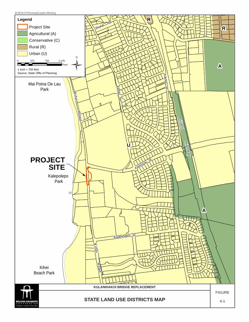
U
A
A
R
RLegend
Project SiteAgricultural (A)Conservative (C)Rural (R)Urban (U)
Ü0 375 750 1,125Feet
1 inch = 750 feetSource: State Offie of Planning
PROJECTSITE
Pi i lani H
ighway
Pi i lani H
ighway
Kihei R
oadK
ihei Road
Kaonoulu St.
Kaonoulu St.
Kulanihakoi St.Kulanihakoi St.
Keolio Rd.
Keolio Rd.
Ohukai Rd.
Ohukai Rd.
Kaiola Pl.Kaiola Pl.
Pi i lani H
ighway
Kihei R
oad
Kaonoulu St.
Kulanihakoi St.
Keolio Rd.
Ohukai Rd.
Kaiola Pl.
Kihei R
oadK
ihei Road
Kihei R
oad
KiheiBeach Park
Kalepolepo Park
Mai Poina Oe LauPark
STATE LAND USE DISTRICTS MAPFIGURE
4-1
KULANIHAKOI BRIDGE REPLACEMENT
W:\8256-01\Planning\Graphics\Working
Kūlanihāko‘i Bridge Replacement Revised Final Environmental Assessment
4-5
(i) Provide adequate, accessible, and diverse recreational opportunities in the
coastal zone management area by: Protecting coastal resources uniquely suited for recreational activities that cannot be provided in other areas;
(ii) Requiring replacement of coastal resources having significant recreational value, including but not limited to surfing sites, fishponds, and sand beaches, when such resources will be unavoidably damaged by development; or requiring reasonable monetary compensation to the state for recreation when replacement is not feasible or desirable;
(iii) Providing and managing adequate public access, consistent with conservation of natural resources, to and along shorelines with recreational value;
(iv) Providing an adequate supply of shoreline parks and other recreational facilities suitable for public recreation;
(v) Ensuring public recreational use of county, state, and federally owned or controlled shoreline lands and waters having recreational value consistent with public safety standards and conservation of natural resources;
(vi) Adopting water quality standards and regulating point and nonpoint sources of pollution to protect, and where feasible, restore the recreational value of coastal waters.
(vii) Developing new shoreline recreational opportunities, where appropriate, such as artificial lagoons, artificial beaches, and artificial reefs for surfing and fishing; and
(viii) Encouraging reasonable dedication of shoreline areas with recreational value for public use as part of discretionary approvals or permits by the land use commission, board of land and natural resources, and county authorities; and crediting such dedication against the requirements of section 46-6.
The proposed project, at its closest point, is located approximately 120 72-feet from the draft certified shoreline.
In the short-term, storm water runoff may carry increased amounts of sediment into the storm drain system due to erosion from soils exposed during excavation and grading activities. This runoff could potentially impact the water quality of coastal waters in the area. However, excavation and grading activities associated with the construction of the proposed project will be regulated by the County’s grading ordinance.
A DOA Nationwide Permit, pursuant to Section 404 of the Clean Water Act and a WQC, issued by the DOH, pursuant to Section 401 of the Clean Water Act will be required. In conjunction with the Section 401 and 404 permits, a BMP plan will be prepared for construction activities within the project site. Erosion and sediment control measures will be instituted in accordance with site specific assessments, incorporating appropriate structural and/or non-structural BMPs such as minimizing time of exposure between construction and landscaping, and implementing erosion control measures such as silt fences and filter berms. Specific BMPs may include, but may not be limited to the following:

Kūlanihāko‘i Bridge Replacement Revised Final Environmental Assessment
4-6
1. Minimizing soil loss and erosion by revegetation and stabilization of slopes and disturbed areas of soil, possibly using hydromulch, geotextiles, or other applicable alternatives, as soon as possible after working;
2. Minimizing time of exposure between construction and landscaping; 3. Application of protective covers to soil and material stockpiles; 4. Minimizing disturbance of soil during periods of heavy rain; 5. Implementing erosion control measures by emplacement of structural controls such
as silt fences, filter berms, gravel bags, fiber rolls, sandbag barriers and other barriers in order to retard and prevent the loss of sediment from the site;
6. Phasing of the project to disturb the minimum area of soil at a particular time; 7. Use of drip pans beneath vehicles not in use in order to trap vehicle fluids; 8. Routine maintenance of BMPs by adequately trained personnel; 9. Significant leaks or spills, if they occur, shall be properly cleaned up and disposed of
at an approved site. Following construction, exposed soils at the project site will have been built over, paved over, or re-vegetated to control erosion. Dewatering may be required for the proposed project. Should dewatering be deemed necessary, the contractor will be responsible to obtaining all applicable permits including, but not limited to, an NPDES Permit for Dewatering Activities. The permit application will require a BMP plan, an erosion control plan, and a water quality monitoring plan. Water quality impacts associated with the disposal of dewatering effluent will also be addressed in the BMP plan, including appropriate characterization of any potential pollutants such as sediments and nutrients in the effluent. In the long-term, as the proposed culverts will be constructed at a 0.5% slope, the drainage capacity will increase slightly from 204 cfs to 306 cfs. In the event of a 100-year storm, this increase in capacity will increase the likelihood of storm flows breaking through the sand plug. This could slightly relieve some of the upstream flooding, but may slightly increase flows past the sand plug. No significant impacts are anticipated on recreational resources. (2) Historic Resources
Objective: (A) Protect, preserve and, where desirable, restore those natural and manmade
historic and prehistoric resources in the coastal zone management area that are significant in Hawaiian and American history and culture.
Policies: (A) Identify and analyze significant archaeological resources; (B) Maximize information retention through preservation of remains and artifacts or
salvage operations; and (C) Support state goals for protection, restoration, interpretation, and display of
historic resources.
An Archaeological Literature Review and Field Inspection (LR&FI) for the project site was conducted for the property in December 2012. Based on the field inspection findings and
Kūlanihāko‘i Bridge Replacement Revised Final Environmental Assessment
4-7
background research, there is a low potential for the discovery of previously unidentified historic properties beyond the historic era itself. The area surrounding the bridge includes the Kūlanihākoʻi Stream mouth, a natural wetland and associated flood plain. While impacts by flooding episodes and modifications associated with road construction and maintenance have greatly altered sediments of the project areas, the possibility of encountering intact subsurface cultural deposits, including human burials, should not be underestimated. Therefore, the LR&FI recommended that archaeological monitoring be conducted is recommended for all ground disturbing activities during all phases of the temporary bridge and bypass road work and bridge replacement. It is also recommended that a monitoring report be generated after the construction of the temporary bridge and bypass road and the replacement bridge.
A site inspection was conducted on December 13, 2012 by SHPD and Cultural Surveys Hawai‘i. Based on the site inspection, SHPD requested that an AIS be prepared for the project site. The AIS is currently pending and will be submitted to SHPD for approval when it has been completed. Subsequent consultation with SHPD, by letter dated February 1, 2013, indicated that they have concerns that the project area is located within a zone of beach sand dune and Aeolian sand deposits which are known to contain human burial features and historic habitation sites. It is therefore likely that historic properties, including human remains, may be present beneath the previously disturbed road grade and sub-grade or within previously unaffected areas of the right-of-way. SHPD requested that all project associated excavations be monitored by a qualified archaeologist in order to identify and mitigate any subsurface cultural features and deposits. They further recommend that an archaeological monitoring plan be submitted to their office for review and approval prior to initiation of this project.
Should any significant archeological, cultural, or historic resources be found during construction activities, all work will cease in the vicinity of the find and SHPD will be notified immediately to determine appropriate mitigation measures.
During a field visit on December 13, 2012 with Theresa Donham (Archaeology Branch Chief), an archaeological inventory survey of the lands covering the extent of the APE of the proposed detour bridge was recommended. An archaeological inventory survey was conducted by Cultural Surveys Hawai‘i, Inc. dated June 2013.
The survey included shovel testing and pipe coring which enabled mapping a general stratigraphy of the project to a depth of approximately 10 feet below ground surface. Two soil samples were submitted for pollen analysis.
One historic property within the project area is the Kūlanihāko‘i Bridge itself. The bridge has been given a site number (SIHP 50-50-10-7606). The bridge was constructed in 1911 and consisted of four individual reinforced concrete box culverts. The paving surface over the existing culverts was applied in the 1930’s. This included some shoring-up of the edge of the roadway using a historic construction style attributed to pre-1940’s plantation masons. The present day Kūlanihāko‘i Bridge appears to consist of two sections of prefabricated concrete culvert welded together to form the length of the existing bridge. A more modern construction style probably occurred because of the many repairs the bridge had undergone due to storm damage.
Kūlanihāko‘i Bridge Replacement Revised Final Environmental Assessment
4-8
The study was able to establish that at least the first 10 feet of sediment can be attributed to historic alluvium from Kūlanihāko‘i Gulch. This is generally consistent with the information collected by Geolabs, the geotechnical engineer, for this project. They recorded a dark gray clay silt to a depth of 10 feet above the grayish tan coralline sand.
Like the LR&FI, the inventory survey notes that there is a low potential for the discovery of previously unidentified historic properties beyond the historic era itself. The area surrounding the bridge includes the Kūlanihāko‘i Stream mouth, a natural wetland and associated flood plain. While impacts by flooding episodes and modifications associated with road construction and maintenance have greatly altered sediments of the project areas, the possibility of encountering intact subsurface cultural deposits, including human burials, should not be underestimated. Therefore, archaeological monitoring is recommended for all ground disturbing activities during all phases of the temporary bridge and bypass road work and bridge replacement. It is also recommended that a monitoring report be generated after the construction of the temporary bridge and bypass road and the replacement bridge.
With regard to the bridge itself, the structure was constructed in 1911 and is now 102 105 years old. It is therefore considered a historic property and recordation of the bridge would be required under Chapter 13-275, Hawai‘i Administrative Rules if deemed eligible based on SHPD’s evaluation of the bridge’s significance. Consultation with SHPD, by letter dated December 20, 2012, indicated that while the bridge is unique due to age and represents the first generation of concrete bridges in the islands, it is literally falling apart and has lost any distinguishing architectural characteristics. On this basis, SHPD has determined that the bridge has lost its integrity and is not eligible to be recorded on the State Inventory of Historic Properties. Therefore, the proposed project will have no effect on historic property.
The archaeological inventory survey noted that the Kūlanihāko‘i Bridge (SIHP 50-50-10-7606) has yielded information important to the understanding of the first generation of concrete bridges in the Hawaiian Islands. SIHP -7606 is thus considered significant under Criterion D. Sufficient information concerning SIHP -7606 was collected during the investigation. Based on the additional research, no further work is recommended for the bridge.
The archaeological inventory survey also noted that while subsurface testing was not done beneath South Kīhei Road, boring logs from the Geolabs report recorded the presence of coralline sand around 12 feet below the surface of the road. The presence of this type of sediment deposit may present the potential for encountering sensitive cultural resources in a subsurface context. Monitoring of the culvert removal by a qualified archaeologist is thus recommended.
By letter dated June 25, 2014, the SHPD noted that the archaeological inventory survey meets the requirements of Hawai‘i Administrative Rule Section 13-276 and is accepted as final. Refer to Appendix D.

Kūlanihāko‘i Bridge Replacement Revised Final Environmental Assessment
4-9
(3) Scenic and Open Space Resources
Objective: (A) Protect, preserve, and where desirable, restore or improve the quality of
coastal scenic and open space resources. Policies: (A) Identify valued scenic resources in the coastal zone management area; (B) Ensure that new developments are compatible with their visual environment
by designing and locating such developments to minimize the alteration of natural landforms and existing public views to and along the shoreline;
(C) Preserve, maintain, and, where desirable, improve and restore shoreline open space and scenic resources; and
(D) Encourage those developments which are not coastal dependent to locate in inland areas.
In the short-term, a temporary bypass road and bridge are being proposed on the mauka side of the existing roadway. This use will be generally similar in visual character to that of the temporary bridge over the existing culverts. Compared to the existing culverts, the temporary bridge on the mauka side of South Kīhei Road would provide a higher view object (approximately 14 feet) for individuals utilizing South Kīhei Road or in close proximity to this portion of the road. However, the temporary bridge and bypass road are necessary in order to maintain usage of this portion of South Kīhei Road during construction of the replacement Kūlanihākoʻi Bridge. Once the new bridge is constructed, the temporary bypass road and bridge will be removed.
In the long-term, the proposed replacement bridge is not anticipated to have significant impacts on notable view planes nor adversely affect important public viewing points or visual resources. As an already existing roadway and bridge, the project will not significantly change the scenic and visual character of the surrounding area.
(4) Coastal Ecosystems
Objective: (A) Protect valuable coastal ecosystems, including reefs, from disruption and
minimize adverse impacts on all coastal ecosystems. Policies: (A) Exercise an overall conservation ethic, and practice stewardship in the
protection, use, and development of marine and coastal resources; (B) Improve the technical basis for natural resource management; (C) Preserve valuable coastal ecosystems, including reefs, of significant biological
or economic importance; (D) Minimize disruption or degradation of coastal water ecosystems by effective
regulation of stream diversions, channelization, and similar land and water uses, recognizing competing water needs; and
(E) Promote water quantity and quality planning and management practices that reflect the tolerance of fresh water and marine ecosystems and maintain and

Kūlanihāko‘i Bridge Replacement Revised Final Environmental Assessment
4-10
enhance water quality through the development and implementation of point and nonpoint source water pollution control measures.
The proposed project, at its closest point, is located approximately 120 72-feet from the draft certified shoreline.
In the short-term, storm water runoff may carry increased amounts of sediment into the storm drain system due to erosion from soils exposed during excavation and grading activities. This runoff could potentially impact the water quality of coastal waters in the area. However, excavation and grading activities associated with the construction of the proposed project will be regulated by the County’s grading ordinance. A DOA Nationwide Permit, pursuant to Section 404 of the Clean Water Act and a WQC, issued by the DOH, pursuant to Section 401 of the Clean Water Act will be required. In conjunction with the Section 401 and 404 permits, a BMP plan will be prepared for construction activities within the project site. Erosion and sediment control measures will be instituted in accordance with site specific assessments, incorporating appropriate structural and/or non-structural BMPs such as minimizing time of exposure between construction and landscaping, and implementing erosion control measures such as silt fences and filter berms. Specific BMPs may include, but may not be limited to the following:
1. Minimizing soil loss and erosion by revegetation and stabilization of slopes and disturbed areas of soil, possibly using hydromulch, geotextiles, or other applicable alternatives, as soon as possible after working;
2. Minimizing time of exposure between construction and landscaping; 3. Application of protective covers to soil and material stockpiles; 4. Minimizing disturbance of soil during periods of heavy rain; 5. Implementing erosion control measures by emplacement of structural controls such
as silt fences, filter berms, gravel bags, fiber rolls, sandbag barriers and other barriers in order to retard and prevent the loss of sediment from the site;
6. Phasing of the project to disturb the minimum area of soil at a particular time; 7. Use of drip pans beneath vehicles not in use in order to trap vehicle fluids; 8. Routine maintenance of BMPs by adequately trained personnel; 9. Significant leaks or spills, if they occur, shall be properly cleaned up and disposed of
at an approved site. The proposed project is not anticipated to have any long-term impacts on coastal ecosystems. Following construction, exposed soils at the project site will have been built over, paved over, or re-vegetated to control erosion. Dewatering may be required for the proposed project. Should dewatering be deemed necessary, the contractor will be responsible to obtaining all applicable permits including, but not limited to, an NPDES Permit for Dewatering Activities. The permit application will require a BMP plan, an erosion control plan, and a water quality monitoring plan. Water quality impacts associated with the disposal of dewatering effluent will also be addressed in the BMP plan, including appropriate characterization of any potential pollutants such as sediments and nutrients in the effluent.
Kūlanihāko‘i Bridge Replacement Revised Final Environmental Assessment
4-11
In the long-term, as the proposed culverts will be constructed at a 0.5% slope, the drainage capacity will increase slightly from 204 cfs to 306 cfs. In the event of a 100-year storm, this increase in capacity will increase the likelihood of storm flows breaking through the sand plug. This could slightly relieve some of the upstream flooding, but may slightly increase flows past the sand plug. No significant impacts are anticipated on coastal ecosystems. (5) Economic Uses
Objective: (A) Provide public or private facilities and improvements important to the State’s
economy in suitable locations.
Policies: (A) Concentrate coastal dependent development in appropriate areas; (B) Ensure that coastal dependent developments such as harbors and ports, and
coastal related development such as visitor facilities and energy generating facilities, are located, designed, and constructed to minimize adverse social, visual, and environmental impacts in the coastal zone management area; and
(C) Direct the location and expansion of coastal dependent developments to areas presently designated and used for such developments and permit reasonable long-term growth at such areas, and permit coastal dependent development outside of presently designated areas when:
(i) Use of presently designated locations is not feasible; (ii) Adverse environmental effects are minimized; and (iii) The development is important to the State’s economy.
The proposed project provides the necessary infrastructure to promote the safe and efficient movement of people, goods and services important to the State’s economy. The project will provide direct construction and operational jobs and will also have beneficial secondary economic benefits by promoting the procurement of materials and supplies from local vendors. (6) Coastal Hazards
Objectives: (A) Reduce hazard to life and property from tsunami, storm waves, stream
flooding, erosion, subsidence, and pollution. Policies: (A) Develop and communicate adequate information about storm wave, tsunami,
flood, erosion, subsidence, and point and nonpoint source pollution hazards; (B) Control development in areas subject to storm wave, tsunami, flood, erosion,
hurricane, wind, subsidence, and point and nonpoint pollution hazards; (B) Ensure that developments comply with requirements of the Federal Flood
Insurance Program; (C) Prevent coastal flooding from inland projects.
Kūlanihāko‘i Bridge Replacement Revised Final Environmental Assessment
4-12
According to the Flood Insurance Rate Map (FIRM) (Community Panel Numbers 1500030586F and 1500030567F, Effective Date: September 19, 2012) prepared by the Federal Emergency Management Agency (FEMA), the project site is designated Zone VE and Zone AE.
Zone VE includes areas with a 1% or greater change of flooding and have an additional hazard associated with storm waves. In general, these areas have a 26% chance of flooding over the life of a 30-year mortgage.
Zone AE is characterized as a “special flood hazard area subject to inundation by the 1% annual chance flood.” Zone AE is also a “floodway,” in which “the channel of the stream plus any adjacent floodplain areas that must be kept free of the encroachment so that the 1% annual chance flood can be carried without substantial increases in flood height.” The 1% annual flood is also commonly referred to as the 100-year flood or the base flood.
According to the Tsunami Evacuation Zone maps for Maui, the project site lies entirely within the tsunami evacuation zone.
Construction activities within the respective flood hazard districts will be conducted in accordance with regulations set forth in Section 19.62.060, Maui County Code. Before construction of any development begins within any flood hazard area, flood-related erosion hazard area, or mudslide area, a special flood hazard area development permit shall be obtained from the Director of the Department of Planning.
The project will also comply with the rules and regulations for the National Flood Insurance Program (NFIP) present in Title 44, of the Code of Federal Regulations (44CFR), as the project is within a Special Flood Hazard Area.
(7) Managing Development
Objective: (A) Improve the development review process, communication, and public
participation in the management of coastal resource and hazards.
Policies: (A) Use, implement, and enforce existing law effectively to the maximum extent
possible in managing present and future coastal zone development; (B) Facilitate timely processing of applications for development permits and
resolve overlapping or conflicting permit requirements; and (C) Communicate the potential short- and long-term impacts of proposed
significant coastal developments early in their life cycle and in terms understandable to the public to facilitate public participation in the planning and review process.
The Hawai‘i State environmental review process, HRS 343, requires project review by government agencies and affords the public the opportunity to provide comments on the proposed project. The proposed improvements are also subject to the Special Management
Kūlanihāko‘i Bridge Replacement Revised Final Environmental Assessment
4-13
Area (SMA) permit process. Applicable State and County requirements will be adhered to in the design and construction phases of the proposed improvements. (8) Public Participation
Objective: (A) Stimulate public awareness, education, and participation in coastal
management.
Policies: (A) Promote public involvement in coastal zone management processes; (B) Disseminate information on coastal management issues by means of
educational materials, published reports, staff contact, and public workshops for persons and organizations concerned with coastal issues, developments, and government activities; and
(C) Organize workshops, policy dialogues, and site-specific mediations to respond to coastal issues and conflicts.
The Hawai‘i State environmental review process, Chapter 343, HRS, requires project review by government agencies and affords organizations and the general public the opportunity to provide comments on the proposed project. The proposed improvements are also subject to the SMA and Shoreline Setback Variance permit process as discussed in Section 4.2.23, which includes public notification and a public hearing. (9) Beach Protection
Objective: (A) Protect beaches for public use and recreation. Policies: (A) Locate new structures inland from the shoreline setback to conserve open
space, minimize interference with natural shoreline processes, and minimize loss of improvements due to erosion;
(B) Prohibit construction of private erosion-protection structures seaward of the shoreline, except when they result in improved aesthetic and engineering solutions to erosion at the sites and do not interfere with existing recreational and waterline activities; and
(C) Minimize the construction of public erosion-protection structures seaward of the shoreline.
The proposed project will involve some construction activities within the shoreline setback area and will, therefore, need a shoreline setback variance from the County of Maui Planning Department. The shoreline was re-certified by the Department of Land and Natural Resources on September 18, 2015. Currently, a draft of the certified shoreline is in the process of being reviewed by the State Department of Land and Natural Resources (DLNR). In accordance with the Shoreline Setback Rules and Regulations for the Maui Planning Commission, the
Kūlanihāko‘i Bridge Replacement Revised Final Environmental Assessment
4-14
shoreline setback was calculated by utilizing the annual erosion hazard rate (AEHR) erosion based setback line which is located further mauka than the average lot depth based setback line. No portion of the proposed improvements extend makai of the average lot depth based setback line. However, portions of the proposed culverts and the outlet wing walls are located within the AEHR based setback line. The AEHR setback line cuts diagonally across a portion of the proposed six 6’ wide x 4’ high culverts. Approximately 6 feet to 30 feet of makai portions of the culverts are proposed within the AEHR setback line. The remaining mauka portions of the culverts ranging from 54 feet to 20 feet are outside of the AEHR setback line. The Both proposed outlet wing walls adjacent to the southernmost culvert will be located within the AEHR shoreline setback. The dimensions of the wing walls within the shoreline setback are 10-feet long, 6-feet to 2-feet high (the wall will slope towards the ocean), and 1-foot wide. The wing walls is are a part of the culvert structure and is are intended to retain and protect the foundation of South Kīhei Road. Depending on the location of the final certified shoreline, other portions of the project may or may not be located in the shoreline setback, including the outlet wing wall adjacent to the northernmost culvert. Similar to the southern outlet wing wall, the northern outlet wing wall is also part of the culvert structure that is intended to help retain and protect the foundation of South Kīhei Road. The proposed six (6) culverts, two (2) inlet wing walls, and other roadway improvements are located within the existing County right-of-way. These areas have been utilized for roadway and drainage purposes for slightly over a century. In addition, the proposed temporary bridge and bypass road on the mauka side of the existing bridge will be removed and the area would be restored once the permanent culvert improvements are constructed. As the proposed project involved the replacement and upgrade of existing aging infrastructure, the construction and operation of the project is not anticipated to have any significant impacts on beaches for public use and recreation. (10) Marine Resources
Objective: (A) Promote the protection, use, and development of marine and coastal
resources to assure their sustainability.
Policies: (D) Ensure that the use and development of marine and coastal resources are
ecologically and environmentally sound and economically beneficial; (E) Coordinate the management of marine and coastal resources and activities to
improve effectiveness and efficiency; (F) Assert and articulate the interests of the State as a partner with federal
agencies in the sound management of ocean resources within the United States exclusive economic zone;
(G) Promote research, study, and understanding of ocean processes, marine life, and other ocean resources in order to acquire and inventory information necessary to understand how ocean development activities relate to and impact upon ocean and coastal resources; and
Kūlanihāko‘i Bridge Replacement Revised Final Environmental Assessment
4-15
(H) Encourage research and development of new, innovative technologies for exploring, using, or protecting marine and coastal resources.
The proposed project is not anticipated to have any significant adverse impacts on marine and coastal resources. Potential water quality impacts to nearshore coastal waters during construction of the improvements will be mitigated by adherence to State water quality regulations governing grading, excavation and stockpiling.
In the short-term, storm water runoff may carry increased amounts of sediment into the storm drain system due to erosion from soils exposed during excavation and grading activities. This runoff could potentially impact the water quality of coastal waters in the area. However, excavation and grading activities associated with the construction of the proposed project will be regulated by the County’s grading ordinance.
A DOA Nationwide Permit, pursuant to Section 404 of the Clean Water Act and a WQC, issued by the DOH, pursuant to Section 401 of the Clean Water Act will be required. In conjunction with the Section 401 and 404 permits, a BMP plan will be prepared for construction activities within the project site. Erosion and sediment control measures will be instituted in accordance with site specific assessments, incorporating appropriate structural and/or non-structural BMPs such as minimizing time of exposure between construction and landscaping, and implementing erosion control measures such as silt fences and filter berms. Specific BMPs may include, but may not be limited to the following:
1. Minimizing soil loss and erosion by revegetation and stabilization of slopes and disturbed areas of soil, possibly using hydromulch, geotextiles, or other applicable alternatives, as soon as possible after working;
2. Minimizing time of exposure between construction and landscaping; 3. Application of protective covers to soil and material stockpiles; 4. Minimizing disturbance of soil during periods of heavy rain; 5. Implementing erosion control measures by emplacement of structural controls such
as silt fences, filter berms, gravel bags, fiber rolls, sandbag barriers and other barriers in order to retard and prevent the loss of sediment from the site;
6. Phasing of the project to disturb the minimum area of soil at a particular time; 7. Use of drip pans beneath vehicles not in use in order to trap vehicle fluids; 8. Routine maintenance of BMPs by adequately trained personnel; 9. Significant leaks or spills, if they occur, shall be properly cleaned up and disposed of
at an approved site. The proposed project is not anticipated to have any significant long-term impacts on marine resources. Following construction, exposed soils at the project site will have been built over, paved over, or re-vegetated to control erosion. Dewatering may be required for the proposed project. Should dewatering be deemed necessary, the contractor will be responsible to obtaining all applicable permits including, but not limited to, an NPDES Permit for Dewatering Activities. The permit application will require a BMP plan, an erosion control plan, and a water quality monitoring plan. Water quality impacts associated with the disposal of dewatering effluent will also be addressed in the
Kūlanihāko‘i Bridge Replacement Revised Final Environmental Assessment
4-16
BMP plan, including appropriate characterization of any potential pollutants such as sediments and nutrients in the effluent.
4.1.4 Complete Streets, Act 54 Session Laws of Hawai‘i 2009 Act 54, Session Laws of Hawai‘i 2009 requires that DOT and county transportation departments ensure the accommodation of all users of the road, regardless of their age, ability, or preferred mode of transportation. It also calls for the creation of a statewide task force to review existing state and county highway design standards and guidelines and requires the DOT and county transportation department to adopt a Complete Streets Policy. Complete streets are defined as “transportation facilities that are planned, designed, operated, and maintained to provide safe access and mobility for all users, including bicyclists, pedestrians, transit riders, freight, and motorists, and that are appropriate to the function and context of the facility.” Complete streets principles for Hawai‘i include the following:
• Safety – Plan, design, and construct transportation facilities and land developments to create an environment that reduces risk and supports the safe movement of people and goods by all modes.
• Flexible design – Design transportation facilities using best practices that integrate community values and recognize the importance of the surrounding context and environment.
• Accessibility and mobility for all – Plan and design transportation facilities for ease of use and access to destinations by providing an appropriate path of travel for all users, and enhance the ability to move people and goods throughout the state and its counties.
• Use and comfort of all users – Ensure all users of all abilities including bicyclists, pedestrians, transit riders, and drivers feel comfortable and safe using the transportation system.
• Consistency of design standards and guidelines – Encourage consistent use of national best practices to generate consistency in the application of striping and pavement markings for all users on all islands. References of national best practices include the Manual on Uniform Traffic Control Devices (MUTCD) and A Policy on Geometric Design of Highways and Streets (American Association of State Highway and Transportation Officials [AASHTO] Green Book).
• Energy efficient – Plan, design, and construct a transportation system that offers transportation choices for residents and visitors and reduces reliance on single-occupant vehicles to improve energy efficiency in travel, and mitigates vehicle emissions.
• Health – Recognize the health benefits in providing alternative mode choices, while acknowledging that some routes may be healthier than others.
• Appropriate funding – Support a jurisdiction’s ability to secure funding for multimodal facilities and provide a framework to consider and pursue funding sources and opportunities.
• Building partnerships with organizations statewide – Build partnerships among the HDOT, the Counties, other governmental agencies, and stakeholders to implement complete streets throughout the state.

Kūlanihāko‘i Bridge Replacement Revised Final Environmental Assessment
4-17
• Green infrastructure/streets – Use trees and landscaping as integral components of a Complete Street to provide both human and ecosystem benefits, such as shade, to reduce the urban heat island effect, vegetation for carbon sequestration, reducing/filtering non-point source pollution and sediments, retaining stormwater, increasing groundwater storage recharge, and providing wildlife habitat.
The above policies should be considered on all public highways, roadways, and streets statewide when updating long-term planning documents and/or ordinances and when considering project alternatives. Agency design standards should also be updated to incorporate complete streets principles. Discussion: The proposed project is consistent with the policies of the complete streets. The proposed project will replace the current, deteriorating bridge and provide a bike lane and a paved walkway on the mauka side of the roadway making the area safer for pedestrians, bicyclists, and vehicles. In addition, the makai side of the bridge will be built to accommodate a bike lane and paved walkway if and when future improvements are pursued on the makai side of South Kīhei Road. 4.2 County of Maui Land Use Plans and Policies
4.2.1 County of Maui General Plan 2030 The Maui County General Plan is a long-term, comprehensive blueprint for the physical, economic, environmental development and cultural identity of the County. The General Plan is comprised of three parts; The Countywide Policy Plan, The Maui Island Plan, and Community Plans.
4.2.1.1 Countywide Policy Plan
As part of the 2030 Maui County General Plan Update, the County adopted a Countywide Policy Plan in March 2010, which replaces the General Plan of the County of Maui 1990 Update. The Countywide Policy Plan provides broad goals, objectives, policies, and implementing actions that portray the desired direction of the County’s future. This includes: (1) a vision statement and core values for the County to the year 2030; (2) an explanation of the plan-making process; (3) a description and background information regarding Maui County today; (4) identification of guiding principles; and (5) a list of countywide goals, objectives, policies, and implementing actions related to the following themes:
• Protect the Natural Environment • Preserve Local Culture and Traditions • Improve Education • Strengthen Social and Healthcare Services • Expand Housing Opportunities for Residents • Strengthen the Local Economy • Improve Parks and Public Facilities • Diversify Transportation Options • Improve Physical Infrastructure • Promote Sustainable Land Use and Growth Management

Kūlanihāko‘i Bridge Replacement Revised Final Environmental Assessment
4-18
• Strive for Good Governance The proposed project is consistent with the following Countywide Policy Plan objectives and policies relating to diversifying transportation options:
H. Diversify Transportation Options
Goal: Maui County will have an efficient, economical, and environmentally
sensitive means of moving people and goods.
Objective: 1. Provide an effective, affordable, and convenient ground-transportation
system that is environmentally sustainable.
Policies: e. Ensure that roadway systems are safe, efficient, and maintained in good
condition. g. Design new road and roadway improvements to retain and enhance the
existing character and scenic resources of the communities through which they pass.
l. Evaluate all alternatives to preserve quality of life before widening roads.
Objective: 2. Reduce the reliance on the automobile and fossil fuels by encouraging
walking, bicycling, and other energy-efficient and safe alternative modes of transportation.
Policies: a. Make walking and bicycling transportation safe and easy between and
within communities. c. Design and retrofit existing rights-of-way with adequate sidewalks, bicycle
lanes, or separated multi-use transit corridors.
Implementing Actions: a. Design, build, and modify existing bikeways to improve safety and
separation from automobiles. Discussion: The proposed project will replace the current, deteriorating bridge and provide a bike lane and a paved walkway on the mauka side of the roadway making the area safer for pedestrians, bicyclists, and vehicles. In addition, the makai side of the bridge and immediately adjacent areas will accommodate a bike lane and paved walkway. Improvements to additional segments can be implemented if and when future improvements are pursued on the makai side of South Kīhei Road.
Kūlanihāko‘i Bridge Replacement Revised Final Environmental Assessment
4-19
4.2.1.2 Maui Island Plan As part of the 2030 Maui County General Plan Update, the County adopted the Maui Island Plan in December 2012. The Maui Island Plan establishes a pro-active planning process by establishing urban and rural growth areas that indicated where development is intended and will be supported. It is comprised of goals, policies, programs, and actions based on an assessment of current and future needs and available resources. The purpose of the Maui Island Plan is to:
• Assess existing conditions, trends, and issues specific to Maui; • Provide policy direction for the use and development of land, the extension and
improvement of transportation services and infrastructure, the development of community facilities, the expansion of the island’s economic base, the provision of housing, and the protection of natural and cultural resources;
• Establish policies to manage change and to direct decision about future land use and development; and
• Provide the foundation to set capital improvement priorities, revise zoning regulations, and develop other implementation tools.
The proposed project is consistent with or promotes the following Maui Island Plan objectives and policies relating to transportation: Goal: 6.4 An interconnected, efficient, and well maintained, multimodal transportation
system. Objective: 6.4.1 More integrated island-wide transportation and land use planning program that
reduces congestion and promotes more efficient (transit-friendly) land use patterns.
Policies: 6.4.1.a Plan for an integrated multi-modal transportation system comprised of public
transit, bicycle, pedestrian, automobile, and other transportation modes. Objective: 6.4.2 Safe, interconnected transit, roadway, bicycle, equestrian, and pedestrian
network. Policies: 6.4.2.d Identify and improve hazardous and substandard sections of roadways,
drainage infrastructure, and bridges, provided that the historical integrity of the roads and bridges are protected.
Discussion: The proposed project will replace the current, deteriorating bridge and provide a bike lane and a paved walkway on the mauka side of the roadway making the area safer for pedestrians, bicyclists, and vehicles. In addition, the makai side of the bridge and
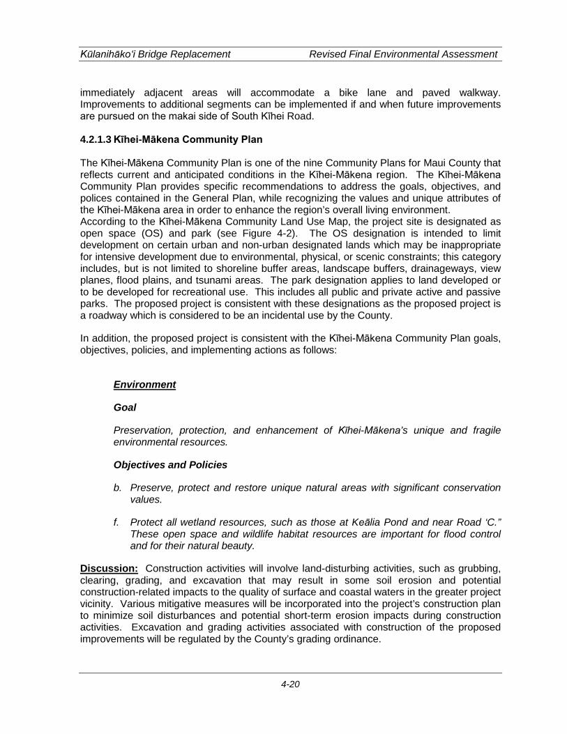
Kūlanihāko‘i Bridge Replacement Revised Final Environmental Assessment
4-20
immediately adjacent areas will accommodate a bike lane and paved walkway. Improvements to additional segments can be implemented if and when future improvements are pursued on the makai side of South Kīhei Road. 4.2.1.3 Kīhei-Mākena Community Plan The Kīhei-Mākena Community Plan is one of the nine Community Plans for Maui County that reflects current and anticipated conditions in the Kīhei-Mākena region. The Kīhei-Mākena Community Plan provides specific recommendations to address the goals, objectives, and polices contained in the General Plan, while recognizing the values and unique attributes of the Kīhei-Mākena area in order to enhance the region’s overall living environment. According to the Kīhei-Mākena Community Land Use Map, the project site is designated as open space (OS) and park (see Figure 4-2). The OS designation is intended to limit development on certain urban and non-urban designated lands which may be inappropriate for intensive development due to environmental, physical, or scenic constraints; this category includes, but is not limited to shoreline buffer areas, landscape buffers, drainageways, view planes, flood plains, and tsunami areas. The park designation applies to land developed or to be developed for recreational use. This includes all public and private active and passive parks. The proposed project is consistent with these designations as the proposed project is a roadway which is considered to be an incidental use by the County.
In addition, the proposed project is consistent with the Kīhei-Mākena Community Plan goals, objectives, policies, and implementing actions as follows:
Environment
Goal
Preservation, protection, and enhancement of Kīhei-Mākena’s unique and fragile environmental resources.
Objectives and Policies
b. Preserve, protect and restore unique natural areas with significant conservation values.
f. Protect all wetland resources, such as those at Keālia Pond and near Road ‘C.” These open space and wildlife habitat resources are important for flood control and for their natural beauty.
Discussion: Construction activities will involve land-disturbing activities, such as grubbing, clearing, grading, and excavation that may result in some soil erosion and potential construction-related impacts to the quality of surface and coastal waters in the greater project vicinity. Various mitigative measures will be incorporated into the project’s construction plan to minimize soil disturbances and potential short-term erosion impacts during construction activities. Excavation and grading activities associated with construction of the proposed improvements will be regulated by the County’s grading ordinance.
PROJECTPROJECTSITESITE
PROJECTSITE
NOT TO SCALESource: County of Maui, Planning Department
KIHEI - MAKENA COMMUNITY PLAN
KULANIHAKOI BRIDGE REPLACEMENTFIGURE
4-2
W:\8256-01\Planning\Graphics\Working

Kūlanihāko‘i Bridge Replacement Revised Final Environmental Assessment
4-22
A DOA Nationwide Permit, pursuant to Section 404 of the Clean Water Act and a WQC, issued by the DOH, pursuant to Section 401 of the Clean Water Act will be required. In conjunction with the Section 401 and 404 permits, a BMP plan will be prepared for construction activities within the project site. Erosion and sediment control measures will be instituted in accordance with site specific assessments, incorporating appropriate structural and/or non-structural BMPs such as minimizing time of exposure between construction and landscaping, and implementing erosion control measures such as silt fences and filter berms. Specific BMPs may include, but may not be limited to the following:
1. Minimizing soil loss and erosion by revegetation and stabilization of slopes and disturbed areas of soil, possibly using hydromulch, geotextiles, or other applicable alternatives, as soon as possible after working;
2. Minimizing time of exposure between construction and landscaping; 3. Application of protective covers to soil and material stockpiles; 4. Minimizing disturbance of soil during periods of heavy rain; 5. Implementing erosion control measures by emplacement of structural controls such
as silt fences, filter berms, gravel bags, fiber rolls, sandbag barriers and other barriers in order to retard and prevent the loss of sediment from the site;
6. Phasing of the project to disturb the minimum area of soil at a particular time; 7. Use of drip pans beneath vehicles not in use in order to trap vehicle fluids; 8. Routine maintenance of BMPs by adequately trained personnel; 9. Significant leaks or spills, if they occur, shall be properly cleaned up and disposed of
at an approved site. The proposed project is not anticipated to have any long-term impacts to land-based, shoreline, and marine resources. Following construction, exposed soils at the project site will have been built over, paved over, or re-vegetated to control erosion. The wetland area is proposed to be restored back to its existing conditions. Dewatering may be required for the proposed project. Should dewatering be deemed necessary, the contractor will be responsible to obtaining all applicable permits including, but not limited to, an NPDES Permit for Dewatering Activities. The permit application will require a BMP plan, an erosion control plan, and a water quality monitoring plan. Water quality impacts associated with the disposal of dewatering effluent will also be addressed in the BMP plan, including appropriate characterization of any potential pollutants such as sediments and nutrients in the effluent.
Cultural Resources
Goal
Identification, preservation, enhancement, and appropriate use of cultural resources, cultural practices, and historic sites that:
a. Provides a sense of history and defines a sense of place for the Kīhei-Mākena region
Objectives and Policies
Kūlanihāko‘i Bridge Replacement Revised Final Environmental Assessment
4-23
a. Identify, preserve, protect and restore historical and cultural sites.
b. Protect those areas, structures and elements that are a significant and functional part of Hawai‘i’s ethnic and cultural heritage.
Discussion: An Archaeological Literature Review and Field Inspection for the project site was conducted for the property in December 2012. Based on the field inspection findings and background research, there is a low potential for the discovery of previously unidentified historic properties beyond the historic era itself. The area surrounding the bridge includes the Kūlanihākoʻi Stream mouth, a natural wetland and associated flood plain. While impacts by flooding episodes and modifications associated with road construction and maintenance have greatly altered sediments of the project areas, the possibility of encountering intact subsurface cultural deposits, including human burials, should not be underestimated. Therefore, archaeological monitoring is recommended for all ground disturbing activities during all phases of the temporary bridge and bypass road work and bridge replacement. It is also recommended that a monitoring report be generated after the construction of the temporary bridge and bypass road and the replacement bridge.
During a field visit on December 13, 2012 with Theresa Donham (Archaeology Branch Chief), an archaeological inventory survey of the lands covering the extent of the APE of the proposed detour bridge was recommended. An archaeological inventory survey was conducted by Cultural Surveys Hawai‘i, Inc. dated June 2013.
The survey included shovel testing and pipe coring which enabled mapping a general stratigraphy of the project to a depth of approximately 10 feet below ground surface. Two soil samples were submitted for pollen analysis.
One historic property within the project area is the Kūlanihāko‘i Bridge itself. The bridge has been given a site number (SIHP 50-50-10-7606). The bridge was constructed in 1911 and consisted of four individual reinforced concrete box culverts. The paving surface over the existing culverts was applied in the 1930’s. This included some shoring-up of the edge of the roadway using a historic construction style attributed to pre-1940’s plantation masons. The present day Kūlanihāko‘i Bridge appears to consist of two sections of prefabricated concrete culvert welded together to form the length of the existing bridge. A more modern construction style probably occurred because of the many repairs the bridge had undergone due to storm damage.
The study was able to establish that at least the first 10 feet of sediment can be attributed to historic alluvium from Kūlanihāko‘i Gulch. This is generally consistent with the information collected by Geolabs, the geotechnical engineer, for this project. They recorded a dark gray clay silt to a depth of 10 feet above the grayish tan coralline sand.
Like the LR&FI, the inventory survey notes that there is a low potential for the discovery of previously unidentified historic properties beyond the historic era itself. The area surrounding the bridge includes the Kūlanihāko‘i Stream mouth, a natural wetland and associated flood plain. While impacts by flooding episodes and modifications associated with road construction and maintenance have greatly altered sediments of the project areas, the possibility of encountering intact subsurface cultural deposits, including human burials,

Kūlanihāko‘i Bridge Replacement Revised Final Environmental Assessment
4-24
should not be underestimated. Therefore, archaeological monitoring is recommended for all ground disturbing activities during all phases of the temporary bridge and bypass road work and bridge replacement. It is also recommended that a monitoring report be generated after the construction of the temporary bridge and bypass road and the replacement bridge.
With regard to the bridge itself, the structure was constructed in 1911 and is now 102 105 years old. It is therefore considered a historic property and recordation of the bridge would be required under Chapter 13-275, Hawai‘i Administrative Rules if deemed eligible based on SHPD’s evaluation of the bridge’s significance. Consultation with SHPD, by letter dated December 20, 2012, indicated that while the bridge is unique due to age and represents the first generation of concrete bridges in the islands, it is literally falling apart and has lost any distinguishing architectural characteristics. On this basis, SHPD has determined that the bridge has lost its integrity and is not eligible to be recorded on the State Inventory of Historic Properties. Therefore, the proposed project will have no effect on historic property.
The archaeological inventory survey noted that the Kūlanihāko‘i Bridge (SIHP 50-50-10-7606) has yielded information important to the understanding of the first generation of concrete bridges in the Hawaiian Islands. SIHP -7606 is thus considered significant under Criterion D. Sufficient information concerning SIHP -7606 was collected during the investigation. Based on the additional research, no further work is recommended for the bridge.
The archaeological inventory survey also noted that while subsurface testing was not done beneath South Kīhei Road, boring logs from the Geolabs report recorded the presence of coralline sand around 12 feet below the surface of the road. The presence of this type of sediment deposit may present the potential for encountering sensitive cultural resources in a subsurface context. Monitoring of the culvert removal by a qualified archaeologist is thus recommended.
By letter dated June 25, 2014, the SHPD noted that the archaeological inventory survey meets the requirements of Hawai‘i Administrative Rule Section 13-276 and is accepted as final. Refer to Appendix D.
Physical and Social Infrastructure
Goal
Provision of facility systems, public services and capital improvement projects in an efficient, reliable, cost effective, and environmentally sensitive manner which accommodates the needs of the Kīhei-Mākena community, and fully support present and planned land uses, especially in the case of project district implementation
Transportation
Objectives and Policies
b. Develop and implement a well-planned road and public transportation system to allow residents and visitors to move safely, effectively, and comfortably within the

Kūlanihāko‘i Bridge Replacement Revised Final Environmental Assessment
4-25
region. Roadway improvements should be planned, designed, and constructed as prioritized under the Implementing Actions section below, and as generally described in the Kīhei Traffic Master Plan.
g. Plan, design, and construct a pedestrian and bikeway network throughout the Kīhei-Mākena region which considers the utilization of existing stream beds, drainageways, wetlands and public rights-of-way along coastal and inland areas.
Discussion: The proposed project will replace the current, deteriorating bridge and provide a bike lane and a paved walkway on the mauka side of the roadway making the area safer for pedestrians, bicyclists, and vehicles. In addition, the makai side of the bridge and immediately adjacent areas will accommodate a bike lane and paved walkway. Improvements to additional segments can be implemented if and when future improvements are pursued on the makai side of South Kīhei Road.
4.2.2 County of Maui Zoning
The purpose and intent of the County of Maui Comprehensive Zoning Ordinance (Title 19, Article II), is to regulate the utilization of land in a manner encouraging orderly development in accordance with the land use directives of the Hawaii Revised Statutes, the revised charter of the County, and the general plan and the community plans of the County.
According to the County of Maui Planning Department, the project site is zoned Drainage (DR), Park (PK), and Apartment (A-1). However, roadways, such as the proposed project, are considered an incidental use that is permitted in each of the County’s zoning districts. Thus the proposed project is consistent with the County zoning districts.
4.2.3 County of Maui Special Management Area
Pursuant to the Hawai‘i CZM Program, Chapter 205A, HRS, the counties have enacted ordinances establishing Special Management Areas (SMA). Any “development” within the SMA requires an SMA Use Permit administered by the County of Maui Planning Department. Through the SMA permit system, the County assesses and regulates developments proposed for areas located within the SMA and the proposed developments are evaluated for compliance with the CZM objectives and policies and SMA guidelines set forth in Chapter 205A, HRS. Figure 2-2 4-3 shows that the entire project site is located within the SMA. Since the project has a total cost fair market value greater than $125,000 $500,000 in value and is considered a “development,” an SMA Use Permit will be required for the proposed project. The proposed project is consistent with the CZM objectives and policies as described in Section 4.1.3 of this document.

Legend
Project SiteSpecial Management Area
Ü0 375 750 1,125
Feet
1 inch = 750 feetSource: State Offie of Planning
PROJECTSITE
Pi i lani H
ighway
Pi i lani H
ighway
Kihei R
oadK
ihei Road
Kaonoulu St.
Kaonoulu St.
Kulanihakoi St.Kulanihakoi St.
Keolio Rd.
Keolio Rd.
Ohukai Rd.
Ohukai Rd.
Kaiola Pl.Kaiola Pl.
Pi i lani H
ighway
Kihei R
oad
Kaonoulu St.
Kulanihakoi St.
Keolio Rd.
Ohukai Rd.
Kaiola Pl.
Kihei R
oadK
ihei Road
Kihei R
oad
KiheiBeach Park
Kalepolepo Park
Mai Poina Oe LauPark
SPECIAL MANAGEMENT AREA MAPFIGURE
4-3
KULANIHAKOI BRIDGE REPLACEMENT
W:\8256-01\Planning\Graphics\Working

Kūlanihāko‘i Bridge Replacement Revised Final Environmental Assessment
4-27
4.3 Permits and Approvals
The following is a list of permits, approvals, and reviews that may be required prior to construction and operation of the proposed project.
Federal
Department of the Army • Department of the Army, Nationwide Permit, Section 404, Clean Water Act • Department of the Army, Section 10 Permit, Rivers and Harbors Act
Federal Highways Administration
• National Environmental Policy Act (NEPA) Categorical Exclusion • Section 7 of the Endangered Species Act • Section 106 of the National Historic Preservation Act
State of Hawai‘i
Department of Health • Section 401, Clean Water Act, Water Quality Certification • National Pollutant Discharge Elimination System (NPDES) Permit for Dewatering
Activity • Noise Permit
Department of Land and Natural Resources
• Chapter 6E, HRS, State Historic Preservation Law • Stream Channel Alteration Permit
Office of Planning
• Coastal Zone Management (CZM) Federal Consistency Certification
County of Maui
Planning Department • Special Management Area Use Permit • Shoreline Setback Variance • Special Flood Hazard Area Development Permit • Grading/Grubbing Permit • Permit to Perform Work within County Right-of-Way

Kūlanihāko‘i Bridge Replacement Revised Final Environmental Assessment
4-28
(This page intentionally left blank)
Kūlanihāko‘i Bridge Replacement Revised Final Environmental Assessment
5-1
5. ALTERNATIVES
5.1 No Action Alternative Under the no action alternative, the replacement of the deteriorating culverts and the proposed roadway improvements would not be pursued. Environmental impacts would be avoided, construction costs spared, and the need for permits precluded. The existing culverts would continue to deteriorate and substandard conditions for motorists, pedestrians, and bicyclists would continue. As the bridge is structurally deficient, the culverts have the potential to collapse in the near future due to vehicles traversing over it. If the bridge should collapse, this portion of South Kīhei Road would need to be closed and vehicles rerouted causing increased congestion on other nearby roadways such as Ohukai Road, Ka‘ono‘ulu Road, Kūlanihāko‘i Street, Waipu‘ilani Road, and Pi‘ilani Highway. This would inconvenience residents and businesses who depend on that portion of South Kīhei Road as a through road for their needs.
5.2 Alternative 1: Construction of Four (4) 6-Feet Wide and 4-Feet High Culverts This alternative proposes constructing four (4) new culverts to replace the existing four (4) deteriorating culverts. As stated in earlier sections, the proposed six (6) culverts only provides a slight increase in drainage capacity for a 100-year, 24-hour storm event. Currently because of the relatively flat topography of the area, installation of four (4) new 6-feet wide by 4-feet high culverts at South Kīhei Road would basically ensure that the same flooding parameters which result from the existing four (4) culverts would continue. Since the sand plug is a natural occurrence at the ocean outlet, flows would continue to be impeded. Silt and sediment would continue to accumulate at the muliwai. With the replacement of the four culverts, South Kīhei Road can continue to be utilized as a collector road. Basically, the replacement of the four (4) culverts represents a continuation of the status quo.
5.3 Alternative 2: Construction of Eight (8) 6-Feet Wide and 4-Feet High Culverts This alternative proposes constructing a total of eight (8) culverts, each 6-feet wide and 4-high. Drainage capacity of the culverts was analyzed, assuming the downstream end of the stream was not blocked off from the existing accumulated sand plug at the shoreline. The results showed that the eight (8) culverts would have an increased flow capacity (409 cfs) and could handle more flow than the existing four culverts as well as the proposed culverts (204 cfs and 306 cfs, respectively). However, this increased capacity does not significantly reduce the amount of runoff overtopping South Kīhei Road. This is due to the accumulated sand dunes blocking the natural flow of the outlet of the stream as well as the relatively flat topography of lands around South Kīhei Road and the shoreline. This causes runoff to pond until water levels reach a height higher than the sand plug or the sand plug is breached. Therefore, adding additional culverts will not reduce the existing flooding in the area. Although there is an increase in drainage capacity and depth of flow over the roadway is slightly decreased, the proposed bridge replacement ultimately does not resolve the existing flooding that occurs near and around the project site during heavy storm events. This is due to the accumulating sand dunes blocking off the downstream path causing runoff to back up and flood the roadway. The eight (8) culverts were also analyzed assuming that the outlet is

Kūlanihāko‘i Bridge Replacement Revised Final Environmental Assessment
5-2
not blocked. The results from the model and calculations show that the depth overtopping the roadway is reduced significantly by about three feet. While the additional culverts would provide a slight decrease in flows overtopping South Kīhei Road, the decrease is not significant enough that it would address the regional flooding problem in the area. While flooding is a concern, it is beyond the scope of this project as it is a regional issue and should be addressed by a drainage master plan. The County of Maui is currently updating their Kīhei Drainage Master Plan which is anticipated to be completed within two years.
5.4 Alternative 3: Construction of Larger Culverts or Construction of a Bridge over South Kīhei Road to Accommodate the 100-Year Storm
This alternative proposes installation of larger culverts or a bridge over the existing culverts to handle the 100-year storm. As discussed earlier in Section 3.13.3, at the point where the 100-year storm runoff flows reach the existing culverts, the total flow would be approximately 14,148 cfs. To accommodate this flow, the size of the culverts, as well as the velocity of the peak flows need to be considered. For example, if the velocity of the flow is assumed to travel at 10 feet per second, the culverts would need to be a total of 10-feet high and 140-feet wide. However, if the velocity of the flow is assumed to travel at 25 feet per second, the culverts would need to be a total of 10-feet high and 56-feet wide. Freeboard requirements for the bridge present another safety factor that needs to be considered. This would result in wider and/or deeper channels, therefore, at a minimum, the roadway would also need to be raised, the invert of the culverts deepened, and/or the span of the culverts would need to be widened to accommodate the 100-year storm flow. The roadway would need to be constructed at a slight incline, but due to the physical constraints of the project site, neighboring properties. would require extensive improvements which may require reconstruction of the Kaʻonoʻulu intersection and the existing drainage system along South Kīhei Road to prevent flooding of the Kīhei Bay Vista complex from the proposed bridge. Although in this alternative the storm flows would not overtop the roadway, flooding would still be an issue for the surrounding areas because of the sand plug and the flat topography of the area. Similarly for the bridge alternative, the bridge could sit approximately 3-feet higher than the existing road with a mid-span pier to help reduce the amount of runoff overtopping the roadway during heavy storm events. Assuming that the outlet is not blocked off by the existing accumulating sand dunes, it was determined that storm runoff from the 100-year storm event would still overtop the bridge, but not as severe as the proposed six (6) culverts. To compensate for this occurrence, the bridge could be raised higher. This is a similar situation to the larger culvert in which, due to the physical constraints of the project site, constructing a bridge would require extensive improvements which may require reconstruction of the Kaʻonoʻulu intersection and the existing drainage system along South Kīhei Road to prevent flooding of the Kīhei Bay Vista complex from the proposed bridge.

Kūlanihāko‘i Bridge Replacement Revised Final Environmental Assessment
5-3
5.5 Alternative 4: Increasing Drainage Channel Capacity This alternative proposes construction of a drainage channel. The makai portions of Kūlanihāko‘i Gulch are not a well-defined water course. There are limited channel capacities that are unable to contain peak flows during storm periods. As a result, during significant rainfall events, runoff from the upper areas of the watershed descends onto the Kīhei flood plains in voluminous quantities. Thus, during significant rains, the existing drainage channel will be overtopped before it reaches the existing culvert even if the culvert is properly sized for the 100 year storm. In order to fully accommodate the 100-year storm flows, the upstream and downstream drainageways need to have the capacity to accommodate peak flows. This would require a drainage channel to be excavated from Ka‘ono‘ulu Estates IV, near Pi‘ilani Highway, to the ocean. Due to the relatively flat coastal topography and the sand dunes which tend to form at the stream mouth, the drainage channel would likely need to extend partially into the ocean. Makai portions of the channel would most likely contain sea water on a relatively permanent basis. Such a channel would likely involve land acquisition and involve view and aesthetic impacts. Portions of existing beach areas would be occupied by a drainage structure at the stream mouth. A significantly larger and more direct drainage route to the ocean would likely mean increased sediment and other pollutants deposited into the nearshore environment. The increased volume and velocity of runoff may affect the bathymetry of the area, which in turn affects wave action, coral growth and sand transport. Since the watershed is significant in terms of its size, impacts to the nearshore environment would need to be studied carefully. Possible effects on coral, aquatic biota, fish and marine mammals need to be considered. While increasing the drainage channel capacity is an alternative, the scope and assessment of impacts for this alternative is much larger than replacing a single deteriorated culvert bridge at South Kīhei Road. As drainage in this area is a regional problem, a coordinated drainage master plan for the region is needed to address how drainage throughout the area will be handled. The County of Maui is currently updating their Kīhei Drainage Master Plan which is anticipated to be completed in approximately two years.
5.6 Alternative 5: Installation of Upstream Detention This alternative proposes upgrading the culverts at South Kīhei Road and installing appropriately sized detention basins located mauka of Pi‘ilani Highway. Detention basins would allow for controlled release of runoff so water would likely be flowing downstream of the basins for a period of time after rain has stopped. Depending on its size and the percolation capacity of the soil, retention basins can allow significant portions of peak runoff to percolate into the ground and allows some settlement and removal of sediment and other pollutants. Upstream detention does not only involve the excavation of basins. Analysis must be undertaken to ensure that drainageways leading to the basin and leaving the basin are adequate to carry flows. If not, excavation to provide for adequate drainage capacity will be needed. It should be noted that this alternative will require a significant amount of land from upstream owners.
Kūlanihāko‘i Bridge Replacement Revised Final Environmental Assessment
5-4
As mentioned earlier, the total flows for a 100-year storm would be approximately 14,148 cfs. The 100-year storm is measured over a 24-hour period. Therefore, a 24-hour period would yield flows of approximately 1,222,387,200 cubic feet of storm flow per day. To accommodate this maximum amount of flow and to not allow any flow to enter the ocean, the upstream detention basin would need to be approximately the size of 1-mile in length by 1-mile in width by approximately 44-feet in depth. To ensure that the detention basins and related drainageways function properly over time, maintenance concerns need to be addressed. Debris, silt and sediment which accumulate in the basin and drainageways must be removed in order to ensure adequate capacity. Personnel needed to maintain the system as well as the cost of maintenance needs to be taken into consideration. Access through private property must also be provided so that maintenance activities can be undertaken. While installing detention basins and related draingeways are an alternative, the scope and assessment of impacts for this alternative is much larger than replacing a single deteriorated culvert bridge at South Kīhei Road. As drainage within this watershed is a regional problem, a coordinated drainage master plan for the region is needed to address how drainage throughout the area will be handled. The County of Maui is currently updating their Kīhei Drainage Master Plan which is anticipated to be completed in approximately two years.
5.7 Alternative 6: Diversion of Upstream Flows to Another Drainage District This alternative proposes diverting runoff flows generated mauka of Pi‘ilani Highway within the Kūlanihāko‘i drainage district to other nearby drainage districts. This alternative may lessen flooding and environmental impacts in the area of Kūlanihāko‘i Gulch from Pi‘ilani Highway to the shoreline, however, it would exacerbate flooding issues in the neighboring districts. Although the Kūlanihāko‘i Gulch generates most of the flows within the Kūlanihāko‘i District, there are smaller subdistricts which contribute to the total amount of flow. In terms of the 100-year storm flows, the Kūlanihāko‘i District generates more than 13,000 cfs mauka of Pi‘ilani Highway. Under this alternative, these flows would be diverted to neighboring drainage districts. Waiakoa District which is the neighboring district to the north, generates 100-year storm flows of approximately 9,000 cfs mauka of Pi‘ilani Highway. If Kūlanihāko‘i District flows were diverted to the Waiakoa District, approximately 22,000 cfs of peak flows would need to be accommodated. Similarly, Waipu‘ilani Gulch, which is the neighboring district to the south, generates 100-year storm flows of more than 10,000 cfs. If flows from the Kūlanihāko‘i Distict were diverted to the Waipu‘ilani District to the south, then 23,000 cfs of peak flows would need to be accommodated. Should this alternative be pursued, analysis would have to be undertaken to ensure that the neighboring drainageways have the capacity to accommodate the peak flows from the Kūlanihāko‘i District. This would most likely require that channel(s) of adequate size to accommodate peak flows would likely need to be excavated in which ever neighboring district was chosen. Roadway culverts also have to be significantly enlarged. Because of

Kūlanihāko‘i Bridge Replacement Revised Final Environmental Assessment
5-5
the relatively flat coastal topography and the sand dunes which tend to form at the stream mouth, the drainage channel may need to extend partially into the ocean. Makai portions of the channel may also contain sea water on a relatively permanent basis. Such channel(s) would likely involve land acquisition and involve view and aesthetic impacts. Portions of existing beach areas would be occupied by a drainage structure at the stream mouth(s) of the neighboring drainage district. A significantly larger and more direct route to the ocean would likely mean increased sediment and other pollutants deposited into the nearshore environment of the neighboring drainage district. The increased volume and velocity of runoff may also affect the bathymetry of the area, which in turn would affect wave action, coral growth and sand transport. Since the drainage area and peak runoff have significantly increased within the adjoining drainage district, impacts to the nearshore environment would need to be studied carefully. Possible effects on coral, aquatic biota, fish and marine mammals are likely to be significant and concentrated. While the general concept of diversion of upstream flows to another drainage district is a possible alternative, diversion of peak runoff to other areas further away would only add more expense and concentrate the issues of dealing with peak runoff to another area besides the Kūlanihāko‘i Drainage District. In addition, the scope and assessment of impacts for this alternative is much larger than replacing a single deteriorated culvert bridge at South Kīhei Road. As drainage in this area is a regional problem, a coordinated drainage master plan for the region is needed to address how drainage throughout the area will be handled. The County of Maui is currently updating their Kīhei Drainage Master Plan which is anticipated to be completed in approximately two years.

Kūlanihāko‘i Bridge Replacement Revised Final Environmental Assessment
5-6
(This page intentionally left blank)

Kūlanihāko‘i Bridge Replacement Revised Final Environmental Assessment
6-1
6. ANTICIPATED DETERMINATION OF FONSI
The proposed project involves the following improvements: Potential impacts of the proposed improvements have been evaluated in accordance with the significance criteria of Section 11-200-12 of the Department of Health’s Administrative Rules. Discussion of the project’s conformance to the criteria is presented as follows: (1) Involves an irrevocable commitment to loss or destruction of any natural or cultural
resource; An Archaeological Literature Review and Field Inspection for the project site was conducted for the property in December 2012. Based on the field inspection findings and background research, there is a low potential for the discovery of previously unidentified historic properties beyond the historic era itself. The area surrounding the bridge includes the Kūlanihākoʻi Stream mouth, a natural wetland and associated flood plain. While impacts by flooding episodes and modifications associated with road construction and maintenance have greatly altered sediments of the project areas, the possibility of encountering intact subsurface cultural deposits, including human burials, should not be underestimated. Therefore, archaeological monitoring is recommended for all ground disturbing activities during all phases of the temporary bridge and bypass road work and bridge replacement. It is also recommended that a monitoring report be generated after the construction of the temporary bridge and bypass road and the replacement bridge. A site inspection was conducted on December 13, 2012 by SHPD and Cultural Surveys Hawai‘i. Based on the site inspection, SHPD requested that an AIS be prepared for the project site. An AIS was conducted by Cultural Surveys Hawai‘i, Inc. dated June 2013. The survey included shovel testing and pipe coring which enabled mapping a general stratigraphy of the project to a depth of approximately 10 feet below ground surface. Two soil samples were submitted for pollen analysis. The AIS is currently pending and will be submitted to SHPD for approval when it has been completed. Subsequent consultation with SHPD, by letter dated February 1, 2013, indicated that they have concerns that the project area is located within a zone of beach sand dune and Aeolian sand deposits which are known to contain human burial features and historic habitation sites. It is therefore likely that historic properties, including human remains, may be present beneath the previously disturbed road grade and sub-grade or within previously unaffected areas of the right-of-way. SHPD requested that all project associated excavations be monitored by a qualified archaeologist in order to identify and mitigate any subsurface cultural features and deposits. They further recommend that an archaeological monitoring plan be submitted to their office for review and approval prior to initiation of this project. Should any significant archeological, cultural, or historic resources be found during construction activities, all work will cease in the vicinity of the find and SHPD will be notified immediately to determine appropriate mitigation measures. The AIS noted that while subsurface testing was not done beneath South Kīhei Road, boring logs from the Geolabs, the geotechnical engineer for the project, recorded the presence of coralline sand around 12 feet below the surface of the road. The presence of this type of
Kūlanihāko‘i Bridge Replacement Revised Final Environmental Assessment
6-2
sediment deposit may present the potential for encountering sensitive cultural resources in a subsurface context. The AIS recommended monitoring of the culvert removal. The County is committed to implement archaeological monitoring in accord with the AIS recommendation. With regard to the bridge itself, the structure was constructed in 1911 and is now 102 105 years old. It is therefore considered a historic property and recordation of the bridge would be required under Chapter 13-275, Hawai‘i Administrative Rules if deemed eligible based on SHPD’s evaluation of the bridge’s significance. Consultation with SHPD, by letter dated December 20, 2012, indicated that while the bridge is unique due to age and represents the first generation of concrete bridges in the islands, it is literally falling apart and has lost any distinguishing architectural characteristics. On this basis SHPD has determined that the bridge has lost its integrity and is not eligible to be recorded on the State Inventory of Historic Properties. Therefore, the proposed project will have no effect on historic property. The archaeological inventory survey noted that the Kūlanihāko‘i Bridge (SIHP 50-50-10-7606) has yielded information important to the understanding of the first generation of concrete bridges in the Hawaiian Islands. SIHP -7606 is thus considered significant under Criterion D. Sufficient information concerning SIHP -7606 was collected during the investigation. Based on the additional research, no further work is recommended for the bridge. There will be no destruction or loss of any significant, endangered, or threatened botanical, faunal, geological, or other natural resources. With the exception of the Hawaiian Stilt, none of the plant or animal species identified within the project site are threatened or endangered, or are a species of concern. Prior to construction, it is recommended that a qualified biologist survey areas mauka of the proposed project site to determine if any nesting stilt are present. If nesting stilt are found, the County will need to consult with the USFWS over appropriate measures or conditions that may need to be met to ensure that construction activity does not harm nesting stilts. There are no federally delineated Critical Habitat within or close to the project corridor, thus construction and operation of the proposed project will not result in any impacts to federally designated Critical Habitats. (2) Curtails the range of beneficial uses of the environment;
The proposed project will not curtail the beneficial uses of the environment. Use of the project site for the proposed project would be consistent with its current use as a culvert bridge and a roadway. (3) Conflicts with the state’s long-term environmental policies or goals and guidelines as
expressed in Chapter 344, HRS, and any revisions thereof and amendments thereto, court decisions, or executive orders;
The proposed project does not conflict with long-term environmental policies, goals, and guidelines of the State of Hawai‘i. As presented in this EA, the project’s potential temporary adverse impacts are associated primarily with short-term construction-related activities and can be mitigated through adherence to standard construction mitigation practices. (4) Substantially affects the economic or social welfare of the community or state;
Kūlanihāko‘i Bridge Replacement Revised Final Environmental Assessment
6-3
In the short-term, the proposed project will confer positive benefits in the local economy. Direct economic benefits will result from construction expenditures both through the purchase of material from local suppliers and through the employment of local labor, thereby stimulating that sector of the economy. Indirect economic benefits may include benefits to local retailing businesses resulting from construction activities. There are no significant adverse long-term socio-economic impacts anticipated with the proposed improvements. The replacement of the culverts and the associated improvements to South Kīhei Road are not expected to induce growth beyond that which is anticipated for the region. The improvements are intended to benefit the entire Kīhei region without impacting a specific ethnicity or income group. The proposed project will not result in a disproportionality high adverse impact on minority and low-income populations. (5) Substantially affects public health;
No significant adverse short or long-term impacts are anticipated as a result of the proposed project. In the long-term, the proposed project will provide positive effects as the proposed project will replace the existing, deteriorating culverts and provide a bike lane and a paved walkway on the mauka side of the roadway. This will enhance the safety of motorists, bicyclists, and pedestrians along this section of roadway. (6) Involves substantial secondary impacts, such as population changes or effects on
public facilities;
No secondary effects are anticipated with the construction or operation of the proposed project. The improvements, in and of themselves, are not anticipated to affect the population of the Kīhei District. Rather, the project is proposed to fulfill an essential community need to provide safe access to and from the region for vehicles, bicyclists, and pedestrians alike. (7) Involves a substantial degradation of environmental quality;
The proposed project is not anticipated to involve a substantial degradation of environmental quality. Construction activities associated with the proposed improvements will create some adverse short-term impacts such as unavoidable noise impacts and air quality impacts from soil excavation and other ground disturbance activities. Unavoidable construction noise impacts on nearby land uses in the immediate vicinity of the proposed project will be mitigated to some degree by complying with the provisions of the State DOH Administrative Rules, Title 11, Chapter 46, Community Noise Control. Potential air quality impacts during construction of the proposed project will be mitigated by complying with the State DOH Administrative Rules, Title 11, Chapter 60, Air Pollution Control.
Potential water quality impacts to surface and near shore coastal waters during construction of the proposed improvements will be mitigated by adherence to State and County water quality regulations governing grading, excavation, and stockpiling. A DOA Nationwide Permit, pursuant to Section 404 of the Clean Water Act and a
Kūlanihāko‘i Bridge Replacement Revised Final Environmental Assessment
6-4
WQC, issued by the DOH, pursuant to Section 401 of the Clean Water Act will be required. In conjunction with the Section 401 and 404 permits, a BMP plan will be prepared for construction activities within the project site. Erosion and sediment control measures will be instituted in accordance with site specific assessments, incorporating appropriate structural and/or non-structural BMPs such as minimizing time of exposure between construction and landscaping, and implementing erosion control measures such as silt fences and filter berms. Specific BMPs may include, but may not be limited to the following: 1. Minimizing soil loss and erosion by revegetation and stabilization of slopes and
disturbed areas of soil, possibly using hydromulch, geotextiles, or other applicable alternatives, as soon as possible after working;
2. Minimizing time of exposure between construction and landscaping; 3. Application of protective covers to soil and material stockpiles; 4. Minimizing disturbance of soil during periods of heavy rain; 5. Implementing erosion control measures by emplacement of structural controls
such as silt fences, filter berms, gravel bags, fiber rolls, sandbag barriers and other barriers in order to retard and prevent the loss of sediment from the site;
6. Phasing of the project to disturb the minimum area of soil at a particular time; 7. Use of drip pans beneath vehicles not in use in order to trap vehicle fluids; 8. Routine maintenance of BMPs by adequately trained personnel; 9. Significant leaks or spills, if they occur, shall be properly cleaned up and disposed
of at an approved site. Following construction, exposed soils at the project site will have been built over, paved over, or re-vegetated to control erosion. Dewatering may be required for the proposed project. Should dewatering be deemed necessary, the contractor will be responsible to obtaining all applicable permits including, but not limited to, an NPDES Permit for Dewatering Activities. The permit application will require a BMP plan, an erosion control plan, and a water quality monitoring plan. Water quality impacts associated with the disposal of dewatering effluent will also be addressed in the BMP plan, including appropriate characterization of any potential pollutants such as sediments and nutrients in the effluent. In the long-term, no significant air quality, noise, or water quality impacts are anticipated from the operation of the proposed project. (8) Is individually limited but cumulatively has considerable effect upon the environment
or involves a commitment for larger actions;
No cumulative effects are anticipated, inasmuch as the proposed project involves replacing an existing culvert bridge and roadway improvements in an already urbanized setting.
(9) Substantially affects a rare, threatened, or endangered species, or its habitat;

Kūlanihāko‘i Bridge Replacement Revised Final Environmental Assessment
6-5
No listed, candidate, or proposed rare, threatened, or endangered species of flora or fauna under either the Federal or State endangered species statutes nor any critical habitat units will be disturbed as a result of the proposed improvements. Prior to construction, it is recommended that a qualified biologist survey areas mauka of the proposed project site to determine if any nesting Hawaiian stilt are present. If nesting stilt are found, the County will need to consult with the USFWS over appropriate measures or conditions that may need to be met to ensure that construction activity does not harm nesting stilts. There are no federally delineated Critical Habitat within or close to the project corridor, thus construction and operation of the proposed project will not result in any impacts to federally designated Critical Habitats. (10) Detrimentally affects air or water quality or ambient noise levels;
No long-term significant impacts to air quality, water quality, or noise levels within the project site are anticipated with the construction of the proposed project. During construction of the proposed project, two potential types of air pollution emissions will likely occur, resulting in air quality impacts: 1) airborne dust from construction activities such as grading and excavation within the project site; and 2) exhaust emissions from construction vehicles and equipment from the project site. Potential air quality impacts during construction of the proposed project will be mitigated by complying with the State DOH Administrative Rules, Title 11, Chapter 60-11.1 “Air Pollution Control.” The construction contractor is responsible to complying with the State DOH regulations which prohibit visible dust emissions at property boundaries. Compliance with State regulations will require adequate measures to control airborne dust by methods such as water spraying and sprinkling of loose or exposed soil or ground surface areas and dust-generating equipment during construction. As may be deemed appropriate, planting of landscaping or re-paving as soon as possible on completed areas will also help to control dust. During construction, air quality levels would be most affected by vehicular emissions generated by project-related traffic, however, the elevated vehicular emission concentrations are anticipated to dissipate.
Potential water quality impacts to surface and near shore coastal waters during construction of the proposed improvements will be mitigated by adherence to State and County water quality regulations governing grading, excavation, and stockpiling. A DOA Nationwide Permit, pursuant to Section 404 of the Clean Water Act and a WQC, issued by the DOH, pursuant to Section 401 of the Clean Water Act will be required. In conjunction with the Section 401 and 404 permits, a BMP plan will be prepared for construction activities within the project site. Erosion and sediment control measures will be instituted in accordance with site specific assessments, incorporating appropriate structural and/or non-structural BMPs such as minimizing time of exposure between construction and landscaping, and implementing erosion control measures such as silt fences and filter berms. Specific BMPs may include, but may not be limited to the following:
Kūlanihāko‘i Bridge Replacement Revised Final Environmental Assessment
6-6
1. Minimizing soil loss and erosion by revegetation and stabilization of slopes and disturbed areas of soil, possibly using hydromulch, geotextiles, or other applicable alternatives, as soon as possible after working;
2. Minimizing time of exposure between construction and landscaping; 3. Application of protective covers to soil and material stockpiles; 4. Minimizing disturbance of soil during periods of heavy rain; 5. Implementing erosion control measures by emplacement of structural controls
such as silt fences, filter berms, gravel bags, fiber rolls, sandbag barriers and other barriers in order to retard and prevent the loss of sediment from the site;
6. Phasing of the project to disturb the minimum area of soil at a particular time; 7. Use of drip pans beneath vehicles not in use in order to trap vehicle fluids; 8. Routine maintenance of BMPs by adequately trained personnel; 9. Significant leaks or spills, if they occur, shall be properly cleaned up and disposed
of at an approved site. Following construction, exposed soils at the project site will have been built over, paved over, or re-vegetated to control erosion. Construction activities are not likely to introduce to, nor release from the soil any materials which could adversely affect groundwater. Construction material wastes will be appropriately disposed of and must also be prevented from leaching into receiving bodies of water. Dewatering may be required for the proposed project. Should dewatering be deemed necessary, the contractor will be responsible to obtaining all applicable permits including, but not limited to, an NPDES Permit for Dewatering Activities. The permit application will require a BMP plan, an erosion control plan, and a water quality monitoring plan. Water quality impacts associated with the disposal of dewatering effluent will also be addressed in the BMP plan, including appropriate characterization of any potential pollutants such as sediments and nutrients in the effluent. No long-term significant impacts to noise levels within the project site are anticipated as a result of construction and operation of the proposed project. In the short-term, noise from construction activities such as excavation, grading, cutting and paving will be unavoidable. The increase in noise level will vary according to the particular phase of construction. Noise may also increase as a result of operating heavy construction vehicles and other power equipment during the construction period. Construction noise impacts will be mitigated by compliance with provisions of the State DOH Administrative Rules, Title 11, Chapter 46, “Community Noise Control” noise control regulations. These rules require a noise permit if the noise levels from construction activities are expected to exceed the allowable levels stated in the DOH Administrative Rules. It shall be the contractor’s responsibility to minimize noise by properly maintaining noise mufflers and other noise-attenuating equipment, and to maintain noise levels within regulatory limits. Also, the guidelines for heavy equipment operation and noise curfew times, as set forth by the DOH noise control rules, will be adhered to; or if necessary, a noise permit shall be obtained. These rules require a noise variance for any night work. Night work is anticipated for the project and, as such, a noise variance will be obtained. Further, DOH rules require a
Kūlanihāko‘i Bridge Replacement Revised Final Environmental Assessment
6-7
noise permit if the noise levels from construction activities are expected to exceed the allowable levels stated in the DOH Administrative Rules. It shall be the contractor’s responsibility to minimize noise by properly maintaining noise mufflers and other noise-attenuating equipment, and to maintain noise levels within regulatory limits. Also, the guidelines for hours of heavy equipment operation and noise curfew times as set forth by the DOH noise control rules will be adhered to; or if necessary, a noise permit will be obtained. In the long-term, no significant noise impact is anticipated once the proposed project has been completed. Noise from vehicles will continue to be the primary noise source along the project site, however, no adverse noise effects from the project are anticipated since the project is not expected to generate additional traffic in the vicinity. (11) Affects or is likely to suffer damage by being located in an environmentally sensitive
area such as a flood plain, tsunami zone, beach, erosion-prone area, geologically hazardous land, estuary, fresh water, or coastal waters;
No short- or long-term significant impacts are anticipated as the project site is not located within an environmentally sensitive area. According to the Flood Insurance Rate Map (FIRM) (Community Panel Numbers 1500030586F and 1500030567F, Effective Date: September 19, 2012) prepared by the Federal Emergency Management Agency (FEMA), the project site is designated Zone VE and Zone AE. Zone VE includes areas with a 1% or greater change of flooding and have an additional hazard associated with storm waves. In general, these areas have a 26% chance of flooding over the life of a 30-year mortgage. Zone AE is characterized as a “special flood hazard area subject to inundation by the 1% annual chance flood.” Zone AE is also a “floodway,” in which “the channel of the stream plus any adjacent floodplain areas that must be kept free of the encroachment so that the 1% annual chance flood can be carried without substantial increases in flood height.” The 1% annual flood is also commonly referred to as the 100-year flood or the base flood. According to the Tsunami Evacuation Zone maps for Maui, the project site lies entirely within the tsunami evacuation zone. Construction activities within the respective flood hazard districts will be conducted in accordance with regulations set forth in Section 19.62.060, Maui County Code. Before construction of any development begins within any flood hazard area, flood-related erosion hazard area, or mudslide area, a special flood hazard area development permit shall be obtained from the Director of the Department of Planning. The project will also comply with the rules and regulations for the National Flood Insurance Program (NFIP) present in Title 44, of the Code of Federal Regulations (44CFR), as the project is within a Special Flood Hazard Area.

Kūlanihāko‘i Bridge Replacement Revised Final Environmental Assessment
6-8
(12) Substantially affects scenic vistas and viewplanes identified in county or state plans or studies; or,
In the short-term, a temporary bypass road and bridge are being proposed on the mauka side of the existing roadway. This use will be generally similar in visual character to that of the temporary bridge over the existing culverts. Compared to the existing culverts, the temporary bridge on the mauka side of South Kīhei Road would provide a higher view object (approximately 14 feet) for individuals utilizing South Kīhei Road or in close proximity to this portion of the road. However, the temporary bridge and bypass road are necessary in order to maintain usage of this portion of South Kīhei Road during construction of the replacement Kūlanihākoʻi Bridge. Once the new bridge is constructed, the temporary bypass road and bridge will be removed. In the long-term, the proposed replacement bridge is not anticipated to have significant impacts on notable view planes nor adversely affect important public viewing points or visual resources. As an already existing roadway and bridge, the project will not significantly change the scenic and visual character of the surrounding area. (13) Requires substantial energy consumption.
Operation of the proposed project will not result in a significant increase in energy consumption.

Kūlanihāko‘i Bridge Replacement Revised Final Environmental Assessment
6-9
(This page intentionally left blank)

Kūlanihāko‘i Bridge Replacement Revised Final Environmental Assessment
7-1
7. CONSULTATION
7.1 Pre-Assessment Consultation The following agencies and organization were consulted during the preparation of the Draft EA. Of the 14 parties that formally replied during the pre-assessment period, some had no comments while others provided substantive comments as indicated by the and , respectively. All written comments are reproduced in Appendix F. Federal Agencies U.S. Army Corps of Engineers (COE)
U.S. Fish and Wildlife Service National Oceanic and Atmospheric Administration (NOAA) NOAA, National Marine Fisheries Service
State Agencies Department of Accounting and General Services
Department of Business, Economic Development & Tourism (DBEDT) DBEDT, Land Use Commission
DBEDT, Office of Planning Department of Education Department of Health (DOH)
DOH, Clean Water Branch DOH, Environmental Management Division
DOH, Environmental Planning Office DOH, Office of Environmental Quality Control
Department of Land and Natural Resources (DLNR) DLNR, Engineering Division
DLNR, Land Division DLNR, State Historic Preservation Division DLNR, Office of Conservation and Coastal Lands Department of Transportation
Office of Hawaiian Affairs County of Maui Department of Environmental Management Department of Fire and Public Safety Department of Parks and Recreation
Department of Planning Department of Public Works
Department of Transportation Department of Water Supply Police Department
Other Interested Parties and Individuals Kīhei Community Association
Kūlanihāko‘i Bridge Replacement Revised Final Environmental Assessment
7-2
7.2 Draft Environmental Assessment Consultation The following agencies and organizations will be were consulted during the public review period of the Draft EA. Of the 16 parties that formally replied during the public review period, some had no comments while others provided substantive comments as indicated by the and , respectively. All written comments are reproduced in Appendix G. Federal Agencies
U.S. Army Corps of Engineers (COE) COE, Civil Works Technical Branch COE, Regulatory Branch
U.S. Fish and Wildlife Service U.S. Geological Survey
National Oceanic and Atmospheric Administration (NOAA), National Marine Fisheries Service
State Agencies Department of Business, Economic Development, and Tourism (DBEDT) DBEDT, Office of Planning* Department of Health (DOH) DOH, Clean Water Branch DOH, Environmental Planning Office DOH, Maui District Health Office** DOH, Office of Environmental Quality Control Department of Land and Natural Resources (DLNR) DLNR, Engineering Division DLNR, Land Division DLNR, Office of Conservation and Coastal Lands DLNR, State Historic Preservation Division Office of Hawaiian Affairs University of Hawaiʻi Environmental Center Department of Transportation
County of Maui Department of Environmental Management
Department of Fire and Public Safety Department of Parks and Recreation Department of Planning
Department of Public Works Department of Transportation Department of Water Supply Police Department
Utility Companies Maui Electric Company Oceanic Time Warner Cable Hawaiʻi Gas Hawaiian Telcom

Kūlanihāko‘i Bridge Replacement Revised Final Environmental Assessment
7-3
Other Interested Parties and Individuals Kīhei Community Association Kenranes, Ltd. Ann Blyde Annette Probst * Office of Planning letter and response was not included as part of the FEA-FONSI but
is included in the RFEA-FONSI. ** The DOH Maui District Health Office letter and response was included in the FEA-
FONSI. However, an additional letter and response were not included in the FEA-FONSI. A third letter was received after the filing of the FEA-FONSI. The additional letter, third letter and responses are included as part of the RFEA-FONSI.

Kūlanihāko‘i Bridge Replacement Revised Final Environmental Assessment
7-4
(This page intentionally left blank)

Kūlanihāko‘i Bridge Replacement Revised Final Environmental Assessment
8-1
8. REFERENCES
County of Maui. Drainage Master Plan for County of Maui, Prepared by R. M. Towill Corporation. October 1971.
County of Maui. Drainage Master Plan for Kīhei, Maui, Hawai‘i, Prepared by Norman Saito
Engineering Consultants, Inc. February 1993. County of Maui. Revised Environmental Impact Statement Kīhei Drainage Project. April
1980. County of Maui. Countywide Policy Plan. March 2010. County of Maui. Kīhei-Mākena Community Plan. 1998. County of Maui. Maui Island Plan 2030. May 2010. Federal Emergency Management Agency, Flood Insurance Rate Map Panel No.
1500030586F, effective date September 19, 2012. Federal Emergency Management Agency, Flood Insurance Rate Map Panel No.
1500030567F, effective date September 25, 2009. U.S. Census Bureau American FactFinder:
http://factfinder2.census.gov United States Department of Agriculture Natural Resource Conservation Service. Web Soil
Survey. Internet. Available at: http://websoilsurvey.nrcs.usda.gov/app/. United States Department of Agriculture Natural Resource Conservation Service. Soil
Classification. Internet. Available at: http://soils.usda.gov/technical/classification/ U.S. Geological Survey, Hazards in Hawai‘i, June 18, 2001:
http://hvo.wr.usgs.gov/earthquakes/hazards/.

Kūlanihāko‘i Bridge Replacement Revised Final Environmental Assessment
8-2
(This page intentionally left blank)
APPENDIX A
Dune Investigation, Kūlanihākoʻi Bridge
Sea Engineering, Inc.
August 13, 2012

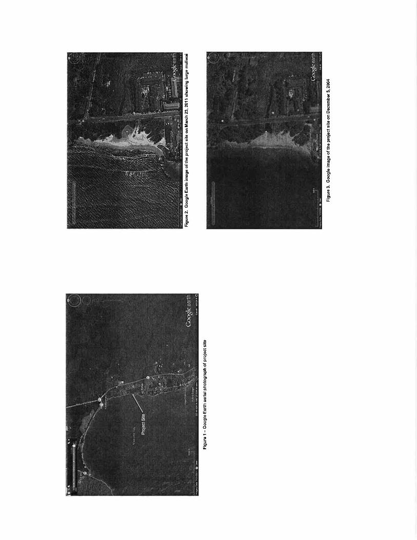

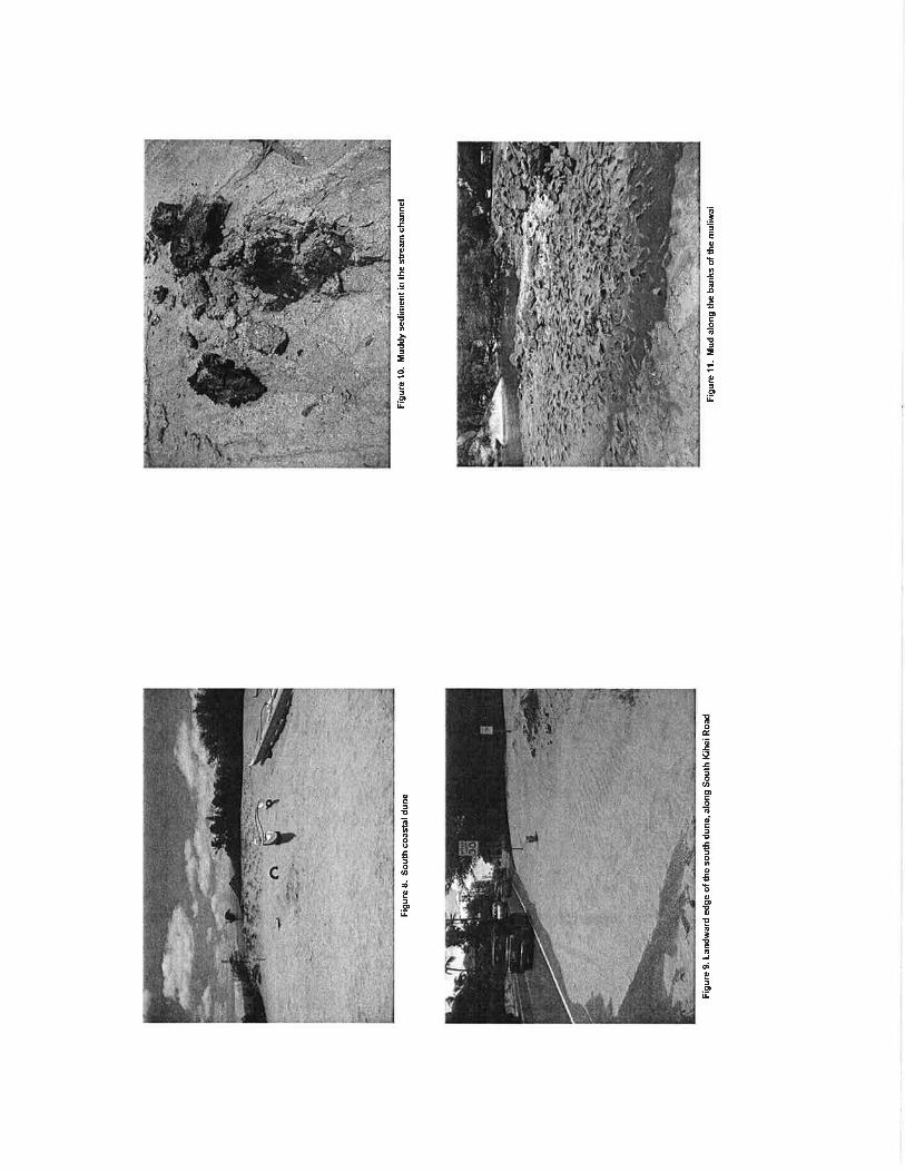
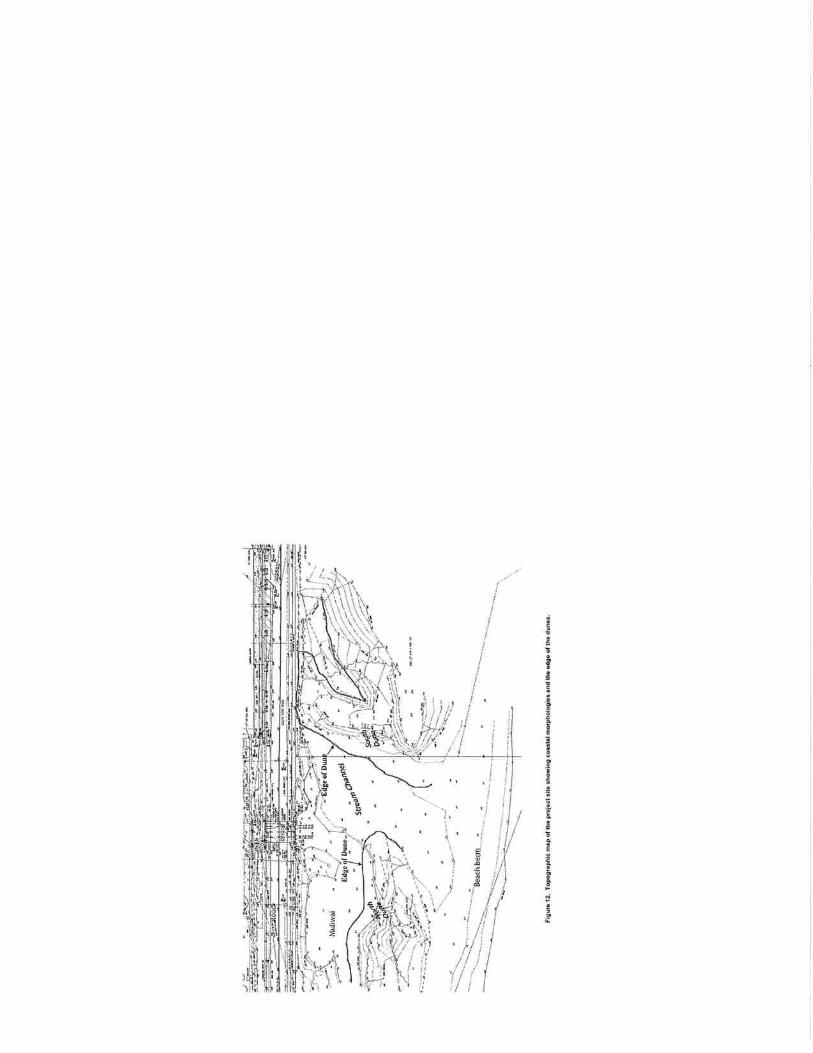

APPENDIX B
Water Quality/Biological Surveys and a Wetland Delineation for a Bridge Repair on Lower Kūlanihākoʻi Gulch in Kīhei, Maui
AECOS, Inc.
March 5, 2013 Revised January 20, 2015

AECOS
Waterquality/biologicalsurveysand
awetlandsdelineation
for
abridgerepairon
lowerKlanihko‘iGulch
inKhei,Maui
AECOS,
RevisedJanuary20,2015
AECOS
Waterquality/biologicalsurveysanda
wetlandsdelineation
forabridgerepairon
lowerKlanihko‘iGulchinKhei,Maui
Rev.:January20,2015
AECOS
EricGu
inther,ChadLine
baugh,andRe
ginaldDa
vid1
AECO
S,Inc.
4593
9Kameh
ameh
aHw
y,Suite
104
Kne
’ohe
,Haw
ai’i96
744
Phon
e:(808
)234
7770
Fax:(808
)234
7775
Email:aecos@
aecos.com
mauka
mauka
AECOS
AECOS

WaterQualityandBiologicalSurveys
AECOS
muliwai
WaterQualityandBiologicalSurveys
AECOS
AECOS
AECOS
Ana
lysi
s M
etho
d R
efer
ence
In
stru
men
t
Am
mon
ia
EPA
350
.1
USE
PA (1
993)
Te
chni
con
Aut
o A
naly
zer I
I
Benz
ene,
Tol
uene
, Et
hylb
enze
ne, a
nd
Xyl
enes
(BTE
X)
EPA
602
U
SEPA
(199
3)
Gas
chr
omat
ogra
ph
Chlo
roph
yll
SM 1
0200
H (M
) St
anda
rd M
etho
ds 2
0th
Editi
on (1
998)
Tu
rner
fluo
rom
eter
Diss
olve
d O
xyge
n SM
450
0-O
G
Stan
dard
Met
hods
20t
h Ed
ition
(199
8)
YSI
Mod
el P
ro 2
030
Diss
olve
d O
xyge
n M
eter
Nitr
ate
+ N
itrite
EP
A 3
53.2
Rev
2.0
U
SEPA
(199
3)
Tech
nico
n A
utoA
naly
zer I
I
Oil
& g
reas
e EP
A 1
664A
U
SEPA
(199
3)
Sepa
rato
ry fu
nnel
; Bal
ance
pH
SM 4
500
H+
Stan
dard
Met
hods
20t
h Ed
ition
(199
8)
Han
nah
pock
et p
H m
eter
Pesti
cide
s and
PC
Bs
EPA
608
.1/6
08.2
U
SEPA
(199
3)
Gas
chr
omat
ogra
ph
PAH
s EP
A 6
10
USE
PA (1
993)
H
igh
perfo
rman
ce li
quid
ch
rom
atog
raph
(HPL
C) o
r ga
s chr
omat
ogra
ph (G
C)

WaterQualityandBiologicalSurveys
AECOS
Ana
lysi
s M
etho
d R
efer
ence
In
stru
men
t
Salin
ity
SM 2
520B
St
anda
rd M
etho
ds 2
0th
Editi
on (1
998)
Y
SI M
odel
Pro
203
0 D
issol
ved
Oxy
gen
Met
er
Tem
pera
ture
th
erm
ister
cal
ibra
ted
to
NBS
. Cer
t. th
erm
omet
er
SM 2
550
B
Stan
dard
Met
hods
20t
h Ed
ition
(199
8)
YSI
Mod
el P
ro 2
030
Diss
olve
d O
xyge
n M
eter
Tota
l Nitr
ogen
pe
rsul
fate
di
gesti
on/E
PA 3
53.2
G
rass
hoff
et a
l (19
86)/
USE
PA (1
993)
Te
chni
con
Aut
oAna
lyze
r II
Tota
l Pho
spho
rus
EPA
365
.30
USE
PA (1
993)
Te
chni
con
Aut
oAna
lyze
r II
Tota
l Sus
pend
ed
Solid
s M
etho
d 25
40 D
St
anda
rd M
etho
ds 2
0th
Editi
on (1
998)
M
ettle
r H31
bal
ance
Turb
idity
EP
A 1
80.1
Rev
2.0
EP
A (1
993)
H
ach
2100
N T
urbi
dim
eter
muliwai
adjacent
WaterQualityandBiologicalSurveys
AECOS
muliwai
muliwai
muliwai
muliwai
muliwai
WaterQualityandBiologicalSurveys
AECOS
muliwai
muliwai
CorpsofEngineersWetland
DelineationManual
RegionalSupplement
muliwai
ManualoftheFloweringPlantsofHawai‘i A
TropicalGardenFlora
WaterQualityandBiologicalSurveys
AECOS
muliwai
muliwai
maukamakai
Lasiuruscinereus
semotus
‘pe‘ape‘a
insitu
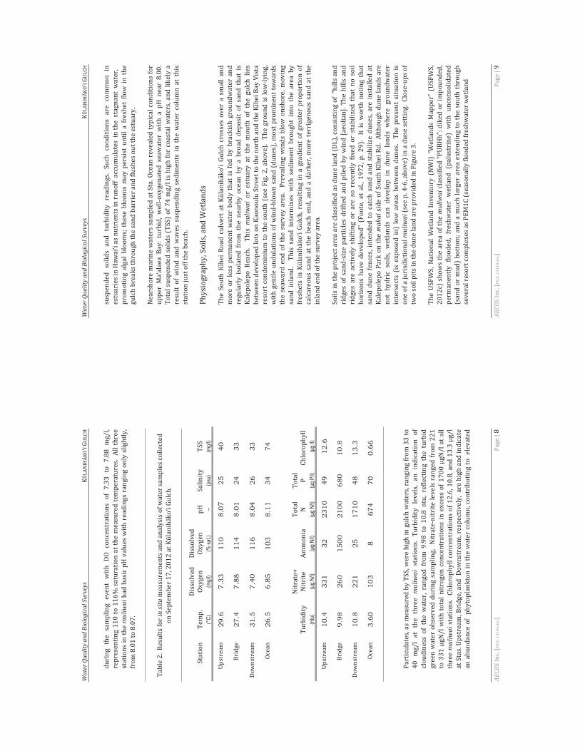
WaterQualityandBiologicalSurveys
AECOS
muliwai
insitu
(°C
) (m
g/l)
(% sa
t.)
-- (p
su)
(mg/l
)
29.6
7.
33
110
8.07
25
40
27.4
7.
88
114
8.01
24
33
31.5
7.
40
116
8.04
26
33
26.5
6.
85
103
8.11
34
74
(ntu)
(
g N/l)
(g N
/l) (
g N/l)
(g P
/l) (
g /l)
10.4
33
1 32
23
10
49
12.6
9.98
26
0 15
00
2100
68
0 10
.8
10.8
22
1 25
17
10
48
13.3
3.60
10
3 8
674
70
0.66
muliwai
muliwai
WaterQualityandBiologicalSurveys
AECOS
muliwai
makai
muliwai
muliwai

AECOS
AECOS
muliwai
‘kulikuliSesuvium
portulacastrum
muliwai
Heliotropiumcurassavicum 3a
3b
‘akulikuli
‘aki‘aki
muliwai
‘akulikulikai
Batis
maritimus
‘aki‘aki
Sporobolusvirginicus
kiaweProsopispallida
makai ‘akiaWikstroemiausaurvi

WaterQualityandBiologicalSurveys
AECOS
muliwai
‘kulikuli
muliwai
3a. N
on-n
ativ
e (o
rnam
enta
ls a
nd n
atur
aliz
ed) p
lant
s
Fam
ily
Com
mon
nam
e St
atus
A
bund
ance
N
otes
S
peci
es
FLO
WER
ING
PLA
NTS
D
ICO
TYLE
DO
NS
AN
AC
AR
DIA
CEA
E
Schi
nus t
ereb
inth
efol
ius R
addi
C
hris
tmas
ber
ry
Nat
R
FA
CU
B
ATA
CEA
E
Batis
mar
itim
a L.
pi
ckle
wee
d, ‘a
kulik
uli k
ai
Nat
R
1 O
BL
WaterQualityandBiologicalSurveys
AECOS
Fa
mily
C
omm
on n
ame
Stat
us
Abu
ndan
ce
Not
es
Spe
cies
FA
BA
CEA
E
Pros
opis
pal
lida
(Hum
b. &
Bon
pl. e
x W
illd.
) K
unth
ki
awe
Nat
O
FA
CU
SOLA
NA
CEA
E
Nic
otia
na g
lauc
a R
.C. G
raha
m
tree
toba
cco
Nat
R
U
PL
So
lanu
m ly
cope
rsic
um v
ar. c
eras
iform
e (D
unal
) Sp
oone
r, A
nder
son,
& Ja
nsen
ch
erry
tom
ato
Nat
UPL
MO
NO
CO
TYLE
DO
NES
PO
AC
EAE
(GR
AM
INEA
E)
C
ynod
on d
acty
lon
(L.)
Pers
. B
erm
uda
gras
s N
at
U2
FAC
U
Tab
le 3
b. N
ativ
e (a
nd e
arly
Pol
ynes
ian
intr
oduc
ed) P
lant
s
Fam
ily
Com
mon
nam
e St
atus
A
bund
ance
N
otes
S
peci
es
FLO
WER
ING
PLA
NTS
D
ICO
TYLE
DO
NS
AIZ
OA
CEA
E
Sesu
vium
por
tula
cast
rum
(L.)
L.
‘ku
likul
i In
dA
A
FAC
B
OR
AG
INA
CEA
E
Cor
dia
subc
orda
ta L
am.
kou
Pol
O
FAC
U
H
elio
trop
um c
uras
savi
cum
L.
kp
kai
Ind
A
FAC
G
OO
DEN
IAC
EAE
Sc
aevo
la se
rice
a V
ahl.
naup
aka
Ind
O
FAC
U
MA
LVA
CEA
E
Thes
pesi
a po
puln
ea (L
.) So
l. ex
Cor
ra
milo
In
d?O
3 FA
C
W
alth
eria
indi
ca L
. ‘u
halo
a In
d?U
12
FAC
U
THY
MEL
AEA
CEA
E
Wik
stro
emia
uva
-urs
i A. G
ray
‘ki
a E
ndR
U
PL
MO
NO
CO
TYLE
DO
NES
C
YPE
RA
CEA
E
Bolb
osch
oenu
s mar
itim
us (L
.) Pa
lla
kalu
h
Ind
R2
OB
L PO
AC
EAE
(GR
AM
INEA
E)
Sp
orob
olus
vir
gini
cus (
L.) K
unth
‘a
ki‘a
ki
Ind
A
FAC
Le
gend
to T
able
3:
Stat
us =
dis
tribu
tiona
l sta
tus
E
nd =
en
dem
ic; n
ativ
e to
Haw
ai‘i
and
foun
d na
tura
lly n
owhe
re e
lse.
Ind
=
indi
geno
us; n
ativ
e to
Haw
ai‘i,
but
not
uni
que
to th
e H
awai
ian
Isla
nds.
In
d? =
po
ssib
ly in
dige
nous
or a
ver
y ea
rly P
olyn
esia
n in
trodu
ctio
n.
Nat
=
natu
raliz
ed, e
xotic
, pla
nt in
trodu
ced
to th
e H
awai
ian
Isla
nds s
ince
the
arriv
al o
f Coo
k Ex
pedi
tion
in 1
778,
and
w
ell-e
stab
lishe
d ou
tsid
e of
cul
tivat
ion.
Po
l =
early
Pol
ynes
ian
intro
duct
ion
(“ca
noe
plan
t”).
A
bund
ance
= o
ccur
renc
e ra
tings
for p
lant
s
R –
Rar
e -
on
ly o
ne o
r tw
o pl
ants
seen
.
U -
Unc
omm
on -
se
vera
l to
a do
zen
plan
ts o
bser
ved.
O -
Occ
asio
nal -
fo
und
regu
larly
, but
not
abu
ndan
t any
whe
re.
C
- C
omm
on -
cons
ider
ed a
n im
porta
nt p
art o
f the
veg
etat
ion
and
obse
rved
num
erou
s tim
es.

WaterQualityandBiologicalSurveys
AECOS
A -
Abu
ndan
t - fo
und
in la
rge
num
bers
; may
be
loca
lly d
omin
ant.
A
A -
Abu
ndan
t - v
ery
abun
dant
and
dom
inan
t; de
finin
g ve
geta
tion
type
.
Num
bers
(as
in R
3) o
ffse
t occ
urre
nce
ratin
gs (1
– se
vera
l pla
nts;
2 –
man
y pl
ants
; 3
– ab
unda
nt
in
a li
mite
d ar
ea) i
n ca
ses w
here
dis
tribu
tion
acro
ss th
e su
rvey
are
a m
ay b
e lim
ited,
but
indi
vidu
als
se
en a
re m
ore
than
indi
cate
d by
the
occu
rren
ce ra
ting
alon
e.
N
otes
: Plan
t wet
land
stat
us a
fter L
ichv
ar (2
012)
and
Lic
hvar
et a
l. (2
014)
. Cod
es e
xpla
ined
in th
e te
xt..
muliwai
WaterQualityandBiologicalSurveys
AECOS
muliwai ‘akulikuli
muliwai
muliwai
muliwai
muliwai
muliwai
Limiavittata
Poecilia
Sarotherodon
melanotheron
Oreochromismassambicus
Mugilcephalus

WaterQualityandBiologicalSurveys
AECOS
WaterQualityandBiologicalSurveys
AECOS
muliwai
Metopograpsus
thuhukar
‘akulikuli
muliwai
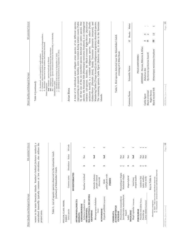
WaterQualityandBiologicalSurveys
AECOS
Ischnuraramburi
muliwai
Genusspecies
INVERTEBRATES
ARTH
ROPODA,INSECTA
ODONATA
COENAGRIONIDAE
Ischnuraramburii
ARTH
ROPODA,
MALACOSTRACA,DECAPODA
GRAPSIDAE
Metopograpsusthukuhar
‘alamihi,kukuau
Ind
OCYPODIDAE
Ocypodepallidula
‘hiki
Ind
FISHES
CHORDATA,
ACTINOPTERYGII
CICHLIDAE
Oreochromismossambicus
Sarotherodonmelanotheron
MUGILIDAE
Mugilcephalus
‘ama‘am
aInd
POECILIIDAE
Poeciliareticulata
Poecilia
Limiavittata
WaterQualityandBiologicalSurveys
AECOS
End
Ind.
muliwai
Himantopusmexicanusknudseni
Nycticorax
nycticorax
hoactli Pluvialis
fulva
Arenaria
interpres
Tringaincana
Bubulcus
ibis
Bubulcusibis
Nycticoraxnycticoraxhoactli
Himantopusm
exicanusknudseni
EE

WaterQualityandBiologicalSurveys
AECOS
Pluvialisfulva
Tringaincana
Arenariainterpres
ST EE
WaterQualityandBiologicalSurveys
AECOS
Pa
ram
eter
To
tal
Nit
roge
n
Nit
rate
+
Nit
rite
To
tal
Phos
phor
us
Turb
idit
y C
hlor
ophy
ll
(μg N
/l) (μ
g N/l)
(μg P
/l) (N
TU)
(mg/l
)
Geom
etric
mean
no
t to ex
ceed
giv
en va
lue
200.
0 8.
0 25
.0
1.5
2.0
Not to
exce
ed
more
than
10%
of
the tim
e 35
0.0
25.0
50
.0
3.0
5.00
Not to
exce
ed
more
than
2% of
the
time
500.
0 35
.0
75.0
5.
0 10
.0
pH –
shall
not d
eviat
e mor
e tha
n 0.5
units
from
ambie
nt an
d sha
ll not
be <
7.0 n
or >
8.6.
Diss
olved
oxyg
en –
not le
ss th
an 75
% sa
turati
on.
Temp
eratu
re –
shall
not v
ary m
ore t
han 1
°C fr
om am
bient.
Sa
linity
– no
t mor
e tha
n 10%
from
ambie
nt co
nditio
ns.
muliwai
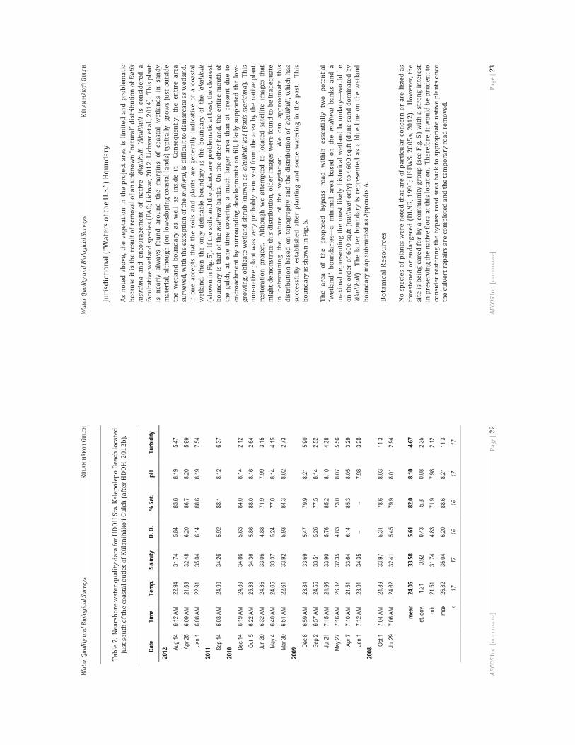
WaterQualityandBiologicalSurveys
AECOS
Date
Ti
me
Tem
p.
Salin
ity
D. O
. %
Sat
. pH
Tu
rbid
ity
2012 Au
g 14
6:12 A
M 22
.94
31.74
5.8
4 83
.6 8.1
9 5.4
7 Ap
r 25
6:09 A
M 21
.68
32.48
6.2
0 86
.7 8.2
0 5.9
9 Ja
n 1
6:08 A
M 22
.91
35.04
6.1
4 88
.6 8.1
9 7.5
4 20
11 Sep 1
4 6:0
3 AM
24.90
34
.26
5.92
88.1
8.12
6.37
2010 De
c 14
6:19 A
M 24
.89
34.86
5.6
3 84
.0 8.1
4 2.1
2 Oc
t 5
6:22 A
M 25
.33
34.36
5.8
6 88
.0 8.1
6 2.6
4 Ju
n 30
6:32 A
M 24
.36
33.06
4.8
8 71
.9 7.9
9 3.1
5 Ma
y 4
6:40 A
M 24
.65
33.37
5.2
4 77
.0 8.1
4 4.1
5 Ma
r 30
6:51 A
M 22
.61
33.92
5.9
3 84
.3 8.0
2 2.7
3 20
09De
c 8
6:59 A
M 23
.84
33.69
5.4
7 79
.9 8.2
1 5.9
0 Se
p 2
6:57 A
M 24
.55
33.51
5.2
6 77
.5 8.1
4 2.5
2 Ju
l 21
7:15 A
M 24
.96
33.90
5.7
6 85
.2 8.1
0 4.3
8 Ma
y 27
7:16 A
M 26
.32
32.35
4.8
3 73
.0 8.0
7 5.5
6 Ap
r 7
7:10 A
M 21
.51
33.64
6.1
4 85
.3 8.0
5 3.2
9 Ja
n 1
7:12 A
M 23
.91
34.35
--
-- 7.9
8 3.2
8 20
08Oc
t 1
7:04 A
M 24
.89
33.97
5.3
1 78
.6 8.0
3 11
.3 Ju
l 29
7:06 A
M 24
.62
32.41
5.4
5 79
.9 8.0
1 2.9
4
mea
n 24
.05
33.58
5.6
1 82
.0 8.1
0 4.6
7 st.
dev.
1.31
0.92
0.43
5.3
0.08
2.35
min
21.51
31
.74
4.83
71.9
7.98
2.12
max
26.32
35
.04
6.20
88.6
8.21
11.3
n 17
17
16
16
17
17
WaterQualityandBiologicalSurveys
AECOS
Batis
martim
a‘kulikuli‘kulikuli
muliwai
‘kulikuli
muliwai
‘akulikulikai
Batismaritima
‘akulikuli
muliwai
muliwai
‘kulikuli

WaterQualityandBiologicalSurveys
AECOS
holehole‘ama‘am
a‘alamihi
‘o‘opu
‘akupa
Eleotrissandwicensis
‘paekala‘ole
Macrobrachium
grandimanus
muliwai
makai
Pterodromasandwichensis
Puffinusauricularisnewelli
mauka
uluhe
Dicranopterislinearis
WaterQualityandBiologicalSurveys
AECOS
Puffinuspacificus
Rattus
r.rattus
Rattus
norvegicus
Rattusexulanshawaiiensis
Mus
musculusdomesticus
WaterQualityandBiologicalSurveys
AECOS
mauka
mauka
WaterQualityandBiologicalSurveys
AECOS
muliwai m
auka
akulikuli
WaterQualityandBiologicalSurveys
AECOS
inEvolution,Ecology,Conservation,andManagementofHawaiian
Birds:AVanishingAvifauna.
ChecklistofNorthAm
erican
Birds
TheAuk,
.TheAuk,
TheAuk,
TheAuk,
TheAuk,
ChecklistofNorth
AmericanBirdsTheAuk
TheAuk,
WaterQualityandBiologicalSurveys
AECOS
TheAuk,
ChecklistofNorthAm
ericanBirdsTheAuk
ChecklistofNorthAm
ericanBirdsTheAuk
ChecklistofNorthAm
ericanBirdsTheAuk
ChecklistofNorthAm
ericanBirdsTheAuk
ColonialWaterbirds
Classificationof
WetlandsandDeepwaterHabitatsoftheUnitedStates
Puffinusauricularisnewelli
Auk

WaterQualityandBiologicalSurveys
AECOS
Methods
ofSeawater
Analysis
Rapanosv.UnitedStates
Carabellv.UnitedStates
Elepaio
http://emdw
eb.doh
.haw
aii.gov/CleanWaterBranch/W
aterQualityD
ata
in:
Evolution,Ecology,Conservation,andManagementof
HawaiianBirds:AVanishingAvifauna
WaterQualityandBiologicalSurveys
AECOS
TheNationalW
etland
PlantList
Phytoneuron,
http://tidesandcurrents.no
aa.gov/
data_m
enu.shtm
l?stn=
1615
680%
20Kahu
lui,%
20Kahu
lui%20
Harbor,%20
HI&type
=Ben
ch%20
Mark%
20Da
ta%20
Sheets;
ColonialWaterbirds
PlaceNam
esofHawaii
Auk
WaterQualityandBiologicalSurveys
AECOS
Pterodroma
phaeopygia
In
http://w
ww.dnr.sc.gov/cgi
bin/wetland
s/nw
idecod
er.
StandardMethodsfortheExam
inationofWater
andWastewater
ATropicalGardenFlora.PlantsCultivated
intheHawaiianIslandsandotherTropical
Places.
‘Elepaio
WildlifeSoc.Bull. Mam
malsin
Hawaii
CorpsofEngineersWetlands
DelineationManual
RegionalSupplementtotheCorpsofEngineersWetlandDelineation
Manual:Hawai‘iandPacificIslandsRegionVersion2.0,
WaterQualityandBiologicalSurveys
AECOS
http://w
ww.spn
.usace.arm
y.mil/
regulatory/nwp.html.
FederalRegister
http://w
ww.fw
s.gov/wetland
s/Do
cumen
ts/W
etland
sandDe
epwater
Habitats
Classificationchart.p
df h
ttp://www.fw
s.gov/wetland
s/Do
cumen
ts/W
etland
sandDe
epwater
Habitats
Mapping
Code
s.pd
f.
http://ecos.fw
s.gov/
tess_p
ublic/StartTESS.do
FederalRegister
WaterQualityandBiologicalSurveys
AECOS
http://w
ww.fw
s.gov/
wetland
s/Da
ta/M
appe
r.htm
l
ManualoftheFlowering
PlantsofHawai‘i
SupplementtotheManualofthefloweringplantsof
Hawai‘i
In:
AECOS
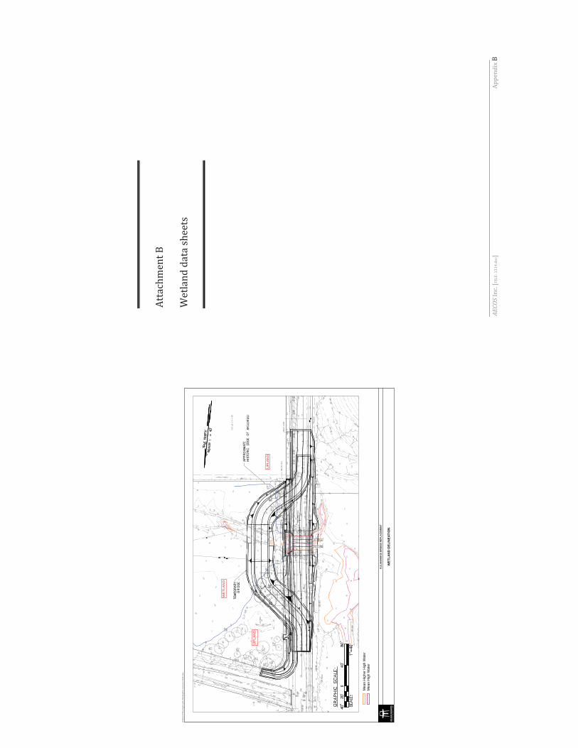
Mea
n H
ighe
r Hig
h W
ater
Mea
n H
igh
Wat
er
APPR
OXIMATE
APPR
OXIMATE
HISTORIC EDG
E OF AKU
LIKU
LIHISTORIC EDG
E OF AKU
LIKU
LI
TEMPO
RARY
TEMPO
RARY
BRIDG
EBRIDGE
WET
LAN
D D
ELIN
EATI
ON
KU
LAN
IHA
KO
I BR
IDG
E R
EPLA
CEM
ENT
W:\8
256-
01\P
lannin
g\Gra
phics
\Wor
king\P
reco
nstru
ction
Noti
ficati
on
WE
TLA
ND
UP
LAN
D
UP
LAN
D
AECOS
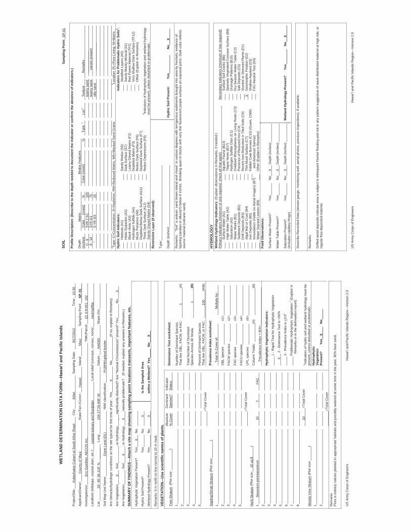
WET
LAN
D D
ETER
MIN
ATI
ON
DA
TA F
OR
M—
Haw
ai‘i
and
Paci
fic Is
land
s
Pro
ject
/Site
:
Kul
anih
akoi
Cul
vert
at S
outh
Kih
ei R
oad
City
:
K
ihei
S
ampl
ing
Dat
e:
9/17
/201
2
T
ime:
10
:30
App
lican
t/Ow
ner:
Cou
nty
of M
aui
Sta
te/T
err./
Com
m.:
H
awai
i
Isla
nd:
Mau
i
Sam
plin
g P
oint
:
SP- 0
1
Inve
stig
ator
(s):
Eric
Gui
nthe
r, A
EC
OS
Inc.
TM
K/P
arce
l:
(2) 3
-9-0
01: 1
62
Land
form
(hill
slop
e, c
oast
al p
lain
, etc
.):
coas
tal e
stua
ry a
nd fl
oodp
lain
Loc
al re
lief (
conc
ave,
con
vex,
non
e):
min
imal
/flat
Lat:
20 4
5’ 5
6.11
0” N
__
____
L
ong:
156
27’2
9.40
8” W
D
atum
:
NA
D83
Slo
pe (%
):
Soi
l Map
Uni
t Nam
e:
Dun
e La
nd (D
L)
NW
I cla
ssifi
catio
n:
PU
BH
h/up
land
bor
der
Are
clim
actic
/hyd
rolo
gic
cond
ition
s on
the
site
typi
cal f
or th
is ti
me
of y
ear:
Yes
X
No
(If
no,
exp
lain
in R
emar
ks)
Are
Veg
etat
ion
X
, Soi
l
, or H
ydro
logy
_
sign
ifica
ntly
dis
turb
ed?
Are
“Nor
mal
Circ
umst
ance
s” p
rese
nt?
Yes
No
X
Are
Veg
etat
ion
, Soi
l
X
, or H
ydro
logy
X
na
tura
lly p
robl
emat
ic?
(If
nee
ded,
exp
lain
any
ans
wer
s in
Rem
arks
.)
SUM
MA
RY
OF
FIN
DIN
GS—
Atta
ch a
site
map
sho
win
g sa
mpl
ing
poin
t loc
atio
ns tr
anse
cts,
impo
rtan
t fea
ture
s, e
tc.
Hyd
roph
ytic
Veg
etat
ion
Pre
sent
?
Yes
X
N
o
Hyd
ric S
oil P
rese
nt?
Ye
s
No
X
Is
the
Sam
pled
Are
a
Wet
land
Hyd
rolo
gy P
rese
nt?
Ye
s _
_
No
X
w
ithin
a W
etla
nd?
Yes
N
o
X
Rem
arks
: 5 m
nor
th o
n lin
e no
rmal
to 2
0 m
mar
k.
VEG
ETAT
ION
—U
se s
cien
tific
nam
es o
f pla
nts.
A
bsol
ute
D
omin
ant
Indi
cato
r Tr
ee S
tratu
m (
Plo
t siz
e:
)
% C
over
Spe
cies
?
Sta
tus
1.
2.
3.
4.
5.
=Tot
al C
over
Sap
ling/
Shr
ub S
tratu
m (P
lot s
ize:
)
1.
2.
3.
4.
5.
=Tot
al C
over
Her
b S
tratu
m (P
lot s
ize:
10
sq.
ft
)
1.
S
esuv
ium
por
tula
cast
rum
10
Y
FA
C
2.
3.
4.
5.
6.
7.
8.
10
=T
otal
Cov
er
Woo
dy V
ine
Stra
tum
(Plo
t siz
e:
)
1.
2.
=Tot
al C
over
Dom
inan
ce T
est w
orks
heet
:
Num
ber o
f Dom
inan
t Spe
cies
Th
at A
re O
BL,
FA
CW
, or F
AC
:
1
(A
)
Tota
l Num
ber o
f Dom
inan
t S
peci
es A
cros
s A
ll S
trata
:
1
(B
)
Per
cent
of D
omin
ant S
peci
es
That
Are
OB
L, F
AC
W, o
r FA
C:
100
(A
/B)
Prev
alen
ce In
dex
wor
kshe
et:
To
tal %
Cov
er o
f:
Mul
tiply
by:
OB
L sp
ecie
s
x1
=
FAC
W s
peci
es
x2=
FAC
spe
cies
x3=
FAC
U s
peci
es
x4
=
UP
L sp
ecie
s
x5
=
Col
umn
Tota
ls:
(A)
(B)
Pre
vale
nce
Inde
x =
B/A
=
Hyd
roph
ytic
Veg
etat
ion
Indi
cato
rs:
1
- R
apid
Tes
t for
Hyd
roph
ytic
Veg
etat
ion
X
2 -
Dom
inan
ce T
est i
s >5
0%
3
- P
reva
lenc
e In
dex
is <
3.01
Pro
blem
atic
Hyd
roph
ytic
Veg
etat
ion
1 (Exp
lain
in
Rem
arks
or i
n th
e de
linea
tion
repo
rt)
1 Indi
cato
rs o
f hyd
ric s
oil a
nd w
etla
nd h
ydro
logy
mus
t be
pres
ent,
unle
ss d
istu
rbed
or p
robl
emat
ic.
Hyd
roph
ytic
Ve
geta
tion
Pres
ent?
Yes
X
No
Rem
arks
Fl
ora
is e
ntire
ly n
ativ
es p
lant
ed in
app
ropr
iate
hab
itats
and
pos
sibl
y w
ater
ed a
t som
e tim
e in
the
past
. 90%
bar
e sa
nd.
US
Arm
y C
orps
of E
ngin
eers
Haw
ai‘i
and
Pac
ific
Isla
nds
Reg
ion—
Ver
sion
2.0
SOIL
Sa
mpl
ing
Poin
t: S
P-0
1
Prof
ile D
escr
iptio
n: (D
escr
ibe
to th
e de
pth
need
ed to
doc
umen
t the
indi
cato
r or c
onfir
m th
e ab
senc
e of
indi
cato
rs.)
Dep
th
M
atrix
R
edox
Fea
ture
s
(in
ches
)
C
olor
(m
oist
)
%
C
olor
(moi
st)
%
Type
1
Loc2
Te
xtur
e
R
emar
ks
0 - 8
5YR
2.5
/1
100
loam
y sa
nd
__
____
____
__
8
- 14
5Y
R 5
/1
75
lo
amy
sand
va
rves
pre
sent
“
5
YR 3
/3
25
silty
san
d
__
____
____
____
_
1 Type
: C=C
once
ntra
tion,
D=D
eple
tion,
RM
=Red
uced
Mat
rix, M
S=M
aske
d S
and
Gra
ins
2 Loca
tion:
PL=
Por
e Li
ning
, M=M
atrix
H
ydric
Soi
l Ind
icat
ors:
In
dica
tors
for P
robl
emat
ic H
ydric
Soi
ls3 :
H
istis
ols
(A1)
San
dy R
edox
(S5)
S
tratif
ied
Laye
rs (A
5)
H
istic
Epi
pedo
n (A
2)
Dar
k-S
urfa
ce (S
7)
San
dy M
ucky
Min
eral
(S1)
Bla
ck H
istic
(A3)
Lo
amy
Gle
yed
Mat
rix (F
2)
Red
Par
ent M
ater
ial (
TF2)
Hyd
roge
n S
ulfid
e (A
4)
D
eple
ted
Mat
rix (F
3)
V
ery
Sha
llow
Dar
k S
urfa
ce (T
F12)
Muc
k P
rese
nce
(A8)
R
edox
Dar
k S
urfa
ce (F
6)
Oth
er (E
xpla
in in
Rem
arks
)
Dep
lete
d B
elow
Dar
k S
urfa
ce (A
11)
D
eple
ted
Dar
k S
urfa
ce (F
7)
Th
ick
Dar
k S
urfa
ce (A
12)
Red
ox D
epre
ssio
ns (F
8)
3 Indi
cato
rs o
f hyd
roph
ytic
veg
etat
ion
and
wet
land
hyd
rolo
gy
S
andy
Gla
yed
Mat
rix (S
4)
mus
t be
pres
ent,
unle
ss d
istu
rbed
or p
robl
emat
ic.
Res
tric
tive
Laye
r (if
obse
rved
):
Type
:
Dep
th (i
nche
s):
Hyd
ric S
oil P
rese
nt:
Yes
N
o
X
Rem
arks
: “S
oil”
is a
olea
n: s
and
blow
n in
land
and
mix
ed t
o va
rious
deg
rees
with
terr
igen
ous
sedi
men
ts b
roug
ht in
to a
rea
by fr
eshe
ts; e
vide
nce
of
laye
ring
(aeo
lian
or a
lluvi
al?)
bel
ow 8
inch
es.
Bre
akin
g ap
art i
n bl
ocks
with
ver
y th
in fl
uore
scen
t pur
ple
surfa
ces
on e
xpos
ed jo
ints
. Dar
k co
lor r
efle
cts
sour
ce m
ater
ial (
volc
anic
san
d).
HYD
RO
LOG
YW
etla
nd H
ydro
logy
Indi
cato
rs: (
Exp
lain
obs
erva
tions
in R
emar
ks, i
f nee
ded.
) P
rimar
y In
dica
tors
(min
imum
of o
ne re
quire
d: c
heck
all
that
app
ly)
S
econ
dary
Indi
cato
rs (m
inim
um o
f tw
o re
quire
d)
Sur
face
Wat
er (A
1)
Aqu
atic
Fau
na (B
13)
Sur
face
Soi
l Cra
cks
(B6)
Hig
h W
ater
Tab
le (A
2)
Ti
lapi
a N
ests
(B17
)
Spa
rsel
y V
eget
ated
Con
cave
Sur
face
(B8)
Sat
urat
ion
(A3)
H
ydro
gen
Sul
fide
Odo
r (C
1)
Dra
inag
e P
atte
rns
(B10
)
Wat
er M
arks
(B1)
Oxi
dize
d R
hizo
sphe
res
on L
ivin
g R
oots
(C3)
D
ry-S
easo
n W
ater
Tab
le (C
2)
S
edim
ent D
epos
its (B
2)
Pre
senc
e of
Red
uced
Iron
(C4)
S
alt D
epos
its (C
5)
D
rift D
epos
its (B
3)
R
ecen
t Iro
n R
educ
tion
in T
iled
Soi
ls (C
6)
Stu
nted
or S
tress
ed P
lant
s (D
1)
A
lgal
Mat
or C
rust
(B4)
Th
in M
uck
Sur
face
(C7)
X
G
eom
orph
ic P
ositi
on (D
2)
Iro
n D
epos
its (B
5)
Fi
ddle
r Cra
b B
urro
ws
(C10
) (G
uam
, CN
MI,
S
hallo
w A
quita
rd (D
3)
In
nund
atio
n V
isib
le o
n A
eria
l Im
ager
y (B
7)
and
Am
eric
an S
amoa
)
FA
C-N
eutra
l Tes
t (D
5)
W
ater
Sta
ined
Lea
ves
(B9)
O
ther
(Exp
lain
in R
emar
ks)
Fiel
d O
bser
vatio
ns:
Sur
face
Wat
er P
rese
nt?
Yes
No
X
D
epth
(inc
hes)
:
Wat
er T
able
Pre
sent
?
Yes
No
X
D
epth
(inc
hes)
:
Sat
urat
ion
Pre
sent
?
Ye
s
N
o
X
Dep
th (i
nche
s):
Wet
land
Hyd
rolo
gy P
rese
nt?
Ye
s
No
X
(incl
udes
cap
illar
y fri
nge)
Des
crib
e R
ecor
ded
Dat
a (s
tream
gau
ge, m
onito
ring
wel
l, ae
rial p
hoto
s, p
revi
ous
insp
ectio
ns),
if av
aila
ble:
Rem
arks
:
Drif
ted
woo
d de
posi
ts in
dica
te a
rea
is s
ubje
ct to
infre
quen
t fre
shet
floo
ding
and
not
in a
ny p
atte
rn s
ugge
stiv
e of
wav
e-di
strib
uted
mat
eria
l at h
igh
tide,
or
regu
lar f
low
dep
osite
d m
ater
ial.
US
Arm
y C
orps
of E
ngin
eers
Haw
ai‘i
and
Pac
ific
Isla
nds
Reg
ion—
Ver
sion
2.0
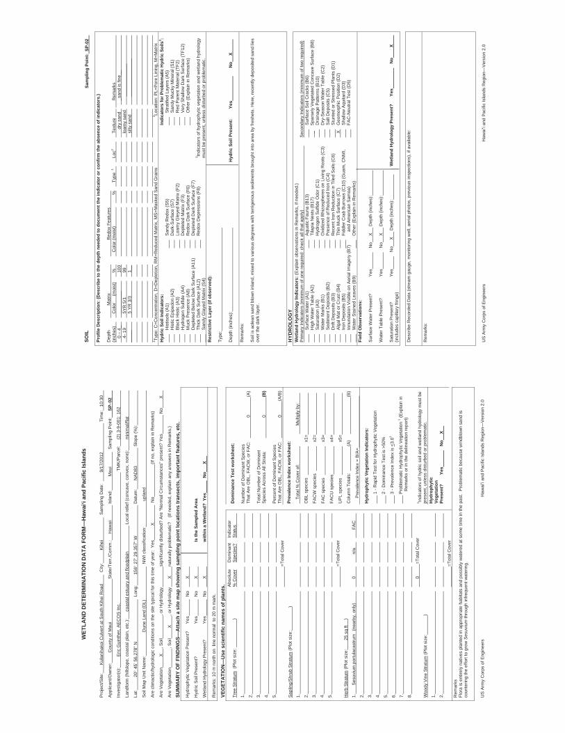
WET
LAN
D D
ETER
MIN
ATI
ON
DA
TA F
OR
M—
Haw
ai‘i
and
Paci
fic Is
land
s
Pro
ject
/Site
:
Kul
anih
akoi
Cul
vert
at S
outh
Kih
ei R
oad
City
:
K
ihei
S
ampl
ing
Dat
e:
9/17
/201
2
T
ime:
10
:30
App
lican
t/Ow
ner:
Cou
nty
of M
aui
Sta
te/T
err./
Com
m.:
H
awai
i
Isla
nd:
Mau
i
Sam
plin
g P
oint
:
SP- 0
2
Inve
stig
ator
(s):
Eric
Gui
nthe
r, A
EC
OS
Inc.
TM
K/P
arce
l:
(2) 3
-9-0
01: 1
62
Land
form
(hill
slop
e, c
oast
al p
lain
, etc
.):
coas
tal e
stua
ry a
nd fl
oodp
lain
Loc
al re
lief (
conc
ave,
con
vex,
non
e):
min
imal
/flat
Lat:
20
45’
56.
278”
N
L
ong:
156
27’
29.
357”
W
Dat
um:
N
AD
83
S
lope
(%):
Soi
l Map
Uni
t Nam
e:
D
une
Land
(DL)
NW
I cla
ssifi
catio
n:
up
land
Are
clim
actic
/hyd
rolo
gic
cond
ition
s on
the
site
typi
cal f
or th
is ti
me
of y
ear:
Yes
X
No
(If
no,
exp
lain
in R
emar
ks)
Are
Veg
etat
ion
X
, Soi
l
, or H
ydro
logy
si
gnifi
cant
ly d
istu
rbed
? A
re “N
orm
al C
ircum
stan
ces”
pre
sent
? Ye
s
N
o
X
Are
Veg
etat
ion
, Soi
l
X
, or H
ydro
logy
X
na
tura
lly p
robl
emat
ic?
(If
nee
ded,
exp
lain
any
ans
wer
s in
Rem
arks
.)
SUM
MA
RY
OF
FIN
DIN
GS—
Atta
ch a
site
map
sho
win
g sa
mpl
ing
poin
t loc
atio
ns tr
anse
cts,
impo
rtan
t fea
ture
s, e
tc.
Hyd
roph
ytic
Veg
etat
ion
Pre
sent
?
Yes
N
o
X
Hyd
ric S
oil P
rese
nt?
Ye
s
No
X
Is
the
Sam
pled
Are
a
Wet
land
Hyd
rolo
gy P
rese
nt?
Ye
s
No
X
w
ithin
a W
etla
nd?
Yes
N
o
X
Rem
arks
: 10
m n
orth
on
line
nor
mal
to
20 m
mar
k.
VEG
ETAT
ION
—U
se s
cien
tific
nam
es o
f pla
nts.
A
bsol
ute
D
omin
ant
Indi
cato
r Tr
ee S
tratu
m (
Plo
t siz
e:
)
% C
over
Spe
cies
?
Sta
tus
1.
2.
3.
4.
5.
=Tot
al C
over
Sap
ling/
Shr
ub S
tratu
m (P
lot s
ize:
)
1.
2.
3.
4.
5.
=Tot
al C
over
Her
b S
tratu
m (P
lot s
ize:
25 s
q ft
)
1.
S
esuv
ium
por
tula
cast
rum
(n
earb
y, o
nly)
0
n/a
FAC
2.
3.
4.
5.
6.
7.
8.
0
=To
tal C
over
Woo
dy V
ine
Stra
tum
(Plo
t siz
e:
)
1.
2.
=Tot
al C
over
Dom
inan
ce T
est w
orks
heet
:
Num
ber o
f Dom
inan
t Spe
cies
Th
at A
re O
BL,
FA
CW
, or F
AC
:
0
(A
)
Tota
l Num
ber o
f Dom
inan
t S
peci
es A
cros
s A
ll S
trata
:
0
(B
)
Per
cent
of D
omin
ant S
peci
es
That
Are
OB
L, F
AC
W, o
r FA
C:
0
(A
/B)
Prev
alen
ce In
dex
wor
kshe
et:
To
tal %
Cov
er o
f:
Mul
tiply
by:
OB
L sp
ecie
s
x1
=
FAC
W s
peci
es
x2=
FAC
spe
cies
x3=
FAC
U s
peci
es
x4
=
UP
L sp
ecie
s
x5
=
Col
umn
Tota
ls:
(A)
(B)
Pre
vale
nce
Inde
x =
B/A
=
Hyd
roph
ytic
Veg
etat
ion
Indi
cato
rs:
1 -
Rap
id T
est f
or H
ydro
phyt
ic V
eget
atio
n
2 -
Dom
inan
ce T
est i
s >5
0%
3 -
Pre
vale
nce
Inde
x is
<3.
01
P
robl
emat
ic H
ydro
phyt
ic V
eget
atio
n 1 (E
xpla
in in
Rem
arks
or i
n th
e de
linea
tion
repo
rt)
1 Indi
cato
rs o
f hyd
ric s
oil a
nd w
etla
nd h
ydro
logy
mus
t be
pres
ent,
unle
ss d
istu
rbed
or p
robl
emat
ic.
Hyd
roph
ytic
Ve
geta
tion
Pres
ent?
Yes
No
X
Rem
arks
Fl
ora
is e
ntire
ly n
ativ
es p
lant
ed in
app
ropr
iate
hab
itats
and
pos
sibl
y w
ater
ed a
t som
e tim
e in
the
past
. P
robl
emat
ic b
ecau
se w
indb
low
n sa
nd is
co
unte
ring
the
effo
rt to
gro
w S
esuv
ium
thro
ugh
infre
quen
t wat
erin
g.
US
Arm
y C
orps
of E
ngin
eers
Haw
ai‘i
and
Pac
ific
Isla
nds
Reg
ion—
Ver
sion
2.0
SOIL
Sa
mpl
ing
Poin
t: SP
-02
Prof
ile D
escr
iptio
n: (D
escr
ibe
to th
e de
pth
need
ed to
doc
umen
t the
indi
cato
r or c
onfir
m th
e ab
senc
e of
indi
cato
rs.)
Dep
th
M
atrix
R
edox
Fea
ture
s
(in
ches
)
C
olor
(m
oist
)
%
C
olor
(moi
st)
%
Type
1
Loc2
Te
xtur
e
R
emar
ks
0 –
4_
____
____
_
10
0
__
dry
sand
_s
and
is fi
ne__
4- 1
9
5YR
5/1
99
loam
y sa
nd
____
____
____
_
____
_
5 YR
3/3
1_
_
si
lty s
and
____
____
____
___
1 Type
: C=C
once
ntra
tion,
D=D
eple
tion,
RM
=Red
uced
Mat
rix, M
S=M
aske
d S
and
Gra
ins
2 Loca
tion:
PL=
Por
e Li
ning
, M=M
atrix
H
ydric
Soi
l Ind
icat
ors:
In
dica
tors
for P
robl
emat
ic H
ydric
Soi
ls3 :
H
istis
ols
(A1)
San
dy R
edox
(S5)
S
tratif
ied
Laye
rs (A
5)
H
istic
Epi
pedo
n (A
2)
Dar
k-S
urfa
ce (S
7)
San
dy M
ucky
Min
eral
(S1)
Bla
ck H
istic
(A3)
Lo
amy
Gle
yed
Mat
rix (F
2)
Red
Par
ent M
ater
ial (
TF2)
Hyd
roge
n S
ulfid
e (A
4)
D
eple
ted
Mat
rix (F
3)
V
ery
Sha
llow
Dar
k S
urfa
ce (T
F12)
Muc
k P
rese
nce
(A8)
R
edox
Dar
k S
urfa
ce (F
6)
Oth
er (E
xpla
in in
Rem
arks
)
Dep
lete
d B
elow
Dar
k S
urfa
ce (A
11)
D
eple
ted
Dar
k S
urfa
ce (F
7)
Th
ick
Dar
k S
urfa
ce (A
12)
Red
ox D
epre
ssio
ns (F
8)
3 Indi
cato
rs o
f hyd
roph
ytic
veg
etat
ion
and
wet
land
hyd
rolo
gy
S
andy
Gla
yed
Mat
rix (S
4)
mus
t be
pres
ent,
unle
ss d
istu
rbed
or p
robl
emat
ic.
Res
tric
tive
Laye
r (if
obse
rved
):
Type
:
Dep
th (i
nche
s):
Hyd
ric S
oil P
rese
nt:
Yes
N
o
X
Rem
arks
:
Soi
l is
aole
an s
and
blow
n in
land
, mix
ed to
var
ious
deg
rees
with
terr
igen
ous
sedi
men
ts b
roug
ht in
to a
rea
by fr
eshe
ts. H
ere,
rece
ntly
dep
osite
d sa
nd li
es
over
the
dark
laye
r.
HYD
RO
LOG
YW
etla
nd H
ydro
logy
Indi
cato
rs: (
Exp
lain
obs
erva
tions
in R
emar
ks, i
f nee
ded.
) P
rimar
y In
dica
tors
(min
imum
of o
ne re
quire
d: c
heck
all
that
app
ly)
S
econ
dary
Indi
cato
rs (m
inim
um o
f tw
o re
quire
d)
Sur
face
Wat
er (A
1)
Aqu
atic
Fau
na (B
13)
Sur
face
Soi
l Cra
cks
(B6)
Hig
h W
ater
Tab
le (A
2)
Ti
lapi
a N
ests
(B17
)
_
Spa
rsel
y V
eget
ated
Con
cave
Sur
face
(B8)
Sat
urat
ion
(A3)
H
ydro
gen
Sul
fide
Odo
r (C
1)
Dra
inag
e P
atte
rns
(B10
)
Wat
er M
arks
(B1)
Oxi
dize
d R
hizo
sphe
res
on L
ivin
g R
oots
(C3)
D
ry-S
easo
n W
ater
Tab
le (C
2)
S
edim
ent D
epos
its (B
2)
Pre
senc
e of
Red
uced
Iron
(C4)
S
alt D
epos
its (C
5)
D
rift D
epos
its (B
3)
R
ecen
t Iro
n R
educ
tion
in T
iled
Soi
ls (C
6)
Stu
nted
or S
tress
ed P
lant
s (D
1)
A
lgal
Mat
or C
rust
(B4)
Th
in M
uck
Sur
face
(C7)
X
G
eom
orph
ic P
ositi
on (D
2)
Iro
n D
epos
its (B
5)
Fi
ddle
r Cra
b B
urro
ws
(C10
) (G
uam
, CN
MI,
S
hallo
w A
quita
rd (D
3)
In
nund
atio
n V
isib
le o
n A
eria
l Im
ager
y (B
7)
and
Am
eric
an S
amoa
)
FA
C-N
eutra
l Tes
t (D
5)
W
ater
Sta
ined
Lea
ves
(B9)
O
ther
(Exp
lain
in R
emar
ks)
Fiel
d O
bser
vatio
ns:
Sur
face
Wat
er P
rese
nt?
Yes
No
X
D
epth
(inc
hes)
:
Wat
er T
able
Pre
sent
?
Yes
No
X
D
epth
(inc
hes)
:
Sat
urat
ion
Pre
sent
?
Ye
s
No
X
D
epth
(inc
hes)
:
Wet
land
Hyd
rolo
gy P
rese
nt?
Ye
s
No
X
(incl
udes
cap
illar
y fri
nge)
Des
crib
e R
ecor
ded
Dat
a (s
tream
gau
ge, m
onito
ring
wel
l, ae
rial p
hoto
s, p
revi
ous
insp
ectio
ns),
if av
aila
ble:
Rem
arks
:
US
Arm
y C
orps
of E
ngin
eers
Haw
ai‘i
and
Pac
ific
Isla
nds
Reg
ion—
Ver
sion
2.0
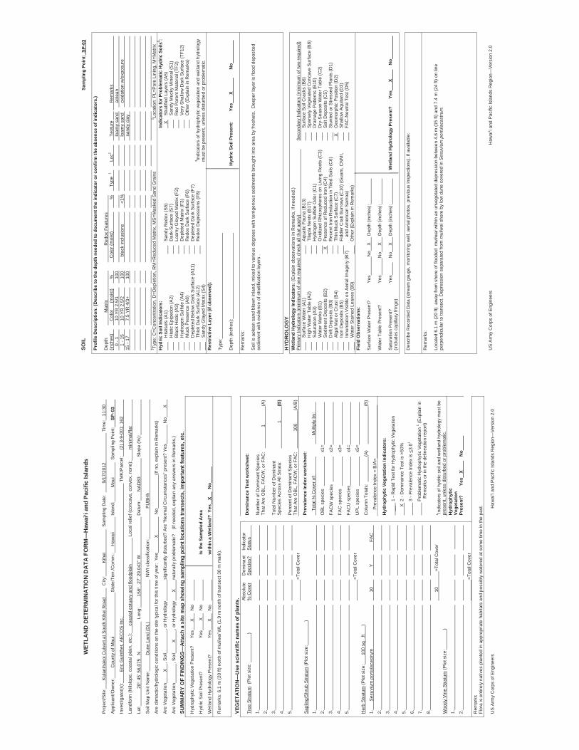
WET
LAN
D D
ETER
MIN
ATI
ON
DA
TA F
OR
M—
Haw
ai‘i
and
Paci
fic Is
land
s
Pro
ject
/Site
:
Kul
anih
akoi
Cul
vert
at S
outh
Kih
ei R
oad
City
:
K
ihei
S
ampl
ing
Dat
e:
9/17
/201
2
T
ime:
11
:30
App
lican
t/Ow
ner:
Cou
nty
of M
aui
Sta
te/T
err./
Com
m.:
H
awai
i
Isla
nd:
Mau
i
Sam
plin
g P
oint
:
SP- 0
3
Inve
stig
ator
(s):
Eric
Gui
nthe
r, A
EC
OS
Inc.
TM
K/P
arce
l:
(2) 3
-9-0
01: 1
62
Land
form
(hill
slop
e, c
oast
al p
lain
, etc
.):
coas
tal e
stua
ry a
nd fl
oodp
lain
Loc
al re
lief (
conc
ave,
con
vex,
non
e):
min
imal
/flat
Lat:
20 4
5’ 5
6,07
5 N
L
ong:
156
27’
29.
043”
W
Dat
um:
N
AD
83
S
lope
(%):
Soi
l Map
Uni
t Nam
e:
D
une
Land
(DL)
NW
I cla
ssifi
catio
n:
PU
BH
h
Are
clim
actic
/hyd
rolo
gic
cond
ition
s on
the
site
typi
cal f
or th
is ti
me
of y
ear:
Yes
X
No
(If
no,
exp
lain
in R
emar
ks)
Are
Veg
etat
ion
X
, Soi
l
, or H
ydro
logy
si
gnifi
cant
ly d
istu
rbed
? A
re “N
orm
al C
ircum
stan
ces”
pre
sent
? Ye
s
N
o
X
Are
Veg
etat
ion
, Soi
l
X
, or H
ydro
logy
X
na
tura
lly p
robl
emat
ic?
(If
nee
ded,
exp
lain
any
ans
wer
s in
Rem
arks
.)
SUM
MA
RY
OF
FIN
DIN
GS—
Atta
ch a
site
map
sho
win
g sa
mpl
ing
poin
t loc
atio
ns tr
anse
cts,
impo
rtan
t fea
ture
s, e
tc.
Hyd
roph
ytic
Veg
etat
ion
Pre
sent
?
Yes
X
N
o
Hyd
ric S
oil P
rese
nt?
Ye
s
X
No
Is
the
Sam
pled
Are
a
Wet
land
Hyd
rolo
gy P
rese
nt?
Ye
s
X
No
w
ithin
a W
etla
nd?
Yes
X
No
Rem
arks
: 6.1
m (2
0 ft)
nor
th o
f mul
iwai
WL
(1.9
m n
orth
of t
rans
ect 3
0 m
mar
k).
VEG
ETAT
ION
—U
se s
cien
tific
nam
es o
f pla
nts.
A
bsol
ute
D
omin
ant
Indi
cato
r Tr
ee S
tratu
m (
Plo
t siz
e:
)
% C
over
Spe
cies
?
Sta
tus
1.
2.
3.
4.
5.
=Tot
al C
over
Sap
ling/
Shr
ub S
tratu
m (P
lot s
ize:
)
1.
2.
3.
4.
5.
=Tot
al C
over
Her
b S
tratu
m (P
lot s
ize:
100
sq .
ft
)
1.
S
esuv
ium
por
tula
cast
rum
10
Y
FA
C
2.
3.
4.
5.
6.
7.
8.
10
=Tot
al C
over
Woo
dy V
ine
Stra
tum
(Plo
t siz
e:
)
1.
2.
=Tot
al C
over
Dom
inan
ce T
est w
orks
heet
:
Num
ber o
f Dom
inan
t Spe
cies
Th
at A
re O
BL,
FA
CW
, or F
AC
:
1
(A
)
Tota
l Num
ber o
f Dom
inan
t S
peci
es A
cros
s A
ll S
trata
:
1
(B
)
Per
cent
of D
omin
ant S
peci
es
That
Are
OB
L, F
AC
W, o
r FA
C:
100
(A
/B)
Prev
alen
ce In
dex
wor
kshe
et:
To
tal %
Cov
er o
f:
Mul
tiply
by:
OB
L sp
ecie
s
x1
=
FAC
W s
peci
es
x2=
FAC
spe
cies
x3=
FAC
U s
peci
es
x4
=
UP
L sp
ecie
s
x5
=
Col
umn
Tota
ls:
(A)
(B)
Pre
vale
nce
Inde
x =
B/A
=
Hyd
roph
ytic
Veg
etat
ion
Indi
cato
rs:
__
1
- R
apid
Tes
t for
Hyd
roph
ytic
Veg
etat
ion
X 2
- D
omin
ance
Tes
t is
>50%
3
- P
reva
lenc
e In
dex
is <
3.01
Pro
blem
atic
Hyd
roph
ytic
Veg
etat
ion
1 (Exp
lain
in
Rem
arks
or i
n th
e de
linea
tion
repo
rt)
1 Indi
cato
rs o
f hyd
ric s
oil a
nd w
etla
nd h
ydro
logy
mus
t be
pres
ent,
unle
ss d
istu
rbed
or p
robl
emat
ic.
Hyd
roph
ytic
Ve
geta
tion
Pres
ent?
Yes
X
No
Rem
arks
Fl
ora
is e
ntire
ly n
ativ
es p
lant
ed in
app
ropr
iate
hab
itats
and
pos
sibl
y w
ater
ed a
t som
e tim
e in
the
past
.
US
Arm
y C
orps
of E
ngin
eers
Haw
ai‘i
and
Pac
ific
Isla
nds
Reg
ion—
Ver
sion
2.0
SOIL
Sa
mpl
ing
Poin
t: SP
-03
Prof
ile D
escr
iptio
n: (D
escr
ibe
to th
e de
pth
need
ed to
doc
umen
t the
indi
cato
r or c
onfir
m th
e ab
senc
e of
indi
cato
rs.)
Dep
th
M
atrix
R
edox
Fea
ture
s
(in
ches
)
C
olor
(m
oist
)
%
C
olor
(moi
st)
%
Type
1
Loc2
Te
xtur
e
R
emar
ks
0 - 1
10 Y
R 2
.5/1
100
loam
y sa
nd
ao
lean
1 - 1
5
10 Y
R 2
.5/2
100
b
lack
incl
usio
ns
<1%
loam
y sa
nd
ox
idat
ion
w/e
xpos
ure
15 -
17
7.5
YR 4
/3+
100
sand
y cl
ay
1 Type
: C=C
once
ntra
tion,
D=D
eple
tion,
RM
=Red
uced
Mat
rix, M
S=M
aske
d S
and
Gra
ins
2 Loca
tion:
PL=
Por
e Li
ning
, M=M
atrix
H
ydric
Soi
l Ind
icat
ors:
In
dica
tors
for P
robl
emat
ic H
ydric
Soi
ls3 :
H
istis
ols
(A1)
San
dy R
edox
(S5)
X
S
tratif
ied
Laye
rs (A
5)
H
istic
Epi
pedo
n (A
2)
Dar
k-S
urfa
ce (S
7)
San
dy M
ucky
Min
eral
(S1)
Bla
ck H
istic
(A3)
Lo
amy
Gle
yed
Mat
rix (F
2)
Red
Par
ent M
ater
ial (
TF2)
Hyd
roge
n S
ulfid
e (A
4)
D
eple
ted
Mat
rix (F
3)
V
ery
Sha
llow
Dar
k S
urfa
ce (T
F12)
Muc
k P
rese
nce
(A8)
R
edox
Dar
k S
urfa
ce (F
6)
Oth
er (E
xpla
in in
Rem
arks
)
Dep
lete
d B
elow
Dar
k S
urfa
ce (A
11)
D
eple
ted
Dar
k S
urfa
ce (F
7)
Th
ick
Dar
k S
urfa
ce (A
12)
Red
ox D
epre
ssio
ns (F
8)
3 Indi
cato
rs o
f hyd
roph
ytic
veg
etat
ion
and
wet
land
hyd
rolo
gy
S
andy
Gla
yed
Mat
rix (S
4)
mus
t be
pres
ent,
unle
ss d
istu
rbed
or p
robl
emat
ic.
Res
tric
tive
Laye
r (if
obse
rved
):
Type
:
Dep
th (i
nche
s):
Hyd
ric S
oil P
rese
nt:
Yes
X
N
o
Rem
arks
:
Soi
l is
aole
an s
and
blow
n in
land
, mix
ed to
var
ious
deg
rees
with
terr
igen
ous
sedi
men
ts b
roug
ht in
to a
rea
by fr
eshe
ts.
Dee
per l
ayer
is fl
ood
depo
site
d se
dim
ent w
ith e
vide
nce
of s
tratif
icat
ion
laye
rs .
HYD
RO
LOG
YW
etla
nd H
ydro
logy
Indi
cato
rs: (
Exp
lain
obs
erva
tions
in R
emar
ks, i
f nee
ded.
) P
rimar
y In
dica
tors
(min
imum
of o
ne re
quire
d: c
heck
all
that
app
ly)
S
econ
dary
Indi
cato
rs (m
inim
um o
f tw
o re
quire
d)
Sur
face
Wat
er (A
1)
Aqu
atic
Fau
na (B
13)
Sur
face
Soi
l Cra
cks
(B6)
Hig
h W
ater
Tab
le (A
2)
Ti
lapi
a N
ests
(B17
)
Spa
rsel
y V
eget
ated
Con
cave
Sur
face
(B8)
Sat
urat
ion
(A3)
H
ydro
gen
Sul
fide
Odo
r (C
1)
Dra
inag
e P
atte
rns
(B10
)
Wat
er M
arks
(B1)
Oxi
dize
d R
hizo
sphe
res
on L
ivin
g R
oots
(C3)
D
ry-S
easo
n W
ater
Tab
le (C
2)
S
edim
ent D
epos
its (B
2)
X
Pre
senc
e of
Red
uced
Iron
(C4)
S
alt D
epos
its (C
5)
D
rift D
epos
its (B
3)
R
ecen
t Iro
n R
educ
tion
in T
iled
Soi
ls (C
6)
Stu
nted
or S
tress
ed P
lant
s (D
1)
A
lgal
Mat
or C
rust
(B4)
Th
in M
uck
Sur
face
(C7)
X
G
eom
orph
ic P
ositi
on (D
2)
Iro
n D
epos
its (B
5)
Fi
ddle
r Cra
b B
urro
ws
(C10
) (G
uam
, CN
MI,
S
hallo
w A
quita
rd (D
3)
In
nund
atio
n V
isib
le o
n A
eria
l Im
ager
y (B
7)
and
Am
eric
an S
amoa
)
FA
C-N
eutra
l Tes
t (D
5)
W
ater
Sta
ined
Lea
ves
(B9)
O
ther
(Exp
lain
in R
emar
ks)
Fiel
d O
bser
vatio
ns:
Sur
face
Wat
er P
rese
nt?
Yes
N
o
X
Dep
th (i
nche
s):
Wat
er T
able
Pre
sent
?
Yes
N
o
X
Dep
th (i
nche
s):
Sat
urat
ion
Pre
sent
?
Ye
s
No
X
D
epth
(inc
hes)
:
Wet
land
Hyd
rolo
gy P
rese
nt?
Ye
s
X
No
(incl
udes
cap
illar
y fri
nge)
Des
crib
e R
ecor
ded
Dat
a (s
tream
gau
ge, m
onito
ring
wel
l, ae
rial p
hoto
s, p
revi
ous
insp
ectio
ns),
if av
aila
ble:
Rem
arks
:
Loca
ted
6.1
m (2
0 ft)
aw
ay fr
om s
hore
of f
lood
ed m
uliw
ai w
ithin
an
unve
geta
ted
depr
essi
on b
etw
een
4.6
m (1
5 ft)
and
7.4
m (2
4 ft)
on
line
perp
endi
cula
r to
trans
ect.
Dep
ress
ion
sepa
rate
d fro
m m
uliw
ai s
hore
by
low
dun
e co
vere
d in
Ses
uviu
m p
ortu
laca
stru
m.
US
Arm
y C
orps
of E
ngin
eers
Haw
ai‘i
and
Pac
ific
Isla
nds
Reg
ion—
Ver
sion
2.0
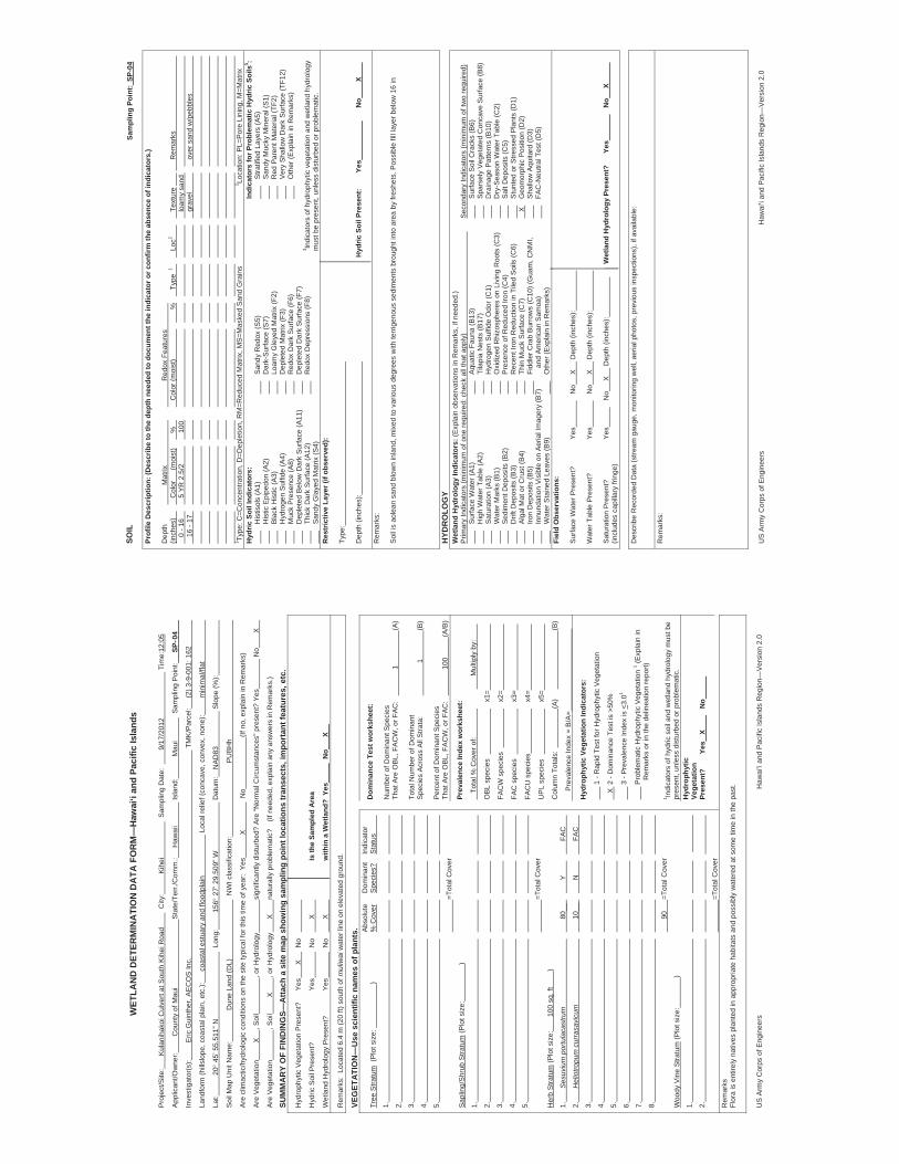
WET
LAN
D D
ETER
MIN
ATI
ON
DA
TA F
OR
M—
Haw
ai‘i
and
Paci
fic Is
land
s
Pro
ject
/Site
:
Kul
anih
akoi
Cul
vert
at S
outh
Kih
ei R
oad
City
:
K
ihei
S
ampl
ing
Dat
e:
9/17
/201
2
T
ime:
12:0
5
App
lican
t/Ow
ner:
Cou
nty
of M
aui
Sta
te/T
err./
Com
m.:
H
awai
i
Isla
nd:
Mau
i
Sam
plin
g P
oint
:
SP- 0
4
Inve
stig
ator
(s):
Eric
Gui
nthe
r, A
EC
OS
Inc.
TM
K/P
arce
l:
(2) 3
-9-0
01: 1
62
Land
form
(hill
slop
e, c
oast
al p
lain
, etc
.):
coas
tal e
stua
ry a
nd fl
oodp
lain
Loc
al re
lief (
conc
ave,
con
vex,
non
e):
min
imal
/flat
Lat:
20
45’
55.
511”
N
L
ong:
156
27’
29.
509”
W
Dat
um:
NA
D83
S
lope
(%):
Soi
l Map
Uni
t Nam
e:
Dun
e La
nd (D
L)
NW
I cla
ssifi
catio
n:
PU
BH
h
Are
clim
actic
/hyd
rolo
gic
cond
ition
s on
the
site
typi
cal f
or th
is ti
me
of y
ear:
Yes
X
No
(If
no,
exp
lain
in R
emar
ks)
Are
Veg
etat
ion
X
, Soi
l
, or H
ydro
logy
si
gnifi
cant
ly d
istu
rbed
? A
re “N
orm
al C
ircum
stan
ces”
pre
sent
? Ye
s
N
o
X
Are
Veg
etat
ion
, Soi
l
X
, or H
ydro
logy
X
na
tura
lly p
robl
emat
ic?
(If
nee
ded,
exp
lain
any
ans
wer
s in
Rem
arks
.)
SUM
MA
RY
OF
FIN
DIN
GS—
Atta
ch a
site
map
sho
win
g sa
mpl
ing
poin
t loc
atio
ns tr
anse
cts,
impo
rtan
t fea
ture
s, e
tc.
Hyd
roph
ytic
Veg
etat
ion
Pre
sent
?
Yes
X
N
o
Hyd
ric S
oil P
rese
nt?
Ye
s
No
X
Is
the
Sam
pled
Are
a
Wet
land
Hyd
rolo
gy P
rese
nt?
Ye
s
No
X
w
ithin
a W
etla
nd?
Yes
N
o
X
Rem
arks
: Lo
cate
d 6.
4 m
(20
ft) s
outh
of m
uliw
ai w
ater
line
on
elev
ated
gro
und.
VEG
ETAT
ION
—U
se s
cien
tific
nam
es o
f pla
nts.
A
bsol
ute
D
omin
ant
Indi
cato
r Tr
ee S
tratu
m (
Plo
t siz
e:
)
% C
over
Spe
cies
?
Sta
tus
1.
2.
3.
4.
5.
=Tot
al C
over
Sap
ling/
Shr
ub S
tratu
m (P
lot s
ize:
)
1.
2.
3.
4.
5.
=Tot
al C
over
Her
b S
tratu
m (P
lot s
ize:
100
sq. f
t
)
1.
S
esuv
ium
por
tula
cast
rum
80
__
Y
FAC
2.
H
elio
tropu
m c
urra
savi
cum
10
__
N
FAC
3.
4.
5.
6.
7.
8.
90
=Tot
al C
over
Woo
dy V
ine
Stra
tum
(Plo
t siz
e:
)
1.
2.
=Tot
al C
over
Dom
inan
ce T
est w
orks
heet
:
Num
ber o
f Dom
inan
t Spe
cies
Th
at A
re O
BL,
FA
CW
, or F
AC
:
1
(A
)
Tota
l Num
ber o
f Dom
inan
t S
peci
es A
cros
s A
ll S
trata
:
1
(B
)
Per
cent
of D
omin
ant S
peci
es
That
Are
OB
L, F
AC
W, o
r FA
C:
100
(A
/B)
Prev
alen
ce In
dex
wor
kshe
et:
To
tal %
Cov
er o
f:
Mul
tiply
by:
OB
L sp
ecie
s
x1
=
FAC
W s
peci
es
x2=
FAC
spe
cies
x3=
FAC
U s
peci
es
x4
=
UP
L sp
ecie
s
x5
=
Col
umn
Tota
ls:
(A)
(B)
Pre
vale
nce
Inde
x =
B/A
=
Hyd
roph
ytic
Veg
etat
ion
Indi
cato
rs:
1 -
Rap
id T
est f
or H
ydro
phyt
ic V
eget
atio
n
X
2 -
Dom
inan
ce T
est i
s >5
0%
3 -
Pre
vale
nce
Inde
x is
<3.
01
P
robl
emat
ic H
ydro
phyt
ic V
eget
atio
n 1 (E
xpla
in in
Rem
arks
or i
n th
e de
linea
tion
repo
rt)
1 Indi
cato
rs o
f hyd
ric s
oil a
nd w
etla
nd h
ydro
logy
mus
t be
pres
ent,
unle
ss d
istu
rbed
or p
robl
emat
ic.
Hyd
roph
ytic
Ve
geta
tion
Pres
ent?
Yes
X
No
Rem
arks
Fl
ora
is e
ntire
ly n
ativ
es p
lant
ed in
app
ropr
iate
hab
itats
and
pos
sibl
y w
ater
ed a
t som
e tim
e in
the
past
.
US
Arm
y C
orps
of E
ngin
eers
Haw
ai‘i
and
Pac
ific
Isla
nds
Reg
ion—
Ver
sion
2.0
SOIL
Sa
mpl
ing
Poin
t: SP
-04
Prof
ile D
escr
iptio
n: (D
escr
ibe
to th
e de
pth
need
ed to
doc
umen
t the
indi
cato
r or c
onfir
m th
e ab
senc
e of
indi
cato
rs.)
Dep
th
M
atrix
R
edox
Fea
ture
s
(in
ches
)
C
olor
(m
oist
)
%
C
olor
(moi
st)
%
Type
1
Loc2
Te
xtur
e
R
emar
ks
0 - 1
6
5 YR
2.5
/2
100
loam
y sa
nd
16
- 17
grav
el
over
san
d w
/peb
bles
1 Type
: C=C
once
ntra
tion,
D=D
eple
tion,
RM
=Red
uced
Mat
rix, M
S=M
aske
d S
and
Gra
ins
2 Loca
tion:
PL=
Por
e Li
ning
, M=M
atrix
H
ydric
Soi
l Ind
icat
ors:
In
dica
tors
for P
robl
emat
ic H
ydric
Soi
ls3 :
H
istis
ols
(A1)
San
dy R
edox
(S5)
S
tratif
ied
Laye
rs (A
5)
H
istic
Epi
pedo
n (A
2)
Dar
k-S
urfa
ce (S
7)
San
dy M
ucky
Min
eral
(S1)
Bla
ck H
istic
(A3)
Lo
amy
Gle
yed
Mat
rix (F
2)
Red
Par
ent M
ater
ial (
TF2)
Hyd
roge
n S
ulfid
e (A
4)
D
eple
ted
Mat
rix (F
3)
V
ery
Sha
llow
Dar
k S
urfa
ce (T
F12)
Muc
k P
rese
nce
(A8)
R
edox
Dar
k S
urfa
ce (F
6)
Oth
er (E
xpla
in in
Rem
arks
)
Dep
lete
d B
elow
Dar
k S
urfa
ce (A
11)
D
eple
ted
Dar
k S
urfa
ce (F
7)
Th
ick
Dar
k S
urfa
ce (A
12)
Red
ox D
epre
ssio
ns (F
8)
3 Indi
cato
rs o
f hyd
roph
ytic
veg
etat
ion
and
wet
land
hyd
rolo
gy
S
andy
Gla
yed
Mat
rix (S
4)
mus
t be
pres
ent,
unle
ss d
istu
rbed
or p
robl
emat
ic.
Res
tric
tive
Laye
r (if
obse
rved
):
Type
:
Dep
th (i
nche
s):
Hyd
ric S
oil P
rese
nt:
Yes
N
o
X
Rem
arks
:
Soi
l is
aole
an s
and
blow
n in
land
, mix
ed to
var
ious
deg
rees
with
terr
igen
ous
sedi
men
ts b
roug
ht in
to a
rea
by fr
eshe
ts. P
ossi
ble
fill l
ayer
bel
ow 1
6 in
HYD
RO
LOG
YW
etla
nd H
ydro
logy
Indi
cato
rs: (
Exp
lain
obs
erva
tions
in R
emar
ks, i
f nee
ded.
) P
rimar
y In
dica
tors
(min
imum
of o
ne re
quire
d: c
heck
all
that
app
ly)
S
econ
dary
Indi
cato
rs (m
inim
um o
f tw
o re
quire
d)
Sur
face
Wat
er (A
1)
Aqu
atic
Fau
na (B
13)
Sur
face
Soi
l Cra
cks
(B6)
Hig
h W
ater
Tab
le (A
2)
Ti
lapi
a N
ests
(B17
)
Spa
rsel
y V
eget
ated
Con
cave
Sur
face
(B8)
Sat
urat
ion
(A3)
H
ydro
gen
Sul
fide
Odo
r (C
1)
Dra
inag
e P
atte
rns
(B10
)
Wat
er M
arks
(B1)
Oxi
dize
d R
hizo
sphe
res
on L
ivin
g R
oots
(C3)
D
ry-S
easo
n W
ater
Tab
le (C
2)
S
edim
ent D
epos
its (B
2)
Pre
senc
e of
Red
uced
Iron
(C4)
S
alt D
epos
its (C
5)
D
rift D
epos
its (B
3)
R
ecen
t Iro
n R
educ
tion
in T
iled
Soi
ls (C
6)
Stu
nted
or S
tress
ed P
lant
s (D
1)
A
lgal
Mat
or C
rust
(B4)
Th
in M
uck
Sur
face
(C7)
X
G
eom
orph
ic P
ositi
on (D
2)
Iro
n D
epos
its (B
5)
Fi
ddle
r Cra
b B
urro
ws
(C10
) (G
uam
, CN
MI,
S
hallo
w A
quita
rd (D
3)
In
nund
atio
n V
isib
le o
n A
eria
l Im
ager
y (B
7)
and
Am
eric
an S
amoa
)
FA
C-N
eutra
l Tes
t (D
5)
W
ater
Sta
ined
Lea
ves
(B9)
O
ther
(Exp
lain
in R
emar
ks)
Fiel
d O
bser
vatio
ns:
Sur
face
Wat
er P
rese
nt?
Yes
No
X
D
epth
(inc
hes)
:
Wat
er T
able
Pre
sent
?
Yes
No
X
D
epth
(inc
hes)
:
Sat
urat
ion
Pre
sent
?
Ye
s
No
X
D
epth
(inc
hes)
:
Wet
land
Hyd
rolo
gy P
rese
nt?
Ye
s
N
o
X
(in
clud
es c
apill
ary
fring
e)
Des
crib
e R
ecor
ded
Dat
a (s
tream
gau
ge, m
onito
ring
wel
l, ae
rial p
hoto
s, p
revi
ous
insp
ectio
ns),
if av
aila
ble:
Rem
arks
:
US
Arm
y C
orps
of E
ngin
eers
Haw
ai‘i
and
Pac
ific
Isla
nds
Reg
ion—
Ver
sion
2.0
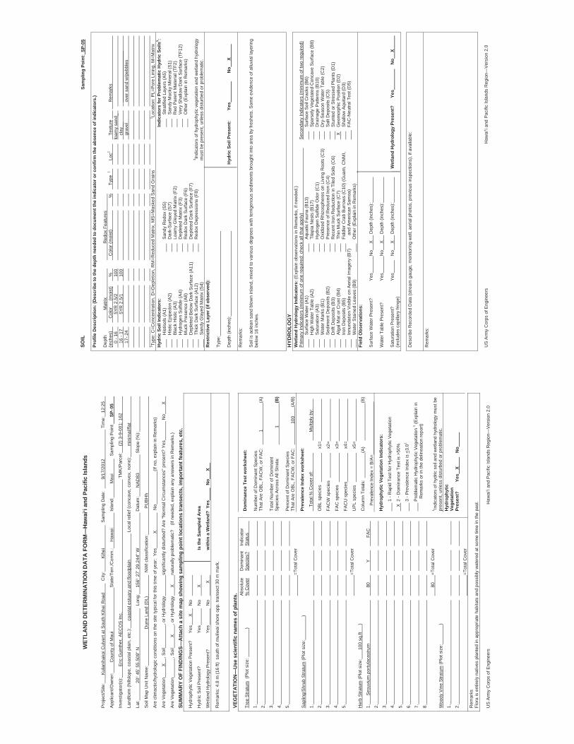
WET
LAN
D D
ETER
MIN
ATI
ON
DA
TA F
OR
M—
Haw
ai‘i
and
Paci
fic Is
land
s
Pro
ject
/Site
:
Kul
anih
akoi
Cul
vert
at S
outh
Kih
ei R
oad
City
:
K
ihei
S
ampl
ing
Dat
e:
9/17
/201
2
T
ime:
12
:25
App
lican
t/Ow
ner:
Cou
nty
of M
aui
Sta
te/T
err./
Com
m.:
H
awai
i
Isla
nd:
Mau
i
Sam
plin
g P
oint
:
SP- 0
5
Inve
stig
ator
(s):
Eric
Gui
nthe
r, A
EC
OS
Inc.
TM
K/P
arce
l:
(2) 3
-9-0
01: 1
62
Land
form
(hill
slop
e, c
oast
al p
lain
, etc
.):
coas
tal e
stua
ry a
nd fl
oodp
lain
Loc
al re
lief (
conc
ave,
con
vex,
non
e):
min
imal
/flat
Lat:
20 4
5’ 5
5.50
9” N
L
ong:
15
6 2
7’ 2
9.24
4” W
Dat
um:
N
AD
83
S
lope
(%):
Soi
l Map
Uni
t Nam
e:
Dun
e La
nd (D
L)
NW
I cla
ssifi
catio
n:
P
UB
Hh
Are
clim
actic
/hyd
rolo
gic
cond
ition
s on
the
site
typi
cal f
or th
is ti
me
of y
ear:
Yes
X
No
(If
no,
exp
lain
in R
emar
ks)
Are
Veg
etat
ion
X
, Soi
l
, or H
ydro
logy
si
gnifi
cant
ly d
istu
rbed
? A
re “N
orm
al C
ircum
stan
ces”
pre
sent
? Ye
s
N
o
X
Are
Veg
etat
ion
, Soi
l
X
, or H
ydro
logy
X
na
tura
lly p
robl
emat
ic?
(If
nee
ded,
exp
lain
any
ans
wer
s in
Rem
arks
.)
SUM
MA
RY
OF
FIN
DIN
GS—
Atta
ch a
site
map
sho
win
g sa
mpl
ing
poin
t loc
atio
ns tr
anse
cts,
impo
rtan
t fea
ture
s, e
tc.
Hyd
roph
ytic
Veg
etat
ion
Pre
sent
?
Yes
X
N
o
Hyd
ric S
oil P
rese
nt?
Ye
s
No
X
Is
the
Sam
pled
Are
a
Wet
land
Hyd
rolo
gy P
rese
nt?
Ye
s
No
X
w
ithin
a W
etla
nd?
Yes
N
o
X
Rem
arks
: 4.8
m (1
6 ft)
sou
th o
f mul
iwai
shor
e op
p. tr
anse
ct 3
0 m
mar
k.
VEG
ETAT
ION
—U
se s
cien
tific
nam
es o
f pla
nts.
A
bsol
ute
D
omin
ant
Indi
cato
r Tr
ee S
tratu
m (
Plo
t siz
e:
)
% C
over
Spe
cies
?
Sta
tus
1.
2.
3.
4.
5.
=Tot
al C
over
Sap
ling/
Shr
ub S
tratu
m (P
lot s
ize:
)
1.
2.
3.
4.
5.
=Tot
al C
over
Her
b S
tratu
m (P
lot s
ize:
100
sq.ft
)
1.
S
esuv
ium
por
tula
cast
rum
80
Y
FA
C
2.
3.
4.
5.
6.
7.
8.
80
=Tot
al C
over
Woo
dy V
ine
Stra
tum
(Plo
t siz
e:
)
1.
2.
=Tot
al C
over
Dom
inan
ce T
est w
orks
heet
:
Num
ber o
f Dom
inan
t Spe
cies
Th
at A
re O
BL,
FA
CW
, or F
AC
:
1
(A
)
Tota
l Num
ber o
f Dom
inan
t S
peci
es A
cros
s A
ll S
trata
:
1
(B
)
Per
cent
of D
omin
ant S
peci
es
That
Are
OB
L, F
AC
W, o
r FA
C:
10
0
(A
/B)
Prev
alen
ce In
dex
wor
kshe
et:
To
tal %
Cov
er o
f:
Mul
tiply
by:
OB
L sp
ecie
s
x1
=
FAC
W s
peci
es
x2=
FAC
spe
cies
x3=
FAC
U s
peci
es
x4
=
UP
L sp
ecie
s
x5
=
Col
umn
Tota
ls:
(A)
(B)
Pre
vale
nce
Inde
x =
B/A
=
Hyd
roph
ytic
Veg
etat
ion
Indi
cato
rs:
1 -
Rap
id T
est f
or H
ydro
phyt
ic V
eget
atio
n
X
2 -
Dom
inan
ce T
est i
s >5
0%
3 -
Pre
vale
nce
Inde
x is
<3.
01
P
robl
emat
ic H
ydro
phyt
ic V
eget
atio
n 1 (E
xpla
in in
Rem
arks
or i
n th
e de
linea
tion
repo
rt)
1 Indi
cato
rs o
f hyd
ric s
oil a
nd w
etla
nd h
ydro
logy
mus
t be
pres
ent,
unle
ss d
istu
rbed
or p
robl
emat
ic.
Hyd
roph
ytic
Ve
geta
tion
Pres
ent?
Yes
X
No
Rem
arks
Fl
ora
is e
ntire
ly n
ativ
es p
lant
ed in
app
ropr
iate
hab
itats
and
pos
sibl
y w
ater
ed a
t som
e tim
e in
the
past
.
US
Arm
y C
orps
of E
ngin
eers
Haw
ai‘i
and
Pac
ific
Isla
nds
Reg
ion—
Ver
sion
2.0
SOIL
Sa
mpl
ing
Poin
t: SP
-05
Prof
ile D
escr
iptio
n: (D
escr
ibe
to th
e de
pth
need
ed to
doc
umen
t the
indi
cato
r or c
onfir
m th
e ab
senc
e of
indi
cato
rs.)
Dep
th
M
atrix
R
edox
Fea
ture
s
(in
ches
)
C
olor
(m
oist
)
%
C
olor
(moi
st)
%
Type
1
Loc2
Te
xtur
e
R
emar
ks
0 - 1
6
5Y
R 2
.5/2
100
lo
amy
sand
_
16
- 17
5Y
R 2
.5/1
100
clay
__
____
____
____
____
____
17
- 24
grav
el
over
san
d w
/peb
bles
1 Type
: C=C
once
ntra
tion,
D=D
eple
tion,
RM
=Red
uced
Mat
rix, M
S=M
aske
d S
and
Gra
ins
2 Loca
tion:
PL=
Por
e Li
ning
, M=M
atrix
H
ydric
Soi
l Ind
icat
ors:
In
dica
tors
for P
robl
emat
ic H
ydric
Soi
ls3 :
H
istis
ols
(A1)
San
dy R
edox
(S5)
S
tratif
ied
Laye
rs (A
5)
H
istic
Epi
pedo
n (A
2)
Dar
k-S
urfa
ce (S
7)
San
dy M
ucky
Min
eral
(S1)
Bla
ck H
istic
(A3)
Lo
amy
Gle
yed
Mat
rix (F
2)
Red
Par
ent M
ater
ial (
TF2)
Hyd
roge
n S
ulfid
e (A
4)
D
eple
ted
Mat
rix (F
3)
V
ery
Sha
llow
Dar
k S
urfa
ce (T
F12)
Muc
k P
rese
nce
(A8)
R
edox
Dar
k S
urfa
ce (F
6)
Oth
er (E
xpla
in in
Rem
arks
)
Dep
lete
d B
elow
Dar
k S
urfa
ce (A
11)
D
eple
ted
Dar
k S
urfa
ce (F
7)
Th
ick
Dar
k S
urfa
ce (A
12)
Red
ox D
epre
ssio
ns (F
8)
3 Indi
cato
rs o
f hyd
roph
ytic
veg
etat
ion
and
wet
land
hyd
rolo
gy
S
andy
Gla
yed
Mat
rix (S
4)
mus
t be
pres
ent,
unle
ss d
istu
rbed
or p
robl
emat
ic.
Res
tric
tive
Laye
r (if
obse
rved
):
Type
:
Dep
th (i
nche
s):
Hyd
ric S
oil P
rese
nt:
Yes
No
X
Rem
arks
:
Soi
l is
aole
an s
and
blow
n in
land
, mix
ed to
var
ious
deg
rees
with
terr
igen
ous
sedi
men
ts b
roug
ht in
to a
rea
by fr
eshe
ts. S
ome
evid
ence
of a
lluvi
al la
yerin
g be
low
16
inch
es.
HYD
RO
LOG
YW
etla
nd H
ydro
logy
Indi
cato
rs: (
Exp
lain
obs
erva
tions
in R
emar
ks, i
f nee
ded.
) P
rimar
y In
dica
tors
(min
imum
of o
ne re
quire
d: c
heck
all
that
app
ly)
S
econ
dary
Indi
cato
rs (m
inim
um o
f tw
o re
quire
d)
Sur
face
Wat
er (A
1)
Aqu
atic
Fau
na (B
13)
Sur
face
Soi
l Cra
cks
(B6)
Hig
h W
ater
Tab
le (A
2)
Ti
lapi
a N
ests
(B17
)
Spa
rsel
y V
eget
ated
Con
cave
Sur
face
(B8)
Sat
urat
ion
(A3)
H
ydro
gen
Sul
fide
Odo
r (C
1)
Dra
inag
e P
atte
rns
(B10
)
Wat
er M
arks
(B1)
Oxi
dize
d R
hizo
sphe
res
on L
ivin
g R
oots
(C3)
D
ry-S
easo
n W
ater
Tab
le (C
2)
S
edim
ent D
epos
its (B
2)
Pre
senc
e of
Red
uced
Iron
(C4)
S
alt D
epos
its (C
5)
D
rift D
epos
its (B
3)
R
ecen
t Iro
n R
educ
tion
in T
iled
Soi
ls (C
6)
Stu
nted
or S
tress
ed P
lant
s (D
1)
A
lgal
Mat
or C
rust
(B4)
Th
in M
uck
Sur
face
(C7)
X
G
eom
orph
ic P
ositi
on (D
2)
Iro
n D
epos
its (B
5)
Fi
ddle
r Cra
b B
urro
ws
(C10
) (G
uam
, CN
MI,
S
hallo
w A
quita
rd (D
3)
In
nund
atio
n V
isib
le o
n A
eria
l Im
ager
y (B
7)
and
Am
eric
an S
amoa
)
FA
C-N
eutra
l Tes
t (D
5)
W
ater
Sta
ined
Lea
ves
(B9)
O
ther
(Exp
lain
in R
emar
ks)
Fiel
d O
bser
vatio
ns:
Sur
face
Wat
er P
rese
nt?
Yes
N
o
X
Dep
th (i
nche
s):
Wat
er T
able
Pre
sent
?
Yes
N
o
X
Dep
th (i
nche
s):
Sat
urat
ion
Pre
sent
?
Ye
s
No
X
D
epth
(inc
hes)
:
Wet
land
Hyd
rolo
gy P
rese
nt?
Ye
s
No
X
(incl
udes
cap
illar
y fri
nge)
Des
crib
e R
ecor
ded
Dat
a (s
tream
gau
ge, m
onito
ring
wel
l, ae
rial p
hoto
s, p
revi
ous
insp
ectio
ns),
if av
aila
ble:
Rem
arks
:
US
Arm
y C
orps
of E
ngin
eers
Haw
ai‘i
and
Pac
ific
Isla
nds
Reg
ion—
Ver
sion
2.0

APPENDIX C
An Archaeological Literature Review and Field Inspection for Kūlanihākoʻi Bridge Replacement Project, Kaʻonoʻulu Ahupuaʻa, Wailuku District, Maui Island
TMK: (2) 3-9-001: 999, 015, 147, 162 (pors)
Cultural Surveys Hawai‘i, Inc.
October 2012


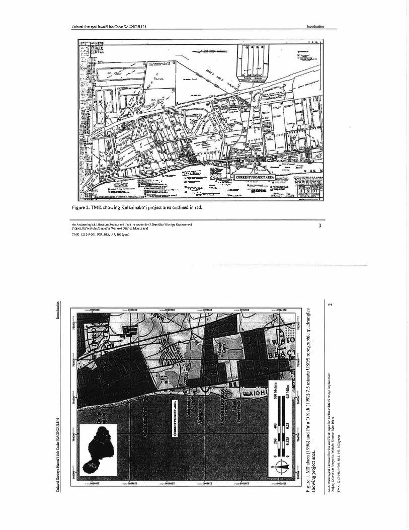
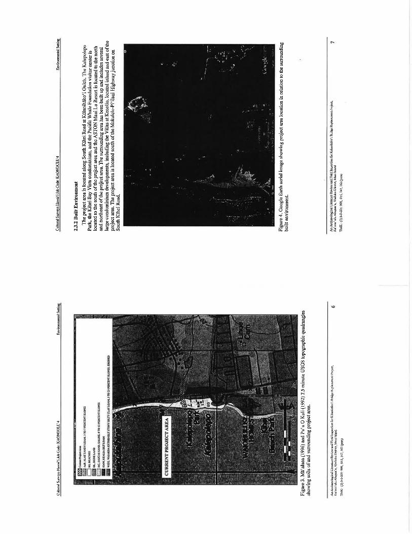


APPENDIX D
An Archaeological Inventory Survey for the Proposed Kūlanihākoʻi Bridge Replacement Project, Kaʻonoʻulu Ahupuaʻa, Wailuku District, Maui Island
TMK: (2) 3-9-001: 999, 162, 143 (pors)
Cultural Surveys Hawai‘i, Inc.
June 2013
Letter from State Historic Preservation Division
June 25, 2014
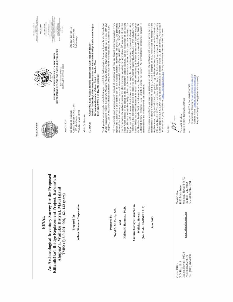
O‘a
hu O
ffic
e P.
O. B
ox 1
114
Kai
lua,
Haw
ai‘i
9673
4 Ph
.: (8
08) 2
62-9
972
Fax:
(808
) 262
-495
0
ww
w.c
ultu
rals
urve
ys.c
om
Mau
i Off
ice
1860
Mai
n St
reet
W
ailu
ku, H
awai
‘i 96
793
Ph: (
808)
242
-988
2 Fa
x: (8
08) 2
44-1
994
FIN
AL
A
n A
rcha
eolo
gica
l Inv
ento
ry S
urve
y fo
r th
e Pr
opos
ed
Kūl
anihāk
o‘i B
ridg
e R
epla
cem
ent P
roje
ct, K
a‘on
o‘ul
u A
hupu
a‘a,
Wai
luku
Dis
tric
t, M
aui I
slan
d T
MK
: (2)
3-9
-001
: 999
, 162
, 143
(por
s)
Pr
epar
ed fo
r W
ilson
Oka
mot
o C
orpo
ratio
n
Prep
ared
by
Tod
d D
. McC
urdy
, MA
an
d H
alle
tt H
. Ham
mat
t, Ph
.D.
C
ultu
ral S
urve
ys H
awai
‘i, In
c.
Wai
luku
, Haw
ai‘i
(Job
Cod
e: K
AO
NO
UL
U 7
)
June
201
3
NE
IL A
BE
RC
RO
MB
IE
GO
VER
NO
R O
F H
AW
AII
WIL
LIA
M J
. AIL
A, J
R.
CH
AIR
PER
SON
B
OA
RD
OF
LAN
D A
ND
NA
TUR
AL
RES
OU
RC
ES
CO
MM
ISSI
ON
ON
WA
TER
RES
OU
RC
E M
AN
AG
EMEN
T
JESS
E K
. SO
UK
I FI
RST
DEP
UTY
WIL
LIA
M M
. TA
M
DEP
UTY
DIR
ECTO
R -
WA
TER
AQ
UA
TIC
RES
OU
RC
ES
BO
ATI
NG
AN
D O
CEA
N R
ECR
EATI
ON
B
UR
EAU
OF
CO
NV
EYA
NC
ES
CO
MM
ISSI
ON
ON
WA
TER
RES
OU
RC
E M
AN
AG
EMEN
T C
ON
SER
VA
TIO
N A
ND
CO
AST
AL
LAN
DS
CO
NSE
RV
ATI
ON
AN
D R
ESO
UR
CES
EN
FOR
CEM
ENT
ENG
INEE
RIN
G
FOR
ESTR
Y A
ND
WIL
DLI
FE
HIS
TOR
IC P
RES
ERV
ATI
ON
K
AH
OO
LAW
E IS
LAN
D R
ESER
VE
CO
MM
ISSI
ON
LA
ND
ST
ATE
PA
RK
S
HIS
TO
RIC
PR
ESE
RV
AT
ION
DIV
ISIO
N
DE
PAR
TM
EN
T O
F L
AN
D A
ND
NA
TU
RA
L R
ESO
UR
CE
S
POST
OFF
ICE
BO
X 6
21
HO
NO
LULU
, HA
WA
II
9680
9
NE
IL A
BE
RC
RO
MB
IE
GO
VER
NO
R O
F H
AW
AII
June
25,
201
4
Dr.
Hal
lett
H. H
amm
att
LOG
NO
: 201
4.00
115
Cul
tura
l Sur
veys
Haw
ai‘i,
Inc.
D
OC
NO
: 140
6JP1
6 18
60 M
ain
Stre
et
Arc
haeo
logy
W
ailu
ku, H
awai
i 967
93
Alo
ha D
r. H
amm
att:
SUB
JEC
T:
Cha
pter
6E-
8 an
d N
atio
nal H
isto
ric
Pres
erva
tion
Act
Sec
tion
106
Rev
iew
- R
evis
ed A
rcha
eolo
gica
l Inv
ento
ry S
urve
y fo
r th
e K
lani
hako
i Bri
dge
Rep
lace
men
t Pro
ject
K
aon
oul
u A
hupu
aa,
Wai
luku
Dis
tric
t, Is
land
of M
aui
T
MK
(2) 3
-9-0
01: 1
43, 1
62, 9
99 (p
ortio
ns)
Than
k yo
u fo
r sub
mitt
ing
the
revi
sed
draf
t rep
ort e
ntitl
ed A
n Ar
chae
olog
ical
Inve
ntor
y Su
rvey
for
the
Kla
niha
koi
Brid
ge R
epla
cem
ent P
roje
ct, K
aon
oul
u Ah
upua
a, W
ailu
ku D
istr
ict,
Mau
i Isl
and,
TM
K:
(2)
3-9-
001:
999
, 162
, 14
3 (p
ors)
, Tod
d D
. McC
urdy
and
Hal
lett
Ham
mat
t (20
14).
We
rece
ived
the
revi
sed
subm
ittal
on
Janu
ary
9, 2
014.
The
revi
sed
draf
t rep
ort w
as p
repa
red
in s
uppo
rt of
com
plia
nce
with
sta
te a
nd f
eder
al h
isto
ric p
rese
rvat
ion
revi
ew
regu
latio
ns C
hapt
er 6
E-8
and
Sect
ion
106
of t
he N
atio
nal
His
toric
Pre
serv
atio
n A
ct (
NH
PA).
We
prev
ious
ly
revi
ewed
the
draf
t inv
ento
ry s
urve
y re
port
and
reco
mm
ende
d re
visi
ons
(Log
201
3.43
97, D
oc 1
309C
G03
). Th
ank
you
for
incl
udin
g th
e up
date
d co
nstru
ctio
n pl
ans
and
map
s de
pict
ing
the
appr
oxim
ate
0.9
acre
are
a of
pot
entia
l ef
fect
, whi
ch c
onsi
sts
of t
he d
etou
r br
idge
, the
tem
pora
ry s
uppo
rt st
ruct
ure,
and
the
rep
lace
men
t of
the
exi
stin
g br
idge
. The
191
1 K
ulan
ihak
oi B
ridge
is li
sted
in th
e St
ate
Inve
ntor
y as
50-
50-1
0-76
06 b
ased
on
Crit
erio
n D
. The
br
idge
has
suf
fere
d se
vere
det
erio
ratio
n so
it
no l
onge
r ha
s an
y di
stin
guis
hing
arc
hite
ctur
al c
hara
cter
istic
s. Th
eref
ore,
it h
as lo
st in
tegr
ity a
nd is
not
elig
ible
for
the
Nat
iona
l Reg
iste
r (L
og 2
012.
3734
, Doc
121
2RS6
4). T
he
hist
oric
brid
ge h
as y
ield
ed in
form
atio
n im
porta
nt to
the
unde
rsta
ndin
g of
the
first
gen
erat
ion
of c
oncr
ete
brid
ges
in
the
Haw
aiia
n Is
land
s. Su
ffic
ient
inf
orm
atio
n w
as c
olle
cted
and
no
furth
er w
ork
reco
mm
ende
d fo
r Si
te 7
606.
No
addi
tiona
l hi
stor
ic p
rope
rties
wer
e id
entif
ied
durin
g th
e su
rvey
. A
n ar
chae
olog
ical
mon
itorin
g pr
ogra
m i
s re
com
men
ded,
and
we
conc
ur w
ith th
at a
sses
smen
t.
Cha
nges
mad
e ac
cord
ing
to o
ur r
eque
sted
rev
isio
ns a
re a
dequ
ate;
the
arc
haeo
logi
cal
inve
ntor
y su
rvey
mee
ts t
he
requ
irem
ents
of
Haw
ai‘i
Adm
inis
trativ
e R
ule
§ 13
-276
and
is a
ccep
ted
as f
inal
. Ple
ase
send
one
har
dcop
y of
the
final
doc
umen
t, cl
early
mar
ked
FIN
AL,
alo
ng w
ith a
cop
y of
this
revi
ew le
tter a
nd a
text
-sea
rcha
ble
vers
ion
on
CD
to
the
Kap
olei
SH
PD o
ffic
e, a
ttent
ion
SHPD
Lib
rary
. We
look
for
war
d to
con
tinue
d co
nsul
tatio
n re
gard
ing
hist
oric
pro
perti
es (3
6 C
FR P
art 8
00.4
), an
d th
e as
sess
men
t of a
dver
se e
ffec
ts (3
6 C
FR P
art 8
00.5
). Pl
ease
con
tact
Je
nny
Pick
ett a
t (80
8) 2
43-5
169
or Je
nny.
L.Pi
cket
t@H
awai
i.gov
for a
ny q
uest
ions
or c
once
rns a
bout
this
lette
r.
Mah
alo,
Ther
esa
K. D
onha
m
Dep
uty
His
toric
Pre
serv
atio
n O
ffic
er
cc:
Cou
nty
of M
aui D
SA F
ax: (
808)
270
-797
2
Dep
artm
ent o
f Pla
nnin
g (p
lann
ing@
mau
icou
nty.
gov)
Ann
alis
e K
ehle
r (an
nalis
e.ke
hler
@m
auic
ount
y.go
v)Ta
nya
Lee-
Gre
ig (L
eeG
reig
@cu
ltura
lsur
veys
.com
)
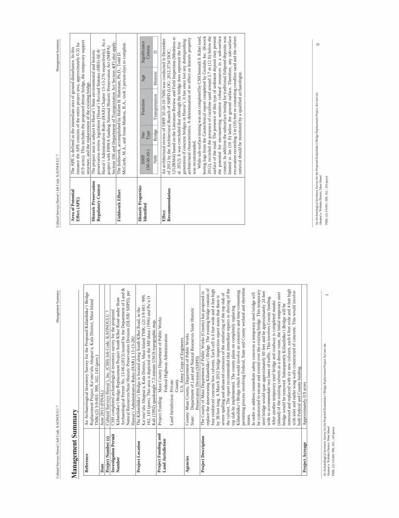
Cultu
ral S
urve
ys H
awai
‘i Jo
b Co
de: K
AO
NO
ULU
7
M
anag
emen
t Sum
mar
y
An
Arc
haeo
logi
cal I
nven
tory
Sur
vey
for t
he P
ropo
sed
Kul
anih
ako‘
i Brid
ge R
epla
cem
ent P
roje
ct, K
a‘on
o‘ul
u A
hupu
a‘a,
Wai
luku
Dist
rict,
Mau
i Isla
nd
i TM
K: (
2) 3
-9-0
01: 9
99, 1
62 ,
143
(por
s)
Man
agem
ent S
umm
ary
Ref
eren
ce
An
Arc
haeo
logi
cal I
nven
tory
Sur
vey
for t
he P
ropo
sed
Kūl
anihāk
o‘i B
ridge
R
epla
cem
ent P
roje
ct, K
a‘on
o‘ul
u A
hupu
a‘a,
Kul
a D
istri
ct, M
aui I
slan
d TM
K:(2
) 3-9
-001
: 999
, 162
, 143
(por
s.)
Dat
e Ju
ne 2
013
(FIN
AL)
Pr
ojec
t Num
ber
(s)
Cul
tura
l Sur
veys
Haw
ai‘i,
Inc.
(CSH
) Job
Cod
e: K
AO
NO
ULU
7
Inve
stig
atio
n Pe
rmit
Num
ber
CSH
com
plet
ed a
rcha
eolo
gica
l inv
ento
ry su
rvey
for t
he p
ropo
sed
Kūl
anihāk
o‘i B
ridge
Rep
lace
men
t Pro
ject
Sou
th Kīh
ei R
oad
unde
r Sta
te
Arc
haeo
logi
cal P
erm
it N
o. 1
3-06
(201
3) is
sued
by
the
Dep
artm
ent o
f Lan
d &
N
atur
al R
esou
rces
/Sta
te H
isto
ric P
rese
rvat
ion
Div
isio
n (D
LNR
/ SH
PD),
per
Haw
ai‘i
Adm
inis
trativ
e R
ules
(HA
R) §
13-
13-2
82.
Proj
ect L
ocat
ion
The
Kūl
anihāk
o‘i B
ridge
is lo
cate
d al
ong
Sout
h Kīh
ei R
oad,
in th
e K
a‘on
o‘ul
u A
hupu
a‘a,
Kul
a D
istri
ct, M
aui I
slan
d TM
K: (
2) 3
-9-0
01: 9
99,
162,
143
(por
s). T
his a
rea
is d
epic
ted
on th
e Mā‘
alae
a (1
996)
and
Pu‘
u O
K
ali (
1992
) qua
dran
gle
7.5-
min
ute
USG
S to
pogr
aphi
c m
ap.
Proj
ect F
undi
ng a
nd
Lan
d Ju
risd
ictio
n Pr
ojec
t Fun
ding
: M
aui C
ount
y D
epar
tmen
t of P
ublic
Wor
ks
Fede
ral H
ighw
ay A
dmin
istra
tion
Land
Juris
dict
ion:
Priv
ate
Cou
nty
U.S
. Arm
y C
orps
of E
ngin
eers
A
genc
ies
Cou
nty:
Mau
i Cou
nty,
Dep
artm
ent o
f Pub
lic W
orks
St
ate:
D
epar
tmen
t of L
and
and
Nat
ural
Res
ourc
es S
tate
His
toric
P
rese
rvat
ion
Div
isio
n (S
HPD
) Pr
ojec
t Des
crip
tion
The
Cou
nty
of M
aui D
epar
tmen
t of P
ublic
Wor
ks (C
ount
y) h
as p
ropo
sed
to
repl
ace
the
dete
riora
ting
Kūl
anihāk
o‘i B
ridge
. The
exi
stin
g br
idge
con
sist
s of
four
rein
forc
ed c
oncr
ete
box
culv
erts
. Eac
h ce
ll is
6 fe
et w
ide
and
4 fe
et h
igh
by 3
8 fe
et lo
ng. A
Mar
ch 2
012
brid
ge in
spec
tion
repo
rt no
tes t
hat t
here
is
seve
re sp
allin
g an
d ad
vanc
ed c
orro
sion
of t
he re
info
rcin
g of
the
top
slab
of
the
culv
ert.
The
repo
rt re
com
men
ded
that
imm
edia
te re
pairs
or s
horin
g of
the
top
slab
be
impl
emen
ted.
The
cou
nty
plan
s on
com
plet
ely
repl
acin
g Kūl
anihāk
o‘i B
ridge
whi
ch w
ould
invo
lve
an e
xten
sive
and
tim
e -co
nsum
ing
perm
ittin
g pr
oces
s inv
olvi
ng F
eder
al, S
tate
and
Cou
nty
wet
land
and
shor
elin
e is
sues
.
In o
rder
to a
ddre
ss im
med
iate
safe
ty c
once
rns a
tem
pora
ry st
eel b
ridge
will
be
con
stru
cted
to e
ncas
e an
d ex
tend
ove
r the
exi
stin
g br
idge
. Thi
s tem
pora
ry
stee
l brid
ge w
ould
span
app
roxi
mat
ely
60 fe
et a
nd b
e ap
prox
imat
ely
24 fe
et
wid
e to
acc
omm
odat
e tw
o la
nes o
f tra
ffic
. Thi
s inv
olve
s Cou
nty
fund
ing.
A
fter a
noth
er te
mpo
rary
stee
l brid
ge a
nd ro
adw
ay is
com
plet
ed m
auka
(in
land
) of t
he e
xist
ing
culv
erts
as a
det
our r
oute
, the
initi
al te
mpo
rary
stee
l br
idge
wou
ld b
e re
mov
ed. S
ubse
quen
tly Kūl
anihāk
o‘i B
ridge
will
be
rem
oved
and
repl
aced
with
six
new
cul
verts
, eac
h 6
feet
wid
e an
d 4
feet
hig
h w
ith in
let a
nd o
utle
t win
g w
alls
con
stru
cted
of c
oncr
ete.
Thi
s wou
ld in
volv
e bo
th F
eder
al a
nd C
ount
y fu
ndin
g.
Proj
ect A
crea
ge
App
roxi
mat
ely
0.9
acre
s
Cultu
ral S
urve
ys H
awai
‘i Jo
b Co
de: K
AO
NO
ULU
7
M
anag
emen
t Sum
mar
y
An
Arc
haeo
logi
cal I
nven
tory
Sur
vey
for t
he P
ropo
sed
Kul
anih
ako‘
i Brid
ge R
epla
cem
ent P
roje
ct, K
a‘on
o‘ul
u A
hupu
a‘a,
Wai
luku
Dist
rict,
Mau
i Isla
nd
ii
TMK
: (2)
3-9
-001
: 999
, 162
, 14
3 (p
ors)
Are
a of
Pot
entia
l Ef
fect
(APE
) Th
e A
PE is
def
ined
as t
he im
med
iate
are
a of
gro
und
dist
urba
nce.
In th
is
inst
ance
the
APE
con
sist
s of t
he e
ntire
pro
ject
are
a, a
ppro
xim
atel
y 0.
35 h
a (0
.9 a
cres
). Th
is in
clud
es th
e pr
opos
ed d
etou
r brid
ge, t
he te
mpo
rary
supp
ort
stru
ctur
e, a
nd th
e re
plac
emen
t of t
he e
xist
ing
brid
ge.
Hist
oric
Pre
serv
atio
n R
egul
ator
y C
onte
xt
The
proj
ect a
rea
is su
bjec
t to
Haw
ai‘i
Stat
e en
viro
nmen
tal a
nd h
isto
ric
pres
erva
tion
revi
ew le
gisl
atio
n [H
awai
‘i R
evis
ed S
tatu
tes (
HR
S) 6
E-8/
H
awai
‘i A
dmin
istra
tive
Rul
es (H
AR
) Cha
pter
13-
13-2
76 re
spec
tivel
y]. A
s a
proj
ect w
ith F
HW
A fu
ndin
g N
atio
nal H
isto
ric P
rese
rvat
ion
Act
(NH
PA)
Sect
ion
106
and
Dep
artm
ent o
f Tra
nspo
rtatio
n A
ct S
ectio
n 4(
F) a
lso
appl
y.
Fiel
dwor
k Ef
fort
Th
e fie
ldw
ork,
acc
ompl
ishe
d by
Hal
lett
H. H
amm
att,
Ph.D
., To
dd D
. M
cCur
dy, M
.A.,
and
Jona
s Mad
eus,
B.A
., to
ok 3
per
son-
days
to c
ompl
ete.
Hist
oric
Pro
pert
ies
Iden
tifie
d SI
HP
(50-
50-1
0-)
Site
Ty
pe
Func
tion
Age
Si
gnifi
canc
e C
riter
ia
7606
B
ridge
Tr
ansp
orta
tion
His
toric
D
Effe
ct
Rec
omm
enda
tion
An
arch
itect
ural
revi
ew o
f SIH
P 50
-50-
10-7
606
was
con
duct
ed in
Dec
embe
r of
201
2 by
the
Arc
hite
ctur
al B
ranc
h of
SH
PD (L
OG
: 201
2.37
34 D
OC
: 12
12R
S64)
bas
ed o
n th
e Li
tera
ture
Rev
iew
and
Fie
ld In
spec
tion
(Med
eiro
s et
al. 2
012)
. It w
as c
oncl
uded
that
alth
ough
the
brid
ge d
oes r
epre
sent
the
first
ge
nera
tion
if co
ncre
te b
ridge
s in
Haw
ai‘i,
it h
as si
nce
lost
any
dis
tingu
ishi
ng
arch
itect
ural
cha
ract
eris
tics.
A d
eter
min
atio
n of
no
effe
ct o
n hi
stor
ic p
rope
rty
was
reco
mm
ende
d.
Whi
le su
b-su
rfac
e tes
ting
was
not
com
plet
ed b
y C
SH b
enea
th S
. Kih
ei ro
ad,
b orin
g lo
gs fr
om th
e G
eote
chni
cal r
epor
t com
plet
ed b
y G
eola
bs In
c. (
Kw
ock
2012
) , re
cord
ed th
e pr
esen
ce o
f cor
allin
e sa
nd a
roun
d 3.
7 m
(12
ft) b
elow
the
surf
ace
of th
e ro
ad. T
he p
rese
nce
of th
is ty
pe o
f sed
imen
t dep
osit
may
pre
sent
th
e po
tent
ial
for
enco
unte
ring
sens
itive
cul
tura
l re
sour
ces
in a
sub
-sur
face
co
ntex
t. In
add
ition
the
subs
urfa
ce te
stin
g fo
r tra
ditio
nal f
ishp
ond
depo
sits
was
lim
ited
to 3
m (
10 f
t) be
low
the
gro
und
surf
ace.
The
refo
re, a
ny s
ub-s
urfa
ce
exca
vatio
n ex
ceed
ing
3 m
(10)
feet
or c
onta
inin
g co
ralli
ne sa
nd an
d th
e cu
lver
t re
mov
al sh
ould
be
mon
itore
d by
a q
ualif
ied
arch
aeol
ogis
t.

Cultu
ral S
urve
ys H
awai
‘i Jo
b Co
de: K
AO
NO
ULU
7
An
Arc
haeo
logi
cal I
nven
tory
Sur
vey
for t
he P
ropo
sed
Kul
anih
ako‘
i Brid
ge R
epla
cem
ent P
roje
ct, K
a‘on
o‘ul
u A
hupu
a‘a,
Wai
luku
Dist
rict,
Mau
i Isla
nd
iii
TMK
: (2)
3-9
-001
: 999
, 162
, 14
3 (p
ors)
Tab
le o
f Con
tent
s M
anag
emen
t Sum
mar
y ...
......
......
......
......
......
......
......
......
......
......
......
......
......
......
......
......
......
... i
Sect
ion
1 In
trod
uctio
n ...
......
......
......
......
......
......
......
......
......
......
......
......
......
......
......
......
......
.... 1
1.1
Proj
ect B
ackg
roun
d ...
......
......
......
......
......
......
......
......
......
......
......
......
......
......
......
......
......
......
......
.. 1
1.2
Scop
e of
Wor
k ....
......
......
......
......
......
......
......
......
......
......
......
......
......
......
......
......
......
......
......
......
... 2
1.3
Envi
ronm
enta
l Set
ting
......
......
......
......
......
......
......
......
......
......
......
......
......
......
......
......
......
......
......
. 7
1.3.
1 N
atur
al E
nviro
nmen
t.....
......
......
......
......
......
......
......
......
......
......
......
......
......
......
......
......
......
.... 7
1.
3.2
Bui
lt En
viro
nmen
t.....
......
......
......
......
......
......
......
......
......
......
......
......
......
......
......
......
......
......
10
Sect
ion
2 M
etho
ds ..
......
......
......
......
......
......
......
......
......
......
......
......
......
......
......
......
......
......
.... 1
1 2.
1 Fi
eld
Met
hods
......
......
......
......
......
......
......
......
......
......
......
......
......
......
......
......
......
......
......
......
......
11
2.1.
1 Pe
dest
rian
Surv
ey ..
......
......
......
......
......
......
......
......
......
......
......
......
......
......
......
......
......
......
... 11
2.
1.2
Subs
urfa
ce T
estin
g ....
......
......
......
......
......
......
......
......
......
......
......
......
......
......
......
......
......
......
11
2.2
Labo
rato
ry M
etho
ds ...
......
......
......
......
......
......
......
......
......
......
......
......
......
......
......
......
......
......
......
11
2.3
Doc
umen
t Rev
iew
.....
......
......
......
......
......
......
......
......
......
......
......
......
......
......
......
......
......
......
......
12
Sect
ion
3 B
ackg
roun
d R
esea
rch
......
......
......
......
......
......
......
......
......
......
......
......
......
......
......
. 14
3.1
Trad
ition
al a
nd H
isto
rical
Bac
kgro
und .
......
......
......
......
......
......
......
......
......
......
......
......
......
......
... 14
3.
1.1
Myt
holo
gica
l and
Tra
ditio
nal A
ccou
nts .
......
......
......
......
......
......
......
......
......
......
......
......
......
14
3.1.
2 Tr
aditi
onal
Acc
ount
s.....
......
......
......
......
......
......
......
......
......
......
......
......
......
......
......
......
......
.. 17
3.1.
3 Ea
rly H
isto
ric P
erio
d ...
......
......
......
......
......
......
......
......
......
......
......
......
......
......
......
......
......
... 20
3.
1.4
Mid
- to
late
-180
0s ...
......
......
......
......
......
......
......
......
......
......
......
......
......
......
......
......
......
......
.. 24
3.1.
5 B
rief H
isto
ry o
f the
Ka‘
ono‘
ulu
Ran
ch C
ompa
ny ...
......
......
......
......
......
......
......
......
......
......
. 25
3.1.
6 19
00s .
......
......
......
......
......
......
......
......
......
......
......
......
......
......
......
......
......
......
......
......
......
......
26
3.1.
7 Th
e re
side
ntia
l are
a of
Kīh
ei ...
......
......
......
......
......
......
......
......
......
......
......
......
......
......
......
.... 2
9 3.
1.8
Impa
ct o
f the
mili
tary
on
the
proj
ect a
rea .
......
......
......
......
......
......
......
......
......
......
......
......
.... 3
1 3.
1.9
Mod
ern
Land
Use
.....
......
......
......
......
......
......
......
......
......
......
......
......
......
......
......
......
......
......
32
3.2
Prev
ious
Arc
haeo
logi
cal R
esea
rch
......
......
......
......
......
......
......
......
......
......
......
......
......
......
......
.... 3
2 3.
3 B
ackg
roun
d Su
mm
ary
and
Pred
ictiv
e M
odel
......
......
......
......
......
......
......
......
......
......
......
......
......
38
Sect
ion
4 R
esul
ts o
f Fie
ldw
ork .
......
......
......
......
......
......
......
......
......
......
......
......
......
......
......
... 4
0 4.
1 Pe
dest
rian
Surv
ey R
esul
ts ...
......
......
......
......
......
......
......
......
......
......
......
......
......
......
......
......
......
... 40
4.
1.1
SIH
P 50
-50-
10-7
606 .
......
......
......
......
......
......
......
......
......
......
......
......
......
......
......
......
......
......
40
4.2
Sub-
Surf
ace
Test
ing
Res
ults
......
......
......
......
......
......
......
......
......
......
......
......
......
......
......
......
......
.. 43
4.2.
1 Sh
ovel
Tes
t 1 ..
......
......
......
......
......
......
......
......
......
......
......
......
......
......
......
......
......
......
......
.... 4
3 4.
2.2
Shov
el T
est 2
.....
......
......
......
......
......
......
......
......
......
......
......
......
......
......
......
......
......
......
......
. 44
4.2.
3 Sh
ovel
Tes
t 3/P
ipe
Core
1 ..
......
......
......
......
......
......
......
......
......
......
......
......
......
......
......
......
.. 44
4.2.
4 Pi
pe C
ore
2 ...
......
......
......
......
......
......
......
......
......
......
......
......
......
......
......
......
......
......
......
......
44
Sect
ion
5 R
esul
ts o
f Lab
orat
ory
Ana
lysi
s ....
......
......
......
......
......
......
......
......
......
......
......
......
54
5.1
Soil
Sam
ple
Ana
lysi
s ....
......
......
......
......
......
......
......
......
......
......
......
......
......
......
......
......
......
......
... 54
Sect
ion
6 Su
mm
ary
and
Inte
rpre
tatio
n ...
......
......
......
......
......
......
......
......
......
......
......
......
.... 6
0 6.
1 Su
mm
ary
of H
isto
ric P
rope
rties
and
Sub
-Sur
face
Inve
stig
atio
ns W
ithin
the
Cur
rent
Pro
ject
Are
a ..
......
......
......
......
......
......
......
......
......
......
......
......
......
......
......
......
......
......
......
......
......
......
......
......
......
......
.. 60
6.1.
1 SI
HP
50-5
0-10
-760
6 ....
......
......
......
......
......
......
......
......
......
......
......
......
......
......
......
......
......
... 60
Cultu
ral S
urve
ys H
awai
‘i Jo
b Co
de: K
AO
NO
ULU
7
An
Arc
haeo
logi
cal I
nven
tory
Sur
vey
for t
he P
ropo
sed
Kul
anih
ako‘
i Brid
ge R
epla
cem
ent P
roje
ct, K
a‘on
o‘ul
u A
hupu
a‘a,
Wai
luku
Dist
rict,
Mau
i Isla
nd
iv
TMK
: (2)
3-9
-001
: 999
, 162
, 14
3 (p
ors)
6.1.
2 Su
b-Su
rfac
e In
vest
igat
ions
.....
......
......
......
......
......
......
......
......
......
......
......
......
......
......
......
.... 6
0
Sect
ion
7 Si
gnifi
canc
e A
sses
smen
ts ..
......
......
......
......
......
......
......
......
......
......
......
......
......
......
70
7.1
SIH
P 50
-50-
10-7
606 .
......
......
......
......
......
......
......
......
......
......
......
......
......
......
......
......
......
......
......
. 70
7.1.
1 C
riter
ion
of S
igni
fican
ce D
......
......
......
......
......
......
......
......
......
......
......
......
......
......
......
......
... 70
Sect
ion
8 Pr
ojec
t Eff
ect a
nd M
itiga
tion
Rec
omm
enda
tions
......
......
......
......
......
......
......
.....
71
8.1
Miti
gatio
n re
com
men
datio
ns ...
......
......
......
......
......
......
......
......
......
......
......
......
......
......
......
......
.... 7
1 8.
2 D
ispo
sitio
n of
Mat
eria
l ....
......
......
......
......
......
......
......
......
......
......
......
......
......
......
......
......
......
......
71
Sect
ion
9 R
efer
ence
s Cite
d ...
......
......
......
......
......
......
......
......
......
......
......
......
......
......
......
......
. 72
App
endi
x A
Pol
len
Ana
lysi
s Rep
ort .
......
......
......
......
......
......
......
......
......
......
......
......
......
......
.. 1
App
endi
x B
SH
PD A
rchi
tect
ural
Bra
nch
Det
erm
inat
ion
lett
er ...
......
......
......
......
......
......
... 1

Cultu
ral S
urve
ys H
awai
‘i Jo
b Co
de: K
AO
NO
ULU
7
An
Arc
haeo
logi
cal I
nven
tory
Sur
vey
for t
he P
ropo
sed
Kul
anih
ako‘
i Brid
ge R
epla
cem
ent P
roje
ct, K
a‘on
o‘ul
u A
hupu
a‘a,
Wai
luku
Dist
rict,
Mau
i Isla
nd
v
TMK
: (2)
3-9
-001
: 999
, 162
, 14
3 (p
ors)
Lis
t of F
igur
es
Figu
re 1
. Mā‘
alae
a (1
996)
and
Pu‘
u O
Kal
i (19
92) 7
.5 m
inut
e U
SGS
topo
grap
hic
quad
rang
les
show
ing
proj
ect a
rea,
pro
ject
are
a ou
tline
d in
red.
......
......
......
......
......
......
......
......
......
......
..3
Figu
re 2
. TM
K sh
owin
g (2
) 3-9
-01,
Kūl
anihāk
o‘i B
ridge
repl
acem
ent p
roje
ct a
rea
outli
ned
in
red.
.....
......
......
......
......
......
......
......
......
......
......
......
......
......
......
......
......
......
......
......
......
......
....4
Fi
gure
3. C
onst
ruct
ion
plan
s sho
win
g th
e pr
opos
ed te
mpo
rary
brid
ge (f
igur
e co
urte
sy o
f Wils
on
Oka
mot
o C
orpo
ratio
n). ..
......
......
......
......
......
......
......
......
......
......
......
......
......
......
......
......
......
5 Fi
gure
4. C
onst
ruct
ion
plan
s sho
win
g th
e pr
opos
ed p
erm
anen
t brid
ge (f
igur
e co
urte
sy o
f Wils
on
Oka
mot
o C
orpo
ratio
n). ..
......
......
......
......
......
......
......
......
......
......
......
......
......
......
......
......
......
6 Fi
gure
5 O
verv
iew
of t
he c
urre
nt p
roje
ct a
rea
faci
ng w
est. .
......
......
......
......
......
......
......
......
......
......
8 Fi
gure
6. M
ā‘al
aea
(199
6) a
nd P
u‘u
O K
ali (
1992
) 7.5
min
ute
USG
S to
pogr
aphi
c qu
adra
ngle
s sh
owin
g th
e so
ils o
f the
cur
rent
pro
ject
and
surr
ound
ing
area
. ....
......
......
......
......
......
......
...9
Figu
re 7
. Goo
gle
Earth
(201
1) a
eria
l im
age
show
ing
proj
ect a
rea
loca
tion
in re
latio
n to
the
surr
ound
ing
built
env
ironm
ent. .
......
......
......
......
......
......
......
......
......
......
......
......
......
......
.....1
0 Fi
gure
8. D
rivin
g th
e Pi
pe C
ore
1 in
to th
e se
dim
ent,
view
to th
e ea
st. .
......
......
......
......
......
......
....1
3 Fi
gure
9. A
por
tion
of th
e F.
S D
odge
map
(188
5) sh
owin
g K
a‘on
o‘ul
u A
hupu
a‘a
in re
latio
n to
th
e tra
ditio
nal m
oku
of K
ula
(cro
wn
land
s in
yello
w, g
over
nmen
t lan
ds in
gre
en).
......
....1
4 Fi
gure
10.
The
cur
rent
pro
ject
loca
tion
on a
por
tion
of a
190
0 Mā‘
alae
a H
arbo
r sho
win
g th
e ne
arby
fish
pond
s (Fr
isby
190
0). .
......
......
......
......
......
......
......
......
......
......
......
......
......
......
...21
Fi
gure
11.
A p
ortio
n of
an
acco
untin
g st
atem
ent f
or w
ater
del
iver
ed to
the
Kih
ei P
lant
atio
n C
ompa
ny in
190
7. ...
......
......
......
......
......
......
......
......
......
......
......
......
......
......
......
......
......
.....2
8 Fi
gure
12.
Aer
ial p
hoto
of K
ūlan
ihāk
o‘i B
ridge
(Sch
ool o
f Oce
an a
nd E
arth
Sci
ence
Tec
hnol
ogy
[SO
EST]
194
9) ..
......
......
......
......
......
......
......
......
......
......
......
......
......
......
......
......
......
......
....3
0 Fi
gure
13.
197
1 ae
rial p
hoto
of a
nten
na, t
rans
mitt
er b
uild
ings
and
adm
inis
trativ
e bu
ildin
g fo
r W
WV
H, j
ust s
eaw
ard
of th
e pr
ojec
t are
a. P
hoto
cou
rtesy
of N
atio
nal I
nstit
ute
of
Stan
dard
s and
Tec
hnol
ogy
(http
://tf.
nist
.gov
/sta
tions
/ww
vhto
ur.h
tml).
.....
......
......
......
....3
1 Fi
gure
14.
Por
tions
of t
he P
u‘u
o K
ali (
1992
) and
Mā‘
alae
a (1
996)
7.5
-min
ute
USG
S to
pogr
aphi
c qu
adra
ngle
s, sh
owin
g th
e cu
rren
t pro
ject
are
a re
lativ
e to
adj
acen
t are
as o
f pr
evio
us a
rcha
eolo
gica
l stu
dy. ..
......
......
......
......
......
......
......
......
......
......
......
......
......
......
.....3
7 Fi
gure
15.
Kūl
anihāk
o‘i B
ridge
, vie
w n
orth
wes
t.....
......
......
......
......
......
......
......
......
......
......
......
....4
1 Fi
gure
16.
Kūl
anihāk
o‘i B
ridge
, vie
w n
orth
east
......
......
......
......
......
......
......
......
......
......
......
......
....4
2 Fi
gure
17.
Nor
ther
n w
ing
wal
l his
toric
con
stru
ctio
n. ...
......
......
......
......
......
......
......
......
......
......
.....4
2 Fi
gure
18.
Sou
ther
n w
ing
wal
l mod
ern
cons
truct
ion.
......
......
......
......
......
......
......
......
......
......
......
..43
Figu
re 1
9. A
eria
l sho
win
g th
e lo
catio
ns o
f the
sub-
surf
ace
exca
vatio
n an
d SI
HP
50-5
0-10
-76
06...
......
......
......
......
......
......
......
......
......
......
......
......
......
......
......
......
......
......
......
......
......
...45
Fi
gure
20.
Pro
files
of t
he su
b-su
rfac
e ex
cava
tions
. .....
......
......
......
......
......
......
......
......
......
......
......
46
Figu
re 2
1. P
rofil
e of
the
sedi
men
t in
STP
3/Pi
pe C
ore
1....
......
......
......
......
......
......
......
......
......
.....4
8 Fi
gure
22.
Pip
e C
ore
1 sh
owin
g St
rata
III-
V. ..
......
......
......
......
......
......
......
......
......
......
......
......
......
49
Figu
re 2
3. P
ipe
Cor
e 1
show
ing
Stra
ta V
-VII.
......
......
......
......
......
......
......
......
......
......
......
......
......
.50
Figu
re 2
4. P
ipe
Cor
e 2
bein
g ex
tract
ed fr
om th
e st
ream
bed,
vie
w to
the
wes
t. ...
......
......
......
......
.51
Figu
re 2
5. P
ipe
Cor
e 2
show
ing
Stra
ta V
-VII.
......
......
......
......
......
......
......
......
......
......
......
......
......
.52
Figu
re 2
6. P
ipe
Cor
e 2
show
ing
Stra
tum
VII.
.....
......
......
......
......
......
......
......
......
......
......
......
......
..53
Figu
re 2
7. P
olle
n D
iagr
am fo
r sam
ples
1 a
nd 2
(ada
pted
from
Cum
min
gs 2
013:
8). ..
......
......
......
59
Cultu
ral S
urve
ys H
awai
‘i Jo
b Co
de: K
AO
NO
ULU
7
An
Arc
haeo
logi
cal I
nven
tory
Sur
vey
for t
he P
ropo
sed
Kul
anih
ako‘
i Brid
ge R
epla
cem
ent P
roje
ct, K
a‘on
o‘ul
u A
hupu
a‘a,
Wai
luku
Dist
rict,
Mau
i Isla
nd
vi
TMK
: (2)
3-9
-001
: 999
, 162
, 14
3 (p
ors)
Figu
re 2
8. P
ortio
n of
a 1
885
Haw
aiia
n Is
land
Map
(Rev
ised
190
3) sh
owin
g th
e ag
ricul
tura
l lan
d m
auka
of t
he c
urre
nt p
roje
ct a
rea
(Don
n 19
03).
......
......
......
......
......
......
......
......
......
......
....6
3 Fi
gure
29.
Site
pla
n sh
owin
g th
e lo
catio
n of
STP
's an
d pi
pe c
ores
in re
latio
n to
the
borin
g an
d bu
lk sa
mpl
es ta
ken
by G
EOLA
BS
Inc.
(ada
pted
from
Kw
ock
3013
:35)
. .....
......
......
......
..65
Figu
re 3
0. L
og o
f Bor
ing
3 ...
......
......
......
......
......
......
......
......
......
......
......
......
......
......
......
......
......
...66
Fi
gure
31.
Log
of B
orin
g 3
......
......
......
......
......
......
......
......
......
......
......
......
......
......
......
......
......
......
67
Figu
re 3
3. L
og o
f Bor
ing
4. ..
......
......
......
......
......
......
......
......
......
......
......
......
......
......
......
......
......
...68
Fi
gure
34.
Log
of B
orin
g 4
......
......
......
......
......
......
......
......
......
......
......
......
......
......
......
......
......
......
69

Cultu
ral S
urve
ys H
awai
‘i Jo
b Co
de: K
AO
NO
ULU
7
An
Arc
haeo
logi
cal I
nven
tory
Sur
vey
for t
he P
ropo
sed
Kul
anih
ako‘
i Brid
ge R
epla
cem
ent P
roje
ct, K
a‘on
o‘ul
u A
hupu
a‘a,
Wai
luku
Dist
rict,
Mau
i Isla
nd
vii
TMK
: (2)
3-9
-001
: 999
, 162
, 14
3 (p
ors)
Lis
t of T
able
s Ta
ble
1. P
lace
Nam
es in
the
vici
nity
of K
alep
olep
o. ...
......
......
......
......
......
......
......
......
......
......
......
15
Tabl
e 2.
Lan
d C
omm
issi
on c
laim
s in
Kal
epol
epo
and
vici
nity
. .....
......
......
......
......
......
......
......
.....2
5 Ta
ble
3. P
revi
ous A
rcha
eolo
gica
l Stu
dies
.....
......
......
......
......
......
......
......
......
......
......
......
......
......
..34
Tabl
e 4.
Stra
tigra
phic
sum
mar
y of
the
sub-
surf
ace
inve
stig
atio
ns. ..
......
......
......
......
......
......
......
...47
Ta
ble
5. P
rove
nien
ce D
ata
for S
oil S
ampl
es C
olle
cted
Dur
ing
Exca
vatio
n (a
dapt
ed fr
om
Cum
min
gs 2
013:
4)...
......
......
......
......
......
......
......
......
......
......
......
......
......
......
......
......
......
....5
5 Ta
ble
6. P
olle
n Ty
pes O
bser
ved
in th
e So
il Sa
mpl
es (a
dapt
ed fr
om C
umm
ings
201
3:5-
7). .
......
.56
Cultu
ral S
urve
ys H
awai
‘i Jo
b Co
de: K
AO
NO
ULU
7
In
trodu
ctio
n
An
Arc
haeo
logi
cal I
nven
tory
Sur
vey
for t
he P
ropo
sed
Kul
anih
ako‘
i Brid
ge R
epla
cem
ent P
roje
ct,
Ka‘
ono‘
ulu
Ahu
pua‘
a, W
ailu
ku D
istric
t, M
aui I
sland
1
TMK
: (2)
3-9
-001
: 999
, 162
, 14
3 (p
ors)
Sect
ion
1 I
ntro
duct
ion
1.1
Proj
ect B
ackg
roun
d Th
e C
ount
y of
Mau
i D
epar
tmen
t of
Pub
lic W
orks
(C
ount
y) h
as p
ropo
sed
to r
epla
ce t
he
dete
riora
ting
Kūl
anihāk
o‘i B
ridge
. The
pro
ject
are
a w
as lo
cate
d al
ong
Sout
h Kīh
ei R
oad
betw
een
the
Ast
on M
aui L
u R
esor
t and
the
Kih
ei B
ay V
ista
Con
dom
iniu
m in
the
Ka‘
ono‘
ulu
Ahu
pua‘
a,
Kul
a D
istri
ct, M
aui I
slan
d, T
MK
:(2) 3
-9-0
01: 9
99, 1
62, 1
43 (p
ors.)
(Fig
ure
1 an
d Fi
gure
2).
The
APE
is d
efin
ed a
s th
e im
med
iate
are
a of
gro
und
dist
urba
nce.
In th
is in
stan
ce th
e A
PE c
onsi
sts
of
the e
ntire
pro
ject
area
, app
roxi
mat
ely
0.35
ha (
0.9
acre
s). T
his i
nclu
des t
he p
ropo
sed
deto
ur b
ridge
, th
e te
mpo
rary
supp
ort s
truct
ure,
and
the
repl
acem
ent o
f the
exi
stin
g br
idge
.
The
exis
ting
brid
ge c
onsi
sts
of fo
ur re
info
rced
con
cret
e bo
x cu
lver
ts. E
ach
cell
is 6
feet
wid
e an
d 4
feet
hig
h by
38
feet
long
. A M
arch
201
2 br
idge
insp
ectio
n re
port
note
s th
at th
ere
is s
ever
e sp
allin
g an
d ad
vanc
ed c
orro
sion
of
the
rein
forc
ing
of t
he t
op s
lab
of t
he c
ulve
rt. T
he r
epor
t re
com
men
ded
that
imm
edia
te re
pairs
or s
horin
g of
the
top
slab
be
impl
emen
ted.
The
cou
nty
plan
s on
com
plet
ely
repl
acin
g Kūl
anihāk
o‘i
Brid
ge w
hich
wou
ld i
nvol
ve a
n ex
tens
ive
and
time-
cons
umin
g pe
rmitt
ing
proc
ess i
nvol
ving
Fed
eral
, Sta
te a
nd C
ount
y w
etla
nd a
nd sh
orel
ine
issu
es.
In o
rder
to a
ddre
ss im
med
iate
saf
ety
conc
erns
a te
mpo
rary
ste
el b
ridge
will
be
cons
truct
ed to
en
case
and
ext
end
over
the
exis
ting
brid
ge. T
his t
empo
rary
stee
l brid
ge w
ould
span
app
roxi
mat
ely
60 fe
et a
nd b
e ap
prox
imat
ely
24 fe
et w
ide
to a
ccom
mod
ate
two
lane
s of t
raff
ic.
Afte
r ano
ther
tem
pora
ry s
teel
brid
ge a
nd ro
adw
ay is
com
plet
ed m
auka
(inl
and)
of t
he e
xist
ing
culv
erts
as
a de
tour
rou
te,
the
initi
al t
empo
rary
ste
el b
ridge
wou
ld b
e re
mov
ed (
Figu
re 3
). Su
bseq
uent
ly Kūl
anihāk
o‘i B
ridge
will
be
repl
aced
with
six
new
cul
verts
, eac
h 6
feet
wid
e an
d 4
feet
hig
h w
ith in
let a
nd o
utle
t win
g w
alls
con
stru
cted
of c
oncr
ete
(Fig
ure
4). G
roun
d di
stur
banc
e ac
tiviti
es f
or th
is p
roje
ct w
ill in
clud
e gr
ubbi
ng, g
radi
ng a
nd tr
ench
exc
avat
ion
asso
ciat
ed w
ith
tem
pora
ry b
ridge
and
cul
vert
cons
truct
ion.
Dur
ing
a fie
ld v
isit
o n
Dec
embe
r 13,
201
2 w
ith T
here
sa D
onha
m (A
rcha
eolo
gy B
ranc
h C
hief
) an
AIS
of
the
land
s co
verin
g th
e ex
tent
of
the
APE
of
the
prop
osed
det
our
brid
ge w
as
reco
mm
ende
d. T
he p
rimar
y fo
cus
of t
he A
IS w
ould
be
to a
ddre
ss c
once
rns
of s
ub-s
urfa
ce
tradi
tiona
l H
awai
ian
fishp
ond
depo
sits
with
in t
he A
PE t
hrou
gh s
ub-s
urfa
ce t
estin
g/co
ring.
B
etw
een
May
9 a
nd 1
0, 2
013
Cul
tura
l Sur
veys
Haw
ai‘i,
Inc.
(CSH
) com
plet
e th
e ar
chae
olog
ical
in
vent
ory
surv
ey (
AIS
) fo
r th
e pr
opos
ed K
ūlan
ihāk
o‘i
Brid
ge R
epla
cem
ent
Proj
ect.
The
inve
stig
atio
n w
as c
ondu
cted
at t
he re
ques
t of W
ilson
Oka
mot
o C
orpo
ratio
n an
d on
beh
alf o
f the
M
aui C
ount
y D
epar
tmen
t of P
ublic
Wor
ks.
This
wou
ld in
volv
e bo
th F
eder
al a
nd C
ount
y fu
ndin
g. A
s su
ch, t
he p
roje
ct a
rea
is s
ubje
ct to
H
awai
‘i St
ate
envi
ronm
enta
l an
d hi
stor
ic p
rese
rvat
ion
revi
ew l
egis
latio
n [H
awai
‘i R
evis
ed
Stat
utes
(HR
S) 6
E-8/
Haw
ai‘i
Adm
inis
trativ
e R
ules
(HA
R) C
hapt
er 1
3-13
-276
resp
ectiv
ely]
. As
a pr
ojec
t w
ith F
HW
A f
undi
ng N
atio
nal
His
toric
Pre
serv
atio
n A
ct (
NH
PA)
Sect
ion
106
and
Dep
artm
ent o
f Tra
nspo
rtatio
n A
ct S
ectio
n 4(
F) a
lso
appl
y.

Cultu
ral S
urve
ys H
awai
‘i Jo
b Co
de: K
AO
NO
ULU
7
In
trodu
ctio
n
An
Arc
haeo
logi
cal I
nven
tory
Sur
vey
for t
he P
ropo
sed
Kul
anih
ako‘
i Brid
ge R
epla
cem
ent P
roje
ct,
Ka‘
ono‘
ulu
Ahu
pua‘
a, W
ailu
ku D
istric
t, M
aui I
sland
2
TMK
: (2)
3-9
-001
: 999
, 162
, 14
3 (p
ors)
1.2
Scop
e of
Wor
k Th
e pr
ovis
ions
of
the
AIS
wer
e de
fined
dur
ing
the
abov
e m
entio
ned
field
vis
it w
ith S
HPD
ar
chae
olog
ists
(The
resa
Don
ham
, per
sona
l com
mun
icat
ion
Dec
embe
r 13,
201
2).
The
follo
win
g ar
chae
olog
ical
inve
ntor
y su
rvey
scop
e of
wor
k is
des
igne
d to
satis
fy th
e H
awai
‘i st
ate
requ
irem
ents
for a
rcha
eolo
gica
l inv
ento
ry su
rvey
s (H
awai
‘i A
dmin
istra
tive
Rul
es [H
AR
] C
hapt
er 1
3-27
6 an
d C
hapt
er 1
3-27
5/28
4):
1)
H
isto
ric a
nd a
rcha
eolo
gica
l bac
kgro
und
rese
arch
, inc
ludi
ng a
sear
ch o
f his
toric
map
s, w
ritte
n re
cord
s, La
nd C
omm
issi
on A
war
d do
cum
ents
, and
the
repo
rts fr
om p
rior
arch
aeol
ogic
al in
vest
igat
ions
. Thi
s res
earc
h w
ill fo
cus o
n th
e sp
ecifi
c pr
ojec
t are
a’s p
ast
land
use
, with
gen
eral
bac
kgro
und
on th
e pr
e-co
ntac
t and
his
toric
settl
emen
t pat
tern
s of
the
ahup
ua‘a
and
dis
trict
. Thi
s bac
kgro
und
info
rmat
ion
will
be
used
to c
ompi
le a
pr
edic
tive
mod
el fo
r the
type
s and
loca
tions
of h
isto
ric p
rope
rties
that
cou
ld b
e ex
pect
ed
with
in th
e pr
ojec
t are
a.
2)
A c
ompl
ete
(100
%) s
yste
mat
ic p
edes
trian
insp
ectio
n of
the
proj
ect a
rea
to id
entif
y an
y po
tent
ial s
urfa
ce h
isto
ric p
rope
rties
. Sur
face
his
toric
pro
perti
es w
ill b
e re
cord
ed w
ith a
n ev
alua
tion
of a
ge, f
unct
ion,
inte
rrel
atio
nshi
ps, a
nd si
gnifi
canc
e. D
ocum
enta
tion
will
in
clud
e ph
otog
raph
s, sc
ale
draw
ings
, and
, if w
arra
nted
, lim
ited
cont
rolle
d ex
cava
tion
of
sele
ct si
tes a
nd/o
r fea
ture
s. In
add
ition
to su
b-su
rfac
e te
stin
g an
d co
re sa
mpl
ing
to
retri
eve
pale
oenv
ironm
enta
l dat
a. T
he fi
eldw
ork
shou
ld c
ompl
y w
ith H
awai
‘i A
dmin
istra
tive
Rul
es [H
AR
] Cha
pter
13-
275
and
36 C
FR P
art 8
00 re
spec
tivel
y.
3)
As a
ppro
pria
te, c
onsu
ltatio
n w
ith k
now
ledg
eabl
e in
divi
dual
s reg
ardi
ng th
e pr
ojec
t are
a’s
hist
ory,
pas
t lan
d us
e, a
nd th
e fu
nctio
n an
d ag
e of
the
hist
oric
pro
perti
es d
ocum
ente
d w
ithin
the
proj
ect a
rea.
4)
A
s app
ropr
iate
, lab
orat
ory
wor
k to
pro
cess
and
gat
her r
elev
ant e
nviro
nmen
tal a
nd/o
r ar
chae
olog
ical
info
rmat
ion
from
col
lect
ed sa
mpl
es to
det
erm
ine
if an
y de
posi
ts in
dica
tive
of a
trad
ition
al fi
shpo
nd w
ere
pres
ent w
ithin
the
proj
ect a
rea
5)
Prep
arat
ion
of a
n in
vent
ory
surv
ey re
port,
whi
ch w
ill in
clud
e th
e fo
llow
ing:
a)
A
pro
ject
des
crip
tion;
b)
A
sect
ion
of a
USG
S to
pogr
aphi
c m
ap sh
owin
g th
e pr
ojec
t are
a bo
unda
ries a
nd th
e lo
catio
n of
all
reco
rded
his
toric
pro
perti
es;
c)
His
toric
al a
nd a
rcha
eolo
gica
l bac
kgro
und
sect
ions
sum
mar
izin
g pr
ehis
toric
and
hi
stor
ic la
nd u
se o
f the
pro
ject
are
a an
d its
vic
inity
; d)
D
escr
iptio
ns o
f all
hist
oric
pro
perti
es, i
nclu
ding
sele
cted
pho
togr
aphs
, sca
le d
raw
ings
, an
d di
scus
sion
s of a
ge, f
unct
ion,
labo
rato
ry re
sults
, and
sign
ifica
nce,
per
the
requ
irem
ents
of H
AR
13-
276.
Eac
h hi
stor
ic p
rope
rty w
ill b
e as
sign
ed a
Haw
ai‘i
Stat
e In
vent
ory
of H
isto
ric P
rope
rties
num
ber;
e)
A su
mm
ary
of h
isto
ric p
rope
rty c
ateg
orie
s, in
tegr
ity, a
nd si
gnifi
canc
e ba
sed
upon
the
Haw
ai‘i
Reg
iste
r of H
isto
ric P
lace
s crit
eria
; f)
A
pro
ject
eff
ect r
ecom
men
datio
n;
g)
Trea
tmen
t rec
omm
enda
tions
to m
itiga
te th
e pr
ojec
t’s a
dver
se e
ffec
t on
any
hist
oric
pr
oper
ties i
dent
ified
in th
e pr
ojec
t are
a th
at a
re re
com
men
ded
elig
ible
to th
e H
awai
‘i R
egis
ter o
f His
toric
Pla
ces.
Cultu
ral S
urve
ys H
awai
‘i Jo
b Co
de: K
AO
NO
ULU
7
In
trodu
ctio
n
An
Arc
haeo
logi
cal I
nven
tory
Sur
vey
for t
he P
ropo
sed
Kul
anih
ako‘
i Brid
ge R
epla
cem
ent P
roje
ct,
Ka‘
ono‘
ulu
Ahu
pua‘
a, W
ailu
ku D
istric
t, M
aui I
sland
3
TMK
: (2)
3-9
-001
: 999
, 162
, 14
3 (p
ors)
Fi
gure
1. M
ā‘al
aea
(199
6) a
nd P
u‘u
O K
ali (
1992
) 7.5
min
ute
USG
S to
pogr
aphi
c qu
adra
ngle
s sh
owin
g pr
ojec
t are
a, p
roje
ct a
rea
outli
ned
in re
d.

Cultu
ral S
urve
ys H
awai
‘i Jo
b Co
de: K
AO
NO
ULU
7
Intro
duct
ion
An
Arc
haeo
logi
cal I
nven
tory
Sur
vey
for t
he P
ropo
sed
Kul
anih
ako‘
i Brid
ge R
epla
cem
ent P
roje
ct,
Ka‘
ono‘
ulu
Ahu
pua‘
a, W
ailu
ku D
istric
t, M
aui I
sland
4
TMK
: (2)
3-9
-001
: 999
, 162
, 14
3 (p
ors)
Fi
gure
2. T
MK
show
ing
(2) 3
-9-0
1, Kūl
anihāk
o‘i B
ridge
repl
acem
ent p
roje
ct a
rea
outli
ned
in re
d.
Cultu
ral S
urve
ys H
awai
‘i Jo
b Co
de: K
AO
NO
ULU
7
Intro
duct
ion
An
Arc
haeo
logi
cal I
nven
tory
Sur
vey
for t
he P
ropo
sed
Kul
anih
ako‘
i Brid
ge R
epla
cem
ent P
roje
ct,
Ka‘
ono‘
ulu
Ahu
pua‘
a, W
ailu
ku D
istric
t, M
aui I
sland
5
TMK
: (2)
3-9
-001
: 999
, 162
, 14
3 (p
ors)
Fi
gure
3. C
onst
ruct
ion
plan
s sho
win
g th
e pr
opos
ed te
mpo
rary
brid
ge (f
igur
e co
urte
sy o
f Wils
on O
kam
oto
Cor
pora
tion)
.
Cultu
ral S
urve
ys H
awai
‘i Jo
b Co
de: K
AO
NO
ULU
7
Intro
duct
ion
An
Arc
haeo
logi
cal I
nven
tory
Sur
vey
for t
he P
ropo
sed
Kul
anih
ako‘
i Brid
ge R
epla
cem
ent P
roje
ct,
Ka‘
ono‘
ulu
Ahu
pua‘
a, W
ailu
ku D
istric
t, M
aui I
sland
6
TMK
: (2)
3-9
-001
: 999
, 162
, 14
3 (p
ors)
Fi
gure
4. C
onst
ruct
ion
plan
s sho
win
g th
e pr
opos
ed p
erm
anen
t brid
ge (f
igur
e co
urte
sy o
f Wils
on O
kam
oto
Cor
pora
tion)
.
Cultu
ral S
urve
ys H
awai
‘i Jo
b Co
de: K
AO
NO
ULU
7
En
viro
nmen
tal S
ettin
g
An
Arc
haeo
logi
cal I
nven
tory
Sur
vey
for t
he P
ropo
sed
Kul
anih
ako‘
i Brid
ge R
epla
cem
ent P
roje
ct, K
a‘on
o‘ul
u A
hupu
a‘a,
Wai
luku
Dist
rict,
Mau
i Isla
nd
7 TM
K: (
2) 3
-9-0
01: 9
99, 1
62 ,
143
(por
s)
1.3
Envi
ronm
enta
l Set
ting
1.3.
1 N
atur
al E
nvir
onm
ent
Loca
ted
on th
e le
ewar
d fa
cing
slo
pes
of H
alea
kalā
, the
cur
rent
pro
ject
are
a is
adj
acen
t to
the
Kīh
ei c
oast
line
at m
ean
sea
leve
l (Fi
gure
5).
The
over
all t
opog
raph
y of
the
land
s co
mpr
isin
g th
e Kūl
anihāk
o‘i
Brid
ge p
roje
ct a
rea
is f
lat
to g
ently
slo
ping
, on
arid
lan
ds c
ompo
sed
chie
fly o
f al
luvi
um c
over
ed in
dun
e sa
nds d
rain
ed b
etw
een
the
Wai
akoa
and
Wai
ohul
i Gul
ches
. The
mou
th
of th
e Kūl
anihāk
o‘i G
ulch
mak
es u
p th
e st
udy
area
. The
mai
n so
ils w
ithin
the
proj
ect a
rea
are
of
the
Pūle
hu-‘
Ewa-
Jauc
as a
ssoc
iatio
n. T
his
soil
asso
ciat
ion
is m
ainl
y fo
und
in a
lluvi
al fa
ns a
nd in
th
e ba
sins
of
cent
ral M
aui.
The
spec
ific
soils
of
the
land
s su
rrou
ndin
g th
e pr
ojec
t are
a in
clud
e th
ose
of th
e K
ealia
Soi
l Ser
ies
(KM
W s
oil u
nits
), w
hich
incl
ude
Dun
e La
nd (
DL)
, Bea
ch S
and
(BS)
, ‘A
lae
(Aab
soil
units
), an
d Ja
ucas
sand
(JcC
), w
hile
the
soil
serie
s with
in th
e pr
ojec
t are
a ar
e pr
edom
inan
tly K
ealia
Silt
Loa
m (K
MW
) and
Dun
e La
nd (D
L) (F
igur
e 6)
.
The K
ealia
Soi
l Ser
ies c
onsi
sts o
f som
ewha
t poo
rly d
rain
ed so
ils o
n th
e coa
stal
flat
s. Th
e upl
and
porti
on o
f the
Kea
lia S
erie
s is i
nflu
ence
d m
ore
by th
e pr
esen
ce o
f vol
cani
c as
h an
d w
as d
evel
oped
fr
om m
ater
ial
wea
ther
ed f
rom
bas
ic i
gneo
us r
ock
(Foo
te e
t al
. 19
72:1
2).
Keā
lia s
oils
are
ge
ogra
phic
ally
asso
ciat
ed w
ith Pūl
ehu,
Mal
a -a
nd Ja
ucas
soils
, whi
ch ar
e use
d fo
r wild
life,
pas
ture
an
d ur
ban
deve
lopm
ent
(Foo
te e
t al
. 19
72:6
7).
The
Jauc
as S
oil
Serie
s is
cha
ract
eriz
ed b
y ex
cess
ivel
y dr
aine
d, c
alca
reou
s so
ils o
f the
coa
stal
are
a ne
xt to
the
ocea
n (F
oote
et a
l. 19
72:4
8).
Thes
e so
ils a
re d
evel
oped
from
cor
al a
nd sh
ells
dep
osite
d by
win
d an
d w
ave
actio
n. T
hey
are
leve
l to
stro
ngly
slop
ing
Rai
nfal
l acc
umul
atio
n w
ithin
the
proj
ect a
rea
aver
ages
less
than
15
to 1
9 in
ches
ann
ually
with
th
e he
avie
st ra
infa
ll oc
curr
ing
durin
g th
e w
inte
r mon
ths (
Dec
embe
r thr
ough
Feb
ruar
y) a
nd li
ttle
to
no ra
infa
ll du
ring
the
sum
mer
mon
ths (
June
thro
ugh
Aug
ust(G
iam
bellu
ca e
t al.
1986
; Ste
arns
and
M
acD
onal
d 19
42).
This
pat
tern
of
rain
fall
and
low
ann
ual
prec
ipita
tion
rate
may
hav
e on
ce
sust
aine
d a
low
land
, dry
shr
ub la
nd, a
nd g
rass
land
nat
ive
ecos
yste
m (
Prat
t and
Gon
199
8). T
he
maj
ority
of
the
land
scap
e w
ithin
the
pro
ject
are
a, h
owev
er, h
as b
een
mod
ified
by
hist
oric
era
ra
nchi
ng a
ctiv
ities
and
mod
ern
deve
lopm
ent.
Veg
etat
ion
with
in th
e pr
ojec
t are
a co
nsis
ted
of b
oth
typi
cal
wet
land
pl
ant
spec
ies
and
othe
r in
trodu
ced
plan
ts
incl
udin
g ak
ulik
uli
(Ses
uviu
m
port
ulac
astr
um),
kiaw
e tre
es (P
roso
pis
palli
da),
akia
ki (S
poro
bolu
s vi
rgin
icus
), m
ilo (T
hesp
esia
po
puln
ea) n
aupa
ka (S
caev
ola
tacc
ada)
, and
pōh
inah
ina
(Vite
x ro
tund
ifolia
).
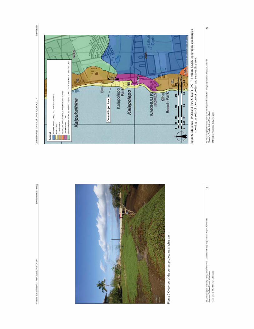
Cultu
ral S
urve
ys H
awai
‘i Jo
b Co
de: K
AO
NO
ULU
7
En
viro
nmen
tal S
ettin
g
An
Arc
haeo
logi
cal I
nven
tory
Sur
vey
for t
he P
ropo
sed
Kul
anih
ako‘
i Brid
ge R
epla
cem
ent P
roje
ct, K
a‘on
o‘ul
u A
hupu
a‘a,
Wai
luku
Dist
rict,
Mau
i Isla
nd
8 TM
K: (
2) 3
-9-0
01: 9
99, 1
62 ,
143
(por
s)
Fi
gure
5 O
verv
iew
of t
he c
urre
nt p
roje
ct a
rea
faci
ng w
est.
Cultu
ral S
urve
ys H
awai
‘i Jo
b Co
de: K
AO
NO
ULU
7
In
trodu
ctio
n
An
Arc
haeo
logi
cal I
nven
tory
Sur
vey
for t
he P
ropo
sed
Kul
anih
ako‘
i Brid
ge R
epla
cem
ent P
roje
ct, K
a‘on
o‘ul
u A
hupu
a‘a,
Wai
luku
Dist
rict,
Mau
i Isla
nd
9
TMK
: (2)
3-9
-001
: 999
, 162
, 14
3 (p
ors)
Fi
gure
6. M
ā‘al
aea
(199
6) a
nd P
u‘u
O K
ali (
1992
) 7.5
min
ute
USG
S to
pogr
aphi
c qu
adra
ngle
s sh
owin
g th
e so
ils o
f the
cur
rent
pro
ject
and
surr
ound
ing
area
.
Cultu
ral S
urve
ys H
awai
‘i Jo
b Co
de: K
AO
NO
ULU
7
In
trodu
ctio
n
An
Arc
haeo
logi
cal I
nven
tory
Sur
vey
for t
he P
ropo
sed
Kul
anih
ako‘
i Brid
ge R
epla
cem
ent P
roje
ct, K
a‘on
o‘ul
u A
hupu
a‘a,
Wai
luku
Dist
rict,
Mau
i Isla
nd
10
TMK
: (2)
3-9
-001
: 999
, 162
, 14
3 (p
ors)
1.3.
2 Bu
ilt E
nvir
onm
ent
The
proj
ect a
rea
is lo
cate
d al
ong
Sout
h Kīh
ei R
oad
at Kūl
anihāk
o‘i G
ulch
app
roxi
mat
ely
61
m (2
00 ft
) sou
th o
f the
inte
rsec
tion
with
Kao
noul
u St
. Kal
epol
epo
Park
, the
Kih
ei B
ay V
ista
co
ndom
iniu
m, a
nd th
e Pa
cific
Wha
le F
ound
atio
n vi
sito
r cen
ter a
re lo
cate
d to
the
sout
h an
d th
e A
STO
N M
aui L
u R
esor
t is l
ocat
ed to
the
north
east
of t
he p
roje
ct a
rea.
The
surr
ound
ing
area
has
be
en b
uilt
up a
nd in
clud
es se
vera
l lar
ge c
ondo
min
ium
dev
elop
men
ts in
clud
ing
the
Vill
as a
t K
enol
io, l
ocat
ed in
land
and
eas
t of t
he p
roje
ct a
rea.
Fi
gure
7. G
oogl
e Ea
rth (2
011)
aer
ial i
mag
e sh
owin
g pr
ojec
t are
a lo
catio
n in
rela
tion
to th
e su
rrou
ndin
g bu
ilt e
nviro
nmen
t.
Cultu
ral S
urve
ys H
awai
‘i Jo
b Co
de: K
AO
NO
ULU
7
Ba
ckgr
ound
Res
earc
h
An
Arc
haeo
logi
cal I
nven
tory
Sur
vey
for t
he P
ropo
sed
Kul
anih
ako‘
i Brid
ge R
epla
cem
ent P
roje
ct, K
a‘on
o‘ul
u A
hupu
a‘a,
Wai
luku
Dist
rict,
Mau
i Isla
nd
11
TMK
: (2)
3-9
-001
: 999
, 162
, 14
3 (p
ors)
Sect
ion
2 M
etho
ds
This
sec
tion
deta
ils th
e m
etho
ds u
sed
by C
SH p
erso
nnel
dur
ing
field
wor
k an
d th
e pr
epar
atio
n of
this
doc
umen
t. C
SH c
ompl
eted
the
AIS
und
er s
tate
arc
haeo
logi
cal p
erm
it N
o. 1
3-06
issu
ed b
y th
e SH
PD,
per
Haw
ai‘i
Adm
inis
trativ
e R
ules
(H
AR
) C
hapt
er 1
3-13
-282
and
the
AIS
was
co
nduc
ted
in c
ompl
ianc
e w
ith H
AR
Cha
pter
13-
276.
2.1
Fiel
d M
etho
ds
2.1.
1 Pe
dest
rian
Sur
vey
A 1
00 %
ped
estri
an su
rvey
of t
he e
ntire
pro
ject
are
a w
as u
nder
take
n fo
r the
pur
pose
of h
isto
ric
prop
erty
ide
ntifi
catio
n an
d do
cum
enta
tion.
The
fol
low
ing
met
hods
wer
e us
ed t
o co
mpl
ete
the
pede
stria
n in
spec
tion
of th
e cu
rren
t pro
ject
are
a:
1.
The
boun
dary
of t
he p
roje
ct a
rea
was
iden
tifie
d an
d m
aint
aine
d du
ring
the
cour
se o
f the
pe
dest
rian
surv
ey u
sing
a G
arm
in G
PSM
ap 6
0CSx
han
dhel
d G
PS u
nit w
ith th
e pr
ojec
t ar
ea d
ata
uplo
aded
and
vis
ible
on
the
map
scre
en;
2.
The
pede
stria
n in
spec
tion
of t
he s
tudy
are
a w
as a
ccom
plis
hed
thro
ugh
syst
emat
ic
trans
ects
at 5
met
er (1
6 ft)
inte
rval
s or
ient
ed n
orth
to s
outh
, par
alle
l to
the
long
axi
s of
th
e st
udy
area
.
2.1.
2 Su
bsur
face
Tes
ting
Prio
r to
the
inve
stig
atio
n th
e G
eote
chni
cal E
ngin
eerin
g Ex
plor
atio
n of
the
Kul
anih
akoi
Brid
ge
Rep
lace
men
t rep
ort f
rom
GEO
LAB
S, In
c., (
Kw
ock
2012
) was
revi
ewed
. The
ava
ilabl
e sa
mpl
es
Geo
labs
, Inc
., co
llect
ed w
ere
also
exa
min
ed a
t the
ir W
ailu
ku fa
cilit
y.
Due
to th
e sa
ndy/
wet
nat
ure
of th
e so
ils A
"pi
pe c
orin
g" m
etho
d w
as u
sed
to c
olle
ct c
olum
ns
for a
naly
sis.
A sh
ovel
test
was
firs
t han
d ex
cava
ted
into
the
rece
nt a
lluvi
um/fi
ll an
d si
fted
thro
ugh
a 0.
3 cm
(0.1
25 in
ch) m
esh.
Onc
e th
e un
derly
ing
sedi
men
t was
exp
osed
a 1
.5 m
(5 fo
ot) l
engt
h of
2
in (5
cm
) dia
met
er P
CV
pip
e w
as fo
r driv
en in
to th
e gr
ound
to c
olle
ct s
ampl
es o
f the
sed
imen
t (F
igur
e 8)
. Sub
sequ
ently
the
pipe
was
cap
ped,
rem
oved
and
take
n ba
ck to
the
CSH
Wai
luku
lab.
A
ll su
b-su
rfac
e ex
cava
tions
wer
e re
cord
ed w
ith a
Trim
ble
Pro
XH
GPS
uni
t and
pos
t-pro
cess
ed
to s
ub-m
eter
acc
urac
y. I
n ad
ditio
n, t
he t
opog
raph
y so
uthe
rn p
ortio
n of
the
pro
ject
are
a w
as
reco
rded
with
a S
okki
a Se
t IIB
2 to
tal s
tatio
n fo
r acc
urat
e el
evat
ions
.
2.2
Labo
rato
ry M
etho
ds
Sedi
men
t sa
mpl
es c
olle
cted
in
the
field
wer
e br
ough
t ba
ck t
o th
e C
SH l
ab f
or p
repa
ratio
n an
d su
bmitt
al f
or p
olle
n an
alys
is. T
wo
sam
ple,
fro
m P
ipe
Cor
e 1
was
sub
mitt
ed to
the
Pale
o R
esea
rch
Inst
itute
in G
olde
n, C
olor
ado.
No
cultu
ral m
ater
ials
(mid
den,
cha
rcoa
l, or
arti
fact
s) w
ere
obse
rved
or
colle
cted
dur
ing
this
inve
stig
atio
n.
Due
to th
e hi
ghly
org
anic
nat
ure
of th
ese
sam
ples
, the
nor
mal
che
mic
al e
xtra
ctio
n te
chni
que
was
m
odifi
ed. A
ppro
xim
atel
y 1.
25 c
ubic
cen
timet
ers
(cc)
of o
rgan
ic-r
ich
sedi
men
t was
sel
ecte
d fo
r eac
h sa
mpl
e, w
hich
rece
ived
a sm
all a
mou
nt o
f hyd
roch
loric
aci
d (1
0%) t
o re
mov
e an
y ca
lciu
m c
arbo
nate
s pr
esen
t in
the
soi
l. N
ext t
he s
ampl
es w
ere
scre
ened
thr
ough
250
-mic
ron
mes
h. T
he s
ampl
es w
ere
allo
wed
to
settl
e fo
r 2
hour
s, af
ter
whi
ch t
he s
uper
nata
nt w
as p
oure
d of
f an
d th
e sa
mpl
es w
ere
Cultu
ral S
urve
ys H
awai
‘i Jo
b Co
de: K
AO
NO
ULU
7
Ba
ckgr
ound
Res
earc
h
An
Arc
haeo
logi
cal I
nven
tory
Sur
vey
for t
he P
ropo
sed
Kul
anih
ako‘
i Brid
ge R
epla
cem
ent P
roje
ct, K
a‘on
o‘ul
u A
hupu
a‘a,
Wai
luku
Dist
rict,
Mau
i Isla
nd
12
TMK
: (2)
3-9
-001
: 999
, 162
, 14
3 (p
ors)
trans
ferr
ed to
50
ml t
ubes
. The
sam
ples
then
rece
ived
a 3
0 m
inut
e tre
atm
ent i
n ho
t hyd
roflu
oric
(HF)
ac
id to
rem
ove
inor
gani
c pa
rticl
es. T
he s
ampl
es w
ere
acet
ylat
ed fo
r 5 m
inut
es to
rem
ove
extra
neou
s, no
n-po
llen
orga
nic
mat
ter.
A li
ght m
icro
scop
e was
use
d to
coun
t pol
len
at a
mag
nific
atio
n of
500
x. P
olle
n pr
eser
vatio
n in
thes
e sa
mpl
es v
arie
d fr
om g
ood
to p
oor.
Com
para
tive
refe
renc
e m
ater
ial
colle
cted
at
the
Inte
rmou
ntai
n H
erba
rium
at U
tah
Stat
e U
nive
rsity
, the
Uni
vers
ity o
f Col
orad
o H
erba
rium
, and
the
Bis
hop
Mus
eum
H
erba
rium
was
use
d to
iden
tify
the
polle
n to
the
fam
ily, g
enus
, and
spec
ies l
evel
, whe
re p
ossi
ble.
Polle
n ag
greg
ates
wer
e re
cord
ed d
urin
g id
entif
icat
ion
of th
e po
llen.
Agg
rega
tes
are
clum
ps o
f a
sing
le ty
pe o
f pol
len
and
may
be
inte
rpre
ted
to re
pres
ent e
ither
pol
len
disp
ersa
l ove
r sho
rt di
stan
ces o
r th
e int
rodu
ctio
n of
por
tions
of t
he p
lant
repr
esen
ted
into
an ar
chae
olog
ical
setti
ng. T
he ag
greg
ates
wer
e in
clud
ed in
the
polle
n co
unts
as s
ingl
e gr
ains
, as i
s cus
tom
ary.
The
pre
senc
e of
agg
rega
tes i
s not
ed b
y an
"A
" ne
xt to
the
polle
n fre
quen
cy o
n th
e pe
rcen
tage
pol
len
diag
ram
. The
per
cent
age
polle
n di
agra
m
was
pro
duce
d us
ing
Tilia
2.0
and
TG
Vie
w 2
.0.2
. Tot
al p
olle
n co
ncen
tratio
ns w
ere
calc
ulat
ed in
Tili
a us
ing
the
quan
tity
of sa
mpl
e pr
oces
sed
in cu
bic
cent
imet
ers (
cc),
the
quan
tity
of e
xotic
s (sp
ores
) add
ed
to th
e sa
mpl
e, th
e qu
antit
y of
exo
tics c
ount
ed, a
nd th
e to
tal p
olle
n co
unte
d an
d ex
pres
sed
as p
olle
n pe
r cc
of s
edim
ent.
“Ind
eter
min
ate”
pol
len
incl
udes
pol
len
grai
ns th
at a
re f
olde
d, m
utila
ted,
or
othe
rwis
e di
stor
ted[
be
yond
rec
ogni
tion.
The
se g
rain
s w
ere
incl
uded
in th
e to
tal p
olle
n co
unt s
ince
they
are
par
t of
the
polle
n re
cord
. A m
ore
deta
iled
expl
anat
ion
of th
e m
etho
ds e
mpl
oyed
dur
ing
the
labo
rato
ry a
naly
sis i
s av
aila
ble
in th
e po
llen
anal
ysis
repo
rt, (A
ppen
dix
A)(
Cum
min
gs 2
013:
1).
2.3
Doc
umen
t Rev
iew
A
var
iety
of
reso
urce
s de
vote
d to
his
toric
al p
ersp
ectiv
es o
f th
e re
gion
and
trad
ition
al s
torie
s an
d ac
coun
ts w
ere
revi
ewed
. Res
earc
h ve
nues
incl
uded
the
Haw
ai‘i
Stat
e H
isto
ric P
rese
rvat
ion
Div
isio
n of
the
Dep
artm
ent
of L
and
and
Nat
ural
Res
ourc
es a
nd t
he S
urve
y O
ffic
e of
the
D
epar
tmen
t of A
ccou
ntin
g an
d G
ener
al S
ervi
ces.
All
rele
vant
Lan
d C
omm
issi
on A
war
ds (L
CA
s)
and
Roy
al P
aten
ts w
ere
rese
arch
ed u
sing
res
ourc
es a
ssoc
iate
d w
ith t
he W
aiho
na ‘
Ain
a on
line
data
base
(Wai
hona
‘Ain
a 20
02).
Cultu
ral S
urve
ys H
awai
‘i Jo
b Co
de: K
AO
NO
ULU
7
Ba
ckgr
ound
Res
earc
h
An
Arc
haeo
logi
cal I
nven
tory
Sur
vey
for t
he P
ropo
sed
Kul
anih
ako‘
i Brid
ge R
epla
cem
ent P
roje
ct, K
a‘on
o‘ul
u A
hupu
a‘a,
Wai
luku
Dist
rict,
Mau
i Isla
nd
13
TMK
: (2)
3-9
-001
: 999
, 162
, 14
3 (p
ors)
Fi
gure
8. D
rivin
g th
e Pi
pe C
ore
1 in
to th
e se
dim
ent,
view
to th
e ea
st.
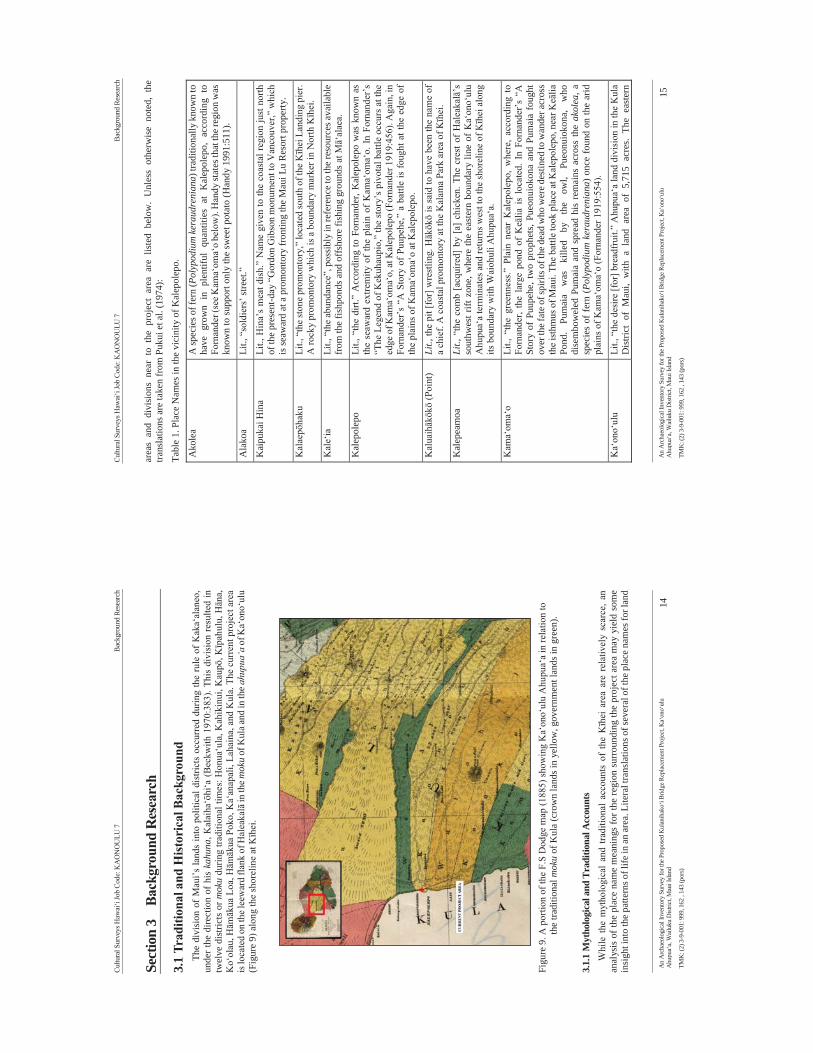
Cultu
ral S
urve
ys H
awai
‘i Jo
b Co
de: K
AO
NO
ULU
7
Ba
ckgr
ound
Res
earc
h
An
Arc
haeo
logi
cal I
nven
tory
Sur
vey
for t
he P
ropo
sed
Kul
anih
ako‘
i Brid
ge R
epla
cem
ent P
roje
ct, K
a‘on
o‘ul
u A
hupu
a‘a,
Wai
luku
Dist
rict,
Mau
i Isla
nd
14
TMK
: (2)
3-9
-001
: 999
, 162
, 14
3 (p
ors)
Sect
ion
3 B
ackg
roun
d R
esea
rch
3.1
Trad
ition
al a
nd H
istor
ical
Bac
kgro
und
The
divi
sion
of
Mau
i’s la
nds
into
pol
itica
l dis
trict
s oc
curr
ed d
urin
g th
e ru
le o
f K
aka‘
alan
eo,
unde
r the
dire
ctio
n of
his
kah
una,
Kal
aiha
‘ōhi
‘a (
Beck
with
197
0:38
3). T
his
divi
sion
resu
lted
in
twel
ve d
istri
cts
or m
oku
durin
g tra
ditio
nal t
imes
: Hon
ua‘u
la, K
ahik
inui
, Kau
pō, K
īpah
ulu,
Hān
a,
Ko‘
olau
, Hām
ākua
Loa
, Hām
ākua
Pok
o, K
a‘an
apal
i, La
hain
a, a
nd K
ula.
The
cur
rent
pro
ject
are
a is
loca
ted
on th
e lee
war
d fla
nk o
f Hal
eaka
lā in
the m
oku
of K
ula a
nd in
the a
hupu
a‘a
of K
a‘on
o‘ul
u (F
igur
e 9)
alo
ng th
e sh
orel
ine
at Kīh
ei.
Fi
gure
9. A
por
tion
of th
e F.
S D
odge
map
(188
5) sh
owin
g K
a‘on
o‘ul
u A
hupu
a‘a
in re
latio
n to
th
e tra
ditio
nal m
oku
of K
ula
(cro
wn
land
s in
yello
w, g
over
nmen
t lan
ds in
gre
en).
3.1.
1 M
ytho
logi
cal a
nd T
radi
tiona
l Acc
ount
s W
hile
the
myt
holo
gica
l an
d tra
ditio
nal
acco
unts
of
the
Kīh
ei a
rea
are
rela
tivel
y sc
arce
, an
anal
ysis
of t
he p
lace
nam
e m
eani
ngs
for t
he re
gion
sur
roun
ding
the
proj
ect a
rea
may
yie
ld s
ome
insi
ght i
nto
the
patte
rns o
f life
in a
n ar
ea. L
itera
l tra
nsla
tions
of s
ever
al o
f the
pla
ce n
ames
for l
and
Cultu
ral S
urve
ys H
awai
‘i Jo
b Co
de: K
AO
NO
ULU
7
Ba
ckgr
ound
Res
earc
h
An
Arc
haeo
logi
cal I
nven
tory
Sur
vey
for t
he P
ropo
sed
Kul
anih
ako‘
i Brid
ge R
epla
cem
ent P
roje
ct, K
a‘on
o‘ul
u A
hupu
a‘a,
Wai
luku
Dist
rict,
Mau
i Isla
nd
15
TMK
: (2)
3-9
-001
: 999
, 162
, 14
3 (p
ors)
area
s an
d di
visi
ons
near
to
the
proj
ect
area
are
lis
ted
belo
w.
Unl
ess
othe
rwis
e no
ted,
the
tra
nsla
tions
are
take
n fr
om P
ukui
et a
l. (1
974)
:
Tabl
e 1.
Pla
ce N
ames
in th
e vi
cini
ty o
f Kal
epol
epo.
Ako
lea
A sp
ecie
s of f
ern
(Pol
ypod
ium
kera
udre
nian
a) tr
aditi
onal
ly k
now
n to
ha
ve g
row
n in
ple
ntifu
l qu
antit
ies
at K
alep
olep
o, a
ccor
ding
to
Forn
ande
r (se
e Kam
a‘om
a‘o
belo
w).
Han
dy st
ates
that
the r
egio
n w
as
know
n to
supp
ort o
nly
the
swee
t pot
ato
(Han
dy 1
991:
511)
.
Ala
koa
Lit.,
“so
ldie
rs’ s
treet
.”
Kai
puka
i Hin
a Li
t., H
ina’
s m
eat d
ish.
” N
ame
give
n to
the
coas
tal r
egio
n ju
st n
orth
of
the
pres
ent-d
ay “
Gor
don
Gib
son
mon
umen
t to
Van
couv
er,”
whi
ch
is se
awar
d at
a p
rom
onto
ry fr
ontin
g th
e M
aui L
u R
esor
t pro
perty
.
Kal
aepō
haku
Li
t., “
the
ston
e pr
omon
tory
,” lo
cate
d so
uth
of th
e Kīh
ei L
andi
ng p
ier.
A ro
cky
prom
onto
ry w
hich
is a
bou
ndar
y m
arke
r in
Nor
th Kīh
ei.
Kal
e‘ia
Li
t., “
the
abun
danc
e”, p
ossi
bly
in re
fere
nce
to th
e re
sour
ces a
vaila
ble
from
the
fishp
onds
and
off
shor
e fis
hing
gro
unds
at M
ā‘al
aea.
Kal
epol
epo
Lit.,
“th
e di
rt.”
Acc
ordi
ng to
For
nand
er, K
alep
olep
o w
as k
now
n as
th
e se
awar
d ex
trem
ity o
f th
e pl
ain
of K
ama‘
oma‘
o. I
n Fo
rnan
der’
s “T
he L
egen
d of
Kek
uhau
pio,
” th
e st
ory’
s piv
otal
bat
tle o
ccur
s at t
he
edge
of K
ama‘
oma‘
o, at
Kal
epol
epo
(For
nand
er 1
919:
456)
. Aga
in, i
n Fo
rnan
der’
s “A
Sto
ry o
f Pu
upeh
e,”
a ba
ttle
is fo
ught
at t
he e
dge
of
the
plai
ns o
f Kam
a‘om
a‘o
at K
alep
olep
o.
Kal
uaihākōkō
(Poi
nt)
Lit.,
the
pit [
for]
wre
stlin
g. Hākōkō
is s
aid
to h
ave
been
the
nam
e of
a
chie
f. A
coa
stal
pro
mon
tory
at t
he K
alam
a Pa
rk a
rea
of Kīh
ei.
Kal
epea
moa
Li
t., “
the
com
b [a
cqui
red]
by
[a]
chic
ken.
The
cre
st o
f H
alea
kalā
’s
sout
hwes
t rift
zon
e, w
here
the
east
ern
boun
dary
line
of
Ka‘
ono‘
ulu
Ahu
pua‘
a te
rmin
ates
and
retu
rns w
est t
o th
e sh
orel
ine
of Kīh
ei a
long
its
bou
ndar
y w
ith W
aioh
uli A
hupu
a‘a.
Kam
a‘om
a‘o
Li
t., “
the
gree
nnes
s.” P
lain
nea
r K
alep
olep
o, w
here
, ac
cord
ing
to
Forn
ande
r, th
e la
rge
pond
of
Keā
lia i
s lo
cate
d. I
n Fo
rnan
der’
s “A
St
ory
of P
uupe
he, t
wo
prop
hets
, Pue
onui
okon
a an
d Pu
mai
a fo
ught
ov
er th
e fat
e of s
pirit
s of t
he d
ead
who
wer
e des
tined
to w
ande
r acr
oss
the
isth
mus
of M
aui.
The
battl
e to
ok p
lace
at K
alep
olep
o, n
ear K
eālia
Po
nd.
Pum
aia
was
ki
lled
by
the
owl,
Pueo
nuio
kona
, w
ho
dise
mbo
wel
ed P
umai
a an
d sp
read
his
rem
ains
acr
oss
the
akol
ea, a
sp
ecie
s of
fern
( Pol
ypod
ium
ker
audr
enia
na) o
nce
foun
d on
the
arid
pl
ains
of K
ama‘
oma‘
o (F
orna
nder
191
9:55
4).
Ka‘
ono‘
ulu
Lit.,
“th
e de
sire
[for
] bre
adfr
uit.”
Ahu
pua‘
a la
nd d
ivis
ion
in th
e K
ula
Dis
trict
of
Mau
i, w
ith a
lan
d ar
ea o
f 5,
715
acre
s. Th
e ea
ster
n
Cultu
ral S
urve
ys H
awai
‘i Jo
b Co
de: K
AO
NO
ULU
7
Ba
ckgr
ound
Res
earc
h
An
Arc
haeo
logi
cal I
nven
tory
Sur
vey
for t
he P
ropo
sed
Kul
anih
ako‘
i Brid
ge R
epla
cem
ent P
roje
ct, K
a‘on
o‘ul
u A
hupu
a‘a,
Wai
luku
Dist
rict,
Mau
i Isla
nd
16
TMK
: (2)
3-9
-001
: 999
, 162
, 14
3 (p
ors)
boun
dary
of t
his
ahup
ua‘a
term
inat
es a
t a p
oint
nam
ed K
alep
eam
oa
befo
re ru
nnin
g w
est b
ack
to th
e sh
orel
ine
of Kīh
ei
Ka‘ōp
ala
liter
ally
“th
e ru
bbis
h”; t
he tr
aditi
onal
bou
ndar
y lin
e be
twee
n Pū
lehu
N
ui A
hupu
a‘a
and
Wai
kapū
Ahu
pua‘
a
Kaw
ililip
oa
Kaw
ililip
oa is
an
‘ili o
f Kam
a‘ol
e A
hupu
a‘a,
cite
d by
Sto
kes i
n 19
18
as t
he s
ite o
f th
ree
heia
u so
uth
of K
alep
olep
o (S
ee S
ectio
n 4.
3,
Prev
ious
Arc
haeo
logi
cal R
esea
rch)
.
Ka‘
ie‘ie
“a
pla
ythi
ng f
or f
loat
ing
in t
he r
apid
s”,
an a
ncie
nt n
ame
for
Kal
epol
epo
(Ste
rling
199
8:25
2)
Keā
lia
liter
ally
“sa
lt en
crus
tatio
n”;
a po
nd n
ear
Kīh
ei a
nd m
ajor
sal
t pa
n lo
catio
n (S
terli
ng 1
998:
95)
Keā
huai
wi
liter
ally
“th
e bo
ne p
ile”;
the
nam
e of
a g
ulch
imm
edia
tely
adj
acen
t to
and
north
of W
aiak
oa G
ulch
in N
orth
Kīh
ei
Ken
olio
Pr
omin
ent S
outh
Mau
i fam
ily n
ame.
Kīh
ei
liter
ally
“ca
pe o
r clo
ak”;
san
dy p
oint
and
bou
ndar
y m
arke
r bet
wee
n Pū
lehu
Nui
and
Wai
kap ū
(Ste
rling
199
8:25
5); c
omm
only
use
d pl
ace
nam
e fo
r the
coa
stal
sout
h M
aui a
rea
Kīh
eipū
ko‘a
kī
hei
liter
ally
tra
nsla
tes
as “
cape
or
cloa
k” a
nd p
ūko‘
a lit
eral
ly
trans
late
s as
“co
ral h
ead”
; Kīh
eipū
ko‘a
was
a tr
aditi
onal
pla
ce-n
ame
for
the
shor
elin
e ne
ar K
eālia
bet
wee
n K
alep
olep
o an
d Mā‘
alae
a (S
terli
ng 1
998:
257)
Kik
aupō
haku
Li
t., “
rock
of
Kik
au.”
In
the
tradi
tiona
l sto
ry o
f th
e bu
ildin
g of
the
Kal
epol
epo
pond
wal
ls b
y W
ilcox
, Kik
au’s
roc
k w
as p
lace
d at
the
north
wes
t cor
ner o
f the
fish
pon
d w
all b
y na
men
ehun
e.
Koh
emāl
amal
ama
Lit.,
“the
vag
ina”
; als
o th
e anc
ient
nam
e for
the i
slan
d of
Kah
o‘ol
awe,
an
isl
and
loca
ted
appr
oxim
atel
y si
x m
iles
sout
hwes
t of
the
Kīh
ei
coas
tline
.
Kul
a (m
oku)
lit
eral
ly t
rans
late
d as
"pl
ain"
; tra
ditio
nally
kno
wn
as a
n ar
id f
lat
regi
on (H
andy
in S
terli
ng 1
995:
242)
Kūl
anihāk
o‘i
Lit.,
“agi
tate
d he
aven
that
stan
ds.”
Nam
ed fo
r a m
ythi
cal f
loat
ing
land
in
the
sky.
Wai
akoa
Li
t., “
wat
er (u
sed)
by
war
rior.”
Poha
ku K
i‘i
“tilt
ed st
one”
; a re
stin
g pl
ace
for t
rave
lers
Pūle
hu N
ui (a
hupu
a‘a)
La
rge
pūle
hu w
here
pūl
ehu
is li
tera
lly tr
ansl
ated
as “
broi
led”
Cultu
ral S
urve
ys H
awai
‘i Jo
b Co
de: K
AO
NO
ULU
7
Ba
ckgr
ound
Res
earc
h
An
Arc
haeo
logi
cal I
nven
tory
Sur
vey
for t
he P
ropo
sed
Kul
anih
ako‘
i Brid
ge R
epla
cem
ent P
roje
ct, K
a‘on
o‘ul
u A
hupu
a‘a,
Wai
luku
Dist
rict,
Mau
i Isla
nd
17
TMK
: (2)
3-9
-001
: 999
, 162
, 14
3 (p
ors)
The
abov
e pl
ace
nam
es, t
oget
her
with
the
envi
ronm
enta
l dat
a, s
ugge
st th
at th
e la
nds
of a
nd
surr
ound
ing
coas
tal K
a‘on
o‘ul
u w
ere
fairl
y dr
y an
d ba
rren
in a
n ag
ricul
tura
l sen
se b
ut r
ich
in
mar
ine
reso
urce
s. Pr
evio
us r
esea
rch
on p
re-C
onta
ct s
ettle
men
t in
the
Kul
a D
istri
ct (
Kol
b et
al.
1997
) has
sugg
este
d th
at m
ost p
erm
anen
t hab
itatio
ns w
ere i
n th
e upl
ands
with
a sm
alle
r per
man
ent
popu
latio
n lo
cate
d al
ong
the
coas
tline
. Whi
le a
rec
onst
ruct
ion
of th
e co
asta
l and
arc
haeo
logi
cal
land
scap
e of
Kul
a M
oku
unde
rsco
res
the
impo
rtanc
e of
the
upla
nds
as a
focu
s of
agr
icul
ture
and
ha
bita
tion,
Haw
aiia
n tra
ditio
ns a
nd th
e pr
esen
ce o
f fo
ur f
ishp
onds
are
evi
denc
e th
at th
e co
asta
l en
viro
ns w
ere
also
a fo
cus o
f set
tlem
ent a
nd m
arin
e ex
ploi
tatio
n. T
he re
lativ
e sc
arci
ty o
f rec
orde
d co
asta
l pla
ce n
ames
, how
ever
, may
be
an in
dica
tion
of a
smal
ler p
opul
atio
n th
at w
as w
idel
y sp
read
ou
t acr
oss
the
leew
ard
coas
tal l
ine.
The
vic
inity
sur
roun
ding
the
curr
ent p
roje
ct a
rea
was
als
o a
site
of c
onfli
ct b
etw
een
the
Haw
ai‘i
Isla
nd c
hief
Kal
anio
pu‘u
and
Mau
i Isl
and
chie
f Kah
ekili
and
is
per
haps
the
orig
in fo
r suc
h pl
ace
nam
es a
s “W
aiak
oa”
and
“Keā
huai
wi”
.
Not
e tha
t man
y of
the p
lace
nam
es ar
e ass
ocia
ted
with
regi
onal
shor
elin
e fis
hpon
ds. K
alep
olep
o Fi
shpo
nd (a
lso
nam
ed K
a‘on
o‘ul
u K
ai a
nd K
o‘ie
‘ie) i
s lo
cate
d al
ong
the
shor
elin
e of
Ka'o
no'u
lu
Ahu
pua'a
, with
in th
e tra
ditio
nal d
istri
ct o
f Kul
a, Is
land
of M
aui.
The
ahup
ua‘a
of K
a‘on
o‘ul
u is
on
e of
six
maj
or K
ula
land
div
isio
ns w
hich
ext
end
from
the
Oce
an t
o th
e up
per
reac
hes
of
Hal
eaka
lā.
Ka‘
ono‘
ulu
is s
ituat
ed n
ear
the
cent
er o
f th
e K
ula
Dis
trict
, w
ith Pūl
ehu
Nui
and
W
aiak
oa t
o th
e no
rth a
nd W
aioh
uli,
Kēō
kea
and
Kam
a'ole
to
the
sout
h. K
a‘on
o‘ul
u is
ap
prox
imat
ely
0.4
mile
wid
e at
the
shor
elin
e, a
nd 0
.7 m
ile w
ide
at K
alep
amoa
(9,0
00 ft
AM
SL).
The
ahup
ua‘a
has
a m
axim
um w
idth
of o
ne m
ile, w
hich
occ
urs a
t 800
ft A
MSL
. Kal
epol
epo
Pond
is
at t
he so
uthe
rn b
ound
ary
of th
e ah
upua
‘a (D
onha
m 1
996:
1).
3.1.
2 Tr
aditi
onal
Acc
ount
s Th
e ea
rlies
t ac
coun
t co
ncer
ning
Kīh
ei a
nd H
awai
ian
polit
ics
is g
iven
by
Kam
akau
(19
91)
durin
g th
e tim
e of
Ala
pa‘i
and
Kek
aulik
e:
Ala
pa‘i
saile
d fr
om K
ohal
a on
Haw
ai‘i.
..But
whe
n he
land
ed a
t Mok
ulau
in K
aupō
(M
aui)
and
hear
d th
at K
e-ka
u-lik
e w
as d
ying
, he
gave
up
all t
houg
ht o
f w
ar a
nd
wis
hed
only
to
mee
t K
e-ka
u-lik
e an
d hi
s (h
alf)
sis
ter
Ke-
ku‘i-
apo-
iwa-
nui..
.He
land
ed a
t Kīh
eipu
ko‘a
with
all
his c
hief
s and
figh
ting
men
...W
hile
he
was
at K
īhei
, A
lapa
‘i he
ard
that
the
rulin
g ch
ief o
f Oah
u w
as m
akin
g w
ar u
pon
Mol
okai
. Mos
t of
the
chie
fs o
f Mol
oka‘
i...w
ere
of H
awai
‘i...A
lapa
‘i's
sym
path
y w
as a
rous
ed, f
or
thes
e w
ere
his
own
brot
hers
and
chi
ldre
n (r
elat
ives
), an
d he
mad
e re
ady
to g
o to
th
eir h
elp
on M
olok
a‘i (
Kam
akau
199
1:70
).
Oth
er a
ccou
nts
invo
lve
the
cont
inui
ng c
onfli
ct b
etw
een
Kah
ekili
of
Mau
i Is
land
and
K
alan
i‘opu
‘u o
f Haw
ai‘i
Isla
nd d
urin
g th
e la
te 1
8th c
entu
ry. F
ollo
win
g a
losi
ng b
attle
at K
aupō
in
1775
, Kal
ani‘o
pu‘u
ded
icat
ed se
vera
l war
hei
au o
n H
awai
‘i Is
land
to a
id in
the
defe
at o
f Kah
ekili
. U
pon
hear
ing
this
new
s K
ahek
ili s
ent
for
the
kahu
na (
prie
st)
Kal
eopu
‘upu
‘u w
ho d
irect
ed
cons
truct
ion
of th
e hei
au o
f Kal
uli a
nd P
u‘uo
hala
on
the n
orth
side
of W
ailu
ku. W
hen
Kal
uli H
eiau
w
as c
ompl
eted
Kal
eopu
‘upu
‘u sa
id to
Kah
ekili
:
This
is th
e hou
se o
f you
r god
; ope
n th
e slu
ice g
ate
that
the f
ish
may
ente
r (K
amak
au
1991
:85)
.
In th
e ye
ar 1
776,
the
arm
y of
Kal
ani‘o
pu‘u
land
ed a
t Keo
neo‘
o‘io
with
thei
r war
can
oes e
xten
ding
to
Mak
ena
at H
onua
‘ula
and
pro
ceed
ed to
rava
ge th
e co
untry
side
. Kal
ani‘o
pu‘u
land
ed w
ith h
is

Cultu
ral S
urve
ys H
awai
‘i Jo
b Co
de: K
AO
NO
ULU
7
Ba
ckgr
ound
Res
earc
h
An
Arc
haeo
logi
cal I
nven
tory
Sur
vey
for t
he P
ropo
sed
Kul
anih
ako‘
i Brid
ge R
epla
cem
ent P
roje
ct, K
a‘on
o‘ul
u A
hupu
a‘a,
Wai
luku
Dist
rict,
Mau
i Isla
nd
18
TMK
: (2)
3-9
-001
: 999
, 162
, 14
3 (p
ors)
Ala
pa re
gim
ent a
t Kīh
eipū
ko’a
at K
eālia
to K
apa‘
ahu,
800
stro
ng a
nd e
ager
to d
rink
the
wat
ers o
f W
ailu
ku: Acr
oss
the
plai
ns o
f Pu
‘u‘a
inak
o (C
ane-
trash
-hill
) an
d K
ama‘
oma‘
o sh
one
the
feat
her c
loak
s of
the
sold
iers
… K
a-he
kili
was
at K
alan
ihal
e ju
st b
elow
Kih
ahal
e an
d ab
ove t
he p
late
au o
f Ka‘
ilipo
e at P
ohak
uaok
ahi …
Kal
eopu
‘upu
‘u [s
aid]
to K
a-he
kili,
“Th
e fis
h ha
ve e
nter
ed th
e sl
uice
; dra
w in
the
net.”
(Kam
akau
199
1:85
)
The f
orce
s of K
ahek
ili d
esce
nded
on
and
dest
roye
d th
e sol
dier
s of K
alan
i‘opu
‘u, s
layi
ng th
e A
lapa
(e
lite
sold
iers
of
Kal
ani‘o
pu‘u
) on
the
sand
hills
at t
he s
outh
east
of
Kal
ua [
an a
rea
clos
e to
the
pres
ent-d
ay W
aika
pū, a
ccor
ding
to th
e ac
coun
ts].
Onl
y tw
o m
en e
scap
ed to
Kīh
eipū
ko‘a
to te
ll K
alan
i‘opu
‘u th
e ne
ws o
f the
ir de
feat
. Afte
r a se
cond
day
of w
arfa
re, K
alan
i‘opu
‘u su
ed fo
r pea
ce
and
was
gra
nted
such
by
Kah
ekili
and
his
mes
seng
ers a
t Kīh
eipū
ko‘a
(Kam
akau
199
1:88
-89)
.
Forn
ande
r (18
80) n
otes
that
Kal
anio
pu‘u
, a ru
ling
chie
f of H
awai
‘i, w
as te
mpo
raril
y at
Kal
epol
epo
in th
e 17
50’s
(For
nand
er 1
880:
142)
.
Forn
ande
r’s
tradi
tiona
l ac
coun
ts f
or t
he p
ortio
n of
Kīh
ei i
nclu
ding
Kal
epol
epo
and
plai
ns o
f K
ama‘
oma‘
o at
the
edge
of
Keā
lia P
ond
incl
udes
“A
Sto
ry o
f Pu
upeh
e,”
abou
t tw
o pr
ophe
ts,
Pueo
nuio
kona
and
Pum
aia
who
foug
ht e
ach
othe
r ove
r the
fate
of s
prits
of t
he d
ead
who
wer
e sa
id
to w
ande
r ac
ross
the
cent
ral i
sthm
us o
f M
aui.
The
battl
e to
ok p
lace
at K
alep
olep
o, n
ear
Keā
lia
Pond
. Pum
aia
was
kill
ed b
y th
e ow
l, Pu
eonu
ioko
na, w
ho d
isem
bow
eled
Pum
aia
and
spre
ad h
is
rem
ains
acr
oss
the
akol
ea, a
spe
cies
of f
ern
(Pol
ypod
ium
ker
audr
enia
na) o
nce
foun
d on
the
arid
pl
ains
of K
ama‘
oma‘
o in
the
vici
nity
of K
eālia
Pon
d (F
orna
nder
191
9:55
4).
Forn
ande
r’s a
ccou
nt o
f the
chi
ef K
auho
lanu
imah
u, w
ho re
side
d at
Hon
ua‘u
la a
nd e
xerc
ised
roya
l au
thor
ity n
ames
him
as t
he b
uild
er o
f the
fish
pond
at K
eone
‘o‘io
(in
Kal
ihi A
hupu
a‘a)
(For
nand
er
1880
:70-
71).
Whe
n C
harle
s Wilc
ox w
rote
abo
ut K
alep
olep
o fo
r the
mon
thly
mag
azin
e of
Haw
ai‘i
nam
ed “
Para
dise
of
the
Paci
fic”
in D
ecem
ber,
1921
, his
arti
cle
incl
uded
the
tradi
tiona
l sto
ry o
f ho
w th
e ra
ce o
f Haw
aiia
ns k
now
n as
Na
Men
ehun
e, c
onst
ruct
ed th
e Kō‘
ie‘ie
fish
pond
. K
oiei
e is
the
anc
ient
nam
e of
Kal
epol
epo,
and
the
rui
ned
sea
wal
ls o
f fis
hpon
ds a
re t
he h
allm
arks
of
its i
mpo
rtanc
e to
the
rul
ers
of a
ncie
nt
Haw
aii.
Whe
n th
e K
onoh
iki s
umm
oned
the
peop
le o
f Mau
i to
build
fish
po
nds
for
the
king
at K
ēōke
a-ka
i, W
aioh
uli-k
ai a
nd K
aono
ulu-
kai,
one
man
, Kik
au, a
kilo
[fis
h-sp
otte
r], p
rote
sted
that
no
such
wor
ks c
ould
be
com
plet
ed w
ithou
t the
hel
p of
the
Men
ehun
e. F
or th
is K
ikau
was
told
that
w
hen
the
king
’s p
onds
wer
e co
mpl
eted
he
shou
ld b
e ba
ked
in th
e im
u[
unde
rgro
und
oven
].
In b
uild
ing
the
sea
wal
ls m
en w
ere
stat
ione
d in
long
line
s, pa
ssin
g st
ones
by
han
d fr
om th
e ro
cky
side
hills
mile
s aw
ay to
the
wor
kmen
layi
ng th
e co
urse
s for
the
wal
ls in
the
sea.
The
tram
ping
s of s
o m
any
busy
feet
rais
ed
muc
h du
st,
and
wor
kmen
thr
owin
g du
st a
t on
e an
othe
r pr
ompt
ed t
he
kono
hiki
to c
all t
hem
der
isiv
ely
“Kan
aka
o K
alep
olep
o ek
u i k
a le
po,”
or
“Kel
epol
epo
root
in th
e di
rt.”
At t
he c
ompl
etio
n of
the
Keo
kea-
kai p
ond
the
kono
hiki
gav
e sp
lend
or to
th
e ev
ent b
y rid
ing
on th
e ca
psto
ne w
hile
it w
as b
eing
car
ried
in a
litte
r of
stou
t pol
es o
n th
e sh
ould
ers
of o
ver t
wen
ty m
en to
its r
estin
g pl
ace
at th
e no
rthea
st c
orne
r of t
he p
ond.
Cultu
ral S
urve
ys H
awai
‘i Jo
b Co
de: K
AO
NO
ULU
7
Ba
ckgr
ound
Res
earc
h
An
Arc
haeo
logi
cal I
nven
tory
Sur
vey
for t
he P
ropo
sed
Kul
anih
ako‘
i Brid
ge R
epla
cem
ent P
roje
ct, K
a‘on
o‘ul
u A
hupu
a‘a,
Wai
luku
Dist
rict,
Mau
i Isla
nd
19
TMK
: (2)
3-9
-001
: 999
, 162
, 14
3 (p
ors)
Afte
r the
cer
emon
y he
sum
mon
ed K
ikau
and
ask
ed h
im h
e th
ough
t of i
t, an
d K
ikau
rep
lied
that
the
wor
ks w
ere
still
unf
inis
hed.
“W
hen
the
last
ston
e of
the
las
t po
nd i
s la
id y
our
life
shal
l be
for
feite
d,”
repl
ied
the
kono
hiki
.
The
com
plet
ion
of th
e se
a w
alls
of t
he W
aioh
uli P
ond
was
mar
ked
by a
si
mila
r cer
emon
y, a
nd tw
o he
avy
boul
ders
wer
e ca
rrie
d on
sepa
rate
litte
rs
from
the
qua
rry
a m
ile a
way
to
the
north
wes
t co
rner
of
the
pond
. The
ko
nohi
ki ro
de o
n th
e lar
ger o
f the
two
caps
tone
s and
, on
the o
ther
, his
wife
w
as c
arrie
d ah
ead
of h
im,
both
dre
ssed
in
the
cost
ume
of t
heir
rank
, at
tend
ed b
y ka
hili-
bear
ers a
nd k
auka
us [w
arrio
r chi
efs]
cha
ntin
g m
eles
.
As
the
seaw
alls
of t
he K
aono
ulu
pond
nea
red
com
plet
ion
a bl
ock
of la
va
fully
a to
n in
wei
ght w
as se
lect
ed fo
r the
cap
ston
e an
d fo
rty m
en p
ut th
eir
shou
lder
s to
the
litte
r of s
tout
pol
es a
nd w
aite
d. T
he k
onoh
iki m
ount
ed th
e ce
rem
onia
l sto
ne d
ress
ed in
his
war
clo
ak a
nd g
ave
the
wor
d. W
ith k
ahili
s w
avin
g an
d ka
ukau
s re
citin
g th
e gl
orie
s of
his
mel
e-in
oa, t
he r
ock
was
lif
ted
and
the p
roce
ssio
n m
oved
. Whe
n bu
t a th
ird o
f the
dis
tanc
e had
bee
n co
vere
d th
e lit
ter
brok
e do
wn,
the
big
sto
ne f
ell
to t
he e
arth
, an
d th
e ko
nohi
ki w
as th
row
n to
the
grou
nd a
nd fe
ll sp
raw
ling,
face
dow
n in
the
dirt.
That
nig
ht a
gre
at st
orm
aro
se –
rain
, win
d, h
ail,
thun
der a
nd li
ghtn
ing
and
an e
arth
quak
e an
d he
avy
stor
m w
aves
fro
m th
e se
a, w
ith a
flo
od o
f re
d w
ater
s fro
m th
e hi
llsid
es, s
pent
its f
ury
on K
alep
olep
o. In
the
mid
st o
f the
st
orm
the
elv
es o
r ee
pa,
birth
bro
ther
s of
Kik
au,
gath
ered
, an
d ea
ch
light
ning
flas
h re
veal
ed th
e hos
t of e
lves
bus
ily te
arin
g do
wn
the
seaw
alls
, un
doin
g th
e w
ork
of th
e ko
nohi
ki, s
o th
at K
ikau
mig
ht n
ot d
ie.
In th
e m
orni
ng th
e st
orm
had
pas
sed
– an
d th
e se
awal
ls o
f the
pon
ds b
uilt
with
so
muc
h la
bor
wer
e se
en t
o ha
ve b
een
torn
dow
n, a
nd t
he h
eavy
bo
ulde
r las
t rid
den
by th
e ko
nohi
ki w
hich
, whe
n se
t in
plac
e, m
eant
the
com
plet
ion
of th
e w
ork,
had
dis
appe
ared
.
Aga
in th
e pe
ople
wer
e su
mm
oned
to re
build
the
ruin
ed fi
shpo
nds,
only
to
have
the
final
cer
emon
y en
d w
ith a
n ac
cide
nt. A
noth
er s
torm
cam
e up
, a
swar
m o
f el
ves
at n
ight
, an
d th
e w
hole
wor
k m
yste
rious
ly u
ndon
e as
be
fore
.
The
kono
hiki
ack
now
ledg
ed h
is fa
ult a
nd o
ffer
ed to
be
guid
ed b
y K
ikau
in
rebu
ildin
g th
e ru
ined
pon
ds w
hich
mus
t be
com
plet
ed o
r his
ow
n lif
e w
ould
be
forf
eite
d to
the
king
. Kik
au to
ld h
im to
sum
mon
the
peop
le o
f K
oola
u to
brin
g op
ae a
nd th
e pe
ople
of W
ailu
ku to
brin
g ba
by ta
ro o
r tar
o sh
oots
(hā
kalo
)in g
reat
qua
ntiti
es a
nd w
hen
this
was
don
e K
ikau
wou
ld
invo
ke h
is a
umak
uas
[gua
rdia
n sp
irits
] to
sum
mon
the
men
ehun
es to
do
the
wor
k.
Whe
n th
ese
supp
lies w
ere
brou
ght i
n, th
e ta
ro c
ooke
d an
d th
e op
ae la
id in
th
e ti-
leav
es, K
ikau
adv
ised
the
kono
hiki
to p
rocl
aim
a ta
bu o
f sile
nce
for
the
peop
le to
rem
ain
sile
nt a
nd s
tay
indo
ors;
that
no
pig
be a
llow
ed to
sq
ueal
, no
dog
to b
ark,
no
roos
ter t
o cr
ow, o
n th
at p
artic
ular
nig
ht –
and
so
it w
as p
rocl
aim
ed.

Cultu
ral S
urve
ys H
awai
‘i Jo
b Co
de: K
AO
NO
ULU
7
Ba
ckgr
ound
Res
earc
h
An
Arc
haeo
logi
cal I
nven
tory
Sur
vey
for t
he P
ropo
sed
Kul
anih
ako‘
i Brid
ge R
epla
cem
ent P
roje
ct, K
a‘on
o‘ul
u A
hupu
a‘a,
Wai
luku
Dist
rict,
Mau
i Isla
nd
20
TMK
: (2)
3-9
-001
: 999
, 162
, 14
3 (p
ors)
That
eve
ning
the
first
sig
ns o
f the
bes
tirrin
g of
the
men
ehun
es w
ere
seen
in
the
risin
g of
spi
rals
of r
ed d
ust f
rom
afa
r of
f –
from
the
upla
nds
– as
th
ey c
ame
troop
ing
to th
e lo
wer
land
s th
ere
wer
e sw
irlin
g cl
ouds
of r
ed
dust
to th
e no
rth a
nd e
ast o
f Koi
eie
(for
mer
nam
e of
Kal
epol
epo)
.
In n
o tim
e (m
anaw
a ol
e) th
e ru
ined
wal
ls o
f the
pon
ds w
ere
rebu
ilt a
nd
then
, to
mar
k th
e co
mpl
etio
n of
thei
r wor
k, th
ey f
ell t
o th
e fin
al ta
sk o
f la
ying
, in
a se
lect
spo
t at t
he n
orth
wes
t cor
ner
of K
alep
olep
o po
nd, t
he
huge
bou
lder
now
kno
wn
as K
ikau
poha
ku.
One
of
seve
ral f
ishp
onds
alo
ng th
e co
ast o
f Kīh
ei, K
ō‘ie
‘ie F
ishp
ond
was
one
of
the
mos
t im
porta
nt o
nes
on M
aui
acco
rdin
g to
tra
ditio
n (K
olb
et a
l. 19
97:6
0).
The
orig
inal
bui
lder
of
Kō‘
ie‘ie
Fis
hpon
d is
not
kno
wn
but i
t is b
elie
ved
to h
ave
been
rebu
ilt a
t lea
st th
ree
times
bas
ed o
n tra
ditio
nal a
ccou
nts.
The
first
tim
e was
dur
ing
the
reig
n of
Kin
g K
ihap
i‘ila
ni (K
olb
et al
. 199
7:62
). Kō‘
ie‘ie
is th
e an
cien
t nam
e of
Kal
epol
epo.
Acc
ordi
ng to
Wilc
ox (1
921:
67) u
pon
com
plet
ion
of
Kō‘
ie‘ie
Fis
hpon
d th
e ko
nohi
ki w
as th
row
n to
the
grou
nd w
hen
the
litte
rs c
arry
ing
the
caps
tone
br
oke.
The
wor
kers
sai
d "U
a ko
nohi
ka K
alep
olep
o, u
a ek
u i k
a le
po,"
. It t
rans
late
s "t
he m
anag
er
of K
alep
olep
o, o
ne w
ho r
oots
in d
irt".
The
fishp
ond
and
regi
on h
ave
sinc
e be
en r
efer
red
to a
s K
alep
olep
o.
Bot
h of
the
fishp
onds
loca
ted
in th
e vi
cini
ty o
f the
pro
ject
are
a ar
e lis
ted
on th
e St
ate
Inve
ntor
y of
His
toric
Pla
ces
(Fig
ure
10).
The
Kō‘
ie‘ie
Fis
hpon
d (S
IHP
50-5
0-09
-128
8),
adja
cent
to
Kal
epol
epo
Park
is
the
smal
lest
of
the
fishp
onds
in
this
reg
ion
of K
īhei
. Th
e W
aioh
uli
Kai
Fi
shpo
nd i
s ju
st s
outh
of
Kō‘
ie‘ie
Fis
hpon
d, i
s su
bmer
ged
and
liste
d as
SIH
P 50
-50-
09-1
704.
K
ikuc
hi in
197
3 pe
rfor
med
a s
tudy
of
fishp
onds
whi
ch c
ateg
oriz
ed th
e Kō‘
ie‘ie
Fis
hpon
d as
a
Type
I, L
oko
Kui
pā ty
pe, o
r a “
fishp
ond
of li
ttora
l wat
er w
hose
side
or s
ides
faci
ng th
e se
a co
nsis
t of
a st
one
or c
oral
wal
l usu
ally
con
tain
ing
one
or m
ore
slui
ce g
ates
” (K
ikuc
hi 1
976:
37).
3.1.
3 Ea
rly
Hist
oric
Per
iod
Kīh
ei w
as o
ne o
f the
loca
tions
vis
ited
by th
e En
glis
h ex
plor
er C
apta
in G
eorg
e V
anco
uver
. A
mon
umen
t at
Mai
Poi
na ‘
Oe
Ia‘u
Bea
ch P
ark
in K
īhei
com
mem
orat
es V
anco
uver
's on
-sho
re
expe
ditio
n in
179
2, w
hen
he fi
rst m
et th
e ru
ling
chie
f Kah
ekili
. With
its
shel
tere
d co
astli
ne a
nd
easy
acc
ess
to u
pcou
ntry
reso
urce
s ov
er a
vas
t slo
pe, K
īhei
wou
ld c
ontin
ue to
be
a co
mm
on s
top
for
visi
ting
ship
s. In
184
1, W
ilkes
com
men
ted,
“A
t M
alae
a [M
ā‘al
aea]
Bay
the
re i
s go
od
anch
orag
e fo
r ves
sels
of a
ny si
ze, a
nd a
fine
fish
ery”
(Wilk
es 1
845)
.
Cultu
ral S
urve
ys H
awai
‘i Jo
b Co
de: K
AO
NO
ULU
7
Ba
ckgr
ound
Res
earc
h
An
Arc
haeo
logi
cal I
nven
tory
Sur
vey
for t
he P
ropo
sed
Kul
anih
ako‘
i Brid
ge R
epla
cem
ent P
roje
ct, K
a‘on
o‘ul
u A
hupu
a‘a,
Wai
luku
Dist
rict,
Mau
i Isla
nd
21
TMK
: (2)
3-9
-001
: 999
, 162
, 14
3 (p
ors)
Fi
gure
10.
The
cur
rent
pro
ject
loca
tion
on a
por
tion
of a
190
0 Mā‘
alae
a H
arbo
r sho
win
g th
e ne
arby
fish
pond
s (Fr
isby
190
0).

Cultu
ral S
urve
ys H
awai
‘i Jo
b Co
de: K
AO
NO
ULU
7
Ba
ckgr
ound
Res
earc
h
An
Arc
haeo
logi
cal I
nven
tory
Sur
vey
for t
he P
ropo
sed
Kul
anih
ako‘
i Brid
ge R
epla
cem
ent P
roje
ct, K
a‘on
o‘ul
u A
hupu
a‘a,
Wai
luku
Dist
rict,
Mau
i Isla
nd
22
TMK
: (2)
3-9
-001
: 999
, 162
, 14
3 (p
ors)
Dur
ing
the
early
and
mid
dle
1800
s, th
e H
awai
ian
dem
ogra
phy
was
aff
ecte
d by
two
dram
atic
fa
ctor
s: ra
dica
l dep
opul
atio
n re
sulti
ng fr
om W
este
rn d
isea
se; a
nd n
ucle
atio
n ar
ound
the d
evel
opin
g po
rt to
wns
. The
trad
ition
ally
Haw
aiia
n po
pula
tion
was
larg
ely
disp
erse
d an
d, a
lthou
gh th
ere
wer
e ro
yal c
ente
rs a
nd a
reas
of m
ore
conc
entra
ted
popu
latio
n, th
ese
area
s ne
ver c
ame
clos
e to
riva
ling
the p
opul
atio
ns o
f the
his
toric
por
t tow
ns th
at d
evel
oped
on
Haw
ai‘i’
s sho
relin
es d
urin
g th
e 180
0s.
In th
is re
gard
, Kuy
kend
all (
1938
:313
) not
es th
at in
the
perio
d fr
om 1
830
to 1
854:
The
com
mer
cial
dev
elop
men
t dur
ing
this
per
iod,
by
mag
nify
ing
the
impo
rtanc
e of
a
few
por
ts, g
ave
mom
entu
m a
nd d
irect
ion
to a
tow
nwar
d dr
ift o
f pop
ulat
ion;
the
popu
latio
n of
the
king
dom
as a
who
le w
as st
eadi
ly g
oing
dow
n, b
ut th
e po
pula
tion
of H
onol
ulu,
Lah
aina
and
Hilo
was
gro
win
g.
We
belie
ve t
hat
Kuy
kend
all’s
obs
erva
tion
was
mos
t lik
ely
the
dem
ogra
phic
pat
tern
at
the
Kal
epol
epo
entre
pot,
an a
rea
that
may
hav
e in
clud
ed th
e pr
ojec
t are
a w
hen
it ex
iste
d, a
nd a
hub
of
early
his
toric
act
ivity
for
Kīh
ei a
nd e
vent
ually
all
of K
ula
Mok
u (K
olb
et a
l. 19
97:6
9).
The
deve
lopm
ent o
f K
alep
olep
o as
an
entre
pot a
nd a
foc
us o
f C
hris
tian
life
in th
e 18
40s
and
1850
s m
ost l
ikel
y in
crea
sed
the
popu
latio
n in
the
imm
edia
te v
icin
ity a
bove
the
pre-
Con
tact
pop
ulat
ion
figur
es, c
ontra
ry to
the
isla
nd-w
ide
trend
of d
epop
ulat
ion.
On
the
2nd
of S
epte
mbe
r [1
853]
, Dav
id M
alo
was
ord
aine
d pa
stor
of
the
chur
ch a
t Keo
kea,
K
ula.
The
chu
rch
at K
alep
olep
o be
cam
e hi
s out
stat
ion,
whe
re h
e sp
ent a
gre
at d
eal o
f tim
e.
Mal
o’s f
athe
r had
bee
n co
nnec
ted
to K
ameh
ameh
a’s c
ourt
and
arm
y. M
alo
was
bor
n in
Kea
hou,
in
the
north
ern
part
of th
e K
ona
dist
rict (
Isla
nd o
f Haw
ai‘i)
in 1
795.
In h
is y
outh
Mal
o w
as p
art o
f th
e en
tour
age
of K
uaki
ni, b
roth
er o
f Que
en K
a‘ah
uman
u. M
alo
then
bec
ame
the
pupi
l of ‘
Auw
ae,
Kam
eham
eha’
s ba
rd, g
enea
logi
st a
nd r
itual
exp
ert.
Mal
o th
en s
tudi
ed a
t La
hain
alun
a w
hen
it op
ened
in 1
831.
Mal
o au
thor
ed a
cultu
ral h
isto
ry o
f Haw
ai‘i
abou
t 184
0 to
assi
st m
issi
onar
y Lo
rrin
A
ndre
ws w
ith h
is re
sear
ch o
n de
velo
ping
a d
ictio
nary
and
a g
ram
mar
for t
he H
awai
ian
lang
uage
; M
alo’
s M
oole
lo H
awai
i w
as t
rans
late
d by
Nat
hani
el B
. Em
erso
n (M
alo
1951
) an
d pu
blis
hed
(Val
eri 1
985:
xxv)
.
That
the
popu
latio
n an
d ar
eal e
xten
t of t
he K
alep
olep
o co
mm
unity
reac
hed
its z
enith
dur
ing
the
mid
180
0's a
ppea
rs to
be
supp
orte
d by
Kol
b (e
t al.
1997
:68)
:
The
anci
ent v
illag
e of
Kal
epol
epo
was
rel
ativ
ely
smal
l, an
d w
as b
uilt
arou
nd a
n ec
onom
y pr
imar
ily b
ased
upo
n th
e ex
ploi
tatio
n of
oce
an re
sour
ces-
-prim
arily
the
exce
llent
fish
ing
grou
nds a
s wel
l as t
hree
larg
e fis
hpon
ds. H
owev
er, a
s the
num
ber
of v
isiti
ng s
hips
inc
reas
ed,
Kal
epol
epo
soon
bec
ame
an i
mpo
rtant
pro
visi
onin
g ar
ea. B
y 18
50 w
e kn
ow th
at th
e ec
onom
ic o
ppor
tuni
ties
wer
e at
tract
ing
a nu
mbe
r of
Eur
opea
n en
trepr
eneu
rs.
In 1
820,
the
wha
ling
indu
stry
was
intro
duce
d in
Haw
ai‘i.
Alth
ough
the
wha
ling
trade
cen
tere
d on
Lah
aina
, mai
nly
affe
ctin
g th
e K
ula/
Kīh
ei a
rea
thro
ugh
agric
ultu
ral d
eman
ds, C
lark
(198
0:47
) no
tes
that
"Fr
om th
e 18
40s
to th
e 18
60s
a sm
all w
halin
g st
atio
n w
as m
aint
aine
d at
Kal
epol
epo
[Kīh
ei]."
The
intro
duct
ion
of w
halin
g to
the M
aui c
omm
unity
bro
ught
with
it an
incr
ease
d de
man
d fo
r foo
dstu
ffs a
nd in
par
ticul
ar th
e lo
ng-la
stin
g Iri
sh p
otat
o. A
fter 1
830,
dry
land
agr
icul
ture
in th
e ol
d K
ula
Dis
trict
exp
ande
d w
ith a
focu
s on
Iris
h po
tato
cul
tivat
ion.
The
Cal
iforn
ia G
old
Rus
h of
18
49 fu
rther
inte
nsifi
ed th
e de
man
d as
a C
alifo
rnia
-Haw
ai‘i
pota
to tr
ade
bega
n to
flou
rish.
Kul
a be
cam
e th
e ar
ea o
f hi
ghes
t pot
ato
prod
uctio
n an
d w
as k
now
n as
"th
e po
tato
dis
trict
" (th
e ar
ea
Cultu
ral S
urve
ys H
awai
‘i Jo
b Co
de: K
AO
NO
ULU
7
Ba
ckgr
ound
Res
earc
h
An
Arc
haeo
logi
cal I
nven
tory
Sur
vey
for t
he P
ropo
sed
Kul
anih
ako‘
i Brid
ge R
epla
cem
ent P
roje
ct, K
a‘on
o‘ul
u A
hupu
a‘a,
Wai
luku
Dist
rict,
Mau
i Isla
nd
23
TMK
: (2)
3-9
-001
: 999
, 162
, 14
3 (p
ors)
betw
een
2000
and
500
0 ft.
am
sl).
Dur
ing
this
tim
e pe
riod
suga
r cu
ltiva
tion
and
ranc
hing
wer
e es
tabl
ishe
d in
the
Kul
a re
gion
. Sug
ar w
as p
rese
nt p
rior t
o 18
46, w
ith si
x su
gar p
rodu
cers
ope
ratin
g on
the
slop
es o
f Hal
eaka
lā (W
ong
Smith
in B
row
n an
d H
aun
1989
:C-7
). A
s W
ong
Smith
poi
nts
out (
Brow
n an
d H
aun
1989
: C-6
), ra
nchi
ng w
as p
rese
nt in
the
area
prio
r to
the
1840
s. M
uch
of th
e pr
oduc
e, s
ugar
and
live
stoc
k m
oved
dow
n th
e K
alep
olep
o an
d K
ekua
wah
a‘ul
a‘ul
a Tr
ails
to th
e la
ndin
g at
Kal
epol
epo,
adj
acen
t to
the
proj
ect a
rea.
Don
ham
(199
2:5)
not
es th
at th
e in
unda
tion
of
land
cle
arin
g an
d cu
ltiva
tion
asso
ciat
ed w
ith th
e G
old
Rus
h re
sulte
d in
"de
fore
stat
ion
[whi
ch]
adve
rsel
y af
fect
[ed]
the
amou
nt o
f ra
infa
ll in
the
dist
rict,
and
perio
ds o
f dr
ough
t bec
ame
mor
e co
mm
on."
In th
e ea
rly 1
850’
s Jo
hn H
alst
ead
built
the
Koa
Hou
se a
t Kal
epol
epo
in Kīh
ei. A
t the
tim
e H
alst
ead
was
con
tem
plat
ing
the
cons
truct
ion
of th
e th
ree-
stor
y fr
ame
hous
e, n
eigh
bors
wag
ered
th
at th
e ho
use
“wou
ld n
ot b
e ab
le to
sta
nd u
p to
the
blas
ts o
f Kau
muk
u w
ind
whi
ch s
wee
ps th
e pl
ace
at ti
mes
like
a lo
caliz
ed to
rnad
o. T
he b
uild
er w
ent o
n w
ith h
is w
ork
and
won
the
wag
er.”
M
auia
n C
harle
s Wilc
ox w
rote
abo
ut th
e K
oa H
ouse
for t
he m
onth
ly m
agaz
ine
of H
awai
‘i na
med
“P
arad
ise
of th
e Pa
cific
” in
Mar
ch, 1
905:
N
o on
e re
mem
bers
the
actu
al d
ate
of it
s [K
oa H
ouse
] con
stru
ctio
n, b
ut th
e fa
ct th
at K
ing
Liho
liho
(Kam
eham
eha
IV) v
isite
d K
alep
olep
o on
a ro
yal
tour
im
med
iate
ly a
fter
acce
ssio
n to
the
thr
one
in t
he f
all
of 1
854,
and
st
ayed
ove
rnig
ht a
s the
gue
st o
f its
ow
ner,
is p
roof
it w
as b
uilt
befo
re th
at
time.
John
Jos
eph
Hal
stea
d w
as a
sci
on o
f a
nota
ble
New
Yor
k fa
mily
of
the
early
col
onia
l day
s who
….w
ent t
o se
a as a
wha
ler.
He c
ame
to H
awai
i and
le
ft sh
ip in
Lah
aina
in th
e ea
rly th
irtie
s. H
e en
gage
d in
bus
ines
s fir
st a
s a
carp
ente
r and
cab
inet
mak
er fo
r the
kin
g an
d la
ter a
s a tr
ader
He
was
said
to
hav
e pu
t up
the
first
fram
e ho
use
in L
ahai
na. W
hile
ther
e in
the
king
’s
serv
ice
he m
arrie
d K
auw
aiki
kila
ni, a
you
ng w
oman
of t
he c
hief
ess
clas
s, be
ing
a gr
andd
augh
ter o
f Isa
ac D
avis
, com
man
der o
f the
roya
l arti
llery
in
Kam
eham
eha’
s war
s of c
onqu
est.
With
the
new
s of t
he d
isco
very
of g
old
in C
alifo
rnia
in 1
848
cam
e or
ders
fr
om S
an F
ranc
isco
mer
chan
ts fo
r Iris
h po
tato
es a
nd o
ther
food
sup
plie
s fo
r the
Arg
onau
ts w
ho c
ame
hurr
ying
to th
e ne
w g
old
field
s. M
any
whi
tes
and
Haw
aiia
ns fi
tted
out a
nd le
ft La
hain
a fo
r the
new
El D
orad
o bu
t Mr.
Hal
stea
d di
d no
t joi
n th
e pi
onee
rs o
f 184
9. H
e ch
ose
inst
ead
to p
rom
ote
the
Irish
pot
ato
indu
stry
for t
he v
ictu
allin
g of
wha
le sh
ips i
n th
eir s
easo
nal
voya
ges a
fter w
hale
s.
He
mov
ed o
ver t
o K
alep
olep
o w
ith h
is fa
mily
and
shor
tly th
erea
fter b
uilt
for h
imse
lf th
e ol
d ho
use…
..fro
m th
e fo
rties
to th
e si
xtie
s at K
alep
olep
o a
smal
l w
halin
g st
atio
n w
as m
aint
aine
d. D
urin
g th
e w
inte
r an
d sp
ring
mon
ths
scho
ols
of w
hale
s w
ould
com
e to
sta
y or
cal
f in
the
quie
t wat
ers
of M
aala
ea B
ay, a
nd a
t suc
h tim
es w
hale
boa
ts m
anne
d by
nat
ive
crew
s of
ficer
ed b
y ex
perie
nced
wha
lers
wou
ld g
o ou
t to
battl
e th
e bi
g m
amm
als
and
if su
cces
sful
wou
ld re
turn
tow
ing
the
carc
ass i
n to
be
cut u
p an
d tri
ed
for o
il.
Som
e tim
e ag
o a
writ
er i
n Th
e Fr
iend
cla
imed
tha
t th
e ol
d ho
use
at
Kal
epol
epo
was
Rev
eren
d G
reen
’s g
rana
ry d
urin
g th
e w
heat
boo
m o
f the
Cultu
ral S
urve
ys H
awai
‘i Jo
b Co
de: K
AO
NO
ULU
7
Ba
ckgr
ound
Res
earc
h
An
Arc
haeo
logi
cal I
nven
tory
Sur
vey
for t
he P
ropo
sed
Kul
anih
ako‘
i Brid
ge R
epla
cem
ent P
roje
ct, K
a‘on
o‘ul
u A
hupu
a‘a,
Wai
luku
Dist
rict,
Mau
i Isla
nd
24
TMK
: (2)
3-9
-001
: 999
, 162
, 14
3 (p
ors)
fiftie
s and
ear
ly si
xtie
s, w
hen
the
uppe
r Mak
awao
cou
ntry
from
Mal
iko
to
Wai
ohul
i w
as c
ropp
ed t
o w
heat
, Po
ssib
ly s
ome
whe
at m
ay h
ave
been
sh
ippe
d fr
om K
alep
olep
o in
thos
e da
ys, f
or f
rom
ear
ly ti
mes
to th
e la
te
sixt
ies
it w
as a
shi
ppin
g po
rt fo
r Wai
luku
to K
ula
and
Mr.
Hal
stea
d ha
d on
e or
two
big
war
ehou
ses
stan
ding
mak
ai (s
easi
de) o
f his
resi
denc
e. S
. Lo
no,
the
olde
st r
esid
ent
of K
alep
olep
o ag
ed o
ver
seve
nty-
five
year
s, re
mem
bers
not
hing
of M
r. G
reen
’s a
ctiv
ities
in th
at ti
me,
exc
ept t
hat t
he
Rev
eren
d G
reen
vis
ited
Kal
epol
epo
quite
ofte
n, u
sual
ly to
pre
ach
a ser
mon
an
d ta
ke u
p a
colle
ctio
n.
At t
hat t
ime,
Kal
epol
epo
was
a th
rivin
g vi
llage
, with
two
chur
ches
, one
be
ing
a M
orm
on c
hurc
h w
here
Geo
rge
Can
non
or W
alte
r Mur
ray
Gib
son
expo
unde
d th
e C
hris
tian
doct
rines
of
Jose
ph S
mith
aga
inst
Chr
istia
n C
alvi
nism
as
prea
ched
by
the
Rev
eren
d G
reen
and
Dav
id M
alo.
At o
ne
time
Fath
er G
reen
pre
ache
d a
red
hot s
erm
on- a
fav
orite
hob
by o
f hi
s –
agai
nst m
ixed
mar
riage
s and
caus
ed q
uite
a st
ir of
scof
fing
from
the c
olon
y of
whi
tes
mar
ried
to H
awai
ian
wom
en li
ving
at K
alep
olep
o co
nsis
ting
of
J.J. H
alst
ead,
Mr.
Fern
, fat
her o
f the
late
may
or F
ern
of H
onol
ulu,
and
Mr.
Fred
enbe
rg.
Mr.
Fern
and
Fre
denb
erg
bein
g in
cha
rge
of t
he w
halin
g st
atio
n (W
ilcox
192
1).
3.1.
4 M
id- t
o la
te-1
800s
Th
e m
ost s
igni
fican
t cha
nge
in la
nd-u
se p
atte
rns
and
allo
catio
n ca
me
with
The
Gre
at M
āhel
e of
184
8 an
d th
e pr
ivat
izat
ion
of la
nd in
Haw
ai‘i.
Thi
s ac
tion
hast
ened
the
shift
of t
he H
awai
ian
econ
omy
from
a su
bsis
tenc
e-ba
sed
to a
mar
ket-b
ased
econ
omy.
Dur
ing
the M
āhel
e, al
l of t
he la
nds
in th
e K
ingd
om o
f Haw
ai‘i
wer
e di
vide
d be
twee
n mō‘ī (
king
), al
i‘i a
nd k
onoh
iki (
over
seer
of a
n ah
upua
‘a),
and
mak
a‘āi
nana
(ten
ants
of t
he la
nd) a
nd p
asse
d in
to th
e W
este
rn la
nd te
nure
mod
el
of p
rivat
e ow
ners
hip.
On
Mar
ch 8
, 18
48,
Kau
ikea
ouli
(Kam
eham
eha
III)
fur
ther
div
ided
his
pe
rson
al h
oldi
ngs
into
land
s he
wou
ld re
tain
as
priv
ate
hold
ings
and
par
cels
he
wou
ld g
ive
to th
e go
vern
men
t. Th
is a
ct p
aved
the
way
for
gov
ernm
ent l
and
sale
s to
for
eign
ers,
and
in 1
850
the
legi
slat
ure g
rant
ed re
side
nt al
iens
the r
ight
to ac
quire
fee s
impl
e lan
d rig
hts (
Mof
fat a
nd F
itzpa
trick
19
95: 4
1-51
).
Nat
ive H
awai
ians
who
des
ired
to cl
aim
the l
ands
on
whi
ch th
ey re
side
d w
ere r
equi
red
to p
rese
nt
test
imon
y be
fore
the
Boa
rd o
f Com
mis
sion
ers
to Q
uiet
Lan
d Ti
tles.
Upo
n ac
cept
ance
of a
cla
im
the
Boa
rd g
rant
ed a
Lan
d C
omm
issi
on A
war
d (L
CA
) to
the
indi
vidu
al. T
he a
war
dee
was
then
re
quire
d to
pay
in ca
sh an
amou
nt eq
ual t
o on
e-th
ird o
f the
tota
l lan
d va
lue o
r to
pay
this
equi
vale
nt
in u
nuse
d la
nd. F
ollo
win
g th
is p
aym
ent,
a R
oyal
Pat
ent w
as is
sued
that
gav
e fu
ll tit
le o
f ow
ners
hip
to th
e te
nant
. But
by
1850
, the
gov
ernm
ent o
f H
awai
i was
off
erin
g la
nd f
or s
ale
to b
oth
Nat
ive
Haw
aiia
ns a
nd fo
reig
ners
. Suc
h la
nds w
ere
refe
rred
to a
s Roy
al P
aten
t Gra
nts o
r as G
rant
s.
A n
umbe
r of
lan
d co
mm
issi
on a
war
d pa
rcel
s w
ere
loca
ted
in t
he n
ears
hore
reg
ion
of t
he
Ka‘
ono‘
ulu
Ahu
pua‘
a, i
n cl
ose
prox
imity
to
the
pres
ent
proj
ect
area
. The
se p
arce
ls a
re t
able
d be
low
. Fro
m th
ese
reco
rds,
it ap
pear
s th
at m
any
of th
e re
side
nts
of K
alep
olep
o ha
d ag
ricul
tura
l in
tere
sts i
nlan
d of
the
coas
t.
Cultu
ral S
urve
ys H
awai
‘i Jo
b Co
de: K
AO
NO
ULU
7
Ba
ckgr
ound
Res
earc
h
An
Arc
haeo
logi
cal I
nven
tory
Sur
vey
for t
he P
ropo
sed
Kul
anih
ako‘
i Brid
ge R
epla
cem
ent P
roje
ct, K
a‘on
o‘ul
u A
hupu
a‘a,
Wai
luku
Dist
rict,
Mau
i Isla
nd
25
TMK
: (2)
3-9
-001
: 999
, 162
, 14
3 (p
ors)
Tabl
e 2.
Lan
d C
omm
issi
on c
laim
s in
Kal
epol
epo
and
vici
nity
.
LC
A
Roy
al
Pate
nt
Num
ber
Cla
iman
t A
war
d T
ype
Acr
eage
0526
7 27
93
Kuh
iahi
wa
1 ‘ā
pana
3.
12
0276
4 --
--
Hio
na
1 ‘ā
pana
of k
ula
land
with
1 m
ala
of
Irish
pot
atoe
s at K
a‘on
o‘ul
u.
----
-
4120
B
5067
K
apoh
aku
[Kon
ohik
i of
Keo
kea]
4 ‘ā
pana
, one
of w
hich
is a
hou
se lo
t at
Kal
epol
epo
mea
surin
g 0.
25 a
cres
. 17
.89
5407
27
91
Mah
iai
3 m
ala
[cul
tivat
ed p
atch
es o
r fie
lds]
of
Iris
h po
tato
es a
t Ka‘
ono‘
ulu.
3.
49
6720
B
3102
N
ahel
u 4
‘āpa
na, o
ne o
f whi
ch is
a h
ouse
lot
in th
e ‘il
i [la
nd se
ctio
n] o
f K
alep
olep
o, b
ound
ed o
n th
e m
auka
si
de b
y M
ahia
i’s la
nd [s
ee L
CA
540
7 ab
ove]
.
20.1
8
5228
--
----
K
uihe
lani
--
----
----
28
.00
9673
63
29
Lono
aea
----
----
--
4.06
53
28
6575
Pu
puka
1
‘āpa
na
1.00
52
67
7467
K
auhi
ahiw
a 3
‘āpa
na, o
ne o
f whi
ch is
a h
ouse
lot
in th
e ‘il
i of K
alep
olep
o; b
ound
ed o
n th
e m
uaka
side
by
Kap
ohak
u’s l
and
[see
LC
A 4
120B
abo
ve].
4.50
7971
F 22
05
Nau
liuli
1 ‘ā
pana
3.
40
5279
65
23
Pale
kai
1 ‘ā
pana
10
.40
0323
7-M
74
47
Hew
ahew
a, H
. K
a‘on
o‘ul
u A
hupu
a‘a
as li
sted
in th
e māh
ele
regi
stry
, Jul
y 12
, 184
9 5,
715
3.1.
5 Br
ief H
istor
y of
the
Ka‘
ono‘
ulu
Ran
ch C
ompa
ny
The
Ka‘
ono‘
ulu
Ran
ch C
ompa
ny w
as e
stab
lishe
d in
the
early
190
0’s
by H
arol
d W
ater
hous
e R
ice,
who
was
app
oint
ed d
ivis
ion
over
seer
for t
he M
aui A
gric
ultu
ral C
ompa
ny in
190
7, th
e sa
me
year
he
mar
ried
Cha
rlotte
M. B
aldw
in. H
e be
cam
e as
sist
ant m
anag
er o
f th
e M
aui A
gric
ultu
ral
Com
pany
sug
ar p
lant
atio
n in
190
9. H
e th
en p
urch
ased
the
Cor
nwel
l ca
ttle
ranc
h in
191
6,
deve
lopi
ng an
d st
ocki
ng th
e ran
ch w
ith p
ure-
bred
cattl
e and
hor
ses a
nd re
nam
ing
the r
anch
. Har
old
Wat
erho
use
Ric
e be
cam
e a
mem
ber o
f the
terr
itoria
l sen
ate
in 1
918.
Sen
ator
Ric
e an
d C
harlo
tte
Bal
dwin
had
four
chi
ldre
n, C
harlo
tte E
mily
, Har
old
Fred
eric
k “O
skie
,” M
aud
Bal
dwin
and
Mar
y M
cKin
ney
Ric
e (N
ellis
t 192
5).
As
of th
e tim
e of
Sta
teho
od, i
n 19
59, s
ome
1,00
0 ac
res
of th
e K
ula
fore
st d
istri
ct w
as in
the
priv
ate
land
hol
ding
s of
the
Ka‘
ono‘
ulu
Ran
ch C
ompa
ny.
Earli
er,
in 1
920,
the
Boa
rd o
f C
omm
issi
oner
s of
Agr
icu1
ture
and
For
estry
req
uest
ed t
hat
title
to
1,00
6 ac
res
of p
rivat
e la
nd
owne
d by
the
Ka‘
ono‘
ulu
Ran
ch, b
e ac
quire
d by
the
Terr
itory
. Und
er th
e la
w th
en in
eff
ect,
"if a
n
Cultu
ral S
urve
ys H
awai
‘i Jo
b Co
de: K
AO
NO
ULU
7
Ba
ckgr
ound
Res
earc
h
An
Arc
haeo
logi
cal I
nven
tory
Sur
vey
for t
he P
ropo
sed
Kul
anih
ako‘
i Brid
ge R
epla
cem
ent P
roje
ct, K
a‘on
o‘ul
u A
hupu
a‘a,
Wai
luku
Dist
rict,
Mau
i Isla
nd
26
TMK
: (2)
3-9
-001
: 999
, 162
, 14
3 (p
ors)
area
exc
eeds
40
acre
s an
exch
ange
can
not b
e m
ade.
” A
ccor
ding
to K
orte
, as t
here
was
insu
ffic
ient
m
oney
for l
and
purc
hase
s, th
e m
atte
r was
dro
pped
(Kor
te 1
961)
.
The
ranc
h is
run
tod
ay b
y H
enry
Ric
e, g
rand
son
of H
arol
d R
ice
(Kar
p 20
10).
In a
201
0 in
terv
iew
with
the
Wal
l Stre
et J
ourn
al, H
arol
d R
ice
desc
ribed
his
fam
ily c
ircum
stan
ces
that
lead
up
to
his
beco
min
g th
e m
anag
ing
gene
ral
partn
er o
f th
e K
a‘on
o‘ul
u R
anch
Com
pany
, w
hich
in
clud
ed th
e his
tory
of t
he ra
nch
land
s as a
pot
ato
farm
. The
arti
cle c
oncl
uded
by
desc
ribin
g H
enry
R
ice’
s da
y-to
-day
dut
ies,
whi
ch in
clud
es m
endi
ng fe
nces
and
taki
ng c
are
of th
e ra
nch
cattl
e an
d em
ploy
ing
a nu
mbe
r of c
owbo
ys to
hel
p in
thes
e ac
tiviti
es (K
arp
2010
).
At t
he p
rese
nt ti
me,
the
cattl
e ra
nch
oper
ates
mos
tly in
the
upla
nd re
ache
s of
the
Ka‘
ono‘
ulu
Ahu
pua‘
a, h
owev
er, i
n th
e lo
wer
ele
vatio
ns, a
land
par
cel s
old
by th
e K
a‘on
o‘ul
u R
anch
alo
ng
Kīh
ei’s
Pi‘i
lani
Hig
hway
is to
be
deve
lope
d in
to a
new
hig
h sc
hool
for K
īhei
, as
wel
l as
a ne
w
“out
let c
ente
r” ty
pe o
f sho
ppin
g ce
nter
(Im
ada
2012
).
By
the
time
John
Hal
stea
d cl
osed
shop
in 1
876,
the
boom
yea
rs o
f Kal
epol
epo
had
pass
ed. B
y 18
80 t
he g
over
nmen
t su
rvey
of
the
Kul
a ar
ea s
how
ed t
he d
emar
catio
n of
onl
y a
few
Lan
d C
omm
issi
on A
war
ds a
nd th
ose
who
had
rece
ived
aw
ards
had
repl
aced
them
with
gra
nts.
Low
er
Kul
a co
nsis
ted
prim
arily
of
past
urel
and
for
ranc
hing
(W
ong
Smith
in
Don
ham
199
0b:B
-6).
Ken
nedy
(199
2:7)
not
es th
at a
t thi
s poi
nt k
iaw
e w
as im
porte
d to
feed
cat
tle a
nd p
rovi
de w
ood.
Reg
ardi
ng t
he s
ettle
men
t at
Kal
epol
epo
and
the
impa
ct o
f th
e ch
ange
s as
soci
ated
with
the
ch
ange
to ra
nchi
ng o
n th
e ge
nera
l are
a kn
own
as Kīh
ei, C
lark
com
men
ts:
Hal
stea
d fin
ally
clo
sed
his s
tore
in 1
876,
as d
eman
ds fo
r his
goo
ds h
ad st
eadi
ly d
ecre
ased
, and
m
oved
to U
lupa
laku
a . .
. B
y th
is ti
me
the
once
thriv
ing
Haw
aiia
n vi
llage
at K
alep
olep
o ha
d be
en
alm
ost t
otal
ly a
band
oned
as w
ell.
The
slop
es o
f Hal
eaka
la h
ad g
radu
ally
bec
ome
denu
ded
of th
eir
fore
sts a
nd to
rren
tial r
ains
had
cau
sed
heav
y so
il ru
noff
s int
o th
e K
alep
olep
o sh
orel
ine.
Cat
tle h
ad
tram
pled
dow
n th
e br
ush
and
gras
sy fi
elds
, cau
sing
sand
dun
es to
drif
t and
fill
up th
e po
nd. C
loud
s of
dus
t file
d th
e ai
r ins
tead
of c
oolin
g w
inds
. Exc
ept f
or a
han
dful
of f
ishi
ng fa
mili
es, K
alep
olep
o (a
nd li
kely
the
Kīh
ei a
rea
in g
ener
al) w
as d
eser
ted.
(Cla
rk 1
980:
48).
Suga
r wou
ld so
on fi
ll th
e vo
id a
nd in
189
8 th
e Kīh
ei P
lant
atio
n C
ompa
ny (K
PC) w
as fo
unde
d.
The
KPC
beg
an su
gar o
pera
tions
in Kīh
ei a
nd o
n th
e pl
ains
acr
oss
cent
ral M
aui.
3.1.
6 19
00s
The
Kih
ei P
lant
atio
n C
ompa
ny, L
td. w
as o
rgan
ized
late
in 1
898
with
a c
apita
lizat
ion
of 6
0,00
0 sh
ares
at $
50 p
ar v
alue
. Wat
er w
as th
e m
ost c
ritic
al c
ompo
nent
in th
e de
cisi
on to
loca
te s
ugar
cu
ltiva
tion
alon
g th
e le
ewar
d sh
ores
of M
aui’s
arid
coa
stlin
e. T
he d
isco
very
of a
n am
ple
supp
ly o
f irr
igat
ion
wat
er e
arly
in 1
898
led
to th
e dr
illin
g of
a la
rge,
succ
essf
ul w
ell,
but t
he su
pply
of w
ater
w
as li
mite
d (S
tear
ns 1
942)
. Ove
r the
nex
t fou
r yea
rs, t
wo
ditc
hes
wer
e de
velo
ped
to s
uppl
emen
t th
e w
ater
nee
ds o
f the
4,8
73 a
cres
of s
ugar
und
er c
ultiv
atio
n at
Kīh
ei (G
ilmor
e 19
36).
The
hist
ory
of t
he K
īhei
Pla
ntat
ion
Com
pany
beg
ins
with
the
ann
exat
ion
of t
he H
awai
ian
Isla
nds
by th
e U
nite
d St
ates
in 1
898.
With
ann
exat
ion
cam
e po
litic
al s
tabi
lity
for H
awai
‘i. S
ugar
pr
ices
wer
e ris
ing
due
to th
e ou
tbre
ak o
f war
bet
wee
n th
e U
nite
d St
ates
and
Spa
in o
ver S
pain
's co
loni
es in
Cub
a, P
uerto
Ric
o an
d th
e Ph
ilipp
ines
. Hen
ry P
. Bal
dwin
, of t
he M
aui p
lant
atio
n of
H
C&
S, e
nter
ed in
to a
par
tner
ship
with
O‘a
hu b
usin
essm
an B
enja
min
F. D
illin
gham
to c
onve
rt Lo
rrin
A. T
hurs
ton’
s lan
dhol
ding
s in
Kīh
ei in
to a
suga
r ent
erpr
ise.
Cultu
ral S
urve
ys H
awai
‘i Jo
b Co
de: K
AO
NO
ULU
7
Ba
ckgr
ound
Res
earc
h
An
Arc
haeo
logi
cal I
nven
tory
Sur
vey
for t
he P
ropo
sed
Kul
anih
ako‘
i Brid
ge R
epla
cem
ent P
roje
ct, K
a‘on
o‘ul
u A
hupu
a‘a,
Wai
luku
Dist
rict,
Mau
i Isla
nd
27
TMK
: (2)
3-9
-001
: 999
, 162
, 14
3 (p
ors)
Up
to th
at ti
me,
sug
ar c
ultiv
atio
n w
ithin
the
cent
ral i
sthm
us o
f Mau
i was
cen
tere
d ar
ound
the
mai
n to
wns
of W
ailu
ku a
nd K
ahul
ui. W
ater
tunn
eled
from
spr
ings
in th
e W
est M
aui M
ount
ains
flo
wed
thr
ough
ditc
hes
in W
ailu
ku t
o irr
igat
e fie
lds
as f
ar a
way
as
Mā‘
alae
a. W
ater
fro
m t
he
win
dwar
d ra
in b
elt o
f Kai
lua
ran
thro
ugh
a ne
twor
k of
ditc
hes f
rom
Eas
t Mau
i to
Pā‘ia
, to
irrig
ate
field
s in
Pu‘u
nēnē
.
The
McC
andl
ess
Bro
ther
s dr
illed
a s
ucce
ssfu
l Mau
i-Typ
e w
ell (
U.S
. Geo
logi
cal S
urve
y W
ell
14 /
Haw
aiia
n C
omm
erci
al &
Sug
ar W
ell K
1) in
189
9. It
was
loca
ted
just
inla
nd fr
om th
e co
ast i
n N
orth
Kīh
ei, b
etw
een
Keā
lia P
ond
and
the
Wai
akoa
Hom
este
ad L
ands
. Thi
s w
ell
was
dril
led
verti
cally
to a
ppro
xim
atel
y 60
fee
t thr
ough
the
Hon
omanū
basa
lts, a
nd tu
nnel
ed la
tera
lly o
ver
1,50
0 fe
et in
ord
er to
skim
10
mill
ion
gallo
ns o
f fre
sh ir
rigat
ion
wat
er p
er d
ay fr
om so
urce
s ben
eath
th
e Kīh
ei p
lain
s (M
cCan
dles
s 193
6).
The K
ihei
Pla
ntat
ion
Com
pany
had
the M
cCan
dles
s Bro
ther
s dril
l tw
o or
thre
e add
ition
al M
aui-
Type
wel
ls o
n th
e no
rth s
ide
of re
serv
oir K
2 at
the
disc
harg
e en
d of
the
exis
ting
pipe
line
of W
ell
14. T
he p
lant
atio
n in
Kīh
ei fa
iled
in 1
908
befo
re th
e w
ell s
ite w
as a
ble
to b
e de
velo
ped.
It w
ould
ha
ve b
een
nam
ed th
e H
C&
S K
2 w
ell,
and
wou
ld h
ave
incl
uded
a la
rge
pum
ping
sta
tion
(Ste
arns
19
42).
The
plan
tatio
n co
mpa
ny in
Kīh
ei b
uilt
brid
ges t
o sp
an st
ream
s and
gul
ches
flow
ing
thro
ugh
the
com
pany
fiel
ds. T
he p
lant
atio
n ha
d pl
anne
d th
e co
nstru
ctio
n of
a m
ill in
Nor
th Kīh
ei, a
nd o
rder
ed
a pl
ant t
o be
bui
lt. It
was
dec
ided
that
the
new
HC
&S
mill
und
er c
onst
ruct
ion
at P
u‘unēnē
wou
ld
have
mor
e th
an e
noug
h ca
paci
ty to
mill
all
the
cane
from
the
Kīh
ei fi
elds
. The
ord
er fo
r the
mill
w
as tr
ansf
erre
d to
the
‘Ōla
‘a S
ugar
Com
pany
in H
awai
‘i, in
exc
hang
e fo
r a s
uppl
y of
ste
el ra
ils
for
new
rai
lway
req
uire
men
ts a
t Pu
‘unē
nē.
A l
arge
sca
le K
ona
stor
m h
it th
e pl
anta
tion
on
Nov
embe
r 15th
, 190
0, an
d ca
used
imm
ense
dam
age t
o bo
th Kīh
ei an
d th
e HC
&S
field
s in
Pu‘u
nēnē
(D
ean
1950
). B
ridge
s w
ere
knoc
ked
out,
build
ings
wer
e fla
ttene
d, a
nd w
asho
uts
fille
d irr
igat
ion
ditc
hes
with
silt
. R
epai
rs w
ere
effe
cted
im
med
iate
ly,
with
the
new
HC
&S
mill
at
Pu‘u
nēnē
co
mm
enci
ng o
pera
tions
Janu
ary
29, 1
902.
3.1.
6.1
Railw
ay O
pera
tions
The
Kih
ei P
lant
atio
n C
ompa
ny p
lann
ed to
con
stru
ct a
railw
ay to
mov
e th
eir c
ane.
The
sug
ar
agen
cy o
f W
illia
m D
imon
d &
Com
pany
pla
ced
an o
rder
for
a l
ocom
otiv
e fr
om t
he B
aldw
in
Loco
mot
ive
Wor
ks i
n Ph
ilade
lphi
a. T
he o
rder
was
pla
ced
Apr
il 18
99,
and
the
plan
tatio
n lo
com
otiv
e “H
alea
kala
” w
as b
uilt
and
sent
on
to M
aui (
Con
de 1
973)
.
By
Mar
ch o
f 19
00, t
he f
irst a
nnua
l rep
ort o
f th
e K
ihei
Sug
ar C
ompa
ny s
tate
d, “
It w
as o
ur
inte
ntio
n to
com
plet
e th
e m
ain
[rai
l]roa
d on
ly a
s fa
r as
Cam
p #2
, or f
or a
bout
2 m
iles,
but a
s th
e de
velo
pmen
t of C
amp
#3 re
quire
d pu
shin
g on
of
the
road
one
and
a h
alf
mile
s fu
rther
, thi
s ha
s be
en d
one,
hav
ing
been
com
plet
ed th
e 15th
of F
ebru
ary.
” An
addi
tiona
l six
mile
s of t
rack
conn
ecte
d th
e Kīh
ei w
harf
to th
e va
rious
wel
l pum
ping
sta
tions
, and
nor
th to
mee
t up
with
HC
&S
track
(C
onde
and
Bes
t 197
3). E
stab
lishi
ng th
e ra
ilroa
d at
Kīh
ei m
ade
it po
ssib
le to
har
vest
and
tran
spor
t ov
er tw
o th
ousa
nd to
ns o
f sug
ar in
a si
ngle
yea
r (D
ean
1950
).
The
3-fo
ot g
auge
tra
ck f
or t
he K
ihei
Pla
ntat
ion
Com
pany
rai
lroad
was
bui
lt to
the
sam
e sp
ecifi
catio
ns a
s th
e ra
ilway
link
ing
the
HC
&S
Com
pany
mill
at S
prec
kels
ville
to it
s fie
lds;
and
to
the
suga
r war
ehou
ses a
t the
Kah
ului
wha
rf. B
y 19
02, w
ith th
e ne
w P
u‘unēnē
mill
com
plet
ed, a

Cultu
ral S
urve
ys H
awai
‘i Jo
b Co
de: K
AO
NO
ULU
7
Ba
ckgr
ound
Res
earc
h
An
Arc
haeo
logi
cal I
nven
tory
Sur
vey
for t
he P
ropo
sed
Kul
anih
ako‘
i Brid
ge R
epla
cem
ent P
roje
ct, K
a‘on
o‘ul
u A
hupu
a‘a,
Wai
luku
Dist
rict,
Mau
i Isla
nd
28
TMK
: (2)
3-9
-001
: 999
, 162
, 14
3 (p
ors)
new
mill
ing
cont
ract
with
HC
&S
prov
ided
that
all
cane
load
ed b
y th
e K
ihei
Pla
ntat
ion
Com
pany
w
as to
be
grou
nd a
nd m
anuf
actu
red
into
suga
r by
HC
&S.
3.1.
6.2
Wat
er S
ourc
e D
evel
opm
ent
The
Low
rie D
itch
proj
ect,
nam
ed f
or f
orm
er H
C&
S m
anag
er W
illia
m J
. Low
rie, b
roug
ht a
n ad
ditio
nal s
ourc
e of
wat
er to
the
Kīh
ei p
lain
s. H
is p
lan
was
to b
egin
the
ditc
h at
the
Pāpa
‘a‘e
a R
eser
voir,
at t
he 1
,000
ft. e
leva
tion,
and
mai
ntai
n a
four
-foo
t dro
p pe
r mile
follo
win
g th
e di
tch’
s in
itial
plu
nge
from
the
Kai
lua
rese
rvoi
r. St
eep
mou
ntai
n gu
lche
s wer
e tra
vers
ed u
sing
the
forc
e of
th
e co
nsta
nt w
eigh
t of w
ater
flow
ing
in a
serie
s of s
ipho
ns. T
he H
aleh
aku
Gul
ch, a
t 250
feet
dee
p,
and
the
Māl
iko
Gul
ch, a
t ove
r 35
0 fe
et d
eep,
wer
e bo
th c
ross
ed b
y gi
ant s
ipho
ns f
abric
ated
of
thre
e-ei
ghth
s-in
ch ir
on, a
nd s
et in
pla
ce b
y Ja
pane
se la
bore
rs. A
t a w
eir l
ocat
ed a
bove
Pā‘
ia, t
he
allo
catio
n of
wat
er b
egan
. The
firs
t ten
th o
f the
wat
er fl
ow in
the
Low
rie D
itch
was
div
ided
out
to
the
Pā‘ia
Pla
ntat
ion
(an
11/2
0ths
sha
re) a
nd th
e H
aikū
Pla
ntat
ion
(a 9
/20t
hs s
hare
). Th
e di
stan
ce
trave
led,
from
Kai
lua t
o th
e pla
ntat
ion’
s Kīh
ei b
ound
ary,
was
21.
9 m
iles (
Thru
m 1
900)
.Mor
e wat
er
was
req
uire
d, b
oth
from
wel
ls a
nd f
rom
the
East
Mau
i wat
er s
hed.
The
man
ager
for
the
Kih
ei
Plan
tatio
n C
ompa
ny, W
.F. P
ogue
, ask
ed th
e m
anag
emen
t of H
C&
S fo
r an
even
larg
er a
lloca
tion
of w
ater
for t
he Kīh
ei la
nds.
In 1
901,
Sam
uel T
. Ale
xand
er o
rder
ed th
e con
stru
ctio
n of
a ne
w d
itch,
ta
ppin
g th
e w
ater
sour
ces f
rom
Nāh
iku
to H
onom
anū.
It w
as d
eter
min
ed th
at th
e K
ihei
Pla
ntat
ion
Com
pany
wou
ld re
ceiv
e 2/
9ths o
f the
cap
acity
from
the
ente
rpris
e (S
eeFi
gure
11)
(Dea
n 19
50).
Fi
gure
11.
A p
ortio
n of
an
acco
untin
g st
atem
ent f
or w
ater
del
iver
ed to
the
Kih
ei P
lant
atio
n C
ompa
ny in
190
7.
The
Kih
ei P
lant
atio
n C
ompa
ny f
aile
d to
live
up
to th
e ex
pect
atio
ns o
f its
pro
mot
ers
with
an
inad
equa
te w
ater
supp
ly a
s the
key
diff
icul
ty. W
ith th
e w
ater
s of t
he K
o‘ol
au D
itch
flow
ing
to th
e Kīh
ei fi
elds
, pro
duct
ion
appe
ared
to h
ave
hit i
ts p
eak.
Alth
ough
5,6
09 to
ns o
f sug
ar w
as d
eliv
ered
in
190
3, h
igh
cost
s req
uire
d a
chan
ge o
f man
ager
s in
Kīh
ei, a
nd a
redu
ctio
n of
the
HC
&S
mill
ing
Cultu
ral S
urve
ys H
awai
‘i Jo
b Co
de: K
AO
NO
ULU
7
Ba
ckgr
ound
Res
earc
h
An
Arc
haeo
logi
cal I
nven
tory
Sur
vey
for t
he P
ropo
sed
Kul
anih
ako‘
i Brid
ge R
epla
cem
ent P
roje
ct, K
a‘on
o‘ul
u A
hupu
a‘a,
Wai
luku
Dist
rict,
Mau
i Isla
nd
29
TMK
: (2)
3-9
-001
: 999
, 162
, 14
3 (p
ors)
char
ge to
$7
per t
on. T
he in
com
ing
HC
&S
man
ager
, Fra
nk F
owle
r Bal
dwin
, det
erm
ined
that
the
best
cou
rse
of a
ctio
n w
as to
buy
out
the
com
pany
for $
375,
000
(Con
de 1
973)
.
In 1
908,
the
land
s of
the
Kih
ei P
lant
atio
n C
ompa
ny w
ere
divi
ded
up b
etw
een
five
new
maj
or
busi
ness
ent
ities
of H
C&
S. T
he K
ahul
ui R
ailro
ad, w
hich
had
alre
ady
been
abs
orbe
d by
HC
&S,
ac
quire
d th
e ra
il lin
es t
o Kīh
ei a
nd t
he r
ollin
g st
ock
of t
he p
lant
atio
n. T
he K
ailu
a Pl
anta
tion
Com
pany
(99
4 ac
res)
, th
e K
alia
linui
Pla
ntat
ion
Com
pany
(92
3 ac
res)
, th
e K
ula
Plan
tatio
n C
ompa
ny (9
96 a
cres
), th
e M
akaw
ao P
lant
atio
n C
ompa
ny (9
82 a
cres
), an
d th
e Pu
lehu
Pla
ntat
ion
Com
pany
(978
acr
es) a
cqui
red
the
rem
aini
ng a
crea
ge n
ot in
clud
ed in
the
railr
oad
right
-of-
way
s. W
ater
rig
hts
reve
rted
to H
C&
S, a
nd w
ere
reap
porti
oned
bet
wee
n th
e ne
w p
lant
atio
ns.
Suga
r op
erat
ions
con
tinue
d in
Nor
th Kīh
ei u
ntil
circ
a 19
68, w
hen
the
HC
&S
Com
pany
beg
an to
leas
e its
m
argi
nal s
ugar
land
s in
north
Kīh
ei to
the
Troj
an S
eed
Com
pany
(a h
ybrid
cor
n re
sear
ch c
ompa
ny
from
Oliv
ia, M
inne
sota
), an
act
ion
whi
ch c
ontin
ues
to th
e pr
esen
t day
with
the
Mon
sant
o G
loba
l Se
eds C
ompa
ny.
3.1.
7 Th
e re
siden
tial a
rea
of K
īhei
Th
e re
side
ntia
l com
mun
ity o
f Kīh
ei g
rew
in th
e pr
e-W
WII
year
s bec
ause
of t
he su
nny
wea
ther
an
d w
hite
-san
d be
ache
s. Tr
uck
farm
ing
of a
lfalfa
had
bee
n do
ne si
nce
the
turn
of t
he c
entu
ry, o
n m
any
of th
e coa
stal
inla
nd K
ama‘
ole h
omes
tead
s. C
ivic
dev
elop
men
t in
Kīh
ei in
clud
ed th
e Kal
ama
Park
and
the
Kīh
ei R
oad.
An
artic
le i
n th
e M
aui
New
s de
scrib
ed t
he S
epte
mbe
r 9th
, 19
36
cele
brat
ion
of th
e co
mpl
etio
n of
the
road
bet
wee
n K
alep
olep
o an
d th
e K
alam
a Pa
rk (N
ews 1
936)
. A
ppro
xim
atel
y 15
00 p
erso
ns at
tend
ed a
luau
at K
alam
a Par
k Su
nday
giv
en
by t
he K
ihei
Com
mun
ity C
lub
to c
eleb
rate
the
ope
ning
of
the
2-m
ile
stre
tch
of p
aved
hig
hway
bet
wee
n K
alep
olep
o an
d th
e [K
alam
a] P
ark.
Earli
er i
n th
e su
mm
er t
he C
ount
y co
mpl
eted
ano
ther
2-m
ile s
tretc
h be
twee
n M
aala
ea A
irpor
t and
the
new
Kih
ei P
ark.
Wor
k on
the
rem
aini
ng
unpa
ved
sect
ion
betw
een
Kal
epol
epo
and
the
Kih
ei S
tore
is
now
in
prog
ress
.
The
artic
le c
ontin
ued
by d
escr
ibin
g fu
rther
pro
gres
s in
othe
r pub
lic w
orks
pro
ject
s in
Kīh
ei:
A n
ew h
igh
mar
k w
as re
ache
d in
cou
nty
road
con
stru
ctio
n du
ring
Aug
ust
whe
n sl
ight
ly m
ore
than
3 m
iles o
f col
d em
ulsi
fied
asph
alt p
avem
ent w
as
laid
in
the
coun
ty d
urin
g th
e 1
mon
th p
erio
d, C
ount
y en
gine
er A
.L.
Bur
dick
repo
rted
to th
e B
oard
of S
uper
viso
rs o
n Th
ursd
ay n
ight
.
This
, he
said
, brin
gs t
he t
otal
for
the
firs
t ei
ght
mon
ths
of t
he y
ear
to
slig
htly
mor
e th
an 1
1 m
iles o
f com
plet
ed g
radi
ng a
nd p
avin
g.
Roa
ds c
ompl
eted
so fa
r thi
s yea
r: K
ihei
Airp
ort t
owar
ds K
ihei
, 2.2
mile
s. K
ihei
, Kal
ama
Park
tow
ard
Kal
epol
epo,
2 m
iles.
Ham
akua
poko
Roa
d 1.
1 m
iles,
Farr
ingt
on A
venu
e, M
olok
ai 1
.5 m
iles;
Cam
p 5-
6 R
oad
1.61
mile
s;
Pule
hu R
oad
1.64
mile
s; W
aihe
e R
oad
.15
mile
s; K
eala
hou
Scho
ol
driv
eway
.16
mile
s; H
omes
tead
road
s, K
ula
.75
mile
s; to
tal 1
1.11
mile
s.
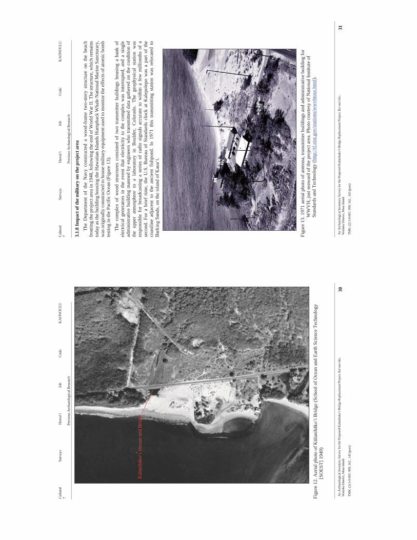
Cultu
ral
Surv
eys
Haw
ai‘i
Job
Code
: K
AO
NO
ULU
7
Prev
ious
Arc
haeo
logi
cal R
esea
rch
An
Arc
haeo
logi
cal I
nven
tory
Sur
vey
for t
he P
ropo
sed
Kul
anih
ako‘
i Brid
ge R
epla
cem
ent P
roje
ct, K
a‘on
o‘ul
u A
Wai
luku
Dist
rict,
Mau
i Isla
nd
30
TMK
: (2)
3-9
-001
: 999
, 162
, 14
3 (p
ors)
Fi
gure
12.
Aer
ial p
hoto
of K
ūlan
ihāk
o‘i B
ridge
(Sch
ool o
f Oce
an a
nd E
arth
Sci
ence
Tec
hnol
ogy
[SO
EST]
194
9)
Cultu
ral
Surv
eys
Haw
ai‘i
Job
Code
: K
AO
NO
ULU
7
Prev
ious
Arc
haeo
logi
cal R
esea
rch
An
Arc
haeo
logi
cal I
nven
tory
Sur
vey
for t
he P
ropo
sed
Kul
anih
ako‘
i Brid
ge R
epla
cem
ent P
roje
ct, K
a‘on
o‘ul
u A
Wai
luku
Dist
rict,
Mau
i Isla
nd
31
TMK
: (2)
3-9
-001
: 999
, 162
, 14
3 (p
ors)
3.1.
8 Im
pact
of t
he m
ilita
ry o
n th
e pro
ject
are
a
The
Dep
artm
ent
of t
he N
avy
cons
truct
ed a
woo
d-fr
ame
two-
stor
y st
ruct
ure
on t
he b
each
fr
ontin
g th
e pr
ojec
t are
a in
194
8, fo
llow
ing
the
end
of W
orld
War
II. T
he st
ruct
ure,
whi
ch re
mai
ns
toda
y as
the b
uild
ing
hous
ing
the
Haw
aiia
n Is
land
s Hum
pbac
k W
hale
Nat
iona
l Mar
ine S
anct
urar
y,
was
orig
inal
ly c
onst
ruct
ed to
hou
se m
ilita
ry e
quip
men
t use
d to
mon
itor t
he ef
fect
s of a
tom
ic b
omb
test
ing
in th
e Pa
cific
Oce
an (F
igur
e 13
).
The
com
plex
of
woo
d st
ruct
ures
con
sist
ed o
f tw
o tra
nsm
itter
bui
ldin
gs h
ousi
ng a
ban
k of
el
ectri
cal
gene
rato
rs i
n th
e ev
ent
that
ele
ctric
ity t
o th
e co
mpl
ex w
as i
nter
rupt
ed, a
nd a
sin
gle
adm
inis
trativ
e bu
ildin
g m
anne
d by
eng
inee
rs w
ho tr
ansm
itted
dat
a ga
ther
ed o
n th
e co
nditi
on o
f th
e up
per
atm
osph
ere
to a
lab
orat
ory
in B
ould
er,
Col
orad
o. T
he g
eoph
ysic
al s
tatio
n w
as
resp
onsi
ble
for
broa
dcas
ting
a se
ries
of r
adio
sig
nals
acc
urat
e to
with
in a
few
mill
iont
hs o
f a
seco
nd. F
or a
brie
f tim
e, t
he U
.S. B
urea
u of
Sta
ndar
ds c
lock
at K
alep
olep
o w
as a
par
t of
the
coas
tline
adj
acen
t to
the
anc
ient
fis
hpon
d. I
n 19
71 t
his
trans
mitt
ing
stat
ion
was
rel
ocat
ed t
o B
arki
ng S
ands
, on
the
isla
nd o
f Kau
a‘i.
Fi
gure
13.
197
1 ae
rial p
hoto
of a
nten
na, t
rans
mitt
er b
uild
ings
and
adm
inis
trativ
e bu
ildin
g fo
r W
WV
H, j
ust s
eaw
ard
of th
e pr
ojec
t are
a. P
hoto
cou
rtesy
of N
atio
nal I
nstit
ute
of
Stan
dard
s and
Tec
hnol
ogy
(http
://tf.
nist
.gov
/sta
tions
/ww
vhto
ur.h
tml).
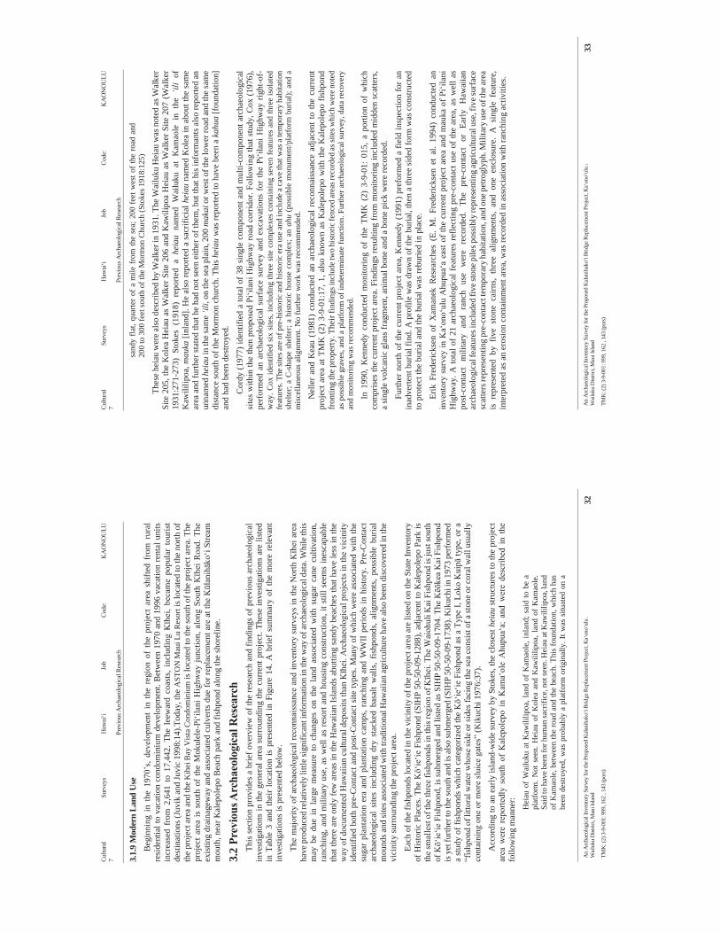
Cultu
ral
Surv
eys
Haw
ai‘i
Job
Code
: K
AO
NO
ULU
7
Prev
ious
Arc
haeo
logi
cal R
esea
rch
An
Arc
haeo
logi
cal I
nven
tory
Sur
vey
for t
he P
ropo
sed
Kul
anih
ako‘
i Brid
ge R
epla
cem
ent P
roje
ct, K
a‘on
o‘ul
u A
Wai
luku
Dist
rict,
Mau
i Isla
nd
32
TMK
: (2)
3-9
-001
: 999
, 162
, 14
3 (p
ors)
3.1.
9 M
oder
n La
nd U
se
Beg
inni
ng i
n th
e 19
70’s
, de
velo
pmen
t in
the
reg
ion
of t
he p
roje
ct a
rea
shift
ed f
rom
rur
al
resi
dent
ial t
o va
catio
n co
ndom
iniu
m d
evel
opm
ent.
Bet
wee
n 19
70 a
nd 1
996
vaca
tion
rent
al u
nits
in
crea
sed
from
2,6
41 t
o 17
,442
. Th
e le
ewar
d co
asts
, in
clud
ing
Kīh
ei,
beca
me
popu
lar
tour
ist
dest
inat
ions
(Juv
ik a
nd Ju
vic
1998
:14)
.Tod
ay, t
he A
STO
N M
aui L
u R
esor
t is l
ocat
ed to
the
north
of
the
proj
ect a
rea
and
the K
ihei
Bay
Vis
ta C
ondo
min
ium
is lo
cate
d to
the
sout
h of
the
proj
ect a
rea.
The
pr
ojec
t are
a is
sou
th o
f th
e M
okul
ele-
Pi‘il
ani H
ighw
ay ju
nctio
n, a
long
Sou
th Kīh
ei R
oad.
The
ex
istin
g dr
aina
gew
ay a
nd a
ssoc
iate
d cu
lver
ts d
ue fo
r rep
lace
men
t are
at t
he Kūl
anihāk
o‘i S
tream
m
outh
, nea
r Kal
epol
epo
Bea
ch p
ark
and
fishp
ond
alon
g th
e sh
orel
ine.
3.2
Prev
ious
Arc
haeo
logi
cal R
esea
rch
This
sect
ion
prov
ides
a b
rief o
verv
iew
of t
he re
sear
ch a
nd fi
ndin
gs o
f pre
viou
s ar
chae
olog
ical
in
vest
igat
ions
in th
e ge
nera
l are
a su
rrou
ndin
g th
e cu
rren
t pro
ject
. The
se in
vest
igat
ions
are
list
ed
in T
able
3 a
nd th
eir
loca
tion
is p
rese
nted
in F
igur
e 14
. A b
rief
sum
mar
y of
the
mor
e re
leva
nt
inve
stig
atio
ns is
pre
sent
ed b
elow
.
The
maj
ority
of a
rcha
eolo
gica
l rec
onna
issa
nce
and
inve
ntor
y su
rvey
s in
the
Nor
th Kīh
ei a
rea
have
pro
duce
d re
lativ
ely
little
sign
ifica
nt in
form
atio
n in
the w
ay o
f arc
haeo
logi
cal d
ata.
Whi
le th
is
may
be
due
in l
arge
mea
sure
to
chan
ges
on t
he l
and
asso
ciat
ed w
ith s
ugar
can
e cu
ltiva
tion,
ra
nchi
ng, a
nd m
ilita
ry u
se, a
s w
ell a
s re
sort
and
hous
ing
cons
truct
ion,
it s
till s
eem
s in
esca
pabl
e th
at th
ere
are
only
few
are
as in
the
Haw
aiia
n Is
land
s abu
tting
san
dy b
each
es th
at h
ave
less
in th
e w
ay o
f doc
umen
ted
Haw
aiia
n cu
ltura
l dep
osits
than
Kīh
ei. A
rcha
eolo
gica
l pro
ject
s in
the
vici
nity
id
entif
ied
both
pre
-Con
tact
and
pos
t-Con
tact
site
type
s. M
any
of w
hich
wer
e as
soci
ated
with
the
suga
r pl
anta
tion
era
and
plan
tatio
n ca
mps
, ran
chin
g an
d W
WII
perio
ds in
his
tory
. Pre
-Con
tact
ar
chae
olog
ical
site
s in
clud
ing
dry
stac
ked
basa
lt w
alls
, fis
hpon
ds,
alig
nmen
ts,
poss
ible
bur
ial
mou
nds a
nd si
tes a
ssoc
iate
d w
ith tr
aditi
onal
Haw
aiia
n ag
ricul
ture
hav
e al
so b
een
disc
over
ed in
the
vici
nity
surr
ound
ing
the
proj
ect a
rea.
Each
of t
he fi
shpo
nds l
ocat
ed in
the
vici
nity
of t
he p
roje
ct a
rea
are
liste
d on
the
Stat
e In
vent
ory
of H
isto
ric P
lace
s. Th
e Kō‘
ie‘ie
Fis
hpon
d (S
IHP
50-5
0-09
-128
8), a
djac
ent t
o K
alep
olep
o Pa
rk is
th
e sm
alle
st o
f the
thre
e fis
hpon
ds in
this
regi
on o
f Kīh
ei. T
he W
aioh
uli K
ai F
ishp
ond
is ju
st so
uth
of Kō‘
ie‘ie
Fis
hpon
d, is
subm
erge
d an
d lis
ted
as S
IHP
50-5
0-09
-170
4. T
he Kēō
kea
Kai
Fis
hpon
d is
yet
furth
er to
the s
outh
and
is al
so su
bmer
ged
(SIH
P 50
-50-
09-1
738)
. Kik
uchi
in 1
973
perf
orm
ed
a st
udy
of fi
shpo
nds
whi
ch c
ateg
oriz
ed th
e Kō‘
ie‘ie
Fis
hpon
d as
a T
ype
I, Lo
ko K
uipā
type
, or a
“f
ishp
ond
of li
ttora
l wat
er w
hose
side
or s
ides
faci
ng th
e sea
cons
ist o
f a st
one o
r cor
al w
all u
sual
ly
cont
aini
ng o
ne o
r mor
e sl
uice
gat
es”
(Kik
uchi
197
6:37
).
Acc
ordi
ng to
an
early
isla
nd-w
ide
surv
ey b
y St
okes
, the
clo
sest
hei
au s
truct
ures
to th
e pr
ojec
t ar
ea w
ere
repo
rtedl
y so
uth
of K
alep
olep
o in
Kam
a‘ol
e A
hupu
a‘a;
and
wer
e de
scrib
ed i
n th
e fo
llow
ing
man
ner:
Hei
au o
f W
ailu
ku a
t Kaw
ililip
oa, l
and
of K
amao
le, i
nlan
d; s
aid
to b
e a
plat
form
. Not
see
n. H
eiau
of
Kol
ea a
nd K
awili
lipoa
, lan
d of
Kam
aole
. Sa
id to
hav
e bee
n fo
r hum
an sa
crifi
ce, n
ot se
en. H
eiau
at K
awili
lipoa
, lan
d of
Kam
aole
, bet
wee
n th
e ro
ad a
nd th
e be
ach.
Thi
s fo
unda
tion,
whi
ch h
as
been
des
troye
d, w
as p
roba
bly
a pl
atfo
rm o
rigin
ally
. It w
as s
ituat
ed o
n a
Cultu
ral
Surv
eys
Haw
ai‘i
Job
Code
: K
AO
NO
ULU
7
Prev
ious
Arc
haeo
logi
cal R
esea
rch
An
Arc
haeo
logi
cal I
nven
tory
Sur
vey
for t
he P
ropo
sed
Kul
anih
ako‘
i Brid
ge R
epla
cem
ent P
roje
ct, K
a‘on
o‘ul
u A
Wai
luku
Dist
rict,
Mau
i Isla
nd
33
TMK
: (2)
3-9
-001
: 999
, 162
, 14
3 (p
ors)
sand
y fla
t, qu
arte
r of
a m
ile fr
om th
e se
a; 2
00 f
eet w
est o
f the
road
and
20
0 to
300
feet
sout
h of
the
Mor
mon
Chu
rch
(Sto
kes 1
918:
125)
Thes
e he
iau
wer
e al
so d
escr
ibed
by
Wal
ker i
n 19
31. T
he W
ailu
ku H
eiau
was
not
ed a
s Wal
ker
Site
205
, the
Kol
ea H
eiau
as
Wal
ker S
ite 2
06 a
nd K
awili
poa
Hei
au a
s W
alke
r Site
207
(W
alke
r 19
31:2
71-2
73)
Stok
es (
1918
) re
porte
d a
heia
u na
med
Wai
luku
at
Kam
aole
in
the
‘ili
of
Kaw
ililip
oa, m
auka
[inl
and]
. He
also
repo
rted
a sa
crifi
cial
hei
au n
amed
Kol
ea in
abo
ut th
e sa
me
area
and
furth
er st
ated
that
he
had
not s
een
eith
er o
f the
m, b
ut th
at h
is in
form
ants
als
o re
porte
d an
un
nam
ed h
eiau
in th
e sa
me
‘ili,
on th
e se
a pl
ain,
200
mak
ai o
r wes
t of t
he lo
wer
road
and
the
sam
e di
stan
ce so
uth
of th
e M
orm
on c
hurc
h. T
his h
eiau
was
repo
rted
to h
ave
been
a k
ahua
[fou
ndat
ion]
an
d ha
d be
en d
estro
yed.
Cor
dy (1
977)
iden
tifie
d a
tota
l of 3
8 si
ngle
com
pone
nt a
nd m
ulti-
com
pone
nt a
rcha
eolo
gica
l si
tes
with
in th
e th
en p
ropo
sed
Pi‘il
ani H
ighw
ay ro
ad c
orrid
or. F
ollo
win
g th
at s
tudy
, Cox
(197
6),
perf
orm
ed a
n ar
chae
olog
ical
sur
face
sur
vey
and
exca
vatio
ns f
or th
e Pi
‘ilan
i Hig
hway
rig
ht-o
f-w
ay. C
ox id
entif
ied
six
site
s, in
clud
ing
thre
e si
te c
ompl
exes
con
tain
ing
seve
n fe
atur
es a
nd th
ree
isol
ated
fe
atur
es. T
he si
tes a
re o
f pre
-his
toric
and
his
toric
era
use
and
incl
ude
a cav
e tha
t was
a te
mpo
rary
hab
itatio
n sh
elte
r; a
C-s
hape
she
lter;
a hi
stor
ic h
ouse
com
plex
; an
ahu
(pos
sibl
e m
onum
ent/p
latfo
rm b
uria
l); a
nd a
m
isce
llane
ous a
lignm
ent.
No
furth
er w
ork
was
reco
mm
ende
d.
Nel
ler
and
Kea
u (1
981)
con
duct
ed a
n ar
chae
olog
ical
rec
onna
issa
nce
adja
cent
to th
e cu
rren
t pr
ojec
t are
a at
TM
K (
2) 3
-9-0
1:17
, 1, a
lso
know
n as
Kal
epol
epo
with
the
Kal
epol
epo
fishp
ond
fron
ting
the p
rope
rty. T
heir
findi
ngs i
nclu
de tw
o hi
stor
ic fe
nced
area
s rec
orde
d as
site
s whi
ch w
ere n
oted
as
pos
sibl
e gr
aves
, and
a p
latfo
rm o
f ind
eter
min
ate
func
tion.
Fur
ther
arc
haeo
logi
cal s
urve
y, d
ata
reco
very
an
d m
onito
ring
was
reco
mm
ende
d.
In 1
990,
Ken
nedy
con
duct
ed m
onito
ring
of t
he T
MK
(2)
3-9
-01:
015
, a
porti
on o
f w
hich
co
mpr
ises
the
curr
ent p
roje
ct a
rea.
Fin
ding
s re
sulti
ng fr
om m
onito
ring
incl
uded
mid
den
scat
ters
, a
sing
le v
olca
nic
glas
s fra
gmen
t, an
imal
bon
e an
d a
bone
pic
k w
ere
reco
rded
.
Furth
er n
orth
of t
he c
urre
nt p
roje
ct a
rea,
Ken
nedy
(19
91) p
refo
rmed
a fi
eld
insp
ectio
n fo
r an
inad
verte
nt b
uria
l fin
d. A
pro
file
was
dra
wn
of th
e bu
rial,
then
a th
ree
side
d fo
rm w
as c
onst
ruct
ed
to p
rote
ct th
e bu
rial a
nd th
e bu
rial w
as re
burie
d in
pla
ce.
Erik
Fre
deric
ksen
of
Xam
anek
Res
earc
hes
(E.
M.
Fred
eric
ksen
et
al.
1994
) co
nduc
ted
an
inve
ntor
y su
rvey
in K
a‘on
o‘ul
u A
hupu
a‘a
east
of
the
curr
ent p
roje
ct a
rea
and
mau
ka o
f Pi‘i
lani
H
ighw
ay. A
tota
l of 2
1 ar
chae
olog
ical
feat
ures
ref
lect
ing
pre-
cont
act u
se o
f the
are
a, a
s w
ell a
s po
st-c
onta
ct
mili
tary
an
d ra
nch
use
wer
e re
cord
ed.
The
pre-
cont
act
or
Early
H
awai
ian
arch
aeol
ogic
al fe
atur
es in
clud
ed fi
ve st
one p
iles p
ossi
bly
repr
esen
ting
agric
ultu
ral u
se, f
ive s
urfa
ce
scat
ters
repr
esen
ting
pre-
cont
act t
empo
rary
hab
itatio
n, an
d on
e pet
rogl
yph.
Mili
tary
use
of t
he ar
ea
is r
epre
sent
ed b
y fiv
e st
one
cairn
s, th
ree
alig
nmen
ts,
and
one
encl
osur
e. A
sin
gle
feat
ure,
in
terp
rete
d as
an
eros
ion
cont
ainm
ent a
rea,
was
reco
rded
in a
ssoc
iatio
n w
ith ra
nchi
ng a
ctiv
ities
.

Cultu
ral S
urve
ys H
awai
‘i Jo
b Co
de: K
AO
NO
ULU
7
Prev
ious
Arc
haeo
logi
cal R
esea
rch
An
Arc
haeo
logi
cal I
nven
tory
Sur
vey
for t
he P
ropo
sed
Kul
anih
ako‘
i Brid
ge R
epla
cem
ent P
roje
ct, K
a‘on
o‘ul
u A
Wai
luku
Dist
rict,
Mau
i Isla
nd
34
TMK
: (2)
3-9
-001
: 999
, 162
, 14
3 (p
ors)
Tabl
e 3.
Pre
viou
s Arc
haeo
logi
cal S
tudi
es
Dat
e A
hupu
a‘a
Nat
ure
of S
tudy
Fi
ndin
gs
Stok
es 1
916
Isla
nd w
ide
Arc
haeo
logi
cal
Rec
onna
issa
nce
3 he
iau
in K
amao
le in
the
‘ili o
f Kaw
ililip
oa, l
ocat
ed
dire
ctly
sout
h of
the
pres
ent p
roje
ct a
rea.
Sto
kes d
id n
ot se
e an
y of
thes
e th
ree
heia
u. H
e no
ted
that
they
may
hav
e be
en
dest
roye
d.
Wal
ker 1
931
Isla
nd w
ide
Rec
onna
issa
nce
3 he
iau
in W
aioh
uli A
hupu
a‘a
abov
e 3,
000
ft. e
leva
tion.
Kik
uchi
197
3 St
atew
ide
fish
pond
surv
ey
Fish
pond
Sur
vey
Not
ed 3
fish
pon
ds in
Kal
epol
epo
area
.
(Cox
197
6) N
o pr
ojec
t are
a m
ap
Pūle
hu N
ui to
K
ama‘
ole
Arc
haeo
logi
cal
Inve
ntor
y Su
rvey
Pi‘il
ani H
ighw
ay ri
ght-o
f-w
ay. I
dent
ified
six
site
s, in
clud
ing
thre
e si
te c
ompl
exes
con
tain
ing
seve
n fe
atur
es a
nd th
ree
isol
ated
feat
ures
.
(Cor
dy 1
977)
Pū
lehu
Nui
to
Paea
hu
Arc
haeo
logi
cal
Rec
onna
issa
nce
Iden
tifie
d 38
site
s: 3
0 in
Wai
ohul
i, 0
in K
a‘on
o‘ul
u, a
nd 8
in
Kēō
kea
(Nel
ler a
nd K
eau
1981
) K
a‘on
o‘ul
u A
rcha
eolo
gica
l R
econ
nais
sanc
e
Find
s inc
lude
two
hist
oric
fenc
ed a
reas
reco
rded
as s
ites
whi
ch w
ere
note
d as
pos
sibl
e gr
aves
, and
a p
latfo
rm o
f in
dete
rmin
ate
func
tion.
Fur
ther
arc
haeo
logi
cal s
urve
y, d
ata
reco
very
and
mon
itorin
g w
as re
com
men
ded.
(Bor
dner
and
Cox
198
2)
Wai
ohul
i and
K
eoke
a A
rcha
eolo
gica
l R
econ
nais
sanc
e
A to
tal o
f nin
e si
tes w
ere
loca
ted
durin
g th
e re
conn
aiss
ance
su
rvey
whi
ch in
clud
ed C
-sha
pes,
an L
-sha
pes,
a m
odifi
ed
bedr
ock
outc
rop,
a te
mpo
rary
hab
itatio
n sh
elte
r, st
one
alig
nmen
ts, a
nd a
hab
itatio
n si
te. C
ultu
ral m
ater
ial w
hich
co
nsis
ted
of sh
ell m
idde
n w
as p
rese
nt a
t som
e of
the
site
s.
(Ken
nedy
198
6)
Wai
ohul
i A
rcha
eolo
gica
l R
econ
nais
sanc
e
Are
a w
as c
lear
ed b
y bu
lldoz
er, r
ubbl
e m
ound
s alo
ng b
oth
east
and
wes
t boa
rder
s of p
roje
ct a
rea,
no
surf
ace
evid
ence
of
arc
haeo
logy
. No
furth
er a
rcha
eolo
gica
l wor
k re
com
men
ded.
(Ken
nedy
198
8b)
Coa
stal
K
a‘on
o‘ul
u A
rcha
eolo
gica
l R
econ
nais
sanc
e N
o ar
chae
olog
ical
find
ings
Cultu
ral S
urve
ys H
awai
‘i Jo
b Co
de: K
AO
NO
ULU
7
Prev
ious
Arc
haeo
logi
cal R
esea
rch
An
Arc
haeo
logi
cal I
nven
tory
Sur
vey
for t
he P
ropo
sed
Kul
anih
ako‘
i Brid
ge R
epla
cem
ent P
roje
ct, K
a‘on
o‘ul
u A
Wai
luku
Dist
rict,
Mau
i Isla
nd
35
TMK
: (2)
3-9
-001
: 999
, 162
, 14
3 (p
ors)
Dat
e A
hupu
a‘a
Nat
ure
of S
tudy
Fi
ndin
gs
(Ken
nedy
198
8a)
Wai
ohul
i A
rcha
eolo
gica
l R
econ
nais
sanc
e N
o ar
chae
olog
ical
find
ings
. No
furth
er a
rcha
eolo
gica
l wor
k re
com
men
ded.
(Ken
nedy
198
9)
Wai
ohul
i A
rcha
eolo
gica
l Su
bsur
face
Te
stin
g R
esul
ts
No
hum
an b
uria
l fin
ding
s
(Don
ham
198
9)
Wai
ohul
i A
rcha
eolo
gica
l In
vent
ory
Surv
ey
Iden
tifie
d fo
ur si
tes,
incl
udin
g tw
o pr
evio
usly
unr
ecor
ded
site
s. R
ecom
men
ded
data
reco
very
(Ken
nedy
199
0b)
Coa
stal
W
aiak
oa
Surv
ey
No
arch
aeol
ogic
al fi
ndin
gs
(Sin
oto
1990
) C
oast
al
Wai
akoa
Su
rvey
& T
estin
g N
o ar
chae
olog
ical
find
ings
(oth
er th
an tw
o pi
eces
of
mid
den)
(Ken
nedy
199
0a)
Ka‘
ono‘
ulu
Mon
itorin
g R
epor
t R
ecor
ded
4 su
rfac
e m
idde
n sc
atte
rs, s
ingl
e fr
agm
ent o
f vo
lcan
ic g
lass
, ani
mal
bon
e an
d bo
ne p
ick.
(Ken
nedy
199
1)
Coa
stal
W
aiak
oa
Fiel
d In
spec
tion
Inad
verte
nt b
uria
l fin
d
(E. M
. Fre
deric
ksen
et a
l. 19
94)
Ka‘
ono‘
ulu,
m
auka
of
Pi‘il
ani
Hig
hway
Inve
ntor
y Su
rvey
21
site
s wer
e id
entif
ied,
som
e m
ilita
ry a
nd so
me
pre-
cont
act
(Bur
gett
et a
l. 19
98)
Ka‘
ono‘
ulu
Inve
ntor
y Su
rvey
Lo
ts A
and
B o
f the
Mau
i Lu
Res
ort.
No
arch
aeol
ogic
al
findi
ngs.
(Ham
mat
t and
Shi
dele
r 199
9)
Wai
ohul
i A
rcha
eolo
gica
l R
econ
nais
sanc
e N
o cu
ltura
l mat
eria
l, no
arc
haeo
logi
cal f
indi
ngs
(Pep
alis
and
Kol
b 20
00)
Wai
ohul
i A
rcha
eolo
gica
l ex
cava
tions
D
isco
vere
d so
ils fr
om in
land
pon
d
(McD
erm
ott e
t al.
2000
) W
aioh
uli
Add
ition
al
Arc
haeo
logi
cal
Inve
ntor
y Su
rvey
Con
firm
atio
n of
an
inla
nd p
ond
(SIH
P 50
-50-
09-4
981)
from
w
hich
14C
radi
ocar
bon
wer
e at
tain
ed th
at p
rovi
des e
vide
nce
of a
n ea
rlier
hab
itatio
n se
quen
ce in
Kih
ei th
an p
revi
ousl
y do
cum
ente
d.
Cultu
ral S
urve
ys H
awai
‘i Jo
b Co
de: K
AO
NO
ULU
7
Prev
ious
Arc
haeo
logi
cal R
esea
rch
An
Arc
haeo
logi
cal I
nven
tory
Sur
vey
for t
he P
ropo
sed
Kul
anih
ako‘
i Brid
ge R
epla
cem
ent P
roje
ct, K
a‘on
o‘ul
u A
Wai
luku
Dist
rict,
Mau
i Isla
nd
36
TMK
: (2)
3-9
-001
: 999
, 162
, 14
3 (p
ors)
Dat
e A
hupu
a‘a
Nat
ure
of S
tudy
Fi
ndin
gs
(McD
erm
ott 2
001)
C
oast
al K
ihei
Gra
duat
e Th
esis
; H
isto
rical
Ec
olog
y of
C
oast
al K
ihei
N/A
(Bor
thw
ick
et a
l. 20
02)
Wai
ohul
i In
vent
ory
Surv
ey
No
arch
aeol
ogic
al fi
ndin
gs
(Hill
et a
l. 20
05)
Wai
ohul
i
Lette
r Rep
ort f
or
a Fi
eld
Insp
ectio
n an
d Su
bsur
face
Te
stin
g
No
arch
aeol
ogic
al fi
ndin
gs
(Hill
et a
l. 20
10)
Pūle
hu N
ui,
Ka‘
ono‘
ulu,
W
aiak
oa
Miti
gatio
n Pr
ogra
m
No
cultu
ral d
epos
its o
r arti
fact
s obs
erve
d du
ring
miti
gatio
n w
ork.
No
hist
oric
pro
perti
es a
ffec
ted.
(Med
eiro
s et a
l. 20
12)
Ka‘
ono‘
ulu
Lite
ratu
re R
evie
w
and
Fiel
d In
spec
tion
Rec
orde
d K
ulan
ihak
oi B
ridge
(50-
50-1
0-76
06),
cons
truct
ed
in 1
911
cons
ider
ed n
ot si
gnifi
cant
bas
ed o
n a
lack
of
inte
grity
.
Cultu
ral S
urve
ys H
awai
‘i Jo
b Co
de: K
AO
NO
ULU
7
Prev
ious
Arc
haeo
logi
cal R
esea
rch
An
Arc
haeo
logi
cal I
nven
tory
Sur
vey
for t
he P
ropo
sed
Kul
anih
ako‘
i Brid
ge R
epla
cem
ent P
roje
ct, K
a‘on
o‘ul
u A
hupu
a‘a,
Wai
luku
Dist
rict,
Mau
i Isla
nd
37
TMK
: (2)
3-9
-001
: 999
, 162
, 14
3 (p
ors)
Fi
gure
14.
Por
tions
of t
he P
u‘u
o K
ali (
1992
) and
Mā‘
alae
a (1
996)
7.5
-min
ute
USG
S to
pogr
aphi
c qu
adra
ngle
s, sh
owin
g th
e cu
rren
t pro
ject
are
a re
lativ
e to
adj
acen
t are
as o
f pre
viou
s arc
haeo
logi
cal s
tudy
.
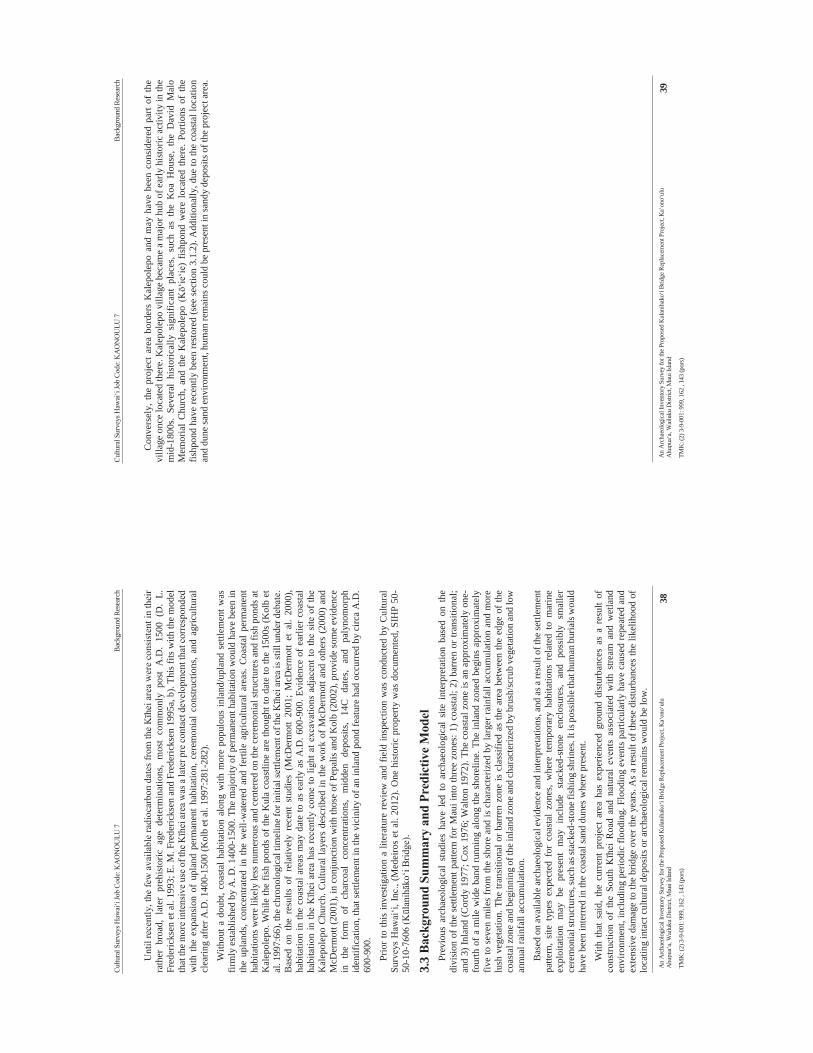
Cultu
ral S
urve
ys H
awai
‘i Jo
b Co
de: K
AO
NO
ULU
7
Ba
ckgr
ound
Res
earc
h
An
Arc
haeo
logi
cal I
nven
tory
Sur
vey
for t
he P
ropo
sed
Kul
anih
ako‘
i Brid
ge R
epla
cem
ent P
roje
ct, K
a‘on
o‘ul
u A
hupu
a‘a,
Wai
luku
Dist
rict,
Mau
i Isla
nd
38
TMK
: (2)
3-9
-001
: 999
, 162
, 14
3 (p
ors)
Unt
il re
cent
ly, t
he fe
w a
vaila
ble
radi
ocar
bon
date
s fro
m th
e Kīh
ei a
rea
wer
e co
nsis
tent
in th
eir
rath
er b
road
, la
ter
preh
isto
ric a
ge d
eter
min
atio
ns,
mos
t co
mm
only
pos
t A
.D.
1500
(D
. L.
Fr
eder
icks
en e
t al.
1993
; E. M
. Fre
deric
ksen
and
Fre
deric
ksen
199
5a, b
). Th
is fi
ts w
ith th
e m
odel
th
at th
e mor
e int
ensi
ve u
se o
f the
Kīh
ei ar
ea w
as a
late
r pre
con
tact
dev
elop
men
t tha
t cor
resp
onde
d w
ith th
e ex
pans
ion
of u
plan
d pe
rman
ent h
abita
tion,
cer
emon
ial
cons
truct
ions
, and
agr
icul
tura
l cl
earin
g af
ter A
.D. 1
400-
1500
(Kol
b et
al.
1997
:281
-282
).
With
out a
dou
bt, c
oast
al h
abita
tion
alon
g w
ith m
ore
popu
lous
inla
nd/u
plan
d se
ttlem
ent w
as
firm
ly e
stab
lishe
d by
A. D
. 140
0-15
00. T
he m
ajor
ity o
f per
man
ent h
abita
tion
wou
ld h
ave
been
in
the
upla
nds,
conc
entra
ted
in th
e w
ell-w
ater
ed a
nd f
ertil
e ag
ricul
tura
l are
as. C
oast
al p
erm
anen
t ha
bita
tions
wer
e lik
ely
less
num
erou
s and
cen
tere
d on
the
cere
mon
ial s
truct
ures
and
fish
pon
ds a
t K
alep
olep
o. W
hile
the
fish
pond
s of
the
Kul
a co
astli
ne a
re th
ough
t to
date
to th
e 15
00s
(Kol
b et
al
. 199
7:66
), th
e ch
rono
logi
cal t
imel
ine
for i
nitia
l set
tlem
ent o
f the
Kīh
ei a
rea
is st
ill u
nder
deb
ate.
B
ased
on
the
resu
lts o
f re
lativ
ely
rece
nt s
tudi
es (
McD
erm
ott
2001
; M
cDer
mot
t et
al.
2000
), ha
bita
tion
in th
e co
asta
l are
as m
ay d
ate
to a
s ea
rly a
s A
.D. 6
00-9
00. E
vide
nce
of e
arlie
r coa
stal
ha
bita
tion
in th
e Kīh
ei a
rea
has
rece
ntly
com
e to
ligh
t at e
xcav
atio
ns a
djac
ent t
o th
e si
te o
f th
e K
alep
olep
o C
hurc
h. C
ultu
ral l
ayer
s de
scrib
ed in
the
wor
k of
McD
erm
ott a
nd o
ther
s (2
000)
and
M
cDer
mot
t (20
01),
in c
onju
nctio
n w
ith th
ose
of P
epal
is a
nd K
olb
(200
2), p
rovi
de so
me
evid
ence
in
th
e fo
rm
of
char
coal
co
ncen
tratio
ns,
mid
den
depo
sits
, 14
C
date
s, an
d pa
lyno
mor
ph
iden
tific
atio
n, th
at se
ttlem
ent i
n th
e vi
cini
ty o
f an
inla
nd p
ond
feat
ure
had
occu
rred
by
circ
a A
.D.
600-
900.
Prio
r to
this
inve
stig
atio
n a
liter
atur
e re
view
and
fie
ld in
spec
tion
was
con
duct
ed b
y C
ultu
ral
Surv
eys
Haw
ai‘i,
Inc.
, (M
edei
ros
et a
l. 20
12).
One
his
toric
pro
perty
was
doc
umen
ted,
SIH
P 50
-50
-10-
7606
(Kūl
anihāk
o‘i B
ridge
).
3.3
Back
grou
nd S
umm
ary
and
Pred
ictiv
e M
odel
Pr
evio
us a
rcha
eolo
gica
l st
udie
s ha
ve l
ed t
o ar
chae
olog
ical
site
int
erpr
etat
ion
base
d on
the
di
visi
on o
f the
set
tlem
ent p
atte
rn fo
r Mau
i int
o th
ree
zone
s: 1
) coa
stal
; 2) b
arre
n or
tran
sitio
nal;
and
3) In
land
(Cor
dy 1
977;
Cox
197
6; W
alto
n 19
72).
The
coas
tal z
one
is a
n ap
prox
imat
ely
one-
four
th o
f a m
ile w
ide
band
runn
ing
alon
g th
e sh
orel
ine.
The
inla
nd z
oned
beg
ins
appr
oxim
atel
y fiv
e to
sev
en m
iles
from
the
shor
e an
d is
cha
ract
eriz
ed b
y la
rger
rain
fall
accu
mul
atio
n an
d m
ore
lush
veg
etat
ion.
The
tran
sitio
nal o
r bar
ren
zone
is c
lass
ified
as
the
area
bet
wee
n th
e ed
ge o
f the
co
asta
l zon
e and
beg
inni
ng o
f the
inla
nd z
one a
nd ch
arac
teriz
ed b
y br
ush/
scru
b ve
geta
tion
and
low
an
nual
rain
fall
accu
mul
atio
n.
Bas
ed o
n av
aila
ble
arch
aeol
ogic
al ev
iden
ce an
d in
terp
reta
tions
, and
as a
resu
lt of
the s
ettle
men
t pa
ttern
, si
te t
ypes
exp
ecte
d fo
r co
asta
l zo
nes,
whe
re t
empo
rary
hab
itatio
ns r
elat
ed t
o m
arin
e ex
ploi
tatio
n m
ay b
e pr
esen
t m
ay i
nclu
de s
tack
ed-s
tone
enc
losu
res,
and
poss
ibly
sm
alle
r ce
rem
onia
l stru
ctur
es, s
uch
as st
acke
d-st
one f
ishi
ng sh
rines
. It i
s pos
sibl
e tha
t hum
an b
uria
ls w
ould
ha
ve b
een
inte
rred
in th
e co
asta
l san
d du
nes w
here
pre
sent
.
With
tha
t sa
id, t
he c
urre
nt p
roje
ct a
rea
has
expe
rienc
ed g
roun
d di
stur
banc
es a
s a
resu
lt of
co
nstru
ctio
n of
the
Sou
th K
īhei
Roa
d an
d na
tura
l ev
ents
ass
ocia
ted
with
stre
am a
nd w
etla
nd
envi
ronm
ent,
incl
udin
g pe
riodi
c flo
odin
g. F
lood
ing
even
ts p
artic
ular
ly h
ave
caus
ed re
peat
ed a
nd
exte
nsiv
e da
mag
e to
the
brid
ge o
ver t
he y
ears
. As
a re
sult
of th
ese
dist
urba
nces
the
likel
ihoo
d of
lo
catin
g in
tact
cul
tura
l dep
osits
or a
rcha
eolo
gica
l rem
ains
wou
ld b
e lo
w.
Cultu
ral S
urve
ys H
awai
‘i Jo
b Co
de: K
AO
NO
ULU
7
Ba
ckgr
ound
Res
earc
h
An
Arc
haeo
logi
cal I
nven
tory
Sur
vey
for t
he P
ropo
sed
Kul
anih
ako‘
i Brid
ge R
epla
cem
ent P
roje
ct, K
a‘on
o‘ul
u A
hupu
a‘a,
Wai
luku
Dist
rict,
Mau
i Isla
nd
39
TMK
: (2)
3-9
-001
: 999
, 162
, 14
3 (p
ors)
Con
vers
ely,
the
proj
ect
area
bor
ders
Kal
epol
epo
and
may
hav
e be
en c
onsi
dere
d pa
rt of
the
villa
ge o
nce
loca
ted
ther
e. K
alep
olep
o vi
llage
bec
ame
a m
ajor
hub
of e
arly
his
toric
act
ivity
in th
e m
id-1
800s
. Se
vera
l hi
stor
ical
ly s
igni
fican
t pl
aces
, su
ch a
s th
e K
oa H
ouse
, th
e D
avid
Mal
o M
emor
ial
Chu
rch,
and
the
Kal
epol
epo
(Kō‘
ie‘ie
) fis
hpon
d w
ere
loca
ted
ther
e. P
ortio
ns o
f th
e fis
hpon
d ha
ve re
cent
ly b
een
rest
ored
(see
sec
tion
3.1.
2). A
dditi
onal
ly, d
ue to
the
coas
tal l
ocat
ion
and
dune
sand
env
ironm
ent,
hum
an re
mai
ns c
ould
be
pres
ent i
n sa
ndy
depo
sits
of t
he p
roje
ct a
rea.
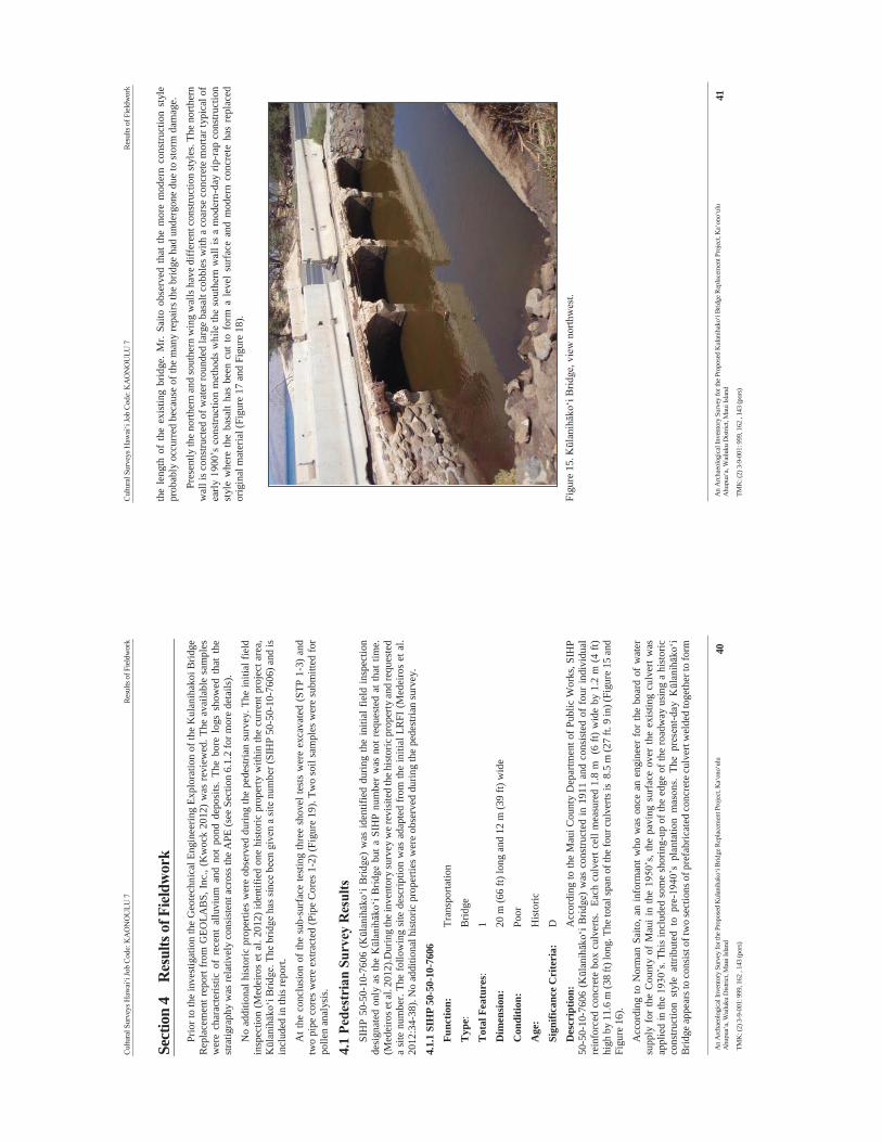
Cultu
ral S
urve
ys H
awai
‘i Jo
b Co
de: K
AO
NO
ULU
7
Re
sults
of F
ield
wor
k
An
Arc
haeo
logi
cal I
nven
tory
Sur
vey
for t
he P
ropo
sed
Kul
anih
ako‘
i Brid
ge R
epla
cem
ent P
roje
ct, K
a‘on
o‘ul
u A
hupu
a‘a,
Wai
luku
Dist
rict,
Mau
i Isla
nd
40
TMK
: (2)
3-9
-001
: 999
, 162
, 14
3 (p
ors)
Sect
ion
4 R
esul
ts o
f Fie
ldw
ork
Prio
r to
the
inve
stig
atio
n th
e G
eote
chni
cal E
ngin
eerin
g Ex
plor
atio
n of
the
Kul
anih
akoi
Brid
ge
Rep
lace
men
t rep
ort f
rom
GEO
LAB
S, In
c., (
Kw
ock
2012
) was
revi
ewed
. The
ava
ilabl
e sa
mpl
es
wer
e ch
arac
teris
tic o
f re
cent
allu
vium
and
not
pon
d de
posi
ts.
The
bore
log
s sh
owed
tha
t th
e st
ratig
raph
y w
as re
lativ
ely
cons
iste
nt a
cros
s the
APE
(see
Sec
tion
6.1.
2 fo
r mor
e de
tails
).
No
addi
tiona
l his
toric
pro
perti
es w
ere
obse
rved
dur
ing
the
pede
stria
n su
rvey
. The
initi
al fi
eld
insp
ectio
n (M
edei
ros
et a
l. 20
12) i
dent
ified
one
his
toric
pro
perty
with
in th
e cu
rren
t pro
ject
are
a,
Kūl
anihāk
o‘i B
ridge
. The
brid
ge h
as si
nce
been
giv
en a
site
num
ber (
SIH
P 50
-50-
10-7
606)
and
is
incl
uded
in th
is re
port.
At t
he c
oncl
usio
n of
the
sub-
surf
ace
test
ing
thre
e sh
ovel
test
s w
ere
exca
vate
d (S
TP 1
-3) a
nd
two
pipe
cor
es w
ere
extra
cted
(Pip
e C
ores
1-2
) (Fi
gure
19)
. Tw
o so
il sa
mpl
es w
ere
subm
itted
for
polle
n an
alys
is.
4.1
Pede
stri
an S
urve
y R
esul
ts
SIH
P 50
-50-
10-7
606
(Kūl
anihāk
o‘i B
ridge
) w
as id
entif
ied
durin
g th
e in
itial
fie
ld in
spec
tion
desi
gnat
ed o
nly
as th
e Kūl
anihāk
o‘i B
ridge
but
a S
IHP
num
ber
was
not
req
uest
ed a
t tha
t tim
e.
(Med
eiro
s et a
l. 20
12).D
urin
g th
e inv
ento
ry su
rvey
we r
evis
ited
the h
isto
ric p
rope
rty an
d re
ques
ted
a si
te n
umbe
r. Th
e fo
llow
ing
site
des
crip
tion
was
ada
pted
from
the
initi
al L
RFI
(Med
eiro
s et
al.
2012
:34-
38).
No
addi
tiona
l his
toric
pro
perti
es w
ere
obse
rved
dur
ing
the
pede
stria
n su
rvey
.
4.1.
1 SI
HP
50-5
0-10
-760
6
Func
tion:
Tran
spor
tatio
n T
ype:
B
ridge
Tota
l Fea
ture
s:
1
Dim
ensio
n:
20
m (6
6 ft)
long
and
12
m (3
9 ft)
wid
e
Con
ditio
n:
Po
or
Age
:
H
isto
ric
Sign
ifica
nce
Cri
teri
a:
D
Des
crip
tion:
Acc
ordi
ng to
the
Mau
i Cou
nty
Dep
artm
ent o
f Pub
lic W
orks
, SIH
P 50
-50-
10-7
606
(Kūl
anihāk
o‘i B
ridge
) w
as c
onst
ruct
ed in
191
1 an
d co
nsis
ted
of f
our i
ndiv
idua
l re
info
rced
con
cret
e bo
x cu
lver
ts.
Each
cul
vert
cell
mea
sure
d 1.
8 m
(6
ft) w
ide
by 1
.2 m
(4 ft
) hi
gh b
y 11
.6 m
(38
ft) lo
ng. T
he to
tal s
pan
of th
e fo
ur c
ulve
rts is
8.5
m (2
7 ft.
9 in
) (Fi
gure
15
and
Figu
re 1
6).
Acc
ordi
ng to
Nor
man
Sai
to, a
n in
form
ant w
ho w
as o
nce
an e
ngin
eer
for
the
boar
d of
wat
er
supp
ly f
or th
e C
ount
y of
Mau
i in
the
1950
’s, t
he p
avin
g su
rfac
e ov
er th
e ex
istin
g cu
lver
t was
ap
plie
d in
the
1930
’s. T
his
incl
uded
som
e sh
orin
g-up
of t
he e
dge
of th
e ro
adw
ay u
sing
a h
isto
ric
cons
truct
ion
styl
e at
tribu
ted
to p
re-1
940’
s pl
anta
tion
mas
ons.
The
pres
ent-d
ay K
ūlan
ihāk
o‘i
Brid
ge a
ppea
rs to
cons
ist o
f tw
o se
ctio
ns o
f pre
fabr
icat
ed co
ncre
te cu
lver
t wel
ded
toge
ther
to fo
rm
Cultu
ral S
urve
ys H
awai
‘i Jo
b Co
de: K
AO
NO
ULU
7
Re
sults
of F
ield
wor
k
An
Arc
haeo
logi
cal I
nven
tory
Sur
vey
for t
he P
ropo
sed
Kul
anih
ako‘
i Brid
ge R
epla
cem
ent P
roje
ct, K
a‘on
o‘ul
u A
hupu
a‘a,
Wai
luku
Dist
rict,
Mau
i Isla
nd
41
TMK
: (2)
3-9
-001
: 999
, 162
, 14
3 (p
ors)
the
leng
th o
f th
e ex
istin
g br
idge
. Mr.
Saito
obs
erve
d th
at t
he m
ore
mod
ern
cons
truct
ion
styl
e pr
obab
ly o
ccur
red
beca
use
of th
e m
any
repa
irs th
e br
idge
had
und
ergo
ne d
ue to
stor
m d
amag
e.
Pres
ently
the
north
ern
and
sout
hern
win
g w
alls
hav
e di
ffer
ent c
onst
ruct
ion
styl
es. T
he n
orth
ern
wal
l is c
onst
ruct
ed o
f wat
er ro
unde
d la
rge
basa
lt co
bble
s with
a c
oars
e co
ncre
te m
orta
r typ
ical
of
early
190
0’s
cons
truct
ion
met
hods
whi
le th
e so
uthe
rn w
all i
s a
mod
ern-
day
rip-r
ap c
onst
ruct
ion
styl
e w
here
the
basa
lt ha
s be
en c
ut to
for
m a
leve
l sur
face
and
mod
ern
conc
rete
has
rep
lace
d or
igin
al m
ater
ial (
Figu
re 1
7 an
d Fi
gure
18)
.
Fi
gure
15.
Kūl
anihāk
o‘i B
ridge
, vie
w n
orth
wes
t.
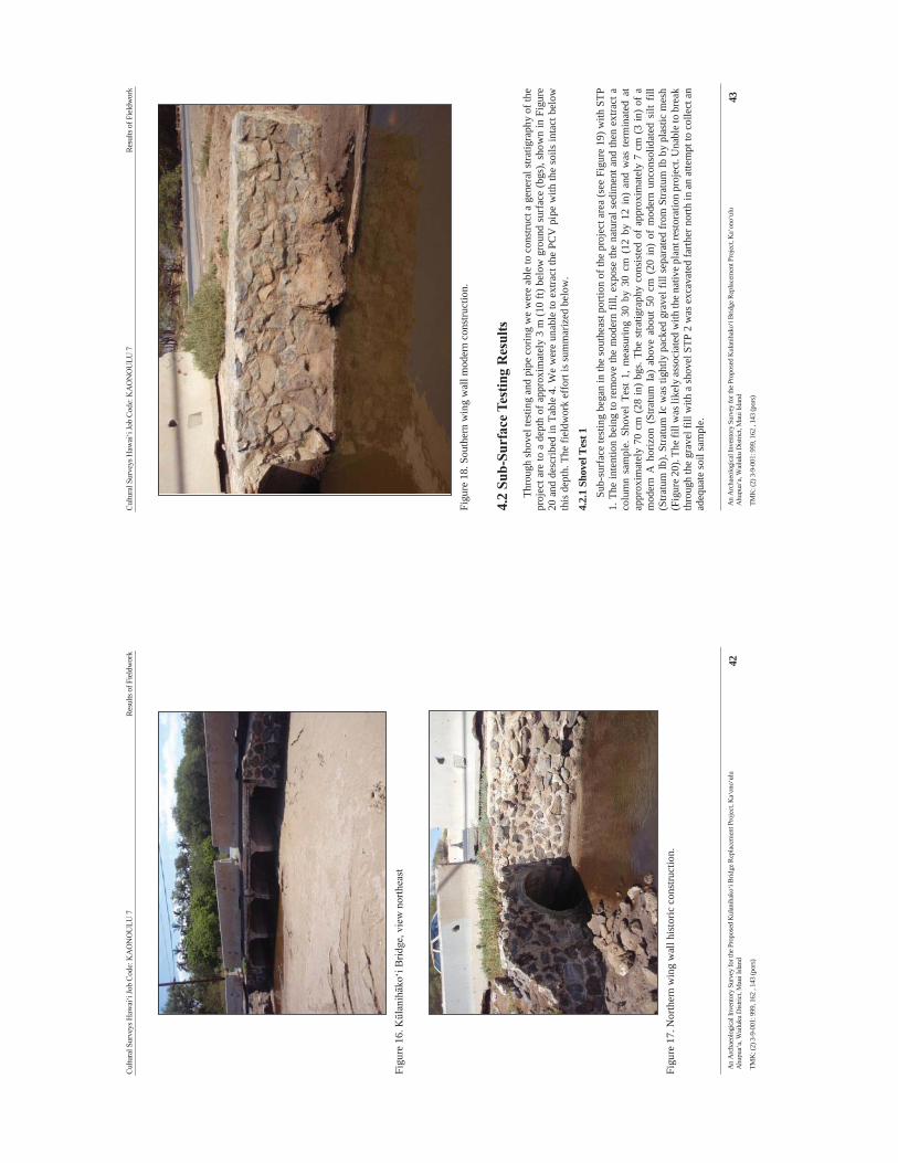
Cultu
ral S
urve
ys H
awai
‘i Jo
b Co
de: K
AO
NO
ULU
7
Re
sults
of F
ield
wor
k
An
Arc
haeo
logi
cal I
nven
tory
Sur
vey
for t
he P
ropo
sed
Kul
anih
ako‘
i Brid
ge R
epla
cem
ent P
roje
ct, K
a‘on
o‘ul
u A
hupu
a‘a,
Wai
luku
Dist
rict,
Mau
i Isla
nd
42
TMK
: (2)
3-9
-001
: 999
, 162
, 14
3 (p
ors)
Fi
gure
16.
Kūl
anihāk
o‘i B
ridge
, vie
w n
orth
east
Fi
gure
17.
Nor
ther
n w
ing
wal
l his
toric
con
stru
ctio
n.
Cultu
ral S
urve
ys H
awai
‘i Jo
b Co
de: K
AO
NO
ULU
7
Re
sults
of F
ield
wor
k
An
Arc
haeo
logi
cal I
nven
tory
Sur
vey
for t
he P
ropo
sed
Kul
anih
ako‘
i Brid
ge R
epla
cem
ent P
roje
ct, K
a‘on
o‘ul
u A
hupu
a‘a,
Wai
luku
Dist
rict,
Mau
i Isla
nd
43
TMK
: (2)
3-9
-001
: 999
, 162
, 14
3 (p
ors)
Fi
gure
18.
Sou
ther
n w
ing
wal
l mod
ern
cons
truct
ion.
4.2
Sub-
Surf
ace T
estin
g R
esul
ts
Thro
ugh
shov
el te
stin
g an
d pi
pe c
orin
g w
e w
ere
able
to c
onst
ruct
a g
ener
al st
ratig
raph
y of
the
proj
ect a
re to
a d
epth
of a
ppro
xim
atel
y 3
m (1
0 ft)
bel
ow g
roun
d su
rfac
e (b
gs),
show
n in
Fig
ure
20 a
nd d
escr
ibed
in T
able
4. W
e w
ere
unab
le to
ext
ract
the
PCV
pip
e w
ith th
e so
ils in
tact
bel
ow
this
dep
th. T
he fi
eldw
ork
effo
rt is
sum
mar
ized
bel
ow.
4.2.
1 Sh
ovel
Tes
t 1
Sub-
surf
ace
test
ing
bega
n in
the
sout
heas
t por
tion
of th
e pr
ojec
t are
a (s
ee F
igur
e 19
) with
STP
1.
The
inte
ntio
n be
ing
to re
mov
e th
e m
oder
n fil
l, ex
pose
the
natu
ral s
edim
ent a
nd th
en e
xtra
ct a
co
lum
n sa
mpl
e. S
hove
l Te
st 1
, mea
surin
g 30
by
30 c
m (
12 b
y 12
in)
and
was
ter
min
ated
at
appr
oxim
atel
y 70
cm
(28
in)
bgs.
The
stra
tigra
phy
cons
iste
d of
app
roxi
mat
ely
7 cm
(3
in)
of a
m
oder
n A
hor
izon
(St
ratu
m I
a) a
bove
abo
ut 5
0 cm
(20
in)
of
mod
ern
unco
nsol
idat
ed s
ilt f
ill
(Stra
tum
Ib).
Stra
tum
Ic w
as ti
ghtly
pac
ked
grav
el fi
ll se
para
ted
from
Stra
tum
Ib b
y pl
astic
mes
h (F
igur
e 20)
. The
fill
was
like
ly a
ssoc
iate
d w
ith th
e na
tive p
lant
rest
orat
ion
proj
ect.
Una
ble
to b
reak
th
roug
h th
e gr
avel
fill
with
a sh
ovel
STP
2 w
as e
xcav
ated
farth
er n
orth
in a
n at
tem
pt to
col
lect
an
adeq
uate
soil
sam
ple.
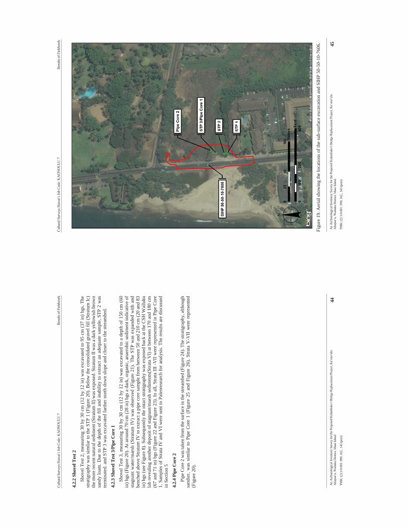
Cultu
ral S
urve
ys H
awai
‘i Jo
b Co
de: K
AO
NO
ULU
7
Re
sults
of F
ield
wor
k
An
Arc
haeo
logi
cal I
nven
tory
Sur
vey
for t
he P
ropo
sed
Kul
anih
ako‘
i Brid
ge R
epla
cem
ent P
roje
ct, K
a‘on
o‘ul
u A
hupu
a‘a,
Wai
luku
Dist
rict,
Mau
i Isla
nd
44
TMK
: (2)
3-9
-001
: 999
, 162
, 14
3 (p
ors)
4.2.
2 Sh
ovel
Tes
t 2
Shov
el T
est 2
, mea
surin
g 30
by
30 c
m (1
2 by
12
in) w
as e
xcav
ated
to 9
5 cm
(37
in) b
gs. T
he
stra
tigra
phy
was
sim
ilar t
o th
e ST
P 1
(Fig
ure
20).
Bel
ow th
e co
nsol
idat
ed g
rave
l fill
(Stra
tum
Ic)
the
mor
e re
cent
nat
ural
sedi
men
t (St
ratu
m II
) was
exp
osed
. Stra
tum
II w
as a
dar
k ye
llow
ish
brow
n sa
ndy
loam
. Due
to th
e de
pth
of th
e fil
l and
inab
ility
to e
xtra
ct a
n ad
equa
te s
ampl
e, S
TP 2
was
te
rmin
ated
. and
STP
3 w
as e
xcav
ated
farth
er n
orth
dow
n sl
ope
and
clos
er to
the
stre
ambe
d.
4.2.
3 Sh
ovel
Tes
t 3/P
ipe C
ore 1
Sh
ovel
Tes
t 3, m
easu
ring
30 b
y 30
cm
(12
by 1
2 in
) was
exc
avat
ed to
a d
epth
of 1
50 c
m (
60
in) b
gs (F
igur
e 20
). A
t aro
und
70 c
m (2
8 in
) bgs
a d
ark,
org
anic
, ana
erob
ic se
dim
ent i
ndic
ativ
e of
st
agna
nt w
ater
/mar
sh (
Stra
tum
IV
) w
as o
bser
ved
(Fig
ure
21).
The
STP
was
exp
ande
d w
ith a
nd
benc
hed
abov
e St
ratu
m IV
to e
xtra
ct a
pip
e co
re sa
mpl
e fr
om b
etw
een
50 a
nd 2
10 c
m (2
0 an
d 83
in
) bgs
(see
Fig
ure
8). S
ubse
quen
tly th
e in
tact
stra
tigra
phy
was
exp
osed
bac
k at
the
CSH
Wai
luku
la
b re
veal
ing
anot
her d
epos
it of
stag
nant
/mar
sh s
edim
ents
(Stra
ta V
I) at
bet
wee
n 17
0 an
d 18
0 cm
(6
7 an
d 71
in) b
gs (F
igur
e 22
and
Fig
ure
23).
In a
ll, S
trata
III -
VII
wer
e re
pres
ente
d in
Pip
e C
ore
1. S
ampl
es o
f Stra
ta IV
and
VI w
ere
sent
to P
aleo
rese
arch
for a
naly
sis.
The
resu
lts a
re d
iscu
ssed
in
Sec
tion
5
4.2.
4 Pi
pe C
ore 2
Pi
pe C
ore 2
was
take
n fr
om th
e sur
face
in th
e stre
ambe
d (F
igur
e 24)
. The
stra
tigra
phy,
alth
ough
sa
ndie
r, w
as s
imila
r to
Pip
e C
ore
1 (F
igur
e 25
and
Fig
ure
26).
Stra
ta V
-VII
wer
e re
pres
ente
d (F
igur
e 20
).
Cultu
ral S
urve
ys H
awai
‘i Jo
b Co
de: K
AO
NO
ULU
7
Re
sults
of F
ield
wor
k
An
Arc
haeo
logi
cal I
nven
tory
Sur
vey
for t
he P
ropo
sed
Kul
anih
ako‘
i Brid
ge R
epla
cem
ent P
roje
ct, K
a‘on
o‘ul
u A
hupu
a‘a,
Wai
luku
Dist
rict,
Mau
i Isla
nd
45
TMK
: (2)
3-9
-001
: 999
, 162
, 14
3 (p
ors)
Figu
re 1
9. A
eria
l sho
win
g th
e lo
catio
ns o
f the
sub-
surf
ace
exca
vatio
n an
d SI
HP
50-5
0-10
-760
6.
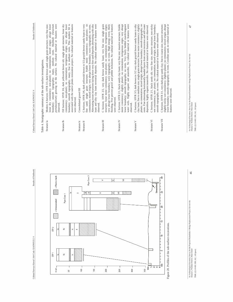
Cultu
ral S
urve
ys H
awai
‘i Jo
b Co
de: K
AO
NO
ULU
4
Re
sults
of F
ield
wor
k
An
Arc
haeo
logi
cal I
nven
tory
Sur
vey
for t
he P
ropo
sed
Kul
anih
ako‘
i Brid
ge R
epla
cem
ent P
roje
ct, K
a‘on
o‘ul
u A
hupu
a‘a,
Wai
luku
Dist
rict,
Mau
i Isla
nd
46
TMK
: (2)
3-9
-001
: 999
, 162
, 14
3 (p
ors)
Fi
gure
20.
Pro
files
of t
he su
b-su
rfac
e ex
cava
tions
.
Cultu
ral S
urve
ys H
awai
‘i Jo
b Co
de: K
AO
NO
ULU
4
Re
sults
of F
ield
wor
k
An
Arc
haeo
logi
cal I
nven
tory
Sur
vey
for t
he P
ropo
sed
Kul
anih
ako‘
i Brid
ge R
epla
cem
ent P
roje
ct, K
a‘on
o‘ul
u A
hupu
a‘a,
Wai
luku
Dist
rict,
Mau
i Isla
nd
47
TMK
: (2)
3-9
-001
: 999
, 162
, 14
3 (p
ors)
Tabl
e 4.
Stra
tigra
phic
sum
mar
y of
the
sub-
surf
ace
inve
stig
atio
ns.
Stra
tum
Ia
Mod
ern
A h
oriz
on; 1
0YR
3/3
, dar
k br
own
sand
; sin
gle
grai
n st
ruct
ure;
ver
y fin
e siz
e;
loos
e dr
y co
nsis
tenc
y; n
on-p
last
ic;
no c
emen
tatio
n; m
ixed
orig
in;
abru
pt l
ower
bo
unda
ry;
smoo
th
topo
grap
hy;
man
y,
med
ium
ro
ots.
Aku
likul
i (S
esuv
ium
po
rtul
acas
trum
) gr
owin
g on
the
sur
face
. N
o cu
ltura
l m
ater
ial
or f
eatu
res
wer
e ob
serv
ed.
Stra
tum
Ib
Fill
horiz
on; 1
0YR
3/6
, dar
k ye
llow
ish
brow
n si
lt; s
ingl
e gr
ain
stru
ctur
e; lo
ose
dry
cons
iste
ncy;
non
-pla
stic
; no
cem
enta
tion;
ter
rigen
ous
orig
in;
very
abr
upt
low
er
boun
dary
; sm
ooth
top
ogra
phy;
man
y, f
ine
to m
ediu
m r
oots
. Th
is m
oder
n fil
l is
as
soci
ated
with
the
nativ
e pl
ants
rest
orat
ion
proj
ect.
No
cultu
ral m
ater
ial o
r fea
ture
s w
ere
obse
rved
.
Stra
tum
Ic
Con
solid
ated
gra
vel f
ill
Stra
tum
II
C h
oriz
on; 1
0YR
3/6
, dar
k ye
llow
ish
brow
n to
5/2
gra
yish
bro
wn
sand
y lo
am to
ver
y fin
e sa
nd;
sing
le
grai
n st
ruct
ure;
fr
iabl
e m
oist
co
nsis
tenc
y;
non-
plas
tic;
no
cem
enta
tion;
mix
ed o
rigin
; ver
y ab
rupt
low
er b
ound
ary;
wav
y to
pogr
aphy
; no
root
s. A
ltern
atin
g oc
ean
incu
rsio
ns la
ying
dow
n ve
ry fi
ne sa
nd d
epos
its al
tern
atin
g w
ith si
lty
loam
and
silt
y cl
ay l
oam
terr
estri
al d
epos
its. N
o cu
ltura
l m
ater
ial
or f
eatu
res
wer
e ob
serv
ed.
Stra
tum
III
C h
oriz
on;
10Y
R 2
/2,
very
dar
k br
own
sand
y lo
am;
very
fin
e si
ze;
sing
le g
rain
st
ruct
ure;
loo
se m
oist
con
sist
ency
; no
n -pl
astic
; no
cem
enta
tion;
ter
rigen
ous
orig
in;
very
abr
upt l
ower
bou
ndar
y; w
avy
topo
grap
hy; n
o ro
ots.
Hig
h en
ergy
eve
nt, l
ikel
y flo
odin
g. F
ive
perc
ent g
rave
l and
peb
ble
incl
usio
ns. N
o cu
ltura
l mat
eria
l or f
eatu
res
wer
e ob
serv
ed.
Stra
tum
IV
C h
oriz
on; 1
0YR
2/1
, bla
ck sa
ndy
clay
loam
; ver
y fin
e si
ze; m
assi
ve st
ruct
ure;
fria
ble
moi
st c
onsi
sten
cy;
slig
htly
pla
stic
; no
cem
enta
tion;
terr
igen
ous
orig
in;
very
abr
upt
low
er b
ound
ary;
sm
ooth
top
ogra
phy;
no
root
s. V
ery
finel
y be
dded
mar
sh/s
tagn
ant
wat
er s
oils
. H
ighl
y or
gani
c an
d an
aero
bic.
No
cultu
ral
mat
eria
l or
fea
ture
s w
ere
obse
rved
.
Stra
tum
V
C h
oriz
on; 1
0YR
3/3
, dar
k br
own
to 3
/2 v
ery
dark
gra
yish
bro
wn
sand
y lo
am to
silty
cl
ay lo
am, f
ine t
o m
ediu
m si
ze; s
ingl
e gra
in st
ruct
ure;
loos
e moi
st co
nsis
tenc
y; sl
ight
ly
plas
tic; n
o ce
men
tatio
n; m
ixed
orig
in; a
brup
t low
er b
ound
ary;
smoo
th to
pogr
aphy
; no
root
s. Fi
ne a
ltern
atin
g ho
rizon
tally
ban
ded
laye
rs fr
om o
cean
incu
rsio
n an
d st
ill w
ater
de
posi
tion,
hig
hly
orga
nic/
anae
robi
c. N
o cu
ltura
l mat
eria
l or f
eatu
res w
ere
obse
rved
.
Stra
tum
VI
C h
oriz
on; 1
0YR
2/1
, bla
ck s
andy
silt
; ver
y fin
e si
ze; m
assi
ve s
truct
ure;
non
-stic
ky
wet
con
sist
ency
; non
- pla
stic;
no
cem
enta
tion;
mix
ed o
rigin
; abr
upt l
ower
bou
ndar
y;
smoo
th to
pogr
aphy
; no
root
s. N
o cu
ltura
l mat
eria
l or f
eatu
res w
ere
obse
rved
.
Stra
tum
VII
C
hor
izon
; 10Y
R 3
/1, v
ery
dark
gra
y sa
ndy
clay
; fin
e to
coar
se si
ze; m
assi
ve st
ruct
ure;
sl
ight
ly-s
ticky
wet
con
sist
ency
; slig
htly
-pla
stic
; no
cem
enta
tion;
mix
ed o
rigin
; abr
upt
low
er b
ound
ary;
smoo
th to
pogr
aphy
; no
root
s. C
oral
line
sand
, no
cultu
ral m
ater
ial o
r fe
atur
es w
ere
obse
rved
.
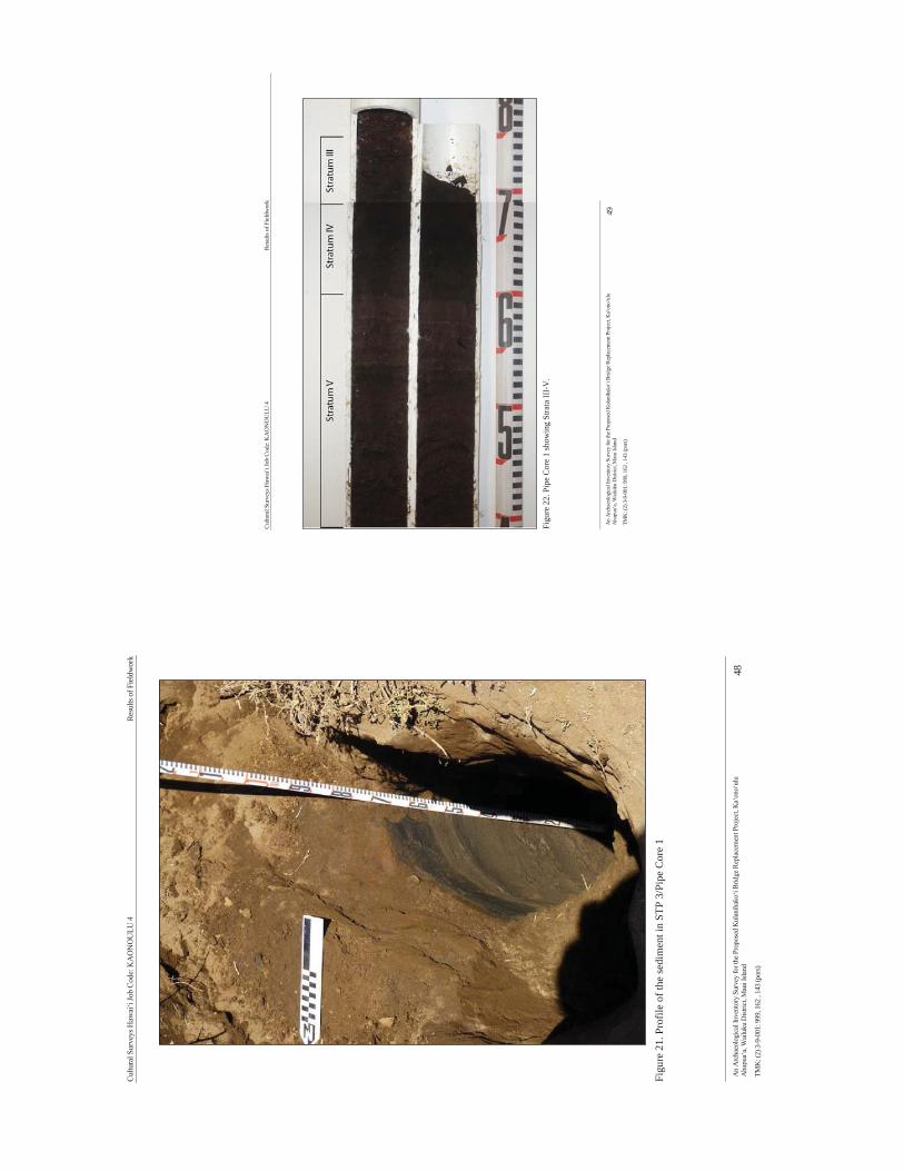
Cultu
ral S
urve
ys H
awai
‘i Jo
b Co
de: K
AO
NO
ULU
4
Re
sults
of F
ield
wor
k
An
Arc
haeo
logi
cal I
nven
tory
Sur
vey
for t
he P
ropo
sed
Kul
anih
ako‘
i Brid
ge R
epla
cem
ent P
roje
ct, K
a‘on
o‘ul
u A
hupu
a‘a,
Wai
luku
Dist
rict,
Mau
i Isla
nd
48
TMK
: (2)
3-9
-001
: 999
, 162
, 14
3 (p
ors)
Fi
gure
21.
Pro
file
of th
e se
dim
ent i
n ST
P 3/
Pipe
Cor
e 1
Cultu
ral S
urve
ys H
awai
‘i Jo
b Co
de: K
AO
NO
ULU
4
Re
sults
of F
ield
wor
k
An
Arc
haeo
logi
cal I
nven
tory
Sur
vey
for t
he P
ropo
sed
Kul
anih
ako‘
i Brid
ge R
epla
cem
ent P
roje
ct, K
a‘on
o‘ul
u A
hupu
a‘a,
Wai
luku
Dist
rict,
Mau
i Isla
nd
49
TMK
: (2)
3-9
-001
: 999
, 162
, 14
3 (p
ors)
Fi
gure
22.
Pip
e C
ore
1 sh
owin
g St
rata
III-
V.

Cultu
ral S
urve
ys H
awai
‘i Jo
b Co
de: K
AO
NO
ULU
4
Re
sults
of F
ield
wor
k
An
Arc
haeo
logi
cal I
nven
tory
Sur
vey
for t
he P
ropo
sed
Kul
anih
ako‘
i Brid
ge R
epla
cem
ent P
roje
ct, K
a‘on
o‘ul
u A
hupu
a‘a,
Wai
luku
Dist
rict,
Mau
i Isla
nd
50
TMK
: (2)
3-9
-001
: 999
, 162
, 14
3 (p
ors)
Fi
gure
23.
Pip
e C
ore
1 sh
owin
g St
rata
V-V
II.
Cultu
ral S
urve
ys H
awai
‘i Jo
b Co
de: K
AO
NO
ULU
4
Re
sults
of F
ield
wor
k
An
Arc
haeo
logi
cal I
nven
tory
Sur
vey
for t
he P
ropo
sed
Kul
anih
ako‘
i Brid
ge R
epla
cem
ent P
roje
ct, K
a‘on
o‘ul
u A
hupu
a‘a,
Wai
luku
Dist
rict,
Mau
i Isla
nd
51
TMK
: (2)
3-9
-001
: 999
, 162
, 14
3 (p
ors)
Fi
gure
24.
Pip
e C
ore
2 be
ing
extra
cted
from
the
stre
ambe
d, v
iew
to th
e w
est.
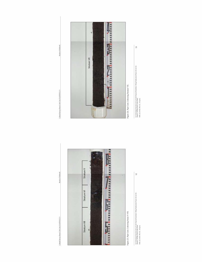
Cultu
ral S
urve
ys H
awai
‘i Jo
b Co
de: K
AO
NO
ULU
4
Re
sults
of F
ield
wor
k
An
Arc
haeo
logi
cal I
nven
tory
Sur
vey
for t
he P
ropo
sed
Kul
anih
ako‘
i Brid
ge R
epla
cem
ent P
roje
ct, K
a‘on
o‘ul
u A
hupu
a‘a,
Wai
luku
Dist
rict,
Mau
i Isla
nd
52
TMK
: (2)
3-9
-001
: 999
, 162
, 14
3 (p
ors)
Fi
gure
25.
Pip
e C
ore
2 sh
owin
g St
rata
V-V
II.
Cultu
ral S
urve
ys H
awai
‘i Jo
b Co
de: K
AO
NO
ULU
4
Re
sults
of F
ield
wor
k
An
Arc
haeo
logi
cal I
nven
tory
Sur
vey
for t
he P
ropo
sed
Kul
anih
ako‘
i Brid
ge R
epla
cem
ent P
roje
ct, K
a‘on
o‘ul
u A
hupu
a‘a,
Wai
luku
Dist
rict,
Mau
i Isla
nd
53
TMK
: (2)
3-9
-001
: 999
, 162
, 14
3 (p
ors)
Fi
gure
26.
Pip
e C
ore
2 sh
owin
g St
ratu
m V
II.
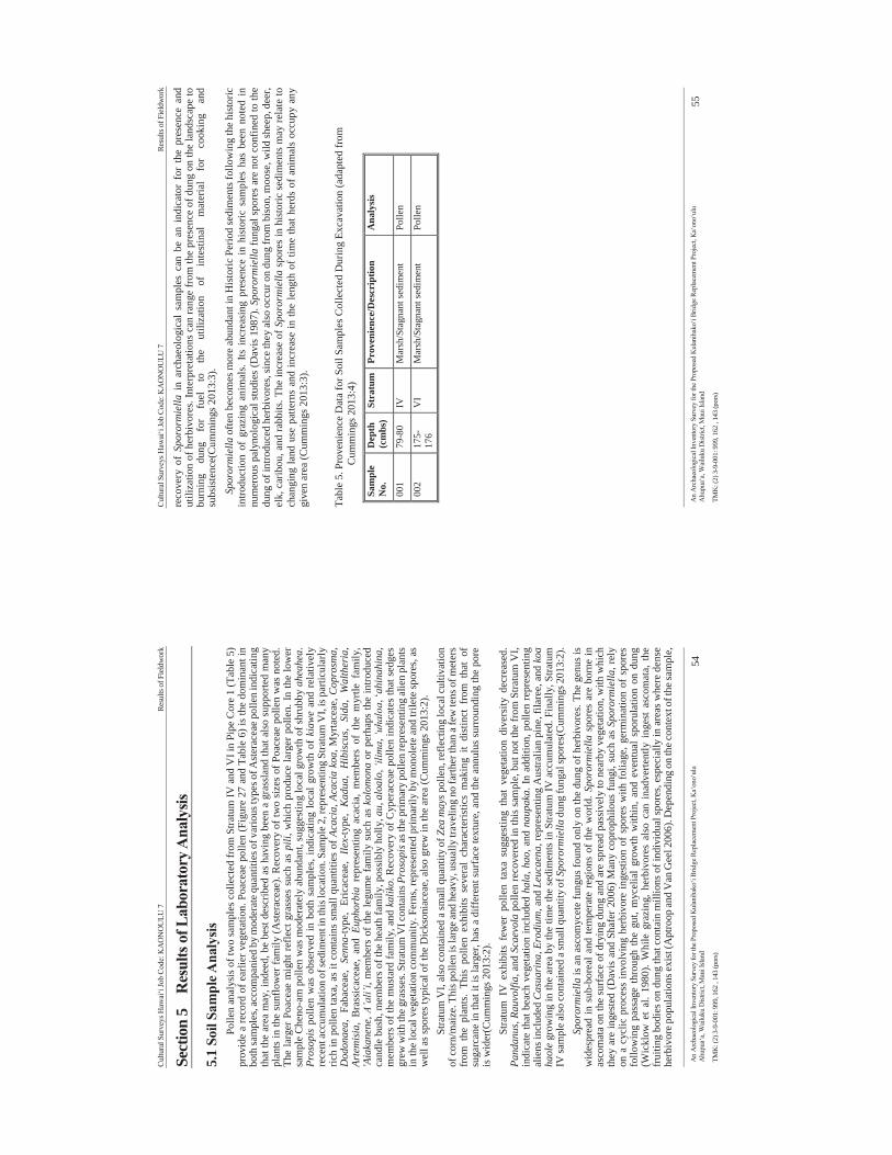
Cultu
ral S
urve
ys H
awai
‘i Jo
b Co
de: K
AO
NO
ULU
7
Re
sults
of F
ield
wor
k
An
Arc
haeo
logi
cal I
nven
tory
Sur
vey
for t
he P
ropo
sed
Kul
anih
ako‘
i Brid
ge R
epla
cem
ent P
roje
ct, K
a‘on
o‘ul
u A
hupu
a‘a,
Wai
luku
Dist
rict,
Mau
i Isla
nd
54
TMK
: (2)
3-9
-001
: 999
, 162
, 14
3 (p
ors)
Sect
ion
5 R
esul
ts o
f Lab
orat
ory A
naly
sis
5.1
Soil
Sam
ple A
naly
sis
Polle
n an
alys
is o
f tw
o sa
mpl
es c
olle
cted
from
Stra
tum
IV a
nd V
I in
Pipe
Cor
e 1
(Tab
le 5
) pr
ovid
e a
reco
rd o
f ear
lier v
eget
atio
n. P
oace
ae p
olle
n (F
igur
e 27
and
Tab
le 6
) is
the
dom
inan
t in
both
sam
ples
, acc
ompa
nied
by
mod
erat
e qua
ntiti
es o
f var
ious
type
s of A
ster
acea
e pol
len
indi
catin
g th
at th
e ar
ea m
ay, i
ndee
d, b
e be
st d
escr
ibed
as
havi
ng b
een
a gr
assl
and
that
als
o su
ppor
ted
man
y pl
ants
in th
e su
nflo
wer
fam
ily (A
ster
acea
e). R
ecov
ery
of tw
o si
zes
of P
oace
ae p
olle
n w
as n
oted
. Th
e la
rger
Poa
ceae
mig
ht re
flect
gra
sses
suc
h as
pili
, whi
ch p
rodu
ce la
rger
pol
len.
In th
e lo
wer
sa
mpl
e C
heno
-am
pol
len
was
mod
erat
ely
abun
dant
, sug
gest
ing
loca
l gro
wth
of s
hrub
by a
heah
ea.
Pros
opis
pol
len
was
obs
erve
d in
bot
h sa
mpl
es, i
ndic
atin
g lo
cal g
row
th o
f ki
awe
and
rela
tivel
y re
cent
accu
mul
atio
n of
sedi
men
t in
this
loca
tion.
Sam
ple 2
, rep
rese
ntin
g St
ratu
m V
I, is
par
ticul
arly
ric
h in
pol
len
taxa
, as
it co
ntai
ns s
mal
l qua
ntiti
es o
f Aca
cia,
Aca
cia
koa,
Myr
tace
ae, C
opro
sma,
D
odon
aea,
Fab
acea
e, S
enna
-type
, Er
icac
eae,
Ile
x-ty
pe,
Kad
ua,
Hib
iscu
s, Si
da,
Wal
ther
ia,
Arte
mis
ia,
Bra
ssic
acea
e, a
nd E
upho
rbia
rep
rese
ntin
g ac
acia
, m
embe
rs o
f th
e m
yrtle
fam
ily,
'Aia
kane
ne, A
’ali’
i, m
embe
rs o
f the
legu
me
fam
ily s
uch
as k
olom
ona
or p
erha
ps th
e in
trodu
ced
cand
le b
ush,
mem
bers
of t
he h
eath
fam
ily, p
ossi
bly
holly
, au,
alo
alo,
‘ilim
a, ‘u
halo
a, ‘a
hina
hina
, m
embe
rs o
f the
mus
tard
fam
ily, a
nd k
alik
o. R
ecov
ery
of C
yper
acea
e po
llen
indi
cate
s tha
t sed
ges
grew
with
the g
rass
es. S
tratu
m V
I con
tain
s Pro
sopi
s as t
he p
rimar
y po
llen
repr
esen
ting
alie
n pl
ants
in
the
loca
l veg
etat
ion
com
mun
ity. F
erns
, rep
rese
nted
prim
arily
by
mon
olet
e an
d tri
lete
spor
es, a
s w
ell a
s spo
res t
ypic
al o
f the
Dic
kson
iace
ae, a
lso
grew
in th
e ar
ea (C
umm
ings
201
3:2)
. St
ratu
m V
I, al
so c
onta
ined
a sm
all q
uant
ity o
f Zea
may
s pol
len,
refle
ctin
g lo
cal c
ultiv
atio
n of
corn
/mai
ze. T
his p
olle
n is
larg
e and
hea
vy, u
sual
ly tr
avel
ing
no fa
rther
than
a fe
w te
ns o
f met
ers
from
the
pla
nts.
This
pol
len
exhi
bits
sev
eral
cha
ract
eris
tics
mak
ing
it di
stin
ct f
rom
tha
t of
su
garc
ane
in th
at it
is la
rger
, has
a d
iffer
ent s
urfa
ce te
xtur
e, a
nd th
e an
nulu
s sur
roun
ding
the
pore
is
wid
er(C
umm
ings
201
3:2)
. St
ratu
m I
V e
xhib
its f
ewer
pol
len
taxa
sug
gest
ing
that
veg
etat
ion
dive
rsity
dec
reas
ed.
Pand
anus
, Rau
volfi
a, a
nd S
caev
ola
polle
n re
cove
red
in th
is sa
mpl
e, b
ut n
ot th
e fr
om S
tratu
m V
I, in
dica
te th
at b
each
veg
etat
ion
incl
uded
hal
a, h
ao, a
nd n
aupa
ka. I
n ad
ditio
n, p
olle
n re
pres
entin
g al
iens
incl
uded
Cas
uari
na, E
rodi
um, a
nd L
euca
ena,
repr
esen
ting
Aus
tralia
n pi
ne, f
ilare
e, a
nd k
oa
haol
e gr
owin
g in
the
area
by
the
time
the
sedi
men
ts in
Stra
tum
IV a
ccum
ulat
ed. F
inal
ly, S
tratu
m
IV sa
mpl
e als
o co
ntai
ned
a sm
all q
uant
ity o
f Spo
rorm
iella
dun
g fu
ngal
spor
es(C
umm
ings
201
3:2)
. Sp
oror
mie
lla is
an
asco
myc
ete
fung
us fo
und
only
on
the
dung
of h
erbi
vore
s. T
he g
enus
is
wid
espr
ead
in s
ub-b
orea
l and
tem
pera
te r
egio
ns o
f th
e w
orld
. Spo
rorm
iella
spo
res
are
born
e in
as
com
ata
on th
e su
rfac
e of
dry
ing
dung
and
are
spre
ad p
assi
vely
to n
earb
y ve
geta
tion,
with
whi
ch
they
are
inge
sted
(Dav
is a
nd S
hafe
r 200
6) M
any
copr
ophi
lous
fung
i, su
ch a
s Sp
oror
mie
lla, r
ely
on a
cyc
lic p
roce
ss in
volv
ing
herb
ivor
e in
gest
ion
of s
pore
s w
ith f
olia
ge, g
erm
inat
ion
of s
pore
s fo
llow
ing
pass
age
thro
ugh
the
gut,
myc
elia
l gr
owth
with
in, a
nd e
vent
ual
spor
ulat
ion
on d
ung
(Wic
klow
et
al.
1980
). W
hile
gra
zing
, he
rbiv
ores
als
o ca
n in
adve
rtent
ly i
nges
t as
com
ata,
the
fr
uitin
g bo
dies
on
dung
that
con
tain
mill
ions
of i
ndiv
idua
l spo
res,
espe
cial
ly in
are
as w
here
den
se
herb
ivor
e pop
ulat
ions
exis
t (A
ptro
op an
d V
an G
eel 2
006)
. Dep
endi
ng o
n th
e con
text
of t
he sa
mpl
e,
Cultu
ral S
urve
ys H
awai
‘i Jo
b Co
de: K
AO
NO
ULU
7
Re
sults
of F
ield
wor
k
An
Arc
haeo
logi
cal I
nven
tory
Sur
vey
for t
he P
ropo
sed
Kul
anih
ako‘
i Brid
ge R
epla
cem
ent P
roje
ct, K
a‘on
o‘ul
u A
hupu
a‘a,
Wai
luku
Dist
rict,
Mau
i Isla
nd
55
TMK
: (2)
3-9
-001
: 999
, 162
, 14
3 (p
ors)
reco
very
of
Spor
orm
iella
in
arch
aeol
ogic
al s
ampl
es c
an b
e an
ind
icat
or f
or t
he p
rese
nce
and
utili
zatio
n of
her
bivo
res.
Inte
rpre
tatio
ns c
an ra
nge
from
the
pres
ence
of d
ung
on th
e la
ndsc
ape
to
burn
ing
dung
fo
r fu
el
to
the
utili
zatio
n of
in
test
inal
m
ater
ial
for
cook
ing
and
subs
iste
nce(
Cum
min
gs 2
013:
3).
Spor
orm
iella
ofte
n be
com
es m
ore
abun
dant
in H
isto
ric P
erio
d se
dim
ents
follo
win
g th
e hi
stor
ic
intro
duct
ion
of g
razi
ng a
nim
als.
Its i
ncre
asin
g pr
esen
ce i
n hi
stor
ic s
ampl
es h
as b
een
note
d in
nu
mer
ous
paly
nolo
gica
l stu
dies
(Dav
is 1
987)
. Spo
rorm
iella
fung
al s
pore
s ar
e no
t con
fined
to th
e du
ng o
f int
rodu
ced
herb
ivor
es, s
ince
they
als
o oc
cur o
n du
ng fr
om b
ison
, moo
se, w
ild sh
eep,
dee
r, el
k, c
arib
ou, a
nd ra
bbits
. The
incr
ease
of S
poro
rmie
lla s
pore
s in
his
toric
sed
imen
ts m
ay re
late
to
chan
ging
land
use
pat
tern
s an
d in
crea
se in
the
leng
th o
f tim
e th
at h
erds
of
anim
als
occu
py a
ny
give
n ar
ea (C
umm
ings
201
3:3)
.
Tabl
e 5.
Pro
veni
ence
Dat
a fo
r Soi
l Sam
ples
Col
lect
ed D
urin
g Ex
cava
tion
(ada
pted
from
C
umm
ings
201
3:4)
Sam
ple
No.
D
epth
(c
mbs
) St
ratu
m
Prov
enie
nce/
Des
crip
tion
Ana
lysis
001
79-8
0 IV
M
arsh
/Sta
gnan
t sed
imen
t Po
llen
002
175-
176
VI
Mar
sh/S
tagn
ant s
edim
ent
Polle
n
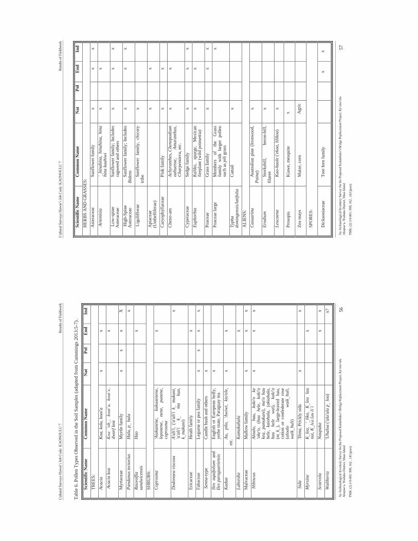
Cultu
ral S
urve
ys H
awai
‘i Jo
b Co
de: K
AO
NO
ULU
7
Re
sults
of F
ield
wor
k
An
Arc
haeo
logi
cal I
nven
tory
Sur
vey
for t
he P
ropo
sed
Kul
anih
ako‘
i Brid
ge R
epla
cem
ent P
roje
ct, K
a‘on
o‘ul
u A
hupu
a‘a,
Wai
luku
Dist
rict,
Mau
i Isla
nd
56
TMK
: (2)
3-9
-001
: 999
, 162
, 14
3 (p
ors)
Tabl
e 6.
Pol
len
Type
s Obs
erve
d in
the
Soil
Sam
ples
(ada
pted
from
Cum
min
gs 2
013:
5-7)
.
Scie
ntifi
c N
ame
Com
mon
Nam
e N
at
Pol
End
Ind
TREE
S:
Acac
ia
Koa
, kol
u, k
oai'a
x
x
A
caci
a ko
a K
oa ‘
oh,
koai
’a,
koai
’e,
dwar
f koa
x
Myr
tace
ae
Myr
tle fa
mily
x
x x
X
Pand
anus
tect
oriu
s H
ala,
p h
ala
x
Rauv
olfia
sa
ndw
icen
sis
Hao
x
SHR
UB
S:
Cop
rosm
a 'A
iaka
nene
, ku
kuae
nene
, le
pone
ne,
nene
, pu
nene
, co
pros
ma
x
Dod
onae
a vi
scos
a A'
ali'i
, ('a
'ali'
i k
mak
ani,
'a'a
li'i
k
ma
kua,
k
mak
ani)
x
Eric
acea
e H
eath
fam
ily
x
Faba
ceae
Le
gum
e or
pea
fam
ily
x x
x x
Sen
na-ty
pe
Can
dle
bush
and
oth
ers
x
Ilex
aqui
foliu
m a
nd
Ilex
para
guar
iens
is
Engl
ish
or E
urop
ean
holly
, ye
rbe
mat
e, P
arag
uay
tea
x
Kad
ua
Au,
pilo
, 'A
wiw
i, ki
o'el
e,
etc.
x
x
Labo
rdia
K
amak
ahal
a
x
M
alva
ceae
M
allo
w fa
mily
x
x
x
Hib
iscus
Al
oalo
, ha
u,
koki
'o
ke
'oke
'o,
(hau
he
le,
koki
'o
kea,
pam
akan
i), m
a'o
hau
hele
, ka
ioha
la,
(aki
ahal
a,
hau
hele
w
ai),
koki
'o
(mk
), la
rge-
leav
ed
hau,
co
tton
or c
onfe
dera
te r
ose
(alo
alo
wai
khu
li,
wai
khu
li)
x
x x
Sid
a 'Il
ima,
Pric
kly
sida
x
x M
yrsi
ne
Kle
a,
‘lik
o,
Kle
a la
u nu
i, K
lea
lau
li’i
x
Scae
vola
N
aupa
ka
x x
Wal
ther
ia
'Uha
loa
('ala
'ala
p lo
a)
x?
Cultu
ral S
urve
ys H
awai
‘i Jo
b Co
de: K
AO
NO
ULU
7
Re
sults
of F
ield
wor
k
An
Arc
haeo
logi
cal I
nven
tory
Sur
vey
for t
he P
ropo
sed
Kul
anih
ako‘
i Brid
ge R
epla
cem
ent P
roje
ct, K
a‘on
o‘ul
u A
hupu
a‘a,
Wai
luku
Dist
rict,
Mau
i Isla
nd
57
TMK
: (2)
3-9
-001
: 999
, 162
, 14
3 (p
ors)
Scie
ntifi
c N
ame
Com
mon
Nam
e N
at
Pol
End
Ind
HER
BS
AN
D G
RA
SSES
: A
ster
acea
e Su
nflo
wer
fam
ily
x
x x
Art
emis
ia
‘hi
nahi
na,
hina
hina
, hi
na
hina
kua
hiwi
x
x
Low
-spi
ne
Ast
erac
eae
Sunf
low
er fa
mily
; Inc
lude
s ra
gwee
d an
d ot
hers
x
x
x
Hig
h-Sp
ine
Ast
erac
eae
Sunf
low
er fa
mily
; Inc
lude
s Bi
dens
x
x
x
Lig
ulifl
orae
Su
nflo
wer
fam
ily,
chic
ory
tribe
x
Api
acea
e (U
mbe
llife
rae)
x
x
Car
yoph
ylla
ceae
Pi
nk fa
mily
x
x
Che
no-a
m
Achy
rant
hes,
Che
nopo
dium
oa
huen
se,
Amar
anth
us,
Cha
rpen
tiera
, etc
.
x
x
Cyp
erac
eae
Sedg
e fa
mily
x
x
x Eu
phor
bia
Kal
iko,
sp
urge
, M
exic
an
firep
lant
(wild
poi
nset
tia)
x
x
Poac
eae
Gra
ss fa
mily
x
x
x
Poac
eae
larg
e M
embe
rs
of
the
Gra
ss
fam
ily w
ith l
arge
r po
llen
such
as p
ili g
rass
x
Typh
a do
min
gens
is/la
tifol
ia
Cat
tail
x
ALI
ENS:
C
asua
rina
A
ustra
lian
pine
(Iro
nwoo
d,
Pain
a )
x
Erod
ium
St
orks
bill,
he
ron-
bill,
fil
aree
x
Leuc
aena
K
ao-h
aole
('ek
oa, l
iliko
a)
x
Pros
opis
K
iaw
e, m
esqu
ite
x
Zea
may
s M
aize
, cor
n A
gric
SPO
RES
:
Dic
kson
iace
ae
Tree
fern
fam
ily
x x
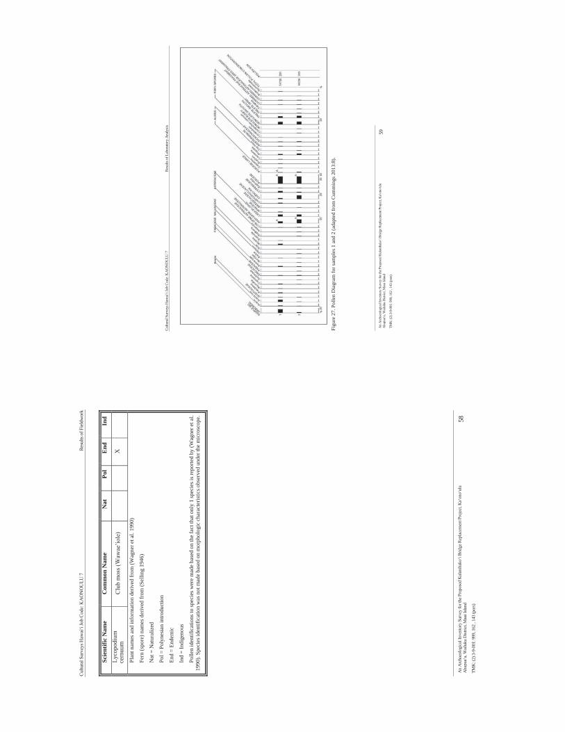
Cultu
ral S
urve
ys H
awai
‘i Jo
b Co
de: K
AO
NO
ULU
7
Re
sults
of F
ield
wor
k
An
Arc
haeo
logi
cal I
nven
tory
Sur
vey
for t
he P
ropo
sed
Kul
anih
ako‘
i Brid
ge R
epla
cem
ent P
roje
ct, K
a‘on
o‘ul
u A
hupu
a‘a,
Wai
luku
Dist
rict,
Mau
i Isla
nd
58
TMK
: (2)
3-9
-001
: 999
, 162
, 14
3 (p
ors)
Scie
ntifi
c N
ame
Com
mon
Nam
e N
at
Pol
End
Ind
Lyco
podi
um
cern
uum
C
lub
mos
s (W
awae
’iole
)
X
Plan
t nam
es a
nd in
form
atio
n de
rived
from
(Wag
ner e
t al.
1990
)
Fern
(spo
re) n
ames
der
ived
from
(Sel
ling
1946
)
Nat
= N
atur
aliz
ed
Pol =
Pol
ynes
ian
intro
duct
ion
End
= En
dem
ic
Ind
= In
dige
nous
Polle
n id
entif
icat
ions
to sp
ecie
s wer
e m
ade
base
d on
the
fact
that
onl
y 1
spec
ies i
s rep
orte
d by
(Wag
ner e
t al.
1990
). Sp
ecie
s ide
ntifi
catio
n w
as n
ot m
ade
base
d on
mor
phol
ogic
cha
ract
eris
tics o
bser
ved
unde
r the
mic
rosc
ope.
Cultu
ral S
urve
ys H
awai
‘i Jo
b Co
de: K
AO
NO
ULU
7
Re
sults
of L
abor
ator
y A
naly
sis
An
Arc
haeo
logi
cal I
nven
tory
Sur
vey
for t
he P
ropo
sed
Kul
anih
ako‘
i Brid
ge R
epla
cem
ent P
roje
ct, K
a‘on
o‘ul
u A
hupu
a‘a,
Wai
luku
Dist
rict,
Mau
i Isla
nd
59
TMK
: (2)
3-9
-001
: 999
, 162
, 14
3 (p
ors)
Fi
gure
27.
Pol
len
Dia
gram
for s
ampl
es 1
and
2 (a
dapt
ed fr
om C
umm
ings
201
3:8)
.
Cultu
ral S
urve
ys H
awai
‘i Jo
b Co
de: K
AO
NO
ULU
7
Su
mm
ary
and
Inte
rpre
tatio
n
An
Arc
haeo
logi
cal I
nven
tory
Sur
vey
for t
he P
ropo
sed
Kul
anih
ako‘
i Brid
ge R
epla
cem
ent P
roje
ct, K
a‘on
o‘ul
u A
hupu
a‘a,
Wai
luku
Dist
rict,
Mau
i Isla
nd
60
TMK
: (2)
3-9
-001
: 999
, 162
, 14
3 (p
ors)
Sect
ion
6 S
umm
ary
and
Inte
rpre
tatio
n B
etw
een
May
9
and
10,
2013
C
ultu
ral
Surv
eys
Haw
ai‘i,
In
c.
(CSH
) co
mpl
eted
an
A
rcha
eolo
gica
l In
vent
ory
Surv
ey (
AIS
) fo
r th
e pr
opos
ed K
ūlan
ihāk
o‘i
Brid
ge R
epla
cem
ent
Proj
ect.
The
field
wor
k, a
ccom
plis
hed
by H
alle
tt H
. Ham
mat
t, Ph
.D.,
Todd
D. M
cCur
dy, M
.A.,
and
Jona
s Mad
eus,
B.A
., to
ok 3
per
son-
days
to c
ompl
ete.
The
initi
al f
ield
insp
ectio
n (M
edei
ros
et a
l. 20
12)
iden
tifie
d on
e hi
stor
ic p
rope
rty w
ithin
the
curr
ent p
roje
ct ar
ea, K
ūlan
ihāk
o‘i B
ridge
(SIH
P 50
-50-
10-7
606)
. As p
er th
e fie
ld v
isit
with
SH
PD,
the
prim
ary
focu
s of t
he A
IS w
as to
add
ress
con
cern
s of s
ub-s
urfa
ce fi
shpo
nd d
epos
its in
the
APE
th
roug
h su
b-su
rfac
e te
stin
g/co
ring.
The
cur
rent
inve
stig
atio
n co
nsis
ted
of s
hove
l tes
ting
and
pipe
co
ring.
Whi
le n
o ne
w h
isto
ric p
rope
rties
wer
e di
scov
ered
dur
ing
the
curr
ent i
nves
tigat
ion,
two
sedi
men
t sam
ples
wer
e su
bmitt
ed fo
r pol
len
anal
ysis
.
6.1
Sum
mar
y of
Hist
oric
Pro
pert
ies a
nd S
ub-S
urfa
ce In
vest
igat
ions
W
ithin
the
Cur
rent
Pro
ject
Are
a 6.
1.1
SIH
P 50
-50-
10-7
606
SIH
P -7
606
(Kūl
anihāk
o‘i B
ridge
) w
as c
onst
ruct
ed in
191
1 an
d co
nsis
ted
of f
our i
ndiv
idua
l re
info
rced
con
cret
e bo
x cu
lver
ts.
Each
cul
vert
cell
mea
sure
d 1.
8 m
(6
ft) w
ide
by 1
.2 m
(4 ft
) hi
gh b
y 11
.6 m
(38
ft) lo
ng. T
he to
tal s
pan
of th
e fo
ur c
ulve
rts is
8.5
m (2
7 ft.
9 in
). Th
e pa
ving
su
rfac
e ov
er th
e ex
istin
g cu
lver
t was
app
lied
in th
e 19
30’s
. Thi
s in
clud
ed so
me
shor
ing-
up o
f the
ed
ge o
f the
road
way
usi
ng a
his
toric
con
stru
ctio
n st
yle
attri
bute
d to
pre
-194
0’s p
lant
atio
n m
ason
s.
6.1.
2 Su
b-Su
rfac
e Inv
estig
atio
ns
Due
to th
e de
pth
of th
e fil
l and
inab
ility
to e
xtra
ct a
n ad
equa
te s
ampl
e th
e co
ring/
sub-
surf
ace
test
ing
was
res
trict
ed t
o ne
ar t
he s
tream
bed.
Non
ethe
less
, th
e in
vest
igat
ion
yiel
ded
two
soil
sam
ples
fro
m S
trata
IV
and
V, b
oth
of w
hich
wer
e su
bmitt
ed to
the
Pale
oRes
earc
h In
stitu
te in
G
olde
n, C
olor
ado
for
polle
n an
alys
is. T
he r
esul
ting
repo
rt (C
umm
ings
201
3) in
dica
ted
that
the
sedi
men
ts in
Lay
ers V
I and
IV a
ccum
ulat
ed d
urin
g th
e hi
stor
ic e
ra. A
lthou
gh P
roso
pis p
olle
n w
as
obse
rved
in b
oth
sam
ples
, pol
len
repr
esen
ting
othe
r alie
n pl
ants
incl
udin
g A
ustra
lian
pine
, fila
ree,
an
d ko
a ha
ole
was
pre
sent
onl
y in
the
Stra
tum
IV. T
he p
olle
n re
cord
is o
ne o
f veg
etat
ion
typi
cal
in d
ry a
reas
and
may
bes
t des
crib
ed a
s mix
ed g
rass
land
. The
pre
senc
e of S
poro
rmie
lla d
ung
fung
al
spor
es i
n St
ratu
m I
V r
efle
cts
use
of s
ome
of t
he l
and
on t
he l
eew
ard
slop
es o
f H
alea
kalā
for
gr
azin
g.
The
Stra
tum
VI s
ampl
e co
ntai
ned
Zea
may
s pol
len,
whi
ch is
evi
denc
e in
this
cor
e of
the
grow
th
of c
orn
in th
e K
ula
area
of M
aui.
A H
awai
ian
Isla
nds m
ap fr
om 1
903
of M
aui d
epic
ts a
reas
acr
oss
the
leew
ard
slop
e of
Hal
eaka
la d
eem
ed g
ood
agric
ultu
ral
land
for
gro
win
g co
rn a
nd p
otat
oes
(Fig
ure
28).
Due
nsin
g (2
008:
160)
repo
rts th
at c
orn
was
gro
wn
in th
e H
awai
ian
Isla
nds a
s ear
ly a
s 18
26 f
or p
erso
nal c
onsu
mpt
ion,
alth
ough
it w
as c
lose
r to
the
mid
dle
of th
e N
inet
eent
h C
entu
ry
befo
re i
t be
cam
e a
viab
le c
omm
erci
al c
rop.
The
Mis
sion
ary
Her
ald
(Ric
hard
s et
al.
1829
) do
cum
ente
d it
bein
g av
aila
ble
on M
aui a
s ear
ly a
s 182
8:
Tour
Aro
und
Mau
i
Cultu
ral S
urve
ys H
awai
‘i Jo
b Co
de: K
AO
NO
ULU
7
Su
mm
ary
and
Inte
rpre
tatio
n
An
Arc
haeo
logi
cal I
nven
tory
Sur
vey
for t
he P
ropo
sed
Kul
anih
ako‘
i Brid
ge R
epla
cem
ent P
roje
ct, K
a‘on
o‘ul
u A
hupu
a‘a,
Wai
luku
Dist
rict,
Mau
i Isla
nd
61
TMK
: (2)
3-9
-001
: 999
, 162
, 14
3 (p
ors)
[An
expe
ditio
n by
Will
iam
Ric
hard
s, Lo
rrin
And
rew
s an
d Jo
nath
an
Gre
en]
Com
men
cem
ent o
f the
Tou
r
“Mon
day,
Aug
ust 1
8 [1
828]
, we
left
Laha
ina
with
the
desi
gn o
f mak
ing
the
tour
of M
aui.
The
exam
inat
ion
of th
e sc
hool
s in
the
seve
ral d
istri
cts o
f th
e Is
land
s w
as o
ur p
rimar
y ob
ject
. We
wis
hed
to se
e al
so th
e le
ngth
and
br
eadt
h of
the
land
. To
asce
nd it
s lof
ty m
ount
ains
, cro
ss it
s fru
itful
pla
ins,
desc
end
into
its
valli
es [
sic]
, to
lear
n th
e st
ate
of th
e pe
ople
; and
, as
we
had
oppo
rtun
ity, t
o af
ford
them
inst
ruct
ion.
We
set o
ut in
a d
oubl
e ca
noe,
ro
wed
by
twel
ve a
ble
bodi
ed m
en, a
nd s
oon
lost
sig
ht o
f La
hain
a. W
e st
eere
d N
.E.,
keep
ing
the
shor
es o
f Mau
i on
our r
ight
.
Her
e w
e ta
rrie
d ov
er n
ight
, in
tend
ing
in t
he m
orni
ng,
to a
scen
d th
e m
ount
ain
[Hal
eaka
la],
near
whi
ch w
e w
ere,
and
slee
p on
the
high
est l
and
on M
aui.
We w
ere t
old
by th
e nat
ives
, tha
t the
way
was
long
, but
the a
scen
t ve
ry e
asy.
We
supp
ose
no E
nglis
h tra
velle
rs (s
ic) h
ad e
ver
asce
nded
this
mou
ntai
n. (p
p 24
7)
Asce
nt o
f an
Extin
guis
hed
Volc
ano
Augu
st 2
1. W
e ro
se e
arly
, and
pre
pare
d fo
r ou
r asc
ent.
Hav
ing
proc
ured
a
guid
e, w
e se
t out
; tak
ing
only
a sc
anty
supp
ly o
f pro
visi
ons.
Hal
f way
up
the m
ount
ain,
we f
ound
ple
nty o
f goo
d w
ater
, and
at a
conv
enie
nt fo
unta
in,
we
fille
d ou
r cal
abas
h fo
r tea
. By
the
side
s of o
ur p
ath,
we
foun
d pl
enty
of
ohel
os,
(a j
uicy
ber
ry,
very
pal
atab
le),
and,
occ
asio
nally
, a
clus
ter
of
stra
wbe
rrie
s. O
n th
e lo
wer
part
of
the
mou
ntai
n, t
here
is c
onsi
dera
ble
timbe
r; b
ut a
s we
proc
eede
d, it
bec
ame
scar
ce, a
nd, a
s we
appr
oach
ed th
e su
mm
it, a
lmos
t the
onl
y th
ing,
of t
he v
eget
able
kin
d, w
hich
we
saw
, was
a
plan
t tha
t gre
w to
the
heig
ht o
f six
or
eigh
t fee
t, an
d pr
oduc
ed a
mos
t be
autif
ul fl
ower
[silv
ersw
ord]
. It s
eem
s to
be p
ecul
iar t
o th
is m
ount
ain,
as
our g
uide
and
serv
ants
mad
e or
nam
ents
of it
for t
heir
hat
s, to
dem
onstr
ate
to th
ose
belo
w, t
hat t
hey
had
been
to th
e to
p of
the
mou
ntai
n. (p
p 24
8)
It w
as n
earl
y 5 o
’clo
ck, w
hen
we r
each
ed th
e sum
mit;
but
we f
elt o
urse
lves
ri
chly
rep
aid
for
the
toil
of th
e da
y, b
y th
e gr
ande
ur a
nd b
eaut
y of
the
scen
e, w
hich
at
once
ope
ned
to o
ur v
iew
. The
day
was
ver
y fin
e. T
he
clou
ds, w
hich
hun
g ov
er th
e m
ount
ains
on
Wes
t Mau
i, an
d w
hich
wer
e sc
atte
red
prom
iscu
ously
, bet
wee
n us
and
the
sea,
wer
e fa
r be
low
us;
so
that
we
saw
the
uppe
r si
de (i
talic
s th
eirs
) of t
hem
, whi
le th
e re
flect
ion
of
the
sun
pain
ting
thei
r ve
rge
with
var
ied
tints
, m
ade
them
app
ear
like
ench
antm
ent.
We g
azed
on
them
with
adm
irat
ion,
and
long
ed fo
r the
pen
cil
of R
apha
el,
to g
ive
perp
etui
ty t
o a
pros
pect
, w
hich
aw
aken
ed i
n ou
r bo
som
s un
utte
rabl
e em
otio
ns. O
n th
e ot
her
side
, we
behe
ld th
e se
at o
f Pe
le’s
dre
adfu
l rei
gn. W
e st
ood
on th
e ed
ge o
f a tr
emen
dous
cra
ter,
dow
n w
hich
, a s
ingl
e m
isst
ep w
ould
hav
e pr
ecip
itate
d us
1,0
00 o
r 1,
500
feet
. Th
is w
as o
nce
fille
d wi
th l
iqui
d fir
e, a
nd i
n it,
we
coun
ted
sixt
een
extin
guis
hed
crat
ers.
To c
ompl
ete
the
gran
deur
of t
he s
cene
, Mou
na K
ea
and
Mou
na R
oa li
fted
thei
r lof
ty su
mm
its, a
nd c
onvi
nced
us,
that
, tho
ugh
far a
bove
the
clou
ds, w
e we
re fa
r bel
ow th
e fe
et o
f the
trav
elle
r (si
c) w
ho
asce
nds t
he m
ount
ains
of H
awai
i. By
this
time,
the
sun
had
near
ly su
nk in
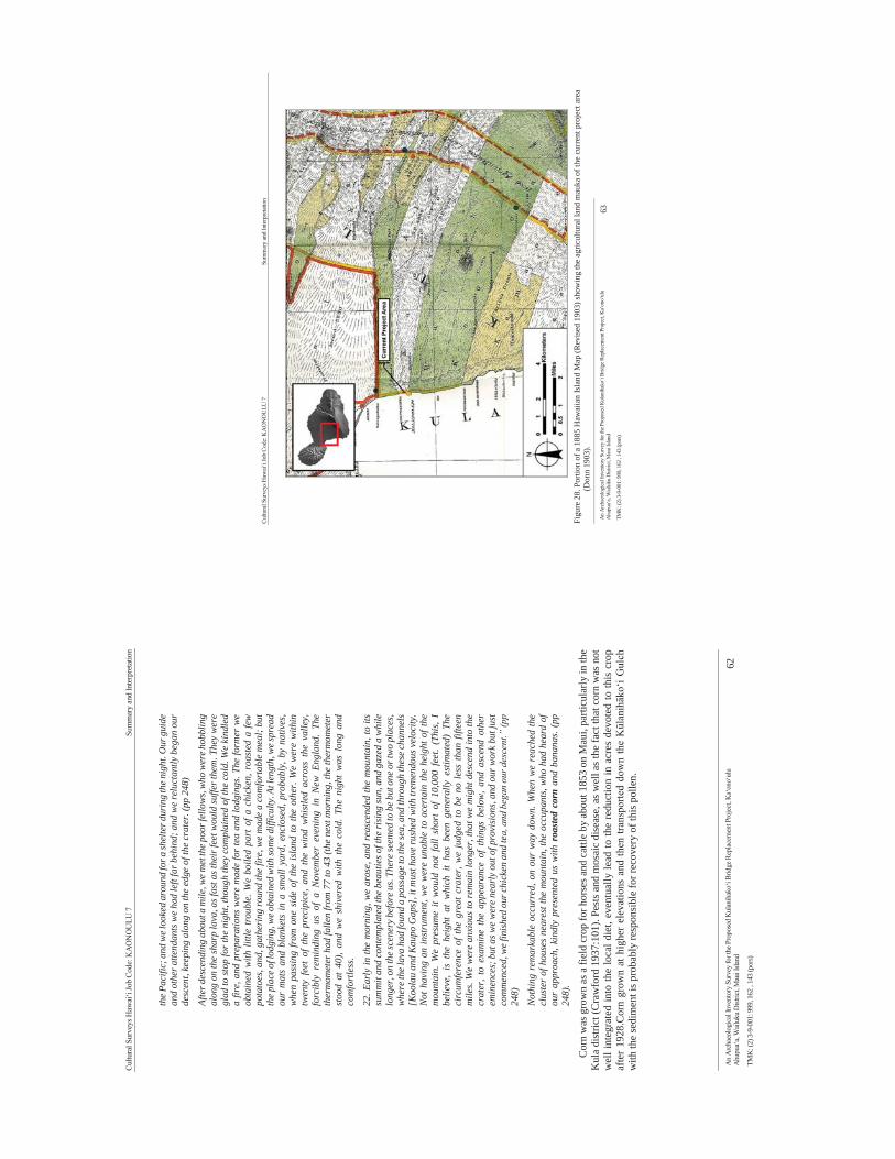
Cultu
ral S
urve
ys H
awai
‘i Jo
b Co
de: K
AO
NO
ULU
7
Su
mm
ary
and
Inte
rpre
tatio
n
An
Arc
haeo
logi
cal I
nven
tory
Sur
vey
for t
he P
ropo
sed
Kul
anih
ako‘
i Brid
ge R
epla
cem
ent P
roje
ct, K
a‘on
o‘ul
u A
hupu
a‘a,
Wai
luku
Dist
rict,
Mau
i Isla
nd
62
TMK
: (2)
3-9
-001
: 999
, 162
, 14
3 (p
ors)
the P
acifi
c; a
nd w
e loo
ked
arou
nd fo
r a sh
elte
r dur
ing
the n
ight
. Our
gui
de
and
othe
r atte
ndan
ts w
e ha
d le
ft fa
r beh
ind;
and
we
relu
ctan
tly b
egan
our
de
scen
t, ke
epin
g al
ong
on th
e ed
ge o
f the
cra
ter.
(pp
248)
Afte
r des
cend
ing
abou
t a m
ile, w
e met
the p
oor f
ello
ws,
who
wer
e hob
blin
g al
ong
on th
e sh
arp
lava
, as f
ast a
s the
ir fe
et w
ould
suffe
r the
m. T
hey
wer
e gl
ad to
stop
for t
he n
ight
, tho
ugh
they
com
plai
ned
of th
e co
ld. W
e ki
ndle
d a
fire,
and
pre
para
tions
wer
e m
ade
for
tea
and
lodg
ings
. The
form
er w
e ob
tain
ed w
ith li
ttle
troub
le. W
e bo
iled
part
of a
chi
cken
, roa
sted
a fe
w po
tato
es, a
nd, g
athe
ring
roun
d th
e fir
e, w
e m
ade
a co
mfo
rtab
le m
eal;
but
the p
lace
of l
odgi
ng, w
e obt
aine
d w
ith so
me d
iffic
ulty
. At l
engt
h, w
e spr
ead
our
mat
s an
d bl
anke
ts in
a s
mal
l yar
d, e
nclo
sed,
pro
babl
y, b
y na
tives
, w
hen
pass
ing
from
one
sid
e of
the
isla
nd to
the
othe
r. W
e w
ere
with
in
twen
ty f
eet
of t
he p
reci
pice
, an
d th
e w
ind
whi
stled
acr
oss
the
valle
y,
forc
ibly
rem
indi
ng u
s of
a N
ovem
ber
even
ing
in N
ew E
ngla
nd.
The
ther
mom
eter
had
falle
n fro
m 7
7 to
43
(the
next
mor
ning
, the
ther
mom
eter
st
ood
at 4
0),
and
we
shiv
ered
with
the
col
d. T
he n
ight
was
lon
g an
d co
mfo
rtle
ss.
22. E
arly
in th
e m
orni
ng, w
e ar
ose,
and
rea
scen
ded
the
mou
ntai
n, to
its
sum
mit
and
cont
empl
ated
the
beau
ties o
f the
risi
ng su
n, a
nd g
azed
a w
hile
lo
nger
, on
the s
cene
ry b
efor
e us.
Ther
e see
med
to b
e but
one
or t
wo
plac
es,
whe
re th
e lav
a ha
d fo
und
a pa
ssag
e to
the s
ea, a
nd th
roug
h th
ese c
hann
els
[Koo
lau
and
Kau
po G
aps]
, it m
ust h
ave
rush
ed w
ith tr
emen
dous
vel
ocity
. N
ot h
avin
g an
inst
rum
ent,
we
wer
e un
able
to a
certa
in th
e he
ight
of t
he
mou
ntai
n. W
e pr
esum
e it
wou
ld n
ot f
all
shor
t of
10,
000
feet
. (T
his,
I be
lieve
, is
the
hei
ght
at w
hich
it
has
been
gen
eral
ly e
stim
ated
) Th
e ci
rcum
fere
nce
of th
e gr
eat
crat
er, w
e ju
dged
to b
e no
les
s th
an fi
fteen
m
iles.
We
wer
e an
xiou
s to
rem
ain
long
er, t
hat w
e m
ight
des
cend
into
the
crat
er,
to e
xam
ine
the
appe
aran
ce o
f th
ings
bel
ow,
and
asce
nd o
ther
em
inen
ces;
but
as w
e w
ere
near
ly o
ut o
f pro
visi
ons,
and
our w
ork
but j
ust
com
men
ced,
we f
inis
hed
our c
hick
en a
nd te
a, a
nd b
egan
our
des
cent
.” (p
p 24
8)
Not
hing
rem
arka
ble
occu
rred
, on
our
way
dow
n. W
hen
we
reac
hed
the
clus
ter
of h
ouse
s ne
ares
t the
mou
ntai
n, th
e oc
cupa
nts,
who
had
hea
rd o
f ou
r ap
proa
ch, k
indl
y pr
esen
ted
us w
ith r
oaste
d co
rn a
nd b
anan
as. (
pp
248)
.
Cor
n w
as g
row
n as
a fi
eld
crop
for h
orse
s and
cat
tle b
y ab
out 1
853
on M
aui,
parti
cula
rly in
the
Kul
a di
stric
t (C
raw
ford
193
7:10
1). P
ests
and
mos
aic
dise
ase,
as w
ell a
s th
e fa
ct th
at c
orn
was
not
w
ell i
nteg
rate
d in
to th
e lo
cal d
iet,
even
tual
ly le
ad to
the
redu
ctio
n in
acr
es d
evot
ed to
this
cro
p af
ter
1928
.Cor
n gr
own
at h
ighe
r el
evat
ions
and
then
tran
spor
ted
dow
n th
e Kūl
anihāk
o‘i G
ulch
w
ith th
e se
dim
ent i
s pro
babl
y re
spon
sibl
e fo
r rec
over
y of
this
pol
len.
Cultu
ral S
urve
ys H
awai
‘i Jo
b Co
de: K
AO
NO
ULU
7
Su
mm
ary
and
Inte
rpre
tatio
n
An
Arc
haeo
logi
cal I
nven
tory
Sur
vey
for t
he P
ropo
sed
Kul
anih
ako‘
i Brid
ge R
epla
cem
ent P
roje
ct, K
a‘on
o‘ul
u A
hupu
a‘a,
Wai
luku
Dist
rict,
Mau
i Isla
nd
63
TMK
: (2)
3-9
-001
: 999
, 162
, 14
3 (p
ors)
Fi
gure
28.
Por
tion
of a
188
5 H
awai
ian
Isla
nd M
ap (R
evis
ed 1
903)
show
ing
the
agric
ultu
ral l
and
mau
ka o
f the
cur
rent
pro
ject
are
a (D
onn
1903
).

Cultu
ral S
urve
ys H
awai
‘i Jo
b Co
de: K
AO
NO
ULU
7
Su
mm
ary
and
Inte
rpre
tatio
n
An
Arc
haeo
logi
cal I
nven
tory
Sur
vey
for t
he P
ropo
sed
Kul
anih
ako‘
i Brid
ge R
epla
cem
ent P
roje
ct, K
a‘on
o‘ul
u A
hupu
a‘a,
Wai
luku
Dist
rict,
Mau
i Isla
nd
64
TMK
: (2)
3-9
-001
: 999
, 162
, 14
3 (p
ors)
At t
he c
oncl
usio
n of
the
sub-
surf
ace
inve
stig
atio
n w
e w
ere
able
to e
stab
lish
that
at l
east
the
first
3
m (1
0 ft)
of s
edim
ent c
an b
e at
tribu
ted
to h
isto
ric a
lluvi
um fr
om Kūl
anihāk
o‘i G
ulch
. No
pond
se
dim
ents
wer
e ob
serv
ed to
this
dep
th. T
he s
tratig
raph
y ob
serv
ed w
as g
ener
ally
con
sist
ent w
ith
the
info
rmat
ion
colle
cted
by
GEO
LAB
S In
c.,(K
woc
k 20
12) f
rom
Bor
e H
oles
3, 4
, 6 a
nd 7
that
are
w
ithin
the
curr
ent A
PE (F
igur
e 29
). Th
ey re
cord
ed a
dar
k gr
ay c
lay
silt
to a
dep
th o
f 10
ft ab
ove
a gr
ayis
h ta
n co
ralli
ne sa
nd. T
he b
oreh
oles
clo
sest
to o
ur su
bsur
face
test
ing
area
3 a
nd 4
(Fig
ure
30
to F
igur
e 33
). Th
e lo
gs fo
r Bor
e H
oles
6 a
nd 7
are
ava
ilabl
e in
App
endi
x C
. The
cor
allin
e sa
nd w
e ob
serv
ed a
t aro
und
10 f
t (3
m)
in S
tratu
m V
II co
inci
des
with
the
findi
ngs
of G
EOLA
BS,
Inc
(K
woc
k 20
12).
Cu
ltura
l Sur
veys
Haw
ai‘i
Job
Code
: KA
ON
OU
LU 7
Sum
mar
y an
d In
terp
reta
tion
An
Arc
haeo
logi
cal I
nven
tory
Sur
vey
for t
he P
ropo
sed
Kul
anih
ako‘
i Brid
ge R
epla
cem
ent P
roje
ct, K
a‘on
o‘ul
u A
hupu
a‘a,
Wai
luku
Dist
rict,
Mau
i Isla
nd
65
TMK
: (2)
3-9
-001
: 999
, 162
, 14
3 (p
ors)
Fi
gure
29.
Site
pla
n sh
owin
g th
e lo
catio
n of
STP
's an
d pi
pe c
ores
in re
latio
n to
the
borin
g an
d bu
lk sa
mpl
es ta
ken
by G
EOLA
BS
Inc.
(a
dapt
ed fr
om K
woc
k 30
13:3
5).

Cultu
ral S
urve
ys H
awai
‘i Jo
b Co
de: K
AO
NO
ULU
7
Su
mm
ary
and
Inte
rpre
tatio
n
An
Arc
haeo
logi
cal I
nven
tory
Sur
vey
for t
he P
ropo
sed
Kul
anih
ako‘
i Brid
ge R
epla
cem
ent P
roje
ct, K
a‘on
o‘ul
u A
hupu
a‘a,
Wai
luku
Dist
rict,
Mau
i Isla
nd
66
TMK
: (2)
3-9
-001
: 999
, 162
, 14
3 (p
ors)
Fi
gure
30.
Log
of B
orin
g 3
(Kw
ock
3013
:45)
.
Cultu
ral S
urve
ys H
awai
‘i Jo
b Co
de: K
AO
NO
ULU
7
Su
mm
ary
and
Inte
rpre
tatio
n
An
Arc
haeo
logi
cal I
nven
tory
Sur
vey
for t
he P
ropo
sed
Kul
anih
ako‘
i Brid
ge R
epla
cem
ent P
roje
ct, K
a‘on
o‘ul
u A
hupu
a‘a,
Wai
luku
Dist
rict,
Mau
i Isla
nd
67
TMK
: (2)
3-9
-001
: 999
, 162
, 14
3 (p
ors)
Fi
gure
31.
Log
of B
orin
g 3
(Kw
ock
3013
:46)
.
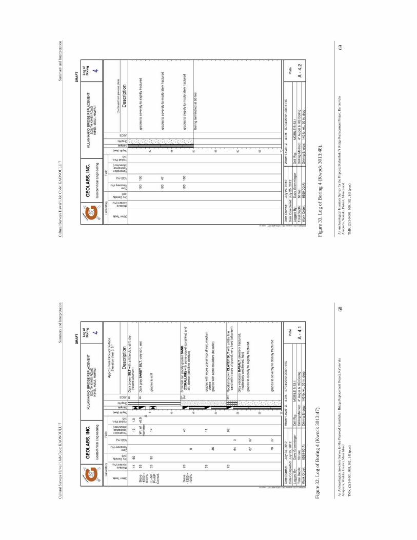
Cultu
ral S
urve
ys H
awai
‘i Jo
b Co
de: K
AO
NO
ULU
7
Su
mm
ary
and
Inte
rpre
tatio
n
An
Arc
haeo
logi
cal I
nven
tory
Sur
vey
for t
he P
ropo
sed
Kul
anih
ako‘
i Brid
ge R
epla
cem
ent P
roje
ct, K
a‘on
o‘ul
u A
hupu
a‘a,
Wai
luku
Dist
rict,
Mau
i Isla
nd
68
TMK
: (2)
3-9
-001
: 999
, 162
, 14
3 (p
ors)
Figu
re 3
2. L
og o
f Bor
ing
4 (K
woc
k 30
13:4
7).
Cultu
ral S
urve
ys H
awai
‘i Jo
b Co
de: K
AO
NO
ULU
7
Su
mm
ary
and
Inte
rpre
tatio
n
An
Arc
haeo
logi
cal I
nven
tory
Sur
vey
for t
he P
ropo
sed
Kul
anih
ako‘
i Brid
ge R
epla
cem
ent P
roje
ct, K
a‘on
o‘ul
u A
hupu
a‘a,
Wai
luku
Dist
rict,
Mau
i Isla
nd
69
TMK
: (2)
3-9
-001
: 999
, 162
, 14
3 (p
ors)
Fi
gure
33.
Log
of B
orin
g 4
(Kw
ock
3013
:48)
.

Cultu
ral S
urve
ys H
awai
‘i Jo
b Co
de: K
AO
NO
ULU
7
Si
gnifi
canc
e Ass
essm
ents
And
Rec
omm
enda
tions
An
Arc
haeo
logi
cal I
nven
tory
Sur
vey
for t
he P
ropo
sed
Kul
anih
ako‘
i Brid
ge R
epla
cem
ent P
roje
ct, K
a‘on
o‘ul
u A
hupu
a‘a,
Wai
luku
Dist
rict,
Mau
i Isla
nd
70
TMK
: (2)
3-9
-001
: 999
, 162
, 14
3 (p
ors)
Sect
ion
7 S
igni
fican
ce A
sses
smen
ts
Sign
ifica
nce
asse
ssm
ents
hav
e be
en m
ade
in a
ccor
danc
e w
ith th
e St
ate
Dep
artm
ent o
f Lan
d an
d N
atur
al R
esou
rces
(DLN
R) C
hapt
er 1
3-28
4, H
awai
‘i A
dmin
istra
tive
Rul
es (H
AR
), en
title
d “R
ules
Gov
erni
ng P
roce
dure
s for
His
toric
Pre
serv
atio
n R
evie
w to
Com
men
t on
Sect
ion
6E-4
2,
Haw
ai‘i
Rev
ised
Sta
tute
s (H
RS)
, Pro
ject
s”; C
hapt
er 1
3-28
4-6
entit
led
“Eva
luat
ion
of
Sign
ifica
nce”
, sta
tes:
a.
Onc
e a
hist
oric
pro
perty
is id
entif
ied,
then
an
asse
ssm
ent o
f sig
nific
ance
sha
ll oc
cur.
The
agen
cy s
hall
mak
e th
is in
itial
ass
essm
ent,
or d
eleg
ate
this
ass
essm
ent,
in w
ritin
g, to
the
SHPD
. Thi
s inf
orm
atio
n sh
all b
e su
bmitt
ed c
oncu
rren
tly w
ith th
e su
rvey
repo
rt, if
his
toric
pr
oper
ties a
re fo
und
in th
e su
rvey
.
b.
To b
e si
gnifi
cant
, a h
isto
ric p
rope
rty s
hall
poss
ess
inte
grity
of
loca
tion,
des
ign,
set
ting,
m
ater
ials
, w
orkm
ansh
ip,
feel
ing,
and
ass
ocia
tion
and
shal
l m
eet
one
or m
ore
of t
he
follo
win
g cr
iteria
:
A. S
ites
that
are
ass
ocia
ted
with
eve
nts
that
hav
e m
ade
a si
gnifi
cant
co
ntri
butio
n to
bro
ad p
atte
rns o
f our
his
tory
; or
B. S
ites t
hat a
re a
ssoc
iate
d w
ith th
e liv
es o
f per
sons
sign
ifica
nt in
our
pas
t; or
C
. Si
tes t
hat e
mbo
dy th
e dis
tinct
ive c
hara
cter
istic
s of a
type
, per
iod,
or m
etho
d of
con
stru
ctio
n, o
r th
at r
epre
sent
s th
e w
ork
of a
mas
ter,
or th
at p
osse
sses
hi
gh a
rtis
tic v
alue
s, or
tha
t re
pres
ents
a s
igni
fican
t or
dis
tingu
isha
ble
entit
y, w
hose
com
pone
nts m
ay la
ck in
divi
dual
dis
tinct
ion;
or
D.
Site
s w
hich
hav
e yi
elde
d, o
r m
ay b
e lik
ely
to y
ield
, inf
orm
atio
n im
port
ant
in p
rehi
stor
y or
his
tory
; or
E. S
ites
whi
ch h
ave
an im
port
ant v
alue
to th
e na
tive
Haw
aiia
n pe
ople
or
to
anot
her e
thni
c gro
up o
f the
Sta
te d
ue to
ass
ocia
tions
with
cultu
ral p
ract
ices
on
ce c
arri
ed o
ut, o
r stil
l car
ried
out
, at t
he p
rope
rty
or d
ue to
ass
ocia
tions
w
ith tr
aditi
onal
bel
iefs
, eve
nts,
or o
ral a
ccou
nts-
thes
e as
soci
atio
ns b
eing
im
port
ant t
o th
e gr
oups
’ his
tory
and
cul
tura
l ide
ntity
.
7.1
SIH
P 50
-50-
10-7
606
7.1.
1 C
rite
rion
of S
igni
fican
ce D
Th
is h
isto
ric b
ridge
has
yie
lded
inf
orm
atio
n im
porta
nt t
o th
e un
ders
tand
ing
of t
he f
irst
gene
ratio
n of
con
cret
e br
idge
s in
the
Haw
aiia
n Is
land
s. Fo
r thi
s rea
sons
SIH
P -7
606
is c
onsi
dere
d si
gnifi
cant
und
er C
riter
ion
D. S
uffic
ient
info
rmat
ion
conc
erni
ng S
IHP-
7606
was
col
lect
ed d
urin
g th
is in
vest
igat
ion.
Bas
ed o
n th
e ab
ove
sign
ifica
nce
eval
uatio
n of
50-
50-1
0-76
06, C
ultu
ral S
urve
ys H
awai
‘i, In
c.
is re
com
men
ding
no
furth
er w
ork.
Cultu
ral S
urve
ys H
awai
‘i Jo
b Co
de: K
AO
NO
ULU
7
Pr
ojec
t Effe
ct an
d M
itiga
tion
Reco
mm
enda
tions
An
Arc
haeo
logi
cal I
nven
tory
Sur
vey
for t
he P
ropo
sed
Kul
anih
ako‘
i Brid
ge R
epla
cem
ent P
roje
ct, K
a‘on
o‘ul
u A
hupu
a‘a,
Wai
luku
Dist
rict,
Mau
i Isla
nd
71
TMK
: (2)
3-9
-001
: 999
, 162
, 14
3 (p
ors)
Sect
ion
8 P
roje
ct E
ffect
and
Miti
gatio
n R
ecom
men
datio
ns
An
arch
itect
ural
rev
iew
of
SIH
P 50
-50-
10-7
606
was
con
duct
ed in
Dec
embe
r of
201
2 by
the
Arc
hite
ctur
al B
ranc
h of
SH
PD (L
OG
: 201
2.37
34 D
OC
: 121
2RS6
4) b
ased
on
the
initi
al L
itera
ture
R
evie
w a
nd F
ield
Ins
pect
ion
(Med
eiro
s et
al.
2012
). It
was
con
clud
ed th
at a
lthou
gh th
e br
idge
do
es r
epre
sent
the
firs
t ge
nera
tion
if co
ncre
te b
ridge
s in
Haw
ai‘i,
it
has
sinc
e lo
st a
ny
dist
ingu
ishi
ng a
rchi
tect
ural
cha
ract
eris
tics.
A d
eter
min
atio
n of
no
effe
ct o
n hi
stor
ic p
rope
rty w
as
reco
mm
ende
d(A
ppen
dix
B).
8.1
Miti
gatio
n R
ecom
men
datio
ns
Whi
le s
ub-s
urfa
ce te
stin
g w
as n
ot c
ompl
eted
by
CSH
ben
eath
S. K
ihei
road
, bor
ing
logs
from
th
e G
eote
chni
cal
repo
rt co
mpl
eted
by
Geo
labs
Inc
. (K
woc
k 20
12),
reco
rded
the
pre
senc
e of
co
ralli
ne s
and
arou
nd 3
.7 m
(12
ft)
belo
w th
e su
rfac
e of
the
road
. The
pre
senc
e of
this
type
of
sedi
men
t dep
osit
may
pre
sent
the
pote
ntia
l for
enc
ount
erin
g se
nsiti
ve c
ultu
ral r
esou
rces
in a
sub
-su
rfac
e co
ntex
t. In
add
ition
the
subs
urfa
ce te
stin
g fo
r tra
ditio
nal f
ishp
ond
depo
sits
was
lim
ited
to
3m (1
0 ft)
bel
ow th
e gr
ound
sur
face
. The
refo
re, a
ny s
ub-s
urfa
ce e
xcav
atio
n ex
ceed
ing
3 m
(10)
fe
et o
r co
ntai
ning
cor
allin
e sa
nd a
nd t
he c
ulve
rt re
mov
al s
houl
d be
mon
itore
d by
a q
ualif
ied
arch
aeol
ogis
t.
8.2
Disp
ositi
on o
f Mat
eria
l A
ll of
the d
ata g
athe
red
and
gene
rate
d du
ring
the c
ours
e of t
his i
nves
tigat
ion
are c
urre
ntly
bei
ng
cura
ted
and
hous
ed a
t th
e M
aui
Off
ice
of C
ultu
ral
Surv
eys
Haw
ai‘i
Inc.
(18
60 M
ain
Stre
et,
Wai
luku
, HI 9
6793
), w
ith c
opie
s on
file
at th
e m
ain
offic
e of
Cul
tura
l Sur
veys
Haw
ai‘i,
Inc.
(41-
1537
Kal
ania
naol
e H
WY
# 2
00, W
aim
anal
o, H
I 967
95-1
185)
.
Cultu
ral S
urve
ys H
awai
‘i Jo
b Co
de: K
AO
NO
ULU
7
Re
fere
nces
Cite
d
An
Arc
haeo
logi
cal I
nven
tory
Sur
vey
for t
he P
ropo
sed
Kul
anih
ako‘
i Brid
ge R
epla
cem
ent P
roje
ct, K
a‘on
o‘ul
u A
hupu
a‘a,
Wai
luku
Dist
rict,
Mau
i Isla
nd
72
TMK
: (2)
3-9
-001
: 999
, 162
, 14
3 (p
ors)
Sect
ion
9 R
efer
ence
s Cite
d A
ptro
op, A
ndre
and
Bas
Van
Gee
l
2006
Fu
ngi o
f the
Col
on o
f th
e Y
ukag
ir M
amm
oth
and
from
Stra
tigra
phic
ally
Rel
ated
Pe
rmaf
rost
Sam
ples
. Rev
iew
of P
alae
obot
any
and
Paly
nolo
gy (1
41):2
25-2
30.
Bor
dner
, Ric
hard
and
Dav
id W
. Cox
1982
B
iolo
gica
l and
Arc
haeo
logi
cal R
econ
nais
sanc
e, T
MK
2-2
-02:
Por
tion
of 4
2, Kīh
ei,
Mau
i, H
awai
i. En
viro
nmen
t Im
pact
Stu
dy C
orpo
ratio
n, M
aui a
nd H
onol
ulu,
HI.
Bor
thw
ick,
Dou
glas
F.,
Tod
d Tu
lchi
n an
d H
alle
t H. H
amm
att
20
02
Arch
aeol
ogic
al I
nven
tory
Sur
vey
for
the
Prop
osed
Alig
nmen
t of t
he N
orth
-Sou
th
Col
lect
or R
oad
(Ka‘
ono‘
ulu
Stre
et t
o W
aipu
‘ilan
i Ro
ad),
Wai
ohul
i Ah
upua
‘a (
Kīh
ei),
Dis
tric
t of
Mak
awao
, Is
land
of
Mau
i (T
MK
3-9
-01)
. Pr
epar
ed f
or M
&E
Paci
fic,
Inc.
C
ultu
ral S
urve
ys H
awai
‘i, In
c., K
ailu
a, H
I. B
urge
tt, B
erde
na, L
isa H
umph
rey
and
Rob
ert L
. Spe
ar
19
98
An A
rcha
eolo
gica
l Inv
ento
ry S
urve
y of
Lot
s A &
B o
f the
Mau
i Lu
Reso
rt in
Kih
ei,
Ka‘
ono‘
ulu
Ahup
ua‘a
, Wai
luku
Dis
tric
t, M
aui,
Haw
aii.
Prep
ared
for M
aui L
u H
otel
Cor
p.,
Kih
ei, H
I. Sc
ient
ific
Con
sulta
nt S
ervi
ces,
Inc.
, Hon
olul
u, H
I. C
onde
, Jes
se C
. and
Ger
ald
M. B
est
19
73
Suga
r Tr
ains
Nar
row
Gau
ge R
ails
of
Haw
aii.
Gle
nwoo
d Pu
blis
hers
, Fe
lton,
C
alifo
rnia
. C
ordy
, Ros
s H.
19
77
Kih
ei F
lood
Con
trol
Pro
ject
: Arc
heol
ogic
al R
econ
nais
sanc
e &
Lite
ratu
re S
earc
h.
Hon
olul
u.
Cox
, Dav
id W
.
1976
Th
e Arc
haeo
logy
of K
ula,
Mau
i fro
m Pūl
ehu
Nui
Ahu
pua‘
a to
Kam
a‘ol
e Ahu
pua‘
a:
Surf
ace
Surv
ey,
Pi‘il
ani
Hig
hway
. Pr
epar
ed
for
Stat
e of
H
awai
i D
epar
tnm
ent
of
Tran
spor
tatio
n H
ighw
ays
Div
isio
n an
d U
.S.
Dep
artm
ent
of T
rans
porta
tion
Fede
ral
Hig
hway
s A
dmin
istra
tion,
Hon
olul
u, H
I, Pr
ojec
t N
o. F
-031
-1(4
) C
ontra
ct N
o. 5
966.
A
rcha
eolo
gica
l Res
earc
h C
ente
r Haw
aii,
Inc,
Law
a‘i,
HI.
Cra
wfo
rd, D
avid
Liv
ings
ton
19
37
Haw
aiis
Cro
p Pa
rade
. Adv
ertis
er P
ublis
hing
Co.
, Ltd
., H
onol
ulu,
HI.
Cum
min
gs, L
inda
Sco
tt
20
13
Polle
n An
alys
is o
f Sam
ples
from
Aug
er 1
of t
he K
aono
ulu
7 Pr
ojec
t, M
aui.
Doc
. N
o. 1
3-05
5. P
aleo
Res
earc
h In
stitu
te, G
olde
n, C
olor
ado.
D
avis
, Ow
en K
.
Cultu
ral S
urve
ys H
awai
‘i Jo
b Co
de: K
AO
NO
ULU
7
Re
fere
nces
Cite
d
An
Arc
haeo
logi
cal I
nven
tory
Sur
vey
for t
he P
ropo
sed
Kul
anih
ako‘
i Brid
ge R
epla
cem
ent P
roje
ct, K
a‘on
o‘ul
u A
hupu
a‘a,
Wai
luku
Dist
rict,
Mau
i Isla
nd
73
TMK
: (2)
3-9
-001
: 999
, 162
, 14
3 (p
ors)
19
87
Spor
es o
f th
e D
ung
Fung
us S
poro
rmei
lla:In
crea
sed
in A
bund
ance
in
His
toric
Se
dim
ents
and
Bef
ore
Plei
stoc
ene
Meg
afau
nal E
xtin
ctio
n. Q
uate
rnar
y Re
sear
ch (2
8):2
90-
294.
D
avis
, Ow
en K
. and
Dav
id S
. Sh
afer
2006
Sp
oror
mie
lla F
unga
l Sp
ores
, a
Paly
nolo
gica
l M
eans
of
Det
ectin
g H
erbi
vore
D
ensi
ty. P
alae
ogeo
grap
hy, P
alae
oclim
atol
ogy,
Pal
aeoe
colo
gy (2
37):4
0-50
. D
ean,
Art
hur
L.
19
50
Alex
ande
r &
Bal
dwin
, Lt
d. a
nd t
he P
rede
cess
or P
artn
ersh
ips.
Ale
xand
er &
B
aldw
in L
td. a
nd A
dver
tiser
Pub
lishi
ng C
ompa
ny, H
onol
ulu.
D
onha
m, T
here
sa K
.
1989
Ar
chae
olog
ical
Inve
ntor
y Su
rvey
Piil
ani R
esid
entia
l Com
mun
ity -
Phas
e I,
Land
of
Wai
ohul
i, M
akaw
ao D
istr
ict,
Isla
nd o
f Mau
i. Pa
ul H
. Ros
enda
hl, I
nc.,
Hilo
, HI.
19
96
Nat
iona
l Reg
iste
r of
Hist
oric
Pla
ces
regi
stra
tion
form
for
Kal
epol
epo
Fish
pond
. N
atio
nal P
arks
Ser
vice
, Was
hing
ton,
D.C
. D
onn,
Joh
n M
.
1903
M
aui,
Haw
aiia
n Is
land
s (Re
vise
d) [m
ap].
1:60
,000
. Sur
veye
d by
W. D
. Ale
xand
er,
C.
J. Ly
ons,
M.
D.
Mon
sarr
at,
F. S
. D
odge
, S.
E.
Bis
hop,
E.
D.
Bal
dwin
and
W.
R.
Law
renc
e. H
awai
ian
Gov
ernm
ent S
urve
y, O
n fil
e at
Lib
rary
of C
ongr
ess
Geo
grap
hy a
nd
Map
Div
isio
n W
ashi
ngto
n, D
.C. 2
0540
-465
0 U
SA.
Due
nsin
g, D
awn
E.
20
08
Haw
ai'i's
For
gotte
n C
rop:
Cor
n on
Mau
i, 18
51-1
951.
The
Haw
aiia
n Jo
urna
l of
H
isto
ry 4
2.
Foot
e, D
onal
d E
., E
. L. H
ill, S
. Nak
amur
a an
d F.
Ste
phen
s
1972
So
il su
rvey
of i
slan
ds o
f Kau
ai, O
ahu,
Mau
i, M
olok
ai, a
nd L
anai
, Sta
te o
f Haw
aii.
Uni
ted
Stat
es S
oil C
onse
rvat
ion
Serv
ice,
Was
hing
ton
DC
. Fo
rnan
der,
Abr
aham
1880
An
Acc
ount
of t
he P
olyn
esia
n Ra
ce, I
ts O
rigi
n an
d M
igra
tions
. Vol
. II.
Trub
ner &
C
o., L
udga
te H
ill, L
ondo
n, E
ngla
nd.
Fred
eric
ksen
, Dem
aris
L., W
alte
r M
. Fre
deri
ckse
n an
d E
rik
M. F
rede
rick
sen
19
93
An A
rcha
eolo
gica
l In
vent
ory
Surv
ey a
nd D
ata
Reco
very
Rep
ort
for
Loke
lani
In
term
edia
te S
choo
l, Lo
cate
d in
the
Ahup
ua‘a
of W
aioh
uli,
Mak
awao
(Wai
luku
) Dis
tric
t, Is
land
of M
aui (
TMK
: 2-2
-02:
por
43)
. Xam
anek
Res
earc
hes,
Puka
lani
, HI.
Fred
eric
ksen
, Eri
k M
. and
Dem
aris
L. F
rede
rick
sen
Cultu
ral S
urve
ys H
awai
‘i Jo
b Co
de: K
AO
NO
ULU
7
Re
fere
nces
Cite
d
An
Arc
haeo
logi
cal I
nven
tory
Sur
vey
for t
he P
ropo
sed
Kul
anih
ako‘
i Brid
ge R
epla
cem
ent P
roje
ct, K
a‘on
o‘ul
u A
hupu
a‘a,
Wai
luku
Dist
rict,
Mau
i Isla
nd
74
TMK
: (2)
3-9
-001
: 999
, 162
, 14
3 (p
ors)
19
95a
Dat
a Re
cove
ry R
epor
t for
Site
50-
50-1
0-35
29 in
the
Road
“C
” C
orri
dor,
Wai
ohul
i Ah
upua
‘a, M
akaw
ao a
nd W
ailu
ku d
istr
icts
, Mau
i Isl
and
(TM
K 2
-2-0
2: p
or. 6
6, 6
7; 3
-9-
02:1
09).
Xam
anek
Res
earc
hes,
Puka
lani
, HI.
19
95b
Inve
ntor
y Su
rvey
Rep
ort f
or R
oad
“C”
Cor
rido
r, W
aioh
uli A
hupu
a‘a,
Mak
awao
an
d W
ailu
ku d
istr
icts
, M
aui
Isla
nd (
TMK
2-2
-02:
por
. 66,
67;
3-9
-02:
109)
. X
aman
ek
Res
earc
hes,
Puka
lani
, HI.
Fred
eric
ksen
, Eri
k M
., W
alte
r M
. Fre
deri
ckse
n an
d D
emar
is L
. Fre
deri
ckse
n
1994
Ar
chae
olog
ical
In
vent
ory
Surv
ey
and
Bota
nica
l Su
rvey
Re
port
, K
a‘on
o‘ul
u Ah
upua
‘a, W
ailu
ku a
nd M
akaw
ao D
istr
icts
, Isl
and
of M
aui (
TMK
3-9
-01:
16 a
nd 2
-2-0
2:
Por.
15).
Xam
anek
Res
earc
hes,
Puka
lani
, HI.
Fris
by, E
.R
19
00
Haw
aiia
n Is
land
s, M
aala
ea B
ay,
Mau
i I.
Regi
ster
No.
246
2 [m
ap].
1:10
000.
Su
rvey
ed b
y E.
R. F
risby
. Tre
asur
y D
epar
tmen
t, U
.S. C
oast
and
Geo
dect
ic S
urve
y, O
n fil
e at
H
awai
i C
oast
al
Eros
ion
Web
site
ht
tp://
ww
w.so
est.h
awai
i.edu
/asp
/coa
sts/
mau
i/tsh
eet.a
sp.
Gia
mbe
lluca
, Tho
mas
W.,
Mic
hael
A. N
ulle
t and
Tho
mas
A. S
chro
eder
1986
Ra
infa
ll At
las o
f Haw
ai‘i.
Rep
ort:
Div
isio
n of
Wat
er a
nd L
and
Dev
elop
men
t R76
. D
epar
tmen
t of
Land
and
Nat
ural
Res
ourc
es, D
ivis
ion
of W
ater
and
Lan
d D
evel
opm
ent,
Hon
olul
u, H
I. G
oogl
e E
arth
2011
"N
orth
Kih
ei".
[A
eria
l Im
ager
y].
Flig
ht L
ine:
764
112.
04m
E 23
0023
8.60
mN
. Ph
oto:
3/2
3/20
11. G
oogl
e Ea
rth.
Ham
mat
t, H
alle
tt H
. and
Dav
id W
. Shi
dele
r
1999
Ar
chae
olog
ical
Ass
essm
ent
for
Sout
h K
ihei
Roa
d Im
prov
men
ts, L
ipoa
Str
eet
to
Kul
anih
ako'
i Str
eet,
Wai
ohul
i Ahu
pa'a
(Kih
ei) K
ula,
Mau
i. C
ultu
ral S
urve
ys H
awai
i, In
c.,
Kai
lua,
Oah
u.
Hill
, Rob
ert R
., T
anya
Lee
-Gre
ig a
nd H
alle
tt H
. ham
mat
t
2010
C
ompl
etio
n Re
port
fo
r Ar
chae
olog
ical
M
itiga
tion
Prog
ram
: D
une
Syst
em
Alte
ratio
ns a
nd S
and
Rem
oval
Alo
ng S
outh
Kih
ei R
oad:
Pul
ehu
Nui
, K
a'on
o'ul
u an
d W
aiak
oa A
hupu
a'a;
Wai
luku
and
Mak
awao
Dis
tric
ts; M
aui I
slan
d TM
K: (
2) 3
-9-0
01: 0
25
(por
.) an
d 3-
8-00
4: 0
07 (p
or.).
Cul
tura
l Sur
veys
Haw
aii,
Inc.
, Wai
luku
, Mau
i. H
ill, R
ober
t R.,
Tan
ya L
. Lee
-Gre
ig a
nd H
alle
t H. H
amm
att
20
05
Fiel
d In
spec
tion
and
Subs
urfa
ce T
estin
g of
a 1
-acr
e Pa
rcel
in
Kīh
ei,
Wai
ohul
i Ah
upua
‘a, M
akaw
ao D
istr
ict,
Mau
i Isl
and
[TM
K (2
) 3-9
-001
:151
]. P
repa
red
for J
osep
h K
ealo
ha, I
nc. C
ultu
ral S
urve
ys H
awai
‘i, In
c., W
ailu
ku, H
I. Im
ada,
Lee
.
Cultu
ral S
urve
ys H
awai
‘i Jo
b Co
de: K
AO
NO
ULU
7
Re
fere
nces
Cite
d
An
Arc
haeo
logi
cal I
nven
tory
Sur
vey
for t
he P
ropo
sed
Kul
anih
ako‘
i Brid
ge R
epla
cem
ent P
roje
ct, K
a‘on
o‘ul
u A
hupu
a‘a,
Wai
luku
Dist
rict,
Mau
i Isla
nd
75
TMK
: (2)
3-9
-001
: 999
, 162
, 14
3 (p
ors)
20
12 P
ublic
-priv
ate
partn
ersh
ip e
yed
for
Kih
ei h
igh
scho
ol. M
aui N
ews,
July
29,
201
2,
Wai
luku
, Haw
aii,
Ju
vik,
Son
ia P
and
Jam
es O
. Juv
ic (e
dito
rs)
19
98
Atla
s of H
awai
i. Th
ird e
d. U
nive
rsity
of H
awai
i Pre
ss, H
onol
ulu.
K
amak
au, S
amue
l Man
aiak
alan
i
1991
K
a Po
‘e K
ahik
o Th
e Pe
ople
of O
ld.,
edite
d by
D. B
. Bar
rère
. Tra
nsla
ted
by M
. K.
Puku
i. B
erni
ce P
. B
isho
p M
useu
m S
peci
al P
ublic
atio
n 51
. B
isho
p M
useu
m P
ress
, H
onol
ulu,
HI.
Kar
p, H
anna
h.
20
10 H
enry
Ric
e's A
hupu
a'a. W
all S
tree
t Jou
rnal
, Jan
uary
22,
201
0, N
ew Y
ork,
K
enne
dy, J
osep
h
1986
Ar
chae
olog
ical
Wal
k-Th
roug
h Ex
amin
atio
n of
TM
K 3
-9-0
1 Pa
rcel
s 14
4 an
d 14
5.
Prep
ared
for
Bus
ines
s In
vest
men
t, Lt
d. A
rcha
eolo
gica
l Con
sulta
nts
of H
awai
i, H
alei
wa,
H
I.
1988
a Ar
chae
olog
ical
Wal
k-Th
roug
h Re
conn
aiss
ance
Sur
vey
of P
ropo
sed
Dev
elop
men
t of
TM
K:
3-9-
1:11
Loc
ated
at
Kih
ei, I
slan
d of
Mau
i. Pr
epar
ed f
or W
ilson
Oka
mot
o &
A
ssoc
iate
s, H
onol
ulu,
HI.
Arc
haeo
logi
cal C
onsu
ltant
s of H
awai
i, H
alei
wa,
HI.
19
88b
Arch
aeol
ogic
al W
alk-
Thro
ugh
Surv
ey o
f th
e Pr
opos
ed K
a‘on
o‘ul
u Su
bdiv
isio
n,
(TM
K: 3
-9-0
1:15
, 148
& 1
49) L
ocat
ed a
t Kih
ei, M
aui,
Ahup
ua‘a
of K
a‘on
o‘ul
u Pr
epar
ed
for W
arre
n U
nem
ori,
Inc.
, Wai
luku
, HI.
Arc
haeo
logi
cal C
onsu
ltant
s of
Haw
aii,
Hal
eiw
a,
HI.
19
89
Arch
aeol
ogic
al S
ubsu
rfac
e Te
stin
g Re
sults
Con
cern
ing
the
Prop
osed
Kia
we
Terr
ace
Subd
ivis
ion
TMK
: 3-
9-1:
11,
Kih
ei,
Mau
i. Pr
epar
ed f
or W
ilson
Oka
mot
o &
A
ssoc
iate
s, H
onol
ulu,
HI.
Arc
haeo
logi
cal C
onsu
ltant
s of H
awai
i, H
alei
wa,
HI.
19
90a
Arch
aeol
ogic
al M
onito
ring
Rep
ort
Con
cern
ing
Phas
e I
& I
I of
the
Pro
pose
d K
aono
ulu
Esta
tes,
Lcoa
ted
at K
ihei
, M
aui,
TMK
3-9
-014
:15.
Pre
pare
d fo
r H
erbe
rt K
. H
orita
Rea
lty, I
nc.,
Hon
olul
u, H
I. A
rcha
eolo
gica
l Con
sulta
nts o
f Haw
aii,
Hal
eiw
a, H
I.
1990
b Ar
chae
olog
ical
Sur
vey
Repo
rt fo
r TM
K 3
-9-0
1:99
and
TM
K 3
-9-0
1:64
. Pre
pare
d fo
r Ja
mes
Sch
ular
& A
ssoc
iate
s, H
onol
ulu,
HI.
Arc
haeo
logi
cal
Con
sulta
nts
of H
awai
i, H
alei
wa,
HI.
19
91
Mr.
Mik
e Jo
nes S
chul
ar &
Ass
ocia
tes.
Inad
vert
ent D
isco
ver o
f Hum
an R
emai
ns a
t TM
K:
3-9-
01:6
4 an
d 99
, Lo
cate
d K
ihei
, M
aui.
Nov
embe
r 8,
199
1. A
rcha
eolo
gica
l C
onsu
ltant
s of H
awai
i. H
alei
wa,
HI.
K
ikuc
hi, W
illia
m K
.

Cultu
ral S
urve
ys H
awai
‘i Jo
b Co
de: K
AO
NO
ULU
7
Re
fere
nces
Cite
d
An
Arc
haeo
logi
cal I
nven
tory
Sur
vey
for t
he P
ropo
sed
Kul
anih
ako‘
i Brid
ge R
epla
cem
ent P
roje
ct, K
a‘on
o‘ul
u A
hupu
a‘a,
Wai
luku
Dist
rict,
Mau
i Isla
nd
76
TMK
: (2)
3-9
-001
: 999
, 162
, 14
3 (p
ors)
19
76
Preh
isto
ric H
awai
ian
Fish
pond
s. Sc
ienc
e 19
3.
Kol
b, M
icha
el J
., Pa
tty J
. Con
te a
nd R
oss C
ordy
1997
K
ula:
Th
e Ar
chae
olog
y of
U
pcou
ntry
M
aui
in
Wai
ohul
i an
d K
eoke
a,
An
Arch
aeol
ogic
al a
nd H
isto
rica
l Set
tlem
ent S
urve
y in
the
Kin
gdom
of M
aui.
Stat
e of
Haw
aii
Dep
artm
ent o
f Lan
d an
d N
atur
al R
esou
rces
Sta
te H
isto
ric P
rese
rvat
ion
Div
isio
n, H
onol
ulu.
K
orte
, Kar
l H.
19
61
A B
rief
His
tory
of
the
Fore
st R
eser
ves
of t
he I
slan
d of
Mau
i, St
ate
of H
awai
i. U
npub
lishe
d ty
pew
ritte
n m
anus
crip
t. D
ivis
ion
of F
ores
try,
Dep
artm
ent
of L
and
and
Nat
ural
Res
ourc
es, H
onol
ulu.
K
woc
k, T
eddy
s.
20
12
Geo
tech
nica
l En
gine
erin
g Ex
plor
atio
n K
ulan
ihak
oi B
ridg
e Re
plac
emen
t So
uth
Kih
ei R
oad
Kih
ei, M
aui,
Haw
aii (
DRA
FT) G
eola
bs, I
nc.,
Hon
olul
u, H
awai
i. M
alo,
Dav
id
19
51
Haw
aiia
n an
tiqui
ties
(Moo
lelo
Haw
aii).
2d
ed.
Tran
slat
ed b
y D
r. N
atha
niel
B.
Emer
son.
Ber
nice
Pau
ahi
Bis
hop
Mus
eum
, H
onol
ulu.
Spe
cial
pub
licat
ion.
Bis
hop
Mus
eum
, Hon
olul
u,.
McD
erm
ott,
Mat
t
2001
Th
e H
isto
rical
Eco
logy
of C
oast
al Kīh
ei, D
istri
ct o
f Kul
a, M
aui.
Mas
ter's
The
sis,
Dep
artm
ent o
f Ant
hrop
olog
y, U
nive
rsity
of H
awai
‘i, Mān
oa H
onol
ulu.
M
cDer
mot
t, M
att,
Dav
id S
hide
ler
and
Hal
let H
. Ham
mat
t
2000
Ad
ditio
nal A
rcha
eolo
gica
l Inv
ento
ry S
urve
y In
vest
igat
ions
for t
he 7
.4-A
cre
Parc
el
Prop
osed
for
the
Kia
we
Mau
ka P
arce
l D
evel
opm
ent
on K
ulan
ihak
oi R
oad,
Wai
ohul
i Ah
upua
`a, K
ihei
, Dis
tric
t of K
ula,
Mau
i (TM
K 3
-9-0
1:15
5). P
repa
red
for W
ilson
Oka
mot
o &
Ass
ocia
tes,
Hon
olul
u, H
I. C
ultu
ral S
urve
ys H
awai
‘i, In
c., K
ailu
a, H
I. M
edei
ros,
Col
leen
P.,
Rob
ert H
. Hill
and
Hal
latt
H. H
amm
att
20
12
An A
rcha
eolo
gica
l Lite
ratu
re R
evie
w a
nd F
ield
Insp
ectio
n fo
r Kul
anih
ako`
i Br
idge
Re
plac
emem
ent P
roje
ct, K
a`on
o'ul
u Ah
upua
`a, W
ailu
ku D
istr
ict,
Mau
i Isl
and
TMK
: (2)
3-
9-00
1:99
9, 0
15, 1
47, 1
62, (
pors
). Pr
epar
ed f
or W
ilson
Oka
mot
o C
orpo
ratio
n. C
ultu
ral
Surv
eys H
awai
`i, W
ailu
ku, H
I. N
elle
r, E
arl a
nd C
harl
es K
eau
19
81
Arch
aeol
ogic
al
Reco
nnai
ssan
ce
for
Kao
noul
u Be
ach
Lot.
Cou
nty
of
Mau
i D
epar
tmen
t of P
arks
and
Rec
reat
ion,
Wai
luku
, HI.
Nel
list,
Geo
rge
F.
19
25
The
Stor
y of
Haw
aii a
nd It
s Bui
lder
s. H
onol
ulu
Star
Bul
letin
Hon
olul
u, H
I. N
ews,
Mau
i.
Cultu
ral S
urve
ys H
awai
‘i Jo
b Co
de: K
AO
NO
ULU
7
Re
fere
nces
Cite
d
An
Arc
haeo
logi
cal I
nven
tory
Sur
vey
for t
he P
ropo
sed
Kul
anih
ako‘
i Brid
ge R
epla
cem
ent P
roje
ct, K
a‘on
o‘ul
u A
hupu
a‘a,
Wai
luku
Dist
rict,
Mau
i Isla
nd
77
TMK
: (2)
3-9
-001
: 999
, 162
, 14
3 (p
ors)
19
36 K
ihei
Res
iden
ts e
njoy
luau
as
Hig
hway
Ope
ns. M
aui N
ews,
09-0
9-19
36, W
ailu
ku,
Haw
aii,
Pe
palis
, Jea
nne
and
Mic
hael
J. K
olb
20
00
Earl
y H
uman
Act
ivity
at
a Le
ewar
d co
asta
l Po
ndfie
ld n
ear
Kal
epol
epo,
Mau
i. H
onol
ulu,
Haw
aii.
20
02
Early
Hum
an A
ctiv
ity a
t a
Leew
ard
Coa
stal
Pon
dfie
ld n
ear
Kal
epol
epo,
Mau
i. H
awai
ian
Arch
aeol
ogy
8:33
-39.
Pr
att,
Lin
da W
. and
Sam
uel M
. III
Gon
1998
Te
rres
trial
Eco
syst
ems.
In A
tlas
of H
awai
‘i Th
ird
Editi
on.,
edite
d by
S. P
. Juv
ik
and
J. O
. Juv
ik, p
p. 1
21-1
29. U
nive
rsity
of H
awai
i Pre
ss.,
Hon
olul
u, H
I. R
icha
rds,
Will
iam
, Lor
rin
And
rew
s and
Gre
en J
onat
han
18
29
Tour
Aro
und
Mau
i. Pr
epar
ed fo
r Cro
cker
and
Bre
wst
er, N
o. 4
7, W
A. S
t., B
osto
n.
Scho
ol o
f Oce
an a
nd E
arth
Sci
ence
Tec
hnol
ogy
[SO
EST
], U
nive
rsity
of H
awai
‘i at
Mān
oa
[UH
Mān
oa]
19
49
Mau
i O
rtho
-rec
tifie
d H
isto
rica
l Sh
orel
ine
Mos
aics
: K
aana
pali4
9mos
. [a
eria
l ph
oto]
. Unk
now
n Sc
ale.
SO
EST/
UH
Mān
oa, H
onol
ulu,
HI.
Selli
ng, O
lof H
.
1946
St
udie
s in
Haw
aiia
n Po
llen
Stat
istic
s: P
art
1, T
he S
pore
s of
the
Haw
aiia
n Pt
erid
ophy
tes.
. B
erni
ce P
. B
isho
p M
useu
m S
peci
al P
ublic
atio
n 37
. B
isho
p M
useu
m,
Hon
olul
u, H
I. Si
noto
, Aki
1990
Po
st-F
ield
Sum
mar
y, K
ihei
Kai
Mak
ani T
estin
g. P
repa
red
for M
aui A
rchi
tect
ural
G
roup
, Wai
luku
, HI.
Ber
nice
Pau
ahi B
isho
p M
useu
m, H
onol
ulu,
HI.
Stea
rns,
Har
old
T. a
nd G
ordo
n A
. Mac
Don
ald
19
42
Geo
logy
and
Gro
und-
Wat
er R
esou
rces
of t
he I
slan
d of
Mau
i, H
awai
i (In
clud
ing
Hal
eaka
la S
ectio
n, H
awai
i Nat
iona
l Par
k). V
ol. B
ulle
tin 7
. Ter
ritor
y of
Haw
aii,
Div
isio
n of
Hyr
drog
raph
y in
coo
pera
tion
with
the
Geo
logi
cal S
urve
y, U
nite
d St
ates
Dep
artm
ent o
f th
e In
terio
r., H
onol
ulu,
HI.
Stok
es, F
.G.
19
18
Mor
e M
aui H
eiau
Site
s. In
Thr
um's
Haw
aiia
n Al
man
ac a
nd A
nnua
l Thr
um, T
hos.
G.,
Hon
olul
u, H
awai
i. V
aler
i, V
aler
io
19
85
Kin
gshi
p an
d Sa
crifi
ce:
Ritu
al a
nd S
ocie
ty i
n An
cien
t H
awai
i. U
nive
rsity
of
Chi
cago
Pre
ss, C
hica
go, I
llino
is.
Cultu
ral S
urve
ys H
awai
‘i Jo
b Co
de: K
AO
NO
ULU
7
Re
fere
nces
Cite
d
An
Arc
haeo
logi
cal I
nven
tory
Sur
vey
for t
he P
ropo
sed
Kul
anih
ako‘
i Brid
ge R
epla
cem
ent P
roje
ct, K
a‘on
o‘ul
u A
hupu
a‘a,
Wai
luku
Dist
rict,
Mau
i Isla
nd
78
TMK
: (2)
3-9
-001
: 999
, 162
, 14
3 (p
ors)
Wag
ner,
War
rren
L.,
Der
ral R
. Her
bst a
nd S
. H. S
ohm
er
19
90
Man
ual
of t
he F
low
erin
g Pl
ant
of H
awai
i 1
and
2. B
isho
p M
useu
m S
peci
al
Publ
icat
ion
83, H
onol
ulu,
HI.
Wai
hona
‘Ain
a
2002
M
ahel
e D
atab
ase,
Wai
hona
‘A
ina
Cor
pora
tion,
http
://w
ww
.wai
hona
.com
/. (
last
ac
cess
ed N
ovem
ber 2
009)
. W
alke
r, W
insl
ow
19
31
Arc
haeo
logy
of
Mau
i. M
anus
crip
t. B
erni
ce P
auah
i B
isho
p M
useu
m.
Hon
olul
u,
Haw
ai‘i.
W
alto
n, B
eth
19
72
A Pr
elim
inar
y Re
port
on
an A
rcha
eolo
gica
l Su
rvey
of
the
Port
ion
of P
iilan
i H
ighw
ay fr
om S
take
195
+00
to S
take
250
+00
. Wal
ton
Ente
rpris
es, H
onol
ulu,
HI.
Wic
klow
, D. T
., Sr
.K. A
ngel
, C. D
. P. a
nd J
. Lus
senh
op
19
80
Fung
al C
omm
unity
Exp
ress
ion
in L
agom
orph
Ver
sus R
umin
ant F
eces
. Myc
olog
ia
(72(
5)):1
015-
1021
. W
ilcox
, Cha
rles
1921
K
alep
olep
o. I
n Pa
radi
se o
f th
e Pa
cific
. V
ol.
34,
No.
12.
E.A
. La
ngdo
n-B
oyle
, H
onol
ulu.
W
ilkes
, Cha
rles
1845
N
arra
tive o
f the
U.S
. Exp
lori
ng E
xped
ition
in th
e Haw
aiia
n G
roup
. Vol
. V. V
oyag
e of
the
U.S
. Exp
lorin
g Sq
uadr
on 1
838-
1842
. Wile
y &
Put
nam
, Lon
don.
Cultu
ral S
urve
ys H
awai
‘i Jo
b Co
de: K
AO
NO
ULU
7
A
ppen
dix
A
An
Arc
haeo
logi
cal I
nven
tory
Sur
vey
for t
he P
ropo
sed
Kul
anih
ako‘
i Brid
ge R
epla
cem
ent P
roje
ct, K
a‘on
o‘ul
u A
hupu
a‘a,
Wai
luku
Dist
rict,
Mau
i Isla
nd
A-1
TMK
: (2)
3-9
-001
: 999
, 162
, 14
3 (p
ors)
App
endi
x A
Pol
len
Ana
lysis
Rep
ort
Cultu
ral S
urve
ys H
awai
‘i Jo
b Co
de: K
AO
NO
ULU
7
A
ppen
dix
A
An
Arc
haeo
logi
cal I
nven
tory
Sur
vey
for t
he P
ropo
sed
Kul
anih
ako‘
i Brid
ge R
epla
cem
ent P
roje
ct, K
a‘on
o‘ul
u A
hupu
a‘a,
Wai
luku
Dist
rict,
Mau
i Isla
nd
A-2
TMK
: (2)
3-9
-001
: 999
, 162
, 14
3 (p
ors)
Cultu
ral S
urve
ys H
awai
‘i Jo
b Co
de: K
AO
NO
ULU
7
A
ppen
dix
A
An
Arc
haeo
logi
cal I
nven
tory
Sur
vey
for t
he P
ropo
sed
Kul
anih
ako‘
i Brid
ge R
epla
cem
ent P
roje
ct, K
a‘on
o‘ul
u A
hupu
a‘a,
Wai
luku
Dist
rict,
Mau
i Isla
nd
A-3
TMK
: (2)
3-9
-001
: 999
, 162
, 14
3 (p
ors)
Cultu
ral S
urve
ys H
awai
‘i Jo
b Co
de: K
AO
NO
ULU
7
A
ppen
dix
A
An
Arc
haeo
logi
cal I
nven
tory
Sur
vey
for t
he P
ropo
sed
Kul
anih
ako‘
i Brid
ge R
epla
cem
ent P
roje
ct, K
a‘on
o‘ul
u A
hupu
a‘a,
Wai
luku
Dist
rict,
Mau
i Isla
nd
A-4
TMK
: (2)
3-9
-001
: 999
, 162
, 14
3 (p
ors)
Cultu
ral S
urve
ys H
awai
‘i Jo
b Co
de: K
AO
NO
ULU
7
A
ppen
dix
A
An
Arc
haeo
logi
cal I
nven
tory
Sur
vey
for t
he P
ropo
sed
Kul
anih
ako‘
i Brid
ge R
epla
cem
ent P
roje
ct, K
a‘on
o‘ul
u A
hupu
a‘a,
Wai
luku
Dist
rict,
Mau
i Isla
nd
A-5
TMK
: (2)
3-9
-001
: 999
, 162
, 14
3 (p
ors)
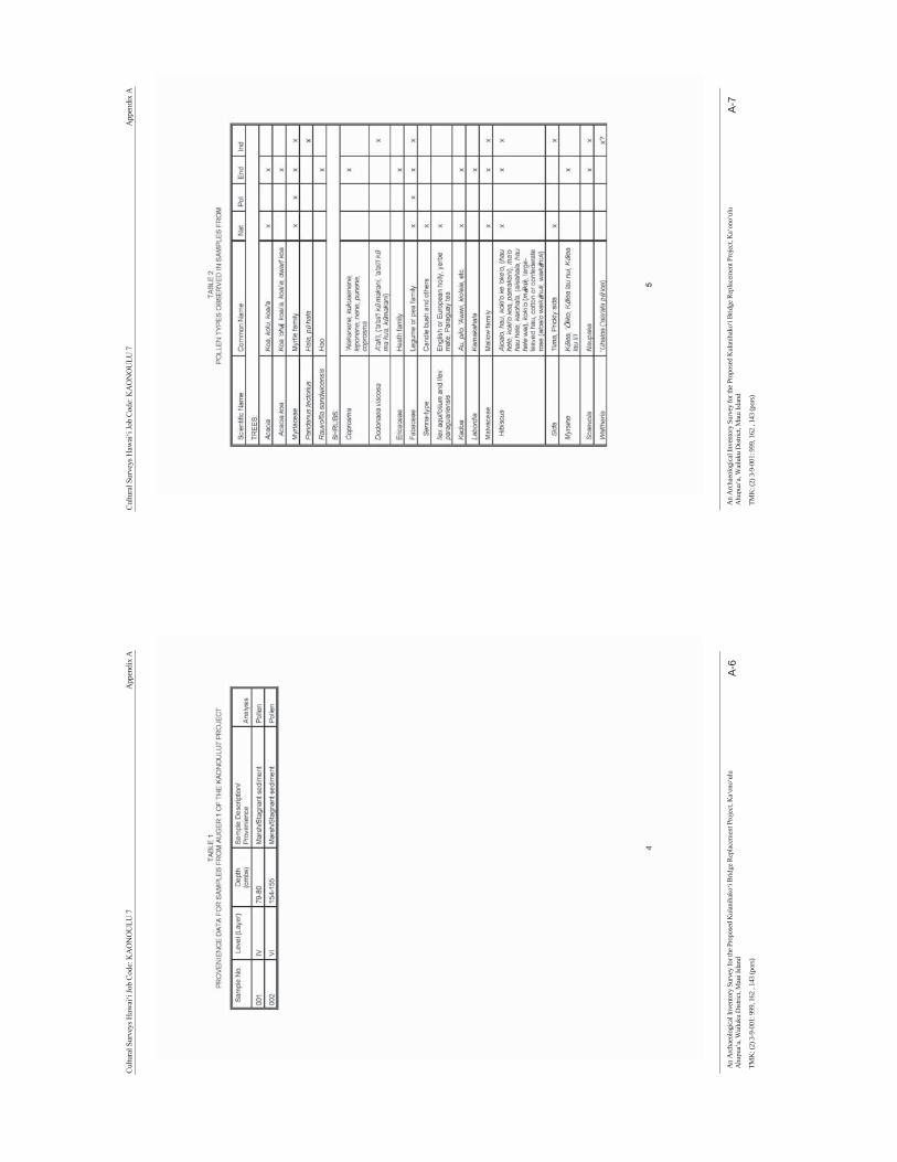
Cultu
ral S
urve
ys H
awai
‘i Jo
b Co
de: K
AO
NO
ULU
7
A
ppen
dix
A
An
Arc
haeo
logi
cal I
nven
tory
Sur
vey
for t
he P
ropo
sed
Kul
anih
ako‘
i Brid
ge R
epla
cem
ent P
roje
ct, K
a‘on
o‘ul
u A
hupu
a‘a,
Wai
luku
Dist
rict,
Mau
i Isla
nd
A-6
TMK
: (2)
3-9
-001
: 999
, 162
, 14
3 (p
ors)
Cultu
ral S
urve
ys H
awai
‘i Jo
b Co
de: K
AO
NO
ULU
7
A
ppen
dix
A
An
Arc
haeo
logi
cal I
nven
tory
Sur
vey
for t
he P
ropo
sed
Kul
anih
ako‘
i Brid
ge R
epla
cem
ent P
roje
ct, K
a‘on
o‘ul
u A
hupu
a‘a,
Wai
luku
Dist
rict,
Mau
i Isla
nd
A-7
TMK
: (2)
3-9
-001
: 999
, 162
, 14
3 (p
ors)

Cultu
ral S
urve
ys H
awai
‘i Jo
b Co
de: K
AO
NO
ULU
7
A
ppen
dix
A
An
Arc
haeo
logi
cal I
nven
tory
Sur
vey
for t
he P
ropo
sed
Kul
anih
ako‘
i Brid
ge R
epla
cem
ent P
roje
ct, K
a‘on
o‘ul
u A
hupu
a‘a,
Wai
luku
Dist
rict,
Mau
i Isla
nd
A-8
TMK
: (2)
3-9
-001
: 999
, 162
, 14
3 (p
ors)
Cultu
ral S
urve
ys H
awai
‘i Jo
b Co
de: K
AO
NO
ULU
7
A
ppen
dix
A
An
Arc
haeo
logi
cal I
nven
tory
Sur
vey
for t
he P
ropo
sed
Kul
anih
ako‘
i Brid
ge R
epla
cem
ent P
roje
ct, K
a‘on
o‘ul
u A
hupu
a‘a,
Wai
luku
Dist
rict,
Mau
i Isla
nd
A-9
TMK
: (2)
3-9
-001
: 999
, 162
, 14
3 (p
ors)
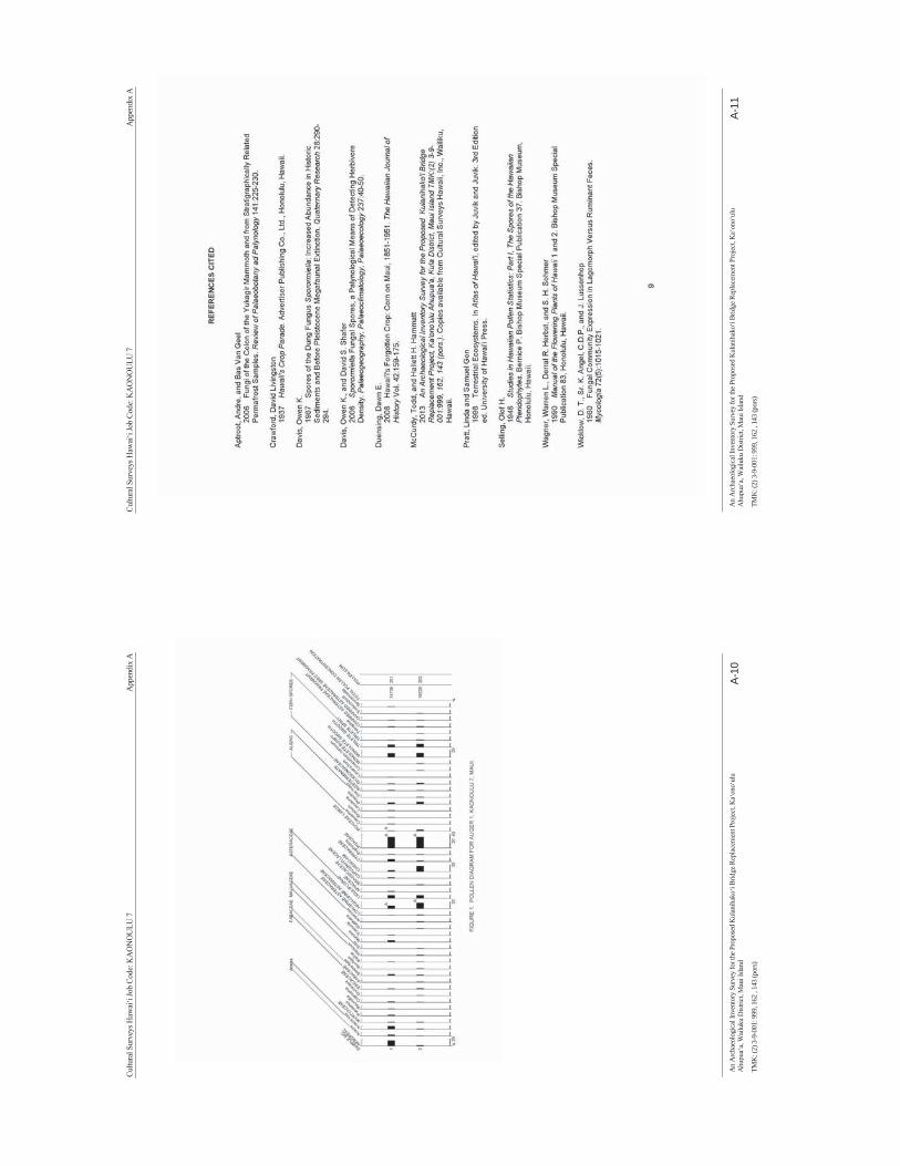
Cultu
ral S
urve
ys H
awai
‘i Jo
b Co
de: K
AO
NO
ULU
7
A
ppen
dix
A
An
Arc
haeo
logi
cal I
nven
tory
Sur
vey
for t
he P
ropo
sed
Kul
anih
ako‘
i Brid
ge R
epla
cem
ent P
roje
ct, K
a‘on
o‘ul
u A
hupu
a‘a,
Wai
luku
Dist
rict,
Mau
i Isla
nd
A-10
TMK
: (2)
3-9
-001
: 999
, 162
, 14
3 (p
ors)
Cultu
ral S
urve
ys H
awai
‘i Jo
b Co
de: K
AO
NO
ULU
7
A
ppen
dix
A
An
Arc
haeo
logi
cal I
nven
tory
Sur
vey
for t
he P
ropo
sed
Kul
anih
ako‘
i Brid
ge R
epla
cem
ent P
roje
ct, K
a‘on
o‘ul
u A
hupu
a‘a,
Wai
luku
Dist
rict,
Mau
i Isla
nd
A-11
TMK
: (2)
3-9
-001
: 999
, 162
, 14
3 (p
ors)
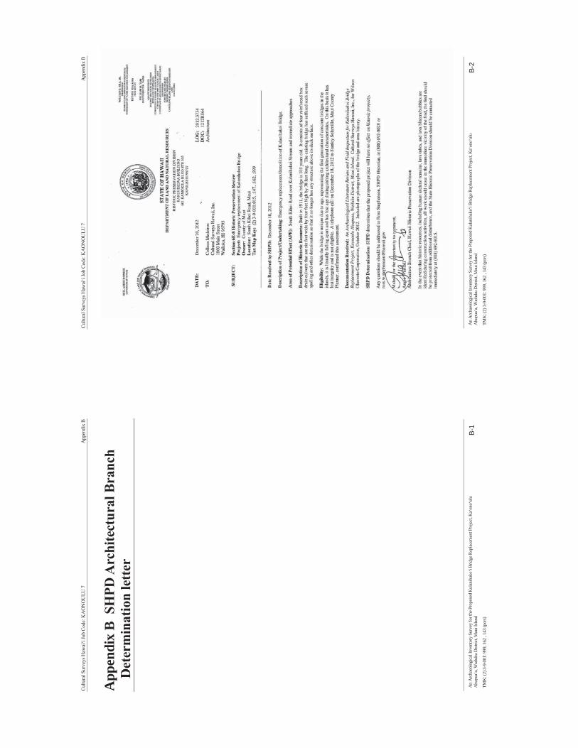
Cultu
ral S
urve
ys H
awai
‘i Jo
b Co
de: K
AO
NO
ULU
7
A
ppen
dix
B
An
Arc
haeo
logi
cal I
nven
tory
Sur
vey
for t
he P
ropo
sed
Kul
anih
ako‘
i Brid
ge R
epla
cem
ent P
roje
ct, K
a‘on
o‘ul
u A
hupu
a‘a,
Wai
luku
Dist
rict,
Mau
i Isla
nd
B-1
TMK
: (2)
3-9
-001
: 999
, 162
, 14
3 (p
ors)
App
endi
x B
SH
PD A
rchi
tect
ural
Bra
nch
Det
erm
inat
ion
lette
r
Cultu
ral S
urve
ys H
awai
‘i Jo
b Co
de: K
AO
NO
ULU
7
A
ppen
dix
B
An
Arc
haeo
logi
cal I
nven
tory
Sur
vey
for t
he P
ropo
sed
Kul
anih
ako‘
i Brid
ge R
epla
cem
ent P
roje
ct, K
a‘on
o‘ul
u A
hupu
a‘a,
Wai
luku
Dist
rict,
Mau
i Isla
nd
B-2
TMK
: (2)
3-9
-001
: 999
, 162
, 14
3 (p
ors)
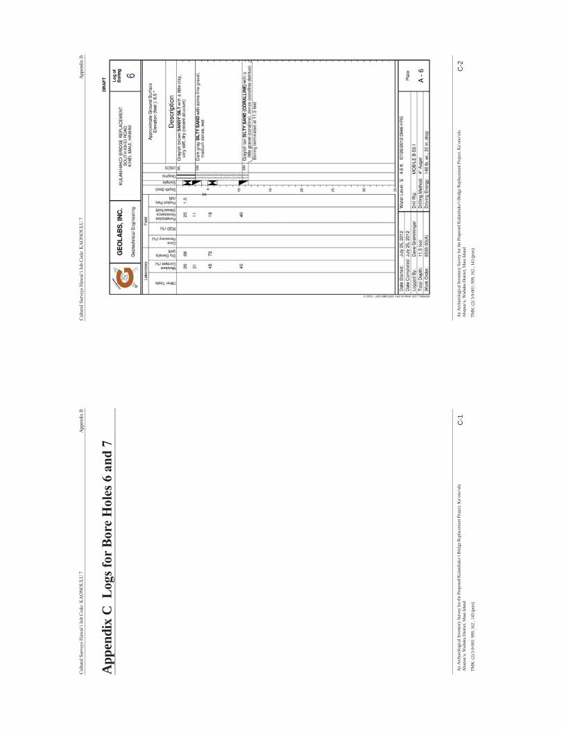
Cultu
ral S
urve
ys H
awai
‘i Jo
b Co
de: K
AO
NO
ULU
7
A
ppen
dix
B
An
Arc
haeo
logi
cal I
nven
tory
Sur
vey
for t
he P
ropo
sed
Kul
anih
ako‘
i Brid
ge R
epla
cem
ent P
roje
ct, K
a‘on
o‘ul
u A
hupu
a‘a,
Wai
luku
Dist
rict,
Mau
i Isla
nd
C-1
TMK
: (2)
3-9
-001
: 999
, 162
, 14
3 (p
ors)
App
endi
x C
Log
s for
Bor
e H
oles
6 a
nd 7
Cultu
ral S
urve
ys H
awai
‘i Jo
b Co
de: K
AO
NO
ULU
7
A
ppen
dix
B
An
Arc
haeo
logi
cal I
nven
tory
Sur
vey
for t
he P
ropo
sed
Kul
anih
ako‘
i Brid
ge R
epla
cem
ent P
roje
ct, K
a‘on
o‘ul
u A
hupu
a‘a,
Wai
luku
Dist
rict,
Mau
i Isla
nd
C-2
TMK
: (2)
3-9
-001
: 999
, 162
, 14
3 (p
ors)
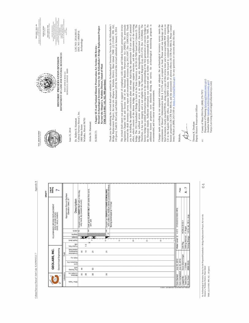
Cultu
ral S
urve
ys H
awai
‘i Jo
b Co
de: K
AO
NO
ULU
7
A
ppen
dix
B
An
Arc
haeo
logi
cal I
nven
tory
Sur
vey
for t
he P
ropo
sed
Kul
anih
ako‘
i Brid
ge R
epla
cem
ent P
roje
ct, K
a‘on
o‘ul
u A
hupu
a‘a,
Wai
luku
Dist
rict,
Mau
i Isla
nd
C-1
TMK
: (2)
3-9
-001
: 999
, 162
, 14
3 (p
ors)
NE
IL A
BE
RC
RO
MB
IE
GO
VER
NO
R O
F H
AW
AII
WIL
LIA
M J
. AIL
A, J
R.
CH
AIR
PER
SON
B
OA
RD
OF
LAN
D A
ND
NA
TUR
AL
RES
OU
RC
ES
CO
MM
ISSI
ON
ON
WA
TER
RES
OU
RC
E M
AN
AG
EMEN
T
JESS
E K
. SO
UK
I FI
RST
DEP
UTY
WIL
LIA
M M
. TA
M
DEP
UTY
DIR
ECTO
R -
WA
TER
AQ
UA
TIC
RES
OU
RC
ES
BO
ATI
NG
AN
D O
CEA
N R
ECR
EATI
ON
B
UR
EAU
OF
CO
NV
EYA
NC
ES
CO
MM
ISSI
ON
ON
WA
TER
RES
OU
RC
E M
AN
AG
EMEN
T C
ON
SER
VA
TIO
N A
ND
CO
AST
AL
LAN
DS
CO
NSE
RV
ATI
ON
AN
D R
ESO
UR
CES
EN
FOR
CEM
ENT
ENG
INEE
RIN
G
FOR
ESTR
Y A
ND
WIL
DLI
FE
HIS
TOR
IC P
RES
ERV
ATI
ON
K
AH
OO
LAW
E IS
LAN
D R
ESER
VE
CO
MM
ISSI
ON
LA
ND
ST
ATE
PA
RK
S
HIS
TO
RIC
PR
ESE
RV
AT
ION
DIV
ISIO
N
DE
PAR
TM
EN
T O
F L
AN
D A
ND
NA
TU
RA
L R
ESO
UR
CE
S
POST
OFF
ICE
BO
X 6
21
HO
NO
LULU
, HA
WA
II
9680
9
NE
IL A
BE
RC
RO
MB
IE
GO
VER
NO
R O
F H
AW
AII
June
25,
201
4
Dr.
Hal
lett
H. H
amm
att
LOG
NO
: 201
4.00
115
Cul
tura
l Sur
veys
Haw
ai‘i,
Inc.
D
OC
NO
: 140
6JP1
6 18
60 M
ain
Stre
et
Arc
haeo
logy
W
ailu
ku, H
awai
i 967
93
Alo
ha D
r. H
amm
att:
SUB
JEC
T:
Cha
pter
6E-
8 an
d N
atio
nal H
isto
ric
Pres
erva
tion
Act
Sec
tion
106
Rev
iew
- R
evis
ed A
rcha
eolo
gica
l Inv
ento
ry S
urve
y fo
r th
e K
lani
hako
i Bri
dge
Rep
lace
men
t Pro
ject
K
aon
oul
u A
hupu
aa,
Wai
luku
Dis
tric
t, Is
land
of M
aui
T
MK
(2) 3
-9-0
01: 1
43, 1
62, 9
99 (p
ortio
ns)
Than
k yo
u fo
r sub
mitt
ing
the
revi
sed
draf
t rep
ort e
ntitl
ed A
n Ar
chae
olog
ical
Inve
ntor
y Su
rvey
for
the
Kla
niha
koi
Brid
ge R
epla
cem
ent P
roje
ct, K
aon
oul
u Ah
upua
a, W
ailu
ku D
istr
ict,
Mau
i Isl
and,
TM
K:
(2)
3-9-
001:
999
, 162
, 14
3 (p
ors)
, Tod
d D
. McC
urdy
and
Hal
lett
Ham
mat
t (20
14).
We
rece
ived
the
revi
sed
subm
ittal
on
Janu
ary
9, 2
014.
The
revi
sed
draf
t rep
ort w
as p
repa
red
in s
uppo
rt of
com
plia
nce
with
sta
te a
nd f
eder
al h
isto
ric p
rese
rvat
ion
revi
ew
regu
latio
ns C
hapt
er 6
E-8
and
Sect
ion
106
of t
he N
atio
nal
His
toric
Pre
serv
atio
n A
ct (
NH
PA).
We
prev
ious
ly
revi
ewed
the
draf
t inv
ento
ry s
urve
y re
port
and
reco
mm
ende
d re
visi
ons
(Log
201
3.43
97, D
oc 1
309C
G03
). Th
ank
you
for
incl
udin
g th
e up
date
d co
nstru
ctio
n pl
ans
and
map
s de
pict
ing
the
appr
oxim
ate
0.9
acre
are
a of
pot
entia
l ef
fect
, whi
ch c
onsi
sts
of t
he d
etou
r br
idge
, the
tem
pora
ry s
uppo
rt st
ruct
ure,
and
the
rep
lace
men
t of
the
exi
stin
g br
idge
. The
191
1 K
ulan
ihak
oi B
ridge
is li
sted
in th
e St
ate
Inve
ntor
y as
50-
50-1
0-76
06 b
ased
on
Crit
erio
n D
. The
br
idge
has
suf
fere
d se
vere
det
erio
ratio
n so
it
no l
onge
r ha
s an
y di
stin
guis
hing
arc
hite
ctur
al c
hara
cter
istic
s. Th
eref
ore,
it h
as lo
st in
tegr
ity a
nd is
not
elig
ible
for
the
Nat
iona
l Reg
iste
r (L
og 2
012.
3734
, Doc
121
2RS6
4). T
he
hist
oric
brid
ge h
as y
ield
ed in
form
atio
n im
porta
nt to
the
unde
rsta
ndin
g of
the
first
gen
erat
ion
of c
oncr
ete
brid
ges
in
the
Haw
aiia
n Is
land
s. Su
ffic
ient
inf
orm
atio
n w
as c
olle
cted
and
no
furth
er w
ork
reco
mm
ende
d fo
r Si
te 7
606.
No
addi
tiona
l hi
stor
ic p
rope
rties
wer
e id
entif
ied
durin
g th
e su
rvey
. A
n ar
chae
olog
ical
mon
itorin
g pr
ogra
m i
s re
com
men
ded,
and
we
conc
ur w
ith th
at a
sses
smen
t.
Cha
nges
mad
e ac
cord
ing
to o
ur r
eque
sted
rev
isio
ns a
re a
dequ
ate;
the
arc
haeo
logi
cal
inve
ntor
y su
rvey
mee
ts t
he
requ
irem
ents
of
Haw
ai‘i
Adm
inis
trativ
e R
ule
§ 13
-276
and
is a
ccep
ted
as f
inal
. Ple
ase
send
one
har
dcop
y of
the
final
doc
umen
t, cl
early
mar
ked
FIN
AL,
alo
ng w
ith a
cop
y of
this
revi
ew le
tter a
nd a
text
-sea
rcha
ble
vers
ion
on
CD
to
the
Kap
olei
SH
PD o
ffic
e, a
ttent
ion
SHPD
Lib
rary
. We
look
for
war
d to
con
tinue
d co
nsul
tatio
n re
gard
ing
hist
oric
pro
perti
es (3
6 C
FR P
art 8
00.4
), an
d th
e as
sess
men
t of a
dver
se e
ffec
ts (3
6 C
FR P
art 8
00.5
). Pl
ease
con
tact
Je
nny
Pick
ett a
t (80
8) 2
43-5
169
or Je
nny.
L.Pi
cket
t@H
awai
i.gov
for a
ny q
uest
ions
or c
once
rns a
bout
this
lette
r.
Mah
alo,
Ther
esa
K. D
onha
m
Dep
uty
His
toric
Pre
serv
atio
n O
ffic
er
cc:
Cou
nty
of M
aui D
SA F
ax: (
808)
270
-797
2
Dep
artm
ent o
f Pla
nnin
g (p
lann
ing@
mau
icou
nty.
gov)
Ann
alis
e K
ehle
r (an
nalis
e.ke
hler
@m
auic
ount
y.go
v)Ta
nya
Lee-
Gre
ig (L
eeG
reig
@cu
ltura
lsur
veys
.com
)

APPENDIX E
Traffic Assessment Report for Kūlanihākoʻi Bridge Replacement
Wilson Okamoto Corporation
December 2012

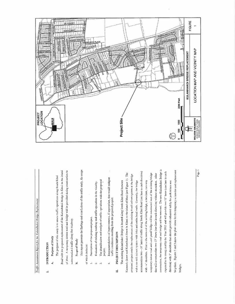
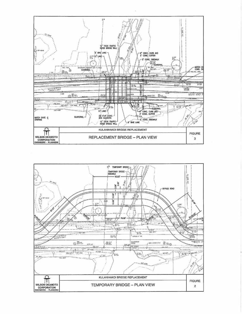
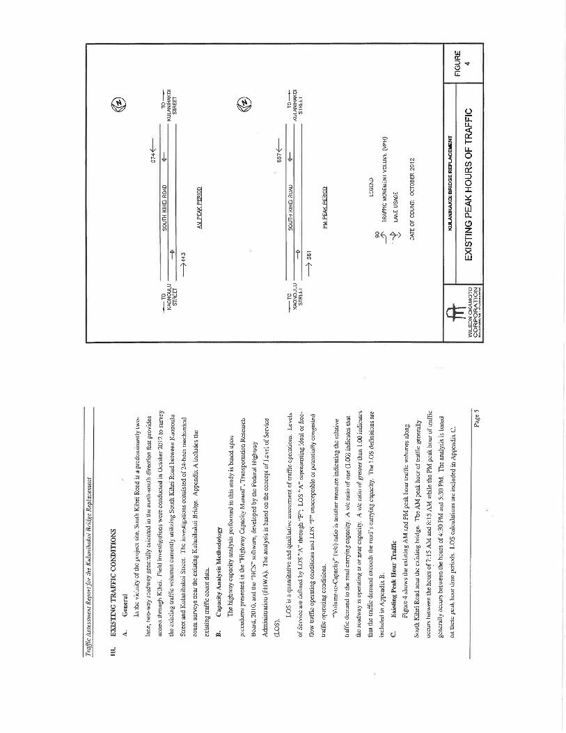
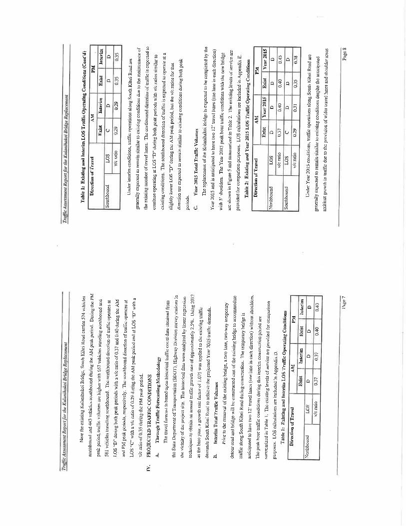
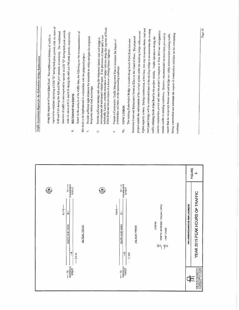


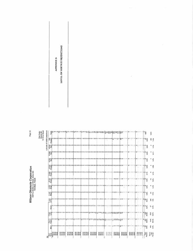
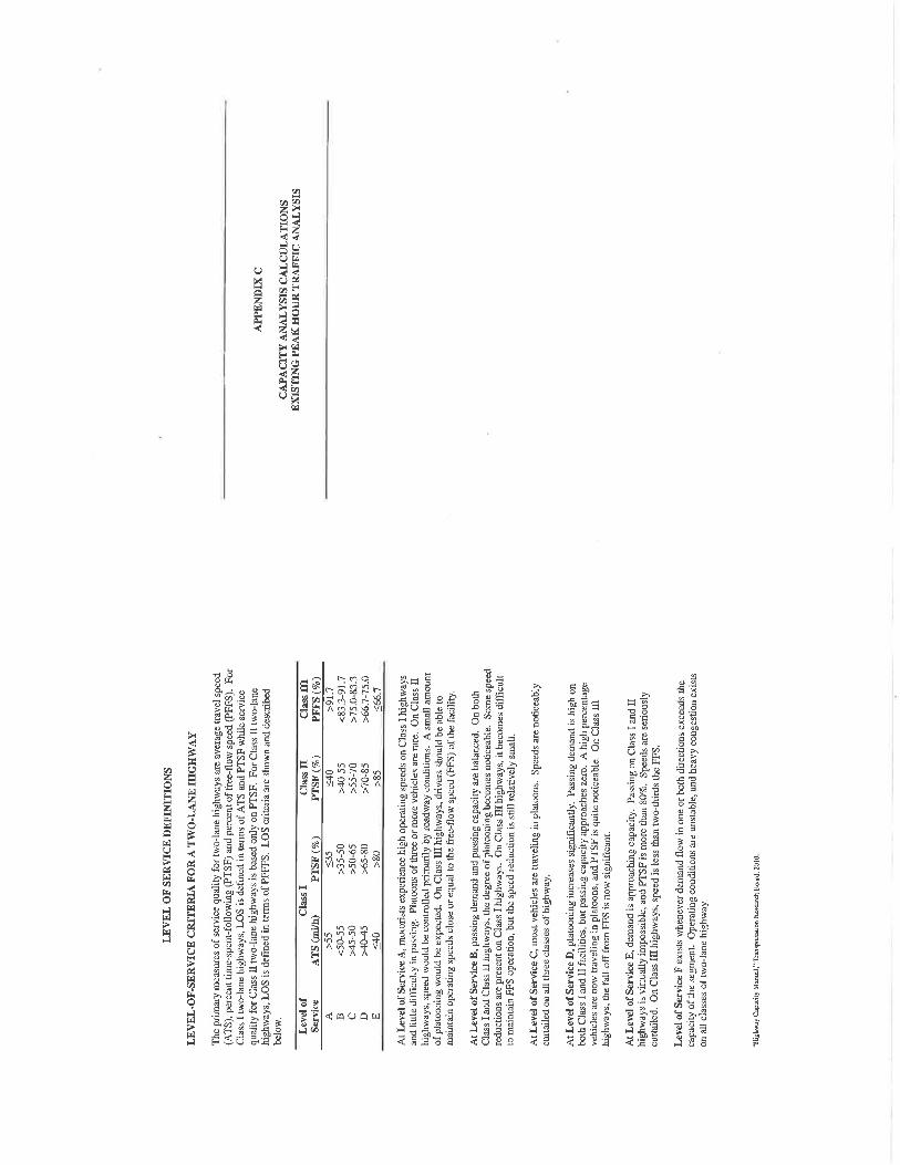

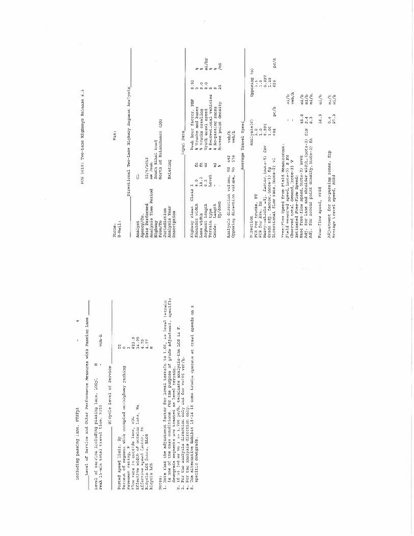


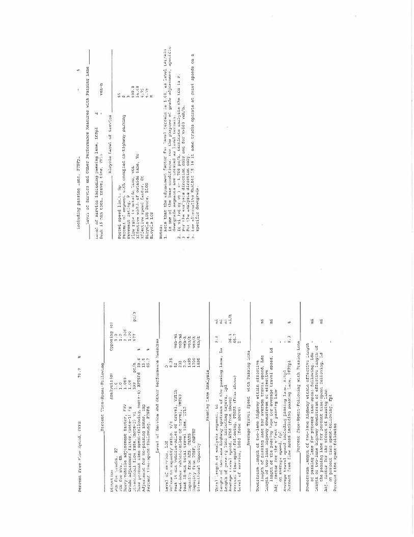
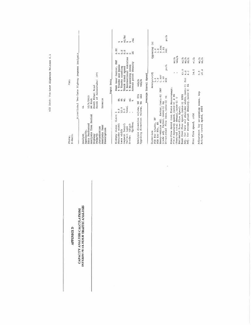

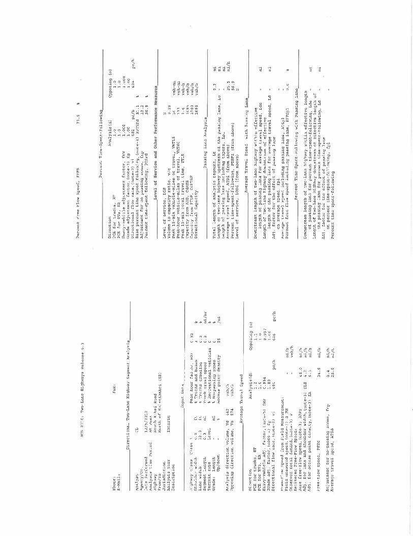
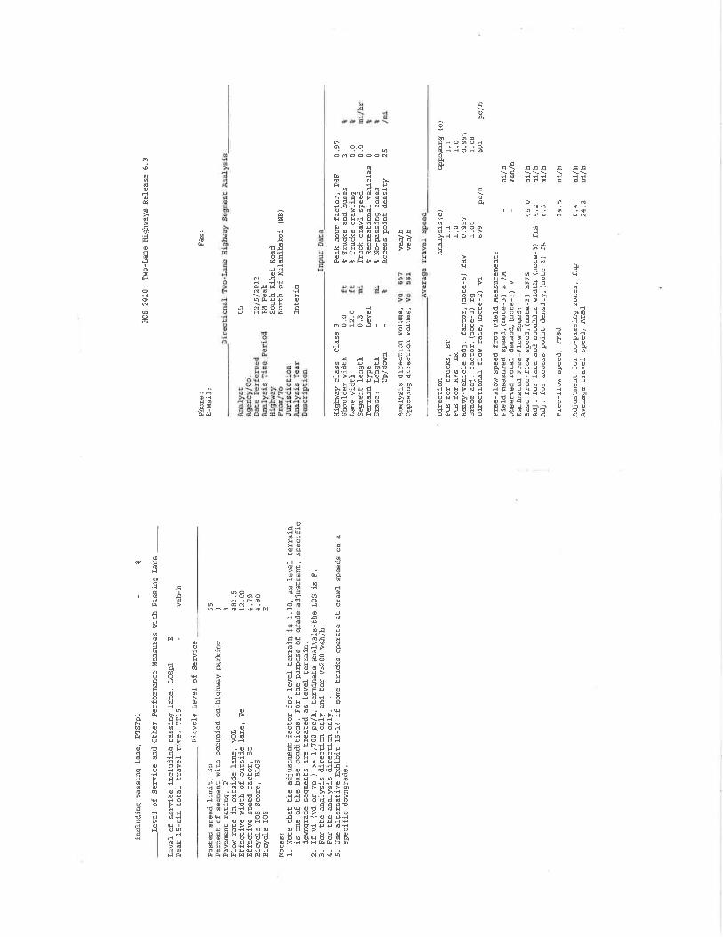
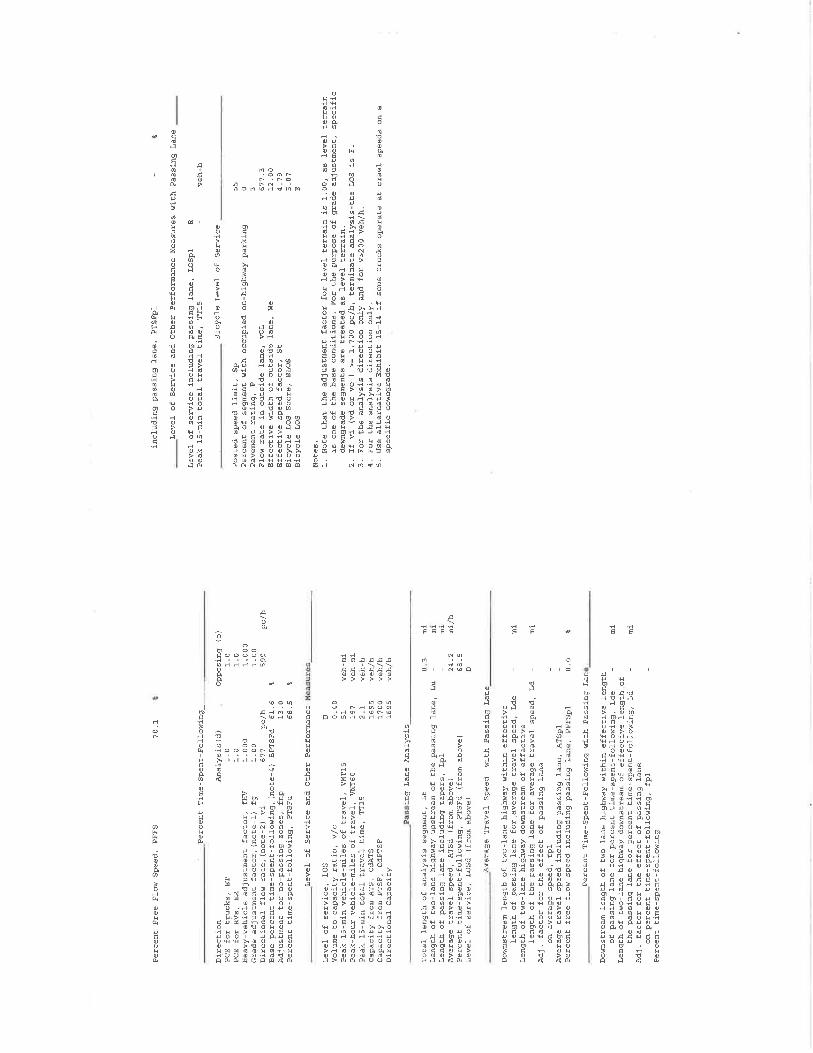
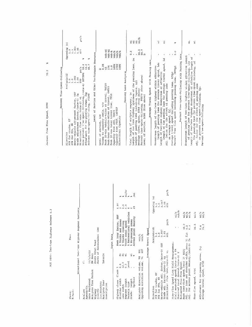

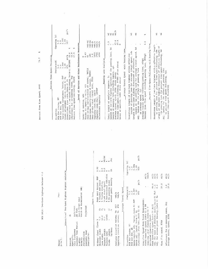
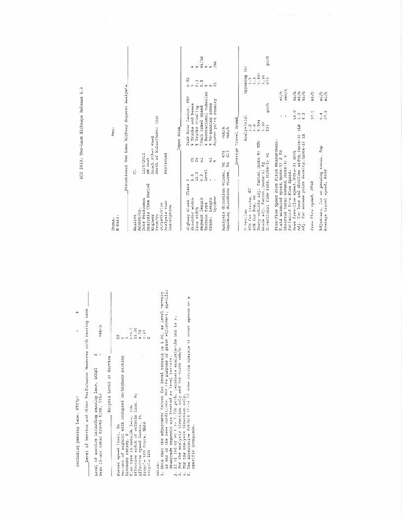
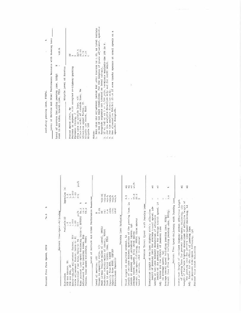
APPENDIX F
Drainage Report for Kūlanihākoʻi Bridge Replacement
Wilson Okamoto Corporation
March 2013
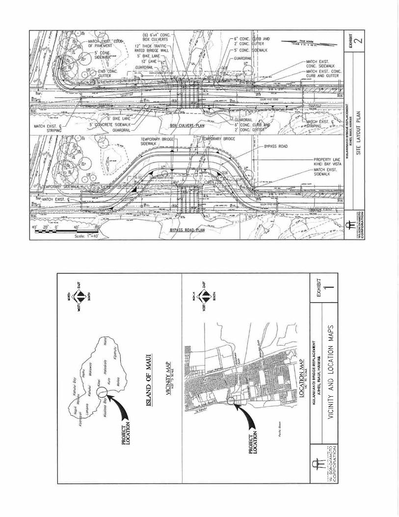

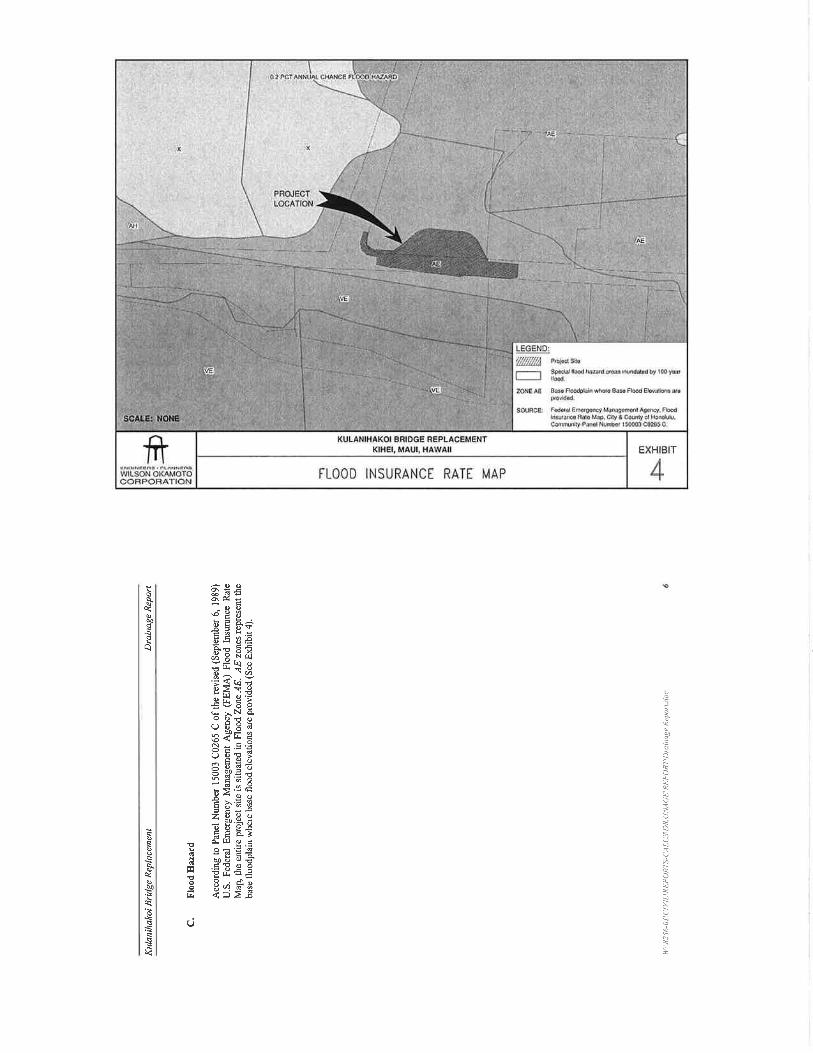

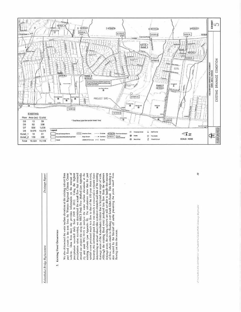


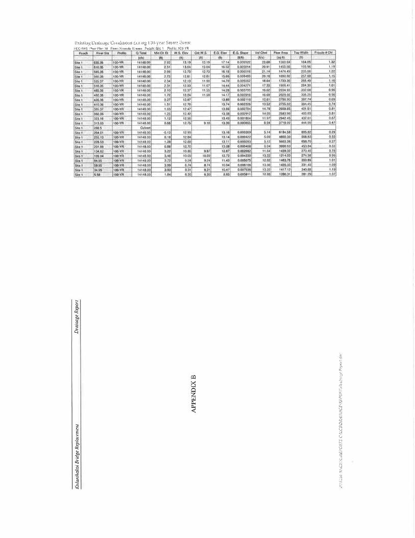
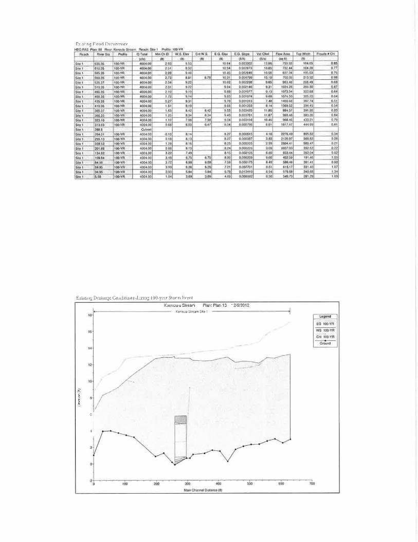
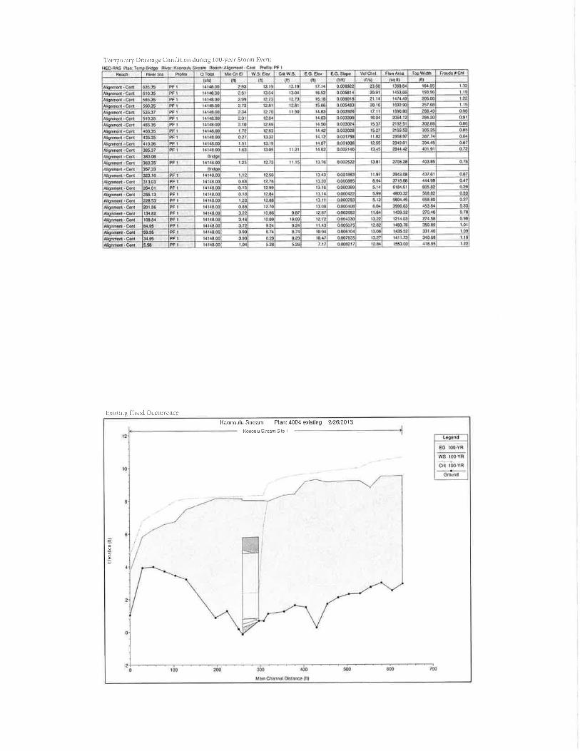


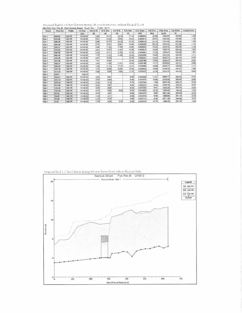

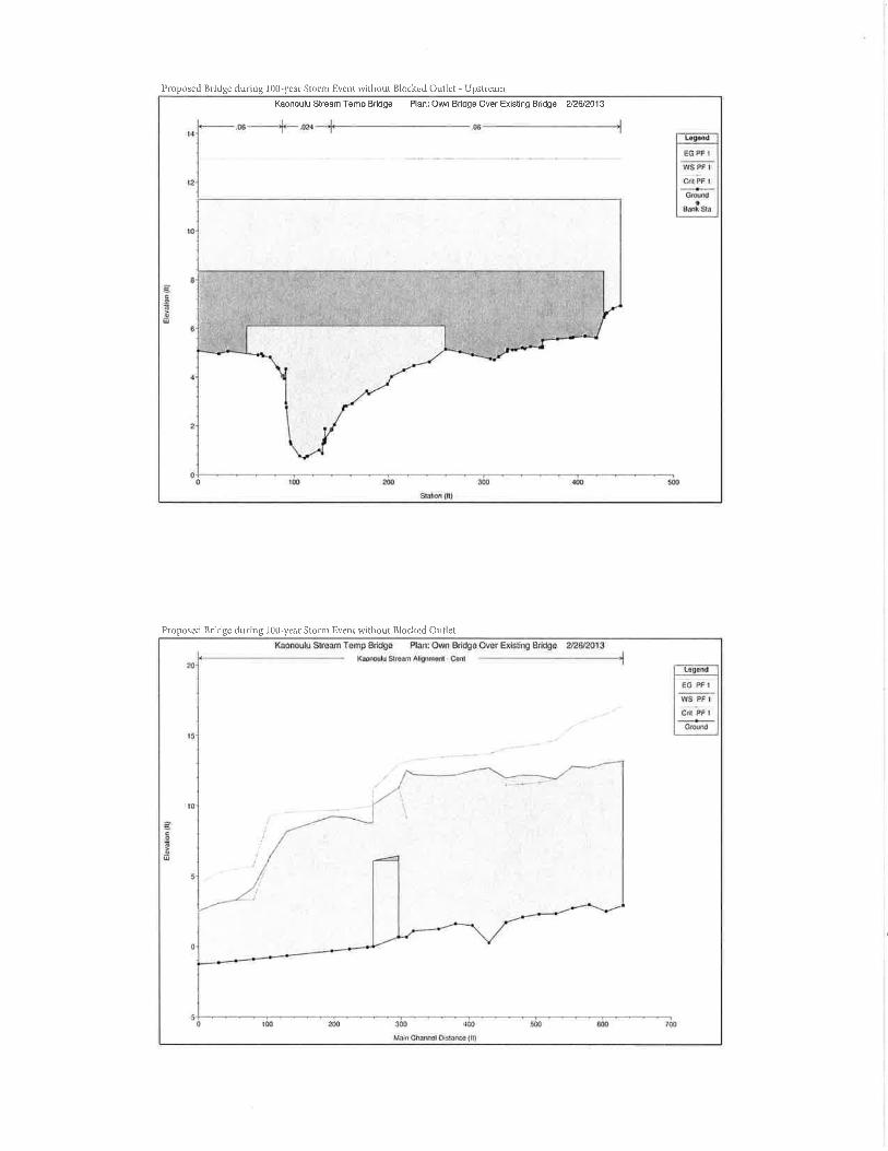
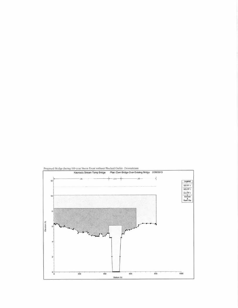
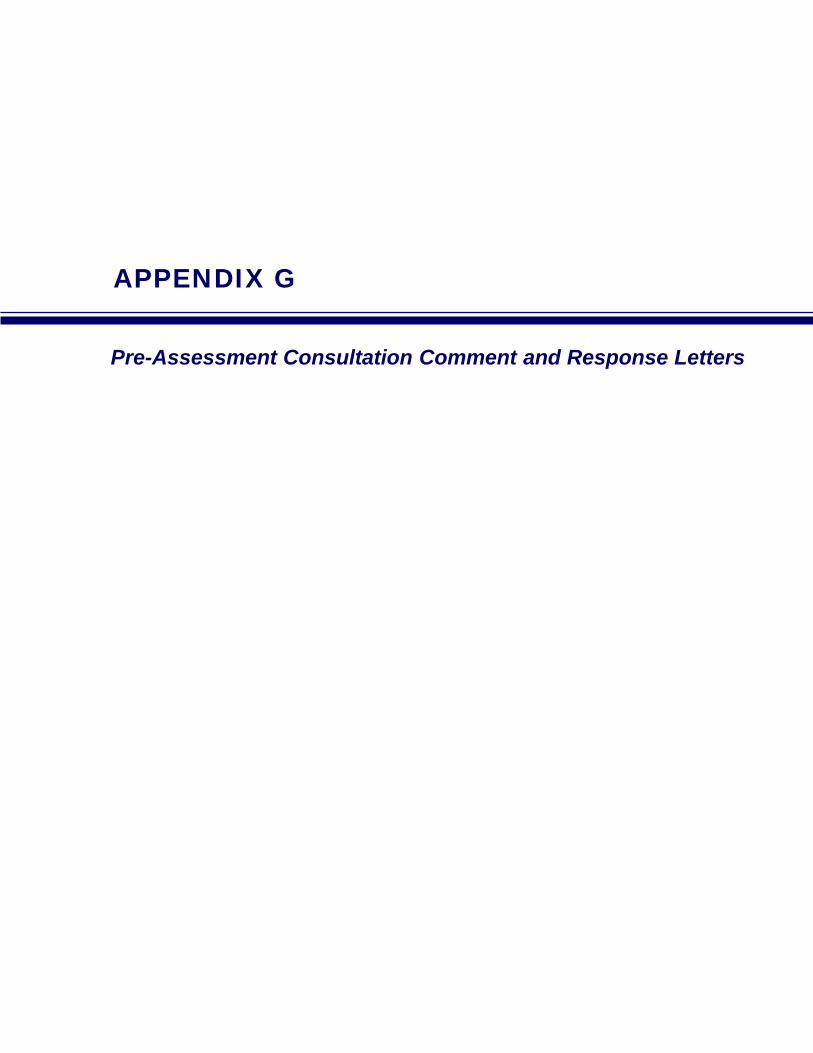
APPENDIX G
Pre-Assessment Consultation Comment and Response Letters


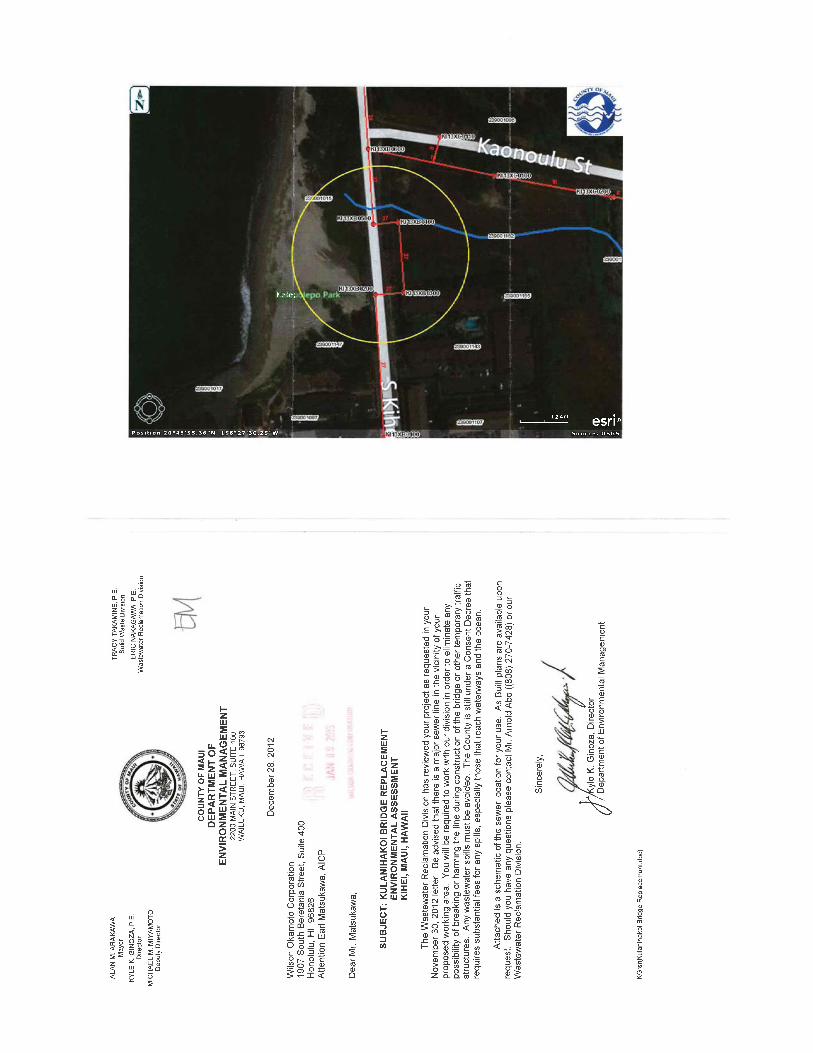


APPENDIX H
Draft EA Comment and Response Letters
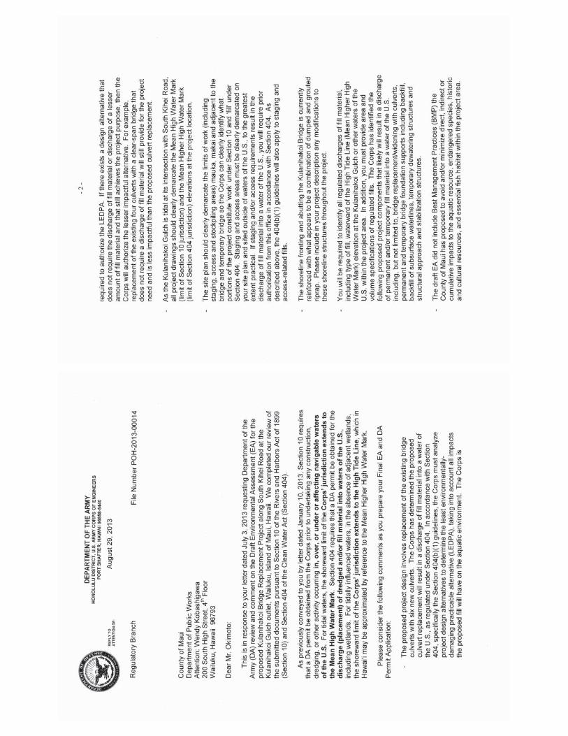


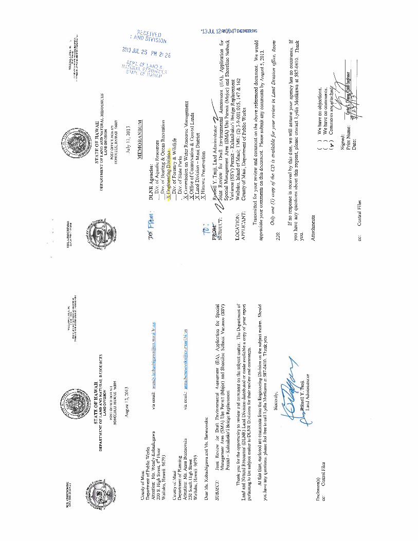

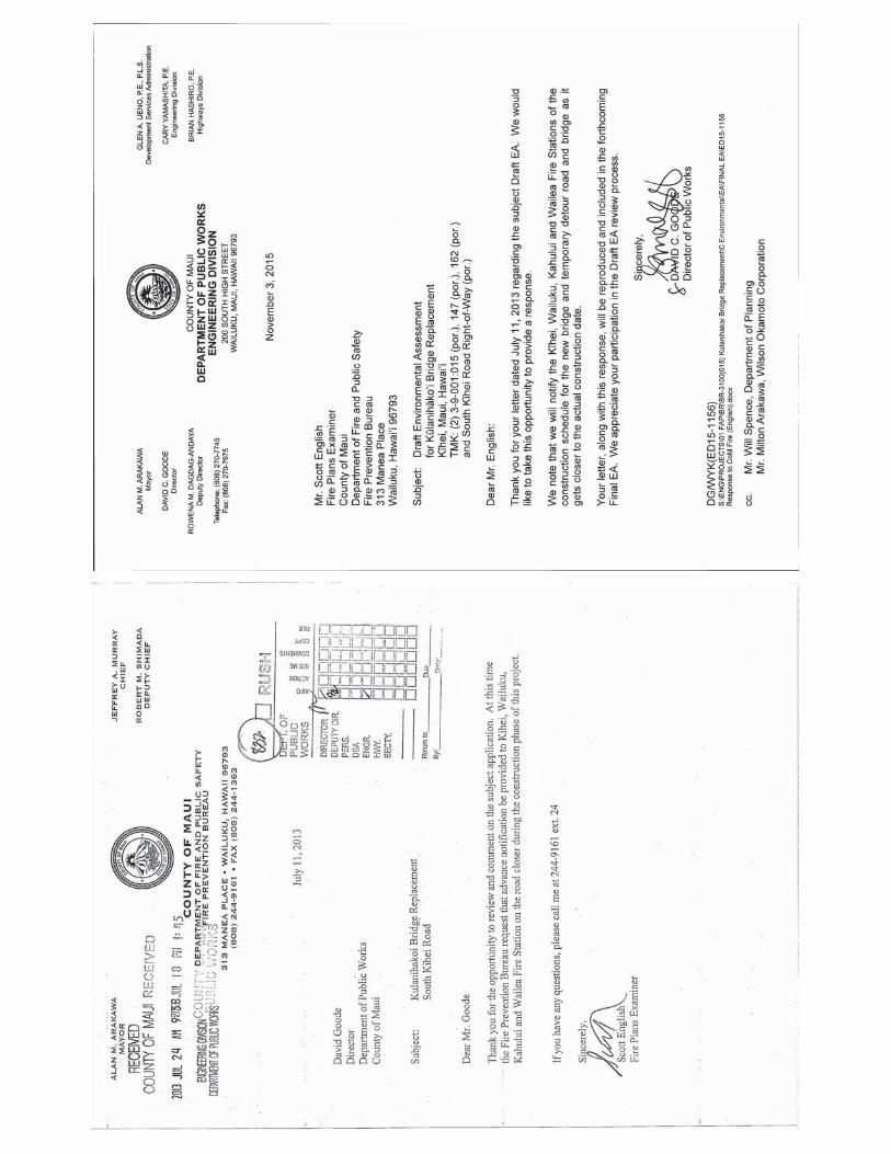

Ala
n M
. Ara
kaw
aM
ayor
JEFF
RE
Y A
.MU
RR
AY
FIR
E C
HIE
F
RO
BE
RT
M.S
HIM
AD
AD
EPU
TY
FIR
E C
HIE
F
Cou
nty
of M
aui
Dep
artm
ent o
f Fir
e an
d Pu
blic
Saf
ety
Fire
Pre
vent
ion
Bur
eau
313
Man
ea P
lace
-Wai
luku
, Haw
aii
9679
3(8
08) 2
44-9
161
-Fax
(808
) 244
-136
3
Aug
ust 1
3, 2
013
To
:M
r. D
avid
Goo
deD
irect
or, P
ublic
Wor
ksA
ttn: W
endy
Kob
ashi
gaw
a
Mr.
Will
Spe
nce
Dire
ctor
, Dep
artm
ent o
f Pla
nnin
g
Re
:K
ulan
ihak
o’i B
ridg
e R
epla
cem
ent
Kih
ei, M
aui,
HI
Dea
r Sirs
:
Than
k fo
r the
allo
win
g th
e D
epar
tmen
t of F
ire a
nd P
ublic
Safe
ty th
e op
portu
nity
to
com
men
t on
the
prop
osed
pro
ject
. A
t thi
s tim
e, o
ur o
ffic
e re
stat
es th
e fo
llow
ing
com
men
ts th
at w
ere
prov
ided
to W
ilson
Oka
mot
o C
orpo
ratio
n in
Dec
embe
r 201
2:
-Our
off
ice
requ
ests
that
the
min
imum
cle
ar w
idth
of t
he b
ridge
afte
r rep
air b
e at
le
ast 2
0 fe
et (t
he m
inim
um w
idth
for f
ire a
ppar
atus
acc
ess)
to a
llow
for f
ire
appa
ratu
s acc
ess.
-The
pro
ject
mus
t be
able
to su
ppor
t the
wei
ght o
f the
hea
vies
t fire
app
arat
us in
di
stric
t; w
hich
wou
ld b
e th
e la
dder
truc
k at
the
Wai
lea
Stat
ion
with
a G
VW
of
70,0
00 #
.
Thes
e sp
ecifi
cs sh
ould
app
ly to
the
tem
pora
ry d
etou
r roa
d in
pla
ce w
hile
the
proj
ect i
s be
ing
com
plet
ed.
If th
ere
are
any
ques
tions
or c
omm
ents
, ple
ase
feel
free
to c
onta
ct m
e at
244
-916
1 ex
t. 23
.
Sinc
erel
y,
Paul
Haa
keC
apta
in, F
ire P
reve
ntio
n B
urea
u


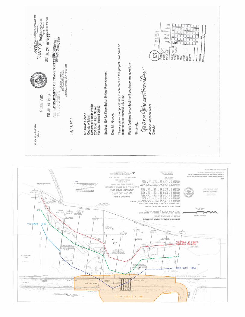
AREA OF POTENTIAL EFFECT AREA OF POTENTIAL EFFECT
ESTIMATION OF SHORELINE SETBACK CALCULATIONS ESTIMATION OF SHORELINE SETBACK CALCULATIONS
AVERAGE LOT DEPTH (ALD) METHOD: AVERAGE LOT DEPTH (ALD) METHOD:
151.50'+153.60'+355.50' = 660.60'/3 = 220.20' (ALD) 151.50'+153.60'+355.50' = 660.60'/3 = 220.20' (ALD)220.20' X 25% = 55.05' (SHORELINE SETBACK) 220.20' X 25% = 55.05' (SHORELINE SETBACK)
ANNUAL EROSION HAZARD RATE (AEHR) METHOD: ANNUAL EROSION HAZARD RATE (AEHR) METHOD:
USING EROSION RATE MAP - NORTH KIHEI, MAUI, HAWAII USING EROSION RATE MAP - NORTH KIHEI, MAUI, HAWAIITRANSECT 8 = (1.60' X 50 YR) = 80.0' + 25' = 105.0' SETBACK TRANSECT 8 = (1.60' X 50 YR) = 80.0' + 25' = 105.0' SETBACKTRANSECT 7 = (1.65 X 50) = 82.5 + 25 = 107.5 TRANSECT 7 = (1.65 X 50) = 82.5 + 25 = 107.5TRANSECT 6 = (1.55 X 50) = 77.5 + 25 = 102.5 TRANSECT 6 = (1.55 X 50) = 77.5 + 25 = 102.5TRANSECT 5 = (1.70 X 50) = 85.0 + 25 = 110.0 TRANSECT 5 = (1.70 X 50) = 85.0 + 25 = 110.0TRANSECT 4 = (2.10 X 50) = 105.0 + 25 = 130.0 TRANSECT 4 = (2.10 X 50) = 105.0 + 25 = 130.0TRANSECT 3 = (2.50 X 50) = 125.0 + 25 = 150.0 TRANSECT 3 = (2.50 X 50) = 125.0 + 25 = 150.0TRANSECT 2 = (2.60 X 50) = 130.0 + 25 = 155.0 TRANSECT 2 = (2.60 X 50) = 130.0 + 25 = 155.0TRANSECT 1 = (2.55 X 50) = 127.5 + 25 = 152.5 TRANSECT 1 = (2.55 X 50) = 127.5 + 25 = 152.5TRANSECT 0 = (2.50 X 50) = 125.0 + 25 = 150.0 TRANSECT 0 = (2.50 X 50) = 125.0 + 25 = 150.0
USING EROSIOIN RATE MAP - KAWILILIPOA, MAUI, HAWAII USING EROSIOIN RATE MAP - KAWILILIPOA, MAUI, HAWAIITRANSECT 7 = (2.00 X 50) = 100.0 + 25 = 125.0 TRANSECT 7 = (2.00 X 50) = 100.0 + 25 = 125.0TRANSECT 8 = (1.75 X 50) = 87.5 + 25 = 112.5 TRANSECT 8 = (1.75 X 50) = 87.5 + 25 = 112.5TRANSECT 9 = (1.90 X 50) = 95.0 + 25 = 120.0 TRANSECT 9 = (1.90 X 50) = 95.0 + 25 = 120.0
1 INCH = 60 FEET
60
N. KIHEI N. KIHEITRANSECT TRANSECT
8
N. KIHEI N. KIHEITRANSECT TRANSECT
7N. KIHEI N. KIHEITRANSECT TRANSECT
6N. KIHEI N. KIHEITRANSECT TRANSECT
5
N. KIHEI N. KIHEITRANSECT TRANSECT
4
N. KIHEI N. KIHEITRANSECT TRANSECT
3
N. KIHEI N. KIHEITRANSECT TRANSECT
2
N. KIHEI N. KIHEITRANSECT TRANSECT
1
N. KIHEI N. KIHEITRANSECT TRANSECT
0KAWILILIPOA KAWILILIPOATRANSECT TRANSECT
7
KAWILILIPOA KAWILILIPOATRANSECT TRANSECT
8
KAWILILIPOA KAWILILIPOATRANSECT TRANSECT
9
AEHR - NORTH KIHEI AEHR - NORTH KIHEI
AEHR - KAWILILIPOA AEHR - KAWILILIPOA
CERTIFIED SHORELINE CERTIFIED SHORELINEREVISED ON 9/18/2015 REVISED ON 9/18/2015
ALD ALD
ALD ALD


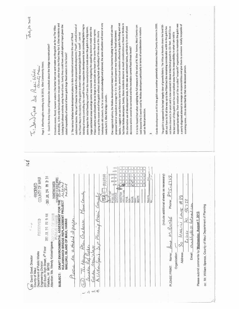
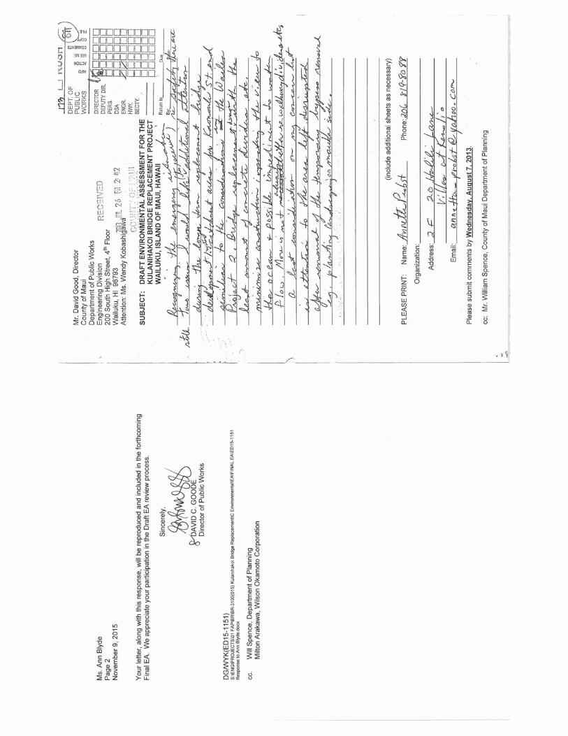
APPENDIX I
Additional Comment and Response Letters Included in
Revised Final Environmental Assessment


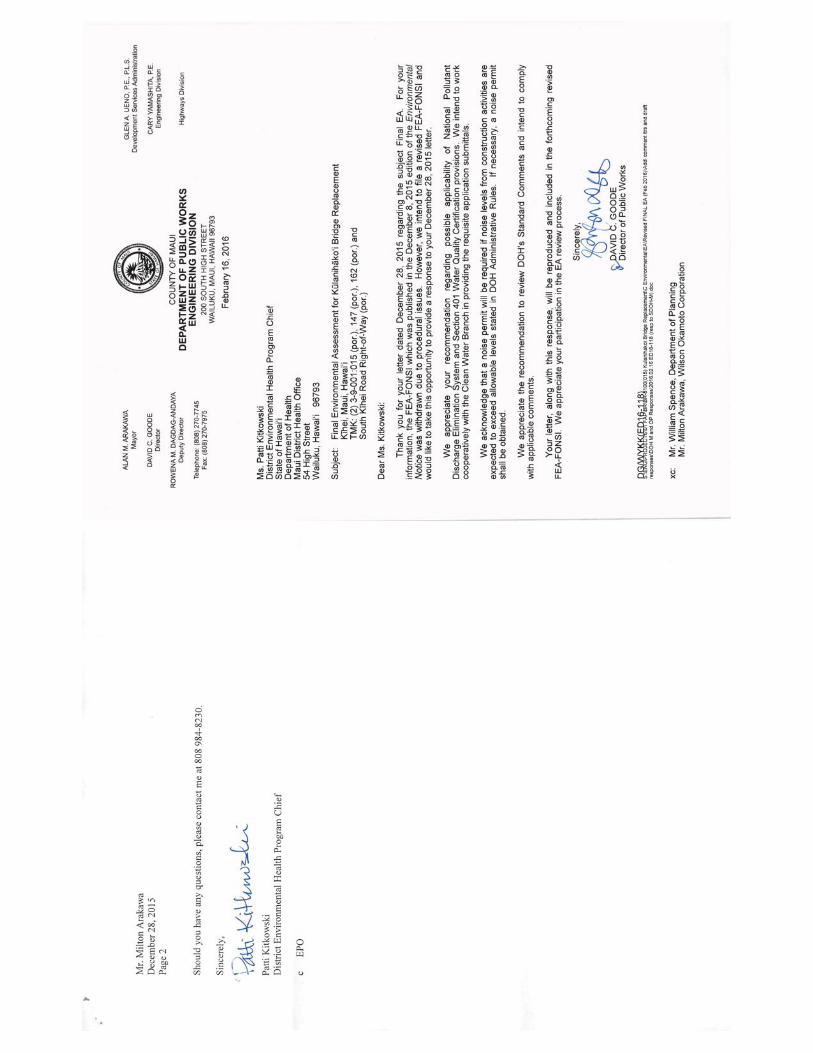
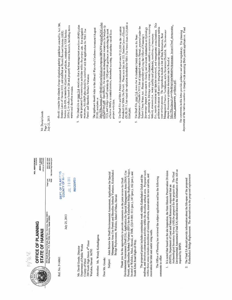

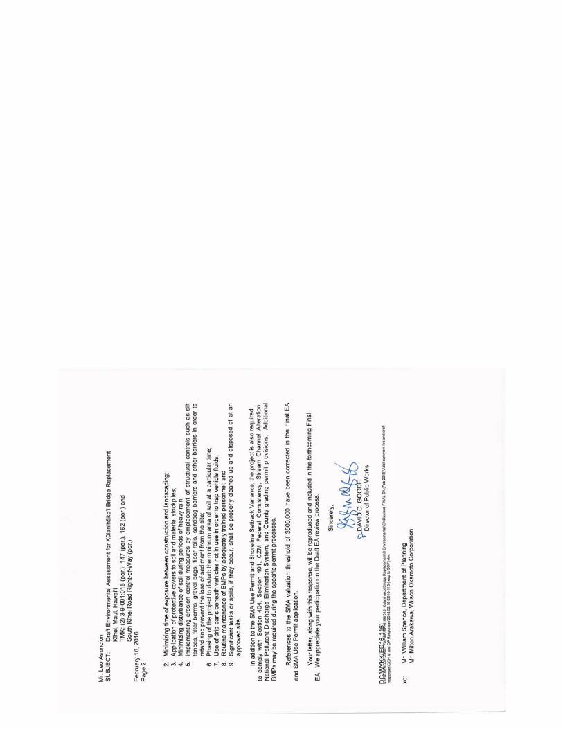

Related Documents