MICHAEL P. VICTORINO Mayor FILE COP MICHELE CHOUTEAU MCLEAN, AICP Director JORDAN E. HART Deputy Director DEPARTMENT OF PLANNING COUNTY OF MAUI ONE MAIN PLAZA 2200 MAIN STREET, SUITE 315 WAILUKU, MAUI, HAWAII 96793 July 15, 2020 Keith Kawaoka, Acting Director Office of Environmental Quality Control Department of Health, State of Hawaii 235 South Beretania Street, Room 702 Honolulu, Hawaii 96813 Dear Mr. Kawaoka: SUBJECT: PROPOSED WAILEA RESORT SF-S RESIDENTIAL PROJECT AT TMK (2)2-1-008:145, WAILEA, MAUI, HAWAII With this letter, on behalf of the Maui Planning Commission, the County of Maui, Department of Planning hereby transmits the Draft Environmental Assessment and Anticipated Finding of No Significant Impact (DEA-AFONSI) for the Proposed Wailea Resort SF-S Residential Project situated at TMK (2)2-1-008: 145 on the island of Maui , for publication in the next available edition of the Environmental Notice. Enclosed is an Adobe Acrobat PDF file of the DEA-AFONSI and a zip file that contains the shapefile of the project's location map. If there are any questions, please contact Tara Furukawa of the Current Planning Division at (808) 270-7520. Sincerely, C. Enclosures MICHELE MCLEAN, AICP Planning Director xc: Tara Furukawa, Maui County Department of Planning (PDF) Paul Woodward, Wailca Resort SF-S Partners LP (PDF) Yukino Uchiyama, Munekiyo Hiraga (PDF) K:\DA TA \Lcdcor\SF-S PERMITTING\Applications\Dr111\ EA \OEQC Submittals\Dml\EA.FONSl. ltr.doc MAIN LINE (808) 270-7735 CURRENT DIVISION (808) 270-8205 / LONG RANGE DIVISION (808) 270-7214 / ZONING DIVISION (808) 270-7253 21-010

Welcome message from author
This document is posted to help you gain knowledge. Please leave a comment to let me know what you think about it! Share it to your friends and learn new things together.
Transcript
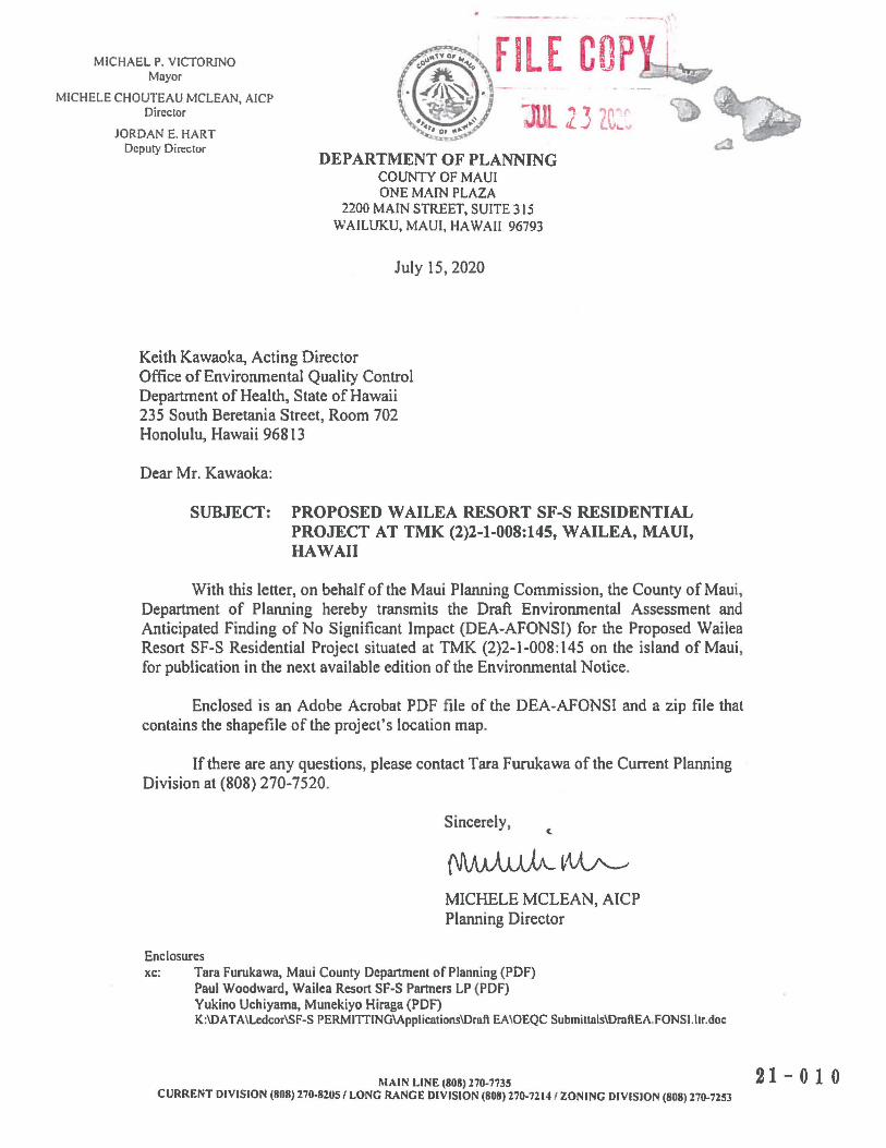
MICHAEL P. VICTORINO Mayor
FILE COP MICHELE CHOUTEAU MCLEAN, AICP
Director
JORDAN E. HART Deputy Director
DEPARTMENT OF PLANNING COUNTY OF MAUI ONE MAIN PLAZA
2200 MAIN STREET, SUITE 315 WAILUKU, MAUI, HAWAII 96793
July 15, 2020
Keith Kawaoka, Acting Director Office of Environmental Quality Control Department of Health, State of Hawaii 235 South Beretania Street, Room 702 Honolulu, Hawaii 96813
Dear Mr. Kawaoka:
SUBJECT: PROPOSED WAILEA RESORT SF-S RESIDENTIAL PROJECT AT TMK (2)2-1-008:145, WAILEA, MAUI, HAWAII
With this letter, on behalf of the Maui Planning Commission, the County of Maui, Department of Planning hereby transmits the Draft Environmental Assessment and Anticipated Finding of No Significant Impact (DEA-AFONSI) for the Proposed Wailea Resort SF-S Residential Project situated at TMK (2)2-1-008: 145 on the island of Maui, for publication in the next available edition of the Environmental Notice.
Enclosed is an Adobe Acrobat PDF file of the DEA-AFONSI and a zip file that contains the shapefile of the project's location map.
If there are any questions, please contact Tara Furukawa of the Current Planning Division at (808) 270-7520.
Sincerely, C.
~~~
Enclosures
MICHELE MCLEAN, AICP Planning Director
xc: Tara Furukawa, Maui County Department of Planning (PDF) Paul Woodward, Wailca Resort SF-S Partners LP (PDF) Yukino Uchiyama, Munekiyo Hiraga (PDF) K:\DA TA \Lcdcor\SF-S PERMITTING\Applications\Dr111\ EA \OEQC Submittals\Dml\EA.FONSl. ltr.doc
MAIN LINE (808) 270-7735 CURRENT DIVISION (808) 270-8205 / LONG RANGE DIVISION (808) 270-7214 / ZONING DIVISION (808) 270-7253
21-010

From: [email protected]: HI Office of Environmental Quality ControlSubject: New online submission for The Environmental NoticeDate: Thursday, July 16, 2020 12:29:31 PM
Action Name
Proposed Wailea Resort SF-S Residential Project at Wailea, Maui, Hawaiʻi
Type of Document/Determination
Draft environmental assessment and anticipated finding of no significant impact (DEA-AFNSI)
HRS §343-5(a) Trigger(s)
(1) Propose the use of state or county lands or the use of state or county funds
Judicial district
Makawao, Maui
Tax Map Key(s) (TMK(s))
(2)2-1-008:145
Action type
Applicant
Other required permits and approvals
Department of Health (DOH) Community Noise Permit, as applicable; National Pollutant DischargeElimination System (NPDES) Permit; Special Management Area (SMA) Use Permit; PlannedDevelopment (PD) Step II and Step III Approvals; and Construction Permits (Building, Grading, Electrical,Plumbing, Work in County Right-of-Way)
Discretionary consent required
SMA Use Permit Approval and PD Step II and Step III Approvals
Approving agency
County of Maui, Maui Planning Commission
Agency contact name
Tara Furukawa
Agency contact email (for info about the action)
Email address or URL for receiving comments
Agency contact phone
(808) 270-7735
Agency address
2200 Main StreetOne Main Plaza, Room 315
•
Wailuku, Hawai‘i 96793United StatesMap It
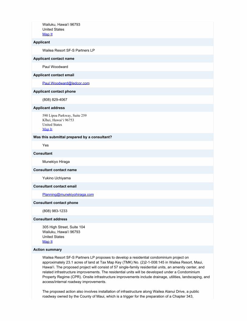
Applicant
Wailea Resort SF-S Partners LP
Applicant contact name
Paul Woodward
Applicant contact email
Applicant contact phone
(808) 829-4067
Applicant address
590 Lipoa Parkway, Suite 259Kīhei, Hawai‘i 96753United StatesMap It
Was this submittal prepared by a consultant?
Yes
Consultant
Munekiyo Hiraga
Consultant contact name
Yukino Uchiyama
Consultant contact email
Consultant contact phone
(808) 983-1233
Consultant address
305 High Street, Suite 104Wailuku, Hawai‘i 96793United StatesMap It
Action summary
Wailea Resort SF-S Partners LP proposes to develop a residential condominium project onapproximately 23.1 acres of land at Tax Map Key (TMK) No. (2)2-1-008:145 in Wailea Resort, Maui,Hawai‘i. The proposed project will consist of 57 single-family residential units, an amenity center, andrelated infrastructure improvements. The residential units will be developed under a CondominiumProperty Regime (CPR). Onsite infrastructure improvements include drainage, utilities, landscaping, andaccess/internal roadway improvements.
The proposed action also involves installation of infrastructure along Wailea Alanui Drive, a publicroadway owned by the County of Maui, which is a trigger for the preparation of a Chapter 343,
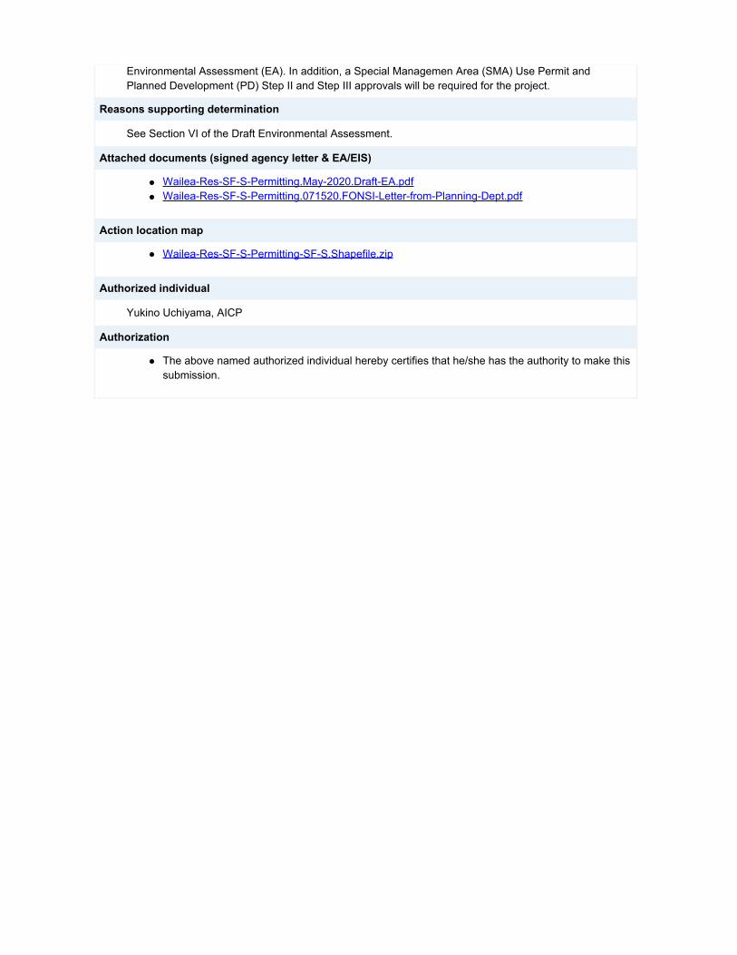
Environmental Assessment (EA). In addition, a Special Managemen Area (SMA) Use Permit andPlanned Development (PD) Step II and Step III approvals will be required for the project.
Reasons supporting determination
See Section VI of the Draft Environmental Assessment.
Attached documents (signed agency letter & EA/EIS)
Wailea-Res-SF-S-Permitting.May-2020.Draft-EA.pdfWailea-Res-SF-S-Permitting.071520.FONSI-Letter-from-Planning-Dept.pdf
Action location map
Wailea-Res-SF-S-Permitting-SF-S.Shapefile.zip
Authorized individual
Yukino Uchiyama, AICP
Authorization
The above named authorized individual hereby certifies that he/she has the authority to make thissubmission.
• •
•
•
Draft Environmental Assessment
PROPOSED WAILEA RESORT SF-S RESIDENTIAL PROJECT
(TMK NO. (2)2-1-008:145)
Prepared for: Wailea Resort SF-S Partners LP
Approving Agency: Maui Planning Commission
May 2020
Copyright © 2020
by Munekiyo Hiraga

Draft Environmental Assessment
PROPOSED WAILEA RESORT SF-S RESIDENTIAL PROJECT
(TMK NO. (2)2-1-008:145)
Prepared for: Wailea Resort SF-S Partners LP
Approving Agency: Maui Planning Commission
May 2020
Copyright © 2020
by Munekiyo Hiraga
i
CONTENTS Page Executive Summary ................................................................................................................... iv List of Acronyms ........................................................................................................................ vi I. PROJECT OVERVIEW ................................................................................................... 1
A. PROPERTY LOCATION, EXISTING USE, AND LAND OWNERSHIP ................ 1
B. PROPOSED ACTION ......................................................................................... 1
C. PROJECT SUSTAINABLE DESIGN FEATURES ............................................... 1 D. REGULATORY CONTEXT AND CHAPTER 343, HAWAI‘I REVISED STATUTES ......................................................................................................... 6 E. PROJECT DEVELOPMENT SCHEDULE AND COST ........................................ 6
II. DESCRIPTION OF EXISTING CONDITIONS, POTENTIAL IMPACTS, AND MITIGATION MEASURES ............................................................................................... 8
A. PHYSICAL SETTING .......................................................................................... 8 1. Surrounding Land Uses ........................................................................... 8 2. Climate .................................................................................................... 8 3. Topography and Soil Conditions .............................................................. 9 4. Streams and Wetlands .......................................................................... 13 5. Flood and Tsunami Hazards .................................................................. 13 6. Sea Level Rise ...................................................................................... 14 7. Flora and Fauna .................................................................................... 14 8. Air Quality .............................................................................................. 20 9. Greenhouse Gas Emissions .................................................................. 20 10. Noise ..................................................................................................... 22 11. Scenic and Open Space Resources ...................................................... 22 12. Archaeological Resources ..................................................................... 23 13. Cultural Resources ................................................................................ 25
B. SOCIO-ECONOMIC ENVIRONMENT ...............................................................28 1. Regional Setting .................................................................................... 28 2. Population and Demography ................................................................. 29 3. Economy and Labor Force .................................................................... 30
C. PUBLIC SERVICES ...........................................................................................32 1. Police and Fire Protection ..................................................................... 32 2. Medical Facilities ................................................................................... 33 3. Education Facilities ............................................................................... 34 4. Recreational Facilities ........................................................................... 35 5. Solid Waste ........................................................................................... 36
D. INFRASTRUCTURE ..........................................................................................37 1. Roadways ............................................................................................. 37 2. Water System ........................................................................................ 45 3. Wastewater System .............................................................................. 48 4. Drainage................................................................................................ 49

ii
5. Electrical, Telephone, and Cable Television Systems............................ 52
E. CUMULATIVE AND SECONDARY IMPACTS ...................................................53
III. RELATIONSHIP TO GOVERNMENTAL PLANS, POLICIES, AND CONTROLS ........... 55
A. STATE LAND USE DISTRICTS .........................................................................55
B. HAWAI‘I STATE PLAN.......................................................................................55
C. STATE FUNCTIONAL PLANS ...........................................................................84
D. COUNTYWIDE POLICY PLAN ..........................................................................89
E. MAUI ISLAND PLAN ........................................................................................ 117
F. KIHEI-MAKENA COMMUNITY PLAN .............................................................. 161
G. PLANNED DEVELOPMENT APPROVAL ........................................................ 166
H. HAWAI‘I COASTAL ZONE MANAGEMENT PROGRAM ................................. 168 1. Recreational Resources ...................................................................... 168 2. Historic/Cultural Resources ................................................................. 170 3. Scenic and Open Space Resources .................................................... 171 4. Coastal Ecosystem .............................................................................. 172 5. Economic Use ..................................................................................... 172 6. Coastal Hazards .................................................................................. 173 7. Managing Development ....................................................................... 174 8. Public Participation .............................................................................. 174 9. Beach Protection ................................................................................. 175 10. Marine Resources ............................................................................... 176
I. HRS 205A-26 SPECIAL MANAGEMENT AREA GUIDELINES ........................ 177
J. MAUI PLANNING COMMISSION SPECIAL MANAGEMENT AREA RULES AND REGULATIONS ............................................................................................... 178
IV. SUMMARY OF ENVIRONMENTAL EFFECTS WHICH CANNOT BE AVOIDED AND IRREVERSIBLE AND IRRETRIEVABLE COMMITMENTS OF RESOURCES ............ 183
V. ALTERNATIVES ANALYSIS ....................................................................................... 184
A. NO ACTION ALTERNATIVE ............................................................................ 184
B. DEFERRED ACTION ALTERNATIVE .............................................................. 184
C. PREFERRED ALTERNATIVE.......................................................................... 184
VI. SIGNIFICANCE CRITERIA ASSESSMENT ................................................................ 185
VII. LIST OF PERMITS AND APPROVALS ....................................................................... 193
VIII. PARTIES CONSULTED DURING THE PREPARATION OF THE DRAFT ENVIRONMENTAL ASSESSMENT; LETTERS RECEIVED AND RESPONSES TO SUBSTANTIVE COMMENTS ...................................................................................... 194
IX. REFERENCES ................................................................................................................. i K:\DATA\LEDCOR\SF-S PERMITTING\APPLICATIONS\DRAFT EA\DRAFT EA.DOCX
iii
List of Figures Page Figure 1. Regional Location Map ....................................................................................... 2 Figure 2. Project Location Map .......................................................................................... 3 Figure 3. Preliminary Site Plan ........................................................................................... 4 Figure 4. Soil Association Map ..........................................................................................11 Figure 5. Soil Classification Map .......................................................................................12 Figure 6. Flood Insurance Rate Map ................................................................................15 Figure 7. Tsunami Evacuation Map ...................................................................................16 Figure 8. Sea Level Rise Exposure Area Map...................................................................17 Figure 9. Proposed Water System Map ............................................................................47 Figure 10. Existing Drainage Condition ...............................................................................50 Figure 11. State Land Use District Classification Map .........................................................56 Figure 12. Maui Island Plan Map ...................................................................................... 119 Figure 13. Kihei-Makena Community Plan ........................................................................ 162 Figure 14. Special Management Area Boundary Map ....................................................... 169
List of Tables Page Table 1. Native Plants Suitable for Paeahu ..............................................................................27 Table 2. Enrollments at Department of Education Schools Serving South Maui Residents ......34 Table 3. Level of Service Criteria for Signalized Intersections ..................................................39 Table 4. Level of Service Summary .........................................................................................41 Table 5. Drainage Area Summary ............................................................................................52 Table 6. Relationship Between the Proposed Wailea Resort SF-S Residential Project and
the State Functional Plans .........................................................................................86
List of Appendices Appendix A. Ordinance No. 2694 Appendix B. Preliminary Project Plans and View Analysis Appendix C. Preliminary Engineering and Drainage Report Appendix D. Biological Resources Survey Appendix E. Archaeological Inventory Survey Appendix F. Cultural Impact Assessment Appendix G. Economic and Fiscal Impact Analysis Table Appendix H. Traffic Impact Analysis Report Appendix I. Wailea Community Association Design Review Committee Approval
Letter
iv
Executive Summary
Project Name: Proposed Wailea Resort SF-S Residential Project
Type of Document: Draft Environmental Assessment
Legal Authority: Chapter 343, Hawai‘i Revised Statutes Chapter 200.1, Hawai‘i Administrative Rules (Environmental Impact Statement Rules),
Anticipated Determination: Finding of No Significant Impact (FONSI)
Applicable Environmental Assessment review "Trigger":
Use of County Lands
Location: Maui Island Wailea Resort TMK No. (2)2-1-008:145
Landowner and Applicant: Wailea Resort SF-S Partners LP 590 Lipoa Parkway, Suite 259 Kīhei, Hawai‘i 96753 Contact: Paul Woodward Phone: 829-4067
Approving Agency: Maui Planning Commission County of Maui c/o Department of Planning One Main Plaza, Room 315 2200 Main Street Wailuku, Hawai‘i 96793 Contact: Tara Furukawa, Staff Planner Phone: 270-7735
Consultant: Munekiyo Hiraga 305 High Street, Suite 104 Wailuku, Hawai`i 96793 Contact: Yukino Uchiyama, AICP Phone: (808) 983-1233
Project Summary: Wailea Resort SF-S Partners LP proposes to develop a residential condominium project and related improvements on approximately 23.1 acres of land at Tax Map Key (TMK) No. (2)2-1-008:145 (Parcel 145) in Wailea Resort, Maui, Hawai‘i. The project site is bounded by Kilohana Park and an open space lot owned by the County of Maui to the north, Wailea Alanui Drive and multi-family housing to the west, Kapilii Street
v
to the east, and single-family residential neighborhoods to the south. The project site is currently vacant. The project site is designated “Urban” by the State Land Use Commission and “Single-Family” by the Kihei-Makena Community Plan. With respect to the Maui County Zoning, the project site is within the Wailea Resort Planned Development (PD) area and Ordinance 2694, which was approved in 1998 by the Maui County Council, conditionally zoned the parcel as “R-3 Residential District”. The project site is also situated within both the County of Maui’s Urban Growth Boundary (as set forth by the Maui Island Plan) and the Special Management Area (SMA). The proposed project will consist of 57 single-family residential units, an amenity center, and related infrastructure improvements. The residential units will be developed under a Condominium Property Regime (CPR). The proposed amenity center will include a mail room, barbeque facility, pool and/or hot tub, and other community gathering spaces for the residents of the project. Onsite infrastructure improvements include drainage, utilities, landscaping, and access/internal roadway improvements. The proposed action also involves installation of infrastructure along Wailea Alanui Drive and Kapili Street. It is noted that Wailea Alanui Drive is a public roadway (owned by the County of Maui) while Kapili Street is a privately owned roadway. Use of County lands is a trigger for preparation of an Environmental Assessment (EA) pursuant to Chapter 343, Hawai‘i Revised Statutes (HRS). The Chapter 343, HRS EA will serve as the primary technical supporting document for the SMA Use Permit application that will be filed with the County of Maui, Department of Planning for processing. The Approving Agency for the EA will be the Maui Planning Commission. Additionally, a PD Step II application will be filed concurrently with the SMA Use Permit application and a PD Step III application will be filed following the SMA Use Permit and the PD Step II approvals.

vi
List of Acronyms
AIS Archaeological Inventory Survey BMP Best Management Practice CATV Cable Television CDP Census Designated Place cfs Cubic Feet Per Second CIA Cultural Impact Assessment CO2 EQ Carbon Dioxide Equivalent CPR Condominium Property Regime CZM Coastal Zone Management DOE Department of Education DOH Department of Health DWS Department of Water Supply EA Environmental Assessment EB Eastbound EPA Environmental Protection Agency EV Electric Vehicle FEMA Federal Emergency Management Agency FIRM Flood Insurance Rate Map FONSI Findings of No Significant Impact FTE Full Time Equivalent GET General Excise Tax GHG Greenhouse Gases GPD Gallons per Day HAR Hawai‘i Administrative Rules HCZMP Hawaii Coastal Zone Management Program HRS Hawai‘i Revised Statutes KCA Kihei Community Association KNXD Keawakapu Extremely Stony Silty Clay Loam kWh Kilowatt Hour LID Low Impact Development LOS Level of Service LT Left Turn MCC Maui County Code MG Million Gallon MGD Million Gallons per Day MIP Maui Island Plan MOA Memorandum of Agreement MPC Maui Planning Commission MPD Maui Police Department mph Miles per Hour MSA Metropolitan Statistical Area MUTCD Manual on Uniform Traffic Control Devices MXC Makena Loam NB Northbound NOAA National Oceanic and Atmospheric Administration NPDES National Pollutant Discharge Elimination System

vii
PD Planned Development PEDR Preliminary Engineering and Drainage Report PV Photovoltaic PVC Polyvinyl Chloride DOT State Department of Transportation RT Right Turn SB Southbound SHPD State Historic Preservation Division SIHP State Inventory of Historic Places SLUC State Land Use Commission SMA Special Management Area SMAC South Maui Advisory Committee TH Through TIAR Traffic Impact Analysis Report TMK Tax Map Key UDRB Urban Design Review Board UGB Urban Growth Boundary UHMC University of Hawai‘i Maui College USFWS U.S. Fish and Wildlife Service WB Westbound WCA Wailea Community Association WWRD Department of Environmental Management, Wastewater Reclamation Division

PROJECT OVERVIEW
I
Page 1
I. PROJECT OVERVIEW
A. PROPERTY LOCATION, EXISTING USE, AND LAND OWNERSHIP
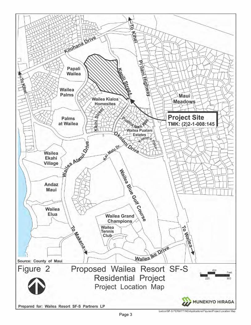
Wailea Resort SF-S Partners LP (hereafter referred to as “Applicant”) proposes the development of a residential project and related improvements on approximately 23.1 acres of land at Tax Map Key (TMK) (2)2-1-008:145 (Parcel 145) in Wailea Resort, Maui, Hawaiʻi. See Figure 1. The proposed project is bounded by Kilohana Park and an open space lot owned by the County of Maui to the north, Wailea Alanui Drive and multi-family housing to the west, Kapilii Street to the east, and single-family residential neighborhoods to the south. See Figure 2. The project parcel is currently vacant. Access to the project site will be provided from Kapili Street. Parcel 145 is owned by the Applicant.
The project site is designated “Urban” by the State Land Use Commission and “Single-Family” by the Kihei-Makena Community Plan. With respect to the Maui County Zoning, the project site is within the Wailea Resort Planned Development (PD) area and Ordinance No. 2694, which was approved in 1998 by the Maui County Council, conditionally zoned the parcel as “R-3 Residential District”. See Appendix “A”. It is noted that Ordinance No. 2694 refers to TMK No. (2)2-1-008:115, which was subsequently subdivided into TMK No. (2)2-1-008:115 (a 0.093-acre utility lot) and Parcel 145 in 2001. The project site is also situated within the County of Maui’s Urban Growth Boundary (UGB) (as set forth by the Maui Island Plan) and the Special Management Area (SMA).
B. PROPOSED ACTION
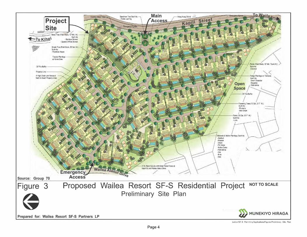
The proposed project will consist of 57 single-family residential units, an amenity center, and related infrastructure improvements. The residential units will be developed under a Condominium Property Regime (CPR) with no accessory dwelling units being allowed. The proposed amenity center will include a mail room, barbeque facility, pool and/or hot tub, and other community gathering spaces for residents of the project. Onsite infrastructure improvements include drainage, utilites, landscaping, and access/internal roadway improvements. The proposed action also involves infrastructure improvements, including installation of driveways along Wailea Alanui Drive and Kapili Street and a new pedestrian crossing on Wailea Alanui Drive. See Figure 3 and Appendix “B”.
C. PROJECT SUSTAINABLE DESIGN FEATURES
A comprehensive set of sustainability design features will be implemented as part of the Wailea Resort SF-S Residential Project. The Applicant has organized its sustainable design features around relevant State and County Plans (such as the Aloha+Challenge and Maui Island Plan, respectively), as well as the unique product offering of single-family

Page 2
Figure 1. Regional Location Map
Page 3
Figure 2. Project Location Map
Page 4
Figure 3. Preliminary Site Plan
Page 5
homes in a condominium setting. Detailed techniques associated with sustainable development were evaluated by the Applicant for implementation as part of the proposed Wailea Resort SF-S Residential Project through all phases, including site planning and design, construction and development, and operations.
The following four (4) sustainability principles and prospective key features have been established by the Applicant in order to be less resource consumptive and align with sustainable development best practices in the industry:
1. Efficient Use of Resources
Use of native or drought tolerant plants with a goal of no or low herbicide use
Ready for future R-1 recycled water hook up and use for common area irrigation
Onsite construction material recycling and waste minimization through standardization of homes
Recycling capabilities in each home for pick up by refuse hauler
Low Impact Design (LID) of stormwater facilities to minimize offsite runoff of pollutants and volume of water flows
2. Low Energy Use
Rooftop solar photovoltaic (PV)-ready home design and option for homeowners to implement
Electric Vehicle (EV) charger-ready home design and option for homeowners to implement
Use of LED lighting and natural lighting in homes
Use of Energy Star appliances
Home design to capture natural air flow and minimize air conditioning needs
3. Mobility Flexibility
Encourage bicycling and walking through road design including multi-modal paths on main roads and shade trees
Half mile walks to current transit stop or beaches

Page 6
4. Honoring the History and Native Culture of Maui and South Maui
Strategic placemaking in project to tell relevant stories through landscaping, rock gardens, etc.
Informing buyers of history and culture through various methods, including books, art, and design within the Sales Gallery
D. REGULATORY CONTEXT AND CHAPTER 343, HAWAI‘I REVISED STATUTES
As noted above, the proposed Wailea Resort SF-S Residential Project involves infrastructure improvements within Wailea Alanui Drive and Kapili Street. It is noted that Wailea Alanui Drive is a public right-of-way while Kapili Street is a private roadway owned by A&B Wailea LLC. Use of County lands is a trigger for preparation of an Environmental Assessment (EA) pursuant to Chapter 343, Hawai‘i Revised Statutes (HRS). This EA is being prepared pursuant to both HRS, Chapter 343 and Chapter 11-200.1 Hawai‘i Administrative Rules (HAR). Accordingly, this document addresses the project’s technical characteristics, environmental impacts and alternatives, and advances findings and conclusions relative to the significance of the proposed action. The Approving Agency for the EA is the Maui Planning Commission.
In addition to the EA, compliance with the Hawai‘i Coastal Zone Management Program (HCZMP), as formalized in Chapter 205A, HRS, will be required. The subject property is located within the island of Maui’s Special Management Area (SMA) and will require a SMA Use Permit. The Rules and Regulations of the Maui Planning Commission, Chapter 202, were established in order to implement Chapter 205A, HRS relating to Special Management Areas. In addition to establishing procedures for processing of SMA applications and procurement of related permits, the rules assist the Maui Planning Commission in giving consideration to State policy regarding coastal zones. As such, the Maui Planning Commission will review the SMA Use Permit application upon completion of the EA process.
The subject property is located within the Wailea Resort Planned Development (PD) area, which is subject to procedural requirements of Maui County Code (MCC), Chapter 19.32. A PD Step II application will be submitted for review and action by the Maui Planning Commission concurrently with the SMA Use Permit application. A PD Step III application will be filed following the SMA Use Permit and the PD Step II approvals.
E. PROJECT DEVELOPMENT SCHEDULE AND COST
It is estimated the proposed construction of the Wailea Resort SF-S Residential Project will cost approximately $130 million.

Page 7
Construction of the project will commence upon receipt of applicable regulatory permits and approvals. The construction duration of the project is estimated to be approximately four (4) years.

DESCRIPTION OF EXISTING
CONDITIONS, POTENTIAL
IMPACTS, AND MITIGATION
MEASURES
II
Page 8
II. DESCRIPTION OF EXISTING CONDITIONS, POTENTIAL IMPACTS, AND MITIGATION
MEASURES
A. PHYSICAL SETTING
1. Surrounding Land Uses
a. Existing Conditions
The project site is located in the midst of the resort community of Wailea, approximately 0.4 mile inland from the south Maui shoreline. Wailea Resort is a resort destination area consisting of resort-oriented single-family and multi-family units, hotels, commercial uses, and recreational amenities.
Access to the project site is from Kapili Street. On the northside of the project site are Kilohana Park and an open space lot owned by the County of Maui, to the west is Wailea Alanui Drive and existing multi-family housing, to the east is Kapili Street, and to the south are the existing single-family residential neighborhoods. Refer to Figure 2.
b. Potential Impacts and Mitigation Measures
The proposed action involves development of vacant land within an established resort area for a residential project which includes 57 single-family condominium residential units, an amenity center, and related infrastructure improvements. The project is compatible with the surrounding resort and residential uses within Wailea Resort and there are no anticipated adverse land use impacts associated with the proposed project.
2. Climate
a. Existing Conditions
The Kīhei coast is generally sunny, warm, and dry the entire year. The average annual temperatures in Kīhei range between the low 70’s to the high 80’s. The average annual temperature in 2018 was 75.4 degrees Fahrenheit as measured from the nearby Mākena Golf Course. June through August are historically the warmer months of the year, while the cooler months are January to March (Maui County Data Book, 2018).
Page 9
Average rainfall distribution in the Kīhei-Mākena region varies from under ten (10) inches per year along the coastline to twenty (20) inches per year in the higher elevations. The annual rainfall in the area as measured from the nearby Mākena Golf Course in 2018 was 20.5 inches. Rainfall in the Kīhei-Mākena region is highly seasonal, with most of the precipitation occurring in the winter months (Maui County Data Book, 2018).
Northeast tradewinds prevail approximately 80 to 85 percent of the time. Winds average ten (10) to fifteen (15) miles per hour during afternoons, with slightly lighter winds during mornings and nights. Between October to April, the southerly winds of Kona storms may be experienced (Maui County Data Book, 2018).
b. Potential Impacts and Mitigation Measures
According to the United States Environmental Protection Agency (EPA), the development of cities and suburban areas has a tendency to increase temperatures slightly (a mean increase of up to 5.4 degrees Fahrenheit annually, with a tendency to increase up to 22 degrees Fahrenheit in the evenings) as compared to surrounding natural land cover. This “heat island” effect, as it is often denoted, refers to urban air and surface temperatures that may be higher than nearby rural or undeveloped areas (U.S. Environmental Protection Agency, 2018).
In order to minimize the potential of an elevated heat island profile, a number of landscaping measures are being incorporated into the project plans. For example, shade trees and landscape vegetation will be planted throughout the proposed project to take advantage of the natural cooling effects of shading and the evaporative effects of water from the soil and leaves. Landscape enhancements, including ornamental tree and accent plantings around buildings and throughout the new community, will also provide cooling effects. A minimum of 20 percent of the project area will be maintained as open space. These mitigation measures will serve to offset the potential “heat island” effect of the proposed project. As a result, the proposed action is not anticipated to significantly alter local micro-climates.
3. Topography and Soil Conditions
a. Existing Conditions
The existing topographic conditions of the project area are characterized by moderately sloping lands from east to west at an average grade of approximately 10 percent. Elevations across the site range from 266 feet

Page 10
at its eastern edge along Kapili Street to 126 feet at its northwestern boundary along Kilohana Park. See Appendix “C”.
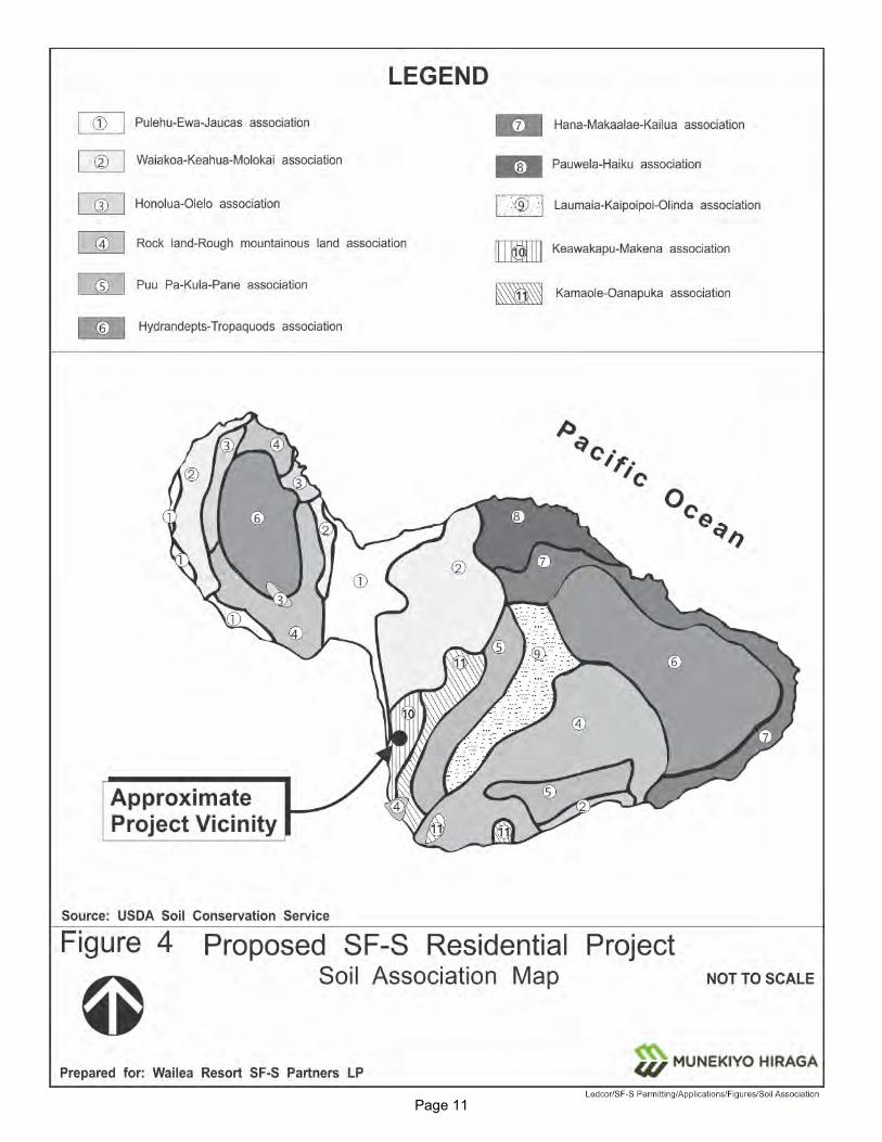
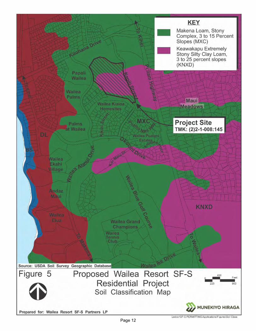
Underlying the project area is the Keawakapu-Makena soil association. See Figure 4. The soil survey of the islands of Kaua‘i, O‘ahu, Maui, Moloka‘i and Lana‘i, State of Hawai‘i characterizes the soils of this association as gently sloping to moderately steep and well drained (U.S. Soil Conservation Service, 1972). The underlying material is fine-textured to medium-textured subsoil and ranges in depth from shallow to deep and is comprised of fragmental A‘a lava. The soil series underlying the project site is Makena loam, stony complex, 3 to 15 percent slopes (MXC) and Keawakapu extremely stony silty clay loam, 3 to 25 percent slopes (KNXD). See Figure 5.
MXC is generally found on the lower leeward slopes of Haleakalā, between Mākena and Kama‘ole, and consists of Makena loam and stony land. Stony land occurs on the low ridges and makes up 30 to 60 percent of the complex. Makena loam is a dark brown to dark yellowish brown well drained soil, developed from volcanic ash, and is usually located between the low ridges of stony land. Makena loam is characterized by a relatively high permeability, and a low shrink swell potential. Permeability on stony land is very rapid.
KNXD is generally found on upland areas on the island of Maui. These soils are dark reddish brown in color and were developed in volcanic ash. KNXD is characterized by moderate permeability and a low shrink-swell potential.
Highly vesicular basalt with an irregular and spiny surface, referred to as A‘a lava, underlies both soil types at depths of usually less than about five (5) feet.
b. Potential Impacts and Mitigation Measures
The proposed project is compatible with the site’s underlying soil characteristics. The project site will be graded so as to respect the natural form of the hillside, and maintain the drainage pattern that now exists. To control runoff, sedimentation, and erosion during construction a comprehensive program of Best Management Practices (BMPs) will be implemented in accordance with applicable provisions of the Maui County Code (MCC) and Drainage Rules of the Department of Public Works. Following construction, a comprehensive drainage system will be implemented, consisting of a combination of Low Impact Development
Page 11
Figure 4. Soil Association Map
Page 12
Figure 5. Soil Classification Map

Page 13
(LID) measures, such as bioretention strips, and a conventional drainage system consisting of inlets and underground pipes. With implementation of the mitigation measures, the post-development runoff (for the 10-year, 1-hour storm) will be less than or equal to the pre-development condition. Refer to Appendix “C”.
An application for a National Pollution Discharge Elimination System (NPDES) permit for construction will be submitted to the State Department of Health (DOH) for review and approval prior to start of construction.
With implementation of the foregoing mitigation measures, the proposed action is not anticipated to involve significant adverse impacts on topography and soil parameters.
4. Streams and Wetlands
a. Existing Conditions
There are no streams or wetlands located within the project site. An unnamed stream is located approximately 0.25 mile south of the project site near Okolani Drive in the Wailea Pualani Estates Subdivision, which eventually exits into the ocean at Keawakapu Beach Park. There are no wetlands in the vicinity of the project site.
b. Potential Impacts and Mitigation Measures
The proposed project will not present any significant adverse impacts on streams or wetlands in the region.
As mentioned previously, a program of BMPs will be implemented to manage potential impacts from runoff during the construction period. Following construction, a comprehensive drainage system will be implemented to retain the increase in post development runoff (for the 10-year, 1-hour storm) generated by the proposed project. Refer to Appendix “C”.
5. Flood and Tsunami Hazards
a. Existing Conditions
According to the Flood Insurance Rate Maps, the project site is located in Flood Zone X (unshaded), areas of minimal flood hazard determined to be
Page 14
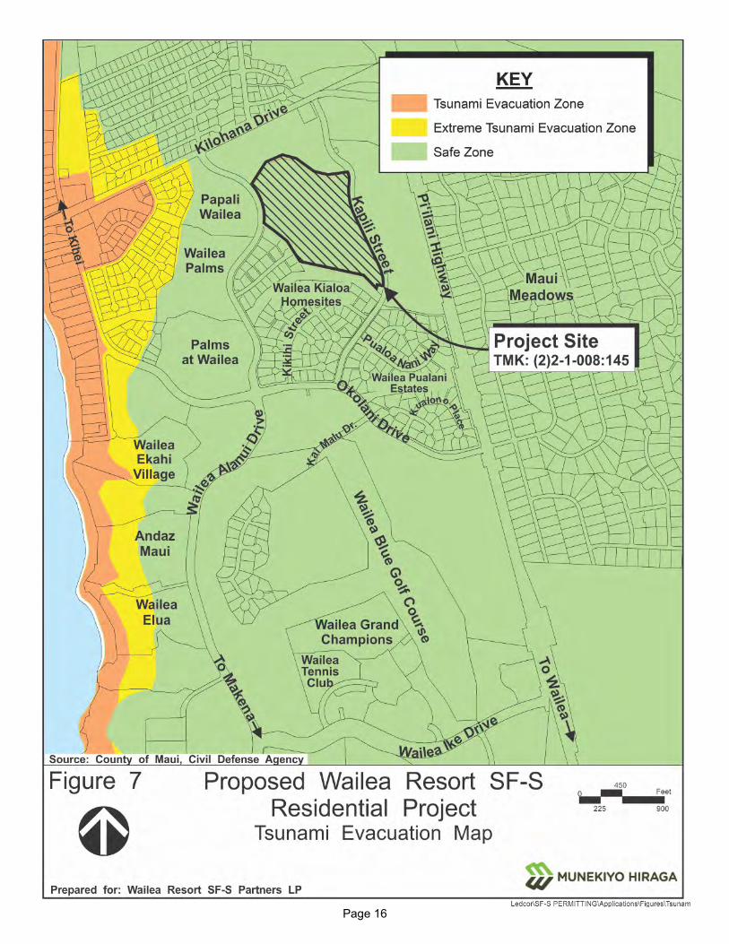
outside the 0.2 percent annual chance floodplain. See Figure 6. Further, the project site is located approximately 0.4 mile inland from the nearest shoreline and outside of the tsunami evacuation zone or extreme tsunami evacuation zone. See Figure 7.
b. Potential Impacts and Mitigation Measures
There are no restrictions on development associated with the Flood Zone X (unshaded) designation. The project site is located outside of the tsunami evacuation zone and extreme tsunami evacuation zone. As such, no impacts on these parameters are anticipated with project implementation.
6. Sea Level Rise
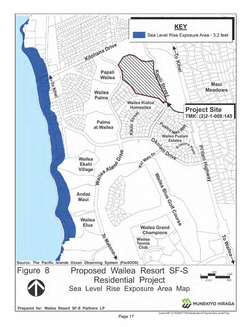
a. Existing Conditions
Due to Hawai‘i’s location in the Pacific, it is often faced with risks due to extreme weather events. Changing climatic patterns caused by global warming result in impacts, including rising sea levels, storm surge, increased flood potential, and beach erosion for oceanfront and shoreline parcels. A 3.2-foot rise in sea level is projected for the Hawaiian Islands by the mid to latter half of the 21st Century based on the findings of the Hawaiʻi Sea Level Rise Vulnerability and Adoption Report that was prepared in 2017 by the Hawaiʻi Climate Change Mitigation and Adoption Commission. The project site is located outside (inland of) the projected 3.2-foot sea level rise exposure area for Wailea. See Figure 8.
b. Potential Impacts and Mitigation Measures
Due to the site’s location mauka of Wailea Alanui Drive and inland of the 3.2-foot sea level rise exposure area, there are no anticipated impacts with regards to sea level rise inundation for the proposed project. Refer to Figure 8.
7. Flora and Fauna
a. Existing Conditions
A Biological Resources Survey has been completed for the project site in May 2019 by Robert W. Hobdy. See Appendix “D”. No federally listed threatened, endangered, or candidate endangered plant species were observed within the project site. Vegetation on the project site was

Page 15
Figure 6. Flood Insurance Rate Map
Page 16
Figure 7. Tsunami Evacuation Map
Page 17
Figure 8. Sea Level Rise Exposure Area Map
Page 18
predominantly non-native in character. A total of 15 plant species were recorded of which two (2) species are native, the ʿilima (Sida fallax) and ʿuhaloa (Waltheria indica). These two (2) native species are widespread and common throughout the dry areas in Hawai‘i.
Just one (1) non-native mammal species was observed during two (2) site visits in the project area. Axis deer (Axis axis) were common in the area. A herd of ten animals were seen, and their trails, tracks, droppings, and signs of feeding were found. Other animals that can be expected in the area are mice (Mus dometicus), rats (Rattus spp), mongoose (Herpestus auropunctatus), domestic cats (Felis catus), and domestic dogs (Canus femiliaris). Although special effort was made to look for the Hawaiian hoary bat by making an evening survey at two (2) locations in the area with a bat detecting device, no bats were detected.
Birdlife was moderate in species and in total numbers in this dry habitat. Ten species of non-native birds were observed on the project site. Three (3) species were common, the zebra dove (Geopelia striata), the mourning dove (Zenaida macroura), and the gray francolin (Francolinus pondicerianus). Less common were the spotted dove (Streptopelia chinensis), the common myna (Acridotheres tristis), and the African silverbill (Lonchura cantans). Four (4) other species were of rare occurrence. No native birds were observed in or around the project site.
Two (2) species of non-native lizards were observed, the garden skink (Lampropholis delicata) and the mourning gecko (Lepidodactylus lugubris).
One non-native snail species, the giant African snail (Achatina fulica), was seen in the project site.
Insect life was modest in the project site. Seven (7) non-native species of insects were observed on the project site. Two (2) species were common, the short-horned grasshopper (Oedaleus abruptus) and the dung fly (Musca sorbens). Less common was the monarch butterfly (Danaus plexippus). Four (4) other species were of rare occurrence.
b. Potential Impacts and Mitigation Measures
The Biological Resources Survey concluded that the vegetation in the area is dominated by non-native plants, and because there are no endangered or threatened species within the area, there are no serious concerns regarding disturbances or losses of critical native botanical resources.
Page 19
The fauna species recorded during the survey, including all mammals, birds, reptiles, mollusks, and insects, were entirely non-native species that are of no conservation concern.
While not detected during the survey, the Hawaiian hoary bat could occasionally occur in this habitat. These bats are highly mobile and move around to take advantage of spikes in insect activity that provide the food they depend on. The U.S. Fish and Wildlife Service (USFWS) has federal jurisdiction over these bats under provisions of the Endangered Species Act (1973) and provided comments as part of the Chapter 343, Hawai‘i Revised Statutes (HRS) early consultation process for the project. Based on the recommendation by the USFWS, woody plants greater than 15 feet tall will not be disturbed, removed, or trimmed during the bat birthing and pup-rearing season (June 1 through September 15). Further, barbed wire for fencing will not be used within the project site.
Seabirds, such as the endangered dark rumped petrel (Pterodroma phaeophygia sandwichensis) and the wedge-tailed shearwater (Puffinus pacificus chlororhynchus), nesting on Haleakalā and the coastal sites of Wailea Point and Molokini, may traverse the project site at night. These birds can become attracted to and confused by bright lights, crash and be killed by vehicles and cats and dogs that find them. Based on the recommendation by the USFWS, any outdoor lighting, particularly when used during each year’s peak fledgling period, could result in seabird disorientation, fallout, and injury or mortality. As such, any outdoor lighting within the project site will be hooded to direct the light downward.
‘Aiea, or tree tobacco, which could be host plants for Blackburn's sphinx moth, were not found during the Biological Resources Survey. Based on the recommendations by the USFWS, all tree tobacco less than three (3) feet tall will be removed if found and the Applicant and/or its contractor will monitor the site every four (4) to six (6) weeks for new tree tobacco growth before, during, and after the proposed ground-disturbing activity.
With implementation of the above noted mitigation measures, significant adverse impacts to flora and fauna resources are not anticipated as a result of the proposed project. Refer to Appendix “D”.
Page 20
8. Air Quality
a. Existing Conditions
There are no point sources of airborne emissions in the immediate vicinity of the project site. The air quality in the Wailea area is considered good with existing airborne pollutants attributed to automobile exhaust from the region’s roadways. The closest Department of Health air monitoring site is located at the Hale Pi‘ilani Park which is located in Kīhei, approximately 5.5 miles to the north. Particulate matter associated with cane burning ceased at the end of 2016 with the closure of sugar cane operations on Maui. Available data indicates that pollutant levels are significantly below the applicable State standards (State of Hawai‘i, Department of Health, 2019).
b. Potential Impacts and Mitigation Measures
Implementation of the project would involve potential for impacts from dust generated by short-term construction-related activities. Site work, such as clearing, grubbing, grading, and utilities and roadway improvements, for example, will generate wind-blown particulates. A comprehensive BMP plan will be developed and implemented for the construction phase of the project. Examples of mitigation measures include the use of dust control measures, such as regular watering and sprinkling, installation of dust screens, and timely revegetation of graded areas.
Once construction is completed, project-related vehicular traffic will generate automotive emissions. Bicycling and walking will be encouraged for residents and visitors of the proposed community by road design, including installation of multi-modal paths on the main project spine road, which will connect to Wailea Alanui Drive and Kapili Street, and installation of shade trees. Given the density and use characteristics associated with the project, the proposed new community is not anticipated to present significant adverse impacts which would detrimentally affect local and regional ambient air quality conditions.
9. Greenhouse Gas Emissions
a. Existing Conditions
Greenhouse gases (GHG) (carbon dioxide, methane, nitrous oxide and fluorinated gases) trap heat in the earth’s atmosphere. In the context of climate and ocean warming, increases in levels of atmospheric GHG have been attributed to human activity (IPCC, 2017). Within the State of Hawai‘i, the energy sector (including fossil fuel burning to produce electricity,
Page 21
transportation, waste incineration, and natural gas systems) is identified as the source of 89.7 percent of GHG emissions (Hawaii Department of Health, 2019). Other sources of GHG emissions include industrial facilities, agriculture and forestry, and waste treatment such as landfills, composting, and wastewater treatment.
The Federal Greenhouse Gas Reporting Program (40 CFR Part 98) requires mandatory reporting of GHG emissions from sources that emit 25,000 metric tons or more of carbon dioxide equivalent (CO2 EQ) per year in the United States. Categories of use which are generally associated with this level of reporting include power plants, petroleum and natural gas systems, refineries and other heavy manufacturing processes. On Maui, facilities operating at or above the 25,000 metric ton level include Maui Electric Company’s Kahului Power Plant, Maalaea Power Plant, and the Central Maui Landfill (U.S. EPA, 2017).
b. Potential Impacts and Mitigation Measures
The proposed action involves the development of 57 single-famiy residential condominium units and related improvements. GHG emissions are anticipated during and after the construction phase of the project. The average energy use per household in Maui County is 581 kilowatt hour (kWh)/month (Hawaii Energy, 2017). This corresponds roughly to production of 4.9 metric tons of CO2 EQ per year (U.S. EPA, 2018). It is noted that homes within the SF-S Residential Project will incorporate sustainable design features to reduce overall energy consumption and GHG emissions per square foot in accordance with the project’s overall guiding sustainability principles. The sustainable design features include rooftop solar photovoltaic (PV)-ready and Electric Vehicle (EV) charger-ready home designs, use of LED and natural lighting, use of Energy Star certified appliances, and home designs to capture natural air flow to minimize air conditioning needs. Energy Star is a program run by the EPA and the U.S. Department of Energy that promotes energy efficiency.
Based on the foregoing, GHG emissions from the proposed project will be far below the GHG reporting threshold and are not anticipated to be significant.
Page 22
10. Noise
a. Existing Conditions
The project site is situated within the resort community of Wailea and adjacent to Piʿilani Highway. Sources of ambient noise include wind, local vehicular traffic, golf course, and resort activities.
b. Potential Impacts and Mitigation Measures
Ambient noise conditions will be temporarily impacted by construction activities. Heavy construction equipment and possible vibrations for construction activities would be the dominant source of noise during construction. Equipment mufflers or other noise attenuating equipment, as well as proper equipment maintenance, will be used during construction activities in order to mitigate potential impacts to ambient noise conditions in the vicinity. Also, construction activities are anticipated to be limited to daytime working hours. The contractor for the project will be required to comply with the maximum allowable noise levels for stationary equipment established by Hawai‘i Administrative Rules (HAR), Chapter 11-46, “Community Noise Control”. Should a community noise permit be required, said permit will be obtained prior to the commencement of construction.
Once completed, the proposed project is not anticipated to detrimentally affect ambient noise levels.
11. Scenic and Open Space Resources
a. Existing Conditions
In proximity to the project site, the lands makai (west) are predominantly developed with residential, commercial/retail, and hotel, and defined by the built up urban landscape of Wailea. The lands mauka (east) of the project site are characterized by a vacant lot and beyond Piʻilani Highway and the rural residential single-family subdivision of Maui Meadows. The Pacific Ocean, the island of Kaho‘olawe, and the West Maui coastline may be visible from selected points within the project site.
b. Potential Impacts and Mitigation Measures
The proposed project has been designed to complement and enhance existing development within the Wailea Resort. Particular attention has been given to the placement of buildings during the design process to arrive at a site plan that the Applicant believes is both design sensitive and place

Page 23
appropriate to the Wailea community. In particular, the project provides open space relief, landscaping, and building forms to complement existing residential and commercial developed properties and the surrounding environment.
It is noted that all lands in the Wailea Resort, including the subject property, are in a Planned Development (PD) governed by MCC Section 19.32. The preliminary plans for the proposed project have been developed to meet the Planned Development Standards as set forth in Section 19.32.030 of the MCC and the project area will retain approximately 20 percent of open space.
The site plan has been carefully designed to allow for makai view corridors from Kapili Street and mauka view corridors from Wailea Alanui Drive and to create a new residential community that integrates with its surrounding resort residential environment. The View Analysis of the proposed architectural concept of the project provides 3-dimensional “before” and “after” perspectives of the proposed new community from public vantage points located around the project site. Refer to Appendix “B”. As documented by the view studies, the proposed project is not anticipated to substantially affect scenic vistas and view planes.
12. Archaeological Resources
a. Existing Conditions
An Archaeological Inventory Survey (AIS) was prepared by Scientific Consultant Services. See Appendix “E”. The AIS followed a work plan approved by the State Historic Preservation Division (SHPD) in March, 2020. The objective of the AIS was to identify and document historic properties, to gather sufficient information on these properties, to evaluate the significance of any newly identified historic properties, to determine the project effect on these properties, and to advance appropriate mitigation recommendations to address potential adverse effects.
It is noted that two (2) AIS reports were previously conducted in the project area. These previously completed studies informed the formulation of the approved work plan. From a methodological standpoint, the AIS encompassed a full pedestrian survey of the project area, locating and assessing previously identified sites, recording of newly identified sites, and mapping of each feature in the project areas. Manual testing was conducted at select features to provide a distribution of site types and function. The results of the AIS are presented below.

Page 24
As a general finding, the AIS notes that archaeological features within the project area have not been well-preserved. This assessment is attributed to past mechanical alterations associated with World War II training activities, baseyards, and firebreaks. The AIS further concludes that most features appear to be surviving remnants due to prior earth-moving and landscape-altering, thereby retaining only a fraction of their original extent.
The AIS identified seven (7) temporary sites consisting of 12 features. The AIS reports that seven (7) features are associated with the pre-contact/early historic period and exhibit traditional Hawaiian architecture. These features, consisting of four (4) modified outcrops, two (2) linear mounds, and one (1) L-shape, were determined to be related to an agricultural function. These features were combined into a single site landscape as State Inventory of Historic Places (SIHP) 50-50-14-8709 based on their similar construction style and function.
Three (3) military-related features were also documented and included in a single site landscape as SIHP 50-50-14-8710. These features consisted of roughly stacked basalt in one (1) to two (2) courses forming C and U shapes and are similar in construction style to those found throughout the Makena area. The AIS noted that military construction in the project area could have potentially adversely impacted earlier pre-contact/early historic sites, thus making it difficult to determine pre-World War II activities in the project area.
Two (2) boundary features were associated with historic ranching and identified as part of SIHP 50-50-14-4791, which was previously documented in the two (2) AIS reports undertaken in the project area. This site consists of a wall measuring about 29 meters in length. The western segment of the wall is badly collapsed while the eastern portion of the wall is intact. The AIS notes that additional fieldwork and research suggest that this wall is part of a larger wall which continued upland, east of Piʻilani Highway.
b. Potential Impacts and Mitigation Measures
All sites identified and documented during the AIS process were assessed for significance in terms of the five (5) criteria of the Hawai‘i State Register of Historic Places set forth by Section 13-275-6, HAR. These criteria are as follows:
Criterion A: Site is associated with events that have made a significant contribution to the broad patterns of our history.

Page 25
Criterion B: Site is associated with the lives of persons significant to our past.
Criterion C: Site is an excellent site type; embodies the distinctive characteristics of a type, period, or method of construction, or that represent the work of a master, or that possess high artistic value or that represent a significant and distinguishable entity, whose components may lack individual construction.
Criterion D: Site has yielded or has the potential to yield information important to prehistory or history.
Criterion E: Site has cultural significance to an ethnic group; examples include religious structures, burials, major traditional trails, and traditional cultural places.
Given its construction detail, state of preservation and association with early historic land use and possible political demarcation, SIHP 50-50-14-4791 is assessed to be significant under Criterions A, C and D. No further work is recommended for the three (3) features of Site 50-50-14-4791.
SIHP 50-50-14-8709 and -8710 described above are determined to be significant under Criterion D. No further work is also recommended for these sites. The AIS concludes that these sites are in marginal condition and provide limited further value for archaeological research. Refer to Appendix “E”. Based on the foregoing, it is not anticipated that the proposed project would result in significant adverse impacts to archaeological resources.
13. Cultural Resources
a. Existing Conditions
A Cultural Impact Assessment (CIA) for the proposed project was prepared by Aina Archaeology. See Appendix “F”. The geographic scope of the CIA encompassed the ahupua‘a of Paeahu. In keeping with the Office of Environmental Quality Control’s guidelines for the preparation of CIAs, it was the objective of this study to gain an understanding of traditional cultural practices within the study area and to identify any potential effects on these practices which may occur as the result of project implementation.
The ahupua‘a of Paeahu is situated within the moku or district of Honua‘ula. Paeahu traditionally included offshore fishery, which encompassed the shoreline and bays from Keawakapu to Halo. The kula lands (open plain

Page 26
lands), where agricultural activities were undertaken, and the region in which the proposed action is located, extends towards the mauka extent of the ahupua‘a.
The CIA establishes the context for Paeahu’s cultural historical background with documentation of the traditions of the Paeahu region prior to Western arrival. This background explores the value of place names in interpreting cultural practices. As well, the CIA documents mo‘olelo (traditional stories) and their role in explaining the creation of lands and resources. The CIA describes the traditional Hawaiian settlement of the Paeahu ahupua‘a and its relationship to resource (e.g., water and land) utilization. Finally, the CIA reviews the history of the region, including post-contact milestones, up to the modern era.
All of the above establishes the context for understanding cultural practices at Paeahu, thereby enabling the formulation and implementation of a sound CIA methodology.
b. Potential Impacts and Mitigation Measures
The methodological framework for conducting a CIA begins with an outreach program which identified individuals with knowledge of the traditional cultural practices within and adjacent to the proposed project area. In this regard, Aina Archaeology initiated contact with government agencies, advisory councils, local community organizations, traditional cultural practitioners, as well as kama‘aina and kupuna with generational ties to the project site.
Scoping letters were sent to 20 individuals with diverse backgrounds. This step in the process allowed for the identification of individuals who were willing to be interviewed as part to the information gathering phase of the analysis. As a result of the outreach process, interviews were conducted with four (4) individuals.
Based on the testimony of Land Commission kuleana claims, information gathered during the CIA’s background research and information provided by the interviewees, the CIA concludes that Paeahu functioned in the typical traditional sense, with a focus on marine resource gathering in off-shore waters and along the coastline, as well as cultivation of kula ‘uala (potato), maia (banana), and kalo (taro). The CIA states that while traditional Hawaiian archaeological sites and features associated with traditional and potentially historical agriculture were noted within the project area, there were no currently active traditional and customary practices identified in association with resources in the study area.
Page 27
Notwithstanding, the CIA’s recommendations and the Applicant’s proposed mitigation measures are summarized as follows:
1. Consult with those who participated in the CIA process, as well as some of those who may have declined at this time, be undertaken by the project proponent in order to understand how the mo‘olelo (stories) of this land might be preserved and shared, either through physical preservation of the previously identified historic properties related to traditional Hawaiian land use and incorporated into the design of the project, or through interpretation to retain and return a sense of place that opens up access to the area for the local native Hawaiian families and generations to come.
2. Consult with Aha Moku O Maui and those who participated in this study, on traditional place names that could be incorporated into materials, as well as the overall project name as a means to honor Hawaiian space and restore the knowledge of place that is inherent in wahi‘inoa.
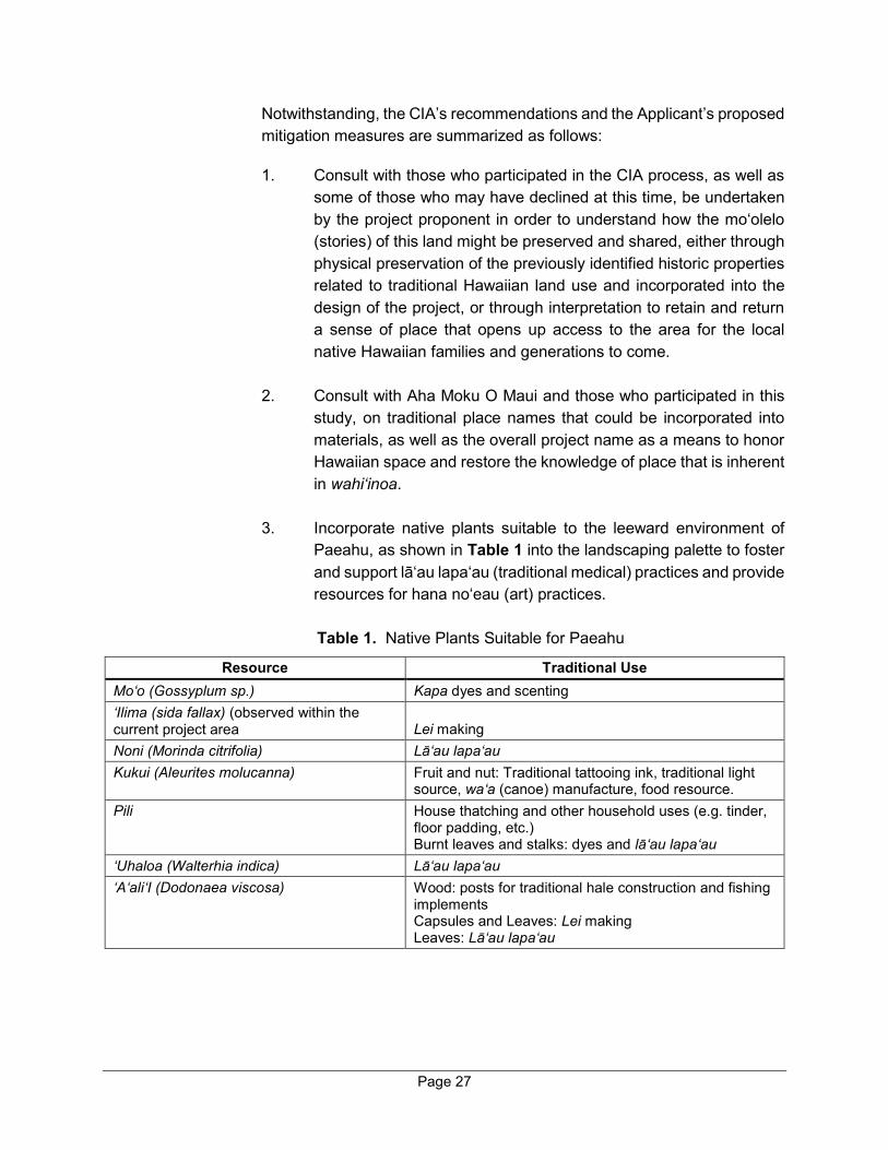
3. Incorporate native plants suitable to the leeward environment of
Paeahu, as shown in Table 1 into the landscaping palette to foster and support lā‘au lapa‘au (traditional medical) practices and provide resources for hana no‘eau (art) practices. Table 1. Native Plants Suitable for Paeahu
Resource Traditional Use Mo‘o (Gossyplum sp.) Kapa dyes and scenting ‘Ilima (sida fallax) (observed within the current project area Lei making Noni (Morinda citrifolia) Lā‘au lapa‘au Kukui (Aleurites molucanna) Fruit and nut: Traditional tattooing ink, traditional light
source, wa‘a (canoe) manufacture, food resource. Pili House thatching and other household uses (e.g. tinder,
floor padding, etc.) Burnt leaves and stalks: dyes and lā‘au lapa‘au
‘Uhaloa (Walterhia indica) Lā‘au lapa‘au ‘A‘ali‘I (Dodonaea viscosa) Wood: posts for traditional hale construction and fishing
implements Capsules and Leaves: Lei making Leaves: Lā‘au lapa‘au
Page 28
4. Reduce light pollution by exceeding the lighting standards of the Wailea Resort to assist with reducing seabirds fallout due to disorientation related to artificial lighting and maintain the visibility of the night sky.
5. Identify potential runoff and flooding zones within the project area
to ensure proper maintenance of water channels in order to help minimize coastal resource degradation that may result from flooding.
6. Reduce stormwater runoff by using Low Impact Design (LID)
measures and green infrastructure methods to capture, collect, and retain stormwater, as well as potentially remove pollutants in any stormwater runoff that might eventually enter the ocean through the project area.
It is noted that various sustainability strategies will be undertaken as part
of the project to educate new residents of the proposed residential community and honor the native Hawaiian history and culture in accordance with the project’s overall guiding sustainability principles. The proposed sustainability strategies include strategic placemaking to tell relevant stories and informing new residents of native Hawaiian culture through books, art, and design.
With implementation of the mitigation measures discussed above, the proposed project is not anticipated to present significant adverse impacts on cultural resources. Refer to Appendix “F”.
B. SOCIO-ECONOMIC ENVIRONMENT
1. Regional Setting
a. Existing Conditions
From a regional standpoint, the project site is located within the Kihei-Makena Community Plan region which encompasses the area from Mā‘alaea in the north to La Perouse Bay in the south. This region contains a diverse range of physical and socio-economic environments. With its dry and mild climate and proximity to recreation-oriented shoreline resources, the visitor-based economy has grown steadily over the years. The town of Kīhei serves as the commercial and residential center of the region with the master-planned communities of Wailea and Mākena serving as the focal
Page 29
point for visitor activities. A number of internationally recognized hotels and golf courses are located along the coastline at Wailea and Mākena.
b. Potential Impacts and Mitigation Measures
The proposed project is compatible with the surrounding resort-related and residential land uses. The regional character of the Wailea and Mākena areas will be complemented by the proposed action. Project design parameters have taken into consideration architectural and landscape thematic concepts which will advance consistency with the area’s built environment.
2. Population and Demography
a. Existing Conditions
According to Gale Cengage Learning, which provides demographic data based on the 2000 and 2010 Census and provides current and future year estimates for various geographic areas, the resident population of the County of Maui was 154,834 in 2010 and was estimated to be 164,872 in 2019. This represents a 6.5 percent increase over the past nine (9) year period. By 2024, the population of the County of Maui is projected to reach approximately 169,217 (Gale Cengage Learning, 2020).
The project area is located on the southwestern part of Maui, within the Kihei-Makena Community Plan region. Just as Maui County’s population has grown, the resident population of the Kīhei-Mākena region has also increased. The population of the Kīhei-Mākena region (including Kīhei, Mākena, Wailea Census Designated Places (CDP)) is estimated to be 28,215 in 2019 (Gale Cengage Learning, 2020), comprising 17.1 percent of the County’s population. According to the 2010 Census, the resident population of the Kīhei-Mākena region was 26,917. The resident population for this region in 2019 increased by 4.8 percent since 2010. By 2024, the population for the region is projected to reach approximately 28,590 (Gale Cengage Learning, 2020).
b. Potential Impacts and Mitigation Measures
As a resort community, the expected buyer demographic profile includes local residents, with the majority of buyers being from off-island. Based on the Applicant’s experience in developing similar projects, it is anticipated that approximately 90 percent of the single-family condominium units will be utilized as part-time residences.
Page 30
In terms of housing, the Wailea Resort SF-S Residential Project proposes 57 single-family residential condominium units. The Applicant recognizes the need for affordable housing on Maui and is committed to meeting its workforce housing obligations for this project, in full compliance with the applicable County requirements. Under the County’s Residential Workforce Housing Policy (Chapter 2.96, MCC), developers are required to provide residential workforce housing units equivalent to at least 25 percent of the total number of market rate units. The proposed project will utilize residential workforce housing credits, which were acquired from A&B Wailea LLC, the previous owner of the property, to comply with applicable requirements of Chapter 2.96, MCC.
Beyond the use of the aforementioned workforce housing credits, the applicant has been and will continue to evaluate building residential workforce housing units when such opportunities are commercially viable.
The proposed action is not anticipated to have significant adverse impacts on population.
3. Economy and Labor Force
a. Existing Conditions
The economy of Maui is heavily dependent upon the visitor industry and in turn the industry fosters the retail and service industries. The dependency on the visitor industry is especially evident in the Kīhei-Mākena region, which is one of the State's major resort destination areas. The foundation for the region’s visitor strength lies in the availability of vacation rentals, hotel condominiums, single-family and multi-family resort residential properties, world-class resorts and recreational facilities throughout Kīhei, Wailea, and Mākena. Service support for the visitor industry is found in Kīhei, where numerous retail commercial centers are located.
Hawai‘i’s economy through 2019 was strong, with record-setting visitor arrivals and low unemployment. However, the COVID-19 pandemic will have far reaching impacts on the economy on Maui, in Hawai‘i, and across the nation and world. Stay-at-home regulations and travel quarantines aimed to curb the spread of the COVID-19 virus in Hawai‘i have caused many businesses to shut down or drastically reduce operations. Unemployment claims have soared. It was reported that more than one third of Hawai‘i’s labor force has filed unemployment claims as the Hawaiian islands effectively shut down large sectors of the economy to slow the spread of the COVID-19 virus (Honolulu Star Advertiser, 2020). It is expected that the recovery will take many months, if not years, and as

Page 31
such, the labor force, and State and County revenues will suffer for some time to come.
b. Potential Impacts and Mitigation Measures
The proposed project includes development of 57 single-family residential condominium units, an amenity center, and related infrastructure improvements. As will be detailed below, the project will generate construction-related spending and employment during the estimated 3 year construction period. Once completed, the project will support the local economy on Maui by directly creating jobs and generating new spending in the local economy. As noted previously, it is anticipated that approximately 90 percent of the single-family condominium units will be utilized as part-time residences. A summary of the anticipated economic and fiscal impacts for the project during construction and at full build-out is provided below. Detailed tables are provided in Appendix “G”.
(1) Development-Related (Construction Period) Economic and Fiscal Impacts
The proposed project is estimated to cost approximately $130 million to construct over a 3-year development period. The project is anticipated to create approximately 77 full-time equivalent (FTE) construction-related jobs on average per year, with an annual payroll of $5.8 million. Project-related construction expenditures would result in a General Excise Tax (GET) revenue of $453,000 per year or $1.36 million over a 3-year development period for the State of Hawai‘i. Salaries and wages from construction activities would result in approximately $347,000 of annual Personal Income Tax revenue for the State. In addition, approximately $1.23 million of Conveyance Tax revenue is estimated for all 57 residential units for the State of Hawaiʻi based on the projected sale price for each residential unit. Refer to Appendix “G”. The County will collect permit fees associated with construction permits for the project. Inasmuch as the State and County of Maui are not anticipated to bear any additional costs as a result of project construction, the proposed project will generate a positive fiscal impact for the State and County during the construction period.
(2) Build-Out Economic and Fiscal Impacts From a long-term perspective, the project will create new jobs and
generate new spending in the local economy. The Wailea Resort SF-S Residential Project will employ three (3) FTE employees for
Page 32
operations, maintenance, and administration of the residential community. This will result in an increase in Personal Income Tax revenue to the State of Hawai‘i by $8,300 annually. New residents of the Wailea Resort SF-S Project are anticipated to spend money locally (i.e. shopping and dining). In addition, each homeowner of the proposed community will contribute approximately $3,000 of homeowners association fee per month, portions of which will be spent locally for repair and maintenance of the community. These new spending by the residents and/or homeowners of the proposed community will in turn result in an increase in the GET revenue to the State of Hawaiʻi.
The proposed project will result in a substantial increase in property tax revenue to the County of Maui. Residential property tax revenues for the project are estimated based on the estimated sales price for each residential unit and improvement value (construction cost) for the proposed amenity center. Detailed calculations of the residential property tax revenues are presented in Appendix “G”. The total annual property tax generated at the subject property after the project build-out is estimated at $1.13 million per year. In 2019, the existing property tax assessment for the subject property was approximately $60,800. Therefore, the net new property tax revenue generated by the proposed project is estimated to be approximatey $1.07 million annually. Refer to Appendix “G”.
Based on the foregoing, the proposed project will have a direct positive economic and fiscal impact resulting from increased employment and tax revenues for the State and County. Beyond the direct economic and fiscal impacts, it is noted that the project will generate indirect and induced benefits for the local economy which have not been quantified above. The project is anticipated to help mitigate the impacts of the COVID-19 pandemic by facilitating economic activity and tax revenues.
C. PUBLIC SERVICES
1. Police and Fire Protection
a. Existing Conditions
The County of Maui’s Police Department’s (MPD) main headquarters is in Wailuku at its Mahalani Street facility. The department consists of several

Page 33
patrol, support, administrative, and investigative divisions that service the Hāna, Lāna‘i, Lāhainā, Moloka‘i, Wailuku, and Kīhei regions.
The MPD has a station in Kīhei on the east side of Piʿilani Highway at the intersection with Kanani Street approximately 1.6 miles north of the project site. The MPD’s Kīhei station covers the Kīhei-Mākena region.
Fire prevention, protection, and suppression services are provided by the County of Maui, Department of Fire and Public Safety. The Kīhei Fire Station, which services the Kīhei-Mākena region from North Kīhei to Kama‘ole Beach Park II, is situated on South Kīhei Road near Kalama Park, approximately 2.4 miles northwest of the project site near the Kilohana Drive/Kapili Street intersection. The Wailea Fire Station is located in the close proximity of the subject property, approximately 700 feet to the north near the Kilohana Drive/Kapili Street intersection. The Wailea Station services the area from Kama‘ole Beach Park II to Mākena, and is located on land that was donated, in part, by the previous owner of the subject parcel.
b. Potential Impacts and Mitigation Measures
The project site is located within the Wailea Resort, in the vicinity of existing resort properties which are currently afforded similar services. The proposed project is not expected to extend the service area for emergency service providers. Access to the proposed project is planned from Kapili Street.
The proposed action will contribute towards police and fire protection services through real property tax revenues generated from the project. As such, substantial secondary impacts or effects on public facilities, such as on police and fire protection services, are not anticipated from project implementation.
2. Medical Facilities
a. Existing Conditions
Maui Memorial Medical Center, the only major medical facility on the island, services the Kīhei-Mākena region. Acute, general, and emergency care services are provided by this facility, which is licensed for 213 beds and is situated in Wailuku, in the vicinity of Mahalani Street and Maui Lani Parkway.

Page 34
Clinics and doctors’ offices are situated throughout the Kīhei and Wailea areas, however, these offer medical services on a lesser scale. Such clinics include Kihei Clinic, Wailea Medical Services, Kihei Pediatric Clinic, Kihei Physicians, the Kihei-Wailea Medical Center, Maui Medical Group, and Kaiser Permanente.
b. Potential Impacts and Mitigation Measures
The proposed project is not anticipated to affect the service capabilities of emergency medical or general care operations. As noted above, medical services are available throughout the Kīhei-Makena region.
3. Education Facilities
a. Existing Conditions
The State DOE operates four (4) schools in South Maui. Kīhei Elementary School and Kamali‘i Elementary School cover grades Kindergarten to 5, and Lokelani Intermediate School covers grades 6 to 8. Maui High School, which covers grades 9 to 12 and is located in Kahului, is the designated public high school for South Maui residents. Kīhei Public Charter School covers grades Kindergarten to 12. The enrollments for these schools are presented in Table 2.
Table 2. Enrollments at Department of Education Schools Serving South Maui Residents
School
Actual Enrollment
SY 18-19
Maui High 2,017
Lokelani Intermediate 551
Kamali‘i Elementary 472
Kīhei Elementary 690
Kīhei Charter 652
Source: Department of Education, 2019.
The University of Hawai‘i Maui College (UHMC), located in Kahului, is a branch of the University of Hawai‘i system. UHMC is the primary higher education institution serving Maui.
The new Kihei High School is scheduled to be open in 2021 and will serve the Kīhei-Makena region.
Page 35
b. Potential Impacts and Mitigation Measures
The proposed project will offer 57 single-family residential condominium units for sale. For the most part, the units will be used intermittently by their owners. As previously mentioned, approximately 90 percent of the proposed homes at the project are anticipated to be part-time residences and would not have children enrolled in local public schools. In addition, resort-oriented housing in Wailea attracts an older population, including many retirees who do not have school-age children. The impacts from the project on school facilities and enrollments are, therefore, not anticipated to be significant.
The project site is located in the DOE’s Central Maui Impact Fee District. It is noted that the proposed project is covered under a fair share agreement between DOE and A&B Wailea LLC, the previous owner of the subject property. A&B Wailea LLC contributed $1 million towards the construction of Kamaliʻi Elementary School in Kīhei and received DOE credits in the amount of 1,176 units, a portion of which will be utilized towards the proposed Wailea Resort SF-S Residential Project to satisfy the DOE impact fee requirement.
4. Recreational Facilities
a. Existing Conditions
Diverse recreational opportunities are available in the Kihei-Makena Community Plan region. Shoreline activities, such as fishing, surfing, jogging, camping, picnicking, snorkeling, swimming, and windsurfing, are by far the predominant forms of recreation in the area. Within the Wailea Resort there are numerous recreational facilities such as Kilohana Park on Kilohana Drive and the various beach parks from Keawakapu Beach to Polo Beach.
Numerous public park facilities exist within Kīhei, a relatively short driving distance from the project site, including Waipuilani, Kalama, and Kama‘ole I/II/III Beach Parks. Additional recreational resources include the Kīhei Community Center and Aquatic Center and South Maui Park, as well as the resort-affiliated, world-class golf courses and tennis centers of Wailea and Mākena.
b. Potential Impacts and Mitigation Measures
While usage of recreational facilities (such as beach parks) in the Wailea area may slightly increase with implementation of the proposed project, this

Page 36
increase is not expected to be significant given the average daily population characteristics of the project. It is noted that pursuant to zoning conditions of Ordinance No. 2694, which was approved in 1998 by the Maui County Council and conditionally zoned the subject parcel as “R-3 Residential District”, the parks assessment has been satisfied for the subject property through the donation of a 5.75-acre parcel, identified as TMK (2)3-9-038:26, to the County for use as a fire station and a park.
Given the foregoing, the proposed project is not anticipated to impact recreational facilities in the Kīhei-Mākena region.
5. Solid Waste
a. Existing Conditions
Single-family residential solid waste collection service is provided by the County of Maui on a weekly basis. Residential solid waste collected by County crews are disposed at the County’s Central Maui Landfill located 4.0 miles southeast of the Kahului Airport. In addition to County-collected refuse, the Central Maui Landfill accepts commercial waste from private collection companies. A County supported green waste recycling facility is also located at the Central Maui Landfill.
The County of Maui’s 2009 Integrated Solid Waste Management Plan estimates that the Central Maui Landfill has adequate capacity to accommodate commercial and residential waste needs through the year 2026 (Gershman, Brickner & Bratton, Inc., 2009). The County is currently in the process of planning a processing facilities project at the Central Maui Landfill which will further extend the life of the landfill.
b. Potential Impacts and Mitigation Measures
Construction waste generated by the project will be transported to appropriate processing facilities. Post-construction, the proposed project will be served by a private waste collection company. The proposed project is, therefore, not anticipated to affect the service capabilities of the Countyʻs residential waste collection operations.
As mentioned previously, the Central Maui Landfill has adequate capacity through the year 2026 with capacity enhancements expected with implementation of the facilities processing project adjacent to the landfill. The remaining capacity estimated by the Integrated Solid Waste Management Plan is based on future disposal volumes that assumes significant population growth. The proposed project is not anticipated
Page 37
to present significant adverse impacts on Central Maui Landfill solid waste capacity estimates.
In accordance with the project’s overall guiding sustainability principles, various waste management strategies will be implemented through construction and operation of the project. The strategies include onsite recycling of construction materials, construction waste minimization through standardization of homes, and recycling capabilities in each home for home pick up by a refuse hauler.
D. INFRASTRUCTURE
1. Roadways
a. Existing Conditions
Access to the project site is provided by Kapili Street. The following is a summary of major roadways in the vicinity of the project site.
Pi‘ilani Highway – is a north-south State Highway that extends southward from Maui Veterans Highway at its intersection with North Kīhei Road and terminates approximately seven (7) miles to the south at Wailea Ike Drive. Pi‘ilani Highway provides regional access to Kīhei and Wailea and is generally a two-way, four-lane, principal arterial that transitions to a two-way, two-lane roadway south of its intersection with Kilohana Drive and Mapu Drive. Exclusive left-turn lanes and right-turn deceleration lanes are provided at all major intersections with the shoulder areas of the highway designated as bicycle lanes. Within the study area, the posted speed limit along this roadway is 45 miles per hour (mph).
South Kihei Road – is generally a two-way, two-lane, undivided, north-south County roadway that traverses the Kīhei coastline. This roadway begins at a T-intersection with North Kihei Road near Maui Veterans Highway and eventually terminates at Okolani Drive in Wailea. South Kihei Road provides local access to shopping centers and visitor accommodations. The posted speed limit along this roadway in the Project vicinity is 20 mph. Continuous sidewalks and a shoulder/bike lane are provided along South Kihei Road in the vicinity of the Project.
Kilohana Drive – is a two-way, two-lane, east-west County roadway that extends from South Kīhei Road eastward to Pi‘ilani Highway. The posted speed limit along this roadway is 25 mph.
Page 38
Okolani Drive – is a four-lane, divided, east-west County collector roadway between South Kīhei Road and Wailea Alanui Drive. Okolani Drive narrows to a two-lane undivided roadway east of Wailea Alanui Drive to its intersection with Pi‘ilani Highway directly across of Mikioi Street. The posted speed limit on Okolani Drive is 30 mph.
Kapili Street – is a two-way, two-lane, undivided, north-south private roadway that extends southward from its intersection with Kilohana Drive to its intersection with Okolani Drive. The posted speed limit along this roadway is 30 mph. Continuous sidewalks are provided adjacent to the southbound side for the entire length of Kapili Street and along the northbound side within residential areas. Kapili Street is currently privately owned but is open for public use.
Wailea Alanui Drive – is a two-way, two-lane, divided, north-south, County roadway that extends northward from its intersection with Makena Road and terminates to the north at its intersection with Kilohana Drive and Lawakua Street. The posted speed limit along this roadway is 30 mph. Continuous sidewalks are provided along the southbound side of Wailea Alanui Drive within the project vicinity.
Wailea Ike Drive – is a divided, east-west, two-way, four-lane collector roadway that connects Pi‘ilani Highway with Wailea Alanui Drive. Wailea Ike Drive provides access to resort, residential, and commercial areas. The posted speed limit is 30 mph.
Wailea Ike Place – is an undivided, north-south, two-way, two-lane roadway that provides access to the Grand Champions Villas residential neighborhood, Wailea Tennis Club and various retail/office space to the north of Wailea Ike Drive and the Wailea Ekolu Village residential neighborhood and Wailea Village Center to the south of Wailea Ike Drive. The posted speed limit is 20 mph.
Kualono Place – is a two-way, two-lane, private driveway providing residents with access from the Wailea Pualani Estates gated community to Okolani Drive.
A Traffic Impact Analysis Report (TIAR) was prepared for the proposed project by Austin, Tsutsumi & Associates in May 2020. See Appendix “H”.
The TIAR evaluated the following intersections:
South Kihei Road/Kilohana Drive (Unsignalized)
Kilohana Drive/Wailea Alanui Drive (Unsignalized)

Page 39
Kilohana Drive/Kapili Street (Unsignalized)
Pi‘ilani Highway/Kilohana Drive (Signalized)
Pi‘ilani Highway/Okolani Drive (Unsignalized)
Okolani Drive/Kualono Place (Unsignalized)
Okolani Drive/Kapili Street (Unsignalized)
Okolani Drive/Wailea Alanui Drive (4-way stop)
Wailea Alanui Drive/Wailea Ike Drive (Signalized)
Wailea Ike Drive/Wailea Ike Place (North) (Unsignalized)
Wailea Ike Drive/Wailea Ike Place (South) (Unsignalized)
Level of service (LOS) of each intersection was evaluated as part of the TIAR. LOS is a measure of the acceptability of delay values to motorists at a given intersection. The criteria are presented in Table 3 below.
Table 3. Level of Service Criteria for Signalized Intersections
Level of Service Control Delay per Vehicle (sec./veh)
A < 10.0
B > 10.0 and ≤ 20.0
C > 20.0 and ≤ 35.0
D > 35.0 and ≤ 55.0
E > 55.0 and ≤ 80.0
F > 80.0 Based on traffic counts, the weekday morning peak hour was determined
to occur between 7:30 a.m. and 8:30 a.m. and the afternoon peak hour was determined to occur 3:15 p.m. to 4:15 p.m. At the time of traffic counts, Wailea Village Center construction was occurring, which impacted turning movements at the Wailea Ike Drive/Wailea Ike Place (South) intersection. As a result, 2017 traffic counts were used at this intersection.
The majority of movements at the study intersections operated adequately at LOS D or better and under-capacity conditions during the peak hours of traffic with the exception of the following:
Pi‘ilani Highway and Kilohana Drive Intersection – During the afternoon peak hour, northbound through volumes were observed to queue for about a 30-35 minute period extending as far south to Okolani Drive. By 4:50 p.m., vehicle queues were observed to clear

Page 40
without heavy congestion. Traffic analysis indicates the intersection operates at overall LOS C with all movements operating at LOS D or better, with the exception of the northbound left-turn movement, which operates at LOS E.
Pi‘ilani Highway and Okolani Drive Intersection – During the morning peak hour, all approaches operate relatively smoothly with minor movements experiencing moderate delay. Traffic analysis indicated that the northbound and southbound left-turn movements operate at LOS A and the eastbound and westbound left-turn/through movements operate at LOS E and LOS C, respectively. During the afternoon peak hour, higher volumes along Pi‘ilani Highway result in longer delays to the minor street movements. The northbound and southbound left-turn movements operate at LOS A/B and the eastbound/westbound approaches operate at LOS E/F, with eastbound approach operating over-capacity. A traffic signal is currently being designed and will be implemented at the Pi‘ilani Highway/Okolani Drive/Mikioi Place intersection as part of the mitigation for the Kai Malu Wailea residential development.
b. Potential Impacts and Mitigation Measures
The proposed project will have access from Kapili Street. The proposed project involves two (2) driveway improvements (main entrance and vehicle exit) along Kapili Street and an emergency access improvement and a new pedestrian crossing along Wailea Alanui Drive.
To analyze the traffic impacts in the area, the TIAR analysed traffic projections for Base Year 2024 without the proposed SF-S Residential Project, including traffic generated by other known developments in the vicinity of the proposed project in addition to an ambient growth rate. The TIAR also analyzed traffic projections for Future Year 2024 with the proposed project, which include the Base Year traffic volumes in addition to traffic volumes generated by the Wailea Resort SF-S Residential Project.
The LOS at the study intersections for existing, future (without project) and future (with project) are summarized inTable 4, below:

Page 41
Table 4. Level of Service Summary
Intersection
Existing Conditions
Base Year 2024 Without Project
Future Year 2024 with Project
AM LOS
PM LOS AM LOS PM LOS AM LOS PM LOS
1: South Kihei Road and Kilohana Drive WB LT/RT B C B C B C SB LT A A A A A A
Overall – – – – – – 2: Wailea Ala Nui Drive and Kilohana Drive
NB LT/TH/RT
B B B B B B
WB LT A A A A A A SB LT/TH/RT
B B B B B B
Overall – – – – – – 3: Kapali Street and Kilohana Drive
NB LT/RT A A A B A B WB LT A A A A A A
Overall – – – – – – 4: Piilani Highway and Kilohana Drive/Mapu Drive
NB LT D E E E E E NB TH – – A B A B NB TH/RT A B – – – – NB RT – – A A A B EB LT C D D D D D EB TH/RT C D D D D D WB LT – – D D D D WB TH – – D D D D WB LT/TH/RT
C D – – – –
WB RT – – D D D D SB LT D D D D D D SB TH B B C C C C SB RT A A A A A A
Overall B C C C C C 5: Piilani Highway and Okolani Drive
NB LT A A D D D D NB TH – – A B A B NB RT – – A A A A EB LT/TH/RT
E F* C D C D
WB LT/TH/RT
C E C D C D
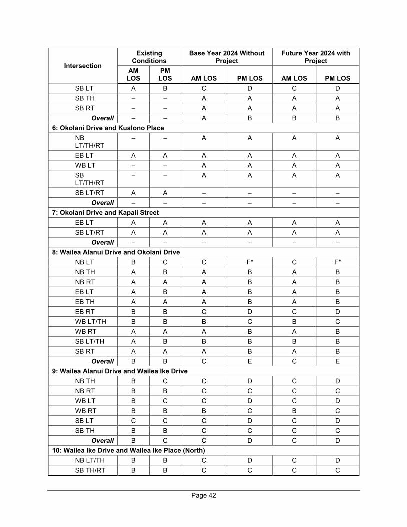
Page 42
Intersection
Existing Conditions
Base Year 2024 Without Project
Future Year 2024 with Project
AM LOS
PM LOS AM LOS PM LOS AM LOS PM LOS
SB LT A B C D C D SB TH – – A A A A SB RT – – A A A A
Overall – – A B B B 6: Okolani Drive and Kualono Place
NB LT/TH/RT
– – A A A A
EB LT A A A A A A WB LT – – A A A A SB LT/TH/RT
– – A A A A
SB LT/RT A A – – – – Overall – – – – – –
7: Okolani Drive and Kapali Street EB LT A A A A A A SB LT/RT A A A A A A
Overall – – – – – – 8: Wailea Alanui Drive and Okolani Drive
NB LT B C C F* C F* NB TH A B A B A B NB RT A A A B A B EB LT A B A B A B EB TH A A A B A B EB RT B B C D C D WB LT/TH B B B C B C WB RT A A A B A B SB LT/TH A B B B B B SB RT A A A B A B
Overall B B C E C E 9: Wailea Alanui Drive and Wailea Ike Drive
NB TH B C C D C D NB RT B B C C C C WB LT B C C D C D WB RT B B B C B C SB LT C C C D C D SB TH B B C C C C
Overall B C C D C D 10: Wailea Ike Drive and Wailea Ike Place (North)
NB LT/TH B B C D C D SB TH/RT B B C C C C
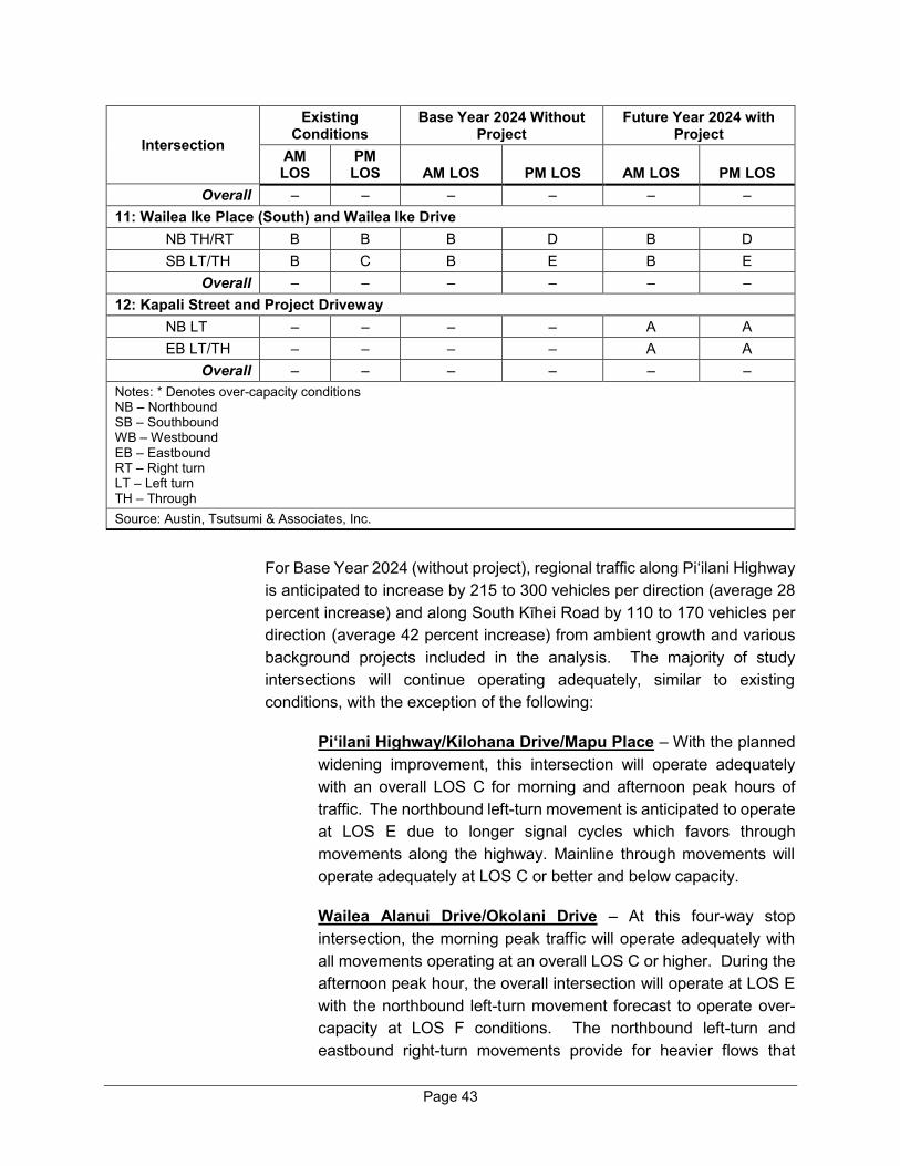
Page 43
Intersection
Existing Conditions
Base Year 2024 Without Project
Future Year 2024 with Project
AM LOS
PM LOS AM LOS PM LOS AM LOS PM LOS
Overall – – – – – – 11: Wailea Ike Place (South) and Wailea Ike Drive
NB TH/RT B B B D B D SB LT/TH B C B E B E
Overall – – – – – – 12: Kapali Street and Project Driveway
NB LT – – – – A A EB LT/TH – – – – A A
Overall – – – – – – Notes: * Denotes over-capacity conditions NB – Northbound SB – Southbound WB – Westbound EB – Eastbound RT – Right turn LT – Left turn TH – Through Source: Austin, Tsutsumi & Associates, Inc.
For Base Year 2024 (without project), regional traffic along Pi‘ilani Highway
is anticipated to increase by 215 to 300 vehicles per direction (average 28 percent increase) and along South Kīhei Road by 110 to 170 vehicles per direction (average 42 percent increase) from ambient growth and various background projects included in the analysis. The majority of study intersections will continue operating adequately, similar to existing conditions, with the exception of the following:
Pi‘ilani Highway/Kilohana Drive/Mapu Place – With the planned widening improvement, this intersection will operate adequately with an overall LOS C for morning and afternoon peak hours of traffic. The northbound left-turn movement is anticipated to operate at LOS E due to longer signal cycles which favors through movements along the highway. Mainline through movements will operate adequately at LOS C or better and below capacity.
Wailea Alanui Drive/Okolani Drive – At this four-way stop intersection, the morning peak traffic will operate adequately with all movements operating at an overall LOS C or higher. During the afternoon peak hour, the overall intersection will operate at LOS E with the northbound left-turn movement forecast to operate over-capacity at LOS F conditions. The northbound left-turn and eastbound right-turn movements provide for heavier flows that
Page 44
service regional traffic between Kīhei and the Wailea/Makena regions. All remaining movements at this intersection are relatively low, with peak volumes generally below 100 vehicles per movement. Based on the U.S. Department of Transportation’s Manual on Uniform Traffic Control Devices for Streets and Highways (MUTCD) four-hour signal warrant, a signal will likely not be warranted by Year 2024.
Wailea Ike Drive/Wailea Ike Place (South) – The southbound left turn/through movement is anticipated to operate at LOS E conditions during the afternoon peak hour, however, should operate well below capacity. Existing observations also showed minimal southbound queues ranging from only 1 to 2 vehicles. Based on MUTCD, a signal will likely not be warranted by Year 2024.
For the Future Year 2024 (with project), the proposed project is forecast to generate approximately 32(30) new vehicle trips during the morning (afternoon) peak hours of traffic, respectively. Upon completion of the Project, all study intersections are forecast to operate with similar LOS as Base Year 2024 traffic conditions. Regionally along Pi‘ilani Highway, traffic generated by the Project will increase by approximately 1 to 8 vehicles in each direction per peak hour, which translates to a 0.6 percent increase in traffic. Similarly along South Kihei Road, traffic will only increase by approximately 4 vehicles in each direction per peak hour, which translates to a 0.8 percent increase in traffic. Due to generally low traffic increases as a result of the Project, the majority of movements will operate with the same LOS as Base Year 2024 condition. All movements that operated at LOS E/F with Base Year 2024 conditions will continue operating at LOS E/F for Future Year 2024.
As discussed previously, the Wailea Alanui Drive/Okolani Drive intersection is forecast to operate at overall LOS E and the northbound left-turn will operate over-capacity at LOS F during the afternoon peak hour for Base Year 2024. Since there are no planned improvements at the Wailea Alanui Drive/Okolani Drive intersection, it was analyzed as a 4-way stop for Future Year 2024. A traffic signal is likely not warranted. Refer to Appendix “H”.
It is noted that a Memorandum of Agreement, dated March 14, 2016, and its subsequent amendment between the State DOT and landowners in Wailea Resort, encompass the subject property. As such, the Applicant will contribute the regional fair share for the following planned improvements in Wailea Resort:
Page 45
Widening of Piilani Highway to provide an additional northbound through lane and an exclusive northbound right-turn lane at the Piʻilani Highway/Kilohana Drive/Mapu Place intersection.
Widening of the westbound Mapu Drive approach to provide an exclusive left-turn, through, and right-turn lane.
It is noted that these planned improvements will not be triggered by the construction of the proposed Wailea Resort SF-S Residential Project and will be implemented at the appropriate time in accordance with the Memorandum of Agreement and its subsequent amendment. The proposed 57 units of the project will count towards the 150-unit trigger needed to implement the planned improvements.
In accordance with the project’s overall guiding sustainability principles, residents and visitors of the proposed community will be encouraged to walk and bicycle by road design, including installation of multi-modal paths on main roads, which will connect to the Wailea Alanui Drive and Kapili Street, and installation of shade trees. Based on the foregoing, the proposed project is not anticipated to result in significant adverse impacts to the traffic conditions in the vicinity of the project site.
2. Water System
a. Existing Conditions
A Preliminary Engineering and Drainage Report (PEDR) was prepared for the proposed project in May 2020. Refer to Appendix “C”. The proposed project is located within the existing service area of the County of Maui Department of Water Supply (DWS)’s Central Maui Water system. The Central Maui water system serves residents and businesses in Wailuku, Pāi‘a, Kahului, Pu‘unēnē, and Kīhei. The water sources of the Central Maui water system include groundwater wells located in Waiehu and Waihee which draw water from the Iao Aquifer.
The existing Wailea water storage system is divided into three (3) systems, the Low, Mid, and High level water storage systems.
b. Potential Impacts and Mitigation Measures
Potable water for drinking and fire protection for the proposed Wailea Resort SF-S Residential Project will be supplied from DWS’ existing 3.0 million gallon (MG) capacity Wailea Mid-Level storage tank located along Kalai Waa Street and A&B Wailea LLC’s existing 1.0 MG capacity Upper-
Page 46
Level storage tank located within the Wailea 670 development. A&B Wailea LLC is in the process of dedicating the Upper-Level storage tank to DWS. An existing 17-mile long transmission line transmits water from DWS’ well sources in Waiehu and Waihee to fill these tanks. Together, the 1.0 MG Upper-Level tank and 3.0 MG Mid-Level tank provide the necessary water pressure, domestic storage capacity, and fire protection storage capacity that are needed to meet DWS’ water service standards for the Wailea Resort SF-S Residential Project. As such, no storage improvements are required for the proposed project. Refer to Appendix “C”.
An existing network of 12-, 16-, and 18-inch diameter distribution mains within the Wailea Resort brings water from the 3.0 MG Wailea Mid-Level and 1.0 MG Upper-Level storage tanks to the Wailea Resort SF-S Residential Project site. Three (3) sets of service mains, including two (2) for drinking water and another for fire protection, will be extended into the project site from the existing 12-inch Mid-Level and 12-inch Upper-Level distribution mains located on Kapili Street to provide water service to each home and supply the fire hydrants located at regular intervals through the development.
Two (2) DWS-issued 3-inch water meters, one for the Upper-Level service zone and the other for the Mid-Level service zone, will be installed on the drinking water main near Kapili Street to measure water usage by the entire development. See Figure 9. Water use by each condominium unit, amenity center building, and common-area irrigation will be tracked by privately-read sub-meters installed downstream of the main County meter. The project’s existing 1-inch irrigation water meter will be utilized to supplement the project's water demands. Refer to Appendix “C”.
It is noted that the proposed project is located beyond the service limits of the existing R-1 distribution system. In accordance with the project’s overall guiding sustainability principles, the project’s irrigation system for common areas will be designed to facilitate the future connection to the R-1 distribution system when it becomes available. Based on the foregoing, significant adverse impacts to the Maui County’s water system are not anticipated as a result of the proposed project.
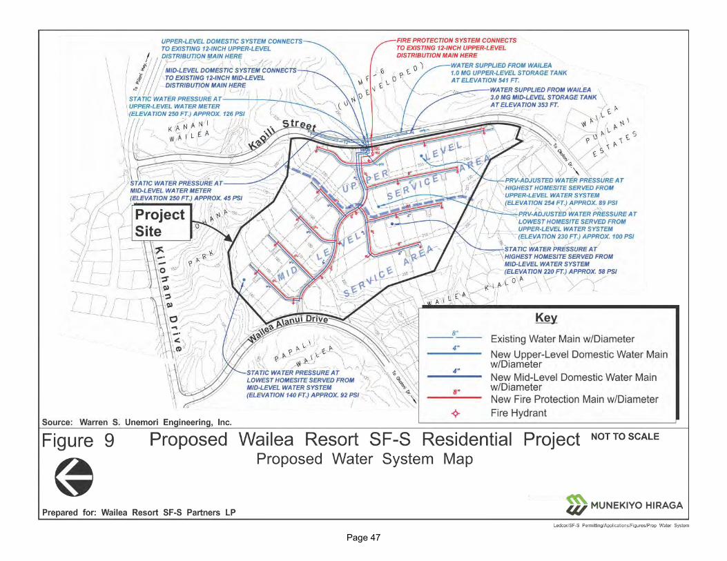
Page 47
Figure 9. Proposed Water System Map
Page 48
3. Wastewater System
a. Existing Conditions
The service area for the County’s Kīhei Wastewater Reclamation System extends from North Kīhei to Wailea. The system consists of a number of pump stations and force mains which convey wastewater through the County’s transmission lines. The combined flows are transported to the Kīhei Wastewater Reclamation Facility, which is located adjacent to the Maui Nui Golf Club. The existing design capacity of the Kīhei Wastewater Reclamation Facility is 8.0 million gallons per day (MGD).
The wastewater generated within the Wailea area is collected and transported to sewer pump stations by a series of gravity polyvinyl chloride (PVC) sewerlines and manholes. Generally, the collection system consists of primarily 8-inch gravity mains running throughout the existing residential and commercial areas that eventually connect to a main trunk line ranging from 8-inch to 30-inch diameter that runs along Wailea Alanui Drive and South Kīhei Road. The wastewater collected is transported to a series of force mains ranging from 6-inch to 12-inch diameter to existing pump stations.
b. Potential Impacts and Mitigation Measures
According to the PEDR prepared for the proposed project, the proposed Wailea Resort SF-S Residential Project is expected to generate a wastewater flow of approximately 20,000 gallons per day (GPD). A conventional gravity sewer collection system will be installed as part of the project, which will collect wastewater generated by the buildings and discharge it into the existing 8-inch diameter County sewer main located on Wailea Alanui Drive. The County sewerage system will, in turn, convey the wastewater down Kilohana Drive to South Kīhei Road, then along South Kīhei Road to Pumping Station No. 8; then from Pump Station No. 8 to Pump Station No. 7; then from Pump Station No. 7 to Pump Station No. 6; then from Pump Station No. 6 to the Kihei Wastewater Reclamation Facility above Pi‘ilani Highway. Refer to Appendix “C”.
According to Maui County Department of Environmental Management's Wastewater Reclamation Division (WWRD), about 4,800 feet of a large diameter gravity sewerline, located under South Kīhei Road between Sewer Pump Stations No. 7 and No. 8. is nearing its current safe operating capacity and will require a capacity upgrade if flows increase significantly

Page 49
due to new developments in the Wailea Resort. WWRD is currently working to plan and program the needed capacity upgrade.
WWRD’s Kihei Wastewater Reclamation Facility is currently processing about four (4) MGD out of its eight (8) MGD design capacity. It is anticipated that the Kihei Wastewater Reclamation Facility has sufficient treatment capacity to accommodate the project's projected sewer demand. Refer to Appendix “C”.
4. Drainage
a. Existing Conditions
According to the PEDR prepared for the project, the existing 23.1-acre project site generates approximately 24.5 cubic feet per second (cfs) of onsite surface runoff during a 10-year, 1-hour storm which flows off of the project site in three (3) directions. See Figure 10 and refer to Appendix “C”.
Drainage Area 1 - generates approximately 11.3 cfs of onsite surface runoff which sheet flows to an existing drainage gully located on the County-owned Kilohana Park parcel to the north of the project site. The runoff then flows into an underground storm drain along Kilohana Drive; through an open drainageway crossing the Wailea Kai subdivision; through a culvert crossing at South Kihei Road; then into the ocean at Keawekapu Beach.
Drainage Area 2 - generates approximately 4.5 cfs of onsite surface runoff which enters an 18-inch culvert crossing at Wailea Alanui Drive. The runoff then passes into an open drainage way between the Palms at Wailea and Papali Wailea condominiums; past the Wailea Kai subdivision; through a culvert crossing at South Kīhei Road; then into the ocean at Keawekapu Beach.
Drainage Area 3 - generates approximately 8.7 cfs of onsite surface runoff which flows into the grassed drainage channel passing through the adjacent Wailea Kialoa Subdivision. The runoff then crosses under Wailea Alanui Drive; through the Palms at Wailea; through the Wailea Kai subdivision; across South Kīhei Road; and into the ocean at Keawekapu Beach.
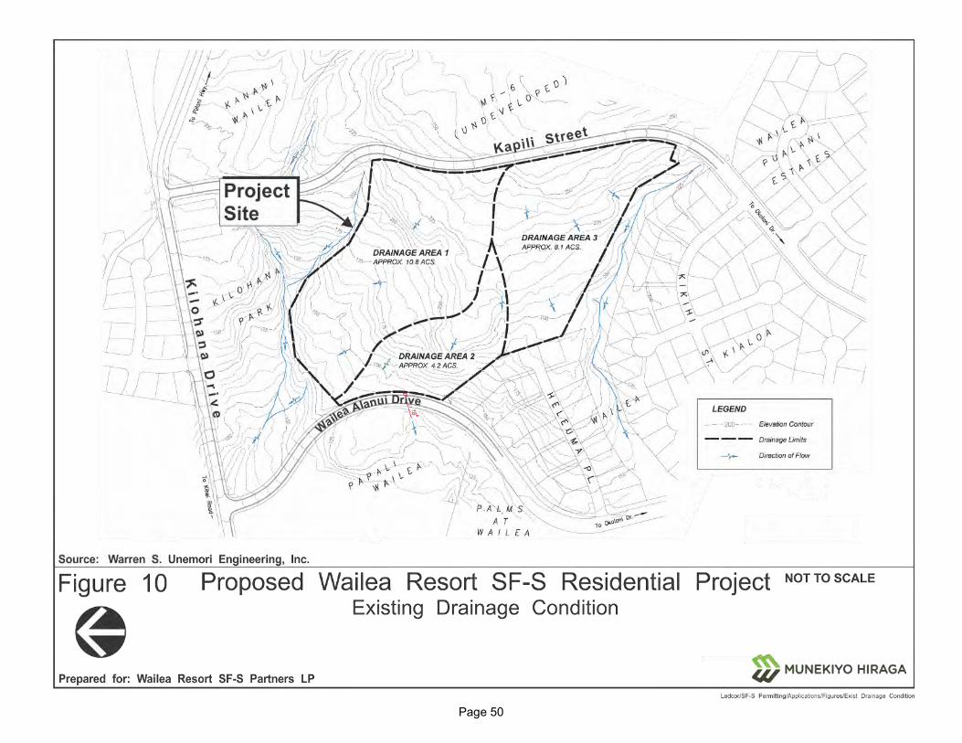
Page 50
Figure 10. Existing Drainage Condition

Page 51
b. Potential Impacts and Mitigation Measures
Development of the proposed Wailea Resort SF-S Residential Project is expected to generate an onsite 10-year, 1-hour peak storm flow of 52.9 cfs, which results in 28.4 cfs increase from its existing condition. The project site will be graded in order to maintain the natural form of the hillside and the drainage pattern that exists. Two (2) different approaches to mitigating the post-development runoff will be implemented:
Drainage Area 1
A LID stormwater system will be implemented for Drainage Area 1. Runoff from rooftops and pavements will be directed into bioretention strips (“Green Streets”) located along on one (1) side of the streets in which runoff will be held and allowed to percolate into the ground. Subsurface storage chambers will be used to augment the capacity of the bioretention strips and underground drainage piping will be installed as a safety precaution to handle overflows and prevent flooding during large storm events.
Drainage Area 2
A conventional storm drainage system will be employed within Drainage Area 2. The conventional system includes inlets and underground pipes installed throughout Drainage Area 2 to collect the runoff shed by rooftops and pavements and convey it to stormwater detention basins located just upstream of pre-designated discharge points.
Drainage Area 3
Drainage Area 3 will employ a combination of a LID stormwater system (“Green Street” bioretention strips), subsurface storage chambers, and a conventional open stormwater basin to provide the storage capacity necessary to mitigate post-development runoff. As with Drainage Area 1, underground drainage piping will be installed as a safety precaution to handle overflows and prevent flooding during large storm events.
The onsite stormwater retention/detention facilities and LID water quality measures described above will mitigate the increase in peak flow attributable to development of the project, with the result that post-development flows discharged into each of the three (3) receiving storm

Page 52
drainage facilities downstream of Drainage Areas 1, 2 and 3 will either decrease or remain unchanged from the current, pre-development condition. See Table 5.
Table 5. Drainage Area Summary
Drainage Area
Receiving Facility
Approx. Area
Draining to
Receiving Facility
Pre-Development Peak Runoff (10 yr/1 hr)
Post-Development Peak Runoff
BEFORE Mitigation
Post-Development Peak Runoff
AFTER Mitigation
Net Change in Peark
Flow AFTER
Mitigation 1 Drainage
through Kilohana Park
10.6 acres 11.3 cfs 24.4 cfs ≤11.3 cfs ≤0.0 cfs
2 18” diameter Roadway Culvert at Wailea Alanui
4.1 acres 4.5 cfs 9.2 cfs ≤4.5 cfs ≤0.0 cfs
3 Drainageway through Wailea Kialoa Subd
8.4 acres 8.7 cfs 19.3 cfs ≤8.7 cfs ≤0.0 cfs
Total 23.1 acres
24.5 cfs 52.9 cfs ≤24.5 cfs ≤0.0 cfs
Based on the foregoing, the proposed project is not anticipated to present significant adverse impacts on downstream properties and nearshore waters. Refer to Appendix “C”.
5. Electrical, Telephone, and Cable Television Systems
a. Existing Conditions
Electrical, telephone, and cable television (CATV) services in the Kīhei-Wailea-Mākena area are provided by Maui Electric Company, Hawaiian Telcom, and Spectrum (Oceanic Time Warner) Cable, respectively. Refer to Appendix “C”.
b. Potential Impacts and Mitigation Measures
Utility infrastructure for the proposed project will be placed underground. The existing underground power and telecom distribution lines will be extended from the mauka shoulder of Kapili Street. Underground ducting and distribution equipment will be installed within utility easements located
Page 53
alongside the internal streets to connect the amenity center and homesites throughout the development. In accordance with the project’s overall guiding sustainability principles, energy conservation and efficiency measures will be incorporated into the project design to reduce overall energy consumption, including use of LED and natural lighting, Energy Star certified appliances, and home designs to capture natural air flow to minimize air conditioning needs.
Coordination with Maui Electric Company, Hawaiian Telcom, and Spectrum (Oceanic Time Warner) Cable will be undertaken to ensure that utilities’ planning and design can be programmed in concert with the project development schedule.
E. CUMULATIVE AND SECONDARY IMPACTS
Cumulative impacts are defined by Title 11, Chapter 200.1, HAR, Environmental Impact Statement Rules as:
The impact on the environment which results from the incremental impact of the action when added to other past, present, and reasonably foreseeable future actions regardless of what agency or person undertakes such other actions. Cumulative impacts can result from individually minor but collectively significant actions taking place over a period of time.
“Secondary impacts” or “indirect effects” are defined by Title 11, Chapter 200.1, HAR as:
[E]ffects which are caused by the action and are later in time or farther removed in distance, but are still reasonably foreseeable. An indirect effect may include a growth inducing effect and other effects related to induced changes in the pattern of land use, population density, or growth rate, and related effects on air and water and other natural systems including ecosystems
Although located within the Wailea Resort area, the proposed project is limited to the development of the Wailea Resort SF-S Residential Project site. The project has independent utility and is not a phase or increment of a larger total undertaking; a necessary precedent for a larger project; or a commitment to some larger project; in the reasonably foreseeable future. The proposed project will stand on its own and is not reliant upon or a trigger for any other development within Wailea Resort or elsewhere.
The Maui Island Plan (MIP), Kihei-Makena Community Plan (KMCP), and Maui County Zoning define the parameters for growth. As will be discussed further in Chapter III, the proposed Wailea Resort SF-S Residential Project is located within the Urban Growth Boundary (UGB) for the area as designated within the MIP. Furthermore, the KMCP appropriately designates the affected parcel for Single-Family use. As noted previously, Ordinance 2694 was approved in 1998 by the Maui County Council and conditionally

Page 54
zoned the parcel as “R-3 Residential District”. In this context, the proposed Wailea Resort SF-S Residential Project is consistent with the growth and type of development that is envisioned for the area. Furthermore, by proposing the development on lands located within the UGB and on lands with appropriate land use designations, the proposed Wailea Resort SF-S Residential Project will contain growth to designated areas rather than promoting urban sprawl and the development of lands not designated for such growth.
The cumulative impacts of the proposed project, together with other reasonably foreseeable actions, will include both increased population and infrastructural demands. All necessary infrastructure to serve the proposed project will be provided by the Applicant and designed to meet applicable local, State, and Federal regulations. The PEDR and TIAR prepared for the proposed project have evaluated potential impacts and designed infrastructure systems for the project in the context of future projected regional growth.
With respect to secondary impacts, the proposed Wailea Resort SF-S Residential Project will spur positive economic development opportunities through the establishment of resort residential uses. The proposed project will benefit the local economy through increased resident spending. The proposed project will also provide 57 single-family condominium residential units to the island’s resort housing market within Wailea Resort, a location designated as appropriate for such growth by the MIP.
Given the foregoing, there are no significant adverse cumulative or secondary impacts anticipated with implementation of the proposed Wailea Resort SF-S Residential Project.
RELATIONSHIP TO
GOVERNMENTAL PLANS,
POLICIES, AND CONTROLS
III
Page 55
III. RELATIONSHIP TO GOVERNMENTAL PLANS, POLICIES, AND CONTROLS
This section discusses the relationship between the proposed Wailea Resort SF-S Residential Project and State and County land use plans, policies, and controls for the Kīhei-Mākena region.
A. STATE LAND USE DISTRICTS
Pursuant to Chapter 205, Hawai‘i Reivsed Statutes (HRS), all lands in the State have been placed into one (1) of four (4) major land use districts by the State Land Use Commission. These land use districts are designated “Urban”, “Rural”, “Agricultural”, and “Conservation”. The project site is located within the “Urban” district. See Figure 11. The proposed action involves the use of the property for 57 single-family residential condominium units, an amenity center, and related improvements, which are compatible with the “Urban” classification.
B. HAWAI‘I STATE PLAN
Chapter 226, HRS, also known as the Hawai‘i State Plan, is a long-range comprehensive plan which serves as a guide for the future long-term development of the State by identifying goals, objectives, policies, and priorities, as well as implementation mechanisms. The Plan consists of three (3) parts. Part I includes the Overall Theme, Goals, Objectives, and Policies; Part II includes Planning, Coordination, and Implementation; and Part III establishes Priority Guidelines. Inasmuch as Part II of the State Plan covers its administrative structure and implementation process, discussion of the proposed project’s applicability to Part II is not appropriate. Below is an analysis of the project’s applicability to Part I and Part III of the Hawai‘i State Plan.

Page 56
Figure 11. State Land Use District Classification Map
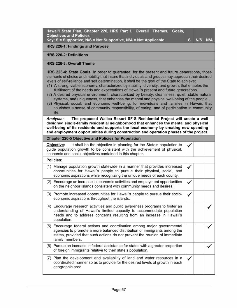
Page 57
Hawai‘i State Plan, Chapter 226, HRS Part I. Overall Themes, Goals, Objectives and Policies Key: S = Supportive, N/S = Not Supportive, N/A = Not Applicable S N/S N/A HRS 226-1: Findings and Purpose
HRS 226-2: Definitions
HRS 226-3: Overall Theme
HRS 226-4: State Goals. In order to guarantee, for the present and future generations, those elements of choice and mobility that insure that individuals and groups may approach their desired levels of self-reliance and self determination, it shall be the goal of the State to achieve:
A strong, viable economy, characterized by stability, diversity, and growth, that enables the fulfillment of the needs and expectations of Hawaii’s present and future generations.
A desired physical environment, characterized by beauty, cleanliness, quiet, stable natural systems, and uniqueness, that enhances the mental and physical well-being of the people.
Physical, social, and economic well-being, for individuals and families in Hawaii, that nourishes a sense of community responsibility, of caring, and of participation in community life.
Analysis: The proposed Wailea Resort SF-S Residential Project will create a well designed single-family residential neighborhood that enhances the mental and physical well-being of its residents and supports the local economy by creating new spending and employment opportunities during construction and operation phases of the project. Chapter 226-5 Objective and Policies for Population Objective: It shall be the objective in planning for the State’s population to guide population growth to be consistent with the achievement of physical, economic and social objectives contained in this chapter.
Policies: (1) Manage population growth statewide in a manner that provides increased
opportunities for Hawaii’s people to pursue their physical, social, and economic aspirations while recognizing the unique needs of each county.
(2) Encourage an increase in economic activities and employment opportunities on the neighbor islands consistent with community needs and desires.
(3) Promote increased opportunities for Hawaii’s people to pursue their socio-economic aspirations throughout the islands.
(4) Encourage research activities and public awareness programs to foster an understanding of Hawaii’s limited capacity to accommodate population needs and to address concerns resulting from an increase in Hawaii’s population.
(5) Encourage federal actions and coordination among major governmental agencies to promote a more balanced distribution of immigrants among the states, provided that such actions do not prevent the reunion of immediate family members.
(6) Pursue an increase in federal assistance for states with a greater proportion of foreign immigrants relative to their state’s population.
(7) Plan the development and availability of land and water resources in a coordinated manner so as to provide for the desired levels of growth in each geographic area.

Page 58
Hawai‘i State Plan, Chapter 226, HRS Part I. Overall Themes, Goals, Objectives and Policies Key: S = Supportive, N/S = Not Supportive, N/A = Not Applicable S N/S N/A Analysis: The proposed Wailea Resort SF-S Residential Project is a residential development that will provide housing in an area that has been planned to manage population growth with available infrastructure and services. The proposed project will generate both short-term and long-term employment opportunities for the construction as well as operational phases of the new community, which will support the local economy. Chapter 226-6 Objectives and policies for the economy – – in general Objectives: Planning for the State’s economy in general shall be directed toward achievement of the following objectives: (1) Increased and diversified employment opportunities to achieve full
employment, increased income and job choice, and improved living standards for Hawaii’s people, while at the same time stimulating the development and expansion of economic activities capitalizing on defense, dual-use, and science and technology assets, particularly on the neighbor islands where employment opportunities may be limited.
(2) A steadily growing and diversified economic base that is not overly dependent on a few industries, and includes the development and expansion of industries on the neighbor islands.
Policies: (1) Promote and encourage entrepreneurship within Hawaii by residents and
nonresidents of the State.
(2) Expand Hawaii’s national and international marketing, communication, and organizational ties, to increase the State’s capacity to adjust to and capitalize upon economic changes and opportunities occurring outside the State.
(3) Promote Hawaii as an attractive market for environmentally and socially sound investment activities that benefit Hawaii’s people.
(4) Transform and maintain Hawaii as a place that welcomes and facilitates innovative activity that may lead to commercial opportunities.
(5) Promote innovative activity that may pose initial risks, but ultimately contribute to the economy of Hawaii.
(6) Seek broader outlets for new or expanded Hawaii business investments.
(7) Expand existing markets and penetrate new markets for Hawaii’s products and services.
(8) Assure that the basic economic needs of Hawaii’s people are maintained in the event of disruptions in overseas transportation.
(9) Strive to achieve a level of construction activity responsive to, and consistent with, state growth objectives.
(10) Encourage the formation of cooperatives and other favorable marketing arrangements at the local or regional level to assist Hawaii’s small scale producers, manufacturers, and distributors.
(11) Encourage labor-intensive activities that are economically satisfying and which offer opportunities for upward mobility.

Page 59
Hawai‘i State Plan, Chapter 226, HRS Part I. Overall Themes, Goals, Objectives and Policies Key: S = Supportive, N/S = Not Supportive, N/A = Not Applicable S N/S N/A (12) Encourage innovative activities that may not be labor-intensive, but may
otherwise contribute to the economy of Hawaii.
(13) Foster greater cooperation and coordination between the government and private sectors in developing Hawaii’s employment and economic growth opportunities.
(14) Stimulate the development and expansion of economic activities which will benefit areas with substantial or expected employment problems.
(15) Maintain acceptable working conditions and standards for Hawaii’s workers.
(16) Provide equal employment opportunities for all segments of Hawaii’s population through affirmative action and nondiscrimination measures.
(17) Stimulate the development and expansion of economic activities capitalizing on defense, dual-use, and science and technology assets, particularly on the neighbor islands where employment opportunities may be limited.
(18) Encourage businesses that have favorable financial multiplier effects within Hawaii’s economy, particularly with respect to emerging industries in science and technology.
(19) Promote and protect intangible resources in Hawaii, such as scenic beauty and the aloha spirit, which are vital to a healthy economy.
(20) Increase effective communication between the educational community and the private sector to develop relevant curricula and training programs to meet future employment needs in general, and requirements of new or innovative potential growth industries in particular.
(21) Foster a business climate in Hawaii--including attitudes, tax and regulatory policies, and financial and technical assistance programs-- that is conducive to the expansion of existing enterprises and the creation and attraction of new business and industry.
Analysis: The proposed project will create substantial economic activity in the labor intensive construction sector during construction of the project. The operation of the residential community will also create long-term employment opportunities. In addition, new residents will generate new spending in the local economy. The project has been designed to protect the scenic beauty of the Wailea Resort area with approximately 20 percent of the project area being maintained in open space. Chapter 226-7 Objectives and policies for the economy – – agriculture. Objectives: Planning for the State’s economy with regard to agriculture shall be directed towards achievement of the following objectives: (1) Viability of Hawaii’s sugar and pineapple industries.
(2) Growth and development of diversified agriculture throughout the State.
(3) An agriculture industry that continues to constitute a dynamic and essential
component of Hawaii’s strategic, economic, and social well-being.
Policies: (1) Establish a clear direction for Hawaii’s agriculture through stakeholder
commitment and advocacy.
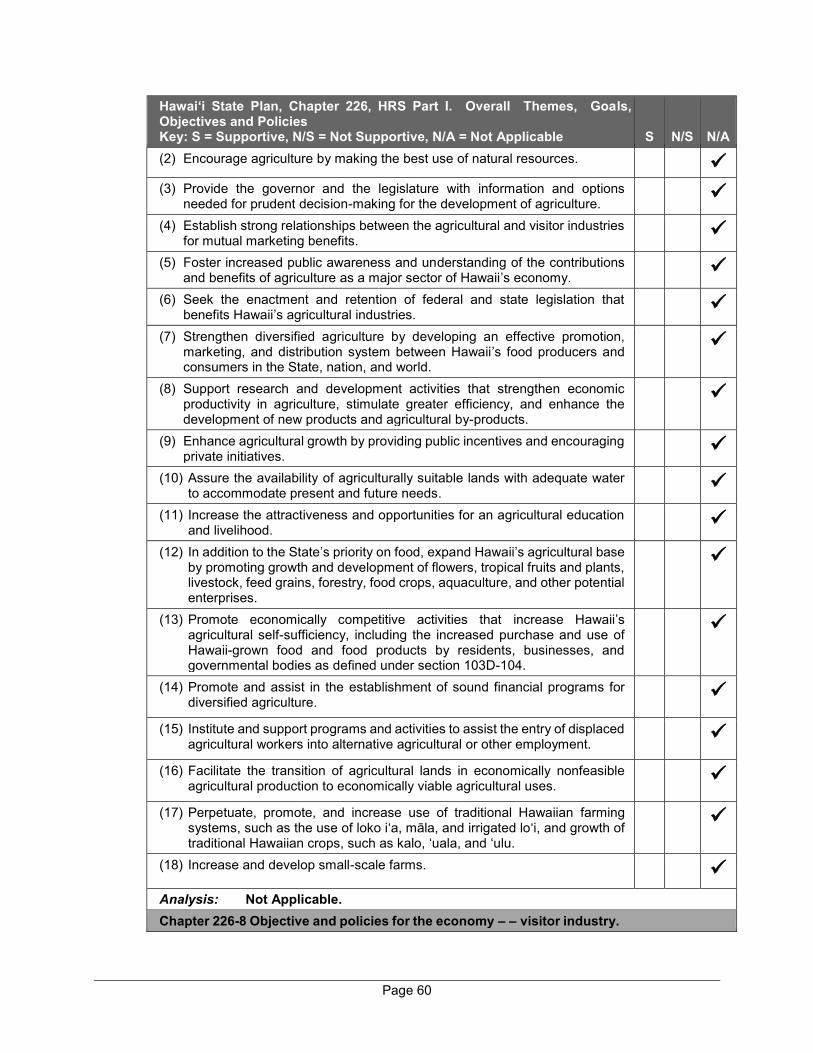
Page 60
Hawai‘i State Plan, Chapter 226, HRS Part I. Overall Themes, Goals, Objectives and Policies Key: S = Supportive, N/S = Not Supportive, N/A = Not Applicable S N/S N/A (2) Encourage agriculture by making the best use of natural resources.
(3) Provide the governor and the legislature with information and options
needed for prudent decision-making for the development of agriculture.
(4) Establish strong relationships between the agricultural and visitor industries for mutual marketing benefits.
(5) Foster increased public awareness and understanding of the contributions and benefits of agriculture as a major sector of Hawaii’s economy.
(6) Seek the enactment and retention of federal and state legislation that benefits Hawaii’s agricultural industries.
(7) Strengthen diversified agriculture by developing an effective promotion, marketing, and distribution system between Hawaii’s food producers and consumers in the State, nation, and world.
(8) Support research and development activities that strengthen economic productivity in agriculture, stimulate greater efficiency, and enhance the development of new products and agricultural by-products.
(9) Enhance agricultural growth by providing public incentives and encouraging private initiatives.
(10) Assure the availability of agriculturally suitable lands with adequate water to accommodate present and future needs.
(11) Increase the attractiveness and opportunities for an agricultural education and livelihood.
(12) In addition to the State’s priority on food, expand Hawaii’s agricultural base by promoting growth and development of flowers, tropical fruits and plants, livestock, feed grains, forestry, food crops, aquaculture, and other potential enterprises.
(13) Promote economically competitive activities that increase Hawaii’s agricultural self-sufficiency, including the increased purchase and use of Hawaii-grown food and food products by residents, businesses, and governmental bodies as defined under section 103D-104.
(14) Promote and assist in the establishment of sound financial programs for diversified agriculture.
(15) Institute and support programs and activities to assist the entry of displaced agricultural workers into alternative agricultural or other employment.
(16) Facilitate the transition of agricultural lands in economically nonfeasible agricultural production to economically viable agricultural uses.
(17) Perpetuate, promote, and increase use of traditional Hawaiian farming systems, such as the use of loko i‘a, māla, and irrigated lo‘i, and growth of traditional Hawaiian crops, such as kalo, ‘uala, and ‘ulu.
(18) Increase and develop small-scale farms.
Analysis: Not Applicable. Chapter 226-8 Objective and policies for the economy – – visitor industry.
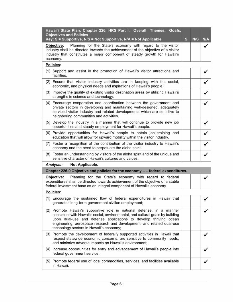
Page 61
Hawai‘i State Plan, Chapter 226, HRS Part I. Overall Themes, Goals, Objectives and Policies Key: S = Supportive, N/S = Not Supportive, N/A = Not Applicable S N/S N/A Objective: Planning for the State’s economy with regard to the visitor industry shall be directed towards the achievement of the objective of a visitor industry that constitutes a major component of steady growth for Hawaii’s economy.
Policies: (1) Support and assist in the promotion of Hawaii’s visitor attractions and
facilities.
(2) Ensure that visitor industry activities are in keeping with the social, economic, and physical needs and aspirations of Hawaii’s people.
(3) Improve the quality of existing visitor destination areas by utilizing Hawaii’s strengths in science and technology.
(4) Encourage cooperation and coordination between the government and private sectors in developing and maintaining well-designed, adequately serviced visitor industry and related developments which are sensitive to neighboring communities and activities.
(5) Develop the industry in a manner that will continue to provide new job opportunities and steady employment for Hawaii’s people.
(6) Provide opportunities for Hawaii’s people to obtain job training and education that will allow for upward mobility within the visitor industry.
(7) Foster a recognition of the contribution of the visitor industry to Hawaii’s economy and the need to perpetuate the aloha spirit.
(8) Foster an understanding by visitors of the aloha spirit and of the unique and sensitive character of Hawaii’s cultures and values.
Analysis: Not Applicable. Chapter 226-9 Objective and policies for the economy – – federal expenditures. Objective: Planning for the State’s economy with regard to federal expenditures shall be directed towards achievement of the objective of a stable federal investment base as an integral component of Hawaii’s economy.
Policies: (1) Encourage the sustained flow of federal expenditures in Hawaii that
generates long-term government civilian employment;
(2) Promote Hawaii’s supportive role in national defense, in a manner consistent with Hawaii’s social, environmental, and cultural goals by building upon dual-use and defense applications to develop thriving ocean engineering, aerospace research and development, and related dual-use technology sectors in Hawaii’s economy;
(3) Promote the development of federally supported activities in Hawaii that respect statewide economic concerns, are sensitive to community needs, and minimize adverse impacts on Hawaii’s environment;
(4) Increase opportunities for entry and advancement of Hawaii’s people into federal government service;
(5) Promote federal use of local commodities, services, and facilities available in Hawaii;
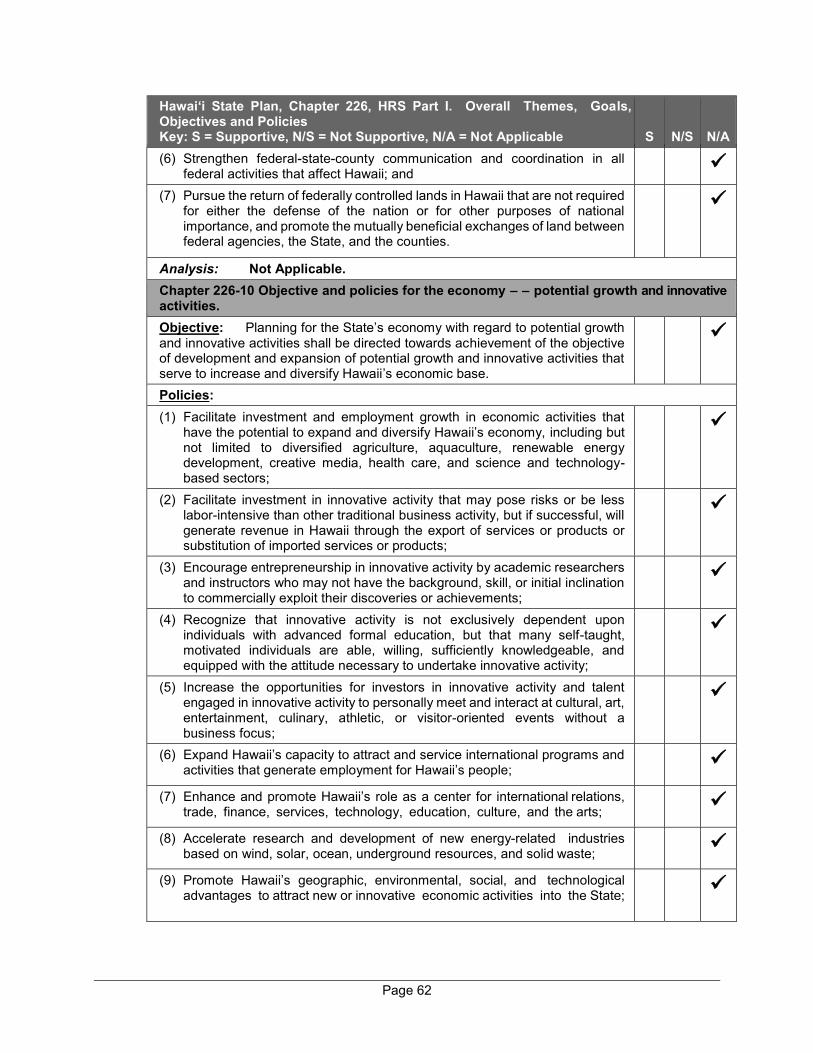
Page 62
Hawai‘i State Plan, Chapter 226, HRS Part I. Overall Themes, Goals, Objectives and Policies Key: S = Supportive, N/S = Not Supportive, N/A = Not Applicable S N/S N/A (6) Strengthen federal-state-county communication and coordination in all
federal activities that affect Hawaii; and
(7) Pursue the return of federally controlled lands in Hawaii that are not required for either the defense of the nation or for other purposes of national importance, and promote the mutually beneficial exchanges of land between federal agencies, the State, and the counties.
Analysis: Not Applicable. Chapter 226-10 Objective and policies for the economy – – potential growth and innovative activities. Objective: Planning for the State’s economy with regard to potential growth and innovative activities shall be directed towards achievement of the objective of development and expansion of potential growth and innovative activities that serve to increase and diversify Hawaii’s economic base.
Policies: (1) Facilitate investment and employment growth in economic activities that
have the potential to expand and diversify Hawaii’s economy, including but not limited to diversified agriculture, aquaculture, renewable energy development, creative media, health care, and science and technology-based sectors;
(2) Facilitate investment in innovative activity that may pose risks or be less labor-intensive than other traditional business activity, but if successful, will generate revenue in Hawaii through the export of services or products or substitution of imported services or products;
(3) Encourage entrepreneurship in innovative activity by academic researchers and instructors who may not have the background, skill, or initial inclination to commercially exploit their discoveries or achievements;
(4) Recognize that innovative activity is not exclusively dependent upon individuals with advanced formal education, but that many self-taught, motivated individuals are able, willing, sufficiently knowledgeable, and equipped with the attitude necessary to undertake innovative activity;
(5) Increase the opportunities for investors in innovative activity and talent engaged in innovative activity to personally meet and interact at cultural, art, entertainment, culinary, athletic, or visitor-oriented events without a business focus;
(6) Expand Hawaii’s capacity to attract and service international programs and activities that generate employment for Hawaii’s people;
(7) Enhance and promote Hawaii’s role as a center for international relations, trade, finance, services, technology, education, culture, and the arts;
(8) Accelerate research and development of new energy-related industries based on wind, solar, ocean, underground resources, and solid waste;
(9) Promote Hawaii’s geographic, environmental, social, and technological advantages to attract new or innovative economic activities into the State;
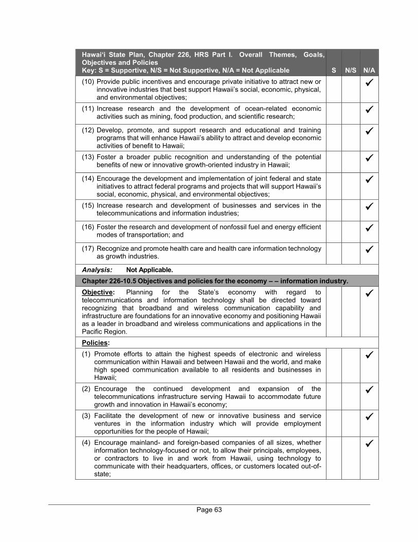
Page 63
Hawai‘i State Plan, Chapter 226, HRS Part I. Overall Themes, Goals, Objectives and Policies Key: S = Supportive, N/S = Not Supportive, N/A = Not Applicable S N/S N/A (10) Provide public incentives and encourage private initiative to attract new or
innovative industries that best support Hawaii’s social, economic, physical, and environmental objectives;
(11) Increase research and the development of ocean-related economic activities such as mining, food production, and scientific research;
(12) Develop, promote, and support research and educational and training programs that will enhance Hawaii’s ability to attract and develop economic activities of benefit to Hawaii;
(13) Foster a broader public recognition and understanding of the potential benefits of new or innovative growth-oriented industry in Hawaii;
(14) Encourage the development and implementation of joint federal and state initiatives to attract federal programs and projects that will support Hawaii’s social, economic, physical, and environmental objectives;
(15) Increase research and development of businesses and services in the telecommunications and information industries;
(16) Foster the research and development of nonfossil fuel and energy efficient modes of transportation; and
(17) Recognize and promote health care and health care information technology as growth industries.
Analysis: Not Applicable. Chapter 226-10.5 Objectives and policies for the economy – – information industry. Objective: Planning for the State’s economy with regard to telecommunications and information technology shall be directed toward recognizing that broadband and wireless communication capability and infrastructure are foundations for an innovative economy and positioning Hawaii as a leader in broadband and wireless communications and applications in the Pacific Region.
Policies: (1) Promote efforts to attain the highest speeds of electronic and wireless
communication within Hawaii and between Hawaii and the world, and make high speed communication available to all residents and businesses in Hawaii;
(2) Encourage the continued development and expansion of the telecommunications infrastructure serving Hawaii to accommodate future growth and innovation in Hawaii’s economy;
(3) Facilitate the development of new or innovative business and service ventures in the information industry which will provide employment opportunities for the people of Hawaii;
(4) Encourage mainland- and foreign-based companies of all sizes, whether information technology-focused or not, to allow their principals, employees, or contractors to live in and work from Hawaii, using technology to communicate with their headquarters, offices, or customers located out-of-state;
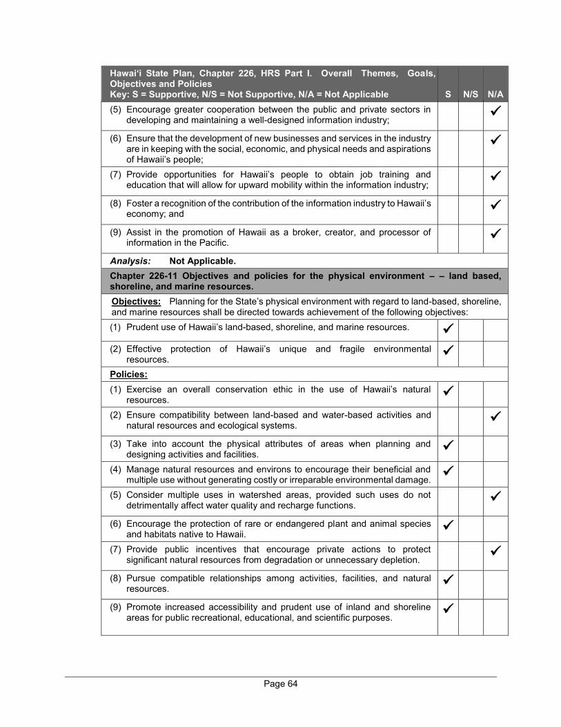
Page 64
Hawai‘i State Plan, Chapter 226, HRS Part I. Overall Themes, Goals, Objectives and Policies Key: S = Supportive, N/S = Not Supportive, N/A = Not Applicable S N/S N/A (5) Encourage greater cooperation between the public and private sectors in
developing and maintaining a well-designed information industry;
(6) Ensure that the development of new businesses and services in the industry are in keeping with the social, economic, and physical needs and aspirations of Hawaii’s people;
(7) Provide opportunities for Hawaii’s people to obtain job training and education that will allow for upward mobility within the information industry;
(8) Foster a recognition of the contribution of the information industry to Hawaii’s economy; and
(9) Assist in the promotion of Hawaii as a broker, creator, and processor of information in the Pacific.
Analysis: Not Applicable. Chapter 226-11 Objectives and policies for the physical environment – – land based, shoreline, and marine resources. Objectives: Planning for the State’s physical environment with regard to land-based, shoreline, and marine resources shall be directed towards achievement of the following objectives: (1) Prudent use of Hawaii’s land-based, shoreline, and marine resources.
(2) Effective protection of Hawaii’s unique and fragile environmental resources.
Policies: (1) Exercise an overall conservation ethic in the use of Hawaii’s natural
resources.
(2) Ensure compatibility between land-based and water-based activities and natural resources and ecological systems.
(3) Take into account the physical attributes of areas when planning and designing activities and facilities.
(4) Manage natural resources and environs to encourage their beneficial and multiple use without generating costly or irreparable environmental damage.
(5) Consider multiple uses in watershed areas, provided such uses do not detrimentally affect water quality and recharge functions.
(6) Encourage the protection of rare or endangered plant and animal species and habitats native to Hawaii.
(7) Provide public incentives that encourage private actions to protect significant natural resources from degradation or unnecessary depletion.
(8) Pursue compatible relationships among activities, facilities, and natural resources.
(9) Promote increased accessibility and prudent use of inland and shoreline areas for public recreational, educational, and scientific purposes.

Page 65
Hawai‘i State Plan, Chapter 226, HRS Part I. Overall Themes, Goals, Objectives and Policies Key: S = Supportive, N/S = Not Supportive, N/A = Not Applicable S N/S N/A Analysis: The proposed project site has been identified by both the State Land Use Commission and the County of Maui’s Maui Island Plan (MIP) as an appropriate location for urban growth in close proximity to existing infrastructure and services. The physical attributes of the project area have been taken into account in the planning and design of the proposed project. A Biological Resources Survey has also been carried out for the proposed project. Appropriate mitigation measures will be implemented to ensure there will be no adverse impacts to endangered plant and animal species and their habitats. In addition, a comprehensive drainage system, including Low Impact Development (LID) measures, will be implemented to ensure protection of the shoreline environment. Chapter 226-12 Objective and policies for the physical environment – – scenic, natural beauty, and historic resources. Objective: Planning for the State’s physical environment shall be directed towards achievement of the objective of enhancement of Hawaii’s scenic assets, natural beauty, and multi-cultural/historical resources.
Policies: (1) Promote the preservation and restoration of significant natural and historic
resources.
(2) Provide incentives to maintain and enhance historic, cultural, and scenic amenities.
(3) Promote the preservation of views and vistas to enhance the visual and aesthetic enjoyment of mountains, ocean, scenic landscapes, and other natural features.
(4) Protect those special areas, structures, and elements that are an integral and functional part of Hawaii’s ethnic and cultural heritage.
(5) Encourage the design of developments and activities that complement the natural beauty of the islands.
Analysis: An Archaeological Inventory Survey (AIS) and Cultural Impact Assessment (CIA) have been undertaken to ensure the proposed project will not adversely impact historic and cultural resouces. A View Analysis has also been prepared to ensure that views from surrounding roadways and public vantage points will not be adversely impacted. The proposed project has been designed to complement the natural beauty of the Wailea Resort. Landscaping and vegetative open spaces have been incorporated in the project design to provide visual buffers. Chapter 226-13 Objectives and policies for the physical environment – – land, air, and water quality. Objectives: Planning for the State’s physical environment with regard to land, air, and water quality shall be directed towards achievement of the following objectives. (1) Maintenance and pursuit of improved quality in Hawaii’s land, air, and water
resources.
(2) Greater public awareness and appreciation of Hawaii’s environmental resources.
Policies: (1) Foster educational activities that promote a better understanding of Hawaii’s
limited environmental resources.
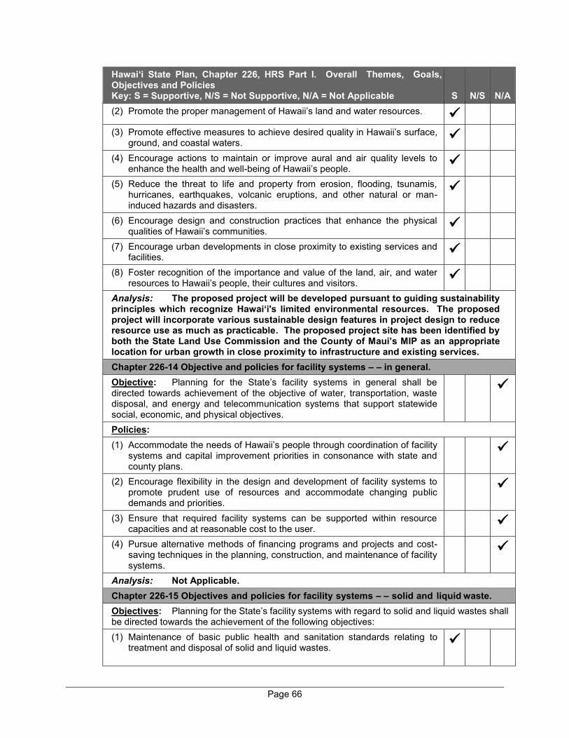
Page 66
Hawai‘i State Plan, Chapter 226, HRS Part I. Overall Themes, Goals, Objectives and Policies Key: S = Supportive, N/S = Not Supportive, N/A = Not Applicable S N/S N/A (2) Promote the proper management of Hawaii’s land and water resources.
(3) Promote effective measures to achieve desired quality in Hawaii’s surface, ground, and coastal waters.
(4) Encourage actions to maintain or improve aural and air quality levels to enhance the health and well-being of Hawaii’s people.
(5) Reduce the threat to life and property from erosion, flooding, tsunamis, hurricanes, earthquakes, volcanic eruptions, and other natural or man-induced hazards and disasters.
(6) Encourage design and construction practices that enhance the physical qualities of Hawaii’s communities.
(7) Encourage urban developments in close proximity to existing services and facilities.
(8) Foster recognition of the importance and value of the land, air, and water resources to Hawaii’s people, their cultures and visitors.
Analysis: The proposed project will be developed pursuant to guiding sustainability principles which recognize Hawai‘i's limited environmental resources. The proposed project will incorporate various sustainable design features in project design to reduce resource use as much as practicable. The proposed project site has been identified by both the State Land Use Commission and the County of Maui’s MIP as an appropriate location for urban growth in close proximity to infrastructure and existing services. Chapter 226-14 Objective and policies for facility systems – – in general. Objective: Planning for the State’s facility systems in general shall be directed towards achievement of the objective of water, transportation, waste disposal, and energy and telecommunication systems that support statewide social, economic, and physical objectives.
Policies: (1) Accommodate the needs of Hawaii’s people through coordination of facility
systems and capital improvement priorities in consonance with state and county plans.
(2) Encourage flexibility in the design and development of facility systems to promote prudent use of resources and accommodate changing public demands and priorities.
(3) Ensure that required facility systems can be supported within resource capacities and at reasonable cost to the user.
(4) Pursue alternative methods of financing programs and projects and cost-saving techniques in the planning, construction, and maintenance of facility systems.
Analysis: Not Applicable. Chapter 226-15 Objectives and policies for facility systems – – solid and liquid waste. Objectives: Planning for the State’s facility systems with regard to solid and liquid wastes shall be directed towards the achievement of the following objectives: (1) Maintenance of basic public health and sanitation standards relating to
treatment and disposal of solid and liquid wastes.
Page 67
Hawai‘i State Plan, Chapter 226, HRS Part I. Overall Themes, Goals, Objectives and Policies Key: S = Supportive, N/S = Not Supportive, N/A = Not Applicable S N/S N/A (2) Provision of adequate sewerage facilities for physical and economic
activities that alleviate problems in housing, employment, mobility, and other areas.
Policies: (1) Encourage the adequate development of sewerage facilities that
complement planned growth.
(2) Promote re-use and recycling to reduce solid and liquid wastes and employ a conservation ethic.
(3) Promote research to develop more efficient and economical treatment and disposal of solid and liquid wastes.
Analysis: The proposed project will be designed to meet applicable State and County standards for solid and liquid waste disposal. The proposed project will be served by a private waste collection company and the County’s wastewater collection and disposal system. The applicant will promote re-use and recycling of solid waste within the new community to the extent practicable. Chapter 226-16 Objective and policies for facility systems – – water. Objective: Planning for the State’s facility systems with regard to water shall be directed towards achievement of the objective of the provision of water to adequately accommodate domestic, agricultural, commercial, industrial, recreational, and other needs within resource capacities.
Policies: (1) Coordinate development of land use activities with existing and potential
water supply.
(2) Support research and development of alternative methods to meet future water requirements well in advance of anticipated needs.
(3) Reclaim and encourage the productive use of runoff water and wastewater discharges.
(4) Assist in improving the quality, efficiency, service, and storage capabilities of water systems for domestic and agricultural use.
(5) Support water supply services to areas experiencing critical water problems.
(6) Promote water conservation programs and practices in government, private industry, and the general public to help ensure adequate water to meet long-term needs.
Analysis: The project is located within the Urban Growth Boundary (UGB) of the MIP, which identifies areas for future urban development where existing public services are available. The project will connect to the County water system. Two (2) 3-inch water meters will be installed on the drinking water main near Kapili Street to measure water usage by the entire development. In accordance with the project’s overall guiding sustainability principles, water conservation design features and practices will be incorporated into the project where feasible. Chapter 226-17 Objectives and policies for facility systems – – transportation. Objectives: Planning for the State’s facility systems with regard to transportation shall be directed towards the achievement of the following objectives:
Page 68
Hawai‘i State Plan, Chapter 226, HRS Part I. Overall Themes, Goals, Objectives and Policies Key: S = Supportive, N/S = Not Supportive, N/A = Not Applicable S N/S N/A (1) An integrated multi-modal transportation system that services statewide
needs and promotes the efficient, economical, safe, and convenient movement of people and goods.
(2) A statewide transportation system that is consistent with and will accommodate planned growth objectives throughout the State.
Policies: (1) Design, program, and develop a multi-modal system in conformance with
desired growth and physical development as stated in this chapter;
(2) Coordinate state, county, federal, and private transportation activities and programs toward the achievement of statewide objectives;
(3) Encourage a reasonable distribution of financial responsibilities for transportation among participating governmental and private parties;
(4) Provide for improved accessibility to shipping, docking, and storage facilities;
(5) Promote a reasonable level and variety of mass transportation services that adequately meet statewide and community needs;
(6) Encourage transportation systems that serve to accommodate present and future development needs of communities;
(7) Encourage a variety of carriers to offer increased opportunities and advantages to interisland movement of people and goods;
(8) Increase the capacities of airport and harbor systems and support facilities to effectively accommodate transshipment and storage needs;
(9) Encourage the development of transportation systems and programs which would assist statewide economic growth and diversification;
(10) Encourage the design and development of transportation systems sensitive to the needs of affected communities and the quality of Hawaii’s natural environment;
(11) Encourage safe and convenient use of low-cost, energy-efficient, non-polluting means of transportation;
(12) Coordinate intergovernmental land use and transportation planning activities to ensure the timely delivery of supporting transportation infrastructure in order to accommodate planned growth objectives; and
(13) Encourage diversification of transportation modes and infrastructure to promote alternate fuels and energy efficiency.
Analysis: In accordance with the project’s overall guiding sustainability principles, bicycling and walking will be encouraged by road design within the proposed Wailea Resort SF-S Residential Project. Multi-modal paths will be installed on main roads and will be connected to Wailea Alanui Drive and Kapili Street. Chapter 226-18 Objectives and policies for facility systems – – energy. Objectives: Planning for the State’s facility systems with regard to energy shall be directed toward the achievement of the following objectives, giving due consideration to all: (1) Dependable, efficient, and economical statewide energy systems capable
of supporting the needs of the people;
Page 69
Hawai‘i State Plan, Chapter 226, HRS Part I. Overall Themes, Goals, Objectives and Policies Key: S = Supportive, N/S = Not Supportive, N/A = Not Applicable S N/S N/A (2) Increased energy security and self-sufficiency through the reduction and
ultimate elimination of Hawaii’s dependence on imported fuels for electrical generation and ground transportation.
(3) Greater diversification of energy generation in the face of threats to Hawaii’s energy supplies and systems;
(4) Reduction, avoidance, or sequestration of greenhouse gas emissions from energy supply and use; and
(5) Utility models that make the social and financial interests of Hawaii’s utility customers a priority.
(b) To achieve the energy objectives, it shall be the policy of this State to ensure the short- and long-term provision of adequate, reasonably prices, and dependable energy services to accommodate demand.
Policies: (1) Support research and development as well as promote the use of renewable
energy sources;
(2) Ensure that the combination of energy supplies and energy-saving systems is sufficient to support the demands of growth;
(3) Base decisions of least-cost supply-side and demand-side energy resource options on a comparison of their total costs and benefits when a least-cost is determined by a reasonably comprehensive, quantitative, and qualitative accounting of their long-term, direct and indirect economic, environmental, social, cultural, and public health costs and benefits;
(4) Promote all cost-effective conservation of power and fuel supplies through measures, including:
(A) Development of cost-effective demand-side management programs;
(B) Education;
(C) Adoption of energy-efficient practices and technologies; and
(D) Increasing energy efficiency and decreasing energy use in public infrastructure
(5) Ensure, to the extent that new supply-side resources are needed, that the development or expansion of energy systems uses the least-cost energy supply option and maximizes efficient technologies; and
(6) Support research, development, demonstration, and use of energy efficiency, load management, and other demand-side management programs, practices, and technologies;
(7) Promote alternate fuels and transportation energy efficiency;
(8) Support actions that reduce, avoid, or sequester greenhouse gases in utility, transportation, and industrial sector applications;
(9) Support actions that reduce, avoid, or sequester Hawaii’s greenhouse gas emissions through agriculture and forestry initiatives;
Page 70
Hawai‘i State Plan, Chapter 226, HRS Part I. Overall Themes, Goals, Objectives and Policies Key: S = Supportive, N/S = Not Supportive, N/A = Not Applicable S N/S N/A (10) Provide priority handling and processing for all state and county permits
required for renewable energy projects;
(11) Ensure that liquefied natural gas is used only as a cost-effective transitional, limited-term replacement of petroleum for electricity generation and does not impede the development and use of other cost-effective renewable energy sources; and
(12) Promote the development of indigenous geothermal energy resources that are located on public trust land as an affordable and reliable source of firm power for Hawaii.
Analysis: The proposed project will incorporate sustainable design features, such as rooftop solar photovoltaic (PV) and Electric Vehicle (EV) charger-ready home designs and use of energy efficient appliances and lighting, to reduce overall energy consumption and greenhouse gas (GHG) emissions per square foot.
Chapter 226-18.5 Objectives and policies for facility systems – – telecommunications. Objectives:
(a) Planning for the State’s telecommunications facility systems shall be directed towards the achievement of dependable, efficient, and economical statewide telecommunications systems capable of supporting the needs of the people.
(b) To achieve the telecommunications objective, it shall be the policy of this State to ensure the provision of adequate, reasonably priced, and dependable telecommunications services to accommodate demand.
Policies: (1) Facilitate research and development of telecommunications systems and
resources;
(2) Encourage public and private sector efforts to develop means for adequate, ongoing telecommunications planning;
(3) Promote efficient management and use of existing telecommunications systems and services; and
(4) Facilitate the development of education and training of telecommunications personnel.
Analysis: Not Applicable. Chapter 226-19 Objectives and policies for socio-cultural advancement – – housing. Objectives: Planning for the State’s socio-cultural advancement with regard to housing shall be directed toward the achievement of the following objectives:
(1) Greater opportunities for Hawaii’s people to secure reasonably priced, safe, sanitary, and livable homes, located in suitable environments that satisfactorily accommodate the needs and desires of families and individuals, through collaboration and cooperation between government and nonprofit and for-profit developers to ensure that more affordable housing is made available to very low-, low- and moderate-income segments of Hawaii’s population.
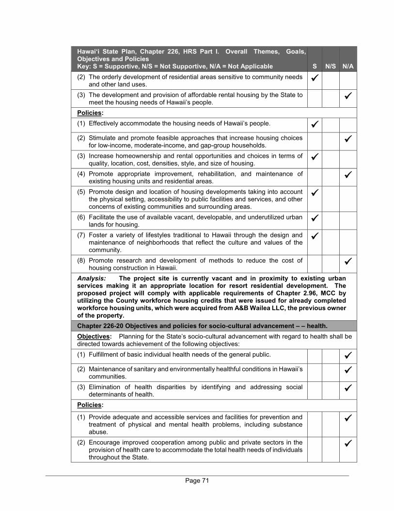
Page 71
Hawai‘i State Plan, Chapter 226, HRS Part I. Overall Themes, Goals, Objectives and Policies Key: S = Supportive, N/S = Not Supportive, N/A = Not Applicable S N/S N/A (2) The orderly development of residential areas sensitive to community needs
and other land uses.
(3) The development and provision of affordable rental housing by the State to meet the housing needs of Hawaii’s people.
Policies: (1) Effectively accommodate the housing needs of Hawaii’s people.
(2) Stimulate and promote feasible approaches that increase housing choices for low-income, moderate-income, and gap-group households.
(3) Increase homeownership and rental opportunities and choices in terms of quality, location, cost, densities, style, and size of housing.
(4) Promote appropriate improvement, rehabilitation, and maintenance of existing housing units and residential areas.
(5) Promote design and location of housing developments taking into account the physical setting, accessibility to public facilities and services, and other concerns of existing communities and surrounding areas.
(6) Facilitate the use of available vacant, developable, and underutilized urban lands for housing.
(7) Foster a variety of lifestyles traditional to Hawaii through the design and maintenance of neighborhoods that reflect the culture and values of the community.
(8) Promote research and development of methods to reduce the cost of housing construction in Hawaii.
Analysis: The project site is currently vacant and in proximity to existing urban services making it an appropriate location for resort residential development. The proposed project will comply with applicable requirements of Chapter 2.96, MCC by utilizing the County workforce housing credits that were issued for already completed workforce housing units, which were acquired from A&B Wailea LLC, the previous owner of the property. Chapter 226-20 Objectives and policies for socio-cultural advancement – – health. Objectives: Planning for the State’s socio-cultural advancement with regard to health shall be directed towards achievement of the following objectives: (1) Fulfillment of basic individual health needs of the general public.
(2) Maintenance of sanitary and environmentally healthful conditions in Hawaii’s
communities.
(3) Elimination of health disparities by identifying and addressing social determinants of health.
Policies:
(1) Provide adequate and accessible services and facilities for prevention and treatment of physical and mental health problems, including substance abuse.
(2) Encourage improved cooperation among public and private sectors in the provision of health care to accommodate the total health needs of individuals throughout the State.
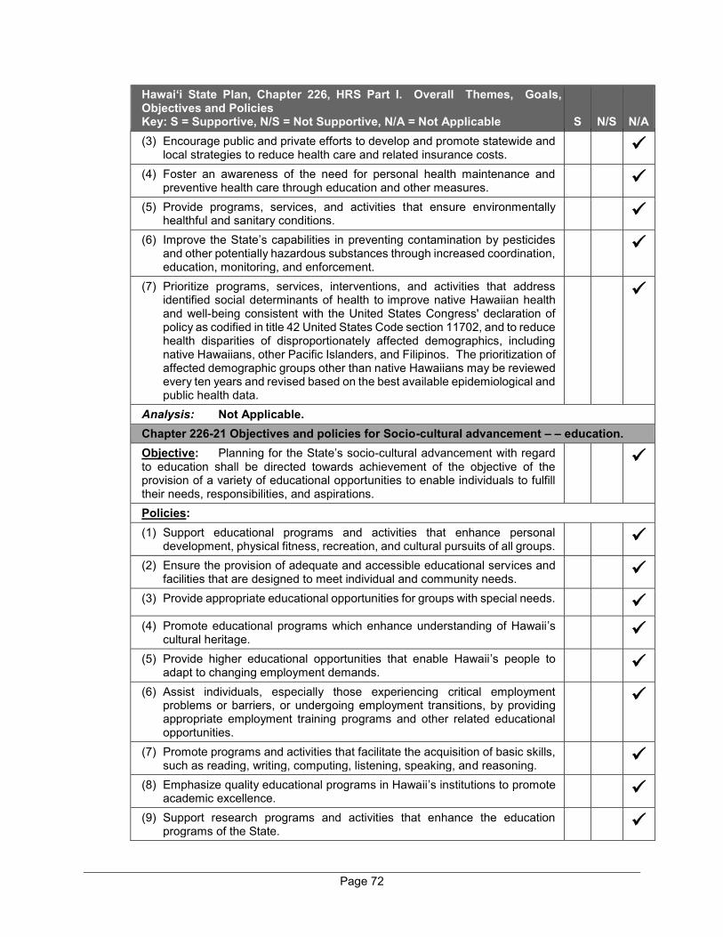
Page 72
Hawai‘i State Plan, Chapter 226, HRS Part I. Overall Themes, Goals, Objectives and Policies Key: S = Supportive, N/S = Not Supportive, N/A = Not Applicable S N/S N/A (3) Encourage public and private efforts to develop and promote statewide and
local strategies to reduce health care and related insurance costs.
(4) Foster an awareness of the need for personal health maintenance and preventive health care through education and other measures.
(5) Provide programs, services, and activities that ensure environmentally healthful and sanitary conditions.
(6) Improve the State’s capabilities in preventing contamination by pesticides and other potentially hazardous substances through increased coordination, education, monitoring, and enforcement.
(7) Prioritize programs, services, interventions, and activities that address identified social determinants of health to improve native Hawaiian health and well-being consistent with the United States Congress' declaration of policy as codified in title 42 United States Code section 11702, and to reduce health disparities of disproportionately affected demographics, including native Hawaiians, other Pacific Islanders, and Filipinos. The prioritization of affected demographic groups other than native Hawaiians may be reviewed every ten years and revised based on the best available epidemiological and public health data.
Analysis: Not Applicable. Chapter 226-21 Objectives and policies for Socio-cultural advancement – – education. Objective: Planning for the State’s socio-cultural advancement with regard to education shall be directed towards achievement of the objective of the provision of a variety of educational opportunities to enable individuals to fulfill their needs, responsibilities, and aspirations.
Policies: (1) Support educational programs and activities that enhance personal
development, physical fitness, recreation, and cultural pursuits of all groups.
(2) Ensure the provision of adequate and accessible educational services and facilities that are designed to meet individual and community needs.
(3) Provide appropriate educational opportunities for groups with special needs.
(4) Promote educational programs which enhance understanding of Hawaii’s cultural heritage.
(5) Provide higher educational opportunities that enable Hawaii’s people to adapt to changing employment demands.
(6) Assist individuals, especially those experiencing critical employment problems or barriers, or undergoing employment transitions, by providing appropriate employment training programs and other related educational opportunities.
(7) Promote programs and activities that facilitate the acquisition of basic skills, such as reading, writing, computing, listening, speaking, and reasoning.
(8) Emphasize quality educational programs in Hawaii’s institutions to promote academic excellence.
(9) Support research programs and activities that enhance the education programs of the State.
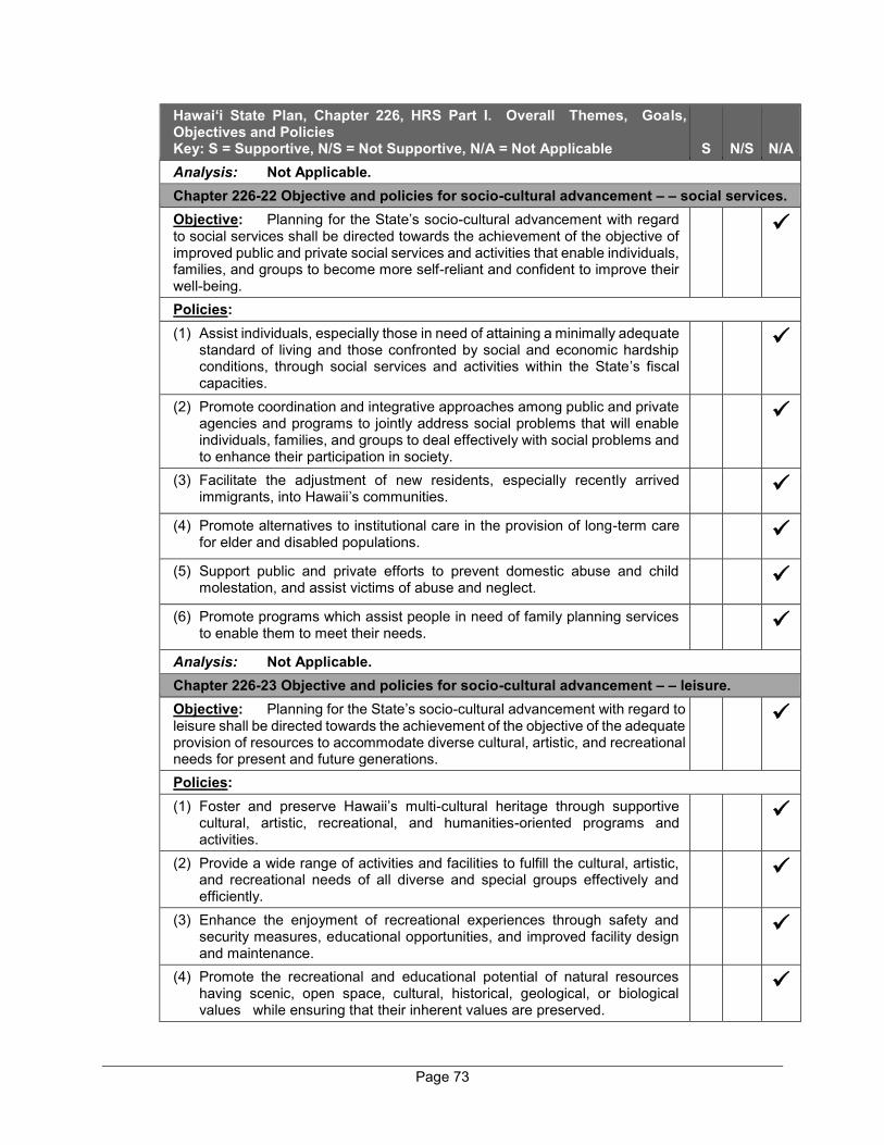
Page 73
Hawai‘i State Plan, Chapter 226, HRS Part I. Overall Themes, Goals, Objectives and Policies Key: S = Supportive, N/S = Not Supportive, N/A = Not Applicable S N/S N/A Analysis: Not Applicable. Chapter 226-22 Objective and policies for socio-cultural advancement – – social services. Objective: Planning for the State’s socio-cultural advancement with regard to social services shall be directed towards the achievement of the objective of improved public and private social services and activities that enable individuals, families, and groups to become more self-reliant and confident to improve their well-being.
Policies: (1) Assist individuals, especially those in need of attaining a minimally adequate
standard of living and those confronted by social and economic hardship conditions, through social services and activities within the State’s fiscal capacities.
(2) Promote coordination and integrative approaches among public and private agencies and programs to jointly address social problems that will enable individuals, families, and groups to deal effectively with social problems and to enhance their participation in society.
(3) Facilitate the adjustment of new residents, especially recently arrived immigrants, into Hawaii’s communities.
(4) Promote alternatives to institutional care in the provision of long-term care for elder and disabled populations.
(5) Support public and private efforts to prevent domestic abuse and child molestation, and assist victims of abuse and neglect.
(6) Promote programs which assist people in need of family planning services to enable them to meet their needs.
Analysis: Not Applicable. Chapter 226-23 Objective and policies for socio-cultural advancement – – leisure. Objective: Planning for the State’s socio-cultural advancement with regard to leisure shall be directed towards the achievement of the objective of the adequate provision of resources to accommodate diverse cultural, artistic, and recreational needs for present and future generations.
Policies: (1) Foster and preserve Hawaii’s multi-cultural heritage through supportive
cultural, artistic, recreational, and humanities-oriented programs and activities.
(2) Provide a wide range of activities and facilities to fulfill the cultural, artistic, and recreational needs of all diverse and special groups effectively and efficiently.
(3) Enhance the enjoyment of recreational experiences through safety and security measures, educational opportunities, and improved facility design and maintenance.
(4) Promote the recreational and educational potential of natural resources having scenic, open space, cultural, historical, geological, or biological values while ensuring that their inherent values are preserved.

Page 74
Hawai‘i State Plan, Chapter 226, HRS Part I. Overall Themes, Goals, Objectives and Policies Key: S = Supportive, N/S = Not Supportive, N/A = Not Applicable S N/S N/A (5) Ensure opportunities for everyone to use and enjoy Hawaii’s recreational
resources.
(6) Assure the availability of sufficient resources to provide for future cultural, artistic, and recreational needs.
(7) Provide adequate and accessible physical fitness programs to promote the physical and mental well-being of Hawaii’s people.
(8) Increase opportunities for appreciation and participation in the creative arts, including the literary, theatrical, visual, musical, folk, and traditional art forms.
(9) Encourage the development of creative expression in the artistic disciplines to enable all segments of Hawaii’s population to participate in the creative arts.
(10) Assure adequate access to significant natural and cultural resources in public ownership.
Analysis: Not Applicable. Chapter 226-24 Objective and policies for socio-cultural advancement – – individual rights and personal well-being. Objective: Planning for the State’s socio-cultural advancement with regard to individual rights and personal well-being shall be directed towards achievement of the objective of increased opportunities and protection of individual rights to enable individuals to fulfill their socio-economic needs and aspirations.
Policies: (1) Provide effective services and activities that protect individuals from criminal
acts and unfair practices and that alleviate the consequences of criminal acts in order to foster a safe and secure environment.
(2) Uphold and protect the national and state constitutional rights of every individual.
(3) Assure access to, and availability of, legal assistance, consumer protection, and other public services which strive to attain social justice.
(4) Ensure equal opportunities for individual participation in society.
Analysis: Not Applicable. Chapter 226-25 Objective and policies for socio-cultural advancement – – culture. Objective: Planning for the State’s socio-cultural advancement with regard to culture shall be directed toward the achievement of the objective of enhancement of cultural identities, traditions, values, customs, and arts of Hawaii’s people.
Policies: (1) Foster increased knowledge and understanding of Hawaii’s ethnic and
cultural heritages and the history of Hawaii.
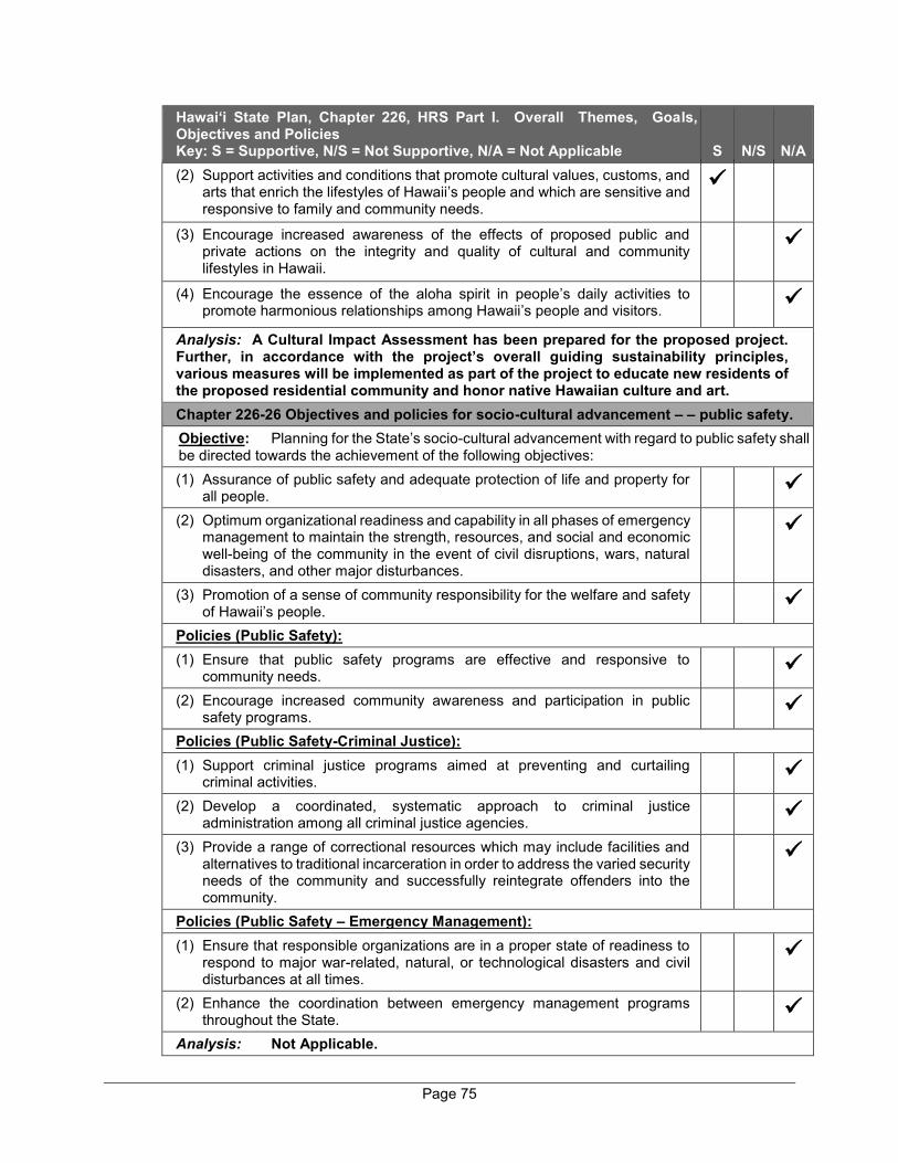
Page 75
Hawai‘i State Plan, Chapter 226, HRS Part I. Overall Themes, Goals, Objectives and Policies Key: S = Supportive, N/S = Not Supportive, N/A = Not Applicable S N/S N/A (2) Support activities and conditions that promote cultural values, customs, and
arts that enrich the lifestyles of Hawaii’s people and which are sensitive and responsive to family and community needs.
(3) Encourage increased awareness of the effects of proposed public and private actions on the integrity and quality of cultural and community lifestyles in Hawaii.
(4) Encourage the essence of the aloha spirit in people’s daily activities to promote harmonious relationships among Hawaii’s people and visitors.
Analysis: A Cultural Impact Assessment has been prepared for the proposed project. Further, in accordance with the project’s overall guiding sustainability principles, various measures will be implemented as part of the project to educate new residents of the proposed residential community and honor native Hawaiian culture and art. Chapter 226-26 Objectives and policies for socio-cultural advancement – – public safety. Objective: Planning for the State’s socio-cultural advancement with regard to public safety shall be directed towards the achievement of the following objectives: (1) Assurance of public safety and adequate protection of life and property for
all people.
(2) Optimum organizational readiness and capability in all phases of emergency management to maintain the strength, resources, and social and economic well-being of the community in the event of civil disruptions, wars, natural disasters, and other major disturbances.
(3) Promotion of a sense of community responsibility for the welfare and safety of Hawaii’s people.
Policies (Public Safety): (1) Ensure that public safety programs are effective and responsive to
community needs.
(2) Encourage increased community awareness and participation in public safety programs.
Policies (Public Safety-Criminal Justice): (1) Support criminal justice programs aimed at preventing and curtailing
criminal activities.
(2) Develop a coordinated, systematic approach to criminal justice administration among all criminal justice agencies.
(3) Provide a range of correctional resources which may include facilities and alternatives to traditional incarceration in order to address the varied security needs of the community and successfully reintegrate offenders into the community.
Policies (Public Safety – Emergency Management): (1) Ensure that responsible organizations are in a proper state of readiness to
respond to major war-related, natural, or technological disasters and civil disturbances at all times.
(2) Enhance the coordination between emergency management programs throughout the State.
Analysis: Not Applicable.
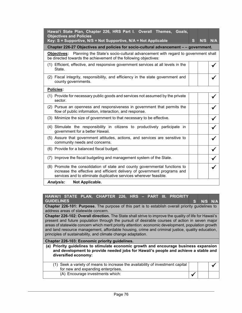
Page 76
Hawai‘i State Plan, Chapter 226, HRS Part I. Overall Themes, Goals, Objectives and Policies Key: S = Supportive, N/S = Not Supportive, N/A = Not Applicable S N/S N/A Chapter 226-27 Objectives and policies for socio-cultural advancement – – government. Objectives: Planning the State’s socio-cultural advancement with regard to government shall be directed towards the achievement of the following objectives: (1) Efficient, effective, and responsive government services at all levels in the
State.
(2) Fiscal integrity, responsibility, and efficiency in the state government and county governments.
Policies: (1) Provide for necessary public goods and services not assumed by the private
sector.
(2) Pursue an openness and responsiveness in government that permits the flow of public information, interaction, and response.
(3) Minimize the size of government to that necessary to be effective.
(4) Stimulate the responsibility in citizens to productively participate in government for a better Hawaii.
(5) Assure that government attitudes, actions, and services are sensitive to community needs and concerns.
(6) Provide for a balanced fiscal budget.
(7) Improve the fiscal budgeting and management system of the State.
(8) Promote the consolidation of state and county governmental functions to increase the effective and efficient delivery of government programs and services and to eliminate duplicative services wherever feasible.
Analysis: Not Applicable.
HAWAI‘I STATE PLAN, CHAPTER 226, HRS – PART III. PRIORITY GUIDELINES (Key: S = Supportive, N/S = Not Supportive, N/A = Not Applicable)
S N/S N/A Chapter 226-101: Purpose. The purpose of this part is to establish overall priority guidelines to address areas of statewide concern. Chapter 226-102: Overall direction. The State shall strive to improve the quality of life for Hawaii’s present and future population through the pursuit of desirable courses of action in seven major areas of statewide concern which merit priority attention: economic development, population growth and land resource management, affordable housing, crime and criminal justice, quality education, principles of sustainability, and climate change adaptation.
Chapter 226-103: Economic priority guidelines. (a) Priority guidelines to stimulate economic growth and encourage business expansion
and development to provide needed jobs for Hawaii’s people and achieve a stable and diversified economy: (1) Seek a variety of means to increase the availability of investment capital
for new and expanding enterprises.
(A) Encourage investments which:
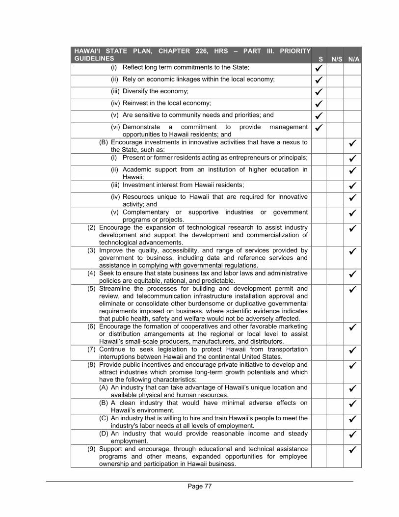
Page 77
HAWAI‘I STATE PLAN, CHAPTER 226, HRS – PART III. PRIORITY GUIDELINES (Key: S = Supportive, N/S = Not Supportive, N/A = Not Applicable)
S N/S N/A (i) Reflect long term commitments to the State;
(ii) Rely on economic linkages within the local economy;
(iii) Diversify the economy;
(iv) Reinvest in the local economy;
(v) Are sensitive to community needs and priorities; and
(vi) Demonstrate a commitment to provide management
opportunities to Hawaii residents; and
(B) Encourage investments in innovative activities that have a nexus to the State, such as:
(i) Present or former residents acting as entrepreneurs or principals;
(ii) Academic support from an institution of higher education in Hawaii;
(iii) Investment interest from Hawaii residents;
(iv) Resources unique to Hawaii that are required for innovative activity; and
(v) Complementary or supportive industries or government programs or projects.
(2) Encourage the expansion of technological research to assist industry development and support the development and commercialization of technological advancements.
(3) Improve the quality, accessibility, and range of services provided by government to business, including data and reference services and assistance in complying with governmental regulations.
(4) Seek to ensure that state business tax and labor laws and administrative policies are equitable, rational, and predictable.
(5) Streamline the processes for building and development permit and review, and telecommunication infrastructure installation approval and eliminate or consolidate other burdensome or duplicative governmental requirements imposed on business, where scientific evidence indicates that public health, safety and welfare would not be adversely affected.
(6) Encourage the formation of cooperatives and other favorable marketing or distribution arrangements at the regional or local level to assist Hawaii’s small-scale producers, manufacturers, and distributors.
(7) Continue to seek legislation to protect Hawaii from transportation interruptions between Hawaii and the continental United States.
(8) Provide public incentives and encourage private initiative to develop and attract industries which promise long-term growth potentials and which have the following characteristics:
(A) An industry that can take advantage of Hawaii’s unique location and available physical and human resources.
(B) A clean industry that would have minimal adverse effects on Hawaii’s environment.
(C) An industry that is willing to hire and train Hawaii’s people to meet the industry's labor needs at all levels of employment.
(D) An industry that would provide reasonable income and steady employment.
(9) Support and encourage, through educational and technical assistance programs and other means, expanded opportunities for employee ownership and participation in Hawaii business.
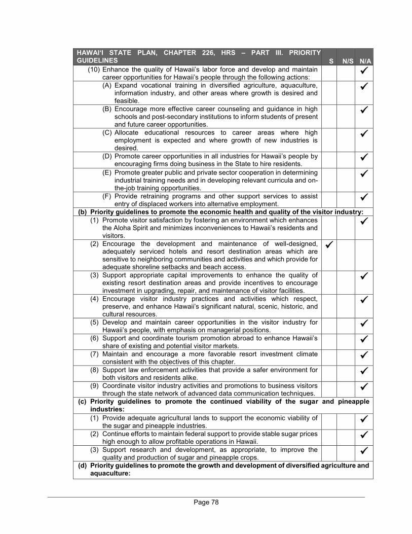
Page 78
HAWAI‘I STATE PLAN, CHAPTER 226, HRS – PART III. PRIORITY GUIDELINES (Key: S = Supportive, N/S = Not Supportive, N/A = Not Applicable)
S N/S N/A (10) Enhance the quality of Hawaii’s labor force and develop and maintain
career opportunities for Hawaii’s people through the following actions:
(A) Expand vocational training in diversified agriculture, aquaculture,
information industry, and other areas where growth is desired and feasible.
(B) Encourage more effective career counseling and guidance in high schools and post-secondary institutions to inform students of present and future career opportunities.
(C) Allocate educational resources to career areas where high employment is expected and where growth of new industries is desired.
(D) Promote career opportunities in all industries for Hawaii’s people by encouraging firms doing business in the State to hire residents.
(E) Promote greater public and private sector cooperation in determining industrial training needs and in developing relevant curricula and on- the-job training opportunities.
(F) Provide retraining programs and other support services to assist entry of displaced workers into alternative employment.
(b) Priority guidelines to promote the economic health and quality of the visitor industry: (1) Promote visitor satisfaction by fostering an environment which enhances
the Aloha Spirit and minimizes inconveniences to Hawaii’s residents and visitors.
(2) Encourage the development and maintenance of well-designed, adequately serviced hotels and resort destination areas which are sensitive to neighboring communities and activities and which provide for adequate shoreline setbacks and beach access.
(3) Support appropriate capital improvements to enhance the quality of existing resort destination areas and provide incentives to encourage investment in upgrading, repair, and maintenance of visitor facilities.
(4) Encourage visitor industry practices and activities which respect, preserve, and enhance Hawaii’s significant natural, scenic, historic, and cultural resources.
(5) Develop and maintain career opportunities in the visitor industry for Hawaii’s people, with emphasis on managerial positions.
(6) Support and coordinate tourism promotion abroad to enhance Hawaii’s share of existing and potential visitor markets.
(7) Maintain and encourage a more favorable resort investment climate consistent with the objectives of this chapter.
(8) Support law enforcement activities that provide a safer environment for both visitors and residents alike.
(9) Coordinate visitor industry activities and promotions to business visitors through the state network of advanced data communication techniques.
(c) Priority guidelines to promote the continued viability of the sugar and pineapple industries: (1) Provide adequate agricultural lands to support the economic viability of
the sugar and pineapple industries.
(2) Continue efforts to maintain federal support to provide stable sugar prices
high enough to allow profitable operations in Hawaii.
(3) Support research and development, as appropriate, to improve the
quality and production of sugar and pineapple crops.
(d) Priority guidelines to promote the growth and development of diversified agriculture and
aquaculture:
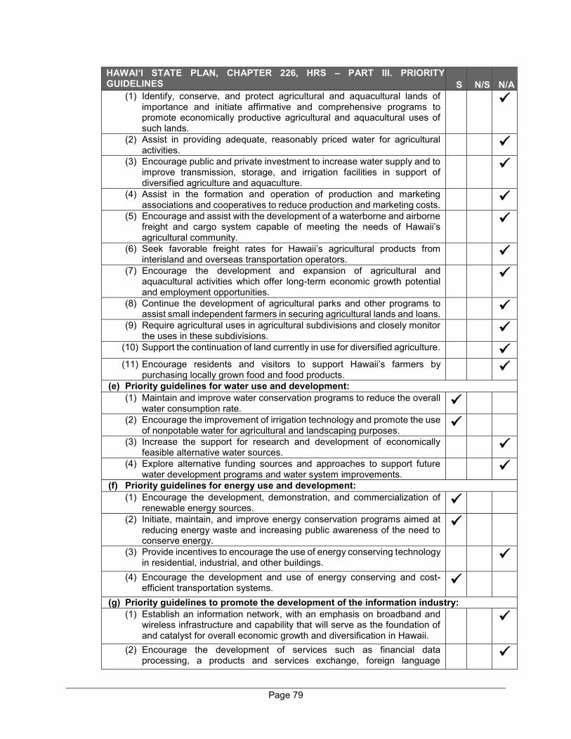
Page 79
HAWAI‘I STATE PLAN, CHAPTER 226, HRS – PART III. PRIORITY GUIDELINES (Key: S = Supportive, N/S = Not Supportive, N/A = Not Applicable)
S N/S N/A (1) Identify, conserve, and protect agricultural and aquacultural lands of
importance and initiate affirmative and comprehensive programs to promote economically productive agricultural and aquacultural uses of such lands.
(2) Assist in providing adequate, reasonably priced water for agricultural activities.
(3) Encourage public and private investment to increase water supply and to improve transmission, storage, and irrigation facilities in support of diversified agriculture and aquaculture.
(4) Assist in the formation and operation of production and marketing associations and cooperatives to reduce production and marketing costs.
(5) Encourage and assist with the development of a waterborne and airborne freight and cargo system capable of meeting the needs of Hawaii’s agricultural community.
(6) Seek favorable freight rates for Hawaii’s agricultural products from interisland and overseas transportation operators.
(7) Encourage the development and expansion of agricultural and aquacultural activities which offer long-term economic growth potential and employment opportunities.
(8) Continue the development of agricultural parks and other programs to assist small independent farmers in securing agricultural lands and loans.
(9) Require agricultural uses in agricultural subdivisions and closely monitor the uses in these subdivisions.
(10) Support the continuation of land currently in use for diversified agriculture.
(11) Encourage residents and visitors to support Hawaii’s farmers by purchasing locally grown food and food products.
(e) Priority guidelines for water use and development: (1) Maintain and improve water conservation programs to reduce the overall
water consumption rate.
(2) Encourage the improvement of irrigation technology and promote the use of nonpotable water for agricultural and landscaping purposes.
(3) Increase the support for research and development of economically feasible alternative water sources.
(4) Explore alternative funding sources and approaches to support future water development programs and water system improvements.
(f) Priority guidelines for energy use and development: (1) Encourage the development, demonstration, and commercialization of
renewable energy sources.
(2) Initiate, maintain, and improve energy conservation programs aimed at reducing energy waste and increasing public awareness of the need to conserve energy.
(3) Provide incentives to encourage the use of energy conserving technology in residential, industrial, and other buildings.
(4) Encourage the development and use of energy conserving and cost-efficient transportation systems.
(g) Priority guidelines to promote the development of the information industry: (1) Establish an information network, with an emphasis on broadband and
wireless infrastructure and capability that will serve as the foundation of and catalyst for overall economic growth and diversification in Hawaii.
(2) Encourage the development of services such as financial data processing, a products and services exchange, foreign language
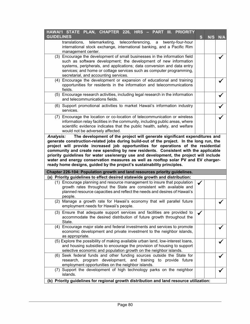
Page 80
HAWAI‘I STATE PLAN, CHAPTER 226, HRS – PART III. PRIORITY GUIDELINES (Key: S = Supportive, N/S = Not Supportive, N/A = Not Applicable)
S N/S N/A translations, telemarketing, teleconferencing, a twenty-four-hour international stock exchange, international banking, and a Pacific Rim management center.
(3) Encourage the development of small businesses in the information field such as software development; the development of new information systems, peripherals, and applications; data conversion and data entry services; and home or cottage services such as computer programming, secretarial, and accounting services.
(4) Encourage the development or expansion of educational and training opportunities for residents in the information and telecommunications fields.
(5) Encourage research activities, including legal research in the information and telecommunications fields.
(6) Support promotional activities to market Hawaii’s information industry services.
(7) Encourage the location or co-location of telecommunication or wireless information relay facilities in the community, including public areas, where scientific evidence indicates that the public health, safety, and welfare would not be adversely affected.
Analysis: The development of the project will generate significant expenditures and generate construction-related jobs during build-out of the project. In the long run, the project will provide increased job opportunities for operations of the residential community and create new spending by new residents. Consistent with the applicable priority guidelines for water use/energy use and development, the project will include water and energy conservation measures as well as rooftop solar PV and EV charger-ready home designs, guided by the project’s sustainability principles.
Chapter 226-104: Population growth and land resources priority guidelines. (a) Priority guidelines to effect desired statewide growth and distribution:
(1) Encourage planning and resource management to insure that population growth rates throughout the State are consistent with available and planned resource capacities and reflect the needs and desires of Hawaii’s people.
(2) Manage a growth rate for Hawaii’s economy that will parallel future employment needs for Hawaii’s people.
(3) Ensure that adequate support services and facilities are provided to accommodate the desired distribution of future growth throughout the State.
(4) Encourage major state and federal investments and services to promote economic development and private investment to the neighbor islands, as appropriate.
(5) Explore the possibility of making available urban land, low-interest loans, and housing subsidies to encourage the provision of housing to support selective economic and population growth on the neighbor islands.
(6) Seek federal funds and other funding sources outside the State for research, program development, and training to provide future employment opportunities on the neighbor islands.
(7) Support the development of high technology parks on the neighbor islands.
(b) Priority guidelines for regional growth distribution and land resource utilization:
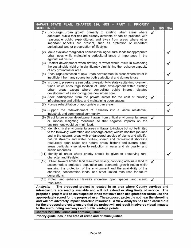
Page 81
HAWAI‘I STATE PLAN, CHAPTER 226, HRS – PART III. PRIORITY GUIDELINES (Key: S = Supportive, N/S = Not Supportive, N/A = Not Applicable)
S N/S N/A (1) Encourage urban growth primarily to existing urban areas where
adequate public facilities are already available or can be provided with reasonable public expenditures, and away from areas where other important benefits are present, such as protection of important agricultural land or preservation of lifestyles.
(2) Make available marginal or nonessential agricultural lands for appropriate urban uses while maintaining agricultural lands of importance in the agricultural district.
(3) Restrict development when drafting of water would result in exceeding the sustainable yield or in significantly diminishing the recharge capacity of any groundwater area.
(4) Encourage restriction of new urban development in areas where water is insufficient from any source for both agricultural and domestic use.
(5) In order to preserve green belts, give priority to state capital-improvement funds which encourage location of urban development within existing urban areas except where compelling public interest dictates development of a noncontiguous new urban core.
(6) Seek participation from the private sector for the cost of building infrastructure and utilities, and maintaining open spaces.
(7) Pursue rehabilitation of appropriate urban areas.
(8) Support the redevelopment of Kakaako into a viable residential, industrial, and commercial community.
(9) Direct future urban development away from critical environmental areas or impose mitigating measures so that negative impacts on the environment would be minimized.
(10) Identify critical environmental areas in Hawaii to include but not be limited to the following: watershed and recharge areas; wildlife habitats (on land and in the ocean); areas with endangered species of plants and wildlife; natural streams and water bodies; scenic and recreational shoreline resources; open space and natural areas; historic and cultural sites; areas particularly sensitive to reduction in water and air quality; and scenic resources.
(11) Identify all areas where priority should be given to preserving rural character and lifestyle.
(12) Utilize Hawaii’s limited land resources wisely, providing adequate land to accommodate projected population and economic growth needs while ensuring the protection of the environment and the availability of the shoreline, conservation lands, and other limited resources for future generations.
(13) Protect and enhance Hawaii’s shoreline, open spaces, and scenic resources.
Analysis: The proposed project is located in an area where County services and infrastructure are readily available and will not extend existing limits of service. The proposed project will be developed on lands that have been designated for urban use and appropriately zoned for the proposed use. The proposed project is not near the shoreline and will not adversely impact shoreline resources. A View Analysis has been carried out for the proposed project to ensure that the project will not result in adverse visual impacts to the surrounding roadways and public vantage points. Chapter 226-105: Crime and criminal justice. Priority guidelines in the area of crime and criminal justice:
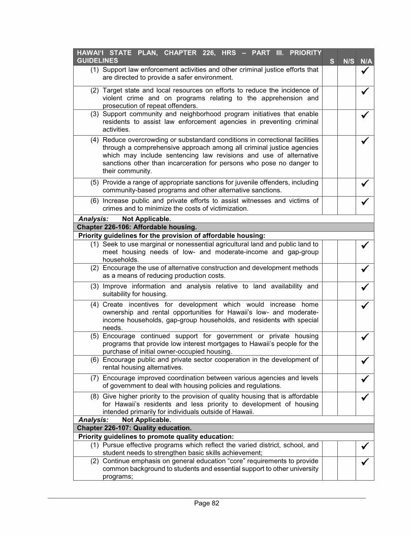
Page 82
HAWAI‘I STATE PLAN, CHAPTER 226, HRS – PART III. PRIORITY GUIDELINES (Key: S = Supportive, N/S = Not Supportive, N/A = Not Applicable)
S N/S N/A (1) Support law enforcement activities and other criminal justice efforts that
are directed to provide a safer environment.
(2) Target state and local resources on efforts to reduce the incidence of violent crime and on programs relating to the apprehension and prosecution of repeat offenders.
(3) Support community and neighborhood program initiatives that enable residents to assist law enforcement agencies in preventing criminal activities.
(4) Reduce overcrowding or substandard conditions in correctional facilities through a comprehensive approach among all criminal justice agencies which may include sentencing law revisions and use of alternative sanctions other than incarceration for persons who pose no danger to their community.
(5) Provide a range of appropriate sanctions for juvenile offenders, including community-based programs and other alternative sanctions.
(6) Increase public and private efforts to assist witnesses and victims of crimes and to minimize the costs of victimization.
Analysis: Not Applicable. Chapter 226-106: Affordable housing. Priority guidelines for the provision of affordable housing:
(1) Seek to use marginal or nonessential agricultural land and public land to meet housing needs of low- and moderate-income and gap-group households.
(2) Encourage the use of alternative construction and development methods as a means of reducing production costs.
(3) Improve information and analysis relative to land availability and suitability for housing.
(4) Create incentives for development which would increase home ownership and rental opportunities for Hawaii’s low- and moderate-income households, gap-group households, and residents with special needs.
(5) Encourage continued support for government or private housing programs that provide low interest mortgages to Hawaii’s people for the purchase of initial owner-occupied housing.
(6) Encourage public and private sector cooperation in the development of rental housing alternatives.
(7) Encourage improved coordination between various agencies and levels of government to deal with housing policies and regulations.
(8) Give higher priority to the provision of quality housing that is affordable for Hawaii’s residents and less priority to development of housing intended primarily for individuals outside of Hawaii.
Analysis: Not Applicable. Chapter 226-107: Quality education. Priority guidelines to promote quality education:
(1) Pursue effective programs which reflect the varied district, school, and student needs to strengthen basic skills achievement;
(2) Continue emphasis on general education “core” requirements to provide common background to students and essential support to other university programs;
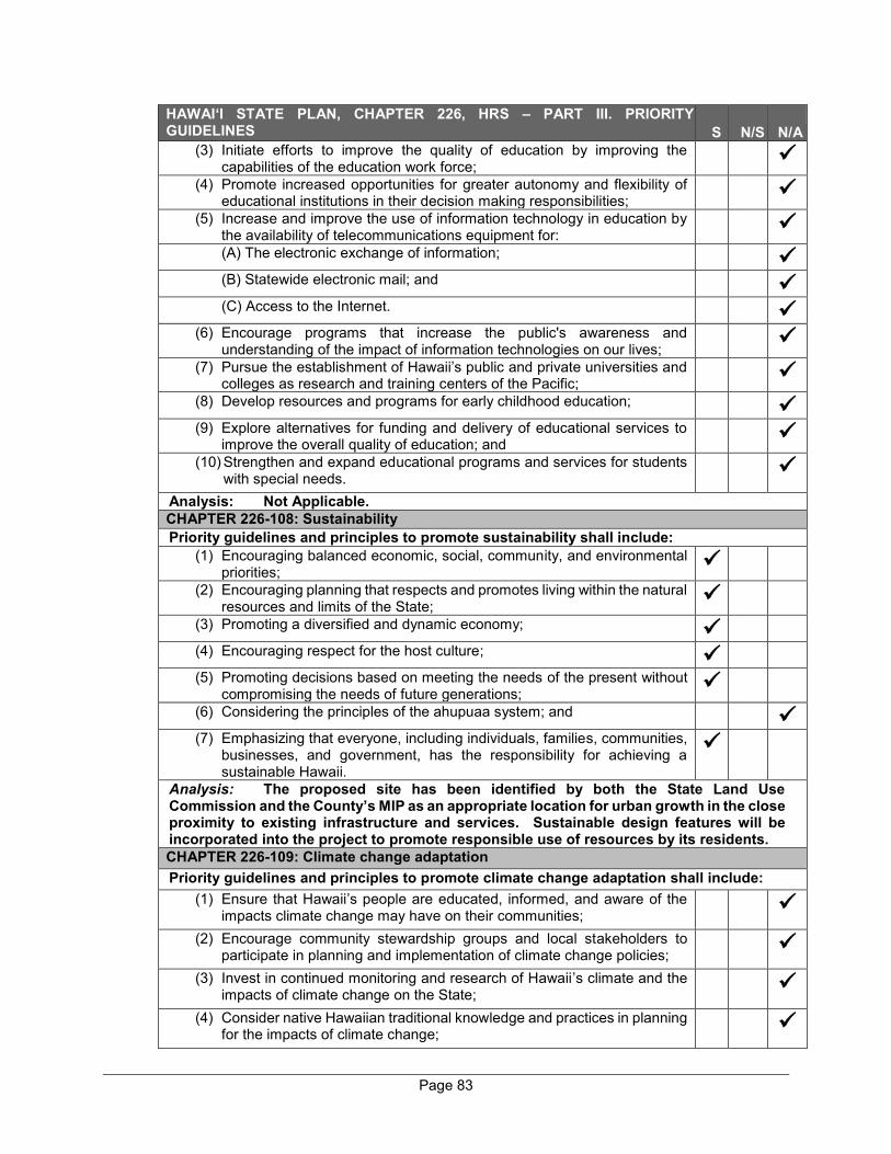
Page 83
HAWAI‘I STATE PLAN, CHAPTER 226, HRS – PART III. PRIORITY GUIDELINES (Key: S = Supportive, N/S = Not Supportive, N/A = Not Applicable)
S N/S N/A (3) Initiate efforts to improve the quality of education by improving the
capabilities of the education work force;
(4) Promote increased opportunities for greater autonomy and flexibility of
educational institutions in their decision making responsibilities;
(5) Increase and improve the use of information technology in education by
the availability of telecommunications equipment for:
(A) The electronic exchange of information;
(B) Statewide electronic mail; and
(C) Access to the Internet.
(6) Encourage programs that increase the public's awareness and
understanding of the impact of information technologies on our lives;
(7) Pursue the establishment of Hawaii’s public and private universities and
colleges as research and training centers of the Pacific;
(8) Develop resources and programs for early childhood education;
(9) Explore alternatives for funding and delivery of educational services to
improve the overall quality of education; and
(10) Strengthen and expand educational programs and services for students
with special needs.
Analysis: Not Applicable. CHAPTER 226-108: Sustainability Priority guidelines and principles to promote sustainability shall include:
(1) Encouraging balanced economic, social, community, and environmental priorities;
(2) Encouraging planning that respects and promotes living within the natural resources and limits of the State;
(3) Promoting a diversified and dynamic economy;
(4) Encouraging respect for the host culture;
(5) Promoting decisions based on meeting the needs of the present without compromising the needs of future generations;
(6) Considering the principles of the ahupuaa system; and
(7) Emphasizing that everyone, including individuals, families, communities, businesses, and government, has the responsibility for achieving a sustainable Hawaii.
Analysis: The proposed site has been identified by both the State Land Use Commission and the County’s MIP as an appropriate location for urban growth in the close proximity to existing infrastructure and services. Sustainable design features will be incorporated into the project to promote responsible use of resources by its residents. CHAPTER 226-109: Climate change adaptation Priority guidelines and principles to promote climate change adaptation shall include:
(1) Ensure that Hawaii’s people are educated, informed, and aware of the impacts climate change may have on their communities;
(2) Encourage community stewardship groups and local stakeholders to participate in planning and implementation of climate change policies;
(3) Invest in continued monitoring and research of Hawaii’s climate and the impacts of climate change on the State;
(4) Consider native Hawaiian traditional knowledge and practices in planning for the impacts of climate change;

Page 84
HAWAI‘I STATE PLAN, CHAPTER 226, HRS – PART III. PRIORITY GUIDELINES (Key: S = Supportive, N/S = Not Supportive, N/A = Not Applicable)
S N/S N/A (5) Encourage the preservation and restoration of natural landscape
features, such as coral reefs, beaches and dunes, forests, streams, floodplains, and wetlands, that have the inherent capacity to avoid, minimize, or mitigate the impacts of climate change;
(6) Explore adaptation strategies that moderate harm or exploit beneficial opportunities in response to actual or expected climate change impacts to the natural and built environments;
(7) Promote sector resilience in areas such as water, roads, airports, and public health, by encouraging the identification of climate change threats, assessment of potential consequences, and evaluation of adaptation options;
(8) Foster cross-jurisdictional collaboration between county, state, and federal agencies and partnerships between government and private entities and other nongovernmental entities, including nonprofit entities;
(9) Use management and implementation approaches that encourage the continual collection, evaluation, and integration of new information and strategies into new and existing practices, policies, and plans; and
(10) Encourage planning and management of the natural and built environments that effectively integrate climate change policy.
Analysis: The project site is located inland of the 3.2-foot sea level rise exposure area. Sustainable design features have been incorporated into the proposed project to promote responsible resource use and reduce GHG emissions.
C. STATE FUNCTIONAL PLANS
A key element of the Statewide Planning System is the Functional Plans which set forth the policies, statewide guidelines, and priorities within a specific field of activity. There are 13 Functional Plans which have been developed by the State agency primarily responsible for a given functional area. Together with the County General Plans, the State Functional Plans establish more specific strategies for implementation. In particular, State Functional Plans provide for the following:
● Identify major Statewide priority concerns
● Define current strategies for each functional area
● Identify major relationships among functional areas
● Provide direction and strategies for departmental policies, programs, and priorities
● Provide a guide for the allocation of resources
● Coordinate State and County roles and responsibilities in the implementation of the Hawaii State Plan
Page 85
Thirteen (13) Functional Plans have been prepared by State agencies. Table 6 provides an assessment of the relationship between the proposed action and each of the 13 Functional Plans.

Page 86
Table 6. Relationship Between the Proposed Wailea Resort SF-S Residential Project and the State Functional Plans
State Functional
Plan
State Coordinating
Agency Purpose Analysis 1 Agriculture
Functional Plan (1991)
Department of Agriculture
Continued viability of agriculture throughout the State
Not Applicable
2 Conservation Lands State Functional Plan (1991)
Department of Land and Natural Resources
Addresses issues of population and economic growth and its strain on current natural resources; broadening public use of natural resources while protecting lands and shorelines from overuse; additionally, promotes the aquaculture industry
Not Applicable
3 Education State Functional Plan (1989)
Department of Education
Improvements to Hawaii’s educational curriculum, quality of educational staff, and access to adequate facilities
Not Applicable
4 Employment State Functional Plan (1990)
Department of Labor and Industrial Relations
Improve the qualifications, productivity, and effectiveness of the State’s workforce through better education and training of workers as well as efficient planning of economic development, employment opportunities, and training activities
The proposed project will have a beneficial short-term impact on the State's workforce through construction and long-term employment benefits from operations, maintenance, and administration of the residential community.
5 Energy State Functional Plan (1991)
Department of Business, Economic Development and Tourism
Lessen the reliance on petroleum and other fossil fuels in favor of alternative sources of energy so as to keep up with the State’s increasing energy demands while also becoming a more sustainable island state; achieving dependable, efficient, and economical statewide energy systems
The project proposes to implement sustainability measures in support of the State’s energy objectives.
6 Health State Functional Plan (1989)
Department of Health
Improve health care system by providing for those who don’t have access to private health care providers; increasing preventative health measures; addressing ‘quality of care’ elements in private and public sectors to cut increasing costs
Not Applicable
7 Higher Education Functional Plan (1984)
University of Hawaii
Prepare Hawaii’s citizens for the demands of an increasingly complex world through providing technical and intellectual tools
Not Applicable
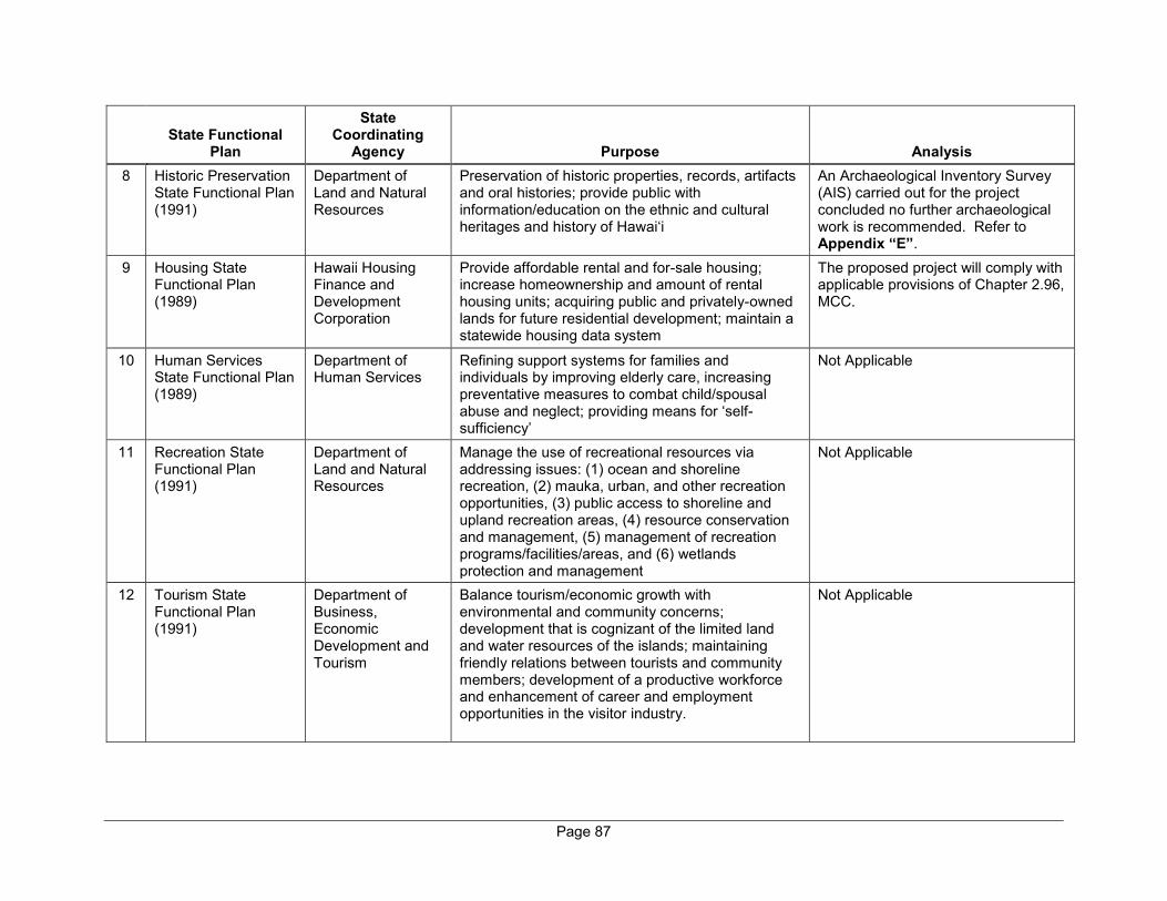
Page 87
State Functional
Plan
State Coordinating
Agency Purpose Analysis 8 Historic Preservation
State Functional Plan (1991)
Department of Land and Natural Resources
Preservation of historic properties, records, artifacts and oral histories; provide public with information/education on the ethnic and cultural heritages and history of Hawai‘i
An Archaeological Inventory Survey (AIS) carried out for the project concluded no further archaeological work is recommended. Refer to Appendix “E”.
9 Housing State Functional Plan (1989)
Hawaii Housing Finance and Development Corporation
Provide affordable rental and for-sale housing; increase homeownership and amount of rental housing units; acquiring public and privately-owned lands for future residential development; maintain a statewide housing data system
The proposed project will comply with applicable provisions of Chapter 2.96, MCC.
10 Human Services State Functional Plan (1989)
Department of Human Services
Refining support systems for families and individuals by improving elderly care, increasing preventative measures to combat child/spousal abuse and neglect; providing means for ‘self-sufficiency’
Not Applicable
11 Recreation State Functional Plan (1991)
Department of Land and Natural Resources
Manage the use of recreational resources via addressing issues: (1) ocean and shoreline recreation, (2) mauka, urban, and other recreation opportunities, (3) public access to shoreline and upland recreation areas, (4) resource conservation and management, (5) management of recreation programs/facilities/areas, and (6) wetlands protection and management
Not Applicable
12 Tourism State Functional Plan (1991)
Department of Business, Economic Development and Tourism
Balance tourism/economic growth with environmental and community concerns; development that is cognizant of the limited land and water resources of the islands; maintaining friendly relations between tourists and community members; development of a productive workforce and enhancement of career and employment opportunities in the visitor industry.
Not Applicable
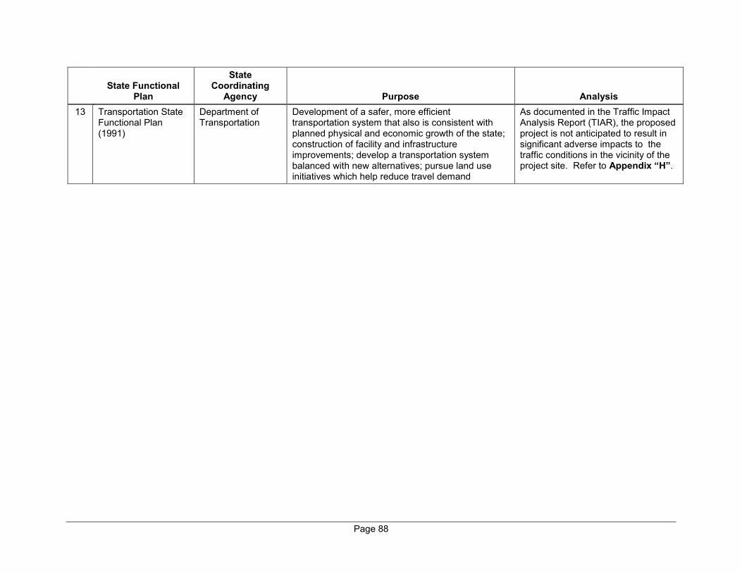
Page 88
State Functional
Plan
State Coordinating
Agency Purpose Analysis 13 Transportation State
Functional Plan (1991)
Department of Transportation
Development of a safer, more efficient transportation system that also is consistent with planned physical and economic growth of the state; construction of facility and infrastructure improvements; develop a transportation system balanced with new alternatives; pursue land use initiatives which help reduce travel demand
As documented in the Traffic Impact Analysis Report (TIAR), the proposed project is not anticipated to result in significant adverse impacts to the traffic conditions in the vicinity of the project site. Refer to Appendix “H”.
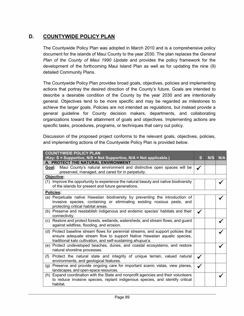
Page 89
D. COUNTYWIDE POLICY PLAN
The Countywide Policy Plan was adopted in March 2010 and is a comprehensive policy document for the islands of Maui County to the year 2030. The plan replaces the General Plan of the County of Maui 1990 Update and provides the policy framework for the development of the forthcoming Maui Island Plan as well as for updating the nine (9) detailed Community Plans.
The Countywide Policy Plan provides broad goals, objectives, policies and implementing actions that portray the desired direction of the County’s future. Goals are intended to describe a desirable condition of the County by the year 2030 and are intentionally general. Objectives tend to be more specific and may be regarded as milestones to achieve the larger goals. Policies are not intended as regulations, but instead provide a general guideline for County decision makers, departments, and collaborating organizations toward the attainment of goals and objectives. Implementing actions are specific tasks, procedures, programs, or techniques that carry out policy.
Discussion of the proposed project conforms to the relevant goals, objectives, policies, and implementing actions of the Countywide Policy Plan is provided below.
COUNTYWIDE POLICY PLAN (Key: S = Supportive, N/S = Not Supportive, N/A = Not applicable.) S N/S N/A A. PROTECT THE NATURAL ENVIRONMENT Goal: Maui County’s natural environment and distinctive open spaces will be
preserved, managed, and cared for in perpetuity.
Objective: (1) Improve the opportunity to experience the natural beauty and native biodiversity
of the islands for present and future generations.
Policies: (a) Perpetuate native Hawaiian biodiversity by preventing the introduction of
invasive species, containing or eliminating existing noxious pests, and protecting critical habitat areas.
(b) Preserve and reestablish indigenous and endemic species’ habitats and their connectivity.
(c) Restore and protect forests, wetlands, watersheds, and stream flows, and guard against wildfires, flooding, and erosion.
(d) Protect baseline stream flows for perennial streams, and support policies that ensure adequate stream flow to support Native Hawaiian aquatic species, traditional kalo cultivation, and self-sustaining ahupua‘a.
(e) Protect undeveloped beaches, dunes, and coastal ecosystems, and restore natural shoreline processes.
(f) Protect the natural state and integrity of unique terrain, valued natural environments, and geological features.
(g) Preserve and provide ongoing care for important scenic vistas, view planes, landscapes, and open-space resources.
(h) Expand coordination with the State and nonprofit agencies and their volunteers to reduce invasive species, replant indigenous species, and identify critical habitat.
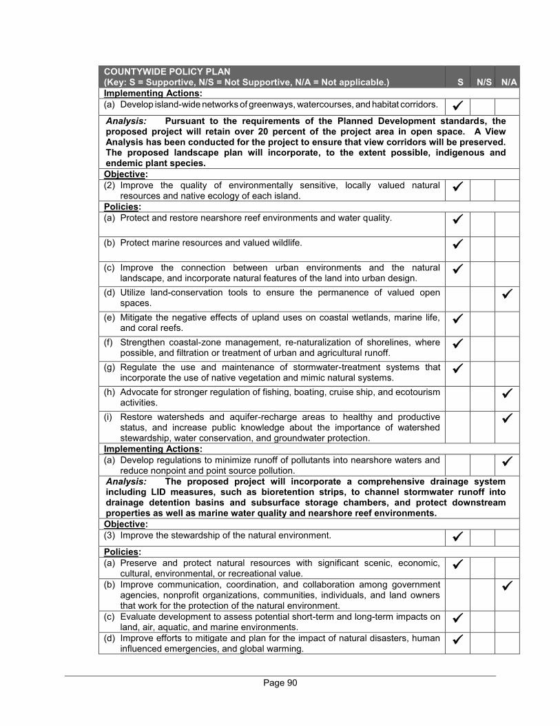
Page 90
COUNTYWIDE POLICY PLAN (Key: S = Supportive, N/S = Not Supportive, N/A = Not applicable.) S N/S N/A Implementing Actions: (a) Develop island-wide networks of greenways, watercourses, and habitat corridors.
Analysis: Pursuant to the requirements of the Planned Development standards, the proposed project will retain over 20 percent of the project area in open space. A View Analysis has been conducted for the project to ensure that view corridors will be preserved. The proposed landscape plan will incorporate, to the extent possible, indigenous and endemic plant species. Objective: (2) Improve the quality of environmentally sensitive, locally valued natural
resources and native ecology of each island.
Policies: (a) Protect and restore nearshore reef environments and water quality.
(b) Protect marine resources and valued wildlife.
(c) Improve the connection between urban environments and the natural landscape, and incorporate natural features of the land into urban design.
(d) Utilize land-conservation tools to ensure the permanence of valued open spaces.
(e) Mitigate the negative effects of upland uses on coastal wetlands, marine life, and coral reefs.
(f) Strengthen coastal-zone management, re-naturalization of shorelines, where possible, and filtration or treatment of urban and agricultural runoff.
(g) Regulate the use and maintenance of stormwater-treatment systems that incorporate the use of native vegetation and mimic natural systems.
(h) Advocate for stronger regulation of fishing, boating, cruise ship, and ecotourism activities.
(i) Restore watersheds and aquifer-recharge areas to healthy and productive status, and increase public knowledge about the importance of watershed stewardship, water conservation, and groundwater protection.
Implementing Actions: (a) Develop regulations to minimize runoff of pollutants into nearshore waters and
reduce nonpoint and point source pollution.
Analysis: The proposed project will incorporate a comprehensive drainage system including LID measures, such as bioretention strips, to channel stormwater runoff into drainage detention basins and subsurface storage chambers, and protect downstream properties as well as marine water quality and nearshore reef environments. Objective: (3) Improve the stewardship of the natural environment.
Policies: (a) Preserve and protect natural resources with significant scenic, economic,
cultural, environmental, or recreational value.
(b) Improve communication, coordination, and collaboration among government agencies, nonprofit organizations, communities, individuals, and land owners that work for the protection of the natural environment.
(c) Evaluate development to assess potential short-term and long-term impacts on land, air, aquatic, and marine environments.
(d) Improve efforts to mitigate and plan for the impact of natural disasters, human influenced emergencies, and global warming.
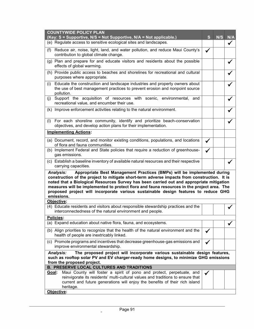
Page 91
COUNTYWIDE POLICY PLAN (Key: S = Supportive, N/S = Not Supportive, N/A = Not applicable.) S N/S N/A (e) Regulate access to sensitive ecological sites and landscapes.
(f) Reduce air, noise, light, land, and water pollution, and reduce Maui County’s
contribution to global climate change.
(g) Plan and prepare for and educate visitors and residents about the possible effects of global warming.
(h) Provide public access to beaches and shorelines for recreational and cultural purposes where appropriate.
(i) Educate the construction and landscape industries and property owners about the use of best management practices to prevent erosion and nonpoint source pollution.
(j) Support the acquisition of resources with scenic, environmental, and recreational value, and encumber their use.
(k) Improve enforcement activities relating to the natural environment.
(l) For each shoreline community, identify and prioritize beach-conservation objectives, and develop action plans for their implementation.
Implementing Actions: (a) Document, record, and monitor existing conditions, populations, and locations
of flora and fauna communities.
(b) Implement Federal and State policies that require a reduction of greenhouse-gas emissions.
(c) Establish a baseline inventory of available natural resources and their respective carrying capacities.
Analysis: Appropriate Best Management Practices (BMPs) will be implemented during construction of the project to mitigate short-term adverse impacts from construction. It is noted that a Biological Resources Survey has been carried out and appropriate mitigation measures will be implemented to protect flora and fauna resources in the project area. The proposed project will incorporate various sustainable design features to reduce GHG emissions. Objective: (4) Educate residents and visitors about responsible stewardship practices and the
interconnectedness of the natural environment and people.
Policies: (a) Expand education about native flora, fauna, and ecosystems.
(b) Align priorities to recognize that the health of the natural environment and the
health of people are inextricably linked.
(c) Promote programs and incentives that decrease greenhouse-gas emissions and improve environmental stewardship.
Analysis: The proposed project will incorporate various sustainable design features, such as rooftop solar PV and EV charger-ready home designs, to minimize GHG emissions from the proposed project. B. PRESERVE LOCAL CULTURES AND TRADITIONS Goal: Maui County will foster a spirit of pono and protect, perpetuate, and
reinvigorate its residents’ multi-cultural values and traditions to ensure that current and future generations will enjoy the benefits of their rich island heritage.
Objective:
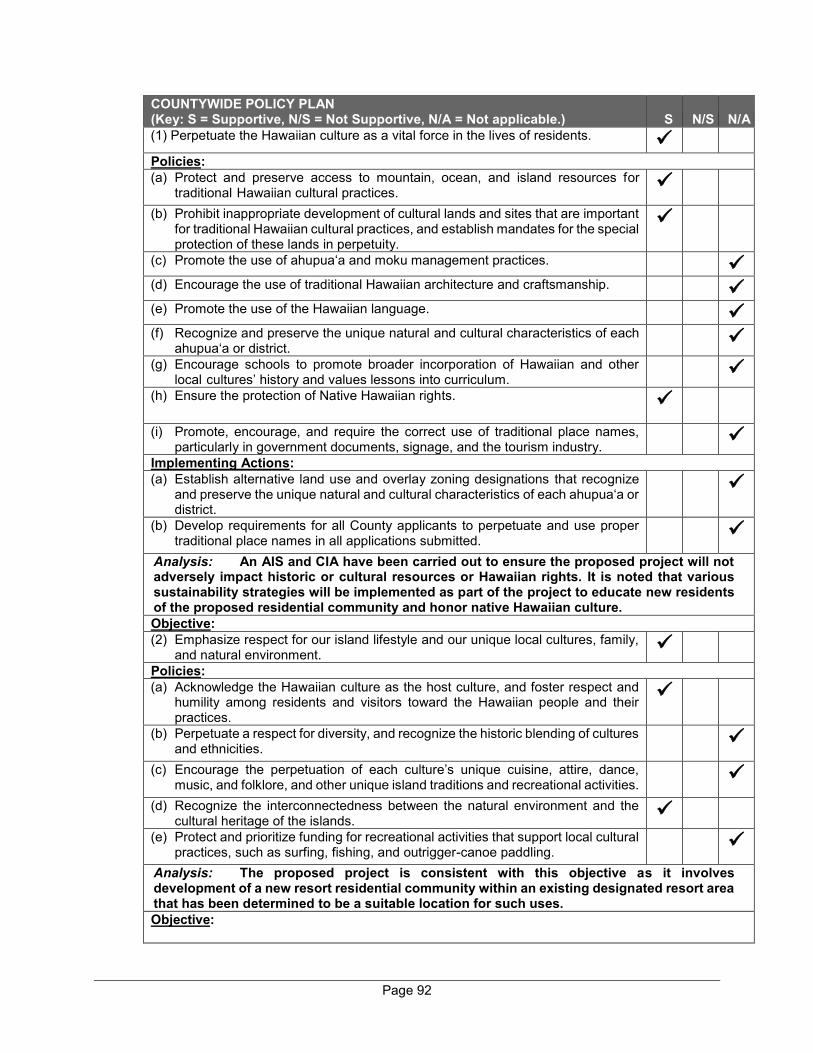
Page 92
COUNTYWIDE POLICY PLAN (Key: S = Supportive, N/S = Not Supportive, N/A = Not applicable.) S N/S N/A (1) Perpetuate the Hawaiian culture as a vital force in the lives of residents.
Policies: (a) Protect and preserve access to mountain, ocean, and island resources for
traditional Hawaiian cultural practices.
(b) Prohibit inappropriate development of cultural lands and sites that are important for traditional Hawaiian cultural practices, and establish mandates for the special protection of these lands in perpetuity.
(c) Promote the use of ahupua‘a and moku management practices.
(d) Encourage the use of traditional Hawaiian architecture and craftsmanship.
(e) Promote the use of the Hawaiian language.
(f) Recognize and preserve the unique natural and cultural characteristics of each ahupua‘a or district.
(g) Encourage schools to promote broader incorporation of Hawaiian and other local cultures’ history and values lessons into curriculum.
(h) Ensure the protection of Native Hawaiian rights.
(i) Promote, encourage, and require the correct use of traditional place names, particularly in government documents, signage, and the tourism industry.
Implementing Actions: (a) Establish alternative land use and overlay zoning designations that recognize
and preserve the unique natural and cultural characteristics of each ahupua‘a or district.
(b) Develop requirements for all County applicants to perpetuate and use proper traditional place names in all applications submitted.
Analysis: An AIS and CIA have been carried out to ensure the proposed project will not adversely impact historic or cultural resources or Hawaiian rights. It is noted that various sustainability strategies will be implemented as part of the project to educate new residents of the proposed residential community and honor native Hawaiian culture. Objective: (2) Emphasize respect for our island lifestyle and our unique local cultures, family,
and natural environment.
Policies: (a) Acknowledge the Hawaiian culture as the host culture, and foster respect and
humility among residents and visitors toward the Hawaiian people and their practices.
(b) Perpetuate a respect for diversity, and recognize the historic blending of cultures and ethnicities.
(c) Encourage the perpetuation of each culture’s unique cuisine, attire, dance, music, and folklore, and other unique island traditions and recreational activities.
(d) Recognize the interconnectedness between the natural environment and the cultural heritage of the islands.
(e) Protect and prioritize funding for recreational activities that support local cultural practices, such as surfing, fishing, and outrigger-canoe paddling.
Analysis: The proposed project is consistent with this objective as it involves development of a new resort residential community within an existing designated resort area that has been determined to be a suitable location for such uses. Objective:

Page 93
COUNTYWIDE POLICY PLAN (Key: S = Supportive, N/S = Not Supportive, N/A = Not applicable.) S N/S N/A (3) Preserve for present and future generations the opportunity to know and
experience the arts, culture, and history of Maui County.
Policies: (a) Foster teaching opportunities for cultural practitioners to share their knowledge
and skills.
(b) Support the development of cultural centers.
(c) Broaden opportunities for public art and the display of local artwork.
(d) Foster the Aloha Spirit by celebrating the Hawaiian host culture and other Maui County cultures through support of cultural-education programs, festivals, celebrations, and ceremonies.
(e) Support the perpetuation of Hawaiian arts and culture.
(f) Support programs and activities that record the oral and pictorial history of residents.
(g) Support the development of repositories for culture, history, genealogy, oral history, film, and interactive learning.
Implementing Actions: (a) Establish incentives for the display of public art.
(b) Establish centers and programs of excellence for the perpetuation of Hawaiian arts and culture.
Analysis: In accordance with the project’s overall guiding sustainability principles, the project will incorporate various measures to honor native Hawaiian culture and educate new residents of the residential community. Objective: (4) Preserve and restore significant historic architecture, structures, cultural sites,
cultural districts, and cultural landscapes.
Policies: (a) Support the development of island-wide historic, archaeological, and cultural
resources inventories.
(b) Promote the rehabilitation and adaptive reuse of historic sites, buildings, and structures to perpetuate a traditional sense of place.
(c) Identify a sustainable rate of use and set forth specific policies to protect cultural resources.
(d) Protect and preserve lands that are culturally or historically significant.
(e) Support programs that protect, record, restore, maintain, provide education about, and interpret cultural districts, landscapes, sites, and artifacts in both natural and museum settings.
(f) Perpetuate the authentic character and historic integrity of rural communities and small towns.
(g) Seek solutions that honor the traditions and practices of the host culture while recognizing the needs of the community.
(h) Support the development of an Archaeological District Ordinance.
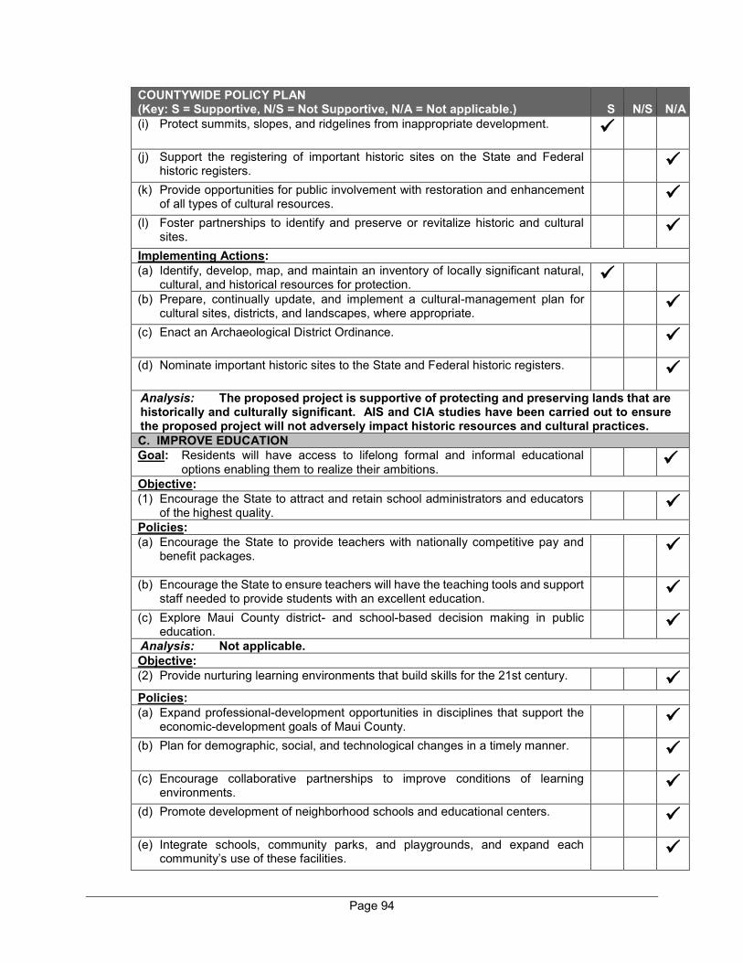
Page 94
COUNTYWIDE POLICY PLAN (Key: S = Supportive, N/S = Not Supportive, N/A = Not applicable.) S N/S N/A (i) Protect summits, slopes, and ridgelines from inappropriate development.
(j) Support the registering of important historic sites on the State and Federal historic registers.
(k) Provide opportunities for public involvement with restoration and enhancement of all types of cultural resources.
(l) Foster partnerships to identify and preserve or revitalize historic and cultural sites.
Implementing Actions: (a) Identify, develop, map, and maintain an inventory of locally significant natural,
cultural, and historical resources for protection.
(b) Prepare, continually update, and implement a cultural-management plan for cultural sites, districts, and landscapes, where appropriate.
(c) Enact an Archaeological District Ordinance.
(d) Nominate important historic sites to the State and Federal historic registers.
Analysis: The proposed project is supportive of protecting and preserving lands that are historically and culturally significant. AIS and CIA studies have been carried out to ensure the proposed project will not adversely impact historic resources and cultural practices. C. IMPROVE EDUCATION Goal: Residents will have access to lifelong formal and informal educational
options enabling them to realize their ambitions.
Objective: (1) Encourage the State to attract and retain school administrators and educators
of the highest quality.
Policies: (a) Encourage the State to provide teachers with nationally competitive pay and
benefit packages.
(b) Encourage the State to ensure teachers will have the teaching tools and support staff needed to provide students with an excellent education.
(c) Explore Maui County district- and school-based decision making in public education.
Analysis: Not applicable. Objective: (2) Provide nurturing learning environments that build skills for the 21st century.
Policies: (a) Expand professional-development opportunities in disciplines that support the
economic-development goals of Maui County.
(b) Plan for demographic, social, and technological changes in a timely manner.
(c) Encourage collaborative partnerships to improve conditions of learning environments.
(d) Promote development of neighborhood schools and educational centers.
(e) Integrate schools, community parks, and playgrounds, and expand each community’s use of these facilities.
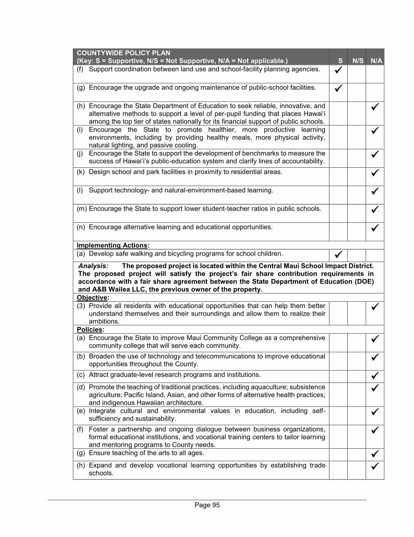
Page 95
COUNTYWIDE POLICY PLAN (Key: S = Supportive, N/S = Not Supportive, N/A = Not applicable.) S N/S N/A (f) Support coordination between land use and school-facility planning agencies.
(g) Encourage the upgrade and ongoing maintenance of public-school facilities.
(h) Encourage the State Department of Education to seek reliable, innovative, and alternative methods to support a level of per-pupil funding that places Hawai‘i among the top tier of states nationally for its financial support of public schools.
(i) Encourage the State to promote healthier, more productive learning environments, including by providing healthy meals, more physical activity, natural lighting, and passive cooling.
(j) Encourage the State to support the development of benchmarks to measure the success of Hawai‘i’s public-education system and clarify lines of accountability.
(k) Design school and park facilities in proximity to residential areas.
(l) Support technology- and natural-environment-based learning.
(m) Encourage the State to support lower student-teacher ratios in public schools.
(n) Encourage alternative learning and educational opportunities.
Implementing Actions: (a) Develop safe walking and bicycling programs for school children.
Analysis: The proposed project is located within the Central Maui School Impact District. The proposed project will satisfy the project’s fair share contribution requirements in accordance with a fair share agreement between the State Department of Education (DOE) and A&B Wailea LLC, the previous owner of the property. Objective: (3) Provide all residents with educational opportunities that can help them better
understand themselves and their surroundings and allow them to realize their ambitions.
Policies: (a) Encourage the State to improve Maui Community College as a comprehensive
community college that will serve each community.
(b) Broaden the use of technology and telecommunications to improve educational opportunities throughout the County.
(c) Attract graduate-level research programs and institutions.
(d) Promote the teaching of traditional practices, including aquaculture; subsistence agriculture; Pacific Island, Asian, and other forms of alternative health practices; and indigenous Hawaiian architecture.
(e) Integrate cultural and environmental values in education, including self-sufficiency and sustainability.
(f) Foster a partnership and ongoing dialogue between business organizations, formal educational institutions, and vocational training centers to tailor learning and mentoring programs to County needs.
(g) Ensure teaching of the arts to all ages.
(h) Expand and develop vocational learning opportunities by establishing trade schools.

Page 96
COUNTYWIDE POLICY PLAN (Key: S = Supportive, N/S = Not Supportive, N/A = Not applicable.) S N/S N/A (i) Encourage the State to integrate financial and economic literacy in elementary,
secondary, and higher-education levels.
Implementing Actions: (a) Encourage the State to establish a four-year university, and support the
development of other higher-education institutions to enable residents to obtain bachelor degrees and postgraduate degrees in Maui County.
Analysis: Not Applicable. Objective: (4) Maximize community-based educational opportunities.
Policies: (a) Encourage the State and others to expand pre-school, after-school, and
homebased (parent-child) learning.
(b) Support public-private partnerships to develop youth-internship, -apprenticeship, and -mentoring programs.
(c) Support the development of a wide range of informal educational and cultural programs for all residents.
(d) Improve partnerships that utilize the skills and talents at Hawai‘i’s colleges and universities to benefit the County.
(e) Support career-development and job-recruitment programs and centers.
(f) Attract learning institutions and specialty schools to diversify and enhance educational opportunities.
(g) Expand education of important life skills for the general public.
(h) Support community facilities such as museums, libraries, nature centers, and open spaces that provide interactive-learning opportunities for all ages.
Analysis: Not Applicable. D. STRENGTHEN SOCIAL AND HEALTHCARE SERVICES Goal: Health and social services in Maui County will fully and comprehensively
serve all segments of the population.
Objective: (1) In cooperation with the Federal and State governments and nonprofit agencies,
broaden access to social and healthcare services and expand options to improve the overall wellness of the people of Maui County.
Policies: (a) Work with other levels of government and the nonprofit sector to expand
services to address hunger, homelessness, and poverty.
(b) Support the improvement of opportunities for disadvantaged youth, encourage the tradition of hanai relatives, and support expanded opportunities for foster care.
(c) Support expanded long-term-care options, both in institutions and at home, for patients requiring ongoing assistance and medical attention.
(d) Encourage the expansion and improvement of local hospitals, facilitate the establishment of new healthcare facilities, and facilitate prompt and high-quality emergency- and urgent-care services for all.
(e) Support broadened access to affordable health insurance and health care, and recognize the unique economic challenges posed to families when healthcare services are provided off-island.

Page 97
COUNTYWIDE POLICY PLAN (Key: S = Supportive, N/S = Not Supportive, N/A = Not applicable.) S N/S N/A (f) Encourage equal access to social and healthcare services through both
technological and traditional means.
Analysis: Not Applicable. Objective: (2) Encourage the Federal and State governments and the private sector to improve
the quality and delivery of social and healthcare services.
Policies: (a) Strengthen partnerships with government, nonprofit, and private organizations
to provide funding and to improve counseling and other assistance to address substance abuse, domestic violence, and other pressing social challenges.
(b) Encourage the State to improve the quality of medical personnel, facilities, services, and equipment.
(c) Encourage investment to improve the recruitment of medical professionals and the quality of medical facilities and equipment throughout Maui County.
(d) Promote the development of continuum-of-care facilities that provide assisted living, hospice, home-care, and skilled-nursing options allowing the individual to be cared for in a manner congruent with his or her needs and desires.
(e) Support improved social, healthcare, and governmental services for special needs populations.
(f) Plan for the needs of an aging population and the resulting impacts on social services, housing, and healthcare delivery.
(g) Improve coordination among the police, the courts, and the public in the administration of social and healthcare services.
(h) Support programs that address needs of veterans.
(i) Support programs that address the needs of immigrants.
Implementing Actions: (a) Invest in programs designed to improve the general welfare and quality of life of
Native Hawaiians.
(b) Assist and facilitate the State Department of Public Safety and others in efforts to strengthen programs and facilities that will improve the mental and social health of incarcerated people and assist in prison inmates' successful transition back into Maui County communities.
(c) Develop and maintain a comprehensive index that will measure the health and wellness needs of families.
(d) Provide heliports countywide for emergency health and safety purposes.
Analysis: Not Applicable. Objective: (3) Strengthen public-awareness programs related to healthy lifestyles and social
and medical services.
Policies: (a) Expand public awareness about personal safety and crime prevention.
(b) Encourage residents to pursue education and training for careers in the healthcare, social services, and community-development fields.
(c) Expand public awareness and promote programs to achieve healthy eating habits and drug-free lifestyles.
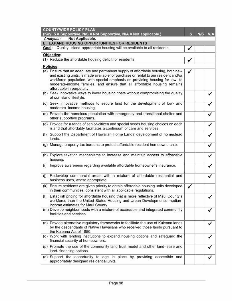
Page 98
COUNTYWIDE POLICY PLAN (Key: S = Supportive, N/S = Not Supportive, N/A = Not applicable.) S N/S N/A Analysis: Not Applicable. E. EXPAND HOUSING OPPORTUNITIES FOR RESIDENTS Goal: Quality, island-appropriate housing will be available to all residents.
Objective: (1) Reduce the affordable housing deficit for residents.
Policies: (a) Ensure that an adequate and permanent supply of affordable housing, both new
and existing units, is made available for purchase or rental to our resident and/or workforce population, with special emphasis on providing housing for low- to moderate-income families, and ensure that all affordable housing remains affordable in perpetuity.
(b) Seek innovative ways to lower housing costs without compromising the quality of our island lifestyle.
(c) Seek innovative methods to secure land for the development of low- and moderate- income housing.
(d) Provide the homeless population with emergency and transitional shelter and other supportive programs.
(e) Provide for a range of senior-citizen and special needs housing choices on each island that affordably facilitates a continuum of care and services.
(f) Support the Department of Hawaiian Home Lands’ development of homestead lands.
(g) Manage property-tax burdens to protect affordable resident homeownership.
(h) Explore taxation mechanisms to increase and maintain access to affordable housing.
(i) Improve awareness regarding available affordable homeowner’s insurance.
(j) Redevelop commercial areas with a mixture of affordable residential and business uses, where appropriate.
(k) Ensure residents are given priority to obtain affordable housing units developed in their communities, consistent with all applicable regulations.
(l) Establish pricing for affordable housing that is more reflective of Maui County’s workforce than the United States Housing and Urban Development's median-income estimates for Maui County.
(m) Develop neighborhoods with a mixture of accessible and integrated community facilities and services.
(n) Provide alternative regulatory frameworks to facilitate the use of Kuleana lands by the descendants of Native Hawaiians who received those lands pursuant to the Kuleana Act of 1850.
(o) Work with lending institutions to expand housing options and safeguard the financial security of homeowners.
(p) Promote the use of the community land trust model and other land-lease and land- financing options.
(q) Support the opportunity to age in place by providing accessible and appropriately designed residential units.
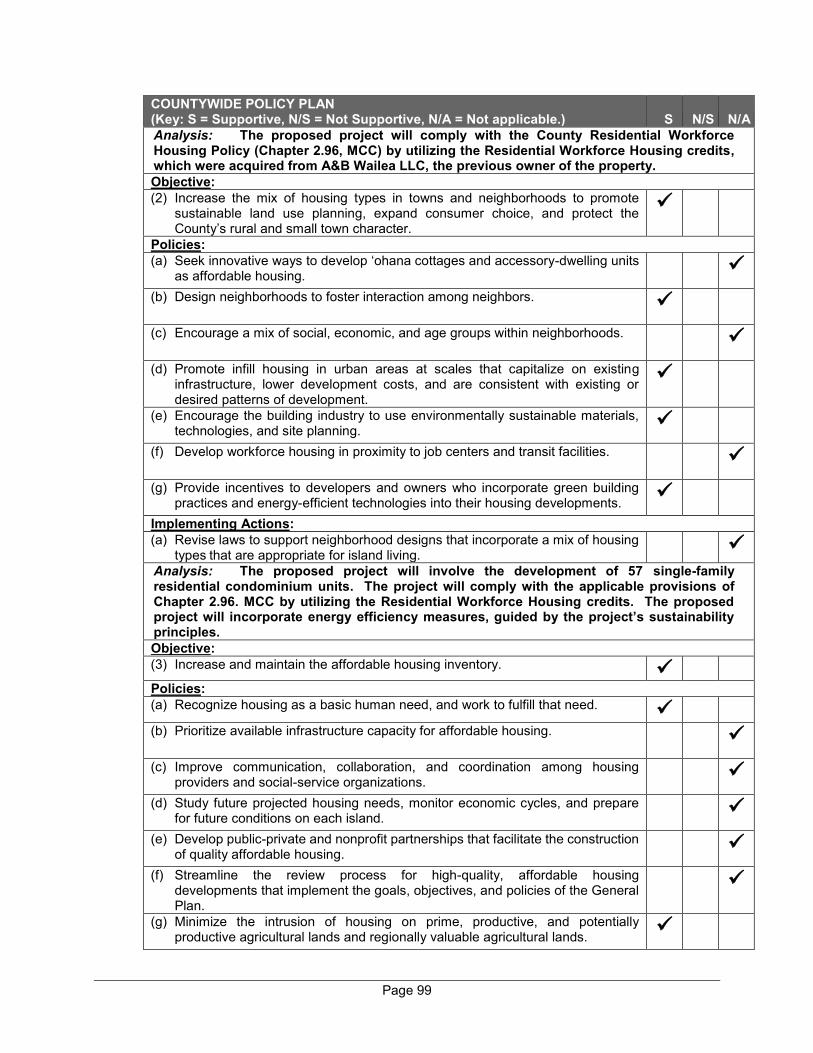
Page 99
COUNTYWIDE POLICY PLAN (Key: S = Supportive, N/S = Not Supportive, N/A = Not applicable.) S N/S N/A Analysis: The proposed project will comply with the County Residential Workforce Housing Policy (Chapter 2.96, MCC) by utilizing the Residential Workforce Housing credits, which were acquired from A&B Wailea LLC, the previous owner of the property. Objective: (2) Increase the mix of housing types in towns and neighborhoods to promote
sustainable land use planning, expand consumer choice, and protect the County’s rural and small town character.
Policies: (a) Seek innovative ways to develop ‘ohana cottages and accessory-dwelling units
as affordable housing.
(b) Design neighborhoods to foster interaction among neighbors.
(c) Encourage a mix of social, economic, and age groups within neighborhoods.
(d) Promote infill housing in urban areas at scales that capitalize on existing infrastructure, lower development costs, and are consistent with existing or desired patterns of development.
(e) Encourage the building industry to use environmentally sustainable materials, technologies, and site planning.
(f) Develop workforce housing in proximity to job centers and transit facilities.
(g) Provide incentives to developers and owners who incorporate green building practices and energy-efficient technologies into their housing developments.
Implementing Actions: (a) Revise laws to support neighborhood designs that incorporate a mix of housing
types that are appropriate for island living.
Analysis: The proposed project will involve the development of 57 single-family residential condominium units. The project will comply with the applicable provisions of Chapter 2.96. MCC by utilizing the Residential Workforce Housing credits. The proposed project will incorporate energy efficiency measures, guided by the project’s sustainability principles. Objective: (3) Increase and maintain the affordable housing inventory.
Policies: (a) Recognize housing as a basic human need, and work to fulfill that need.
(b) Prioritize available infrastructure capacity for affordable housing.
(c) Improve communication, collaboration, and coordination among housing providers and social-service organizations.
(d) Study future projected housing needs, monitor economic cycles, and prepare for future conditions on each island.
(e) Develop public-private and nonprofit partnerships that facilitate the construction of quality affordable housing.
(f) Streamline the review process for high-quality, affordable housing developments that implement the goals, objectives, and policies of the General Plan.
(g) Minimize the intrusion of housing on prime, productive, and potentially productive agricultural lands and regionally valuable agricultural lands.
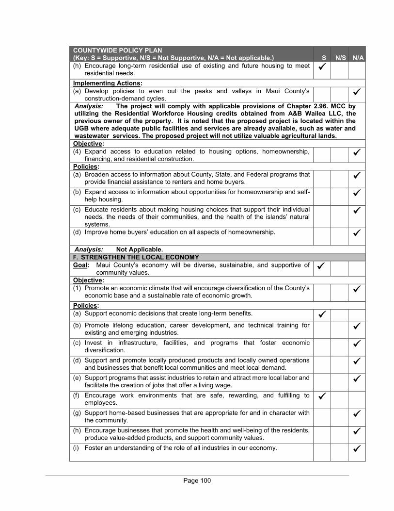
Page 100
COUNTYWIDE POLICY PLAN (Key: S = Supportive, N/S = Not Supportive, N/A = Not applicable.) S N/S N/A (h) Encourage long-term residential use of existing and future housing to meet
residential needs.
Implementing Actions: (a) Develop policies to even out the peaks and valleys in Maui County’s
construction-demand cycles.
Analysis: The project will comply with applicable provisions of Chapter 2.96. MCC by utilizing the Residential Workforce Housing credits obtained from A&B Wailea LLC, the previous owner of the property. It is noted that the proposed project is located within the UGB where adequate public facilities and services are already available, such as water and wastewater services. The proposed project will not utilize valuable agricultural lands. Objective: (4) Expand access to education related to housing options, homeownership,
financing, and residential construction.
Policies: (a) Broaden access to information about County, State, and Federal programs that
provide financial assistance to renters and home buyers.
(b) Expand access to information about opportunities for homeownership and self-help housing.
(c) Educate residents about making housing choices that support their individual needs, the needs of their communities, and the health of the islands’ natural systems.
(d) Improve home buyers’ education on all aspects of homeownership.
Analysis: Not Applicable. F. STRENGTHEN THE LOCAL ECONOMY Goal: Maui County’s economy will be diverse, sustainable, and supportive of
community values.
Objective: (1) Promote an economic climate that will encourage diversification of the County’s
economic base and a sustainable rate of economic growth.
Policies: (a) Support economic decisions that create long-term benefits.
(b) Promote lifelong education, career development, and technical training for existing and emerging industries.
(c) Invest in infrastructure, facilities, and programs that foster economic diversification.
(d) Support and promote locally produced products and locally owned operations and businesses that benefit local communities and meet local demand.
(e) Support programs that assist industries to retain and attract more local labor and facilitate the creation of jobs that offer a living wage.
(f) Encourage work environments that are safe, rewarding, and fulfilling to employees.
(g) Support home-based businesses that are appropriate for and in character with the community.
(h) Encourage businesses that promote the health and well-being of the residents, produce value-added products, and support community values.
(i) Foster an understanding of the role of all industries in our economy.
Page 101
COUNTYWIDE POLICY PLAN (Key: S = Supportive, N/S = Not Supportive, N/A = Not applicable.) S N/S N/A (j) Support efforts to improve conditions that foster economic vitality in our historic
small towns.
(k) Support and encourage traditional host-culture businesses and indigenous agricultural practices.
(l) Support public and private entities that assist entrepreneurs in establishing locally operated businesses.
Implementing Actions: (a) Develop regulations and programs that support opportunities for local
merchants, farmers, and small businesses to sell their goods and services directly to the public.
(b) Monitor the carrying capacity of the islands’ social, ecological, and infrastructure systems with respect to the economy.
Analysis: The proposed project will create both short-term and long-term employment opportunities during construction and operation phases of the residential community. The proposed project will ensure that the work environments are safe, rewarding, and fulfilling to employees. Objective: (2) Diversify and expand sustainable forms of agriculture and aquaculture.
Policies: (a) Support programs that position Maui County’s agricultural products as premium
export products.
(b) Prioritize the use of agricultural land to feed the local population, and promote the use of agricultural lands for sustainable and diversified agricultural activities.
(c) Capitalize on Hawai‘i’s economic opportunities in the ecologically sensitive aquaculture industries.
(d) Assist farmers to help make Maui County more self-sufficient in food production.
(e) Support ordinances, programs, and policies that keep agricultural land and water available and affordable to farmers.
(f) Support a tax structure that is conducive to the growth of the agricultural economy.
(g) Enhance County efforts to monitor and regulate important agricultural issues. (h) Support education, research, and facilities that strengthen the agricultural
industry.
(i) Maintain the genetic integrity of existing food crops.
(j) Encourage healthy and organic farm practices that contribute to land health and regeneration.
(k) Support cooperatives and other types of nontraditional and efforts.
communal farming
(l) Encourage methods of monitoring and controlling genetically modified crops to prevent adverse effects.
(m) Work with the State to ease the permitting process for the revitalization of traditional fish ponds.
Implementing Actions: (a) Redirect efforts in the Office of Economic Development to further facilitate the
development of the agricultural section and to monitor agricultural legislation and issues.
Page 102
COUNTYWIDE POLICY PLAN (Key: S = Supportive, N/S = Not Supportive, N/A = Not applicable.) S N/S N/A (b) Publicly identify, with signage and other means, the field locations of all
genetically modified crops.
(c) Create agricultural parks in areas distant from genetically modified crops.
Analysis: Not Applicable. Objective: (3) Support a visitor industry that respects the resident culture and the environment.
Policies: (a) Promote traditional Hawaiian practices in visitor-related facilities and activities.
(b) Encourage and educate the visitor industry to be sensitive to island lifestyles
and cultural values.
(c) Encourage a spirit of welcome for residents at visitor facilities, such as by offering kama‘aina incentives and discount programs.
(d) Support the renovation and enhancement of existing visitor facilities.
(e)
(e) Support policies, programs, and a tax structure that redirect the benefits of the visitor industry back into the local community.
(f) Encourage resident ownership of visitor-related businesses and facilities.
(g) Develop partnerships to provide educational and training facilities to residents employed in the visitor industry.
(h) Foster an understanding of local cultures, customs, and etiquette, and emphasize the importance of the Aloha Spirit as a common good for all.
(i) Support the diversification, development, evolution, and integration of the visitor industry in a way that is compatible with the traditional, social, economic, spiritual, and environmental values of island residents
(j) Improve collaboration between the visitor industry and the other sectors of Maui County’s economy.
(k) Perpetuate an authentic image of the Hawaiian culture and history and an appropriate recognition of the host culture.
(l) Support the programs and initiatives outlined in the Maui County Tourism Strategic Plan 2006-2015.
(m) Promote water conservation, beach conservation, and open-space conservation in areas providing services for visitors.
(n) Recognize the important contributions that the visitor industry makes to the County’s economy, and support a healthy and vibrant visitor industry.
Analysis: Not Applicable. Objective: (4) Expand economic sectors that increase living-wage job choices and are
compatible with community values.
Policies: (a) Support emerging industries, including the following:
• Health and wellness industry; • Sports and recreation industry; • Film and entertainment industry; • Arts and culture industry; • Renewable-energy industry;
• Research and development industry;
• High-technology and knowledge-based industries;
• Education and training industry; • Ecotourism industry; and • Agritourism industry.
Page 103
COUNTYWIDE POLICY PLAN (Key: S = Supportive, N/S = Not Supportive, N/A = Not applicable.) S N/S N/A Analysis: The proposed project will create both short-term and long-term employment opportunities during the construction and operation phases of the residential community, which will increase living-wage job choices and are compatible with community values. It is noted that the project will encourage homeowners to install rooftop solar PV panels and an EV charger on their homes, which will support the renewable energy industry. G. IMPROVE PARKS AND PUBLIC FACILITIES Goal: A full range of island-appropriate public facilities and recreational
opportunities will be provided to improve the quality of life for residents and visitors.
Objective: (1) Expand access to recreational opportunities and community facilities to meet
the present and future needs of residents of all ages and physical abilities.
Policies: (a) Protect, enhance, and expand access to public shoreline and mountain
resources.
(b) Expand and enhance the network of parks, multi-use paths, and bikeways.
(c) Assist communities in developing recreational facilities that promote physical fitness.
(d) Expand venue options for recreation and performances that enrich the lifestyles of Maui County’s people.
(e) Expand affordable recreational and after-school programs for youth.
(f) Encourage and invest in recreational, social, and leisure activities that bring people together and build community pride.
(g) Promote the development and enhancement of community centers, civic spaces, and gathering places throughout our communities.
(h) Expand affordable access to recreational opportunities that support the local lifestyle.
Implementing Actions: (a) Identify and reserve lands for cemeteries, and preserve existing cemeteries on
all islands, appropriately accommodating varying cultural and, faith-based traditions.
Analysis: The proposed project will include multi-modal paths on main roads within the proposed community to encourage walking and biking, which will connect to Wailea Alanui Drive and Kapili Street. An amenity center, proposed as part of the project, will include community spaces to bring people together. The proposed project donated land to the County for a future park next to Wailea Fire Station. Objective: (2) Improve the quality and adequacy of community facilities.
Policies: (a) Provide an adequate supply of dedicated shelters and facilities for disaster relief.
(b) Provide and maintain community facilities that are appropriately designed to reflect the traditions and customs of local cultures.
(c) Ensure that parks and public facilities are safe and adequately equipped for the needs of all ages and physical abilities to the extent reasonable.
Page 104
COUNTYWIDE POLICY PLAN (Key: S = Supportive, N/S = Not Supportive, N/A = Not applicable.) S N/S N/A (d) Maintain, enhance, expand, and provide new active and passive recreational
facilities in ways that preserve the natural beauty of their locations.
(e) Redesign or retrofit public facilities to adapt to major shifts in environmental or urban conditions to the extent reasonable.
Analysis: As discussed previously, the proposed amenity center will include various community spaces for the residents and visitors of the Wailea Resort SF-S Residential Project. The amenity center will be equipped for the needs of all ages and physical abilities to the extent reasonable. The County of Maui’s Urban Design Review Board (UDRB) will review the project design to ensure that the proposed homes, as well as the amenity center are appropriately designed. Objective: (3) Enhance the funding, management, and planning of public facilities and park
lands.
Policies: (a) Identify and encourage the establishment of regulated and environmentally
sound campgrounds.
(b) Manage park use and control access to natural resources in order to rest sensitive places and utilize the resources in a sustainable manner.
(c) Provide public-recreational facilities that are clean and well-maintained.
(d) Develop partnerships to ensure proper stewardship of the islands' trails, public lands, and access systems.
(e) Ensure that there is an adequate supply of public restrooms in convenient locations.
Implementing Actions: (a) Encourage the State to allow for overnight fishing along the shoreline in
accordance with management plans and regulations.
(b) Develop and regularly update functional plans, including those relating to public facilities, parks, and campgrounds.
(c) Develop and adopt local level-of service standards for public facilities and parks.
(d) Identify, acquire, and develop lands for parks, civic spaces, and public uses.
Analysis: As discussed previously, the proposed amenity center will include community spaces for the residents and visitors of the Wailea Resort SF-S Residential Project. The amenity center will be adequately maintained and cleaned for the users. H. DIVERSIFY TRANSPORTATION OPTIONS Goal: Maui County will have an efficient, economical, and environmentally
sensitive means of moving people and goods.
Objective: (1) Provide an effective, affordable, and convenient ground-transportation system
that is environmentally sustainable.
Policies: (a) Execute planning strategies to reduce traffic congestion.
(b) Plan for the efficient relocation of roadways for the public benefit.
(c) Support the use of alternative roadway designs, such as traffic-calming techniques and modern roundabouts.
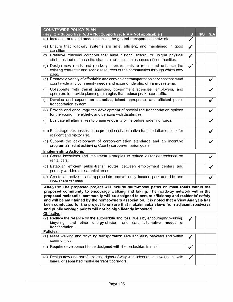
Page 105
COUNTYWIDE POLICY PLAN (Key: S = Supportive, N/S = Not Supportive, N/A = Not applicable.) S N/S N/A (d) Increase route and mode options in the ground-transportation network.
(e) Ensure that roadway systems are safe, efficient, and maintained in good
condition.
(f) Preserve roadway corridors that have historic, scenic, or unique physical attributes that enhance the character and scenic resources of communities.
(g) Design new roads and roadway improvements to retain and enhance the existing character and scenic resources of the communities through which they pass.
(h) Promote a variety of affordable and convenient transportation services that meet countywide and community needs and expand ridership of transit systems.
(i) Collaborate with transit agencies, government agencies, employers, and operators to provide planning strategies that reduce peak-hour traffic.
(j) Develop and expand an attractive, island-appropriate, and efficient public transportation system.
(k) Provide and encourage the development of specialized transportation options for the young, the elderly, and persons with disabilities.
(l) Evaluate all alternatives to preserve quality of life before widening roads.
(m) Encourage businesses in the promotion of alternative transportation options for resident and visitor use.
(n) Support the development of carbon-emission standards and an incentive program aimed at achieving County carbon-emission goals.
Implementing Actions: (a) Create incentives and implement strategies to reduce visitor dependence on
rental cars.
(b) Establish efficient public-transit routes between employment centers and primary workforce residential areas.
(c) Create attractive, island-appropriate, conveniently located park-and-ride and ride- share facilities.
Analysis: The proposed project will include multi-modal paths on main roads within the proposed community to encourage walking and biking. The roadway network within the proposed residential community will be designed to ensure efficiency and residents’ safety and will be maintained by the homeowners association. It is noted that a View Analysis has been conducted for the project to ensure that makai/mauka views from adjacent roadways and public vantage points will not be significantly impacted. Objective: (2) Reduce the reliance on the automobile and fossil fuels by encouraging walking,
bicycling, and other energy-efficient and safe alternative modes of transportation.
Policies: (a) Make walking and bicycling transportation safe and easy between and within
communities.
(b) Require development to be designed with the pedestrian in mind.
(c) Design new and retrofit existing rights-of-way with adequate sidewalks, bicycle lanes, or separated multi-use transit corridors.
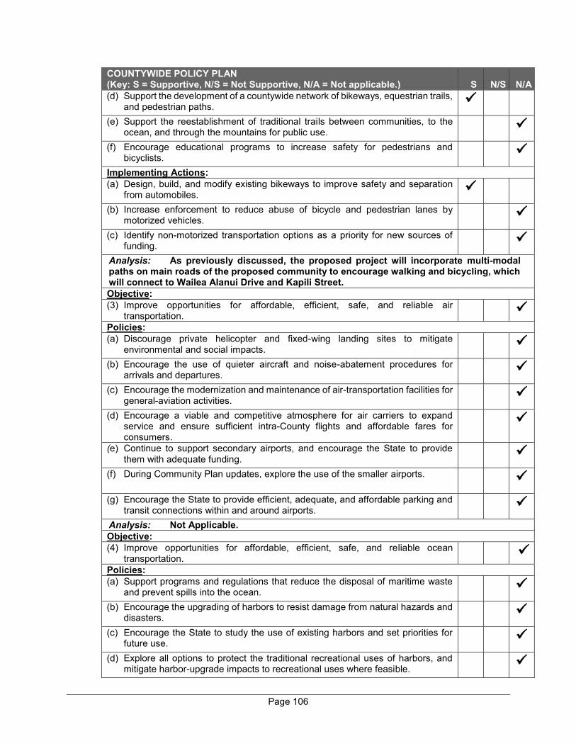
Page 106
COUNTYWIDE POLICY PLAN (Key: S = Supportive, N/S = Not Supportive, N/A = Not applicable.) S N/S N/A (d) Support the development of a countywide network of bikeways, equestrian trails,
and pedestrian paths.
(e) Support the reestablishment of traditional trails between communities, to the ocean, and through the mountains for public use.
(f) Encourage educational programs to increase safety for pedestrians and bicyclists.
Implementing Actions: (a) Design, build, and modify existing bikeways to improve safety and separation
from automobiles.
(b) Increase enforcement to reduce abuse of bicycle and pedestrian lanes by motorized vehicles.
(c) Identify non-motorized transportation options as a priority for new sources of funding.
Analysis: As previously discussed, the proposed project will incorporate multi-modal paths on main roads of the proposed community to encourage walking and bicycling, which will connect to Wailea Alanui Drive and Kapili Street. Objective: (3) Improve opportunities for affordable, efficient, safe, and reliable air
transportation.
Policies: (a) Discourage private helicopter and fixed-wing landing sites to mitigate
environmental and social impacts.
(b) Encourage the use of quieter aircraft and noise-abatement procedures for arrivals and departures.
(c) Encourage the modernization and maintenance of air-transportation facilities for general-aviation activities.
(d) Encourage a viable and competitive atmosphere for air carriers to expand service and ensure sufficient intra-County flights and affordable fares for consumers.
(e) Continue to support secondary airports, and encourage the State to provide them with adequate funding.
(f) During Community Plan updates, explore the use of the smaller airports.
(g) Encourage the State to provide efficient, adequate, and affordable parking and transit connections within and around airports.
Analysis: Not Applicable. Objective: (4) Improve opportunities for affordable, efficient, safe, and reliable ocean
transportation.
Policies: (a) Support programs and regulations that reduce the disposal of maritime waste
and prevent spills into the ocean.
(b) Encourage the upgrading of harbors to resist damage from natural hazards and disasters.
(c) Encourage the State to study the use of existing harbors and set priorities for future use.
(d) Explore all options to protect the traditional recreational uses of harbors, and mitigate harbor-upgrade impacts to recreational uses where feasible.
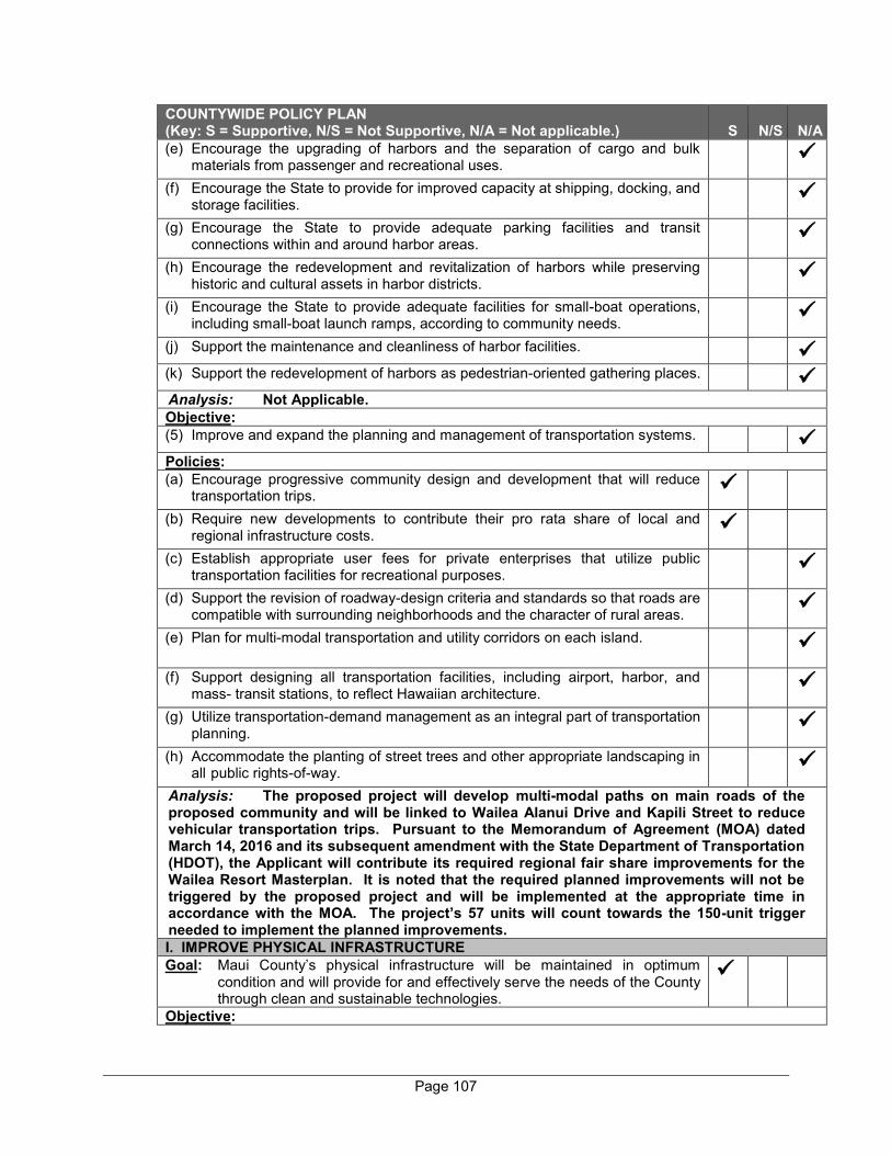
Page 107
COUNTYWIDE POLICY PLAN (Key: S = Supportive, N/S = Not Supportive, N/A = Not applicable.) S N/S N/A (e) Encourage the upgrading of harbors and the separation of cargo and bulk
materials from passenger and recreational uses.
(f) Encourage the State to provide for improved capacity at shipping, docking, and storage facilities.
(g) Encourage the State to provide adequate parking facilities and transit connections within and around harbor areas.
(h) Encourage the redevelopment and revitalization of harbors while preserving historic and cultural assets in harbor districts.
(i) Encourage the State to provide adequate facilities for small-boat operations, including small-boat launch ramps, according to community needs.
(j) Support the maintenance and cleanliness of harbor facilities.
(k) Support the redevelopment of harbors as pedestrian-oriented gathering places.
Analysis: Not Applicable. Objective: (5) Improve and expand the planning and management of transportation systems.
Policies: (a) Encourage progressive community design and development that will reduce
transportation trips.
(b) Require new developments to contribute their pro rata share of local and regional infrastructure costs.
(c) Establish appropriate user fees for private enterprises that utilize public transportation facilities for recreational purposes.
(d) Support the revision of roadway-design criteria and standards so that roads are compatible with surrounding neighborhoods and the character of rural areas.
(e) Plan for multi-modal transportation and utility corridors on each island.
(f) Support designing all transportation facilities, including airport, harbor, and mass- transit stations, to reflect Hawaiian architecture.
(g) Utilize transportation-demand management as an integral part of transportation planning.
(h) Accommodate the planting of street trees and other appropriate landscaping in all public rights-of-way.
Analysis: The proposed project will develop multi-modal paths on main roads of the proposed community and will be linked to Wailea Alanui Drive and Kapili Street to reduce vehicular transportation trips. Pursuant to the Memorandum of Agreement (MOA) dated March 14, 2016 and its subsequent amendment with the State Department of Transportation (HDOT), the Applicant will contribute its required regional fair share improvements for the Wailea Resort Masterplan. It is noted that the required planned improvements will not be triggered by the proposed project and will be implemented at the appropriate time in accordance with the MOA. The project’s 57 units will count towards the 150-unit trigger needed to implement the planned improvements. I. IMPROVE PHYSICAL INFRASTRUCTURE Goal: Maui County’s physical infrastructure will be maintained in optimum
condition and will provide for and effectively serve the needs of the County through clean and sustainable technologies.
Objective:
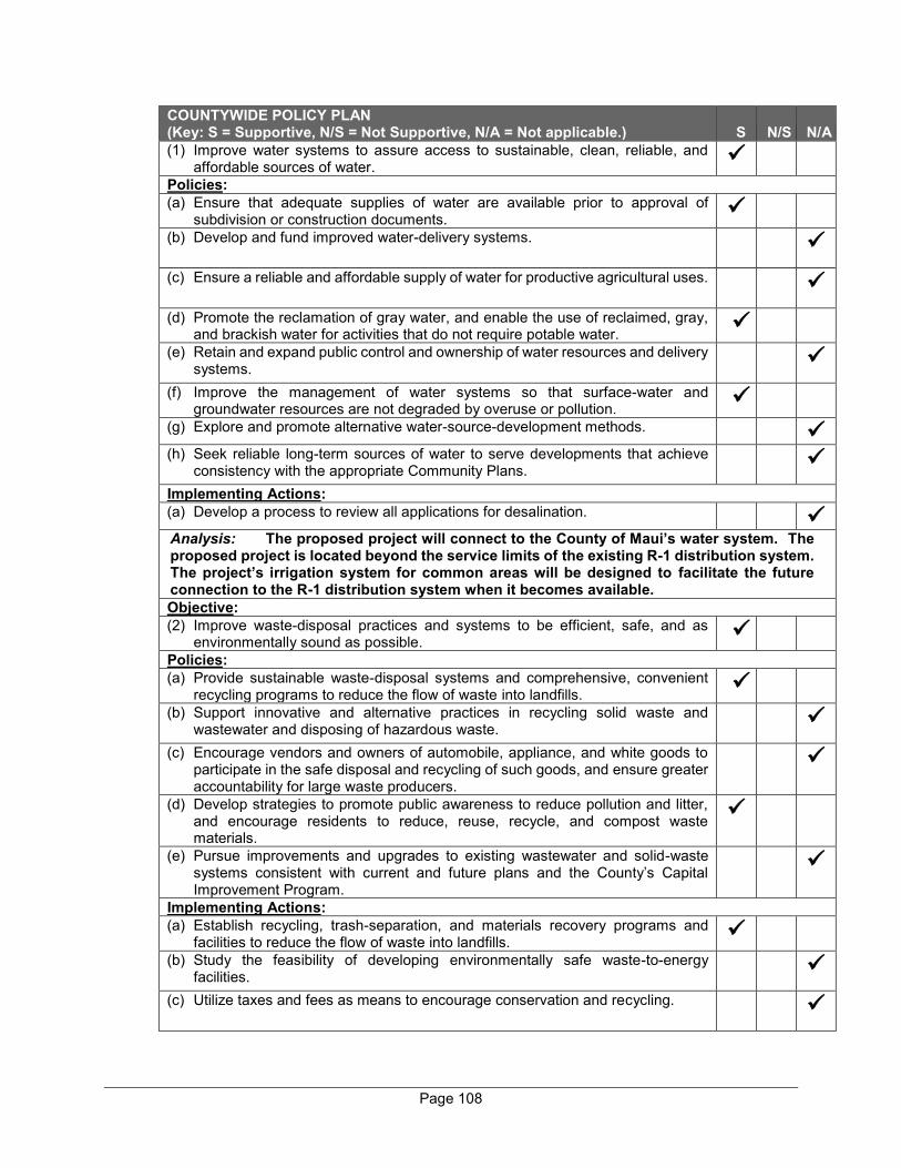
Page 108
COUNTYWIDE POLICY PLAN (Key: S = Supportive, N/S = Not Supportive, N/A = Not applicable.) S N/S N/A (1) Improve water systems to assure access to sustainable, clean, reliable, and
affordable sources of water.
Policies: (a) Ensure that adequate supplies of water are available prior to approval of
subdivision or construction documents.
(b) Develop and fund improved water-delivery systems.
(c) Ensure a reliable and affordable supply of water for productive agricultural uses.
(d) Promote the reclamation of gray water, and enable the use of reclaimed, gray, and brackish water for activities that do not require potable water.
(e) Retain and expand public control and ownership of water resources and delivery systems.
(f) Improve the management of water systems so that surface-water and groundwater resources are not degraded by overuse or pollution.
(g) Explore and promote alternative water-source-development methods.
(h) Seek reliable long-term sources of water to serve developments that achieve consistency with the appropriate Community Plans.
Implementing Actions: (a) Develop a process to review all applications for desalination.
Analysis: The proposed project will connect to the County of Maui’s water system. The proposed project is located beyond the service limits of the existing R-1 distribution system. The project’s irrigation system for common areas will be designed to facilitate the future connection to the R-1 distribution system when it becomes available. Objective: (2) Improve waste-disposal practices and systems to be efficient, safe, and as
environmentally sound as possible.
Policies: (a) Provide sustainable waste-disposal systems and comprehensive, convenient
recycling programs to reduce the flow of waste into landfills.
(b) Support innovative and alternative practices in recycling solid waste and wastewater and disposing of hazardous waste.
(c) Encourage vendors and owners of automobile, appliance, and white goods to participate in the safe disposal and recycling of such goods, and ensure greater accountability for large waste producers.
(d) Develop strategies to promote public awareness to reduce pollution and litter, and encourage residents to reduce, reuse, recycle, and compost waste materials.
(e) Pursue improvements and upgrades to existing wastewater and solid-waste systems consistent with current and future plans and the County’s Capital Improvement Program.
Implementing Actions: (a) Establish recycling, trash-separation, and materials recovery programs and
facilities to reduce the flow of waste into landfills.
(b) Study the feasibility of developing environmentally safe waste-to-energy facilities.
(c) Utilize taxes and fees as means to encourage conservation and recycling.
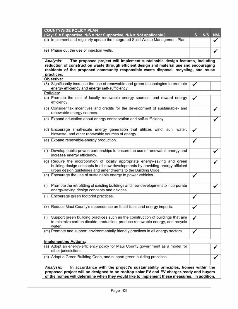
Page 109
COUNTYWIDE POLICY PLAN (Key: S = Supportive, N/S = Not Supportive, N/A = Not applicable.) S N/S N/A (d) Implement and regularly update the Integrated Solid Waste Management Plan.
(e) Phase out the use of injection wells.
Analysis: The proposed project will implement sustainable design features, including reduction of construction waste through efficient design and material use and encouraging residents of the proposed community responsible waste disposal, recycling, and reuse practices. Objective: (3) Significantly increase the use of renewable and green technologies to promote
energy efficiency and energy self-sufficiency.
Policies: (a) Promote the use of locally renewable energy sources, and reward energy
efficiency.
(b) Consider tax incentives and credits for the development of sustainable- and renewable-energy sources.
(c) Expand education about energy conservation and self-sufficiency.
(d) Encourage small-scale energy generation that utilizes wind, sun, water, biowaste, and other renewable sources of energy.
(e) Expand renewable-energy production.
(f) Develop public-private partnerships to ensure the use of renewable energy and increase energy efficiency.
(g) Require the incorporation of locally appropriate energy-saving and green building design concepts in all new developments by providing energy efficient urban design guidelines and amendments to the Building Code.
(h) Encourage the use of sustainable energy to power vehicles.
(i) Promote the retrofitting of existing buildings and new development to incorporate energy-saving design concepts and devices.
(j) Encourage green footprint practices.
(k) Reduce Maui County’s dependence on fossil fuels and energy imports.
(l) Support green building practices such as the construction of buildings that aim to minimize carbon dioxide production, produce renewable energy, and recycle water.
(m) Promote and support environmentally friendly practices in all energy sectors.
Implementing Actions: (a) Adopt an energy-efficiency policy for Maui County government as a model for
other jurisdictions.
(b) Adopt a Green Building Code, and support green building practices.
Analysis: In accordance with the project’s sustainability principles, homes within the proposed project will be designed to be rooftop solar PV and EV charger-ready and buyers of the homes will determine when they would like to implement these measures. In addition,
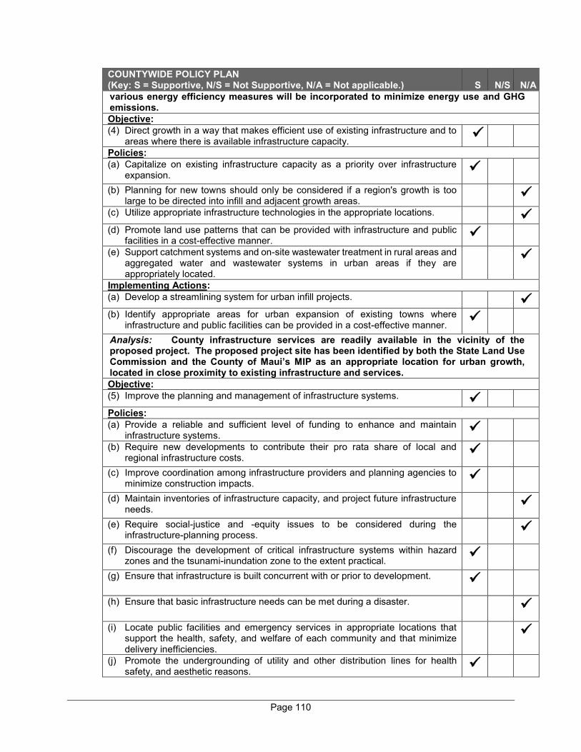
Page 110
COUNTYWIDE POLICY PLAN (Key: S = Supportive, N/S = Not Supportive, N/A = Not applicable.) S N/S N/A various energy efficiency measures will be incorporated to minimize energy use and GHG emissions. Objective: (4) Direct growth in a way that makes efficient use of existing infrastructure and to
areas where there is available infrastructure capacity.
Policies: (a) Capitalize on existing infrastructure capacity as a priority over infrastructure
expansion. (b) Planning for new towns should only be considered if a region's growth is too
large to be directed into infill and adjacent growth areas.
(c) Utilize appropriate infrastructure technologies in the appropriate locations.
(d) Promote land use patterns that can be provided with infrastructure and public facilities in a cost-effective manner.
(e) Support catchment systems and on-site wastewater treatment in rural areas and aggregated water and wastewater systems in urban areas if they are appropriately located.
Implementing Actions: (a) Develop a streamlining system for urban infill projects.
(b) Identify appropriate areas for urban expansion of existing towns where
infrastructure and public facilities can be provided in a cost-effective manner.
Analysis: County infrastructure services are readily available in the vicinity of the proposed project. The proposed project site has been identified by both the State Land Use Commission and the County of Maui’s MIP as an appropriate location for urban growth, located in close proximity to existing infrastructure and services. Objective: (5) Improve the planning and management of infrastructure systems.
Policies: (a) Provide a reliable and sufficient level of funding to enhance and maintain
infrastructure systems.
(b) Require new developments to contribute their pro rata share of local and regional infrastructure costs.
(c) Improve coordination among infrastructure providers and planning agencies to minimize construction impacts.
(d) Maintain inventories of infrastructure capacity, and project future infrastructure needs.
(e) Require social-justice and -equity issues to be considered during the infrastructure-planning process.
(f) Discourage the development of critical infrastructure systems within hazard zones and the tsunami-inundation zone to the extent practical.
(g) Ensure that infrastructure is built concurrent with or prior to development.
(h) Ensure that basic infrastructure needs can be met during a disaster.
(i) Locate public facilities and emergency services in appropriate locations that support the health, safety, and welfare of each community and that minimize delivery inefficiencies.
(j) Promote the undergrounding of utility and other distribution lines for health safety, and aesthetic reasons.

Page 111
COUNTYWIDE POLICY PLAN (Key: S = Supportive, N/S = Not Supportive, N/A = Not applicable.) S N/S N/A Implementing Actions: (a) Develop and regularly update functional plans for infrastructure systems.
(b) Develop, adopt, and regularly update local or community-sensitive level-of service standards for infrastructure systems.
Analysis: As applicable, the Applicant will pay code required assessments towards wastewater treatment plant expansion costs, as well as its regional fair share commitments to roadway improvements in the Wailea Resort Master Plan area. It is noted that all utilities within the project area will be installed underground. Necessary infrastructure improvements to service the proposed project will be provided by the Applicant concurrently with development except for planned roadway improvements, which will be implemented at the appropriate time as called for in the MOA dated March 16, 2016, and its subsequent amendment. The Applicant will coordinate with infrastructure providers and various agencies to ensure services are provided in a timely manner and to minimize potential construction impacts. J. PROMOTE SUSTAINABLE LAND USE AND GROWTH MANAGEMENT Goal: Community character, lifestyles, economies, and natural assets will be
preserved by managing growth and using land in a sustainable manner.
Objective: (1) Improve land use management and implement a directed-growth strategy.
Policies: (a) Establish, map, and enforce urban- and rural-growth limits.
(b) Direct urban and rural growth to designated areas.
(c) Limit the number of visitor-accommodation units and facilities in Community Plan Areas.
(d) Maintain a sustainable balance between the resident, part-time resident, and visitor populations.
(e) Encourage redevelopment and infill in existing communities on lands intended for urban use to protect productive farm land and open-space resources.
(f) Discourage new entitlements for residential, resort, or commercial development along the shoreline.
(g) Restrict development in areas that are prone to natural hazards, disasters, or sea-level rise.
(h) Direct new development in and around communities with existing infrastructure and service capacity, and protect natural, scenic, shoreline, and cultural resources.
(i) Establish and maintain permanent open space between communities to protect each community’s identity.
(j) Support the dedication of land for public uses.
(k) Preserve the public’s rights of access to and continuous lateral access along all shorelines.
(l) Enable existing and future communities to be self-sufficient through sustainable land use planning and management practices.
(m) Protect summits, slopes, and ridgelines from inappropriate development.
Implementing Actions:

Page 112
COUNTYWIDE POLICY PLAN (Key: S = Supportive, N/S = Not Supportive, N/A = Not applicable.) S N/S N/A (a) Regularly update urban- and rural-growth boundaries and their maps.
(b) Establish transfer and purchase of development rights programs.
(c) Develop and adopt a green infrastructure plan.
(d) Develop studies to help determine a sustainable social, environmental, and
economic carrying capacity for each island.
(e) Identify and define resort-destination areas.
Analysis: The proposed project is located within Wailea Resort, an area established in the MIP as a resort destination and designated within the UGB. The project area is currently vacant and undeveloped, but is appropriately designated and zoned for residential use. It is noted that the Applicant satisfied the project’s parks assessment through the donation of a 5.75-acre parcel, identified as TMK (2)3-9-038:26, to the County for use as a fire station and a park. Objective: (2) Improve planning for and management of agricultural lands and rural areas.
Policies: (a) Protect prime, productive, and potentially productive agricultural lands to
maintain the islands' agricultural and rural identities and economies.
(b) Provide opportunities and incentives for self-sufficient and subsistence homesteads and farms.
(c) Discourage developing or subdividing agriculturally designated lands when non- agricultural activities would be primary uses.
(d) Conduct agricultural-development planning to facilitate robust and sustainable agricultural activities.
Implementing Actions: (a) Inventory and protect prime, productive, and potentially productive agricultural
lands from competing non-agricultural land uses.
Analysis: Not applicable. Objective: (3) Design all developments to be in harmony with the environment and to protect
each community’s sense of place.
Policies: (a) Support and provide incentives for green building practices.
(b) Encourage the incorporation of green building practices and technologies into all government facilities to the extent practicable.
(c) Protect and enhance the unique architectural and landscape characteristics of each Community Plan Area, small town, and neighborhood.
(d) Ensure that adequate recreational areas, open spaces, and public-gathering places are provided and maintained in all urban centers and neighborhoods.
(e) Ensure business districts are distinctive, attractive, and pedestrian-friendly destinations.
(f) Use trees and other forms of landscaping along rights-of-way and within parking lots to provide shade, beauty, urban-heat reduction, and separation of pedestrians from automobile traffic in accordance with community desires.
(g) Where appropriate, integrate public-transit, equestrian, pedestrian, and bicycle facilities, and public rights-of-way as design elements in new and existing communities.

Page 113
COUNTYWIDE POLICY PLAN (Key: S = Supportive, N/S = Not Supportive, N/A = Not applicable.) S N/S N/A (h) Ensure better connectivity and linkages between land uses.
(i) Adequately buffer and mitigate noise and air pollution in mixed-use areas to maintain residential quality of life.
(j) Protect rural communities and traditional small towns by regulating the footprint, locations, site planning, and design of structures.
(k) Support small-town revitalization and preservation.
(l) Facilitate safe pedestrian access, and create linkages between destinations and within parking areas.
Implementing Actions: (a) Establish design guidelines and standards to enhance urban and rural
environments.
(b) Provide funding for civic-center and civic-space developments.
(c) Establish and enhance urban forests in neighborhoods and business districts.
Analysis: The proposed project will be designed with respect of the character of the neighboring residential developments to preserve Wailea’s sense of place. The proposed project will incorporate various sustainable design features to avoid and mitigate adverse impacts to environmental resources. Appropriate shade trees and landscaping throughout the project will be provided to reduce the heat island effect and provide visual buffers. Multi-modal paths in main roads of the proposed community will be provided to link the project area to Wailea Alanui Drive and Kapili Street to integrate the project with the Wailea Resort. Objective: (4) Improve and increase efficiency in land use planning and management.
Policies: (a) Assess the cumulative impact of developments on natural ecosystems, natural
resources, wildlife habitat, and surrounding uses.
(b) Ensure that new development projects requiring discretionary permits demonstrate a community need, show consistency with the General Plan, and provide an analysis of impacts.
(c) Encourage public and private partnerships to preserve lands of importance, develop housing, and meet the needs of residents.
(d) Promote creative subdivision designs that implement best practices in land development, sustainable management of natural and physical resources, increased pedestrian and bicycle functionality and safety, and the principles of livable communities.
(e) Coordinate with Federal, State, and County officials in order to ensure that land use decisions are consistent with County plans and the vision local populations have for their communities.
(f) Enable greater public participation in the review of subdivisions.
(g) Improve land use decision making through the use of land- and geographic information systems.
Implementing Actions: (a) Institute a time limit and sunsetting stipulations on development entitlements and
their implementation.
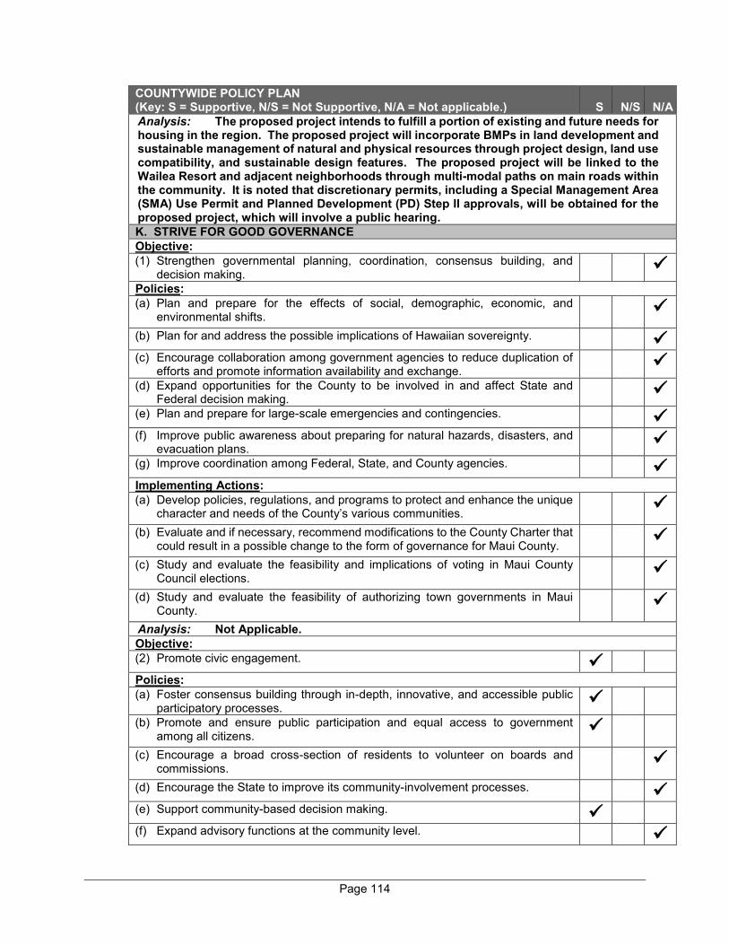
Page 114
COUNTYWIDE POLICY PLAN (Key: S = Supportive, N/S = Not Supportive, N/A = Not applicable.) S N/S N/A Analysis: The proposed project intends to fulfill a portion of existing and future needs for housing in the region. The proposed project will incorporate BMPs in land development and sustainable management of natural and physical resources through project design, land use compatibility, and sustainable design features. The proposed project will be linked to the Wailea Resort and adjacent neighborhoods through multi-modal paths on main roads within the community. It is noted that discretionary permits, including a Special Management Area (SMA) Use Permit and Planned Development (PD) Step II approvals, will be obtained for the proposed project, which will involve a public hearing. K. STRIVE FOR GOOD GOVERNANCE Objective: (1) Strengthen governmental planning, coordination, consensus building, and
decision making.
Policies: (a) Plan and prepare for the effects of social, demographic, economic, and
environmental shifts.
(b) Plan for and address the possible implications of Hawaiian sovereignty.
(c) Encourage collaboration among government agencies to reduce duplication of efforts and promote information availability and exchange.
(d) Expand opportunities for the County to be involved in and affect State and Federal decision making.
(e) Plan and prepare for large-scale emergencies and contingencies.
(f) Improve public awareness about preparing for natural hazards, disasters, and evacuation plans.
(g) Improve coordination among Federal, State, and County agencies.
Implementing Actions: (a) Develop policies, regulations, and programs to protect and enhance the unique
character and needs of the County’s various communities.
(b) Evaluate and if necessary, recommend modifications to the County Charter that could result in a possible change to the form of governance for Maui County.
(c) Study and evaluate the feasibility and implications of voting in Maui County Council elections.
(d) Study and evaluate the feasibility of authorizing town governments in Maui County.
Analysis: Not Applicable. Objective: (2) Promote civic engagement.
Policies: (a) Foster consensus building through in-depth, innovative, and accessible public
participatory processes.
(b) Promote and ensure public participation and equal access to government among all citizens.
(c) Encourage a broad cross-section of residents to volunteer on boards and commissions.
(d) Encourage the State to improve its community-involvement processes.
(e) Support community-based decision making.
(f) Expand advisory functions at the community level.
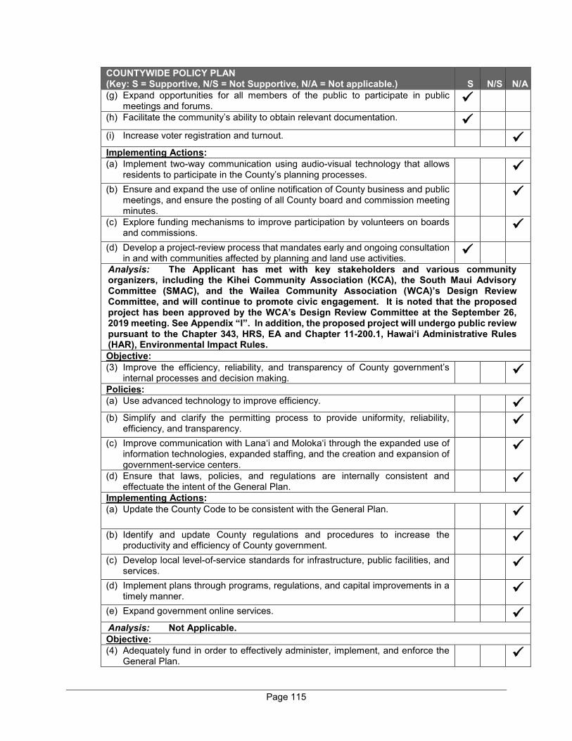
Page 115
COUNTYWIDE POLICY PLAN (Key: S = Supportive, N/S = Not Supportive, N/A = Not applicable.) S N/S N/A (g) Expand opportunities for all members of the public to participate in public
meetings and forums.
(h) Facilitate the community’s ability to obtain relevant documentation.
(i) Increase voter registration and turnout.
Implementing Actions: (a) Implement two-way communication using audio-visual technology that allows
residents to participate in the County’s planning processes.
(b) Ensure and expand the use of online notification of County business and public meetings, and ensure the posting of all County board and commission meeting minutes.
(c) Explore funding mechanisms to improve participation by volunteers on boards and commissions.
(d) Develop a project-review process that mandates early and ongoing consultation in and with communities affected by planning and land use activities.
Analysis: The Applicant has met with key stakeholders and various community organizers, including the Kihei Community Association (KCA), the South Maui Advisory Committee (SMAC), and the Wailea Community Association (WCA)’s Design Review Committee, and will continue to promote civic engagement. It is noted that the proposed project has been approved by the WCA’s Design Review Committee at the September 26, 2019 meeting. See Appendix “I”. In addition, the proposed project will undergo public review pursuant to the Chapter 343, HRS, EA and Chapter 11-200.1, Hawai‘i Administrative Rules (HAR), Environmental Impact Rules. Objective: (3) Improve the efficiency, reliability, and transparency of County government’s
internal processes and decision making.
Policies: (a) Use advanced technology to improve efficiency.
(b) Simplify and clarify the permitting process to provide uniformity, reliability,
efficiency, and transparency.
(c) Improve communication with Lana‘i and Moloka‘i through the expanded use of information technologies, expanded staffing, and the creation and expansion of government-service centers.
(d) Ensure that laws, policies, and regulations are internally consistent and effectuate the intent of the General Plan.
Implementing Actions: (a) Update the County Code to be consistent with the General Plan.
(b) Identify and update County regulations and procedures to increase the productivity and efficiency of County government.
(c) Develop local level-of-service standards for infrastructure, public facilities, and services.
(d) Implement plans through programs, regulations, and capital improvements in a timely manner.
(e) Expand government online services.
Analysis: Not Applicable. Objective: (4) Adequately fund in order to effectively administer, implement, and enforce the
General Plan.

Page 116
COUNTYWIDE POLICY PLAN (Key: S = Supportive, N/S = Not Supportive, N/A = Not applicable.) S N/S N/A Policies: (a) Adequately fund, staff, and support the timely update and implementation of
planning policy, programs, functional plans, and enforcement activities.
(b) Ensure that the County’s General Plan process provides for efficient planning at the County, island, town, and neighborhood level.
(c) Encourage ongoing professional development, education, and training of County employees.
(d) Encourage competitive compensation packages for County employees to attract and retain County personnel.
(e) Enable the County government to be more responsive in implementing our General Plan and Community Plans.
(f) Review discretionary permits for compliance with the Countywide Policy Plan.
(g) Strengthen the enforcement of County, State, and Federal land use laws.
Implementing Actions: (a) Establish penalties to ensure compliance with County, State, and Federal land
use laws.
Analysis: The proposed project is consistent with the applicable provisions of the Countywide Policy Plan as analyzed in this section. Objective: (5) Strive for County government to be a role model for implementing cultural and
environmental policies and practices.
Policies: (a) Educate residents on the benefits of sustainable practices.
(b) Encourage the retention and hiring of qualified professionals who can improve cultural and environmental practices.
(c) Incorporate environmentally sound and culturally appropriate practices in government operations and services.
(d) Encourage all vendors with County contracts to incorporate environmentally sound and culturally appropriate practices.
Analysis: Not Applicable.
Page 117
E. MAUI ISLAND PLAN
The Maui Island Plan (MIP) is applicable to the island of Maui only, providing more specific policy-based strategies for population, land use, transportation, public and community facilities, water and wastewater systems, visitor destinations, urban design, and other matters related to future growth.
As provided by Chapter 2.80B, MCC, the MIP shall include the following components:
1. An island-wide land use strategy, including a managed and directed growth plan
2. A water element assessing supply, demand and quality parameters
3. A nearshore ecosystem element assessing nearshore waters and requirements for preservation and restoration
4. An implementation program which addresses the County’s 20-year capital improvement requirements, financial program for implementation, and action implementation schedule
5. Milestone indicators designed to measure implementation progress of the MIP
It is noted that Ordinance No. 4004, which adopted the MIP on December 28, 2012 does not address the component relating to the implementation program. Chapter 2.80B of the MCC, relating to the General Plan, was amended via Ordinance No. 3979 on October 5, 2012, to provide that the implementation program component be adopted no later than one (1) year following the effective date of Ordinance No. 4004. In December 2013 and March 2014, the Council approved time extensions for approval and adoption of the implementation chapter of the MIP. The implementation program component of the MIP was adopted as Ordinance No. 4126 on May 29, 2014.
The MIP addresses a number of planning categories with detailed policy analysis and recommendations which are framed in terms of goals, objectives, policies and implementing actions. These planning categories address the following areas:
1. Population
2. Heritage Resources
3. Natural Hazards
4. Economic Development
5. Housing
6. Infrastructure and Public Facilities
Page 118
7. Land Use
Additionally, an essential element of the MIP is its directed growth plan which provides a management framework for future growth in a manner that is fiscally, environmentally, and culturally prudent. Among the directed growth management tools developed through the MIP process are maps delineating UGB, small town boundaries and rural growth boundaries. The respective boundaries identify areas appropriate for future growth and their corresponding intent with respect to development character.
The proposed project is located within the UGB depicted in MIP Directed Growth Boundaries Map. See Figure 12. In this regard, it is consistent with the directed growth strategy defined via growth maps adopted in the MIP.
In addition, the proposed project has been reviewed with respect to pertinent goals, objectives, policies and implementing actions of the MIP. The analysis is presented in the table below.
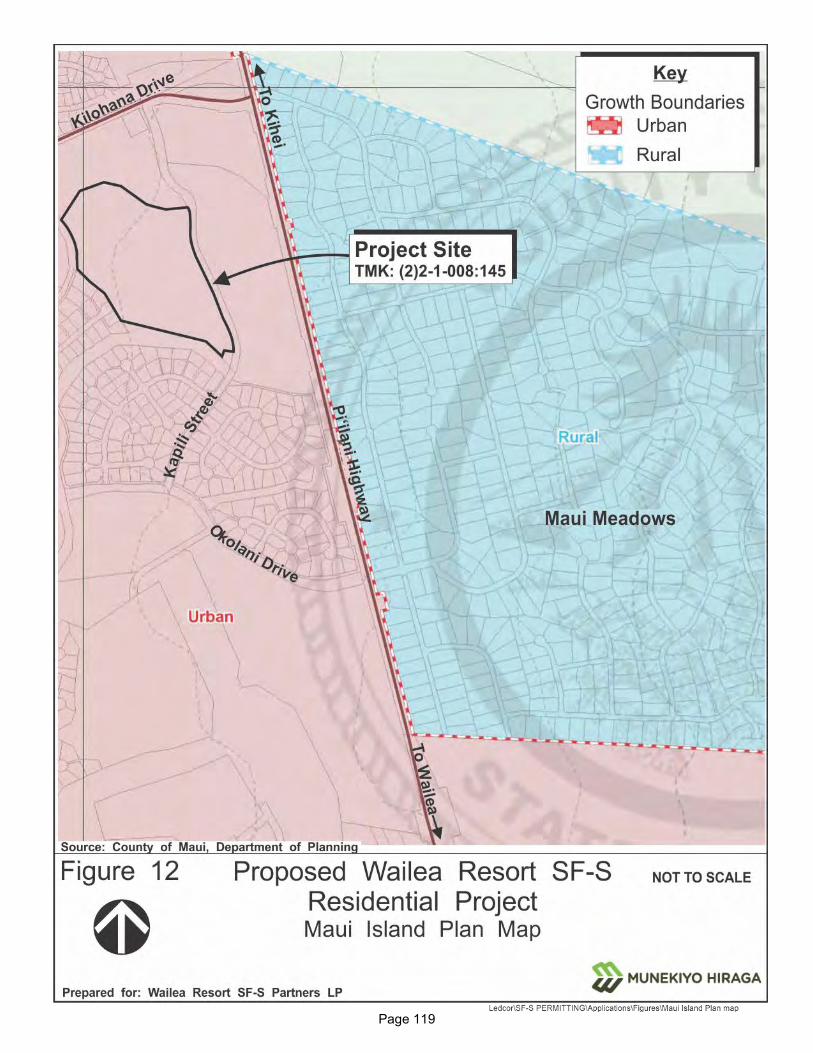
Page 119
Figure 12. Maui Island Plan Map
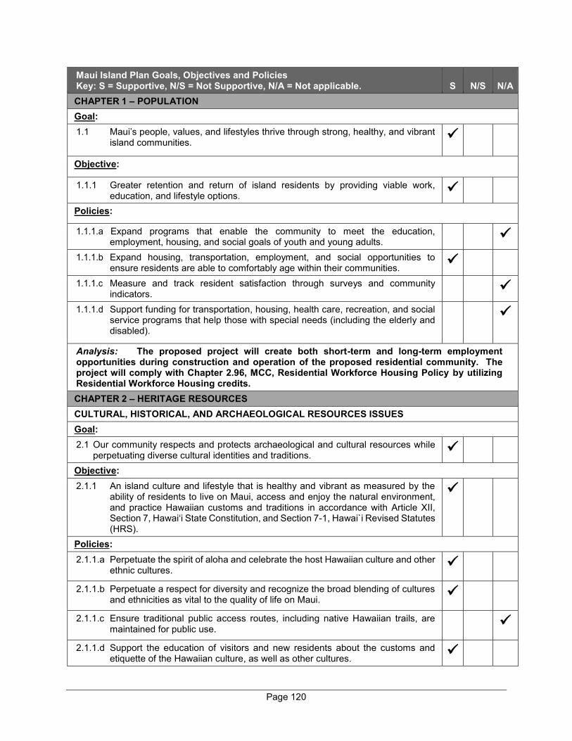
Page 120
Maui Island Plan Goals, Objectives and Policies Key: S = Supportive, N/S = Not Supportive, N/A = Not applicable. S N/S N/A CHAPTER 1 – POPULATION Goal: 1.1 Maui’s people, values, and lifestyles thrive through strong, healthy, and vibrant
island communities.
Objective:
1.1.1 Greater retention and return of island residents by providing viable work, education, and lifestyle options.
Policies:
1.1.1.a Expand programs that enable the community to meet the education, employment, housing, and social goals of youth and young adults.
1.1.1.b Expand housing, transportation, employment, and social opportunities to ensure residents are able to comfortably age within their communities.
1.1.1.c Measure and track resident satisfaction through surveys and community indicators.
1.1.1.d Support funding for transportation, housing, health care, recreation, and social service programs that help those with special needs (including the elderly and disabled).
Analysis: The proposed project will create both short-term and long-term employment opportunities during construction and operation of the proposed residential community. The project will comply with Chapter 2.96, MCC, Residential Workforce Housing Policy by utilizing Residential Workforce Housing credits. CHAPTER 2 – HERITAGE RESOURCES CULTURAL, HISTORICAL, AND ARCHAEOLOGICAL RESOURCES ISSUES Goal: 2.1 Our community respects and protects archaeological and cultural resources while
perpetuating diverse cultural identities and traditions.
Objective: 2.1.1 An island culture and lifestyle that is healthy and vibrant as measured by the
ability of residents to live on Maui, access and enjoy the natural environment, and practice Hawaiian customs and traditions in accordance with Article XII, Section 7, Hawai‘i State Constitution, and Section 7-1, Hawai`i Revised Statutes (HRS).
Policies: 2.1.1.a Perpetuate the spirit of aloha and celebrate the host Hawaiian culture and other
ethnic cultures.
2.1.1.b Perpetuate a respect for diversity and recognize the broad blending of cultures and ethnicities as vital to the quality of life on Maui.
2.1.1.c Ensure traditional public access routes, including native Hawaiian trails, are maintained for public use.
2.1.1.d Support the education of visitors and new residents about the customs and etiquette of the Hawaiian culture, as well as other cultures.
Page 121
Maui Island Plan Goals, Objectives and Policies Key: S = Supportive, N/S = Not Supportive, N/A = Not applicable. S N/S N/A Analysis: An AIS and CIA were carried out to ensure the proposed project will not adversely impact historic and cultural resources. It is noted that the project will incorporate various sustainability strategies to honor native Hawaiian culture and art and educate new residents of the community. Objective: 2.2 A more effective and efficient planning and review process that incorporates the
best available cultural resources inventory, protection techniques, and preservation strategies.
Policies: 2.1.2.a Ensure that the island has a comprehensive and up-to-date inventory of historic
and archaeological resources, and their cultural significance.
2.1.2.b Require the update of existing planning and regulatory mechanisms to protect the natural, cultural, scenic, and historic resources within designated Heritage Areas (see Cultural Resources Overlay/Scenic Corridor Protection Technical Reference Map).
2.1.2.c Ensure that cultural, historic, and archaeological resources are protected for the benefit of present and future generations.
Objective: 2.3 Enhance the island’s historic, archaeological, and cultural resources.
Policies: 2.1.3.a Identify and pursue a listing of the properties and sites on the State and National
Register of Historic Places.
2.1.3.b Support the use of easements, dedications, and other mechanisms to acquire, maintain, and protect lands with cultural, archaeological, and historic significance.
2.1.3.c Support regulations to require developers, when appropriate, to prepare an Archaeological Inventory Survey, Cultural Impact Assessment, and Ethnographic Inventories that are reviewed and commented upon by the Office of Hawaiian Affairs, Native Hawaiian advisory bodies, the State Historic Preservation Division (SHPD), and the Office of Environmental Quality Control, and systematically comply with the steps listed in SHPD’s administrative rules, including consultation and monitoring during construction phases of projects.
2.1.3.d Promote the rehabilitation and adaptive reuse of historic sites, buildings, and structures.
2.1.3.e Encourage property owners to register historic and archaeological sites on the State and National Register.
2.1.3.f Support opportunities for public involvement with the intent to facilitate the protection and restoration of historic and archeological sites, including consultation with stakeholders.
2.1.3.g Encourage the resolution of land title questions relating to Land Commission Awards and Royal patents.
2.1.3.h Ensure compliance with historic preservation laws, and discourage demolition of properties that are determined to be eligible for listing on the National or State Register of Historic Places.
Page 122
Maui Island Plan Goals, Objectives and Policies Key: S = Supportive, N/S = Not Supportive, N/A = Not applicable. S N/S N/A Analysis: An AIS and CIA have been carried out on the proposed project to ensure protection of archaeological and cultural resources. It is noted that the Applicant has conducted meetings with key stakeholders and various community organizers, including the KCA, the SMAC, and the WCA’s Design Review Committee. The proposed project will undergo public review pursuant to the Chapter 343, HRS environmental review process, as well as public hearing and review during the SMA and PD review and approval processes. SHORELINE, REEFS, AND NEARSHORE WATERS Goal: 2.2 An intact, ecologically functional system of reef, shoreline, and nearshore
waters that are protected in perpetuity.
Objective: 2.2.1 A more comprehensive and community-based ICZM program.
Policies: 2.2.1.a Encourage a management system that protects and temporarily rests the reef
ecosystems from overuse.
2.2.1.b Support the establishment of additional MMAs and reef replenishment areas.
2.2.1.c Work with appropriate agencies and community members to protect any special managed conservation areas from overuse and ensure that surrounding land uses do not contribute to the degradation of the natural resources, such as ‘Ahihi-Kina‘u Natural Area Reserve, Honolua-Mokulē‘ia Bay Marine Life Conservation District, and Mākena State Park.
2.2.1.d Incorporate the following into the MIP, where consistent with the MIP:
(1) Beach Management Plan for Maui;
(2) Coastal Nonpoint Pollution Control Program Management Plan;
(3) Implementation Plan for Polluted Runoff Control; and
(4) Ocean Resource Management Plan.
2.2.1.e Support greater coordination among governmental agencies involved with the protection of the island’s marine resources.
Objective: 2.2.2 Improved reef health, coastal water quality, and marine life.
Policies: 2.2.2.a Create additional mechanisms where needed to contain and control runoff and
pollution.
2.2.2.b Allow extraction of high quality, Class A, low silt sands only when they will be used to protect or restore Maui’s shorelines and beaches.
2.2.2.c Carefully manage beach nourishment activities to protect the coastal and marine ecosystem.
Page 123
Maui Island Plan Goals, Objectives and Policies Key: S = Supportive, N/S = Not Supportive, N/A = Not applicable. S N/S N/A 2.2.2.d Require, where appropriate, a buffer between landscaped areas and the
shoreline, gulches, and streams to reduce the runoff of fertilizers, pesticides, herbicides, and other pollutants into coastal waters.
2.2.2.e Strictly regulate shoreline armoring in accordance with adopted Shoreline Rules, with an intent to protect the coastal and marine ecosystem.
2.2.2.f Support greater protection of Keālia Pond National Wildlife Refuge through the following:
(1) Enhancement of marine ecosystems;
(2) Beach and sand dune resoration; and
(3) Expansion of habitat for Maui’s threatened or endangered sea turtles, birds, and other species.
2.2.2.g Support the development of regulations to prevent the excessive depletion of fish stocks due to non-sustainable practices and gear such as SCUBA spear-fishing and lay nets, within the context of nearshore ecosystems.
2.2.2.h Encourage the State to conduct a regular census of fish populations and monitor coral health.
2.2.2.i Encourage the State to significantly increase the number of park rangers, enforcement officers, and marine biologists to protect coastal resources.
2.2.2.j Encourage the State to prohibit the collection and exportation of fish, coral, algae, and other marine species for the ornamental and aquarium trade.
Objective: 2.2.3 Water quality that meets or exceeds State Clean Water Act standards.
Policies: 2.2.3.a Reduce the amount of impervious surface and devise site plan standards that
aim to minimize storm runoff and NPS pollution.
2.2.3.b Support the revision of existing regulations to require an Erosion and Sedimentation Control Plan (ESCP) for development activities that may pose a threat to water quality.
2.2.3.c Require an on-site monitoring program, where applicable, when grading may pose a threat to water quality or when recommended in the ESCP.
2.2.3.d Avoid development actions that impair Maui’s reef systems and remove identified stressors.
2.2.3.e Phase out cesspools and restrict the use of septic systems in ecologically sensitive coastal areas by converting to environmentally-friendly alternative sewage treatment systems, and connecting to central sewerage systems when and where feasible.
2.2.3.f Prohibit the development of new wastewater injection wells, except when unavoidable for public health and safety purposes.
2.2.3.g Ensure that the County upholds its affirmative duty under the Clean Water Act by monitoring and reducing point and NPS pollution to help safeguard coastal waters.
Page 124
Maui Island Plan Goals, Objectives and Policies Key: S = Supportive, N/S = Not Supportive, N/A = Not applicable. S N/S N/A Objective: 2.2.4 Acquire additional shoreline lands and shoreline access rights.
Policies: 2.2.4.a Promote the use of conservation easements, land trusts, transfer and purchase
of development rights, and mitigation banking.
2.2.4.b Require the dedication of public beach and rocky shoreline access ways to and along the shoreline where it serves a practical public interest as a condition of development or subdivision approval; future subdivisions and developments shall be consistent with and effectuate, to the extent practicable, the Shoreline Access Inventory Update - Final Report (March 2005), and its updates.
2.2.4.c Incorporate the Shoreline Access Inventory Update - Final Report (March 2005), and its regular updates, into this plan.
2.2.4.d Identify access points while further acquiring key shoreline parcels and easement rights to enhance and protect beach access and shoreline recreation.
Analysis: The proposed project is not located in close proximity to the shoreline. Nevertheless, construction BMPs as well as a comprehensive drainage system, including LID measures, will be implemented to channel stormwater runoff into drainage detention basins and subsurface storage chambers in order to protect downstream properties and nearshore water quality. WATERSHEDS, STREAMS, AND WETLANDS ISSUES Goal: 2.3 Healthy watersheds, streams, and riparian environments.
Objective: 2.3.1 Greater protection and enhancement of watersheds, streams, and riparian
environments.
Policies: 2.3.1.a All present and future watershed management plans shall incorporate concepts
of ahupua‘a management based on the interconnectedness of upland and coastal ecosystems/species.
2.3.1.b Continue to support and be an active member of watershed partnerships.
2.3.1.c Support the establishment of regional water trusts, composed of public and private members, to manage water resources.
2.3.1.d Support regulations to require developments to utilize ahupua‘a management practices.
2.3.1.e Work with private and non-profit entities to educate the public about the connection between upland activities within the watershed and the impacts on nearshore ecosystems and coral reefs.
2.3.1.f Provide adequate funding and staff to develop and implement watershed protection plans and policies, including acquisition and management of watershed resources and land.
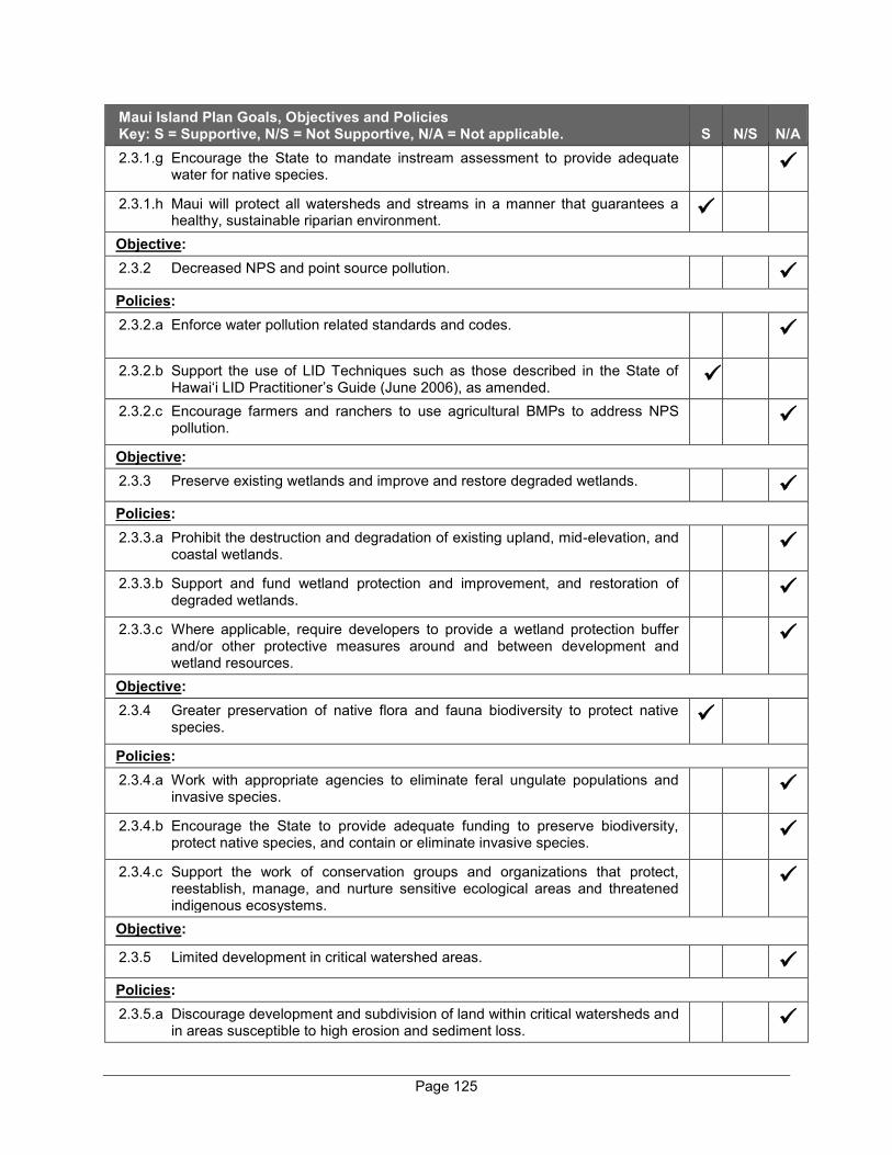
Page 125
Maui Island Plan Goals, Objectives and Policies Key: S = Supportive, N/S = Not Supportive, N/A = Not applicable. S N/S N/A 2.3.1.g Encourage the State to mandate instream assessment to provide adequate
water for native species.
2.3.1.h Maui will protect all watersheds and streams in a manner that guarantees a healthy, sustainable riparian environment.
Objective: 2.3.2 Decreased NPS and point source pollution.
Policies: 2.3.2.a Enforce water pollution related standards and codes.
2.3.2.b Support the use of LID Techniques such as those described in the State of Hawai‘i LID Practitioner’s Guide (June 2006), as amended.
2.3.2.c Encourage farmers and ranchers to use agricultural BMPs to address NPS pollution.
Objective: 2.3.3 Preserve existing wetlands and improve and restore degraded wetlands.
Policies: 2.3.3.a Prohibit the destruction and degradation of existing upland, mid-elevation, and
coastal wetlands.
2.3.3.b Support and fund wetland protection and improvement, and restoration of degraded wetlands.
2.3.3.c Where applicable, require developers to provide a wetland protection buffer and/or other protective measures around and between development and wetland resources.
Objective: 2.3.4 Greater preservation of native flora and fauna biodiversity to protect native
species.
Policies: 2.3.4.a Work with appropriate agencies to eliminate feral ungulate populations and
invasive species.
2.3.4.b Encourage the State to provide adequate funding to preserve biodiversity, protect native species, and contain or eliminate invasive species.
2.3.4.c Support the work of conservation groups and organizations that protect, reestablish, manage, and nurture sensitive ecological areas and threatened indigenous ecosystems.
Objective:
2.3.5 Limited development in critical watershed areas.
Policies: 2.3.5.a Discourage development and subdivision of land within critical watersheds and
in areas susceptible to high erosion and sediment loss.

Page 126
Maui Island Plan Goals, Objectives and Policies Key: S = Supportive, N/S = Not Supportive, N/A = Not applicable. S N/S N/A 2.3.5.b Designate critical watershed areas as conservation lands.
2.3.5.c Strongly encourage new subdivisions and developments that are proximate to
environmentally sensitive watershed resources to prepare and implement CSD plans.
Objective: 2.3.6 Enhance the vitality and functioning of streams, while balancing the multiple
needs of the community.
Policies: 2.3.6.a Protect and enhance natural streambeds and discourage stream alteration.
2.3.6.b Work with appropriate agencies to establish minimum stream flow levels and ensure adequate stream flow to sustain riparian ecosystems, traditional kalo cultivation, and self-sustaining ahupua‘a.
2.3.6.c Respect and participate in the resolution of native Hawaiian residual land and water rights issues (kuleana lands, ceded lands, and historic agricultural and gathering rights).
2.3.6.d Ensure that stream flows implement laws and policies found in the State Constitution and Water Code.
2.3.6.e Work with appropriate agencies and stakeholders to establish minimum stream flow levels, promote actions to support riparian habitat and the use of available lo‘i, and maintain adequate flows for the production of healthy kalo crops.
Analysis: The proposed project is not located near any wetlands, streams or waterways. LID measures, such as bioretention strips, have been incorporated into the project’s drainage system to protect downstream properties and nearshore water quality. It is noted that a Biological Resources Survey has been prepared for the project and appropriate mitigation measures will be implemented to protect native flora and fauna species. WILDLIFE AND NATURAL AREAS Goal: 2.4 Maui’s natural areas and indigenous flora and fauna will be protected.
Objective:
2.4.1 A comprehensive management strategy that includes further identification, protection, and restoration of indigenous wildlife habitats.
Policies:
2.4.1.a Identify and inventory the following:
(1) Natural, recreational, and open space resources;
(2) Flora and fauna with medium, high, and very high concentrations of threatened or endangered species; and
(3) Location and extent of invasive species.
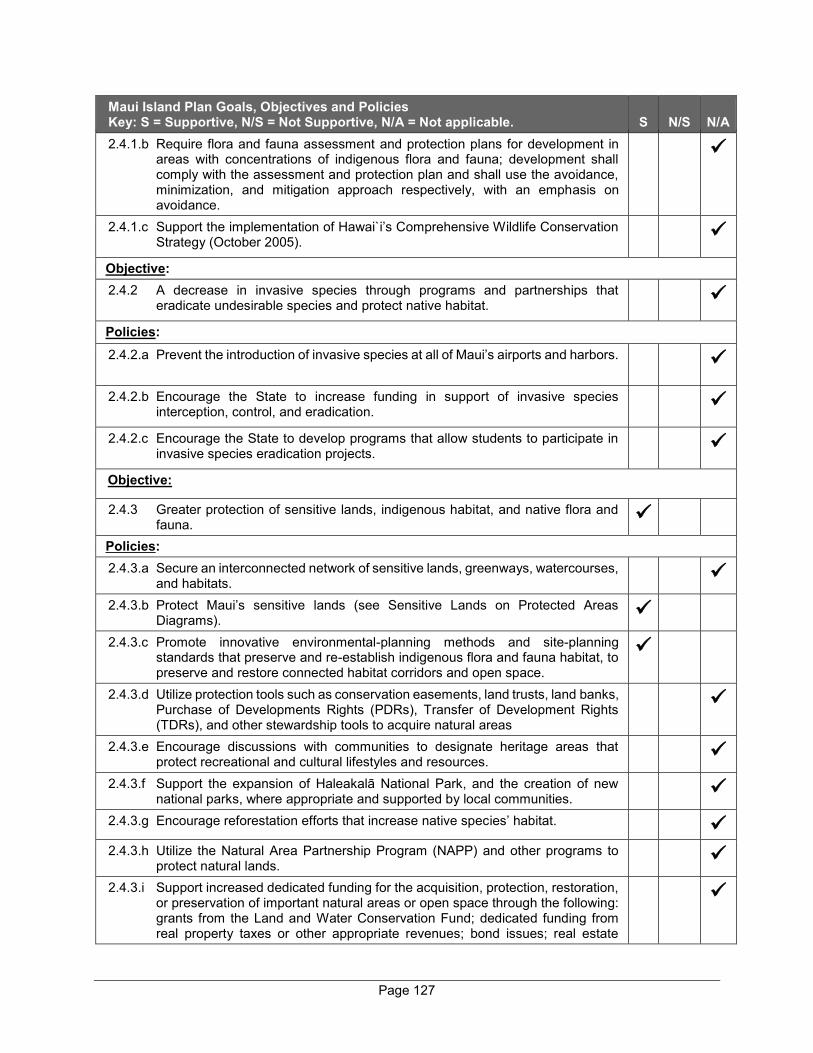
Page 127
Maui Island Plan Goals, Objectives and Policies Key: S = Supportive, N/S = Not Supportive, N/A = Not applicable. S N/S N/A 2.4.1.b Require flora and fauna assessment and protection plans for development in
areas with concentrations of indigenous flora and fauna; development shall comply with the assessment and protection plan and shall use the avoidance, minimization, and mitigation approach respectively, with an emphasis on avoidance.
2.4.1.c Support the implementation of Hawai`i’s Comprehensive Wildlife Conservation Strategy (October 2005).
Objective: 2.4.2 A decrease in invasive species through programs and partnerships that
eradicate undesirable species and protect native habitat.
Policies: 2.4.2.a Prevent the introduction of invasive species at all of Maui’s airports and harbors.
2.4.2.b Encourage the State to increase funding in support of invasive species interception, control, and eradication.
2.4.2.c Encourage the State to develop programs that allow students to participate in invasive species eradication projects.
Objective:
2.4.3 Greater protection of sensitive lands, indigenous habitat, and native flora and fauna.
Policies: 2.4.3.a Secure an interconnected network of sensitive lands, greenways, watercourses,
and habitats.
2.4.3.b Protect Maui’s sensitive lands (see Sensitive Lands on Protected Areas Diagrams).
2.4.3.c Promote innovative environmental-planning methods and site-planning standards that preserve and re-establish indigenous flora and fauna habitat, to preserve and restore connected habitat corridors and open space.
2.4.3.d Utilize protection tools such as conservation easements, land trusts, land banks, Purchase of Developments Rights (PDRs), Transfer of Development Rights (TDRs), and other stewardship tools to acquire natural areas
2.4.3.e Encourage discussions with communities to designate heritage areas that protect recreational and cultural lifestyles and resources.
2.4.3.f Support the expansion of Haleakalā National Park, and the creation of new national parks, where appropriate and supported by local communities.
2.4.3.g Encourage reforestation efforts that increase native species’ habitat.
2.4.3.h Utilize the Natural Area Partnership Program (NAPP) and other programs to protect natural lands.
2.4.3.i Support increased dedicated funding for the acquisition, protection, restoration, or preservation of important natural areas or open space through the following: grants from the Land and Water Conservation Fund; dedicated funding from real property taxes or other appropriate revenues; bond issues; real estate
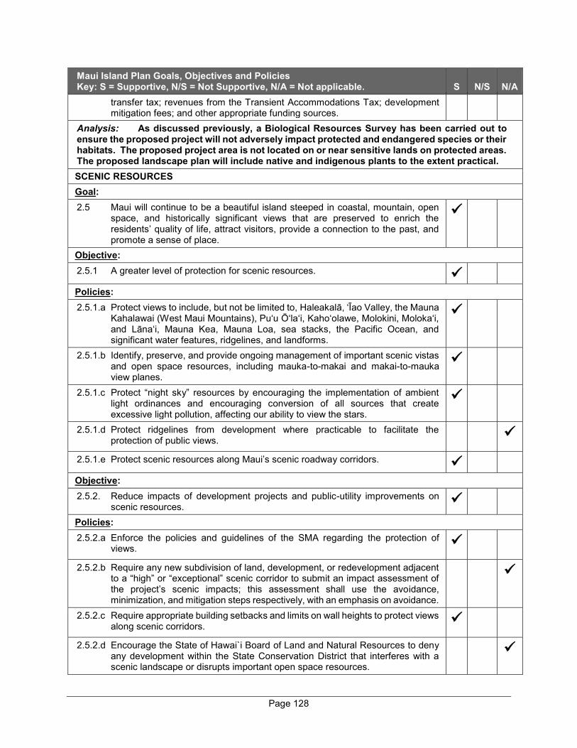
Page 128
Maui Island Plan Goals, Objectives and Policies Key: S = Supportive, N/S = Not Supportive, N/A = Not applicable. S N/S N/A
transfer tax; revenues from the Transient Accommodations Tax; development mitigation fees; and other appropriate funding sources.
Analysis: As discussed previously, a Biological Resources Survey has been carried out to ensure the proposed project will not adversely impact protected and endangered species or their habitats. The proposed project area is not located on or near sensitive lands on protected areas. The proposed landscape plan will include native and indigenous plants to the extent practical. SCENIC RESOURCES Goal: 2.5 Maui will continue to be a beautiful island steeped in coastal, mountain, open
space, and historically significant views that are preserved to enrich the residents’ quality of life, attract visitors, provide a connection to the past, and promote a sense of place.
Objective: 2.5.1 A greater level of protection for scenic resources.
Policies: 2.5.1.a Protect views to include, but not be limited to, Haleakalā, ‘Īao Valley, the Mauna
Kahalawai (West Maui Mountains), Pu‘u Ō‘la‘i, Kaho‘olawe, Molokini, Moloka‘i, and Lāna‘i, Mauna Kea, Mauna Loa, sea stacks, the Pacific Ocean, and significant water features, ridgelines, and landforms.
2.5.1.b Identify, preserve, and provide ongoing management of important scenic vistas and open space resources, including mauka-to-makai and makai-to-mauka view planes.
2.5.1.c Protect “night sky” resources by encouraging the implementation of ambient light ordinances and encouraging conversion of all sources that create excessive light pollution, affecting our ability to view the stars.
2.5.1.d Protect ridgelines from development where practicable to facilitate the protection of public views.
2.5.1.e Protect scenic resources along Maui’s scenic roadway corridors.
Objective: 2.5.2. Reduce impacts of development projects and public-utility improvements on
scenic resources.
Policies: 2.5.2.a Enforce the policies and guidelines of the SMA regarding the protection of
views.
2.5.2.b Require any new subdivision of land, development, or redevelopment adjacent to a “high” or “exceptional” scenic corridor to submit an impact assessment of the project’s scenic impacts; this assessment shall use the avoidance, minimization, and mitigation steps respectively, with an emphasis on avoidance.
2.5.2.c Require appropriate building setbacks and limits on wall heights to protect views along scenic corridors.
2.5.2.d Encourage the State of Hawai`i Board of Land and Natural Resources to deny any development within the State Conservation District that interferes with a scenic landscape or disrupts important open space resources.
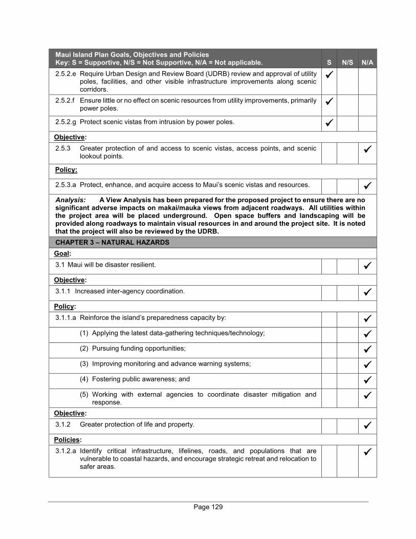
Page 129
Maui Island Plan Goals, Objectives and Policies Key: S = Supportive, N/S = Not Supportive, N/A = Not applicable. S N/S N/A 2.5.2.e Require Urban Design and Review Board (UDRB) review and approval of utility
poles, facilities, and other visible infrastructure improvements along scenic corridors.
2.5.2.f Ensure little or no effect on scenic resources from utility improvements, primarily power poles.
2.5.2.g Protect scenic vistas from intrusion by power poles.
Objective: 2.5.3 Greater protection of and access to scenic vistas, access points, and scenic
lookout points.
Policy:
2.5.3.a Protect, enhance, and acquire access to Maui’s scenic vistas and resources.
Analysis: A View Analysis has been prepared for the proposed project to ensure there are no significant adverse impacts on makai/mauka views from adjacent roadways. All utilities within the project area will be placed underground. Open space buffers and landscaping will be provided along roadways to maintain visual resources in and around the project site. It is noted that the project will also be reviewed by the UDRB. CHAPTER 3 – NATURAL HAZARDS Goal: 3.1 Maui will be disaster resilient.
Objective: 3.1.1 Increased inter-agency coordination.
Policy: 3.1.1.a Reinforce the island’s preparedness capacity by:
(1) Applying the latest data-gathering techniques/technology;
(2) Pursuing funding opportunities;
(3) Improving monitoring and advance warning systems;
(4) Fostering public awareness; and
(5) Working with external agencies to coordinate disaster mitigation and
response.
Objective: 3.1.2 Greater protection of life and property.
Policies: 3.1.2.a Identify critical infrastructure, lifelines, roads, and populations that are
vulnerable to coastal hazards, and encourage strategic retreat and relocation to safer areas.
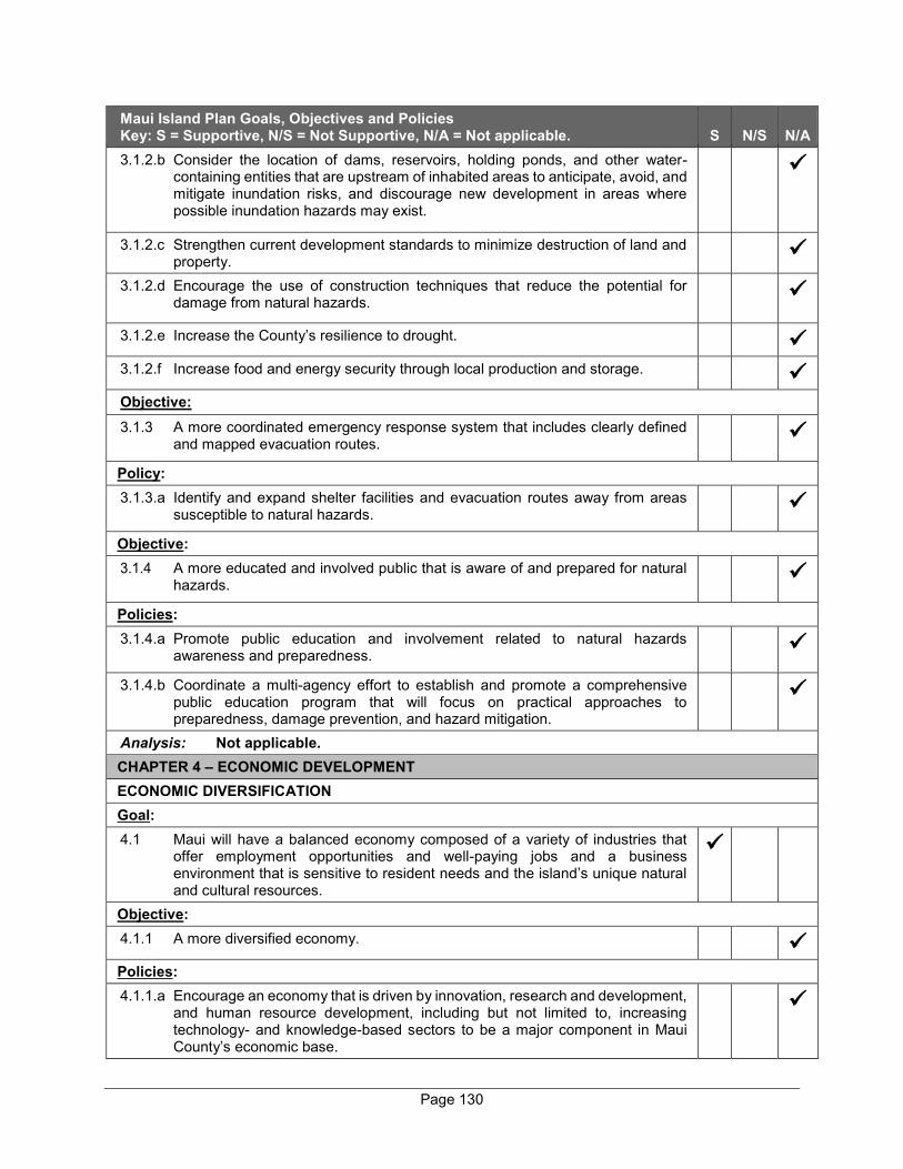
Page 130
Maui Island Plan Goals, Objectives and Policies Key: S = Supportive, N/S = Not Supportive, N/A = Not applicable. S N/S N/A 3.1.2.b Consider the location of dams, reservoirs, holding ponds, and other water-
containing entities that are upstream of inhabited areas to anticipate, avoid, and mitigate inundation risks, and discourage new development in areas where possible inundation hazards may exist.
3.1.2.c Strengthen current development standards to minimize destruction of land and property.
3.1.2.d Encourage the use of construction techniques that reduce the potential for damage from natural hazards.
3.1.2.e Increase the County’s resilience to drought.
3.1.2.f Increase food and energy security through local production and storage.
Objective: 3.1.3 A more coordinated emergency response system that includes clearly defined
and mapped evacuation routes.
Policy: 3.1.3.a Identify and expand shelter facilities and evacuation routes away from areas
susceptible to natural hazards.
Objective: 3.1.4 A more educated and involved public that is aware of and prepared for natural
hazards.
Policies: 3.1.4.a Promote public education and involvement related to natural hazards
awareness and preparedness.
3.1.4.b Coordinate a multi-agency effort to establish and promote a comprehensive public education program that will focus on practical approaches to preparedness, damage prevention, and hazard mitigation.
Analysis: Not applicable. CHAPTER 4 – ECONOMIC DEVELOPMENT ECONOMIC DIVERSIFICATION Goal: 4.1 Maui will have a balanced economy composed of a variety of industries that
offer employment opportunities and well-paying jobs and a business environment that is sensitive to resident needs and the island’s unique natural and cultural resources.
Objective: 4.1.1 A more diversified economy.
Policies: 4.1.1.a Encourage an economy that is driven by innovation, research and development,
and human resource development, including but not limited to, increasing technology- and knowledge-based sectors to be a major component in Maui County’s economic base.

Page 131
Maui Island Plan Goals, Objectives and Policies Key: S = Supportive, N/S = Not Supportive, N/A = Not applicable. S N/S N/A 4.1.1.b Support the creation of new jobs and industries that provide a living wage.
4.1.1.c Facilitate and expedite permits and approvals.
4.1.1.d Develop linkages and partnerships among international research and development activities and Maui businesses.
Objective: 4.1.2 Increase activities that support principles of sustainability.
Policies: 4.1.2.a Support industries that are sustainable, and culturally and environmentally
sensitive.
4.1.2.b Encourage and support local businesses.
4.1.2.c Substitute imports with locally-produced services and products where practicable.
4.1.2.d Support the development of economic development clusters in targeted industry sectors.
4.1.2.e Encourage all businesses to save energy, water, and other resources.
Objective: 4.1.3 Improve the island’s business climate.
Policies: 4.1.3.a Upgrade, maintain the quality of, and improve access to telecommunications
infrastructure.
4.1.3.b Ensure an adequate supply of affordable workforce housing.
4.1.3.c Develop neighborhoods and communities that are attractive to the workforce of a diversified economy.
4.1.3.d Encourage, nurture, and reward entrepreneurship and innovation.
4.1.3.e Encourage employers to establish incentive programs. Support flexibility in workforce policies compatible with business and quality of life goals.
4.1.3.f Assist community development organizations with revitalization and development of neighborhoods and communities that are attractive to the workforce of a diversified economy.
Analysis: The proposed project will create both short-term and long-term employment opportunities during the construction and operation phases of the new community. Various sustainable design features, guided by the project’s sustainability principles, will be implemented to promote sustainable development. TOURISM Goal: 4.2 A healthy visitor industry that provides economic well-being with stable and
diverse employment opportunities.
Objective:
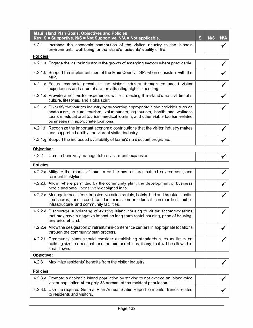
Page 132
Maui Island Plan Goals, Objectives and Policies Key: S = Supportive, N/S = Not Supportive, N/A = Not applicable. S N/S N/A 4.2.1 Increase the economic contribution of the visitor industry to the island’s
environmental well-being for the island’s residents’ quality of life.
Policies: 4.2.1.a Engage the visitor industry in the growth of emerging sectors where practicable.
4.2.1.b Support the implementation of the Maui County TSP, when consistent with the
MIP.
4.2.1.c Focus economic growth in the visitor industry through enhanced visitor experiences and an emphasis on attracting higher-spending.
4.2.1.d Provide a rich visitor experience, while protecting the island’s natural beauty, culture, lifestyles, and aloha spirit.
4.2.1.e Diversify the tourism industry by supporting appropriate niche activities such as ecotourism, cultural tourism, voluntourism, ag-tourism, health and wellness tourism, educational tourism, medical tourism, and other viable tourism-related businesses in appropriate locations.
4.2.1.f Recognize the important economic contributions that the visitor industry makes and support a healthy and vibrant visitor industry.
4.2.1.g Support the increased availability of kama‘āina discount programs.
Objective: 4.2.2 Comprehensively manage future visitor-unit expansion.
Policies: 4.2.2.a Mitigate the impact of tourism on the host culture, natural environment, and
resident lifestyles.
4.2.2.b Allow, where permitted by the community plan, the development of business hotels and small, sensitively-designed inns.
4.2.2.c Manage impacts from transient vacation rentals, hotels, bed and breakfast units, timeshares, and resort condominiums on residential communities, public infrastructure, and community facilities.
4.2.2.d Discourage supplanting of existing island housing to visitor accommodations that may have a negative impact on long-term rental housing, price of housing, and price of land.
4.2.2.e Allow the designation of retreat/mini-conference centers in appropriate locations through the community plan process.
4.2.2.f Community plans should consider establishing standards such as limits on building size, room count, and the number of inns, if any, that will be allowed in small towns.
Objective: 4.2.3 Maximize residents’ benefits from the visitor industry.
Policies: 4.2.3.a Promote a desirable island population by striving to not exceed an island-wide
visitor population of roughly 33 percent of the resident population.
4.2.3.b Use the required General Plan Annual Status Report to monitor trends related to residents and visitors.
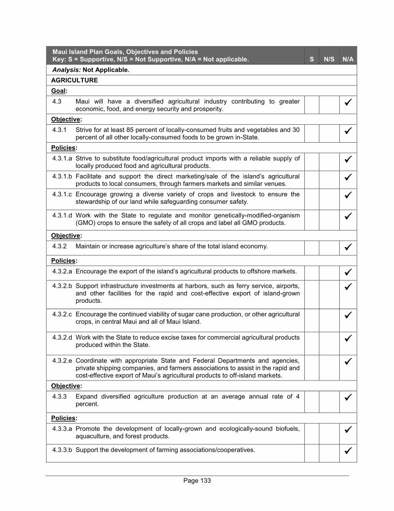
Page 133
Maui Island Plan Goals, Objectives and Policies Key: S = Supportive, N/S = Not Supportive, N/A = Not applicable. S N/S N/A Analysis: Not Applicable. AGRICULTURE Goal: 4.3 Maui will have a diversified agricultural industry contributing to greater
economic, food, and energy security and prosperity.
Objective: 4.3.1 Strive for at least 85 percent of locally-consumed fruits and vegetables and 30
percent of all other locally-consumed foods to be grown in-State.
Policies: 4.3.1.a Strive to substitute food/agricultural product imports with a reliable supply of
locally produced food and agricultural products.
4.3.1.b Facilitate and support the direct marketing/sale of the island’s agricultural products to local consumers, through farmers markets and similar venues.
4.3.1.c Encourage growing a diverse variety of crops and livestock to ensure the stewardship of our land while safeguarding consumer safety.
4.3.1.d Work with the State to regulate and monitor genetically-modified-organism (GMO) crops to ensure the safety of all crops and label all GMO products.
Objective: 4.3.2 Maintain or increase agriculture’s share of the total island economy.
Policies: 4.3.2.a Encourage the export of the island’s agricultural products to offshore markets.
4.3.2.b Support infrastructure investments at harbors, such as ferry service, airports,
and other facilities for the rapid and cost-effective export of island-grown products.
4.3.2.c Encourage the continued viability of sugar cane production, or other agricultural crops, in central Maui and all of Maui Island.
4.3.2.d Work with the State to reduce excise taxes for commercial agricultural products produced within the State.
4.3.2.e Coordinate with appropriate State and Federal Departments and agencies, private shipping companies, and farmers associations to assist in the rapid and cost-effective export of Maui’s agricultural products to off-island markets.
Objective: 4.3.3 Expand diversified agriculture production at an average annual rate of 4
percent.
Policies: 4.3.3.a Promote the development of locally-grown and ecologically-sound biofuels,
aquaculture, and forest products.
4.3.3.b Support the development of farming associations/cooperatives.

Page 134
Maui Island Plan Goals, Objectives and Policies Key: S = Supportive, N/S = Not Supportive, N/A = Not applicable. S N/S N/A 4.3.3.c Work with educational institutions and appropriate agencies to provide
education and training for farm owners and entrepreneurs.
Analysis: Not Applicable. EMERGING SECTORS Goal: 4.4 A diverse array of emerging economic sectors.
Objective: 4.4.1 Support increased investment and expanded activity in emerging industries.
Policies: 4.4.1.a Support the development of and access to state-of-the-art voice, video, and
data telecommunications systems and high-speed Internet.
4.4.1.b Attract and assist industries to compete in high technology activities such as those related to renewable energy, green technologies, diversified agriculture, ocean sciences, health sciences, space technologies, and other knowledge-based industries.
4.4.1.c Support new industries that are environmentally and culturally sensitive such as health and wellness, sports and outdoor activities, cultural activities, the arts, film-making, entertainment, and digital media.
4.4.1.d Support a sustainable, culturally sensitive, astronomy industry.
4.4.1.e Support the continued development of the Maui Research and Technology Park in Kīhei, as a center for research and development, education, and diversified economic development, as provided by the Maui County Code.
4.4.1.f Work with appropriate organizations to support the development of high technology clusters around renewable energy, diversified agriculture, ocean sciences, health sciences, and other knowledge-based industries.
Objective: 4.4.2 Increase the development of renewable energy technologies that are supported
by the local community.
Policies: 4.4.2.a Support the expansion of the renewable energy sector and the use of solar,
wind, wave, and biofuel technologies.
4.4.2.b Provide incentives to encourage renewable energy development, the use of green energy technologies, and energy conservation.
4.4.2.c Ensure an adequate supply of land and facilitate permitting to meet the needs for renewable energy technologies such as solar, wind, wave, biofuel, and other technologies, provided that environmental, view plane, and cultural impacts are addressed.
4.4.2.d Support the Maui County Energy Alliance Plan where consistent with the MIP.
Analysis: In accordance with the project’s overall guiding sustainability principles, the homes within the proposed project will be designed to be rooftop solar PV and EV charger-ready and buyers of the homes will determine when they would like to implement these measures.

Page 135
Maui Island Plan Goals, Objectives and Policies Key: S = Supportive, N/S = Not Supportive, N/A = Not applicable. S N/S N/A SMALL BUSINESS DEVELOPMENT Goal: 4.5 Small businesses will play a key role in Maui’s economy.
Objective: 4.5.1 Increase the number of and revenue generated by small businesses and
decrease the percentage of small business failures.
Policies: 4.5.1.a Provide incentives and support for small businesses and entrepreneurs that
incorporate sustainable technologies and practices into their operations, utilize local materials, or produce and sell locally-made goods or services.
4.5.1.b Assist traditional “mom and pop” business establishments.
4.5.1.c Reduce barriers to small business development.
4.5.1.d Require, where feasible, the government procurement of goods and services from locally-owned, small businesses.
4.5.1.e Support community markets and venues that sell locally-made produce, goods, and services.
Analysis: Not Applicable.
HEALTH CARE SECTOR Goal: 4.6 Maui will have a health care industry and options that broaden career
opportunities that are reliable, efficient, and provide social well-being.
Objective: 4.6.1 Expand the economic benefits of the health care sector.
Policies: 4.6.1.a Encourage expanded services at MMMC and at other medical facilities.
4.6.1.b Support expansion of federally qualified health centers with the direct
involvement of the residents of the communities served.
4.6.1.c Support the use of multimedia as a means to provide healthcare information.
4.6.1.d Encourage digitalization of all diagnostic equipment at all facilities on Maui to enable sharing of data and more efficient use of limited provider workforce, consistent with data protection and patient privacy.
4.6.1.e Support the expansion of telemedicine.
4.6.1.f Encourage expansion and improved access to emergency care in all communities.
Objective: 4.6.2 Be more efficient in the delivery of health care services and in minimizing health
care costs.
Policies:
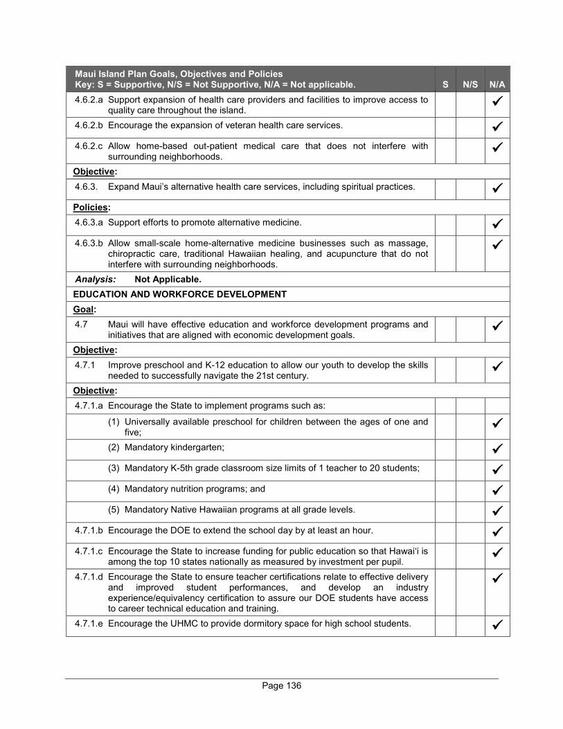
Page 136
Maui Island Plan Goals, Objectives and Policies Key: S = Supportive, N/S = Not Supportive, N/A = Not applicable. S N/S N/A 4.6.2.a Support expansion of health care providers and facilities to improve access to
quality care throughout the island.
4.6.2.b Encourage the expansion of veteran health care services.
4.6.2.c Allow home-based out-patient medical care that does not interfere with surrounding neighborhoods.
Objective: 4.6.3. Expand Maui’s alternative health care services, including spiritual practices.
Policies: 4.6.3.a Support efforts to promote alternative medicine.
4.6.3.b Allow small-scale home-alternative medicine businesses such as massage, chiropractic care, traditional Hawaiian healing, and acupuncture that do not interfere with surrounding neighborhoods.
Analysis: Not Applicable. EDUCATION AND WORKFORCE DEVELOPMENT Goal: 4.7 Maui will have effective education and workforce development programs and
initiatives that are aligned with economic development goals.
Objective: 4.7.1 Improve preschool and K-12 education to allow our youth to develop the skills
needed to successfully navigate the 21st century.
Objective: 4.7.1.a Encourage the State to implement programs such as:
(1) Universally available preschool for children between the ages of one and five;
(2) Mandatory kindergarten;
(3) Mandatory K-5th grade classroom size limits of 1 teacher to 20 students;
(4) Mandatory nutrition programs; and
(5) Mandatory Native Hawaiian programs at all grade levels.
4.7.1.b Encourage the DOE to extend the school day by at least an hour.
4.7.1.c Encourage the State to increase funding for public education so that Hawai‘i is among the top 10 states nationally as measured by investment per pupil.
4.7.1.d Encourage the State to ensure teacher certifications relate to effective delivery and improved student performances, and develop an industry experience/equivalency certification to assure our DOE students have access to career technical education and training.
4.7.1.e Encourage the UHMC to provide dormitory space for high school students.

Page 137
Maui Island Plan Goals, Objectives and Policies Key: S = Supportive, N/S = Not Supportive, N/A = Not applicable. S N/S N/A 4.7.1.f Encourage the development and implementation of curriculum on native
Hawaiian history, culture, and practices, in consultation with native Hawaiian groups and associations.
Objective: 4.7.2 Encourage an increase in the number of certificate recipients and associate,
bachelors, and graduate degrees conferred.
Policies: 4.7.2.a Encourage the State to increase the number of articulation agreements between
the UHMC and four-year universities, particularly the University of Hawai‘i at Manoa.
4.7.2.b Encourage the State to expand accredited 2-year, 4-year, and graduate programs through the UHMC.
4.7.2.c Encourage the education and training of our residents to meet the needs of a diversified economy.
4.7.2.d Support education and training programs such as student internships, vocational training, and career development opportunities to ensure a highly skilled workforce
4.7.2.e Work with educational institutions to improve and expand access to education and training through multiple modes, including distance learning.
Objective: 4.7.3 Strive to ensure that more of Maui’s jobs are developed in STEM-related sectors
by 2030.
Policies: 4.7.3.a Support the development of STEM-related certificates and degrees at the two-
and four year levels.
4.7.3.b Support the education initiatives of the Maui Agricultural Development Plan.
4.7.3.c Expand and seek funding for internships, mentoring, job shadowing, etc. to foster interest in health and green workforce careers.
4.7.3.d Work with MEDB, UHMC, and other similar organizations to expand internship/education programs to support STEM careers.
4.7.3.e Continue to partner with the MEDB and other similar organizations to recruit, assist, and retain emerging industries, research and development activities, and educational/workforce opportunities.
Analysis: Not Applicable. CHAPTER 5 – HOUSING Goal: 5.1 Maui will have safe, decent, appropriate, and affordable housing for all residents
developed in a way that contributes to strong neighborhoods and a thriving island community.
Objective: 5.1.1 More livable communities that provide for a mix of housing types, land uses,
income levels, and age.
Page 138
Maui Island Plan Goals, Objectives and Policies Key: S = Supportive, N/S = Not Supportive, N/A = Not applicable. S N/S N/A Policies: 5.1.1.a Promote livable communities (compact/walkable/bikeable, access to transit)
that provide for a mix of housing types and land uses, including parks, open space, and recreational areas.
5.1.1.b Promote planning approaches that provide a mix of multifamily and single-family housing units to expand housing choices.
5.1.1.c Discourage gated communities.
5.1.1.d Provide incentives for the rehabilitation or adaptive reuse of historic structures to facilitate more housing choices.
5.1.1.e Use planning and regulatory approaches to provide higher housing densities.
Objective: 5.1.2 Better monitoring, evaluation, and refinement of affordable housing policy in
conjunction with the economic cycle.
Policies: 5.1.2.a Improve data on resident and nonresident housing.
5.1.2.b Utilize the following approaches to promote resident housing and to minimize
offshore market impacts:
(1) Ensure that the future housing stock is composed of a mix of housing types (multifamily, small lots, ohana units, co-housing, cottage houses, etc.);
(2) Encourage new housing in proximity to jobs and services, in places that are conducive/affordable to island residents; and
(3) Explore taxation alternatives and building fee structures.
Objective: 5.1.3 Provide affordable housing, rental or in fee, to the broad spectrum of our island
community.
Policies: 5.1.3.a Consider regulations that can help keep affordable housing available at
affordable rents.
5.1.3.b Seek to have ownership of affordable for-sale and rental housing vested in a non-profit community land trust, or other qualified housing provider, committed to keeping such housing affordable in perpetuity.
5.1.3.c Facilitate the use of public lands in urban areas that are suitable for affordable housing.
5.1.3.d Develop or support partnerships and initiatives that provide housing-related education/outreach.
5.1.3.e Support the continuing efforts of the County and its community partners to: (1) Disseminate information on different housing/financial assistance programs
(loans, grants, etc.) including information on housing rehabilitation/restoration/adaptive reuse;
(2) Provide housing-related counseling including budget, credit, and financial planning assistance; and

Page 139
Maui Island Plan Goals, Objectives and Policies Key: S = Supportive, N/S = Not Supportive, N/A = Not applicable. S N/S N/A
(3) Create and maintain a comprehensive/master list of available affordable housing to help residents secure a unit that satisfies their need.
Objective: 5.1.4 Provide infrastructure in a more timely manner to support the development of
affordable housing.
Policies: 5.1.4.a Prioritize the development of infrastructure that supports the development of
affordable housing.
5.1.4.b Utilize appropriate financing approaches and assistance tools to encourage the development of infrastructure and public facilities.
5.1.4.c Tailor infrastructure requirements to correspond with appropriate level-of-service standards to help control housing costs and to maintain safety.
Objective:
5.1.5 A wider range of affordable housing options and programs for those with special needs.
Policies:
5.1.5.a Ensure that residents with special needs have access to appropriate housing.
5.1.5.b Encourage housing to be built or rehabilitated to allow the elderly and those with special needs to live in their homes.
5.1.5.c Ensure and facilitate programs to assist those with special needs from becoming homeless.
5.1.5.d Promote programs that stimulate the production of sustainable homeless shelters and alternative housing technologies.
5.1.5.e Support programs that offer home modification counseling on low-interest retrofit loans and grants to those with special needs.
Objective: 5.1.6 Reduce the cost to developers of providing housing that is affordable to families
with household incomes 160 percent and below of annual median income.
Policies: 5.1.6.a Support fast-track processing procedures for the following housing-related
entitlements: affordable housing projects/units; indigenous Hawaiian housing/units; and special-needs housing units (seniors, disabled, homeless, etc.).
5.1.6.b Require the construction of affordable for-sale and rental housing units as part of the construction of new housing developments.
5.1.6.c Offer extra incentives in boom periods and withdraw incentives during slack periods.
Objective:
5.1.7 Increased preservation and promotion of indigenous Hawaiian housing and architecture.
Policies:

Page 140
Maui Island Plan Goals, Objectives and Policies Key: S = Supportive, N/S = Not Supportive, N/A = Not applicable. S N/S N/A 5.1.7.a Preserve, promote, and give priority to Hawaiian housing/architecture forms to
preserve Hawaiian culture.
5.1.7.b Provide for indigenous architecture as an allowable structure for native Hawaiian uses to include hula and lāְ‘au lapa‘au.
Analysis: The proposed project involves development of 57 single-family condominium units and related improvements. The proposed project will comply with applicable provisions of Chapter 2.96 MCC by utilizing Residential Workforce Housing credits for workforce housing units that have already been built. It is noted that the credits were acquired from A&B Wailea LLC, the previous owner of the property. The project area is located in proximity to existing jobs and services in Kīhei and Wailea. CHAPTER 6 – INFRASTRUCTURE AND PUBLIC FACILITES SOLID WASTE Goal: 6.1 Maui will have implemented the ISWMP thereby diverting waste from its
landfills, extending their capacities.
Objective:
6.1.1 Meet our future solid waste needs with a more comprehensive planning and management strategy.
Policies: 6.1.1.a Update and publicize the ISWMP every ten years.
6.1.1.b Strengthen inter-agency coordination including Planning and Environmental
Management departments.
6.1.1.c Divert waste from the landfills and educate the public about the recommendations of the ISWMP.
6.1.1.d Minimize future active, unlined landfill cells to the extent feasible.
Objective:
6.1.2 Divert at least 60 percent of solid waste from the island’s landfills.
Policies:
6.1.2.a Require residents and commercial enterprises that generate waste to pay a fair proportion of disposal costs.
6.1.2.b Encourage environmentally safe waste-to-energy solutions.
6.1.2.c Facilitate the reduction of solid waste generated by packaging, food service products, construction waste, etc.
6.1.2.d Educate residents and visitors about the impacts of and methods to reduce, reuse, and recycle.
6.1.2.e Discourage the disposal of landfill leachate by diversion to wastewater treatment plants, where practicable.
Analysis: The proposed project has been designed to incorporate sustainable design features regarding solid waste management in accordance with the project’s sustainability principles.

Page 141
Maui Island Plan Goals, Objectives and Policies Key: S = Supportive, N/S = Not Supportive, N/A = Not applicable. S N/S N/A WASTEWATER
Goal:
6.2 Maui will have wastewater systems that comply with or exceed State and Federal regulations; meet levels-of-service needs; provide adequate capacity to accommodate projected demand; ensure efficient, effective, and environmentally sensitive operation; and maximize wastewater reuse where feasible.
Objective:
6.2.1 A wastewater planning program capable of efficiently providing timely and adequate capacity to service projected demand where economically feasible and practicable.
Policies:
6.2.1.a Encourage the use of renewable energy in support of wastewater treatment facilities.
6.2.1.b Focus the expansion of wastewater systems to accommodate planned growth consistent with the MIP Directed Growth Strategy.
6.2.1.c Establish new wastewater treatment plant(s) outside the tsunami zone.
Objective:
6.2.2 Adequate levels of wastewater service with minimal environmental impacts.
Policies:
6.2.2.a Meet or exceed all State and Federal standards regulating wastewater disposal or reuse.
6.2.2.b Encourage tertiary treatment for all municipal wastewater that is disposed through deep injection wells. Phase out all municipal and private injection wells in coordination with water reuse programs, where feasible, by 2020.
6.2.2.c Improve and upgrade the County’s existing wastewater collection, treatment, and reuse facilities consistent with current and future plans and the County’s CIP.
6.2.2.d Maintain an ongoing sewer inspection program for public and private multi-user systems to identify potential problems and forecast each system’s residual life.
6.2.2.e Require all new developments to fund system improvements in proportion to the development impact and in accordance with the County’s wastewater functional plan.
6.2.2.f Require appropriate funding mechanisms, such as a sinking fund, to adequately maintain or replace aging water-system components.
6.2.2.g Strongly encourage the phase out of cesspools.
Objective:
6.2.3 Increase the reuse of wastewater.
Page 142
Maui Island Plan Goals, Objectives and Policies Key: S = Supportive, N/S = Not Supportive, N/A = Not applicable. S N/S N/A Policies:
6.2.3.a Strengthen coordination between the Department of Water Supply (DWS) and the WWRD to promote reuse/recycling of wastewater.
6.2.3.b Expand the reuse of wastewater from the Central Maui, Kīhei, Lahaina, and other wastewater systems.
Analysis: Wastewater generated from the proposed project will be treated at the County Kihei Wastewater Reclamation Facility (KWRF). As may be required, the proposed project will pay assessment fees for treatment plant expansion costs in accordance with ordinances setting forth such fees. The proposed project is currently located beyond the service limits of the existing R-1 distribution system. The project’s irrigation system for common areas will be designed to facilitate the future connection to the R-1 distribution system when it becomes available. WATER
Goal:
6.3 Maui will have an environmentally sustainable, reliable, safe, and efficient water system.
Objective:
6.3.1 More comprehensive approach to water resources planning to effectively protect, recharge, and manage water resources including watersheds, groundwater, streams, and aquifers.
Policies:
6.3.1.a Ensure that DWS actions reflect its public trust responsibilities toward water.
6.3.1.b Ensure the WUDP implements the State Water Code and MIP’s goals, objectives, and policies.
6.3.1.c Regularly update the WUDP, to maintain compliance with the General Plan.
6.3.1.d Ensure that the County’s CIP for water-source development is consistent with the WUDP and the MIP.
6.3.1.e Where desirable, retain and expand public ownership and management of watersheds and fresh-water systems.
6.3.1.f Encourage and improve data exchange and coordination among Federal, State, County, and private land use planning and water resource management agencies.
Objective:
6.3.2 Increase the efficiency and capacity of the water systems in striving to meet the needs and balance the island’s water needs.
Policies:
6.3.2.a Ensure the efficiency of all water system elements including well and stream intakes, water catchment, transmission lines, reservoirs, and all other system infrastructure.
6.3.2.b Encourage increased education about and use of private catchment systems where practicable for nonpotable uses.
6.3.2.c Maximize the efficient use of reclaimed wastewater to serve nonpotable needs.
Page 143
Maui Island Plan Goals, Objectives and Policies Key: S = Supportive, N/S = Not Supportive, N/A = Not applicable. S N/S N/A 6.3.2.d Work with appropriate State and County agencies to achieve a balance in
resolving the needs of water users in keeping with the water allocation priorities of the MIP.
6.3.2.e Ensure water conservation through education, incentives, and regulations.
6.3.2.f Acquire and develop additional sources of potable water.
Objective:
6.3 Improve water quality and the monitoring of public and private water systems.
Policy:
6.3.3.a Protect and maintain water delivery systems.
Analysis: The proposed project will incorporate a comprehensive drainage system, utilizing LID measures, to protect groundwater resources from adverse impacts. As previously noted, the project’s irrigation system for common areas will be designed to facilitate the future connection to the R-1 distribution system when it becomes available. TRANSPORTATION
Goal:
6.4 An interconnected, efficient, and well-maintained, multimodal transportation system.
Objective:
6.4.1 Provide for a more integrated island-wide transportation and land use planning program that reduces congestion and promotes more efficient (transit-friendly) land use patterns.
Policies:
6.4.1.a Plan for an integrated multi-modal transportation system comprised of public transit, bicycle, pedestrian, automobile, and other transportation modes.
6.4.1.b Refocus transportation investment from the construction of additional roadways only for the automobile to the expansion of a multimodal transportation system.
6.4.1.c Encourage the use of “complete streets” design methods.
6.4.1.d Encourage employers to implement TDM strategies.
Objective:
6.4.2 Safe, interconnected transit, roadway, bicycle, equestrian, and pedestrian network.
Policies:
6.4.2.a Ensure transit-, roadway-, and pedestrian-facilities design and level-of-service standards respect the unique character of our communities.
6.4.2.b Prioritize transportation improvements list to cost-effectively meet existing and future needs consistent with the MIP.
Page 144
Maui Island Plan Goals, Objectives and Policies Key: S = Supportive, N/S = Not Supportive, N/A = Not applicable. S N/S N/A 6.4.2.c Require new development, where appropriate, to integrate sidewalks, pathways,
bikeways, and transit infrastructure into new commercial and residential projects while enhancing community character.
6.4.2.d Identify and improve hazardous and substandard sections of roadways, drainage infrastructure, and bridges, provided that the historical integrity of the roads and bridges are protected.
6.4.2.e Consider identification, acquisition where appropriate, and utilization of abandoned right of-ways for bikeways, pedestrian pathways, and open-space networks.
6.4.2.f Support the implementation of the Central Maui Pedestrian & Bicycle Master Plan (March 2012), when consistent with the MIP.
Objective:
6.4.3 An island-wide, multimodal transportation system that respects and enhances the natural environment, scenic views, and each community’s character.
Policies:
6.4.3.a Ensure that the roadway and transit alignments respect the natural environment and scenic views.
6.4.3.b Ensure that roadways and transit systems in rural areas and small towns enhance community character.
6.4.3.c Design all transit systems to respect visual corridors and Maui’s character.
Analysis: The proposed project will include multi-modal paths on main roads of the community which will connect to Wailea Alanui Drive and Kapili Street. A TIAR has been prepared for the project and indicated that the project is not anticipated to result in significant adverse impacts to the traffic conditions in the project’s vicinity. Refer to Appendix “H”. TRANSIT
Goal: 6.5 An island-wide transit system that addresses the needs of residents and visitors
and contributes to healthy and livable communities.
Objective:
6.5.1 An integrated transit system that better serves all mobility needs of Maui’s residents and visitors.
Policies:
6.5.1.a Maximize access to public transit in town centers, commercial districts, and employment centers.
6.5.1.b Expand regional and inter-regional transit services, where appropriate, in heavily traveled corridors and within communities
6.5.1.c Increase the frequency of current service, add additional bus routes as demand requires, and transition to nonpolluting transit vehicles, as funding permits.
6.5.1.d Provide adequate transit infrastructure (e.g., bus pullouts, waiting benches and shelters, signs) along existing and future transit right-of-ways.
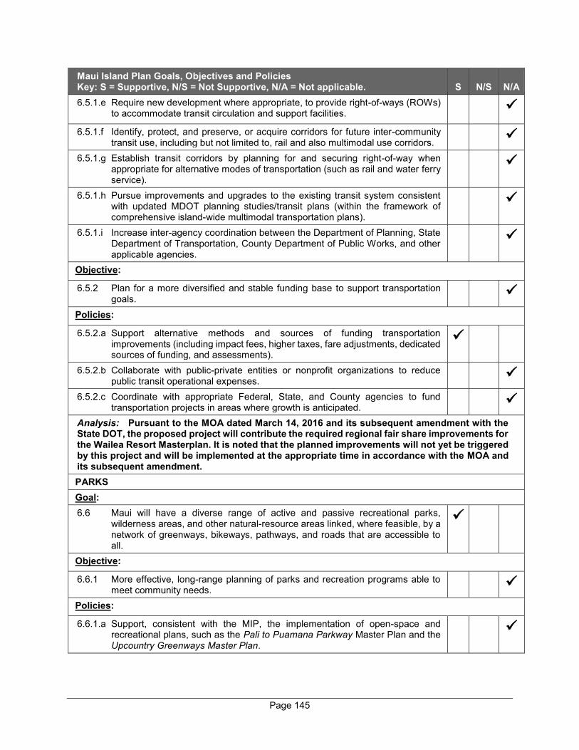
Page 145
Maui Island Plan Goals, Objectives and Policies Key: S = Supportive, N/S = Not Supportive, N/A = Not applicable. S N/S N/A 6.5.1.e Require new development where appropriate, to provide right-of-ways (ROWs)
to accommodate transit circulation and support facilities.
6.5.1.f Identify, protect, and preserve, or acquire corridors for future inter-community transit use, including but not limited to, rail and also multimodal use corridors.
6.5.1.g Establish transit corridors by planning for and securing right-of-way when appropriate for alternative modes of transportation (such as rail and water ferry service).
6.5.1.h Pursue improvements and upgrades to the existing transit system consistent with updated MDOT planning studies/transit plans (within the framework of comprehensive island-wide multimodal transportation plans).
6.5.1.i Increase inter-agency coordination between the Department of Planning, State Department of Transportation, County Department of Public Works, and other applicable agencies.
Objective:
6.5.2 Plan for a more diversified and stable funding base to support transportation goals.
Policies:
6.5.2.a Support alternative methods and sources of funding transportation improvements (including impact fees, higher taxes, fare adjustments, dedicated sources of funding, and assessments).
6.5.2.b Collaborate with public-private entities or nonprofit organizations to reduce public transit operational expenses.
6.5.2.c Coordinate with appropriate Federal, State, and County agencies to fund transportation projects in areas where growth is anticipated.
Analysis: Pursuant to the MOA dated March 14, 2016 and its subsequent amendment with the State DOT, the proposed project will contribute the required regional fair share improvements for the Wailea Resort Masterplan. It is noted that the planned improvements will not yet be triggered by this project and will be implemented at the appropriate time in accordance with the MOA and its subsequent amendment. PARKS Goal: 6.6 Maui will have a diverse range of active and passive recreational parks,
wilderness areas, and other natural-resource areas linked, where feasible, by a network of greenways, bikeways, pathways, and roads that are accessible to all.
Objective:
6.6.1 More effective, long-range planning of parks and recreation programs able to meet community needs.
Policies:
6.6.1.a Support, consistent with the MIP, the implementation of open-space and recreational plans, such as the Pali to Puamana Parkway Master Plan and the Upcountry Greenways Master Plan.
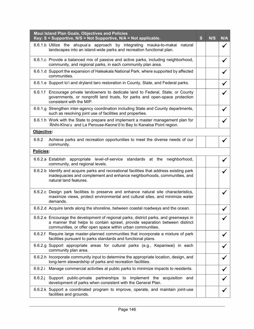
Page 146
Maui Island Plan Goals, Objectives and Policies Key: S = Supportive, N/S = Not Supportive, N/A = Not applicable. S N/S N/A 6.6.1.b Utilize the ahupua‘a approach by integrating mauka-to-makai natural
landscapes into an island-wide parks and recreation functional plan.
6.6.1.c Provide a balanced mix of passive and active parks, including neighborhood, community, and regional parks, in each community plan area.
6.6.1.d Support the expansion of Haleakala National Park, where supported by affected communities.
6.6.1.e Support lo‘i and dryland taro restoration in County, State, and Federal parks.
6.6.1.f Encourage private landowners to dedicate land to Federal, State, or County governments, or nonprofit land trusts, for parks and open-space protection consistent with the MIP.
6.6.1.g Strengthen inter-agency coordination including State and County departments, such as resolving joint use of facilities and properties.
6.6.1.h Work with the State to prepare and implement a master management plan for ‘Āhihi-Kīna‘u and La Perouse-Keone‘ō‘io Bay to Kanaloa Point region.
Objective:
6.6.2 Achieve parks and recreation opportunities to meet the diverse needs of our community.
Policies:
6.6.2.a Establish appropriate level-of-service standards at the neighborhood, community, and regional levels.
6.6.2.b Identify and acquire parks and recreational facilities that address existing park inadequacies and complement and enhance neighborhoods, communities, and natural land features.
6.6.2.c Design park facilities to preserve and enhance natural site characteristics, maximize views, protect environmental and cultural sites, and minimize water demands.
6.6.2.d Acquire lands along the shoreline, between coastal roadways and the ocean.
6.6.2.e Encourage the development of regional parks, district parks, and greenways in a manner that helps to contain sprawl, provide separation between distinct communities, or offer open space within urban communities.
6.6.2.f Require large master-planned communities that incorporate a mixture of park facilities pursuant to parks standards and functional plans.
6.6.2.g Support appropriate areas for cultural parks (e.g., Kepaniwai) in each community plan area.
6.6.2.h Incorporate community input to determine the appropriate location, design, and long-term stewardship of parks and recreation facilities.
6.6.2.i Manage commercial activities at public parks to minimize impacts to residents.
6.6.2.j Support public-private partnerships to implement the acquisition and development of parks when consistent with the General Plan.
6.6.2.k Support a coordinated program to improve, operate, and maintain joint-use facilities and grounds.

Page 147
Maui Island Plan Goals, Objectives and Policies Key: S = Supportive, N/S = Not Supportive, N/A = Not applicable. S N/S N/A Objective:
6.6.3 An expanded network of greenways, trails, pathways, and bikeways.
Policies:
6.6.3.a Link existing and future park sites, natural areas, the shoreline, and residential areas with a network of bikeways, pedestrian paths, trails, and greenways.
6.6.3.b Support the implementation of plans and programs that facilitate pedestrian mobility and access to active and passive recreation areas and sites.
6.6.3.c Collaborate with the State and private land owners to ensure perpetual access and proper stewardship of traditional trails and access systems.
6.6.3.d Facilitate the development of well-managed noncommercial campgrounds throughout the island.
6.6.3.e Consider requiring commercial bike rental businesses to provide funding that supports a mauka-to-makai Haleakalā bikeway improvement program.
6.6.3.f Ensure ADA compliance and seek opportunities to make all parks and recreational facilities accessible to people with disabilities.
Analysis: As noted previously, the proposed project will include multi-modal paths on main roads to encourage walking and bicycling, which will connect to Wailea Alanui Drive and Kapili Street. The project has been designed to protect the scenic beauty of the Wailea Resort area and approximately 20 percent of the project area will be retained as open space. PUBLIC FACILITIES Goal: 6.7 Maui will have adequate public facilities that meet the diverse needs of
residents.
Objective:
6.7.1 More effective planning for public facilities to meet community needs.
Policies:
6.7.1.a Ensure the development and update of island-wide public facilities functional plans that incorporate prioritized facilities, programs, and a financial component.
6.7.1.b Establish appropriate level-of-service standards for public facilities provided by the County.
6.7.1.c Pursue improvements and upgrades of County public facilities consistent with the public facilities functional plan.
6.7.1.d Recognize Wailuku Town as Maui’s Civic Center and support the revitalization of the Civic Center District by consolidating government office spaces, enhancing landscape beautification, and providing adequate public parking.
6.7.1.e Support, with community input, the relocation of the Maui Community Correctional Center from Wailuku to an appropriate location in Pu‘unēnē.
6.7.1.f Adequately plan and fund public safety facilities (fire, police, ambulance, civil defense) to meet community needs.
6.7.1.g Increase joint facilities utilization and program coordination between State and County agencies such as baseyards, communication centers, recreational facilities, etc., where feasible.

Page 148
Maui Island Plan Goals, Objectives and Policies Key: S = Supportive, N/S = Not Supportive, N/A = Not applicable. S N/S N/A 6.7.1.h Focus future expenditures for additional government office space, parking, and
related facilities in Wailuku’s Civic Center District.
6.7.1.i Encourage continuous and safe walkways for children within one mile of each school.
6.7.1.j Encourage public-private partnerships to identify and resolve public facility plan shortcomings when consistent with the General Plan.
6.7.1.k Incorporate community/area residents’ input to determine the appropriate location and design of public facilities.
Analysis: Not Applicable.
SCHOOLS AND LIBRARIES
Goal:
6.8 Maui will have school and library facilities that meet residents’ needs and goals.
Objective:
6.8.1 Assist in providing appropriate school and library facilities in a timely manner and in strategic locations.
Policies:
6.8.1.a Work in partnership with all educational institutions to meet current and future needs including appropriate location, timing, and design of future facilities.
6.8.1.b Allow for the expansion and intensification of uses at the UHMC including satellite campuses operating in remote areas.
6.8.1.c Encourage the DOE to build and maintain smaller, community-oriented schools.
6.8.1.d Encourage better cooperation by the State and County for use of State and County facilities.
6.8.1.e Encourage the State to upgrade, modernize, and expand school facilities, including those in remote communities.
6.8.1.f Work with the State to develop a master plan for the expansion of UHMC in accordance with the MIP.
6.8.1.g Support partnerships (public/private/nonprofit) to build and staff new schools and improve existing facilities.
6.8.1.h Work with the BOE HSPLS to provide centralized library services (including telecommunications) to all areas of Maui.
6.8.1.i Work with the State to expedite planning and construction of Kīhei High School, including the integration of the high school with the Maui Research and Technology Park.
6.8.1.j Work with the State to identify intermediate school sites in Central Maui and other areas where needed.
Objective:
6.8.2 Provide a more expansive network of safe and convenient pedestrian-friendly streets, trails, pathways, and bikeways between neighborhoods and schools where appropriate.
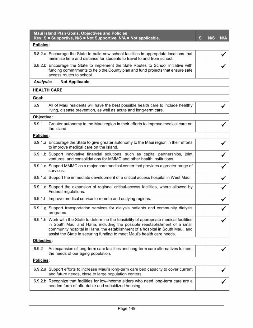
Page 149
Maui Island Plan Goals, Objectives and Policies Key: S = Supportive, N/S = Not Supportive, N/A = Not applicable. S N/S N/A Policies:
6.8.2.a Encourage the State to build new school facilities in appropriate locations that minimize time and distance for students to travel to and from school.
6.8.2.b Encourage the State to implement the Safe Routes to School initiative with funding commitments to help the County plan and fund projects that ensure safe access routes to school.
Analysis: Not Applicable.
HEALTH CARE
Goal:
6.9 All of Maui residents will have the best possible health care to include healthy living, disease prevention, as well as acute and long-term care.
Objective: 6.9.1 Greater autonomy to the Maui region in their efforts to improve medical care on
the island.
Policies: 6.9.1.a Encourage the State to give greater autonomy to the Maui region in their efforts
to improve medical care on the island.
6.9.1.b Support innovative financial solutions, such as capital partnerships, joint ventures, and consolidations for MMMC and other health institutions.
6.9.1.c Support MMMC as a major core medical center that provides a greater range of services.
6.9.1.d Support the immediate development of a critical access hospital in West Maui.
6.9.1.e Support the expansion of regional critical-access facilities, where allowed by Federal regulations.
6.9.1.f Improve medical service to remote and outlying regions.
6.9.1.g Support transportation services for dialysis patients and community dialysis programs.
6.9.1.h Work with the State to determine the feasibility of appropriate medical facilities in South Maui and Hāna, including the possible reestablishment of a small community hospital in Hāna, the establishment of a hospital in South Maui, and assist the State in securing funding to meet Maui’s health care needs.
Objective:
6.9.2 An expansion of long-term care facilities and long-term care alternatives to meet the needs of our aging population.
Policies:
6.9.2.a Support efforts to increase Maui’s long-term care bed capacity to cover current and future needs, close to large population centers.
6.9.2.b Recognize that facilities for low-income elders who need long-term care are a needed form of affordable and subsidized housing.
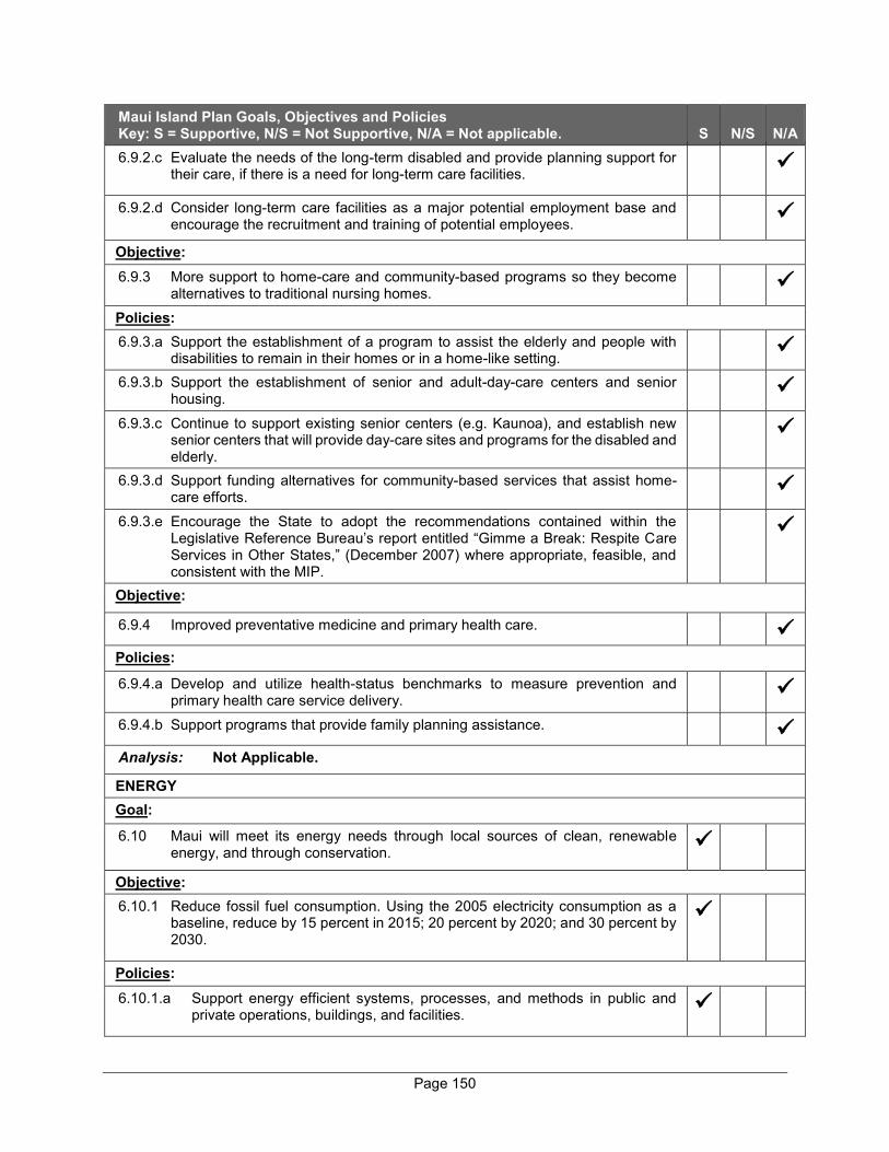
Page 150
Maui Island Plan Goals, Objectives and Policies Key: S = Supportive, N/S = Not Supportive, N/A = Not applicable. S N/S N/A 6.9.2.c Evaluate the needs of the long-term disabled and provide planning support for
their care, if there is a need for long-term care facilities.
6.9.2.d Consider long-term care facilities as a major potential employment base and encourage the recruitment and training of potential employees.
Objective: 6.9.3 More support to home-care and community-based programs so they become
alternatives to traditional nursing homes.
Policies: 6.9.3.a Support the establishment of a program to assist the elderly and people with
disabilities to remain in their homes or in a home-like setting.
6.9.3.b Support the establishment of senior and adult-day-care centers and senior housing.
6.9.3.c Continue to support existing senior centers (e.g. Kaunoa), and establish new senior centers that will provide day-care sites and programs for the disabled and elderly.
6.9.3.d Support funding alternatives for community-based services that assist home-care efforts.
6.9.3.e Encourage the State to adopt the recommendations contained within the Legislative Reference Bureau’s report entitled “Gimme a Break: Respite Care Services in Other States,” (December 2007) where appropriate, feasible, and consistent with the MIP.
Objective:
6.9.4 Improved preventative medicine and primary health care.
Policies:
6.9.4.a Develop and utilize health-status benchmarks to measure prevention and primary health care service delivery.
6.9.4.b Support programs that provide family planning assistance.
Analysis: Not Applicable.
ENERGY Goal:
6.10 Maui will meet its energy needs through local sources of clean, renewable energy, and through conservation.
Objective: 6.10.1 Reduce fossil fuel consumption. Using the 2005 electricity consumption as a
baseline, reduce by 15 percent in 2015; 20 percent by 2020; and 30 percent by 2030.
Policies: 6.10.1.a Support energy efficient systems, processes, and methods in public and
private operations, buildings, and facilities.
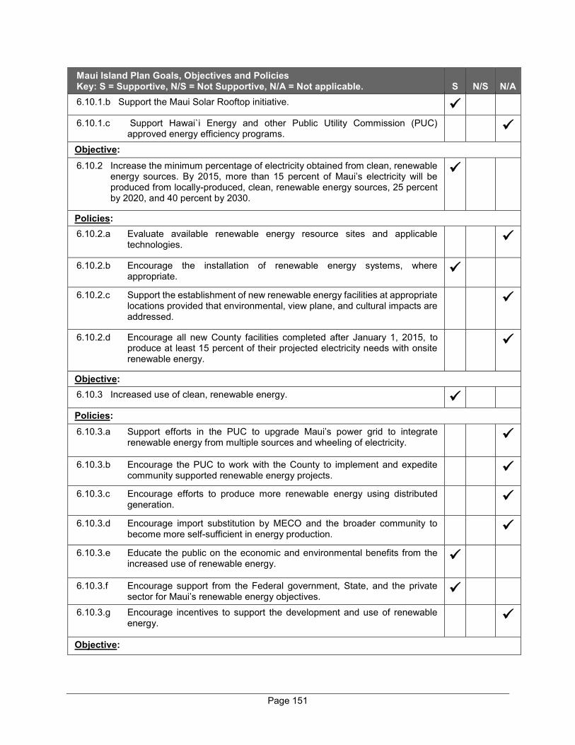
Page 151
Maui Island Plan Goals, Objectives and Policies Key: S = Supportive, N/S = Not Supportive, N/A = Not applicable. S N/S N/A 6.10.1.b Support the Maui Solar Rooftop initiative.
6.10.1.c Support Hawai`i Energy and other Public Utility Commission (PUC) approved energy efficiency programs.
Objective: 6.10.2 Increase the minimum percentage of electricity obtained from clean, renewable
energy sources. By 2015, more than 15 percent of Maui’s electricity will be produced from locally-produced, clean, renewable energy sources, 25 percent by 2020, and 40 percent by 2030.
Policies: 6.10.2.a Evaluate available renewable energy resource sites and applicable
technologies.
6.10.2.b Encourage the installation of renewable energy systems, where appropriate.
6.10.2.c Support the establishment of new renewable energy facilities at appropriate locations provided that environmental, view plane, and cultural impacts are addressed.
6.10.2.d Encourage all new County facilities completed after January 1, 2015, to produce at least 15 percent of their projected electricity needs with onsite renewable energy.
Objective: 6.10.3 Increased use of clean, renewable energy.
Policies: 6.10.3.a Support efforts in the PUC to upgrade Maui’s power grid to integrate
renewable energy from multiple sources and wheeling of electricity.
6.10.3.b Encourage the PUC to work with the County to implement and expedite community supported renewable energy projects.
6.10.3.c Encourage efforts to produce more renewable energy using distributed generation.
6.10.3.d Encourage import substitution by MECO and the broader community to become more self-sufficient in energy production.
6.10.3.e Educate the public on the economic and environmental benefits from the increased use of renewable energy.
6.10.3.f Encourage support from the Federal government, State, and the private sector for Maui’s renewable energy objectives.
6.10.3.g Encourage incentives to support the development and use of renewable energy.
Objective:

Page 152
Maui Island Plan Goals, Objectives and Policies Key: S = Supportive, N/S = Not Supportive, N/A = Not applicable. S N/S N/A 6.10.4 More efficient distribution of power throughout the island while preserving island
beauty.
Analysis: In accordance with the project’s overall guiding sustainability principles, home designs within the proposed project will be rooftop solar PV and EV charger-ready and the home buyers will determine when they would like to install solar panels on their homes. HARBORS AND AIRPORT Goal:
6.11 Maui will have harbors and airports that will efficiently, dependably, and safely facilitate the movement of passengers and cargo.
Objective: 6.11.1 Upgraded harbor facilities to handle larger volumes of freight and passengers
and additional small boat harbors.
Policies: 6.11.1.a Support the expansion and upgrade of Kahului Harbor through the
following, provided that any expansion is respectful of cultural practices and existing recreational uses and supports improved water quality:
(4) Accommodate increasing volumes of cargo;
(5) Provide deeper pier depths and greater fuel-receiving and storing capacities; and
(6) Ensure safe and efficient work areas, including separating passenger operations from fuel and cargo operations.
6.11.1.b Work with public and private entities to provide adequate pier slips, utilities, repair facilities, and waste-disposal capabilities.
6.11.1.c Encourage the State to safely separate passenger (cruise and ferry) operations from hazardous bulk fuels and heavy cargo transporting operations, while not decreasing harbor’s capacity to safely support various recreational uses.
6.11.1.d Encourage the State to develop cargo inspecting sites and facilities for efficient cargo and container processing and transportation and to prevent alien species entry.
6.11.1.e Support a State and County task force to study the feasibility of a second commercial harbor on Maui.
Objective: 6.11.2 Establish more economically thriving and environmentally sensitive small boat
harbors accommodating resident and business activity, including fishing, recreation, and tour boats.
Policy: 6.11.2.a Provide for needed shore-side facilities and capabilities to support small
boat harbor users (e.g. repair facilities, parking, cold storage, and mass-transit connections).
Objective:
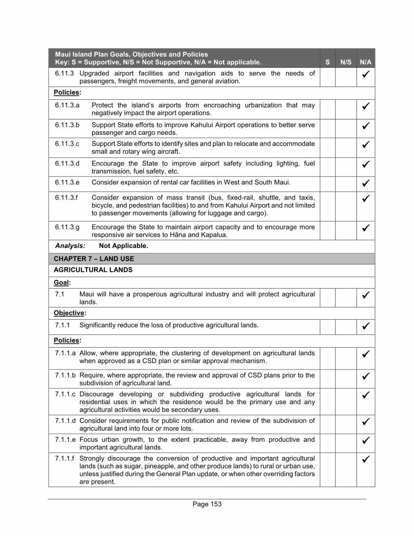
Page 153
Maui Island Plan Goals, Objectives and Policies Key: S = Supportive, N/S = Not Supportive, N/A = Not applicable. S N/S N/A 6.11.3 Upgraded airport facilities and navigation aids to serve the needs of
passengers, freight movements, and general aviation.
Policies:
6.11.3.a Protect the island’s airports from encroaching urbanization that may negatively impact the airport operations.
6.11.3.b Support State efforts to improve Kahului Airport operations to better serve passenger and cargo needs.
6.11.3.c Support State efforts to identify sites and plan to relocate and accommodate small and rotary wing aircraft.
6.11.3.d Encourage the State to improve airport safety including lighting, fuel transmission, fuel safety, etc.
6.11.3.e Consider expansion of rental car facilities in West and South Maui.
6.11.3.f Consider expansion of mass transit (bus, fixed-rail, shuttle, and taxis, bicycle, and pedestrian facilities) to and from Kahului Airport and not limited to passenger movements (allowing for luggage and cargo).
6.11.3.g Encourage the State to maintain airport capacity and to encourage more responsive air services to Hāna and Kapalua.
Analysis: Not Applicable.
CHAPTER 7 – LAND USE AGRICULTURAL LANDS
Goal: 7.1 Maui will have a prosperous agricultural industry and will protect agricultural
lands.
Objective:
7.1.1 Significantly reduce the loss of productive agricultural lands.
Policies:
7.1.1.a Allow, where appropriate, the clustering of development on agricultural lands when approved as a CSD plan or similar approval mechanism.
7.1.1.b Require, where appropriate, the review and approval of CSD plans prior to the subdivision of agricultural land.
7.1.1.c Discourage developing or subdividing productive agricultural lands for residential uses in which the residence would be the primary use and any agricultural activities would be secondary uses.
7.1.1.d Consider requirements for public notification and review of the subdivision of agricultural land into four or more lots.
7.1.1.e Focus urban growth, to the extent practicable, away from productive and important agricultural lands.
7.1.1.f Strongly discourage the conversion of productive and important agricultural lands (such as sugar, pineapple, and other produce lands) to rural or urban use, unless justified during the General Plan update, or when other overriding factors are present.

Page 154
Maui Island Plan Goals, Objectives and Policies Key: S = Supportive, N/S = Not Supportive, N/A = Not applicable. S N/S N/A 7.1.1.g Further develop the requirements for agricultural assessments found under
Section 19.510, MCC.
7.1.1.h Provide incentives for landowners to preserve and protect agricultural lands from development through the use of TDR/PDR, tax credits, easement programs, or similar means.
7.1.1.i Promote the use of U.S.D.A. Farm and Ranch Lands Protection Program grants to fund the acquisition of conservation easements on eligible agricultural lands.
7.1.1.j Require all major developments adjacent to agricultural lands to provide an appropriate and site-specific agricultural protection buffer as part of a required site plan.
7.1.1.k Support and promote the viability of Maui’s agricultural businesses through property tax incentives and other programs and subsidies.
7.1.1.l Encourage future community plan efforts to identify lands within the County Agricultural zoning district that are primarily being used for large-lot residential or rural use and consider such lands for reclassification to an appropriate County Rural zone.
Objective: 7.1.2 Reduction of the island’s dependence on off-island agricultural products and
expansion of export capacity.
Policies:
7.1.2.a Coordinate with the agricultural community, associations/community groups, agricultural landowners, and the State to designate IALs.
7.1.2.b Support an incentive package for productive Agricultural Lands which aims to ensure agricultural viability for small- and commercial-scale agricultural producers.
7.1.2.c Actively look to acquire land and provide infrastructure to expand the agricultural park and establish new agricultural parks.
7.1.2.d Support the designation of a research and development area within agricultural parks to help farmers stay attuned to new technology and research.
7.1.2.e Support local cooperative extension services to facilitate timely technology transfer opportunities.
7.1.2.f Support plans and programs to develop additional sources of water for irrigation purposes.
7.1.2.g Consider appropriate subdivision requirements (gravel roads, above-ground utilities, etc.) in those subdivisions creating Agricultural Parks where lots are limited to agricultural production with no dwellings.
7.1.2.h Support the recommendations, policies, and actions contained within the Maui Agricultural Development Plan, July 2009, when consistent with the MIP.
7.1.2.i Allow water and tax discounts for legitimate farming operations on rural and agricultural land.
7.1.2.j Give priority in delivery and use of agricultural water and agricultural land within County agricultural parks to cultivation of food crops for local consumption.
7.1.2.k Support programs that control pests and diseases that affect agriculture.
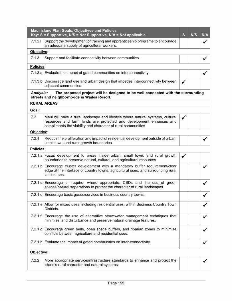
Page 155
Maui Island Plan Goals, Objectives and Policies Key: S = Supportive, N/S = Not Supportive, N/A = Not applicable. S N/S N/A 7.1.2.l Support the development of training and apprenticeship programs to encourage
an adequate supply of agricultural workers.
Objective: 7.1.3 Support and facilitate connectivity between communities.
Policies: 7.1.3.a Evaluate the impact of gated communities on interconnectivity.
7.1.3.b Discourage land use and urban design that impedes interconnectivity between adjacent communities.
Analysis: The proposed project will be designed to be well connected with the surrounding streets and neighborhoods in Wailea Resort. RURAL AREAS
Goal:
7.2 Maui will have a rural landscape and lifestyle where natural systems, cultural resources and farm lands are protected and development enhances and compliments the viability and character of rural communities.
Objective: 7.2.1 Reduce the proliferation and impact of residential development outside of urban,
small town, and rural growth boundaries.
Policies: 7.2.1.a Focus development to areas inside urban, small town, and rural growth
boundaries to preserve natural, cultural, and agricultural resources.
7.2.1.b Encourage cluster development with a mandatory buffer requirement/clear edge at the interface of country towns, agricultural uses, and surrounding rural landscapes.
7.2.1.c Encourage or require, where appropriate, CSDs and the use of green spaces/natural separations to protect the character of rural landscapes.
7.2.1.d Encourage basic goods/services in business country towns.
7.2.1.e Allow for mixed uses, including residential uses, within Business Country Town Districts.
7.2.1.f Encourage the use of alternative stormwater management techniques that minimize land disturbance and preserve natural drainage features.
7.2.1.g Encourage green belts, open space buffers, and riparian zones to minimize conflicts between agriculture and residential uses.
7.2.1.h Evaluate the impact of gated communities on inter-connectivity.
Objective:
7.2.2 More appropriate service/infrastructure standards to enhance and protect the island’s rural character and natural systems.
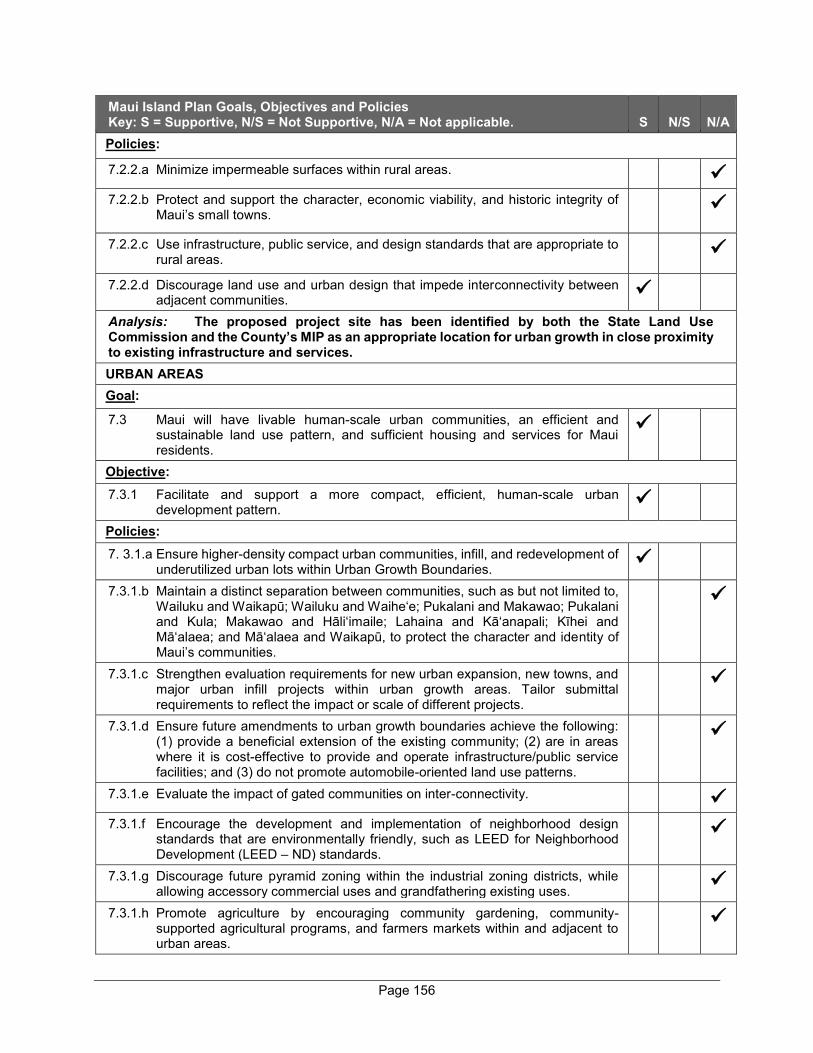
Page 156
Maui Island Plan Goals, Objectives and Policies Key: S = Supportive, N/S = Not Supportive, N/A = Not applicable. S N/S N/A Policies:
7.2.2.a Minimize impermeable surfaces within rural areas.
7.2.2.b Protect and support the character, economic viability, and historic integrity of Maui’s small towns.
7.2.2.c Use infrastructure, public service, and design standards that are appropriate to rural areas.
7.2.2.d Discourage land use and urban design that impede interconnectivity between adjacent communities.
Analysis: The proposed project site has been identified by both the State Land Use Commission and the County’s MIP as an appropriate location for urban growth in close proximity to existing infrastructure and services. URBAN AREAS Goal:
7.3 Maui will have livable human-scale urban communities, an efficient and sustainable land use pattern, and sufficient housing and services for Maui residents.
Objective: 7.3.1 Facilitate and support a more compact, efficient, human-scale urban
development pattern.
Policies: 7. 3.1.a Ensure higher-density compact urban communities, infill, and redevelopment of
underutilized urban lots within Urban Growth Boundaries.
7.3.1.b Maintain a distinct separation between communities, such as but not limited to, Wailuku and Waikapū; Wailuku and Waihe‘e; Pukalani and Makawao; Pukalani and Kula; Makawao and Hāli‘imaile; Lahaina and Kā‘anapali; Kīhei and Mā‘alaea; and Mā‘alaea and Waikapū, to protect the character and identity of Maui’s communities.
7.3.1.c Strengthen evaluation requirements for new urban expansion, new towns, and major urban infill projects within urban growth areas. Tailor submittal requirements to reflect the impact or scale of different projects.
7.3.1.d Ensure future amendments to urban growth boundaries achieve the following: (1) provide a beneficial extension of the existing community; (2) are in areas where it is cost-effective to provide and operate infrastructure/public service facilities; and (3) do not promote automobile-oriented land use patterns.
7.3.1.e Evaluate the impact of gated communities on inter-connectivity.
7.3.1.f Encourage the development and implementation of neighborhood design standards that are environmentally friendly, such as LEED for Neighborhood Development (LEED – ND) standards.
7.3.1.g Discourage future pyramid zoning within the industrial zoning districts, while allowing accessory commercial uses and grandfathering existing uses.
7.3.1.h Promote agriculture by encouraging community gardening, community-supported agricultural programs, and farmers markets within and adjacent to urban areas.
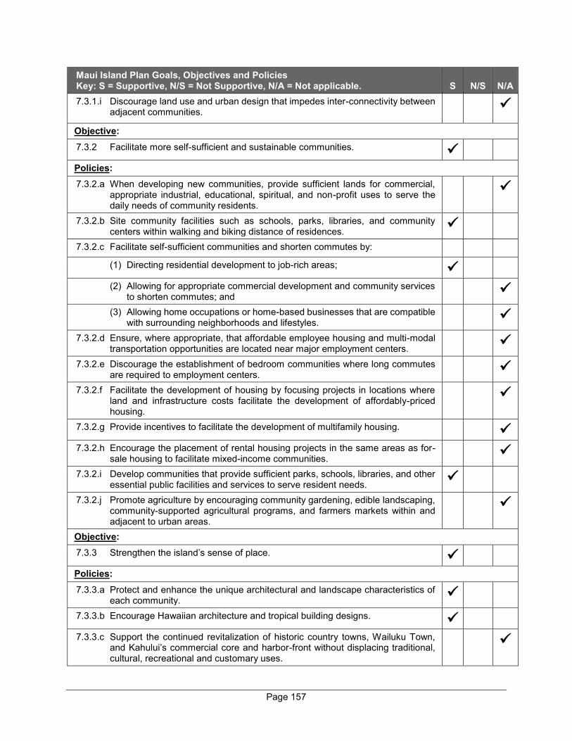
Page 157
Maui Island Plan Goals, Objectives and Policies Key: S = Supportive, N/S = Not Supportive, N/A = Not applicable. S N/S N/A 7.3.1.i Discourage land use and urban design that impedes inter-connectivity between
adjacent communities.
Objective: 7.3.2 Facilitate more self-sufficient and sustainable communities.
Policies: 7.3.2.a When developing new communities, provide sufficient lands for commercial,
appropriate industrial, educational, spiritual, and non-profit uses to serve the daily needs of community residents.
7.3.2.b Site community facilities such as schools, parks, libraries, and community centers within walking and biking distance of residences.
7.3.2.c Facilitate self-sufficient communities and shorten commutes by: (1) Directing residential development to job-rich areas;
(2) Allowing for appropriate commercial development and community services to shorten commutes; and
(3) Allowing home occupations or home-based businesses that are compatible with surrounding neighborhoods and lifestyles.
7.3.2.d Ensure, where appropriate, that affordable employee housing and multi-modal transportation opportunities are located near major employment centers.
7.3.2.e Discourage the establishment of bedroom communities where long commutes are required to employment centers.
7.3.2.f Facilitate the development of housing by focusing projects in locations where land and infrastructure costs facilitate the development of affordably-priced housing.
7.3.2.g Provide incentives to facilitate the development of multifamily housing.
7.3.2.h Encourage the placement of rental housing projects in the same areas as for-sale housing to facilitate mixed-income communities.
7.3.2.i Develop communities that provide sufficient parks, schools, libraries, and other essential public facilities and services to serve resident needs.
7.3.2.j Promote agriculture by encouraging community gardening, edible landscaping, community-supported agricultural programs, and farmers markets within and adjacent to urban areas.
Objective: 7.3.3 Strengthen the island’s sense of place.
Policies: 7.3.3.a Protect and enhance the unique architectural and landscape characteristics of
each community.
7.3.3.b Encourage Hawaiian architecture and tropical building designs.
7.3.3.c Support the continued revitalization of historic country towns, Wailuku Town, and Kahului’s commercial core and harbor-front without displacing traditional, cultural, recreational and customary uses.
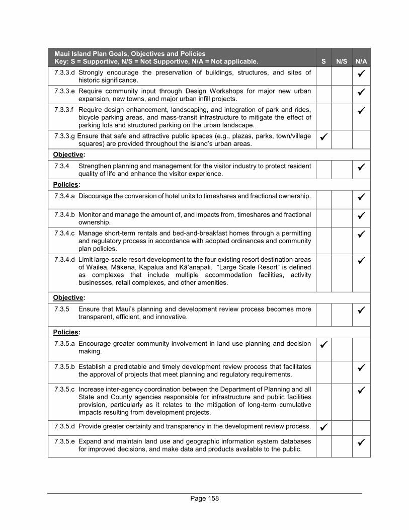
Page 158
Maui Island Plan Goals, Objectives and Policies Key: S = Supportive, N/S = Not Supportive, N/A = Not applicable. S N/S N/A 7.3.3.d Strongly encourage the preservation of buildings, structures, and sites of
historic significance.
7.3.3.e Require community input through Design Workshops for major new urban expansion, new towns, and major urban infill projects.
7.3.3.f Require design enhancement, landscaping, and integration of park and rides, bicycle parking areas, and mass-transit infrastructure to mitigate the effect of parking lots and structured parking on the urban landscape.
7.3.3.g Ensure that safe and attractive public spaces (e.g., plazas, parks, town/village squares) are provided throughout the island’s urban areas.
Objective: 7.3.4 Strengthen planning and management for the visitor industry to protect resident
quality of life and enhance the visitor experience.
Policies: 7.3.4.a Discourage the conversion of hotel units to timeshares and fractional ownership.
7.3.4.b Monitor and manage the amount of, and impacts from, timeshares and fractional ownership.
7.3.4.c Manage short-term rentals and bed-and-breakfast homes through a permitting and regulatory process in accordance with adopted ordinances and community plan policies.
7.3.4.d Limit large-scale resort development to the four existing resort destination areas of Wailea, Mākena, Kapalua and Kā‘anapali. “Large Scale Resort” is defined as complexes that include multiple accommodation facilities, activity businesses, retail complexes, and other amenities.
Objective: 7.3.5 Ensure that Maui’s planning and development review process becomes more
transparent, efficient, and innovative.
Policies: 7.3.5.a Encourage greater community involvement in land use planning and decision
making.
7.3.5.b Establish a predictable and timely development review process that facilitates the approval of projects that meet planning and regulatory requirements.
7.3.5.c Increase inter-agency coordination between the Department of Planning and all State and County agencies responsible for infrastructure and public facilities provision, particularly as it relates to the mitigation of long-term cumulative impacts resulting from development projects.
7.3.5.d Provide greater certainty and transparency in the development review process.
7.3.5.e Expand and maintain land use and geographic information system databases for improved decisions, and make data and products available to the public.
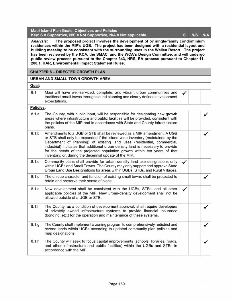
Page 159
Maui Island Plan Goals, Objectives and Policies Key: S = Supportive, N/S = Not Supportive, N/A = Not applicable. S N/S N/A Analysis: The proposed project involves the development of 57 single-family condominium residences within the MIP’s UGB. The project has been designed with a residential layout and building massing to be consistent with the surrounding uses in the Wailea Resort. The project has been reviewed by the KCA, the SMAC, and the WCA’s Design Committee, and will undergo public review process pursuant to the Chapter 343, HRS, EA process pursuant to Chapter 11- 200.1, HAR, Environmental Impact Statement Rules.
CHAPTER 8 – DIRECTED GROWTH PLAN
URBAN AND SMALL TOWN GROWTH AREA
Goal:
8.1 Maui will have well-serviced, complete, and vibrant urban communities and traditional small towns through sound planning and clearly defined development expectations.
Policies: 8.1.a The County, with public input, will be responsible for designating new growth
areas where infrastructure and public facilities will be provided, consistent with the policies of the MIP and in accordance with State and County infrastructure plans.
8.1.b Amendments to a UGB or STB shall be reviewed as a MIP amendment. A UGB or STB shall only be expanded if the island-wide inventory (maintained by the Department of Planning) of existing land uses (residential, commercial, industrial) indicates that additional urban density land is necessary to provide for the needs of the projected population growth within ten years of that inventory; or, during the decennial update of the MIP.
8.1.c Community plans shall provide for urban density land use designations only within UGBs and Small Towns. The County may only support and approve State Urban Land Use Designations for areas within UGBs, STBs, and Rural Villages.
8.1.d The unique character and function of existing small towns shall be protected to retain and preserve their sense of place.
8.1.e New development shall be consistent with the UGBs, STBs, and all other applicable policies of the MIP. New urban-density development shall not be allowed outside of a UGB or STB.
8.1.f The County, as a condition of development approval, shall require developers of privately owned infrastructure systems to provide financial insurance (bonding, etc.) for the operation and maintenance of these systems.
8.1.g The County shall implement a zoning program to comprehensively redistrict and rezone lands within UGBs according to updated community plan policies and map designations.
8.1.h The County will seek to focus capital improvements (schools, libraries, roads, and other infrastructure and public facilities) within the UGBs and STBs in accordance with the MIP.

Page 160
Maui Island Plan Goals, Objectives and Policies Key: S = Supportive, N/S = Not Supportive, N/A = Not applicable. S N/S N/A 8.1.i The County will promote (through incentives, financial participation, expedited
project review, infrastructure/public facilities support, etc.) appropriate urban infill, redevelopment and the efficient use of buildable land within UGBs to avoid the need to expand the UGBs.
8.1.j The MIP’s UGBs and STBs shall not be construed or implemented to prohibit the construction of a single-family dwelling on any existing parcel where otherwise permitted by law.
Analysis: As discussed previously, the project site has been identified by both the State Land Use Commission and the County’s MIP as an appropriate location for urban-scale growth in close proximity to existing infrastructure and services. RURAL GROWTH AREA
Goal:
8.2 Maui will maintain opportunities for agriculture and rural communities through sound planning and clearly defined development expectations.
Policies: 8.2.a Amendments to a RGB shall be reviewed as an MIP amendment. A RGB shall
only be expanded if an island-wide inventory of existing land uses (residential, commercial, industrial) indicates that additional lands are necessary to provide for the needs of the projected population growth within ten years of that inventory; or, during the decennial update of the MIP.
8.2.b New development shall be consistent with RGB and all other applicable policies and requirements of the MIP. Public, quasi-public, civic, and limited commercial or industrial uses may be allowed in the RGB when the proposed uses demonstrate a public need and are consistent with the Community Plan and zoning.
8.2.c Environmental protection and compatibility will be a top priority in rural growth areas.
8.2.d All development within rural growth areas should avoid encroachment upon prime agricultural land.
8.2.e Rural growth areas include Rural Residential Areas and Rural Villages. Rural residential areas may be designated when they are located in association with or on the border of urban growth areas or Small Towns; and/or when they provide for complete, self-sufficient rural communities with a range of uses to be developed at densities that do not require urban infrastructure.
8.2.f Community plans shall provide for rural density land use designations only within RGBs; provided that limited community plan urban designations may be allowed within Rural Villages. New rural growth areas shall not be located where urban expansion may ultimately become necessary or desirable. New rural-density development shall not be allowed outside of a RGB.
8.2.g New rural growth areas intended to be complete, self-sufficient rural communities must be located a significant distance from existing urban areas, distinctly separated by agricultural or open lands.
8.2.h Urban-scale infrastructure and public facilities shall not be provided in rural areas except as described in the defined Level-of-Service (LOS) standards. There should be no expectations of urban services in rural areas.
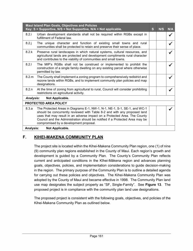
Page 161
Maui Island Plan Goals, Objectives and Policies Key: S = Supportive, N/S = Not Supportive, N/A = Not applicable. S N/S N/A 8.2.i Urban development standards shall not be required within RGBs except in
fulfillment of Federal law.
8.2.j The unique character and function of existing small towns and rural communities shall be protected to retain and preserve their sense of place.
8.2.k Preserve rural landscapes in which natural systems, cultural resources, and agricultural lands are protected and development compliments rural character and contributes to the viability of communities and small towns.
8.2.l The MIP’s RGBs shall not be construed or implemented to prohibit the construction of a single family dwelling on any existing parcel where otherwise permitted by law.
8.2.m The County shall implement a zoning program to comprehensively redistrict and rezone lands within RGBs, and to implement community plan policies and map designations.
8.2.n At the time of zoning from agricultural to rural, Council will consider prohibiting restrictions on agricultural activity.
Analysis: Not Applicable. PROTECTED AREA POLICY 8.3.a The Protected Areas in Diagrams E-1, NW-1, N-1, NE-1, S-1, SE-1, and WC-1
should be concurrently reviewed with Table 8-2 and with any proposed land uses that may result in an adverse impact on a Protected Area. The County Council and the Administration should be notified if a Protected Area may be compromised by a development proposal.
Analysis: Not Applicable.
F. KIHEI-MAKENA COMMUNITY PLAN
The project site is located within the Kihei-Makena Community Plan region, one (1) of nine (9) community plan regions established in the County of Maui. Each region’s growth and development is guided by a Community Plan. The County’s Community Plan reflects current and anticipated conditions in the Kīhei-Mākena region and advances planning goals, objectives, policies, and implementation considerations to guide decision-making in the region. The primary purpose of the Community Plan is to outline a detailed agenda for carrying out these policies and objectives. The Kihei-Makena Community Plan was adopted by the County of Maui and became effective in 1998. The Community Plan land use map designates the subject property as “SF, Single-Family”. See Figure 13. The proposed project is in compliance with the community plan land use designations.
The proposed project is consistent with the following goals, objectives, and policies of the Kihei-Makena Community Plan as outlined below.
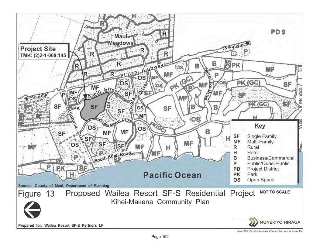
Page 162
Figure 13. Kihei-Makena Community Plan
Page 163
LAND USE
Goal:
A well-planned community with land use and development patterns designed to achieve the efficient and timely provision of infrastructural and community needs while preserving and enhancing the unique character of Ma`alaea, Kihei, Wailea and Makena as well as the region’s natural environment, marine resources and traditional shoreline uses.
Objectives and Policies:
* * *
b. Identify priority growth areas to focus public and private efforts on the provision of infrastructure and amenities to serve existing residents and to accommodate new growth.
Response: The proposed project site is located within the UGB as designated within the MIP. Furthermore, the project site is located on land with appropriate existing land use designations with respect to the Kihei-Makena Community Plan and Maui County Zoning to support the proposed development.
ENVIRONMENT
Goal:
Preservation, protection, and enhancement of Kihei-Makena’s unique and fragile environmental resources.
Objectives and Policies
* * *
4. Storm water run-off from proposed developments shall not adversely affect the marine environment and nearshore and offshore water quality.
Response: A comprehensive drainage system, including LID measures, such as bioretention strips, will be installed as part of the project development to capture and retain all post-development runoff.
HOUSING AND URBAN DESIGN
Goal:
A variety of attractive, sanitary, safe and affordable homes for Kihei’s residents, especially for families earning less than the median income for families within the County. Also, a built environment which provides complementary and aesthetically pleasing physical and visual linkages with the natural environment.

Page 164
Objectives and Policies
a. Provide an adequate variety of housing choices and range of prices for the needs of Kihei’s residents, especially for families earning less than the median income for families within the County, through the project district approach and other related programs. Choices can be increased through public/private sector cooperation and coordinated development of necessary support facilities and services.
b. Require a mix of affordable and market-priced housing in all major residential projects, unless the project is to be developed exclusively as an affordable housing project.
* * *
e. Implement landscaped setbacks for future multi-family and commercial areas. Developments shall provide space for landscaped pedestrian ways and bikeways.
f. Incorporate the principles of xeriscaping in all future landscaping.
g. Encourage the use of native plants in landscaping in the spirit of Act 73, Session Laws of Hawaii, 1992.
Response:
As discussed previously, the proposed project will utilize Residential Workforce Housing credits to comply with Chapter 2.96, MCC, the County’s Residential Workforce Housing Policy. The credits from the previous development of residential workforce housing were acquired from A&B Wailea LLC, the previous owner of the property. The Applicant understands and respects the importance of scenic vistas, particularly towards the ocean and mountains. A View Analysis has been prepared for the project to ensure that makai/mauka views from adjacent roadways and public vantage points are not significantly adversely impacted. Refer to Appendix “B”. Multi-modal paths will be incorporated on main roads of the project site to encourage walking and bicycling. A landscaping plan utilizing native plants, where feasible, will be implemented as part of the proposed project.
PHYSICAL AND SOCIAL INFRASTRUCTURE
Goal:
Provision of facility systems, public services and capital improvement projects in an efficient, reliable, cost effective, and environmentally sensitive manner which accommodates the needs of the Kihei-Makena community, and fully supports present and planned land uses, especially in the case of project district implementation.
Page 165
Allow no development for which infrastructure may not be available concurrent with the development’s impacts.
Response: The Applicant will construct all infrastructure improvements necessary for
the proposed project in an efficient, reliable, cost effective, and environmentally sensitive manner. The SDOT’s MOA, dated March 14, 2016, and its subsequent amendment encompass the subject property. As such, the Applicant or its assigns will pay the regional fair share for the planned regional transportation improvements in Wailea Resort. It is noted that the planned improvements will not be triggered by the proposed project and will be implemented at the appropriate time in accordance with the MOA and its subsequent amendment. The proposed 57 units will count towards the 150 units needed to trigger the regional planned improvements. In addition, pursuant to Ordinance 2694, which conditionally zoned the subject parcel as “R-3 Residential District”, the parks assessment has been satisfied for the subject property by donating a 5.75-acre parcel, identified as TMK (2)3-9-038:026, to the County for use as a fire station and a park.
a. Drainage
Objectives and Policies:
1. Design drainage systems that protect coastal water quality by incorporating best management practices to remove pollutants from runoff. Construct and maintain, as needed, sediment retention basins and other best management practices to remove sediments and other pollutants from runoff.
Response: A comprehensive drainage system, including LID measures, such as bioretention strips, will be installed as part of the project development to capture and retain all post-developoment runoff on the project site.
b. Energy and Public Utilities
Objectives and Policies:
a. Promote energy efficiency as the energy resource of first choice, and increase energy efficiency in all sectors of the community.
***
c. Promote environmentally and culturally sensitive use of renewable energy resources like biomass, solar, wind, and hydroelectric energy in all sectors of the community.
Response: In accordance with the project’s overall guidling sustainability principles, various energy efficient measures will be implemented, where feasible, in the proposed project. In addition, homes within the proposed project will be
Page 166
designed to be rooftop solar PV and EV charger-ready. The buyers of the homes will be encouraged to implement these measures in order to reduce the dependence on imported fuel for energy generation and reduce GHG emissions.
URBAN DESIGN STANDARDS
The proposed project was evaluated with respect to the following Urban Design Standards listed within the Kihei-Makena Community Plan:
Building Form
Limit resort development throughout the region to thirty-five (35) feet in building height for sites near the shoreline. Building height limits may gradually be increased up to seventy-five (75) feet for inland resort development provided that important mauka/Makai vistas are maintained, and impacts to coastal resources are minimized. Resort community planning and design shall integrate recreational amenities with adequate shoreline setback and public shoreline access provisions. Response: The homes and amenity center within the proposed project will be single-story, well below the 30 feet allowed in the “R-3, Residential” district. The intent of the project design is to allow the proposed residential community that draws upon the region’s heritage and responds to the unique climate and setting. The landscaping plan has been crafted to fit within this context and utilizes native plants, where available and feasible.
G. PLANNED DEVELOPMENT APPROVAL
All lands in the Wailea Resort, including the subject property, are in a Planned Development area and governed by MCC Section 19.32, Planned Development (PD). The PD approval process involves three (3) steps before the Maui Planning Commission.
Step I: Establishes location, size, and brief description of the development
Step II: Establishes preliminary plan of the development, showing among other things, a preliminary proposal for drainage, streets, utilities, grading, landscaping, open spaces, lots, land uses, recreational and community facilities, buildings and structures, and programming
Step III: Establishes an unified site and building program which shall include, among other things, construction plans
The Wailea Resort was approved as a PD pursuant to Chapter 19.32 of the MCC by Ordinance No. 752 on April 19, 1973. The establishment of the Wailea Resort also involved a PD Step 1 approval.
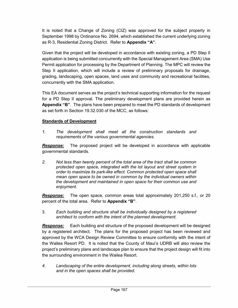
Page 167
It is noted that a Change of Zoning (CIZ) was approved for the subject property in September 1998 by Ordinance No. 2694, which established the current underlying zoning as R-3, Residential Zoning District. Refer to Appendix “A”.
Given that the project will be developed in accordance with existing zoning, a PD Step II application is being submitted concurrently with the Special Management Area (SMA) Use Permit application for processing by the Department of Planning. The MPC will review the Step II application, which will include a review of preliminary proposals for drainage, grading, landscaping, open spaces, land uses and community and recreational facilities, concurrently with the SMA application.
This EA document serves as the project’s technical supporting information for the request for a PD Step II approval. The preliminary development plans are provided herein as Appendix “B”. The plans have been prepared to meet the PD standards of development as set forth in Section 19.32.030 of the MCC, as follows:
Standards of Development
1. The development shall meet all the construction standards and requirements of the various governmental agencies.
Response: The proposed project will be developed in accordance with applicable governmental standards.
2. Not less than twenty percent of the total area of the tract shall be common protected open space, integrated with the lot layout and street system in order to maximize its park-like effect. Common protected open space shall mean open space to be owned in common by the individual owners within the development and maintained in open space for their common use and enjoyment.
Response: The open space, common areas total approximately 201,250 s.f., or 20 percent of the total area. Refer to Appendix “B”.
3. Each building and structure shall be individually designed by a registered architect to conform with the intent of the planned development.
Response: Each building and structure of the proposed development will be designed by a registered architect. The plans for the proposed project has been reviewed and approved by the WCA Design Review Committee to ensure conformity with the intent of the Wailea Resort PD. It is noted that the County of Maui’s UDRB will also review the project’s preliminary plans and landscape plan to ensure that the project design will fit into the surrounding environment in the Wailea Resort.
4. Landscaping of the entire development, including along streets, within lots and in the open spaces shall be provided.

Page 168
Response: The landscape plan for the proposed development provides additional landscaping enhancements. The landscape plans have been prepared by a licensed landscape architect and will be reviewed by the Department of Planning, MPC, and the County of Maui’s UDRB. Refer to Exhibit “B”.
5. Adequate recreational and community facilities shall be provided.
Response: An amenity center, which includes a mail room, barbecue facility, pool and/or hot tub, and other community gathering places for the residents within the community, will be developed as part of the proposed project. As well, there will be multi-modal paths on main roads within the project area which will connect to Wailea Alanui Drive and Kapili Street.
6. Provision shall be made for adequate and continuing management of all open spaces and community facilities to insure proper maintenance and policing. Documents to said effect shall be required.
Response: The owners’ association fees and management personnel will ensure adequate and continuing management of all open spaces and community facilities.
H. HAWAI‘I COASTAL ZONE MANAGEMENT PROGRAM
The Hawai‘i Coastal Zone Management Program (HCZMP), as formalized in Chapter 205A, HRS, establishes objectives and policies for the preservation, protection, and restoration of natural resources of Hawai‘i’s coastal zone. The subject property is within the County of Maui’s SMA. See Figure 14. As such, the applicability of coastal zone management considerations has been reviewed and assessed.
1. Recreational Resources
Objective:
Provide coastal recreational opportunities accessible to the public.
Policies:
a. Improve coordination and funding of coastal recreational planning and management; and
b. Provide adequate, accessible, and diverse recreational opportunities in the coastal zone management area by:
Protecting coastal resources uniquely suited for recreational activities that cannot be provided in other areas;
Page 169
Figure 14. Special Management Area Boundary Map

Page 170
Requiring replacement of coastal resources having significant recreational value including, but not limited to surfing sites, fishponds, and sand beaches, when such resources will be unavoidably damaged by development; or requiring reasonable monetary compensation to the State for recreation when replacement is not feasible or desirable;
Providing and managing adequate public access, consistent with conservation of natural resources, to and along shorelines with recreational value;
Providing an adequate supply of shoreline parks and other recreational facilities suitable for public recreation;
Ensuring public recreational uses of county, state, and federally owned or controlled shoreline lands and waters having recreational value consistent with public safety standards and conservation of natural resources;
Adopting water quality standards and regulating point and nonpoint sources of pollution to protect, and where feasible, restore the recreational value of coastal waters;
Developing new shoreline recreational opportunities, where appropriate, such as artificial lagoons, artificial beaches, and artificial reefs for surfing and fishing; and
Encouraging reasonable dedication of shoreline areas with recreational value for public use as part of discretionary approvals or permits by the land use commission, board of land and natural resources, and county authorities; and crediting such dedication against the requirements of section 46-6.
Response: The project site is located inland approximately 0.4 mile from the nearest coastline. As such, the proposed action is not expected to impact coastal recreational opportunities or affect existing public access to the shoreline.
2. Historic/Cultural Resources
Objective:
Protect, preserve, and, where desirable, restore those natural and manmade historic and prehistoric resources in the coastal zone management area that are significant in Hawaiian and American history and culture.
Policies:
a. Identify and analyze significant archaeological resources;
Page 171
b. Maximize information retention through preservation of remains and artifacts or salvage operations; and
c. Support state goals for protection, restoration, interpretation, and display of historic resources.
Response: The proposed project is not anticipated to have an adverse effect on historical or cultural resources. An AIS and a CIA have been conducted to assess the presence and/or absence of any historical, archaeological, and cultural resources on the proposed project site. The AIS concluded that no further archaeological work is recommended for the seven (7) temporary sites identified within the project site. The CIA indicated there were no currently active traditional and customary practices identified in association with cultural resources in the project site. Refer to Appendix “E” and Appendix “F”.
3. Scenic and Open Space Resources
Objective:
Protect, preserve, and, where desirable, restore or improve the quality of coastal scenic and open space resources.
Policies:
a. Identify valued scenic resources in the coastal zone management area;
b. Ensure that new developments are compatible with their visual environment by designing and locating such developments to minimize the alteration of natural landforms and existing public views to and along the shoreline;
c. Preserve, maintain, and, where desirable, improve and restore shoreline open space and scenic resources; and
d. Encourage those developments that are not coastal dependent to locate in inland areas.
Response: As indicated previously, the project is not located on or near the shoreline. A View Analysis has been conducted to ensure that the proposed project will not adversely impact coastal scenic and open space resources. Refer to Appendix “B”. The proposed project will also maintain approximately 20 percent of the project area in open space.
Page 172
4. Coastal Ecosystem
Objective:
Protect valuable coastal ecosystems, including reefs, from disruption and minimize adverse impacts on all coastal ecosystems.
Policies:
a. Exercise an overall conservation ethic, and practice stewardship in the protection, use, and development of marine and coastal resources;
b. Improve the technical basis for natural resource management;
c. Preserve valuable coastal ecosystems, including reefs, of significant biological or economic importance;
d. Minimize disruption or degradation of coastal water ecosystems by effective regulation of stream diversions, channelization, and similar land and water uses, recognizing competing water needs; and
e. Promote water quantity and quality planning and management practices that reflect the tolerance of fresh water and marine ecosystems and maintain and enhance water quality through the development and implementation of point and nonpoint source water pollution control measures.
Response: The proposed project is located inland, away from the coastal ecosystems and is, therefore, not anticipated to have adverse impacts on coastal/shoreline resources, including reefs and marine resources. A comprehensive drainage system, including LID measures, such as bioretention strips, will be implemented as part of the project to ensure that pre- and post-construction runoff is appropriately captured, minimizing any impact on coastal waters.
5. Economic Use
Objective:
Provide public or private facilities and improvements important to the State’s economy in suitable locations.
Policies:
a. Concentrate coastal dependent development in appropriate areas;
Page 173
b. Ensure that coastal dependent development such as harbors and ports, and coastal related development such as visitor industry facilities and energy generating facilities, are located, designed, and constructed to minimize adverse social, visual, and environmental impacts in the coastal zone management area; and
c. Direct the location and expansion of coastal dependent developments to areas presently designated and used for such developments and permit reasonable long-term growth at such areas, and permit coastal dependent development outside of presently designated areas when:
Use of presently designated locations is not feasible;
Adverse environmental effects are minimized; and
The development is important to the State’s economy.
Response: The proposed project is not a coastal dependent development. The project site is located inland from the shoreline. The proposed project will stimulate the economy through the generation of short-term and long-term employment opportunities and new spending in the local economy. The proposed project does not contravene the objective and policies for economic use of Maui’s coastal zones.
6. Coastal Hazards
Objective:
Reduce hazard to life and property from tsunami, storm waves, stream flooding, erosion, subsidence, and pollution.
Policies:
a. Develop and communicate adequate information about storm wave, tsunami, flood, erosion, subsidence, and point and nonpoint source pollution hazards;
b. Control development in areas subject to storm wave, tsunami, flood, erosion, hurricane, wind, subsidence, and point and nonpoint source pollution hazards;
c. Ensure that developments comply with requirements of the Federal Flood Insurance Program; and
d. Prevent coastal flooding from inland projects.
Response: The project site currently falls within Zone X (unshaded), an area of minimal flooding. Drainage improvements will be designed in accordance with the

Page 174
Drainage Standards of the County of Maui to ensure that the project will not adversely affect downstream properties.
Adverse impacts to hazard-sensitive areas are not anticipated as the project site is not located within a flood hazard district and is not located near the shoreline. In addition, tsunami inundation parameters do not apply to the subject project.
7. Managing Development
Objective:
Improve the development review process, communication, and public participation in the management of coastal resources and hazards.
Policies:
a. Use, implement, and enforce existing law effectively to the maximum extent possible in managing present and future coastal zone development;
b. Facilitate timely processing of applications for development permits and resolve overlapping or conflicting permit requirements; and
c. Communicate the potential short and long-term impacts of proposed significant coastal developments early in their life cycle and in terms understandable to the public to facilitate public participation in the planning and review process.
Response: Opportunities for agency and public review of the proposed action are provided through the notification, review and public hearing processes pursuant to the SMA Use Permit and PD requirements, as well as Chapter 343, HRS. It is noted that the Applicant presented the project to the KCA on October 1, 2019 and to the SMAC on October 24, 2019. In addition, the WCA Design Committee approved the project plans at its September 26, 2019 meeting. Refer to Appendix “I”.
8. Public Participation
Objective:
Stimulate public awareness, education, and participation in coastal management.
Policies:
a. Promote public involvement in coastal zone management processes;
Page 175
b. Disseminate information on coastal management issues by means of educational materials, published reports, staff contact, and public workshops for persons and organizations concerned with coastal issues, developments, and government activities; and
c. Organize workshops, policy dialogues, and site-specific mediations to respond to coastal issues and conflicts.
Response: The project has, and will continue to address public awareness, education, and participation objectives. As noted previously, the Applicant had presented the project to the KCA on October 1, 2019 and to the SMAC on October 24, 2019. In addition, the WCA Design Committee approved the project plans at its September 26, 2019 meeting. Refer to Appendix “I”. Further opportunities for agency and public review of the proposed action are provided through the notification review and public hearing processes pursuant to the SMA Use Permit and Chapter 343, HRS.
9. Beach Protection
Objective:
Protect beaches for public use and recreation.
Policies:
a. Locate new structures inland from the shoreline setback to conserve open space, minimize interference with natural shoreline processes, and minimize loss of improvements due to erosion;
b. Prohibit construction of private erosion-protection structures seaward of the shoreline, except when they result in improved aesthetic and engineering solutions to erosion at the sites and do not interfere with existing recreational and waterline activities;
c. Minimize the construction of public erosion-protection structures seaward of the shoreline;
d. Prohibit private property owners from creating a public nuisance by inducing or cultivating the private property owner’s vegetation in a beach transit corridor; and
e. Prohibit private property owners from creating a public nuisance by allowing the private property owner’s unmaintained vegetation to interfere or encroach upon a beach transit corridor.
Response: The project site is located inland, approximately 0.4 mile from the nearest shoreline and is not anticipated to impact the public use of shoreline resources.
Page 176
10. Marine Resources
Objective:
Promote the protection, use, and development of marine and coastal resources to assure their sustainability.
Policies:
a. Ensure that the use and development of marine and coastal resources are ecologically and environmentally sound and economically beneficial;
b. Coordinate the management of marine and coastal resources and activities to improve effectiveness and efficiency;
c. Assert and articulate the interests of the State as a partner with federal agencies in the sound management of ocean resources within the United States exclusive economic zone;
d. Promote research, study, and understanding of ocean processes, marine life, and other ocean resources to acquire and inventory information necessary to understand how ocean development activities relate to and impact upon ocean and coastal resources; and
e. Encourage research and development of new, innovative technologies for exploring, using, or protecting marine and coastal resources.
Response: As previously stated, the project is located inland, away from the ocean and is, therefore, not anticipated to have an impact on marine or coastal resources.
In addition to the foregoing objectives and policies, SMA permit review criteria pursuant to §205A.30.5(1) Prohibitions provides that:
No special management area use permit or special management area minor permit shall be granted for structures that allow artificial light from floodlights, uplights, or spotlights used for decorative or aesthetic purposes when the light:
(1) Directly illuminates the shoreline and ocean waters; or
(2) Is directed to travel across property boundaries toward the shoreline and ocean waters.
Further, artificial lighting provided by a government agency or its authorized users for government operations, security, public safety, or navigational
Page 177
needs shall make reasonable efforts to properly position or shield lights to minimize adverse impacts.
Response: All construction operations will be carried out during daylight hours. Upon completion, outdoor lights will be shielded and will not directly illuminate any shoreline or ocean waters. All outdoor lighting will comply with the County’s Outdoor Lighting ordinance.
I. HRS 205A-26 SPECIAL MANAGEMENT AREA GUIDELINES
The proposed project is consistent with the State’s guidelines for issuance of a SMA Use Permit by the MPC, as set forth in HRS, Chapter 205A-26:
(1) All development in the special management area shall be subject to reasonable terms and conditions set by the authority in order to ensure:
(A) Adequate access, by dedication or other means, to publicly owned
or used beaches, recreation areas, and natural reserves is provided to the extent consistent with sound conservation principles;
(B) Adequate and properly located public recreation areas and wildlife preserves are reserved;
(C) Provisions are made for solid and liquid waste treatment, disposition, and management which will minimize adverse effects upon special management area resources; and
(D) Alterations to existing land forms and vegetation, except crops, and construction of structures shall cause minimum adverse effect to water resources and scenic and recreational amenities and minimum danger of floods, wind damage, storm surge, landslides, erosion, siltation, or failure in the event of earthquake.
(2) No development shall be approved unless the authority has first found:
(A) That the development will not have any substantial adverse environmental or ecological effect, except as such adverse effect is minimized to the extent practicable and clearly outweighed by public health, safety, or compelling public interests. Such adverse effects shall include, but not be limited to, the potential cumulative impact of individual developments, each one of which taken in itself might not have a substantial adverse effect, and the elimination of planning options;
(B) That the development is consistent with the objectives, policies, and special management area guidelines of this chapter and any guidelines enacted by the legislature; and
(C) That the development is consistent with the county general plan and zoning. Such a finding of consistency does not preclude concurrent processing where a general plan or zoning amendment may also be required.
(3) The authority shall seek to minimize, where reasonable:

Page 178
(A) Dredging, filling or otherwise altering any bay, estuary, salt marsh,
river mouth, slough or lagoon; (B) Any development which would reduce the size of any beach or
other area usable for public recreation; (C) Any development which would reduce or impose restrictions upon
public access to tidal and submerged lands, beaches, portions of rivers and streams within the special management areas and the mean high tide line where there is no beach;
(D) Any development which would substantially interfere with or detract from the line of sight toward the sea from the state highway nearest the coast; and
(E) Any development which would adversely affect water quality, existing areas of open water free of visible structures, existing and potential fisheries and fishing grounds, wildlife habitats, or potential or existing agricultural uses of land.
J. MAUI PLANNING COMMISSION SPECIAL MANAGEMENT AREA RULES AND REGULATIONS
As noted above, the project site is located within the County of Maui’s SMA. Refer to Figure 14. The Rules and Regulations of the Maui Planning Commission, Chapter 202 were established in order to implement HRS, Chapter 205A-26 relating to Coastal Zone Management and Special Management Areas. In addition to establishing procedures for processing of SMA applications and procurement of related permits, the rules assist the Commission in giving consideration to State policy regarding coastal zones.
This section addresses the project’s relationship to applicable coastal zone management considerations as set forth in the Maui Planning Commission Rules and Regulations, Chapter 202, “Special Management Area Permit Procedures,” which are provided for considering the significance of potential environmental and ecological effects of a proposed action. The criteria have been reviewed and analyzed with respect to the proposed project.
1. Involves an irrevocable commitment to loss or destruction of any natural or cultural resources.
As noted previously, an AIS and a CIA have been carried out on the project site. The AIS concluded that no further archaeological work is recommended for seven (7) temporary sites identified within the project site. The CIA indicated there were no currently active traditional and customary practices identified in association with cultural resources in the project site. Refer to Appendix “E” and Appendix “F”. In addition, a Biological Resources Survey has been conducted for the project site. Appropriate mitigation measures will be implemented, as recommended by the Biological Resources Survey, to ensure that no rare, threatened, or endangered species or their habitats will be adversely affected by the proposed project.

Page 179
2. Significantly curtails the range of beneficial uses of the environment.
The proposed project involves development of 57 single-family condominium residences, an amenity center, and related infrastructure improvements and will not curtail the range of beneficial uses of the environment.
Applicable dust control, noise control, and drainage control measures will be implemented during construction activities to minimize impacts to the surrounding environment.
3. Conflicts with the County’s or the State’s long-term environmental policies or goals.
As noted within this Chapter, the proposed project does not conflict with the Hawai‘i State Plan, General Plan of the County of Maui, MIP, Kihei-Makena Community Plan, and Maui County Zoning. The proposed project is consistent with the property’s underlying land use designations, which were established to guide development patterns, limiting the land uses considered to be compatible with the regional context and suitable for the regional environment.
4. Substantially affects the economic or social welfare and activities of the community, County, or State.
On a short-term basis, the project will support construction and construction-related industries, thereby increasing employment opportunities to result in a beneficial impact on the local economy during the period of construction. In the long term, there will be increased expenditures from continuous operation and maintenance of the project, as well as new spending by the residents of the proposed residential community. The project will also generate substantial revenue for both the State and County from General Excise Tax (GET), income tax, and real property tax. The proposed development is located within the Kihei-Makena Community Plan region, which offers a dry, mild climate and access to ocean based recreational resources. The proposed project is considered compatible with surrounding resort-related land uses; thus, the Wailea and Mākena areas will be complemented by the proposed action.
5. Involves substantial secondary impacts, such as population changes and increased effects on public facilities, streets, drainage, sewage, and water systems, and pedestrian walkways.
The proposed project is not anticipated to result in adverse, secondary impacts to population or public facilities or services. Proposed drainage improvements will accommodate the increase in runoff resulting from the proposed project. Water and wastewater infrastructure services will be provided by the County. The project
Page 180
site is located within the UGB, as defined by the MIP, and, as such, increased effects on population changes and public facilities have been planned in the context of future land uses. As such, no substantial secondary impacts are anticipated on public facilities or services.
6. In itself has no significant adverse effects but cumulatively has considerable effect upon the environment or involves a commitment for larger actions.
Although it is also located within the Wailea Resort, the proposed project is limited to the development of the 57 single-family residential condominium units and related improvements. The project is not a phase or increment of a larger total undertaking; a necessary precedent for a larger project; a commitment to some larger project; or one (1) of a series of individual actions planned by the Applicant within Wailea Resort in the reasonably foreseeable future. The proposed project will stand on its own and is not reliant upon or a trigger for any other development within Wailea Resort or elsewhere. The cumulative impacts of the proposed project, together with other reasonably foreseeable actions, will include slightly increased population, but not a significant change, and minimal infrastructural demands. However, the Applicant will provide the necessary infrastructure to serve the proposed project. Drainage, wastewater, water, and roadway improvements will be designed to meet applicable local, State, and Federal regulations. The engineering and traffic studies prepared for the proposed project have assessed potential impacts and designed infrastructure systems in the context of future planned regional growth. Given the foregoing, the proposed project is not anticipated to cumulatively have a considerable effect upon the environment, nor does it involve a commitment for larger actions.
7. Substantially affects a rare, threatened, or endangered species of animal or plant, or its habitat.
A Biological Resources Survey report was prepared to ensure that any sensitive flora/fauna resources within the project site would be identified and provided adequate protection. Refer to Appendix “D”. The survey concluded that with implementation of appropriate mitigation measures recommended by the survey, the proposed project will not have a significant impact on rare, threatened, or endangered species of animal or plant, or its habitat.
8. Is contrary to the State plan, County’s general plan, appropriate community plans, zoning and subdivision ordinances.
Lands underlying the project site were previously committed for development with the establishment of the State Land Use Commission “Urban” District designation, inclusion in the UGB of the MIP, adoption of the “Single-Family” community plan

Page 181
designation in the Kihei-Makena Community Plan, and “R-3, Residential” County zoning designation.
As discussed herein, the proposed project is in compliance with underlying land use designations and is not considered to be contrary to the State Plan, the County’s General Plan, appropriate community plans, County zoning, or subdivision ordinances.
9. Detrimentally affects air or water quality or ambient noise levels.
Construction activities will result in short-term air quality and noise impacts. Dust control measures, such as regular watering and sprinkling and installation of dust screens and timely revegetation of graded areas, will be implemented to minimize wind-blown emissions. In the short term, noise impacts will occur primarily from construction equipment. Equipment mufflers or other noise attenuating equipment, as well as proper vehicle maintenance and limiting construction hours to daylight hours will be used during construction activities. Construction noise impacts will be mitigated through compliance with the provisions of the State of Hawai‘i, Department of Health Administrative Rules Title 11, Chapter 46, “Community Noise Control.” These rules require a noise permit if the noise levels from construction activities are expected to exceed the allowable levels set forth in Chapter 46. In the long term, the proposed new community is not anticipated to detrimentally affect ambient noise levels and air quality.
A comprehensive drainage system, including LID measures, such as bioretention strips, will be implemented to capture the increase of runoff and minimize potential drainage impacts on downstream properties. Based on the foregoing, long-term impacts to air, ambient noise level, and water are not anticipated as a result of the proposed project.
10. Affects an environmentally sensitive area, such as flood plains, shoreline, tsunami zone, erosion-prone area, geologically hazardous land, estuary, fresh waters, or coastal waters.
The project site is located within Flood Zone X (unshaded). Zone X designation denotes an area of low flood risk and minimal flooding with no development restrictions. The subject property is located inland, outside of the Tsunami Evacuation and Extreme Tsunami Evacuation Zones, erosion prone areas, and geologically hazardous land. Additionally, the proposed project does not directly front the shoreline and is not located within the 3.2-foot sea level rise exposure area. As such, the proposed project is not anticipated to significantly impact any environmentally sensitive areas.

Page 182
11. Substantially alters natural land forms and existing public views to and along the shoreline.
The proposed project has been designed to complement and enhance existing development within Wailea Resort. Careful consideration has been given during the planning process to formulate a site plan that is both sensitive and appropriate to Wailea. A View Analysis has been prepared for the project to ensure that the project will not adversely affect the existing makai/mauka public views from adjacent roadways or public vantage points. Refer to Appendix “B”.
12. Is contrary to the objectives and policies of chapter 205A, HRS.
A review of the objectives and policies of Chapter 205A, HRS, is provided in its entirety in Section H of Chapter III of this EA document, which addresses the project’s relationship to the Coastal Zone Management considerations. Based on the foregoing analysis, the project will appropriately and adequately mitigate impacts to SMA-relevant areas of interest. Accordingly, there are no significant adverse environmental impacts anticipated with the proposed project.
SUMMARY OF
ENVIRONMENTAL EFFECTS
WHICH CANNOT BE
AVOIDED AND
IRREVERSIBLE AND
IRRETRIEVABLE
COMMITMENTS OF
RESOURCES
IV
Page 183
IV. SUMMARY OF ENVIRONMENTAL EFFECTS WHICH CANNOT BE AVOIDED AND IRREVERSIBLE
AND IRRETRIEVABLE COMMITMENTS OF RESOURCES
The proposed project may result in unavoidable short-term construction-related impacts which include noise-generated impacts associated with construction of the proposed improvements. Construction of the proposed project will be carried out in compliance with State Department of Health Community Noise Control standards. Furthermore, Best Management Practices (BMPs), such as equipment mufflers and regular maintenance, will be employed to mitigate noise-related impacts. In addition, there may be temporary air quality impacts associated with dust generated from site work and exhaust emissions discharged by construction equipment. These impacts will be mitigated by BMPs for minimizing dust and providing erosion control.
The cumulative impacts of the proposed project, together with other reasonably foreseeable actions, will include increased population and infrastructural demands. The Applicant will provide necessary infrastructure to serve the project. Drainage, wastewater, water, and roadway improvements will be designed to meet applicable local, State, and Federal regulations. The engineering and traffic studies prepared for the project assessed potential impacts and have designed infrastructure systems in the context of future projected regional growth.
Project implementation will require commitments of land, labor, material, and fuel resources. Lands underlying the project site have been previously committed for development purposes by the establishment of the State Land Use “Urban” District, and the Maui Island Plan’s (MIP) Urban Growth Boundary (UGB), as well as the Kihei-Makena Community Plan and county zoning designations. Labor, material, and fuel resources expended during construction are deemed justified when considered in relation to the existing land use designations for the property and the construction-related and long-term employment that will be generated through operation of the project.
In summary, the proposed action is not anticipated to create any significant, long-term adverse environmental effects which cannot be avoided, or require an irreversible and irretrievable commitment of resources.

ALTERNATIVES ANALYSIS
V
Page 184
V. ALTERNATIVES ANALYSIS
A. NO ACTION ALTERNATIVE
The project site is currently vacant and undeveloped. The no action alternative would involve a continuation of the underutilized nature of the site. The no action alternative is not considered a viable scenario in the context of the property’s location within the Wailea Resort area, as well as its underlying State land use, Maui Island Plan (MIP), Kihei-Makena Community Plan (KMCP), and Maui County zoning land use designations.
B. DEFERRED ACTION ALTERNATIVE
Similar to the no action alternative, the deferred action alternative would involve the continued underutilization of the project site and would not implement the intended land uses and nature of development set forth by the properties’ existing land use designations. As such, the deferred alternative is not considered a viable scenario.
C. PREFERRED ALTERNATIVE
The Applicant has placed a high priority on designing a project that is both sensitive and place-appropriate given the existing topographic conditions and limitations of the property, location of the site within the overall Wailea Resort area, as well as the neighboring community. Several design alternatives were considered by the Applicant and its design team with different site plan configurations. Careful consideration was given to view planes and open space and consistency with the existing architectural fabric of the Wailea Resort. These factors were considered through evaluation of County of Maui zoning regulations, the Urban Design Standards of the KMCP, Planned Development (PD) Development Standards, and the Wailea Community Association (WCA) Design Committee Rules. The preferred alternative represents the culmination of this multi-pronged design review process.

SIGNIFICANCE CRITERIA
ASSESSMENT
VI
Page 185
VI. SIGNIFICANCE CRITERIA ASSESSMENT
The proposed action involves the construction of a residential community, which includes 57 single-family residential condominium units, an amenity center, and related infrastructure improvements.
The proposed project also involves improvements to Wailea Alanui Drive, a County right-of-way. The use of County lands requires compliance with Chapter 343, Hawai‘i Revised Statutes (HRS), and Chapter 200.1 (Title 11), Hawai‘i Administrative Rules (HAR). As defined under Chapter 343, HRS, “significant effect” means the sum of effects on the quality of the environment, including actions that irrevocably commit a natural resource, curtail the range of beneficial uses of the environment, are contrary to the State’s environmental policies or long-term environmental goals as established by law, or adversely affect the economic welfare, social welfare, or cultural practices of the community and State. The analysis required to determine whether a proposed action may have a significant effect requires that every aspect of the proposed action, expected primary and secondary consequences, and the cumulative as well as the short-term and long-term effects are evaluated in accordance with the Significance Criteria of Section 11-200.1-12 of the Administrative Rules. Discussion of the proposed project’s conformance to the Significance Criteria is provided below:
1. Irrevocably commit a natural, cultural, or historic resource.
The project site, located within the Wailea Resort, is currently vacant and undeveloped. The proposed project will complement existing residential and resort-related uses found throughout the Wailea community. As discussed in Chapter II, this project does not involve an irrevocable commitment to loss or destruction of any natural resources. A Biological Resources Survey has been prepared as part of assessing the potential impact of the project and appropriate mitigation measures will be implemented to ensure that no rare, threatened, or endangered species or their habitats will be adversely affected. Refer to Appendix “D”.
As also discussed in Chapter II, appropriate surveys have been conducted to address potential impacts on historic/cultural resources. The Cultural Impact Assessment (CIA) identified no cultural practices occurring within the project site. Refer to Appendix “F”. The Archaeological Inventory Survey (AIS) report for the project site concluded that no further archaeological work is recommended for seven (7) temporary sites identified within the project site. Refer to Appendix “E”.
With implementation of the mitigation measures, the proposed project is not anticipated to involve an irrevocable commitment to loss or destruction of any natural or cultural resources.
Page 186
2. Curtail the range of beneficial uses of the environment.
The proposed project will not curtail the range of beneficial uses of the environment.
“Environment” means humanity’s surroundings, inclusive of all the physical, economic, cultural, and social conditions that exist within the area affected by a proposed action, including land, human, and animal communities, air, water, minerals, flora, fauna, ambient noise, and objects of historic or aesthetic significance.
The subject property is located within the Urban Growth Boundary (UGB) of the Maui Island Plan and has the appropriate land use designations in place (with respect to the State Land Use District, the Kihei-Makena Community Plan (KMCP), and Maui County Zoning) to allow for the proposed development. The proposed project will provide 57 single-family condominium units to offset market demand in an existing resort area in close proximity to previously established communities. It will be a residential community within the existing Wailea Resort area that will create jobs and encourage spending, both in the short term for construction contractors and supplies, and in the long term for employees and new residents of the new residential community. As a resort residential community, the proposed project seeks to support the local housing market population by providing residential accommodations. Through this, the local economy will benefit from job creation and new residents’ spending.
Further, the proposed project has been designed to complement and enhance existing development within the Wailea Resort. Careful consideration has been given to the placement of buildings during the planning process to arrive at a site plan that is both sensitive and place appropriate to the Wailea community. The project’s design employs architectural styles and materials commonly found in Hawai‘i. The intent is to allow the new community to blend into the landscape and to create a design that draws upon the region’s heritage and responds to both climate and setting. The buildings will not exceed maximum height limits as established by the KMCP or underlying zoning designations. The landscaping plan has been crafted to fit within this context and utilize native plants, where available and feasible.
Development of detailed engineering and architectural plans for the project will allow for the identification of a comprehensive program of Best Management Practices (BMPs) to minimize any construction-related impacts.
Page 187
3. Conflict with the State’s environmental policies or long-term environmental goals established by law.
The proposed project does not conflict with the State’s environmental policies or long-term environmental goals established by law. As discussed in Chapter III, the proposed project is consistent with the property’s underlying land use designations, which were established to guide development patterns in the region.
4. Have a substantial adverse effect on the economic welfare, social welfare, or cultural practices of the community and State.
On a short-term basis, the project will have a beneficial impact on the economic welfare of the community. During development, the project will support construction and construction-related industries, thereby increasing employment opportunities to result in a beneficial impact on the local economy during the period of construction. From a long-term perspective, the project will provide long-term job opportunities for operation and maintenance of the residential community.
It is noted that approximately 90 percent of the proposed single-family condominium homes are anticipated to be utilized as part-time residences and, as such, a substantial adverse effect on social welfare is not anticipated. As indicated previously, the CIA identified no cultural practices occurring within the project site. In this regard, cultural practices are not anticipated to be impacted as a result of the project.
5. Have a substantial adverse effect on public health.
During the construction period, appropriate BMPs will be implemented to mitigate potential air quality and noise impacts and to ensure that air quality and noise levels stay within the regulatory limits. Following construction, the proposed project will not have an adverse effect on public health.
6. Involve adverse secondary impacts, such as population changes or effects on public facilities.
The proposed project does not involve adverse secondary impacts. Secondary impacts are effects which are caused by the action and occur later in time or farther removed in distance, but are still reasonably foreseeable. The proposed project will provide 57 single-family condominium residential units for sale. As noted previously, buyer profiles indicate that approximately 90 percent of the units will be utilized as part-time residences. The buyer profiles are not anticipated to significantly change upon re-sale of units and thus it is not foreseeable that there are any substantial secondary impacts as a result of the proposed action.
Page 188
The population in the Kīhei-Mākena region has seen steady growth over the last 20 years and the population is projected to increase through 2030. The proposed development will provide residential product offerings to keep pace with the projected growth in the region. Considering the occupancy characteristics, the proposed project being located in an area designated for development, and in close proximity to existing residential, resort, and commercial facilities, will not cause a significant change in the population. All onsite/offsite infrastructure necessary to support the proposed project will be funded and installed by the Applicant. Based on the anticipated buyer profile, no substantial changes or effects on public facilities are likely.
The proposed Wailea Resort SF-S Residential Project will spur economic development opportunities through the development of residential uses. The proposed project will result in new spending in the region by new residents and income generation for employees of the residential community. As discussed in Chapter II, the Applicant will provide the necessary infrastructure to serve the proposed project. Drainage, wastewater, water, and roadway improvements will be designed to meet applicable local, State, and Federal regulations. The engineering and traffic reports prepared for the proposed project assessed potential impacts and have designed infrastructure systems in the context of future projected regional growth. Refer to Appendix “C” and Appendix “H”.
Based on the foregoing, this project does not involve significant adverse secondary impacts, such as population changes or effects on public facilities.
7. Involve a substantial degradation of environmental quality.
Construction activities will create temporary short-term nuisances related to noise and dust. Appropriate BMPs, including dust control and noise mitigation measures, will be implemented by the contractor to ensure that potential impacts generated in connection with construction are minimized.
As previously discussed, the proposed project does not involve a substantial degradation of environmental quality.
8. Be individually limited but cumulatively have substantial adverse effect upon the environment or involves a commitment for larger actions.
Although it is located within the Wailea Resort, the proposed project is limited to the development of the Wailea Resort SF-S Residential Project site. The project has independent utility and is not a phase or increment of a larger total undertaking by the Applicant; a necessary precedent for a larger project or a commitment to some larger project in the reasonably foreseeable future. The proposed project will stand on its own and is not reliant upon or a trigger for any other development

Page 189
within Wailea Resort or elsewhere. The cumulative impacts of the proposed project, together with other reasonably foreseeable actions, will include increased population and infrastructural demands, but this will not have a considerable effect on the environment. The Applicant will provide the necessary infrastructure to serve the proposed project. Drainage, wastewater, water, and roadway improvements will be designed to meet applicable local, State, and Federal regulations. The engineering and traffic reports prepared for the proposed project have assessed potential impacts and designed infrastructure systems in the context of future projected regional growth. Refer to Appendix “C” and Appendix “H”. Given the foregoing, the proposed project is not anticipated to cumulatively have a substantial adverse effect upon the environment, nor does it involve a commitment for larger actions.
9. Have a substantial adverse effect on rare, threatened, or endangered species, or its habitat.
A Biological Resources Survey was conducted to ensure that any sensitive biological resources within the project site would be identified and provided adequate protection. Refer to Appendix “D”. The survey concluded that the proposed project will not have a significant adverse impact on native botanical resources. While not detected during the survey, the Endangered Hawaiian hoary bat, as well as seabirds such as the endangered dark rumped petrel and the wedge tailed shearwater, could occasionally occur in the vicinity of the project site. As recommended by the U.S. Fish and Wildlife Service (USFWS) and the Biological Resources Survey, the project will incorporate appropriate mitigation measures to avoid and minimize impacts to these species. In addition, based on the recommendations by the USFWS related to Blackburn’s sphinx moth, all tree tobacco plants less than three (3) feet tall will be removed if found and the Applicant and/or its contractor will monitor the site every four (4) to six (6) weeks for new tree tobacco growth before, during, and after the proposed ground-disturbing activity.
In consideration of the foregoing, the proposed project is not anticipated to have a substantial adverse effect on a rare, threatened, or endangered species or its habitat.
10. Have a substantial adverse effect on air or water quality or ambient noise levels.
Construction activities will result in short-term air quality and noise impacts. BMPs, including erosion control and dust control measures (such as regular watering and sprinkling and installation of dust screens and timely revegetation of graded areas), will be implemented to minimize wind-blown emissions. Refer to Appendix “C”.

Page 190
In the short- term, noise impacts will occur primarily from construction equipment. Equipment mufflers or other noise attenuating equipment as well as proper vehicle maintenance and limiting construction to daylight hours will be used during construction activities. Construction noise impacts will be mitigated through compliance with the provisions of the State of Hawai‘i, Department of Health (DOH) Administrative Rules Title 11, Chapter 46, “Community Noise Control.” These rules require a noise permit if the noise levels from construction activities are expected to exceed the allowable levels set forth in Chapter 46. In the long term, the proposed new community is not anticipated to significantly impact ambient noise levels.
In seeking to preserve marine water quality, a number of measures will be implemented during the construction and operational phases of the proposed project. During construction, the project will implement a BMP Plan approved by the DOH under a National Pollutant Discharge Elimination System (NPDES) permit. Further, the increase in stormwater associated with the project will be handled by a comprehensive drainage system that will be installed as part of the project. This drainage system will include Low Impact Design (LID) measures, such as bioretention strips, to increase permeability of surfaces within the new residential community and provide for additional retention and water quality treatment of stormwater runoff. Refer to Appendix “C”.
With implementation of foregoing mitigation measures, the proposed project is not anticipated to have a substantial adverse effect on air or water quality or ambient noise levels.
11. Have a substantial adverse effect on or be likely to suffer damage by being located in an environmentally sensitive area such as a flood plain, tsunami zone, sea level rise exposure area, beach, erosion-prone area, geologically hazardous land, estuary, fresh water, or coastal waters.
The project site is located inland (mauka) of the shoreline and is not considered to be a shoreline-abutting property. The project is located in Flood Zone X (unshaded), an area of minimal flood risk and outside of the tsunami evacuation zone and extreme tsunami evacuation zone.
The proposed project site is located inland of the 3.2-foot sea level rise exposure area and will not be adversely impacted by established sea level rise paramenters. The proposed project is not located within or near any other environmentally sensitive areas. Based on the foregoing, the proposed project is not anticipated to have a substantial adverse effect on or be likely to suffer damage by being located in an environmentally sensitive area, such as a flood plain, tsunami zone, sea level

Page 191
rise exposure area, beach, erosion-prone area, geologically hazardous land, estuary, fresh water, or coastal waters.
12. Have a substantial adverse effect on scenic vistas and viewplanes, during day or night, identified in county or state plans or studies.
The proposed project has been designed to complement and enhance existing development within the Wailea Resort. Careful consideration has been given during the planning process to formulate a site plan that is both sensitive and placed appropriate to Wailea. In particular, the project provides open space relief, landscaping, and building forms to complement existing developed properties and the surrounding environment. It is noted that pursuant to the requirements of the Planned Development Standards as set forth in Section 19.32.030 of Maui County Code (MCC), the proposed project will retain approximately 20 percent of the project area in open space.
The proposed buildings will not exceed the allowable height threshold as set forth by the MCC and as recommended in the KMCP. The site plan has been designed to create a new residential community that integrates with its surrounding environment.
The View Analysis provides 3-dimensional before and after perspectives of the proposed project from public vantage points located along adjacent roadways. As documented by the view studies, the proposed project is not anticipated to substantially affect scenic vistas or makai/mauka public views from adjacent roadways or public vantage points. Refer to Appendix “B”. There are no scenic vistas or viewplanes identified in County or State plans or studies in vicinity of the project site. As such, the proposed project is not anticipated to have a substantial adverse effect on any scenic vistas and viewplanes, during day or night, identified in county or state plans or studies.
13. Require substantial energy consumption or emit substantial greenhouse gases.
While the majority of construction-related activities utilize diesel operated construction equipment, there may be short-term electrical energy needs while the project is under construction. Short-term greenhouse gas emissions associated with construction activities are anticipated during the construction phase of the project. Following construction, energy consumption will be necessary for the operational phase of the project. Guided by the project’s sustainability principles, energy conservation and efficiency measures will be incorporated into the project to reduce overall energy use and greenhouse gas emissions. In addition, homes within the proposed residential community will be rooftop solar photovoltaic (PV) and Electric Vehicle (EV) charger-ready and buyers of the homes will determine if

Page 192
they would like to implement these measures. Coordination will be undertaken with Maui Electric Company to ensure that electrical service requirements are addressed and are available prior to project implementation. As such, this project will not require substantial energy consumption or emit substantial greenhouse gases.
Given the preceding analysis, it is anticipated that the proposed action will result in a Finding of No Significant Impact (FONSI).
LIST OF PERMITS AND
APPROVALS
VII
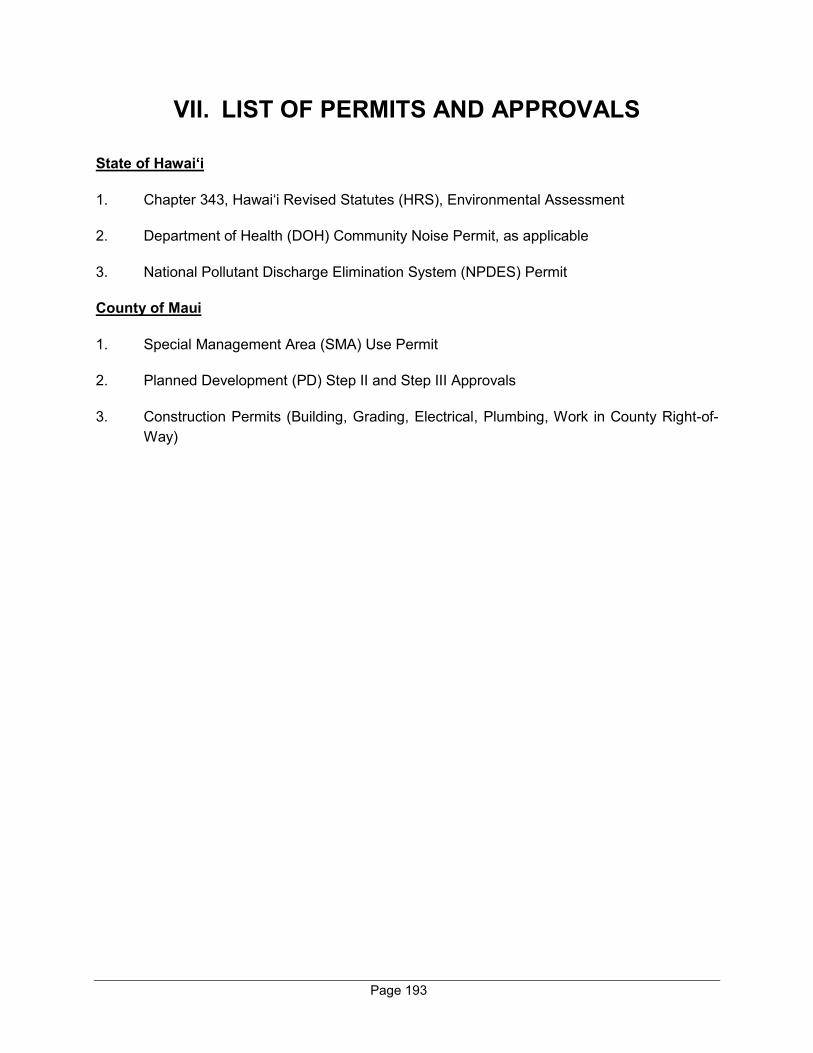
Page 193
VII. LIST OF PERMITS AND APPROVALS
State of Hawai‘i
1. Chapter 343, Hawai‘i Revised Statutes (HRS), Environmental Assessment
2. Department of Health (DOH) Community Noise Permit, as applicable
3. National Pollutant Discharge Elimination System (NPDES) Permit
County of Maui
1. Special Management Area (SMA) Use Permit
2. Planned Development (PD) Step II and Step III Approvals
3. Construction Permits (Building, Grading, Electrical, Plumbing, Work in County Right-of-Way)
PARTIES CONSULTED
DURING THE
PREPARATION OF THE
DRAFT ENVIRONMENTAL
ASSESSMENT; LETTERS
RECEIVED AND
RESPONSES TO
SUBSTANTIVE
COMMENTS
VIII

Page 194
VIII. PARTIES CONSULTED DURING THE PREPARATION OF THE DRAFT ENVIRONMENTAL
ASSESSMENT; LETTERS RECEIVED AND RESPONSES TO SUBSTANTIVE COMMENTS
The following agencies were consulted during preparation of the Draft Environmental Assessment (EA). Agency comments and responses to substantive comments are included herein. FEDERAL AGENCIES 1. Mr. Kahana Stone, Soil
Conservationist Natural Resources Conservation Service U.S. Department of Agriculture 77 Hookele Street, Suite 202 Kahului, HI 96732
2. Mr. Tunis McElwain, Acting Chief
U.S. Department of the Army, Regulatory Branch U.S. Army Engineer District, Honolulu Regulatory Branch, Building 230 Fort Shafter, HI 96858-5440
3. Ms. Alexis Strauss, Acting Regional
Administrator U.S. Environmental Protection Agency Region 9 75 Hawthorne Street San Francisco, CA 94105
4. Ms. Michelle Bogardus, Island Team
Leader U. S. Fish and Wildlife Service 300 Ala Moana Blvd., Rm. 3-122 Honolulu, HI 96850
STATE AGENCIES 5. Major General Arthur "Joe" Logan,
Adjutant General Hawai‘i State Civil Defense 3949 Diamond Head Road Honolulu, HI 96816
6. Mr. Curt Otaguro, Comptroller State of Hawai‘i Department of Accounting and General Services 1151 Punchbowl Street, #426 Honolulu, HI 96813
7. Ms. Zenaida Fisher
State of Hawai‘i Department of Business, Economic Development & Tourism, Director's Office 250 S. Hotel Street, 5th Floor Honolulu, HI 96813
8. Ms. Christine Kishimoto,
Superintendent State of Hawai‘i Department of Education P.O. Box 2360 Honolulu, HI 96804
9. State of Hawai'i
Department of Education Office of Planning 3633 Waialae Avenue, Room C-209 Honolulu, HI 96816
10. Mr. William Aila, Jr., Interim Chair
State of Hawai‘i Department of Hawaiian Home Lands P.O. Box 1879 Honolulu, HI 96805
11. Mr. Bruce Anderson, PhD, Director
State of Hawai‘i Department of Health 1250 Punchbowl St., Room 325 Honolulu, HI 96813
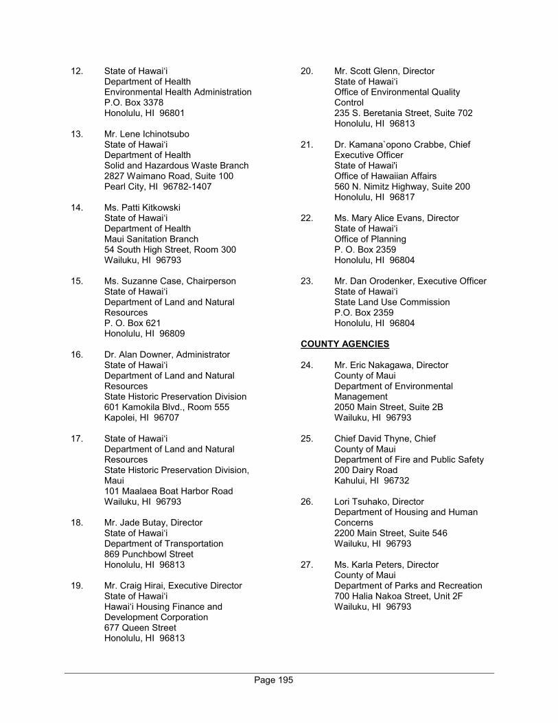
Page 195
12. State of Hawai‘i Department of Health Environmental Health Administration P.O. Box 3378 Honolulu, HI 96801
13. Mr. Lene Ichinotsubo
State of Hawai‘i Department of Health Solid and Hazardous Waste Branch 2827 Waimano Road, Suite 100 Pearl City, HI 96782-1407
14. Ms. Patti Kitkowski
State of Hawai‘i Department of Health Maui Sanitation Branch 54 South High Street, Room 300 Wailuku, HI 96793
15. Ms. Suzanne Case, Chairperson
State of Hawai‘i Department of Land and Natural Resources P. O. Box 621 Honolulu, HI 96809
16. Dr. Alan Downer, Administrator
State of Hawai‘i Department of Land and Natural Resources State Historic Preservation Division 601 Kamokila Blvd., Room 555 Kapolei, HI 96707
17. State of Hawai‘i
Department of Land and Natural Resources State Historic Preservation Division, Maui 101 Maalaea Boat Harbor Road Wailuku, HI 96793
18. Mr. Jade Butay, Director
State of Hawai‘i Department of Transportation 869 Punchbowl Street Honolulu, HI 96813
19. Mr. Craig Hirai, Executive Director
State of Hawai‘i Hawai‘i Housing Finance and Development Corporation 677 Queen Street Honolulu, HI 96813
20. Mr. Scott Glenn, Director State of Hawai‘i Office of Environmental Quality Control 235 S. Beretania Street, Suite 702 Honolulu, HI 96813
21. Dr. Kamana`opono Crabbe, Chief
Executive Officer State of Hawai'i Office of Hawaiian Affairs 560 N. Nimitz Highway, Suite 200 Honolulu, HI 96817
22. Ms. Mary Alice Evans, Director
State of Hawai‘i Office of Planning P. O. Box 2359 Honolulu, HI 96804
23. Mr. Dan Orodenker, Executive Officer
State of Hawai‘i State Land Use Commission P.O. Box 2359 Honolulu, HI 96804
COUNTY AGENCIES 24. Mr. Eric Nakagawa, Director
County of Maui Department of Environmental Management 2050 Main Street, Suite 2B Wailuku, HI 96793
25. Chief David Thyne, Chief
County of Maui Department of Fire and Public Safety 200 Dairy Road Kahului, HI 96732
26. Lori Tsuhako, Director
Department of Housing and Human Concerns 2200 Main Street, Suite 546 Wailuku, HI 96793
27. Ms. Karla Peters, Director
County of Maui Department of Parks and Recreation 700 Halia Nakoa Street, Unit 2F Wailuku, HI 96793

Page 196
28. Ms. Michele Chouteau McLean, Director County of Maui Department of Planning 2200 Main Street, Suite 315 Wailuku, HI 96793
29. Ms. Rowena Dagdag-Andaya,
Director County of Maui Department of Public Works 200 South High Street Wailuku, HI 96793
30. Mr. Marc Takamori, Director
County of Maui Department of Transportation David Trask Building, Suite 102 2145 Kaohu Street Wailuku, HI 96793
31. Mr. Jeffrey Pearson, Director
County of Maui Department of Water Supply 200 South High Street, 5th Floor Wailuku, HI 96793
32. Mr. Herman Andaya, Emergency
Management Officer County of Maui Emergency Management Agency 200 South High Street Wailuku, HI 96793
33. Ms. Kay Fukumoto, Coordinator
County of Maui Office of Economic Development 2200 Main Street, Suite 305 Wailuku, HI 96793
34. Mayor Michael Victorino
County of Maui Office of the Mayor 200 South High Street Wailuku, HI 96793
35. Chief Tivoli Faaumu, Chief
County of Maui Police Department 55 Mahalani Street Wailuku, HI 96793
MAUI COMMUNITY ORGANIZATIONS 36. Hawaiian Telcom
60 South Church Street Wailuku, HI 96793
37. Kīhei Community Association
P. O. Box 662 Kihei, HI 96753
38. Ms. Pamela Tumpap, Executive
Director Maui Chamber of Commerce 95 Mahalani Street, Suite 22A Wailuku, HI 96793
39. Ms. Debbie Cabebe, Chief Executive
Officer Maui Economic Opportunity 99 Mahalani Street Wailuku, HI 96793
40. Mr. Michael Grider, Manager,
Engineering Maui Electric Company, Ltd. P.O. Box 398 Kahului, HI 96733
41. Mr. Bud Pikrone
Wailea Community Association 555 Kaukahi Street, Suite 214 Kihei, HI 96753
42. Spectrum
158 Ma‘a Street Kahului, HI 96732
REFERENCES
IX

Page i
IX. REFERENCES
County of Maui, Department of Planning, Maui Island Plan, December 2012.
County of Maui, Department of Planning, 2030 General Plan - Countywide Policy Plan, March 2010.
County of Maui, Department of Planning, Special Management Area Map, 2007.
County of Maui, Department of Planning, Kihei-Makena Community Plan, March 6, 1998.
County of Maui, Department of Planning, Socio-Economical Forecast, The Economic Projections for the Maui County General Plan 2030, 2006.
County of Maui, Online Resources, accessed July 2019.
County of Maui, Office of Economic Development; Maui County Data Book 2018, https://hisbdc.org/BusinessResearchLibrary/MauiCountyDataBook2018.aspx, accessed November 2019.
County of Maui; Emergency Management Agency; Tsunami Evacuation Maps; https://tsunami.coast.noaa.gov/#/, accessed November 2019.
Federal Emergency Management Agency, Flood Map Service; https://msc.fema.gov/portal/search?AddressQuery=Wailea%20Maui#searchresultsanchor, accessed November 2019.
Federal Environmental Protection Agency; Heat Island Effects; https://www.epa.gov/heat-islands, accessed November 2019.
Gale Cengage Learning, Complete Demographic Comparison Report, Accessed March 2020.
Gershman, Brickner & Bratton, Inc., Integrated Solid Waste Management Overview, 2009.
Hawaii Department of Health, Clean Air Branch, Hawaii Greenhouse Gas Emissions Report for 2015, Final Report, January 2019.
Hawaii Energy, “Average Energy Use Per Household by County”, https://dashboard.hawaii.gov/stat/goals/5xhf-begg/fgyu-2f7k/ydqr-r2fu, 2017, Accessed August 21, 2019Hawaii Public Utilities Commission, Report to the 2019 Legislature on Hawaii’s Renewable Portfolio Standards, December 2018.
Honolulu Star Advertiser, 37% of Hawaii’s labor force files unemployment claims, https://www.staradvertiser.com/2020/04/17/breaking-news/37-of-hawaiis-labor-force-filesunemployment-claims/, Accessed April 19, 2020.
IPCC (2007). Summary for Policymakers. In: Climate Change 2007: The Physical Science Basis. EXIT Contribution of Working Group I to the Fourth Assessment Report of the Intergovernmental Panel on Climate Change [Solomon, S., D. Qin, M. Manning, Z. Chen, M. Marquis, K.B. Averyt,
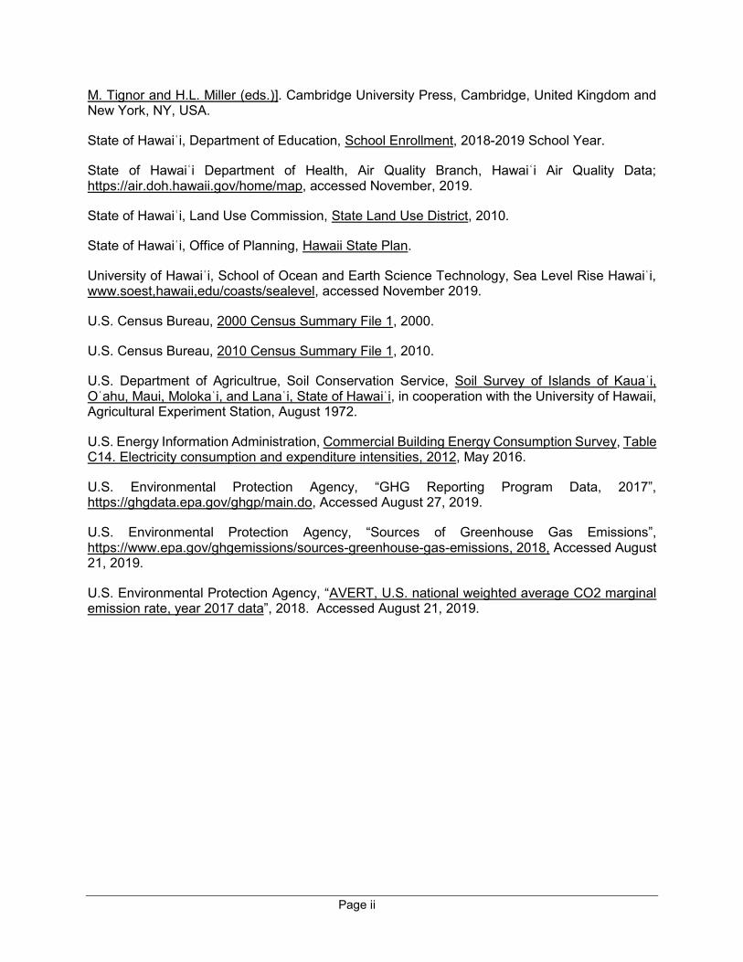
Page ii
M. Tignor and H.L. Miller (eds.)]. Cambridge University Press, Cambridge, United Kingdom and New York, NY, USA.
State of Hawaiʿi, Department of Education, School Enrollment, 2018-2019 School Year.
State of Hawaiʿi Department of Health, Air Quality Branch, Hawaiʿi Air Quality Data; https://air.doh.hawaii.gov/home/map, accessed November, 2019.
State of Hawaiʿi, Land Use Commission, State Land Use District, 2010.
State of Hawaiʿi, Office of Planning, Hawaii State Plan.
University of Hawaiʿi, School of Ocean and Earth Science Technology, Sea Level Rise Hawaiʿi, www.soest,hawaii,edu/coasts/sealevel, accessed November 2019.
U.S. Census Bureau, 2000 Census Summary File 1, 2000.
U.S. Census Bureau, 2010 Census Summary File 1, 2010.
U.S. Department of Agricultrue, Soil Conservation Service, Soil Survey of Islands of Kauaʿi, Oʿahu, Maui, Molokaʿi, and Lanaʿi, State of Hawaiʿi, in cooperation with the University of Hawaii, Agricultural Experiment Station, August 1972.
U.S. Energy Information Administration, Commercial Building Energy Consumption Survey, Table C14. Electricity consumption and expenditure intensities, 2012, May 2016.
U.S. Environmental Protection Agency, “GHG Reporting Program Data, 2017”, https://ghgdata.epa.gov/ghgp/main.do, Accessed August 27, 2019.
U.S. Environmental Protection Agency, “Sources of Greenhouse Gas Emissions”, https://www.epa.gov/ghgemissions/sources-greenhouse-gas-emissions, 2018, Accessed August 21, 2019.
U.S. Environmental Protection Agency, “AVERT, U.S. national weighted average CO2 marginal emission rate, year 2017 data”, 2018. Accessed August 21, 2019.

ORDINANCE NO. 2694
APPENDIX
A
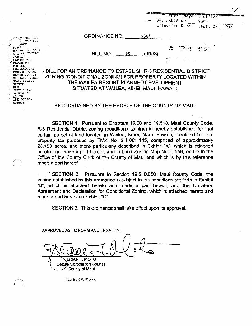
// .. Allllll llllilllllllllillllllillll"""!J{lllllllo111111r111111: 1111111111111filllla•y•o rl s u tt ' ce
ORD ... ANCE NO. 2694 E f feet i ve Da t-e-: -=s:--e-<-p~t -. --,,2-3-, -19_9_8
J./' ·~~ L ~~F!:'.'.:'S~ I .. -~ull~E~
ORDINANCE NO_ 2691*
....j' ,<}ICE I E'IRE J HUMAN CCNCS?.~15 1 :.raucR C:JN:-?c:. I ;;>ARKS
BILL NO. __ 6_9 __ (1998) I PERSONNEL
...('pL.ANNU/G I ?OLICE I ?ROSECUT:'.:RS I i>UBLIC lo/CR!<S I :..rATER .SUPl?LY I RICHARD ?ii\.\KE J OAVE DELC:CN
'..BILL FOR AN ORDINANCE TO ESTABLISH R-3 RESIDENTIAL DISTRICT ZONING (CONDITIONAL ZONING) FOR PROPERTY LOCATED WITHIN
THE WAILEA RESORT PLANNED DEVELOPMENT l ::JEORGE I PAM I .;C:FF CHA.NG I GEORGINA I LLOYD I LEE OOCSON I ROBBIE
SITUATED AT WAILEA, KIHEI, MAUI, HAWAl'I
BE IT ORDAINED BY THE PEOPLE OF THE COUNTY OF MAUI:
SECTION 1. Pursuant to Chapters 19.08 and 19.510, Maui County Code, R-3 Residential District zoning (conditional zoning) is hereby established for that certain parcel of land located in Wailea, Kihei, Maui, Hawai'i, identified for real property tax purposes by TMK No. 2-1-08: 115, comprised of approximately 23.193 acres, and more particularly described in Exhibit "A", which is attached hereto and made a part hereof, and in Land Zoning Map No. L-559, on file in the Office of the County Clerk of the County of Maui and which is by this reference made a part hereof.
· SECTION 2. Pursuant to Section 19.510.050, Maui County Code, the zoning established by this ordinance is subject to the conditions set forth in Exhibit "B", which is attached hereto and made a part hereof, and the Unilateral Agreement and Declaration for Conditional Zoning, which is attached hereto and made a part hereof as Exhibit "C".
SECTION 3. This ordinance shall take effect upon its approval.
APPROVED AS TO FORM AND LEGALITY:
lu:misc:07bill1 :mnc
1111
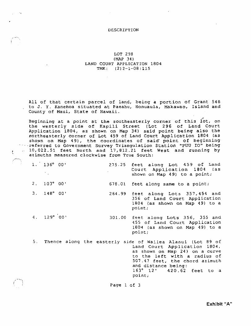
/ i
.,
DESCRIPTION
LOT 298 (MAP 34)
LAND COURT APPLICATION 1804 TMK: (2)2-1-08:115
All of that certain parcel of la~d, being a portion of Grant 548 to J. Y. Kanehoa situated at Paeahu, Honuaula, Makawao, Island and County of Maui, State of Hawaii.
Beginning at a point at the southeasterly corner of this lot, on the westerly side of Kapili Street (Lot 296 of Land Court Application 1804, as shown on Map 34) said point being also the northeasterly corner of Lot 459 of Land Court Application 1804 (as sho~n on Map 4 9), the coordinates of said· point of beginning
·referred to Government Survey Triangulation Station "PUU IO" being 10, 022. 51 feet North and 17, 812. 21 feet West and running by azimuths measured clockwise from True South:
1 • 13 6° 00 I
2 • 103° 00 I
3. 148° 00'
4. 129° 00'
275.25 feet along Lot 459 of Land Court Appl_ication 1804 (as shown on Map 49) to a point;
678.01 feet along same to a point;
264.99 feet along Lots 357,454 and 356 of Land Court Application 1804 (as shown on Map 49) to a point;
301.00 feet along Lots 356, 355 and 455 of Land Court Application 1804 (as shown on Map 4 9) to a point;
5. Thence along th1= easterly side of Wai.lea Alanui (Lot 89 of Land Court Application 1804, as shown on Map 24) on a curve to the left with a radius of 507.47 feet, the chord azimuth and distance being: 163° 12' 420.62 feet to a point;
Page l of 3
Exhibit "A"
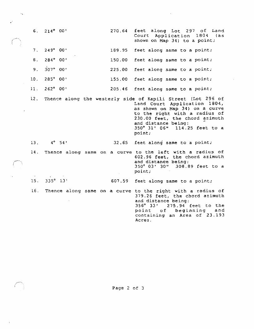
(
6. 214° 00'
7. 24 9° 00'
8. 284° 00'
9. 3'01° 00'
10. 285° 00'
11. 2 62° 00'
270. 64 feet along Lot 297 of Land Court Application 180 4 (as shown on Map 34) to a point;
189.95 feet along same to a point;
150.00 feet along same to a point;
225.00 feet along same to a point;
155.00 feet along same to a point;
205.46 feet along same to a point;
12. Theni:::e along the westerly side of Kapili Street (Lot 296 of Land Court Application 1804, as shown on Map 34) on a curve to the right with a radius of 230.00 feet, the chord ~zimuth
13. 4° 54 J
14. Thence along same on
15. 335° 13'
and distance being: -350° 31' 06" 114. 25 feet to a point;
32.65 feet along same to a point;
a curve to the left 602.96 feet, and distance 350° 03 J 30" point;
with a radius of the chord azimuth being:
308.89 feet to a
607.59 feet along same to a point;
16. Thence along same on a curve to the right with a radius of 379. 26 feet, the chord azimuth and distance being: 356° 33' 275. 94 feet to the point of beginning and containing an Area of 23.193 Acres.
Page 2 of 3
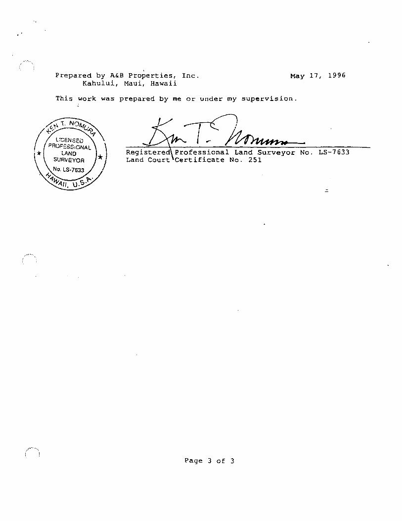
' Prepared by A&B Properties, Inc. May 17, 1996
Kahului, Maui, Hawaii
This work was prepared by me or under my supervision.
Professional Land Surveyor No. LS-7633 Certificate No. 251
::.
Page 3 of 3

.,
1. The density shall be restricted to 2.5 single-family dwelling units per acre.
2. The applicant, its successors and assigns, shall satisfy the parks assessment, pursuant to Section 18.16.320, Maui County Code, for the subject property and the other properties that were granted R-3 Residential District zoning and A-1 Apartment District zoning upon the date of enactment of this ordinance (TMK Nos. 2-1-08: portion of 118, portion of 120 and portion of 128), by donating no less than 3.0 acres of land near the intersection of Piilani Highway and Kilohana Drive in an exact location to be determined by the Maui County Department of Parks and Recreation through discussions with the applicant, its successors and assigns. In addition, the applicant, its successors and assigns shall donate to the County the approximately 2.0-acre site at the northwest comer of Piilani Highway and Kilohana Road, referenced as Matrix 228 (Fire Station} in the Kihei-Makena Community Plan (1998), for use as a fire station and/or fire and public services facility. -
.:
3. As required by the State Historic Preservation Division, the applicant, its successors and assigns, shall conduct an archaeological inventory survey, including any subsurface testing where appropriate, prior to any ground-altering activity, excavation or landscaping. If significant historic sites are located during such survey(s), then a mitigation plan shall be prepared for the review and approval of the State Historic Preservation Division.
4. The applicant, its successors and assigns, shall provide opportunities for pedestriafl and/or bicycle access ways within the roadways fronting the subject property. If the property includes a design focal point, such as a central or main entryway or "pull off', schematic designs for said focal point(s) shall be submitted to the Maui County Department of Planning for consideration by the Maui Planning Commission in conjunction with the Special Management Area application for the subject property.
5. The applicant, its successors and assigns, shall contribute its pro-rata share of regional roadway improvements as determined by the State Department of Transportation and the Maui County Department of Public Works and Waste Management. The applicant, its successors and assigns, shall work with the Wailea Community Association to mitigate traffic problems within the resort resulting from the development of the subject property.
EXHIBIT "B"
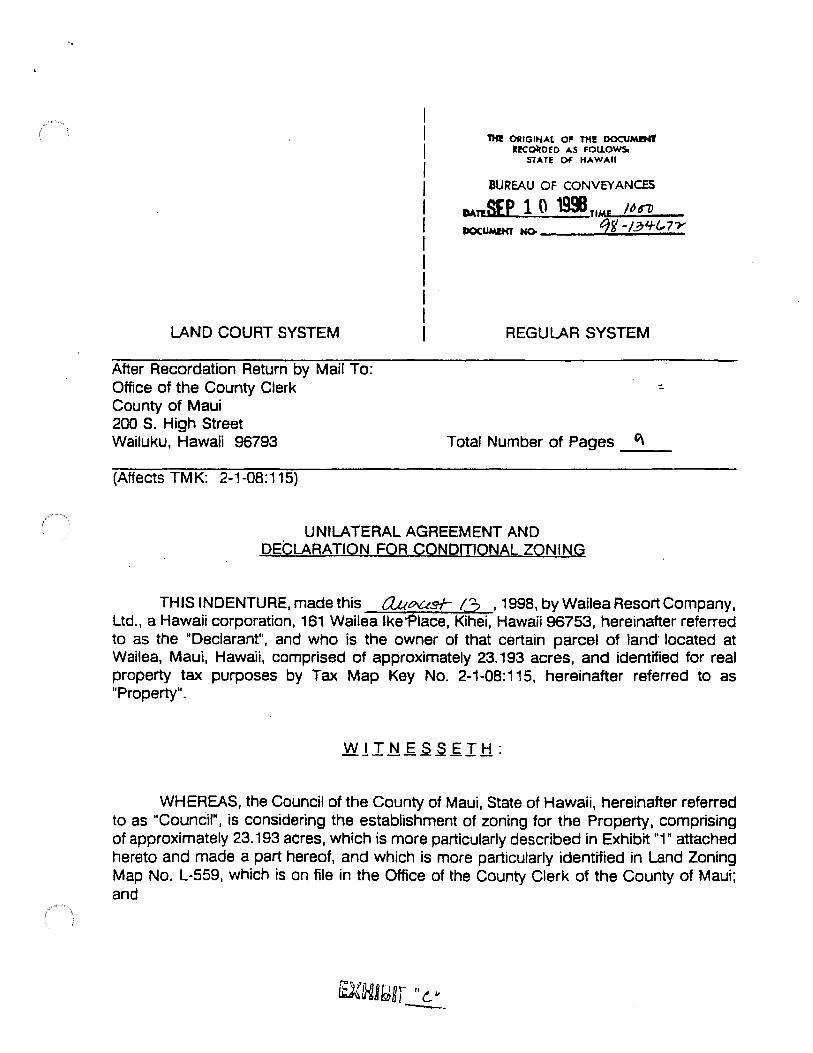
LAND COURT SYSTEM
After Recordation Return by Mail To: Office of the County Clerk County of Maui 200 S. High Street Wailuku, Hawaii 96793
(Affects TMK: 2-1-08:115)
TH! OtllGlliAl 01' TH!! DOCUMDn' a!Col!DED AS FOUOWS.
STATE OF HAWAII
BUREAU OF CONVEYANCES
o.t.TESEP 1 0 1991t,ME Nn DOCUMIHT HO- C)r/ -/~'f(,7-Y
REGULAR SYSTEM
Total Number of Pages -"'--
UNILATERAL AGREEMENT AND DECLARATION FOR CONDITIONAL ZONING
THIS INDENTURE, made this 0..Uoust- 1..3 , 1998, by Wailea Resort Company, Ltd., a Hawaii corporation, 161 Wailea lke:Place, Kihei, Hawaii 96753, hereinafter referred to as the MDeclarant", and who is the owner of that certain parcel of land· located at Wailea, Maui, Hawaii, comprised of approximately 23.193 acres, and identified tor real property tax purposes by Tax Map Key No. 2-1-08:115, hereinafter referred to as "Property".
WHEREAS, the Council of the County of Maui, State of Hawaii, hereinafter referred to as "Council", is considering the establishment of zoning for the Property, comprising of approximately 23.193 acres, which is more particularly described in Exhibit ~," attached hereto and made a part hereof, and which is more particularly identified in Land Zoning Map No. L-559, which is on file in the Office of the County Clerk of the County of Maui; and
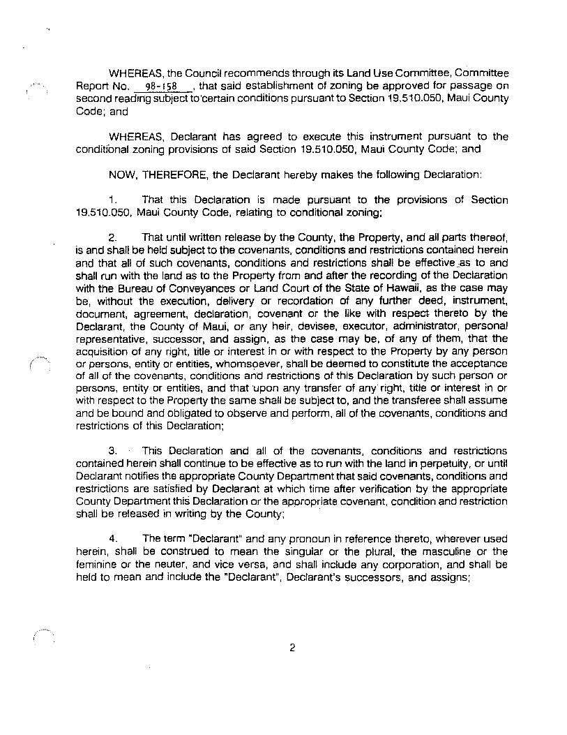
WHEREAS, the Council recommends through its land Use Committee, Committee Report No. 98· 158 , that said establishment of zoning be approved for passage on second reading subject to'certain conditions pursuant to Section 19.510.050, Maui County Code; and
WHEREAS, Declarant has agreed to execute this instrument pursuant to the conditional zoning provisions of said Section 19.510.050, Maui County Code; and
NOW, THEREFORE, the Declarant hereby makes the following Declaration:
1. That this Declaration is made pursuant to the provisions of Section 19.510.050, Maui County Code, relating to conditional zoning;
2. That until written release by the County, the Property, and all parts thereof, is and shall be held subject to the covenants, conditions and restrictions contained herein and that all of such covenants, conditions and restrictions shall be effective.oas to and shall run with the land as to the Property from and after the recording of the Declaration with the Bureau of Conveyances or Land Court of the State of Hawaii, as the case may be, without the execution, delivery or recordation of any further deed, instrument, document, agreement, declaration, covenant or the like with respect thereto by the Declarant, the County of Maui, or any heir, devisee, executor, administrator, personal representative, successor, and assign, as the case may be, of any of them, that the acquisition of any right, title or interest in or with respect to the Property by any person or persons, entity or entities, whorns9ever, shall be deemed to constitute the acceptance of all of the covenants, conditions and restrictions of this Declaration by such person or persoMs, entity or entities, and that ·upon any transfer of any· right, title or interest in or with respect to the Property the same shall be subject to, and the transferee shall assume and be bound and obligated to observe and perform, all of the covenants, conditions and restrictions of this Declaration;
3. This Declaration and all of the covenants, conditions and restrictions contained herein shall continue to be effective as to run with the land in perpetuity, or until Declarant notifies the appropriate County Department that said covenants, conditions and restrictions are satisfied by Declarant at which time after verification by the appropriate County Department this Declaration or the appropriate covenant, condition and restriction shall be released in writing by the County; ·
4. The term "Declarant" and any pronoun in reference thereto, wherever used herein, shall be construed to mean the singular or the plural, the masculine or the feminine or the neuter, and vice versa, and shall include any corporation, and shall be held to mean and include the "Declarant", Declarant's successors, and assigns;
2
·.
5. That the Declaration shall become fully effective on the effective date of the ( zoning ordinance apprqving the establishment of R-3 Residential District zoning for the
Property and this Declaration shall be recorded in the Bureau of Conveyances of the State of Hawaii;
. 6. That the Declarant agrees to develop said Property in conformance with the conditions set forth in Exhibit "2", which is attached hereto and made a part hereof and which shall be made a part of the zoning ordinance; and
7. That the conditions imposed are reasonable and rationally relate to the objective of preserving the public health, safety and general welfare and such conditions fulfill the need for the public service demands created by the proposed use.
AND IT IS EXPRESSLY UNDERSTOOD AND AGREED that until released in writing by the County, the conditions imposed in this Declaration shall run with the land identified hereinabove and shall bind and constitute notice to all subsequent lessees, grantees, assignees, mortgagees, lienors and any other persons who claim an interest in the said land, and the County of Maui shall have the right to enforce this Declaration by appropriate action at law or suit in equity against all such persons, provided that the Declarant or its successor and assigns may at any time file a petition for the removal of the conditions and terminate this Unilateral Agreement, such petition to be processed in the same manner as petitions for change in zoning.
IN WITNESS WHEREOF, the undersigned has executed this Declaration the day and year first above written.
DECLARANT:
WAILEA RESORT COMPANY, LTD., a Hawaii corporation
By~~ HOWARD K. NAKAMURA Its President
Bye'?~~ CL YOE MURASHlGE Its Sr. Vice President
3
·.
.
uv;.s;z~ ANNE M. TAKABUKI Attorney for Declarant
poration Counsel aui
.:
4

STATE OF HAWAII ) ) SS:
COUNTY OF MAUI )
. On this !l!J!i day of ~ ----j"- , 1998 before me appeared HOW ARD K. NAKAMURA AND E MURASIDGE, to me personally known, who, being by me duly sworn. did say that they are the President and Senior Vice President. respectively, ofWAil..EA RESORT COMPANY, LTD., a Hawaii corporation; that the seal affixed to the foregoing instrument is the corporate seal of such corporation and that such instrument was signed and sealed on behalf of such corporation by authority of its Board of Directors, and said HOWARD K. NAKAMURA AND CLYDE MURASIDGE acknowledged such instrument to be the free act and deed of such corporation.
L) My commission expires:/o/A'/61
I I
--
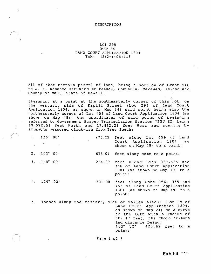
DESCRIPTION
LOT 298 (MAP 34)
LAND COURT APPLICATION 1804 TMK: (2)2-1-08:115
All of that certain parc~l of land, being a portion of Grant 548 to J. Y. Kanehoa situated at Paeahu, Honuaula, Makawao, Island and County of Maui, State of Hawaii.
-aeginning at a point at the southeasterly corner of this lot, on the westerl7 side of Kapili Street (Lot 296 of Land Court Application 1804, as shown on Map 34) said point being also the no~theasterly corner of Lot 459 of Land Court Application 1804 (as shown on Map 4 9), the coordinates of said. point ·of beginning refe~red to Government Survey Triangulation Station "PUU IO" being 10,022.51 feet North and 17,812.21 feet West and running by azimuths measured clockwise from True South:
1. 136" 00 I
2. 103° 00'
3. 148° 00'
4. 129° 00 I
275.25 feet along Lot 459 of Land Court Application 1804 (as shown on Map 49) to a point;
678.01 feet along same to a point;
264.99 feet along Lots 357,454 and 356 of "Land Court Application 1804 (as shown on Map 49) to a point;
301.00 feet along Lots 356, 355 and 455 of Land Court Application 1804 (as shown on Map 49) to a point;
5. Thence along th~ easter-ly side of Wailea Alanui (Lot 89 of Land Court Application 1804, as shown on Map 24) on a curve to the left with a radius of 507. 4 7 feet, the chord az.imut h and distance being: 163° 12' 420.62 feet to a point;
Page 1 of 3
Exhibit "1"

6. 214° 00'
7. 24 9° 00'
8. 284° 00'
9. J07° 00'
10. 285° 00'
11. 2 62° 00'
270.64 feet along Lot 297 of Land Court Application 1804 (a::;
shown on Map 34) to a point;
189.95 feet along same t.o a point;
150.00 feet along same to a point;
225.00 feet along same to a point;
155.00 feet along same to a point;
205.46 feet along same to a point;
12. Thence along the westerly side of Kapili Street (Lot 296 of Land Court Application 1804, as shown on Map 34) on a cu~ve
to the right with a radius of 230.00 feet, the ch~rd_azimu~h
13. 4° 54 I
14. Thence along same on
15. 335° 13'
and distance being: -350° 31' 06" 114. 25 feet to a point;
32.65 feet along same to a point;
a curve to the left 602.96 feet, and distance 350° 03 I 30" point;
with a radius of the chord azimuth being:
308.89 feet to a
607.59 feet along same to a point;
16. Thence along same on a curve to the right with a radius of 379.26 feet, the chord azimuth and distance being: 356° 33' 275. 94 feet to the point of beginning and containing an Area of 23. 19J Acres.
Page 2 of 3
Prepared by A&B Properties, Inc. May 17, 1996 Kahului, Maui, Hawaii
This work was prepared by me or under my supervision.
Professional Land Surveyor No. LS-7633 Certificate No. 251
.:
Page 3 of 3

1. The density shall be restricted to 2.5 single-family dwelling units per acre.
2. The applicant, its successors and assigns, shall satisfy the parks assessment, pursuant to Section 1 B.16.320, Maui County Code, for the subject property and the other properties that were granted R-3 Residential District zoning and A-1 Apartment District zoning upon the date of enactment of this ordinance (TMK Nos. 2-1-08: portion of 118, portion of 120 and portion of 128), by donating no less than 3.0 acres of land near the intersection of Piilani Highway and Kilohana Drive in an exact location to be detennined by the Maui County Department of Parks and Recreation through discussions with the applicant, its successors and assigns. In addition, the applicant, its successors and assigns shall donate to the County the approximately 2.0-acre site at the northwest comer of Piilani Highway and Kilohana Road, referenced as Matrix 228 (Fire Station) in the Kihei-Makena Community Plan (1998), for use as a fire station and/or fire and public services facility.
3. As required by the State Historic Preservation Division, the applicant, its successors and assigns, shall conduct an archaeological inventory survey, including any subsurface testing where appropriate, prior to any ground-altering activity, excavation or landscaping. If significant historic sites are located during such survey(s), then a mitigation plan shall be prepared for the review and approval of the State Historic Preservation Division.
4. The applicant, its successors and assigns, shall provide opportunities for pedestrian ~nd/or bicycle access ways within the roadways fronting the subject property. If the property includes a design focal point, such as a central or main entryway or "pull off', schematic designs for said focal point(s) shall be submitted to the Maui County Department of Planning for consideration by the Maui Planning Commission in conjunction with the Special Management Area application for the subject property.
5. The applicant, its successors and assigns, shall contribute its pro-rata share of regional roadway improvements as determined by the State Department of Transportation and the Maui County Department of Public Works and Waste Management. The applicant, its successors and assigns, shall work with the Wailea Community Association to mitigate traffic problems within the resort resulting from the development of the subject property.
EXHIBIT "2"
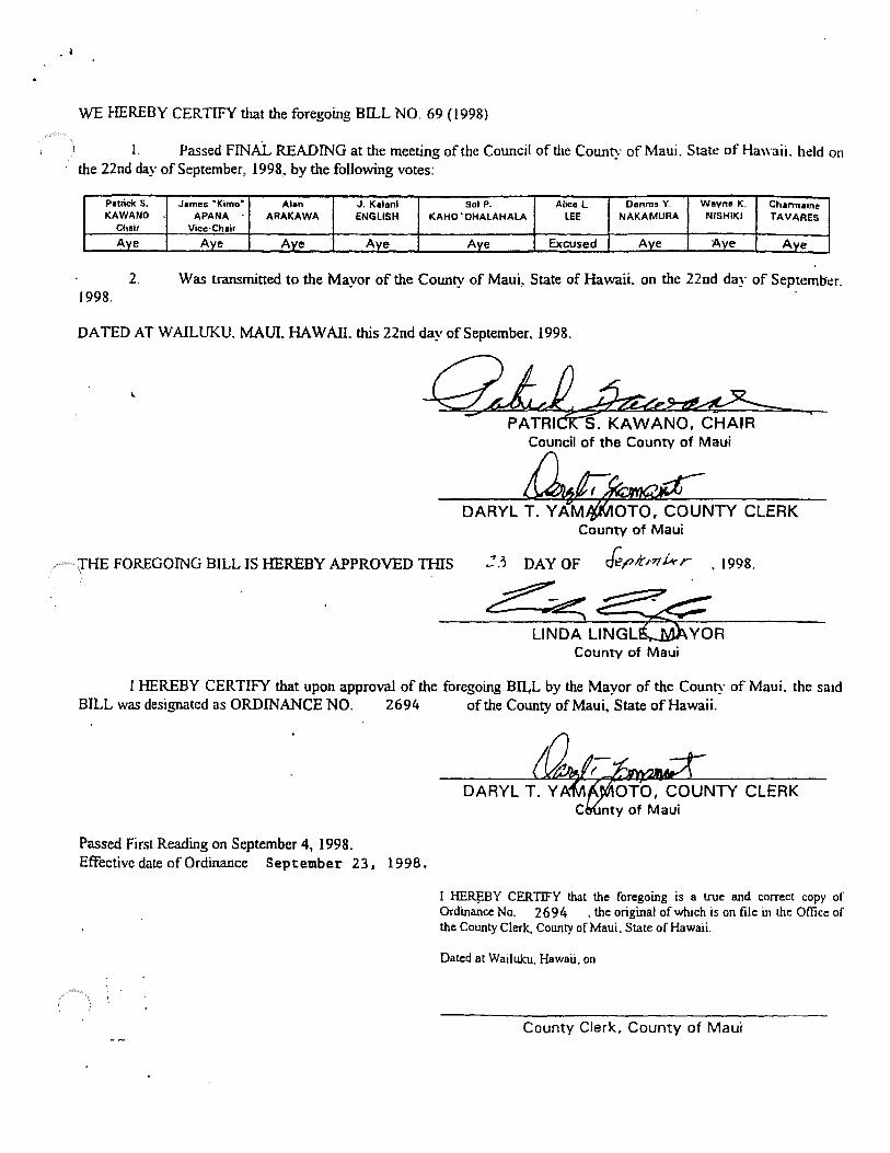
. I
WE HEREBY CERTIFY that the foregoing Bil..L NO. 69 (1998)
L Passed FINAL READING at the meeting of the Council of the County of Maui. State of Hawaii. held on the 22nd day of September, 1998, by the following votes:
Patrick s. James •K1mo• Alan J. Kalani Sol P. Alice L Oonnrs Y. Wayne K. Charmaine KAWANO APANA ARAKAWA ENGLISH KAHO 'OHALAHALA LEE NAKAMURA NISHIKI TAVARES
Chair Vice·Chair
Aye Aye Ave Ave Aye Excused Aye Ave Ave
2. Was transmitted to the Mayor of the County of MauL State of Hawaii. on the 22nd day of Septeml:ic:r. 1998.
DA TED AT W AILUKU. MAUI, HAW AIL this 22nd day of September. 1998.
~ Council of the County of Maui
1HE FOREGOING BILL IS HEREBY APPROVED TIUS
County of Maui
de,o.t m hr
County of Maui
I HEREBY CERTIFY that upon approval of the foregoing BILL by the Mayor of the County of Maui. the said BILL was designated as ORDINANCE NO. 2694 of the County of Maui, State of Hawaii.
Passed First Reading on September 4, 1998. Effective date of Ordinance September 23. 1998.
I ~BY CERTIFY that the foregoing is a true and correct copy or Ordinance No. 2 6 9 4 , the original of which is on file 'm the Office of the County Clerk, County of Maui. State of Hawaii.
Dated at Wailulcu, Hawaii, on
County Clerk, County of Maui

LOT 297
Parcel 115
LOT 298 23.193 Acs.
L.or 4Ss
TMK: 2nd 2-1-08: 115 ( Site No, I) AREA= 23.193 Acs.
APPROVED:
LAND ZONING MAP NO. 559 CHANGE IN ZONING - HONUAULA, MAUI
FROM: PUBLIC/QUASI-PUBLIC TO: R-3 RESIDENTIAL
COUNTY CLERK
PUBLIC HEARING: 11-10-97 ADOPTED-COUNCIL: 9- 22-96 ADOPTED-MAYOR: 9-23-96
1-AP-P-RO-VE-D:-------~-. -.-/;£-.-_-"-e..-----1 ORDINANCE: 2694
pLAfilllNGDiREcroR DATE: SCALE: 1• =200'
OFFICE OF THE COUNlY CLERK 200 SOUTH HIGH STREET, WAILUKU, MAUI, HAWAII L559

PRELIMINARY PROJECT
PLANS AND VIEW ANALYSIS
APPENDIX
B
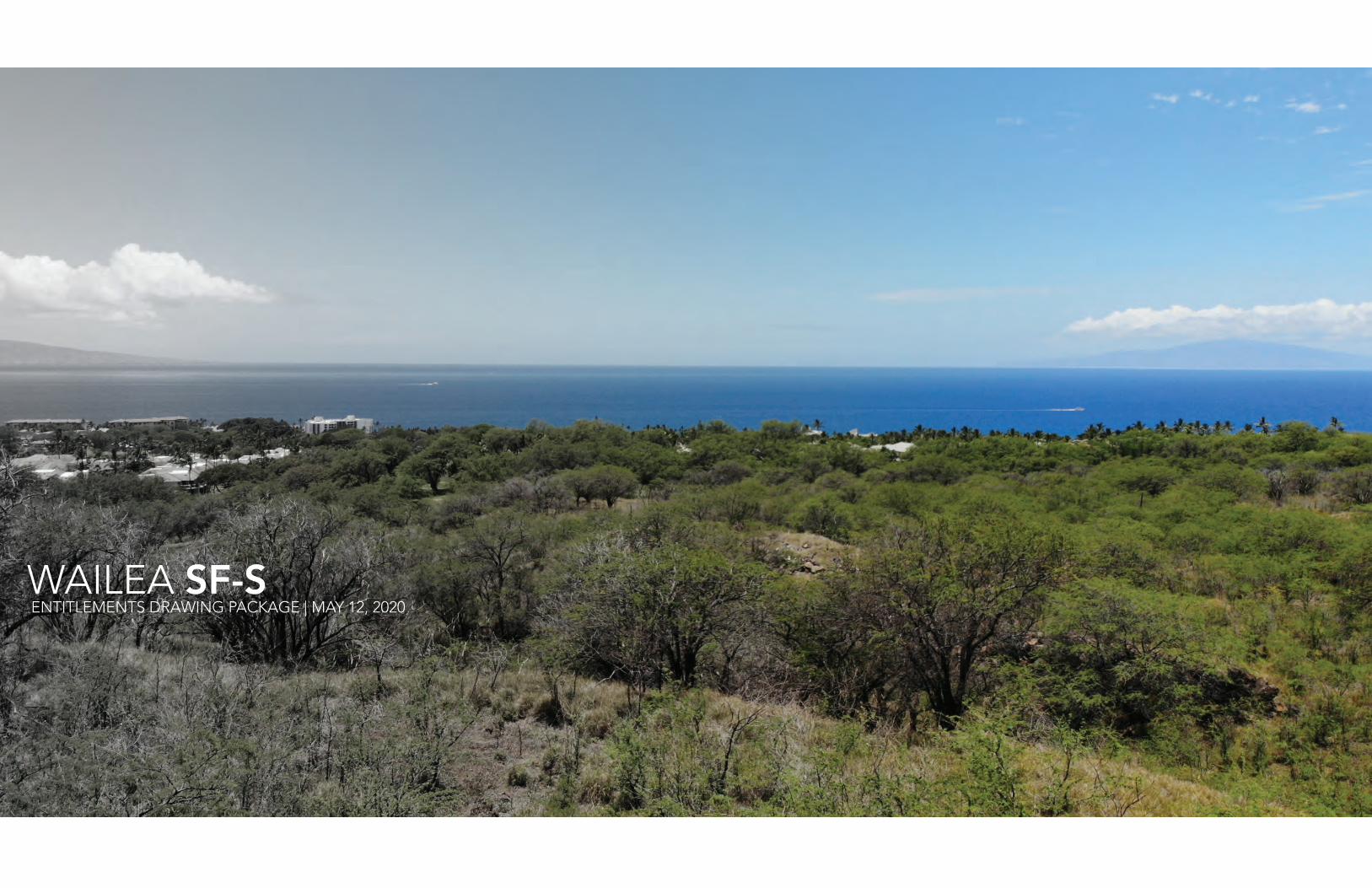
WAILEA SF-S ENTITLEMENTS DRAWING PACKAGE | MAY 12, 2020

01Wailea SF-S05/12/2020
PROJECT DESCRIPTION
The planned development Wailea Resort SF-S is located on a single, undeveloped parcel within Wailea on Maui. Wailea Resort SF-S Partners LP is the developer of the fi fty-seven single-family homes in a condominium property regime.
The lot measures 23.1 acres with +/- 120-ft of grade sloping downward from southeast to north-west corners. The site is boarded on its mauka edge by Kapili Street and on its makai edge by Wailea Alanui Drive. The southern portion of the site is bordered by a drainageway and the de-velopment. On the northern edge, the property is bordered by undeveloped land owned by the County of Maui.
The project is envisioned as a boutique, low density, up-market residential enclave with homes that provide all the desirable qualities of a single-family neighborhood, with the convenient lock-and-leave lifestyle provided through a condominium regime form of ownership.
Home sites will be just over 10,000sf and will be orientated towards either Molokini views or Lanai views. All homes will be single story and with 150 ft deep lots, the consistent grade on thesite will allow the homes to look over top of the home in front, providing for excellent views.
Homes will have a consistent design for building effi ciency and to provide a cohesive design aesthetic. Utilizing a pre-programmed expandable footprint, homes will range in size from ap-proximately 2,600sf to 3,300sf. This allows for a fl exible product size that can be personalized to a customer’s individual needs.
A residential amenity center will be in a prominent location offering panoramic sweeping viewsfrom Molokini to the West Maui Mountains. The amenity center consists of a pool, terraces,covered outdoor lounge, offi ce and spa/changing rooms; and 11 on-grade parking stalls.
A network of landscaped private lanes and pedestrian pathways connecting each structureto the main access points of the Project, allowing residents of the project easy pedestrian and bike access to both Wailea Alanui and Kapili Street.
SF-S PROJECT TEAM
OWNER Wailea Resort SF-S Partners, LP
ARCHITECT G70
CIVIL ENGINEER Warren S. Unemori Engineering, Inc. LANDSCAPE ARCHITECT PBR Hawaii & Associates, Inc.
Summary Sheet
SHEET LIST
01 Summary Sheet
02 Context Plan
03 Existing Topographic Plan
04 Site Grading Plan
05 Site Lot Plan
06 Site Landscape Plan
07 Site Irrigation Plan
08 Protected Open Space Diagram
09 Typical Lot Landscape Plan
10 Typical Residence Floor Plan
11 Typical Residence Roof Plan
12 Typical Residence Exterior Elevations
13 Typical Residence Sections
14 Amenity Center Building and Landscape Plan
15 Amenity Center Floor Plan
16 Amenity Center Roof Plan
17 Amenity Center Exterior Elevations
18 Amenity Center Exterior Elevations
19 Amenity Center Building Section
20 Main Entry Landscape Plan
21 Main Entry Elevations
22 Kapili Street Fencing and Emergency Egress Gates
23 Wailea Ala Nui Fencing and Emergency Access Gates
24 Signage Monument
25 Plant Palette
26 View Study 1
27 View Study 2
28 View Study 3
29 View Study 4
30 View Study 5
31 View Study 6
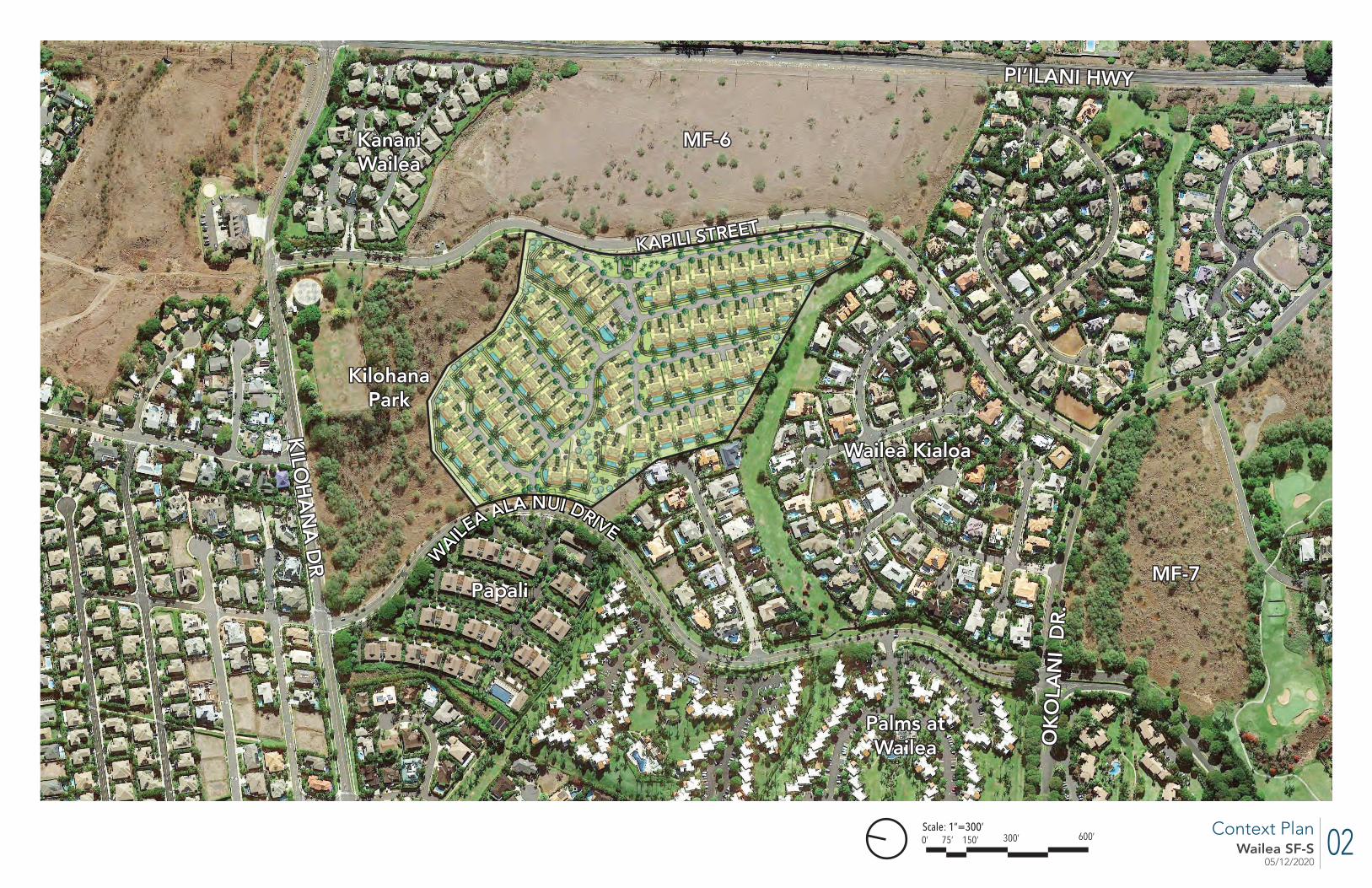
02Wailea SF-S05/12/2020
Context Plan
LANDSCAPE CONCEPTWAILEA PARCEL SF-S 01/28/2020
DATE
N
Site Landscape Plan
SCALE: 1” = 100’
50’ 50’ 100’25’ 0’
L-01
ote: The Biological Resources Survey report epared by Robert W. Hobdy for Wailea Re-
ort SF-S Partners, LP and dated May 2019 oes not identify any signifi cant historical or xceptional trees on the property.
WAILE
A ALA NUI DRIVE
WAILE
A ALA NUI DRIVE
Scale: 1”=300’600’300’150’75’0’
KAPILI STREETKAPILI STREET
KILO
HA
NA
DR
KILO
HA
NA
DR
.
PI’ILANI HWYPI’ILANI HWY
Palms at Palms at WaileaWailea
PapaliPapali
KilohanaKilohanaParkPark
Wailea KialoaWailea Kialoa
Kanani Kanani WaileaWailea
OK
OLA
NI
DR
.O
KO
LAN
I D
R.
MF-6MF-6
MF-7MF-7

03Wailea SF-S05/12/2020
Existing Topographic Plan
LEGEND
EXISTING GROUND ELEVATION CONTOUR

04Wailea SF-S05/12/2020
LEGEND
EXISTING GROUND ELEVATION CONTOUR
FINISH GROUND ELEVATION CONTOUR
RETAINING WALL
Site Grading Plan
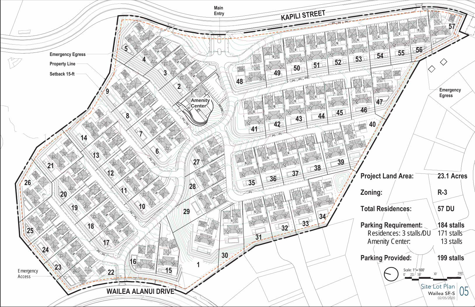
05Wailea SF-S02/05/2020
Scale: 1”=100’200’100’50’25’0’
Site Lot Plan
182
162
164170
168
164
166
168
202
204
206
204
202
204
206
208
208
206
210
210
210
220
220
220
228
230
234
232
230
244
246 250
252
254
252
250
250
252
254
254
252
252
254
252
250
250
252
250
252
252
248
230
230
228
230
232
232
234
234
234
236
236
218
214
216
216
214216
216
218
218
216212
214
194
200
198
198
200
202
202
200
200
202
204
204
202
200
200
198
198
250
234
234
232
232
236
238
240
238
220
210
200
200
190
198
196
196
194
196
194
198
196
180
180
178
178
180
180
178
176
178
176
176
162
160
158
158
160
160
164
170
180
184
182
180
160
150
146
146
144
144
142
140
142
142
140144
142
240
138
206
208
212 214 216 218
218
204
232 23
4
236
236
234
232
242
238
236
198
198
184
186
162
164
162
146
144
148
212
200
200
162
160
162
160
140
164
182
184
200
204
230
234
244
244
246
248
252
254
256
254
200
198
230
240
234
Property Line
Setback 15-ft
KAPILI STREET
WAILEA ALANUI DRIVE
Main Entry
Emergency Egress
EmergencyEgress
Emergency Access
26
25
24
23 2216
15
17
18
19
20
21
10
11
12
13
14
9
8
7
627
28
29
2
3
45
4849 50 51 52 53 54 55 56
57
41 4243 44 45 46
47
40
3938
373635
343332
31
301
Amenity Center
Project Land Area: 23.1 Acres
Zoning: R-3
Total Residences: 57 DU
Parking Requirement: 184 stallsResidences: 3 stalls/DU 171 stallsAmenity Center: 13 stalls
Parking Provided: 199 stalls
pkgpkg
pkg
pkg
pkgpkg
pkgpkg
pkg
pkg pkg
pkg pkg pkg
pkgpkgpkg

06Wailea SF-S05/12/2020
LANDSCAPE CONCEPTWAILEA PARCEL SF-S 01/28/2020
DATE
N
Site Landscape Plan
SCALE: 1” = 100’
50’ 50’ 100’25’ 0’
L-01
Note: The Biological Resources Survey report prepared by Robert W. Hobdy for Wailea Re-sort SF-S Partners, LP and dated May 2019 does not identify any signifi cant historical or exceptional trees on the property.
Site Landscape Plan
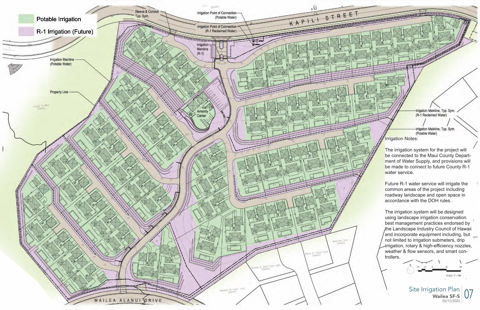
07Wailea SF-S05/12/2020
LANDSCAPE CONCEPTWAILEA PARCEL SF-S 01/28/2020
DATE
N
Site Irrigation Plan
SCALE: 1” = 100’
50’ 50’ 100’25’ 0’
L-02
Irrigation Notes:
The irrigation system for the project will be connected to the Maui County Depart-ment of Water Supply, and provisions will be made to connect to future County R-1 water service.
Future R-1 water service will irrigate the common areas of the project including roadway landscape and open space in accordance with the DOH rules.
The irrigation system will be designed using landscape irrigation conservation best management practices endorsed by the Landscape Industry Council of Hawaii and incorporate equipment including, but not limited to irrigation submeters, drip irrigation, rotary & high-effi ciency nozzles, weather & fl ow sensors, and smart con-trollers.
Site Irrigation Plan

08Wailea SF-S02/05/2020
Scale: 1”=100’200’100’50’25’0’
182
162
164170
168
164
166
168
202
204
206
204
202
204
206
208
208
206
210
210
210
220
220
220
228
230
234
232
230
244
246 250
252
254
252
250
250
252
254
254
252
252
254
252
250
250
252
250
252
252
248
230
230
228
230
232
232
234
234
234
236
236
218
214
216
216
214216
216
218
218
216212
214
194
200
198
198
200
202
202
200
200
202
204
204
202
200
200
198
198
250
234
234
232
232
236
238
240
238
220
210
200
200
190
198
196
196
194
196
194
198
196
180
180
178
178
180
180
178
176
178
176
176
162
160
158
158
160
160
164
170
180
184
182
180
160
150
146
146
144
144
142
140
142
142
140144
142
240
138
206
208
212 214 216 218
218
204
232 23
4
236
236
234
232
242
238
236
198
198
184
186
162
164
162
146
144
148
212
200
200
162
160
162
160
140
164
182
184
200
204
230
234
244
244
246
248
252
254
256
254
200
198
230
240
234
Property Line
Setback 15-ft
KAPILI STREET
WAILEA ALANUI DRIVE
Main Entry
Emergency Egress
EmergencyEgress
Emergency Access
Overall Parcel Area: 23.1 acres 1,106,236 sf
Protected Common Open Space 20% Requirement for PD : 201,250sf
Amenity Center
Protected Open Space Diagram
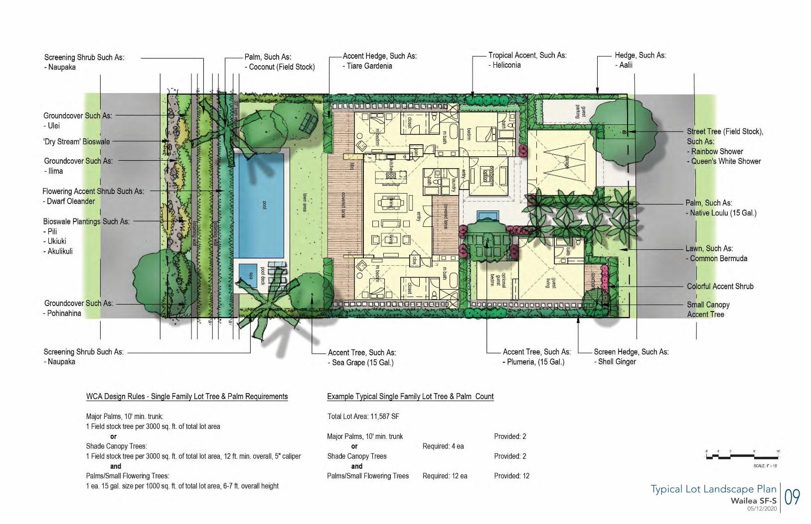
09Wailea SF-S05/12/2020
Typical Lot Landscape Plan
Screening Shrub Such As: - Naupaka
Groundcover Such As: ------+~~~ - Ulei
'Dry Stream' Bioswale ------+~ I
Groundcover Such As: -llima
Flowering Accent Shrub Such As: - Dwarf Oleander
Bioswale Plantings Such As: ------ii:r+-if.;lllt--':i
- Pili - Ukiuki -Akulikuli
Groundcover Such As: --- Pohinahina
Palm, Such As: - Coconut (Field Stock)
Screening Shrub Such As: ------------~ - Naupaka
WCA Design Rules - Single Family Lot Tree & Palm Requirements
Major Palms, 1 O' min. trunk: 1 Field stock tree per 3000 sq. ft. of total lot area
or Shade Canopy Trees: 1 Field stock tree per 3000 sq. ft. of total lot area, 12 ft min. overall , 5" caliper
and Palms/Small Flowering Trees: 1 ea. 15 gal. size per 1000 sq. ft. of total lot area, 6-7 ft. overall height
Accent Hedge, Such As: - Tiare Gardenia
Tropical Accent, Such As: - Heliconia
Hedge, Such As: -Aalii
Street Tree (Field Stock), Such As: - Rainbow Shower - Queen's White Shower
-'--+----- Lawn, Such As:
tQE~~< I - Common Bermuda
Accent Tree, Such As: - Sea Grape (15 Gal.)
Example Typical Single Family Lot Tree & Palm Count
Total Lot Area: 11,587 SF
Major Palms, 10' min. trunk or
Shade Canopy Trees and
Palms/Small Flowering Trees
Required: 4 ea
Required: 12 ea
Accent Tree, Such As: - Plumeria, (15 Gal.)
Provided: 2
Provided: 2
Provided: 12
..,.1--· _I -+------ Colorful Accent Shrub I
----it--T----- Small Canopy Accent Tree - ----..:..=.=
Screen Hedge, Such As: - Shell Ginger
8' 4· o·
~-8' 16'
I
SCALE 1· = 16'
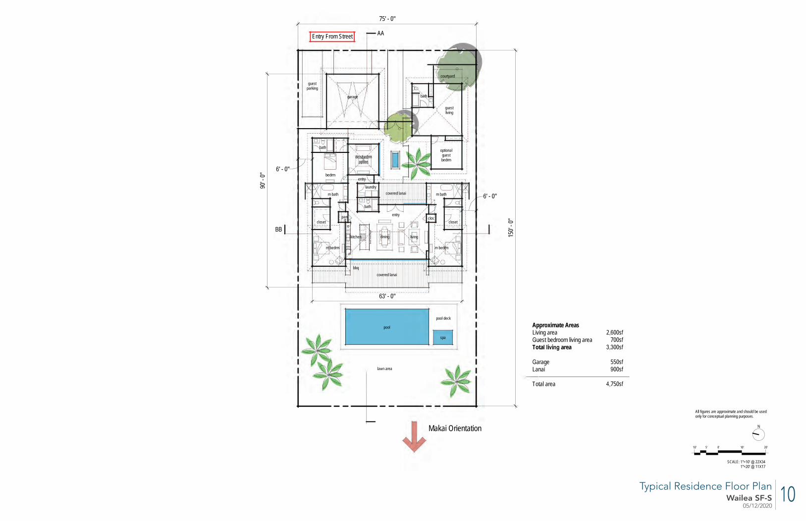
10Wailea SF-S05/12/2020
75' - 0"
150'
- 0"
garage
m bath
m bedrm
kitchen
closeto
r
livingdining
bbqcovered lanai
pan
m bath
m bedrm
clos
guest parking
closet
den/bedrmoption
laundry
bath
bedrm
optional guest bedrm
Entry From Street
Makai Orientation
Approximate AreasLiving area
uest bedroom living areaTota i i area
arageLanai
Total area
bath
guest living
bath
courtyard
covered lanai
entry
entry
pool
spa
pool deck
la n area
AA
' - 0"
' - 0"
0' - 0
"
' - 0"
2 00s700s00s
550s00s
750s
0'10' 5' 10' 20'
SCALE: 1"=10' 221"=20' 11 17
All igures are appro imate and should be usedonly or conceptual planning purposes
Typical Residence Floor Plan
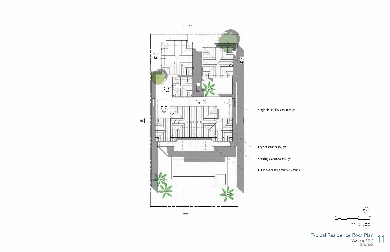
11Wailea SF-S05/12/2020
Future solar array appro 2 panels
Standing seam metal roo typ
Edge o house belo typ
:12 slopetyp
typ2' - 0"
typ2' - 0"
typ2' - "
typ2' - "
25:12 slopetyp
Single ply TPO lo slope roo typ
AA
0'10' 5' 10' 20'
SCALE: 1"=10' 221"=20' 11 17
0'10' 5' 10' 20'
SCALE: 1"=10' 221"=20' 11 17
Typical Residence Roof Plan
12Wailea SF-S05/12/2020
Material Considerations
Stucco or EIFS, light color
Pool and deck
Lanai ceiling
Standing seam metal roof
Sliding doors
Rock walls
Front door
Typical Residence Exterior Elevations
13Wailea SF-S05/12/2020
LEVEL 10"
Clerestory transom
Single ply low slope roof
Standing seam metal roof, typ
Great Room roof plate +2' above standard roof plate height
412
MAIN ROOF PLATE9' - 0" to 10'-0"
LEVEL 10"
412
MAIN ROOF PLATE9' - 0" to 10'-0"
SECTION AA
SECTION BB
0'10' 5' 10' 20'
SCALE: 1"=10' @ 22X341"=20' @ 11X17
Typical Residence Sections
14Wailea SF-S05/12/2020
Amenity Center Building and Landscape Plan
pool
Lawn----+---
~ Aceenf Shrubs, Such As: _ ___.. .... - P~pider Lily - ird of Paradise -1\gave - Philodendron
c=:J c=:J ~.;,~
~i;:~
c=:J c=:J~~~~
[ = J "'9f=l~l=51nlt=' 1--- -.r
c=:J ~rtaz~~~ c=:J
~J c=:J c=:J
pecimen Tree Such As: - Variegated Hala Palms Such As:
- Coconut
234 Flowering Accent Tree
,__ _______ such As:
ADA
- Plumeria
11 parking spaces
AccentT ree Such 1---~---- Sea Grape
- Beac Heliotrope
Street I Parking Lot Tree Such As: - Rainbow Shower
20'
15Wailea SF-S05/12/2020
pool deck
pool
spafire pit
pool equipbldg
11 parking spaces
activity lawn
office
storage
womens
mens
Mailboxes
shallow lounge area
bbq area~+234'
~+234'
~+200'
~+234'
terraced planters
ADA
~+234'
~+222'
entrygate
Trash/recycle areaRock wall
Rock wall
~+214'
~+220'
~+215'
fitness
~+234'
~+220'
~+226'
~+204'
Sidewalk
lockers
lockers
Retaining wall
Loading
Terracing above pool equip building
Trellis above
Driveway entry
WAILEA PARCEL SF-SCONCEPT DESIGN
1/21/2020
SF-S AME IT CE TER PLA A1
0'10' 5' 10' 20'
SCALE: 1"=10' @ 22 341"=20' @ 11 17
Amenity Center Floor Plan
16Wailea SF-S05/12/2020
AA
Single ply TPO low slope roof typ
Standing seam metal roof typ
.25:12 slope typ
4:12 slopetyp
Future solar array approx 22 panels
typ3' - 0"
typ2' - 0"
WAILEA PARCEL SF-SCONCEPT DESIGN
1/8/2020
SF-S AME IT CE TER ROOF PLA A2
0'10' 5' 10' 20'
SCALE: 1"=10' @ 22 341"=20' @ 11 17
Amenity Center Roof Plan
17Wailea SF-S05/12/2020
Amenity Center Exterior Elevations
BBQ pavilion-----------....__
FRONT ELEVATION
Low slope single ply roof with exposed structure----~
LEFT ELEVATION
--------Standing seam metal roof, typ
--------Amenity building
~--------Mailboxes
-----------Synthetic plaster or EIFS wall finish
~------Composite wood shiplap siding between pavilions
igv~ 10' - 0"
~-----Synthetic plaster or EIFS wall finish
1a 5' a I -- N
I
SCALE: 1"=10' @22X34 1"=20'@ 11X17

18Wailea SF-S05/12/2020
Amenity Center Exterior Elevations
Standing seam metal roof, typ-----~ __.----------BBQ pavilion
Amenity building------~ ~-------6' high rock wall
____ L~ o·
Rock retaining walls,---~
Pool equipment building--~
REAR ELEVATION
- --------6' high rock wall
- ---------Synthetic plaster or EIFS wall finish
RIGHT ELEVATION
1a 5' a I -- N
I
SCALE: 1"=10' @22X34 1"=20'@ 11X17
19Wailea SF-S05/12/2020
LE EL 10"
LE EL 210' - 0"
124
Rock retaining walls
Pool equipment building
Standing seam metal roof typ
Low slope single ply roof
0'10' 5' 10' 20'
SCALE: 1"=10' @ 22 341"=20' @ 11 17
SECTIO AA
Amenity Center Building Section
20Wailea SF-S05/12/2020
N
SCALE: 1” = 16’
8’ 8’ 16’4’ 0’
Main Entry Landscape Plan
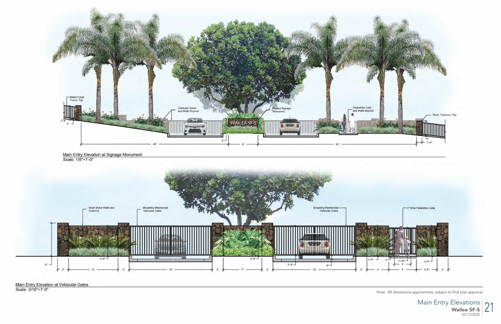
21Wailea SF-S05/12/2020
Main Entry Elevations
Note: All dimensions approximate, subject to fi nal plan approval

22Wailea SF-S05/12/2020
Kapili Street Fencing and Emergency Egress Gates
Note: All dimensions approximate, subject to fi nal plan approval

23Wailea SF-S05/12/2020
Wailea Ala Nui Fencing and Emergency Access Gates
Note: All dimensions approximate, subject to fi nal plan approval
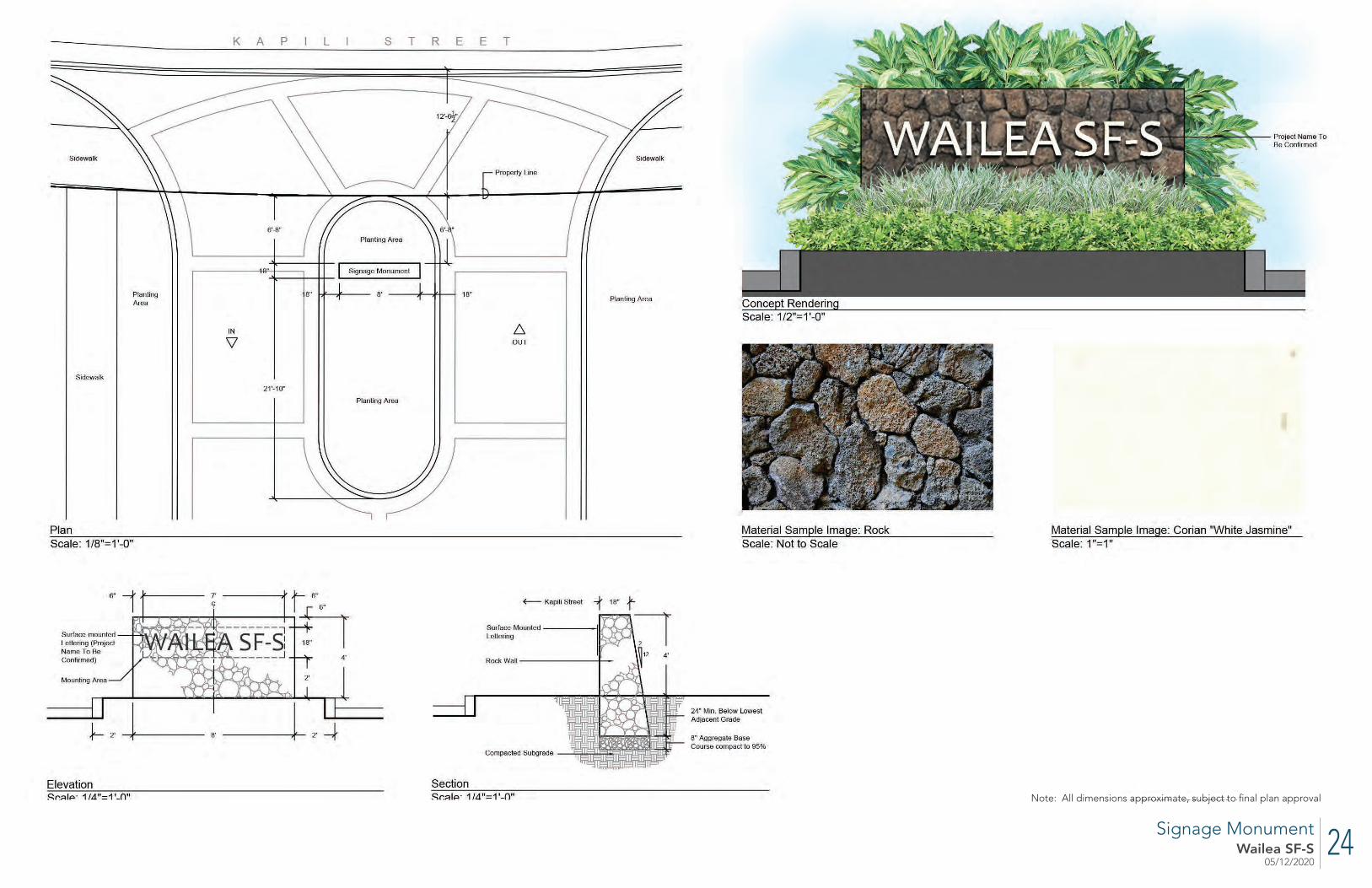
24Wailea SF-S05/12/2020
Signage Monument
Note: All dimensions approximate, subject to fi nal plan approval

25Wailea SF-S05/12/2020
Sea Grape (Coccoloba uvifera)15 Gal, 6’-7’ HeightShade Tree
Queens White Shower (Cassia x nealiae)Field Stock, 12’ Height Street Tree
Rainbow Shower (Cassia x nealiae)Field Stock, 12’ HeightStreet Tree
Fiddle Leaf Fig (Ficus lyrata)Field StockSpecimen Tree
Carex (Carex wahuensis)6” Pot Bioswale
Pili Grass (Heteropogon contortus)6” Pot Bioswale
Ukiuki (Dianella sandwicensis)6” Pot Bioswale
Thornless Kiawe (Prosopis pallida)Field Stock, 12’ HeightShade Tree
Akia (Wikistroemia uva-ursi)6” PotGroundcover
Pohinahina (Vitex rotundifolia)6” PotGroundcover
Ulei (Osteomeles anthyllidifolia)6” PotGroundcover
Monstera (Monstera deliciosa)3 GalTropical Accent
Red Ginger (Alpinia purpurata)3 GalTropical Accent
Lauae Fern (Microsorum grossum)6” PotGroundcover
Xanadu Philodendron6” PotGroundcover
Coconut Palm (Cocos nucifera)Field Stock, 10’ Min Trunk HeightMajor Palm
Loulu (Pritchardia Spp.)15 Gal, 6’-7’ HeightAccent Palm
Lobster Claw Heliconia (Heliconia rostrata)3 GalTropical Accent
Singapore Plumeria (Plumeria obtusa)15 Gal, 6’-7’ HeightFlowering Tree
Yellow Plumeria (Plumeria rubra)15 Gal, 6’-7’ HeightFlowering Tree
Rhapis Palm (Rhapis excelsa)3 GalScreening Shrub
Variegated Shell Ginger (Alpinia zerumbet) 3 GalScreening / Accent Shrub
Aalii (Dodonaea viscosa)3 GalHedge
Tiare Gardenia (Gardenia taitensis)3 GalHedge
STREETSCAPE
COURTYARD LUSH
COASTAL DRYLAND
FIRE BUFFER
Ahuawa (Cyperus javanicus)6” Pot Bioswale
Bird of Paradise (Strelitzia reginae) 3 GalAccent Shrub
Varieagated Dianella (Dianella tasmanica variegata) 6” PotGroundcover
Queen Palm (Syagrus romanzof -ana) Field StockSpecimen Palm
Dwarf Oleander (Nerium oleander)3 Gal Accent Hedge
Akulikuli (Sesuvium portulacastrum)6” Pot Bioswale
Purple Spider Lily (Crinum asiaticum) 3 GalAccent Shrub
Naupaka (Scaevola taccada)3 GalScreening Shrub
Plant Palette
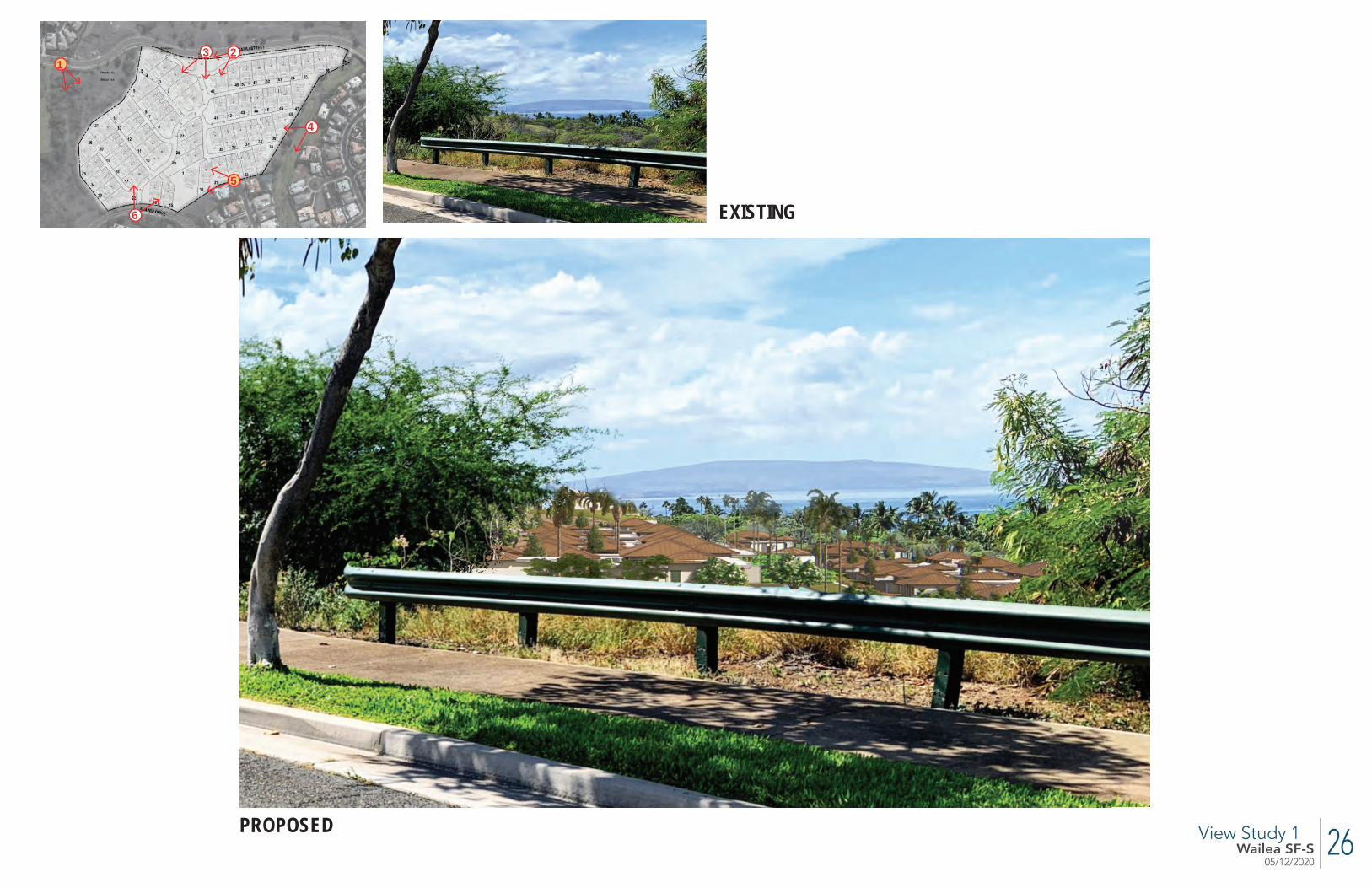
26Wailea SF-S05/12/2020
View Study 1
EXISTING
PROPOSED
2
6
5
4
13

27Wailea SF-S05/12/2020
View Study 2
EXISTING
PROPOSED
2
6
5
4
13
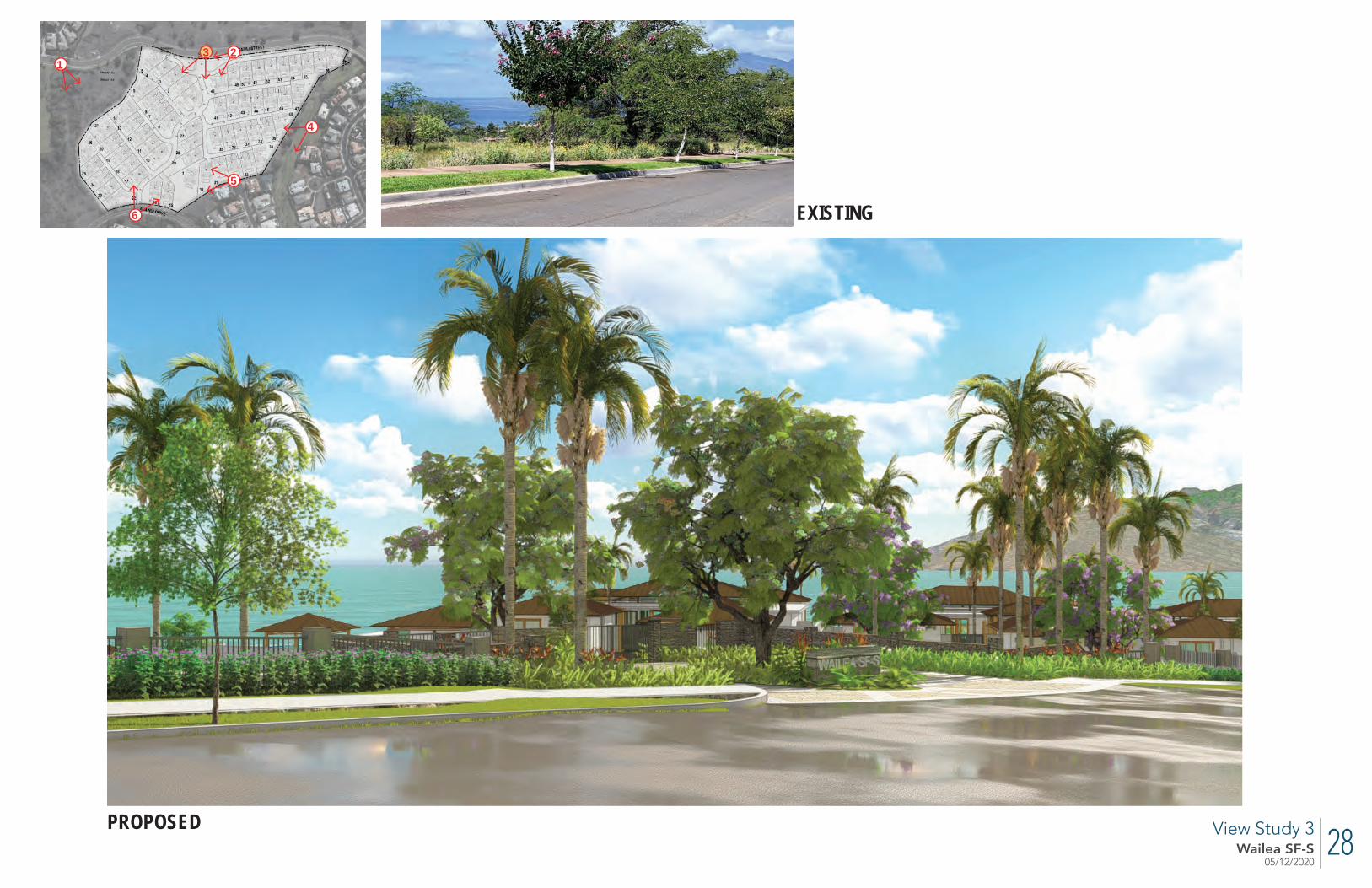
28Wailea SF-S05/12/2020
EXISTING
PROPOSED View Study 3
2
6
5
4
13
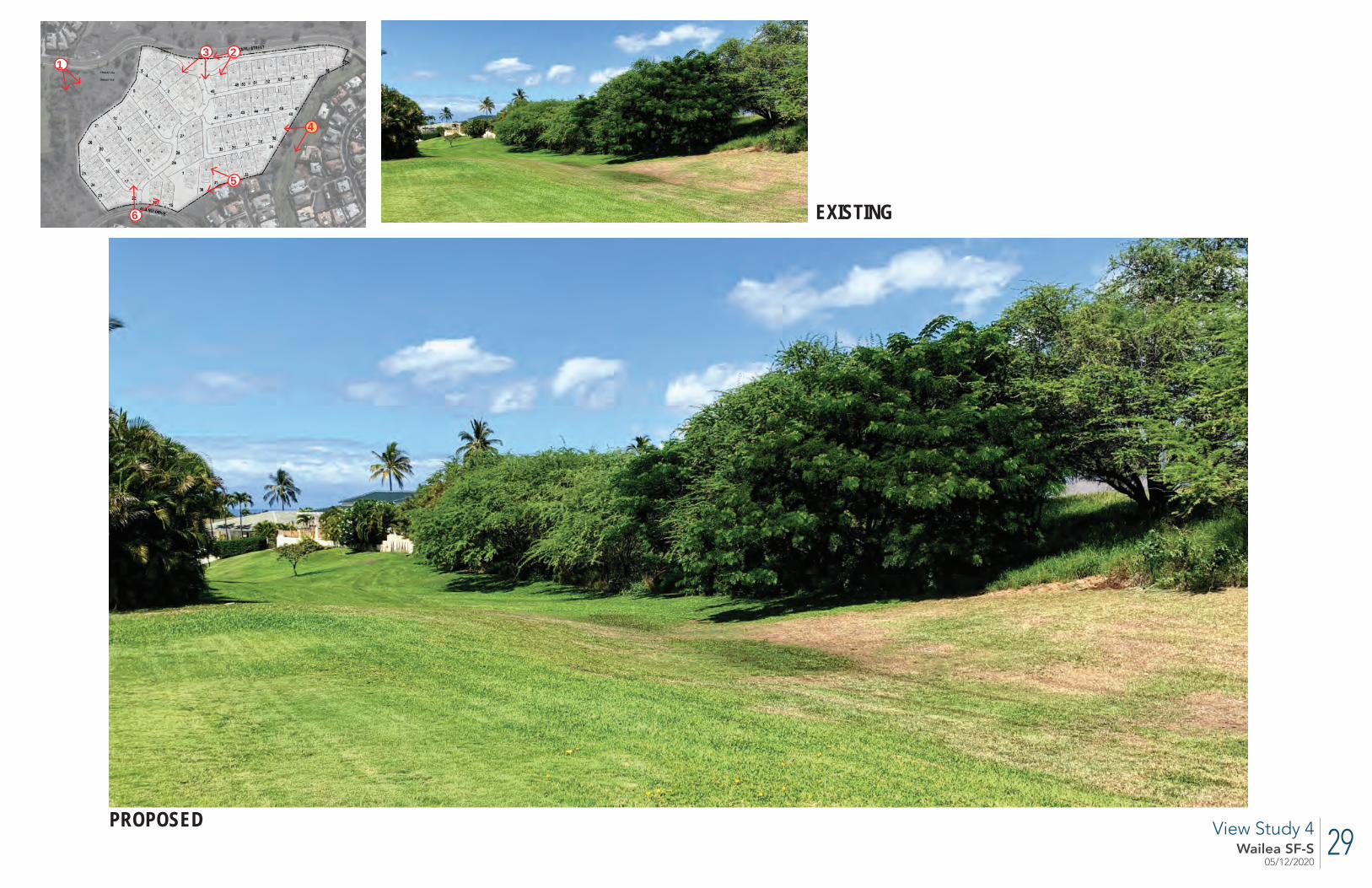
29Wailea SF-S05/12/2020
View Study 4
EXISTING
EXISTING
PROPOSED
2
6
5
4
13
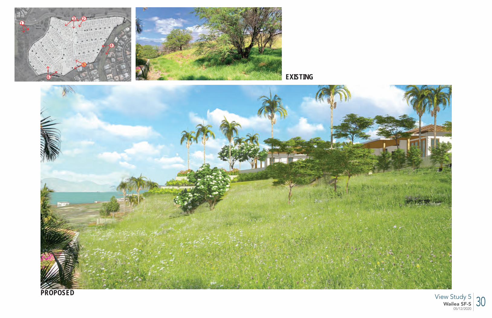
30Wailea SF-S05/12/2020
View Study 5
EXISTING
PROPOSED
EXISTING
2
6
5
4
13
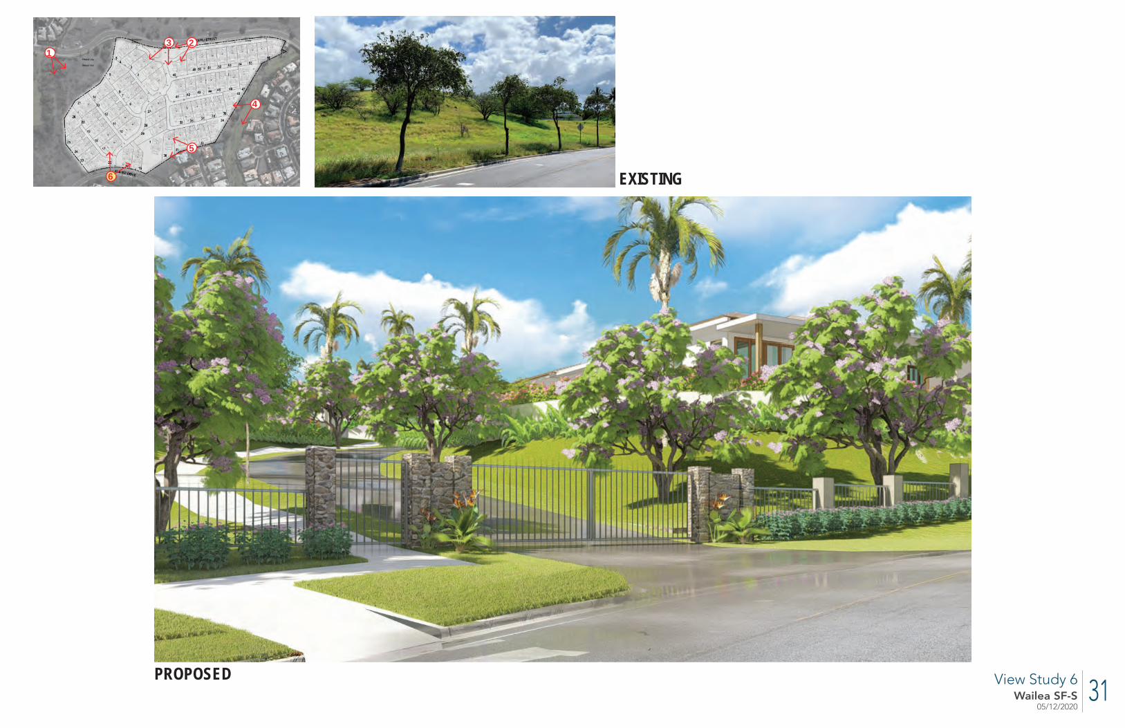
31Wailea SF-S05/12/2020
View Study 6
EXISTING
PROPOSED
EXISTING
2
6
5
4
13
PRELIMINARY ENGINEERING
AND DRAINAGE REPORT
APPENDIX
C

V:\Projdata\19proj\19026\Reports\Prelim Engineering Report\cover_000.docx
Established 1969
Preliminary Engineering Report
WAILEA SF-S DEVELOPMENT Wailea, Maui, Hawaii TMK: (2) 2-1-008:145
Prepared For: Ledcor Development LP 590 Lipoa Parkway, Suite 259 Kihei, Maui, Hawaii 96753
May 14, 2020
WARREN S. UNEMORI ENGINEERING, INC. Civil and Structural Engineers – Land Surveyors Wells Street Professional Center – Suite 403 2145 Wells Street Wailuku, Maui, Hawaii 96793
TABLE OF CONTENTS
Page1. INTRODUCTION
1.1 Purpose . . . . . . . . . . . . . . . . . . . . . . . . . . . . . . . . . . . . . . . . . . . . . . . . . . . 1-1
1.2 Project Description . . . . . . . . . . . . . . . . . . . . . . . . . . . . . . . . . . . . . . . . . . 1-1
2. ROADWAY IMPROVEMENTS
2.1 Existing Conditions . . . . . . . . . . . . . . . . . . . . . . . . . . . . . . . . . . . . . . . . . 2-1
2.2 Proposed Improvements . . . . . . . . . . . . . . . . . . . . . . . . . . . . . . . . . . . . . 2-1
2.2.1 Vehicular Access . . . . . . . . . . . . . . . . . . . . . . . . . . . . . . . . . . . . . 2-1
2.2.2 Bike and Pedestrian Access . . . . . . . . . . . . . . . . . . . . . . . . . . . . . 2-2
Figure 2-1 Access Plan
Figure 2-2 Spine Road Sections
Figure 2-3 Side Street Sections
3. STORM DRAINAGE
3.1 Existing Conditions . . . . . . . . . . . . . . . . . . . . . . . . . . . . . . . . . . . . . . . . . 3-1
3.1.1 Topography and Soils . . . . . . . . . . . . . . . . . . . . . . . . . . . . . . . . . . 3-1
3.1.2 Flood and Tsunami Zone. . . . . . . . . . . . . . . . . . . . . . . . . . . . . . . . 3-2
3.1.3 Existing Drainage Conditions . . . . . . . . . . . . . . . . . . . . . . . . . . . . 3-2
Table 3-1 Pre-Development Drainage Summary
3.2 Drainage Plan . . . . . . . . . . . . . . . . . . . . . . . . . . . . . . . . . . . . . . . . . . . . . . 3-4
3.2.1 Projected Increase in Runoff Due to Development . . . . . . . . . . . . 3-4
3.2.2 Proposed Improvements . . . . . . . . . . . . . . . . . . . . . . . . . . . . . . . . 3-4
3.2.3 Post-Development Condition . . . . . . . . . . . . . . . . . . . . . . . . . . . . 3-5
Table 3-2 Post-Development Drainage Summary
Figure 3-1 Soil Survey Map
Figure 3-2 Existing Drainage Condition
Figure 3-3 Drainage Plan
i
4. WATER
4.1 Demand. . . . . . . . . . . . . . . . . . . . . . . . . . . . . . . . . . . . . . . . . . . . . . . . . . . 4-1
4.1.1 Domestic Consumption . . . . . . . . . . . . . . . . . . . . . . . . . . . . . . . . . 4-1
4.1.2 Fire Protection . . . . . . . . . . . . . . . . . . . . . . . . . . . . . . . . . . . . . . . 4-1
4.2 Existing Infrastructure and Needed Improvements . . . . . . . . . . . . . . . . . 4-2
4.2.1 Water Source . . . . . . . . . . . . . . . . . . . . . . . . . . . . . . . . . . . . . . . . 4-2
4.2.2 Storage Reservoirs . . . . . . . . . . . . . . . . . . . . . . . . . . . . . . . . . . . . 4-2
4.2.3 Distribution System . . . . . . . . . . . . . . . . . . . . . . . . . . . . . . . . . . . 4-3
4.3 Provisions for Future R-1 Reclaimed Water Use . . . . . . . . . . . . . . . . . . 4-4
Figure 4-1 Water System Plan
5. WASTEWATER
5.1 Projected Demand. . . . . . . . . . . . . . . . . . . . . . . . . . . . . . . . . . . . . . . . . . . 5-1
5.2 Existing Infrastructure and Needed Improvements . . . . . . . . . . . . . . . . . 5-1
Figure 5-1 Sanitary Sewer Plan
6. POWER AND TELECOMMUNICATIONS
6.1 Existing Conditions . . . . . . . . . . . . . . . . . . . . . . . . . . . . . . . . . . . . . . . . . 6-1
6.2 Project Requirements . . . . . . . . . . . . . . . . . . . . . . . . . . . . . . . . . . . . . . . . 6-1
6.2.1 Maui Electric Company. . . . . . . . . . . . . . . . . . . . . . . . . . . . . . . . . 6-2
6.2.2 Hawaiian Telcom. . . . . . . . . . . . . . . . . . . . . . . . . . . . . . . . . . . . . . 6-3
6.2.3 Spectrum . . . . . . . . . . . . . . . . . . . . . . . . . . . . . . . . . . . . . . . . . . . . 6-3
6.3 Site Lighting Plan . . . . . . . . . . . . . . . . . . . . . . . . . . . . . . . . . . . . . . . . . . . 6-4
6.4 Cost of Improvements. . . . . . . . . . . . . . . . . . . . . . . . . . . . . . . . . . . . . . . . 6-5
Figure 6-1 Electrical Site Plan
Figure 6-2 Lighting Details
ii
APPENDIX A - Drainage Calculations
A-1 DLNR Flood Hazard Assessment Report for TMK 2-1-008: 145
A-2 Pre-Development Runoff Calculations
Table A-2 Pre-Development Drainage Summary
A-3 Post-Development Runoff Calculations
Table A-3 Post-Development Drainage Summary
A-4 Detention / Retention Basin Sizing Calculations
Table A-4 Minimum Storage Capacities for Detention / Retention
Facilities
A-5 Stormwater Quality Calculations
Table A-5 Minimum 48 hr. Retention Capacity Needed to Meet Maui
County Stormwater Quality Requirements
APPENDIX B - Potable Water Calculations
B-1 Projected Daily Water Demand
B-2 Domestic Water Storage Capacity Calculation
B-3 Preliminary Water Meter Sizing Calculation
APPENDIX C - Wastewater Demand Calculation
APPENDIX D - Electrical System References
D-1 MECo Reference Drawings
D-2 Preliminary Cost Estimate
V:\Projdata\19proj\19026\Reports\Prelim Engineering Report\Table of Contents_00.wpd
iii
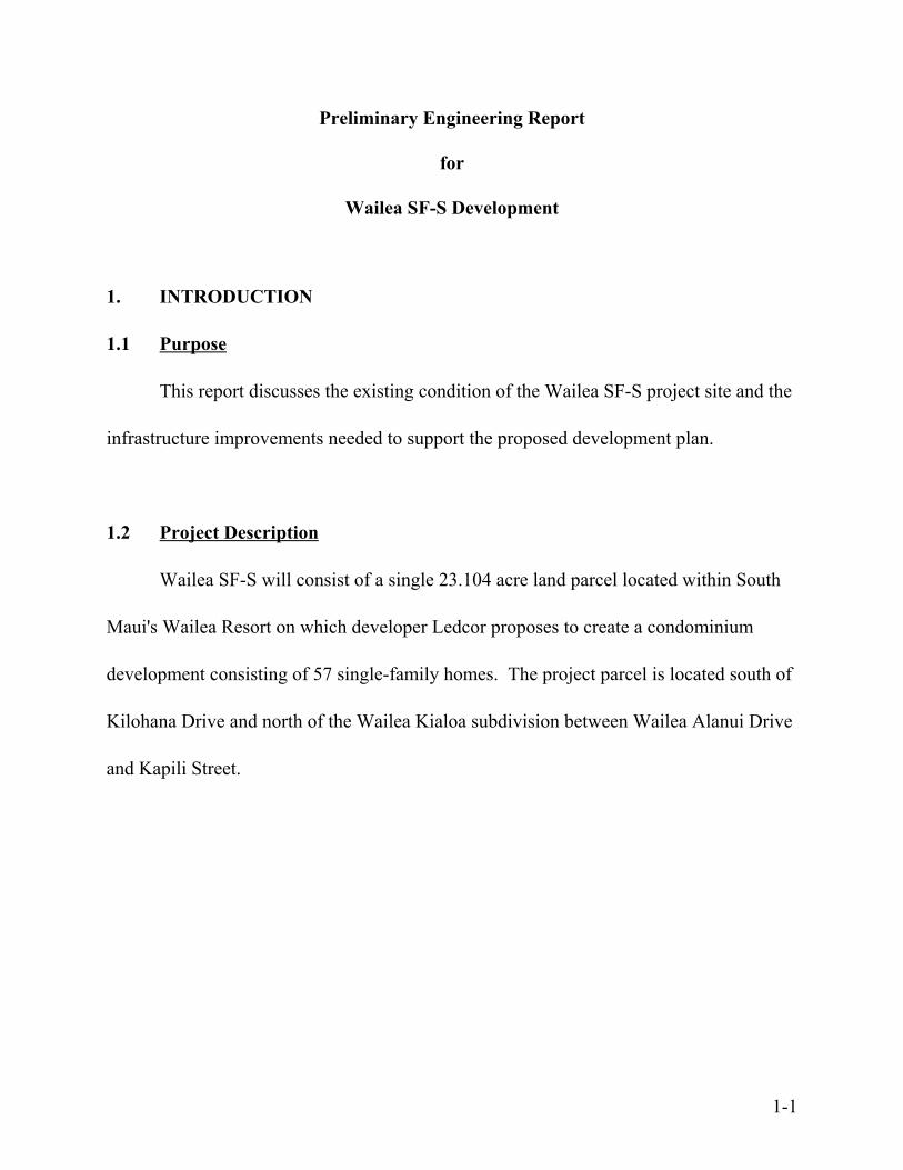
Preliminary Engineering Report
for
Wailea SF-S Development
1. INTRODUCTION
1.1 Purpose
This report discusses the existing condition of the Wailea SF-S project site and the
infrastructure improvements needed to support the proposed development plan.
1.2 Project Description
Wailea SF-S will consist of a single 23.104 acre land parcel located within South
Maui's Wailea Resort on which developer Ledcor proposes to create a condominium
development consisting of 57 single-family homes. The project parcel is located south of
Kilohana Drive and north of the Wailea Kialoa subdivision between Wailea Alanui Drive
and Kapili Street.
1-1

2. ROADWAY IMPROVEMENTS
2.1 Existing Conditions
The Wailea SF-S site is accessible from either County-owned Wailea Alanui Drive
or privately-owned1 Kapili Street. Both streets possess the same physical cross-section,
consisting of a 36-foot wide pavement2; two 12-foot wide curbed shoulders; and a single,
six-foot wide sidewalk located on the makai shoulder. Both are two-lane roads; however,
Wailea Alanui Drive has striped, curbside bike lanes while Kapili Street does not.
2.2 Proposed Improvements
2.2.1 Vehicular Access
The Wailea SF-S development proposes to utilize the four access points
identified on Figure 2-1 for access. These include one primary, full-movement
driveway on Kapili Street; two limited access (emergency exit-only) driveways on
Kapili Street; and one limited access (emergency-only) driveway on Wailea Alanui
Drive.
Internal access to each homesite will be provided by 20-foot wide paved
driveways branching from a central spine road, as depicted on Figure 2-1.
Figures 2-2 and 2-3 illustrate the typical roadway sections that will be used.
1Kapili Street, TMK 2-1-008: 147, is owned by A&B Wailea LLC.
236 feet measured curb-to-curb
2-1
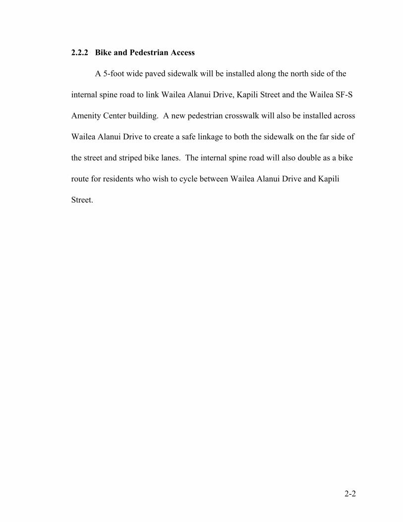
2.2.2 Bike and Pedestrian Access
A 5-foot wide paved sidewalk will be installed along the north side of the
internal spine road to link Wailea Alanui Drive, Kapili Street and the Wailea SF-S
Amenity Center building. A new pedestrian crosswalk will also be installed across
Wailea Alanui Drive to create a safe linkage to both the sidewalk on the far side of
the street and striped bike lanes. The internal spine road will also double as a bike
route for residents who wish to cycle between Wailea Alanui Drive and Kapili
Street.
2-2
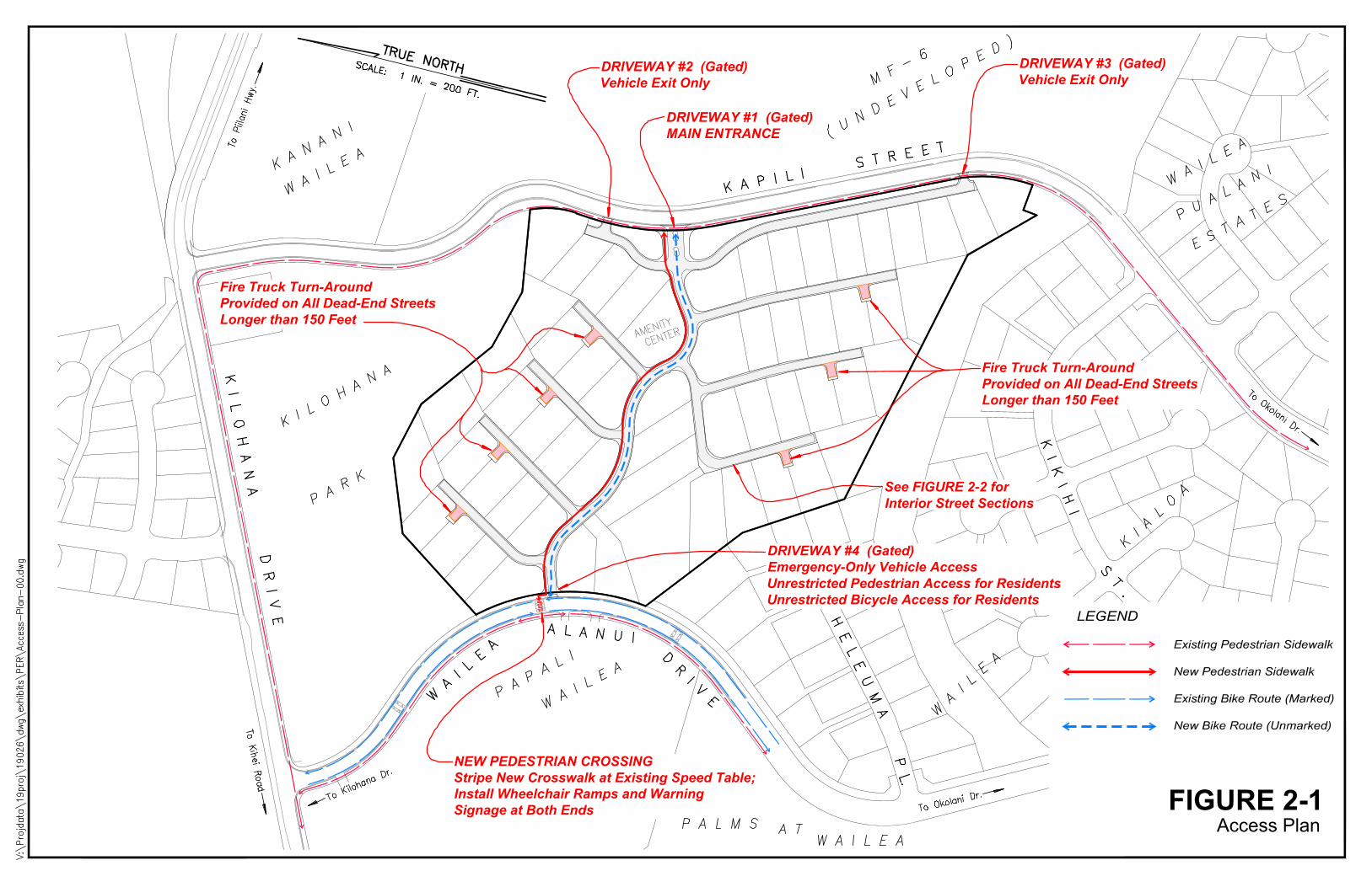
FIGURE 2-1Access Plan
DRIVEWAY #1 (Gated)MAIN ENTRANCE
DRIVEWAY #4 (Gated)Emergency-Only Vehicle AccessUnrestricted Pedestrian Access for ResidentsUnrestricted Bicycle Access for Residents
Fire Truck Turn-AroundProvided on All Dead-End StreetsLonger than 150 Feet
Fire Truck Turn-AroundProvided on All Dead-End StreetsLonger than 150 Feet
DRIVEWAY #2 (Gated)Vehicle Exit Only
DRIVEWAY #3 (Gated)Vehicle Exit Only
NEW PEDESTRIAN CROSSINGStripe New Crosswalk at Existing Speed Table;Install Wheelchair Ramps and WarningSignage at Both Ends
LEGEND
Existing Pedestrian Sidewalk
New Pedestrian Sidewalk
Existing Bike Route (Marked)
New Bike Route (Unmarked)
See FIGURE 2-2 forInterior Street Sections
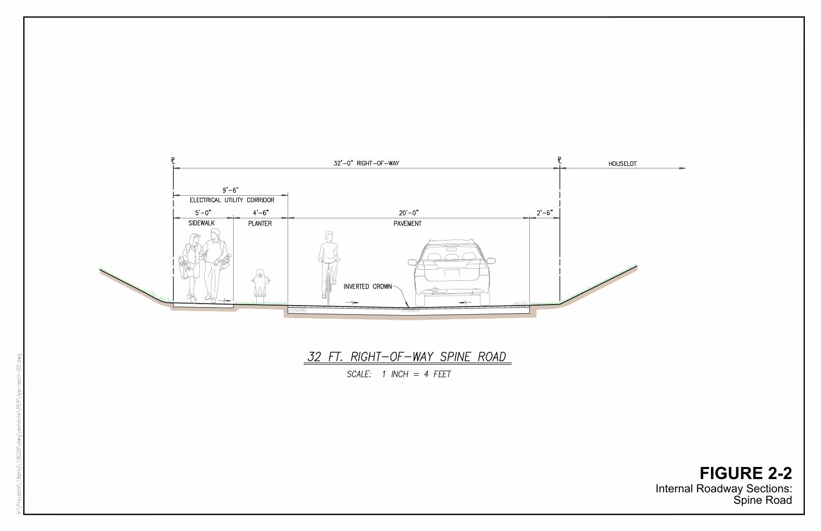
FIGURE 2-2Internal Roadway Sections:
Spine Road
FIGURE 2-3Internal Roadway Sections:
Side Streets
3. STORM DRAINAGE
3.1 Existing Conditions
3.1.1 Topography and Soils
The project site is currently undeveloped and not being used for any
particular purpose.
The existing terrain within the project parcel slopes downward in an east-to-
west direction at an average grade of approximately 10 percent. Elevations across
the site range from 266 feet at its eastern edge along Kapili Street to 126 feet at its
northwestern boundary along Kilohana Park. Two existing drainageways lie
immediately to the north and south of the project site.
The USDA Natural Resources Conservation Service identifies two
predominant soil types on the project site: (See Figure 3-1)
- Keawakapu extremely stony silty clay loam, 3 to 25 percent slopes
(KNXD), having moderate permeability, slow to medium runoff, with a
slight to moderate erosion hazard; and
- Makena loam, stony complex, 3 to 15 percent slopes (MXC), having
moderately rapid permeability, slow to medium runoff, with a slight to
moderate erosion hazard.3
3 United States Department of Agriculture, Soil Conservation Service, Soil Survey of Islands of Kauai,Oahu, Maui, Molokai, and Lanai, State of Hawaii, August 1972, pp. 68 and 91, Maps 108-109.
3-1
3.1.2 Flood and Tsunami Zone
The Federal Emergency Management Agency’s Flood Insurance Rate Map
for Maui County locates the project site within Zone X, outside both the 500-year
floodplain and tsunami zone.4 A current DLNR Flood Hazard Assessment Report
for the parcel can be found in Appendix A-1.
3.1.3 Existing Drainage Conditions
The existing 23.1 acre project site generates approximately 24.5 cfs of
onsite surface runoff during a 10-year 1-hour storm which flows off of the project
site in three directions. (See Figure 3-2)
1) Drainage Area 1 generates approximately 11.3 cfs of onsite surface runoff
which sheet flows to an existing drainage gully located on the County-
owned Kilohana Park site to the north of the project. The runoff then flows
into an underground storm drain along Kilohana Drive; through an open
drainageway crossing the Wailea Kai subdivision; through a culvert
crossing at South Kihei Road; then into the ocean at Keawekapu Beach
roughly 3,000 feet from the Wailea SF-S project site.
2) Drainage Area 2 generates approximately 4.5 cfs of onsite surface runoff
which enters an 18" culvert crossing at Wailea Alanui. The runoff then
4 U.S. Department of Homeland Security, Federal Emergency Management Agency, Flood InsuranceRate Map, Maui County, Hawaii, Community-Panel Number 150003 0391E, September 25, 2009.
3-2
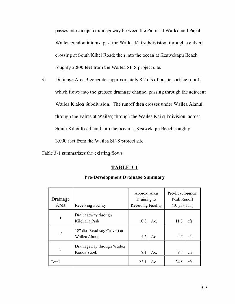
passes into an open drainageway between the Palms at Wailea and Papali
Wailea condominiums; past the Wailea Kai subdivision; through a culvert
crossing at South Kihei Road; then into the ocean at Keawekapu Beach
roughly 2,800 feet from the Wailea SF-S project site.
3) Drainage Area 3 generates approximately 8.7 cfs of onsite surface runoff
which flows into the grassed drainage channel passing through the adjacent
Wailea Kialoa Subdivision. The runoff then crosses under Wailea Alanui;
through the Palms at Wailea; through the Wailea Kai subdivision; across
South Kihei Road; and into the ocean at Keawekapu Beach roughly
3,000 feet from the Wailea SF-S project site.
Table 3-1 summarizes the existing flows.
TABLE 3-1
Pre-Development Drainage Summary
DrainageArea Receiving Facility
Approx. AreaDraining to
Receiving Facility
Pre-DevelopmentPeak Runoff(10 yr / 1 hr)
1Drainageway throughKilohana Park 10.8 Ac. 11.3 cfs
218" dia. Roadway Culvert atWailea Alanui 4.2 Ac. 4.5 cfs
3Drainageway through WaileaKialoa Subd. 8.1 Ac. 8.7 cfs
Total 23.1 Ac. 24.5 cfs
3-3

3.2 Drainage Plan
3.2.1 Projected Increase in Runoff Due to Development
Once developed, the project site is expected to generate an onsite 10-year
peak storm flow of 52.9 cfs -- an 28.4 cfs increase over its existing, undeveloped
condition.5
3.2.2 Proposed Improvements
The project site will be graded so as to maintain the natural form of the
hillside and the drainage pattern that now exists. Three different approaches to
mitigating the post-development runoff will be implemented. (See Figure 3-3)
Drainage Area 1
Drainage Area 1 will employ "Green Streets" to capture and dispose of runoff
where it is generated. Runoff from rooftops and pavements will be directed into
green "bioretention strips" located along on one side of the street in which runoff
will be held and allowed to percolate into the ground. Subsurface storage
chambers will be used to augment the capacity of the bioretention strips and
underground drainage piping will be installed as a safety precaution to handle
overflows and prevent flooding during large storm events.
5 See Post-Development runoff calculation in Appendix A-3.
3-4
Drainage Area 2
Drainage Area 2 will employ a conventional storm drainage system consisting of
inlets and underground pipes to collect the runoff shed by rooftops and pavements
and convey it to an underground stormwater detention structure located just
upstream of the existing 18-inch culvert crossing at Wailea Alanui Drive that will
serve as its discharge point.
Drainage Area 3
Drainage Area 3 will employ a combination of "Green Street" bioretention strips,
subsurface storage chambers and a conventional open stormwater basin to provide
the storage capacity necessary to mitigate post-development runoff. As with
Drainage Area 1, underground drainage piping will be installed as a safety
precaution to handle overflows and prevent flooding during large storm events.
3.2.3 Post-Development Condition
Peak Flow Mitigation
The onsite stormwater retention/detention facilities described above will
mitigate the increase in peak flow attributable to development of the Wailea SF-S
site, with the result that post-development flows discharged into each of the three
3-5
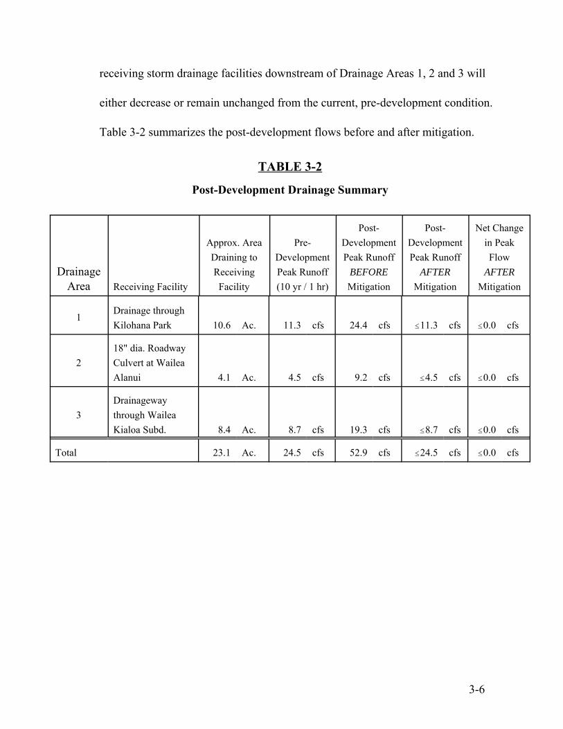
receiving storm drainage facilities downstream of Drainage Areas 1, 2 and 3 will
either decrease or remain unchanged from the current, pre-development condition.
Table 3-2 summarizes the post-development flows before and after mitigation.
TABLE 3-2
Post-Development Drainage Summary
DrainageArea Receiving Facility
Approx. AreaDraining toReceivingFacility
Pre-DevelopmentPeak Runoff(10 yr / 1 hr)
Post-DevelopmentPeak Runoff
BEFORE
Mitigation
Post-DevelopmentPeak Runoff
AFTER
Mitigation
Net Changein PeakFlow
AFTER
Mitigation
1Drainage throughKilohana Park 10.6 Ac. 11.3 cfs 24.4 cfs #11.3 cfs #0.0 cfs
218" dia. RoadwayCulvert at WaileaAlanui 4.1 Ac. 4.5 cfs 9.2 cfs #4.5 cfs #0.0 cfs
3Drainagewaythrough WaileaKialoa Subd. 8.4 Ac. 8.7 cfs 19.3 cfs #8.7 cfs #0.0 cfs
Total 23.1 Ac. 24.5 cfs 52.9 cfs #24.5 cfs #0.0 cfs
3-6
Water Pollution Control
Stormwater will receive the following pollution control treatment before
leaving the project site.
- Runoff within Drainage Area 1 and a portion of Drainage Area 3 will
receive "flow through" treatment6 by utilizing the roadside bioretention
strips as vegetated filters.
- Runoff from Drainage Area 2 and a portion of Drainage Area 3 will
receive "detention-based" treatment7 whereby a requisite amount of
stormwater will be held in stormwater basins for at least 48 hours before
being discharged.8
6 "Flow through" treatment defined in Maui County Dept. of Public Works, Title MC-15, Subtitle 01,Chapter 111, "Rules for the Design of Stormwater Treatment Best Management Practices", Section 15-111-5 (b).
7"Detention-based" treatment defined in Maui County Dept. of Public Works, Title MC-15, Subtitle 01,Chapter 111, "Rules for the Design of Stormwater Treatment Best Management Practices", Section 15-111-5 (a).
8See Table A-5 in Appendix A-5 for minimum required 48-hour detention volumes.
3-7
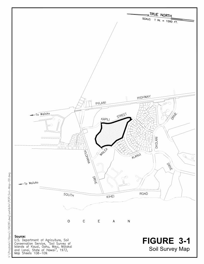
FIGURE 3-1Soil Survey Map
AutoCAD SHX Text
Source: U.S. Department of Agriculture, Soil Conservation Service, "Soil Survey of Islands of Kauai, Oahu, Maui, Molokai and Lanai, State of Hawaii", 1972, Map Sheets 108-109.
AutoCAD SHX Text
TRUE NORTH
AutoCAD SHX Text
SCALE: 1 IN. = 1000 FT.
AutoCAD SHX Text
KAPILI
AutoCAD SHX Text
ALANUI
AutoCAD SHX Text
DRIVE
AutoCAD SHX Text
WAILEA
AutoCAD SHX Text
KILOHANA DRIVE
AutoCAD SHX Text
STREET
AutoCAD SHX Text
DRIVE
AutoCAD SHX Text
OKOLANI
AutoCAD SHX Text
SOUTH
AutoCAD SHX Text
KIHEI
AutoCAD SHX Text
ROAD
AutoCAD SHX Text
PIILANI
AutoCAD SHX Text
HIGHWAY
AutoCAD SHX Text
O C E A N
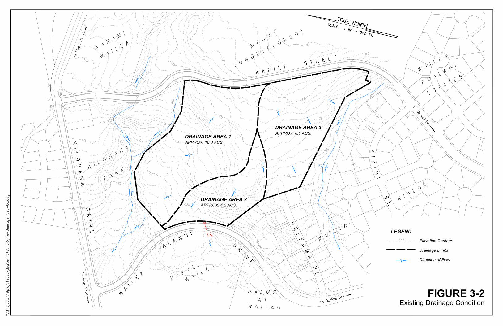
FIGURE 3-2Existing Drainage Condition
LEGEND
Elevation Contour
Drainage Limits
Direction of Flow
DRAINAGE AREA 2APPROX. 4.2 ACS.
DRAINAGE AREA 3APPROX. 8.1 ACS.
DRAINAGE AREA 1APPROX. 10.8 ACS.

18"
18"12"
18"
12"
18"
18"
18"
24"
24"
18"
18"
18"
18"
18"
18"
18"18"
18"
"GREEN STREETS"STORMWATER DISPOSALBIORETENTION STRIPS WITHSUPPLEMENTAL SUBSURFACEDETENTION CHAMBERSAPPROX. STORAGE CAPACITY27,200 TO 44,300 CU. FT.
DISCHARGE TO EXISTINGDRAINAGEWAY HERE
UNDERGROUND STORMWATERDETENTION STRUCTUREAPPROX. STORAGE CAPACITY10,200 TO 19,200 CU. FT.
DISCHARGE TO EXISTINGCULVERT HERE
DRAINAGE AREA 2APPROX. 4.1 ACS.
STORMWATER DETENTION BASINAPPROX. STORAGE CAPACITY20,000 TO 35,100 CU. FT.
DRAINAGE AREA 3APPROX. 8.4 ACS.
DRAINAGE AREA 1APPROX. 10.6 ACS.
DISCHARGE TO EXISTINGDRAINAGEWAY HERE
FIGURE 3-3Drainage Plan
LEGEND
Boundary of Primary Tributary Drainage Area
"Green Street" Bioswale / Bioretention Strip
Underground Stormwater Detention Chamber
Storm Drain Pipe w/ Diameter
Storm Drain Manhole
Flow Line of Drainageway
Direction of Flow
24"
"GREEN STREETS" STORMWATER DISPOSALBIORETENTION STRIPS WITH SUPPLEMENTALSUBSURFACE DETENTION CHAMBERS
AutoCAD SHX Text
18"
AutoCAD SHX Text
K I L O H A N A D R I V E
AutoCAD SHX Text
TRUE NORTH
AutoCAD SHX Text
SCALE: 1 IN. = 200 FT.
AutoCAD SHX Text
K A P I L I S T R E E T
AutoCAD SHX Text
A L A N U I
AutoCAD SHX Text
D R I V E
AutoCAD SHX Text
W A I L E A
AutoCAD SHX Text
H E L E U M A
AutoCAD SHX Text
K I L O H A N A
AutoCAD SHX Text
P A R K
AutoCAD SHX Text
W A I L E A K I A L O A
AutoCAD SHX Text
P A P A L I
AutoCAD SHX Text
W A I L E A
AutoCAD SHX Text
P A L M S
AutoCAD SHX Text
W A I L E A
AutoCAD SHX Text
A T
AutoCAD SHX Text
K A N A N I
AutoCAD SHX Text
W A I L E A
AutoCAD SHX Text
M F - 6
AutoCAD SHX Text
( U N D E V E L O P E D )
AutoCAD SHX Text
W A I L E A
AutoCAD SHX Text
P U A L A N I
AutoCAD SHX Text
E S T A T E S
AutoCAD SHX Text
I H I
AutoCAD SHX Text
S T.
AutoCAD SHX Text
K I K
4. WATER
Potable water for drinking and fire protection will be supplied to the
Wailea SF-S development by the Maui County Department of Water Supply
(DWS) from its Central Maui water system.
4.1 Demand
4.1.1 Domestic Consumption
The proposed condominium complex is expected to consume an average
36,000 gallons per day (gpd) of potable water.9
4.1.2 Fire Protection
A fire flow of 1,000 gallons per minute (gpm) sustainable for 2 hours is
required to protect the single-family homes within the development.10 The
Amenity Center public building may require a higher fire flow depending upon
its fire-resistance and whether it is sprinklered.
9 See Appendix B-1 for potable water demand calculation.
10Required fire flow specified for single-family homes by Maui County Code Section 14.05.090.D (FireProtection) and Maui County Department of Water Supply Water System Standards, 2002, Table 100-19,p.111-4.
4-1

4.2 Existing Infrastructure and Needed Improvements
4.2.1 Water Source
The water sources from which the Dept. of Water Supply will use to
supply the project site include groundwater wells located in Wailuku, Waiehu
and Waihee which draw water from the Iao Aquifer. Surface water flows from
the irrigation ditch system operated by Wailuku Water Company are also
utililized. No source improvements are proposed by the Wailea SF-S project.
4.2.2 Storage Reservoir
The project site will be supplied from both the Dept. of Water Supply's
existing 3.0 million gallon (MG) capacity Wailea Mid-Level storage tank
located along Kalai Waa Street at an elevation of 353 feet and A&B Wailea's
1.0 MG capacity Upper-Level storage tank located within Wailea 670 at
elevation 541 feet.11 A 17-mile long transmission line brings water from DWS'
well sources in Waiehu and Waihee to fill these tanks. The 1.0 MG Upper- and
3.0 MG Mid-Level tanks together provide the necessary water pressure12,
11A&B Wailea LLC is currently working to dedicate the 1.0 MG Upper-Level storage tank and itsassociated pipelines to the Maui County Department of Water Supply.
12Static water pressure will range between 58 psi and 100 psi as indicated on Figure 4-1.
4-2

domestic storage capacity13 and fire protection storage capacity14 needed to meet
Maui County Dept. of Water Supply's water service standards when developing
the Wailea SF-S site; therefore, no additional storage improvements are
proposed with the project.
4.2.3 Distribution System
Existing networks of 12-, 16-, and 18-inch diameter distribution mains
within the Wailea Resort bring water from the 3.0 MG Mid-Level and 1.0 MG
Upper-Level storage tanks to the Wailea SF-S project site. Three sets of service
mains -- two for domestic (drinking) water and one for fire protection -- will be
extended into the site from the existing 12-inch Mid-Level and 12-inch Upper-
Level distribution mains located on Kapili Street to provide domestic water
service and fire suppression as shown in Figure 4-1. A branching network of
domestic and fire protection waterlines located along the internal streets will
provide water service to each home and supply the fire hydrants located at
regular intervals throughout the development.
13A calculation of the domestic water storage capacity needed by Wailea SF-S can be found inAppendix B-2
14The 1.0 MG Upper-Level Tank, which supplies the Wailea SF-S fire protection system, exceeds theminimum 120,000 gallon minimum capacity required for fire protection. (1,000 gpm fire flow x 2 hours= 120,000 gallons)
4-3
Two Dept. of Water Supply-issued 3-inch water meters15 -- one for the
Upper-Level service zone; the other for the Mid-Level service zone -- will be
installed on the drinking water mains near Kapili Street to measure water usage
by the development. Water use by each of the individual homes, Amenity
Center building and common-area irrigation will be tracked by privately-read
sub-meters installed downstream of the main County meter.
4.3 Provisions for Future R-1 (Reclaimed Water) Use
County R-1 reclaimed water is not yet available at the Wailea SF-S
project site. However, in preparation for the day when R-1 water does become
available, the following provisions will be made during the initial construction
of Wailea SF-S to encourage its future use by all homeowners.
1. The common area irrigation system for the development will be designed
and constructed to allow an easy conversion to an R-1 source by:
a) Utilizing a single point of connection to the external water supply;
and by
b) Utilizing materials, equipment and installation meeting current
State Dept. of Health guidelines for reclaimed water use.
15See Appendix B-3 for Preliminary Water Meter Sizing Calculation.
4-4

2. Adequate space will be set aside within the internal roads to allow
reclaimed water piping to be economically installed and run to the
Amenity Center and front yards of each individual home within the
development.
4-5

12"DDCWMPRV
PRV
12"
8"
8"
8"
8"
8"
8"
8"
8"
8"
8"
4"
4"
4"
4"
4"
4"
4"
4"
4"
4"
4"
8"FIGURE 4-1
Water System Plan
STATIC WATER PRESSURE ATLOWEST HOMESITE SERVED FROMMID-LEVEL WATER SYSTEM(ELEVATION 140 FT.) APPROX. 92 PSI
LEGEND
Existing Water Main w/ Diameter
New Upper-Level Domestic Water Mainw/ Diameter
New Mid-Level Domestic Water Mainw/ Diameter
New Fire Protection Main w/ Diameter
Fire Hydrant
8"
4"
8"
WATER SUPPLIED FROM WAILEA3.0 MG MID-LEVEL STORAGE TANKAT ELEVATION 353 FT.
STATIC WATER PRESSURE ATUPPER-LEVEL WATER METER(ELEVATION 250 FT.) APPROX. 126 PSI
PRV-ADJUSTED WATER PRESSURE ATLOWEST HOMESITE SERVED FROMUPPER-LEVEL WATER SYSTEM(ELEVATION 230 FT.) APPROX. 100 PSI
STATIC WATER PRESSURE ATHIGHEST HOMESITE SERVED FROMMID-LEVEL WATER SYSTEM(ELEVATION 220 FT.) APPROX. 58 PSI
PRV-ADJUSTED WATER PRESSURE ATHIGHEST HOMESITE SERVED FROMUPPER-LEVEL WATER SYSTEM(ELEVATION 254 FT.) APPROX. 89 PSI
WATER SUPPLIED FROM WAILEA1.0 MG UPPER-LEVEL STORAGE TANKAT ELEVATION 541 FT.
FIRE PROTECTION SYSTEM CONNECTSTO EXISTING 12-INCH UPPER-LEVELDISTRIBUTION MAIN HERE
UPPER-LEVEL DOMESTIC SYSTEM CONNECTSTO EXISTING 12-INCH UPPER-LEVELDISTRIBUTION MAIN HERE
MID-LEVEL DOMESTIC SYSTEM CONNECTSTO EXISTING 12-INCH MID-LEVELDISTRIBUTION MAIN HERE
STATIC WATER PRESSURE ATMID-LEVEL WATER METER(ELEVATION 250 FT.) APPROX. 45 PSI
S E R V I C E A
R E A
M I D
L E V E L
S E R V I C E A R E A
U P P E R
L E V E L
4"
5. WASTEWATER
5.1 Projected Demand
Wailea SF-S is expected to contribute a wastewater flow of approximately
20,000 gallons per day (gpd) into the County-managed Kihei sewerage system.16
5.2 Existing Infrastructure and Needed Improvements
Maui County Department of Environmental Management's Wastewater
Reclamation Division (WWRD) operates the public sewerage system which collects
wastewater from the Wailea Resort and conveys it to the County's Kihei Wastewater
Treatment Facility for processing and disposal.
The Wailea SF-S project will install a conventional gravity sewer collection
system which will collect wastewater generated by the buildings and discharge it into
the existing 8-inch diameter County sewer main located on Wailea Alanui Drive as
indicated in Figure 5-1. The County sewerage system will, in turn, convey the
wastewater down Kilohana Drive to South Kihei Road; then along South Kihei Road to
Pumping Station No. 8; then from Pump Station No. 8 to Pump Station No. 7; then
from Pump Station No. 7 to Pump Station No. 6; then from Pump Station No. 6 to the
Kihei Wastewater Reclamation Facility above Piilani Highway.
16 See Appendix C for wastewater demand calculation.
5-1
WWRD reports that about 4,800 feet of large diameter gravity sewerline located
under South Kihei Road between Sewer Pump Stations No. 7 and No. 817 is nearing its
current safe operating capacity and will require a capacity upgrade if flows increase
significantly in the future -- due to new development in the Wailea Resort, for
example. WWRD is currently working to plan and program the needed capacity
upgrade.
WWRD's Kihei Wastewater Reclamation Facility is currently processing about
4 million gallons of wastewater per day (MGD) out of its 8 MGD design capacity, so
treatment capacity appears ample to accommodate Wailea SF-S' projected sewer
demand.
17The sewer pipeline segment of concern is located between the Kihei Boat Landing and Kamaole BeachPark I.
5-2
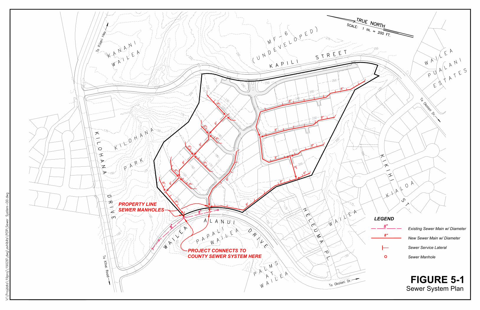
8"
8"
8"
8"
8"
8"
8"
8"
8"
8"
8"
8"
8"
8" 8"
8"8" 8"
6"
6"
6"
6"
6"
6"
FIGURE 5-1Sewer System Plan
PROJECT CONNECTS TOCOUNTY SEWER SYSTEM HERE
LEGEND
Existing Sewer Main w/ Diameter
New Sewer Main w/ Diameter
Sewer Service Lateral
Sewer Manhole
PROPERTY LINESEWER MANHOLES
8"
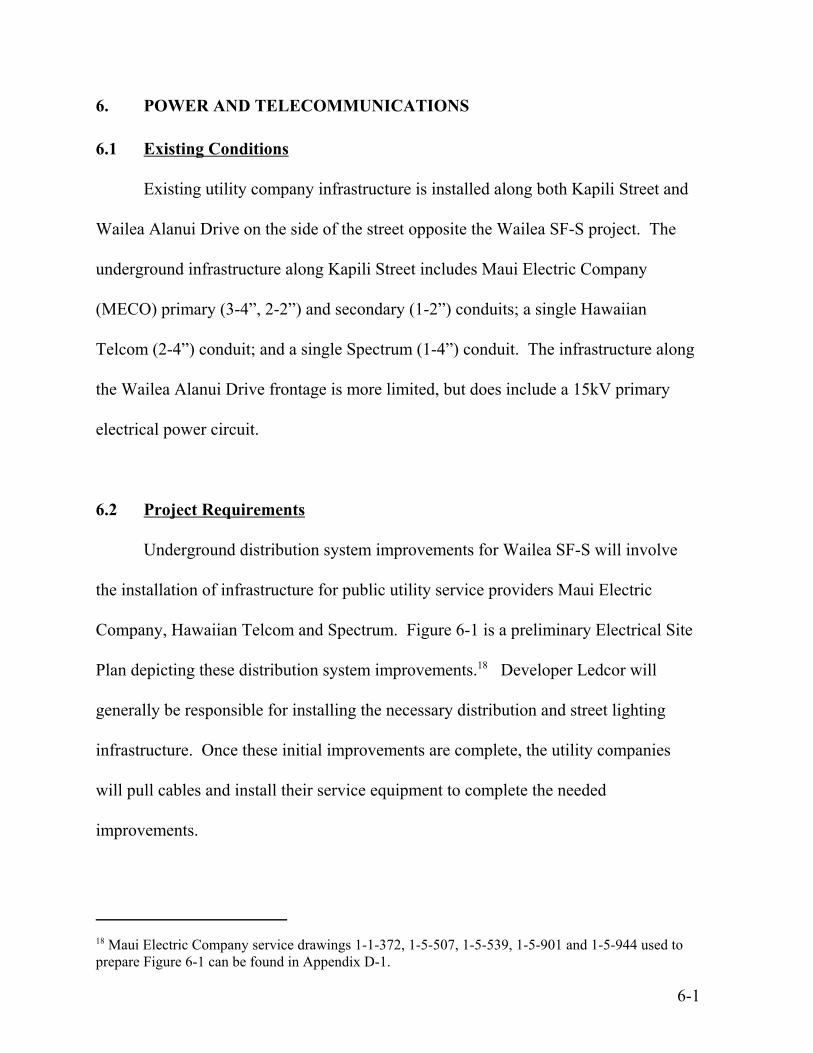
6. POWER AND TELECOMMUNICATIONS
6.1 Existing Conditions
Existing utility company infrastructure is installed along both Kapili Street and
Wailea Alanui Drive on the side of the street opposite the Wailea SF-S project. The
underground infrastructure along Kapili Street includes Maui Electric Company
(MECO) primary (3-4”, 2-2”) and secondary (1-2”) conduits; a single Hawaiian
Telcom (2-4”) conduit; and a single Spectrum (1-4”) conduit. The infrastructure along
the Wailea Alanui Drive frontage is more limited, but does include a 15kV primary
electrical power circuit.
6.2 Project Requirements
Underground distribution system improvements for Wailea SF-S will involve
the installation of infrastructure for public utility service providers Maui Electric
Company, Hawaiian Telcom and Spectrum. Figure 6-1 is a preliminary Electrical Site
Plan depicting these distribution system improvements.18 Developer Ledcor will
generally be responsible for installing the necessary distribution and street lighting
infrastructure. Once these initial improvements are complete, the utility companies
will pull cables and install their service equipment to complete the needed
improvements.
18 Maui Electric Company service drawings 1-1-372, 1-5-507, 1-5-539, 1-5-901 and 1-5-944 used toprepare Figure 6-1 can be found in Appendix D-1.
6-1

6.2.1 Maui Electric Company
MECO will require an extension of its distribution system into the
project site from Kapili Street to provide service to Wailea SF-S, with a possible
connection through to Wailea Alanui Drive. Onsite electrical improvements
will consist of a single-phase underground distribution system for which the
developer Ledcor will install underground conduit, handholes, and equipment
pads; MECO will install electrical conductors and pad-mounted transformers
on-site and street lights off-site along county roads. The underground
distribution facilities will be installed as part of the project's site work; however,
separate service requests for each individual house/cottage will need to be
submitted to MECO during construction.
Table 6-1 is an estimate of the load Wailea SF-S will demand from
MECO's system.
TABLE 6-1
Estimated Project Demand Load
Unit Type Number
MECO Estimate NEC Estimate
kWkW/Lot Total kW
Single Family 57 10 570 6,555
Amenity Center 1 20 20 100
Total 58 590 6,655
6-2

6.2.2 Hawaiian Telcom
Hawaiian Telcom provides telephone and DSL services in the area. Its
existing telephone plant is not sufficient to serve the Wailea SF-S project;
therefore, a fiber distribution hub (FDH) and fiber optic equipment will be
installed to provide the needed telecommunication services. The FDH
equipment will function as a hub for the distribution of all Hawaiian Telcom
telecommunication services within the Wailea SF-S development.
Hawaiian Telcom's route of entry into Wailea SF-S will either be from
Kapili Street or Wailea Alanui Drive, with the final configuration of the
telephone system dependent upon the location of the FDH within the project.
Telephone cables will be installed at Hawaiian Telcom’s expense, and
customers will be responsible for service connection and monthly rental fees.
An easement will be required for the FDH equipment, whose location
will be specified by Hawaiian Telcom's planning department at the time detailed
construction plans are prepared.
6.2.3 Spectrum
Spectrum, Maui's designated cable television provider19, will need to
install an underground service extension to the Wailea SF-S site from either the
makai side of the Wailea Alanui Drive or the mauka side of Kapili Street where
it has existing underground facilities. Developer Ledcor will be responsible for
19 Spectrum also offers telephone and internet connection services.
6-3
providing all onsite infrastructure, including a 4" conduit for main runs along
the streets and street crossings; 2” service stub-outs; boxes; and at least one
power supply pad within the project site. The power supply equipment and all
cabling will be installed by Spectrum. Individual homeowners will be required
to submit a service request with Spectrum for the desired type of service and
rental equipment for which an installation and monthly service fees will be
charged.
Easements will be required to cover any underground facilities located in
private property and ensure access for maintenance vehicles.
6.3 Site Lighting Plan
Existing street lighting along Kapili Street will be supplemented by additional
fixtures at the main development entrance (Driveway #1) and possibly the auxiliary
driveways (Driveways #2 and #3) on Kapili Street to enable safe vehicle and
pedestrian movement at these locations. Safety lighting will also be provided along
the internal sidewalk linking Kapili Street and Wailea Alanui Drive, as well as the new
pedestrian crossing at Wailea Alanui Drive.
All exterior lighting will be full cut-off fixtures compliant with Maui County
Dept. of Public Works' street lighting standards20 and Maui County's Street Lighting
20 Maui County Department of Public Works, "Street Lighting Standards", Title MC-15, Chapter 901,Effective March 23, 2000.
6-4
Ordinance.21 Lighting fixtures for the private roads, which includes Kapili Street and
Wailea SF-S' internal driveways, will be the responsibility of the developer. Lighting
fixtures for County-owned Wailea Alanui Drive will be installed by MECO.
Figure 6-2 depict the lighting fixtures proposed for use along private and public
roadways.
6.4 Cost of Improvements
The cost to construct the described electrical site improvements is estimated to
be $1,951,486 excluding utility company charges. An itemized breakdown of this cost
figure can be found in Appendix D-2.
V:\Projdata\19proj\19026\Reports\Prelim Engineering Report\Wailea SF-S_Preliminary Eng Report_rev09.wpd
21 Maui County Code, Chapter 20.35 - Outdoor Lighting.
6-5

260
252
254
254
250
240 252 250
238240
232
236
220
234
218
220
218
210
210
160
234
240
230
150
210
220
230
210
170
210
220
190
ALA NUI DRIVE
230
246
142
144
240
220
150
200
220
170
180
200
140
164 164
184
180
190
190
180
230
180
200
162
160
230
148
214
158
140
204
190
206
EmergencyAccess
EmergencyAccess
MainEntry
56Property Line
Setback 15-ft
9
54
3
2 48
814
21
2620
19
25
24Possible PoolModificationfor 25 23 22
16EmergencyAccess
15
18
1730
Possible PoolModificationfor 27
3511
10
28
29
132
31
33
13
1236
7
6
2738
37 34
39
4143
4244 45 46
4047
49 50 51 52 53 54 55
57
H:\a
cad2
\201
9-93
Wai
lea
sf-s
PER
\E-1
.dw
g, 1
1/6/
2019
7:5
1:16
AM
, DW
G T
o PD
F.pc
3
AutoCAD SHX Text
S
AutoCAD SHX Text
S
AutoCAD SHX Text
%%UELECTRICAL SITE PLAN
AutoCAD SHX Text
SCALE: 1" = 60'-0"
AutoCAD SHX Text
N
AutoCAD SHX Text
%%USYMBOL LEGEND
AutoCAD SHX Text
EXISTING 150W HPS MECO ST. LIGHT, 20' POLE (FULL CUT-OFF)
AutoCAD SHX Text
C
AutoCAD SHX Text
I
AutoCAD SHX Text
A
AutoCAD SHX Text
K
AutoCAD SHX Text
P.
AutoCAD SHX Text
R
AutoCAD SHX Text
.
AutoCAD SHX Text
.
AutoCAD SHX Text
S
AutoCAD SHX Text
A
AutoCAD SHX Text
.
AutoCAD SHX Text
D
AutoCAD SHX Text
W
AutoCAD SHX Text
A
AutoCAD SHX Text
H
AutoCAD SHX Text
A
AutoCAD SHX Text
I
AutoCAD SHX Text
No. 8991-E
AutoCAD SHX Text
PROFESSIONAL
AutoCAD SHX Text
ENGINEER
AutoCAD SHX Text
LICENSED
AutoCAD SHX Text
R
AutoCAD SHX Text
A
AutoCAD SHX Text
M
AutoCAD SHX Text
R
AutoCAD SHX Text
K
AutoCAD SHX Text
,
AutoCAD SHX Text
U
AutoCAD SHX Text
I
AutoCAD SHX Text
E-mail: [email protected]
AutoCAD SHX Text
Fax: (808)244-9539
AutoCAD SHX Text
Phone: (808)242-8070
AutoCAD SHX Text
Wailuku, Maui, Hi. 96793
AutoCAD SHX Text
130 North Market Street
AutoCAD SHX Text
MAUI OFFICE
AutoCAD SHX Text
DATE
AutoCAD SHX Text
REVISIONS
AutoCAD SHX Text
0
AutoCAD SHX Text
0
AutoCAD SHX Text
1
AutoCAD SHX Text
1
AutoCAD SHX Text
2
AutoCAD SHX Text
2
AutoCAD SHX Text
CONCLUSIONS, OR METHODOLOGY TO ANY OTHER WORK MAY HAVE SERIOUS CONSEQUENCES.
AutoCAD SHX Text
THIS DRAWING IS AN "INSTRUMENT OF SERVICE" BY ECM INC. THIS WORK IS A PART OF AN INTEGRATED
AutoCAD SHX Text
PROCESS OF TECHNICAL DESIGN. USE OUTSIDE THIS PROCESS IS INAPPROPRIATE AND TRANSFER OF ITS OBSERVATIONS,
AutoCAD SHX Text
ELECTRICAL PLANS FOR:
AutoCAD SHX Text
OF
AutoCAD SHX Text
SHEETS
AutoCAD SHX Text
SHEET NO.
AutoCAD SHX Text
DESIGNED BY:
AutoCAD SHX Text
CHECKED BY:
AutoCAD SHX Text
JOB NO.
AutoCAD SHX Text
DRAWN BY:
AutoCAD SHX Text
DATE:
AutoCAD SHX Text
NO
AutoCAD SHX Text
DESCRIPTION
AutoCAD SHX Text
INI
AutoCAD SHX Text
STATE OF HAWAII.)
AutoCAD SHX Text
dimensions at job before proceeding with work.
AutoCAD SHX Text
Note: Contractor shall check and verify all
AutoCAD SHX Text
MY SUPERVISION AND CONSTRUCTION OF THIS
AutoCAD SHX Text
(SUPERVISION OF CONSTRUCTION AS DEFINED
AutoCAD SHX Text
PROJECT WILL BE UNDER MY OBSERVATION.
AutoCAD SHX Text
UNDER SECTION 16-82-2 OF CHAPTER 82:
AutoCAD SHX Text
RULES OF THE BOARD OF PROFESSIONAL
AutoCAD SHX Text
ENGINEERS, ARCHITECTS AND LAND SURVEYORS:
AutoCAD SHX Text
THIS WORK WAS PREPARED BY ME OR UNDER
AutoCAD SHX Text
EXPIRATION DATE
AutoCAD SHX Text
Electrical Engineering Consultants
AutoCAD SHX Text
APRIL 30, 2020
AutoCAD SHX Text
11/19
AutoCAD SHX Text
2019-93
AutoCAD SHX Text
RMB
AutoCAD SHX Text
MPR
AutoCAD SHX Text
MPR
AutoCAD SHX Text
WAILEA, MAUI, HAWAII TMK: (X) X-X-XX:XXX
AutoCAD SHX Text
WAILEA SF-S
AutoCAD SHX Text
E-1
AutoCAD SHX Text
-
AutoCAD SHX Text
1
AutoCAD SHX Text
2019-93
AutoCAD SHX Text
24x36
AutoCAD SHX Text
2019-93-E1
AutoCAD SHX Text
TELEPHONE PULLBOX, TYPE 435TB (2'x4'), HTCO DWG. 34056.
AutoCAD SHX Text
T-2
AutoCAD SHX Text
ELECTRICAL PRIMARY DUCTS, QTY. AND SIZE AS INDICATED
AutoCAD SHX Text
ELECTRICAL SECONDARY DUCTS, QTY. AND SIZE AS INDICATED
AutoCAD SHX Text
TELEPHONE DUCTS, QTY. AND SIZE AS INDICATED
AutoCAD SHX Text
EP
AutoCAD SHX Text
T
AutoCAD SHX Text
ES
AutoCAD SHX Text
ELECTRICAL 4'x6' HANDHOLE, MECO DWGS. 101024/101028/101029.
AutoCAD SHX Text
M-4
AutoCAD SHX Text
CATV PULLBOX, SIMILAR TO HTCO TYPE 3660TB (3'x5')
AutoCAD SHX Text
CATV PULLBOX, SIMILAR TO HTCO TYPE 435TB, HTCO DWG. 34036.
AutoCAD SHX Text
C-2
AutoCAD SHX Text
C-3
AutoCAD SHX Text
CATV DUCTS, QTY. AND SIZE AS INDICATED
AutoCAD SHX Text
TV
AutoCAD SHX Text
T-4
AutoCAD SHX Text
TELEPHONE PULLBOX, (4'x6') HTCO DWG. 34029.
AutoCAD SHX Text
C
AutoCAD SHX Text
NEW FDH PAD (HTCO)
AutoCAD SHX Text
F
AutoCAD SHX Text
NEW POWER SUPPLY PAD (CATV)
AutoCAD SHX Text
STUB-OUT CONDUIT, CAP, AND CONDUIT MARKER
AutoCAD SHX Text
NEW HANDHOLE GROUP
AutoCAD SHX Text
NEW TRANSFORMER PAD (MECO) SINGLE-PHASE UNLESS OTHERWISE NOTED
AutoCAD SHX Text
NEW DUCT LINE
AutoCAD SHX Text
EXISTING DUCT LINE
AutoCAD SHX Text
EXISTING HANDHOLE
AutoCAD SHX Text
TELEPHONE PULLBOX, (3'x5') HTCO DWG. 34110A.
AutoCAD SHX Text
T-3
AutoCAD SHX Text
FRONT
AutoCAD SHX Text
EXISTING MANHOLE
AutoCAD SHX Text
ELECTRICAL 2'x4' HANDHOLE, MECO DWG. 30-2005.
AutoCAD SHX Text
M-2
AutoCAD SHX Text
C-434T
AutoCAD SHX Text
CATV METER TYPE PULLBOX (18"x36")
AutoCAD SHX Text
C-436T
AutoCAD SHX Text
CATV METER TYPE PULLBOX (12"x20")
AutoCAD SHX Text
ELECTRICAL 5'x7' HANDHOLE, MECO DWGS. 102302/101028/101029.
AutoCAD SHX Text
M-5
AutoCAD SHX Text
NEW OR RELOCATED 150W HPS MECO ST. LIGHT, 20' POLE (FULL CUT-OFF)
AutoCAD SHX Text
S
AutoCAD SHX Text
NEW SWITCHGEAR (MECO)
AutoCAD SHX Text
T-436T
AutoCAD SHX Text
TELEPHONE METER TYPE PULLBOX, (12"x20").
AutoCAD SHX Text
ELECTRICAL 6'X11' HANDHOLE, HECO DWGS. 100919/100913/100914.
AutoCAD SHX Text
M-6
AutoCAD SHX Text
NEW OR RELOCATED LED PRIVATE ST. LIGHT, 12' POLE (FULL CUT-OFF)
dday
Text Box
FIGURE 6-1 Electrical Site Plan

H:\a
cad2
\201
9-93
Wai
lea
sf-s
PER
\E-2
.dw
g, 1
0/31
/201
9 8:
35:3
9 AM
, DW
G T
o PD
F.pc
3
FIGURE 6-2Lighting Details
AutoCAD SHX Text
PLAN
AutoCAD SHX Text
3 1/2 " BOLT PROJECTION
AutoCAD SHX Text
9"
AutoCAD SHX Text
#6BC GRD WIRE
AutoCAD SHX Text
BY CUSTOMER
AutoCAD SHX Text
COIL 24" #6BC
AutoCAD SHX Text
GRD WIRE
AutoCAD SHX Text
15" DIA.
AutoCAD SHX Text
BOLT CIRCLE
AutoCAD SHX Text
12"
AutoCAD SHX Text
MIN
AutoCAD SHX Text
42" SQ.
AutoCAD SHX Text
4' -6"
AutoCAD SHX Text
(LIMIT OF EXCAVATION)
AutoCAD SHX Text
4-#4 EACH WAY
AutoCAD SHX Text
ELEVATION
AutoCAD SHX Text
#3 @ 12" O.C.
AutoCAD SHX Text
EQUALLY SPACED
AutoCAD SHX Text
9"
AutoCAD SHX Text
5'-0"
AutoCAD SHX Text
3"
AutoCAD SHX Text
3"
AutoCAD SHX Text
1.
AutoCAD SHX Text
2.
AutoCAD SHX Text
3.
AutoCAD SHX Text
2" MAX.
AutoCAD SHX Text
RETAINING NUT
AutoCAD SHX Text
(TYPICAL)
AutoCAD SHX Text
COIL 24" OF GRD
AutoCAD SHX Text
WIRE ON SIDE OF
AutoCAD SHX Text
POLE BASE FROM
AutoCAD SHX Text
CONNECTION TO
AutoCAD SHX Text
GRD ROD AT
AutoCAD SHX Text
PROJECT SITE
AutoCAD SHX Text
(SEE PLAN VIEW)
AutoCAD SHX Text
FINISHED GRADE
AutoCAD SHX Text
8-#4
AutoCAD SHX Text
2" PVC TYPE - SCH 40
AutoCAD SHX Text
24" RADIUS BEND MINIMUM
AutoCAD SHX Text
4-1"x36" GALV.
AutoCAD SHX Text
ANCHOR BOLTS
AutoCAD SHX Text
(TYPICAL)
AutoCAD SHX Text
CONC. 3000 PSI 28 DAYS
AutoCAD SHX Text
EST. WEIGHT: 3500 LBS
AutoCAD SHX Text
2" PVC-TYPE SCH. 40
AutoCAD SHX Text
24" RADIUS BEND (MIN.)
AutoCAD SHX Text
4-1" DIA. x 36" GALV.
AutoCAD SHX Text
ANC. BOLTS w/
AutoCAD SHX Text
RETAINING NUTS
AutoCAD SHX Text
5/8 " DIA. x 8'-0" COPPER
AutoCAD SHX Text
GRD ROD AND CLAMP
AutoCAD SHX Text
FURNISHED AND INSTALLED
AutoCAD SHX Text
BY CUSTOMER INCLUDING
AutoCAD SHX Text
GRD WIRE CONNECTION
AutoCAD SHX Text
AT PROJECT SITE.
AutoCAD SHX Text
THIS ITEM PREFABRICATED BY WALKER INDUSTRIES AT AMERON MAUI, PH: 877-5068
AutoCAD SHX Text
INSPECTION BY MECO INSPECTOR REQUIRED PRIOR TO FABRICATION OF FOOTING,
AutoCAD SHX Text
CONTACT MECO INSPECTOR (PH: 871-8461)
AutoCAD SHX Text
NOTES:
AutoCAD SHX Text
MECO SHALL PROVIDE 1" DIA. x 36" ANCHOR BOLTS (4 EACH) AS FURNISHED BY
AutoCAD SHX Text
MANUFACTURER. PICK-UP BY CUSTOMER AT MECO'S KAHULUI WAREHOUSE.
AutoCAD SHX Text
N. .S.
AutoCAD SHX Text
N. .S.
AutoCAD SHX Text
24" #6BC GRD WIRE, CUSTOMER TO COIL WIRE
AutoCAD SHX Text
ON TOP OF ST. LIGHT POLE BASE, MECO TO
AutoCAD SHX Text
CONNECT TO NEW ALUM POLE
AutoCAD SHX Text
PRECAST CONCRETE FOOTING
AutoCAD SHX Text
STREET LIGHT POLE BASE TRANSFORMER TYPE
AutoCAD SHX Text
(COUNTY ROADWAY OR STATE HIGHWAY)
AutoCAD SHX Text
42" SQ.
AutoCAD SHX Text
24" SQ.
AutoCAD SHX Text
STREET LIGHTING NOTES: FOUR 1" X36" GALVANIZED ANCHOR BOLTS SHALL BE FURNISHEDBY MAUI ELECTRIC COMPANY AND INSTALLED BY THE CONTRACTOR. THE CONTRACTOR SHALL PICK UP THE ANCHOR BOLTS FROM MAUI ELECTRIC COMPANY'S KAHULUI WAREHOUSE. THE CONTRACTOR SHALL FURNISH AND INSTALL A 5/8"X8'-0" COPPER CLAD GROUND ROD AT EACH STREET LIGHT LOCATION. THE GROUND ROD SHALL BE LOCATED A MINIMUM OF TWELVE (12) INCHES FROM THE STREET LIGHT CONCRETE FOUNDATION. THE CONTRACTOR SHALL FURNISH AND INSTALL THE STREET LIGHT CONCRETE FOUNDATION. STREET LIGHT CONCRETE FOUNDATIOINS ARE PRECASTED BY WALKER INDUSTRIES, PHONE NO. 877-3430 AND WEIGH APPROXIAMETLY 4,000 POUNDS EACH. IF THE STREET LIGHT CONCRETE FOUNDATIOINS ARE PRECASTED, INSPECTION BY MAUI ELECTRIC COMPANY'S INSPECTOR IS REQUIRED PRIOR TO PRECASTING THE CONCRETE FOUNDATION. MAUI ELECTRIC COMPANY'S INSPECTOR MAY BE CONTACTED BY CALLING 871-8461, EXT. 213. MAUI ELECTRIC COMPANY WILL FURNISH AND INSTALL THE STREET LIGHT POLES, CONDUCTORS, FIXTURES, DEVICES AND LUMINAIRE. MAUI ELECTRIC COMPANY WILL CONNECT THE STREET LIGHTS TO THE 120 VOLT SOURCE. ALL GROUNDING, BONDING AND STREET LIGHT INSTALLATION SHALL BE DONE IN ACCORDANCE WITH THE NATIONAL ELECTRICAL CODE, THE NATIONAL ELECTRICAL SFETY CODE, MAUI COUNTY ELECTRICAL ORDINANCE AND ALL APPLICABLE RULES, REGULATIONS, CODES, ORDINANCES AND MANDATES.
AutoCAD SHX Text
1.
AutoCAD SHX Text
2.
AutoCAD SHX Text
3.
AutoCAD SHX Text
4.
AutoCAD SHX Text
5.
AutoCAD SHX Text
%%USTREET LIGHT STANDARD DETAIL W/IN COUNTY R.O.W.
AutoCAD SHX Text
BREAK-AWAY TRANSFORMER
AutoCAD SHX Text
NOT TO SCALE
AutoCAD SHX Text
ROUND, TAPER, BRONZE SPUN ALUMINUM POLE FOR NOM. 20 FT. MOUNTING. POLE, ARM AND BASE TO WITHSTAND EPA & WEIGHT OF LUMINAIRE AND WIND LOAD OF 90 MPH. INSTALL 2-1/C NO. 12 AWG FROM LUMINAIRE TO FUSE IN TRANSFORMER BASE.
AutoCAD SHX Text
BASE. HANDHOLE TO
AutoCAD SHX Text
FACE PROPERTY LINE
AutoCAD SHX Text
INTERNAL VIBRATION
AutoCAD SHX Text
DAMPER
AutoCAD SHX Text
150 WATT,
AutoCAD SHX Text
HIGH PRESSURE SODIUM
AutoCAD SHX Text
SWITCH
AutoCAD SHX Text
PHOTO ELECTRIC
AutoCAD SHX Text
8 FT. ARM
AutoCAD SHX Text
120V FULL CUT-OFF &
AutoCAD SHX Text
SHIELDED LUMINAIRE
AutoCAD SHX Text
(VERIFY ON PLANS)
AutoCAD SHX Text
20'-0" NOMINAL MOUNTING HEIGHT
AutoCAD SHX Text
24" MIN. OR STATE/COUNTY REQUIREMENTS
AutoCAD SHX Text
WHICHEVER IS GREATER
AutoCAD SHX Text
CONCRETE BASE
AutoCAD SHX Text
PROPERTY
AutoCAD SHX Text
LINE
AutoCAD SHX Text
FINISHED
AutoCAD SHX Text
GRADE
AutoCAD SHX Text
ROAD
AutoCAD SHX Text
PAVEMENT
AutoCAD SHX Text
8'-0"
AutoCAD SHX Text
GROUND ROD
AutoCAD SHX Text
(BY CUSTOMER)
AutoCAD SHX Text
VARIES
AutoCAD SHX Text
SHOULDER
AutoCAD SHX Text
CONCRETE
AutoCAD SHX Text
CURB
AutoCAD SHX Text
SIDEWALK
AutoCAD SHX Text
2'-0"
AutoCAD SHX Text
THE CLEAR WIDTH OF SIDEWALKS ADJACENT TO STREET LIGHTS SHALL BE 36" MINIMUM WHERE APPLICABLE.
AutoCAD SHX Text
FINISH GRADE
AutoCAD SHX Text
4-ANCHOR BOLTS SEE ABOVE
AutoCAD SHX Text
4 @ #5 BARS EACH WAY
AutoCAD SHX Text
%%UPRIVATE DRIVEWAY LIGHT DETAIL
AutoCAD SHX Text
NOT TO SCALE
AutoCAD SHX Text
SQ. POLE BASE
AutoCAD SHX Text
GRD. LUG IN POLE.
AutoCAD SHX Text
BOND #8 B.C. TO
AutoCAD SHX Text
GRD. ROD
AutoCAD SHX Text
SCHE 4O PVC AS
AutoCAD SHX Text
REQUIRED(TYP)
AutoCAD SHX Text
%%UPOLE LIGHT DETAIL
AutoCAD SHX Text
GRADE
AutoCAD SHX Text
FINISH
AutoCAD SHX Text
#4 TIES @ 6" O.C.
AutoCAD SHX Text
REQUIRED(TYP)
AutoCAD SHX Text
SCHE 4O PVC AS
AutoCAD SHX Text
3OOOPSI, 28 DAYS
AutoCAD SHX Text
24" SQ. CONC. FTG.
AutoCAD SHX Text
18" MIN. BURIAL
AutoCAD SHX Text
NEMA BASE PHOTO CELL
AutoCAD SHX Text
BY ELECTRICAL CONTRACTOR
AutoCAD SHX Text
FURNISHED AND INSTALLED
AutoCAD SHX Text
ROUND NON-TAPERED
AutoCAD SHX Text
CAST ALUMINUM
AutoCAD SHX Text
12'-0" HIGH
AutoCAD SHX Text
POLE, DARK
AutoCAD SHX Text
BRONZE FINISH
AutoCAD SHX Text
(62.5W LED)
AutoCAD SHX Text
FIXTURE
AutoCAD SHX Text
(AS REQUIRED)
AutoCAD SHX Text
NON-SHRINK GROUT
AutoCAD SHX Text
(RUBBED FINISH)
AutoCAD SHX Text
12"
AutoCAD SHX Text
2'-O"
AutoCAD SHX Text
12"
AutoCAD SHX Text
2'-6"
AutoCAD SHX Text
5/8"%%C x 8'L
AutoCAD SHX Text
%%UELEVATION
AutoCAD SHX Text
24" SQ.
AutoCAD SHX Text
4'-6"
AutoCAD SHX Text
GRD. ROD
AutoCAD SHX Text
IN POLE & WIRE MESH
AutoCAD SHX Text
#8 B.C.-BOND TO GRD. LUG
AutoCAD SHX Text
CONSULT POLE VENDOR
AutoCAD SHX Text
TYPE DB OR SCH. 4O
AutoCAD SHX Text
(AS REQUIRED)
AutoCAD SHX Text
FOR BOLT CIRCLE DIA.
AutoCAD SHX Text
ANCHOR BOLTS --
AutoCAD SHX Text
%%UP L A N
AutoCAD SHX Text
PVC
AutoCAD SHX Text
LED AREA LIGHT, DARK BRONZE, DIE-CAST ALUMINUM HOUSING, POLYESTER POWDER COAT FINISH, TYPE 3 DISTRIBUTION, SEE PLAN FOR MULTIPLE FIXTURE CONFIGURATION, 12' MOUNTING HEIGHT ON 4" ROUND ALUMINUM ANODIZED POLE WITH TENON ARM AND VERTICAL SLIPFITTER, 120V.
AutoCAD SHX Text
A
AutoCAD SHX Text
KIM LIGHTING ALT3P-35-60L-4K-120V PRA-12-6188-DBA OR APPROVED EQUAL
AutoCAD SHX Text
62.5W LED
AutoCAD SHX Text
FIXTURE SCHEDULE
AutoCAD SHX Text
TYPE
AutoCAD SHX Text
SYMBOL
AutoCAD SHX Text
DESCRIPTION
AutoCAD SHX Text
MANUFACTURER
AutoCAD SHX Text
LAMP
AutoCAD SHX Text
B
AutoCAD SHX Text
LANDSCAPE/PATHWAY LIGHTS
AutoCAD SHX Text
VERIFY WITH LANDSCAPE PLANS
AutoCAD SHX Text
LED
AutoCAD SHX Text
C
AutoCAD SHX Text
I
AutoCAD SHX Text
A
AutoCAD SHX Text
K
AutoCAD SHX Text
P.
AutoCAD SHX Text
R
AutoCAD SHX Text
.
AutoCAD SHX Text
.
AutoCAD SHX Text
S
AutoCAD SHX Text
A
AutoCAD SHX Text
.
AutoCAD SHX Text
D
AutoCAD SHX Text
W
AutoCAD SHX Text
A
AutoCAD SHX Text
H
AutoCAD SHX Text
A
AutoCAD SHX Text
I
AutoCAD SHX Text
No. 8991-E
AutoCAD SHX Text
PROFESSIONAL
AutoCAD SHX Text
ENGINEER
AutoCAD SHX Text
LICENSED
AutoCAD SHX Text
R
AutoCAD SHX Text
A
AutoCAD SHX Text
M
AutoCAD SHX Text
R
AutoCAD SHX Text
K
AutoCAD SHX Text
,
AutoCAD SHX Text
U
AutoCAD SHX Text
I
AutoCAD SHX Text
E-mail: [email protected]
AutoCAD SHX Text
Fax: (808)244-9539
AutoCAD SHX Text
Phone: (808)242-8070
AutoCAD SHX Text
Wailuku, Maui, Hi. 96793
AutoCAD SHX Text
130 North Market Street
AutoCAD SHX Text
MAUI OFFICE
AutoCAD SHX Text
DATE
AutoCAD SHX Text
REVISIONS
AutoCAD SHX Text
0
AutoCAD SHX Text
0
AutoCAD SHX Text
1
AutoCAD SHX Text
1
AutoCAD SHX Text
2
AutoCAD SHX Text
2
AutoCAD SHX Text
CONCLUSIONS, OR METHODOLOGY TO ANY OTHER WORK MAY HAVE SERIOUS CONSEQUENCES.
AutoCAD SHX Text
THIS DRAWING IS AN "INSTRUMENT OF SERVICE" BY ECM INC. THIS WORK IS A PART OF AN INTEGRATED
AutoCAD SHX Text
PROCESS OF TECHNICAL DESIGN. USE OUTSIDE THIS PROCESS IS INAPPROPRIATE AND TRANSFER OF ITS OBSERVATIONS,
AutoCAD SHX Text
ELECTRICAL PLANS FOR:
AutoCAD SHX Text
OF
AutoCAD SHX Text
SHEETS
AutoCAD SHX Text
SHEET NO.
AutoCAD SHX Text
DESIGNED BY:
AutoCAD SHX Text
CHECKED BY:
AutoCAD SHX Text
JOB NO.
AutoCAD SHX Text
DRAWN BY:
AutoCAD SHX Text
DATE:
AutoCAD SHX Text
NO
AutoCAD SHX Text
DESCRIPTION
AutoCAD SHX Text
INI
AutoCAD SHX Text
STATE OF HAWAII.)
AutoCAD SHX Text
dimensions at job before proceeding with work.
AutoCAD SHX Text
Note: Contractor shall check and verify all
AutoCAD SHX Text
MY SUPERVISION AND CONSTRUCTION OF THIS
AutoCAD SHX Text
(SUPERVISION OF CONSTRUCTION AS DEFINED
AutoCAD SHX Text
PROJECT WILL BE UNDER MY OBSERVATION.
AutoCAD SHX Text
UNDER SECTION 16-82-2 OF CHAPTER 82:
AutoCAD SHX Text
RULES OF THE BOARD OF PROFESSIONAL
AutoCAD SHX Text
ENGINEERS, ARCHITECTS AND LAND SURVEYORS:
AutoCAD SHX Text
THIS WORK WAS PREPARED BY ME OR UNDER
AutoCAD SHX Text
EXPIRATION DATE
AutoCAD SHX Text
Electrical Engineering Consultants
AutoCAD SHX Text
APRIL 30, 2020
AutoCAD SHX Text
11/19
AutoCAD SHX Text
2019-93
AutoCAD SHX Text
RMB
AutoCAD SHX Text
MPR
AutoCAD SHX Text
MPR
AutoCAD SHX Text
WAILEA, MAUI, HAWAII TMK: (X) X-X-XX:XXX
AutoCAD SHX Text
WAILEA SF-S
AutoCAD SHX Text
E-2
AutoCAD SHX Text
-
AutoCAD SHX Text
2
AutoCAD SHX Text
2019-93
AutoCAD SHX Text
24x36
AutoCAD SHX Text
2019-93-E2
AutoCAD SHX Text
2019-93-E2
APPENDIX ADrainage Calculations
APPENDIX A-1
DLNR Flood Hazard Assessment Report for TMK 2-1-008: 145

Flood Hazard Assessment Report
Disclaimer: The Hawaii Department of Land and Natural Resources (DLNR) assumes no responsibility arising from the use, accuracy, completeness, and meliness of any informa on contained in this report. Viewers/Users are responsible for verifying the accuracy of the informa on and agree to indemnify the DLNR, its o cers, and employ-ees from any liability which may arise from its use of its data or informa on.
If this map has been iden ed as 'PRELIMINARY', please note that it is being provided for informa onal purposes and is not to be used for ood insurance ra ng. Contact your county oodplain manager for ood zone determina-
ons to be used for compliance with local oodplain management regula ons.
Property Informa on COUNTY:
FIRM INDEX DATE:
THIS PROPERTY IS WITHIN A TSUNAMI EVACUTION ZONE: FOR MORE INFO, VISIT: h p://www.scd.hawaii.gov/
THIS PROPERTY IS WITHIN A DAM EVACUATION ZONE: FOR MORE INFO, VISIT: http://dlnreng.hawaii.gov/dam/
Flood Hazard Informa on
SPECIAL FLOOD HAZARD AREAS (SFHAs) SUBJECT TO INUNDATION BY THE 1% ANNUAL CHANCE FLOOD - The 1% annual chance ood (100-year), also know as the base ood, is the ood that has a 1% chance of being equaled or exceeded in any given year. SFHAs include Zone A, AE, AH, AO, V, and VE. The Base Flood Eleva on (BFE) is the water surface eleva on of the 1% annual chance ood. Mandatory ood insurance purchase applies in these zones:
Zone A: No BFE determined.
Zone AE: BFE determined.
Zone AH: Flood depths of 1 to 3 feet (usually areas of ponding); BFE determined.
Zone AO: Flood depths of 1 to 3 feet (usually sheet ow on sloping terrain); average depths determined.
Zone V: Coastal ood zone with velocity hazard (wave ac on); no BFE determined.
Zone VE: Coastal ood zone with velocity hazard (wave ac on); BFE determined.
Zone AEF: Floodway areas in Zone AE. The oodway is the channel of stream plus any adjacent oodplain areas that must be kept free of encroachment so that the 1% annual chance
ood can be carried without increasing the BFE.
NON-SPECIAL FLOOD HAZARD AREA - An area in a low-to-moderate risk ood zone. No mandatory ood insurance purchase requirements apply,
but coverage is available in par cipa ng communi es.
Zone XS (X shaded): Areas of 0.2% annual chance ood; areas of 1% annual chance ood with average depths of less than 1 foot or with drainage areas less than 1 square mile; and areas protected by levees from 1% annual chance ood.
Zone X: Areas determined to be outside the 0.2% annual chance oodplain.
OTHER FLOOD AREAS
Zone D: Unstudied areas where ood hazards are undeter-mined, but ooding is possible. No mandatory ood insurance purchase apply, but coverage is available in par cipa ng commu-ni es.
FLOOD HAZARD ASSESSMENT TOOL LAYER LEGEND (Note: legend does not correspond with NFHL)
www.hawaiinfip.org
Notes:
BASEMAP: FIRM BASEMAP
0 400 800 ft
Wailea SF-S Project Site
MAUI
TMK NO: (2) 2-1-008:145
WATERSHED: WAILEA
PARCEL ADDRESS: KAPILI STREETKIHEI, HI 96753
NOVEMBER 04, 2015
LETTER OF MAP CHANGE(S): NONE
FEMA FIRM PANEL: 1500030676F
PANEL EFFECTIVE DATE: SEPTEMBER 19, 2012
NO
NO

APPENDIX A-2
Pre-Development Runoff Calculations
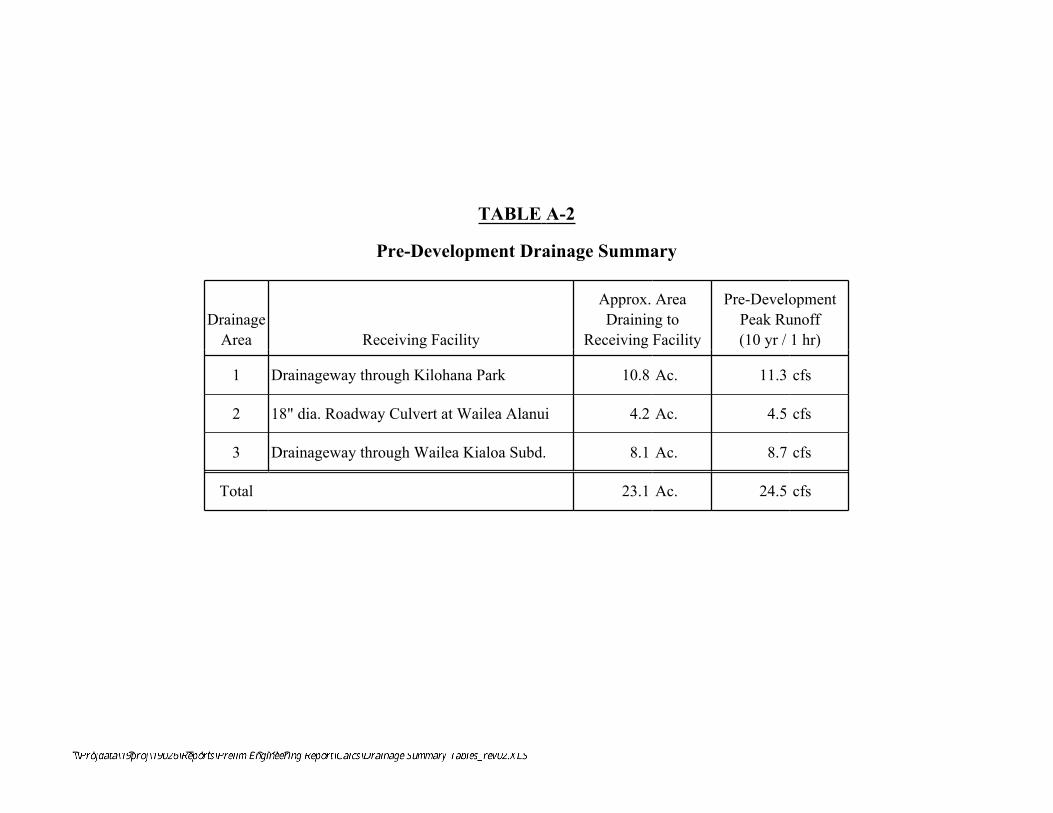
Drainage Summary Tables_rev02.XLS
TABLE A-2
Pre-Development Drainage Summary
DrainageArea Receiving Facility
Approx. AreaDraining to
Receiving Facility
Pre-DevelopmentPeak Runoff(10 yr / 1 hr)
1 Drainageway through Kilohana Park 10.8 Ac. 11.3 cfs
2 18" dia. Roadway Culvert at Wailea Alanui 4.2 Ac. 4.5 cfs
3 Drainageway through Wailea Kialoa Subd. 8.1 Ac. 8.7 cfs
Total 23.1 Ac. 24.5 cfs
dday
Text Box
\\Projdata\19proj\19026\Reports\Prelim Engineering Report\Calcs\Drainage Summary Tables_rev02.XLS
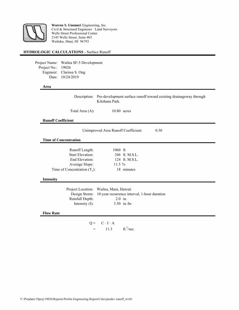
HYDROLOGIC CALCULATIONS - Surface Runoff
Project Name: Wailea SF-5 DevelopmentProject No.: 19026
Engineer: Clarissa S. OngDate: 10/24/2019
Area
Description: Pre-development surface runoff toward existing drainageway through Kilohana Park.
Total Area (A): 10.80 acres
Runoff Coefficient
Unimproved Area Runoff Coefficient: 0.30
Time of Concentration
Runoff Length: 1060 ft.Start Elevation: 246 ft. M.S.L.End Elevation: 124 ft. M.S.L.Average Slope: 11.5 %
Time of Concentration (Tc): 18 minutes
Intensity
Project Location: Wailea, Maui, HawaiiDesign Storm: 10-year recurrence interval, 1-hour duration
Rainfall Depth: 2.0 in.Intensity (I): 3.50 in./hr.
Flow Rate
Q = C · I · A = 11.3 ft.3/sec.
Warren S. Unemori Engineering, Inc.Civil & Structural Engineers · Land SurveyorsWells Street Professional Center2145 Wells Street, Suite 403Wailuku, Maui, HI 96793
V:\Projdata\19proj\19026\Reports\Prelim Engineering Report\Calcs\predev runoff_rev01
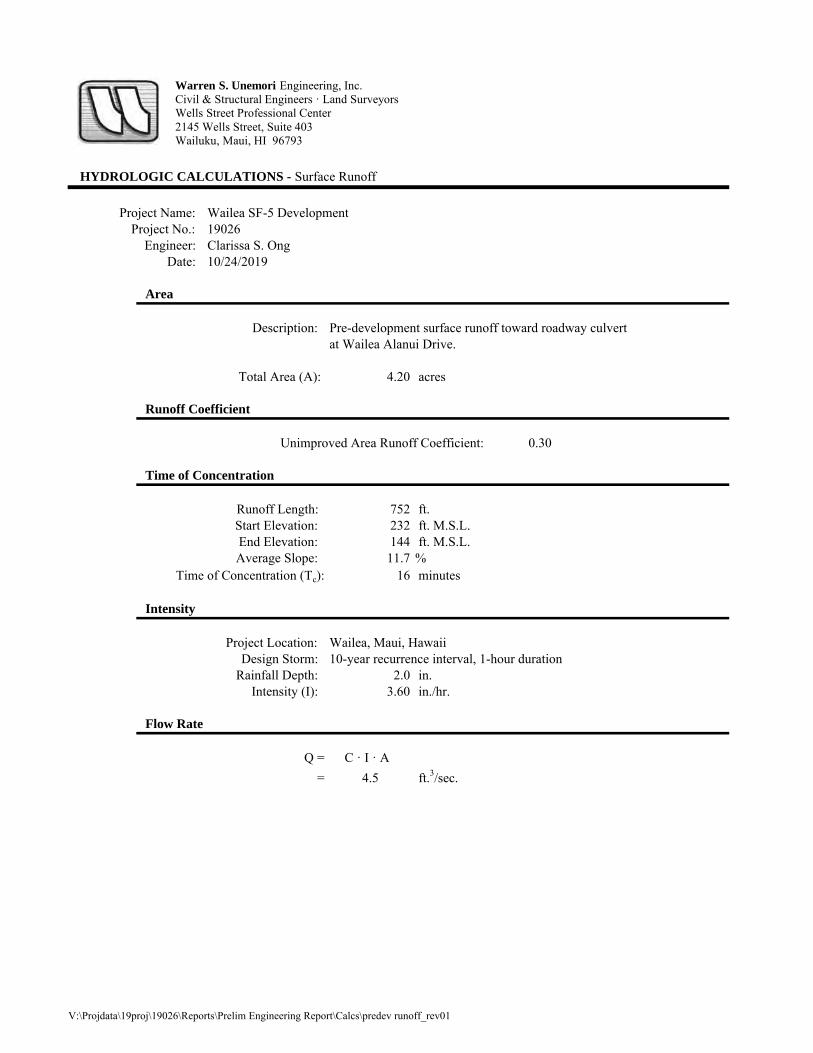
HYDROLOGIC CALCULATIONS - Surface Runoff
Project Name: Wailea SF-5 DevelopmentProject No.: 19026
Engineer: Clarissa S. OngDate: 10/24/2019
Area
Description: Pre-development surface runoff toward roadway culvert at Wailea Alanui Drive.
Total Area (A): 4.20 acres
Runoff Coefficient
Unimproved Area Runoff Coefficient: 0.30
Time of Concentration
Runoff Length: 752 ft.Start Elevation: 232 ft. M.S.L.End Elevation: 144 ft. M.S.L.Average Slope: 11.7 %
Time of Concentration (Tc): 16 minutes
Intensity
Project Location: Wailea, Maui, HawaiiDesign Storm: 10-year recurrence interval, 1-hour duration
Rainfall Depth: 2.0 in.Intensity (I): 3.60 in./hr.
Flow Rate
Q = C · I · A = 4.5 ft.3/sec.
Warren S. Unemori Engineering, Inc.Civil & Structural Engineers · Land SurveyorsWells Street Professional Center2145 Wells Street, Suite 403Wailuku, Maui, HI 96793
V:\Projdata\19proj\19026\Reports\Prelim Engineering Report\Calcs\predev runoff_rev01
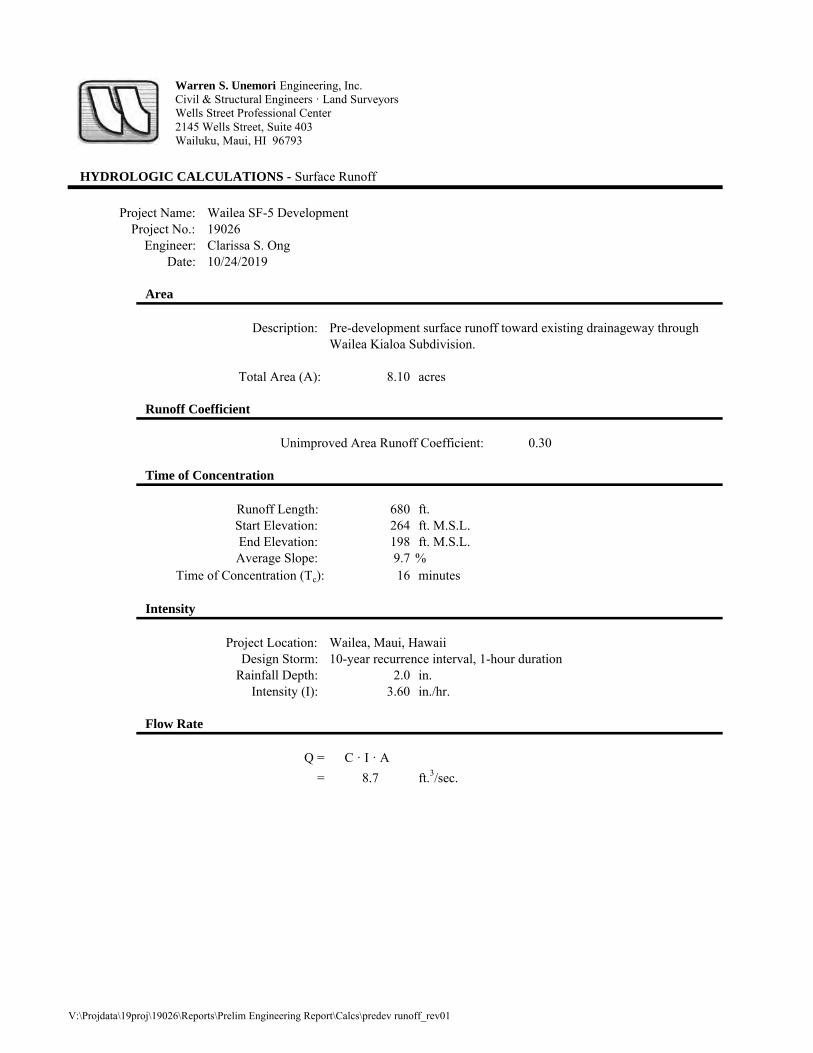
HYDROLOGIC CALCULATIONS - Surface Runoff
Project Name: Wailea SF-5 DevelopmentProject No.: 19026
Engineer: Clarissa S. OngDate: 10/24/2019
Area
Description: Pre-development surface runoff toward existing drainageway throughWailea Kialoa Subdivision.
Total Area (A): 8.10 acres
Runoff Coefficient
Unimproved Area Runoff Coefficient: 0.30
Time of Concentration
Runoff Length: 680 ft.Start Elevation: 264 ft. M.S.L.End Elevation: 198 ft. M.S.L.Average Slope: 9.7 %
Time of Concentration (Tc): 16 minutes
Intensity
Project Location: Wailea, Maui, HawaiiDesign Storm: 10-year recurrence interval, 1-hour duration
Rainfall Depth: 2.0 in.Intensity (I): 3.60 in./hr.
Flow Rate
Q = C · I · A = 8.7 ft.3/sec.
Warren S. Unemori Engineering, Inc.Civil & Structural Engineers · Land SurveyorsWells Street Professional Center2145 Wells Street, Suite 403Wailuku, Maui, HI 96793
V:\Projdata\19proj\19026\Reports\Prelim Engineering Report\Calcs\predev runoff_rev01
APPENDIX A-3
Post-Development Runoff Calculations

Drainage Summary Tables_rev02.XLS
TABLE A-3
Post-Development Drainage Summary
DrainageArea Receiving Facility
Approx. AreaDraining toReceivingFacility
Pre-DevelopmentPeak Runoff(10 yr / 1 hr)
Post-DevelopmentPeak RunoffBEFOREMitigation
Post-DevelopmentPeak RunoffAFTER
Mitigation
Net Change inPeak FlowAFTER
Mitigation
1 Drainageway through Kilohana Park 10.6 Ac. 11.3 cfs 24.4 cfs ≤ 11.3 cfs ≤ 0 cfs
2 18" dia. Roadway Culvert at Wailea Alanui 4.1 Ac. 4.5 cfs 9.2 cfs ≤ 4.5 cfs ≤ 0 cfs
3 Drainageway through Wailea Kialoa Subd. 8.4 Ac. 8.7 cfs 19.3 cfs ≤ 8.7 cfs ≤ 0 cfs
Total 23.1 Ac. 24.5 cfs 52.9 cfs ≤ 24.5 cfs ≤ 0 cfs
dday
Text Box
\\Projdata\19proj\19026\Reports\Prelim Engineering Report\Calcs\Drainage Summary Tables_rev02.XLS

HYDROLOGIC CALCULATIONS - Surface Runoff
Project Name: Wailea SF-5 DevelopmentProject No.: 19026
Engineer: Clarissa S. OngDate: 10/25/2019
Area
Description: Post-development surface runoff toward existing drainageway through Kilohana Park.
Total Area (A): 10.60 acres
Runoff Coefficient
Single-Family Runoff Coefficient: 0.50
Time of Concentration
Runoff Length: 1200 ft.Start Elevation: 249 ft. M.S.L.End Elevation: 135 ft. M.S.L.Average Slope: 9.5 %
Time of Concentration (Tc): 7.5 minutes
Intensity
Project Location: Wailea, Maui, HawaiiDesign Storm: 10-year recurrence interval, 1-hour duration
Rainfall Depth: 2.0 in.Intensity (I): 4.60 in./hr.
Flow Rate
Q = C · I · A = 24.4 ft.3/sec.
Warren S. Unemori Engineering, Inc.Civil & Structural Engineers · Land SurveyorsWells Street Professional Center2145 Wells Street, Suite 403Wailuku, Maui, HI 96793
V:\Projdata\19proj\19026\Reports\Prelim Engineering Report\Calcs\postdev runoff_rev01

HYDROLOGIC CALCULATIONS - Surface Runoff
Project Name: Wailea SF-5 DevelopmentProject No.: 19026
Engineer: Clarissa S. OngDate: 10/25/2019
Area
Description: Post-development surface runoff toward roadway culvert atWailea Alanui.
Total Area (A): 4.10 acres
Runoff Coefficient
Single-Family Runoff Coefficient: 0.50
Time of Concentration
Runoff Length: 1440 ft.Start Elevation: 240 ft. M.S.L.End Elevation: 142 ft. M.S.L.Average Slope: 6.8 %
Time of Concentration (Tc): 8.5 minutes
Intensity
Project Location: Wailea, Maui, HawaiiDesign Storm: 10-year recurrence interval, 1-hour duration
Rainfall Depth: 2.0 in.Intensity (I): 4.50 in./hr.
Flow Rate
Q = C · I · A = 9.2 ft.3/sec.
Warren S. Unemori Engineering, Inc.Civil & Structural Engineers · Land SurveyorsWells Street Professional Center2145 Wells Street, Suite 403Wailuku, Maui, HI 96793
V:\Projdata\19proj\19026\Reports\Prelim Engineering Report\Calcs\postdev runoff_rev01

HYDROLOGIC CALCULATIONS - Surface Runoff
Project Name: Wailea SF-5 DevelopmentProject No.: 19026
Engineer: Clarissa S. OngDate: 10/25/2019
Area
Description: Post-development surface runoff toward existing drainageway throughWailea Kialoa Subdivision.
Total Area (A): 8.40 acres
Runoff Coefficient
Single-Family Runoff Coefficient: 0.50
Time of Concentration
Runoff Length: 900 ft.Start Elevation: 246 ft. M.S.L.End Elevation: 195 ft. M.S.L.Average Slope: 5.7 %
Time of Concentration (Tc): 7.5 minutes
Intensity
Project Location: Wailea, Maui, HawaiiDesign Storm: 10-year recurrence interval, 1-hour duration
Rainfall Depth: 2.0 in.Intensity (I): 4.60 in./hr.
Flow Rate
Q = C · I · A = 19.3 ft.3/sec.
Warren S. Unemori Engineering, Inc.Civil & Structural Engineers · Land SurveyorsWells Street Professional Center2145 Wells Street, Suite 403Wailuku, Maui, HI 96793
V:\Projdata\19proj\19026\Reports\Prelim Engineering Report\Calcs\postdev runoff_rev01

APPENDIX A-4
Detention / Retention Basin Sizing Calculations
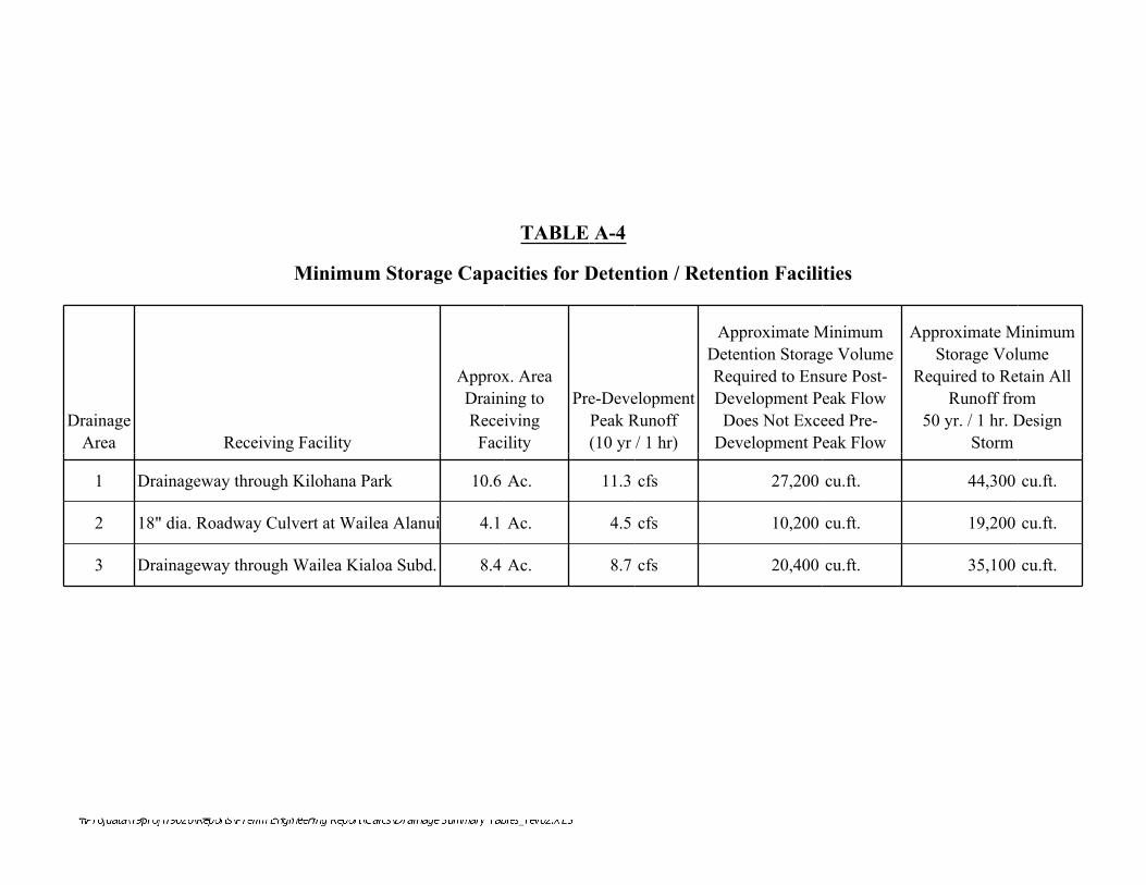
Drainage Summary Tables_rev02.XLS
TABLE A-4
Minimum Storage Capacities for Detention / Retention Facilities
DrainageArea Receiving Facility
Approx. AreaDraining toReceivingFacility
Pre-DevelopmentPeak Runoff(10 yr / 1 hr)
Approximate MinimumDetention Storage VolumeRequired to Ensure Post-Development Peak FlowDoes Not Exceed Pre-
Development Peak Flow
Approximate MinimumStorage Volume
Required to Retain AllRunoff from
50 yr. / 1 hr. DesignStorm
1 Drainageway through Kilohana Park 10.6 Ac. 11.3 cfs 27,200 cu.ft. 44,300 cu.ft.
2 18" dia. Roadway Culvert at Wailea Alanui 4.1 Ac. 4.5 cfs 10,200 cu.ft. 19,200 cu.ft.
3 Drainageway through Wailea Kialoa Subd. 8.4 Ac. 8.7 cfs 20,400 cu.ft. 35,100 cu.ft.
dday
Text Box
\\Projdata\19proj\19026\Reports\Prelim Engineering Report\Calcs\Drainage Summary Tables_rev02.XLS
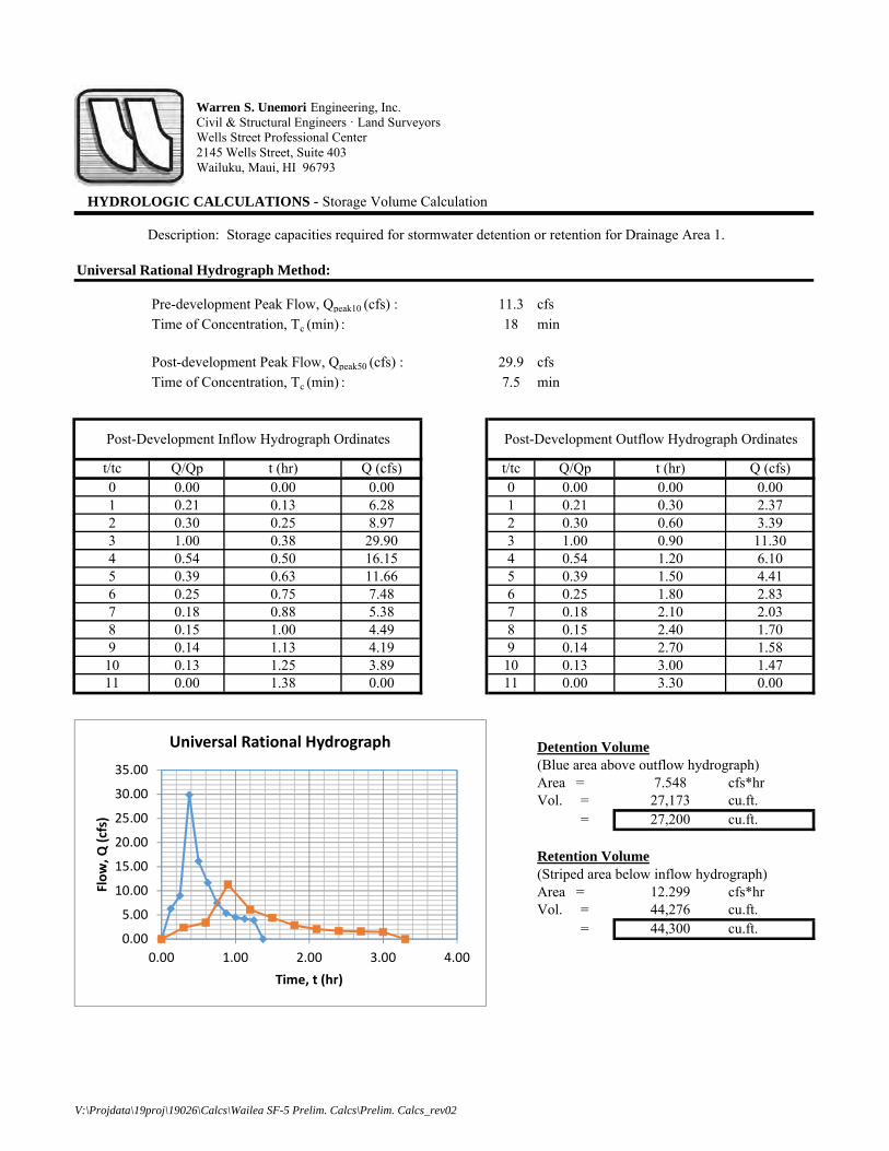
HYDROLOGIC CALCULATIONS - Storage Volume Calculation
Description: Storage capacities required for stormwater detention or retention for Drainage Area 1.
Universal Rational Hydrograph Method:
Pre-development Peak Flow, Qpeak10 (cfs) : 11.3 cfsTime of Concentration, Tc (min) : 18 min
Post-development Peak Flow, Qpeak50 (cfs) : 29.9 cfsTime of Concentration, Tc (min) : 7.5 min
t/tc Q/Qp t (hr) Q (cfs) t/tc Q/Qp t (hr) Q (cfs)0 0.00 0.00 0.00 0 0.00 0.00 0.001 0.21 0.13 6.28 1 0.21 0.30 2.372 0.30 0.25 8.97 2 0.30 0.60 3.393 1.00 0.38 29.90 3 1.00 0.90 11.304 0.54 0.50 16.15 4 0.54 1.20 6.105 0.39 0.63 11.66 5 0.39 1.50 4.416 0.25 0.75 7.48 6 0.25 1.80 2.837 0.18 0.88 5.38 7 0.18 2.10 2.038 0.15 1.00 4.49 8 0.15 2.40 1.709 0.14 1.13 4.19 9 0.14 2.70 1.58
10 0.13 1.25 3.89 10 0.13 3.00 1.4711 0.00 1.38 0.00 11 0.00 3.30 0.00
Detention Volume(Blue area above outflow hydrograph) Area = 7.548 cfs*hrVol. = 27,173 cu.ft. = 27,200 cu.ft.
Retention Volume(Striped area below inflow hydrograph)Area = 12.299 cfs*hrVol. = 44,276 cu.ft. = 44,300 cu.ft.
Post-Development Outflow Hydrograph OrdinatesPost-Development Inflow Hydrograph Ordinates
Warren S. Unemori Engineering, Inc.Civil & Structural Engineers · Land SurveyorsWells Street Professional Center2145 Wells Street, Suite 403Wailuku, Maui, HI 96793
0.00
5.00
10.00
15.00
20.00
25.00
30.00
35.00
0.00 1.00 2.00 3.00 4.00
Flow, Q
(cfs)
Time, t (hr)
Universal Rational Hydrograph
V:\Projdata\19proj\19026\Calcs\Wailea SF-5 Prelim. Calcs\Prelim. Calcs_rev02
csuson
Polygon
csuson
Polygon
csuson
Callout
Outflow Hydrograph
csuson
Callout
Inflow Hydrograph

HYDROLOGIC CALCULATIONS - Storage Volume Calculation
Description: Storage capacities required for stormwater detention or retention for Drainage Area 2.
Universal Rational Hydrograph Method:
Pre-development Peak Flow, Qpeak10 (cfs) : 4.5 cfsTime of Concentration, Tc (min) : 16 min
Post-development Peak Flow, Qpeak50 (cfs) : 11.4 cfsTime of Concentration, Tc (min) : 8.5 min
t/tc Q/Qp t (hr) Q (cfs) t/tc Q/Qp t (hr) Q (cfs)0 0.00 0.00 0.00 0 0.00 0.00 0.001 0.21 0.14 2.39 1 0.21 0.27 0.952 0.30 0.28 3.42 2 0.30 0.53 1.353 1.00 0.43 11.40 3 1.00 0.80 4.504 0.54 0.57 6.16 4 0.54 1.07 2.435 0.39 0.71 4.45 5 0.39 1.33 1.766 0.25 0.85 2.85 6 0.25 1.60 1.137 0.18 0.99 2.05 7 0.18 1.87 0.818 0.15 1.13 1.71 8 0.15 2.13 0.689 0.14 1.28 1.60 9 0.14 2.40 0.63
10 0.13 1.42 1.48 10 0.13 2.67 0.5911 0.00 1.56 0.00 11 0.00 2.93 0.00
Detention Volume(Blue area above outflow hydrograph) Area = 2.822 cfs*hrVol. = 10,159 cu.ft. = 10,200 cu.ft.
Retention Volume(Striped area below inflow hydrograph)Area = 5.342 cfs*hrVol. = 19,231 cu.ft. = 19,200 cu.ft.
Post-Development Inflow Hydrograph Ordinates Post-Development Outflow Hydrograph Ordinates
Warren S. Unemori Engineering, Inc.Civil & Structural Engineers · Land SurveyorsWells Street Professional Center2145 Wells Street, Suite 403Wailuku, Maui, HI 96793
0.00
2.00
4.00
6.00
8.00
10.00
12.00
0.00 1.00 2.00 3.00 4.00
Flow, Q
(cfs)
Time, t (hr)
Universal Rational Hydrograph
V:\Projdata\19proj\19026\Calcs\Wailea SF-5 Prelim. Calcs\Prelim. Calcs_rev02
csuson
Polygon
csuson
Polygon
csuson
Callout
Outflow Hydrograph
csuson
Callout
Inflow Hydrograph

HYDROLOGIC CALCULATIONS - Storage Volume Calculation
Description: Storage capacities required for stormwater detention or retention for Drainage Area 3.
Universal Rational Hydrograph Method:
Pre-development Peak Flow, Qpeak10 (cfs) : 8.7 cfsTime of Concentration, Tc (min) : 16 min
Post-development Peak Flow, Qpeak50 (cfs) : 23.7 cfsTime of Concentration, Tc (min) : 7.5 min
t/tc Q/Qp t (hr) Q (cfs) t/tc Q/Qp t (hr) Q (cfs)0 0.00 0.00 0.00 0 0.00 0.00 0.001 0.21 0.13 4.98 1 0.21 0.27 1.832 0.30 0.25 7.11 2 0.30 0.53 2.613 1.00 0.38 23.70 3 1.00 0.80 8.704 0.54 0.50 12.80 4 0.54 1.07 4.705 0.39 0.63 9.24 5 0.39 1.33 3.396 0.25 0.75 5.93 6 0.25 1.60 2.187 0.18 0.88 4.27 7 0.18 1.87 1.578 0.15 1.00 3.56 8 0.15 2.13 1.319 0.14 1.13 3.32 9 0.14 2.40 1.22
10 0.13 1.25 3.08 10 0.13 2.67 1.1311 0.00 1.38 0.00 11 0.00 2.93 0.00
Detention Volume(Blue area above outflow hydrograph) Area = 5.666 cfs*hrVol. = 20,398 cu.ft. = 20,400 cu.ft.
Retention Volume(Striped area below inflow hydrograph)Area = 9.749 cfs*hrVol. = 35,096 cu.ft. = 35,100 cu.ft.
Post-Development Inflow Hydrograph Ordinates Post-Development Outflow Hydrograph Ordinates
Warren S. Unemori Engineering, Inc.Civil & Structural Engineers · Land SurveyorsWells Street Professional Center2145 Wells Street, Suite 403Wailuku, Maui, HI 96793
0.00
5.00
10.00
15.00
20.00
25.00
0.00 1.00 2.00 3.00 4.00
Flow, Q
(cfs)
Time, t (hr)
Universal Rational Hydrograph
V:\Projdata\19proj\19026\Calcs\Wailea SF-5 Prelim. Calcs\Prelim. Calcs_rev02
csuson
Polygon
csuson
Polygon
csuson
Callout
Outflow Hydrograph
csuson
Callout
Inflow Hydrograph

HYDROLOGIC CALCULATIONS - Surface Runoff
Project Name: Wailea SF-5 DevelopmentProject No.: 19026
Engineer: Clarissa S. OngDate: 10/25/2019
Area
Description: Post-development surface runoff toward existing drainageway through Kilohana Park.
Total Area (A): 10.60 acres
Runoff Coefficient
Single-Family Runoff Coefficient: 0.50
Time of Concentration
Runoff Length: 1200 ft.Start Elevation: 249 ft. M.S.L.End Elevation: 135 ft. M.S.L.Average Slope: 9.5 %
Time of Concentration (Tc): 7.5 minutes
Intensity
Project Location: Wailea, Maui, HawaiiDesign Storm: 50-year recurrence interval, 1-hour duration
Rainfall Depth: 2.5 in.Intensity (I): 5.65 in./hr.
Flow Rate
Q = C · I · A = 29.9 ft.3/sec.
Warren S. Unemori Engineering, Inc.Civil & Structural Engineers · Land SurveyorsWells Street Professional Center2145 Wells Street, Suite 403Wailuku, Maui, HI 96793
V:\Projdata\19proj\19026\Reports\Prelim Engineering Report\Calcs\postdev runoff_rev01

HYDROLOGIC CALCULATIONS - Surface Runoff
Project Name: Wailea SF-5 DevelopmentProject No.: 19026
Engineer: Clarissa S. OngDate: 10/25/2019
Area
Description: Post-development surface runoff toward roadway culvert atWailea Alanui.
Total Area (A): 4.10 acres
Runoff Coefficient
Single-Family Runoff Coefficient: 0.50
Time of Concentration
Runoff Length: 1440 ft.Start Elevation: 240 ft. M.S.L.End Elevation: 142 ft. M.S.L.Average Slope: 6.8 %
Time of Concentration (Tc): 8.5 minutes
Intensity
Project Location: Wailea, Maui, HawaiiDesign Storm: 50-year recurrence interval, 1-hour duration
Rainfall Depth: 2.5 in.Intensity (I): 5.54 in./hr.
Flow Rate
Q = C · I · A = 11.4 ft.3/sec.
Warren S. Unemori Engineering, Inc.Civil & Structural Engineers · Land SurveyorsWells Street Professional Center2145 Wells Street, Suite 403Wailuku, Maui, HI 96793
V:\Projdata\19proj\19026\Reports\Prelim Engineering Report\Calcs\postdev runoff_rev01

HYDROLOGIC CALCULATIONS - Surface Runoff
Project Name: Wailea SF-5 DevelopmentProject No.: 19026
Engineer: Clarissa S. OngDate: 10/25/2019
Area
Description: Post-development surface runoff toward existing drainageway throughWailea Kialoa Subdivision.
Total Area (A): 8.40 acres
Runoff Coefficient
Single-Family Runoff Coefficient: 0.50
Time of Concentration
Runoff Length: 900 ft.Start Elevation: 246 ft. M.S.L.End Elevation: 195 ft. M.S.L.Average Slope: 5.7 %
Time of Concentration (Tc): 7.5 minutes
Intensity
Project Location: Wailea, Maui, HawaiiDesign Storm: 50-year recurrence interval, 1-hour duration
Rainfall Depth: 2.5 in.Intensity (I): 5.65 in./hr.
Flow Rate
Q = C · I · A = 23.7 ft.3/sec.
Warren S. Unemori Engineering, Inc.Civil & Structural Engineers · Land SurveyorsWells Street Professional Center2145 Wells Street, Suite 403Wailuku, Maui, HI 96793
V:\Projdata\19proj\19026\Reports\Prelim Engineering Report\Calcs\postdev runoff_rev01

APPENDIX A-5
Stormwater Quality Calculations

Drainage Summary Tables_rev02.XLS
TABLE A-5
Minimum 48 hr. Retention Capacity Needed to MeetMaui County Stormwater Quality Requirements1
DrainageArea Receiving Facility
Approx. AreaDraining to
Receiving Facility
Minimum 48 hr. RetentionCapacity Needed to MeetMaui County Stormwater
Quality Requirements
1 Drainageway through Kilohana Park 10.6 Ac. 19,239 cu.ft.
2 18" dia. Roadway Culvert at Wailea Alanui 4.1 Ac. 7,442 cu.ft.
3 Drainageway through Wailea Kialoa Subd. 8.4 Ac. 15,246 cu.ft.
1 Ref. Maui County Dept. of Public Works, Title MC-15, Subtitle 01, Chapter 111, "Rules for theDesign of Stormwater Treatment Best Management Practices", Section 15-111-5 (a).
dday
Text Box
\\Projdata\19proj\19026\Reports\Prelim Engineering Report\Calcs\Drainage Summary Tables_rev02.XLS
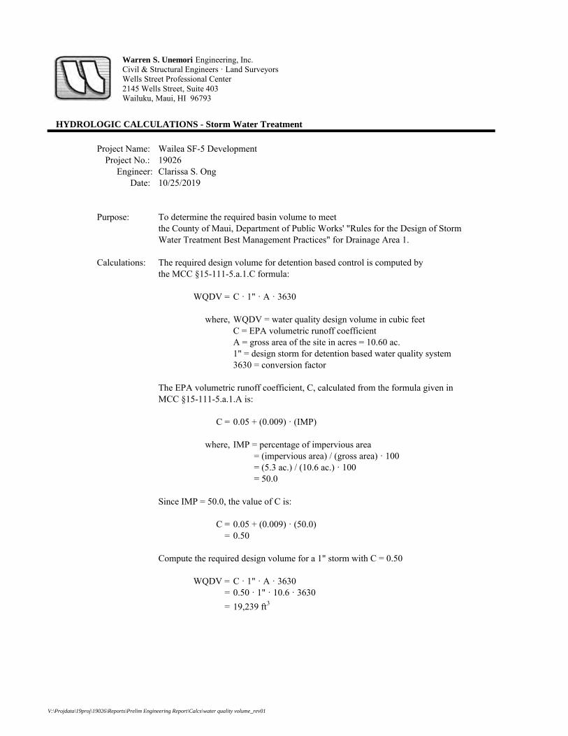
HYDROLOGIC CALCULATIONS - Storm Water Treatment
Project Name: Wailea SF-5 DevelopmentProject No.: 19026
Engineer: Clarissa S. OngDate: 10/25/2019
Purpose: To determine the required basin volume to meetthe County of Maui, Department of Public Works' "Rules for the Design of StormWater Treatment Best Management Practices" for Drainage Area 1.
Calculations: The required design volume for detention based control is computed bythe MCC §15-111-5.a.1.C formula:
WQDV = C · 1" · A · 3630
where, WQDV = water quality design volume in cubic feetC = EPA volumetric runoff coefficientA = gross area of the site in acres = 10.60 ac.1" = design storm for detention based water quality system3630 = conversion factor
The EPA volumetric runoff coefficient, C, calculated from the formula given inMCC §15-111-5.a.1.A is:
C = 0.05 + (0.009) · (IMP)
where, IMP = percentage of impervious area = (impervious area) / (gross area) · 100 = (5.3 ac.) / (10.6 ac.) · 100 = 50.0
Since IMP = 50.0, the value of C is:
C = 0.05 + (0.009) · (50.0)= 0.50
Compute the required design volume for a 1" storm with C = 0.50
WQDV = C · 1" · A · 3630= 0.50 · 1" · 10.6 · 3630= 19,239 ft3
Warren S. Unemori Engineering, Inc.Civil & Structural Engineers · Land SurveyorsWells Street Professional Center2145 Wells Street, Suite 403Wailuku, Maui, HI 96793
V:\Projdata\19proj\19026\Reports\Prelim Engineering Report\Calcs\water quality volume_rev01

HYDROLOGIC CALCULATIONS - Storm Water Treatment
Project Name: Wailea SF-5 DevelopmentProject No.: 19026
Engineer: Clarissa S. OngDate: 10/25/2019
Purpose: To determine the required basin volume to meetthe County of Maui, Department of Public Works' "Rules for the Design of StormWater Treatment Best Management Practices" for Drainage Area 2.
Calculations: The required design volume for detention based control is computed bythe MCC §15-111-5.a.1.C formula:
WQDV = C · 1" · A · 3630
where, WQDV = water quality design volume in cubic feetC = EPA volumetric runoff coefficientA = gross area of the site in acres = 4.10 ac.1" = design storm for detention based water quality system3630 = conversion factor
The EPA volumetric runoff coefficient, C, calculated from the formula given inMCC §15-111-5.a.1.A is:
C = 0.05 + (0.009) · (IMP)
where, IMP = percentage of impervious area = (impervious area) / (gross area) · 100 = (2.05 ac.) / (4.1 ac.) · 100 = 50.0
Since IMP = 50.0, the value of C is:
C = 0.05 + (0.009) · (50.0)= 0.50
Compute the required design volume for a 1" storm with C = 0.50
WQDV = C · 1" · A · 3630= 0.50 · 1" · 4.1 · 3630= 7,442 ft3
Warren S. Unemori Engineering, Inc.Civil & Structural Engineers · Land SurveyorsWells Street Professional Center2145 Wells Street, Suite 403Wailuku, Maui, HI 96793
V:\Projdata\19proj\19026\Reports\Prelim Engineering Report\Calcs\water quality volume_rev01

HYDROLOGIC CALCULATIONS - Storm Water Treatment
Project Name: Wailea SF-5 DevelopmentProject No.: 19026
Engineer: Clarissa S. OngDate: 10/25/2019
Purpose: To determine the required basin volume to meetthe County of Maui, Department of Public Works' "Rules for the Design of StormWater Treatment Best Management Practices" for Drainage Area 3.
Calculations: The required design volume for detention based control is computed bythe MCC §15-111-5.a.1.C formula:
WQDV = C · 1" · A · 3630
where, WQDV = water quality design volume in cubic feetC = EPA volumetric runoff coefficientA = gross area of the site in acres = 8.40 ac.1" = design storm for detention based water quality system3630 = conversion factor
The EPA volumetric runoff coefficient, C, calculated from the formula given inMCC §15-111-5.a.1.A is:
C = 0.05 + (0.009) · (IMP)
where, IMP = percentage of impervious area = (impervious area) / (gross area) · 100 = (4.2 ac.) / (8.4 ac.) · 100 = 50.0
Since IMP = 50.0, the value of C is:
C = 0.05 + (0.009) · (50.0)= 0.50
Compute the required design volume for a 1" storm with C = 0.50
WQDV = C · 1" · A · 3630= 0.50 · 1" · 8.4 · 3630= 15,246 ft3
Warren S. Unemori Engineering, Inc.Civil & Structural Engineers · Land SurveyorsWells Street Professional Center2145 Wells Street, Suite 403Wailuku, Maui, HI 96793
V:\Projdata\19proj\19026\Reports\Prelim Engineering Report\Calcs\water quality volume_rev01
APPENDIX BPotable Water Calculations

APPENDIX B-1
Projected Daily Water Demand
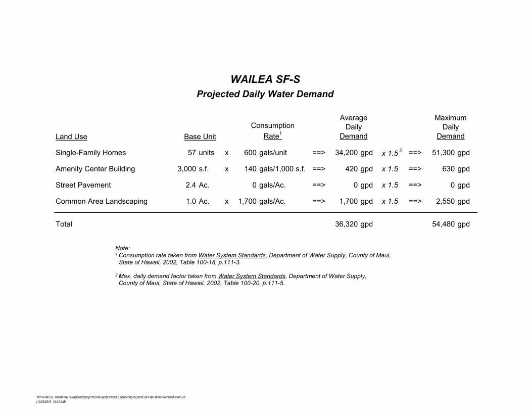
Land Use
Single-Family Homes 57 units x 600 gals/unit ==> 34,200 gpd x 1.5 2 ==> 51,300 gpd
Amenity Center Building 3,000 s.f. x 140 gals/1,000 s.f. ==> 420 gpd x 1.5 ==> 630 gpd
Street Pavement 2.4 Ac. 0 gals/Ac. ==> 0 gpd x 1.5 ==> 0 gpd
Common Area Landscaping 1.0 Ac. x 1,700 gals/Ac. ==> 1,700 gpd x 1.5 ==> 2,550 gpd
Total 36,320 gpd 54,480 gpd
Consumption Rate1
Average Daily
DemandBase Unit
Maximum Daily
Demand
Projected Daily Water DemandWAILEA SF-S
Note: 1 Consumption rate taken from Water System Standards, Department of Water Supply, County of Maui,
State of Hawaii, 2002, Table 100-18, p.111-3.
2 Max. daily demand factor taken from Water System Standards, Department of Water Supply, County of Maui, State of Hawaii, 2002, Table 100-20, p.111-5.
\\HP16\WSUE Data\Array1\Projdata\19proj\19026\Reports\Prelim Engineering Report\Calcs\dtu-Water-Demand-rev05.xls(10/29/2019 10:23 AM)

APPENDIX B-2
Domestic Water Storage Capacity Calculation

UPPER-LEVEL STORAGE TANK
Single-Family Homes 21 units x 600 gals/unit ==> 12,600 gpd x 1.5 2 ==> 18,900 gal.
Amenity Center Building 3,000 s.f. x 140 gals/1,000 s.f. ==> 420 gpd x 1.5 ==> 630 gal.
Common Area Landscaping 1.0 Ac. x 1,700 gals/Ac. ==> 1,700 gpd x 1.5 ==> 2,550 gal.
Subtotal 14,720 gpd 22,080 gal.
MID-LEVEL STORAGE TANK
Single-Family Homes 36 units x 600 gals/unit ==> 21,600 gpd x 1.5 ==> 32,400 gal.
Subtotal 21,600 gpd 32,400 gal.
Total 54,480 gal.
WAILEA SF-SDomestic Water Storage Capacity Calculation
Needed Domestic
Water Storage Capacity
Consumption Rate1
Average Daily DemandBase UnitLand Use
Notes: 1 Consumption rate taken from Water System Standards, Department of Water Supply, County of Maui,
State of Hawaii, 2002, Table 100-18, p.111-3.
2 Max. daily demand factor taken from Water System Standards, Department of Water Supply, County of Maui, State of Hawaii, 2002, Table 100-20, p.111-5.
V:\Projdata\19proj\19026\Reports\Prelim Engineering Report\Calcs\dtu-Water-Storage Requirements_rev01(1/16/2020 10:32 AM)
APPENDIX B-3
Preliminary Water Meter Sizing Calculation

WAILEA SF-SPreliminary Water Meter Sizing Calculation
for Upper-Level Service Zone(Single meter for CPR Development)
January 15, 2020
Domestic Flow Demand
Single-family homes + Amenity Center
= (35 FU/home x 21 homes) + 50 FU/Amenity Center
= 785 FU
. 176 gpm
Irrigation Flow Demand
50 gpm peak flow
Needed Meter Capacity
Domestic Flow Demand + Irrigation Flow Demand . 226 gpm
Needed Meter Size
2" Meter Capacity < Needed Capacity < 3" Meter Capacity 160 gpm 226 gpm 320 gpm
ˆ 3-inch meter needed for Upper-Level service zone
Page 1 of 2
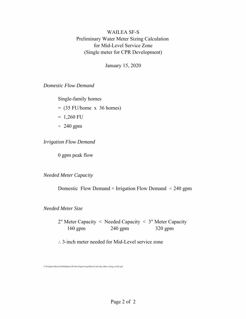
WAILEA SF-SPreliminary Water Meter Sizing Calculation
for Mid-Level Service Zone(Single meter for CPR Development)
January 15, 2020
Domestic Flow Demand
Single-family homes
= (35 FU/home x 36 homes)
= 1,260 FU
. 240 gpm
Irrigation Flow Demand
0 gpm peak flow
Needed Meter Capacity
Domestic Flow Demand + Irrigation Flow Demand . 240 gpm
Needed Meter Size
2" Meter Capacity < Needed Capacity < 3" Meter Capacity 160 gpm 240 gpm 320 gpm
ˆ 3-inch meter needed for Mid-Level service zone
V:\Projdata\19proj\19026\Reports\Prelim Engineering Report\Calcs\dtu_Meter sizing_rev03.wpd
Page 2 of 2
APPENDIX CWastewater Demand Calculations
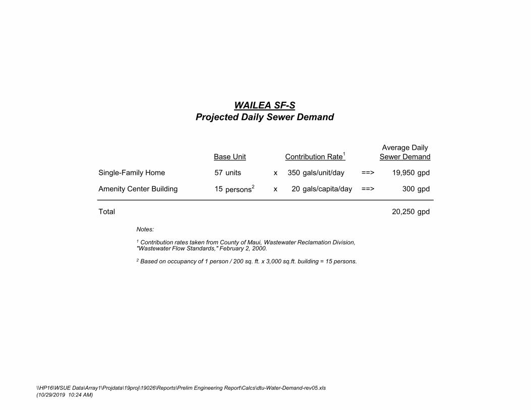
Contribution Rate1
Single-Family Home 57 units x 350 gals/unit/day ==> 19,950 gpd
Amenity Center Building 15 persons2 x 20 gals/capita/day ==> 300 gpd
Total 20,250 gpd
Average Daily Sewer DemandBase Unit
WAILEA SF-SProjected Daily Sewer Demand
Notes:
1 Contribution rates taken from County of Maui, Wastewater Reclamation Division, "Wastewater Flow Standards," February 2, 2000.
2 Based on occupancy of 1 person / 200 sq. ft. x 3,000 sq.ft. building = 15 persons.
\\HP16\WSUE Data\Array1\Projdata\19proj\19026\Reports\Prelim Engineering Report\Calcs\dtu-Water-Demand-rev05.xls(10/29/2019 10:24 AM)
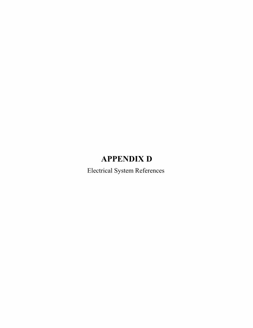
APPENDIX D
Electrical System References

APPENDIX D-1
MECo Reference Drawings

QEl:1.
6Tf<;;BeT Llq!-ff CONOOC1'01\'..IN:$i Offil'e'AM &.
® ©
BITE f' l,,A N
®
El\1::'.JT'6. ~~'1
~;:J
~F.::f
----3-
()LJ65fAfiON• Z5.w.1i; C.IR<:.t.Jlfl Jl'.Si ;;iliJ~i:A'1
. .12.ill'G.~K~
0
riEW
.~ t;;lMl':t tYbHI C01'1o: .13A$c
wJ Q.4-'SG)..
!'.SI l-1.l>NDtlOt...e ( ;:; ~ e;) srn 1ee-tl
"" HANDHol-e (l?iq' $10 li$$-t3
iJ l'l!>Oilri $Wl1C~hR, (SCHSOC>I ) 0112+:!>
00-!\;0")IA
~ ~1ff,,,~tl1&< .O~. Cil il.24$
(.ao·$COI)
u.ei. CCMCJJITo (l"YC, 06,d'< &.e COl!Ollif)
$T. lAGHT Clf':CUIT
---ll ~TUoOUT
• ~
[):)CATION IYIAF K.T-""
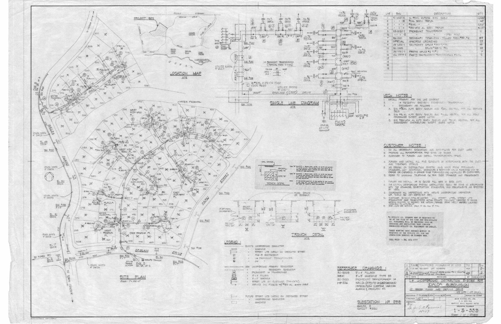
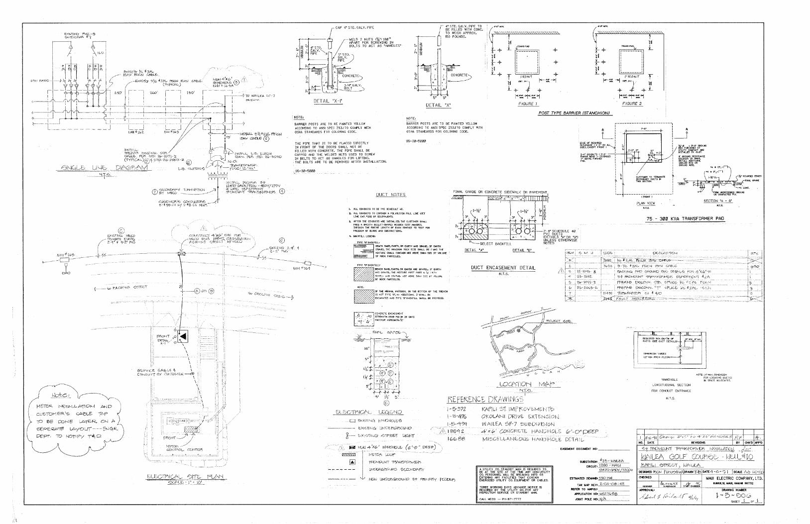
··~;
.. i),'lefeR .,JN!CfA!.kJ!fPC>N
--.<=4~ER'e ~
... .'IP. ~ ~Nf.i ~R. ... a-l ~
~~~ ~yt:'.\li..rr.,---,-ei,J.~
•. ~ .. :~..:.~+~o....
@:~·"~"'-·
~~~·-··· ,,_~i~W·.Q1:"Kf,~:i:•·.:tu':N~·\,
iii'
DE;;rAJL 'X~
,J!$ i . .• l!f~Mrf!lt, /'GSTS AIU! TO at;: l>"1!11'El1 Y1!!.l.1'W A;OO!llllJQ!lil TQ ANSf SPEC l~Ttl COMPLY l'llTll !Jl!Hl< S'~AilO!l Fllll eQl.Qlllll~ .-~
'll<'ffCIP~t:' QPl\UIJNZ:-c·· · .... 1 S .. ;;~~~,,-.di~L·II: J_~_."'t~
I ;;;~m::t -~L':it )Mff;:.~6.~~~· I-:.~·-~ ..... ~.:DRI.V!L.E.Xle.Nst!>Ji.l.
.J~7ri~liA •e;
A
L
PLAN VIEW N.T.S.
A
__J %" ¢ x 81-0" GROUND ROD FURNISHED BY UTILITY COMP ANY AND INST Pl.LED BY GUST.
IF GROUND RESIST ANGE EXCEEDS 25 OHMS, INST ALL AODITIONN.. GROUND ROD OR GROUND WIRE.
•4
~
CIRM UNDISTURBED GROUND OR COMPACTED FILL
SECTION "A - A" N.T.S.
75 - 301Zl KVA TRANSFORMER PAD
DUCT NllTES
1. ALL cm.murrs TO BE PVC: SCHEOULE. 4"
Z. ALL d)ND\Jrrs TO COITTAlti 4·.POLYOl.EflN PULL LINE lJEl' LINE CAT. •:2:32 OR EQUIVALENT>.
3. AFTER rne ctlNDUITS .AR£ tNSTALLEO, THE CUSTOMER SHALL PASS A SMOOTH BIJl..LET·Sf1A1'£0 W()OOEN TEST MANDRELL Tl:'f\,l{lXlH THE alTlRE LENGTtt OF': EACtt'·eoNDUIT TO TEST FOR Ff\rt!lOM -OF BURRS- Arm OBSTRUCTIONS.
4. SACl<flLL LEGEND:
TYPE 'fl• eAo:Fii..L1
•
- ·$EACH SAN.D;.E.AATH,_OR EARl'B AN. 0 GRAVEL JF EARTH ANO .GRAVEL. TIE MIXTURE MUST PASS A ¥.i_• MESH SCRE!;N AOO'_CONTAIN NOT MOR£ 1lfAN 2ltt BY VOLUHE OF ROCK PARTICLES.
•
ti" THE: Nlll)MAL MAT£f'rl:AL IN THE ~OTTOM Of THE T_RENCH IS NOT ii'f'E "S', AN AOOITIOt-iAL 3' stW.L SE i!:XCAVAT£0 ANO TYPE 'B'·BACKflLL SHALL BE PRCMOEO,
CUSTOMER'S SECONDARY DUCT AND CONDUCTORS
KAP\ L l
~. 4" STD. GN.. V. PIPE TO
BE FILLED WITH CONC. TO WEIGH APPROX.
0
r 150 POUNDS.
J~~--· .:~:[;~~ ~L=. '
! 5' 5'
DETAIL "X"
NOTE'
BARRIER POSTS AR!:: TO BE PAINTED YELLOW ACCORDING TO ANSI SPEC ZS3,1 TO COMPLY WITH OSHA ST AND ARDS FOR COLORING CODE.
UG-30-5000
CHAIN-LINK FENCE )
TRANS PAD
1------------1 I I I I I I I I I I I I I I I I I I I I I I l ____________ J
FRONT ~ ~i~" --7J m. x-1 l
+ -f-~··o" -'*-''·O" .-.;:< !- MAX. ·1· MAX. -I
~. CAP 4 ' STD GAL V PIPE
- --- WELD 2 NUTS r%'l 180° • APART FOR SCREWING IN
0 ::-; o 4" STD. £BOLTS TO ACT AS 'HANDLES' te ~ _1 GALV"""-·' ~ "' PIPE ':> ~" STD n ::2 GALV
PIPE
DETAIL "X-1"
~ BARRIER POSTS ARI:: TO BE PAtNTEO YELLOW ACCORDING TO ANSI SPEC 253.1 TO COMPLY W!TH OSHA STANDARDS FOR COLORlNG CODE.
THE PIPE THAI IS TO BE PLACED DIRECTLY IN FRONT OF. THE OOOf={S SHALL NOT BE FILLED WITH CONCRETE. THE PIPE SHALL BE CAPPED AND THE WELD!'::O NUTS USED TO SCREW IN BOLTS TO ACT AS HANDLES FOR LIFTING. THE BOLTS ARE TO BE REMOVED AFTER INSTALLATION.
UG-30-5000
. 5
:!M=~~@~; ~SELECT B_ACKF!U .•
~ DETAIL"l3"
ULE 40 s 'A'OR 'B'l THE.RWISE
s TREE T ------------
------------ POST TYPE BARRIER (STANCHION) DUCT ENCASEMENT DETNL N.T.S.
INSET 11An
SCALE' 1" • 10'
AL
N.T.S.
ELECTRICAL LEGEND:
g} EXISTING PAOMOUNT TRANSFORMER
!§] EXISTING PAOMOUNT SWITCHGEAR
CJ EXISTING HANDHOLES
CONSTRUCTION NOTES: EXISTING UNDERGROUND
EXISTING STREET LIGHT
NEW METER LOOP 1. THIS PROJECT IS SUBJECT TO THE CtiMPLETION OF UNDERGROUND CABLE !NST N..LATION FOR WAILl:A RESORT <KAPIU STRcETl BY LARRY BERNADES' PROJECT NO. M103552. N...SO THE COMPLETION OF OR COORDINATION WITH THE 3 PHASE PADMOUNT INSTALLATION FOR WAILEA GOLF COURSE WELL NO. 10 BY RON f'UKUSHIMA'S PROJECT NO.
M.JE.6_~~-T INSTALlt;METER CCTY. INSP.'·-----------·-l. 3f( 4W, IS•JAW, 277 I 480V RATE "J".
NEW PADMOUNT TRANSFORMER
NEW UNDERGROUND SECONDARY <BY CUSTOMER>
NEW UNDERGROUND 3t PRIMARY FEEDER
REQUIRED
~l!\%WoTJirs~ REFERENCE DWG.
{SEE DUCT ~J4~'~M~AX'---'"--'-= DETAILS) i WJOTH
I
MEGO DWG. NO.' 1-5-372
NO.' 1·5·506
PME-9 ( SWITCHGEAR
11 ~~I ~ol ldt: \
U.G. CABLE. !NSTN..LATION FOR WAILEA RESORT CKAPILI STREET)
3~ PAOMT. TRANSFORMER INSTALLATION
PAD
FOR WAILEA GOLF COURSE WELL NO. 10
A UTILITY CO. STANDBY MAN IS REQUIRED TO BE AT THE SITE AT THE TIME ANY NON-UTILITY CO. PERSONNEL WILL BE BREAKING INTO OR ENTERING ANY F AGILITIES THAT CONTAIN ENERGIZED UTILITY CO. EQUIPMENT OR CABLES.
THREE WORKING DAYS ADVANCE NOTICE IS REQUIRED BY THE UTILITY CO. FOR ANY INSPECTION SERVICE OR STANDBY MAN.
CN..L MEGO ~c PH' 871-7777
I VARIES (1'MIN FROM FLQORJ
HANDHOLE LONGITUDINAL SECTION
FOR CONDUIT ENTRANCE N.T.S.
EASEMENT DOCUMENT NO: NI A
SleS'fATfQN'; 25 WAILEA
CIRCVl1' ___JmQ..XJJ:iS_I _ ~-1~47K_V __
ESTIMATED DEMAND• 8QKW
TAX MAP l<l!"f; 2~1~,03:42
REFER T? MAP<Sl> _fi'!Uc . .±~2JL. APPLICAt.JON Nor·- M117657
J01N't' POLE HO'f_· -~N/A -~
NOTES
1~ THE CUSTOMER IS TO FURNISH MATERIALS AND CONSTRUCT THE FACILITIES FOR l~~ofi~~~$ug0~~s:RANSFORMER INCLUDING THE CONCRETE PAD, PRIMARY AND
Z.f'RlMARY DUCTS, THE BENDS INTO THE PRIMARY COMPARTMENT OF THE PADMOUNTEO TRANSFORMER MAY BE GALVANIZED STEEL CONtlUIT ,,OF SCHED. 40 PVC, WITH A J1 ~0' RADIUS.
3tSECONDARY DUCTS: THE CUSTOMER lS TO SUPPLY AND INSTALL All THE StCQNDARY DUCTS AND CABLES. THE SE:CONDARY CABLES ARE TO BE A MINIMUM OF 7'~0'LONG-fROM THE END OF THE oucr.
-j-~: THE UTILITY COMPANY SHALL HAVE 24-HDUR ACCESS TO THE TRANSFORMER Wl1HOUT GOING THROUGH LOCKEP AREAS.
~'$/THE UTILITY COMPANY Stu:ILL }!AVE A MlNIMliM 10 FT. WIDE VEHJCULAA ACCESS _THAT rs APPROVED BY THE UTILITY co. TO THE TRANSFORMER.
_$.JIENOS DUE ro CHANGES OF GRADE ARE TO HAVE A MINIMUM RAOlUS OF 2;0'-0'. JHE CUST0t-1ER IS TO JN$TALL THE DUCTS AS REQUIRED SY THE UTILITY COMPANY AND IN ACCOFl.DANCE WI-TH DUCT ENCASEMENT DETAILS.
-";:t~~f'~~~~~w~~D t~&~g~E~o~~;He8'CS~r~~:A 1f8 ~c~Ht°AgTl~I~~GWN ON THE ._DRAWING. THE CUSTOMER JS TO PICK UP THE RODS AT THE UTILITY COMPANY ~:SUPPLY ROOM. THE RObS ARE TO EXTEND 6_' ABOVE THE FINISHED fAO" TIE
f!OOS TO A GALV. IRON OR COPPER .WATER PtPE WITH •110 COPPER WIRE. THIS - _MAY BE ELIMINA'nrn \./HERE THE WAT€R PIPE lS MORE THAN 2.5 FT. A\.IA'i'.
·a;coNCR€'TE NOTE.S ' A. CONCRETE STRENGTH- 3,000 -P.S.I. IN 28 DAYS.
B, .CUfUN"G BY APPl:lOVED METHOD. C. POUR CONCRETE ON Flll.M, UNOlSTURBED SOIL OR COMPACTED FILL.
'rsNO PERMANENT OR TEMPORARY STRUCTURE OR OBJECT SHALL BE ERECTED OR :'.-,PLACED W'!THIN THE INDICATED CLEAR SPACE.
LO.CATED IN THE VICINITY_ OF _EXISTING {)R , COMBUST1Bl€ BUILDINGS OR PARTS OF L PROVlOI;! SAFEGUARDS· A$ OUTLINEIJ IN 10NAL Et.ECTfiJCAL C'OOE _!LATE$T_ Rf'VlSltlN),
"'_ _ THE- CUSTOMER SHALL ERECT A 5' WIOE BY 14' DEEP C;ONCRETE CUBS AROUND THE TRANSFORMER PAO, 2 FT.
""FROM 1HE EDGES. THE CURB SHALL -PROTRUDE 2' ABOVE THE PAD FINJSHED , , GRADE, AND THE SPACE BETWEEN THE PAD AND THE CURB SHALL BE Fil).ED WITH ~ '-7• OF GRAOE 'A' CRUSHED LAVA ROCK.
;i:1f-THE FRONT -$lOES, OF THE CONCRETE PADS SHALL ALWAYS BE LOCATED ro FACE "THE VEHiqJLAfl: ACCESS (SE-8 NOTES 4 &. 5l, AND SHALL BE FREE AND CLEAR OF
,-ANY CONSTRUCTION OR PARKED VEHICLE AT ALL TIMES.
-~WHtN PAflT_S OF BUILDINGS OR STRUCTURES ARE l0Cf>T£0 DIRECTLY OVER THE CONCRETE PADS, A MIN!MlJM VERTlCLE CL~RANCE OF ~'~0' fRDH _THE PAD
_,'- OHADE IS REQUIRED. JN ADOITlON, 4'-0' CLEARANCE FROM-- ANY P€RMANENT ~-OR TEMPORARY OBJECT OR STRUDTUR.E SHALL BE REQUIRED-FROM EITHER SlDES --~-OF THE PAD TO f'"ACILITATE TRANSFORHER REMO\IAL OR CHANGEOUT. 1HE
CUSTOMER SHALL PROVIDE ADEQUATE SAF'E!>UARDS -AS OUTLINED 1N PARAGRAPH ' .450-26' OF THI:: NATION'AL ELECTRICAL CODE (LATEST .RfVlSJON}, ANO SUBJECT
10 APf'RDVAL OF 'THE tOUNTY BUILD!NG INSPECTOR.
~f·-~~LE~fJkC~~i).SHALL CONTAIN A POLYOLEFIN PULL llNE lJEi LINE CAT. •232:
-;~:stLECT BACKflLL1 AS SPECJFlEO IN THE UTillfY COMPANY'S SEA.VICE :_:·_::_,INSiALlATION MANUAL.
'1~; THI;: UTILITY COMPANY'S METERING FACILITIES SHALL BE- INSTALLED IN ;,-J READ.IL Y ACCESS1BLE, PREFERABLY UNLC ~~e;~~I~~~~/HE
'ENCLOSED AREAS WHICH DOORS OR COVERS WHICH
LOCK.
TANDARO W_ILLBE. 'T"HE SdUND LEVEL
~' - PROXIMITY-OF "fHE TRAN$FORME'R TO THt- BUlLDiNGS- WINDOWS, WALLS, -ETC. ON HIS PROPERTY TO LIHil ANY OBJECTIONABLE NOISE TO OCCUPANTS IN IHAT PROPl;RTY.
l~AFTER THE CONDUITS ARE INSTALLED, THE CUSTOMER SHALL PASS A -sMOO'rti
::---~~5ITS~~Pf€sro~&!iNF~€Jo~A~R~(iRJ~Rg~gH oJ~fRtjg:g~~s:ENGTH OF EACH
:;_~-t~~n:-g1g~MJ~:EF~RO~J~GI~tp~~~r%~A~~v~gpcE REQUIRED BY TH~ A UTIUTY"STANO~BY MAN IS _RE®I~ED TO J;l€ AT THE SITE-AT THE TlHE ANY NON-UTILTIY CO. PERSONNEL W1LL BE BRe-AKING INTO OR ENTERING" -ANY ~ACIL!TlES
'.THAT CONTAJN ENERG!2ED UTtLliY EQUIPMENT OR CABLES.
-CALL MECO - PHONE 871-7777
LOCATION MAP N.T.S.
TO-> -MA!<ENA
COURS~ WELL No.9 KIHEI
Df:tAWN_TL DATE 9/:;;q/'."'1·""- SCALE PS NOTED
MAUI ELECTRIC COMPANY, LTD.
"--~-"''"'-"'"""''-..J'-'"':Jf".'-''"'"""'_;;"-'Y1,,_~-~ KAHULut, .MAUl;--WAWAI 9&732: DRAWJNG. lj\JMBER
t-5-507
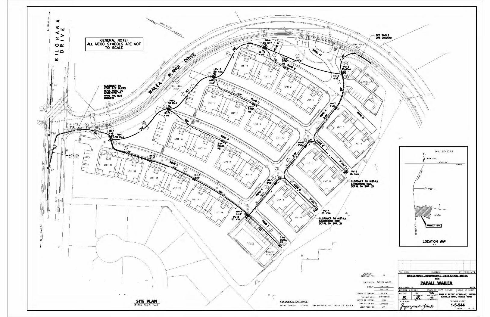
;., 0:: < ·c 2 ii: z l&J }!
<> :r Oa:
-'O
~
J r Kl §
E6
J ~
GENERAL NOTE: ALL MECO SYMBOLS ARE NOT
TO SCALE
---------------------------------------------------------------
SITE PLAN AP PRO)(_ SCALE' 111 -40 1
' ' ' ' ' ' ' ' '
' ' ' ' ' ' ' ' ' ' ' ' ' '
'\,\',,\',,\ ',
'
®( REFERENCE DRAWINGS'
/
/
' '
' CUITCMR TO IST M.L IT MCllDlll llEE
///
,/,/ ,/Plil·7
/ 25 ICYA ®
' CUITIMR TO lld11U. l STMOOd Cla OEHL ON IHT. 2>
OETM. ON 911. ll~
EASE'-"ENT DOCU~ENl NO: _____ _
SUBSTATION: SUB 2!i WALEA
CIRClJT· 1280 Kii-£!
12 H KY
ESTIMATED DEMAND•---~"=B~K=W __
TAX MAP KEY: __ 2~-~1-=00=8~'0=84~-
REFER ro MN'(SJ; ___ 4=3=2B~--
MECO DRAWING 1-5-493 THE PALMS CONDO PHASE II o WAILEA APPLICA.TKJN N0=-~"~00=1=86=2=9 __
JOIN"T POL E NO· __ ~N~/~--
MAUI MEADOWS
l
J
LOCATION MAP NTS
ND. DATE REVISIONS BY CH K'D APP'D
8N&lffllAM UNQllGIOUNp PllD•IUllON DIDM FOil
PAPALI WAILEA WAL EA
DATE 312-1/06 SCALE AS SHOWN
APPROVAL: DRr'l.WING NUli!BER
1-5-944 SHEET_1_ o f_l_
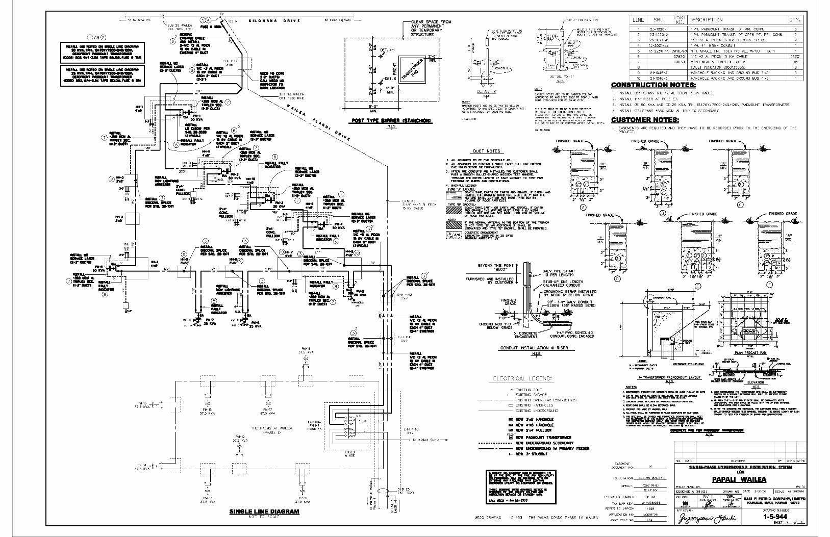
- lo S. Kihei Rd
(i)oR(2)
.............. Gii 9llDl.I ..... -.......... 11111111,.......,..,. ..,..,_..NIMUll._. .... -· ... .,...,. ......... ,.. ...
.......
-· .....
(j) :a-.:----. P.r 1UC11 .---------.:
I 138' ! -• • i
SUB 25 WAILEA CKT. 1280 KIHEI
2
©
100 N
EHH •177 .......... _ ..... G•r lllUClll
2•ljy, 3'x5'
® : .: :.,, "': U01 2"'" llUCI ----<!> .......
It IL 0 HA Iii A 0 RIVE
_,._ 2•1'" llUCI• __ .., _ .. ---
•••ua -·a-r auc ..
• .,, ..
to P1ilan1 Highway -
ICLEAR SPACE FROM ANY PERMANENT
' .. ," ' ..
' '
OR TEMPORARY STRUCTURE
,---- ---- ------1 I ~~ I I N ::! DET. X-1 I I -1'--tf 2·-0 .. I I !z ~"'4 MIN. i I ~ ~ ~ .fi_a I I LL. ,,.41"<l""" I I ~ -IDET.X ., I I ~ ;;i::; 4'-D" I I N ::::E I MIN. I
IL _________________ J
8'-D"
•• '•.
MIN .
EXISTING 3-1/C •4/D AL PEICN 15 KV CABLE
€ 4" STD.G/>LV.PIPE TO BE FILLED W.ITH CD.'°· TO WEIGH N'PROX 150 POUNDS
5" 5"
DETAIL "X" _t::!l_§._
8AARIER POSTS AAE TO BE PAINTED YELLOW ACCORDING TO ANSI SPEC Z53.I TO COMPLY WITH OSHA STANDAADS FOR COLORING CODE.
DUCT NOTES
1, ALL COIOJITS TO BE PVC SCHEDU.E •O .
NOTE·
DETAIL "X 1" __li,_p._
BMRIER POSTS ARE TO BE Pi\JNTED YELLOW ACCORDING TO N<SI SPEC Z5>.1 TD COMPLY WITH OSHA STANDARDS FOR COLORING CODE
THE PEPE THOT IS TO BE PLOCED DIRECTLY IN FRDNT OF THE DOORS SHALL NDT BE FILLED WITH CONCRETE. THE PIPE SH"--L BE LOPPED ONO THE WELDED NUTS USED TD SCREW IN BOLTS TD ACT AS HANDLES FOR LIFTINO. THE Ba.TS ARE TD BE REMOVED OFTER INSTOLLATIDN.
FINISHED GRADE'
2. ALL CONlUITS TO CONTAfl A "liU.E TAPE" Pl.\.L LINE (WESCO CAT. 0072~·92000 OR ECUIVN..ENTJ.
J, Af'TER THE COICIUITS ARE tlST Al.LEO, THE CUSTOlllER SHALL PASS A SMOOTH BU.LET·SHAPEO WOODEN TEST IUNlREL T~ THE ENTIRE LENGTH OF EACH COIO.IT TO TEST FOFI FREEDOM OF BURRS ANO OBSTRUCTIONS.
'· BACKFl.L LECEt«J1 TYPE "A" BACKFLL• ~ BEACH 5.ANl, EARTH, DR EARTH ~ GRAVEL. F EARTH ANO
~ ffx'TviitE ~AL~~=AflROC~Ts~r#t~BE.511~ ~D THE VOL'-"E OF ROCK PMTICLES.
TYPE "B" llAC<FU.• ~ BEN::H S#ID, EMTH, OR EMTH ~ GRAVEL. F ENITH
J" 11/2" J"
@
LINE SMU PART DESCRIPTION NOo
QTY.
23-1020-1 1 PH. PADMOUNT TRANSF. OF PRI. CONN.
23-1020-2 1 PH. PADMOUNT TRANSF. OF OPEN PT. PRI. CONN.
26-1071-Ml 1/C +2 AL PEICN 15 KV DISCONN. SPLICE
13-2001-52 1 PH. 4" RISER CONDUIT
13-2250-lA (SIMILAR) 1PH. SINGLE PRI. RISER INSTALL W/CO FIG. 1
07620 1/C +2 AL PEICN 15 KV CABLE
08030 +350 MCM AL TRIPLEX 600V
FAULT INDICATOR COOD130035J
21-1046-4 HANDHOLE RACKING AND GROUND BUS 3'x5'
21-1046-3 HANDHOLE RACKING AND GROUND BUS 4'x6'
CONSTRUCTION NOTES: INSTALL (23) SPANS 1/C •2 AL PEICN 15 KV CABLE
2. INSTALL 1-4" RISER AT POLE E7.
3. INSTALL (5) 50 KVA AND (3) 25 KVA, 1PH., 12470Y/7200-24-0/120V, PADMOUNT TRANSFORMERS .
4 INSTALL (12) SPANS *350 MCM AL TRIPLEX SECONDARY
CUSTOMER NOTES:
5220'
1015'
EASEMENTS ARE REQUIRED AND THEY HAVE TO BE RECORDED PRIOR TO THE ENERGIZING OF THE PROJECT .
FINIS:L GRADE' FINISHED GRADE
18" MTN. ====--
~ ~~A~h· ~~~T'=T~~ = ~~ ~~·~E~LUIE · OF ROCK PARTICLES. FINISHED GRADE ® .:;&__ ,..-- FINISHED GRADE
PM-16 37.5 KVA
PM-13 37.5 KVA
PM-17 37.5 KVA
THE PALMS AT WAILEA (PHASE Ill
.L T
EXISTING PMH-9
SWGR. •5
PM-11 37.5 KVA
SINGLE LINE DIAGRAM NOT TO SCALE
I
.... .....
_ N.O.
""" I
...... <Jf -......... ..,. EHH •142
3'x5'
NOTE•
!Bl IF THE NOR1t1AL IAA.TE!l!AL ti THE BOTTOltl OF THE TFiE~ IS NOT TYPE "B"', AN .-ODITIONAL J'' SHALL BE EXCAVATED #ID TYPE "B" BACKFILL SHALL BE PRDVllED.
~ CONCJIETE Er<ICASEltlENT ~ ~~~li'Ml~rdi.T~ I:• 28 DAYS
BEYOND THIS POINT f "MECD" I
FURNISHED AND INST Al.LED l BY CUSTOMER
FINISHED GRADE
~ CALV. PIPE STRAP .....- CJ PER LENGTHl
STUB-UP ONE LENGTH / GAL\IN-llZED CONDUIT
GROUNDING STRAP INST AL.LED BY MECO 6" BELOW GRADE
J" CONCRETE ENCASEMENT
1-4" PVC, SCHED. 40 CONOUIT, CONC. ENCASED
CONDUIT INSTALLATION
ELECTRICAL LEGEND'
o EXISTING POLE I-- EXISTING ANCHOR
11 RISER
EXISTING OVERHEAD CONDUCTORS = EXISTING HANDHOLES
EXISTING UNDERGROUND
• M:W 3'd' HMOtOLE .... 4'd' HAtOtOLE 1Z1 NEW 2'114' PU.LBOI
18" MTN.
lfc~~Et=::uj±l-~~,:~:H 0140
5'x7'
I 1 to Kioloo Sub'd--FMT NEW PADlllOl..tlT TIUNSF'DMER
NEW LllJERGROUIJ SECON>MY
- - - - - - - - -FUSED- -
~ 65E
ff" ~ - i.::--=--:: ----SUB 25
1--- ir--- CKT 1320
si. I 15"['§ .8~
I~
NEW LllJERGROUIJ I• PRllMtY f'EEOER t- NEW ;s- STUIDUT
MECO DRAWING 1-5-4-93 THE PALMS CONDO PHASE II Ill WAILEA
=:--:s--
J" J"
@ ® ©
+---_,("'k>-r-,_-00-.-,":"o~~---+j
TI.···· , ...
.0 • . ')t~-::
DCT.ST\a·OUT :5'-il'" ,,_ EOGE OF Tllolll5F,PIO
....
REFERENCE STD.• !fl-!5001
1• TRANSFORt.ER PAD/CONDUIT LAYOUT ....!:!,,µ..
,............,......,.. ......... , ......... $.11111 ........ .,, .....
z. ~:-a-.:r~,_,""'ll'L,,..~'11..~ .........
..
...!!,,J~ ._..._. __ ,__.. ... SHllJ. ............
GUl!DmASlll-..:ll!T-WJl..LalLTTO_....,.l'UllllE Fl.l.llO .. DFTHl!LGT.
.... ,.,,. N-r' • 4'-r - r DEEP SHIU IE m:llYAl!D ....... ClllllYCT- - ,_.11111..L IE FU!D •TH THI! Z'' 1111! -Diii. -"""""""'-''"""' .....
.. .....,,. .. ......... .,.,. .... _lllrl>UI....., .... •.llEllF.-IHll..LIEQ.[.ftlDEFOllllEOBMll. 5.PllECAITPJOlllAllE ... _ ....... 1,M.1.llDll!llWJ.IEF_,.,,NPLllCECDIPll!TE..,ClllTIMll. ... ~.::.......~I!-:;~~~ .. -::-..:~~"':":' ....
-.ITTOTDITl'OllFREIDCllilDF ......... D&lllTAUCIVa
'·L~=t..!JS;:~lSl:.=!r .. T<IMllll Tnl! _,._,. m ......... m:m>to8 ~- PEii FDDT.
EASEMENT DOCUMENT NO• _____ _
SUBSTATION _0>00oco0o~•<c"o'c'_
CIRCUIT -~'0°'00c<c,~cCc' _ 12.47 KV
ESTIMATED DEMAND,_ -~'°'"c'""~
TAX MAP KEY•'-~'c+co,,,,,,,,"'
REFER TO MAPCSJ•--~"'''"-
APPLICATION NO -~0'0'°'""'"°"'-
JOINT POLE NO·_--"""'~--
...:11 ... ,.. - _., .., .. NO. DATE REVISIONS CHK'D APP'D
llNGlffHAll UNQllGIOUND PISDlllUJIQN IDDM
FOR
PAPAL! WAILEA WAJLEA
SCALE AS SHOWN
DRAWING NUMBER
1-5-944 SHEET_O_ "' -L

APPENDIX D-2
Preliminary Cost Estimate
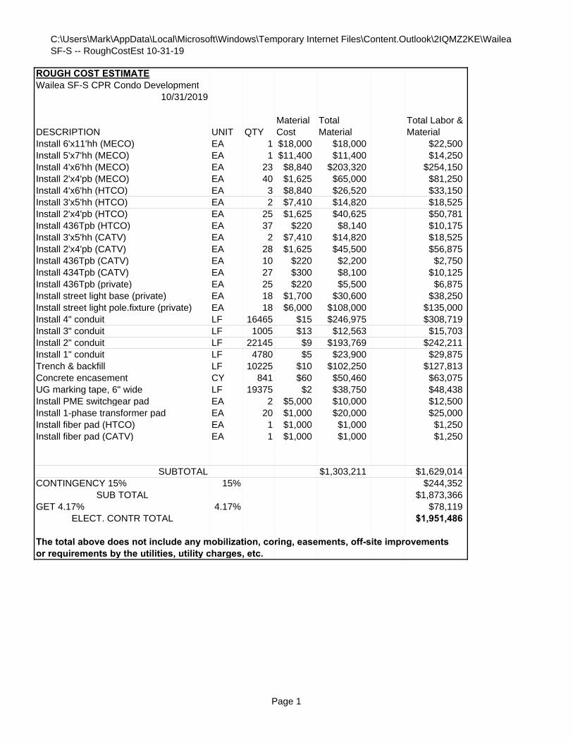
C:\Users\Mark\AppData\Local\Microsoft\Windows\Temporary Internet Files\Content.Outlook\2IQMZ2KE\Wailea SF-S -- RoughCostEst 10-31-19
ROUGH COST ESTIMATEWailea SF-S CPR Condo Development
10/31/2019
Install 6'x11'hh (MECO) EA 1 $18,000 $18,000 $22,500Install 5'x7'hh (MECO) EA 1 $11,400 $11,400 $14,250Install 4'x6'hh (MECO) EA 23 $8,840 $203,320 $254,150Install 2'x4'pb (MECO) EA 40 $1,625 $65,000 $81,250Install 4'x6'hh (HTCO) EA 3 $8,840 $26,520 $33,150Install 3'x5'hh (HTCO) EA 2 $7,410 $14,820 $18,525Install 2'x4'pb (HTCO) EA 25 $1,625 $40,625 $50,781Install 436Tpb (HTCO) EA 37 $220 $8,140 $10,175Install 3'x5'hh (CATV) EA 2 $7,410 $14,820 $18,525Install 2'x4'pb (CATV) EA 28 $1,625 $45,500 $56,875Install 436Tpb (CATV) EA 10 $220 $2,200 $2,750Install 434Tpb (CATV) EA 27 $300 $8,100 $10,125Install 436Tpb (private) EA 25 $220 $5,500 $6,875Install street light base (private) EA 18 $1,700 $30,600 $38,250Install street light pole.fixture (private) EA 18 $6,000 $108,000 $135,000Install 4" conduit LF 16465 $15 $246,975 $308,719Install 3" conduit LF 1005 $13 $12,563 $15,703Install 2" conduit LF 22145 $9 $193,769 $242,211Install 1" conduit LF 4780 $5 $23,900 $29,875Trench & backfill LF 10225 $10 $102,250 $127,813Concrete encasement CY 841 $60 $50,460 $63,075UG marking tape, 6" wide LF 19375 $2 $38,750 $48,438Install PME switchgear pad EA 2 $5,000 $10,000 $12,500Install 1-phase transformer pad EA 20 $1,000 $20,000 $25,000Install fiber pad (HTCO) EA 1 $1,000 $1,000 $1,250Install fiber pad (CATV) EA 1 $1,000 $1,000 $1,250
SUBTOTAL $1,303,211 $1,629,014CONTINGENCY 15% 15% $244,352
SUB TOTAL $1,873,366GET 4.17% 4.17% $78,119
ELECT. CONTR TOTAL $1,951,486
The total above does not include any mobilization, coring, easements, off-site improvements or requirements by the utilities, utility charges, etc.
Total Material
Total Labor & MaterialDESCRIPTION UNIT QTY
Material Cost
Page 1

BIOLOGICAL
RESOURCES SURVEY
APPENDIX
D
BIOLOGICAL RESOURCES SURVEY
for the
W AILEA LOT SF-S PROJECT
WAIL EA, MAUI, HAWAII
by
Robert W. Hobdy Kokomo, Maui
May 2019
Prepared for: Wailea Resort SF-S Partners, LP
1
BIOLOGICAL RESOURCES SURVEY WAILEA LOT SF-S PROJECT
W AILEA, MAUI
INTRODUCTION
The Wail ea Lot SF-S project is located on 23 .104 acres of undeveloped land in Wailea Maui TMK (2) 2-1-08:115 (see Figures 1 & 2). The project area is bounded on the west side by Wailea Alanui Drive, on the east side by Kapili Street, on the north side by an unnamed gully and on the south side by residential properties. This biological survey was initiated by the owners to assess the flora and fauna resources in fulfillment of environmental requirements and the planning process.
SITE DESCRIPTION
The terrain within the project area is gently to moderately sloping with a few steeper spots. The vegetation consists of a dense open grassland with scattered trees. The soils are characterized by a combination of Makena Loam, Stony Complex, 2 - 15 % slopes (MSC) and Keawakapu Extremely Stony Silty Clay Loam, 3 -25% slopes (KNXD) (Foote et al, 1972). Rainfall averages around 15inches per year with most occurring during the winter months (Armstrong, 1983).
BIOLOGICAL HISTORY
In pre-contact times this area would have supported a diverse dry forest/grassland with many species of native trees, shrubs, vines and grasses and a few seasonal herbs and fems, as well as a complement of native birds and insects. We can still observe fragments of this diversity in relictual pockets of native vegetation in a few places between Kihei and Makena. This diversity of native species was drastically reduced by over a century of browsing and grazing by wild and domesticated herbivores and replaced by aggressive, non-native plant species. Charred stumps indicate that at least portions of the property have burned in the recent past, further reducing species diversity. The area now contains only some of the hardier native species and many nonnative species that have proven to be stronger competitors and more resistant to disturbance.
2

SURVEY OBJECTIVES
This rep01i summarizes the findings of a flora and fauna survey of the proposed Wail ea SF-S project area in Wailea, Maui which was conducted during May 2019. The objectives of the survey were to:
1. Document what plant and animal species occur on the property or may likely occur in the existing habitat.
2. Document the status and abundance of each species.
3. Determine the presence or likely occurrence of any native flora and fauna, particularly any that are Federally listed as Threatened or Endangered. If such occur, identify what features of the habitat may be essential for these species.
4. Determine if the project area contains any special habitats which if lost or altered might result in a significant negative impact on the flora and fauna in this paii of the island.
3
BOTANICAL SURVEY REPORT
SURVEY METHODS
A walk-through botanical survey method covering all portions of this property was used following routes to ensure complete coverage of the area. Areas most likely to harbor native or rare plants such as rocky outcroppings were more intensively examined. Notes were made on plant species, distribution and abundance as well as on terrain and substrate.
DESCRIPTION OF THE VEGETATION
The vegetation in the project area was composed of a grassland with scattered trees. One species dominated the entire area, buffelgrass (Cenchrus ciliaris). Two other species were common, kiawe trees (Prosopis pallida) and 'ilima (Sidafallax). A total of only fifteen plant species were recorded during two site visits to the area.
Just two indigenous native plant species were found, the 'ilima and the 'uhaloa (Waltheria indica), both of which are widespread throughout Hawaii. The remaining thirteen species are all non-native plants that are of no particular concern.
DISCUSSION AND RECOMMENDATIONS
The vegetation in the project area is predominantly non-native in character. Just two common native species were found during the survey, the 'ilima and the 'uhaloa. These two species are widespread throughout Hawaii, and both species occur naturally on other Pacific islands as well. Neither species is of any conservation concern.
No Threatened or Endangered plant species (USFWS, 2019) occur in the project area. No special native plant habitats occur here either. There is little of botanical concern with regard to the project area. The proposed development plans are not expected to have a significant negative impact on the botanical resources in this part of Maui.
4
PLANT SPECIES LIST
Following is a checklist of all those vascular plant species inventoried during the field studies. Plant families are arranged alphabetically within each of two groups Monocots and Dicots. Taxonomy and nomenclature of the flowering plants (Monocots and Dicots) are in accordance with Wagner et al. (1999).
For each species, the following info1mation is provided:
1. Scientific name with author citation
2. Common English or Hawaiian name.
3. Bio-geographical status. The following symbols are used:
endemic = native only to the Hawaiian Islands; not naturally occurring anywhere else in the world.
indigenous= native to the Hawaiian Islands and also to one or more other geographic area(s).
Polynesian= those plants brought to the islands by the Hawaiians during their migrations.
non-native = all those plants brought to the islands intentionally or accidentally after western contact.
4. Abundance of each species within the project area:
abundant= forming a major part of the vegetation within the project area.
common widely scattered throughout the area or locally abundant within a portion of it.
uncommon = scattered sparsely throughout the area or occurring in a few small patches.
rare= only a few isolated individuals within the project area.
5
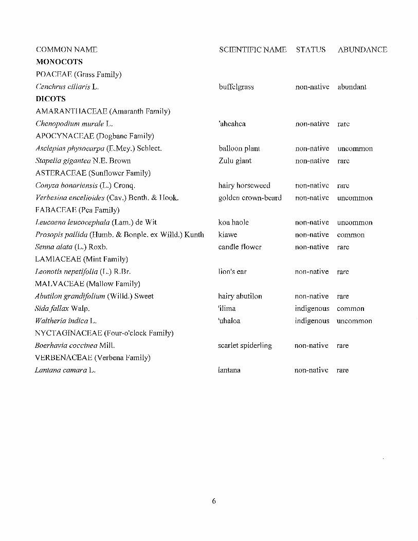
COMMON NAME
MONOCOTS
POACEAE (Grass Family)
Cenchrus cWaris L.
DI COTS
AMARANTHACEAE (Amaranth Family)
Chenopodium murale L.
APOCYNACEAE (Dogbane Family)
Asclepias physocmpa (E.Mey.) Schlect.
Stapelia gigantea N.E. Brown
ASTERACEAE (Sunflower Family)
Conyza bonariensis (L.) Cronq.
Verbesina encelioides (Cav.) Benth. & Hook.
FABACEAE (Pea Family)
Leucaena leucocephala (Lam.) de Wit
Prosopis pallida (Humb. & Bonple. ex Willd.) Kunth
Senna alata (L.) Roxb.
LAMIACEAE (Mint Family)
Leonotis nepetifolia (L.) R.Br.
MAL V ACEAE (Mallow Family)
Abutilon grandifolium (Willd.) Sweet
Sidafallax Walp.
Waltheria indica L.
NYCTAGINACEAE (Four-o'clock Family)
Boerhavia coccinea Mill.
VERBENACEAE (Verbena Family)
Lantana camara L.
6
SCIENTIFIC NAME STATUS ABUNDANCE
buffelgrass
'aheahea
balloon plant
Zulu giant
hairy horseweed
golden crown-beard
koa haole
kiawe
candle flower
lion's ear
hairy abutilon
'ilima
'uhaloa
scarlet spiderling
lantana
non-native abundant
non-native rare
non-native uncommon
non-native rare
non-native rare
non-native uncommon
non-native uncommon
non-native common
non-native rare
non-native rare
non-native rare
indigenous common
indigenous uncommon
non-native rare
non-native rare
FAUNA SURVEY REPORT
SURVEY METHODS
A walk-through fauna survey method was conducted in conjunction with the botanical survey. All parts of the project area were covered. Field observations were made with the aid of binoculars and by listening to vocalizations. Notes were made on species, abundance, activities and location as well as observations of trails, tracks scat and signs of feeding. In addition, an evening visit was made to the area to record crepuscular activities and vocalizations and to see if there was any evidence of occurrence of the Endangered Hawaiian hoary bat (Lasiurus cinereus semotus) in the area.
RESULTS
MAMMALS
Just one non-native mammal species was observed during two site visits in the project area. Taxonomy and nomenclature follow Tomich (1986).
Axis deer were common in the project area. A herd of ten animals were seen, and their trails, tracks, droppings and signs of feeding were everywhere. Other mammals one would expect in this habitat include mice (Mus domesticus), rats (Rattus spp.), mongoose (Herpestes auropunctatus), domestic cats (Felis catus) and domestic dogs (Canisfamiliaris).
A special effort was made to look for the Hawaiian hoary bat by making an evening survey at two locations in the area. A bat detecting device (Batbox IIID) was used, set to the frequency of 27,000 Hertz that these bats are known to use when echo-locating for nocturnal flying insect prey. No bats were detected with the use of this device.
BIRDS
Birdlife was moderate in species and in total numbers in this dry habitt. Taxonomy and nomenclature follow American Ornithologists' Union (2019). Ten species of non-native birds were observed during two site visits in the project area. Three species were common, the zebra dove (Geopelia striata), the mourning dove (Zenaida macroura) and the gray francolin (Francolinus pondicerianus). Less common were the spotted dove (Streptopelia chinensis), the common myna (Acridotheres tristis) and the African silverbill (Lonchura cantans). Four other species were of rare occurrence.
REPTILES
Two species of non-native lizards were observed, the garden skink (Lampropholis delicata) and the mourning gecko (Lepidodactylus lugubris).
7
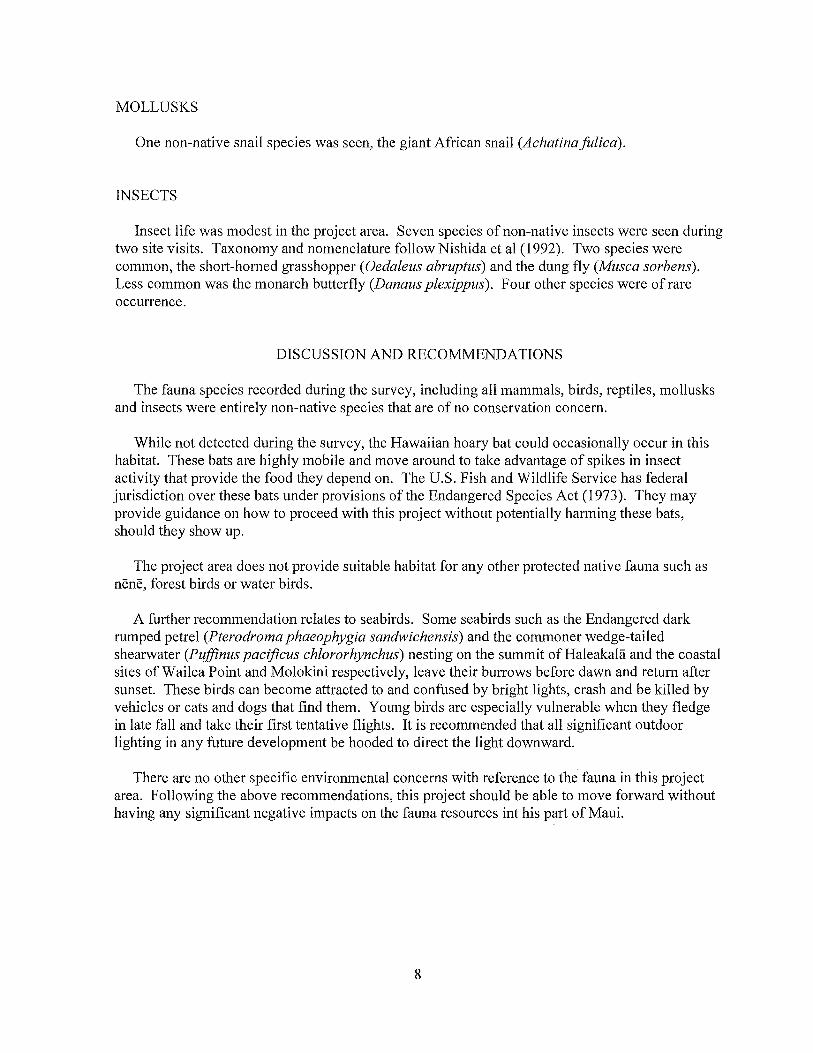
MOLLUSKS
One non-native snail species was seen, the giant African snail (AchaUnafulica).
INSECTS
Insect life was modest in the project area. Seven species of non-native insects were seen during two site visits. Taxonomy and nomenclature follow Nishida et al (1992). Two species were common, the short-horned grasshopper (Oedaleus abruptus) and the dung fly (Musca sorbens). Less common was the monarch butterfly (Danaus plexippus). Four other species were of rare occurrence.
DISCUSSION AND RECOMMENDATIONS
The fauna species recorded during the survey, including all mammals, birds, reptiles, mollusks and insects were entirely non-native species that are of no conservation concern.
While not detected during the survey, the Hawaiian hoary bat could occasionally occur in this habitat. These bats are highly mobile and move around to take advantage of spikes in insect activity that provide the food they depend on. The U.S. Fish and Wildlife Service has federal jurisdiction over these bats under provisions of the Endangered Species Act (1973 ). They may provide guidance on how to proceed with this project without potentially harming these bats, should they show up.
The project area does not provide suitable habitat for any other protected native fauna such as nene, forest birds or water birds.
A further recommendation relates to seabirds. Some seabirds such as the Endangered dark rumped petrel (Pterodroma phaeophygia sandwichensis) and the commoner wedge-tailed shearwater (Puffinus pacificus chlororhynchus) nesting on the summit of Haleakala and the coastal sites of Wailea Point and Molokini respectively, leave their burrows before dawn and return after sunset. These birds can become attracted to and confused by bright lights, crash and be killed by vehicles or cats and dogs that find them. Young birds are especially vulnerable when they fledge in late fall and take their first tentative flights. It is recommended that all significant outdoor lighting in any future development be hooded to direct the light downward.
There are no other specific environmental concerns with reference to the fauna in this project area. Following the above recommendations, this project should be able to move forward without having any significant negative impacts on the fauna resources int his part of Maui.
8
ANIMAL SPECIES LIST
Following is a checklist of the animal species inventoried during the field work. Animal species are arranged in descending abundance within four groups: Mammals, Birds, Insects, Mollusks and Reptiles. For each species the following information is provided:
1. Common name
2. Scientific name
3. Bio-geographical status. The following symbols are used:
endemic =native only to Hawaii; not naturally occurring anywhere else in the world.
indigenous = native to the Hawaiian Islands and also to one or more other geographic area(s).
non-native = all those animals brought to Hawaii intentionally or accidentally after western contact.
migratory = spending a portion of the year in Hawaii and a portion elsewhere. In Hawaii the migratory birds are usually in the overwintering/non-breeding phase of their life cycle.
4. Abundance of each species within the project area:
abundant = many flocks or individuals seen throughout the area at all times of day
common = a few flocks or well scattered individuals throughout the area.
uncommon= only one flock or several individuals seen within the project area.
rare= only one or two seen within the project area.
9
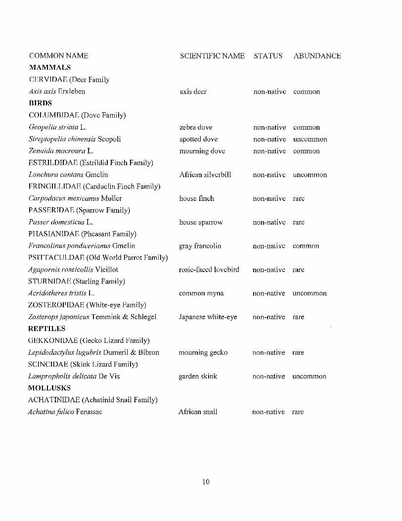
COMMON NAME
MAMMALS
CERVIDAE (Deer Family
Axis axis Erxleben
BIRDS
COLUMBIDAE (Dove Family)
Geopelia striata L.
Streptopelia chinensis Scopoli
Zenaida macroura L.
ESTRILDIDAE (Estrildid Finch Family)
Lonchura cantans Gmelin
FRINGILLIDAE (Carduelin Finch Family)
Carpodacus mexicanus Muller
PASSERIDAE (Sparrow Family)
Passer domesticus L.
PHASIANIDAE (Pheasant Family)
SCIENTIFIC NAME STATUS ABUNDANCE
axis deer
zebra dove
spotted dove
mourning dove
African silverbill
house finch
house sparrow
non-native common
non-native common
non-native uncommon
non-native common
non-native uncommon
non-native rare
non-native rare
Francolinus pondicerianus Gmelin gray francolin non-native common
PSITTACULDAE (Old World Parrot Family)
Agapornis roseicollis Vieillot
STURNIDAE (Starling Family)
Acridotheres tristis L.
ZOSTEROPIDAE (White-eye Family)
Zosterops japonicus Temmink & Schlegel
REPTILES
GEKKONIDAE (Gecko Lizard Family)
Lepidodactylus lugubris Dumeril & Bibron
SCINCIDAE (Skink Lizard Family)
Lampropholis delicata De Vis
MOLLUSKS
ACHA TINIDAE (Achatinid Snail Family)
Achatinafulica Ferussac
rosie-faced lovebird non-native rare
common myna non-native uncommon
Japanese white-eye non-native rare
mourning gecko non-native rare
garden skink non-native uncommon
African snail non-native rare
10

COMMON NAME SCIENTIFIC NAME STATUS ABUNDANCE
INSECTS
Order COLEOPTERA - beetles
SCARABAEIDAE (Scarab Beetle Family)
Protaetia orientalis Burmeister Oriental flower beetle non-native rare
Order D IPTERA - flies
MUSCIDAE (Housefly Family)
Musca sorbens Wiedemann dung fly non-native common
Order HYMENOPTERA - bees, wasps, ants
FORMICIDAE (Ant Family)
Pheidole megacephala Fabricius big-headed ant non-native rare
VESPIDAE (Vespid Wasp Family)
Polistes aurifer Saussure golden paper wasp non-native rare
Order LEPIDOPTERA - butterflies, moths
NYMPALIDAE (Brush-footed Butterfly Family)
Danaus plexippus L. monarch butterfly non-native uncommon
Order MANTODEA - mantises
MANTIDAE (Praying Mantis Family)
Tenodera angustipennis Saussure narrow-winged mantis non-native rare
Order ORTHOPTERA - grasshoppers, crickets
ACRIDIDAE (Grasshopper Family)
Oedaleus abruptus Thunberg short-homed grasshopper non-native common
11
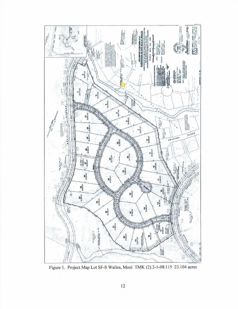
1TJ ' ·'•: t; . ll >
,1 U \ · ~C' f ' ,,. , .,
i 11'
t . ... < P,'~' ·. · ~ H I ~ 11 {~.· ~:· --11
f/"! i. ~ • J \ .. ,,.
I' Ir : _ \~/\0-· P'
Figure 1. Project Map Lot SF-S Wail ea, Maui TMK (2) 2-1-08 : 115 23 .104 acres
12
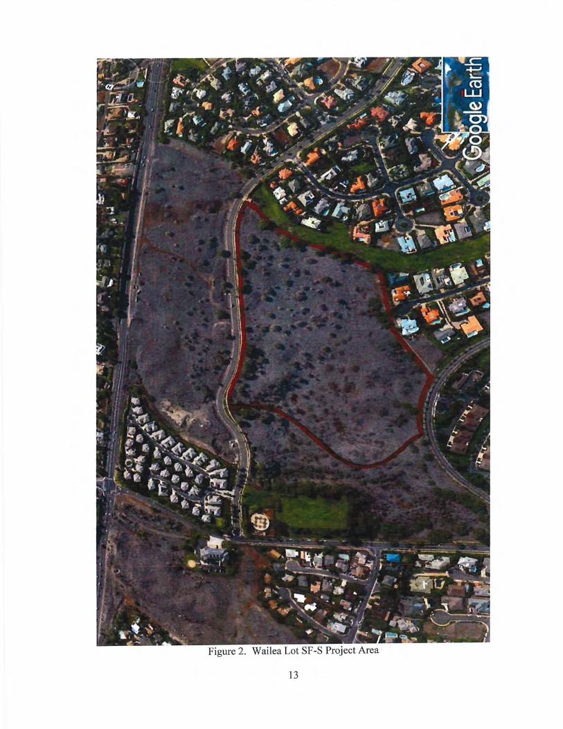
Figure 2. Wailea Lot SF-S Project Area
13
Literature Cited
American Ornithologists' Union 2019. Check-list of North American Birds. 7th edition. American Ornithologists' Union. Washington D.C.
Armstrong, R. W. (ed.) 1983. Atlas of Hawaii. (2nd. ed.) University of Hawaii Press.
Foote, D.E., E.L. Hill, S. Nakamura, and F. Stephens. 1972. Soil Survey of the Islands of Kauai, Oahu, Maui, Molokai, and Lanai, State of Hawaii. U.S. Dept. of Agriculture, Soil Conservation Service. Washington, D.C.
Nishida, G.M., G.A. Samuelson, J.S. Strazanac, K.S. Kami. 1992. Hawaiian Terrestrial Anthropod Checklist. Hawaii Biological Survey.
Tomich, P.Q. 1986. Mammals in Hawaii. Bishop Museum Press, Honolulu.
U.S. Fish and Wildlife Service. 2019. Endangered and threatened wildlife and plants. 50 CFR 17.11 & 17.12
Wagner, W. L., D.R. Herbst, and S. H. Sohmer. 1999. Manual of the Flowering Plants of Hawaii. University of Hawaii Press and Bishop Museum Press. Honolulu.
93r<l United States Congress. 1973. Endangered Species Act.
14
ARCHAEOLOGICAL
INVENTORY SURVEY
APPENDIX
E

1
SCS Project Number 2350-4
ARCHAEOLOGICAL INVENTORY SURVEY OF 23 ACRES IN
PAEAHU AHUPUA'A
MAKAWAO DISTRICT ISLAND OF MAUI
HAWAI'I
TMK: (2) 2-1-008:145
Prepared by: Kepa Lyman, M.A.,
and Michael Dega, Ph.D.
April 2020
DRAFT
Prepared for:
Wailea Resort SF-S Development Partners LP
ii
TABLE OF CONTENTS
INTRODUCTION 4
ENVIRONMENTAL SETTING 7
Location and Topography 7
Vegetation 7
Soils 8
Climate 9
METHODOLOGY 9
RESULTS OF FIELDWORK 10
SUMMARY AND DISCUSSION 14
Traditional Features 14
Military Features 14
SITE 50-50-14-4791 15
RECOMMENDATIONS 22
BIBLIOGRAPHY 23
APPENDIX A: FEATURE DATA 24
APPENDIX B: TEST UNIT DETAILS 69
iii
LIST OF FIGURES
Figure 1. Project Area (portion of USGS Makena quadrangle 1998). 5
Figure 2. Tax Map Key map of the project area. 6
Figure 3. Aerial mosaic of the project area (Google 2019). 7
Figure 4. Soils near the project area. 8
Figure 5. Features by formal type documented during the AIS. 12
Figure 6. Archaeological features by SIHP site designation (ESRI basemap 2018). 13
Figure 7. Plan view of Site 50-50-14-4791 wall from Sinoto et al. 1999:13. 16
Figure 8. Portion of F.S. Dodge (1885) map showing the project area and Site 50-50-14-4741 in relation to the Kula-Honua'ula moku boundary. 17
Figure 9. Aerial mosaic (Google 2019) showing portions of the boundary wall continuing to the east/upland. 18
Figure 10. Site 50-50-14-4791 wall remnant of boundary wall (1924 USGS topographic quad). 19
Figure 11. Site -4791 profile showing boulder bottom course and core-filled construction in interior cavity (view to E). 20
Figure 12. Site -4791 showing trapezoidal profile shape (view to E). 21
LIST OF TABLES
Table 1. Features recorded during the inventory survey and significance assessments and recommendations. 11
Table 2. Test unit details and layer descriptions. 70
4
INTRODUCTION
At the request of Wailea Resort SF-S Development Partners LP, Scientific Consultant
Services, Inc. (SCS) conducted an archaeological inventory survey (AIS) of 23 acres of
undeveloped land (labeled SF-S) in Paeahu Ahupua'a, Makawao District, Island of Maui [TMK (2)
2- 1-008:145] (Figures 1 and 2).This follows a State Historic Preservation Division (SHPD) letter
recommending an archaeological work plan for the project area (December 2019) and a field
inspection conducted by SCS in October 2018. The work plan was accepted on March 11, 2020.
Per HAR § 13-276-5 (3), the historic and archaeological background sections are not repeated in
this document as they were accepted in the work plan.
Two archaeological surveys have also been previously conducted in the project area
(Pantaleo and Sinoto 1991; Sinoto et al. 1999) in which one site consisting of a historic wall was
documented (SHIP # 50-50-14-4791). The current survey led to the identification of seven
temporary sites composed of twelve features. These include four modified outcrops, one U-
shape, one L-shape, two C-shapes, two mounds, and two fencepost molds. All of the features
were composed of basalt boulders/cobble utilizing exposed bedrock when available. The
features have initially been assessed to be associated with traditional agriculture, historic
ranching, and historic military activities and have been grouped into two project area-wide site
landscapes delineated by age/function: Site 50-50-14-8709 containing seven traditional
agricultural features; 50-50-14-8710 composed of three historic military-related features; and
two historic fencepost molds which have been added to Site 50-50-14-4791 as additional
features. Both sites are recommended as significant under Criterion D. Additional research on
the previously recorded wall, Site -4791, has determined that it is possibly a remnant segment
of an early historic period moku boundary wall, which was re-utilized as a historic-era cattle
wall as noted in the 1991 AIS. This site is recommended as significant under Criteria A, C, and D.
This archaeological inventory survey was conducted in order to identify and document
historic properties, to gather sufficient information on these properties, to evaluate the
significance of any newly identified historic properties, to determine the project effect on these
properties, and to make mitigation recommendations to address possible adverse impacts to
identified historic properties, pursuant to HAR § 13-284 and HAR § 13-276. This AIS was survey-
focused through full pedestrian survey of the project area, re-location and assessment of the
formerly identified site (-4791), recording of newly identified sites, and mapping of each feature
in the project area.
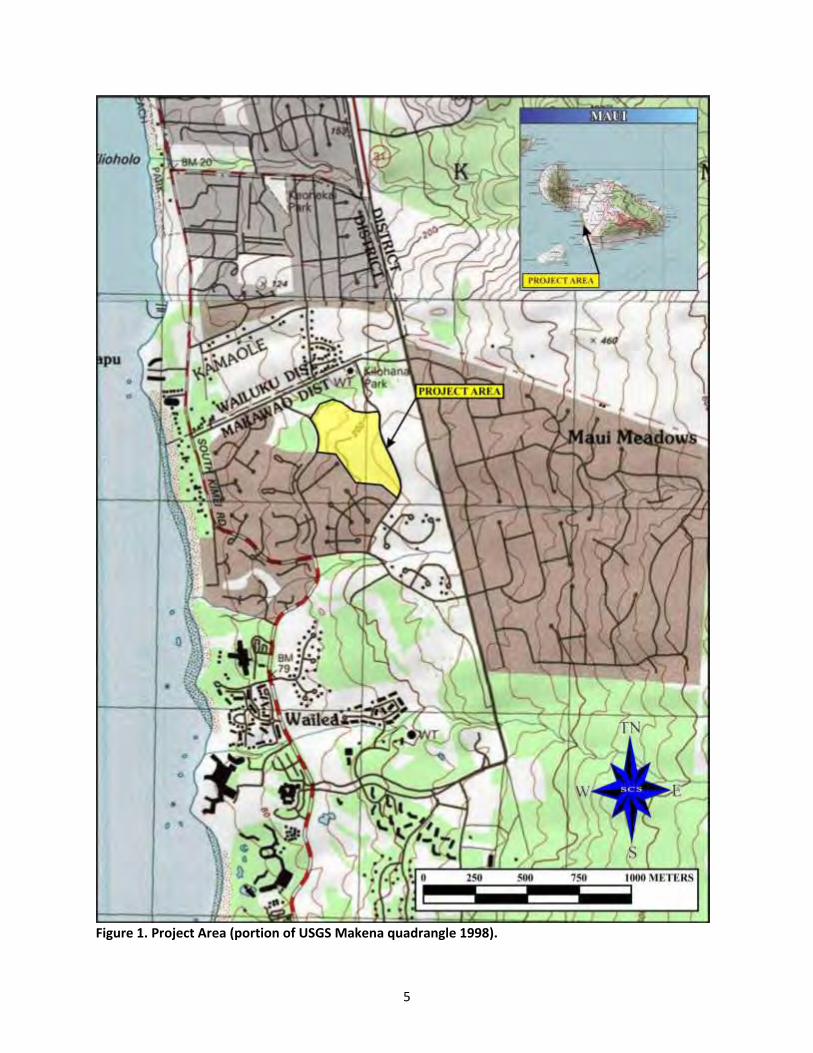
5
Figure 1. Project Area (portion of USGS Makena quadrangle 1998).
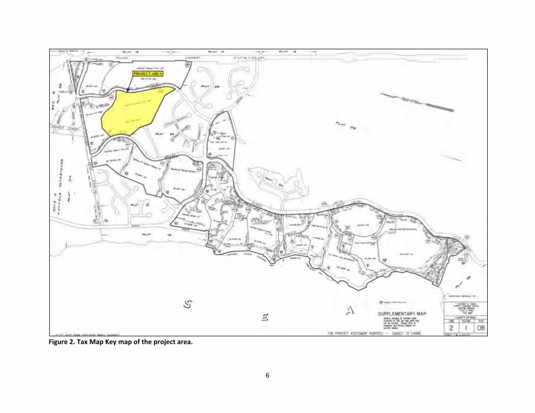
6
Figure 2. Tax Map Key map of the project area.
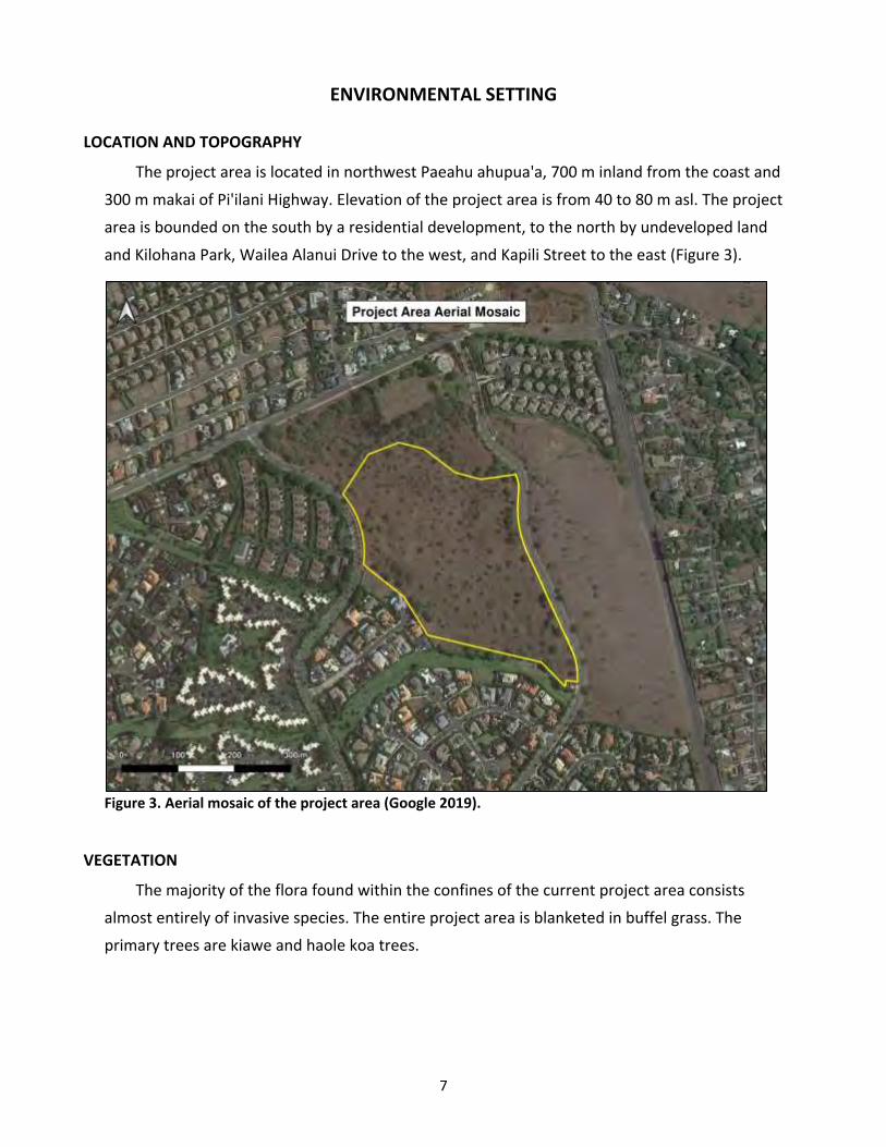
7
ENVIRONMENTAL SETTING
LOCATION AND TOPOGRAPHY
The project area is located in northwest Paeahu ahupua'a, 700 m inland from the coast and
300 m makai of Pi'ilani Highway. Elevation of the project area is from 40 to 80 m asl. The project
area is bounded on the south by a residential development, to the north by undeveloped land
and Kilohana Park, Wailea Alanui Drive to the west, and Kapili Street to the east (Figure 3).
Figure 3. Aerial mosaic of the project area (Google 2019).
VEGETATION
The majority of the flora found within the confines of the current project area consists
almost entirely of invasive species. The entire project area is blanketed in buffel grass. The
primary trees are kiawe and haole koa trees.
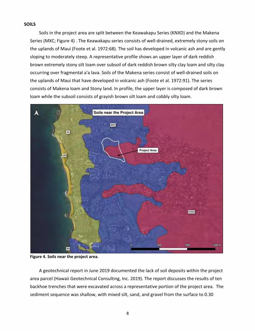
8
SOILS
Soils in the project area are split between the Keawakapu Series (KNXD) and the Makena
Series (MXC; Figure 4) . The Keawakapu series consists of well-drained, extremely stony soils on
the uplands of Maui (Foote et al. 1972:68). The soil has developed in volcanic ash and are gently
sloping to moderately steep. A representative profile shows an upper layer of dark reddish
brown extremely stony silt loam over subsoil of dark reddish brown silty clay loam and silty clay
occurring over fragmental a'a lava. Soils of the Makena series consist of well-drained soils on
the uplands of Maui that have developed in volcanic ash (Foote et al. 1972:91). The series
consists of Makena loam and Stony land. In profile, the upper layer is composed of dark brown
loam while the subsoil consists of grayish brown silt loam and cobbly silty loam.
Figure 4. Soils near the project area.
A geotechnical report in June 2019 documented the lack of soil deposits within the project
area parcel (Hawaii Geotechnical Consulting, Inc. 2019). The report discusses the results of ten
backhoe trenches that were excavated across a representative portion of the project area. The
sediment sequence was shallow, with mixed silt, sand, and gravel from the surface to 0.30
9
meters below surface (mbs) overlying cobble and silty gravel to 0.60 mbs. Trenching was
difficult due to the sands and gravels in the upper stratum and boulders and bedrock causing a
cessation in excavation at the base. The backhoe met “refusal by boulders” in most cases
between 0.70-1.20 mbs.
CLIMATE
Annual rainfall in the project area is less than 478 millimeters (mm) (10-20 inches) annually,
one of the lowest on Maui, making this region one of the driest in the Hawaiian Island
archipelago (Giambelluca et al. 2013; Foote et al. 1972). Winter months account for the
majority of the rainfall and during these months the drainage may intermittently flow or be
subject to a rapid flow/flood-type event. Temperatures average between the low 60s and mid-
90s Fahrenheit (F), with the warmer temperatures occurring in the summer months of July and
August (Armstrong 1983). Wind speeds in this leeward area average 16 knots (18.4 mph) in the
prevailing northeasterly trade wind pattern.
METHODOLOGY
The AIS fieldwork was divided three tasks: pedestrian survey, site recordation, and testing
of sites. All the tasks were be done in compliance with HRS HAR 13-276-4 and followed the AIS
work plan approved by SHPD.
Full pedestrian survey (100%) was conducted by a team of 2-3 SCS archaeologists. The crew
walked north-south transects spaced at 5 m, depending on ground visibility. Identified sites
were flagged for recording. Handheld GPS (accurate to 15m at Sigma-2) was utilized to record
the location of each identified site. Landscape modifications, site locations, flora and fauna,
and other pertinent information were noted to better understand the landscape and sites.
General views of the project area were also photographed showing the landscape topography
and vegetation.
Sites were then recorded in text, map, photograph, and illustration using tape, compass,
and sub-meter accurate GPS (Trimble Geo 7x). Plan view maps and photographs were created
for each feature. Features were photographed with handheld digital camera and archived in the
SCS database. Typically, boundaries of the sites in this region are determined by the
presence/absence of surface architecture and/or presence of surface cultural materials that
may occur outside site architecture.
Manual Testing was conducted at select features to provide a distribution of site types and
function. No cultural materials or subsurface features were identified in any unit. As specified
by SHPD, test units were excavated directly through site architecture. Test units were manually

10
excavated at 10 cm levels within natural strata to the maximum depths of bedrock or sterile
sediment. Given the paucity of subsurface findings in this area during previous projects, 1 x .5 m
and 1 x 1 m unit sizes were utilized as a starting point for examining subsurface site contexts
before attempting to expand to 1 x 2 m as specified by SHPD in the work plan. However, in the
field this was found impractical given the small size of the features and frequency of natural
bedrock outcrops.
Profile and standard plan view maps were created for each test unit excavated. Sediment
acquired from excavation was screened through ¼” wire mesh screen.
Due to the findings from the geotechnical report (2019), neither manual nor mechanical
trenching was conducted outside of areas with site architecture due to the limited depth range
of the sediments on the parcel. The report clearly shows gravelly and silty deposits extending
only 2.5 feet below the surface (0.76 mbs) in most parts of the parcel.
All AIS notes, photographs, illustrations, and other data is curated at the SCS Honolulu
facility.
RESULTS OF FIELDWORK
AIS fieldwork in the project area led to the identification of 7 temporary sites consisting of
12 features (Table 1). These include four modified outcrops, one U-shape, one L-shape, two C-
shapes, two mounds, and two fencepost molds (Figure 5). Seven features were determined to
be from the pre-Contact/Early Historic periods and five from the Historic period. Seven features
were determined to be associated with agriculture, three with a suspected WWII military
training function, and two boundary features associated with historic ranching. Three site
aggregations of features have been formed based on construction style, form type, and
function (Figure 6).
Appendix A contains site plan views, text descriptions, feature photographs, and test unit
details. Appendix B contains a summary of test unit information in tabular form.
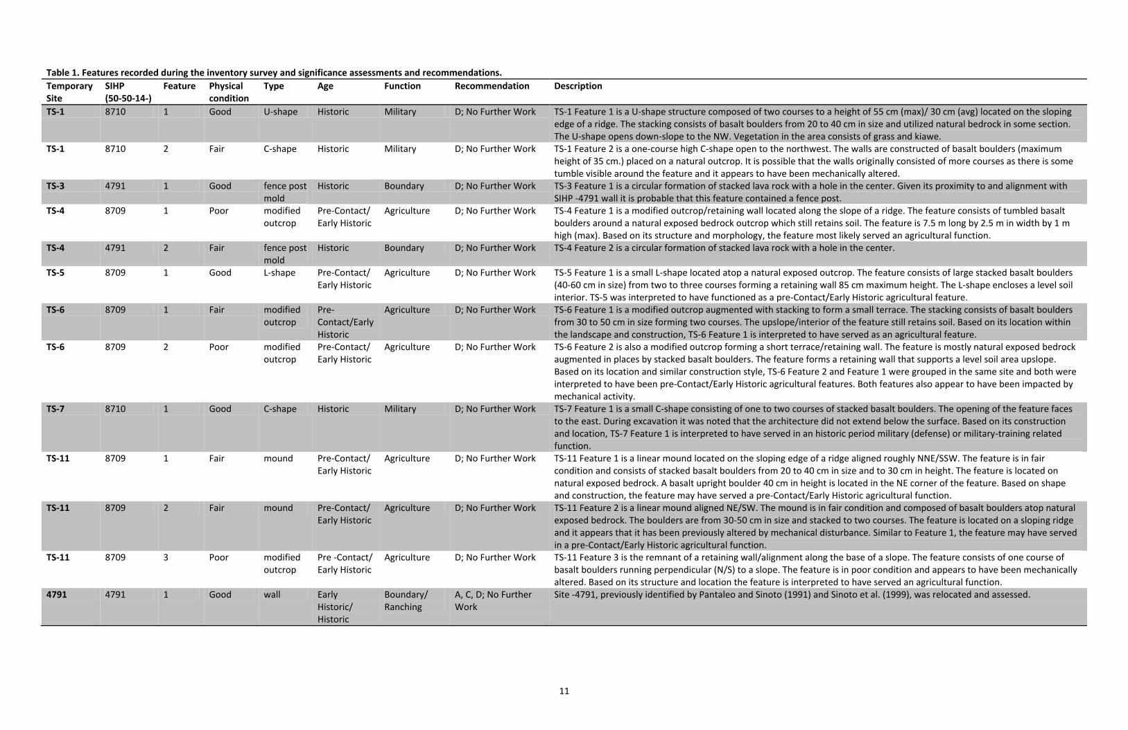
11
Table 1. Features recorded during the inventory survey and significance assessments and recommendations.
Temporary Site
SIHP (50-50-14-)
Feature Physical condition
Type Age Function Recommendation Description
TS-1 8710 1 Good U-shape Historic Military D; No Further Work TS-1 Feature 1 is a U-shape structure composed of two courses to a height of 55 cm (max)/ 30 cm (avg) located on the sloping edge of a ridge. The stacking consists of basalt boulders from 20 to 40 cm in size and utilized natural bedrock in some section. The U-shape opens down-slope to the NW. Vegetation in the area consists of grass and kiawe.
TS-1 8710 2 Fair C-shape Historic Military D; No Further Work TS-1 Feature 2 is a one-course high C-shape open to the northwest. The walls are constructed of basalt boulders (maximum height of 35 cm.) placed on a natural outcrop. It is possible that the walls originally consisted of more courses as there is some tumble visible around the feature and it appears to have been mechanically altered.
TS-3 4791 1 Good fence post mold
Historic Boundary D; No Further Work TS-3 Feature 1 is a circular formation of stacked lava rock with a hole in the center. Given its proximity to and alignment with SIHP -4791 wall it is probable that this feature contained a fence post.
TS-4 8709 1 Poor modified outcrop
Pre-Contact/ Early Historic
Agriculture D; No Further Work TS-4 Feature 1 is a modified outcrop/retaining wall located along the slope of a ridge. The feature consists of tumbled basalt boulders around a natural exposed bedrock outcrop which still retains soil. The feature is 7.5 m long by 2.5 m in width by 1 m high (max). Based on its structure and morphology, the feature most likely served an agricultural function.
TS-4 4791 2 Fair fence post mold
Historic Boundary D; No Further Work TS-4 Feature 2 is a circular formation of stacked lava rock with a hole in the center.
TS-5 8709 1 Good L-shape Pre-Contact/ Early Historic
Agriculture D; No Further Work TS-5 Feature 1 is a small L-shape located atop a natural exposed outcrop. The feature consists of large stacked basalt boulders (40-60 cm in size) from two to three courses forming a retaining wall 85 cm maximum height. The L-shape encloses a level soil interior. TS-5 was interpreted to have functioned as a pre-Contact/Early Historic agricultural feature.
TS-6 8709 1 Fair modified outcrop
Pre-Contact/Early Historic
Agriculture D; No Further Work TS-6 Feature 1 is a modified outcrop augmented with stacking to form a small terrace. The stacking consists of basalt boulders from 30 to 50 cm in size forming two courses. The upslope/interior of the feature still retains soil. Based on its location within the landscape and construction, TS-6 Feature 1 is interpreted to have served as an agricultural feature.
TS-6 8709 2 Poor modified outcrop
Pre-Contact/ Early Historic
Agriculture D; No Further Work TS-6 Feature 2 is also a modified outcrop forming a short terrace/retaining wall. The feature is mostly natural exposed bedrock augmented in places by stacked basalt boulders. The feature forms a retaining wall that supports a level soil area upslope. Based on its location and similar construction style, TS-6 Feature 2 and Feature 1 were grouped in the same site and both were interpreted to have been pre-Contact/Early Historic agricultural features. Both features also appear to have been impacted by mechanical activity.
TS-7 8710 1 Good C-shape Historic Military D; No Further Work TS-7 Feature 1 is a small C-shape consisting of one to two courses of stacked basalt boulders. The opening of the feature faces to the east. During excavation it was noted that the architecture did not extend below the surface. Based on its construction and location, TS-7 Feature 1 is interpreted to have served in an historic period military (defense) or military-training related function.
TS-11 8709 1 Fair mound Pre-Contact/ Early Historic
Agriculture D; No Further Work TS-11 Feature 1 is a linear mound located on the sloping edge of a ridge aligned roughly NNE/SSW. The feature is in fair condition and consists of stacked basalt boulders from 20 to 40 cm in size and to 30 cm in height. The feature is located on natural exposed bedrock. A basalt upright boulder 40 cm in height is located in the NE corner of the feature. Based on shape and construction, the feature may have served a pre-Contact/Early Historic agricultural function.
TS-11 8709 2 Fair mound Pre-Contact/ Early Historic
Agriculture D; No Further Work TS-11 Feature 2 is a linear mound aligned NE/SW. The mound is in fair condition and composed of basalt boulders atop natural exposed bedrock. The boulders are from 30-50 cm in size and stacked to two courses. The feature is located on a sloping ridge and it appears that it has been previously altered by mechanical disturbance. Similar to Feature 1, the feature may have served in a pre-Contact/Early Historic agricultural function.
TS-11 8709 3 Poor modified outcrop
Pre -Contact/ Early Historic
Agriculture D; No Further Work TS-11 Feature 3 is the remnant of a retaining wall/alignment along the base of a slope. The feature consists of one course of basalt boulders running perpendicular (N/S) to a slope. The feature is in poor condition and appears to have been mechanically altered. Based on its structure and location the feature is interpreted to have served an agricultural function.
4791 4791 1 Good wall Early Historic/ Historic
Boundary/ Ranching
A, C, D; No Further Work
Site -4791, previously identified by Pantaleo and Sinoto (1991) and Sinoto et al. (1999), was relocated and assessed.

12
Figure 5. Features by formal type documented during the AIS.
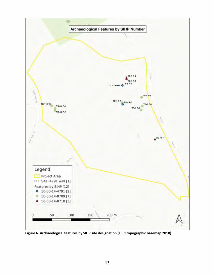
13
Figure 6. Archaeological features by SIHP site designation (ESRI topographic basemap 2018).
14
SUMMARY AND DISCUSSION
Archaeological features in the project area have not been well-preserved. It is probable the
extensive mechanical alteration observed in the project area, perhaps associated with
construction base yard activities or firebreaks, has extensively destroyed or damaged what
features were once located here. Most of the features appeared to be the surviving remnants
of earth-moving and landscape-altering equipment and probably retain only a fraction of their
original extent.
TRADITIONAL FEATURES
Seven features are associated with the pre-Contact/Early Historic period and exhibit
Traditional Hawaiian architecture. These features, consisting of four modified outcrops, two
linear mounds, and an L-shape were determined in the field to be related to an agricultural
function. In the Traditional period, this area could have been utilized for temporary habitation
and subsistence agriculture to support more permanent habitation along the shoreline. It could
also be likely that the agricultural features are associated with the early historic effort to raise
potato for export to the California market. These features were combined into one formal site
landscape based on their similar construction style and function as SIHP 50-50-14-8709.
The current project area does not contain any ceremonial sites such as heiau, burials, or
ahu. This absence bespeaks to the temporary nature of activities in the area. Ultimately, this
medial or “barren” landscape characteristic may be accurate in describing the landscape itself,
with no perennial water sources, limited overstory, and shallow soils, but it cannot be claimed
to be a barren area when it comes to the presence or absence of historic properties.
MILITARY FEATURES
Three military-related features were also documented and included in one site landscape
as SIHP 50-50-14-8710. These features consisted of roughly stacked basalt in one to two
courses forming C and U shapes and are similar in construction style to those found throughout
the Makena area. Although these feature types can be similar to pre-Contact/Early Historic
period features also found in the area, several criteria can be used to distinguish these sites in
the field. Clark (1986:196-199) provides several criteria for defining military shelters from other
shelters. While C-shapes and L-shapes were used by the military, U-shaped structures were the
most common, based on fieldwork in former training areas on Hawai'i Island. The interior of
these structures were narrow and oval to rectangular in shape. Military shelters were generally
smaller than Hawaiian shelters. Of particular interest is Clark (1986) notes that Hawaiian
shelters occurred as isolated features or in small groups associated with agricultural features,
15
while military structures usually occurred in large numbers (i.e., TS-1, 2, 3). Further, Clark
(1986:19) notes:
Sites interpreted as fortifications included C-shapes, low walls, and alignments; these sites probably served as bivouac or training areas. The sites were characterized by military debris, poorly constructed features, and the presence of earth-staining on the rocks used as building materials, indicating that such features were relatively recent constructions…Military related sites tended to occur on the tops of ridges and are present throughout the project area…
As shown for the current project area, many of these criteria are similar. These WWII
training sites represent the “opportunistic construction of small features, rather than large-
scale or pre-planned construction projects” (Clark 1986). It should also be noted that military
construction in the area could have potentially adversely impacted earlier constructed sites,
those from pre-contact/early Historic times and may have, in some cases, even adapted these
earlier sites into structures necessary for training. Thus, this military construction does make it
difficult at times to determine pre-WWII military activities in the project area.
Another discrepancy between early sites and military training sites are site/feature
orientation (blocking the wind or facing the wind, respectively), as well as structural arcs of the
sites/features which either can allow or not allow the features to become sediment traps,
thereby allowing for cultivation within the structures. One final criteria was the
presence/absence of vegetation within or near a site, assuming some stability in hydration
resources over time. Often sites found in these dry areas that contain kiawe and haole koa
trees are near pre-Contact/early Historic agricultural sites, likely for the same reasons.
SITE 50-50-14-4791
Site -4791, previously identified by Pantaleo and Sinoto (1991) and Sinoto et al. (1999), was
relocated and reassessed. The site was not re-mapped or subjected to manual testing. Sinoto et
al. (1999:9) states:
The current survey identified a solitary archaeological feature, a free-standing wall remnant, located on the northwest facing slope of a ridge, roughly 300 feet west of Kapili Street. This wall segment measures 29 meters in total length with a 4.5 meter breach following the eastern 13 meter segment from the top of the ridge down onto a grassy swale. The western segment is badly collapsed and measures 11.5 meters in length. The wall segment is oriented 268 degrees of Magnetic North, nearly on an east- west alignment.
The intact eastern portion of the double-faced, rubble-filled wall measures .80 meters wide at the bottom and tapers to .55 meters at the top. It ranges in height from 1.5 to 1.8 meters representing six to nine courses of cobbles and boulders. The western wall portion ranges in height from .75 to 1.15 meters with the upper portions tumbled. The breach appears to have been bulldozed from the south as evidenced by the tailings
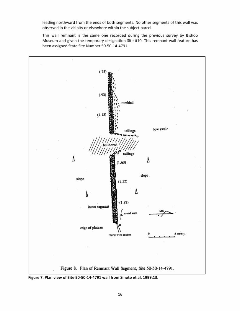
16
leading northward from the ends of both segments. No other segments of this wall was observed in the vicinity or elsewhere within the subject parcel.
This wall remnant is the same one recorded during the previous survey by Bishop Museum and given the temporary designation Site #10. This remnant wall feature has been assigned State Site Number 50-50-14-4791.
Figure 7. Plan view of Site 50-50-14-4791 wall from Sinoto et al. 1999:13.
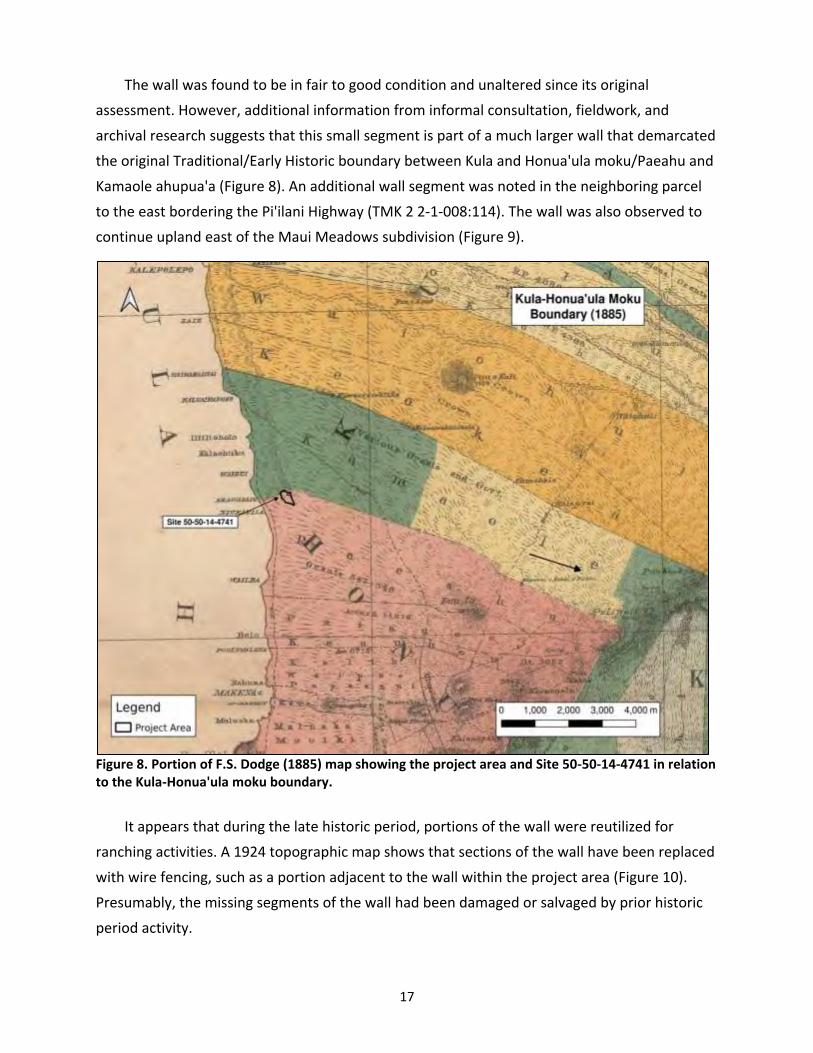
17
The wall was found to be in fair to good condition and unaltered since its original
assessment. However, additional information from informal consultation, fieldwork, and
archival research suggests that this small segment is part of a much larger wall that demarcated
the original Traditional/Early Historic boundary between Kula and Honua'ula moku/Paeahu and
Kamaole ahupua'a (Figure 8). An additional wall segment was noted in the neighboring parcel
to the east bordering the Pi'ilani Highway (TMK 2 2-1-008:114). The wall was also observed to
continue upland east of the Maui Meadows subdivision (Figure 9).
Figure 8. Portion of F.S. Dodge (1885) map showing the project area and Site 50-50-14-4741 in relation to the Kula-Honua'ula moku boundary.
It appears that during the late historic period, portions of the wall were reutilized for
ranching activities. A 1924 topographic map shows that sections of the wall have been replaced
with wire fencing, such as a portion adjacent to the wall within the project area (Figure 10).
Presumably, the missing segments of the wall had been damaged or salvaged by prior historic
period activity.
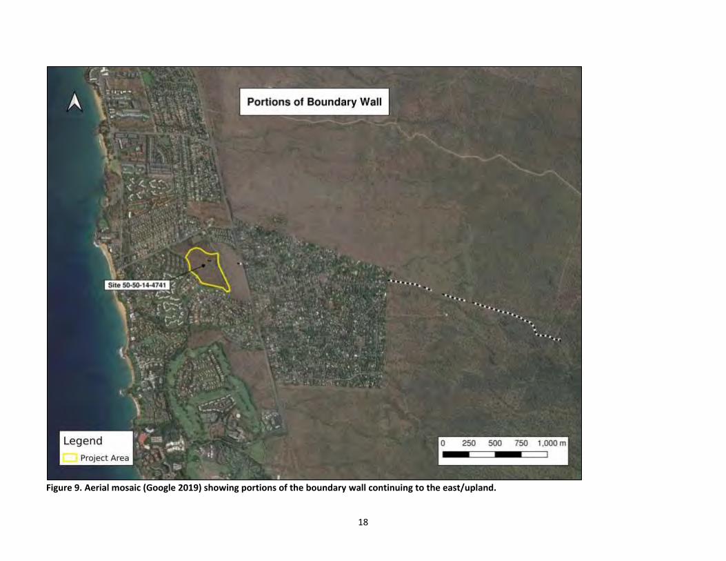
18
Figure 9. Aerial mosaic (Google 2019) showing portions of the boundary wall continuing to the east/upland.
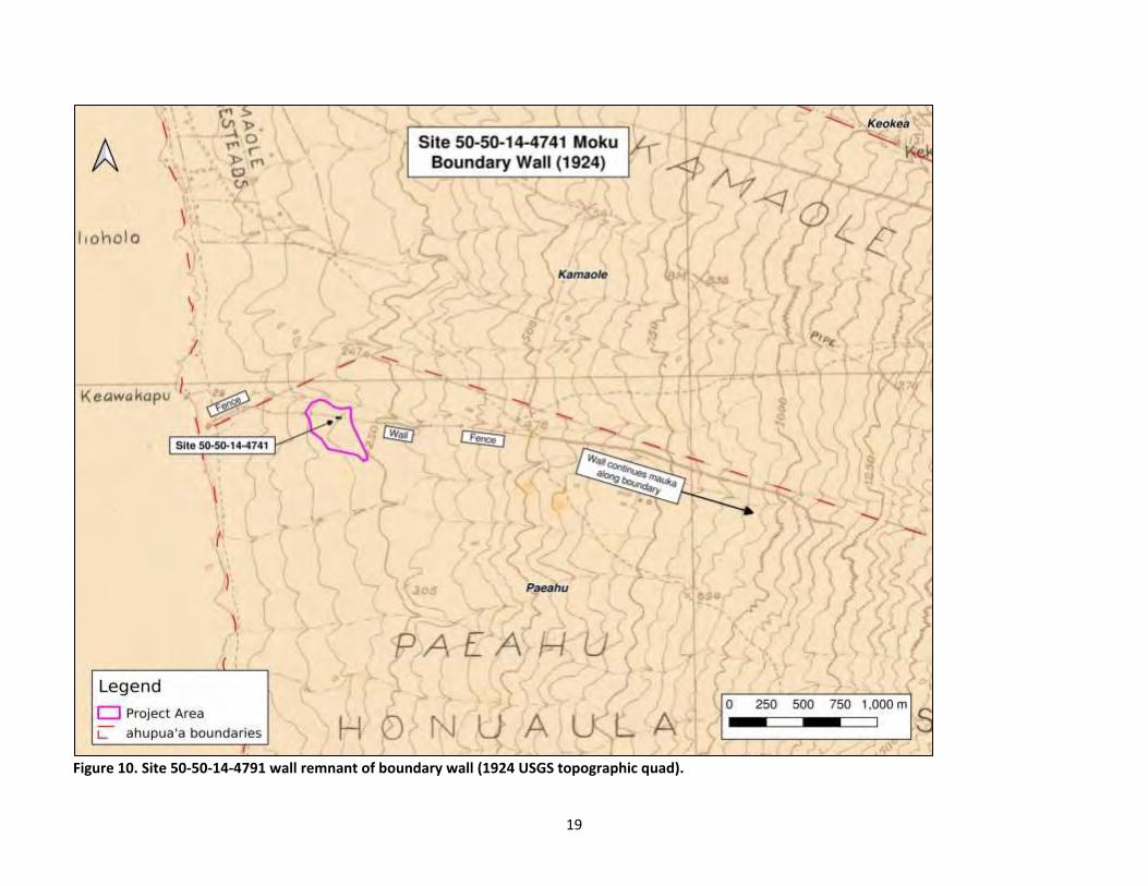
19
Figure 10. Site 50-50-14-4791 wall remnant of boundary wall (1924 USGS topographic quad).
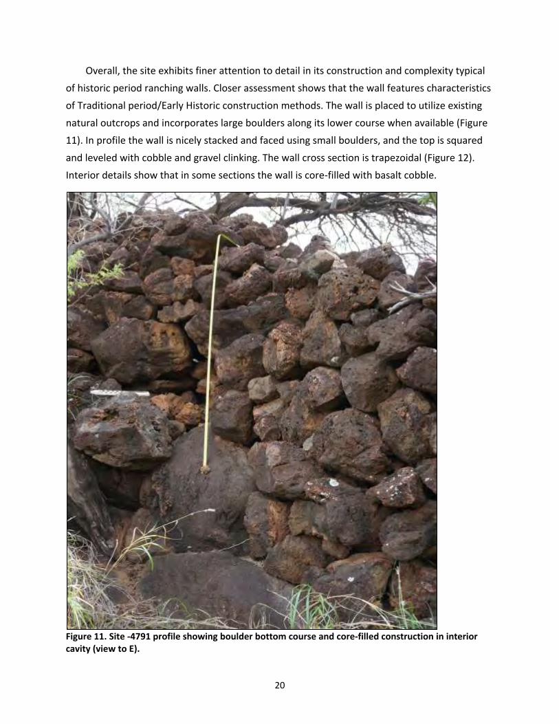
20
Overall, the site exhibits finer attention to detail in its construction and complexity typical
of historic period ranching walls. Closer assessment shows that the wall features characteristics
of Traditional period/Early Historic construction methods. The wall is placed to utilize existing
natural outcrops and incorporates large boulders along its lower course when available (Figure
11). In profile the wall is nicely stacked and faced using small boulders, and the top is squared
and leveled with cobble and gravel clinking. The wall cross section is trapezoidal (Figure 12).
Interior details show that in some sections the wall is core-filled with basalt cobble.
Figure 11. Site -4791 profile showing boulder bottom course and core-filled construction in interior cavity (view to E).

21
Figure 12. Site -4791 showing trapezoidal profile shape (view to E).

22
Temporary Site TS-3 Feature 1, a stacked basalt circular fence post mold, was documented
near the east end of the wall. It is likely that it contained a fencepost supporting the wire
sections noted on Figure 10. This feature has been designated as an additional feature of -4791.
Temporary Site TS-4 Feature 2, also a stacked basalt circular fence post mold, was documented
in the vicinity of the wall. It is probable that it also contained a fencepost supporting a wire
fence in association with the wall, although it is not in the direct east-west alignment. This
feature has also been included as an additional feature of Site -4791.
Given its construction detail, state of preservation, and association with early historic land
use and possible political demarcation, Site 50-50-14-4791 is assessed to be significant under
Criteria A, C, and D.
RECOMMENDATIONS
Sites 50-50-14-8709 and -8710 were found to be significant under Criterion D. No Further
Work is recommended for these sites. These sites are in marginal condition, do not exemplify
the characteristics of their type, and can only provide limited further value for archaeological
research. No further work is also recommended for the three features of Site 50-50-14-4791.
Site significance assessments and recommendations are included in Table 1.
23
BIBLIOGRAPHY
Armstrong, R. W. 1983. “Climate.” In Atlas of Hawaii. The University Press of Hawaii, Honolulu. Foote, D.E., E.L. Hill, S. Nakamura, and F. Stephens 1972 Soil Survey of the Islands of Kauai, Oahu, Maui, Molokai, and Lanai, State of Hawaii. U.S. Dept. of Agriculture, Soil Conservation Service and University of Hawaii Agricultural Experiment Station. Washington, D.C., Government Printing Office Giambelluca, T.W., M.A. Nuller, and T.A. Schroeder 1986 Rainfall Atlas of Hawai'i. Report R76. Water Resources Research Center, University of Hawai'i,
Manoa, for the Department of Land and Natural Resources, State of Hawai'i, Honolulu, HI. Pantaleo, J. and A. Sinoto 1991 Archaeological Surface Assessment of Four Alternative Lots for the Kihei School Site Selection,
Kihei, Wailea, Makawao, Maui Island. Prepared for Comprehensive Consulting Services of Hawaii. Applied Research Group. Bishop Museum. Honolulu.
Sinoto, A., L. Rotunno-Hazuka, and J Pantaleo 1999 An Archaeological Inventory Survey of the Proposed One Wailea Parcel, Wailea, Paeahu
Ahupua’a, Makawao, HI TMK 2-1-08:115. Aki Sinoto Consulting: Honolulu. State of Hawaii. State Historic Preservation Division 2002a Hawaii Administrative Rules Title 13 DLNR, Subtitle 13 SHPD Rules Chapter279 Rules Governing
Minimal Standards for Archaeological Monitoring Studies and Reports. 2002b Hawaii Administrative Rules Title 13 DLNR, Subtitle 13 SHPD Rules Chapter 300 Rules Governing
Inadvertent Discovery of Human Remains. United States Department of Agriculture (USDA) Web Soil Survey. (Accessed December 2019) https://websoilsurvey.sc.egov.usda.gov/App/HomePage.htm University of Hawaii at Manoa. MAGIS Collection. http://magis.manoa.hawaii.edu/ (Accessed December 2019) 1885 Maui topographic map. F.S. Dodge 1:90,000 scale. 1924 Makena Topographic Quadrangle Advance Sheet. 1:2400 scale. 1956 Makena Quadrangle Map. 1:24000 scale.

24
APPENDIX A: FEATURE DATA
TS-1 Feature 1 (SIHP 50-50-14-8710)
Feature Details
Site: 50-50-14-8710Temporary Site: TS-1Feature: 1Type: U-shapeFunction: MilitaryAge: HistoricCondition: GoodSignificance: NoneUTM: 767001 E 2291389 N
TS-1 Feature 1 is a U-shape structure composed oftwo courses to a height of 55 cm (max)/ 30 cm (avg)located on the sloping edge of a ridge. The stackingconsists of basalt boulders from 20 to 40 cm in sizeand utilized natural bedrock in some sections. The U-shape opens down-slope to the NW. Vegetation in thearea consists of grass and kiawe.
Based on its structure, location, and type, Feature1 is assumed to have functioned as a military-relatedtraining feature.
TU-1 was placed to explore any subsurface archi-tecture of Feature 1. The unit was placed in the interioradjacent to the northwest wall of the feature. In the fieldan exploratory 1 x .5 m test unit size was determinedprior to excavation with the possibility of increasing thesize after an initial assessment. A small handpick was used do the rocky nature of the soil. All soilwas screened through 1/8in mesh. One layer consisting of 2 levels was excavated. Soils were 7.5 YR3/3 Dark Brown, Granular, Weak, Fine, Loose, Non-plastic, Silty Loam. No subsurface architecture orcultural material was found. The test unit was terminated at Layer I/Level 2 (20 30 cmbs) due to thepresence of rock and bedrock.
25

Figure 1: SIHP 50-50-14-8710 TS-1 Feature 1 plan view.
26
Figure 2: SIHP 50-50-14-8710 TS-1 Feature 1 interior (view to SE).
Figure 3: SIHP 50-50-14-8710 TS-1 Feature 1 (view to N).
27

Figure 4: SIHP 50-50-14-8710 TS-1 Feature 1 (view to SE).
28
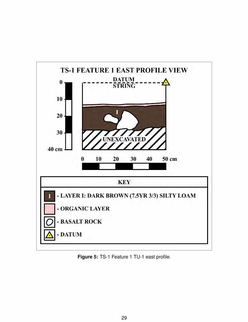
Figure 5: TS-1 Feature 1 TU-1 east profile.
29

Figure 6: TS-1 Feature 1 TU-1 north profile.
Figure 7: TS-1 Feature 1 TU-1 post excavation (view to ESE).
30
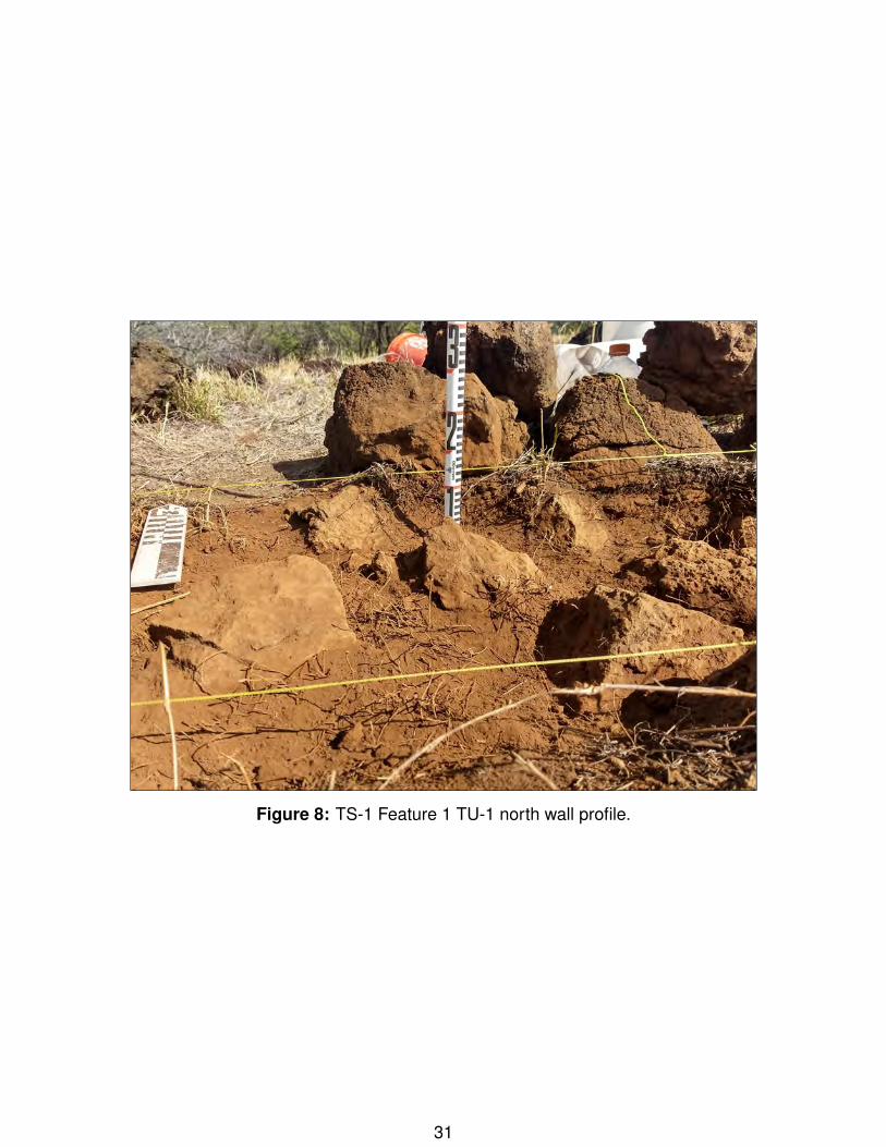
Figure 8: TS-1 Feature 1 TU-1 north wall profile.
31
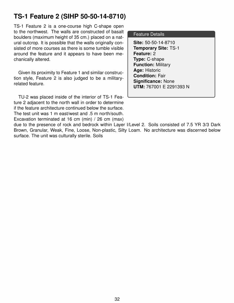
TS-1 Feature 2 (SIHP 50-50-14-8710)
Feature Details
Site: 50-50-14-8710Temporary Site: TS-1Feature: 2Type: C-shapeFunction: MilitaryAge: HistoricCondition: FairSignificance: NoneUTM: 767001 E 2291393 N
TS-1 Feature 2 is a one-course high C-shape opento the northwest. The walls are constructed of basaltboulders (maximum height of 35 cm.) placed on a nat-ural outcrop. It is possible that the walls originally con-sisted of more courses as there is some tumble visiblearound the feature and it appears to have been me-chanically altered.
Given its proximity to Feature 1 and similar construc-tion style, Feature 2 is also judged to be a military-related feature.
TU-2 was placed inside of the interior of TS-1 Fea-ture 2 adjacent to the north wall in order to determineif the feature architecture continued below the surface.The test unit was 1 m east/west and .5 m north/south.Excavation terminated at 16 cm (min) / 26 cm (max)due to the presence of rock and bedrock within Layer I/Level 2. Soils consisted of 7.5 YR 3/3 DarkBrown, Granular, Weak, Fine, Loose, Non-plastic, Silty Loam. No architecture was discerned belowsurface. The unit was culturally sterile. Soils
32

Figure 9: SIHP 50-50-14-8710 TS-1 Feature 2 (view to S).
Figure 10: TS-1 Feature 2 TU-2 post excavation.
33
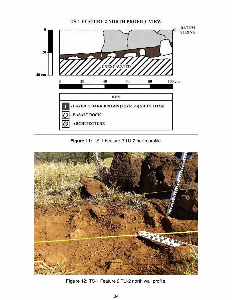
Figure 11: TS-1 Feature 2 TU-2 north profile.
Figure 12: TS-1 Feature 2 TU-2 north wall profile.
34
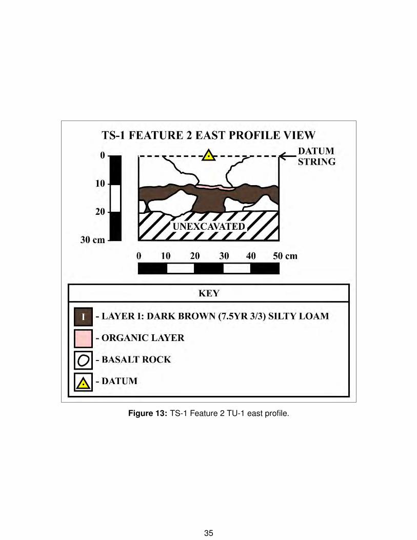
Figure 13: TS-1 Feature 2 TU-1 east profile.
35
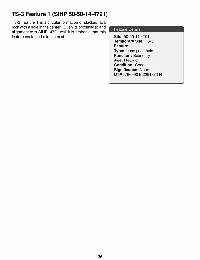
TS-3 Feature 1 (SIHP 50-50-14-4791)
Feature Details
Site: 50-50-14-4791Temporary Site: TS-3Feature: 1Type: fence post moldFunction: BoundaryAge: HistoricCondition: GoodSignificance: NoneUTM: 766990 E 2291373 N
TS-3 Feature 1 is a circular formation of stacked lavarock with a hole in the center. Given its proximity to andalignment with SIHP -4791 wall it is probable that thisfeature contained a fence post.
36
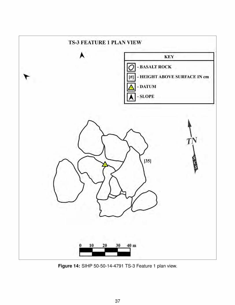
Figure 14: SIHP 50-50-14-4791 TS-3 Feature 1 plan view.
37

Figure 15: SIHP 50-50-14-4791 TS-3 Feature 1 fence post mold (oblique view to E).
38

TS-4 Feature 1 (SIHP 50-50-14-8709)
Feature Details
Site: 50-50-14-8709Temporary Site: TS-4Feature: 1Type: modified outcropFunction: AgricultureAge: Pre-Contact/Early HistoricCondition: PoorUTM: 766990 E 2291328 N
TS-4 Feature 1 is a modified outcrop/retaining wall lo-cated along the slope of a ridge. The feature consistsof tumbled basalt boulders around a natural exposedbedrock outcrop which still retains soil. The feature is7.5 m long by 2.5 m in width by 1 m high (max). Basedon its structure and morphology, the feature most likelyserved an agricultural function.
39
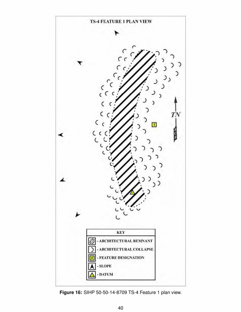
Figure 16: SIHP 50-50-14-8709 TS-4 Feature 1 plan view.
40
TS-4 FEATURE 1 PLAN VIEW
. } } ' } I )
: ) ) ) ,' ) )
J ) )
KEY
)
.) )
.) )
)
1@ 1-ARCAJTECTURALREMNANT
[2) -A.RCHJTECTURAL COLLAPSE
llfill -FEATURE DESIGNATION
~-SLOPE
~ -DATUM
t TN

Figure 17: SIHP 50-50-14-8709 TS-4 Feature 1 (view to NNE).
41
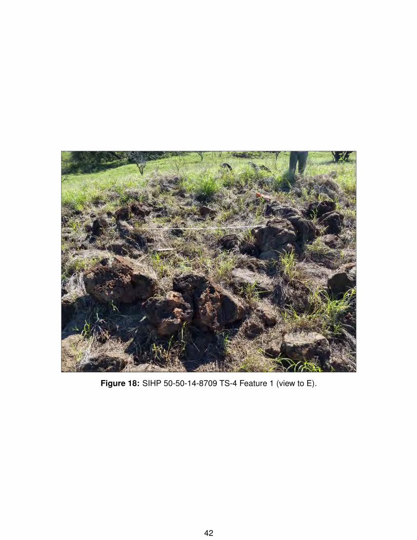
Figure 18: SIHP 50-50-14-8709 TS-4 Feature 1 (view to E).
42

TS-4 Feature 2 (SIHP 50-50-14-4791)
Feature Details
Site: 50-50-14-4791Temporary Site: TS-4Feature: 2Type: fence post moldFunction: BoundaryAge: HistoricCondition: FairUTM: 766991 E 2291324 N
TS-4 Feature 2 is a circular formation of stacked lavarock with a hole in the center. Based on its structuralsimilarity to TS-3 Feature 1, this feature is also jusgedto have functioned as a historic-period fence post.
43
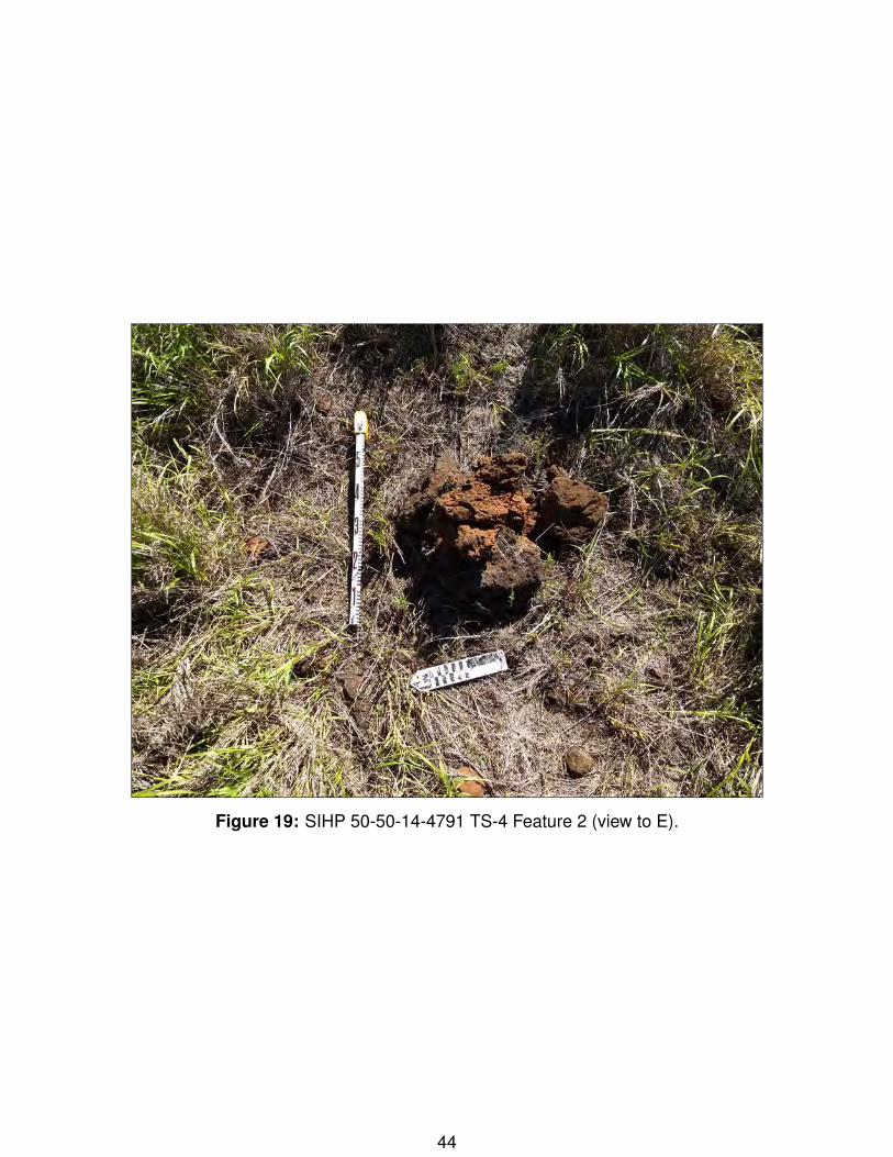
Figure 19: SIHP 50-50-14-4791 TS-4 Feature 2 (view to E).
44
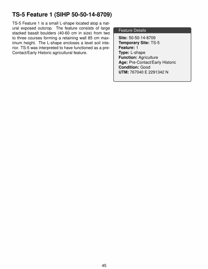
TS-5 Feature 1 (SIHP 50-50-14-8709)
Feature Details
Site: 50-50-14-8709Temporary Site: TS-5Feature: 1Type: L-shapeFunction: AgricultureAge: Pre-Contact/Early HistoricCondition: GoodUTM: 767040 E 2291342 N
TS-5 Feature 1 is a small L-shape located atop a nat-ural exposed outcrop. The feature consists of largestacked basalt boulders (40-60 cm in size) from twoto three courses forming a retaining wall 85 cm max-imum height. The L-shape encloses a level soil inte-rior. TS-5 was interpreted to have functioned as a pre-Contact/Early Historic agricultural feature.
45

Figure 20: SIHP 50-50-14-8709 TS-5 Feature 1 plan view.
46

Figure 21: SIHP 50-50-14-8709 TS-5 Feature 1 (view to N).
47
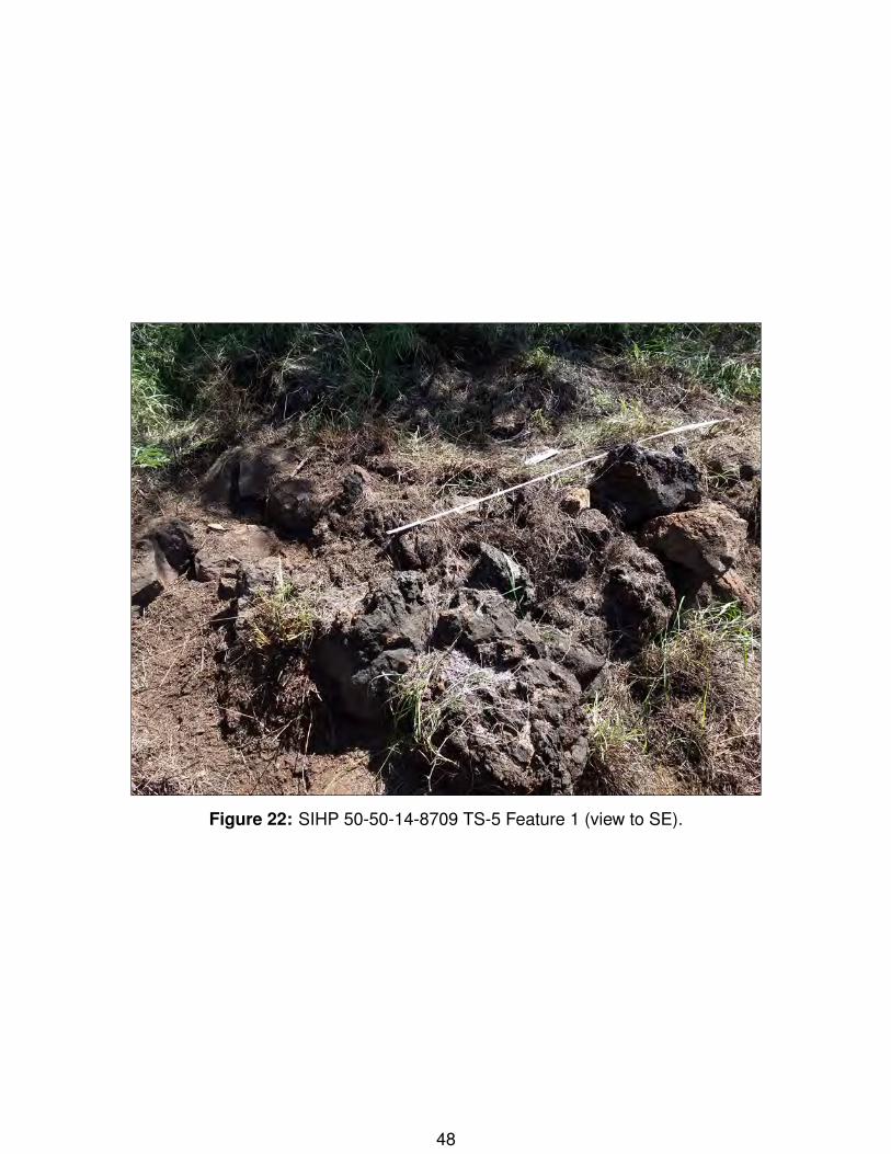
Figure 22: SIHP 50-50-14-8709 TS-5 Feature 1 (view to SE).
48
TS-6 Feature 1 (SIHP 50-50-14-8709)
Feature Details
Site: 50-50-14-8709Temporary Site: TS-6Feature: 1Type: modified outcropFunction: AgricultureAge: Pre-Contact/Early HistoricCondition: FairUTM: 767042 E 2291319 N
TS-6 Feature 1 is a modified outcrop augmented withstacking to form a small terrace. The stacking consistsof basalt boulders from 30 to 50 cm in size formingtwo courses. The uplsope/interior of the feature stillretains soil. Based on its location within the landscapeand construction, TS-6 Feature 1 is interpreted to haveserved as an agricultural feature.
49

Figure 23: SIHP 50-50-14-8709 TS-6 Feature 1 plan view.
50

Figure 24: SIHP 50-50-14-8709 TS-6 Feature 1 (view to S).
51

Figure 25: SIHP 50-50-14-8709 TS-6 Feature 1 (view to NE).
52
TS-6 Feature 2 (SIHP 50-50-14-8709)
Feature Details
Site: 50-50-14-8709Temporary Site: TS-6Feature: 2Type: modified outcropFunction: AgricultureAge: Pre-Contact/Early HistoricCondition: PoorUTM: 767039 E 2291309 N
TS-6 Feature 2 is also a modified outcrop forming ashort terrace/retaining wall. The feature is mostly nat-ural exposed bedrock augmented in places by stackedbasalt boulders. The feature forms a retaining wall thatsupports a level soil area upslope. Based on its lo-cation and similar construction style, TS-6 Feature 2and Feature 1 were grouped in the same site and bothwere interpreted to have been pre-Contact/Early His-toric agricultural features. Both features also appear tohave been impacted by mechanical activity.
53

Figure 26: SIHP 50-50-14-8709 TS-6 Feature 2 (view to NE).
54
Figure 27: SIHP 50-50-14-8709 TS-6 Feature 2 (view to NNE).
55

TS-7 Feature 1 (SIHP 50-50-14-8710)
Feature Details
Site: 50-50-14-8710Temporary Site: TS-7Feature: 1Type: C-shapeFunction: MilitaryAge: HistoricCondition: GoodUTM: 767075 E 2291232 N
TS-7 Feature 1 is a small C-shape consisting of oneto two courses of stacked basalt boulders. Severalmodern glass bottles were found on the interior sur-face. The opening of the feature faces to the east.During excavation it was noted that the architecturedid not extend below the surface. Based on its con-struction and location, TS-7 Feature 1 is interpreted tohave served in an historic period military (defense) ormilitary-training related function.
TU-1 was placed in the interior of the C-shape tomaximize the chance to discover subsurface artifactsthat could help in the determination of the feature func-tion. The excavation consisted of two one layer/ 2 lev-els from 4 30 cmbs. The layer was roughly half rockand soil. Soils were 7.5 YR 3/3 Dark Brown, Granular, Weak, Fine, Loose, Non-plastic, Silty Loam.Decayed bedrock was encountered in the northwest corner. Due to the soil sterility and presence ofrock, excavation was terminated at the bottom of Layer I/Level 3 (30 cmbs).
56
Figure 28: SIHP 50-50-14-8710 TS-7 Feature 1 plan view.
57
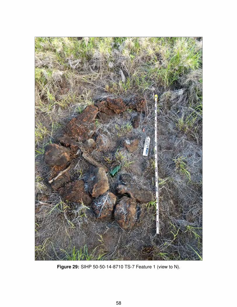
Figure 29: SIHP 50-50-14-8710 TS-7 Feature 1 (view to N).
58
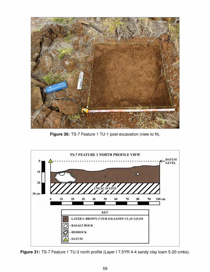
Figure 30: TS-7 Feature 1 TU-1 post-excavation (view to N).
Figure 31: TS-7 Feature 1 TU-3 north profile (Layer I 7.5YR 4-4 sandy clay loam 5-20 cmbs).
59
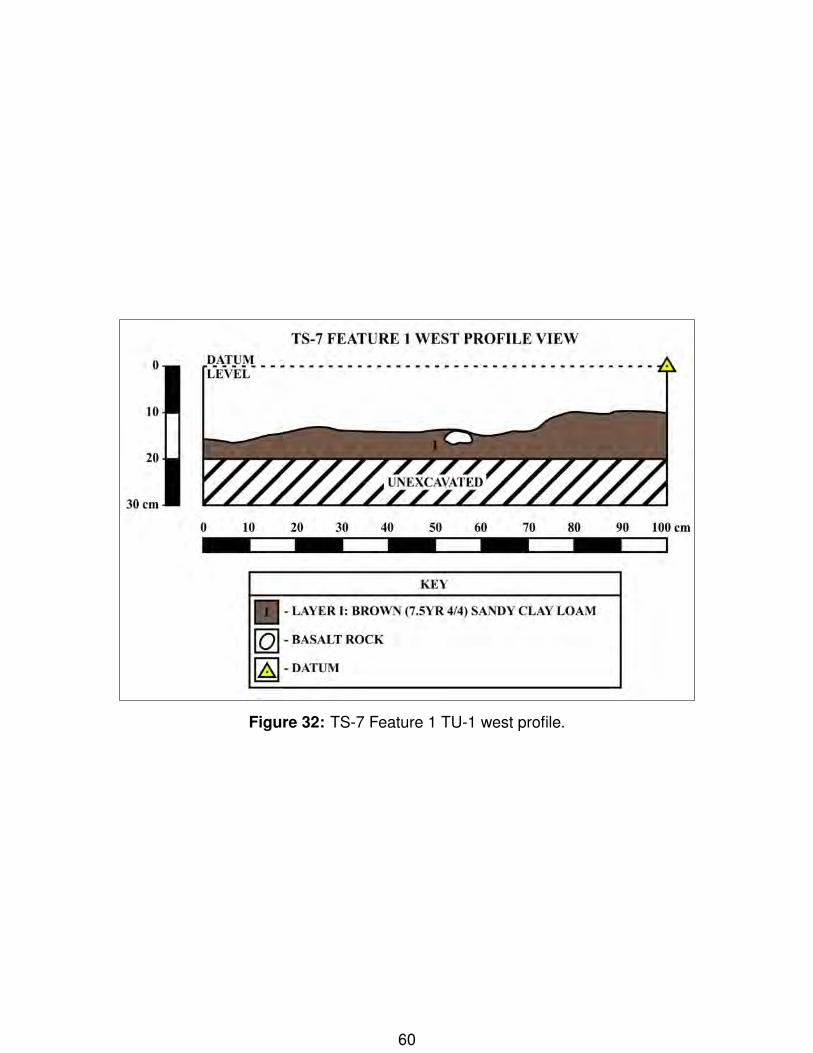
Figure 32: TS-7 Feature 1 TU-1 west profile.
60
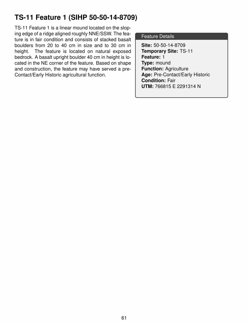
TS-11 Feature 1 (SIHP 50-50-14-8709)
Feature Details
Site: 50-50-14-8709Temporary Site: TS-11Feature: 1Type: moundFunction: AgricultureAge: Pre-Contact/Early HistoricCondition: FairUTM: 766815 E 2291314 N
TS-11 Feature 1 is a linear mound located on the slop-ing edge of a ridge aligned roughly NNE/SSW. The fea-ture is in fair condition and consists of stacked basaltboulders from 20 to 40 cm in size and to 30 cm inheight. The feature is located on natural exposedbedrock. A basalt upright boulder 40 cm in height is lo-cated in the NE corner of the feature. Based on shapeand construction, the feature may have served a pre-Contact/Early Historic agricultural function.
61

Figure 33: SIHP 50-50-14-8709 TS-11 Feature 1 plan view.
62
TS-11 FEATURES 1·3 PLAN VIEW
(
( L
L L L L
.-'.. (
KEY
[QI -BASALT ROCK
121-B;\SALT BEDROCK
[Q] -UPRIGUT
IOOI -llEA'.TURE DESJGNATlON
[iJ
~ - lfEIGHT ABOVF. SORF'ACF. IN cm
EJ-COLLAPSE
[!} -SLOPE
~- DATIJM
0 .s 1.5 2 Ill
~ . .
. • . ' I .
. '
..J
. . . )
...;
)
)
> )
) )
~ ) )
)
J ~
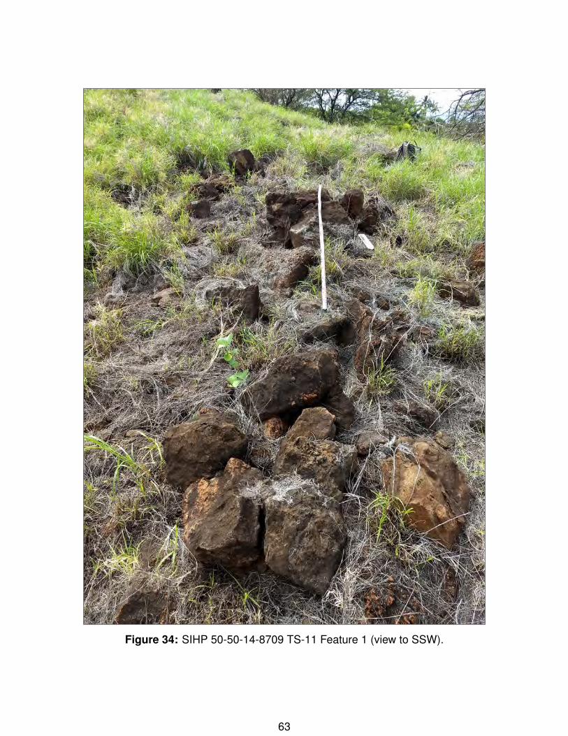
Figure 34: SIHP 50-50-14-8709 TS-11 Feature 1 (view to SSW).
63
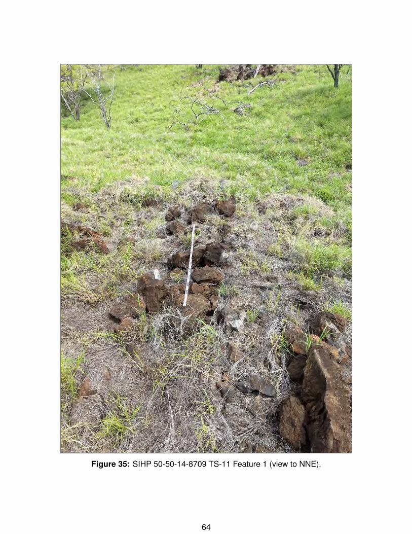
Figure 35: SIHP 50-50-14-8709 TS-11 Feature 1 (view to NNE).
64

TS-11 Feature 2 (SIHP 50-50-14-8709)
Feature Details
Site: 50-50-14-8709Temporary Site: TS-11Feature: 2Type: moundFunction: AgricultureAge: Pre-Contact/Early HistoricCondition: FairUTM: 766815 E 2291308 N
TS-11 Feature 2 is a linear mound aligned NE/SW. Themound is in fair condition and composed of basalt boul-ders atop natural exposed bedrock. The boulders arefrom 30-50 cm in size and stacked to two courses. Thefeature is located on a sloping ridge and it appearsthat it has been previously altered by mechanical dis-turbance. Similar to Feature 1, the feature may haveserved in a pre-Contact/Early Historic agricultural func-tion.
65
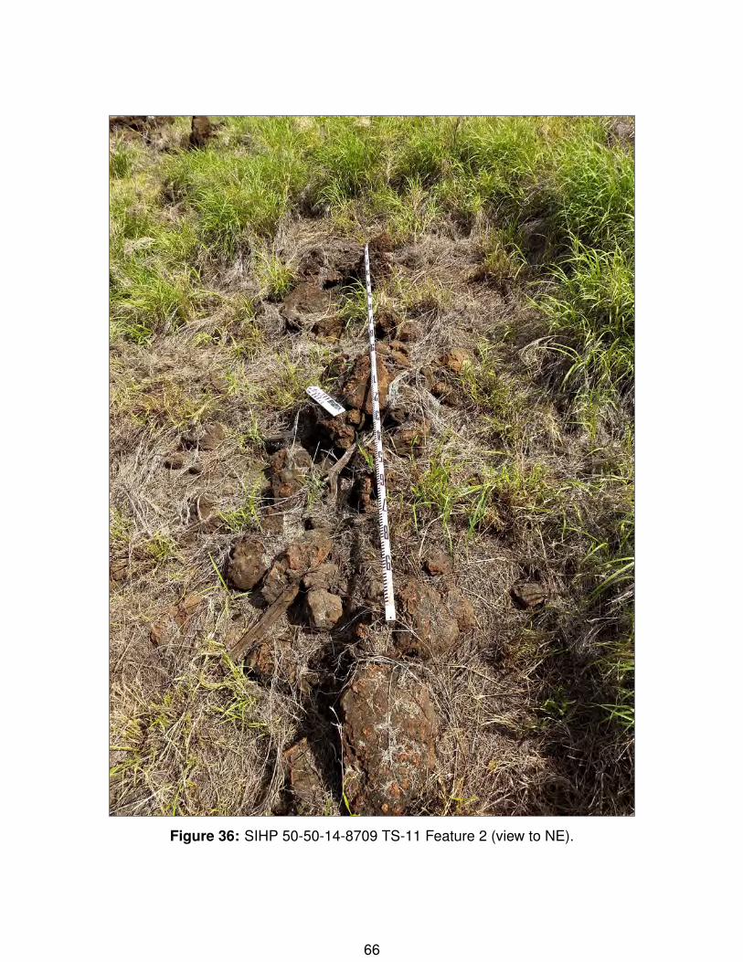
Figure 36: SIHP 50-50-14-8709 TS-11 Feature 2 (view to NE).
66

TS-11 Feature 3 (SIHP 50-50-14-8709)
Feature Details
Site: 50-50-14-8709Temporary Site: TS-11Feature: 3Type: modified outcropFunction: AgricultureAge: Pre-Contact/Early HistoricCondition: PoorUTM: 766806 E 2291320 N
TS-11 Feature 3 is the remnant of a retainingwall/alignment along the base of a slope. The featureconsists of one course of basalt boulders running per-pinduclar (N/S) to a slope. The feature is in poor con-dition and appears to have been mechanically altered.Based on its structure and location the feature is inter-preted to have served an agricultural function.
67

Figure 37: SIHP 50-50-14-8709 TS-11 Feature 3 (view to SSW).
68

69
APPENDIX B: TEST UNIT DETAILS
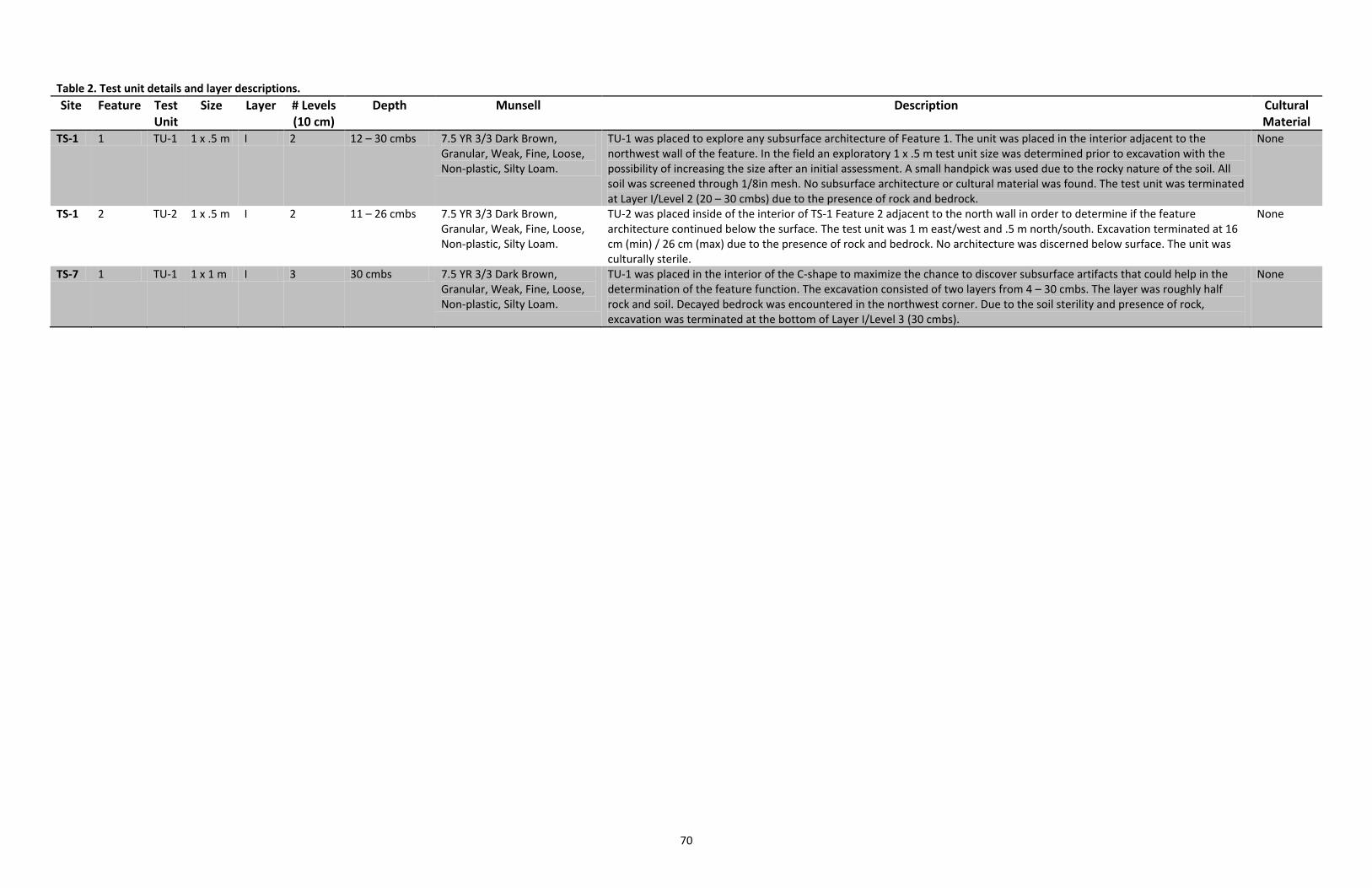
70
Table 2. Test unit details and layer descriptions.
Site Feature Test Unit
Size Layer # Levels (10 cm)
Depth Munsell Description Cultural Material
TS-1 1 TU-1 1 x .5 m I 2 12 – 30 cmbs 7.5 YR 3/3 Dark Brown, Granular, Weak, Fine, Loose, Non-plastic, Silty Loam.
TU-1 was placed to explore any subsurface architecture of Feature 1. The unit was placed in the interior adjacent to the northwest wall of the feature. In the field an exploratory 1 x .5 m test unit size was determined prior to excavation with the possibility of increasing the size after an initial assessment. A small handpick was used due to the rocky nature of the soil. All soil was screened through 1/8in mesh. No subsurface architecture or cultural material was found. The test unit was terminated at Layer I/Level 2 (20 – 30 cmbs) due to the presence of rock and bedrock.
None
TS-1 2 TU-2 1 x .5 m I 2 11 – 26 cmbs 7.5 YR 3/3 Dark Brown, Granular, Weak, Fine, Loose, Non-plastic, Silty Loam.
TU-2 was placed inside of the interior of TS-1 Feature 2 adjacent to the north wall in order to determine if the feature architecture continued below the surface. The test unit was 1 m east/west and .5 m north/south. Excavation terminated at 16 cm (min) / 26 cm (max) due to the presence of rock and bedrock. No architecture was discerned below surface. The unit was culturally sterile.
None
TS-7 1 TU-1 1 x 1 m I 3 30 cmbs 7.5 YR 3/3 Dark Brown, Granular, Weak, Fine, Loose, Non-plastic, Silty Loam.
TU-1 was placed in the interior of the C-shape to maximize the chance to discover subsurface artifacts that could help in the determination of the feature function. The excavation consisted of two layers from 4 – 30 cmbs. The layer was roughly half rock and soil. Decayed bedrock was encountered in the northwest corner. Due to the soil sterility and presence of rock, excavation was terminated at the bottom of Layer I/Level 3 (30 cmbs).
None
CULTURAL IMPACT
ASSESSMENT
APPENDIX
F
AA PROJECT NO. 1915
FINAL CULTURAL IMPACT ASSESSMENT FOR THE PROPOSED SINGLE-FAMILY RESIDENCES AT
PAEAHU Paeahu Ahupua‘a, Honua‘ula Moku, Makawao Modern Tax District, Island
of Maui TMK: (2) 2-1-008:145

AA PROJECT NO. 1915
CULTURAL IMPACT ASSESSMENT FOR THE PROPOSED SINGLE-FAMILY RESIDENCES AT
PAEAHU Paeahu Ahupua‘a, Honua‘ula Moku, Makawao Modern Tax District, Island
of Maui TMK: (2) 2-1-008:145
4/24/2020 Final
Prepared For:
Wailea Resort SF-S Partners LP
590 Līpoa Parkway, Suite 259
Kīhei, HI 96753
Prepared By:
Kim-Hee Wong, M.A
Tanya L. Lee-Greig, M.A
and
Angela Petersons, B.A
ʻĀina Archaeology
O‘ahu: 725 Kapi‘olani Blvd, C400 Honolulu, HI 96813
Maui: 590 Līpoa Parkway, Suite 106 Kīhei, HI 96753
AA PROJECT NO. 1915
Cultural Impact Assessment for the Proposed Single-Family Residences at Paeahu Final -- 4/24/2020
P a g e | ii
Executive Summary Date March 31, 2020 --Draft Project Single Family Residences at Paeahu Project Proponent Wailea Resort SF-S Partners LP Proposed Action Wailea Resort SF-S Partners LP proposes to construct 57 single-family
homes, which would range in size from 2500 to 3500 sq. ft. each. In addition to the dwellings, the project would also include the development of residential amenities consisting of a pool, fitness center, washrooms, and a manager’s office. The low-density nature of the project would also allow for significant green space and preservation of the existing topography of the hillside, which is a key feature of the project site. The use of bioswales have also been incorporated into the storm water management plan, as well as other sustainable features such as drip irrigation, drought tolerant plants, water conserving plumbing fixtures, and solar PV systems.
Estimates for the build-out of the proposed the Project is expected to be over a 3-4 year period, see Section 1.0 for an overview description of the conceptual plans for various aspects of the project.
Project Area and Region of Influence
The potential area of direct effect, or project area, is considered to be 23.1-acre development footprint located in Paeahu Ahupua‘a, Honua‘ula Moku, Makawao Modern Tax District, Maui Island.
When assessing the presence or absence of direct and indirect effects of the proposed project on the traditional cultural practices of a region, traditional use and access to resources from the mountains to ocean, or mauka (mountain region) to makai (coastal region), must be taken into consideration. As such, the region of influence, or study area for the proposed project is defined as the geographic area encompassed by the known traditional boundaries of Paeahu Ahupua‘a.
Results Based on testimony for kuleana claims presented before the Land Commission during the Mahele ‘Āina; and in addition to the stories and information gathered during the background research and consultation completed for this study, it is apparent that settlement and land use within Paeahu Ahupua‘a functioned in the typical traditional sense, with a focus on marine resource gathering within the off-shore waters and along the coastline; as well as cultivation of kula ‘uala (potato land), maia (banana), and kalo (taro) in the mauka reaches.
While resources such as ‘ilima (Sida fallax) and traditional Hawaiian archaeological sites and features associated with traditional and potentially historically agriculture were noted within the current project area (see Sections 2.1.3, 2.2.3.1.1, 3.2, and 4.1), there were no currently active or extant traditional and customary practices identified in association with these resources as a result of this study (see Section 5.0.)
AA PROJECT NO. 1915
Cultural Impact Assessment for the Proposed Single-Family Residences at Paeahu Final -- 4/24/2020
P a g e | iii
Results (Continued) The most common traditional and customary practices that are either currently undertaken or have relatively recently been discontinued due to declining resource availability revolves around fishing and gathering practices along the Paeahu shoreline (see Section 2.1.3.2, 3.2, and 4.2). Though outside of the current project footprint, concerns about runoff adding to the cumulative impacts on the ocean resources from the surrounding build environment were voiced (see Section 3.2).
Recommendations Hiʻohiʻona ʻĀina No Nā Kūpuna Mai-- Honoring the Traditional Cultural
Landscape of the Current Project Area (Section 5.2.1)
• Consultation with those who participated in this study, as well as
some of those who may have declined at this time, to understand
how the mo‘olelo of this wahi might be preserved and shared,
either through physical preservation of the identified historic
properties and incorporated into the design of the project, or
through interpretation to retain and return a sense of place that
opens up access to the area for the local native Hawaiian families
and generations to come.
• Consult with Aha Moku O Maui and those who participated in this
study, on traditional place names that could be incorporated into
project design, street naming, signage, and other project related
materials, as well as the overall project name as a means to honor
Hawaiian space and restore the knowledge of place that is inherent
in wahi ‘inoa.
• Incorporate native plants suitable to the leeward environment of
Paeahu into the landscaping palette to foster and support lā‘au
lā‘au practices and provide resources for hana no‘eau practices.
• Cut light pollution by exceeding the lighting standards of the area
currently referred to as Wailea Resort to assist with reducing sea
bird fallout due to disorientation related to artificial lighting and
maintain the visibility of the night sky.
Malama i ke Kai, a Malama ke Kai Ia ‘Oe – Taking Care of Ocean Resources
through Land and Stormwater Management (Section 5.1.2)
• Identify potential runoff and flooding zones within the project area
to ensure proper maintenance of water channels in order to help
minimize coastal resource degradation that may result from
flooding.
• Reduce stormwater runoff by using low impact development and
green infrastructure methods to capture, collect, and retain
stormwater, as well as potentially remove pollutants in any
stormwater runoff that might eventually enter the ocean through
the project area.
AA PROJECT NO. 1915
Cultural Impact Assessment for the Proposed Single-Family Residences at Paeahu Final -- 4/24/2020
P a g e | ii
Acknowledgments
Many thanks go out to the various individuals who shared their personal life experiences and
traditional knowledge for this study. Information shared helps tremendously in reconstructing
the traditional way of life at different times in history and shows how lifestyles, particularly
relating to Hawaiian traditions and cultural practices, have evolved.
Most important it is with sincerest gratitude and fondest aloha that I thank the following kūpuna
and individuals who have contributed greatly to our understanding of traditional cultural
practices related to the lands and waters of Paeahu Ahupua‘a: Ms. Leina‘ala Teruya Drummond,
Mr. Vernon Kalanikau, Mr. Daniel Kanahele, Ms. Carol-Marie Lee, Mr. Cody Tuivaiti, and Mr.
Johnny and Mrs. Leona Medeiros. Mahalo a nui for taking time out of your day to share your
mana‘o (input) and concerns.
AA PROJECT NO. 1915
Cultural Impact Assessment for the Proposed Single-Family Residences at Paeahu Final -- 4/24/2020
P a g e | iii
Table of Contents
1.0 Introduction ............................................................................................................... 1
2.0 Cultural Historical Background .................................................................................... 5
2.1 He mau Mo‘olelo o na Ahupuaʻa ‘o Paeahu i ka Wā Kahiko – Traditions of the Paeahu
Region Prior to Western Arrival ...................................................................................... 7
2.1.1 Wahi ‘Inoa ................................................................................................................... 7
2.1.2 The Mythical Era ....................................................................................................... 13
2.1.3 Nā Po‘e Kahiko o ka Ahupua‘a o Paeahu – Traditional Hawaiian Settlement of the
Paeahu Ahupuaʻa ...................................................................................................... 16
2.2 Arrival of Western Vessels and 19th Century Culture Change ...................................... 29
2.2.1 Transitions in Population and Land Use ................................................................... 29
2.2.2 1845-1851 – The Mahele .......................................................................................... 32
2.2.3 Land in Support of Commercial Interests ................................................................. 43
2.3 Paeahu In the 20th Century ........................................................................................... 48
2.3.1 The ʻUlupalakua Ranch ............................................................................................. 48
2.3.2 World War II Military Exercises ................................................................................. 49
2.4 Resort Development and the Modern Era ................................................................... 50
3.0 Scoping Methods and Results ................................................................................... 52
3.1 Scoping Methods .......................................................................................................... 52
3.2 Community Outreach Results and Interviews .............................................................. 55
3.2.1 Interview with Carol-Marie Kaʻonohiokalā Lee ........................................................ 55
3.2.2 Interview with Mr. Vernon Kalanikau ....................................................................... 56
3.2.3 Interview with Leinaʻala Teruya Drummond ............................................................ 57
3.2.4 Interview with Daniel Kanahele ................................................................................ 58
4.0 Traditional Cultural Practices of Paeahu Ahupua‘a .................................................... 63
4.1 Traditional Hawaiian Agriculture and Plant Resource Gathering Practices ................. 63
4.2 Makai Resources and the Traditional Cultural Practices of the Shoreline and Offshore
Area ............................................................................................................................... 67
4.3 Na Ala Hele -- Traditional Access and Trails ................................................................. 71
4.4 Traditional Hawaiian Burial Practices ........................................................................... 75
4.5 The Cultural Landscape and Practices as Reflected in the Archaeological Record ...... 76

AA PROJECT NO. 1915
Cultural Impact Assessment for the Proposed Single-Family Residences at Paeahu Final -- 4/24/2020
P a g e | iv
5.0 Analysis and Recommendations ............................................................................... 78
5.1 Analysis of Effect to Traditional and Customary Practices and Proposed Project
Recommendations ........................................................................................................ 82
5.1.1 Traditional Cultural Resources and Customary Practices Specific to the Proposed
Project Area............................................................................................................... 82
5.1.2 Traditional Cultural Resources and Customary Practices Identified within Paeahu
Ahupua‘a and adjacent to the Proposed Project ...................................................... 83
5.2 Recommendations for the Proposed Project ............................................................... 84
5.2.1 Hiʻohiʻona ʻĀina No Nā Kūpuna Mai-- Honoring the Traditional Cultural Landscape of
the Current Project Area ........................................................................................... 84
5.2.2 Malama i ke Kai, a Malama ke Kai Ia ‘Oe – Taking Care of Ocean Resources through
Land and Stormwater Management ......................................................................... 85
6.0 References Cited ...................................................................................................... 86
AA PROJECT NO. 1915
Cultural Impact Assessment for the Proposed Single-Family Residences at Paeahu Final -- 4/24/2020
P a g e | v
List of Figures
Figure 1-1. Preliminary site plan for the proposed single-family residences at Paeahu Ahupua‘a
(figure courtesy of Ledcor Development and Munekiyo Hiraga). ...................................... 2
Figure 1-2. A portion of the USGS 7.5’ topographic map, Puu o Kali Quadrangle (1992), showing
the location of the proposed project (outlined in blue) in relation to Paeahu Ahupua‘a
(shaded in green). ............................................................................................................... 3
Figure 1-3. TMK Map (2) 2-1-08 showing the location of the current project area cross-hatched in
red. ...................................................................................................................................... 4
Figure 2-1. A portion of the F.S. Dodge (1885) Hawaiian Government Survey map of Maui showing
the current project area (outlined in blue) in relation to the ahupua‘a of Paeahu and moku
of Honua‘ula. ....................................................................................................................... 6
Figure 2-2. Aerial photo (Esri et al. 2018) showing currently known place names of Paeahu
Ahupua‘a. .......................................................................................................................... 11
Figure 2-3. Land Grant 548 to John Y. Kanehoa highlighting boundary sections regarding resources
of particular interest. ........................................................................................................ 19
Figure 2-4. Native tenant claim by Ohule for pahulu and pahulu ‘uala lands in Paeahu (Helu 10580)
(Office of Hawaiian Affairs 2011). ..................................................................................... 20
Figure 2-5. Native tenant claim by Kuhilani for moku lauhala in Paeahu (Helu 5281) (Office of
Hawaiian Affairs 2011) ...................................................................................................... 25
Figure 2-6. A portion of the USGS 7.5’ topographic map, Puu o Kali Quadrangle (1992), showing
the location of the proposed project (outlined in blue) in relation to Land Commission
Awards with location information and Land Grants......................................................... 42
Figure 2-7. A portion of the revised Government Survey Map of Maui (F. S. Dodge 1903 (1885))
with a portion of an undated tracing of Honua‘ula by Monsarrat showing Land Grants
issued in Paeahu in relation to the potato lands outlined in Kula Moku. ........................ 44
Figure 4-1. ‘Ilima (Sida fallax) flowers. .......................................................................................... 66
Figure 4-2. Patches of ‘Ilima (Sida fallax) within the current project area. .................................. 66
Figure 4-3. A portion of the 1922 USGS topographic map, Kihei Quadrangle overlain on the ESRI
World Imagery map (Esri et al. 2018) highlighting the historic stream routes and muliwai
locations in relation to the current project area and modern built environment. .......... 70
Figure 4-4. Boundary Descriptions for Mahele Award 5281 to Kuhilani (Office of Hawaiian Affairs
2011)highlighting the notation of Apana 2 being bound by the ala and alanui. .............. 73
Figure 4-5. Boundary Descriptions for Mahele Award 5329 to Pahu (Office of Hawaiian Affairs
2014) highlighting the notation of Apana 1 being bound by the ala and alanui. ............. 73
Figure 4-6. A portion of the F.S. Dodge (1885) Hawaiian Government Survey map of Maui showing
the current project area in relation to coastal trail and mauka cart trail. ....................... 74
Figure 4-7. A portion of the 1922 USGS topographic map, Kihei Quadrangle overlain on the ESRI
World Imagery map (Esri et al. 2018) highlighting the coastal trail and mauka cart trail in
relation to the current project area and modern built environment. .............................. 74
AA PROJECT NO. 1915
Cultural Impact Assessment for the Proposed Single-Family Residences at Paeahu Final -- 4/24/2020
P a g e | vi
Figure 4-8. . A portion of the USGS 7.5’ topographic map, Puu o Kali Quadrangle (1992), showing
the location of the proposed project (outlined in blue) in relation to the underlying soil
units of Paeahu Ahupua‘a (U.S. Department of Agriculture 2001). ................................. 76
List of Tables
Table 2-1. Summary of Land Commission Awards for Paeahu Ahupua‘a (Office of Hawaiian Affairs
2011, 2014) ....................................................................................................................... 36
Table 3-1. Outreach Summary ...................................................................................................... 52
AA PROJECT NO. 1915
Cultural Impact Assessment for the Proposed Single-Family Residences at Paeahu Final -- 4/24/2020
P a g e | 1
1.0 INTRODUCTION
Wailea Resort SF-S Partners LP proposes to develop 57 single-family residential units situated across
approximately 23.1-acres within the Wailea Resort Planned Development area. The lands of the
proposed Wailea Single Family Residences Project (Project) is situated on a currently vacant hillside
within Paeahu Ahupua‘a, Honua‘ula Moku (Makawao Modern Tax District, TMK [2] 2-1-008:145),
Maui Island and is bounded by Wailea Alanui Drive, Kapili St., the undeveloped County property and
Kilohana Park to the north, and the Wailea Kialoa neighborhood to the south.
Because the proposed project is located within the Wailea Resort Planned Development area, there
is a specific single-family residential zoning that limits the on-site density to 2.5 homes per acre (57
units). In addition to the proposed 57 single-family homes, which would range in size from 2500 to
3500 sq. ft. each, the Project would also include the development of residential amenities consisting
of a pool, fitness center, washrooms, and a manager’s office. The low density nature of the Project
also allows for significant green space and preservation of the existing topography of the hillside,
which is a key feature of the site (Figure 1-1). The use of bioswales have also been incorporated into
the storm water management plan, as well as other sustainable features such as drip irrigation,
drought tolerant plants, water conserving plumbing fixtures, and solar PV systems. Estimates for the
build-out of the proposed the Project is expected to be over a 3-4 year period.
As a part of the Environmental Assessment (EA) process for the proposed project, at the request of
Wailea Resort SF-S Partners LP, ʻĀina Archaeology conducted a study of traditional cultural practices
within and adjacent to the proposed project. The Guidelines for Assessing Cultural Impacts adopted
on November 19, 1997 by the Environmental Council, State of Hawai‘i states:
(For) the cultural portion of an environmental assessment, the geographical extent of the inquiry should, in most instances, be greater than the area over which the proposed action will take place (proposed project area). This is to ensure that cultural practices which may not occur within the boundaries of the project area, but which may nonetheless be affected, are included in the assessment…. An ahupua‘a is usually the appropriate geographical unit to begin an assessment of cultural impacts of a proposed action, particularly if it includes all of the types of cultural practices associated with the project area. (State of Hawaii Office of Environmental Quality Control 2012:11)
For this cultural impact assessment, the ahupua‘a of Paeahu is considered the overall “study area”
while the development footprint of the Project is identified as the area of potential direct effect
(project area) (Figure 1-2 and Figure 1-3). The purpose of this document is to gain an understanding
of traditional cultural practices within the study area and identify any potential effects on these
practices that may occur during, or as a result of, the implementation of the proposed project.
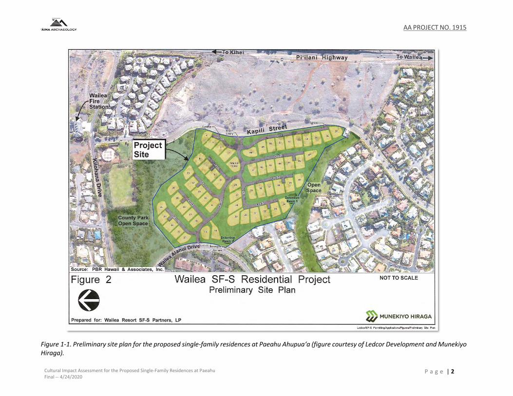
AA PROJECT NO. 1915
Cultural Impact Assessment for the Proposed Single-Family Residences at Paeahu Final -- 4/24/2020
P a g e | 2
Figure 1-1. Preliminary site plan for the proposed single-family residences at Paeahu Ahupua‘a (figure courtesy of Ledcor Development and Munekiyo Hiraga).

AA PROJECT NO. 1915
Cultural Impact Assessment for the Proposed Single-Family Residences at Paeahu Final -- 4/24/2020
P a g e | 3
Figure 1-2. A portion of the USGS 7.5’ topographic map, Puu o Kali Quadrangle (1992), showing the location of the proposed project (outlined in blue) in relation to Paeahu Ahupua‘a (shaded in green).
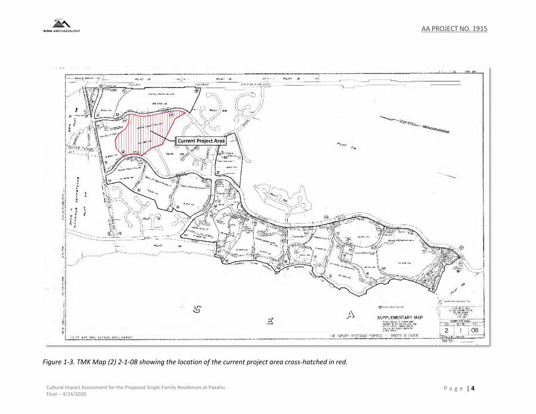
AA PROJECT NO. 1915
Cultural Impact Assessment for the Proposed Single-Family Residences at Paeahu Final -- 4/24/2020
P a g e | 4
Figure 1-3. TMK Map (2) 2-1-08 showing the location of the current project area cross-hatched in red.
AA PROJECT NO. 1915
Cultural Impact Assessment for Proposed Single-Family Residences at Paeahu DRAFT- 4/24/2020
P a g e | 5
2.0 CULTURAL HISTORICAL BACKGROUND
The division of Maui’s lands into political districts occurred during the rule of Kaka‘alaneo, under
the direction of his kahuna, Kalaiha‘ōhi‘a (Beckwith 1970:383). This division resulted in the
creation of twelve districts or moku during traditional times: Kula, Honua‘ula, Kahikinui, Kaupō,
Kīpahulu, Hāna, Ko‘olau, Hāmākua Loa, Hāmākua Poko, Na Poko or Na Wai Eha (Wailuku),
Kā‘anapali, and Lāhainā (Alexander 1882; Sterling 1998:3). The moku o loko, or moku as it is most
commonly called, literally means “to cut across, divide, separate” (Lucas 1995:77). When used as
a term of traditional land tenure, a moku is similar to a modern political district.
Within these moku are smaller units of land called ahupua‘a, the name of which is derived from
the Hawaiian term ahu (altar), which were erected at the points where the land boundary
intersected the alaloa (main road encircling the island), upon which a carved pua‘a (hog) image
made of kukui wood and stained with red ochre was placed along with the tax of food items from
that particular land unit as payment to the ali‘i (chief) during the annual progression of the akua
makahiki (Alexander 1882:4).
The typical configuration of the ahupua‘a extends from the sea to the mountain so that the ali‘i
(chiefs) and maka‘āinana (native tenants) could have access to resources of the wao lā‘au or wao
nahele (forested region), the wao ‘ama‘u and wao kanaka (cultivated land), and the kula uka and
kula kai (the lower grasslands and shoreline) (Alexander 1882:4; Mueller-Dombois 2007). While
the boundaries of an ahupua‘a generally followed prominent landforms (i.e. ridge lines, the
bottom of a ravine, a depression in the earth), there were times where a stone or rock that was
notable from a tradition or sacred use would mark a corner or determine a line (Alexander
1890:105-106). Along similar lines, the growth of a certain kind of tree, herb or grass, or the
habitat of a certain kind of bird would sometimes define a division (Alexander 1890:105-106).
Honua‘ula is comprised of some twenty ahupuaʻa, which, from north to south, include: Paeahu,
Palauea, Keauhou, Kalihi, Waipao, Pāpaʻanui, Kāʻeo, Maluaka, Moʻoiki (fronting the islet of
Molokini), Mohopilo (which does not reach the shoreline), Moʻoloa, Moʻomoku, Onau,
Kanahena, Kualapa, Kalihi, Papaka Kai, Kaunuahane, Kaloi, and Kanaio. The current project area
is situated within the the ahupua‘a of Paeahu which traditionally included the offshore fishery,
which began in the sea, and encompassed the shoreline and bays from Keawekapu to Halo. The
kula lands (open plain lands), where much of the agricultural activities occurred and the region
in which the proposed project is situated, stretched mauka behind a once active sand dune
system that swept across the shoreline.
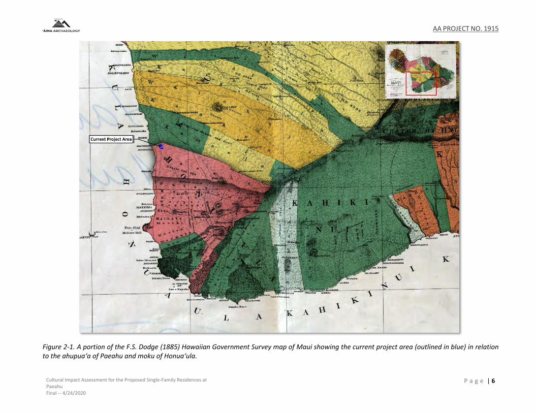
AA PROJECT NO. 1915
Cultural Impact Assessment for the Proposed Single-Family Residences at Paeahu Final -- 4/24/2020
P a g e | 6
Figure 2-1. A portion of the F.S. Dodge (1885) Hawaiian Government Survey map of Maui showing the current project area (outlined in blue) in relation to the ahupua‘a of Paeahu and moku of Honua‘ula.

AA PROJECT NO. 1915
Cultural Impact Assessment for the Proposed Single-Family Residences at Paeahu Final -- 4/24/2020
P a g e | 7
2.1 HE MAU MO‘OLELO O NA AHUPUAʻA ‘O PAEAHU I KA WĀ KAHIKO – TRADITIONS OF THE PAEAHU
REGION PRIOR TO WESTERN ARRIVAL The island of Maui has been known by several names throughout history and across the pae ‘āina. The ancient name of Ihikapalaumaewa, after the child of Wakea and Papa who is the ancestral origin of the people of Maui, was once attributed to the island of Maui. Maui has also been referred to Kulua for the two prominent volcanoes that comprise the island, Nā Hono-a-Pi‘ilani for Pi‘ilani, the great 16th Century chief of Maui, and Maui Nui a Kama for Kamalalawalu the grandson of Pi‘ilani (Kapiikauinamoku 1956; Sterling 1998:1). An origin story of the Hawaiian people speaks to the creation of their islands as being born to the gods Papa and Wakea. In the ancient oli (chant) that tells this origin story, Hawai‘i Island is first to be born, followed by Maui, and then the rest:
Hanau o Maui he moku, he
aina,
Na kama o Kamalawalu e
noho.
Maui was born an island, a land,
A dwelling place for the children of
Kamalalawalu.
(Fornander 1916b:2-3)
In this chant, Maui is called “a dwelling place for the children of Kamalalawalu,” who was the grandson of Pi‘ilani, a 16th century Mōʻī (paramount ruler) of Maui and founder of one of its greatest dynasties (Barrere 1975:1). Thus, the traditional poetic name for Maui as Maui-a-Kama, named after Kamalalawalu, whose children are the people of Maui. It’s because of them that we have the ability to know the historical names, moʻolelo, cultural sites and practices of the area in and around Paeahu.
2.1.1 Wahi ‘Inoa
In Hawai‘i, names were given to virtually everything. In the preface of Place Names of Hawaii,
Samuel Elbert states that:
Hawaiians named taro patches, rocks and trees that represented deities and ancestors, sites of houses and heiau, canoe landings, fishing stations in the sea, resting places in the forests, and the tiniest spots where miraculous or interesting events are believed to have taken place.
Place names are far from static … names are constantly being given to new houses and buildings, land holdings, airstrips, streets, and towns and old names are replaced by new ones … it is all the more essential, then to record the names and the lore associated with them (the ancient names) now. (Pukui et al. 1974:x)
Lyons also notes that as a consequence of the long tenancy of the people on land, “every piece
of land had its name, as individual and characteristic as that of its cultivation” (Lyons 1903:23).
Intrinsic to our knowledge of place names is their ability to tell the story or keep record of an
area’s resources or characteristics prior to European contact. Consideration of the place name
meanings for the study area may yield some insight into the stories, patterns of life, and land use
within the ahupua‘a of Paeahu. The place names noted on Figure 2-2 and listed below are for
areas, divisions, and features of the land and sea that comprise this ahupuaʻa, as identified
through research of the historic and modern maps of Paeahu and Honua‘ula, Mahele ‘Āina
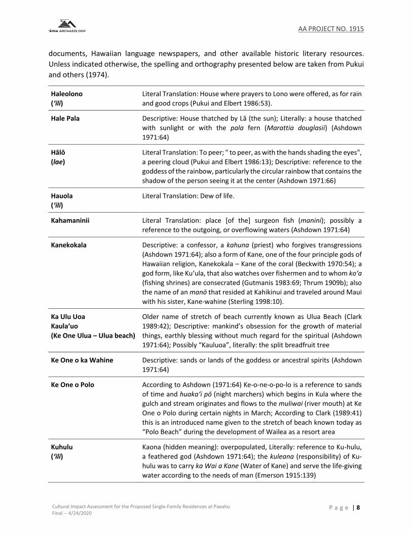
AA PROJECT NO. 1915
Cultural Impact Assessment for the Proposed Single-Family Residences at Paeahu Final -- 4/24/2020
P a g e | 8
documents, Hawaiian language newspapers, and other available historic literary resources.
Unless indicated otherwise, the spelling and orthography presented below are taken from Pukui
and others (1974).
Haleolono
(ʻili)
Literal Translation: House where prayers to Lono were offered, as for rain
and good crops (Pukui and Elbert 1986:53).
Hale Pala Descriptive: House thatched by Lā (the sun); Literally: a house thatched
with sunlight or with the pala fern (Marattia douglasii) (Ashdown
1971:64)
Hālō
(lae)
Literal Translation: To peer; " to peer, as with the hands shading the eyes",
a peering cloud (Pukui and Elbert 1986:13); Descriptive: reference to the
goddess of the rainbow, particularly the circular rainbow that contains the
shadow of the person seeing it at the center (Ashdown 1971:66)
Hauola
(ʻili)
Literal Translation: Dew of life.
Kahamaninii Literal Translation: place [of the] surgeon fish (manini); possibly a
reference to the outgoing, or overflowing waters (Ashdown 1971:64)
Kanekokala Descriptive: a confessor, a kahuna (priest) who forgives transgressions
(Ashdown 1971:64); also a form of Kane, one of the four principle gods of
Hawaiian religion, Kanekokala – Kane of the coral (Beckwith 1970:54); a
god form, like Ku‘ula, that also watches over fishermen and to whom ko‘a
(fishing shrines) are consecrated (Gutmanis 1983:69; Thrum 1909b); also
the name of an manō that resided at Kahikinui and traveled around Maui
with his sister, Kane-wahine (Sterling 1998:10).
Ka Ulu Uoa
Kaula‘uo
(Ke One Ulua – Ulua beach)
Older name of stretch of beach currently known as Ulua Beach (Clark
1989:42); Descriptive: mankind’s obsession for the growth of material
things, earthly blessing without much regard for the spiritual (Ashdown
1971:64); Possibly “Kauluoa”, literally: the split breadfruit tree
Ke One o ka Wahine Descriptive: sands or lands of the goddess or ancestral spirits (Ashdown
1971:64)
Ke One o Polo According to Ashdown (1971:64) Ke-o-ne-o-po-lo is a reference to sands
of time and huaka‘i pō (night marchers) which begins in Kula where the
gulch and stream originates and flows to the muliwai (river mouth) at Ke
One o Polo during certain nights in March; According to Clark (1989:41)
this is an introduced name given to the stretch of beach known today as
“Polo Beach” during the development of Wailea as a resort area
Kuhulu
(ʻili)
Kaona (hidden meaning): overpopulated, Literally: reference to Ku-hulu,
a feathered god (Ashdown 1971:64); the kuleana (responsibility) of Ku-
hulu was to carry ka Wai a Kane (Water of Kane) and serve the life-giving
water according to the needs of man (Emerson 1915:139)

AA PROJECT NO. 1915
Cultural Impact Assessment for the Proposed Single-Family Residences at Paeahu Final -- 4/24/2020
P a g e | 9
Keahuaao
(ʻili)
No definition available
Kumukahi
(ʻili)
Literal Translation: Origin, beginning (Pukui and Elbert 1986:182)
Maahi Ma-ahi: emotions running like fire or an emotions that cannot be
quenched like love or anger, Literally: running schools of ahi (yellow-fin
tuna) (Ashdown 1971:64)
Mokapu (Mōkapu) Literal Translation: Taboo district (mō-is short for moku); Form of moku
kapu (sacred island): a small rock island heavily populated with kōlea
(Pluvialis fulva) and other sea birds that gathered after feeding in the
mauka reaches , this offshore islet was destroyed during WWII combat
demolition exercises (Clark 1989:42-43)
Nupawai o Kukuiopiikea
(boundary point, cave)
Literal Translation: Deep water cave of Kukui-o-Piʻikea
Paeahu
(ahupuaʻa)
Literal Translation: Row [of] heaps; when broken down, pae means a
cluster, row, group, margin or bank like a taro patch, or level like a
platform leading to the interpretation while ahu translates as a heap, pile,
collection, mound, mass, altar, shrine, or cairn. Pukui and Elbert
(1986:298) also note that pae was a type of sweet potato.
Palauea
(ahupua‘a and stream)
Literal Translation: “lazy”; an alternative pronunciation and translation
was provided by Mr. Nathan Napoka (personal communication) where an
okina or glottal stop is added and the name changed to Palau‘ea which
refers to a traditionalsweet potato variety.
Pauaua
(ʻili)
No definition available
Piliwale
(ʻili)
Literal Translation: To cling, etc., for no reason or cause; often used in
unfavorable sense of living off other people (Pukui and Elbert 1986:331)
Punakea
(ʻili)
Literal Translation: A barely visible rainbow or white coral, as cast ashore
by the sea (Pukui and Elbert 1986:355)
Waihou
(spring)
Literal Translation: New water
Waikaahi
(spring)
Possibly Wai-ka-ahi and a potential reference to a hot spring given the
location along the east rift zone of Haleakalā where wai=water and
ahi=fire or heat
Wailea
(lae or point)
Literal Translation: Water [of] Lea (the goddess of canoe makers). One of
five calcareous sand beaches fronting the Wailea resort complex and the
namesake of the complex. The surf site is a shore break that forms on the
sandbar fronting the beach. The dive site is off Wailea Point. The beach is
also known as Kahamanini.
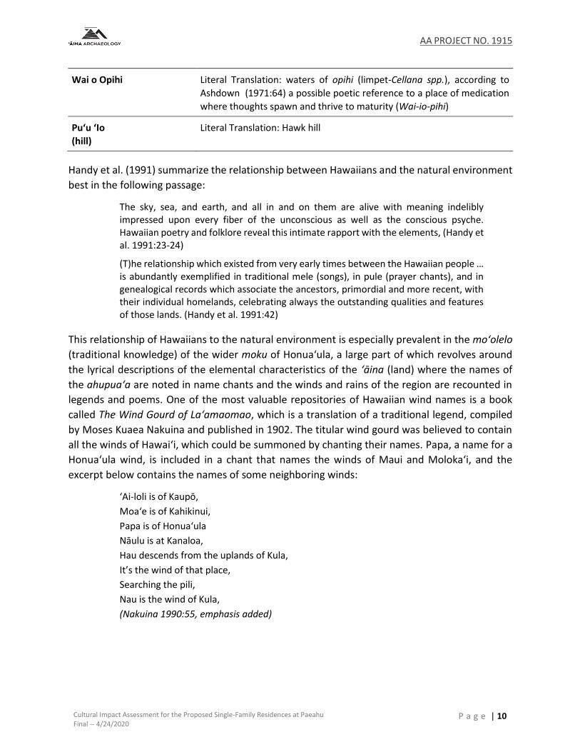
AA PROJECT NO. 1915
Cultural Impact Assessment for the Proposed Single-Family Residences at Paeahu Final -- 4/24/2020
P a g e | 10
Wai o Opihi Literal Translation: waters of opihi (limpet-Cellana spp.), according to
Ashdown (1971:64) a possible poetic reference to a place of medication
where thoughts spawn and thrive to maturity (Wai-io-pihi)
Puʻu ʻIo
(hill)
Literal Translation: Hawk hill
Handy et al. (1991) summarize the relationship between Hawaiians and the natural environment
best in the following passage:
The sky, sea, and earth, and all in and on them are alive with meaning indelibly impressed upon every fiber of the unconscious as well as the conscious psyche. Hawaiian poetry and folklore reveal this intimate rapport with the elements, (Handy et al. 1991:23-24)
(T)he relationship which existed from very early times between the Hawaiian people … is abundantly exemplified in traditional mele (songs), in pule (prayer chants), and in genealogical records which associate the ancestors, primordial and more recent, with their individual homelands, celebrating always the outstanding qualities and features of those lands. (Handy et al. 1991:42)
This relationship of Hawaiians to the natural environment is especially prevalent in the mo‘olelo
(traditional knowledge) of the wider moku of Honuaʻula, a large part of which revolves around
the lyrical descriptions of the elemental characteristics of the ‘āina (land) where the names of
the ahupua‘a are noted in name chants and the winds and rains of the region are recounted in
legends and poems. One of the most valuable repositories of Hawaiian wind names is a book
called The Wind Gourd of Laʻamaomao, which is a translation of a traditional legend, compiled
by Moses Kuaea Nakuina and published in 1902. The titular wind gourd was believed to contain
all the winds of Hawaiʻi, which could be summoned by chanting their names. Papa, a name for a
Honua‘ula wind, is included in a chant that names the winds of Maui and Molokaʻi, and the
excerpt below contains the names of some neighboring winds:
‘Ai-loli is of Kaupō,
Moaʻe is of Kahikinui,
Papa is of Honuaʻula
Nāulu is at Kanaloa,
Hau descends from the uplands of Kula,
It’s the wind of that place,
Searching the pili,
Nau is the wind of Kula,
(Nakuina 1990:55, emphasis added)
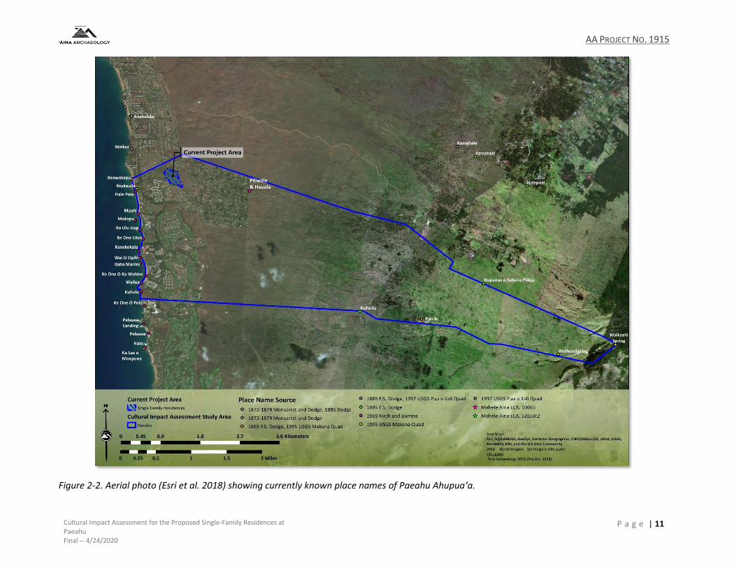
AA PROJECT NO. 1915
Cultural Impact Assessment for the Proposed Single-Family Residences at Paeahu Final -- 4/24/2020
P a g e | 11
Figure 2-2. Aerial photo (Esri et al. 2018) showing currently known place names of Paeahu Ahupua‘a.
AA PROJECT NO. 1915
Cultural Impact Assessment for the Proposed Single-Family Residences at Paeahu Final -- 4/24/2020
P a g e | 12
The various rains of Hawaiʻi were also given names. Some were named after people, others after
their particular traits or the way they interacted with the area and local vegetation. Different
rains from different parts of the islands often share the same name. The book Hānau Ka Ua
Hawaiian Rain Names (Akana and Gonzalez 2015) contains many of the rain names that were
recorded in newspapers from the 1800s and other primary source materials. There are at least
two rains associated with the moku of Honuaʻula: Lanipaʻina and Nāulu.
“Ka ua Lanipaʻina o ʻUlupalakua” is “[t]he Sky-crackling [Lanipaʻina] rain of ʻUlupalakua” (Pukui
1983:170), which is mauka of the subject property in the ahupuaʻa of Kāʻeo to the south. The
Lanipaʻina rain features prominently in a lengthy letter written by someone named Makaikai and
published in the newspaper Ka Lahui Hawaii, which describes the events one Fourth of July at
James Makee’s Rose Ranch in ʻUlupalakua (discussed below):
E ʻoluʻolu ʻoe a me kou kāpena
e hoʻokomo iho i nā mea ʻano
hou i hana ʻia ma ʻUlupalakua
i ka lā 4 iho nei o Iulai, ̒ oiai hoʻi
ka ua Lani Paʻina e kilihune
ana i luna o “Prospect Hill.” . .
.
Aia hoʻi i ka hiki ʻana aku i ka
hora 12 awakea, i ka wā hoʻi a
nā pua e luhe mālie mai ana i
ka nani, a e kilihune kili hau
ana ka ua Lanipaʻina i ka liko o
ka pua, pēlā i ʻike ʻia aku ai ka
pūʻali koa, “Ka Ua Lanipaʻina
Military Company” e paikau
hoʻokahakaha mai ana ma
lalo o ke alakaʻi maiau ʻana a
ko lākou Kāpena R. W. Wilcox.
. . .
You and your captain, please add the
new events that took place at
ʻUlupalakua this past Fourth of July while
the Lanipaʻina rain was drizzling over
“Prospect Hill.” . . .
When 12 noon came, indeed the period
when flowers gently droop in their
beauty, and the Lanipaʻina rain was
coming down in a cold drizzle over the
buds of the flowers, that was when the
group of soldiers, “Ka Ua Lanipaʻina
Military Company,” could be seen
parading back and forth under the
expert leadership of their captain, R. W.
Wilcox. . . .
(Akana and Gonzalez 2015:136-
137)
A second rain of the area is called Nāulu and is usually associated with Makawao. One reference
to it, in relation to Honuaʻula, comes to us indirectly by way of a wind name from a 1910 report
by Ralph S. Hosmer, who was the Territory of Hawaiʻi’s first forester. In the report he says:
There is much verbal testimony that in former days, say 25 years ago and before, there were many light drifting showers at the south end of East Maui, at ʻUlupalakua, which originated over Kahoʻolawe and drifted across the channel with the Nāulu breeze. (Akana and Gonzalez 2015:127)
Hawaiian proverbs, or ʻōlelo noʻeau, have been passed down through oral traditions. Many ʻōlelo
noʻeau have been collected and published in Hawaiian language newspapers and other primary

AA PROJECT NO. 1915
Cultural Impact Assessment for the Proposed Single-Family Residences at Paeahu Final -- 4/24/2020
P a g e | 13
and secondary sources. They often have both a literal and metaphorical meaning (called kaona),
which is given where applicable. ̒ Ōlelo noʻeau about geography can help us to understand natural
phenomenon, land use, and the history of a place. There aren’t any ʻōlelo noʻeau that refer
specifically to Paeahu, but there are two for Honua‘ula and one for ʻUlupalakua.
The two ʻōlelo noʻeau about Honuaʻula speak to the strength of its people:
Honua‘ula, e pāluku ʻia ana na kihi poʻohiwi e na ʻale o ka Moaʻe.
Honuaʻula whose shoulders are pummelled by the Moa'e wind. A poetical expression for a person being buffeted by the wind. Honuaʻula, Maui, is a windy place.
. . . .
Honuaʻula kua laʻolaʻo.
Callous-backed Honuaʻula. Said of the people of Honuaʻula, Maui, who were hard workers. The loads they carried often caused callouses on their backs.
(Pukui 1983:79)
The one ʻōlelo noʻeau for ʻUlupalakua is noted above and refers to the name and quality of its
rain:
Ka ua Lanipaʻina o ʻUlupalakua.
the Sky-crackling rain of ʻUlupalakua. Refers to ʻUlupalakua, Maui.
(Pukui 1983:170)
2.1.2 The Mythical Era
Preserved in moʻolelo (traditional stories) are tales about a period in Hawaiʻi before kānaka
(humans), when gods and deities inhabited the islands, often bringing about the creation of lands
and resources. Below are excerpts of moʻolelo set more generally in the larger moku of
Honuaʻula, as well as, passages that speak specifically of Paeahu and places within Paeahu.
2.1.2.1 Moʻikeha and His Traveling Companion Honuaʻula
Place names are often inspired by the physical characteristics of the area being named.
Honua‘ula translates to mean “red land” (Pukui et al. 1974:51). It’s possible that the origin of the
name lies elsewhere, because reddish soils are not common in Honua‘ula, where black lava fields
and brown soils cover the landscape.
One theory is that the name Honua‘ula comes from the mo‘olelo of Mo‘ikeha, a chief from Tahiti
who resettled in Hawai‘i and eventually became the king of Kaua‘i. Among those who joined
Mo‘ikeha on his voyage from Tahiti was a man named Honua‘ula. In the story, as recounted by
Fornander, when the canoe reached Maui, Honua‘ula elected to stay behind, perhaps settling in
the district that now shares his name:
One early morning at dawn, just at the rise of the star Sinus, Moikeha boarded his double canoe, taking with him all his attendants and followers, and set out from Tahiti. From that morn until sunrise when they first beheld Hilo all went well, whereupon Kamahualele stood up and prayed by way of a mele their voyage hither. Upon their
AA PROJECT NO. 1915
Cultural Impact Assessment for the Proposed Single-Family Residences at Paeahu Final -- 4/24/2020
P a g e | 14
arrival at Hilo, Kumukahi and Haehae became charmed with Hilo, and so expressed to Moikeha their desire to remain there, whereupon Moikeha allowed them to take up their residence at Hilo.
Moikeha soon after set sail from Hilo, sailing along the north coast of Hawaii until they arrived at Kohala, when Mookini and Kaluawilinau expressed their desire to take up their residence at Kohala. Moikeha therefore landed them there. On leaving Kohala they sailed along the eastern coast of Maui until they reached Hana, when one of his men, Honuaula, expressed his desire of making this his place of residence, so he too was allowed to remain behind. (Fornander 1916a:114-116)
2.1.2.2 Molokini
The crescent-shaped islet of Molokini, noted landform, located in ‘Alalākeiki Channel between
Kaho‘olawe and Maui, off the coast of Honua‘ula. Molokini’s origin story ties the tiny islet to Pu‘u
Ōlaʻi, the prominent shoreline cinder cone within Honua‘ula. According to mo‘olelo, Molokini was
a mo‘o (large mythological lizard) who was known as Puuoinaina prior to her death. She lived
most of her life on Kaho‘olawe, which was then called Kohemalamalama. She took two brothers
as her husbands before falling for Pele’s lover Lohiau and becoming the target of the fire goddess’
wrath. Pele’s retaliation for Puuoinaina’s interest in Lohiau is what led to the creation of Molokini
and Pu‘u Ōlaʻi, as recounted by Fornander:
But when Pele heard what Puuoinaina had done she became angry, she then cursed Puuoinaina. When Puuoinaina heard this cursing from Pele she felt so ashamed that she ran into the sea. She left her home, Kohemalamalama, now called Kahoolawe. Pele, residing at Kahikinui, thought so much of her husband, Lohiau, who was living at Kealia, Kamaalaea, that she started out to meet him; but she found her way blocked by Puuhele, so she went from there and waded through the sea. She saw her lizard rival, Puuoinaina, stretching from Kahoolawe to Makena, so she came along and cut the lizard in two, right in the middle, separating the tail from the head. The tail became Puuolai at Makena, and the head became Molokini. When the husbands heard that their wife was dead, they looked and beheld the head of their beloved standing in the sea, so they called the name of the islet Molokini. That is the story of how it was born of its parents and how it obtained this new name Molokini. (Fornander 1918:518)
2.1.2.3 A Riddle for Ka-Miki
The following passage comes from a moʻolelo called “Kaao Hooniua Puuwai no Ka-Miki” (The
Heart-Stirring Story of Ka-Miki). Published between 1914 and 1917 in the Hawaiian language
newspaper Ka Hoku o Hawaii, the story features two brothers, descendants of the goddess
Haumea, who possessed magical powers. In the following excerpt, Ka-Miki is asked by a chief
named Kahuku to solve a riddle relating to Maui, and in his answer, Ka-Miki describes Maui’s
various lands, including Honuaʻula:
AA PROJECT NO. 1915
Cultural Impact Assessment for the Proposed Single-Family Residences at Paeahu Final -- 4/24/2020
P a g e | 15
O ka ua hoelo a ka Ukui i ka
ulawena, o Honuaula ia, ilaila
i make ai ka makani.
A make i ke kula; o Makena ia
he okana aina a me Kula, o
kauwahi moe kokolo alualu
hele a ke kula hoi mai, he aina
ua kaulana mai na lii kahiki loa
mai
And where the cold ʻŪkiu wind bears
down, glowing red [driving the dust], is
Honuaʻula where the winds begin to die.
Where the wind dies upon the kula
(plains), is the sub-region of Makena and
Kula, where the mists are seen creeping
low, traveling to and fro along the plain.
This is a land famous with the chiefs
from the distant past.
(Maly and Maly 2005:29)
(Translation: Kepā Maly)
2.1.2.4 The Work of Pele at Honua‘ula and Her Time at Paeahu
In Moses Manu’s version of Pele’s story, Ke Kaua Nui Weliweli Mawaena o Pele-Keahialoa ame
Waka-Keakaikawai (1899), Manu provides a description of her work at Honua‘ula and specifically
notes Paeahu as a temporary residence before moving on to her current home on Hawai‘i Island:
Nu keia Pele no I hana, na puu
mahoe ma Ulupalakua I
kapaia ka inoa o Hanaleloulu e
ku nei; a ua nee aku la ka Pele
ma Paeahu, a oia hoi ka
palena o ka pele ma
Honuaula; a – hiki i keia wa ma
Maui. A ma ia ano – E IKE NO
KE KAMAHELE, ke nana ma
keia maui wahi a ka mea -
kakau-moolelo e hoike nei;
nolaila, a haalele iho a na
kakou ia “Maui no ka oi.”
Haalele ka Pele ia Maui no
Hawaii.
. . . .
This is what Pele formed, the
twin hills in ʻUlupalakua, which
bear the name Nāhaleloulu and
stands; and Pele had moved to
Paeahu, and this is the end of
the lavaflow at Honuaula; -- up
until now on Maui. And in the
same way — THE TRAVELER
KNOWS, look at these places
that the writer is describing;
therefore, let us leave with
“Maui is the best.”
Pele leaves Maui for Hawaii.
. . . . (Translation: Kaiani Kiaha)
2.1.2.5 Ka Pule a Kane – A Prayer of Kane
Of the four principal gods of Hawaiian beliefs and religious systems, Kane is the leading god who
represent procreation and is worshiped as an ancestor of both ali‘i and maka‘āinana. One of the
place names found along the shoreline of Paeahu holds the name Kanekokola (see Figure 2-2), a
coral form of Kane that can be found in the following excerpt of a pule (prayer) that was given by
Kane at the heiau of Kuikahi at Hanapēpē, Kaua‘i:

AA PROJECT NO. 1915
Cultural Impact Assessment for the Proposed Single-Family Residences at Paeahu Final -- 4/24/2020
P a g e | 16
. . . .
Kane-kokala,
Kane-kokala-loa,
Kane-kokala-lu-honua,
Kane-kokala-ku-honua,
Kane-kokala-i-ke-kiu,
Kane-kokala-i-ke-ahe
. . . .
. . . .
Kane-of-the-coral,
Kane-of-the-long-coral,
Kane-of-the-quaking-coral,
Kane-of-the-steadfast-coral,
Kane-of-the-sharp-pointed-coral,
Kane-of-wafted-coral
. . . .
(Beckwith 1970:54, emphasis added)
We also see Kane-kokola invoked in fishing ritual and ceremony. According to Titcomb and Pukui
(1977:91), fisherman who prayed to Kane ko kola and caught the kukala (kokola) fish, which is of
the same family as puffer fish, would throw them back into the sea while sending a prayer to
Kane with the following words:
E Kane-kokola
E Kane-kokola
E ho‘i, e ho‘i
I Kane huna-moku
O Kane-kokola
O Kane-kokola
Return, return
To Kane-huna-moku
2.1.3 Nā Po‘e Kahiko o ka Ahupua‘a o Paeahu – Traditional Hawaiian Settlement of the Paeahu
Ahupuaʻa
Maui’s southeastern region is dry and water is scarce, and the settlement of Honuaʻula likely
occurred as populations expanded in the more hospitable windward areas (Matsuoka et al.
1996:72) and seemingly following a general pattern of initial makai settlement and expansion
into the mauka elevations. de Naie and Donham (2007:42) speculate that canoe landing sites
evolved into coastal settlements, with footpaths and trails connecting coastal kauhale (villages),
like Kahimanini (Figure 2-3) as noted in the survey boundaries of Land Grant 548, to fishponds,
agricultural plots, the upland forests, heiau and other sacred sites. In this pattern, it is probable
that the open, sandy beaches of Paeahu have served as safe and reliable canoe landings since
the earliest days of Honuaʻula’s settlement with a network of trails likely branching up toward
the higher elevations (de Naie and Donham 2007:42).
The seasonality of water availability in this kona environment also likely dictated where and when
people resided in the area and how they cultivated the staples needed during the year. Matsuoka
describes a seasonal pattern of moving between mauka and makai in accordance with the
planting cycle, as documented by a kama‘āina named Sam Po:
According to [Sam Po], even up through the latter half of the 19th century, the Hawaiians in the district (Honua‘ula) continued to live mauka or makai and plant in accordance with the annual rains. About once month before the rainy season began, they would carry dirt down from the mountains to the coast in lauhala baskets and fill holes in the lava in preparation for planting. . . . While on the coast, the Hawaiians
AA PROJECT NO. 1915
Cultural Impact Assessment for the Proposed Single-Family Residences at Paeahu Final -- 4/24/2020
P a g e | 17
would subsist on fishing and various vegetable foods that they cultivated in soil placed in the pockets of lava and nurtured by the rain. When the vegetables matured (Hawaiian watermelon, Ipu oloolo, Ipu nuhou-lani, pumpkin, and poha or Ipu ʻala) they were consumed. After a period of about six months, just when the climate became dry, the families would make the return journey to their upland habitation sites. (Matsuoka et al. 1996:73)
In the June 8, 1836 issue of the newspaper Ke Kumu Hawai‘i, someone named Naleipuleho
provided one of the earliest first-hand accounts of life in Honua‘ula on record. It also speaks to
how the availability of water and other resources dictated patterns of residency and travel.
Translated by Kepā Maly, the following excerpt gives a glimpse of life in Honuaʻula as it may have
been since the earliest days of settlement:
Ke hai aku nei au ia oe i ke ano
o keia aina, i ka noho ana o na
kanaka
Eia ke ano. He aina wi, o
Honuaula. O ka uwala ko laila
ai, a me ka kalo, he ai pau wale
no ia. Eia ka ai mau loa, heko,
heki lau o ke aa, o ke ki lau a
me ka muo, o na ai mau loa ia.
Eia ke ano o ka noho ana o na
kanaka; elua wahi noho. Ma
kahakai, mauka ma waena o
ka aina. O ke kii ana o ka ai a
na kanaka ma kahakai he loihi
loa. He kokoke ka wai o lakou.
Pomaikai lakou i ke kokoke o
ka wai a me ka ia. Poino ko
lakou mau ai i ka loihi o ka ai.
O na kanaka i noho ma waena
o ka aina,— pomaikai lakou i
ka ai i ke kokoke o ka ai. Poino
lakou i ka wai i ka loihi o ke
ana o ka wai. Aia no i kahakai
kawai e kii ai. Ina e kii i uka i ka
wai, he loihi ke pii aku i luna,
he naenae ka pii ana,—aia no
i ka lae laau ka wai, i hoi mai
he lole ke kuli i ka loihi o ka hoi
ana mai, i ke kii ana o ka wai
elua ipu nui e ukuhi ai i ka wai,
a piha, hoi mai. Hooheehee i
I hereby tell you about the
nature of this land and the
residency of the people.
Here are the characteristics.
Honuaula is a land of famines.
The sweet potato is the food
there, and the taro, but they are
foods which do not last. Here
are the foods which are always
available, sugar cane, ti leaf
roots, and the budding leaves of
the ti are the steady foods.
Here is how the people live;
there are two places of
residency. Along the shore, and
in the mid uplands of the land.
The people who live on the
shore, must travel a great
distance to get vegetable foods.
But the fresh water is close to
them. They are blessed to be
near the drinking water and fish.
Though they are greatly
burdened in having to travel far
for their other foods.
The people who reside in the
middle of the land, are fortunate
that their foods are close to
them. But they are unfortunate
because the fresh water is a
great distance from them in the
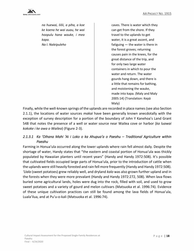
AA PROJECT NO. 1915
Cultural Impact Assessment for the Proposed Single-Family Residences at Paeahu Final -- 4/24/2020
P a g e | 18
na huewai, liilii, a piha, a koe
ke koena he wai auau, he wai
hoopulu hana wauke, i mea
kapa.
Na I. Naleipuleho
caves. There is water which they
can get from the shore. If they
travel to the uplands to get
water, it is a great ascent, and
fatiguing — the water is there in
the forest groves; returning
causes pain in the knees, for the
great distance of the trip, and
for only two large water
containers in which to pour the
water and return. The water
gourds hang down, and there is
a little that remains for bathing,
and moistening the wauke,
made into kapa. (Maly and Maly
2005:14) (Translation: Kepā
Maly)
Finally, while the well-known springs of the uplands are recorded in place names (see also Section
2.1.1), the locations of water sources makai have been generally known anecdotally with the
exception of survey description for a portion of the boundary of John Y Kanehoa’s Land Grant
548 that notes the presence of a well or water source near Wailea cove or harbor (ka luawai
kokoke i ke awa o Wailea) (Figure 2-3).
2.1.3.1 Ka ‘Oihana Mahi ‘Ai i Loko o ka Ahupua‘a o Paeahu – Traditional Agriculture within
Paeahu
Farming in Honuaʻula occurred along the lower uplands where rain fell almost daily. Despite the
shortage of water, Handy states that “the eastern and coastal portion of Honua‘ula was thickly
populated by Hawaiian planters until recent years” (Handy and Handy 1972:508). It’s possible
that cultivated fields occupied large parts of Honuaʻula, prior to the introduction of cattle when
the uplands were still heavily forested and rain fell more frequently (Handy and Handy 1972:508).
‘Uala (sweet potatoes) grew reliably well, and dryland kalo was also grown further upland and in
the forests when they were more prevalant (Handy and Handy 1972:272, 508). When lava flows
buried some agricultural lands, holes were dug into the rock, filled with soil, and used to grow
sweet potatoes and a variety of gourd and melon cultivars (Matsuoka et al. 1996:74). Evidence
of these unique cultivation practices can still be found among the lava fields of Honuaʻula,
Luala‘ilua, and at Puʻu-o-kali (Matsuoka et al. 1996:74).

AA PROJECT NO. 1915
Cultural Impact Assessment for the Proposed Single-Family Residences at Paeahu Final -- 4/24/2020
P a g e | 19
Figure 2-3. Land Grant 548 to John Y. Kanehoa highlighting boundary sections regarding resources of particular interest.

AA PROJECT NO. 1915
Cultural Impact Assessment for the Proposed Single-Family Residences at Paeahu Final -- 4/24/2020
P a g e | 20
Testimony gathered for claims of the Mahele ‘Āina (see also Section 2.2.2) may lend further
insight into the traditional crops and agricultural practices of Paeahu Ahupua‘a with all of the
land claims sharing two features in common: grasslands (moku mauu) and potato fields (mala
‘uala). It should be noted that many of the native tenant claims stated that these potato fields
were planted with white (or Irish) potatoes (‘uala haole). Intensive cultivation of ‘uala haole by
native tenants in the mid-19th Century was a response to a shift from a subsistence based
economy to a monetary economy to fulfill the initial needs of the whaling ships that would come
to port followed by the Irish Potato Boom (see Section 2.2.3.1.1) that was fueled by the California
Gold Rush. While this type of potato was a historically introduced crop and not a part of the
traditional Hawaiian diet, it is likely that those same fields were ‘uala maoli (native potato), as
seen in the award to Anahe (LCA 5370 Apana 3), and subsequently supplanted by ‘uala haole.
Additionally, the survey description of the earliest Land Grant to John Y Kanehoa also provides
insight as to the abundance of ‘uala fields in Paeahu where his boundary crossed through the
potato fields toward the upper portion of forest and center of ravine which is the boundary
Paeahu and Palauea Ahupua‘a (see also Figure 2-3).
Other types of traditional crops can be found in the testimony provided by Ainua (LCA 5369) such
as kalo (taro) and bananas (mala maia). Of interest is also an unawarded claim by Ohule for a
section of pahulu ‘uala and a section of pahulu (Helu 10580,Figure 2-4).
Figure 2-4. Native tenant claim by Ohule for pahulu and pahulu ‘uala lands in Paeahu (Helu 10580) (Office of Hawaiian Affairs 2011).
The term pahulu has two meanings in the context of traditional agriculture: 1. Exhausted, worn-
out, of over-farmed soil; such soil. hoʻo.pahulu To exhaust the soil; to let the land rest and lie
fallow; and 2. volunteer sweet potatoes, sweet potatoes of the second growth (Pukui and Elbert
1986:301). Kahikāhealani Wight’s Illustrated Hawaiian Dictionary (2005) offered the phrase “hiki
ke mahi ‘ia ka ‘uala I ka lepo pahulu” (Sweet potatoes can be farmed on the worn-out soil) in the
definition of pahulu as “worn-out” soil. Second growth in potatoes is likely induced by a period
AA PROJECT NO. 1915
Cultural Impact Assessment for the Proposed Single-Family Residences at Paeahu Final -- 4/24/2020
P a g e | 21
of high soil temperatures, as well as drought to some extent, followed by heavy rainfall
(Bodlaender et al. 1964). The specific claim for pahulu ‘uala and pahulu may speak to the
environmental conditions and challenge of farming the lands of Paeahu, as well as an agricultural
reliance on and traditional importance of pahulu ‘uala of those that settled the area.
2.1.3.2 Ka ‘Oihana Lawai‘a o ka Ahupua‘a o Paeahu – Aquaculture and the Fishing Traditions of
Paeahu
Honua‘ula is mentioned in the historical record in ways which suggest that its coastline has long
been a point of arrival and departure for canoes traveling to and from Maui. Channel waters
between the islands can be notoriously rough, and parties must occasionally wait for better
weather, as indicated in the following exerpt from the story of Lāʻieikawai, a chiefess from
Hawaiian mythology, recorded and published in the newspaper Kuokoa in 1862 by S. N. Haleʻole.
In this part of the story, Lāʻieikawai and her lover ʻAiwohi are making their way from Maui to
Hawaiʻi Island, and they end up spending a month in Honuaʻula as they wait for the ocean
conditions to improve:
[P]ae i Mala, ma Lahaina, e
haalele lakou ia wahi, hiki
lakou i Keoneoio, ma
Honuaula, a malaila i noho
loihi ai ekolu anahulu. No ka
mea, ua nui ka ino ma ka
moana, a pau na la ino, alaila,
ua ike ia mai ka maikai o ka
moana. Ia manawa ko lakou
haalele ana ia Honuaula, a
holo aku la a hiki ma
Kaelehuluhulu, ma Kona,
Hawaii.
Having landed at Māla, at Lāhaina, they
then departed from that place and
arrived at Keoneʻōʻio, in Honuaʻula.
There, they resided for a period of three
anahulu [a total of thirty days]. They did
this because the sea was extremely
rough. When the stormy days ended,
they saw the ocean was good.
(Maly and Maly 2005:23)
The story of Lauka‘ie‘ie adds some visual detail to the picture of Honuaʻula as an ancient canoe
landing site. Published as a series of articles in the newspaper Nupepa Ka Oiaio between January
5, 1894 and September 13, 1895, it tells the tale of Lauka‘ie‘ie, her brother Makanikeo, and their
traveling companions as they visit various parts of Hawai‘i. The following exerpts are set in
Honuaʻula:
Ia Makanikeoe, malaila e
nanea nei, aia na manowaa
mawaho ae o Keoneioio ma
Honuaula, ke pii pono ala i ke
alo makani. A eia no ka maka
hope mawaho ae o Puuolai a
ua hoomalu aku ka holo ana o
[Passing between Maui and
Kahoʻolawe]: Makanikeoe had the fleet
of canoes rest at Keoneʻōʻio, in
Honuaʻula, which rises up in the face of
the wind. It is marked by Puʻu Ōlaʻi,
where on the side the canoes find
shelter, before entering the famous sea

AA PROJECT NO. 1915
Cultural Impact Assessment for the Proposed Single-Family Residences at Paeahu Final -- 4/24/2020
P a g e | 22
na waa no ka moana kaulana
o Alenuihaha me ka pii wahi
ale ole o ua moana huhu ala o
ale ahiu. Aia ke kiei iho la ke
kuahiwi kamehai o Haleakala,
a ke oni mai la o Maunakea
me Maunaloa a me Hualalai,
mamua pono me ko lakou
kulana kilakila o ka nani.
of ʻAlenuihāhā, where there is no place
that the angry and wild waves of the sea
do not rise. From here [Honuaʻula], one
may gaze upon the wondrous mountain
of Haleakalā, as Mauna Kea, Mauna Loa
and Hualālai appear to move before you,
in their outstanding beauty.
(Maly and Maly 2005:24)
2.1.3.2.1 Fisheries and Fishponds
The Hawaiian worldview and organization of nature and space not only applied to the skies above
and natural phenomena, as noted previously, but also to the natural divisions of the oceans and
lands. With regard to the ocean, the named sections began at ae-kai, or the strip of beach where
the waves ran after breaking and extended to the deep ocean, or moana, which reached Kahiki-
moe the extreme boundary of the ocean (Malo 1951:25-26). In 1839, definition of the fishing
grounds and fishing rights of the maka‘āinana (common people), as well as that of the konohiki
(landlord) and ali‘i, were recorded as a part of the earliest Constitution of the Kingdom, a
structure that may have been an extension of the traditional management system.
Of the free and prohibited fishing grounds, the sections of the water were defined as follows –
for the maka‘āinana the fishing grounds were all those grounds without coral reef such as the
kilohe‘e (sea for spearing squid), the luhe‘e (sea for squid fishing), the malolo (sea of the flying
fishing), and moana (Malo 1951:26; Translation of the Constitution and Laws of the Hawaiian
Island, Established in the Reign of Kamehamaha III 1842:36). The fishing grounds from the coral
reefs to the sea beach were reserved for the konohiki (landlords) and tenants of their lands
(ahupua‘a) but not for others. At Honua‘ula, the grounds of the kuleku were the fishing grounds
that during the proper season for fishing would be placed under the protective kapu of the tax
officers for the King (Translation of the Constitution and Laws of the Hawaiian Island, Established
in the Reign of Kamehamaha III 1842:38).
The people of Honuaʻula were strongly connected to the ocean. Its waters were noted by 19th
century historians and writers for its well-stocked fisheries. According to Handy, the coastline of
Moʻoloa and Moʻoiki, and their neighboring ahupuaʻa, supported continuous populations of
people who relied on the ocean for food and trade:
Between Makena and the lava-covered terrain of Keoneoio (another famous fishing locality) the coastal region includes the small ahupuaʻa of Onau, Moomuku, Mooloa, Mooiki, Maluaka, Kaeo. According to an old Kamaaina, these ahupuaʻa had in former times a continuous population of fisher folk who cultivated potatoes and exchanged their fish for taro, bananas, and sweet potatoes grown by the upland residents of the Ulupalakua section. A few Hawaiians still live here. One living near Puu Olai has a sizable sweet potato patch in the dusty soil near the shore; another raises fine potatoes

AA PROJECT NO. 1915
Cultural Impact Assessment for the Proposed Single-Family Residences at Paeahu Final -- 4/24/2020
P a g e | 23
in a low flatland of white sand near the abandoned schoolhouse of Makena. (Sterling 1998:229)
The following traditional names and locations of Honuaʻula’s fishing grounds were gathered from
the Hawaiian Ethnological Notes archived at the Bishop Museum and published in Elspeth
Sterling’s book Sites of Maui, and they reveal an intimate knowledge of the sea. Some of the
descriptions have been abbreviated:
Pahua is the first and is located at Kanaio. Laeloa is (one of the) landmarks; when it appears directly over Holu Point, that is the upper mark. Puwai is the lower mark and it is called Ka-hope-o-ka-waa. It is a cave on the beach at Kanaio. The stone within the cave resembles a man standing there and when it appears slightly toward the windward side, the canoe is over the spot. It is 40 or more fathoms deep.
Hiu is another fishing ground . . .
Keahua is another . . .
Kalawa is another fishing ground . . .
Pohaku-ula is another fishing ground . . .
Kiele is another, it is situated at Lualailua . . .
Papuaa is another fishing ground . . .
Koa-hau is another. When the hill of Keoneoio appears above Puu-olai that is its upper landmark. When the hill of Kaka on Kahoolawe appears above (in line with) Pahee-o-lono Point on Molokini, that is the lower mark.
Na-ia-a-Kamahalu is another one. When Hoaka, which is in the upland of Kahoolawe on the western side appear to be in line with the cape of Ke-ala-i-kahiki that is the upper land mark. When the hill of Keoneoio appears to be in line of the seaward side of Puu-olai, that is the lower land mark.
Na-iʻa-a-Kamaliʻi is another. When the cave on Makena appears to be close to the point of Paopao at Puu-olai, that is the upper landmark. The cave at Pali ku in Keonioio is the other landmark. When it appears between the two stone at Mokuha and Kanahena, that is the low landmark. (Sterling 1998:215-216)
2.1.3.2.2 Fishing Methods and Practices
Drying fish was a regular practice in Honuaʻula, where it could be traded and stored for times
when food ran short, which occurred with some regularity. Drying fish went hand-in-hand with
the production of salt, which was gathered from basins along the shoreline of Oneuli (Sterling
1998:5, 213).
A traditional fishing method of Honuaʻula has been preserved by Daniel Kahāʻulelio, who recalled
how his parents would fish for kala and kole (two species of surgeonfish) using a special blend of
palu (bait). His parents were from Keoneʻōʻio and would have been alive during the early-to-mid-
1800s:
They used coconut milk with the ink sac that had been well-broiled over a charcoal fire. It was rubbed fine with an ʻalā stone, then the coconut milk was added. That was the
AA PROJECT NO. 1915
Cultural Impact Assessment for the Proposed Single-Family Residences at Paeahu Final -- 4/24/2020
P a g e | 24
palu they used at Keoneʻōʻio, Honuaʻula, their birthplace. Their lauhala bags were filled to the brim with kala and kole. (Kahā‘ulelio 2006:116)
Jarves (1843:77) notes that when it came to fishing, Hawaiians were “very expert; catching their
prey either by hooks made from pearl-shells, or in nets, some of which were of great size and
fine workmanship.” Use of large nets and such hooks would have been important for carrying
out akule (Big-Eyed Scad) surrounds or fishing for ulua (Giant Trevally) within the waters of
Honua‘ula. With regard to akule, Daniel Kahā‘ulelio writes that the saying “akule fish seek the
deep” is one that describes the nature of akule, which are a migratory species that only stop
whenever they find a place that they like. Akule fishing required a kilo i‘a, or skilled fish spotter,
that could identify the cloud of akule from the shore. When the fishermen were supplied with
bags to collect the fish and large surround nets, they would call for two canoes to carry the nets
to that spot, as guided by the kilo i‘a from shore, and surround the fish that had come to rest at
their favored places. At Mākena, hukilau was the method fishermen and their families used to
gather akule (big eyed scad). In a 2003 oral history interview with Samuel Ponopake Chang,
conducted by Kepā Maly and Nanea Armstrong, Chang, who was born in Mākena in 1911,
describes how his tūtū would be the kilo i‘a and watch for the school of akule from the shore
then direct the fishermen in their canoes as they surrounded the fish with a net that would then
be pulled in from the beach (Maly and Maly 2003:962).
Elspeth P. Sterling writes of meeting with a kama‘āina of Paeahu in 1968 who was sixty-five years
old at the time. His name was Bill Kaiaoka-mailie, and his recollections of his childhood, as relayed
by Sterling, offer a rare first-hand account of this region of Honuaʻula around the turn of the 20th
century:
He admits he doesn’t know much but he was born in Paeahu mauka and went fishing with his father. In his time no one lived at the shore but they all had their campsites directly below their mauka homes and went constantly to fish. Within Sam Po’s knowledge, in Kanaio, the people spent several months at the shore. They knew when the rains were about to begin and would head for the beach, plant their sweet potatoes and stay until time to harvest–about five months.
Irish potatoes were a big crop all through that mauka area, supplying gold rush and whalers. Quite a few of the LCA’s note apana for potatoes. Bill showed me graves at the shore, as well as the landing place at Palauea where potatoes were shipped from. Pointed out to him by his father. There was plenty of water (brackish) at the shore and plenty of fish. As far as Bill knows there were no inhabitants between the shore and mauka homes. No water. Walker lists no heiaus in this area. Either he missed them (more than likely), they were long destroyed or there was no great population.
Perkins in Na Motu 1854 mentions “Among the sand hills of Palauea, five miles distant (from Kalepolepo) I have seen children erecting pyramids of skulls and enclosing them with ancestral bones.” (Sterling 1998:234)
2.1.3.3 Ka Hana No‘eau o Nā Po‘e o Paeahu – Traditional Crafts of the People of Paeahu
In addition to descriptions of areas that were either under cultivation (see Section 2.1.3.1) or
necessary for gathering of aquatic food resources (see Section 2.1.3.2), at least one of the native
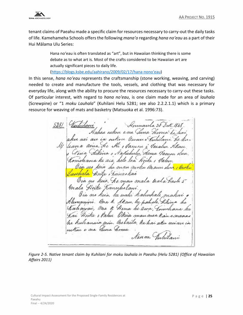
AA PROJECT NO. 1915
Cultural Impact Assessment for the Proposed Single-Family Residences at Paeahu Final -- 4/24/2020
P a g e | 25
tenant claims of Paeahu made a specific claim for resources necessary to carry-out the daily tasks
of life. Kamehameha Schools offers the following mana‘o regarding hana no‘eau as a part of their
Hui Mālama Ulu Series:
Hana no‘eau is often translated as “art”, but in Hawaiian thinking there is some
debate as to what art is. Most of the crafts considered to be Hawaiian art are
actually significant pieces to daily life.
(https://blogs.ksbe.edu/aahirano/2009/02/17/hana-nono‘eau)
In this sense, hana no‘eau represents the craftsmanship (stone working, weaving, and carving)
needed to create and manufacture the tools, vessels, and clothing that was necessary for
everyday life, along with the ability to procure the resources necessary to carry-out these tasks.
Of particular interest, with regard to hana no‘eau, is one claim made for an area of lauhala
(Screwpine) or “1 moku Lauhala” (Kuhilani Helu 5281; see also 2.2.2.1.1) which is a primary
resource for weaving of mats and basketry (Matsuoka et al. 1996:73).
Figure 2-5. Native tenant claim by Kuhilani for moku lauhala in Paeahu (Helu 5281) (Office of Hawaiian Affairs 2011)
AA PROJECT NO. 1915
Cultural Impact Assessment for the Proposed Single-Family Residences at Paeahu Final -- 4/24/2020
P a g e | 26
2.1.3.4 Nā Moʻolelo o nā Aliʻi ma Honuaʻula – The Stories of Chiefs at Honuaʻula
The moʻolelo of Maui’s aliʻi document the famous battles, journeys, alliances, romances, and
accomplishments that occurred throughout history and often reveal a little bit about the places
where these events occurred. The excerpts below come from some of these moʻolelo, where
certain events are said to have occurred in Honuaʻula.
2.1.3.4.1 Kauholanuimahu, the Aliʻi from Hawaiʻi Island
Kauholanuimahu was a Hawaiʻi Island chief who ruled in the mid-1400s and spent considerable
time in, and exercised influence over, Honuaʻula. Kauholanuimahu was the son of Laʻakapu, who
came from Honuaʻula, and a Hawaiʻi Island chief named Kahoukapu (Matsuoka et al. 1996:76).
When his father died, his mother returned to Honuaʻula and her lands became his. Fornander
states that he “resided a great portion of his time at Honuaula, Maui where he exercised royal
authority, and, among other useful works, built the fishpond at Keoneoio” (Fornander 1880:8).
He is also credited with buidling a heiau in Kāʻeo, mauka of Keawalaʻi Church (Matsuoka et al.
1996:76).
2.1.3.4.2 Kiha-a-Piʻilani and Ke Alaloa
Kiha-a-Piʻilani was the son of Piʻilani and ruled as King of Maui during the late-1500s. For a short
while prior to his reign, Kiha-a-Piʻilani resided in Honuaʻula. He lived in secret among the
makaʻāinana to avoid execution by his brother (Kamakau 1992:22).
Kiha-a-Piʻilani’s older brother Lono-a-Piʻilani became King upon the death of their father Piʻilani,
despite Piʻilani’s stated wish that his sons share Maui’s rule. For a short time, the two had a
harmonious relationship. Kiha-a-Piʻilani was a kind aliʻi. He was attentive to well-being of the
makaʻāinana, offering them food in times of shortage. His older brother saw his generosity as an
attempt to curry favor and undermine his rule, and so a rift developed. One day, the two got into
a fight, and Lono-a-Piʻilani became so certain of his brother’s disloyalty, that he resolved to have
him killed.
Kiha-a-Piʻilani fled first to Molokaʻi and then to Lanaʻi before returning in secret to Maui. He and
his wife managed to reach the uplands of Honuaʻula without being discovered by Lono-a-Piʻilani’s
men, and there they were welcomed by the makaʻāinana. According to Kamakau, they first lived
at a place called Keʻekeʻe (Kamakau 1992:23), which De Naie suggests likely refers Puʻu
Keʻekeʻehia (de Naie and Donham 2007:105). Eventually, they relocated to the vicinity of Kula
and Makawao before Kiha-a-Piʻilani’s sought to wrest Maui from his brother’s control, which he
accomplished with the help of his brother-in-law ‘Umi-a-Liloa, the Hawaiʻi Island chief.
During his reign, he managed to finish the construction of Ke Alaloa (The Long Road), a paved
footpath that encircled both Maui’s east and west ends, a length of approximately 138 miles (de
Naie and Donham 2007:75). The project, which would improve travel, trade, communication, and
the collection of hoʻokupu (taxes), was started under his father, the chief Piʻilani around the year
1516. In Honuaʻula, Ke Alaloa travelled along the coastline, crossing the beaches from Wailea
AA PROJECT NO. 1915
Cultural Impact Assessment for the Proposed Single-Family Residences at Paeahu Final -- 4/24/2020
P a g e | 27
heading south to Poʻolenalena and Maluaka and then over the lava fields to Keoneʻoʻio. Large
sections were paved with stone, about which Martha Fleming provides some insight:
The Alii had a line of men stand from the sea and hand stones along the line till they reached the required place. Here the stones were artfully put into position. The trail was paved with flat, hard beach stones Those on the steeper grades were very flat, while those in less sloping country were more rounded. In open country, each side of the trail was flanked with large field boulders solidly sunk into the ground and standing above the center from one to five feet. . . . On the steep gulches, only one side of the trail had this guard. The stones, or flags, on the floor of the trail were placed horizontally to abutments in quite regular lines. It took four or five stones to make a line across. The second row of horizontal stones was placed parallel to the other in a checker-board fashion to prevent wash. The width of the trail between the balustrades was from four to five feet, giving a regular appearance as it stretched over the country. There were few turns in the trail, even where the grade was steepest. (Fleming 1933:5)
2.1.3.4.3 The Invasion of Kalaniʻōpuʻu
Just prior to the reign of Kamehameha, Maui was controlled by Kahekili and Hawaiʻi Island by
Kalaniʻōpuʻu. Kamakau writes that in 1776, war broke out in Honuaʻula when Kalaniʻōpuʻu and
his army invaded the district and terrorized its people, prompting Kahekili to come their defense
and defend his rule over the island:
In the year 1776 Ka-lani-ʻopuʻu and the chiefs returned to war on Maui, and in the battle with Ka-hekili’s forces at Wailuku were completely overthrown. The army landed at Keoneʻoʻio, their double canoes extending to Makena at Honuaʻula. There they ravaged the countryside, and many of the people of Honuaʻula fled to the bush. When Ka-hekili heard of the fighting at Honuaʻula he got his forces together–chiefs, fighting men, and left-handed warriors whose sling-shots missed not a hair of the head or a blade of grass. Ka-lani-ʻopuʻu landed his forces before noon, a great multitude filling the land from Kiheipukoʻa at Kealia to Kapaʻahu, all eager with the thought that the Alapa were to drink the waters of Wailuku. (Kamakau 1992:85)
2.1.3.4.4 Kalola and the Olowalu Massacre of 1790
The chiefess Kalola was the daughter of Kekaulike, Mōʻī of Maui during the 1700s. Her brother
was Kahekili, the famous warrior king mentioned above who came to control seven of the eight
Hawaiian islands and paved the way for Kamehameha’s eventual unification. There are accounts
documented by Fornander and Kamakau of Kalola residing or spending time in Honuaʻula
(Kamakau 1992:145) (Fornander 1880:214, 228).
Kalola and her husband Kaʻopuiki were involved in one of Maui’s most infamous attacks, the
Olowalu Massacre of 1790. The massacre itself resulted in the brutal murder of more than a
hundred Hawaiians at a village located in what is now known as Olowalu. This event was
precipitated by a series of incidents involving the British-American captain Simon Metcalf and the
crew of a fur trading ship called Eleanora (also called the Eleanor), which anchored at Honuaʻula
in 1790. Barrere suggests that this was Mākena Bay (Barrere 1975:21). An anonymous officer’s
account of the event was published in 1792 in a London journal called Gentleman’s Magazine.
AA PROJECT NO. 1915
Cultural Impact Assessment for the Proposed Single-Family Residences at Paeahu Final -- 4/24/2020
P a g e | 28
Kalola and Kaʻopuiki were present when the Eleanora first docked at Honuaʻula. They went out
to greet the foreigners and offer goods to trade, at which point Kaʻopoiki took notice of a smaller
boat, called a cutter, tied to the Eleanora’s stern. The boat was constructed with highly coveted
metal parts. That night, Kaʻopuiki and some others snuck out to the ship and cut the smaller boat
loose. Sleeping inside was one of Metcalf’s crewmen, who was killed during the raid. Realizing
that the boat was missing, Metcalf sent out a search party but found nothing.
The next day, several more canoes came out to the Eleanora with pigs and fruit to offer. They
were told to go away but didn’t obey, and so, Metcalf fired on them, killing and wounding several
Hawaiians. The following day, according to an officer’s account, “four or five thousand people”
gathered at the shoreline, “all armed with slings, spears, and arrows” ("Americans at Otaheite"
1792:318). A battle ensued, with the boat firing its cannons at the beach and likely killing and
wounding many. A crew went to shore and set fire to the village and heiau, and any survivors
eventually fled mauka to avoid being shot at.
After that, the Eleanora left Honuaʻula and headed north. The officer wrote, “We had been under
way about an hour and a half, with a light breeze, when the natives in canoe alongside, informed
us that the chief of the people that had stolen the boat, lived behind a point, to the northward,
we then hauled our wind, went round the point and came to anchor” ("Americans at Otaheite"
1792:319).
The next day, Kaʻopuiki came aboard the ship and offered to return the boat, which had been
stripped for its metal parts, and the boat’s keeper, who was dead, in exchange for a reward.
Kaʻopuiki later returned with just the boat’s keel, angering Metcalf.
Sensing danger, Kalola had declared a kapu forbidding anyone from making conact with the ship.
It lasted three days, and when it was over, hundreds of villagers paddled out to the Eleanora in
the hopes of trading with the crew. Presenting a friendly demeanor, Metcalf managed to corral
the canoes along one side of his ship, and once they were packed tightly together, he ordered his
crew to fire the guns. It was a scene of carnage, with at least a hundred dead and a hundred
wounded. Kamakau describes the aftermath:
Even those who swam away were shot down. John Young was an eyewitness on board the ship and has testified to the great number who were killed at this time. At noon that day the “Eleanor” sailed, and the people went out and brought the dead ashore, some diving down into the sea with ropes and others using hooks; and the dead were heaped on the sands at Olowalu. Because the brains of many were oozing out where they had been shot in the head, this battle with the ship “Eleanor” and her captain was called "The spilled brains" (Kalolo-pahu). It was a sickening sight, as Mahulu and others have reported it; the slaughtered dead were heaped upon the sand; wives, children, parents, and friends came to view and mourn over their dead; and the sound of loud wailing arose. (Kamakau 1992:146)
AA PROJECT NO. 1915
Cultural Impact Assessment for the Proposed Single-Family Residences at Paeahu Final -- 4/24/2020
P a g e | 29
2.2 ARRIVAL OF WESTERN VESSELS AND 19TH CENTURY CULTURE CHANGE In 1778, Captain James Cook made Hawaiʻi known to the West, and the flow of seamen,
merchants, missionaries, and plantation owners that followed forever altered the land, people,
and culture of Hawaiʻi. The sections below explain how these changes impacted the people and
lands of of Honuaʻula.
2.2.1 Transitions in Population and Land Use
In May of 1786, the French explorer Jean-François de La Pérouse sailed past Maui and landed
briefly to the south of Mākena State Park at Keoneʻoʻio, anchoring in the bay that now bears his
name. It was his belief that he was the first European to set foot on Maui and spent one day
ashore engaging in trade and exploring the area (Dunmore 1985:227). Accounts from this
expedition suggest a relatively large and well-established community with ready access to
resources:
More than one hundred and twenty of them, men, women, and children had been out in their canoes since the crack of dawn and immediately offered to begin trading. Two of them, who seemed to be the men of authority, approached. They made a long, serious speech to La Pérouse, who did not understand a single word, and presented him with a pig, which he accepted. In return he gave them some medals, hatchets, and pieces of iron, which they valued very highly. By this generosity, the French succeeded in winning the friendship of the islanders.
During his reconnaissance, La Pérouse saw four small villages of ten or twelve houses. These are made of grass and are covered with the same material. They have the same shape as the thatched cottages found in certain parts of France. The roofs are pitched on two sides, and the door, which is located on the gable end, is only three feet high, so that it is necessary to stoop when entering. The furnishings consist of mats, which like our carpets make a very neat flooring on which the islanders sleep. The only cooking utensils they have are gourds painted in various colors. Their cloth is made from the paper mulberry tree, but, although painted in a great variety of colors, it appears less skillfully made than the cloth of other South Sea islanders.
When he returned aboard, the commander learned that Captain Clonard, his executive officer, had received a chief and had bought a cape and a fine red helmet from him; he had also acquired more than one hundred pigs, some bananas, yams, taro, mats, and various small objects made of feathers and shells. (Jean-François de Galaup 1969:24-25)
Another early description that we have of Honua‘ula comes from the account of Archibald
Menzies, a Scottish naturalist who was on Captain George Vancouver’s 1793 voyage through
Hawaiʻi. The impression the Menzies got was of a “barren” and “thinly inhabited” place:
[E]arly in the morning of 10th, when we bore away along the southern shore, with a steady breeze, till we came to Molokini, and ther it became light and fluctuating in its direction, by the high land of Maui intercepting the regular trade wind. We had some canoes off from the latter island, but they brought no refreshments: indeed this part of the island appeared to be very barren and thinly inhabited. (Thrum 1909a:92-93)
AA PROJECT NO. 1915
Cultural Impact Assessment for the Proposed Single-Family Residences at Paeahu Final -- 4/24/2020
P a g e | 30
The century that followed is characterized by immense change. Contact with the foreigners from
the U.S. and Europe brought new customs and practices, new ways of organzing land and labor,
new technologies, as well as new threats and, for a few, new opportunities. Honuaʻula, as
elsewhere throughout Hawaiʻi, felt the effects of these changes in large and small ways.
2.2.1.1.1 A Declining Population
One of the more consequential aspects of this period was a steady decline in population
beginning in the 1830s. The first formal population counts were conducted by the missionaries
in 1831-1832 (Schmitt 1973:5), when 3,340 people were counted in Honuaʻula, which made it
Maui’s fourth most populated district behind Lahaina, Hamakualoa, and Hāna (de Naie and
Donham 2007:113).This was likely near its peak before exposure to foreign epidemics and disease
took its toll.
Contact with the wider world brought Hawai‘i into a global market economy and transformed
traditional Hawaiian society in complex ways. Whaling was one of the first industries to find a
foothold in Hawai‘i, and as it drew young Hawaiian men away from the land and their families
and onto whaling ships, the communities of Honua‘ula felt the effects. In an 1846 letter to editor
of The Polynesian, a missionary named Jonathan S. Green expressed his dismay at the threat such
a loss posed:
The fact that the number of young men who leave home, and engage their services on board whale ships, is rapidly increasing, is one of the facts, so far as my people are concerned, which fills me with painful apprehension. More or less of the Hawaiian youth, I am aware, have engaged in this business for many years, especially those living in the vicinity of Honolulu, Lahaina, Hilo and Kaawaloa. But of late the number of these has greatly increased—at least in our vicinity—so that the present season not a few of the most promising young men from Kula, Honuaula and Wailuku have gone to sea. During the three years past we have had an excellent native school at Makawao, taught by a graduate of Lahaina Seminary. Many of these young men had made good proficiency in their studies—had nearly completed their course of education, and some few of them had commenced teaching. Now that these youth were just ready to engage in labors for the good of the nation, they have nearly all gone on board whale ships, and thus our hopes of good to the nation through them is for the present, utterly blighted. (Maly and Maly 2005:18)
2.2.1.1.2 The Nuisance of Cattle
In places like Honuaʻula, the presence of cattle had profound impacts to the land and to people’s
livelihoods. Cattle were first given to Kamehameha by Captain George Vancouver in 1793, who
hoped it would become “a convenient source of beef provisions for ships in the mid-Pacific, as
well as a civilizing tool to transform the Hawaiian people” (Fischer 2015:31). Kamehameha placed
a kapu (prohibition) on the animals, and while under protection, their numbers multiplied. It’s
not known when cattle were brought to Maui. The first reliable population count was taken in
1852 and tallied a total of 40,700 cattle on all islands (Fischer 2015:58).

AA PROJECT NO. 1915
Cultural Impact Assessment for the Proposed Single-Family Residences at Paeahu Final -- 4/24/2020
P a g e | 31
The herds of wild cattle were a destructive force on the native enviroment. The ecologist
Christopher Lever notes that in Hawaiʻi, “feral cattle have had a serious negative impact on the
vegetation of dry, mesic, and wet forests at both high and low altitudes. Indeed, it has been
claimed that they have been the single most destructive animal in the islands” (Lever 1994:44).
Appreciating the scale of such impacts, Handy concludes that Honuaʻula was more hospitable
before the cattle transformed it:
In Honuaula, as in Kaupo and Kahikinui, the forest zone was much lower and rain more abundant before the introduction of cattle. The usual forest-zone plants were cultivated in the lower upland above the inhabited area. Despite two recent (geologically speaking) lava flows which erupted from fissures below the crater and only a few miles inland and which covered many square miles of land, the eastern and coastal portion of Honuaula was thickly populated by Hawaiian planters until recent years. (Handy et al. 1991:113-114)
In these conditions, and in an area already prone to drought, the deforestation of the land made
Honuaʻula’s residents even more vulnerable. On June 8, 1838, Jonathan S. Green submitted this
report to the Hawaiian Spectator, describing a time when the conditions were so bad, it forced
the people of Honuaʻula to seek food in other districts:
Hoapilikane [Governor of Maui] is now ordering all the people from Honuaula, one of our out stations, away from home, 20 miles to dig fishponds. They have been here by fifties to request food. For they work for naught and board themselves. They have no food on their own land, it being a time of famine at that place, so they have to get food where they can find it. They carry their food to the place of their labor, leaving their families to seek sustenance as they can. (Maly and Maly 2005:61)
Not only did cattle cause deforestation, they threatend farmers’ crops. There are numerous
reports of cattle driving farmers off of their lands. In an 1846 article published in The Polynesian,
the writer, while summarizing Kamehameha III’s visit to Maui, notes that “the cattle have done
much mischief by trespassing on the plantations, and driving the owners from their little farms.
Two districts have in consequence been deserted” (Maly and Maly 2005:17).
One of the more tragic incidences resulted in the death of a man named Aki from Honuaʻula
(Maly and Maly 2005:16-17). Linton Torbert, who owned much of ʻUlupalakua and the
surrounding lands, owned some cattle that had allegedly trampled on Aki’s farmland. Aki
allegedly cut several of their legs, injuring Torbert’s cattle. Torbert and his blacksmith Benjamin
Furbush confronted Aki, they got into a scuffle, and while Aki was attempting to flee, he was shot
in the back and killed. Torbert and Furbush were sentenced to four years in prison, which was
commuted with the payment of a fine, $200 each.
Up until the early-1840s, land use, access, and subsistence activities in Honua‘ula remained as
they had from ancient times. But by the mid-1840s, things began to change as the Māhele’s new
land ownership rules facilitated a shift in use from subsistence to commercial ranching and
agriculture (Maly and Maly 2005:13).

AA PROJECT NO. 1915
Cultural Impact Assessment for the Proposed Single-Family Residences at Paeahu Final -- 4/24/2020
P a g e | 32
2.2.2 1845-1851 – The Mahele
The Mahele reformed Hawaiʻi’s traditional system of land tenure, from one where the chiefs and
people held the land in common, to one of private ownership modeled off of Western land
regimes. It was a multi-part process that began in 1845 with the establishment of a Board of
Commissioners to Quiet Land Titles, also known as the Land Commission. Those who intended to
secure rights or title to any lands would submit their claims to the five-member Land Commission
Board. The Board would then determine the validity of those claims and issue a Land Commission
Award (LCA) to successful claimants (Chinen 1958:8-9). Upon payment of a commutation fee to
the government, a Royal Patent would be issued, perfecting title to the land (Chinen 1958:21).
The actual land division, or mahele, began 1848. It required an initial process of clarifying and
separating out the respective property interests of the King, the chiefs and konohiki (ahupuaʻa
managers), and the native tenants or hoa ʻāina (Chinen 1958:15). The intent was for the King
(Kamehameha III) to retain his own individual lands (known as the Crown Lands), and for the
remaining lands to be divided into thirds and entitled to the government, the chiefs and konohiki,
and the native tenants (Chinen 1958:15-16). These three land categories are known as
Government Lands, Konohiki Lands, and Kuleana Lands. This mahele (division) between the King
and more than 240 chiefs and konohiki occurred between January and March of 1848. In what’s
called the Buke Mahele (Mahale Book), the chiefs and konohiki surrendered all interests in any
lands the King wanted to retain, and he did the same with any lands they wanted to retain. The
aliʻi and konohiki claims were typically for entire ahupuaʻa or smaller, whole subdivisions within
ahupuaʻa. Commutation fees were often paid in land, at a rate of one-third of an awardee’s total
award, and placed into the inventory of Government Lands (Alexander 1890:114).
The distinction between Crown and Government Lands is an important one. From their inception,
they were regarded as separate and distinct classifications of property. Crown Lands were
defined as the:
… private lands of His Majesty Kamehameha III., to have and to hold for himself, his heirs and successors forever; and said lands shall be regulated and disposed of according to his royal will and pleasure subject only to the rights of tenants. (Kingdom of Hawaii 1848)
At the death of Kamehameha III, the Crown Lands passed to Kamehameha IV. But at the death
of Kamehameha IV, there was no immediate heir to the throne, which created some confusion
as to the inheritance of Crown Lands and whether or not it followed the family line or the throne.
It was decided by the Supreme Court that under the confirmatory Act of June 7th, 1848, “the
inheritance is limited to the successors to the throne,” “the wearers of the crown which the
conqueror had won,” and that at the same time “each successive possessor may regulate and
dispose of the same according to his will and pleasure as private property, in the manner as was
done by Kamehameha III” (Alexander 1890:121).
In contrast to the Crown Lands were the Government Lands, which were defined and set aside in
a manner more typical of public lands. They were defined as:
AA PROJECT NO. 1915
Cultural Impact Assessment for the Proposed Single-Family Residences at Paeahu Final -- 4/24/2020
P a g e | 33
… those lands to be set apart as the lands of the Hawaiian Government, subject always to the rights of tenants. And we do hereby appoint the Minister of the Interior and his successors in office, to direct, superintend, and dispose of said lands, as provided in the Act … (p)rovided, however, that the Minister … shall have the power, upon the approval of the King in Privy Council, to dispose of the government lands to Hawaiian subject, upon such other terms and conditions as to him and the King in Privy Council, may seem best for the promotion of agriculture, and the best interests for the Hawaiian Kingdom … (Kingdom of Hawaii 1848:41)
As a part of the 1848 Act Relating to the Lands of His Majesty the King and of the Government,
and as published in subsequent newspaper notifications, the lands of Paeahu Ahupua‘a, noted
as Paeahu 1 and Paeahu 2, were set apart and declared as lands of the Hawaiian Government
(Kingdom of Hawaii 1848:34; "Na ke Aupuni: He Kanawai no na Aina Ponoi o ka Moi, a me na Aina
o ke Aupuni" 1848).
As previously noted, in designations of lands as either Crown or Government, and through all
awards of whole ahupua‘a, ‘ili, and later land sales to foreigners, the rights of the native tenants
were expressly reserved, “Koe na Kuleana o Kanaka” (Reserving the Rights of Native Tenants)
(Alexander 1890:114). For the native tenants, it took the passage of the Act of August 6, 1850,
commonly known as the Kuleana Act, to facilitate the process of taking title to their own
landholdings, which became known as Kuleana Lands. The Act waived the commutation fee,
although a survey was still required. The tenants were permitted to make claims for any lands
that they actually cultivated and were required to provide evidence of such through testimony,
and claims often included multiple ʻili, or apana, located both mauka and makai. Kuleana Land
claims were presented to and heard by the Land Commission.
Although the intent was for the land to be divided equally among the government, chiefs, and
native tenants, the outcome was far from equitable, with the native tentants receiving less than
one percent of all the land in Hawaiʻi, a total of 28,658 acres (Van Dyke 2008:48).
Over the course of the Māhele, the ahupuaʻa of Paeahu, which was classified as Paeahu 1 and
Paeahu 2, ended up as Government Lands, with various parcels awarded as Kuleana Lands or sold
to individuals via Land Grants, discussed below. In the Mahele, the aliʻi Moses Kekūāiwa first
disclaimed any interest to the ahupuaʻa of Paeahu, and it thereafter became Government Lands.
2.2.2.1.1 Claims of Native Tenants
In Paeahu, 12 kuleana claims were presented and recorded in the Native Register (Table 2-1);
however, only eight LCA claims were successfully awarded:
1. LCA 2435 to Kaakole for two apana in the ‘ili of Kualapa for a total of 3.25 acres, which resulted
in the issuance of Royal Patent 7751;
2. LCA 5265B to Kaneiholani for two apana in the ‘ili of Kuhulu for a total of 7.5 acres, which
resulted in the issuance of Royal Patent 6393;
3. LCA 5281 to Kuhilani for three apana in the ‘ili of Kumukahi, Kuhulu, and Pauaua for a total of
10.307 acres, which resulted in the issuance of Royal Patent 6396;

AA PROJECT NO. 1915
Cultural Impact Assessment for the Proposed Single-Family Residences at Paeahu Final -- 4/24/2020
P a g e | 34
4. LCA 5329 to Pahu for two apana in the ‘ili of Kapunakea and Haleolono for 7.9 acres, which
resulted in the issuance of Royal Patent 6398;
5. LCA 5369 to Ainua for a one-acre apana, which resulted in the issuance of Royal Patent 6394;
6. LCA 5370 to Anahe for three apana in the ‘ili of Kuhulu, Haleolono, and Paukuehewa for a total
of 6.87 acres, which resulted in the issuance of Royal Patent 6533;
7. LCA 7975 to Pepeiaonui for a 1.5-acre apana in the ‘ili of Haleolono, which resulted in the
issuance of Royal Patent 6348; and
8. LCA 10665 to Pipio for an 11.68-acre apana in the ‘ili of Piliwale and Hauola, which resulted in
the issuance of Royal Patent 7543.
Many of the land claim awards in Paeahu are linked to testimony provided by Pikanele, who is
identified as a former konohiki. According to Pikanele, he allowed certain hoa ‘āina to plant
potatoes in the mauka lands of Paeahu, but he never granted the lands to them. Those whose
land claims in Paeahu went unawarded, presumably for this reason, included Naale (LCA 5363),
Ohule (LCA 10580), Wahie (LCA 10964), and Kouhaiwa (LCA 5200).
Of the claims that were awarded, the testimony suggests that at least six claimants held
additional lands that were not ultimately included in their Land Commission Awards. For
example, native testimony in support of Kaakole’s claim (LCA 2435) identifies seven apana, but
Kaakole was awarded only two apana. This is also the case for Kaneiholani (LCA 5265B for two
apana, whereas testimony supports a claim for three apana); Kuhilani (LCA 5281 for three apana,
whereas testimony supports a claim for six apana); Ainua (LCA 5369 for one apana, whereas
testimony supports a claim for three apana); Anahe (LCA 5370 for three apana, whereas
testimony supports a claim for five apana); and Pepeiaonui (LCA 7975 for one apana, whereas
testimony supports a claim for two apana).
With regard to a few of the kuleana claims at Paeahu, there had been some dispute over the
validity of the claims made by some for mauka lands in Paeahu that had been used to grow Irish
potatoes. The confusion over the Irish potato-growing lands is apparent in the testimony of
Pikanele, a konohiki of the area:
Only one man received his land from me in Paeahu. He was an ancient dweller on the land, viz; Pahu, the father of Kameiholani1 and Kuhilani. Pipio and Pepeiaonui and Anahe were also ancient dwellers on the land. But I only gave land to Pahu and Pipio, and I do not know whether they entered their claims for the land before the Board of Land Commissioners. They told me they did not. I did not give land to Kameiholani + Ainoa + Kuhilani + Kahoikaina, but they did occupy land under Ainua my agent. They had begun to plant a very few potatoes only before 1850, in which year Kanehoa the Governor forbade any person planting any land that they had not previously planted. I became Konohiki of Paeahu in 1836. In the year 1838, Hana Kaunahi and I sent off Pahu and Pipio from the land. When Kaumaea was Lunaauhau [tax collector] of Honuaula, and Kamakau and Kaauwai were waiting out claims, then for the first time these persons, viz; Kaneiholani, Kuhilani, Ainoa, Naale, Kahoikaina (Koukaina), Kaakole, an
1 Possibly a variation or mis-spelling of Kaneiholani

AA PROJECT NO. 1915
Cultural Impact Assessment for the Proposed Single-Family Residences at Paeahu Final -- 4/24/2020
P a g e | 35
old settler, and Pepeiaonui, Ainua, Kalama or Lukua and Ohule entered claims for land in the Irish Potato region. But I never gave them their land there, only myself and wife (Hana Kaunahi) made Ainua our Agent there, and he continued in that capacity till W. Swinton bought it. Nobody cultivated above the clear land2 till 1850, except the few above named who planted a little. (Land Commission Book of Testimony:91-92)
Most of the claims for lands under dispute were abandoned, with the claimants instead seeking
to buy lands from Goodale, who had acquired his holding through the sale of Land Grant 548 (see
Section 2.2.2.1.2). Unfortunately, not all who tried to purchase lands could secure financing.
2.2.2.1.2 Land Grants
While the Māhele was underway, it became clear that the process did not adequately meet the
needs of native tenants, nor did it address the demands of foreign residents. Often, native tenant
claims went unawarded, or the land that was awarded was insufficient to support a family’s
subsistence lifestyle. At the same time, foreigners were seeking larger and larger tracts of land
to further their business interests. And so, a provision of the Kuleana Act provided a mechanism
that enabled both groups to purchase land from the inventory of Government Lands (Maly and
Maly 2005:152).
In March of 1851, James Young Kanehoa purchased most of the available land in Paeahu from
the government under Land Grant 548. He paid $6,000 for 4,879 acres of land. Just a few months
after the purchase, Kanehoa sold his Paeahu lands to Warren Goodale, the nephew of Lucy
Goodale and Asa Thurston, some of the first Protestant missionaries to arrive in Hawaiʻi (Barrere
1975:32-37). Between August 1851 and September 1854, Goodale sold approximately 300 acres
to 19 different individuals. In 1862, Goodale sold the remaining Paeahu lands to James W. Austin,
who then sold it to Captain James Makee, founder of the famed Rose Ranch.
Other land grants issued at the time of the Mahele ‘Āina included Land Grant 449 to William
Fredenburg and Land Grant 547 to William Wilcox, both of which were situated within the prime
potato agriculture lands (Figure 2-7).
2 Possibly a reference to the mid-elevations above the shoreline settlement area and below the elevation of lands noted as good agricultural lands.
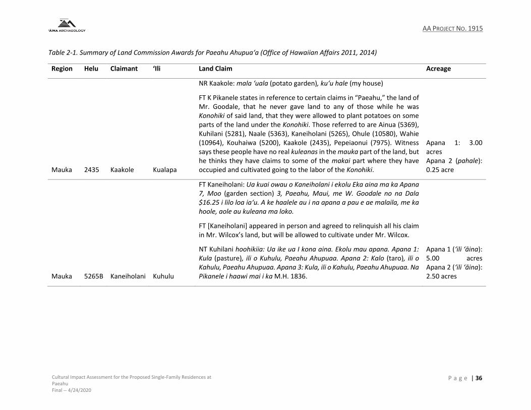
AA PROJECT NO. 1915
Cultural Impact Assessment for the Proposed Single-Family Residences at Paeahu Final -- 4/24/2020
P a g e | 36
Table 2-1. Summary of Land Commission Awards for Paeahu Ahupua‘a (Office of Hawaiian Affairs 2011, 2014)
Region Helu Claimant ‘Ili Land Claim Acreage
Mauka 2435 Kaakole Kualapa
NR Kaakole: mala ‘uala (potato garden), kuʻu hale (my house)
FT K Pikanele states in reference to certain claims in “Paeahu,” the land of Mr. Goodale, that he never gave land to any of those while he was Konohiki of said land, that they were allowed to plant potatoes on some parts of the land under the Konohiki. Those referred to are Ainua (5369), Kuhilani (5281), Naale (5363), Kaneiholani (5265), Ohule (10580), Wahie (10964), Kouhaiwa (5200), Kaakole (2435), Pepeiaonui (7975). Witness says these people have no real kuleanas in the mauka part of the land, but he thinks they have claims to some of the makai part where they have occupied and cultivated going to the labor of the Konohiki.
Apana 1: 3.00 acres Apana 2 (pahale): 0.25 acre
Mauka 5265B Kaneiholani Kuhulu
FT Kaneiholani: Ua kuai owau o Kaneiholani i ekolu Eka aina ma ka Apana 7, Moo (garden section) 3, Paeahu, Maui, me W. Goodale no na Dala $16.25 i lilo loa iaʻu. A ke haalele au i na apana a pau e ae malaila, me ka hoole, aole au kuleana ma loko.
FT [Kaneiholani] appeared in person and agreed to relinquish all his claim in Mr. Wilcox’s land, but will be allowed to cultivate under Mr. Wilcox.
NT Kuhilani hoohikiia: Ua ike ua I kona aina. Ekolu mau apana. Apana 1: Kula (pasture), ili o Kuhulu, Paeahu Ahupuaa. Apana 2: Kalo (taro), ili o Kahulu, Paeahu Ahupuaa. Apana 3: Kula, ili o Kahulu, Paeahu Ahupuaa. Na Pikanele i haawi mai i ka M.H. 1836.
Apana 1 (‘ili ‘āina): 5.00 acres Apana 2 (‘ili ‘āina): 2.50 acres
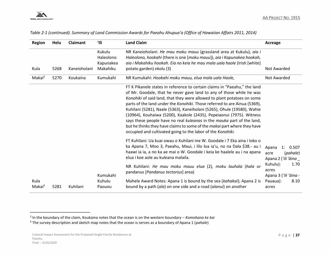
AA PROJECT NO. 1915
Cultural Impact Assessment for the Proposed Single-Family Residences at Paeahu Final -- 4/24/2020
P a g e | 37
Table 2-1 (continued). Summary of Land Commission Awards for Paeahu Ahupua‘a (Office of Hawaiian Affairs 2011, 2014)
Region Helu Claimant ‘Ili Land Claim Acreage
Kula 5268 Kaneioholani
Kukulu Haleolono Kapunakea Makahiku
NR Kaneioholani: He mau moku mauu (grassland area at Kukulu), aia i Haleolono, hookahi (there is one [moku mauu]), aia i Kapunakea hookah, aia i Makahiku hookah. Eia no keia he mau mala uala haole (Irish [white] potato garden) ekolu (3) Not Awarded
Makai3 5270 Koukaina Kumukahi NR Kumukahi: Hookahi moku mauu, elua mala uala Haole, Not Awarded
Kula Makai4 5281 Kuhilani
Kumukahi Kuhulu Paouou
FT K Pikanele states in reference to certain claims in “Paeahu,” the land of Mr. Goodale, that he never gave land to any of those while he was Konohiki of said land, that they were allowed to plant potatoes on some parts of the land under the Konohiki. Those referred to are Ainua (5369), Kuhilani (5281), Naale (5363), Kaneiholani (5265), Ohule (19580), Wahie (10964), Kouhaiwa (5200), Kaakole (2435), Pepeiaonui (7975). Witness says these people have no real kuleanas in the mauka part of the land, but he thinks they have claims to some of the makai part where they have occupied and cultivated going to the labor of the Konohiki.
FT Kuhilani: Ua kuai owau o Kuhilani me W. Goodale i 7 Eka aina i loko o ka Apana 7, Moo 3, Paeahu, Maui, i lilo loa iaʻu, no na Dala $38.- au i haawi ia ia, a no ka ae mai o W. Goodale i keia ke haalele au i na apana elua i koe aole au kuleana malaila.
NR Kuhilani: He mau moku mauu elua (2), moku lauhala (hala or pandanus [Pandanus tectorius] area)
Mahele Award Notes: Apana 1 is bound by the sea (kahakai); Apana 2 is bound by a path (ala) on one side and a road (alanui) on another
Apana 1: 0.507 acre (pahale) Apana 2 (‘ili ‘āina _ Kuhulu): 1.70 acres Apana 3 (‘ili ‘āina - Pauaua): 8.10 acres
3 In the boundary of the claim, Koukaina notes that the ocean is on the western boundary – Komohana ke kai 4 The survey description and sketch map notes that the ocean is serves as a boundary of Apana 1 (pahale)
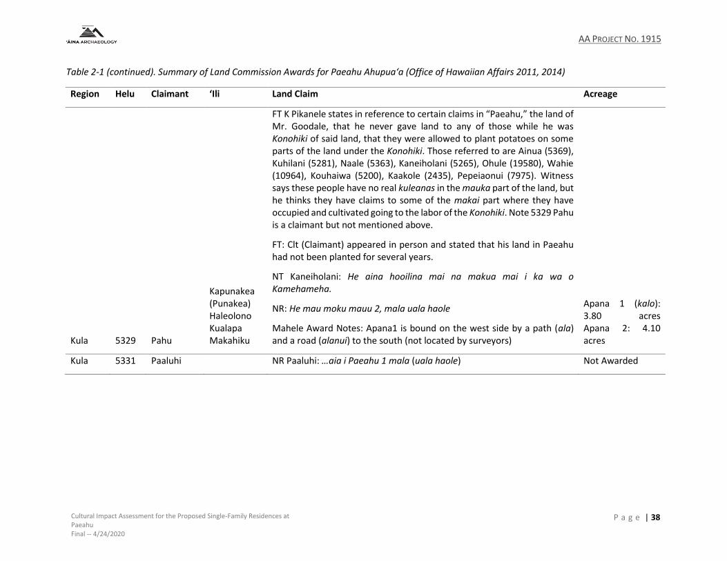
AA PROJECT NO. 1915
Cultural Impact Assessment for the Proposed Single-Family Residences at Paeahu Final -- 4/24/2020
P a g e | 38
Table 2-1 (continued). Summary of Land Commission Awards for Paeahu Ahupua‘a (Office of Hawaiian Affairs 2011, 2014)
Region Helu Claimant ‘Ili Land Claim Acreage
Kula 5329 Pahu
Kapunakea (Punakea) Haleolono Kualapa Makahiku
FT K Pikanele states in reference to certain claims in “Paeahu,” the land of Mr. Goodale, that he never gave land to any of those while he was Konohiki of said land, that they were allowed to plant potatoes on some parts of the land under the Konohiki. Those referred to are Ainua (5369), Kuhilani (5281), Naale (5363), Kaneiholani (5265), Ohule (19580), Wahie (10964), Kouhaiwa (5200), Kaakole (2435), Pepeiaonui (7975). Witness says these people have no real kuleanas in the mauka part of the land, but he thinks they have claims to some of the makai part where they have occupied and cultivated going to the labor of the Konohiki. Note 5329 Pahu is a claimant but not mentioned above.
FT: Clt (Claimant) appeared in person and stated that his land in Paeahu had not been planted for several years.
NT Kaneiholani: He aina hooilina mai na makua mai i ka wa o Kamehameha.
NR: He mau moku mauu 2, mala uala haole
Mahele Award Notes: Apana1 is bound on the west side by a path (ala) and a road (alanui) to the south (not located by surveyors)
Apana 1 (kalo): 3.80 acres Apana 2: 4.10 acres
Kula 5331 Paaluhi NR Paaluhi: …aia i Paeahu 1 mala (uala haole) Not Awarded

AA PROJECT NO. 1915
Cultural Impact Assessment for the Proposed Single-Family Residences at Paeahu Final -- 4/24/2020
P a g e | 39
Table 2-1 (continued). Summary of Land Commission Awards for Paeahu Ahupua‘a (Office of Hawaiian Affairs 2011, 2014)
Region Helu Claimant ‘Ili Land Claim Acreage
Kula 5369 Ainua Nena Hao
FT K Pikanele states in reference to certain claims in “Paeahu,” the land of Mr. Goodale, that he never gave land to any of those while he was Konohiki of said land, that they were allowed to plant potatoes on some parts of the land under the Konohiki. Those referred to are Ainua (5369), Kuhilani (5281), Naale (5363), Kaneiholani (5265), Ohule (19580), Wahie (10964), Kouhaiwa (5200), Kaakole (2435), Pepeiaonui (7975). Witness (Pikanele) says these people have no real kuleanas in the mauka part of the land, but he thinks they have claims to some of the makai part where they have occupied and cultivated going to the labor of the Konohiki. Note 5329 Pahu is a claimant but not mentioned above.
FT Bailey: This is all that remains of this Clt as he has comprimised his lot in Paeahu.
NT Kaneiholani: Na Pikanele i haawi mai i ka 1836 M.H.
NR Ainua: Hookahi moku mauu, he kalo, he uala elua mala, he mala maia (banana area)
Mahele Award Notes: Kihi o Fredenberg – corner of Fredenberg (Land Grant 449 to Wm Fredenberg) noted in the survey description and approximate location on the survey sketch
Apana 1: 1.00 acre (mala kalo)
Kula and Makai 5370 Anahe
Kuhulu (Kukulu) Haleolono Paukuehewa
NR Anahe: he mau moku mauu aia i Haleolono, eha (4), aia i Kapunakea elua moku mauu ... hookahi mala uala haole ... he wahi pahale aia ma kai
NT Kaneiholani: He aina hooilina mai na makua mai i ka wa o Kamehameha.
Apana 1: 5.16 acres (mala maia) Apana 2: 0.36 acre (mala kalo) Apana 3: 1.35 acres (mala uala [uwala] maoli [native potato])

AA PROJECT NO. 1915
Cultural Impact Assessment for the Proposed Single-Family Residences at Paeahu Final -- 4/24/2020
P a g e | 40
Table 2-1 (continued). Summary of Land Commission Awards for Paeahu Ahupua‘a (Office of Hawaiian Affairs 2011, 2014)
Region Helu Claimant ‘Ili Land Claim Acreage
7974 Kaehulawaia Makahiku
NR Kaehulawaia: ‘ili ‘āina claim ... Eia no keia he mau moku mauu i ka aina o Kamaloa, ekolu moku mauu, ma Kumukahi hookahi moku mauu, i Kahielu hookahi moku mauu, ma Keahuao, hookahi moku mauu, i Kaopa, hookahi moku mauu...Eia no keia eluaj mala uala haole i Paehu. Not Awarded
Kula 7975 Pepeiaonui Haleolono
FT K Pikanele states in reference to certain claims in “Paeahu,” the land of Mr. Goodale, that he never gave land to any of those while he was Konohiki of said land, that they were allowed to plant potatoes on some parts of the land under the Konohiki. Those referred to are Ainua (5369), Kuhilani (5281), Naale (5363), Kaneiholani (5265), Ohule (19580), Wahie (10964), Kouhaiwa (5200), Kaakole (2435), Pepeiaonui (7975). Witness says these people have no real kuleanas in the mauka part of the land, but he thinks they have claims to some of the makai part where they have occupied and cultivated going to the labor of the Konohiki.
NT Wahie: He aina hooilina mai na makua mai i ka wa o Kamehameha.
NR Pepeiaonui: he mau moku mauu ka ii i Kamaloa, ekolu moku mauu, Aia i Kumukahi, hookahi moku mauu, Aia i Haleolono, hookahi moku mauu, he mau mala uala haole ekolu ma Paeahu
Mahele Award Notes: bound to the east by a path (ala) Apana 1 (kula): 1.50 acres
8818 Kuahine Makahiku Kualapa
NR Kuahine: hookahi mala uala (Makahiku), i Kualapa moku mauu, i Kekuaao Ekolu moku mauu, i Pohopohoa 1 mala uala haole, Pahulu I Kumukahi, mala uala haole Not Awarded
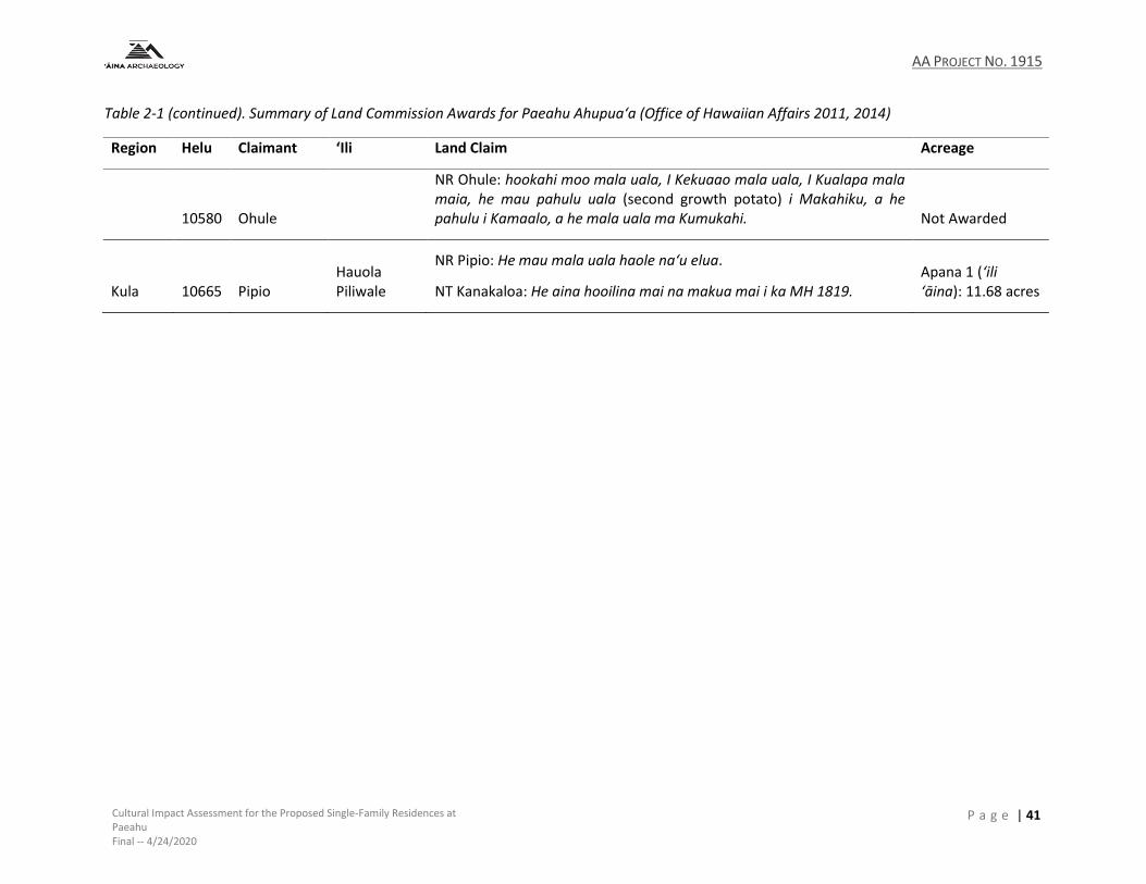
AA PROJECT NO. 1915
Cultural Impact Assessment for the Proposed Single-Family Residences at Paeahu Final -- 4/24/2020
P a g e | 41
Table 2-1 (continued). Summary of Land Commission Awards for Paeahu Ahupua‘a (Office of Hawaiian Affairs 2011, 2014)
Region Helu Claimant ‘Ili Land Claim Acreage
10580 Ohule
NR Ohule: hookahi moo mala uala, I Kekuaao mala uala, I Kualapa mala maia, he mau pahulu uala (second growth potato) i Makahiku, a he pahulu i Kamaalo, a he mala uala ma Kumukahi. Not Awarded
Kula 10665 Pipio Hauola Piliwale
NR Pipio: He mau mala uala haole naʻu elua.
NT Kanakaloa: He aina hooilina mai na makua mai i ka MH 1819. Apana 1 (‘ili ‘āina): 11.68 acres
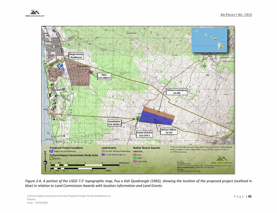
AA PROJECT NO. 1915
Cultural Impact Assessment for the Proposed Single-Family Residences at Paeahu Final -- 4/24/2020
P a g e | 42
Figure 2-6. A portion of the USGS 7.5’ topographic map, Puu o Kali Quadrangle (1992), showing the location of the proposed project (outlined in blue) in relation to Land Commission Awards with location information and Land Grants.

AA PROJECT NO. 1915
Cultural Impact Assessment for the Proposed Single-Family Residences at Paeahu Final -- 4/24/2020
P a g e | 43
2.2.3 Land in Support of Commercial Interests
Even before the Māhele, lands in the Honuaʻula district were being used to support commercial
enterprises, namely sugar and cattle. In December of 1945 and January of 1946, King
Kamehameha III traveled to Maui to speak to the issue of land privatization. A newspaper article
published on February 14, 1846 in The Polynesian gave readers a recap of the visit, and the author
tells of the agricultural developments in Honuaʻula, giving us a glimpse at some of the
developments and challenges to come:
Agriculture on Maui is in a forward state, compared with Oahu. At Honuaula there are 178 acres under cultivation of sugar cane with a good sugar mill managed chiefly by natives. One farm, besides sugar, raises $5000 worth of Irish potatoes annually. There are 12 foreigners here, one of whom John White, arrived in 1799. On some parts of Maui the cattle have done much mischeif by trespassing on the plantations, and driving the owners from their little farms. Two districts have in consequence been deserted. (Maly and Maly 2005:16)
2.2.3.1.1 The Irish Potato Boom
In the early-to-mid-1800s, white potatoes were one of Maui’s most important agricultural
commodities, and Kula was regarded as having some of the finest potato-growing land (Figure
2-7). Demand for white potatoes, also known as Irish potatoes or ʻuala haole, came primarily
from two sources: the local whaling industry and the California Gold Rush.
Hawaiʻi’s whaling period began in 1819 and peaked in 1846. Whaling ships used Hawaiʻi as a
stopover between the United States and Japan, where whales were hunted primarily for their
blubber, which was then processed into whale oil and used for heating, lighting, and as an
industrial lubricant. Each spring and summer, hundreds of whaling ships would arrive and spend
months at a time in Lahaina and Honolulu, their crews resting and stocking up on food and other
supplies.

AA PROJECT NO. 1915
Cultural Impact Assessment for the Proposed Single-Family Residences at Paeahu Final -- 4/24/2020
P a g e | 44
Figure 2-7. A portion of the revised Government Survey Map of Maui (F. S. Dodge 1903 (1885)) with a portion of an undated tracing of Honua‘ula by Monsarrat showing Land Grants issued in Paeahu in relation to the potato lands outlined in Kula Moku.
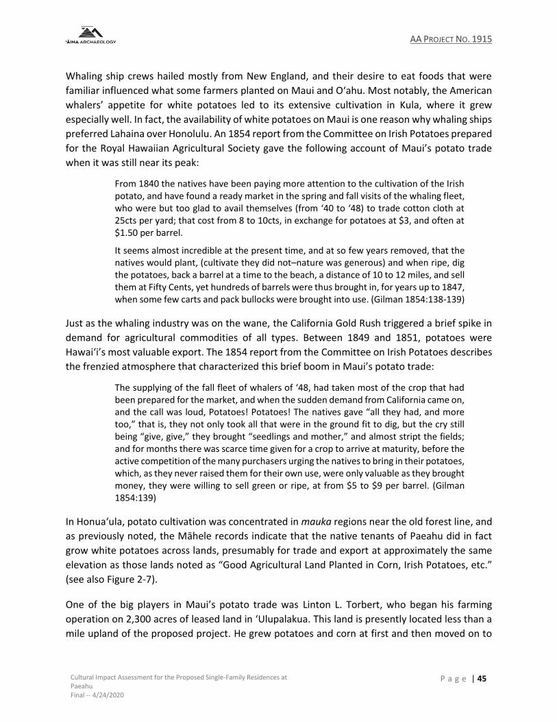
AA PROJECT NO. 1915
Cultural Impact Assessment for the Proposed Single-Family Residences at Paeahu Final -- 4/24/2020
P a g e | 45
Whaling ship crews hailed mostly from New England, and their desire to eat foods that were
familiar influenced what some farmers planted on Maui and Oʻahu. Most notably, the American
whalers’ appetite for white potatoes led to its extensive cultivation in Kula, where it grew
especially well. In fact, the availability of white potatoes on Maui is one reason why whaling ships
preferred Lahaina over Honolulu. An 1854 report from the Committee on Irish Potatoes prepared
for the Royal Hawaiian Agricultural Society gave the following account of Maui’s potato trade
when it was still near its peak:
From 1840 the natives have been paying more attention to the cultivation of the Irish potato, and have found a ready market in the spring and fall visits of the whaling fleet, who were but too glad to avail themselves (from ʻ40 to ʻ48) to trade cotton cloth at 25cts per yard; that cost from 8 to 10cts, in exchange for potatoes at $3, and often at $1.50 per barrel.
It seems almost incredible at the present time, and at so few years removed, that the natives would plant, (cultivate they did not–nature was generous) and when ripe, dig the potatoes, back a barrel at a time to the beach, a distance of 10 to 12 miles, and sell them at Fifty Cents, yet hundreds of barrels were thus brought in, for years up to 1847, when some few carts and pack bullocks were brought into use. (Gilman 1854:138-139)
Just as the whaling industry was on the wane, the California Gold Rush triggered a brief spike in
demand for agricultural commodities of all types. Between 1849 and 1851, potatoes were
Hawaiʻi’s most valuable export. The 1854 report from the Committee on Irish Potatoes describes
the frenzied atmosphere that characterized this brief boom in Maui’s potato trade:
The supplying of the fall fleet of whalers of ʻ48, had taken most of the crop that had been prepared for the market, and when the sudden demand from California came on, and the call was loud, Potatoes! Potatoes! The natives gave “all they had, and more too,” that is, they not only took all that were in the ground fit to dig, but the cry still being “give, give,” they brought “seedlings and mother,” and almost stript the fields; and for months there was scarce time given for a crop to arrive at maturity, before the active competition of the many purchasers urging the natives to bring in their potatoes, which, as they never raised them for their own use, were only valuable as they brought money, they were willing to sell green or ripe, at from $5 to $9 per barrel. (Gilman 1854:139)
In Honuaʻula, potato cultivation was concentrated in mauka regions near the old forest line, and
as previously noted, the Māhele records indicate that the native tenants of Paeahu did in fact
grow white potatoes across lands, presumably for trade and export at approximately the same
elevation as those lands noted as “Good Agricultural Land Planted in Corn, Irish Potatoes, etc.”
(see also Figure 2-7).
One of the big players in Maui’s potato trade was Linton L. Torbert, who began his farming
operation on 2,300 acres of leased land in ʻUlupalakua. This land is presently located less than a
mile upland of the proposed project. He grew potatoes and corn at first and then moved on to
AA PROJECT NO. 1915
Cultural Impact Assessment for the Proposed Single-Family Residences at Paeahu Final -- 4/24/2020
P a g e | 46
sugar. Torbert sought to purchase, and was later awarded, several parcels of land in the nearby
ahupuaʻa of Kāʻeo and Pāpaʻanui. In a letter to Keoni Ana, he shared his vision for these lands:
If I get this land my intention is this. To manufacture sugar as extensively as possible. To accomplish this end I shall get 30 or 40 families of natives to come and live on the farm. I will find them houses and food, school their children & learn them to work. (Maly and Maly 2005:160)
2.2.3.1.2 Maui Sugar
Another crop that attracted new demand and early market potential was sugar. The first sugar
operations on Maui were started in the 1820s in Wailuku and Waikapū. Many early ventures
failed, but over time, the industry came to dominate the economic, physical, and social landscape
of Maui. Between 1860 and 1880, Hawaiʻi’s economy made a turn towards sugar, and growth
was fastest on Maui, which counted twelve plantations in 1866, compared to eight on Hawaiʻi
Island, six on Oʻahu, and four on Kauaʻi (MacLennan 1997:98).
Captain James Makee, a Massachusetts-born whaler, first made news in Hawai’i in 1843 while
aboard the whaling ship “Maine” in the Lahaina harbor. It was reported that his cook attacked
his face with a hatchett or cleaver, intending to leave Makee for dead (Nellist 1925:155). Makee
was attended by a neighboring American warship and survived the attack which led to him
abandoning the frontlines of the whaling industry and instead opened a local merchant and ship
chandlery business. As whaling ships became less profitable in the 1850s, Makee set his sights
further inland, with hopes of growing and milling sugar cane (Nellist 1925:155).
By 1856, Torbert began auctioning off his ‘Ulupalakua and Honua’ula lands piece-meal between
1856 and 1858, eventually selling the entierty of his estate to Captain Makee (The Polynesian
1856:3). The land, still under an agreement to manufacture sugar and grind sugar cane for the
King, was renamed “Rose Ranch” for Makee’s wife. Makee enclosed some 40 acres of land with
a stone and wire fence, and moved his family to the ranch (Cooke 1956).
By 1860, the Makee Sugar Plantation was one of the largest in East Maui (MacLennan 1997:101).
During the American Civil War, Makee contributed huge shipments of sugar molasses to support
the cause of the Union (Nellist 1925:157). One of Makee’s signature improvements was in
locating a reliable source of water, as reported on in an article from the July 7, 1866 issue of
Nupepa Kuokoa:
Hunahuna mea hou o Hawaii
Nei.
PAU KA PILIKIA. Ma keia pa
hana, ua kukulu ae o J. Makee
i na hale laau a me na
punawai hohonu ma na
hakala o na hale laau. Ua pau
ka pilikia o na kanaka a me na
Bits of News About Hawaiʻi.
The trouble has ended. By this work, J.
Makee has built a wooden house and
deep reservoir on the side of the house.
The troubles of the men and women are
now ended by this work, they are now
truly well supplied with water. This land,
in ancient times, was a barren open
AA PROJECT NO. 1915
Cultural Impact Assessment for the Proposed Single-Family Residences at Paeahu Final -- 4/24/2020
P a g e | 47
wahine ma keia pa hana, ua
ulakolako maoli i ka wai. O
keia aina i ka wa kahiko, he
kula panoa wale no, he a-a, he
haoa, aohe wai e loaa. O ka
wai o keia aina i ka wa
mamua, he pu-maia, he lau
kakonakona; a i keia wa, limua
ka wai, pau ka pilikia. Me ka
mahalo. E wiki oe e ke Kuokoa.
JOHN KELIIKANAKAOLE.
Ulupalakua, Maui, Iune 12,
1866.
place, a rocky, scorched land, where
water could not be gotten. The water of
this land in times before, was from the
stumps of the banana trees, and from
the leaves of the kākonakona grass; but
now there is water where moss can
grow. The problem is resolved.
(Maly and Maly 2005:37)
(Translation: Kepā Maly)
Makee’s plantation was renowned for its beauty, productivity, and the hospitality of its owners.
King Kalākaua and his wife Queen Kapiʻolani were frequent guests. Makee’s wife Catherine
planted gardens decorated with roses, exotics plants, and other flowers that were unlike any
that Maui had ever seen. It’s here where the island’s official flower, a deep pink rose variety
called Lokelani, was first grown. Here’s a typical visitor’s report, published in the November 14,
1868 issue of Nupepa Kuokoa:
The nature of this land is like that of a rose garden filled with blossoms. The beautiful home of J. Makee, Esq., has no equal. . . . The things grown there are like nothing else seen, there are beautiful flowers, and trees of all kinds. The road passes through the gardens, and to the large reservoir within the arboretum, it looks like a pond. When he finished showing us around the gardens, he took us to meet his lady (his wife), the one about whom visitors say, “She is the queen of the rose garden.” (Maly and Maly 2005:38)
Makee managed the plantation and mill for just over 20 years. In 1876 and 1877, Makee began
producing sugar bumper crops, leading to a highly profitable year in 1877. Makee and King
Kalākaua began a professional partnership running the Makee Sugar Co. in Kauai. Makee also
purchased the Waihe’e Plantation on Maui which was then managed by his son Parker Makee
(Thrum 1925:86). Makee was appointed as a comissioner to aid in the development of the
Kingdom of Hawaii, and soon constructed a breakwater project at Mākena to further develop the
harbor and ease shipment of sugar (Nellist 1925:157). However, by 1878, the sugar fields of
‘Ulupalakua were hit with a blighting drought causing sugar profits to dry up in Honua‘ula for
good (Thrum 1926:38). Sugar production for Rose Ranch was fully moved to Waihe’e as a result
of the drought and the era of ‘Ulupalakua cattle ranching was on the rise.
Before his death, James Makee conveyed portions of Rose Ranch to his son, Parker Makee (Liber
55:1-9, Maly and Maly 2005:172). Following additional conveyances after James Makee’s death
(Libers 82:276, 61:1, and 232, Maly and Maly 2005:172) Parker Makee held the land during a

AA PROJECT NO. 1915
Cultural Impact Assessment for the Proposed Single-Family Residences at Paeahu Final -- 4/24/2020
P a g e | 48
transitional period from sugar production to cattle ranching and in 1886, James Dowsett, father-
in-law to James Makee’s son Charles, purchased the Rose Ranch estate.
2.2.3.2 Cattle Ranching at the Raymond Ranch
Between 1886 and his death in 1898, James Dowsett, a preeminent businessman in Hawai’i,
bought and leased additional lands, expanding the ranch’s holdings (Nellist 1925:103). He aquired
kuleana land, Helu 2401 in 1896 (Liber 159:34, Maly and Maly 2005:172), and Mākena Landing
(Helu 2427 and Royal Patent No. 1289) and its accompanying lot and building in 1898 (Liber
176:343-344, Maly and Maly 2005:172). In the same time period, a navigation light was installed
at Kanahena Point (Pu‘u Ola‘i) to aide in interisland sea commerce. The light, visible 11 miles out
to sea, sat atop a 50-ft tall rough wooden structure (Craig 1899:17).
After James Dowsett’s death in 1898, his daughter Pheobe, wife of Charles Makee, inherited the
expansive estate upon his passing. When Charles died, Phoebe married Dr. James Raymond.
Raymond bought the ranch in 1900, renaming the land “Raymond Ranch,” and concentrated
operations on raising and slaughtering cattle (de Naie and Donham 2007:103). From 1906 to
1907, the ranch had approximately 4,000 Shorthorn cattle (Henke 1929:60). The number slowly
grew to nearly 6,000, requiring a slaughterhouse, refrigeration plant, and cold-storage
technology on steamers to assure the delivery of fresh beef to Honolulu (Coffee 1920:78).
The ranch in ‘Ulupalakua was the largest on the Maui. At any one time, the ranch ran more than
5,000 head of cattle and each year and sent 1,000 to market in Honolulu through the port at
Mākena Landing. These vast ranchlands were the domain of Hawaiian paniolo (cowboys), and
one of Hawaiʻi’s most celebrated paniolo, Daniel Ikua Purdy, would eventually come to work at
the Raymond Ranch. Purdy earned international fame when he won the World’s Steer Roping
Championship in 1908 at the Cheyenne Frontier Days Rodeo. In 1914, he came to ‘Ulupalakua
from the Parker Ranch on Hawaiʻi Island to work as Raymond’s ranch foreman. He remained in
ʻUlupalakua until his death in 1945. (Purdy 2006)
2.3 PAEAHU IN THE 20TH CENTURY The legacy of ranching continued well into the 20th century, with a burst of wartime activity
giving way to a search for new sources of industry. With vast stretches of undeveloped land,
perfect weather, and sandy beaches, Honuaʻula was primed for the boom in resort development
that has characterized the modern era. The sections below provide an overview of the events
that bring us to today.
2.3.1 The ʻUlupalakua Ranch
By the 1920s, it was recorded that the ‘Ulupalakua ranchlands extended “along the sea for
twenty-five miles and up the southwestern slope of Haleakala on Maui, [with] an area of
approximately 63,000 acres, 28,000 of which are held in fee simple and the balance is
government leased lands” (Henke 1929:60). The ranch employed many Native Hawaiians, some
Portuguese-Hawaiians, Japanese stablemen and dairymen, and a Chinese cook and yardman, as
AA PROJECT NO. 1915
Cultural Impact Assessment for the Proposed Single-Family Residences at Paeahu Final -- 4/24/2020
P a g e | 49
described by Inez McPhee Ashdown, daughter of Angus McPhee, ranch manager at the time
(Mair 1979:13). Some people at ‘Ulupalakua had kuleana land, and others lived in Kahikinui
homesteads on the 23,000-acre property. Before 1920, no one had a car in ‘Ulupalakua, so to get
to Wailuku they would rent a Ford Jitney from the Kihei Store run by Ah Sue (Mair 1979:14). In
1910, Angus McPhee was fired from the Raymond Ranch for losing an arm in a hunting accident,
and went instead to work for Henry Baldwin at the Hawaiian Commercial & Sugar Company, who
also happened to be missing an arm (Mair 1979:3). A few years later, Raymond reemployed
McPhee, and in the 1920s Inez Ashdown joined her father at ‘Ulupalakua to teach at the school
on the property (Mair 1979:4).
In 1923, Frank Fowler Baldwin, son of a prominent missionary family and President of the
Hawaiian Commercial & Sugar Company, purchased the 23,000 acre ranch from James Raymond
for the production of beef, hides, tallow, and fine polo ponies (Cooke 1956). At that time, Edward
Baldwin, Frank’s oldest son, took over management (Henke 1929:60) McPhee turned to other
ventures, namely the purchase of Kaho’olawe in 1917, with the hopes of turning the island into
a ranch of his own (Ashdown 1979:4). McPhee also reportedly purchased land to build a house
and cattle feedlot near Pu’u Olai (de Naie and Donham 2007:163). While constructing the house,
the McPhee family lived in the “Baldwin Beach Cottage”, a house used by ‘Ulupalakua ranchers,
guests, and Baldwin family members (de Naie and Donham 2007:164). During this time, Mākena
Bay to the south was one of the busiest ports on Maui. As the export of beef produced at
ʻUlupalakua Ranch grew, so too did the traffic of interisland steamers at Mākena’s landing. By
the mid-1920s, there were over one hundred families living in the area (Clark 1989:38).
The population of Honua’ula began to wane in the years prior to WWII as the Kahului Harbor was
slowly improved upon, drawing sugar trade to the north side of the island (Semi-Weekly Maui
News 1922). With less industrial sea commerce, masses of akule gathered on the coastline from
Pu’u’ōlai to Mākena Landing and residents in the area continued practicing traditional fishing and
farming in the region once more (Lee-Greig et al. 2014:98).
2.3.2 World War II Military Exercises
During World War II, the U.S. military used Hawaiʻi as a major training, staging, and supply base
for its Pacific command. During the war years, the military population on Maui outnumbered the
local resident population by a factor of four (Maui General Plan 2030 2006:7). Dozens of training
sites were located on the island. Up and down the coastline between Maʻalaea and Cape Kīnaʻu,
including Molokini, the military ran combat training exercises involving amphibious equipment
and tactics. In Wailea, Ulua Beach became known as Little Tarawa amongst the marines who used
the area to stage amphibious landings in preparation for the Battle of Tarawa in the Gilbert
Islands in 1943. Military exercises were also staged at Kahoʻolawe, and the proximity of this
stretch of coastline, made it useful for various training drills (Cottrell 2018:2). Over time the
military made additional changes to the area, including the construction or widening of roads
and the dismantling of the Mākena Landing pier.

AA PROJECT NO. 1915
Cultural Impact Assessment for the Proposed Single-Family Residences at Paeahu Final -- 4/24/2020
P a g e | 50
Those families who lived near the Landing were forced to evacuate and had their homes razed.
In an interview, Annie Leimomi Chang Wilmington, who was born in Mākena in 1907, shared her
recollections of the wartime upheaval: “When the war started coming, they told everybody from
the beach they had to move. [People] were selling their houses . . . but they [the military] took
[bulldozed] all the homes so we didn’t get anything but fifty dollars for it” (Lee-Greig 2002:C-8).
After the war, little was left for former residents to return to, and many stayed away (Clark
1989:38).
2.4 RESORT DEVELOPMENT AND THE MODERN ERA Following the war, Maui saw a steady decrease in population as the sugar and pineapple
industries began to shrink and opportunities on O‘ahu and the U.S. mainland drew residents,
younger ones in particular, away. In 1957 Frank F. Baldwin’s estate sold 1,600 acres of
‘Ulupalakua lands, consisting of the modern day Wailea coastline, to the Matson Navigation
Company (Lee-Greig et al. 2014:100) which would eventually become a subsidiary of Alexander
& Baldwin, Inc. (https://www.matson.com/corporate/about_us/history.html). Two years later,
in 1959, the Hawaiian Islands became the Fiftieth State of the United States. The Hawaiian
Islands, “not too far away to be accessible, yet just far enough away to be interesting,” drew so
many tourists that the number of yearly visitors soon outnumbered the permanent residents
(Daws 1968:394). As the sugar and pineapple industries began to shrink and opportunities on
O‘ahu and the U.S. mainland drew younger residents away, this rise in tourism gave residents a
new source of industry (Maui General Plan 2030 2006:10). In a 1959 Report of Land Use for the
Island of Maui, the Commission reported that,
Maui is not fully utilizing its assets as a tourist attraction. As a result it is missing an opportunity to obtain a rich source of revenue necessary to provide additional income and employment as an aid in maintaining not only its present population, but to encourage future population growth. There are several fine sandy beaches in Maui [that] are on a par with the famous Waikiki Beach. (quoted in Maui General Plan 2030 2006:10 from [Community Planning, Inc. and R.M. Towill Corporation. July 1959. Report of Land Use for the Island of Maui. Prepared for County of Maui, Planning and Traffic Commission. Wailuku, Maui.])
One of the biggest barriers to capturing a greater share of the Hawai‘i visitor market was Maui’s
lack of hotel accommodations. From this need arose the concept of the resort destination
development, with a range of amenities to serve guests, including hotels, restaurants, shopping
centers, and golf courses.
The report identified Wailea as having major resort community potential, and in 1970, the Wailea
Development Company formed and quickly broke ground on the first of four golf courses in
Wailea, which would provide an immediate source of cashflow. The original plan envisioned a
densely populated mini-city for locals and visitors alike, and so residential condominium
development came next, beginning in 1974. The Wailea ʻEkahi, ʻElua, and ʻEkolu condos opened
between 1976 and 1978 to strong demand and high prices. Alongside the condominium
AA PROJECT NO. 1915
Cultural Impact Assessment for the Proposed Single-Family Residences at Paeahu Final -- 4/24/2020
P a g e | 51
development came the 558-room Hotel Inter-Continental Maui in 1976 (now the Wailea Beach
Resort) and the 350-room Wailea Beach Hotel in 1978.
Today, the shoreline area of Paeahu and Palauea that is collectively referred to as Wailea, consists
of over 2,000 luxury homes and condominiums, six major resort hotels, three
commercial/shopping centers, a tennis center, and three golf courses
(https://wailearesortassociation.com/about-wailea-resort-association/history-culture).
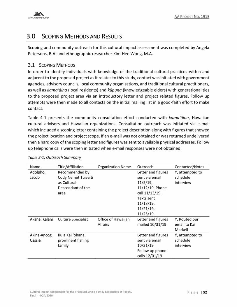
AA PROJECT NO. 1915
Cultural Impact Assessment for the Proposed Single-Family Residences at Paeahu Final -- 4/24/2020
P a g e | 52
3.0 SCOPING METHODS AND RESULTS
Scoping and community outreach for this cultural impact assessment was completed by Angela
Petersons, B.A. and ethnographic researcher Kim-Hee Wong, M.A.
3.1 SCOPING METHODS In order to identify individuals with knowledge of the traditional cultural practices within and
adjacent to the proposed project as it relates to this study, contact was initiated with government
agencies, advisory councils, local community organizations, and traditional cultural practitioners,
as well as kama‘āina (local residents) and kūpuna (knowledgeable elders) with generational ties
to the proposed project area via an introductory letter and project related figures. Follow up
attempts were then made to all contacts on the initial mailing list in a good-faith effort to make
contact.
Table 4-1 presents the community consultation effort conducted with kama‘āina, Hawaiian
cultural advisors and Hawaiian organizations. Consultation outreach was initiated via e-mail
which included a scoping letter containing the project description along with figures that showed
the project location and project scope. If an e-mail was not obtained or was returned undelivered
then a hard copy of the scoping letter and figures was sent to available physical addresses. Follow
up telephone calls were then initiated when e-mail responses were not obtained.
Table 3-1. Outreach Summary
Name Title/Affiliation Organization Name Outreach Contacted/Notes
Adolpho, Jacob
Recommended by Cody Nemet Tuivaiti as Cultural Descendant of the area
Letter and figures sent via email 11/5/19, 11/12/19. Phone call 11/13/19. Texts sent 11/18/19, 11/21/19, 11/25/19.
Y, attempted to schedule interview
Akana, Kalani Culture Specialist Office of Hawaiian Affairs
Letter and figures mailed 10/31/19
Y, Routed our email to Kai Markell
Akina-Ancog, Cassie
Kula Kai ‘ohana, prominent fishing family
Letter and figures sent via email 10/31/19 Follow up phone calls 12/01/19
Y, attempted to schedule interview

AA PROJECT NO. 1915
Cultural Impact Assessment for the Proposed Single-Family Residences at Paeahu Final -- 4/24/2020
P a g e | 53
Table 3-1 (continued). Outreach Summary
Name Title/Affiliation Organization Name Outreach Contacted/Notes
Delima, Ashford
Cultural Descendant Honua‘ula Moku (Papa‘anui, Ka‘eo, Mo‘oloa, Mo‘oiki, Mohopilo, Kanahena Ahupua‘a)
Ho‘oponopono o Makena
Letter and figures sent via email 10/31/19
N
DeNaie, Lucienne
Maui Tomorrow Letter and figures sent via email 10/31/19, phone call
Y, completed a project site walk through and pointed out areas of concern that included a cultural material scatter in the westernmost section of the project area and an examination of wall feature SIHP 50-50-14-4791 (see Section 4.5)
Drummond, Leina‘ala Teruya
Realtor ‘Ohana owned lands above Maui Hill
Keller Williams Letter and figures sent 10/31/19, 11/12/19. Phone call 11/14/19.
Y, interview summary provided in Section 3.2.3
Hussey, Sylvia
Interim Ka Pouhana Office of Hawaiian Affairs
Letter and figures mailed 10/31/19
N
Kalanikau, Vernon
Kula Kai Moku Po‘o, Cultural Descendant of Kula (Kula Kai) Moku – Waiakoa, Pūlehunui, and Keokea Ahupua‘a; Cultural Descendant of Honua‘ula Moku
Aha Moku Council Letter and figures sent via email 10/31/19
Y, interview summary provided in Section 3.2.2
Kanahele, Daniel
Resident of Paeahu Letter and figures sent via email 10/31/19
Y, interview provided in Section 3.2.4
Kapu, Ke‘eaumoku
CEO Aka Moku o Maui, LLC
Letter and figures mailed 10/31/19
N

AA PROJECT NO. 1915
Cultural Impact Assessment for the Proposed Single-Family Residences at Paeahu Final -- 4/24/2020
P a g e | 54
Table 3-1 (continued). Outreach Summary
Name Title/Affiliation Organization Name Outreach Contacted/Notes
Kekiwi, Justin Cultural Descendant Honua‘ula Moku (Papa‘anui, Ka‘eo, Mo‘oloa, Mo‘oiki, Mohopilo, Kanahena Ahupua‘a)
I Letter and figures sent via email 10/31/19
N, requested more project information on 10/18/19, but no further correspondence
Kuloloia, Leslie
Kupunakāne Letter and figures sent via mail 10/31/19
N
Lee, Carol-Marie “Ka‘onohi”
Honua‘ula Moku Po‘o Cultural Descendant Honua‘ula Moku (Papa‘anui, Ka‘eo, Mo‘oloa, Mo‘oiki, Mohopilo, Kanahena Ahupua‘a)
Aha Moku Council Letter and figures sent via email 10/31/19
Y, interview summary provided in Section 3.2.1
Markell, Kai Compliance Enforcement
Office of Hawaiian Affairs
Letter and figures mailed 10/31/19
N
Medeiros, Johnny and Leona
Maui Meadows Resident
Letter and figures mailed 12/10/19
Y, permission to incorporate the interview summary was not able to be obtained.
Nakahashi, Christopher
Cultural Historian State Historic Preservation
Letter and figures mailed 10/31/19
N
Nakanelua, Kyle
Maui Po‘o Aha Moku Council, Moku o Kahekili
Letter and figures mailed 10/31/19
N
Nemet Tuivaiti, Cody
Resident of Kula Kai, active in traditional Hawaiian practices in Kula and Honua‘ula Moku
Letter and figures sent via email 10/31/19
Y, respectfully withdrew interview mana‘o
Phillips, Andrew
Burial Sites Specialist
State Historic Preservation
Letter and figures mailed 10/31/19
N
Shimaoka, Thelma
Maui Community Resource Coordinator
Office of Hawaiian Affairs
Letter and figures mailed 10/31/19
N

AA PROJECT NO. 1915
Cultural Impact Assessment for the Proposed Single-Family Residences at Paeahu Final -- 4/24/2020
P a g e | 55
3.2 COMMUNITY OUTREACH RESULTS AND INTERVIEWS Scoping letters were sent to a total 20 individuals with diverse backgrounds. Contacts included
representatives of Native Hawaiian organizations including, The Office of Hawaiian Affairs (OHA)
and the State Historic Preservation Office. In addition, we reached out to representatives from
the Aha Moku Councils. At least two attempts were made to contact each potential consultant.
Some individuals were contacted but chose not to share information regarding the cultural
practices and resources of Wailea and Paeahu.
Collectively, interviewees emphasized the importance of fishing and gathering limu in the Paeahu
ahupuaʻa and surrounding areas. Some expressed concerns about the potential of historical sites
and iwi in the proposed project area.
3.2.1 Interview with Carol-Marie Kaʻonohiokalā Lee
Carol Kaʻonohi Lee was born and raised in Makena, Maui. She has generational ties throughout
the island but particularly along the south shore from Kanahena to Kihei. As a child she lived with
her parents near Puʻuolaʻi. Her maternal grandfather, Kauwekane Kukahiko, obtained the land
by exchanging his Kanahena land with Ulupalakua Ranch. Her fraternal great-great grandfather
was William Slocum Wilcox, a whaling captain and the patriarch of a strong Hawaiian family.
Ms. Lee shared that her family engaged in traditional fishing and limu gathering practices in
Makena and the costal areas of Paeahu. Her father would go fishing in a skipper (boat) with her
uncles and they would catch akule, manini and weke. When asked about their fishing techniques,
Ms. Lee recalled that they would “surround” when out at sea, but she prefered to use a pole and
remain closer to shore. Although she herself did not recall seeing her father fish using palu (fish
chum), Ms.Lee shared that her grandfather did. Her grandfather also used a small canoe in
Kanahena that he would use to go fishing in. Ms. Lee shared that before she was born, her mother
and grandfather would paddle out to sea and canoe fish. This was a common practice amongst
members of her family, but Ms. Lee herself did not expereince this. Ms. Lee’s mother often
gathered limu– including limu lipoa, kohu, wāwaeʻiole– along the Makena and Paeahu shoreline.
As a child Ms. Lee would spend all day in Makena Bay and rather than go home to eat lunch, she
would eat the limu straight off of the rocks. In addition, she would eat ʻopihi along with pipipi and
hāʻueʻue while her brothers would collect wana and catch fish. Ms. Lee also shared that her
family would use hukilau nets to collect large quantities of fish for family gatherings or church
events.
According to Ms. Lee the project site was once a dry open space filled with kiawe trees. She said
they would drive on the old road along the coast and could easily access the beach; unlike today
where parking and beach accesses are limited. Ms. Lee recalled a crown flower orchard in Paeahu
near the Akina family property. Once upon a time there were white and purple crown flowers
that attracted butterflies; but, now Ms. Lee says that there are none. She also recalls gathering
both varities of ʻuhaloa (Waltheria indica) that would then be used as a form of lāʻau lapaʻau
(Hawaiian medicine).

AA PROJECT NO. 1915
Cultural Impact Assessment for the Proposed Single-Family Residences at Paeahu Final -- 4/24/2020
P a g e | 56
When asked about the project, Ms. Lee shared that she is concerned for the local people and the
impact that this project will have. According to Ms. Lee the area of the project site was once a
dry area filled with dry shrub and kiawe trees, but now there is no open space only housing
developments. Ms. Lee suggests that if the project were to really address the needs of Maui
people the plan would include real affordable homes for locals. In addition, the plan should
include a central space for a Hawaiian cultural center where artifacts and stories discovered
through the archaeological process can be shared with the public.˙
Ms. Lee also expressed concern over the environmental impacts that the project will have on the
area. This includes water resources. Ms. Lee is interested to learn where the water will be coming
from and how it will affect the surrounding area – especially during the summer months when
there is a water shortage. Ms. Lee believes that farmers should be given priority over water usage
so that they are able to cultivate crops that will then support the masses. Another concern is
regarding the density of the project. Ms. Lee suggests decreasing the number of housing units
and potential occupants as part of the saving the view plane. Common sense will tell you that
plants and trees are better for the environment and view planes rather than housing rooftops.
Most importantly, Maui has a housing issue; we are an island people. Our kupuna understood
how to manage the very fragile environment and to be self-sustaining. However, if developments
are designed for part time residents and transients, it solves nothing. It creates an obstruction of
the flow, mauka to makai, of the native culture and landscape and the practices that sustain it.
That management system is known as the Aha Moku System.
3.2.2 Interview with Mr. Vernon Kalanikau
Vernon Kalanikau was born and raised on the south shore of Maui. Mr. Kalanikau shared
memories of going with his uncle and father to gather panini (cactus) in the uplands of Paeahu,
the area above the present site of Maui Meadows. Panini, he cautioned, must be gathered
downwind and one must avoid touching his or her eyes after doing so. After picking the panini
they would take it home, clean it and put it in a cooler to get cold before cutting it up into pieces
to eat. He remembers his father giving offerings after picking panini, but being a kid Mr. Kalanikau
was not allowed to participate or watch his father; however, he did share that his father would
give offerings at two different historical sites, but he does not know the exact location nor their
signifiance. Although he does not know what the particular offerings were, he theorizes that it
consisted of ‘awa, kalo and a red fish wrapped inside of a pūʻolo (ti-leaf bundle) made from 12 tī-
leaves. This pūʻolo would then be wrapped in kaunaʻoa, which was the favorite lei of Keōpūolani,
his ancestor.
In terms of cultural practices, Mr. Kalanikau spent a lot of time in the ocean swimming, fishing,
diving, gathering, etc. He identified Keawakapu, Mana Kai and Kamaʻole 3 as areas he would
frequent as a child. As a kid he remembers other families such as the Kanahele’s and the Akina’s
who would fish for akule in their boats. He also shared memories of helping to pull in the large
hukilau net. Mr. Kalanikau shared that they would catch akule and heʻe and then eat it at the
AA PROJECT NO. 1915
Cultural Impact Assessment for the Proposed Single-Family Residences at Paeahu Final -- 4/24/2020
P a g e | 57
beach. He noted that they were not allowed to eat certain fish at the beach and so they had to
take it home to clean. Near the present spot of the Mana Kai hotel, Mr. Kalanikau described being
able to gather limu along the reefs when he was a kid. His father would use limu kala when he
practiced hoʻoponopono or to give as an offering. He mentioned that limu kohu and limu
wāwaeʻiole could be found near Kamaʻole, Keokea and Kalama Park.
In terms of sites within Paeahu, Mr. Kalanikau noted the signifiance of Keawakapu. As a child he
remembers his father would go to Mākena and feed a shark. According to Mr. Kalanikau his family
would camp near Mākena Landing. One day, his father was going to feed the shark and he told
Vernon to stay behind, but out of curiosity, he secretly followed his father to a large cave, almost
like a lava tube. It was there where his father left an offering for the shark.
Mr. Kalanikau is very passionate about protecting and preserving the ʻāina and animals of Maui.
He talked about his work with protecting the whales that are stranded on the beach. Mr.
Kalanikau also commented that his family is involved with keeping the waterways clear (streams,
kahawai, muliwai, etc.) for the moʻo (lizard ‘aumakua [guardians]). According to Mr. Kalanikau,
a portion of Kīhei used to be majority wetlands, but due to development in the area he estimates
that only 25% of wetlands are left.
3.2.3 Interview with Leinaʻala Teruya Drummond
Leinaʻala Teruya Drummond was born and raised on Maui and originally lived in Naval Air Station
Kahului (NASKA) area near the airport, but shortly after moved to the neighboring ahupua‘a of
Kamaʻole in the Kula Kai section (Kīhei). The oldest in a family of eight children, she spent her
formative years being raised on a 13 acre farm in a farming family near the area currently known
as Maui Hill, which is located just mauka of the Kīhei Boat Ramp. The dry, arid landscape of the
Maui Hill area housed seven farming families, although they were about 5-10 minutes away from
the next farmer, and that family was 10 minutes away from the next. They were the only part-
Hawaiian family and the rest were Okinawan. She recalls that there were Hawaiian families
nearby including the Akina ʻohana – a large fishing family – but in her area, there were primarily
Okinawan families. Her biological father was Caucasian and her mother was three quarters
Hawaiian and one quarter Chinese. She was raised by her mother and Okinawan stepdad.
On her family farm, they raised hogs and produce including tomatoes, bell peppers, corn and
alfalfa. Most of the tomatoes, bell peppers and corn were shipped to Oʻahu to be sold in stores
and they would sell whatever was left to local Maui grocery stores. They grew the alfalfa to feed
the hogs and she learned that the alfalfa also helped to make the land more fertile. She recalls
the hard work she put in as she would hanawai the acres and acres of tomato fields until it got
dark and then she would have to go to school as well. She can now understand the importance
of being sustainable and the hard work farmers put in to tend their land. She even helped her
father dig a well to provide water for her family and the farm. Her ʻohana did not fish, but one of
her dad’s best friends was a fisherman. He would provide her family with fish, turtle, and Kona
crabs in exchange for items from her family farm. She vividly remembers eating fried turtle – and
AA PROJECT NO. 1915
Cultural Impact Assessment for the Proposed Single-Family Residences at Paeahu Final -- 4/24/2020
P a g e | 58
at that time there was no restriction on turtle fishing. They would also trade with other farmers
for goat. And her mom would purchase a whole cow and freeze the meat for her large family.
Leinaʻala recalls the views from her family farm – she was able to see just about all of Maui from
Māʻalaea to Makena including a view of Haleakalā and Kahoʻolawe. She remembers her house
shaking all the time from the bombings.
In her free time, her favorite pastime was going to the beach at Keawekapu. She would walk
down the shoreline through the kiawe trees and she recalls seeing people gathering limu. She
remembers that people would collect all types of limu – limu kohu, limu kala, ʻeleʻele and
wāwaeʻiole – and one type of yellow limu in particular that smelled really good, but she couldn’t
recall the name. She said that her ʻohana can no longer find limu. As more immigrants arrived in
the area, instead of “Hawaiian style” collecting the limu they needed for just that meal,
immigrants would gather as much limu as they could and sell it. She recalls that the water was
always clean and clear but as condos were developed up and down the shoreline, they could see
the water changing.
In 1958 or 1959 there was a hurricane that completely ruined their farm and the farm could no
longer sustain their family. Her mom quickly taught herself real estate and sold their family farm
and they moved to ʻĪao Valley. She did not spend much time in this home as she was boarding at
Kamehameha Schools at that point. But eventually, her parents moved back to Kīhei because her
dad didn't like the wet rainy weather in ʻĪao – preferring the dry climate of Kīhei.
When asked about the project area, she recommended that they keep some big open spaces for
people who want to do small “truck farming” as her family did. More and more young people are
looking to farm the land and keeping some open space would allow for that. Providing spaces for
small farmlands would allow opportunities to increase sustainability. In addition, she
recommends creating more affordable residential opportunities. Anything over $300,000 is not
affordable anymore so developments need to adjust what “affordable” means.
In addition, she suggests widening the highway to at least 3-4 lanes going each way on Piʻilani
Highway to plan ahead for the increase in residents and mitigate the already growing traffic
issues. She also believes that more thought needs to be put into a plan for where they are going
to get their water moving forward as the population increases.
3.2.4 Interview with Daniel Kanahele
Daniel Kanahele is a longtime resident of Maui Meadows. Maui Meadows is in the ahupua‘a of
Paeahu and is immediately mauka of the proposed Wailea SF-S residential project. His father,
Daniel Keli'i Kanahele is from Maui and his mother is from Hawaii Island. Born and raised on
Oʻahu, Mr. Kanaheleʻs parents moved to Maui Meadows and built a house in the 1970's. After
traveling between Oʻahu and Maui for several decades, Mr. Kanahele permanently moved into
his parents home in 2009.
AA PROJECT NO. 1915
Cultural Impact Assessment for the Proposed Single-Family Residences at Paeahu Final -- 4/24/2020
P a g e | 59
Mr. Kanahele practices aloha ʻāina. This means he has aloha (love) for ʻāina (land) and kanaka
(people)– not just Hawaiians, but all people. He shared his wholistic perspective and belief that
ʻāina and kanaka are inseparably connected and interdependent, one upon the other. Native
Hawaiians trace this relationship back to the Kumulipo, the Hawaiian cosmology chant. In the
Kumulipo, man (kanaka) is the last to be born and therefore as the youngest sibling of the ʻāina
and all living things, we (kanaka) have the kuleana (duty) to care for our older siblings. We
observe, listen, and learn from them. In return, they care for us and provide us with
nourishment. As such, Mr. Kanahele recognizes ʻāina as a kumu (teacher) and that there is a
symbiotic relationship to care for the natural resources and elements that he is afforded.
Mr. Kanahele explains, “All of us who live on Maui, who make Maui our home, have a kuleana, a
moral obligation, to take care of our natural resources...our life systems. This is everybody's
stewardship...to take care of (mālama) Mother Earth, particularly in the area we live. This is one
of the meanings of aloha ʻāina.”
As a resident of Maui Meadows and Paeahu Ahupua'a, Mr. Kanahele frequently walks through
and around different parts of his neighborhood and the larger area of Paeahu as part of his
cultural practice to mālama and be a student of the ʻāina. On these walks he carefully observes
natural features of the land, cultural landscapes, native flora and fauna and their habitats. These
observations over time helps to deepens his connection and understanding of the ʻāina and its
life systems. He believes that he must mālama and serve the ʻāina as well. Mr. Kanahele has
observed that with few exceptions almost all of the undeveloped lands in Paeahu have cultural
landscapes, native flora and fauna, and cultural and historic properties.
On the other hand, Mr. Kanahele commented that he has observed that almost all the developed
lands within Paeahu, with few exceptions, have few to no preserved historic properties and little
to no native habitat left. He concludes that the destruction or displacement of natural features,
native habitat and Hawaiian cultural landscapes as a result of development makes whatever is
left that much more valuable in terms of preserving and defining a sense of place and providing
a sense of history of Paeahu for current and future generations. He says that in many respects
much of Paeahu has become a very non-Hawaiian place, unrecognizable by locals who once lived
here. Mr. Kanahele shared that one of his mentors, a kanaka (kanaka ‘ōiwi or native man or
human) born and raised in this Moku (District) of Honua'ula, Kevin Mahealani Kai‘okamalie, said
that “modern-day man brings with him the ability to wipe-out everything that define people of
culture.”
For Mr. Kanahele, this ahupuaʻa is like a library– each natural feature, each micro-habitat, each
cultural site and traditional place name is a book that has its own story to tell. Together, they tell
the mo‘olelo (story) of this specific place, this ahupua‘a and this moku. Mr. Kanahele likens the
concept of destroying habitats and cultural/historic properties to burning books and the
destruction of knowledge and vessels that hold valuable information. He shares that most of the
books (natural and cultural resources) in the developed lands of Paeahu have been destroyed–
and when its gone, itʻs gone forever. This makes whatever sites and stories that are left much

AA PROJECT NO. 1915
Cultural Impact Assessment for the Proposed Single-Family Residences at Paeahu Final -- 4/24/2020
P a g e | 60
more precious and the need to preserve them much greater for future generations and kanaka
maoli that have, are and will yet engage with the ʻāina to better understand who they are, where
they come from, why they are here and where they are headed.
If each site has a story to tell then Mr. Kanahele believes there are no insignificant sites in Paeahu.
He believes that all sites are significant and valuable for Native Hawaiians. These sites serve as
places of connection for local Native Hawaiian families. He notes that there are far fewer
Hawaiians that still live in the area compared to the 1970's and 80's. He says that there are only
two other Native Hawaiian individuals, besides himself, that he is aware of that presently live in
Maui Meadows. He believes that some of the reasons many local families left the area or do not
live here are due to real estate speculation, rising real property taxes and the lack of affordable
housing. Many locals work in in this district, but don't live here due to lack of workforce housing.
And that's a sad situation that Hawaiians often feel like strangers and foreigners in their
homeland. He understands the role that he currently has as a resident of Maui Meadows is to
speak for future generations so that they have a place to return and plant their roots here too.
When provided the opportunity to comment on a project, Mr. Kanahele shared that he asks
certain questions:
1. How is your project going to advance the history of this area?
2. What is the name of the moku and ahupuaʻa that your project is being built in?
3. How is your project going to honor the sense of place?
4. What cultural properties, historic properties, cultural landscapes are you going to design
into the project?
5. How is your project going to help relieve the affordable housing needs?
6. Will locals be able to afford to live there...is there a place for locals in your project?
Over the years Mr. Kanahele has seen firsthand the many changes that have occurred in Paeahu.
He recalls that Paeahu was once a much greener area due to more frequent rains, like the Kona
rains. Nowadays, Mr. Kanahele says that the rain is more concentrated, and more intense in
terms of occurrence...so it rains less frequently and those rains are often more intense and
heavier. According to Mr. Kanahele, this intense rainfall results in an increase in soil runoff and a
decrease in time and opportunities for rain to be absorbed into the ground. Mr. Kanahele said
that the gulch near his property quickly fills with water and from his house he can hear boulders
rolling down the gulch. If the gulch becomes filled with debris, Mr. Kanahele said the water will
move onto the road and head makai or west on Kumulani Drive. This path can lead to water
damage to homes and properties. According to Mr. Kanahele, heavy rain that leads to the gulch
overflowing occurs more often than not. If the water were to continue through the gulch to the
ocean it would exit from an outlet on Keawakapu Beach near the Wailea Resort. Another gulch
shoreline outlet is south of the Kilohana Street beach parking lot. According to Mr. Kanahele, the
water travels down these gulches and is diverted under Piʻilani Highway where it continues to be
diverted into grass covered drainage ways until it reaches makai (ocean).

AA PROJECT NO. 1915
Cultural Impact Assessment for the Proposed Single-Family Residences at Paeahu Final -- 4/24/2020
P a g e | 61
The surface and subsurface freshwater that runs off into the ocean is important to sustain the
marine life in the bay. Mr. Kanahele shared that the fresh and saltwater combination is what
produces healthy limu growth along the shoreline; therefore, sustaining the marine life and
kanaka that depend upon the limu as a source of nutrients. According to Mr. Kanahele, the
quantity of limu in the area has decreased over the years. He recalled being able to smell the limu
from his house during certain times of the year. He said the wind would carry the smell up mauka
(upland) and nowadays that does not happen anymore. Large patches or strands of limu are no
longer found along the shoreline and one is not able to gather limu in the way that was done in
the past. At one time, Mr. Kanahele shared that there was so much limu on the shore that large
trucks would come and haul the limu away. In addition, Mr. Kanahele said that his family would
gather limu species from the shoreline, like limu ʻeleʻele, limu kala and limu līpoa and others--but
that there is now less variety and quantity. Mr. Kanahele theorizes that the decrease in fresh
water flowing mauka to makai is one factor causing the decline of limu.
In terms of marine life in the area, Mr. Kanahele says that the ocean is a desert compared to what
it was in the 1970s. At the time there were many more fish. There are a lot of green sea turtles,
but nowadays a lot less fish. Mr. Kanahele shared that while he is very concerned about the
health of the ocean, he focuses his energy on land-related issues because he believes that
everything that occurs on land will affect the ocean. Everything flows into the ocean. He
commented that if the land is healthy, then the ocean is healthy and so it is important for him to
focus on protecting the land. Mr. Kanahele shared that he has an emotional attachment to the
land. Although he may not access certain areas of land on a regularly basis, he wants to know
that the cultural or natural resources are still there for him and others to use. Mr. Kanahele
believes that the native flora and fauna on those lands are the first Hawaiians because they were
here long before man arrived. His mentor, Kevin, taught that Hawaii's natural history, or biology
redefined the first Polynesians that came here and made them Hawaiian's (Kanaka). Mr. Kanahele
affirms, “The biota and biology of this land had transformative, um, powers that made the kanaka
who they were, and consequently who we are as descendants. And so, as kanaka, we must
mālama our cultural and natural resources because, among other things, it defines who we are.”
The decline in marine resources aligns with what Mr. Kanahele identifies as a decrease in the
population of Native Hawaiian residents in Paeahu. Mr. Kanahele shared that he is one of few
residents in Maui Meadows that identifies as Kanaka Maoli (Hawaiian aboriginal). He notes that
the increase in development in what is now called Wailea, led to an increase in real property
taxes that local Native Hawaiians are unable to afford; thus, they move out of Paeahu, to another
area of Maui, or off-island. The decrease in ocean resources has also led to a change in dietary
needs and gathering practices for Native Hawaiians that remain in Paeahu. Instead of engaging
in traditional fishing and gathering methods these individuals must go to other parts of the island
to gather resources.
Mr. Kanahele believes that this new project will impact the number of visitors or users to the
beach. There will be an increase of recreational activities at Keawakapu. This could potentially

AA PROJECT NO. 1915
Cultural Impact Assessment for the Proposed Single-Family Residences at Paeahu Final -- 4/24/2020
P a g e | 62
increase the pollutants in the water. Mr. Kanahele also mentions that an increase in recreational
activity, decreases the number of fishermen on the beach who rely on the natural resources of
the area for food. He notes that visitors do not pay attention to the fishing lines and walk or swim
right into them; therefore, impacting the ability of locals to gather their resources.
Mr. Kanahele also commented on the changes in the sounds of the area. When his family first
moved to Paeahu, Mr. Kanahele recalled hearing the sounds of birds and the crash of the waves
on the beaches below. Today those sounds are no longer heard due to the steady increase of cars
that are constantly moving through the area, especially on Pi‘ilani highway.
In response to the impact of the development on the natural habitat, Mr. Kanahele would like to
see a section of project area set aside to honor the native flora found within and adjacent to the
project. The coastal area was known for maʻo, noni, kukui and pili grass. Mr. Kanahele would like
to see some of these plants being grown on the property as a native plant educational garden.
After all the project is on Kapili Street (The Pili). In terms of landscaping, Mr. Kanahele suggested
utilizing plants that attract rainfall, but do not use a lot of water. He shared that it is well known
fact that trees attract rain. He said that water use needs to be properly planned so that the
project does not take more than its fair share of water. There is a domino effect for every action
and so water use must be properly managed. Avoiding putting in tropical landscapes not suited
to the coastal zones of Paeahu is recommended.
Mr. Kanahele commented on the obstruction of view plains. He explained the importance of
experiencing sunrise and sunset. Hawaiians practiced kilo, observation, and he notes that even
today people gather on Kapili St. to watch the sunset. Mr. Kanahele shared that he can see the
night sky in the East, South and North but not so much towards the West because of all the light
pollution that make it impossible to view the western sky from the horizon to 15-20 degrees
above it. He said that being able to see the moon, the stars and planets in the night sky are critical
to traditional cultural practices. He thinks that more can be done to reduce light pollution in this
area by going beyond County and Wailea Resort lighting standards.
He explained that Kevin Kai‘okamalie shared that, “places like Honua'ula ... still harbor our
history. Our natural history. Our cultural history... and should be preserved because they are the
last Hawaiian places. And it's not just because of the cultural sites that exist there, but the
botanical treasures.”
Mr. Kanahele believes that Hawaiian cultural landscapes that are already on the property should
be preserved and incorporated into the overall aesthetic design of new developments in a
genuine and meaningful way. This design approach will increase the sense of place and the
appreciation for individual stewardship that new residents can have for the place they now call
home. Just making building pads high enough to insure new owners have a great views of the
ocean and the sunsets is not enough to preserve a sense of place.
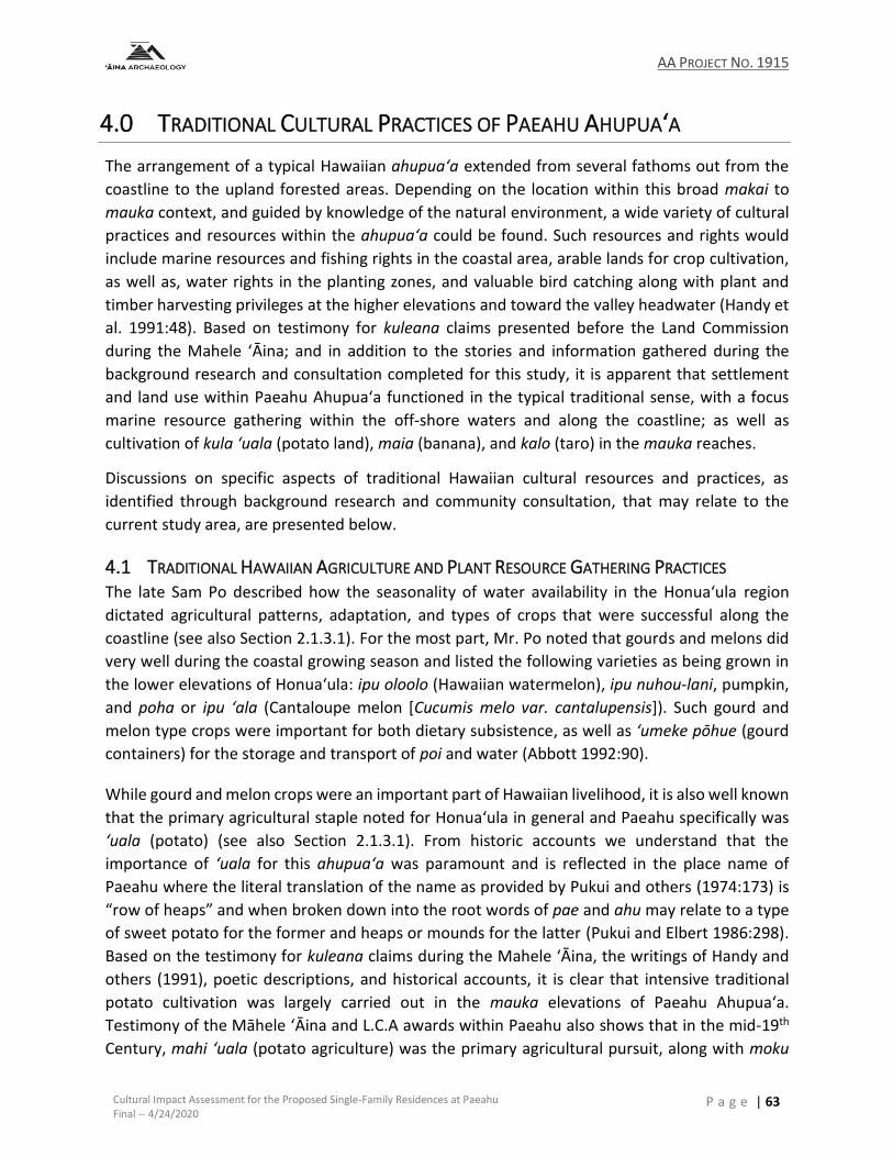
AA PROJECT NO. 1915
Cultural Impact Assessment for the Proposed Single-Family Residences at Paeahu Final -- 4/24/2020
P a g e | 63
4.0 TRADITIONAL CULTURAL PRACTICES OF PAEAHU AHUPUA‘A
The arrangement of a typical Hawaiian ahupua‘a extended from several fathoms out from the
coastline to the upland forested areas. Depending on the location within this broad makai to
mauka context, and guided by knowledge of the natural environment, a wide variety of cultural
practices and resources within the ahupua‘a could be found. Such resources and rights would
include marine resources and fishing rights in the coastal area, arable lands for crop cultivation,
as well as, water rights in the planting zones, and valuable bird catching along with plant and
timber harvesting privileges at the higher elevations and toward the valley headwater (Handy et
al. 1991:48). Based on testimony for kuleana claims presented before the Land Commission
during the Mahele ‘Āina; and in addition to the stories and information gathered during the
background research and consultation completed for this study, it is apparent that settlement
and land use within Paeahu Ahupua‘a functioned in the typical traditional sense, with a focus
marine resource gathering within the off-shore waters and along the coastline; as well as
cultivation of kula ‘uala (potato land), maia (banana), and kalo (taro) in the mauka reaches.
Discussions on specific aspects of traditional Hawaiian cultural resources and practices, as
identified through background research and community consultation, that may relate to the
current study area, are presented below.
4.1 TRADITIONAL HAWAIIAN AGRICULTURE AND PLANT RESOURCE GATHERING PRACTICES The late Sam Po described how the seasonality of water availability in the Honua‘ula region
dictated agricultural patterns, adaptation, and types of crops that were successful along the
coastline (see also Section 2.1.3.1). For the most part, Mr. Po noted that gourds and melons did
very well during the coastal growing season and listed the following varieties as being grown in
the lower elevations of Honua‘ula: ipu oloolo (Hawaiian watermelon), ipu nuhou-lani, pumpkin,
and poha or ipu ʻala (Cantaloupe melon [Cucumis melo var. cantalupensis]). Such gourd and
melon type crops were important for both dietary subsistence, as well as ‘umeke pōhue (gourd
containers) for the storage and transport of poi and water (Abbott 1992:90).
While gourd and melon crops were an important part of Hawaiian livelihood, it is also well known
that the primary agricultural staple noted for Honua‘ula in general and Paeahu specifically was
‘uala (potato) (see also Section 2.1.3.1). From historic accounts we understand that the
importance of ‘uala for this ahupua‘a was paramount and is reflected in the place name of
Paeahu where the literal translation of the name as provided by Pukui and others (1974:173) is
“row of heaps” and when broken down into the root words of pae and ahu may relate to a type
of sweet potato for the former and heaps or mounds for the latter (Pukui and Elbert 1986:298).
Based on the testimony for kuleana claims during the Mahele ‘Āina, the writings of Handy and
others (1991), poetic descriptions, and historical accounts, it is clear that intensive traditional
potato cultivation was largely carried out in the mauka elevations of Paeahu Ahupua‘a.
Testimony of the Māhele ‘Āina and L.C.A awards within Paeahu also shows that in the mid-19th
Century, mahi ‘uala (potato agriculture) was the primary agricultural pursuit, along with moku

AA PROJECT NO. 1915
Cultural Impact Assessment for the Proposed Single-Family Residences at Paeahu Final -- 4/24/2020
P a g e | 64
mau‘u (grassland areas) (see also 3.1.4.1). While many of the claimants stated that their potato
field claims were planted with white (or Irish) potatoes (‘uala haole), it is also likely that those
fields that were then planted in ‘uala haole were once planted in ‘uala maoli (native potato) (LCA
5370 Apana 3 to Anahe, see also see Sections 2.1.3.1 and 2.2.3.1.1).
This transition to a focus on ‘uala haole by native tenants in the mid-19th Century was an
economic response to commercialization of supplying provisions to first the whaling ships that
would come port, followed by the Irish Potato Boom fueled by the needs of the California Gold
Rush. With waning demand of Irish Potatoes following the end of the California Gold Rush, the
focus of agriculture shifted to other commercial crops at Paeahu and on adjacent lands, thus
further illustrating the fertility of the soil when properly supplied with water.
Ms. Teruya Drummond recalled the success of her family’s 13-acre farm, as well as that of seven
other families, located at a comparable elevation to the current project area that was located
along the border of Paeahu and Kama‘ole Ahupua‘a (Section 3.2.3). At the Teruya farm the focus
was alfalfa feed for the hog along with several acres of tomato fields along with bell peppers and
corn. Maintaining the success of crop yields required the availability of water, which the Teruya
ohana had developed on their farm with the successful drilling of a well. The presence of ground
water at Paeahu is not surprising given the mauka springs of Waihou, Nupawai o Kukulu o Piikea,
and Waikaahi (see Section 2.1.1 and Figure 2-2), the mention of a luawai along the boundary of
Land Grant 548 at Wailea bay, as well as the once prominent limu beds along the Paeahu
shoreline that would have required freshwater seeps to thrive (see Section 4.2 below).
In addition to the agricultural staples noted above, claims for mai‘a (banana) and lauhala
(Screwpine) stands at Paeahu were also presented during the Mahele ‘Āina while noted
resources along the boundary of Kanekoa’s grant include lā‘au kukui (kukui trees or groves) and
a large koa tree. Mr. Kanahele also shared that maʻo (Hawaiian cotton, Gossypium tomentosum),
noni (Morinda citrifolia), kukui (Aleurites moluccana) and pili grass (Heteropogon contortus) were
once dominant in the coastal region and area just back from this region. While Ms. Lee noted
that ‘uhaloa or hialoa (Waltheria indica) grew throughout the Honua‘ula region, including Paeahu
Ahupua‘a, and has been used for generations in lā‘au lapa‘au (traditional plant medicine).
With regard to day-to-day tasks and the needs of traditional Hawaiian lifeways, lauhala was likely
one of the more important resources of daily domestic life prior to Western contact. The seeds
of the tree were used in personal adornment (i.e. paint brushes for kapa and lei making) (Abbott
1992:54-55, 128), while the leaves were woven to produce moena (mats) for sleeping or house
floors (Abbott 1992:73-74), uluna (small pillows) (Abbott 1992:74; Summers 1999:15), canoe sails
(Abbott 1992:82), cordage and baskets for household use (Abbott 1992:75, 76), and as thatch
finish (Abbott 1992:69). In addition to domestic needs, lauhala was also versatile in that it also
used for medicinal purposes and minor dietary needs (Abbott 1992:43, 99). With regard to the
art of weaving, the plaiting of a lauhala weave could vary from a makanui (coarse) type of weave
using wide strips of hala to a makali‘i or very fine weave of narrow hala strips. On Maui,
Fornander translates a mo‘olelo given by G.S. Kahanai regarding the names for the various types
of moena made of hala on Maui (G.S. Kahanai in Fornander 1919a:626):
AA PROJECT NO. 1915
Cultural Impact Assessment for the Proposed Single-Family Residences at Paeahu Final -- 4/24/2020
P a g e | 65
pueo – coarse, thick mat of large size
puukaio – a mat of many layers
hiialo – end section of a mat
opuu – a mat with rounded edges that resemble flower buds
kumukolu – three layers of matting
alolua – a mat that is smooth on both sides
kumulua – a mat with two layers
puhala – a mat made from the flower of the hala tree
Lauhala weaving continues to be a prominent customary practice within the Hawaiian
community with both traditional weaves and uses for mats, storage vessels, and personal
adornment (e.g. hats and bands); as well as, modern takes on vessel forms and integration with
non-indigenous materials like metals and cloth for jewelry and contemporary fashion.
Like lauhala, kukui (Aleurites moluccana) was also a versatile plant that used in domestic life, as
well as, canoe building. With regard to the manufacture of canoes, the kukui created a black
pigment from blending the juices of the inner bark of the kukui roots with charcoal, and studies
have shown that where the kukui juices were used in high concentration the paint was resistant
to abrasion and water (Abbott 1992:81). Pigments made from the charcoal of the kukui nut and
juice of the flesh of the fruit were also used in traditional tattooing and yield completely black
tattoos (Abbott 1992:128) The oil of the kukui nut was most prized for its oils, and traditionally
used as the final finish on all parts of the canoe with frequent applications made after each use
(Abbott 1992:81). The most common use of kukui nut oil was for lighting (Abbott 1992:77). Kālī
kukui were simple lamps with a low or weak light that consisted of skewered kernel on dry midrib
portion of the coconut leaf. Pōho kukui were lamps made out of hollowed stones that could hold
pools of oil with wicks of folded wauke (Broussonetia papyrifera) cordage or kapa (bark cloth).
Lama lamps were made of ‘ohe (bamboo lengths) that were filled with kukui kernels (Abbott
1992:77).
For lei making, it is postulated that rather than manually working and polishing the kukui kernels
to be strung, kernels that were collected on the beach and polished through wave action and
sand abrasion were the ones chosen for lei kukui (Abbott 1992:125) as manually processing the
fruit and kernels would be time consuming. ‘Ilima (Sida fallax), which was observed throughout
the project area (Figure 4-1 and Figure 4-2), was also used in lei pua and made in the lei kui style
where the flowers were strung through the center. This style of lei required several hundreds of
‘ilima flowers to complete a single lei (Abbott 1992:127).
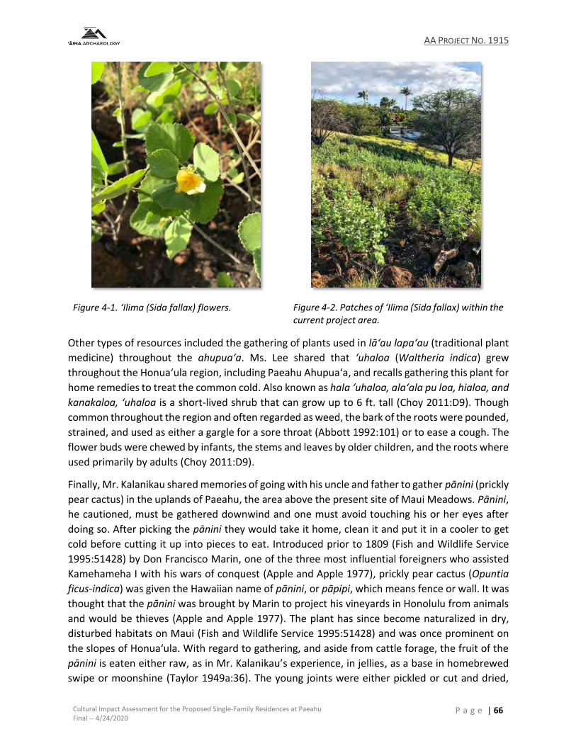
AA PROJECT NO. 1915
Cultural Impact Assessment for the Proposed Single-Family Residences at Paeahu Final -- 4/24/2020
P a g e | 66
Figure 4-1. ‘Ilima (Sida fallax) flowers.
Figure 4-2. Patches of ‘Ilima (Sida fallax) within the current project area.
Other types of resources included the gathering of plants used in lā‘au lapa‘au (traditional plant
medicine) throughout the ahupua‘a. Ms. Lee shared that ‘uhaloa (Waltheria indica) grew
throughout the Honua‘ula region, including Paeahu Ahupua‘a, and recalls gathering this plant for
home remedies to treat the common cold. Also known as hala ‘uhaloa, ala‘ala pu loa, hialoa, and
kanakaloa, ‘uhaloa is a short-lived shrub that can grow up to 6 ft. tall (Choy 2011:D9). Though
common throughout the region and often regarded as weed, the bark of the roots were pounded,
strained, and used as either a gargle for a sore throat (Abbott 1992:101) or to ease a cough. The
flower buds were chewed by infants, the stems and leaves by older children, and the roots where
used primarily by adults (Choy 2011:D9).
Finally, Mr. Kalanikau shared memories of going with his uncle and father to gather pānini (prickly
pear cactus) in the uplands of Paeahu, the area above the present site of Maui Meadows. Pānini,
he cautioned, must be gathered downwind and one must avoid touching his or her eyes after
doing so. After picking the pānini they would take it home, clean it and put it in a cooler to get
cold before cutting it up into pieces to eat. Introduced prior to 1809 (Fish and Wildlife Service
1995:51428) by Don Francisco Marin, one of the three most influential foreigners who assisted
Kamehameha I with his wars of conquest (Apple and Apple 1977), prickly pear cactus (Opuntia
ficus-indica) was given the Hawaiian name of pānini, or pāpipi, which means fence or wall. It was
thought that the pānini was brought by Marin to project his vineyards in Honolulu from animals
and would be thieves (Apple and Apple 1977). The plant has since become naturalized in dry,
disturbed habitats on Maui (Fish and Wildlife Service 1995:51428) and was once prominent on
the slopes of Honua‘ula. With regard to gathering, and aside from cattle forage, the fruit of the
pānini is eaten either raw, as in Mr. Kalanikau’s experience, in jellies, as a base in homebrewed
swipe or moonshine (Taylor 1949a:36). The young joints were either pickled or cut and dried,

AA PROJECT NO. 1915
Cultural Impact Assessment for the Proposed Single-Family Residences at Paeahu Final -- 4/24/2020
P a g e | 67
while the expressed juice was used in whitewash for exterior work. The pulp of the fruit was also
used for poultices and the production of cactus candy (McClelland 1916:35), while the school
children of ‘Ulupalakua School substituted gum for the sap of the pānini leaves that would be
gathered into a white gum. Mr. Miranda, a teacher at the school, noted that the pānini gum was
highly nutritious and gave the students strong white teeth (Taylor 1949b:24).
4.2 MAKAI RESOURCES AND THE TRADITIONAL CULTURAL PRACTICES OF THE SHORELINE AND
OFFSHORE AREA The shoreline of Paeahu Ahupua‘a extends from Keawakapu to Kuhulu and consists of bays white
sand beaches bordered by rocky points that continue into the sea. Use of the shoreline resources
and preference for residency along the coastline from a time period prior to Western contact to
the present is evident in the mo‘olelo of Paeahu (Section2.1.3.2), locations of house lots awarded
during the Māhele (Table 2-1), and the continuation of fishing traditions practiced by families and
those consulted for this study (see Section3.2). The nearshore and offshore marine environment
provides excellent opportunities for fishing and limu (seaweed) gathering.
The fishing traditions of the Honua‘ula region in general, and Paeahu specifically, were shared by
Ms. Carol-Marie Ka‘onohiokalā Lee who recalled that her family engaged in traditional fishing in
Makena and the costal areas of Paeahu. When asked about their fishing techniques, Ms. Lee
recalled that they would “surround” when out at sea, but she prefered to use a pole and remain
closer to shore. Although she herself did not recall seeing her father fish using palu (fish chum),
Ms.Lee shared that her grandfather did. Her grandfather also used a small canoe in Kanahena
that he would use to go fishing in. Ms. Lee shared that before she was born, her mother and
grandfather would paddle out to sea and canoe fish. This was a common practice amongst
members of her family, but Ms. Lee herself did not experience this.
Ms. Lee’s father would go fishing in a skipper (boat) with her uncles and they would catch akule,
manini and weke. Akule (Selar crumenophthalmus), or big-eyed scad, generally travel in large
migratory schools along the south Maui coastline which was well known to akule fishermen. Prior
to Western contact and into the historic era, akule fishing would require at least two manned
canoes and a kilo (spotter), who was either stationed on the prominent headland or in a canoe,
to guide the fishermen toward the grounds where they would surround the fish with curtain nets
and draw them toward the shore to those who waited to help with the catch (Kahā‘ulelio
2006:201). Ms. Lee also described this method of fishing where her family would use hukilau nets
to collect large quantities of fish for family gatherings or church events. Akule was eaten raw,
broiled, cooked in ti leaf bundles over kalo in the imu (earth oven), dried, or used for palu
(Titcomb and Pukui 1977:62). Manini (Acanthurus triostegus), or surgeon fish, was enjoyed by
both ali‘i and maka‘āinana. A bony and white fleshed fish, manini was eaten both raw and
cooked, as well as dried, but rarely gutted if eaten fresh except for the gall bladder (Titcomb and
Pukui 1977:104-105). Mary Kawena Pukui relayed the following practice with regard to manini at
Ka‘u that may have some bearing for mauka – makai trade at Paeahu:
AA PROJECT NO. 1915
Cultural Impact Assessment for the Proposed Single-Family Residences at Paeahu Final -- 4/24/2020
P a g e | 68
Every summer the natives used to catch the spawn by the million. Large, flat lava rocks
were swept clean with brooms of coconut midribs. Then the ‘ōhua (young stage), about
postage stamp size, were mixed with salt and scattered to dry in the hot sun. Later they
were stored for the future or taken inland for exchange with those who lived far from
the shore. (Titcomb and Pukui 1977:106)
Finally, weke (Mullidae), are large scaled fish that are usually found inside the reefs and
sometimes in the deeper waters but always near the reefs. A popular fish for food, oama (young
weke) was eaten either raw after being salted or dried, while full-grown weke were sometimes
eaten raw, but more commonly cooked by broiling in ti leaves over hot coals (Titcomb and Pukui
1977:162). Titcomb and Pukui (1977:162) also describe the following method for descaling weke
of their large scales:
To remove the scales, the oama were put into a large container with pebbles and sand,
stirred until the scales were loosened or rubbed off, then rinsed in sea-water. Large
weke were scaled by scraping.
Besides food, both red and light-colored weke were popular as offerings and chosen as
demanded by custom with red offered for particular ceremonies or reasons and white for others.
Weke was also used in sorcery, drawing on the meaning of the word “to open” and offering the
fish with a prayer to open or release either something unwanted, in preparation for forgiveness,
or in prayer to open a door to reveal truth. Finally, the flesh of the head of some weke, like weke
pahulu, is known to have a poisonous substance that causes those who eat it to have restless
sleep or nightmares where the head feels lower than the feet thus producing a sort of delirium
(Titcomb and Pukui 1977:161). Mo‘olelo also associates weke pahulu with Kaululā‘au’s encounter
with Pahulu, the chiefs of the ghosts that resided on Lāna‘i, during his banishment on Lāna‘i and
before he expelled the spirits and made the island hospitable for man (Fornander 1880:82;
1917a, 1919b). Articles recounting mo‘olelo as it relates to Kaululā‘au and the effects of eating
the head flesh of weke pahulu were also published in the Hawaiian language newspapers. Pukui
(in Titcomb and Pukui 1977:162) gives the following translations for a section of Na Wahi Pana o
Lanai (Nupepa Kuokoa 1912)
Kaululaau sat in the milo tree with a flat stone. He saw Pahulu peer into the spring, for
the light of the moon shone fully upon it. As Pahulu stooped to dip up some water,
Kaululaau pushed aside some of the milo leaves. The moon cast his reflection in the
water. He made grimaces, and when Pahulu saw the reflection making faces (he was
deceived), and he dived to catch him. As son as Kaululaau saw that Pahulu’s whole body
had gone into the water, he threw the stone down. The spark of life went out of Pahulu’s
body and he died. His spirit leaped into the sea, and that is why the people who eat
weke are troubled with nightmares.
An excerpt from the story of Eleio as it relates to Kaulula‘āu that was published in the Hawaiian
language newspaper Ke Au Hou (October 31, 1863) was also translated by Pukui (in Titcomb and
Pukui 1977:162)as follows:
Then Kaululaau went and sat over the pool where he dropped a stone on Pahulu, killing
him. Pahulu died but he lived on in the itching caused by certain fish. That is why there
AA PROJECT NO. 1915
Cultural Impact Assessment for the Proposed Single-Family Residences at Paeahu Final -- 4/24/2020
P a g e | 69
is itching in the head of the weke and the itch is always there in the fish caught off Lanai
to this day.
With regard to coastal gathering practices of limu or seaweed, Ms. Lee, as well as Ms. Teruya and
Mr Kanahele, all recall the limu beds of the Paeahu shoreline. Ms. Lee’s mother often gathered
limu– including limu līpoa, kohu, and wāwaeʻiole– along the Makena and Paeahu shoreline, while
Ms. Leina‘ala Teruya would walk down the shoreline at Keawakapu through the kiawe trees and
recall seeing people gathering limu. Ms. Teruya remembers that people would collect all types of
limu – limu kohu, limu kala, ʻeleʻele and wāwaeʻiole – and one type of yellow limu in particular
that smelled really good, but she couldn’t recall the name. Mr. Daniel Kanahele shared that his
family would gather limu species from the shoreline, like limu ʻeleʻele, limu kala and limu līpoa
and others.
Limu kohu (Asparagopsis sp.) was amongst the most sought after limu for the Hawaiian
household. Once a staple condiment in every Hawaiian household, this limu has a peppery taste
that can be rolled into balls for storage and when used, is pounded and mixed with salt to be
eaten with fresh fish (Setchell 1907; Wianecki 2010). Limu kala (Turbinaria ornate or Sargassum
echinocarpum), where kala translates to loosen or untie and interpreted as forgiveness and
atonement, was said to have been used first for food and second for atonement for religious
purposes rather than moral. An account regarding the incorporation of limu kala into ritual was
given by a Kawaihae fisherman and recorded as follows:
The one who has sinned gets all persons concerned together, makes a prayer, and then throws the limu from him. It takes with it all the sins. (Setchell 1907)
On Maui, the following incorporation of limu kala into ceremony and ritual was also recorded:
… when a kahuna has treated and cured a patient he has the patient bathe, put Limu kala in his mouth, spit it out, and then put a lei of Limu kala on his head. This is symbolic of being healed. (Setchell 1907)
Limu ‘ele‘ele (Enteromorpha sp.) was particularly preferred, sometimes at the expense of others,
and is found growing in running water, either fresh or brackish with the fresh-water form keeping
only for a couple of days and the salt-water form keeping for up to a week. This limu is slippery
and fragrant and was widely consumed as a part of the traditional diet with no specific
preparation (Setchell 1907). Wāwae‘iole (Lycopodium sp.) translates to “rat foot” and is generally
eaten raw alone or combined with wana (sea urchin) or he‘e (squid or octopus). Finally, limu līpoa
(Dictyopteris plagiogramma) was noted as an especially well-regarded food resource that was
said to be fragrant and pleasant to taste it was a common condiment in the Hawaiian diet.
According to Mr. Kanahele, the quantity of limu in the area has decreased over the years and
while he recalled being able to smell the limu from his house during certain times of the year,
winter months in particular, as the wind would carry the smell up mauka (upland), presently that
does not happen anymore as the limu beds are virtually gone with less variety and quantity of
what little remains. Large patches or strands of limu are no longer found along the shoreline and
one is not able to gather limu in the way that was done in the past. Ms. Teruya echoes that
sentiment when she notes that her ʻohana can no longer find limu. She observed that as more
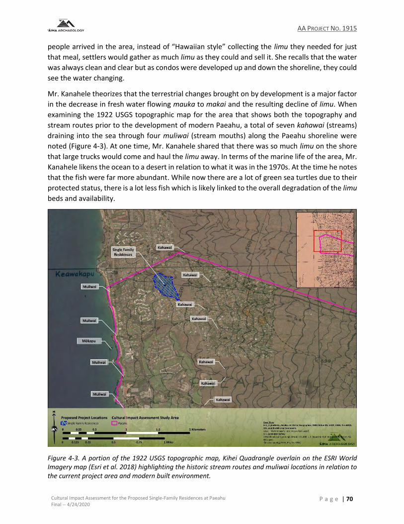
AA PROJECT NO. 1915
Cultural Impact Assessment for the Proposed Single-Family Residences at Paeahu Final -- 4/24/2020
P a g e | 70
people arrived in the area, instead of “Hawaiian style” collecting the limu they needed for just
that meal, settlers would gather as much limu as they could and sell it. She recalls that the water
was always clean and clear but as condos were developed up and down the shoreline, they could
see the water changing.
Mr. Kanahele theorizes that the terrestrial changes brought on by development is a major factor
in the decrease in fresh water flowing mauka to makai and the resulting decline of limu. When
examining the 1922 USGS topographic map for the area that shows both the topography and
stream routes prior to the development of modern Paeahu, a total of seven kahawai (streams)
draining into the sea through four muliwai (stream mouths) along the Paeahu shoreline were
noted (Figure 4-3). At one time, Mr. Kanahele shared that there was so much limu on the shore
that large trucks would come and haul the limu away. In terms of the marine life of the area, Mr.
Kanahele likens the ocean to a desert in relation to what it was in the 1970s. At the time he notes
that the fish were far more abundant. While now there are a lot of green sea turtles due to their
protected status, there is a lot less fish which is likely linked to the overall degradation of the limu
beds and availability.
Figure 4-3. A portion of the 1922 USGS topographic map, Kihei Quadrangle overlain on the ESRI World Imagery map (Esri et al. 2018) highlighting the historic stream routes and muliwai locations in relation to the current project area and modern built environment.
AA PROJECT NO. 1915
Cultural Impact Assessment for the Proposed Single-Family Residences at Paeahu Final -- 4/24/2020
P a g e | 71
4.3 NA ALA HELE -- TRADITIONAL ACCESS AND TRAILS Prior to the arrival of Western vessels to the waters of Maui, trail networks served to connect the
various settlements within and between the ahupua‘a and districts of the Hawaiian Islands. The
island of Maui is thought to have been the only mokupuni to have had a paved, delineated
footpath that encircled the entire island around both the east and west ends. Following the
unification of the eastern and western moku of Maui, and his acknowledgment as mō‘ī by the
East Maui chiefs (Fornander 1880:65, 87), Chief Pi‘ilani initiated the construction of the Alaloa,
or Long Road (Ashdown 1971:5). The completion of the alaloa was accomplished by his son, Kiha-
a-pi‘ilani, after securing his reign over Maui from his brother Lono-a-pi‘ilani (Fornander 1917b;
Kamakau 1992:22-33). Handy and others (1991:489) note that while the beaches were used as
crossings where gulches reached the shore, and travelers sometimes used canoes to cross the
mouths of larger streams or swinging ropes and vines to make torrential stream crossings, a
significant extent of the alaloa was paved with stones, hence the reference to the alaloa as the
Kīpapa of Kihapi‘ilani. Martha Fleming provides the following general description of constructed
portions of the alaloa:
The Alii had a line of men stand from the sea and hand stones along the line till they
reached the required place. Here the stones were artfully put into position. The trail
was paved with flat, hard beach stones. Those on the steeper grades were very flat,
while those in less sloping country were more rounded. In open country, each side of
the trail was flanked with large field boulders solidly sunk into the ground and standing
above the center from one to five feet... On the steep gulches, only one side of the trail
had this guard. The stones, or flags, on the floor of the trail were placed horizontally to
the abutments in quite regular lines. It took four or five stones to make a line across.
The second row of horizontal stones was placed parallel to the other in a checker-board
fashion in order to prevent wash. The width of the trail between the balustrades was
from four to five feet, giving a regular appearance as it stretched over the country.
There were few turns in the trail, even where the grade was steepest. (Fleming 1933:5)
At Honua‘ula, this trail, or road, was situated along the coastline, where it crossed along the sandy
beaches from Waile‘a to Po‘olenalena toward Maluaka and across the lava fields to Keone‘o‘io
where it would later evolve into the Makena to Keoneo‘i‘o Government road and across the lava
fields constructed and delineated as described by Fleming above. Handy and others (1991:489)
go on to explain that in addition to the usefulness of the alaloa in facilitating travel and
establishing intra-island communication, this footpath was also used during the time of Makahiki
by the konohiki (tax collectors), the priests who released the land from kapu after the collections
of the ho‘okupu (taxes), and the bearers of the symbol of Lono. In times of war, kuakini, or trained
runners, would also use the alaloa to carry messages along the road to their ali‘i.
Traditional Hawaiian land tenure, as well as resource management and use, was also reliant on
the ability to traverse the land from the shoreline (makai) to the forested zone (mauka). The
arrangement of a typical Hawaiian ahupua‘a, or primary land management unit, extended from
the coastline to the upland forest areas. This right of access was so important and integral in
traditional Hawaiian thinking and settlement, that such rights for the native tenant were explicitly
AA PROJECT NO. 1915
Cultural Impact Assessment for the Proposed Single-Family Residences at Paeahu Final -- 4/24/2020
P a g e | 72
stated during the division of lands according to a Western model, award, and sale of lands in fee
simple during the Great Māhele (Van Dyke 2008:32-33), following the transition of the Hawaiian
social structure from chiefdom to Kingdom, and codified in the Civil Code of Hawaiian Kingdom.
As previously stated in Section 2.2.2, in designations of lands as either Crown or Government,
and through all awards of whole ahupua‘a and ‘ili, the rights of the native tenants were expressly
reserved, “Koe na Kuleana o Kanaka” (Reserving the Rights of Native Tenants) (Alexander
1890:114; Handy et al. 1991:48; "Na ke Aupuni: He Kanawai no na Aina Ponoi o ka Moi, a me na
Aina o ke Aupuni" 1848). In an Act ratified on August 6th, 1850, the gathering rights of the
common people for personal use, which included the gathering of both terrestrial and marine
resources, in addition to the right to water and the right of way on the lands of the Konohiki,
were guaranteed and embodied in Section 1477 of the Civil Code:
Where the landlords have obtained, or may hereafter obtain, allodial title to their lands.
the people on each of their lands shall not be deprived of the right to take firewood,
house-timber, aho cord, thatch, or ki (ti) leaf, from the land on which they live, for their
own private use, but they shall not have a right to take such articles to sell for profit.
The people shall also have a right to drinking water, and running water, and the right
of way. The springs of water, running water, and roads, shall be free to all, on all lands
granted in fee simple: provided , that this shall not be applicable to wells and water-
courses, which individuals have made for their own use (private). (Alexander 1890:114-
115)
Though not located on the overall maps during the Mahele ‘Āina, there is reference to both ala
(trail) and ala loa (road) in the boundary descriptions of LCA 5281, Apana 2 to Kuhilani (Figure
4-4) and LCA 5329, Apana 1 to Pahu (Figure 4-5) within Paeahu. Though archaeological data for
the mid to upper elevations of Paeahu mauka of the current project area is not yet available,
both pre-contact trail systems and historic roads were identified in the mid elevations above the
current project area and mauka of the golf courses of Wailea as a part of an archaeological
inventory survey of a portion of neighboring Palauea Ahupua‘a that was completed by Scientific
Consultant Services (Perzinski et al. 2014). Twenty-seven features were identified in their project
area and interpreted as travel paths with formal types that included stepping stone trail segments
and two historic roads, with the stepping stone trails with at least one (SIHP 50-50-14-7753)
appearing to link gardening plots to habitation areas (Perzinski et al. 2014:213).
For Paeahu Ahupua‘a, examination of Hawaiian Government map of Maui shows the location of
the coastal trail or road, which may also be a part of the Alaloa (Figure 4-6), as being well makai
of the current project area while an upland road or cart trail, later referred to as the Kalama-
Kanaio Extension, is situated well mauka of the current project area. The alignment of these trails,
which would later evolve into modern roads, continue into at least the 1920s, as shown on the
1922 USGS topographic map (figure). While it is possible that similar trails as identified by Perzinki
and others (2014:213) may have been present in Paeahu and with extensions to the coast and
uplands, and though there are survey descriptions containing reference to trails in Paeahu it is
not currently known where these more commonly used foot paths were situated and if there
were trails that crossed the current project area.
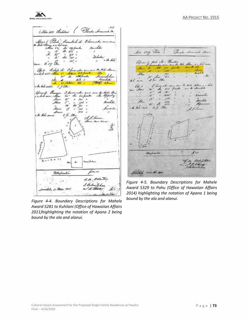
AA PROJECT NO. 1915
Cultural Impact Assessment for the Proposed Single-Family Residences at Paeahu Final -- 4/24/2020
P a g e | 73
Figure 4-4. Boundary Descriptions for Mahele Award 5281 to Kuhilani (Office of Hawaiian Affairs 2011)highlighting the notation of Apana 2 being bound by the ala and alanui.
Figure 4-5. Boundary Descriptions for Mahele Award 5329 to Pahu (Office of Hawaiian Affairs 2014) highlighting the notation of Apana 1 being bound by the ala and alanui.
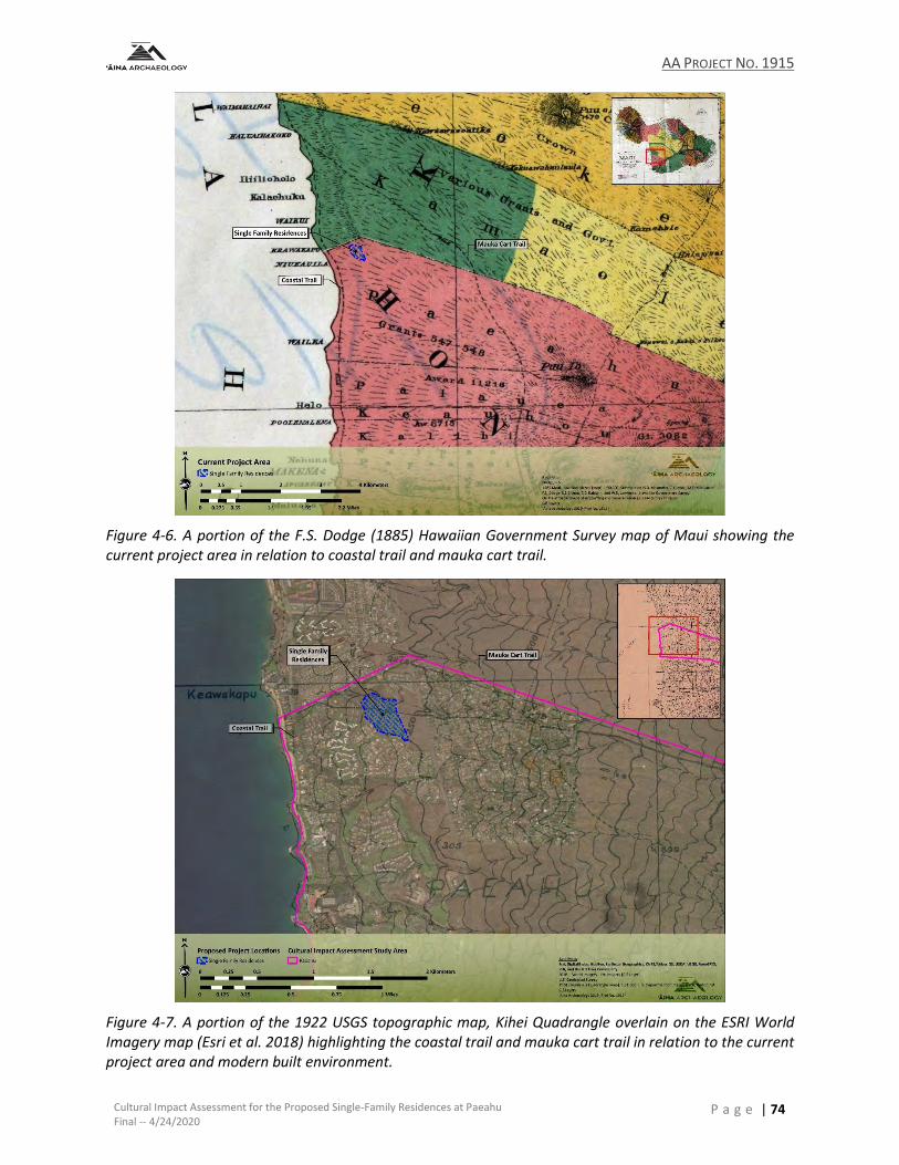
AA PROJECT NO. 1915
Cultural Impact Assessment for the Proposed Single-Family Residences at Paeahu Final -- 4/24/2020
P a g e | 74
Figure 4-6. A portion of the F.S. Dodge (1885) Hawaiian Government Survey map of Maui showing the current project area in relation to coastal trail and mauka cart trail.
Figure 4-7. A portion of the 1922 USGS topographic map, Kihei Quadrangle overlain on the ESRI World Imagery map (Esri et al. 2018) highlighting the coastal trail and mauka cart trail in relation to the current project area and modern built environment.
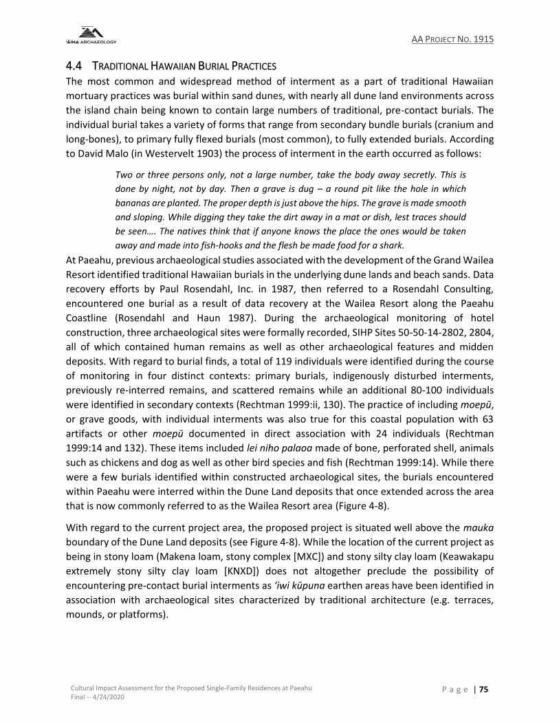
AA PROJECT NO. 1915
Cultural Impact Assessment for the Proposed Single-Family Residences at Paeahu Final -- 4/24/2020
P a g e | 75
4.4 TRADITIONAL HAWAIIAN BURIAL PRACTICES The most common and widespread method of interment as a part of traditional Hawaiian
mortuary practices was burial within sand dunes, with nearly all dune land environments across
the island chain being known to contain large numbers of traditional, pre-contact burials. The
individual burial takes a variety of forms that range from secondary bundle burials (cranium and
long-bones), to primary fully flexed burials (most common), to fully extended burials. According
to David Malo (in Westervelt 1903) the process of interment in the earth occurred as follows:
Two or three persons only, not a large number, take the body away secretly. This is
done by night, not by day. Then a grave is dug – a round pit like the hole in which
bananas are planted. The proper depth is just above the hips. The grave is made smooth
and sloping. While digging they take the dirt away in a mat or dish, lest traces should
be seen…. The natives think that if anyone knows the place the ones would be taken
away and made into fish-hooks and the flesh be made food for a shark.
At Paeahu, previous archaeological studies associated with the development of the Grand Wailea
Resort identified traditional Hawaiian burials in the underlying dune lands and beach sands. Data
recovery efforts by Paul Rosendahl, Inc. in 1987, then referred to a Rosendahl Consulting,
encountered one burial as a result of data recovery at the Wailea Resort along the Paeahu
Coastline (Rosendahl and Haun 1987). During the archaeological monitoring of hotel
construction, three archaeological sites were formally recorded, SIHP Sites 50-50-14-2802, 2804,
all of which contained human remains as well as other archaeological features and midden
deposits. With regard to burial finds, a total of 119 individuals were identified during the course
of monitoring in four distinct contexts: primary burials, indigenously disturbed interments,
previously re-interred remains, and scattered remains while an additional 80-100 individuals
were identified in secondary contexts (Rechtman 1999:ii, 130). The practice of including moepū,
or grave goods, with individual interments was also true for this coastal population with 63
artifacts or other moepū documented in direct association with 24 individuals (Rechtman
1999:14 and 132). These items included lei niho palaoa made of bone, perforated shell, animals
such as chickens and dog as well as other bird species and fish (Rechtman 1999:14). While there
were a few burials identified within constructed archaeological sites, the burials encountered
within Paeahu were interred within the Dune Land deposits that once extended across the area
that is now commonly referred to as the Wailea Resort area (Figure 4-8).
With regard to the current project area, the proposed project is situated well above the mauka
boundary of the Dune Land deposits (see Figure 4-8). While the location of the current project as
being in stony loam (Makena loam, stony complex [MXC]) and stony silty clay loam (Keawakapu
extremely stony silty clay loam [KNXD]) does not altogether preclude the possibility of
encountering pre-contact burial interments as ‘iwi kūpuna earthen areas have been identified in
association with archaeological sites characterized by traditional architecture (e.g. terraces,
mounds, or platforms).
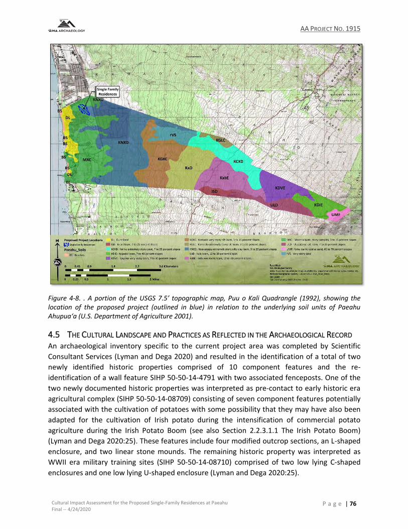
AA PROJECT NO. 1915
Cultural Impact Assessment for the Proposed Single-Family Residences at Paeahu Final -- 4/24/2020
P a g e | 76
Figure 4-8. . A portion of the USGS 7.5’ topographic map, Puu o Kali Quadrangle (1992), showing the location of the proposed project (outlined in blue) in relation to the underlying soil units of Paeahu Ahupua‘a (U.S. Department of Agriculture 2001).
4.5 THE CULTURAL LANDSCAPE AND PRACTICES AS REFLECTED IN THE ARCHAEOLOGICAL RECORD An archaeological inventory specific to the current project area was completed by Scientific
Consultant Services (Lyman and Dega 2020) and resulted in the identification of a total of two
newly identified historic properties comprised of 10 component features and the re-
identification of a wall feature SIHP 50-50-14-4791 with two associated fenceposts. One of the
two newly documented historic properties was interpreted as pre-contact to early historic era
agricultural complex (SIHP 50-50-14-08709) consisting of seven component features potentially
associated with the cultivation of potatoes with some possibility that they may have also been
adapted for the cultivation of Irish potato during the intensification of commercial potato
agriculture during the Irish Potato Boom (see also Section 2.2.3.1.1 The Irish Potato Boom)
(Lyman and Dega 2020:25). These features include four modified outcrop sections, an L-shaped
enclosure, and two linear stone mounds. The remaining historic property was interpreted as
WWII era military training sites (SIHP 50-50-14-08710) comprised of two low lying C-shaped
enclosures and one low lying U-shaped enclosure (Lyman and Dega 2020:25).

AA PROJECT NO. 1915
Cultural Impact Assessment for the Proposed Single-Family Residences at Paeahu Final -- 4/24/2020
P a g e | 77
With regard to the general cultural historical landscape as it pertains to the extant distribution of
archaeological sites within the lower Paeahu region, Mr. Kanahele commented that he has
observed that almost all the developed lands within Paeahu. With few exceptions, Mr. Kanahele
goes on to say there are few to no preserved historic properties and concludes that the
destruction or displacement of Hawaiian cultural landscapes as a result of development makes
whatever is left that much more valuable in terms of preserving and defining a sense of place and
providing a sense of history of Paeahu for current and future generations. He laments that when
it is gone, then it is gone forever, and if each site has a story to tell then Mr. Kanahele believes
there are no insignificant sites in Paeahu. He believes that all sites are significant and valuable for
Native Hawaiians as they could serve as places of connection for local Native Hawaiian families.
During the site walk with Ms. Lucienne DeNaie, she pointed out the several scattered areas of
cultural material (e.g. shell, coral fragments, and ‘ili) on a bluff at the westernmost extent of the
project area. In addition to surface scatter, Ms. DeNaie spoke about the previously documented
wall feature (SIHP -4791) and the story of Paeahu being told to include representations of the
ranching history of Paeahu, though she gave some thought as to the possibility of this wall
potentially being associated with an ‘ili boundary.
AA PROJECT NO. 1915
Cultural Impact Assessment for the Proposed Single-Family Residences at Paeahu Final -- 4/24/2020
P a g e | 78
5.0 ANALYSIS AND RECOMMENDATIONS
The State of Hawai‘i has a constitutional and statutory obligation to protect native Hawaiian
customary and traditional gathering rights. We offer this introductory section to explain the basis
and substance of the state’s obligations, as well as the impact of this protection upon traditional
western private property rights and the role of private landowners in the necessary research and
analysis of traditional and customary practices. To provide the appropriate historical context for
such traditional and customary practices, an authoritative treatise on this subject states:
At the time of Western contact in 1778, Native Hawaiians “lived in a highly organized, self-sufficient, subsistent social system based on communal land tenure with a sophisticated language, culture, and religion.” Access from one area to another—along the shore, between adjacent ahupua‘a (land divisions [usually extending from the mountains to the sea along rational lines, such as ridges or other natural characteristics]), to the mountains and the sea, and to small plots of land cultivated or harvested by native tenants—was a necessary part of early Hawaiian life. Gathering activities supplemented everyday food and medicinal supplies, while cultural and religious practices sustained the people in a variety of ways.
Prior to 1839, ancient Hawaiian custom and usage governed the islands. To ensure the political existence of the kingdom in the face of expanding foreign influence, Kamehameha III developed a system of codified laws that incorporated protections for ancient tradition, custom, and usage. In other words, the laws in force at the time of the Māhele in the mid-1800s and for some time thereafter recognized the importance of traditional and customary practices to the native people. Many of these laws survived later political transformations and continue to apply as background principles of private property law in the State of Hawai‘i. (MacKenzie et al. 2015:1082).
With respect to “laws [that] survived later political transformations”, the present-day obligation
of the State to protect native Hawaiian traditional and customary practices is based, first, upon
the State Constitution and, in addition, upon the legislature’s acts as codified in the Hawai‘i
Revised Statutes and the judiciary’s interpretation of the state constitution and state statutes
through case law. These authoritative sources of law, in essence, describe how the State seeks
to integrate and protect native Hawaiian traditional and customary practices in a western system
of private property ownership.
Article XII, section 7 of the Hawai‘i Constitution provides:
The State reaffirms and shall protect all rights, customarily and traditionally exercised for subsistence, cultural and religious purposes and possessed by ahupua‘a tenants who are descendants of native Hawaiians who inhabited the
AA PROJECT NO. 1915
Cultural Impact Assessment for the Proposed Single-Family Residences at Paeahu Final -- 4/24/2020
P a g e | 79
Hawaiian Islands prior to 1778, subject to the right of the State to regulate such rights.
Delegates to the 1978 Hawai‘i Constitutional Convention explained:
The proposed new section reaffirms all rights customarily and traditionally held by ancient Hawaiians. . . . [B]esides fishing rights, other rights for sustenance, cultural and religious purposes exist. Hunting, gathering, access and water rights, while not provided for in the State Constitution, were nevertheless an integral part of the ancient Hawaiian civilization and are retained by its descendants.” Hawaiian Affairs Comm., Standing Comm. Rep. No. 57, reprinted in 1 Proceedings of the Constitutional Convention of Hawai‘i of 1978, at 637, 640 (1980).
With respect to legislative acts, Section 7-1 of the HRS specifically protects the right to gather,
although that right is limited in scope to the enumerated items that are primarily used for
constructing a house or starting a fire. Section 1-1 of the HRS offers broader protection for the
exercise of traditional and customary rights. By codifying “Hawaiian usage” as an exception to
the common law of the State, this statutory provision provides “a vehicle for the continued
existence of those customary rights which continued to be practiced” after November 25, 1892.
Kalipi v. Hawaiian Trust Co., 66 Haw. 1, 10, 656 P.2d 745, 750–51 (1982).
In a series of landmark cases beginning with Kalipi, the Hawai‘i Supreme Court reaffirmed the
customary and traditional gathering rights of ahupua‘a tenants, particularly under article XII,
section 7 of the Hawai‘i Constitution See Kalipi, 66 Haw. at 10–12, 656 P.2d at 750–52; Pele
Defense Fund v. Paty, 73 Haw. 578, 837 P.2d 1247 (1992), cert. denied, 507 U.S. 918 (1993); Public
Access Shoreline Haw. v. Haw. Cnty. Planning Comm’n, 79 Hawai‘i 425, 903 P.2d 1246 (1995),
cert. denied, 517 U.S. 1163 (1996) (commonly known as “PASH”); Ka Pa‘akai O Ka ‘Āina v. Land
Use Com’n, State of Hawai‘i, 94 Hawai‘i 31, 7P.3d 1068 (2000). Through this line of cases, the
Supreme Court established the way that State agencies must apply constitutional protections of
native Hawaiian gathering rights in the development of private real property.
In Kalipi, the Hawai‘i Supreme Court ruled that “any argument for the extinguishing of traditional
rights based simply upon the possible inconsistency of purported native rights with our modern
system of land tenure must fail.”. Kalipi, 66 Haw. at 4, 656 P.2d at 748. In Pele Defense Fund v.
Paty, the Court held that “native Hawaiian rights protected by article XII, section 7 may extend
beyond the ahupua‘a in which a native Hawaiian resides where such rights have been customarily
and traditionally exercised in this manner.” Pele Defense Fund v. Paty, 73 Haw. at 620, 837 P.2d
1272. In the PASH case, the Court stated that “legitimate customary and traditional practices
must be protected to the extent feasible in accordance with article XII, section 7.” PASH, 79
Hawai‘i at 451, 903 P.2d at 1272
The Court in PASH stated that the “State retains the ability to reconcile competing interests under
article XII, section 7”. PASH, 79 Hawai‘i at 447, 903 P.2d at 1268. As part of this balance of
interests, the Court stated: (a) “[although access is only guaranteed in connection with
AA PROJECT NO. 1915
Cultural Impact Assessment for the Proposed Single-Family Residences at Paeahu Final -- 4/24/2020
P a g e | 80
undeveloped lands, and article XII, section 7 does not require the preservation of such lands, the
State does not have the unfettered discretion to regulate the rights of ahupua'a tenants out of
existence”, id. at 451, 903 P.2d at 1272, and (b) “the balance of interests and harms clearly favors
a right of exclusion for private property owners as against persons pursuing non-traditional
practices or exercising otherwise valid customary rights in an unreasonable manner”, although,
“[o]n the other hand, the reasonable exercise of ancient Hawaiian usage is entitled to protection
under article XII, section 7”, id. at 442, 903 P.2d at 1272.
In Ka Pa‘akai O Ka ‘Āina, the Supreme Court provided further direction on the constitutional and
statutory responsibility of state agencies to preserve and protect the rights of native Hawaiians
to carry-out their traditional and customary practices to the extent feasible and, in so doing, “the
Court introduced an analytical framework that governmental agencies must specifically consider
when balancing their obligations to protect traditional and customary practices against private
property (as well as competing public) interests.” (MacKenzie et al. 2015:1109).
In Ka Pa‘akai O Ka ‘Āina, 94 Haw. at 35, 7 P.3d at 1072, the Court held that the State Land Use Commission (LUC) failed to satisfy its constitutional and statutory obligations to preserve and protect customary and traditional rights of native Hawaiians (Belatti 2003). At issue was the LUC’s grant of a petition to reclassify over 1,000 acres of land in the ahupua‘a of Ka‘upulehu on Hawai‘i Island from the State Land Use “Conservation District” to the State Land Use “Urban District” in order to allow the development of a new resort. The Court acknowledged a variety of traditional and customary rights asserted by the petitioners, who were comprised of a coalition of Native Hawaiian community organizations. These rights included “fishing [and] gathering salt, ‘opihi, limu, kūpe‘e (edible marine snails whose shells are used for ornaments; the rare ones by chiefs), Pele's Tears (tear drops made from pahoehoe lava), and hā‘uke‘uke (edible sea urchins).” Ka Pa‘akai O Ka ‘Āina, 94 Haw. at 43 and nn.19-21, 7 P.3d at 1080 and nn. 19-21. The Court also recognized the “special religious significance” of an 1800-1801 lava flow to gather salt for subsistence and religious purposes. Id.
The petitioners further asserted that “the petition area is associated with important personages
and events in Hawaiian history, contains well-known physical entities (such as the shoreline, Ka
Lae Mano and the 1800-1801 lava flow) and remnants of the native tenants’ lateral shoreline and
mauka-makai trail system, living areas and burials.” Id. at 43, 7 P.3d at 1080. Agreeing with the
petitioners that their interests as native Hawaiians and as tenants of the ahupua‘a of Ka‘upulehu
would be impaired by the proposed development in relation to the use of ancient trails and the
shoreline area to practice traditional and customary gathering rights, the Court held the LUC had
failed to develop a proper record on such rights and consider and analyze the extent of Native
Hawaiian practitioners’ exercise of traditional and customary rights in the affected area. The
Court stated that the LUC, as the reviewing state agency, must consider and make express
findings of fact and conclusions of law regarding the cultural, historical, and natural resources of
a subject property as they relate to Native Hawaiian rights when determining what restrictions
should be placed on land use. Ka Pa‘akai O Ka ‘Āina , 94 Haw. at 35, 7 P.3d at 1072.
AA PROJECT NO. 1915
Cultural Impact Assessment for the Proposed Single-Family Residences at Paeahu Final -- 4/24/2020
P a g e | 81
The Court further held that the LUC, by directing the developer to work independently to protect
cultural rights, impermissibly delegated the LUC’s constitutional and statutory responsibility, as
a State agency, to protect and preserve cultural resources and native Hawaiian rights. The Court
vacated the LUC’s grant of the developer’s application for a land use boundary reclassification
and remanded the case to the LUC to make findings of fact and conclusions of law relating to:
(1) the identity and scope of “valued cultural, historical, or natural resources” in the petition area, including the extent to which traditional and customary native Hawaiian rights are exercised in the petition area;
(2) the extent to which those resources - including traditional and customary native Hawaiian rights - will be affected or impaired by the proposed action; and,
(3) the feasible action, if any, to be taken by the LUC to reasonably protect native Hawaiian rights if they are found to exist. Ka Pa‘akai O Ka ‘Āina, 94 Haw. at 35, 7 P.3d at 1072.
The Court’s framework seeks “to effectuate the State’s obligation to protect native Hawaiian
customary and traditional practices while reasonably accommodating competing private
[property] interests”. Id. at 46-47, 7 P.3d at 1083-84. Beyond the directives to the LUC in this
specific case, this three-part framework provides specific direction to state and county agencies
when considering land use and development projects on previously undeveloped land and should
provide guidance to developers with respect to the record that must be prepared for a
discretionary land use authorization or permit.
In attempting to comply with the PASH and Ka Pa‘akai O Ka ‘Āina cases, the LUC had to address the issue of who has the responsibility to identify (and place on the record) any pre-existing native Hawaiian gathering rights. In subsequent boundary amendment proceedings, the LUC directed the petitioner to consult with the Office of Hawaiian Affairs (OHA) and with kūpuna in the area regarding past and present practices. The Office of Planning (OP) also consults with OHA. The LUC does not do any independent investigation, rather relies on the record made by the petitioner and OP (and any intervenor) and determines whether that record is sufficient.
Once the rights have been identified and the impacts assessed, the LUC is faced with the difficult
problem of reconciling the private property rights, particularly the right of exclusion, with the
gathering rights of native Hawaiians, which of themselves can require a certain amount of privacy
and seclusion. Following the Supreme Court’s remand in Ka Pa‘akai O Ka ‘Āina and in another
case, In the Matter of the Petition of Destination Villages Kauai, Docket No. A00731 (2001) in
which native Hawaiian gathering rights were shown to exist, the LUC put conditions on its
approval of reclassification of property that in each case required the formation of a committee
made of up a developer’s representative and a representative from the local native Hawaiian
community to develop a plan to ensure that the gathering rights are protected. The plans are
subject to LUC approval; any controversy arising from the plan is to be resolved by the
AA PROJECT NO. 1915
Cultural Impact Assessment for the Proposed Single-Family Residences at Paeahu Final -- 4/24/2020
P a g e | 82
committee. In the event the committee members cannot agree, they must agree on a third
person who then will break the tie.
The LUC chose the committee approach because it did not believe it had sufficient information
on resource conservation and management for the area in either of the two cases to make the
final decision and, as a practical matter, would not be able to create such a record within the
statutorily-mandated (365-day) time frame for making a decision. Because the Supreme Court
has forbidden the LUC to delegate its decision-making power over balancing the private property
rights and native Hawaiian gathering rights, forming a committee with each party having an equal
vote in the outcome and requiring that any plans be approved by the LUC ensured that both sides
would have their interests adequately represented and that the LUC would be the final arbiter
that the balance reached meets the requirements of the law.
For purposes of the present project, the following sections provide an analysis of potential effects
to currently known traditional and customary practices within and adjacent to the proposed
project footprint. Recommendations for managing potential impacts to on-going practices or
protecting the integrity of traditional cultural resources that may be present within and adjacent
to the project area should traditional cultural practices that were once carried out in the area be
re-established.
5.1 ANALYSIS OF EFFECT TO TRADITIONAL AND CUSTOMARY PRACTICES AND PROPOSED PROJECT
RECOMMENDATIONS
5.1.1 Traditional Cultural Resources and Customary Practices Specific to the Proposed Project
Area
While ‘ilima resources were observed within the project area, no active or historically known
traditional and customary practices related to the gathering and use of ‘ilima from within the
project area have been identified at this time. This factor notwithstanding, ‘ilima continues to
figure prominently in traditional lei making (see discussion in Section 4.1), and the availability
and integrity of this resource that grows naturally in the project area may be adversely impacted
by construction related activities.
With regard to traditional Hawaiian archaeological sites, a total of four historic properties,
consisting of modified outcrops, linear mounds, and an L-shape were identified within the current
project area (see Section 4.5Error! Reference source not found.) and interpreted as having an
agricultural function related to either traditional potato agriculture and/or potato agriculture
related to the Irish Potato Boom (Lyman and Dega 2020:25) and evaluated as being historically
significant under Criterion “d” for informational purposes under HAR §13-13-275-6 and HAR §13-
13-284-6. These sites have been further evaluated as being of degraded integrity and as a result
it was determined that no additional archaeological documentation beyond that of the inventory
survey study or archaeological mitigation in the form of data recovery or preservation was
needed. As mentioned above Mr Kanahele notes that when a traditional Hawaiian site is “gone,

AA PROJECT NO. 1915
Cultural Impact Assessment for the Proposed Single-Family Residences at Paeahu Final -- 4/24/2020
P a g e | 83
it is gone forever” and that there are not insignificant sites. To this end, both he and Lucienne
DeNaie note that the number of historic properties preserved within Paeahu are few and far
between.
5.1.2 Traditional Cultural Resources and Customary Practices Identified within Paeahu Ahupua‘a
and adjacent to the Proposed Project
The Guidelines for Assessing Cultural Impacts, adopted on November 19, 1997 by the
Environmental Council, State of Hawai‘i also states:
(For) the cultural portion of an environmental assessment, the geographical extent
of the inquiry should, in most instances, be greater than the area over which the
proposed action will take place (proposed project area). This is to ensure that
cultural practices which may not occur within the boundaries of the project area,
but which may nonetheless be affected, are included in the assessment. (State of
Hawaii Office of Environmental Quality Control 2012:11)
While there are no currently known currently active traditional customary practices being carried
out within the footprint of the proposed project area and there appear to be no potential for
adverse effects on the cultural resources of the mauka region of Paeahu Ahupua‘a as a result of
the proposed project, concerns with regard to the cumulative effects of runoff and additional
development in the region on the shoreline resources that remain was expressed by those who
participated in this study.
Mr. Kanahele notes that the quantity of limu in the area has decreased over the years. He recalled
being able to smell the limu from his house during certain times of the year. He said the wind
would carry the smell up mauka (upland) and now notes that the wind does not carry the smell
of limu anymore. Large patches or strands of limu are no longer found along the Paeahu shoreline
and both Mr. Kanahele and Ms. Teruya have said that families are not able to gather limu in the
way that was done in the past. Most poignant, is Mr. Kanahele’s comparison of the ocean and
beaches to a desert which is echoed by Ms. Lee and Ms. Teruya who also note that the fishing
resources have become limited and the schools of fish appear have dwindled. Mr. Kanahele
shared that the surface and subsurface freshwater that runs off into the ocean is important to
sustain the marine life along the Paeahu shoreline noting that the fresh and saltwater
combination is what produces healthy limu growth along the shoreline which then sustains the
marine life and kanaka that depend upon the limu as a source of nutrients. Mr Kalanikau, whose
family is involved with keeping the ways clear for the mo‘o and advocating for the wetlands of
South Maui, has noted that it is important for healthy waterway flow to malama the kahawai for
‘āina, kai, and ‘aumakua. To this end, the current project will not be making modifications to the
existing drainage or make alterations within the historic pathway of the streams and drainages
that border the north and southern boundary of the project area (see Figure 4-3).
As recommended by those who participated in this study, the overall project design incorporates
the use of 4.6-acres of green space to be situated between the proposed locations of the house
AA PROJECT NO. 1915
Cultural Impact Assessment for the Proposed Single-Family Residences at Paeahu Final -- 4/24/2020
P a g e | 84
pads and roads, along with two detention basins (see Figure 1-1) that would allow for storm and
rainwater absorption and percolation and therefore reduce runoff into the ocean. In this way, it
is believed that storm runoff into the ocean would not significantly add to the cumulative runoff
from the surrounding built environment.
Finally, concerns regarding building heights in relation to view shed were brought forward by Mr.
Kanahele who expressed that there may be potential effects to view sheds toward the ocean
from Kapili Street due to building heights, thus removing one of the last remaining places in the
built-out region of Paeahu from an elevated location to view sunset. In this regard, the project
proponent notes that the proposed homes will be sited such that the view study from Kapili St.
continues to have very good ocean and sunset views from Kapili St. Moreover, the zoning density
requirements for the project of no more than 2.5 units per acre will also help to preserve
viewshed into the future.
5.2 RECOMMENDATIONS FOR THE PROPOSED PROJECT
5.2.1 Hiʻohiʻona ʻĀina No Nā Kūpuna Mai-- Honoring the Traditional Cultural Landscape of the
Current Project Area
• With regard to the traditional Hawaiian archaeology of the current project area, it is strongly
recommended that consultation with those who participated in this study, as well as some of
those who may have declined at this time, be undertaken by the project proponent in order to
understand how the mo‘olelo of this land might be preserved and shared, either through
physical preservation of the identified historic properties and incorporated into the design of
the project, or through interpretation to retain and return a sense of place that opens up access
to the area for the local native Hawaiian families and generations to come.
• In consultation with Aha Moku O Maui and those who participated in this study, incorporate
traditional place names (see also Section 2.1.1 Wahi ‘Inoa and Figure 2-2) into project design,
street naming, signage, and other project related materials, as well as the overall project name
as a means to honor Hawaiian space and restore the knowledge of place that is inherent in wahi
‘inoa.
• Incorporate native plants suitable to the leeward environment of Paeahu into the landscaping
palette to foster and support lā‘au lapa‘au practices and provide resources for hana no‘eau
practices (see also Sections 2.1.3.3 and 4.1).
Resource Traditional Uses
Ma‘o (Gossypium sp.) Kapa dyes and scenting
‘Ilima (Sida fallax) (observed within the current project area
Lei making
Noni (Morinda citrifolia) Lā‘au lapa‘au
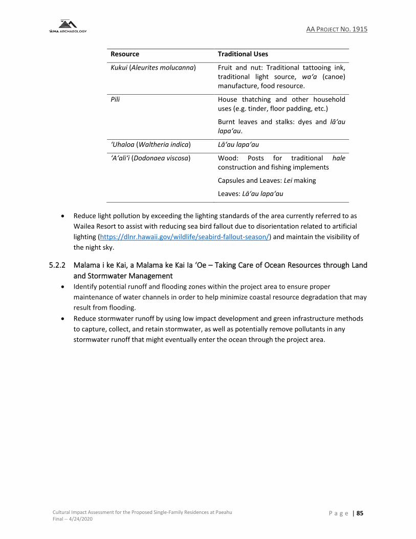
AA PROJECT NO. 1915
Cultural Impact Assessment for the Proposed Single-Family Residences at Paeahu Final -- 4/24/2020
P a g e | 85
Resource Traditional Uses
Kukui (Aleurites molucanna) Fruit and nut: Traditional tattooing ink, traditional light source, wa‘a (canoe) manufacture, food resource.
Pili House thatching and other household uses (e.g. tinder, floor padding, etc.)
Burnt leaves and stalks: dyes and lā‘au lapa‘au.
‘Uhaloa (Waltheria indica) Lā‘au lapa‘au
‘A‘ali‘i (Dodonaea viscosa) Wood: Posts for traditional hale construction and fishing implements
Capsules and Leaves: Lei making
Leaves: Lā‘au lapa‘au
• Reduce light pollution by exceeding the lighting standards of the area currently referred to as
Wailea Resort to assist with reducing sea bird fallout due to disorientation related to artificial
lighting (https://dlnr.hawaii.gov/wildlife/seabird-fallout-season/) and maintain the visibility of
the night sky.
5.2.2 Malama i ke Kai, a Malama ke Kai Ia ‘Oe – Taking Care of Ocean Resources through Land
and Stormwater Management
• Identify potential runoff and flooding zones within the project area to ensure proper
maintenance of water channels in order to help minimize coastal resource degradation that may
result from flooding.
• Reduce stormwater runoff by using low impact development and green infrastructure methods
to capture, collect, and retain stormwater, as well as potentially remove pollutants in any
stormwater runoff that might eventually enter the ocean through the project area.
AA PROJECT NO. 1915
Cultural Impact Assessment for the Proposed Single-Family Residences at Paeahu Final -- 4/24/2020
P a g e | 86
6.0 REFERENCES CITED
Abbott, Isabella Aiona 1992 Lā‘au Hawai‘i : Traditional Hawaiian Uses of Plants. Bishop Museum Press,
Honolulu, HI. Akana, Collette Leimomi and Kiele Gonzalez 2015 Hānau Ka Ua: Hawaiian Rain Names. Kamehameha Publishing, 597 South King St.
Honolulu Hawaiʻi 96813. Alexander, W.D. 1882 Interior Department, Appendix 1, to Surveyor Generals Report. A Brief History of
Land Titles in the Hawaiian Kingdom. P. C. Advertiser Company Steam Print, Honolulu, HI. 1890 A Brief History of Land Titles in the Hawaiian Kingdom. In Hawaiian Almanac and
Annual for 1891, edited by T. G. Thrum. Press Publishing Company Print, Honolulu, HI. Americans at Otaheite 1792. In The Gentleman’s Magazine. Vol. 26, No. 4. London. Apple, Russell A. and Peg Apple. 1977 "Don Francisco Marin." Honolulu Star-Bulletin, 02 Dec 1977. Vol. 66, No. 336 No.
Honolulu, HI. Ashdown, Inez 1971 Ke Alaloa O Maui, The Broad Highay of Maui. Ace Printing Company, Wailuku, HI. 1979 Inez McPhee Ashdown. Interviewed by L. Mair. Honolulu, HI. Barrere, Dorothy B. 1975 Waileʻa: Waters of Pleasure for the Children of Kama. Prepared for Bishop
Museium Department of Anthropology, Honolulu, Hawaiʻi Bernice P. Bishop Museum, Honolulu, Hawaiʻi
Beckwith, Martha W. 1970 Hawaiian Mythology. University of Hawaii Press, Honolulu, HI.
AA PROJECT NO. 1915
Cultural Impact Assessment for the Proposed Single-Family Residences at Paeahu Final -- 4/24/2020
P a g e | 87
Belatti, Della Au 2003 Act 50: The Protections, Pitfalls, and Possibilites of the New Cultural Assessment
Requirement for Hawai‘i's Diverse Communities. In He Mau Mo‘olelo Kānāwai o ka ‘Āina “Stories of the Law of the Land”, pp. 3-28. Hawai‘i Environmental Law Program, University of Hawai‘i at Mānoa.
Bodlaender, K. B. A., C. Lugt and J. Marinus 1964 The induction of second-growth in potato tubers. European Potato Journal
7(1):57-71. Chinen, Jon J. 1958 The Great Māhele, Hawai‘i’s Land Division of 1848. University of Hawai‘i Press,
Honolulu. Choy, Duane. 2011 "Uhaloa is a treasure fo traditional medicine." Honolulu Star-Advertiser, 9 Jan
2011.Honolulu, HI. Clark, John R. K. 1989 The Beaches of Maui County. University of Hawaii Press, Honolulu, HI. Coffee, Frank 1920 Forty Years on the Pacific. Oceanic Ppublishing Company, New York, NY. Cooke, Mary. 1956 "From Whales to Cane and Cattle: The Ulupalakua Story." Honolulu Star-Bulletin,
August 1, 1965.D1 and D9, Cottrell, Curt 2018 Alan Downer, Administrator, State Historic Preservation Division. Honolulu, HI. Craig, J.E. 1899 The Hawaiian Islands, and the Islands, Rocks, and Shoals to the Westward.
Hydrographic Office, U.S. Department of the Navy, Washington, D.C. de Naie, Lucienne and Theresa Donham 2007 Project Kaʻeo: The Challenge to Preserve Cultural Landscapes in Modern Makena,
a Land Famous with the Chiefs from the Distant Past. Dodge, F. S. 1903 (1885) Maui Hawaiian Islands [map]. Revised 1903 by John M. Donn.1:60000.
Surveyed by W.D. Alexander, S.E.Bishop, C.J.Lyons, M.D. Monsarrat, F.S.Dodge, E.D. Baldwin, and W.R. Lawrence. Hawaiian Government Survey, Honolulu, HI. On file at Department of Accounting and General Services, Land Survey Division.
AA PROJECT NO. 1915
Cultural Impact Assessment for the Proposed Single-Family Residences at Paeahu Final -- 4/24/2020
P a g e | 88
Dodge, F.S. 1885 Maui, Hawaiian Islands [map]. 1:90,000. Surveyed by W.D. Alexander, C.J. Lyons,
M.D.Monsarrat, F.S. Dodge, S.E.Bishop, E.E. Baldwin, and W.R. Lawrence. Hawaiian Government Survey. On file at Department of Accounting and General Services, Land Survey Division.
Dunmore, John 1985 Pacific Explorer: The Life of Jean François de La Pérouse 1741-1788. The Dunmore
Press Limited, Palmerston North, New Zealand. Emerson, Nathaniel B. 1915 Pele and Hiiaka: A Myth from Hawaii. Honolulu Star-Bulletin, Ltd., Honolulu, HI. Esri, DigitalGlobe, GeoEye, Earthstar Geographics, CNES/Airbus DS, USDA, USGS, AeroGRID,
IGN and GIS User Community 2018 World Imagery - 1m Imagery [GIS Layer]. Fischer, John Ryan 2015 Cattle Colonialism: An Environmental History of the Conquest of California and
Hawaiʻi. University of North Carolina Press, Chapel Hill. Fish and Wildlife Service 1995 50 CFR Part 17 Endangered and Threatened Wildlife and Plants; Proposed
Endangered or Threatened Status for Fourteen Plant Taxa From teh Hawaiian Islands. Honolulu, HI. Office of the Federal Register, National Archives and Records Administration, Washington D.C.
Fleming, Martha Foss 1933 Old Trails of Maui. Daughters of the American Revolution, William & Mary
Alexander Chapter. Fornander, Abraham 1880 An Account of the Polynesian Race, its Origins and Migrations, and the Ancient
History of the Hawaiian People to the Times of Kamehameha I. Vol. II, 6 Vols, edited by J. F. G. Stokes. Trubner & Co., London.
1916a History of Moikeha. In Fornander Collection of Hawaiian Antiquities and Folk-lore:
The Hawaiians’ Account of the Formation of Their Islands and Origin of Their Race, with the Traditions of Their Migrations, Etc., as Gathered from Original Sources, Vol. IV, Part 1, edited by T. G. Thrum, pp. 112-155. Bishop Museum Press, Honolulu.
AA PROJECT NO. 1915
Cultural Impact Assessment for the Proposed Single-Family Residences at Paeahu Final -- 4/24/2020
P a g e | 89
Fornander, Abraham (continued)
1916b Story of Islands’ Formation and Origin of Race. In Fornander Collection of Hawaiian Antiquities and Folk-Lore the Hawaiians' Account of the Formation of Their Islands and Origin of Their Race, with the Traditions of Their Migration, Etc., as Gathered from Original Sources, Vol. IV, edited by T. G. Thrum. Memoirs of the Bernice Pauahi Bishop Museum. Bishop Museum Press, Honolulu, HI.
1917a Legend of Eleio, Relating to Kaululaau. In Fornander Collection of Hawaiian
Antiquities and Folk-Lore The Hawaiian Account of the Formation of their Islands and Origin of their Race with the Traditions of their Migrations, Etc., as Gathered from Original Sources, Vol. IV, Part III, edited by T. G. Thrum, pp. 486-488. Bishop Museum Press, Honolulu, HI.
1917b Relating to Kihapiilani. In Fornander Collection of Hawaiian Antiquities and Folk-
lore The Hawaiians' Account of the Formation of their Islands and Origin of their Race, with the Traditions fo their Migrations, Etc., as Gathered from Original Sources, Vol. IV, Part II, edited by T. G. Thrum, pp. 242-246. Bishop Museum Press, Honolulu, HI.
1918 Mythical Tales. In Fornander Collection of Hawaiian Antiquities and Folk-lore: The
Hawaiians’ Account of the Formation of Their Islands and Origin of Their Race, with the Traditions of Their Migrations, Etc., as Gathered from Original Sources, Vol. V, Part 3, pp. 506-569.
1919a The Mat. In Fornander Collection of Hawaiian Antiquities and Folk-Lore the
Hawaiians' Account of the Formation of Their Islands and Origin of Their Race, with the Traditions of Their Migration, Etc., as Gathered from Original Sources, Vol. V, Part III, edited by T. G. Thrum, pp. 626-629. Bishop Museum Press, Honolulu, HI.
1919b Relating to Kekaa. In Fornander Collection of Hawaiian Antiquities and Folk-Lore
the Hawaiians' Account of the Formation of Their Islands and Origin of Their Race, with the Traditions of Their Migration, Etc., as Gathered from Original Sources, Vol. V, Part III, edited by T. G. Thrum, pp. 540-544. Bishop Museum Press, Honolulu, HI.
Gilman, G. D. 1854 The Transactions of the Royal Hawaiian Agricultural Society: At its Fourth Annual
Meeting, in June, 1854. Prepared for Royal Hawaiian Agricultural Society, Honolulu. Government Press, Honolulu.
Gutmanis, June 1983 Na Pule Kahiko: Ancient Hawaiian Prayers. Editions Limited, Honolulu, HI.
AA PROJECT NO. 1915
Cultural Impact Assessment for the Proposed Single-Family Residences at Paeahu Final -- 4/24/2020
P a g e | 90
Handy, E. S. Craighill and Elizabeth G. Handy 1972 Native Planters in Old Hawaii: Their Life, Lore, and Environment. Bishop Museum
Press, Honolulu. Handy, E. S. Craighill, Elizabeth Green Handy and Mary Kawena Pukui 1991 Native Planters in Old Hawaii : Their Life, Lore, and Environment. Rev. ed. Bernice
P Bishop Museum Bulletin 233. Bishop Museum Press, Honolulu, HI. Henke, L.A. 1929 University of Hawai’i Research Publication No 5: A Survey of Livestock in Hawaii.
University of Hawaii, Honolulu, HI. Jarves, James J. 1843 History of the Hawaiian Or Sandwich Islands: Embracing their Antiquities,
Mythology, Legends, Discovery by Europeans in the Sixteenth Century, Re-Discovery by Cook, with their Civil, Religious and Political History, from the Earliest Traditionary Period to teh Present Time. Tappan and Dennet, Boston, MA.
Jean-François de Galaup, La Pérouse 1969 Voyages and Adventures of La Pérouse. Translated by J. S. Gassner. University of
Hawaii Press, Honolulu, Hawaiʻi. Kahā‘ulelio, Daniel 2006 Ka ‘Oihana Lawai‘a - Hawaiian Fishing Traditions, edited by M. P. Nogelmeier.
Translated by M. K. Pukui. Bishop Museum Press, Honolulu, HI. Kamakau, S.M. 1992 Ruling Chiefs of Hawaii. Revised ed. The Kamehameha Schools Press, Honolulu, HI. Kapiikauinamoku. 1956 "The Story of Maui Royalty: Mighty Isle Warriors were Closely Related. Article 21:
Kiha-a-Piilani." The Honolulu Advertiser, 16 May 1956.A7, Honolulu, HI. Home edition. Kingdom of Hawaii 1848 An Act Relating to the Lands of His Majesty the King and of the Government. In A
Supplement to the Statute Laws of His Majesty, Kamehameha III., King of the Hawaiian Islands, Containing the Acts and Resoultions Passed by the Houses of Nobels and Representatives, During the Twenty-Third Year of His Reign and the Sixth Year of His Public Recognition, A.D. 1848, pp. 22-43. Government Press, Honolulu, HI.
Land Commission Book of Testimony. Prepared for Board of Commissioners to Quiet Land Titles.
Honolulu.
AA PROJECT NO. 1915
Cultural Impact Assessment for the Proposed Single-Family Residences at Paeahu Final -- 4/24/2020
P a g e | 91
Lee-Greig, Tanya L. 2002 Archaeological Inventory Survey of the Chang Family Property, Keauhou and Kalihi
Ahupua’a, Honoua’ula, Maui. Prepared for Mr. and Mrs. Joseph Noland, Wailuku, HI. Island Archaeology, Makawao, HI. On file at State of Hawai'i Department of Land and Natural Resources State Historic Preservation Division.
Lee-Greig, Tanya L., Robert R. Hill and Hammatt H. Hallett 2014 Cultural Historical Background for Keauhou, Kalihi, Waipao, Pāpaʻanui, Kāʻeo,
Maluaka, Moʻoiki, Moʻoloa, and Moʻomuku Ahupuaʻa, Honuaʻula Moku, Makawao District, Island of Maui TMK: [2] 2-1-05 through 2-1-08: Multiple Parcels. Prepared for ATC Makena Holdings, LLC. Cultural Surveys Hawaiʻi, Inc., Wailuku, Maui.
Lever, Christopher 1994 Naturalized Animals: The Ecology of Successfully Introduced Species. T. & A. D.
Poyser, London. Lucas, Paul F. Nahoa 1995 A Dictionary of Hawaiian Legal Land-Terms. Native Hawaiian Legal Corp. :
University of Hawai‘i Committee for the Preservation and Study of Hawaiian Language, Art, and Culture, Honolulu, HI.
Lyman, Kepa and Michael Dega 2020 Archaeological Inventory Survey of 23 Acres in Paeahu Ahupua‘a, Makawao
District, Island of Maui, Hawai‘i, TMK (2) 2-1-008:145 -- Draft. Prepared for Wailea Resort SF-S Partners LP, Kihei, HI. Scientific Constultant Services, Inc., Honoulu, HI.
Lyons, Curtis J. 1903 A History of the Hawaiian Government Survey with Notes on Land Matters in
Hawaii, Appendixes 3 and 4 of Surveyor's Report for 1902. The Hawaiian Gazette Co., Honolulu, HI.
MacKenzie, Melody Kapilialoha, Susan K. Serrano, D. Kapua ala Sproat, Ashley Kaiao Obrey,
Avis Kuuipoleialoha Poai, Corporation Native Hawaiian Legal, Law Ka Huli Ao Center for Excellence in Native Hawaiian and Publishing Kamehameha
2015 Native Hawaiian Law : A Treatise. Kamehameha Publishing, Honolulu, HI. MacLennan, Carol 1997 Hawaii Turns to Sugar: The Rise of Plantation Centers, 1860-80. Hawaiian Journal
of History, 31:97-125. Malo, David 1951 Hawaiian Antiquities: Mo‘olelo Hawai‘i. 2d ed. Translated by N. B. Emerson.
Bernice Pauahi Bishop Museum, Honolulu, HI.
AA PROJECT NO. 1915
Cultural Impact Assessment for the Proposed Single-Family Residences at Paeahu Final -- 4/24/2020
P a g e | 92
Maly, Kepa and Onaona Maly 2003 Ka Hana Lawai‘a a me Nā Ko‘a o na Kai ‘Ewalu : A History of Fishing Practices and
Marine Fisheries of the Hawaiian Islands Compiled from: Oral History Interviews with Kūpuna and Kama’āina. Prepared for The Nature Convervancy, Honolulu, HI. Kumu Pono Associates, Hilo, HI.
2005 He Mo‘olelo ‘Āina No Kaʻeo Me Kāhi ʻĀina E Aʻe Ma Honuaʻula -- A Cultural-
Historical Study of Kaʻeo and Other Lands in Honuaʻula, Island of Maui (TMK 2-1-07:67). Prepared for Sam Garcia, Jr. & Jon Garcia, Makena, HI. Kumu Pono Associates, Hilo, HI.
Manu, Moke. 1899 "Ke Kaua Nui Weliweli Mawaiena o Pele-Keahialoa ame Waka-Keakaikawai." Ka
Loea Kalaiaiana, 16 September 1899. Vol. III, No. 36 No. Honolulu. Matsuoka, Jon K., Davianna Pomaika‘i McGregor, Luciano Minerbi, Pualani Kanahele, Marion
Kelly and Noenoe Barney-Campbell 1996 Native Hawaiian Ethnographic Study for the Hawai‘i Geothermal Project Proposed
for Puna and Southeast Maui. Prepared for U.S. Department of Energy, Oak Ridge Operations Office, Oak Ridge, Tennessee.
Maui General Plan 2030 2006 Prepared for Maui County Long-Range Planning Division. Chris Hart & Partners,
Inc., Wailuku, Hawaiʻi. McClelland, C.K. 1916 Bulletin No. 36, Grasses and Forage Plants of Hawaii. Hawaii Agricultural
Experiment Station Under the Supervision of Office of Experiment Stations, U.S. Department of Agriculture. Government Printing Office, Washington D.C.
Mueller-Dombois, Dieter 2007 The Hawaiian Ahupua‘aLand Use System: Its Biological Resource Zones and the
Challenge for Silvicultural Restoration. In Biology of Hawaiian Streames and Estuararies, edited by N. L. Evenuis and J. M. Fitzsimions, pp. 23-33. Bishop Museum Bulletin in Cultural and Environmental Studies 3.
"Na ke Aupuni: He Kanawai no na Aina Ponoi o ka Moi, a me na Aina o ke Aupuni." 1848 Ka Elele Hawaii, Iuali 14, 1848. Vol. 4, No. 5 No.:17-20, Honolulu, HI. Nakuina, Moses K. 1990 The Wind Gourd of La‘amaomao. Translated by E. T. Mookini and S. Nākoa.
Kalamaku Press, Honolulu, HI.

AA PROJECT NO. 1915
Cultural Impact Assessment for the Proposed Single-Family Residences at Paeahu Final -- 4/24/2020
P a g e | 93
Nellist, George F. 1925 The Story of Hawaii and Its Builders. Vol. III. Honolulu Star-Bulletin, Ltd., Territory
of Hawaii. Nupepa Kuokoa. 1912 "Wahi Pana o Lanai." Nupepa Kuokoa, May 31, 1912. Vol. 48 No. 22 No. Office of Hawaiian Affairs 2011 Papakilo Database: Kūkulu ka ‘ike i ka ‘ōpua [Online Database].Māhele ‘Āina Index,
DL Consulting. https://papakilodatabase.com 2014 Kipuka Databse [Online GIS Database], BEI Consulting and ‘Āina Arts Photography.
kipukadatabase.com Perzinski, David, Kepa Lyman, Colleen Medieros, Rachel Hodara and Michael Dega 2014 Arhcaeological Inventory Survey of a 670-acre Parcel in Honua‘ula (Formerly
Wailea 670), in Palauea and Keauhou Ahupuaà, Makawao District, Island of Maui, Hawai‘i [TMK: (2) 2-1-008:71 and 56 por.] Volume I Report. Prepared for Honua‘ula Partners, LLC,, Kihei, HI. Scientific Constultant Services, Inc., Honolulu, HI. On file at Hawai'i State Historic Preservation Division.
Pukui, Mary Kawena 1983 ‘Ōlelo No‘eau: Hawaiian Proverbs & Poetical Sayings. Bernice P Bishop Museum
special publication. Bishop Museum Press, Honolulu, HI. Pukui, Mary Kawena and Samuel H. Elbert 1986 Hawaiian Dictionary Hawaiian-English, English-Hawaiian. Rev. and enl. ed.
University of Hawaii Press, Honolulu, HI. Pukui, Mary Kawena, Samuel H. Elbert and Esther T. Mookini 1974 Place Names of Hawaii. Revised and expanded edition. ed. University Press of
Hawaii, Honolulu, HI. Purdy, Martin 2006 Martin Purdy Oral History Interview. Interviewed by I. Loomis. Oahu Catlemen’s
Association, Paniolo Hall of Fame, Waimea, HI. Rechtman, Robert B. 1999 Archaeological Monitoring at Development Parcel A/B Wailea Resort Property
Land of Paeahu, Makawao District Island of Maui. Prepared for TSA International, Ltd. c/o Wilson Okamoto and Associates, Inc. Paul H. Rosendahl, Ph.D., Inc.

AA PROJECT NO. 1915
Cultural Impact Assessment for the Proposed Single-Family Residences at Paeahu Final -- 4/24/2020
P a g e | 94
Rosendahl, Margaret L.K. and Alan Haun 1987 Archaeological Date Recovery Excavations Development Parcels A/B/C-Wailea
Resort, Maui, Hawaiian Islands. Prepared for TSA Internationa, Ltd. c/o Mr Gary Okamoto, Honolulu, Hawaii 96811. Rosendahl Consulting, Hilo, Hawaii 96720. On file at SHPD, Maui Office.
Schmitt, Robert 1973 The Missionary Census of Hawaii. Prepared for Pacific Anthropological Records.
Bishop Museum Press, Honolulu, Hawaiʻi. Semi-Weekly Maui News. 1922 "Improvements to Kahului Harbor Greatly Needed." Semi-Weekly Maui News,
November 14, 1922. Vol. 22. 1218 No. Wailuku, HI. Setchell, William Albert 1907 Limu. University of Californa Publications, Botany 2(3):91-113. State of Hawaii Office of Environmental Quality Control 2012 Guide to the Implementation and Practice of the Hawaii Environmental Policy Act.
2012 Edition. Honolulu, HI. Sterling, Elspeth P. 1998 Sites of Maui. Bishop Museum Press, Honolulu, HI. Summers, Catherine C. 1999 Material Culture: The J.S. Emerson Collection of Hawaiian Artifacts. Bishop
Museum Press, Honolulu, HI. Taylor, Clarice. 1949a "Little Tales, All About Hawaii." Honolulu Star-Bulletin, 31 Mar 1949. Vol. LV,
No.17665 No. Honolulu, HI. 1949b "Panini Gum." Honolulu Star-Bulletin, Vol. LV, No.17665 No. Honolulu, HI. The Polynesian. 1856 "Valuable Real Estate at Auction." The Polynesian, January 19, 1856.Honolulu, HI. Thrum, Thomas G. 1909a Excursion to the Mountains of Maui, Extract from M.S.–“A Menzies’ Journal in
Vancourver’s Voyage, 1790-1794.”. In Hawaiian Almanac and Annual for 1909, The Reference Book of Information and Statistics Relating to the Territory of Hawaii, of Value to Merchants, Tourists and Others, edited by T. G. Thrum, pp. 92-97. Thomas G. Ghrum, Honolulu, HI.
AA PROJECT NO. 1915
Cultural Impact Assessment for the Proposed Single-Family Residences at Paeahu Final -- 4/24/2020
P a g e | 95
Thrum, Thomas G. (continued) 1909b Heiaus: their kinds, construction, ceremonies, etc. In Hawaiian Almanac and
Annual for 1910, The Reference Book of Information and Statistics Relating to the Territory of Hawaii, of Value to Merchants, Tourists and Others, edited by T. G. Thrum, pp. 53-71. Thomas G. Ghrum, Honolulu, HI.
1925 Early Ulupalakua Data. In The Hawaiian Annual For 1926, edited by T. G. Thrum,
pp. 80-87. Honolulu, HI. 1926 James Makee: Master Mariner, Merchant, Rancher, Planter, Pioneer. In The
Hawaiian Annual for 1927, edited by T. G. Thrum, pp. 27-39. Honolulu, HI. Titcomb, Margaret and Mary Kawena Pukui 1977 Native Use of Fish in Hawaii. 2d ed. University Press of Hawaii, Honolulu, HI. Translation of the Constitution and Laws of the Hawaiian Island, Established in the Reign of
Kamehamaha III 1842. Lahainaluna, Lahaina, HI. U.S. Department of Agriculture, Natural Resources Conservation Service 2001 Soil Survey Geographic (SSURGO) database for Island of Maui, Hawaii (hi980). U.S.
Department of Agriculture, Natural Resources Conservation Service. <http://www.ncgc.nrcs.usda.gov/products/datasets/ssurgo/> (last accessed March 2005).
U.S. Geological Survey 1922 Kihei Quadrangle [map]. 1:31,680. U.S. Department of Interior USGS, Reston, VA. 1992 Puu o Kali Quadrangle [map]. 1:24000. U.S. Department of Interior, USGS, Reston,
VA. Van Dyke, Jon M. 2008 Who Owns the Crown Lands of Hawai‘i. University of Hawai‘i Press, Honolulu, HI. Westervelt, W. D. 1903 Hawaiian Burial Caves. In Hawaiian Alamanac and Annual for 1904 The Reference
Book of Information and Statistics Relating to the Territory of Hawaii, of Value to Merchants, Tourists and Others, edited by T. G. Thrum, pp. 145-154. Thomas G. Thrum, Honolulu, HI.
Wianecki, Shannon 2010 The Lure of Limu. Haynes Publishing Group. https://www.mauimagazine.net/the-
lure-of-limu/.
AA PROJECT NO. 1915
Cultural Impact Assessment for the Proposed Single-Family Residences at Paeahu Final -- 4/24/2020
P a g e | 96
Wight, Kahikāhealani 2005 Illustrated Hawaiian Dictionary. Bess Press, Honolulu, HI.

ECONOMIC AND FISCAL
IMPACT ANALYSIS TABLE
APPENDIX
G
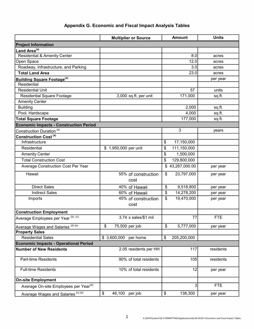
Amount Units
Land Area(a)
Residential & Amenity Center 8.0 acresOpen Space 12.0 acres Roadway, Infrastructure, and Parking 3.0 acres Total Land Area 23.0 acresBuilding Square Footage(a) per year Residential Residential Unit 57 units Residential Square Footage 3,000 sq.ft. per unit 171,000 sq.ft. Amenity Center Building 2,000 sq.ft. Pool, Hardscape 4,000 sq.ft.Total Square Footage 177,000 sq.ft.
Construction Duration (a) 3 yearsConstruction Cost (a)
Infrastructure $ 17,150,000 Residential $ 1,950,000 per unit $ 111,150,000 Amenity Center $ 1,500,000 Total Construction Cost $ 129,800,000 Average Construction Cost Per Year $ 43,267,000.00 per year
Hawaii 55% of construction cost
$ 23,797,000 per year
Direct Sales 40% of Hawaii $ 9,518,800 per year Indirect Sales 60% of Hawaii $ 14,278,200 per year Imports 45% of construction
cost $ 19,470,000 per year
Construction EmploymentAverage Employees per Year (b) (c) 3.74 x sales/$1 mil 77 FTE
Average Wages and Salaries (d) (e) $ 75,500 per job $ 5,777,000 per yearProperty Sales Residential Sales $ 3,600,000 per home $ 205,200,000
Number of New Residents 2.05 residents per HH 117 residents
Part-time Residents 90% of total residents 105 residents
Full-time Residents 10% of total residents 12 per year
On-site Employment Average On-site Employees per Year(a) 3 FTE
Average Wages and Salaries (c) (d) $ 46,100 per job $ 138,300 per year
Appendix G. Economic and Fiscal Impact Analysis Tables
Multiplier or SourceProject Information
Economic Impacts - Construction Period
Economic Impacts - Operational Period
1 K:\DATA\Ledcor\SF-S PERMITTING\Applications\Draft EA\SF-S Economic and Fiscal Impact Tables

Amount UnitsMultiplier or SourceProject InformationSTATE OF HAWAIIGeneral Excise TaxFinal Sales 4% of final sales $ 380,752 per yearIndirect Sales 0.5% of indirect sales $ 71,391 per yearAnnual General Excise Tax $ 452,000 per yearTotal General Excise Tax for Construction Period
$ 1,356,000
Personal Income Tax 6% of Wages/ Salaries
$ 347,000 per year
Conveyance Tax $ 0.60 per $100 $ 1,231,000 for all homes
COUNTY OF MAUIPermitting Fees Not Estimated
STATE OF HAWAIIPersonal Income Tax 6% of Wages/
Salaries $ 8,300 per year
General Excise Tax Not EstimatedCOUNTY OF MAUITaxable Property Value Full-time Residential Taxable Value Homeowner Exemption (f) 5% of total homes 3 homes Less Exemption $ 200,000 per home $ (600,000) Net Taxable Value $ 9,660,000 Part-time Residential Taxable Value 95% of total homes $ 194,940,000 Amenity Center Value $ 1,500,000 Property Tax Full-time Residents $ 2.90 /$1,000 of
taxable value $ 28,000 per year
Part-time Residents $ 5.60 /$1,000 of taxable value
$ 1,091,700 per year
Amenity Center (Building) $ 5.60 /$1,000 of taxable value
$ 8,400 per year
Total Property Tax $ 1,128,100
Less Exsting Property Tax Revenue(g) $ (60,800) per year
Total Net New Property Tax $ 1,067,300 per year
Source/Note:(a) Wailea Resort SF-S Partners, LP, 2020.(b) State of Hawaii, Department of Business, Economic Development & Tourism, 2012 State Input-Output Study, 2016(c) U.S. Bureau of Labor Statistics, Average Weekly Hours and Overtime of All Employees on Private Nonfarm Payrolls by Industry Sector, Seasonally Adjusted, https://www.bls.gov/news.release/empsit.t18.htm (Accessed December 2019)(d) 2018 Employment and Payrolls in Hawaii, State of Hawaii, Department of Labor and Industorial Relations, October 2019(e) CPI Historical Table, Honolulu, HI - November 2019, U.S Department of Labor, Bureau of Labor Statistics, https://www.bls.gov/regions/west/data/consumerpriceindex_honolulu_table.pdf (Accessed December 2019)(f) 6 units (10% of all homes) are assumed to be full-time residences (6 units). Of which, 3 units (5% of all homes) is anticipated to be owner-occupied and receive homeowner exemption. (g)Maui County Real Property Assesment Division, 2019
Fiscal Impacts - Construction Period
Fiscal Impacts - Operational Period
2 K:\DATA\Ledcor\SF-S PERMITTING\Applications\Draft EA\SF-S Economic and Fiscal Impact Tables
TRAFFIC IMPACT
ANALYSIS REPORT
APPENDIX
H
Austin, Tsutsumi & Associates, Inc. Civil Engineers • Surveyors 501 Sumner Street, Suite 521 Honolulu, Hawaii 96817-5031 Telephone: (808) 533-3646 Facsimile: (808) 526-1267 E-mail: [email protected] Honolulu • Wailuku • Hilo, Hawaii
TRAFFIC IMPACT ANALYSIS REPORT SF-S PARCEL WAILEA, MAUI, HAWAII FINAL DRAFT May 12, 2020 Prepared for: Wailea Resort Development LP c/o Ledcor Development LP 1300 N. Holopono Street, Ste. 201 PO Box 220, Kihei, Maui, Hawaii 96753

TRAFFIC IMPACT ANALYSIS REPORT
SF-S PARCEL Wailea, Maui, Hawaii
FINAL DRAFT
Prepared for
Wailea Resort Development LP
Prepared by
Austin, Tsutsumi & Associates, Inc. Civil Engineers • Surveyors
Honolulu • Wailuku • Hilo, Hawaii
May 12, 2020
TABLE OF CONTENTS
Page
1. INTRODUCTION ......................................................................................... 1
1.1 Project Location .............................................................................. 1
1.2 Project Description .......................................................................... 1
2. METHODOLOGY ........................................................................................ 4
2.1 Study Methodology ......................................................................... 4
2.2 Intersection Analysis ....................................................................... 4
2.3 Study Area Intersection Analysis .................................................... 4
3. EXISTING TRAFFIC CONDITIONS ............................................................ 5
3.1 Roadway System ............................................................................ 5
3.2 Existing Traffic Volumes .................................................................. 6
3.3 Existing Observations and Intersection Analysis ............................ 6
4. BASE YEAR 2024 TRAFFIC CONDITIONS ............................................... 10
4.1 Defacto Growth Rate ....................................................................... 10
4.2 Traffic Forecasts for Known Developments .................................... 10
4.3 Planned Roadway Improvements ................................................... 12
4.4 Base Year 2024 Analysis ................................................................ 13
5. FUTURE YEAR 2024 TRAFFIC CONDITIONS .......................................... 22
5.1 Background ..................................................................................... 22
5.2 Travel Demand Estimations ............................................................ 22
5.2.1 Trip Generation ............................................................... 22
5.2.2 Trip Distribution & Assignment ........................................ 23
5.3 Future Year 2024 Analysis .............................................................. 23
6. CONCLUSION ............................................................................................ 28
TABLE OF CONTENTS Cont’d
6.1 Existing Conditions .......................................................................... 28
6.2 Base Year 2024 .............................................................................. 28
6.2.1 Planned Roadway Improvements ................................... 29
6.2.2 Base Year 2024 Analysis ................................................ 29
6.3 Future Year 2024 ............................................................................ 29
7. REFERENCES ............................................................................................ 31
TABLE OF CONTENTS Cont’d
TABLES
3.1 EXISTING 2019 LEVEL OF SERVICE SUMMARY ........................ 9
4.1 TRIPS GENERATED BY KNOWN DEVELOPMENTS IN KIHEI .... 17
4.2 TRIPS GENERATED BY KNOWN DEVELOPMENTS IN WAILEA AND MAKENA ................................................................................. 18
4.3 EXISTING AND BASE YEAR 2024 LEVEL OF SERVICE SUMMARY 20
5.1 PROJECT TRIP GENERATION RATES ......................................... 22
5.2 PROJECT-GENERATED TRIPS .................................................... 23
5.3 EXISTING, BASE YEAR 2024 AND FUTURE YEAR 2024 LEVEL OF SERVICE SUMMARY ............................................................... 26
TABLE OF CONTENTS Cont’d
FIGURES
1.1 LOCATION MAP ............................................................................. 2
1.2 SITE PLAN ...................................................................................... 3
3.1 EXISTING CONDITIONS, LANE CONFIGURATIONS, TRAFFIC VOLUMES AND LOS ...................................................................... 8
4.1 KIHEI BACKGROUND PROJECTS ................................................ 14
4.2 WAILEA BACKGROUND PROJECTS ............................................ 15
4.3 MAKENA BACKGROUND PROJECTS ........................................... 16
4.4 BASE YEAR 2024 LANE CONFIGURATIONS, TRAFFIC VOLUMES AND LOS ...................................................................... 19
5.1 PROJECT GENERATED TRIPS ...................................................... 24
5.2 FUTURE YEAR 2024 LANE CONFIGURATIONS, TRAFFIC VOLUMES AND LOS ...................................................................... 25
TABLE OF CONTENTS Cont’d
APPENDICES
A. TRAFFIC COUNT DATA
B. LEVEL OF SERVICE CRITERIA
C. LEVEL OF SERVICE CALCULATIONS
D. SIGNAL WARRANTS
1. IN
This repAssociate(hereinaf
1.1 PThe ProjidentifiedKialoa to
1.2 PThe Proj23.1-acredrivewaypossible Plan.
NTRODU
port documees, Inc. (ATfter referred
Project Locject is locat
d as TMK: (2o the south, C
Project Desect proposee lot south oy via Kapili S
emergency
TRAFFI
CTION
ents the findTA) to evalua
to as the “P
cation ted in Waile2) 2-1-008:14County Park
scription es to develoof Kilohana Street. An eegress at tw
C IMPAC
SF-S
Wailea,
dings of a ate the traffiroject”) loca
ea on the is45. The Pro
k property to
p 57 single-Drive. Acce
mergency awo locations
CT ANALY
S PARCE
Maui, Ha
traffic studyc impacts reted in Waile
sland of Maoject is bounthe north, a
-family residess to the S
access will bs along Kapi
YSIS REP
EL
awaii
y conductedesulting from
ea, Maui, Ha
aui on parcended by Kapand Wailea A
dential unitsSF-S parcel be provided ili Street. Se
PORT
d by Austinm the propowaii.
els of land pili Street to Alanui Drive
on a currenwill be prov
via Wailea Aee Figure 1.2
n, Tsutsumi,osed SF-S P
more specifthe east, Wto the west.
ntly undevelvided by onAlanui Drive2 for Projec
, and Parcel
fically Wailea
loped ne (1) e with t Site
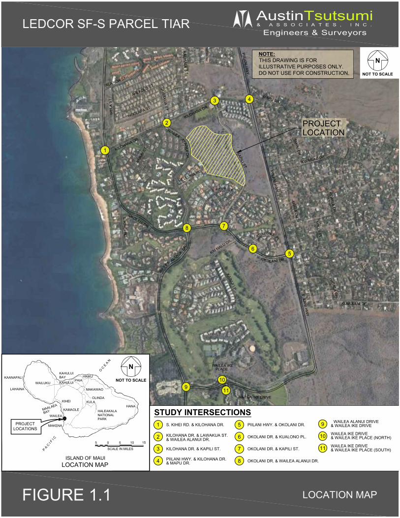
PIILANI H
WY.
PIILANI H
WY.
PIILANI H
WY.
S. KIHEI R
D.
OKOLANI DR.
NI DR.
WAILE
A ALANUI DR.
KAI MALU DR.
KAINUI LP.KAPILI ST.
KIKIHI ST.
WAILEA ALANU
I DR
.
HELEUMA PL.
WAI
KAI S
T.KILOHANA DR.
KILOHANA DR.
HOOLAPA ST.
AHEKOLO ST.ALA KOA ST.
KAUH
ALE ST.
MAPU DR.AKALA D
R.
MAPU
DR
.
KUPULAU DR.
KEHALA D
R.
MIKIO
I PL.
ALA DR
.HO
KUMULANI DR.
WEL
A ST
.
LAWAKU
A ST.
OKOLA
KUALO
PL.
NO
WAILEA IKE DRIVE
WAILEA IKEPLACE
1
LEDCOR SF-S PARCEL TIAR AustinTsutsumi& A S S O C I A T E S , I N C .
Engineers & Surveyors
N
NOT TO SCALE
STUDY INTERSECTIONS
O C E
A N
BAYMAALAEA
P A C
I F I C
ISLAND OF MAUI
HALEAKALANATIONALPARK
MAKAWAO
OLINDA
KAMAOLE
KIHEI
WAILEA
MAKENA
LAHAINA
KAANAPALIWAILUKU
KAHULUIBAY
PAIAHAIKU
KAHULUI
HANAKULA
PROJECTLOCATIONS
LOCATION MAP
N
NOT TO SCALE
FIGURE 1.1 LOCATION MAP
NOTE:THIS DRAWING IS FORILLUSTRATIVE PURPOSES ONLY.DO NOT USE FOR CONSTRUCTION.
PIILANI HWY. & OKOLANI DR.
OKOLANI DR. & KUALONO PL.
OKOLANI DR. & KAPILI ST.
OKOLANI DR. & WAILEA ALANUI DR.PIILANI HWY. & KILOHANA DR.
KILOHANA DR. & KAPILI ST.
KILOHANA DR. & LAWAKUA ST.
S. KIHEI RD. & KILOHANA DR.
PROJECTLOCATION
SCALE IN MILES
1510505
2
3 4
56
78
1
2
3
4
5
6
7
8
& WAILEA ALANUI DR.
& MAPU DR.
WAILEA ALANUI DRIVE 9
10
11
910
11
& WAILEA IKE DRIVE
WAILEA IKE DRIVE& WAILEA IKE PLACE (NORTH)
WAILEA IKE DRIVE& WAILEA IKE PLACE (SOUTH)
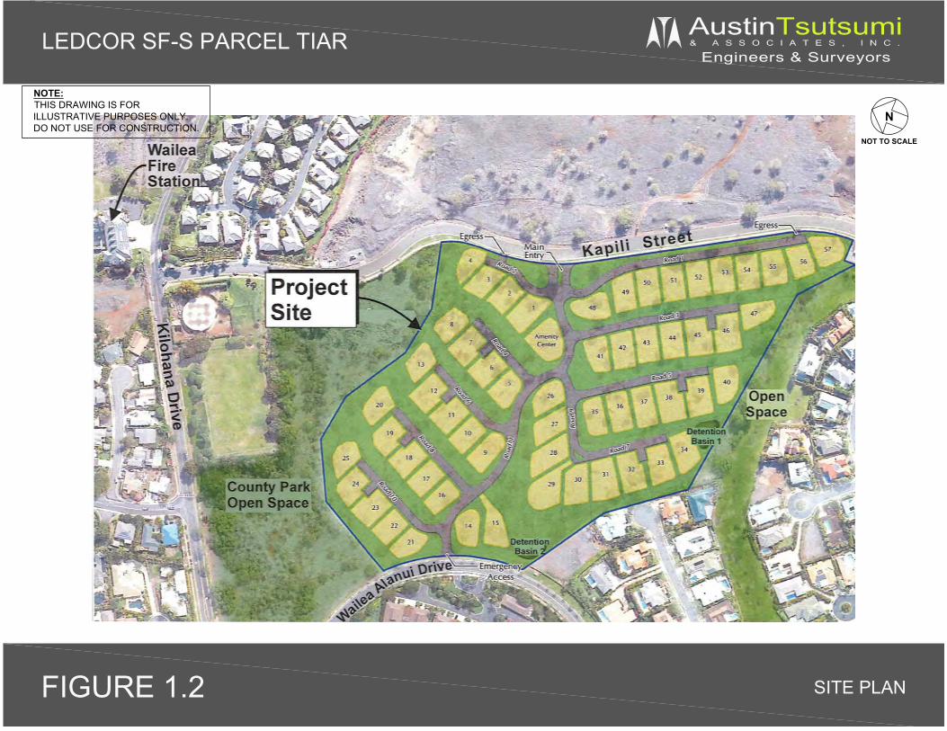
N
NOT TO SCALE
LEDCOR SF-S PARCEL TIAR AustinTsutsumi& A S S O C I A T E S , I N C .
Engineers & Surveyors
SITE PLANFIGURE 1.2
NOTE:THIS DRAWING IS FORILLUSTRATIVE PURPOSES ONLY.DO NOT USE FOR CONSTRUCTION.

4
2. METHODOLOGY
2.1 Study Methodology This study will address the following:
Assess existing traffic operating conditions at key intersections during the weekday morning (AM) and afternoon (PM) peak hours of traffic within the study area.
Traffic projections for Base Year 2024 (without the Project) including traffic generated by other known developments in the vicinity of the Project in addition to an ambient growth rate. These other known developments are projects that are currently under construction or known new/future developments that are anticipated to affect traffic demand and operations within the study area.
Trip generation and traffic assignment characteristics for the proposed Project.
Traffic projections for Future Year 2024 (with the Project), which includes Base Year traffic volumes in addition to traffic volumes generated by the Project.
Recommendations for Base Year and Future Year roadway improvements or other mitigative measures, as appropriate, to reduce or eliminate the adverse impacts resulting from traffic generated by known developments in the region or the Project.
2.2 Intersection Analysis Level of Service (LOS) is a qualitative measure used to describe the conditions of traffic flow at intersections, with values ranging from free-flow conditions at LOS A to congested conditions at LOS F. The Highway Capacity Manual (HCM), 6th Edition, includes methods for calculating volume to capacity ratios, delays, and corresponding Levels of Service that were utilized in this study. LOS definitions for signalized and unsignalized intersections are provided in Appendix B.
Analyses for the study intersections were performed using the traffic analysis software Synchro, which is able to prepare reports based on the methodologies described in the HCM. These reports contain control delay results as based on intersection lane geometry, signal timing, and hourly traffic volumes. Based on the vehicular delay at each intersection, a LOS is assigned to each approach and intersection movement as a qualitative measure of performance. These results, as confirmed or refined by field observations, constitute the technical analysis that will form the basis of the recommendations outlined in this report.
2.3 Study Area Intersection Analysis Analysis within the Project’s study area was performed on the following intersections:
South Kihei Road/Kilohana Drive (Unsignalized) Kilohana Drive/Wailea Alanui Drive (Unsignalized) Kilohana Drive/Kapili Street (Unsignalized) Piilani Highway/Kilohana Drive (Signalized) Piilani Highway/Okolani Drive (Unsignalized) Okolani Drive/Kualono Place (Unsignalized) Okolani Drive/Kapili Street (Unsignalized) Okolani Drive/Wailea Alanui Drive (4-way stop)
5
Wailea Alanui Drive/Wailea Ike Drive (signalized) Wailea Ike Drive/Wailea Ike Place (North) – (unsignalized) Wailea Ike Drive/Wailea Ike Place (South) – (unsignalized)
3. EXISTING TRAFFIC CONDITIONS
The existing conditions scenario represents the traffic conditions within the Project area as it currently stands, with no build-out of the Project.
3.1 Roadway System The following are brief descriptions of the existing roadways studied within the vicinity of the Project:
Piilani Highway is a north-south State Highway that extends southward from Maui Veterans Highway at its intersection with North Kihei Road and terminates approximately seven (7) miles to the south at Wailea Ike Drive. Piilani Highway provides regional access to Kihei and Wailea and is generally a two-way, four-lane, principal arterial that transitions to a two-way, two-lane roadway south of its intersection with Kilohana Drive and Mapu Drive. Exclusive left-turn lanes and right-turn deceleration lanes are provided at all major intersections with the shoulder areas of the highway designated as bicycle lanes. Within the study area, the posted speed limit along this roadway is 45 mph.
South Kihei Road is generally a two-way, two-lane, undivided, north-south County roadway that traverses the Kihei coastline. This roadway begins at a T-intersection with North Kihei Road near Maui Veterans Highway and eventually terminates at Okolani Drive in Wailea. South Kihei Road provides local access to shopping centers and visitor accommodations. The posted speed limit along this roadway in the Project vicinity is 20 miles per hour (mph). Continuous sidewalks and a shoulder/bike lane are provided along South Kihei Road in the vicinity of the Project.
Kilohana Drive is a two-way, two-lane, east-west County roadway that extends from South Kihei Road eastward to Piilani Highway. The posted speed limit along this roadway is 25 mph.
Okolani Drive is a two-way, two-lane, east-west, County roadway that extends eastward from its intersection with South Kihei Road and terminates at its intersection with Mikioi Place and Kehala Drive. Between South Kihei Road and Kikihi Street, Okolani Drive is a two-way, four-lane, divided roadway. The posted speed limit along this roadway is 30 mph. Continuous sidewalks are provided along the north side of Okolani Drive.
Kapili Street is a two-way, two-lane, undivided, north-south roadway that extends southward from its intersection with Kilohana Drive to its intersection with Okolani Drive. The posted speed limit along this roadway is 30 mph. Continuous sidewalks are provided adjacent to the southbound side for the entire length of Kapili Street and along the northbound side within residential areas. Kapili Street is currently privately owned but is open for public use.
Wailea Alanui Drive is a two-way, two-four lane, divided, north-south, County roadway that extends northward from its intersection with Makena Road and terminates to the north at its intersection with Kilohana Drive and Lawakua Street. The posted speed limit along this roadway is 30 mph. Continuous sidewalks are provided along the southbound side of Wailea Alanui Drive within the Project vicinity.

6
Wailea Ike Drive – is a divided, east-west, two-way, four-lane collector roadway that connects Piilani Highway with Wailea Alanui Drive. Wailea Ike Drive provides access to resort, residential and commercial areas. The posted speed limit is 30 mph
Wailea Ike Place – is an undivided, north-south, two-way, two-lane roadway that provides access to the Grand Champions Villas residential neighborhood, Wailea Tennis Club and various retail/office space to the north of Wailea Ike Drive and the Wailea Ekolu Village residential neighborhood and Wailea Village Center to the south of Wailea Ike Drive. The posted speed limit is 20 mph.
Kualono Place is a two-way, two-lane, private driveway providing residents with access from the Wailea Pualani Estates gated community to Okolani Drive.
3.2 Existing Traffic Volumes The hourly traffic volume data utilized in this report were collected on Wednesday, May 8, 2019 and Thursday, May 9, 2019. See the traffic count data provided in Appendix A for the existing intersections studied and their corresponding traffic count data. Based on the traffic count data, the weekday AM and PM peak hours of traffic were determined to occur between 7:30 AM and 8:30 AM and between 3:15 PM to 4:15 PM, respectively. At the time of traffic counts, Wailea Village Center construction was occurring, which impacted turning movements at the Wailea Ike Drive/Wailea Ike Place (South) intersection. As a result, 2017 traffic counts were used at this intersection.
3.3 Existing Observations and Intersection Analysis In the study area, Piilani Highway acts as the main thoroughfare between Kihei and Wailea, and Wailea Alanui Drive acts as the main thoroughfare between Wailea and Makena. Wailea Ike Drive provides the main connection between Piilani Highway and Wailea Alanui Drive.
The majority of movements at the study intersections operated adequately at LOS D or better and under-capacity conditions during the peak hours of traffic with the exception of the following:
Piilani Highway & Kilohana Drive – This signalized intersection primarily serves north-south vehicle traffic along Piilani Highway and provides protected access for the minor street movements. Piilani Highway is generally a four-lane roadway about 700 feet to the north of this intersection, and reduces to a two-lane highway south of this intersection. One of the two southbound through lanes terminates to an exclusive southbound right-turn lane onto Kilohana Drive.
During the AM peak hour, traffic was observed to traverse the intersection smoothly. Traffic analysis indicates the intersection operates at an overall LOS B with all movements operating at LOS D or better. However, these movements are low volume, with only 4 southbound left-turn vehicles that were delayed due to a long cycle length at this intersection.
During the PM peak hour of traffic, northbound through volumes were observed to queue for about a 30-35 minute period extending as far south to Okolani Drive. By 4:50 PM, vehicle queues were observed to clear without heavy congestion. Traffic analysis indicates the intersection operates at overall LOS C with all movements operating at LOS D or better, with the exception of the northbound left-turn movement, which operates at LOS E.

7
Piilani Highway & Okolani Drive – This unsignalized intersection primarily serves north-south traffic along Piilani Highway.
During the AM peak hour, all approaches operate relatively smoothly with minor movements experiencing moderate delay with traffic analysis indicating that the northbound and southbound left-turn movements operate at LOS A and the eastbound and westbound left-turn/through movements operating at LOS E and LOS C, respectively.
During the PM peak hour, higher volumes along Piilani Highway result in longer delays to the minor street movements. The northbound and southbound left-turn movements operate at LOS A/B and the eastbound/westbound approaches operate at LOS E/F, with eastbound approach operating over-capacity. A traffic signal is currently being designed and will be implemented at the Piilani Highway/Okolani Drive/Mikioi Place intersection as part of the mitigation for the Kai Malu Wailea residential development.
Okolani Drive & Wailea Alanui Drive – This intersection provides stop-control for all approaches and currently operates adequately at overall LOS B during the AM and PM peak hours of traffic. During both peaks, the eastbound right-turn and northbound left-turn movements were heavier, providing regional flows between South Kihei Road and Wailea Alanui Drive. Both movements are stop controlled, but since the eastbound right-turn movement is provided with a dedicated receiving lane, most eastbound right-turners were observed to operate similar to a free or yield right-turn movement. As a result, no lengthy queues formed.
During the AM peak hour, all approaches operate at LOS B or better due to relatively low vehicular volumes of 100-300 vehicles in each direction.
During the PM peak hour, the northbound left turn movement operates at LOS C due to the increase in vehicles utilizing the lane to make a left onto Okolani Drive from Wailea Alanui Drive. The longest observed queue, during the PM peak hour, consisted of 7 vehicles, which completely cleared within 40 seconds. All other movements operate at LOS B or better during the PM peak hour of traffic.
Figure 3.1 illustrates the existing lane configuration, existing traffic volumes, and LOS for each study intersection. Table 3.1 summarizes the existing LOS at the study intersections. LOS worksheets are provided in Appendix C.
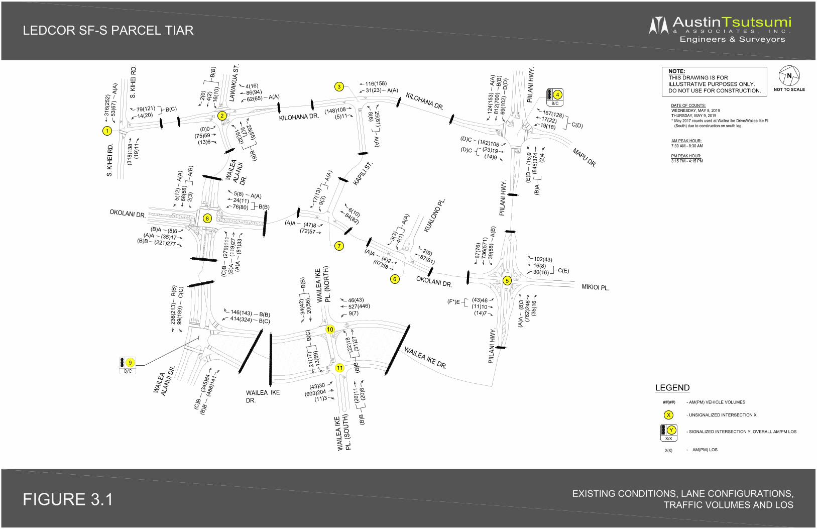
X
LEDCOR SF-S PARCEL TIAR AustinTsutsumi& A S S O C I A T E S , I N C .
Engineers & Surveyors
NOTE:THIS DRAWING IS FORILLUSTRATIVE PURPOSES ONLY.DO NOT USE FOR CONSTRUCTION.
DATE OF COUNTS:WEDNESDAY, MAY 8, 2019THURSDAY, MAY 9, 2019* May 2017 counts used at Wailea Ike Drive/Wailea Ike Pl
(South) due to construction on south leg.
AM PEAK HOUR:7:30 AM - 8:30 AM
PM PEAK HOUR:3:15 PM - 4:15 PM
FIGURE 3.1 EXISTING CONDITIONS, LANE CONFIGURATIONS,TRAFFIC VOLUMES AND LOS
N
NOT TO SCALE
316(
252)
53(6
7)A(
A)79(121)14(20)
B(C)
(318
)138
(19)
11
2(0)
4(2)
16(1
0)B(
B)
4(16)86(94)62(65) A(A)
(0)0(75)59
(13)6
(148)108(5)11
25(61)8(6)
A(A)
116(158)31(23) A(A)
(15)
9(8
48)3
74(2
)4(B
)A
(E)D
167(128)17(22)19(18) C(D)
(182)105(23)19(14)9
(D)C
(D)C
124(
153)
812(
700)
69(1
02)
B(B)
A(A)
D(D
)
25(85)
5(7)15(32)
B(B)
KILOHANA DR.
MAPU DR.
S. K
IHEI
RD.
WAI
LEA
ALAN
UIDR
.
KAPI
LI ST
.
PIIL
ANI H
WY.
MIKIOI PL.
PIIL
ANI H
WY.
(43)46(11)10(14)7
(F*)E
67(7
6)73
6(57
1)39
(88)
A(B)
102(43)16(8)30(16) C(E)
(8)3
(762
)246
(35)
16
(A)A
KILOHANA DR.
LEGEND
- UNSIGNALIZED INTERSECTION X
##(##)
- SIGNALIZED INTERSECTION Y, OVERALL AM/PM LOS
- AM(PM) VEHICLE VOLUMES
X(X) - AM(PM) LOS
(8)6(35)17
(221)277(B)B
(A)A(B)A
5(8)24(11)76(80)
A(A)5(12
)68
(58)
2(3)
A(B)
A(A)
(47)8(72)57
(A)A
6(10)84(82)
17(1
3)9(
3)A(
A)
(4)2(67)58
(A)A 2(6)87(81)
3(3)
4(1)
A(A)
KUAL
ONO
PL.
OKOLANI DR.
OKOLANI DR.
(279
)111
(119
)27
(81)
33(A
)A(B
)A(C
)BLA
WAK
UA S
T.
S. K
IHEI
RD.
PIIL
ANI H
WY.
WAI
LEA
ALAN
UI D
R.
4B/C
YX/X
1
2
3
56
7
WAILEA IKEDR.
9
WAI
LEA
IKE
PL. (
NORT
H)
WAI
LEA
IKE
PL. (
SOUT
H)WAILEA IKE DR.
236(
213)
99(1
89)
146(143)414(324)
46(43)527(446)9(7)
(345
)84
(488
)141
(22)
18(3
1)27
34(4
2)20
(56)
21(1
7)13
(59)
(26)
11(2
0)8
(C)B
(B)B
B(C)B(B)
C(C
)B(
B)
(B)B
B(B)
(B)B
(43)30
(603)204(11)3
B(C
)
B(B)
8
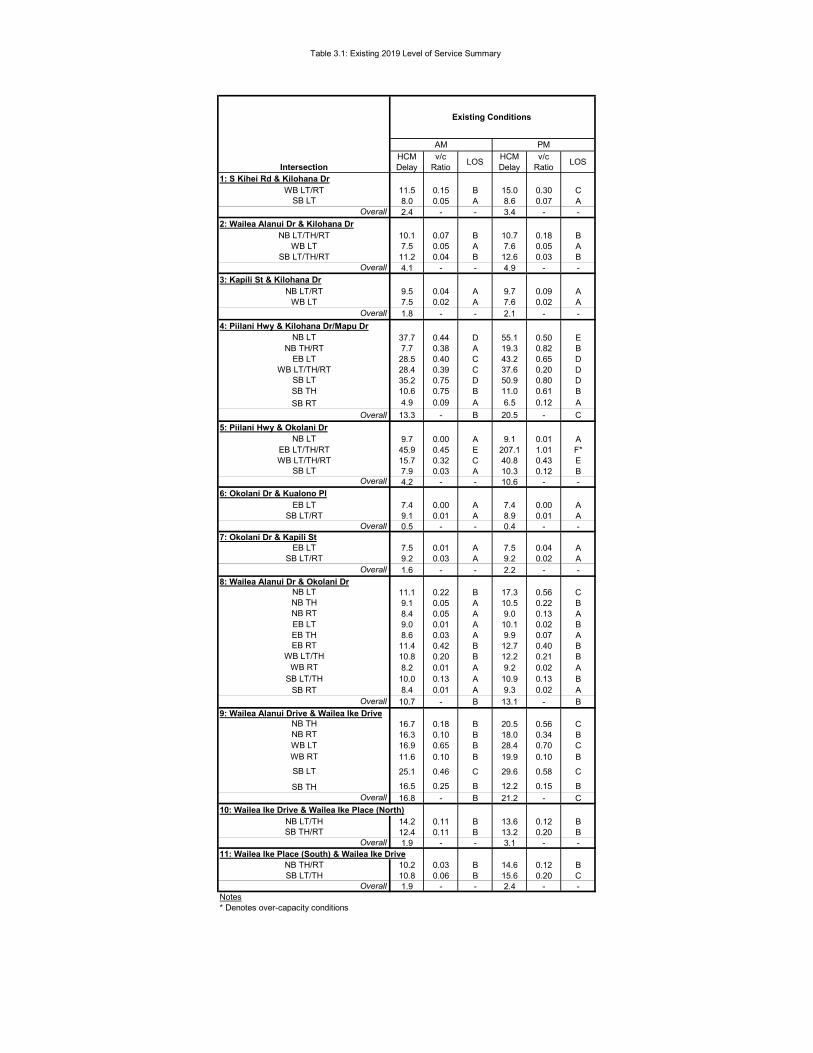
Table 3.1: Existing 2019 Level of Service Summary
HCMDelay
v/c Ratio LOS HCM
Delayv/c
Ratio LOS
1: S Kihei Rd & Kilohana Dr11.5 0.15 B 15.0 0.30 C8.0 0.05 A 8.6 0.07 A2.4 - - 3.4 - -
2: Wailea Alanui Dr & Kilohana Dr10.1 0.07 B 10.7 0.18 B7.5 0.05 A 7.6 0.05 A
11.2 0.04 B 12.6 0.03 B4.1 - - 4.9 - -
3: Kapili St & Kilohana Dr9.5 0.04 A 9.7 0.09 A7.5 0.02 A 7.6 0.02 A1.8 - - 2.1 - -
4: Piilani Hwy & Kilohana Dr/Mapu Dr37.7 0.44 D 55.1 0.50 E7.7 0.38 A 19.3 0.82 B
28.5 0.40 C 43.2 0.65 D28.4 0.39 C 37.6 0.20 D35.2 0.75 D 50.9 0.80 D10.6 0.75 B 11.0 0.61 B4.9 0.09 A 6.5 0.12 A
13.3 - B 20.5 - C5: Piilani Hwy & Okolani Dr
9.7 0.00 A 9.1 0.01 A45.9 0.45 E 207.1 1.01 F*15.7 0.32 C 40.8 0.43 E7.9 0.03 A 10.3 0.12 B4.2 - - 10.6 - -
6: Okolani Dr & Kualono Pl7.4 0.00 A 7.4 0.00 A9.1 0.01 A 8.9 0.01 A0.5 - - 0.4 - -
7: Okolani Dr & Kapili St7.5 0.01 A 7.5 0.04 A9.2 0.03 A 9.2 0.02 A1.6 - - 2.2 - -
8: Wailea Alanui Dr & Okolani Dr11.1 0.22 B 17.3 0.56 C9.1 0.05 A 10.5 0.22 B8.4 0.05 A 9.0 0.13 A9.0 0.01 A 10.1 0.02 B8.6 0.03 A 9.9 0.07 A
11.4 0.42 B 12.7 0.40 B10.8 0.20 B 12.2 0.21 B8.2 0.01 A 9.2 0.02 A
10.0 0.13 A 10.9 0.13 B8.4 0.01 A 9.3 0.02 A
10.7 - B 13.1 - B9: Wailea Alanui Drive & Wailea Ike Drive
16.7 0.18 B 20.5 0.56 C16.3 0.10 B 18.0 0.34 B16.9 0.65 B 28.4 0.70 C11.6 0.10 B 19.9 0.10 B
25.1 0.46 C 29.6 0.58 C
16.5 0.25 B 12.2 0.15 B16.8 - B 21.2 - C
10: Wailea Ike Drive & Wailea Ike Place (North)14.2 0.11 B 13.6 0.12 B12.4 0.11 B 13.2 0.20 B1.9 - - 3.1 - -
11: Wailea Ike Place (South) & Wailea Ike Drive10.2 0.03 B 14.6 0.12 B10.8 0.06 B 15.6 0.20 C1.9 - - 2.4 - -
Notes* Denotes over-capacity conditions
Overall
WB RTSB LT/TH
SB RT
EB RTWB LT/TH
NB RTEB LTEB TH
NB LT
Overall
NB TH
SB LT/RTEB LT
EB LT/TH/RTWB LT/TH/RT
NB LT
SB LTSB THSB RT
Overall
EB LT
WB LT
NB TH/RT
WB LT/TH/RT
Overall
NB LT/TH/RT
Overall
WB LT/RTSB LT
Overall
Intersection
Existing Conditions
AM PM
WB LT
OverallSB LT
SB LT/TH/RT
NB LT
NB LT/RT
SB LT/RTEB LT
Overall
NB THNB RTWB LTWB RT
SB LT
OverallSB TH
NB LT/THSB TH/RT
Overall
NB TH/RT
OverallSB LT/TH
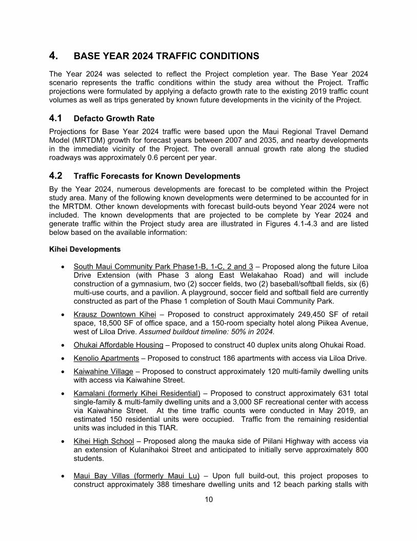
10
4. BASE YEAR 2024 TRAFFIC CONDITIONS
The Year 2024 was selected to reflect the Project completion year. The Base Year 2024 scenario represents the traffic conditions within the study area without the Project. Traffic projections were formulated by applying a defacto growth rate to the existing 2019 traffic count volumes as well as trips generated by known future developments in the vicinity of the Project.
4.1 Defacto Growth Rate Projections for Base Year 2024 traffic were based upon the Maui Regional Travel Demand Model (MRTDM) growth for forecast years between 2007 and 2035, and nearby developments in the immediate vicinity of the Project. The overall annual growth rate along the studied roadways was approximately 0.6 percent per year.
4.2 Traffic Forecasts for Known Developments By the Year 2024, numerous developments are forecast to be completed within the Project study area. Many of the following known developments were determined to be accounted for in the MRTDM. Other known developments with forecast build-outs beyond Year 2024 were not included. The known developments that are projected to be complete by Year 2024 and generate traffic within the Project study area are illustrated in Figures 4.1-4.3 and are listed below based on the available information:
Kihei Developments
South Maui Community Park Phase1-B, 1-C, 2 and 3 – Proposed along the future Liloa Drive Extension (with Phase 3 along East Welakahao Road) and will include construction of a gymnasium, two (2) soccer fields, two (2) baseball/softball fields, six (6) multi-use courts, and a pavilion. A playground, soccer field and softball field are currently constructed as part of the Phase 1 completion of South Maui Community Park.
Krausz Downtown Kihei – Proposed to construct approximately 249,450 SF of retail space, 18,500 SF of office space, and a 150-room specialty hotel along Piikea Avenue, west of Liloa Drive. Assumed buildout timeline: 50% in 2024.
Ohukai Affordable Housing – Proposed to construct 40 duplex units along Ohukai Road.
Kenolio Apartments – Proposed to construct 186 apartments with access via Liloa Drive.
Kaiwahine Village – Proposed to construct approximately 120 multi-family dwelling units with access via Kaiwahine Street.
Kamalani (formerly Kihei Residential) – Proposed to construct approximately 631 total single-family & multi-family dwelling units and a 3,000 SF recreational center with access via Kaiwahine Street. At the time traffic counts were conducted in May 2019, an estimated 150 residential units were occupied. Traffic from the remaining residential units was included in this TIAR.
Kihei High School – Proposed along the mauka side of Piilani Highway with access via an extension of Kulanihakoi Street and anticipated to initially serve approximately 800 students.
Maui Bay Villas (formerly Maui Lu) – Upon full build-out, this project proposes to construct approximately 388 timeshare dwelling units and 12 beach parking stalls with
11
access via Kaonoulu Street. Approximately 280 timeshare units are expected to be developed and occupied by Year 2024.
Welakahao Village – Proposed to construct approximately 86 single family dwelling units and up to 86 ohana units with access via East Welakahao Road.
Kalama Kai – Proposed to construct approximately 40 affordable multi-family residential units with access via Kanani Road.
Wailea Developments
Kahoolawe Island Reserve Commission (KIRC) Education & Operations Center – Proposed 23,950 square feet building that will provide educational, administrative exhibition, and office functions.
Kilohana Makai – Proposed to construct approximately 28 affordable single-family residential units with access via Wela Street.
Makalii at Wailea (MF-15) – This project proposes to develop 68 multi-family residential units. The project is located on the northeast corner of the Wailea Alanui Drive/Kaukahi Street intersection. Groundbreaking for this Project started in January 2019.
Wailea Village Center Expansion – This project proposes to expand the existing Wailea Village Center by developing an additional 22,000 square-feet of shopping center use. The project is located to the south of Wailea Ike Drive between Wailea Alanui Drive and Wailea Ike Place. At the time of traffic counts in May 2019, construction was still ongoing for the expansion.
Parcel MF-7 – Proposed to construct approximately 75 resort multi-family residential units with access via Okolani Drive.
Large Parcel (SF-7a, MF-12, MF-13) – Proposed to construct 289 resort multi-family units along Okolani Drive. 23 of these units will be Transient Vacation Rental (TVR) units. Approximately 40% of the Large Parcel is anticipated to be occupied by 2024.
Keala O Wailea (MF-11) – This project proposes to develop 70 multi-family units as part of the Wailea Resort. The project is located next to the Wailea Gateway Center on the northwest corner of the Piilani Highway/Wailea Ike Drive intersection. At the time traffic counts were conducted in May 2019, an estimated 75% of the units were sold. For purposes of this TIAR, it was assumed that 50% of the units were occupied.
Parcel B-1 – This project proposes to develop an approximate 97,600 SF square-foot shopping center. The project is located on the southeast corner of the Wailea Ike Drive/Kalai Waa intersection.
The Ridge at Wailea (MF-19) – This project proposes to develop nine (9) single-family residential units as part of the Wailea Resort. The project is located east of Kalai Waa Street and north of Hotel Wailea.
Hotel Ike Project (MF-10) – This project proposes to construct a 110-room hotel at the northeast corner of the Wailea Ike Drive and Wailea Ike Place (North) intersection. Primary access to the site will occur at the Wailea Ike Drive/Wailea Ike Place (North) intersection with the Project access located along Wailea Ike Place (North). The project will also share an internal easement with the adjacent Marriott Residence Inn Hotel to
12
the east, and secondary access may occur at the Wailea Ike Drive/Wailea Ekolu Place intersection.
Honuaula- This is a master planned residential and commercial community being proposed mauka of Piilani Highway at the southern terminus adjacent to the Piilani Highway/Wailea Ike Drive intersection. It is unknown when development will occur, but for purposes of this study, the initial 250 affordable single family residential units are assumed to be built by Year 2024.
Grand Wailea Expansion – The existing Grand Wailea Hotel is proposing to increase the room count by an additional 224 rooms.
Makena Developments
Makena Parcel H-1 Ocean Villas Maluaka Development – Construction is ongoing for this project, which proposes to develop 13 single-family residential units and six (6) multi-family condominium units. Parcel H-1 is located south of the former Makena Beach & Golf Resort and is bordered by the Makena Golf Course to the south and west and by Makena Keoneoio Road to the east.
Makena Resort H-M Development – This project proposes to convert the former 310-room hotel at the Makena Beach & Golf Resort into 65 multi-family resort residential units, including a beach club for residents only.
Makena M-5/M-6/S-7/B-2 – This project will consist of 46 resort single-family and residential units, 88 resort multi-family residential units, 10 Transient Vacation Rental (TVR) units, 14 residential condominium units, and approximately 27,300 square feet (SF) of retail space. The project also proposes to provide two new vehicular accesses; one (1) access along Honoiki Street and one (1) access along Makena Alanui Road.
Makena H-2 - This Project proposes to develop a 53-unit CPR residential development with a 57-stall beach parking lot. An existing 51-stall beach parking lot will be replaced, resulting in a beach parking stall count increase of 6 stalls. Assumed buildout timeline: 50% in 2024.
The forecast trip generation for each of the background developments in Kihei, Wailea and Makena are summarized in Table 4.1 and Table 4.2.
4.3 Planned Roadway Improvements The following roadway improvements are assumed to be implemented by Year 2024.
Piilani Highway/Okolani Drive/Mikioi Place Intersection: o Installation of a traffic signal.
The construction of a traffic control signal by Armstrong Builders is currently being designed as part of the roadway improvements for the Kai Malu at Wailea residential development.
Piilani Highway/Kilohana Drive/Mapu Place Intersection:
13
o Widening of Piilani Highway to provide an additional northbound through lane and an exclusive northbound right-turn lane at the Piilani Highway/Kilohana Drive/Mapu Place intersection.
o In addition, widening of the westbound Mapu Drive approach to provide an exclusive left-turn, through and right-turn lane. These improvements are anticipated to occur before Year 2024 as part of
construction and phasing agreements for the Wailea Resort Master Plan.
4.4 Base Year 2024 Analysis For Base Year 2024 conditions, regional traffic along Piilani Highway is anticipated to increase by approximately 215-300 vehicles per direction (average 28 percent increase) and along South Kihei Road by approximately 110-170 vehicles per direction (average 42 percent increase). As mentioned above, widening improvements will occur at the Piilani Highway/Kilohana Drive/Mapu Place intersection and a traffic signal will be constructed at the Piilani Highway/Okolani Drive/Mikioi Place intersection. These improvements are assumed to be implemented as part of the Base Year 2024 scenario.
The majority of study intersection will continue operating adequately, similar to existing conditions, with the exception of the following:
Piilani Highway/Kilohana Drive/Mapu Place – With the proposed widening improvement, the intersection will operate adequately with an overall LOS C for AM and PM peak hours of traffic. The northbound left-turn movement is anticipated to operate at LOS E due to longer signal cycles which favors through movements along the highway. Mainline through movements will operate adequately at LOS C or better and below capacity.
Wailea Alanui Drive/Okolani Drive – At this four-way stop intersection, the AM peak traffic will operate adequately with all movements operating at LOS C or higher and LOS C overall. During the PM peak hour, the overall intersection will operate at LOS E with the northbound left-turn movement forecast to operate at-capacity and LOS F conditions. The northbound left-turn and eastbound right-turn movements provide for heavier flows that service regional traffic between Kihei and the Wailea/Makena regions. All remaining movements at this intersection are relatively low, with peak volumes generally below 100 vehicles per movement. Based on the MUTCD four-hour signal warrant, which assumes the critical Wailea Alanui Drive northbound left-turn movement as the “minor street” and conflicting Okolani Drive movements as the “major street”, a signal will likely not be warranted by Year 2024. It should be noted that due to the low conflicting major street traffic at this intersection, the four-hour signal warrant graph had to be interpolated from the MUTCD graph to estimate thresholds for major street volumes in the 200-300 vehicle range at this intersection.
Wailea Ike Drive/Wailea Ike Place (South) – The southbound left-turn/through movement is anticipated to operate at LOS E conditions, however should operate well below capacity. Existing observations also showed minimal southbound queues ranging from only 1-2 vehicles. Based on MUTCD, a signal will likely not be warranted by Year 2024.
Figure 4.4 illustrates the Base Year 2024 forecast traffic volumes and LOS for all study intersections. Table 4.3 summarizes the Base Year 2024 LOS at the study intersections with the planned roadway improvements discussed in section 4.3. LOS worksheets are provided in Appendix C. Signal warrant figures are shown in Appendix D.

LEDCOR SF-S PARCEL TIAR
FIGURE 4.1 KIHEI BACKGROUND PROJECTS
PACIFIC OCEAN
•..
I •
NEARBY DEVELOPMENTS CD KIHEI RESIDENTIAL
0 Ki\JWAHINE VILLAGE
0 OHUKAI AFFORDABLE HOUSING
CD MAUI BAY VILLAS
® KENOLIO APARTMENTS
® KIHEI HIGH SCHOOL
GE RESIDENTIAL SUBDIVISION (j) WELAKAHAO VILLA
7 - PHASES I -B, 1-C, 2 & 3 ® SOUTH MAUI COMMUNITY PARK
(9) KRAUSZ - DOWNTOWN KIHEI
@ KALAMA KAI
l
SOUTH MAUI
COMMUNITY PARK
®
~ NOT TO SCALE
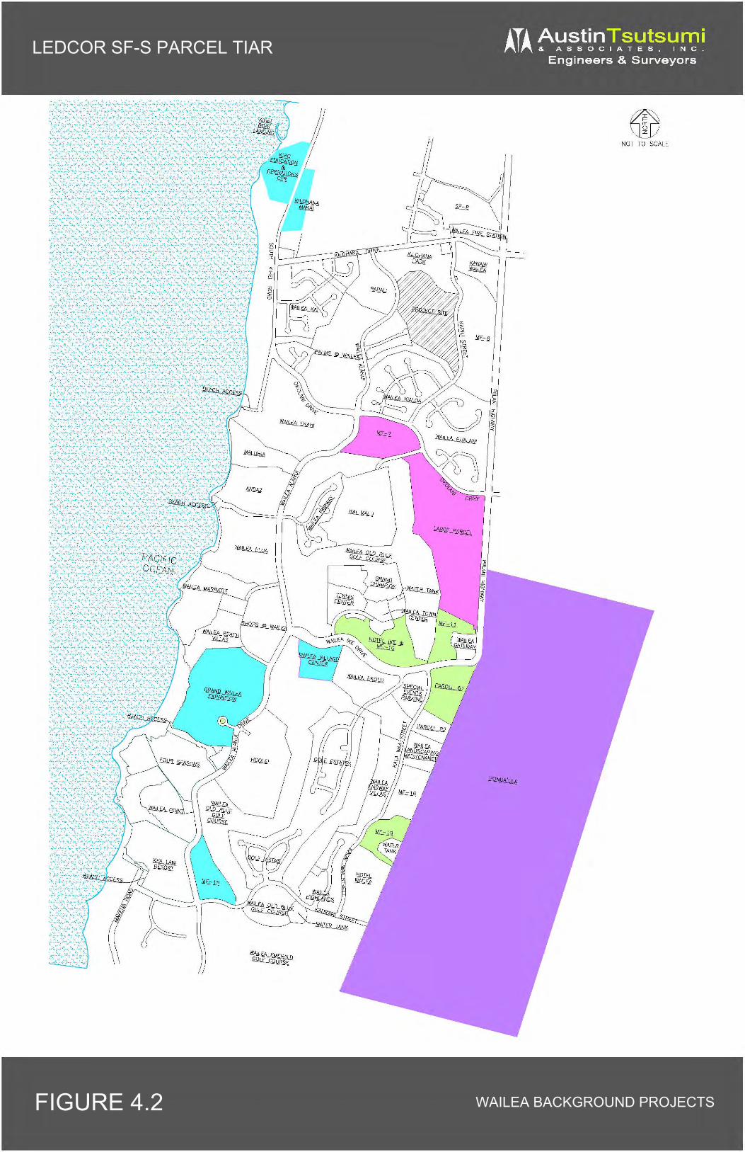
LEDCOR SF-S PARCEL TIAR
FIGURE 4.2 WAILEA BACKGROUND PROJECTS
~ ·.:·.":: .... ~.~·.:::.: .. , :·
,.. ' ' . NOT TO SCALE
•• ' • ·~ "~ • c '
.... ~· .:~. ,· ' :· ~ ....... ~:: · .. ·: ~; ·.~ ·:
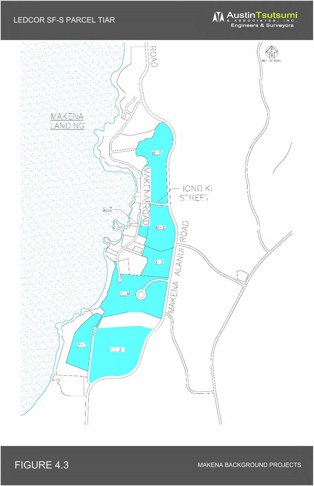
LEDCOR SF-S PARCEL TIAR
FIGURE 4.3 MAKENA BACKGROUND PROJECTS
~ I• • •
· .. ·.·
·.'.
: ~ . ,·:
·;.
: . .. ··
.. :.
·~ ..
;.
. ~ ·. · .... ·
·~ .· .. ·.,
• •• 1
··,
.·.·
·.::.
...... .. ~ ..
; .
· .. ·, .
. ··
·. ~ ...
·,_
·: · ··
·· :s·~1
/J 0 ):> 0
HONOIKI STREET
~ NOT TO SCALE
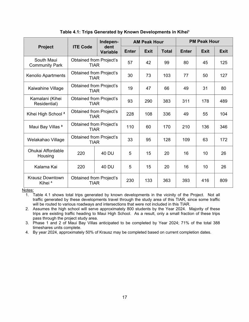
17
Table 4.1: Trips Generated by Known Developments in Kihei¹
Project ITE Code Indepen-
dent Variable
AM Peak Hour PM Peak Hour
Enter Exit Total Enter Exit Exit
South Maui Community Park
Obtained from Project’s TIAR 57 42 99 80 45 125
Kenolio Apartments Obtained from Project’s TIAR 30 73 103 77 50 127
Kaiwahine Village Obtained from Project’s TIAR 19 47 66 49 31 80
Kamalani (Kihei Residential)
Obtained from Project’s TIAR 93 290 383 311 178 489
Kihei High School ² Obtained from Project’s TIAR 228 108 336 49 55 104
Maui Bay Villas ³ Obtained from Project’s TIAR 110 60 170 210 136 346
Welakahao Village Obtained from Project’s TIAR 33 95 128 109 63 172
Ohukai Affordable Housing 220 40 DU 5 15 20 16 10 26
Kalama Kai 220 40 DU 5 15 20 16 10 26
Krausz Downtown Kihei ⁴
Obtained from Project’s TIAR 230 133 363 393 416 809
Notes: 1. Table 4.1 shows total trips generated by known developments in the vicinity of the Project. Not all
traffic generated by these developments travel through the study area of this TIAR, since some traffic will be routed to various roadways and intersections that were not included in this TIAR.
2. Assumes the high school will serve approximately 800 students by the Year 2024. Majority of these trips are existing traffic heading to Maui High School. As a result, only a small fraction of these trips pass through the project study area.
3. Phase 1 and 2 of Maui Bay Villas anticipated to be completed by Year 2024; 71% of the total 388 timeshares units complete.
4. By year 2024, approximately 50% of Krausz may be completed based on current completion dates.
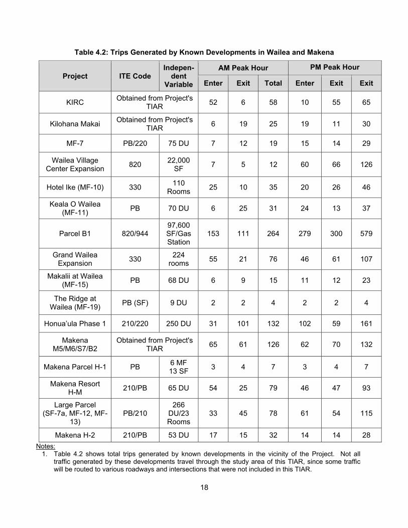
18
Table 4.2: Trips Generated by Known Developments in Wailea and Makena
Project ITE Code Indepen-
dent Variable
AM Peak Hour PM Peak Hour
Enter Exit Total Enter Exit Exit
KIRC Obtained from Project's TIAR 52 6 58 10 55 65
Kilohana Makai Obtained from Project's TIAR 6 19 25 19 11 30
MF-7 PB/220 75 DU 7 12 19 15 14 29
Wailea Village Center Expansion 820 22,000
SF 7 5 12 60 66 126
Hotel Ike (MF-10) 330 110 Rooms 25 10 35 20 26 46
Keala O Wailea (MF-11) PB 70 DU 6 25 31 24 13 37
Parcel B1 820/944 97,600 SF/Gas Station
153 111 264 279 300 579
Grand Wailea Expansion 330 224
rooms 55 21 76 46 61 107
Makalii at Wailea (MF-15) PB 68 DU 6 9 15 11 12 23
The Ridge at Wailea (MF-19) PB (SF) 9 DU 2 2 4 2 2 4
Honua’ula Phase 1 210/220 250 DU 31 101 132 102 59 161
Makena M5/M6/S7/B2
Obtained from Project's TIAR 65 61 126 62 70 132
Makena Parcel H-1 PB 6 MF 13 SF 3 4 7 3 4 7
Makena Resort H-M 210/PB 65 DU 54 25 79 46 47 93
Large Parcel (SF-7a, MF-12, MF-
13) PB/210
266 DU/23 Rooms
33 45 78 61 54 115
Makena H-2 210/PB 53 DU 17 15 32 14 14 28 Notes:
1. Table 4.2 shows total trips generated by known developments in the vicinity of the Project. Not all traffic generated by these developments travel through the study area of this TIAR, since some traffic will be routed to various roadways and intersections that were not included in this TIAR.
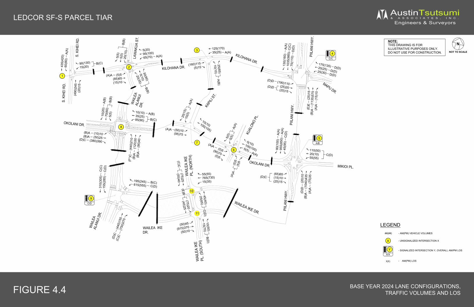
X
LEDCOR SF-S PARCEL TIAR AustinTsutsumi& A S S O C I A T E S , I N C .
Engineers & Surveyors
NOTE:THIS DRAWING IS FORILLUSTRATIVE PURPOSES ONLY.DO NOT USE FOR CONSTRUCTION.
FIGURE 4.4 BASE YEAR 2024 LANE CONFIGURATIONS,TRAFFIC VOLUMES AND LOS
N
NOT TO SCALE
435(
420)
60(8
0)A(
A)90(130)15(20)
B(C)
(490
)245
(20)
15
5(5)
5(5)
20(1
5)B(
B)
5(20)95(100)65(70) A(A)
(5)5(85)65(15)10
(160)115(5)15
25(65)10(10)
A(B)
125(170)35(25) A(A)
(25)
15(1
135)
575
(15)
10(B
)A(E
)E
175(135)20(25)25(30) D(D)
(190)110(25)20(25)15
(D)D
(D)D
130(
160)
1035
(985
)75
(110
)C
(C)
A(A)
D(D
)
30(90)
5(10)
20(35)
B(B)
KILOHANA DR.
MAPU DR.
S. K
IHEI
RD.
WAI
LEA
ALAN
UIDR
.
KAPI
LI ST
.
PIIL
ANI H
WY.
MIKIOI PL.
PIIL
ANI H
WY.
(65)65(15)10(25)15
(D)C
80(1
00)
955(
850)
45(9
5)
A(A)
110(50)20(10)55(55)
C(D)
(20)
10(1
040)
435
(75)
35
(D)D
KILOHANA DR.
LEGEND
- UNSIGNALIZED INTERSECTION X
##(##)
- SIGNALIZED INTERSECTION Y, OVERALL AM/PM LOS
- AM(PM) VEHICLE VOLUMES
X(X) - AM(PM) LOS
(10)10(50)25
(380)390(D)C
(B)A(B)A
10(10)35(25)85(90)
A(B)10(2
0)70
(60)
5(5)
B(B)
A(B)
(50)10(95)75
(A)A
10(10)100(105)
20(1
5)10
(5)
A(A)
(5)5(90)75(5)5
(A)A5(10)100(100)5(5)
5(5)
5(5)
A(A)
KUAL
ONO
PL.
OKOLANI DR.
OKOLANI DR.
(440
)210
(120
)30
(90)
40(B
)A(B
)A(F
*)C
LAW
AKUA
ST.
S. K
IHEI
RD.
PIIL
ANI H
WY.
WAI
LEA
ALAN
UI D
R.
4C/C
YX/X
1
2
3
6
7
WAILEA IKEDR.
WAI
LEA
IKE
PL. (
NORT
H)
WAI
LEA
IKE
PL. (
SOUT
H)WAILEA IKE DR.
310(
305)
155(
285)
195(245)615(555)
55(55)765(730)15(35)
(445
)155
(750
)270
(D)C
(C)C
C(D)B(C)
C(D
)C
(C)
(50)45
(915)370(50)10
(5)5
(5)5
5A/B
(A)A
D(D)D(D)
(B)A (A
)A
A(A)
C(D
)
A(A)
(A)A
B(C)
9C/D
45(40)25(65)
C(D
)10(50)15(70)
B(D)
(75)20(45)25
(E)B(75)25(55)40
(C)C
8
(A)A

Table 4.3: Existing and Base Year 2024 Level of Service Summary
HCMDelay
v/c Ratio LOS HCM
Delayv/c
Ratio LOS HCMDelay
v/c Ratio LOS HCM
Delayv/c
Ratio LOS
1: S Kihei Rd & Kilohana Dr11.5 0.15 B 15.0 0.30 C 13.6 0.22 B 22.5 0.45 C8.0 0.05 A 8.6 0.07 A 8.3 0.06 A 9.4 0.10 A2.4 - - 3.4 - - 2.2 - - 3.6 - -
2: Wailea Alanui Dr & Kilohana Dr10.1 0.07 B 10.7 0.18 B 10.5 0.08 B 11.2 0.20 B7.5 0.05 A 7.6 0.05 A 7.6 0.05 A 7.6 0.05 A
11.2 0.04 B 12.6 0.03 B 11.6 0.06 B 12.6 0.05 B4.1 - - 4.9 - - 4.4 - - 5.3 - -
3: Kapili St & Kilohana Dr9.5 0.04 A 9.7 0.09 A 9.7 0.05 A 10.0 0.10 B7.5 0.02 A 7.6 0.02 A 7.6 0.03 A 7.6 0.02 A1.8 - - 2.1 - - 1.9 - - 2.2 - -
4: Piilani Hwy & Kilohana Dr/Mapu Dr37.7 0.44 D 55.1 0.50 E 55.5 0.51 E 57.5 0.59 E
- - - - - - 9.1 0.28 A 16.0 0.60 B7.7 0.38 A 19.3 0.82 B - - - - - -- - - - - - 7.5 0.01 A 10.0 0.01 A
28.5 0.40 C 43.2 0.65 D 42.9 0.48 D 48.2 0.68 D26.5 0.10 C 36.8 0.10 D 43.6 0.13 D 42.7 0.12 D
- - - - - - 46.5 0.16 D 48.8 0.19 D- - - - - - 50.0 0.28 D 53.0 0.34 D
28.4 0.39 C 37.6 0.20 D - - - - - -- - - - - - 48.1 0.02 D 50.5 0.02 D
35.2 0.75 D 50.9 0.80 D 53.1 0.78 D 53.5 0.81 D10.6 0.75 B 11.0 0.61 B 24.0 0.91 C 27.2 0.91 C4.9 0.09 A 6.5 0.12 A 6.4 0.10 A 8.2 0.13 A
13.3 - B 20.5 - C 21.9 - C 25.0 - C5: Piilani Hwy & Okolani Dr
9.7 0.00 A 9.1 0.01 A 38.7 0.44 D 47.0 0.51 D- - - - - - 5.4 0.40 A 13.3 0.89 B- - - - - - 3.9 0.02 A 4.2 0.05 A
45.9 0.45 E 207.1 1.01 F* 25.1 0.32 C 36.8 0.42 D15.7 0.32 C 40.8 0.43 E 25.2 0.33 C 36.0 0.34 D7.9 0.03 A 10.3 0.12 B 31.8 0.58 C 45.2 0.78 D- - - - - - 8.9 0.84 A 6.3 0.68 A- - - - - - 3.4 0.06 A 3.1 0.07 A
4.2 - - 10.6 - - 10.0 - A 13.2 - B6: Okolani Dr & Kualono Pl
- - - - - - 9.4 0.01 A 9.5 0.01 A7.4 0.00 A 7.4 0.00 A 7.5 0.00 A 7.5 0.00 A- - - - - - 7.4 0.00 A 7.4 0.00 A- - - - - - 9.4 0.01 A 9.5 0.01 A
9.1 0.01 A 8.9 0.01 A - - - - - -0.5 - - 0.4 - - 1.2 - - 1.1 - -
SB LT/RTOverall
SB LT/TH/RTWB LTEB LT
NB LT/TH/RT
SB RTOverall
SB LTSB TH
WB LT/TH/RTEB LT/TH/RT
NB RT
NB LTNB TH
SB TH
EB TH/RTWB LTWB TH
WB LT/TH/RTWB RTSB LT
NB RTEB LT
Overall
NB LT/TH/RTWB LT
OverallSB LT
WB LT/RT
Intersection
Existing Conditions Base Year 2024
AM PM AM PM
SB LT/TH/RTOverall
SB RTOverall
NB TH/RT
WB LT
NB LTNB TH
NB LT/RT

Table 4.3: Existing and Base Year 2024 Level of Service Summary Cont'd
HCMDelay
v/c Ratio LOS HCM
Delayv/c
Ratio LOS HCMDelay
v/c Ratio LOS HCM
Delayv/c
Ratio LOS
Intersection
Existing Conditions Base Year 2024
AM PM AM PM
7: Okolani Dr & Kapili St7.5 0.01 A 7.5 0.04 A 7.5 0.01 A 7.6 0.04 A9.2 0.03 A 9.2 0.02 A 9.4 0.04 A 9.5 0.03 A1.6 - - 2.2 - - 1.6 - - 2.0 - -
8: Wailea Alanui Dr & Okolani Dr11.1 0.22 B 17.3 0.56 C 16.0 0.46 C 76.1 1.01 F*9.1 0.05 A 10.5 0.22 B 9.9 0.06 A 12.5 0.26 B8.4 0.05 A 9.0 0.13 A 9.3 0.07 A 10.6 0.18 B9.0 0.01 A 10.1 0.02 B 9.8 0.02 A 11.3 0.03 B8.6 0.03 A 9.9 0.07 A 9.5 0.05 A 11.5 0.12 B
11.4 0.42 B 12.7 0.40 B 19.2 0.67 C 33.1 0.81 D10.8 0.20 B 12.2 0.21 B 12.9 0.27 B 15.8 0.31 C8.2 0.01 A 9.2 0.02 A 9.2 0.02 A 10.9 0.02 B
10.0 0.13 A 10.9 0.13 B 11.6 0.17 B 13.4 0.18 B8.4 0.01 A 9.3 0.02 A 9.5 0.02 A 11.3 0.05 B
10.7 - B 13.1 - B 15.7 - C 40.2 - E9: Wailea Alanui Drive & Wailea Ike Drive
16.7 0.18 B 20.5 0.56 C 26.7 0.39 C 44.6 0.84 D16.3 0.10 B 18.0 0.34 B 25.1 0.19 C 33.4 0.63 C16.9 0.65 B 28.4 0.70 C 25.5 0.82 C 52.6 0.93 D11.6 0.10 B 19.9 0.10 B 12.8 0.17 B 22.7 0.19 C25.1 0.46 C 29.6 0.58 C 34.2 0.59 C 53.2 0.83 D16.5 0.25 B 12.2 0.15 B 23.1 0.34 C 22.2 0.25 C16.8 - B 21.2 - C 24.4 - C 39.3 - D
10: Wailea Ike Drive & Wailea Ike Place (North)14.2 0.11 B 13.6 0.12 B 20.6 0.25 C 25.2 0.39 D12.4 0.11 B 13.2 0.20 B 15.8 0.18 C 21.7 0.40 C1.9 - - 3.1 - - 2.5 - - 5.2 - -
11: Wailea Ike Place (South) & Wailea Ike Drive10.2 0.03 B 14.6 0.12 B 11.8 0.05 B 30.5 0.49 D10.8 0.06 B 15.6 0.20 C 12.7 0.10 B 45.8 0.62 E1.9 - - 2.4 - - 1.8 - - 7.3 - -
Notes* Denotes over-capacity conditions
NB LT/TH
NB RT
Overall
WB RT
OverallSB TH/RT
OverallSB LT/TH
NB THNB RTEB LT
NB TH/RT
SB LT/RT
NB LT
EB LT
EB RT
SB TH
WB LT
SB LT
NB TH
Overall
SB RTOverall
EB TH
WB LT/THWB RT
SB LT/TH
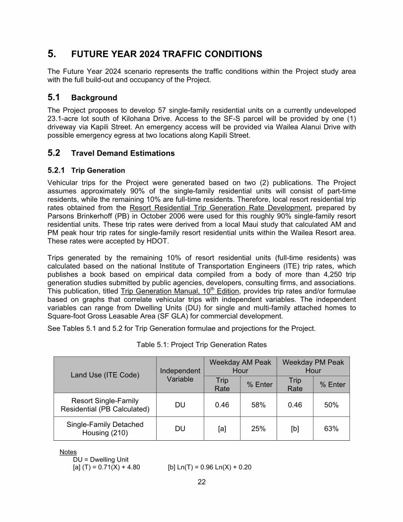
22
5. FUTURE YEAR 2024 TRAFFIC CONDITIONS
The Future Year 2024 scenario represents the traffic conditions within the Project study area with the full build-out and occupancy of the Project.
5.1 Background The Project proposes to develop 57 single-family residential units on a currently undeveloped 23.1-acre lot south of Kilohana Drive. Access to the SF-S parcel will be provided by one (1) driveway via Kapili Street. An emergency access will be provided via Wailea Alanui Drive with possible emergency egress at two locations along Kapili Street.
5.2 Travel Demand Estimations
5.2.1 Trip Generation Vehicular trips for the Project were generated based on two (2) publications. The Project assumes approximately 90% of the single-family residential units will consist of part-time residents, while the remaining 10% are full-time residents. Therefore, local resort residential trip rates obtained from the Resort Residential Trip Generation Rate Development, prepared by Parsons Brinkerhoff (PB) in October 2006 were used for this roughly 90% single-family resort residential units. These trip rates were derived from a local Maui study that calculated AM and PM peak hour trip rates for single-family resort residential units within the Wailea Resort area. These rates were accepted by HDOT. Trips generated by the remaining 10% of resort residential units (full-time residents) was calculated based on the national Institute of Transportation Engineers (ITE) trip rates, which publishes a book based on empirical data compiled from a body of more than 4,250 trip generation studies submitted by public agencies, developers, consulting firms, and associations. This publication, titled Trip Generation Manual, 10th Edition, provides trip rates and/or formulae based on graphs that correlate vehicular trips with independent variables. The independent variables can range from Dwelling Units (DU) for single and multi-family attached homes to Square-foot Gross Leasable Area (SF GLA) for commercial development. See Tables 5.1 and 5.2 for Trip Generation formulae and projections for the Project.
Table 5.1: Project Trip Generation Rates
Land Use (ITE Code) IndependentVariable
Weekday AM Peak Hour
Weekday PM Peak Hour
Trip Rate % Enter Trip
Rate % Enter
Resort Single-Family Residential (PB Calculated) DU 0.46 58% 0.46 50%
Single-Family Detached Housing (210) DU [a] 25% [b] 63%
Notes DU = Dwelling Unit
[a] (T) = 0.71(X) + 4.80 [b] Ln(T) = 0.96 Ln(X) + 0.20
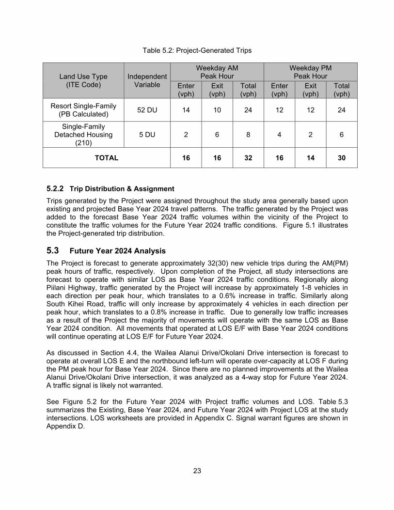
23
Table 5.2: Project-Generated Trips
Land Use Type (ITE Code)
IndependentVariable
Weekday AM Peak Hour
Weekday PM Peak Hour
Enter (vph)
Exit (vph)
Total (vph)
Enter (vph)
Exit (vph)
Total (vph)
Resort Single-Family (PB Calculated) 52 DU 14 10 24 12 12 24
Single-Family Detached Housing
(210) 5 DU 2 6 8 4 2 6
TOTAL 16 16 32 16 14 30
5.2.2 Trip Distribution & Assignment Trips generated by the Project were assigned throughout the study area generally based upon existing and projected Base Year 2024 travel patterns. The traffic generated by the Project was added to the forecast Base Year 2024 traffic volumes within the vicinity of the Project to constitute the traffic volumes for the Future Year 2024 traffic conditions. Figure 5.1 illustrates the Project-generated trip distribution.
5.3 Future Year 2024 Analysis The Project is forecast to generate approximately 32(30) new vehicle trips during the AM(PM) peak hours of traffic, respectively. Upon completion of the Project, all study intersections are forecast to operate with similar LOS as Base Year 2024 traffic conditions. Regionally along Piilani Highway, traffic generated by the Project will increase by approximately 1-8 vehicles in each direction per peak hour, which translates to a 0.6% increase in traffic. Similarly along South Kihei Road, traffic will only increase by approximately 4 vehicles in each direction per peak hour, which translates to a 0.8% increase in traffic. Due to generally low traffic increases as a result of the Project the majority of movements will operate with the same LOS as Base Year 2024 condition. All movements that operated at LOS E/F with Base Year 2024 conditions will continue operating at LOS E/F for Future Year 2024. As discussed in Section 4.4, the Wailea Alanui Drive/Okolani Drive intersection is forecast to operate at overall LOS E and the northbound left-turn will operate over-capacity at LOS F during the PM peak hour for Base Year 2024. Since there are no planned improvements at the Wailea Alanui Drive/Okolani Drive intersection, it was analyzed as a 4-way stop for Future Year 2024. A traffic signal is likely not warranted. See Figure 5.2 for the Future Year 2024 with Project traffic volumes and LOS. Table 5.3 summarizes the Existing, Base Year 2024, and Future Year 2024 with Project LOS at the study intersections. LOS worksheets are provided in Appendix C. Signal warrant figures are shown in Appendix D.

X
LEDCOR SF-S PARCEL TIAR AustinTsutsumi& A S S O C I A T E S , I N C .
Engineers & Surveyors
NOTE:THIS DRAWING IS FORILLUSTRATIVE PURPOSES ONLY.DO NOT USE FOR CONSTRUCTION.
FIGURE 5.1 PROJECT GENERATED TRIPS
N
NOT TO SCALE
4(4)
4(4)
4(4)
(4)4
4(4) 8(6)4(4)
7(7)
(6)8
7(7)
KILOHANA DR.
MAPU DR.
S. K
IHEI
RD.
WAI
LEA
ALAN
UIDR
.
KAPI
LI ST
.
PIIL
ANI H
WY.
MIKIOI PL.
PIIL
ANI H
WY.
(1)1
(1)1
KILOHANA DR.
LEGEND
- UNSIGNALIZED INTERSECTION X
##(##)
- SIGNALIZED INTERSECTION Y
- AM(PM) VEHICLE VOLUMES
3(3)
(3)3
1(1)
3(3)
1(1)
(1)11(1)
KUAL
ONO
PL.
OKOLANI DR.
OKOLANI DR.
(3)3
LAW
AKUA
ST.
S. K
IHEI
RD.
PIIL
ANI H
WY.
WAI
LEA
ALAN
UI D
R.
4
Y
1
2
3
6
7
WAILEA IKEDR.
9
WAI
LEA
IKE
PL. (
NORT
H)W
AILE
A IK
EPL
. (SO
UTH)
WAILEA IKE DR.
3(3) 1(1) 1(1)
(3)3
(1)1 (1)1
11(1
1)
(10)12(4)4 (5
)5
(1)1
1(1)
5
12
PROJECTDWY
8
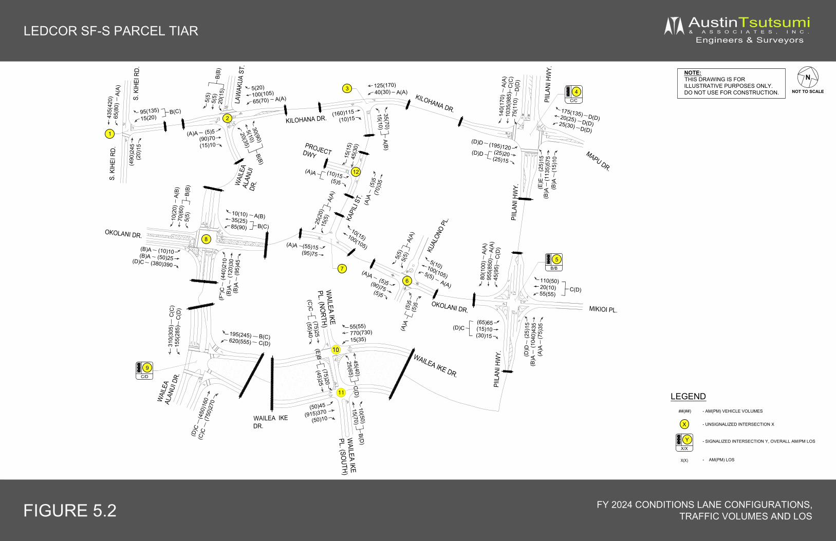
X
LEDCOR SF-S PARCEL TIAR AustinTsutsumi& A S S O C I A T E S , I N C .
Engineers & Surveyors
NOTE:THIS DRAWING IS FORILLUSTRATIVE PURPOSES ONLY.DO NOT USE FOR CONSTRUCTION.
FIGURE 5.2 FY 2024 CONDITIONS LANE CONFIGURATIONS,TRAFFIC VOLUMES AND LOS
N
NOT TO SCALE
435(
420)
65(8
0)A(
A)95(135)15(20)
B(C)
(490
)245
(20)
15
5(5)
5(5)
20(1
5)B(
B)
5(20)100(105)65(70) A(A)
(5)5(90)70(15)10
(A)A
(160)115(10)15
35(70)15(10)
A(B)
125(170)40(30) A(A)
(25)
15(1
135)
575
(15)
10(B
)A(E
)E
175(135)20(25)25(30) D(D)
(195)120(25)20(25)15
(D)D
(D)D
140(
170)
1035
(985
)75
(110
)C
(C)
A(A)
D(D
)
30(90)
5(10)
20(35)
B(B)
KILOHANA DR.
MAPU DR.
S. K
IHEI
RD.
WAI
LEA
ALAN
UIDR
.
KAPI
LI ST
.
PIIL
ANI H
WY.
MIKIOI PL.
PIIL
ANI H
WY.
(65)65(15)10(30)15
(D)C
80(1
00)
955(
850)
45(9
5)
A(A)
110(50)20(10)55(55)
C(D)
(25)
15(1
040)
435
(75)
35
(D)D
KILOHANA DR.
LEGEND
- UNSIGNALIZED INTERSECTION X
##(##)
- SIGNALIZED INTERSECTION Y, OVERALL AM/PM LOS
- AM(PM) VEHICLE VOLUMES
X(X) - AM(PM) LOS
(10)10(50)25
(380)390(D)C
(B)A(B)A
10(10)35(25)85(90)
A(B)10(2
0)70
(60)
5(5)
B(B)
A(B)
(55)15(95)75
(A)A
10(15)100(105)
25(2
0)15
(5)
A(A)
(5)5(90)75(5)5
(A)A
5(10)100(105)5(5)
5(5)
5(5)
A(A)
KUAL
ONO
PL.
OKOLANI DR.
OKOLANI DR.
(440
)210
(120
)30
(95)
45(B
)A(B
)A(F
*)C
LAW
AKUA
ST.
S. K
IHEI
RD.
PIIL
ANI H
WY.
WAI
LEA
ALAN
UI D
R.
4C/C
YX/X
1
2
3
6
7
WAILEA IKEDR.
WAILEA IKE DR.
310(
305)
155(
285)
195(245)620(555)
55(55)770(730)15(35)
(450
)160
(750
)270
(D)C
(C)C
C(D)B(C)
C(D
)C
(C)
(50)45
(915)370(50)10
15(1
5)45
(30)
(10)15(5)5
(A)A
(5)5
(70)
35
(A)A
(B)A
D(D)D(D)
(B)A
(A)A
A(A)
C(D
)
A(A)
5B/B
(5)5
(5)5
(A)A
B(C)
PROJECTDWY
9C/D
45(40)25(65)
C(D
)10(50)15(70)
B(D)
(75)20(45)25
(E)B(75)25(55)40
(C)C
12
WAILEA IKE
PL. (NORTH)
WAILEA IKE
PL. (SOUTH)
8
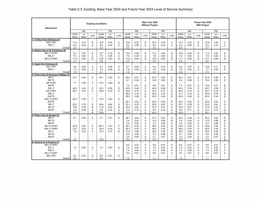
Table 5.3: Existing, Base Year 2024 and Future Year 2024 Level of Service Summary
HCMDelay
v/c Ratio LOS HCM
Delayv/c
Ratio LOS HCMDelay
v/c Ratio LOS HCM
Delayv/c
Ratio LOS HCMDelay
v/c Ratio LOS HCM
Delayv/c
Ratio LOS
1: S Kihei Rd & Kilohana Dr11.5 0.15 B 15.0 0.30 C 13.6 0.22 B 22.5 0.45 C 13.7 0.22 B 22.8 0.46 C8.0 0.05 A 8.6 0.07 A 8.3 0.06 A 9.4 0.10 A 8.3 0.06 A 9.4 0.10 A2.4 - - 3.4 - - 2.2 - - 3.6 - - 2.4 - - 3.7 - -
2: Wailea Alanui Dr & Kilohana Dr10.1 0.07 B 10.7 0.18 B 10.5 0.08 B 11.2 0.20 B 10.6 0.09 B 11.3 0.20 B7.5 0.05 A 7.6 0.05 A 7.6 0.05 A 7.6 0.05 A 7.6 0.05 A 7.6 0.05 A11.2 0.04 B 12.6 0.03 B 11.6 0.06 B 12.6 0.05 B 11.7 0.06 B 12.7 0.06 B4.1 - - 4.9 - - 4.4 - - 5.3 - - 4.3 - - 5.2 - -
3: Kapili St & Kilohana Dr9.5 0.04 A 9.7 0.09 A 9.7 0.05 A 10.0 0.10 B 9.9 0.07 A 10.0 0.11 B7.5 0.02 A 7.6 0.02 A 7.6 0.03 A 7.6 0.02 A 7.6 0.03 A 7.7 0.02 A1.8 - - 2.1 - - 1.9 - - 2.2 - - 2.3 - - 2.3 - -
4: Piilani Hwy & Kilohana Dr/Mapu Dr37.7 0.44 D 55.1 0.50 E 55.5 0.51 E 57.5 0.59 E 56.1 0.51 E 57.6 0.59 E
- - - - - - 9.1 0.28 A 16.0 0.60 B 9.4 0.28 A 16.0 0.60 B7.7 0.38 A 19.3 0.82 B - - - - - - - - - - - -- - - - - - 7.5 0.01 A 10.0 0.01 A 7.7 0.01 A 10.0 0.01 B
28.5 0.40 C 43.2 0.65 D 42.9 0.48 D 48.2 0.68 D 43.2 0.50 D 49.1 0.69 D26.5 0.10 C 36.8 0.10 D 43.6 0.13 D 42.7 0.12 D 43.5 0.12 D 42.7 0.12 D
- - - - - - 46.5 0.16 D 48.8 0.19 D 47.1 0.16 D 48.8 0.19 D- - - - - - 50.0 0.28 D 53.0 0.34 D 50.6 0.28 D 53.0 0.34 D
28.4 0.39 C 37.6 0.20 D - - - - - - - - - - - -- - - - - - 48.1 0.02 D 50.5 0.02 D 48.7 0.02 D 50.5 0.02 D
35.2 0.75 D 50.9 0.80 D 53.1 0.78 D 53.5 0.81 D 53.7 0.78 D 53.5 0.81 D10.6 0.75 B 11.0 0.61 B 24.0 0.91 C 27.2 0.91 C 24.9 0.91 C 27.2 0.91 C4.9 0.09 A 6.5 0.12 A 6.4 0.10 A 8.2 0.13 A 6.6 0.11 A 8.3 0.14 A13.3 - B 20.5 - C 21.9 - C 25.0 - C 22.6 - C 25.1 - C
5: Piilani Hwy & Okolani Dr9.7 0.00 A 9.1 0.01 A 38.7 0.44 D 47.0 0.51 D 36.2 0.46 D 46.3 0.54 D- - - - - - 5.4 0.40 A 13.3 0.89 B 5.4 0.40 A 13.3 0.89 B- - - - - - 3.9 0.02 A 4.2 0.05 A 3.9 0.02 A 4.2 0.05 A
45.9 0.45 E 207.1 1.01 F* 25.1 0.32 C 36.8 0.42 D 25.5 0.32 C 36.8 0.42 D15.7 0.32 C 40.8 0.43 E 25.2 0.33 C 36.0 0.34 D 25.6 0.33 C 36.0 0.34 D7.9 0.03 A 10.3 0.12 B 31.8 0.58 C 45.2 0.78 D 32.3 0.58 C 45.2 0.78 D- - - - - - 8.9 0.84 A 6.3 0.68 A 9.1 0.84 A 6.5 0.68 A- - - - - - 3.4 0.06 A 3.1 0.07 A 3.4 0.06 A 3.2 0.07 A
4.2 - - 10.6 - - 10.0 - A 13.2 - B 10.2 - B 13.4 - B6: Okolani Dr & Kualono Pl
- - - - - - 9.4 0.01 A 9.5 0.01 A 9.4 0.01 A 9.5 0.01 A7.4 0.00 A 7.4 0.00 A 7.5 0.00 A 7.5 0.00 A 7.5 0.00 A 7.5 0.00 A- - - - - - 7.4 0.00 A 7.4 0.00 A 7.4 0.00 A 7.4 0.00 A- - - - - - 9.4 0.01 A 9.5 0.01 A 9.4 0.01 A 9.6 0.01 A
9.1 0.01 A 8.9 0.01 A - - - - - - - - - - - -0.5 - - 0.4 - - 1.2 - - 1.1 - - 1.2 - - 1.1 - -
Intersection
Existing Conditions Future Year 2024With Project
AM PM AM PM
Base Year 2024Without Project
AM PM
SB LTWB LT/RT
Overall
NB LT/TH/RTWB LT
SB LT/TH/RTOverall
NB LT/RTWB LT
NB LTNB TH
NB TH/RT
Overall
EB TH/RTWB LT
NB RTEB LT
SB LTSB TH
WB THWB LT/TH/RT
WB RT
NB LTNB TH
SB RTOverall
EB LT/TH/RTNB RT
SB LTSB TH
WB LT/TH/RT
SB RTOverall
EB LTNB LT/TH/RT
WB LT
Overall
SB LT/TH/RTSB LT/RT
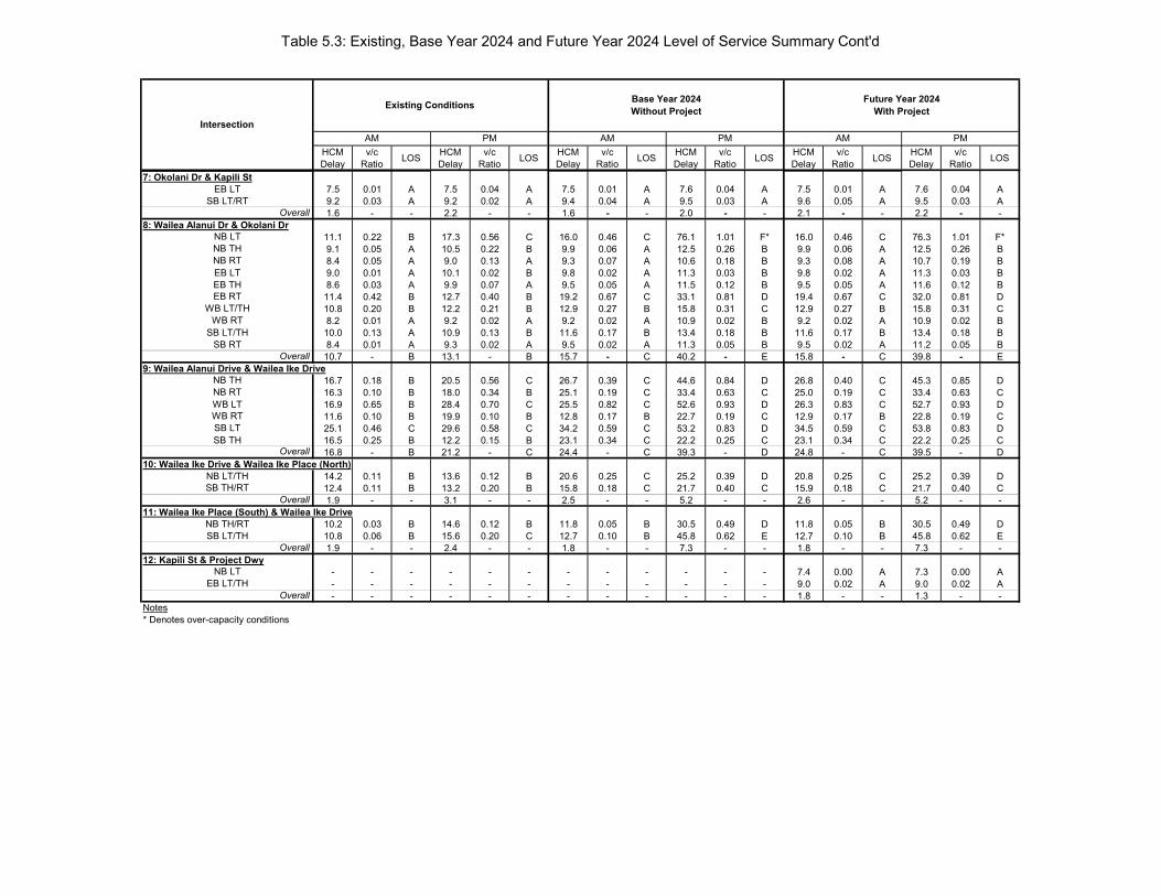
Table 5.3: Existing, Base Year 2024 and Future Year 2024 Level of Service Summary Cont'd
HCMDelay
v/c Ratio LOS HCM
Delayv/c
Ratio LOS HCMDelay
v/c Ratio LOS HCM
Delayv/c
Ratio LOS HCMDelay
v/c Ratio LOS HCM
Delayv/c
Ratio LOS
Intersection
Existing Conditions Future Year 2024With Project
AM PM AM PM
Base Year 2024Without Project
AM PM
7: Okolani Dr & Kapili St7.5 0.01 A 7.5 0.04 A 7.5 0.01 A 7.6 0.04 A 7.5 0.01 A 7.6 0.04 A9.2 0.03 A 9.2 0.02 A 9.4 0.04 A 9.5 0.03 A 9.6 0.05 A 9.5 0.03 A1.6 - - 2.2 - - 1.6 - - 2.0 - - 2.1 - - 2.2 - -
8: Wailea Alanui Dr & Okolani Dr11.1 0.22 B 17.3 0.56 C 16.0 0.46 C 76.1 1.01 F* 16.0 0.46 C 76.3 1.01 F*9.1 0.05 A 10.5 0.22 B 9.9 0.06 A 12.5 0.26 B 9.9 0.06 A 12.5 0.26 B8.4 0.05 A 9.0 0.13 A 9.3 0.07 A 10.6 0.18 B 9.3 0.08 A 10.7 0.19 B9.0 0.01 A 10.1 0.02 B 9.8 0.02 A 11.3 0.03 B 9.8 0.02 A 11.3 0.03 B8.6 0.03 A 9.9 0.07 A 9.5 0.05 A 11.5 0.12 B 9.5 0.05 A 11.6 0.12 B11.4 0.42 B 12.7 0.40 B 19.2 0.67 C 33.1 0.81 D 19.4 0.67 C 32.0 0.81 D10.8 0.20 B 12.2 0.21 B 12.9 0.27 B 15.8 0.31 C 12.9 0.27 B 15.8 0.31 C8.2 0.01 A 9.2 0.02 A 9.2 0.02 A 10.9 0.02 B 9.2 0.02 A 10.9 0.02 B10.0 0.13 A 10.9 0.13 B 11.6 0.17 B 13.4 0.18 B 11.6 0.17 B 13.4 0.18 B8.4 0.01 A 9.3 0.02 A 9.5 0.02 A 11.3 0.05 B 9.5 0.02 A 11.2 0.05 B10.7 - B 13.1 - B 15.7 - C 40.2 - E 15.8 - C 39.8 - E
9: Wailea Alanui Drive & Wailea Ike Drive16.7 0.18 B 20.5 0.56 C 26.7 0.39 C 44.6 0.84 D 26.8 0.40 C 45.3 0.85 D16.3 0.10 B 18.0 0.34 B 25.1 0.19 C 33.4 0.63 C 25.0 0.19 C 33.4 0.63 C16.9 0.65 B 28.4 0.70 C 25.5 0.82 C 52.6 0.93 D 26.3 0.83 C 52.7 0.93 D11.6 0.10 B 19.9 0.10 B 12.8 0.17 B 22.7 0.19 C 12.9 0.17 B 22.8 0.19 C25.1 0.46 C 29.6 0.58 C 34.2 0.59 C 53.2 0.83 D 34.5 0.59 C 53.8 0.83 D16.5 0.25 B 12.2 0.15 B 23.1 0.34 C 22.2 0.25 C 23.1 0.34 C 22.2 0.25 C16.8 - B 21.2 - C 24.4 - C 39.3 - D 24.8 - C 39.5 - D
10: Wailea Ike Drive & Wailea Ike Place (North)14.2 0.11 B 13.6 0.12 B 20.6 0.25 C 25.2 0.39 D 20.8 0.25 C 25.2 0.39 D12.4 0.11 B 13.2 0.20 B 15.8 0.18 C 21.7 0.40 C 15.9 0.18 C 21.7 0.40 C1.9 - - 3.1 - - 2.5 - - 5.2 - - 2.6 - - 5.2 - -
11: Wailea Ike Place (South) & Wailea Ike Drive10.2 0.03 B 14.6 0.12 B 11.8 0.05 B 30.5 0.49 D 11.8 0.05 B 30.5 0.49 D10.8 0.06 B 15.6 0.20 C 12.7 0.10 B 45.8 0.62 E 12.7 0.10 B 45.8 0.62 E1.9 - - 2.4 - - 1.8 - - 7.3 - - 1.8 - - 7.3 - -
12: Kapili St & Project Dwy- - - - - - - - - - - - 7.4 0.00 A 7.3 0.00 A- - - - - - - - - - - - 9.0 0.02 A 9.0 0.02 A- - - - - - - - - - - - 1.8 - - 1.3 - -
Notes* Denotes over-capacity conditions
EB LT
Overall
NB LT
SB LT/RT
EB LTEB TH
NB THNB RT
WB RT
EB RTWB LT/TH
Overall
NB TH
SB LT/THSB RT
WB LTNB RT
WB RTSB LTSB TH
NB LT/TH
Overall
SB TH/RTOverall
NB TH/RT
OverallSB LT/TH
EB LT/THNB LT
Overall
28
6. CONCLUSION
The Project proposes to develop 57 single-family units on approximately 23.1 acres of land. Access to the SF-S parcel will be provided by one (1) driveway via Kapili Street. An emergency access will be provided via Wailea Alanui Drive. The Project is anticipated to be completed and fully occupied by the Year 2024.
6.1 Existing Conditions The majority of movements at the study intersections operated adequately at LOS D or better and under-capacity conditions during the peak hours of traffic with the exception of the following:
Piilani Highway & Kilohana Drive –During the AM peak hour, traffic analysis indicates the intersection operates at an overall LOS B with all movements operating at LOS D or better.
During the PM peak hour of traffic, northbound through volumes were observed to queue for about a 30-35 minute period extending as far south to Okolani Drive. By 4:50 PM, vehicle queues were observed to clear without heavy congestion. Traffic analysis indicates the intersection operates at overall LOS C with all movements operating at LOS D or better, with the exception of the northbound left-turn movement, which operates at LOS E.
Piilani Highway & Okolani Drive –During the AM peak hour, all approaches operate relatively smoothly with minor movements experiencing moderate delay with traffic analysis indicating that the northbound and southbound left-turn movements operate at LOS A and the eastbound and westbound left-turn/through movements operating at LOS E and LOS C, respectively.
During the PM peak hour, higher volumes along Piilani Highway result in longer delays to the minor street movements. The northbound and southbound left-turn movements operate at LOS A/B and the eastbound/westbound approaches operate at LOS E/F, with eastbound approach operating over-capacity. A traffic signal is currently being designed and will be implemented at the Piilani Highway/Okolani Drive/Mikioi Place intersection as part of the mitigation for the Kai Malu Wailea residential development.
Okolani Drive & Wailea Alanui Drive – This intersection provides stop-control for all approaches and currently operates adequately at overall LOS B during the AM and PM peak hours of traffic. During both peaks, the eastbound right-turn and northbound left-turn movements were heavier, providing regional flows between South Kihei Road and Wailea Alanui Drive. Both movements are stop controlled, but since the eastbound right-turn movement is provided with a dedicated receiving lane, most eastbound right-turners were observed to operate similar to a free or yield right-turn movement. As a result, no lengthy queues formed.
During the PM peak hour, the longest observed queue consisted of 7 vehicles, which completely cleared within 40 seconds. All other movements operate at LOS B or better during the PM peak hour of traffic.
6.2 Base Year 2024 Based on a comparison with existing conditions, regional traffic along Piilani Highway is anticipated to increase by 215-300 vehicles per direction (average 28 percent increase) and along South Kihei Road by 110-170 vehicles per direction (average 42 percent increase) from ambient growth and various background projects included in the analysis.

29
6.2.1 Planned Roadway Improvements The following roadway improvements are assumed to be implemented by Year 2024:
Piilani Highway/Okolani Drive/Mikioi Place Intersection: o Installation of a traffic signal.
The construction of a traffic control signal by Armstrong Builders is currently being designed as part of the roadway improvements for the Kai Malu at Wailea residential development.
Piilani Highway/Kilohana Drive/Mapu Place Intersection: o Widening of Piilani Highway to provide an additional northbound through lane
and an exclusive northbound right-turn lane at the Piilani Highway/Kilohana Drive/Mapu Place intersection.
o In addition, widening of the westbound Mapu Drive approach to provide an exclusive left-turn, through and right-turn lane.
6.2.2 Base Year 2024 Analysis The majority of study intersections will continue operating adequately, similar to existing conditions, with the exception of the following:
Piilani Highway/Kilohana Drive/Mapu Place – With the proposed widening improvement, the intersection will operate adequately with an overall LOS C for AM and PM peak hours of traffic. The northbound left-turn movement is anticipated to operate at LOS E due to longer signal cycles which favors through movements along the highway. Mainline through movements will operate adequately at LOS C or better and below capacity.
Wailea Alanui Drive/Okolani Drive – At this four-way stop intersection, the AM peak traffic will operate adequately with all movements operating at LOS C or higher and LOS overall. During the PM peak hour, the overall intersection will operate at LOS E with the northbound left-turn movement forecast to operate at-capacity and LOS F conditions. The northbound left-turn and eastbound right-turn movements provide for heavier flows that service regional traffic between Kihei and the Wailea/Makena regions. All remaining movements at this intersection are relatively low, with peak volumes generally below 100 vehicles per movement. Based on the MUTCD four-hour signal warrant, a signal will likely not be warranted by Year 2024.
Wailea Ike Drive/Wailea Ike Place (South) – The southbound left-turn/through movement is anticipated to operate at LOS E conditions, however should operate well below capacity. Existing observations also showed minimal southbound queues ranging from only 1-2 vehicles. Based on MUTCD, a signal will likely not be warranted by Year 2024.
6.3 Future Year 2024 The Project is forecast to generate approximately 32(30) new vehicle trips during the AM(PM) peak hours of traffic, respectively. Upon completion of the Project, all study intersections are forecast to operate with similar LOS as Base Year 2024 traffic conditions. Regionally along Piilani Highway, traffic generated by the Project will increase by approximately 1-8 vehicles in each direction per peak hour, which translates to a 0.6% increase in traffic. Similarly along South Kihei Road, traffic will only increase by approximately 4 vehicles in each direction per peak hour, which translates to a 0.8% increase in traffic. Due to generally low traffic increases
30
as a result of the Project the majority of movements will operate with the same LOS as Base Year 2024 condition. All movements that operated at LOS E/F with Base Year 2024 conditions will continue operating at LOS E/F for Future Year 2024. As discussed in Section 4.4, the Wailea Alanui Drive/Okolani Drive intersection is forecast to operate at overall LOS E and the northbound left-turn will operate over-capacity at LOS F during the PM peak hour for Base Year 2024. Since there are no planned improvements at the Wailea Alanui Drive/Okolani Drive intersection, it was analyzed as a 4-way stop for Future Year 2024. A traffic signal is likely not warranted.
31
7. REFERENCES
1. Austin, Tsutsumi & Associates, Hotel Ike TIAR, 2018.
2. Austin, Tsutsumi & Associates, Kihei Residential TIAR, 2013.
3. Austin, Tsutsumi & Associates, KIRC TIAR, 2018.
4. Austin, Tsutsumi & Associates, Krausz Downtown Kihei TIAR, 2014.
5. Austin, Tsutsumi & Associates, Maui Bay Villas TIAR, 2015.
6. Austin, Tsutsumi & Associates, Wailea Resort Master Plan TIAR, 2014.
7. Austin, Tsutsumi & Associates, Welakahao Village TIAR, 2019.
8. Federal Highway Administration, Manual on Uniform Traffic Control Devices, 2009.
9. Institute of Transportation Engineers, Trip Generation, 10th Edition, 2017.
10. Phillip Rowell and Associates, Traffic Impact Analysis Report For South Maui Park
at Piilani, December 2, 2005.
11. Phillip Rowell and Associates, Traffic Impact Assessment Report for Kenolio
Apartments, February 2015.
12. Phillip Rowell & Associates, Traffic Impact Assessment Report for Wailea MF-11,
June 22, 2012.
13. Transportation Research Board, Highway Capacity Manual, 6th Edition, 2016.
14. Wilson Okamoto Corporation, Traffic Impact Report for Kihei High School,
September 2011.

A PP P E N D I C E
S

TRAP
RAFFIC C
PPENDIXCOUNT DA
X A ATA

File Name : S Kihei Rd - Kilohana DrSite Code : 19-518 SF-S ParcelStart Date : 5/9/2019Page No : 1
Groups Printed- Motorcycles - Cars & Light Goods - Buses - Unit Trucks - Articulated Trucks - Bicycles on Road - Bicycles on Crosswalk - PedestriansS.KIHEI RD
SOUTHBOUNDKILOHANA DRWESTBOUND
S. KIHEI RDNORTHBOUND EASTBOUND
Start Time Left Thru Right Peds Left Thru Right Peds Left Thru Right Peds Left Thru Right Peds Int. Total06:30 17 38 0 1 5 0 5 24 0 30 2 4 0 0 0 0 12606:45 8 61 0 3 7 0 5 35 0 18 1 3 0 0 0 0 141Total 25 99 0 4 12 0 10 59 0 48 3 7 0 0 0 0 267
07:00 15 65 0 2 3 0 12 4 0 27 0 4 0 0 0 0 13207:15 7 59 0 0 5 0 12 6 0 28 1 4 0 0 0 0 12207:30 9 89 0 0 2 0 18 16 0 36 1 4 0 0 0 0 17507:45 15 85 0 0 3 0 23 16 0 30 5 7 0 0 0 0 184Total 46 298 0 2 13 0 65 42 0 121 7 19 0 0 0 0 613
08:00 11 66 0 0 3 0 24 20 0 42 1 7 0 0 0 0 17408:15 18 76 0 1 6 0 14 6 0 30 4 14 0 0 0 0 169
Grand Total 100 539 0 7 34 0 113 127 0 241 15 47 0 0 0 0 1223Apprch % 15.5 83.4 0 1.1 12.4 0 41.2 46.4 0 79.5 5 15.5 0 0 0 0
Total % 8.2 44.1 0 0.6 2.8 0 9.2 10.4 0 19.7 1.2 3.8 0 0 0 0Motorcycles 1 8 0 0 0 0 2 0 0 2 0 0 0 0 0 0 13
% Motorcycles 1 1.5 0 0 0 0 1.8 0 0 0.8 0 0 0 0 0 0 1.1Cars & Light Goods 97 500 0 0 31 0 108 0 0 221 14 0 0 0 0 0 971% Cars & Light Goods 97 92.8 0 0 91.2 0 95.6 0 0 91.7 93.3 0 0 0 0 0 79.4
Buses 1 9 0 0 0 0 2 0 0 5 0 0 0 0 0 0 17% Buses 1 1.7 0 0 0 0 1.8 0 0 2.1 0 0 0 0 0 0 1.4
Single-Unit Trucks 1 6 0 0 2 0 1 0 0 1 0 0 0 0 0 0 11% Single-Unit Trucks 1 1.1 0 0 5.9 0 0.9 0 0 0.4 0 0 0 0 0 0 0.9Articulated Trucks 0 0 0 0 1 0 0 0 0 1 1 0 0 0 0 0 3% Articulated Trucks 0 0 0 0 2.9 0 0 0 0 0.4 6.7 0 0 0 0 0 0.2Bicycles on Road 0 16 0 0 0 0 0 0 0 11 0 0 0 0 0 0 27% Bicycles on Road 0 3 0 0 0 0 0 0 0 4.6 0 0 0 0 0 0 2.2Bicycles on Crosswalk 0 0 0 0 0 0 0 1 0 0 0 0 0 0 0 0 1% Bicycles on Crosswalk 0 0 0 0 0 0 0 0.8 0 0 0 0 0 0 0 0 0.1
Pedestrians 0 0 0 7 0 0 0 126 0 0 0 47 0 0 0 0 180% Pedestrians 0 0 0 100 0 0 0 99.2 0 0 0 100 0 0 0 0 14.7
Austin Tsutsumi & Associates1871 Wili Pa Loop, Suite A
Wailuku, Hawaii 96793Phone: (808) 224-8044 Fax: (808) 242-9163

File Name : S Kihei Rd - Kilohana DrSite Code : 19-518 SF-S ParcelStart Date : 5/9/2019Page No : 2
S.KIHEI RDSOUTHBOUND
KILOHANA DRWESTBOUND
S. KIHEI RDNORTHBOUND EASTBOUND
Start Time Left Thru Right Peds App. Total Left Thru Right Peds App. Total Left Thru Right Peds App. Total Left Thru Right Peds App. Total Int. Total
Peak Hour Analysis From 06:30 to 08:15 - Peak 1 of 1Peak Hour for Entire Intersection Begins at 07:30
07:30 9 89 0 0 98 2 0 18 16 36 0 36 1 4 41 0 0 0 0 0 17507:45 15 85 0 0 100 3 0 23 16 42 0 30 5 7 42 0 0 0 0 0 18408:00 11 66 0 0 77 3 0 24 20 47 0 42 1 7 50 0 0 0 0 0 17408:15 18 76 0 1 95 6 0 14 6 26 0 30 4 14 48 0 0 0 0 0 169
Total Volume 53 316 0 1 370 14 0 79 58 151 0 138 11 32 181 0 0 0 0 0 702% App. Total 14.3 85.4 0 0.3 9.3 0 52.3 38.4 0 76.2 6.1 17.7 0 0 0 0
PHF .736 .888 .000 .250 .925 .583 .000 .823 .725 .803 .000 .821 .550 .571 .905 .000 .000 .000 .000 .000 .954
S.KIHEI RD
K
ILOH
AN
A D
R
S. KIHEI RD
Right0
Thru316
Left53
Peds1
InOut Total217 370 587
Out0
In0
Total0
Right
79 T
hru0 Left14
Peds58
Out
Total
In64
151 215
O ut0
In0
T otal
0
Left0
Thru138
Right11
Peds32
Out TotalIn330 181 511
Out0
In0
Total0
Left0
Thr
u0 R
ight0
Ped
s0
Tot
alO
utIn
0 0
0
O ut0
In0
T otal
0
Peak Hour Begins at 07:30 MotorcyclesCars & Light GoodsBusesSingle-Unit TrucksArticulated TrucksBicycles on RoadBicycles on CrosswalkPedestrians
Peak Hour Data
North
Austin Tsutsumi & Associates1871 Wili Pa Loop, Suite A
Wailuku, Hawaii 96793Phone: (808) 224-8044 Fax: (808) 242-9163
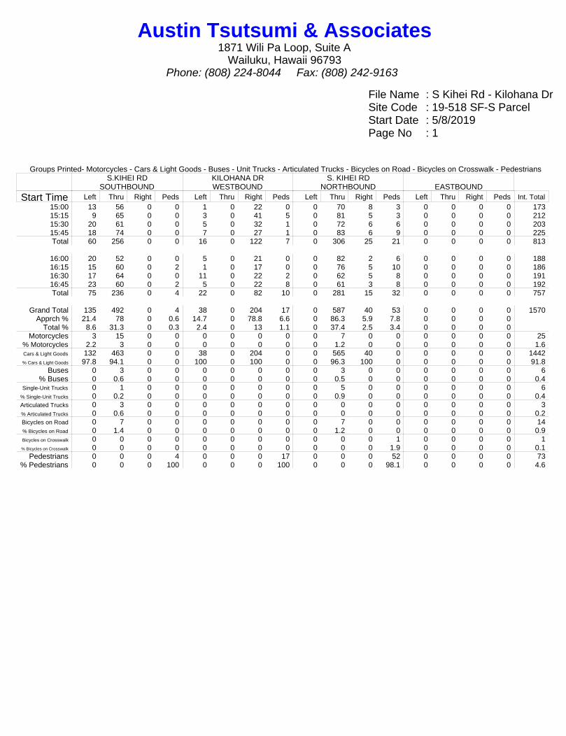
File Name : S Kihei Rd - Kilohana DrSite Code : 19-518 SF-S ParcelStart Date : 5/8/2019Page No : 1
Groups Printed- Motorcycles - Cars & Light Goods - Buses - Unit Trucks - Articulated Trucks - Bicycles on Road - Bicycles on Crosswalk - PedestriansS.KIHEI RD
SOUTHBOUNDKILOHANA DRWESTBOUND
S. KIHEI RDNORTHBOUND EASTBOUND
Start Time Left Thru Right Peds Left Thru Right Peds Left Thru Right Peds Left Thru Right Peds Int. Total15:00 13 56 0 0 1 0 22 0 0 70 8 3 0 0 0 0 17315:15 9 65 0 0 3 0 41 5 0 81 5 3 0 0 0 0 21215:30 20 61 0 0 5 0 32 1 0 72 6 6 0 0 0 0 20315:45 18 74 0 0 7 0 27 1 0 83 6 9 0 0 0 0 225Total 60 256 0 0 16 0 122 7 0 306 25 21 0 0 0 0 813
16:00 20 52 0 0 5 0 21 0 0 82 2 6 0 0 0 0 18816:15 15 60 0 2 1 0 17 0 0 76 5 10 0 0 0 0 18616:30 17 64 0 0 11 0 22 2 0 62 5 8 0 0 0 0 19116:45 23 60 0 2 5 0 22 8 0 61 3 8 0 0 0 0 192Total 75 236 0 4 22 0 82 10 0 281 15 32 0 0 0 0 757
Grand Total 135 492 0 4 38 0 204 17 0 587 40 53 0 0 0 0 1570Apprch % 21.4 78 0 0.6 14.7 0 78.8 6.6 0 86.3 5.9 7.8 0 0 0 0
Total % 8.6 31.3 0 0.3 2.4 0 13 1.1 0 37.4 2.5 3.4 0 0 0 0Motorcycles 3 15 0 0 0 0 0 0 0 7 0 0 0 0 0 0 25
% Motorcycles 2.2 3 0 0 0 0 0 0 0 1.2 0 0 0 0 0 0 1.6Cars & Light Goods 132 463 0 0 38 0 204 0 0 565 40 0 0 0 0 0 1442% Cars & Light Goods 97.8 94.1 0 0 100 0 100 0 0 96.3 100 0 0 0 0 0 91.8
Buses 0 3 0 0 0 0 0 0 0 3 0 0 0 0 0 0 6% Buses 0 0.6 0 0 0 0 0 0 0 0.5 0 0 0 0 0 0 0.4
Single-Unit Trucks 0 1 0 0 0 0 0 0 0 5 0 0 0 0 0 0 6% Single-Unit Trucks 0 0.2 0 0 0 0 0 0 0 0.9 0 0 0 0 0 0 0.4Articulated Trucks 0 3 0 0 0 0 0 0 0 0 0 0 0 0 0 0 3% Articulated Trucks 0 0.6 0 0 0 0 0 0 0 0 0 0 0 0 0 0 0.2Bicycles on Road 0 7 0 0 0 0 0 0 0 7 0 0 0 0 0 0 14% Bicycles on Road 0 1.4 0 0 0 0 0 0 0 1.2 0 0 0 0 0 0 0.9Bicycles on Crosswalk 0 0 0 0 0 0 0 0 0 0 0 1 0 0 0 0 1% Bicycles on Crosswalk 0 0 0 0 0 0 0 0 0 0 0 1.9 0 0 0 0 0.1
Pedestrians 0 0 0 4 0 0 0 17 0 0 0 52 0 0 0 0 73% Pedestrians 0 0 0 100 0 0 0 100 0 0 0 98.1 0 0 0 0 4.6
Austin Tsutsumi & Associates1871 Wili Pa Loop, Suite A
Wailuku, Hawaii 96793Phone: (808) 224-8044 Fax: (808) 242-9163
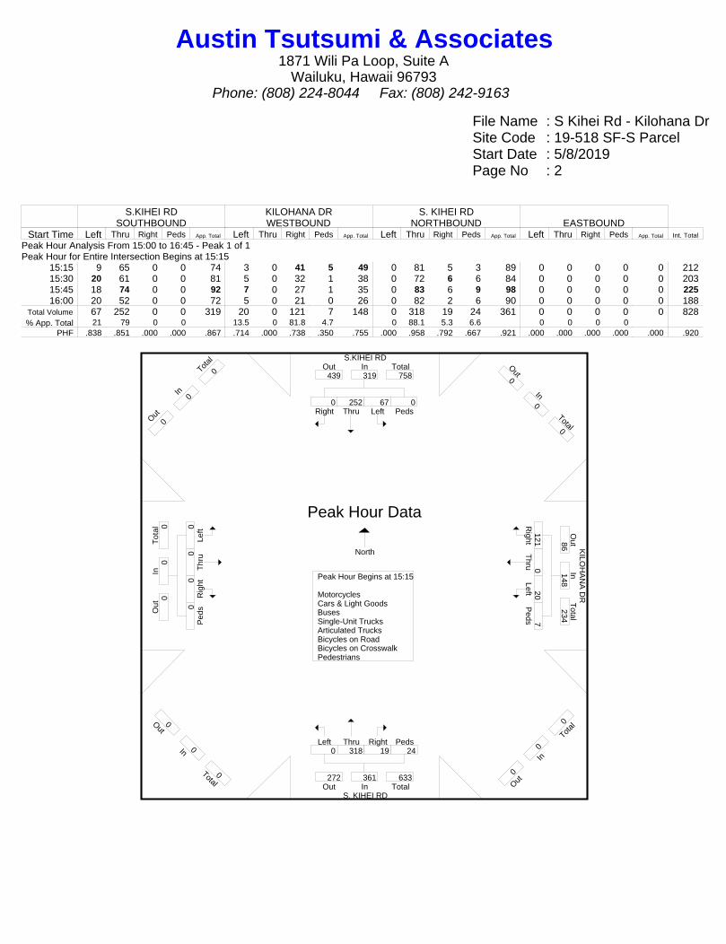
File Name : S Kihei Rd - Kilohana DrSite Code : 19-518 SF-S ParcelStart Date : 5/8/2019Page No : 2
S.KIHEI RDSOUTHBOUND
KILOHANA DRWESTBOUND
S. KIHEI RDNORTHBOUND EASTBOUND
Start Time Left Thru Right Peds App. Total Left Thru Right Peds App. Total Left Thru Right Peds App. Total Left Thru Right Peds App. Total Int. Total
Peak Hour Analysis From 15:00 to 16:45 - Peak 1 of 1Peak Hour for Entire Intersection Begins at 15:15
15:15 9 65 0 0 74 3 0 41 5 49 0 81 5 3 89 0 0 0 0 0 21215:30 20 61 0 0 81 5 0 32 1 38 0 72 6 6 84 0 0 0 0 0 20315:45 18 74 0 0 92 7 0 27 1 35 0 83 6 9 98 0 0 0 0 0 22516:00 20 52 0 0 72 5 0 21 0 26 0 82 2 6 90 0 0 0 0 0 188
Total Volume 67 252 0 0 319 20 0 121 7 148 0 318 19 24 361 0 0 0 0 0 828% App. Total 21 79 0 0 13.5 0 81.8 4.7 0 88.1 5.3 6.6 0 0 0 0
PHF .838 .851 .000 .000 .867 .714 .000 .738 .350 .755 .000 .958 .792 .667 .921 .000 .000 .000 .000 .000 .920
S.KIHEI RD
K
ILOH
AN
A D
R
S. KIHEI RD
Right0
Thru252
Left67
Peds0
InOut Total439 319 758
Out0
In0
Total0
Right121
Thru0
Left20 P
eds7
Out
Total
In86
148 234
O ut0
In0
T otal
0
Left0
Thru318
Right19
Peds24
Out TotalIn272 361 633
Out0
In0
Total0
Left0
Thr
u0 R
ight0
Ped
s0
Tot
alO
utIn
0 0
0
O ut0
In0
T otal
0
Peak Hour Begins at 15:15 MotorcyclesCars & Light GoodsBusesSingle-Unit TrucksArticulated TrucksBicycles on RoadBicycles on CrosswalkPedestrians
Peak Hour Data
North
Austin Tsutsumi & Associates1871 Wili Pa Loop, Suite A
Wailuku, Hawaii 96793Phone: (808) 224-8044 Fax: (808) 242-9163

File Name : Wailea Alanui Dr - Kilohana DrSite Code : 19-518 Proposed SF-S ParcelStart Date : 5/9/2019Page No : 1
Groups Printed- Motorcycles - Cars & Light Goods - Buses - Unit Trucks - Articulated Trucks - Bicycles on Road - Bicycles on Crosswalk - PedestriansLAWAKUA ST
SOUTHBOUNDKILOHANA DRWESTBOUND
WAILEA ALANUI DRNORTHBOUND
KILOHANA DREASTBOUND
Start Time Left Thru Right Peds Left Thru Right Peds Left Thru Right Peds Left Thru Right Peds Int. Total06:30 3 0 1 1 10 5 0 0 0 1 7 0 0 11 1 4 4406:45 4 1 0 0 20 12 1 1 0 0 6 0 0 16 0 4 65Total 7 1 1 1 30 17 1 1 0 1 13 0 0 27 1 8 109
07:00 1 0 0 0 8 13 0 1 1 0 6 1 0 8 1 0 4007:15 2 0 0 4 12 16 2 1 3 0 5 6 0 13 0 5 6907:30 5 2 1 2 23 20 0 0 1 1 6 1 0 15 2 1 8007:45 3 1 0 2 11 22 1 1 5 1 3 4 0 10 0 1 65Total 11 3 1 8 54 71 3 3 10 2 20 12 0 46 3 7 254
08:00 1 0 0 0 8 22 2 0 4 2 7 6 0 19 3 0 7408:15 7 1 1 2 20 22 1 0 5 1 9 3 0 15 1 2 90
Grand Total 26 5 3 11 112 132 7 4 19 6 49 21 0 107 8 17 527Apprch % 57.8 11.1 6.7 24.4 43.9 51.8 2.7 1.6 20 6.3 51.6 22.1 0 81.1 6.1 12.9
Total % 4.9 0.9 0.6 2.1 21.3 25 1.3 0.8 3.6 1.1 9.3 4 0 20.3 1.5 3.2Motorcycles 0 1 0 0 1 2 0 0 0 1 0 0 0 2 0 0 7
% Motorcycles 0 20 0 0 0.9 1.5 0 0 0 16.7 0 0 0 1.9 0 0 1.3Cars & Light Goods 26 4 3 0 107 125 7 0 17 4 46 0 0 103 8 0 450% Cars & Light Goods 100 80 100 0 95.5 94.7 100 0 89.5 66.7 93.9 0 0 96.3 100 0 85.4
Buses 0 0 0 0 1 1 0 0 1 0 0 0 0 1 0 0 4% Buses 0 0 0 0 0.9 0.8 0 0 5.3 0 0 0 0 0.9 0 0 0.8
Single-Unit Trucks 0 0 0 0 0 1 0 0 0 0 0 0 0 1 0 0 2% Single-Unit Trucks 0 0 0 0 0 0.8 0 0 0 0 0 0 0 0.9 0 0 0.4Articulated Trucks 0 0 0 0 0 3 0 0 0 0 0 0 0 0 0 0 3% Articulated Trucks 0 0 0 0 0 2.3 0 0 0 0 0 0 0 0 0 0 0.6Bicycles on Road 0 0 0 0 3 0 0 0 1 1 3 0 0 0 0 0 8% Bicycles on Road 0 0 0 0 2.7 0 0 0 5.3 16.7 6.1 0 0 0 0 0 1.5Bicycles on Crosswalk 0 0 0 0 0 0 0 0 0 0 0 0 0 0 0 0 0% Bicycles on Crosswalk 0 0 0 0 0 0 0 0 0 0 0 0 0 0 0 0 0
Pedestrians 0 0 0 11 0 0 0 4 0 0 0 21 0 0 0 17 53% Pedestrians 0 0 0 100 0 0 0 100 0 0 0 100 0 0 0 100 10.1
Austin Tsutsumi & Associates1871 Wili Pa Loop, Suite A
Wailuku, Hawaii 96793Phone: (808) 224-8044 Fax: (808) 242-9163

File Name : Wailea Alanui Dr - Kilohana DrSite Code : 19-518 Proposed SF-S ParcelStart Date : 5/9/2019Page No : 2
LAWAKUA STSOUTHBOUND
KILOHANA DRWESTBOUND
WAILEA ALANUI DRNORTHBOUND
KILOHANA DREASTBOUND
Start Time Left Thru Right Peds App. Total Left Thru Right Peds App. Total Left Thru Right Peds App. Total Left Thru Right Peds App. Total Int. Total
Peak Hour Analysis From 06:30 to 08:15 - Peak 1 of 1Peak Hour for Entire Intersection Begins at 07:30
07:30 5 2 1 2 10 23 20 0 0 43 1 1 6 1 9 0 15 2 1 18 8007:45 3 1 0 2 6 11 22 1 1 35 5 1 3 4 13 0 10 0 1 11 6508:00 1 0 0 0 1 8 22 2 0 32 4 2 7 6 19 0 19 3 0 22 7408:15 7 1 1 2 11 20 22 1 0 43 5 1 9 3 18 0 15 1 2 18 90
Total Volume 16 4 2 6 28 62 86 4 1 153 15 5 25 14 59 0 59 6 4 69 309% App. Total 57.1 14.3 7.1 21.4 40.5 56.2 2.6 0.7 25.4 8.5 42.4 23.7 0 85.5 8.7 5.8
PHF .571 .500 .500 .750 .636 .674 .977 .500 .250 .890 .750 .625 .694 .583 .776 .000 .776 .500 .500 .784 .858
LAWAKUA ST
KIL
OH
AN
A D
R K
ILOH
AN
A D
R
WAILEA ALANUI DR
Right2
Thru4
Left16
Peds6
InOut Total9 28 37
Out0
In0
Total0
Right4
Thru86
Left62 P
eds1
Out
Total
In100
153 253
O ut0
In0
T otal
0
Left15
Thru5
Right25
Peds14
Out TotalIn72 59 131
Out0
In0
Total0
Left0
Thr
u59
Rig
ht6 P
eds4
Tot
alO
utIn
103
69
172
O ut0
In0
T otal
0
Peak Hour Begins at 07:30 MotorcyclesCars & Light GoodsBusesSingle-Unit TrucksArticulated TrucksBicycles on RoadBicycles on CrosswalkPedestrians
Peak Hour Data
North
Austin Tsutsumi & Associates1871 Wili Pa Loop, Suite A
Wailuku, Hawaii 96793Phone: (808) 224-8044 Fax: (808) 242-9163
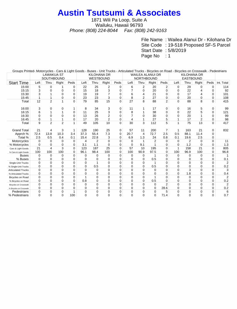
File Name : Wailea Alanui Dr - Kilohana DrSite Code : 19-518 Proposed SF-S ParcelStart Date : 5/8/2019Page No : 1
Groups Printed- Motorcycles - Cars & Light Goods - Buses - Unit Trucks - Articulated Trucks - Bicycles on Road - Bicycles on Crosswalk - PedestriansLAWAKUA ST
SOUTHBOUNDKILOHANA DRWESTBOUND
WAILEA ALANUI DRNORTHBOUND
KILOHANA DREASTBOUND
Start Time Left Thru Right Peds Left Thru Right Peds Left Thru Right Peds Left Thru Right Peds Int. Total15:00 5 0 1 0 22 25 2 0 6 2 20 2 0 29 0 0 11415:15 3 0 0 0 15 18 3 0 7 0 20 0 0 22 4 0 9215:30 3 1 0 0 19 19 7 0 6 4 21 0 0 17 4 0 10115:45 1 1 0 0 23 23 3 0 8 2 27 0 0 20 0 0 108Total 12 2 1 0 79 85 15 0 27 8 88 2 0 88 8 0 415
16:00 3 0 0 1 8 34 3 0 11 1 17 0 0 16 5 0 9916:15 6 1 1 0 11 25 3 0 8 1 38 0 0 22 5 0 12116:30 0 0 0 0 13 26 2 0 7 0 30 0 0 20 1 0 9916:45 0 1 1 0 17 20 2 0 4 1 27 5 1 17 2 0 98Total 9 2 2 1 49 105 10 0 30 3 112 5 1 75 13 0 417
Grand Total 21 4 3 1 128 190 25 0 57 11 200 7 1 163 21 0 832Apprch % 72.4 13.8 10.3 3.4 37.3 55.4 7.3 0 20.7 4 72.7 2.5 0.5 88.1 11.4 0
Total % 2.5 0.5 0.4 0.1 15.4 22.8 3 0 6.9 1.3 24 0.8 0.1 19.6 2.5 0Motorcycles 0 0 0 0 4 2 0 0 0 1 2 0 0 2 0 0 11
% Motorcycles 0 0 0 0 3.1 1.1 0 0 0 9.1 1 0 0 1.2 0 0 1.3Cars & Light Goods 21 4 3 0 123 187 25 0 57 10 195 0 1 158 21 0 805% Cars & Light Goods 100 100 100 0 96.1 98.4 100 0 100 90.9 97.5 0 100 96.9 100 0 96.8
Buses 0 0 0 0 0 0 0 0 0 0 1 0 0 0 0 0 1% Buses 0 0 0 0 0 0 0 0 0 0 0.5 0 0 0 0 0 0.1
Single-Unit Trucks 0 0 0 0 0 1 0 0 0 0 1 0 0 0 0 0 2% Single-Unit Trucks 0 0 0 0 0 0.5 0 0 0 0 0.5 0 0 0 0 0 0.2Articulated Trucks 0 0 0 0 0 0 0 0 0 0 0 0 0 3 0 0 3% Articulated Trucks 0 0 0 0 0 0 0 0 0 0 0 0 0 1.8 0 0 0.4Bicycles on Road 0 0 0 0 1 0 0 0 0 0 1 0 0 0 0 0 2% Bicycles on Road 0 0 0 0 0.8 0 0 0 0 0 0.5 0 0 0 0 0 0.2Bicycles on Crosswalk 0 0 0 0 0 0 0 0 0 0 0 2 0 0 0 0 2% Bicycles on Crosswalk 0 0 0 0 0 0 0 0 0 0 0 28.6 0 0 0 0 0.2
Pedestrians 0 0 0 1 0 0 0 0 0 0 0 5 0 0 0 0 6% Pedestrians 0 0 0 100 0 0 0 0 0 0 0 71.4 0 0 0 0 0.7
Austin Tsutsumi & Associates1871 Wili Pa Loop, Suite A
Wailuku, Hawaii 96793Phone: (808) 224-8044 Fax: (808) 242-9163

File Name : Wailea Alanui Dr - Kilohana DrSite Code : 19-518 Proposed SF-S ParcelStart Date : 5/8/2019Page No : 2
LAWAKUA STSOUTHBOUND
KILOHANA DRWESTBOUND
WAILEA ALANUI DRNORTHBOUND
KILOHANA DREASTBOUND
Start Time Left Thru Right Peds App. Total Left Thru Right Peds App. Total Left Thru Right Peds App. Total Left Thru Right Peds App. Total Int. Total
Peak Hour Analysis From 15:15 to 16:00 - Peak 1 of 1Peak Hour for Entire Intersection Begins at 15:15
15:15 3 0 0 0 3 15 18 3 0 36 7 0 20 0 27 0 22 4 0 26 9215:30 3 1 0 0 4 19 19 7 0 45 6 4 21 0 31 0 17 4 0 21 10115:45 1 1 0 0 2 23 23 3 0 49 8 2 27 0 37 0 20 0 0 20 10816:00 3 0 0 1 4 8 34 3 0 45 11 1 17 0 29 0 16 5 0 21 99
Total Volume 10 2 0 1 13 65 94 16 0 175 32 7 85 0 124 0 75 13 0 88 400% App. Total 76.9 15.4 0 7.7 37.1 53.7 9.1 0 25.8 5.6 68.5 0 0 85.2 14.8 0
PHF .833 .500 .000 .250 .813 .707 .691 .571 .000 .893 .727 .438 .787 .000 .838 .000 .852 .650 .000 .846 .926
LAWAKUA ST
KIL
OH
AN
A D
R K
ILOH
AN
A D
R
WAILEA ALANUI DR
Right0
Thru2
Left10
Peds1
InOut Total23 13 36
Out0
In0
Total0
Right
16 T
hru94 Left65
Peds0
Out
Total
In170
175 345
O ut0
In0
T otal
0
Left32
Thru7
Right85
Peds0
Out TotalIn80 124 204
Out0
In0
Total0
Left0
Thr
u75
Rig
ht13
Ped
s0
Tot
alO
utIn
126
88
214
O ut0
In0
T otal
0
Peak Hour Begins at 15:15 MotorcyclesCars & Light GoodsBusesSingle-Unit TrucksArticulated TrucksBicycles on RoadBicycles on CrosswalkPedestrians
Peak Hour Data
North
Austin Tsutsumi & Associates1871 Wili Pa Loop, Suite A
Wailuku, Hawaii 96793Phone: (808) 224-8044 Fax: (808) 242-9163
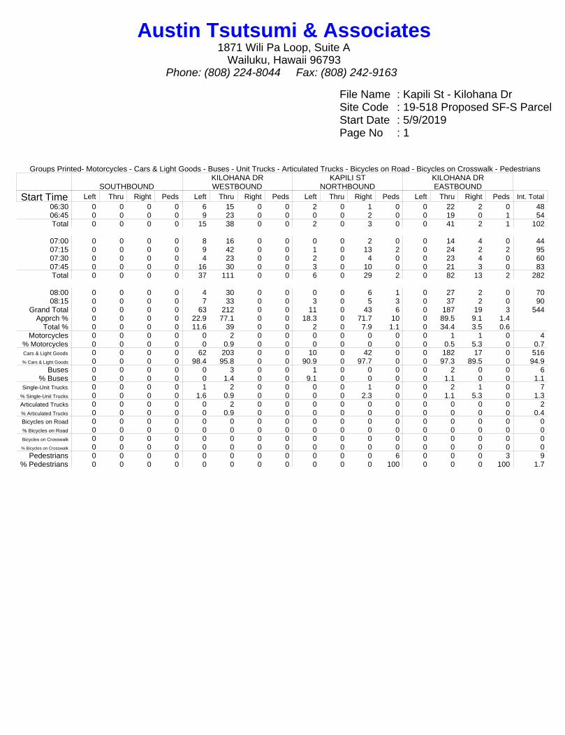
File Name : Kapili St - Kilohana DrSite Code : 19-518 Proposed SF-S ParcelStart Date : 5/9/2019Page No : 1
Groups Printed- Motorcycles - Cars & Light Goods - Buses - Unit Trucks - Articulated Trucks - Bicycles on Road - Bicycles on Crosswalk - Pedestrians
SOUTHBOUNDKILOHANA DRWESTBOUND
KAPILI STNORTHBOUND
KILOHANA DREASTBOUND
Start Time Left Thru Right Peds Left Thru Right Peds Left Thru Right Peds Left Thru Right Peds Int. Total06:30 0 0 0 0 6 15 0 0 2 0 1 0 0 22 2 0 4806:45 0 0 0 0 9 23 0 0 0 0 2 0 0 19 0 1 54Total 0 0 0 0 15 38 0 0 2 0 3 0 0 41 2 1 102
07:00 0 0 0 0 8 16 0 0 0 0 2 0 0 14 4 0 4407:15 0 0 0 0 9 42 0 0 1 0 13 2 0 24 2 2 9507:30 0 0 0 0 4 23 0 0 2 0 4 0 0 23 4 0 6007:45 0 0 0 0 16 30 0 0 3 0 10 0 0 21 3 0 83Total 0 0 0 0 37 111 0 0 6 0 29 2 0 82 13 2 282
08:00 0 0 0 0 4 30 0 0 0 0 6 1 0 27 2 0 7008:15 0 0 0 0 7 33 0 0 3 0 5 3 0 37 2 0 90
Grand Total 0 0 0 0 63 212 0 0 11 0 43 6 0 187 19 3 544Apprch % 0 0 0 0 22.9 77.1 0 0 18.3 0 71.7 10 0 89.5 9.1 1.4
Total % 0 0 0 0 11.6 39 0 0 2 0 7.9 1.1 0 34.4 3.5 0.6Motorcycles 0 0 0 0 0 2 0 0 0 0 0 0 0 1 1 0 4
% Motorcycles 0 0 0 0 0 0.9 0 0 0 0 0 0 0 0.5 5.3 0 0.7Cars & Light Goods 0 0 0 0 62 203 0 0 10 0 42 0 0 182 17 0 516% Cars & Light Goods 0 0 0 0 98.4 95.8 0 0 90.9 0 97.7 0 0 97.3 89.5 0 94.9
Buses 0 0 0 0 0 3 0 0 1 0 0 0 0 2 0 0 6% Buses 0 0 0 0 0 1.4 0 0 9.1 0 0 0 0 1.1 0 0 1.1
Single-Unit Trucks 0 0 0 0 1 2 0 0 0 0 1 0 0 2 1 0 7% Single-Unit Trucks 0 0 0 0 1.6 0.9 0 0 0 0 2.3 0 0 1.1 5.3 0 1.3Articulated Trucks 0 0 0 0 0 2 0 0 0 0 0 0 0 0 0 0 2% Articulated Trucks 0 0 0 0 0 0.9 0 0 0 0 0 0 0 0 0 0 0.4Bicycles on Road 0 0 0 0 0 0 0 0 0 0 0 0 0 0 0 0 0% Bicycles on Road 0 0 0 0 0 0 0 0 0 0 0 0 0 0 0 0 0Bicycles on Crosswalk 0 0 0 0 0 0 0 0 0 0 0 0 0 0 0 0 0% Bicycles on Crosswalk 0 0 0 0 0 0 0 0 0 0 0 0 0 0 0 0 0
Pedestrians 0 0 0 0 0 0 0 0 0 0 0 6 0 0 0 3 9% Pedestrians 0 0 0 0 0 0 0 0 0 0 0 100 0 0 0 100 1.7
Austin Tsutsumi & Associates1871 Wili Pa Loop, Suite A
Wailuku, Hawaii 96793Phone: (808) 224-8044 Fax: (808) 242-9163

File Name : Kapili St - Kilohana DrSite Code : 19-518 Proposed SF-S ParcelStart Date : 5/9/2019Page No : 2
SOUTHBOUNDKILOHANA DRWESTBOUND
KAPILI STNORTHBOUND
KILOHANA DREASTBOUND
Start Time Left Thru Right Peds App. Total Left Thru Right Peds App. Total Left Thru Right Peds App. Total Left Thru Right Peds App. Total Int. Total
Peak Hour Analysis From 07:30 to 08:15 - Peak 1 of 1Peak Hour for Entire Intersection Begins at 07:30
07:30 0 0 0 0 0 4 23 0 0 27 2 0 4 0 6 0 23 4 0 27 6007:45 0 0 0 0 0 16 30 0 0 46 3 0 10 0 13 0 21 3 0 24 8308:00 0 0 0 0 0 4 30 0 0 34 0 0 6 1 7 0 27 2 0 29 7008:15 0 0 0 0 0 7 33 0 0 40 3 0 5 3 11 0 37 2 0 39 90
Total Volume 0 0 0 0 0 31 116 0 0 147 8 0 25 4 37 0 108 11 0 119 303% App. Total 0 0 0 0 21.1 78.9 0 0 21.6 0 67.6 10.8 0 90.8 9.2 0
PHF .000 .000 .000 .000 .000 .484 .879 .000 .000 .799 .667 .000 .625 .333 .712 .000 .730 .688 .000 .763 .842
KIL
OH
AN
A D
R K
ILOH
AN
A D
R
KAPILI ST
Right0
Thru0
Left0
Peds0
InOut Total0 0 0
Out0
In0
Total0
Right0
Thru116
Left31 P
eds0
Out
Total
In133
147 280
O ut0
In0
T otal
0
Left8
Thru0
Right25
Peds4
Out TotalIn42 37 79
Out0
In0
Total0
Left0
Thr
u10
8 R
ight11
P
eds0
Tot
alO
utIn
124
119
243
O ut0
In0
T otal
0
Peak Hour Begins at 07:30 MotorcyclesCars & Light GoodsBusesSingle-Unit TrucksArticulated TrucksBicycles on RoadBicycles on CrosswalkPedestrians
Peak Hour Data
North
Austin Tsutsumi & Associates1871 Wili Pa Loop, Suite A
Wailuku, Hawaii 96793Phone: (808) 224-8044 Fax: (808) 242-9163
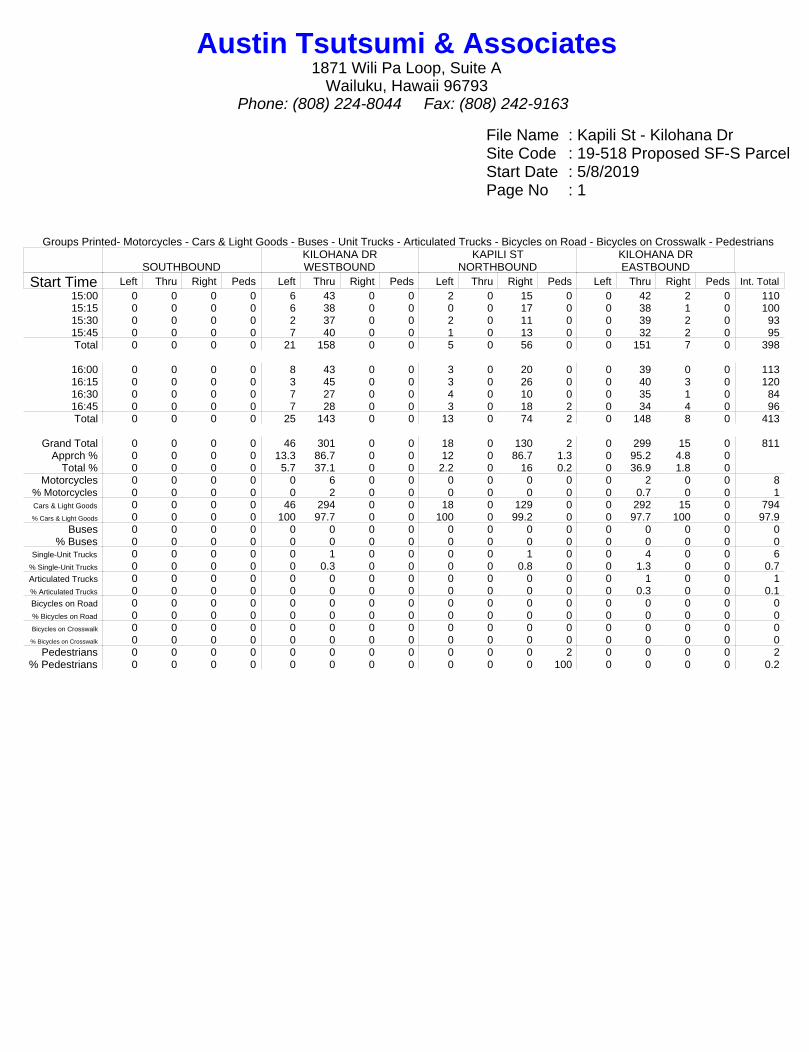
File Name : Kapili St - Kilohana DrSite Code : 19-518 Proposed SF-S ParcelStart Date : 5/8/2019Page No : 1
Groups Printed- Motorcycles - Cars & Light Goods - Buses - Unit Trucks - Articulated Trucks - Bicycles on Road - Bicycles on Crosswalk - Pedestrians
SOUTHBOUNDKILOHANA DRWESTBOUND
KAPILI STNORTHBOUND
KILOHANA DREASTBOUND
Start Time Left Thru Right Peds Left Thru Right Peds Left Thru Right Peds Left Thru Right Peds Int. Total15:00 0 0 0 0 6 43 0 0 2 0 15 0 0 42 2 0 11015:15 0 0 0 0 6 38 0 0 0 0 17 0 0 38 1 0 10015:30 0 0 0 0 2 37 0 0 2 0 11 0 0 39 2 0 9315:45 0 0 0 0 7 40 0 0 1 0 13 0 0 32 2 0 95Total 0 0 0 0 21 158 0 0 5 0 56 0 0 151 7 0 398
16:00 0 0 0 0 8 43 0 0 3 0 20 0 0 39 0 0 11316:15 0 0 0 0 3 45 0 0 3 0 26 0 0 40 3 0 12016:30 0 0 0 0 7 27 0 0 4 0 10 0 0 35 1 0 8416:45 0 0 0 0 7 28 0 0 3 0 18 2 0 34 4 0 96Total 0 0 0 0 25 143 0 0 13 0 74 2 0 148 8 0 413
Grand Total 0 0 0 0 46 301 0 0 18 0 130 2 0 299 15 0 811Apprch % 0 0 0 0 13.3 86.7 0 0 12 0 86.7 1.3 0 95.2 4.8 0
Total % 0 0 0 0 5.7 37.1 0 0 2.2 0 16 0.2 0 36.9 1.8 0Motorcycles 0 0 0 0 0 6 0 0 0 0 0 0 0 2 0 0 8
% Motorcycles 0 0 0 0 0 2 0 0 0 0 0 0 0 0.7 0 0 1Cars & Light Goods 0 0 0 0 46 294 0 0 18 0 129 0 0 292 15 0 794% Cars & Light Goods 0 0 0 0 100 97.7 0 0 100 0 99.2 0 0 97.7 100 0 97.9
Buses 0 0 0 0 0 0 0 0 0 0 0 0 0 0 0 0 0% Buses 0 0 0 0 0 0 0 0 0 0 0 0 0 0 0 0 0
Single-Unit Trucks 0 0 0 0 0 1 0 0 0 0 1 0 0 4 0 0 6% Single-Unit Trucks 0 0 0 0 0 0.3 0 0 0 0 0.8 0 0 1.3 0 0 0.7Articulated Trucks 0 0 0 0 0 0 0 0 0 0 0 0 0 1 0 0 1% Articulated Trucks 0 0 0 0 0 0 0 0 0 0 0 0 0 0.3 0 0 0.1Bicycles on Road 0 0 0 0 0 0 0 0 0 0 0 0 0 0 0 0 0% Bicycles on Road 0 0 0 0 0 0 0 0 0 0 0 0 0 0 0 0 0Bicycles on Crosswalk 0 0 0 0 0 0 0 0 0 0 0 0 0 0 0 0 0% Bicycles on Crosswalk 0 0 0 0 0 0 0 0 0 0 0 0 0 0 0 0 0
Pedestrians 0 0 0 0 0 0 0 0 0 0 0 2 0 0 0 0 2% Pedestrians 0 0 0 0 0 0 0 0 0 0 0 100 0 0 0 0 0.2
Austin Tsutsumi & Associates1871 Wili Pa Loop, Suite A
Wailuku, Hawaii 96793Phone: (808) 224-8044 Fax: (808) 242-9163
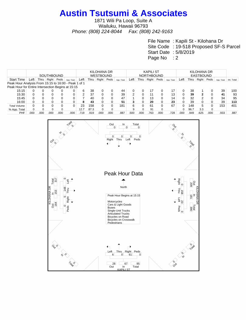
File Name : Kapili St - Kilohana DrSite Code : 19-518 Proposed SF-S ParcelStart Date : 5/8/2019Page No : 2
SOUTHBOUNDKILOHANA DRWESTBOUND
KAPILI STNORTHBOUND
KILOHANA DREASTBOUND
Start Time Left Thru Right Peds App. Total Left Thru Right Peds App. Total Left Thru Right Peds App. Total Left Thru Right Peds App. Total Int. Total
Peak Hour Analysis From 15:15 to 16:00 - Peak 1 of 1Peak Hour for Entire Intersection Begins at 15:15
15:15 0 0 0 0 0 6 38 0 0 44 0 0 17 0 17 0 38 1 0 39 10015:30 0 0 0 0 0 2 37 0 0 39 2 0 11 0 13 0 39 2 0 41 9315:45 0 0 0 0 0 7 40 0 0 47 1 0 13 0 14 0 32 2 0 34 9516:00 0 0 0 0 0 8 43 0 0 51 3 0 20 0 23 0 39 0 0 39 113
Total Volume 0 0 0 0 0 23 158 0 0 181 6 0 61 0 67 0 148 5 0 153 401% App. Total 0 0 0 0 12.7 87.3 0 0 9 0 91 0 0 96.7 3.3 0
PHF .000 .000 .000 .000 .000 .719 .919 .000 .000 .887 .500 .000 .763 .000 .728 .000 .949 .625 .000 .933 .887
KIL
OH
AN
A D
R K
ILOH
AN
A D
R
KAPILI ST
Right0
Thru0
Left0
Peds0
InOut Total0 0 0
Out0
In0
Total0
Right0
Thru158
Left23 P
eds0
Out
Total
In209
181 390
O ut0
In0
T otal
0
Left6
Thru0
Right61
Peds0
Out TotalIn28 67 95
Out0
In0
Total0
Left0
Thr
u14
8 R
ight5
Ped
s0
Tot
alO
utIn
164
153
317
O ut0
In0
T otal
0
Peak Hour Begins at 15:15 MotorcyclesCars & Light GoodsBusesSingle-Unit TrucksArticulated TrucksBicycles on RoadBicycles on CrosswalkPedestrians
Peak Hour Data
North
Austin Tsutsumi & Associates1871 Wili Pa Loop, Suite A
Wailuku, Hawaii 96793Phone: (808) 224-8044 Fax: (808) 242-9163
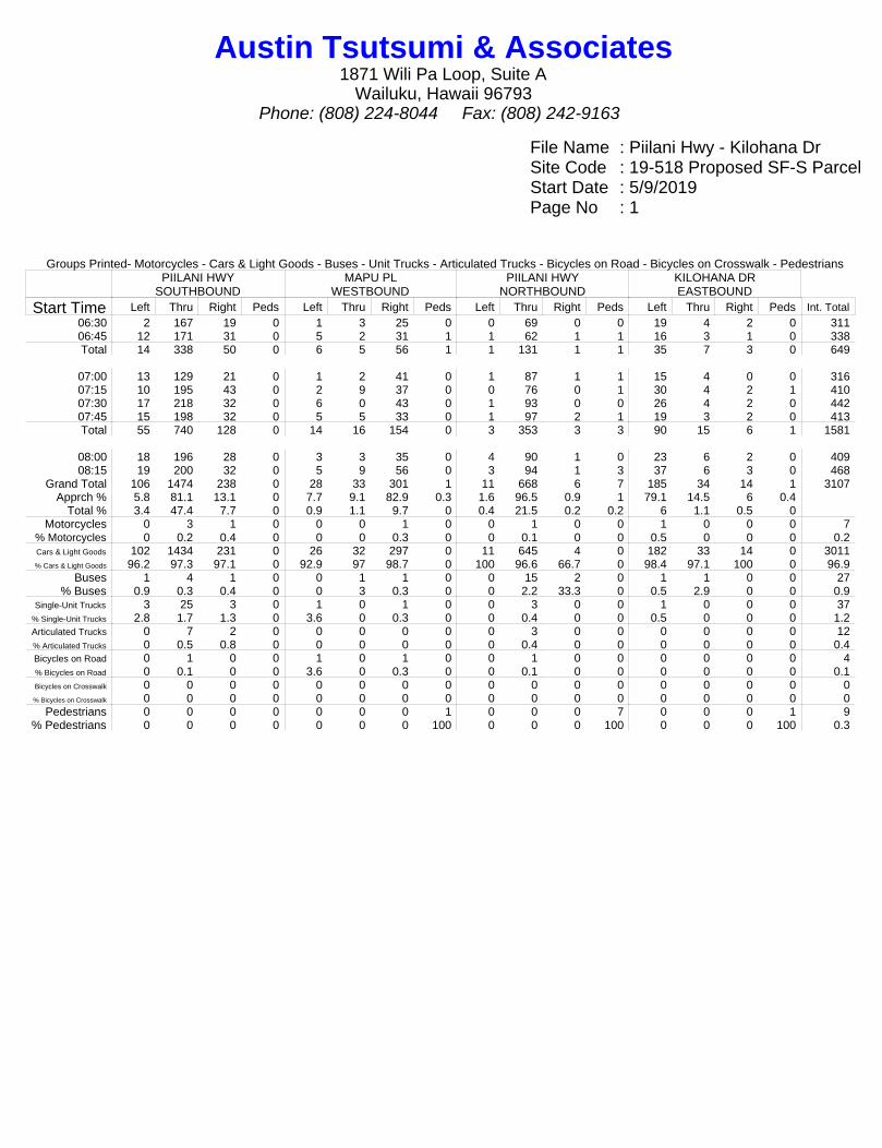
File Name : Piilani Hwy - Kilohana DrSite Code : 19-518 Proposed SF-S ParcelStart Date : 5/9/2019Page No : 1
Groups Printed- Motorcycles - Cars & Light Goods - Buses - Unit Trucks - Articulated Trucks - Bicycles on Road - Bicycles on Crosswalk - PedestriansPIILANI HWY
SOUTHBOUNDMAPU PL
WESTBOUNDPIILANI HWY
NORTHBOUNDKILOHANA DREASTBOUND
Start Time Left Thru Right Peds Left Thru Right Peds Left Thru Right Peds Left Thru Right Peds Int. Total06:30 2 167 19 0 1 3 25 0 0 69 0 0 19 4 2 0 31106:45 12 171 31 0 5 2 31 1 1 62 1 1 16 3 1 0 338Total 14 338 50 0 6 5 56 1 1 131 1 1 35 7 3 0 649
07:00 13 129 21 0 1 2 41 0 1 87 1 1 15 4 0 0 31607:15 10 195 43 0 2 9 37 0 0 76 0 1 30 4 2 1 41007:30 17 218 32 0 6 0 43 0 1 93 0 0 26 4 2 0 44207:45 15 198 32 0 5 5 33 0 1 97 2 1 19 3 2 0 413Total 55 740 128 0 14 16 154 0 3 353 3 3 90 15 6 1 1581
08:00 18 196 28 0 3 3 35 0 4 90 1 0 23 6 2 0 40908:15 19 200 32 0 5 9 56 0 3 94 1 3 37 6 3 0 468
Grand Total 106 1474 238 0 28 33 301 1 11 668 6 7 185 34 14 1 3107Apprch % 5.8 81.1 13.1 0 7.7 9.1 82.9 0.3 1.6 96.5 0.9 1 79.1 14.5 6 0.4
Total % 3.4 47.4 7.7 0 0.9 1.1 9.7 0 0.4 21.5 0.2 0.2 6 1.1 0.5 0Motorcycles 0 3 1 0 0 0 1 0 0 1 0 0 1 0 0 0 7
% Motorcycles 0 0.2 0.4 0 0 0 0.3 0 0 0.1 0 0 0.5 0 0 0 0.2Cars & Light Goods 102 1434 231 0 26 32 297 0 11 645 4 0 182 33 14 0 3011% Cars & Light Goods 96.2 97.3 97.1 0 92.9 97 98.7 0 100 96.6 66.7 0 98.4 97.1 100 0 96.9
Buses 1 4 1 0 0 1 1 0 0 15 2 0 1 1 0 0 27% Buses 0.9 0.3 0.4 0 0 3 0.3 0 0 2.2 33.3 0 0.5 2.9 0 0 0.9
Single-Unit Trucks 3 25 3 0 1 0 1 0 0 3 0 0 1 0 0 0 37% Single-Unit Trucks 2.8 1.7 1.3 0 3.6 0 0.3 0 0 0.4 0 0 0.5 0 0 0 1.2Articulated Trucks 0 7 2 0 0 0 0 0 0 3 0 0 0 0 0 0 12% Articulated Trucks 0 0.5 0.8 0 0 0 0 0 0 0.4 0 0 0 0 0 0 0.4Bicycles on Road 0 1 0 0 1 0 1 0 0 1 0 0 0 0 0 0 4% Bicycles on Road 0 0.1 0 0 3.6 0 0.3 0 0 0.1 0 0 0 0 0 0 0.1Bicycles on Crosswalk 0 0 0 0 0 0 0 0 0 0 0 0 0 0 0 0 0% Bicycles on Crosswalk 0 0 0 0 0 0 0 0 0 0 0 0 0 0 0 0 0
Pedestrians 0 0 0 0 0 0 0 1 0 0 0 7 0 0 0 1 9% Pedestrians 0 0 0 0 0 0 0 100 0 0 0 100 0 0 0 100 0.3
Austin Tsutsumi & Associates1871 Wili Pa Loop, Suite A
Wailuku, Hawaii 96793Phone: (808) 224-8044 Fax: (808) 242-9163
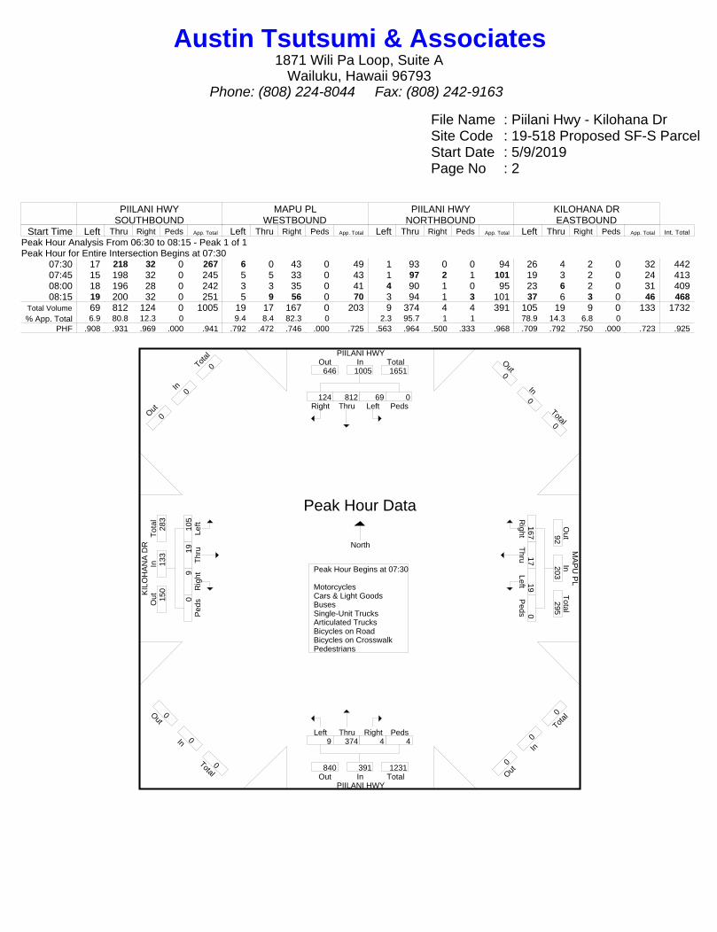
File Name : Piilani Hwy - Kilohana DrSite Code : 19-518 Proposed SF-S ParcelStart Date : 5/9/2019Page No : 2
PIILANI HWYSOUTHBOUND
MAPU PLWESTBOUND
PIILANI HWYNORTHBOUND
KILOHANA DREASTBOUND
Start Time Left Thru Right Peds App. Total Left Thru Right Peds App. Total Left Thru Right Peds App. Total Left Thru Right Peds App. Total Int. Total
Peak Hour Analysis From 06:30 to 08:15 - Peak 1 of 1Peak Hour for Entire Intersection Begins at 07:30
07:30 17 218 32 0 267 6 0 43 0 49 1 93 0 0 94 26 4 2 0 32 44207:45 15 198 32 0 245 5 5 33 0 43 1 97 2 1 101 19 3 2 0 24 41308:00 18 196 28 0 242 3 3 35 0 41 4 90 1 0 95 23 6 2 0 31 40908:15 19 200 32 0 251 5 9 56 0 70 3 94 1 3 101 37 6 3 0 46 468
Total Volume 69 812 124 0 1005 19 17 167 0 203 9 374 4 4 391 105 19 9 0 133 1732% App. Total 6.9 80.8 12.3 0 9.4 8.4 82.3 0 2.3 95.7 1 1 78.9 14.3 6.8 0
PHF .908 .931 .969 .000 .941 .792 .472 .746 .000 .725 .563 .964 .500 .333 .968 .709 .792 .750 .000 .723 .925
PIILANI HWY
KIL
OH
AN
A D
R
MA
PU
PL
PIILANI HWY
Right124
Thru812
Left69
Peds0
InOut Total646 1005 1651
Out0
In0
Total0
Right167
Thru17
Left19 P
eds0
Out
Total
In92
203 295
O ut0
In0
T otal
0
Left9
Thru374
Right4
Peds4
Out TotalIn840 391 1231
Out0
In0
Total0
Left
105
Thr
u19
Rig
ht9 P
eds0
Tot
alO
utIn
150
133
283
O ut0
In0
T otal
0
Peak Hour Begins at 07:30 MotorcyclesCars & Light GoodsBusesSingle-Unit TrucksArticulated TrucksBicycles on RoadBicycles on CrosswalkPedestrians
Peak Hour Data
North
Austin Tsutsumi & Associates1871 Wili Pa Loop, Suite A
Wailuku, Hawaii 96793Phone: (808) 224-8044 Fax: (808) 242-9163

File Name : Piilani Hwy - Kilohana DrSite Code : 19-518 Proposed SF-S ParcelStart Date : 5/8/2019Page No : 1
Groups Printed- Motorcycles - Cars & Light Goods - Buses - Unit Trucks - Articulated Trucks - Bicycles on Road - Bicycles on Crosswalk - PedestriansPIILANI HWY
SOUTHBOUNDMAPU PL
WESTBOUNDPIILANI HWY
NORTHBOUNDKILOHANA DREASTBOUND
Start Time Left Thru Right Peds Left Thru Right Peds Left Thru Right Peds Left Thru Right Peds Int. Total15:00 30 177 35 0 1 1 35 0 6 204 1 0 47 8 1 0 54615:15 25 191 39 0 6 6 31 0 5 242 0 0 45 6 4 0 60015:30 30 163 29 0 4 6 18 0 2 201 0 0 30 6 3 0 49215:45 26 189 38 0 6 5 50 0 4 219 1 0 50 7 4 0 599Total 111 720 141 0 17 18 134 0 17 866 2 0 172 27 12 0 2237
16:00 21 157 47 0 2 5 29 0 4 186 1 0 57 4 3 0 51616:15 29 136 37 0 3 3 26 0 3 228 0 0 51 3 3 0 52216:30 31 151 25 0 5 6 25 0 3 230 1 1 38 7 5 0 52816:45 36 154 28 0 2 2 23 0 2 213 0 1 35 11 5 0 512Total 117 598 137 0 12 16 103 0 12 857 2 2 181 25 16 0 2078
Grand Total 228 1318 278 0 29 34 237 0 29 1723 4 2 353 52 28 0 4315Apprch % 12.5 72.3 15.2 0 9.7 11.3 79 0 1.6 98 0.2 0.1 81.5 12 6.5 0
Total % 5.3 30.5 6.4 0 0.7 0.8 5.5 0 0.7 39.9 0.1 0 8.2 1.2 0.6 0Motorcycles 0 6 2 0 0 2 1 0 2 9 0 0 0 2 1 0 25
% Motorcycles 0 0.5 0.7 0 0 5.9 0.4 0 6.9 0.5 0 0 0 3.8 3.6 0 0.6Cars & Light Goods 226 1288 276 0 29 31 231 0 27 1673 4 0 346 50 27 0 4208% Cars & Light Goods 99.1 97.7 99.3 0 100 91.2 97.5 0 93.1 97.1 100 0 98 96.2 96.4 0 97.5
Buses 1 11 0 0 0 0 0 0 0 11 0 0 1 0 0 0 24% Buses 0.4 0.8 0 0 0 0 0 0 0 0.6 0 0 0.3 0 0 0 0.6
Single-Unit Trucks 1 10 0 0 0 1 4 0 0 26 0 0 5 0 0 0 47% Single-Unit Trucks 0.4 0.8 0 0 0 2.9 1.7 0 0 1.5 0 0 1.4 0 0 0 1.1Articulated Trucks 0 3 0 0 0 0 0 0 0 4 0 0 1 0 0 0 8% Articulated Trucks 0 0.2 0 0 0 0 0 0 0 0.2 0 0 0.3 0 0 0 0.2Bicycles on Road 0 0 0 0 0 0 1 0 0 0 0 0 0 0 0 0 1% Bicycles on Road 0 0 0 0 0 0 0.4 0 0 0 0 0 0 0 0 0 0Bicycles on Crosswalk 0 0 0 0 0 0 0 0 0 0 0 0 0 0 0 0 0% Bicycles on Crosswalk 0 0 0 0 0 0 0 0 0 0 0 0 0 0 0 0 0
Pedestrians 0 0 0 0 0 0 0 0 0 0 0 2 0 0 0 0 2% Pedestrians 0 0 0 0 0 0 0 0 0 0 0 100 0 0 0 0 0
Austin Tsutsumi & Associates1871 Wili Pa Loop, Suite A
Wailuku, Hawaii 96793Phone: (808) 224-8044 Fax: (808) 242-9163

File Name : Piilani Hwy - Kilohana DrSite Code : 19-518 Proposed SF-S ParcelStart Date : 5/8/2019Page No : 2
PIILANI HWYSOUTHBOUND
MAPU PLWESTBOUND
PIILANI HWYNORTHBOUND
KILOHANA DREASTBOUND
Start Time Left Thru Right Peds App. Total Left Thru Right Peds App. Total Left Thru Right Peds App. Total Left Thru Right Peds App. Total Int. Total
Peak Hour Analysis From 15:15 to 16:00 - Peak 1 of 1Peak Hour for Entire Intersection Begins at 15:15
15:15 25 191 39 0 255 6 6 31 0 43 5 242 0 0 247 45 6 4 0 55 60015:30 30 163 29 0 222 4 6 18 0 28 2 201 0 0 203 30 6 3 0 39 49215:45 26 189 38 0 253 6 5 50 0 61 4 219 1 0 224 50 7 4 0 61 59916:00 21 157 47 0 225 2 5 29 0 36 4 186 1 0 191 57 4 3 0 64 516
Total Volume 102 700 153 0 955 18 22 128 0 168 15 848 2 0 865 182 23 14 0 219 2207% App. Total 10.7 73.3 16 0 10.7 13.1 76.2 0 1.7 98 0.2 0 83.1 10.5 6.4 0
PHF .850 .916 .814 .000 .936 .750 .917 .640 .000 .689 .750 .876 .500 .000 .876 .798 .821 .875 .000 .855 .920
PIILANI HWY
KIL
OH
AN
A D
R
MA
PU
PL
PIILANI HWY
Right153
Thru700
Left102
Peds0
InOut Total1158 955 2113
Out0
In0
Total0
Right128
Thru22
Left18 P
eds0
Out
Total
In127
168 295
O ut0
In0
T otal
0
Left15
Thru848
Right2
Peds0
Out TotalIn732 865 1597
Out0
In0
Total0
Left
182
Thr
u23
Rig
ht14
Ped
s0
Tot
alO
utIn
190
219
409
O ut0
In0
T otal
0
Peak Hour Begins at 15:15 MotorcyclesCars & Light GoodsBusesSingle-Unit TrucksArticulated TrucksBicycles on RoadBicycles on CrosswalkPedestrians
Peak Hour Data
North
Austin Tsutsumi & Associates1871 Wili Pa Loop, Suite A
Wailuku, Hawaii 96793Phone: (808) 224-8044 Fax: (808) 242-9163

File Name : Piilani Hwy - Okolani DrSite Code : 19-518 Proposed SF-S ParcelStart Date : 5/9/2019Page No : 1
Groups Printed- Motorcycles - Cars & Light Goods - Buses - Unit Trucks - Articulated Trucks - Bicycles on Road - Bicycles on Crosswalk - PedestriansPIILANI HWY
SOUTHBOUNDMIKIOI PL
WESTBOUNDPIILANI HWY
NORTHBOUNDOKOLANI DREASTBOUND
Start Time Left Thru Right Peds Left Thru Right Peds Left Thru Right Peds Left Thru Right Peds Int. Total06:30 5 173 13 0 3 7 12 0 0 61 0 0 2 1 2 0 27906:45 2 165 12 0 8 2 9 0 0 41 0 0 6 2 0 0 247Total 7 338 25 0 11 9 21 0 0 102 0 0 8 3 2 0 526
07:00 4 135 10 0 7 3 26 0 2 68 1 0 6 1 1 0 26407:15 7 184 23 1 6 5 22 0 0 37 1 0 7 4 0 0 29707:30 4 205 8 0 8 4 31 0 1 68 7 0 14 1 3 0 35407:45 11 183 18 0 10 3 23 0 2 61 1 0 3 2 3 0 320Total 26 707 59 1 31 15 102 0 5 234 10 0 30 8 7 0 1235
08:00 13 172 17 0 5 4 25 0 0 65 3 0 12 4 1 0 32108:15 11 176 24 0 7 5 23 0 0 52 5 0 17 3 0 0 323
Grand Total 57 1393 125 1 54 33 171 0 5 453 18 0 67 18 10 0 2405Apprch % 3.6 88.4 7.9 0.1 20.9 12.8 66.3 0 1.1 95.2 3.8 0 70.5 18.9 10.5 0
Total % 2.4 57.9 5.2 0 2.2 1.4 7.1 0 0.2 18.8 0.7 0 2.8 0.7 0.4 0Motorcycles 0 3 0 0 1 0 0 0 0 0 0 0 1 0 0 0 5
% Motorcycles 0 0.2 0 0 1.9 0 0 0 0 0 0 0 1.5 0 0 0 0.2Cars & Light Goods 55 1363 125 0 51 31 166 0 4 433 17 0 66 17 8 0 2336% Cars & Light Goods 96.5 97.8 100 0 94.4 93.9 97.1 0 80 95.6 94.4 0 98.5 94.4 80 0 97.1
Buses 1 3 0 0 1 0 3 0 1 13 0 0 0 0 1 0 23% Buses 1.8 0.2 0 0 1.9 0 1.8 0 20 2.9 0 0 0 0 10 0 1
Single-Unit Trucks 1 18 0 0 1 0 1 0 0 5 1 0 0 1 1 0 29% Single-Unit Trucks 1.8 1.3 0 0 1.9 0 0.6 0 0 1.1 5.6 0 0 5.6 10 0 1.2Articulated Trucks 0 6 0 0 0 0 0 0 0 2 0 0 0 0 0 0 8% Articulated Trucks 0 0.4 0 0 0 0 0 0 0 0.4 0 0 0 0 0 0 0.3Bicycles on Road 0 0 0 0 0 2 1 0 0 0 0 0 0 0 0 0 3% Bicycles on Road 0 0 0 0 0 6.1 0.6 0 0 0 0 0 0 0 0 0 0.1Bicycles on Crosswalk 0 0 0 0 0 0 0 0 0 0 0 0 0 0 0 0 0% Bicycles on Crosswalk 0 0 0 0 0 0 0 0 0 0 0 0 0 0 0 0 0
Pedestrians 0 0 0 1 0 0 0 0 0 0 0 0 0 0 0 0 1% Pedestrians 0 0 0 100 0 0 0 0 0 0 0 0 0 0 0 0 0
Austin Tsutsumi & Associates1871 Wili Pa Loop, Suite A
Wailuku, Hawaii 96793Phone: (808) 224-8044 Fax: (808) 242-9163
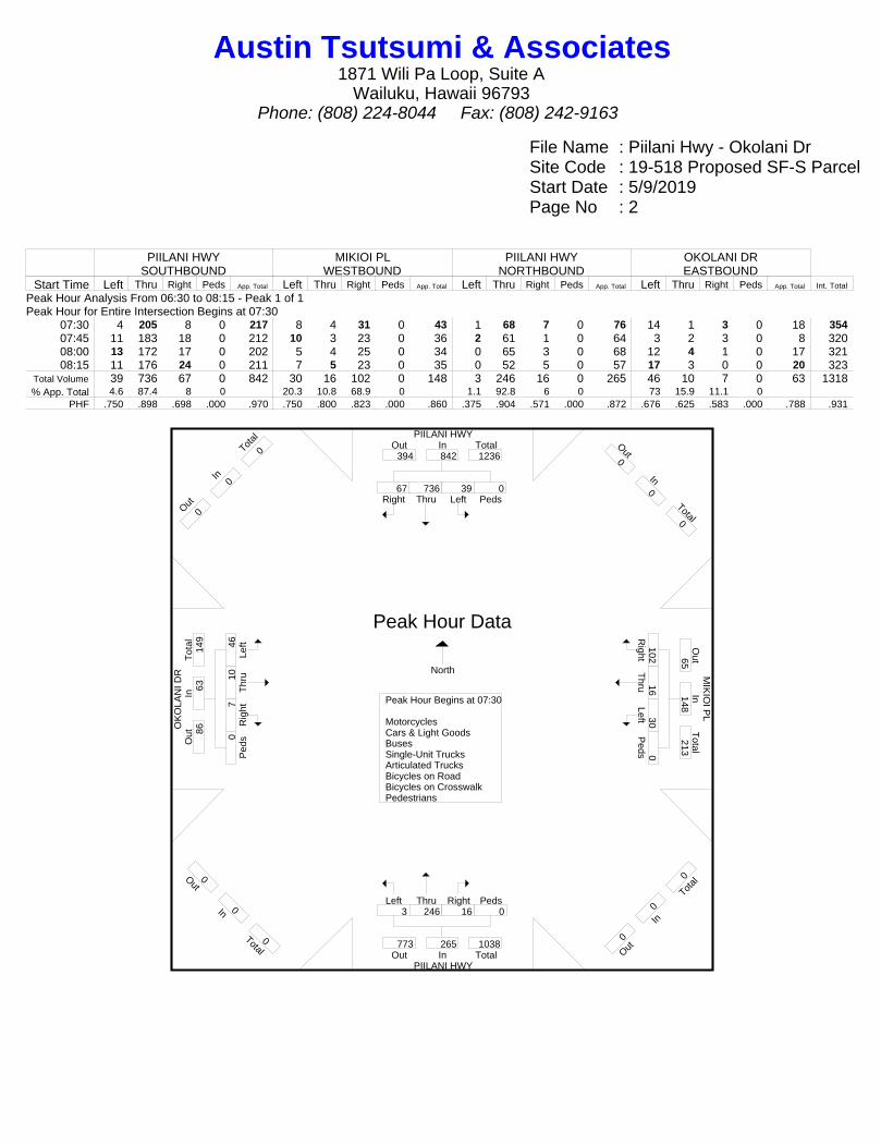
File Name : Piilani Hwy - Okolani DrSite Code : 19-518 Proposed SF-S ParcelStart Date : 5/9/2019Page No : 2
PIILANI HWYSOUTHBOUND
MIKIOI PLWESTBOUND
PIILANI HWYNORTHBOUND
OKOLANI DREASTBOUND
Start Time Left Thru Right Peds App. Total Left Thru Right Peds App. Total Left Thru Right Peds App. Total Left Thru Right Peds App. Total Int. Total
Peak Hour Analysis From 06:30 to 08:15 - Peak 1 of 1Peak Hour for Entire Intersection Begins at 07:30
07:30 4 205 8 0 217 8 4 31 0 43 1 68 7 0 76 14 1 3 0 18 35407:45 11 183 18 0 212 10 3 23 0 36 2 61 1 0 64 3 2 3 0 8 32008:00 13 172 17 0 202 5 4 25 0 34 0 65 3 0 68 12 4 1 0 17 32108:15 11 176 24 0 211 7 5 23 0 35 0 52 5 0 57 17 3 0 0 20 323
Total Volume 39 736 67 0 842 30 16 102 0 148 3 246 16 0 265 46 10 7 0 63 1318% App. Total 4.6 87.4 8 0 20.3 10.8 68.9 0 1.1 92.8 6 0 73 15.9 11.1 0
PHF .750 .898 .698 .000 .970 .750 .800 .823 .000 .860 .375 .904 .571 .000 .872 .676 .625 .583 .000 .788 .931
PIILANI HWY
OK
OLA
NI D
R M
IKIO
I PL
PIILANI HWY
Right67
Thru736
Left39
Peds0
InOut Total394 842 1236
Out0
In0
Total0
Right102
Thru16
Left30 P
eds0
Out
Total
In65
148 213
O ut0
In0
T otal
0
Left3
Thru246
Right16
Peds0
Out TotalIn773 265 1038
Out0
In0
Total0
Left46
T
hru10
R
ight7
Ped
s0
Tot
alO
utIn
86
63
149
O ut0
In0
T otal
0
Peak Hour Begins at 07:30 MotorcyclesCars & Light GoodsBusesSingle-Unit TrucksArticulated TrucksBicycles on RoadBicycles on CrosswalkPedestrians
Peak Hour Data
North
Austin Tsutsumi & Associates1871 Wili Pa Loop, Suite A
Wailuku, Hawaii 96793Phone: (808) 224-8044 Fax: (808) 242-9163
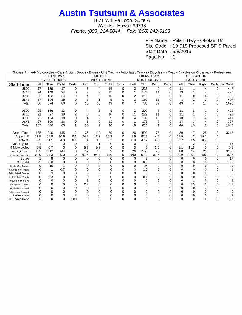
File Name : Piilani Hwy - Okolani DrSite Code : 19-518 Proposed SF-S ParcelStart Date : 5/8/2019Page No : 1
Groups Printed- Motorcycles - Cars & Light Goods - Buses - Unit Trucks - Articulated Trucks - Bicycles on Road - Bicycles on Crosswalk - PedestriansPIILANI HWY
SOUTHBOUNDMIKIOI PL
WESTBOUNDPIILANI HWY
NORTHBOUNDOKOLANI DREASTBOUND
Start Time Left Thru Right Peds Left Thru Right Peds Left Thru Right Peds Left Thru Right Peds Int. Total15:00 17 139 17 0 3 4 15 0 2 225 9 0 11 1 4 0 44715:15 24 149 24 0 2 3 15 0 1 173 11 0 13 1 4 0 42015:30 22 122 24 0 4 2 10 0 2 213 6 0 11 0 6 0 42215:45 17 164 15 0 6 1 9 0 2 169 11 0 8 2 3 0 407Total 80 574 80 0 15 10 49 0 7 780 37 0 43 4 17 0 1696
16:00 25 136 13 0 4 2 9 0 3 207 7 0 11 8 1 0 42616:15 21 97 18 2 6 5 10 0 11 229 11 0 11 1 1 0 42316:30 22 124 18 0 4 2 9 0 4 199 16 0 10 1 2 0 41116:45 37 109 16 0 6 0 12 0 1 178 7 0 14 3 4 0 387Total 105 466 65 2 20 9 40 0 19 813 41 0 46 13 8 0 1647
Grand Total 185 1040 145 2 35 19 89 0 26 1593 78 0 89 17 25 0 3343Apprch % 13.5 75.8 10.6 0.1 24.5 13.3 62.2 0 1.5 93.9 4.6 0 67.9 13 19.1 0
Total % 5.5 31.1 4.3 0.1 1 0.6 2.7 0 0.8 47.7 2.3 0 2.7 0.5 0.7 0Motorcycles 1 7 0 0 2 1 0 0 0 0 2 0 1 2 0 0 16
% Motorcycles 0.5 0.7 0 0 5.7 5.3 0 0 0 0 2.6 0 1.1 11.8 0 0 0.5Cars & Light Goods 183 1012 144 0 32 18 89 0 26 1558 76 0 88 14 25 0 3265% Cars & Light Goods 98.9 97.3 99.3 0 91.4 94.7 100 0 100 97.8 97.4 0 98.9 82.4 100 0 97.7
Buses 1 8 0 0 0 0 0 0 0 8 0 0 0 0 0 0 17% Buses 0.5 0.8 0 0 0 0 0 0 0 0.5 0 0 0 0 0 0 0.5
Single-Unit Trucks 0 10 1 0 0 0 0 0 0 24 0 0 0 0 0 0 35% Single-Unit Trucks 0 1 0.7 0 0 0 0 0 0 1.5 0 0 0 0 0 0 1Articulated Trucks 0 3 0 0 0 0 0 0 0 3 0 0 0 0 0 0 6% Articulated Trucks 0 0.3 0 0 0 0 0 0 0 0.2 0 0 0 0 0 0 0.2Bicycles on Road 0 0 0 0 1 0 0 0 0 0 0 0 0 1 0 0 2% Bicycles on Road 0 0 0 0 2.9 0 0 0 0 0 0 0 0 5.9 0 0 0.1Bicycles on Crosswalk 0 0 0 0 0 0 0 0 0 0 0 0 0 0 0 0 0% Bicycles on Crosswalk 0 0 0 0 0 0 0 0 0 0 0 0 0 0 0 0 0
Pedestrians 0 0 0 2 0 0 0 0 0 0 0 0 0 0 0 0 2% Pedestrians 0 0 0 100 0 0 0 0 0 0 0 0 0 0 0 0 0.1
Austin Tsutsumi & Associates1871 Wili Pa Loop, Suite A
Wailuku, Hawaii 96793Phone: (808) 224-8044 Fax: (808) 242-9163
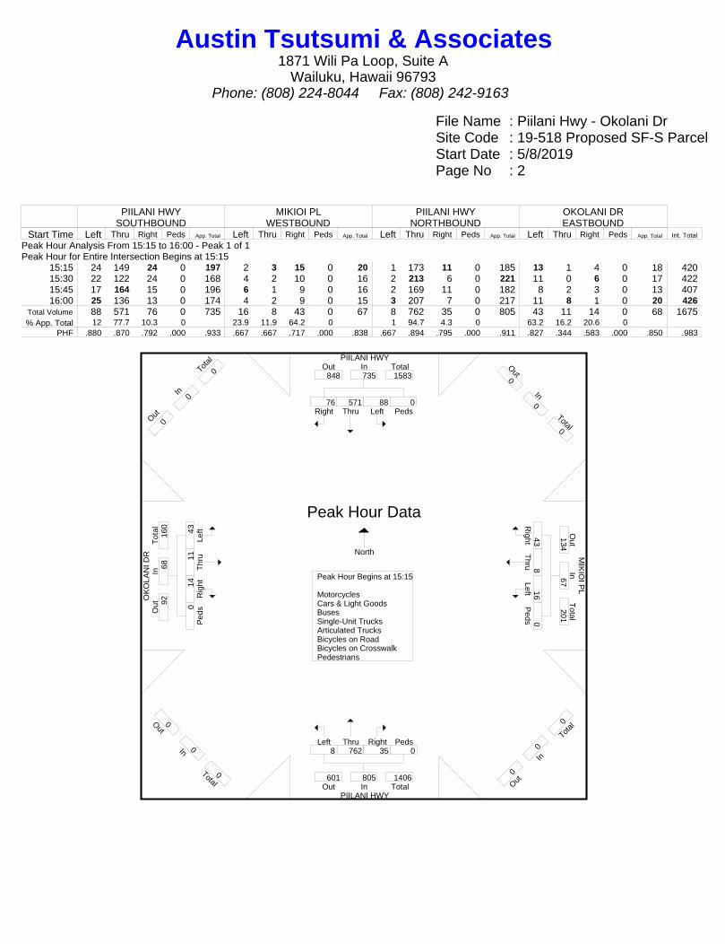
File Name : Piilani Hwy - Okolani DrSite Code : 19-518 Proposed SF-S ParcelStart Date : 5/8/2019Page No : 2
PIILANI HWYSOUTHBOUND
MIKIOI PLWESTBOUND
PIILANI HWYNORTHBOUND
OKOLANI DREASTBOUND
Start Time Left Thru Right Peds App. Total Left Thru Right Peds App. Total Left Thru Right Peds App. Total Left Thru Right Peds App. Total Int. Total
Peak Hour Analysis From 15:15 to 16:00 - Peak 1 of 1Peak Hour for Entire Intersection Begins at 15:15
15:15 24 149 24 0 197 2 3 15 0 20 1 173 11 0 185 13 1 4 0 18 42015:30 22 122 24 0 168 4 2 10 0 16 2 213 6 0 221 11 0 6 0 17 42215:45 17 164 15 0 196 6 1 9 0 16 2 169 11 0 182 8 2 3 0 13 40716:00 25 136 13 0 174 4 2 9 0 15 3 207 7 0 217 11 8 1 0 20 426
Total Volume 88 571 76 0 735 16 8 43 0 67 8 762 35 0 805 43 11 14 0 68 1675% App. Total 12 77.7 10.3 0 23.9 11.9 64.2 0 1 94.7 4.3 0 63.2 16.2 20.6 0
PHF .880 .870 .792 .000 .933 .667 .667 .717 .000 .838 .667 .894 .795 .000 .911 .827 .344 .583 .000 .850 .983
PIILANI HWY
OK
OLA
NI D
R M
IKIO
I PL
PIILANI HWY
Right76
Thru571
Left88
Peds0
InOut Total848 735 1583
Out0
In0
Total0
Right
43 T
hru8 Left16
Peds0
Out
Total
In134
67 201
O ut0
In0
T otal
0
Left8
Thru762
Right35
Peds0
Out TotalIn601 805 1406
Out0
In0
Total0
Left43
T
hru11
R
ight14
P
eds0
Tot
alO
utIn
92
68
160
O ut0
In0
T otal
0
Peak Hour Begins at 15:15 MotorcyclesCars & Light GoodsBusesSingle-Unit TrucksArticulated TrucksBicycles on RoadBicycles on CrosswalkPedestrians
Peak Hour Data
North
Austin Tsutsumi & Associates1871 Wili Pa Loop, Suite A
Wailuku, Hawaii 96793Phone: (808) 224-8044 Fax: (808) 242-9163
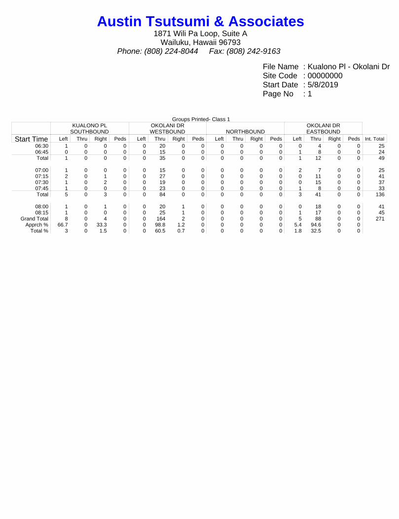
File Name : Kualono Pl - Okolani DrSite Code : 00000000Start Date : 5/8/2019Page No : 1
Groups Printed- Class 1KUALONO PL
SOUTHBOUNDOKOLANI DRWESTBOUND NORTHBOUND
OKOLANI DREASTBOUND
Start Time Left Thru Right Peds Left Thru Right Peds Left Thru Right Peds Left Thru Right Peds Int. Total
06:30 1 0 0 0 0 20 0 0 0 0 0 0 0 4 0 0 2506:45 0 0 0 0 0 15 0 0 0 0 0 0 1 8 0 0 24Total 1 0 0 0 0 35 0 0 0 0 0 0 1 12 0 0 49
07:00 1 0 0 0 0 15 0 0 0 0 0 0 2 7 0 0 2507:15 2 0 1 0 0 27 0 0 0 0 0 0 0 11 0 0 4107:30 1 0 2 0 0 19 0 0 0 0 0 0 0 15 0 0 3707:45 1 0 0 0 0 23 0 0 0 0 0 0 1 8 0 0 33Total 5 0 3 0 0 84 0 0 0 0 0 0 3 41 0 0 136
08:00 1 0 1 0 0 20 1 0 0 0 0 0 0 18 0 0 4108:15 1 0 0 0 0 25 1 0 0 0 0 0 1 17 0 0 45
Grand Total 8 0 4 0 0 164 2 0 0 0 0 0 5 88 0 0 271Apprch % 66.7 0 33.3 0 0 98.8 1.2 0 0 0 0 0 5.4 94.6 0 0
Total % 3 0 1.5 0 0 60.5 0.7 0 0 0 0 0 1.8 32.5 0 0
Austin Tsutsumi & Associates1871 Wili Pa Loop, Suite A
Wailuku, Hawaii 96793Phone: (808) 224-8044 Fax: (808) 242-9163
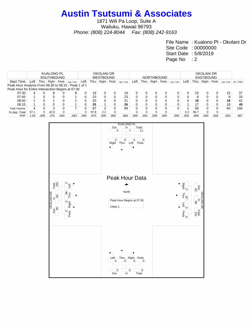
File Name : Kualono Pl - Okolani DrSite Code : 00000000Start Date : 5/8/2019Page No : 2
KUALONO PLSOUTHBOUND
OKOLANI DRWESTBOUND NORTHBOUND
OKOLANI DREASTBOUND
Start Time Left Thru Right Peds App. Total Left Thru Right Peds App. Total Left Thru Right Peds App. Total Left Thru Right Peds App. Total Int. Total
Peak Hour Analysis From 06:30 to 08:15 - Peak 1 of 1Peak Hour for Entire Intersection Begins at 07:30
07:30 1 0 2 0 3 0 19 0 0 19 0 0 0 0 0 0 15 0 0 15 3707:45 1 0 0 0 1 0 23 0 0 23 0 0 0 0 0 1 8 0 0 9 3308:00 1 0 1 0 2 0 20 1 0 21 0 0 0 0 0 0 18 0 0 18 4108:15 1 0 0 0 1 0 25 1 0 26 0 0 0 0 0 1 17 0 0 18 45
Total Volume 4 0 3 0 7 0 87 2 0 89 0 0 0 0 0 2 58 0 0 60 156% App. Total 57.1 0 42.9 0 0 97.8 2.2 0 0 0 0 0 3.3 96.7 0 0
PHF 1.00 .000 .375 .000 .583 .000 .870 .500 .000 .856 .000 .000 .000 .000 .000 .500 .806 .000 .000 .833 .867
KUALONO PL
OK
OLA
NI D
R O
KO
LAN
I DR
Right3
Thru0
Left4
Peds0
InOut Total4 7 11
Right2
Thru87
Left0 P
eds0
Out
Total
In62
89 151
Left0
Thru0
Right0
Peds0
Out TotalIn0 0 0
Left2
Thr
u58
Rig
ht0 P
eds0
Tot
alO
utIn
90
60
150
Peak Hour Begins at 07:30 Class 1
Peak Hour Data
North
Austin Tsutsumi & Associates1871 Wili Pa Loop, Suite A
Wailuku, Hawaii 96793Phone: (808) 224-8044 Fax: (808) 242-9163
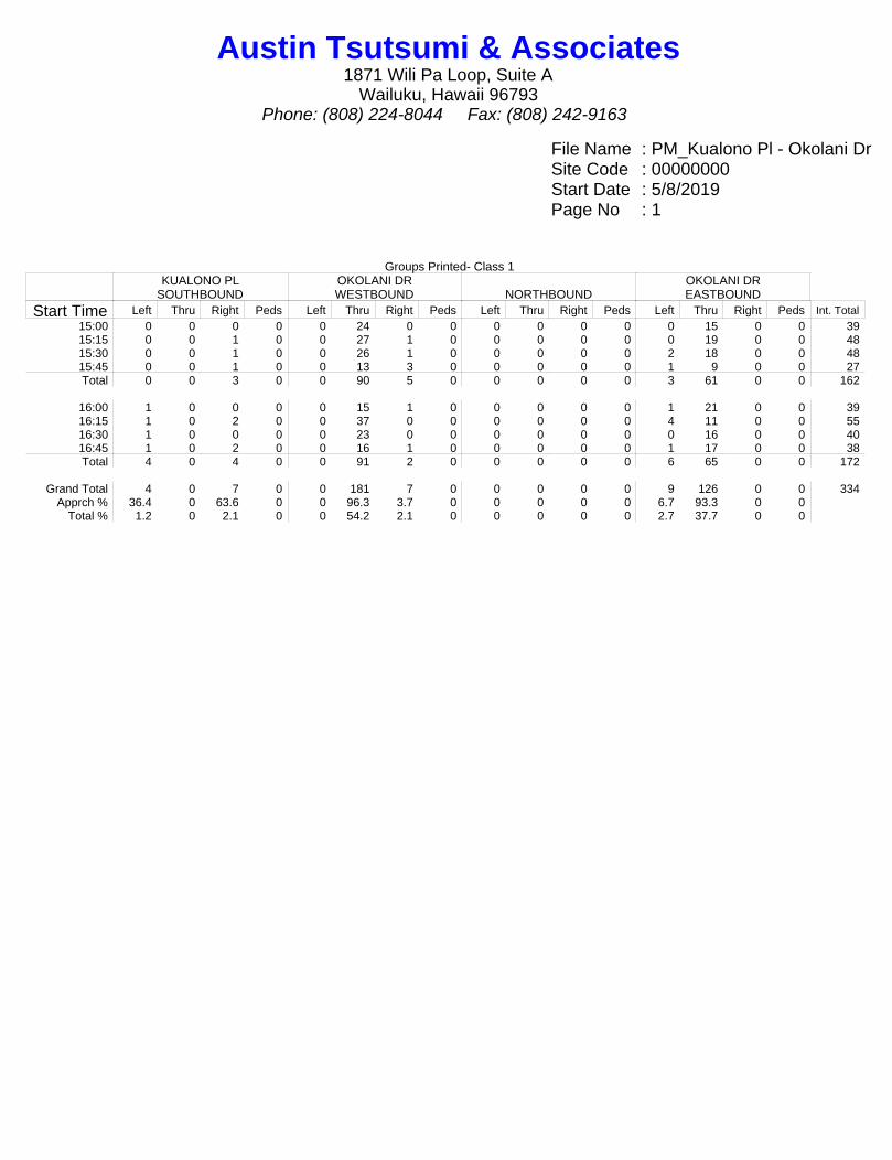
File Name : PM_Kualono Pl - Okolani DrSite Code : 00000000Start Date : 5/8/2019Page No : 1
Groups Printed- Class 1KUALONO PL
SOUTHBOUNDOKOLANI DRWESTBOUND NORTHBOUND
OKOLANI DREASTBOUND
Start Time Left Thru Right Peds Left Thru Right Peds Left Thru Right Peds Left Thru Right Peds Int. Total
15:00 0 0 0 0 0 24 0 0 0 0 0 0 0 15 0 0 3915:15 0 0 1 0 0 27 1 0 0 0 0 0 0 19 0 0 4815:30 0 0 1 0 0 26 1 0 0 0 0 0 2 18 0 0 4815:45 0 0 1 0 0 13 3 0 0 0 0 0 1 9 0 0 27Total 0 0 3 0 0 90 5 0 0 0 0 0 3 61 0 0 162
16:00 1 0 0 0 0 15 1 0 0 0 0 0 1 21 0 0 3916:15 1 0 2 0 0 37 0 0 0 0 0 0 4 11 0 0 5516:30 1 0 0 0 0 23 0 0 0 0 0 0 0 16 0 0 4016:45 1 0 2 0 0 16 1 0 0 0 0 0 1 17 0 0 38Total 4 0 4 0 0 91 2 0 0 0 0 0 6 65 0 0 172
Grand Total 4 0 7 0 0 181 7 0 0 0 0 0 9 126 0 0 334Apprch % 36.4 0 63.6 0 0 96.3 3.7 0 0 0 0 0 6.7 93.3 0 0
Total % 1.2 0 2.1 0 0 54.2 2.1 0 0 0 0 0 2.7 37.7 0 0
Austin Tsutsumi & Associates1871 Wili Pa Loop, Suite A
Wailuku, Hawaii 96793Phone: (808) 224-8044 Fax: (808) 242-9163
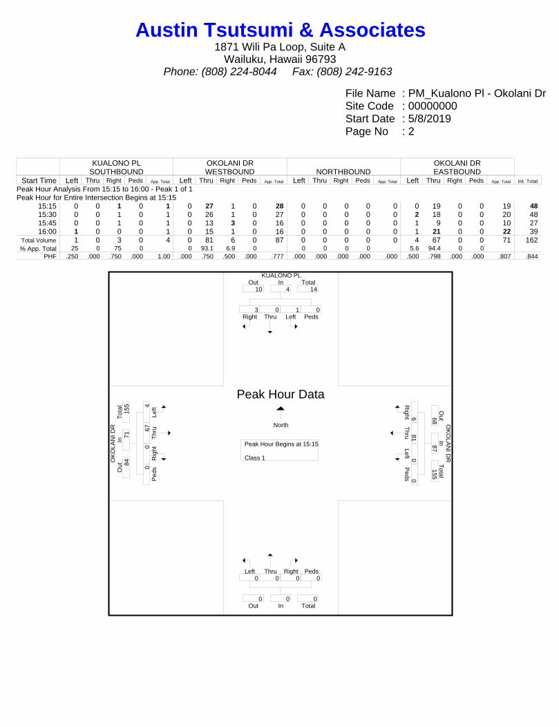
File Name : PM_Kualono Pl - Okolani DrSite Code : 00000000Start Date : 5/8/2019Page No : 2
KUALONO PLSOUTHBOUND
OKOLANI DRWESTBOUND NORTHBOUND
OKOLANI DREASTBOUND
Start Time Left Thru Right Peds App. Total Left Thru Right Peds App. Total Left Thru Right Peds App. Total Left Thru Right Peds App. Total Int. Total
Peak Hour Analysis From 15:15 to 16:00 - Peak 1 of 1Peak Hour for Entire Intersection Begins at 15:15
15:15 0 0 1 0 1 0 27 1 0 28 0 0 0 0 0 0 19 0 0 19 4815:30 0 0 1 0 1 0 26 1 0 27 0 0 0 0 0 2 18 0 0 20 4815:45 0 0 1 0 1 0 13 3 0 16 0 0 0 0 0 1 9 0 0 10 2716:00 1 0 0 0 1 0 15 1 0 16 0 0 0 0 0 1 21 0 0 22 39
Total Volume 1 0 3 0 4 0 81 6 0 87 0 0 0 0 0 4 67 0 0 71 162% App. Total 25 0 75 0 0 93.1 6.9 0 0 0 0 0 5.6 94.4 0 0
PHF .250 .000 .750 .000 1.00 .000 .750 .500 .000 .777 .000 .000 .000 .000 .000 .500 .798 .000 .000 .807 .844
KUALONO PL
OK
OLA
NI D
R O
KO
LAN
I DR
Right3
Thru0
Left1
Peds0
InOut Total10 4 14
Right6
Thru81
Left0 P
eds0
Out
Total
In68
87 155
Left0
Thru0
Right0
Peds0
Out TotalIn0 0 0
Left4
Thr
u67
Rig
ht0 P
eds0
Tot
alO
utIn
84
71
155
Peak Hour Begins at 15:15 Class 1
Peak Hour Data
North
Austin Tsutsumi & Associates1871 Wili Pa Loop, Suite A
Wailuku, Hawaii 96793Phone: (808) 224-8044 Fax: (808) 242-9163

File Name : Kapili St - Okalani DrSite Code : 19-518 Proposed SF-S ParcelStart Date : 5/9/2019Page No : 1
Groups Printed- Motorcycles - Cars & Light Goods - Buses - Unit Trucks - Articulated Trucks - Bicycles on Road - Bicycles on Crosswalk - PedestriansKAPILI ST
SOUTHBOUNDOKOLANI DRWESTBOUND NORTHBOUND
OKOLANI DREASTBOUND
Start Time Left Thru Right Peds Left Thru Right Peds Left Thru Right Peds Left Thru Right Peds Int. Total06:30 2 0 4 2 0 16 3 0 0 0 0 0 0 9 0 0 3606:45 1 0 8 2 0 22 2 0 0 0 0 0 4 9 0 0 48Total 3 0 12 4 0 38 5 0 0 0 0 0 4 18 0 0 84
07:00 3 0 5 2 0 24 2 0 0 0 0 0 1 12 0 0 4907:15 3 0 8 1 0 18 3 0 0 0 0 0 0 8 0 0 4107:30 2 0 4 6 0 19 1 0 0 0 0 0 2 13 0 0 4707:45 4 0 5 0 0 18 3 0 0 0 0 0 1 18 0 0 49Total 12 0 22 9 0 79 9 0 0 0 0 0 4 51 0 0 186
08:00 2 0 2 1 0 24 0 0 0 0 0 0 2 14 0 0 4508:15 1 0 6 3 0 23 2 0 0 0 0 0 3 12 0 0 50
Grand Total 18 0 42 17 0 164 16 0 0 0 0 0 13 95 0 0 365Apprch % 23.4 0 54.5 22.1 0 91.1 8.9 0 0 0 0 0 12 88 0 0
Total % 4.9 0 11.5 4.7 0 44.9 4.4 0 0 0 0 0 3.6 26 0 0Motorcycles 0 0 0 0 0 2 0 0 0 0 0 0 0 0 0 0 2
% Motorcycles 0 0 0 0 0 1.2 0 0 0 0 0 0 0 0 0 0 0.5Cars & Light Goods 16 0 38 0 0 159 14 0 0 0 0 0 13 93 0 0 333% Cars & Light Goods 88.9 0 90.5 0 0 97 87.5 0 0 0 0 0 100 97.9 0 0 91.2
Buses 0 0 0 0 0 1 0 0 0 0 0 0 0 1 0 0 2% Buses 0 0 0 0 0 0.6 0 0 0 0 0 0 0 1.1 0 0 0.5
Single-Unit Trucks 1 0 4 0 0 1 2 0 0 0 0 0 0 1 0 0 9% Single-Unit Trucks 5.6 0 9.5 0 0 0.6 12.5 0 0 0 0 0 0 1.1 0 0 2.5Articulated Trucks 0 0 0 0 0 0 0 0 0 0 0 0 0 0 0 0 0% Articulated Trucks 0 0 0 0 0 0 0 0 0 0 0 0 0 0 0 0 0Bicycles on Road 1 0 0 0 0 1 0 0 0 0 0 0 0 0 0 0 2% Bicycles on Road 5.6 0 0 0 0 0.6 0 0 0 0 0 0 0 0 0 0 0.5Bicycles on Crosswalk 0 0 0 0 0 0 0 0 0 0 0 0 0 0 0 0 0% Bicycles on Crosswalk 0 0 0 0 0 0 0 0 0 0 0 0 0 0 0 0 0
Pedestrians 0 0 0 17 0 0 0 0 0 0 0 0 0 0 0 0 17% Pedestrians 0 0 0 100 0 0 0 0 0 0 0 0 0 0 0 0 4.7
Austin Tsutsumi & Associates1871 Wili Pa Loop, Suite A
Wailuku, Hawaii 96793Phone: (808) 224-8044 Fax: (808) 242-9163

File Name : Kapili St - Okalani DrSite Code : 19-518 Proposed SF-S ParcelStart Date : 5/9/2019Page No : 2
KAPILI STSOUTHBOUND
OKOLANI DRWESTBOUND NORTHBOUND
OKOLANI DREASTBOUND
Start Time Left Thru Right Peds App. Total Left Thru Right Peds App. Total Left Thru Right Peds App. Total Left Thru Right Peds App. Total Int. Total
Peak Hour Analysis From 06:30 to 08:15 - Peak 1 of 1Peak Hour for Entire Intersection Begins at 07:30
07:30 2 0 4 6 12 0 19 1 0 20 0 0 0 0 0 2 13 0 0 15 4707:45 4 0 5 0 9 0 18 3 0 21 0 0 0 0 0 1 18 0 0 19 4908:00 2 0 2 1 5 0 24 0 0 24 0 0 0 0 0 2 14 0 0 16 4508:15 1 0 6 3 10 0 23 2 0 25 0 0 0 0 0 3 12 0 0 15 50
Total Volume 9 0 17 10 36 0 84 6 0 90 0 0 0 0 0 8 57 0 0 65 191% App. Total 25 0 47.2 27.8 0 93.3 6.7 0 0 0 0 0 12.3 87.7 0 0
PHF .563 .000 .708 .417 .750 .000 .875 .500 .000 .900 .000 .000 .000 .000 .000 .667 .792 .000 .000 .855 .955
KAPILI ST
OK
OLA
NI D
R O
KO
LAN
I DR
Right17
Thru0
Left9
Peds10
InOut Total14 36 50
Out0
In0
Total0
Right6
Thru84
Left0 P
eds0
Out
Total
In66
90 156
O ut0
In0
T otal
0
Left0
Thru0
Right0
Peds0
Out TotalIn0 0 0
Out0
In0
Total0
Left8
Thr
u57
Rig
ht0 P
eds0
Tot
alO
utIn
101
65
166
O ut0
In0
T otal
0
Peak Hour Begins at 07:30 MotorcyclesCars & Light GoodsBusesSingle-Unit TrucksArticulated TrucksBicycles on RoadBicycles on CrosswalkPedestrians
Peak Hour Data
North
Austin Tsutsumi & Associates1871 Wili Pa Loop, Suite A
Wailuku, Hawaii 96793Phone: (808) 224-8044 Fax: (808) 242-9163
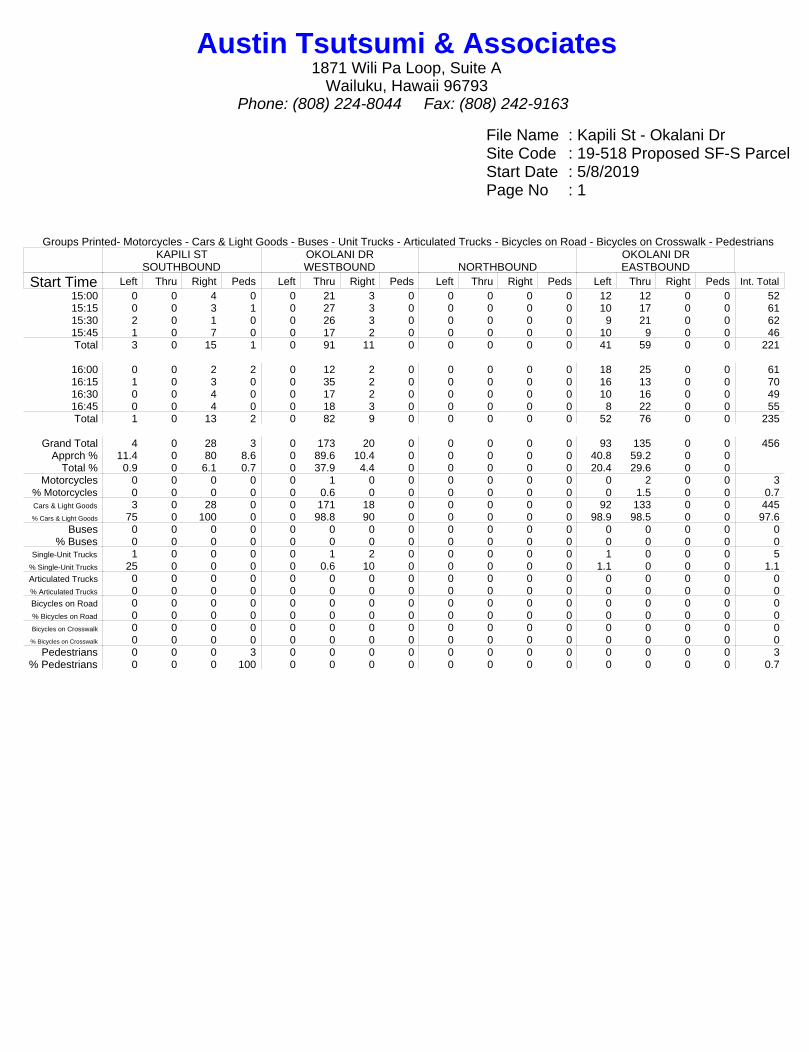
File Name : Kapili St - Okalani DrSite Code : 19-518 Proposed SF-S ParcelStart Date : 5/8/2019Page No : 1
Groups Printed- Motorcycles - Cars & Light Goods - Buses - Unit Trucks - Articulated Trucks - Bicycles on Road - Bicycles on Crosswalk - PedestriansKAPILI ST
SOUTHBOUNDOKOLANI DRWESTBOUND NORTHBOUND
OKOLANI DREASTBOUND
Start Time Left Thru Right Peds Left Thru Right Peds Left Thru Right Peds Left Thru Right Peds Int. Total15:00 0 0 4 0 0 21 3 0 0 0 0 0 12 12 0 0 5215:15 0 0 3 1 0 27 3 0 0 0 0 0 10 17 0 0 6115:30 2 0 1 0 0 26 3 0 0 0 0 0 9 21 0 0 6215:45 1 0 7 0 0 17 2 0 0 0 0 0 10 9 0 0 46Total 3 0 15 1 0 91 11 0 0 0 0 0 41 59 0 0 221
16:00 0 0 2 2 0 12 2 0 0 0 0 0 18 25 0 0 6116:15 1 0 3 0 0 35 2 0 0 0 0 0 16 13 0 0 7016:30 0 0 4 0 0 17 2 0 0 0 0 0 10 16 0 0 4916:45 0 0 4 0 0 18 3 0 0 0 0 0 8 22 0 0 55Total 1 0 13 2 0 82 9 0 0 0 0 0 52 76 0 0 235
Grand Total 4 0 28 3 0 173 20 0 0 0 0 0 93 135 0 0 456Apprch % 11.4 0 80 8.6 0 89.6 10.4 0 0 0 0 0 40.8 59.2 0 0
Total % 0.9 0 6.1 0.7 0 37.9 4.4 0 0 0 0 0 20.4 29.6 0 0Motorcycles 0 0 0 0 0 1 0 0 0 0 0 0 0 2 0 0 3
% Motorcycles 0 0 0 0 0 0.6 0 0 0 0 0 0 0 1.5 0 0 0.7Cars & Light Goods 3 0 28 0 0 171 18 0 0 0 0 0 92 133 0 0 445% Cars & Light Goods 75 0 100 0 0 98.8 90 0 0 0 0 0 98.9 98.5 0 0 97.6
Buses 0 0 0 0 0 0 0 0 0 0 0 0 0 0 0 0 0% Buses 0 0 0 0 0 0 0 0 0 0 0 0 0 0 0 0 0
Single-Unit Trucks 1 0 0 0 0 1 2 0 0 0 0 0 1 0 0 0 5% Single-Unit Trucks 25 0 0 0 0 0.6 10 0 0 0 0 0 1.1 0 0 0 1.1Articulated Trucks 0 0 0 0 0 0 0 0 0 0 0 0 0 0 0 0 0% Articulated Trucks 0 0 0 0 0 0 0 0 0 0 0 0 0 0 0 0 0Bicycles on Road 0 0 0 0 0 0 0 0 0 0 0 0 0 0 0 0 0% Bicycles on Road 0 0 0 0 0 0 0 0 0 0 0 0 0 0 0 0 0Bicycles on Crosswalk 0 0 0 0 0 0 0 0 0 0 0 0 0 0 0 0 0% Bicycles on Crosswalk 0 0 0 0 0 0 0 0 0 0 0 0 0 0 0 0 0
Pedestrians 0 0 0 3 0 0 0 0 0 0 0 0 0 0 0 0 3% Pedestrians 0 0 0 100 0 0 0 0 0 0 0 0 0 0 0 0 0.7
Austin Tsutsumi & Associates1871 Wili Pa Loop, Suite A
Wailuku, Hawaii 96793Phone: (808) 224-8044 Fax: (808) 242-9163

File Name : Kapili St - Okalani DrSite Code : 19-518 Proposed SF-S ParcelStart Date : 5/8/2019Page No : 2
KAPILI STSOUTHBOUND
OKOLANI DRWESTBOUND NORTHBOUND
OKOLANI DREASTBOUND
Start Time Left Thru Right Peds App. Total Left Thru Right Peds App. Total Left Thru Right Peds App. Total Left Thru Right Peds App. Total Int. Total
Peak Hour Analysis From 15:15 to 16:00 - Peak 1 of 1Peak Hour for Entire Intersection Begins at 15:15
15:15 0 0 3 1 4 0 27 3 0 30 0 0 0 0 0 10 17 0 0 27 6115:30 2 0 1 0 3 0 26 3 0 29 0 0 0 0 0 9 21 0 0 30 6215:45 1 0 7 0 8 0 17 2 0 19 0 0 0 0 0 10 9 0 0 19 4616:00 0 0 2 2 4 0 12 2 0 14 0 0 0 0 0 18 25 0 0 43 61
Total Volume 3 0 13 3 19 0 82 10 0 92 0 0 0 0 0 47 72 0 0 119 230% App. Total 15.8 0 68.4 15.8 0 89.1 10.9 0 0 0 0 0 39.5 60.5 0 0
PHF .375 .000 .464 .375 .594 .000 .759 .833 .000 .767 .000 .000 .000 .000 .000 .653 .720 .000 .000 .692 .927
KAPILI ST
OK
OLA
NI D
R O
KO
LAN
I DR
Right13
Thru0
Left3
Peds3
InOut Total57 19 76
Out0
In0
Total0
Right
10 T
hru82 Left0
Peds0
Out
Total
In75
92 167
O ut0
In0
T otal
0
Left0
Thru0
Right0
Peds0
Out TotalIn0 0 0
Out0
In0
Total0
Left47
T
hru72
R
ight0
Ped
s0
Tot
alO
utIn
95
119
214
O ut0
In0
T otal
0
Peak Hour Begins at 15:15 MotorcyclesCars & Light GoodsBusesSingle-Unit TrucksArticulated TrucksBicycles on RoadBicycles on CrosswalkPedestrians
Peak Hour Data
North
Austin Tsutsumi & Associates1871 Wili Pa Loop, Suite A
Wailuku, Hawaii 96793Phone: (808) 224-8044 Fax: (808) 242-9163
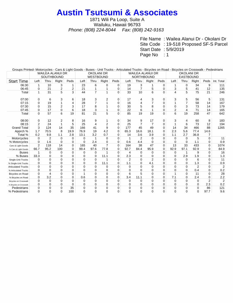
File Name : Wailea Alanui Dr - Okolani DrSite Code : 19-518 Proposed SF-S ParcelStart Date : 5/9/2019Page No : 1
Groups Printed- Motorcycles - Cars & Light Goods - Buses - Unit Trucks - Articulated Trucks - Bicycles on Road - Bicycles on Crosswalk - PedestriansWAILEA ALANUI DR
SOUTHBOUNDOKOLANI DRWESTBOUND
WAILEA ALANUI DRNORTHBOUND
OKOLANI DREASTBOUND
Start Time Left Thru Right Peds Left Thru Right Peds Left Thru Right Peds Left Thru Right Peds Int. Total06:30 1 10 3 1 23 6 0 0 19 3 1 0 1 0 34 9 11106:45 0 21 2 2 21 1 1 0 14 7 5 0 3 5 41 12 135Total 1 31 5 3 44 7 1 0 33 10 6 0 4 5 75 21 246
07:00 0 6 3 6 18 3 2 0 17 4 3 0 3 5 56 5 13107:15 0 19 1 4 28 7 1 0 16 4 7 0 1 7 58 14 16707:30 0 15 2 3 17 8 1 0 30 5 8 0 0 3 73 14 17907:45 0 17 0 6 18 3 1 0 22 6 1 0 2 4 71 14 165Total 0 57 6 19 81 21 5 0 85 19 19 0 6 19 258 47 642
08:00 0 12 2 8 16 9 1 0 34 9 17 0 3 4 60 8 18308:15 2 24 1 5 25 4 2 0 25 7 7 0 1 6 73 12 194
Grand Total 3 124 14 35 166 41 9 0 177 45 49 0 14 34 466 88 1265Apprch % 1.7 70.5 8 19.9 76.9 19 4.2 0 65.3 16.6 18.1 0 2.3 5.6 77.4 14.6
Total % 0.2 9.8 1.1 2.8 13.1 3.2 0.7 0 14 3.6 3.9 0 1.1 2.7 36.8 7Motorcycles 0 2 0 0 0 1 0 0 1 2 0 0 0 0 5 0 11
% Motorcycles 0 1.6 0 0 0 2.4 0 0 0.6 4.4 0 0 0 0 1.1 0 0.9Cars & Light Goods 2 118 14 0 165 40 7 0 164 38 47 0 13 33 433 0 1074% Cars & Light Goods 66.7 95.2 100 0 99.4 97.6 77.8 0 92.7 84.4 95.9 0 92.9 97.1 92.9 0 84.9
Buses 1 0 0 0 0 0 1 0 4 0 0 0 0 1 9 0 16% Buses 33.3 0 0 0 0 0 11.1 0 2.3 0 0 0 0 2.9 1.9 0 1.3
Single-Unit Trucks 0 0 0 0 0 0 1 0 2 0 2 0 0 0 6 0 11% Single-Unit Trucks 0 0 0 0 0 0 11.1 0 1.1 0 4.1 0 0 0 1.3 0 0.9Articulated Trucks 0 0 0 0 0 0 0 0 0 0 0 0 0 0 2 0 2% Articulated Trucks 0 0 0 0 0 0 0 0 0 0 0 0 0 0 0.4 0 0.2Bicycles on Road 0 4 0 0 1 0 0 0 6 5 0 0 1 0 11 0 28% Bicycles on Road 0 3.2 0 0 0.6 0 0 0 3.4 11.1 0 0 7.1 0 2.4 0 2.2Bicycles on Crosswalk 0 0 0 0 0 0 0 0 0 0 0 0 0 0 0 2 2% Bicycles on Crosswalk 0 0 0 0 0 0 0 0 0 0 0 0 0 0 0 2.3 0.2
Pedestrians 0 0 0 35 0 0 0 0 0 0 0 0 0 0 0 86 121% Pedestrians 0 0 0 100 0 0 0 0 0 0 0 0 0 0 0 97.7 9.6
Austin Tsutsumi & Associates1871 Wili Pa Loop, Suite A
Wailuku, Hawaii 96793Phone: (808) 224-8044 Fax: (808) 242-9163
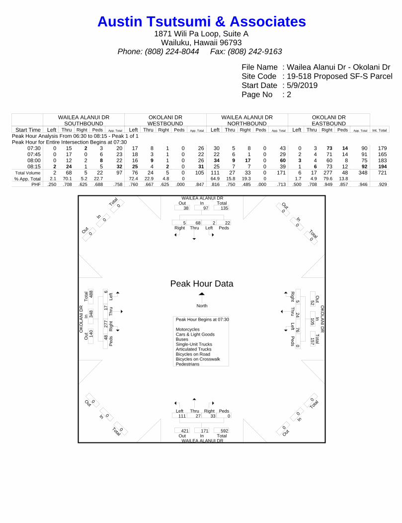
File Name : Wailea Alanui Dr - Okolani DrSite Code : 19-518 Proposed SF-S ParcelStart Date : 5/9/2019Page No : 2
WAILEA ALANUI DRSOUTHBOUND
OKOLANI DRWESTBOUND
WAILEA ALANUI DRNORTHBOUND
OKOLANI DREASTBOUND
Start Time Left Thru Right Peds App. Total Left Thru Right Peds App. Total Left Thru Right Peds App. Total Left Thru Right Peds App. Total Int. Total
Peak Hour Analysis From 06:30 to 08:15 - Peak 1 of 1Peak Hour for Entire Intersection Begins at 07:30
07:30 0 15 2 3 20 17 8 1 0 26 30 5 8 0 43 0 3 73 14 90 17907:45 0 17 0 6 23 18 3 1 0 22 22 6 1 0 29 2 4 71 14 91 16508:00 0 12 2 8 22 16 9 1 0 26 34 9 17 0 60 3 4 60 8 75 18308:15 2 24 1 5 32 25 4 2 0 31 25 7 7 0 39 1 6 73 12 92 194
Total Volume 2 68 5 22 97 76 24 5 0 105 111 27 33 0 171 6 17 277 48 348 721% App. Total 2.1 70.1 5.2 22.7 72.4 22.9 4.8 0 64.9 15.8 19.3 0 1.7 4.9 79.6 13.8
PHF .250 .708 .625 .688 .758 .760 .667 .625 .000 .847 .816 .750 .485 .000 .713 .500 .708 .949 .857 .946 .929
WAILEA ALANUI DR
OK
OLA
NI D
R O
KO
LAN
I DR
WAILEA ALANUI DR
Right5
Thru68
Left2
Peds22
InOut Total38 97 135
Out0
In0
Total0
Right5
Thru24
Left76 P
eds0
Out
Total
In52
105 157
O ut0
In0
T otal
0
Left111
Thru27
Right33
Peds0
Out TotalIn421 171 592
Out0
In0
Total0
Left6
Thr
u17
Rig
ht27
7 P
eds48
Tot
alO
utIn
140
348
488
O ut0
In0
T otal
0
Peak Hour Begins at 07:30 MotorcyclesCars & Light GoodsBusesSingle-Unit TrucksArticulated TrucksBicycles on RoadBicycles on CrosswalkPedestrians
Peak Hour Data
North
Austin Tsutsumi & Associates1871 Wili Pa Loop, Suite A
Wailuku, Hawaii 96793Phone: (808) 224-8044 Fax: (808) 242-9163
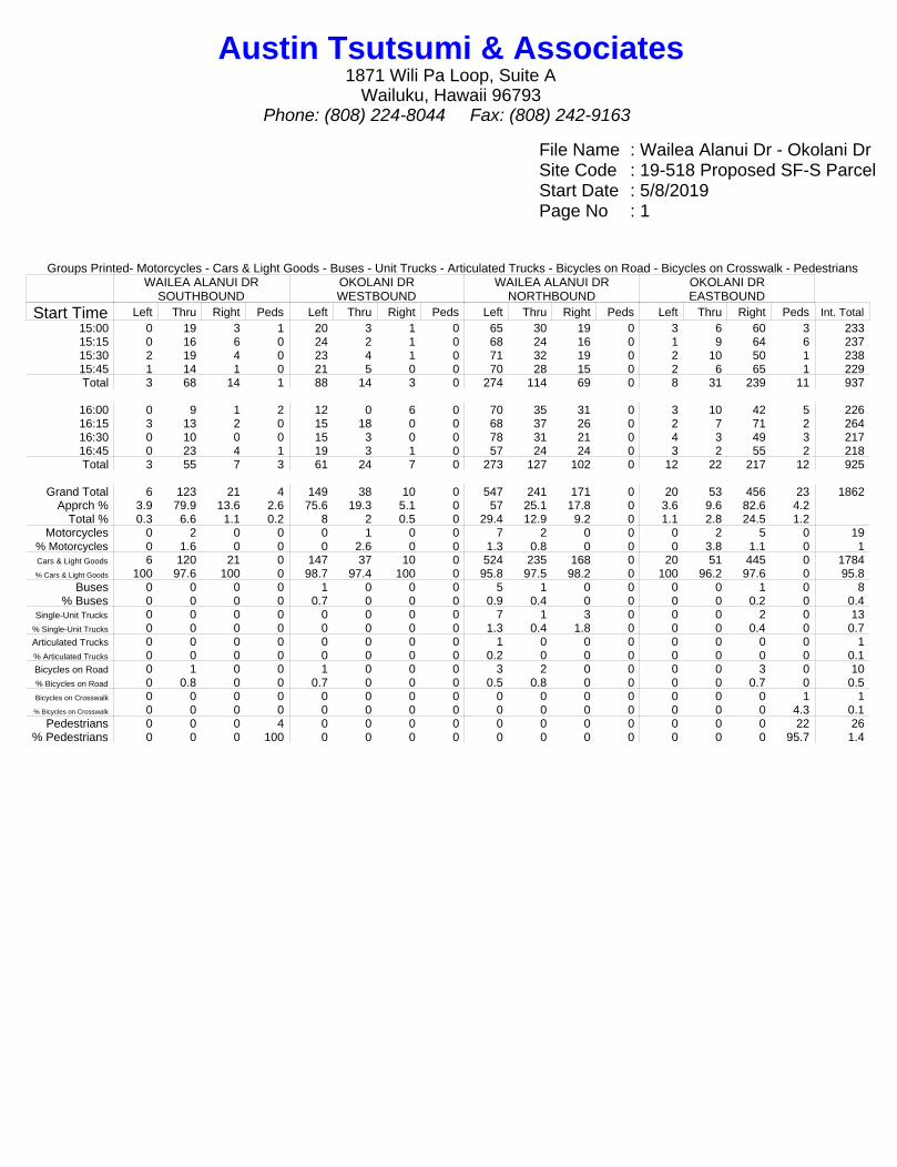
File Name : Wailea Alanui Dr - Okolani DrSite Code : 19-518 Proposed SF-S ParcelStart Date : 5/8/2019Page No : 1
Groups Printed- Motorcycles - Cars & Light Goods - Buses - Unit Trucks - Articulated Trucks - Bicycles on Road - Bicycles on Crosswalk - PedestriansWAILEA ALANUI DR
SOUTHBOUNDOKOLANI DRWESTBOUND
WAILEA ALANUI DRNORTHBOUND
OKOLANI DREASTBOUND
Start Time Left Thru Right Peds Left Thru Right Peds Left Thru Right Peds Left Thru Right Peds Int. Total15:00 0 19 3 1 20 3 1 0 65 30 19 0 3 6 60 3 23315:15 0 16 6 0 24 2 1 0 68 24 16 0 1 9 64 6 23715:30 2 19 4 0 23 4 1 0 71 32 19 0 2 10 50 1 23815:45 1 14 1 0 21 5 0 0 70 28 15 0 2 6 65 1 229Total 3 68 14 1 88 14 3 0 274 114 69 0 8 31 239 11 937
16:00 0 9 1 2 12 0 6 0 70 35 31 0 3 10 42 5 22616:15 3 13 2 0 15 18 0 0 68 37 26 0 2 7 71 2 26416:30 0 10 0 0 15 3 0 0 78 31 21 0 4 3 49 3 21716:45 0 23 4 1 19 3 1 0 57 24 24 0 3 2 55 2 218Total 3 55 7 3 61 24 7 0 273 127 102 0 12 22 217 12 925
Grand Total 6 123 21 4 149 38 10 0 547 241 171 0 20 53 456 23 1862Apprch % 3.9 79.9 13.6 2.6 75.6 19.3 5.1 0 57 25.1 17.8 0 3.6 9.6 82.6 4.2
Total % 0.3 6.6 1.1 0.2 8 2 0.5 0 29.4 12.9 9.2 0 1.1 2.8 24.5 1.2Motorcycles 0 2 0 0 0 1 0 0 7 2 0 0 0 2 5 0 19
% Motorcycles 0 1.6 0 0 0 2.6 0 0 1.3 0.8 0 0 0 3.8 1.1 0 1Cars & Light Goods 6 120 21 0 147 37 10 0 524 235 168 0 20 51 445 0 1784% Cars & Light Goods 100 97.6 100 0 98.7 97.4 100 0 95.8 97.5 98.2 0 100 96.2 97.6 0 95.8
Buses 0 0 0 0 1 0 0 0 5 1 0 0 0 0 1 0 8% Buses 0 0 0 0 0.7 0 0 0 0.9 0.4 0 0 0 0 0.2 0 0.4
Single-Unit Trucks 0 0 0 0 0 0 0 0 7 1 3 0 0 0 2 0 13% Single-Unit Trucks 0 0 0 0 0 0 0 0 1.3 0.4 1.8 0 0 0 0.4 0 0.7Articulated Trucks 0 0 0 0 0 0 0 0 1 0 0 0 0 0 0 0 1% Articulated Trucks 0 0 0 0 0 0 0 0 0.2 0 0 0 0 0 0 0 0.1Bicycles on Road 0 1 0 0 1 0 0 0 3 2 0 0 0 0 3 0 10% Bicycles on Road 0 0.8 0 0 0.7 0 0 0 0.5 0.8 0 0 0 0 0.7 0 0.5Bicycles on Crosswalk 0 0 0 0 0 0 0 0 0 0 0 0 0 0 0 1 1% Bicycles on Crosswalk 0 0 0 0 0 0 0 0 0 0 0 0 0 0 0 4.3 0.1
Pedestrians 0 0 0 4 0 0 0 0 0 0 0 0 0 0 0 22 26% Pedestrians 0 0 0 100 0 0 0 0 0 0 0 0 0 0 0 95.7 1.4
Austin Tsutsumi & Associates1871 Wili Pa Loop, Suite A
Wailuku, Hawaii 96793Phone: (808) 224-8044 Fax: (808) 242-9163
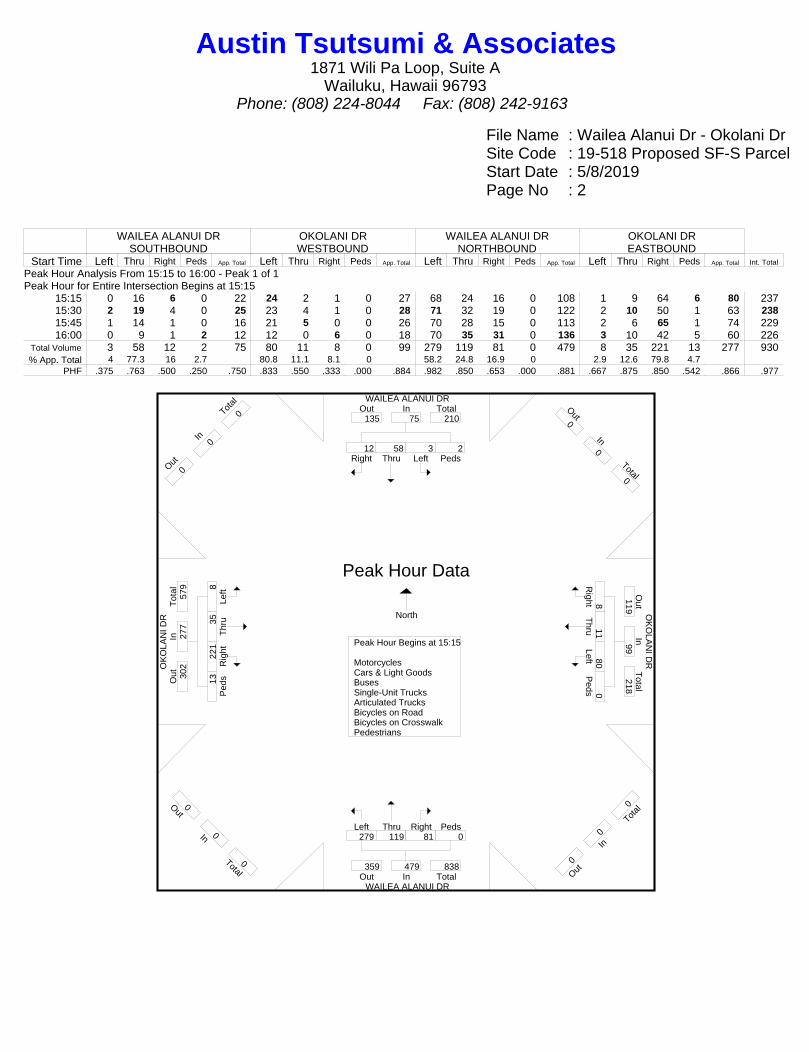
File Name : Wailea Alanui Dr - Okolani DrSite Code : 19-518 Proposed SF-S ParcelStart Date : 5/8/2019Page No : 2
WAILEA ALANUI DRSOUTHBOUND
OKOLANI DRWESTBOUND
WAILEA ALANUI DRNORTHBOUND
OKOLANI DREASTBOUND
Start Time Left Thru Right Peds App. Total Left Thru Right Peds App. Total Left Thru Right Peds App. Total Left Thru Right Peds App. Total Int. Total
Peak Hour Analysis From 15:15 to 16:00 - Peak 1 of 1Peak Hour for Entire Intersection Begins at 15:15
15:15 0 16 6 0 22 24 2 1 0 27 68 24 16 0 108 1 9 64 6 80 23715:30 2 19 4 0 25 23 4 1 0 28 71 32 19 0 122 2 10 50 1 63 23815:45 1 14 1 0 16 21 5 0 0 26 70 28 15 0 113 2 6 65 1 74 22916:00 0 9 1 2 12 12 0 6 0 18 70 35 31 0 136 3 10 42 5 60 226
Total Volume 3 58 12 2 75 80 11 8 0 99 279 119 81 0 479 8 35 221 13 277 930% App. Total 4 77.3 16 2.7 80.8 11.1 8.1 0 58.2 24.8 16.9 0 2.9 12.6 79.8 4.7
PHF .375 .763 .500 .250 .750 .833 .550 .333 .000 .884 .982 .850 .653 .000 .881 .667 .875 .850 .542 .866 .977
WAILEA ALANUI DR
OK
OLA
NI D
R O
KO
LAN
I DR
WAILEA ALANUI DR
Right12
Thru58
Left3
Peds2
InOut Total135 75 210
Out0
In0
Total0
Right8
Thru11
Left80 P
eds0
Out
Total
In119
99 218
O ut0
In0
T otal
0
Left279
Thru119
Right81
Peds0
Out TotalIn359 479 838
Out0
In0
Total0
Left8
Thr
u35
Rig
ht22
1 P
eds13
Tot
alO
utIn
302
277
579
O ut0
In0
T otal
0
Peak Hour Begins at 15:15 MotorcyclesCars & Light GoodsBusesSingle-Unit TrucksArticulated TrucksBicycles on RoadBicycles on CrosswalkPedestrians
Peak Hour Data
North
Austin Tsutsumi & Associates1871 Wili Pa Loop, Suite A
Wailuku, Hawaii 96793Phone: (808) 224-8044 Fax: (808) 242-9163
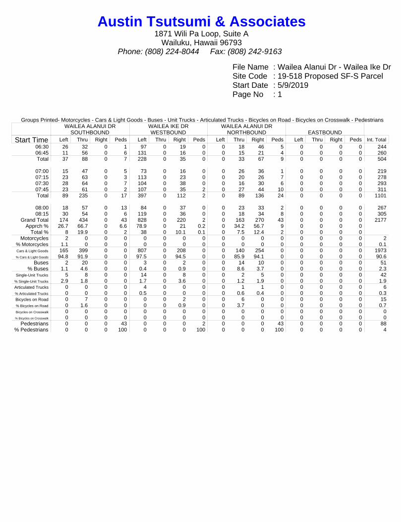
File Name : Wailea Alanui Dr - Wailea Ike DrSite Code : 19-518 Proposed SF-S ParcelStart Date : 5/9/2019Page No : 1
Groups Printed- Motorcycles - Cars & Light Goods - Buses - Unit Trucks - Articulated Trucks - Bicycles on Road - Bicycles on Crosswalk - PedestriansWAILEA ALANUI DR
SOUTHBOUNDWAILEA IKE DRWESTBOUND
WAILEA ALANUI DRNORTHBOUND EASTBOUND
Start Time Left Thru Right Peds Left Thru Right Peds Left Thru Right Peds Left Thru Right Peds Int. Total06:30 26 32 0 1 97 0 19 0 0 18 46 5 0 0 0 0 24406:45 11 56 0 6 131 0 16 0 0 15 21 4 0 0 0 0 260Total 37 88 0 7 228 0 35 0 0 33 67 9 0 0 0 0 504
07:00 15 47 0 5 73 0 16 0 0 26 36 1 0 0 0 0 21907:15 23 63 0 3 113 0 23 0 0 20 26 7 0 0 0 0 27807:30 28 64 0 7 104 0 38 0 0 16 30 6 0 0 0 0 29307:45 23 61 0 2 107 0 35 2 0 27 44 10 0 0 0 0 311Total 89 235 0 17 397 0 112 2 0 89 136 24 0 0 0 0 1101
08:00 18 57 0 13 84 0 37 0 0 23 33 2 0 0 0 0 26708:15 30 54 0 6 119 0 36 0 0 18 34 8 0 0 0 0 305
Grand Total 174 434 0 43 828 0 220 2 0 163 270 43 0 0 0 0 2177Apprch % 26.7 66.7 0 6.6 78.9 0 21 0.2 0 34.2 56.7 9 0 0 0 0
Total % 8 19.9 0 2 38 0 10.1 0.1 0 7.5 12.4 2 0 0 0 0Motorcycles 2 0 0 0 0 0 0 0 0 0 0 0 0 0 0 0 2
% Motorcycles 1.1 0 0 0 0 0 0 0 0 0 0 0 0 0 0 0 0.1Cars & Light Goods 165 399 0 0 807 0 208 0 0 140 254 0 0 0 0 0 1973% Cars & Light Goods 94.8 91.9 0 0 97.5 0 94.5 0 0 85.9 94.1 0 0 0 0 0 90.6
Buses 2 20 0 0 3 0 2 0 0 14 10 0 0 0 0 0 51% Buses 1.1 4.6 0 0 0.4 0 0.9 0 0 8.6 3.7 0 0 0 0 0 2.3
Single-Unit Trucks 5 8 0 0 14 0 8 0 0 2 5 0 0 0 0 0 42% Single-Unit Trucks 2.9 1.8 0 0 1.7 0 3.6 0 0 1.2 1.9 0 0 0 0 0 1.9Articulated Trucks 0 0 0 0 4 0 0 0 0 1 1 0 0 0 0 0 6% Articulated Trucks 0 0 0 0 0.5 0 0 0 0 0.6 0.4 0 0 0 0 0 0.3Bicycles on Road 0 7 0 0 0 0 2 0 0 6 0 0 0 0 0 0 15% Bicycles on Road 0 1.6 0 0 0 0 0.9 0 0 3.7 0 0 0 0 0 0 0.7Bicycles on Crosswalk 0 0 0 0 0 0 0 0 0 0 0 0 0 0 0 0 0% Bicycles on Crosswalk 0 0 0 0 0 0 0 0 0 0 0 0 0 0 0 0 0
Pedestrians 0 0 0 43 0 0 0 2 0 0 0 43 0 0 0 0 88% Pedestrians 0 0 0 100 0 0 0 100 0 0 0 100 0 0 0 0 4
Austin Tsutsumi & Associates1871 Wili Pa Loop, Suite A
Wailuku, Hawaii 96793Phone: (808) 224-8044 Fax: (808) 242-9163
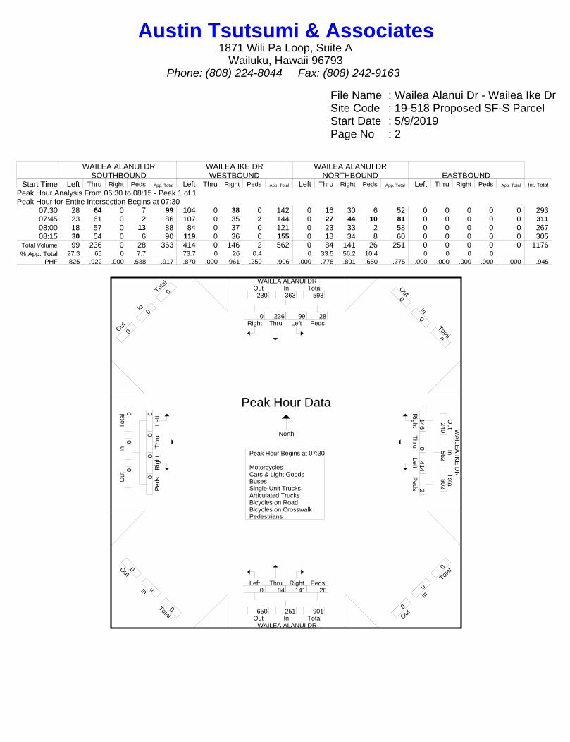
File Name : Wailea Alanui Dr - Wailea Ike DrSite Code : 19-518 Proposed SF-S ParcelStart Date : 5/9/2019Page No : 2
WAILEA ALANUI DRSOUTHBOUND
WAILEA IKE DRWESTBOUND
WAILEA ALANUI DRNORTHBOUND EASTBOUND
Start Time Left Thru Right Peds App. Total Left Thru Right Peds App. Total Left Thru Right Peds App. Total Left Thru Right Peds App. Total Int. Total
Peak Hour Analysis From 06:30 to 08:15 - Peak 1 of 1Peak Hour for Entire Intersection Begins at 07:30
07:30 28 64 0 7 99 104 0 38 0 142 0 16 30 6 52 0 0 0 0 0 29307:45 23 61 0 2 86 107 0 35 2 144 0 27 44 10 81 0 0 0 0 0 31108:00 18 57 0 13 88 84 0 37 0 121 0 23 33 2 58 0 0 0 0 0 26708:15 30 54 0 6 90 119 0 36 0 155 0 18 34 8 60 0 0 0 0 0 305
Total Volume 99 236 0 28 363 414 0 146 2 562 0 84 141 26 251 0 0 0 0 0 1176% App. Total 27.3 65 0 7.7 73.7 0 26 0.4 0 33.5 56.2 10.4 0 0 0 0
PHF .825 .922 .000 .538 .917 .870 .000 .961 .250 .906 .000 .778 .801 .650 .775 .000 .000 .000 .000 .000 .945
WAILEA ALANUI DR
W
AILE
A IK
E D
R
WAILEA ALANUI DR
Right0
Thru236
Left99
Peds28
InOut Total230 363 593
Out0
In0
Total0
Right146
Thru0
Left414
Peds2
Out
Total
In240
562 802
O ut0
In0
T otal
0
Left0
Thru84
Right141
Peds26
Out TotalIn650 251 901
Out0
In0
Total0
Left0
Thr
u0 R
ight0
Ped
s0
Tot
alO
utIn
0 0
0
O ut0
In0
T otal
0
Peak Hour Begins at 07:30 MotorcyclesCars & Light GoodsBusesSingle-Unit TrucksArticulated TrucksBicycles on RoadBicycles on CrosswalkPedestrians
Peak Hour Data
North
Austin Tsutsumi & Associates1871 Wili Pa Loop, Suite A
Wailuku, Hawaii 96793Phone: (808) 224-8044 Fax: (808) 242-9163

File Name : Wailea Alanui Dr - Wailea Ike DrSite Code : 19-518 Proposed SF-S ParcelStart Date : 5/8/2019Page No : 1
Groups Printed- Motorcycles - Cars & Light Goods - Buses - Unit Trucks - Articulated Trucks - Bicycles on Road - Bicycles on Crosswalk - PedestriansWAILEA ALANUI DR
SOUTHBOUNDWAILEA IKE DRWESTBOUND
WAILEA ALANUI DRNORTHBOUND EASTBOUND
Start Time Left Thru Right Peds Left Thru Right Peds Left Thru Right Peds Left Thru Right Peds Int. Total15:00 32 43 0 0 69 0 26 0 0 60 108 0 0 0 0 0 33815:15 54 52 0 0 71 0 35 0 0 88 124 5 0 0 0 0 42915:30 41 60 0 3 85 0 31 0 0 90 130 6 0 0 0 0 44615:45 44 61 0 1 104 0 36 0 0 80 111 3 0 0 0 0 440Total 171 216 0 4 329 0 128 0 0 318 473 14 0 0 0 0 1653
16:00 50 40 0 0 64 0 41 0 0 87 123 3 0 0 0 0 40816:15 51 65 0 0 64 0 45 0 0 88 137 7 0 0 0 0 45716:30 41 61 0 0 66 0 48 0 0 88 140 0 0 0 0 0 44416:45 45 58 0 0 70 0 53 0 0 67 85 1 0 0 0 0 379Total 187 224 0 0 264 0 187 0 0 330 485 11 0 0 0 0 1688
Grand Total 358 440 0 4 593 0 315 0 0 648 958 25 0 0 0 0 3341Apprch % 44.6 54.9 0 0.5 65.3 0 34.7 0 0 39.7 58.7 1.5 0 0 0 0
Total % 10.7 13.2 0 0.1 17.7 0 9.4 0 0 19.4 28.7 0.7 0 0 0 0Motorcycles 1 9 0 0 3 0 0 0 0 5 6 0 0 0 0 0 24
% Motorcycles 0.3 2 0 0 0.5 0 0 0 0 0.8 0.6 0 0 0 0 0 0.7Cars & Light Goods 348 424 0 0 579 0 308 0 0 632 941 0 0 0 0 0 3232% Cars & Light Goods 97.2 96.4 0 0 97.6 0 97.8 0 0 97.5 98.2 0 0 0 0 0 96.7
Buses 5 2 0 0 5 0 2 0 0 3 4 0 0 0 0 0 21% Buses 1.4 0.5 0 0 0.8 0 0.6 0 0 0.5 0.4 0 0 0 0 0 0.6
Single-Unit Trucks 2 3 0 0 6 0 3 0 0 7 7 0 0 0 0 0 28% Single-Unit Trucks 0.6 0.7 0 0 1 0 1 0 0 1.1 0.7 0 0 0 0 0 0.8Articulated Trucks 0 0 0 0 0 0 0 0 0 0 0 0 0 0 0 0 0% Articulated Trucks 0 0 0 0 0 0 0 0 0 0 0 0 0 0 0 0 0Bicycles on Road 2 2 0 0 0 0 2 0 0 1 0 0 0 0 0 0 7% Bicycles on Road 0.6 0.5 0 0 0 0 0.6 0 0 0.2 0 0 0 0 0 0 0.2Bicycles on Crosswalk 0 0 0 0 0 0 0 0 0 0 0 0 0 0 0 0 0% Bicycles on Crosswalk 0 0 0 0 0 0 0 0 0 0 0 0 0 0 0 0 0
Pedestrians 0 0 0 4 0 0 0 0 0 0 0 25 0 0 0 0 29% Pedestrians 0 0 0 100 0 0 0 0 0 0 0 100 0 0 0 0 0.9
Austin Tsutsumi & Associates1871 Wili Pa Loop, Suite A
Wailuku, Hawaii 96793Phone: (808) 224-8044 Fax: (808) 242-9163

File Name : Wailea Alanui Dr - Wailea Ike DrSite Code : 19-518 Proposed SF-S ParcelStart Date : 5/8/2019Page No : 2
WAILEA ALANUI DRSOUTHBOUND
WAILEA IKE DRWESTBOUND
WAILEA ALANUI DRNORTHBOUND EASTBOUND
Start Time Left Thru Right Peds App. Total Left Thru Right Peds App. Total Left Thru Right Peds App. Total Left Thru Right Peds App. Total Int. Total
Peak Hour Analysis From 15:15 to 16:00 - Peak 1 of 1Peak Hour for Entire Intersection Begins at 15:15
15:15 54 52 0 0 106 71 0 35 0 106 0 88 124 5 217 0 0 0 0 0 42915:30 41 60 0 3 104 85 0 31 0 116 0 90 130 6 226 0 0 0 0 0 44615:45 44 61 0 1 106 104 0 36 0 140 0 80 111 3 194 0 0 0 0 0 44016:00 50 40 0 0 90 64 0 41 0 105 0 87 123 3 213 0 0 0 0 0 408
Total Volume 189 213 0 4 406 324 0 143 0 467 0 345 488 17 850 0 0 0 0 0 1723% App. Total 46.6 52.5 0 1 69.4 0 30.6 0 0 40.6 57.4 2 0 0 0 0
PHF .875 .873 .000 .333 .958 .779 .000 .872 .000 .834 .000 .958 .938 .708 .940 .000 .000 .000 .000 .000 .966
WAILEA ALANUI DR
W
AILE
A IK
E D
R
WAILEA ALANUI DR
Right0
Thru213
Left189
Peds4
InOut Total488 406 894
Out0
In0
Total0
Right143
Thru0
Left324
Peds0
Out
Total
In677
467 1144
O ut0
In0
T otal
0
Left0
Thru345
Right488
Peds17
Out TotalIn537 850 1387
Out0
In0
Total0
Left0
Thr
u0 R
ight0
Ped
s0
Tot
alO
utIn
0 0
0
O ut0
In0
T otal
0
Peak Hour Begins at 15:15 MotorcyclesCars & Light GoodsBusesSingle-Unit TrucksArticulated TrucksBicycles on RoadBicycles on CrosswalkPedestrians
Peak Hour Data
North
Austin Tsutsumi & Associates1871 Wili Pa Loop, Suite A
Wailuku, Hawaii 96793Phone: (808) 224-8044 Fax: (808) 242-9163
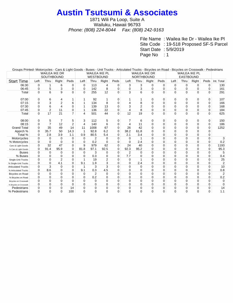
File Name : Wailea Ike Dr - Wailea Ike PlSite Code : 19-518 Proposed SF-S ParcelStart Date : 5/9/2019Page No : 1
Groups Printed- Motorcycles - Cars & Light Goods - Buses - Unit Trucks - Articulated Trucks - Bicycles on Road - Bicycles on Crosswalk - PedestriansWAILEA IKE DRSOUTHBOUND
WAILEA IKE PLWESTBOUND
WAILEA IKE DRNORTHBOUND
WAILEA IKE PLEASTBOUND
Start Time Left Thru Right Peds Left Thru Right Peds Left Thru Right Peds Left Thru Right Peds Int. Total06:30 0 1 6 0 0 113 4 0 3 3 0 0 0 0 0 0 13006:45 0 5 3 0 0 142 8 0 0 3 0 0 0 0 0 0 161Total 0 6 9 0 0 255 12 0 3 6 0 0 0 0 0 0 291
07:00 0 6 4 1 1 92 1 0 1 1 0 0 0 0 0 0 10707:15 0 3 2 6 1 134 8 0 4 8 0 0 0 0 0 0 16607:30 0 6 4 0 1 139 13 0 3 2 0 0 0 0 0 0 16807:45 0 2 11 0 1 136 22 0 4 8 0 0 0 0 0 0 184Total 0 17 21 7 4 501 44 0 12 19 0 0 0 0 0 0 625
08:00 0 5 7 5 3 112 5 0 7 6 0 0 0 0 0 0 15008:15 0 7 12 2 4 140 6 0 4 11 0 0 0 0 0 0 186
Grand Total 0 35 49 14 11 1008 67 0 26 42 0 0 0 0 0 0 1252Apprch % 0 35.7 50 14.3 1 92.8 6.2 0 38.2 61.8 0 0 0 0 0 0
Total % 0 2.8 3.9 1.1 0.9 80.5 5.4 0 2.1 3.4 0 0 0 0 0 0Motorcycles 0 0 0 0 0 2 0 0 0 1 0 0 0 0 0 0 3
% Motorcycles 0 0 0 0 0 0.2 0 0 0 2.4 0 0 0 0 0 0 0.2Cars & Light Goods 0 32 47 0 9 979 62 0 24 40 0 0 0 0 0 0 1193% Cars & Light Goods 0 91.4 95.9 0 81.8 97.1 92.5 0 92.3 95.2 0 0 0 0 0 0 95.3
Buses 0 0 0 0 0 3 0 0 2 0 0 0 0 0 0 0 5% Buses 0 0 0 0 0 0.3 0 0 7.7 0 0 0 0 0 0 0 0.4
Single-Unit Trucks 0 0 2 0 1 19 2 0 0 1 0 0 0 0 0 0 25% Single-Unit Trucks 0 0 4.1 0 9.1 1.9 3 0 0 2.4 0 0 0 0 0 0 2Articulated Trucks 0 3 0 0 1 3 3 0 0 0 0 0 0 0 0 0 10% Articulated Trucks 0 8.6 0 0 9.1 0.3 4.5 0 0 0 0 0 0 0 0 0 0.8Bicycles on Road 0 0 0 0 0 2 0 0 0 0 0 0 0 0 0 0 2% Bicycles on Road 0 0 0 0 0 0.2 0 0 0 0 0 0 0 0 0 0 0.2Bicycles on Crosswalk 0 0 0 0 0 0 0 0 0 0 0 0 0 0 0 0 0% Bicycles on Crosswalk 0 0 0 0 0 0 0 0 0 0 0 0 0 0 0 0 0
Pedestrians 0 0 0 14 0 0 0 0 0 0 0 0 0 0 0 0 14% Pedestrians 0 0 0 100 0 0 0 0 0 0 0 0 0 0 0 0 1.1
Austin Tsutsumi & Associates1871 Wili Pa Loop, Suite A
Wailuku, Hawaii 96793Phone: (808) 224-8044 Fax: (808) 242-9163

File Name : Wailea Ike Dr - Wailea Ike PlSite Code : 19-518 Proposed SF-S ParcelStart Date : 5/9/2019Page No : 2
WAILEA IKE DRSOUTHBOUND
WAILEA IKE PLWESTBOUND
WAILEA IKE DRNORTHBOUND
WAILEA IKE PLEASTBOUND
Start Time Left Thru Right Peds App. Total Left Thru Right Peds App. Total Left Thru Right Peds App. Total Left Thru Right Peds App. Total Int. Total
Peak Hour Analysis From 06:30 to 08:15 - Peak 1 of 1Peak Hour for Entire Intersection Begins at 07:30
07:30 0 6 4 0 10 1 139 13 0 153 3 2 0 0 5 0 0 0 0 0 16807:45 0 2 11 0 13 1 136 22 0 159 4 8 0 0 12 0 0 0 0 0 18408:00 0 5 7 5 17 3 112 5 0 120 7 6 0 0 13 0 0 0 0 0 15008:15 0 7 12 2 21 4 140 6 0 150 4 11 0 0 15 0 0 0 0 0 186
Total Volume 0 20 34 7 61 9 527 46 0 582 18 27 0 0 45 0 0 0 0 0 688% App. Total 0 32.8 55.7 11.5 1.5 90.5 7.9 0 40 60 0 0 0 0 0 0
PHF .000 .714 .708 .350 .726 .563 .941 .523 .000 .915 .643 .614 .000 .000 .750 .000 .000 .000 .000 .000 .925
WAILEA IKE DR
WA
ILE
A IK
E P
L W
AILE
A IK
E P
L
WAILEA IKE DR
Right34
Thru20
Left0
Peds7
InOut Total73 61 134
Out0
In0
Total0
Right
46 T
hru527
Left9 P
eds0
Out
Total
In0
582 582
O ut0
In0
T otal
0
Left18
Thru27
Right0
Peds0
Out TotalIn29 45 74
Out0
In0
Total0
Left0
Thr
u0 R
ight0
Ped
s0
Tot
alO
utIn
579
0 57
9
O ut0
In0
T otal
0
Peak Hour Begins at 07:30 MotorcyclesCars & Light GoodsBusesSingle-Unit TrucksArticulated TrucksBicycles on RoadBicycles on CrosswalkPedestrians
Peak Hour Data
North
Austin Tsutsumi & Associates1871 Wili Pa Loop, Suite A
Wailuku, Hawaii 96793Phone: (808) 224-8044 Fax: (808) 242-9163

File Name : Wailea Ike Dr - Wailea Ike PlSite Code : 19-518 Proposed SF-S ParcelStart Date : 5/8/2019Page No : 1
Groups Printed- Motorcycles - Cars & Light Goods - Buses - Unit Trucks - Articulated Trucks - Bicycles on Road - Bicycles on Crosswalk - PedestriansWAILEA IKE DRSOUTHBOUND
WAILEA IKE PLWESTBOUND
WAILEA IKE DRNORTHBOUND
WAILEA IKE PLEASTBOUND
Start Time Left Thru Right Peds Left Thru Right Peds Left Thru Right Peds Left Thru Right Peds Int. Total15:00 0 12 9 3 2 118 13 0 11 12 0 0 0 0 0 1 18115:15 0 17 14 5 1 104 10 0 6 11 0 0 0 0 0 2 17015:30 0 19 7 0 1 103 11 0 9 8 0 0 0 0 0 0 15815:45 0 10 10 0 2 137 10 0 4 8 0 0 0 0 0 1 182Total 0 58 40 8 6 462 44 0 30 39 0 0 0 0 0 4 691
16:00 0 10 11 1 3 102 12 0 3 4 0 0 0 0 0 2 14816:15 0 18 9 2 0 88 9 0 10 14 0 0 0 0 0 0 15016:30 0 14 10 0 1 106 4 0 4 4 0 0 0 0 0 2 14516:45 0 11 4 2 1 105 6 2 6 10 0 0 0 0 0 0 147Total 0 53 34 5 5 401 31 2 23 32 0 0 0 0 0 4 590
Grand Total 0 111 74 13 11 863 75 2 53 71 0 0 0 0 0 8 1281Apprch % 0 56.1 37.4 6.6 1.2 90.7 7.9 0.2 42.7 57.3 0 0 0 0 0 100
Total % 0 8.7 5.8 1 0.9 67.4 5.9 0.2 4.1 5.5 0 0 0 0 0 0.6Motorcycles 0 1 0 0 0 1 0 0 0 0 0 0 0 0 0 0 2
% Motorcycles 0 0.9 0 0 0 0.1 0 0 0 0 0 0 0 0 0 0 0.2Cars & Light Goods 0 106 72 0 11 838 70 0 51 68 0 0 0 0 0 0 1216% Cars & Light Goods 0 95.5 97.3 0 100 97.1 93.3 0 96.2 95.8 0 0 0 0 0 0 94.9
Buses 0 0 0 0 0 10 0 0 2 2 0 0 0 0 0 0 14% Buses 0 0 0 0 0 1.2 0 0 3.8 2.8 0 0 0 0 0 0 1.1
Single-Unit Trucks 0 1 0 0 0 9 4 0 0 0 0 0 0 0 0 0 14% Single-Unit Trucks 0 0.9 0 0 0 1 5.3 0 0 0 0 0 0 0 0 0 1.1Articulated Trucks 0 3 0 0 0 2 1 0 0 0 0 0 0 0 0 0 6% Articulated Trucks 0 2.7 0 0 0 0.2 1.3 0 0 0 0 0 0 0 0 0 0.5Bicycles on Road 0 0 2 0 0 3 0 0 0 1 0 0 0 0 0 0 6% Bicycles on Road 0 0 2.7 0 0 0.3 0 0 0 1.4 0 0 0 0 0 0 0.5Bicycles on Crosswalk 0 0 0 0 0 0 0 0 0 0 0 0 0 0 0 0 0% Bicycles on Crosswalk 0 0 0 0 0 0 0 0 0 0 0 0 0 0 0 0 0
Pedestrians 0 0 0 13 0 0 0 2 0 0 0 0 0 0 0 8 23% Pedestrians 0 0 0 100 0 0 0 100 0 0 0 0 0 0 0 100 1.8
Austin Tsutsumi & Associates1871 Wili Pa Loop, Suite A
Wailuku, Hawaii 96793Phone: (808) 224-8044 Fax: (808) 242-9163
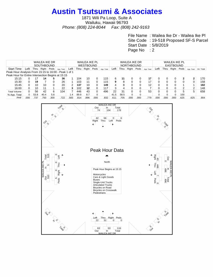
File Name : Wailea Ike Dr - Wailea Ike PlSite Code : 19-518 Proposed SF-S ParcelStart Date : 5/8/2019Page No : 2
WAILEA IKE DRSOUTHBOUND
WAILEA IKE PLWESTBOUND
WAILEA IKE DRNORTHBOUND
WAILEA IKE PLEASTBOUND
Start Time Left Thru Right Peds App. Total Left Thru Right Peds App. Total Left Thru Right Peds App. Total Left Thru Right Peds App. Total Int. Total
Peak Hour Analysis From 15:15 to 16:00 - Peak 1 of 1Peak Hour for Entire Intersection Begins at 15:15
15:15 0 17 14 5 36 1 104 10 0 115 6 11 0 0 17 0 0 0 2 2 17015:30 0 19 7 0 26 1 103 11 0 115 9 8 0 0 17 0 0 0 0 0 15815:45 0 10 10 0 20 2 137 10 0 149 4 8 0 0 12 0 0 0 1 1 18216:00 0 10 11 1 22 3 102 12 0 117 3 4 0 0 7 0 0 0 2 2 148
Total Volume 0 56 42 6 104 7 446 43 0 496 22 31 0 0 53 0 0 0 5 5 658% App. Total 0 53.8 40.4 5.8 1.4 89.9 8.7 0 41.5 58.5 0 0 0 0 0 100
PHF .000 .737 .750 .300 .722 .583 .814 .896 .000 .832 .611 .705 .000 .000 .779 .000 .000 .000 .625 .625 .904
WAILEA IKE DR
WA
ILE
A IK
E P
L W
AILE
A IK
E P
L
WAILEA IKE DR
Right42
Thru56
Left0
Peds6
InOut Total74 104 178
Out0
In0
Total0
Right
43 T
hru446
Left7 P
eds0
Out
Total
In0
496 496
O ut0
In0
T otal
0
Left22
Thru31
Right0
Peds0
Out TotalIn63 53 116
Out0
In0
Total0
Left0
Thr
u0 R
ight0
Ped
s5
Tot
alO
utIn
510
5 51
5
O ut0
In0
T otal
0
Peak Hour Begins at 15:15 MotorcyclesCars & Light GoodsBusesSingle-Unit TrucksArticulated TrucksBicycles on RoadBicycles on CrosswalkPedestrians
Peak Hour Data
North
Austin Tsutsumi & Associates1871 Wili Pa Loop, Suite A
Wailuku, Hawaii 96793Phone: (808) 224-8044 Fax: (808) 242-9163
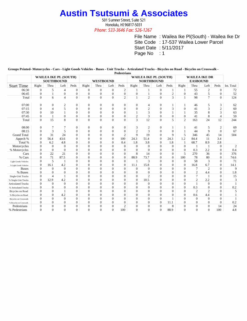
Austin Tsutsumi & Associates501 Sumner Street, Suite 521
Honolulu, HI 96817-5031
Phone: 533-3646 Fax: 526-1267
File Name : Wailea Ike Pl(South) - Wailea Ike DrSite Code : 17-537 Wailea Lower ParcelStart Date : 5/11/2017Page No : 1
Groups Printed- Motorcycles - Cars - Light Goods Vehicles - Buses - Unit Trucks - Articulated Trucks - Bicycles on Road - Bicycles on Crosswalk -Pedestrians
WAILEA IKE PL (SOUTH)SOUTHBOUND WESTBOUND
WAILEA IKE PL (SOUTH)NORTHBOUND
WAILEA IKE DREASBOUND
Start Time Right Thru Left Peds Right Thru Left Peds Right Thru Left Peds Right Thru Left Peds Int. Total
06:30 0 5 4 0 0 0 0 2 1 1 0 1 1 55 2 0 7206:45 0 1 0 0 0 0 0 0 0 1 0 2 0 43 5 0 52Total 0 6 4 0 0 0 0 2 1 2 0 3 1 98 7 0 124
07:00 0 0 2 0 0 0 0 0 0 4 0 1 1 46 5 3 6207:15 0 4 5 0 0 0 0 0 0 2 0 3 0 41 3 2 6007:30 0 10 1 0 0 0 0 0 1 3 0 1 1 35 8 3 6307:45 0 1 0 0 0 0 0 0 2 3 0 0 0 41 8 4 59Total 0 15 8 0 0 0 0 0 3 12 0 5 2 163 24 12 244
08:00 0 7 7 0 0 0 0 0 3 2 0 1 1 41 5 2 6908:15 0 3 5 0 0 0 0 0 2 3 0 0 1 44 9 0 67
Grand Total 0 31 24 0 0 0 0 2 9 19 0 9 5 346 45 14 504Apprch % 0 56.4 43.6 0 0 0 0 100 24.3 51.4 0 24.3 1.2 84.4 11 3.4
Total % 0 6.2 4.8 0 0 0 0 0.4 1.8 3.8 0 1.8 1 68.7 8.9 2.8Motorcycles 0 0 0 0 0 0 0 0 0 0 0 0 0 1 1 0 2
% Motorcycles 0 0 0 0 0 0 0 0 0 0 0 0 0 0.3 2.2 0 0.4Cars 0 22 21 0 0 0 0 0 8 14 0 0 5 270 36 0 376
% Cars 0 71 87.5 0 0 0 0 0 88.9 73.7 0 0 100 78 80 0 74.6Light Goods Vehicles 0 5 1 0 0 0 0 0 1 3 0 0 0 58 3 0 71% Light Goods Vehicles 0 16.1 4.2 0 0 0 0 0 11.1 15.8 0 0 0 16.8 6.7 0 14.1
Buses 0 0 0 0 0 0 0 0 0 0 0 0 0 7 2 0 9% Buses 0 0 0 0 0 0 0 0 0 0 0 0 0 2 4.4 0 1.8
Single-Unit Trucks 0 4 1 0 0 0 0 0 0 2 0 0 0 7 1 0 15% Single-Unit Trucks 0 12.9 4.2 0 0 0 0 0 0 10.5 0 0 0 2 2.2 0 3Articulated Trucks 0 0 0 0 0 0 0 0 0 0 0 0 0 1 0 0 1% Articulated Trucks 0 0 0 0 0 0 0 0 0 0 0 0 0 0.3 0 0 0.2Bicycles on Road 0 0 1 0 0 0 0 0 0 0 0 0 0 2 2 0 5% Bicycles on Road 0 0 4.2 0 0 0 0 0 0 0 0 0 0 0.6 4.4 0 1Bicycles on Crosswalk 0 0 0 0 0 0 0 0 0 0 0 1 0 0 0 0 1% Bicycles on Crosswalk 0 0 0 0 0 0 0 0 0 0 0 11.1 0 0 0 0 0.2
Pedestrians 0 0 0 0 0 0 0 2 0 0 0 8 0 0 0 14 24% Pedestrians 0 0 0 0 0 0 0 100 0 0 0 88.9 0 0 0 100 4.8
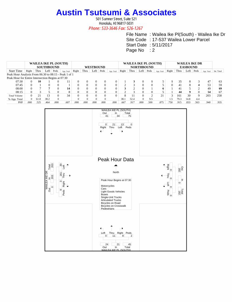
Austin Tsutsumi & Associates501 Sumner Street, Suite 521
Honolulu, HI 96817-5031
Phone: 533-3646 Fax: 526-1267
File Name : Wailea Ike Pl(South) - Wailea Ike DrSite Code : 17-537 Wailea Lower ParcelStart Date : 5/11/2017Page No : 2
WAILEA IKE PL (SOUTH)SOUTHBOUND WESTBOUND
WAILEA IKE PL (SOUTH)NORTHBOUND
WAILEA IKE DREASBOUND
Start Time Right Thru Left Peds App. Total Right Thru Left Peds App. Total Right Thru Left Peds App. Total Right Thru Left Peds App. Total Int. Total
Peak Hour Analysis From 06:30 to 08:15 - Peak 1 of 1Peak Hour for Entire Intersection Begins at 07:30
07:30 0 10 1 0 11 0 0 0 0 0 1 3 0 1 5 1 35 8 3 47 6307:45 0 1 0 0 1 0 0 0 0 0 2 3 0 0 5 0 41 8 4 53 5908:00 0 7 7 0 14 0 0 0 0 0 3 2 0 1 6 1 41 5 2 49 6908:15 0 3 5 0 8 0 0 0 0 0 2 3 0 0 5 1 44 9 0 54 67
Total Volume 0 21 13 0 34 0 0 0 0 0 8 11 0 2 21 3 161 30 9 203 258% App. Total 0 61.8 38.2 0 0 0 0 0 38.1 52.4 0 9.5 1.5 79.3 14.8 4.4
PHF .000 .525 .464 .000 .607 .000 .000 .000 .000 .000 .667 .917 .000 .500 .875 .750 .915 .833 .563 .940 .935
WAILEA IKE PL (SOUTH)
WA
ILE
A IK
E D
R
WAILEA IKE PL (SOUTH)
Right0
Thru21
Left13
Peds0
InOut Total41 34 75
Right0
Thru0
Left0 P
eds0
Out
Total
In182
0 182
Left0
Thru11
Right8
Peds2
Out TotalIn24 21 45
Left30
T
hru
161
Rig
ht3 P
eds9
Tot
alO
utIn
0 20
3 20
3
Peak Hour Begins at 07:30 MotorcyclesCarsLight Goods VehiclesBusesSingle-Unit TrucksArticulated TrucksBicycles on RoadBicycles on CrosswalkPedestrians
Peak Hour Data
North

Austin Tsutsumi & Associates501 Sumner Street, Suite 521
Honolulu, HI 96817-5031
Phone: 533-3646 Fax: 526-1267
File Name : Wailea Ike Pl(South) - Wailea Ike DrSite Code : 17-537 Wailea Lower ParcelStart Date : 5/11/2017Page No : 1
Groups Printed- Motorcycles - Cars - Light Goods Vehicles - Buses - Unit Trucks - Articulated Trucks - Bicycles on Road - Bicycles on Crosswalk -Pedestrians
WAILEA IKE PL (SOUTH)SOUTHBOUND WESTBOUND
WAILEA IKE PL (SOUTH)NORTHBOUND
WAILEA IKE DREASBOUND
Start Time Right Thru Left Peds Right Thru Left Peds Right Thru Left Peds Right Thru Left Peds Int. Total
15:00 0 5 18 0 0 0 0 0 7 4 0 0 1 162 10 0 20715:15 0 2 11 0 0 0 0 0 4 8 0 7 3 126 9 0 17015:30 0 4 14 0 0 0 0 0 5 8 0 0 5 126 11 6 17915:45 0 7 17 0 0 0 0 0 7 8 0 3 2 125 13 1 183Total 0 18 60 0 0 0 0 0 23 28 0 10 11 539 43 7 739
16:00 0 4 17 0 0 0 0 0 4 2 0 0 1 141 10 0 17916:15 0 3 24 0 0 0 0 0 7 4 0 2 3 142 5 2 19216:30 0 1 14 0 0 0 0 0 1 7 0 1 1 158 5 0 18816:45 0 3 10 0 0 0 0 0 1 4 0 3 1 156 14 0 192Total 0 11 65 0 0 0 0 0 13 17 0 6 6 597 34 2 751
Grand Total 0 29 125 0 0 0 0 0 36 45 0 16 17 1136 77 9 1490Apprch % 0 18.8 81.2 0 0 0 0 0 37.1 46.4 0 16.5 1.4 91.7 6.2 0.7
Total % 0 1.9 8.4 0 0 0 0 0 2.4 3 0 1.1 1.1 76.2 5.2 0.6Motorcycles 0 0 0 0 0 0 0 0 0 1 0 0 0 2 1 0 4
% Motorcycles 0 0 0 0 0 0 0 0 0 2.2 0 0 0 0.2 1.3 0 0.3Cars 0 26 103 0 0 0 0 0 28 38 0 0 16 877 66 0 1154
% Cars 0 89.7 82.4 0 0 0 0 0 77.8 84.4 0 0 94.1 77.2 85.7 0 77.4Light Goods Vehicles 0 3 20 0 0 0 0 0 8 6 0 0 1 234 8 0 280% Light Goods Vehicles 0 10.3 16 0 0 0 0 0 22.2 13.3 0 0 5.9 20.6 10.4 0 18.8
Buses 0 0 0 0 0 0 0 0 0 0 0 0 0 5 2 0 7% Buses 0 0 0 0 0 0 0 0 0 0 0 0 0 0.4 2.6 0 0.5
Single-Unit Trucks 0 0 2 0 0 0 0 0 0 0 0 0 0 16 0 0 18% Single-Unit Trucks 0 0 1.6 0 0 0 0 0 0 0 0 0 0 1.4 0 0 1.2Articulated Trucks 0 0 0 0 0 0 0 0 0 0 0 0 0 2 0 0 2% Articulated Trucks 0 0 0 0 0 0 0 0 0 0 0 0 0 0.2 0 0 0.1Bicycles on Road 0 0 0 0 0 0 0 0 0 0 0 0 0 0 0 0 0% Bicycles on Road 0 0 0 0 0 0 0 0 0 0 0 0 0 0 0 0 0Bicycles on Crosswalk 0 0 0 0 0 0 0 0 0 0 0 0 0 0 0 0 0% Bicycles on Crosswalk 0 0 0 0 0 0 0 0 0 0 0 0 0 0 0 0 0
Pedestrians 0 0 0 0 0 0 0 0 0 0 0 16 0 0 0 9 25% Pedestrians 0 0 0 0 0 0 0 0 0 0 0 100 0 0 0 100 1.7

Austin Tsutsumi & Associates501 Sumner Street, Suite 521
Honolulu, HI 96817-5031
Phone: 533-3646 Fax: 526-1267
File Name : Wailea Ike Pl(South) - Wailea Ike DrSite Code : 17-537 Wailea Lower ParcelStart Date : 5/11/2017Page No : 2
WAILEA IKE PL (SOUTH)SOUTHBOUND WESTBOUND
WAILEA IKE PL (SOUTH)NORTHBOUND
WAILEA IKE DREASBOUND
Start Time Right Thru Left Peds App. Total Right Thru Left Peds App. Total Right Thru Left Peds App. Total Right Thru Left Peds App. Total Int. Total
Peak Hour Analysis From 15:15 to 16:00 - Peak 1 of 1Peak Hour for Entire Intersection Begins at 15:15
15:15 0 2 11 0 13 0 0 0 0 0 4 8 0 7 19 3 126 9 0 138 17015:30 0 4 14 0 18 0 0 0 0 0 5 8 0 0 13 5 126 11 6 148 17915:45 0 7 17 0 24 0 0 0 0 0 7 8 0 3 18 2 125 13 1 141 18316:00 0 4 17 0 21 0 0 0 0 0 4 2 0 0 6 1 141 10 0 152 179
Total Volume 0 17 59 0 76 0 0 0 0 0 20 26 0 10 56 11 518 43 7 579 711% App. Total 0 22.4 77.6 0 0 0 0 0 35.7 46.4 0 17.9 1.9 89.5 7.4 1.2
PHF .000 .607 .868 .000 .792 .000 .000 .000 .000 .000 .714 .813 .000 .357 .737 .550 .918 .827 .292 .952 .971
WAILEA IKE PL (SOUTH)
WA
ILE
A IK
E D
R
WAILEA IKE PL (SOUTH)
Right0
Thru17
Left59
Peds0
InOut Total69 76 145
Right0
Thru0
Left0 P
eds0
Out
Total
In597
0 597
Left0
Thru26
Right20
Peds10
Out TotalIn28 56 84
Left43
T
hru
518
Rig
ht11
Ped
s7
Tot
alO
utIn
0 57
9 57
9
Peak Hour Begins at 15:15 MotorcyclesCarsLight Goods VehiclesBusesSingle-Unit TrucksArticulated TrucksBicycles on RoadBicycles on CrosswalkPedestrians
Peak Hour Data
North

LLEVEL OFAP
F SERVICPPENDIXCE CRITE
X B ERIA
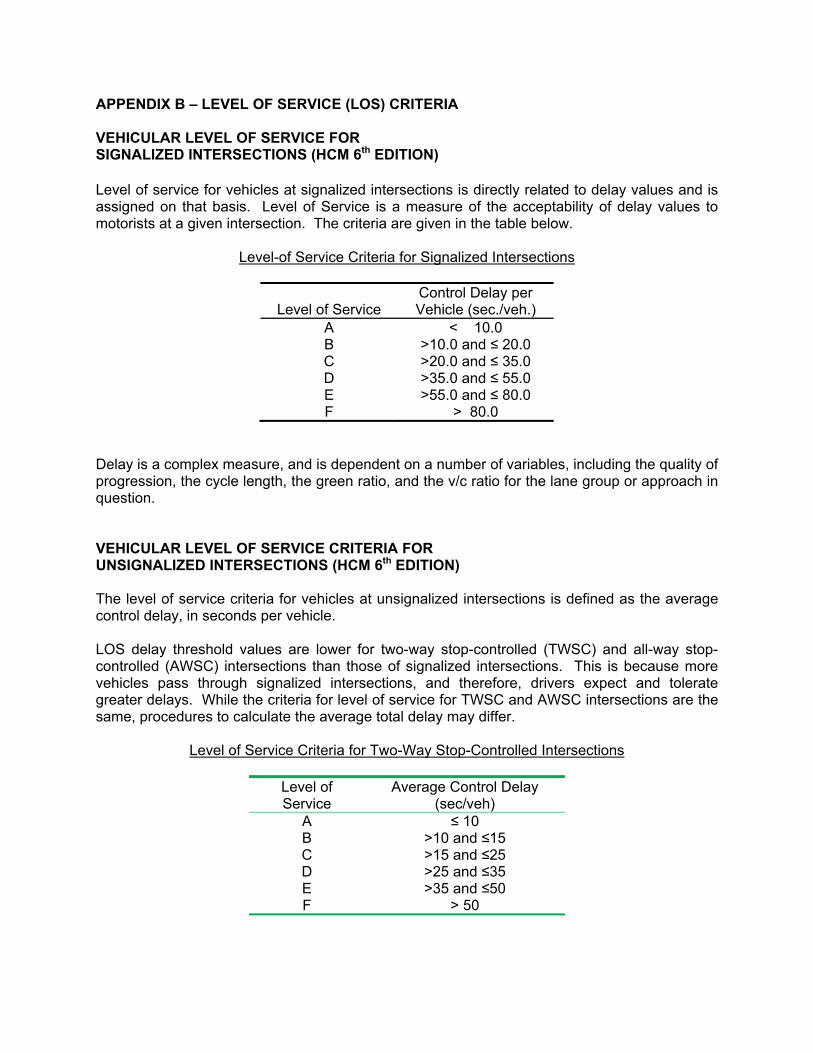
APPENDIX B – LEVEL OF SERVICE (LOS) CRITERIA VEHICULAR LEVEL OF SERVICE FOR SIGNALIZED INTERSECTIONS (HCM 6th EDITION) Level of service for vehicles at signalized intersections is directly related to delay values and is assigned on that basis. Level of Service is a measure of the acceptability of delay values to motorists at a given intersection. The criteria are given in the table below.
Level-of Service Criteria for Signalized Intersections
Control Delay per Level of Service Vehicle (sec./veh.)
A < 10.0 B >10.0 and ≤ 20.0 C >20.0 and ≤ 35.0 D >35.0 and ≤ 55.0 E >55.0 and ≤ 80.0 F > 80.0
Delay is a complex measure, and is dependent on a number of variables, including the quality of progression, the cycle length, the green ratio, and the v/c ratio for the lane group or approach in question. VEHICULAR LEVEL OF SERVICE CRITERIA FOR UNSIGNALIZED INTERSECTIONS (HCM 6th EDITION) The level of service criteria for vehicles at unsignalized intersections is defined as the average control delay, in seconds per vehicle. LOS delay threshold values are lower for two-way stop-controlled (TWSC) and all-way stop-controlled (AWSC) intersections than those of signalized intersections. This is because more vehicles pass through signalized intersections, and therefore, drivers expect and tolerate greater delays. While the criteria for level of service for TWSC and AWSC intersections are the same, procedures to calculate the average total delay may differ.
Level of Service Criteria for Two-Way Stop-Controlled Intersections
Level of Service
Average Control Delay (sec/veh)
A ≤ 10 B >10 and ≤15 C >15 and ≤25 D >25 and ≤35 E >35 and ≤50 F > 50

LEVEL OF SERVAP
VICE CALPPENDIXLCULATIO
X C ONS
LEVEL OF SERVAP
VICE CAL
• Exis
PPENDIXLCULATIO
ting AM P
X C ONS
Peak
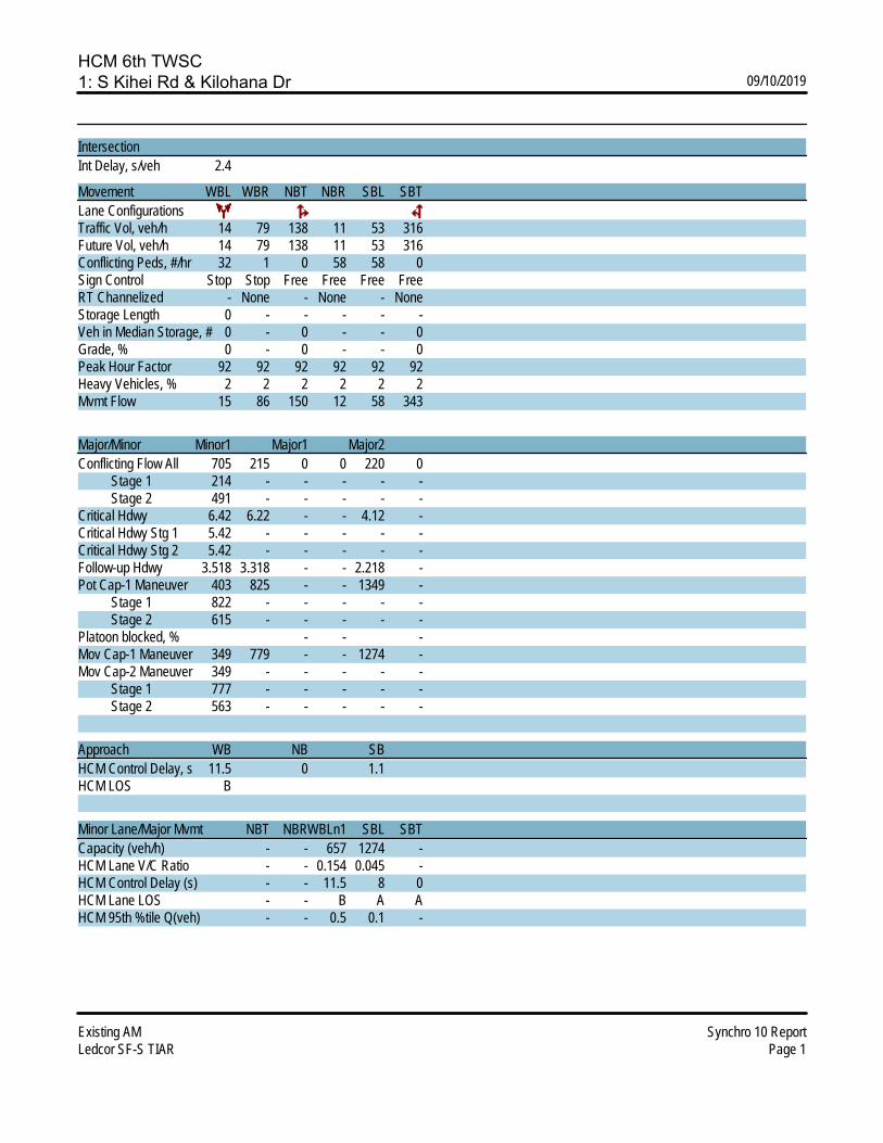
HCM 6th TWSC1: S Kihei Rd & Kilohana Dr 09/10/2019
Existing AM Synchro 10 ReportLedcor SF-S TIAR Page 1
IntersectionInt Delay, s/veh 2.4
Movement WBL WBR NBT NBR SBL SBTLane ConfigurationsTraffic Vol, veh/h 14 79 138 11 53 316Future Vol, veh/h 14 79 138 11 53 316Conflicting Peds, #/hr 32 1 0 58 58 0Sign Control Stop Stop Free Free Free FreeRT Channelized - None - None - NoneStorage Length 0 - - - - -Veh in Median Storage, # 0 - 0 - - 0Grade, % 0 - 0 - - 0Peak Hour Factor 92 92 92 92 92 92Heavy Vehicles, % 2 2 2 2 2 2Mvmt Flow 15 86 150 12 58 343
Major/Minor Minor1 Major1 Major2Conflicting Flow All 705 215 0 0 220 0 Stage 1 214 - - - - - Stage 2 491 - - - - -Critical Hdwy 6.42 6.22 - - 4.12 -Critical Hdwy Stg 1 5.42 - - - - -Critical Hdwy Stg 2 5.42 - - - - -Follow-up Hdwy 3.518 3.318 - - 2.218 -Pot Cap-1 Maneuver 403 825 - - 1349 - Stage 1 822 - - - - - Stage 2 615 - - - - -Platoon blocked, % - - -Mov Cap-1 Maneuver 349 779 - - 1274 -Mov Cap-2 Maneuver 349 - - - - - Stage 1 777 - - - - - Stage 2 563 - - - - -
Approach WB NB SBHCM Control Delay, s 11.5 0 1.1HCM LOS B
Minor Lane/Major Mvmt NBT NBRWBLn1 SBL SBTCapacity (veh/h) - - 657 1274 -HCM Lane V/C Ratio - - 0.154 0.045 -HCM Control Delay (s) - - 11.5 8 0HCM Lane LOS - - B A AHCM 95th %tile Q(veh) - - 0.5 0.1 -

HCM 6th TWSC2: Wailea Alanui Dr & Kilohana Dr 09/10/2019
Existing AM Synchro 10 ReportLedcor SF-S TIAR Page 2
IntersectionInt Delay, s/veh 4.1
Movement EBL EBT EBR WBL WBT WBR NBL NBT NBR SBL SBT SBRLane ConfigurationsTraffic Vol, veh/h 0 59 6 62 86 4 15 5 25 16 4 2Future Vol, veh/h 0 59 6 62 86 4 15 5 25 16 4 2Conflicting Peds, #/hr 6 0 14 14 0 6 4 0 1 1 0 4Sign Control Free Free Free Free Free Free Stop Stop Stop Stop Stop StopRT Channelized - - None - - None - - None - - NoneStorage Length 40 - - 195 - - - - - - - -Veh in Median Storage, # - 0 - - 0 - - 0 - - 0 -Grade, % - 0 - - 0 - - 0 - - 0 -Peak Hour Factor 92 92 92 92 92 92 92 92 92 92 92 92Heavy Vehicles, % 2 2 2 2 2 2 2 2 2 2 2 2Mvmt Flow 0 64 7 67 93 4 16 5 27 17 4 2
Major/Minor Major1 Major2 Minor1 Minor2Conflicting Flow All 103 0 0 85 0 0 318 319 83 320 320 105 Stage 1 - - - - - - 82 82 - 235 235 - Stage 2 - - - - - - 236 237 - 85 85 -Critical Hdwy 4.12 - - 4.12 - - 7.12 6.52 6.22 7.12 6.52 6.22Critical Hdwy Stg 1 - - - - - - 6.12 5.52 - 6.12 5.52 -Critical Hdwy Stg 2 - - - - - - 6.12 5.52 - 6.12 5.52 -Follow-up Hdwy 2.218 - - 2.218 - - 3.518 4.018 3.318 3.518 4.018 3.318Pot Cap-1 Maneuver 1489 - - 1512 - - 635 598 976 633 597 949 Stage 1 - - - - - - 926 827 - 768 710 - Stage 2 - - - - - - 767 709 - 923 824 -Platoon blocked, % - - - -Mov Cap-1 Maneuver 1480 - - 1492 - - 598 560 962 586 559 940Mov Cap-2 Maneuver - - - - - - 598 560 - 586 559 - Stage 1 - - - - - - 914 816 - 763 674 - Stage 2 - - - - - - 723 673 - 890 813 -
Approach EB WB NB SBHCM Control Delay, s 0 3.1 10.1 11.2HCM LOS B B
Minor Lane/Major Mvmt NBLn1 EBL EBT EBR WBL WBT WBR SBLn1Capacity (veh/h) 750 1480 - - 1492 - - 601HCM Lane V/C Ratio 0.065 - - - 0.045 - - 0.04HCM Control Delay (s) 10.1 0 - - 7.5 - - 11.2HCM Lane LOS B A - - A - - BHCM 95th %tile Q(veh) 0.2 0 - - 0.1 - - 0.1

HCM 6th TWSC3: Kapili St & Kilohana Dr 09/10/2019
Existing AM Synchro 10 ReportLedcor SF-S TIAR Page 3
IntersectionInt Delay, s/veh 1.8
Movement EBT EBR WBL WBT NBL NBRLane ConfigurationsTraffic Vol, veh/h 108 11 31 116 8 25Future Vol, veh/h 108 11 31 116 8 25Conflicting Peds, #/hr 0 4 4 0 0 0Sign Control Free Free Free Free Stop StopRT Channelized - None - None - NoneStorage Length - - - - 0 -Veh in Median Storage, # 0 - - 0 0 -Grade, % 0 - - 0 0 -Peak Hour Factor 92 92 92 92 92 92Heavy Vehicles, % 2 2 2 2 2 2Mvmt Flow 117 12 34 126 9 27
Major/Minor Major1 Major2 Minor1Conflicting Flow All 0 0 133 0 321 127 Stage 1 - - - - 127 - Stage 2 - - - - 194 -Critical Hdwy - - 4.12 - 6.42 6.22Critical Hdwy Stg 1 - - - - 5.42 -Critical Hdwy Stg 2 - - - - 5.42 -Follow-up Hdwy - - 2.218 - 3.518 3.318Pot Cap-1 Maneuver - - 1452 - 673 923 Stage 1 - - - - 899 - Stage 2 - - - - 839 -Platoon blocked, % - - -Mov Cap-1 Maneuver - - 1446 - 653 919Mov Cap-2 Maneuver - - - - 653 - Stage 1 - - - - 895 - Stage 2 - - - - 818 -
Approach EB WB NBHCM Control Delay, s 0 1.6 9.5HCM LOS A
Minor Lane/Major Mvmt NBLn1 EBT EBR WBL WBTCapacity (veh/h) 836 - - 1446 -HCM Lane V/C Ratio 0.043 - - 0.023 -HCM Control Delay (s) 9.5 - - 7.5 0HCM Lane LOS A - - A AHCM 95th %tile Q(veh) 0.1 - - 0.1 -

HCM 6th Signalized Intersection Summary4: Piilani Hwy & Kilohana Dr/Mapu Dr 09/10/2019
Existing AM Synchro 10 ReportLedcor SF-S TIAR Page 4
Movement EBL EBT EBR WBL WBT WBR NBL NBT NBR SBL SBT SBRLane ConfigurationsTraffic Volume (veh/h) 105 19 9 19 17 167 9 374 4 69 812 124Future Volume (veh/h) 105 19 9 19 17 167 9 374 4 69 812 124Initial Q (Qb), veh 0 0 0 0 0 0 0 0 0 0 0 0Ped-Bike Adj(A_pbT) 0.99 0.98 0.98 0.98 1.00 1.00 1.00 1.00Parking Bus, Adj 1.00 1.00 1.00 1.00 1.00 1.00 1.00 1.00 1.00 1.00 1.00 1.00Work Zone On Approach No No No NoAdj Sat Flow, veh/h/ln 1870 1870 1870 1870 1870 1870 1870 1870 1870 1870 1870 1870Adj Flow Rate, veh/h 114 21 1 21 18 61 10 407 4 75 883 90Peak Hour Factor 0.92 0.92 0.92 0.92 0.92 0.92 0.92 0.92 0.92 0.92 0.92 0.92Percent Heavy Veh, % 2 2 2 2 2 2 2 2 2 2 2 2Cap, veh/h 287 208 10 90 49 115 23 1084 11 100 1178 999Arrive On Green 0.12 0.12 0.12 0.12 0.12 0.12 0.01 0.59 0.59 0.06 0.63 0.63Sat Flow, veh/h 1305 1769 84 207 416 975 1781 1849 18 1781 1870 1585Grp Volume(v), veh/h 114 0 22 100 0 0 10 0 411 75 883 90Grp Sat Flow(s),veh/h/ln 1305 0 1853 1599 0 0 1781 0 1867 1781 1870 1585Q Serve(g_s), s 0.4 0.0 0.7 0.9 0.0 0.0 0.4 0.0 7.8 2.8 22.1 1.5Cycle Q Clear(g_c), s 4.2 0.0 0.7 3.8 0.0 0.0 0.4 0.0 7.8 2.8 22.1 1.5Prop In Lane 1.00 0.05 0.21 0.61 1.00 0.01 1.00 1.00Lane Grp Cap(c), veh/h 287 0 218 253 0 0 23 0 1095 100 1178 999V/C Ratio(X) 0.40 0.00 0.10 0.39 0.00 0.00 0.44 0.00 0.38 0.75 0.75 0.09Avail Cap(c_a), veh/h 719 0 832 770 0 0 400 0 2236 533 2380 2017HCM Platoon Ratio 1.00 1.00 1.00 1.00 1.00 1.00 1.00 1.00 1.00 1.00 1.00 1.00Upstream Filter(I) 1.00 0.00 1.00 1.00 0.00 0.00 1.00 0.00 1.00 1.00 1.00 1.00Uniform Delay (d), s/veh 27.8 0.0 26.3 27.7 0.0 0.0 32.7 0.0 7.3 31.1 8.7 4.8Incr Delay (d2), s/veh 0.7 0.0 0.1 0.7 0.0 0.0 5.0 0.0 0.4 4.1 1.9 0.1Initial Q Delay(d3),s/veh 0.0 0.0 0.0 0.0 0.0 0.0 0.0 0.0 0.0 0.0 0.0 0.0%ile BackOfQ(50%),veh/ln 1.7 0.0 0.3 1.5 0.0 0.0 0.2 0.0 2.3 1.2 6.2 0.3Unsig. Movement Delay, s/vehLnGrp Delay(d),s/veh 28.5 0.0 26.5 28.4 0.0 0.0 37.7 0.0 7.7 35.2 10.6 4.9LnGrp LOS C A C C A A D A A D B AApproach Vol, veh/h 136 100 421 1048Approach Delay, s/veh 28.1 28.4 8.5 11.8Approach LOS C C A B
Timer - Assigned Phs 1 2 4 5 6 8Phs Duration (G+Y+Rc), s 8.8 45.2 12.9 5.8 48.1 12.9Change Period (Y+Rc), s 5.0 6.0 5.0 5.0 6.0 5.0Max Green Setting (Gmax), s 20.0 80.0 30.0 15.0 85.0 30.0Max Q Clear Time (g_c+I1), s 4.8 9.8 5.8 2.4 24.1 6.2Green Ext Time (p_c), s 0.1 5.1 0.4 0.0 18.0 0.3
Intersection SummaryHCM 6th Ctrl Delay 13.3HCM 6th LOS B
HCM 6th TWSC5: Piilani Hwy & Okolani Dr 09/10/2019
Existing AM Synchro 10 ReportLedcor SF-S TIAR Page 5
IntersectionInt Delay, s/veh 4.2
Movement EBL EBT EBR WBL WBT WBR NBL NBT NBR SBL SBT SBRLane ConfigurationsTraffic Vol, veh/h 46 10 7 30 16 102 3 246 16 39 736 67Future Vol, veh/h 46 10 7 30 16 102 3 246 16 39 736 67Conflicting Peds, #/hr 0 0 0 0 0 0 0 0 0 0 0 0Sign Control Stop Stop Stop Stop Stop Stop Free Free Free Free Free FreeRT Channelized - - Yield - - Yield - - None - - NoneStorage Length - - - - - - 240 - 230 435 - 175Veh in Median Storage, # - 0 - - 0 - - 0 - - 0 -Grade, % - 0 - - 0 - - 0 - - 0 -Peak Hour Factor 92 92 92 92 92 92 92 92 92 92 92 92Heavy Vehicles, % 2 2 2 2 2 2 2 2 2 2 2 2Mvmt Flow 50 11 8 33 17 111 3 267 17 42 800 73
Major/Minor Minor2 Minor1 Major1 Major2Conflicting Flow All 1174 1174 800 1199 1230 267 873 0 0 284 0 0 Stage 1 884 884 - 273 273 - - - - - - - Stage 2 290 290 - 926 957 - - - - - - -Critical Hdwy 7.12 6.52 6.22 7.12 6.52 6.22 4.12 - - 4.12 - -Critical Hdwy Stg 1 6.12 5.52 - 6.12 5.52 - - - - - - -Critical Hdwy Stg 2 6.12 5.52 - 6.12 5.52 - - - - - - -Follow-up Hdwy 3.518 4.018 3.318 3.518 4.018 3.318 2.218 - - 2.218 - -Pot Cap-1 Maneuver 169 192 385 162 178 772 773 - - 1278 - - Stage 1 340 363 - 733 684 - - - - - - - Stage 2 718 672 - 322 336 - - - - - - -Platoon blocked, % - - - -Mov Cap-1 Maneuver 130 185 385 147 171 772 773 - - 1278 - -Mov Cap-2 Maneuver 130 185 - 147 171 - - - - - - - Stage 1 339 351 - 730 681 - - - - - - - Stage 2 597 669 - 296 325 - - - - - - -
Approach EB WB NB SBHCM Control Delay, s 45.9 15.7 0.1 0.4HCM LOS E C
Minor Lane/Major Mvmt NBL NBT NBR EBLn1WBLn1 SBL SBT SBRCapacity (veh/h) 773 - - 154 497 1278 - -HCM Lane V/C Ratio 0.004 - - 0.445 0.324 0.033 - -HCM Control Delay (s) 9.7 - - 45.9 15.7 7.9 - -HCM Lane LOS A - - E C A - -HCM 95th %tile Q(veh) 0 - - 2 1.4 0.1 - -

HCM 6th TWSC6: Okolani Dr & Kualono Pl 09/10/2019
Existing AM Synchro 10 ReportLedcor SF-S TIAR Page 6
IntersectionInt Delay, s/veh 0.5
Movement EBL EBT WBT WBR SBL SBRLane ConfigurationsTraffic Vol, veh/h 2 58 87 2 4 3Future Vol, veh/h 2 58 87 2 4 3Conflicting Peds, #/hr 0 0 0 0 0 0Sign Control Free Free Free Free Stop StopRT Channelized - None - None - NoneStorage Length - - - - 0 -Veh in Median Storage, # - 0 0 - 0 -Grade, % - 0 0 - 0 -Peak Hour Factor 92 92 92 92 92 92Heavy Vehicles, % 2 2 2 2 2 2Mvmt Flow 2 63 95 2 4 3
Major/Minor Major1 Major2 Minor2Conflicting Flow All 97 0 - 0 163 96 Stage 1 - - - - 96 - Stage 2 - - - - 67 -Critical Hdwy 4.12 - - - 6.42 6.22Critical Hdwy Stg 1 - - - - 5.42 -Critical Hdwy Stg 2 - - - - 5.42 -Follow-up Hdwy 2.218 - - - 3.518 3.318Pot Cap-1 Maneuver 1496 - - - 828 960 Stage 1 - - - - 928 - Stage 2 - - - - 956 -Platoon blocked, % - - -Mov Cap-1 Maneuver 1496 - - - 827 960Mov Cap-2 Maneuver - - - - 827 - Stage 1 - - - - 927 - Stage 2 - - - - 956 -
Approach EB WB SBHCM Control Delay, s 0.2 0 9.1HCM LOS A
Minor Lane/Major Mvmt EBL EBT WBT WBR SBLn1Capacity (veh/h) 1496 - - - 879HCM Lane V/C Ratio 0.001 - - - 0.009HCM Control Delay (s) 7.4 0 - - 9.1HCM Lane LOS A A - - AHCM 95th %tile Q(veh) 0 - - - 0

HCM 6th TWSC7: Okolani Dr & Kapili St 09/10/2019
Existing AM Synchro 10 ReportLedcor SF-S TIAR Page 7
IntersectionInt Delay, s/veh 1.6
Movement EBL EBT WBT WBR SBL SBRLane ConfigurationsTraffic Vol, veh/h 8 57 84 6 9 17Future Vol, veh/h 8 57 84 6 9 17Conflicting Peds, #/hr 10 0 0 10 0 0Sign Control Free Free Free Free Stop StopRT Channelized - None - None - NoneStorage Length - - - - 0 -Veh in Median Storage, # - 0 0 - 0 -Grade, % - 0 0 - 0 -Peak Hour Factor 92 92 92 92 92 92Heavy Vehicles, % 2 2 2 2 2 2Mvmt Flow 9 62 91 7 10 18
Major/Minor Major1 Major2 Minor2Conflicting Flow All 108 0 - 0 185 105 Stage 1 - - - - 105 - Stage 2 - - - - 80 -Critical Hdwy 4.12 - - - 6.42 6.22Critical Hdwy Stg 1 - - - - 5.42 -Critical Hdwy Stg 2 - - - - 5.42 -Follow-up Hdwy 2.218 - - - 3.518 3.318Pot Cap-1 Maneuver 1483 - - - 804 949 Stage 1 - - - - 919 - Stage 2 - - - - 943 -Platoon blocked, % - - -Mov Cap-1 Maneuver 1469 - - - 783 940Mov Cap-2 Maneuver - - - - 783 - Stage 1 - - - - 904 - Stage 2 - - - - 934 -
Approach EB WB SBHCM Control Delay, s 0.9 0 9.2HCM LOS A
Minor Lane/Major Mvmt EBL EBT WBT WBR SBLn1Capacity (veh/h) 1469 - - - 879HCM Lane V/C Ratio 0.006 - - - 0.032HCM Control Delay (s) 7.5 0 - - 9.2HCM Lane LOS A A - - AHCM 95th %tile Q(veh) 0 - - - 0.1
HCM 6th AWSC8: Wailea Alanui Dr & Okolani Dr 09/10/2019
Existing AM Synchro 10 ReportLedcor SF-S TIAR Page 8
IntersectionIntersection Delay, s/veh 10.7Intersection LOS B
Movement EBL EBT EBR WBL WBT WBR NBL NBT NBR SBL SBT SBRLane ConfigurationsTraffic Vol, veh/h 6 17 277 76 24 5 111 27 33 2 68 5Future Vol, veh/h 6 17 277 76 24 5 111 27 33 2 68 5Peak Hour Factor 0.92 0.92 0.92 0.92 0.92 0.92 0.92 0.92 0.92 0.92 0.92 0.92Heavy Vehicles, % 2 2 2 2 2 2 2 2 2 2 2 2Mvmt Flow 7 18 301 83 26 5 121 29 36 2 74 5Number of Lanes 1 1 1 0 1 1 1 1 1 0 1 1
Approach EB WB NB SBOpposing Approach WB EB SB NBOpposing Lanes 2 3 2 3Conflicting Approach Left SB NB EB WBConflicting Lanes Left 2 3 3 2Conflicting Approach Right NB SB WB EBConflicting Lanes Right 3 2 2 3HCM Control Delay 11.2 10.7 10.3 9.9HCM LOS B B B A
Lane NBLn1 NBLn2 NBLn3 EBLn1 EBLn2 EBLn3 WBLn1 WBLn2 SBLn1 SBLn2Vol Left, % 100% 0% 0% 100% 0% 0% 76% 0% 3% 0%Vol Thru, % 0% 100% 0% 0% 100% 0% 24% 0% 97% 0%Vol Right, % 0% 0% 100% 0% 0% 100% 0% 100% 0% 100%Sign Control Stop Stop Stop Stop Stop Stop Stop Stop Stop StopTraffic Vol by Lane 111 27 33 6 17 277 100 5 70 5LT Vol 111 0 0 6 0 0 76 0 2 0Through Vol 0 27 0 0 17 0 24 0 68 0RT Vol 0 0 33 0 0 277 0 5 0 5Lane Flow Rate 121 29 36 7 18 301 109 5 76 5Geometry Grp 8 8 8 8 8 8 8 8 8 8Degree of Util (X) 0.219 0.049 0.053 0.011 0.03 0.422 0.195 0.008 0.133 0.008Departure Headway (Hd) 6.535 6.032 5.329 6.252 5.75 5.047 6.473 5.387 6.298 5.578Convergence, Y/N Yes Yes Yes Yes Yes Yes Yes Yes Yes YesCap 550 594 672 576 626 717 555 664 569 641Service Time 4.268 3.766 3.062 3.952 3.45 2.747 4.206 3.12 4.035 3.315HCM Lane V/C Ratio 0.22 0.049 0.054 0.012 0.029 0.42 0.196 0.008 0.134 0.008HCM Control Delay 11.1 9.1 8.4 9 8.6 11.4 10.8 8.2 10 8.4HCM Lane LOS B A A A A B B A A AHCM 95th-tile Q 0.8 0.2 0.2 0 0.1 2.1 0.7 0 0.5 0

HCM Signalized Intersection Capacity Analysis9: Wailea Alanui Drive & Wailea Ike Drive 09/10/2019
Existing AM Synchro 10 ReportLedcor SF-S TIAR Page 1
Movement WBL WBR NBT NBR SBL SBTLane ConfigurationsTraffic Volume (vph) 414 146 84 141 99 236Future Volume (vph) 414 146 84 141 99 236Ideal Flow (vphpl) 1900 1900 1900 1900 1900 1900Total Lost time (s) 4.0 4.0 4.0 4.0 4.0 4.0Lane Util. Factor 1.00 1.00 1.00 1.00 1.00 0.95Frpb, ped/bikes 1.00 0.96 1.00 0.99 1.00 1.00Flpb, ped/bikes 1.00 1.00 1.00 1.00 1.00 1.00Frt 1.00 0.85 1.00 0.85 1.00 1.00Flt Protected 0.95 1.00 1.00 1.00 0.95 1.00Satd. Flow (prot) 1770 1527 1863 1560 1770 3539Flt Permitted 0.95 1.00 1.00 1.00 0.95 1.00Satd. Flow (perm) 1770 1527 1863 1560 1770 3539Peak-hour factor, PHF 0.92 0.92 0.92 0.92 0.92 0.92Adj. Flow (vph) 450 159 91 153 108 257RTOR Reduction (vph) 0 97 0 111 0 0Lane Group Flow (vph) 450 62 91 42 108 257Confl. Peds. (#/hr) 14 4Turn Type Prot Perm NA Perm Prot NAProtected Phases 8 2 1 6Permitted Phases 8 2Actuated Green, G (s) 23.3 23.3 16.2 16.2 8.0 17.0Effective Green, g (s) 23.3 23.3 16.2 16.2 8.0 17.0Actuated g/C Ratio 0.39 0.39 0.27 0.27 0.13 0.29Clearance Time (s) 4.0 4.0 4.0 4.0 4.0 4.0Vehicle Extension (s) 3.0 3.0 3.0 3.0 3.0 3.0Lane Grp Cap (vph) 693 597 507 424 237 1011v/s Ratio Prot c0.25 0.05 c0.06 c0.07v/s Ratio Perm 0.04 0.03v/c Ratio 0.65 0.10 0.18 0.10 0.46 0.25Uniform Delay, d1 14.8 11.5 16.6 16.2 23.7 16.4Progression Factor 1.00 1.00 1.00 1.00 1.00 1.00Incremental Delay, d2 2.1 0.1 0.2 0.1 1.4 0.1Delay (s) 16.9 11.6 16.7 16.3 25.1 16.5Level of Service B B B B C BApproach Delay (s) 15.5 16.5 19.1Approach LOS B B B
Intersection SummaryHCM 2000 Control Delay 16.8 HCM 2000 Level of Service BHCM 2000 Volume to Capacity ratio 0.49Actuated Cycle Length (s) 59.5 Sum of lost time (s) 12.0Intersection Capacity Utilization 41.8% ICU Level of Service AAnalysis Period (min) 15c Critical Lane Group
HCM 6th TWSC10: Wailea Ike Drive & Wailea Ike Place (North) 09/10/2019
Existing AM Synchro 10 ReportLedcor SF-S TIAR Page 10
IntersectionInt Delay, s/veh 1.9
Movement EBL EBT EBR WBL WBT WBR NBL NBT NBR SBL SBT SBRLane ConfigurationsTraffic Vol, veh/h 0 0 0 9 527 46 18 27 0 0 20 34Future Vol, veh/h 0 0 0 9 527 46 18 27 0 0 20 34Conflicting Peds, #/hr 0 0 0 0 0 0 0 0 0 0 0 0Sign Control Free Free Free Free Free Free Stop Stop Stop Stop Stop StopRT Channelized - - None - - None - - None - - NoneStorage Length - - - - - - - - - - - -Veh in Median Storage, # - 2 - - 0 - - 0 - - 0 -Grade, % - 0 - - 0 - - 0 - - 0 -Peak Hour Factor 92 92 92 92 92 92 92 92 92 92 92 92Heavy Vehicles, % 2 2 2 2 2 2 2 2 2 2 2 2Mvmt Flow 0 0 0 10 573 50 20 29 0 0 22 37
Major/Minor Major2 Minor1 Minor2Conflicting Flow All 0 0 0 318 643 - - 618 312 Stage 1 - - - 0 0 - - 618 - Stage 2 - - - 318 643 - - 0 -Critical Hdwy 4.14 - - 7.54 6.54 - - 6.54 6.94Critical Hdwy Stg 1 - - - - - - - 5.54 -Critical Hdwy Stg 2 - - - 6.54 5.54 - - - -Follow-up Hdwy 2.22 - - 3.52 4.02 - - 4.02 3.32Pot Cap-1 Maneuver - - - 611 390 0 0 403 684 Stage 1 - - - - - 0 0 479 - Stage 2 - - - 668 467 0 0 - -Platoon blocked, % - -Mov Cap-1 Maneuver - - - 554 390 - - 403 684Mov Cap-2 Maneuver - - - 554 390 - - 403 - Stage 1 - - - - - - - 479 - Stage 2 - - - 603 467 - - - -
Approach WB NB SBHCM Control Delay, s 14.2 12.4HCM LOS B B
Minor Lane/Major Mvmt NBLn1 WBL WBT WBR SBLn1Capacity (veh/h) 442 - - - 544HCM Lane V/C Ratio 0.111 - - - 0.108HCM Control Delay (s) 14.2 - - - 12.4HCM Lane LOS B - - - BHCM 95th %tile Q(veh) 0.4 - - - 0.4
HCM 6th TWSC11: Wailea Ike Place (South) & Wailea Ike Drive 09/10/2019
Existing AM Synchro 10 ReportLedcor SF-S TIAR Page 11
IntersectionInt Delay, s/veh 1.9
Movement EBL EBT EBR WBL WBT WBR NBL NBT NBR SBL SBT SBRLane ConfigurationsTraffic Vol, veh/h 30 204 3 0 0 0 0 11 8 13 21 0Future Vol, veh/h 30 204 3 0 0 0 0 11 8 13 21 0Conflicting Peds, #/hr 0 0 2 2 0 0 9 0 0 0 0 9Sign Control Free Free Free Free Free Free Stop Stop Stop Stop Stop StopRT Channelized - - None - - None - - None - - NoneStorage Length - - - - - - - - - - - -Veh in Median Storage, # - 0 - - 16979 - - 0 - - 0 -Grade, % - 0 - - 0 - - 0 - - 0 -Peak Hour Factor 92 92 92 92 92 92 92 92 92 92 92 92Heavy Vehicles, % 2 2 2 2 2 2 2 2 2 2 2 2Mvmt Flow 33 222 3 0 0 0 0 12 9 14 23 0
Major/Minor Major1 Minor1 Minor2Conflicting Flow All 0 0 0 - 292 115 183 293 - Stage 1 - - - - 292 - 0 0 - Stage 2 - - - - 0 - 183 293 -Critical Hdwy 4.14 - - - 6.54 6.94 7.54 6.54 -Critical Hdwy Stg 1 - - - - 5.54 - - - -Critical Hdwy Stg 2 - - - - - - 6.54 5.54 -Follow-up Hdwy 2.22 - - - 4.02 3.32 3.52 4.02 -Pot Cap-1 Maneuver - - - 0 617 916 761 617 0 Stage 1 - - - 0 670 - - - 0 Stage 2 - - - 0 - - 801 669 0Platoon blocked, % - -Mov Cap-1 Maneuver - - - - 616 914 743 616 -Mov Cap-2 Maneuver - - - - 616 - 743 616 - Stage 1 - - - - 669 - - - - Stage 2 - - - - - - 779 668 -
Approach EB NB SBHCM Control Delay, s 10.2 10.8HCM LOS B B
Minor Lane/Major Mvmt NBLn1 EBL EBT EBR SBLn1Capacity (veh/h) 714 - - - 659HCM Lane V/C Ratio 0.029 - - - 0.056HCM Control Delay (s) 10.2 - - - 10.8HCM Lane LOS B - - - BHCM 95th %tile Q(veh) 0.1 - - - 0.2

LEVEL OF SERV AP
VICE CAL
• Exis
PPENDIXLCULATIO
ting PM P
X C ONS
Peak

HCM 6th TWSC1: S Kihei Rd & Kilohana Dr 09/10/2019
Existing PM Synchro 10 ReportLedcor SF-S TIAR Page 1
IntersectionInt Delay, s/veh 3.4
Movement WBL WBR NBT NBR SBL SBTLane ConfigurationsTraffic Vol, veh/h 20 121 318 19 67 252Future Vol, veh/h 20 121 318 19 67 252Conflicting Peds, #/hr 32 1 0 58 58 0Sign Control Stop Stop Free Free Free FreeRT Channelized - None - None - NoneStorage Length 0 - - - - -Veh in Median Storage, # 0 - 0 - - 0Grade, % 0 - 0 - - 0Peak Hour Factor 92 92 92 92 92 92Heavy Vehicles, % 2 2 2 2 2 2Mvmt Flow 22 132 346 21 73 274
Major/Minor Minor1 Major1 Major2Conflicting Flow All 867 416 0 0 425 0 Stage 1 415 - - - - - Stage 2 452 - - - - -Critical Hdwy 6.42 6.22 - - 4.12 -Critical Hdwy Stg 1 5.42 - - - - -Critical Hdwy Stg 2 5.42 - - - - -Follow-up Hdwy 3.518 3.318 - - 2.218 -Pot Cap-1 Maneuver 323 637 - - 1134 - Stage 1 666 - - - - - Stage 2 641 - - - - -Platoon blocked, % - - -Mov Cap-1 Maneuver 272 601 - - 1071 -Mov Cap-2 Maneuver 272 - - - - - Stage 1 629 - - - - - Stage 2 572 - - - - -
Approach WB NB SBHCM Control Delay, s 15 0 1.8HCM LOS C
Minor Lane/Major Mvmt NBT NBRWBLn1 SBL SBTCapacity (veh/h) - - 513 1071 -HCM Lane V/C Ratio - - 0.299 0.068 -HCM Control Delay (s) - - 15 8.6 0HCM Lane LOS - - C A AHCM 95th %tile Q(veh) - - 1.2 0.2 -

HCM 6th TWSC2: Wailea Alanui Dr & Kilohana Dr 09/10/2019
Existing PM Synchro 10 ReportLedcor SF-S TIAR Page 2
IntersectionInt Delay, s/veh 4.9
Movement EBL EBT EBR WBL WBT WBR NBL NBT NBR SBL SBT SBRLane ConfigurationsTraffic Vol, veh/h 0 75 13 65 94 16 32 7 85 10 2 0Future Vol, veh/h 0 75 13 65 94 16 32 7 85 10 2 0Conflicting Peds, #/hr 6 0 14 14 0 6 4 0 1 1 0 4Sign Control Free Free Free Free Free Free Stop Stop Stop Stop Stop StopRT Channelized - - None - - None - - None - - NoneStorage Length 40 - - 195 - - - - - - - -Veh in Median Storage, # - 0 - - 0 - - 0 - - 0 -Grade, % - 0 - - 0 - - 0 - - 0 -Peak Hour Factor 92 92 92 92 92 92 92 92 92 92 92 92Heavy Vehicles, % 2 2 2 2 2 2 2 2 2 2 2 2Mvmt Flow 0 82 14 71 102 17 35 8 92 11 2 0
Major/Minor Major1 Major2 Minor1 Minor2Conflicting Flow All 125 0 0 110 0 0 361 370 104 399 369 121 Stage 1 - - - - - - 103 103 - 259 259 - Stage 2 - - - - - - 258 267 - 140 110 -Critical Hdwy 4.12 - - 4.12 - - 7.12 6.52 6.22 7.12 6.52 6.22Critical Hdwy Stg 1 - - - - - - 6.12 5.52 - 6.12 5.52 -Critical Hdwy Stg 2 - - - - - - 6.12 5.52 - 6.12 5.52 -Follow-up Hdwy 2.218 - - 2.218 - - 3.518 4.018 3.318 3.518 4.018 3.318Pot Cap-1 Maneuver 1462 - - 1480 - - 595 560 951 561 560 930 Stage 1 - - - - - - 903 810 - 746 694 - Stage 2 - - - - - - 747 688 - 863 804 -Platoon blocked, % - - - -Mov Cap-1 Maneuver 1454 - - 1460 - - 561 522 937 479 522 921Mov Cap-2 Maneuver - - - - - - 561 522 - 479 522 - Stage 1 - - - - - - 891 799 - 742 656 - Stage 2 - - - - - - 706 650 - 770 794 -
Approach EB WB NB SBHCM Control Delay, s 0 2.8 10.7 12.6HCM LOS B B
Minor Lane/Major Mvmt NBLn1 EBL EBT EBR WBL WBT WBR SBLn1Capacity (veh/h) 769 1454 - - 1460 - - 486HCM Lane V/C Ratio 0.175 - - - 0.048 - - 0.027HCM Control Delay (s) 10.7 0 - - 7.6 - - 12.6HCM Lane LOS B A - - A - - BHCM 95th %tile Q(veh) 0.6 0 - - 0.2 - - 0.1
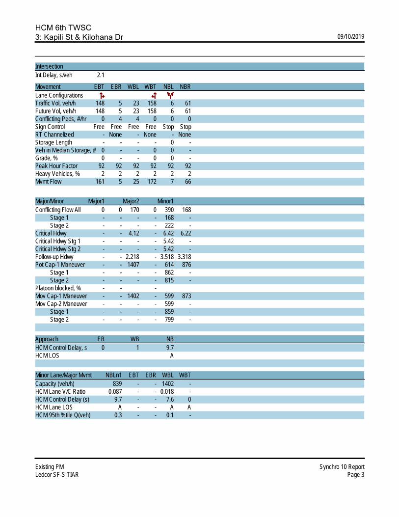
HCM 6th TWSC3: Kapili St & Kilohana Dr 09/10/2019
Existing PM Synchro 10 ReportLedcor SF-S TIAR Page 3
IntersectionInt Delay, s/veh 2.1
Movement EBT EBR WBL WBT NBL NBRLane ConfigurationsTraffic Vol, veh/h 148 5 23 158 6 61Future Vol, veh/h 148 5 23 158 6 61Conflicting Peds, #/hr 0 4 4 0 0 0Sign Control Free Free Free Free Stop StopRT Channelized - None - None - NoneStorage Length - - - - 0 -Veh in Median Storage, # 0 - - 0 0 -Grade, % 0 - - 0 0 -Peak Hour Factor 92 92 92 92 92 92Heavy Vehicles, % 2 2 2 2 2 2Mvmt Flow 161 5 25 172 7 66
Major/Minor Major1 Major2 Minor1Conflicting Flow All 0 0 170 0 390 168 Stage 1 - - - - 168 - Stage 2 - - - - 222 -Critical Hdwy - - 4.12 - 6.42 6.22Critical Hdwy Stg 1 - - - - 5.42 -Critical Hdwy Stg 2 - - - - 5.42 -Follow-up Hdwy - - 2.218 - 3.518 3.318Pot Cap-1 Maneuver - - 1407 - 614 876 Stage 1 - - - - 862 - Stage 2 - - - - 815 -Platoon blocked, % - - -Mov Cap-1 Maneuver - - 1402 - 599 873Mov Cap-2 Maneuver - - - - 599 - Stage 1 - - - - 859 - Stage 2 - - - - 799 -
Approach EB WB NBHCM Control Delay, s 0 1 9.7HCM LOS A
Minor Lane/Major Mvmt NBLn1 EBT EBR WBL WBTCapacity (veh/h) 839 - - 1402 -HCM Lane V/C Ratio 0.087 - - 0.018 -HCM Control Delay (s) 9.7 - - 7.6 0HCM Lane LOS A - - A AHCM 95th %tile Q(veh) 0.3 - - 0.1 -

HCM 6th Signalized Intersection Summary4: Piilani Hwy & Kilohana Dr/Mapu Dr 09/10/2019
Existing PM Synchro 10 ReportLedcor SF-S TIAR Page 4
Movement EBL EBT EBR WBL WBT WBR NBL NBT NBR SBL SBT SBRLane ConfigurationsTraffic Volume (veh/h) 182 23 14 18 22 128 15 848 2 102 700 153Future Volume (veh/h) 182 23 14 18 22 128 15 848 2 102 700 153Initial Q (Qb), veh 0 0 0 0 0 0 0 0 0 0 0 0Ped-Bike Adj(A_pbT) 0.99 0.99 0.99 0.99 1.00 1.00 1.00 1.00Parking Bus, Adj 1.00 1.00 1.00 1.00 1.00 1.00 1.00 1.00 1.00 1.00 1.00 1.00Work Zone On Approach No No No NoAdj Sat Flow, veh/h/ln 1870 1870 1870 1870 1870 1870 1870 1870 1870 1870 1870 1870Adj Flow Rate, veh/h 198 25 6 20 24 18 16 922 2 111 761 121Peak Hour Factor 0.92 0.92 0.92 0.92 0.92 0.92 0.92 0.92 0.92 0.92 0.92 0.92Percent Heavy Veh, % 2 2 2 2 2 2 2 2 2 2 2 2Cap, veh/h 307 242 58 111 128 79 32 1122 2 140 1238 1049Arrive On Green 0.17 0.17 0.17 0.17 0.17 0.17 0.02 0.60 0.60 0.08 0.66 0.66Sat Flow, veh/h 1351 1454 349 393 766 474 1781 1866 4 1781 1870 1585Grp Volume(v), veh/h 198 0 31 62 0 0 16 0 924 111 761 121Grp Sat Flow(s),veh/h/ln 1351 0 1803 1632 0 0 1781 0 1870 1781 1870 1585Q Serve(g_s), s 10.6 0.0 1.5 0.0 0.0 0.0 0.9 0.0 40.5 6.4 24.1 2.9Cycle Q Clear(g_c), s 13.8 0.0 1.5 3.1 0.0 0.0 0.9 0.0 40.5 6.4 24.1 2.9Prop In Lane 1.00 0.19 0.32 0.29 1.00 0.00 1.00 1.00Lane Grp Cap(c), veh/h 307 0 300 318 0 0 32 0 1124 140 1238 1049V/C Ratio(X) 0.65 0.00 0.10 0.20 0.00 0.00 0.50 0.00 0.82 0.80 0.61 0.12Avail Cap(c_a), veh/h 472 0 520 512 0 0 257 0 2699 514 2700 2288HCM Platoon Ratio 1.00 1.00 1.00 1.00 1.00 1.00 1.00 1.00 1.00 1.00 1.00 1.00Upstream Filter(I) 1.00 0.00 1.00 1.00 0.00 0.00 1.00 0.00 1.00 1.00 1.00 1.00Uniform Delay (d), s/veh 41.5 0.0 36.7 37.4 0.0 0.0 50.6 0.0 16.3 47.1 10.0 6.4Incr Delay (d2), s/veh 1.7 0.0 0.1 0.2 0.0 0.0 4.5 0.0 3.0 3.9 1.0 0.1Initial Q Delay(d3),s/veh 0.0 0.0 0.0 0.0 0.0 0.0 0.0 0.0 0.0 0.0 0.0 0.0%ile BackOfQ(50%),veh/ln 5.0 0.0 0.7 1.4 0.0 0.0 0.4 0.0 15.5 2.9 8.3 0.8Unsig. Movement Delay, s/vehLnGrp Delay(d),s/veh 43.2 0.0 36.8 37.6 0.0 0.0 55.1 0.0 19.3 50.9 11.0 6.5LnGrp LOS D A D D A A E A B D B AApproach Vol, veh/h 229 62 940 993Approach Delay, s/veh 42.3 37.6 20.0 14.9Approach LOS D D B B
Timer - Assigned Phs 1 2 4 5 6 8Phs Duration (G+Y+Rc), s 13.1 68.5 22.3 6.8 74.8 22.3Change Period (Y+Rc), s 5.0 6.0 5.0 5.0 6.0 5.0Max Green Setting (Gmax), s 30.0 150.0 30.0 15.0 150.0 30.0Max Q Clear Time (g_c+I1), s 8.4 42.5 5.1 2.9 26.1 15.8Green Ext Time (p_c), s 0.1 20.0 0.2 0.0 14.8 0.5
Intersection SummaryHCM 6th Ctrl Delay 20.5HCM 6th LOS C
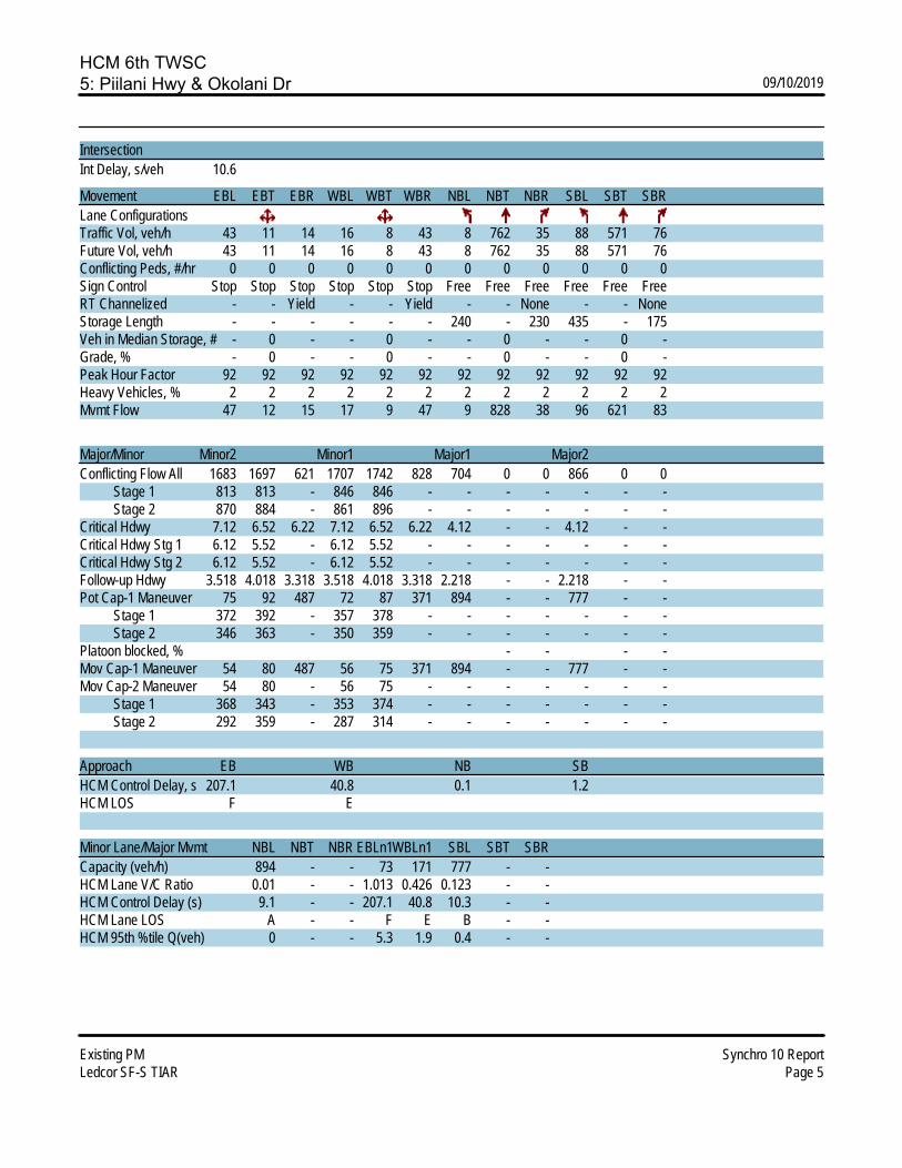
HCM 6th TWSC5: Piilani Hwy & Okolani Dr 09/10/2019
Existing PM Synchro 10 ReportLedcor SF-S TIAR Page 5
IntersectionInt Delay, s/veh 10.6
Movement EBL EBT EBR WBL WBT WBR NBL NBT NBR SBL SBT SBRLane ConfigurationsTraffic Vol, veh/h 43 11 14 16 8 43 8 762 35 88 571 76Future Vol, veh/h 43 11 14 16 8 43 8 762 35 88 571 76Conflicting Peds, #/hr 0 0 0 0 0 0 0 0 0 0 0 0Sign Control Stop Stop Stop Stop Stop Stop Free Free Free Free Free FreeRT Channelized - - Yield - - Yield - - None - - NoneStorage Length - - - - - - 240 - 230 435 - 175Veh in Median Storage, # - 0 - - 0 - - 0 - - 0 -Grade, % - 0 - - 0 - - 0 - - 0 -Peak Hour Factor 92 92 92 92 92 92 92 92 92 92 92 92Heavy Vehicles, % 2 2 2 2 2 2 2 2 2 2 2 2Mvmt Flow 47 12 15 17 9 47 9 828 38 96 621 83
Major/Minor Minor2 Minor1 Major1 Major2Conflicting Flow All 1683 1697 621 1707 1742 828 704 0 0 866 0 0 Stage 1 813 813 - 846 846 - - - - - - - Stage 2 870 884 - 861 896 - - - - - - -Critical Hdwy 7.12 6.52 6.22 7.12 6.52 6.22 4.12 - - 4.12 - -Critical Hdwy Stg 1 6.12 5.52 - 6.12 5.52 - - - - - - -Critical Hdwy Stg 2 6.12 5.52 - 6.12 5.52 - - - - - - -Follow-up Hdwy 3.518 4.018 3.318 3.518 4.018 3.318 2.218 - - 2.218 - -Pot Cap-1 Maneuver 75 92 487 72 87 371 894 - - 777 - - Stage 1 372 392 - 357 378 - - - - - - - Stage 2 346 363 - 350 359 - - - - - - -Platoon blocked, % - - - -Mov Cap-1 Maneuver 54 80 487 56 75 371 894 - - 777 - -Mov Cap-2 Maneuver 54 80 - 56 75 - - - - - - - Stage 1 368 343 - 353 374 - - - - - - - Stage 2 292 359 - 287 314 - - - - - - -
Approach EB WB NB SBHCM Control Delay, s 207.1 40.8 0.1 1.2HCM LOS F E
Minor Lane/Major Mvmt NBL NBT NBR EBLn1WBLn1 SBL SBT SBRCapacity (veh/h) 894 - - 73 171 777 - -HCM Lane V/C Ratio 0.01 - - 1.013 0.426 0.123 - -HCM Control Delay (s) 9.1 - - 207.1 40.8 10.3 - -HCM Lane LOS A - - F E B - -HCM 95th %tile Q(veh) 0 - - 5.3 1.9 0.4 - -
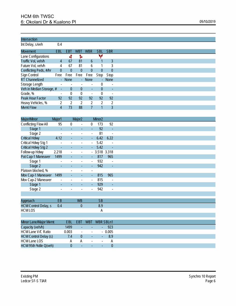
HCM 6th TWSC6: Okolani Dr & Kualono Pl 09/10/2019
Existing PM Synchro 10 ReportLedcor SF-S TIAR Page 6
IntersectionInt Delay, s/veh 0.4
Movement EBL EBT WBT WBR SBL SBRLane ConfigurationsTraffic Vol, veh/h 4 67 81 6 1 3Future Vol, veh/h 4 67 81 6 1 3Conflicting Peds, #/hr 0 0 0 0 0 0Sign Control Free Free Free Free Stop StopRT Channelized - None - None - NoneStorage Length - - - - 0 -Veh in Median Storage, # - 0 0 - 0 -Grade, % - 0 0 - 0 -Peak Hour Factor 92 92 92 92 92 92Heavy Vehicles, % 2 2 2 2 2 2Mvmt Flow 4 73 88 7 1 3
Major/Minor Major1 Major2 Minor2Conflicting Flow All 95 0 - 0 173 92 Stage 1 - - - - 92 - Stage 2 - - - - 81 -Critical Hdwy 4.12 - - - 6.42 6.22Critical Hdwy Stg 1 - - - - 5.42 -Critical Hdwy Stg 2 - - - - 5.42 -Follow-up Hdwy 2.218 - - - 3.518 3.318Pot Cap-1 Maneuver 1499 - - - 817 965 Stage 1 - - - - 932 - Stage 2 - - - - 942 -Platoon blocked, % - - -Mov Cap-1 Maneuver 1499 - - - 815 965Mov Cap-2 Maneuver - - - - 815 - Stage 1 - - - - 929 - Stage 2 - - - - 942 -
Approach EB WB SBHCM Control Delay, s 0.4 0 8.9HCM LOS A
Minor Lane/Major Mvmt EBL EBT WBT WBR SBLn1Capacity (veh/h) 1499 - - - 923HCM Lane V/C Ratio 0.003 - - - 0.005HCM Control Delay (s) 7.4 0 - - 8.9HCM Lane LOS A A - - AHCM 95th %tile Q(veh) 0 - - - 0

HCM 6th TWSC7: Okolani Dr & Kapili St 09/10/2019
Existing PM Synchro 10 ReportLedcor SF-S TIAR Page 7
IntersectionInt Delay, s/veh 2.2
Movement EBL EBT WBT WBR SBL SBRLane ConfigurationsTraffic Vol, veh/h 47 72 82 10 3 13Future Vol, veh/h 47 72 82 10 3 13Conflicting Peds, #/hr 10 0 0 10 0 0Sign Control Free Free Free Free Stop StopRT Channelized - None - None - NoneStorage Length - - - - 0 -Veh in Median Storage, # - 0 0 - 0 -Grade, % - 0 0 - 0 -Peak Hour Factor 92 92 92 92 92 92Heavy Vehicles, % 2 2 2 2 2 2Mvmt Flow 51 78 89 11 3 14
Major/Minor Major1 Major2 Minor2Conflicting Flow All 110 0 - 0 285 105 Stage 1 - - - - 105 - Stage 2 - - - - 180 -Critical Hdwy 4.12 - - - 6.42 6.22Critical Hdwy Stg 1 - - - - 5.42 -Critical Hdwy Stg 2 - - - - 5.42 -Follow-up Hdwy 2.218 - - - 3.518 3.318Pot Cap-1 Maneuver 1480 - - - 705 949 Stage 1 - - - - 919 - Stage 2 - - - - 851 -Platoon blocked, % - - -Mov Cap-1 Maneuver 1466 - - - 666 940Mov Cap-2 Maneuver - - - - 666 - Stage 1 - - - - 877 - Stage 2 - - - - 842 -
Approach EB WB SBHCM Control Delay, s 3 0 9.2HCM LOS A
Minor Lane/Major Mvmt EBL EBT WBT WBR SBLn1Capacity (veh/h) 1466 - - - 873HCM Lane V/C Ratio 0.035 - - - 0.02HCM Control Delay (s) 7.5 0 - - 9.2HCM Lane LOS A A - - AHCM 95th %tile Q(veh) 0.1 - - - 0.1

HCM 6th AWSC8: Wailea Alanui Dr & Okolani Dr 09/10/2019
Existing PM Synchro 10 ReportLedcor SF-S TIAR Page 8
IntersectionIntersection Delay, s/veh 13.1Intersection LOS B
Movement EBL EBT EBR WBL WBT WBR NBL NBT NBR SBL SBT SBRLane ConfigurationsTraffic Vol, veh/h 8 35 221 80 11 8 279 119 81 3 58 12Future Vol, veh/h 8 35 221 80 11 8 279 119 81 3 58 12Peak Hour Factor 0.92 0.92 0.92 0.92 0.92 0.92 0.92 0.92 0.92 0.92 0.92 0.92Heavy Vehicles, % 2 2 2 2 2 2 2 2 2 2 2 2Mvmt Flow 9 38 240 87 12 9 303 129 88 3 63 13Number of Lanes 1 1 1 0 1 1 1 1 1 0 1 1
Approach EB WB NB SBOpposing Approach WB EB SB NBOpposing Lanes 2 3 2 3Conflicting Approach Left SB NB EB WBConflicting Lanes Left 2 3 3 2Conflicting Approach Right NB SB WB EBConflicting Lanes Right 3 2 2 3HCM Control Delay 12.2 12 14.2 10.6HCM LOS B B B B
Lane NBLn1 NBLn2 NBLn3 EBLn1 EBLn2 EBLn3 WBLn1 WBLn2 SBLn1 SBLn2Vol Left, % 100% 0% 0% 100% 0% 0% 88% 0% 5% 0%Vol Thru, % 0% 100% 0% 0% 100% 0% 12% 0% 95% 0%Vol Right, % 0% 0% 100% 0% 0% 100% 0% 100% 0% 100%Sign Control Stop Stop Stop Stop Stop Stop Stop Stop Stop StopTraffic Vol by Lane 279 119 81 8 35 221 91 8 61 12LT Vol 279 0 0 8 0 0 80 0 3 0Through Vol 0 119 0 0 35 0 11 0 58 0RT Vol 0 0 81 0 0 221 0 8 0 12Lane Flow Rate 303 129 88 9 38 240 99 9 66 13Geometry Grp 8 8 8 8 8 8 8 8 8 8Degree of Util (X) 0.555 0.219 0.132 0.017 0.071 0.398 0.206 0.015 0.13 0.023Departure Headway (Hd) 6.592 6.089 5.385 7.177 6.673 5.968 7.485 6.332 7.075 6.342Convergence, Y/N Yes Yes Yes Yes Yes Yes Yes Yes Yes YesCap 546 589 664 497 535 601 478 562 505 561Service Time 4.34 3.837 3.133 4.939 4.435 3.729 5.256 4.102 4.848 4.115HCM Lane V/C Ratio 0.555 0.219 0.133 0.018 0.071 0.399 0.207 0.016 0.131 0.023HCM Control Delay 17.3 10.5 9 10.1 9.9 12.7 12.2 9.2 10.9 9.3HCM Lane LOS C B A B A B B A B AHCM 95th-tile Q 3.4 0.8 0.5 0.1 0.2 1.9 0.8 0 0.4 0.1

HCM Signalized Intersection Capacity Analysis9: Wailea Alanui Drive & Wailea Ike Drive 09/10/2019
Existing PM Synchro 10 ReportLedcor SF-S TIAR Page 1
Movement WBL WBR NBT NBR SBL SBTLane ConfigurationsTraffic Volume (vph) 324 143 345 488 189 213Future Volume (vph) 324 143 345 488 189 213Ideal Flow (vphpl) 1900 1900 1900 1900 1900 1900Total Lost time (s) 4.0 4.0 4.0 4.0 4.0 4.0Lane Util. Factor 1.00 1.00 1.00 1.00 1.00 0.95Frpb, ped/bikes 1.00 0.96 1.00 0.98 1.00 1.00Flpb, ped/bikes 1.00 1.00 1.00 1.00 1.00 1.00Frt 1.00 0.85 1.00 0.85 1.00 1.00Flt Protected 0.95 1.00 1.00 1.00 0.95 1.00Satd. Flow (prot) 1770 1520 1863 1559 1770 3539Flt Permitted 0.95 1.00 1.00 1.00 0.95 1.00Satd. Flow (perm) 1770 1520 1863 1559 1770 3539Peak-hour factor, PHF 0.92 0.92 0.92 0.92 0.92 0.92Adj. Flow (vph) 352 155 375 530 205 232RTOR Reduction (vph) 0 111 0 341 0 0Lane Group Flow (vph) 352 44 375 189 205 232Confl. Peds. (#/hr) 14 4Turn Type Prot Perm NA Perm Prot NAProtected Phases 8 2 1 6Permitted Phases 8 2Actuated Green, G (s) 21.2 21.2 26.7 26.7 14.9 33.6Effective Green, g (s) 21.2 21.2 26.7 26.7 14.9 33.6Actuated g/C Ratio 0.28 0.28 0.36 0.36 0.20 0.45Clearance Time (s) 4.0 4.0 4.0 4.0 4.0 4.0Vehicle Extension (s) 3.0 3.0 3.0 3.0 3.0 3.0Lane Grp Cap (vph) 501 430 665 556 352 1589v/s Ratio Prot c0.20 c0.20 c0.12 0.07v/s Ratio Perm 0.03 0.12v/c Ratio 0.70 0.10 0.56 0.34 0.58 0.15Uniform Delay, d1 24.0 19.8 19.4 17.6 27.1 12.1Progression Factor 1.00 1.00 1.00 1.00 1.00 1.00Incremental Delay, d2 4.4 0.1 1.1 0.4 2.4 0.0Delay (s) 28.4 19.9 20.5 18.0 29.6 12.2Level of Service C B C B C BApproach Delay (s) 25.8 19.0 20.3Approach LOS C B C
Intersection SummaryHCM 2000 Control Delay 21.2 HCM 2000 Level of Service CHCM 2000 Volume to Capacity ratio 0.61Actuated Cycle Length (s) 74.8 Sum of lost time (s) 12.0Intersection Capacity Utilization 58.5% ICU Level of Service BAnalysis Period (min) 15c Critical Lane Group

HCM 6th TWSC10: Wailea Ike Drive & Wailea Ike Place (North) 09/10/2019
Existing PM Synchro 10 ReportLedcor SF-S TIAR Page 10
IntersectionInt Delay, s/veh 3.1
Movement EBL EBT EBR WBL WBT WBR NBL NBT NBR SBL SBT SBRLane ConfigurationsTraffic Vol, veh/h 0 0 0 7 446 43 22 31 0 0 56 42Future Vol, veh/h 0 0 0 7 446 43 22 31 0 0 56 42Conflicting Peds, #/hr 0 0 0 0 0 0 0 0 0 0 0 0Sign Control Free Free Free Free Free Free Stop Stop Stop Stop Stop StopRT Channelized - - None - - None - - None - - NoneStorage Length - - - - - - - - - - - -Veh in Median Storage, # - 2 - - 0 - - 0 - - 0 -Grade, % - 0 - - 0 - - 0 - - 0 -Peak Hour Factor 92 92 92 92 92 92 92 92 92 92 92 92Heavy Vehicles, % 2 2 2 2 2 2 2 2 2 2 2 2Mvmt Flow 0 0 0 8 485 47 24 34 0 0 61 46
Major/Minor Major2 Minor1 Minor2Conflicting Flow All 0 0 0 289 548 - - 525 266 Stage 1 - - - 0 0 - - 525 - Stage 2 - - - 289 548 - - 0 -Critical Hdwy 4.14 - - 7.54 6.54 - - 6.54 6.94Critical Hdwy Stg 1 - - - - - - - 5.54 -Critical Hdwy Stg 2 - - - 6.54 5.54 - - - -Follow-up Hdwy 2.22 - - 3.52 4.02 - - 4.02 3.32Pot Cap-1 Maneuver - - - 641 442 0 0 456 732 Stage 1 - - - - - 0 0 528 - Stage 2 - - - 694 515 0 0 - -Platoon blocked, % - -Mov Cap-1 Maneuver - - - 540 442 - - 456 732Mov Cap-2 Maneuver - - - 540 442 - - 456 - Stage 1 - - - - - - - 528 - Stage 2 - - - 576 515 - - - -
Approach WB NB SBHCM Control Delay, s 13.6 13.2HCM LOS B B
Minor Lane/Major Mvmt NBLn1 WBL WBT WBR SBLn1Capacity (veh/h) 478 - - - 544HCM Lane V/C Ratio 0.121 - - - 0.196HCM Control Delay (s) 13.6 - - - 13.2HCM Lane LOS B - - - BHCM 95th %tile Q(veh) 0.4 - - - 0.7

HCM 6th TWSC11: Wailea Ike Place (South) & Wailea Ike Drive 09/10/2019
Existing PM Synchro 10 ReportLedcor SF-S TIAR Page 11
IntersectionInt Delay, s/veh 2.4
Movement EBL EBT EBR WBL WBT WBR NBL NBT NBR SBL SBT SBRLane ConfigurationsTraffic Vol, veh/h 43 603 11 0 0 0 0 26 20 59 17 0Future Vol, veh/h 43 603 11 0 0 0 0 26 20 59 17 0Conflicting Peds, #/hr 0 0 2 2 0 0 9 0 0 0 0 9Sign Control Free Free Free Free Free Free Stop Stop Stop Stop Stop StopRT Channelized - - None - - None - - None - - NoneStorage Length - - - - - - - - - - - -Veh in Median Storage, # - 0 - - 16979 - - 0 - - 0 -Grade, % - 0 - - 0 - - 0 - - 0 -Peak Hour Factor 92 92 92 92 92 92 92 92 92 92 92 92Heavy Vehicles, % 2 2 2 2 2 2 2 2 2 2 2 2Mvmt Flow 47 655 12 0 0 0 0 28 22 64 18 0
Major/Minor Major1 Minor1 Minor2Conflicting Flow All 0 0 0 - 757 336 436 763 - Stage 1 - - - - 757 - 0 0 - Stage 2 - - - - 0 - 436 763 -Critical Hdwy 4.14 - - - 6.54 6.94 7.54 6.54 -Critical Hdwy Stg 1 - - - - 5.54 - - - -Critical Hdwy Stg 2 - - - - - - 6.54 5.54 -Follow-up Hdwy 2.22 - - - 4.02 3.32 3.52 4.02 -Pot Cap-1 Maneuver - - - 0 335 660 504 333 0 Stage 1 - - - 0 414 - - - 0 Stage 2 - - - 0 - - 569 411 0Platoon blocked, % - -Mov Cap-1 Maneuver - - - - 334 659 456 332 -Mov Cap-2 Maneuver - - - - 334 - 456 332 - Stage 1 - - - - 413 - - - - Stage 2 - - - - - - 513 410 -
Approach EB NB SBHCM Control Delay, s 14.6 15.6HCM LOS B C
Minor Lane/Major Mvmt NBLn1 EBL EBT EBR SBLn1Capacity (veh/h) 425 - - - 421HCM Lane V/C Ratio 0.118 - - - 0.196HCM Control Delay (s) 14.6 - - - 15.6HCM Lane LOS B - - - CHCM 95th %tile Q(veh) 0.4 - - - 0.7

LEVEL OF SERV
• Bas
APVICE CAL
se Year 20
PPENDIXLCULATIO
024 AM P
X C ONS
Peak
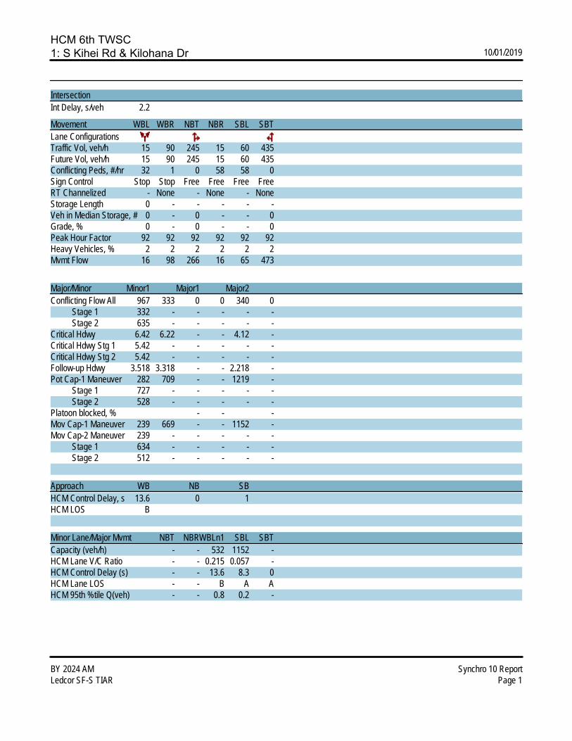
HCM 6th TWSC1: S Kihei Rd & Kilohana Dr 10/01/2019
BY 2024 AM Synchro 10 ReportLedcor SF-S TIAR Page 1
IntersectionInt Delay, s/veh 2.2
Movement WBL WBR NBT NBR SBL SBTLane ConfigurationsTraffic Vol, veh/h 15 90 245 15 60 435Future Vol, veh/h 15 90 245 15 60 435Conflicting Peds, #/hr 32 1 0 58 58 0Sign Control Stop Stop Free Free Free FreeRT Channelized - None - None - NoneStorage Length 0 - - - - -Veh in Median Storage, # 0 - 0 - - 0Grade, % 0 - 0 - - 0Peak Hour Factor 92 92 92 92 92 92Heavy Vehicles, % 2 2 2 2 2 2Mvmt Flow 16 98 266 16 65 473
Major/Minor Minor1 Major1 Major2Conflicting Flow All 967 333 0 0 340 0 Stage 1 332 - - - - - Stage 2 635 - - - - -Critical Hdwy 6.42 6.22 - - 4.12 -Critical Hdwy Stg 1 5.42 - - - - -Critical Hdwy Stg 2 5.42 - - - - -Follow-up Hdwy 3.518 3.318 - - 2.218 -Pot Cap-1 Maneuver 282 709 - - 1219 - Stage 1 727 - - - - - Stage 2 528 - - - - -Platoon blocked, % - - -Mov Cap-1 Maneuver 239 669 - - 1152 -Mov Cap-2 Maneuver 239 - - - - - Stage 1 634 - - - - - Stage 2 512 - - - - -
Approach WB NB SBHCM Control Delay, s 13.6 0 1HCM LOS B
Minor Lane/Major Mvmt NBT NBRWBLn1 SBL SBTCapacity (veh/h) - - 532 1152 -HCM Lane V/C Ratio - - 0.215 0.057 -HCM Control Delay (s) - - 13.6 8.3 0HCM Lane LOS - - B A AHCM 95th %tile Q(veh) - - 0.8 0.2 -
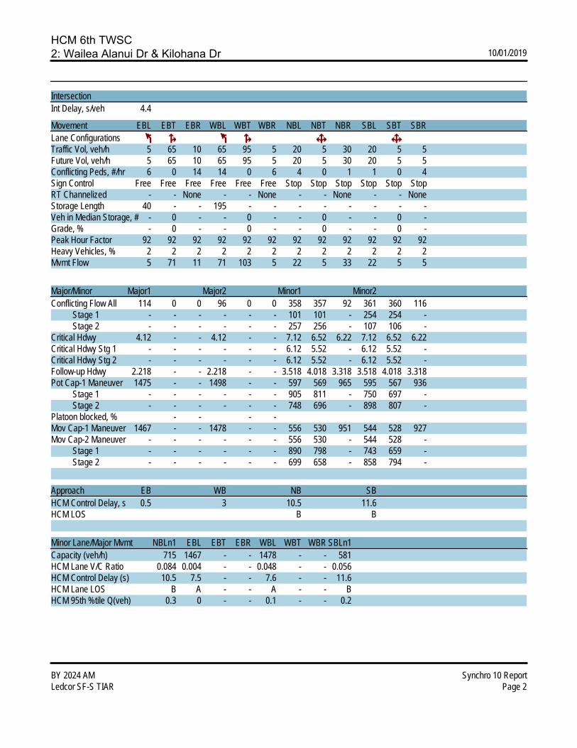
HCM 6th TWSC2: Wailea Alanui Dr & Kilohana Dr 10/01/2019
BY 2024 AM Synchro 10 ReportLedcor SF-S TIAR Page 2
IntersectionInt Delay, s/veh 4.4
Movement EBL EBT EBR WBL WBT WBR NBL NBT NBR SBL SBT SBRLane ConfigurationsTraffic Vol, veh/h 5 65 10 65 95 5 20 5 30 20 5 5Future Vol, veh/h 5 65 10 65 95 5 20 5 30 20 5 5Conflicting Peds, #/hr 6 0 14 14 0 6 4 0 1 1 0 4Sign Control Free Free Free Free Free Free Stop Stop Stop Stop Stop StopRT Channelized - - None - - None - - None - - NoneStorage Length 40 - - 195 - - - - - - - -Veh in Median Storage, # - 0 - - 0 - - 0 - - 0 -Grade, % - 0 - - 0 - - 0 - - 0 -Peak Hour Factor 92 92 92 92 92 92 92 92 92 92 92 92Heavy Vehicles, % 2 2 2 2 2 2 2 2 2 2 2 2Mvmt Flow 5 71 11 71 103 5 22 5 33 22 5 5
Major/Minor Major1 Major2 Minor1 Minor2Conflicting Flow All 114 0 0 96 0 0 358 357 92 361 360 116 Stage 1 - - - - - - 101 101 - 254 254 - Stage 2 - - - - - - 257 256 - 107 106 -Critical Hdwy 4.12 - - 4.12 - - 7.12 6.52 6.22 7.12 6.52 6.22Critical Hdwy Stg 1 - - - - - - 6.12 5.52 - 6.12 5.52 -Critical Hdwy Stg 2 - - - - - - 6.12 5.52 - 6.12 5.52 -Follow-up Hdwy 2.218 - - 2.218 - - 3.518 4.018 3.318 3.518 4.018 3.318Pot Cap-1 Maneuver 1475 - - 1498 - - 597 569 965 595 567 936 Stage 1 - - - - - - 905 811 - 750 697 - Stage 2 - - - - - - 748 696 - 898 807 -Platoon blocked, % - - - -Mov Cap-1 Maneuver 1467 - - 1478 - - 556 530 951 544 528 927Mov Cap-2 Maneuver - - - - - - 556 530 - 544 528 - Stage 1 - - - - - - 890 798 - 743 659 - Stage 2 - - - - - - 699 658 - 858 794 -
Approach EB WB NB SBHCM Control Delay, s 0.5 3 10.5 11.6HCM LOS B B
Minor Lane/Major Mvmt NBLn1 EBL EBT EBR WBL WBT WBR SBLn1Capacity (veh/h) 715 1467 - - 1478 - - 581HCM Lane V/C Ratio 0.084 0.004 - - 0.048 - - 0.056HCM Control Delay (s) 10.5 7.5 - - 7.6 - - 11.6HCM Lane LOS B A - - A - - BHCM 95th %tile Q(veh) 0.3 0 - - 0.1 - - 0.2
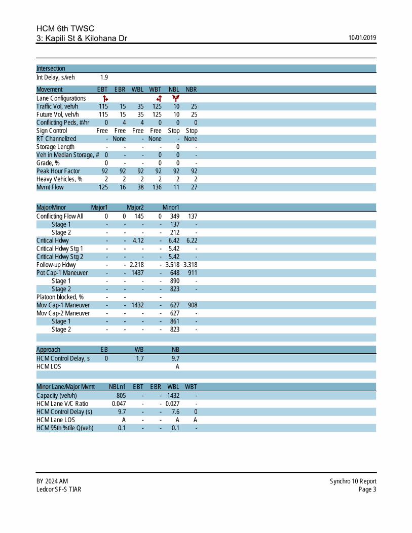
HCM 6th TWSC3: Kapili St & Kilohana Dr 10/01/2019
BY 2024 AM Synchro 10 ReportLedcor SF-S TIAR Page 3
IntersectionInt Delay, s/veh 1.9
Movement EBT EBR WBL WBT NBL NBRLane ConfigurationsTraffic Vol, veh/h 115 15 35 125 10 25Future Vol, veh/h 115 15 35 125 10 25Conflicting Peds, #/hr 0 4 4 0 0 0Sign Control Free Free Free Free Stop StopRT Channelized - None - None - NoneStorage Length - - - - 0 -Veh in Median Storage, # 0 - - 0 0 -Grade, % 0 - - 0 0 -Peak Hour Factor 92 92 92 92 92 92Heavy Vehicles, % 2 2 2 2 2 2Mvmt Flow 125 16 38 136 11 27
Major/Minor Major1 Major2 Minor1Conflicting Flow All 0 0 145 0 349 137 Stage 1 - - - - 137 - Stage 2 - - - - 212 -Critical Hdwy - - 4.12 - 6.42 6.22Critical Hdwy Stg 1 - - - - 5.42 -Critical Hdwy Stg 2 - - - - 5.42 -Follow-up Hdwy - - 2.218 - 3.518 3.318Pot Cap-1 Maneuver - - 1437 - 648 911 Stage 1 - - - - 890 - Stage 2 - - - - 823 -Platoon blocked, % - - -Mov Cap-1 Maneuver - - 1432 - 627 908Mov Cap-2 Maneuver - - - - 627 - Stage 1 - - - - 861 - Stage 2 - - - - 823 -
Approach EB WB NBHCM Control Delay, s 0 1.7 9.7HCM LOS A
Minor Lane/Major Mvmt NBLn1 EBT EBR WBL WBTCapacity (veh/h) 805 - - 1432 -HCM Lane V/C Ratio 0.047 - - 0.027 -HCM Control Delay (s) 9.7 - - 7.6 0HCM Lane LOS A - - A AHCM 95th %tile Q(veh) 0.1 - - 0.1 -
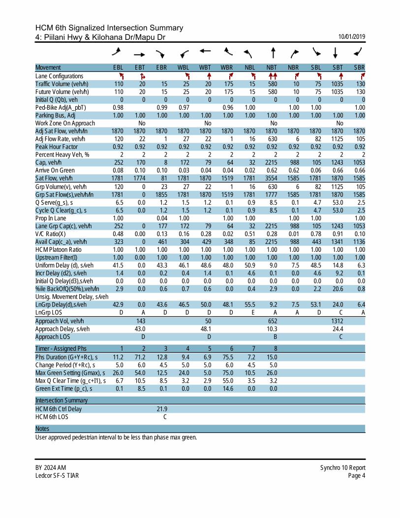
HCM 6th Signalized Intersection Summary4: Piilani Hwy & Kilohana Dr/Mapu Dr 10/01/2019
BY 2024 AM Synchro 10 ReportLedcor SF-S TIAR Page 4
Movement EBL EBT EBR WBL WBT WBR NBL NBT NBR SBL SBT SBRLane ConfigurationsTraffic Volume (veh/h) 110 20 15 25 20 175 15 580 10 75 1035 130Future Volume (veh/h) 110 20 15 25 20 175 15 580 10 75 1035 130Initial Q (Qb), veh 0 0 0 0 0 0 0 0 0 0 0 0Ped-Bike Adj(A_pbT) 0.98 0.99 0.97 0.96 1.00 1.00 1.00 1.00Parking Bus, Adj 1.00 1.00 1.00 1.00 1.00 1.00 1.00 1.00 1.00 1.00 1.00 1.00Work Zone On Approach No No No NoAdj Sat Flow, veh/h/ln 1870 1870 1870 1870 1870 1870 1870 1870 1870 1870 1870 1870Adj Flow Rate, veh/h 120 22 1 27 22 1 16 630 6 82 1125 105Peak Hour Factor 0.92 0.92 0.92 0.92 0.92 0.92 0.92 0.92 0.92 0.92 0.92 0.92Percent Heavy Veh, % 2 2 2 2 2 2 2 2 2 2 2 2Cap, veh/h 252 170 8 172 79 64 32 2215 988 105 1243 1053Arrive On Green 0.08 0.10 0.10 0.03 0.04 0.04 0.02 0.62 0.62 0.06 0.66 0.66Sat Flow, veh/h 1781 1774 81 1781 1870 1519 1781 3554 1585 1781 1870 1585Grp Volume(v), veh/h 120 0 23 27 22 1 16 630 6 82 1125 105Grp Sat Flow(s),veh/h/ln 1781 0 1855 1781 1870 1519 1781 1777 1585 1781 1870 1585Q Serve(g_s), s 6.5 0.0 1.2 1.5 1.2 0.1 0.9 8.5 0.1 4.7 53.0 2.5Cycle Q Clear(g_c), s 6.5 0.0 1.2 1.5 1.2 0.1 0.9 8.5 0.1 4.7 53.0 2.5Prop In Lane 1.00 0.04 1.00 1.00 1.00 1.00 1.00 1.00Lane Grp Cap(c), veh/h 252 0 177 172 79 64 32 2215 988 105 1243 1053V/C Ratio(X) 0.48 0.00 0.13 0.16 0.28 0.02 0.51 0.28 0.01 0.78 0.91 0.10Avail Cap(c_a), veh/h 323 0 461 304 429 348 85 2215 988 443 1341 1136HCM Platoon Ratio 1.00 1.00 1.00 1.00 1.00 1.00 1.00 1.00 1.00 1.00 1.00 1.00Upstream Filter(I) 1.00 0.00 1.00 1.00 1.00 1.00 1.00 1.00 1.00 1.00 1.00 1.00Uniform Delay (d), s/veh 41.5 0.0 43.3 46.1 48.6 48.0 50.9 9.0 7.5 48.5 14.8 6.3Incr Delay (d2), s/veh 1.4 0.0 0.2 0.4 1.4 0.1 4.6 0.1 0.0 4.6 9.2 0.1Initial Q Delay(d3),s/veh 0.0 0.0 0.0 0.0 0.0 0.0 0.0 0.0 0.0 0.0 0.0 0.0%ile BackOfQ(50%),veh/ln 2.9 0.0 0.6 0.7 0.6 0.0 0.4 2.9 0.0 2.2 20.6 0.8Unsig. Movement Delay, s/vehLnGrp Delay(d),s/veh 42.9 0.0 43.6 46.5 50.0 48.1 55.5 9.2 7.5 53.1 24.0 6.4LnGrp LOS D A D D D D E A A D C AApproach Vol, veh/h 143 50 652 1312Approach Delay, s/veh 43.0 48.1 10.3 24.4Approach LOS D D B C
Timer - Assigned Phs 1 2 3 4 5 6 7 8Phs Duration (G+Y+Rc), s 11.2 71.2 12.8 9.4 6.9 75.5 7.2 15.0Change Period (Y+Rc), s 5.0 6.0 4.5 5.0 5.0 6.0 4.5 5.0Max Green Setting (Gmax), s 26.0 54.0 12.5 24.0 5.0 75.0 10.5 26.0Max Q Clear Time (g_c+I1), s 6.7 10.5 8.5 3.2 2.9 55.0 3.5 3.2Green Ext Time (p_c), s 0.1 8.5 0.1 0.0 0.0 14.6 0.0 0.0
Intersection SummaryHCM 6th Ctrl Delay 21.9HCM 6th LOS C
NotesUser approved pedestrian interval to be less than phase max green.
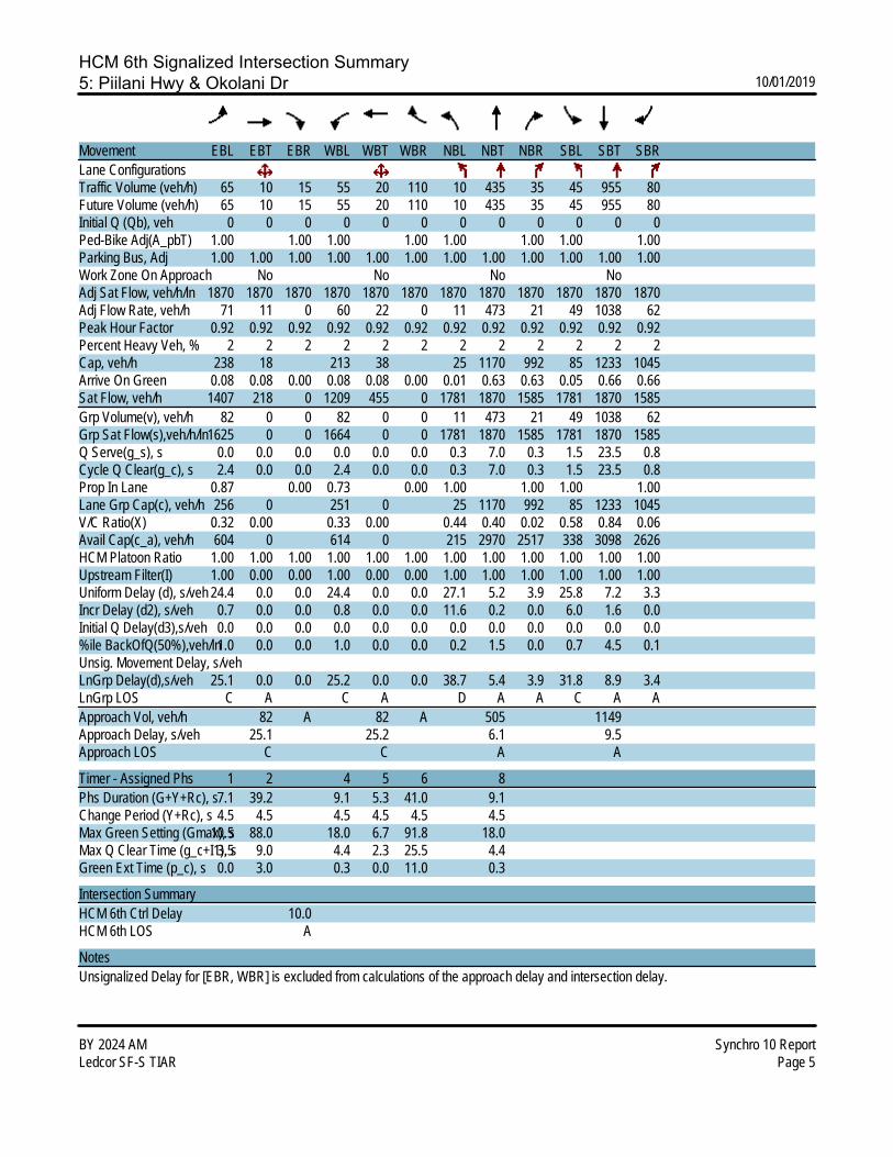
HCM 6th Signalized Intersection Summary5: Piilani Hwy & Okolani Dr 10/01/2019
BY 2024 AM Synchro 10 ReportLedcor SF-S TIAR Page 5
Movement EBL EBT EBR WBL WBT WBR NBL NBT NBR SBL SBT SBRLane ConfigurationsTraffic Volume (veh/h) 65 10 15 55 20 110 10 435 35 45 955 80Future Volume (veh/h) 65 10 15 55 20 110 10 435 35 45 955 80Initial Q (Qb), veh 0 0 0 0 0 0 0 0 0 0 0 0Ped-Bike Adj(A_pbT) 1.00 1.00 1.00 1.00 1.00 1.00 1.00 1.00Parking Bus, Adj 1.00 1.00 1.00 1.00 1.00 1.00 1.00 1.00 1.00 1.00 1.00 1.00Work Zone On Approach No No No NoAdj Sat Flow, veh/h/ln 1870 1870 1870 1870 1870 1870 1870 1870 1870 1870 1870 1870Adj Flow Rate, veh/h 71 11 0 60 22 0 11 473 21 49 1038 62Peak Hour Factor 0.92 0.92 0.92 0.92 0.92 0.92 0.92 0.92 0.92 0.92 0.92 0.92Percent Heavy Veh, % 2 2 2 2 2 2 2 2 2 2 2 2Cap, veh/h 238 18 213 38 25 1170 992 85 1233 1045Arrive On Green 0.08 0.08 0.00 0.08 0.08 0.00 0.01 0.63 0.63 0.05 0.66 0.66Sat Flow, veh/h 1407 218 0 1209 455 0 1781 1870 1585 1781 1870 1585Grp Volume(v), veh/h 82 0 0 82 0 0 11 473 21 49 1038 62Grp Sat Flow(s),veh/h/ln1625 0 0 1664 0 0 1781 1870 1585 1781 1870 1585Q Serve(g_s), s 0.0 0.0 0.0 0.0 0.0 0.0 0.3 7.0 0.3 1.5 23.5 0.8Cycle Q Clear(g_c), s 2.4 0.0 0.0 2.4 0.0 0.0 0.3 7.0 0.3 1.5 23.5 0.8Prop In Lane 0.87 0.00 0.73 0.00 1.00 1.00 1.00 1.00Lane Grp Cap(c), veh/h 256 0 251 0 25 1170 992 85 1233 1045V/C Ratio(X) 0.32 0.00 0.33 0.00 0.44 0.40 0.02 0.58 0.84 0.06Avail Cap(c_a), veh/h 604 0 614 0 215 2970 2517 338 3098 2626HCM Platoon Ratio 1.00 1.00 1.00 1.00 1.00 1.00 1.00 1.00 1.00 1.00 1.00 1.00Upstream Filter(I) 1.00 0.00 0.00 1.00 0.00 0.00 1.00 1.00 1.00 1.00 1.00 1.00Uniform Delay (d), s/veh 24.4 0.0 0.0 24.4 0.0 0.0 27.1 5.2 3.9 25.8 7.2 3.3Incr Delay (d2), s/veh 0.7 0.0 0.0 0.8 0.0 0.0 11.6 0.2 0.0 6.0 1.6 0.0Initial Q Delay(d3),s/veh 0.0 0.0 0.0 0.0 0.0 0.0 0.0 0.0 0.0 0.0 0.0 0.0%ile BackOfQ(50%),veh/ln1.0 0.0 0.0 1.0 0.0 0.0 0.2 1.5 0.0 0.7 4.5 0.1Unsig. Movement Delay, s/vehLnGrp Delay(d),s/veh 25.1 0.0 0.0 25.2 0.0 0.0 38.7 5.4 3.9 31.8 8.9 3.4LnGrp LOS C A C A D A A C A AApproach Vol, veh/h 82 A 82 A 505 1149Approach Delay, s/veh 25.1 25.2 6.1 9.5Approach LOS C C A A
Timer - Assigned Phs 1 2 4 5 6 8Phs Duration (G+Y+Rc), s7.1 39.2 9.1 5.3 41.0 9.1Change Period (Y+Rc), s 4.5 4.5 4.5 4.5 4.5 4.5Max Green Setting (Gmax), s10.5 88.0 18.0 6.7 91.8 18.0Max Q Clear Time (g_c+I1), s3.5 9.0 4.4 2.3 25.5 4.4Green Ext Time (p_c), s 0.0 3.0 0.3 0.0 11.0 0.3
Intersection SummaryHCM 6th Ctrl Delay 10.0HCM 6th LOS A
NotesUnsignalized Delay for [EBR, WBR] is excluded from calculations of the approach delay and intersection delay.
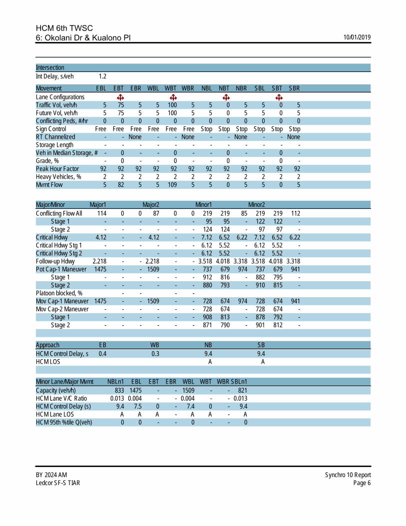
HCM 6th TWSC6: Okolani Dr & Kualono Pl 10/01/2019
BY 2024 AM Synchro 10 ReportLedcor SF-S TIAR Page 6
IntersectionInt Delay, s/veh 1.2
Movement EBL EBT EBR WBL WBT WBR NBL NBT NBR SBL SBT SBRLane ConfigurationsTraffic Vol, veh/h 5 75 5 5 100 5 5 0 5 5 0 5Future Vol, veh/h 5 75 5 5 100 5 5 0 5 5 0 5Conflicting Peds, #/hr 0 0 0 0 0 0 0 0 0 0 0 0Sign Control Free Free Free Free Free Free Stop Stop Stop Stop Stop StopRT Channelized - - None - - None - - None - - NoneStorage Length - - - - - - - - - - - -Veh in Median Storage, # - 0 - - 0 - - 0 - - 0 -Grade, % - 0 - - 0 - - 0 - - 0 -Peak Hour Factor 92 92 92 92 92 92 92 92 92 92 92 92Heavy Vehicles, % 2 2 2 2 2 2 2 2 2 2 2 2Mvmt Flow 5 82 5 5 109 5 5 0 5 5 0 5
Major/Minor Major1 Major2 Minor1 Minor2Conflicting Flow All 114 0 0 87 0 0 219 219 85 219 219 112 Stage 1 - - - - - - 95 95 - 122 122 - Stage 2 - - - - - - 124 124 - 97 97 -Critical Hdwy 4.12 - - 4.12 - - 7.12 6.52 6.22 7.12 6.52 6.22Critical Hdwy Stg 1 - - - - - - 6.12 5.52 - 6.12 5.52 -Critical Hdwy Stg 2 - - - - - - 6.12 5.52 - 6.12 5.52 -Follow-up Hdwy 2.218 - - 2.218 - - 3.518 4.018 3.318 3.518 4.018 3.318Pot Cap-1 Maneuver 1475 - - 1509 - - 737 679 974 737 679 941 Stage 1 - - - - - - 912 816 - 882 795 - Stage 2 - - - - - - 880 793 - 910 815 -Platoon blocked, % - - - -Mov Cap-1 Maneuver 1475 - - 1509 - - 728 674 974 728 674 941Mov Cap-2 Maneuver - - - - - - 728 674 - 728 674 - Stage 1 - - - - - - 908 813 - 878 792 - Stage 2 - - - - - - 871 790 - 901 812 -
Approach EB WB NB SBHCM Control Delay, s 0.4 0.3 9.4 9.4HCM LOS A A
Minor Lane/Major Mvmt NBLn1 EBL EBT EBR WBL WBT WBR SBLn1Capacity (veh/h) 833 1475 - - 1509 - - 821HCM Lane V/C Ratio 0.013 0.004 - - 0.004 - - 0.013HCM Control Delay (s) 9.4 7.5 0 - 7.4 0 - 9.4HCM Lane LOS A A A - A A - AHCM 95th %tile Q(veh) 0 0 - - 0 - - 0

HCM 6th TWSC7: Okolani Dr & Kapili St 10/01/2019
BY 2024 AM Synchro 10 ReportLedcor SF-S TIAR Page 7
IntersectionInt Delay, s/veh 1.6
Movement EBL EBT WBT WBR SBL SBRLane ConfigurationsTraffic Vol, veh/h 10 75 100 10 10 20Future Vol, veh/h 10 75 100 10 10 20Conflicting Peds, #/hr 10 0 0 10 0 0Sign Control Free Free Free Free Stop StopRT Channelized - None - None - NoneStorage Length - - - - 0 -Veh in Median Storage, # - 0 0 - 0 -Grade, % - 0 0 - 0 -Peak Hour Factor 92 92 92 92 92 92Heavy Vehicles, % 2 2 2 2 2 2Mvmt Flow 11 82 109 11 11 22
Major/Minor Major1 Major2 Minor2Conflicting Flow All 130 0 - 0 229 125 Stage 1 - - - - 125 - Stage 2 - - - - 104 -Critical Hdwy 4.12 - - - 6.42 6.22Critical Hdwy Stg 1 - - - - 5.42 -Critical Hdwy Stg 2 - - - - 5.42 -Follow-up Hdwy 2.218 - - - 3.518 3.318Pot Cap-1 Maneuver 1455 - - - 759 926 Stage 1 - - - - 901 - Stage 2 - - - - 920 -Platoon blocked, % - - -Mov Cap-1 Maneuver 1441 - - - 738 917Mov Cap-2 Maneuver - - - - 738 - Stage 1 - - - - 885 - Stage 2 - - - - 911 -
Approach EB WB SBHCM Control Delay, s 0.9 0 9.4HCM LOS A
Minor Lane/Major Mvmt EBL EBT WBT WBR SBLn1Capacity (veh/h) 1441 - - - 848HCM Lane V/C Ratio 0.008 - - - 0.038HCM Control Delay (s) 7.5 0 - - 9.4HCM Lane LOS A A - - AHCM 95th %tile Q(veh) 0 - - - 0.1

HCM 6th AWSC8: Wailea Alanui Dr & Okolani Dr 10/01/2019
BY 2024 AM Synchro 10 ReportLedcor SF-S TIAR Page 8
IntersectionIntersection Delay, s/veh 15.7Intersection LOS C
Movement EBL EBT EBR WBL WBT WBR NBL NBT NBR SBL SBT SBRLane ConfigurationsTraffic Vol, veh/h 10 25 390 85 35 10 210 30 40 5 70 10Future Vol, veh/h 10 25 390 85 35 10 210 30 40 5 70 10Peak Hour Factor 0.92 0.92 0.92 0.92 0.92 0.92 0.92 0.92 0.92 0.92 0.92 0.92Heavy Vehicles, % 2 2 2 2 2 2 2 2 2 2 2 2Mvmt Flow 11 27 424 92 38 11 228 33 43 5 76 11Number of Lanes 1 1 1 0 1 1 1 1 1 0 1 1
Approach EB WB NB SBOpposing Approach WB EB SB NBOpposing Lanes 2 3 2 3Conflicting Approach Left SB NB EB WBConflicting Lanes Left 2 3 3 2Conflicting Approach Right NB SB WB EBConflicting Lanes Right 3 2 2 3HCM Control Delay 18.4 12.6 14.4 11.4HCM LOS C B B B
Lane NBLn1 NBLn2 NBLn3 EBLn1 EBLn2 EBLn3 WBLn1 WBLn2 SBLn1 SBLn2Vol Left, % 100% 0% 0% 100% 0% 0% 71% 0% 7% 0%Vol Thru, % 0% 100% 0% 0% 100% 0% 29% 0% 93% 0%Vol Right, % 0% 0% 100% 0% 0% 100% 0% 100% 0% 100%Sign Control Stop Stop Stop Stop Stop Stop Stop Stop Stop StopTraffic Vol by Lane 210 30 40 10 25 390 120 10 75 10LT Vol 210 0 0 10 0 0 85 0 5 0Through Vol 0 30 0 0 25 0 35 0 70 0RT Vol 0 0 40 0 0 390 0 10 0 10Lane Flow Rate 228 33 43 11 27 424 130 11 82 11Geometry Grp 8 8 8 8 8 8 8 8 8 8Degree of Util (X) 0.457 0.061 0.072 0.021 0.048 0.668 0.267 0.019 0.168 0.02Departure Headway (Hd) 7.213 6.709 6.002 6.883 6.379 5.674 7.363 6.296 7.4 6.556Convergence, Y/N Yes Yes Yes Yes Yes Yes Yes Yes Yes YesCap 498 531 592 517 558 632 484 563 488 541Service Time 4.998 4.493 3.786 4.662 4.158 3.452 5.16 4.093 5.1 4.355HCM Lane V/C Ratio 0.458 0.062 0.073 0.021 0.048 0.671 0.269 0.02 0.168 0.02HCM Control Delay 16 9.9 9.3 9.8 9.5 19.2 12.9 9.2 11.6 9.5HCM Lane LOS C A A A A C B A B AHCM 95th-tile Q 2.4 0.2 0.2 0.1 0.2 5.1 1.1 0.1 0.6 0.1
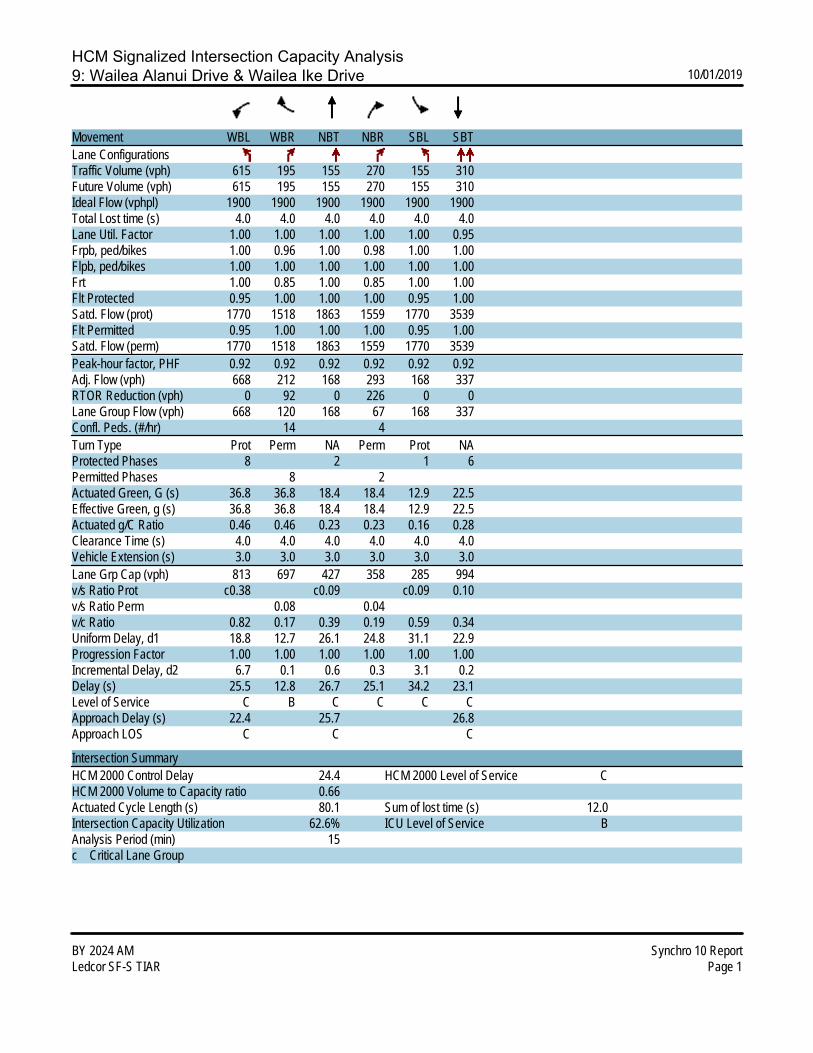
HCM Signalized Intersection Capacity Analysis9: Wailea Alanui Drive & Wailea Ike Drive 10/01/2019
BY 2024 AM Synchro 10 ReportLedcor SF-S TIAR Page 1
Movement WBL WBR NBT NBR SBL SBTLane ConfigurationsTraffic Volume (vph) 615 195 155 270 155 310Future Volume (vph) 615 195 155 270 155 310Ideal Flow (vphpl) 1900 1900 1900 1900 1900 1900Total Lost time (s) 4.0 4.0 4.0 4.0 4.0 4.0Lane Util. Factor 1.00 1.00 1.00 1.00 1.00 0.95Frpb, ped/bikes 1.00 0.96 1.00 0.98 1.00 1.00Flpb, ped/bikes 1.00 1.00 1.00 1.00 1.00 1.00Frt 1.00 0.85 1.00 0.85 1.00 1.00Flt Protected 0.95 1.00 1.00 1.00 0.95 1.00Satd. Flow (prot) 1770 1518 1863 1559 1770 3539Flt Permitted 0.95 1.00 1.00 1.00 0.95 1.00Satd. Flow (perm) 1770 1518 1863 1559 1770 3539Peak-hour factor, PHF 0.92 0.92 0.92 0.92 0.92 0.92Adj. Flow (vph) 668 212 168 293 168 337RTOR Reduction (vph) 0 92 0 226 0 0Lane Group Flow (vph) 668 120 168 67 168 337Confl. Peds. (#/hr) 14 4Turn Type Prot Perm NA Perm Prot NAProtected Phases 8 2 1 6Permitted Phases 8 2Actuated Green, G (s) 36.8 36.8 18.4 18.4 12.9 22.5Effective Green, g (s) 36.8 36.8 18.4 18.4 12.9 22.5Actuated g/C Ratio 0.46 0.46 0.23 0.23 0.16 0.28Clearance Time (s) 4.0 4.0 4.0 4.0 4.0 4.0Vehicle Extension (s) 3.0 3.0 3.0 3.0 3.0 3.0Lane Grp Cap (vph) 813 697 427 358 285 994v/s Ratio Prot c0.38 c0.09 c0.09 0.10v/s Ratio Perm 0.08 0.04v/c Ratio 0.82 0.17 0.39 0.19 0.59 0.34Uniform Delay, d1 18.8 12.7 26.1 24.8 31.1 22.9Progression Factor 1.00 1.00 1.00 1.00 1.00 1.00Incremental Delay, d2 6.7 0.1 0.6 0.3 3.1 0.2Delay (s) 25.5 12.8 26.7 25.1 34.2 23.1Level of Service C B C C C CApproach Delay (s) 22.4 25.7 26.8Approach LOS C C C
Intersection SummaryHCM 2000 Control Delay 24.4 HCM 2000 Level of Service CHCM 2000 Volume to Capacity ratio 0.66Actuated Cycle Length (s) 80.1 Sum of lost time (s) 12.0Intersection Capacity Utilization 62.6% ICU Level of Service BAnalysis Period (min) 15c Critical Lane Group

HCM 6th TWSC10: Wailea Ike Drive & Wailea Ike Place (North) 10/01/2019
BY 2024 AM Synchro 10 ReportLedcor SF-S TIAR Page 10
IntersectionInt Delay, s/veh 2.6
Movement EBL EBT EBR WBL WBT WBR NBL NBT NBR SBL SBT SBRLane ConfigurationsTraffic Vol, veh/h 0 0 0 15 770 55 25 45 0 0 25 40Future Vol, veh/h 0 0 0 15 770 55 25 45 0 0 25 40Conflicting Peds, #/hr 0 0 0 0 0 0 0 0 0 0 0 0Sign Control Free Free Free Free Free Free Stop Stop Stop Stop Stop StopRT Channelized - - None - - None - - None - - NoneStorage Length - - - - - - - - - - - -Veh in Median Storage, # - 2 - - 0 - - 0 - - 0 -Grade, % - 0 - - 0 - - 0 - - 0 -Peak Hour Factor 92 92 92 92 92 92 92 92 92 92 92 92Heavy Vehicles, % 2 2 2 2 2 2 2 2 2 2 2 2Mvmt Flow 0 0 0 16 837 60 27 49 0 0 27 43
Major/Minor Major2 Minor1 Minor2Conflicting Flow All 0 0 0 464 929 - - 899 449 Stage 1 - - - 0 0 - - 899 - Stage 2 - - - 464 929 - - 0 -Critical Hdwy 4.14 - - 7.54 6.54 - - 6.54 6.94Critical Hdwy Stg 1 - - - - - - - 5.54 -Critical Hdwy Stg 2 - - - 6.54 5.54 - - - -Follow-up Hdwy 2.22 - - 3.52 4.02 - - 4.02 3.32Pot Cap-1 Maneuver - - - 481 266 0 0 277 557 Stage 1 - - - - - 0 0 356 - Stage 2 - - - 548 344 0 0 - -Platoon blocked, % - -Mov Cap-1 Maneuver - - - 410 266 - - 277 557Mov Cap-2 Maneuver - - - 410 266 - - 277 - Stage 1 - - - - - - - 356 - Stage 2 - - - 467 344 - - - -
Approach WB NB SBHCM Control Delay, s 20.8 15.9HCM LOS C C
Minor Lane/Major Mvmt NBLn1 WBL WBT WBR SBLn1Capacity (veh/h) 304 - - - 401HCM Lane V/C Ratio 0.25 - - - 0.176HCM Control Delay (s) 20.8 - - - 15.9HCM Lane LOS C - - - CHCM 95th %tile Q(veh) 1 - - - 0.6

HCM 6th TWSC11: Wailea Ike Place (South) & Wailea Ike Drive 10/01/2019
BY 2024 AM Synchro 10 ReportLedcor SF-S TIAR Page 11
IntersectionInt Delay, s/veh 1.8
Movement EBL EBT EBR WBL WBT WBR NBL NBT NBR SBL SBT SBRLane ConfigurationsTraffic Vol, veh/h 45 370 10 0 0 0 0 15 10 20 25 0Future Vol, veh/h 45 370 10 0 0 0 0 15 10 20 25 0Conflicting Peds, #/hr 0 0 2 2 0 0 9 0 0 0 0 9Sign Control Free Free Free Free Free Free Stop Stop Stop Stop Stop StopRT Channelized - - None - - None - - None - - NoneStorage Length - - - - - - - - - - - -Veh in Median Storage, # - 0 - - 16979 - - 0 - - 0 -Grade, % - 0 - - 0 - - 0 - - 0 -Peak Hour Factor 92 92 92 92 92 92 92 92 92 92 92 92Heavy Vehicles, % 2 2 2 2 2 2 2 2 2 2 2 2Mvmt Flow 49 402 11 0 0 0 0 16 11 22 27 0
Major/Minor Major1 Minor1 Minor2Conflicting Flow All 0 0 0 - 508 209 307 513 - Stage 1 - - - - 508 - 0 0 - Stage 2 - - - - 0 - 307 513 -Critical Hdwy 4.14 - - - 6.54 6.94 7.54 6.54 -Critical Hdwy Stg 1 - - - - 5.54 - - - -Critical Hdwy Stg 2 - - - - - - 6.54 5.54 -Follow-up Hdwy 2.22 - - - 4.02 3.32 3.52 4.02 -Pot Cap-1 Maneuver - - - 0 466 797 622 463 0 Stage 1 - - - 0 537 - - - 0 Stage 2 - - - 0 - - 678 534 0Platoon blocked, % - -Mov Cap-1 Maneuver - - - - 465 795 597 462 -Mov Cap-2 Maneuver - - - - 465 - 597 462 - Stage 1 - - - - 536 - - - - Stage 2 - - - - - - 648 533 -
Approach EB NB SBHCM Control Delay, s 11.8 12.7HCM LOS B B
Minor Lane/Major Mvmt NBLn1 EBL EBT EBR SBLn1Capacity (veh/h) 558 - - - 514HCM Lane V/C Ratio 0.049 - - - 0.095HCM Control Delay (s) 11.8 - - - 12.7HCM Lane LOS B - - - BHCM 95th %tile Q(veh) 0.2 - - - 0.3

LEVEL OF SERV
• Bas
APVICE CAL
se Year 20
PPENDIXLCULATIO
024 PM P
X C ONS
Peak
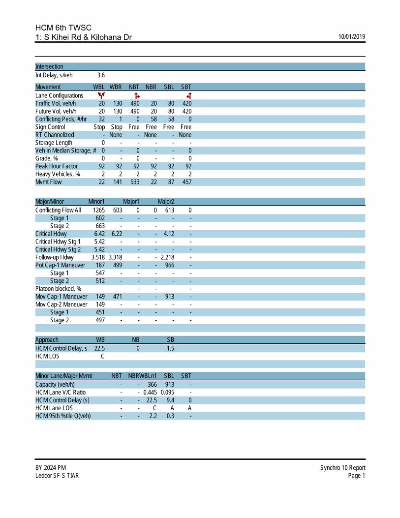
HCM 6th TWSC1: S Kihei Rd & Kilohana Dr 10/01/2019
BY 2024 PM Synchro 10 ReportLedcor SF-S TIAR Page 1
IntersectionInt Delay, s/veh 3.6
Movement WBL WBR NBT NBR SBL SBTLane ConfigurationsTraffic Vol, veh/h 20 130 490 20 80 420Future Vol, veh/h 20 130 490 20 80 420Conflicting Peds, #/hr 32 1 0 58 58 0Sign Control Stop Stop Free Free Free FreeRT Channelized - None - None - NoneStorage Length 0 - - - - -Veh in Median Storage, # 0 - 0 - - 0Grade, % 0 - 0 - - 0Peak Hour Factor 92 92 92 92 92 92Heavy Vehicles, % 2 2 2 2 2 2Mvmt Flow 22 141 533 22 87 457
Major/Minor Minor1 Major1 Major2Conflicting Flow All 1265 603 0 0 613 0 Stage 1 602 - - - - - Stage 2 663 - - - - -Critical Hdwy 6.42 6.22 - - 4.12 -Critical Hdwy Stg 1 5.42 - - - - -Critical Hdwy Stg 2 5.42 - - - - -Follow-up Hdwy 3.518 3.318 - - 2.218 -Pot Cap-1 Maneuver 187 499 - - 966 - Stage 1 547 - - - - - Stage 2 512 - - - - -Platoon blocked, % - - -Mov Cap-1 Maneuver 149 471 - - 913 -Mov Cap-2 Maneuver 149 - - - - - Stage 1 451 - - - - - Stage 2 497 - - - - -
Approach WB NB SBHCM Control Delay, s 22.5 0 1.5HCM LOS C
Minor Lane/Major Mvmt NBT NBRWBLn1 SBL SBTCapacity (veh/h) - - 366 913 -HCM Lane V/C Ratio - - 0.445 0.095 -HCM Control Delay (s) - - 22.5 9.4 0HCM Lane LOS - - C A AHCM 95th %tile Q(veh) - - 2.2 0.3 -

HCM 6th TWSC2: Wailea Alanui Dr & Kilohana Dr 10/01/2019
BY 2024 PM Synchro 10 ReportLedcor SF-S TIAR Page 2
IntersectionInt Delay, s/veh 5.3
Movement EBL EBT EBR WBL WBT WBR NBL NBT NBR SBL SBT SBRLane ConfigurationsTraffic Vol, veh/h 5 85 15 70 100 20 35 10 90 15 5 5Future Vol, veh/h 5 85 15 70 100 20 35 10 90 15 5 5Conflicting Peds, #/hr 6 0 14 14 0 6 4 0 1 1 0 4Sign Control Free Free Free Free Free Free Stop Stop Stop Stop Stop StopRT Channelized - - None - - None - - None - - NoneStorage Length 40 - - 195 - - - - - - - -Veh in Median Storage, # - 0 - - 0 - - 0 - - 0 -Grade, % - 0 - - 0 - - 0 - - 0 -Peak Hour Factor 92 92 92 92 92 92 92 92 92 92 92 92Heavy Vehicles, % 2 2 2 2 2 2 2 2 2 2 2 2Mvmt Flow 5 92 16 76 109 22 38 11 98 16 5 5
Major/Minor Major1 Major2 Minor1 Minor2Conflicting Flow All 137 0 0 122 0 0 405 413 115 444 410 130 Stage 1 - - - - - - 124 124 - 278 278 - Stage 2 - - - - - - 281 289 - 166 132 -Critical Hdwy 4.12 - - 4.12 - - 7.12 6.52 6.22 7.12 6.52 6.22Critical Hdwy Stg 1 - - - - - - 6.12 5.52 - 6.12 5.52 -Critical Hdwy Stg 2 - - - - - - 6.12 5.52 - 6.12 5.52 -Follow-up Hdwy 2.218 - - 2.218 - - 3.518 4.018 3.318 3.518 4.018 3.318Pot Cap-1 Maneuver 1447 - - 1465 - - 556 529 937 524 531 920 Stage 1 - - - - - - 880 793 - 728 680 - Stage 2 - - - - - - 726 673 - 836 787 -Platoon blocked, % - - - -Mov Cap-1 Maneuver 1439 - - 1445 - - 516 490 924 438 492 911Mov Cap-2 Maneuver - - - - - - 516 490 - 438 492 - Stage 1 - - - - - - 865 780 - 721 640 - Stage 2 - - - - - - 675 633 - 734 774 -
Approach EB WB NB SBHCM Control Delay, s 0.4 2.8 11.2 12.6HCM LOS B B
Minor Lane/Major Mvmt NBLn1 EBL EBT EBR WBL WBT WBR SBLn1Capacity (veh/h) 727 1439 - - 1445 - - 501HCM Lane V/C Ratio 0.202 0.004 - - 0.053 - - 0.054HCM Control Delay (s) 11.2 7.5 - - 7.6 - - 12.6HCM Lane LOS B A - - A - - BHCM 95th %tile Q(veh) 0.8 0 - - 0.2 - - 0.2

HCM 6th TWSC3: Kapili St & Kilohana Dr 10/01/2019
BY 2024 PM Synchro 10 ReportLedcor SF-S TIAR Page 3
IntersectionInt Delay, s/veh 2.2
Movement EBT EBR WBL WBT NBL NBRLane ConfigurationsTraffic Vol, veh/h 160 5 25 170 10 65Future Vol, veh/h 160 5 25 170 10 65Conflicting Peds, #/hr 0 4 4 0 0 0Sign Control Free Free Free Free Stop StopRT Channelized - None - None - NoneStorage Length - - - - 0 -Veh in Median Storage, # 0 - - 0 0 -Grade, % 0 - - 0 0 -Peak Hour Factor 92 92 92 92 92 92Heavy Vehicles, % 2 2 2 2 2 2Mvmt Flow 174 5 27 185 11 71
Major/Minor Major1 Major2 Minor1Conflicting Flow All 0 0 183 0 420 181 Stage 1 - - - - 181 - Stage 2 - - - - 239 -Critical Hdwy - - 4.12 - 6.42 6.22Critical Hdwy Stg 1 - - - - 5.42 -Critical Hdwy Stg 2 - - - - 5.42 -Follow-up Hdwy - - 2.218 - 3.518 3.318Pot Cap-1 Maneuver - - 1392 - 590 862 Stage 1 - - - - 850 - Stage 2 - - - - 801 -Platoon blocked, % - - -Mov Cap-1 Maneuver - - 1387 - 575 859Mov Cap-2 Maneuver - - - - 575 - Stage 1 - - - - 828 - Stage 2 - - - - 801 -
Approach EB WB NBHCM Control Delay, s 0 1 10HCM LOS B
Minor Lane/Major Mvmt NBLn1 EBT EBR WBL WBTCapacity (veh/h) 806 - - 1387 -HCM Lane V/C Ratio 0.101 - - 0.02 -HCM Control Delay (s) 10 - - 7.6 0HCM Lane LOS B - - A AHCM 95th %tile Q(veh) 0.3 - - 0.1 -

HCM 6th Signalized Intersection Summary4: Piilani Hwy & Kilohana Dr/Mapu Dr 10/01/2019
BY 2024 PM Synchro 10 ReportLedcor SF-S TIAR Page 4
Movement EBL EBT EBR WBL WBT WBR NBL NBT NBR SBL SBT SBRLane ConfigurationsTraffic Volume (veh/h) 190 25 25 30 25 135 25 1135 15 110 990 160Future Volume (veh/h) 190 25 25 30 25 135 25 1135 15 110 990 160Initial Q (Qb), veh 0 0 0 0 0 0 0 0 0 0 0 0Ped-Bike Adj(A_pbT) 0.98 0.99 0.97 0.96 1.00 1.00 1.00 1.00Parking Bus, Adj 1.00 1.00 1.00 1.00 1.00 1.00 1.00 1.00 1.00 1.00 1.00 1.00Work Zone On Approach No No No NoAdj Sat Flow, veh/h/ln 1870 1870 1870 1870 1870 1870 1870 1870 1870 1870 1870 1870Adj Flow Rate, veh/h 207 27 2 33 27 1 27 1234 8 120 1076 133Peak Hour Factor 0.92 0.92 0.92 0.92 0.92 0.92 0.92 0.92 0.92 0.92 0.92 0.92Percent Heavy Veh, % 2 2 2 2 2 2 2 2 2 2 2 2Cap, veh/h 306 218 16 174 79 64 45 2044 912 148 1184 1003Arrive On Green 0.11 0.13 0.13 0.03 0.04 0.04 0.03 0.58 0.58 0.08 0.63 0.63Sat Flow, veh/h 1781 1719 127 1781 1870 1515 1781 3554 1585 1781 1870 1585Grp Volume(v), veh/h 207 0 29 33 27 1 27 1234 8 120 1076 133Grp Sat Flow(s),veh/h/ln 1781 0 1846 1781 1870 1515 1781 1777 1585 1781 1870 1585Q Serve(g_s), s 12.0 0.0 1.5 1.9 1.5 0.1 1.7 24.9 0.2 7.3 54.9 3.7Cycle Q Clear(g_c), s 12.0 0.0 1.5 1.9 1.5 0.1 1.7 24.9 0.2 7.3 54.9 3.7Prop In Lane 1.00 0.07 1.00 1.00 1.00 1.00 1.00 1.00Lane Grp Cap(c), veh/h 306 0 234 174 79 64 45 2044 912 148 1184 1003V/C Ratio(X) 0.68 0.00 0.12 0.19 0.34 0.02 0.59 0.60 0.01 0.81 0.91 0.13Avail Cap(c_a), veh/h 306 0 435 292 407 330 81 2044 912 420 1272 1078HCM Platoon Ratio 1.00 1.00 1.00 1.00 1.00 1.00 1.00 1.00 1.00 1.00 1.00 1.00Upstream Filter(I) 1.00 0.00 1.00 1.00 1.00 1.00 1.00 1.00 1.00 1.00 1.00 1.00Uniform Delay (d), s/veh 42.7 0.0 42.7 48.5 51.3 50.6 53.2 15.3 10.0 49.7 17.5 8.1Incr Delay (d2), s/veh 5.9 0.0 0.2 0.5 1.9 0.1 4.5 0.7 0.0 3.9 10.0 0.1Initial Q Delay(d3),s/veh 0.0 0.0 0.0 0.0 0.0 0.0 0.0 0.0 0.0 0.0 0.0 0.0%ile BackOfQ(50%),veh/ln 5.7 0.0 0.7 0.9 0.8 0.0 0.8 9.1 0.1 3.3 22.8 1.2Unsig. Movement Delay, s/vehLnGrp Delay(d),s/veh 48.5 0.0 42.9 49.0 53.2 50.7 57.7 16.0 10.0 53.7 27.5 8.2LnGrp LOS D A D D D D E B B D C AApproach Vol, veh/h 236 61 1269 1329Approach Delay, s/veh 47.8 50.9 16.8 28.0Approach LOS D D B C
Timer - Assigned Phs 1 2 3 4 5 6 7 8Phs Duration (G+Y+Rc), s 14.2 69.4 17.0 9.7 7.8 75.8 7.7 19.0Change Period (Y+Rc), s 5.0 6.0 4.5 5.0 5.0 6.0 4.5 5.0Max Green Setting (Gmax), s 26.0 54.0 12.5 24.0 5.0 75.0 10.5 26.0Max Q Clear Time (g_c+I1), s 9.3 26.9 14.0 3.5 3.7 56.9 3.9 3.5Green Ext Time (p_c), s 0.1 16.0 0.0 0.1 0.0 13.0 0.0 0.1
Intersection SummaryHCM 6th Ctrl Delay 25.2HCM 6th LOS C
NotesUser approved pedestrian interval to be less than phase max green.

HCM 6th Signalized Intersection Summary5: Piilani Hwy & Okolani Dr 10/01/2019
BY 2024 PM Synchro 10 ReportLedcor SF-S TIAR Page 5
Movement EBL EBT EBR WBL WBT WBR NBL NBT NBR SBL SBT SBRLane ConfigurationsTraffic Volume (veh/h) 65 15 25 55 10 50 20 1040 75 95 850 100Future Volume (veh/h) 65 15 25 55 10 50 20 1040 75 95 850 100Initial Q (Qb), veh 0 0 0 0 0 0 0 0 0 0 0 0Ped-Bike Adj(A_pbT) 1.00 1.00 1.00 1.00 1.00 1.00 1.00 1.00Parking Bus, Adj 1.00 1.00 1.00 1.00 1.00 1.00 1.00 1.00 1.00 1.00 1.00 1.00Work Zone On Approach No No No NoAdj Sat Flow, veh/h/ln 1870 1870 1870 1870 1870 1870 1870 1870 1870 1870 1870 1870Adj Flow Rate, veh/h 71 16 0 60 11 0 22 1130 59 103 924 82Peak Hour Factor 0.92 0.92 0.92 0.92 0.92 0.92 0.92 0.92 0.92 0.92 0.92 0.92Percent Heavy Veh, % 2 2 2 2 2 2 2 2 2 2 2 2Cap, veh/h 184 23 188 22 43 1270 1076 132 1364 1156Arrive On Green 0.08 0.08 0.00 0.08 0.08 0.00 0.02 0.68 0.68 0.07 0.73 0.73Sat Flow, veh/h 1335 301 0 1381 297 0 1781 1870 1585 1781 1870 1585Grp Volume(v), veh/h 87 0 0 71 0 0 22 1130 59 103 924 82Grp Sat Flow(s),veh/h/ln1635 0 0 1678 0 0 1781 1870 1585 1781 1870 1585Q Serve(g_s), s 0.9 0.0 0.0 0.0 0.0 0.0 1.0 38.6 1.0 4.5 20.8 1.2Cycle Q Clear(g_c), s 3.9 0.0 0.0 3.0 0.0 0.0 1.0 38.6 1.0 4.5 20.8 1.2Prop In Lane 0.82 0.00 0.85 0.00 1.00 1.00 1.00 1.00Lane Grp Cap(c), veh/h 206 0 211 0 43 1270 1076 132 1364 1156V/C Ratio(X) 0.42 0.00 0.34 0.00 0.51 0.89 0.05 0.78 0.68 0.07Avail Cap(c_a), veh/h 431 0 433 0 151 2089 1771 237 2179 1847HCM Platoon Ratio 1.00 1.00 1.00 1.00 1.00 1.00 1.00 1.00 1.00 1.00 1.00 1.00Upstream Filter(I) 1.00 0.00 0.00 1.00 0.00 0.00 1.00 1.00 1.00 1.00 1.00 1.00Uniform Delay (d), s/veh 35.4 0.0 0.0 35.1 0.0 0.0 38.0 10.3 4.2 35.8 5.7 3.1Incr Delay (d2), s/veh 1.4 0.0 0.0 0.9 0.0 0.0 9.0 3.0 0.0 9.4 0.6 0.0Initial Q Delay(d3),s/veh 0.0 0.0 0.0 0.0 0.0 0.0 0.0 0.0 0.0 0.0 0.0 0.0%ile BackOfQ(50%),veh/ln1.7 0.0 0.0 1.3 0.0 0.0 0.5 10.9 0.2 2.2 4.6 0.2Unsig. Movement Delay, s/vehLnGrp Delay(d),s/veh 36.8 0.0 0.0 36.0 0.0 0.0 47.0 13.3 4.2 45.2 6.3 3.1LnGrp LOS D A D A D B A D A AApproach Vol, veh/h 87 A 71 A 1211 1109Approach Delay, s/veh 36.8 36.0 13.5 9.7Approach LOS D D B A
Timer - Assigned Phs 1 2 4 5 6 8Phs Duration (G+Y+Rc), s10.4 58.0 10.4 6.4 61.9 10.4Change Period (Y+Rc), s 4.5 4.5 4.5 4.5 4.5 4.5Max Green Setting (Gmax), s10.5 88.0 18.0 6.7 91.8 18.0Max Q Clear Time (g_c+I1), s6.5 40.6 5.0 3.0 22.8 5.9Green Ext Time (p_c), s 0.1 12.9 0.2 0.0 8.7 0.3
Intersection SummaryHCM 6th Ctrl Delay 13.2HCM 6th LOS B
NotesUnsignalized Delay for [EBR, WBR] is excluded from calculations of the approach delay and intersection delay.

HCM 6th TWSC6: Okolani Dr & Kualono Pl 10/01/2019
BY 2024 PM Synchro 10 ReportLedcor SF-S TIAR Page 6
IntersectionInt Delay, s/veh 1.1
Movement EBL EBT EBR WBL WBT WBR NBL NBT NBR SBL SBT SBRLane ConfigurationsTraffic Vol, veh/h 5 90 5 5 105 10 5 0 5 5 0 5Future Vol, veh/h 5 90 5 5 105 10 5 0 5 5 0 5Conflicting Peds, #/hr 0 0 0 0 0 0 0 0 0 0 0 0Sign Control Free Free Free Free Free Free Stop Stop Stop Stop Stop StopRT Channelized - - None - - None - - None - - NoneStorage Length - - - - - - - - - - - -Veh in Median Storage, # - 0 - - 0 - - 0 - - 0 -Grade, % - 0 - - 0 - - 0 - - 0 -Peak Hour Factor 92 92 92 92 92 92 92 92 92 92 92 92Heavy Vehicles, % 2 2 2 2 2 2 2 2 2 2 2 2Mvmt Flow 5 98 5 5 114 11 5 0 5 5 0 5
Major/Minor Major1 Major2 Minor1 Minor2Conflicting Flow All 125 0 0 103 0 0 243 246 101 243 243 120 Stage 1 - - - - - - 111 111 - 130 130 - Stage 2 - - - - - - 132 135 - 113 113 -Critical Hdwy 4.12 - - 4.12 - - 7.12 6.52 6.22 7.12 6.52 6.22Critical Hdwy Stg 1 - - - - - - 6.12 5.52 - 6.12 5.52 -Critical Hdwy Stg 2 - - - - - - 6.12 5.52 - 6.12 5.52 -Follow-up Hdwy 2.218 - - 2.218 - - 3.518 4.018 3.318 3.518 4.018 3.318Pot Cap-1 Maneuver 1462 - - 1489 - - 711 656 954 711 659 931 Stage 1 - - - - - - 894 804 - 874 789 - Stage 2 - - - - - - 871 785 - 892 802 -Platoon blocked, % - - - -Mov Cap-1 Maneuver 1462 - - 1489 - - 702 651 954 702 654 931Mov Cap-2 Maneuver - - - - - - 702 651 - 702 654 - Stage 1 - - - - - - 890 801 - 871 786 - Stage 2 - - - - - - 862 782 - 883 799 -
Approach EB WB NB SBHCM Control Delay, s 0.4 0.3 9.5 9.6HCM LOS A A
Minor Lane/Major Mvmt NBLn1 EBL EBT EBR WBL WBT WBR SBLn1Capacity (veh/h) 809 1462 - - 1489 - - 800HCM Lane V/C Ratio 0.013 0.004 - - 0.004 - - 0.014HCM Control Delay (s) 9.5 7.5 0 - 7.4 0 - 9.6HCM Lane LOS A A A - A A - AHCM 95th %tile Q(veh) 0 0 - - 0 - - 0
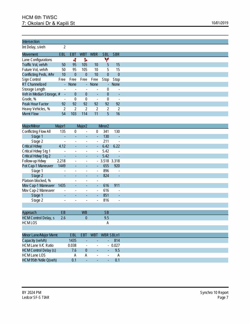
HCM 6th TWSC7: Okolani Dr & Kapili St 10/01/2019
BY 2024 PM Synchro 10 ReportLedcor SF-S TIAR Page 7
IntersectionInt Delay, s/veh 2
Movement EBL EBT WBT WBR SBL SBRLane ConfigurationsTraffic Vol, veh/h 50 95 105 10 5 15Future Vol, veh/h 50 95 105 10 5 15Conflicting Peds, #/hr 10 0 0 10 0 0Sign Control Free Free Free Free Stop StopRT Channelized - None - None - NoneStorage Length - - - - 0 -Veh in Median Storage, # - 0 0 - 0 -Grade, % - 0 0 - 0 -Peak Hour Factor 92 92 92 92 92 92Heavy Vehicles, % 2 2 2 2 2 2Mvmt Flow 54 103 114 11 5 16
Major/Minor Major1 Major2 Minor2Conflicting Flow All 135 0 - 0 341 130 Stage 1 - - - - 130 - Stage 2 - - - - 211 -Critical Hdwy 4.12 - - - 6.42 6.22Critical Hdwy Stg 1 - - - - 5.42 -Critical Hdwy Stg 2 - - - - 5.42 -Follow-up Hdwy 2.218 - - - 3.518 3.318Pot Cap-1 Maneuver 1449 - - - 655 920 Stage 1 - - - - 896 - Stage 2 - - - - 824 -Platoon blocked, % - - -Mov Cap-1 Maneuver 1435 - - - 616 911Mov Cap-2 Maneuver - - - - 616 - Stage 1 - - - - 851 - Stage 2 - - - - 816 -
Approach EB WB SBHCM Control Delay, s 2.6 0 9.5HCM LOS A
Minor Lane/Major Mvmt EBL EBT WBT WBR SBLn1Capacity (veh/h) 1435 - - - 814HCM Lane V/C Ratio 0.038 - - - 0.027HCM Control Delay (s) 7.6 0 - - 9.5HCM Lane LOS A A - - AHCM 95th %tile Q(veh) 0.1 - - - 0.1
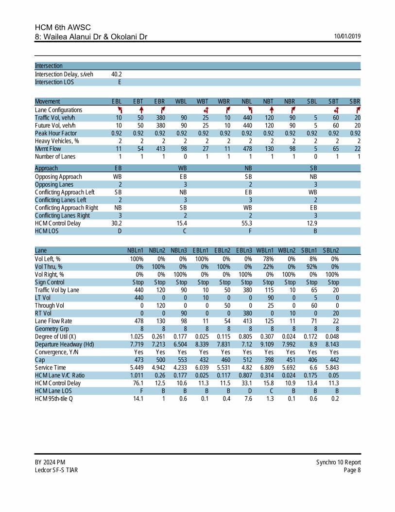
HCM 6th AWSC8: Wailea Alanui Dr & Okolani Dr 10/01/2019
BY 2024 PM Synchro 10 ReportLedcor SF-S TIAR Page 8
IntersectionIntersection Delay, s/veh 40.2Intersection LOS E
Movement EBL EBT EBR WBL WBT WBR NBL NBT NBR SBL SBT SBRLane ConfigurationsTraffic Vol, veh/h 10 50 380 90 25 10 440 120 90 5 60 20Future Vol, veh/h 10 50 380 90 25 10 440 120 90 5 60 20Peak Hour Factor 0.92 0.92 0.92 0.92 0.92 0.92 0.92 0.92 0.92 0.92 0.92 0.92Heavy Vehicles, % 2 2 2 2 2 2 2 2 2 2 2 2Mvmt Flow 11 54 413 98 27 11 478 130 98 5 65 22Number of Lanes 1 1 1 0 1 1 1 1 1 0 1 1
Approach EB WB NB SBOpposing Approach WB EB SB NBOpposing Lanes 2 3 2 3Conflicting Approach Left SB NB EB WBConflicting Lanes Left 2 3 3 2Conflicting Approach Right NB SB WB EBConflicting Lanes Right 3 2 2 3HCM Control Delay 30.2 15.4 55.3 12.9HCM LOS D C F B
Lane NBLn1 NBLn2 NBLn3 EBLn1 EBLn2 EBLn3 WBLn1 WBLn2 SBLn1 SBLn2Vol Left, % 100% 0% 0% 100% 0% 0% 78% 0% 8% 0%Vol Thru, % 0% 100% 0% 0% 100% 0% 22% 0% 92% 0%Vol Right, % 0% 0% 100% 0% 0% 100% 0% 100% 0% 100%Sign Control Stop Stop Stop Stop Stop Stop Stop Stop Stop StopTraffic Vol by Lane 440 120 90 10 50 380 115 10 65 20LT Vol 440 0 0 10 0 0 90 0 5 0Through Vol 0 120 0 0 50 0 25 0 60 0RT Vol 0 0 90 0 0 380 0 10 0 20Lane Flow Rate 478 130 98 11 54 413 125 11 71 22Geometry Grp 8 8 8 8 8 8 8 8 8 8Degree of Util (X) 1.025 0.261 0.177 0.025 0.115 0.805 0.307 0.024 0.172 0.048Departure Headway (Hd) 7.719 7.213 6.504 8.339 7.831 7.12 9.109 7.992 8.9 8.143Convergence, Y/N Yes Yes Yes Yes Yes Yes Yes Yes Yes YesCap 473 500 553 432 460 512 398 451 406 442Service Time 5.449 4.942 4.233 6.039 5.531 4.82 6.809 5.692 6.6 5.843HCM Lane V/C Ratio 1.011 0.26 0.177 0.025 0.117 0.807 0.314 0.024 0.175 0.05HCM Control Delay 76.1 12.5 10.6 11.3 11.5 33.1 15.8 10.9 13.4 11.3HCM Lane LOS F B B B B D C B B BHCM 95th-tile Q 14.1 1 0.6 0.1 0.4 7.6 1.3 0.1 0.6 0.2

HCM Signalized Intersection Capacity Analysis9: Wailea Alanui Drive & Wailea Ike Drive 10/01/2019
BY 2024 PM Synchro 10 ReportLedcor SF-S TIAR Page 1
Movement WBL WBR NBT NBR SBL SBTLane ConfigurationsTraffic Volume (vph) 555 245 445 750 285 305Future Volume (vph) 555 245 445 750 285 305Ideal Flow (vphpl) 1900 1900 1900 1900 1900 1900Total Lost time (s) 4.0 4.0 4.0 4.0 4.0 4.0Lane Util. Factor 1.00 1.00 1.00 1.00 1.00 0.95Frpb, ped/bikes 1.00 0.95 1.00 0.98 1.00 1.00Flpb, ped/bikes 1.00 1.00 1.00 1.00 1.00 1.00Frt 1.00 0.85 1.00 0.85 1.00 1.00Flt Protected 0.95 1.00 1.00 1.00 0.95 1.00Satd. Flow (prot) 1770 1508 1863 1557 1770 3539Flt Permitted 0.95 1.00 1.00 1.00 0.95 1.00Satd. Flow (perm) 1770 1508 1863 1557 1770 3539Peak-hour factor, PHF 0.92 0.92 0.92 0.92 0.92 0.92Adj. Flow (vph) 603 266 484 815 310 332RTOR Reduction (vph) 0 161 0 514 0 0Lane Group Flow (vph) 603 105 484 301 310 332Confl. Peds. (#/hr) 14 4Turn Type Prot Perm NA Perm Prot NAProtected Phases 8 2 1 6Permitted Phases 8 2Actuated Green, G (s) 37.9 37.9 32.0 32.0 22.0 39.4Effective Green, g (s) 37.9 37.9 32.0 32.0 22.0 39.4Actuated g/C Ratio 0.36 0.36 0.31 0.31 0.21 0.38Clearance Time (s) 4.0 4.0 4.0 4.0 4.0 4.0Vehicle Extension (s) 3.0 3.0 3.0 3.0 3.0 3.0Lane Grp Cap (vph) 645 550 573 479 374 1342v/s Ratio Prot c0.34 c0.26 c0.18 0.09v/s Ratio Perm 0.07 0.19v/c Ratio 0.93 0.19 0.84 0.63 0.83 0.25Uniform Delay, d1 31.8 22.5 33.6 30.8 39.2 22.1Progression Factor 1.00 1.00 1.00 1.00 1.00 1.00Incremental Delay, d2 20.8 0.2 11.0 2.6 14.0 0.1Delay (s) 52.6 22.7 44.6 33.4 53.2 22.2Level of Service D C D C D CApproach Delay (s) 43.5 37.6 37.2Approach LOS D D D
Intersection SummaryHCM 2000 Control Delay 39.3 HCM 2000 Level of Service DHCM 2000 Volume to Capacity ratio 0.88Actuated Cycle Length (s) 103.9 Sum of lost time (s) 12.0Intersection Capacity Utilization 80.0% ICU Level of Service DAnalysis Period (min) 15c Critical Lane Group

HCM 6th TWSC10: Wailea Ike Drive & Wailea Ike Place (North) 10/01/2019
BY 2024 PM Synchro 10 ReportLedcor SF-S TIAR Page 10
IntersectionInt Delay, s/veh 5.2
Movement EBL EBT EBR WBL WBT WBR NBL NBT NBR SBL SBT SBRLane ConfigurationsTraffic Vol, veh/h 0 0 0 35 730 55 65 40 0 0 75 55Future Vol, veh/h 0 0 0 35 730 55 65 40 0 0 75 55Conflicting Peds, #/hr 0 0 0 0 0 0 0 0 0 0 0 0Sign Control Free Free Free Free Free Free Stop Stop Stop Stop Stop StopRT Channelized - - None - - None - - None - - NoneStorage Length - - - - - - - - - - - -Veh in Median Storage, # - 2 - - 0 - - 0 - - 0 -Grade, % - 0 - - 0 - - 0 - - 0 -Peak Hour Factor 92 92 92 92 92 92 92 92 92 92 92 92Heavy Vehicles, % 2 2 2 2 2 2 2 2 2 2 2 2Mvmt Flow 0 0 0 38 793 60 71 43 0 0 82 60
Major/Minor Major2 Minor1 Minor2Conflicting Flow All 0 0 0 514 929 - - 899 427 Stage 1 - - - 0 0 - - 899 - Stage 2 - - - 514 929 - - 0 -Critical Hdwy 4.14 - - 7.54 6.54 - - 6.54 6.94Critical Hdwy Stg 1 - - - - - - - 5.54 -Critical Hdwy Stg 2 - - - 6.54 5.54 - - - -Follow-up Hdwy 2.22 - - 3.52 4.02 - - 4.02 3.32Pot Cap-1 Maneuver - - - 443 266 0 0 277 576 Stage 1 - - - - - 0 0 356 - Stage 2 - - - 511 344 0 0 - -Platoon blocked, % - -Mov Cap-1 Maneuver - - - 307 266 - - 277 576Mov Cap-2 Maneuver - - - 307 266 - - 277 - Stage 1 - - - - - - - 356 - Stage 2 - - - 353 344 - - - -
Approach WB NB SBHCM Control Delay, s 25.2 21.7HCM LOS D C
Minor Lane/Major Mvmt NBLn1 WBL WBT WBR SBLn1Capacity (veh/h) 290 - - - 355HCM Lane V/C Ratio 0.394 - - - 0.398HCM Control Delay (s) 25.2 - - - 21.7HCM Lane LOS D - - - CHCM 95th %tile Q(veh) 1.8 - - - 1.9

HCM 6th TWSC11: Wailea Ike Place (South) & Wailea Ike Drive 10/01/2019
BY 2024 PM Synchro 10 ReportLedcor SF-S TIAR Page 11
IntersectionInt Delay, s/veh 7.3
Movement EBL EBT EBR WBL WBT WBR NBL NBT NBR SBL SBT SBRLane ConfigurationsTraffic Vol, veh/h 50 915 50 0 0 0 0 70 50 75 45 0Future Vol, veh/h 50 915 50 0 0 0 0 70 50 75 45 0Conflicting Peds, #/hr 0 0 2 2 0 0 9 0 0 0 0 9Sign Control Free Free Free Free Free Free Stop Stop Stop Stop Stop StopRT Channelized - - None - - None - - None - - NoneStorage Length - - - - - - - - - - - -Veh in Median Storage, # - 0 - - 16979 - - 0 - - 0 -Grade, % - 0 - - 0 - - 0 - - 0 -Peak Hour Factor 92 92 92 92 92 92 92 92 92 92 92 92Heavy Vehicles, % 2 2 2 2 2 2 2 2 2 2 2 2Mvmt Flow 54 995 54 0 0 0 0 76 54 82 49 0
Major/Minor Major1 Minor1 Minor2Conflicting Flow All 0 0 0 - 1132 527 644 1159 - Stage 1 - - - - 1132 - 0 0 - Stage 2 - - - - 0 - 644 1159 -Critical Hdwy 4.14 - - - 6.54 6.94 7.54 6.54 -Critical Hdwy Stg 1 - - - - 5.54 - - - -Critical Hdwy Stg 2 - - - - - - 6.54 5.54 -Follow-up Hdwy 2.22 - - - 4.02 3.32 3.52 4.02 -Pot Cap-1 Maneuver - - - 0 202 496 358 194 0 Stage 1 - - - 0 276 - - - 0 Stage 2 - - - 0 - - 428 268 0Platoon blocked, % - -Mov Cap-1 Maneuver - - - - 202 495 225 194 -Mov Cap-2 Maneuver - - - - 202 - 225 194 - Stage 1 - - - - 275 - - - - Stage 2 - - - - - - 276 267 -
Approach EB NB SBHCM Control Delay, s 30.5 45.8HCM LOS D E
Minor Lane/Major Mvmt NBLn1 EBL EBT EBR SBLn1Capacity (veh/h) 268 - - - 212HCM Lane V/C Ratio 0.487 - - - 0.615HCM Control Delay (s) 30.5 - - - 45.8HCM Lane LOS D - - - EHCM 95th %tile Q(veh) 2.5 - - - 3.6

LEVEL OF SERV
• Futur
APVICE CAL
re Year 20
PPENDIXLCULATIO
024 AM P
X C ONS
Peak

HCM 6th TWSC1: S Kihei Rd & Kilohana Dr 10/01/2019
FY 2024 AM Synchro 10 ReportLedcor SF-S TIAR Page 1
IntersectionInt Delay, s/veh 2.4
Movement WBL WBR NBT NBR SBL SBTLane ConfigurationsTraffic Vol, veh/h 15 95 245 15 65 435Future Vol, veh/h 15 95 245 15 65 435Conflicting Peds, #/hr 32 1 0 58 58 0Sign Control Stop Stop Free Free Free FreeRT Channelized - None - None - NoneStorage Length 0 - - - - -Veh in Median Storage, # 0 - 0 - - 0Grade, % 0 - 0 - - 0Peak Hour Factor 92 92 92 92 92 92Heavy Vehicles, % 2 2 2 2 2 2Mvmt Flow 16 103 266 16 71 473
Major/Minor Minor1 Major1 Major2Conflicting Flow All 979 333 0 0 340 0 Stage 1 332 - - - - - Stage 2 647 - - - - -Critical Hdwy 6.42 6.22 - - 4.12 -Critical Hdwy Stg 1 5.42 - - - - -Critical Hdwy Stg 2 5.42 - - - - -Follow-up Hdwy 3.518 3.318 - - 2.218 -Pot Cap-1 Maneuver 277 709 - - 1219 - Stage 1 727 - - - - - Stage 2 521 - - - - -Platoon blocked, % - - -Mov Cap-1 Maneuver 233 669 - - 1152 -Mov Cap-2 Maneuver 233 - - - - - Stage 1 630 - - - - - Stage 2 505 - - - - -
Approach WB NB SBHCM Control Delay, s 13.7 0 1.1HCM LOS B
Minor Lane/Major Mvmt NBT NBRWBLn1 SBL SBTCapacity (veh/h) - - 533 1152 -HCM Lane V/C Ratio - - 0.224 0.061 -HCM Control Delay (s) - - 13.7 8.3 0HCM Lane LOS - - B A AHCM 95th %tile Q(veh) - - 0.9 0.2 -

HCM 6th TWSC2: Wailea Alanui Dr & Kilohana Dr 10/01/2019
FY 2024 AM Synchro 10 ReportLedcor SF-S TIAR Page 2
IntersectionInt Delay, s/veh 4.3
Movement EBL EBT EBR WBL WBT WBR NBL NBT NBR SBL SBT SBRLane ConfigurationsTraffic Vol, veh/h 5 70 10 65 100 5 20 5 30 20 5 5Future Vol, veh/h 5 70 10 65 100 5 20 5 30 20 5 5Conflicting Peds, #/hr 6 0 14 14 0 6 4 0 1 1 0 4Sign Control Free Free Free Free Free Free Stop Stop Stop Stop Stop StopRT Channelized - - None - - None - - None - - NoneStorage Length 40 - - 195 - - - - - - - -Veh in Median Storage, # - 0 - - 0 - - 0 - - 0 -Grade, % - 0 - - 0 - - 0 - - 0 -Peak Hour Factor 92 92 92 92 92 92 92 92 92 92 92 92Heavy Vehicles, % 2 2 2 2 2 2 2 2 2 2 2 2Mvmt Flow 5 76 11 71 109 5 22 5 33 22 5 5
Major/Minor Major1 Major2 Minor1 Minor2Conflicting Flow All 120 0 0 101 0 0 369 368 97 372 371 122 Stage 1 - - - - - - 106 106 - 260 260 - Stage 2 - - - - - - 263 262 - 112 111 -Critical Hdwy 4.12 - - 4.12 - - 7.12 6.52 6.22 7.12 6.52 6.22Critical Hdwy Stg 1 - - - - - - 6.12 5.52 - 6.12 5.52 -Critical Hdwy Stg 2 - - - - - - 6.12 5.52 - 6.12 5.52 -Follow-up Hdwy 2.218 - - 2.218 - - 3.518 4.018 3.318 3.518 4.018 3.318Pot Cap-1 Maneuver 1468 - - 1491 - - 588 561 959 585 559 929 Stage 1 - - - - - - 900 807 - 745 693 - Stage 2 - - - - - - 742 691 - 893 804 -Platoon blocked, % - - - -Mov Cap-1 Maneuver 1460 - - 1471 - - 547 522 945 535 520 920Mov Cap-2 Maneuver - - - - - - 547 522 - 535 520 - Stage 1 - - - - - - 885 794 - 738 656 - Stage 2 - - - - - - 694 654 - 853 791 -
Approach EB WB NB SBHCM Control Delay, s 0.4 2.9 10.6 11.7HCM LOS B B
Minor Lane/Major Mvmt NBLn1 EBL EBT EBR WBL WBT WBR SBLn1Capacity (veh/h) 706 1460 - - 1471 - - 572HCM Lane V/C Ratio 0.085 0.004 - - 0.048 - - 0.057HCM Control Delay (s) 10.6 7.5 - - 7.6 - - 11.7HCM Lane LOS B A - - A - - BHCM 95th %tile Q(veh) 0.3 0 - - 0.2 - - 0.2

HCM 6th TWSC3: Kapili St & Kilohana Dr 10/01/2019
FY 2024 AM Synchro 10 ReportLedcor SF-S TIAR Page 3
IntersectionInt Delay, s/veh 2.3
Movement EBT EBR WBL WBT NBL NBRLane ConfigurationsTraffic Vol, veh/h 115 15 40 125 15 35Future Vol, veh/h 115 15 40 125 15 35Conflicting Peds, #/hr 0 4 4 0 0 0Sign Control Free Free Free Free Stop StopRT Channelized - None - None - NoneStorage Length - - - - 0 -Veh in Median Storage, # 0 - - 0 0 -Grade, % 0 - - 0 0 -Peak Hour Factor 92 92 92 92 92 92Heavy Vehicles, % 2 2 2 2 2 2Mvmt Flow 125 16 43 136 16 38
Major/Minor Major1 Major2 Minor1Conflicting Flow All 0 0 145 0 359 137 Stage 1 - - - - 137 - Stage 2 - - - - 222 -Critical Hdwy - - 4.12 - 6.42 6.22Critical Hdwy Stg 1 - - - - 5.42 -Critical Hdwy Stg 2 - - - - 5.42 -Follow-up Hdwy - - 2.218 - 3.518 3.318Pot Cap-1 Maneuver - - 1437 - 640 911 Stage 1 - - - - 890 - Stage 2 - - - - 815 -Platoon blocked, % - - -Mov Cap-1 Maneuver - - 1432 - 617 908Mov Cap-2 Maneuver - - - - 617 - Stage 1 - - - - 858 - Stage 2 - - - - 815 -
Approach EB WB NBHCM Control Delay, s 0 1.8 9.9HCM LOS A
Minor Lane/Major Mvmt NBLn1 EBT EBR WBL WBTCapacity (veh/h) 795 - - 1432 -HCM Lane V/C Ratio 0.068 - - 0.03 -HCM Control Delay (s) 9.9 - - 7.6 0HCM Lane LOS A - - A AHCM 95th %tile Q(veh) 0.2 - - 0.1 -

HCM 6th Signalized Intersection Summary4: Piilani Hwy & Kilohana Dr/Mapu Dr 10/01/2019
FY 2024 AM Synchro 10 ReportLedcor SF-S TIAR Page 4
Movement EBL EBT EBR WBL WBT WBR NBL NBT NBR SBL SBT SBRLane ConfigurationsTraffic Volume (veh/h) 120 20 15 25 20 175 15 580 10 75 1035 140Future Volume (veh/h) 120 20 15 25 20 175 15 580 10 75 1035 140Initial Q (Qb), veh 0 0 0 0 0 0 0 0 0 0 0 0Ped-Bike Adj(A_pbT) 0.98 0.99 0.97 0.96 1.00 1.00 1.00 1.00Parking Bus, Adj 1.00 1.00 1.00 1.00 1.00 1.00 1.00 1.00 1.00 1.00 1.00 1.00Work Zone On Approach No No No NoAdj Sat Flow, veh/h/ln 1870 1870 1870 1870 1870 1870 1870 1870 1870 1870 1870 1870Adj Flow Rate, veh/h 130 22 1 27 22 1 16 630 6 82 1125 116Peak Hour Factor 0.92 0.92 0.92 0.92 0.92 0.92 0.92 0.92 0.92 0.92 0.92 0.92Percent Heavy Veh, % 2 2 2 2 2 2 2 2 2 2 2 2Cap, veh/h 261 179 8 170 78 63 32 2204 983 105 1238 1049Arrive On Green 0.09 0.10 0.10 0.03 0.04 0.04 0.02 0.62 0.62 0.06 0.66 0.66Sat Flow, veh/h 1781 1774 81 1781 1870 1518 1781 3554 1585 1781 1870 1585Grp Volume(v), veh/h 130 0 23 27 22 1 16 630 6 82 1125 116Grp Sat Flow(s),veh/h/ln 1781 0 1855 1781 1870 1518 1781 1777 1585 1781 1870 1585Q Serve(g_s), s 7.1 0.0 1.2 1.5 1.2 0.1 0.9 8.7 0.2 4.8 54.0 2.8Cycle Q Clear(g_c), s 7.1 0.0 1.2 1.5 1.2 0.1 0.9 8.7 0.2 4.8 54.0 2.8Prop In Lane 1.00 0.04 1.00 1.00 1.00 1.00 1.00 1.00Lane Grp Cap(c), veh/h 261 0 187 170 78 63 32 2204 983 105 1238 1049V/C Ratio(X) 0.50 0.00 0.12 0.16 0.28 0.02 0.51 0.29 0.01 0.78 0.91 0.11Avail Cap(c_a), veh/h 320 0 456 301 424 344 84 2204 983 438 1326 1123HCM Platoon Ratio 1.00 1.00 1.00 1.00 1.00 1.00 1.00 1.00 1.00 1.00 1.00 1.00Upstream Filter(I) 1.00 0.00 1.00 1.00 1.00 1.00 1.00 1.00 1.00 1.00 1.00 1.00Uniform Delay (d), s/veh 41.7 0.0 43.3 46.7 49.2 48.6 51.5 9.3 7.7 49.1 15.2 6.5Incr Delay (d2), s/veh 1.5 0.0 0.2 0.4 1.4 0.1 4.6 0.1 0.0 4.6 9.7 0.1Initial Q Delay(d3),s/veh 0.0 0.0 0.0 0.0 0.0 0.0 0.0 0.0 0.0 0.0 0.0 0.0%ile BackOfQ(50%),veh/ln 3.2 0.0 0.6 0.7 0.6 0.0 0.4 2.9 0.1 2.2 21.3 0.9Unsig. Movement Delay, s/vehLnGrp Delay(d),s/veh 43.2 0.0 43.5 47.1 50.6 48.7 56.1 9.4 7.7 53.7 24.9 6.6LnGrp LOS D A D D D D E A A D C AApproach Vol, veh/h 153 50 652 1323Approach Delay, s/veh 43.2 48.7 10.5 25.1Approach LOS D D B C
Timer - Assigned Phs 1 2 3 4 5 6 7 8Phs Duration (G+Y+Rc), s 11.3 71.6 13.5 9.4 6.9 76.0 7.2 15.7Change Period (Y+Rc), s 5.0 6.0 4.5 5.0 5.0 6.0 4.5 5.0Max Green Setting (Gmax), s 26.0 54.0 12.5 24.0 5.0 75.0 10.5 26.0Max Q Clear Time (g_c+I1), s 6.8 10.7 9.1 3.2 2.9 56.0 3.5 3.2Green Ext Time (p_c), s 0.1 8.5 0.1 0.0 0.0 14.0 0.0 0.0
Intersection SummaryHCM 6th Ctrl Delay 22.5HCM 6th LOS C
NotesUser approved pedestrian interval to be less than phase max green.

HCM 6th Signalized Intersection Summary5: Piilani Hwy & Okolani Dr 10/01/2019
FY 2024 AM Synchro 10 ReportLedcor SF-S TIAR Page 5
Movement EBL EBT EBR WBL WBT WBR NBL NBT NBR SBL SBT SBRLane ConfigurationsTraffic Volume (veh/h) 65 10 20 55 20 110 15 435 35 45 955 80Future Volume (veh/h) 65 10 20 55 20 110 15 435 35 45 955 80Initial Q (Qb), veh 0 0 0 0 0 0 0 0 0 0 0 0Ped-Bike Adj(A_pbT) 1.00 1.00 1.00 1.00 1.00 1.00 1.00 1.00Parking Bus, Adj 1.00 1.00 1.00 1.00 1.00 1.00 1.00 1.00 1.00 1.00 1.00 1.00Work Zone On Approach No No No NoAdj Sat Flow, veh/h/ln 1870 1870 1870 1870 1870 1870 1870 1870 1870 1870 1870 1870Adj Flow Rate, veh/h 71 11 0 60 22 0 16 473 22 49 1038 62Peak Hour Factor 0.92 0.92 0.92 0.92 0.92 0.92 0.92 0.92 0.92 0.92 0.92 0.92Percent Heavy Veh, % 2 2 2 2 2 2 2 2 2 2 2 2Cap, veh/h 235 18 211 37 35 1178 999 85 1230 1043Arrive On Green 0.08 0.08 0.00 0.08 0.08 0.00 0.02 0.63 0.63 0.05 0.66 0.66Sat Flow, veh/h 1409 218 0 1212 453 0 1781 1870 1585 1781 1870 1585Grp Volume(v), veh/h 82 0 0 82 0 0 16 473 22 49 1038 62Grp Sat Flow(s),veh/h/ln1627 0 0 1666 0 0 1781 1870 1585 1781 1870 1585Q Serve(g_s), s 0.0 0.0 0.0 0.0 0.0 0.0 0.5 7.0 0.3 1.5 24.0 0.8Cycle Q Clear(g_c), s 2.5 0.0 0.0 2.5 0.0 0.0 0.5 7.0 0.3 1.5 24.0 0.8Prop In Lane 0.87 0.00 0.73 0.00 1.00 1.00 1.00 1.00Lane Grp Cap(c), veh/h 253 0 248 0 35 1178 999 85 1230 1043V/C Ratio(X) 0.32 0.00 0.33 0.00 0.46 0.40 0.02 0.58 0.84 0.06Avail Cap(c_a), veh/h 596 0 606 0 212 2930 2483 333 3057 2590HCM Platoon Ratio 1.00 1.00 1.00 1.00 1.00 1.00 1.00 1.00 1.00 1.00 1.00 1.00Upstream Filter(I) 1.00 0.00 0.00 1.00 0.00 0.00 1.00 1.00 1.00 1.00 1.00 1.00Uniform Delay (d), s/veh 24.8 0.0 0.0 24.8 0.0 0.0 27.2 5.1 3.9 26.2 7.4 3.4Incr Delay (d2), s/veh 0.7 0.0 0.0 0.8 0.0 0.0 9.0 0.2 0.0 6.1 1.7 0.0Initial Q Delay(d3),s/veh 0.0 0.0 0.0 0.0 0.0 0.0 0.0 0.0 0.0 0.0 0.0 0.0%ile BackOfQ(50%),veh/ln1.0 0.0 0.0 1.0 0.0 0.0 0.3 1.5 0.1 0.7 4.8 0.1Unsig. Movement Delay, s/vehLnGrp Delay(d),s/veh 25.5 0.0 0.0 25.6 0.0 0.0 36.2 5.4 3.9 32.3 9.1 3.4LnGrp LOS C A C A D A A C A AApproach Vol, veh/h 82 A 82 A 511 1149Approach Delay, s/veh 25.5 25.6 6.3 9.7Approach LOS C C A A
Timer - Assigned Phs 1 2 4 5 6 8Phs Duration (G+Y+Rc), s7.2 39.9 9.1 5.6 41.5 9.1Change Period (Y+Rc), s 4.5 4.5 4.5 4.5 4.5 4.5Max Green Setting (Gmax), s10.5 88.0 18.0 6.7 91.8 18.0Max Q Clear Time (g_c+I1), s3.5 9.0 4.5 2.5 26.0 4.5Green Ext Time (p_c), s 0.0 3.0 0.3 0.0 11.0 0.3
Intersection SummaryHCM 6th Ctrl Delay 10.2HCM 6th LOS B
NotesUnsignalized Delay for [EBR, WBR] is excluded from calculations of the approach delay and intersection delay.

HCM 6th TWSC6: Okolani Dr & Kualono Pl 10/01/2019
FY 2024 AM Synchro 10 ReportLedcor SF-S TIAR Page 6
IntersectionInt Delay, s/veh 1.2
Movement EBL EBT EBR WBL WBT WBR NBL NBT NBR SBL SBT SBRLane ConfigurationsTraffic Vol, veh/h 5 75 5 5 105 5 5 0 5 5 0 5Future Vol, veh/h 5 75 5 5 105 5 5 0 5 5 0 5Conflicting Peds, #/hr 0 0 0 0 0 0 0 0 0 0 0 0Sign Control Free Free Free Free Free Free Stop Stop Stop Stop Stop StopRT Channelized - - None - - None - - None - - NoneStorage Length - - - - - - - - - - - -Veh in Median Storage, # - 0 - - 0 - - 0 - - 0 -Grade, % - 0 - - 0 - - 0 - - 0 -Peak Hour Factor 92 92 92 92 92 92 92 92 92 92 92 92Heavy Vehicles, % 2 2 2 2 2 2 2 2 2 2 2 2Mvmt Flow 5 82 5 5 114 5 5 0 5 5 0 5
Major/Minor Major1 Major2 Minor1 Minor2Conflicting Flow All 119 0 0 87 0 0 224 224 85 224 224 117 Stage 1 - - - - - - 95 95 - 127 127 - Stage 2 - - - - - - 129 129 - 97 97 -Critical Hdwy 4.12 - - 4.12 - - 7.12 6.52 6.22 7.12 6.52 6.22Critical Hdwy Stg 1 - - - - - - 6.12 5.52 - 6.12 5.52 -Critical Hdwy Stg 2 - - - - - - 6.12 5.52 - 6.12 5.52 -Follow-up Hdwy 2.218 - - 2.218 - - 3.518 4.018 3.318 3.518 4.018 3.318Pot Cap-1 Maneuver 1469 - - 1509 - - 732 675 974 732 675 935 Stage 1 - - - - - - 912 816 - 877 791 - Stage 2 - - - - - - 875 789 - 910 815 -Platoon blocked, % - - - -Mov Cap-1 Maneuver 1469 - - 1509 - - 723 670 974 723 670 935Mov Cap-2 Maneuver - - - - - - 723 670 - 723 670 - Stage 1 - - - - - - 908 813 - 873 788 - Stage 2 - - - - - - 866 786 - 901 812 -
Approach EB WB NB SBHCM Control Delay, s 0.4 0.3 9.4 9.5HCM LOS A A
Minor Lane/Major Mvmt NBLn1 EBL EBT EBR WBL WBT WBR SBLn1Capacity (veh/h) 830 1469 - - 1509 - - 815HCM Lane V/C Ratio 0.013 0.004 - - 0.004 - - 0.013HCM Control Delay (s) 9.4 7.5 0 - 7.4 0 - 9.5HCM Lane LOS A A A - A A - AHCM 95th %tile Q(veh) 0 0 - - 0 - - 0
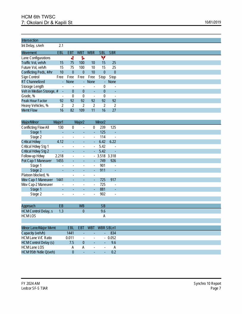
HCM 6th TWSC7: Okolani Dr & Kapili St 10/01/2019
FY 2024 AM Synchro 10 ReportLedcor SF-S TIAR Page 7
IntersectionInt Delay, s/veh 2.1
Movement EBL EBT WBT WBR SBL SBRLane ConfigurationsTraffic Vol, veh/h 15 75 100 10 15 25Future Vol, veh/h 15 75 100 10 15 25Conflicting Peds, #/hr 10 0 0 10 0 0Sign Control Free Free Free Free Stop StopRT Channelized - None - None - NoneStorage Length - - - - 0 -Veh in Median Storage, # - 0 0 - 0 -Grade, % - 0 0 - 0 -Peak Hour Factor 92 92 92 92 92 92Heavy Vehicles, % 2 2 2 2 2 2Mvmt Flow 16 82 109 11 16 27
Major/Minor Major1 Major2 Minor2Conflicting Flow All 130 0 - 0 239 125 Stage 1 - - - - 125 - Stage 2 - - - - 114 -Critical Hdwy 4.12 - - - 6.42 6.22Critical Hdwy Stg 1 - - - - 5.42 -Critical Hdwy Stg 2 - - - - 5.42 -Follow-up Hdwy 2.218 - - - 3.518 3.318Pot Cap-1 Maneuver 1455 - - - 749 926 Stage 1 - - - - 901 - Stage 2 - - - - 911 -Platoon blocked, % - - -Mov Cap-1 Maneuver 1441 - - - 725 917Mov Cap-2 Maneuver - - - - 725 - Stage 1 - - - - 881 - Stage 2 - - - - 902 -
Approach EB WB SBHCM Control Delay, s 1.3 0 9.6HCM LOS A
Minor Lane/Major Mvmt EBL EBT WBT WBR SBLn1Capacity (veh/h) 1441 - - - 834HCM Lane V/C Ratio 0.011 - - - 0.052HCM Control Delay (s) 7.5 0 - - 9.6HCM Lane LOS A A - - AHCM 95th %tile Q(veh) 0 - - - 0.2
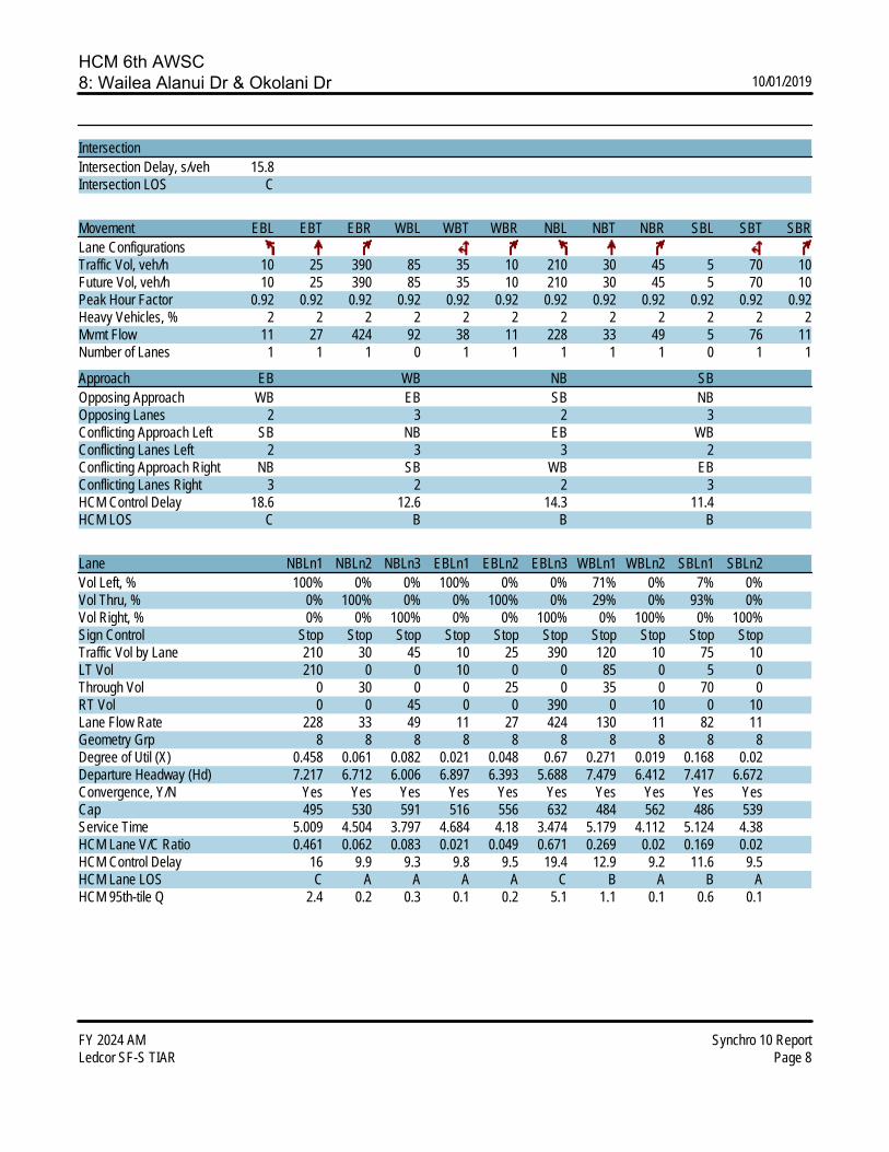
HCM 6th AWSC8: Wailea Alanui Dr & Okolani Dr 10/01/2019
FY 2024 AM Synchro 10 ReportLedcor SF-S TIAR Page 8
IntersectionIntersection Delay, s/veh 15.8Intersection LOS C
Movement EBL EBT EBR WBL WBT WBR NBL NBT NBR SBL SBT SBRLane ConfigurationsTraffic Vol, veh/h 10 25 390 85 35 10 210 30 45 5 70 10Future Vol, veh/h 10 25 390 85 35 10 210 30 45 5 70 10Peak Hour Factor 0.92 0.92 0.92 0.92 0.92 0.92 0.92 0.92 0.92 0.92 0.92 0.92Heavy Vehicles, % 2 2 2 2 2 2 2 2 2 2 2 2Mvmt Flow 11 27 424 92 38 11 228 33 49 5 76 11Number of Lanes 1 1 1 0 1 1 1 1 1 0 1 1
Approach EB WB NB SBOpposing Approach WB EB SB NBOpposing Lanes 2 3 2 3Conflicting Approach Left SB NB EB WBConflicting Lanes Left 2 3 3 2Conflicting Approach Right NB SB WB EBConflicting Lanes Right 3 2 2 3HCM Control Delay 18.6 12.6 14.3 11.4HCM LOS C B B B
Lane NBLn1 NBLn2 NBLn3 EBLn1 EBLn2 EBLn3 WBLn1 WBLn2 SBLn1 SBLn2Vol Left, % 100% 0% 0% 100% 0% 0% 71% 0% 7% 0%Vol Thru, % 0% 100% 0% 0% 100% 0% 29% 0% 93% 0%Vol Right, % 0% 0% 100% 0% 0% 100% 0% 100% 0% 100%Sign Control Stop Stop Stop Stop Stop Stop Stop Stop Stop StopTraffic Vol by Lane 210 30 45 10 25 390 120 10 75 10LT Vol 210 0 0 10 0 0 85 0 5 0Through Vol 0 30 0 0 25 0 35 0 70 0RT Vol 0 0 45 0 0 390 0 10 0 10Lane Flow Rate 228 33 49 11 27 424 130 11 82 11Geometry Grp 8 8 8 8 8 8 8 8 8 8Degree of Util (X) 0.458 0.061 0.082 0.021 0.048 0.67 0.271 0.019 0.168 0.02Departure Headway (Hd) 7.217 6.712 6.006 6.897 6.393 5.688 7.479 6.412 7.417 6.672Convergence, Y/N Yes Yes Yes Yes Yes Yes Yes Yes Yes YesCap 495 530 591 516 556 632 484 562 486 539Service Time 5.009 4.504 3.797 4.684 4.18 3.474 5.179 4.112 5.124 4.38HCM Lane V/C Ratio 0.461 0.062 0.083 0.021 0.049 0.671 0.269 0.02 0.169 0.02HCM Control Delay 16 9.9 9.3 9.8 9.5 19.4 12.9 9.2 11.6 9.5HCM Lane LOS C A A A A C B A B AHCM 95th-tile Q 2.4 0.2 0.3 0.1 0.2 5.1 1.1 0.1 0.6 0.1

HCM Signalized Intersection Capacity Analysis9: Wailea Alanui Drive & Wailea Ike Drive 10/01/2019
FY 2024 AM Synchro 10 ReportLedcor SF-S TIAR Page 1
Movement WBL WBR NBT NBR SBL SBTLane ConfigurationsTraffic Volume (vph) 620 195 160 270 155 310Future Volume (vph) 620 195 160 270 155 310Ideal Flow (vphpl) 1900 1900 1900 1900 1900 1900Total Lost time (s) 4.0 4.0 4.0 4.0 4.0 4.0Lane Util. Factor 1.00 1.00 1.00 1.00 1.00 0.95Frpb, ped/bikes 1.00 0.96 1.00 0.98 1.00 1.00Flpb, ped/bikes 1.00 1.00 1.00 1.00 1.00 1.00Frt 1.00 0.85 1.00 0.85 1.00 1.00Flt Protected 0.95 1.00 1.00 1.00 0.95 1.00Satd. Flow (prot) 1770 1518 1863 1559 1770 3539Flt Permitted 0.95 1.00 1.00 1.00 0.95 1.00Satd. Flow (perm) 1770 1518 1863 1559 1770 3539Peak-hour factor, PHF 0.92 0.92 0.92 0.92 0.92 0.92Adj. Flow (vph) 674 212 174 293 168 337RTOR Reduction (vph) 0 91 0 225 0 0Lane Group Flow (vph) 674 121 174 68 168 337Confl. Peds. (#/hr) 14 4Turn Type Prot Perm NA Perm Prot NAProtected Phases 8 2 1 6Permitted Phases 8 2Actuated Green, G (s) 36.8 36.8 18.6 18.6 12.9 22.6Effective Green, g (s) 36.8 36.8 18.6 18.6 12.9 22.6Actuated g/C Ratio 0.46 0.46 0.23 0.23 0.16 0.28Clearance Time (s) 4.0 4.0 4.0 4.0 4.0 4.0Vehicle Extension (s) 3.0 3.0 3.0 3.0 3.0 3.0Lane Grp Cap (vph) 811 695 431 361 284 996v/s Ratio Prot c0.38 c0.09 c0.09 c0.10v/s Ratio Perm 0.08 0.04v/c Ratio 0.83 0.17 0.40 0.19 0.59 0.34Uniform Delay, d1 19.0 12.8 26.1 24.8 31.3 22.9Progression Factor 1.00 1.00 1.00 1.00 1.00 1.00Incremental Delay, d2 7.3 0.1 0.6 0.3 3.3 0.2Delay (s) 26.3 12.9 26.8 25.0 34.5 23.1Level of Service C B C C C CApproach Delay (s) 23.1 25.7 26.9Approach LOS C C C
Intersection SummaryHCM 2000 Control Delay 24.8 HCM 2000 Level of Service CHCM 2000 Volume to Capacity ratio 0.65Actuated Cycle Length (s) 80.3 Sum of lost time (s) 12.0Intersection Capacity Utilization 63.1% ICU Level of Service BAnalysis Period (min) 15c Critical Lane Group

HCM 6th TWSC10: Wailea Ike Drive & Wailea Ike Place (North) 10/01/2019
FY 2024 AM Synchro 10 ReportLedcor SF-S TIAR Page 10
IntersectionInt Delay, s/veh 2.6
Movement EBL EBT EBR WBL WBT WBR NBL NBT NBR SBL SBT SBRLane ConfigurationsTraffic Vol, veh/h 0 0 0 15 770 55 25 45 0 0 25 40Future Vol, veh/h 0 0 0 15 770 55 25 45 0 0 25 40Conflicting Peds, #/hr 0 0 0 0 0 0 0 0 0 0 0 0Sign Control Free Free Free Free Free Free Stop Stop Stop Stop Stop StopRT Channelized - - None - - None - - None - - NoneStorage Length - - - - - - - - - - - -Veh in Median Storage, # - 2 - - 0 - - 0 - - 0 -Grade, % - 0 - - 0 - - 0 - - 0 -Peak Hour Factor 92 92 92 92 92 92 92 92 92 92 92 92Heavy Vehicles, % 2 2 2 2 2 2 2 2 2 2 2 2Mvmt Flow 0 0 0 16 837 60 27 49 0 0 27 43
Major/Minor Major2 Minor1 Minor2Conflicting Flow All 0 0 0 464 929 - - 899 449 Stage 1 - - - 0 0 - - 899 - Stage 2 - - - 464 929 - - 0 -Critical Hdwy 4.14 - - 7.54 6.54 - - 6.54 6.94Critical Hdwy Stg 1 - - - - - - - 5.54 -Critical Hdwy Stg 2 - - - 6.54 5.54 - - - -Follow-up Hdwy 2.22 - - 3.52 4.02 - - 4.02 3.32Pot Cap-1 Maneuver - - - 481 266 0 0 277 557 Stage 1 - - - - - 0 0 356 - Stage 2 - - - 548 344 0 0 - -Platoon blocked, % - -Mov Cap-1 Maneuver - - - 410 266 - - 277 557Mov Cap-2 Maneuver - - - 410 266 - - 277 - Stage 1 - - - - - - - 356 - Stage 2 - - - 467 344 - - - -
Approach WB NB SBHCM Control Delay, s 20.8 15.9HCM LOS C C
Minor Lane/Major Mvmt NBLn1 WBL WBT WBR SBLn1Capacity (veh/h) 304 - - - 401HCM Lane V/C Ratio 0.25 - - - 0.176HCM Control Delay (s) 20.8 - - - 15.9HCM Lane LOS C - - - CHCM 95th %tile Q(veh) 1 - - - 0.6

HCM 6th TWSC11: Wailea Ike Place (South) & Wailea Ike Drive 10/01/2019
FY 2024 AM Synchro 10 ReportLedcor SF-S TIAR Page 11
IntersectionInt Delay, s/veh 1.8
Movement EBL EBT EBR WBL WBT WBR NBL NBT NBR SBL SBT SBRLane ConfigurationsTraffic Vol, veh/h 45 370 10 0 0 0 0 15 10 20 25 0Future Vol, veh/h 45 370 10 0 0 0 0 15 10 20 25 0Conflicting Peds, #/hr 0 0 2 2 0 0 9 0 0 0 0 9Sign Control Free Free Free Free Free Free Stop Stop Stop Stop Stop StopRT Channelized - - None - - None - - None - - NoneStorage Length - - - - - - - - - - - -Veh in Median Storage, # - 0 - - 16979 - - 0 - - 0 -Grade, % - 0 - - 0 - - 0 - - 0 -Peak Hour Factor 92 92 92 92 92 92 92 92 92 92 92 92Heavy Vehicles, % 2 2 2 2 2 2 2 2 2 2 2 2Mvmt Flow 49 402 11 0 0 0 0 16 11 22 27 0
Major/Minor Major1 Minor1 Minor2Conflicting Flow All 0 0 0 - 508 209 307 513 - Stage 1 - - - - 508 - 0 0 - Stage 2 - - - - 0 - 307 513 -Critical Hdwy 4.14 - - - 6.54 6.94 7.54 6.54 -Critical Hdwy Stg 1 - - - - 5.54 - - - -Critical Hdwy Stg 2 - - - - - - 6.54 5.54 -Follow-up Hdwy 2.22 - - - 4.02 3.32 3.52 4.02 -Pot Cap-1 Maneuver - - - 0 466 797 622 463 0 Stage 1 - - - 0 537 - - - 0 Stage 2 - - - 0 - - 678 534 0Platoon blocked, % - -Mov Cap-1 Maneuver - - - - 465 795 597 462 -Mov Cap-2 Maneuver - - - - 465 - 597 462 - Stage 1 - - - - 536 - - - - Stage 2 - - - - - - 648 533 -
Approach EB NB SBHCM Control Delay, s 11.8 12.7HCM LOS B B
Minor Lane/Major Mvmt NBLn1 EBL EBT EBR SBLn1Capacity (veh/h) 558 - - - 514HCM Lane V/C Ratio 0.049 - - - 0.095HCM Control Delay (s) 11.8 - - - 12.7HCM Lane LOS B - - - BHCM 95th %tile Q(veh) 0.2 - - - 0.3
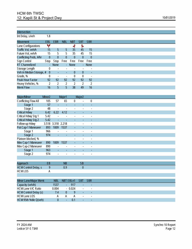
HCM 6th TWSC12: Kapili St & Project Dwy 10/01/2019
FY 2024 AM Synchro 10 ReportLedcor SF-S TIAR Page 12
IntersectionInt Delay, s/veh 1.8
Movement EBL EBR NBL NBT SBT SBRLane ConfigurationsTraffic Vol, veh/h 15 5 5 35 45 15Future Vol, veh/h 15 5 5 35 45 15Conflicting Peds, #/hr 0 0 0 0 0 0Sign Control Stop Stop Free Free Free FreeRT Channelized - None - None - NoneStorage Length 0 - - - - -Veh in Median Storage, # 0 - - 0 0 -Grade, % 0 - - 0 0 -Peak Hour Factor 92 92 92 92 92 92Heavy Vehicles, % 2 2 2 2 2 2Mvmt Flow 16 5 5 38 49 16
Major/Minor Minor2 Major1 Major2Conflicting Flow All 105 57 65 0 - 0 Stage 1 57 - - - - - Stage 2 48 - - - - -Critical Hdwy 6.42 6.22 4.12 - - -Critical Hdwy Stg 1 5.42 - - - - -Critical Hdwy Stg 2 5.42 - - - - -Follow-up Hdwy 3.518 3.318 2.218 - - -Pot Cap-1 Maneuver 893 1009 1537 - - - Stage 1 966 - - - - - Stage 2 974 - - - - -Platoon blocked, % - - -Mov Cap-1 Maneuver 890 1009 1537 - - -Mov Cap-2 Maneuver 890 - - - - - Stage 1 963 - - - - - Stage 2 974 - - - - -
Approach EB NB SBHCM Control Delay, s 9 0.9 0HCM LOS A
Minor Lane/Major Mvmt NBL NBT EBLn1 SBT SBRCapacity (veh/h) 1537 - 917 - -HCM Lane V/C Ratio 0.004 - 0.024 - -HCM Control Delay (s) 7.4 0 9 - -HCM Lane LOS A A A - -HCM 95th %tile Q(veh) 0 - 0.1 - -

LEVEL OF SERV
• Futur
APVICE CAL
re Year 20
PPENDIXLCULATIO
024 PM P
X C ONS
Peak
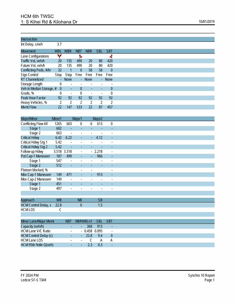
HCM 6th TWSC1: S Kihei Rd & Kilohana Dr 10/01/2019
FY 2024 PM Synchro 10 ReportLedcor SF-S TIAR Page 1
IntersectionInt Delay, s/veh 3.7
Movement WBL WBR NBT NBR SBL SBTLane ConfigurationsTraffic Vol, veh/h 20 135 490 20 80 420Future Vol, veh/h 20 135 490 20 80 420Conflicting Peds, #/hr 32 1 0 58 58 0Sign Control Stop Stop Free Free Free FreeRT Channelized - None - None - NoneStorage Length 0 - - - - -Veh in Median Storage, # 0 - 0 - - 0Grade, % 0 - 0 - - 0Peak Hour Factor 92 92 92 92 92 92Heavy Vehicles, % 2 2 2 2 2 2Mvmt Flow 22 147 533 22 87 457
Major/Minor Minor1 Major1 Major2Conflicting Flow All 1265 603 0 0 613 0 Stage 1 602 - - - - - Stage 2 663 - - - - -Critical Hdwy 6.42 6.22 - - 4.12 -Critical Hdwy Stg 1 5.42 - - - - -Critical Hdwy Stg 2 5.42 - - - - -Follow-up Hdwy 3.518 3.318 - - 2.218 -Pot Cap-1 Maneuver 187 499 - - 966 - Stage 1 547 - - - - - Stage 2 512 - - - - -Platoon blocked, % - - -Mov Cap-1 Maneuver 149 471 - - 913 -Mov Cap-2 Maneuver 149 - - - - - Stage 1 451 - - - - - Stage 2 497 - - - - -
Approach WB NB SBHCM Control Delay, s 22.8 0 1.5HCM LOS C
Minor Lane/Major Mvmt NBT NBRWBLn1 SBL SBTCapacity (veh/h) - - 368 913 -HCM Lane V/C Ratio - - 0.458 0.095 -HCM Control Delay (s) - - 22.8 9.4 0HCM Lane LOS - - C A AHCM 95th %tile Q(veh) - - 2.3 0.3 -

HCM 6th TWSC2: Wailea Alanui Dr & Kilohana Dr 10/01/2019
FY 2024 PM Synchro 10 ReportLedcor SF-S TIAR Page 2
IntersectionInt Delay, s/veh 5.2
Movement EBL EBT EBR WBL WBT WBR NBL NBT NBR SBL SBT SBRLane ConfigurationsTraffic Vol, veh/h 5 90 15 70 105 20 35 10 90 15 5 5Future Vol, veh/h 5 90 15 70 105 20 35 10 90 15 5 5Conflicting Peds, #/hr 6 0 14 14 0 6 4 0 1 1 0 4Sign Control Free Free Free Free Free Free Stop Stop Stop Stop Stop StopRT Channelized - - None - - None - - None - - NoneStorage Length 40 - - 195 - - - - - - - -Veh in Median Storage, # - 0 - - 0 - - 0 - - 0 -Grade, % - 0 - - 0 - - 0 - - 0 -Peak Hour Factor 92 92 92 92 92 92 92 92 92 92 92 92Heavy Vehicles, % 2 2 2 2 2 2 2 2 2 2 2 2Mvmt Flow 5 98 16 76 114 22 38 11 98 16 5 5
Major/Minor Major1 Major2 Minor1 Minor2Conflicting Flow All 142 0 0 128 0 0 416 424 121 455 421 135 Stage 1 - - - - - - 130 130 - 283 283 - Stage 2 - - - - - - 286 294 - 172 138 -Critical Hdwy 4.12 - - 4.12 - - 7.12 6.52 6.22 7.12 6.52 6.22Critical Hdwy Stg 1 - - - - - - 6.12 5.52 - 6.12 5.52 -Critical Hdwy Stg 2 - - - - - - 6.12 5.52 - 6.12 5.52 -Follow-up Hdwy 2.218 - - 2.218 - - 3.518 4.018 3.318 3.518 4.018 3.318Pot Cap-1 Maneuver 1441 - - 1458 - - 547 522 930 515 524 914 Stage 1 - - - - - - 874 789 - 724 677 - Stage 2 - - - - - - 721 670 - 830 782 -Platoon blocked, % - - - -Mov Cap-1 Maneuver 1433 - - 1439 - - 507 483 917 430 485 905Mov Cap-2 Maneuver - - - - - - 507 483 - 430 485 - Stage 1 - - - - - - 859 776 - 717 637 - Stage 2 - - - - - - 670 630 - 728 769 -
Approach EB WB NB SBHCM Control Delay, s 0.3 2.7 11.3 12.7HCM LOS B B
Minor Lane/Major Mvmt NBLn1 EBL EBT EBR WBL WBT WBR SBLn1Capacity (veh/h) 719 1433 - - 1439 - - 493HCM Lane V/C Ratio 0.204 0.004 - - 0.053 - - 0.055HCM Control Delay (s) 11.3 7.5 - - 7.6 - - 12.7HCM Lane LOS B A - - A - - BHCM 95th %tile Q(veh) 0.8 0 - - 0.2 - - 0.2

HCM 6th TWSC3: Kapili St & Kilohana Dr 10/01/2019
FY 2024 PM Synchro 10 ReportLedcor SF-S TIAR Page 3
IntersectionInt Delay, s/veh 2.3
Movement EBT EBR WBL WBT NBL NBRLane ConfigurationsTraffic Vol, veh/h 160 10 30 170 10 70Future Vol, veh/h 160 10 30 170 10 70Conflicting Peds, #/hr 0 4 4 0 0 0Sign Control Free Free Free Free Stop StopRT Channelized - None - None - NoneStorage Length - - - - 0 -Veh in Median Storage, # 0 - - 0 0 -Grade, % 0 - - 0 0 -Peak Hour Factor 92 92 92 92 92 92Heavy Vehicles, % 2 2 2 2 2 2Mvmt Flow 174 11 33 185 11 76
Major/Minor Major1 Major2 Minor1Conflicting Flow All 0 0 189 0 435 184 Stage 1 - - - - 184 - Stage 2 - - - - 251 -Critical Hdwy - - 4.12 - 6.42 6.22Critical Hdwy Stg 1 - - - - 5.42 -Critical Hdwy Stg 2 - - - - 5.42 -Follow-up Hdwy - - 2.218 - 3.518 3.318Pot Cap-1 Maneuver - - 1385 - 578 858 Stage 1 - - - - 848 - Stage 2 - - - - 791 -Platoon blocked, % - - -Mov Cap-1 Maneuver - - 1380 - 560 855Mov Cap-2 Maneuver - - - - 560 - Stage 1 - - - - 822 - Stage 2 - - - - 791 -
Approach EB WB NBHCM Control Delay, s 0 1.2 10HCM LOS B
Minor Lane/Major Mvmt NBLn1 EBT EBR WBL WBTCapacity (veh/h) 802 - - 1380 -HCM Lane V/C Ratio 0.108 - - 0.024 -HCM Control Delay (s) 10 - - 7.7 0HCM Lane LOS B - - A AHCM 95th %tile Q(veh) 0.4 - - 0.1 -
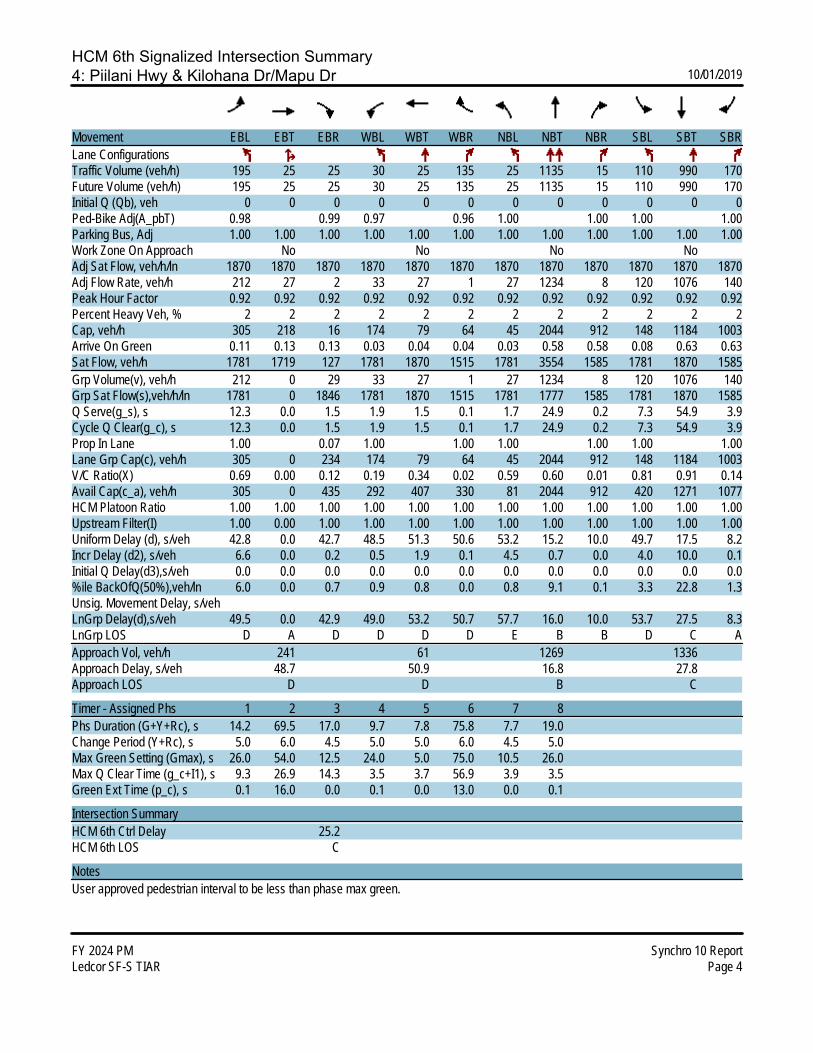
HCM 6th Signalized Intersection Summary4: Piilani Hwy & Kilohana Dr/Mapu Dr 10/01/2019
FY 2024 PM Synchro 10 ReportLedcor SF-S TIAR Page 4
Movement EBL EBT EBR WBL WBT WBR NBL NBT NBR SBL SBT SBRLane ConfigurationsTraffic Volume (veh/h) 195 25 25 30 25 135 25 1135 15 110 990 170Future Volume (veh/h) 195 25 25 30 25 135 25 1135 15 110 990 170Initial Q (Qb), veh 0 0 0 0 0 0 0 0 0 0 0 0Ped-Bike Adj(A_pbT) 0.98 0.99 0.97 0.96 1.00 1.00 1.00 1.00Parking Bus, Adj 1.00 1.00 1.00 1.00 1.00 1.00 1.00 1.00 1.00 1.00 1.00 1.00Work Zone On Approach No No No NoAdj Sat Flow, veh/h/ln 1870 1870 1870 1870 1870 1870 1870 1870 1870 1870 1870 1870Adj Flow Rate, veh/h 212 27 2 33 27 1 27 1234 8 120 1076 140Peak Hour Factor 0.92 0.92 0.92 0.92 0.92 0.92 0.92 0.92 0.92 0.92 0.92 0.92Percent Heavy Veh, % 2 2 2 2 2 2 2 2 2 2 2 2Cap, veh/h 305 218 16 174 79 64 45 2044 912 148 1184 1003Arrive On Green 0.11 0.13 0.13 0.03 0.04 0.04 0.03 0.58 0.58 0.08 0.63 0.63Sat Flow, veh/h 1781 1719 127 1781 1870 1515 1781 3554 1585 1781 1870 1585Grp Volume(v), veh/h 212 0 29 33 27 1 27 1234 8 120 1076 140Grp Sat Flow(s),veh/h/ln 1781 0 1846 1781 1870 1515 1781 1777 1585 1781 1870 1585Q Serve(g_s), s 12.3 0.0 1.5 1.9 1.5 0.1 1.7 24.9 0.2 7.3 54.9 3.9Cycle Q Clear(g_c), s 12.3 0.0 1.5 1.9 1.5 0.1 1.7 24.9 0.2 7.3 54.9 3.9Prop In Lane 1.00 0.07 1.00 1.00 1.00 1.00 1.00 1.00Lane Grp Cap(c), veh/h 305 0 234 174 79 64 45 2044 912 148 1184 1003V/C Ratio(X) 0.69 0.00 0.12 0.19 0.34 0.02 0.59 0.60 0.01 0.81 0.91 0.14Avail Cap(c_a), veh/h 305 0 435 292 407 330 81 2044 912 420 1271 1077HCM Platoon Ratio 1.00 1.00 1.00 1.00 1.00 1.00 1.00 1.00 1.00 1.00 1.00 1.00Upstream Filter(I) 1.00 0.00 1.00 1.00 1.00 1.00 1.00 1.00 1.00 1.00 1.00 1.00Uniform Delay (d), s/veh 42.8 0.0 42.7 48.5 51.3 50.6 53.2 15.2 10.0 49.7 17.5 8.2Incr Delay (d2), s/veh 6.6 0.0 0.2 0.5 1.9 0.1 4.5 0.7 0.0 4.0 10.0 0.1Initial Q Delay(d3),s/veh 0.0 0.0 0.0 0.0 0.0 0.0 0.0 0.0 0.0 0.0 0.0 0.0%ile BackOfQ(50%),veh/ln 6.0 0.0 0.7 0.9 0.8 0.0 0.8 9.1 0.1 3.3 22.8 1.3Unsig. Movement Delay, s/vehLnGrp Delay(d),s/veh 49.5 0.0 42.9 49.0 53.2 50.7 57.7 16.0 10.0 53.7 27.5 8.3LnGrp LOS D A D D D D E B B D C AApproach Vol, veh/h 241 61 1269 1336Approach Delay, s/veh 48.7 50.9 16.8 27.8Approach LOS D D B C
Timer - Assigned Phs 1 2 3 4 5 6 7 8Phs Duration (G+Y+Rc), s 14.2 69.5 17.0 9.7 7.8 75.8 7.7 19.0Change Period (Y+Rc), s 5.0 6.0 4.5 5.0 5.0 6.0 4.5 5.0Max Green Setting (Gmax), s 26.0 54.0 12.5 24.0 5.0 75.0 10.5 26.0Max Q Clear Time (g_c+I1), s 9.3 26.9 14.3 3.5 3.7 56.9 3.9 3.5Green Ext Time (p_c), s 0.1 16.0 0.0 0.1 0.0 13.0 0.0 0.1
Intersection SummaryHCM 6th Ctrl Delay 25.2HCM 6th LOS C
NotesUser approved pedestrian interval to be less than phase max green.
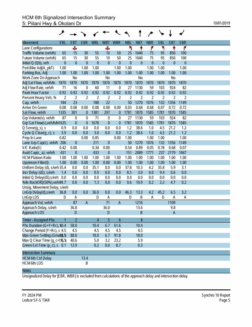
HCM 6th Signalized Intersection Summary5: Piilani Hwy & Okolani Dr 10/01/2019
FY 2024 PM Synchro 10 ReportLedcor SF-S TIAR Page 5
Movement EBL EBT EBR WBL WBT WBR NBL NBT NBR SBL SBT SBRLane ConfigurationsTraffic Volume (veh/h) 65 15 30 55 10 50 25 1040 75 95 850 100Future Volume (veh/h) 65 15 30 55 10 50 25 1040 75 95 850 100Initial Q (Qb), veh 0 0 0 0 0 0 0 0 0 0 0 0Ped-Bike Adj(A_pbT) 1.00 1.00 1.00 1.00 1.00 1.00 1.00 1.00Parking Bus, Adj 1.00 1.00 1.00 1.00 1.00 1.00 1.00 1.00 1.00 1.00 1.00 1.00Work Zone On Approach No No No NoAdj Sat Flow, veh/h/ln 1870 1870 1870 1870 1870 1870 1870 1870 1870 1870 1870 1870Adj Flow Rate, veh/h 71 16 0 60 11 0 27 1130 59 103 924 82Peak Hour Factor 0.92 0.92 0.92 0.92 0.92 0.92 0.92 0.92 0.92 0.92 0.92 0.92Percent Heavy Veh, % 2 2 2 2 2 2 2 2 2 2 2 2Cap, veh/h 184 23 188 22 50 1270 1076 132 1356 1149Arrive On Green 0.08 0.08 0.00 0.08 0.08 0.00 0.03 0.68 0.68 0.07 0.72 0.72Sat Flow, veh/h 1335 301 0 1381 297 0 1781 1870 1585 1781 1870 1585Grp Volume(v), veh/h 87 0 0 71 0 0 27 1130 59 103 924 82Grp Sat Flow(s),veh/h/ln1635 0 0 1678 0 0 1781 1870 1585 1781 1870 1585Q Serve(g_s), s 0.9 0.0 0.0 0.0 0.0 0.0 1.2 38.6 1.0 4.5 21.2 1.2Cycle Q Clear(g_c), s 3.9 0.0 0.0 3.0 0.0 0.0 1.2 38.6 1.0 4.5 21.2 1.2Prop In Lane 0.82 0.00 0.85 0.00 1.00 1.00 1.00 1.00Lane Grp Cap(c), veh/h 206 0 211 0 50 1270 1076 132 1356 1149V/C Ratio(X) 0.42 0.00 0.34 0.00 0.54 0.89 0.05 0.78 0.68 0.07Avail Cap(c_a), veh/h 431 0 433 0 151 2089 1771 237 2179 1847HCM Platoon Ratio 1.00 1.00 1.00 1.00 1.00 1.00 1.00 1.00 1.00 1.00 1.00 1.00Upstream Filter(I) 1.00 0.00 0.00 1.00 0.00 0.00 1.00 1.00 1.00 1.00 1.00 1.00Uniform Delay (d), s/veh 35.4 0.0 0.0 35.1 0.0 0.0 37.8 10.3 4.2 35.8 5.9 3.1Incr Delay (d2), s/veh 1.4 0.0 0.0 0.9 0.0 0.0 8.5 3.0 0.0 9.4 0.6 0.0Initial Q Delay(d3),s/veh 0.0 0.0 0.0 0.0 0.0 0.0 0.0 0.0 0.0 0.0 0.0 0.0%ile BackOfQ(50%),veh/ln1.7 0.0 0.0 1.3 0.0 0.0 0.6 10.9 0.2 2.2 4.7 0.2Unsig. Movement Delay, s/vehLnGrp Delay(d),s/veh 36.8 0.0 0.0 36.0 0.0 0.0 46.3 13.3 4.2 45.2 6.5 3.2LnGrp LOS D A D A D B A D A AApproach Vol, veh/h 87 A 71 A 1216 1109Approach Delay, s/veh 36.8 36.0 13.6 9.8Approach LOS D D B A
Timer - Assigned Phs 1 2 4 5 6 8Phs Duration (G+Y+Rc), s10.4 58.0 10.4 6.7 61.6 10.4Change Period (Y+Rc), s 4.5 4.5 4.5 4.5 4.5 4.5Max Green Setting (Gmax), s10.5 88.0 18.0 6.7 91.8 18.0Max Q Clear Time (g_c+I1), s6.5 40.6 5.0 3.2 23.2 5.9Green Ext Time (p_c), s 0.1 12.9 0.2 0.0 8.7 0.3
Intersection SummaryHCM 6th Ctrl Delay 13.4HCM 6th LOS B
NotesUnsignalized Delay for [EBR, WBR] is excluded from calculations of the approach delay and intersection delay.

HCM 6th TWSC6: Okolani Dr & Kualono Pl 10/01/2019
FY 2024 PM Synchro 10 ReportLedcor SF-S TIAR Page 6
IntersectionInt Delay, s/veh 1.1
Movement EBL EBT EBR WBL WBT WBR NBL NBT NBR SBL SBT SBRLane ConfigurationsTraffic Vol, veh/h 5 90 5 5 105 10 5 0 5 5 0 5Future Vol, veh/h 5 90 5 5 105 10 5 0 5 5 0 5Conflicting Peds, #/hr 0 0 0 0 0 0 0 0 0 0 0 0Sign Control Free Free Free Free Free Free Stop Stop Stop Stop Stop StopRT Channelized - - None - - None - - None - - NoneStorage Length - - - - - - - - - - - -Veh in Median Storage, # - 0 - - 0 - - 0 - - 0 -Grade, % - 0 - - 0 - - 0 - - 0 -Peak Hour Factor 92 92 92 92 92 92 92 92 92 92 92 92Heavy Vehicles, % 2 2 2 2 2 2 2 2 2 2 2 2Mvmt Flow 5 98 5 5 114 11 5 0 5 5 0 5
Major/Minor Major1 Major2 Minor1 Minor2Conflicting Flow All 125 0 0 103 0 0 243 246 101 243 243 120 Stage 1 - - - - - - 111 111 - 130 130 - Stage 2 - - - - - - 132 135 - 113 113 -Critical Hdwy 4.12 - - 4.12 - - 7.12 6.52 6.22 7.12 6.52 6.22Critical Hdwy Stg 1 - - - - - - 6.12 5.52 - 6.12 5.52 -Critical Hdwy Stg 2 - - - - - - 6.12 5.52 - 6.12 5.52 -Follow-up Hdwy 2.218 - - 2.218 - - 3.518 4.018 3.318 3.518 4.018 3.318Pot Cap-1 Maneuver 1462 - - 1489 - - 711 656 954 711 659 931 Stage 1 - - - - - - 894 804 - 874 789 - Stage 2 - - - - - - 871 785 - 892 802 -Platoon blocked, % - - - -Mov Cap-1 Maneuver 1462 - - 1489 - - 702 651 954 702 654 931Mov Cap-2 Maneuver - - - - - - 702 651 - 702 654 - Stage 1 - - - - - - 890 801 - 871 786 - Stage 2 - - - - - - 862 782 - 883 799 -
Approach EB WB NB SBHCM Control Delay, s 0.4 0.3 9.5 9.6HCM LOS A A
Minor Lane/Major Mvmt NBLn1 EBL EBT EBR WBL WBT WBR SBLn1Capacity (veh/h) 809 1462 - - 1489 - - 800HCM Lane V/C Ratio 0.013 0.004 - - 0.004 - - 0.014HCM Control Delay (s) 9.5 7.5 0 - 7.4 0 - 9.6HCM Lane LOS A A A - A A - AHCM 95th %tile Q(veh) 0 0 - - 0 - - 0
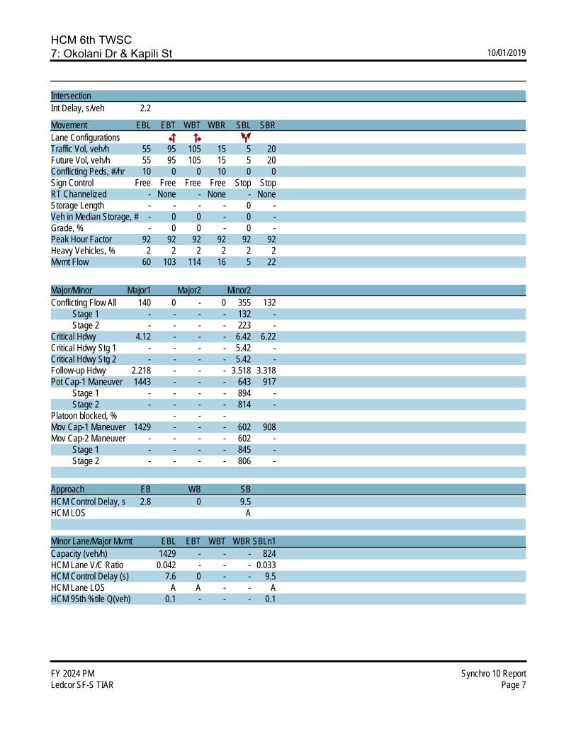
HCM 6th TWSC7: Okolani Dr & Kapili St 10/01/2019
FY 2024 PM Synchro 10 ReportLedcor SF-S TIAR Page 7
IntersectionInt Delay, s/veh 2.2
Movement EBL EBT WBT WBR SBL SBRLane ConfigurationsTraffic Vol, veh/h 55 95 105 15 5 20Future Vol, veh/h 55 95 105 15 5 20Conflicting Peds, #/hr 10 0 0 10 0 0Sign Control Free Free Free Free Stop StopRT Channelized - None - None - NoneStorage Length - - - - 0 -Veh in Median Storage, # - 0 0 - 0 -Grade, % - 0 0 - 0 -Peak Hour Factor 92 92 92 92 92 92Heavy Vehicles, % 2 2 2 2 2 2Mvmt Flow 60 103 114 16 5 22
Major/Minor Major1 Major2 Minor2Conflicting Flow All 140 0 - 0 355 132 Stage 1 - - - - 132 - Stage 2 - - - - 223 -Critical Hdwy 4.12 - - - 6.42 6.22Critical Hdwy Stg 1 - - - - 5.42 -Critical Hdwy Stg 2 - - - - 5.42 -Follow-up Hdwy 2.218 - - - 3.518 3.318Pot Cap-1 Maneuver 1443 - - - 643 917 Stage 1 - - - - 894 - Stage 2 - - - - 814 -Platoon blocked, % - - -Mov Cap-1 Maneuver 1429 - - - 602 908Mov Cap-2 Maneuver - - - - 602 - Stage 1 - - - - 845 - Stage 2 - - - - 806 -
Approach EB WB SBHCM Control Delay, s 2.8 0 9.5HCM LOS A
Minor Lane/Major Mvmt EBL EBT WBT WBR SBLn1Capacity (veh/h) 1429 - - - 824HCM Lane V/C Ratio 0.042 - - - 0.033HCM Control Delay (s) 7.6 0 - - 9.5HCM Lane LOS A A - - AHCM 95th %tile Q(veh) 0.1 - - - 0.1

HCM 6th AWSC8: Wailea Alanui Dr & Okolani Dr 10/01/2019
FY 2024 PM Synchro 10 ReportLedcor SF-S TIAR Page 8
IntersectionIntersection Delay, s/veh 39.8Intersection LOS E
Movement EBL EBT EBR WBL WBT WBR NBL NBT NBR SBL SBT SBRLane ConfigurationsTraffic Vol, veh/h 10 50 380 90 25 10 440 120 95 5 60 20Future Vol, veh/h 10 50 380 90 25 10 440 120 95 5 60 20Peak Hour Factor 0.92 0.92 0.92 0.92 0.92 0.92 0.92 0.92 0.92 0.92 0.92 0.92Heavy Vehicles, % 2 2 2 2 2 2 2 2 2 2 2 2Mvmt Flow 11 54 413 98 27 11 478 130 103 5 65 22Number of Lanes 1 1 1 0 1 1 1 1 1 0 1 1
Approach EB WB NB SBOpposing Approach WB EB SB NBOpposing Lanes 2 3 2 3Conflicting Approach Left SB NB EB WBConflicting Lanes Left 2 3 3 2Conflicting Approach Right NB SB WB EBConflicting Lanes Right 3 2 2 3HCM Control Delay 29.2 15.4 55.1 12.9HCM LOS D C F B
Lane NBLn1 NBLn2 NBLn3 EBLn1 EBLn2 EBLn3 WBLn1 WBLn2 SBLn1 SBLn2Vol Left, % 100% 0% 0% 100% 0% 0% 78% 0% 8% 0%Vol Thru, % 0% 100% 0% 0% 100% 0% 22% 0% 92% 0%Vol Right, % 0% 0% 100% 0% 0% 100% 0% 100% 0% 100%Sign Control Stop Stop Stop Stop Stop Stop Stop Stop Stop StopTraffic Vol by Lane 440 120 95 10 50 380 115 10 65 20LT Vol 440 0 0 10 0 0 90 0 5 0Through Vol 0 120 0 0 50 0 25 0 60 0RT Vol 0 0 95 0 0 380 0 10 0 20Lane Flow Rate 478 130 103 11 54 413 125 11 71 22Geometry Grp 8 8 8 8 8 8 8 8 8 8Degree of Util (X) 1.026 0.261 0.187 0.025 0.115 0.794 0.307 0.024 0.172 0.048Departure Headway (Hd) 7.723 7.216 6.507 8.347 7.839 7.128 9.101 7.984 8.889 8.132Convergence, Y/N Yes Yes Yes Yes Yes Yes Yes Yes Yes YesCap 473 501 555 431 460 512 398 451 406 443Service Time 5.429 4.923 4.214 6.047 5.539 4.828 6.801 5.684 6.589 5.832HCM Lane V/C Ratio 1.011 0.259 0.186 0.026 0.117 0.807 0.314 0.024 0.175 0.05HCM Control Delay 76.3 12.5 10.7 11.3 11.6 32 15.8 10.9 13.4 11.2HCM Lane LOS F B B B B D C B B BHCM 95th-tile Q 14.2 1 0.7 0.1 0.4 7.4 1.3 0.1 0.6 0.2
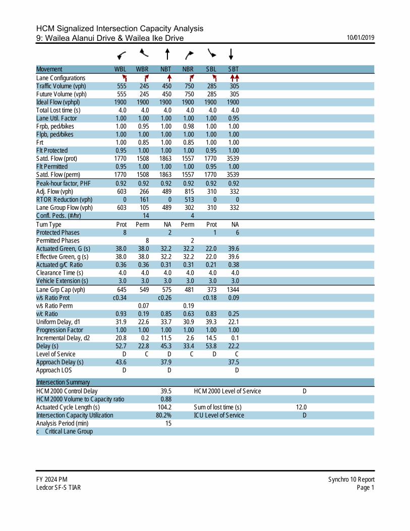
HCM Signalized Intersection Capacity Analysis9: Wailea Alanui Drive & Wailea Ike Drive 10/01/2019
FY 2024 PM Synchro 10 ReportLedcor SF-S TIAR Page 1
Movement WBL WBR NBT NBR SBL SBTLane ConfigurationsTraffic Volume (vph) 555 245 450 750 285 305Future Volume (vph) 555 245 450 750 285 305Ideal Flow (vphpl) 1900 1900 1900 1900 1900 1900Total Lost time (s) 4.0 4.0 4.0 4.0 4.0 4.0Lane Util. Factor 1.00 1.00 1.00 1.00 1.00 0.95Frpb, ped/bikes 1.00 0.95 1.00 0.98 1.00 1.00Flpb, ped/bikes 1.00 1.00 1.00 1.00 1.00 1.00Frt 1.00 0.85 1.00 0.85 1.00 1.00Flt Protected 0.95 1.00 1.00 1.00 0.95 1.00Satd. Flow (prot) 1770 1508 1863 1557 1770 3539Flt Permitted 0.95 1.00 1.00 1.00 0.95 1.00Satd. Flow (perm) 1770 1508 1863 1557 1770 3539Peak-hour factor, PHF 0.92 0.92 0.92 0.92 0.92 0.92Adj. Flow (vph) 603 266 489 815 310 332RTOR Reduction (vph) 0 161 0 513 0 0Lane Group Flow (vph) 603 105 489 302 310 332Confl. Peds. (#/hr) 14 4Turn Type Prot Perm NA Perm Prot NAProtected Phases 8 2 1 6Permitted Phases 8 2Actuated Green, G (s) 38.0 38.0 32.2 32.2 22.0 39.6Effective Green, g (s) 38.0 38.0 32.2 32.2 22.0 39.6Actuated g/C Ratio 0.36 0.36 0.31 0.31 0.21 0.38Clearance Time (s) 4.0 4.0 4.0 4.0 4.0 4.0Vehicle Extension (s) 3.0 3.0 3.0 3.0 3.0 3.0Lane Grp Cap (vph) 645 549 575 481 373 1344v/s Ratio Prot c0.34 c0.26 c0.18 0.09v/s Ratio Perm 0.07 0.19v/c Ratio 0.93 0.19 0.85 0.63 0.83 0.25Uniform Delay, d1 31.9 22.6 33.7 30.9 39.3 22.1Progression Factor 1.00 1.00 1.00 1.00 1.00 1.00Incremental Delay, d2 20.8 0.2 11.5 2.6 14.5 0.1Delay (s) 52.7 22.8 45.3 33.4 53.8 22.2Level of Service D C D C D CApproach Delay (s) 43.6 37.9 37.5Approach LOS D D D
Intersection SummaryHCM 2000 Control Delay 39.5 HCM 2000 Level of Service DHCM 2000 Volume to Capacity ratio 0.88Actuated Cycle Length (s) 104.2 Sum of lost time (s) 12.0Intersection Capacity Utilization 80.2% ICU Level of Service DAnalysis Period (min) 15c Critical Lane Group

HCM 6th TWSC10: Wailea Ike Drive & Wailea Ike Place (North) 10/01/2019
FY 2024 PM Synchro 10 ReportLedcor SF-S TIAR Page 10
IntersectionInt Delay, s/veh 5.2
Movement EBL EBT EBR WBL WBT WBR NBL NBT NBR SBL SBT SBRLane ConfigurationsTraffic Vol, veh/h 0 0 0 35 730 55 65 40 0 0 75 55Future Vol, veh/h 0 0 0 35 730 55 65 40 0 0 75 55Conflicting Peds, #/hr 0 0 0 0 0 0 0 0 0 0 0 0Sign Control Free Free Free Free Free Free Stop Stop Stop Stop Stop StopRT Channelized - - None - - None - - None - - NoneStorage Length - - - - - - - - - - - -Veh in Median Storage, # - 2 - - 0 - - 0 - - 0 -Grade, % - 0 - - 0 - - 0 - - 0 -Peak Hour Factor 92 92 92 92 92 92 92 92 92 92 92 92Heavy Vehicles, % 2 2 2 2 2 2 2 2 2 2 2 2Mvmt Flow 0 0 0 38 793 60 71 43 0 0 82 60
Major/Minor Major2 Minor1 Minor2Conflicting Flow All 0 0 0 514 929 - - 899 427 Stage 1 - - - 0 0 - - 899 - Stage 2 - - - 514 929 - - 0 -Critical Hdwy 4.14 - - 7.54 6.54 - - 6.54 6.94Critical Hdwy Stg 1 - - - - - - - 5.54 -Critical Hdwy Stg 2 - - - 6.54 5.54 - - - -Follow-up Hdwy 2.22 - - 3.52 4.02 - - 4.02 3.32Pot Cap-1 Maneuver - - - 443 266 0 0 277 576 Stage 1 - - - - - 0 0 356 - Stage 2 - - - 511 344 0 0 - -Platoon blocked, % - -Mov Cap-1 Maneuver - - - 307 266 - - 277 576Mov Cap-2 Maneuver - - - 307 266 - - 277 - Stage 1 - - - - - - - 356 - Stage 2 - - - 353 344 - - - -
Approach WB NB SBHCM Control Delay, s 25.2 21.7HCM LOS D C
Minor Lane/Major Mvmt NBLn1 WBL WBT WBR SBLn1Capacity (veh/h) 290 - - - 355HCM Lane V/C Ratio 0.394 - - - 0.398HCM Control Delay (s) 25.2 - - - 21.7HCM Lane LOS D - - - CHCM 95th %tile Q(veh) 1.8 - - - 1.9

HCM 6th TWSC11: Wailea Ike Place (South) & Wailea Ike Drive 10/01/2019
FY 2024 PM Synchro 10 ReportLedcor SF-S TIAR Page 11
IntersectionInt Delay, s/veh 7.3
Movement EBL EBT EBR WBL WBT WBR NBL NBT NBR SBL SBT SBRLane ConfigurationsTraffic Vol, veh/h 50 915 50 0 0 0 0 70 50 75 45 0Future Vol, veh/h 50 915 50 0 0 0 0 70 50 75 45 0Conflicting Peds, #/hr 0 0 2 2 0 0 9 0 0 0 0 9Sign Control Free Free Free Free Free Free Stop Stop Stop Stop Stop StopRT Channelized - - None - - None - - None - - NoneStorage Length - - - - - - - - - - - -Veh in Median Storage, # - 0 - - 16979 - - 0 - - 0 -Grade, % - 0 - - 0 - - 0 - - 0 -Peak Hour Factor 92 92 92 92 92 92 92 92 92 92 92 92Heavy Vehicles, % 2 2 2 2 2 2 2 2 2 2 2 2Mvmt Flow 54 995 54 0 0 0 0 76 54 82 49 0
Major/Minor Major1 Minor1 Minor2Conflicting Flow All 0 0 0 - 1132 527 644 1159 - Stage 1 - - - - 1132 - 0 0 - Stage 2 - - - - 0 - 644 1159 -Critical Hdwy 4.14 - - - 6.54 6.94 7.54 6.54 -Critical Hdwy Stg 1 - - - - 5.54 - - - -Critical Hdwy Stg 2 - - - - - - 6.54 5.54 -Follow-up Hdwy 2.22 - - - 4.02 3.32 3.52 4.02 -Pot Cap-1 Maneuver - - - 0 202 496 358 194 0 Stage 1 - - - 0 276 - - - 0 Stage 2 - - - 0 - - 428 268 0Platoon blocked, % - -Mov Cap-1 Maneuver - - - - 202 495 225 194 -Mov Cap-2 Maneuver - - - - 202 - 225 194 - Stage 1 - - - - 275 - - - - Stage 2 - - - - - - 276 267 -
Approach EB NB SBHCM Control Delay, s 30.5 45.8HCM LOS D E
Minor Lane/Major Mvmt NBLn1 EBL EBT EBR SBLn1Capacity (veh/h) 268 - - - 212HCM Lane V/C Ratio 0.487 - - - 0.615HCM Control Delay (s) 30.5 - - - 45.8HCM Lane LOS D - - - EHCM 95th %tile Q(veh) 2.5 - - - 3.6

HCM 6th TWSC12: Kapili St & Project Dwy 10/01/2019
FY 2024 PM Synchro 10 ReportLedcor SF-S TIAR Page 12
IntersectionInt Delay, s/veh 1.3
Movement EBL EBR NBL NBT SBT SBRLane ConfigurationsTraffic Vol, veh/h 10 5 5 70 30 15Future Vol, veh/h 10 5 5 70 30 15Conflicting Peds, #/hr 0 0 0 0 0 0Sign Control Stop Stop Free Free Free FreeRT Channelized - None - None - NoneStorage Length 0 - - - - -Veh in Median Storage, # 0 - - 0 0 -Grade, % 0 - - 0 0 -Peak Hour Factor 92 92 92 92 92 92Heavy Vehicles, % 2 2 2 2 2 2Mvmt Flow 11 5 5 76 33 16
Major/Minor Minor2 Major1 Major2Conflicting Flow All 127 41 49 0 - 0 Stage 1 41 - - - - - Stage 2 86 - - - - -Critical Hdwy 6.42 6.22 4.12 - - -Critical Hdwy Stg 1 5.42 - - - - -Critical Hdwy Stg 2 5.42 - - - - -Follow-up Hdwy 3.518 3.318 2.218 - - -Pot Cap-1 Maneuver 868 1030 1558 - - - Stage 1 981 - - - - - Stage 2 937 - - - - -Platoon blocked, % - - -Mov Cap-1 Maneuver 865 1030 1558 - - -Mov Cap-2 Maneuver 865 - - - - - Stage 1 978 - - - - - Stage 2 937 - - - - -
Approach EB NB SBHCM Control Delay, s 9 0.5 0HCM LOS A
Minor Lane/Major Mvmt NBL NBT EBLn1 SBT SBRCapacity (veh/h) 1558 - 914 - -HCM Lane V/C Ratio 0.003 - 0.018 - -HCM Control Delay (s) 7.3 0 9 - -HCM Lane LOS A A A - -HCM 95th %tile Q(veh) 0 - 0.1 - -

T
TRAFFICAP
C SIGNAL PPENDIXWARRAN
X D NTS
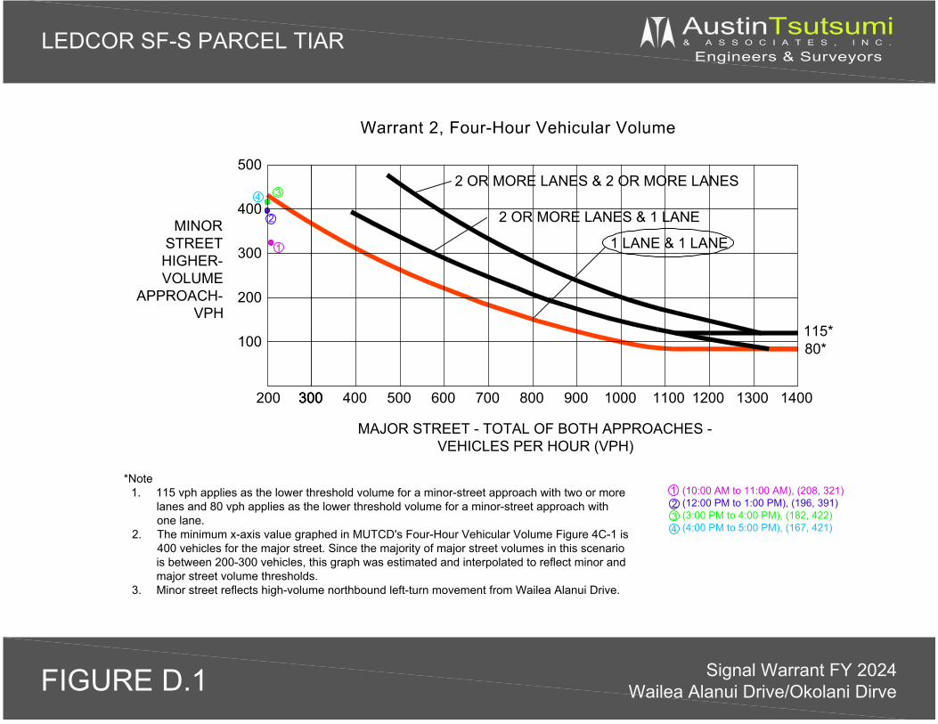
1234
2 OR MORE LANES & 2 OR MORE LANES
2 OR MORE LANES & 1 LANE
1 LANE & 1 LANE
(10:00 AM to 11:00 AM), (208, 321)(12:00 PM to 1:00 PM), (196, 391)(3:00 PM to 4:00 PM), (182, 422)(4:00 PM to 5:00 PM), (167, 421)
1
4 3
2MINORSTREETHIGHER-VOLUME
APPROACH-VPH
MAJOR STREET - TOTAL OF BOTH APPROACHES -VEHICLES PER HOUR (VPH)
Warrant 2, Four-Hour Vehicular Volume
*Note1. 115 vph applies as the lower threshold volume for a minor-street approach with two or more
lanes and 80 vph applies as the lower threshold volume for a minor-street approach withone lane.
2. The minimum x-axis value graphed in MUTCD's Four-Hour Vehicular Volume Figure 4C-1 is400 vehicles for the major street. Since the majority of major street volumes in this scenariois between 200-300 vehicles, this graph was estimated and interpolated to reflect minor andmajor street volume thresholds.
3. Minor street reflects high-volume northbound left-turn movement from Wailea Alanui Drive.
300 400 500 700 800 900 1200600 1100 14001000300300 1300
115*80*100
300
500
200
400
200
LEDCOR SF-S PARCEL TIAR AustinTsutsumi& A S S O C I A T E S , I N C .
Engineers & Surveyors
Signal Warrant FY 2024Wailea Alanui Drive/Okolani DirveFIGURE D.1
WAILEA COMMUNITY
ASSOCIATION DESIGN
REVIEW COMMITTEE
APPROVAL LETTER
APPENDIX
I
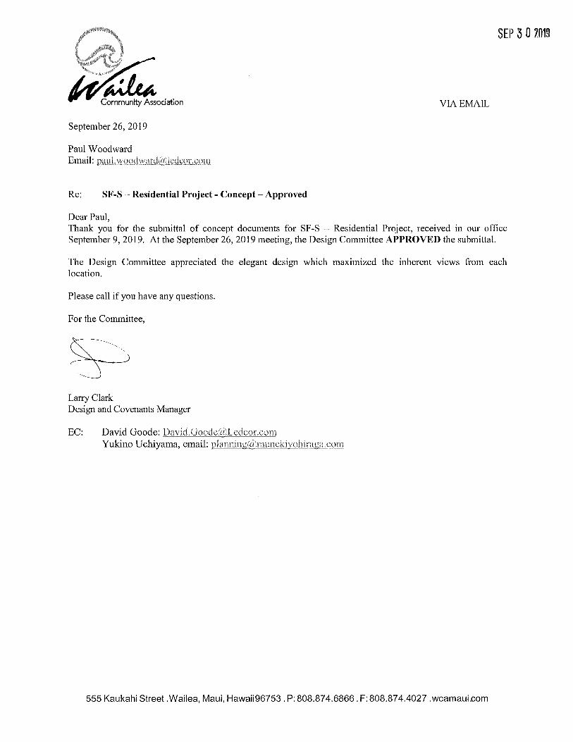
SEP 3 0 2019
VIA EMAIL
September 26, 2019
Paul Woodward
Email: =~~'~'""'"'-'"'""~""""-"""-'~-"-'-'-'
Re: SF-S - Residential Project - Concept-Approved
Dear Paul, Thank you for the submittal of concept documents for SF-S - Residential Project, received in our office September 9, 2019. At the September 26, 2019 meeting, the Design Committee APPROVED the submittal.
The Design Committee appreciated the elegant design which maximized the inherent views from each location.
Please call if you have any questions.
For the Committee,
Larry Clark Design and Covenants Manager
555 Kaukahi Street .Wailea, Maui, Hawaii96753. P: 808.874.6866. F: 808.874.4027 .wcamaui.com

Related Documents