4 ioN.._ P'"• D5.. 9 ., PLANNING DEPARTMENTDARRYLL D. M. WONG DAVID Y. ! GE II MAJOR G d _ 11 ADJUTANT GENERAL L CPe- t,„ 2014 DEC 1 r PH 2: 9e JOSEPH K. KIM BRIGADIER GENERAL DEPUTY ADJUTANT GENERAL STATE OF HAWAII DEPARTMENT OF DEFENSE OFFICE OF THE ADJUTANT GENERAL 3949 DIAMOND HEAD ROAD HONOLULU, HAWAII 96816- 4495 December 5, 2014 State of Hawaii Land Use Commission Department of Business, Economic Development& Tourism P. O. Box 2359 Honolulu, Hawaii 96804-2359 Daniel E. Orodenker, Executive Officer Subject: SP14- 404 JAS. W. GLOVER( Hawaii) Dear Mr. Orodenker: The Hawaii Army National Guard ( HIARNG) is in receipt of the November 19, 2014 letter regarding the Land Use Commission' s ( LUC) comments on docket SP14- 404 JAS. W. GLOVER. The HIARNG notes the LUC has requested the Final Archeological Inventory Survey and Monitoring Plan, Phase I, Keaukaha Military Reservation ( KMR), Hawaii Army National Guard Facility, Waiakea Ahupuaa, South Hilo District, Island of Hawaii, TMKs ( 3) 2- 1- 012: 003, 131 and ( 3) 2- 1- 013: 010, and any boundary surveys to the LUC, Hawaii County Windward Planning Commission, Mr. Randy Vitousek, and the State Office of Planning. The requested report is enclosed herewith. HIARNG notes regarding the point of contact for further questions regarding the boundary issue is Mr. Lloyd Maki, HIARNG Engineering Office at( 808) 733- 8441. If you have any further questions regarding our comments, please contact Ms. Dawn Hegger, Ecosystem Specialist( NEPA) at( 808) 672- 1284. Sincerely, orAPAPPF Marjean R. Stubbert Lieutenant Colonel, Hawaii Army National Guard Construction and Facilities Management Office Enclosure cc: Mr. Randy Vitousek, Attorney Hawaii County Windward Planning Commission State Office of Planning AA NNED EXHIBIT p 9

Welcome message from author
This document is posted to help you gain knowledge. Please leave a comment to let me know what you think about it! Share it to your friends and learn new things together.
Transcript
4
ioN.._P'"• D5.. 9 ., PLANNING DEPARTMENTDARRYLL D. M. WONG
DAVID Y. !GE
IIMAJOR
GENERALCO1rOFHAWAGOVERNORd _ 11 ADJUTANT GENERALLCPe-
t,„ 2014 DEC 1 r PH 2: 9eJOSEPH K. KIM
BRIGADIER GENERAL
DEPUTY ADJUTANT GENERALSTATE OF HAWAII
DEPARTMENT OF DEFENSEOFFICE OF THE ADJUTANT GENERAL
3949 DIAMOND HEAD ROADHONOLULU, HAWAII 96816-4495
December 5, 2014
State of Hawaii Land Use CommissionDepartment of Business, Economic Development& Tourism
P. O. Box 2359
Honolulu, Hawaii 96804-2359
Daniel E. Orodenker, Executive Officer
Subject: SP14- 404 JAS. W. GLOVER( Hawaii)
Dear Mr. Orodenker:
The Hawaii Army National Guard ( HIARNG) is in receipt of the November 19, 2014 letter regardingthe Land Use Commission' s ( LUC) comments on docket SP14-404 JAS. W. GLOVER.
The HIARNG notes the LUC has requested the Final Archeological Inventory Survey andMonitoring Plan, Phase I, Keaukaha Military Reservation ( KMR), Hawaii Army National Guard Facility,Waiakea Ahupuaa, South Hilo District, Island of Hawaii, TMKs (3) 2- 1- 012: 003, 131 and ( 3) 2- 1-
013: 010, and any boundary surveys to the LUC, Hawaii County Windward Planning Commission, Mr.Randy Vitousek, and the State Office of Planning. The requested report is enclosed herewith.
HIARNG notes regarding the point of contact for further questions regarding the boundary issue isMr. Lloyd Maki, HIARNG Engineering Office at( 808) 733- 8441. If you have any further questionsregarding our comments, please contact Ms. Dawn Hegger, Ecosystem Specialist( NEPA) at( 808) 672-1284.
Sincerely,
orAPAPPF
Marjean R. Stubbert
Lieutenant Colonel, Hawaii Army National GuardConstruction and Facilities Management Office
Enclosure
cc:
Mr. Randy Vitousek, AttorneyHawaii County Windward Planning CommissionState Office of Planning AA NNED
EXHIBIT p 9
Final
Archaeological Inventory Survey and Monitoring Plan,Phase I, Keaukaha Military Reservation (KMR)
Hawaii Army National Guard Facility
Waiakea Ahupua`a, South Hilo District, Island of Hawaii
TMKs: [3] 2- 1- 012: 003, 131 and [3] 2- 1- 013: 010
Prepared for
Hawaii Army National Guard, ENV Office
Prepared by
Momi Wheeler, B.S.,
Olivier Bautista, B.A.,
Sarah Wilkinson, B.A.,
and
Hallett H. Hammatt, Ph.D.
Cultural Surveys Hawaii, Inc.
Kailua, Hawaii
Job Code: WAIAKEA 10)
July 2014
Oahu Office Hawaii Office
P.O. Box 1114 P.O. Box 393
Kailua, Hawaii 96734www.culturalsurvevs. com
Pahoa, Hawaii 96778
Ph.: ( 808) 262- 9972 Ph: ( 808) 965-6478
Fax: ( 808) 262- 4950 Fax: ( 808) 965- 6582
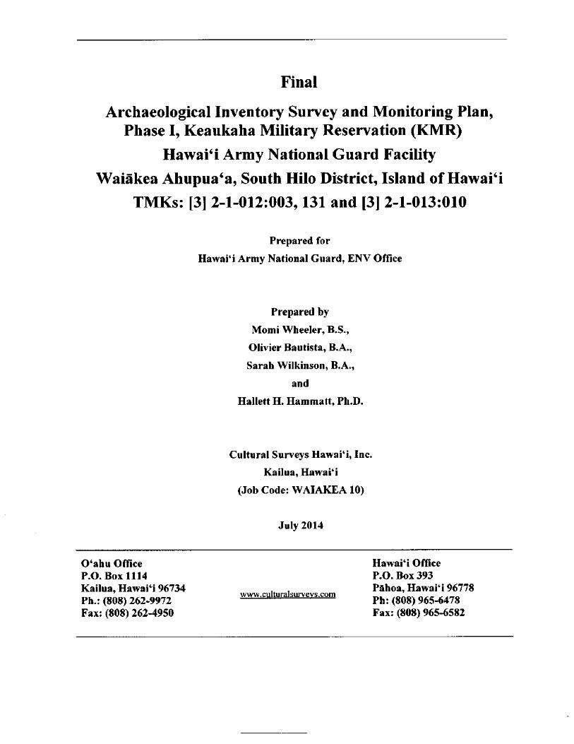
Cultural Surveys Hawai` i Job Code: WAIAKEA 10 Management Summary
Management Summary
Reference Archaeological Inventory Survey and Monitoring Plan, Phase I,
Keaukaha Military Reservation ( KMR) Hawaii Army NationalGuard Facility Waiakea Ahupua` a, South Hilo District, Island ofHawai` i, TMKs: [ 3] 2- 1- 012: 003, 131 and [ 3] 2- 1- 013: 010 ( Wheeler
et al. 2014)
Date July 2014Project Number (s) Cultural Surveys Hawaii (CSH) Job Code: WAIAKEA 10
Investigation The fieldwork for this project was carried out under archaeologicalPermit Number permit number 13- 06 issued by the State of Hawai` i Department of
Land and Natural Resources/ State Historic Preservation DivisionSHPD) per Hawai` i Administrative Rules ( HAR) § 13- 282
Project Location The Keaukaha Military Reservation ( KMR) is located in the town ofHilo on the windward side of Hawai` i Island. It is bound by GeneralLyman Field/Hilo International Airport on the northwest, a Countyquarry and borrow pit site on the southeast, the Airport Access Roadon the northeast, and undeveloped forest land on the southwest.
Land Jurisdiction The Hawai` i Army National Guard ( HIARNG)Agencies The State of Hawai` i Department of Land and Natural Resources/
State Historic Preservation Division (SHPD)
Project Description This archaeological study supports planning for potential long-rangeand Related improvements at the HIARNG KMR Facility. No specific
Ground improvements are known at this time.
Disturbance
Area of Potential The KMR encompasses TMKs: [ 3] 2- 1- 012: 003, 131 and [ 3] 2- 1-
Effect( APE) and 013: 010, for a total area of 504 acres. However, the project or surveyProject Acreage area encompassed vegetated portions of the KMR ( not currently
maintained). Therefore the project area comprises a 405. 3- acre
portion of the overall 509. 17—acre property ( refer to Figure 5), and
excludes TMK: [ 3] 2- 1- 012: 131 in its entiretyDocument Purpose Under Section 106 of the National Historic Preservation Act
NHPA), Federal agencies must consider the impact of a project onthe historic resource( s). Section 110 of the NHPA requires Federal
agencies to provide for the identification, evaluation and protection
of the agency' s historic properties. The proposed project is beingperformed under Section 106 of the NHPA in regard to new
construction projects. The purpose of this Phase I archaeological
inventory survey ( AIS) was to identify and document any surfacearchaeological features within the project area, evaluate the potential
for subsurface historic properties, and assess the potential for impact
to such sites. The study was also made to identify any sensitive areasthat may require further investigation or mitigation before the projectproceeds. This document is intended to facilitate the project' s
AIS, Phase I, KMR Hawai` i Army National Guard Facility, Waiakea, South Hilo, Hawai` i Island
TMKs:[ 3] 2- 1- 012: 003, 131 and[ 3] 2- 1- 013: 010
Cultural Surveys Hawaii Job Code: WAIAKEA 10 Management Summary
planning and support the project' s historic preservation reviewcompliance. Based on the findings of this Phase I study, culturalresource management recommendations are presented.
Fieldwork Effort The fieldwork component of the AIS was accomplished from 19
August 2013 to 24 September 2013 by CSH archaeologists AndrewSoltz, B.A., David Doig, B.A., Doug Inglis, B.A., Johnny Dudoit,B.A., Nigel Kingsbury, B.A., and Olivier Bautista, B.A. under the
general supervision of Hallett H. Hammatt, Ph. D. ( principal
investigator). The fieldwork required approximately 76 person- daysto complete.
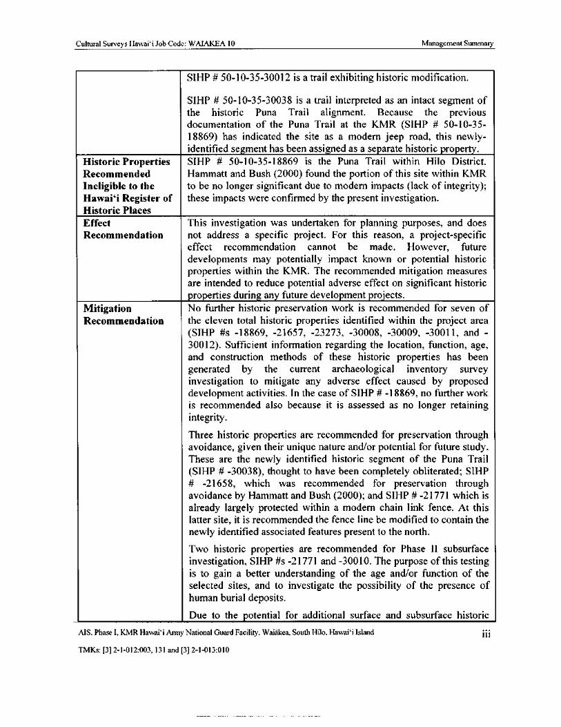
Number of Historic The pedestrian inspection identified 11 historic properties, of which
Properties five were previously identified and six are newly identified.Identified
Historic Properties With the exception of SIHP # 50- 10- 35- 18869, all of the historic
Recommended properties documented during the inventory survey fieldwork areEligible to the recommended eligible for the National Register of Historic Places
National Register ( NRHP) and the Hawai` i Register of Historic Places ( HRHP).
of Historic Places
and Hawaii SIHP # 50- 10- 35- 21657 is a C- shaped enclosure identified byRegister of Historic Hammatt and Bush (2000) likely associated with military occupation.Places
SIHP # 50- 10- 35- 21658 is a complex of five stacked stone ahu or
markers identified by Hammatt and Bush ( 2000) and associated withthe Puna Trail.
SIHP # 50- 10- 35- 21771 is a complex identified by Tolleson andGodby ( 2001) associated with late nineteenth century constructionalong the Puna Trail. In the current ALS, CSH documented eightadditional features at this site.
SIHP # 50- 10- 35- 23273 is a trail exhibiting historic modificationidentified by Escott and Tolleson (2002). Two associated agricultural
features were not relocated.
SIHP # 50- 10- 35- 30008 is a pre- Contact to historic era lava tube
shelter.
SIHP # 50- 10- 35- 30009 is a pre-Contact to historic era modified
outcrop complex used for temporary habitation.
SIHP # 50- 10- 35- 30010 is a complex with five features associated
with late nineteenth century construction along the Puna Trail.
SIHP # 50- 10- 35- 30011 is a late nineteenth century complex of twofeatures of indeterminate function.
AIS, Phase I. KMR Hawaii Army National Guard Facility, Waiakea, South Hilo, Hawaii Island 11
TMKs:[ 3] 2- 1- 012: 003, 131 and[ 3] 2- 1- 013: 010
Cultural Surveys Hawai` i Job Code: WAIAKEA 10 Management Summary
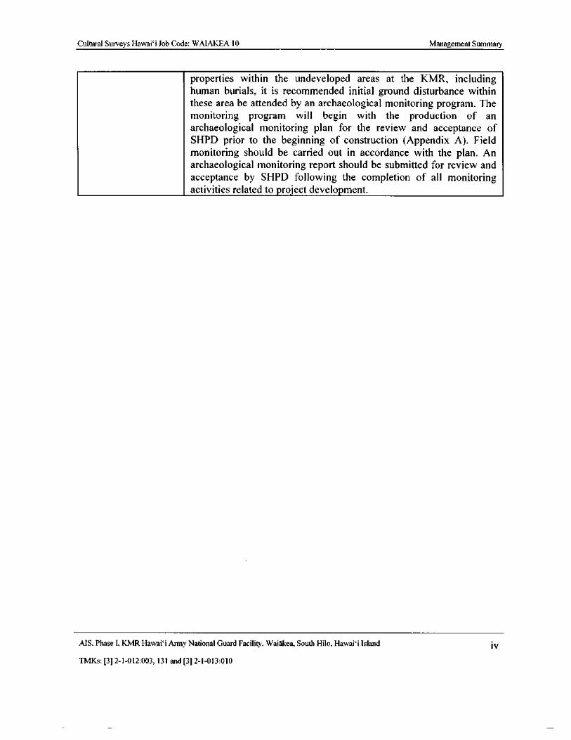
SIHP# 50- 10- 35- 30012 is a trail exhibiting historic modification.
SIHP # 50- 10- 35- 30038 is a trail interpreted as an intact segment of
the historic Puna Trail alignment. Because the previous
documentation of the Puna Trail at the KMR ( SIHP # 50- 10- 35-
18869) has indicated the site as a modern jeep road, this newly-identified segment has been assigned as a separate historic property.
Historic Properties SIHP # 50- 10- 35- 18869 is the Puna Trail within Hilo District.
Recommended Hammatt and Bush ( 2000) found the portion of this site within KMR
Ineligible to the to be no longer significant due to modern impacts ( lack of integrity);Hawaii Register of these impacts were confirmed by the present investigation.Historic Places
Effect This investigation was undertaken for planning purposes, and doesRecommendation not address a specific project. For this reason, a project-specific
effect recommendation cannot be made. However, future
developments may potentially impact known or potential historicproperties within the KMR. The recommended mitigation measures
are intended to reduce potential adverse effect on significant historic
properties during any future development projects.Mitigation No further historic preservation work is recommended for seven of
Recommendation the eleven total historic properties identified within the project area
SIHP # s - 18869, - 21657, - 23273, - 30008, - 30009, - 30011, and -
30012). Sufficient information regarding the location, function, age,and construction methods of these historic properties has been
generated by the current archaeological inventory survey
investigation to mitigate any adverse effect caused by proposeddevelopment activities. In the case of SIHP # - 18869, no further work
is recommended also because it is assessed as no longer retainingintegrity.
Three historic properties are recommended for preservation through
avoidance, given their unique nature and/ or potential for future study.These are the newly identified historic segment of the Puna TrailSIHP # - 30038), thought to have been completely obliterated; SIHP
21658, which was recommended for preservation through
avoidance by Hammatt and Bush ( 2000); and SIHP# - 21771 which is
already largely protected within a modern chain link fence. At thislatter site, it is recommended the fence line be modified to contain the
newly identified associated features present to the north.
Two historic properties are recommended for Phase II subsurface
investigation, SIHP# s - 21771 and - 30010. The purpose of this testingis to gain a better understanding of the age and/or function of theselected sites, and to investigate the possibility of the presence ofhuman burial deposits.
Due to the potential for additional surface and subsurface historic
MS. Phase I, KMR Hawaii Army National Guard Facility, Waiakea, South Hilo, Hawaii Island
TMKs:[ 3] 2- 1- 012:003, 131 and[ 3] 2- 1- 013: 010
Cultural Surveys Hawaii Job Code: WAIAKEA 10 Management Summary
properties within the undeveloped areas at the KMR, includinghuman burials, it is recommended initial ground disturbance within
these area be attended by an archaeological monitoring program. Themonitoring program will begin with the production of an
archaeological monitoring plan for the review and acceptance ofSHPD prior to the beginning of construction ( Appendix A). Field
monitoring should be carried out in accordance with the plan. Anarchaeological monitoring report should be submitted for review andacceptance by SHPD following the completion of all monitoringactivities related to project development.
AIS, Phase I, KMR Hawai` i Army National Guard Facility, Waiakea, South Hilo, Hawaii Island iV
TMKs:[ 3] 2- 1- 012: 003, 131 and[ 3] 2- 1- 013: 010
Cultural Surveys Hawaii Job Code: WAIAKEA 10
Table of Contents
Management Summary
Section 1 Introduction 1
1. 1 Project Background 1
1. 2 Scope of Work 1
1. 3 Environmental Setting 9
1. 3. 1 Natural Environment 9
1. 3. 2 Built Environment 9
Section 2 Methods 13
2. 1 Field Methods 13
2. 2 Laboratory Methods 13
2. 3 Document Review 13
2. 4 Consultation 14
Section 3 Background Research 15
3. 1 Traditional Background 15
3. 1. 1 The Epic Tale of Hi` iakaikapoliopele 15
3. 1. 2 Other Myths and Legends 18
3. 2 Historical Background 21
3. 2. 1 Early 1800s 25
3. 2. 2 1820s 25
3. 2. 3 1830s 26
3. 2. 4 The Mahele 28
3. 2. 5 Late 1800s 28
3. 2. 6 Early to Mid- 1900s 29
3. 2. 1 The Hilo Airport and the Militarization of Waiakea 34
3. 2. 2 Mid- 1900s to the Present 37
Section 4 Previous Archaeological Research 39
4. 1 Heiau of Waiakea 39
4. 2 Puna Trail 41
4. 3 Previous Archaeological Studies in the Vicinity of the KMR 42
4. 3. 1 Past Archaeological Studies at KMR 52
4. 3. 2 Historic Properties Previously Documented at KMR 53
4. 4 Background Summary and Predictive Model 58
Section 5 Results of Fieldwork 60
5. 1 Survey Findings 60
5. 2 Historic Properties Descriptions 65
5. 2. 1 SIHP# 50- 10- 35- 18869 65
5. 2. 2 SIHP# 50- 10- 35- 21657 68
5. 2. 3 SIHP# 50- 10- 35- 21658 71
5. 2. 4 SIHP# 50- 10- 35- 21771 77
5. 2. 5 SIHP# 50- 10- 35- 23273 95
5. 3 Description of Newly Identified Sites 99
5. 3. 1 SIHP# 50- 10- 35- 30008 99
AIS, Phase I, KMR Hawai` i Army National Guard Facility, Waiakea, South Hilo, Hawai` i Island V
TMKs:[ 3] 2- 1- 012: 003, 131 and[ 3] 2- 1- 013: 010
Cultural Surveys Hawaii Job Code: WAIAKEA 10
5. 3. 2 SIHP# 50- 10- 35- 30009 102
5. 3. 3 SIHP# 50- 10- 35- 30010 110
5. 3. 4 SIHP# 50- 10- 35- 30011 118
5. 3. 5 SIHP# 50- 10- 35- 30012 121
5. 3. 6 SIHP# 50- 10- 35- 30038 124
Section 6 Results of Laboratory Analysis 126
6. 1 Artifacts Collected from the Surface at SIHP# 50- 10- 35- 30010 126
6. 1. 1 Bottles 126
6. 1. 2 Modified Water Worn Basalt Cobbles 126
6. 2 Discussion 132
Section 7 Summary and Interpretation 133
Section 8 Significance Assessments 135
Section 9 Project Effect and Mitigation Recommendations 140
9. 1 Project Effect 140
9. 2 Mitigation Recommendations 140
9. 2. 1 Historic Properties at which Sufficient Data Has Been Recovered 140
9. 2. 2 Preservation through Avoidance 140
9. 2. 3 Phase II Subsurface Investigation 142
9. 2. 4 Archaeological Monitoring 142
9. 3 Disposition of Materials 142
Section 10 References Cited 143
Appendix A Phase I Archaeological Monitoring Plan 151
Introduction 152
Scope of Work 152
Results of Phase I AIS and Recommendations 153
Archaeological Monitoring Provisions 153
Specific Provisions 154
Research Objective 156
Appendix B CSH Site Inventory Records and Plan View Maps 157
SIHP# 50- 10- 35- 18869( CSH- 003) 157
SIHP# 50- 10- 35- 21771 ( Features H to L= CSH- 005) 159
SIHP# 50- 10- 35- 23273 175
SIHP# 50- 10- 35- 30008( CSH- 001) 177
SIHP# 50- 10- 35- 30009 ( CSH- 002) 179
SIHP# 50- 10- 35- 30010( CSH-004) 189
SIHP# 50- 10- 35- 30011 ( CSH- 006) 193
SIHP# 50- 10- 35- 30012( CSH- 007) 196
Appendix C CSH Photo Logs 198
Appendix D CSH GPS Logs 213
Appendix E SIHP Site Number Requests 221
MS, Phase I, KMR Hawaii Army National Guard Facility, Waiakea, South Hilo, Hawai` i Island vi
TMKs:[ 3] 2- 1- 012:003, 131 and[ 3] 2- 1- 013: 010
Cultural Surveys Hawai` i Job Code: WAIAKEA 10
List of Figures
Figure 1. Portion of the 1995 Hilo USGS 7. 5- minute Topographic Quadrangle, showing thelocation of the Keaukaha Military Reservation (KMR) 2
Figure 2. Tax Map Key (TMK): [3] 2- 1- 012, showing a portion of the KMR (Hawai` i Tax MapKey Service 2010) 3
Figure 3. TMK: [3] 2- 1- 013, showing a portion of the KMR( Hawai` i Tax Map Key Service2010) 4
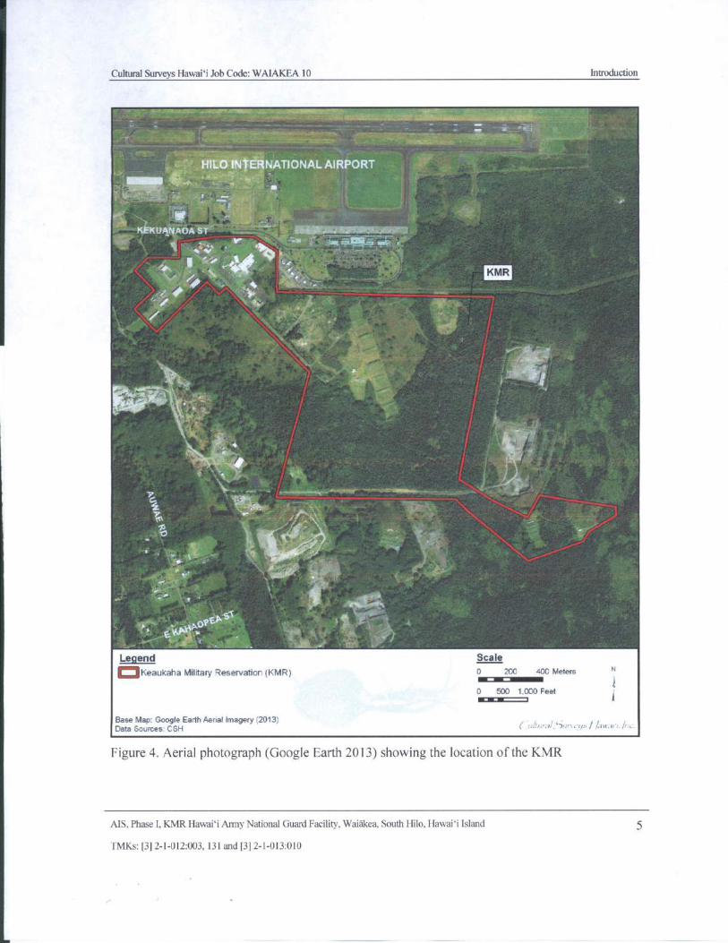
Figure 4. Aerial photograph (Google Earth 2013) showing the location of the KMR 5
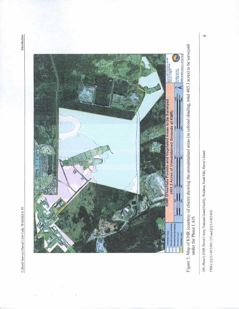
Figure 5. Map of KMR( courtesy of client) showing the unmaintained areas ( in colored shading,total 405. 3 acres) to be surveyed under the Phase I AIS 6
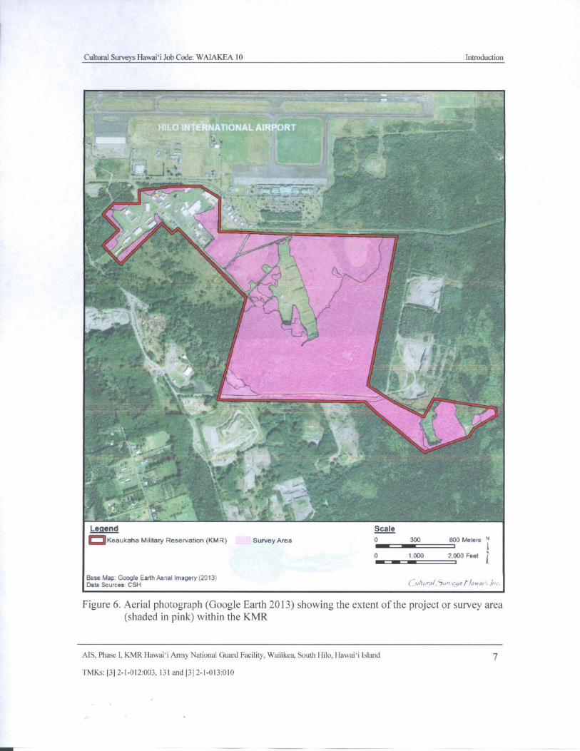
Figure 6. Aerial photograph (Google Earth 2013) showing the extent of the project or survey areashaded in pink) within the KMR 7
Figure 7. Aerial photograph ( Google Earth 2013) overlain with soil survey data ( Sato et al.1973), showing the land and sediment types within the proposed project area 10
Figure 8. KMR map showing the locations of various buildings, ranges and other named areaswithin the KMR boundary ( courtesy of client) 11
Figure 9. Aerial photograph ( Google Earth 2013) showing the extent of the undisturbed forestareas within KMR( shaded in green, as indicated by the client Map of KMR; see Figure5) 12
Figure 10. Settlement zone map reprinted from McEldowney ( 1979: 64), showing the location ofthe KMR( in red) within Zone II 22
Figure 11. 1851 map of Waiakea by Webster( RM 524) showing the location of the KMR( inred) in relation to the " Hala Woods" and the " Pana`ewa Woods"; note also the depiction
of the " Road to Puna" 23
Figure 12. Map of Hawai` i Island showing the route of Reverend William Ellis and theagricultural zones delineated by Newman (Newman 2000) 27
Figure 13. Portion of Walter A. Wall' s 1886 map of Hawai` i ( RM 1438), showing theapproximate location of the proposed project area( in red) adjacent to the lands of the
Waiakea Mill Plantation" 30
Figure 14. Portion of the 1995 Hilo USGS 7. 5- minute Topographic Quadrangle, overlain withthe Waiakea Mill Company Map ( in Conde and Best 1973: 120), showing the location ofKMR in relation to the limits of the plantation as of 1933 31
Figure 15. Portion of the 1915 Map of Waiakea Government Tract( HTS Plat 775) by W.E. Wall,showing the approximate location of the proposed project area in relation to featuresdiscussed in the text 33
Figure 16. Aerial photograph, 2922- 1 Hilo Airport Hawai` i, Photo section A.C. 6- 25- 29, U.S.
Army Museum of Hawai` i ( Judd 1971) 35
Figure 17. 1977 USGS Orthophoto, showing the extent of development in the vicinity of theproposed project area 38
Figure 18. Locations of heiau documented by John F. G. Stokes in Hilo District( Stokes and Dye1991: 155) 40
Figure 19. Portion of the 1995 Hilo USGS 7. 5- minute Topographic Quadrangle, showingprevious archaeological studies within and in the vicinity of the KMR 43
MS, Phase I, KMR Hawai`i Army National Guard Facility, Waiakea, South Hilo, Hawai` i Islandvii
TMKs:[ 3] 2- 1- 012: 003, 131 and[ 3] 2- 1- 013: 010

Cultural Surveys Hawai` i Job Code: WAIAKEA 10
Figure 20. Aerial photograph ( Google Earth 2013) showing the approximate locations of historicproperties previously documented within the KMR( note: the locations and extent of thedepicted historic properties are shown as understood from previous archaeological
reports) 56
Figure 21. Adapted GIS database screen shot showing the potential location of SIHP# - 18844,
visible as a red dot near the center of photograph ( Courtesy of SHPD) 57
Figure 22. Photo showing the disturbed vicinity of SIHP# - 18844; view to north 60
Figure 23. Portion of the 1995 Hilo USGS 7. 5- minute Topographic Quadrangle, showing thelocations of historic properties relocated or newly documented during the AIS within theKMR 61
Figure 24. Aerial photograph ( Google Earth 2013) showing the locations of historic propertiesrelocated or newly documented during the AIS within the KMR 62
Figure 25. Aerial photograph ( Google Earth 2013) showing the locations of historic propertiesrelocated or newly documented during the AIS, in relation to both the disturbed andundisturbed portions of the survey area 63
Figure 26. Photograph of a portion of SIHP# - 18869 within KMR, view to east 67
Figure 27. Photograph of a portion of SIHP# - 18869 within KMR, view to west 67
Figure 28. Plan view map of SIHP# - 21657 from Hammatt and Bush (2000: 30) 69
Figure 29. Photograph of SIHP # - 21657, view to southeast 70
Figure 30. Plan view map of SIHP # -21658 from Hammatt and Bush ( 2000: 32) 72
Figure 31. Photograph of SIHP #- 21658 Feature A, view to east 74
Figure 32. Photograph of SIHP # -21658 Feature B, view to east 74
Figure 33. Photograph of SIHP # -21658 Feature C, view to south 75
Figure 34. Photograph of SIHP # -21658 Feature D, view to west 75
Figure 35. Photograph of SIHP # -21658 Feature E, view to north 76
Figure 36. Plan view map of SIHP #- 21771; note, top of map is oriented to 13 degress true north78Figure 37. Overview photograph of SIHP# - 21771, view to northwest 79
Figure 38. Photograph of SIHP #- 21771 Feature A, view to east 79
Figure 39. Plan view map showing SIHP # - 21771 Features A, E, and G 80
Figure 40. Plan view map showing SIHP # - 21771 Features B, C, and D and the location of
Tolleson and Godby' s ( 2001) TU- 1 at Feature C 82
Figure 41. Photograph of SIHP # -21771 Feature B, view to northwest 83
Figure 42. Photograph of grinding wheel near SIHP # - 21771 Features B and C, view to south 83
Figure 43. Photograph of SIHP#- 21771 Feature C, view to northwest 84
Figure 44. Photograph of SIHP# - 21771 Feature C, showing the upright slab located along thenorthern end of the feature, view to northwest 84
Figure 45. Photograph of SIHP # - 21771 Feature D, view to west 85
Figure 46. Photograph of SIHP# - 21771 Feature E, showing the retaining wall along the westernbank of the depression, view to north 86
Figure 47. Photograph of a portion of SIHP # -21771 Feature E, showing the northern stonecauseway crossing the depression, view to south 87
Figure 48. Photograph of SIHP# - 21771 Feature E, showing the constructed pit within thedepression, view to north 87
Figure 49. Plan view map of SIHP #- 21771 Feature F 88
Figure 50. Photograph of SIHP # - 21771 Feature F, view to northwest 89
MS, Phase I, KMR Hawai` i Army National Guard Facility, Waiakea, South Hilo, Hawaii Island viii
TMKs:[ 3] 2- 1- 012:003, 131 and[ 3] 2- 1- 013: 010
Cultural Surveys Hawaii Job Code: WAIAKEA 10
Figure 51. Photograph of SIHP # -21771 Feature G, view to southwest 89
Figure 52. Plan view map of SIHP# - 21771 Features H through L 91
Figure 53. Photograph of SIHP # -21771 Feature H, view to north 92
Figure 54. Photograph of SIHP # - 21771 Feature I, view to east 92
Figure 55. Photograph of SIHP # - 21771 Feature J, view to northwest 93
Figure 56. Photograph of SIHP # - 21771 Feature K, view to northwest 93
Figure 57. Photograph of SIHP # -21771 Feature L, view to northeast 94
Figure 58. Plan view map of SIHP#- 23273 97
Figure 59. Photograph of a portion of SIHP # -23273, view to southwest 98
Figure 60. Plan view map of SIHP # - 30008 100
Figure 61. Photograph of SIHP # - 30008, lava tube opening, view to south 101
Figure 62. Photograph of SIHP# - 30008, interior of tube showing the constructed terrace, viewto northeast 101
Figure 63. Plan view map of SIHP # - 30009 103
Figure 64. Overview photograph of SIHP# - 30009 Feature A, outcrop surface, view to east 104
Figure 65. Photograph of SIHP # - 30009 Feature A, rock wall, view to north 104
Figure 66. Detail plan view map of SIHP # - 30009 Feature B interior 105
Figure 67. Photograph of SIHP # - 30009 Feature B, lava tube opening, view to west 106
Figure 68. Photograph of SIHP #- 30009 Feature B, paved area at entrance, view to southwestl 06
Figure 69. Detail plan view map of SIHP# - 30009 Feature C interior 108
Figure 70. Photograph of SIHP # - 30009 Feature C, lava tube entrance, view to north 109
Figure 71. Photograph of SIHP # - 30009 Feature C, paved area at entrance, view to east 109
Figure 72. Plan view map of SIHP #- 30010 111
Figure 73. Photograph of SIHP # - 30010 Feature A, view to southeast 112
Figure 74. Photograph of SIHP# - 30010 Feature A, ART 4 ( modified waterworn basalt cobble,
not collected) in situ, view to east 112
Figure 75. Photograph of SIHP# - 30010 Feature B, view to east 113
Figure 76. Photograph showing a horseshoe located on the surface at SIHP #- 30010 Feature B
not collected), view to northeast 113
Figure 77. Plan view map of SIHP# - 30010 Feature C 115
Figure 78. Photograph of SIHP # - 30010 Feature C, view to southeast 116
Figure 79. Photograph of SIHP # - 30010 Feature D, view to northwest 116
Figure 80. Photograph of SIHP # - 30010 Feature E, view to north 117
Figure 81. Plan view map of SIHP # - 30011 119
Figure 82. Photograph of SIHP# - 30011 Feature A, view to south 120
Figure 83. Photograph of SIHP# - 30011 Feature B, view to south 120
Figure 84. Plan view map of SIHP # - 30012 122
Figure 85. Photograph of SIHP# - 30012, view to northeast 123
Figure 86. Photograph of the newly identified remnant portion of the historic Puna Trail ( SIHP #30038), view to east 125
Figure 87. Plan view map of the newly identified remnant portion of the historic Puna TrailSIHP# - 30038) 125
Figure 88. Photograph of Accession# 1, historic bottle collected from surface at SIHP # - 30010
Feature A 128
Figure 89. Photograph of Accession# 1, showing embossed markings 128
MS, Phase I, KMR Hawaii Army National Guard Facility, Waiakea, South Hilo, Hawai` i Island ix
TMKs:[ 3] 2- 1- 012: 003, 131 and[ 3] 2- 1- 013: 010
Cultural Surveys Hawaii Job Code: WAIAKEA 10
Figure 90. Photograph of Accession# 2, historic bottle collected from surface at SIHP # - 30010
Feature A 129
Figure 91. Photograph of Accession # 3, modified basalt waterworn cobble collected from surface
at SIHP # - 30010 Feature A, showing indentations 130
Figure 92. Photograph of Accession #3, modified basalt waterworn cobble collected from surface
at SIHP#- 30010 Feature A, showing flattened base 130
Figure 93. Photograph of Accession# 4, modified basalt waterworn cobble collected from
surface at SIHP # - 30010 Feature A, showing exposed void within indentation 131
Figure 94. Photograph of Accession #4, modified basalt waterworn cobble collected from surface
at SIHP #- 30010 Feature A, showing battering marks on end 131
Figure 95. Plan map of SIHP# - 21771, showing the recommended extension of the protectivechain link fence line ( dashed line) 141
List of Tables
Table 1. Legends of Waiakea, Hawai` i ( Ching 1989) 19
Table 2. Archaeological Studies Conducted Within and in the Immediate Vicinity of the KMR 44Table 3. Historic Properties Previously Documented Within the KMR 54
Table 4. Summary of Historic Properties Documented During the Phase I AIS 64
Table 5. Artifacts Collected from the Surface of SIHP # 50- 10- 35- 30010 127
Table 6. Historic Property Significance Criteria and Recommended Treatment 136
MS, Phase I, KMR Hawaii Army National Guard Facility, Waiakea, South Hilo, Hawaii Island x
TMKs:[ 3] 2- 1- 012: 003, 131 and[ 3] 2- 1- 013: 010
Cultural Surveys Hawaii Job Code: WAIAKEA 10 Introduction
Section 1 Introduction
1. 1 Project Background
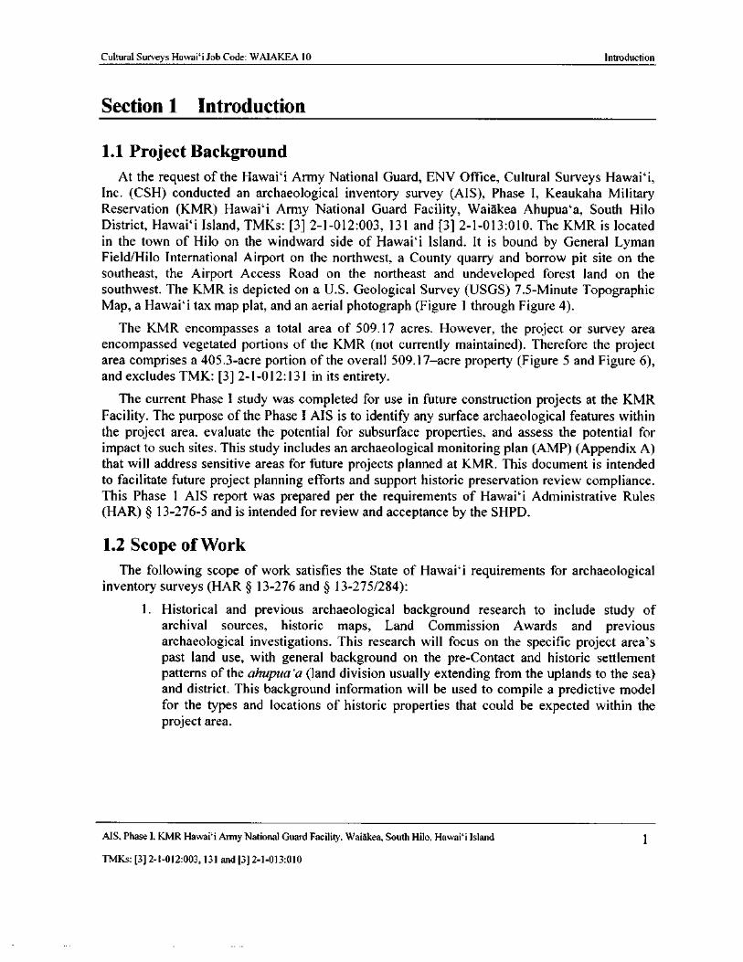
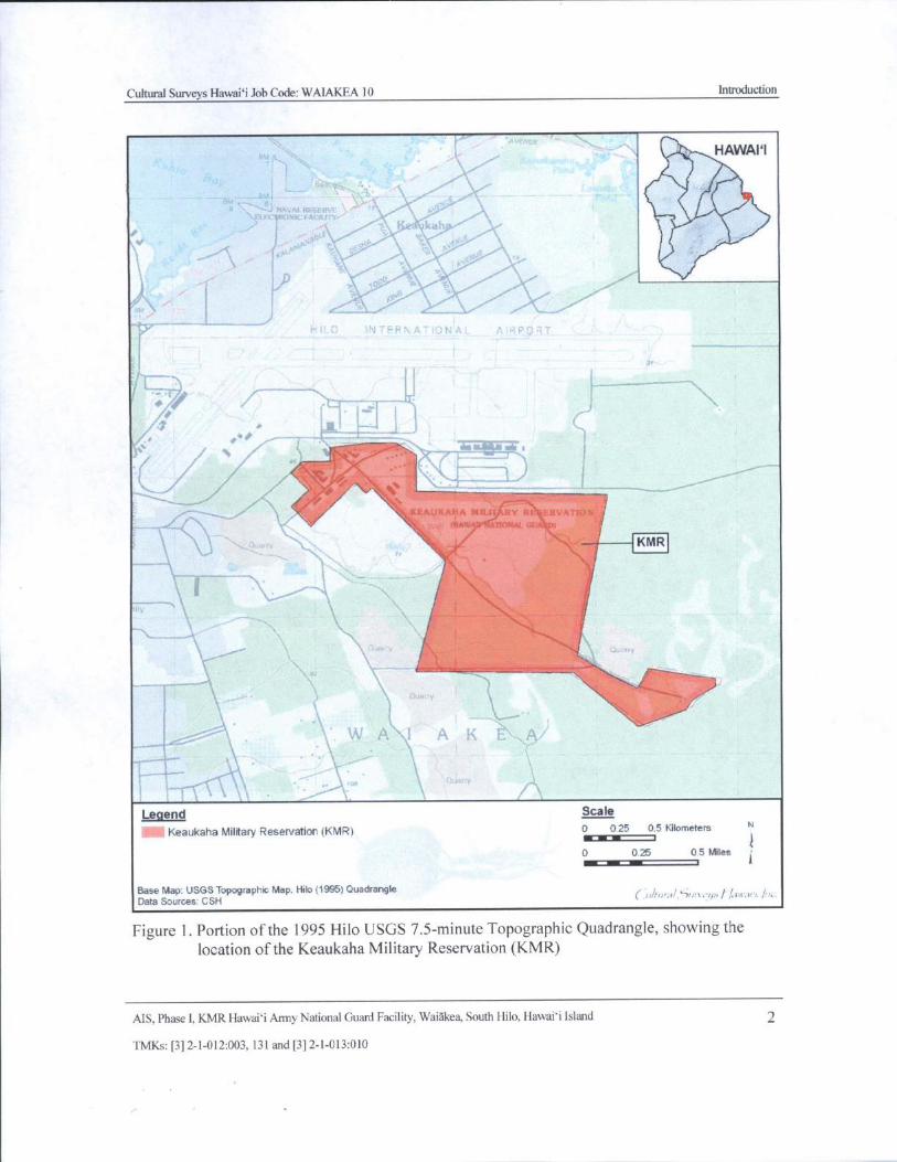
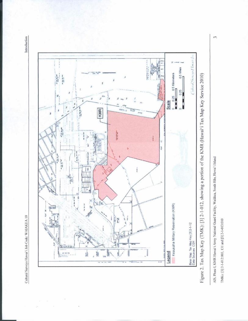
At the request of the Hawaii Army National Guard, ENV Office, Cultural Surveys Hawaii,Inc. ( CSH) conducted an archaeological inventory survey ( AIS), Phase I, Keaukaha MilitaryReservation ( KMR) Hawaii Army National Guard Facility, Waiakea Ahupua`a, South HiloDistrict, Hawaii Island, TMKs: [ 3] 2- 1- 012: 003, 131 and [ 3] 2- 1- 013: 010. The KMR is located
in the town of Hilo on the windward side of Hawaii Island. It is bound by General LymanField/Hilo International Airport on the northwest, a County quarry and borrow pit site on thesoutheast, the Airport Access Road on the northeast and undeveloped forest land on the
southwest. The KMR is depicted on a U. S. Geological Survey ( USGS) 7. 5- Minute TopographicMap, a Hawai` i tax map plat, and an aerial photograph (Figure 1 through Figure 4).
The KMR encompasses a total area of 509. 17 acres. However, the project or survey areaencompassed vegetated portions of the KMR ( not currently maintained). Therefore the project
area comprises a 405. 3- acre portion of the overall 509. 17—acre property ( Figure 5 and Figure 6),and excludes TMK: [ 3] 2- 1- 012: 131 in its entirety.
The current Phase I study was completed for use in future construction projects at the KMRFacility. The purpose of the Phase I AIS is to identify any surface archaeological features withinthe project area, evaluate the potential for subsurface properties, and assess the potential for
impact to such sites. This study includes an archaeological monitoring plan (AMP) (Appendix A)
that will address sensitive areas for future projects planned at KMR. This document is intended
to facilitate future project planning efforts and support historic preservation review compliance.This Phase 1 AIS report was prepared per the requirements of Hawaii Administrative Rules
HAR) § 13- 276- 5 and is intended for review and acceptance by the SHPD.
1. 2 Scope ofWork
The following scope of work satisfies the State of Hawaii requirements for archaeologicalinventory surveys ( HAR § 13- 276 and § 13- 275/ 284):
1. Historical and previous archaeological background research to include study ofarchival sources, historic maps, Land Commission Awards and previous
archaeological investigations. This research will focus on the specific project area' s
past land use, with general background on the pre- Contact and historic settlement
patterns of the ahupua` a ( land division usually extending from the uplands to the sea)and district. This background information will be used to compile a predictive model
for the types and locations of historic properties that could be expected within theproject area.
MS, Phase I, KMR Hawaii Army National Guard Facility, Waiakea, South Hilo, Hawai` i Island 1
TMKs:[ 3] 2- 1- 012: 003, 131 and[ 3] 2- 1- 013: 010
Cultural Surveys Hawaii Job Code: WAIAKEA 10 Introduction
k, HAWAII
1Rm -. °:-, 11
fa ,,, Nt4VAip „,•\ ,, 4,
ACFL
kali
0*ti 11` i"t R
r--gw f
O.)i-. 1-, i _: N fit.. !
1-
s'vr
K.
a O.k7.)
fi_________::_
y//:
s• " 7,-- i .
KMR
N.
WA 1 A K \-., A/
Legend Scale
Keaukaha Military Reservation( KMR) 0 0.25 0.5 Kilometers N
EniriEi
0 0.25 0.5 Miles •
Base Map: USGS Topographic Map, Hilo( 1995) QuadrangleData Sources CSH
r:.,,,•. d,`7,.- 1, r;, 1/ air,8' r./:::..
Figure 1. Portion of the 1995 Hilo USGS 7. 5- minute Topographic Quadrangle, showing thelocation of the Keaukaha Military Reservation ( KMR)
AIS, Phase I, KMR Hawaii Army National Guard Facility, Waiakea, South Hilo, Hawaii Island 2
TMKs:[ 3] 2- 1- 012:003, 131 and[ 3] 2- 1- 013: 010
0 cn
It
8ti
Iz ----r -.. ....
wi 4„1 } f Aa) ' 9...11 Cl.
r- C)
1, 0'. il• ' i',., ! ir 0E
4.--, 1I t I I1! a 1 2
4.)1
i I i . 1 2 ', 11- C.)
A - . 1y
i1 ; i.r)N i--
V Ii .._.-" Cl'. ' 1 etliii
a I I.)
t-:::,-- d . 1 " d . 1 a I1
1 r-,1v
j ii al d. I
i xal
1 elt I ''-.• - , t
CI
t
c4
25-"' ! , t , 5; _ ii ._r_:. , ,
1 - ..- t- t- . n4
1 gp ... ,
4\,-
11 ; . i , -_-,_?_ , - • $ 0 _
v/ 4
00.s., . I
I rn
0cd
i 14 v1 ccn
TMt X
14 \,i‘
cci
I. 11 r
CeC*4
fm % i.4 / '
a T1c4
cs
e : ' i,.. ,c)
c.
1.. 4s' t' ' • •
Tvt.,: tca
7:3c,
A L enP a"G14 1", ,- 1! 12 C.4 CD ••
n. ;-: -a0Ow
L- ei 0
1 • I .-v*-2.
2 11Iligri--.
Z ^Igi _-
r- cu rn7,-;,-
1C-.)
lidfaili:':k'r•.,:c ' . 4
7___- -1f m co 0) tl)
4.$. 4: 47.=:, AIL , A' II ____
2x2n a —
7,- 1 :
r0d.-
MI 1 3 Aw
2 g cl O'i
cu
CJ
1) E,A
5
Ewr-
b•
zt v ' r h
i...!',Ai_ • Y
meq
o
tHN
0
0
i ....y
1.+
47
Nl ,
yr r ', ' l O^uf
4 1 i. i
i1Ai'f IIno o
eVx
N ' 1
i; 0.
I
ct
i 'ice } 1
MA%' A r3 .-CS
Q,
I x.
44..t,!;:,
7o O
yt.--,...- ,:
y*i
t !
to
oS .: i y //
J
a' F10 d ,—,
rnj. , / ./
p i.
CD2 o ClJ
co
xi' r T 1•‘-. ' CIn` .. M
5'4 a
N 1 O
COm03o H 4
r, N
enu
Etao w
Cultural Surveys Hawaii Job Code: WAIAKEA 10 Introduction
x,--. x..44=, - ri- rurmew ,: rn
7s ,.,..
HILO INTERNATIONAL AIRPORT Iff
4.
ira
PirK# KUANAOAST
r •
1101.
MEI
1.,
r
i
a ' K,l
G 14r
f
to11-
1.:"•'
II r^*,
NAOpEp.Sj
Legend Scale
CMKeaukaha Military Reservatior( KMR) 0 200 400 Meters N
0® 0 Feetj
Base Map: Google Earth Aerial Imagery( 2013)Data Sources' CSI- 1
ul ural,`7a. r,<• q.,/ 1airrar:./.: .
Figure 4. Aerial photograph ( Google Earth 2013) showing the location of the KMR
AIS, Phase I, KMR Hawaii Army National Guard Facility, Waiakea, South Hilo, Hawaii Island 5
TMKs:[ 3] 2- 1- 012:003, 131 and[ 3] 2- 1- 013: 010
o
D
8 O6)
O
r
t
ss z
Fie 4rt '« I
317Sn j
r'.`"'' f fA+t,
4.•.•,4.14.0,:t' C' C i•..' . , k71,4,y i S4,
gra SFpire V
6
I
o>rtv
t c ce I to
41)
12eo
O
tr' 4 0 O
v (9 u)
i SLS \ 7
c
i R-`. y.
t F } r i ,` Is
O ci k
f.
1
r. V, .f e. k 4 0 y N
r .
f1 s
fJ
fy V y
ih
r `., '
09
O M1•
tom•,i•
Cyt 1'' t a ! Q pp
t
ri"el-
4,11(
iiii0040L
4,,\', * 0ti >, 4 1 ' ,40r.f,, 4rO
Q Y O
t + P3fj
ziliN34. 1.1'....„.;-.',;••
i, t ,.
KY. 46 f1 0U44qr r ZR" ',
3 d•. t
Ot $ C
am
3 t * 'a. 'y
J1CMr
ewa ver 4, . O O
IN
N
c,i' iU G4 C
Cultural Surveys Hawai` i Job Code: WAIAKEA 10 Introduction
s
a,
7877 /
I',1,
2liik '. 1it
r
N '''`''''''.--:,-,,,,if------' --------- ---z-•=-'
J
w
Legend Scale
oKeaukaha Military Reservation( KMR) Survey Area 0 300 600 Meters "
0 1 000 2, 000 Feet jsttti — — t 1
Base Map: Google Earth Aerial Imagery( 2013)Data Sources: CSH uiturd,5un-c40/-/ awai';, Arc.
Figure 6. Aerial photograph( Google Earth 2013) showing the extent of the project or survey areashaded in pink) within the KMR
AIS, Phase I, KMR Hawaii Army National Guard Facility, Waiakea, South Hilo, Hawaii Island 7
TMKs:[ 3] 2- 1- 012:003, 131 and[ 3] 2- 1- 013: 010
Cultural Surveys Hawaii Job Code: WAIAKEA 10 Introduction
2. A complete ( 100%) systematic pedestrian inspection of the project area to identify anypotential surface historic properties. Surface historic properties will be recorded withan evaluation of age, function, interrelationships and significance. Documentation willbe provided using warranted, limited controlled excavation of select sites and/ orfeatures.
3. Based on the project area' s environment and the results of background research,
subsurface testing with a combination of hand and backhoe excavation may be used toidentify and document subsurface historic properties that would not be located bysurface pedestrian inspection. Appropriate samples from these excavations will beanalyzed for cultural and chronological information. All subsurface historic properties
identified will be documented to the extent possible, including geographic extent,content, function/derivation, age, interrelationships and significance.
4. As appropriate, consultation with knowledgeable individuals regarding the projectarea' s history, past use, and the function and age of the historic properties documentedwithin the project area.
5. As appropriate, laboratory work to process and gather relevant environmental and/ orarchaeological information from collected samples.
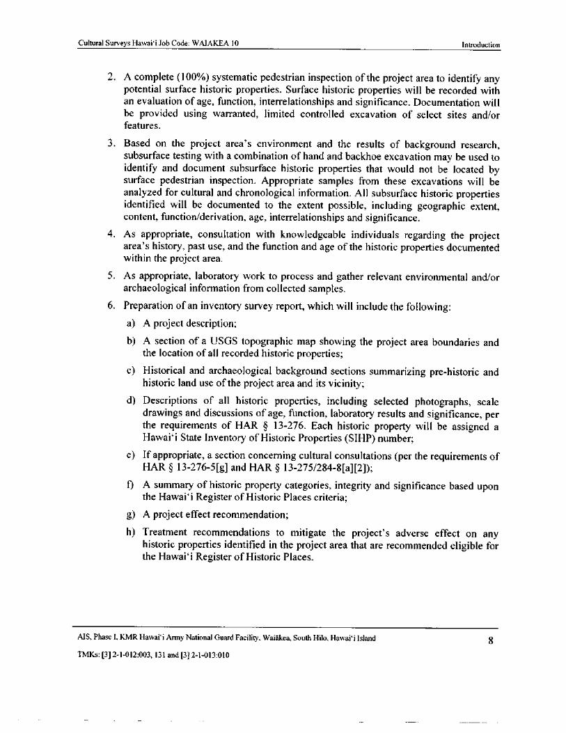
6. Preparation of an inventory survey report, which will include the following:a) A project description;
b) A section of a USGS topographic map showing the project area boundaries andthe location of all recorded historic properties;
c) Historical and archaeological background sections summarizing pre- historic andhistoric land use of the project area and its vicinity;
d) Descriptions of all historic properties, including selected photographs, scale
drawings and discussions of age, function, laboratory results and significance, perthe requirements of HAR § 13- 276. Each historic property will be assigned aHawai` i State Inventory of Historic Properties ( SIHP) number;
e) If appropriate, a section concerning cultural consultations ( per the requirements ofHAR § 13- 276- 5[ g] and HAR § 13- 275/ 284- 8[ a][ 2]);
f) A summary of historic property categories, integrity and significance based uponthe Hawai` i Register of Historic Places criteria;
g) A project effect recommendation;
h) Treatment recommendations to mitigate the project' s adverse effect on anyhistoric properties identified in the project area that are recommended eligible forthe Hawai` i Register of Historic Places.
MS, Phase 1, KMR Hawaii Army National Guard Facility, Waiakea, South Hilo, Hawaii Island 8
TMKs:[ 3] 2- 1- 012: 003, 131 and[ 3] 2- 1- 013: 010
Cultural Surveys Hawaii Job Code: WAIAKEA 10 Introduction
1. 3 Environmental Setting
1. 3. 1 Natural Environment
The study area, located within the district of South Hilo on the windward coast of HawaiiIsland, on the lower eastern slope of Mauna Loa, comprises 405. 3 acres in the ahupua`a of
Waiakea. The study area is near Hilo Town in the Hawaii National Guard Keaukaha MilitaryReservation ( KMR) and is bound by General Lyman Field/Hilo International Airport on thenorthwest, a County quarry and borrow pit site on the southeast, the Airport Access Road on thenortheast and dense forest on the southwest( see Figure 5).
Elevations within the study area range from roughly 40 ft to 80 ft above mean sea levelamsl). Rainfall in the ahupua` a of Waiakea below to 5, 000 ft elevation averages 150- 200 inches
per year( Kelley et al. 1981).
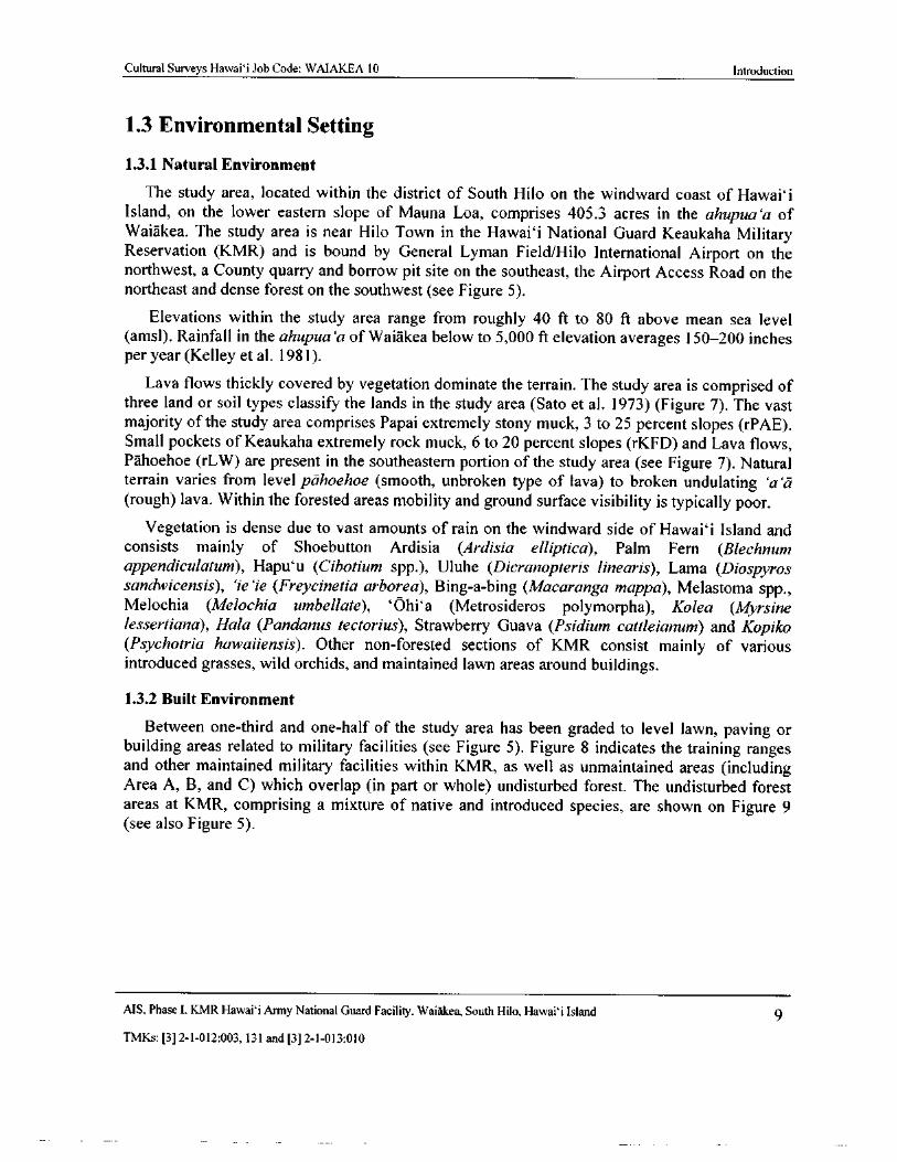
Lava flows thickly covered by vegetation dominate the terrain. The study area is comprised ofthree land or soil types classify the lands in the study area ( Sato et al. 1973) ( Figure 7). The vast
majority of the study area comprises Papai extremely stony muck, 3 to 25 percent slopes ( rPAE).Small pockets of Keaukaha extremely rock muck, 6 to 20 percent slopes ( rKFD) and Lava flows,Pahoehoe ( rLW) are present in the southeastern portion of the study area ( see Figure 7). Natural
terrain varies from level pahoehoe ( smooth, unbroken type of lava) to broken undulating `a`arough) lava. Within the forested areas mobility and ground surface visibility is typically poor.
Vegetation is dense due to vast amounts of rain on the windward side of Hawaii Island andconsists mainly of Shoebutton Ardisia ( Ardisia elliptica), Palm Fern ( Blechnum
appendiculatum), Hapu` u ( Cibotium spp.), Uluhe ( Dicranopteris linearis), Lama ( Diospyrossandwicensis), `ie` ie ( Freycinetia arborea), Bing-a- bing (Macaranga mappa), Melastoma spp.,Melochia ( Melochia umbellate), ` Ohi` a ( Metrosideros polymorpha), Kolea ( Myrsinelessertiana), Hala ( Pandanus tectorius), Strawberry Guava ( Psidium cattleianum) and KopikoPsychotria hawaiiensis). Other non- forested sections of KMR consist mainly of various
introduced grasses, wild orchids, and maintained lawn areas around buildings.
1. 3. 2 Built Environment
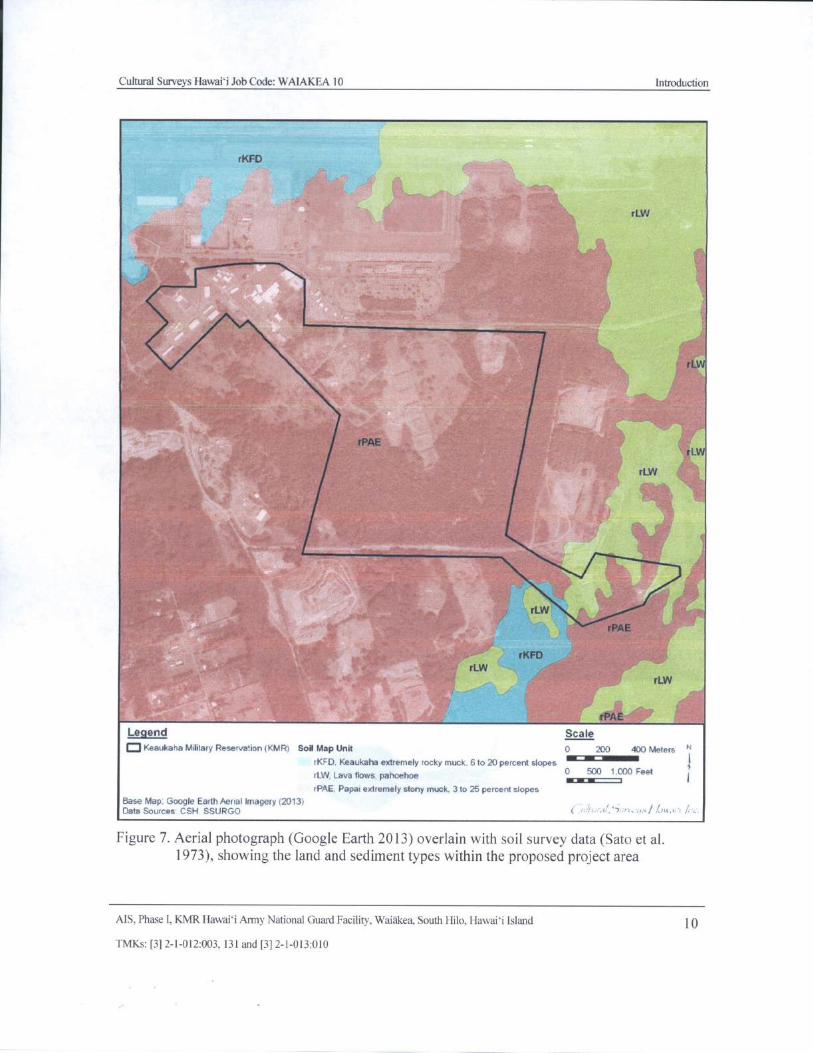
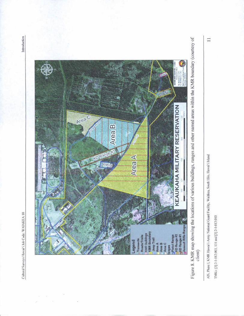
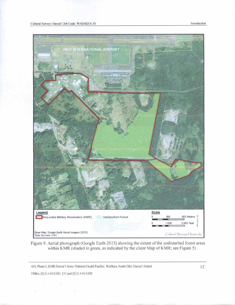
Between one- third and one-half of the study area has been graded to level lawn, paving orbuilding areas related to military facilities ( see Figure 5). Figure 8 indicates the training rangesand other maintained military facilities within KMR, as well as unmaintained areas ( includingArea A, B, and C) which overlap ( in part or whole) undisturbed forest. The undisturbed forestareas at KMR, comprising a mixture of native and introduced species, are shown on Figure 9see also Figure 5).
MS, Phase I, KMR Hawai` i Army National Guard Facility, Waiakea, South Hilo, Hawaii Island 9
TMKs:[ 3] 2- 1- 012: 003, 131 and[ 3] 2- 1- 013: 010
Cultural Surveys Hawai`i Job Code: WAIAKEA 10 Introduction
rKFD
rLW
rLW
r LW
rLW
rLW
rPAE
rKFD
rLW
rLW
rPAE
Legend Scale
Q Keaukaha Military Reservation tKMR) Soil Map Unit 0 200 400 Meters N
rKFD. Keaukaha extremely rocky muck. 6 to 20 percent slopes
rLW, Lava flows pahoehoe 0 Feet
rPAE. Papal extremely stony muck. 3 to 25 percent slopes
Base Map: Google Earth Aerial Imagery( 2013)Data Sources CSH SSURGO rrr•. ,
Figure 7. Aerial photograph ( Google Earth 2013) overlain with soil survey data( Sato et al.1973), showing the land and sediment types within the proposed project area
AIS, Phase I, KMR Hawaii Army National Guard Facility, Waiakea, South 1- Ii1o, Hawaii Island 10
FMKs:[ 3] 2- 1- 012: 003, 131 and[ 31 2- 1- 013: 010
o wO
78c t
0O
CS
3.. IC
Z 3
0CI)
PCe- t
Q 0
CC t I W C
u.
t0 i N
1 Wy0.
e i Cl)
IFI4k...,,.. , . t
t Q bAsz..
I
cii
Q
VD
LcrSd
tt
ct
o xcd w
a ' gip N . r Lr0.
s+ tom
O
1 4,,r >!
o, opo
v
o m m m r- c m u g g a.Es r t'. Of m cc cr m m m m m a CC CX « i A
3 f '!, N,*'.'''Atj aillt :41
E` OG i Y n Q Q Q c'. x x Sco ,..... 011..„---..--:- A•, '.. . i J to ,.
1 ! T W = N
to
0 Nc
on
a.
v; x
Cultural Surveys Hawai` i Job Code: WAIAKEA 10 Introduction
V/C 11
11i
liss
4/'—---———-:-...,--__--___.,___,rNN
r=
Legend Scale
oKeaukaha Military Reservation( KMR) Undisturbed Forest 0 300 600 Meters "N — r i0 1 000 2,000 Feet j
Base Map: Google Earth Aural Imagery( 2013)Data Sources CSH 0/tura1,5un cgs f/awor•r, Inc.
Figure 9. Aerial photograph( Google Earth 2013) showing the extent of the undisturbed forest areaswithin KMR( shaded in green, as indicated by the client Map of KMR; see Figure 5)
AIS, Phase I, KMR Hawaii Army National Guard Facility, Waiakea, South Hilo, Hawaii Island 12
TMKs:[ 3] 2- 1- 012:003, 131 and[ 3] 2- 1- 013:010
Cultural Surveys Hawai` i Job Code: WAIAKEA 10 Methods
Section 2 Methods
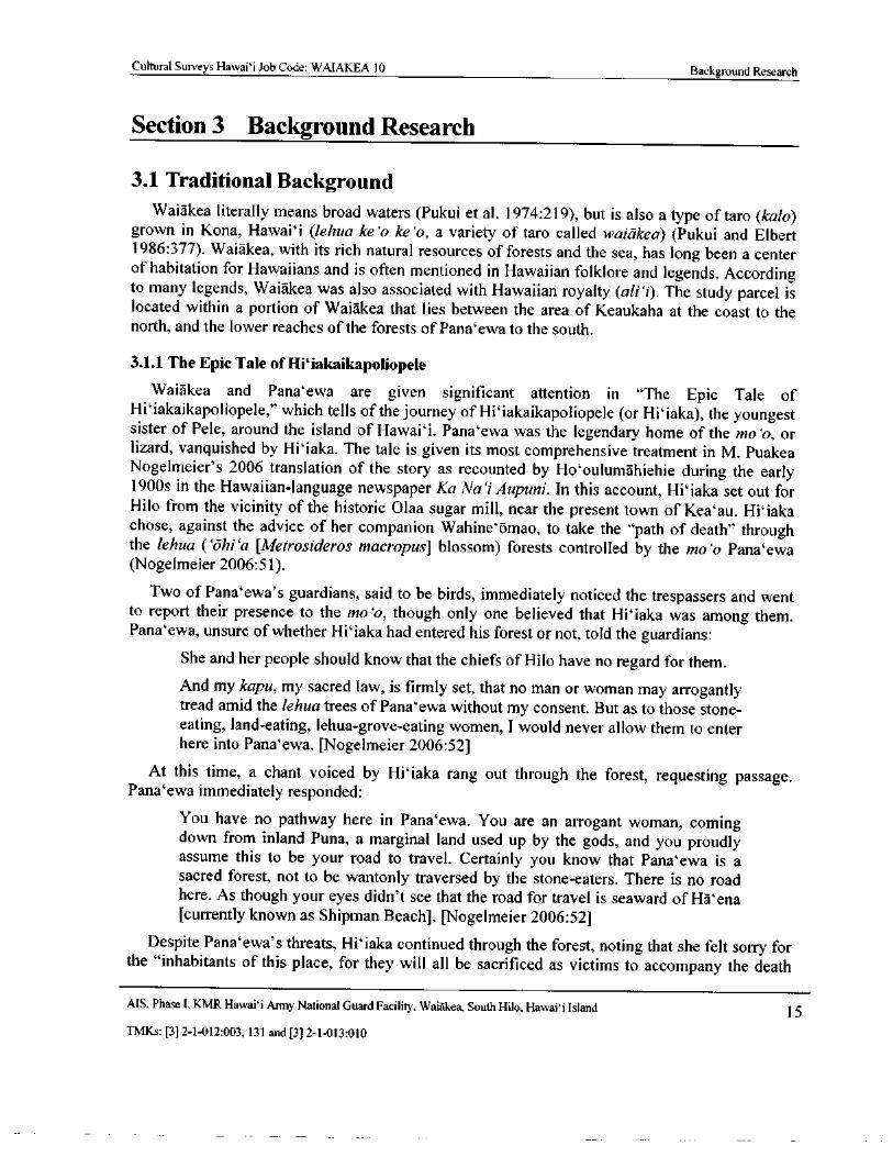
2. 1 Field Methods
The fieldwork component of the AIS investigation was carried out under archaeological researchpermit number 13- 06, issued by the State of Hawaii Department of Land and NaturalResources/ State Historic Preservation Division ( SHPD), per HAR § 13- 13- 282. The fieldwork
component of the AIS was conducted from 19 August 2013 through 24 September 2013 by CSHarchaeologists Andrew Soltz, B.A., David Doig, B.A., Doug Inglis, B.A., Johnny Dudoit, B. A.,Nigel Kingsbury, B.A., and Olivier Bautista, B.A. under the general supervision of Hallett H.Hammatt, Ph.D. ( principal investigator). The fieldwork required approximately 76 person- days tocomplete.
A complete ground survey of the project area was undertaken for the purpose of historic propertyidentification and documentation. While a 100% survey was attempted, ground visibility was verypoor throughout much of the project area given extremely dense vegetation. The ground survey ofthe project area was accomplished through systematic pedestrian sweeps. The interval between thearchaeologists was generally between 5 to 10 m. All historic properties were documented throughdetailed written descriptions, with evaluation of function, interrelationships, and significance;
photographs; scale drawings using standard tape- and- compass mapping procedures; and locatedwith a GARMIN GPSMAP60Cx unit (accuracy +/- 2- 5 m). The areal designations shown on Figure8 were used to discuss site location within the project area. The determination of site boundarieswas based on factors including apparent age, architectural style, and the spatial and functionalinterrelationships of both natural and man- made features.
All of the site documentation prepared in the field is included in Appendices B through D of thisreport. As this investigation consisted of a surface survey only, no subsurface testing ( i. e.,excavation) was conducted.
2. 2 Laboratory MethodsA small number of artifacts were collected from the surface to be analyzed at the CSH Hawaii
Island Office laboratory. All collected materials were analyzed using current and standardarchaeological laboratory techniques. Historic artifacts were identified using standard referencematerials and resources.
2.3 Document Review
Background research included a review of previous archaeological studies on file at SHPD;review of documents at Hamilton Library of the University of Hawaii at Manoa, the Hawaii StateArchives, the Mission Houses Museum Library, the Hawaii Public Library, and the BishopMuseum Archives; study of historic photographs at the Hawaii State Archives and the BishopMuseum Archives; and study of historic maps at the Survey Office of the Department of Land andNatural Resources. Historic maps and photographs from the CSH library were also consulted. Inaddition, Mahele (portion, division, section, land division of 1848) records were examined from theWaihona `Aina database ( Waihona `Aina 2000).
AIS, Phase I, KMR Hawai` i Army National Guard Facility, Waiakea, South Hilo, Hawaii Island 13
TMKs:[ 3] 2- 1- 012: 003, 131 and[ 3] 2- 1- 013: 010
Cultural Surveys Hawaii Job Code: WAIAKEA 10 Methods
2.4 Consultation
Consultation was not conducted as part of the present investigation. The reasoning behind this istwo- fold. First, the Phase I survey does not address a specific project being undertaken at this time.As specific developments are proposed by the HIARNG, the DLNR/ SHPD and other entities havebeen and will continue to be consulted. Second, no historic properties have been previously orcurrently identified within the project area having an important value to the native Hawaiian peopleor to another ethnic group ( i. e., assessed as significant under Criterion E).
AIS, Phase I, KMR Hawai` i Army National Guard Facility, Waiakea, South Hilo, Hawaii Island 14
TMKs:[ 3] 2- 1- 012:003, 131 and[ 3] 2- 1- 013: 010
Cultural Surveys Hawai` i Job Code: WAIAKEA 10 Background Research
Section 3 Background Research
3. 1 Traditional Background
Waiakea literally means broad waters ( Pukui et al. 1974: 219), but is also a type of taro ( kalo)grown in Kona, Hawai` i ( lehua ke` o ke` o, a variety of taro called waiakea) ( Pukui and Elbert1986: 377). Waiakea, with its rich natural resources of forests and the sea, has long been a centerof habitation for Hawaiians and is often mentioned in Hawaiian folklore and legends. Accordingto many legends, Waiakea was also associated with Hawaiian royalty ( ali`i). The study parcel islocated within a portion of Waiakea that lies between the area of Keaukaha at the coast to thenorth, and the lower reaches of the forests of Pana` ewa to the south.
3. 1. 1 The Epic Tale of Hi`iakaikapoliopele
Waiakea and Pana`ewa are given significant attention in " The Epic Tale of
Hi` iakaikapoliopele," which tells of the journey of Hi` iakaikapoliopele ( or Hi' iaka), the youngest
sister of Pele, around the island of Hawai` i. Pana` ewa was the legendary home of the mo o, orlizard, vanquished by Hi` iaka. The tale is given its most comprehensive treatment in M. PuakeaNogelmeier' s 2006 translation of the story as recounted by Ho`oulumahiehie during the early1900s in the Hawaiian- language newspaper Ka Na`i Aupuni. In this account, Hi`iaka set out forHilo from the vicinity of the historic Olaa sugar mill, near the present town of Kea' au. Hi` iakachose, against the advice of her companion Wahine`omao, to take the " path of death" throughthe lehua (` ohi`a [ Metrosideros macropus] blossom) forests controlled by the mo` o Pana`ewaNogelmeier 2006: 51).
Two of Pana` ewa' s guardians, said to be birds, immediately noticed the trespassers and wentto report their presence to the mo' o, though only one believed that Hi` iaka was among them.Pana` ewa, unsure of whether Hi` iaka had entered his forest or not, told the guardians:
She and her people should know that the chiefs of Hilo have no regard for them.
And my kapu, my sacred law, is firmly set, that no man or woman may arrogantlytread amid the lehua trees of Pana`ewa without my consent. But as to those stone-eating, land- eating, lehua-grove- eating women, I would never allow them to enterhere into Pana` ewa. [ Nogelmeier 2006: 52]
At this time, a chant voiced by Hi` iaka rang out through the forest, requesting passage.Pana` ewa immediately responded:
You have no pathway here in Pana`ewa. You are an arrogant woman, comingdown from inland Puna, a marginal land used up by the gods, and you proudlyassume this to be your road to travel. Certainly you know that Pana` ewa is asacred forest, not to be wantonly traversed by the stone- eaters. There is no roadhere. As though your eyes didn' t see that the road for travel is seaward of Ha`enacurrently known as Shipman Beach]. [ Nogelmeier 2006: 52]
Despite Pana` ewa' s threats, Hi` iaka continued through the forest, noting that she felt sorry forthe " inhabitants of this place, for they will all be sacrificed as victims to accompany the death
MS, Phase I, KMR Hawaii Army National Guard Facility, Waiakea, South Hilo, Hawaii Island 15
TMKs:[ 3] 2- 1- 012: 003, 131 and[ 3] 2- 1- 013: 010
Cultural Surveys Hawai` i Job Code: WAIAKEA 10 Background Research
Pana`ewa hopes to inflict upon us. The twilight of morning shall be Pana`ewa' s, and it is theevening twilight that shall be ours" ( Nogelmeier 2006: 53).
At this time Pana` ewa sent a flood of blood toward Hi` iaka, which his guardians created bysevering the heads of all of the ghosts of Pana` ewa. Afloat in the flood, Hi' iaka called upon Pelefor help ( Nogelmeier 2006: 53). Pele heard, and commanded their brother Lonomakua to stokethe fires of Kilauea:
In no time, the red flames leapt up and the clouds glowed crimson, as the uplandsof Maunakea, Maunaloa, and Hualalai were blanketed by smoke.
The glow of the sun was blocked and darkness covered the lehua forest ofPana` ewa. Because of the sudden gloom that covered the lehua groves, the songsof the birds dropped to a twitter, showing the extent of the inky blackness . . .Then Hi` iaka chanted another prayer.
CHANT TWELVE
Great Pana` ewa, wildwood of lehua,
Ohi' a that grows jaggedly toward heavenIn the rain, scarlet lehua in the rain
At the twitter of the birds, night has come
Hilo is darkened by the smoke of my landThose multitudes will survive, for the fires are ablaze.Nogelmeier 2006: 56]
Pele then instructed Hi` iaka to call to her brothers Kauilanuimaka`ehaikalani, Kamohoali` i,Kahuilaokalani, and Ka`ekaokalani. In this next chant Hi` iaka called for rain, and as soon as theprayer reached her brothers " and all of the other denizens of heaven" a torrent of rain beset theforest, sweeping Pana` ewa away and " out to the darkest depths of the ocean, where the mo' o wasswallowed whole into the belly of a big-mouthed fish. With this flood of water, the bloodPana` ewa had brought about . . . was washed away . . ." ( Nogelmeier 2006: 57). Hi` iaka thencontinued onward toward Waiakea:
When Hi` iaka and her companions escaped the doom which Pana`ewa . . . had
prepared for them, as shown above, they continued on their travels . . .
Hi` iaka speaking] We have faced the red waters and the white waters here inPana` ewa. We have donned the red lehua and the white lehua of this place, andshall now leave and go to the shore of Waiakea. We will encounter many banefulones in these places prior to reaching Waiakea. There is Pa` ie` ie, a supernaturalwoman, and Pua`aloa, a supernatural male; Ka` ililahilahi, a woman, and
Pu' umoho, a male; Na`u is a woman, as is Haili, while KIPeho` opiokala is a male;Ma`u is the wife of Makali` i; Kapakapakaua is a male, and Honokawailani is alsomale. However, if I pray diligently and they heed me, then our descent throughthese places toward the sea should be safe, but if they pay no mind to my plea forcompassion, then they shall be made victims of this magical skirt of mine.'
The supernaturals gathered together on the plains of Pa` ie` ie [ according toPukui et al. ( 1974: 175), a [ l] and near Pana-` ewa, Hilo'] and arranged themselves
MS, Phase I, KMR Hawai`i Army National Guard Facility, Waiakea, South Hilo, Hawaii Island 16
TMKs:[ 3] 2- 1- 012: 003, 131 and[ 3] 2- 1- 013: 010
Cultural Surveys Hawaii Job Code: WAIAKEA 10 Background Research
in readiness to attack Hi` iaka when she stepped onto the field. All of thesesupernatural beings who had assembled were mo` o. [ Nogelmeier 2006: 58- 59]
The mo' o showered Hilaka' s party with arrow- like lehua stamens and caused trees to topplein their direction, but Hi` iaka used her divine powers to evade the attacks and, ultimately,defeated the mo' o by striking at them with her skirt. Only Haili was spared, as she had refused tojoin in the attack. For this, Hi` iaka embraced her and declared to her that
you shall become a foundation upon which will be built a temple for the godsour ancestors . . . because you have a kind heart, and you are a refuge for those indistress. Your name shall come to be known by distant future generations as Haili,temple of the great kupua( demigod or culture hero).' [ Nogelmeier 2006:60- 61]
Interestingly, in 1824 the Haili Congregational Church of Hilo was founded in neighboringPonahawai ahupua`a; according to Pukui et al. ( 1974: 35), the church was named after the
forest area near Hilo" from which its timbers came.
The party leaves Pa' ie` ie, continuing towards Hilo. " When they got to Pu` ainako [ not far fromthe current study parcel to the south], a man was coming uphill with a bundle of mullet"Nogelmeier 2006: 62). Hi` iaka asked for some of the fish, and the man, who had an abundance,
gave her five (( Nogelmeier 2006: 62). By this time night had fallen, and Hi` iaka and hercompanions stopped to rest at the home of Haili' s relatives, where they ate of the " heaps ofcooked taro greens" ( lu`au); Wahine` oma` o also ate " the thick poi [Hawaiian staff of life madefrom cooked taro corms, pounded and thinned with water] of that place, consuming plenty"Nogelmeier 2006: 63). After their meal, Hi` iaka healed a member of the household suffering
from consumption by placing her magic skirt upon his chest( Nogelmeier 2006: 65).
The next morning, the party continued toward the Hilo Bay area and was invited to dine at thehome of another family. The girl of the home, Papanuioleka, offered them poi, and indicated herfather was fishing at Kalauokukui Point, which is across from Coconut Island ( Mokuola) at HiloBay. The father, ` Ohele, returned having caught only a single bait fish, blaming the rough seasNogelmeier 2006:67). Hi` iaka, who had not yet revealed her name to the family, told the
fisherman to return to the bay and try again. ` Ohele suspected this woman might indeed be " fromthe crater," and therefore wanted to please her, so he went back out to fish some more, and thistime immediately caught an uhu ( parrotfish) ( Nogelmeier 2006: 68). Right away Papanuiolekatook this fish back to Hi` iaka as an offering, and shortly after, ` Ohele returned laden with abounty of uhu. He offered this catch to her, and though she refused it, she told him that "[ i] n thefuture, there will be an abundance of fish for you in the sea" ( Nogelmeier 2006:69).
Papanuioleka joined Hi` iaka' s party and they left, continuing on to the Wailoa River.
The account of Hi` iaka moving through Pana` ewa to the vicinity of Hilo Bay tells us someimportant things about these areas. Pana`ewa was a sacred `ohi`a forest known for its lehuablossoms and home to many birds and ghostly spirits. Moving closer to the Hilo Bay area, and incloser proximity to the study area, references to the abundance of fish underscore this significant
resource of the area. Descriptions of large amounts of other foods, including taro greens and poi,indicate cultivated crops were also grown with great success throughout this area.
MS, Phase I, KMR Hawai` i Army National Guard Facility, Waiakea, South Hilo, Hawai` i Island 17
TMKs:[ 3] 2- 1- 012:003, 131 and[ 3] 2- 1- 013: 010
Cultural Surveys Hawaii Job Code: WAIAKEA 10 Background Research
3. 1. 2 Other Myths and Legends
The " Legend of Halemano," as given by Fornander ( 1916- 1919:V:2: 250- 251), tells of love
between Halemano and his wife Kamalalawalu and their home in Waiakea, in an area calledUluomalama, apparently above the cliffs of Pana` ewa, Hilo. Halemano looked at his wife, and
when he saw the tears in her eyes, his love for her again welled up within him as he rememberedhow they had lived at ` Uluomalama in Waiakea, Hilo. He chanted as follows:
We once lived in Hilo, in our own home,Our home that was in Panaewa . . .The streams of Hilo are innumerable,
The high cliff was the home where we lived . . .From the waters of Wailuku where the people are carried under,Which we had to go through to get to the many cliffs of Hilo,Those solemn cliffs that are bare of people . . .
Noho i Hilo i o maua hale- e,He hale noho i Panaewa e; . . .
He kini, he lehu, kahawai o Hilo e,Pali kui ka hale a ke aloha i alo ai. . . .Mai ka wai lumalumai kanaka o Wailuku,A kaua i alo aku ai i na pall kinikini o Hilo,O is mau pali anoano kanaka ole, . . .
There are abundant references to Waiakea in general in the myths and legends of Hawai` irecorded by the early ethnographers Thrum, Emerson, Westervelt, and Fornander. One earlyaccount of the Hawaiian chiefdom Waiakea is told by Samuel Kamakau ( 1961: 15- 17) in a storyof the unification of the Island of Hawai` i under chief `Umi- a- Liloa, beginning with the chieflyresidences of Waiakea in the sixteenth century. The legend establishes Waiakea as a relativelyearly residence of Hawaiian ali` i ( chief, chiefess). Hilo' s Kanoa Heiau, where human sacrifices
were offered, was also mentioned in the story, indicating its early existence (Kelly et al. 1981: 1).
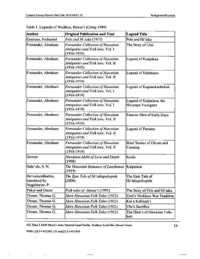
Table 1 is a comprehensive list of Hawaiian tales that include Waiakea as a place setting.These legends were primarily found in the Hawaiian Legends Index ( revised edition) compiledby Lillian Ching and edited by Dr. Masae Gotanda, Director of Hawai` i State Library ( 1989).Many of these stories merely mention Waiakea in passing, including Fornander' s " Legend ofPamano" ( 1916- 1919: 304- 305) and " Brief Stories of Ghosts and Cunning" ( 1916- 919: 422- 423).
Another brief mention of Waiakea is found in Pukui and Green' s " The Story of Pele andHi` iaka" in Folktales of Hawai` i. Hi` iaka, Pele' s sister, " slept at Waiakea, Hilo, and in the
morning kept on as far as Kukui- lau- mania, where she turned to gaze back over the country, thencontinued her journey toward the cliffs of Hilo" ( Pukui and Green 1995: 25). Waiakea was oftenvisited by Hawaiian chiefs of high rank. In Westervelt' s " Keaomelemele, The Maid of theGolden Cloud," chief Kahanai- a- ke-Akua ( adopted son of the gods), and his friend Waiolawater of life), " went down to Waiakea, a village by Hilo . . . The men were invited to sport, but
only Waiola went because Kahanai himself was of too high rank" ( Westervelt 1915: 133).
MS, Phase I. KMR Hawaii Army National Guard Facility, Waiakea, South Hilo, Hawaii Island 18
TMKs:[ 3] 2- 1- 012:003, 131 and[ 3] 2- 1- 013: 010
Cultural Surveys Hawaii Job Code: WAIAKEA 10 Background Research
Table 1. Legends of Waiakea, Hawai` i ( Ching 1989)
Author Original Publication and Year Legend Title
Emerson, Nathaniel Pele and Hi`iaka( 191 5) Pele and Hi` iaka
Fornander, Abraham Fornander Collection ofHawaiian The Story of UmiAntiquities and Folk lore, Vol. I
1916- 1919)
Fornander, Abraham Fornander Collection ofHawaiian Legend of Kuapakaa
Antiquities and Folk lore, Vol. II
1916- 1919)
Fornander, Abraham Fornander Collection ofHawaiian Legend of Halemano
Antiquities and Folk lore, Vol. II
1916- 1919)
Fornander, Abraham Fornander Collection ofHawaiian Legend of Kapuaokaoheloai
Antiquities and Folk lore, Vol. I
1916- 1919)
Fornander, Abraham Fornander Collection ofHawaiian Legend of Kaipalaoa, the
Antiquities and Folk lore, Vol. I Hoopapa Youngster
1916- 1919)
Fornander, Abraham Fornander Collection ofHawaiian Famous Men of Early DaysAntiquities and Folk lore, Vol. II
1916- 1919)
Fornander, Abraham Fornander Collection ofHawaiian Legend of Pamano
Antiquities and Folk lore, Vol. II
1916- 1919)
Fornander, Abraham Fornander Collection ofHawaiian Brief Stories of Ghosts and
Antiquities and Folk lore, Vol. II Cunning1916- 1919)
Gowen Hawaiian Idylls ofLove and Death Keala
1908)
Hale`ole, S. N. The Hawaiian Romance ofLaieikawai Kaipalaoa1919)
Ho`oulumahiehie, The Epic Tale ofHi`iakapoliopele The Epic Tale of
translated by 2006) Hi`iakapoliopele
Nogelmeier, P.
Pukui and Green Folk tales of Hawai i( 1995) The Story of Pele and Hi` iakaThrum, Thomas G. More Hawaiian Folk Tales ( 1923) Umi' s Necklace War Tradition
Thrum, Thomas G. More Hawaiian Folk Tales ( 1923) Kai a Kahinali` i
Thrum, Thomas G. More Hawaiian Folk Tales ( 1923) Ulu' s Sacrifice
Thrum, Thomas G. More Hawaiian Folk Tales ( 1923) The Hina' s of Hawaiian Folk-
lore
MS, Phase I, KMR Hawaii Army National Guard Facility, Waiakea, South Hilo, Hawai` i Island 19
TMKs:[ 3] 2- 1- 012: 003, 131 and[ 3] 2- 1- 013: 010
Cultural Surveys Hawai` i Job Code: WAIAKEA 10 Background Research
Author Original Publication and Year Legend Title
Thrum, Thomas G. Hawaiian Folk Tales ( 1998) Stories of the Menehune' s: As
Heiau Builders
Westervelt, William Legends ofGods and Ghosts ( 1915) Keaomelemele, The Maid of
the Golden Cloud
Westervelt, William Legends ofGods and Ghosts ( 1915) Keaunini
In the legend " Keala" ( Gowen 1908: 43- 50), " well- known landmarks" of Waiakea are viewed
by Ahi, a Hawaiian priest, in his spirit form:
The green water below was the bay of Hilo, the mountain was the terribleKilauea, where in Halemaumau, the house of everlasting fire, the goddess Pelewas wont to ride the red surges with her sisters and tilt with lances of flaminglava. The road was the mountain-path from Waiakea to Kapapala . . . [ Gowen
1908: 47]
John Papa ` I` i makes two general references to Waiakea, Hilo. According to ` Ii, at the timeof Kamehameha I ( ca. 1800):
The lands of the chief of Kau were divided within their own district, each beinggiven a portion and each asking for what he wanted. For this reason, a skilled warleader whose name I have forgotten said to Keoua Kuahuula, son of Kalaniopuu
and half brother of Kiwalao, perhaps you should go to the chief and ask that these
lands be given us. Let Waiakea and Keaau be the container from whence our food
is to come and Olaa the lid. [`I`i 1959: 13- 14]
I'i's second reference notes the well-known surf of" Kanukuokamanu in Waiakea, Hilo" CPT
1959: 134). Kanukuokamanu, on the western side of Wailoa River, was also mentioned in the
sixteenth century story by Kamakau ( 1961: 15- 17) as a beach where chiefs and people gatheredat night . . . to amuse themselves with hula dancing, chanting, and the playing of games calling
for forfeits of entertainment or sexual favors" ( Kelly et al. 1981: 1). This summary was likelydrawn from two legends: " Story of Umi" and " Umi' s Necklace War Tradition."
The " Story of Umi" describes the chiefly residences at Hilo and the king of Hilo, Kulukulua.The legend tells of the chiefs of Hilo gathering at a place called Kanukuokamanu, in Waiakea:
One night there was a grand entertainment for all the chiefs of Hilo at
Kanukuokamanu, in Waiakea; there was dancing and games of papahene, kiluand loku. ( A he po le' ale' a nui no na ` lii o Hilo a pau ma Kanukuokamanu ma
Waiakea, he hula, he papahene, a he kilu, a me a ka loka). [ Fornander 1916-
1919: 220- 221]
A similar story, " Umi' s Necklace War Tradition," also mentions the festive night at
Kanukuokamanu, Waiakea, and ` Umi' s marriage to ` I` iwalani, the daughter of the king of HiloThrum 1923).
The " Legend of Kapuaokaokeloai" makes a passing reference to Waiakea as a place wherethe people of " high chief rank of Hilo" lived ( 0 Waiakea, i Hilo ka ? dna, o ka mua ke
MS, Phase I, KMR Hawai` i Army National Guard Facility, Waiakea, South Hilo, Hawaii Island 20
TMKs:[ 3] 2- 1- 012: 003, 131 and[ 3] 2- 1- 013: 010
Cultural Surveys Hawaii Job Code: WAIAKEA 10 Background Research
kaikunane, o ka mull ke kaikuahine, he mau all' 1 lakou no Hilo) (Fornander 1916- 1919: 540- 541).
Again, this passage reiterates the importance of Hilo as a chiefly residence. This story is also toldin " The Hina' s of Hawaiian Folklore" ( Thrum 1923).
Another reference to the associated royalty of Waiakea can be found in the " Legend of
Kaipalaoa, the Hoopapa Youngster" ( Fornander 1916- 1919: 574- 575). According to the legend,Kaipalaoa" ( a relative of Kukuipahu, the king of Kona) " was born in Waiakea, Hilo."
Many legends tell of the abundant fish and shrimp of Waiakea. The fishpond of Waiakea wasso valued that Kamehameha I sent runners from Kawaihae and Kailua to fetch live mullet fromWaiakea. Fornander' s ( 1916- 1919: 490- 491) work describes Kamehameha I sending his fastestrunners, Makoa and Kaneaka` ehu, to " Hilo to get mullet from the pond of Waiakea, on the
boundary adjoining Puna" ( o ka nanawa is o Makoa e holo ai i Hilo i ka ' anae o ka loko oWaiakea, ala ma ka palena e pili la me Puna).
The rich and varied resources Waiakea offered made it one of the most important locales on
Hawai` i Island. Traditional accounts concerning Waiakea include references to it being the seatof chiefly residences as early as ca. AD 1550 ( Kelly et al. 1981). Chiefly associations withWaiakea continued through traditional times and into the historic era.
3.2 Historical Background
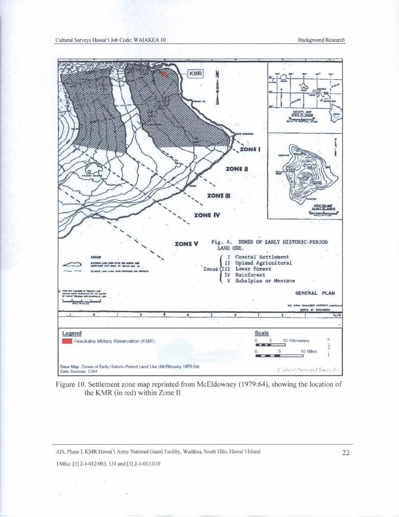
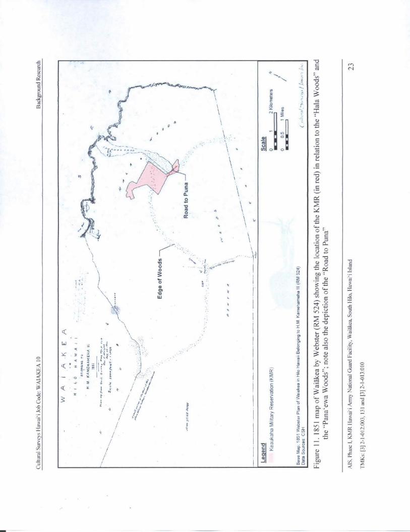
The ahupua` a of Waiakea, South Hilo, is large, encompassing some 95, 000 acres. It extendsfrom the coast to approximately the 6, 000- ft elevation on the windward slope of Mauna Loa. In1979 Holly McEldowney prepared an archaeological and historical literature search and researchdesign, as part of a lava flow control study ( McEldowney 1979). In her report, McEldowneydescribes five zones of land use and associated resources. The five zones ( Figure 10) includeI. Coastal Settlement; II. Upland Agricultural; III. Lower Forest; IV. Rain forest; and V. Sub-Alpine or Montaine ( McEldowney 1979: 14). McEldowney generally bases the extent of thesezones on elevation and distance from the coast. Following this model, the lands of the studyparcel, situated at approximately 40 to 80 ft amsl, would lie along the makai( seaward) margin ofZone II, which was characterized by open grassland used for planting ( see Figure 10). An 1851
Government Survey map ( Figure 11) shows the study parcel overlapping both the " Hala Woods"and the " Panaewa Woods." Presumably, these forests were being used to some extentagriculturally. Figure 11 also depicts the " Road to Puna" in the southern portion of the presentKMR.
McEldowney ( 1979: 19- 20) discusses the characteristics of Zone II and the anomaly of theHilo forests as observed during the early historic period:
The constituents of gardens and tree crops in the village [ Zone I] basicallycontinued in the upland [ Zone II] except that dry- land taro was planted moreextensively and bananas were more numerous. Wet or irrigated taro occurredalong small streams, tributaries, and rivers that cut into the ash- capped substrates
This same pattern occurred between Waiakea Pond and the Pana` ewa Forest in
the four or five miles of open country dominated by tall grasses. Here stands ofkukui ( Aleurites moluccana), pandanus, and mountain apple became more
AIS. Phase I, KMR Hawaii Army National Guard Facility, Waiakea, South Hilo, Hawaii Island 21
TMKs:[ 3] 2- 1- 012: 003, 131 and[ 3] 2- 1- 013: 010
Cultural Surveys Hawai` i Job Code: WAIAKEA 10 Background Research
if';f.%f off1 f l
I •`.`im fItgMre.
wpart6vim
4111I. -'
r ,
j% %% zaNEt r
17ot,
ZONE II
VJ/ ilt.`
4- 4
illAmp- ... 0 ,
N. ZONE IH
t1466, 616 4666
ZONE IVs
ZONE V Fig. 4. ZONES OF EARLY HISTORIC- PERIODN LAND USE.
r V N. I Coastal Settlement
0 7:= 7.4117777:11 II Upland Agricultural.
W.".,„, . 1. .... . ar,.. eKA..., oZones III Lower Forest
IV Rainforest
V Subalpine or Montane
y....... nevm•..e... awa"..R al GENERAL PLANn .- m... v.... a -
61 MI6, CorCiorn. Oosmcf, 6666..6.6
tM. 3 Of COMMAS
l 6 I 5 1 1 3 t 2 I Ra+C
Legend Scale
MN Keaukaha Military Reservation( KMR) 0 5 10 Kilometers N
go .. t 10 5 10 Miles
f
Base Map Zones o1 Early Historic- Period Land Use{ McEldowny 1979:64)Data Sources CSH
Figure 10. Settlement zone map reprinted from McEldowney ( 1979: 64), showing the location ofthe KMR( in red) within Zone 1I
AIS, Phase I, KMR Hawaii Army National Guard Facility, Waiakea, South I lilo, Hawaii Island 22
TMKs:[ 3] 2- 1- 012: 003, 131 and[ 3] 2- 1- 013: 010
al N
a
N
p
I al Y w •
r,-.aS
N
04
Tol1 1
al
ai f
v
4. C It C
d 1o t: 4
o O " cd
t.. O =COU
ro!: Ian
I 0 I Cc_ '3 -'
v011as
tr o
o
t c o x
0v I Y v°a
i 111•t.
3.6
u
im
Y 3r}" 5 1 .. m ro
o v s t: I a o w
Q a i h
I; i m
a l a o I y Vi MY C
Cr
o n d o4
2 3 • yt° O
3 Q _- _ 1 ° i I Y 3 3 z Nt. ,a
r im m
8 is o0 3
tv
T a cv
a ti a 3ri
ao/
IrNxooOV / m U
1
I CYmm
a=N
Ia M j d
J2
wvi
Q
itu
Cultural Surveys Hawaii Job Code: WAIAKEA 10 Background Research
conspicuous, with large areas of dryland taro planted in rocky crevices on theyounger Mauna Loa flows. The 4-mile- wide forest, corresponding to the presentPana` ewa Forest Reserve, grows on a single flow roughly 2, 700 years old ( JackLockwood, pers. comm.) and in the early 1800s was one of the few forests tonearly reach the ocean. The trail leading from Hilo to the Volcano through thisdense stand of `ohi`a trees, and ` ie` ie ( Freycinetia aborea) again comes upon anunwooded landscape near what is now Kea' au. [ McEldowney 1979: 19- 20]
In her study, McEldowney provides some discussion about underlying factors that could haveresulted in the presence of the open grasslands of Zone II. She states that, " due to the tendency oftropical or sub- tropical] soils to be rapidly leached of nutrients,"
shifting agriculture ( i.e., swidden or slash- and-burn) is practiced by mostPolynesian and Pacific peoples. In forested areas, this cyclical process involves
the opening of the forest canopy, burning of the resulting debris and leaf litter,planting one or more crops either simultaneously or sequentially, and harvesting.When nutrient levels drop below those needed to support further crops, the plot isleft fallow, and the entire process is repeated in another plot chosen in either
secondary or primary forest.
The process by which forests can be reduced to open grass or shrub lands througheither long-term swiddening, or by the repeated effects of intentional and/ oraccidental fires, has been discussed for New Zealand ( Cumberland 1963), New
Guinea ( Robbins 1963), Indonesia ( Geertz 1969), and Hawaii ( Yen 1974: 316;
Handy 1972: 17; Newman 1971: 108- 111). Changes most frequently occur when,through the shortening of the fallow periods or repeated burning, the forest fails toregenerate, the important organic layer does not accumulate, and soil properties
are altered by exposure to sun and wind. The reduced rate of regeneration in semi-tropical environments ( e. g., Hawaii), when compared to truly tropical
environments, can accelerate this degradation. [ McEldowney 1979: 21]
Several factors are then discussed in support of McEldowney' s interpretation that, absenthuman interference, ". . . forest was capable of developing on, and did originally cover, most ofthese [ grassland] slopes down to the coast"; she cites the lowland presence of the Pana`ewaforest as an example ( McEldowney 1979: 24). The resources of this forest, characteristic of Zone
III, would have been readily available to the population of the lower zones in Waiakea.
Since the majority of fishponds in Waiakea were concentrated northwest of the KMR,primarily at and around Hilo Bay, settlement was also concentrated northwest of the KMR. Theproject area may have been marginally occupied in the prehistoric period but likely did notsupport substantial habitation or intensive agricultural activity. However, Handy and Handy citea 1922 article in the Hawaiian language newspaper, Ka Nupepa Ku`oko` a, that refers to
numerous residences found within the " woods of Pana` ewa" and to planting sweet potatoes andsugar cane on pahoehoe lava fields in Waiakea:
There are pahoehoe lava beds walled in by the ancestors, in which sweet potatoesand sugar cane were planted and they are still growing today. Not only one or twobut several times forty ( mau ka au) of them. The house sites are still there, not
MS, Phase I, KMR Hawaii Army National Guard Facility, Waiakea, South Hilo, Hawaii Island 24
TMKs:[ 3] 2- 1- 012: 003, 131 and[ 3] 2- 1- 013: 010
Cultural Surveys Hawaii Job Code: WAIAKEA 10 Background Research
one or two but several times four hundred in the woods of Pana` ewa. Our
indigenous bananas are growing wild, these were planted by the hands of ourancestors. [ Handy and Handy 1972: 131- 132]
Handy and Handy ( 1972) recorded the agricultural methods used to grow taro, sweet potatoes,and sugar cane in Waiakea in the 1930s. They describe the natural habitat and agriculturaldevelopment of Waiakea and South Hilo, and again make reference to the Pana` ewa forest:
In lava- strewn South Hilo there were no streams whose valleys or banks were
capable of being developed in terraces, but [ taro] cuttings were stuck into theground on the shores and islets for many miles along the course of the WailukuRiver far up into the forest zone. In the marshes surrounding Waiakea Bay, east ofHilo, taro was planted in a unique way known as kanu kipi ( mounded taro
patches) . . . On the lava- strewn plain of Waiakea and the slopes between
Waiakea and the Wailuku River, dry taro was formerly planted wherever therewas enough soil. There were forest plantations in Pana` ewa and in the lower fern-forest zone above Hilo town and along the course of the Wailuku River. [ Handyand Handy 1972: 538- 539]
The accounts above underscore the somewhat unique nature of lowland Waiakea and
Pana`ewa in terms of their traditional land use. Despite the presence of forests here, the relativelylow elevation and proximity to Hilo Bay and the coastline meant this area was also desirable forplanting and related settlement.
3.2. 1 Early 1800s
Land use during the early historic period was still essentially subsistence- based, althoughaspects of major changes were occurring. Settlement continued to be primarily focused on thecoastal zone, as was most of the agricultural production of both indigenous food crops and newlyintroduced plants. Significant alterations to these lifeways began occurring in the 1800s. Thesandalwood (` iliahi, Santalum spp.) trade, establishment of the American Board of
Commissioners for Foreign Missions ( ABCFM) station in Hilo and the arrival of whalers began
the shift from subsistence to a market-based economy.
During this early historic period the forest and sub- alpine zone land use changed as well.Besides the more traditional procurement of timber products and bird feathers for taxes
McEldowney 1979: 35), cattle, goats, and sheep were hunted in the upper zones. These animals,first introduced in the 1790s, had spread over large portions of the interior of Hawaii Island,
especially in the Waimea area due to an imposed 10 year prohibition on killing them. However,by the 1830s substantial amounts of hides, jerked meat and tallow were exported from Hilo"McEldowney 1979: 36).
3.2.2 1820s
In 1823, Reverend William Ellis conducted a two- month journey around the entire island ofHawai` i, following a route primarily along the coast. During his journey Ellis made observationsof indigenous Hawaiian agriculture and population densities. The following is his account of thecoastal inhabitants of the North Hilo and Hamakua districts:
MS, Phase I, KMR Hawaii Army National Guard Facility, Waiakea, South Hilo, Hawaii Island 25
TMKs:[ 3] 2- 1- 012: 003, 131 and[ 3] 2- 1- 013: 010
Cultural Surveys Hawaii Job Code: WAIAKEA 10 Background Research
the inhabitants, excepting at Waiakea, did not appear better supplied with thenecessaries of life than those of Kona, or the more barren parts of Hawaii. Theyhad better houses, plenty of vegetables, some dogs, and few hogs, but hardly anyfish, a principle article of food with the natives in general. [ Ellis 1963: 252]
T. Stell Newman ( 2000) conducted an ethnohistorical study utilizing the observations of Ellisin conjunction with modern environmental data in an attempt to define indigenous Hawaiian landuse patterns ca. 1823. Through an analysis of Ellis' s journal writings Newman was able to
reconstruct Ellis' s route around the island. Ellis' s route was then plotted onto a map and allreferences by Ellis about indigenous Hawaiian agriculture, population density, soil type, waterresources, and botany were matched to the route allowing Newman ( 2000) to establish fouragricultural zones: Irrigation, Dryland Farming, Scattered Farms, and Field Systems ( Figure 12).Based on a review of Newman' s map it appears the KMR falls into the Scattered Fieldsagricultural zone, which is defined as having a low population density, dispersed settlement withfew fishing villages at the coast, and scattered fields and gardens with no major field systemsNewman 2000). Crops that would have been cultivated consisted of dryland taro, sweet potato,
bananas, yams, breadfruit, sugarcane, and paper mulberry. Note that number 25 shows thelocation of Hilo, which is identified as " Waiakea."
C. S. Stewart, an American missionary, traveled to Hilo in 1825 with Lord Byron on the HMSBlonde. He described the Waiakea vicinity as the ship landed at Coconut Island, approximately2. 5 km northwest of the KMR:
The beach is covered with varied vegetation, and ornamented by clumps andsingle trees of lofty cocoa- nut, among which the habitations of the natives areseen, not in a village, but scattered everywhere among the plantations, like farm-houses in a thickly inhabited country . . . At a very short distance from the beach,the bread- fruit trees were seen in heavy groves, in every direction intersected withpandanus and tutui [ kukui], or candle- tree, the hibiscus and the acacia, & c. The
tops of these rising gradually one above another, as the country gently ascendedtowards the mountains in the interior, presented for twenty or thirty miles in thesouth- east, a delightful forest scene. [ Stewart 1970: 362- 363]
The American Board of Commissioners for Foreign Missions ( ABCFM) established
themselves in Hilo in the mid- 1820s. The years following the missionaries' arrival were spentintroducing a new religion that was not accepted by the general population until the late 1830sMcEldowney 1979: 33- 34, 36).
3.2.3 1830s
A " religious revival" occurred in Hilo in the late 1830s due in part to the preaching of TitusCoan and several other factors. The Hawaiian population had been considerably reduced at thispoint due to the introduction of new diseases and a decline in the birth rate. Alterations totraditional religion and lifeways were prevalent and this devotion to the new religion intensifiedthese changes:
During the revivals height [ between 1837 and 1840], as many as 10,000 peoplecongregated in Hilo at one time. Among other consequences, this led to the severe
MS, Phase I, KMR Hawaii Army National Guard Facility, Waiakea, South Hilo, Hawaii Island 26
TMKs:[ 3] 2- 1- 012: 003, 131 and[ 3] 2- 1- 013: 010
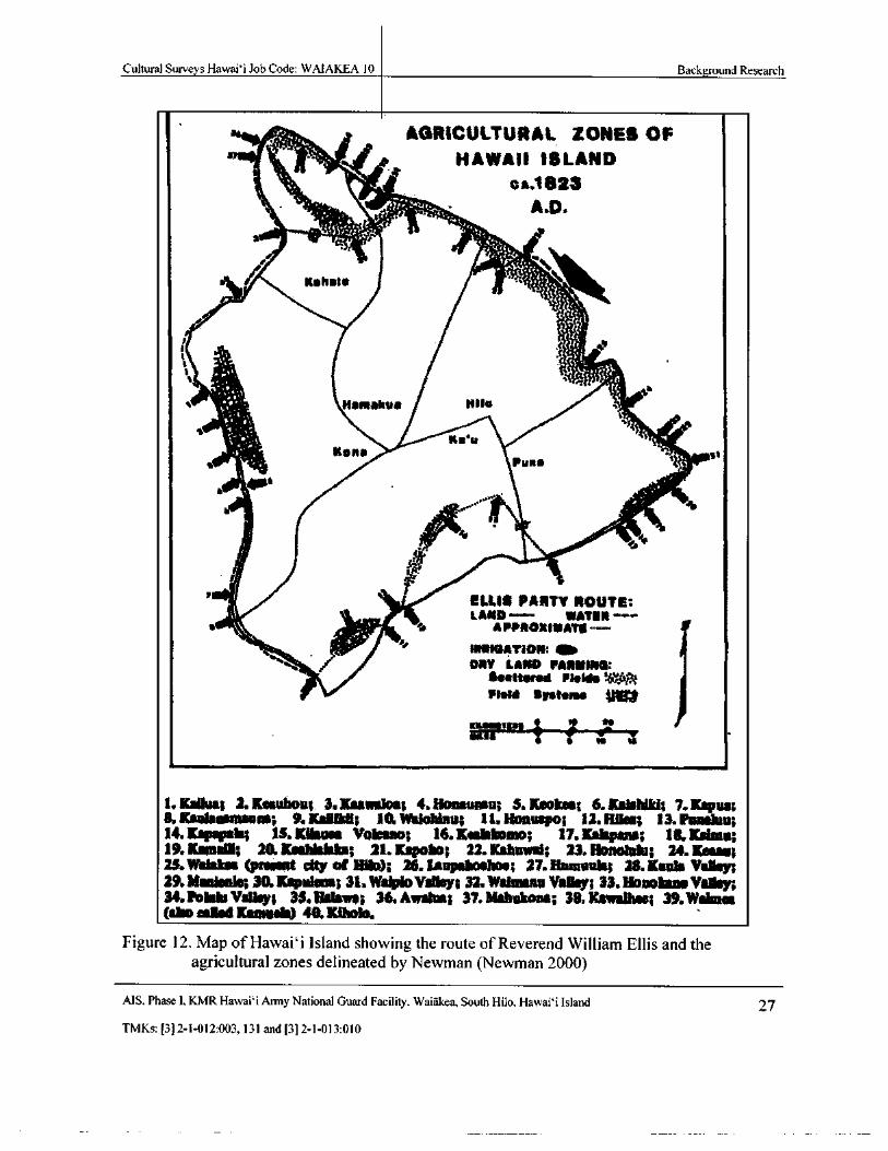
Cultural Surveys Hawaii Job Code: WAIAKEA 10 Background Research
AGRICULTURAL ZONES OF
HAWAII ISLANDi
C A. 1823
a
r'cie`..11')-`?:."-4-.'
4".,`
ri
r itahal*
a ``*
cl •.
Hantakua Pilo
Ronatss Puna ili.
s
t` Vif
Oei
vilt: . ilk-1111
I ELLI$ PARTY ROUTE:1LAIRD-- WATER---
I'
IalatiGATION: ati. •
ti
DRY LAND MA1ItlNO:1sstterad Midis WPlaid Systems
morgivin to v
1. Kansa; 2, Kesuhou; 3. Kaaaaiioa; 4. tioaauneu; S. Makes; 6. Kel ldkl; 7. Kaput8. Ksaleimunaaia; 9. ltailiioll; 10.WabMau; 11. Honuspo; 12. Hliee; 13. Punka;14. Koper* IS. Kilauea Vokkaaa; 16. Kesiebomo; 17. Kskpana; 18. Kudrna;19. llama; 20. Kaahialeira; 21. Kapoba; 22.! Mused; 23. Hanalula; 24. Kamm23. Wallas ( present city of Hlla); 26. tanpsboelme; 27. Remains; 28. Kayla Valley;29. MardeaIee 30.! Evident 31. Wei toVa11my; 32. Wilma= Valley; 33. Hanle Way;34.Polak Valley; 35, Halms; 36. Amiga; 37. Mehakona; 38, Karmen; 39.Waimeaabo called Kannada) 40.Kiholo.
Figure 12. Map of Hawaii Island showing the route of Reverend William Ellis and theagricultural zones delineated by Newman( Newman 2000)
MS. Phase I, KMR Hawaii Army National Guard Facility, Waiakea, South Hilo, Hawai` i Island 27
TMKs:[ 3] 2- 1- 012: 003, 131 and[ 3] 2- 1- 013: 010
Cultural Surveys Hawaii Job Code: WAIAKEA 10 Background Research
alteration of traditional habitation and garden sites within the Hilo area, the
permanent or temporary abandonment of entire villages in outlying areas, and adeeper disruption of traditional Hawaiian beliefs and subsistence patterns
McEldowney 1979: 37].
3.2.4 The Mahele
The Organic Acts of 1845 and 1846 initiated the process of the Mahele, the division ofHawaiian lands, which introduced private property into Hawaiian society. In 1848, the crownand the ali` i received their land titles. Kuleana ( title or ownership) awards to commoners forindividual parcels within the ahupua' a were subsequently granted in 1850. It is through recordsfor Land Commission Awards ( LCAs) generated during the Mahele that the first specificdocumentation of life in Hawai` i, as it had evolved up to the mid-nineteenth century, come tolight. Although many Hawaiians did not submit or follow through on claims for their lands, thedistribution of LCA parcels can provide insight into patterns of residence and agriculture. Manyof these patterns of residence and agriculture probably had existed for centuries past. Byexamining the patterns of kuleana LCA parcels in the vicinity of the study parcel, insight can begained to the likely intensity and nature of Hawaiian activity in the area.
Waiakea Ahupua' a was held by Kamehameha. When he died in 1819, his son Liholihoreceived the lands. The Kamehameha dynasty' s control over the valuable property was affirmedin the status of the ahupua' a as Crown Land during the Mahele, with the ` iii (land section, nextin importance to an ahupua' a and usually a subdivision of an ahupua` a) of Pi` opi` o, awarded toVictoria Kamamalu ( LCA 7713: 16), a granddaughter of Kamehameha I and heir to Ka`ahumanuas well.
Twenty-six LCA parcels were granted within Waiakea, none of them within or in the vicinityof the present study parcel. Most LCA parcels were within the coastal zone and for the most partfocused around the edges of the large fishponds of Waiakea. The two exceptions are LCA 2663and 2402; they were in the lower portion ( i.e., approximately 100 ft amsl) of the upland
agricultural zone. Land use information for the kuleana generally refers to cultivated fields withhouse lots, indicating habitation and agricultural production within the same zone, unlike
leeward Hawai` i Island where in many cases kuleana included coastal house lots with associatedupland agricultural lots, because of elevation- dependent rainfall.
The coastal zone continued to contain the vast majority of the population. Houses and storeswere concentrated in the northern half of Hilo Bay, somewhat removed from Waiakea, becauseat the time the main pier for Hilo was at the mouth of the Wailuku River. Hilo was beingtransformed into an entirely wood- framed " New Bedford type Whaling Town." Whaling shipsrequiring supplies visited the port causing the export economy to grow. More foreigners weresettling in Hilo and began purchasing Hawaiian lands (McEldowney 1979: 38).
3.2.5 Late 1800s
Early " eco- tourist" Isabella Bird described the country area around Hilo in 1873 and itsvariety of crops. She wrote, "[ a] bove Hilo, broad lands sweeping up cloud wards with theirsugar-cane, kalo ( taro), melons, pine- apples, and banana groves suggest the boundless liberalityof nature" ( Bird 1964: 38).
AIS, Phase I, KMR Hawaii Army National Guard Facility, Waiakea, South Hilo, Hawaii Island 28
TMKs:[ 3] 2- 1- 012:003, 131 and[ 3] 2- 1- 013: 010
Cultural Surveys Hawaii Job Code: WAIAKEA 10 Background Research
Large- scale commercial sugar cane production began in Waiakea in the late 1870s with theestablishment of the Waiakea Mill Company. The Waiakea Mill Company leased WaiakeaCrown lands extending from the town of Hilo up to 1, 100 ft elevation. The mill was located atthe head ( mauka or upland end) of Waiakea Fishpond and sugar was transported by bargethrough the pond and down Wailoa River to Hilo Bay. In 1879, a 3- mile segment of railroad wasconstructed from the Waiakea Mill to the cane fields, " the first in the ` Sandwich Islands' to haulsugar cane with a steam locomotive" ( Conde and Best 1973: 117). Three years later, on 1 October1882, Queen Emma visited the Waiakea plantation " to take a ride on the railroad . . . and a
pleasant trip was made into the cane fields, a distance of four miles from the mill" ( Conde andBest 1973: 118). Registered Map ( RM) 1438, dating to 1886, shows the western edges of KMRadjacent to the Waiakea plantation lands ( Figure 13). A 1933 map of the plantation ( Figure 14)indicates that it was situated entirely west of the KMR. Even if the plantation included lands easttoward KMR prior to that time, any impacts to the reservation by the cane industry would likelyhave been to the areas comprising the presently developed portions of the facility, as the majorityof undeveloped lands at the KMR appear to be relatively undisturbed forest. Figure 13 alsodepicts the " Road to Puna" crossing diagonally through the KMR.
McEldowney describes other land usage activities in Waiakea during this time period. " Other
examples of business, not directly related to sugar cultivation, were the continued use of theWaiakea fishponds, an active Chinese fish market, small pastures above Hilo supporting dairycattle, and scattered vegetable gardens" ( McEldowney 1979: 39). Cattle ranching and timber forfirewood and housing were the primary interior land uses during this period.
3.2. 6 Early to Mid-1900s
Sugar and its associated industries continued to expand during the early 1900s. Haun andHenry ( 2000) discuss the impetus behind the extension of the railroad to Hilo Bay anddevelopment of the wharfs:
Between 1900 and the 1930s, the population of Hilo grew dramatically with theexpansion of sugar cane cultivation, pineapple production, the timber industry,and other commercial developments. In the 1910s, the Hilo Railroad Companyexpanded the rail system to Puna and Hilo Town. A railroad wharf was built north
of the mouth of the Wailoa River. Between 1909 and 1913, the railroad wasextended to North Hilo and Hamakua Districts.
The pending opening of the Panama Canal and anticipated increase in trans-Pacific shipping lead to serious efforts to build a breakwater to protect shipping inHilo Bay. Construction of the breakwater began in 1908. The breakwater wasinitially planned for a location just east of Coconut Island, but the plan wasmodified and the selected site was approximately 6,000 ft east of the island. Theinitial plans called for a 10, 000 ft long breakwater along Blonde Reef. Stone forthe structure was brought by railroad from quarries in Puna and Waiakea. Thebreakwater was completed in 1929 . . .
By the 1910s, the existing railroad and government wharf facilities wereinadequate to support shipping. In 1912, the Territorial Government contracted
MS. Phase I, KMR Hawaii Army National Guard Facility. Waiakea, South Hilo, Hawaii Island 29
TMKs:[ 3] 2- 1- 012:003, 131 and[ 3] 2- 1- 013: 010
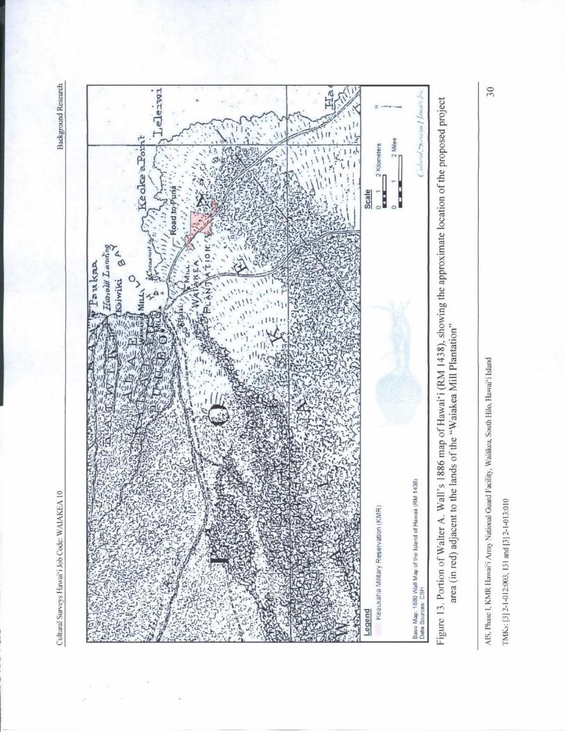
fFt 4 ,
an 4 f'..• • ••• ••: ..,;...... k, :,,fic("4.r,,,bra45'; iir.:,.., • i s, ,,• 1 • ,.• 1 I... 1.
Ir, ,„ --. 7-.:." a
7.- z. S '- ry .• ij-'i%.''
i¶
Y r!`fit`•;' i j3 I
a%` 1. , c r'` • 1' J%
t -
l` tJLj. a, v) O
2. '•, 1i. ,,' Yl'• . 1x ri4),.. .`^ ,q{ iY J.z1r.`... 1 tO O
47-:
a :.tc•.
3 . fr r',".- 1A Negyp-t, g:i + 0
JC-4,- 4G • iY).1 ' Y r2A •!
U
Oir
N2 19ti •/ LZ o.•
A 3 _' S r#. `- \ '\1,.•, ,
ems);" 9 q•-,`'..C-2,:e
eL.II',', 1IA• t. `', b}
gy'iA
r,\'' .. •\ .tli:.I, r , hi, "V '/ ii ... 3
f:. t; lflts: 1-' j 1\' 1+ • t.F. ,; '!:^
C Cn p
1 3 , 1,.'twi„ ,. ••. 1 II.; tf o yI K Y{?pip
i , U .. ) iu 1i'. ' tf.}`',•t N. 1)+
r1 ” • , ,`ti;. t4t3+
lr m
11,1 ', I L, ,!.10.[„ .`
pht 1i4 f•hrslJrr 1
If ! l.Ilf iJ .,„. •,,„... .,• • .•• • .. ... , t , .. .. ,, ,,,,,/,. .„, e _.l '• 3
Ilii.I t/ ,•, N 1.•A r!
i' w ` YJ rtr. l (.-
4,-;:
C e
1i mss:
4:,_,ut',•*.--.r' . + a„' u, C. N.li, 1, ' r• 7....1: x-. : Ytc le)
x
ij'• 1•”'}+lrf+: t,' f.
2. t . L J- ,r1 t 1. 3 cc xI'•',-/.‘ tir, .1 (..., J,- , 44, N 1,:. V.-Z. ..,
01.4;...il.,...t01, x
t ,,3 1 ' T!.*.- '''...t.....,.....4. 1.•.
4..,"
3.....
r,3y;. l•+,
Y' i, Y' ,, T', . 4:/,,n,.....,
i ..-..:-..,%: • ..
rpJ.-e.
rt•.'P`
1sr 1
G1,'.. ' L:•
i., C'• '•a •• ,
a ' N. •''' A 1,i-'T t C2, cd
6;11:•' ae,? 42:,._r x,•'.')' 11 •,;..., r' ••• .4., 4.- '•'* C,.;. oT.J
1i'
i +. +. r •. + , 1 4 • y' .
Ci '> i 4' tJ•f x 7c.^ i{
cdr, a. 4L wq tC' . 4 p1 llE> ,,; f L^3iin , ck.1•
r' Si. ' r +1.. f;Z 1 Lp Cn3
00 72;
o °•i-La
r.:. 3.s.- 1 sC ' 1 in .•.f`^'
tiy.•.
4 ..,ta = + -,
Tim
x,---,, '%
rte•.`.,. r'r
r l t;''{ fl 'f •-+• t .1,'SV X
c -+ 3 c
w • '';' is•+VA.:-`1.rc{ '''t;t;• r', ' irn. w_5. e n0,
1%,...u.:. 4.j....l 3 p o
r C, (.. r,arm,(.._,, cc'.
4 Ztr aiQ : 1..
4.. 1.1.;• t A U •c_n
rt. f L='f s' T' f z I°',
R. } C•• ct{ > ' ^. .- 3 • Z 4
75
6 s i;t(CiA 'yizC''. ! ' 1e, 1J' ,.,
0_ 6` IC.{ *,*J
p.,1 , m cd ' G
6.-,,. •.;-..!, y-,( 6a7(q,, ;:, 4,,'..,
T. ) ..' ,_ i l (,+". _ may+ y Ri b
oil'
r_' r",),agf•+` jr t ),. S''i p! V
Re+-cr•••••.-1•'.!;-- .,.. vo:;, 1) c, i,`_Nya:
10 -••• sh ( yam' A
ZcrO u.
mi
Cd1V•J'Q .:`..,:).._:4 }'..•'."• 1:' i'4 - y .*±` •
1.
4,
R`=!y,, ...' 1 S }-, . M
M
R M, 2•C;..),;•:"'"..?.. • ?, 4...
N,'' -.;,'
OY•.t::•,.;' ... . Kl•~ :i0•.',•-----;
yti7`,+`..•j { , 0 y
Oc -'•
c','.+.:- F., i;Ta tl;') •' 1 y •
l• ",• •yQprI" +. V.
u p N
rn
1(3••- ti') '.!•-(' 1,1.,''
s`'' Jf. 1' {',`„ t.",:
A.,,g.,+i. .--,. 2 in
Q• „,,.-04-&':-'3'
r',,,,,,........-'•:_n+ ;-:-.0. 45%., r-.. J....‘:•''' i.,4' . 1 ..
47 • y(,
I•' a oeJ• S'.. g”: .e,;..V1
r ,,,-,f• ifLi v'• ! , v tl ,+::+ elf..•. W v ° P, v
anti: J,_ - - Z' .•,` • ` • , 9' ',' iii} J m o pp U
U , : 6. t...r. .:'FM. ' r- y'y"' . ''ti•P , Y; - l: r', m
Ll. Q E-,
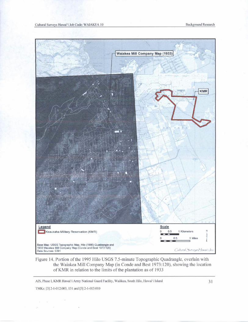
Cultural Surveys Hawai` i Job Code: WAIAKEA 10 Background Research
Waiakea Mill Company Map( 1933)
1
T/•' l
sem
i I
r vt- r
j
1-!: 70 t
k'x 3
K
Legend Scale
oKea ukaha Military Reservation( KMR) 0 0. 5 1 Kilometers
10 0.5 1 Miles jMB I
Base Map: USGS Topographic Map, Hilo( 1995) Quadrangle and1933 Waiakea Mill Company Map( Conde and Best 1973: 120)Data Sources CSH
Figure 14. Portion of the 1995 Hilo USGS 7. 5- minute Topographic Quadrangle, overlain with
the Waiakea Mill Company Map ( in Conde and Best 1973: 120), showing the locationof KMR in relation to the limits of the plantation as of 1933
AIS, Phase I, KMR Hawaii Army National Guard Facility, Waiakea, South Hilo, Hawai` i Island 31
TMKs:[ 3] 2- 1- 012:003, 131 and[ 3] 2- 1- 013: 010
Cultural Surveys Hawaii Job Code: WAIAKEA 10 Background Research
the construction of a new wharf approximately one mile east of Coconut Islandand the dredging of the adjacent portion of the bay. The new wharf, designatedKuhio Wharf was completed in 1916. From the beginning, the wharf wascongested and plans for a second wharf were made. Construction of the wharfbegan in 1921 and it was completed in 1923. A third wharf was completed in1927. [ Haun and Henry 2000: 10]
Ranching in the Hilo area, although not specifically in Waiakea, came under the control oftwo large enterprises, the Parker and Shipman ranches. In Waiakea a large portion of the uplandagricultural zone that was too rocky for sugar cane cultivation became available for lease asWaiakea pasture lands. The specific use of the pasture land is not known but McEldowney notesa " substantial amount of grazing land adjacent to Hilo or to sugarcane fields supported dairycows for Hilo' s several dairies" ( McEldowney 1979:41).
In 1918 the 30- year lease of the Waiakea Mill Company expired and, because Hawai` i hadbecome a territory,
the land fell under homesteading laws that required the government to putsome of it up for lease to homesteaders who would be willing to grow sugar caneon it. Waiakea Mill was to grind the crop for them. A total of about 700 acres ofland was divided into cane lots ( between 10 and 76 acres each) and house lots
ranging from 1 to 3 acres . . . [ Kelly et al. 1981: 121]
A 1915 Hawaii Territory Survey map (Figure 15) shows the KMR west of the Waiakea HouseLots, which were located mauka of the Waiakea Mill. The plantation railroad system ( the presentRailroad Avenue; see Figure 2 and Figure 15), was located just west and north of the KMR. This
map also depicts the " National Guard of Hawaii Rifle Range" overlapping the northernmostportion of the KMR. The homestead and cane lots eventually reverted to the overall mechanizedcultivation and the homestead and cane lot experiment " was declared a failure" ( Kelly et al.1981: 121).
By the 1920s the Waiakea Mill Company had some 7, 000 acres in cane production. Rechtmanand Lang ( 2009) discuss some of the consequences of sugar production in this region:
Sugar cultivation brought dramatic changes to the Hilo area. Some of its largefishponds ( Hanalei, Kalepolepo, Mohouli, Waiahole, and Hoakumau) were filledand thus destroyed. Many old residences, burial sites, trails, heiau ( high place ofworship), and more were destroyed by the development of sugar plantation fields.Rechtman and Lang 2009: 12]
In the 1920s large tracts of remaining forests in Waiakea were " designated as ` forest reserve'to maintain the forest as a ` watershed' to capture, retain, and support the continuous flow ofwater necessary to the sugar industry" ( McEldowney 1979: 42). Clearly, sugar was the dominanteconomic factor during this period including the institution of settlements ( i. e., camps).
In 1931, the Hawaiian Cane Products Company, Ltd. began a firm that developed a newproduct, a fiber board product called " canec." Canec was made from bagasse, the fibrous
byproduct of sugar production usually burned by sugar factories for fuel. The Waiakea Millbegan selling their bagasse to the canec plant, which was located approximately 200 yards fromWaiakea Sugar Mill (Conde and Best 1973: 119).
MS, Phase I, KMR Hawaii Army National Guard Facility, Waiakea, South Hilo, Hawaii Island 32
TMKs:[ 3] 2- 1- 012: 003, 131 and[ 3] 2- 1- 013:010
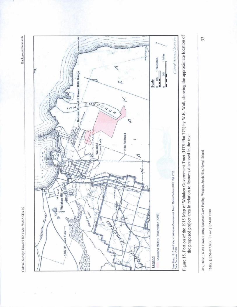
pcMnpG
e 77: 3 t>
4 1 O
ff
1 1t11in LO
al
1 (
ce
r'''.., .
Y ' i
0IOAr , CA ° oI
YtsC-4/ e1j 6iO N O ,17.' ,
1/,t
tJc, OA'
0
o a{faZ. Q
e r,' pn
o \ tip p •
a. tu— } , ! j rp
BWN
S
2
9 77,1/t& t
LIcn
aa /
t t V
ti ..,,t? lel., •
2J ! '
I
cy
ri i. x
a. a. tY. VV' A v
wi t°
s.
s
r z ,,- ce
z-. 4 , 4-. sl' -- O a.,
o
as=
L ( it UT.Zff d
uO
o0ifP 4Y
zlillik N
r Y ` ° t 1-7)
Y a, aTcn
10 r att.,(A O p cn
0co o ro
2
O V t U LL. S. OT
to c6
Yn
pv,. 3 a 01) cii
Cultural Surveys Hawaii Job Code: WAIAKEA 10 Background Research
Several major construction projects were completed in the Hilo area in the 1920s and 1930s,including Hilo Bay wharfs, bridges, and completion of the breakwater. Some of the projects wererelated to winter weather damage of 1923 that included storm surf in January and a tidal wave inFebruary ( Kelly et al. 1981: 171).
3.2.1 The Hilo Airport and the Militarization of Waiakea
The following information comes from two main resources, a 1997 preliminary assessmentfor the Keauhaka Military Reserve ( KMR) ( located just northwest of the study area next to theHilo Airport) by Inter Island Environmental Services, Inc. ( IIES 1997), summarized in Bush andHammatt ( 2000: 15- 19); and an online archive of historic photos and facts about aviation inHawai` i operated by the State of Hawaii (State of Hawai` i 2012).
In 1914, the Governor of the Territory of Hawaii set aside 216.43 acres of land in Waiakeafor a National Guard of Hawaii rifle range ( see Figure 15). A few years later in 1925, 33 acres
were withdrawn from the Guard for the construction of an aviation landing field, named HiloField ( located just north of the present KMR) (Figure 16). In 1927, an Executive Order( EO) wasissued that again increased the acreage under control of the Guard to 994. 6 acres. Two years laterin 1929, 10,000 sq ft of land was withdrawn from the Guard to be used for the Territorial PowderMagazine controlled by the Department of Public Works.
In the mid- 1930s, the chairman of the Aeronautical Commission reported on four planneddevelopments upcoming at the Hilo Airport: 1) development of the main runway; 2) the
development of a " cross- wind" runway; 3) development by Inter- Island Airways, Ltd., of a
terminal building and an airplane shelter; and 4) a request for additional land for expansionInter-Island Airways, Ltd. 1930). With growing international tensions about to lead to a world
war in the early 1940s, precedence for further development was given to Hilo Airport over thenearby KMR.
The decision to refurbish the Hilo Airport was made partially because the airport was the bestdeveloped in the Territory. To complete the runway, prisoners were brought in and housed atKMR( Hawai` i Territorial Aeronautical Commission 1930: 13- 15).
In 1938, the Guard entered into a Temporary Use Agreement ( TUA) with the Territory ofHawaii for the construction of the civilian Waiakea or Territorial Prison Camp, to be located inthe northwestern section of the Guard property, presumably to house the prisoners closer to theirwork projects. Structures included a jailer' s cottage and an acting jailer' s cottage, two prisoners'dormitories, a kitchen, a laundry, and a recreation and workshop building. The Guard' s powdermagazine, consisting of three structures, was constructed south of the prison camp. The Guardrifle range, which included a pistol range, storehouse, and two sheds, was constructed east of thepowder magazine.
In 1941, the Governor of the Territory of Hawai' i authorized the U.S. Army to use andoccupy all Hawai' i Army National Guard armory sites and military reservations. The ArmyCorps of Engineers constructed an airfield and facilities that included 30 assorted buildings southof Hilo Airfield at a projected cost of $670,400. This airfield was later incorporated into HiloAirport. By 1942, the United States and the Territory of Hawaii were involved in World War II.During this time, expansion of the Hilo airport and the construction of the Saddle Road weremajor projects undertaken as part of the military presence on the island. The
MS. Phase I. KMR Hawai`i Army National Guard Facility, Waiakea, South Hilo, Hawaii Island 34
TMKs:[ 3] 2- 1- 012: 003, 131 and[ 3] 2- 1- 013: 010
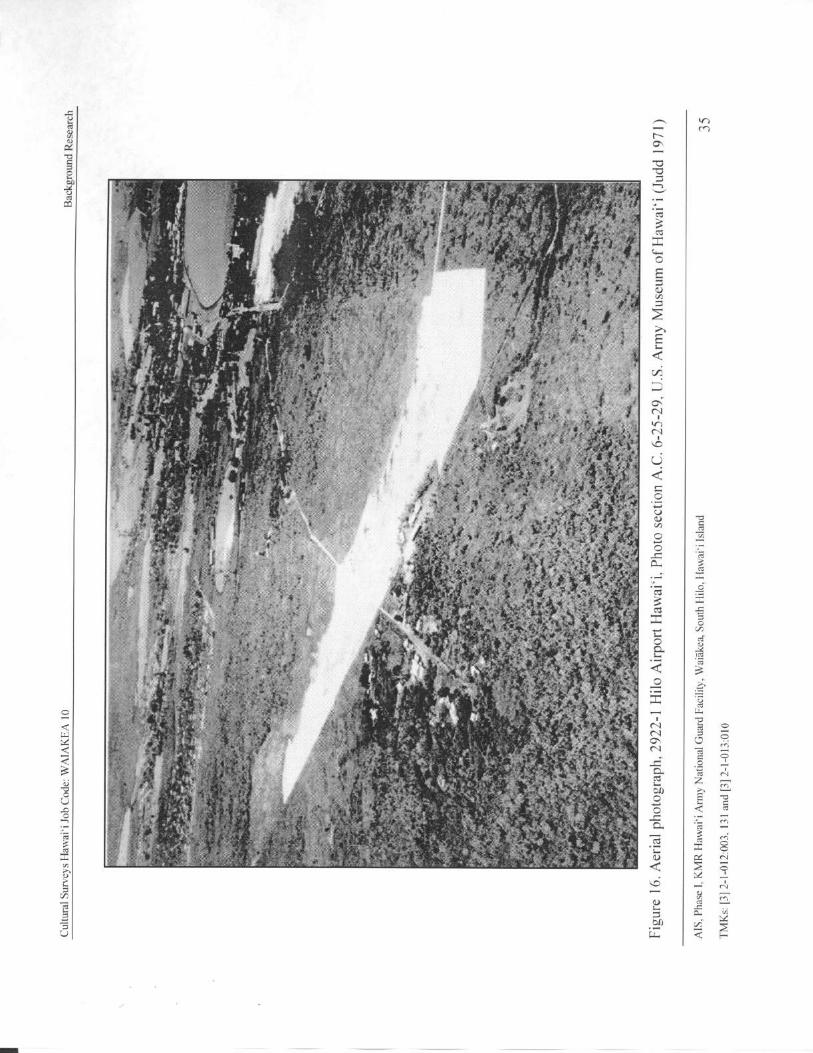
n
yM
N
1 - 4,'''i.ii.;
t •'-
0,
t7
oOO
b, F a '. i° 9 j.; , j
cc
wu
f of 4" d
ice4,}° ''.•',
a• E a 3 t
ol'''''''':':::::i';':'49'':::.*E'':''''' L's'
S:o,j:-,;t'''';4'';:..l:':"'P:..
4:.,:-.A-li':'fl:'':,''''':
c• I'A"
t
i4J1: '
tt
i; r
t p
ft! ,#::
4:,,,,,i11",::::,,t,:ti,,,,,,,:::, ,,,,,,, ::,,,,,,:,,,,,,,,,,...,i .: 7.g
itr,'41 -ji, 'O.* ;
1.,t- I'''-**-:' AN.:4';)4,... %?
1:' ),'',
i::,..:*-601 lki ,,,,,, I b, '',As4e.''' .'''',7..„'',,, ',.':**
34::1*,,--,V* 1:
i;,,) = LI!
t. ,,4-tot°,-.
4i,,--; 41,°,,,
di, ,'-it . 1".. *
k '''' ..-'' 2 -,
ii44f1, ..':'
St.:4
1.,
o
7is'
rp a #
LiZ::-.:*<,,,;:-, .!.4,*..,„. -
4,11.4-,k;,V.; 0.,".:-klkak, —
0.
C
n N
to yr
E...wU
Cultural Surveys Hawai` i Job Code: WAJAKEA 10 Background Research
expansion of Hilo Airport caused the termination of 50 leases in Keaukaha and homes weredemolished and replaced with officers' quarters and mess facilities.
The Navy Department, Bureau of Aeronautics, authorized the establishment of the Hilo Naval
Air Station in 1943. The Navy allotment included a total of 1, 975. 88 acres for its use. The Fifty-ninth Naval Construction Battalion ( NCB) constructed various Naval Air Station facilities andinfrastructure in conjunction with the Hilo Army Air Base. Facilities and infrastructure
completed in 1943 included the enlisted men' s mess hall and barracks, water works system,
communication lines, sewer system, and roads. The Guard Rifle Range was demolished duringthis construction. Navy facilities bordered the Hilo Airfield, renamed General Lyman Field in
1943, on the west and southwest, and abutting the west and south boundaries of the Army AirStation.
According to the State of Hawai` i aviation website, Brigadier General Albert KualiiBrickwood Lyman " was born on the island of Hawaii on May 5, 1885, was educated at
Kamehameha and Punahou Schools, and the West Point Military Academy. General Lyman wasthe first man of Hawaiian blood to be appointed a brigadier general of the United States Army"State of Hawai` i 2012)
By 1944 the Fifty-ninth NCB had completed a pistol and machine gun range and a skeetrange. In April 1944, the 141st NCB replaced the Fifty-ninth NCB. During 1944 the 141st NCBcompleted a tank farm consisting of three gasoline storage tanks, the Radio Transmitter Building,the Station photo lab, Naval Land Bombing Targets, a second tank farm consisting of fourgasoline storage tanks ( most likely Buildings 511 through 514 currently located on DLNR land),a 10- ton jib crane, ammunition storage magazines, a third tank farm, loading racks for the tanks,control houses for all three tank farms, gasoline lines, a dispensary, an oxygen and acetylenewarehouse, a Quonset dynamite storage building, the main gate house, extensions to taxiwaysand aircraft parking, the torpedo workshop, tennis courts, an automotive service station, a rocketassembly hut and magazine, 15 Quonset hut warehouses, two water wells, water mains, and areservoir ( Building 702 currently located on DLNR land). During the latter part of 1944 theWaiakea Prison Camp was moved, with assistance from the 141st NCB, to the upper ` Ola`aForest Reserve. Also during this period, replacement draftees and troops of the Fifth MarineDivision, Fleet Marine Force, Pacific arrived in Hilo and were quartered in the U. S. Armybarracks.
After the completion of Naval Air Station-Hilo in mid- 1945, the Construction Battalion
Maintenance Unit ( CBMU) Number 562, responsible for upkeep of the Naval Air Station,replaced the 141st NCB. During World War II, the number of personnel at Naval Air Station-Hilo reached a peak of 4, 500. The war ended shortly after the completion of Naval Air Station-Hilo, prompting the decommissioning of CBMU Number 562 and the disposal of magazines.The squadron departed in October 1945 and Naval Air Station- Hilo was reduced to caretakerstatus. Naval Air Station- Hilo facilities bordering Runways 3 and 8 were all cleared and movedsouth of Runway 8, except for the Brigade.
In 1946, the Seventh Army Air Force ( AAF) arrived at General Lyman Field (GLF) to beginoperations as a satellite field to support Hickam and Wheeler Air Force Bases on O` ahu. The
area of operations for the AAF included the control tower, operations building, barracks and
MS, Phase I, KMR Hawaii Army National Guard Facility, Waiakea, South Hilo, Hawaii Island 36
TMKs:[ 3] 2- 1- 012: 003, 131 and[ 3] 2- 1- 013: 010
Cultural Surveys Hawaii Job Code: WAIAKEA 10 Background Research
several other smaller buildings. In August 1946 the Navy turned over a dispensary and adjacentbarracks at GLF to the Territory for use as a tuberculosis hospital.
In 1947 the Hawaii National Guard was reactivated on Hawaii Island and obtained the useof 15 buildings on KMR previously used by the Navy for offices and warehouses. Thesebuildings lay within the boundaries of EO # 286, and were intended for the 299th Regimental
Combat Team. In August 1947 Naval Air Station-Hilo officially closed, however, the Navyretained 20 acres on GLF. Previous Naval Air Station-Hilo property reverted back to theTerritory of Hawaii. After the Navy evacuation of GLF, the Guard retained the Navy facilitiesexisting on the property for its use.
In April 1953 the old Naval Air Station-Hilo facilities housed 11 Hawaii National Guard
units. These included the 299th Infantry Medical Company, Service Company, Tank Company,Engineer Combat Company, 110th Army Band, Headquarters Company Second Battalion,Company F, HQ Battery, 487th Field Artillery Battalion, Service Battery, 487th Field ArtilleryBattalion, Battery B, 487th Field Artillery Battalion, and the Medical Detachment, 487th FieldArtillery Battalion. The Guard later constructed combined field, machine gun, mortar, andcombat facilities. Additionally, in April 1953 the Adjutant General requested 954. 67 acres ofland be set aside by the Commissioner of Public Lands for the Hawai` i Army National Guard. In1962, 184. 82 acres were withdrawn from the HIARNG for use by the Hilo IndustrialDevelopment Subdivision; in 1964, 2. 874 acres were withdrawn for the extension of Runways 8through 26. In 1973, 257.810 acres were withdrawn for construction of new airport terminalfacilities. Afterwards 509. 17 acres remained under EO # 1562 for HIARNG use.
3.2.2 Mid-1900s to the Present
Sugar production began to decrease and the Waiakea Mill Company ceased operations in1948. Following statehood in 1959 and the demise of the sugar mill and canec plant, tourismbecame the next economic mainstay. In Waiakea, C. Brewer & Company built a hotel complexat the site of the old canec plant. Other hotels were built along the Hilo Bay frontage of Waiakeanear Coconut Island or Moku`ola. Large tracts of former Waiakea Homestead and cane lots were
converted to housing and sub- division tracts. The portion of Hilo including the study parcelbegan to experience commercial and industrial development, as indicated by Figure 17, althoughmost of the development in Hilo still tended to be concentrated to the west.
MS, Phase I, KMR Hawai` i Army National Guard Facility, Waiakea, South Hilo, Hawaii Island 37
TMKs:[ 3] 2- 1- 012: 003, 131 and[ 3] 2- 1- 013: 010
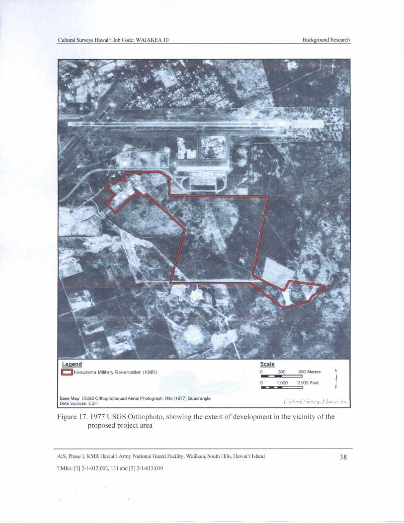
Cultural Surveys Hawaii Job Code: WAIAKEA 10 Background Research
pielkt
a
4 4.,. ., _7-- f;
tk"iret :
F'" .. .t
it
ryIMryI
w
w
pttei4
k YI ,. '....,, •,
al 744
104. ,,,,,,, :., -1, „ .. ,......,_ .
tom^
Jr'
1-
44 } '.'
k
yst (.•..
d , j•,1 Yy4 .
f x44
f
4 t % :,..',,,," fi•
V 1 __
1114,Oil
it 1.
i ay w ti10,
Legend Scale
OKeaukaha Military Reservation( KMR) 0 300 600 Meters N
10 1. 000 2 000 Feet
Op i
Base Map: USGS Orthophotoquad Aerial Photograph. Hilo( 1977) QuadrangleData Sources: CSI-1 r.>/ . r;:./.•;
Figure 17. 1977 USGS Orthophoto, showing the extent of development in the vicinity of theproposed project area
MS, Phase I, KMR Hawai` i Army National Guard Facility, Waiakea, South Hilo, Hawaii Island 38
TMKs:[ 3] 2- 1- 012:003, 131 and[ 3] 2- 1- 013: 010
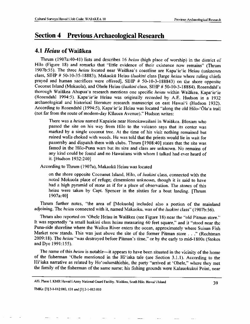
Cultural Surveys Hawaii Job Code: WAIAKEA 10 Previous Archaeological Research
Section 4 Previous Archaeological Research
4. 1 Heiau of Waiakea
Thrum ( 1907a: 40- 41) lists and describes 16 heiau ( high place of worship) in the district ofHilo ( Figure 18) and remarks that " little evidence of their existence now remains" ( Thrum1907b: 55). The three heiau located near Waiakea' s coastline are Kapa` ieie Heiau ( unknownclass, SIHP # 50- 10- 35- 18883), Makaoku Heiau ( luakini class [ large heiau where ruling chiefsprayed and human sacrifices were offered], SIHP # 50- 10- 3- 188843) on the shore opposite
Coconut Island (Mokuola), and Ohele Heiau ( luakini class, SIHP # 50- 10- 3- 18884). Rosendahl' s
thorough Waiakea Ahupua' a research mentions one specific heiau within Waiakea, KapaieieRosendahl 1994: 5). Kapaieie Heiau was originally recorded by A.E. Hudson in a 1932
archaeological and historical literature research manuscript on east Hawaii ( Hudson 1932).
According to Rosendahl ( 1994: 5), Kapaieie Heiau was located " along the old Hilo-` Ola`a trailnot far from the route of modern-day Kilauea Avenue)." Hudson writes:
There was a heiau named Kapaieie near Honokawailani in Waiakea. Bloxam whopassed the site on his way from Hilo to the volcano says that its center wasmarked by a single coconut tree. At the time of his visit nothing remained butruined walls choked with weeds. He was told that the priests would lie in wait for
passersby and dispatch them with clubs. Thrum [ 1908: 40] states that the site wasfamed in the Hilo-Puna wars but its size and class are unknown. No remains ofany kind could be found and no Hawaiians with whom I talked had ever heard ofit. [Hudson 1932: 240]
According to Thrum ( 1907a), Makaoku Heiau was located
on the shore opposite Cocoanut Island, Hilo, of luakini class, connected with thenoted Mokuola place of refuge; dimensions unknown, though it is said to havehad a high pyramid of stone as if for a place of observation. The stones of thisheiau were taken by Capt. Spencer in the sixties for a boat landing. [Thrum1907a:40]
Thrum further notes, " the area of [ Mokuola] included also a portion of the mainlandadjoining. The heiau connected with it, named Makaoku, was of the luakini class" ( 1907b: 56).
Thrum also reported on ` Ohele Heiau in Waiakea ( see Figure 18) near the " old Pitman store."It was reportedly " a small luakini class heiau measuring 60 feet square," and it " stood near the
Puna- side shoreline where the Wailoa River enters the ocean, approximately where Suisan FishMarket now stands. This was just above the site of the former Pitman store . . ." ( Rechtman2009: 18). The heiau " was destroyed before Pitman' s time," or by the early to mid- 1800s ( Stokesand Dye 1991: 155).
The name of this heiau is notable— it appears to have been situated in the vicinity of the homeof the fisherman ` Ohele mentioned in the Hiiaka tale ( see Section 3. 1. 1). According to theHiiaka narrative as related by Ho`oulumahiehie, the party " arrived at ` Ohele," where they metthe family of the fisherman of the same name; his fishing grounds were Kalauokukui Point, near
AIS, Phase I, KMR Hawaii Army National Guard Facility, Waiakea, South Hilo, Hawaii Island 39
TMKs:[ 3] 2- 1- 012: 003, 131 and[ 3] 2- 1- 013: 010
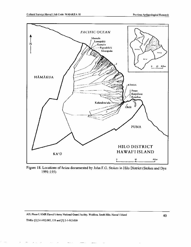
Cultural Surveys Hawai` i Job Code: WAIAKEA 10 Previous Archaeological Research
PACIFIC OCEAN
111an1alat
Lonopuhaa
N K31113`0 11110
Papauleki`i(/* —
Xlue puhiPON A
ri 0 20 - 00 km
ilpv_.
krc1
s,;-----:—.„---,,__Pinarl
7,--- Kaipala las Kinailcla
Kahinihine ula `--_-. ,; fr
thele
2
PUNA
HILO DISTRICT
KA‘ tiHAWAII ISLAND
0 10 20140t l
Figure 18. Locations of heiau documented by John F.G. Stokes in Hilo District (Stokes and Dye1991: 155)
MS, Phase I, KMR Hawaii Army National Guard Facility, Waiakea, South Hilo, Hawaii Island 40
TMKs:[ 3] 2- 1- 012: 003, 131 and[ 3] 2- 1- 013: 010
Cultural Surveys Hawai` i Job Code: WAIAKEA 10 Previous Archaeological Research
the mouth of the Wailoa River (Nogelmeier 2006: 67). None of the heiau described by Thrum isin close proximity to the study parcel.
4.2 Puna Trail
Accounts by nineteenth century historians ` Ii, Kamakau and Malo, as well as accounts ofearly missionary and explorers relate that travel by sea was the preferred method oftransportation during prehistoric and early historic times. However, these same sources also pointout the importance of overland trails as means of movement and communication. Appledescribes the importance of the circle- island coastal trail (ala loa, or " long trail") for traditionaltax collection associated with the annual Makahiki (Apple 1965: 22- 23). This system consisted of
circle- island coastal trails, as well as numerous trails to facilitate mauka-makai ( upland- sea)travel, connecting the coast with terrestrial resources.
Ross Cordy, in his study of the ala kahakai (beach), or ala loa ( long road) trail system on theleeward coast of the Island of Hawai` i, briefly discusses windward trails, noting that previousarchaeological research shows permanent habitation on the windward side existed earlier in
places such as Hilo and eastern Puna. Thus, it might be surmised that some form of trailsystem— perhaps including the Puna Trail— may date back as early as the years 900- 1000Cordy 1995: 8).
Wendy Goodman ( Tolleson), in her study of two lots in Chalan Pago/ Ordot, Guam, and herstudy of prehistoric trails systems in Waiawa Ahupua`a, O` ahu, suggested factors affectingplacement and preservation of aboriginal trails ( Goodman and Nees 1991; Goodman and Olmo1993). It is common for trails in Hawai` i to be constructed, or relocated, based on relatedfeatures such as ease of overland route compared to the coast, temporary rock shelters, sources offresh water, or markers created by travelers to make the trails less obscure.
In prehistoric times a tradition of exchange was centered in the Hilo area. The banks of theWailuku river appear to have been the site of extensive trade between the different regions ofEast Hawai` i. This trade flourished in prehistoric and early historic times, but apparentlydeclined during the reign of Liholiho, Kamehameha II (Ellis 1974: 325- 326).
It should be noted that the Puna Trail mentioned by Ellis in 1823 was a coastal trail whichskirted the Hilo and Puna coastline. In subsequent maps ( e. g., Figure 11 and Figure 13), the road
or trail to Puna appears as a transportation route that cross- cuts the Hilo and Puna regions rather
than following the coastline. The ease of traveling through this cooler region, and the decreaseddistances it provided in spite of exhausting climbs, could have made for expedient trade andcommunication especially at a time in Hawaiian history when missionary activities wereprevalent. Traders from such far districts as Ka`u traveled to Hilo, thus it is not unreasonable tosuppose some traveled overland, probably along the Puna Trail.
Hudson' s ( 1932) manuscript noted the presence of the Puna Trail, and it was later
documented to some extent by McEldowney ( 1979) during her study of the larger Hilo area. Thisportion of the Puna Trail was assigned as SIHP # 50- 10- 35- 18869 ( the site number is commonlylisted incorrectly with the quadrant numbered as " 99").
Lass' study of a portion of the " Old Government Road" in the coastal area of Kea' au ( Lass1997: 14- 15), approximately 7 miles southeast of the KMR facility, discusses changes to the
MS, Phase I, KMR Hawai` i Army National Guard Facility, Waiakea, South Hilo, Hawai` i Island 41
TMKs:[ 3] 2- 1- 012: 003, 131 and[ 3] 2- 1- 013: 010
Cultural Surveys Hawaii Job Code: WAIAKEA 10 Previous Archaeological Research
routing and construction style of the Puna Trail. What she calls the " Old Government Road" is
clearly a portion of the Puna Trail, assigned SIHP # 50- 10- 36- 21273 during her study.
In the early 1840s, horses and mules began to be used in the Hilo region, though the vastmajority of land travel was still by foot. The initial improvements to the Puna Trail date to theearly 1840s, when the Wilkes U. S. Exploration Expedition traveled along the coast of Puna toHilo. However, accounts of the expedition' s progress along this route do not go into detail aboutwhich trail was used. It is clear that by the mid- to late 1870s, the Puna Trail was used for horsetravel ( Lass 1997: 17). Lass describes how the shifting importance of transportation routes after1880 resulted in a marked decline in use of the Puna Trail immediately south of Hilo.
Despite the decline in usage of the trail for major market and horse traffic after 1890, localfoot traffic continued to use the Puna Trail, including the portions that extend through the KMR,into the twentieth century. The alignment of the route is charted and labeled " Puna Trail" on the1932 Hilo USGS Topographic Quadrangle as well as the 1961 State of Hawaii Department ofDefense Map of the KMR facility.
4.3 Previous Archaeological Studies in the Vicinity of the KMRA number of past archaeological studies have been conducted in Waiakea and the greater Hilo
area, with a small handful at or overlapping the KMR. These studies are shown on Figure 19 andlisted in Table 2. The past studies undertaken at KMR appear in bold in Table 2 and arediscussed in Section 4. 3. 1.
In 1974, the Archaeological Research Center of Hawaii completed an archaeological
reconnaissance for a proposed drag strip in Pana`ewa, south of the KMR ( Ching and Stauder1974; see Figure 19). No archaeological sites were encountered within the 135- acre project area.
In 1979, the University of Hawaii at Hilo undertook an archaeological survey of a 39- acreportion of Hawaiian Home Lands ( HHL) west of the KMR ( Bonk 1979; see Figure 19). A
section of a rock wall and a" broken wire fence line" were identified, though these were assessedas modern. Furthermore, the remains of an " old road" were identified. The roadway wasdescribed as 15 to 20 ft wide, marked by rock alignments 1 to 2 ft high ( Bonk 1979: 3). No
further work was recommended for the project area.
In 1983, the SHPD investigated a claim of a heiau depicted on a modern TMK: [ 3] 2- 1- 007,north of KMR along the coast( Kam 1983; see Figure 19). This unnamed heiau also appears on a
1936 Ocean View Lease Lots map. No records were found at that time pertaining to the heiau;Kam ( 1983: 1) recommended it be recorded and photographed. This site was assigned as SIHP #50- 10- 35- 18695, but no formal documentation ever occurred. In 2000, Haun and Associates
came upon the heiau just outside the bounds of their survey of two parcels near Hilo Harbor ( seebelow). Haun and Henry ( 2000: 22) described the heiau but did not formally document it.
In 1988, a single set of human remains was identified near the mouth of Wailoa Stream acrossfrom the Suisan Fish Market, which is located approximately 1 mile northwest of the KMR. Theremains were documented ( Pietrusewsky 1989; see Figure 19) and then excavated and studiedSmith and Tourtellotte 1988; see Figure 19). As Rechtman ( 2009: 27) writes, "[ t]his discovery,
while only that of a single set of remains, does indicate that the possibility exists for additionalremains, especially in coastal areas of former dune deposits along the Hilo bay front."MS, Phase I. KMR Hawai` i Army National Guard Facility. Waiakea, South Hilo, Hawaii Island 42
TMKs:[ 3] 2- 1- 012:003, 131 and[ 3] 2- 1- 013: 010
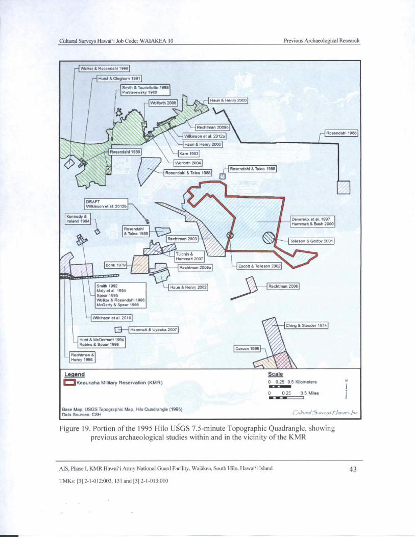
Cultural Surveys Hawaii Job Code: WAIAKEA 10 Previous Archaeological Research
Walker& Rosendahl 1996
Hurst& Cleghorn 1991
Ii—
I
Smith& Tourtetiotle 1988
Ptetrusewsky 1989
Ytb80rth 2006 4 Haus& Henry 2000
0 .
RedNman209b
Rosendahl 1988
i0-. Wilkinson et al. 2012a
Haun& Henry 2000
Rosendahl 1988Kam 1983
wenenn 2ooa
i' Rosendahl& Talea 1988)r Rosendahl 8 Taloa 1988
DRAFT
Wilkinson et al. 2012b
Kennedy& j Devereux et el. 1997Ireland 1994
Hammett& Bush 2000
Rosendahl
Taloa 1988 4Rechtman 2003
Tolleson& Godby 2001
r AroTulchus&
Hammett 2007
Bonk 19791Rechtman 2009a Escott& Tolleson 20021
Smith 1992 Haun& henry 2002 Rechtman 2006
Maly et al. 1994Spear 1995
Walker& Rosendahl 1996
McGerty& Spear 1999
Wilkinson et al. 2010
AChing& Stauder 1974
0 I Hammett& Uyeoka 2007Hunt& McDermott 1994
Robins& Spear 1996Carson 1999 i
Rechtman&
Henry 1998 OOLegend Scale
oKeaukaha Military Reservation( KMR) 0 0.25 0. 5 KilometersOCIEMONO 10 0 25 0. 5 Miles
1 I
Base Map: USGS Topographic Map, Hilo Quadrangle( 1995)Data Sources. CSH C. ariiii'a/, L'Ju 1 c'i r lawa' i. Ali.
Figure 19. Portion of the 1995 Hilo USGS 7. 5- minute Topographic Quadrangle, showingprevious archaeological studies within and in the vicinity of the KMR
AIS, Phase I, KMR Hawaii Army National Guard Facility, Waiakea, South Hilo, Hawaii Island 43
TMKs:[ 3] 2- 1- 012:003, 131 and[ 3] 2- 1- 013:010
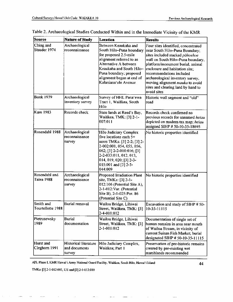
Cultural Surveys Hawaii Job Code: WAIAKEA 10 Previous Archaeological Research
Table 2. Archaeological Studies Conducted Within and in the Immediate Vicinity of the KMRSource Nature of Study Location Results
Ching and Archaeological Between Keaukaha and Four sites identified, concentratedStauder 1974 reconnaissance South Hilo—Puna boundary near South Hilo—Puna Boundary;
for proposed 2. 5- mile sites included stacked pahoehoealignment referred to as wall on South Hilo—Puna boundary,Alternative A between platform/monument burial, animal
Keaukaha and South Hilo— enclosure and habitation site;Puna boundary; proposed recommendations included
alignment began at end of archaeological inventory survey,Kalaniana`ole Avenue moving alignment mauka to avoid
sites and clearing land by hand toavoid sites
Bonk 1979 Archaeological Survey of HHL Pana` ewa Historic wall segment and" old"
inventory survey Tract 1, Waiakea, South road
Hilo
Kam 1983 Records check State lands at Reed' s Bay, Records check confirmed noWaiakea, TMK: [3] 2- 1- previous records for unnamed heiau007: 011 depicted on modem tax map; heiau
assigned SIHP# 50- 10- 35- 18695
Rosendahl 1988 Archaeological Hilo Judiciary Complex No historic properties identifiedreconnaissance five locations each 5+
survey acres TMKs: [ 3] 2- 2; [ 3] 2-
2- 002: 001, 054, 055, 056,
062; [ 3] 2- 2- 010: 016; [ 3]
2- 2- 033: 011, 012, 013,
014, 019, 020; [ 3] 2- 3-
015: 001 and [ 3] 2- 3-
044: 009
Rosendahl and Archaeological Proposed Irradiation Plant No historic properties identifiedTalea 1988 reconnaissance site, TMKs: [ 3] 2- 1-
survey 012: 106( Potential Site A),
2- 1- 012: Var. (Potential
Site B), 2- 1- 025: Por. 86
Potential Site C)
Smith and Burial removal Wailoa Bridge, Lihiwai Excavation and study of SIHP# 50-
Tourtellotte 1988 Street, Waiakea, TMK: [3] 10- 35- 11115
2- 4- 001: 012
Pietrusewsky Burial Wailoa Bridge, Lihiwai Documentation of single set of1989 documentation Street, Waiakea, TMK: [3] human remains in area near mouth
2- 1- 001: 012 of Wailoa Stream, in vicinity ofcurrent Suisan Fish Market; burial
designated SIHP# 50- 10- 35- 11115
Hurst and Historical literature Hilo Judiciary Complex, Preservation of pre-historic remainsCleghorn 1991 and documents Waiakea; Part 1 created by pre- existing wet
survey marshlands recommended
MS, Phase I, KMR Hawai` i Army National Guard Facility, Waiakea, South Hilo, Hawai` i Island 44
TMKs:[ 3] 2- 1- 012: 003, 131 and[ 3] 2- 1- 013: 010
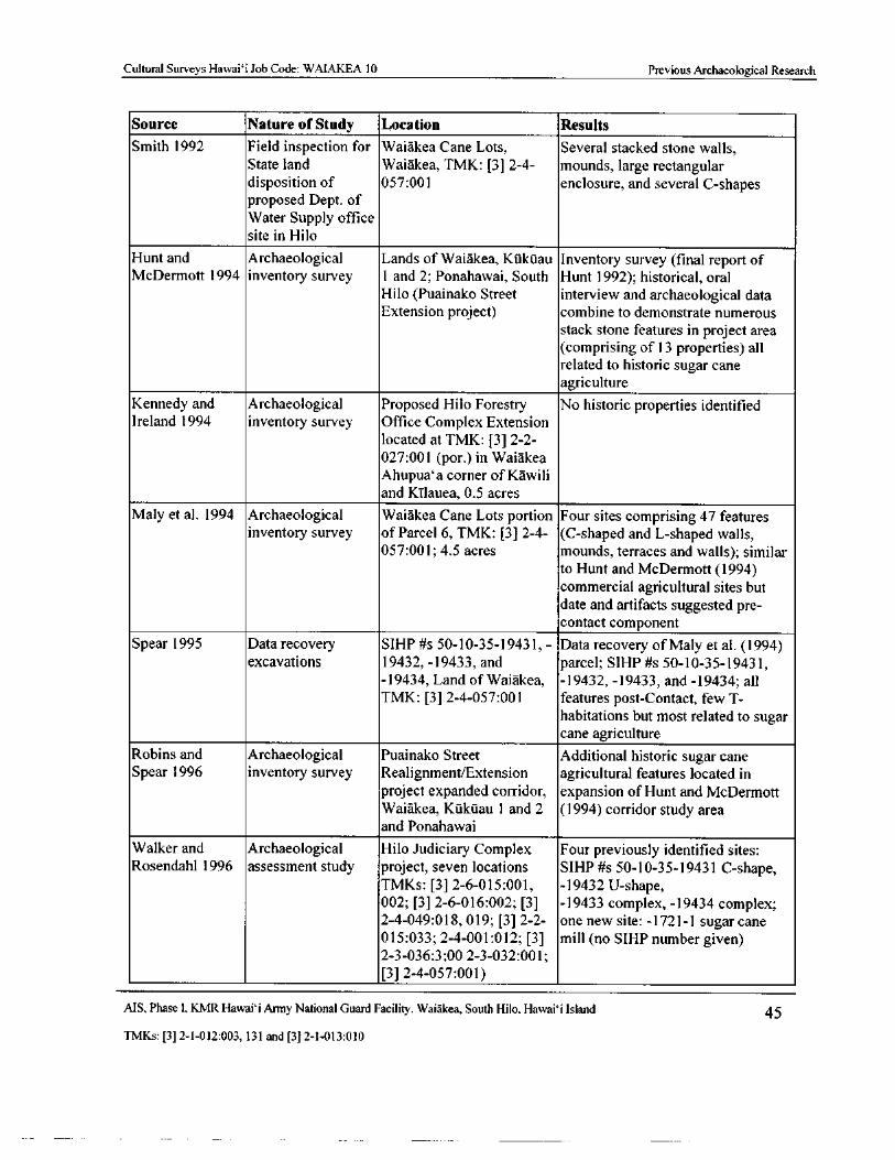
Cultural Surveys Hawaii Job Code: WAIAKEA 10 Previous Archaeological Research
Source Nature of Study Location Results
Smith 1992 Field inspection for Waiakea Cane Lots, Several stacked stone walls,State land Waiakea, TMK: [ 3] 2- 4- mounds, large rectangulardisposition of 057: 001 enclosure, and several C- shapesproposed Dept. of
Water Supply officesite in Hilo
Hunt and Archaeological Lands of Waiakea, Ktakuau Inventory survey ( final report ofMcDermott 1994 inventory survey 1 and 2; Ponahawai, South Hunt 1992); historical, oral
Hilo( Puainako Street interview and archaeological dataExtension project) combine to demonstrate numerous
stack stone features in project area
comprising of 13 properties) allrelated to historic sugar cane
agriculture
Kennedy and Archaeological Proposed Hilo Forestry No historic properties identifiedIreland 1994 inventory survey Office Complex Extension
located at TMK: [3] 2- 2-
027:001 ( por.) in Waiakea
Ahupua' a corner of Kawili
and Kilauea, 0. 5 acres
Maly et al. 1994 Archaeological Waiakea Cane Lots portion Four sites comprising 47 featuresinventory survey of Parcel 6, TMK: [3] 2- 4- ( C- shaped and L- shaped walls,
057:001; 4. 5 acres mounds, terraces and walls); similar
to Hunt and McDermott( 1994)
commercial agricultural sites but
date and artifacts suggested pre-
contact component
Spear 1995 Data recovery SIHP# s 50- 10- 35- 19431, - Data recovery of Maly et al. ( 1994)
excavations 19432, - 19433, and parcel; SIHP# s 50- 10- 35- 19431,19434, Land of Waiakea, - 19432, - 19433, and- 19434; all
TMK: [ 3] 2- 4- 057: 001 features post- Contact, few T-
habitations but most related to sugarcane agriculture
Robins and Archaeological Puainako Street Additional historic sugar caneSpear 1996 inventory survey Realignment/Extension agricultural features located in
project expanded corridor, expansion of Hunt and McDermott
Waiakea, Kukuau 1 and 2 ( 1994) corridor study areaand Ponahawai
Walker and Archaeological Hilo Judiciary Complex Four previously identified sites:Rosendahl 1996 assessment study project, seven locations SIHP# s 50- 10- 35- 19431 C- shape,
TMKs: [ 3] 2- 6- 015: 001, - 19432 U-shape,
002; [ 3] 2- 6- 016: 002; [ 3] - 19433 complex, - 19434 complex;2- 4- 049: 018, 019; [ 3] 2- 2- one new site: - 1721- 1 sugar cane
015: 033; 2- 4- 001: 012; [ 3] mill (no SIHP number given)
2- 3- 036: 3; 00 2- 3- 032: 001;
3] 2- 4- 057: 001)
AIS, Phase I. KMR Hawai` i Army National Guard Facility, Waiakea, South Hilo, Hawai` i Island 45
TMKs:[ 3] 2- 1- 012: 003, 131 and[ 3] 2- 1- 013: 010
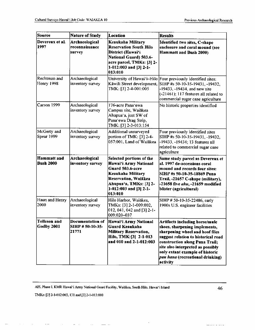
Cultural Surveys Hawai` i Job Code: WAIAKEA 10 Previous Archaeological Research
Source Nature of Study Location Results
Devereux et al. Archaeological Keaukaha Military Identified two sites, C- shape1997 reconnaissance Reservation South Hilo enclosure and coral mound( see
survey District( Hawai` i Hammatt and Bush 2000)
National Guard) 503. 6-
acre parcel, TMKs: [3] 2-
1- 012: 003 and [ 3] 2- 1-
013: 010
Rechtman and Archaeological University of Hawai` i—Hilo Four previously identified sites:Henry 1998 inventory survey Kawili Street development, SIHP# s 50- 10- 35- 19431,- 19432,
TMK: [ 3] 2- 4- 001: 005 - 19433,- 19434, and new site
21461); 117 features all related to
commercial sugar cane agriculture
Carson 1999 Archaeological 176- acre Pana`ewa No historic properties identified
inventory survey Campus site, Waiakea
Ahupua`a, just SW of
Pana`ewa Drag Strip,TMK: [ 3] 2- 3- 013: 154
McGerty and Archaeological Additional unsurveyed Four previously identified sitesSpear 1999 inventory survey portion of TMK: [3] 2- 4- SIHP# s 50- 10- 35- 19431,- 19432,
057: 001, Land of Waiakea - 19433, - 19434; 13 features all
related to commercial sugar cane
agriculture
Hammatt and Archaeological Selected portions of the Same study parcel as Devereux etBush 2000 inventory survey Hawaii Army National al. 1997 de- accessions coral
Guard 503. 6- acre mound and records four sites:
Keaukaha Military SIHP# s 50- 10- 35- 18869 Puna
Reservation, Waiakea Trail,- 21657 C-shape( military),Ahupua` a, TMKs: [3] 2- - 21658 five ahu,- 21659 modified1- 012: 003 and [ 3] 2- 1- blister( agricultural)
013: 010
Haun and Henry Archaeological Hilo Harbor, Waiakea, SIHP# 50- 10- 35- 22486, early2000 inventory survey TMKs: [ 3] 2- 1- 009: 002, 1900s U. S. engineer facilities
012, 041, 042 and [ 3] 2- 1-
009: 020- 037
Tolleson and Documentation of Hawaii Army National Artifacts including horse/muleGodby 2001 SIHP# 50- 10-35- Guard Keaukaha shoes, sharpening implements,
21771 Military Reservation, sharpening wheel and hoof filesHilo, TMK:[3] 2- 1- 013 suggest relation to historical roadand 010 and 2- 1- 012: 003 construction along Puna Trail;
site also interpreted as possiblyonly extant example of historicpau hana( recreational drinking)activity
AIS, Phase I, KMR Hawaii Army National Guard Facility, Waiakea, South Hilo, Hawaii Island 46
TMKs:[ 3] 2- 1- 012: 003, 131 and[ 3] 2- 1- 013: 010
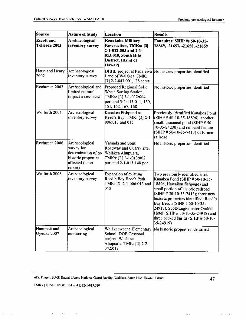
Cultural Surveys Hawaii Job Code: WAIAKEA 10 Previous Archaeological Research
Source Nature ofStudy Location Results
Escott and Archaeological Keaukaha Military Four sites: SIHP# s 50- 10- 35-Tolleson 2002 inventory survey Reservation, TMKs: [3] 18869,- 21657,- 21658,- 21659
2- 1- 012: 003 and 2- 1-
013: 010, South Hilo
District, Island of
Hawaii
Haun and Henry Archaeological DHHL project at Pana` ewa No historic properties identified2002 inventory survey Land of Waiakea, TMK:
3] 2- 2- 047: 001, 28 acres
Rechtman 2003 Archaeological and Proposed Regional Solid No historic properties identifiedlimited cultural Waste Sorting Station,impact assessment TMKs: [ 3] 3- 1- 012: 004
por. and 3- 2- 113: 011, 150,
151, 162, 167, 168
Wolforth 2004 Archaeological Kanakea Fishpond at Previously identified Kanakea Pondinventory survey Reed' s Bay, TMK: [3] 2- 1- ( SIHP# 50- 10- 35- 18896), another
006: 013 and 015 small, unnamed pond( SIHP# 50-
10- 35- 24230) and remnant featureSIHP# 50- 10- 35- 7413) of former
railroad
Rechtman 2006 Archaeological Yamada and Sons No historic properties identified
survey for Roadway and Quarry site,determination of no Waiakea Ahupua`a,historic properties TMKs: [ 3] 2- 1- 013: 002
affected( letter por. and 2- 1- 013: 148 por.
report)
Wolforth 2006 Archaeological Expansion of existing Two previously identified sites,inventory survey Reed' s Bay Beach Park, Kanakea Pond ( SIHP# 50- 10- 35-
TMK: [3] 2- 1- 006: 013 and 18896, Hawaiian fishpond) and015 small portion of historic railroad
SIHP# 50- 10- 35- 7413); three new
historic properties identified: Reed' s
Bay Beach( SIHP# 50- 10- 35-
24917), Scott-Legionnaire-OrchidHotel ( SIHP# 50- 10- 35- 24918) and
three pecked basins( SIHP# 50- 10-
3 5- 24919)
Hammatt and Archaeological Waiakeawaena Elementary No historic properties identifiedUyeoka 2007 monitoring School, DOE Cesspool
project, Waiakea
Ahupua`a, TMK: [3] 2- 2-
042: 017
MS. Phase I. KMR Hawai` i Army National Guard Facility, Waiakea, South Hilo, Hawai` i Island 47
TMKs:[ 3] 2- 1- 012:003, 131 and[ 3] 2- 1- 013: 010
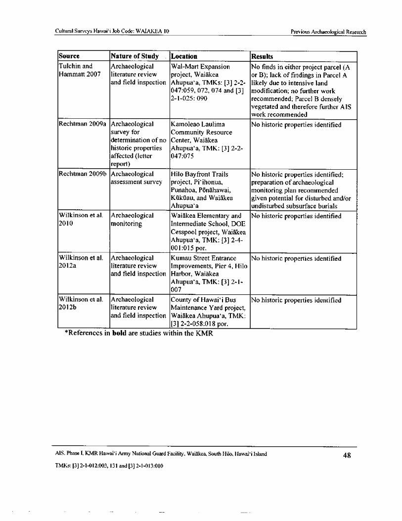
Cultural Surveys Hawaii Job Code: WAIAKEA 10 Previous Archaeological Research
Source Nature of Study Location Results
Tulchin and Archaeological Wal- Mart Expansion No finds in either project parcel( AHammatt 2007 literature review project, Waiakea or B); lack of findings in Parcel A
and field inspection Ahupua`a, TMKs: [ 3] 2- 2- likely due to intensive land047: 059, 072, 074 and [ 3] modification; no further work2- 1- 025: 090 recommended; Parcel B densely
vegetated and therefore further AIS
work recommended
Rechtman 2009a Archaeological Kamoleao Laulima No historic properties identified
survey for Community Resourcedetermination of no Center, Waiakea
historic properties Ahupua`a, TMK: [3] 2- 2-
affected( letter 047: 075
report)
Rechtman 2009b Archaeological Hilo Bayfront Trails No historic properties identified;assessment survey project, Pi` ihonua, preparation of archaeological
Punahoa, Ponahawai, monitoring plan recommendedKukuau, and Waiakea given potential for disturbed and/orAhupua`a undisturbed subsurface burials
Wilkinson et al. Archaeological Waiakea Elementary and No historic properties identified2010 monitoring Intermediate School, DOE
Cesspool project, Waiakea
Ahupua`a, TMK: [3] 2- 4-
001: 015 por.
Wilkinson et al. Archaeological Kumau Street Entrance No historic properties identified2012a literature review Improvements, Pier 4, Hilo
and field inspection Harbor, Waiakea
Ahupua`a, TMK: [3] 2- 1-
007
Wilkinson et al. Archaeological County of Hawai` i Bus No historic properties identified2012b literature review Maintenance Yard project,
and field inspection Waiakea Ahupua`a, TMK:3] 2- 2- 058: 018 por.
References in bold are studies within the KMR
MS. Phase I, KMR Hawai` i Army National Guard Facility, Waiakea, South Hilo, Hawaii Island 48
TMKs:[ 3] 2- 1- 012: 003, 131 and[ 3] 2- 1- 013: 010
Cultural Surveys Hawai` i Job Code: WAIAKEA 10 Previous Archaeological Research
Also in 1988, Paul H. Rosendahl, Ph.D., Inc. ( PHRI) reported on the results of an archaeological
reconnaissance of five proposed locations surrounding the KMR for the Hilo Judiciary ComplexRosendahl 1988; see Figure 19). No finds were reported. That same year, PHRI conducted an
archaeological reconnaissance survey for a proposed irradiation plant site at three locations in Hilo,including one area north and east of the KMR( Rosendahl and Talea 1988; see Figure 19). Similarly,no historic properties were identified due to extensive land modifications associated with urbandevelopment.
In 1991 the Bishop Museum completed a literature and documents search for the proposed HiloJudiciary Complex northwest of the KMR ( Hurst and Cleghorn 199; see Figure 19). The report
concluded with a recommendation of test excavations and borings to identify any potential pre-Contact cultural layers.
In 1992 the SHPD undertook a field inspection in the Waiakea Cane Lots west of the KMRSmith 1992; see Figure 19). Several stacked stone walls, mounds, a large rectangular enclosure, and
several C- shapes were encountered during the inspection, and inventory survey was recommendedprior to any land- disturbing activity.
In 1994, PHRI completed an archaeological inventory survey at Parcel 6 within the WaiakeaCane Lots ( Maly et al. 1994; see Figure 19), per the earlier recommendations of the SHPD ( Smith1992). According to the report:
During the field work, four sites consisting of 47+ features were identified in the
study parcel. The sites consist of both single and multiple- components, and theirphysical condition ranges from poor to good. Formal feature types include C- shapeenclosures, cupboards, L-shape enclosures, mounds, terraces, and walls. Functionalfeature types include both temporary and long-term habitation and agriculture. As apart of the survey, two subsurface test units, totaling three square meters, and oneshovel test were excavated at Sites 19431 and 19432. No substantial cultural depositsor portable remains were identified as a result of these investigations. [ Maly et al.1994: ii]
Furthermore, a " volcanic glass flake and a charcoal sample were recovered from Site 19431, apossible historic habitation with an associated agricultural site . . . [ yielding] a conventional
radiocarbon date of 490 + 70 B. P." ( McGerty and Spear 1999: 4- 6). This date range indicated thepotential presence of a pre- Contact cultural layer.
In 1994 Archaeological Consultants of Hawaii, Inc. conducted an archaeological inventorysurvey for the proposed Hilo Forestry Office Complex Extension west of the KMR (Kennedy andIreland 1994; see Figure 19). No historic properties were identified due to extensive land
modifications associated with the urban development of Hilo. However, one historic property, SIHP19626 ( stone wall), was identified bordering the perimeter of the study area. The site consists of a
bi- faced, core- filled wall constructed of stacked, and in some sections, mortared basalt boulders. Thesite was determined to be of historic origin.
Two surveys were completed west of the KMR for the proposed Puainako Street Extension (Huntand McDermott 1994, Robins and Spear 1996; see Figure 19). These studies along with an earliersurvey ( Hunt 1992) covered various road corridor alignments from 200- 1, 500 ft elevation, throughmultiple ahupua' a including Waiakea, KUkUau 1 and 2, and a small part of Ponahawai. A total of 13
MS. Phase I, KMR Hawai` i Army National Guard Facility, Waiakea, South Hilo, Hawai` i Island 49
TMKs:[ 3] 2- 1- 012: 003, 131 and[ 3] 2- 1- 013: 010
Cultural Surveys Hawaii Job Code: WAIAKEA 10 Previous Archaeological Research
sites were observed and recorded. Site types included stacked stone walls, mounds, platforms,modified outcrops, and faced terraces. Also documented were railroad- related features such asberms, sections of track, and cross- ties. The historical research and oral interviews with
knowledgeable local residents provided ample evidence that all of these features were historic andrelated to the development of commercial sugar cane agriculture in this portion of Hilo after the
1870s. The stacked stone structures are predominantly related to field clearance. The stony soil ofthis region yielded large quantities of basalt cobbles and boulders that had to be stored in an efficientmanner to maximize the arable land. The limited evidence of prehistoric land use within the
Pu` ainako Street Extension project clearly predated construction of the numerous stacked stonefeatures ( Hunt and McDermott 1994: 104- 105, 108).
In 1995, Scientific Consultant Services, Inc. ( SCS) conducted data recovery at the four sitesinvestigated by Maly et al. ( 1994) ( Spear 1995; see Figure 19). Excavation at SIHP # - 19431 foundno evidence of a buried pre- Contact cultural layer. As described by McGerty and Spear( 1999: 6), the
volcanic glass flake identified during the 1994 survey and its associated radiocarbon date wereinterpreted as examples of the " subtle evidence on Hawaiian use of the area . . . found only in sparseand unpredictable spatial distribution" ( Hunt and McDermott 1994: 108).
In 1996 PHRI conducted an assessment study at seven newly proposed locations for the HiloJudiciary Complex ( Walker and Rosendahl 1996; see Figure 19). A total of five historic sites weredocumented, including 47+ features relating to sugar cane cultivation and production ( SIHP # s
19431 through - 19434) and the old Hilo Sugar Company Mill ( SIHP # - 21133) ( Walker andRosendahl 1996: 20- 22). SIHP # - 19431 is a C- shaped structure. While the architectural remains arehistoric, a subsurface prehistoric fire pit and volcanic glass artifact were discovered at the site,indicating " prehistoric occupation prior to early historic sugar cane cultivation" ( Walker andRosendahl 1996:22).
In 1998 PHRI conducted an archaeological inventory survey for the University of Hawai` i at HiloKawili Street Development, west of the KMR ( Rechtman and Henry 1998; see Figure 19). Onehistoric property was identified, SIHP # - 21461, an agricultural field complex associated withhistoric sugar cane agriculture, consisting of piled rock mounds and stacked rock walls andenclosures.
In 1999 Haun and Associates returned to the vicinity of the Maly et al. ( 1994) and Spear ( 1995)
study parcels to conduct an archaeological inventory survey of an adjacent unsurveyed portion ofTMK: [ 3] 2- 4- 057: 001 ( McGerty and Spear 1999; see Figure 19). Four historic properties wereidentified, SIHP # s - 19431, - 19432, - 19433, and - 19434. All four sites were determined to beassociated with historic sugar cane agriculture.
The same year, SCS completed an archaeological inventory survey for a proposed 176- acrePana` ewa Campus located south of the KMR (Carson 1999; see Figure 19). No finds were reported
and no further work was recommended.
In 2000, Haun and Associates undertook a survey of two parcels near the Hilo Harbor, one parceljust west of the breakwater, and the second parcel at the Ocean View Lease Lots and within thelands abutting the eastern end of Ocean View Drive ( Haun and Henry; see Figure 19). A concreteslab complex, SIHP # - 22486, is located in this latter parcel, adjacent to the current project area.According to Haun and Henry ( 2000: 22), the site " consist[ s] of two concrete slabs ( Features A and
MS, Phase 1, KMR Hawaii Army National Guard Facility, Waiakea, South Hilo, Hawaii Island 50
TMKs:[ 3] 2- 1- 012: 003, 131 and[ 3] 2- 1- 013: 010
Cultural Surveys Hawaii Job Code: WAIAKEA 10 Previous Archaeological Research
B), a set of parallel concrete curbs ( Feature C), and two displaced sections of concrete slab located atthe water' s edge ( Feature D)." The report noted that despite signs of disturbance, the features remainin fair condition.
In 2002 Haun and Associates conducted an archaeological inventory survey west of the KMRHaun and Henry 2002; see Figure 19). No historic properties were identified due to extensive land
modifications associated with urban development.
The following year, Rechtman Consulting undertook an archaeological inventory survey directlywest of the KMR (Rechtman 2003; see Figure 19). Within the project area, a 90- acre corridor wasinvestigated. No finds were reported and no further work was recommended.
In 2004 and 2006 SCS undertook archaeological studies for proposed parks around Reed' s Baynorth of the KMR (Wolforth 2004 and 2006; see Figure 19). The 2004 study for Kuhio-Kalaniana` ole Park documented three sites, Kanakea Pond ( SIHP # - 18896), a second unnamed pond
SIHP # - 24230), and a remnant ( SIHP # - 7413) of the former railroad that once crossed the small
bay. The 2006 study for Reed' s Bay Beach Park re- identified the Kanakea Pond and the railroadremnant, as well as three newly identified sites, SIHP # - 24917 ( Reed' s Bay Beach), SIHP # 24918location of the former Scott-Legionnaire Hotel), and SIHP # - 24919 ( pecked basins). Both of the
ponds and the railroad remnant were recommended for preservation.
In 2006, Rechtman Consulting completed an archaeological survey for development of a roadwayand quarry site in Pana`ewa south of the KMR ( Rechtman 2006; see Figure 19). Extensive
disturbance was noted and no historic properties were identified.
In 2007 CSH undertook an archaeological literature review and field inspection for the
approximately 33- acre Wal-Mart Expansion project, located just west of the KMR ( Tulchin andHammatt 2007; see Figure 19). The study parcel was comprised of two parcels, A and B; no historicproperties were identified within either parcel. Parcel A exhibited extensive past disturbance, and no
further work was recommended there. Parcel B was observed to be relatively unmodified, consistingof rocky terrain with extremely dense vegetation; thus, while no historic properties were observed inParcel B, archaeological inventory survey was recommended.
Also in 2007, CSH monitored septic upgrades at Waiakeawaena Elementary School, southwest ofthe KMR( Hammatt and Uyeoka 2007; see Figure 19). No finds were reported.
In 2009 Rechtman Consulting completed a pedestrian survey of approximately 13 acres for theproposed Kamoleao Laulima Community Resource Center, west of the KMR (Rechtman 2009a; seeFigure 19). No finds were reported.
The same year, Rechtman Consulting undertook an archaeological assessment for the proposedHilo Bayfront Trails project, which comprised the coastal portions of Pi` ihonua, Punahoa,
Ponahawai, Kukuau, and Waiakea Ahupua' a ( Rechtman 2009b; see Figure 19). While no historic
properties were identified, the study noted the potential for subsurface burials, citing the earlierinvestigations by Pietrusewsky ( 1989) and Smith and Tourtellote ( 1988). Development of an
archaeological monitoring plan was recommended for the project. Not shown on Figure 19, acultural impact assessment( CIA) was also completed ( Rechtman and Lang 2009).
Also in 2009, CSH monitored septic upgrades at Waiakea Elementary and Intermediate Schools,west of the KMR( Wilkinson et al. 2010; see Figure 19). No finds were reported.
MS, Phase I, KMR Hawai`i Army National Guard Facility, Waiakea, South Hilo, Hawai` i Island 51
TMKs:[ 3] 2- 1- 012:003, 131 and[ 3] 2- 1- 013: 010
Cultural Surveys Hawai` i Job Code: WAIAKEA 10 Previous Archaeological Research
In 2010, CSH undertook an archaeological literature review and field inspection for the proposedKumau Street pier, north of the KMR along the coast ( Wilkinson et al. 2012a; see Figure 19). No
historic properties were identified, and no further archaeological work was recommended.
In 2012, CSH carried out an archaeological literature review and field inspection west of theKMR ( Wilkinson et al. 2012b); the report has not yet been finalized. While no significant historicproperties were identified, the project area was found to contain WWII-era Quonset huts and othermilitary remnants.
4.3. 1 Past Archaeological Studies at KMR
As mentioned in Section 4. 2, in 1932 Alfred Hudson conducted an archaeological survey of theeastern part of the Island of Hawaii based on fieldwork carried out during parts of 1930, 1931 and1932 ( Hudson 1932: x). Within the present area of the KMR, Hudson identified the Puna Trail and anadditional site that now appears to be destroyed ( SIHP # - 18844; see Section 4. 3. 2). The later
McEldowney ( 1979) and Barrere et al. ( 1980) investigations of the greater Hilo area revisited manyof the sites recorded by Hudson, including the Puna Trail within the KMR.
The first archaeological survey specifically conducted at the KMR was undertaken in 1997. Thatyear, CSH conducted a Phase I archaeological reconnaissance survey of KMR( Devereux et al. 1997;see Figure 19). Two historic properties were observed and given temporary site numbers: CSH 1 ( C-shape) and CSH 2 ( coral mound). Both sites were determined to be associated with the Puna Trailalso known as the " Old Puna Trail"), a route utilized for travel between the Hilo coastline and the
Kilauea Caldera ( see Section 4.2). The relative age ( pre- Contact or historic) of the sites was notdetermined.
In 2000, CSH returned to the KMR to complete a Phase II archaeological inventory survey atKMR ( Hammatt and Bush 2000; Figure 19). Sample transects were conducted in the relativelyunmodified areas that had been identified during the Phase I survey. Areas that had been identifiedduring Phase I as graded were not investigated during the Phase II survey. In addition, some forestedareas west of the KMR boundary were surveyed. Four archaeological sites were documented: SIHP
18869, a section of the Puna Trail; SIHP # - 21657, a C- shaped enclosure located in the
southeastern portion of KMR near the alignment of the Puna Trail, which was likely constructed as amilitary artillery position; SIHP # - 21658, a grouping of five ahu or mounds situated parallel to thePuna Trail, and possibly marking a freshwater source or temporary shelter; and SIHP # - 21659, a
modified natural blister on a pahoehoe flow believed to be a traditional Hawaiian agriculturalplanting feature. This last site was encountered in a forested area outside of the KMR to the west; assuch, it is not presented with the remaining three historic properties documented by Hammatt andBush (2000) in Section 4.3. 2.
In 2001, SCS documented SIHP # - 21771, a historic complex comprising an enclosure, lowplatform, two modified oblong depressions ( one possibly representing an imu or underground oven)and associated fruit trees and a meadow located adjacent to the Puna Trail within the KMR( Tollesonand Godby 2001; see Figure 19). The site was initially identified during a biological and naturalresources survey. The 2001 survey area consisted of a 100- sq- m area surrounding the previouslyidentified feature. At SIHP # - 21771, Tolleson and Godby ( 2001) documented artifacts includingnumerous historic bottles, various manuports and unworked waterworn stones, a poi pounder,
pottery sherds, a cooking pot, horse/ mule shoes, and sharpening implements including a grinding
MS, Phase I, KMR Hawaii Army National Guard Facility, Waiakea, South Hilo, Hawaii Island 52
TMKs:[ 3] 2- 1- 012: 003, 131 and[ 3] 2- 1- 013: 010
Cultural Surveys Hawaii Job Code: WAIAKEA 10 Previous Archaeological Research
wheel and hoof files. Subsurface testing was conducted at Features 2 and 3, and yielded potterysherds and fragments of what may have been a Chinese funerary jar, respectively ( Tolleson andGodby 2001: 34- 38). No burials were encountered, nor midden deposits, hearths, or other remains
considered indicative of permanent habitation. Citing the results of background research and thedates reflected by the bottle assemblage, the authors concluded that SIHP # - 21771 was a place used
by road crew for short-term layovers associated with the construction and maintenance of the PunaTrail in the late nineteenth century. The presence of an extensive assemblage of liquor bottles and apot possibly used to prepare okolehao ( an alcoholic drink) also led to the interpretation of the site asa place for historic pau hana ( finish work) activity (Tolleson and Godby 2001: 49, 51). The
significance of the site as a rare, extant example of its type was noted, though the report did not
outright call for its preservation ( Tolleson and Godby 2001: 51).
The following year, SCS conducted an archaeological inventory survey to document SIHP #23273, which had been identified during a reconnaissance survey conducted by HIARNG for a
proposed fence line (Escott and Tolleson 2002; see Figure 19). The site consists of a remnant portionof a curbstone trail likely associated with the Puna Trail ( Feature 1), and two agricultural plantingfeatures ( Features 2 and 3) exhibiting " ambiguous architectural style" ( Escott and Tolleson2002: 17). While no further work was recommended for the identified features, additional survey wasrecommended " for the area between Site 23273 and the Historic Puna Trail to locate additional
remnant portions of the Feature 1 trail, and to determine its relationship and possible physicalconnection to the Historic Puna Trail" ( Escott and Tolleson 2002: 17).
4.3.2 Historic Properties Previously Documented at KMR
As discussed in Section 4. 3. 1 above, six historic properties have been previously documentedwithin the KMR. These historic properties are presented in Table 3. The locations of five of these
sites are known from background research, and indicated on Figure 20. The remaining site, SIHP # -18844, has very little existing documentation. The information on file at the SHPD indicates onlythat it was first documented by Hudson ( 1932). Considering its numerical sequence, the site waslikely assigned its present SIHP number around the time of McEldowney' s ( 1979) study of Hilo;however, based on the existing information it could not be correlated with any features documentedin either the Hudson ( 1932) or McEldowney ( 1979) report. The SHPD provided CSH with a screenshot from its GIS database ( Figure 21), indicating the potential location of SIHP # - 18844; because
its location has never been verified, the site is not included on Figure 20.
MS, Phase I, KMR Hawai` i Army National Guard Facility, Waiakea, South Hilo, Hawaii Island 53
TMKs:[ 3] 2- 1- 012: 003, 131 and[ 3] 2- 1- 013: 010
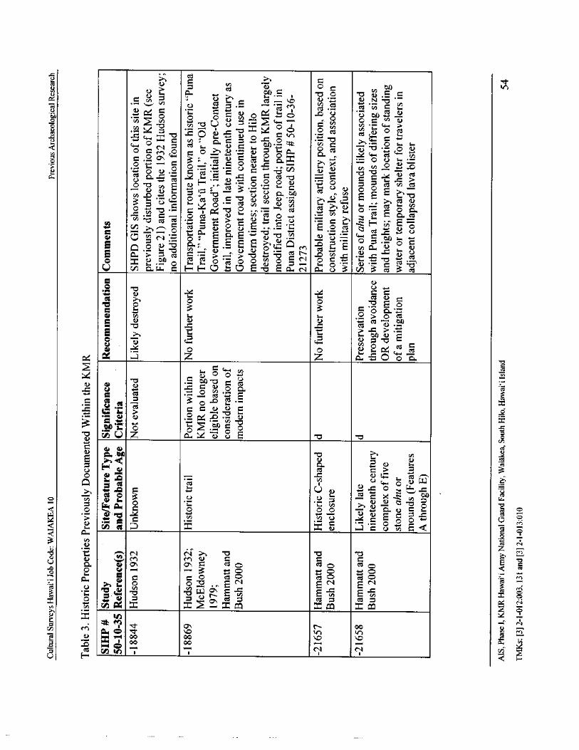
U Ct
R, Oa> bA V7
v
azbA 7(.
3) o
iv)) Z .. V s. I O E
O5. y c
McO ••cn
cvi 0 i
oC
0 0 0 ' o Q" y o o . F.-) = , n 07: 3= cn - o C) U Q + O ; a
co44-, >
ccsQ., v.: E -- Q
c as " O - a C ' moi. .= >O
N E 3 .O . Oy O o
O0 «s ^ C
Q C Ov 0 O cC C L3
as
c-) O co aE ' O
E Q .° O - 0 a.a
sem•, , s., Q
M • i cn a •r) O NE G1. > ' 74 = N > N
cdIt ..+
4: . 0 s, U
0 x C) bAO
sem, yam. O ' cC O O y O = ,- 2 Q • N B
U c a. u. a H H C7 C7 E - a E a eq a oo • 3 v) 3 c 3 : 25'
C s... x o
at o 0o0E33d0 >> o ez
d bo- aE >©
76, toaO ct. Qk
t24 Z Z C0 Q,a o o
0 w • o .° 3R
i
a) O ^ • 'fin t
8C...) z ax E 0o
cn
c y 0 C
cn
o H 4) c* c _> a 3o . 0
rte„ o , c. W 6
rte+ .0 Q
Li) v +
O- O QCI L 3 U c -o o
et
o pyo 3.
ojr o 0 0 a, N c s-cn cn
o o oy c V
Qtn
a tno
3 NC) z
ao
a' a, c aso cso oE 72
o 3 o o o
p y? O as N al c N a
s0, wO O " Cl .
O 6' W O' E ^ QE .-) E
oO • 4) 0 0 0 0, as = es Q as =
x o
cn c, C4 x Z - Zt xcc) .0 GG o
It ef)
cid N - I.: 00o In M
s. a) 1 00 0i v
U con .. N N
v 5
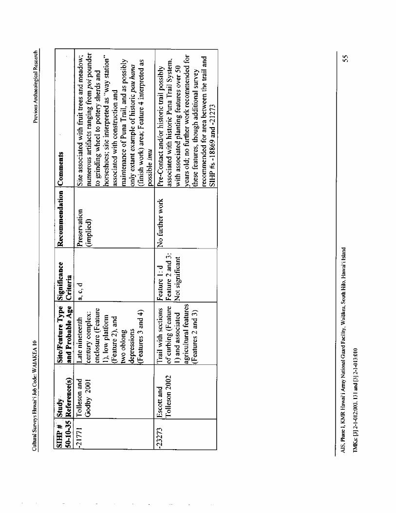
C o - oal 4,
aInmi O ' 0 O - m Eat
at O N N C > s-
tt - o az fl C3 a, O
r >
O = vCi a_C s.. 3 O
w ' 8O O _ U
C cC . - 3 M4-J to U 7 a)
i. C to
S] Q. C H
c+, cd
0CCA
3c -
0 •--.
Ct. x
s. c-.)O aai 2 a) 4.
el r l0 i. stn i -O
n = o C Q^ 4 O C O ,-.
T3 C ' O c cd C E. 'C3 c? 4-
C) '. ti • a) 4]
cat • l.) z "p ppC C !
DO3 U ,-. - V
c =
s0. 'Op a>D
y+• aa ..... O
c'
zIut 3 N C u 9, 73 ct U
Engyp++ al - C) .0 = a) En ,.. 0 U •UcG O C) P.
q a) E to
sv. O .en Fi >,•
O , ad v) OU . Ticn
V VD
4O .0 0 O Q,Cl. c 3 >-. 7
XO
CL.
E ' ) O
En ....
a a. Zb
Cr')
04 v
C clU 3wca00
tetN •c x
Lp
sa). r0.. . o
vnU 4 w w 4 0v)4) 0 O a) cd
a o M124)
7• tet p cC ^ tab C Mn
O c (V 4.
4, = U
a)
CA
O . ajC v) = 3
0 0) L C 34 vi L at 4..+ > 2 U.
rzi Ay .• o o o . 30 -
o
cb
oC C UW
C — C U a) O Q a) Ft" O et • i. a) ot) 0 .: w 3 C) w
s, 4. au), M
W U a) —, o H o '— `.qN
N z
a0) at O O
en
ON C
oCO >; N C C
Q
y: p p F4c-Qi
Lt a)w "0 O a) i
ro=O xyp CAmai H (.7 W H o
s..
Lx4Cla EA
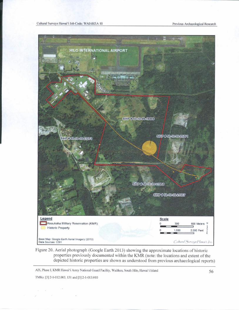
Cultural Surveys Hawaii Job Code: WAIAKEA 10 Previous Archaeological Research
HILO INTERNATIONAL AIRPORT
Mt
t Y y
slog.
40, wIf
ae
eeap0 50-10-9948869
MPEO 50- 10- 35-23273
G 50- 10- 35- 1771
u
4111
rYy n y.
cam'050-10- 35-2165:
r* L
M0 50-10- 5-21657
Legend Scale
oKeaukaha Military Reservation( KMR) 0 300 600 Meters N
Historic Property 10 1, 000 2, 000 Feet j
Base Map: Google Earth Aerial Imagery( 2013)Data Sources CSH ihrral`) un
Figure 20. Aerial photograph (Google Earth 2013) showing the approximate locations ofhistoricproperties previously documented within the KMR( note: the locations and extent of thedepicted historic properties are shown as understood from previous archaeological reports)
MS, Phase I, KMR Hawaii Army National Guard Facility, Waiakea, South Hilo, Hawaii Island 56
TMKs:[ 3] 2- 1- 012: 003, 131 and[ 3] 2- 1- 013: 010
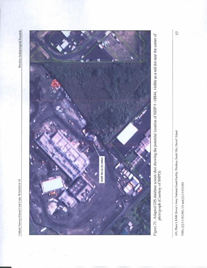
Cg VMr' lir
Tiit. , C
o
44111 9 41.o
s
t t vo sot t1 t
o
I4
vhoo00
tic41 404 * R.
k
iik:. •t
f• O
14 4 U
s , 4 lirr
10, 77i'
1A
til O Ior*
C]. x
o
ar a
o
oe
14?
cn Q
a,
4 v) 4.
I !;V1\IV 00 0 E
Cti ( fl
In
18 4 , 1 , v) Uo fa. ti
it* it1
1) 3 ^3
co S
0
N
U z. F+
Cultural Surveys Hawai` i Job Code: WAIAKEA 10 Previous Archaeological Research
4.4 Background Summary and Predictive Model
Waiakea, with its rich natural forest and ocean resources, has long been a center of habitation forHawaiians and is often mentioned in Hawaiian folklore and legends. Hawaiian gods and goddessesfrequented Waiakea including Pele, Hi` iaka and Pana` ewa. Many legends have associated Waiakeawith Hawaiian ali`i since the sixteenth century and describe it as a gathering place for ceremonies.The rich mountain resources of taro and sweet potato and the abundant marine resources,particularly shrimp and fish, made Waiakea very valuable to the Hawaiian people. Some 16 heiau ofvarious sizes and classes stood within Waiakea.
Prehistorically the project area does not appear to have supported extensive habitation or large-scale agriculture. Habitations would have been located closer to the coast or further inland amid themore productive upland agricultural zones. This pattern is attributable to an excess of rainfall and
lack of arable land within the dense forest that remains in the undisturbed portions of the projectarea. At present this forest is a mostly natural combination of endemic, indigenous, and introducedvegetation including such plants as hala (Pandanus odoratissimus), Melochia (Melochia umbellate),endemic ` ie` ie ( Freycinetia arborea), ohi`a ( Metrosideros macropus), guava, various ferns, glorybush ( Tibouchina lepidota) and bing- a- bing( Macaranga mappa).
The KMR parcel would have been used for intermittent, small- scale agriculture, with the naturaldepressions in lava flows used for mulch-type agriculture. Natural resources, such as the prevalentlauhala ( leaves of the hala plant) used for weaving, would have been collected. The project arearemained marginal in the historic period, with the probable continuation of intermittent use fortraditional Hawaiian agriculture. The Puna Trail (SIHP # s 50- 10- 99- 18869 and 50- 10- 36- 21273) was
modified and became the most notable man- made feature on KMR' s landscape. By the 1870s, thetrail was a functioning horse trail. At this time the trail was a paved, 4- ft-wide trail, classified as aType C trail following Apple' s typology ( 1965: 65). A small handful of sites previously documentedwithin KMR (including a series of ahu or cairns; a section of curbstone trail with associated plantingareas; and a historic complex comprising a low platform, enclosure, and modified depressions) haveall been at least tentatively associated with the Puna Trail.
Unlike portions of Waiakea further to the west, the vicinity of the KMR was not utilized for sugarcane; therefore, stacked stone mounds associated with this late nineteenth and early twentiethcentury agricultural activity are not expected to be extant within the project area.
The KMR parcel was subjected to extensive development beginning in 1914 with theestablishment of the National Guard of Hawaii Rifle Range and continuing through World War IIwith Army and Navy use. Large portions of the KMR were graded for buildings, roads, firing rangesand lawns. The most extensive modifications occurred in the northwest portion of the parcel. Anyarchaeological remains once present in the areas at KMR that have undergone extensive military-related development have been effectively removed. All of the structures in KMR date to themilitary use period. While the alignment of the Puna Trail through KMR survived these changes as aJeep road, the nineteenth century characteristics of the trail, such as paving and curbstones,
apparently did not. Because it has been modified for vehicle travel ( Apple 1965: 65), the Puna Trail
through KMR has become a Type D trail, following Apple' s trail typology.
The southeast portion of KMR is relatively undisturbed in comparison, and it is here that pastsurvey work has located the remains of possibly prehistoric and early historic sites. However, givenMS, Phase I, KMR Hawaii Army National Guard Facility, Waiakea, South Hilo, Hawai` i Island 58
TMKs:[ 3] 2- 1- 012: 003, 131 and[ 3] 2- 1- 013: 010
Cultural Surveys Hawai` i Job Code: WAIAKEA 10 Previous Archaeological Research
the marginal nature of this area of Waiakea and the distribution of features indicted by past studies, alow site density is expected within the project area. The types of traditional archaeological siteslikely to be found within KMR include small, temporary habitations or shelters, which could beassociated with occupation near the Puna Trail. Agricultural areas may consist of groupings ofmounds, low mounded walls, or modified pits, depressions or outcrops in exposed lava areas. These
types of features are often found in marginal areas and are testimony to the Native Hawaiians' abilityto utilize such areas for subsistence agriculture. If features of these types are found during the surveyfieldwork, the potential for modification in early historic times or during the military era must beevaluated.
Military features may also be found within the project area. In addition to the more obviousbuildings, Jeep roads, lawns, and shooting ranges, military use can leave less obtrusive remains. Forexample, small, crudely constructed stacked stone enclosures, similar to Native Hawaiian structures,
are constructed as artillery positions during training exercises. It would not be unusual to find suchstructures within KMR. These features are usually distinguishable from Native Hawaiian ones bytheir cruder construction style, geographic association with other military structures, and theirassociation with military debris, such as spent ammunition casings, MRE ( meals ready to eat)packets and/ or C- ration tins.
AIS, Phase I, KMR Hawaii Army National Guard Facility, Waiakea, South Hilo, Hawai`i Island 59
TMKs:[ 3J 2- 1- 012: 003, 131 and[ 3] 2- 1- 013: 010
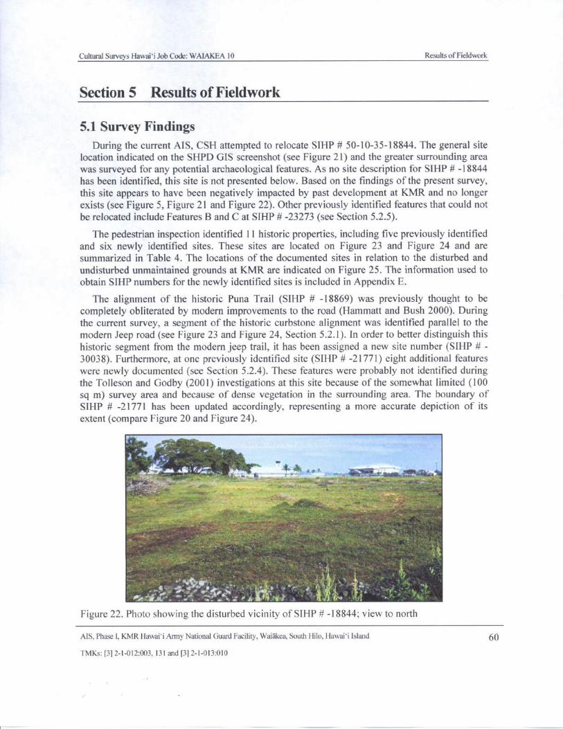
Cultural Surveys Hawaii Job Code: WAIAKEA 10 Results ofFieldwork
Section 5 Results of Fieldwork
5. 1 Survey FindingsDuring the current AIS, CSH attempted to relocate SIHP # 50- 10- 35- 18844. The general site
location indicated on the SHPD GIS screenshot( see Figure 21) and the greater surrounding areawas surveyed for any potential archaeological features. As no site description for SIHP# - 18844
has been identified, this site is not presented below. Based on the findings of the present survey,this site appears to have been negatively impacted by past development at KMR and no longerexists( see Figure 5, Figure 21 and Figure 22). Other previously identified features that could notbe relocated include Features B and C at SIHP#- 23273 ( see Section 5. 2.5).
The pedestrian inspection identified 11 historic properties, including five previously identifiedand six newly identified sites. These sites are located on Figure 23 and Figure 24 and aresummarized in Table 4. The locations of the documented sites in relation to the disturbed and
undisturbed unmaintained grounds at KMR are indicated on Figure 25. The information used to
obtain SIHP numbers for the newly identified sites is included in Appendix E.
The alignment of the historic Puna Trail ( SIHP # - 18869) was previously thought to becompletely obliterated by modern improvements to the road ( Hammatt and Bush 2000). Duringthe current survey, a segment of the historic curbstone alignment was identified parallel to themodern Jeep road( see Figure 23 and Figure 24, Section 5. 2. 1). In order to better distinguish this
historic segment from the modem jeep trail, it has been assigned a new site number ( SIHP # -30038). Furthermore, at one previously identified site ( SIHP # - 21771) eight additional features
were newly documented ( see Section 5. 2.4). These features were probably not identified duringthe Tolleson and Godby ( 2001) investigations at this site because of the somewhat limited ( 100sq m) survey area and because of dense vegetation in the surrounding area. The boundary ofSIHP # - 21771 has been updated accordingly, representing a more accurate depiction of itsextent( compare Figure 20 and Figure 24).
16.414 .> ti
r..
5 .
fir5 -
n 5:
Sok''. a
c "` +, #,
Figure 22. Photo showing the disturbed vicinity of SIHP# - 18844; view to north
AIS, Phase I, KMR Hawaii Army National Guard Facility, Waiakea, South Hilo, Hawaii Island 60
TMKs:[ 3] 2- 1- 012:003, 131 and[ 3] 2- 1- 013: 010
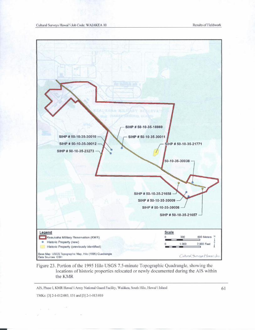
Cultural Surveys Hawaii Job Code: WAIAKEA 10 Results ofFieldwork
N.
s\
SIHP# 50- 10- 35- 18869
SIHP# 50- 10- 35-30010 SIHP# 50- 10- 35-30011
SIHP# 50-10- 35-30012 SIHP# 50- 10-35-21771
SIHP# 50- 10- 35-23273
50- 10-35-30038
SIHP# 50- 10- 35-21658
SIHP# 50- 10- 35-30009
SIHP# 50- 10- 35-30008
SIHP# 50- 10-35-21657
Legend Scale
QKeaukaha Military Reservation( KMR) 0 300 600 Meters "IBM
o Historic Property( new) 0 1. 000 2, 000 Feet
Historic Property( previously identified) t 1Base Map. USGS Topographic Map, Hilo( 1995) QuadrangleData Sources CSH uu, rah47m rys nw rr./,
Figure 23. Portion of the 1995 Hilo USGS 7. 5- minute Topographic Quadrangle, showing thelocations of historic properties relocated or newly documented during the AIS withinthe KMR
AIS, Phase I, KMR Hawaii Army National Guard Facility, Waiakea, South Hilo, Hawaii Island 61
I' MKs:[ 3] 2- 1- 012:003, 131 and[ 3] 2- 1- 013: 010
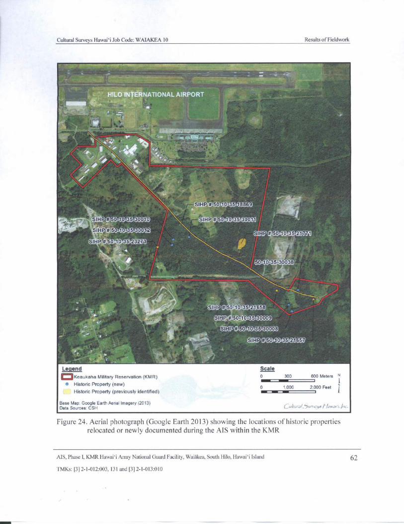
Cultural Surveys Hawaii Job Code: WAIAKEA 10 Results ofFieldwork
HILO1N E tNATIONALAIRPORT
I
V Ito,U "- AO ss
t
J0 '-1'- 35-1'8X'
It. r
i' SI/WOO-1i- 36 0111 OW'[email protected]
4,..r' QS0- 11- 36-3011etYPO 50- 10 5- 1570
0• 11i - 5 iti r. .
10- 35- 30038
voi, - J., .
3.,;,,
hQAC
O- 11- 35-3000•
ii' 6
IN,-""""' 050- 1'- 3.: 1577
Legend Scale
oKeaukaha Military Reservation( KMR) 0 300 600 Meters "
Historic Property( new) 0 1, 000 2, 000 Feet
Historic Property( previously identified) t
Base Map. Google Earth Aerial Imagery( 2013)Data Sources CSH uirulal, h:+r. git101,,, /,,.
Figure 24. Aerial photograph ( Google Earth 2013) showing the locations of historic propertiesrelocated or newly documented during the AIS within the KMR
AIS, Phase I, KMR Hawaii Army National Guard Facility, Waiakea, South Hilo, Hawaii Island 62
TMKs:[ 3] 2- 1- 012: 003. 131 and[ 31 2- 1- 013: 010
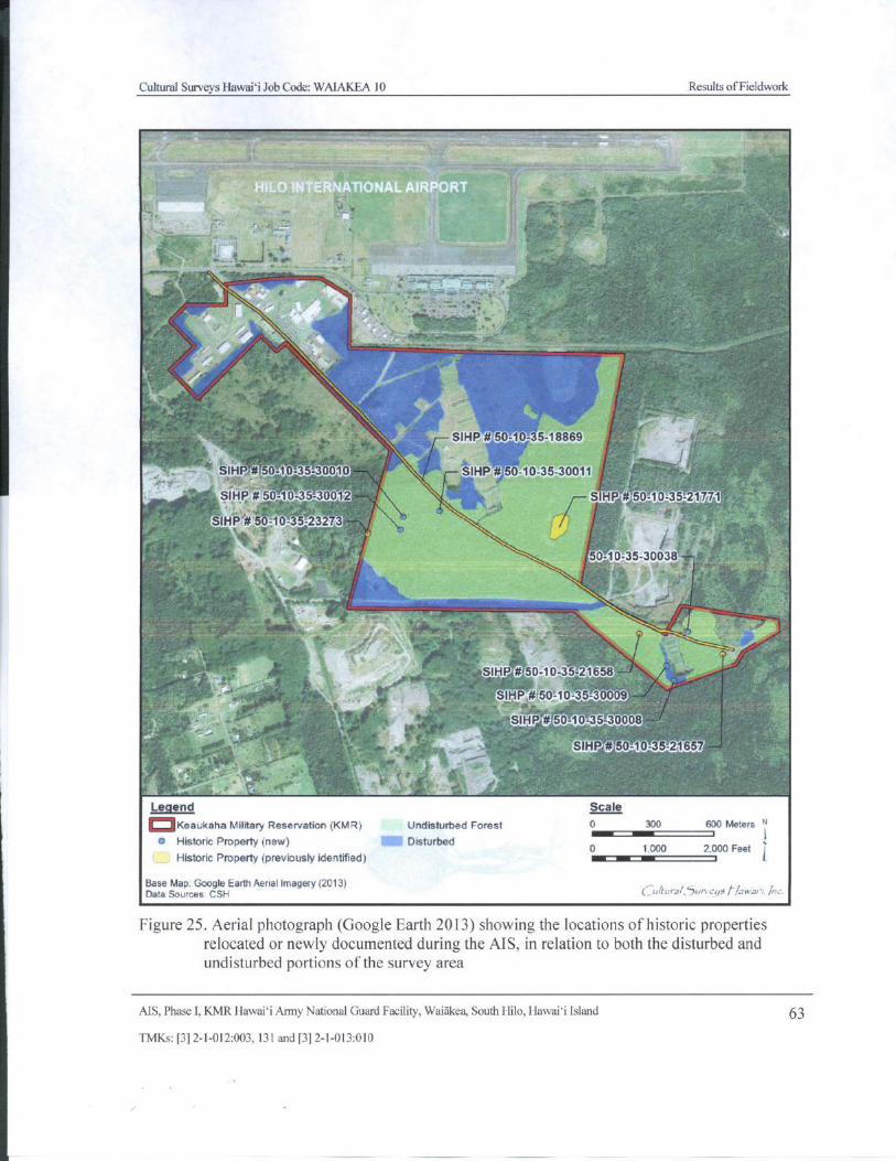
Cultural Surveys Hawaii Job Code: WAIAKEA 10 Results ofFieldwork
r,
syaa
t 1
r
0.0,,,„1,,,,,...,,.,,,4
lSIHP#' 5 10-35- 18869
SIHP# 50- 1 - 30-30010 ”
I— SIHP# 50- 10- 35- 30011 :', v =
t,i
SIHP# 50- 10- 3 - 3002 SIHP# 50- 1' 035-21x771r''
SIHP# 50- 10235- 232. 3 750- 10- 35- 30038
j
t
t jSIHP# 50- 10- 35-21658 -
SIHP # 50- 10-35-3i0, 9 `
SIHPO50- 10-35-30018
a1n1 fF2 il i c C1
FaI
Legend Scale
oKeaukaha Military Reservation( KMR) Undisturbed Forest 0 300 600 MetersiIMP t
Historic Property( new) Disturbedo 1 000 2,000 Feet
Historic Property( previously identified) t
Base Map: Google Earth Aerial Imagery( 2013)Data Sources CSH ukura/, 5un•c95 f/awan',, Inc.
Figure 25. Aerial photograph ( Google Earth 2013) showing the locations of historic propertiesrelocated or newly documented during the AIS, in relation to both the disturbed andundisturbed portions of the survey area
AIS, Phase I, KMR Hawaii Army National Guard Facility, Waiakea, South Hilo, Hawaii Island 63
TMKs:[ 3] 2- 1- 012:003, 131 and[ 3] 2- 1- 013: 010
t
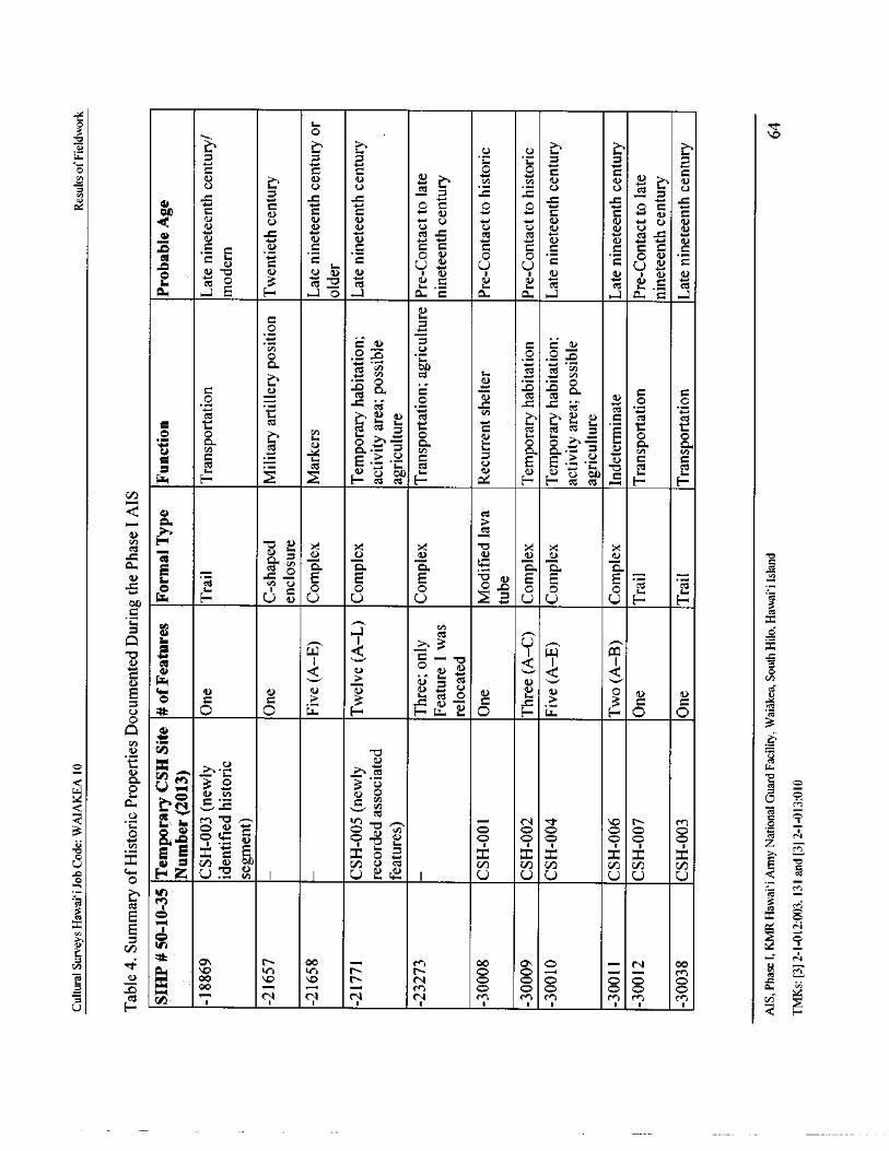
o 71-o
0 c ao 0 a0i
0 O O c 0 0U U U
n a) a) a)U
0.'.
QO N 0 0 O 0 O c 0 0 O
U U a) N U r.) 4 ' a) a) -+ U NU a) a) U U U a) a) U a)
CV N
rte-., N 0) 4-,
ate') 0) N
Z 0o _
1) 0 0 0 0 0 0 0 0 0 0
53 •O . •
0C
i, O
U + U UC O U C
O, ) (
1.)•LS 0) 0)) U CU I a) I I ay) 0) i y ate-)
L.. as Oct
casU.
iU. cC cat u . C as
ow - a E F-' O - a a. o a. a. ,.. a. a ,-
a)
0u.
o
0 U V O a a)O O O O
a
rte., V) CZ to
rte., rte., Lh
N
Caz O O C O
d] 0 0
cC c O 0 9 i.4 ,
o O
O O3.
rO0
0 c
CI 6.) QU544.• 0.•; U t. O. - V rJ
Cd U p0
01 s0OS.cCW - H ccc cc H aH ' C cc 1... 1i H H
06 cda)
anE". 0 k
a) X O k k C
a) a) a) a) a) a) a) o
a. s _ cOC" ` OQ. a'. Q.. 0., 0.. L].
alO . i O Os 0 0 O - O O 00
sem. c
01)40 H U 0) U U U U U U F- H ct
ch
LT-
1.
03 w w x
a) a I ` o - 0 Q I I
0a)• W 0 a) .
cn
0w a) a) s o
sem. a) 0 a) a)
o O 0 ? 0 a) ^ 0 .- 0 ? 3 0 0 ao O O w H H. w E). O H a. H O O
3Q 4
Q
x 4 w3' 0 3• 77
o
o , c 0) ° a) oa,
oQ 0i
S. 6, M ' t3 ^a) 174 kr) O ,-. N M o
0
cd
ZN3 O O O O
ym O O O O O O
X x o
0 0 0
r0r
0. o
TC
i-,
CI)
8 x x x x x u
s w E= y 4 U :: E I I U 2 c° I U U U UCl)
U Q g0 0
vi a.
cd Ed x o
CA
0 ' I o
l 0'. o0 --- M o0 0, OV
N o0
cdM
e a)
cooc Ckr) r- t
0
Sr-- O O - M
O ac M O O O O O Oa iA
NN N N M M M M M M i
Cultural Surveys Hawai` i Job Code: WAIAKEA 10 Results ofFieldwork
5.2 Historic Properties Descriptions
5. 2. 1 SIHP# 50- 10-35- 18869
Hudson ( 1932) first described the Puna Trail as follows:
Site 38. The beginning of the Puna-Kau trail is now in back of the [ HIARNG]rifle range, the section nearer Hilo having been destroyed. It is about 4 feet wide,paved with bits of aa lava and flat stones, banked on the sides, and built up incrossing gullies. For the first 5 miles toward Keaau the trail runs through densejungle which has disrupted much of the stonework. It can be followed with
difficulty. [Hudson 1932: 246]
The trail was briefly noted by McEldowney ( 1979) as " Segments of trails" occurring " at
frequent intervals along the coast west of Leleiwi Point." Hammatt and Bush ( 2000: 27- 28)described SIHP # - 18869 ( citing also its additional segment in Puna District, SIHP # - 21273) asfollows:
Site Type: Puna Trail (Historic Trail)
Function: Transportation
Features (#): 1
Site Length: Approximately 3000 m within project areaAhupua`a: Waiakea
Elevation: 60 ft. amsl
The Puna Trail forms the primary roadway through the KMR facility. It extendsfrom the facility entrance, off the airport access road in the northwest corner ofthe facility, through the center of KMR to the southeast corner of the facility. Thenorthwestern portion of the trail through the facility is paved. The southeasternportion of the trail is unpaved, consisting of a Jeep- road similar to the otherunpaved roads which cross KMR. From the bull-dozer push- piles found at
intervals along the unpaved portion of the trail, it appears that the trail was bull-dozed or graded in the past, probably by the military. No sign of the historicallydescribed paving and curbstones was observed. It appears that modifications ofthe route have removed all traces of the historic trail which preceded the Jeeproad.
The Puna Trail, taken in its entirety as it stretches from Hilo through Puna andpossibly into Kau, is a significant historical property under the criteria of the Stateand National Register of Historic Places, for both its information content
regarding historic transportation ( criterion D) and for its contribution to broadpatterns of history (criterion A). Lass' s ( 1997: 24) investigations of the " Old
Government Road", a portion of the Puna Trail approximately 7 miles to thesoutheast of the KMR facility, demonstrate that portions of this historic trail arewell preserved and available for future research and public education and
enjoyment. However, within KMR, the remains of the Puna Trail have been
altered by military use. Only the alignment of the trail remains. The available
AIS, Phase I, KMR Hawai` i Army National Guard Facility, Waiakea, South Hilo, Hawai` i Island 65
TMKs:[ 3] 2- 1- 012: 003, 131 and[ 3] 2- 1- 013: 010
Cultural Surveys Hawai` i Job Code: WAIAKEA 10 Results of Fieldwork
information for the trail, which now consists of its alignment, has been recordedon project area maps. For this reason, within KMR, the segment of the Puna Trailis considered no longer significant. [McEldowney 1979: 10]
During the current AIS, CSH relocated SIHP # - 18869 within the project area ( Figure 26 andFigure 27). Hammatt and Bush ( 2000) accurately describe the general state of the Puna Trailalignment within the KMR. Based on the current findings, the site no longer retains integrity as ahistoric property.
AIS, Phase I, KMR Hawai` i Army National Guard Facility, Waiakea, South Hilo, Hawai` i Island 66
TMKs:[ 3] 2- 1- 012: 003, 131 and[ 3] 2- 1- 013: 010
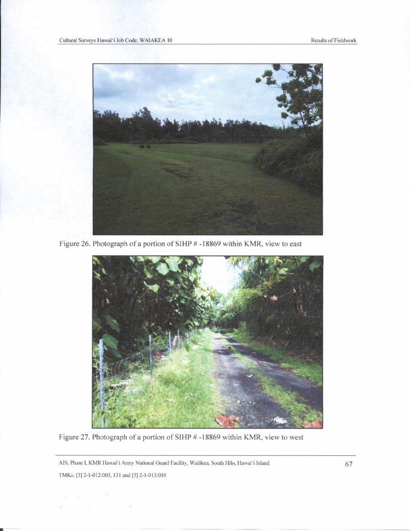
Cultural Surveys Hawaii Job Code: WAIAKEA 10 Results ofFieldwork
TT
Figure 26. Photograph of a portion of SIHP# - 18869 within KMR, view to east
h - vb * i 4_:" -;,.'-,....41,
3b..,/,, 4,,, 4.
5
k i`t
it • r
16';. '` ; .
4
ay
1
Figure 27. Photograph of a portion of SIHP# - 18869 within KMR, view to west
MS, Phase I, KMR Hawai` i Army National Guard Facility, Waiakea, South Hilo, Hawaii Island 67
TMKs:[ 3] 2- 1- 012:003, 131 and[ 3] 2- 1- 013: 010
j
Cultural Surveys Hawaii Job Code: WAIAKEA 10 Results of Fieldwork
5.2.2 SIHP# 50- 10-35- 21657
Hammatt and Bush (2000) described SIHP # - 21657 as follows:
Site Type: C- Shape
Function: Military Artillery PositionFeatures (#): 1
Site Dimension: 4.25 m ( meters) by 5. 2 m ( 14 ft. x 17 ft.)Ahupua`a: Waiakea
Elevation: 60 ft. a. m.s. l.
Site 50- 10- 35- 21657 is located approximately 45 m. ( 150 ft.) from a HIARNG
quonset hut at 1, 030 magnetic north, near the quarry at the southeast end of KMR.It is surrounded by sharply undulating pahoehoe composed of raised areas, deepcrevices, and several collapsed lava tubes. The surrounding vegetation consists ofohia, strawberry guava, vines, ti and orchids.
Site - 21657 is a " C- shaped" stacked- stone enclosure measuring approximately4.25 m. ( 14 ft. east- west) by 5. 2 m. ( 17 ft. north- south) [ Figure 28]. The interiorof the structure measured 3. 6 m ( 12 ft. east-west) by 3. 0 m. ( 9. 5 ft.) north- south.
The average height of the interior face is 118 cm ( centimeters), while the exterior
face is somewhat sloped with heights ranging from 125- 190 cm. The enclosure isbuilt against the south edge of a raised pahoehoe flow, with its south and east
sides stacked up to create a protective wall of uniform height. The site is in fairlygood condition though there is evidence of some collapse.
Site - 21657 is constructed of roughly stacked pahoehoe boulders and cobbles. Atthe top of the structure the rocks are one course thick, while the bottom ( due to
sloping walls) is thicker. This feature is one to five courses wide, with the southand east sides being the steepest. The interior floor surface of the structure issloped and consists of boulder, cobbles, smaller rocks and pockets of humus.
Several small trees ( ohia, strawberry guava), orchids and ti are growing within thestructure. No indigenous artifacts or marine shell midden was observed.
Immediately to the west of the structure several military trash items were noted,including MRE' s, tuna cans, and miscellaneous unidentifiable metal fragments.
Due to the crude construction of the walls, the lack of indigenous artifacts, or
other cultural material, the sloping and rocky interior, and the garbage and debrisleft from military activities, it is likely that the structure is military in origin.
This feature was not tested. The generally thin humus layer over bedrock that wasfound within and around the structure had no excavation potential.
There were difficulties with dating the construction of this site. Based on theassociation with the MRE packets, which came into use after the Vietnam War, it
would seem the structure was used within the last 20 to 25 years. The older, O-
ration, type tins also found at the structure date back to World War II, suggestingthat the structure may be older than 50 years. For this reason the site was given a
MS. Phase I, KMR Hawai` i Army National Guard Facility, Waiakea, South Hilo, Hawaii Island 68
TMKs:[ 3] 2- 1- 012:003, 131 and[ 3] 2- 1- 013: 010
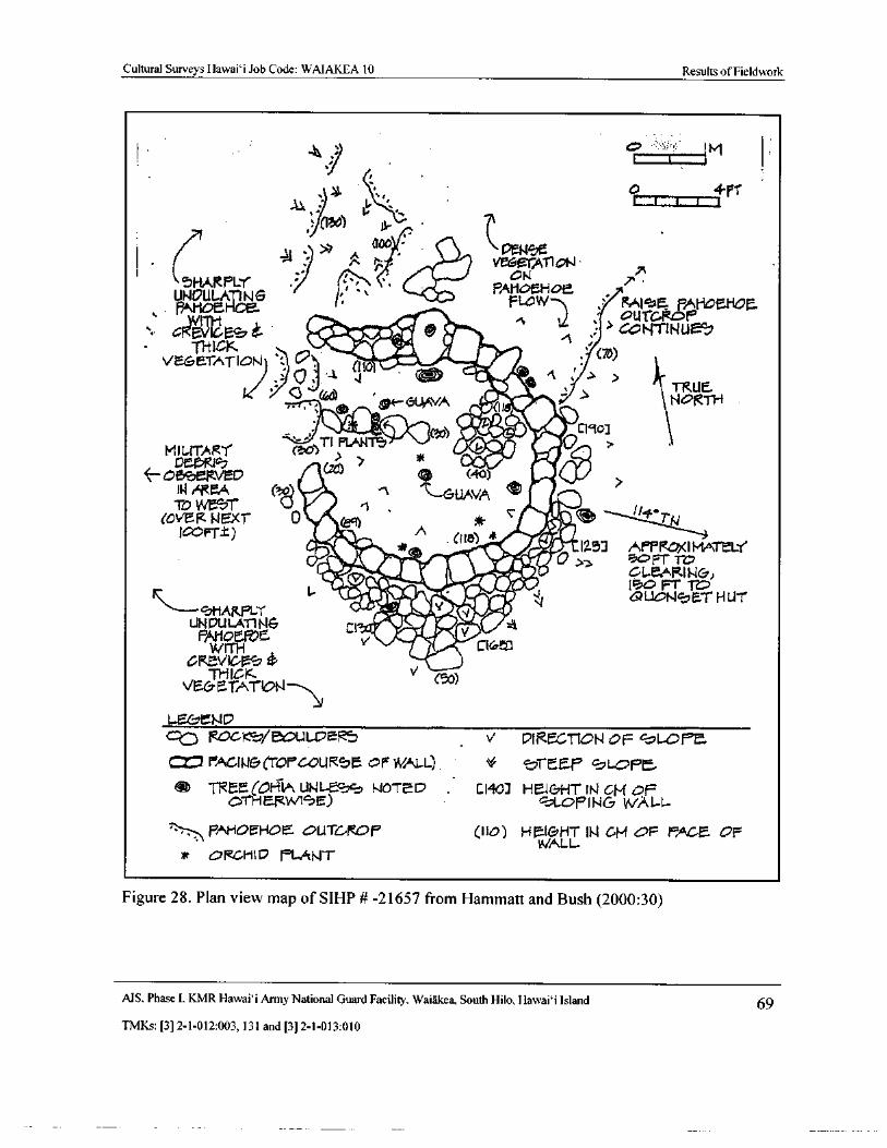
Cultural Surveys Hawai` i Job Code: WAIAKEA 10 Results of Fieldwork
4 ic>
1 .. 1,.. itvi 1
44 - y ( too =- $
2,,,, xn r . Jima Vlrle AT1 ohl•
UNDUA-L^
N G .?„.
1r,, "\ '.. ba„
PAHDEHOE
TsOH©EI-IC
FLOW Mi vE PAHcatioa.ouTGRoP
G1 E i2 4 . ipzda • mit '
GCNTZNU ,
velTIDIJ ': o'~: a.
01. 7O)
1 (
1110mos A.- 1
r > >
Ible6t--GUAVA 'r
TRUE.NORTH
11%-Atli". .eZWOWI. 1 to1
MILITARYTI E' f.Ht ll- f'=
taA) , +'` O
39 DmpR1 Ct0) ?
b! '
3t' eRVED c%; (. 40) 1WI AMA t04111‘ t ' - GUAVA CEJ -
TO Wr. ' rVEEXT" 0 eR 4,411 1- 1 TNJ T_t) A
ariLikcm'') ' ie
1257 APPROX I MATEL-r
SHARpf.Y
1- if•+e 1 G21©,IONSET HUT
UPSESN& Y! D0ar 2ACl '
iliaCIS
GRWITHto5>
xTHICK V
o )VE& I- TATON-
L- Efal ND
c] ROOD/ e0U1- 1, ER V 21RfCTION OF cL-t)Pe.
CZ":1 FAcJI.t&( TOP OURSM or WALL) v SrEe.P SL 7
TREE( O- ii UNI- 1. 10TcD Ci40] H . 1& HT IN CM OF0THERWt5E) c-LOFII1 & WALL_
pAHOEHO! auTGmOP Ifo) HtrHT N GM 47P FACE OFu//ALL
ORLHI fa FL&LJT
Figure 28. Plan view map of SIHP# - 21657 from Hammatt and Bush ( 2000: 30)
MS. Phase I, KMR Hawaii Army National Guard Facility, Waiakea, South Hilo, Hawaii Island 69
TMKs:[ 3] 2- 1- 012: 003, 131 and[ 3] 2- 1- 013: 010
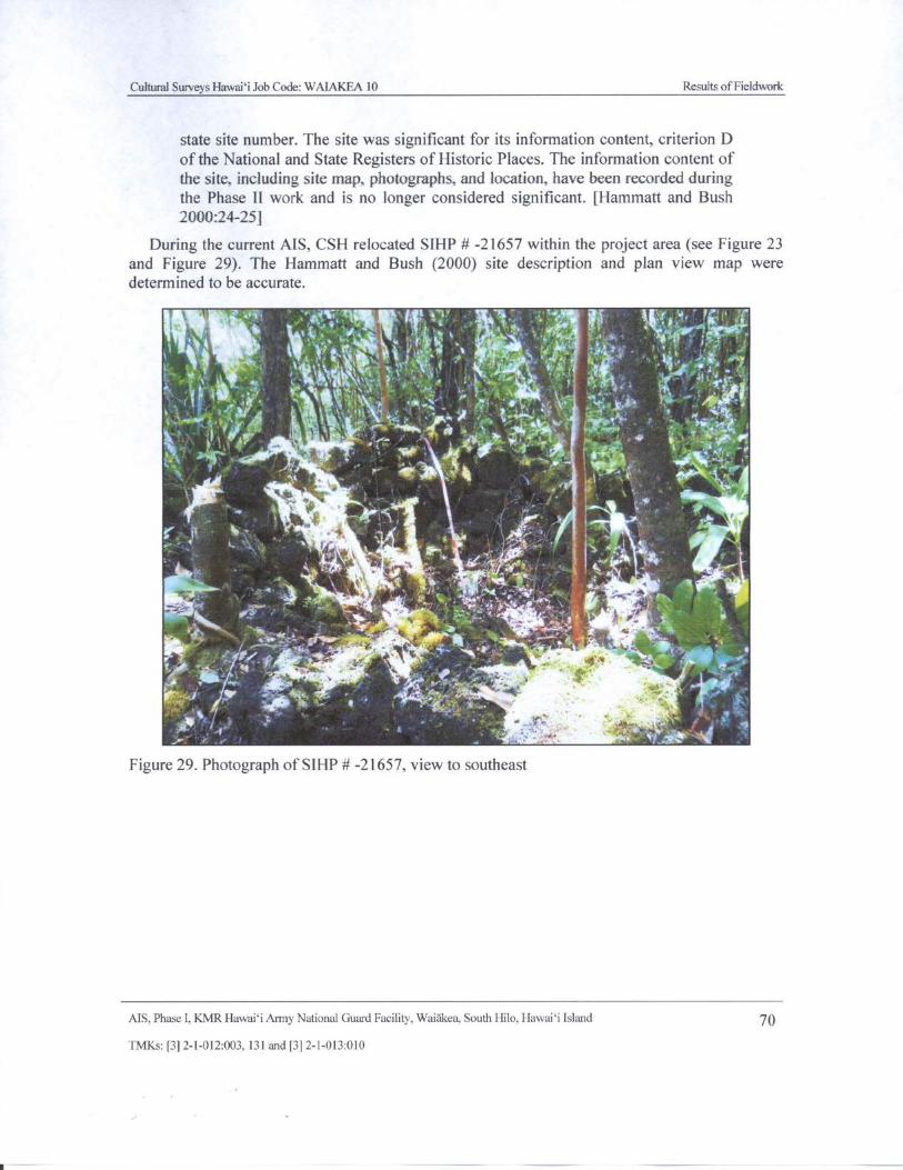
Cultural Surveys Hawaii Job Code: WAIAKEA 10 Results ofFieldwork
state site number. The site was significant for its information content, criterion D
of the National and State Registers of Historic Places. The information content of
the site, including site map, photographs, and location, have been recorded duringthe Phase II work and is no longer considered significant. [ Hammatt and Bush
2000:24-25]
During the current AIS, CSH relocated SIHP # - 21657 within the project area ( see Figure 23
and Figure 29). The Hammatt and Bush ( 2000) site description and plan view map weredetermined to be accurate.
sit.:,:,-A::
7114 it,t7' , 7 1,-,, - - , pr
1 Ci . r, ,,,
4 ,„ '
Iire,&,‘ '''1 N ''. .,i.,
II7 i 11 `Va'iPc` 4 '{ {, '•
f4f
A
44y, ti
C 1 `' r itir ,'\',anti„ Yk` t '` . 4
t ir f. t,',..,
111,
41$ 1. Er: o
r ` zr 1f: ,
1
4- 1 ' *-4(- 4A, .
4'" ..M
y
p
i - •` ' fir'''`. . k'
iiia
ti
Y
fir f '
Y
0 s
Figure 29. Photograph of SIHP#- 21657, view to southeast
AIS, Phase I, KMR Hawai` i Army National Guard Facility, Waiakea, South Hilo, Hawai` i Island 70
TMKs:[ 3] 2- 1- 012:003, 131 and[ 3] 2- 1- 013:010
r
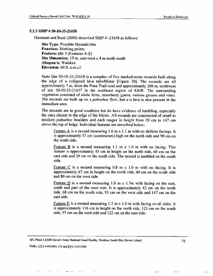
Cultural Surveys Hawaii Job Code: WAIAKEA 10 Results of Fieldwork
5.2. 3 SIHP# 50- 10-35- 21658
Hammatt and Bush ( 2000) described SIHP # -21658 as follows:
Site Type: Possible Mounds/Ahu
Function: Marking pointsFeatures (#): 5 ( Features A-E)
Site Dimension: 19 m. east-west x 4 m north- southAhupua` a: Waiakea
Elevation: 60 ft. a. m. s. l.
State Site 50- 10- 35- 21658 is a complex of five stacked- stone mounds built alongthe edge of a collapsed lava tube/blister [ Figure 30]. The mounds are all
approximately 7 m. from the Puna Trail road and approximately 200 m. northwestof site 50- 10- 35- 21657 in the southeast region of KMR. The surroundingvegetation consisted of uluhe ferns, strawberry guava, various grasses and vines.The mounds are built up on a pahoehoe flow, but a`a lava is also present in theimmediate area.
The mounds are in good condition but do have evidence of tumbling, especiallythe ones closest to the edge of the blister. All mounds are constructed of small tomedium pahoehoe boulders and each ranges in height from 20 cm to 147 cm
above the top of ledge. Individual features are described below:
Feature A is a mound measuring 1. 0 m x 1. 1 m with no definite facings. Itis approximately 53 cm ( centimeters) high on the north side and 90 cm onthe south side.
Feature B is a mound measuring 1. 1 m x 1. 0 m with no facing. Thisfeature is approximately 45 cm in height on the north side, 60 cm on theeast side and 20 cm on the south side. The mound is tumbled on the southside.
Feature C is a mound measuring 0. 8 m x 1. 0 m with no facing. It isapproximately 67 cm in height on the north side, 60 cm on the south sideand 80 cm on the west side.
Feature D is a mound measuring 1. 0 m x 1. 7m with facing on the east,south and part of the west side. It is approximately 43 cm on the northside, 68 cm on the south side, 93 cm on the west side and 147 cm on theeast side.
Feature E is a mound measuring 1. 2 m x 1. 0 m with facing on all sides. Itis approximately 116 cm in height on the north side, 123 cm on the southside, 97 cm on the west side and 122 cm on the east side.
MS, Phase I, KMR Hawai` i Army National Guard Facility, Waiakea, South Hilo, Hawai` i Island 71
TMKs:[ 3] 2- 1- 012: 003, 131 and[ 3] 2- 1- 013: 010
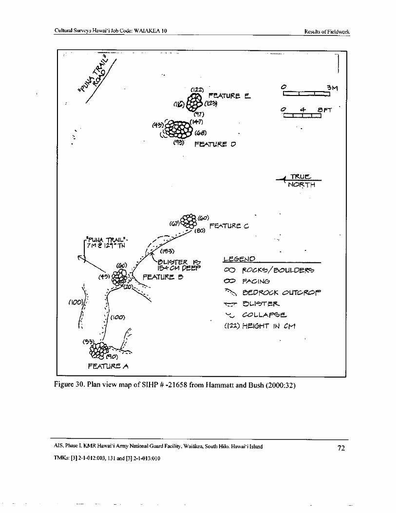
Cultural Surveys Hawai` i Job Code: WAIAKEA 10 Results of Fieldwork
w\
v
A1i2 40 3Mrr. PEATURE E t ` II
1 :o 1123) 47.
3T) 4
t
a F' T
C43). 4410#47)
ITh.? i.t: (trp8)
93) FEATURE D
TKLI E..
NORTH
67 '.."4.4ejt{6,a)
PEATURl. C
IiPUTRAIL"-7M IA@I7T - r1 i.,-
1," ( 153)
e,LIhTER I L EC END
ISA-Gil PEEP 00 lOLKs/ pG7ULDEf45) ••;•)- FEATUKr• t?S
0=, FADINGZo)-
S . 0 OGK vUTC-
I00) % 77:-.,- P LIST R.
B 100) y COL-LAP1
022) Fial&HT N CM
53•i.'
ri MD) ,
REaT1.SRE A
Figure 30. Plan view map of SIHP # -21658 from Hammatt and Bush (2000:32)
MS, Phase I, KMR Hawai` i Army National Guard Facility, Waiakea, South Hilo, Hawaii Island 72
TMKs:[ 3] 2- 1- 012: 003, 131 and[ 3] 2- 1- 013: 010
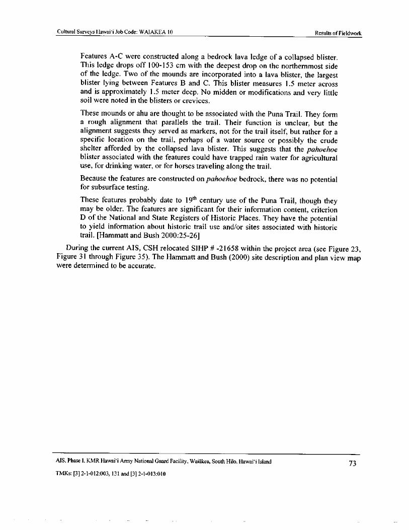
Cultural Surveys Hawaii Job Code: WAIAKEA 10 Results of Fieldwork
Features A-C were constructed along a bedrock lava ledge of a collapsed blister.This ledge drops off 100- 153 cm with the deepest drop on the northernmost sideof the ledge. Two of the mounds are incorporated into a lava blister, the largestblister lying between Features B and C. This blister measures 1. 5 meter acrossand is approximately 1. 5 meter deep. No midden or modifications and very littlesoil were noted in the blisters or crevices.
These mounds or ahu are thought to be associated with the Puna Trail. They forma rough alignment that parallels the trail. Their function is unclear, but the
alignment suggests they served as markers, not for the trail itself, but rather for a
specific location on the trail, perhaps of a water source or possibly the crudeshelter afforded by the collapsed lava blister. This suggests that the pahoehoeblister associated with the features could have trapped rain water for agriculturaluse, for drinking water, or for horses traveling along the trail.
Because the features are constructed on pahoehoe bedrock, there was no potential
for subsurface testing.
These features probably date to19th
century use of the Puna Trail, though theymay be older. The features are significant for their information content, criterionD of the National and State Registers of Historic Places. They have the potentialto yield information about historic trail use and/or sites associated with historictrail. [ Hammatt and Bush 2000: 25- 26]
During the current AIS, CSH relocated SIHP # - 21658 within the project area ( see Figure 23,Figure 31 through Figure 35). The Hammatt and Bush ( 2000) site description and plan view mapwere determined to be accurate.
MS, Phase I. KMR Hawaii Army National Guard Facility, Waiakea, South Hilo, Hawaii Island 73
TMKs:[ 3] 2- 1- 012: 003, 131 and[ 3] 2- 1- 013: 010
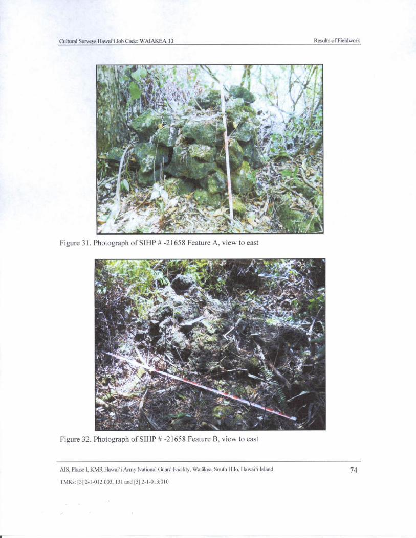
Cultural Surveys Hawaii Job Code: WAIAKEA 10 Results ofFieldwork
Ili , '.' t.: i
t rip • ' Ayk :
j...'• 'If*' ......' ....",..' 1',4.:lit '';1311 ' '
A'C 4
1. 4'- .‘,
tAt?' 'en
01 iirAold - •
4 '
1i.,1,
l
i 13 . •
P :07,2
yrte
J
il.1,. '
t #`
7.... ,
L pD''1
1wt.
aV
k..% A.. )'
S
a d yp: \ 1 ;' t''. ''‘4,1
i — , 41iit' t JL4- - ' i t 1y
N„ sem. 14"4 : H . '' '
yM' i. e
4,p. v - 4 M, .• l3l,
s
Figure 31. Photograph of SIHP#- 21658 Feature A, view to east
x r,.yam. ti- 1.. r 4 - r 4
ms, ,•
4
111135,_ 4t,ar. `` ate'•. ,4+3
V44 \'
y/ j
t ]'
ri11614,
ki.:44.
6 1 1i • v
14,---e v . i e.t... . , - : -- .02... , -, „. 4fi,;- ' , *._
iv,' _,.... •f
Vim'-
A' :I... i
Figure 32. Photograph of SIHP# - 21658 Feature B, view to east
AIS, Phase I, KMR Hawaii Army National Guard Facility, Waiakea, South Hilo, Hawaii Island 74
TMKs:[ 3] 2- 1- 012:003, 131 and[ 3] 2- 1- 013: 010
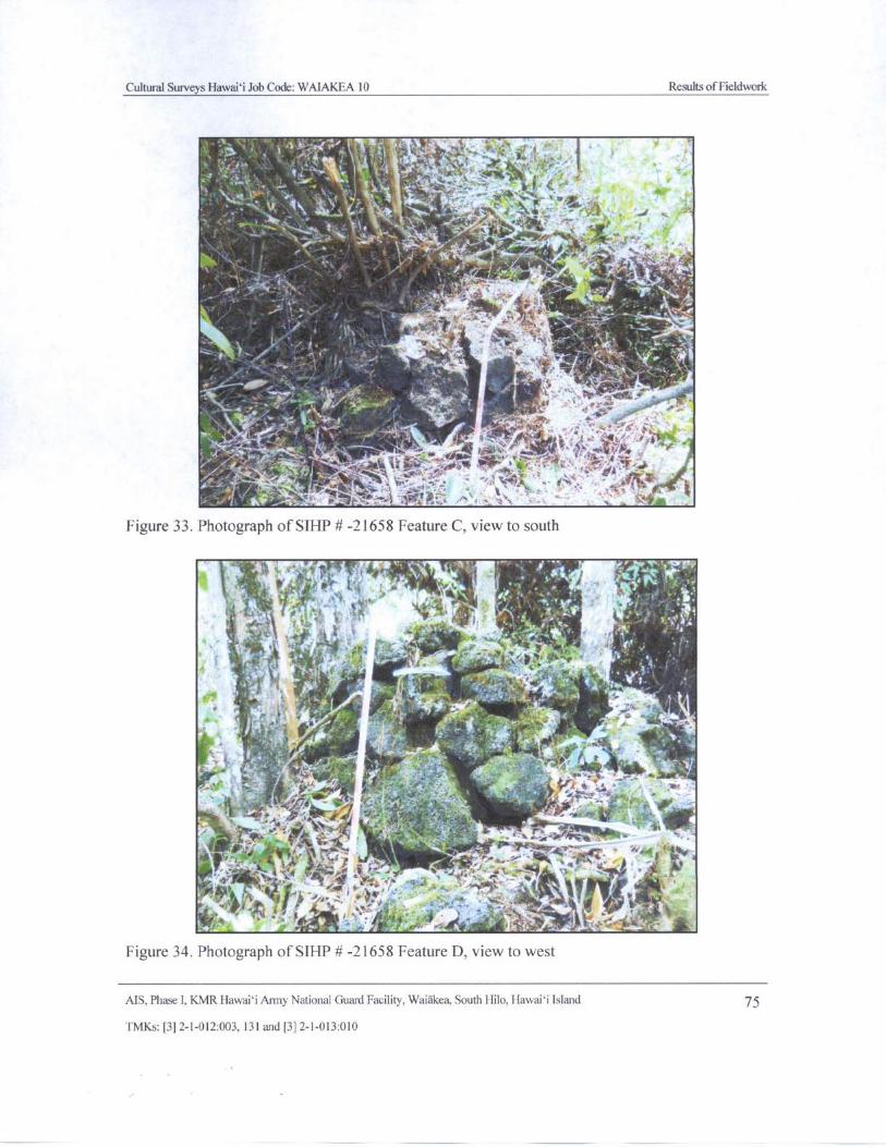
Cultural Surveys Hawai' i Job Code: WAIAKEA 10 Results of Fieldwork
SP414,"*. A.6 i
j\ yp* Y
v7' `+
4
ia
toy
1
w
1111111°':',
Iiir-..:421$
14."' '-it,
t;-.'"--:::,k,
t-t, ::- -.:.'-
t ' n c.• ,\
r . ,rte+
r i.,r 4,t4K
4J ~'.- t`/ l I
r40.' 4. ,. - .' S ' 4.
i '
Figure 33. Photograph of SIHP#- 21658 Feature C, view to south
Ws . ''.\ • i, . ,.., }' R .
t• Arnr •
44 11 11 ' !* ,
f, s f
so,
ofc •• #. i '. .,
4k,- - ,F• .
ate,' 4 Y tXF{
AN i 0d
4. --.' *). V
k A
Figure 34. Photograph of SIHP# - 21658 Feature D, view to west
MS, Phase I, KMR Hawaii Army National Guard Facility, Waiakea, South Hilo, Hawaii Island 75
TMKs:[ 3] 2- 1- 012:003, 131 and[ 3] 2- 1- 013: 010
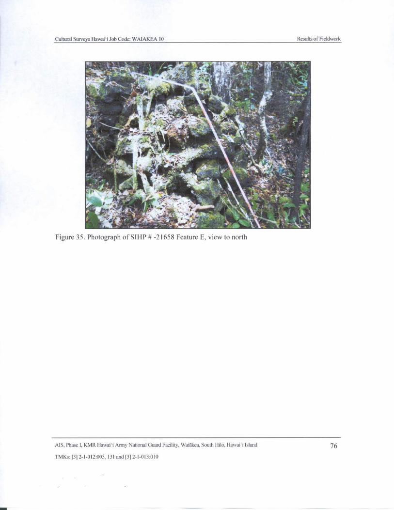
Cultural Surveys Hawaii Job Code: WAIAKEA 10 Results ofFieldwork
t'wSy- 1 Y• - f F
11# 4 f" ,.' -s# 1
y*
may,. •.. ! 4. Y.. \ s - ..
Figure 35. Photograph of SIHP# - 21658 Feature E, view to north
AIS, Phase I, KMR Hawaii Army National Guard Facility, Waiakea, South Hilo, Hawaii Island 76
TMKs:[ 3] 2- 1- 012:003, 131 and[ 3] 2- 1- 013: 010
t
r
Cultural Surveys Hawaii Job Code: WAIAKEA 10 Results of Fieldwork
5.2. 4 SIHP# 50- 10-35- 21771
At SIHP # - 21771, Tolleson and Godby ( 2001) documented a total of four features ( Features1 through 4). During the present survey, CSH relocated the site ( Figure 23 and Figure 37) anddocumented an additional eight associated features, for a total of 12 features within the complexsee Figure 23, Figure 36, and Figure 37). The complex covers an area of 2. 16 acres. A chain
link fence encloses Features A through G, which are accessed through a gate at the end of a jeeptrail. As CSH typically designates features alphabetically, Features 1 through 4 have beenreassigned as Features A through D. This enables consistency with the designation of features atother sites within the project area. Features A through D ( Tolleson and Godby' s Features 1through 4) are presented first, followed by the newly identified Features E through L.
5. 2.4. 1 Features Recorded by Tolleson and Godby( 2001)
Feature A( Tolleson and Godby' s Feature 1)
Tolleson and Godby ( 2001) described Feature A as follows:
Feature 1 [ A] ( enclosure) lies in an area of undulating a`a, flows and crevices,severe uplift and heavy vegetation consisting of bing-a- bing ([ M]acarangamappa), hala (Dicranopteris llineraris) [ sic], guava ( Psidium spp.), ti ( CordylinetJerminalis), ' le` ie ( Freycinetia arborea), mango ([ MJangifera [ spp.J) liliko` iPJassiflora edulis), lantana, and lehua [` ohi`a] ( metrodideros) [ sic; Metrosideros
spp.] and avocado ([ PJersea americana). The feature measures 6. 47 m ( 21 ft) E/ W
by 6. 20 m ( 20 ft) N/ S, and approximately 1 m ( 3 ft) in height. It is constructed ofstacked pahoehoe cobbles on a pahoehoe flow. A datum marker placed for
mapping, with the corners of each quadrant meeting at this central datum point.The northeast quadrant was designated quadrant A, the southeast quadrant B,southwest quadrant C, and the southwest quadrant D.
Quadrant A is the least disturbed area of the enclosure, constructed of a small
amount of water rounded cobbles and boulders. Quadrant A' s height is uniformly1 m, sloping south 60 cm to end as tumble at the southern edge of the quadrant.
Quadrant B consists of collapsed outcrop and rubble. Several large boulders
remain in place in the wall, retaining the overall shape and height in this quadrant.Quadrant C contains the large entrance to the enclosure at the west edge. Theentrance is in the N/W portion of the quadrant and is approximately 80 cm wide.There is collapse along most of this quadrant except for a small section containingfive boulders ranging from 60 cm to 1 m in size. The eastern end of the entranceterminates in small klinker and rubble, and the western end terminates withklinker upon pahoehoe. Quadrant D contains a natural hole, or puka, under theflow. The hole measures approximately 50 cm by 50 cm and extends 90 cm intothe flow. No soil deposits or cultural materials are present. Materials recordedwithin the vicinity of FE1 included a poi pounder, an egg shaped water wornstone ( possibly a poi pounder blank), a large oval water-worn manuport, and abroken patent medicine bottle. Only the poi pounder was collected. [ Tolleson and
Godby 2001: 25- 27]
MS. Phase I, KMR Hawaii Army National Guard Facility, Waiakea, South Hilo, Hawaii Island 77
TMKs:[ 3] 2- 1- 012: 003, 131 and[ 3] 2- 1- 013: 010
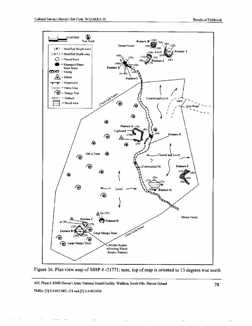
Cultural Surveys Hawaii Job Code: WAIAKEA 10 Results of Fieldwork
0 5 10 METERS
True North Feature H( 1( x))(130) 1 80)Dense Forest ( 90) 41i ',-`' ( 30)
Modified Height( cm) 100) i
m# Modified Depth( cm) 30) Level ( 601,",.-Feature I
x
Q =Placed Rock
60) \ (20) (50)' z. ( 30) (
e, (
40)tr HO)— Feature J
as = Manuport/WaterU00)
40) , (2S)
Worn Stone Feature K
Facingm 40; (
30
Q=DatumFeature 1.
T— y- Depression ZFence Line
MangoTreecE
BedrockV
e
Cleared and Level - •-
Paved AreaG.r*
svv '
Vf'
Gate
16^ 1 Jeep Road1 /
1 1
Feature A ( 30)
Cupboard40) ti
V
l00) 44)
Feature E
r6 ( 35)
Ohi' a Trees Cleared and Level
14.- onstructed Pit Feature F
II 3O) (40)
20) 60)111 t2t=()
50)
V Level --'"" 1 ( 3(' Feature G
Nit,,,
A(in 120)Dense Forest
Q Feature CFeature Drn 30
IS)35)
air 0
eslceFeature B•' 4WIller0el
Large Mango Trees r20) 20)) lra
f't Large Mango Trees Artifact Scatter
Grinding Wheel,Bottles, Pottery)
Figure 36. Plan view map of SIHP # - 21771; note, top of map is oriented to 13 degress true north
AIS, Phase I, KMR Hawai` i Army National Guard Facility, Waiakea, South Hilo, Hawai` i Island 78
TMKs:[ 3] 2- 1- 012: 003, 131 and[ 3] 2- 1- 013: 010
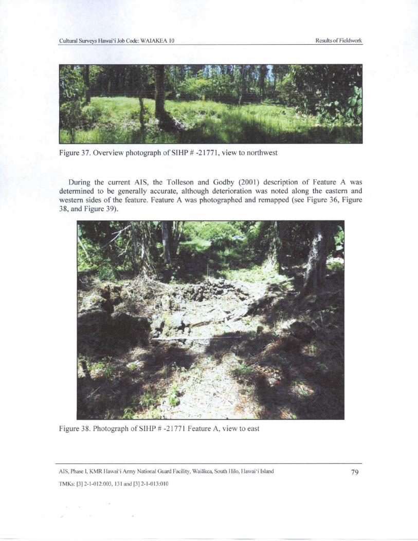
Cultural Surveys Hawaii Job Code: WAIAKEA 10 Results of Fieldwork
F' r A Eva
r . 74;
n;:' . 15'^
T
il ta lt ' r L
i
1 "' r
A
r
1- "*. 410*OWtA-L01.-L01. •, . 1,:':. X0;4
v ket
d
gyp, t '
t • ', 5•• 41, y
Figure 37. Overview photograph of SIHP# - 21771, view to northwest
During the current AIS, the Tolleson and Godby ( 2001) description of Feature A was
determined to be generally accurate, although deterioration was noted along the eastern andwestern sides of the feature. Feature A was photographed and remapped ( see Figure 36, Figure
38, and Figure 39).
71 J ', h clit
1*ts,
D v1 1' v
44
Y. Q4#. v ti -
j 14- 1" rr±
tt: ..
t+
1. }-r
s.,
s'. 4,, 9'
t - ^oK y ._
t
espy -f
r. .. iit. i
Figure 38. Photograph of SIHP# - 21771 Feature A, view to east
AIS, Phase I, KMR Hawaii Army National Guard Facility, Waiakea, South Hilo, Hawaii Island 79
TMKs:[ 3] 2- 1- 012:003, 131 and[ 3] 2- 1- 013:010
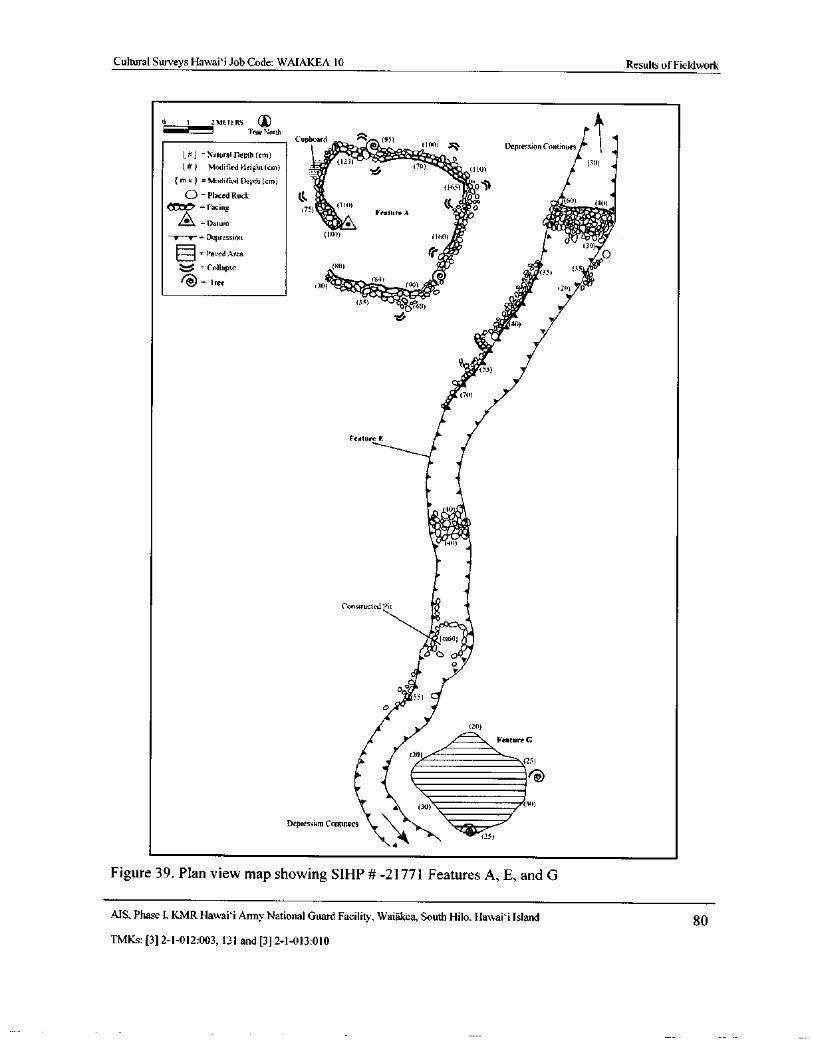
Cultural Surveys Hawaii Job Code: WAIAKEA 10 Results ofFieldwork
0 1 2114E 1-f.RS 4)ii " le! J True Nero
Cupboard • ( 9S)
41:a0
100) ". Depression1.- . 1 Continues
4l - Natural Depth( cm) T, 410- wry"irl i•
Modified Height( cm)t2) (
7iO•` 2 ( 1( 0) b; 0)
4
rn k} = Modified Depth( cm) '/ j77,ao 4
O- Placed Rock lk iia drE
Facing 7S) y.•( 110)
Feature A1 0!. p G.-..^- E
A Datum I>e i e i w`%. 44%i: 7Depression 11 co % of se j i
Lo, 130)
Paved Area i5.ii40
v -Collapse A0( I 35 09,°
tree 5O) . 1Viie%_tom 190) ii/ r
i1 r !' 0) p+c) • S•
4• it,
0 40i
A V
fp title ( 55
70)
Feature F.
40ij
4• d1( 40)
Constructed Pit
4,1•( m60; i
o
0.°/r 55) •'o ,,
20)
I. Feature G411111111111111111111116)
20)25)
MININNIMIMIIIMIIIIM C.-611111111111111111111111111111111
A ( 30) 111111111 30)
Depression Continues SMP'
1.
4
Figure 39. Plan view map showing SIHP # -21771 Features A, E, and G
MS, Phase I, KMR Hawai`i Army National Guard Facility, Waiakea, South Hilo, Hawaii Island 80
TMKs:[ 3] 2- 1- 012:003, 131 and[ 3] 2- 1- 013: 010
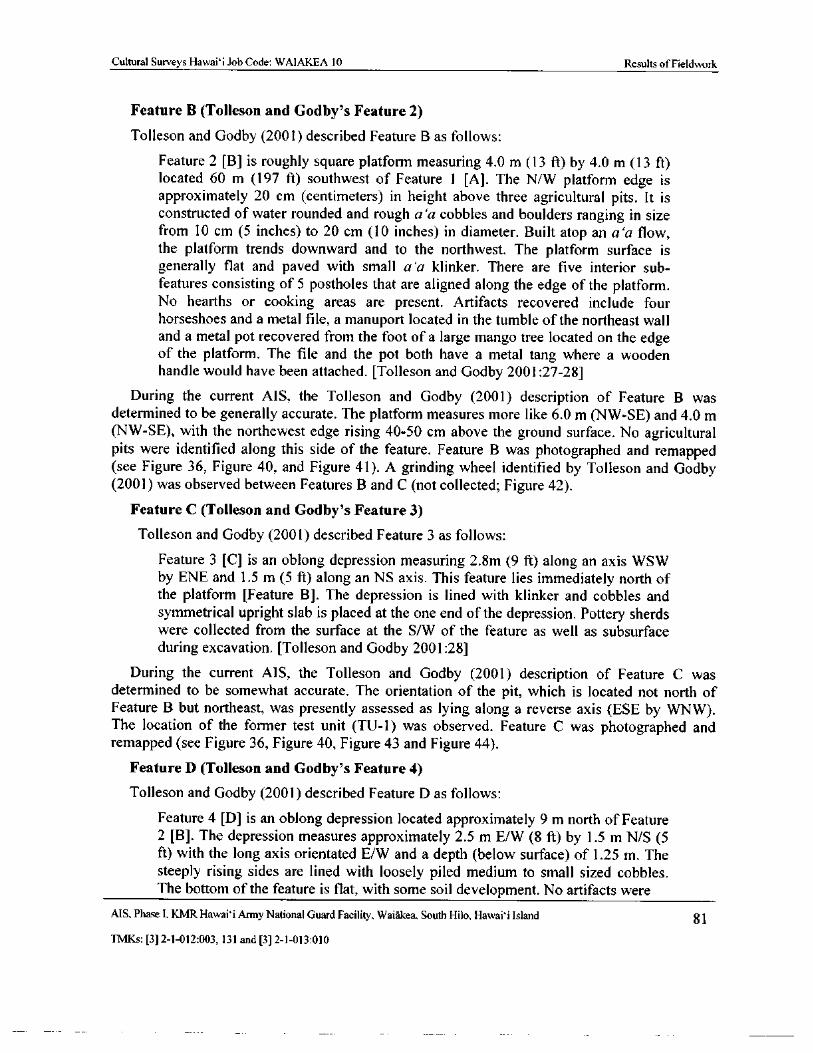
Cultural Surveys Hawai` i Job Code: WAIAKEA 10 Results ofFieldwork
Feature B ( Tolleson and Godby' s Feature 2)
Tolleson and Godby ( 2001) described Feature B as follows:
Feature 2 [ B] is roughly square platform measuring 4. 0 m ( 13 ft) by 4. 0 m ( 13 ft)located 60 m ( 197 ft) southwest of Feature 1 [ A]. The N/W platform edge is
approximately 20 cm ( centimeters) in height above three agricultural pits. It is
constructed of water rounded and rough a`a cobbles and boulders ranging in sizefrom 10 cm ( 5 inches) to 20 cm ( 10 inches) in diameter. Built atop an a' a flow,the platform trends downward and to the northwest. The platform surface is
generally flat and paved with small a` a klinker. There are five interior sub-features consisting of 5 postholes that are aligned along the edge of the platform.No hearths or cooking areas are present. Artifacts recovered include four
horseshoes and a metal file, a manuport located in the tumble of the northeast walland a metal pot recovered from the foot of a large mango tree located on the edge
of the platform. The file and the pot both have a metal tang where a woodenhandle would have been attached. [ Tolleson and Godby 2001: 27- 28]
During the current AIS, the Tolleson and Godby ( 2001) description of Feature B was
determined to be generally accurate. The platform measures more like 6. 0 m ( NW- SE) and 4. 0 mNW- SE), with the northewest edge rising 40- 50 cm above the ground surface. No agricultural
pits were identified along this side of the feature. Feature B was photographed and remappedsee Figure 36, Figure 40, and Figure 41). A grinding wheel identified by Tolleson and Godby2001) was observed between Features B and C ( not collected; Figure 42).
Feature C ( Tolleson and Godby' s Feature 3)
Tolleson and Godby (2001) described Feature 3 as follows:
Feature 3 [ C] is an oblong depression measuring 2. 8m ( 9 ft) along an axis WSWby ENE and 1. 5 m ( 5 ft) along an NS axis. This feature lies immediately north ofthe platform [ Feature B]. The depression is lined with klinker and cobbles and
symmetrical upright slab is placed at the one end of the depression. Pottery sherdswere collected from the surface at the S/ W of the feature as well as subsurface
during excavation. [ Tolleson and Godby 2001: 28]
During the current AIS, the Tolleson and Godby ( 2001) description of Feature C was
determined to be somewhat accurate. The orientation of the pit, which is located not north of
Feature B but northeast, was presently assessed as lying along a reverse axis ( ESE by WNW).The location of the former test unit ( TU- 1) was observed. Feature C was photographed andremapped ( see Figure 36, Figure 40, Figure 43 and Figure 44).
Feature D ( Tolleson and Godby' s Feature 4)
Tolleson and Godby ( 2001) described Feature D as follows:
Feature 4 [ D] is an oblong depression located approximately 9 m north of Feature2 [ B]. The depression measures approximately 2. 5 m E/W ( 8 ft) by 1. 5 m N/S ( 5ft) with the long axis orientated E/ W and a depth ( below surface) of 1. 25 m. Thesteeply rising sides are lined with loosely piled medium to small sized cobbles.The bottom of the feature is flat, with some soil development. No artifacts were
AIS. Phase I. KMR Hawaii Army National Guard Facility, Waiakea, South Hilo, Hawaii Island 81
TMKs:[ 3] 2- 1- 012:003, 131 and[ 3] 2- 1- 013: 010
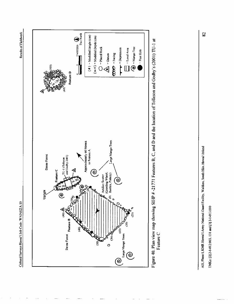
Yi. s N
toEi.0u ct
y v x y Q E"" O HNW W - 0 E C
o!') St = n
iO- v v U 6 > C ho S y p O
x Q q w q a z b O
II I I f[ q li I u e
It 0 t I I II @ 0 ,
oo,y'''
Oy,! ieu
q 0up
0H
0
c0
alUO0
Cct
E v QL
N ft Q
o>, E4 g TA
rri 3p. L' cl
o Y o a V) x
6 E , oti. 1..)
3 cCL yt
vwor• -- 3 n
m20 tL_
C1.-0
d
a a ?c doo .2
eN1
It
O Oo0,co i
x R
411*
iC Nrn
U p •46 b
all 11
rn
3 O if/00 7 0 Ki
et crix de0CS
a o
aa
N
VD
7,4 a@.., 1...) as
a
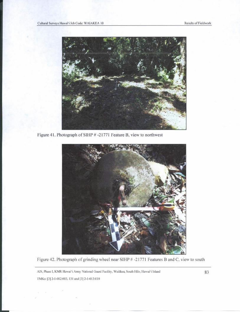
Cultural Surveys Hawaii Job Code: WAIAKEA 10 Results of Fieldwork
in _ 4 ' 41
I- dise-..
4+ mer_
i
y
G , .
4-',,, tfr r.ilki 4- e_
ire-A.
i . v,
Figure 41. Photograph of SIHP#- 21771 Feature B, view to northwest
aT '`' aIr .:1 :.
fit.r A. i
tex' jt'
1 ' vit. I.` )
111,r
1141 I,-'.. a . 17'' iN". :?ki.*'..'6.:!P''' -
a.
ir
ill141 .
r.. ' S''''
t_ , 1
t
Figure 42. Photograph of grinding wheel near SIHP# - 21771 Features B and C, view to south
AIS, Phase I, KMR Hawaii Army National Guard Facility, Waiakea, South Hilo, Hawaii Island 83
TMKs:[ 3] 2- 1- 012:003, 131 and[ 3] 2- 1- 013: 010
Cultural Surveys Hawaii Job Code: WAIAKEA 10 Results of Fieldwork
i 7.0
F.
7:f.Y'
Ali1
aw
0'` A.- -
3 1{ ,. X11 ' • f', J . - • -
4e..,y
t` „ 4y .,
f ^• `'fT
Figure 43. Photograph of SIHP# - 21771 Feature C, view to northwest
4
i c
i yS10.
Ar" 411P!.. / #1`', . 1
r . r- 4, 41 sr 1,40
Jr e
11Figure 44. Photograph of SIHP#- 21771 Feature C, showing the upright slab located along the
northern end of the feature, view to northwest
AIS, Phase I, KMR Hawaii Army National Guard Facility, Waiakea, South Hilo, Hawaii Island 84
TMKs:[ 3] 2- 1- 012:003, 131 and[ 3] 2- 1- 013: 010
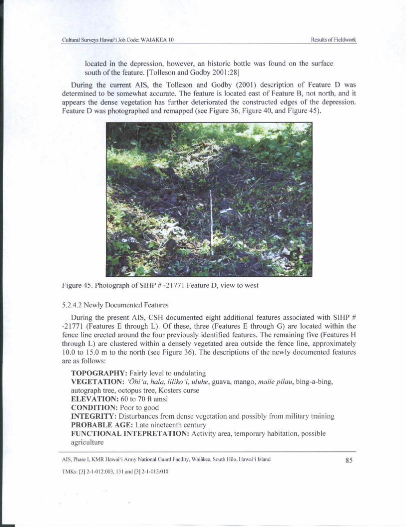
Cultural Surveys Hawaii Job Code: WAIAKEA 10 Results ofFieldwork
located in the depression, however, an historic bottle was found on the surface
south of the feature. [ Tolleson and Godby 2001: 28]
During the current AIS, the Tolleson and Godby ( 2001) description of Feature D was
determined to be somewhat accurate. The feature is located east of Feature B, not north, and it
appears the dense vegetation has further deteriorated the constructed edges of the depression.
Feature D was photographed and remapped( see Figure 36, Figure 40, and Figure 45).
ktititiot .,"-*V----.1"..-ideill'
Plii-'*
1,. t , r
xtom i re
li,, Y ,
Figure 45. Photograph of SIHP#- 21771 Feature D, view to west
5. 2.4.2 Newly Documented Features
During the present AIS, CSH documented eight additional features associated with SIHP #21771 ( Features E through L). Of these, three ( Features E through G) are located within the
fence line erected around the four previously identified features. The remaining five( Features Hthrough L) are clustered within a densely vegetated area outside the fence line, approximately10. 0 to 15. 0 m to the north ( see Figure 36). The descriptions of the newly documented featuresare as follows:
TOPOGRAPHY: Fairly level to undulatingVEGETATION: `Ohi`a, hala, liliko`i, uluhe, guava, mango, maile pilau, bing-a- bing,autograph tree, octopus tree, Kosters curse
ELEVATION: 60 to 70 ft amsl
CONDITION: Poor to good
INTEGRITY: Disturbances from dense vegetation and possibly from military trainingPROBABLE AGE: Late nineteenth centuryFUNCTIONAL INTEPRETATION: Activity area, temporary habitation, possibleagriculture
AIS, Phase I, KMR Hawaii Army National Guard Facility, Waiakea, South Hilo, Hawaii Island 85
TMKs:[ 3] 2- 1- 012:003, 131 and[ 3] 2- 1- 013:010
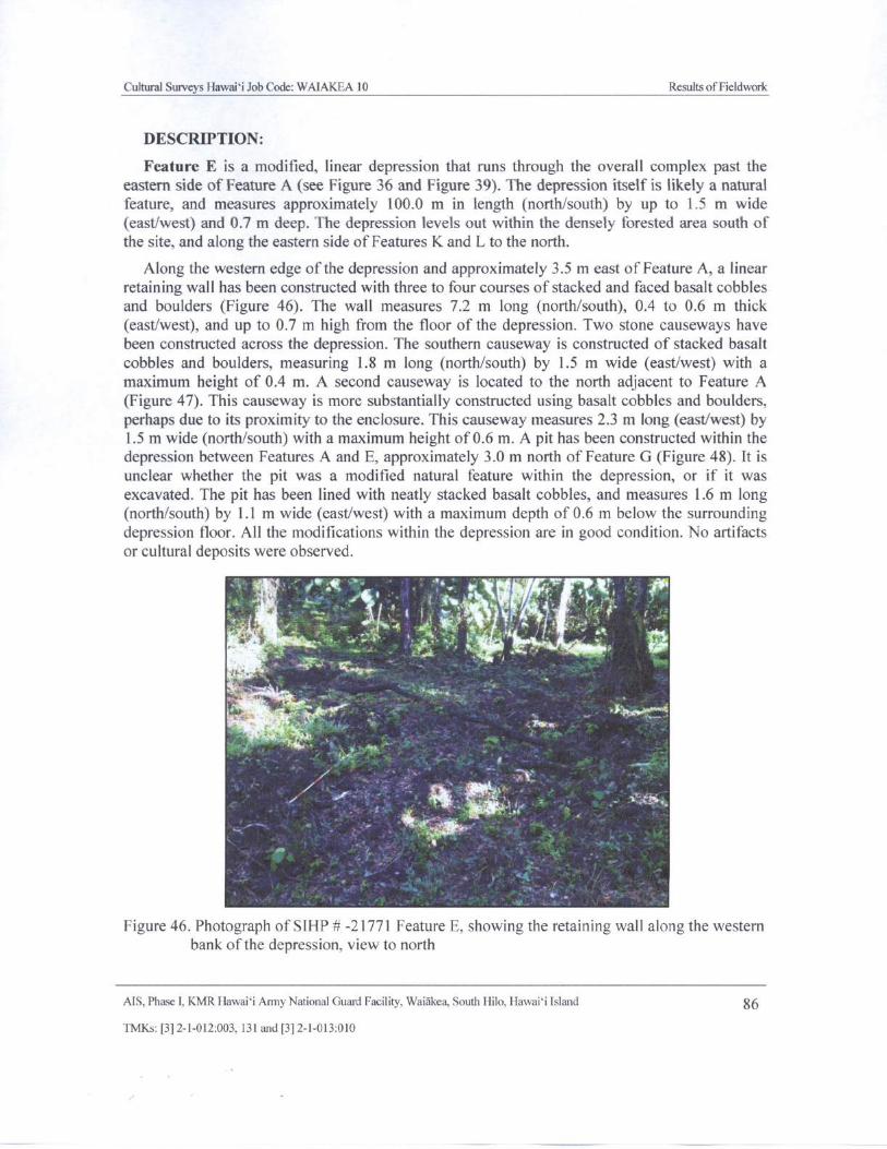
Cultural Surveys Hawaii Job Code: WAIAKEA l0 Results ofFieldwork
DESCRIPTION:
Feature E is a modified, linear depression that runs through the overall complex past the
eastern side of Feature A( see Figure 36 and Figure 39). The depression itself is likely a naturalfeature, and measures approximately 100.0 m in length ( north/south) by up to 1. 5 m wideeast/west) and 0. 7 m deep. The depression levels out within the densely forested area south of
the site, and along the eastern side of Features K and L to the north.
Along the western edge of the depression and approximately 3. 5 m east of Feature A, a linearretaining wall has been constructed with three to four courses of stacked and faced basalt cobblesand boulders ( Figure 46). The wall measures 7.2 m long ( north/ south), 0.4 to 0.6 m thick
east/west), and up to 0.7 m high from the floor of the depression. Two stone causeways havebeen constructed across the depression. The southern causeway is constructed of stacked basaltcobbles and boulders, measuring 1. 8 m long ( north/ south) by 1. 5 m wide ( east/west) with amaximum height of 0. 4 m. A second causeway is located to the north adjacent to Feature AFigure 47). This causeway is more substantially constructed using basalt cobbles and boulders,
perhaps due to its proximity to the enclosure. This causeway measures 2.3 m long (east/west) by1. 5 m wide (north/south) with a maximum height of 0.6 m. A pit has been constructed within the
depression between Features A and E, approximately 3. 0 m north of Feature G ( Figure 48). It is
unclear whether the pit was a modified natural feature within the depression, or if it was
excavated. The pit has been lined with neatly stacked basalt cobbles, and measures 1. 6 m longnorth/south) by 1. 1 m wide ( east/west) with a maximum depth of 0.6 m below the surrounding
depression floor. All the modifications within the depression are in good condition. No artifacts
or cultural deposits were observed.
1 ,
VV% f
Nu
Figure 46. Photograph of SIHP# - 21771 Feature E, showing the retaining wall along the westernbank of the depression, view to north
AIS, Phase I, KMR Hawaii Army National Guard Facility, Waiakea, South Hilo, Hawaii Island 86
TMKs:[ 3] 2- 1- 012:003, 131 and[ 3] 2- 1- 013: 010
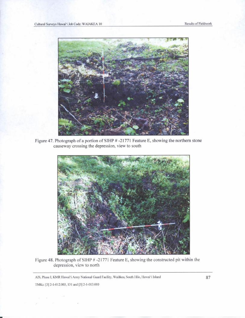
Cultural Surveys Hawaii Job Code: WAIAKEA 10 Results of Fieldwork
1" 4 it'-- f.,,;.\''
i-d\ R-" S L ' L .• t4
n
y4ii
1- r
t
1'
414014„ , ss.....
41i-- -.1- _ : ' ,.
4,4" .,' 4 4.... to. 4:4.41, 7.. 174, ***
t aweeAIIP1. 11,' '. 7t
Figure 47. Photograph ofa portion of SIHP#- 21771 Feature E, showing the northern stonecauseway crossing the depression, view to south
P.-
vy` 7 ..
7. .H .
t sra
x. isoWit.= '' I. t.i x-.' y s
r
Y !. s t.
v,
a . 7rt,, fir" l
i,..fit
v fF jI: 1- ,,r }
a. a
h.
5 ;, vim
Ti. v r~ J0
r1.i•. 11 ` t _
I
l.•-.._''r.;' ` Q~.k Y' ," C.\ '-i .{i, ' e,-
FigureFigure 48. Photograph of SIHP#- 21771 Feature E, showing the constructed pit within thedepression, view to north
AIS, Phase I, KMR Hawai` i Anny National Guard Facility, Waiakea, South Hilo, Hawaii Island 87
TMKs:[ 3] 2- 1- 012:003, 131 and[ 3] 2- 1- 013:010
j
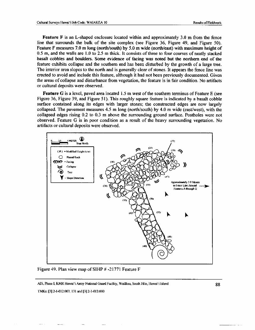
Cultural Surveys Hawai` i Job Code: WAIAKEA 10 Results ofFieldwork
Feature F is an L-shaped enclosure located within and approximately 3. 0 m from the fenceline that surrounds the bulk of the site complex ( see Figure 36, Figure 49, and Figure 50).
Feature F measures 7. 0 m long( north/south) by 5. 0 m wide( north/east) with maximum height of0. 5 m, and the walls are 1. 0 to 2.5 m thick. It consists of three to four courses of neatly stackedbasalt cobbles and boulders. Some evidence of facing was noted but the northern end of thefeature exhibits collapse and the southern end has been disturbed by the growth of a large tree.The interior area slopes to the north and is generally clear of stones. It appears the fence line waserected to avoid and include this feature, although it had not been previously documented. Giventhe areas of collapse and disturbance from vegetation, the feature is in fair condition. No artifactsor cultural deposits were observed.
Feature G is a level, paved area located 1. 5 m west of the southern terminus of Feature E( seeFigure 36, Figure 39, and Figure 51). This roughly square feature is indicated by a basalt cobblesurface contained along its edges with larger stones; the constructed edges are now largelycollapsed. The pavement measures 4. 5 m long (north/south) by 4.0 m wide (east/west), with thecollapsed edges rising 0.2 to 0.3 m above the surrounding ground surface. Postholes were notobserved. Feature G is in poor condition as a result of the heavy surrounding vegetation. Noartifacts or cultural deposits were observed.
111'0. 1 METER ® 35)
True North
35)
Modified I lcight( cum 14D Placed Rock 0 lirP'. O o
tc =Facing 30) 116'i :a,\\..
0cona1
Treecedririk,
11 " j**\47.11
it(V
y- Slope Directicut rit T4.,4•• 07)
rs:.=
6• Approximately 3 Meters
20) S' 50) to Fence Line Around —
vOir. Features A through G
Els0405)
4544)
witimpA
1111/1a2) AVAIL, (52)
ilk
vitt1,10. (48)
40) Y ioa
Figure 49. Plan view map of SIHP# - 21771 Feature F
AIS, Phase I, KMR Hawai` i Army National Guard Facility, Waiakea, South Hilo, Hawai` i Island 88
TMKs:[ 3] 2- 1- 012:003, 131 and[ 3] 2- 1- 013: 010
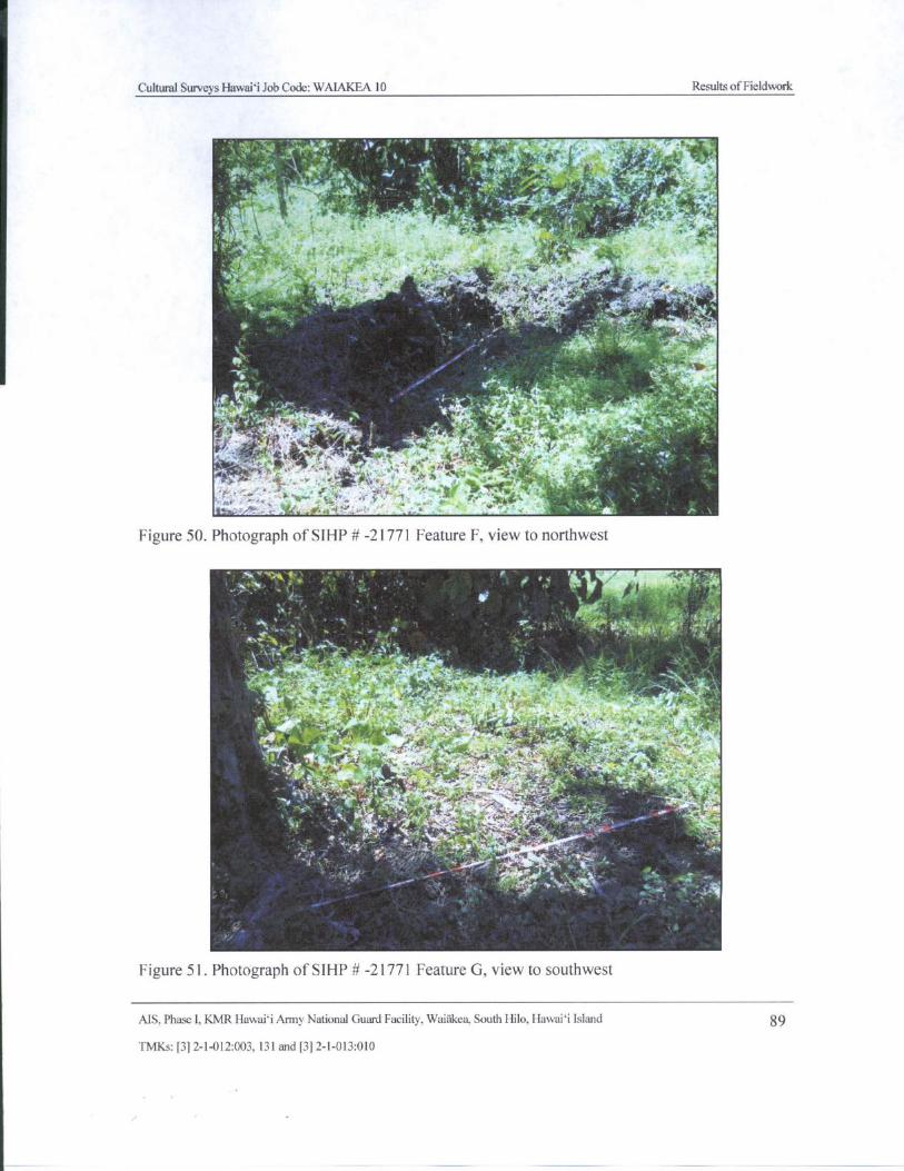
Cultural Surveys Hawaii Job Code: WAIAKEA 10 Results ofFieldwork
1. 4' R!' .e. ', '
i t. i
4t ' ', Y i
vS
r r
3 2'' v.
4 t• "`3
t + q
ii 1+ .-. ,,,,....-= .
N .r
ii aT
41,,
s
vY .
t'..-,-*•?,,0w s + e,;:l As ' V%'.. 1, 1.: 101- ,:
44
Figure 50. Photograph of SIHP# - 21771 Feature F, view to northwest
IV
r'1
8.'
p '
yam` . n
AHca
ulc J._ _.,40... 4: , r, •, -...'-,.*i-,...
t. ›E-,. : , ‘,..,• i' Af" ',;;4'..- '..:''';.
Figure 51. Photograph of SIHP# - 21771 Feature G, view to southwest
AIS, Phase I, KMR Hawaii Anny National Guard Facility. Waiakea, South Hilo, Hawaii Island 89
TMKs:[ 3] 2- 1- 012: 003, 131 and[ 3] 2- 1- 013: 010
j
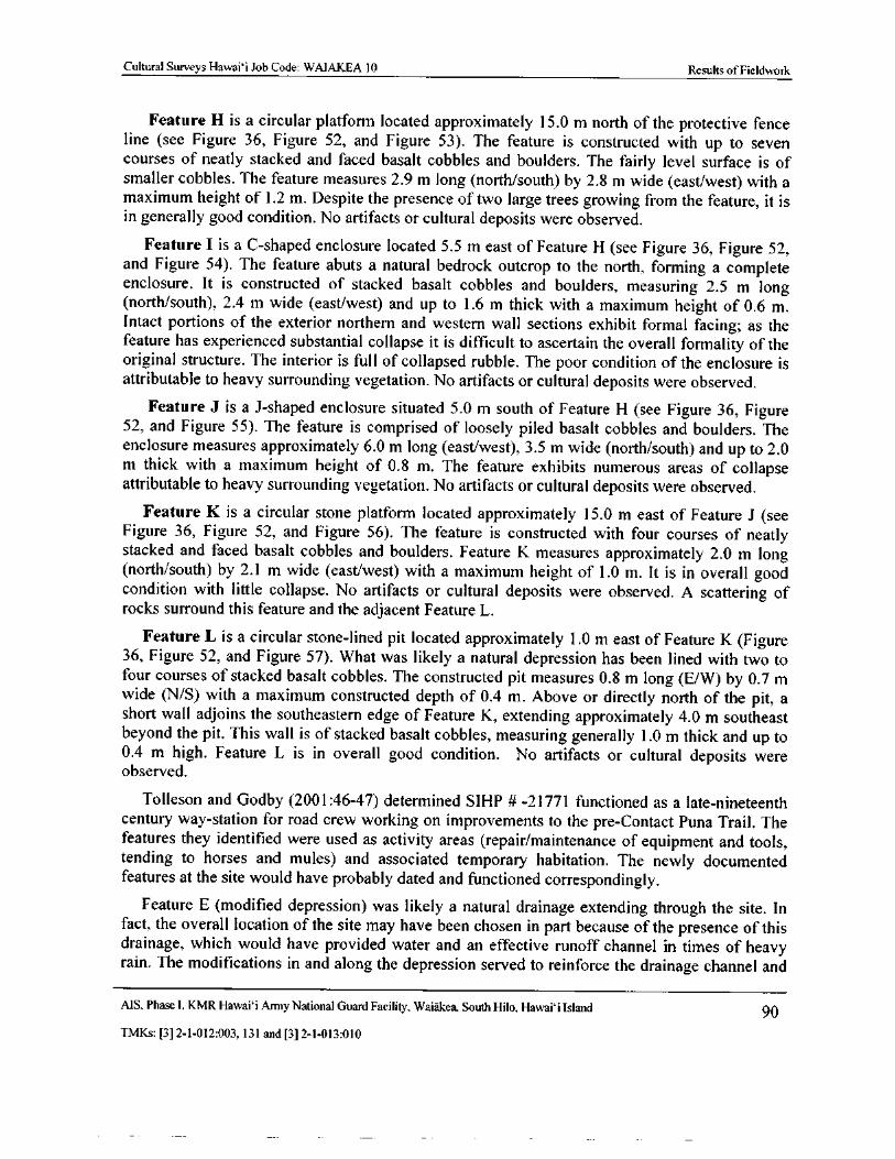
Cultural Surveys Hawai` i Job Code: WAIAKEA 10 Results of Fieldwork
Feature H is a circular platform located approximately 15. 0 m north of the protective fenceline ( see Figure 36, Figure 52, and Figure 53). The feature is constructed with up to sevencourses of neatly stacked and faced basalt cobbles and boulders. The fairly level surface is ofsmaller cobbles. The feature measures 2. 9 m long (north/south) by 2. 8 m wide ( east/west) with amaximum height of 1. 2 m. Despite the presence of two large trees growing from the feature, it isin generally good condition. No artifacts or cultural deposits were observed.
Feature I is a C- shaped enclosure located 5. 5 m east of Feature H ( see Figure 36, Figure 52,and Figure 54). The feature abuts a natural bedrock outcrop to the north, forming a completeenclosure. It is constructed of stacked basalt cobbles and boulders, measuring 2. 5 m longnorth/south), 2. 4 m wide ( east/west) and up to 1. 6 m thick with a maximum height of 0. 6 m.
Intact portions of the exterior northern and western wall sections exhibit formal facing; as thefeature has experienced substantial collapse it is difficult to ascertain the overall formality of theoriginal structure. The interior is full of collapsed rubble. The poor condition of the enclosure isattributable to heavy surrounding vegetation. No artifacts or cultural deposits were observed.
Feature J is a J- shaped enclosure situated 5. 0 m south of Feature H ( see Figure 36, Figure52, and Figure 55). The feature is comprised of loosely piled basalt cobbles and boulders. Theenclosure measures approximately 6.0 m long ( east/west), 3. 5 m wide (north/ south) and up to 2. 0m thick with a maximum height of 0. 8 m. The feature exhibits numerous areas of collapseattributable to heavy surrounding vegetation. No artifacts or cultural deposits were observed.
Feature K is a circular stone platform located approximately 15. 0 m east of Feature J ( seeFigure 36, Figure 52, and Figure 56). The feature is constructed with four courses of neatlystacked and faced basalt cobbles and boulders. Feature K measures approximately 2. 0 m longnorth/ south) by 2. 1 m wide ( east/west) with a maximum height of 1. 0 m. It is in overall good
condition with little collapse. No artifacts or cultural deposits were observed. A scattering ofrocks surround this feature and the adjacent Feature L.
Feature L is a circular stone- lined pit located approximately 1. 0 m east of Feature K ( Figure36, Figure 52, and Figure 57). What was likely a natural depression has been lined with two tofour courses of stacked basalt cobbles. The constructed pit measures 0.8 m long ( E/ W) by 0. 7 mwide ( N/ S) with a maximum constructed depth of 0.4 m. Above or directly north of the pit, ashort wall adjoins the southeastern edge of Feature K, extending approximately 4.0 m southeastbeyond the pit. This wall is of stacked basalt cobbles, measuring generally 1. 0 m thick and up to0. 4 m high. Feature L is in overall good condition. No artifacts or cultural deposits wereobserved.
Tolleson and Godby ( 2001: 46- 47) determined SIHP # - 21771 functioned as a late- nineteenth
century way-station for road crew working on improvements to the pre- Contact Puna Trail. Thefeatures they identified were used as activity areas ( repair/maintenance of equipment and tools,tending to horses and mules) and associated temporary habitation. The newly documentedfeatures at the site would have probably dated and functioned correspondingly.
Feature E ( modified depression) was likely a natural drainage extending through the site. Infact, the overall location of the site may have been chosen in part because of the presence of thisdrainage, which would have provided water and an effective runoff channel in times of heavyrain. The modifications in and along the depression served to reinforce the drainage channel and
MS, Phase I, KMR Hawaii Army National Guard Facility. Waiakea, South Hilo, Hawaii Island 90
TMKs:[ 3] 2- 1- 012: 003, 131 and[ 3] 2- 1- 013: 010
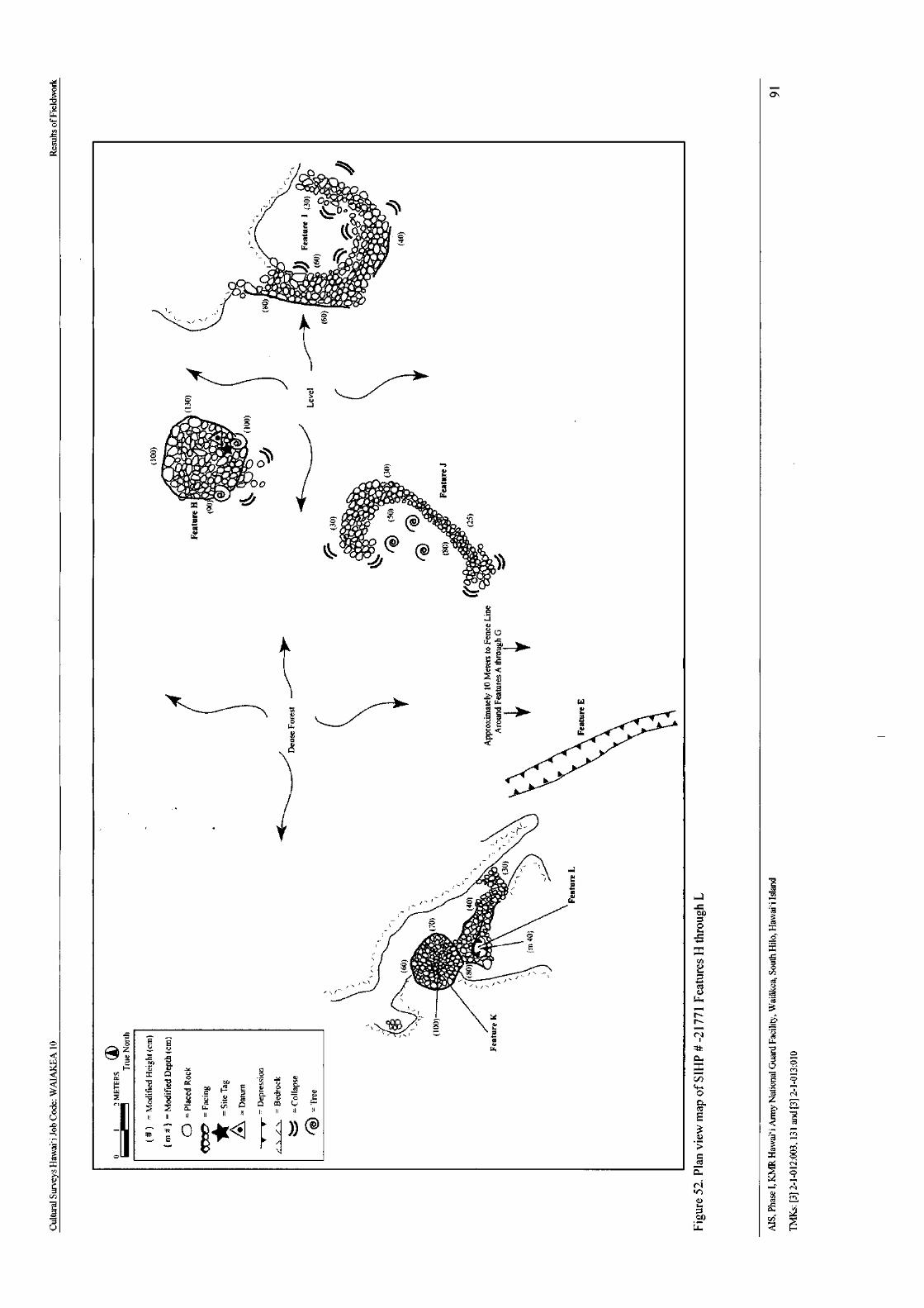
o1. 4
3T>ww0h
aa4
t ONVIIJif• <r
z
a
400 8
72. IP?*' '•1046140.rit• 0.-
rzt.1i J/ et,t..."• ii
4. WI.
Va
a vLao u,O D. '_
Q
b
1 CS
ti w
C
C
Id,,1_
e
bA RI
cs
0 x
0%N- .. 4'4140 4,, 4...
i. 2
i\, I
cd'- , ,
ct i
a3
oo E
EAtt
I w
z w It b o
E^ v a)
v
11J5
cn
Qr C C
Ck o
3 7. - 3 4, .F a cz, v o 0 oo _ o M v A a cu E-
01, 1 1 0 0 f { 1
cuc O tAig<• II
mV1
a :
3G
7alORx o
CCS N
Na O
N NM
a ci
P to
w a
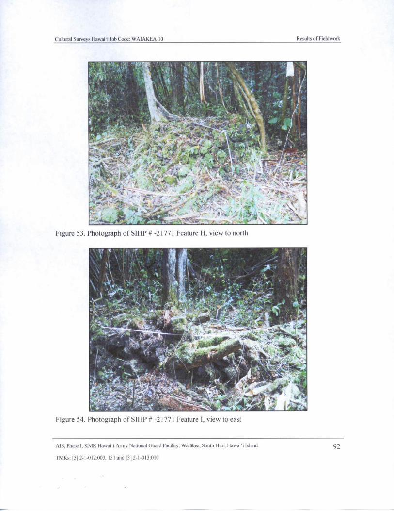
Cultural Surveys Hawaii, lob Code: WAIAKEA 10 Results of Fieldwork
3,
It.
tM ciiw a
1
2416.'`],,,* k, '' P>°. fi`eo4s,'^-- a:. ' Vie.• ; y
t :,.'. 4
T
l
i t ,,. . y ,,.. 44----17-t- 1 - 401-,
Figure 53. Photograph of SIHP#- 21771 Feature H, view to north
i
J
y'. .. it • ' :: , •
i.. „
ii di ty i
19V CSS t
144,ti, 9 •
S- r ;
was -R. ,
W' i, I. A.> Ir ay ti
Q A.,ade•
r
tt
i7
y
r
y- A eft'
Y:'''* elk , . I• tt
A4rFigure 54. Photograph of SIHP# - 21771 Feature I, view to east
AIS, Phase I, KMR Hawaii Army National Guard Facility, Waiakea, South Hilo, Hawaii Island 92
TMKs:[ 3] 2- 1- 012:003, 131 and[ 3] 2- 1- 013:010
j
r—
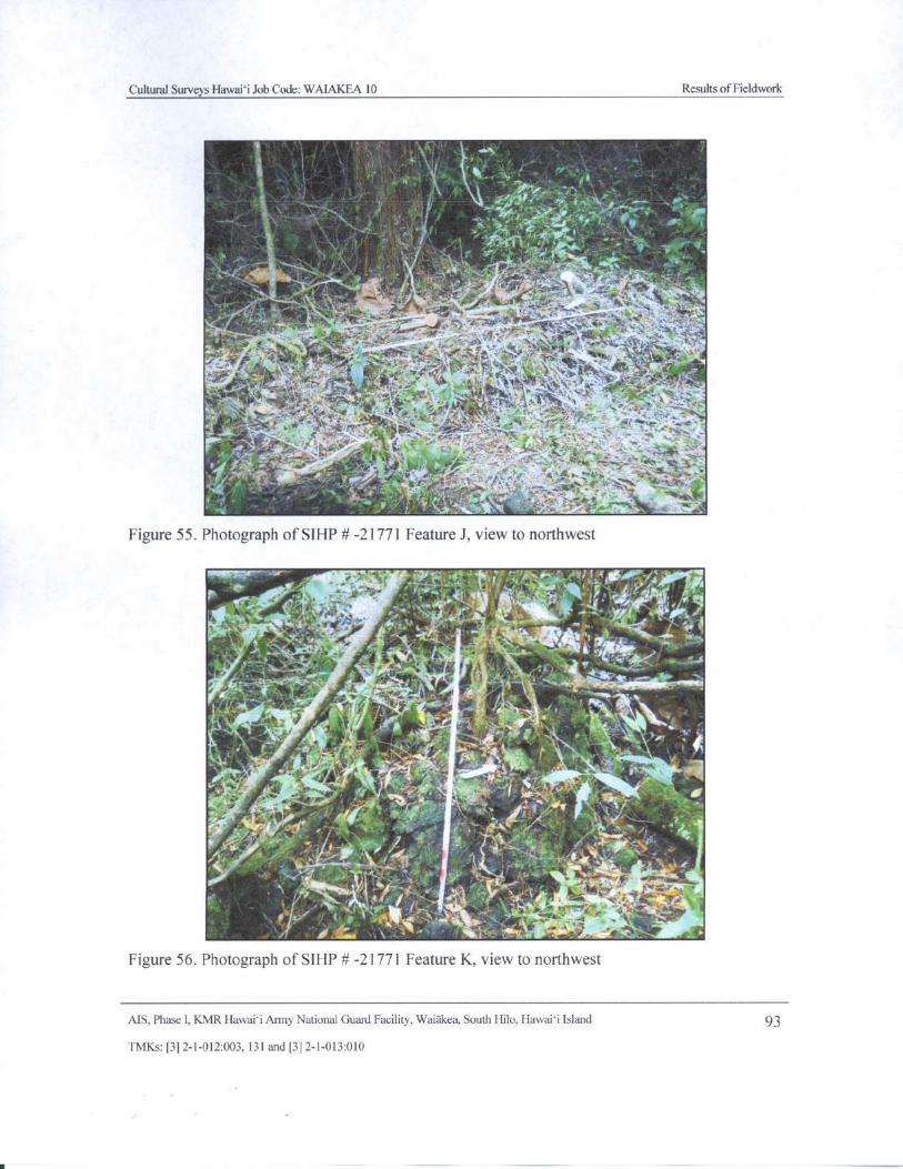
Cultural Surveys Hawaii Job Code: WAIAKEA 10 Results of Fieldwork
1/4.
iL
Z! k
Xy A / , p 4 r-- ,
111semej. * rIli * Or I,
p. i_
I
i. y '" --.
wit f el,; “ g s :,
s. '' 47. . , .,/ s",•LObt 4I< Nt-
vieilf- ..,, jiz•-fie .
sta
64,
i.414 ft 41a / ,
rM tia 1 - , 1 ' r
T ,`' y ! 4 ..47.4 ' i ''-. r"-.4$1".7,..:*,-
I STS ., T$•" Y • `
4,
t.,: a :_ 4,,—
f1{ • .
F , ,yam '{ '"
Figure 55. Photograph of SIHP#- 21771 Feature J, view to northwest
v*fir - 4- x~ Tilia
41,^ -""" , tea 4aj°,' rtr
l Tom...FiN,
of
J` y r yamS ^
I
R '^ F
Cd , •. - C sL0 /Fa ,_
s
Figure 56. Photograph of SIHP# - 21771 Feature K, view to northwest
AIS, Phase I, KMR Hawaii Army National Guard Facility, Waiakea, South Hilo, Hawaii Island 93
TMKs:[ 3] 2- 1- 012:003, 131 and[ 3] 2- 1- 013: 010
l
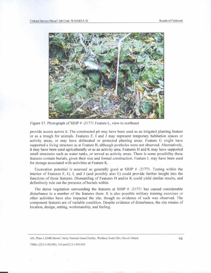
Cultural Surveys Hawaii Job Code: WAIAKEA 10 Results of Fieldwork
Y, 410.-z it
Q
fit"
iek*4
i 1 d
4
4i C -
J '
T; +ry r , f'}f``
j. ;{` \ "moi.
5.v "
ate`., aF'
fy - 4'. all `... 1' i
i
v 4 r,•, . ita"#', - , Aa
Figure 57. Photograph of SIHP#- 21771 Feature L, view to northeast
provide access across it. The constructed pit may have been used as an irrigated planting featureor as a trough for animals. Features F, I and J may represent temporary habitation spaces oractivity areas, or may have delineated or protected planting areas. Feature G might havesupported a living structure as at Feature B, although postholes were not observed. Alternatively,it may have been used agriculturally or as an activity area. Features H and K may have supportedsmall structures such as water tanks, or served as activity areas. There is some possibility thesefeatures contain burials, given their size and formal construction. Feature L may have been usedfor storage associated with activities at Feature K.
Excavation potential is assessed as generally good at SIHP # - 21771. Testing within theinterior of Features F, G, I, and J ( and possibly also E) could provide further insight into thefunctions of those features. Dismantling of Features H and/or K could yield similar results, anddefinitively rule out the presence ofburials within.
The dense vegetation surrounding the features at SIHP # - 21771 has caused considerable
disturbance to a number of the features there. It is also possible military training exercises orother activities have also impacted the site, though no evidence of such was observed. The
component features are of variable condition. Despite evidence of disturbance, the site retains of
location, design, setting, workmanship, and feeling.
AIS, Phase I, KMR Hawaii Anny National Guard Facility, Waiakea, South Hilo, Hawaii Island 94
TMKs:[ 3] 2- 1- 012:003, 131 and[ 3] 2- 1- 013: 010
Cultural Surveys Hawai` i Job Code: WAIAKEA 10 Results of Fieldwork
5. 2.5 SIHP# 50- 10- 35- 23273
Escott and Tolleson (2002: 9- 12) described SIHP # - 23272 as follows:
Site 23273 covers an area approximately 103 meters [ 338 feet] north/ south and146 meters [ 479 feet] east/ west. There are three features associated with the site: aremnant portion of trail ( Feature 1) and two planting features ( Features 2 and 3).The site' s boundaries are represented by ti plants and Feature 3 to the north,Feature 2 to the south and the remnant ends of trail Feature 1 to the east and west.
There are no additional features apparent within or immediately outside of thesite' s boundaries. However, its proximity to the Puna Trail ( 300 meters east of thesite) and the condition of the site' s features suggest that it is an historic site.
Feature 1 is a remnant portion of trail this bisects the site at an axis of72°/ 252°. It is in fair condition, is visible on the landscape for 146 meters andranges in width from 0. 8 to 0. 9 meters. The width and structure of the trail are
consistent with that of a foot trail. The majority of the trail consists of theunimproved ground surface and is visible as a slight depression on it. It contains
no water worn stones and none of the a`a pebbles and cobbles in the trail surface
have been worn to a high degree. The trail is bent and curved to pass over the
broken and uneven a`a topography, and to allow passage through the less denselyforested areas of the natural environment. Two large mango trees exist less than ameter north of the trail, one near the center of the site and one on the western edge
of the site. There were no artifacts evident on or around the trail surface.
A small segment of the trail situated in a shallow depression in the northeastquadrant of the site has been improved through the use of curbstones. Thecurbstones of a`a cobbles placed on the a`a flow surface one to two courses wide,
one course high and aligned parallel to edges of the trail. They range in heightfrom 0. 11 to 0. 17 meters above the ground surface. The alignment of curbstoneson the southern edge is 7. 0 m in length, and the northern alignment is 4. 0 meters
long. The different length of the two alignments is most likely a function of thetopography on which they exist. The longer southern alignment is at the base of asmall steeply sloping hillock, while the shorter northern alignment is locatedalong the more level ground surface at the base of the depression.
The eastern terminus of the remnant trail is located approximately 3. 0 meters eastof the curbstone alignments. At this point the trail is situated at the top of thedepression through which it passes. A search for additional remnant portions of
trail in all directions from the trail terminus situated atop this thickly forested lowa`a ridge did not locate any signs of the trail' s continuation. A search along thetrail' s western terminus had similar results. The western end of the remnant trail
segment is no longer visible where it is situated across a very uneven and brokena`a surface. There is no apparent wear on the ground surface and it appears thattrees have grown on the trail' s surface.
Feature 2 is a rectangular agricultural planting feature located on a level a`aoutcrop at the northern base of an a`a ridge. The ground surface slopes downward
MS, Phase I, KMR Hawai` i Army National Guard Facility. Waiakea, South Hilo, Hawai` i Island 95
TMKs:[ 3] 2- 1- 012:003, 131 and[ 3] 2- 1- 013: 010
Cultural Surveys Hawai` i Job Code: WAIAKEA 10 Results of Fieldwork
to the north and west of the level outcrop. The surrounding landscape consists ofvery dense mixed forest vegetation covering a very rugged and uneven a`a flow.The rectangular planting feature is 0. 8 meters in length ( north/ south), 0. 3 meters
in width ( east/west) and 0. 16 to 0. 35 meters below surface at its interior. Theedges of the feature are lined with a course of a`a cobbles and boulder
surrounding an interior surface of a`a pebbles and cobbles. Fourteen ornamentalpalm trees of various sizes are growing around the feature and on the ridge to itssouth. Several palm seeds were observed to be sprouting on the ground surfacenear the planting feature.
Feature 3 is a circular agricultural planting feature located at the southeasternedge of a relatively level a`a flow. The ground surface to the south of the featureslopes gently downward. The feature is approximately 1. 7 meters in diameter andis constructed of a single course of a`a pebbles and cobbles 0. 2 meters in height
enclosing a soil filled area. Two fragments of undeteriorated kukui shell wereobserved on the surface of the feature. No other artifacts were apparent on thesurface near Feature 3. [ Escott and Tolleson 2002: 9- 12]
Escott and Tolleson ( 2002: 12) interpreted this trail as being " most likely associated with thecultivation and acquisition of forest plants," with at least the curbstone section created or
improved contemporaneous with the late nineteenth century construction along the Puna Trail.This trail is assessed as a Type B or AB trail using Apple' s ( 1965) typology. During the currentAIS, CSH relocated SIHP # - 23273 Feature 1 within the project area ( see Figure 23). CSH was
unable to relocate Features 2 and 3, likely due to their ambiguous nature and disturbances causedby the dense vegetative growth. The Escott and Tolleson ( 2002) Feature 1 site description wasdetermined to be accurate, and the trail was photographed and remapped ( Figure 58 and Figure59).
MS, Phase I, KMR Hawai` i Army National Guard Facility, Waiakea, South Hilo, Hawaii Island 96
TMKs:[ 3] 2- 1- 012: 003, 131 and[ 3] 2- 1- 013: 010
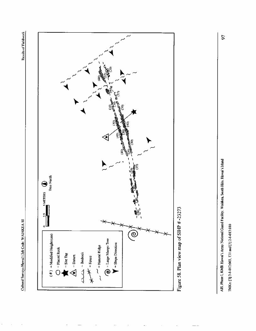
s.
3
s.J N
or
w
r-1w
rora r
1r1 1
r \ ,:i
1,
V,1
N
rj
06
O''''' w
4 • 1
ri
or.:.,
t
t
T
4 •OM
S C• e--1‘
N, ,../
1 1 o
10 r - 1 1 ,_,. g
I M
7,1
cz
t
I0
ul
F 1
fll v
ra1v,
1 1 r3
N
N I 1 co
etraoC'
w
o
Q
oQ G 0 iC N
OillZ
OIlcl u-0 u
U EgoswOrOC i 7ti Q
aanccdii-1 x E Z ix r0:,
x11 II = 1 H A0 II 11 II
cz
0 40(<, ( ...\, 1 @ >
1
OD0.
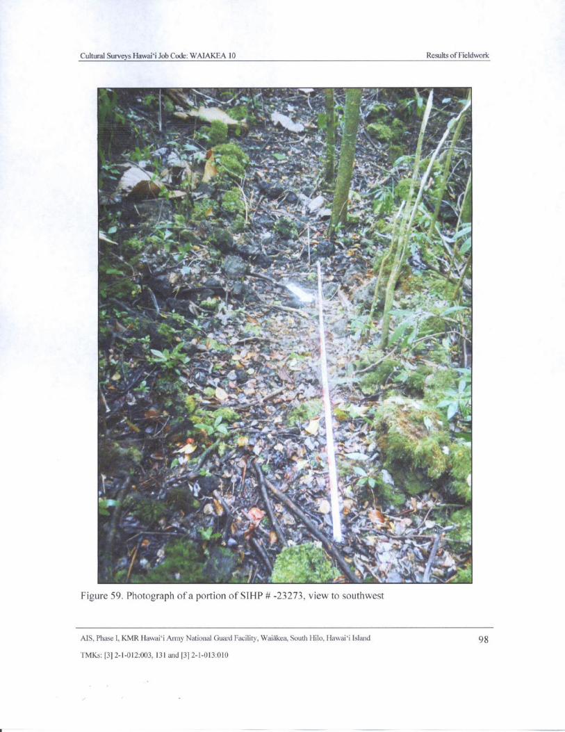
Cultural Surveys Hawaii Job Code: WAIAKEA 10 Results ofFieldwork
0.N t
Alts
L
w
lithiikt' - 1' '4
to1 wr.'.`
top
u'!.
II
x..' . fry \ - x
i
t .0._ *.' r -,,i7....,. .7._„
zw: Mfit, d r 1 r. ti
e t. 4
S. . `- r A.,-Y•
1°' 1 ` 7 ' s' t .fib }.-, .-.. s . t
t y.. . t .[
gipj. " Gni
X77/ firt
4 -"
w. 1, . 4.:: +.
yam tiro4• •
r` , P
ri
firmit . t
4. .i
4 " iihi.
virl,4.. 4
w. y it, le .t =t
i.w\ 2-.
Figure 59. Photograph of a portion of SHIP# - 23273, view to southwest
AIS, Phase I, KMR Hawaii Army National Guard Facility. Waiakea, South Hilo, Hawaii Island 98
TMKs:[ 3] 2- 1- 012:003, 131 and[ 3] 2- 1- 013: 010
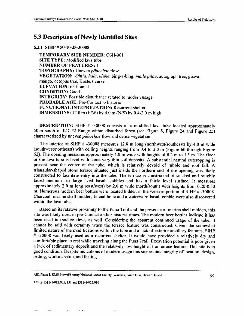
Cultural Surveys Hawaii Job Code: WAIAKEA 10 Results of Fieldwork
5.3 Description of Newly Identified Sites
5.3. 1 SIHP# 50- 10- 35-30008
TEMPORARY SITE NUMBER: CSH- 001
SITE TYPE: Modified lava tube
NUMBER OF FEATURES: 1
TOPOGRAPHY: Uneven pahoehoe flowVEGETATION: Ohi`a, hala, uluhe, bing-a- bing, maile pilau, autograph tree, guava,mango, octopus tree, Kosters curse
ELEVATION: 63 ft amsl
CONDITION: Good
INTEGRITY: Possible disturbance related to modern usage
PROBABLE AGE: Pre- Contact to historic
FUNCTIONAL INTEPRETATION: Recurrent shelter
DIMENSIONS: 12. 0 m ( E/ W) by 4. 0 m ( N/ S) by 0. 4- 2. 0 m high
DESCRIPTION: SIHP # - 30008 consists of a modified lava tube located approximately50 m south of KD # 2 Range within disturbed forest ( see Figure 8, Figure 24 and Figure 25)
characvterized by uneven pahoehoe flow and dense vegetation.
The interior of SIHP # - 30008 measures 12. 0 m long ( northwest/southeast) by 4. 0 m widesouthwest/northeast) with ceiling heights ranging from 0. 4 to 2. 0 m ( Figure 60 through Figure
62). The opening measures approximately 4. 0 m wide with heights of 0. 2 m to 1. 5 m. The floorof the lava tube is level with some very thin soil deposits. A substantial natural outcropping ispresent near the center of the tube, which is relatively devoid of rubble and roof fall. Atriangular- shaped stone terrace situated just inside the northern end of the opening was likelyconstructed to facilitate entry into the tube. The terrace is constructed of stacked and roughlyfaced medium- to large- sized basalt cobbles and has a fairly level surface. It measures
approximately 2. 0 m long ( east/west) by 2. 0 m wide ( north/ south) with heights from 0. 20- 0.50m. Numerous modern beer bottles were located hidden in the western portion of SIHP # - 30008.
Charcoal, marine shell midden, faunal bone and a waterworn basalt cobble were also discoveredwithin the lava tube.
Based on its relative proximity to the Puna Trail and the presence of marine shell midden, thissite was likely used in pre- Contact and/ or historic times. The modern beer bottles indicate it hasbeen used in modern times as well. Considering the apparent continued usage of the tube, itcannot be said with certainty when the terrace feature was constructed. Given the somewhatlimited nature of the modifications within the tube and a lack of exterior ancillary features, SIHP
30008 was likely used as a recurrent shelter. It would have provided a relatively dry andcomfortable place to rest while traveling along the Puna Trail. Excavation potential is poor givena lack of sedimentary deposit and the relatively low height of the terrace feature. This site is ingood condition. Despite indications of modern usage this site retains integrity of location, design,setting, workmanship, and feeling.
MS, Phase I. KMR Hawaii Army National Guard Facility, Waiakea, South Hilo, Hawaii Island 99
TMKs:[ 3] 2- 1- 012: 003, 131 and[ 3] 2- 1- 013: 010
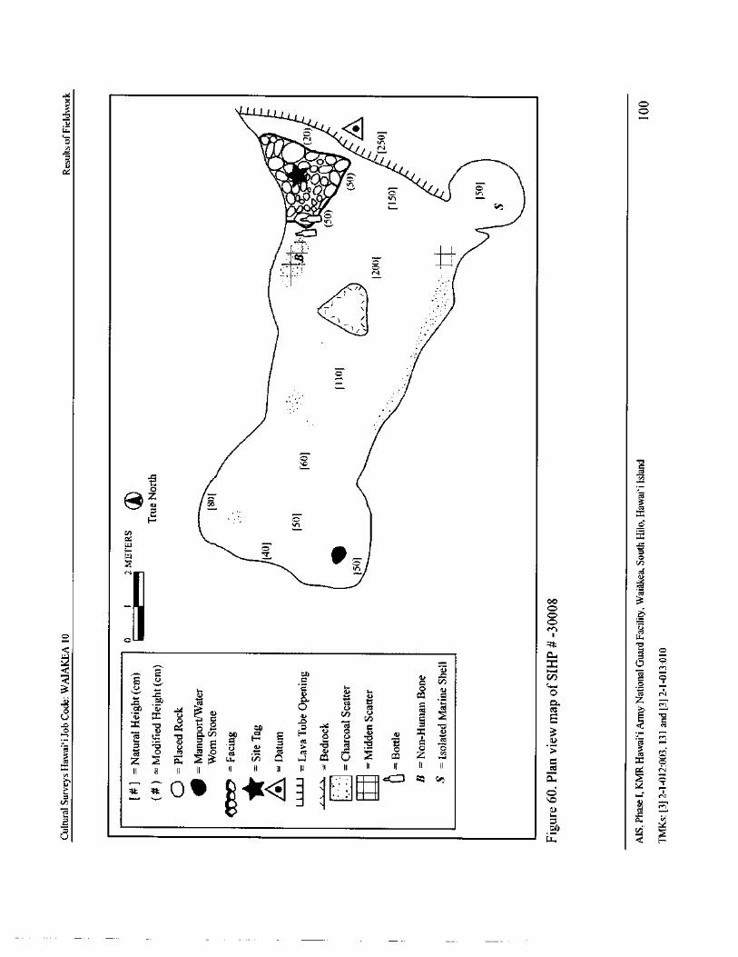
01-•
2 110
N}o Viral( oe 2 t 110 es`
do., J
y
1, 41000 /
w/
71
0
e
1:4 2F
1II1ri!
iJis
2 a 7 m C,
k II 72 0 2 1) 2 c 0
t a« * e , e ° 3 t) u
a , 0 e § c
7Q
2 \ $ m / $ \ ® k ) 7 a kE > & w 7 o Q / U / = 4 —
i i II : i ! i i , ; : " II " czi
II@}
4 I 0 0kB
U w
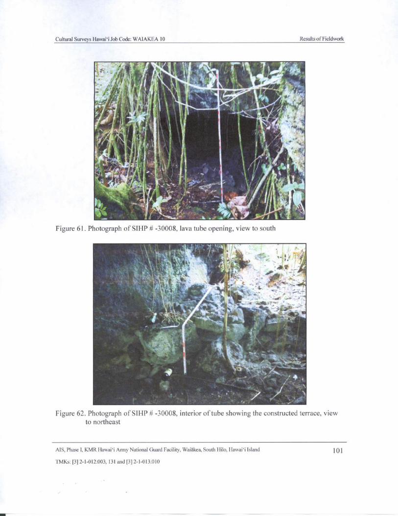
Cultural Surveys Hawaii Job Code: WAIAKEA 10 Results of Fieldwork
t, h , i
8 . , k
t
Atr.
t
1
1 -
tsi L . 4fI
Figure 61. Photograph of SIHP# - 30008, lava tube opening, view to south
4*.;
k
2*-_ ., i x4 4, it
t
4. ii,,,ks., , A' Nfw
way. iltii
N .7r
x 414.1: 1, 4" 12..
Vii, , A. -. _'
i
Figure 62. Photograph of SIHP# - 30008, interior of tube showing the constructed terrace, viewto northeast
AIS, Phase I, KMR Hawaii Army National Guard Facility, Waiakea, South Hilo, Hawaii Island 101
TMKs:[ 3] 2- 1- 012:003, 131 and[ 3] 2- 1- 013: 010
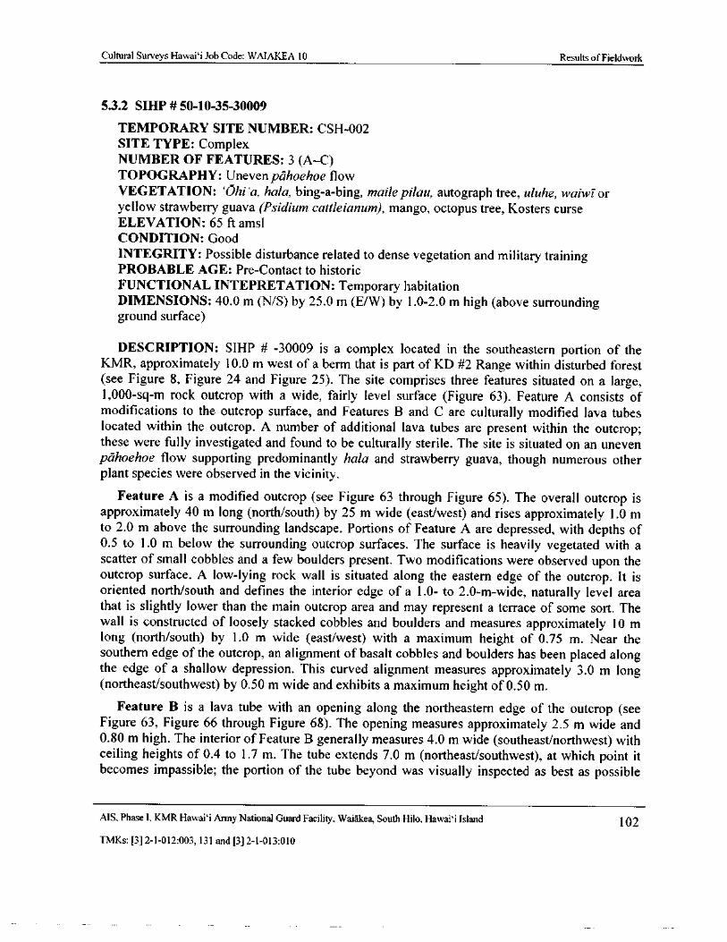
Cultural Surveys Hawaii Job Code: WAIAKEA 10 Results of Fieldwork
5.3.2 SIHP# 50- 10-35-30009
TEMPORARY SITE NUMBER: CSH- 002
SITE TYPE: Complex
NUMBER OF FEATURES: 3 ( A—C)
TOPOGRAPHY: Uneven pahoehoe flow
VEGETATION: `Ohi`a, hala, bing-a- bing, maile pilau, autograph tree, uluhe, waiwi oryellow strawberry guava (Psidium cattleianum), mango, octopus tree, Kosters curse
ELEVATION: 65 ft amsl
CONDITION: Good
INTEGRITY: Possible disturbance related to dense vegetation and military trainingPROBABLE AGE: Pre- Contact to historic
FUNCTIONAL INTEPRETATION: Temporary habitationDIMENSIONS: 40. 0 m ( N/ S) by 25. 0 m ( E/W) by 1. 0- 2.0 m high (above surroundingground surface)
DESCRIPTION: SIHP # - 30009 is a complex located in the southeastern portion of theKMR, approximately 10. 0 m west of a berm that is part of KD #2 Range within disturbed forestsee Figure 8, Figure 24 and Figure 25). The site comprises three features situated on a large,
1, 000- sq- m rock outcrop with a wide, fairly level surface ( Figure 63). Feature A consists of
modifications to the outcrop surface, and Features B and C are culturally modified lava tubeslocated within the outcrop. A number of additional lava tubes are present within the outcrop;these were fully investigated and found to be culturally sterile. The site is situated on an unevenpahoehoe flow supporting predominantly hala and strawberry guava, though numerous otherplant species were observed in the vicinity.
Feature A is a modified outcrop ( see Figure 63 through Figure 65). The overall outcrop isapproximately 40 m long ( north/ south) by 25 m wide ( east/west) and rises approximately 1. 0 mto 2. 0 m above the surrounding landscape. Portions of Feature A are depressed, with depths of0. 5 to 1. 0 m below the surrounding outcrop surfaces. The surface is heavily vegetated with ascatter of small cobbles and a few boulders present. Two modifications were observed upon the
outcrop surface. A low- lying rock wall is situated along the eastern edge of the outcrop. It isoriented north/south and defines the interior edge of a 1. 0- to 2. 0- m-wide, naturally level areathat is slightly lower than the main outcrop area and may represent a terrace of some sort. Thewall is constructed of loosely stacked cobbles and boulders and measures approximately 10 mlong ( north/south) by 1. 0 m wide ( east/west) with a maximum height of 0. 75 m. Near the
southern edge of the outcrop, an alignment of basalt cobbles and boulders has been placed alongthe edge of a shallow depression. This curved alignment measures approximately 3. 0 m longnortheast/ southwest) by 0. 50 m wide and exhibits a maximum height of 0. 50 m.
Feature B is a lava tube with an opening along the northeastern edge of the outcrop ( seeFigure 63, Figure 66 through Figure 68). The opening measures approximately 2. 5 m wide and0. 80 m high. The interior of Feature B generally measures 4. 0 m wide ( southeast/ northwest) withceiling heights of 0.4 to 1. 7 m. The tube extends 7. 0 m ( northeast/southwest), at which point it
becomes impassible; the portion of the tube beyond was visually inspected as best as possible
MS, Phase 1, KMR Hawai` i Army National Guard Facility, Waiakea, South Hilo, Hawaii Island 102
TMKs:[ 3] 2- 1- 012: 003, 131 and[ 3] 2- 1- 013: 010
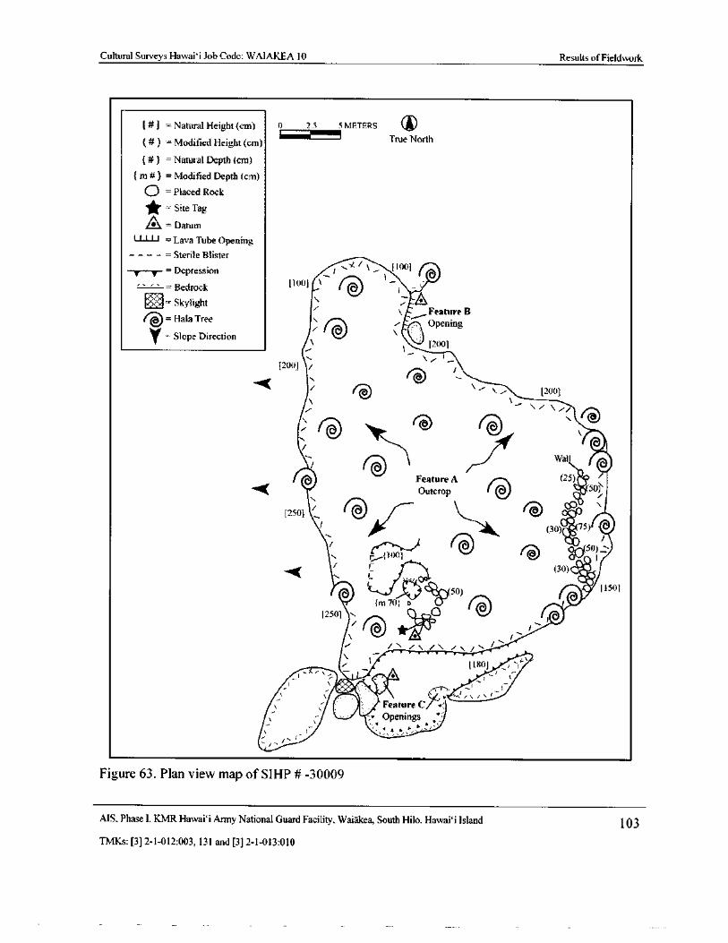
Cultural Surveys Hawaii Job Code: WAIAKEA 10 Results ofFieldwork
Natural Height( cm) 0_ 2.5 5 METERS
Modified Height( cm) True North
Natural Depth( cm)
m#) = Modified Depth( cm)
O =Placed Rock
Site Tag
0=Datum
i i l l =Lava Tube OpeningSterile Blister
T— T--= Depression t
Bedrock
t .„- i tom)
11001 \ ( 1
l - '
r •-- Skylight dFeature B
HataTreeOpening
Yi
Slope Direction
l 2001
200] / J/
v - 200]
i A
jV
7-1 Wall
Feature A 25)
Outcrop q SO
250]
ii—Ak. (-- .
e:c' \
75)
1 1
ril il' )t)1 Od(50 1
A
30) witOo IV
11f 50) 11501
m701 o •
12501 N. Orc
i
t`'
i1
11801 _,,a
nt
0 Feature C' •
Openingsy ' .
Figure 63. Plan view map of SIHP # -30009
MS, Phase I, KMR Hawai` i Army National Guard Facility, Waiakea, South Hilo, Hawai`i Island 103
TMKs:[ 3] 2- 1- 012: 003, 131 and[ 3] 2- 1- 013: 010
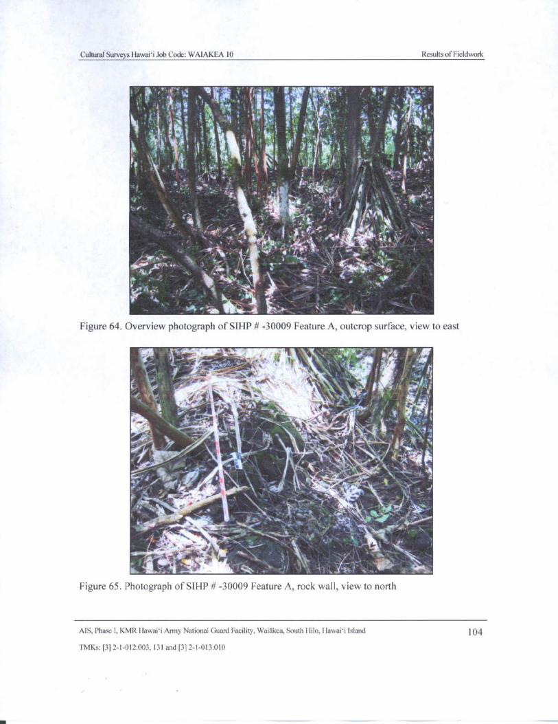
Cultural Surveys Hawaii Job Code: WAIAKEA 10 Results of Fieldwork
14
iii , A, , . 0 ).. ,,,, , , .. .
f4C
y,"t... '''. ' 1 ,pl
s:
4 :„. f, i 3., iN z' .`,,A, ),
JA,' , t-, - L 1„ 17-'‘7
r '
k',,T41„:e..•4 i Iv
ve N. ,,,,1
L• •J.
i ' _ ''..• * It ; , i ''.‘ VI '' i'
likt..4I .
or It. ,.• ,, .,,, ,_. ,---; s
tiirro...1....
194t, 4.:,
400 002. 4,e /_ cii, 4 • c
1." , " 4 *,
4. - i .4..... _ (
Fev—
16,.AL,;
A-' tiik
Figure 64. Overview photograph of SIHP# - 30009 Feature A, outcrop surface, view to east
IPi if \
wr> .
11, : ----.. ir .. 1
5N
h. - '",,,,c- -:"." • '-.- ' tv,
meii* Itlfr'
1 - n
I' . s,
fi"-, —44, ••
i V41.--, k. 4.Arylit„, \ -,. 4,,di*, , , iV.,--- , Ab„1117.
1..„...
s . 1_-+ - 4di.,„:; fon it l'-' ., - .• - - ....- .
il
4 ,
7.-i:-•4"
4. 4:10ei...,4•,-,1 . I, 4,4,7... <-- ," 14" • ",..; . 1- . 4c;
s...... ‘ ..,
16-41r'4'. '•4 .. 1. 1/4\:-"
Iks 0-, i, s
ilit; - ,..**. i z
Figure 65. Photograph of SIHP# - 30009 Feature A, rock wall, view to north
AIS, Phase I, KMR Hawaii Army National Guard Facility, Waidkea, South Hilo, Hawaii Island 104
TMKs:[ 3] 2- 1- 012:003, 131 and[ 3] 2- 1- 013: 010
m —
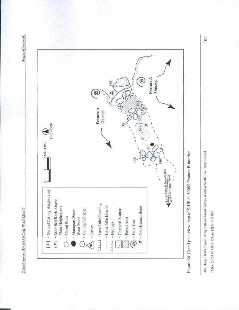
qk 3
To0r
C:1
V ' / ---
1
@ k /2
QI%
2
t k4.
ky- .
f
CA
2• \a
7:1
c-.1!
ire,
T xs.-,
1 . ' 1
3T1It
e 00
3
t0.)
oZ U -
CU
E - - 0j 2 a / 2 2 a J /
U - a k $ Cl) /
to \
w w ct
S , e ,„ ) _ ® 2k fn
2 0 0 2m o . a e t # / / t = o
u Z 2 E 2 > U Q . Q m U Zi , ; , , , , J , ! , r ,
r
0 S Q 8
y /
e3
@u y 9 w
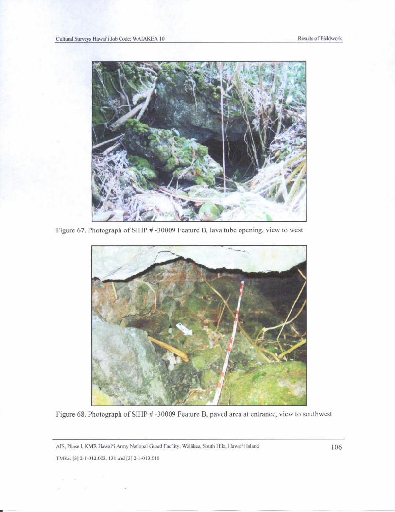
Cultural Surveys Hawaii Job Code: WAIAKEA 10 Results ofFieldwork
010::
4 s..
s .,,. , , -: 41:.'z''.*
4‘ 111.:,,,
i
4,1 4117,.'.'••'e
Figure 67. Photograph of SIHP# - 30009 Feature B, lava tube opening, view to west
1.7 . ir
Al0 - S ' 4*" 9111°
i' ti
4
r -
Figure 68. Photograph of SIHP# - 30009 Feature B, paved area at entrance, view to southwest
AIS, Phase I, KMR Hawaii Army National Guard Facility, Waiakea, South Hilo, Hawaii Island 0C
TMKs:[ 3] 2- 1- 012:003, 131 and[ 3] 2- 1- 013: 010
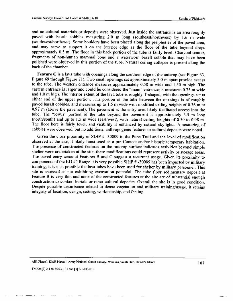
Cultural Surveys Hawaii Job Code: WAIAKEA 10 Results of Fieldwork
and no cultural materials or deposits were observed. Just inside the entrance is an area roughlypaved with basalt cobbles measuring 2. 0 m long ( southeast/northwest) by 1. 6 m widesouthwest/northeast). Some boulders have been placed along the peripheries of the paved area,
and may serve to support it on the interior edge as the floor of the tube beyond drops
approximately 0. 5 m. The floor in this back portion of the tube is fairly level. Charcoal scatter,fragments of non- human mammal bone and a waterworn basalt cobble that may have beenpolished were observed in this portion of the tube. Natural ceiling collapse is present along theback of the chamber.
Feature C is a lava tube with openings along the southern edge of the outcrop ( see Figure 63,Figure 69 through Figure 71). Two small openings set approximately 3. 0 m apart provide accessto the tube. The western entrance measures approximately 0. 50 m wide and 1. 50 m high. Theeastern entrance is larger and could be considered the " main" entrance; it measures 0. 75 m wide
and 1. 0 m high. The interior extent of the lava tube is roughly T- shaped, with the openings set ateither end of the upper portion. This portion of the tube between the openings is of roughlypaved basalt cobbles, and measures up to 1. 5 m wide with modified ceiling heights of 0. 36 m to0. 97 m ( above the pavement). The pavement at the entry area likely facilitated access into thetube. The " lower" portion of the tube beyond the pavement is approximately 3. 5 m longnorth/south) and up to 1. 5 m wide ( east/west), with natural ceiling heights of 0. 50 to 0.98 m.
The floor here is fairly level, and visibility is enhanced by natural skylights. A scattering ofcobbles were observed, but no additional anthropogenic features or cultural deposits were noted.
Given the close proximity of SIHP # - 30009 to the Puna Trail and the level of modification
observed at the site, it likely functioned as a pre- Contact and/ or historic temporary habitation.The presence of constructed features on the outcrop surface indicates activities beyond simpleshelter were undertaken at the site; these modifications could represent activity or storage areas.The paved entry areas at Features B and C suggest a recurrent usage. Given its proximity tocomponents of the KD #2 Range it is very possible SIHP# - 30009 has been impacted by militarytraining; it is also possible the lava tubes have been used for shelter by military personnel. Thissite is assessed as not exhibiting excavation potential. The tube floor sedimentary deposit atFeature B is very thin and none of the constructed features at the site are of substantial enoughconstruction to contain burials or other cultural deposits. Overall the site is in good condition.
Despite possible disturbance related to dense vegetation and military training/usage, it retainsintegrity of location, design, setting, workmanship, and feeling.
MS. Phase I, KMR Hawaii Army National Guard Facility, Waiakea, South Hilo, Hawaii Island 107
TMKs:[ 3] 2- 1- 012:003, 131 and[ 3] 2- 1- 013: 010
0 00
MI
582 1.-.,
2 Q
I
Y '
EX - .
1 .
z % 2V /
Sm
I 0: 14.0 . F . - -
I00
InX.I \\
4\. 5
K
kZ e
r' ^
0 20 a
000
3
3a
f 3 .01)
o
2
CAo
c •§ o
2 O Ev R 3
ez /
2 / E Q / w 42 u = 7 7 > k
cz d \ / c. r i i q
e 1 UO3}
e M
3 2 /
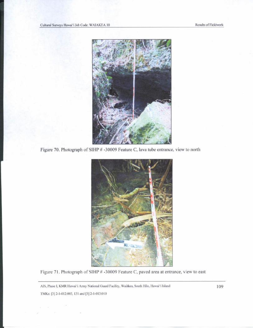
Cultural Surveys Hawaii Job Code: WAIAKEA 10 Results ofFieldwork
r},
y ;
r • 1
p r r+-'-yam
tf"..
r
iti1m l
4
Oar 4. ,
ll V4 ti 4
ta' 0.",6
1.
Figure 70. Photograph of SIHP# - 30009 Feature C, lava tube entrance, view to north
0„ .- 1-,--
Figure 71. Photograph of SIHP# - 30009 Feature C, paved area at entrance, view to east
AIS, Phase I, KMR Hawaii Army National Guard Facility, Waiakea, South Hilo, Hawaii Island 109
TMKs:[ 3] 2- 1- 012:003, 131 and[ 3] 2- 1- 013:010
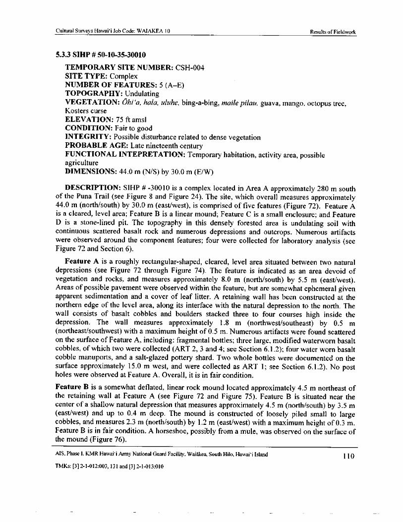
Cultural Surveys Hawai` i Job Code: WAIAKEA 10 Results of Fieldwork
5.3.3 SIHP# 50- 10- 35-30010
TEMPORARY SITE NUMBER: CSH- 004
SITE TYPE: Complex
NUMBER OF FEATURES: 5 ( A—E)
TOPOGRAPHY: UndulatingVEGETATION: Ohi`a, hala, uluhe, bing- a- bing, maile pilau, guava, mango, octopus tree,Kosters curse
ELEVATION: 75 ft amsl
CONDITION: Fair to good
INTEGRITY: Possible disturbance related to dense vegetation
PROBABLE AGE: Late nineteenth centuryFUNCTIONAL INTEPRETATION: Temporary habitation, activity area, possibleagriculture
DIMENSIONS: 44.0 m ( N/ S) by 30. 0 m ( E/W)
DESCRIPTION: SIHP # - 30010 is a complex located in Area A approximately 280 m southof the Puna Trail ( see Figure 8 and Figure 24). The site, which overall measures approximately44.0 m ( north/south) by 30. 0 m ( east/west), is comprised of five features (Figure 72). Feature A
is a cleared, level area; Feature B is a linear mound; Feature C is a small enclosure; and Feature
D is a stone- lined pit. The topography in this densely forested area is undulating soil withcontinuous scattered basalt rock and numerous depressions and outcrops. Numerous artifacts
were observed around the component features; four were collected for laboratory analysis ( seeFigure 72 and Section 6).
Feature A is a roughly rectangular-shaped, cleared, level area situated between two naturaldepressions ( see Figure 72 through Figure 74). The feature is indicated as an area devoid of
vegetation and rocks, and measures approximately 8. 0 m ( north/south) by 5. 5 m ( east/west).Areas of possible pavement were observed within the feature, but are somewhat ephemeral given
apparent sedimentation and a cover of leaf litter. A retaining wall has been constructed at thenorthern edge of the level area, along its interface with the natural depression to the north. Thewall consists of basalt cobbles and boulders stacked three to four courses high inside thedepression. The wall measures approximately 1. 8 m ( northwest/ southeast) by 0. 5 m
northeast/ southwest) with a maximum height of 0. 5 m. Numerous artifacts were found scattered
on the surface of Feature A, including: fragmental bottles; three large, modified waterworn basaltcobbles, of which two were collected (ART 2, 3 and 4; see Section 6. 1. 2); four water worn basalt
cobble manuports, and a salt-glazed pottery shard. Two whole bottles were documented on thesurface approximately 15. 0 m west, and were collected as ART 1; see Section 6. 1. 2). No post
holes were observed at Feature A. Overall, it is in fair condition.
Feature B is a somewhat deflated, linear rock mound located approximately 4. 5 m northeast ofthe retaining wall at Feature A ( see Figure 72 and Figure 75). Feature B is situated near the
center of a shallow natural depression that measures approximately 4. 5 m ( north/south) by 3. 5 meast/west) and up to 0. 4 m deep. The mound is constructed of loosely piled small to large
cobbles, and measures 2. 3 m (north/ south) by 1. 2 m ( east/west) with a maximum height of 0. 3 m.Feature B is in fair condition. A horseshoe, possibly from a mule, was observed on the surface ofthe mound (Figure 76).
AIS, Phase I, KMR Hawaii Army National Guard Facility, Waiakea, South Hilo, Hawaii Island 110
TMKs:[ 3] 2- 1- 012: 003, 131 and[ 3] 2- 1- 013: 010
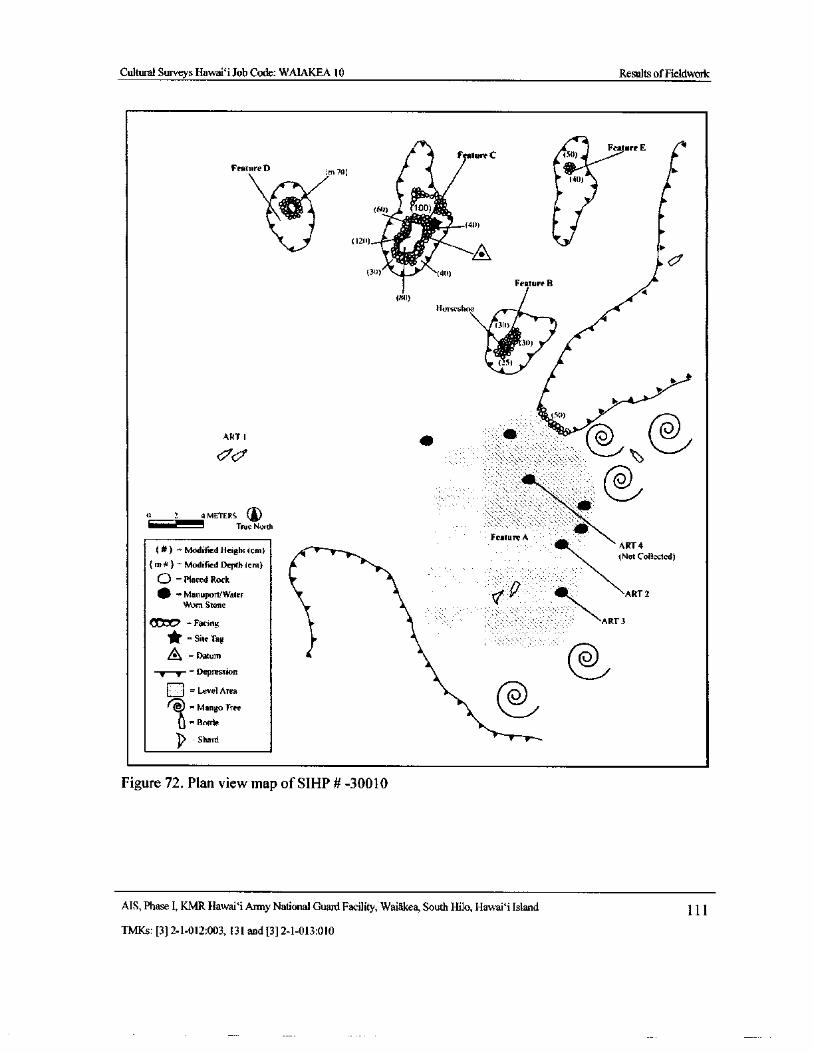
Cultural Surveys Hawai` i Job Code: WAIAKEA 10 Results ofField1work
Feature E 1
tFeature C
Featurem70l
MI) ' 100) •
21.' (4())
120) A %30) 40)
Feature B
an)
Horseshoe
30)
30)
131
1
S0)
ART 1
dab
@.....„0 2 4 METERS
True North
Feature A
Modified Height( cm) ART 4
Modified Depth( cm)
Not Collected)m
O =Placed Rock1111 = Morn Ston
Water t'f ART 2
Worn Stone 1Vi
Facing ART 3
Site Tag
A _
Datum@—••/Tr==Depression
1 = Level Area
Mango Tree1\` v
Bottle
Shard
Figure 72. Plan view map of SIHP# - 30010
AIS, Phase I, KMR Hawaii Army National Guard Facility, Waiakea, South Hilo, Hawai` i Island 1 1 1
TMKs:[ 3] 2- 1- 012: 003, 131 and[ 3] 2- 1- 013: 010
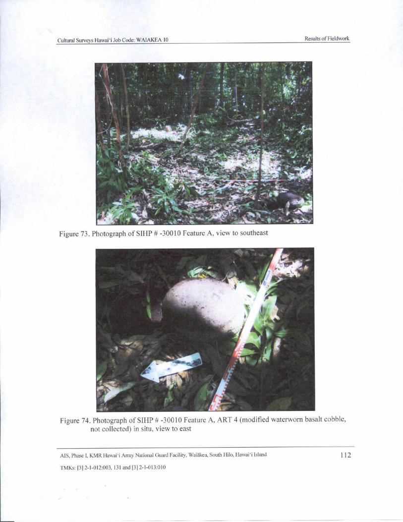
Cultural Surveys Hawaii Job Code: WAIAKEA 10 Results ofFieldwork
mss
a • • ..
le
n+ ;_ T
T,74":,,.
4-
w
gyp .
w. M
4,
akilit
sit_ ' _ +•
47901;
1111'”VIILA.
vq;_1.. , 4
114
A*.r
tea,, . a `
er~
r
iiiqr
Figure 73. Photograph of SIHP# - 30010 Feature A, view to southeast
4,',A'
0
etit
4
ler
A4Figure 74. Photograph of SIHP# - 30010 Feature A, ART 4 ( modified waterworn basalt cobble,
not collected) in situ, view to east
AIS, Phase I, KMR Hawaii Army National Guard Facility, Waiakea, South Hilo, Hawaii Island 1 12
TMKs:[ 31 2- 1- 012: 003, 131 and[ 3] 2- 1- 013: 010
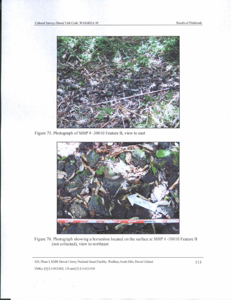
Cultural Surveys Hawaii Job Code: WAIAKEA 10 Results of Fieldwork
L
1"
i:.__..,....4:
ib.[! i.
tr a
rvi
4. 1wrpt
Y ' i4 ' dam.
y
ir \d' ! \ *
lam • . -. -s`
t„,••ti •_' / } y . l .,..s'` y
y
ytv. w. KYR
4_
y^
yj 1ti _ Jam/ ' rf
1' '' `1. \. vt1Jt.„,,,
4t- 0. 7,.., , . -: vv.,t- -- -... _ , ,
J
Figure 75. Photograph of SIHP# -
300ii.,..;:), _:..:,,,eature B, view to ea:.::,,...,
7r,:
iir:
1:::.,,,,,,,,:4„...
pcVik ...e.
0,... ..i :iH.,4.....'il ,..* .
7.,.,
i -:,: , 1:t1:
711:...
4- ::;.40 k W1 s
ir,, 4
1"
44V
oiro,,, - .
4k 4 4,-, i,
RM' ,.
Mme! ,.. , l
Y
t
Figure 76. Photograph showing a horseshoe located on the surface at SIHP# - 30010 Feature B
not collected), view to northeast
AIS, Phase I, KMR Hawaii Army National Guard Facility, Waiakea, South Hilo, Hawaii Island 113
TMKs:[ 3] 2- 1- 012:003, 131 and[ 3] 2- 1- 013: 010
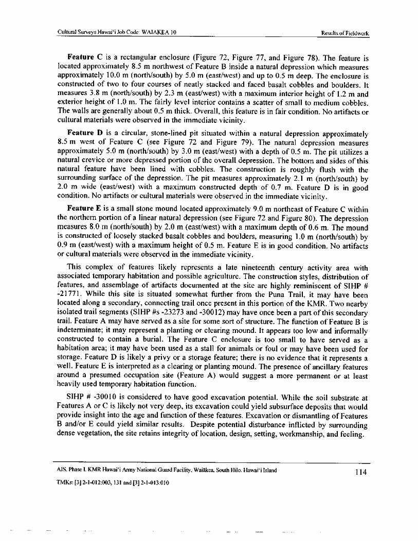
Cultural Surveys Hawaii Job Code: WAIAKEA 10 Results of Fieldwork
Feature C is a rectangular enclosure ( Figure 72, Figure 77, and Figure 78). The feature is
located approximately 8. 5 m northwest of Feature B inside a natural depression which measuresapproximately 10. 0 m ( north/ south) by 5. 0 m ( east/west) and up to 0. 5 m deep. The enclosure isconstructed of two to four courses of neatly stacked and faced basalt cobbles and boulders. Itmeasures 3. 8 m (north/ south) by 2. 3 m ( east/west) with a maximum interior height of 1. 2 m andexterior height of 1. 0 m. The fairly level interior contains a scatter of small to medium cobbles.The walls are generally about 0. 5 m thick. Overall, this feature is in fair condition. No artifacts orcultural materials were observed in the immediate vicinity.
Feature D is a circular, stone- lined pit situated within a natural depression approximately8. 5 m west of Feature C ( see Figure 72 and Figure 79). The natural depression measures
approximately 5. 0 m ( north/south) by 3. 0 m ( east/west) with a depth of 0. 5 m. The pit utilizes anatural crevice or more depressed portion of the overall depression. The bottom and sides of thisnatural feature have been lined with cobbles. The construction is roughly flush with thesurrounding surface of the depression. The pit measures approximately 2. 1 m ( north/ south) by2.0 m wide ( east/west) with a maximum constructed depth of 0. 7 m. Feature D is in goodcondition. No artifacts or cultural materials were observed in the immediate vicinity.
Feature E is a small stone mound located approximately 9. 0 m northeast of Feature C withinthe northern portion of a linear natural depression ( see Figure 72 and Figure 80). The depression
measures 8. 0 m ( north/ south) by 2. 0 m ( east/west) with a maximum depth of 0. 6 m. The moundis constructed of loosely stacked basalt cobbles and boulders, measuring 1. 0 m ( north/south) by0. 9 m ( east/west) with a maximum height of 0. 5 m. Feature E is in good condition. No artifactsor cultural materials were observed in the immediate vicinity.
This complex of features likely represents a late nineteenth century activity area withassociated temporary habitation and possible agriculture. The construction styles, distribution offeatures, and assemblage of artifacts documented at the site are highly reminiscent of SIHP #21771. While this site is situated somewhat further from the Puna Trail, it may have been
located along a secondary, connecting trail once present in this portion of the KMR. Two nearbyisolated trail segments ( SIHP # s - 23273 and - 30012) may have once been a part of this secondarytrail. Feature A may have served as a site for some sort of structure. The function of Feature B isindeterminate; it may represent a planting or clearing mound. It appears too low and informallyconstructed to contain a burial. The Feature C enclosure is too small to have served as a
habitation area; it may have been used as a stall for animals or foul or may have been used forstorage. Feature D is likely a privy or a storage feature; there is no evidence that it represents awell. Feature E is interpreted as a clearing or planting mound. The presence of ancillary featuresaround a presumed occupation site ( Feature A) would suggest a more permanent or at least
heavily used temporary habitation function.
SIHP # - 30010 is considered to have good excavation potential. While the soil substrate at
Features A or C is likely not very deep, its excavation could yield subsurface deposits that wouldprovide insight into the age and function of these features. Excavation or dismantling of FeaturesB and/ or E could yield similar results. Despite potential disturbance inflicted by surroundingdense vegetation, the site retains integrity of location, design, setting, workmanship, and feeling.
AIS. Phase I, KMR Hawai` i Army National Guard Facility, Waiakea, South Hilo, Hawaii Island 114
TMKs:[ 3] 2- 1- 012: 003, 131 and[ 3] 2- 1- 013: 010
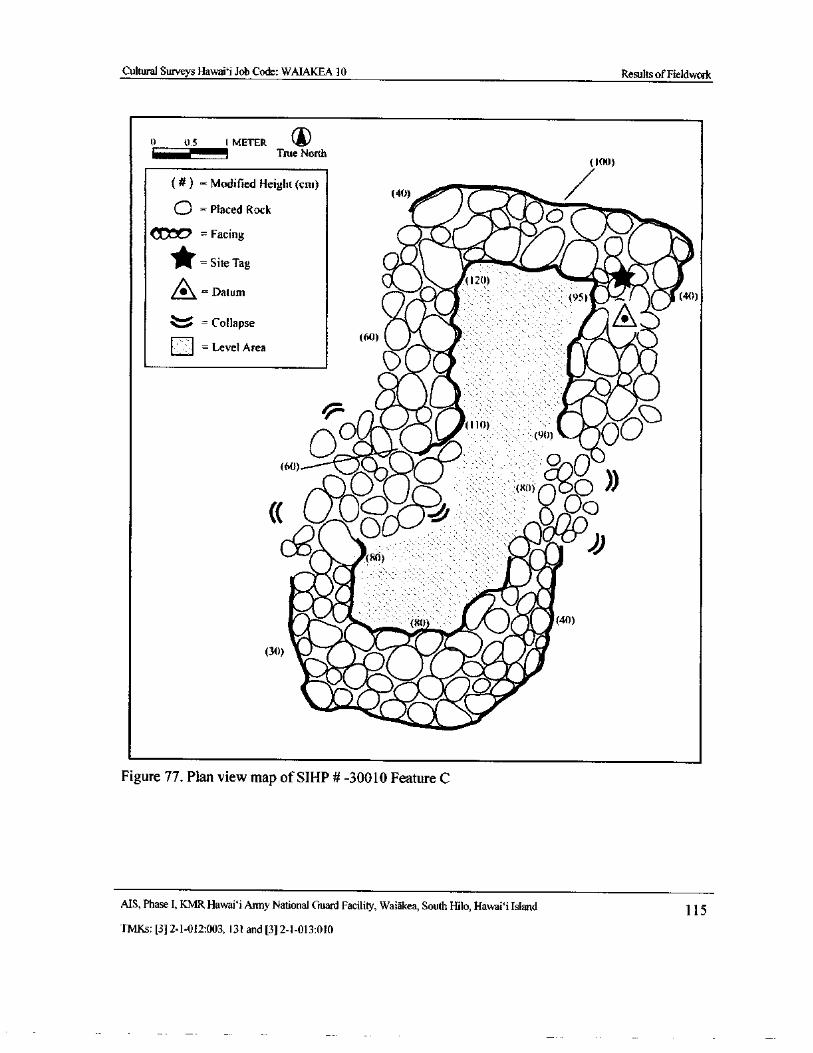
Cultural Surveys Hawaii Job Code: WAIAKEA 10 Results ofFieldwork
0 0.5 1 METERIIIIIIIIIII1........
r True North100)
Modified Height( cm) 4t)) T 1
0 =Placed RockO qp.,,icon = Facing
Site Tag r12( 1) Ay
Datum ly5) # 40)
Collapse IF 460) 0Level Area
ilILM
2Sb• ii4P. O
00 . W '
8......... eff) 9t1) •• QO
qa60) lq)
0 x0) Cj0 IICC Oc O
ce 416° 0;))41 ,, (80)
eitPi. di As ie
ItOta,..-4„t
8o 0 (40)
4‘. Weill(flP. 01IfifkelePibelr. 4140,
by
AyIIi*rd•410%AereAbel
p0410r
Figure 77. Plan view map of SIHP# - 30010 Feature C
AIS, Phase I, KMR Hawaii Army National Guard Facility, Waiakea, South Hilo, Hawaii Island 115
TMKs:[ 3] 2- 1- 012:003, 131 and[ 3] 2- 1- 013: 010
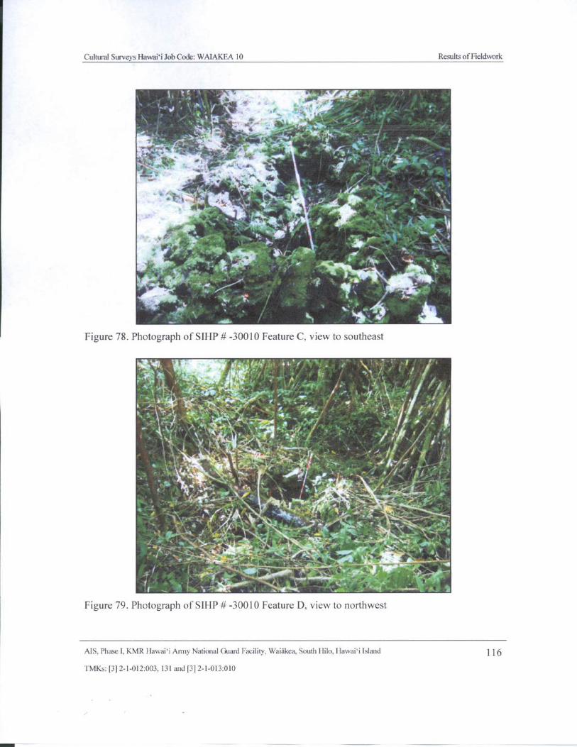
Cultural Surveys Hawaii Job Code: WAIAKEA 10 Results ofFieldwork
ur„
a, 't dk. r.
f
lr
a. * + • ir-" 4..„,t 4•
w
4,, 4
f 1
1
O.,
4
l'.. aLFigure 78. Photograph of SIHP# - 30010 Feature C, view to southeast
4,," •
F+— y
i i, J. . , ..4i
c - y N, ,,if, ‘ ,/ ,, .. ,
AI ,- er
ti, 4. a • ._,
fig
k fr.. .. A.
4kikla
o
Figure 79. Photograph of SIHP# - 30010 Feature D, view to northwest
AIS, Phase I, KMR Hawaii Army National Guard Facility, Waiakea, South Hilo, Hawaii Island 116
TMKs:[ 3] 2- 1- 012:003, 131 and[ 3] 2- 1- 013:010
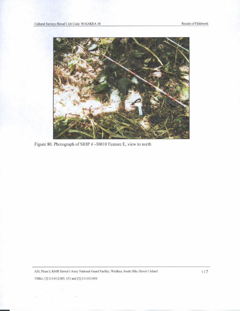
Cultural Surveys Hawaii Job Code: WAIAKEA 10 Results of Fieldwork
t
ittAi
11.54141Fir '
y`
i
R t
4 -
a
llikablert\
d
tit,. Qs
M t
Y * '•1411k ire ;+ r +
z ' 5
1.10 y f .5,. '
f,„ R "'"
cis - 2
o
40,
Figure 80. Photograph of SIHP# - 30010 Feature E, view to north
AIS, Phase I, KMR Hawaii Army National Guard Facility, Waiakea, South Hilo, Hawai` i Island 117
TMKs:[ 3] 2- 1- 012:003, 131 and[ 3] 2- 1- 013:010
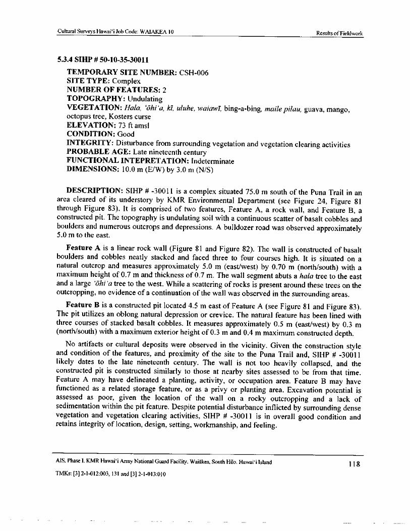
Cultural Surveys Hawai` i Job Code: WAIAKEA 10 Results of Fieldwork
5.3.4 SIHP# 50- 10-35-30011
TEMPORARY SITE NUMBER: CSH- 006SITE TYPE: Complex
NUMBER OF FEATURES: 2
TOPOGRAPHY: UndulatingVEGETATION: Hala, `ohi' a, ki, uluhe, waiawi, bing- a- bing, maile pilau, guava, mango,octopus tree, Kosters curse
ELEVATION: 73 ft amsl
CONDITION: Good
INTEGRITY: Disturbance from surrounding vegetation and vegetation clearing activitiesPROBABLE AGE: Late nineteenth centuryFUNCTIONAL INTEPRETATION: Indeterminate
DIMENSIONS: 10. 0 m ( E/W) by 3. 0 m ( N/ S)
DESCRIPTION: SIHP # - 30011 is a complex situated 75. 0 m south of the Puna Trail in anarea cleared of its understory by KMR Environmental Department ( see Figure 24, Figure 81through Figure 83). It is comprised of two features, Feature A, a rock wall, and Feature B, aconstructed pit. The topography is undulating soil with a continuous scatter of basalt cobbles andboulders and numerous outcrops and depressions. A bulldozer road was observed approximately5. 0 m to the east.
Feature A is a linear rock wall ( Figure 81 and Figure 82). The wall is constructed of basalt
boulders and cobbles neatly stacked and faced three to four courses high. It is situated on anatural outcrop and measures approximately 5. 0 m ( east/ west) by 0. 70 m ( north/ south) with amaximum height of 0. 7 m and thickness of 0. 7 m. The wall segment abuts a hala tree to the eastand a large ` ohi' a tree to the west. While a scattering of rocks is present around these trees on theoutcropping, no evidence of a continuation of the wall was observed in the surrounding areas.
Feature B is a constructed pit located 4.5 m east of Feature A (see Figure 81 and Figure 83).The pit utilizes an oblong natural depression or crevice. The natural feature has been lined withthree courses of stacked basalt cobbles. It measures approximately 0. 5 m ( east/west) by 0. 3 mnorth/south) with a maximum exterior height of 0. 3 m and 0. 4 m maximum constructed depth.
No artifacts or cultural deposits were observed in the vicinity. Given the construction styleand condition of the features, and proximity of the site to the Puna Trail and, SIHP # - 30011
likely dates to the late nineteenth century. The wall is not too heavily collapsed, and theconstructed pit is constructed similarly to those at nearby sites assessed to be from that time.Feature A may have delineated a planting, activity, or occupation area. Feature B may havefunctioned as a related storage feature, or as a privy or planting area. Excavation potential isassessed as poor, given the location of the wall on a rocky outcropping and a lack ofsedimentation within the pit feature. Despite potential disturbance inflicted by surrounding densevegetation and vegetation clearing activities, SIHP # - 30011 is in overall good condition and
retains integrity of location, design, setting, workmanship, and feeling.
MS, Phase I, KMR Hawai` i Army National Guard Facility, Waiakea, South Hilo, Hawai` i Island 118
TMKs:[ 3] 2- 1- 012: 003, 131 and[ 3] 2- 1- 013: 010
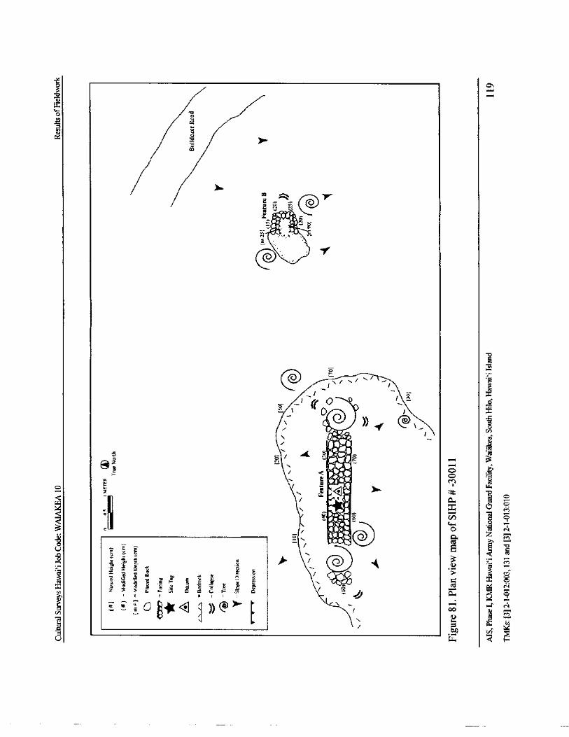
3CIN
a a
4 e4
0 v
124G1
22 :. N,
@-r-
y o 'i .irigfio
is • s
lr
d
gI
lei / \'
Ico
tera
p x
k 7 @ , oEA
ce
WO aii
Fs ' 1i`% 3Mit o
ro
O w 1
6;;1,, W
d
0, c
s.. M
iR v) o3 vova%
o
t yd N
UE
czten
E e
y 3E
yy
pMo . u 8- ` e o Cd p; N
t D @ r 00
4.
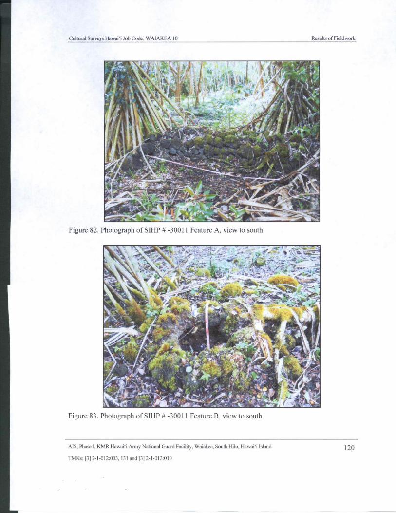
Cultural Surveys Hawaii Job Code: WAIAKEA 10 Results ofFieldwork
d ti
fizr
1
til 4 ',.` 1' 1•
2 2., # .;#
r_ '''''•;'e ,,
1•••, y Y
5
yt(•
1 I
T} ( "? moi'. -\ • ',
Yr
dam
r ti'...
Jt { ., ' d—
Es^i ,,p!,'''•. aN -
e: 7 i3 s
r•rA 5 ti A
1, .
wwm> pp
aJ;_ r
Figure 82. Photograph of SIHP# - 30011 Feature A, view to south
4.'1,;?,, * "" ....- i_ : 404:7 f; IA:.ii.:7,:...,;;;
Itt.&,..'..„\.;•.
4,"q64.„.._,-",:-....1
TSF N i1 A •ry
S t .,•
9" J ..
t_,.., `, .r,004W-,,.';0/,-;.-,-,..,;,,,
gt.4—1 ::--, -
1,
44N,_ -;--71.105‘41,
4tt•
if, +;:".",,S1t..:,. ,y.
4514.. v...
X a
3 iii, r.,
it 1, 4
t'
S f s
tom . jr/,
Figure 83. Photograph of SIHP# - 30011 Feature B, view to south
AIS, Phase I, KMR Hawaii Army National Guard Facility. Waiakea, South Hilo. Hawaii Island 120
TMKs:[ 31 2- 1- 012:003, 131 and[ 3] 2- 1- 013: 010
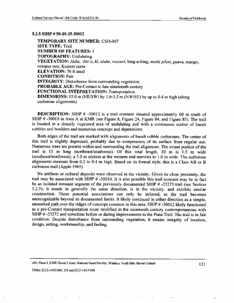
Cultural Surveys Hawai` i Job Code: WAIAKEA 10 Results of Fieldwork
5.3.5 SIHP# 50- 10- 35-30012
TEMPORARY SITE NUMBER: CSH- 007
SITE TYPE: Trail
NUMBER OF FEATURES: 1
TOPOGRAPHY: UndulatingVEGETATION: Hala, `ohi`a, ki, uluhe, waiawi, bing-a- bing, maile pilau, guava, mango,octopus tree, Kosters curse
ELEVATION: 76 ft amsl
CONDITION: Fair
INTEGRITY: Disturbance from surrounding vegetationPROBABLE AGE: Pre- Contact to late nineteenth centuryFUNCTIONAL INTEPRETATION: Transportation
DIMENSIONS: 15. 0 m (NE/SW) by 1. 0- 1. 5 m (NW/SE) by up to 0. 4 m high (alongcurbstone alignments)
DESCRIPTION: SIHP # - 30012 is a trail remnant situated approximately 60 m south ofSIHP # - 30010 in Area A at KMR ( see Figure 8, Figure 24, Figure 84, and Figure 85). The trail
is located in a densely vegetated area of undulating soil with a continuous scatter of basaltcobbles and boulders and numerous outcrops and depressions.
Both edges of the trail are marked with alignments of basalt cobble curbstones. The center of
this trail is slightly depressed, probably due to compression of its surface from regular use.Numerous trees are present within and surrounding the trail alignment. The extant portion of thetrail is 15 m long ( northeast/ southwest). Of this total length, 10 m is 1. 5 m widesoutheast/northwest); a 5. 0 m section at the western end narrows to 1. 0 m wide. The curbstone
alignments measure from 0. 2 to 0. 4 m high. Based on its formal style, this is a Class AB or Bcurbstone trail (Apple 1965).
No artifacts or cultural deposits were observed in the vicinity. Given its close proximity, thetrail may be associated with SIHP # - 30010. It is also possible this trail remnant may be in factbe an isolated remnant segment of the previously documented SIHP # - 23273 trail ( see Section5. 2. 5); it trends in generally the same direction, is in the vicinity, and exhibits similar
construction. These potential associations can only be inferred, as the trail becomes
unrecognizable beyond its documented limits. It likely continued in either direction as a simple,unmarked path over the ridges of outcrops common in this area. SIHP# - 30012 likely functionedas a pre- Contact transportation route modified in the nineteenth century contemporaneous withSIHP # -23272 and sometime before or during improvements to the Puna Trail. The trail is in faircondition. Despite disturbance from surrounding vegetation, it retains integrity of location,design, setting, workmanship, and feeling.
AIS, Phase I, KMR Hawaii Army National Guard Facility, Waiakea, South Hilo, Hawai` i Island 121
TMKs:[ 3] 2- 1- 012:003, 131 and[ 3] 2- 1- 013: 010
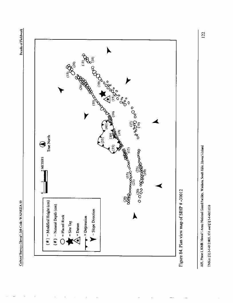
qCl
E
I0-
fJ
CaiOrk
lkII..;
7 Oo
i000
air ovk ' Pk< o
o /
0Oo 0
glia,0
O0
2p2
di
f0
4
@ c / / tcl
201.0
TA\
ilij •
i 02 l aNI ;
o N
I
2Ak
2 0m \
AE k K 6
oz / -
b . 2 E ja 2 Z / 7 f o E
01-" r i m i : n ,
z
0 m 3
00
o. Fa
1..1.
Cultural Surveys Hawaii Job Code: WAIAKEA 10 Results ofFieldwork
1-ir". g-
4tom „
N. S°'+ l s;s l_
yy 11/&„,kR' j .
4,k y4 4. ../- a',, , , .. SOy._....-->
7
40
6.
4211
110 y,:y .
G,-yf
sr
yam _
r
fa....
7.4FI t
A• • ii . - -,- - ,-- - ,-
Iii -.7,4,r,„ 1,.& a. _
4(
te
NPA-
Figure 85. Photograph of SIHP#- 30012, view to northeast
AIS, Phase I, KMR Hawaii Army National Guard Facility, Waiakea, South Hilo, Hawaii Island 123
TMKs:[ 3] 2- 1- 012:003, 131 and[ 3] 2- 1- 013:010
r
Cultural Surveys Hawai` i Job Code: WAIAKEA 10 Results ofFieldwork
53.6 SIHP# 50- 10-35-30038
TEMPORARY SITE NUMBER: CSH- 003SITE TYPE: Trail
NUMBER OF FEATURES: 1
TOPOGRAPHY: Undulating with numerous voidsVEGETATION: ' Ohl' a, hala, uluhe, bing- a- bing, maile pilau, autograph tree, guava,mango, octopus tree, Kosters curse
ELEVATION: 65 ft amsl
CONDITION: Poor to remnant
INTEGRITY: Disturbance from dense vegetation
PROBABLE AGE: Late nineteenth centuryFUNCTIONAL INTEPRETATION: Transportation
DIMENSIONS: 22 m ( 72.2 ft) in length ( E/ W) by 2. 3 m ( 7. 5 ft) wide (N/ S)
DESCRIPTION: A remnant segment of the historic Puna Trail was identified parallel to themodern Jeep trail near a disturbed area adjacent to the KD # 2 Range. The east- west trendingsegment is situated approximately 15. 0 m ( 50 ft) north of the Jeep road ( see Figure 24, Figure 86and Figure 87) in an area of uneven pahoehoe flow and dense vegetation. Because the Puna Trailalignment in KMR( SIHP # - 18869) has been assessed as no longer eligible as a historic propertybased on modern impacts, this intact historic segment has been assigned as a separate historicproperty.
The fairly level surface of the trail is comprised of compressed and worn ` a`a cobbles. Thesides of the trail are defined in places by alignments of neatly placed ( and in some places
stacked) basalt cobble curbstones. The curbstone alignments are spaced up to 2. 3 m ( 7. 5 ft) apartnorth/south), rising 0. 35 m ( 1. 1 ft) above the interior trail surface and 0. 20 m to 0. 40 m ( 0. 7 ft to
1. 3 ft) above the exterior surface. The alignments are generally 0. 50 m ( 1. 6 ft) wide, making theoverall width of the trail up to 3. 30 m ( 10. 8 ft) (north/south). Only a 7. 5 m ( 24.6 ft) portion ofthis trail segment is curbed on both sides. The southern curb could be traced for approximately22. 0 m ( 72. 2 ft) (east/west), while only 7. 5 m ( 24.6 ft) of the northern curb remain. The westernend of the trail has been bulldozed, likely when the area adjacent to the KD # 2 Range was
cleared. At the eastern terminus the trail meets a small linear depression and disappears, possiblyas a result of erosion.
No artifacts or cultural deposits were observed in the vicinity. Given its location directlyadjacent and parallel to the modern alignment of the Puna Trail, this segment is interpreted as an
extant portion of the historic alignment. It therefore dates to the late nineteenth century, when thepre- Contact trail was improved through this area. Excavation potential is poor considering thelimited prospect for new information about the Puna Trail. Overall, the trail segment is in poor to
remnant condition, due mainly to the disturbance at the western terminus and the surroundingdense vegetation. Despite its disturbed condition, this segment of the historic Puna Trail retainsintegrity of location, design, setting, workmanship, and feeling.
MS, Phase I, KMR Hawai` i Army National Guard Facility, Waiakea, South Hilo, Hawai` i Island 124
TMKs:[ 3] 2- 1- 012: 003, 131 and[ 3] 2- 1- 013:010
Cultural Surveys Hawaii Job Code: WAIAKEA 10 Results ofFieldwork
at
W
14. .:' .
AI ' , .?„,
pyo.
f
4., vs-
Figure 86. Photograph of the newly identified remnant portion of the historic Puna Trail (SIHP#30038), view to east
n 2 4 METERS Modified Height( cm)moms
True North Q —Placed Rock
Facing
Site Tag
A —Datum
Oo9. Q •( 05) i/ —Paved Area
1 40) V —Treei"(.i.• ;
351I •1!! N•' n
Bulldo7ina
C6(25) 40) ( 258 ,-
C 0000k
20) % coop.Approximately IS m to 20) ..
North Edge of Jeep Road
r I
Figure 87. Plan view map of the newly identified remnant portion of the historic Puna TrailSIHP# - 30038)
AIS, Phase I, KMR Hawai` i Army National Guard Facility, Waiakea, South Hilo, Hawaii Island 125
TMKs:[ 3] 2- 1- 012: 003, 131 and[ 3] 2- 1- 013: 010
Cultural Surveys Hawai` i Job Code: WAIAKEA 10 Results ofLaboratory Analysis
Section 6 Results of Laboratory Analysis
6. 1 Artifacts Collected from the Surface at SIHP# 50- 10-35-30010
Four artifacts were collected during the Phase I AIS. These artifacts, all from the surface ofFeature A at SIHP # - 30010, are presented in Table 5.
6. 1. 1 Bottles
Two glass bottle artifacts (ART # 1) were collected from the surface in an area relatively clearof underbrush west of SIHP # - 30010 Feature A (see Table 5). The bottles were deposited in the
same location, side by side, and may have been carried here from Feature A after the site wasoccupied. These were the only intact bottles found at the site.
Accession # 1 is an amber-colored whiskey bottle ( Figure 88). The quart- sized bottle is
machine- made and exhibits a two-piece, applied top. The bottle is embossed on the front panelwith " MACEFARLANE & Co. HONOLULU" and the monogram " M" over " C" with small " o"Figure 89). Accession # 1 is one of three types of quart-sized whiskey bottles produced by the
company between 1880 and 1900. This bottle is considered to be rare ( Elliot 1971: 72- 78,
Lindsey 2014).
Accession # 2 is a brown-colored whiskey bottle ( Figure 90). The seamless bottle was turned
in a mold. It exhibits a tooled top and is not embossed. These characteristics indicate this bottlewas manufactured between 1850 and 1918 ( Lindsey 2014).
6.1. 2 Modified Water Worn Basalt Cobbles
Three modified waterworn stone artifacts were observed on the surface of SIHP # - 30010Feature A; two were collected ( see Table 5). The remaining stone artifact was too large tocollect, ( ART #4); a single indentation similar to those on Accession # 3 was noted upon thesurface ( see also Section 5. 3. 3 and Figure 74). That these stones are water worn indicates that
they were transported from the coast or a river, either before or after their modification; suchsources lie at some distance from the site.
Accession # 3 is a large, modified waterworn cobble of dense basalt. The artifact exhibits two
anthropogenic indentations spaced approximately 2 cm apart on one side, and a slightly flattenedbase" ( Table 5, Figure 91, and Figure 92). The inner or " central" indentation is slightly larger3. 5 cm in diameter) than the outer indentation ( 3. 0 cm in diameter). Both are fairly shallow, at
about 1. 0 cm deep.
Accession # 4 is a large, modified waterworn cobble of slightly vesicular basalt. One side ofthe artifact exhibits what appears to be an anthropogenic indentation that has breached at least
one natural internal void. The narrow end of the artifact exhibits signs of battering ( Table 5,Figure 93, and Figure 94). The modified indentation is approximately 5. 0 cm in diameter, andmay be up to 4. 0 cm deep; it is difficult to ascertain whether the indentation breached a shallowernatural void that was widened to some degree before the innermost void was breached. Nothingwas observed deposited within the void.
MS, Phase I. KMR Hawai` i Army National Guard Facility, Waiakea, South Hilo, Hawai` i Island 126
TMKs:[ 31 2- 1- 012: 003, 131 and[ 3] 2- 1- 013: 010
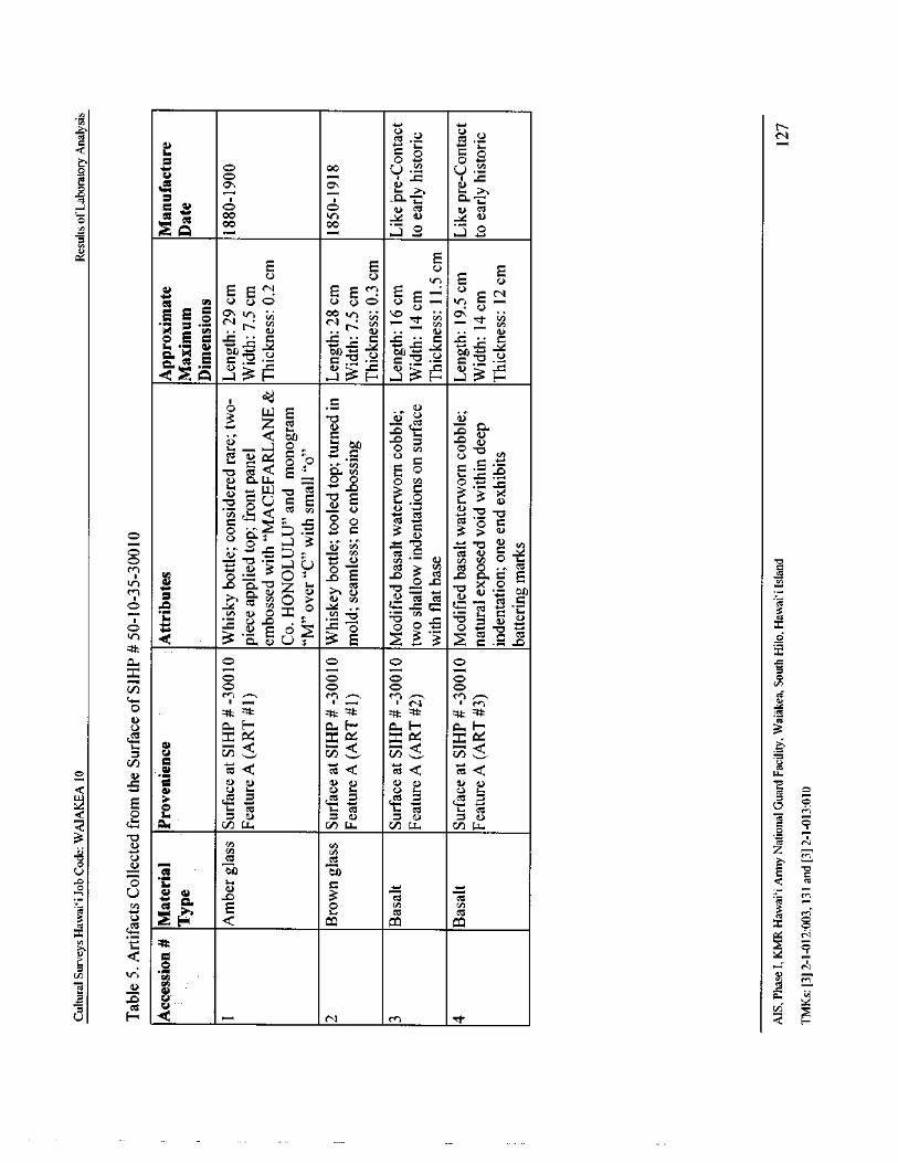
U N
L i
o O UO
UO
O i Yil
OO M u Mo
CI 174 00
N
E0 E0 0 E
to +- bo +- bo +- bo
1: 2+ el 071 : E 0 ,= 0 = • 0 :=
QUA a3H 3H a3H ..J 3H
z o a>i, a) ci.., _
000 to
o f0 c o - o
a ocn oa.. E = 0 0 0 CA o
ti E71vc° UQ o o 3 7:3
C) s_-, s o e o UU
o s — 3 a; • . ' o c CA
O o R . V ''- - i 0
05 C3TA0crs
0cSm ' •'a'tn 41)
p ai
Zo
3 ', 0U 3E 3 2 . 5 _
cmx
n, o 0
T cd
a) Q Q Qo v c `, vp yr ... v,
c g Q VI ' t ¢ iQ w
WW
a a) a) 0 0 0 u a) 0
0 ti.+ C it C it CC Sr Cd M
a w v) w C/ w cI w o —3
cu y N
O U Ct
e'a EUbo b
o 1." a cU
Eiv, e E 0 3
H Q CO 0. x o
0 CV
CU4p
ct V
U H N M E-
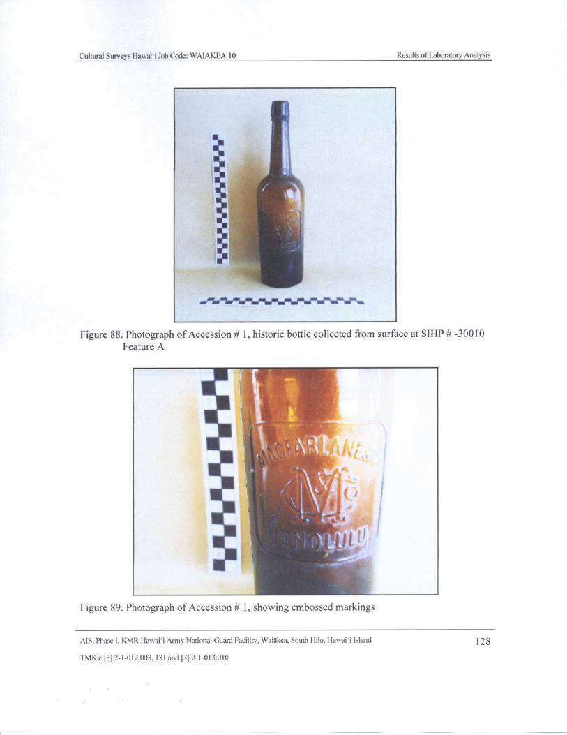
Cultural Surveys Hawaii Job Code: WAIAKEA 10 Results of Laboratory Analysis
4 .,l x
5t
r:
A
Figure 88. Photograph of Accession# 1, historic bottle collected from surface at SIHP# - 30010
Feature A
i*
1
a
k
l
id
Figure 89. Photograph of Accession # 1, showing embossed markings
AIS, Phase I, KMR Hawaii Army National Guard Facility, Waiakea, South Hilo, Hawaii Island 128
TMKs:[ 3] 2- 1- 012:003, 131 and[ 3] 2- 1- 013: 010
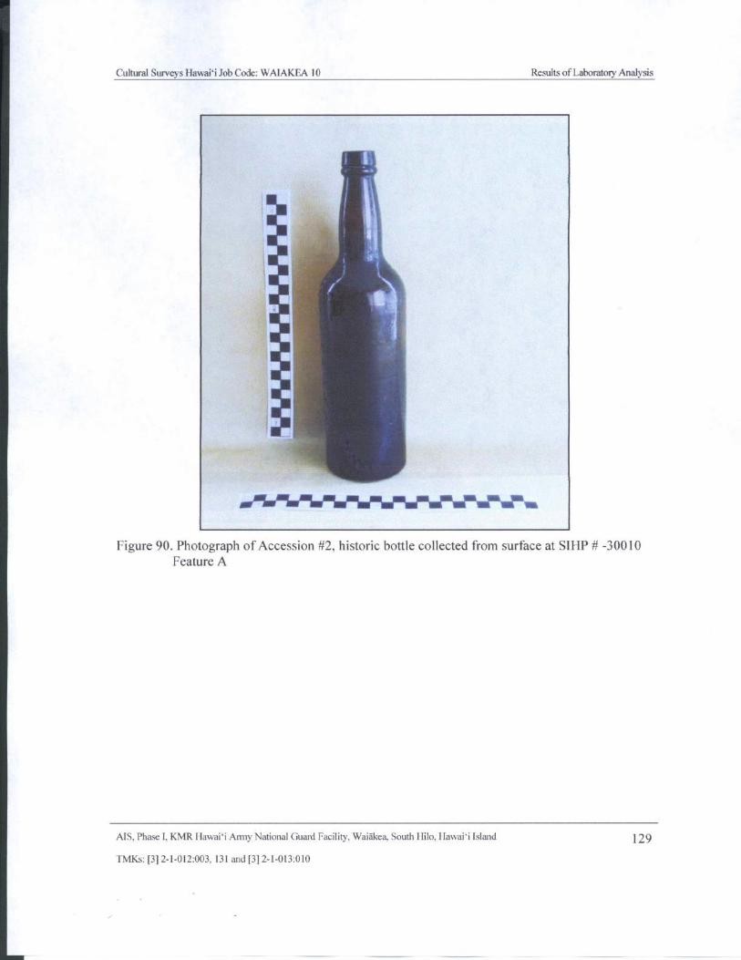
Cultural Surveys Hawaii Job Code: WAIAKEA 10 Results ofLaboratory Analysis
jarailleSIMIWNNeseldlikrnft
Figure 90. Photograph of Accession# 2, historic bottle collected from surface at S1HP# - 30010
Feature A
AIS, Phase I, KMR Hawaii Army National Guard Facility, Waiakea, South Hilo, Hawaii Island 129
TMKs:[ 3] 2- 1- 012: 003, 131 and[ 3] 2- 1- 013: 010
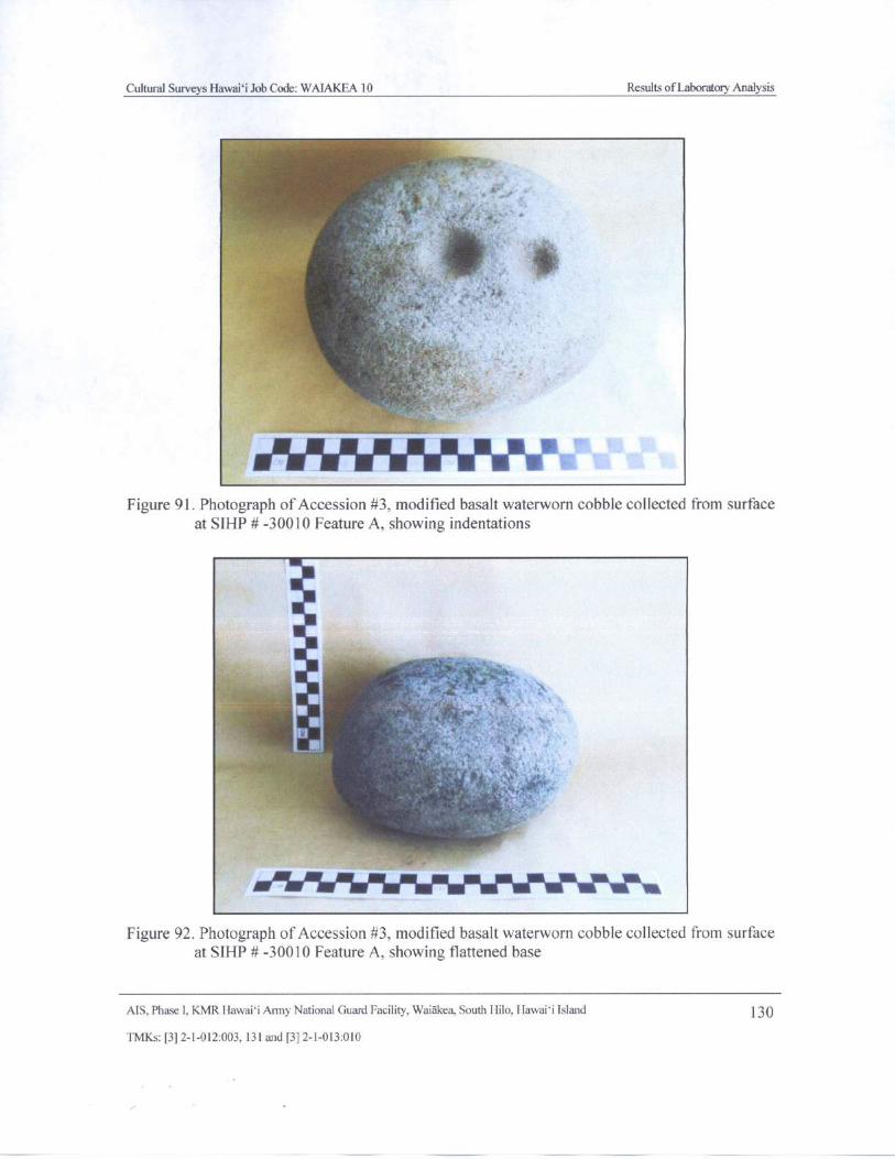
Cultural Surveys Hawaii Job Code: WAIAKEA 10 Results of Laboratory Analysis
x Tf
T . y
4,' r
Figure 91. Photograph of Accession# 3, modified basalt waterworn cobble collected from surface
at SIHP#- 30010 Feature A, showing indentations
dam.
11 t
Figure 92. Photograph of Accession# 3, modified basalt waterworn cobble collected from surface
at SIHP# - 30010 Feature A, showing flattened base
MS, Phase I, KMR Hawaii Army National Guard Facility, Waiakea, South Hilo, Hawaii Island 130
TMKs:[ 3] 2- 1- 012:003, 131 and[ 3] 2- 1- 013: 010
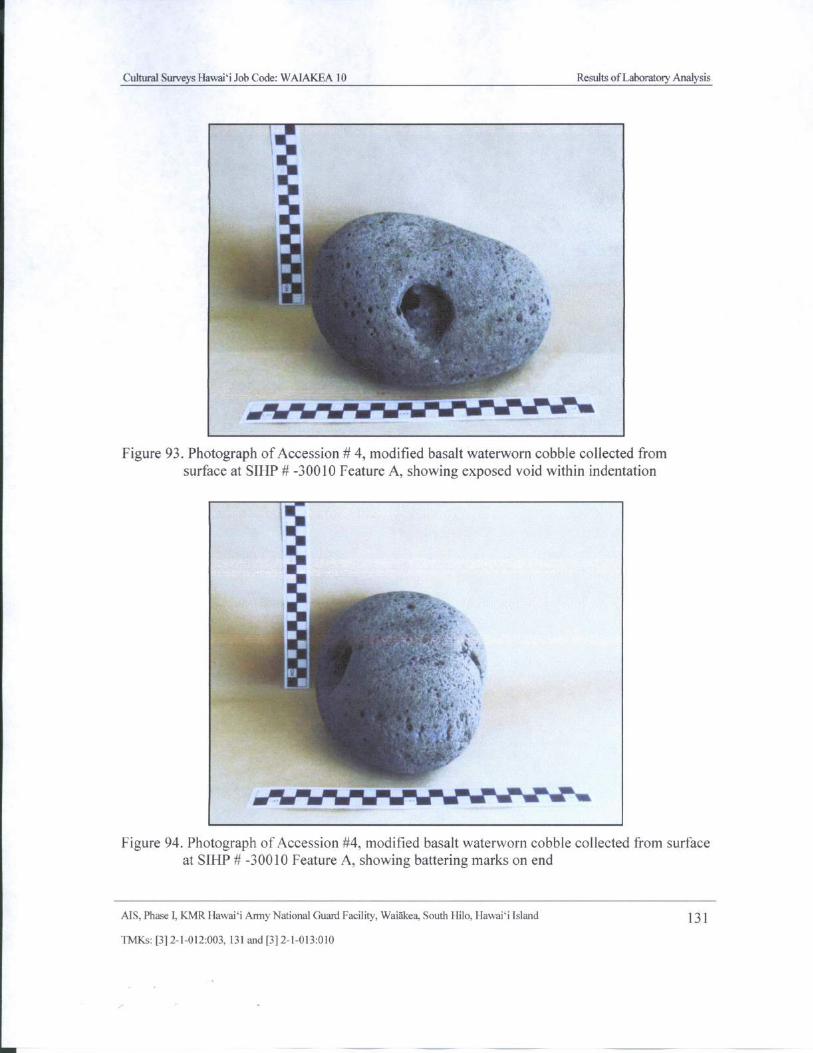
Cultural Surveys Hawaii Job Code: WAIAKEA 10 Results ofLaboratory Analysis
jq,
1
MS¢Sr `* 4 .• MB^ i7'Yiss j rat '*
to 3Y R R-BF 4 iA t {F ,\
u,
414
t a
Figure 93. Photograph ofAccession# 4, modified basalt waterworn cobble collected from
surface at SIHP# - 30010 Feature A, showing exposed void within indentation
y
i
Figure 94. Photograph of Accession# 4, modified basalt waterworn cobble collected from surface
at SIHP# - 30010 Feature A, showing battering marks on end
AIS, Phase I, KMR Hawaii Army National Guard Facility, Waiakea, South IIilo, Hawaii Island 131
TMKs:[ 3] 2- 1- 012: 003, 131 and[ 3] 2- 1- 013: 010
Cultural Surveys Hawaii Job Code: WAIAKEA 10 Results of Laboratory Analysis
The function of these artifacts is somewhat indeterminate. The indentations on Accession # 3
are too shallow for a lamp or for a mortar stone. Dr. Hammatt has suggested this artifact mayhave been used with a hand drill to spark a fire. Alternatively, it may have been used to hold akukui or other nut to facilitate extraction of the kernel. The slightly flattened base indicates itmay have been modified somewhat to create a more stable base. Accession # 4 could have beenused in a similar fashion; however, the deeper indentation indicates it could have been workedfor use as alamp or mortar stone likely abandoned when the inner void was breached. It alsoappears to have functioned to some degree as a battering stone.
6.2 Discussion
The assemblage of artifacts collected during the Phase I investigation is reflective of theartifacts documented at nearby SIHP # - 21771 by Tolleson and Godby ( 2001). Both assemblagesinclude late nineteenth century liquor bottles and " traditional Hawaiian- type" stone artifacts ( at
SIHP # - 21771 poi pounders and manuports were observed). Of this latter category, it isimportant to note the relative portability and durability of such items. Once a desirable stone wasfound and modified for use, it would have become a valuable tool that would not have beencasually abandoned, and that could have seen continued use over many years. Therefore, the ageand place of origin of the modified basalt waterworn stones found at SIHP # - 30010— whatever
their purpose may have been— is difficult to interpret. We know from the presence of poipounders at SIHP # - 21771 that traditional methods of food preparation were occurring at thatsite contemporaneous with late nineteenth century construction along the Puna Trail; Hawaiianswere among the roadway workforce. The stone artifacts presented above may represent pre-Contact tools found elsewhere at a later date and brought to the site in historic times.Alternatively, they could be historic models of traditional tools. If anything, the presence of theseartifacts speaks of the diversity of the road crew and other travelers along the Puna Trail in thelate 1800s, and to the related potential for historic ( as well as modern military) occupation andmodification of traditional features within the project area.
MS. Phase I, KMR Hawaii Army National Guard Facility. Waiakea, South Hilo, Hawaii Island 132
TMKs:[ 3] 2- 1- 012: 003, 131 and[ 3] 2- 1- 013: 010
Cultural Surveys Hawaii Job Code: WAIAKEA 10 Summary and Interpretation
Section 7 Summary and Interpretation
Prehistorically the project area does not appear to have supported extensive habitation orlarge- scale agriculture. Habitations would have been located closer to the coast or further inlandamid the more productive upland agricultural zones. The KMR parcel would have been used forintermittent, small- scale agriculture, with the natural depressions in lava flows used for mulch-type agriculture. Natural resources, such as the prevalent lauhala for weaving, would have beencollected.
The project area remained marginal in the historic period, with the probable continuation ofintermittent use for traditional Hawaiian agriculture. Originally a pre- Contact ala Loa, the PunaTrail ( SIHP # 50- 10- 35- 18869) was modified, and became the most notable man- made featureon the KMR landscape. By the 1870s, the trail was a functioning horse trail. Four feet wide andpaved, it represented a Type C trail, following Apple' s trail typology ( 1965: 65).
Sometime during the use of the trail, ahu ( SIHP # - 21658) were constructed to mark a pointalong it, and natural features in the surrounding environment were modified for use as sheltersSIHP # - 30008) or temporary habitations ( SIHP # - 30009), and for agricultural pursuits.
Secondary trails were also constructed laterally from the Puna Trail, likely to access forestresources ( SIHP # s - 23273 and - 30012). Activity areas associated with the late nineteenthcentury construction of the trail led to the presence of activity areas ( or " way- stations") foractivities related to maintenance and associated habitation ( SIHP # s - 21771, - 30010, and30011).
The project area was subjected to extensive development beginning in 1914 with theestablishment of the National Guard of Hawaii Rifle Range and continuing through WorldWar II with Army and Navy use of the KMR. Large portions of the project area were graded forbuildings, roads, firing ranges, and lawns. The most extensive modifications occurred in thenorthwest portion of the KMR. The southern and eastern portions are relatively undisturbed incomparison, and it is in these areas that CSH located the remains of the pre-Contact and/ orhistoric sites described above.
The alignment of the Puna Trail through KMR survived the changes of the twentieth centuryas a Jeep road; however, the nineteenth century characteristics of the trail, such as paving andcurbstones, generally did not. A previous study at KMR (Hammatt and Bush 2000) determinedthe historic alignment had been completely obliterated by the Jeep road construction, but aremnant segment of the trail was documented during the current investigation in the southeasternportion of the reservation. Since much of the Puna Trail through KMR has been modified forvehicle travel, it has largely become a Type D trail, following Apple' s trail typology ( Apple1965: 65). The extant segment represents the former Class C alignment.
A substantial portion of the KMR has been extensively modified by military development.This development has effectively removed any archaeological remains that may once have beenpresent in these areas. The present Phase I survey focused on the portions of the KMR that havenot been heavily modified. Generally, the Phase I survey findings support the assessment thatKMR was a marginal area prehistorically and through the nineteenth century. The types ofhistoric properties encountered within the KMR pre- dating the late nineteenth centuryMS, Phase I, KMR Hawaii Army National Guard Facility, Waiakea, South Hilo, Hawai` i Island 133TMKs:[ 3] 2- 1- 012: 003, 131 and[ 3] 2- 1- 013: 010
Cultural Surveys Hawai` i Job Code: WAIAKEA 10 Summary and Interpretation
modification of the Puna Trail suggest intermittent use for forest resource procurement andpossible distribution to adjacent ahupua`a or districts. The lands along the Puna Trail sawincreased usage as the trail was modified for equestrian travel, necessitating the creation ofassociated way- stations for maintenance and rest.
A low site density within KMR was expected; results of the AIS support this expectation,particularly when considering traditional land use. Examination of the traditional settlementpattern and present results suggests habitation focused along the coast, and not within the moredensely forested mauka areas. It is likely this is the result of drier conditions along the coastline.The lack of arable land within the interior areas was also a factor in the paucity of permanenthabitation and agricultural sites within the mauka regions of Waiakea Ahupua`a. However,indications of agricultural pursuits have been identified within the KMR and it is notunreasonable to assume that more of these agricultural sites were once present. Additionalfeatures of this type have likely deteriorated over time and/or become obscured by the densevegetation characterizing the undeveloped portions of the KMR. The fact that historic propertieswere newly- recorded in previously- surveyed areas underscores the problematic nature of featureidentification within the forests of the KMR.
MS, Phase I, KMR Hawaii Army National Guard Facility, Waiakea, South Hilo, Hawai` i Island 134
TMKs:[ 3] 2- 1- 012: 003, 131 and[ 3] 2- 1- 013: 010
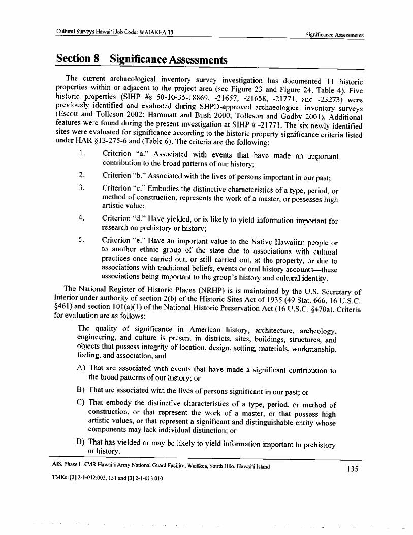
Cultural Surveys Hawai` i Job Code: WAIAKEA 10 Significance Assessments
Section 8 Significance Assessments
The current archaeological inventory survey investigation has documented 11 historicproperties within or adjacent to the project area ( see Figure 23 and Figure 24, Table 4). Fivehistoric properties ( SIHP # s 50- 10- 35- 18869, - 21657, - 21658, - 21771, and - 23273) were
previously identified and evaluated during SHPD- approved archaeological inventory surveysEscott and Tolleson 2002; Hammatt and Bush 2000; Tolleson and Godby 2001). Additional
features were found during the present investigation at SIHP # - 21771. The six newly identifiedsites were evaluated for significance according to the historic property significance criteria listedunder HAR §13- 275- 6 and ( Table 6). The criteria are the following:
1. Criterion " a." Associated with events that have made an importantcontribution to the broad patterns of our history;
2. Criterion " b." Associated with the lives of persons important in our past;3. Criterion " c." Embodies the distinctive characteristics of a type, period, or
method of construction, represents the work of a master, or possesses highartistic value;
4. Criterion " d." Have yielded, or is likely to yield information important forresearch on prehistory or history;
5. Criterion " e." Have an important value to the Native Hawaiian people orto another ethnic group of the state due to associations with culturalpractices once carried out, or still carried out, at the property, or due toassociations with traditional beliefs, events or oral history accounts— these
associations being important to the group' s history and cultural identity.The National Register of Historic Places ( NRHP) is is maintained by the U.S. Secretary of
Interior under authority of section 2( b) of the Historic Sites Act of 1935 ( 49 Stat. 666, 16 U.S. C.461) and section l01( a)( 1) of the National Historic Preservation Act ( 16 U.S. C. § 470a). Criteria
for evaluation are as follows:
The quality of significance in American history, architecture, archeology,engineering, and culture is present in districts, sites, buildings, structures, andobjects that possess integrity of location, design, setting, materials, workmanship,feeling, and association, and
A) That are associated with events that have made a significant contribution tothe broad patterns of our history; or
B) That are associated with the lives of persons significant in our past; orC) That embody the distinctive characteristics of a type, period, or method of
construction, or that represent the work of a master, or that possess highartistic values, or that represent a significant and distinguishable entity whosecomponents may lack individual distinction; or
D) That has yielded or may be likely to yield information important in prehistoryor history.
MS, Phase I, KMR Hawaii Army National Guard Facility, Waiakea, South Hilo, Hawaii Island 135TMKs:[ 3] 2- 1- 012: 003, 131 and[ 3] 2- 1- 013: 010
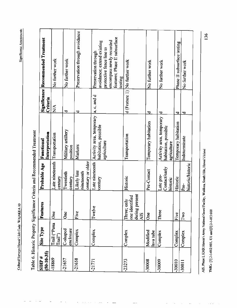
a)Uy r.+ CI a)
d y0 Zb11CD CI- 0
bAE O ,.. c
U 10 CCS O O vOi ti0 a)
a et
tu
w to bA
sem. U
to
3 3 c c6) CO
3 3s.
3 C
a) '. 4 i. OL.ai cn a
E t 'tct
C) ,.= C
40 al
Z Uviw° , •O O a) O p U ?
z1x ZZ aa as fl. Z Z a Za
no i0
6" Q C)
0
v) U' Z -v - o ccr o v - o c • 0
c C cO uO o O
c c E ° 6 6Ecat
4-- _ ate)ez
b a)
LTO F- n SCI H H < cH R
E L: U c3S
O o° oa) y y6 CCS C
c
c L ) a S a x •= a a cn
a) cl 0 0 •.- a'. oc Po U F, U 6 c U U x A.. U , x a ...I.
703
U4. CA
ca)U a)
o O C 0.—a) .
Q 17,LT
a) a) Oa) a) O O
c y c 3 c c . c M
w 0 0 i.:., H H o - o Q 0 H E- y o 0
u co
Z Mo cU LA., C, . 9" A, k X
a) a)
a) a) a)
d
U ." r
sem.. sem. 1 C o 0 0 O o 0 ri
ct p H H U a) U U U 5 U U U x oN
E) tonM Ncn VS
aoOa.0 'r if) r- N 00o
NY x oo _ N O O O c:, a
CI 1... 0 co N elM
co.,
c-) O OU H ;,,`, r . N N M re) M M
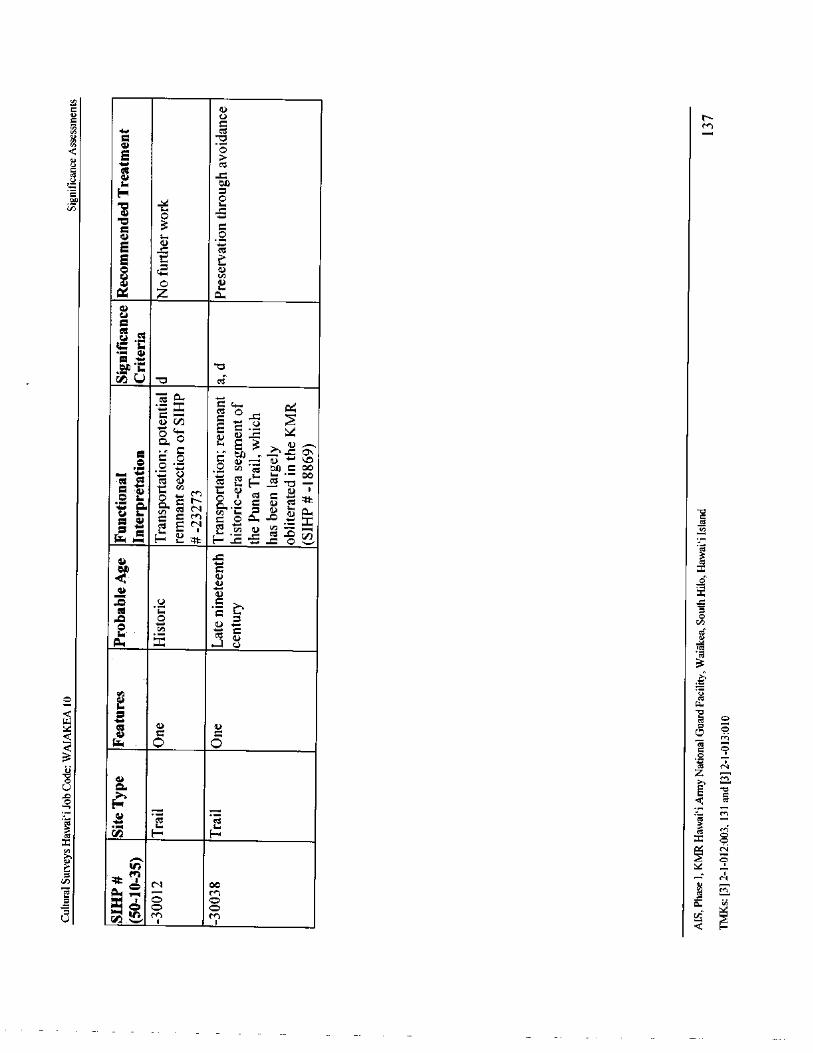
c a)
NV N
cn
O
E
to Ov, fl s-
Off13C OEE t
a z a
et0
x• c 4.
5Q. s
3 ? a0 •
Z o c a)_; a) +,a O . o &) •''3 04 C 00
C U m E oc
M
e,
c- tR. L1• c C 00... U I aUi
O a) = = M C O a -c
a
C
sem. a N i ti c, .O
8
x
ONa)N
t3 U C
CO • L Eocn
o vuLa
4.0
W O pc7 0
3 z o0
rt N
Oa) 1
OE Q ca
rn
03 titx Oti N
C
kin
CA 4i
rn
0.. .
g
Cultural Surveys Hawaii Job Code: WAIAKEA 10 Project Effect and Mitigation Recommendations
The Hawai` i Register of Historic Places ( HRHP) criteria for consideration, listed under HAR13- 198- 8, are almost identical to those for the NRHP.
SIHP # - 18869 is the Hilo District portion of the Puna Trail, a pre- Contact trail that wasmodified for horse travel in the late nineteenth century. The historic property was documentedunder studies by Hudson ( 1932), McEldowney ( 1979), and Hammatt and Bush ( 2000). As awhole, the trail is significant under both Criteria " a" and " d". Within the KMR, the trail' s
original alignment has been developed into a modern Jeep road. These alterations have generallyobliterated its nineteenth century characteristics, such as paving and curbstones. As such,
Hammatt and Bush ( 2000) reported that the portion of the Puna Trail through the KMR was notconsidered eligible for the HRHP and NRHP.
SIHP # - 21657 is thought to be an historic military artillery position. The historic propertywas previously identified by Hammatt and Bush ( 2000) and evaluated generally significant forinformation content. The results of the current AIS support the recommendation of eligibilityunder National/Hawai` i Register Criterion D and determination of significance under HAR §13-275- 6 Criterion " d."
SIHP # - 21658 is a series of five possible ahu or trail markers along the Puna Trail. Thehistoric property was previously identified by Hammatt and Bush ( 2000) and evaluated generallysignificant for information content. The results of the current AIS support the recommendation ofeligibility under National/Hawaii Register Criterion D and determination of significance underHAR §13- 275- 6 Criterion " d."
SIHP # - 21771 is a late nineteenth century complex located adjacent to the paved portion ofthe Puna Trail. Four features at this historic property were previously identified by Tolleson andGodby ( 2001) and evaluated generally significant for their association with events that made animportant contribution to the broad patterns of our history, their embodiment of the distinctivecharacteristics of a type, period, or method of construction, and their information content. In thecurrent AIS, CSH documented eight additional features at this site. The results of the current AISsupport the recommendation of eligibility under National/Hawai` i Register Criterion D anddetermination of significance under HAR §13- 275- 6 Criteria" a," " c," and " d."
SIHP # - 23273 is an historic era complex consisting of a remnant trail ( Feature 1) and twoagricultural planting areas ( Features 2 and 3). The historic property was previously identified byEscott and Tolleson ( 2002); Feature 1 was evaluated generally significant for informationcontent under Criterion D, while Features 2 and 3 were considered not significant. The results ofthe current AIS support the recommendation of eligibility under National/Hawai` i RegisterCriterion D and determination of significance of Feature 1 under HAR §13- 275- 6 Criterion " d."
SIHP # - 30008 is a pre-Contact to historic era lava tube shelter identified during the currentAIS. It is recommended eligible under National/ Hawaii Register Criterion D and determinedsignificant under HAR §13- 275- 6 Criterion " d" for its information content.
SIHP # - 30009 is a pre- Contact to historic era complex of three features situated on a largenatural outcropping identified during the current AIS. It is recommended eligible underNational/Hawai` i Register Criterion D and determined significant under HAR § 13- 275- 6Criterion " d" for its information content.
MS. Phase I, KMR Hawaii Army National Guard Facility, Waiakea, South Hilo, Hawai` i Island 138TMKs:[ 3] 2- 1- 012: 003, 131 and[ 3] 2- 1- 013: 010
Cultural Surveys Hawai` i Job Code: WAIAKEA 10 Project Effect and Mitigation Recommendations
SIHP # - 30010 is a late nineteenth century complex of five features identified during thecurrent AIS. It is recommended eligible under National/ Hawai` i Register Criterion D anddetermined significant under HAR § 13- 275- 6 Criterion " d" for its information content. Whilesimilar in some ways to SIHP # - 21771, it is not assessed as significant under Criteria " a" and
c" as it does not embody these characteristics as well as that historic property.SIHP # - 30011 is a late nineteenth century complex of two features identified during the
current AIS. Feature A is a wall and Feature B is a circular depression. It is recommendedeligible under National/Hawai` i Register Criterion D and determined significant under HAR
13- 275- 6 Criterion " d" for its information content.
SIHP # - 30012 is a historic era or older trail identified during the current AIS. It is
recommended eligible under National/Hawai` i Register Criterion D and determined significantunder HAR §13- 275- 6 Criterion " d" for its information content.
SIHP # - 30038 is an isolated remnant segement of the late nineteenth century Puna Trailwithin KMR. While the Puna Trail through KMR ( SIHP # - 18869) had been assessed as nolonger eligible to the National/Hawai` i Register due to its modern improvements, SIHP # - 30038
does represent a relatively intact portion of the historic alignment. This trail segment has beenheavily disturbed by bulldozing and dense surrounding vegetation. Despite these disturbances,this segment of the historic trail retains integrity and is therefore eligible as an historic property.It is recommended eligible under National/Hawai` i Register Criterion D and determinedsignificant under HAR §13- 275- 6 Criterion " a" for its association with changes in infrastructuree. g., ala loa) through the historic period, and Criterion " d" for its information content.
AIS, Phase I. KMR Hawai` i Army National Guard Facility, Waiakea, South Hilo, Hawai` i Island 139TMKs:[ 3] 2- 1- 012: 003, 131 and[ 3] 2- 1- 013: 010
Cultural Surveys Hawai` i Job Code: WAIAKEA 10 Project Effect and Mitigation Recommendations
Section 9 Project Effect and Mitigation Recommendations
9. 1 Project Effect
This investigation was undertaken for planning purposes, and does not address a specificproject. For this reason, a project-specific effect recommendation cannot be made. However,future developments may have the potential to impact known or potential historic propertieswithin the KMR. The recommended mitigation measures are intended to reduce potentialadverse effect on significant historic properties during any future development projects.
9.2 Mitigation Recommendations
9.2. 1 Historic Properties at which Sufficient Data Has Been Recovered
No further historic preservation work is recommended for seven of the 11 total historicproperties identified within the project area ( SIHP #s 50- 10- 35- 18869, - 21657, - 23273, - 30008, -30009, - 30011, and - 30012). Sufficient information regarding the location, function, age, andconstruction methods of these historic properties has been generated by the currentarchaeological inventory survey investigation to mitigate any adverse effect caused by proposeddevelopment activities.
9.2.2 Preservation through Avoidance
Because of their evaluated significance during past and present studies, three historic
properties within the KMR are recommended for preservation through avoidance.SIHP # - 21658 was recommended for preservation through avoidance by Hammatt and Bush
2000). CSH presently concurs with this recommendation, to allow for future study.CSH also concurs with the recommendation for preservation of SIHP # - 21771 implied by
Tolleson and Godby (2001). This historic property provides a unique picture of the history of thisportion of Hilo in the late nineteenth century. The bulk of this historic property is alreadypreserved within a modern chain link fence. It is recommended that the fence line be modified tocontain the newly identified associated features present to the north. Figure 95 shows howalteration of the existing fenceline at SIHP # - 21771 would fulfill this recommendation. Theportion of fencing presently situated between the Features A through G and Features H throughL clusters could be removed, if desired, to create a single continuous enclosed space.
SIHP# - 30038 is an isolated remnant segment of the late nineteenth century Puna Trail. All ofthe historic components of this trail were previously thought to have been obliterated by themodernization of the overall trail into a Jeep road ( SIHP # - 18869). Because this segment likelyrepresents the only " intact" segment of the historic trail within the KMR, it should also beavoided to allow for future study.
MS, Phase I. KMR Hawaii Army National Guard Facility. Waiakea, South Hilo, Hawaii Island 140
TMKs:[ 3] 2- 1- 012: 003, 131 and[ 3] 2- 1- 013: 010
Cultural Surveys Hawai` i Job Code: WAIAKEA 10 Project Effect and Mitigation Recommendations
0 5 10 MOTORS
Truc North
Modified Height( cm)
Feature H( 100)m#}= Modified Depth( cm) 3 3()) f(80)
i3( 1)a „
13( Y)
O =Placed Rock Dense Forestexe
r I
m( 30) Level () 0) F*. Feature IManuporMater sotWorn Stone 70) ( 50) ( 3t)) (
t0t I
Facing 00)-2= Feature J ( 40)
WO)40) (
25) t
1- Datum Feature K '] \ t
iv—v- = Depression
in 40) (30
i
1
Fence Line Feature L '1
t
Mango Tree i1
Bedrock I
Paved Area
ocecRecommended Extent vsv ^ Cleared and Level -of Protective Chain
Cr nV ^ Gate
Link Fence i'J Jeep Road a
y /
IFeatureA ( 30)
Cupboard 40) IPJ
ow) J40)
Feature E
Q Q (35) _
Ohi' a Trees Q Cleared and Level
V t Constructed Pit Feature F
Q
1
30). (4(f)
20)
2 (25)
n0)
50)
V 45Level 05 (
30w. Feature G
4
A lin 120)Feature C Dense Forest
ttt 101FeatureD15)
35) iFeature B •"~
livr
c5"
2 20) CLarge Mango Trees * o
Large Mango TreesArtifact Scatter
Grinding Wheel)Bottles, Pottery)
Figure 95. Plan map of SIHP# - 21771, showing the recommended extension of the protectivechain link fence line (dashed line)
AIS, Phase I, KMR Hawai` i Army National Guard Facility, Waiakea, South Hilo, Hawai` i Island 141TMKs:[ 3] 2- 1- 012: 003, 131 and[ 3] 2- 1- 013: 010
Cultural Surveys Hawaii Job Code: WAIAKEA 10 Project Effect and Mitigation Recommendations
9.2.3 Phase II Subsurface Investigation
Given their potential for containing additional information regarding feature age and/ orfunction, and to rule out the possibility ( however unlikely) of the presence of human burialdeposits, subsurface investigation ( i. e., test excavation) is recommended for two historicproperties, SIHP # s - 21771 ( also recommended for preservation through avoidance) and - 30010.This work would be completed under a Phase II contract with the HIARNG, if concurrence thatsuch testing is warranted has been obtained in consultation with that agency and the SHPD.9.2. 4 Archaeological Monitoring
The results of the current Phase I investigation underscored the difficult nature of siteidentification within the heavily forested, undeveloped portions of the KMR. Due to the potentialfor additional surface and subsurface historic properties within these areas, including humanburials, it is recommended that initial ground disturbance within the presently unmodifiedportions of the KMR be attended by an archaeological monitoring program. The monitoringprogram will begin with the production of an archaeological monitoring plan for the review andacceptance of SHPD prior to the beginning of construction ( Appendix A of this report). Field
monitoring should be carried out in accordance with the plan. An archaeological monitoringreport should be submitted for review and acceptance by SHPD following the completion of allmonitoring activities related to project development.
9.3 Disposition of MaterialsMaterials collected during the current archaeological inventory survey will remain
temporarily curated at the CSH storage facility in Pahoa, Hawai` i. CSH will make arrangementswith the landowner regarding the disposition of this material. Should the landowner requestarchiving of material, an archive location will be determined in consultation with SHPD.
MS. Phase I, KMR Hawai` i Army National Guard Facility, Waiakea, South Hilo, Hawaii Island 142TMKs:[ 3] 2- 1- 012: 003, 131 and[ 3] 2- 1- 013: 010
Cultural Surveys Hawai` i Job Code: WAIAKEA 10 References Cited
Section 10 References Cited
Apple, R.A.
1965 Trails: Stepping Stones to Kerbstones. Bishop Museum Special Publication 53.Bishop Museum Press, Honolulu.
Berrere, D.B., M. Kelly, and B. Nakamura1980 Hilo Bay: A Chronological History, Land and Water Use in the Hilo Bay Area,
Island ofHawai' I. Department of Anthropology, Bernice Pauahi Bishop Museum,Honolulu.
Bird, Isabella L.
1964 Six Months in the Sandwich Islands. University of Hawai` i Press, Honolulu.Bonk, William J.
1979 An Archaeological Survey of a Portion of Hawaiian Home Lands of Pana`ewa,Tract 1, Waiakea, South Hilo, Hawai`i. University of Hawaii at Hilo, Hilo,Hawai` i.
Carson, Mike T.1999 Archaeological Inventory Survey of the 176 Acre Pana`ewa Campus Site,
Waiakea Ahupua`a, Hilo District, Island of Hawai` i ( TMK: 2- 3- 13: 154).Scientific Consultant Services, Inc., Honolulu.
Ching, Lillian1989 Hawaiian Legends Index. Revised edition. Dr. Masae Gotanda, editor. Hawaii
State Library, Honolulu.
Ching, Francis K.W. and Catherine Stauder1974 The Archaeology of South Hilo, Hawai` i: Archaeological Reconnaissance and
Preliminary Historical Investigation of the Proposed 2 % Mile Alignment (Alt. A)
Between Keaukaha and the South Hilo—Puna Boundary. Archaeological ResearchCenter Hawaii, Lawai, Kaua` i, Hawaii.
Conde, Jesse C. and Gerald M. Best1973 Sugar Trains: Narrow Gauge Rails of Hawai`i. Glenwood Publishers, Felton,
California.
Cordy, R.1995 The Ala Kahakai Trail—or the Ala Loa; An Archaeological and Historic
Preservation Perspective. Department of Land and Natural Resources, StateHistoric Preservation Division, Kapolei, Hawaii'.
Devereux, Thomas, Douglas Borthwick, and Hallett H. Hammatt1997 Archaeological Reconnaissance Survey of Keaukaha Military Reservation South
Hilo District Hawai` i Island (Hawai` i National Guard) 503.6 acre parcel, TMK:2- 1- 12: 3 and 2- 1- 13: 10. Cultural Surveys Hawaii, Inc., Kailua, Hawaii.
Elliott, Rex R.
1971 Hawaiian Bottles ofLong Ago. Hawaiian Service, Inc., Honolulu.
MS, Phase I. KMR Hawaii Army National Guard Facility, Waiakea, South Hilo, Hawaii Island 143TMKs:[ 3] 2- 1- 012: 003, 131 and[ 3] 2- 1- 013: 010
Cultural Surveys Hawai` i Job Code: WAIAKEA 10 References Cited
Ellis, William
1963 Journal of William Ellis. Advertiser Publishing Company, Ltd., Honolulu.1974 Polynesian Researches, Hawaii. Charles E. Tuttle Company, Tokyo.
Emerson, Nathaniel B.
1915 Pele and Hi`iaka. Reprinted copyright 1993. University of Hawai` i at Manoa,Honolulu.
Escott, Glenn G. and Wendy Tolleson2002 Archaeological Inventory Survey at Keaukaha Military Reservation, South Hilo
District, Island ofHawai` i, [ TMK 2- 1- 12: 3 and 2- 1- 13: 10]. Scientific ConsultantServices, Inc., Honolulu.
Fornander, Abraham1916 to 1919 Fornander Collection of Hawaiian Antiquities and Folk-lore. Bishop
Museum Memoirs, vols. IV—VI. Bishop Museum Press, Honolulu.Goodman, W.L. and R. Nees
1991 Archaeological Reconnaissance and Inventory Surveys of3, 600 acres in WaiawaAhupua' a, Ewa, 0`ahu. Bishop Museum Manuscript 022092, available at BernicePauahi Bishop Museum, Honolulu.
Goodman, W.L. and R.K. Olmo1993 Archaeological Identification Survey Lots # 3264-REM-2NEW and 3264-REM-
2R/ W, Village of Ordot, Chalan Pago/ Ordot, Guam. International ArchaeologicalResearch Institute, Inc., Honolulu.
Google Earth
2013 Aerial photographs of Hawaii. Google Inc., 1600 Amphitheatre Parkway,Mountain View, California. Available online at www.google. com/earth.html.
Gowen, Herbert H.1908 Keala. In Hawaiian Idylls of Love and Death. Cochrane Publishing Company,
New York.
Hale ole, S.N.
1919 Kaipalaoa, The Hawaiian Romance of Laieikawai. Thirty-third annual report,1911- 1912. U.S. Bureau of American Ethnology, Washington, D.C.
Hammatt, Hallett H. and Anthony Bush2000 Archaeological Inventory Survey of Selected Portions of the Hawai`i Army
National Guard 503. 6 acre Keaukaha Military Reservation, Waiakea Ahupua' aSouth Hilo District, Hawai` i Island. Cultural Surveys Hawaii, Inc., Kailua,Hawai` i.
Hammatt, Hallett H. and Kelley Lehuakeopuna Uyeoka2007 Archaeological Monitoring Report for Waiakeawaena Elementary School,
Hawai` i Inter-Island DOE Cesspool Project, Waiakea Ahupua' a, Hilo District,Island ofHawai` i, TMK: [ 3] 2- 2- 042: 017. Cultural Surveys Hawai` i, Inc., Kailua,Hawai` i.
MS, Phase I, KMR Hawai` i Army National Guard Facility, Waiakea, South Hilo, Hawaii Island 144
TMKs:[ 3] 2- 1- 012:003, 131 and[ 3] 2- 1- 013: 010
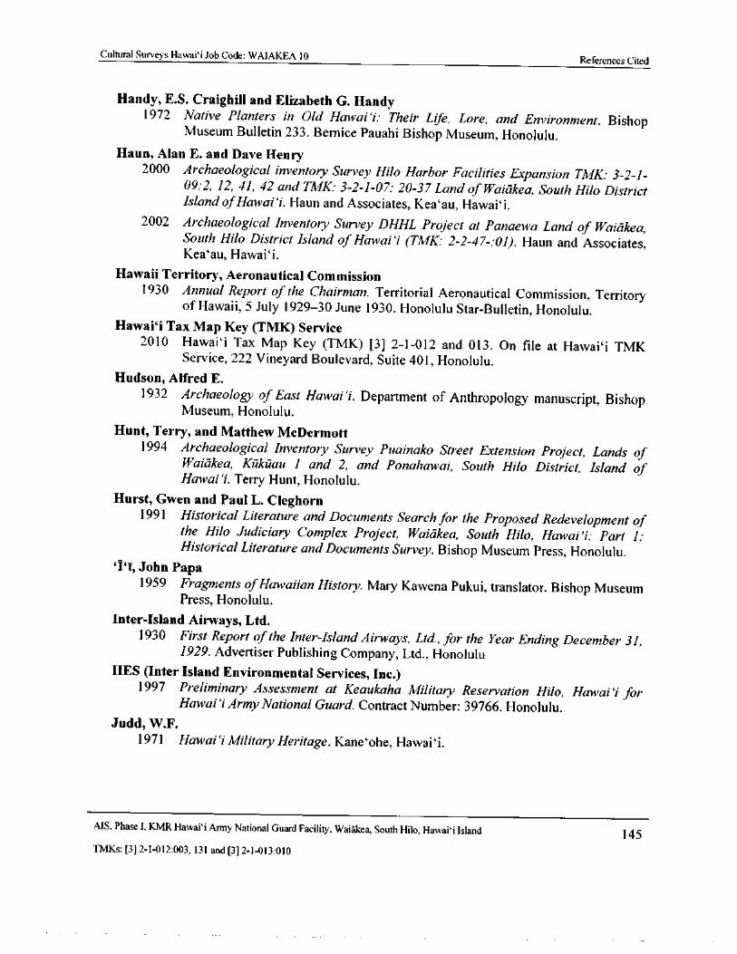
Cultural Surveys Hawaii Job Code: WAIAKEA 10References Cited
Handy, E. S. Craighill and Elizabeth G. Handy1972 Native Planters in Old Hawai` i: Their Life, Lore, and Environment. Bishop
Museum Bulletin 233. Bernice Pauahi Bishop Museum, Honolulu.Haun, Alan E. and Dave Henry
2000 Archaeological inventory Survey Hilo Harbor Facilities Expansion TMK: 3- 2- 1-09: 2, 12, 41, 42 and TMK: 3- 2- 1- 07: 20-37 Land of Waiakea, South Hilo DistrictIsland ofHawai`i. Haun and Associates, Kea' au, Hawai` i.
2002 Archaeological Inventory Survey DHHL Project at Panaewa Land of Waiakea,South Hilo District Island of Hawai`i (TMK: 2- 2- 47-: 01). Haun and Associates,Kea' au, Hawai` i.
Hawaii Territory, Aeronautical Commission1930 Annual Report of the Chairman. Territorial Aeronautical Commission, Territory
of Hawaii, 5 July 1929- 30 June 1930. Honolulu Star- Bulletin, Honolulu.Hawaii Tax Map Key (TMK) Service
2010 Hawaii Tax Map Key ( TMK) [ 3] 2- 1- 012 and 013. On file at Hawaii TMKService, 222 Vineyard Boulevard, Suite 401, Honolulu.
Hudson, Alfred E.1932 Archaeology of East Hawai`i. Department of Anthropology manuscript, Bishop
Museum, Honolulu.
Hunt, Terry, and Matthew McDermott1994 Archaeological Inventory Survey Puainako Street Extension Project, Lands of
Waiakea, Kukuau 1 and 2, and Ponahawai, South Hilo District, Island ofHawai`i. Terry Hunt, Honolulu.
Hurst, Gwen and Paul L. Cleghorn1991 Historical Literature and Documents Search for the Proposed Redevelopment of
the Hilo Judiciary Complex Project, Waiakea, South Hilo, Hawai` i: Part 1:Historical Literature and Documents Survey. Bishop Museum Press, Honolulu.
I`i,John Papa
1959 Fragments ofHawaiian History. Mary Kawena Pukui, translator. Bishop MuseumPress, Honolulu.
Inter-Island Airways, Ltd.1930 First Report of the Inter-Island Airways, Ltd.,for the Year Ending December 31,
1929. Advertiser Publishing Company, Ltd., HonoluluIIES (Inter Island Environmental Services, Inc.)
1997 Preliminary Assessment at Keaukaha Military Reservation Hilo, Hawai' i forHawai` i Army National Guard. Contract Number: 39766. Honolulu.
Judd, W.F.
1971 Hawai`i Military Heritage. Kaneohe, Hawai` i.
AIS, Phase I. KMR Hawai` i Army National Guard Facility, Waiakea, South Hilo, Hawaii Island 145TMKs:[ 3] 2- 1- 012: 003, 131 and[ 3] 2- 1- 013: 010
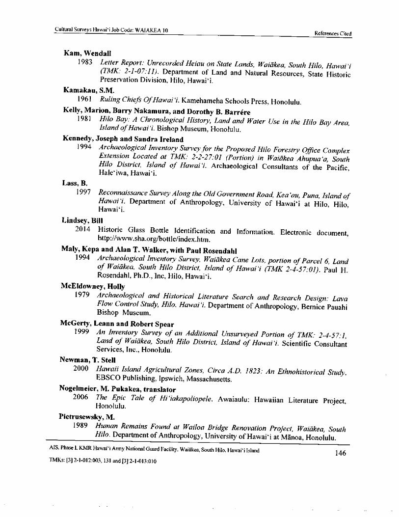
Cultural Surveys Hawai` i Job Code: WAIAKEA 10References Cited
Kam, Wendall
1983 Letter Report: Unrecorded Heiau on State Lands, Waiakea, South Hilo, Hawai`iTMK: 2- 1- 07: 11). Department of Land and Natural Resources, State Historic
Preservation Division, Hilo, Hawaii,
Kamakau, S. M.
1961 Ruling Chiefs OfHawai` i. Kamehameha Schools Press, Honolulu.Kelly, Marion, Barry Nakamura, and Dorothy B. Barrere
1981 Hilo Bay: A Chronological History, Land and Water Use in the Hilo Bay Area,Island ofHawai` i. Bishop Museum, Honolulu.
Kennedy, Joseph and Sandra Ireland1994 Archaeological Inventory Survey for the Proposed Hilo Forestry Office Complex
Extension Located at TMK: 2-2- 27: 01 ( Portion) in Waiakea Ahupua`a, SouthHilo District, Island of Hawai` i. Archaeological Consultants of the Pacific,Hale` iwa, Hawaii.
Lass, B.
1997 Reconnaissance Survey Along the Old Government Road, Kea`au, Puna, Island ofHawai` i. Department of Anthropology, University of Hawai` i at Hilo, Hilo,Hawaii.
Lindsey, Bill2014 Historic Glass Bottle Identification and Information. Electronic document,
http:// www.sha.org/bottle/ index.htm.
Maly, Kepa and Alan T. Walker, with Paul Rosendahl1994 Archaeological Inventory Survey, Waiakea Cane Lots, portion of Parcel 6, Land
of Waiakea, South Hilo District, Island of Hawai`i ( TMK 2- 4- 57,•01). Paul H.Rosendahl, Ph.D., Inc, Hilo, Hawaii.
McEldowney, Holly1979 Archaeological and Historical Literature Search and Research Design: Lava
Flow Control Study, Hilo, Hawai`i. Department of Anthropology, Bernice PauahiBishop Museum.
McGerty, Leann and Robert Spear1999 An Inventory Survey of an Additional Unsurveyed Portion of TMK: 2- 4- 57: 1,
Land of Waiakea, South Hilo District, Island of Hawai` i. Scientific ConsultantServices, Inc., Honolulu.
Newman, T. Stell2000 Hawaii Island Agricultural Zones, Circa A.D. 1823: An Ethnohistorical Study.
EBSCO Publishing, Ipswich, Massachusetts.Nogelmeier, M. Pukakea, translator
2006 The Epic Tale of Hi` iakapoliopele. Awaiaulu: Hawaiian Literature Project,Honolulu.
Pietrusewsky, M.1989 Human Remains Found at Wailoa Bridge Renovation Project, Waiakea, South
Hilo. Department of Anthropology, University of Hawaii at Manoa, Honolulu.MS, Phase I, KMR Hawaii Army National Guard Facility, Waiakea, South Hilo, Hawai` i Island 146TMKs:[ 3] 2- 1- 012: 003, 131 and[ 3] 2- 1- 013: 010
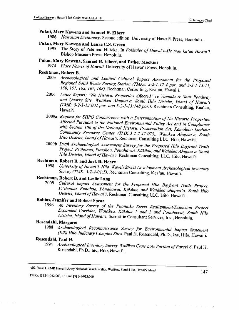
Cultural Surveys Hawai` i Job Code: WAIAKEA 10References Cited
Pukui, Mary Kawena and Samuel H. Elbert1986 Hawaiian Dictionary. Second edition. University of Hawaii Press, Honolulu.
Pukui, Mary Kawena and Laura C.S. Green1995 The Story of Pele and Hi iaka. In Folktales of Hawai`i—He mau ka' ao Hawai`i.
Bishop Museum Press, Honolulu.
Pukui, Mary Kawena, Samuel H. Elbert, and Esther Mookini1974 Place Names ofHawaii. University of Hawaii Press, Honolulu.
Rechtman, Robert B.2003 Archaeological and Limited Cultural Impact Assessment for the Proposed
Regional Solid Waste Sorting Station ( TMKs: 3- 2- 1- 12: 4 por. and 3- 2- 1- 13: 11,150, 151, 162, 167, 168). Rechtman Consulting, Kea' au, Hawaii.
2006 Letter Report: " No Historic Properties Affected" re Yamada & Sons Roadwayand Quarry Site, Waiakea Ahupua' a, South Hilo District, Island of Hawai` iTMK: 3- 2- 1- 13: 002 por. and 3- 2- 1- 13: 148 por.). Rechtman Consulting, Kea' au,Hawai` i.
2009a Request for SHPO Concurrence with a Determination ofNo Historic PropertiesAffected Pursuant to the National Environmental Policy Act and in Compliancewith Section 106 of the National Historic Preservation Act, Kamoleao LaulimaCommunity Resource Center ( TMK:3- 2-2- 47: 075), Waiakea Ahupua' a, SouthHilo District, Island ofHawai`i. Rechtman Consulting LLC, Hilo, Hawaii.
2009b Draft Archaeological Assessment Survey for the Proposed Hilo Bayfront TrailsProject, Pi`ihonua, Punahoa, Ponahawai, Kukuau, and Waiakea Ahupua' a, SouthHilo District, Island ofHawai` i. Rechtman Consulting, LLC, Hilo, Hawaii.
Rechtman, Robert B. and Jack D. Henry1998 University ofHawai` i—Hilo Kawili Street Development Archaeological Inventory
Survey ( TMK: 3- 2- 4- 01: 5). Rechtman Consulting, Kea' au, Hawaii.Rechtman, Robert B. and Leslie Lang
2009 Cultural Impact Assessment for the Proposed Hilo Bayfront Trails Project,Pi`ihonua, Punahoa, Ponahawai, Kukuau, and Waiakea ahupua' a, South HiloDistrict, Island ofHawai`i. Rechtman Consulting LLC, Hilo, Hawai` i.
Robins, Jennifer and Robert Spear1996 An Inventory Survey of the Puainako Street Realignment/Extension Project
Expanded Corridor, Waiakea, Kukuau 1 and 2 and Ponahawai, South HiloDistrict, Island ofHawai` i. Scientific Consultant Services, Inc., Honolulu.
Rosendahl, Margaret1988 Archaeological Reconnaissance Survey for Environmental Impact Statement
EIS) Hilo Judiciary Complex Sites. Paul H. Rosendahl, Ph.D., Inc, Hilo, Hawaii.Rosendahl, Paul H.
1994 Archaeological Inventory Survey Waiakea Cane Lots Portion ofParcel 6. Paul H.Rosendahl, Ph.D., Inc, Hilo, Hawaii.
MS, Phase I, KMR Hawai` i Anny National Guard Facility, Waiakea, South Hilo, Hawai` i Island147
TMKs:[ 3] 2- 1- 012: 003, 131 and[ 3] 2- 1- 013: 010
Cultural Surveys Hawai` i Job Code: WAIAKEA 10References Cited
Rosendahl, Margaret and Lawrence Talea1988 Archaeological Reconnaissance Survey for Environmental Impact Statement
EIS) Proposed Irradiation Plant Site. Paul H. Rosendahl, Ph.D., Inc, Hilo,Hawai` i.
Sato, H., Warren Ikeda, Robert Paeth, Richard Smythe, and Minoru Takehiro, Jr.1973 Soil Survey of the Island of Hawaii. U. S. Department of Agriculture and
University of Hawai` i Agricultural Experiment Station.Smith, Marc
1992Field Inspection for State Land Disposition of the Proposed Department of WaterSupply Office Site in Hilo, Waiakea Cane Lots, Waiakea, South Hilo, Hawai`iIsland ( TMK: 3- 2- 4- 57: 001). Department of Land and Natural Resources, StateHistoric Preservation Division, Kapolei, Hawai` i.
Smith, M. and P. Tourtellotte1988 Wailoa Bridge Renovation Project, Site No. 50- 10- 11115 Burial Removal.
Department of Land and Natural Resources, State Historic Preservation Division,Kapolei, Hawai` i.
Spear, Robert1995 Data Recovery Excavations for Sites 50- 10- 35- 19431, 19432, 19433, and 19434,
Land of Waiakea, South Hilo District, Island of Hawai` i. Scientific ConsultantServices, Inc., Honolulu.
State of Hawaii2012 Hawai` i Aviation: An Archive of Historic Photos and Facts: General Lyman
Field/Hilo International Airport. Electronic document http:// hawaii.gov/hawaiiaviation/( accessed 11 June 2012).
Stewart, C. S.
1970 Journal of a Residence in the Sandwich Islands, During the Years 1823, 1824,and 1825. Facsimile reproduction of the third edition of 1830. University ofHawai` i Press, Honolulu.
Stokes, John F.G. and Tom Dye (Editor)1991 Heiau of the Island of Hawai`i: A Historic Survey of Native Hawaiian Temple
Sites. Bishop Museum Press, Honolulu.Thrum, Thomas G.
1907a Heiau and heiau sites throughout the Hawaiian Islands. Hawai`i Almanac andAnnualfor 1908. Thos. G. Thrum, Honolulu.
1907b Tales from the temples. Hawai`i Almanac and Annual for 1908. Thos. G. Thrum,Honolulu.
1923 More Hawaiian Folk Tales. A.C. McClurg & Company, Chicago, Illinois.
AIS. Phase I, KMR Hawai` i Army National Guard Facility, Waiakea, South Hilo, Hawai` i Island148
TMKs:[ 3] 2- 1- 012: 003, 131 and[ 3] 2- 1- 013: 010
Cultural Surveys Hawaii Job Code: WAIAKEA 10References Cited
Tolleson, Wendy L. and William Godby2001 From Trail to Road: A Late Historic Way Station on the Puna Trail on the
Hawai`i Army National Guard Keaukaha Military Reservation, Hilo, Hawai` iIsland, TMK: 2- 1- 13 and 10 and 2- 1- 12: 3. Scientific Consultant Services, Inc.,Honolulu.
Tulchin, Jon T. and Hallett H. Hammatt2007
Archaeological Literature Review and Field Inspection for an Approximately 33-acre Wal-Mart Expansion Project, Waiakea Ahupua`a, South Hilo District,Hawai`i Island TMK: [ 3] 2- 2- 047: 059, 072, 074 and 13J 2- 1- 025: 090. CulturalSurveys Hawai` i, Inc., Kailua, Hawai` i.
U.S. Geological1995 Hilo USGS 7. 5- minute topographic quadrangle. Available at USGS Information
Services, Box 25286, Denver, Colorado.1977 Orthophoto, Hilo, Hawaii. Available at USGS Information Services, Box 25286,
Denver, Colorado.
Waihona `Aina2000 The Mahele Database. Electronic document, http:// waihona.com.
Walker, Alan and Paul Rosendahl1996 Archaeological Assessment Study Hilo Judiciary Complex Project. Paul H.
Rosendahl, Ph.D., Inc, Hilo, Hawai` i.Wall, Walter A.
1886 Hawai` i Island. W.A. Wall, Surveyor. Registered Map 1438. Available at Hawai` iLand Survey Division, State of Hawai` i, Department of Accounting and GeneralServices, 1151 Punchbowl Street, Room 210, Honolulu. Available online athttp:// dags.hawaii.gov/ survey/ search.php.
Wall, Walter E.1915 Waiakea Government Tract, W.E. Wall, Surveyor. HTS Plat 775. Available at
Hawai` i Land Survey Division, State of Hawaii, Department of Accounting andGeneral Services, 1151 Punchbowl Street, Room 210, Honolulu. Available onlineat http:// dags.hawaii.gov/ survey/ search.php.
Webster, William
1851 Waiakea. William Webster, Surveyor. Registered Map No. 524. Available atHawaii Land Survey Division, State of Hawai` i, Department of Accounting andGeneral Services, 1151 Punchbowl Street, Room 210, Honolulu. Available onlineat http:// dags.hawaii.gov/survey/ search.php.
Westervelt, William D.
1915 Legends ofGods and Ghosts. Boston, Massachusetts.
MS, Phase I, KMR Hawai` i Army National Guard Facility, Waiakea, South Hilo, Hawaii Island149
TMKs:[ 3] 2- 1- 012: 003, 131 and[ 3] 2- 1- 013: 010
Cultural Surveys Hawai` i Job Code: WAIAKEA 10References Cited
Wilkinson, Sarah, Auli`i Mitchell, and Hallett H. Hammatt2010 Archaeological Literature Review and Field Inspection for the Proposed Kumau
Street Entrance Improvements, Pier 4, Hilo Harbor, Waiakea Ahupua`a, SouthHilo District, Island of Hawai`i, TMK: ( 3) 2- 1- 007. Cultural Surveys Hawaii,Inc., Kailua, Hawai` i.
2012a Archaeological Literature Review and Field Inspection for the Proposed KumauStreet Entrance Improvements, Pier 4, Hilo Harbor, Waiakea Ahupua a, SouthHilo District, Island of Hawai`i TMK: ( 3) 2- 1- 007. Cultural Surveys Hawaii,Inc., Kailua, Hawai` i.
2012b Draft Archaeological Literature Review and Field Inspection Report for theCounty of Hawai`i Bus Maintenance Yard Project, Waiakea Ahupua a, SouthHilo District, Island of Hawai` i, TMK: ( 3) 2-2- 058: 018 por. Cultural SurveysHawaii, Inc., Kailua, Hawaii.
Wolforth, T.2004 Inventory Survey for the Proposed Kuhio-Kalaniana` ole Park, Hilo:
Investigations into the Kanakea Fishpond at Reed' s Bay TMK: 3-2- 1- 6: 13 and 15.Scientific Consultant Services, Inc.
2006 Inventory Survey for the Proposed Reed' s Bay Beach Park, Hilo. ScientificConsultant Services, Inc.
MS, Phase I, KMR Hawai` i Army National Guard Facility, Waiakea, South Hilo, Hawaii Island150
TMKs:[ 3] 2- 1- 012: 003, 131 and[ 3] 2- 1- 013: 010
Cultural Surveys Hawai` i Job Code: WAIAKEA 11 Appendix A
Appendix A Phase I Archaeological
Monitoring Plan
Archaeological Monitoring Plan, Phase I,
Keaukaha Military Reservation (KMR)
Hawaii Army National Guard Facility
Waiakea Ahupua`a, South Hilo District, Island of Hawaii
TMK (3) 2- 1- 012: 003, 131 and (3) 2- 1- 013: 010
Prepared for
Hawaii Army National Guard, ENV Office
Prepared by
Momi Wheeler, B.S.,
Sarah Wilkinson, B.A.,
and
Hallett H. Hammatt, Ph.D.
Cultural Surveys Hawaii, Inc.
Kailua, Hawaii
Job Code: WAIAKEA 11)
March 2014
MS. Phase I. KMR Hawaii Army National Guard Facility. Waiakea, South Hilo, Hawai` i Island 151
TMKs:[ 3] 2- 1- 012: 003, 131 and[ 3] 2- 1- 013: 010
Cultural Surveys Hawai` i Job Code: WAIAKEA 11 Appendix A
Introduction
At the request of the Hawaii Army National Guard, ENV Office, Cultural Surveys Hawaii,Inc. ( CSH) has prepared this archaeological monitoring plan ( AMP) as part of Phase I
investigations at Keaukaha Military Reservation ( KMR) Hawaii Army National Guard Facility,Waiakea Ahupua`a, South Hilo District, Hawaii Island, TBD: TMK (3) 2- 1- 012: 003, 131 and
3) 2- 1- 013: 010. The proposed project area is near Hilo Town in the Hawaii Army NationalGuard ( HIARNG) KMR and is bound by General Lyman Field/Hilo International Airport on thenorthwest, County Quarry and Borrow Pit Site on the southeast, the Airport Access Road on thenortheast and dense forest on the southwest. The proposed project area is depicted on a U.S.Geological Survey ( USGS) 7. 5 Minute Topographic Map, Hawaii Tax Key Map ( TMK), an
aerial photograph and project area site plan of KMR( see Figure 1 through Figure 4).
The KMR encompasses a total area of 509. 17 acres. However, the project or survey areaencompassed the portions of the KMR that are vegetated ( not currently maintained). Therefore
the Phase I Archaeological Inventory Survey ( AIS) project area, and subject of the present AMP,comprises a 405. 3- acre portion of the overall 509. 17—acre property ( see Figure 5 and Figure 6),and excludes TMK ( 3) 2- 1- 012: 131 in its entirety. The Phase I investigation is understood asbeing undertaken in support of planning for potential long-range improvements at the HIARNGKMR Facility. No specific improvements are known to us at this time. Development of thisAMP will assure compliance with State of Hawaii and Federal Historic Preservation
regulations, and aid in the discovery and treatment of any historic properties encountered duringfuture projects within the project area.
This undertaking is subject to both Federal and State of Hawaii Historic PreservationRegulations. With regard to Federal regulations, this undertaking is subject to historicpreservation review under Section 106 of the National Historic Preservation Act of 1966, as
amended, and implementing regulation 36 CFR Part 800. In the event that human burials ofNative Hawaiian descent are encountered, all consultation and subsequent work would beconducted under the Native American Graves Protection and Repatriation Act of 1990NAGPRA), as well as State of Hawaii Administrative Rules ( HAR) Title 13 § 13- 300.
Scope ofWork
The following scope of work satisfies the State of Hawaii requirements for archaeologicalmonitoring plans ( Hawaii Administrative Rules [ HAR] § 13- 279-4). The written plan shall
specify:
1. The type of archaeological remains or historic properties anticipated or require
protection;
2. The location of these properties within the project are or where they are anticipated tobe;
3. The fieldwork need to protect or document known or anticipated historic properties;which may include, but not limited to, profile documentation of stratigraphy,drawings, lithic sourcing and excavations or exposed feature;
MS. Phase I. KMR Hawaii Army National Guard Facility, Waiakea, South Hilo, Hawai` i Island 152
TMKs:[ 3] 2- 1- 012: 003, 131 and[ 3] 2- 1- 013: 010
Cultural Surveys Hawaii Job Code: WAIAKEA 11 Appendix A
4. That the archaeological monitor has the authority to halt ground-disturbing activitiesin the immediate area of the find, in order to implement the plan;
5. That a coordination meeting between the archaeological team and the constructionteam will be held to inform the contractor of the plan;
6. Any laboratory work that is expected;
7. That a final report of monitoring activities will be prepared;
8. Archiving of any collections.
This plan must be approved by SHPD before subsurface work in the project area can begin.
Results of Phase I AIS and Recommendations
CSH conducted the Phase I surface AIS from August 19, 2013 to September 24, 2013. The
pedestrian inspection identified 11 historic properties, of which five were previously- identifiedand six are newly- identified. While these sites are largely associated with the late ninteenthcentury modification of the Puna Trail for equestrian travel, some appear to pre- date this activityand were likely related to traditional and or/earlier historic resource procurement within theforests of Waiakea. Evidence of possible shelter, temporary habitation, and agriculture were alsodocumented. See Section 5 of the AIS report for further discussion of these historic properties
and their context within the lands of the KMR.
Of the 11 historic properties documented, seven were recommended for no further work, two
were recommended to undergo Phase II subsurface testing, and three were recommended forpreservation through avoidance ( note that one site, SIHP # 50- 10- 35- 21771, was recommended
for both subsurface testing and preservation through avoidance) ( see also Section 9. 2). The
locations of all eleven historic properties are given on Figure 23 and Figure 24. Figure 25 depicts
these historic properties in relation to both the disturbed and undisturbed portions of the
unmaintained grounds at KMR.
Following concurrence of the SHPD with the evaluations and recommendations as presentedin the AIS report, only the sites recommended for Phase II subsurface testing and preservationthrough avoidance would require protection during future development projects at KMR. IfPhase II subsurface testing was completed prior to any development, the results of thoseinvestigations could decrease the number of historic properties requiring protection. Presently,subsurface testing is recommended for SIHP # s - 21771 and - 30010; as SIHP # - 21771 is also
recommended for preservation through avoidance, the results for testing at this site would notbear on the present plan. However, if testing yielded a recommendation of no further work atSIHP # - 30010, protection of that site may no longer be required.
Archaeological Monitoring ProvisionsIn consultation with SHPD, on- site archaeological monitoring is recommended for all ground
disturbances in unmaintained areas within KMR ( see Figure 6) to facilitate the identification and
treatment of any burials that might be discovered during project construction, and to alleviate theproject' s effect on non-burial archaeological deposits. The AIS identified previously unrecordedarchaeological features within previously surveyed areas in both disturbed and undisturbed
AIS, Phase I, KMR Hawaii Army National Guard Facility, Waiakea, South Hilo, Hawaii Island 153
TMKs:[ 3] 2- 1- 012: 003, 131 and[ 3] 2- 1- 013: 010
Cultural Surveys Hawai` i Job Code: WAIAKEA 11 Appendix A
portions of the unmaintained grounds at KMR ( see Figure 25). These results indicate some
potential for additional features within any of these unmaintained areas, regardless of pastdisturbance. Archaeological monitoring is not recommended for any ground disturbance withinthe presently- maintained grounds, including the existing ranges indicated on Figure 5.
Under Hawai` i State historic preservation legislation, " Archaeological monitoring may be anidentification, mitigation, or post- mitigation contingency measure. Monitoring shall entail thearchaeological observation of, and possible intervention with, on- going activities which mayadversely affect historic properties" ( HAR § 13- 279- 3). For this project, the proposed monitoringprogram will serve as a mitigation measure that insures proper documentation should historic
properties be encountered during the road reconstruction/ rehabilitation work. The archaeologicalmonitoring firm would need to be permitted to conduct archaeological studies in the State ofHawai` i and compliant with any federal regulations governing archaeological monitoring.
Specific Provisions
Hawai` i State historic preservation legislation governing archeological monitoring programsrequires that each monitoring plan discuss eight specific items ( HAR § 13- 279- 4). The
monitoring provisions below address these eight requirements.
1. Anticipated Historic Properties:
Based on background research and the results of the current Phase I AIS, historic
properties ( i.e., archaeological sites) in the form of pre- and post-Contact surface or
subsurface features may be encountered during archaeological monitoring of grounddisturbance within the project area. Subsurface features including anthropogenicconstructions, cultural deposits and burials can occur within lava tubes.
Evidence of indigenous Hawaiian land use could include surface architectural features
or cultural deposits obscured by dense vegetation; subsurface cultural deposits mightcontain midden, artifacts and/ or human burials. Evidence of post- Contact land use
could include surface features associated with the Puna Trail or subsurface cultural
deposits in the form of trash pits and/ or human burials.
2. Locations of Historic Properties:
Historic properties may be encountered anywhere within the entire project area.
3. Fieldwork:
Full-time on- site archaeological monitoring is recommended whenever disturbance oforiginal ( previously undisturbed) ground is conducted in the project area. The
archaeological monitor shall continuously observe and monitor ground disturbingactivities. Any departure from full time on- site archaeological monitoring will onlyfollow consultation with and written concurrence from SHPD.
Each piece of mechanical earth- disturbing machinery shall be monitored by anarchaeological monitor. If more than one piece of machinery needs to be monitored,additional monitors shall be employed.
MS, Phase I. KMR Hawai` i Army National Guard Facility, Waiakea, South Hilo, Hawai` i Island 154
TMKs:[ 3] 2- 1- 012:003, 131 and[ 3] 2- 1- 013: 010
Cultural Surveys Hawai` i Job Code: WAIAKEA 11 Appendix A
The monitoring fieldwork may encompass the documentation of surface or subsurfacearchaeological features ( e. g., anthropogenic constructions, or cultural deposits such asmidden scatters or trash pits) and will employ current standard archaeological
recording techniques. For surface features, this would include documentation of
features by written description, tape and compass mapping, photographs, and GPS.For subsurface features, this would include drawing and recording the stratigraphy ofexcavation profiles where cultural features or artifacts are exposed, as well as
representative profiles. These exposures will be photographed, located on project area
maps and sampled. Photographs and representative profiles of excavations will be
taken even if no historically- significant sites are documented. As appropriate,
sampling will include the collection of representative artifacts, bulk sediment samplesand/ or the on- site screening of measured volumes of feature fill to determine featurecontents.
If human remains are identified, no further work will take place, including noscreening of back dirt, no movement of rocks, no cleaning and/or excavation of theburial area and no exploratory work of any kind unless specifically requested by theSHPD. All human skeletal remains that are encountered during construction will behandled in compliance with NAGPRA, HAR § 13- 300, and in consultation with
SHPD.
4. Archaeologist' s Role:
The on-site archaeologist(s) will have the authority to stop work immediately in thearea of any findings so that documentation can proceed and appropriate treatment canbe determined. In addition, the archaeologist will have the authority to slow and/orsuspend construction activities in order to insure that the necessary archaeologicalsampling and recording can take place.
5. Coordination Meeting:
Before work commences on the project, the on- site archaeologist shall hold a
coordination meeting to orient the construction crew to the requirements of the
archaeological monitoring program. At this meeting, the monitor will emphasize his orher authority to temporarily halt construction and that all historic finds, includingobjects such as bottles, are the property of the landowner and may not be removedfrom the construction site. At this time it will be made clear that the archaeologist
must be on site whenever disturbance of original ( previously undisturbed) ground isconducted in the project area; and that multiple machines working in different areasneed multiple monitors.
6. Laboratory Work:
Laboratory work will be conducted in accordance of HAR § 13- 279- 5-( 6). Laboratoryanalysis of non- burial related finds will be tabulated into table form and standard
artifact and midden recording will be conducted as follows: artifacts will be
documented as to provenience, weight, length, width, type of material, and presumed
function. Photographs of representative artifacts will be taken for inclusion into the
AIS, Phase I, KMR Hawai` i Army National Guard Facility, Waiakea, South Hilo, Hawaii Island 155
TMKs:[ 3] 2- 1- 012: 003, 131 and[ 3] 2- 1- 013: 010
Cultural Surveys Hawai' i Job Code: WAIAKEA 11 Appendix A
archaeological monitoring report. Bone and shell midden materials will be sorteddown to species, when possible, and then tabulated by provenience.
As appropriate, collected charcoal material obtained within intact cultural deposits will
be analyzed for species identification. Charcoal samples ideal for dating analyses willbe sent to Beta Analytic, Inc. for radiocarbon dating. If appropriate, artifacts may besent to the University of Hawai` i- Hilo Geoarchaeology lab for Energy-Dispersive X-ray Fluorescence ( EDXRF) analysis in order to identify and possibly geographicallylocate the source material. All analyzed samples, provenience information, and results
will be presented in table form within the archaeological monitoring report.
7. Report Preparation:
One of the primary objectives of the report will be to present a stratigraphic overviewof the project area which will allow for predictive assessments of adjacent properties,
which may be the subject of future development. The report will contain a section onstratigraphy, description of archaeological findings, monitoring methods and results oflaboratory analyses. The report will address the requirements of a monitoring reportHAR § 13- 279- 5). Photographs of excavations will be included in the monitoring
report even if no historically-significant sites are documented. Should burial treatmentbe completed as part of the monitoring effort, a summary of this treatment will beincluded in the monitoring report. Should burials and/or human remains be identified,then other letters, memos, and/ or reports may be requested by SHPD' s Burial SitesProgram.
8. Curation:
All burial materials will be addressed as directed by the SHPD. Materials not
associated with burials will be temporarily stored at the contracted archaeologist' sfacilities until an appropriate curation facility is selected, in consultation with thelandowner and SHPD.
Research Objective
The research objective for archaeological monitoring fieldwork will focus on gatheringinformation related to the cultural history of the area surrounding the current project area. Inparticular, the focus would be to clarify our understanding of pre-Contact land use in the forestsof Waiakea, and to further document historical activities within the KMR and relationship ofsuch activities to the Puna Trail.
Temporal analysis ( radiocarbon dating) will also be conducted if dateable material ( e. g.,charcoal) can be collected from discrete subsurface features that are associated with a particular
event ( such as the construction of fire pits), rather than from bulk sediment samples which reflect
extended depositional events. The results of this research will be presented in the project' s final
archaeological monitoring report.
MS, Phase I. KMR Hawaii Army National Guard Facility, Waiakea, South Hilo, Hawaii Island 156
TMKs:[ 3] 2- 1- 012: 003, 131 and[ 3] 2- 1- 013: 010
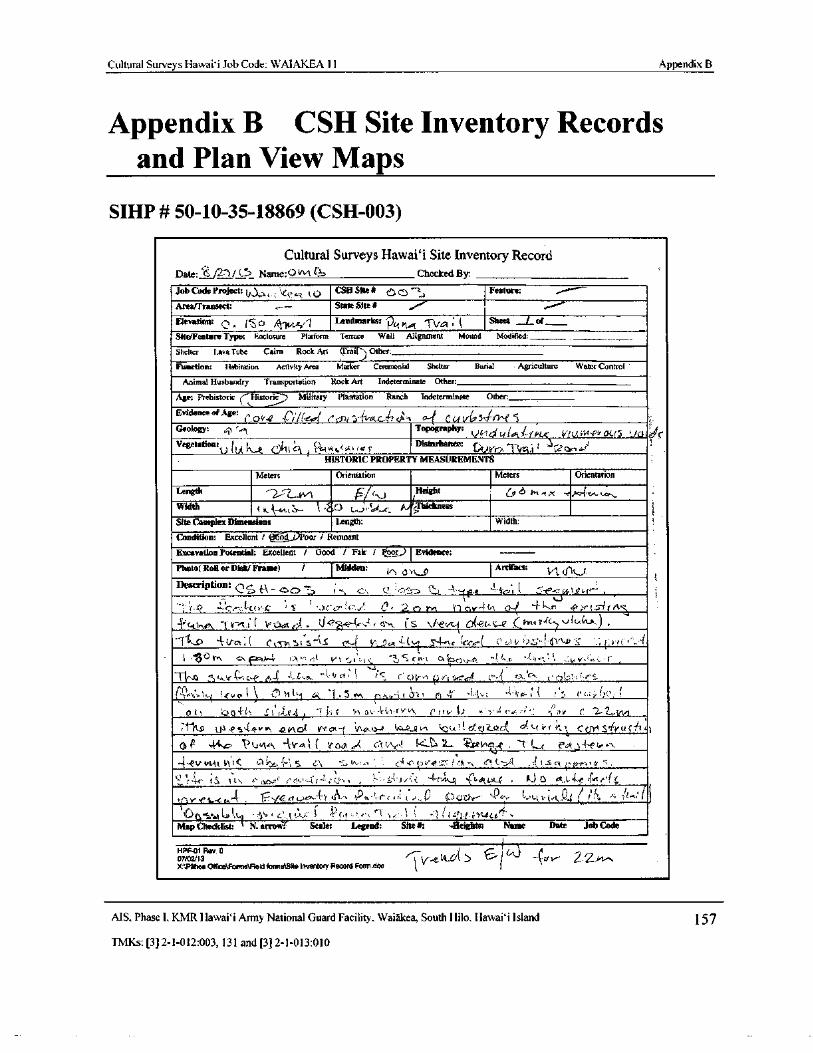
Cultural Surveys Hawaii Job Code: WAIAKEA 11 Appendix B
Appendix B CSH Site Inventory Recordsand Plan View Maps
SIHP # 50- 10- 35- 18869 (CSH-003)
Cultural Surveys Hawai`i Site Inventory RecordDate:' Z/ 271/(.°? Name: 0 vvt Checked By:
Job Code Project:{ , . t t;? CSS Site# v
r t Feature:
Area/ Transect: State Site# o""
Elevation: 0 isba 1 Landmarks: p,t T11 ; Sheet jof_
Site/Feature Type: Enclosure Platform Terrace Wall Alignment Mound Modified:
Shelter Lava Tube Cairn Rock Art ( frail) Other;
Function: Habitation Activity Area Matter Ceremonial Shelter Burial Agriculture Water Control
Animal Husbandry Transportation Rock Art Indeterminate Other:
Age: Prehistoric ( istoric Military Plantation Ranch Indeterminate Other:_____
Evidence of Age: U+r.t! i r- col C' fl7r S..S:' n.-C.^`"!. C Gd t/ Fi S4.a' 7'` P S
Geology: 6, Topography: JStd . LL• V( 14 - PfrOGIS JGt C
Vegetation:t.)
i, vt r
Disturbance: s9 i r.•- C 7 ^ Y .
HISTORIC PROPERTY MEASUREMENTS
Meters Orientation Meters Orientation
Length L.Vv1 r Height y 6Width i { e b-- SThichness
Site Complex Dimensions Length: Width:
Condition: Excellent t ll J)Poor I Remnant
Excavation Potential: Excellent I Good / Fair / Poor Evidence:
Photo( Roll or Disk/ Frame) / Midden: Artifact: Irl( 51k.J.
Description: r:,J e4 cJ03 7 h
Llr-
ti
J,. f . C$P, G. 1'• : 4
trO r., 2 e. : 2 en 1, 4 n coe- E f, t ; J- r"
tr0(e1/.
P 1 S a f yM1
a V<' 4' r c5h tS \/ 2tfi 0(e1 SP Yve ft7vlc itx.} .
t CcS^ st 3`\ g r Y: a( S4-. c u'trk- C LA v ++ l,y a c; e+. ,• I
l •'. c V"^ eti. lr 5,•. ri..
V t ;. 3 C -?,,' S r rs t cx rren; r-P, J(^.
K r :.: n 4'•:.•:
Tv-. ;tey,4 c c>{>,( 1 : rl c.E { raC , c:. rw
111:1.":` t?)ti 61 ( i I. 5 vv, r vt i) l 1,, 1.,. = 4 it c, r t f r z r' 20s
At9 ..' 4a i1 4' l 4 c.. t 4/ " f 5.;t rY 0 c I• - f s 0. i' 4t i t,t . <
y
y
N2s2 n erneJl t•r.rn r nu.0-¢ - a.: R n t urlG1'.Ua nc-d c t' vr: CCMS rvuc,''i iit,- rt ( r G 7 t C:r 41.
x.:) ( We t . '( L.-( 4-et,
4.. V'vtit i\ t‹ fl.".. '" r" i-"> r1 5.:1 + t. i er .r. 1. S 1' 1,, u " e r• < ., t e, r
y. f;; y . r 4,61, , C , tJ tL r v n_F. J-,f,
v SwCew le'Rt e, 4—t 411,, { ribt
F .; r
tr . d, 1t'% v" .
7)u,r _' LlLt•' k f r,
i , +L }
W 1.te
t Ga lt, ' 4 t,; { 1. e: P t •',‘" c• t tx-'. y s-. 1 1 l.(.V0.4Map Checklist t N. arrovr i Scale Legend: Site# Heights: Name Date Job Code
HPF-01 Rev. 907/02/ 13 xr-o(kV( 5 C.i ‘
4"-/ ._.cr/Tahoe Otfico\forma\Aeld forma\Slte inventory Record Formdoe
MS, Phase I, KMR Hawaii Army National Guard Facility, Waiakea, South Hilo, Hawai` i Island 157
TMKs:[ 3] 2- 1- 012: 003, 131 and[ 3] 2- 1- 013: 010
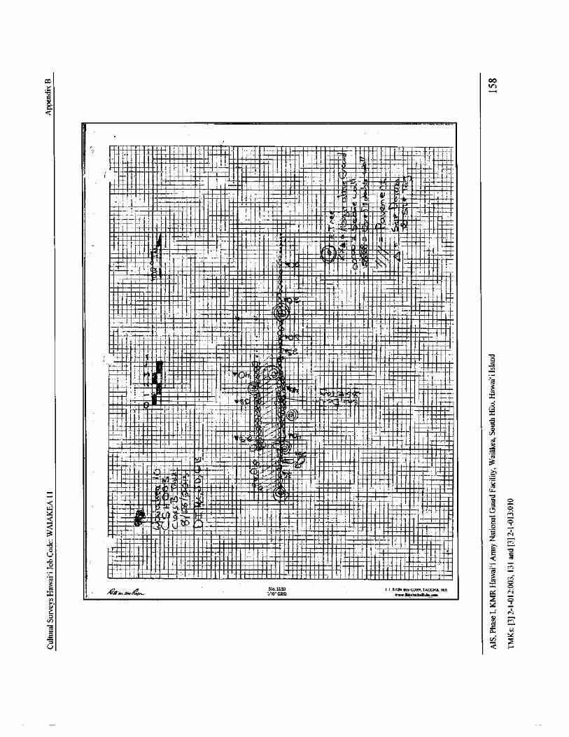
C0 Co
1
8.a.
1oaeaana - t
It I I a
I1I
II1
aaa.
m
III,al e I i l ,
11
t 1.I. ._4.. 1T
1 I' ae I.
1.. nni....•
1 ,_ n:. "7' aII 1-Ii1 1 { Ia - Igo 11
aeon 111 111" 11 rI' L _ ,
I I - ! I rI l 1.. e : , • Haan If, . U b. -.
1anena111 . . .. -
EMMEN
L:: I , 1
I11 .. I 0 k.. 1I
J I 1"_. I aaa • r1 f ::, ,.., 1 ... P1sakaa - LI
iaha en { I aaa
a_1...
1ra-
afS ±'I i
a •
eeneaae 1 ... ..... a I II e
i ... 1 C 1
I..... I a j-: = Immunising. I I T...: j lk r ,, f,--,• - :?I!
i aaiaaann F - 1 1'
I1"= . waaaana - #. .-.. 0 ' - a.. ,--1 7
waaeaaaas I - n• _.• e ' }- elves otiv Z I 'tommiz%anambiwz .. Ill ana T-
PROW MI= • 1 1 1 I I .
r, ..
fimammas f n
eYY' [:M
n INE ern eaa rm Hams i I
J1 4_. 1 -
atk a .. i I
I
111112 eaanna 1i r
paSanfGic,. dna 4
TiiiIIiwliteaeaaianl.. e aa e,,
afflIoF !1 ! '• Taan I_ /
IIS i can na
1I1.aanon 1 , i ' - on n
na: aaa
IaaIII el
I
i as•IIIas I
Ia a 1I. et
1
i
1_
i -4--,-4..-4-----J: r-'"
Mara t U
1.
aaW I• f- _ L
Ne 1 -
r-:-: 1_
c 1 1 . .!_ as . - 1 .: earelaaa.` .. ea ar....., j 1 •en
1 I f__` _ , { I Eno nen I _
j' "• iia I _• . i.eenLeie erw+ F a aa. rT
i juidnan I. t' I -. 3-1,E,..4,
aaaaeawawa 1
i
i H. • nnM1/4'.• 111 • I aana•we
a7G { n." a.. .ee, NNE
I
II
Ilt' __ I. I I
eaa 11..
1
ainaanr'_ C
T - I ""_. a. ,+' Tyi73lUf a ' ..1 i I -'_.. J i i ' f
cnI 71:
a .. ' "::._: i e!
1Ci `# Mn= L11 i 71 1.. 0I# I l',.-1e . as ana-b _ i
JI
I 1 ' IY C laClan11 1 I a 1724)1 as
1) cl l•-' oan " IL
nin 9• arila - i.. 6aV.l at 1 i , nea® - i i --• -' . .
aaee a: 1
ilhltlPoW1% i IVJ. I.a i si sei
rila1
naU . nn a.,. LZ r[`..,
aneeni[IA annna.ru ,. . a naenaeaat UI • 3 L aa aa
re 0. '` innrau ia R®
aa G } C7
7 4__Q ` _ 111111 n ill
1 !: canna t I ii R os Z:0 Pi naanan r o ,_,
y N
c um i. . I.. ... j •.__ eaaa a...-' -•aa
Ylinim[e n
I
1 _ hI a ;
CAU nneeeln a e1 1• y
a i I Io as eelaaan. nmaa , a 1{° en
1 aaan aaea aaa - nnaNil _ 1 .- - snap MEIN it 1 { { $ j-F A'
M
M
p /
JctN4.1110 11_ DAMN(: CORP. TACOMA, WA
O
r+-Agr..',.., 9.,. .. 00"GRID swv6s. imaae. lo.tam
N
L NC/] N u
U I .
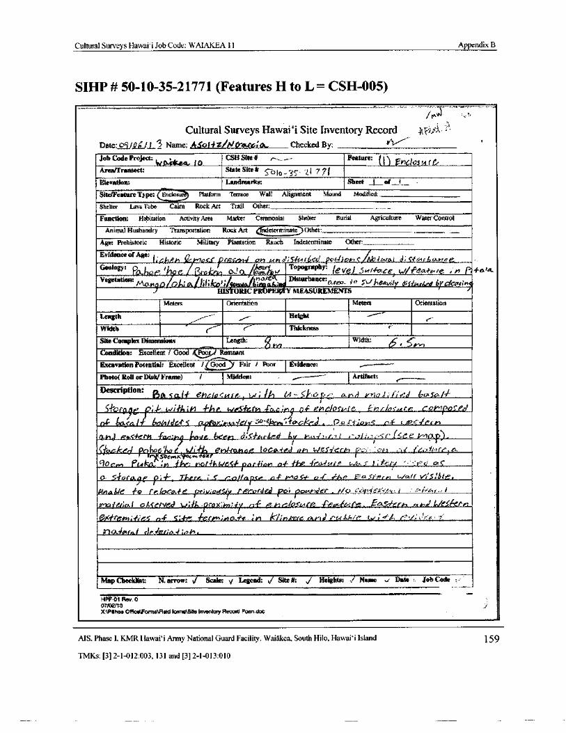
Cultural Surveys Hawai` i Job Code: WAIAKEA 11 Appendix B
SIHP # 50- 10- 35- 21771 ( Features H to L= CSH-005)
itA
Cultural Surveys Hawai` i Site Inventory RecordDate: C41/ 0 / L3 Name: ASo tZ/ N(r&rcf tat., Checked By:
Job Code Projectiv tt*srke - J
CSH Site.# r ._ Feature: . 1 1 Ft1Ghuf fAreafrransect: State Site* <- 010 3S' 1. a 7 7Elevation: Landmarks: Sheet j of_ I_
Site/Feature Type: Fncelos Platform Terrace Wall Alignment Mound Modified:_
Shelter Lava Tube Cairn Rock Art Trail Other:
Function: Habitation Activity Area Marker Ceremonial Shelter Burial Agriculture Water Control
Animal Husbandry Transportation Rock Artndeterminate Other:
Age: Prehistoric Historic Military Plantation Ranch Indeterminate Other:
Evidence of Age:os.5. r ' sL uard; Svurtr rdivvrC Jlto4Ural d; S-tr rrcAr -.
Geology: QoJJrae l.?I
l rrrkriq atCl A
troyj ToP PhY• level ..Sr rrfcce t. drtecr# , e , n r, Fain.
f // c Disturbance:Vegetation:Nlan t3 l7 ,; / ii lillCo, tatAir. area.. sry ;
theavitr d=Stra rbed br' r'CCar%n1.HISTORIC PROP MEASUREMENTS
Meters Orientation Meters Orientation
Length rHeight
Width Ct Thickness c'
Site Complex Dimensions Length: g Width:
Condition: Excellent 1 Good liZr, RemnantExcavation Potential: Excellent / Good Fair / Poor Evidence:
Photo( Roll or Disk/ Frame) / Midden: Artifact:
Description:Ot, 5od-1 eY?c.10< c tr,., 1. Gt t.4- Seke, r., ex.ks trVr i f;44/ br so•1
5 hroye U;. 1,44a 4-0 c
ry p-c elociAre. £ mr/n tri CFS/ tired
6r,bt/ SCP 5 tR.P ' a,vkiG/yac-•
p,;,•# cncie P o/ 4-4.03: L*•- r r r rs
CMG, Ras errs ' far:yx/, / nave. been 5 ter( d v t:. a. t.. z` / .::> f' 1aee
rrlfa,cke pc hoe roG t, 1t• F e#1.14t.14ot Iocix4'idd r)H S.,/ eSy'crki 1? . G= t1 r/ ei.
frISberm,s, foco» ear
rlocrer PIA 1.4 IV; yx)r•IhGIVcii- nncIiw a-F # / tzsJytro i c.} 1, rPr F: 1' v at lc
t). -# orale Th®re S rnj/ase ea- t 0-405'# 0,.(' F - i'r,rar t./ cart t'S161r',
iln,n4/r° to re IocA„.1e PecorJeJ poi
f ,4,41er. td, c). 4< i tl a: r'I"te t % Lr,'.., I
rt-7crr rzet:a! tshce( vt°4 , Ih. pro x:hrr; 1% 3'I p t r t•/OsMi • Peotie4 it.. t'r,.5.6-r ,
ueXtre# ;-, ec n4 5:-/-z lerem;# 1, c/1e:.; ri k!inkere rht rdl d C, t//,/ f
l J,, der;4 ; oil,
Map Checklist: N. arrow: }/ Scale: a Legend: ,/ Site#: j Heights ./ Name Date Job Code
1- PF•01 Rev. 007,b?J13X:1PiPoa 4ificeomrs\Field forma-Site inventory Record Formdoc
MS. Phase I. KMR Hawaii Army National Guard Facility, Waiakea, South Hilo, Hawaii Island 159
TMKs:[ 3] 2- 1- 012: 003, 131 and[ 3] 2- 1- 013: 010
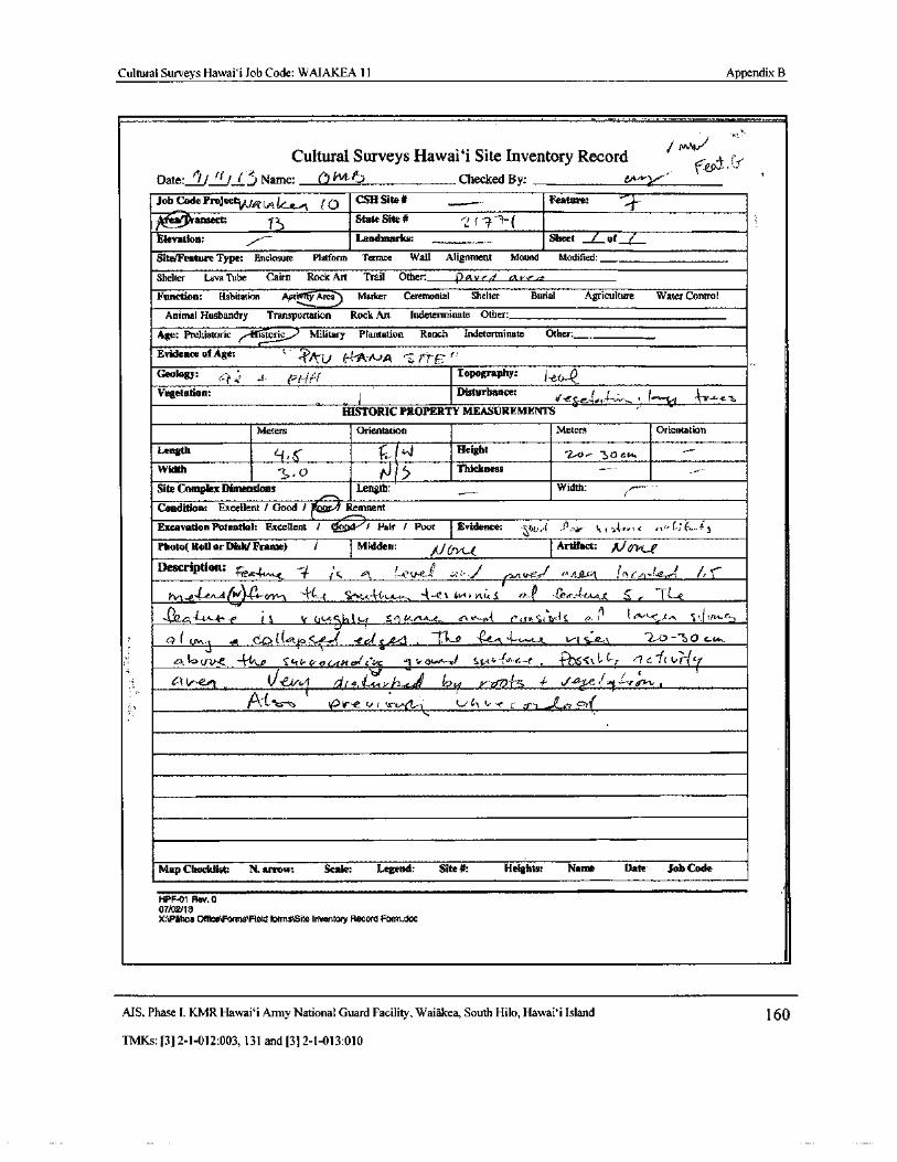
Cultural Surveys Hawai` i Job Code: WAIAKEA 11 Appendix B
Cultural Surveys Hawaii Site Inventory Record V- .
Date: if/ f./If)Name; e) ift4.15 Checked By:
Job Code Project (A4„, (U
CSH Site# Feature:
tit / Pransect State Site#
Elevation: Landmarks: Sheet _ Lof /
Site/Feature Type: Enclosure Platform Terrace Wall Alignment Mound Modified:
Shelter Lava Tube Cairn Rock Art Trail Other: 4) Av, 4n.v.r..,Function: Habitation Aptic1fy Area Marker Ceremonial Shelter Burial Agriculture Water Control
Animal Husbandry Transportation Rock Art Indeterminate Other:
Age: Prehistoric tstoric Military Plantation Ranch Indeterminate Other:_. 1Evidence of Age: t:
0, {;
Geology: k, : `_ r-/-.,i.:/ Topography: 1 eL=--Q.,Vegetation: Disturbance:
ti / // L
HISTORIC PROPERTY MEASUREMENTS6
Meters Orientation meters Orientation
Length "Height3O CPs
Width 0 ri 5 Thickness
Site Complex Dimensions Length: Width:
Condition: Excellent / Good /t
Remnant
Excavation Potential: Excellent` I : ----)./ Fair / Poor Evidence: • 4 . 0,,,r t„ i% A,,., r ry"-( 7 6.:.f tPhoto( Roll or Disk/ Frame) / Midden:
itiU>/t.0Artifact: / 1/ orpla
Description: ir,
tv-,44-t"^ d cr " 1 ' 4' 1,-- •'` tA.`1,4- 4-.. 4--t..t 4w t vtu. S r+..:.e ' fee:-( CA-41, t --11...g
012.A.-1-,--(-; t 1 Y G 5{,t l u 5: 1 4," A- t_.. ca. Vs`..P4. e,,,,° i lta, t S ,,. til i `- , e.,,: S clt 1`-r!
0 ( ` fr, cO t GAta ed S- C-e--' t. 4--,,, k, v t s=r, 2.;o-` 3 o 1.....
el, 6 uti-e. - 4-1A4 S kt-rC, o G.-Ores,/ c'
0 1 tr owA...r/ St,:'-• e' e r" POSC t, 1- C.I
Et c- I(4-' 1"-(7,G3(..- e..01 ,, di.1cIIA-,v h..) b ti
yJ-60 l":a - 4 6 J
Map Checklist: N. arrow: Scale: Legend: Site#: Heights: Name Date Job Code
r
HPF-01 Rev. 007/ 0x/ 13X:\Pthoa OthcetForms\Fleld forms\Site Inventory Record Form doe
MS, Phase I, KMR Hawai` i Army National Guard Facility, Waiakea, South Hilo, Hawai` i Island 160
TMKs:[ 3] 2- 1- 012: 003, 131 and[ 3] 2- 1- 013: 010
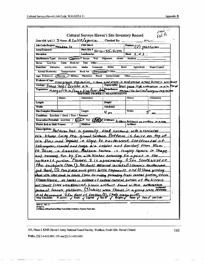
Cultural Surveys Hawai` i Job Code: WAIAKEA 11 Appendix B
Cultural Surveys Hawai` i Site Inventory Record r , ,'P7
Date:04 fo C/ I_3 Name: A$ o l0ZINpirc7te... Checked By:
Job Code Project:Na--g. k6a- / 0
CSH Site# Feature:/
Area/Transect: State Site# J pia-Watts,
Co 7/0- 3c-211'11Elevation: Landmarks: Sheet L of
Site/Feature Type: Enclosure Terrace Wall Alignment Mound Modified:
Shelter Lava Tube Cairn Rock Art Trail Other:
Function: Habitation Activity Area Marker Ceremonial Shelter Burial Agriculture Water Control
Animal.Husbandry Transportation Rock Art ndetermin Other:
Age: Prehistoricistoric _ Military Plantation Ranch Indeterminate Other:
Evidence of Age:Aver9to h ye9; 0.4;oi9, !: Gfreti 11404 Ple ie, 140d/ sr.& ees a•rms!it;S•roNc atfi.1ktet'S
Geology: FGthpG' ' 4'L06 IJro kenOt- A. opograph3
j paha Slit undcrlgt.or, : tt oomflosot
Vegetation: J isturbance:M1 Yl00H;6:,; nq ab: hqq( Iit krl,,./ YEA. N kta fdtrGaf;onlovCJyros ty:fc trat
HISTORIC PROPERTY MEASUREMENTS
Meters Orientation Meters Orientation
Length Height
Width Thickness
Site Complex Dimensions Length: Width: Ss--
041Condition: Excellent / Good / Poor / Remnant
Excavation Potential: Excellent / Fair en Evidence: jh;slime ArdrFoeis oh_vAtir ce : n at(aPhoto( Roll or Disk/ Frame) / Midden: Artifact:
Description.Ficcfiorte, his a 5, c4e4,, sures..= „ it", .SsoC;Otfe'
o) 0,. kiweef 1,4,1 fie- 9 raar,d c,.tr-foto. PIO--s orm ; 5 bier,' 4.• ci, lop 0°F
O` o Pot./ enoi 4f ; h Sferc o rig, r'€ sf COP sirMat fled n 1F
Siit 6.-ar9r,,lar/ topraidgorexkui fooffh 412A, C.04110.5" 6Q / drr5 •frOPel / Uvr„
4'0 30Garl Iea,kua.. :3 toa,9hlp 5e eorte in SFlo_fe0424 megteteres it yet by cry) t.: 4461 ki:1 k. r e.x:fesir oy t o n Polh f :n -the
harfh 00,5 4- fa p,govi. Fct 4tre. 2 i c a prowniad,utr 656-#
1, 1 5041.1"Ai Lie , o+.‘"
elle/o, ,, r'e ( Fe.', 1). A - facdj ltgterved it,c/t40e(I)Cergpvc taa.rf/rvnt,rs„
p®f glen)) ( 3) #i^,e F:e..cv_ tntald 914-53 4, 4-He. f-Alky , n...,- LS rind b) Sys ondinpgl w sOzi crsr 4o ro#aie Stone. for trawl Pm/ Rad/ i ' tool cehta~l trortFiop' 4Ocrrt
itCNm, F/LvtCP1, m_c AMNIA_ ev,knee of est./wit! y # ei;a/ owf'S:de ott 11Ole stor r
ar¢: tfazeps4'r6 lee dfecVe-e' e l,:c r:c and;AAs 406. E w. fh.,F noriheus,koto4otrveci
par ; o,w,, o4 • rea.fute_ PrQ# fr7rh"i. ( 3)wAIter l,forn _S1 lies in a., roue iVe-te -sd docuni® .A 6'r,. eas# of feat(I !' ceJY po rts,
Map Checklist: N. arrow: v Scale: , Legend: v Site 1 Heights]k
Name ' Date f Job Code
HPF-01 Rev. O
07102/ 13
X:\Pahoa( mice Forrnsl leid forms\slte Inventory Record Form. doc
AIS, Phase I. KMR Hawaii Army National Guard Facility, Waiakea, South Hilo, Hawaii Island 161
TMKs:[ 3] 2- 1- 012: 003, 131 and[ 3] 2- 1- 013: 010
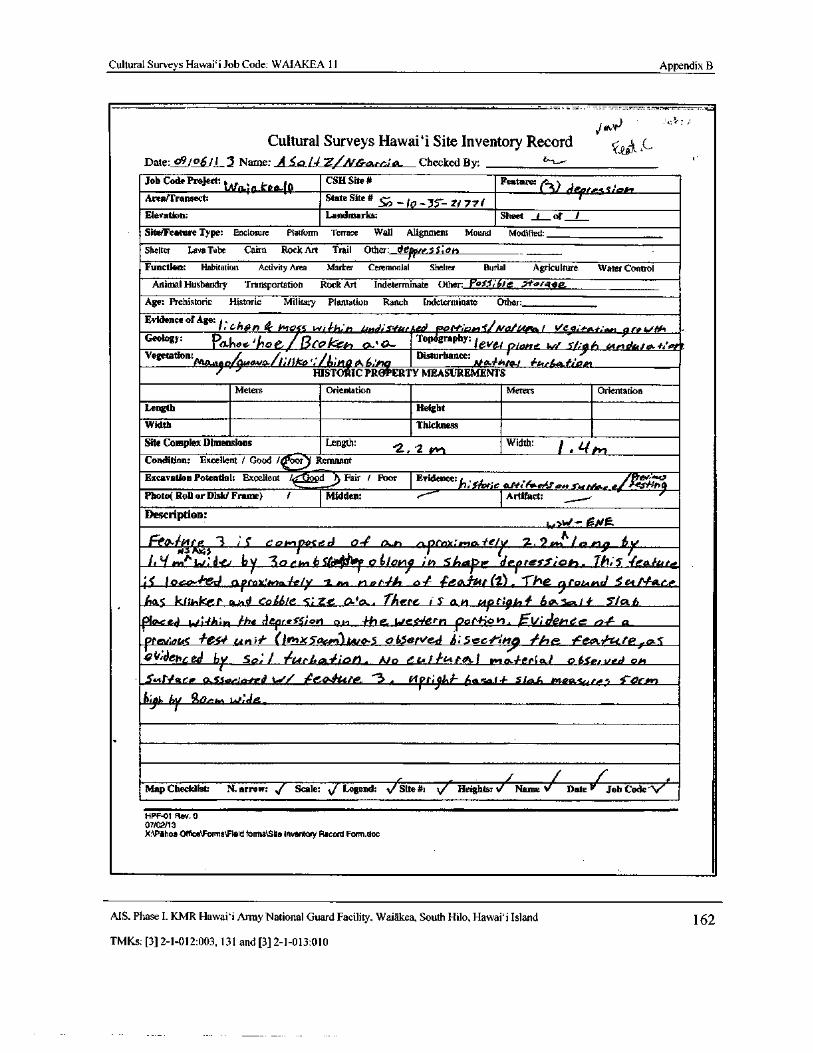
Cultural Surveys Hawaii Job Code: WAIAKEA 11 Appendix B
Cultural Surveys Hawaii Site Inventory Record C--Date:Date: 09/ 06/i I Name: A5,0/ I Z/ NCrz , ct Checked By: r" i.—"
Job Code Project: CSH Site# Featurep
Areafrransect: iNnyfO- p
State Site# _10_ 15._ 2/ 77/
C3 T rr sic*"Elevation: Landmarks: Sheet I of t
Site/Feature Type: Enclosure Platform Terrace Wall Alignment Mound Modified:
Shelter Lava Tube Cairn Rock Art Trail Otter: d_ pte..3S; oh
Function: Habitation Activity Area Marker Ceremonial Shelter Burial Agriculture Water Control
Animal Husbandry Transportation Rock Art Indeterminate Other:_ Pa$5, / e > 1otagg.
Age: Prehistoric Historic Military Plantation Ranch Indeterminate Other:
Evidence of Age:liCMS
h1j& hso s wii-ii...") LnedisWrrjed joor-:ams/va/A4ee f ve ,, t:pn gtrcc '
Geology: PeiftoG1noe., Oro h a.rd- Topography: levefpone w/ It,.h evendsttwf/ e/?Vegetation:
futaNla / 6Disturbance:
04wavo-/!li/ Ika / 1 riq Ab.'nqq HLa/ c1 / / atboktivatHISTORIIC PROPERTY MEASUREMENTS
Meters Orientation Meters Orientation
Length Height
Width Thickness
Site Complex Dimensions Length:2 Y 2 /
AnWidth: 1 . qM
Condition: Excellent / Good / our Remnant
Excavation Potential: Excellent I odFair / Poor I Evidence: r/rim:/ic.. t# . 70„ 5,44losrsornfc ce/ A6 c
Photo( Roll or Disk/ Frame) I Midden: I Artifact:
Description:1.; ‘•/— ONe
re044+ ;s 3 ' 5 e os..p€ d a-' Gx.rt ofe x: ryta to/y 2, 2 AM I®n9 ifit ti wt^ : d by 3ocIiyt 6S6 o ttoi ;h 51iape [derrev,; oh. Th; 5 1eahtte
11 l oc - d arrovzsid a'efy 1. An Al erfli l4 feOlbet( 2), The 9 rot.,end S ct./ tfaae,e
Acts kIimice.r oa, d Co66/e 5; Z.e. Ara.. TAere iS am ctP9r; kl¢ 6ok.so,,I¢ 5'/ 46
placed 1,. 44ir; r1 the rleftreSS; CM 01 4-he te/ Ciiierh pot-Hail. , 1/ idekree 1, a
prey:041 # ei t unit'" (10+x5os.r) tetio-S o dSe, ved ,; 5 e61-4-1, / he fea. zc/ e j.cx satdepced by $ o;
if tArLu.' i0l9. Ala eu/ ktlot.I wto.ferial 0&Sertied os+
5.4,NeaGP G Sor:corAi t./ ? 40414te 3 . l4ft;9s 4ssa.f4- Sfo h ellaalutel` S`OCAsn
156 by go,„,, t r de_i
Map Checklist: N. arrow: f Scale: J Legend: / Site#:
Vi. Heights:/ Namei Date/ Job Code- Nei
HPF-01 Rev. 0
07/02/13
X:\P6hoa Offrce\Forms\ Field forms150e inventory Record Forrn.doc
AIS, Phase I. KMR Hawai` i Army National Guard Facility. Waiakea, South Hilo, Hawai` i Island 162
TMKs:[ 3] 2- 1- 012: 003, 131 and[ 3] 2- 1- 013: 010
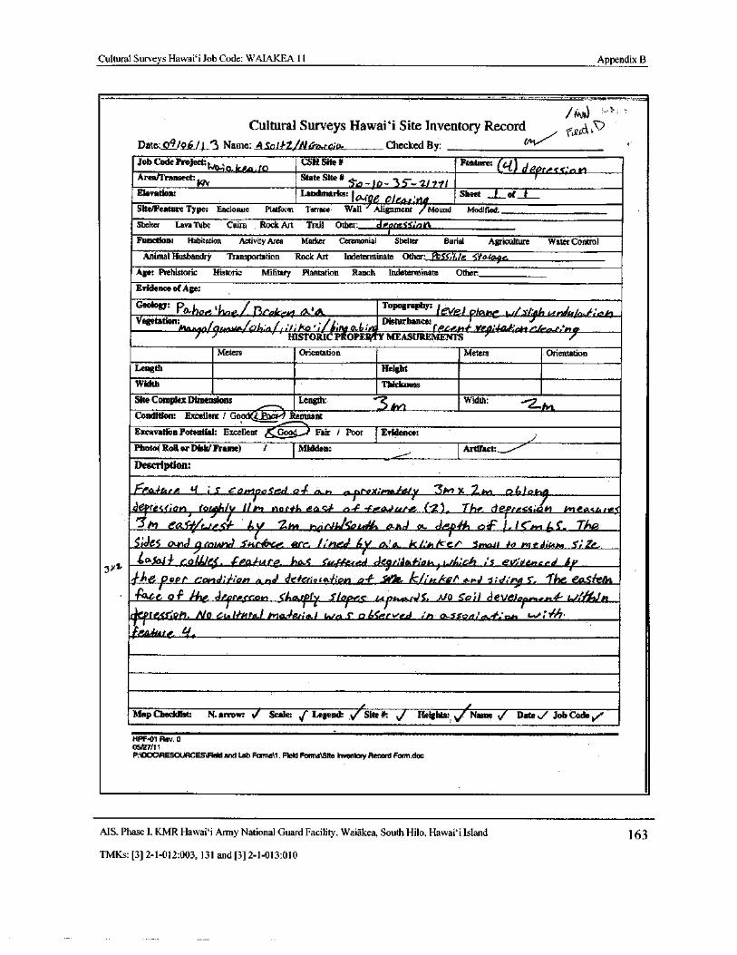
Cultural Surveys Hawai` i Job Code: WAIAKEA 11 Appendix B
MSS
Cultural Surveys Hawai` i Site Inventory Record03,; 7
Date: o9ip / j_3 Name: A Sol tZ NGa.rc;o. Checked By:
Job Code Project: w04.0. 10A.,10 CSH Site# Feature: 04) d P, re. 1 S: o v!Area/Transect: State Site#
Ylv 5A- lb- 2/ 7trElevation: Landmarks: Wee Sheet I of
0/664: 04Site/Feature Type: Enclosure Platform Terrace Wall Alignment / Mound Modified:
Shelter Lava Tube Cairn Rock Art Trail Other: dPpttiSSla t'
Function: Habitation Activity Area Marker Ceremonial
1
Shelter Burial Agriculture Water Control
Animal Husbandry Transportation Rock Art Indeterminate Other: f'bcc;j/e 5-to rale.Age: Prehistoric Historic Military Plantation Ranch Indeterminate Other:
Evidence of Age:
J'Geology: PO-hoe tt ' / Pl'lt/cei/ ' Topography: let/el plane W/../ 1a isnd[e/ oLf-ioh
Vegetation: Disturbance: t
0/ 91gttvolaij;l{I/,WIco': f iit gpoLt; P.GPh1f:, Lod HlJP ' rnQ
HISTORIC PROPS Y MEASUREMENTS
Meters Orientation Meters Orientation
Length Height
Width Thickness
Site Complex Dimensions Length:, 3„ lWidth:
Condition: Excellent ,' Goodtt Remnant
Excavation Potential: Excellent &..- G-O-D Fair / Poor Evidence:
Photo( Roll or Disk/ Frame) / Midden: Artifact:,
Description:
Ft!ad-ura. q ; S cowlpo5ed o-/ ar n oprox:mou/e./r 3wt x Zwt b1:,1ohq
derrGss; onf rfl / 1l rr nortt, eac o-F - tleirAr ur, ( 2), The, Etef+resslczh L+'teexsurrt
M eaS r.,/e sf Sr 2m nomikoi.4 and a. der% of ICA-,6 S. TM
5;de5 and 9lnrnhJ Scclrbue, erre. /:•• red ! Js& k/.e, t1e/` 5h>0/ 1 io rnesiu4.1
40,504/ cod/,lc5. feO trfe. has cm-yr-red del/ Me i:1m 1./ A; Ch ; 5 evdenced1/
LitJ oPr f tdiiian and deieriot44ion of slit A-pd s; d. r9 S. ? he easrent
Face of ihe Jfftess on Sivxtr r Siere' La pa oad 5 : M0 SP; J deveot
nie41. tv'//k'rt
ri 7teor:oh. No ern ltRCd.I/' IGL P,Y1leR/ 4 p c a 6Servetd .' n a d'SrOn' a - 0I1 -,/ t I*•
feeaArt, Lf.
Map Checklist: N. arrow: Scale: j Legend: / Site#: J Heights:,fName S/ Date ti/ Job Code yr'
HPF-01 Rev. 005/27/11
P:IDOCSRESOURCES\ Field and Lab Forms11. Reid Forms\Stte Inventory Record Form.doc
MS, Phase I, KMR Hawaii Army National Guard Facility, Waiakea, South Hilo, Hawai` i Island 163
TMKs:[ 3] 2- 1- 012:003, 131 and[ 3] 2- 1- 013: 010
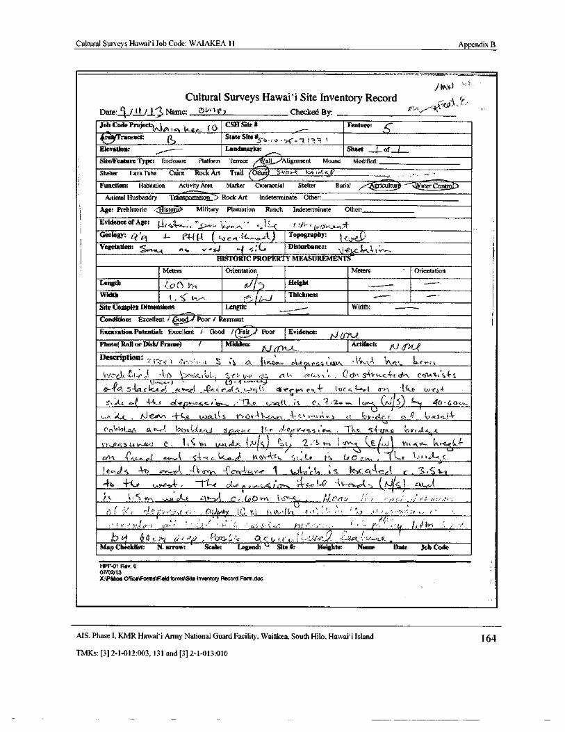
Cultural Surveys Hawai` i Job Code: WAIAKEA 11 Appendix B
j4/04,)
Cultural Surveys Hawaii Site Inventory Record4(,
Date: 1 / tl /J Name: Dti"'t r) Checked By: e'
Job Code Project: e-t ke,. i J
CSH Site# Feature: 6ti ranseet: f1 State Site#
s6JSo-, 0-•> L t' S
Elevation: Landmarks: Sheet ( of
Site/Feature Type: Enclosure Platform Terrace all Alignment Mound Modified:
Shelter I.ava Tube Cairn Rock Art Trail Othe $- 4- 0 a-c. 4' c c<(*,' i
Function: Habitation Activity Area Marker Ceremonial Shelter Burialgricultur : Water Contra)
Animal Husbandry `}' rbnsportatign Rock Art Indeterminate Other:
Age: Prehistoric ` Elistorr Military Plantation Ranch Indeterminate Other
Evidence of Age: { q ngi-' rr S Y+'+ t + a" F c i3tvge,, Y Lc CJ'- r .! J rtsna
Geology: a' Gl4._ eel ul ( t-,1 c.. e:( c,_,,.. A) Topography: I';.
vegetation: u
a s v tea.( s; i-rDisturbance:
t,.....
HISTORIC PROPERTY MEASUREMENT
Meters Orientation Meters Orientation
Length Height
Width1 . S--
Thickness
Site Complex Dimensions Length: 1
Width:
Condition: Excellent i .60 Poor l Remnant
Excavation Potential: Excellent / Good /( Eair Poor _ Evidence:
Photo( Roll or Disk/ Frame) 1 Midden: tl ....
Artifact: , )
Description: 11: 1`. i 4' 0,-', itvuen.., -- f Er. . lc-,• tt
C
v _ ` .
0.(5 S4 ' 1- t cs t Cccu 4- S4V , C.. f, r _' f i;
Jti:;,ttail (
t, U, t: : Vii., f r. t_ ri 4c st g
0"-e}} LI tt.r) ' g 9.,. s- iJ
61, S- Zt.c. i.C. 01 A_tr- 0t - c4cef.( 4 L.,—) q,(
k. 611` wt ( 1. i4- 1, 00.,'[;- c>,1 ( 3. v‘ ` t"i. e r.o-rs. t
v
st,IA4 c.,( 4.A..,.* a(-e() Wass, rloy , ,• 71...o t,.)( l iS e, - 3 2> ,t. [( 0- c 5)
4y1le..,4o• 60 —
L. h ; CC . Ai' A. + 1Q uockt:( S V •0fiA1-.•.eAv ' t' et,‘,,,, r._n. e'i Yretc' c/// 0 -° 3mak.{^ t`
0(-00i,2 Lo,6 rh& bOtt,'c - k.,u1 Ze- ra< ] s, r` , 41'GaY-4SS1..a,-. , Tks. S4 hvtde ki t i
1--... s a :. t r . { 1, 5
Iwttr„ ,, J1 S) tit. 2.-s s, l i r, stt,._ . t- 4-
01"1- .. l;.. r.(. n.v..,%1 c"t U'-..c vk Vt, A1,. e Co C C Kt , t 1 1"' 9 e i'L:_C
1 eC161 s 4 c .._eJ -{\, its, -(-ec - ity--e 1 i,s. tL e S. Icsc: ci.Ace r , 3, S 1.. 1
r( '` vn , tet x . t41t.- C- ( 0 tS' q_. i !J!` t7 er ,., f r•! a
iAddY2
y1. t • i v
i..0i..
0i ;_'' . i
I ,' 2r' tIf, 1,
11zMap Checklist: N. arrow: Scale:
w
Legend: `" Site#: Heights: Name Date Job Code
HPF-01 Rev. 007/02/ 13
X:\Pthoe Office\ Forms\Field forms\Site Inventory Record Form. doc
AIS. Phase I, KMR Hawai`i Army National Guard Facility, Waiakea, South Hilo, Hawaii Island 164
TMKs:[ 3] 2- 1- 012: 003, 131 and[ 3] 2- 1- 013: 010
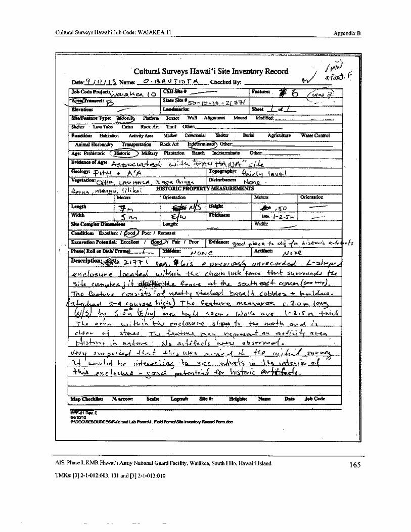
Cultural Surveys Hawai` i Job Code: WAIAKEA 11 Appendix B
Cultural Surveys Hawaii Site Inventory Record 1Shit
Date:/ J, Name: 0 ( A J T 1' 5 r A Checked By: gsri/
y
Jab Cock Pra ject: Ot i A d
CSH Site a y -- Feature: 6WX3A ransect: State Site#
ziElevation: Landmarks: Sheet f of
Site/Feature Type: ip ) rtt i Platform Terrace Wall Alignment Mound Modified:
Shelter Lava Tube Cairn Rock Art Trail Other:
Function: Habitation Activity Area Marker Ceremonial Shelter Burial Agriculture Water Control
Animal Husbandry Transportation Rock Art Other:
Age: Prehistoric r,FTtstoric Military Plantation Ranch Indeterminate Other:
Evidence of Age: fk 3a tct 4 { C..,> 44,, 106"
Geology: : ei" t' 4 a A tp Topography: to i r{ [ 1e U a- C
Vegetation: o{ * u.:¢rot a a4-, i 1.+, sem
Disturbance:
4t,+t*a /rty A,vi r.` o4 ilki. i HISTORIC PROPERTY MEASUREMENTS
Meters Orientation Meters Orientation
Length ligJ/5 Height
Width 1CouThickness 1- 2 w .
Site Complex Dimensions Length: Width:
Condition: Excellent/ Poor! Remnant
Excavation Potential: Excellent / ,)/ Fair ! Poor Evidence: `3 Pte c.e -$„ t - 6'+ l„
Photo{ Roll or Disk/ Framel__,_L__.... Midden: NON Artifact:
A/ erne
Description3 ,” Z i" 41" k Fe,ok. V'(oJS fla' pt%•tv+cakSey NvE' G.Br.,{_ G Zti,.re,.e,, t0514 t e [ csc..A. I G{. wAU: t%, -- c,c. C,dtcu int 1.t vac
1-1:ckc'e - 1. 1/1 4- sc,, irr.«rh , j-tt.
14 c of, r< i' 4- 44.4.4404-e_ c4- 4 cr.4- sena-- i' ei 4- ccjotal4i eA rama s ' rvw44- 1 s-(arc. { ! xa K 4 A G( 3bb{e. + 1P. w4GtQra
a, rc 44.4..4k c a u_tfs- 1 i rti) c. . o w. ( u•4.
J ` lj, o+ f Mi c h:t k,{ o cw. 4 41114 ave 4- Z. trl, ± ta ie. 4
i e L4 v- r. L.. , - L i K 3 to s r-t c(, ciKat I +'tats vuo- 4' Q N ra !
r
4
C`-A-!
F 4+ a-"t S'{' P.4, ` TL.z,
i `'
i-
avl ,„1
fy
0\ 44.. V'-e ev«®loz,„„ ' at u e-/ C 4i c rt t Via,
t,:` it 5 t t - ° t - u,W(, 0 A..c.` h- e^ t . C' S
lbaJ- e-u eh S
l,
reV,.li
ea G/
t
r .
kkeVSvnvpatu., '' UJ '(1r, S LJ' S mrscr ,. p, Tw /+-ti.4.. Yt'-
a ( t > a t o4 kp ( 1.44-e v-vs - a VLS --r to S-- e tn.3{Itct"{5 1:\ n ` A-A^ ,.. t vt c v t a4 0
t,p s t+ut.A. -- c o, 0/d r.:J --{trr tit C oti c `" e">l'
Map Checklist: N. arrow: Scale: Legend: Site#: Heights: Name Date Job Code
HIT-01 Rev. 004110/ 10
P.SDOCtRESOURCEBtRaid and Lab Formai:. Heid Forms\Slte Inventory Record Form.dac
MS, Phase I, KMR Hawaii Army National Guard Facility, Waiakea, South Hilo, Hawai` i Island 165
TMKs:[ 3] 2- 1- 012:003, 131 and[ 3] 2- 1- 013: 010
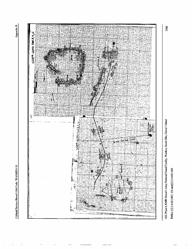
I
ii r 7 ]
fI r .
1L{ I * -. r
i
Lir },':-.4_,:7; 74-2;_,____,"471- 74-17'14--7":4-
I
t
7:
La
moE * dt- i `
7 . .- i:7'*"
14:17li
4 LtP :i
i4::!.. r.' r
tF,a' 4i-'tii_ 141. 4--' V--f Yti L
fti '' •t :
71-74, ie " - i- -,-,' . -''
FS-
1 ° wC—i.; '. '-i.
ma 1-.
FT' 41_-i
1 I " t1F7 " tJf
ii-«,-
F -, Y 1 '{1 a `}
P -t ,-
r + r 11r r- g 1 j- x I.:
er * •
4-
1 s l
i
t
T!-t '-
1° 1 - i i. t-' fam
r-, C.. 17. 7-•,•-o _r f
b
c.-
t' f -----:---.--,-.2- 7. x4 D;
r
Jr 1c
i S (
t
yy *`
f s
4 M
f L f rl -,,
se n l Si z Ayy
o r
3cin-
CVIII-.r;''''r..'1,7 ITEV.-.7:.-; 7' -,-;,, 7,7,17 .-_.....,_.,.,.... .,,..,.,,,....,,,,_,,, ,.,,-4- 4,,.. i..L.,-'-':.---'-`,.
gl4
F
0.
pj v.
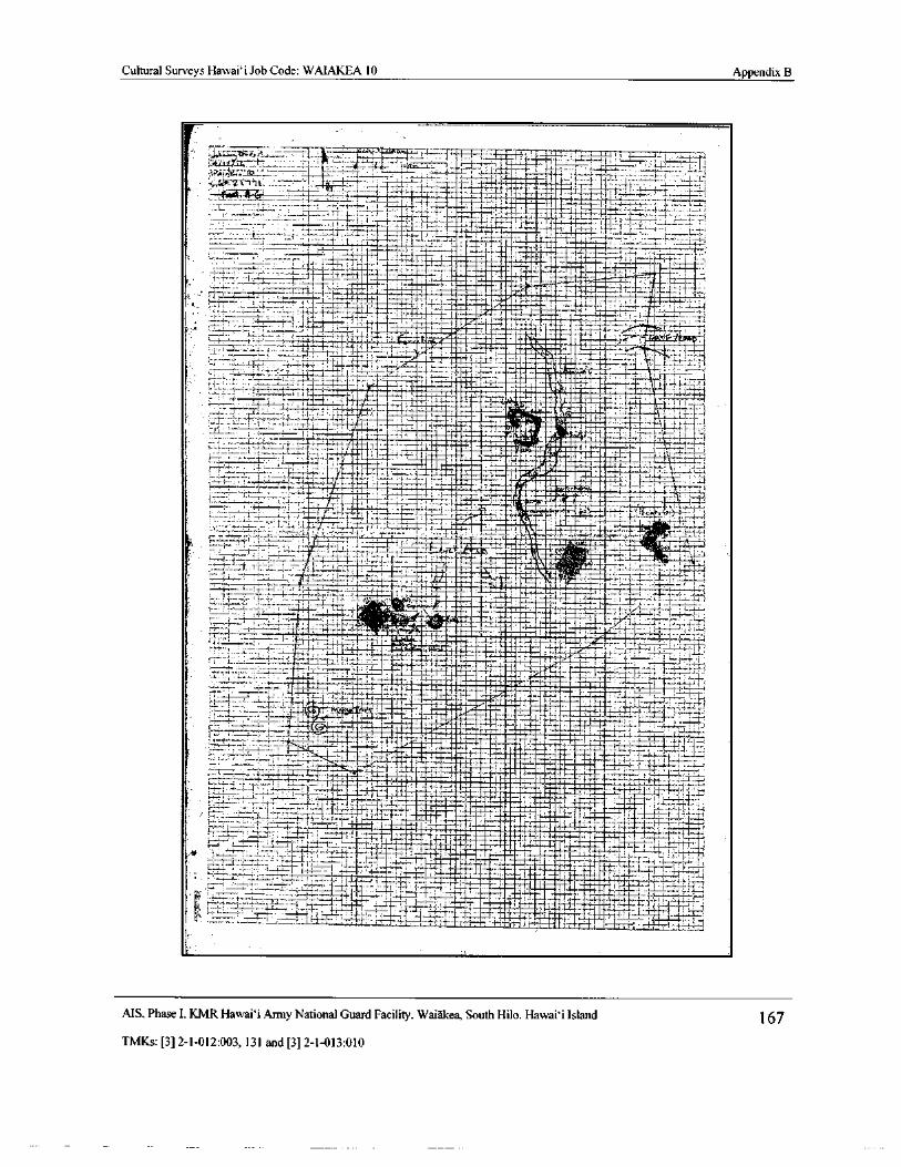
Cultural Surveys Hawai` i Job Code: WAIAKEA 10 Appendix B
br-,, Yg — h,. , S' F r t- ri
qFf+ * ,_ g • c4 , n a-- ii t .$ t
4--,,,:.- 4
1.,..401-,-4144Ni
1 : J #
1t
4afid
E 1 . d t Imo. g ' ta
r f i:.. ,+ 1. -
T" g v
1 t.
4 --ri j ''. 17,;:-.. fl '•_:-
1 - 1E-- fills C_
i 4 Iaii. ,
1,
1 Ij- r m }dim
w 4 .. r I4 { I1.:;,,L; t. W .'i`
w... t.
3. !
E _ j'f _. 1 ' t 1„$. 4,,,,i$3 -
J,
tt
S--, J3.3 f ...
1IE43. 3-. 33- H- 3,31- 3,11: 3-' 3---:f vy
t•--.
1E ! E maw1 -
m`. 1; Z
1 4r T1
1-.J:-
T_--
4I,:-_-1-
7.
14':.-7
a
a pp1I
1,4
s fAWart;
i_r
t y-- t S - f} K i
i !
j;'
1- :^ mow i {-'
Z
i1 z• J
1-
1 - s- r ' 1 II4 773 rte.
1-:
1110
4 ' I-. i :
111 NM1.1
it_ - ice„!
p4 - ma
r'_`
S - I `'++ I'"., Al-.-
i..,-.
1: f+, x_. amna it
r {
I* f-, ;$w
14
I• t' I ,- r1 _
f [ ' 4,, ,;
3_-5 ! 4. I :444- 1--,
d_ j . 3 1 .
4
a age 8
T._
I ! e Fir,
1 ! 1_" T`_ > t ---- 1I—},, 1,.. 1,- -.
IL:._ .E 1-!'.. 61, i;', 4,.,.',-..41=III u ,
AIS, Phase I, KR Hawai` i Army National Guard Facility, Waiakea, South Hilo, Hawaii Island 167M
TMKs:[ 3] 2- 1- 012:003, 131 and[ 3] 2- 1- 013: 010
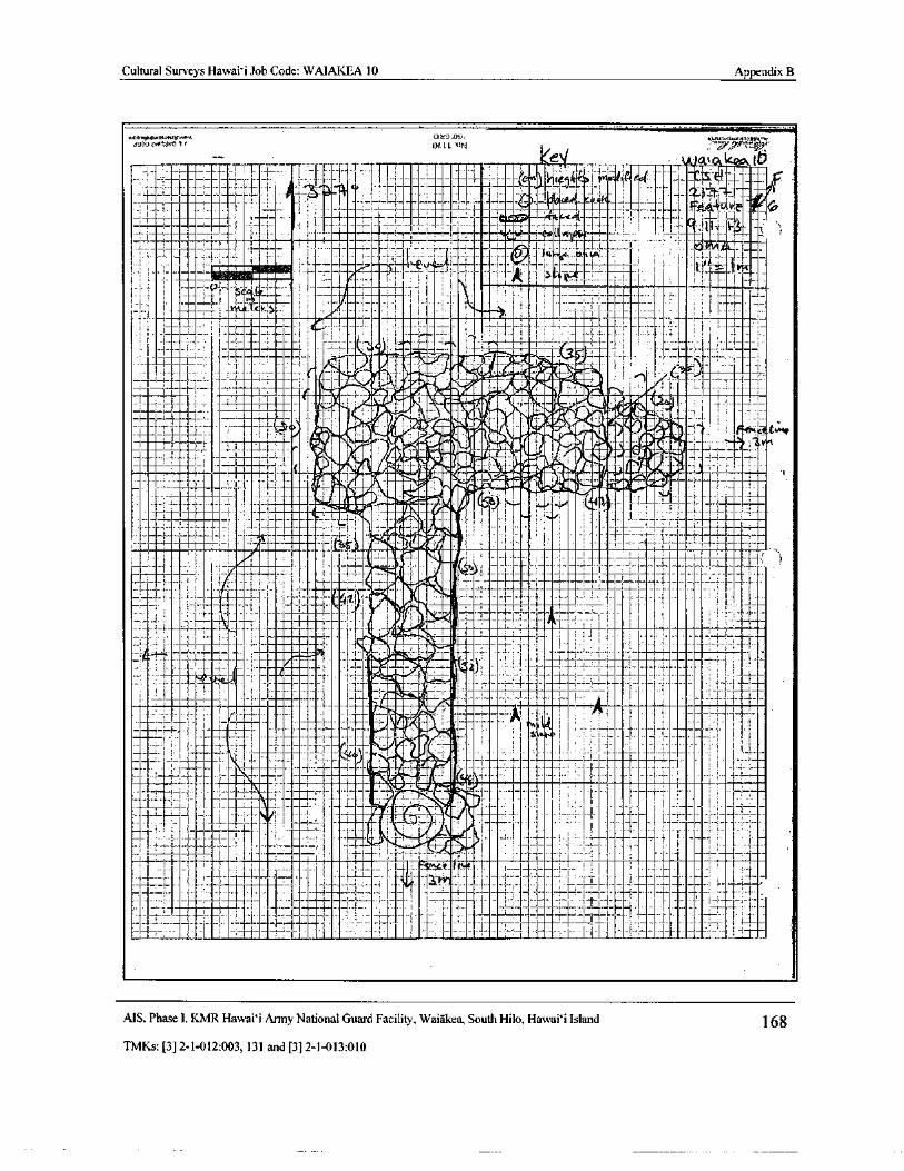
Cultural Surveys Hawaii Job Code: WAIAKEA 10 Appendix B
0......„........,,, or:.3-. w.i, y_ n.al , N.4T' Y.
i33 0i.?ritr/ r 0466 ON 7
1_ ..,_,_. _63,..„. 1,7i_.4‘
1.j._•-iti.1' : '' it:C _ , i riti li: 11 F 'I
IIpj (' i
1- 1 1 — — 1 )
a
7
ff Scat 1
I
gbilation®
i
21.:,-
i' i ' i61140"72,11 C 6,- . f4k3m
cOF,
11 , ,-,,,:-......
141., Ai ) i , ' 1 i H-
i- - e 1 Ir__ , t--
j_ l r I _ l.
l
ti iE :1 i 4i1:7- 7--
I !
IILiJlh 1.,•:-', 4-
1
1
11 _ 111I ; ' #ral
1
t 1I L T II-
isitiuklibrailiiiitigis- I 1 a-
ILp i__,:......! .... i.e, 1.
1.1,
0.-
41P411:k.iur i_ 1 ! J;_!,
700! 4. ! ! ' , 1_ 1 i
1 ' J
III'r`I 4 r I i • _
f
i . ii 1
k , i l1J I.
1;': .; 1 1 j. ;ii1
1.. -._.
II 1 a 1 I 11 I
MS. Phase I, KMR Hawai` i Army National Guard Facility, Waiakea, South Hilo, Hawai` i Island 168
TMKs:[ 3] 2- 1- 012: 003, 131 and[ 3] 2- 1- 013: 010
7Cn2:1,4:11:17-4'.-, a—
COjY tr:-; j :' -
k
7.---,-,,"•,-7,
77:41" 177-777T-++!__,'774' `
a* ,
J Y- r" t—
t
iQl'.;..-4::;:e4x 4 8
7 - ° , --ti-3-.,--“:„4...i.4.14:-
7II -;- tt....
a ttA
i
4- 1i f
r ;;;-;-i
i17 Y i+
I {'-
4, 1- -{
Tt4
4 - A-,r.._-- i
fi1 i-11:; .- - ._.
a -
artrNji-
f_S ` jl
D:
Tt1 1 - 4-,;,:::t;.,17.:74111.-H-4. i r4"" I
IYA7fit* - +
mfA-ti y
cczTA
t - i' s
A
t" ta -•t
4 ,
x4L. ,
eyr
r+ -t-- a2hI -'_?99 -
r '
IYi 'tTT
oba
r
ate .;
11 Isar11, 1'
o
or
i }
T - r4. . I. .: 3
1:-. 7:L:-H-+4
r
itide_i
f+ q
ca
rd r i
r 47.k.4.77.!:::::',....:::
47.',477,oM-7. 4-1-- 4:7,71,41.:. 74: 2: 44777, 4..:t
iirqC¢
irt
ieQ
ais ,..
o.
N_
ipoFL.a 7 44--,--H-T.:: - rz
f^
yri4 i — ,
r
Cultural Surveys Hawaii Job Code: WAIAKEA 10Appendix B
Cultural Surveys Hawaii Site Inventory RecordDate: / 6/ IS Name: -(. Kr Checked By:Job Code Project:
ta_A A bCSH Site#
oos Feature: e, o
r
Area/Transect: Q State Site# , ,- i t
Elevation: r Landmarks: —.._ Sheet ti of 1Site/Feature Type: Enclosure Platform Terrace Wail . Alignment Mound Modified:
Shelter Lava Tube Cairn Rock Art Trail Other:
Function: Habitation Activity Area Marker Ceremonial Shelter Burial Agriculture Water Control
Animal Husbandry Transportation Rock Art Indeterminate Other:
Age: Prehistoric - Iistoric) Military Plantation Ranch Indeterminate Other:,,_,
Evidence of Age:
Geology: Topography: r `Vegetation: Disturbance:C•os3se.tas ru,rol , vvio.. to'. n a. IAI1
HISTOI( IC PROPERTY MEASUREMENTS
Meters Orientation Meters Orientation
Length Height
Width Thickness
Site Complex Dimensions Length Width:
Conditions Excellent/ 040/ Poor/ Remnant
Excavation Potential: Excellent / ' I Fair / Poor Evidence:
Photo( Rod or Disk/ Frame) / Midden: Alen Artifact:
None ASr( Aim)Description: 1 \ ry, p t r Alt (
tIAS. . 00-3i:S\ c-e^ CC Pr. til , 100,.:. , 1_ .
YIiti•P\ C Ytes Alt A`r. !(P
t e. 6?.noi7 p \_)/ Ngtco ;\.. etdt afr*r
Peak t^v-t, A — f irc,, 1 'ottt lnosa VV
p Q ' etlr{Mj
t^ tnJ a ` y+1, © De ,- ic 1s
pass a r. t thio.\] IA See iMell•-e1S. N es-Y N f a' vt re t, • TCtnc,.rl
2. et vet )(1.);/.. g" Xtr.t. 2„" I e.ve.\ ow 43?
FeakVre 8 — 6+olt,, ped i ( 165c/4-1„, e A. S'ke.,c_k ) aF bev1,5e61.4y s Q<_ G. rd ad,cl oloatty Wit:I
e: _' r t .( h e ``- . GtsasC' t? C,G e
P Al, 1 vi44el
ttert- itn kart lr no e5ct o A 7 d ep
ock• yY16(. a,-
ply vl•\ s' ,: e. l" / 0,e.) e dV\ erit t Te+ 1I No AA
Cf, co>r elc_avor i l5 L:
1}
W: N:
eeklv( e -- T 4\Aot .
crrr} 4,-Y vt kC 4^ r'.St J. ',SclAo }--ir7 S v S c - revr,r.A
t v GsP4t4S vY Seur ;] e rN r ark aa 5r L. . C" tiwit for w\
Ccgos,) CA.441Iis;o , P Rrlitctvt, eY.e nv nov\ Wit.
Map Checklist: N. arida,: Scale: Legend: Site#: l
Heights: Name Date Job Code
HPF-41 Any. 0pp07/42/ 13
AP!Vet!, , 1 \\ ZJt ' 1'1/ CC 3 ' ScttrC`- IcS ,\C 10 \
X:\Pt hoe Oftce\Fonna\Field lorma\Stte Inventory Record Form doc
MS, Phase I, KMR Hawai` i Army National Guard Facility, Waiakea, South Hilo, Hawaii Island 170
TMKs:[ 3] 2- 1- 012: 003, 131 and[ 3] 2- 1- 013: 010
mx
M.
4Pap ,., r adJ. C: 1
tie
V .. II I Illi 1 I 11 II 11l } -" II 11..-I
f In
J_ I - 1I_ Nli I--,;
I
11 , t 1 1---"
t1 1 : ; I 1I 1 1_ , I,I i l I - I
J-_- I E. 1
1
1 I OI T-1. I
1 ._. 1 I
1 ' ! i III lit- Ir* I I I _ f i _ L.. I t:
I }I i :. i ., I I I ---__
1I
I , 1 -_
111 I "_ • U-,...,•
I . ff..-- t tLj-
1 I _ I—
1 1 - ; I : I
i i-I s 1 I 1
I
i.
IIc7 ,T _
Ei51
kaIi:; = 0
i o a .. _____.:i : i1 i 04.
I1i4
I I I . 111" '-
I1 > i H. `
1. r: a
i1I_-.- 1 1 .- 1-'t f
1 " 1 i- -- v.i..•Z.f..l. 3.` }
I..
ti i^ - 1-1-11- 1
UV)
i II }}
1 1..
w .I M
I _
j • 11 - 1
r
I--.....,,-4....0. 1 • 1 - .. 1
1
r y
If 1-•.... ( I
1V'
I
1fiv/ 1 _I I ...
1 . AC,I
J
ff h{
anI I.
t
C7 •M
o
N1ilt
I 2911 1 ; 1 I II
Z
II II1 H ; 1 I I , 1 fit+ E; , 3
0, 0 xox
U
Cultural Surveys Hawai` i Job Code: WAIAKEA 10Appendix B
Cultural Surveys Hawai` i Site Inventory RecordDate: 9 /' / 15 Name: 1f-.T Checked By:Job Code Project:
LJAIA kF-,o. ' G9CSH Site# S Feature:
0\itt e..) Dig
Transect a State Site# a 1
Elevation: _.___ Landmarks: Sheet 7 of 2..Site/Feature Type: Enclosure Platform Terrace Wall Alignment Mound Modified:
Shelter Lava Tube Cairn Rock Art Trail Other:
Function: Habitation Activity Area Marker Ceremonial Shelter Burial Agriculture Water Control
Animal Husbandry Transportation Rock Art Indeterminate Other:
Age: PrehistoricIstor Military Plantation Ranch Indeterminate Other:
Evidence of Age:
Geology: Topography:Vegetation; Disturbance:
HISTORIC PROPERTY MEASUREMENTS
Meters Orientation Meters Orientation
Length Height
Width Thickness
Site Complex Dimensions Length: Width:
Condition: Excellent/ / Poor I Remnant
Excavation Potential: Excellent / egad> / Fair / Poor Evidence:
Photo( Roll or Disk/ Frame) / Midden: Artifact:
Description: x. 1:L0,5604
1 lToh tA' bWad, lQfiSe avt ' ti' lql/1 C491911'
1Sjsa c. in q. Li CALA r 3 r S \ Wit% i V6e\ Ow f'o . Caw) Ori 014 S a j r 4SSi lrrr!•. J J@ti1r1G\ 2 % M. 1.^. 1 y 1 04i-cocA'S
w+ r FP AA/- C e S e kwkejel La\,ei 6,.\yc, vtIac. 2... C.nrA( SP .
rA54 tc' Sc eve 037 kr-eek
A tL , gvA c Dvl rt." b V Q i 1Y c>t /Yo rW i. Pi^srt,
6 r-avlol ii;osAJ
eaii GlnwtvG..-c 4 elr.u+ve c; ov,
1ol ; km Fe"- k-. P
Map Checklist: N. arrow: Scale: Legend: Site#: Heights: Name Date Job Code
HPF-01 Rev. 007/02/13
X tPahos OffieeTorrns\ Hold lorms\Site Inventory Record Formdoc
AIS, Phase I, KMR Hawai` i Army National Guard Facility, Waiakea, South Hilo, Hawaii Island 172TMKs:[ 3] 2- 1- 012: 003, 131 and[ 3] 2- 1- 013: 010
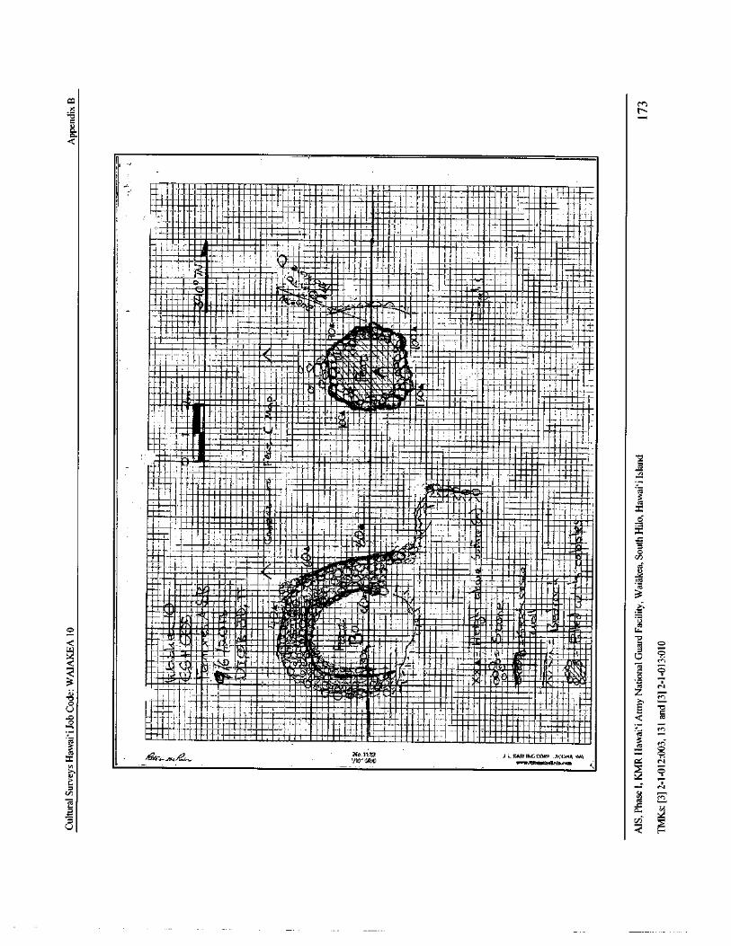
caM
x N-
ca.)aad
r
j 1 N.I .. warp I
q
ill!Ngr q r
I .. wr•®r T 1 F1(
r7 141. r -{ I- I
1 I _ irw -.1 au mq i , I
q 1 I,
r r. 11,®
qq® I :
I { ®.{. I T_ . _ I _,.
iceq -
rgrN
ri- •• r'. I_ s ; W_
CiT . I aa._ , J I t_ 1 Fri : , 1 l
esq ` to I
BI , r
r
ai- a
MIN MO
111-N. NP" r! 4 I i a. ....r
ri t 1
fT am r lI. "-
i t m ti•. rLI
Nr
RE N J—., rI 1„,.. 1.2,..: 411., l r i1_. 1 -
i--- SIR' 0. C 4•At 1Lt)la_7.. 1. ... Ytq qq 1. ... r q
fin
Ili I , ._.
el, f' 1 1' t., rri•g,La ti 1 I.
IIE
rarq®qr 1 li err+r,. 1mamar {_ I N rr•. a r S a -T x a • si
r•ssa t. 1i I .—
I1
NEi11111111Eu..
N R i i ; r° rr. gra,.
rWf
a•g27I1. wq urea. ... . FerWl-ia l_a. '- I ' 1
1
rte_{.
u.• au • 4 ... I T # o_,1
r..rra 1 N CI
illIIIIIIIIIIM 71-
1
jT i
l,L; I n.
a au
1 - 1_
1r
T
Nq® qi i I f- T 1 • •.• au...;.. TAC
N _.. ; I+ I
II ,
T , .-r a. • , -!'
r. a•a , yM 0.•,,
NN pad •
err , I
I : i_. c@
NWrNiiN rI_ 1.; 1 , . . r
1 I 1
C
I , 1r 1 I .• 1 • aq_
iIST' LI
1r
1' q: .
7"m
I
t •
flawNEi.ii1 WiT. , ,
1h ®
QD.. r:::` 1 it 1 4T
rs r® .--` tI_ {
t- tea€ ILVDluF
c,:
O
IIMIN}r r Mus .{srsauuL..r6ri. r.•• , i _ E 9warp• reN•
1111.,•••••mis I ,:i.„,,,taz,
a.T•
vorqNuq&illitte 41 iurae a.. wai FirIa o
G V_ iw iaau-.4Iru E . 1
iisarim
r` a N• i grR: i•r" • rs,
Q I 8 .. T `• 6,,,,.. 6i......,F 1fs!• moms_
twill1_.:, i a uf" riiia i • o
r
MI: CrlwrN '_`"` R orb qq _ iiff• L7ci 11$. 11., rrB NN i ' d r
i aa` rprrl sa 1 rail/ a
r11@lia o
1
agq•r• t>« sa. 1. i+L , r. a1 a , a
3Ioil pp' inial r• L9,ti , + u... d®:JNI. roN• r ev
C 0•.-- 111111• 111= M _ a•ir1i/r' r i 'L i® in• iNq q• i z
o1_ T { T. _ ! lam_aar
1 Ir ,a•® UI. _ it: E w
p NI .r J 1L ' 1 ... w.W
i_IN 11111®a• d
O
L
1 ... N isi.
iiiM_
3
mosions EmuN I a... rr•sgau•a•N ogr ia•rraaa I' lI w. Nq . 1_ iM
Nc. 111p y:,. rmar.WO C.O.,.. 1cOwa WAT"coC
e4- / 61
1/ 10* MD locinckittiackeicbccesa 4,cn
E.' N
gV
0.,
I
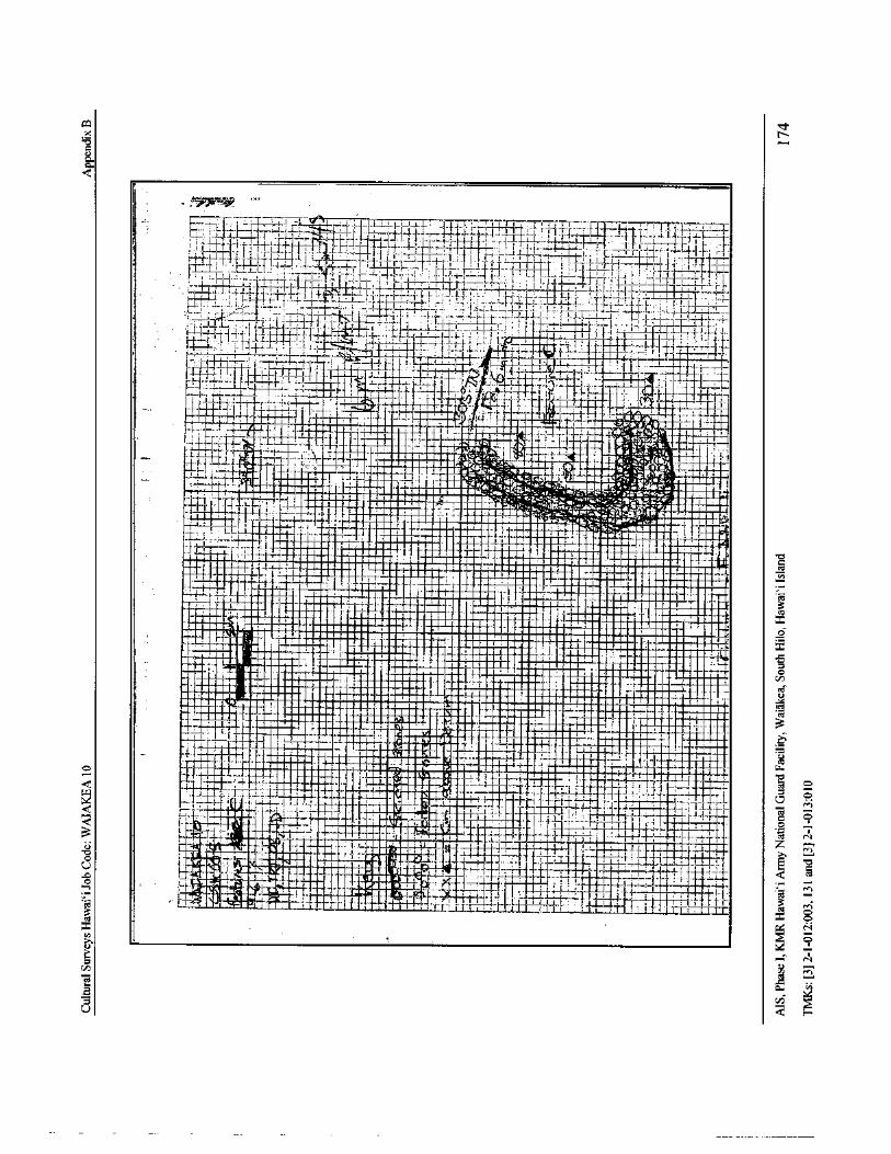
coX
a.C.
r
I.. 1
t
iTHELI i I { I i I1
4 { 1
I '" 1 '„ 4„. I L T - 1- , 1 . r, ----
1-{-- 1
i--? I ) !i r ;
I
J.
1 ` i I ,
Is I - 1- 1- 1_'- 1- 11--ir a l 1 ' ,,,
r
i? I T, 1-- i- I
i_ { TITi- _ J-' 1f1
II l' I 1 ' I 1 - _ —
I
1IIi___47.. .
17 _;
i- i-:771- 1- 0j 1 I .' I
Ii fi J I . !I { i j= i- ,-' -F j - AFI
w - i.. i- I
1 1 11 - r
l i J T Lt.I
I 1 1-- 1-., 1
I''
f ., ht+ L` i „ 1 - 1-_t I1117;;::';.-4,;' 4v it_
y--` .. 1 q 1
i rLiinn
e ' V+¢ 6 C§ iailt,.,,fii`!
ln t yI 'y
i q i
ixa 4°-. L et '".--".-
17F :';,,,,:-. 1e. a e: G1"
TceTrr.mime
4i-irk ,-.1 I
rq !!!riWill
q, ff k t. Ew r' aS
IR J '"
OM . eL.U. Nen
T:1.-Li.
HiI • I-
lii,Hppp i--
4,1 11 .. I...-.. .....
i
q q :.-1
i .
ii _q qq, gr
giiaimI ' qi ._.
3Tarri1. ffiT w
aq rrr tam..p i
irffii i q!R 'i liri ! i_{ R .
qggrigi
qpp ce
ESN I, et
M 11• 11• 1111-1 VII iltININI 0 IWZp
1a o
n 1 ia 4 q . :"rr
mii :- lgrMillI. 011rOMOO NM .: NE ilgi!q
q Radii 1um
ra II.- cA
r11444= 4NElllirI N! Rrfr14gr q. ! 1. 11 • l ami1E11gii"'
Mg:ffi aaiaq
Ic.1 q
omuf
61 f ';H.I 1_.
iiia q.._>umtimaimmoie
tia. II w1
1 q1i . I ffi r r 1 • :
t
II
o
Q l ".'-'1-
i . 1.1- . I{
rL, f_. y I ._ I
jY-' I 11_41.
I r d
Illi I
e — 11,, i; I J- 1 I { I ; I 1 ( 1 o
Q tr''J ' 1 I - • ^
I I 1--. q " s t".
i WI I I I E J • - ORTt
a `- 4 I ! a I is , 1Lzi :
ciY!!}`:.- 1 i'? > t! i
r? f r I..,
j
91r^ i ,• t -
1. ..L1 -.- 1- r
1F .... > 1 - - pie 1-'{"i II-_ f I j -
1 . 1. a rigA: iWPFAIMri
it !4 {
j_ I ---+-!
Rfort r__-----—1'- r-; a :
s 1 I-, I e a er -,
J- i-,. I' I 1- Y1'-" 3J,.:_t[ r 1— 1 _ 1_,, k 1 . 211 : 1 1 . T1 1 , !'. ,I , 1 ; TT..t ex-
N7—
CL
rU
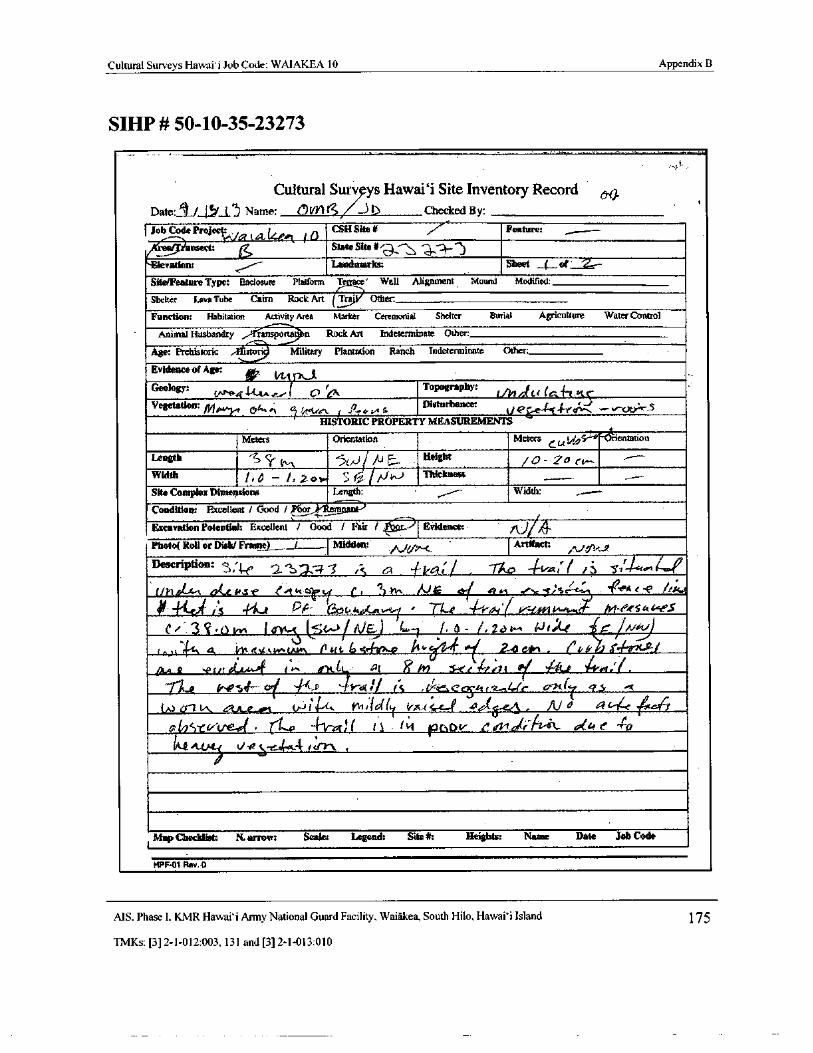
Cultural Surveys Hawaii Job Code: WAIAKEA 10 Appendix B
SIHP# 50- 10- 35- 23273
Cultural Surv9ys Hawaii Site Inventory RecordDate: 1 t_111..11)
Name: 4VY J b Checked By: r
I Job Code Prof t
i 0CSH Site# 7Feature: „_ ..
fti ansect: , State Site#<- , 4„----A...'"‘)Elevation: Landmarks: Sheet _(_ of 2..--
Site/Feature Type: Enclosure Platform T ' Wall Alignment Mound Modified,
Shelter Lava Tube Cairn Rock Art Taa' Other
Function: Habitation Activity Area Marker Ceremonial Shelter Burial Agriculture Water Control
Animal Husbandry ansportat n Rock Art Indeterminate Other:
Age: Prehistoric : stori Military Plantation Ranch Indeterminate Other:
Evidence of Age:
Geology: (.."^,4 - La. r,..,-( Ct ICA Topography:
llLlrr 41 (
Jt" K(
Vegetation: ,.,.1„,„ 04.,,..‘' ,
Disturbance: t <
HISTORIC PROPERTY MEASUREMENTS
Meters Orientation Meters / 9c- entadon
Length S C(OA 5 /U = Height 0-. a co-,
Width i, d — i. 2 o t., ;
1F.0- // J Thickness
Site Complex Dimensions Length:r,..-
Width: ,,....--
Condition: Excellent/ Good/ o5}/' lfatuolantPExcavation Potential: Excellent / Good / Fair / a. Evidence: 0/4Photo( Roll or Disk/ Frante) _ J Midden: t
Artifact;
De riPtim: S,4 3 Is 64 1ta[/ i ,<t . 1,114*--, 4-49
1/ 1"ti-4' v Ck6t.S e t° dl. t-.ri c. 11 K., / Jdi
ds .,..„ tiS ' ` -/ ' 4 c e
I's e Pk.' es""`. "'""> l • - rtae •- - o4'( Y=in 14,5A s
c' 3 , o ir+ t I ov- ( mow/; l /) L.-] 1, o - (. 244. ter. ar E.- / iv r,
t..) t A 11t 2y[ u.v. l vw\ tl to. 6 1,4-0.4, It. 0 Cor+ . CP k 1 Plaidla Jt
IAA 1? sPidt 41.4.4 #+^ it t. t! al in r6e a'di of ,'& C.€ 4-0:/ .
1112 V0144 0. s _ fr'4:/ / S , Ceyit z.4.-fe 01( 4 5
W al . ti-J14-4-t,
rvett Wd(I fr,, c 4,......e 4,16.-e, </ AI 4 4- 16c q
A-e : Ve , - 4-01.,( t S ( ti ptteir . t 1. 01r At-(k 4:lo e 40u; p is-c --4 t vr", ,
1Map Checklist: N. arrow: Scale: Legend: Site#: Heights: Name Date Job Code
HPF.01 Rev. 0
MS. Phase I. KMR Hawai` i Army National Guard Facility, Waiakea, South Hilo, Hawai` i Island 175
TMKs:[ 3] 2- 1- 012:003, 131 and[ 3] 2- 1- 013: 010
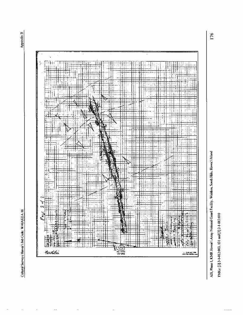
coX
c
a.a.
L
1 i ri- I I --1- 2`;-1- 1-- 1- 1- 1- 11 I -._ I i 1 . T- 111 ; 711 t V 1_- I I
7 r 1° 11_ Ii
iti- - I ---- 1
I ;I rI i L r 1 1 ; I1 1
Tr
1. h, I I 11
1 J1
MINIF- .._. l . I . I.
IjI I
11 a 1 - 1 ? r; _ A. 1 I
t
I I a ' i „.1. 1'
11 I/{'-} ' 1- 7t-t-'.-r-11---
7 6q
IHf -II
T1I
l1
tiiiiIiL_
L41I T S 11-., 1:_,,s.,,,...,,,.... . „4„,.... .... .:, I , I
Its L... L... 1 1 e>• _.
01_ ca
I a`-- { II ' 1
1. 1_ I111 I 1
r I
1 1 -- 1 NIN® 0
L. T 1 . 1 • I - •
1- 1.:"1"1 . iLI '- 1 i ..' -- — _ F j ." 111mr_1
I
1 !. A!. LI .
fI
CI I
r 1
I_ If
i j I NI®.
1( ; I r ' 1._- - t- Lw I 1 ' 1 s I
I. I 1 r I.:..: I
111I I ' 1 =
aim
MINN
t l_VA I 1 1 ; ! -
774 . I I L' 1 1 , 1 1 w
j 1 t
g i 1 -1-. 1_ tel _am S
NI L r t - rtiaa... miliiieo 1 1= -, I r t o
o
anH NI® L 1 .--:: n1
zilEr".' is
dB
Q ca
FiTO
1) 1C" GRD t. uexan. am
g= O
Nc
u
4U Q
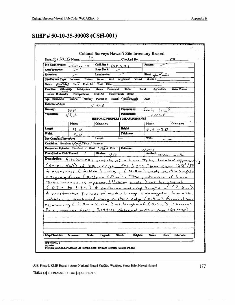
Cultural Surveys Hawai` i Job Code: WAIAKEA 10 Appendix B
SIHP# 50- 10- 35- 30008 ( CSH-001)
Cultural Surveys Hawai` i Site Inventory RecordDate: n6/ 2 4=1,> Name: t) Checked By:
Job Code Project.l s, v rr r
CSH Site# L i 4 , p 1Feature: , -
AredTranaect: r State Site lU
Elevation: Landmarks: Sheet ( of '-
Site/Feature Type: Enclosure Platform Terrace. Wall Alignment Mound Modified_
Shelter va Tube Cairn Rock Art Trail Other:
Function: natio Activity Area Marker Ceremonial Shelter Burial Agriculture Water Control
Animal Husbandry Transportation Rock Art Indeterminate Other:
Age: Prehistoric Historic Military Plantation Ranch ( Indetermina3 Other:
Evidence of Age:
Geology: Topography:
Vegetation: y-r. Disturbance: f - A
HISTORIC PROPERTY MEASUREMENTS
Meters Orientation Meters Orientation
Length l 0 Height 0, e 2,0Width Thickness
Site Complex Dimensions Length: Widths
Condition: Excellent/( i000r f Remnantt
Excavation Potential: Excellent / Good f ai Poor Evidence: fil ..N
Photo( Roll or Disk/ Frame) / Midden: yArtifact: Ph ouf.c
De8cription; 4, ,4 N4^ ea 0 j G'> r,s, w} s ' C . ea I.. r}..... " 1' 1.- e-
w. f(4 J c„. tr S th3 ^. o, n - L . - a. l.- a....... _ t.,t... b.xOG
1 SEq rvt[ n S•. 0 w ") 1 p" O w " t tai, t F ti 1n .,*- i
t`^ . n
pi { a
2..0 .n.., ) ? to G t a+ e r e } v•.
il4., y r. w ; C t t, 1"
d-
1
7-0' Z ci` 4, 4 ar
er Y.cr-/ vllA / L.-^ 41 .• a, «
S!.
1 .eV'6la14 ctt c} qL'^•^1 47.-••• C, u'+(ry! / C d r s v{..
2 , o.++ 7c 2.... C?.,.-,.
l
3 f c, q\n^} . o.{. .. J..w... F.,. a ay..+4 ,
a fi4s otoK. re
Map Checklist: N. arrow: Scale: Legend: Site#: Heights: Name Date Job Code
HPF01 Rev. 0
09/ 16108
PADOCNRESOURCESTielo and Lab Form; U. Field Forms\Slte Inventory Renate Form;doe
AIS. Phase I, KMR Hawaii Army National Guard Facility, Waiakea, South Hilo, Hawai` i Island 177
TMKs:[ 3] 2- 1- 012: 003, 131 and[ 3] 2- 1- 013: 010
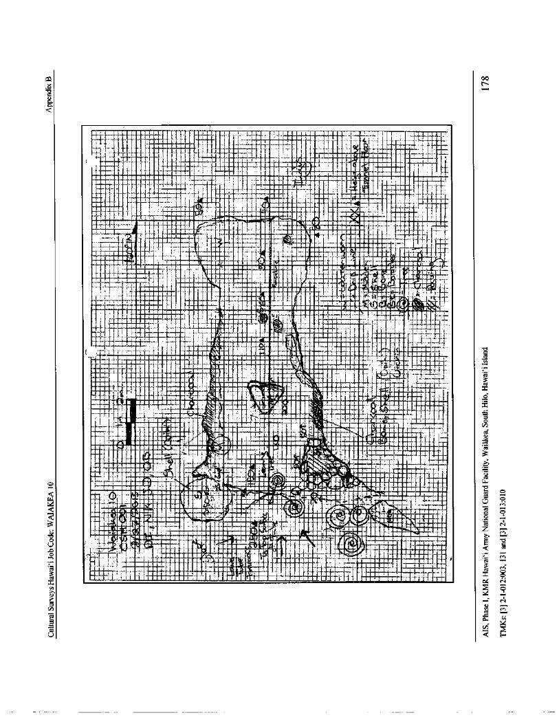
ca 00
x N
a
F!k
a .IS.. i
it t I• IW.
4.--; a' 4 _--. ° 6• 66min . I I. i i,,.,_.• all'
i' T i. .' . _.. .a ,.. I
Ir.
e_ ,
w
s - 1I:: _ i_ .i ,
i
s a ,. J._ Mms s _
1. ly, t
111,1110114111 ' — 7
Ir s i 1 k slµ, , IT -
1trf ss
1 F. , al , r a° ,
RI111L
i s i iffiMaod0, y tit_
r
t
4 - al!. - 4- 1 r r !"- luir
t ••
A 1 ' 1ii ._
1 (( t ° i s..i t11_.._ mm• 4= 1_. imminjumemis
v
141 rempafflon....., „
Air.
1 T ITT"' iii1 -.- 4 r, MINO i. Ilia 7 l
eli llw
il• fii E
c.,1mu ,-IN„,..4 1_ , _ , . .........___,..Limi,,, 1, iiiimines in .airl4,
1111111
III i P9iid 5 . d
y. MIf'ri' t AM V]a q>it`
1 1 r.4.-0,:„.
tril 7 1 41..
1111111111111111116 !..- 1---:—••',.',..., r
r''''71111411111.
r. .... ';11111110,.. ''' 1.11.L.A1011,11011111117111 0001 ' Jr':I,'''',11r
F , Y";_, '
r.
4t
tl . t
iL;ri L ft
Vaal": i r rtwo iiiij9\
aii ,,,`a 1 err . M • w v
iiroz.v
g110ii•rlli i
say a [ t. w i r[ .? ,. iii ; _ . lir10. 44,,. 11. 1111
n
airco
MNrWit
e
IMOF . F t
tiVidloa
o
N
vdc
Q .
C1.
cA
U Q
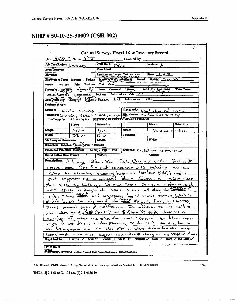
Cultural Surveys Hawai` i Job Code: WAIAKEA 10 Appendix B
SIHP# 50- 10- 35- 30009 (CSH-002)
Cultural Surveys Hawaii Site Inventory RecordDate: S/ W6 1 Name: . L Checked By:
Job Code Project: .0. ,e
CSA Site# O Feature: A
Areaffransect: State Site#
Elevation: Larndmarks Sheet ti of -ta
Site/Feature Type: Enclosure Platform '. terraa-` jAlig ne Mound Modified:
Shelter Lava Tube Cairn Rock Art Trail Other:
Funetion: .r
nano egallirro Marker Ceremonial Burial. 04 A but Water Control
Animal " u e r Transportation Rock Art Indeterminate Other. "
Age- ha-istor? istoric?I Militay) Plantation Ranch Indeterminate Other:
Evidence of Age:
Geology: 1. 0 , nm G 4, nc i^Gc> Topography: > c 1 tytSr ssP C Best, e, r,
Vegetation: t' t tr! Gln t o 1 ,
v w, a c, D gturbance: ( p„ 51. 0
PkA k Pi taw HISTORIC PROPERTY MEASUREMENTS
Meters Orientation Meters Orientation
Length 40 fj Height I--,` w, < a „ e S r r: 11. NeWidth 2 Cj yy t J
Thickness
Site Complex Dimensions Length: Width:
Condition: ExcellentGood/ ) oor / Remnant
Excavation Potentiab Excellent / Oood(/ Fa/ Poor Evidence: Ws c:; 1 r t a ctcnS+ ucrPhoto( Roll or Disk/ Frame) I Midden: Artifact:
Description: , \orae 5. 4ff0.,.. RcLc © v rcro { wi C. t it e
cc,tW-- cac. r+evvT • ra" e. iv1G\,u
ydr'°..J
CV..o¢5 1 c- c 5 2r.v pr] ek5 ' vn x r. V.a , -,, cw tGee ' r,.-r• t C
I rack at<" tnrnev\^ tnlxr.; ; o t` c kc, ktSc' e) 1.! ait('Pct r 1'- ra a ,^^ gir pit..
tlne 11,iGJ+ c}' s Scare. G.rec s Cor-Tc.-O+S w " etcr.tt(z.
3 RPesett tt.+ti,e , y a v Ec t. tl e c, efig-
graiir's,
aq_ uTln ` e
k a i.."( Pt-too; a, 3 6 Bets e
1
act.e4 4kog l- olt w:c e•, -` 4ev- Pc-
c1@c,;e, cST
elsJ. 1-Le l`-_x L_+}o T- h'@ C7. h
qe["cc
S
l61.S"\As c 1; tCG., r: Siv'r.JJ
C 0.•^3 Lemem c.f- ' et.
Y v vn o t3r. pr haw
rrdoes were- i,
1ngt.
Esc- ra3 ' j r 16) y+ro*
VaOv
Cifcr\ llS(' 0+' se_ V('` tit, a- : y i c cc.e V . w.; s - tJ - ti+t. "!-r«, r G N^.., ..., ur l
US PG v, f?t s,'Cea C? utF C. TF°.., t,..a.ue, -
11.0h, t5. ker. !nhr,... k`rr'ft' : nal-t,e r` n„ il^•.w
tr„, e5+
t.vK:7hpkr,
M:aer," - rrc c...t r`., - A* - c asec u Ccr^+,n..e ,. x,,c'V9 : .. , t. T.,- j chCs _ txw• tY exp+.
Map Checklist: N. arrow:,/ Scale: Legend:‘../ Site#: Heights: t,/ Name t) Date t Job Code vi
HPF-01 Rev. 0
0.5!27/ 11P:\DOCiRESOURCES1FIetd and Lab Fwmstl: Meld Fountains Inventory Record Form. doe
AIS, Phase I, KMR Hawai` i Army National Guard Facility, Waiakea, South Hilo, Hawai` i Island 179
TMKs:[ 3] 2- 1- 012: 003, 131 and[ 3] 2- 1- 013: 010
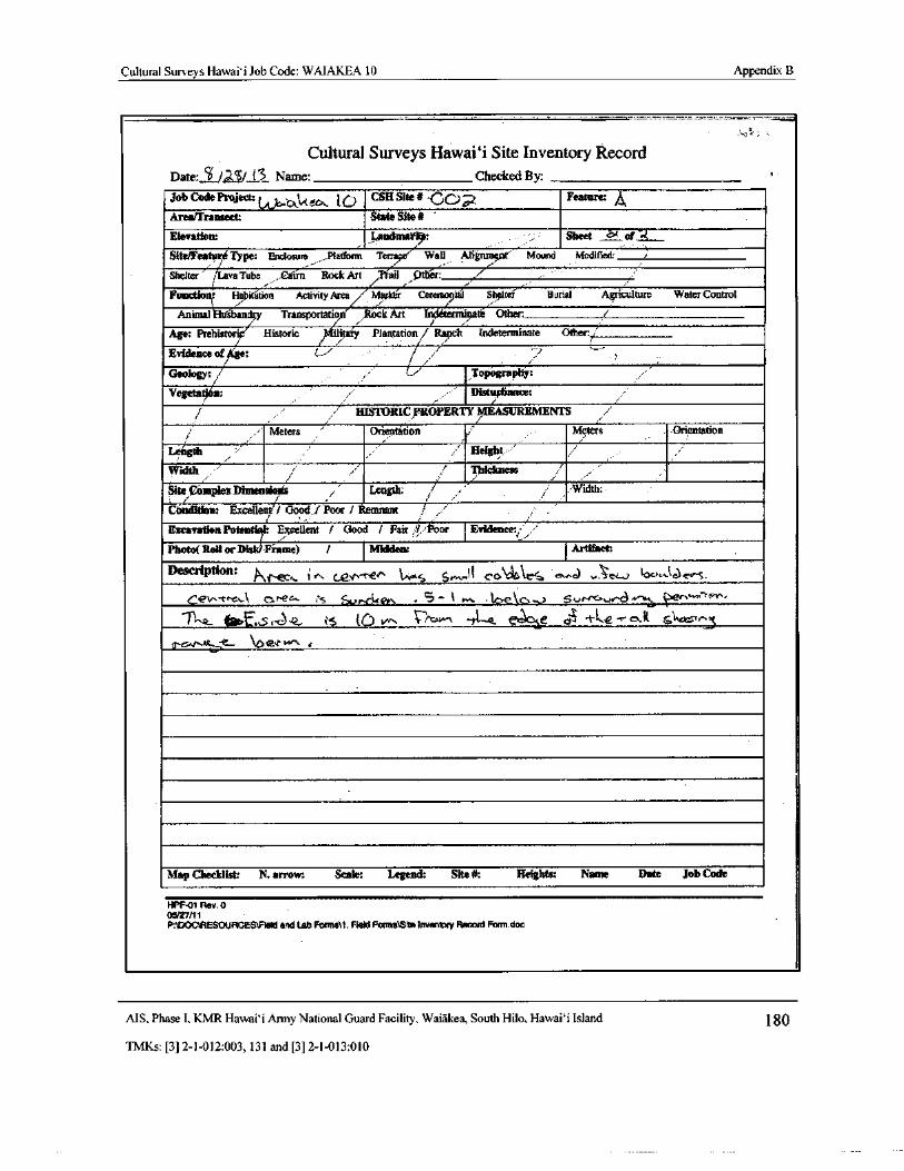
Cultural Surveys Hawaii Job Code: WAIAKEA 10 Appendix B
Cultural Surveys Hawaii Site Inventory RecordDate: S. Jal•`
61/
13 Name: Checked By:
Job Code Project:tet ', Qkit eos. [ U CSH Site# CC)a Feature: A
Area/ Transect: State Site# '
Elevation: I,andmat,: Sheet of of w,
Site/Feature Type: Enclosure . Platform Terra e' Wall Atigmnent'` Mound Modified: i
JLaShelter i va Tube Lain Rock Art Trail Pther: ,/- I
Functio r Habitation Activity Area Marker<' Ceremo ad Sheltei Burial Agriculture Water Control
Animal Htfsbandry Transportatio Rock Art In ternusate Other: i
Age: Prehistori Historic ui5ary Plantation/ Ranch Indeterminate Other/
Evidence of e:
Geology: 1 Topography:
Vegeta94 n: i Distupbance:i
HISTORIC PROPERTY MItASUREMENTS
Meters , Orientation Meters Orientation
Length Height
Width i' Thickness
Site Mamie,*CompleMamie,* Length: /' Width:
Condition Excellent/•/ Good,.I Poor 1 Remnant ' ,
Excavation Potentit,l: Excellent / Good / Fair dl.: or Evidence:iPhoto( Roil orDisk/Pin.'nie) / Midden: Artifact:
Description: kd` ec,, i ro f_ev'- nem s Sw., i{ cobla` rS mo,e) ,... cv loo,Ze)c‘rs.
rCev--t., o ec,- is SVKkey. .. S- I fr, .6€kc>-.." Sc.,rs+c. v.-.8 a. '' e‘"""..
1.''
S: r.) 2, i5 tO 1/".. i Pc w1 - e tLe.-r ea ts1 in
ir' G'V...cr ` 0ervr` 4
Map Checklist: N. arrow: Scale: Legend: Site#: Heights: Name Date Job Code
HPI-01 Rev. 005/27/ 11
P:WOC\RESOURCES\Iield and lab Forman. Field Forms\ Sfte Inventory Record Form doc
MS, Phase I, KMR Hawai` i Army National Guard Facility, Waiakea, South Hilo, Hawaii Island 180
TMKs:[ 3] 2- 1- 012:003, 131 and[ 3] 2- 1- 013: 010
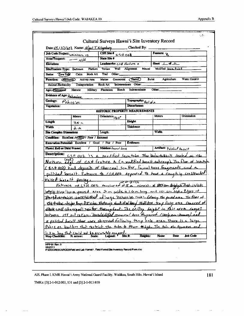
Cultural Surveys Hawai` i Job Code: WAIAKEA 10 Appendix B
Cultural Surveys Hawai` i Site Inventory RecordDate:`/ tm1 Name:/ 1/;: le/ 1-Xiri shin Checked By:
Job Cade Protect:WA is\ it.a I o
CSH Site# c- S t4. OO a
Feature:-
Area/Tragsect: _-Nl
State Site#
Elevation: Landmarks: C-$ 10 Sheet of
Site/Feature Type: Enclosure Platform Terrace Wall Alignment Mound Modified: lava.#„ Ja e
Shelter "— Ova Cairn Rock Art Trail Other:
Function: a tatior'7 Activity Arca Marker Ceremonial ( heifer Burial Agriculture Water Control
Animal Husbandry Transportation Rock Art Indeterminate Other:
Agmeta.istasii Historic Military Plantation Ranch Indeterminate Other:
Evidence of Age: Rs4040.t,Geology: 1061 0 cpc Topography: em of AVegetation: Disturbance:
HISTORIC PROPERTY MEASUREMENTS
Meters Orientation 40e Meters Orientation
Length Height
Width 2_MThickness
Site Complex Dimensions Length: Width:
Condition: Excellent a: rr I Poor/ Remnant
Excavation Potential: Excellent / Good I Fair / Poor Evidence:
Photo( Roll or Disk/ Frame) / Midden: a,.. l,ont Artifact: pot%L . t/ o., fe, 1/-Description:
L-S N4 002 ,1 t a. Nvta ifled ! ay.-414a l*e.
14er4ivrn0j4)
49f G5 If c,e aV . fGuPo ( a- lvva.oi€itGd baso!)-. o.& I- r(rn,f Dor aif tilk..A116e.
1.& SO' t 22) (' lrA.c l Qitm-s; k Ot Chas-c od.l. SCc.. 77er, 1'iwuna) oohe 1Ya.g N'itKn: t-s, Ger d
90.1 SIttai ] oasIal}, i=g, frame, -Izy (. Apar lLpfearto, '/ t Am', a ver.,
j ly cthsinc.iedkro,Ierk k'aSalT fllu/) tt)
par rpl;4tt
ONfrthee. of CS 1-[ Ooz, n. Acre,55 ytL Ces.. v%4. 73- 6)- , nr5 tle
1 1i?fj A,,;(0, ketre\ fi0.ve.eA Ahta. ...+ L., rule.. 1, Lor-, 0k ui?.i PS rG
v 9; v4 Y, d itS tr.l lar34... toi/o. 4J the raved arca_ -4,e Poor of
r- t4/ . r a>r teur,-12, 77-tiat, i it`'ienaA efemA,+401- dro41 : i3'-,a?,d . JPA,, iitby prra Cernevc-d oto
S41Sttit bt l,4.3ecerklaew s . We o:,* Lac. kt7ltio.- 1 : lie ‘, / 14:
7 /ier 14/ : n or• etbne r..rnje
o J'"weevt.
I/'
t r 0.N / t, 4.- 31.. 66-rsSa/ iI MY // 9R, 1?/? s/ hon C. Aq N? exp' ( /( h6 r— AteswerKJ . o4l p h<. I. ha f,rlf Sl„ rse : Atm' e alisyrvee/. laHew e,.
7 ( r ti, alo N-Lore is e, r e
One c et_ 1c111.. 1Acr7
1'[
J itstir« Y 'fi11.
h bc.
I+ +
Ge GA, 71-t. Jt, J*. , t/s. ar/l. artes
m 1 Lay.)
ahil'
1 3 t6+v9Lay.)rt ie- p 8. Amir 1v.I M.A ppeJ,.Map Checklist N. arrow: Scale: Legend:
ve Site Ji: Heights: Name Date Job Code
HPF-01 Rev. 0
05/21/ P1
P:1t1OC\RESOURCES\FIeId and Lab Forms\1. Field FormslSIte Inventory Record Form.doc
MS, Phase I, KMR Hawai` i Army National Guard Facility. Waiakea, South Hilo, Hawaii Island 181
TMKs:[ 3] 2- 1- 012: 003, 131 and[ 3] 2- 1- 013: 010
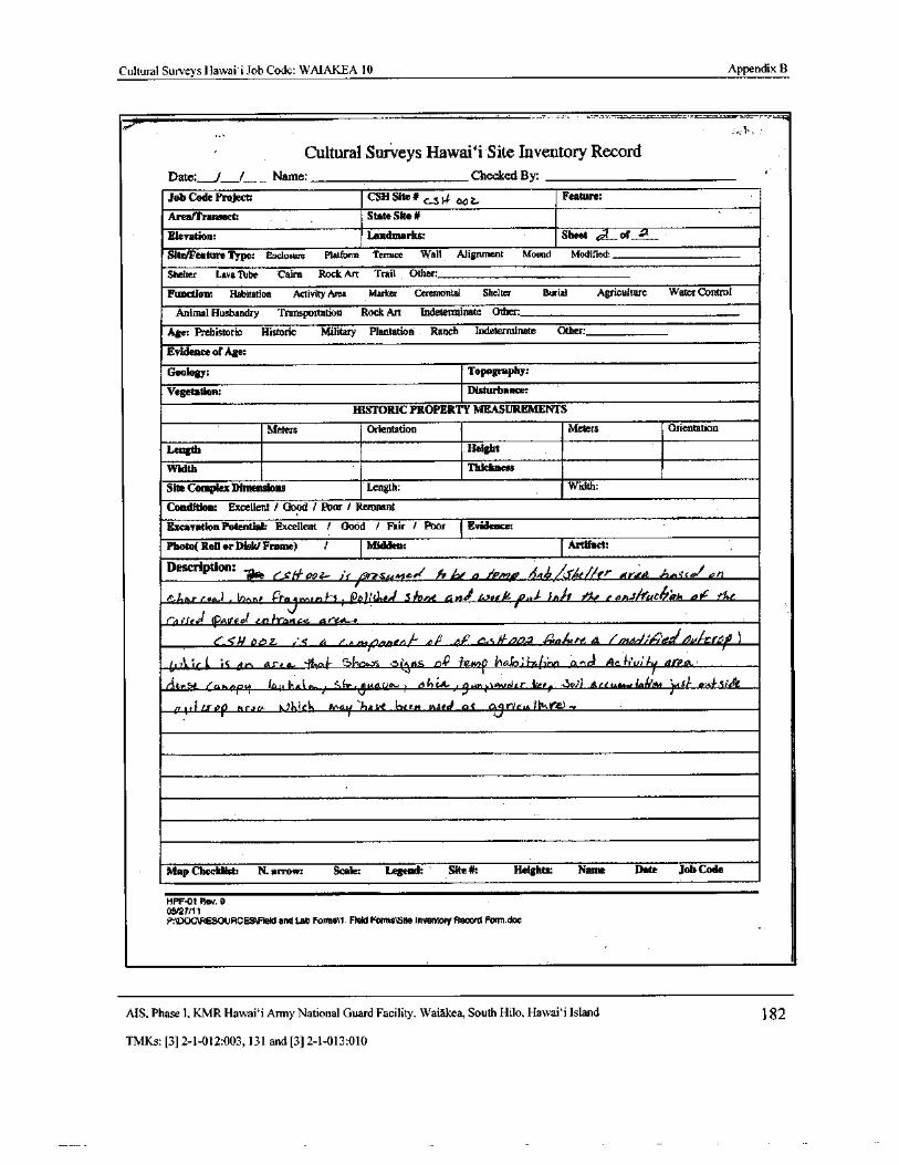
Cultural Surveys Hawaii Job Code: WAIAKEA 10 Appendix B
Cultural Surveys Hawai`i Site Inventory RecordDate: / _ Name: Checked By.
Job Code Project: CSH Site#`S i oat,
Feature:
Area/Transect: State Site#
Elevation: Landmarks: Sheet A of
Site/Feature Type: Enclosure Platform Terrace Wall Alignment Mound Modified:
Shelter Lava Tube Cairn Rock Art Trail Other:
Function: Habitation ActivityArea Marker Ceremonial Shelter Burial Agriculture Water Control
Animal Husbandry Transportation Rock Art Indeterminate Other:
Age: Prehistoric Historic Military Plantation Ranch Indeterminate Other:
Evidence of Age:
Geology: Topography:
Vegetation: Disturbance:
HISTORIC PROPERTY MEASUREMENTS
Meters Orientation Meters Orientation
Length Height
Width Thickness
Site Complex Dimensions Length: Width:
Condition: Excellent / Good / Poor/ Remnant
Excavation Potential: Excellent / Good / Fair / Poor Evidence:
Photo( Roll or Disk/ Frame) / Midden: Artifact:
Description: Celf 00Z- it Pr2suMe,/ Jrr ( a• , Pnro 444fcfAe/ fer , rrrra h..seel on
Char eu) , l/innl P't'a q ruin H 1201444 Slane 4 rizi toot* pia u t/ I e an-rfroC ph bit- ?At
fp?Sepouf urlrancm. r"(. L..
0519 baz ,' s G nrapoacnk ec,s fog, 4n ure Q t/ilo.I:,e)eIDa/ creft4A is k iS dr, as-4 a ` 4 v4- f7( ora5 5(vt5 nC lamp ita,(7lWyin Cnnc Ac r' ui ly it1PlA
t tv t'L Cahnpy lauMa1 s.-/ Sir-.ANauw 1 t?huV) LtWni,)+wdrr fee, - v4 GtetCAA.. 441470(4 iwb/- 04. 1,5rde
tr[ Lrop nraet, 6.? hict, May hai,t int cm rnsref os u r/cu1Okra)
Map Checklist: N. arrow: Scale: Legend: Site#: Heights: Name Date Job Code
HPF-01 Rev. 0
05/27/ 11
P:\DOCUIESOURCESNField and Lab Forms\1. Field Forms\Site Inventory Record Fonn. doc
AIS, Phase I, KMR Hawai` i Army National Guard Facility, Waiakea, South Hilo, Hawaii Island 82
TMKs:[ 3] 2- 1- 012: 003, 131 and[ 3] 2- 1- 013: 010
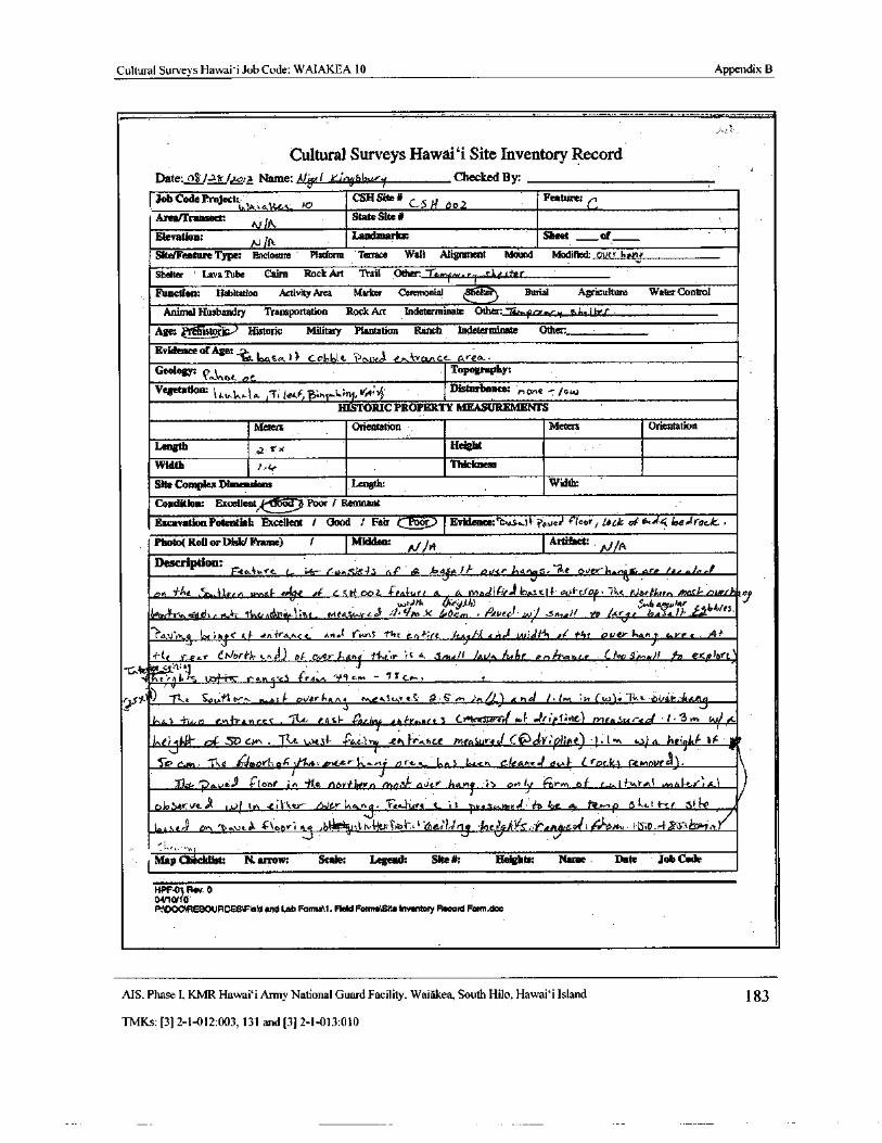
Cultural Surveys Hawaii Job Code: WAIAKEA 10 Appendix B
Cultural Surveys Hawaii Site Inventory RecordDate:oir/ qtr c„ a Name: A1,./ 44'41613,,...-/ Checked By:
Job Code Project:" CSH Site# Feature:
Arearrransect: ilkState Site#
Elevation: N fR
Landmarks: Sheet _., of
Site/Feature Type: Enclosure Platform Terrace Wall Alignment Mound Modified: oUtr bona
Shelter ' Lava Tube Cairn Rock Art Trail Other: 6r pay. r, , SI` rtrr
Function: Habitation Activity Area Marker Ceremonial ( tga-.)Ler Burial Agriculture Water Control
Animal Husbandry Transportation Rock Art Indeterminate Other: Te"h, ierr r.
Age: tator3c Historic Military Plantation Ranch Indeterminate Other:
Evidence ofAge:Lasa I 066k, ? OAkrT @tikvancc o,ren
Geology: Q,.1, oc 0Topography:
Vegetation: l t b 1a rT jetFr , 1n- 6tnJJ,' Disturbance: none -/ ow
IMTORIC PROPERTY MEASUREMENTS
Meters Orientation Meters Orientation
Length x x Height
Width Thickness
Site Complex Dimensions Length: Width:
Condition: Excellent Poor / RemnantExcavation Potential: Excellent 1 Good / Fair .,• r Evidence:1:vs41f'iaor lack of tA., 4 loe" rock
Photo( Roil or Disk/ Frame) / Midden: oki14
Artifact:Description:
F-kabure r., ' tax- e J. fie4s a!' 4. bnjR/ f potsy,ans- Ike over , are P
e•n At 50,_i),Prn u,nsl + a e aF tett 002. 4PRI-urr a et mndi " r6escl4- eV lCrap" `+
l,. rJortf,er., favi' fhnni,,
p p :/*tt Ott-‘0)0 - makae/" [• bb/ es
irooA tsc, n7a, 4l, A o„.4- 4- f . tenni- . 1i' ar. r+rrkst..-rLsa .:/ Vitt lo0c,n • Rdv. o; / iv - 31t•tdlr- )' n / r4r bws41J-, w t
Tau"rn1
IC{ aJs RF anf a•.ce .nal 1ronS the e. -; re / cA, fl 4 l dt . 01 1-4ovetri,aej e vrc• A!
f"le r„..e Cr,/ori'lt• c 41) Pi over Aryl i{ f" r rS a. jm4/ t ) KVA14be Pri>tleenGt ' (/ oc3,nai/ / s exp/oft)to it c 7tU J
t' 7' f C. ra•i • t3 cr4e., " r'' 9 cru. -
y Sy-t9) -( 1 < Snv e t, JesA oiler ink tviceS, vs 9. ,, i"n( 5 /< hc 1.( r+"t yr ( w). 14. a dVRk: ilartaq
l^,t) Two G+ IYaw r_s< . ice- e4S1- . rau'yrt tn1'V.. ntc3 c 51 N td- JriPfiit•) mea Su r-td • i• ''3mJIv/ it•
inej y) c, . " r(t. .. i-
irrJ €h Pr., nc•t Measur4J C tP V; phae.) : b. t , to) a. haili,F
OffIF
To 6.41, - 1. e Is avvl, o.</ 14, ov rter+-a.. L s brzn cleA' e- 1 ova. trek:. r.errinvi .
0,..y6.49 4` lo'of jn '}( e nofnatty n ,') l- eJt:+ /14.! i On 1 prm of r c I fuYAd wta t
fir"a.
6loStrVt:d IJJ' 1a, . t I ker.-e / Wee InanQ. ea• t.swt S i i , ve5. n.vzaed'# a lot. a,. l.>•- p 5 Li t-.. r r
r. SrrtD„ '..vc. . . w,',, l l: t.h{-{eg rh' 6.60(o 4 i ' 7er i S; Y'. rhip= u1 L(-)- ons, 115i19..- F S+' J 1rt
J
MapChecklist: N. arrow: Scale: Legend: Site#: - Heights: Name . Date Job Code
HPFW 0-01Rev. 0
0411
P:\DOC\RESOURCES\Field and tab Foams\1. Field FamasSite Inventory Record Fam.doc
MS. Phase I. KMR Hawai` i Army National Guard Facility. Waiakea, South Hilo, Hawai` i Island 183
TMKs:[ 3] 2- 1- 012: 003, 131 and[ 3] 2- 1- 013: 010
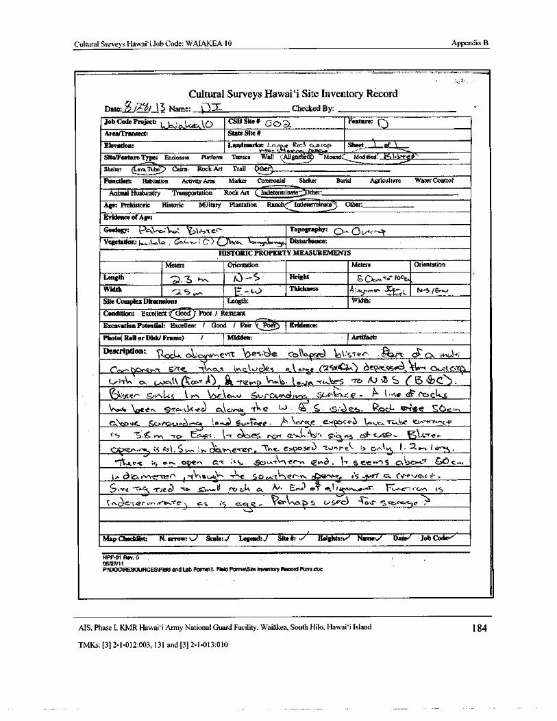
Cultural Surveys Hawaii Job Code: WAIAKEA 10 Appendix B
Cultural Surveys Hawaii Site Inventory RecordDate: Z$ in/ 13 Name: l--,,) L Checked By: -
Job Code Project: t.jc„,:o..Lerk.ko CSH Site* Doa Feature: (- 3
Areafllansect: State Site#
1Elevation: Landmarks: e ( t..
cRc -r Sheet .-„ of
y' 46r ce. , a
Site/Feature Type: Enclosure Platform Terrace Wall Atigmnen Mound: Modified' , K1,3-t 1'
Shelter ( ava 7Lbc Cairn• Rock Art Trail the).
Function: Habitation Activity Area Marker Ceremonial Shelter Burial Agriculture Water Control
Animal Husbandry Transportation Rock Art ( Indeterminate ther:
Age: Prehistoric Historic Military Plantation Ranch('' lncleterminate Other
Evidence ofAge:
GeologY: \- 34;..\.. a:\ w: Qj1,z-, Yer' Topography: o,., 0t,,Kc^'Vegetation: 1a,.,,L,„ic,., 6.0:...w--; 0 Q\,+.•ti "-yal...,y, Disturbance:
HISTORIC PROPERTY MEASUREMENTS
Meters Orientation Meters Orientation
Length a 'zJ . v. 0 —S Height Lu DC.,,1 ' 0' lock,,Width 2.s EJ
Thickness At. „^, e.r. --
E.ut N- 5/ e.'.,)
Site Complex Dimensions Length: Width:
Condition: Excellent( am. Poor/ Remnant
Excavation Potential: Excellent / Good / Fair K Evidence:
Photo( Roll or DIsk/Frame) / Midden: Artifact:
Description:. 9,0c1x o,,; t,,, evvr Oes,c) e code. cl Vcsl e+ gam od Ck IMu1";
CI ev.- t 5 re. ` , t: t- + lck s
q
c cr e ( 2 Sx d".) t e(N'C:SfiS(,' FA'w C3,.- t Er' j
kiln 0h t t! Gtr.- t, 9), it-•T-tank) l'A Lb^•. E 0,,4A-' C, A-6'S " F J A. ` ( i7 e)
ki`..4 rel" cSw LS k P-, OCIC1...4.1 SiaiOVRh,4+te-A e^ '" w:r€ - k- t,, A* car' tYa cit
G\\,.-_ \, neer, S-re.%Ix.ec) cA.tc>r- - AN-e wL . s' e- Rod- ate SC) cer,
v . ( jt.c.LA i.e.' iw .-{ In,,r,.e) 5‘.,( G, Ce!
u,.../ \
cr e, e/xObePU ` aVc, Ti e et-- trz- c-e
5"U.. vt - res Ec-9i . t-- C-.3)oe •L• e. r..., h,-, 3,
1
ns cit- cJs2.. cjik,s- c'e.c
r
ILL
s : 4t. S» wac w er, .e r2po se t c nt`
X:
et e} C, r+t ). 2.1.--.. i O } ,
tR C"L tc Oti T' a ,-, met , tL SC) w r,' lPyn ev,a . 4 e ? e..e.' 5 A' - 4-1 SCD C.,...
n ,:) , oerr.--ver, 1,-. 1 \. es.+...^ _. r\,,e s a.."tt"'
tR,c-- n.,• a'rhrt r,,, nS. VS' Y A r .+Jcut eP .
el-4, ` t- Tied -CO G.^"" M ti / V.) cL CA. '", E.""1c 1 etfi , ik,, O,-sr. iMG—S,' U,n iS
C>,.. Ue•-t2rw,,v-b,-re, s / S F: - Wer& c.- 5 u5''c) A-0s s•cz.+X.c.le
Map Checklist: N. arrow: Scale: I Legend:,/ Site#: . 1 Heights: NameV Datel Job Code,
HPF-01 Rev. 005/27/ 11
P:5DOCIRESOURCES1FIeld and Lab Formsll. Reid Fonns4SIte Inventory Record Form.doc
MS, Phase I, KMR Hawai` i Army National Guard Facility, Waiakea, South Hilo, Hawai` i Island 1 84
TMKs:[ 3] 2- 1- 012: 003, 131 and[ 3] 2- 1- 013: 010
m tok0,0
1)
at
vM•\ 1JODV1': 1, 1) URI ICPSC" - r ort'°N.
C I . 1 1 r111
1
11 }I1- 1-i-_i- -i
ev..! a cauirri , , 1 1". Iaiiii 1 1-
Ia
i 'II.._ lJ
rtrR ; : r! l r a • ea-J +_
q lour. r
A `amort
i, till • ( I I.+ tt .
1_,,: ... .......;,, A pPI!-- c
eu•_ Cr' a11
r_
i.., u aru
1.f ._ s sFist
gas. ro, '.'Asi
11:. iuuelne r lair' 6 aA .I ming I Mii.VI N r- 1 s
a r
4' 1I f II 11.
i rrrr1 d ( +'.
I _ Y JI. '
ti4• '_•t... w , • rade r6'i 20,,,..!...-..,..w' r
I.. ' Alt In- ?
y '\ kf -
i._. r g ..Uig _ -.
I'
1 4 dN... a •
tOa 1
nob_uemrJ
14 rA' J,
1I._ F. i '_ i 1.
ffFiu - 7= 1...-.-- 1---:1 I +
at
I •
1),27T
I
t I m s ikTgi}P" J® gmnm6F 3 :.1....0.1.1_,.
t.. i
1111f"
L_Elmeeer
ali F
5.
eom
I l mmfms JtOg
k
i`
L r . s17 J t taut. r• a,; J I ,_ I ` ,maL,
1.__ r j juiifs
iu®i
ito r .i- :
u01
I } Ti Q i ti.';$ ge usgririVti
r
l` .6+nnau gemrr '# t {S F a: a
rg p seg ! s 1' mili a1 i ' 1 - 1IMO l server• o rn
11. 1 i ......vii, ............ 1, nr our
Cr t_ l,.-
IN r'W!+9fueu r it.. I 1• 1111111111uI_... a ..:.. I _ a1i aea m f ••• boort x
111.1.
L :_I
ue teer..1.14.,•,•••,„: 01, , if i
1 .:1 5
I .
I ` A0._ ..n1._;. 1.• a maem P rrl 1 ulrnue v]
IIIMi
P. .s,
js/,i mem rw 'quip' - 11 ri
r
rng
i111114111 10
I 1 ... tiler 4g ; 3S` uu_d .:. I ._ k ur®
VIa Ar a ir ueuec ai1 I u <. aaaa Uuenu i \ eriilere i
I.I. eiuu. 1". wu.a uur lu/ gr l, , a i - r ; :. t i R
cI
1a aii4rr -... .---r-,:-!..,
NNW is s, w
1 a f' irill _ 1__ ii'rcirr.: , rIl
r- a
411111 u..... ma +.. e:srtim. _. m1 - + -
BI o
S• 5 agreet r _ ti .. o
cls a '' e 1,. - 2- 7,..- I :_ NrrreerI 1y. F I C7 •
im er'
yeir1-
1 _..R 30 4 I I
g I . 1- F ._
M
7773
Int 1a ii ' t I... , ariu-amuo ! u pC
ri 1 • I4 .... I • Ii 7 I I I I I
II
b lata II ur J to1LAN•r4 ' 1 . gENN: r z
uc
Y7emuonlBAneu _._1 _ ... l0, . . t... i- 11 - -
U s lege7..:
L•
1
oII
t 1 ......., I_ .1 1..- 1- _ + ' nra
mi ."
e
ma..a -I Q
M
1 7-.- I I i1.
I 1 i II .;, 1_ i 3.. ''
y. . . I I z• en
Mi.o
x o
vi O
u
avi
U
mx 00
aaQ
11i - r
iii,, ' l.. 1 i 111 !®
I t rru 1I
t. a 1i_._ . 1 r. I .t
111raa 1111.+T ,• i }
r t J
i 1 rtes! ,Iiiinil ` .
l1111111.:
1
111
j 1- i• i '
7 Lia i' 1 I !!! y_
1
ru i Inn { ..T...+ I Vis.. r
s
77' losugI-
1 r °111i11mt'mI I
rr4
i... _' _.[1 .. L.'
1 [ ,- .,._ F-1... 3k r[a ! , , !
1 1 -
Ii.- 1-, Py 1 f1
t 1111: 11I I I ©
II 11 I I
JIB-+1F!'1
Nms m I _. '-`.
1011 [sl
Ilq l6.
i1 j..i
Mil
MN
I1J_ m!! s reit
714—
1 I,. . 1 I I dpi a l • itIR" krill
1[
4 rr I 'I
f 1 _ r f' l.rim.. nipir i. lJtLtl
i 1111- m,. 1 ., ',„ fOi
nnuYWr ! 4 ilq t J .- i?1141. 1-
teal Et r.
rl_,__TI
1
drb~ I r
1 1
r- J
III _ ,}' r t mummer1-
wtin-
1 ITT, _ t '
L.I
1 ... E t ' .. I ri ' r
1 .. _ - .. 0 -T f
i _I iii
ryw_ L 1,! , L
Ij I,--` t'y ! gi 1111 1 y 1 ' 7.-• r 11111111i_. D
I« tri 'r 31it i( .. I
I ga I rr, Gw tit,'" Tf
IIT 111_ 1
di01111 _:.4 '
tile _ II"\ .._ t -. . iI AIM 1.: y 1111ii . V s T.
17- 7 ./'r1 _..
Batu . ,
3aimegins.
Ia J.
0I r 1111111 f- I..r t11 I ._ -_ Darr.
r...m::AN sir T UI •' a I -
iii
I `11rrrum Y i,.
rti r J I_
UUUmr , I ,
litUrr•t . 1` s
I_I 4I
t - t t I L rrirrrrri
r/
1111t! ill 11111111111M-t1 i I Nrr q : I p
vi ,
I+ i 1 ! r. I
t : r ' ttNr
or .l 1••••,••• T -- I r- U
OURi
rpim sur-
1
11 I
I. Ie t
ttirgo '-'
ARMS I I:" rrr ..i. ... sso
tr11rr 1* iot ttt`: , NMI11 1
r . 1r
rsimm I •::.., umEr w
prufmtmirrratTpurr.,%smare 1111/ Its U 1111 aoOtt trrri t
pmtk* TI
lirt11ri T fi rte
1 " NAME . 1 - oIii ME
IIN'1
muter 11 01
111r , ter Ht
3 mm i ,.. z N
1 ---••••••••- 1. 1"1 rI
o w rEn _
TL. - term ., r= 1-.,:-
7-.,nn: ,
r 1 ; r E '°OErr
11111111
o ur1 t.
1
wt.
irr
r0.,,.,. a11urrr tti
TI EMU 111111111 HNN . p I I ...
yc. IN: m - I1 1111:.. MO! tI I. : rrmum J x/ o
J VG. 1131, J. I,. IMV'_iN.a= ORF. TACOMA. WA Yy NrT. AZtr..,,,,I., ,-, 1C” GR. 3 enr Rksix6easin,com
YSyr'
O
L 4- N
cr u
U Q
ozx00
C
cuaa
j ;
3
1i
I II
rI 1 I I LI
l i l ' K: i IIII ! a
I1 I , . o`,_ fir® 1
MIfalielli
1I n1
C • , It
iit, v. ` r
1 , ,,,„.
I
fnum__,....74
I n 0 Q vI !..: I.. 1 ...I,
iiRa1 <- aye. i 1Ji I
k.6\! I Irl
dh, arr m 1 1 I
I ekr16 tiU'
tet_ l k
J. a.l
4- 4 x911111F '
f q i r I 1 I , i. I
L. q —, '_
1 x I I
i. L_. __ _ rB,,.-+!,,,,_
s.
N.
O
1 L I ` I I i _ I -
1 - I1
rn a • cd
it I- I i....Em-! 7
f® ---
I I
I I T ? ! ii ter®
1_1
1.. _ I1 _
a 1 IEarn® w
o o r
Emus.sir o
ala.
ELM SOI. i,'_< .._ 1_
I { firTi
O
I 1 * Le I ' 1. laid I 1't
r®® z Ners 1 i rrrurrr
O 1 " w'Y i. J I71' I- ` 1 I J I i -
U g. , i J. ts® f r p
r
s'iivsur® a d 0
I. . > r-Ii, ®\ ua
3 rr
2'= w v0•'"" 1. CARL 00.
r O
g oC
N
i-I
viI
cO o0
x 00
Ivo.a
w:. ,.ua. 06[ 1. uy P. M 2I 9:. ar,' 7,._ ;r-r_, ,,__VN VINC:'L: 1.' cd035.A': Z: VG" 1' f OUT. 01c
f ix i
1= I • Tai ® ' * n , .... I1 ii 1 .
N `
p '-
u . ;
ii. ' t i I 8 sii:
NN NN I1 - I ii• i i 1- INF { 1 {_
I, I la inn t\r Ir, 1r
nail: ansim r.im Ni rin'._ 1 NNNrrL i ir1 t FR. C.< i• T 1 rr ir
N I.. ilii -
r
1
II k: 1- 1 ., a lTi %..
1___, J _-. I
3..
1-
in I t,._ laras
min aii i •- I-. I s wi ami ,1. r Ni_ 1-__-_®
i' I _. r® f
iri1tisoma , f I ri 1 +
I i
r E.r r '; -; l—• NErr I4. Hpi1((.
r I I.. , I+ 3',
1 d'1r A I Ir r 1
a.
L
FI mtli I 1 1 • ILl `
I i " I 1.,-,- i '- i--+1
i. 1I
I.__ 1j
flitI.,
1P _ .
1 , I_. rrr - E. iiii.... t1111,,,,,,,-..,...,...--.--,-,......., I 9I i 4, iNiaa t 1M
y
kI , : ,: gliar 1 ,.
4I . I .
rii digi
L--er<+
lll . . 7'— t - V --
i1 ENUriN
1 ` r
3FI1 ,
1 - bi._L, - j/ii_ _.-, ANDAL..4r 1 1`
I.•
it# -r,..
4i. - 111 WIFE 9
r1
i j.. . I
rart 1 aI? e' ; fTa9N
n. I ' L' EC' i. 137 1---j
9) ® r* L ' 1.. 3g" R 4r I._ i.. N asLair
i RI/ii 1:. J ' I. ir;I Tralwt' .. / Nir G__ L"
I
iiiI: irlrrNPR iiF:'l 1 _ O
mammaI 1 d:N i I 1 I - i`
r= te:pimamma L 1
RN I-, 1 w
Iii : 0
mmuma! tcst
1,::, 4_ 1 •
t f _. ..1._ V)1- iiia i 41 , I 7
it-_I I
I —_ ' - d 1 `. ^ NM `/r`. -
I 1 rL '
7.:. a i
I I [
b)jiiiLL4NiiwEr
7 k_ ..._
1_
J rrr i 1 -{ , LNii
11
l
1 im1\ \
Isitlajor. .4 } I. 1.
u.
I v rri® r N tri r I 1 O
4w
miAlrlr I Ell.,: N
i NIIiii >-,
r I
i. o
Nr" i Vl® 1 iii' 1. 1 1 rfH o
ir! ul ` i- NNON
7-11.-.
i...._.!.... o
3I' i
r'
1iN la iiiiiir r® I N Z
en
C I I` 1` k' W. 1' 7rr 1. iii1I I 1 I
Ur $ 141111 . i jti I - 1
iuiN® r I 4 r .
I i .-. o
1
p I i i N -_ N t II
T11 1 I_. f I I 1 i 1
1 4.._ r 1 f 1
Y1, !.: , ; P_i--__E ,::.
I. 1.. lir cv I i I
ct3
0
3 x
gN
0Or N
U f
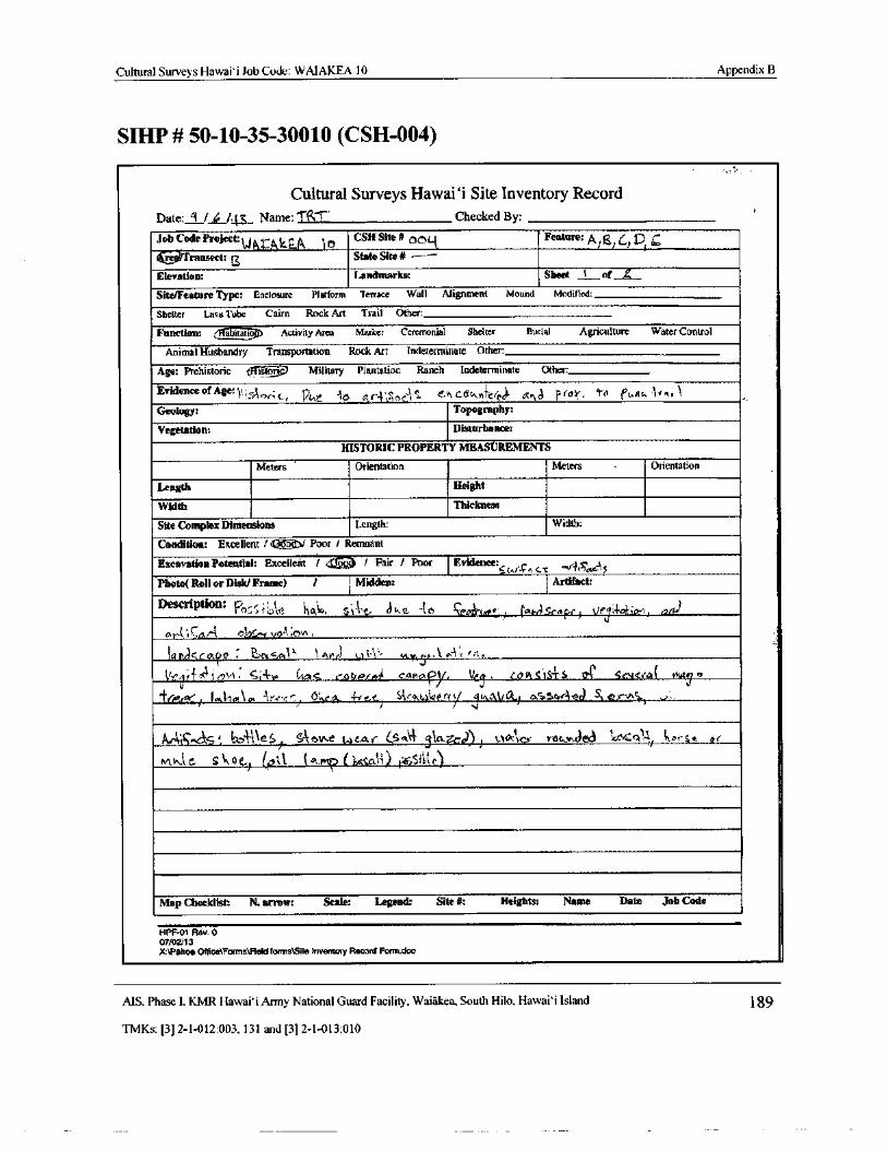
Cultural Surveys Hawai' i Job Code: WAIAKEA 10 Appendix B
SIHP# 50- 10- 35-30010 ( CSH-004)
Cultural Surveys Hawaii Site Inventory RecordDate: / 4 IV; , Name: MT Checked By:
Job Code Project:W Atkie.;
jkCSH Site#oeLt
Feature: Al el 61 DTransect: State Site# ----
j
Elevation: Landmarks: Sheet t of L
Site/Feature Type: Enclosure Platform Terrace Wall Alignment Mound Modified:
J{Shelter Lava Tube Cairn Rock Art Trail Other:
Function: abitattop Activity Area Marker Ceremonial Shelter Burial Agriculture Water Control
Animal Husbandry Transportation Rock Art Indeterminate Other:
Age: Prehistoric fflistort Military Plantation Ranch Indeterminate Other:
Evidence ofAgeril sA : c. o r j" ehc nfercr)• aid ft)\'• 7n ecus l",r{ V t r cdL'i C r
Geology: Topography:
Vegetation: Disturbance:
HISTORIC PROPERTY MEASUREMENTS
Meters Orientation Meters Orientation
Length Height
Width Thickness
Site Complex Dimensions Length: Width:
Condition: Excellent/ Poor/ Remnant
Excavation Potential: Excellent / (( 1Z h I Pair / Poor Evidence: „r.c
Photo( Roll or Disk/ Frame) I I Midden: Artifact:
Description: 's ! M tqb 5 f e) ke - t o ceDA-tat.&,, r., sca pr t) 4(A raid
misc4, 04 1 Are) t.a3l. K a, l A en.
rrlt1',A1Clot cot/Pot). CAP ac V . eavt.sis4s
1zT Sr.teeal
V41,2
1I I egY0,/ 1. 0,10:\ rn F r. bye •- r a.1
Skr a.0.0 rl y o,ottt .) aS3or4N A,rwS1
J
tAMttc. s: 6A-14S/ mm !Wear 4Sat 310.. .4..c)) , OA ex Y4G_r,t en,.Q tt lr arse @(
Mhlt; S\\ oe ( pil { tai. ( kcati) l=it SiLt, c)
Map Checklist: N. arrow: Scale: Legend: Site#: Heights: Name Date Job Code
HPF-01 Rev. 007/02/13
X:\PShoa Office\Farms\Aetd forms\Site Inventory Record Form. doc
AIS. Phase I, KMR Hawai` i Army National Guard Facility, Waiakea, South Hilo, Hawai` i Island 89
TMKs:[ 3] 2- 1- 012: 003, 131 and[ 3] 2- 1- 013: 010
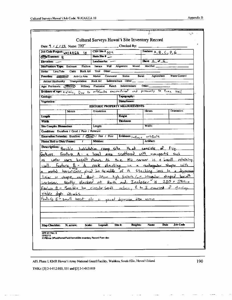
Cultural Surveys Hawai` i Job Code: WAIAKEA 10 Appendix B
Cultural Surveys Hawaii Site Inventory RecordDate: f LIS Name: TM Checked By:
Job Code Project:WNT" QKQA 10
CSH Site#00 of Feature: p B Lr, D/
ge/Transect: State Site it ,_•._
Elevation: Landmarks: --- S Sheet 2 of 2.
Site/Feature Type: Enclosure Platform Terrace Wall Alignment Mound Modified:
Shelter Lava Tube Cairn Rock Art Trail Other:
Function: ,
tetatio>; Activity Area Marker Ceremonial Shelter Burial Agriculture Water Control
Animal Husbandry Transportation Rock Art Indeterminate Other.
Age: Prehisuaric eI stortcs7 Military Plantation Ranch Indeterminate Other:
Evidence or Age: ki,; 5$ o iL/ avec
e and or>.s_ esc.owq'lrtot? r; t,a p*'@ue„, tAy 4v Punt, rai
Geology: Topography:
Vegetation: Disturbance:
HISTORIC PROPERTY MEASUREMENTS
Meters Orientation Meters Orientation
Length Height
Width Thickness
Site Complex Dimensions Length: Width:
Condition: Excellent/ Good / Poor / Remnant
Excavation Potential: Excellent f (G-ood) I Fair / Poor Evidence: „ q6c k5
Photo( Roll or Disk/ Frame) / Midden: Artifact:
Description: Passi61r, 1, a3ninAatinn ( Ampp Sl} e. ' fin nt' c ofSis S eR t
CeAdes. Frafttre, At t leve\ area sco ' erlnR..v. ter s str,ct,
as Wales
warppp apsapp1 Stoae1. Al ' ti,. e. fd13 cmrvier is toasall
1. 14. tro-i(Ake,- L ( l fork S C. Lt a S/...aar Iat3\
A vf1P40,4 JACr5t' tdJtoe t h.:L 'ttr* 4 e.midette OC f4. SA6,1t{ vl 4 420Fr e-14iph1Iin<i. iN final • 2
anI l,.
r f 2Dv ll
1GtiXp 1- }
rr, / ine, re. 1 Rr,af}
i a1G' 1.0S0-4. : vfA.Ti V sko.ck-e a{ Alai kt. P.v d. 1,-Yl 4-6 SP. 1S 2-30 X
Featf} PPSStbqut•e a ( C.c.1o% . tl}.. tc n; rr le C.rrr.r,os
Jta"r4: PC.. deer. ‘ 6,c(AG
5 0.41. ` Jrs,-n- r- r; 0. 4) Jt p r o., 5, 04. 0.CIc S;
d
Map Checklist: N. arrow: Scale: Legend: Site if: Heights: Name Date Joh Code
HPF-01 Rev. 0
07/02/ 13
X:Tahoe O ficelFormssField formslffite Inventory Record Form. doc
AIS, Phase I. KMR Hawai` i Army National Guard Facility, Waiakea, South Hilo, Hawaii Island 190
TMKs:[ 3] 2- 1- 012: 003, 131 and[ 3] 2- 1- 013: 010
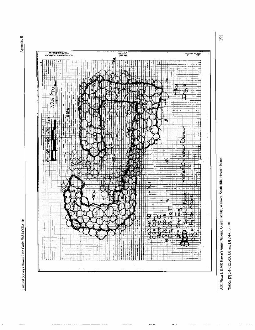
m o45
1: 1-
rra' vu03v/•da01ennava'1/
r OTTL' oN
114_ 1I._ 7 - . N 1 i'.
1 111l•••• ' • •• 11 . ® uu
11i •s.n I__
wt_ I. r t._ IA Ig• -1...
fl..®nl•.r.., a . .`Ji, n.n 1
1 r
um rsj i,: 1
n , .. irI _iir
r:_ yn r..
lllr3map
ui.,•a1I m. U.@r
iir' .. ! -it
1' ,
k.
wli._
uIVj •
UIUI / I 1-
f/ r n st,_
I i1 I II r e-
UUII•.ut® dim "`' {
eU ," i
1
tfUUUUt...i
ni_.i A_
iii' i s dU'I : liE.1••MINMIR ... ,t.. 0 UUS - .. 1i1i.. ra.' re n i 1.;. ..
lirar ®
I "I.!
U` l ' .} 1 N ,. I Hi- it
1 — . nI
p Innr! uu. il llll , n ;.
Nr. ,....e. 4 1 i
i 1.
l ! I
I .1 _ re,
Fid
01 . E 1 ' _ UI` '." ' . , i r
U
lamUm.A
I all ,. 1 .- 14.
6 iii 4 A1i1------
1I
1 t . l1 I. a. r. r1n ,' l;.... ME x' 01- MOIN=
i 1
1 i' - 1 tiligio"ii iiU PIL/ IIIlia! u. s
n.snow I 111111111D a..
rEmmy.*••.1 LUV.
aonium . 1. '
1'19 , iIlr +; .
rM 1' !! Jd .1 11Ympl If, 111. 1 1 i 1t . 1-.., _.. 9•
J'
i I i•U®1 UU_ 1,:. -,.fJ'
4: I `- ..:® :IIIb - .t ' 3
11",.-- 7"1"
ii .
fiUMl 4, 4 I xAibitAINNo
I_ nI_ 11 1 a.T I ti ', .....ti Ur. glN. UU!
l
1. I .. 1ima 1U1/ U UUA.._;
n l .'amtI•!"
10t: • UI US.I 1 ... P. .. 1. n.... 0 S• UI..
ii. irvl- , I' aid•ii •IUC 11
EMU1 -ld ism - „ Ur In n.fir n.
4v N IUI• . 1 III!UUI . r.n I 1 1 . e
X11' 1 L I
11.
11111lIs0-.._;.]..,.:..,.114..:... ..!,.,_' Tg
s t r 4iR
1 1.nn..
IR q.. AA
Walk: AA r 1 I1 i,,Ulln n. r... 1 - I
imaiIl11H - 11
w t, tA1' : E..nr` .' IU Uel Uu® f .
S hili. UU a 1 V: I
tT 1 ; : - 1 Irl'.: f" 1 EliIa
1 t ° a,-ang i
Cs1sw .'• 1® n 1r
4rn0
odf1 Jr.
IQT Us I ' ZI [
IN "radii
is N, iI Id T 1o 11nn.
n , ;
o 111111111• 11111111111111111
3 x om N
oN
n uTd ta, N
v-
U
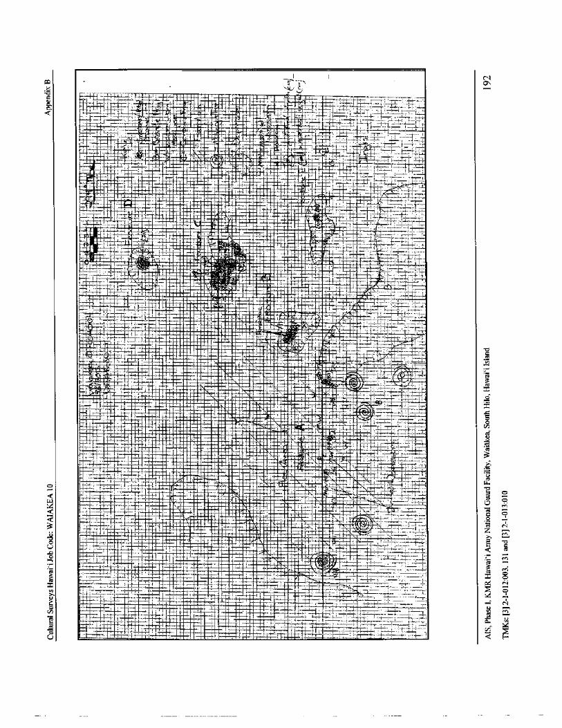
IN
CO Cr*,Y- G;
a- I- r x;71 EII;
i. I { ,.. N N j7: Ii-I-;.•. * tea-- - r .. 1 NMI I: 77-1' 13.
777:4- 4_,..,L.;-•__ L
A
KI. .._' ,• , 11
7
J
r*..
a.
ku aaIVIR aha ell.3 AS Mitill..m ';,--;: ' ILL; „..;• '-' 77.;=:..jt 7:
n _. C-
T;' ., ; . :I , MrIll.
r. ,..- '' -'-',-; . :,'
I lAilM'..-k4. i.!' ..- 1 It;------ r----:-.'- 1.---•
3 ___
34/
y fit---",'P/ I- ..- C all
N '.-.1.,.. 1- 1-' 11 -—} 1
rte--"imir
t j_1 y ra— Ni- 5-
e
s 1- -..•t ®• .• : NMa 1 R°
i.'
WS
xmT-
I jI {
y 1+._ ®
N ,
tN`N® N y-- T—'7 : 3 T.
11•11•••• 11214 'r.....-...17::„
i;+ aN rH
ai I
I IU..NN. 9BEI a ! i es,IE ill
N NU CW f pp 1,. a,_;_ ,Lfi:' N .
113. NN r
I ( - - iTy !
1I... N i , a L- i
H 1 • EI-, N iP
filizz
ImE
NI o-' F - l;-. ,-
t---";
I ' ' i -+ - ism7 : 7 a mF{
T.. _ 1 a eN i1 Ii{ 1.......4_,. :`, i e r--
r-' t-ate, ;"
i--- - f-- iA i .. `r _J ii {
M-:o
ninensaMini
j 9 •
N
1- 1- -; r- 1N- -+-; I U
I PilaN
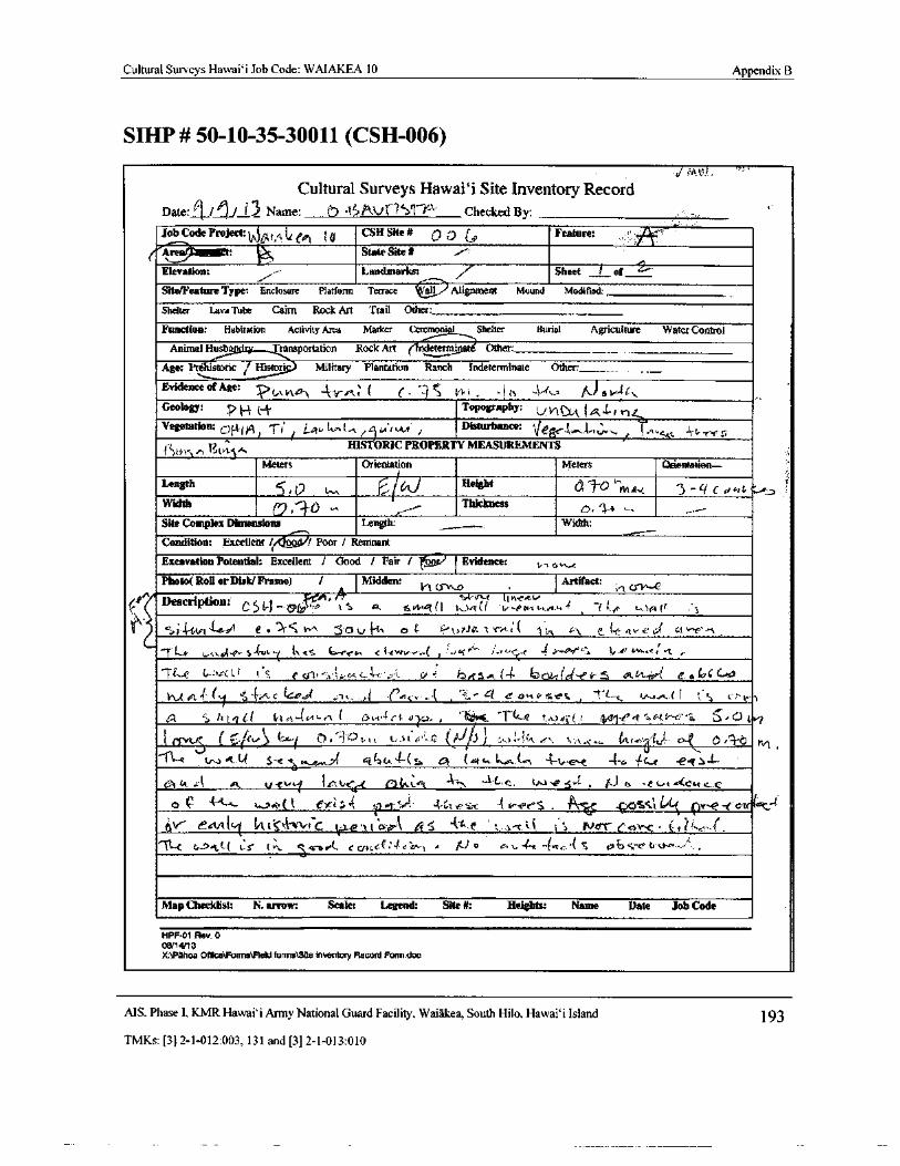
Cultural Surveys Hawaii Job Code: WAIAKEA 10 Appendix B
SIHP# 50- 10- 35- 30011 ( CSH-006)
i mar.).
Cultural Surveys Hawaii Site Inventory RecordDate: I ,l, r 3 Name: b ,Y Pkv i 1' V?'' Checked By:Job Code Project 0/1t., te ep1 i 0
CSH Site# 0 0 6, Feature , `"
Areal gliget: c State Site N /'
Elevation: f,,-
Landmarks:
r--, 7 Sheet I ofi`
Site/Feature Type: Enclosure Platform Terrace W, 1 J Alignment Mound Modified:
Shelter Lava Tube Cairn Rock Art Trail Other: _
Function: Habitation Activity Area Marker Ccromonni Shelter Burial Agriculture Water Control
Animal Husb Transportation Rock Art ( indetermi Other:
Age: Pr ' toric / Histori Military Plantation Ranch indeterminate Other:____,
Evidence of Age:tAVl.tJl 4V'."ie ( c. - 1 t`," '! b ,, I-.lt_a. lk) OY-ZG.,..
Geology: ? H t-i.. Topography: yl l (R4-r r.11...
Vegetation: of(i dg fTi La, ti„,(- ti/ u+wr. / Disturbance: Ve '. twj,,t.,..
fI. 1. CCG - 44- r Y' 5
HISTORIC PROPERTY MEASUREMENTS4} fvsllts,
Meters Orientation Meters Q entatien—.
Length5, 0 .V,. C..--/60 TOvvErfHeight
c j -'f( C d, L':
aWidthThickness0 ,
Site Complex Dimensions Length: Width:
Condition: Excellent/ / Poor / Remnant
Excavation Potential: Excellent / Good I Fair l Evidence: 1,, a vie
Photo( Roll or Disk/Frame) / Midden: 1,1 csr fl
Artifact:
In
Description: 1'4,, r t It",e"
C5 1— Tli;" is [''i sw ul( I t. t( i t.. n.,,+-, ' fi.p wr.-arr ,' 1
f-;/
t 4-ftit-(-441 / e' . ') r C w, ZS 0 t T^ r, K. P•,, rJ, x r:.: ( 'r „ t 1,\ e.. I.e.. 1:,.., d ct '., .
1". 4itio('- s- iue, y \ 4S tree4/4 C 1- F:WI".,....( i `...&i''- 4,3,,{
e.< 4,.
lt'1'
l...f•',....ee
ft:.t ,
rt—e {,.., e 1 t',,
G
e 0- I, ,1:
u,< r' 1. • LrPS...e (-- 10r,)Lf G .? 4 5 GLGG.. „ l f_' a Irr c
1,-1., e eri 1-( y `'J• C14" C YPts'l 6. 1,, .> i rAt...-.,•1 .., 4 ..'./t3' s rr w' CS ' 1'.. c ta,.. w...+.- fl t % v.^..
0.1d2 < ht,? Gt t,1 et•- l( c. e_i.- ( F) I,, 4Ct 4r.a,. , f - I(c. e. tt.:1tiC(` fv,,11- e/ t" aGt.!"-f?,ia 5„ c.1
jvt ..;, trey '
1r -: t=._t `.._^: 1 t. tt,., ( 4,.. 0, i3 I"
11-e t,...1 A-u s- e1,...r,..,
a4 6t la IA-(-( 1., A ( G( t., 4-t.-......e. - i 4 a. e - el 2.-
0iv'•1 to A as, /- c-1 14, t.c.( fat, L'.1. • - 4C^c_ (, cwt , f,.] a - e c., e w( Cac r.0
e c 4-4—k- Safi( i ) ei r 4 V," t:`• SLG,". ai . 1 to-er^S . 4)01a{ t LdL ov, e- t cu . c..-1-6\ f"- ettnt1 fit tst e'. tC vi..e 1 t"..,,,,A, t,.r ' .,.•]- c, t.i
s j Nor ctavc. . (, -:;.(.
fit-[ G_> 9.t( t' r tr. . K-o> l ccot, cr'4.' rnt A jj.) o r. t. 4v. -(. ce.•{ S ce6c- t. i.ke,:..:
Map Checklist: N. arrow: Scale: Legend: Site#: Heights: Name Date Job Code
HPF•01 Rev. 008/14/ 13
X:1Pahoa O18ce1Formecield forms\Site Inventory Record Form.doc
MS. Phase I, KMR Hawaii Army National Guard Facility, Waiakea, South Hilo, Hawai` i Island 193
TMKs:[ 3] 2- 1- 012: 003, 131 and[ 3] 2- 1- 013: 010
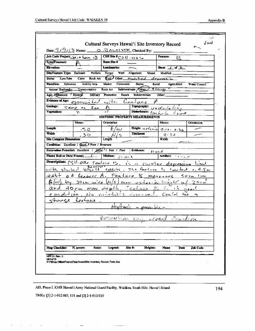
Cultural Surveys Hawai` i Job Code: WAIAKEA 10 Appendix B
Cultural Surveys Hawai` i Site Inventory Record J""" 7
Date: c'f/9/ i a Name: CD 3 #\ T7 . t Checked By:
Job Code Project,,,,A.,.....,„ 1 o CSH Site#(' cr _ cJ t. c<, Feature: 1nsect: f..\ State Site#
Elevation: Landmarks: Sheet / of 2-.
Site/Feature Type: Enclosure Platform Terrace Wall Alignment Mound Modified:
Shelter Lava Tube Cairn Rock Art lt£_' Other: ,^. o., tcal a. t e( t,,,, ar,;,,,
3
Function: Habitation Activity Area Marker Ceremonial Shelter Burial Agriculture Water Control
Animal Husband ransportation Rock Art Indeterminatel
1- zV, '
t
Age: ehistoric ( Histarj Military Plantation Ranch Indeterminate Other:
Evidence of Age: j f3'CJ c..1.-.; V: .
1t-o '' I!, c?. " v.Y--sz
Geology: ,, n Topography: , / r /wV• LLS d`. t1 d[. Ps Topography:
t 3i .
Vegetation: f/ Disturbance: / P
HISTORIC PROPERTY MEASUREMENTS
Meters Orientation Meters Orientation
Length
EI • 1 Height _ f 3.(<_c, 0, 0, r o. d_' S AWidtht' Thickness
O, - til1
Site Complex Dimensions Length: ` Width:
Condition: Excellent/ r.+., Poor/ Remnant
Excavation Potential: Excellent / )/ Fair / Poor Evidence: V1 is — B
Photo( Roll or Disk/ Fr'atnel,._...,...L,_..:.. Midden: j .,t. k Artifact: s ) . t+
Description: ' E. o((.,e 0vt 4,,. r.. ('r . 1*-; .', t^ t4/' V lav 0,1- e 9,../, s; S 1.`^-'-- 33.(..Ou F`4{, Y
t1.---):: ` SI\
e. Ize/, l,O cis.4 I A. C 0/914';.', /_ ' 1`t..9
q
e.:- t.,, arc I. 1 t uc..,..sr.. 4 c, 4 , s" tin
lj,(?'.a 4 4 O '!- t^ Q.R t V-1' A - F'C_ ' i,:. t..-. C' L:. vkt, c,, r,^. t vv^ 0 C. u,. 1 C7s,s,
lr+J 17tz . z ..+ (,/,) J r loil,/nA t c _ t r ? z., t{'r
r 1 tt L-fivn at - 1Y c t.,,,,-, V',\ 1Ckio4( t . "_.• d rt S- r f`., 1. s t s <, l 0- v'
t
e CChil Oft -I,
i tli1 /\ ) Ci' ^' Jo\ P,t;
i ;.l' ea ;, P,.;,P,. 4),, 1 . C O A/ ee/ 1----
Rt.. e
5"4"0Yft CeR,j-,
A v...A. „
1.,';•.,,-err
1< ' I); .:,r'-( ;.,.
04t-,A x.},. )', f i '/4eJr'i' d
Map Checklist: N. arrow: Scale: Legend: Site#: Heights Name Date Job Code
HPF•01 Rev. 008114113
X:\Pihoa Office\ Fonns\Field forms\Site Inventory Record Form. doc
MS. Phase I. KMR Hawai` i Anny National Guard Facility. Waiakea, South Hilo, Hawaii Island 194
TMKs:[ 3] 2- 1- 012: 003, 131 and[ 3] 2- 1- 013: 010
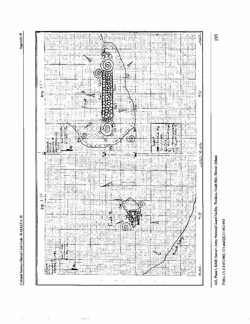
CO 7 s
o Itff
5 O
yfi
ii
l -'k
i•1
TS
I
E
a(
s4e
tifi.: 1,
talY„
cz
ts, t'4::;:,
it4,....,:::ii,„,',..-,-;:,;!::-.1-....:Li=-=-,-.;':;.
7.1!:...,;-:,.- 1-. 714:
1;.,.-•.:-::,-. 1-1.
1"..1.•'.. 1:: 1[_:1,•;;;,'
4'.. 1.: 1:::::::
177:41:7::,1,„,.,„,„:::::;: l.,,-_
if..ilt.:,!:., i.
i,,I
I x
upti,..._:::,..,:i.,...
r...i:
t.t.:1,,,,,.....
1,
71,...i ccFa
1—' —1—_.
C a f ,} 3
o
3.
III R° • t < E -;,..
7-, p„r1' ' ` Z n8 mom v
1 tzt I
I
I
i
IC i Ai T u
tct
a1
rnx
cu
o
co
n
aZ
r713.aa..
e r 3 . .—._. . may
vi
U
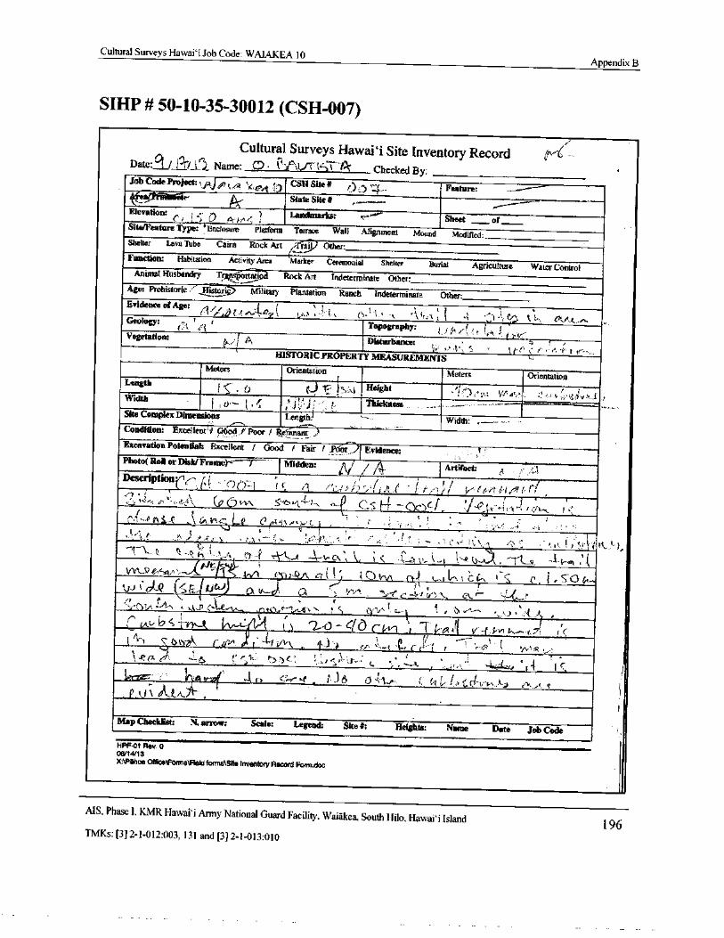
Cultural Surveys Hawai` i Job Code: WAIAKEA 10Appendix B
SIHP# 50- 10- 35- 30012 ( CSH-007)
Cultural Surveys Hawaii Site Inventory RecordDate:° I. / i'-'ry il Name: C..0• 'i.:,e'.VC 1 k Checked By: Job Code Project,./ A) tr,4 ' Cal Site# ,•:› )•-
Feature:
tkState Site# ---•
Elevation: r, I, Landmarks: ,---"*.' Sheet of
Site/Feature Type: ' Enclosure Platform Terrace Wall Alignment Mound Modified:Shelter Lava Tube Cairn Rock Art / FP Other:Function: Habitation Activity Area Marker Ceremonial Shelter Burial Agriculture Water Control
Animal Husbandry TrArtfpin—utisur Rock Art Indeterminate Other:Age: Prehistoric '' Ilistor Military Plantation Ranch Indeterminate Other:Evident* 4 Ageg (
1 °,4..) 4 4, 4.,,,`, ( . 1, •-::,- 1,
ef.,:l l'',,,, elt A a- 0', ,Geology: (.. 'el
r
Topography: 1Vegetation: t
Disturbance: 4 't
j• =* t`, `' t ' 1 t‘'< er `
e'' t l'''• _
HISTORIC PROPERTY MEASUREMENTSMeters Orientation Meters Orientation
Lengthi".-- • 0 0 Height i'),- 2,,, 1,r, A,,,,' ,',, 1.;• qd..,,,, 1 ,Width
i 1 0''''' I ' C ' r' i: I- Thickness __ .•Site Complex Dimensions Length:I
Width: „-----
Condition: Excellent 4 p‘ ed /' Poor/ Refina; r )Excavation Potential: Excellent / Good / Fair / , Priin---) 1 Evidence:Photo( Roll or Disk/ Frame)-c 7 "-- I Midden: / / 4 I Artifact
ADeSCriPti° nr(-' 1, ' r)e)-- 1 I r", f//
f
4
9j , e, .. C , ;) v,", o. 1-4- I, ,, Cs t 4 - Ionc f, -0 t k'''' A'-'I1., . .,1l'.- '‘ i t •--'' *1( 14i--...,..' Le 01-111..“ 1. (_
1 ,k" , .„ ,, , , : , ,,,,,, ,, ,, ,..
14 * , V1':,4,,--''-
I' _ ~. ' -, ' - t ' ' - •' , i h:`,„ 1 •';'• : •' ,, t 1; 4.,' i''! k•••' ),C.,. .
4,1. '\- --E' :.• 1
1- 4 .., c. - 11.- P -- 1iptis* ,
cp),QA, c;( 1 ') I( 2) trvk ot.-) l.....)tn. 1 ;::: C''N ( c c
Y-
E, it) ). 1 a ti—e). n r ii.-." ----- r 4- 4, f-e •-•"--,C...fti
r
I - 2,- 0 - 616 c fri.- 1 : I 7 ,.•* ,ti C kvi - 7-1'i
I‘(c...... ',
AC'
lArtr l (s\
t.)ks:2,
4‘. rip'- l' 4-f Vv\ ,
e,,,, s'.,..,
t , k-..., ..,-,,.. r , '.-• 0 Cyv C....P., . -s'.. 1 .. iR e, el * 2- r' 1, i"),) 4-' 1--. 5,.
el 41., (, ( 1. 1,- i, e i\ dk-t/L' ...., ,
i
Map Checklist: N. arrow: Scale: Legend: Site#: Heights: Name Date Job Code
HPF-01 Rev. 008/ 14i13
X:\Pahoe OtticeFonns1Reld formaNStte Inventory Record Forndoc
MS, Phase I. KMRI-lawai` i Army National Guard Facility, Waiakea, South Hilo, Hawai` i Island196
TMKs:[ 3] 2- 1- 012: 003, 131 and[ 3] 2- 1- 013: 010
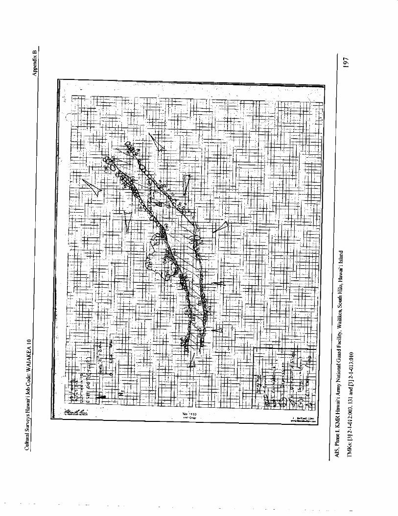
x
0aa
1 , 1r-i 1 I
IIIII I s- J I I 1I
I
i I- 1r i f i 1......• I- i 1
i
I i,. ._Ai
I, I it 1 1
0-„,.., 1,-.a, I, I .-
1- II1
l 4- 1 .... 1.:I
I sig. .. If. i
111..:. t I iI
INIE
i i _ 1 .+ 4 + tat ,-a,, :' 1 f t -,- ,
1 1117i_ II , i-
IR 4
I ,_. 411111:. .._. ; 1 1 _ I III
I '...I. f-- -{_.'i \
14li ,... I Iiia Itl:j. t i ' it- L —
I
f
If . I I I 1 ! i war } I .
1 . 1 I I _, __ pati 3 h
1 I_ 1 .. Ij.
Imoi I iT"
s'
I I tif---- r...-::
i1 r
ppppppppp
I I• , ! % - I . T_.I _,
I C. q' ' w.- 7 1
7- 4'
h,gi
9 t lI
ct
i 1 4.- I
I i
li .: { I i—
1i_L 11
e iy1 cct
3
11— l I ,j 1 11 . m i — 1I car
T I , I _ i r I
11I
IIK
tflH:. i f F
114 11... .
7::::,
LirC I I £
I 1 ! '
1 ' r- •
eft , 1
1 -,2,6''•
Ifsr
L
flII IST tI _
Y MIr I Ji 1 5 r
z Nrn
t
Ir
NO 0vow3; lnr= P.1".
N',it' GTI.) wW191. 11wwaansnm
9x7CU
iNI u
U

Cultural Surveys Hawai` i Job Code: WAIAKEA 10Appendix C
Appendix C CSH Photo Logs
Cultural Surveys Hawaii, Inc. PHOTOGRAPHIC RECORD FORM( Digital Camera)
Project Name: 1 K...rei tt. pSil Job Code: IiicIACILeee;‘ t 0Camera: CS 14- L Photographer(s): 01/146/. AJ k"( bi, j tFile Name'( Sob Code-Camera—Dates ofPhotos): kt-‘ a I. a (4-eat ( 0 - C'-) 44-. t..,) - , 2 4 - 2.013Prune Time Direction
i Na Date ..( Military).(Fachkg to). , Description
IS 2- VIP- I st.,J c5P - do 2 t t: A • C:4 1,-- AL'i, (4' •
I' i11'
IS) i
I ,, S kJ t IILI
i_) I, I 1
I''.-Z '1 54)
I •
o . 1t t f I I
I'
1" 1 k% II
poll' S to A IE.) ev tj , it i, 1
I i1I '() t '
51.4
044 t,,, i,,...,..-, 1 ,, ', e+ , •• ...,.,..),
ile1R1 t I 1'
i 14-
lq ' r t t t., ,..., „ d
ye, ti1/4, d. I 4
1 tf71'
t) tII
is For example" KORAN 1— CSH 0- 3- 2-07 to 3- 17-6'67.Page I of 1
MS, Phase I. KMR Hawai` i Army National Guard Facility. Waiakea, South Hilo, Hawaii Island198
TMKs:[ 3] 2- 1- 012: 003, 131 and[ 3] 2- 1- 013: 010
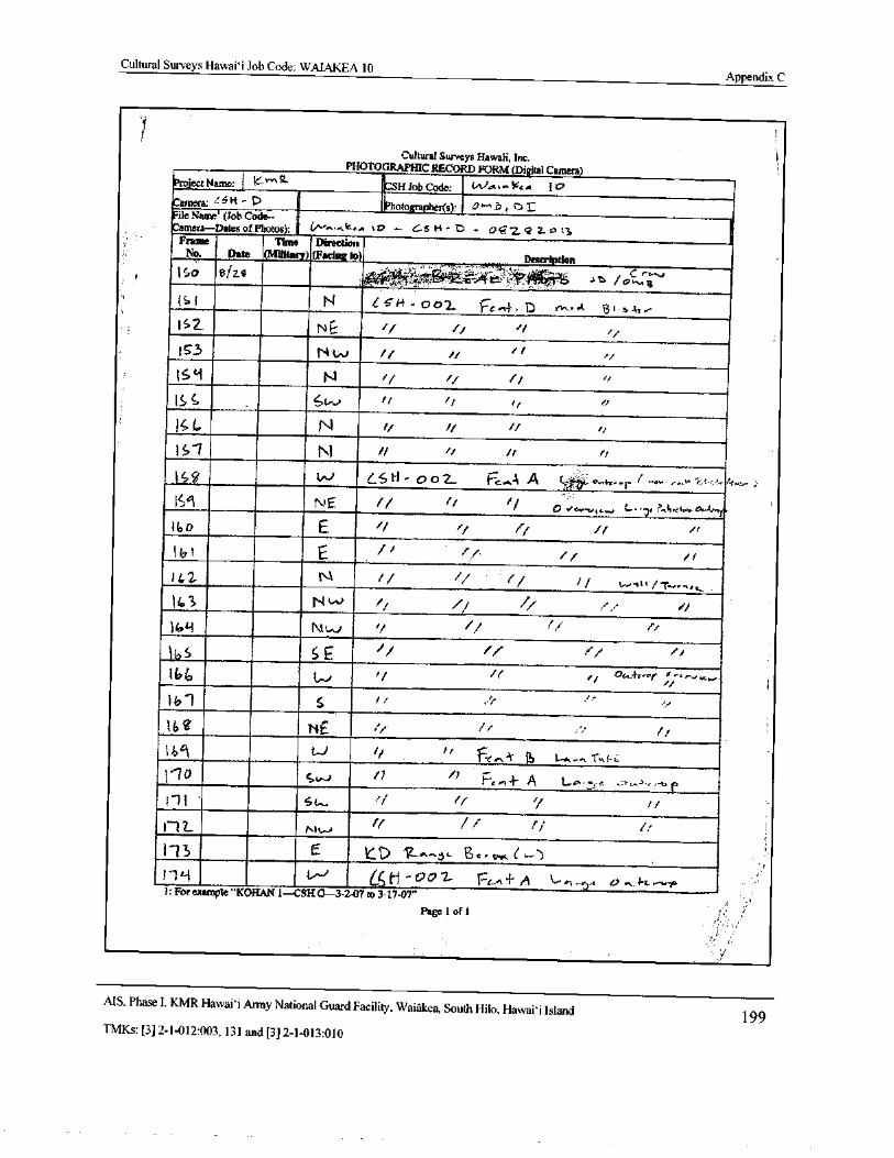
Cultural Surveys Hawaii Job Code: WAIAKEA 10Appendix C
Cultural Surveys Hawaii, Inc, i,PHOTOGRAPHIC RECORD FORM( Digital Camera)
project Name: I 1'"' 9. CSR Job Code: ( AAA*—14t A 10
Camera: ' 5 41 - t) photo O Nr , r) iFile Name''( Job Code--Camera— Dales
P
3
S):
fCamera— Dates of Photos): V" K„ 1v4A to +- C5 H- r) - {)T 2 Z. P 11 1Frame Time Direction
No Date ( Military)( Facing to)z .
Description
i tro 8( 28 0 ' ru L" M.," - /
0' Z ''
1S1 N eSi-t - 002_ F,„ 4, D nti..,. t 731s- 1-4,-
IS
3tskc,-
l ' 2. N 4E t r/
153 N'w if iirt
164 N 1/
IS t, t/ if r
Is L. N ii 1/
1 - 1 N t t rt
159 LSH - 0 02- (-7,....,
4 4 e„ o..+z- r —., , ,: ...
Sq NE 1/ if o ve..,,,...,, c.,. 7' r.4.? I.. A-d..' r`140 E f r
li 1 E t,
1t2 t`- 1w-w /- r..Rtt
14 3 N w 1/ F,,• 1
47i-1 Nt..,../ ''i P, r
111 S E f/ i
144, Li 1 oc,.4r..nt a-,,„,_
1i, 1 S t/
l b e NE s f/
14i41 t../ t/ r
110 s tesi 711 .,- 1- A ' rA-owe ,-,—. x_.. v t
111 6t, j
1- 1 Z. A!.-.... ff 1/ f!
113E kl7 'R... .6 gr. ! L,.)
y»1" 19 L/- a ti0071- TSG,"± fj kal—r7.1 t.. '+..^ t-+ we•p
I: Forexample" KOHAN 1-- CSH G- 3- 2-07 to 3- 17-07"
Page 1of1
MS, Phase I, KMR Hawai` i Army National Guard Facility, Waiakea, South Hilo, Hawai` i Island199
TMKs:[ 3] 2- 1- 012: 003, 131 and[ 3] 2- 1- 013: 010
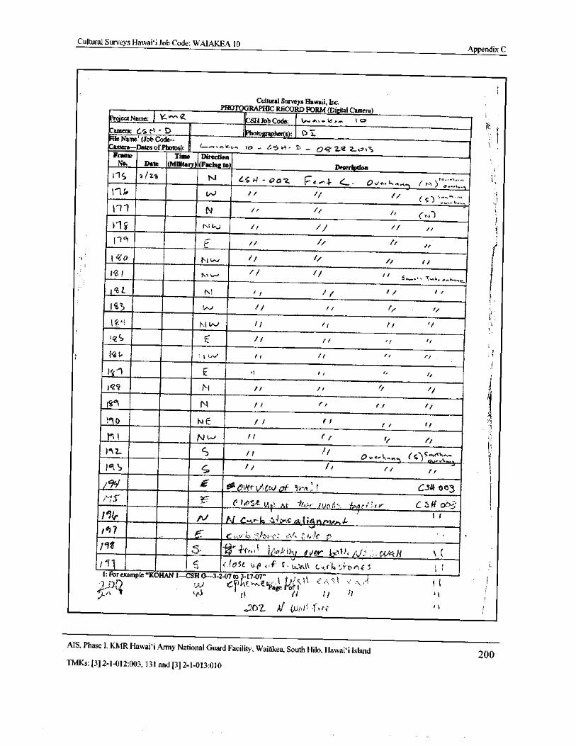
Cultural Surveys Hawaii Job Code: WAIAKEA 10Appendix C
Cultural Surveys Hawaii, Inc.PHOTOGRAPHIC RECORD FORM( Digital Camera)
Project Name: 1 Y-'''''' 4- i
CSH Job Code: v.,..,'' s%
Camera: Cc.(-1 - D Photograptier(s): 0 1File Name'( Job Code-1 ,
Camera— Dates of Photos): 1.--'''"'•-```-'- ui - 1' 5" 4- S' - 0 Cr 2-g 2-Frame Time Direction
No. Date ( Military)( Facing to) Description
lic 812.1s N “. 14 - 0 o' Z. P e.. 1 Jr 4 . 0 v... 1-......,
p (1, 1)";::::::,
1
11 N rf ri
Y1 N t,0
1
1 0 r,, t 6-, 1/ 4"
1 r/
IL N 1 I , I 1 I '
1 ,
I,
i
11 E 0 I,
lqq N 11 1
iIt`l N I ,
r / f 1
i it lei11
II 11e C) ,
c74I:.C.:::
16k S I iI,
941 I( 10 Over VI,( CIII ai l'real . rg C34 03
M 1t; e• 1 fin 11, ii,a est:, r 4, C S ft Or-33
11' p1. N A. .......-I, ,.. 4 oy‘c
1r
lit S* -b•''4-(-,,, i )c..),2, t, ii-
y $./er
ll e to St uqo ,, f S• LOA.kl C.,, L I' 1,4'', -. Dr‘€ i ',1: For example" KORAN 1— CSH 0- 3- 2.07 to?- 17- 07" 1„,,,(‘\ c.,\ 1 . 7, A
O() SAI e-rK('- e lige friyi' I1 l 1 1 i
J07_ Al tP
MS. Phase I, KMR Hawaii Army National Guard Facility, Waiakea, South Hilo, Hawai` i Island200
TMKs:[ 3] 2- 1- 012: 003, 131 and[ 3] 2- 1- 013: 010
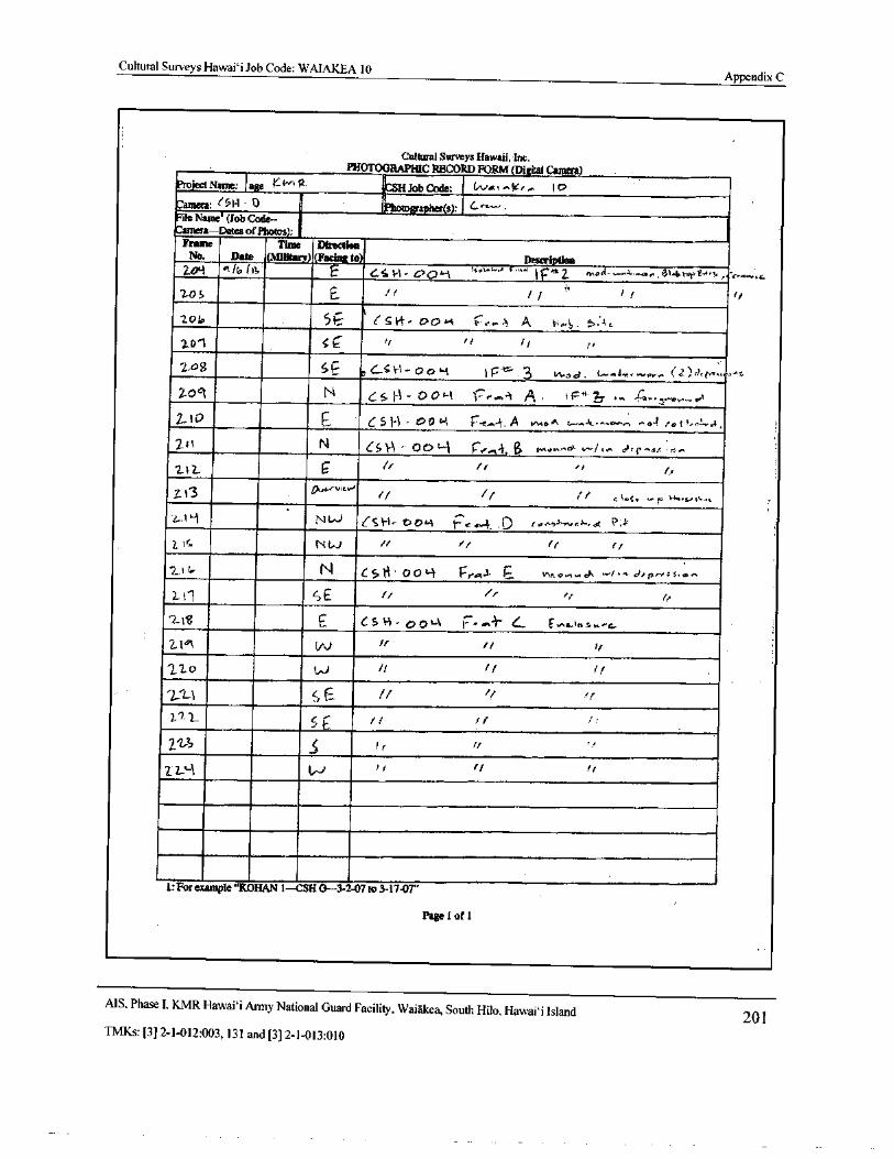
Cultural Surveys Hawai`i Job Code: WAIAKEA 10Appendix C
Cultural Surveys Hawaii, Inc.PHOTOGRAPHIC RECORD FORM( Digital Camera)
Project Name: 1 age K-4""'? ICSH Job Code• Ilya,.-, k, 1 o
Camera: ( 1. 1 - 0 Photographer(s): e-"—
File Name'( Job Code—Camera— Dates ofPhotos): .
Frame Time DirectionNo. Date ( Military)( Facing to) Descri
204 / b( I E 6,,s 1.,, i, C' 09lc,A-, .., f.,,.'
IF 2. mo 4., w.", 3t. btev,. v, er.,,... c
205 E. J l
2.0i. 51-_- 1
t7r' t sti- 00H t---,- A A H,,4. 5: 4c
2-D1 5c i rr
2-a`
gy 511 C651.1- 00" 1 1 F . 3 wod, t--, 4-,.... a... ( 2) 4, e,„—,
2-0C1 NAi 111 0 0°-.1 r w.A.. A + i,--' 4—,,,,,—,,.„„i
2_ l O C- 6 5 I-' i - t7 0+L- t r......4. A tM e A t- 1,.--. n -._ r /o f 5. J, i
2_11 N 65 l- 00 Li r„e" 4. 0 ha,..,.. e- L..../,.. dr t:.•., c.r+ ra..
217 r I r,
7. 1 V.' / f/ I s, ... r1a..,,, 4., 1
t.? N"-^) CSt-t- c,c .-A 1:: e,,,.. 4. D tonSS-v.,,., j., l._
Z IC Ni'-.) / 1 if r/
2_ II, N e5tt 009 reR c vNON. wd, - f• 0,0 pe-,- 5, co,.
1, i1 SE i/ r,i.
218 E C. S H - p 0 Lk I:, at+" s„ F NC...1 1 s r.- a.
11°\ N r r t/
220 W rl t/ f
2: 0 fr:1 If
ra
2L'-1 W c/ f
is For example" KOHAN 1— CSH G- 3-2-07 to 3- 17-07"
Page 1 of 1
MS, Phase I, KMR Hawaii Army National Guard Facility, Waiakea, South Hilo, Hawaii Island 201TMKs:[ 3] 2- 1- 012: 003, 131 and[ 3] 2- 1- 013: 010
Cultural Surveys Hawai` i Job Code: WAIAKEA 10Appendix C
Cultural Surveys Hawaii, Inc.PHOTOGRAPHIC RECORD FORM( Digital Camera)
Project Name: Wpja,kfit, JO CSH Job Code:
Camera:N6„ ra_c5: 1` fphotographer(s): A4 GG+,".G
File Name( Job Code--
Camera-- Dates of Photos):
Frame Time DirectionNo. Date SMilitary)( Facing to) Description
3221 + in NW flertjerw. ( 9tw. 4i Vita heal- -
3228 oftiJ1. NW
3.2. 2A
al.,, 3 N1 dn t.
323h ‘,./ f.- In NC
32.31 . egv. I,l N6
31.-32 ejt.j sSW Slat- Wall r N ”
3233 alt, 1,3 SW N
32 34 A JI• it3 SWF
32 35 alt fB SW „
A„ 1
u N
3211, a17/ It3 Ov... V+w, 14;( 1,..- 0.., Av-F at.{1
3111 GI/ 1, 1. 3 Ow V*4.r r
323? Q4141. 1 Ov.. t1;, 4..) ' 9etn.. ( 6145.)
3239 Albil3 0v„ dr( 4) Hall. ( 61art) - Makt. s Mit eft.
9240 et11014 OV,, Woo clew- 6r0. 1, y Wk.(31.41 6111,4111 NIA' Vtp,..srm.- rt.4 S G?4-. 4 Vi. )
32,42 ogJ4f3 N1../ a
31, 43 Ail, f t7. SWv
r
wi 1. 4. 4.I' to ' Ba°IfP144.3L• 44 Qlt,1S SW u 1. a o
31,0" agl. In NW tl., t 4 g., Wts4sldc ofFia}. 3
3e41.., * Mil W Gt«t€. i Woe DI',fait'', F4 4. r,. 4
31. vh A14, inW a N
r N
11 4g 40/ 135
r44
31 4S 411. 105
31 cv gft,' sSE p-Fa-
32 ci h
ofolvy SE' N1•
t: For example" KORAN 1— CSH G- 3- 2. 07 to 3- 17-07"
Page 1 of I
MS. Phase I. KMR Hawaii Army National Guard Facility. Waiakea, South Hilo, Hawai` i Island202
TMKs:[ 3] 2- 1- 012: 003, 131 and[ 3] 2- 1- 013: 010
Cultural Surveys Hawaii Job Code: WAIAKEA 10Appendix C
Cultural Surveys Hawaii, Inc,PHOTOGRAPHIC RECORD FORM( Dai Camera)
Project Name: („/ p a tk J Q CSH Job Code:
Camera: N' Ga c s_ D,g,F. l Photographer(s): N' Get"'
File Name'( Job Code--Camera— Dates of Photos):
Frame Time DirectionNo. Date ( Military)( Facing to) Description
25E gGt3 E G. N., 4i ViI.N Et414
3253
4fr
32 S1 411t.!« W
158 b! n y!
R,.}; 1,, FSclI- self Tit
s- z
tf ./tr
t<. a
1211 041, 3 MFi
OVA, v1+w Nt. Wa'1<r 14. 10, C6^-1war Yc:. I.
32L1- qt../or NE U 1,,.ff vt u wa Warr. 5' I+JY+! rlus.r
320 41 0/ 12 NW l7GYl1 t1: uJ Qq.,, Gta „ st1'a.
1: For example" KORAN 1— CSH 0- 3- 2- 07 to 3- 17-07"
Page 1 of 1
MS, Phase I. KMR Hawaii Army National Guard Facility, Waiakea, South Hilo, Hawaii Island 203TMKs:[ 3] 2- 1- 012: 003, 131 and[ 3] 2- 1- 013: 010
Cultural Surveys Hawai` i Job Code: WAIAKEA 10Appendix C
11,
Cultural Surveys Hawaii, Inc.PHOTOGRAPHIC RECORD FORM( Digital Camera)
Project Name:_ .,‘/ VI( 7.„-- ICSH Job Code: \ AJ a_t C\, LC e._^ \ C)Camera:0 1-\- C....- Photographer( s): _ 2)
Fife NameName ( Job Code--Camera—Dates of Photos): VVia i P..v--ee'\ \( 2 - c4", [\--
C. — ` 1 , 4.1 tFrame Time Direction
No. __,..13ete fMilitaryL(Fachig to) Description
1Cs 4\- ocx., Tr ro,,. A, ..,
b 2-',/ 2-- cE a,/ ey 7
9 2 1 1/ 7 77 2 —
rb 9 SIA) i r7/
1
C, 54-1— octc,,, c"--(..AJ .
1 1 i i cr...,...)-..., ,,....s.../..,..
1 1
p7./5/ 1 E :. CoPt) 0. 1-..4'. 2_ tk, il, 4,, c,,,A 4
c5r, r/
J----
f c :,.:', \' E 7,
7 7
C.,•.:,..
je;: \3 r sE._ 7,,
I) 1,-) r - 1
C sr- 1 r
5 I, p I/ 1.,..1 , . L
P l, 7 t/ 7/ 7
iv j s 5(.-- // 7 1/
0,,/ N 7 P F . Fzo N
iI2_ ) 7/ o 1/ 1/ r.,-[ D —
21_ CA) 0 t i 1 F:•,-', 01
2.:; t.A.J /, 7 1i
II 1,
I: For example" KOHAN 1— CSII G- 3- 2-07 to 3- 17-07"
Page loft
MS. Phase I, KMR Hawaii' i Army National Guard Facility. Waiakea, South Hilo, Hawai` i Island 204TMKs:[ 3] 2- 1- 012: 003, 131 and[ 3] 2- 1- 013: 010
Cultural Surveys Hawaii Job Code: WAIAKEA 10Appendix C
1
Cultural Surveys Hawaii, Inc.PHOTOGRAPHIC RECORD FORM( Digital Camera)
Project Name: K w.' CSH Job Code: t'-'"^,-,' t^ i 0
Camera: < k„. Pbo10grapher(s). 0' 4File Name'( Job Code-- T
Camera Dates of Photos): _ s'j,/ i : r' , 1 _}t-, -
1 ", 1 . ( __ j!Frame Time Direction
l
No. Date ( Military)( Facing to) Description
09— 2 (:' ' ' 1- 1 I' D , s14,_'','t 2 1“-] [ s t,—I,<.. 4:---. 1.,,,,_
Coy: 21 jy I I
q29 1/ 1/ i II
62.91 c r` 1
a/ j
41 213a iNI s/ f
L i .,-/-
j . I: t,
G51 3 ) S if it
SU4Z. S ij if t/
t
1: For example" KOHAN 1— CSH G- 3- 2- 07 to 3- 17-07"
Page' lLofj...,
MS. Phase I. KMR Hawai` i Army National Guard Facility. Waiakea, South Hilo, Hawai` i Island 205TMKs:[ 3] 2- 1- 012: 003, 131 and[ 3] 2- 1- 013: 010
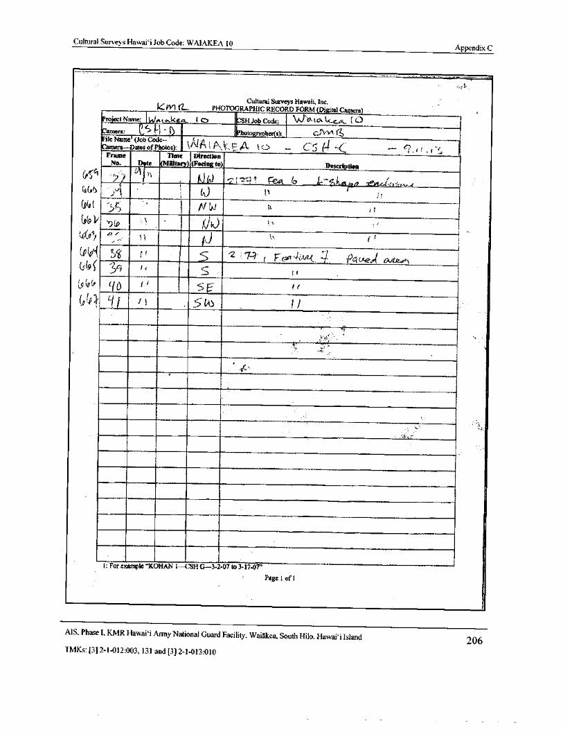
Cultural Surveys Hawaii Job Code: WAIAKEA 10Appendix C
Cultural Surveys Hawaii, inc.W1 PHOTOGRAPHIC RECORD FORM( Digital Caincral
Project Name: i.JAt a. keri t C) - ICSH Job Code: W Y ta.l t- r•.. (C) i
Camera: ( j 1. 1 6 Photographer(.):_ C.II'vl('File Name( Job Code-- t
Camera-- Dates of Photos: l' €. C: l4 = C?
Frame Time DirectionNo. Date ( Military)( Facingto). Description
d} e
1l4) N - 2` . m
Y'': t s ',-.4, 4/9r x_Yt.C. - t
t,) ti I
OW ft gni)
zJr
4104IA 15 s„' VL ` C€t e
s
04 IIj / s Slns 1
1: For example" KORAN i-- CSR G- 3- 2- 07 to 3- 17-07”
Page t of l
MS. Phase I. KMR Hawai` i Army National Guard Facility. Waiakea, South Hilo, Hawai` i Island 206TMKs:[ 3] 2- 1- 012: 003, 131 and[ 3] 2- 1- 013: 010
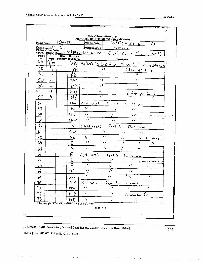
Cultural Surveys Hawai` i Job Code: WAIAKEA 10Appendix C
Cultural Surveys Hawaii, Inc.PHOTOGRAPHIC RECORD FORM( Digital Camera)
Project Name: 1- I fvt" CSH Joh Code. vV r 1 j ..F. CI 10Camera. C,t` 14- i _. C otugcaphv:_ JV :File Name'( Joh Code-
1 ' ppi;
1` .-
c-_ tr M J
Camera— Dates of Photos): "' J F41 I- 0 Lj tFrame Time Direction ' 7
No. Dto / Military)( Facia to) Description
4.,,:c, s, TC3- J50 ( 1: # c- fade 6 (,`. )
1.61/ , 1 1}
k1M
t l t ) t.\
5,. - 1 1 Cr7- 4,1,, e 2,,,,,,,,
f 51. NG-' ( 5 - H 0 o ) r , rt 4 . 1_ 1 ''"
r<..
5- 7 N r/ r r, I
S. ti
ci Ni") 1! I6,0 S ( S el - 00 S 1.-- e.--4 A ? 1" 4 .. c..0,,,,,,
61 SwH
r r, rr
62 0 H 1' r if N-. r E.
6 e r/ tr rr. rr
11(
9 N i' . If 1 "
qPj 65, 1 _, C?Cl5 p-c... 4 . „ cluss..r..
lr rr r rct. sa uT s•-,*.k.:...)
191 c it Ii rr rr
t2i N E t/ r r/
ic w Ir rr 4 it f. :
10 Nt../ (51-1- 007 5 if D, 0,‘,,,,,,,A
11 I r II ft a
13, N S r 11 f,
I: For example" KORAN 1--, LSH G- 3- 2- 07 to 3- 17- 07"
Page 1 of I
MS. Phase I. KMR Hawaii Army National Guard Facility. Waiakea, South Hilo, Hawaii Island 207TMKs:[ 3] 2- 1- 012:003, 131 and[ 3] 2- 1- 013: 010
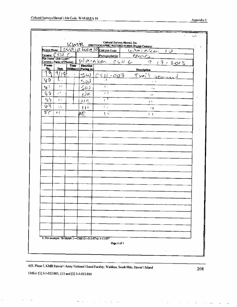
Cultural Surveys Hawaii Job Code: WAIAKEA 10Appendix C
IL " ftCultural Surveys Hawaii, Inc.
1L I v/ Y& PHOTOGRAPHIC RECORD FORM( Digital Camera)Project Name: ( Ala (a. kel iIO CSH Job Code: 10. Acnk , r' x t4,:...L,,. / .)Camera; C 5(--4 ( Photographer( s): 1)..,,,- /I-File Name'( Job Code-
ft}odi—
Kamera—Dates of Photos): . ' 1 t,#! . L?;‘.. C .,! C... cr / f – 2,-.0 f '' jFrame Time Direction
No. Date ( Military)( Facing to)„, DescriptionA ( i
11 l J t` 1.-v-0'.'(10: l ' - e,, - 4,.;- i; R 4.^, 1.
c60 ((
1; r
f ( yr y t, 1
1: For example." KOHAN 1— CSH 0- 3- 2-07 to 3- 17-07"
Page 1 of 1
AIS. Phase I. KMR Hawai` i Army National Guard Facility. Waiakea, South Hilo, Hawai` i Island 208TMKs:[ 3] 2- 1- 012: 003, 131 and[ 3] 2- 1- 013: 010
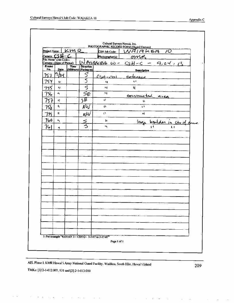
Cultural Surveys Hawaii Job Code: WAIAKEA 10Appendix C
Cultural Surveys Hawaii, Inc.PHOTOGRAPHIC RECORD FORM( Digital Camera)
Project Name:„,, t4
f:.`
Vl.v Q. fSH Job Code: k / 41f . I 04' 1H'Camera:
ePhotographer(s): O Y14c
File Name ( Job Code— t
Camera—Dates ofPhotos): Uj 4- (. CS il —C., 9 rZ4 e IK, i
Frame Time DirectionNo.
qDto ( Military)( Facing to) Description
el
75.E C56 -,-,b,t e441-vet, s.a
75'1 u 5 tt 4
5' S/ ti J Li 4
i4-Yu.c 4e{. ,,v-
75 t) 51 (
rtti
it X+/ UV It L i
15i h Celit/ t` t.t
66 alt t{ 1 a 1k C4-v c-j Q.7( a i r1 5 t 1
1: For example" KORAN 1-- CSH G— 3- 2-07 to 3- 17- 07"
Page 1 oft
AIS, Phase I. KMR Hawai` i Army National Guard Facility, Waiakea, South Hilo, Hawai` i Island 209TMKs:[ 3] 2- 1- 012: 003, 131 and[ 3] 2- 1- 013: 010
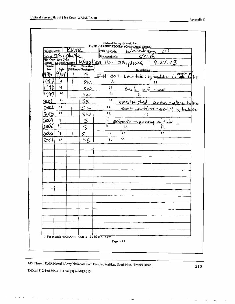
Cultural Surveys Hawaii Job Code: WAIAKEA 10Appendix C
Cultural Surveys Hawaii, Inc.
r' i,, }
PHOTOGRAPHIC RECORD FORM( Digital Camera)
Project Name:/ f---Y V`--- CSH Job Code: WC314 1/4- te.-42_, i 0Camera: I 1 t. 0. 1„.._... Photographer(s): t„s14FileName ( Job Co : I,/,,, j tCamera— Dates ofPhotos): v [ +-41 1 b ^ 0 I l elft fjr„Q - q, 2-1• / 3
Frame Time DirectionNo. Dto ( Military)( Facing to) Description
C uJ
1 9 i i I c 0 Lc r 15 b i tr t
ceE•-
r! ;
L( I 57.43b( t f
f 11? t. f 1 50,) , t t 3ttc t cc 4.,..d®e
litL'
s 6 t c tt
11i 56
t te 015 fr C r, c or-eco. -w ib,e,ev 1: s., 441,04
at7i32- ti i S LJ t tect-t-- tot,--1 tr1 1 — c ss - c [
s b tc
5 471 S%J 11 i(
U il Jtttel- tc.v —b '- eV1:tyA-
A c - tt .e_
U (] ti. l.. Ct
3-c0( t 1 5' 1 k, t l LI
apt v 5 11 t..1
1: For example" KORAN 1— CSH G- 3- 2- 07 to 3- 17- 07"
Page 1 of 11
1
MS, Phase I, KMR Hawai` i Army National Guard Facility, Waiakea, South Hilo, Hawai` i Island 210TMKs:[ 3] 2- 1- 012: 003, 131 and[ 3] 2- 1- 013: 010
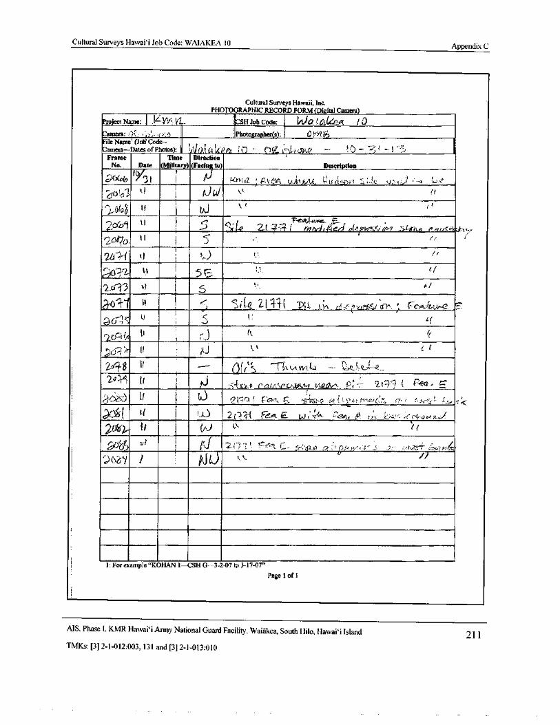
Cultural Surveys Hawai` i Job Code: WAIAKEA 10Appendix C
Cultural Surveys Hawaii, Inc.PHOTOGRAPHIC RECORD R)RM( Digital Camera)
Project Name: KW ia.... CSH Job Code: 1, 00 f CI 462A / 0
Camera: ' iL *1,;',,, (-',;,.) Photogra_pher(s): 0 MI??File Name'( Joti Code.- iCamera— Dates of Photos); w,)1( l ki-.1 6 ; i") .. 0.e.
14*.:-*j.1 jp...() -- !0 - - 2; - I
Frame Time Direction
No. Date ( Military)( Facial to) Description
00(th IY3 1 i P v.vt•-•a ,: A V eA t.,,t Arkjejii_ tj.t I( I'ii) I1 ' 1' A` Ac t: LI::: 3.,.) ' -' 1i
13( iti k-" i t6.i.01D')• ° 1
1
000Li " eZ (-)- I 4F-eatocvoqe- ,.......:C;' ,L.- I 2( ?-7.3_( il7Adi 4er-) o( 79 /
r26(cib t l il 5:
2612-f oI
i 12, e fLIv- , -
2_41•13 0 4 ir
aoli 0 I ....- s i Le 2 1 i( TY0v 1;,,,,, „-„,., r, ,••
I.) 301c L., Lr
tl, x0.-.0., /I l' ii
t
ti't e 11 4- 11" k.A.irPt L. —
2-6141 11i Id r14< sn_.0
11 i ti qil----1 t cee, 4.5.: . T-1 I(L.,e.!,.•,.., ee:- 7.2 (. 7., : :',,,,...—.54
04( t 1 1 1),) 2( Rr( Fe_A E ?,,u; 44- .:',7c,,v,, AI, (i A..
20o), ' I, 1A) ‘\ e i
I ri 2. I' 1 ,!. r*-7,--- 3 C ,...), p,s, ,
62T`l i pj u
i: For example" KORAN 1- 2CSH G- 3- 2- 07 to 3. 17-07"Page 1 of 1
AIS, Phase I, KMR Hawaii Army National Guard Facility, Waiakea, South Hilo, Hawai` i Island 211TMKs:[ 3] 2- 1- 012: 003, 131 and[ 3] 2- 1- 013: 010
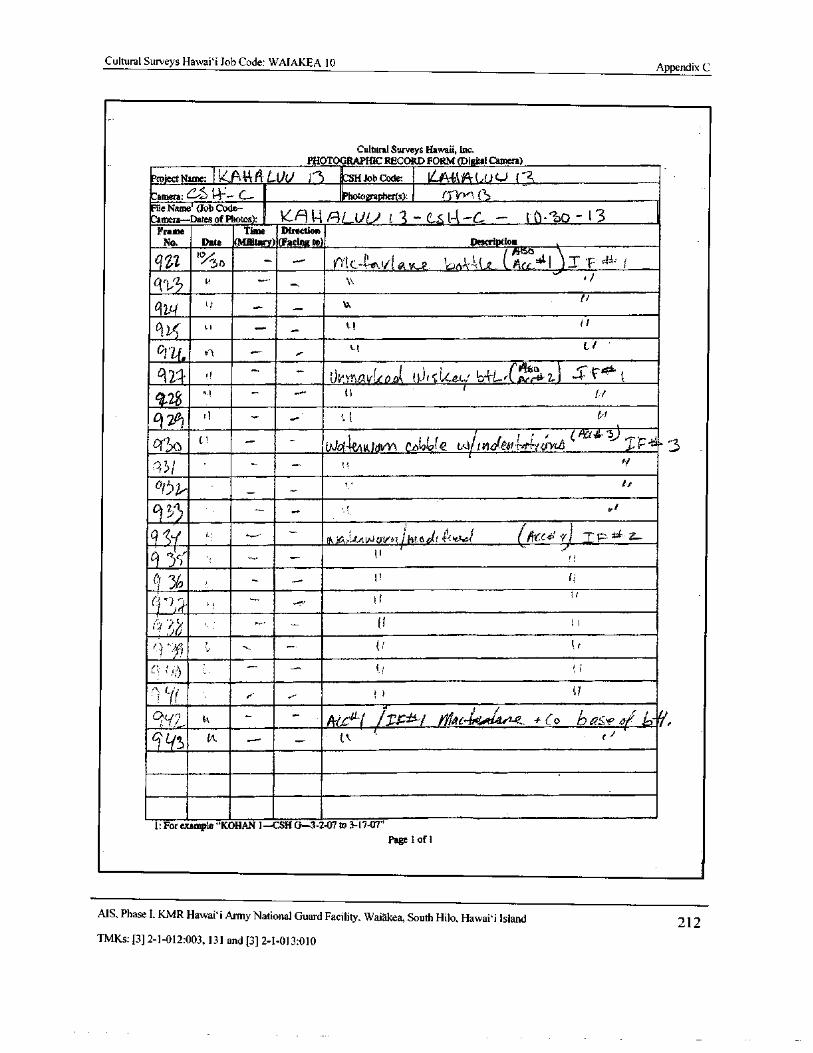
Cultural Surveys Hawai` i Job Code: WAIAKEA 10 Appendix C
Cultural Surveys Hawaii, Inc.
PHOTOGRAPHIC RECORD FORM( Digital Camera)
Project HaMe: le: PIA 14 LOU )-. 5 CSIl Job Code: , ILA-R-14-( du L) 13Camera: e....- t-V- c...- Photographer(s): en-v-s,(._.File Name'( Job Code-Camera— Dates of Photos): _ 4/9 t4 ilLin} i, 3 - c.,,Lt-k- C. - I 0.--bo * 13
Frame Time Direction
No. Date ( Military)(Facing to) Description
j iiiScs ,)MC-Illss.ii`I OS.Y.-e. Ic.0,
1,- 1, 4„ e. Acx,41 I f 4d". 1
1131.,
ti
ti K ' .... t. H
6121- 0 OvYnetvizo..0A
4‘ t
21 -I
it ri
ti
Aa4-sj ,Wo4eAuthwy\ ebt2tof a wtotaeoilet;‘41.IL 3
ti
917
9rS1' ' f& o,,Lutt,,Jov“ ipm 6 el'$1?"
ev-*/ tifkee4'" X) IF- z•-•
IIf,
11
I lie)
1 .) I 1 d
If 1 1 tl
r r,ge-1"1fA _ IV,C41 /
t1, Mbuoe-tritsite. 4- Co
ty Pk. ....„ -
I: For example" KORAN 1— CSR 0- 3- 2-07 to 34747"
Page 1 oft
MS, Phase I. KMR I lawai` i Army National Guard Facility, Waiakea, South Hilo, Hawai` i Island 212TMKs:[ 3] 2- 1- 012: 003, 131 and[ 3] 2- 1- 013: 010
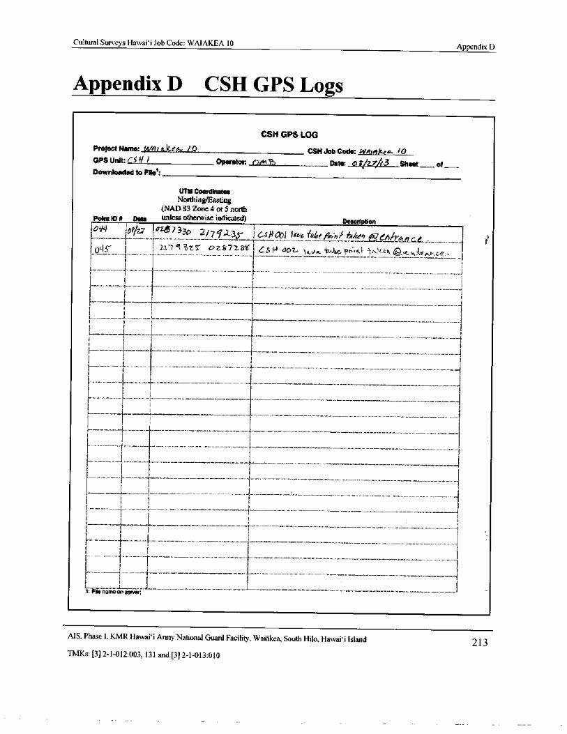
Cultural Surveys Hawai` i Job Code: WAIAKEA 10Appendix D
Appendix D CSH GPS Logs
CSH GPS LOG
Project Name: ( 4/ ii ak[ Q. / 0 CSH Job Code: Won10A•ep 10OPS Unit: CS If I Operator: ( Dim T Date: . 0;/ z7/r3 Sheet of_
Downloaded to File:
UTM Coordinates
Northing/EastingNAA 83 Zone 4 or 5 north
Point ID 0 Date unless otherwise indicated) Description
I0'f4 11_107 ia2a,7 33o Z/ 71i z35_' i Gskooi hcv6 f4ke f°o:n/ f,-tkeo a1 nive i
i U14S 1 1 ICI` 7--•5' OZ£f72 8.1 i 6 S f^ 00Z- } fid... tttiid,e,(' n' 5 t s.«. v 1. c, 4„re r, c,.• 11 . l_
1 1
1 I
1
I1 i
1
r_.____
I
j Ii
L
I1 1
II
I I
i 1i
I r
if11 f
Ii
i 1 I I
1
1: File name on server;
MS. Phase I, KMR Hawaii Army National Guard Facility, Waiakea, South Hilo, Hawaii Island 213TMKs:[ 3] 2- 1- 012: 003, 131 and[ 3] 2- 1- 013: 010
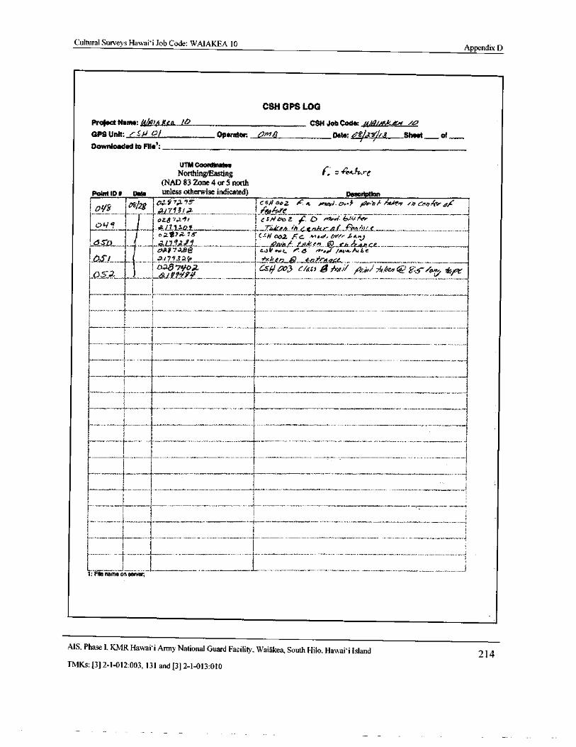
Cultural Surveys Hawai` i Job Code: WAIAKEA 10Appendix D
CSH GPS LOG
Project Name: 1.4411,4 Kea 14 CSH Job Code: j449i. k,e /
GPS Unit: !' SW 0/ Operator: Uig Date:! frf2. fr3 Sheet— of
Downloaded to File':
UTM Coordinates
Northing/Easting re.a. kreNAD 83 Zone 4 or 5 north
Point ID A Date unless otherwise indicated) Description
I 00 'd f28 jDd 57,2 f csfl aoz , e;.
c yea . c,....,, / 0.10,.., ro in rerpliv die
0117131. 2. IfritiVre3 E OZ,$? 07. 91 I felf lr.OZ ', 0 H!o<r blffhPr
N` t.v 1_ 72,kta_ b..4 r.t .._ F ,. L".. e_,
oav7.o295
1oar?Aae i e.s4on "... 6 . seal 1acv. wAtde1. 0,x:'/...____ .......... _ atZ93 ___. ______. _f. kv2...12 _ ".": 0& ._:. m- __._._...
oAr9 Wool Cs# OD,3 t/(0 g/ na jothi 74,z,,en ' Ys / a6 K forI 0,,5% ..._ 1 __..._._ _. 9f. _ -. .. . _---__
r
3
i I
I
1
r_____.._ , i
7 FAe name on sewer3
AIS, Phase I, KMR Hawaii Army National Guard Facility, Waiakea, South Hilo, Hawaii Island 214TMKs:[ 3] 2- 1- 012: 003, 131 and[ 3] 2- 1- 013: 010
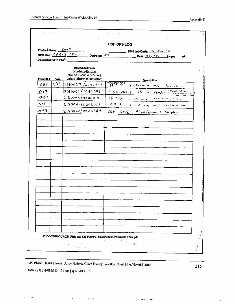
Cultural Surveys Hawai` i Job Code: WAIAKEA 10Appendix D
CSH GPS LOG
Project Name: KvvkCSH Job Code
GPS Unit: 6.5 H- 2 Operator: s t3 Date: l4_/ IS Sheet of
Downloaded to Flle1:
UTM Coordinates
Northing/FastingNAD 83 Zone 4 or 5 north
Point+D# pate unless otherwise indicated) Description
036 t; b/, i ll8002 j O2C65`192yy^^ qq
9' S- aa- C$ FI - 00, 4 s
A) 9 2(`de?0S; D28S9`} 3 Sil. C7o -.,• 5 c. ( n ' ex { :
n
rs>>
0L-1i 2tgooLi1 / io/ gG02.2 e 3 Cr}! 4) 0,4 .., d. -
M2. 21cOa 2/ 0286- 1$`. 1 5H• Ooj r1' '
P:\DOC\RESOURCES\Field and Lab Forms. Field Forms\ GPS Record Fonn.pdf
1•
MS. Phase I. KMR Hawai` i Army National Guard Facility, Waiakea, South Hilo, Hawai` i Island2] 5
TMKs:[ 3] 2- 1- 012: 003, 131 and[ 3] 2- 1- 013: 010
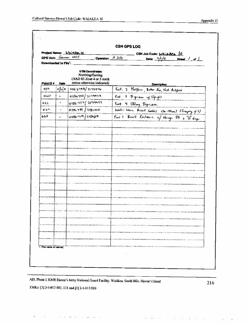
Cultural Surveys Hawaii Job Code: WAIAKEA 10Appendix D
CSH GPS LOG
Project Name: tio:toi,l4w 10 CSH Job Code: 1,40.44(11, tQGPS Unit: G4e..or, ‘. 10iOperator: A. Sbzper' ilq/./,Date: / / Sheet /.-_ of
Downloaded to File':-.
UTM Coordinates
Northing/FastingNAD 83 Zone 4 or 5 north
Point ID# Data unless otherwise indicated) Description
1 056i 1tEL#t?; 1 . ni 1,` 1461` 2119 Tit/ 1 Ftc.f. 2 TlL/Jw.., B4O4 4, WIt}. Ar} icoh 1i °( 4u ! 011-f.I. 21L1±I1 , F4.4 3 To ,,
rtw. H, Li 1,4
IO61 I. a
EOi xV,- 15" 1( ' 2. 1` 61q- 1' FAA-F; 01,19 1,, rE0n.i I
4 ® LZ0211, 141 i 2IV)nUV. _.. 1 144.41' Wrr„ artii
m11'I Colts ( 7o- yU ) ( 6 3 I
10 U3 I ,+ 1024U- Gci r 21 Qf 1 F,4 ( '<sa.t wdam., t
iAL s}o + ice,{' .
1. C sn.c 1
I
is
1
SE---------- I
I Ir- 1- -_____.._.__ _
3 i tI t
I I
TI i
i 1I
I
e
1 I 1.__,_.._1: File name 4n server,
AIS, Phase I, KMR Hawai` i Army National Guard Facility, Waiakea, South Hilo, Hawaii Island 216TMKs:[ 3] 2- 1- 012: 003, 131 and[ 3] 2- 1- 013: 010
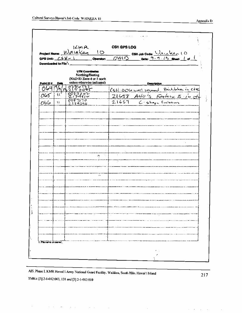
Cultural Surveys Hawaii Job Code: WAIAKEA 10Appendix D
1
IL Wk A,. CSH GPS LOG
Project Name: V3 40- 4 0 CSH Job Code: Qt4-4. ke,,,, 1 0
GPS unit: ( 3 14— 1 Operator: OW K Date: ci - 1 ' 4> sheet t of {.
Downloaded to File':
UTM Coordinates
Northing/EastingNAD 83 Zone 4 or 5 north
Point It) s D unless otherwise indicated) Description
L!` o_ I Ijai/ 7 2.1 (.7 0ea-S`..._.-_...,._...,._... i
l,s+.;ti„_ 00(4 ,,,,, to. ,;_e.,,r,,„ I, ?,,,,;,,AY, , i to C, 4- !
V(0 ( SA s i Le 1 LI(0 .- Y / ` t C) 5 k,ei-Slit. f3 • J 3 tC L-
Qb 1
2. 1. 4_ silo
j 2_1461 G- s r €`!os.
i Ir____r_t___________--r------—----
I
t E
1------ L ------------_.__.__
I
1i
i
iIt
1
1. f1: File name on server:
AIS• Phase I. KMR Hawaii Army National Guard Facility, Waiakea, South Hilo, Hawai` i Island217
TMKs:[ 3] 2- 1- 012: 003, 131 and[ 3] 2- 1- 013: 010
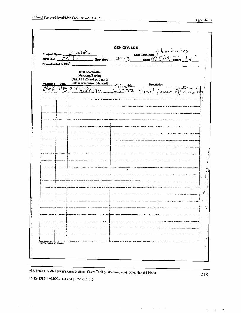
Cultural Surveys Hawai` i Job Code: WAIAKEA 10Appendix D
CSH GPS LOG
Project Name: -- OniiCSHJob Code: ,
GPS Unit: C-
11Operator: Cti' v,
Date:(- 7/ O i( Sheet. 1 ofLDownloaded to File':—
I
UM Coordinates
Northing/EastingNAD 83 Zone 4 or 5 north
Point ID# D to unless otherwise indicated) ,. c( _ Li Description
l(( i 2,11'-'r, jri t : CA," .....,•-•
f 1
I
i
l
i f
3
I1-
i __.__..
I I
11
I
I
I i 3
1: File name on senrer:
MS. Phase I, KMR Hawaii Army National Guard Facility, Waiakea, South Hilo, Hawaii Island 218TMKs:[ 3] 2- 1- 012: 003, 131 and[ 3] 2- 1- 013: 010
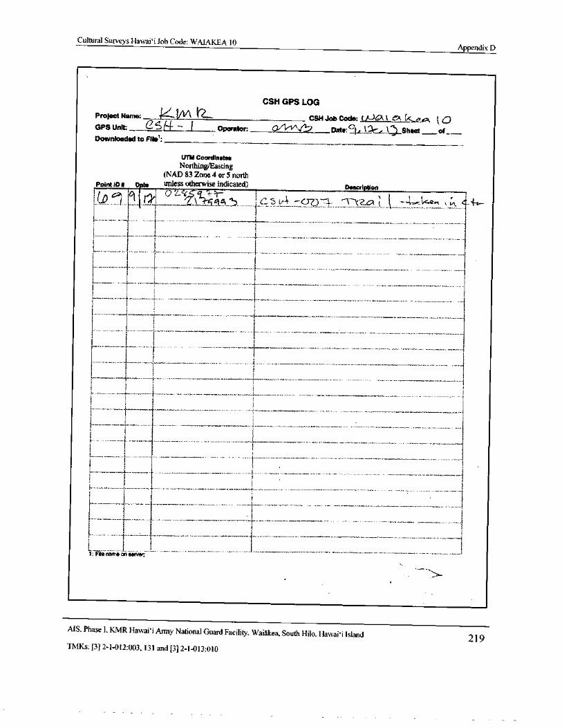
Cultural Surveys Hawai` i Job Code: WAIAKEA 10Appendix D
q
CSH GPS LOG
Project Name: V CSM Job Code: ( JJt2 i C. ey
GPS Unit: 2f4- -- L Operator: CVl' vV2, Date:E., 13r, k) Sheet_ oi__.._.
Downloaded to File":
UM Coordinates
Northing/EastingNAD 83 Zone 4 or 5 north
Point ID# to unless otherwise indicated) Description
1i
I 1
Li
m___ rI
I F
i 1li-i
rty 1
iI
4
i
l
1
E
IiL._._... .._.
31; Fie name on sena:
MS. Phase I, KMR Hawai` i Army National Guard Facility. Waiakea, South Hilo, Hawaii Island219
TMKs:[ 3] 2- 1- 012: 003, 131 and[ 3] 2- 1- 013: 010
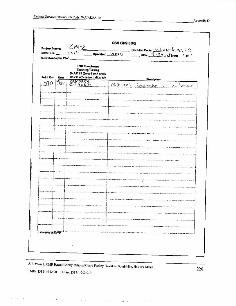
Cultural Surveys Hawai` i Job Code: WAIAKEA 10Appendix D
1i
1i CSH GPS LOG
Project Name: 04`aCSH Job Code: { AGi_t a.11e..€? cam ? C.)
GPS Unit: GS V 1 Operator: s
JRerator: + _ r? Date: ` 2`f d., Sheet'; of _,.
Downloaded to File":
UTM Coordinates
Northing/EastingNAD 83 Zone 4 or 5 north
Pint ID# Date unless otherwise indicated)Description
ri,,/I
1
3
H
1
a
a
L.,,._._.. ,{_..............,
7
r'
IJ..:......__ .__....._. . + . I.
i
1: File name on server,
I
AIS, Phase I, KMR Hawai` i Army National Guard Facility, Waiakea, South Hilo, Hawaii Island220
TMKs:[ 3] 2- 1- 012: 003, 131 and[ 3] 2- 1- 013: 010
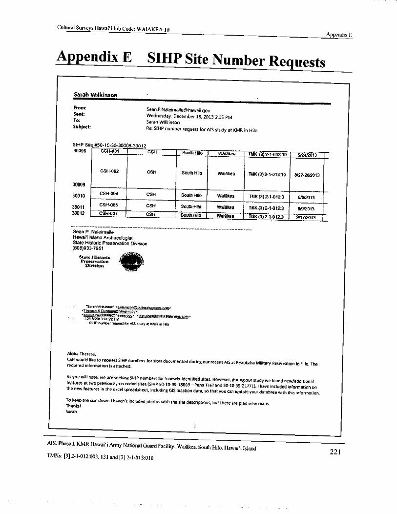
Cultural Surveys Hawai` i Job Code: WAIAKEA 10Appendix E
Appendix E SIHP Site Number Requests
Sarah Wilkinson
From: Sean.P. [email protected]
Sent: Wednesday, December 18, 2013 2: 15 PM
To: Sarah WilkinsonSubject:
Re: SIHP number request for AIS study at KMR in Hilo
SIHP Site# 50- 10-35-30008-3001230008 CSH-001 CSH South Hilo Walakea TMK( 3) 2- 1- 013:10 - 9/24/2013
CSH-002 CSH South Hilo Waiakea TMK( 3) 2-1- 013:10 8/27-28/2013
30009
30010CSH-004 CSH South Hilo Waiakea TMK( 3) 2-1- 012:3 9/6/ 2013
30011CSH-006 CSH South Hila Walakea TMK( 3) 2-1- 012:3 9/9/2013
30012 CSH- 007 CSH South Hilo Walakea TMK( 3) 2-1- 012:3 9/17/2013
Sean P. NaleimaileHawaii Island ArchaeologistState Historic Preservation Division808)933-7651
J Yv°
State Historic f S,Preservation :
Divisionva "
Sarah Wilkinson"< swiifdnsont8cutturalsuivey§;, om>Theresa.K_Donham 3hawatlsean.p.nalearai hawan env>.< obauii$taculturalkurveyg.ca—.-
r<.,: 12/ 18/2013 01: 22 PM
SIHP number request for AIS study at KMR in Hilo
Aloha Theresa,
CSH would like to request SIHP numbers for sites documented during our recent AIS at Keaukaha Military Reservation in Hilo. Therequired information is attached.
As you will note, we are seeking SIHP numbers for S newly- identified sites. However, during our study we found new/ additionalfeatures at two previously- recorded sites( SIHP 50- 10. 99- 18869— Puna Trail and 50- 10- 35- 21771). I have included information onthe new features in the excel spreadsheet, including G15 location data, so that you can update your database with this information.To keep the size down I haven' t included photos with the site descriptions, but there are plan view maps.Thanks?
Sarah
1
MS, Phase I. KMR Hawai` i Army National Guard Facility. Waiakea, South Hilo, Hawai` i Island221
TMKs:[ 3] 2- 1- 012: 003, 131 and[ 3] 2- 1- 013: 010
Cultural Surveys Hawai` i Job Code: WAIAKEA 10Appendix E
Sarah WilknscrnCultural Stirve}, i, Ink.
tiralkinsoniiiicultpr vlsrtrvcy , cotnoffice( 80K) 9b5- 6478
e11( 8O8) 756- 8468
Iiax( 8( J O965408"2
attachment" WAIAKEA 10 Site Number Request. xlsx" deleted by Sean P Naleimaile/ DLNR/ StateHiUS][ attachment" WAIAKEA 10SIHP Site No. Request Form. doc" deleted by Sean P Naleimaile/ DLNRJStateHiUs]
2
MS, Phase I, KMR Hawaii Army National Guard Facility, Waiakea, South Hilo, Hawaii Island222
TMKs:[ 3] 2- 1- 012: 003, 131 and[ 3] 2- 1- 013: 010
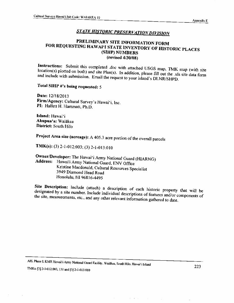
Cultural Surveys Hawaii Job Code: WAIAKEA 10Appendix E
STATE HISTORIC PRESERVATION DIVISION
PRELIMINARY SITE INFORMATION FORMFOR REQUESTING HAWAII STATE INVENTORY OF HISTORIC PLACES
SIHP) NUMBERSrevised 4/ 30/08)
Instructions: Submit this completed . doc with attached USGS map, TMK map ( with sitelocation( s) plotted on both) and site Plan( s). In addition, please fill out the . xls site data form
and include with submission. Email the request to your island' s DLNR/SHPD.Total SIHP#' s being requested: 5
Date: 12/ 18/ 2013
Firm/Agency: Cultural Survey' s Hawaii, Inc.PI: Hallett H. Hammatt, Ph.D.
Island: Hawai` i
Ahupua`a: WaiakeaDistrict: South Hilo
Project Area size ( acreage): A 405. 3 acre portion of the overall parcelsTMK(s): ( 3) 2- 1- 012: 003; ( 3) 2- 1- 013: 010
Owner/Developer: The Hawai` i Army National Guard ( HIARNG)Address: Hawai' i Army National Guard, ENV Office
Kristine Macdonald, Cultural Resources Specialist3949 Diamond Head RoadHonolulu, HI 96816-4495
Site Description: Include ( attach) a description of each historic property that will bedesignated by a site number. Include individual descriptions of features and/ or components ofthe site, measurements, etc., and any other relevant information gathered to date.
MS. Phase I, KMR Hawaii Army National Guard Facility, Waiakea, South Hilo, Hawai` i Island223
TMKs:[ 3] 2- 1- 012: 003, 131 and[ 3] 2- 1- 013: 010
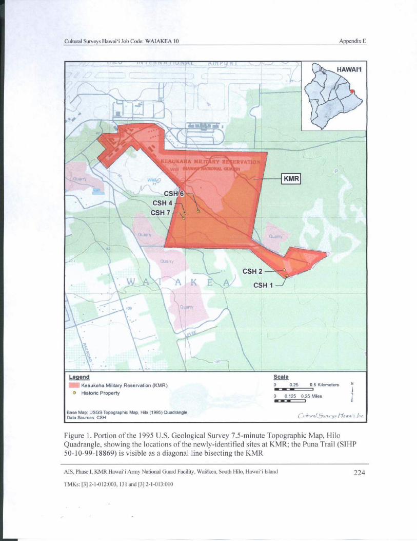
Cultural Surveys Hawaii Job Code: WAIAKEA 10 Appendix E
v iir i cn Vi Fk a IEITiFFTI - RfYSFI T?"` i.
HAWAII
j1,
Illt 1140,11Ow.
T
ifillammi....am
Ie4ttiAtlrS1.11
WY It : 1-.. RVA S1
sONAL au )
KMRjaor, ~
CSH/ 6 — 1s-------
CSH 4 TA
CSH 7 (
N\
I
7
c—, CSH 2
A 1 A K 3.'` CSH 1 --
1
tpg
c‘
1j
yS
Lb
ay
Legend Scale
Keaukaha Military Reservation( KMR) 0 0. 25 0. 5 Kilometers N
o Historic Property0 0. 125 025 Miles
L+
Base Map: USGS Topographic Map, Hilo( 1995) Quadrangle1. ..,,rrafur^..i,1` 7um rr s , wi.
Data Sources: CSH J
Figure 1. Portion of the 1995 U. S. Geological Survey 7. 5- minute Topographic Map, HiloQuadrangle, showing the locations of the newly- identified sites at KMR; the Puna Trail (SIHP50- 10- 99- 18869) is visible as a diagonal line bisecting the KMR
AIS, Phase I, KMR Hawaii Army National Guard Facility, Waiakea, South Hilo, Hawaii Island 224
TMKs:[ 3] 2- 1- 012:003. 131 and[ 3] 2- 1- 013: 010
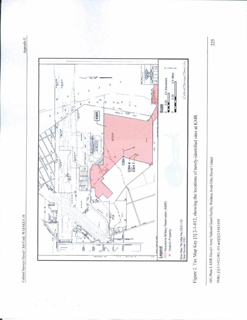
Wv)
xN
a N
c.d
E`: e AY
N u o_ ZIIt3 E
I t V 3 oI
1
yyi1
a ` IY 1-a
i IS
1 E pA ; 1 Ji F
oi, iEwm1oN% n , q r , I
i :orB
wt1 COo f'
li '
Yg
fv",,
ii2 1 t:
tEi
cv
s.)
01 .11.-, 1
a II'
Ir R ' a1
ti
t+=+
1 Sfi x C
U' ri ' ' i eti,
1r g
c \ : i.., I : 7-- -" i: 1 VI , z' '''..,*-.!/
as
q Jwls4 O
x
1t R3 FJ
ovp
i \\ 1 \,...______________,------'-----" -'---- ----
tl) at
l
1
Y 3a r . '
Ol Co11 a a
m R.SS
J t! F JO a
N r~
f I . K i 1 N 1 M
y vN
Ois — —
I iU'
AI I . J" p Nat u u
cd
r " r a C
cd F..... — - c J N 7.' p
cu ON
g N N
a., abA
w E-
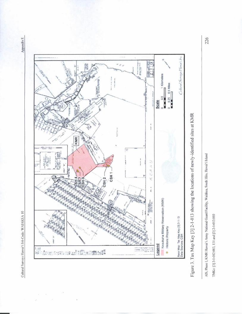
W C)x N3 NC
d
J ` , r
J
0 J
4.
s,. ja f
r_ gl
f ` let` D
f, [ 1ii'
ii' tt)
S Mi€
al i t2
x.0 x-
mssir`
per'" f
t ;'7710'•,..'' '- „} .. 1
P
CIIX if
4' ii
T.1i.;i?a ii a 1. i' e
i114
t.. eiVii-
V •q I
I - tgo
4tifl N ,-( I) O
X X°n
I
1 Cl)con
semIiS / /
V// '`' y.(i ,. r• Tc_
ff\ // p `
4frf/ C% ` RyCO
cz
z/4-4e,) OO7S. 1 /413/
tt• / //}
fire. _ M p_VJ`lt''
Z51/./ M
FF
rn
i
f 54Q. itF
N ~ u L2. ' c
3 I is IIY' 8at 4. i: gra;.
JO
mc'
o o
relf
L° a.
01) v4
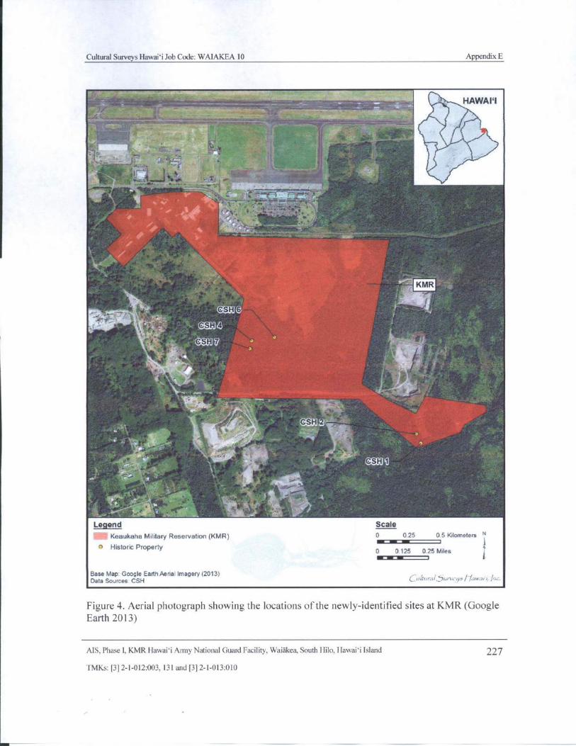
Cultural Surveys Hawaii Job Code: WAIAKEA 10 Appendix E
111 HAWAPI
I $ 40 ,,,,,,
i ..,... .. ... . ..„,,........, „..,.... „.,,. .. ..., illiltf .. .... o
a I1.
41..:„.,
aoo . ..
r - ; 1.', :
w
ti
kwdil
l
6
14 _ .
4 6
1
faal-;:.2,,,^:::::'..-.rz
IT 11; E.t' rc
C ' J9
r
Legend Scale
Keaukaha Military Reservation( KMR) 0 0.25 0. 5 Kilometers NMI
Historic Propertyr 1
0 0 125 0.25 Miles
1
Base Map. Google Earth Aerial Imagery( 2013)Data Sources CSH C_u/w-,/_`,,,,-9z J" awai t./;,:.
Figure 4. Aerial photograph showing the locations of the newly- identified sites at KMR( GoogleEarth 2013)
AIS, Phase I, KMR Hawaii Army National Guard Facility, Waiakea, South Hilo, Hawaii Island 227
TMKs:[ 3] 2- 1- 012: 003, 131 and[ 3] 2- 1- 013: 010
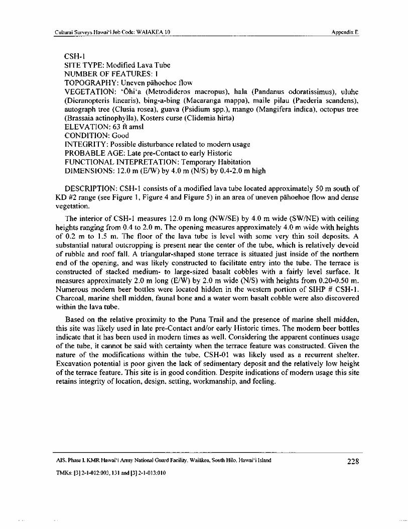
Cultural Surveys Hawaii Job Code: WAIAKEA 10 Appendix E
CSH- 1
SITE TYPE: Modified Lava Tube
NUMBER OF FEATURES: 1
TOPOGRAPHY: Uneven pahoehoe flow
VEGETATION: ` Ohi` a ( Metrodideros macropus), hala ( Pandanus odoratissimus), uluhe
Dicranopteris linearis), bing-a- bing ( Macaranga mappa), maile pilau ( Paederia scandens),
autograph tree ( Clusia rosea), guava ( Psidium spp.), mango ( Mangifera indica), octopus tree
Brassaia actinophylla), Kosters curse ( Clidemia hirta)
ELEVATION: 63 ft amsl
CONDITION: Good
INTEGRITY: Possible disturbance related to modern usage
PROBABLE AGE: Late pre- Contact to early HistoricFUNCTIONAL INTEPRETATION: Temporary HabitationDIMENSIONS: 12. 0 m ( E/ W) by 4. 0 m ( N/ S) by 0.4- 2. 0 m high
DESCRIPTION: CSH- 1 consists of a modified lava tube located approximately 50 m south ofKD #2 range ( see Figure 1, Figure 4 and Figure 5) in an area of uneven pahoehoe flow and dense
vegetation.
The interior of CSH- 1 measures 12. 0 m long (NW/ SE) by 4.0 m wide ( SW/NE) with ceilingheights ranging from 0. 4 to 2. 0 m. The opening measures approximately 4. 0 m wide with heightsof 0. 2 m to 1. 5 m. The floor of the lava tube is level with some very thin soil deposits. Asubstantial natural outcropping is present near the center of the tube, which is relatively devoidof rubble and roof fall. A triangular-shaped stone terrace is situated just inside of the northern
end of the opening, and was likely constructed to facilitate entry into the tube. The terrace isconstructed of stacked medium- to large- sized basalt cobbles with a fairly level surface. Itmeasures approximately 2. 0 m long ( E/ W) by 2. 0 m wide (N/S) with heights from 0. 20- 0. 50 m.Numerous modern beer bottles were located hidden in the western portion of SIHP # CSH- 1.
Charcoal, marine shell midden, faunal bone and a water worn basalt cobble were also discovered
within the lava tube.
Based on the relative proximity to the Puna Trail and the presence of marine shell midden,this site was likely used in late pre- Contact and/ or early Historic times. The modern beer bottlesindicate that it has been used in modern times as well. Considering the apparent continues usageof the tube, it cannot be said with certainty when the terrace feature was constructed. Given thenature of the modifications within the tube, CSH-01 was likely used as a recurrent shelter.Excavation potential is poor given the lack of sedimentary deposit and the relatively low heightof the terrace feature. This site is in good condition. Despite indications of modern usage this site
retains integrity of location, design, setting, workmanship, and feeling.
MS, Phase I, KMR Hawaii Army National Guard Facility, Waiakea, South Hilo, Hawai` i Island 228
TMKs:[ 3] 2- 1- 012:003, 131 and[ 3] 2- 1- 013: 010
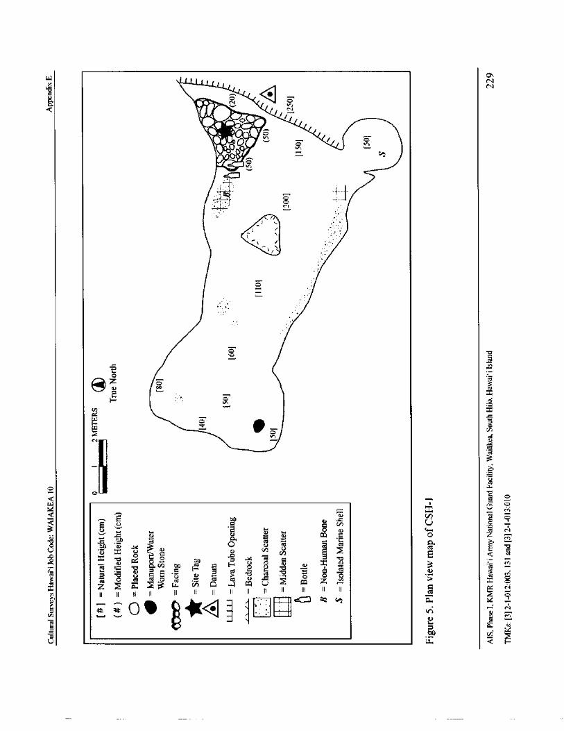
WN
d
CN
1.
111600. 1-
11°'• f
Q
0
Oz)
1@l) 44v cz
Fr;
o
VD x
WE—
z7 o
cvc
a
U
o cctu.o
HN
0 0 6.7 COG oo. zrn
3 0 U clan
t.: b a4rn on
3N
o U z 3
3 o t o m v .4 72 3 r
ca
a " .?r u iii Q - 4 Ca U co Z x oZ
II II II II II II II II II cT II I! II I II o
u
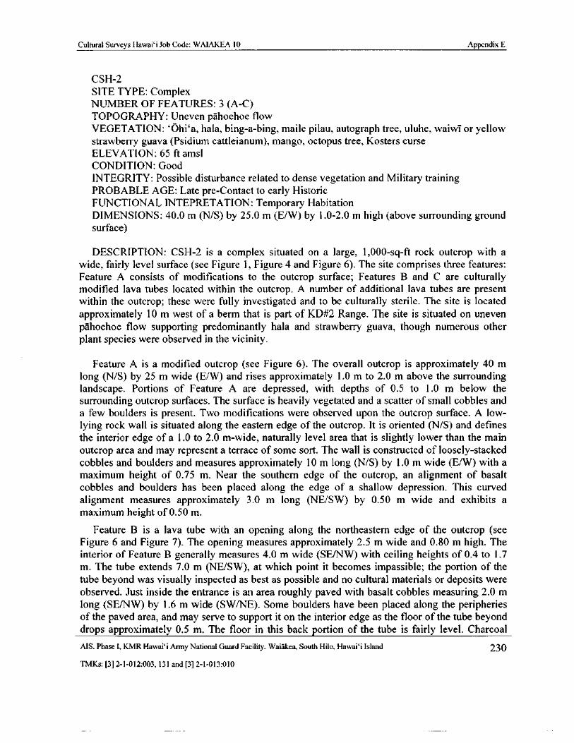
Cultural Surveys Hawai` i Job Code: WAIAKEA 10 Appendix E
CSH- 2
SITE TYPE: Complex
NUMBER OF FEATURES: 3 ( A-C)
TOPOGRAPHY: Uneven pahoehoe flow
VEGETATION: `Ohi` a, hala, bing- a- bing, maile pilau, autograph tree, uluhe, waiwi or yellowstrawberry guava ( Psidium cattleianum), mango, octopus tree, Kosters curse
ELEVATION: 65 ft amsl
CONDITION: Good
INTEGRITY: Possible disturbance related to dense vegetation and Military trainingPROBABLE AGE: Late pre- Contact to early HistoricFUNCTIONAL INTEPRETATION: Temporary HabitationDIMENSIONS: 40.0 m (N/S) by 25. 0 m ( E/ W) by 1. 0- 2. 0 m high ( above surrounding groundsurface)
DESCRIPTION: CSH- 2 is a complex situated on a large, 1, 000- sq- ft rock outcrop with awide, fairly level surface ( see Figure 1, Figure 4 and Figure 6). The site comprises three features:
Feature A consists of modifications to the outcrop surface; Features B and C are culturallymodified lava tubes located within the outcrop. A number of additional lava tubes are presentwithin the outcrop; these were fully investigated and to be culturally sterile. The site is locatedapproximately 10 m west of a berm that is part of KD#2 Range. The site is situated on unevenpahoehoe flow supporting predominantly hala and strawberry guava, though numerous otherplant species were observed in the vicinity.
Feature A is a modified outcrop ( see Figure 6). The overall outcrop is approximately 40 mlong ( N/ S) by 25 m wide ( E/W) and rises approximately 1. 0 m to 2.0 m above the surroundinglandscape. Portions of Feature A are depressed, with depths of 0. 5 to 1. 0 m below the
surrounding outcrop surfaces. The surface is heavily vegetated and a scatter of small cobbles anda few boulders is present. Two modifications were observed upon the outcrop surface. A low-lying rock wall is situated along the eastern edge of the outcrop. It is oriented (N/ S) and definesthe interior edge of a 1. 0 to 2. 0 m- wide, naturally level area that is slightly lower than the mainoutcrop area and may represent a terrace of some sort. The wall is constructed of loosely- stackedcobbles and boulders and measures approximately 10 m long ( N/ S) by 1. 0 m wide ( E/ W) with amaximum height of 0. 75 m. Near the southern edge of the outcrop, an alignment of basaltcobbles and boulders has been placed along the edge of a shallow depression. This curvedalignment measures approximately 3. 0 m long (NE/SW) by 0. 50 m wide and exhibits amaximum height of 0. 50 m.
Feature B is a lava tube with an opening along the northeastern edge of the outcrop ( seeFigure 6 and Figure 7). The opening measures approximately 2. 5 m wide and 0. 80 m high. Theinterior of Feature B generally measures 4.0 m wide ( SE/ NW) with ceiling heights of 0. 4 to 1. 7m. The tube extends 7. 0 m ( NE/SW), at which point it becomes impassible; the portion of the
tube beyond was visually inspected as best as possible and no cultural materials or deposits wereobserved. Just inside the entrance is an area roughly paved with basalt cobbles measuring 2. 0 mlong ( SE/NW) by 1. 6 m wide ( SW/NE). Some boulders have been placed along the peripheriesof the paved area, and may serve to support it on the interior edge as the floor of the tube beyonddrops approximately 0. 5 m. The floor in this back portion of the tube is fairly level. CharcoalAIS, Phase I, KMR Hawaii Army National Guard Facility, Waiakea, South Hilo, Hawaii Island 230
TMKs:[ 3] 2- 1- 012:003, 131 and[ 3] 2- 1- 013: 010
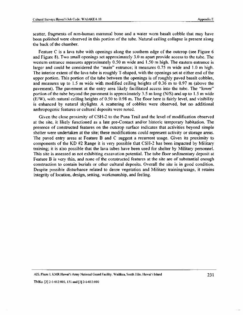
Cultural Surveys Hawaii Job Code: WAIAKEA 10 Appendix E
scatter, fragments of non-human mammal bone and a water worn basalt cobble that may havebeen polished were observed in this portion of the tube. Natural ceiling collapse is present alongthe back of the chamber.
Feature C is a lava tube with openings along the southern edge of the outcrop ( see Figure 6and Figure 8). Two small openings set approximately 3. 0 m apart provide access to the tube. Thewestern entrance measures approximately 0. 50 m wide and 1. 50 m high. The eastern entrance islarger and could be considered the " main" entrance; it measures 0. 75 m wide and 1. 0 m high.
The interior extent of the lava tube is roughly T- shaped, with the openings set at either end of theupper portion. This portion of the tube between the openings is of roughly paved basalt cobbles,and measures up to 1. 5 m wide with modified ceiling heights of 0. 36 m to 0. 97 m ( above thepavement). The pavement at the entry area likely facilitated access into the tube. The " lower"
portion of the tube beyond the pavement is approximately 3. 5 m long (N/ S) and up to 1. 5 m wideE/ W), with natural ceiling heights of 0. 50 to 0. 98 m. The floor here is fairly level, and visibility
is enhanced by natural skylights. A scattering of cobbles were observed, but no additionalanthropogenic features or cultural deposits were noted.
Given the close proximity of CSH- 2 to the Puna Trail and the level of modification observedat the site, it likely functioned as a late pre-Contact and/ or historic temporary habitation. Thepresence of constructed features on the outcrop surface indicates that activities beyond simpleshelter were undertaken at the site; these modifications could represent activity or storage areas.The paved entry areas at Feature B and C suggest a recurrent usage. Given its proximity tocomponents of the KD #2 Range it is very possible that CSI-1- 2 has been impacted by Militarytraining; it is also possible that the lava tubes have been used for shelter by Military personnel.This site is assessed as not exhibiting excavation potential. The tube floor sedimentary deposit atFeature B is very thin, and none of the constructed features at the site are of substantial enoughconstruction to contain burials or other cultural deposits. Overall the site is in good condition.
Despite possible disturbance related to dense vegetation and Military training/usage, it retainsintegrity of location, design, setting, workmanship, and feeling.
MS, Phase I, KMR Hawaii Army National Guard Facility, Waiakea, South Hilo, Hawaii Island 231
TMKs:[ 3] 2- 1- 012: 003, 131 and[ 3] 2- 1- 013: 010
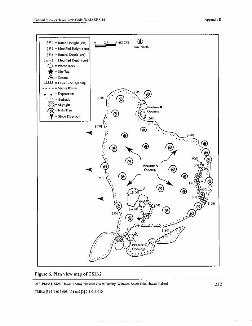
Cultural Surveys Hawai` i Job Code: WAIAKEA 10 Appendix E
Natural Height( cm) 0 2. 5 5 METERS IX
Modified Height( cm) True North
a Natural Depth( cm)
m#} = Modified Depth( cm)
0 =Placed Rock
Site Tag
L1 Datum
11 111 = Lava Tube OpeningSterile Blister
t ,/ IOtl[ 1DepressionA
I
Bedrock 11001 AI
Skylightt Feature B
Hala Treei (
F OpeningrSlope Direction
12001
200] i
tq i 1200]
l..-moi
rqr
t
Wall
Feature A 25)
Outcrop n 50jN.
12501
Ah..
1:.30) t75)
o 5ol00) I6 I
44( i 30)" OR
pis SQ) 11501
m 201 o •
12501 N. O t
r
i /, /
e 11801 i tir. G
11/‘
i•
is-11 Feature
s-
Feature G/6•;
Openingsf l t
I-
Figure 6. Plan view map of CSH-2
MS, Phase I, KMR Hawai` i Army National Guard Facility, Waiakea, South Hilo, Hawaii Island 232
TMKs:[ 3] 2- 1- 012: 003, 131 and[ 3] 2- 1- 013: 010
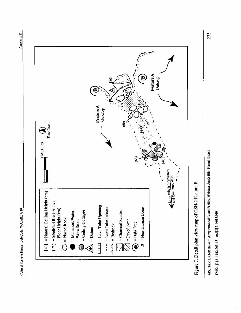
w M
X M
o N
ca
Q
i
1
@ .,,,xvii-. r '
@.. I_ 44.4 (. 44.,
C)
d 6\\\ (.\ci4 Ita .
o
i i0
Cl)
H
N
ElRe ` 4, F.., \
ctt0
i h 1. • xt.3
gjcois
a) . 5a
C.) PSc l
Llo
CD 1 emsCl
oczC O 0 fi'
1- tli N O U o
1010 o .....
Iad Aat O C
dxO 4-
3 vs
c S cid aM
O,„9 +-4 c -iVCN
vC ZO ceS ° 8 8
NN
O cit o o az co Q N G 0 ct I) . g azt 0u Z w Q, U q „-a go U r., z Z
II II I I II II It II II II II II II II as :. c-n
c, 0 0 4' <, : ' \ •-•' ' @Q _
c...) 4. 1
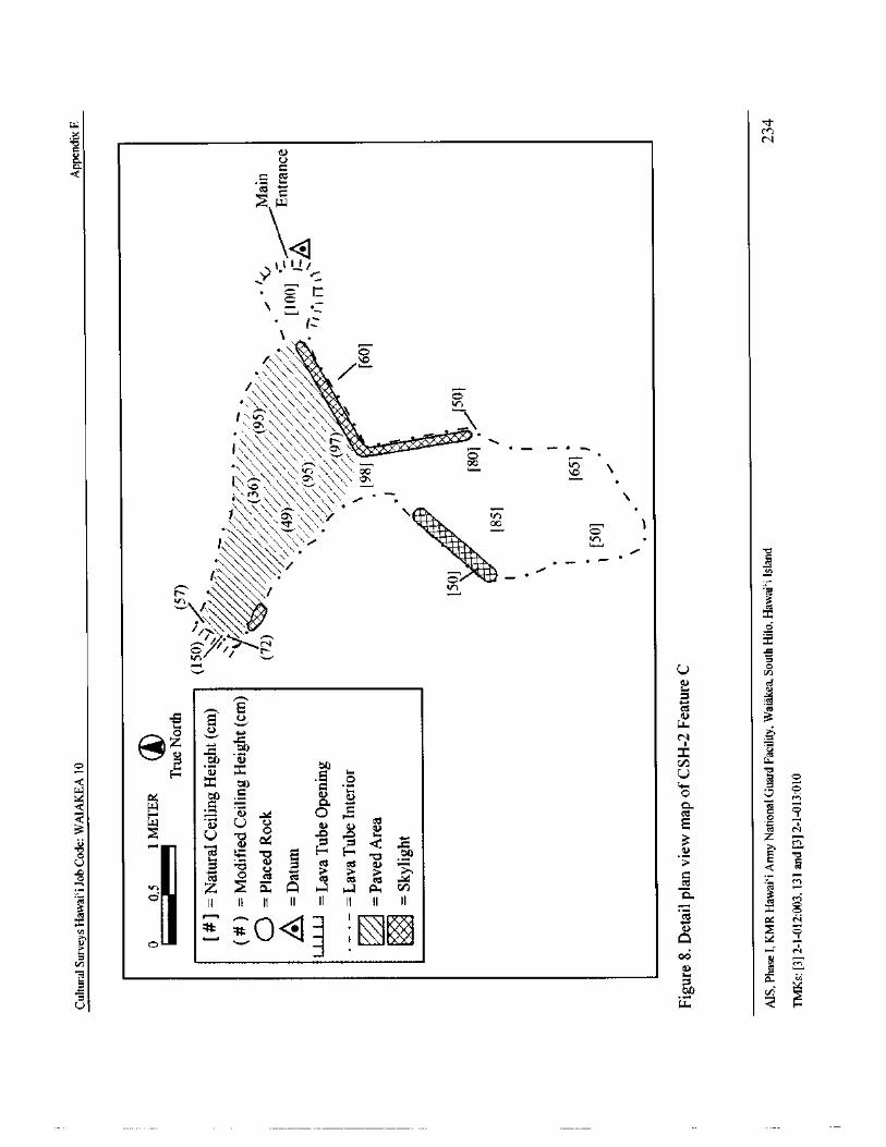
wM
aN
a
a0.
v
cd ti=wl
Q1•% f 1/
Yr_
r,
R o
V•
vAAA.'\(,.--_,,,,\\AA oe
n \
01 \\
cn
vAV\,,VV\
VVA , •. —, q 1x
W
4
3
5U 1D
N cds.
a
w
N 4
t . °' w
V d
z to
04W-
V
Oc.E . vO r
M
W U , V atN cE 0 0o ° U w
e NZ
v V , 7'o
5Z c. Q a a a
3 II II II II i i II ii71'
x 0
To
1 \ * i L) 7 q
EN N
y ca
U w c4 g
Cultural Surveys Hawaii Job Code: WAIAKEA 10 Appendix E
CSH-4
SITE TYPE: Complex
NUMBER OF FEATURES: 5 ( A-E)
TOPOGRAPHY: Undulating
VEGETATION: ` Ohi` a, hala, uluhe, bing-a- bing, maile pilau, guava, mango, octopus tree,Kosters curse
ELEVATION: 75 ft amsl
CONDITION: Fair to good
INTEGRITY: Possible disturbance related to dense vegetation
PROBABLE AGE: Late Pre- Contact/Early Historic
FUNCTIONAL INTEPRETATION: Habitation, possible agriculture
DIMENSIONS: 44. 0 m ( N/S) by 30. 0 m ( E/ W)
DESCRIPTION: CSH-4 is a complex located in Area A approximately 280 m south of the PunaTrail (see Figure 1, Figure 4 and Figure 9). The site, which overall measures approximately 44.0m (N/ S) by 30. 0 m ( E/W), is comprised of five features: Feature A is a cleared, level area;
Feature B is a linear mound; Feature C is a small enclosure; and Feature D is a stone- lined pit.
The topography in this densely forested area is undulating soil with scattered basalt rock andnumerous depressions and outcrops. Numerous artifacts were observed around the component
features and collected for laboratory analysis.
Feature A is a roughly rectangular- shaped cleared, level area situated between two naturaldepressions ( see Figure 9). The feature is indicated as an area devoid of vegetation and rocks,
and measures approximately 8. 0 m ( N/S) by 5. 5 m ( E/W). Areas of possible pavement wereobserved within the feature, but are somewhat ephemeral given apparent sedimentation and a
cover of leaf litter. A retaining wall has been constructed at the northern edge of the level area,along its interface with the natural depression to the north. The wall consists of basalt cobblesand boulders stacked three to four courses high inside the depression. The wall measures
approximately 1. 8 m ( NW/ SE) by 0. 5 m (NE/SW) with a maximum height of 0.5 m. Numerousartifacts were found scattered on the surface of Feature A, including three large, modifiedwaterworn basalt cobbles ( Isolated Find [ IF] #2, # 3 and # 4), four water worn basalt cobble
manuports, a blob-top bottle fragment and a salt-glazed pottery shard. Overall, Feature A is infair condition. It may have served as a site for some sort of structure. No post holes wereobserved.
Feature B is a somewhat deflated, linear rock mound located approximately 4. 5 m northeast ofthe retaining wall at Feature A (see Figure 9). Feature B is situated near the center of a shallow
natural depression that measures approximately 4. 5 m (N/ S) by 3. 5 m ( E/W) and up to 0. 4 mdeep. The mound is constructed of loosely piled small to large cobbles, and measures 2. 3 m
AIS, Phase I. KMR Hawaii Army National Guard Facility. Waiakea, South Hilo, Hawaii Island 235
TMKs:[ 3] 2- 1- 012: 003, 131 and[ 3] 2- 1- 013: 010
Cultural Surveys Hawaii Job Code: WAIAKEA 10 Appendix E
N/ S) by 1. 2 m ( E/ W) with a maximum height of 0. 3 m. Feature B is in fair condition. Ahorseshoe, possibly from a mule, was observed on the surface of the mound.
Feature C is a rectangular enclosure ( see Figure 9 and Figure 10). The feature is located
approximately 8. 5 m northwest of Feature B inside of a natural depression which measuresapproximately 10. 0 m (N/ S) by 5. 0 m ( E/ W) and up to 0. 5 m deep. The enclosure is constructedof two to four courses of neatly stacked and faced basalt cobbles and boulders. It measures 3. 8 mN/ S) by 2. 3 m ( E/ W) with a maximum interior height of 1. 2 m and exterior height of 1. 0 m. Thefairly level interior contains a scatter of small to medium cobbles. The walls are generally about0. 50 m thick. Overall, this feature is in fair condition. No artifacts or cultural materials were
observed in the immediate vicinity.
Feature D is a circular, stone- lined pit situated within a natural depression approximately 8. 5 mwest of Feature C ( see Figure 9). The natural depression measures approximately 5. 0 m (N/ S) by3. 0 m (E/ W) with a depth of 0. 5 m. The pit utilizes a natural crevice or more depressed portion ofthe overall depression. The bottom and sides of this natural feature have been lined with cobbles.
The construction is roughly flush with the surrounding surface of the depression. The pitmeasures approximately 2. 1 m (N/ S) by 2. 0 m wide ( E/ W) with a maximum constructed depth of0. 7 m. Feature D is in good condition. No artifacts or cultural materials were observed in the
immediate vicinity.
Feature E is a small stone mound located approximately 9. 0 m northeast of Feature C within thenorthern portion of a linear natural depression ( see Figure 9). The depression measures 8. 0 m
N/S) by 2. 0 m ( E/W) with a maximum depth of 0. 6 m. The mound is constructed of looselystacked basalt cobbles and boulders, measuring 1. 0 m (N/ S) by 0. 9 m ( E/ W) with a maximumheight of 0. 5 m. Feature E is in good condition. No artifacts or cultural materials were observed
in the immediate vicinity.
This complex of features likely represents a late pre-Contact to early Historic habitation site withpossible related agriculture. The assemblage of artifacts documented at the site indicates a
historic occupation, but may be the result of continued usage from pre- Contact times. Feature Amay represent a former house site at which the structure has been removed. The function ofFeature B is indeterminate; it may represent a planting or clearing mound. It appears too low andinformally constructed to contain a burial. The Feature C enclosure is too small to have served asa habitation area; it may have been used to contain small animals or foul or may have been usedfor storage. Feature D is likely a privy or a storage feature; there is no evidence that it representsa well. Feature E is interpreted as a clearing or planting mound. The presence of ancillaryfeatures around a presumed occupation site ( Feature A) would suggest a more permanent or at
least heavily-used temporary habitation function.
CSH-4 is considered to have good excavation potential. While the soil substrate at Features A or
C is likely not very deep, its excavation could yield subsurface deposits that would provideinsight into the age and function of these features. Excavation or dismantling of Features Band/or E could yield similar results. Despite potential disturbance inflicted by surrounding densevegetation, the site retains integrity of location, design, setting, workmanship, and feeling.
MS. Phase I, KMR Hawai` i Army National Guard Facility. Waiakea, South Hilo, Hawai` i Island 236
TMKs:[ 3] 2- 1- 012: 003, 131 and[ 3] 2- 1- 013: 010
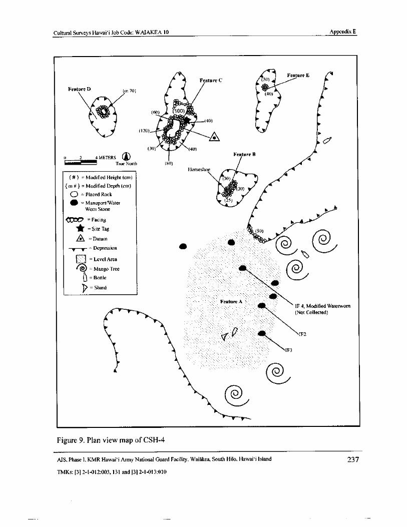
Cultural Surveys Hawai` i Job Code: WAIAKEA 10 Appendix E
Feature E 11
ANN— °.* '
Feature C
Feature D Im 701.sOrr'F:::
40
rti) 100)
l20) t1
30) 40)
04 METERS ® Feature B
True North 80)
Horseshoe
Modified Height( cm)
m#}= Modified Depth( cm) J%
O . 3(1)
Placed Rock
ManuporttWater
Worn Stone
i , 7C? =. Facing
Site Tag 30)
A Datum
@,,/TT Depression
Level Area
Mange Tree
6 = Bottle
I?.=Shard
410Feature A
IF 4; Modified Waterworn
Not Collected)
p1F2
IF3
@,.../@...../
Figure 9. Plan view map of CSH- 4
MS, Phase I, KMR Hawai` i Army National Guard Facility, Waiakea, South Hilo, Hawaii Island 237
TMKs:[ 3] 2- 1- 012:003, 131 and[ 3] 2- 1- 013: 010
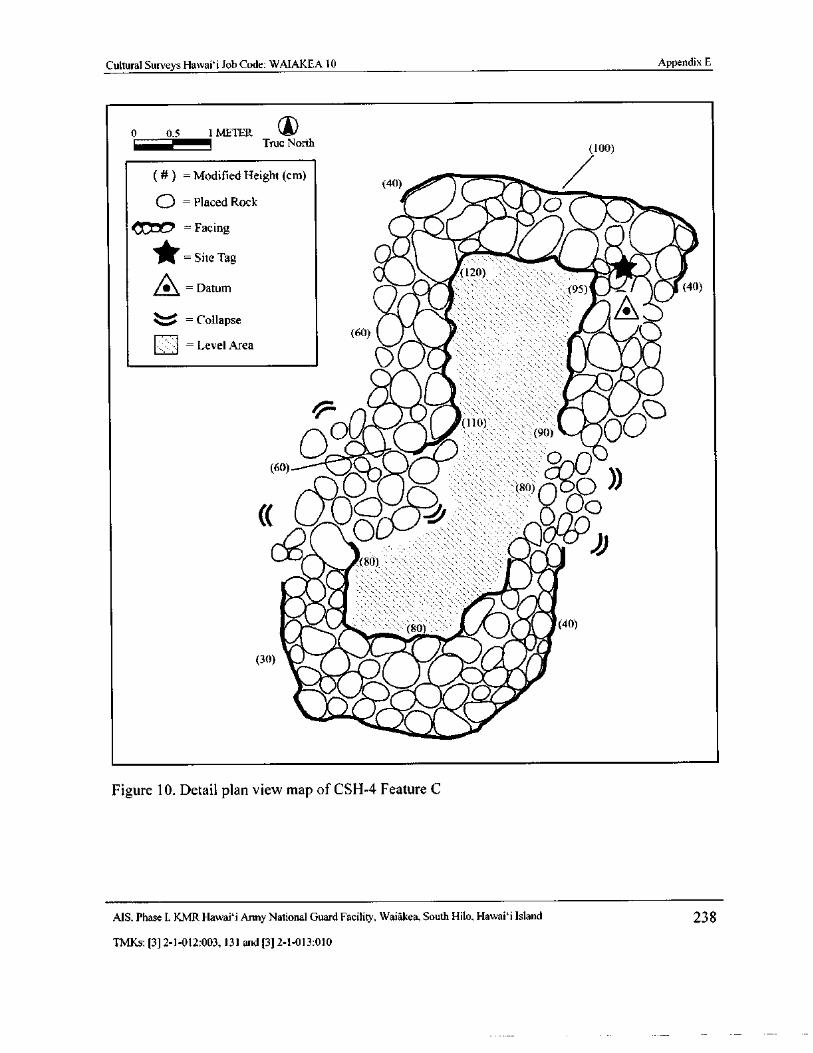
Cultural Surveys Hawai` i Job Code: WAIAKEA 10 Appendix E
0 0.5 1 METER ITrue North
100)
Modified Height( cm)40)
Q =Placed Rock 0// -
Facing
Site Tag0II
gill 120) wl
A = figDatum 0/1095) ` S 40)
u =Collapse60) 0Level Area
o fli 40 -..::::,::::sH•-.-- - Sale
ret
0ISIlip Ono):...,.:,:.-::::.. ::,.
2)0. 0 • '.:,:.::,:....:.:.•. .s:..:,,
90) my
60)
opc.,,,cc:5) Ci:
0aoDionO, 1,1
S , ii4 i, woo
ili40tlit-
iiii4,..
t-m„ 80) .
30)IMF
4_ 4 ii,40 4
110. if" Weiltor
fib,. p ipiAdp.2.9r
w0Akrollliikwr
Figure 10. Detail plan view map of CSH- 4 Feature C
MS. Phase I. KMR Hawai` i Army National Guard Facility, Waiakea, South Hilo, Hawai` i Island 238
TMKs:[ 3] 2- 1- 012: 003, 131 and[ 3] 2- 1- 013: 010
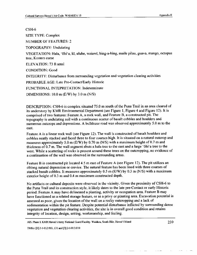
Cultural Surveys Hawaii Job Code: WAIAKEA 10 Appendix E
CSH- 6
SITE TYPE: Complex
NUMBER OF FEATURES: 2
TOPOGRAPHY: Undulating
VEGETATION: Hala, `ohi` a, ki, uluhe, waiawT, bing-a- bing, maile pilau, guava, mango, octopustree, Kosters curse
ELEVATION: 73 ft amsl
CONDITION: Good
INTEGRITY: Disturbance from surrounding vegetation and vegetation clearing activities
PROBABLE AGE: Late Pre- Contact/Early Historic
FUNCTIONAL INTEPRETATION: Indeterminate
DIMENSIONS: 10. 0 m ( E/ W) by 3. 0 m (N/ S)
DESCRIPTION: CSH- 6 is complex situated 75. 0 m south of the Puna Trail in an area cleared ofits understory by KMR Environmental Department( see Figure 1, Figure 4 and Figure 12). It is
comprised of two features: Feature A, a rock wall, and Feature B, a constructed pit. The
topography is undulating soil with a continuous scatter of basalt cobbles and boulders andnumerous outcrops and depressions. A bulldozer road was observed approximately 5. 0 m to theeast.
Feature A is a linear rock wall ( see Figure 12). The wall is constructed of basalt boulders and
cobbles neatly stacked and faced three to four courses high. It is situated on a natural outcrop andmeasures approximately 5. 0 m ( E/W) by 0. 70 m (N/ S) with a maximum height of 0. 7 m andthickness of 0. 7 m. The wall segment abuts a hala tree to the east and a large ` ohi` a tree to the
west. While a scattering of rocks is present around these trees on the outcropping, no evidence ofa continuation of the wall was observed in the surrounding areas.
Feature B is constructed pit located 4. 5 m east of Feature A (see Figure 12). The pit utilizes an
oblong natural depression or crevice. The natural feature has been lined with three courses ofstacked basalt cobbles. It measures approximately 0. 5 m (E/ W) by 0. 3 m (N/ S) with a maximumexterior height of 0. 3 m and 0. 4 m maximum constructed depth.
No artifacts or cultural deposits were observed in the vicinity. Given the proximity of CSH-6 tothe Puna Trail and its construction style, it likely dates to the late pre- Contact or early Historicperiod. Feature A may have delineated a planting, activity or occupation area. Feature B mayhave functioned as a related storage feature, or as a privy or planting area. Excavation potential isassessed as poor, given the location of the wall on a rocky outcropping and a lack ofsedimentation within the pit feature. Despite potential disturbance inflicted by surrounding densevegetation and vegetation clearing activities, the site is in overall good condition and retainsintegrity of location, design, setting, workmanship, and feeling.
MS, Phase I. KMR Hawaii Army National Guard Facility. Waiakea, South Hilo, Hawaii Island 239
TMKs:[ 3] 2- 1- 012:003, 131 and[ 3] 2- 1- 013: 010
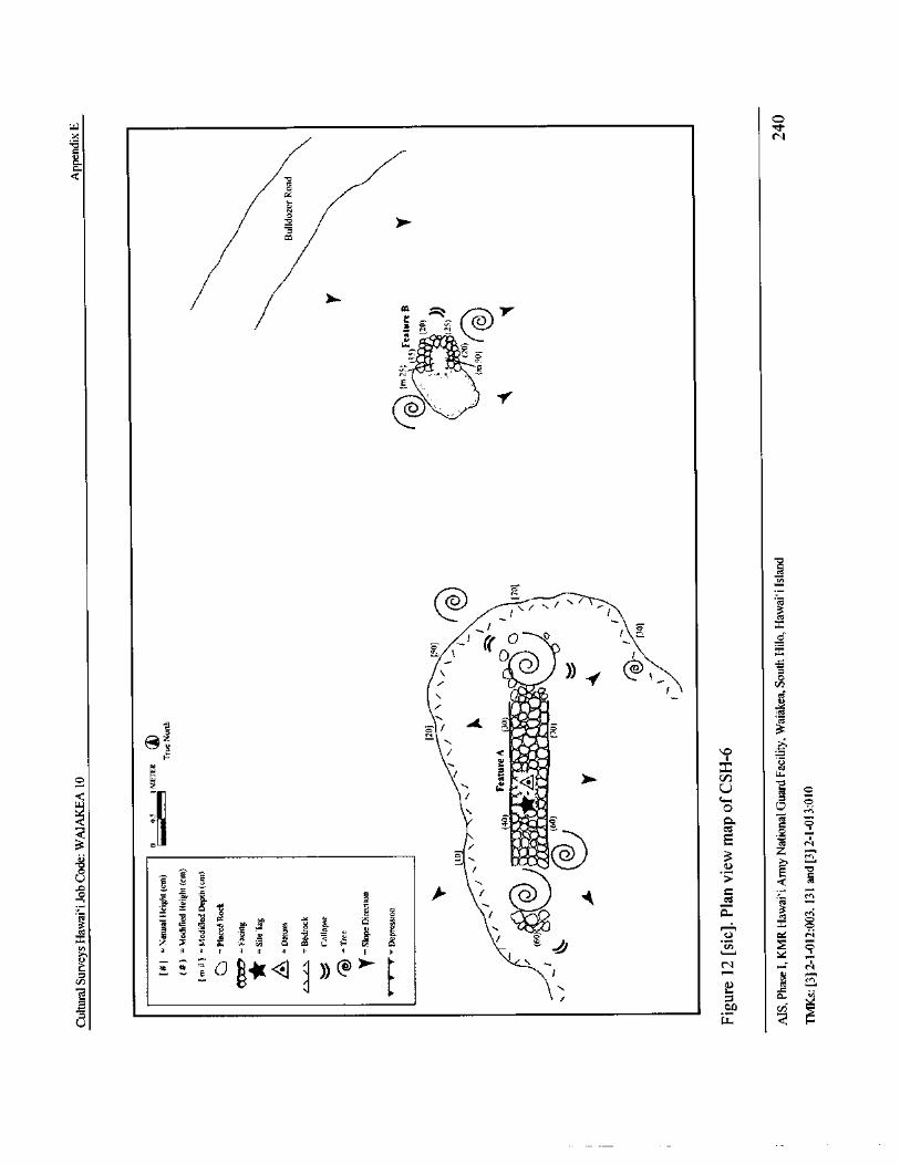
m
CA
kg
10`-S
kms\a »
s /
4 '2
@
TA
r's
i~® / i
@/i}
a dclAL z _
r16
e f ': 9 a
t * O
F b4-,
4
0
so3 f f / o
A. c r
f \ $ \ \ e \ \
x \
7 ) ` 7 \ ± a f Jf r
w
n i3
x
g z
w

Cultural Surveys Hawaii Job Code: WAIAKEA 10 Appendix E
CSH- 7
SITE TYPE: Trail
NUMBER OF FEATURES: 1
TOPOGRAPHY: Undulating
VEGETATION: Hala, `ohi` a, ki, uluhe, waiawi, bing-a- bing, maile pilau, guava, mango, octopustree, Kosters curse
ELEVATION: 76 ft amsl
CONDITION: Fair
INTEGRITY: Disturbance from surrounding vegetation
PROBABLE AGE: Early Historic
FUNCTIONAL INTEPRETATION: Transportation
DIMENSIONS: 15. 0 m (NE/SW) by 1. 0- 1. 5 m (NW/ SE) by up to 0.4 m high (along curbstonealignments)
DESCRIPTION: CSH- 7 is a trail remnant situated approximately 60 m south of CSH- 4 in AreaA at KMR( see Figure 1, Figure 4 and Figure 15). The trail is located in a densely-vegetated areaof undulating soil with a continuous scatter of basalt cobbles and boulders and numerousoutcrops and depressions.
Both edges of the trail are lined with alignments of basalt cobbles, making this a Class Bcurbstone trail (Apple 1965). The center of this trail is slightly depressed, probably due tocompression of its surface from regular use. Numerous trees are present within and surroundingthe trail alignment. The extant portion of the trail is 15 m long (NE/SW). Of this total length, 10
m is 1. 5 m wide ( SE/NW); a 5. 0 m section at the western end narrows to 1. 0 m wide. The
curbstone alignments measure from 0. 2 to 0.4 m high.
No artifacts or cultural deposits were observed in the vicinity. CSH- 7 functioned as an historictransportation route, and was likely constructed in the 1830s or 1840s. Given its close proximityand age, the trail may be associated with CSH- 4. It is also possible that this trail remnant may bein fact be an isolated remnant segment of the previously-documented SIHP# 50- 10- 35- 23273trail; it is trends in generally the same direction, is in the vicinity, and exhibits similarconstruction. These potential associations can only be inferred, as the trail becomesunrecognizable beyond its documented limits. It likely continued in either direction as a simple,unmarked path over the ridges of outcrops that are common in this area. The trail is in fair
condition. Despite disturbance from surrounding vegetation, it retains integrity of location,design, setting, workmanship, and feeling.
MS, Phase I. KMR Hawaii Army National Guard Facility, Waiakea, South Hilo, Hawaii Island 241
TMKs:[ 31 2- 1- 012: 003, 131 and[ 3] 2- 1- 013: 010
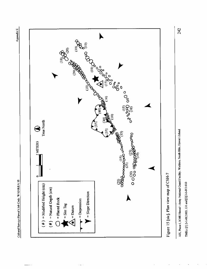
W Nx
b N
uIlka
Q a•illo• a
till 0
0" 6. 0
It- N . 0o
II ii,
in tiCegO o 0
III. 0 0
0
O0
O 0oQM.' •
VVO
IS 0Sir
Aiiz
r;
tna
M • r .Y O
ccz
E 7.
Cn vs
waQ,C
CA[ V 45to LCDo
mi1•. a
a Q 4%
co `.O
w
QeN t• O U o
II3 a
3ooa;
ro z a v. D C? 0.
v x o
x II II II II ( IIn Vi O
N
P.1
w H
W CO v alit mQ' Cti ±" r G ffi 6d cn n 7! a MG W 2O ? r TN' ? p N =' 3N3 c 8 a+ y
K L non a; R O it m f; 6V
0 Y m m¢ r- a>. m m'- 0), ca, m a, or.' V
N CV ¢ C1LL N ,,.. 7, ¢'<7,,
M NN' 440
ClL
NN N fd
LL LL (_ j LL LL 11 LL it
dQ La
CO06 ai Ui.,-bf S V S. CD 6/ is10 ,
2 ac, , ,, c, ,_,
N CQ ce) d_CC N
CC`I U) N CT)
a, C a
ii• N a)N a) W d N. 6 N m 0N 0, 140" 41,
4. 176V
GO 00 !V N00
W LL. LLpLL. 11 0U-
O LLO
z
OIn
z
Ly m d s d _ T ¢ s
E• N N N 4 'C'''' 3'
J
a CO CO ro C x
2 0 0 0 0 0 0 0
Ej ZCO CO
Z Z Z Z
tlN l9 3 m
m m v ca a aocaL m N C<
CSE. C m m o
o a Ooo2a .ca2moWrymo mNUc.
oca $ - 44
EA m , T12aa6aPmmo O = c LLp3
Z f@ _ cN . ON2O
c,t
W D c 2
0Z C rn 0 n a a 0
gZ i-oY o r—' o _
yos
7 O Q Q. T. V Clc a
mr,"2.-.'i) m rn m m m H m
CCoi:
a a a` m c
FS: m.- 0 S FS 41- 2. 2 Nen co ._ I-
ry N . XU Qi _
16 O -- C 1-- CO ? a. ® 0
E F 1-- o m E0. - 0 3`-
WU J
L1 0 0
m ry0, c0 C-, a 3o c
oIgr _= o
ohlc a
CCS
a o ' m 3i 4ai rn ;:-', 4-
6
Ax
t-a ry ./ v rzas"' ai
v.K
ii
VZ, c m vr. N r 0
Y. Yaa+ gY vG Yo 1'o Yo y V]
t--: 2 g 2 5 5 2 cd1- 3- H
c
74as41
8i, co 3
c
OC _
I I I T S 0
UM N ( r, tj CA 0 7 O
R 1O
opcoir
cc0, N N n I
0I is N
ti cwm nN U u t c) u Z
o v° =IVa
NCu
tod2 V ? 4D N
o
g: S m 0 U 9: a. 03,,,,,.....,
0 Oa
Q o 3 .M..
EE." 2 Ya. 7 o a`
s 2 22c.
2 2
O.
0' o
O fn 0 ff, 0 L, U M
xO
0 83r
Y `le
a' ti r
Ni::,
CID SCA Y> EcS 6 L
Cd N
H dy
V
CIS
F",
Cultural Surveys Hawai` i Job Code: WAIAKEA 10 Appendix E
Sarah Wilkinson
From: Sean.P. [email protected]
Sent: Thursday, February 06, 2014 10: 16 AMTo: Sarah Wilkinson
Subject: Re: Site Number Request
Here you go...
50- 10-35-30038
30038 CSH-3 CSH South Hilo Walakea TMK( 3) 2-1- 013: 10 8/28/2013 Tr
Sean P. Naleimaile
Hawaii Island ArchaeologistState Historic Preservation Division808) 933-7851
State Historic 7`, \Preservation
Dtviccon
m. ' Sarah Wilkinson"< seilkinsoncuituralsurteismllr>
sseesp.ttaleimstelfihawassiov>,rheresa.K. 00nham tthawaiiaaov>02/ 0512014 0137 PM
stst•, 1 Site Number Request
Aloha e Sean,
We' ve decided that we need another site number for a feature found during our AIS at KMR in Hilo. Please see the attachments.Thanks!]
Sarah
Sarah Wilkinson
Cultural Surveys tlaws i' i, Inc
kw itkinscnl ii culturalsurvcvs.comoffice( 8(1dd) 46S- 6478cell( 808) 756- 8468
falx( Stt$)9( 5-( 15x2
attachment" SIHP Site No Request WAIAKEA 10_ CSH- 3. doc" deleted by Sean P Naleimaile/ DLNR/ StateHiUS][ attachment" ShelfRequest Spreadsheet- WAIAKEA 10_CSH- 3 Trail. xls" deleted by Sean P Naleimaile/ DLNR/ StateHiUS]
1
MS, Phase I, KMR Hawai` i Army National Guard Facility, Waiakea, South Hilo, Hawai` i Island 244
TMKs:[ 3] 2- 1- 012:003, 131 and[ 3] 2- 1- 013: 010
Cultural Surveys Hawaii Job Code: WAIAKEA 10 Appendix E
STATE HISTORIC PRESERVATION DIVISION
PRELIMINARY SITE INFORMATION FORM
FOR REQUESTING HAWAI' I STATE INVENTORY OF HISTORIC PLACESSIHP) NUMBERS
revised 4/ 30/ 08)
Instructions: Submit this completed. doc with attached USGS map, TMK map ( with site location( s) plotted onboth) and site Plan( s). In addition, please fill out the . xis site data form and include with submission. Email therequest to your island' s SHPD.
Total SIHP#' s being requested: 1
Date: 2/ 5/ 14
Firm/Agency: Cultural Survey' s Hawai` i, Inc.PI: Hallett H. Hammatt, Ph.D.
Island: Hawai` i
Ahupua' a: Waiakea
District: South Hilo
Project Area size ( acreage): A 405. 3 acre portion of the overall parcels
TMK(s): ( 3) 2- 1- 012: 003; ( 3) 2- 1- 013: 010
Owner/Developer: The Hawai` i Army National Guard (HIARNG)Address: Hawaii Army National Guard, ENV Office
Kristine Macdonald, Cultural Resources Specialist3949 Diamond Head Road
Honolulu, HI 96816- 4495
Site Description: Include ( attach) a description of each historic property that will be designated by a sitenumber. Include individual descriptions of features and/ or components of the site, measurements, etc., and any otherrelevant information gathered to date.
MS, Phase I, KMR Hawai`i Army National Guard Facility, Waiakea, South Hilo, Hawaii Island 245
TMKs:[ 3] 2- 1- 012: 003, 131 and[ 3] 2- 1- 013: 010
Cultural Surveys Hawaii Job Code: WAIAKEA 10 Appendix E
OM HAWAII
ir.- '
i 44ar
1111.s 0' may, is
h, KMR
CSH 3N.
V.....--,, •- NN\ _ ,-- -_-'
1 W lk- -1 A A;;,yi
L
1 k.,..} df r ,,,,,...../.\\
I
I
Legend Scale
Keaukaha Military Reservation( KMR) 0 0.25 0. 5 IGlometers N
0 Historic Property0 0. 125 0.25 Miles
Base Map: USGS Topographic Map, Hilo( 1995) QuadrangleData Sources CSH ultu': 3/, 47u' cy 113 44 al V, 6
Figure 1. Portion of the 1995 U. S. Geological Survey 7. 5- minute Topographic Map, HiloQuadrangle, showing the location of CSH- 3 along the Jeep trail/Puna Trail alignment (SIHP 50-10- 99- 18869) at KMR
AIS, Phase I, KMR Hawaii Army National Guard Facility, Waiakea, South Hilo, Hawaii Island 246
TMKs:[ 3] 2- 1- 012: 003, 131 and[ 31 2- 1- 013: 010
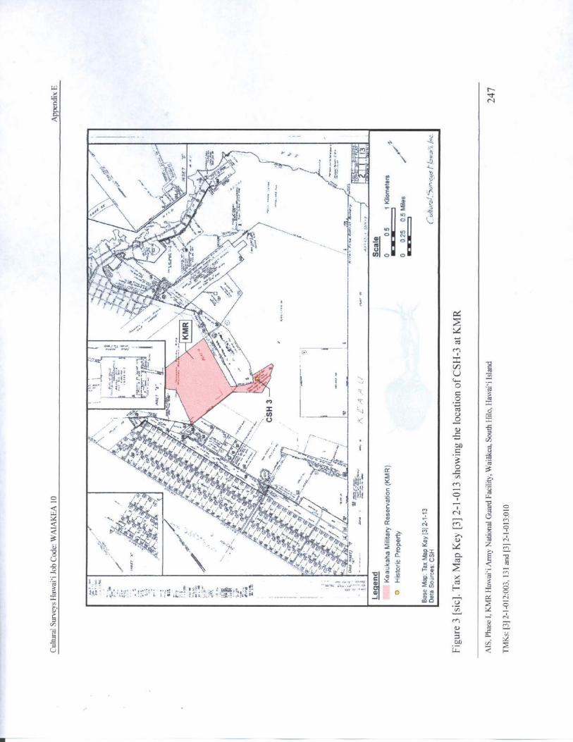
Wx d'
N
Q
I
ja\ h k;
4 m a
O L7.
i.40,,`A d
x,---';‘,- 1 ......- - a I . 1,3 il
1 !`3
lig
ct
jyisst '
d 34-,G1. 7 i it
vil'. ;
h OM_
o rr
44V . ler,42%,*
lli 0
ax''
1) a
7,1p p.,' J
X0
11 //at. -
r; / J! . ft
alt O
d s /!; !/ ate IN pY
V ti 11 / / ' w Dc'44‘.- u
en
8 p
rn
m V cl.0 i' v
f Xi d Y 2crS
p
uM .
4gcvu
L. 0.7
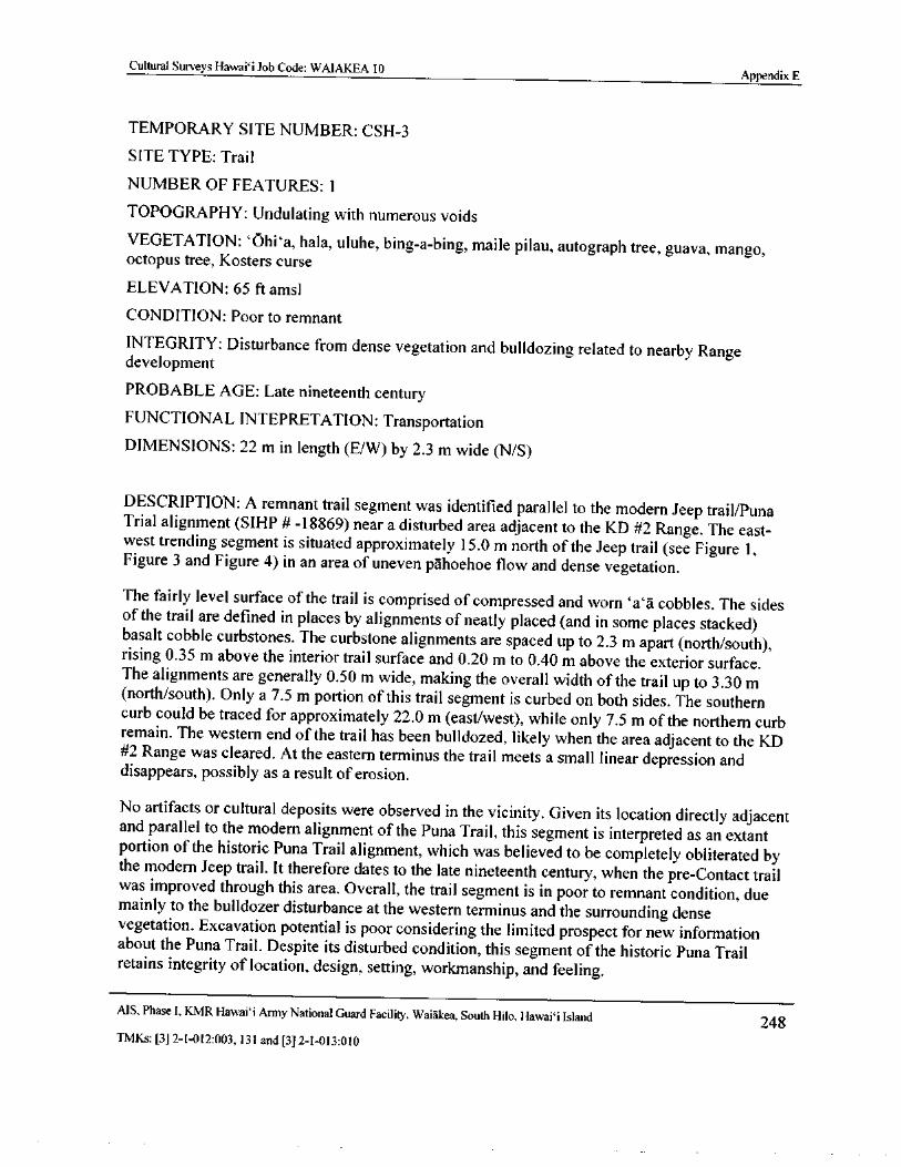
Cultural Surveys Hawaii Job Code: WAIAKEA 10Appendix E
TEMPORARY SITE NUMBER: CSH- 3
SITE TYPE: Trail
NUMBER OF FEATURES: 1
TOPOGRAPHY: Undulating with numerous voidsVEGETATION: ` Ohi` a, hala, uluhe, bing- a-bing, maile pilau, autograph tree, guava, mango,octopus tree, Kosters curse
ELEVATION: 65 ft amsl
CONDITION: Poor to remnant
INTEGRITY: Disturbance from dense vegetation and bulldozing related to nearby Rangedevelopment
PROBABLE AGE: Late nineteenth centuryFUNCTIONAL INTEPRETATION: Transportation
DIMENSIONS: 22 m in length ( E/ W) by 2. 3 m wide (N/ S)
DESCRIPTION: A remnant trail segment was identified parallel to the modern Jeep trail/PunaTrial alignment ( SIHP# - 18869) near a disturbed area adjacent to the KD# 2 Range. The east-west trending segment is situated approximately 15. 0 m north of the Jeep trail ( see Figure 1,Figure 3 and Figure 4) in an area of uneven pahoehoe flow and dense vegetation.
The fairly level surface of the trail is comprised of compressed and worn `a` a cobbles. The sidesof the trail are defined in places by alignments of neatly placed ( and in some places stacked)basalt cobble curbstones. The curbstone alignments are spaced up to 2. 3 m apart ( north/ south),rising 0. 35 m above the interior trail surface and 0. 20 m to 0.40 m above the exterior surface.The alignments are generally 0. 50 m wide, making the overall width of the trail up to 3. 30 mnorth/ south). Only a 7. 5 m portion of this trail segment is curbed on both sides. The southern
curb could be traced for approximately 22.0 m ( east/west), while only 7. 5 m of the northern curbremain. The western end of the trail has been bulldozed, likely when the area adjacent to the KD
2 Range was cleared. At the eastern terminus the trail meets a small linear depression anddisappears, possibly as a result of erosion.
No artifacts or cultural deposits were observed in the vicinity. Given its location directly adjacentand parallel to the modern alignment of the Puna Trail, this segment is interpreted as an extantportion of the historic Puna Trail alignment, which was believed to be completely obliterated bythe modern Jeep trail. It therefore dates to the late nineteenth century, when the pre- Contact trailwas improved through this area. Overall, the trail segment is in poor to remnant condition, duemainly to the bulldozer disturbance at the western terminus and the surrounding densevegetation. Excavation potential is poor considering the limited prospect for new informationabout the Puna Trail. Despite its disturbed condition, this segment of the historic Puna Trailretains integrity of location, design, setting, workmanship, and feeling.
MS, Phase I, KMR Hawaii Army National Guard Facility, Waiakea, South Hilo, Hawaii Island 248TMKs:[ 3] 2- 1- 012: 003, 131 and[ 3] 2- 1- 013: 010
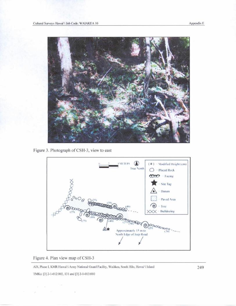
Cultural Surveys Hawai` i Job Code: WAIAKEA 10 Appendix E
4icr , WPOr ' ,• ,
4..•.
4
lif 1' Os
f
tit• ''' Vir•
fi '*;, ` : h,
1 I l f ,
a« s
roc ',° t. .,,,-,..
1, 11
l
r • 4. ^
c;` • ..... 4
r Tt.
Aa • r
t8.a
Itt ay
lielli ttHt, , t
Figure 3. Photograph of CSH-3, view to east
e 3\ It 111 ' 1t thfit9) I Ici li;( cm!
trite forthPlaced Rock
1 acnm
rite Tag
A Datum
Qc Q
IIILI_• Pa. eIAi a
1:,_,
1' ti; J I• In1r.: I—. ills
12° 11
Appnrnmatek Irnnl 1' u1 --
gib 1 tlge of Jccp Road
Figure 4. Plan view map of CSH-3
AIS, Phase I, KMR Hawaii Army National Guard Facility, Waiakea, South Hilo, Hawaii Island 249
TMKs:[ 3] 2- 1- 012:003, 131 and[ 3] 2- 1- 013: 010
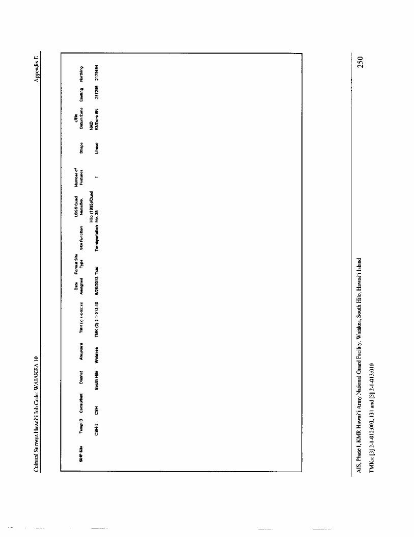
LQ o
3I CA
k 7Q. k
c et
oa
lit
2\z.
0 k
Osan
3 .
a0s /z \
WY
Iz
kla ea0
It
aJ /
2.k \
37 C4 a
e
I
o
ai j /
ag
u Q2
cd Ere,
cn^
b 2
7 2 ..
2
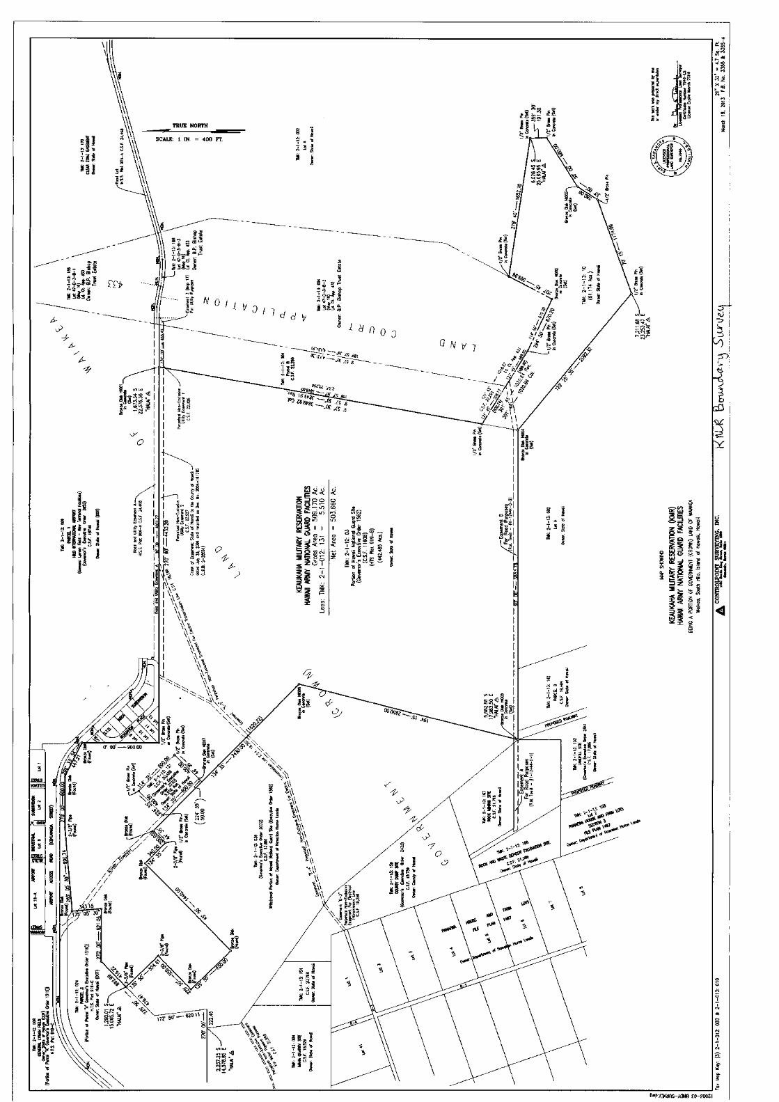
6
II
N
LI tn. I n6 g-1 !
1iSEN
s oi>
6xs3
TRUE NORTH i.n_ $ g a E` S'
2\ --....."- ii.=
8Y SCALE: 1 IN. = 400 Ff.
8 " As' ',..•,, a
oS 5l €
74: 4 I J, \
No
ZN
57c
041
Lii'7
aY
m;omgm
t g ' s oe
m
g.
oild e
3 • o
LT.!! v 0
o.o:
o ryd d v Ya 7
p
N
d i o7 c
d
0£ IFIi.
OcIFPs elq
9' asf odrmg
ri.OF dS '
4.5‘ CY / k`'
Jj
IA rn w
d aa l6' S. 691 y'0 :,
y
4 ^
r o%
l00 Z6'648c .0c.[ S. 6 7,-,:
s/ r4-,4,2\4Niar-ILLo
1. 1 UcT_'
a
g
Fg WQQ Q
a-a000 O n
I" gV
f.0; t:, aQrnin M NmSi
g 1 YWEE.. n O O v-
a JU
a‘ l tel
Si r n o . S II II IIooE
Eo: nb ZQ
a J
I '3 i
J 22 N N dm
a S Qo rg
C7
X ` rE8 Soya; a a
o = 1'..
EUx Rn
n nom m .; Ln„, z NC.
13
offs
ci i=
21 ,:. 35 15; s
N hi I I J Z 05
rc \\'E NJ a
y
m
A
0-4 a s I w
I d;s o N Cf.'
mea$ ^ sJJ p0ssz ill N
4
Fi
1 \ ryp'ti m
ep P.'5' q2. 4'4.. yy W\ tikms:
a h /`:
se."! . X_ PRS 6 N I a13310 - _'• e m 1 by
K4••PA _3 ,
4S\E' o
S
PY
roam As.
o ,`! ''',/,
1o 8'66 5\\ q
g 1a°/6
oma= r;,
1i;
g. .: 4, ..),
I 2' 1
Sof vA00
00:: 090 ,,, 00, P4'
C/ a\\ x,63'.‘ 1 W"e'
CS'/ e^ i 4' 2• so\ r 1.--, 00
al_ 15 4 Sh z o\ s _
0 05g6
glow $ m j e e,yi w f. a\\\ sg&
8 0 ipP - c5.
54..of
ryo /// c}
7_
coo
ro
ig / :, 2 1 s\\ ' WOe z a3//
s' i 2
51 175' 05' 30= g 6,s
xAlp'
FNd
1331usi//
c7i06
w 0,14 1 §YIMMNLL
go
a^ PM"" iMf
off'ow
1.96y 6 y`. j 3 D nS
3 i i 6R ' 1.%$; h a' gv.
55I
LL i
n 1 sir rn
F: 2
7F s fl
x Si 0` 4 • szr
o, 3N o', 5
620. 11 Im
rc 17E 50' 4 01i, 3w
x o
i°Z-.. rt- v';',,T,..s
S n xx
Ina \ 7y% s
N
g6MP'A3Aans- AaNe co- coOdl
Related Documents